RIVER SAND MINING
656
DISTRICT SURVEY REPORT (DSR) OF MAYURBHANJ DISTRICT, ODISHA. FOR RIVER SAND MINING (FOR PLANNING & EXPLOITING OF MINOR MINERAL RESOURCES) As per Notification No. S.O. 3611(E) New Delhi dated 25 th July 2018 of Ministry of Environment, Forest & Climate Change ( MoEF & CC) (Prepared by DEIAA, Mayurbhanj, Odisha)
-
Upload
khangminh22 -
Category
Documents
-
view
0 -
download
0
Transcript of RIVER SAND MINING

DISTRICT SURVEY REPORT (DSR) OF
MAYURBHANJ DISTRICT, ODISHA. FOR
RIVER SAND MINING
(FOR PLANNING & EXPLOITING OF MINOR MINERAL RESOURCES)
As per Notification No. S.O. 3611(E) New Delhi
dated 25th July 2018 of
Ministry of Environment, Forest & Climate Change
( MoEF & CC)
(Prepared by DEIAA, Mayurbhanj, Odisha)

RIVER SAND MINING DSR OF MAYURBHANJ DISTRICT
1
CONTENT
CH.NO.
DESCRIPTION PAGE NO.
Preamble 2
1 Introduction 3
1.1 Location and Geographical Area 3
1.2 Administrative Units 4-5
1.3 Connectivity 6-8
2 Overview of Mining Activity in the District 9
3 The list of Mining Leases in the District with location, area, and period of validity.
10
3.1 List of Mines is operation in the district 10
3.2 List of Mines is not in operation in the district 10
4 Detail of Royalty or Revenue received in last three years 10
5 Detail of production Sand or Bajri or minor mineral in last three years
11
6 Process of Deposition of Sediments in the rivers of the district.
12-13
7 General Profile of the District 14
7.1 Demography
8 Land Utilization Pattern in the District 15
8.1 Forest and non forest land. 15-16
8.2 Agricultural land. 17
8.3 Horticultural land. 18
9 Physiography of the District 18-19
10 Rainfall of the District. 20
10.1 Month Wise rainfall. 20
11 Geology and Mineral Wealth 20
11.1 Regional Geology 20
11.2 Geomorphology 21
11.3 Stratigraphy. 21
11.4 Mineral Resources. 22-25
11.5 Soil. 26
a District wise details of river or stream and other sand sources.
27
b District wise availability of Sand or gravel or aggregate resources.
28
c District wise details of existing mining leases of sand and aggregates.
Annexure-A
Conclusion 33

RIVER SAND MINING DSR OF MAYURBHANJ DISTRICT
2
PREAMBLE
Odisha is the major mineral reach in India. Mayurbhanj is a unique district in Odisha
lies on the northern most part of the state with varied mineral resources. In
pursuance of the order of Hon’ble Supreme Court Petition (C) No. 19628-19629 of
2009, dated 27th Feb. 2012 in the matter of Deepak Kumar Vs State of Haryana and
others etc., prior environmental clearance has now become mandatory for mining of
minor minerals irrespective of the area of Mining Lease. And also in view of the
Hon’ble National Green Tribunal, order dated the 13th Jan. 2015 the matter
regarding Sand, Brick earth, & burrowed earth cutting for Road Construction has to
take prior E.C. for Mining Lease area more or less than 5 hectares also suggested
making a policy on E.C for minor minerals lease in cluster. As per MOEF & CC
Notification S.O.-1533(E) dated 14th Sept. 2006 and subsequent MoEF & CC
Notification S.O. 141(E) dated 15th Jan. 2016, District Environment Impact
Assessment Authority (DEIAA) & District level Expert Appraisal Committee (DEAC)
has been formed for Category –B2 Minor Minerals having area less than or equal to
5 ha. In compliance to the notification issued by the Ministry of Environment and
Forest and Climate Change Notification no. S.O.3611 (E) New Delhi dated 25-07-2018;
the preparation of district survey report of river sand mining has been prepared in
accordance with Clause II of Appendix X of the notification.
Keeping in view of the prior information of Odisha Minor Mineral Concession Rule
2004, (OMMCR -2004) the mining operation for minor mineral were carried out in
unscientific manner. Identifying this fact in exercise of power, Conferred by Section
15 by Mines and Minerals (Development and Regulation) Act 1957 as amended in
2015 and all other powers enabling it in that behalf, the Mining & Geology
Department, Govt. of Odisha framed the aforementioned rule. Further, this report
will act as a compendium of available mineral resources, geological set up,
environmental and ecological set up of the district and based on data of various
departments like Revenue, Water Resources, Forest, Geology and Mining in the
district as well as statistical data uploaded by various state Government departments
for preparation for district survey report.

RIVER SAND MINING DSR OF MAYURBHANJ DISTRICT
3
1. INTRODUCTION
Mayurbhanj at a Glance:
1.1 Location and Geographical Area:
Mayurbhanj district is the largest among the thirty districts of Odisha and Baripada is
the District head quarter, spreading over an area of 10,418 sq.km lies between
latitudes 21° 17’ North and 22° 34’ North and longitudes 85°40’ East and 87°10’
East. It is bounded on the north by the Singhbhum district of Jharkhand and
Midnapore district of West Bengal, on the south by the districts of Mayurbhanj and
Keonjhar, on the east by the Midnapore and Mayurbhanj districts and on the west by
the districts of Keonjhar and Singhbhum. Mayurbhanj occupies a unique position
being endowed with lush green vegetation, different fauna & flora and rich cultural
heritage. The district has a rich mineral base and is home to the Similipal Biosphere.
Iron-ore (hematite), vanadiferous and titaniferous magnetic, chaina clay, galena
(lead ore), Kyanite, asbestos, steatite (soap stone) and quartzite constitute the
principal mineral resources of Mayurbhanj district, of these the iron-ore deposits of
Gorumahisani, Badampahar and Suleipat, which have been exploited for a period of
about half a century, deserve special mention.

RIVER SAND MINING DSR OF MAYURBHANJ DISTRICT
4
1.2 Administrative Units:-
Baripada is the administrative headquarter of Mayurbhanj district. It is located at a
distance of 263 km from Bhubaneswar, state capital of Odisha. In order of size, the
district is the largest among the thirty districts of Odisha. It has 3980 villages
(including 178 uninhabited villages) covering 26 Blocks, 26 Tahasils and 4 Sub-
Divisions. The district is divided into 4 Sub-Divisions namely 1) Sadar Sub-Division
Baripada, 2) Kaptipada Sub-Division Udala, 3) Bamanghaty Sub-Division, Rairangpur,
4) Panchapir Sub-Division, Karanjia which are given below:-

RIVER SAND MINING DSR OF MAYURBHANJ DISTRICT
5
Sl No Name of the Block/Tehsil Name of the Sub-Division with
Head quarter
1 Baripada
Sadar Sub-Division, Baripada
2 Samakhunta
3 Kuliana
4 Bangriposi
5 Saraskana
6 Suliapada
7 Betnoti
8 Badsahi
9 Rasgovindpur
10 Moroda
11 Udala
Kaptipada Sub-Division, Udala
12 Kaptipada
13 Khunta
14 Gapabandhu Nagar
15 Rairangpur
Bamanghaty Sub-Division,
Rairangpur
16 Bisoi
17 Bijatala
18 Kusumi
19 Bahalda
20 Tiring Bamanghaty Sub-Division,
Rairangpur 21 Jamda
22 Karanjia
Panchpir Sub-Division, Karanjia
23 Jashipur
24 Sukruli
25 Thakurmunda
26 Raruan
The population of the district 25,19,738 according to the 2011 Census. The district
accounts for 6.69% of the state’s territory and about 6% of state’s population. The
density of population of the district is 242 per square km as against 270 per square
km of the state. As per 2011 census, the population of Scheduled Caste is 1,84,682
(7.30%), that of Scheduled Tribe is 14,79,576 (58.7%). The literacy percentage of
the district covers 63.2 against 72.9 of the state.

RIVER SAND MINING DSR OF MAYURBHANJ DISTRICT
6
1.3 Connectivity facilities:-
Road Network
The district is well served by a network of good roads and has been called the
motorists paradise. The chief roads emanating from Mayurbhanj town are NH-18
and NH-49 passes the district. Baripada is 60 Kms from Mayurbhanj, 103 Kms from
Kharagpur, 163 Kms from Jamshedpur, 231 Kms from Cuttack, 255 Kms from
Bhubaneswar and 368 Kms from Rourkela. It is also connected with other cities such
as Sambalpur, Puri, Bolangir, Bhadrak, Jhargram, Angul, Ranchi and Kolkata via
Odisha State Road Transport Corporation and some private travel services.

RIVER SAND MINING DSR OF MAYURBHANJ DISTRICT
7
Rail Network
Mayurbhanj district is well connected by rail link to different places, the city of
Baripada is well connected to many places in India like Mayurbhanj, Bhubaneswar,
Kolkata, Jamshedpur and Cuttack,

RIVER SAND MINING DSR OF MAYURBHANJ DISTRICT
8
Air Network
At present, Mayurbhanj has no connection by airway. The site selection for
aerodrome is presently under process. Nearest aerodrome is Dum Dum Airport
(International Airport) Kolkata, roughly 195 Kms from Baripada. The other nearest
airport to Baripada is Biju Patnaik Airport, Bhubaneshwar, 207 Kms from Baripada.

RIVER SAND MINING DSR OF MAYURBHANJ DISTRICT
9
2. OVERVIEW OF MINING ACTIVITY IN THE DISTRICT:
Mayurbhanj district is land features of both plain and hilly region. Most of the
mineralized area coming under safety zone eco-sensitive zone, mining activity only
confined out of safety zone of eco-sensitive zone. The mining activity in the district
is not only restricted to minor minerals i.e. of sand, stone, granite and brick clays.
Altogether there are leases of Iron-ore (hematite), vanadiferous and titaniferous
magnetic, chaina clay, galena (lead ore), Kyanite, asbestos, steatite (soap stone)
and quartzite constitute the principal mineral resources of Mayurbhanj district, of
these the iron-ore deposits of Gorumahisani, Badampahar and Suleipat, which have
been exploited for a period of about half a century. Stone, granite and sand which
has been granted to the district is regulated as per minerals concession rules of
Odisha. There is no lease of major mineral in the district. At present Leases of stone,
sand and bricks making units are operational in the district. Stone chips, granite
stones, ordinary sand constitute the principal mining activity of Bangirposi, Badasahi,
Kaptipada, Kuliana area etc. of Mayurbhanj district. Out of these huge granite stones

RIVER SAND MINING DSR OF MAYURBHANJ DISTRICT
10
deposits are available near Badasahi, Kaptipada, Kuliana area and major potential
sand in G.B Nagar, Morda & Kaptipada area of the district, which have been
provides tremendous scope for development of few more industries based on this
resources.
3.0 LIST OF MINING LEASES WITH LOCTION, AREA, AND PERIOD OF
VALIDITY IN THE DISTRICT:
3.1 List of Mines is operation in the district:
Attached as Annexure- A
3.2 List of Mines is not operation in the district:
Attached as Annexure- A
4.0 DETAIL OF ROYALTY OR REVENUE RECEIVED IN LAST THREE YEARS:
Sl. No. Name of the
Tahasil
2016-17 2017-18 2018-19 Total Amount
(Rs.)
1 Baripada 1422000 1750755 1690360 4863115
2 Samakhunta 0 716850 729525 1446375
3 Kuliana 1210950 1266900 1307560 3785410
4 Bangriposi 103837 114599 415161 633597
5 Saraskana 120000 1965000 3984000 6069000
6 Suliapada 0 493830 493830 987660
7 Betnoti 353220 286020 311640 950880
8 Badsahi 2552040 7213519 8423062 18188621
9 Rasagovindpur 1115942 1147507 1034686 3298135
10 Morada 1134050 1929745 2316122 5379917
11 Udala 855581 1263983 2488855 4608419
12 Kaptipada 2395160 2339100 2408540 7142800
13 Khunta 0 0 0 0
14 G.B Nagar 3675224 3113182 3185832 9974238
15 Rairangpur 228800 811109 1463127 2503036
16 Bisoi 0 0 0 0
17 Bijatala 0 0 0 0
18 Kusumi 345900 512100 539400 1397400
19 Bahalda 290550 324400 334950 949900
20 Tiring 0 521612 591612 1113224
21 Jamda 272000 304400 918455 1494855
22 Karanjia 3071372 3088130 1095130 7254632

RIVER SAND MINING DSR OF MAYURBHANJ DISTRICT
11
23 Jashipur 0 0 0 0
24 Sukruli 938378 2456861 2950829 6346068
25 Thakurmunda 60480 65520 70560 196560
26 Raruan 23555 315521 1087664 1426740
Grand Total 20169039 32000643 37840900 90010582
5.0 DETAILS OF PRODUCTION SAND OR BAJRI OR MINOR
MINERAL IN LAST THREE YEARS:
Details of Production in Cum:
Sl.
No.
Name of the
Tahasil
2016-17 2017-18 2018-19 Total in Cum.
1 Baripada 16845 25500 26626 68971
2 Samakhunta 0 5050 5150 10200
3 Kuliana 14470 14715 14924 44109
4 Bangriposi 3000 3250 28278 34528
5 Saraskana 4000 7000 7200 18200
6 Suliapada 0 930 930 1860
7 Betnoti 6410 10810 11420 28640
8 Badsahi 17777 26400 34165 78342
9 Rasagovindpur 19269 19545 19878 58692
10 Morada 26275 35407 36607 98289
11 Udala 19430 27356.80 45559 92345.80
12 Kaptipada 40841 41340 42439 124620
13 Khunta 0 0 0 0
14 G.B Nagar 55095 57530 59280 171905
15 Rairangpur 4400 10441 18509 33350
16 Bisoi 0 0 0 0
17 Bijatala 0 0 0 0
18 Kusumi 10100 10500 11000 31600
19 Bahalda 7450 8960 9250 25660
20 Tiring 0 14903.20 16903.20 31806.40
21 Jamda 864 6808 8849 16521
22 Karanjia 24860 24860 13860 63580
23 Jashipur 0 0 0 0
24 Sukruli 21252 20552 25560.50 67364.50
25 Thakurmunda 1440 1560 2280 5280
26 Raruan 1587 16067.537 18795.739 36450.276
Grand Total 295365 389485.537 457463.439 1142313.976

RIVER SAND MINING DSR OF MAYURBHANJ DISTRICT
12
6.0 PROCESS OF DEPOSITION OF SAND OR BAJRI OR MINOR
MINERAL IN LAST THREE YEARS:
Sl. No. Name of the River
Financial Year
Process of Deposition of
Sediments
Volume of Sand deposited in last three years
1
Budhabalanga 2016-17 moderate 1,38,755
2017-18 ---do--- 1,85,568
2018-19 ---do--- 2,71,041
Total Volume of Sand in three years 5,95,364
2
Subarnarekha 2016-17 moderate 90,000
2017-18 ---do--- 1,12,500
2018-19 ---do--- 1,17,000
Total Volume of Sand in three years 3,19,500
3 Jambhira 2016-17 moderate 1,02,474
2017-18 ---do--- 1,25,734
2018-19 ---do--- 1,29,183
Total Volume of Sand in three years 3,57,391
4 Sona 2016-17 moderate 2,59,573
2017-18 ---do--- 2,84,008
2018-19 ---do--- 2,31,375
Total Volume of Sand in three years 7,74,956
5 Khadkhai 2016-17 moderate 17,752
2017-18 ---do--- 77,184
2018-19 ---do--- 1,00,489
Total Volume of Sand in three years 1,95,425
6 Khairibandhan 2016-17 Slow 14,448
2017-18 ---do--- 16,325
2018-19 ---do--- 15,781
Total Volume of Sand in three years 46,554
7 Deo 2016-17 Slow ----
2017-18 ---do--- ----
2018-19 ---do--- ----
Total Volume of Sand in three years
8 Katra 2016-17 Slow 7,500
2017-18 ---do--- 8,125
2018-19 ---do--- 6,325
Total Volume of Sand in three years 21,950
9 Gangahar 2016-17 Slow 1,243
2017-18 ---do--- 1,008
2018-19 ---do--- 1,185
Total Volume of Sand in three years 3,436
10 Baitarani 2016-17 moderate 55,935
2017-18 ---do--- 55,935

RIVER SAND MINING DSR OF MAYURBHANJ DISTRICT
13
2018-19 ---do--- 31,185
Total Volume of Sand in three years 1,43,055
11 Tel 2016-17 Slow 8,087
2017-18 ---do--- 9,245
2018-19 ---do--- 8,634
Total Volume of Sand in three years 25,966
12 Kantamauli 2016-17 Slow 1,869
2017-18 ---do--- 2,051
2018-19 ---do--- 1,645
Total Volume of Sand in three years 5,565
13 Sim 2016-17 Slow 7,897
2017-18 ---do--- 6952
2018-19 ---do--- 8245
Total Volume of Sand in three years 23,094
14 Kangira 2016-17 Slow 36,150
2017-18 ---do--- 35,468
2018-19 ---do--- 37,006
Total Volume of Sand in three years 1,08,624
15 Balijori 2016-17 Slow ----
2017-18 ---do--- ----
2018-19 ---do--- ----
Total Volume of Sand in three years ----
16 Kantakhaira 2016-17 Slow 21,326
2017-18 ---do--- 20,547
2018-19 ---do--- 21,389
Total Volume of Sand in three years 63,262
17 Kanhu 2016-17 Slow 15,084
2017-18 ---do--- 15,318
2018-19 ---do--- 19,910
Total Volume of Sand in three years 50,312
18 Balisudura 2016-17 Slow 7,500
2017-18 ---do--- 6,764
2018-19 ---do--- 7,681
Total Volume of Sand in three years 21,945
Grand Total

RIVER SAND MINING DSR OF MAYURBHANJ DISTRICT
14
7.0 GENERAL PROFILE OF THE DISTRICT:
7.1 Demography:
Census - 2011
Geographical Area 10,418 Sq. Km.
Total population 25,19,738
Male Population 12,56,213
Female Population 12,63,525
Male Literacy 794,171
Female Literacy 575,226
SC Male 92,127
SC Female 92,555
ST Male 730,487
ST Female 749,089
OBC 855,480
Illiterate Male 462,042
Illiterate Female 688,299
7.2 Climate:
The climate in Mayurbhanj is warm and temperate. In winter, there is much less
rainfall in Mayurbhanj than in summer. The general climate of the district is
characterized by oppressive heat in summer, severe cold in winter with high
humidity throughout the year. The rainfall distribution is equal during the monsoon
period. The period from June to October is the rainy season and the district
experiences it from the southwest monsoon. May is the hottest month when the
mean daily maximum temperature rises up to 47º Celsius. The Köppen-Geiger
climate classification is Cwa & as per they the average temperature in Mayurbhanj is
24.7 °C. The temperature in May averages 32.3 °C. January has the lowest average
temperature of the year, it is 16.5 °C. There is a difference of 321 mm of
precipitation between the driest and wettest months. During the year, the average
temperatures vary by 15.8 °C., when the mean daily minimum temperature dips to
4º Celsius. The higher reaches of the Similipal experiences frosting during the peak
of winter.
Source: Indian Meteorological Department

RIVER SAND MINING DSR OF MAYURBHANJ DISTRICT
15
8.0 LAND UTILIZATION PATTERN IN THE DISTRICT
8.1 Forest and non forest land
The forest of Mayurbhanj district is full variety of medicinal plants, Kendu leaves,
Bamboo, Sal, Teak, other timber species and a wide range of carnivorous &
herbivorous wild animals. The district has one Wildlife Sanctuaries known as the
Similipal Wildlife Sanctuary situated at the heart of the district, which hosts all type of
wildlife even tigers. The area of the sanctuary is 26, 886.23 hectares. And two
kilometer safety zone of eco-sensitive zone of Kuldiha Wildlife Sanctuary are coming in
Mayurbhanj district. In these sanctuary areas the principal animals that are found are
Elephant, Bear, Nilgai, Sambhar, Peacock, Wild Boar and Deer, together with variety of
snakes and birds.
District-wise Forest Cover Area in Odisha (Area in Km2)
2017 Assessment
District Geograph ical Area Km2
Very Dense Forest
Moder- ate. Dense Forest
Open Forest
Total Percent of GA
Change Scrub
Angul 6375 371 1380 1004 2755 43.22 43 84
Bolangir 6575 70 224 837 1131 17.2 151 142
Balasore 3806 23 127 234 380 9.98 30 48
Bargarh 5837 176 371 484 1031 17.66 88 47
Bouda 3098 263 546 480 1289 41.61 27 57
Bhadrak 2505 0 9 66 75 2.99 2 0
Cuttack 3932 53 226 517 796 20.24 11 68
Deogarh 2940 191 667 614 1472 50.07 -3 14
Dhenkanal 4452 174 418 825 1417 31.83 9 82
Gajapati 4325 84 1490 946 2520 58.27 12 262
Ganjam 8206 164 1075 864 2103 25.63 15 655
Jagatsinghpur 1668 0 5 131 136 8.15 6 0
Jajpur 2899 6 72 225 303 10.45 3 50
Jharsugada 2114 3 140 179 322 15.23 9 36
Kalahandi 7920 362 729 1327 2418 30.53 36 362
Kandhamal 8021 661 2588 2143 5392 67.22 16 380
Kendrapada 2644 84 88 133 305 11.54 14 2
Keonjhar 8303 289 1404 1519 3212 38.68 4 55

RIVER SAND MINING DSR OF MAYURBHANJ DISTRICT
16
Khorda 2813 21 186 250 457 16.25 0 92
Koraput 8807 94 740 1255 2089 23.72 120 944
Malkangiri 5791 158 709 1475 2342 40.44 20 45
Mayurbhanj 10418 1335 1718 1027 4080 39.16 42 34
Nabarangpur 5291 168 428 507 1103 20.85 8 47
Nayagarh 3890 189 965 556 1710 43.96 28 173
Nuapada 3852 86 482 705 1273 33.05 33 109
Puri 3479 0 54 160 214 6.15 8 11
Rayagada 7073 422 853 1851 3126 44.2 7 349
Sambalpur 6624 499 1675 1106 3280 49.52 13 40
Subarnapur 2337 2 187 161 350 14.98 26 29
Sundargarh 9712 1019 1814 1431 4264 43.9 107 89
Grand Total 155707 6967 21730 23008 51345 32.98 885 4306
(Source: India state of forest report 2017-Odisha)
The major portion of the district is covered by forest (39.16 % of TGA) and has
scattered settlement pattern. The forest is full of variety of medicinal plants. The
district has considerable flat land, which provide suitable site for agricultural use.
The hilly areas are mostly under forest with patches of cultivation on scarp areas.
Major crops grown in the district are rice and pulses. Only 14.82 percent area of
agricultural use are net irrigated and major source of irrigations are well and tube
wells.
Source: Fertilizer and Agriculture Statistics, Eastern Region
Tahasil Forest
Area
Misc Tree
Permanent Pasture
Cultivated waste
Non Agricultural
uses
Barren land
Current Fallow
Other Fallow
Net area
sown
Bahalda 964 471 1397 1262 2590 1900 875 944 14031
Bangiriposi 3712 281 1037 1688 3046 684 2054 922 16951
Baripada 216 6733 128 1628 1376 8 2752 2156 4219
Badasahi 288 1807 1194 1874 3840 24 3378 2110 17630
Betnoti 2271 911 1198 1728 3227 21 1915 578 17022
Bijatala 2841 224 681 3100 1792 1636 1214 600 11228
Bisoi 3116 471 757 2508 2193 459 2298 1643 15860
G.B.Nagar 191 116 683 582 1147 590 643 1209 10960
Jamda 408 100 1650 434 2060 785 840 1149 13608
Jashipur 8932 141 1389 2655 3637 400 3873 2634 17754
Kaptipada 8745 387 3292 5596 4123 2165 3123 4930 19932
Karanjia 1644 838 1444 2441 3065 462 3493 1362 16690
Khunta 400 2260 314 672 2061 21 1332 2213 12879

RIVER SAND MINING DSR OF MAYURBHANJ DISTRICT
17
Kuliana 1749 1626 2222 1902 2529 608 4919 1504 11108
Kusumi 1434 32 2320 2679 2337 587 1086 1682 18032
Morada 993 4127 513 4340 1941 61 1909 3633 10179
Rairangpur 2260 107 1759 1373 2027 504 1276 631 9713
Raruan 1210 171 890 1120 1899 503 1609 1020 12818
Rasgovindpur 288 2145 665 1091 2774 142 2002 1537 10054
Shamakhunta 1354 764 1378 2472 1859 334 1861 941 6695
Saraskana 3464 275 689 2658 4042 115 1864 1837 15384
Sukruli 412 211 734 1295 1271 502 1286 1294 10352
Suliapada 2937 5535 97 2262 2148 86 1589 2906 8971
Thakurmunda 10885 96 1530 1438 2034 795 5317 2670 17681
8.2 Agriculture Land:
Mayurbhanj is surrounded by no of forest areas as well as Rocky Mountains. People
used to cultivate Paddy in most parts of the hill slopes and in plain lands. Most of the
cultivators grow short duration local paddy in the un-bonded upland during Kharif
season. The crop suffers moisture stress at different stages due to inadequate
rainfall. The primary objective of Agriculture Department is increase of production as
well as productivity of major crops like paddy, groundnut, mustard, Mung, Biri &
vegetables which is widely covered in this District in both Khariff & Rabi season.
Another key objective is the all round development of the farming community of the
District. The Deputy Director of Agriculture is the head of office so far as agriculture
is concerned & he is the Principal Agriculture Officer of the District. Under him there
are 5 District Agriculture Officers & the block under them. As already pointed out,
that agriculture is the main livelihood of the people in Mayurbhanj District. It is
therefore also designated as the food bowl of Odisha. Rice is the principal crop
grown in this district, followed by other cereals, pulses, oilseeds, vegetables, spices
and sugarcane. The agricultural statistics for the district is shown in subsequent
tables below:

RIVER SAND MINING DSR OF MAYURBHANJ DISTRICT
18
Table – 3.6a: Crop Coverage Area of Mayurbhanj District, Odisha
Crop Khariff Rabi Annual TOTAL
Area (ha)
(% of Cropped
Area
Area (ha)
% of Cropped
Area
Area (ha)
Gross Cropped
Area (ha)
% of Gross
Cropped Area
Rice 301.37 82.353% 3.80 4.015% --- 305.17 62.051%
Cereals 9.99 2.730% 2.17
2.293% --- 12.16 2.472%
Pulses 32.37 8.846% 36.20 38.255% --- 68.57 13.943%
Oilseeds 5.92 1.617% 28.30 29.906% --- 34.22 6.958%
Vegetables 12.39 3.386% 21.74 22.974% --- 34.13 6.940%
Fibres 2.43 0.664% --- 2.43 0.494% Spices 1.48 0.404% 2.42 2.557% --- 3.90 0.792%
Sugarcane --- --- 00 --- --- 00 ---
Tobacco --- --- 00 --- --- 00 ---
Fruits --- --- --- --- --- 31.23 6.350%
TOTAL 365.95 100.00% 94.63 100.00% --- 491.81 100.00%
8.3 Horticulture Land:
The primary objective of Horticulture Department is increase of production as well as
productivity of major fruits like Mango, Guava, Citrus etc., which is widely covered in
this District. Another key objective is the all round development of the farming
community of the District. The Deputy Director of Horticulture is the head of office.
9.0 PHYSIOGRAPHY OF THE DISTRICT:
Mayurbhanj district presents diverse physiographic features; Physiographically the
study area can be divided into 3 categories. The first physiographic unit of the
district is high mountain ranges, Similipal Complex being at its central part (Figure
1). The mountain ranges comprise mainly of highland plateau and valleys with
intrusive
running through them. The second physiographic unit is Tertiary Plain occurring in
the eastern part of the district. The third physiographic unit is Alluvial Plain which
lies partly in Rasgobindpur, Morada, Samakhunta, Betnoti, Baripada, Badasahi and
Suliapada blocks. The highest elevation about 1500m near similipal hill of the
district, due to scarp landforms some waterfalls are observed in the district. The
general slope of the district is from north to south. Geologically the area is

RIVER SAND MINING DSR OF MAYURBHANJ DISTRICT
19
comprised with Archean granites and gneisses. Geomorphologically the district is
divided into 3 units:
i) The denudational hills with moderate to high slope occurring in the western part
of the district.
ii) Dissected pediments having gentle slope.
iii) Pediplain having slope between 0o to 5o.

RIVER SAND MINING DSR OF MAYURBHANJ DISTRICT
20
RAINFALL OF THE DISTRICT AND CLIMATE CONDITION
10.1 Month wise rainfall:
The driest month is November, with 3 mm of rain. There is on average 0 mm of
precipitation in December. In July, the precipitation reaches its peak, with an
average of 324 mm. May is the warmest month of the year. The temperature in May
averages 32.3 °C. January has the lowest average temperature of the year. It is
16.5 °C.
Year 2016 2017 2018 Average
Sl. No. Month (mm) (mm) (mm) (mm)
1 Jan 9.23 2.71 0.00 3.98
2 Feb 52.61 0.00 0.04 17.55
3 Mar 12.29 44.87 0.72 19.29
4 Apr 22.38 23.36 172.10 72.61
5 May 118.73 139.31 125.30 127.78
6 Jun 195.46 169.39 208.83 191.22
7 Jul 245.28 385.31 300.05 310.21
8 Aug 351.25 291.03 371.30 337.86
9 Sep 285.27 170.11 285.17 246.85
10 Oct 85.39 189.09 154.08 142.85
11 Nov 12.10 34.79 0.00 15.63
12 Dec 0.00 1.80 36.69 12.83
Total 1389.99 1451.77 1654.28 1498.68
Source: Indian Meteorological Department
The Indian Meteorological Department, Bhubaneswar, vide letter No. BBS/RMC/CS-
312, dated 18th January, 2016 has provided the period of Rainy Season viz. Normal
dates of Onset and Withdrawal of South West Monsoon over India as state-wise.
The duration for the period is 10th June to 15th October.
11.0 GEOLOGY AND MINERAL WEALTH OF THE DISTRICT:
11.1 Geology
Mayurbhanj is a unique district in Odisha with rich and varied geology. The major
rock types encountered in the district are Granite Gneiss, Quartzite, Orthoquartzite,
Arkose, Shale, Phyllite, Gabbro, Px-granite. The geology of the district is constituted
by the Similipal complex at its central part belonging the Archaean age,
unconformably lying over Singhbhum Granite and Banded Iron Formation (BIF). It

RIVER SAND MINING DSR OF MAYURBHANJ DISTRICT
21
consists of three alternate bands of volcano sedimentary units uniquely disposed in a
ring like circular pattern formed under sub-marine conditions. The sedimentary of
Similipal mostly comprise of orthoquartzite, Arkoses and minor band of ferruginous
shale and phyllite. The quartzites are devoid of any volcanic materials within it and
exhibit well-preserved cross-bedding and palaeo-current structures indicating
shallow water sub-marine origin. Important mineral resources include iron, copper,
itanium, vanadium, chinaclay, nickel, kyanite, quartz, talc, steatite, soapstone and
bauxite. Natural Emerald, green Beryl and opaque Beryl are reported to occur
around Jaraguda, Pokharidiha, Bahadurpur,
11.2 Geomorphology:
Geomorphological features of Mayurbhanj district are mainly attributed to Similipal
Complex being at its central part. The mountain ranges comprise mainly of highland
plateau and valleys with intrusive running through them. The second physiographic
unit is Tertiary Plain occurring in the eastern part of the district. The third
physiographic unit is Alluvial Plain .The drainage density is observed to be fairly
moderate and drainage pattern is dendritic in nature. It consists of three alternate
bands of volcano sedimentary units uniquely disposed in a ring like circular pattern
formed under sub- marine conditions. Baripada Beds outcrops of tertiary formation
occur around Baripada town. These comprise stratified clay and sand with marly clay
or limestone interbands. The alluvial plains owe their origin due to various fluviatile
actions of major rivers. The details of the geomorphic unit as identified are as below:
11.3 Stratigraphy:
The study area comprises the following distinct geomorphic units:
i) Younger alluvial plain
ii) Older alluvial plain
iii) Lateritic upload

RIVER SAND MINING DSR OF MAYURBHANJ DISTRICT
22
Geological Age Geological Formation / Group
Quaternany : Recent Alluvium, Clays, silt, Sand, Gravel
Tertiary : Older Alluvium, Laterite, Baripada Beds.
Mesozoic/ Palaeozoic : Volcanics / Epidiorite
Precambrian : Slate/ Phyllite/ Schist / Gneiss
Archean : Granite/ Granite Gneiss
11.4 Mineral Resources:
The earliest known geological survey in Mayurbhanj dates back to 1903, when P.N.
Bose brought to light the extensive iron-ore deposits of high quantity on the
Gorumahisani and Suleipat hills in Bamanghaty Sub-Division. These deposits were
considered to be almost inexhaustible and were pronounced to be of excellent
quality, perhaps second to none in the whole of Asia by the famous American and
English experts like M/s Perin, Weld and Colonel Staddart, who visited these deposits
during 1905-06. This discovery was a momentous one as the steel plant of the Tata
Iron & Steel Co. at Jamshedpur was entirely based on the exploitation of these
deposits. By 1915, important discoveries of Steatite near Lulung and placer gold
from the sands of Subarnarekha, Kharkhai and Barhai rivers had been made. The
placer gold deposits were being worked by M/s J.B. Bettie of Calcutta, Mr. V.G.
Piggot of Ghatsila and the Mayurbhanj Prospecting Concession Syndicate.

RIVER SAND MINING DSR OF MAYURBHANJ DISTRICT
23
Gold: The mid-Archaean Gorumahisani-Badampahar schist belt composed of basic
ultrabasic, volcanic rocks and volcanogenic sediments. This belt has been
prognosticated as a rift-type of volcanic dominated one and is highly potential for
economic grade gold mineralization. Likely targets include: a) auriferous quartz veins
close to the contact of sulphide chert volcanics, b) sheared and sulphidised Fe-rich
tholeiite with anomalous copper, c) epigenetic vein type of mineralization and BIF
volcanic association, and d) sulphidic conglomerate resting over the basic volcanics.
Placer gold occurrences are known from rivers and stream of Mayurbhanj district. An
area of about 5 square kilometers of alluvium at the headwaters of Sapgora and
Borai rivers near Kudersai was indicated as promising.

RIVER SAND MINING DSR OF MAYURBHANJ DISTRICT
24
Iron: Bose discovered iron ore deposits in Gorumahisani and Badampahar in the
eastwhile princely state of Mayurbhanj (now Mayurbhanj District). Gorumahisani
deposits were investigated by Perin & Weld (1905). Gorumahisani- Badampahar-
Suleipat deposits are associated with banded hematite / magnetite grunerite and
BHJ.
Gorumahisani – Badampahar- Suleipat (Broad geological sequence)
Laterite & Alluvium
Newer Dolerite
Gabhro-Anorthosite Granite
---Unconformity---
Ultramafic dyke
Singhbhum Granite
Banded magnetite/ Martite quartzite with Fe-Ores
Quartzite
Basal Conglomerate
----Unconformity----
Older metamorphic
Vanadium Ores & Titanium: Vanadium is an important alloying element.
Magnetite associated with gabbro- anorthosite suite of rocks contains vanadium and
titanium. Deposits of vanadium-magnetite occur in association with gabbro-
Anorthosite suite of rocks in the precambrian metamorphites. Vanadium bearing
magnetite belts are :-
(a) Rairangpur – Bisoi belt (Kumardubi, Betjharan Amdabeda)
(b) Bisoi – Joshipur belt (Mayurbeka, Kesham, Sialnoi)
(c) Baripada – Podadiha belt (Andipur, Bahalda)
Pyrophyllite: is mainly used as a high grade ceramic product, electric insulator and
refractory material. The comp. is Al2O34SiO2 H20. It is formed as an alteration
product of feldspar. Pyrophyllite occurrences are reported at Kankrani, Jashipur,
Gorumahisani, Bangriposhi and Manada in Mayurbhanj dist. Ichinda, Khairakocha,
Jamukunda, Nakulkocha, Kapadiha, Dunguridiha, Maheshpur, Kashidiha, Sagragora
and Pokpoka. Dimension stone of the district are granite, granite-gneiss, migmatites,

RIVER SAND MINING DSR OF MAYURBHANJ DISTRICT
25
syenite, gabbro, anorthosite, charnockite, leptynite, pyroxene granulite, dolerite,
pyroxinite and dunite etc.
Bauxite: In Similipal complex (Mayurbhanj) aluminous laterite/ Bauxite are
observed around 1000 m AMSL. The spongy aluminous laterite/bauxite occurs as
sheets and boulders occupying the flat-topped hills made up of
metavolcanics. Both ultramafics and metavolcanics are lateritised giving rise to
nickeliferous laterite and aluminous laterite respectively.
China Clay: is clay like material approximating the mineral Kaolinite (Al2O3, 2SIO2,
2H2O). China clay is found to occur in a long belt stretching from Singhbhum to
Mayurbhanj. Badampahar-Joshipur- Karanjia – Ramachandrapur belt is the most
important china-clay producing area of the state. The important deposits in
Mayurbhanj district are found near Joshipur, Chanchbani, Dumuria, Jamda,
Kodadiha, Jamkeswar and Thakurmunda. China clay has many industrial applications
as filler in paper, textile, rubber, in the manufacture of potteries, ceramics, sanitary
wares, glazed tiles, white cement, insecticides, paints, cosmetics, refractory bricks
etc. Soap stone and Steatite Asbestos is mined from Mayurbhanj area.
Talc, steatite and soapstone: Important localities of these deposits in
Mayurbhanj dist are Tiring, Kendumundi and Kharidamak.
Kyanite: Kyanite deposits of refractory grade occur in Panijia area of Mayurbhanj
dist, where it is associated with dumortierite bearing rocks, qtz-veins, quartz-mica-
schists and talc-tremolite-schist. Other kyanite occurrence include Purnapani &
Similipal.
Quartz & Quartzite: Quartz and silica sand are mostly used in glass foundry,
ferrosilicon alloy, ceramic industry, abrasive, paint, rubber, textile industries.
Transparent varieties of quartz such as rock crystal, amethyst, citrine, Rosequartz
and smoky quartz are used as semi-precious gemstone. Quartz is a piezoelectric
material and is used in radio circuit, Radars and ultra-sonic devices. Quartzite is a

RIVER SAND MINING DSR OF MAYURBHANJ DISTRICT
26
monomineralic rock constituted predominantly of quartz. There are 6 mining leases
for quartz and quartzite in Mayurbhanj dist.
High Magnesia rock: are found in Notapahar, Thakurmunda, Amjori and
Badampahar of Mayurbhanj Dist.
Nickel: Nickel is concentrated within chemically weathered ultramafic rocks and
found in the laterite and soil capping in Similipal area. The mineral occurs in silicate
form i.e. garnierite. The important patches of prospective ore zones are: Gurguria
and Nawana.
11.5 Soil:
The district comprises chiefly of lateritic, sandy loam and clayey loam type of soil
(Figure 3). Laterite soil is mostly marked in the area occupied by crystalline rocks.
The low lying valley fields are covered with clayey loam type of soil.

RIVER SAND MINING DSR OF MAYURBHANJ DISTRICT
27
a) DISTRICT WISE DETAILS OF RIVER OR STREAM AND OTHER SAND
SOURCE:
Attached as Annexure-A.

RIVER SAND MINING DSR OF MAYURBHANJ DISTRICT
28
b) DISTRICT WISE AVAILABILITY OF SAND OR GRAVEL OR AGGREGATE
RESTORES:
Geological resource ( in cum ) Mineable resource( in cum )
4322607.24 283292.55
DRAINAGE SYSTEM WITH DESCRIPTION OF MAIN RIVERS:
The district has considerable flat land, which provide suitable site for agricultural
use. The hilly areas are mostly under forest with patches of cultivation on scarp
areas. Major rivers flowing in the district are Budhabalanga, Subernarekha,
Jambhira, Sona, Khadkhai, Deo, Katra, Khairibandhan & Baitarani. Major crops
grown in the district are rice only. 14.82 percent area of agricultural use are net
irrigated and major source of irrigations are well and tube-wells.
Sl. No. Name of the River Area drained
(Sq.Km.)
% Area drained
in the District
1 Budhabalanga 2143 21%
2 Subernarekha 265 0.25%
3 Jambhira 1377 13%
4 Sona 1062 10%
5 Khadkhai 1131 10.8%
6 Khairibandhan 1014 0.09%
7 Deo 473 0.04%
8 Katra 352 0.03%
9 Gangahar 594 0.057%
10 Baitarani 260 24.6%
11 Tel 96 0.009%
12 Kantamauli 82 0.007%
13 Sim 165 0.015%
14 Jhagada 30 0.002%
15 Balijori 56 0.005%
16 Kantakhaira 186 0.017%
17 Kanhu 383 0.036%
18 Balisudura 170 0.016%

RIVER SAND MINING DSR OF MAYURBHANJ DISTRICT
29
Salient Features of Important Rivers and Streams:
The Budhabalanga River (also called Balanga River) flows through the districts
of Mayurbhanj & Balasore and finally reached Bay of Bengal. The Budhabalanga,
rises from Similipal hills and plunges through Barehipani Falls, the second-highest
waterfall in India, located in Similipal National Park. It then flows in a northerly
direction up to the village Karanjiapal in Bangiriposi police-station. Thereafter, it
turns to the north-east and flows along the railway track up to the village
Jhankapahadi. There it changes its course to the south and meets the Katra nala.
The other tributaries are the Palpala and the Chipat both of which are hill streams
rising from the Similipal hills. Then the river passes through Baripada. It later flows
through Balasore district and into the Bay of Bengal. The Budhabalanga is about 175
kilometres (109 mi) long and has a total catchment area of 4,840 square kilometres
(1,870 sq mi). Its major tributaries are the Sona, Gangahar, and the Katra.
Burhabalang and its tributaries, viz. Sona Nadi, Amrutia Nadi, Gangahar Nadi drain
almost round the year in the present area. Sona Nadi receives the watery effluent
load through a nalah (Sankh nalah) from the Balgopalpur Industrial Estate and flows
from west to east. Amrutia Nadi flows from NNW to SSE and carries the waste water
load of East Coast. Subarnrekha originate from Nagri of Jharkhand and then enter
into Mayurbhanj district, very less portion of the river flows within Mayurbhanj
district, Major portion of Subarnarekha River passes in the Balasore district. Another
river Jambhira runs in Mayurbhanj district then enters into Balasore district and
Renamed as river Jalaka flows into Bay of Bengal. Other small rivers run in this
district like River Khadkhai originates from Tunhgru R.F. and plunges through
Suleipat Dam (Khadkhai Reserviour). It then runs towards Rairangpur, Bahalda,
Tiringi area of western direction of Mayurbhanj district and finally reached at River
Subarnarekha. River Deo rises from Similipal R.F. and runs towards western part of
the district and flows through Karanjia area and then joins with Baitarani River. River
Khairabandhan originates from Similipal R.F. and flows towards western part of the
Mayurbhanj district through Jashipur, Raruan, Sukruli area of district and then joins
with River Baitarani This river maintains a sluggish flow in the pre-monsoon period,
but swells menacingly with the onset of monsoon often flooding large tracts. Another
small tributary named as Kanhu starts from River Khadkhai and branched into
RIVER SAND MINING DSR OF MAYURBHANJ DISTRICT
30
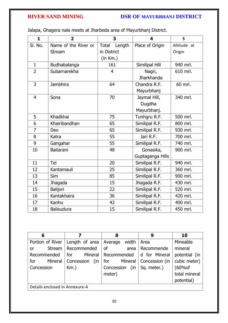
Jalapa, Ghagera nala meets at Jharbeda area of Mayurbhanj District.
1 2 3 4 5
Sl. No. Name of the River or
Stream
Total Length
in District
(in Km.)
Place of Origin Altitude at
Origin
1 Budhabalanga 161 Similipal Hill 940 mrl.
2 Subarnarekha 4 Nagri,
Jharkhanda
610 mrl.
3 Jambhira 64 Chandra R.F.
Mayurbhanj
60 mrl.
4 Sona 70 Jaymal Hill,
Dugdha
Mayurbhanj.
340 mrl.
5 Khadkhai 75 Tunhgru R.F. 500 mrl.
6 Khairibandhan 65 Similipal R.F. 800 mrl.
7 Deo 65 Similipal R.F. 930 mrl.
8 Katra 55 Jari R.F. 700 mrl.
9 Gangahar 55 Similipal R.F. 740 mrl.
10 Baitarani 48 Gonasika,
Guptaganga Hills
900 mrl.
11 Tel 20 Similipal R.F. 940 mrl.
12 Kantamauli 25 Similipal R.F. 360 mrl.
13 Sim 85 Similipal R.F. 900 mrl.
14 Jhagada 15 Jhagada R.F. 430 mrl.
15 Balijori 22 Similipal R.F. 520 mrl.
16 Kantakhaira 36 Similipal R.F. 420 mrl.
17 Kanhu 42 Similipal R.F. 400 mrl.
18 Balisudura 15 Similipal R.F. 450 mrl.
6 7 8 9 10
Portion of River
or Stream
Recommended
for Mineral
Concession
Length of area
Recommended
for Mineral
Concession (in
Km.)
Average width
of area
Recommended
for Mineral
Concession (in
meter)
Area
Recommende
d for Mineral
Concession (in
Sq. meter.)
Mineable
mineral
potential (in
cubic meter)
(60%of
total mineral
potential)
Details enclosed in Annexure-A
RIVER SAND MINING DSR OF MAYURBHANJ DISTRICT
31
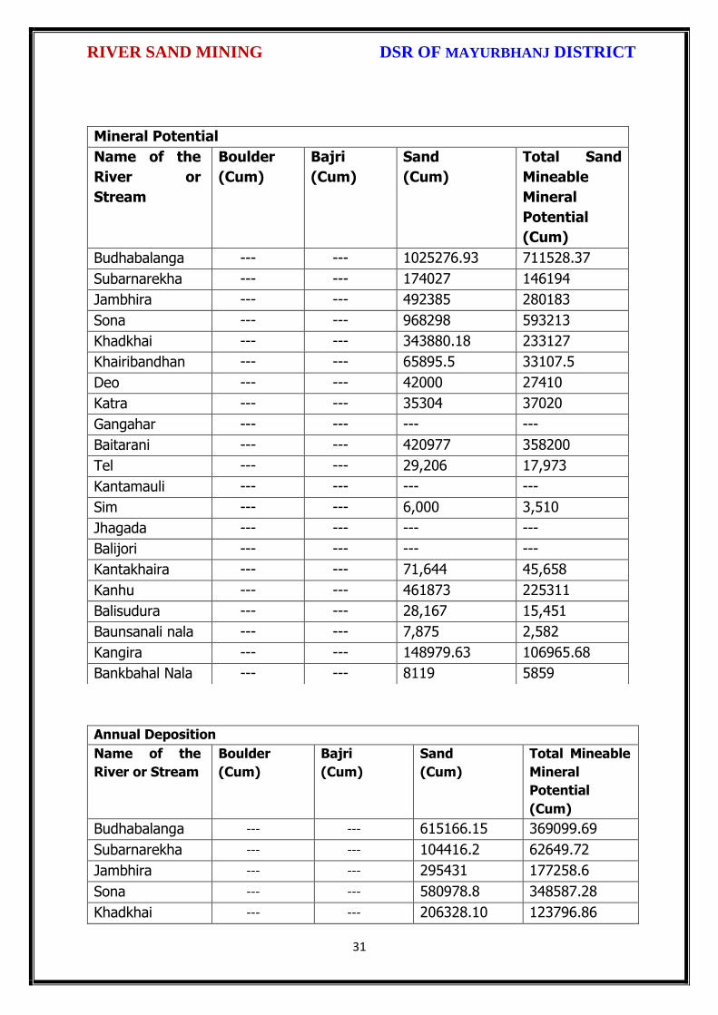
Annual Deposition
Name of the
River or Stream
Boulder
(Cum)
Bajri
(Cum)
Sand
(Cum)
Total Mineable
Mineral
Potential
(Cum)
Budhabalanga --- --- 615166.15 369099.69
Subarnarekha --- --- 104416.2 62649.72
Jambhira --- --- 295431 177258.6
Sona --- --- 580978.8 348587.28
Khadkhai --- --- 206328.10 123796.86
Mineral Potential
Name of the
River or
Stream
Boulder
(Cum)
Bajri
(Cum)
Sand
(Cum)
Total Sand
Mineable
Mineral
Potential
(Cum)
Budhabalanga --- --- 1025276.93 711528.37
Subarnarekha --- --- 174027 146194
Jambhira --- --- 492385 280183
Sona --- --- 968298 593213
Khadkhai --- --- 343880.18 233127
Khairibandhan --- --- 65895.5 33107.5
Deo --- --- 42000 27410
Katra --- --- 35304 37020
Gangahar --- --- --- ---
Baitarani --- --- 420977 358200
Tel --- --- 29,206 17,973
Kantamauli --- --- --- ---
Sim --- --- 6,000 3,510
Jhagada --- --- --- ---
Balijori --- --- --- ---
Kantakhaira --- --- 71,644 45,658
Kanhu --- --- 461873 225311
Balisudura --- --- 28,167 15,451
Baunsanali nala --- --- 7,875 2,582
Kangira --- --- 148979.63 106965.68
Bankbahal Nala --- --- 8119 5859

RIVER SAND MINING DSR OF MAYURBHANJ DISTRICT
32
Khairibandhan --- --- 39537 23722
Deo --- --- 25200 15120
Katra --- --- 21182.4 12709.44
Gangahar --- --- 1,145.33 687.20
Baitarani --- --- 252586.2 151551.72
Tel --- --- 17523.6 10514.16
Kantamauli --- --- 1,855 1,113
Sim --- --- 3600 2160
Jhagada --- --- ---- -----
Balijori --- --- ---- ----
Kantakhaira --- --- 42986 25791.84
Kanhu --- --- 277123.8 166274.28
Balisudura --- --- 16900.2 10140.12
Baunsanali nala 4725 2835
Kangira 89387.78 53632.66
Bankbahal Nala 4871 4383

RIVER SAND MINING DSR OF MAYURBHANJ DISTRICT
33
Drainage pattern map of Mayurbhanj District

RIVER SAND MINING DSR OF MAYURBHANJ DISTRICT
34
CONCLUSION:
Since it is an interim report, to meet the requirement of minerals in the present
scenario, it is proposed to identify such potential areas at certain interval and get
the data bank of DSR to be updated. The insitu mining activity in any area is on one
hand bring revenue and employment (Direct and indirect) and on other hand if not
done properly potential pollution and ecological imbalance increases, the ability of
the ecosystem can also be reduced. Particulate matter transported by the wind as a
result of excavations, blasting, transportation of materials, heavy equipments used
raise these particulate levels; and Gas emissions from the combustion of fuels in
stationary and mobile sources, explosions, and mineral processing. All these
activities indirectly affected the biodiversity of area. Larger potential and smaller
areas have been identified in Mayurbhanj district on the basis of geological study
carried out during field observation, which can be considered for mining concession
after all the parameters for statutory clearances are verified by consulting with
concerned authorities.

RIVER SAND MINING DSR OF MAYURBHANJ DISTRICT
35
Plate-I

RIVER SAND MII{ING DSR OF UAYURBHANJ DISTRICT
The District Survey Report for Sand Mining ( Minor Mineral) in respect of
Mayurbhanj District s prepared in accordance with Appendix-X, Para -7 (iii) (a) of
S.O. 3611 (E) Dt. 25.07.2018 of Ministry of Environment, Forest and Climate
Change, New Delhi is approved for final publication in the district website.
o\ t qx t\ \.,\
Dr" H.K.Sahu, Sri S.Mallick, I.F.S,DFO-cum-Member,DEIAA, Mayurbhanj
Sri Dibyajyoti a, I"A.SProf in Zoology, NOU -cum-Member, DEIA& Mayurbhanj
SDM, Sadar-cum -Member SecretaryDEIAA, Mayurbhanj
,n
Sri ViCollector & DM-cu
Mayurbhanj (Odisha)
36
Chairman, DEIAA
From To
1 2 3 4 5 6 7 8 9 10 11 12 13
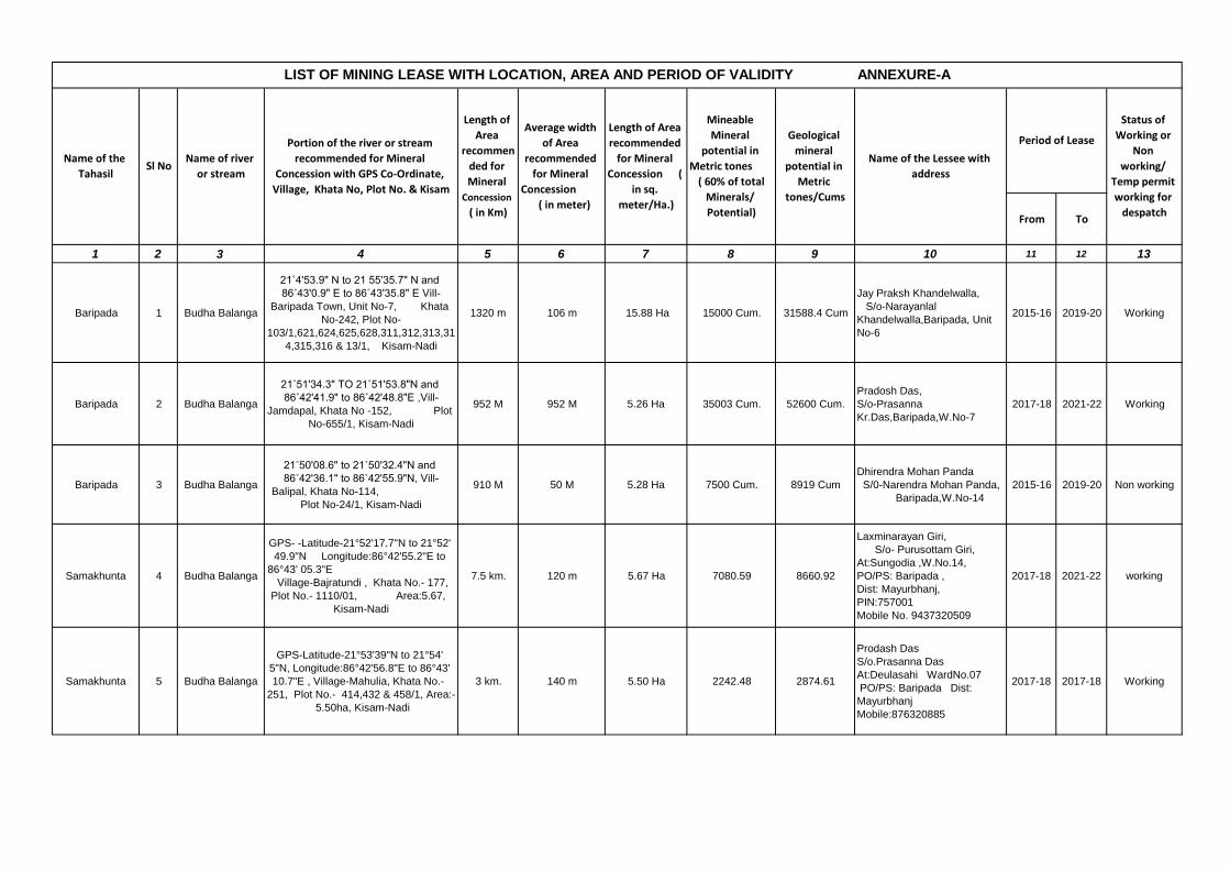
Baripada 1 Budha Balanga
21˚4'53.9" N to 21 55'35.7" N and
86˚43'0.9" E to 86˚43'35.8" E Vill-
Baripada Town, Unit No-7, Khata
No-242, Plot No-
103/1,621,624,625,628,311,312,313,31
4,315,316 & 13/1, Kisam-Nadi
1320 m 106 m 15.88 Ha 15000 Cum. 31588.4 Cum
Jay Praksh Khandelwalla,
S/o-Narayanlal
Khandelwalla,Baripada, Unit
No-6
2015-16 2019-20 Working
Baripada 2 Budha Balanga
21˚51'34.3" TO 21˚51'53.8"N and
86˚42'41.9" to 86˚42'48.8"E ,Vill-
Jamdapal, Khata No -152, Plot
No-655/1, Kisam-Nadi
952 M 952 M 5.26 Ha 35003 Cum. 52600 Cum.
Pradosh Das,
S/o-Prasanna
Kr.Das,Baripada,W.No-7
2017-18 2021-22 Working
Baripada 3 Budha Balanga
21˚50'08.6" to 21˚50'32.4"N and
86˚42'36.1" to 86˚42'55.9"N, Vill-
Balipal, Khata No-114,
Plot No-24/1, Kisam-Nadi
910 M 50 M 5.28 Ha 7500 Cum. 8919 Cum
Dhirendra Mohan Panda
S/0-Narendra Mohan Panda,
Baripada,W.No-14
2015-16 2019-20 Non working
Samakhunta 4 Budha Balanga
GPS- -Latitude-21°52'17.7"N to 21°52'
49.9"N Longitude:86°42'55.2"E to
86°43' 05.3"E
Village-Bajratundi , Khata No.- 177,
Plot No.- 1110/01, Area:5.67,
Kisam-Nadi
7.5 km. 120 m 5.67 Ha 7080.59 8660.92
Laxminarayan Giri,
S/o- Purusottam Giri,
At:Sungodia ,W.No.14,
PO/PS: Baripada ,
Dist: Mayurbhanj,
PIN:757001
Mobile No. 9437320509
2017-18 2021-22 working
Samakhunta 5 Budha Balanga
GPS-Latitude-21°53'39"N to 21°54'
5"N, Longitude:86°42'56.8"E to 86°43'
10.7"E , Village-Mahulia, Khata No.-
251, Plot No.- 414,432 & 458/1, Area:-
5.50ha, Kisam-Nadi
3 km. 140 m 5.50 Ha 2242.48 2874.61
Prodash Das
S/o.Prasanna Das
At:Deulasahi WardNo.07
PO/PS: Baripada Dist:
Mayurbhanj
Mobile:876320885
2017-18 2017-18 Working
LIST OF MINING LEASE WITH LOCATION, AREA AND PERIOD OF VALIDITY ANNEXURE-A
Name of the
Tahasil
Status of
Working or
Non
working/
Temp permit
working for
despatch
Length of Area
recommended
for Mineral
Concession (
in sq.
meter/Ha.)
Mineable
Mineral
potential in
Metric tones
( 60% of total
Minerals/
Potential)
Geological
mineral
potential in
Metric
tones/Cums
Name of the Lessee with
address
Period of Lease
Sl NoName of river
or stream
Portion of the river or stream
recommended for Mineral
Concession with GPS Co-Ordinate,
Village, Khata No, Plot No. & Kisam
Length of
Area
recommen
ded for
Mineral
Concession
( in Km)
Average width
of Area
recommended
for Mineral
Concession
( in meter)

1 2 3 4 5 6 7 8 9 10 11 12 13
Samakhunta 6 Budha Balanga
GPS- -Latitude-21°53'21.1"N to 21°53'
43.06"N Longitude:86°43'23.06"E to
86°43' 39.09"E , Village:Pundura ,
Khata No.- 68 , Plot No.- 2/1 ,
Area: 5.47, Kisam-Nadi
- - 5.47 Ha - - - - Non Working
Samakhunta 7 Budha Balanga
GPS-Latitude-21°56'43.5"N to 21°56'
37.3"N Longitude:86°42'00.9"E to
86°42' 14.8"E, Village-Suniapal ,
Khata No.-74, Plot No.- 319 & 322
Area:- 5.65, Kisam-Nadi
- - 5.65 Ha - - - - - Non Working
Samakhunta 8 Budha Balanga
GPS-Latitude-21°57'05"N to 21°57'
54"N Longitude:86°40'47"E to
86°40' 53"E , Village-Inkidapal
Khata No.- 69, Plot No.- 412/1
Area:-5.00, Kisam-Nadi
- - 5.00 Ha - - - - - Non Working
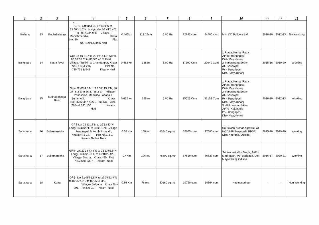
Kuliana 9 Budhabalanga
GPS- Latitude 21
⁰
57'33.7''N to
21
⁰
57'43.7''N Longitude- 86
⁰
42'14.9''E
to 86
⁰
42'03.6''E Village- Tumuda,
Khata No.-52 , Plot No.- 225 & 87,
Kisam-Nadi
0.406 km 181mtr 5.061 Ha 43120 cum 46640 cum
Jayanta Kumar Sikhar,
At-Ambikasahi, Ward.No-1,
Po- Baripada, Dist-Mayurbhanj
2015-16 2019-20 Working
Kuliana 10 Budhabalanga
GPS- Latitued 21
⁰
58'26.9''N to
21
⁰
58'41.1''N Longitude- 86
⁰
41'19.8''E
to 86
⁰
41'27.8''E Village-
Padhiaripur, Khata No.-
80 , Plot No.-126 Kisam-
Nadi
0.37 km 154 mtr 5.745 Ha 11162 cum 72796 cum
Ramakrushna See,
At-Chhancha,ward No-25,
Po-Takatpur,
Dist-Mayurbhanj
2016-17 2020-21 Working
Kuliana 11 Budhabalanga
GPS- Latitued Block A- 22
⁰
01'11.2''N
to 22
⁰
01'34''N Block B-22
⁰
02'9.52''N to
22
⁰
02'3''N Longitude- Block A-
86
⁰
38'4.9''E to 86
⁰
38'54.5''E Block -B
86
⁰
38'1.9''E to 86
⁰
38'2''E, Village-
Goudrama & Kathapal, Khata No.-
94 & 28, Plot No.-223 & 04,
Kisam-Nadi
1.086 km 152 Mtr 9.145 Ha 62538.3 cum 80712.0 cum
Bhuban Mohan Dutta, At-
Darkholi, Po- Aniapal,
Ps- Kuliana
Dist- Mayurbhanj
2015-16 2019-20 Non-working
Kuliana 12 Budhabalanga
GPS- Latitued 21
⁰
59'41.8''N to
21
⁰
59'49.5''N Longitude- 86
⁰
39'15.8''E
to 86
⁰
39'26.8''E Village- Mangrajia,
Khata No.-38, Plot No.-43, Kisam-
Nadi
0.386 km 31.98 mtr 1.238 Ha 9935 cum 12380 cum M/s Ratna DD Builders 2017-18 2019-20 Non-working
1 2 3 4 5 6 7 8 9 10 11 12 13
Kuliana 13 Budhabalanga
GPS- Latitued 21
⁰
57'34.0''N to
21
⁰
57'41.5''N Longitude- 86
⁰
41'8.4''E
to 86
⁰
41'24.0''E Village-
Manishmundia, Khata
No.-39, Plot
No.-169/1,Kisam-Nadi
0.445km 112.15mtr 5.00 Ha 72742 cum 84480 cum M/s DD Builders Ltd. 2018-19 2022-23 Non-working
Bangriposi 14 Katra River
Gps-22 10 31.7"to 22 06" 54.3" North,
86 38"32.5" to 86 38" 46.5" East
Village.- Taltikiri & Chandanpur, Khata
No:- 117 & 216 Plot No-
730,731 & 549 Kisam- Nadi
0.462 km 138 m 5.00 Ha 17300 Cum 20940 Cum
1.Pravat Kumar Patra
At/ po- Bangriposi,
Dist- Mayurbhanj.
2. Narasingha Sethy
At- Gosanipal
Ps.- Bangriposi
Dist.- Mayurbhanj
2015-16 2019-20 Working
Bangriposi 15Budhabalanga
River
Gps- 22 06"4.3:N to 22 06" 15.2"N, 86
37" 6.3"E to 86 37"15.2 E Village.-
Panasdiha, Mahulisol, Asana &
Sunamuhi, Khata
No:-35,82,347 & 23 , Plot No.- 35/1,
2804 & 141/160 Kisam-
Nadi
0.462 km 188 m 5.00 Ha 25028 Cum 31153 Cum
1.Pravat Kumar Patra
At/ po- Bangriposi,
Dist- Mayurbhanj.
2. Narasingha Sethy
At- Gosanipal
Ps.- Bangriposi
Dist.- Mayurbhanj
3. Alok Kumar Sikhar
At/Po- Kalabadia
Ps.- Bangriposi
Dist- Mayurbhanj
2018-19 2022-23 Working
Saraskana 16 Subarnarekha
GPS-Lat 22'13'15"N to 22'13'42"N
Longi 86'40'25"E to 86'41'10"E ,Village-
Jamunapal & Kumbhirmundi ,
Khata:44 & 15, Plot No.1 & 1,
Kisam- Nadi & Nadi
0.38 Km 168 mtr 63840 sq.mtr 78675 cum 97500 cum
Sri Bikash Kumar Agrawal, At-
N-2/1698, Nayapalli, BBSR,
Dist: Khordha, Odisha
2015-16 2019-20 Working
Saraskana 17 Subarnarekha
GPS- Lat 22'13'43.9"N to 22'13'58.5"N
Longi 86'40'20.5" E to 86'40'29.9"E,
Village- Sirsha, Khata:450, Plot
No.2301/ 2327 , Kisam- Nadi
0.4Km 196 mtr 78400 sq.mtr 67519 cum 76527 cum
Sri Krupasindhu Singh, At/Po-
Madhuban, Ps- Baripada, Dist
Mayurbhanj, Odisha
2016-17 2020-21 Working
Saraskana 18 Katra
GPS- Lat 22'08'52.9"N to 22'09'22.9"N
to 86'35'7.6"E to 86'36'11.3"E
Village- Belboria, Khata No:-
291, Plot No-01 , Kisam- Nadi
0.66 Km 76 mtr. 50160 sq.mtr 19720 cum 14364 cum Not leased out - - Non Working

1 2 3 4 5 6 7 8 9 10 11 12 13
Suliapada 19 Jambhira
GPS- Latitiude from 21◦ 57 ' 25.9" to
21◦ 57 ' 58.8" N & Longitude from 86◦
54 ' 12.3" to 86◦ 54 ' 40.7" E 1.
Village- Kostha, Khata No.- 266,
Plot No.- 448, 260, 275, 449, 454, 455,
459, 460, 461,1234,1235 & 1236,
Kisam-Nadi
2. Village- Dhatika, Khata No.- 148,
Plot no.- 1069, 1070, 1077, 1079, 1083
& 1084, Kisam- Nadi 3.
Village - Badada, khata No. - 104, Plot
No.- 294, 295, 296 & 297 Kisam -
Nadi, Plot No.- 298 & 308, Kisam -
Balichara
Bed-I 128
M Bed-II
64 M.
Bed-I 18 M
Bed-II 125 M.6.96 Ha 4650 Cums 5520 Cums
Smt. Jhunurani Ghose At/Po-
Rasgovindpur, Dist-
Mayurbhanj, Odisha
2015-16 2019-20 Working
Suliapada 20 Jambhira
1. Village - Gouduniduva, Khata No.-
78, Plot No.- 477, 478, 479, 481, 482,
484, 535 & 540 , Kisam- Nadi
2. Village- Kadakotha, khata No.-
182 , Plot No.-425, 426, 1592 & 1593,
Kisam - Nadi 3.
Village- Jambhirapal, khata No.-205 ,
Plot No.- 339,645,646,647,648,1124 &
1125, Kisam- Nadi
- - - - - - - - Non Working
Betnoti 21Budhabalang
River
GPS- (Latitude), A-21 38' 08.29" N
B-21 38' 07.48" N
C-21 38' 05.53" N
D-21 38' 04.65" N
E-21 38' 03.78" N
F-21 38' 05.41" N
(Longitude), A-86 51' 02.10" E
B-86 51' 07.91" E
C- 86 51' 16.25" E
D-86 51' 24.29" E
E-86 51' 24.17" E
F-86 51' 01.45" E
VILLAGE- Belanpur, Madhunanda &
Demphouda
KHATA NO -160,95 & 200
PLOT NO-711,1 & 1 respectively,
KISAM- Nadi
0.650 Kms. 80 Mtrs. 5.01 Ha. 9648 Cum 26455 Cum
Shri Jagannath Sahu
At-Demphouda
Po-Patalipura
P.S-Baisinga
Dist-Mayurbhanj
2015-16 2019-20 Working

1 2 3 4 5 6 7 8 9 10 11 12 13
Betnoti 22Budhabalang
River
GPS- (Latitude), A-21 37' 54.2" N
to 21 38' 2.1" N
(Longitude), A-86 51' 33.8" E
to 86 52' 19.00" N
VILLAGE- Pratimadeipur & Patalipura
KHATA NO-121 & 175
PLOT NO-177/1 & 491/1
KISAM- Nadi
0.570 Kms. 45 Mtrs. 5.01 Ha. 12482 Cum 26425 Cum
Shri Jagannath Dalei
At-Pratimadeipur
Po-Patalipura
PS-Baisinga
Dist-Mayurbhanj
2015-16 2019-20 Working
Betnoti 23Budhabalang
River
GPS- (Latitude), A-21 38' 28" N
to 21 38' 47" N
(Longitude), A-86 49' 55" E
to 86 50' 6.6" N
VILLAGE- Sankhamode
KHATA NO-63
PLOT NO-1/1 & 275
KISAM- Nadi
0.600 Kms. 80 Mtrs. 5.01 Ha. 15933 Cum 28777 Cum
Shri Raghunath Dash
At-Kathapal
Po-Patalipura
PS-Baisinga
Dist-Mayurbhanj
2015-16 2019-20 Working
Betnoti 24Baunsha Nali
River
GPS- (Latitude), A-21 41' 1.8" N
to 21 41' 56.3" N
(Longitude), A-86 58' 49.1" E
to 86 59' 34.9" E
VILLAGE- Madhukhunta, Anla &
Rangada
KHATA NO-148, 187 & 257
PLOT NO-
1,7,349,232,372,206,728,209,210,208/
776,145/800,65/807 & 118/810
KISAM- Nadi
3.780 Kms. 55 Mtrs. 5.00 Ha. 1306 Cum 4014 Cum
Shri Biranchi Narayn Pradhan
At-Agargahiya
Po-Hatiadiha
PS-Rupsa
Dist-Balasore
2017-18 2021-22 Non Working
Betnoti 25Baunsha Nali
River
GPS- (Latitude), A-21 42' 40.5" N
to 21 43' 31.5" N
(Longitude), A-86 55' 18.5" E
to 86 55' 53.7" E
VILLAGE- Merda, Unapura & Benapura
KHATA NO-131, 122 & 284
PLOT NO-471, 523, 601, 612, 618,
567, 326, 1373, 1355,
1350, 1380, 1348, 1346, 1442, 1230 &
1379
KISAM- Nadi
3.490 Kms. 75 Mtrs. 5.00 Ha. 1276 Cum 3861 Cum
Smt. Mousumi Ghosh
At/Po-Betnoti
Ps-Betnoti
Dist-Mayurbhanj
2017-18 2021-22 Non Working

1 2 3 4 5 6 7 8 9 10 11 12 13
Badasahi 26 Budhabalanga
GPS- Lati- 21°44'27.2''N to
21°45'23.5''N
Long- 86°45'53.1''E to
86°46'15.8''E
Vill- Belpal
Khata No. 287
Plot No. 50/1/2 & 1548
Kisam- Nadi
1.65 KM 72 mtr. 11.51 Ha 65,000 cum. 1,15,000 cum.
SUSANTA KUMAR NAYAK
AT- BELPAL
PO- KHUNTAPAL
DIST- MAYURBHANJ
2015-16 2019-20 Working
Badasahi 27 Budhabalanga
GPS- Lati- 22°48'7'' to 212°48'20''N
Long- 86°43'34.4'' to 86°43'54.8''E
Vill- Pratappur
Khata No.- 327
Plot No- 118
Kisam- Nadi
0.78 KM 66 mtr. 6.82 Ha 43,663 cum. 47'115 cum.
TARANISEN SINGH
AT/PO- TULASICHOURA,
BARIPADA
DIST- MAYURBHANJ
2015-16 2019-20 Working
Badasahi 28 Budhabalanga
GPS- Lati- 21°46'00'' N to 21°47'30''N
Long- 86°43'30'' E to 86°45'00''E
Vill- Sakua
Khata No.- 230
Plot No. - 1344
Kisam- Nadi
0.785 KM 82 mtr. 6.21 Ha 32,764 cum. 52,145 cum.
SANJAY KUMAR BARIK
AT/PO- SAKUA
DIST- MAYURBHANJ
2015-16 2019-20 Working
Badasahi 29 Budhabalanga
GPS-
Vill- Bathudibandh
Khata No.- 191
Plot No.-1043
Kisam- Nadi
- - 6.453 Ha - - - - - Non-Working
Badasahi 30 Budhabalanga
GPS- Lati- 21°45'15.5'' N to
21°45'40.2''N
Long- 86°44'13.6'' E to
86°44'33.1''E
Vill- Arapata
Khata No.- 361
Plot No.- 554
Kisam- Nadi
0.950 KM 88 mtr. 5.261 Ha 29,792 cum. 35,669 cum.
PRADEEP KUMAR BINDHANI
AT- DAHISAHI
PO- RAGHUPUR
DIST- MAYURBHANJ
2016-17 2020-21 Working
Badasahi 31 Budhabalanga
GPS- Lati- 21°50'31.5'' N to
21°50'54.3''N
Long- 86°43'6.2'' E to
86°43'30.7''E
Vill- Uthaninuagan
Khata No.- 378
Plot No.- 2203/1
Kisam - Nadi
1.134 KM 62 mtr. 5.06 Ha 21,196 cum. 28,800 cum.
AMANI BEHERA
AT/PO- UTHANINUAGAN
DIST- MAYURBHANJ
2015-16 2019-20 Working

1 2 3 4 5 6 7 8 9 10 11 12 13
Badasahi 32 Budhabalanga
GPS- Lati- 21°43'33.2'' N to
21°43'28.9''N
Long- 86°46'26.1'' E to
86°46'41.2''E
Vill- Baguli
Khata No.- 224
Plot No.- 1635/1
Kisam- Nadi
0.515 KM 128 mtr. 5.06 Ha 53,667 cum. 64,597 cum.
SUSANTA KUMAR NAYAK
AT/PO- BELPAL
DIST- MAYURBHANJ
2015-16 2019-20 Working
Badasahi 33 Budhabalanga
GPS- Lati- 21°42'17.5'' N to
21°42'319''N
Long- 86°47'58.9'' E to
86°48'5.7''E
Vill- Dingira
Khata No.-13
Plot No.- 844 & 862
Kisam- Nadi
0.4 KM 173 mtr. 6.52 Ha 7,095 cum. 8,773 cum.
PRADEEP KUMAR BINDHANI
AT- DAHISAHI
PO- RAGHUPUR
DIST- MAYURBHANJ
2016-17 2020-21 Working
Badasahi 34 Budhabalanga
GPS-
Vill- Brahmapura
Khata No.- 147
Plot No.- 206/467
Kisam- Nadi
- - 6.429 Ha - - - - - Non-Working
Badasahi 35 Budhabalanga
GPS-
Vill- Asukand
Khata No.- 126
Plot No.- 1
Kisam- Nadi
0.4 KM 200 mtr. 6.11 Ha - - - - - Non-Working
Badasahi 36 Budhabalanga
GPS- Lati- 21°39'12.9'' N to
21°39'402''N
Long- 86°49'48.2'' E to
86°49'57.9''E
Vill- Mahupura
Khata No. -175
Plot No.- 253
Kisam- Nadi
0.9 KM 81 mtr. 5.553 Ha 36,927 cum. 45,410 cum.
KRUPASINDHU SINGH
AT/PO-MADHUBAN,
BARIPADA
DIST- MAYURBHANJ
2016-17 2020-21 Working
Badasahi 37 Budhabalanga
GPS- Lati- 21°41'30'' N to 21°41'42.5''N
Long- 86°48'28.8'' E to
86°48'51.2''E
Vill- Tunagambharia
Khata No.- 228
Plot No.- 746
Kisam- Nadi
0.6 KM 175 mtr. 7.405 Ha 92,010 cum. 1,13,307 cum.
AMIR KUMAR NAYAK
AT/PO-BELPAL
DIST- MAYURBHANJ
2016-17 2020-21 Non-Working
Rasgovindapur 38 Jambhira
N21°47' 30" TO 21° 47' 30" TO 21 & E
87° 57' 30" TO 87° 57'00", Village-
Bachhuripal,
Khata No -203,
Plot No -416/1,416/3 & 420/1248/1
1.38 Km 46 Mtr 5.00 Ha 30150 Cum 34450 CumDipali Raj,
At- Nuasahi, Dist. Balasore 2015-16 2019-20 Working

1 2 3 4 5 6 7 8 9 10 11 12 13
Rasgovindapur 39 Jambhira
LATITUDE 21°46'26.9"TO 21°46'1"N
LONGITUDE 87° 01' 47.5" TO 87° 02'
1.4E, Village -Ramchandrapur,
Khata-120,
Plot-1, 589/682/1,
Village-Bhedisahi,
Khata No -139,
Plot No -647/1
1.7 Km 37 Mtr 5.00 Ha 15985 Cum 20695 CumManoj Ghosh ,
At/PO/PS- Rasgobindapur2015-16 2019-20 Working
Rasgovindapur 40 Jambhira
21° 45' 24.4" N TO 21° 46' 13.4" N &
87°01' 38.4" E TO 87° 02'
14.9"EVillage- Dohilipura,
Khata-53,
Plot-273,117/336,320/331,321/339,
Village-Padmatalia,
Khata No -59,
Plot No -289/1,
Village- Pinguli,
Khata No- 88,
Plot No -2
1.58 Km 42 Mtr 5.00 Ha 15000 Cum. 25000 Cum
Pranakrushna
Chand, At- Bainchanuagan,
PS- Rasgobindapur
2015-16 2020-21 Working
Rasgovindapur 41 Jambhira
Village-Pinguli,
Khata No -88,
Plot-189/690 & 448,
Village- Patharchatia,
Khata No -173, Plot No -666
2.5 Km 27 Mtr 5.0 Ha 41526 Cum 74970 Cum
Pranakrushna
Chand, At- Bainchanuagan,
PS- Rasgobindapur
2015-16 2019-20 Working
Rasgovindapur 42 Jambhira
21° 43' 6.4" TO 21° 43' 45.4" N & 87°
1' 41"TO 87° 2' 19.3" E, Village-
Badampur,
Khata No -452,
Plot No -2224/1 & 2385
1.8 Km 30 mtr 5.00 Ha 12708 Cum 28603 Cum Narottam Giri 2015-16 2019-20 Working
Rasgovindapur 43 Jambhira
21° 41' 37.3" N TO 21° 41' 40.5" N &
87° 01' 53.7" E TO 87° 01 55.3" E,
Village-Ektali, Khata No -127, Plot No -
440,441,520/636 & 622, Village-
Satasgodia, Khata No -168, Plot No-
290,296,469,571,578,608,592/609 &
581/620, Village- Manikpur, Khata No -
161, Plot No -540 & 542, Village-
Handidhua, Khata No - 78, Plot No -
251/1
2.7 Km 15 Mtr 5.00 Ha 9372 Cum 74970 Cum
Pranakrushna
Chand, At- Bainchanuagan,
PS- Rasgobindapur
2015-16 2019-20 Working

1 2 3 4 5 6 7 8 9 10 11 12 13
Rasgovindapur 44 Jambhira
21° 40' 49.8" TO 21° 41' 32.2"N & 87°
1' 58.6" TO 87° 2' 33.4" E, Village-
Handidhua,
Khata-78, Plot- 251/1, Village-
Paiksahi, Khata-217, Plot-421, Village-
Muruda, Khata- 206, Plot - 250/1
1.8 Km 27 Mtr 5.00 Ha 18547 Cum 34738 Cum
Pramila Kumari
Nayak, W/O Late Gadadhar
Nayak, At/Po- Paiksahi, PS-
Rasgobindapur
2015-16 2019-20 Working
Moroda 45 Jambhira
GPS-Latitude-21°56'54.6"N to 21°
57'26.2"N Longitude-86°54'57.1"E to
86°55'22.4"E Village-Kaduani, Khata
No.-184 Plot No.-
653/1,667&525 Kisam-
Nadi
0.81 Km 32 Mtr 5.00 Ha 14892 Cum 21667 Cum
Rama Krushna Si,
S/O -Pradeep Ku.Si At -
Chhancha W.No -25
,Baripada,
Dist-Mayurbhanj
2015-16 2019-20 Non working
Moroda 46 Jambhira
GPS-Latitude-22°57'30"N to 22°
55'00"N Longitude-86°55'00"E to
85°57'30"E
Village-Baunskantia,Gadia &
Kendudiha
Khata No.-184,162,&71, Plot No.-
811/1048/1,931/1&1/463/1 & 1/465/1,
Kisam-Nadi
0.4 Km 110 Mtr 5.00 Ha 24150 Cum 30750 Cum
Smt.Dipali Raj
W/O -Bhaskar ku. Raj
At -Nuasahi
Po -Balia
Dist -Balasore
2015-16 2019-20 Working
Moroda 47 Jambhira
GPS-Latitude-21°53'36.9"N to 21°
53'55.1"N Longitude-86°55'53.3"E to
86°56'2.1"E Village-
Badfera,Ranipal& Paramananda
Khata No.-143,107&111, Plot No.-
328,328/890/1,570 & 51/1 Kisam-
Nadi
0.54 Km 106 Mtr 5.00 Ha 11250 Cum 22282 Cum
Laxmi Narayan Giri
S/O-Purusottam Giri
At -Sungadia,
Ward No-14'
Po -Baripada
Dist -Mayrbhanj
2015-16 2019-20 Working
Moroda 48 Jambhira
GPS- Latitude-21°52'36.6"N to 21°
52'53"N Longitude-86°56'19.5"E to
86°56'47.4"E, Village-Gholmuhan &
Khuntapal , Khata No.-172 & 242, Plot
No.-124/1 & 860/1, Kisam- Nadi
0.53 Km 90 Mtr 5.00 Ha 19891 Cum 35000 Cum
Prodash Ku. Das S/O-
Prashanna ku. Das At-
Deulasahi W.NO.9 PO-
Baripada Dist-Mayurbhanj
2015-16 2019-20 Non Working
Moroda 49 Jambhira
GPS-Latitude-21°51'30"N to 21°
52'30"N Longitude-86°56'00"E to
86°57'30"E Village-Gandaguhali
& Pariakuli Khata No.-1
23&170 Plot No.-
221/1&14/1 Kisam-Nadi
0.58 Km 96 mtr 5.00 Ha 19960 Cum 31150 Cum
Smt.Dipali Raj W/O -Bhaskar
ku. Raj At -
Nuasahi Po -
Balia Dist -
Balasore
2015-16 2019-20 Working

1 2 3 4 5 6 7 8 9 10 11 12 13
Moroda 50 Jambhira
GPS-Latitude-21°51'11.1"N to 21°
51'36.8"N, Longitude-86°57'26.2"E to
86°57'51.9"E, Village-
Rukuni,Pariakuli,Chitrada&Silda,
Khata No.-125,170,422 & 429, Plot
No.-471/548,765,496,544 &
1756/2910/1 Kisam-Nadi
1.2 Km 26 Mtr 5.00 Ha 10532 Cum 16810 Cum
Smt.Dipali Raj
W/O -Bhaskar ku. Raj
At -Nuasahi
Po -Balia
Dist -Balasore
2015-16 2019-20 Working
Moroda 51 Jambhira
GPS-Latitude-21°47'30"N to 21°
50'00"N Longitude-87°57'30"E to
86°57'00"E , Village-Bainchdiha samil
Barkanda & Morada Khata No.-
102 & 471 Plot No.-
1/1,1880 &1881 Kisam- Nadi
0.6 Km 93 Mtr 5.00 Ha 31570 Cum 35780 Cum
Smt.Dipali Raj
W/O -Bhaskar ku. Raj
At -Nuasahi
Po -Balia
Dist -Balasore
2015-16 2019-20 Working
Moroda 52 Jambhira
GPS- Village-Badmundhabani
Khata No.-208 Plot No.-1002 ,
Kisam- Nadi
- - 5.00 Ha - - New sources - - Non working
Udala 53 Sono River
GPS-21 35' 51.6" to 21 36' 9.0"N and
86 37' 41.3" to 86 38'3.9"E Village-
Dhulinda, Khata No.-231, Plot No.- 1/1
,Area-Ac.2.56, Kisam-Nadi,
2. GPS-
Village-Bairatpur, Khata No.-354, Plot
No.-1, Area-Ac.9.94, Kisam-Nadi
0.8 605.00 Ha.
(Ac.12.50dec)34632 Cum 42630 Cum
Ajay Kumar Behera, S/o-
Krushna Chandra Behera of
Vill-Manandi,Udala ,
Mayurbhanj
2015-16 2019-20 Working
Udala 54 Sono River
GPS-21 33' 37.2" to 21 33' 44.2"N and
86 34' 35.3" to 86 35' 1.9 " E
Village-Jirida, Khata No.-168, Plot No.-
840/1 ,Area-Ac.1.30, Kisam-Nadi, &
Plot No - 480/1, Area-Ac.11.20,
Kissam-Nadi
1.46 1805.00 Ha.
(Ac.12.50dec)8220 Cum 19742 Cum
Abhisek Singh
S/o-Bhupendra Singh, At-
Baripada, W.No.9
2015-16 2019-20 Working
Udala 55 Sono River
GPS- 21 32' 57.5" to 21 33' 13.0"N and
86 33' 20.4" to 86 33' 38.4"E ,Village-
Bhimtali, Khata No.-68, Plot No.-120/1,
Area-Ac.11.40, Kisam-Nadi & Khata
no.- 69, Plot No.-117, Area- Ac.1.10,
Kisam- Gochar
0.76 605.00 Ha.
(Ac.12.50dec)28210 Cum 36160 Cum
Gourishankar Pradhan, Of vill-
Mendhakai, Udala,
Mayurbhanj
2015-16 2019-20 Working

1 2 3 4 5 6 7 8 9 10 11 12 13
Udala 56 Sono River
GPS-21 33' 45.9"to 21 34' 14.8" N and
86 35' 48.9" to 86 36' 5.9"E, Village-
Raidandia, Khata No-209, Plot No-
1299/1580, Area-Ac.1.33, Kissam-Nadi
& Plot No- 1299/1588, Area-Ac.11.77,
Kisam- Nadi
1.08 505.00 Ha.
(Ac.12.50dec)13321 Cum 19561 Cum
Sukanti Das of
Vill-Raidandia,Udala,
Mayurbhanj
2015-16 2019-20 Working
Udala 57 Sono River
GPS-21 34' 20.08" to 22 34' 22.9"N
and 86 39' 18.8" to 86 39' 57.7"E, Vill-
Athna gan, Khata No.- 214, Plot No-
474/1, Area-Ac.12.50, Kisam-Nadi
0.8 505.00 Ha.
(Ac.12.50dec)12960 Cum 14360 Cum
Gourishankar Pradhan, Of vill-
Mendhakai, Udala,
Mayurbhanj
2015-16 2019-20 Working
Udala 58 Sono River
GPS-21 34' 9.1"to 21 34' 15.7" N to 86
39' 1.4" to 86 39' 43"E, Vill-Uttarapal,
Khata No -27, Plot No - 23, Area-
Ac.2.10, Kisam-Nadi, Plot No.-83,
Area- Ac.7.38, Kisam-Nadi & Khata No
- 29, Plot No - 81, Area-Ac. 3.02,
Kisam-Gochar
0.72 805.00 Ha.
(Ac.12.50dec)8112 Cum 10876 Cum
Gourishankar Pradhan, Of vill-
Mendhakai, Udala,
Mayurbhanj
2015-16 2019-20 Working
Udala 59 Sono River
GPS-21 32' 59.9" to 21 33' 12.8"N and
86 32' 48.5" to 86 33' 6.8"E, Vill-Jalda,
Khata No.- 428, Plot No.-847/1, Area-
Ac.11.00, Kisam-Nadi, ,Plot No.-
871/1, Area- Ac.1.50, Kisam-Nadi
0.72 805.00 Ha.
(Ac.12.50dec)11636 Cum 16296 Cum
Abhisek Singh
S/o-Bhupendra Singh, At-
Baripada, W.No.9
2015-16 2019-20 Working
Udala 60 Sono River
GPS-21 12' 48.2" to 21 13' 10.4" N
and 86 6' 55.7" to 86 7' 9.9"E, Vill-
Kainsari, Khata No.- 441, Plot No.-
2611/1, Area- Ac.4.73, Kisam-Nadi,
,Plot No.- 1914/2613, Area-Ac.7.77,
Kisam-Nadi
1.2 405.00 Ha.
(Ac.12.50dec)21620 Cum 29950 Cum
S.K. Ahammad Ali, Of
Mendhakhai,Udala,
Mayurbhanj
2015-16 2019-20 Working
Udala 61 Sono River
GPS-21 34' 09.1" to 21 15.7" N and 86
39' 1.4" to 86 39' 43"E, Vill-Kainthaora,
Khata No.37, Plot No.-50, Area-
Ac.0.48, Kisam-Nadi, ,Plot No.- 92,
Area- Ac.7.71, Kisam-Nadi, Plot No.-
87, Area- Ac.2.74, Kisam-Gochar, Plot
No-474/2, Area- Ac.1.97, Kissam-Nadi
0.86 405.00 Ha.
(ac.12.50dec)7699 Cum 9016 Cum
Gourishankar Pradhan, Of vill-
Mendhakai, Udala,
Mayurbhanj
2015-16 2019-20 Working

1 2 3 4 5 6 7 8 9 10 11 12 13
Kaptipada 62 Sono River
GPS- Latitude 21 °32'06"N to
21 °32'25.6"N Longitude
86°32'35.7"E to 86°32'39.2"E Village-
Sanbisol, Khata No.-468 Plot
No.- 1 & 790/1 Kisam- Nadi
620 meter 132 Meter 5.06 Ha 56184 mᶾ 68205mᶾ
Narasingha Kar, S/o- Purna
Chandra Kar of Sanbisol P.S-
Kaptipada Dist. -
mayurbhanj.
2015-16 2019-20 Working
Kaptipada 63 Sono River
GPS- Latitude 21 °29'45.2"N to
21 °29'57.5"N Longitude
86°31'29.3"E to 86°31'40.4"E Village-
Sudsudia, Khata No.-497 Plot No.-
995/1, Kisam- Nadi
420 Meter 113 Meter 5.00 Ha 16867mᶾ 20577mᶾ
Sri Ghanashyam Bindhani
S/O - Chintamani Bindhani of
Sudsudia P.S. Kaptipada Dist.
mayurbahnj
2016-17 2020-21 Working
Kaptipada 64 Sono River
GPS- Latitude 21 °31'2.5"N to
21 °31'18.9"N Longitude
86°32'21.7"E to 86°32'30.4"E Village-
Janakpur & Kaptipada Khata No.-
182 & 850 Plot No.-
555/1 & 1349/1 Kisam- Nadi
540 Meter 43 Meter 5.00 Ha 11,179mᶾ 14,324mᶾ
Sri Gopal Mohanty,
S/o Manibhadra Mohanty of
Dunduria P.S Kaptipada Dist.
Mayurbhanj
2016-17 2020-21 Working
Kaptipada 65 Sono River
GPS- Latitude 21 °30'30.8"N to
21 °30'51.1"N Longitude 86°32'6"E to
86°32'3"E Village- Kaptipada-
Beldiha, Khata No. - 850 & 408
Plot No.- 1973/1, 2613/1 & 313/1,
Kisam- Nadi
680 Meter 130 Meter 5.00 Ha 7000mᶾ 9000mᶾ
Sri Gouri Shankar Pradhan
S/O- Brundaban Pradhan of
Udala W.No. 9 P.S. Udala
Dist . Mayurbhanj.
2016-17 2020-21 Working
Kaptipada 66 Sono River
GPS- Latitude 21 °32'06"N to
21 °32'25.6"N Longitude
86°32'35.7"E to 86°32'39.2"E Village-
Sanbisol , Khata No.-468
Plot No.- 1 & 790/1
Kisam- Nadi
840 Meter 73 Meter 5.05 Ha 10,240 mᶾ 17,287 mᶾ
Dhirendra Nath Padhi,
S/o Padmalochan Padhi Of
Mojuldiha P.S. Kaptipada
Dist. Mayurbhanj
2014-15 2019-20 Working
Kaptipada 67 Sono River
GPS- Latitude 21 °33'34.3"N to
21 °33'44.2"N Longitude
86°34'32.5"E to 86°34'44.6"E Village-
Badbisol Khata No.- 871 Plot
No.- 3024/1 Kisam- Nadi
580 Meter 80 Meter 5.00 Ha 7437 mᶾ 7664 mᶾ
Sri Anadi Charan Jena,
S/o - Banshidhar Jena of
Dugudha P.S Udala Dist.
Mayurbhanj
2016-17 2020-21 Non Working
GB Nagar 68 Sono River
Debagan sand bed
Mouza - Debagan, Khata No - 693,
Plot No - 3068, Kissam - Nadi
21° 35' 28.1" to 21° 36' 17.8" N
86° 41' 36" to 86° 42' 2.50" E
2.32 km 89 m 50.58 Ha 97000 Cum 204690 CumBhagirathi Nayak, Village -
Debagan2015-16 2019-20 Working

1 2 3 4 5 6 7 8 9 10 11 12 13
Nuagan Parichhipur sand bed Mouza -
Nuagan, Khata No - 50, Plot - 156/1 ,
Area - 4.12 Acres, 21° 36' 08.5" to 21°
36' 43" N 85° 41' 32" to 85° 41' 2.55"
E
0.42 km 130 m 31800 Cum 37875 CumShakuntala Das, Village -
Nuagan2015 - 16 2019 - 20
Mouza - Parichhipur, Khata No - 64,
Plot No - 169/1, Area - 9.10 Acres- - - - - - -
Chheliabeda sand bed, Mouza -
Chheliabeda, Khata No - 44, Plot
No - 83, Area - 7.00 Ac 21°
36' 05.2" to 21° 36' 17.5"N
86°39 38.5"to 86° 40' 57.3" E
0.87 km 60 m 10530 Cum 25984 CumPradipta Kishore Raj, Village -
Jaypur, Ps.- Udala2015-16 2019-20
Chheliabeda, Mouza - Srinathpur,
Khata No - 42, Plot No - 174, Area -
4.64 Ac
- - - - - - -
Chheliabeda, Mouza - Baradihi Khata
No - 330, Plot No - 489/1, Area - 1.00
Ac
- - - - - - -
Jayapur - Parichhipur sand bed,
Mouza - Jayapura, Khata No - 332,
Plot No - 2053/1, Area - 5.44 Ac 21°
36' 27.8" to 21° 36' 32.4"N 86°40'
49.3"to 86° 40' 50.2" E
0.33 km 165 m 44000 cum 48888 cum
R.N. Das,
s/o- Baishnaba Charan Das,
Village -
Kalyani, Balasore
2015-16 2019-20
Jayapur - Parichhipur, Mouza -
Parichhipur, Khata No - 64, Plot No -
1/1, Area- 8.04 Ac
- - - - - - -
Jayapur - Baradihi sand bed,
Mouza - Jayapur, Khata No - 332, Plot
No - 2053/1, Area - Ac 5.90, 21° 36'
19.7" to 21° 36' 24.2"N 86°40'
07.1"to 86° 40' 28.2" E
0.72 km 72 m 25560 cum 31759 cum
Raghunath Das, s/o-
Baishnaba Charan Das
Village - Kalyani, Balasore
2015-16 2019-20
Jayapur - Baradihi, Mouza - Baradihi,
Khata No - 330, Plot No- 562, Area-
6.75 Ac
- - - - - - -
GB Nagar 73 Sono River
Debagan - Parichhipur sand bed,
Mouza - Parichhipur, Khata No - 64,
Plot No - 176, 177 & 185 Kissam -
Nadi, 21° 36' 16.50" to 21°
36' 31.00"N 86°41' 36.50"to 86°
41' 52.80" E
0.515 km 115 m 5.88 Ha 21040 cum 117600 cumSoumyadeep Chakraborty,
Village - Khaparapal, Bls2015-16 2019-20 Working
Working
69
70
Sono River
Sono River
71 Sono River
72 Sono River
Working
Working
Working
GB Nagar
GB Nagar
GB Nagar
GB Nagar
5.35 Ha
5.11 Ha
5.43 Ha
5.11 Ha

1 2 3 4 5 6 7 8 9 10 11 12 13
GB Nagar 74 Sono River
Dighi Sand bed, Mouza - Dighi, Khata
No - 266, Plot No - 1127, Kissam -
Nadi, 21° 36' 9.8" to 21°
36' 21.9"N 86°39' 40.0" to 86° 39"
45.9" E
1.180 km 67 m 7.83 Ha 54000 cum 92920 cumSukanta Ku Bindhani, Village -
Dighi2015-16 2019-20 Working
GB Nagar 75 Sono River
Nath ghat sand bed , Mouza -
Sainkula, Khata No -1162 , Plot No.
1755 & 2040 21° 35' 52.5" to
21° 36' 5.9"N 86°41' 42.5"to
86° 41' 58.8" E
0.48 km 105 m 5.01 Ha 30000 cum 40284 cum - 2016-17 2020-21 Non working
Sainkula Kantisahi sand bed
Mouza - Sainkula, Khata No -1162 ,
Plot No- 2049, 21° 35' 52.5" to 21°
36' 5.9"N 86°41' 42.5"to 86° 41' 58.8"
E
Mouza - Kantisahi, Khata No -178 ,
Plot No.- 366
Srinathpur-Sartikpur Sandbed
Mouza - Srinathpur Khata No - 42, Plot
No - 134/1, Ac. 0.53
Mouza - Sartikpur, Khata No - 46, Plot
No - 166/1 Ac. 3.02
Mouza - Keshpur, Khata No - 219, Plot
No - 383/1 Ac. 3.60
Mouza - Goda, Khata No - 232, Plot
No - 1/1 Ac. 2.00 , Plot No.- 173/1, Ac.
3.20
GB Nagar 78 Sono River
Sainkula-Manicha Sand Bed, Mouza-
Sainkula, Khata No -1162, Plot No -
1755, Ac 19.00 ( out of Ac 58.70)
1.0 Km 0.076 m 7.69 Ha - - - - - Non Working
Rairangpur 79 Kanhu River
LAT 22◦13'28.4" TO 22◦14'1.4" N
LON 86◦7'00" TO 86◦7'17.3" E
MOUZA - NEUNTI
K. NO-112
P. NO- 1
KISAM- River
1.16 Km 132 Meter 12.99 Ha 54095 Cum 129904 Cum
Ditikrushna Mandal,
Rairangpur
Neunti Sandbed
2015-2016 2019-2020 Working
2020-21-0.63 80 m 5.01 Ha 23966 32650 Non working2016-17
- - - Non WorkingSono River 0.895 km 0.056 m 5.00 Ha - -
Sono River76
77
GB Nagar
GB Nagar

1 2 3 4 5 6 7 8 9 10 11 12 13
Rairangpur 80 Kanhu River
LAT 22◦15'6.12" TO 22◦15'6.56" N
LON 86◦30'35" TO 86◦7'30.58" E
Mouza- Champrei
K. NO- 106
P. NO.- 1
KISAM-River
1.88 Km 60 Mtr 11.0153 Ha 66532 Cum 110155 CumTapas Das, Rairangpur
Champrei Sandbed2015-2016 2019-2020 Working
Rairangpur 81 Khadakhai River
LAT 22◦16'26.3" TO 22◦16'58.2" N
LON 86◦9'7.12" TO 86◦8'32.8" E,
Mouza- Ranipal, K. NO-58, P. NO- 1,
537 & 567 , KISAM-River Sijukala, K.
NO- 131, P. NO-446, KISAM-River,
Mouza- Chiteibadi, K. No.- 47,
P. No-1
KISAM-River, Vill- HALDA,
K. NO- 155
P. NO- 1, KISAM-River
1.24 Km 60 Mtr 9.1 Ha 21630 Cum 27821 CumAnurag Gupta, Rairangpur
Ranipal Sandbed2016-2017 2020-2021 Working
Rairangpur 82 Khadakhai River
LAT 22◦15'28.9" TO 22◦15'26.4" N
LON 86◦4'47.3" TO 86◦9'57.4" E Vill -
Rautkhamar, K. No. -110 P. No-11 &
116, Vill- BHANJASARA K. No- 75 P.
No.- 61 Kisam- River
0.42 Km 112 Mtr 5.01 Ha 7223 Cum 7732 CumAnurag Gupta, Rairangpur
Rautkhamar Sandbed2016-2017 2020-2021 Working
Rairangpur 83 Khadakhai River
Vill- Rohinikudar, Khata No -34, Plot
No- 211, Area - Ac 5.80 dec, Village-
Adipur, Khata No - 47, Plot No- 9,
Area - Ac 6.58 dec
- - 5.01 Ha - - - - - Non Working
Bijatala 84 Bankabhol Nala
Area- 5.058571 Ha, Ac. 12.50 dec.
Vill- Bharandia, Khata No- 95, Plot No.-
1001, Kisam- Nadi & village-
Chhanpal, Khata No. - 120 , Plot No. -
243, Kisam- nadi
0.63 Km 102 Mtr 5.01 Ha 5859 Cum 8119 Cum - - - Non Working
Kusumi 85 Kanhu River
GPS- Latitude( 22° 06' 30.5'' to 22° 07'
40.5'' N) Longitude (
86°02'34.2'' to 86° 03' 6'' E) Village-
Bankand/Basila , Khata No.-99 & 235
Plot No.- 1/1680 & 747 , 1776/1
, Kisam-Nadi
1.76 Km 40 Mtr 6.5471 Ha 21084 Cum 65470 Cum
Ratan Chandra Hansdah S/o-
Dukhu Hansdah , Vill-
Gobindpur, P.o- Padiha, Ps-
Badampahar, Pin-
757047
2015-16 2019-20 working
Kusumi 86 Kanhu River
GPS- Latitude( 22° 10' 22'' to 22° 10'
42.5'' N) Longitude ( 86° 05' 26'' to
86° 05' 31.8'' E) Village-
Uparbeda/Rangamatia, Khata No.- 697
& 108 , Plot No.- 3161 & 1141/1
Kisam-Nadi
0.75 Km 123 Mtr 5.22 Ha 21800 Cum 48678 Cum
Rudra Narayan Barik S/o-
Late Paramananda Barik, At-
Saraspada, P.o-
Aharbandh, Ps-
Badampahar, Pin-
757050
2015-16 2019-20 working

1 2 3 4 5 6 7 8 9 10 11 12 13
Kusumi 87 Kanhu River
GPS- Latitude( 22° 06' 13.7'' to 22° 06'
29.29'' N) Longitude ( 86°02' 18.7''
to 86° 02' 56.5'' E) Village-
Kathabaria, Khata No.-221
Plot No.- 911 & 1059
Kisam-Nadi
1.2 Km 93 Mtr 5.277 Ha 23609 Cum 48172 Cum
Ugrosen Sahu S/o- late Shiba
Charan sahu. Village- Dalki,
P.o- Padhia, Ps-
Badampahar, Pin-
757047
2015-16 2019-20 working
Kusumi 88 KhadkhaiKhata No.- 126, Plot No.- 45 & 895,
Kisam- Nadi
511 mtr
0.511 km150 mtr 5.00 Ha. - - - - - Non Working
Bahalda 89 Khadakhai River
Latitude:-22°22?' 48.08"to 22°23' ?
18.3"N Long. 86° 03 ' 39.8" to 18° 03'
57.7 "E , Vill - Bahalda, Khata No-587,
Plot No -1, Kisam- Nadi
0.11 209 11 Ha 23160 Cum 64216 Cum
Runurani Mandal,
At- Pandhada , PO-
Bhagabandh, PS-
Tiring
2015-16 2019-20 Working
Bahalda 90 Khadakhai River
Latt. 22 ° 20' 55.4" to 22° 21?' 19.9" N
Long. 86°04' ?59.6"to 86° 05' 4.2"E,
Vill- Tentala & Kadamdiha Khata No -
216, Plot No -483/1, Kisam- Nadi &
Khata No.99 ,Plot No-455/1, Kisam-
Nadi
0.0546 237.5 5.463 Ha 7165 Cum 24155 CumDitikrishna Mandal, At-
Ichinda W.No.14, Rairangpur2016-17 2020-21 Working
Bahalda 91 Khadakhai River
Latt. 22°19'34.5"to 22°20'10.20" Long.
86° 05'23.8"to 86°05'55.0"E, Vill-
Basingi, Khata No -457, Plot No -
2899, Kisam- Nadi
0.0894 230 8.943 Ha 70263 cum 89399.98 CumDitikrishna Mandal, At-
Ichinda, W.No.14, Rairangpur2015-16 2019-20 Working
Tiring 92 Khadakhai River
GPS- Latitude- 22° 27' 30.9" N to 22
27' 41.9" N
Longitude- 85° 57' 55.1" E to
85° 58' 16.9" E
Village- Rambeda , Khata No.- 52
Plot No.- 989 , Kisam- Nadi
0.07 10.05 5.26 Ha 28801 Cum 37233 Cum
Sri Narsing Majhi
At- Randisahi
P.s.- Tiring
Dist- Mayurbhanj, Odisha
2015-16 2019-20 Working
Tiring 93 Khadakhai River
GPS- Latitude- 22° 23' 51.82" N to 22°
24' 07.33" N
Longitude- 86° 3' 02.01" E to
86° 3' 22.16" E
Village- Bhagabandi,
Khata No.- 119
Plot No.- 557 & 558, Kisam- Nadi
0.09 15 5.63 Ha 9528 cum 12967.2 cum
Sri Jagadish Sahu
At- Dolajadi
P.s.- Tiring
Dist- Mayurbhanj, Odisha
2015-16 2019-20 Working

1 2 3 4 5 6 7 8 9 10 11 12 13
Tiring 94 Khadakhai River
GPS- Latitude- 22° 24' 53.12" N to 22°
25' 15.10" N
Longitude- 86° 00' 59.79" E to
86° 01' 09.58" E
Village- Dhabadhabani, Khata
No.- 579
Plot No.- 102/1 & 657/1
Kisam- Nadi
0.076 16 5.42 Ha 15435 Cum 17150 Cum
Sri Padmacharan Sahu
At- Janghia Po- Baddalima
P.s.- Tiring
Dist- Mayurbhanj, Odisha
2015-16 2019-20 Working
Tiring 95 Khadakhai River
GPS- Latitude-
Longitude-
Village- Bijaybasa, Khata No.- 42
Plot No.- 1 , Kisam- Nadi
0.87 60.35 5.00 Ha - - - - - Non Working
Tiring 96 Khadakhai River
GPS- Latitude-
Longitude-
Village- Badnarayani ,
Khata No.- 93
Plot No.- 1006, Kisam- Nadi
0.8 66.38 5.00 Ha - - - - - Non Working
Tiring 97 Khadakhai River
GPS- Latitude-
Longitude-
Village- Maghua, Khata No.-180
Plot No.- 1132, Kisam- Nadi
0.79 68.4 5.00 Ha - - - - - Non Working
Jamda 98 Kanhu river
Lat-22°16'12.2"N to 22°16'37.8"N
Long.-86°07'41.2"E to 86°08'2.8"E ,
Vill-Laxmiposi, Khata No.-85, Plot. No.-
689/1 &1409/1, Kisam-Nadi
1.150 KM 50 m. 5.00 Ha 25949 Cum 36019 Cum
Styabrata Mandal
At-Ichinda,
Po/Ps-Rairangpur, Dist.-
Mayurbhanj
2016-17 2020-21 Working
Jamda 99 Khadkhai river
Lat-22°22'54.3"N to 22°23'6.04"N
Long.-86°03'36.09"E to 86°03'46.02"E
, Vill-Baddundu, Kh. No.-310,
P. No.1106/1, Kisam-Nadi
0.440 KM. 142 m. 5.00 Ha 13356 Cum 21311 Cum
Chandra Sekhar Yadav, At/po-
Bahalda, Dist.-
Mayurbhanj
2016-17 2020-21 Working
Jamda 100 Khadkhai river
Lat-22°23'6.3"N to 22°23'37.16.04"N
Long.-86°03'43.09"E to
86°03'52.07"E, Vill-Baddundu,
Khata. No.-310, Plot. No.-1106/2,
Kisam-Nadi
0.340 KM. 160 m. 5.00 Ha 19819 Cum 23737 Cum
Chandra Sekhar Yadav, At/po-
Bahalda, Dist.-
Mayurbhanj
2016-17 2020-21 Working

1 2 3 4 5 6 7 8 9 10 11 12 13
Jamda 101 Khadkhai river
Lat-22°18'50.3"N to 22°19'12.2"E
Long.-86°06'17.1"E to 86°06'30.6"E ,
Vill-Ghumal, Khata. No.-152, Plot
No.-1832 & 1832/1, Kisam-
Nadi
0.780 KM. 70 m. 5.00 Ha 16675 Cum 18158 Cum
Styabrata Mandal
At-Ichinda,
Po/Ps-Rairangpur, Dist.-
Mayurbhanj
2016-17 2020-21 Working
Jamda 102 Kanhu river
Lat-22°11'11.6"N to 22°11'40.2"N
Long.-86°06'13.6'E to 86°06'29.4"E ,
Vill-Hensda, Khata. No.-
95, Plot No. - 792/1, Kisam-Nadi
0.530 KM. 45 m. 5.00 Ha 6383 Cum 21656 Cum
Ms Billin Trades(Pro-
Tanmaynath Das, Taraknath
Das), At/po-Bahalda,
Dist. Mayurbhanj
2018-19 2022-23 Working
Jamda 103 Balisundura river
Lat-22°18'19.9"N to 22°18'50.6"N
Long.-86°02'55.2"E to 86°03'31.2"E ,
Vill-Bhagabeda, Khata No.-
177, Plot No - 1 & 216/1399/1,
Kisam-Nadi
1.530 KM. 20m. 5.00 Ha 15451 Cum 28167 Cum
Ms Billin Trades(Pro-
Tanmaynath Das, Taraknath
Das), At/po-Bahalda,
Dist. Mayurbhanj
2018-19 2022-23 Working
Karanjia 104 Baitarani
21 50' 18.42" to 21 50' 35.86" N 85 48'
32.36" to 85 48' 37.89 " E, Vill-
Birajadunathpur Sashan Khata.No -
61, Plot No - 627/1, Kissam-River
0.12 km 38 m 5.6680 Ha 22800 m3 22800 m3Md. Nasir At-Chadheibhol Po-
Ghosda P.S-Karanjia2015-16 2019-20 Working
Karanjia 105 Baitarani
21 48' 23.05" to 21 48' 45.01' N 85 48'
56.08" to 85 49' 12.02" E,
Mahadevdeuli-I, Khata No -125, Plot
No - 922/1, Kissam-River
0.264 77.5 8.5020 Ha 55000 m3 55000 m3Md. Nasir, At-Chadheibhol Po-
Ghosda, P.S-Karanjia2015-16 2019-20 Working
Karanjia 106 Baitarani
22 48' 23.05" to 21 48' 45.01' N 85 48'
56.08" to 85 49' 12.02" E,
Mahadevdeuli-II, Khata No - 125, Plot
No-922/1, Kissam-River
0.3 60 8.9068 Ha 46,500 m3 46,500 m4Md. Nasir, At-Chadheibhol Po-
Ghosda, P.S-Karanjia2015-16 2019-20 Working
Karanjia 107 Deo
Vill-Chitraposi & Asanbani Khata No-
152 and 119, Plot No-1127, 400,403
& 404, Kissam-River, Area-5.1902 Ha.
- - 5.1902 Ha - -Md Nurul Islam, At-
Chadheibhol, Karanjia 2015-16 2019-20 Working

1 2 3 4 5 6 7 8 9 10 11 12 13
Karanjia 108 Deo
21'46'59N to 21'47'25N 85'52'58E to
85'53'32E, Vill-Bhanra, Khata No-
215, Plot No-2234, Kissam-River,
Area-5.0000 Ha.
- - 5.00 Ha 27410 Cum 42000 Cum
Wasim Nayar,Keonjhar
Project proponent of Ms
Montecarlo Pvt Ltd
- - Non Working
Sukruli 109 Baitarani River
GPS- Latitude-21˚53'49.9''N to
21˚54'3.2'' N, Longitude-85˚47'33.3''E
to 85˚47'48.1'' E, Village- Adipur,
Khata No.- 225 , Plot No.-1951/1
Kisam-Nadi
386 m 100 m 4.53 Ha 45890 Cum 45950 Cum
Kshirod Mohanta, S/o-
Janaki Ram Mohanta,, At/Po-
Karanjia, W. No-14, P.S.-
Karanjia Dist-
Mayurbhanj Pin No.-
757039
2015-16 2019-20 Working
Sukruli 110 Baitarani River
GPS- Latitude-21˚53'36.4'' N to
21˚53'55.5'' N, Longitude-85˚47'40'' E
to 85˚47'59'' E, Village- Keshna
Khata, No.- 174, Plot No.-1887/1,
Kisam-Nadi
600 m 80 m 5.26 Ha 57382 Cum 49568 Cum
Wasim Bari S/o- Asaf Ali, At-
Magurgadia, Keonjhar Town,
Po/P.S- Keonjhar, Dist-
Keonjhar
2015-16 2019-20 Working
Sukruli 111 Baitarani River
GPS- Latitude-21˚52'32.2''N to
21˚52'49.4''N Longitude-85˚47'59'' E to
48'10.2'' E, Village- Baradapal,
Khata No.- 60,
Plot No.-386 & 89, Kisam-Nadi
380 m 100 m 5.078 Ha 8476 Cum 10286 Cum
Abdul Hannann, S/o-
Sk. Belal, At-Chadheibhol, Po-
Ghosada, P.S- Karanjia, Dist-
Mayurbhanj
2016-17 2020-21 Working
Sukruli 112Kanta-Khairi
river
GPS-Latitude-21˚55' 00'' N to
21˚55'8.5'' N Longitude-85˚49'28.5'' E
to 85˚ 50' 8.4'' E, Village-Khiching
Khata No.- 169,
Plot No.-883,991 & 1320/1
Kisam-Nadi
891 m 25 m 5.034 Ha 11139 Cum 17181 Cum
Rabindra Kumar Sah,
S/O- La te Ekadash @
Harekrushna Sahu, At-
Naupanha, Po- Sukrul, P.S-
Raruan, Dist- Mayurbhanj,
Pin No.-757039
2016-17 2020-21 Working
Sukruli 113Khairi-Bhandan
River
GPS- Latitude-21˚54'59''N to 21˚55'29''
N Longitude-85˚48'59''E to
85˚49'29''E, Village- Ghodeikudar
Khata No.- 39, Plot No.-
130,178,188,189 & 91/192 Kisam-
Nadi & Vill- Panasi, Khata No- 97, Plot
No.-1418 &1491
688 m 25 m 6.078 Ha 10320 Cum 18278 Cum
Babish Prusty, S/O- Suresh
Ch. Prusty,
At/Po- Pandarsil,
Via- Sukruli, P.S- Raruan,
Dist- Mayurbhanj
2016-17 2020-21 Working

1 2 3 4 5 6 7 8 9 10 11 12 13
Sukruli 114Kanta-Khairi
river
GPS- Latitude- 21˚55'3.9''N to
21˚55'14.6'' N Longitude-85˚50'19.8'' E
to 85˚50'55.4'' E , Village- Pandavilla,
Khata No.-88 & Khata No.-169 Plot
No.-732, 732/761 & 1320/1, Kisam-
Nadi
1300 m 25 m 5.09 Ha 11116 Cum 12666 Cum - 2016-17 2020-21 Non working
Sukruli 115Kanta-Khairi
river
GPS- Latitude -21˚54'17.82''N to 21˚54'
43.03'' N Longitude- 85˚52'53.80'' E to
85˚53'28.69'' E Village- Bangiriposi,
Khata No.-91 Plot No.-1 & 516,
Kisam-Nadi
286 m 35 m 5.156 Ha 11903 Cum 25797 Cum - 2016-17 2020-21 Non working
Sukruli 116Kanta-Khairi
river
GPS-Latitude- 21˚52'32.2'' N to
21˚52'49.4'' N Longitude-85˚47'49'' E
to 85˚48'10.2" E, Village- Silmaposi,
Khata No.-59, Plot No.-50,189,194
& 323, Kisam-Nadi & Village-Panasi,
Khata-97, Plot No.-
48,1403,1405 & 1414
460 m 50 m 5.244 Ha 11500 Cum 16000 Cum - 2016-17 2020-21 Non working

1 2 3 4 5 6 7 8 9 10 11 12 13
Sukruli 117 Khairi Bhandan
GPS- Latitude- 21˚55'59.9'' N to
21˚56'20.9''N Longitude-85˚49'56.7'' E
to 85˚50'24.4'' E, Village-Khandiadar,
Khata No.- 18, Plot No.- 1 & 66/1,
Kisam-Nadi
1.5 km 48m 5.00 Ha 14812.5 Cum 36052.5 CumDeo Irregation Project,
Karanjia2017-18 2021-22 Working
Sukruli 118 Baitarani
GPS- Latitude- 21˚54'28.2'' N to
21˚54'51.6''N Longitude-86˚47'17.8'' E
to 86˚47'26.2'' E Village-
Adipur, Khata No.- 225 Plot No.-
1604 & 1578, Kisam-Nadi
1.130 km 30 m 6.454 Ha 47825 Cum 80675 Cum - 2018-19 2022-23 Non-working
Thakurmunda 119 Tel Nadi
GPS- Latitude -21° 35' 8.11" N to 21°
36'10.1"N, Longitude - 86° 03'12"E to
86° 03'48.3, Village-Khasakudar &
Oriam, Khata - 61, 56 & 56 Plot - 1,
24 & 472 Kissam- Upa Nadi, Upa Nadi
& Upa Nadi respectively
2.484 39.56 5.196 Ha. 17973 Cum 29206 Cum
Sri Basanta Kumar Paibarty
At/Po./Ps.- Thakurmunda,
Dist Mauurbhanj,
Mobile -9437252261
2015-16 2019-20 Working
Thakurmunda 120 Sima Nadi
GPS- Latitude -21° 34' 17.8" N to 21°
34'46.9"N Longitude - 86°07'24.8"E to
86°08'23.6"E Village-Bharanibeda,
Khata No - 64, Plot No - 588,589
& 591, Kissam- Nadi, Nadi & Nadi
2.48 40 5.04 Ha. 3510 Cum 6000 Cum
Sri Anjan Kumar Mohanta At-
Nishaposi, Po-
Khandabandha, Ps-
Thakurmunda Dist -
Mauurbhanj, Mobile-
8658002409
2016-17 2020-21 Working
Raruan 121 Kangira
GPS- Lat. 22° 3’ 24.2” to 22° 3’ 47.1”
N, Long. 84° 41’ 29.9" to 86° 41’ 43.8”
E
Village- Righa
Khata No.- 155
Plot No.- 1/1 & 1/1797
Kisam- Nadi
1.112 km 53.5 m 5.15 Ha 35767 cum. 40375 cum.
Sarat Chandra Patra,
S/o-Late Bhanu Patra,
At-Naibhanga,
P.O-Nuagan,
P.S-Ghagarbeda
2015-16 2019-20 Working
Raruan 122 Baitarani
GPS- Lat. 21° 59’ 18”N to 21° 59’ 34.8”
N, Long. 85° 43’ 28.2"E to 85° 43’
54.9” E
Village- Nuagan
Khata No.- 224
Plot No.- 1860/1
Kisam- Nadi
0.940 km 53.5 m 5.00 Ha 4475 cum. 6604 cum.
Kamalakanta Mahanta,
S/o-Late Guru Charan
Mahanta,
At/P.O-Nuagan,
P.S-Ghagarbeda
2016-17 2020-21 Working

1 2 3 4 5 6 7 8 9 10 11 12 13
Raruan 123 Kangira
GPS- Lat. 22° 4’ 39.1”N to 22° 5’ 7.6”
N, Long. 85° 45’ 25.1"E to 85° 45’
35.8” E
Village- Narasandha & Dhanyatri
Khata No.- 276 &129 Plot
No.- 1/1,1/2002 &1025/1
Kisam- Nadi & Nadi
1.148 km 54 m 6.40 Ha 31728 cum. 51046 cum.
Mahendranath Mahanta,
S/o-Banamali Mahanta,
At-Batisahi,
P.O/P.S-Ghagarbeda
2015-16 2019-20 Working
Raruan 124 Kangira
GPS- Lat. 22° 3’ 29.7”N to 22° 3’
46.34” N, Long. 85° 42’ 32.8"E to 85°
43’ 10.25” E
Village- Solghara,
Khata No.- 130,
Plot No.- 1/1, 1/1164
Kisam- Nadi
0.972 km 56.5 m 5.947 Ha 22522.68 cum. 34053.63 cum.
Sashibhusan Giri,
S/o-Late Shiba Giri,
At/P.O-Bamanposi,
P.S-Ghagarbeda
2015-16 2019-20 Working
Raruan 125 Baitarani
GPS- Lat. 21° 56’ 27.4”N to 21°56’
57.4” N, Long. 85° 47’ 32.9"E to 85°
47’ 37” E , Village- Mukuna,
Khata No.- 97, Plot No.- 1,
Kisam- Nadi
0.908 km 64.66 m 5.135 Ha 10767 cum. 14090 cum.
Rahas Bihari Mahanta,
S/o-Late Dasaratha Mahanta,
At/P.O-Nuagan,
P.S-Ghagarbeda
2016-17 2020-21 Working
Raruan 126Khairi
Bhandan
GPS- Lat. 21° 56’ 14.8”N to 21°56’
45.2” N, Long. 85° 51’ 21.2"E to 85°
51’ 34.2” E
Village- Bad-Raruan & San-Raruan
Khata No.- 412 & 36
Plot No.- 2588/1 &153/1
Kisam- Nadi & Nadi
1.330 km 43.2 m 5.042 Ha 2057 cum. 3589 cum.
Kamalakanta Mahanta,
S/o-Late Guru Charan
Mahanta,
At/P.O-Nuagan,
P.S-Ghagarbeda
2016-17 2020-21 Working
Raruan 127Khairi
Bhandan
GPS- Lat. 21° 57’ 53”N to 21°58’ 18.7”
N, Long. 85° 56’ 16.6"E to 85° 56’
48.5” E
Village- Badmenta & Brundeiposi,
Khata No.- 56 & 91,
Plot No.- 674/1,51, 616 & 462/619
Kisam- Nadi & Nadi
1.408 km 44 m 5.171 Ha 4918 cum. 7976 cum.
SK Immam Hossain,
S/o-SK Alli Hossain
At/P.O/P.S-Jashipur
2016-17 2020-21 NonWorking
Raruan 128Kangira/
Routa
GPS- Lat. 22° 05’ 39.4”N to 22°05’
52.9” N, Long. 85° 46’ 33.3"E to 86°
47’ 7.8” E
Village- Rangamatia
Khata No.- 173
Plot No.- 1 & 297/968,
Kisam- Nadi
1.134 km 53.5 m 5.532 Ha 3797 cum. 6612 cum. - 2016-17 2020-21 NonWorking

1 2 3 4 5 6 7 8 9 10 11 12 13
Raruan 129 Baitarani
GPS- Lat. 21° 58’ 24.7”N to 21°58’
41.7” N, Long. 85° 45’ 8.4"E to 85° 45’
31.2” E
Village- Kendua
Khata No.- 59
Plot No.- 1463/1
Kisam- Nadi
0.778 km 76 m 5.018 Ha 38000 cum. 63444 cum. - 2015-16 2019-20 NonWorking
Raruan 130 Baitarani
GPS- Lat. 21° 59’ 6.5”N to 21°59’ 17.6”
N, Long. 85° 42’ 38.9"E to 85°
42’47.9” E
Village- Talbiunria
Khata No.- 57, Plot No.- 725/1,
Kisam- Nadi
0.426 km 73.33 m 5.000 Ha 21085 cum. 26060 cum. - 2019-20 2023-24 NonWorking
Raruan 131 Kangira
GPS- Lat. 22° 03’ 48.9”N to 22°04’ 6”
N , Long. 85° 43’ 38.2"E to 85° 44’
11.6” E, Village- Hindola &
Dhanyatri , Khata No.- 299 & 129
Plot No.- 1(Part), 1(Part) 1(Part),
1/1914 & 1/1915 ,Kisam-Nadi
Kisam-Nadi
1.044 km 58.66 m 5.000 Ha 13151 cum. 16893 cum. - 2019-20 2023-24 Non Working

DISTRICT SURVEY REPORT (DSR) OF
MAYURBHANJ DISTRICT, ODISHA. FOR
ROAD METAL/BUILDING STONE/BLACK STONE
(FOR PLANNING & EXPLOITING OF MINOR MINERAL RESOURCES)
As per Notification No. S.O. 3611(E) New Delhi
dated 25th July 2018 of
Ministry of Environment, Forest & Climate Change
( MoEF & CC)
( Prepared by DEIAA, Mayurbhanj, Odisha )

ROAD METAL/BUILDING STONE MINING DSR OF MAYURBHANJ DISTRICT.
1
CONTENT
CH.
NO.
DESCRIPTION PAGE
NO.
Preamble
1 Introduction 4
1.1 Location and Geographical Area 4
1.2 Administrative Units 5
1.3 Connectivity 7
2 Overview of Mining Activity in the District 10
3 General Profile of the District 11
3.1 Demography 11
4 Geology of the District 11
4.1 Physiography & Geomorphology 12
4.2 Stratigraphy. 13
4.3 Mineral Resources. 14
4.4 Soil 17
5 Drainage of Irrigation Pattern 17
5.1 River System 19
6 Land Utilization Pattern in the District 21
6.1 Forest and non forest land. 21
6.2 Agricultural land. 24
6.3 Horticultural land. 25
7 Surface Water and Ground Water Scenario of the District 25
7.1 Hydrogeology. 25
7.2 Depth to water level. 26
7.3 Ground Water Quality. 28
7.4 Ground Water Development. 29
7.5 Ground water related issues & problems. 29
7.6 Mass Awareness Campaign on Water Management
Training Programme by CGWB
30
7.7 Area Notified By CGWB/SGWA 30
7.8 Recommendations 30
8 Rainfall of the District and Climate Condition 31
8.1 Month Wise rainfall. 31
8.2 Climate. 31
9 Details of Mining Lease in the District 32
9.1 List of Mines in operation in the district Annexure-B
9.2 List of Mines not in operation in the district Annexure-B
10 Detail of Royalty or Revenue received in last 3 years 33

ROAD METAL/BUILDING STONE MINING DSR OF MAYURBHANJ DISTRICT.
2
11 Detail of production of minor mineral in last 3 years 34
12 Mineral Map of the District. 35
13 List of Letter of Intent (LOI) Holders in the District along
with its Validity.
35
14 Total Mineral Reserve Available in the District. 36
15 Quality/Grade of Mineral Available in the District. 37
16 Use of Mineral. 37
17 Demand and Supply of the Mineral in the Last Three Years. 38
18 Map of Existing Mining Leases in the District. 38
19 Details of the Area of where there is a cluster of mining
lease viz. Number of mining leases, location (latitude and
longitude).
39
20 Details of Eco-Sensitive Area, if Any, in the District 39
21 Impact of Mining on Environment 39
22 Remedial Measures to Mitigate the Impact of Mining on
the Environment
40
23 Reclamation of Mined Out Area 40
24 Risk Assessment and Disaster Management Plan 42
25 Details of the Occupational Health Issue in the District 45
26 Plantation and Green Belt Development in Respect of
Lease Already Granted in the District
46
27 Conclusion & References 46

ROAD METAL/BUILDING STONE MINING DSR OF MAYURBHANJ DISTRICT.
3
PREAMBLE
Odisha is the major mineral reach in India. Mayurbhanj is a unique district in Odisha
lies on the northern most part of the state with varied mineral resources. In
pursuance of the order of Hon’ble Supreme Court Petition (C) No. 19628-19629 of
2009, dated 27th Feb. 2012 in the matter of Deepak Kumar Vs State of Haryana and
others etc., prior environmental clearance has now become mandatory for mining of
minor minerals irrespective of the area of Mining Lease. And also in view of the
Hon’ble National Green Tribunal, order dated the 13th Jan. 2015 the matter regarding
Road metal/stone, Sand, Brick earth, & burrowed earth cutting for Road Construction
has to take prior Environmental Clearance for Mining Lease area more or less than 5
hectares also suggested making a policy on Environmental Clearance for minor
minerals lease and leases in cluster. As per MOEF & CC Notification S.O.-1533(E)
dated 14th Sept. 2006 and subsequent MoEF & CC Notification S.O. 141(E) dated 15th
Jan. 2016, District Environment Impact Assessment Authority (DEIAA) & District level
Expert Appraisal Committee (DEAC) has been formed for Category –B2 Minor Minerals
having area less than or equal to 5 ha. In compliance to the notification issued by the
Ministry of Environment and Forest and Climate Change Notification no. S.O.3611 (E)
New Delhi dated 25-07-2018; the preparation of district survey report of road
metal/stone mining has been prepared in accordance with Clause II of Appendix X of the
notification.
Keeping in view of the prior information of Odisha Minor Mineral Concession Rule
2004, (OMMCR -2004) the mining operation for minor minerals were carried out in
unscientific manner. Identifying this fact in exercise of power, Conferred by Section 15
by Mines and Minerals (Development and Regulation) Act 1957 as amended in 2015
and all other powers enabling it in that behalf, the Mining & Geology Department,
Govt. of Odisha framed the aforementioned rule. Further, this report will act as a
compendium of available mineral resources, geological set up, environmental and
ecological set up of the district and based on data of various departments like
Revenue, Water Resources, Forest, Geology and Mining in the district as well as
statistical data uploaded by various state Government departments for preparation for
district survey report.

ROAD METAL/BUILDING STONE MINING DSR OF MAYURBHANJ DISTRICT.
4
1. INTRODUCTION:
Mayurbhanj at a Glance:
1.1 Location and Geographical Area:
Mayurbhanj district is the largest among the thirty districts of Odisha and Baripada is
the District head quarter, spreading over an area of 10,418 sq.km lies between
latitudes 21° 17’ North and 22° 34’ North and longitudes 85°40’ East and 87°10’ East.
It is bounded on the north by the Singhbhum district of Jharkhand and Midnapore
district of West Bengal, on the south by the districts of Balasore and Keonjhar, on the
east by the Midnapore and Balasore districts and on the west by the districts of
Keonjhar and Singhbhum. Mayurbhanj occupies a unique position being endowed
with lush green vegetation, different fauna & flora and rich cultural heritage. The
district has a rich mineral base and is home to the Similipal Biosphere. Iron-ore
(hematite), vanadiferous and titaniferous magnetic, chaina clay, galena (lead ore),
Kyanite, asbestos, steatite (soap stone) and quartzite constitute the principal mineral
resources of Mayurbhanj district, of these the iron-ore deposits of Gorumahisani,
Badampahar and Suleipat, which have been exploited for a period of about half a
century, deserve special mention.

ROAD METAL/BUILDING STONE MINING DSR OF MAYURBHANJ DISTRICT.
5
1.2 Administrative Units:-
Baripada is the administrative headquarter of Mayurbhanj district. It is located at a
distance of 263 km from Bhubaneswar, state capital of Odisha. In order of size, the
district is the largest among the thirty districts of Odisha. It has 3980 villages
(including 178 uninhabited villages) covering 26 Blocks, 26 Tahasils and 4 Sub-
Divisions. The district is divided into 4 Sub-Divisions namely 1) Sadar Sub-Division
Baripada, 2) Kaptipada Sub-Division Udala, 3) Bamanghaty Sub-Division, Rairangpur,
4) Panchapir Sub-Division, Karanjia. which are given below:-

ROAD METAL/BUILDING STONE MINING DSR OF MAYURBHANJ DISTRICT.
6
Sl No Name of the Block/Tehsil Name of the Sub-Division with
Head quarter
1 Baripada
Sadar Sub-Division, Baripada
2 Samakhunta
3 Kuliana
4 Bangriposi
5 Saraskana
6 Suliapada
7 Betnoti
8 Badsahi
9 Rasgovindpur
10 Moroda
11 Udala
Kaptipada Sub-Division, Udala
12 Kaptipada
13 Khunta
14 Gapabandhu Nagar
15 Rairangpur
Bamanghaty Sub-Division,
Rairangpur
16 Bisoi
17 Bijatala
18 Kusumi
19 Bahalda
20 Tiring Bamanghaty Sub-Division,
Rairangpur 21 Jamda
22 Karanjia
Panchpir Sub-Division, Karanjia
23 Jashipur
24 Sukruli
25 Thakurmunda
26 Raruan
The population of the district 25,19,738 according to the 2011 Census. The district
accounts for 6.69% of the state’s territory and about 6% of state’s population. The
density of population of the district is 242 per square km as against 270 per square
km of the state. As per 2011 census, the population of Scheduled Caste is 1,84,682
(7.30%), that of Scheduled Tribe is 14,79,576 (58.7%). The literacy percentage of the
district covers 63.2 against 72.9 of the state.

ROAD METAL/BUILDING STONE MINING DSR OF MAYURBHANJ DISTRICT.
7
1.3 Connectivity facilities:-
Road Network
The district is well served by a network of good roads and has been called the
motorists paradise. The chief roads emanating from Mayurbhanj town are NH-18 and
NH-49 passes the district. Baripada is 60 Kms from Mayurbhanj, 103 Kms from
Kharagpur, 163 Kms from Jamshedpur, 231 Kms from Cuttack, 255 Kms from
Bhubaneswar and 368 Kms from Rourkela. It is also connected with other cities such
as Sambalpur, Puri, Bolangir, Bhadrak, Jhargram, Angul, Ranchi and Kolkata via
Odisha State Road Transport Corporation and some private travel services.

ROAD METAL/BUILDING STONE MINING DSR OF MAYURBHANJ DISTRICT.
8
Rail Network
Mayurbhanj district is well connected by rail link to different places, the city of
Baripada is well connected to many places in India like Mayurbhanj, Bhubaneswar,
Kolkata, Jamshedpur and Cuttack,

ROAD METAL/BUILDING STONE MINING DSR OF MAYURBHANJ DISTRICT.
9
Air Network
At present, Mayurbhanj has no connection by airway. The site selection for aerodrome
is presently under process. Nearest aerodrome is Dum Dum Airport (International
Airport) Kolkata, roughly 195 Kms from Baripada. The other nearest airport to
Baripada is Biju Patnaik Airport, Bhubaneshwar, 207 Kms from Baripada.
ROAD METAL/BUILDING STONE MINING DSR OF MAYURBHANJ DISTRICT.
10
2. OVERVIEW OF MINING ACTIVITY IN THE DISTRICT:
Mayurbhanj district is land features of both plain and hilly region. Most of the
mineralized area coming under safety zone eco-sensitive zone, mining activity only
confined out of safety zone of eco-sensitive zone. The mining activity in the district is
not only restricted to minor minerals i.e. of sand, stone, granite and brick clays.
Altogether there are leases of Iron-ore (hematite), vanadiferous and titaniferous
magnetic, chaina clay, galena (lead ore), Kyanite, asbestos, steatite (soap stone) and
quartzite constitute the principal mineral resources of Mayurbhanj district, of these the
iron-ore deposits of Gorumahisani, Badampahar and Suleipat, which have been
exploited for a period of about half a century. Stone, granite and sand which has been
granted to the district is regulated as per minerals concession rules of Odisha. There
is no lease of major mineral in the district. At present Leases of stone, sand and bricks
making units are operational in the district. Stone chips, granite stones, ordinary sand
ROAD METAL/BUILDING STONE MINING DSR OF MAYURBHANJ DISTRICT.
11
constitute the principal mining activity of Bangirposi, Badasahi, Kaptipada, Kuliana
area etc. of Mayurbhanj district. Out of these huge granite stones deposits are
available near Badasahi, Kaptipada, Kuliana area and major potential sand in G.B
Nagar, Morada & Kaptipada area of the district, which have been provides
tremendous scope for development of few more industries based on this resources.
Iron-ore (hematite), vanadiferous and titaniferous magnetic, chaina clay, galena (lead
ore), Kyanite, asbestos, steatite (soap stone) and quartzite constitute the principal
mineral resources of Mayurbhanj district, of these the iron-ore deposits of
Gorumahisani, Badampahar and Suleipat, which have been exploited for a period of
about half a century.
3.0 GENERAL PROFILE OF THE DISTRICT:
3.1 Demography:
Census - 2011
Geographical Area 10,418 Sq. Km.
Total population 25,19,738
Male Population 12,56,213
Female Population 12,63,525
Male Literacy 794,171
Female Literacy 575,226
SC Male 92,127
SC Female 92,555
ST Male 730,487
ST Female 749,089
OBC 855,480
Illiterate Male 462,042
Illiterate Female 688,299
4.0 GEOLOGY OF THE DISTRICT:
Mayurbhanj is a unique district in Odisha with rich and varied geology. Similipal
Complex being at its central part. The mountain ranges comprise mainly of highland
plateau and valleys with intrusive running through them. The second physiographic
unit is Tertiary Plain occurring in the eastern part of the district. The third
physiographic unit is Alluvial Plain .The drainage density is observed to be fairly
moderate and drainage pattern is dendritic in nature. The major rock types

ROAD METAL/BUILDING STONE MINING DSR OF MAYURBHANJ DISTRICT.
12
encountered in the district are Granite Gneiss, Quartzite, Orthoquartzite, Arkose,
Shale, Phyllite, Gabbro, Px-granite. The geology of the district is constituted by the
Similipal complex at its central part belonging the Archaean age, unconformably lying
over Singhbhum Granite and Banded Iron Formation (BIF). It consists of three
alternate bands of volcano sedimentary units uniquely disposed in a ring like circular
pattern formed under sub- marine conditions. Baripada Beds outcrops of tertiary
formation occur around Baripada town. These comprise stratified clay and sand with
marly clay or limestone interbands. Important mineral resources include iron, copper,
itanium, vanadium, chinaclay, nickel, kyanite ,quartz, talc, steatite ,soapstone and
bauxite.
4.1 Physiography & Geomorphology:
Mayurbhanj district presents diverse physiographic features, Physiographically the
study area can be divided into 3 categories. The first physiographic unit of the district
is high mountain ranges, Similipal Complex being at its central part (Figure 1). The
mountain ranges comprise mainly of highland plateau and valleys with intrusive
running through them. The second physiographic unit is Tertiary Plain occurring in the
eastern part of the district. The third physiographic unit is Alluvial Plain which lies
partly in Rasgovindpur, Morada, Samakhunta, Betnoti, Baripada, Badasahi and
Suliapada Blocks. The highest elevation of about 559m at Bahalda near Similpal hill
and higher elevations of the district, due to scarp landforms some waterfalls are
observed in the district. The general slope of the district is from north to south.
Geologically the area is comprised with Archean granites and gneisses.
Geomorphologically the district is divided into 3 units:
i) The denudational hills with moderate to high slope occurring in the western part of
the district.
ii) Dissected pediments having gentle slope.

ROAD METAL/BUILDING STONE MINING DSR OF MAYURBHANJ DISTRICT.
13
iii) Pediplain having slope between 0o to 5o.
4.2 Stratigraphy:
Geological Age Geological Formation / Group
Quaternany : Recent Alluvium, Clays, silt, Sand, Gravel
Tertiary : Older Alluvium, Laterite, Baripada Beds.
Mesozoic/ Palaeozoic : Volcanics / Epidiorite
Precambrian : Slate/ Phyllite/ Schist / Gneiss
Archean : Granite/ Granite Gneiss

ROAD METAL/BUILDING STONE MINING DSR OF MAYURBHANJ DISTRICT.
14
4.3 Mineral Resources:
The earliest known geological survey in Mayurbhanj dates back to 1903, when P.N.
Bose brought to light the extensive iron-ore deposits of high quantity on the
Gorumahisani and Suleipat hills in Bamanghaty Sub-Division. These deposits were
considered to be almost inexhaustible and were pronounced to be of excellent quality,
perhaps second to none in the whole of Asia by the famous American and English
experts like M/s Perin, Weld and Colonel Staddart, who visited these deposits during
1905-06. This discovery was a momentous one as the steel plant of the Tata Iron &
Steel Co. at Jamshedpur was entirely based on the exploitation of these deposits. By
1915, important discoveries of Steatite near Lulung and placer gold from the sands of
Subarnarekha, Kharkhai and Barhai rivers had been made. The placer gold deposits
were being worked by M/s J.B. Bettie of Calcutta, Mr. V.G. Piggot of Ghatsila and the
Mayurbhanj Prospecting Concession Syndicate.
Gold: The mid-Archaean Gorumahisani-Badampahar schist belt composed of basic
ultrabasic, volcanic rocks and volcanogenic sediments. This belt has been
prognosticated as a rift-type of volcanic dominated one and is highly potential for
economic grade gold mineralization. Likely targets include: a) auriferous quartz veins
close to the contact of sulphide chert volcanics, b) sheared and sulphidised Fe-rich
tholeiite with anomalous copper, c) epigenetic vein type of mineralization and BIF
volcanic association, and d) sulphidic conglomerate resting over the basic volcanics.
Placer gold occurrence are known from rivers and stream of Mayurbhanj district. An
area of about 5 square kilometers of alluvium at the headwaters of Sapgora and Borai
rivers near Kudersai was indicated as promising.
Iron: Bose discovered iron ore deposits in Gorumahisani and Badampahar in the
eastwhile princely state of Mayurbhanj (now Mayurbhanj District). Gorumahisani
deposits were investigated by Perin & Weld (1905). Gorumahisani- Badampahar-
Suleipat deposits are associated with banded hematite / magnetite grunerite and BHJ.

ROAD METAL/BUILDING STONE MINING DSR OF MAYURBHANJ DISTRICT.
15
Gorumahisani – Badampahar- Suleipat (Broad geological sequence)
Laterite & Alluvium
Newer Dolerite
Gabhro-Anorthosite Granite
---Unconformity---
Ultramafic dyke
Singhbhum Granite
Banded magnetite/ Martite quartzite with Fe-Ores
Quartzite
Basal Conglomerate
----Unconformity----
Older metamorphic
Vanadium Ores & Titanium: Vanadium is an important alloying element. Magnetite
associated with gabbro- anorthosite suite of rocks contain vanadium and titanium.
Deposits of vanadium-magnetite occur in association with gabbro-Anorthosite suite of
rocks in the precambrian metamorphites. Vanadium bearing magnetite belts are :-
(a) Rairangpur – Bisoi belt (Kumardubi, Betjharan Amdabeda)
(b) Bisoi – Joshipur belt (Mayurbeka, Kesham, Sialnoi)
(c) Baripada – Podadiha belt (Andipur, Bahalda)
Pyrophyllite : is mainly used as a high grade ceramic product, electric insulator and
refractory material. The comp. is Al2O34SiO2 H20. It is formed as an alteration product
of feldspar. Pyrophyllite occurrences are reported at Kankrani, Jashipur,
Gorumahisani, Bangriposhi and Manada in Mayurbhnaj dist. Ichinda, Khairakocha,
Jamukunda, Nakulkocha, Kapadiha, Dunguridiha, Maheshpur, Kashidiha, Sagragora
and Pokpoka. Dimension stone of the district are granite, granite-gneiss, migmatites,
syenite, gabbro, anorthosite, charnockite, leptynite, pyroxene granulite, dolerite,
pyroxinite and dunite etc.
Bauxite: In Similipal complex (Mayurbhanj) aluminous laterite/ Bauxite are observed
around 1000 m AMSL. The spongy aluminous laterite/bauxite occurs as sheets and
boulders occupying the flat-topped hills made up of metavolcanics. Both
ultramafics and metavolcanics are lateritised giving rise to nickeliferous laterite and
aluminous laterite respectively.

ROAD METAL/BUILDING STONE MINING DSR OF MAYURBHANJ DISTRICT.
16
China Clay clay like material approximating the mineral Kaolinite (Al2O3, 2SIO2,
2H2O). China clay is found to occur in a long belt stretching from Singhbhum to
Mayurbhanj. Badampahar-Joshipur- Karanjia – Ramachandrapur belt is the most
important china-clay producing area of the state. The important deposits in
Mayurbhanj district are found near Jashipur, Chanchbani, Dumuria, Jamda, Kodadiha,
Jamkeswar and Thakurmunda. China clay has many industrial applications as filler in
paper, textile, rubber, in the manufacture of potteries, ceramics, sanitary wares,
glazed tiles, white cement, insecticides, paints, cosmetics, refractory bricks etc. Soap
stone and Steatite Asbestos is mined from Mayurbhanj area.
Talc, Steatite and Soapstone: Important localities of these deposits in Mayurbhanj
dist are Tiring, Kendumundi and Kharidamak.
Kyanite: Kyanite deposits of refractory grade occur in Panijia area of Mayurbhanj
dist, where it is associated with dumortierite bearing rocks, qtz-veins, quartz-mica-
schists and talc-tremolite-schist. Other kyanite occurrence include Purnapani &
Similipal.
Quartz & Quartzite: Quartz and silica sand are mostly used in glass foundry,
ferrosilicon alloy, ceramic industry, abrasive, paint, rubber, textile industries.
Transparent varieties of quartz such as rock crystal, amethyst, citrine, Rosequartz and
smoky quartz are used as semi-precious gemstone. Quartz is a piezoelectric material
and is used in radio circuit, Radars and ultra-sonic devices. Quartzite is a
monomineralic rock constituted predominantly of quartz. There are 6 mining leases
for quartz and quartzite in Mayurbhanj dist.
High Magnesia rock: are found in Notapahar, Thakurmunda, Amjori and
Badampahar of Mayurbhanj Dist.
Nickel: Nickel is concentrated within chemically weathered ultramafic rocks and
found in the laterite and soil capping in Similipal area. The mineral occurs in silicate

ROAD METAL/BUILDING STONE MINING DSR OF MAYURBHANJ DISTRICT.
17
form i.e. garnierite. The important patches of prospective ore zones are: Gurguria and
Nawana.
4.4 Soil:
The district comprises chiefly of lateritic, sandy loam and clayey loam type of soil
(Figure 3). Laterite soil is mostly marked in the area occupied by crystalline rocks.
The low lying valley fields are covered with clayey loam type of soil.
5. DRAINAGE OF IRRIGATION PATTERN
The district has considerable flat land, which provide suitable site for agricultural use.
The hilly areas are mostly under forest with patches of cultivation on scarp areas.
Major rivers flowing in the district are Budhabalanga, Subarnarekha, Jambhira, Sona,

ROAD METAL/BUILDING STONE MINING DSR OF MAYURBHANJ DISTRICT.
18
Khadkhai, Deo, Katra, Khairibandhan & Baitarani. Major crops grown in the district are
rice Only. 14.82 percent area of agricultural use are net irrigated and major source of
irrigations are well and tube-wells.
Sl. No.
Name of the River
Area drained (Sq.Km.)
% Area drained in the District
1 Budhabalanga 2143 21%
2 Subarnarekha 265 0.25%
3 Jambhira 1377 13%
4 Sona 1062 10%
5 Khadkhai 1131 10.8%
6 Khairibandhan 1014 0.09%
7 Deo 473 0.04%
8 Katra 352 0.03%
9 Gangahar 594 0.057%
10 Baitarani 260 24.6%
11 Tel 96 0.009%
12 Kantamauli 82 0.007%
13 Sim 165 0.015%
14 Jhagada 30 0.002%
15 Balijori 56 0.005%
16 Kantakhaira 186 0.017%
17 Kanhu 383 0.036%
18 Balisudura 170 0.016%

ROAD METAL/BUILDING STONE MINING DSR OF MAYURBHANJ DISTRICT.
19
5.1 River System
The Budhabalanga River (also called Balanga River) flows through the districts
of Mayurbhanj & Balasore and finally reached Bay of Bengal. The Budhabalanga, rises
from Similipal hills and plunges through Barehipani Falls, the second-highest waterfall
in India, located in Similipal National Park. It then flows in a northerly direction up to
the village Karanjiapal in Bangiriposi police-station. Thereafter, it turns to the north-
east and flows along the railway track up to the village Jhankapahadi. There it
changes its course to the south and meets the Katra nala. The other tributaries are
the Palpala and the Chipat both of which are hill streams rising from the Similipal hills.
Then the river passes through Baripada. It later flows through Balasore district and
into the Bay of Bengal. The Budhabalanga is about 175 kilometres (109 mi) long and
has a total catchment area of 4,840 square kilometres (1,870 sq mi). Its major
tributaries are the Sona, Gangahar, and the Katra. Burhabalang and its tributaries, viz.

ROAD METAL/BUILDING STONE MINING DSR OF MAYURBHANJ DISTRICT.
20
Sona Nadi, Amrutia Nadi, Gangahar Nadi drain almost round the year in the present
area. Sona Nadi receives the watery effluent load through a nalah (Sankh nalah) from
the Balgopalpur Industrial Estate and flows from west to east. Amrutia Nadi flows
from NNW to SSE and carries the waste water load of East Coast. Subarnrekha
originate from Nagri of Jharkhand and then enter into Mayurbhanj district, very less
portion of the river flows within Mayurbhanj district, Major portion of Subarnarekha
River passes in the Balasore district. Another river Jambhira runs in Mayurbhanj
district then enters into Balasore district and Renamed as river Jalaka flows into Bay
of Bengal. Other small rivers run in this district like River Khadkhai originates from
Tunhgru R.F. and plunges through Suleipat Dam (Khadkhai Reserviour). It then runs
towards Rairangpur, Bahalda, Tiringi area of western direction of Mayurbhanj district
and finally reached at River Subarnarekha. River Deo rises from Similipal R.F. and
runs towards western part of the district and flows through Karanjia area and then
joins with Baitarani River. River Khairabandhan originates from Similipal R.F. and
flows towards western part of the Mayurbhanj district through Jashipur, Raruan,
Sukruli area of district and then joins with River Baitarani This river maintains a
sluggish flow in the pre-monsoon period, but swells menacingly with the onset of
monsoon often flooding large tracts. Another small tributary named as Kanhu starts
from River Khadkhai and branched into Jalapa, Ghagera nala meets at Jharbeda area
of Mayurbhanj District.
Sl. No.
Name of the River or Stream
Total Length in District (in Km.)
Place of Origin Altitude at Origin
1 Budhabalanga 161 Similipal Hill 940 mrl.
2 Subarnarekha 4 Nagri, Jharkhanda
610 mrl.
3 jambhira 64 Chandra R.F. Mayurbhanj
60 mrl.
4 Sona 70 Jaymal Hill, Dugdha
Mayurbhanj.
340 mrl.
5 Khadkhai 75 Tunhgru R.F. 500 mrl.
6 Khairibandhan 65 Similipal R.F. 800 mrl.
7 Deo 65 Similipal R.F. 930 mrl.
8 Katra 55 Jari R.F. 700 mrl.
9 Gangahar 55 Similipal R.F. 740 mrl.
10 Baitarani 48 Gonasika, 900 mrl.

ROAD METAL/BUILDING STONE MINING DSR OF MAYURBHANJ DISTRICT.
21
Guptaganga Hills
11 Tel 20 Similipal R.F. 940 mrl.
12 Kantamauli 25 Similipal R.F. 360 mrl.
13 Sim 85 Similipal R.F. 900 mrl.
14 Jhagada 15 Jhagada R.F. 430 mrl.
15 Balijori 22 Similipal R.F. 520 mrl.
16 Kantakhaira 36 Similipal R.F. 420 mrl.
17 Kanhu 42 Similipal R.F. 400 mrl.
18 Balisudura 15 Similipal R.F. 450 mrl.
6.0 LAND UTILIZATION PATTERN IN THE DISTRICT
6.1 Forest and non forest land
The forest of Mayurbhanj district is full variety of medicinal plants, Kendu leaves,
Bamboo, Sal, Teak, other timber species and a wide range of carnivorous & herbivorous
wild animals. The district has one Wildlife Sanctuaries known as the Similipal Wildlife
Sanctuary situated at the heart of the district, which hosts all type of wildlife even

ROAD METAL/BUILDING STONE MINING DSR OF MAYURBHANJ DISTRICT.
22
tigers. The area of the sanctuary is 26, 886.23 hectares. And two kilometer safety zone
of eco-sensitive zone of Suleipat Wildlife Sanctuary are coming in Mayurbhanj district. In
these sanctuary areas the principal animals that are found are Elephant, Bear, Nilgai,
Sambhar, Peacock, Wild Boar and Deer, together with variety of snakes and birds.
District-wise Forest Cover Area in Odisha (Area in Km2)
2017 Assessment
District Geograph ical Area Km2
Very Dense Forest
Moder- ate. Dense Forest
Open Forest
Total Percent of GA
Change Scrub
Angul 6375 371 1380 1004 2755 43.22 43 84
Bolangir 6575 70 224 837 1131 17.2 151 142
Balasore 3806 23 127 234 380 9.98 30 48
Bargarh 5837 176 371 484 1031 17.66 88 47
Bouda 3098 263 546 480 1289 41.61 27 57
Bhadrak 2505 0 9 66 75 2.99 2 0
Cuttack 3932 53 226 517 796 20.24 11 68
Deogarh 2940 191 667 614 1472 50.07 -3 14
Dhenkanal 4452 174 418 825 1417 31.83 9 82
Gajapati 4325 84 1490 946 2520 58.27 12 262
Ganjam 8206 164 1075 864 2103 25.63 15 655
Jagatsinghpur 1668 0 5 131 136 8.15 6 0
Jajpur 2899 6 72 225 303 10.45 3 50
Jharsugada 2114 3 140 179 322 15.23 9 36
Kalahandi 7920 362 729 1327 2418 30.53 36 362
Kandhamal 8021 661 2588 2143 5392 67.22 16 380
Kendrapada 2644 84 88 133 305 11.54 14 2
Keonjhar 8303 289 1404 1519 3212 38.68 4 55
Khorda 2813 21 186 250 457 16.25 0 92
Koraput 8807 94 740 1255 2089 23.72 120 944
Malkangiri 5791 158 709 1475 2342 40.44 20 45
Mayurbhanj 10418 1335 1718 1027 4080 39.16 42 34
Nabarangpur 5291 168 428 507 1103 20.85 8 47
Nayagarh 3890 189 965 556 1710 43.96 28 173
Nuapada 3852 86 482 705 1273 33.05 33 109
Puri 3479 0 54 160 214 6.15 8 11
Rayagada 7073 422 853 1851 3126 44.2 7 349

ROAD METAL/BUILDING STONE MINING DSR OF MAYURBHANJ DISTRICT.
23
Sambalpur 6624 499 1675 1106 3280 49.52 13 40
Subarnapur 2337 2 187 161 350 14.98 26 29
Sundargarh 9712 1019 1814 1431 4264 43.9 107 89
Grand Total 155707 6967 21730 23008 51345 32.98 885 4306
(Source: India state of forest report 2017-Odisha)
The major portion of the district is covered by forest (39.16 % of TGA) and has
scattered settlement pattern. The forest is full of variety of medicinal plants. The
district has considerable flat land, which provide suitable site for agricultural use. The
hilly areas are mostly under forest with patches of cultivation on scarp areas. Major
crops grown in the district are rice and pulses. Only 14.82 percent area of agricultural
use are net irrigated and major source of irrigations are well and tube wells.
Source: Fertilizer and Agriculture Statistics, Eastern Region
Tahasil Forest Area
Misc Tree
Permanent Pasture
Cultivated waste
Non Agricultural
uses
Barren land
Current Fallow
Other Fallow
Net area
sown
Bahalda 964 471 1397 1262 2590 1900 875 944 14031
Bangiriposi 3712 281 1037 1688 3046 684 2054 922 16951
Baripada 216
673
3 128 1628 1376 8 2752 2156 4219
Badasahi 288 180
7 1194 1874 3840 24 3378 2110 17630
Betnoti 2271 911 1198 1728 3227 21 1915 578 17022
Bijatala 2841 224 681 3100 1792 1636 1214 600 11228
Bisoi 3116 471 757 2508 2193 459 2298 1643 15860
G.B.Nagar 191 116 683 582 1147 590 643 1209 10960
Jamda 408 100 1650 434 2060 785 840 1149 13608
Jashipur 8932 141 1389 2655 3637 400 3873 2634 17754
Kaptipada 8745 387 3292 5596 4123 2165 3123 4930 19932
Karanjia 1644 838 1444 2441 3065 462 3493 1362 16690
Khunta 400 226
0 314 672 2061 21 1332 2213 12879
Kuliana 1749 162
6 2222 1902 2529 608 4919 1504 11108
Kusumi 1434 32 2320 2679 2337 587 1086 1682 18032
Morada 993 412
7 513 4340 1941 61 1909 3633 10179
Rairangpur 2260 107 1759 1373 2027 504 1276 631 9713
Raruan 1210 171 890 1120 1899 503 1609 1020 12818
Rasgovindpur 288 214
5 665 1091 2774 142 2002 1537 10054
Shamakhunta 1354 764 1378 2472 1859 334 1861 941 6695
Saraskana 3464 275 689 2658 4042 115 1864 1837 15384
Sukruli 412 211 734 1295 1271 502 1286 1294 10352
Suliapada 2937 553
5 97 2262 2148 86 1589 2906 8971
Thakurmunda 10885 96 1530 1438 2034 795 5317 2670 17681

ROAD METAL/BUILDING STONE MINING DSR OF MAYURBHANJ DISTRICT.
24
6.2 Agriculture Land:
Mayurbhanj is surrounded by no of forest areas as well as Rocky Mountains. People
used to cultivate Paddy in most parts of the hill slopes and in plain lands. Most of the
cultivators grow short duration local paddy in the un-bonded upland during Kharif
season. The crop suffers moisture stress at different stages due to inadequate rainfall.
The primary objective of Agriculture Department is increase of production as well as
productivity of major crops like paddy, groundnut, mustard, Mung, Biri & vegetables
which is widely covered in this District in both Kharif & Rabi season. Another key
objective is the all round development of the farming community of the District. The
Deputy Director of Agriculture is the head of office so far as agriculture is concerned &
he is the Principal Agriculture Officer of the District. Under him there are 5 District
Agriculture Officers & the block under them. As already pointed out, that agriculture is
the main livelihood of the people in Mayurbhanj District. It is therefore also
designated as the food bowl of Odisha. Rice is the principal crop grown in this district,
followed by other cereals, pulses, oilseeds, vegetables, spices and sugarcane. The
agricultural statistics for the district is shown in subsequent tables below:
Table – 3.6a: Crop Coverage Area of Mayurbhanj District, Odisha
Crop Khariff Rabi Annual TOTAL
Area (ha)
(% of Cropped
Area
Area (ha)
% of Cropped
Area
Area (ha)
Gross Cropped Area (ha)
% of Gross
Cropped Area
Rice 301.37 82.353% 3.80 4.015% --- 305.17 62.051%
Cereals 9.99 2.730% 2.17
2.293% --- 12.16 2.472%
Pulses 32.37 8.846% 36.20 38.255% --- 68.57 13.943%
Oilseeds 5.92 1.617% 28.30 29.906% --- 34.22 6.958%
Vegetables 12.39 3.386% 21.74 22.974% --- 34.13 6.940%
Fibres 2.43 0.664% --- 2.43 0.494% Spices 1.48 0.404% 2.42 2.557% --- 3.90 0.792%
Sugarcane --- --- 00 --- --- 00 ---
Tobacco --- --- 00 --- --- 00 ---
Fruits --- --- --- --- --- 31.23 6.350%
TOTAL 365.95 100.00% 94.63 100.00% --- 491.81 100.00%

ROAD METAL/BUILDING STONE MINING DSR OF MAYURBHANJ DISTRICT.
25
6.3 Horticulture Land:
The primary objective of Horticulture Department is increase of production as well as
productivity of major fruits like Mango, Guava, Citrus etc., which is widely covered in
this District. Another key objective is the all round development of the farming
community of the District. The Deputy Director of Horticulture is the head of office.
7.0 SURFACE WATER AND GROUND WATER SCENARIO OF THE DISTRICT
7.1 Hydrogeology
Distribution of Saline / fresh water aquifers:
The occurrence of fresh water aquifers in coastal tract of Mayurbhanj restricted by
two important factors‐ (i) Occurrence of hard rocks in the western side and (ii) Salinity
hazard problems in the eastern part. The water bearing formation of the area can be
divided into (a) areas underlain by fractured, fissured and consolidated basement rock
formations (b) areas underlain by recent unconsolidated alluvial formations.
(a) Consolidated Formation - These are most predominant rock types occurring in
the undulating plains of the district. Groundwater occurs under unconfined condition
in the shallow weathered zone and circulates through fractures and joints. The
thickness of the weathered zone varies from 3 to 35 m. Depth of open wells in these
formations varies from 5 to 14 m below ground level.
(b) Unconsolidated alluvial formations - The unconsolidated formations consists of
laterite and alluvium. Laterites at places are highly consolidated and used as building
stones. The laterites have high degree of effective porosity and form potential
aquifers commonly tapped in dug wells. The alluvium comprises an admixture of clay,
silt, sand and calcareous concretions in varying proportions. The coarse sediments like
sand and gravel form the main repository of ground water. Ground water occurs
under both unconfined condition in shallow aquifers and in confined condition in
deeper parts.

ROAD METAL/BUILDING STONE MINING DSR OF MAYURBHANJ DISTRICT.
26
7.2 Depth of water level:
The depth to water level map for pre and post monsoon periods 2011 are prepared
based on the ground water monitoring data of 77 Nos of National Hydrograph
Stations of C.G.W.B. monitored during the month of April and November 2006 are
presented below respectively. The pre and post monsoon depth to water levels in the
district range from 3.54 to 14.50 m below ground level and 1.39 to 8.20 m below
ground level respectively. It is observed that during pre monsoon about 75% of the
total areas show the water level varying between 5 to 10 m below ground level.
During post monsoon nearly 60% of the area has water levels within 2 to 5 m,
while the rest part has between 0 to 2 and 4 to 6 m below ground levels. In localized
part of Morada, Kaptipada and Thakurmunda the water level is > 5 mt.
Depth & categorization of ground water levels during pre monsoon period (April 2011)
of Mayurbhanj districts is presented below:

ROAD METAL/BUILDING STONE MINING DSR OF MAYURBHANJ DISTRICT.
27
Depth & categorization of ground water levels during pre monsoon period (November
2011) of Mayurbhanj districts is presented below:
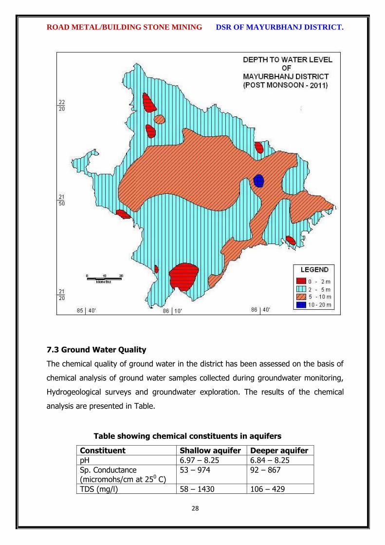
ROAD METAL/BUILDING STONE MINING DSR OF MAYURBHANJ DISTRICT.
28
7.3 Ground Water Quality
The chemical quality of ground water in the district has been assessed on the basis of
chemical analysis of ground water samples collected during groundwater monitoring,
Hydrogeological surveys and groundwater exploration. The results of the chemical
analysis are presented in Table.
Table showing chemical constituents in aquifers
Constituent Shallow aquifer Deeper aquifer
pH 6.97 – 8.25 6.84 – 8.25
Sp. Conductance (micromohs/cm at 250 C)
53 – 974 92 – 867
TDS (mg/l) 58 – 1430 106 – 429

ROAD METAL/BUILDING STONE MINING DSR OF MAYURBHANJ DISTRICT.
29
Calcium (mg/l) 6 – 92 16 – 86
Magnesium (mg/l) 0.6 – 17 3.6 – 22
Sodium (mg/l) 1.6 – 100 3.5 – 168
Potassium (mg/l) 0.4 – 8 <1 --6.4
Bicarbonate (mg/l) 15 – 256 49 – 366
Chloride (mg/l) 7 – 238 5.3 – 85
Sulphate (mg/l) 0.1 – 9 <1 – 82
Nitrate (mg/l) <0.01 – 53 0.1 – 78
Fluoride (mg/l) 0.08 – 20.3 0.21 – 0.61
Total hardness as calcium carbonate
10 – 245 35 - 285
7.4 Ground Water Development
In the rural areas the entire water supply is dependent on ground water. Ground
water development is mainly carried out in the district through dug wells and Hand
pumps. In general dug wells are of 2 m diameter and the depth ranges between 8 to
15 m depending on the thickness of the weathered zone, tapping the shallow aquifer
in the weathered zone and uppermost slice of the basement. Large number of dug
wells used for drinking water is under private ownership for which there is no reliable
data. Over the years Mark II/ Mark III hand pumps are being drilled in large numbers
for ground water development. These hand pumps have the following two major
advantages i) less susceptible to contamination from surface sources and ii) tap
fractures between 20-60m depth which have been found to be less affected by
seasonal water level fluctuation and thus have lesser chances of failure even during
extreme summer. Over all the present level of ground water development is only
27.21 percent in the district with the maximum in Badasahi Block viz. 64.65% and
minimum in Bijatala Block. Block wise development figure indicate that all the blocks
come under the white categories. Thus there is ample scope for development of
groundwater in the district to augment irrigation potentials through suitable ground
water abstraction structure
7.5 Ground Water Related Issue and Problems
Some of key ground water related issues are
I. Locating suitable sites for bore wells
II. Suitable design of dug wells and hand pumps
III. Taking up artificial recharge projects to augment the resource availability in

ROAD METAL/BUILDING STONE MINING DSR OF MAYURBHANJ DISTRICT.
30
Mayurbhanj district.
IV. Optimal development of irrigation potential by developing ground water available
for future uses.
V. Creating public awareness for conserving ground water through awareness
camps, NGO’s and mass media.
7.6 Mass Awareness Campaign (MAP) & Water Management Training
Programme (WMTP) by CGWB
NIL
7.7 Area Notified by Cgwb/Sgwa
None
7.8 RECOMMENDATIONS:
1) Intensive groundwater exploration should be taken up to delineate deeper
potential water saturated fracture zones and to compute aquifer parameter.
2) Large scale planning for ground water development should be preceded by
intensive hydrogeological and geophysical surveys aided by remote sensing
studies.
3) Effective measures may be taken to conserve the surface run off by contour
bonding at suitable sites. Also proper maintenance of reservoir, tanks and spring
channels by periodical disiltation should be carried out.
4) Existing dug-wells should be deepened to tap the maximum saturated thickness of
the weathered mantle or vertical bores may be drilled through the bottom to
enhance the well yield.
5) Energy station of wells already constructed should be stepped up to ensure
optimal utilization of the irrigation potential already created.
6) The farmers should be educated through agricultural extension services fro
adopting suitable cropping pattern for optimal utilization of available groundwater
resources.
7) Programmes for artificial recharge may also be taken up for augmentation of
groundwater through construction of percolation tanks, subsurface dykes, and
check dams and through contour bonding etc.
8) An intensive network of groundwater monitoring stations are required to be
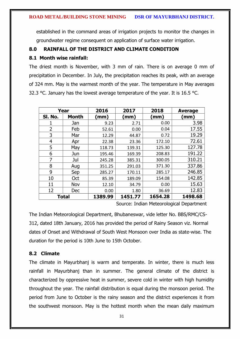
ROAD METAL/BUILDING STONE MINING DSR OF MAYURBHANJ DISTRICT.
31
established in the command areas of irrigation projects to monitor the changes in
groundwater regime consequent on application of surface water irrigation.
8.0 RAINFALL OF THE DISTRICT AND CLIMATE CONDITION
8.1 Month wise rainfall:
The driest month is November, with 3 mm of rain. There is on average 0 mm of
precipitation in December. In July, the precipitation reaches its peak, with an average
of 324 mm. May is the warmest month of the year. The temperature in May averages
32.3 °C. January has the lowest average temperature of the year. It is 16.5 °C.
Year 2016 2017 2018 Average
Sl. No. Month (mm) (mm) (mm) (mm)
1 Jan 9.23 2.71 0.00 3.98
2 Feb 52.61 0.00 0.04 17.55
3 Mar 12.29 44.87 0.72 19.29
4 Apr 22.38 23.36 172.10 72.61
5 May 118.73 139.31 125.30 127.78
6 Jun 195.46 169.39 208.83 191.22
7 Jul 245.28 385.31 300.05 310.21
8 Aug 351.25 291.03 371.30 337.86
9 Sep 285.27 170.11 285.17 246.85
10 Oct 85.39 189.09 154.08 142.85
11 Nov 12.10 34.79 0.00 15.63
12 Dec 0.00 1.80 36.69 12.83
Total 1389.99 1451.77 1654.28 1498.68
Source: Indian Meteorological Department
The Indian Meteorological Department, Bhubaneswar, vide letter No. BBS/RMC/CS-
312, dated 18th January, 2016 has provided the period of Rainy Season viz. Normal
dates of Onset and Withdrawal of South West Monsoon over India as state-wise. The
duration for the period is 10th June to 15th October.
8.2 Climate
The climate in Mayurbhanj is warm and temperate. In winter, there is much less
rainfall in Mayurbhanj than in summer. The general climate of the district is
characterized by oppressive heat in summer, severe cold in winter with high humidity
throughout the year. The rainfall distribution is equal during the monsoon period. The
period from June to October is the rainy season and the district experiences it from
the southwest monsoon. May is the hottest month when the mean daily maximum

ROAD METAL/BUILDING STONE MINING DSR OF MAYURBHANJ DISTRICT.
32
temperature rises up to 47º Celsius. The Köppen-Geiger climate classification is Cwa &
as per they the average temperature in Mayurbhanj is 24.7 °C. The temperature in
May averages 32.3 °C. January has the lowest average temperature of the year, it is
16.5 °C. There is a difference of 321 mm of precipitation between the driest and
wettest months. During the year, the average temperatures vary by 15.8 °C., when
the mean daily minimum temperature dips to 4º Celsius. The higher reaches of the
Similipal experiences frosting during the peak of winter.
9.0 DETAILS OF MINING LEASE OF ROAD METAL/ BUILDING
STONE/BLACK STONE IN THE DISTRICT
9.1 List of Mines is operation in the district:
Attached as Annexure- B
9.2 List of Mines is not operation in the district:
Attached as Annexure- B

ROAD METAL/BUILDING STONE MINING DSR OF MAYURBHANJ DISTRICT.
33
10. DETAIL OF ROYALTY OR REVENUE RECEIVED IN LAST THREE YEARS:
Sl. No. Name of the
Tahasil
2016-17 2017-18 2018-19 Total Amount
(Rs.)
1 Baripada 0 0 0 0
2 Samakhunta 0 0 0 0
3 Kuliana 550217 593244 610626 1754087
4 Bangriposi 8313635 6539799 39895884 54749318
5 Saraskana 0 0 0 0
6 Suliapada 0 0 0 0
7 Betnoti 0 0 0 0
8 Badsahi 0 0 0 0
9 Rasagovindpur 0 0 0 0
10 Morada 0 0 0 0
11 Udala 84507 554305 557307 1196119
12 Kaptipada 314039 7581657 6610173 14505869
13 Khunta 0 0 330750 330750
14 G.B Nagar 3397741 272700 363945 4034386
15 Rairangpur 135975 155400 159840 451215
16 Bisoi 0 0 0 0
17 Bijatala 270776 1858902 769212 2898890
18 Kusumi 1113524 1687760 2939320 5740604
19 Bahalda 553420 1082260 914290 2549970
20 Tiring 518440 735770 726590 1980730
21 Jamda 1214213 1247103 1509560 3970822
22 Karanjia 469908 1468647 8124533 10063088
23 Jashipur 175000 0 0 175000
24 Sukruli 1130314 1900097 2028861 5059272
25 Thakurmunda 265954 417012 468238 1151204
26 Raruan 26260 559933 1186258 1772451
Grand Total 18533923 26654519 67195333 112383775
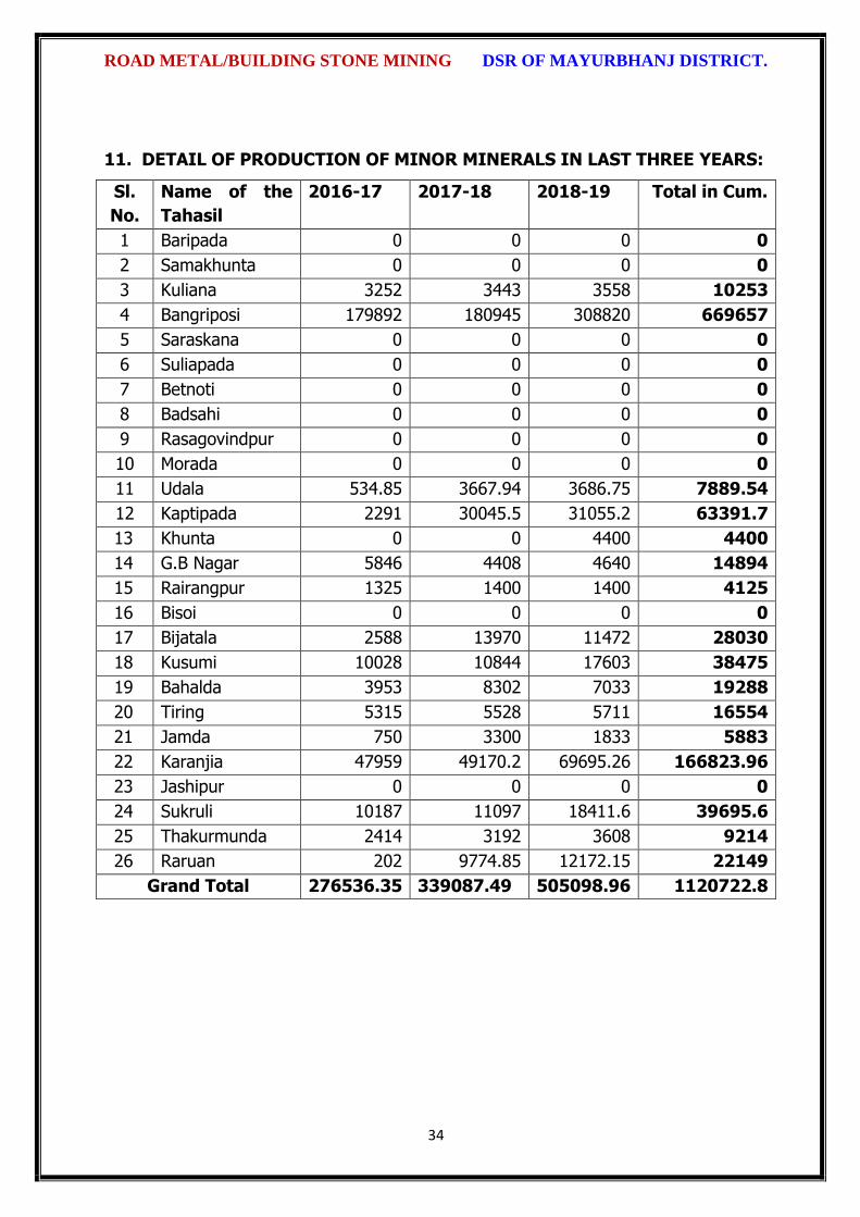
ROAD METAL/BUILDING STONE MINING DSR OF MAYURBHANJ DISTRICT.
34
11. DETAIL OF PRODUCTION OF MINOR MINERALS IN LAST THREE YEARS:
Sl.
No.
Name of the
Tahasil
2016-17 2017-18 2018-19 Total in Cum.
1 Baripada 0 0 0 0
2 Samakhunta 0 0 0 0
3 Kuliana 3252 3443 3558 10253
4 Bangriposi 179892 180945 308820 669657
5 Saraskana 0 0 0 0
6 Suliapada 0 0 0 0
7 Betnoti 0 0 0 0
8 Badsahi 0 0 0 0
9 Rasagovindpur 0 0 0 0
10 Morada 0 0 0 0
11 Udala 534.85 3667.94 3686.75 7889.54
12 Kaptipada 2291 30045.5 31055.2 63391.7
13 Khunta 0 0 4400 4400
14 G.B Nagar 5846 4408 4640 14894
15 Rairangpur 1325 1400 1400 4125
16 Bisoi 0 0 0 0
17 Bijatala 2588 13970 11472 28030
18 Kusumi 10028 10844 17603 38475
19 Bahalda 3953 8302 7033 19288
20 Tiring 5315 5528 5711 16554
21 Jamda 750 3300 1833 5883
22 Karanjia 47959 49170.2 69695.26 166823.96
23 Jashipur 0 0 0 0
24 Sukruli 10187 11097 18411.6 39695.6
25 Thakurmunda 2414 3192 3608 9214
26 Raruan 202 9774.85 12172.15 22149
Grand Total 276536.35 339087.49 505098.96 1120722.8

ROAD METAL/BUILDING STONE MINING DSR OF MAYURBHANJ DISTRICT.
35
12. MINERAL MAP OF THE DISTRICT:
13. LIST OF LETTER OF INTENT (LOI) HOLDERS IN THE DISTRICT ALONG
WITH ITS VALIDITY
Sl. No.
Name of the
Mineral
Name of the
Lessee
Address Letter of Intent Grant
Order No. &
date
Area of Mining lease to
be allotted
Validity of LoI
Use
(Captive/ Non-
Captive)
Location of the Mining
lease (Latitude & Longitude)
1 2 3 4 5 6 7 8 9
Attached as Annexure-B

ROAD METAL/BUILDING STONE MINING DSR OF MAYURBHANJ DISTRICT.
36
14. TOTAL MINERAL RESERVE AVAILABLE IN THE DISTRICT
Total mineral reserve of road metal/Building stone is 18050977.30 cum which may
increase after detail investigation as per details below.
(i) Blocks were identified based on geological studies through field observation.
(ii) Mineable resource was calculated by considering detail prospecting.
(iii) Area calculated as per GPS co-ordinates and information obtained from local
people. Land detail need to be verified from revenue record.
(iv) Since this is an interim report, as per the present requirement of minerals, more
such blocks need to be identified and the data should be updated periodically, after
certain intervals to update the data bank of DSR.
Summary of Identified Mineral Potential:
Sl.
No.
Name
of the
mineral
Name
of the
lessee
Address and
contact No. of
the lessee
Letter of
Intent
Grant
Order
No. and
date
Area of
mining
lease to
be
allotted
Validity of LoI
Use
(Captive/ Non- Captive
Location of the Mining lease (Latitude & Longitude)
1 2 3 4 5 6 7
Attached as Annexure-B
Sl. No.
Name of the Tahasil
Mineral Resources in cum.
Mineable Reserve in cum.
1 Baripada Nil Nil
2 Samakhunta Nil Nil
3 Kuliana 405456 278238
4 Bangriposi 3955649 2695559.2
5 Saraskana 177408 139616
6 Suliapada Nil Nil
7 Betnoti Nil Nil
8 Badsahi 114828 96030
9 Rasagovindpur Nil Nil
10 Morada Nil Nil
11 Udala 88746 34010
12 Kaptipada 29972122.50 1045240.50
13 Khunta Nil Nil
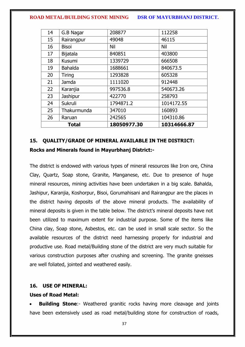
ROAD METAL/BUILDING STONE MINING DSR OF MAYURBHANJ DISTRICT.
37
14 G.B Nagar 208877 112258
15 Rairangpur 49048 46115
16 Bisoi Nil Nil
17 Bijatala 840851 403800
18 Kusumi 1339729 666508
19 Bahalda 1688661 840673.5
20 Tiring 1293828 605328
21 Jamda 1111020 912448
22 Karanjia 997536.8 540673.26
23 Jashipur 422770 258793
24 Sukruli 1794871.2 1014172.55
25 Thakurmunda 347010 160893
26 Raruan 242565 104310.86
Total 18050977.30 10314666.87
15. QUALITY/GRADE OF MINERAL AVAILABLE IN THE DISTRICT:
Rocks and Minerals found in Mayurbhanj District:-
The district is endowed with various types of mineral resources like Iron ore, China
Clay, Quartz, Soap stone, Granite, Manganese, etc. Due to presence of huge
mineral resources, mining activities have been undertaken in a big scale. Bahalda,
Jashipur, Karanjia, Koshorpur, Bisoi, Gorumahisani and Rairangpur are the places in
the district having deposits of the above mineral products. The availability of
mineral deposits is given in the table below. The district’s mineral deposits have not
been utilized to maximum extent for industrial purpose. Some of the items like
China clay, Soap stone, Asbestos, etc. can be used in small scale sector. So the
available resources of the district need harnessing properly for industrial and
productive use. Road metal/Building stone of the district are very much suitable for
various construction purposes after crushing and screening. The granite gneisses
are well foliated, jointed and weathered easily.
16. USE OF MINERAL:
Uses of Road Metal:
Building Stone:- Weathered granitic rocks having more cleavage and joints
have been extensively used as road metal/building stone for construction of roads,

ROAD METAL/BUILDING STONE MINING DSR OF MAYURBHANJ DISTRICT.
38
buildings and various infrastructure development works.
Sub base and base material in road and highway construction:- Crushed
stone is the most basic use of granite. Crushed granite is used as a sub base and base
material in road, railway and highway construction. It is used as crushed stone media
in sewage system drain fields and as a base material for foundations and construction
slabs. Crushed granite in attractive colors is used as a landscape stone and in
planters. It also makes great railroad ballast, and in larger sizes it makes good riprap.
Granite Paving Stone:- Granite paving stones or "pavers" can make a colorful
and interesting way of paving a driveway or patio. The beauty of natural stone
combined with expert craftsmanship and design can produce a unique and lasting
result. In the past granite blocks were often used to pave city streets.
Engineering:- Engineers have traditionally used polished granite surface plates
to establish a plane of reference, since they are relatively impervious and inflexible.
Sandblasted concrete with a heavy aggregate content has an appearance similar to
rough granite, and is often used as a substitute when use of real granite is
impractical. Granite block is usually processed into slabs, which can be cut and shaped
by a cutting center. Granite tables are used extensively as bases for optical
instruments because of granite's rigidity, high dimensional stability, and excellent
vibration characteristics.
17. DEMAND AND SUPPLY OF THE MINERAL IN THE LAST THREE YEARS:
As such there are huge infrastructural activities such as road, building, railways are
coming up by Govt. of India & PSUs under “Make in India” programme. The Granitic
rocks are the main raw minerals for the above activities and considering the last three
years’ actual production of Mayurbhanj with respect to the requirement of the state
has a huge gap. It is proposed to start the stone production from larger block/area to
at least double the production of the district which will enhance the revenue of the
district and also support the livelihood of the local people.
18. MAP OF EXISTING MINING LEASES IN THE DISTRICT:
Enclosed as Plate-I

ROAD METAL/BUILDING STONE MINING DSR OF MAYURBHANJ DISTRICT.
39
19. DETAILS OF THE AREA OF WHERE THERE IS A CLUSTER OF MINING
LEASE VIZ. NUMBER OF MINING LEASES, LOCATION (LATITUDE AND
LONGITUDE)
Currently there are two such clusters of mining leases in Kaptipada area of the district
(Enclosed as Annexure-II). However, it is proposed to consider the cluster of mining
lease while planning for new lease area in coming years.
20. DETAILS OF ECO-SENSITIVE AREA, IF ANY, IN THE DISTRICT:
Eco sensitive zone of Similipal wild life sanctuary is located within the district.
21. IMPACTS OF MINING ON ENVIRONMENT:
The most important environmental impact of mining projects is:-
Transportation sources:
Transportation sources of air pollutants include heavy vehicles used in excavation
operations, cars that transport personnel at the mining site, and trucks that transport
mining materials. The level of polluting emissions from these sources depends on the
fuel and conditions of the equipment. Even though individual emissions can be
relatively small, collectively these emissions can be of real concern. In addition,
mobile sources are a major source of particulate matter, carbon monoxide, and volatile
organic compounds that contribute significantly to the formation of ground-level ozone
Fugitive emissions:
Common sources of fugitive emissions include: storage and handling of materials;
mine processing; fugitive dust, blasting, construction activities, and roadways
associated with mining activities; leach pads, and tailing piles and ponds; and waste
rock piles. Sources and characteristics of fugitive emissions dust in mining operations
vary in each case, as do their impacts. Impacts are difficult to predict and calculate
but should be considered since they could be a significant source of hazardous air
pollutants.
Noise and vibration:
Noise pollution associated with mining may include noise from vehicle engines,
loading and unloading of rock into steel dumpers, chutes, power generation, and
ROAD METAL/BUILDING STONE MINING DSR OF MAYURBHANJ DISTRICT.
40
other sources. Cumulative impacts of shoveling, ripping, drilling, blasting, transport,
crushing, grinding, and stock-piling can significantly affect wildlife and nearby
residents.
Vibrations are associated with many types of equipment used in mining operations,
but blasting is considered the major source. Vibration has affected the stability of
infrastructures, buildings, and homes of people living near large-scale open-pit mining
operations. According to a study commissioned by the European Union in 2000:
“Shocks and vibrations as a result of blasting in connection with mining can lead to
noise, dust and collapse of structures in surrounding inhabited areas. The animal life,
on which the local population may depend, might also be disturbed.”
22. REMEDIAL MEASURES TO MITIGATE THE IMPACT OF MINING ON THE
ENVIRONMENT:
1. Following are the remedial measures to mitigate the in Water sprinkling on haul
road, loading and unloading points.
2. Plantation along the safety zone and dump area.
3. Providing dust masks to workers.
4. Regular monitoring of ambient air quality.
5. Provision of air conditioned cabin of Excavators and Dumpers.
6. Regular and proper maintenance of working equipments.
7. Periodic medical examination of the workers and organize medical camp in the area.
8. Use Milli Second Delay Detonator in blasting operation.
9. Provisions of ear plug to the workers.
10. Regular training programme to the mines workers and operators.
23. RECLAMATION OF MINED OUT AREA
Necessity of Reclamation & Rehabilitation:
Exponential growth in mineral production since 1980.
Mining activities causes physical, chemical, biological and socio-economic changes in
the area.
Surface mining activities disturb the original land profile.
In India, mineral production comes mostly from opencast mines & hence land

ROAD METAL/BUILDING STONE MINING DSR OF MAYURBHANJ DISTRICT.
41
degradation problems are of serious concern.
An intricate, in-depth and site-specified techniques involving integrated approach is
necessary.
Reclamation has three vital roles:
i. Reclamation – Reclamation means return the mined-out land with useful life. It
implies restoring the land to a form and productivity that is useful and inconformity
with a prior land use. Reclamation always may not be a single- phase operation.
ii. Rehabilitation – Rehabilitation is to bring batch the degraded land to a normal
stage by a special treatment. It is a process of taking some mitigation measures for
disturbed environmental condition created through mining activities.
iii. Restoration – Restoration is the process of returning the mined out land being
fit to an acceptable environmental condition. However, the general acceptable
meaning of the term is bringing the disturbed land to its original form. Restoration is
often used to indicate that biological properties of soil are put back to what they were.
This is a rate phenomenon.
iv. When active mining ceases, mine facilities and the site are reclaimed and closed.
The goal of mine site reclamation and closure should always be to return the site to a
condition that most resembles the pre-mining condition. Mines that are notorious for
their immense impact on the environment often made impacts only during the closure
phase, when active mining operations ceased. These impacts can persist for decades
and even centuries.
Mine reclamation and closure plans must describe in sufficient detail how the mining
company will restore the site to a condition that most resembles pre-mining
environmental quality; how it will prevent – in perpetuity – the release of toxic
contaminants from various mine facilities (such as abandoned open pits and tailings
impoundments); and how funds will be set aside to insure that the costs of
reclamation and closure will be paid for.
Proposed future land use after reclamation:
a. Forestry, b. Recreation, c. Water Reservoir, d. Crop Land,
e. residential/Commercial, f. Fish & wildlife Habitat, g. Undeveloped Land,
h. Grazing/Pasture Land
Statutory requirement:

ROAD METAL/BUILDING STONE MINING DSR OF MAYURBHANJ DISTRICT.
42
As per the Mineral Conservation Development Rule, 2017, the following rules must be
bare in mind by the mine owner/agent/manager, which is a part of reclamation
activities –
Rule 22, Mine Closure Plan
Rule 23, Submission of Progressive Mine Closure Plan Rule 24, Submission of Final
Mine Closure Plan
Rule 26, Responsibility of holder of mining lease Rule 27, Financial Assurance
Rule 35, Sustainable Mining
24. RISK ASSESSMENT AND DISASTER MANAGEMENT PLAN:
Mining activity because of the very nature of the operation, complexity of the
systems, procedures and methods always involves some amount of hazards. Hazard
identification and risk analysis is carried for identification of undesirable events that
can leads to a hazard, the analysis of hazard mechanism by which this undesirable
event could occur and usually the estimation of extent, magnitude and likelihood of
harmful effects. The activities which can cause high risk related to face stability and
the person blasting the shots. It was observed that on a working face of the mine,
there were large cracks and unsupported rocks were present, which can lead to a
serious hazard and injure workers engaged in loading operation and machineries
because of rock falls or slides. This type of condition turn out because improper
dressing of the bench and improper supervision. To avoid the hazards due to fall of
rocks the face must be examined, made suitable for working and the remedial
measures must be taken to make it safe if there is any doubt that a collapse could
take place. Working of the face should be in the direction taking into account the
geology of the area such that face and quarry side remain stable. Another major risk
identified in mines is due to the firing of explosive by an unqualified person. In the
mines there is problem of fly rocks and the village is located close to the mine and so
it is rated high as it can affect may people. Explosives by nature have the potential for
the most serious and catastrophic accident. Planning of round of shots, holes correctly
drilled, direction logged, weight of explosive suitable for good fragmentation are the
few of the steps necessary to ensure its safe use and if the shots are not properly
designed can result in misfires, early ignition and flying rocks. No person is allowed to
use explosives without being properly trained in its handling. In the mine a large

ROAD METAL/BUILDING STONE MINING DSR OF MAYURBHANJ DISTRICT.
43
numbers of heavy vehicles were in operation and the roads were not proper for
haulage purpose. The haulage roads were not even and were not wide enough for the
crossing purpose and hence the chances of hazards are very high. The main hazards
arising from the use large earth moving vehicles are incompetent drivers, brake
failure, lack of all-around visibility from the driver position, vehicle movements
particularly reversing, roll over, and maintenance. Those most at risk are the driver
and pedestrians likely to be struck by the vehicle, and drivers of smaller vehicles,
which cannot be seen from the cabs of large vehicles. Edge protection is always
necessary to prevent inadvertent movement over the edge of roadway or a bench.
Seatbelt will protect driver in case of roll. Good maintenance and regular testing are
necessary to reduce the possibility of brake failure. Access to the vehicles should
always be restricted to those people necessary for the work in hand. The use of
personal protective equipment and proper arrangements is essential to check if the
person is wearing protective equipment or not. The personal protective equipment
includes helmet, non-skid safety boots, safety glasses, earmuffs etc. The required
personal protective equipment should be provided and used in a manner that protects
the individual from injury. Few minor injuries which can be prevented are slip, trip, or
fall hazards; hazards due to rock falls and collapse of unstable rocks, atmosphere
containing toxic or combustible gases; protects from chemical or hazardous material
etc. A disaster management plan should be prepared for taking care of for any
disaster. Other risks which are included in this category are noise, as it occurs and it
can lead to permanent disability. There are problems related to road traffic in and out
issuers; inappropriate exposure of moving machines; mechanical failure and because
of large number of moving trucks and dumpers there is large quantity of dust present
in roadways which affects the operators and can lead to accidents causing injury.
They are in acceptable range because of precautions measures taken but no step is
taken it can cause hazard hence steps should be taken to reduce the hazards such as
for dust suppression system should be installed. Other problems like occurrence of
lots of mosquitoes in the area due to unhygienic conditions which affect the human
health causing malaria, dengue etc. and causing a person to be hospitalized.

ROAD METAL/BUILDING STONE MINING DSR OF MAYURBHANJ DISTRICT.
44
Disaster in the mines like fires, explosions, entrapments, and inundations can occur
any time, so emergency preparedness is a must. The Disaster management plan and
risk assessment in the mines will include all sorts of above mentioned emergency and
the extent that this plan will be implemented will depend on the nature and scope of
the emergency. The basic purpose of Disaster management plan and risk assessment
to ensure that mine rescue and recovery activities are conducted safely for rescuer
and survivors. According to MMR act 1961 a standard operating procedure should be
drawn for involvement different category of staff and officers. The SOP should be
updated periodically to reduce the chaos and response to the emergency should be
quick and smooth. The responsible person should be familiar with his responsibility
during the mock drills. One or two standby should be there to replace the person in
Emergency situation. Rescue operations should not include the survivors for any
assistance.
First Information of Disaster / Emergency should go to the attendance clerk on duty.
Duties of attendance Clerk (Emergency Siren) the attendance clerk or other
designated person should on getting information of major accident, sound a hooter or
a siren immediately declaring a state of emergency at the mine and then to contact
the manager and on his advice to call key personnel using the information listed in the
Emergency Organization Chart. It is important that all telephone calls are recorded in
a telephone log book. Duties of Other Officials should be displayed and handed over
to all concerned. Copy the same should be kept at Manager’s Office for ready
reference. Establishment of Control Room at Unit Level, Area Level and Company
Level is essential. Control Room should keep the contact information about –
Company Manager
Company owner/ Administrative officer.
District Administration
Govt. Hospitals in Nearby Localities,
Private Nursing Homes of Localities
Attendance roaster and duty charge register should be properly maintained so the
record of missing people can be obtained.

ROAD METAL/BUILDING STONE MINING DSR OF MAYURBHANJ DISTRICT.
45
25. DETAILS OF THE OCCUPATIONAL HEALTH ISSUE IN THE DISTRICT:
The persons employed in the mines are exposed to a number of hazards at work
which adversely affect their health. Some of the important ones are dust, noise, heat,
humidity, vibration etc. In recent times, there has been increasing awareness among
mining industry and the workers about occupational diseases like Pneumoconiosis,
Silicosis, Tuberculosis, Hearing Impairment etc. caused by exposure to health hazards
at work. Almost all occupational diseases can be prevented by adopting proper
occupational health measures and engineering control on airborne dust pollution at
workplace. Occupational Diseases in mines or industry is required to conduct medical
examinations and health surveillance of workers as per the provisions of Mines Act.
The present efforts of mines management are concentrated on detection of silicosis,
Pneumoconiosis and other notified diseases. The essential features of health
surveillance programme required to be carried out in mines are:
(a) Initial Medical Examination of persons to be conducted at the time of
appointment.
(b) Periodic Medical Examination or General physical examination to be conducted
once in every year.
(c) Maintenance of medical records and health services till the person is in service.
(d) The Details of Tuberculosis cases in last 5 years is given below
RNTCP Activities from 2014 to 2018
Year Projected Population
No of Sputum Examined
Sputum Examine
d per Lakh/Qr
No of
Sputum Positive
Sputum Positive
%
Total Case put on
DOTS/No of
TB
cases
Child DOTS out of Total DOTS
Case detectin
per Lakh/Yr
Sputum
Conversion Rate
NSP Cure Rate
NSP Death Rate
(in Lakh) Norm- 150
Norm-8-15 %
Norm-170 /L/Y
Norm-90 %
Norm-90%
Norm < 5%
2014 26.01 16848 161.9 2825 16.8% 4883 103 187.7 90.2% 89.0% 7.4%
2015 26.30 18118 172.2 2836 15.7% 4831 123 183.7 90.5% 89.0% 6.7%
2016 26.59 20060 188.6 2975 14.8% 5171 119 194.5 95.0% 90.9% 6.5%
2017 26.88 31035 289.4 3152 11.4% 5127 111 190.7 94.0% 91.6% 5.5%
2018 27.18 21273 195.6 2853 13.4% 4894 95 173.4 95.3% 92.7% 6.4%

ROAD METAL/BUILDING STONE MINING DSR OF MAYURBHANJ DISTRICT.
46
26. PLANTATION GREEN BELT DEVELOPMENT IN RESPECT OF LEASE
ALREADY GRANTED IN THE DISTRICT:
During mining operation green belt development through plantation is most important
for environment safe guard, which should be supervision by mining department.
Different type of species should be planted near lease periphery to keep environment
clean at post mining period through reclamation. Where specific usefulness of land
could be decided, a forestation is normally planned through the site could have been
considered for better possibilities of land use.
27. CONCLUSION:
Since it is an interim report, to meet the requirement of minerals in the present
scenario, it is proposed to identify such potential areas at certain interval and get the
data bank of DSR to be updated. The insitu mining activity in any area is on one hand
bring revenue and employment (Direct and indirect) and on other hand if not done
properly potential pollution and ecological imbalance increases, the ability of the
ecosystem can also be reduced. Particulate matter transported by the wind as a result
of excavations, blasting, transportation of materials, heavy equipments used raise
these particulate levels; and Gas emissions from the combustion of fuels in stationary
and mobile sources, explosions, and mineral processing. All these activities indirectly
affected the biodiversity of area. Larger potential and smaller areas have been
identified in Mayurbhanj district on the basis of geological study carried out during
field observation, which can be considered for mining concession after all the
parameters for statutory clearances are verified by consulting with concerned
authorities.
ROAD METAL/BUILDING STONE MINING DSR OF MAYURBHANJ DISTRICT.
47
Plate No.-I

ROAD METAL/BUILDING STONE MINING DSR OF MAYURBHANJ DISTRICT.
48

ROAD METAL/BUILDING STONE MINING DSR OF MAYURBHANJ DISTRICT.
49

C
j
*
L
\
1,
k
t
{r
f
t-
$t
C
ROAD METAL/BUILDING STONE MINING DSR OF MAYURBHANJ DISTRICT'
The District Survey Report for Road Metal/Building Stone/Black Stone
Mining (Minor Mineral) in respect of Mayurbhanj District prepared in accordance with
Appendix-X, para -t (iii) (a) of s.o. 3611 (E) Dt" 25.07 .2018 of Ministry of
Environment, Forest and Climate Chaflg€, New Delhi is approved for final publication
in the district website.
G^ 10s
\B
D H,K"Sahu, Sri S,Mallick, I.F.S,DFO-cum-Member,DEIAA, MaYurbhanj
Sri Dibyajyoti Pa rida, I.A.S
Prof in ZoologY, NOU -cum-Member/ DEIAA, MaYurbhanj
SDM, Sadar-cum -Member SecretaryDEIAA, MaYurbhani
4
Sri Vineet wai,Collector & DM-cum- airrnan, DEIAA
Mayurbhanj (Odisha)
50
\
(

Fro
m
To
Fro
m
To
1 2 3 4 5 6 7 8 9 10 11 12 13 14 15 16 17 18 19
Samakhunta 1 Stone - - -
Area- 1.24 Ha , Vill-
Mahulkarkachia,
Khata No- 263,
Plot No.-159/1,
Kisam-Patharbani
- - - - -
Non
Working- - - - - -
Samakhunta 2 Stone - - -
Area -1.22 Ha, Vill-
Mahulkarkachia,
Khata No-263, plot
No.-159/2, Kisam-
Patharbani
- - - - -
Non
Working- - - - - -
Samakhunta 3 Stone - - -
Area -1.22 Ha,
Vill-
Mahulkarkachia,
Khata No-263, plot
No.-159/3 , Kisam-
Patharbani
- - - - -
Non
Working- - - - - -
Samakhunta 4 Stone - - -
Area -1.25 Ha, Vill-
Mahulkarkachia,
Khata No-263, plot
No.-159/1, Kisam-
Patharbani
- - - - -
Non
Working- - - - - -
OTHER THAN SAND MINING (ROAD METAL/BUILDING SOTNE/BLACK STONE ) Annexure - B
Name of the
TahasilSl No
Name
of
Mineral
s
Name of Lessee
Address and
Contact No. of
Lessee
Mining Lease
Grant Order No.
& Date
Area of Mining lease
(Ha.) with
Village,Khata No,
plot No & Kisam
Period
of
mining
Lease
(Initial)
Period
of
Mining
Lease
(1st
/2nd--
Renewa
l)
Geological
Reserve
(MT/Cums)
Mineable
reserve
(MT/Cums)
Date of
Comme
ncemen
t of
mining
Operati
on
Status
(Working
/non-
working/
temp
working
for
dispatch
etc.)
Captive/
Non-
Captive
Obtained
environment
al Clearance
(Yes/No). If
yes Letter no
with date of
EC
Location of Mining
Lease (
Latitude &
Longitued)
Method of
Mining
Open Cast/
Under
Ground)

1 2 3 4 5 6 7 8 9 10 11 12 13 14 15 16 17 18 19
Samakhunta 5 Stone - - -
Area- 0.88 Ha,
Vill-
Mahulkarkachia,
Khata No-263,
plot No.-694,
Kisam-Patharbani
- - - - -
Non
Working- - - - - -
Samakhunta 6 Stone - - -
Area -1.30 Ha, Vill-
Rangibhole, Khata
No-158, Plot No.-
328/1 , Kisam-
Patharbani
- - - - -
Non
Working- - - - - -
Samakhunta 7 Stone - - -
Area -1.30 Ha , Vill-
Rangibhole, Khata
No-159 , plot No.-
328/2, Kisam-
Patharbani
- - - - -
Non
Working- - - - - -
Samakhunta 8 Stone - - -
Area- 1.22 Ha ,
Vill-Gundihudi ,
Khata No-167, plot
No.-398/1 , Kisam-
Patharbani
- - - - -
Non
Working- - - - - -
Samakhunta 9 Stone - - -
Area -1.25 Ha , Vill-
Gundihudi , Khata
No-167, plot No.-
398/2, Kisam-
Patharbani
- - - - -
Non
Working- - - - - -
Samakhunta 10 Stone - - -
Area - 0.87 Ha,
Vill-
Saratchandrapur,
Khata No-419, Plot
No.-307, Kisam-
Patharbani
- - - - -
Non
Working- - - - - -

1 2 3 4 5 6 7 8 9 10 11 12 13 14 15 16 17 18 19
Kuliana 11 StoneNarendra
Pradhan
At-
Bijayramchand
rapur, Ward
No-21, Po-
Baripada, dist-
Mayurbhanj
992
dt.27.03.2015
Area- 1.510 Ha
Vill-Kothabila
Khata No-177,
Plot No.- 1160,
Kisam-Dunguri,
Plot No- 1163,
Kisam-Pathar
Chatan, Plot No-
1177, Kisam-
Dunguri
2015-1
6
2019-2
0
- -
02.1
2.2
016
WorkingNon-
Captive
Yes, No-
DEIAA48,
Dt.27.05.201
6
Latitude-22
⁰
05'
43'' to 22
⁰
05'
49.3''N
Longitude-86
⁰
42'
35'' to 86
⁰
42'
39.8''E
Open Cast1,28,088
cum68726 Cum
Kuliana 12 StoneNarendra
Pradhan
At-
Bijayramchand
rapur, ward
no-21, Po-
Baripada, dist-
Mayurbhanj
No-VI-01/2015-
1730/CZ dt
29.06.2015
Area.- 1.093 Ha,
Vill-Panijia, Khata
No-152, Plot No.-
994, Kisam-
Dunguri, Plot No-
1019, Kisam-
Pathar Chatan
1047, Kisam-
Dunguri, Plot No-
1087 1089, 1097,
1091, 1095, 1099,
1102 & 1108
2015-1
6
2019-2
0
- -
31.1
2.2
015
WorkingNon-
Captive
Yes, No-
SEIAA-
4527,
Dt.17.08.201
5
Latitude-22
⁰
02'
33'' to 22
⁰
02'
36.1''N
Longitude-86
⁰
41'
25'' to 86
⁰
41'
37''E
Open Cast 81,312 cum69,688
cum
Kuliana 13 StoneSu- Kumar
Dash
At-
Bijayramchand
rapur, ward
no-21, Po-
Baripada, dist-
Mayurbhanj
990/ 27.03.2015
Area- 3.166 Ha.
Vill-
Srichandanpur,
Khata No-88,
Plot- 319,
Kissam- Patharbani2015-1
6
2019-2
0
- - -
Non-
working
Non-
Captive No
Latitude-20
⁰
03'
35'' to 20
⁰
03'
41''N
Longitude-86
⁰
36'
21'' to 86
⁰
36'
30''E
Open Cast196056
cum139824 cum
Bangriposi 14 StoneBiswaraj
Mohanty
At/Po-
Baripada,
Mayurbhanj,94
37189062
64
Dt.27.05.2016
Area - 0.81Ha,
Village:-Nafri,
Khata No. - 178,
Plot No: - 264,
Kisam : -
Patharbani
2015-1
6
2019-2
0
- - - Working -64 dt.
27.05.2016
22 07"20" to 22
07"25"North and
86 33" 59" to 86
34"02"East
- 39428 30960

1 2 3 4 5 6 7 8 9 10 11 12 13 14 15 16 17 18 19
Bangriposi 15 Stone
Suguda
Murmu &
others
At/Po-
Dhobanisole,
Bangriposi,
Mayurbhanj,94
37935744
66
Dt.27.05.2016
Area- 2.43
Village:-Nafri
Khata No.-178
Plote No:- 695/1
Kisam : -
Patharbani
2015-1
6
2019-2
0
- - - Working -66 Dt.
27.05.16
22 07"28" to 22
07"233"North and
86 33" 65" to 86
34"02"East
- 248760 170550
Bangriposi 16 StoneBibudhendu
Ku. Das
At-
Ambikasahi,
Baripada,
9437161645
163
Dt.14.01.2016
Area- 3.24 Ha,
Village:-
Mundhabani ,
Khata No - 74,
Plot No:- 406/2,
Kisam :
Patharbani
2015-1
6
2019-2
0
- - - Working -163 Dt.
26.01.2016
22 06"55.2" to 22
07" 01.9"N & 86
39" 49.3" to 86 39
"57.1E
- 245221 117647
Bangriposi 17 StoneBibudhendu
Ku. Das
At-
Ambikasahi,
Baripada,
9437161645
6227
Dt.27.05.2016
Area:- 2.83 Ha
Village:-
Mundhabani
Khata No.- 74
Plot No:- 406/1
Kisam :-
Patharbani
2015-1
6
2019-2
0
- - - Working -6227 Dt.
27.05.2016
22 06"55.02"N to
22 07"8.8"N & 86
39"38.3"E to 86
39"46.6" E
- 280704 211392
Bangriposi 18 Stone
Nirbhay
Kumar Pallei,
D.G.M.
Hi-tech rock
product,
agrrigates ltd
3rd floor,
landmark B.
Suren Road
Kolkata,
6370119380
2006, Dt.
27.05.2016
Area:- 3.2 Ha
Village:-
Mundhabani ,
Khata No- 74
Plot No: - 406/3,
Kisam - Patharbani
2015-1
6
2019-2
0
- - - Working - -
22 06"55.9"N to
22 07"17"N & 86
39"50"E to 86
39"56.6" E
- 848394 499228
Bangriposi 19 StoneBibudhendu
Ku. Das
At-
Ambikasahi,
Baripada,
9437161645
6229, Dt.
27.05.2016
Area:- 0.31
Ha,Village:-
Jagannathkhunta,
Khata No.- 321,
Plot No- 1310,
Kisam :- Huli
2015-1
6
2019-2
0
- - - Working -3792
30.07.2015
22 06"09 to 22
06"11 north & 86
38"58 to 86 38 58
east
- 10080 9264
Bangriposi 20 StoneJalandhar
Reddy
Anusaha project
pvt.
Ltd, Bhubaneswar
9491383888
4255Dt.17.08.1
5
Area:- 3.24 Ha
Village:-K.M.kata
Khata No.- 488,
Plot No:-
3371/1, Kisam-
Patharbani
2015-1
6
2019-2
0
- - - Working -4255 Dt
17.08.2015
22 05"10 to 22
05"15 N& 85
40"50to 85 40"58
E
- 194720 211392

1 2 3 4 5 6 7 8 9 10 11 12 13 14 15 16 17 18 19
Bangriposi 21 StoneSuresh Kumar
Behera
At/Po-
Budamara,
Bangriposi
Mayurbhanj,
7008583860
3794,
Dt.30.07.15
Area :- 0.983 Ha
Village:-J.khunta
Khata No-
322/68, Plot No:-
1092 &1093,
Kisam -Patharbani
2015-1
6
2019-2
0
- - - Working -3793 dt.
30.07.2015
22 06"12" to 22
06" 14 North & 86
38"52" to 86
38"42 east
- 16080 11460
Bangriposi 22 Stone
Shyamlal
Bhattar &
others
At/Po-
Lalbazar,
Baripada,
9438427038
673
Dt.27.03.2016
Area - 2.43 Ha
Village:-Nafri
Khata No. - 178,
Plot No:- 695/1,
Kisam -Patharbani
2015-1
6
2019-2
0
- - - Working -66 dt.
27.05.2015
22 07"20" to 22
07"25"North and
86 33" 59" to 86
34"02"East
- 218304 138528
Bangriposi 23 StoneBackbone
Enterprises
At/po-
Jagannathkhu
nta,
7978956610
6231
Dt.27.05.2016
Area:- 3.42 Ha
Village:-
Mundhabani
Khata No.- 74,
Plot No: - 406/4,
Kisam -Patharbani
2017-1
8
2022-2
3
- - - Working -6227 dt
27.05.16
22 06"58.8"N to
22 07"17"N & 86
39"60"E to 86
39"58.6" E
- 546756 358918.2
Bangriposi 24 StoneArun Ku.
Sarkar
Bhanjpur,
Baripada,
9437161344
238 Dt.
28.02.2018
Area - 2.84 Ha
Village:-
Mundhabani,
Khata No- 74
Plote No:- 406/5
Kisam -Patharbani
2018-1
9
2024-2
5
- - - Working -3562 Dt.
15.08.2016
22 06" 45.2"N to
22 06"53.3N & 86
39"43.8"E to 86
39"51.3"E
- 374624 236400
Bangriposi 25 Stone Priyabrata DasBaripada,
9437681682
253
Dt.16.03.2018
Area - 4.30 Ha
Village:-
Mundhabani,
Khata No- 74
Plot No:- 406/6
Kisam-Patharbani
2018-1
9
2024-2
5
- - - Working -3568
15.08.2016
22 06"51.5"N to
22 06"56.5N & 86
39"41.3"E to 86
39"51.1"E
- 316432 171372
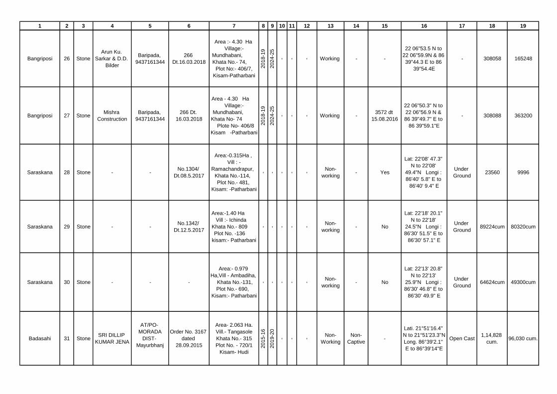
1 2 3 4 5 6 7 8 9 10 11 12 13 14 15 16 17 18 19
Bangriposi 26 Stone
Arun Ku.
Sarkar & D.D.
Bilder
Baripada,
9437161344
266
Dt.16.03.2018
Area :- 4.30 Ha
Village:-
Mundhabani,
Khata No.- 74,
Plot No:- 406/7,
Kisam-Patharbani
2018-1
9
2024-2
5
- - - Working - -
22 06"53.5 N to
22 06"59.9N & 86
39"44.3 E to 86
39"54.4E
- 308058 165248
Bangriposi 27 StoneMishra
Construction
Baripada,
9437161344
266 Dt.
16.03.2018
Area - 4.30 Ha
Village:-
Mundhabani,
Khata No- 74
Plote No- 406/8
Kisam -Patharbani
2018-1
9
2024-2
5
- - - Working -3572 dt
15.08.2016
22 06"50.3" N to
22 06"56.9 N &
86 39"49.7" E to
86 39"59.1"E
- 308088 363200
Saraskana 28 Stone - -No.1304/
Dt.08.5.2017
Area:-0.315Ha ,
Vill : -
Ramachandrapur,
Khata No.-114,
Plot No.- 481,
Kisam: -Patharbani
- - - - -
Non-
working- Yes
Lat: 22'08' 47.3"
N to 22'08'
49.4"N Longi :
86'40' 5.8" E to
86'40' 9.4" E
Under
Ground23560 9996
Saraskana 29 Stone - -No.1342/
Dt.12.5.2017
Area:-1.40 Ha
Vill :- Ichinda
Khata No.- 809
Plot No. -136
kisam:- Patharbani
- - - - -
Non-
working- No
Lat: 22'18' 20.1"
N to 22'18'
24.5"N Longi :
86'30' 51.5" E to
86'30' 57.1" E
Under
Ground89224cum 80320cum
Saraskana 30 Stone - - -
Area:- 0.979
Ha,Vill - Ambadiha,
Khata No.-131,
Plot No.- 690,
Kisam:- Patharbani
- - - - -
Non-
working- No
Lat: 22'13' 20.8"
N to 22'13'
25.9"N Longi :
86'30' 46.8" E to
86'30' 49.9" E
Under
Ground64624cum 49300cum
Badasahi 31 StoneSRI DILLIP
KUMAR JENA
AT/PO-
MORADA
DIST-
Mayurbhanj
Order No. 3167
dated
28.09.2015
Area- 2.063 Ha.
Vill.- Tangasole
Khata No.- 315
Plot No. - 720/1
Kisam- Hudi
2015-1
6
2019-2
0
- - -
Non-
Working
Non-
Captive-
Lati. 21°51'16.4''
N to 21°51'23.3''N
Long. 86°39'2.1''
E to 86°39'14''E
Open Cast1,14,828
cum.96,030 cum.

1 2 3 4 5 6 7 8 9 10 11 12 13 14 15 16 17 18 19
Udala 32 StoneBijay Ku.
Behera
At-Manandi,
Udala,
Mayurbhanj
1897/02
dt.21.09.2016
Area - 0.8093 Ha,
Vill- Hill Block-2,
Khata No- 2,
Plot No.- 1/02,
Kisam-Patharbani
2015
2019-2
0
2017-1
8
2018-1
9
21.1
0.2
016
Working -
No.4072
dt.17.08.201
5
N21 34' 33"-21
34' 35"
E86 36' 47"-86
36' 48"
Open cast32946
CUMS
12,635
(Cums)
Udala 33 StoneAskhay Ku.
Behera
At-Manandi,
Udala,
Mayurbhanj
308/02
dt.03.06.2015
Area.- 0.2428 Ha
,Vill- Hill Block-
1,Khata No-2 , Plot
No.- 01/01,Kisam-
Patharbani
2015
2019-2
0
2017-1
8
2018-1
9
24.0
7.2
017
Working -
No.27
Dt.01.03.201
7
N21 34' 34.2"-21
34' 40.4"
E86 36' 47.3"-
86 36' 51.2"
Open cast55,800/-
cums
21,375
(Cums)
Kaptipada 34 StoneSri Laxmidhar
Nayak
Guapal P.S.
Khaira Dist.
Balasore
Mob. No
9937312961
2231 Dt.
30.07.15
Area.-2.023 Ha,
Vill- Sukhuapata
Hill, Khata No-
53, Plot No.-
571/1, Kisam-
Parbat -I
2015-1
6
2019-2
0
- -
01.0
2.2
018
Non
Working
Non-
Captive
132/ DEIAA
dt
22.11.17
21019'9.8" N to
21019'13.9" N
86024'7.4" E to
86024'13.7"E
Open cast 314954 230849
Kaptipada 35 StoneNarendra Nath
Dhar
Mituani P.S
Khaira Dist
Balasore
Mob.No
9437077411
2244 Dt.
31.07.15
Area.-0.607 Ha,
Vill- Sukhuapata
Hill Khata No-
53, Plot No.-
571/2, Kisam-
Parbat -I
2015-1
6
2019-2
0
- -
01.0
2.2
018
Non
Working
Non-
Captive
134/ DEIAA
dt
22.11.17
21019'13.8" N to
21019'17.1"
N,86024'9" E to
86024'11.9"E
Open cast 120000 58512
Kaptipada 36 StoneDambarudhar
Nayak
Guapal P.S.
Khaira Dist.
Balasore
Mob.
No.943753189
7
2237 Dt.
30.07.15
Area-0.971 Ha
Vill- Sukhuapata
Hill , Khata No-
53, Plot No.-
571/3 , Kisam-
Parbat -I
2015-1
6
2019-2
0
- -
01.0
2.2
018
Non-
working
Non-
Captive
136/ DEIAA
dt
22.11.17
21019'15" N to
21019'18.6"
N,86024'11" E to
86024'16.4"E
Open cast 302616 177336
Kaptipada 37 StoneNarendra Nath
Dhar
Mituani P.S
Khaira Dist
Balasore
Mob.
9437077411
2243 Dt.
31.07.2015
Area-0.647 Ha
Vill- Sukhuapata
Hill, Khata No-
53, Plot No.-
571/4, Kisam-
Parbat -I
2015-1
6
2019-2
0
- -
01.0
2.2
018
Non
working
Non-
Captive
138/ DEIAA
dt
22.11.17
21019'17" N to
21019'20.1" N,
86024'12.7" E to
86024'16.8"E
Open cast 183870 85320

1 2 3 4 5 6 7 8 9 10 11 12 13 14 15 16 17 18 19
Kaptipada 38 StoneSanjay Ku.
Puhan
Kainsari P.S.
Udala Dist.
Mayurbhanj
Mob.
9777784222
2194
Dt.27.07.15
Area -0.4.5 Ha
Vill- Sukhuapata
Hill, Khata No-
53, Plot No.-
571/5, Kisam-
Parbat -I
2015-1
6
2019-2
0
- -
01.0
2.2
018
Non
working
Non-
Captive
140/ DEIAA
dt
22.11.17
21019'19.1" N to
21019'21.7" N,
86024'13.7" E to
86024'16.8"E
Open cast 84710 28814
Kaptipada 39 StoneDambarudhar
Nayak
Guapal P.S.
Khaira Dist.
Balasore
Mob.
No.943753189
7
2235
Dt.30.07.15
Area -0.971 Ha
Vill- Sukhuapata
Hill,
Khata No- 53,
Plot No.- 571/6,
Kisam- Parbat -I
2015-1
6
2019-2
0
- -
01.0
2.2
018
Non-
working
Non-
Captive
142/ DEIAA
dt
22.11.17
21019'16.8" N to
21019'19.4" N,
86024'6.1" E to
86024'11.3"E
Open cast 207986 82496
Kaptipada 40 StoneBhramarabar
Nayak
Mahumuhan
P.S. SORO
Dist. Balasore
Mob.
9937664955
2234 Dt.
30.07.15
Area-0.768 Ha
Vill- Sukhuapata
Hill, Khata No-
53, Plot No.-
571/7, Kisam-
Parbat -I
2015-1
6
2019-2
0
- -
01.0
2.2
018
Non-
working
Non-
Captive
144/ DEIAA
dt
22.11.17
21019'13.2" N to
21019'15.1" N,
86023'18.6" E to
86023'24.2"E
Open cast 160177.5 67770
Kaptipada 41 StoneSushanta
Parida
Sarat P.S.
Sarat Dist.
Mayurbhanj
Mob.
9438116464
2251
Dt,31.07.15
Area -0.687 Ha
Vill- Sukhuapata
Hill, Khata No-
53, Plot No.-
571/8, Kisam-
Parbat -I
2015-1
6
2019-2
0
- -
01.0
2.2
018
Non-
working
Non-
Captive
146/ DEIAA
dt
22.11.17
21019'16.0" N to
21019'19.7"
N,86023'18.7" E
to 86023'22.0"E
Open cast 208656 97861
Kaptipada 42 Stone
Sanjay Ku.
Puhan S/O
Kulamani of
Kainsari
Kainsari P.S.
Udala Dist.
Mayurbhanj
Mob.
9777784222
2195 Dt.
27.07.15
Area -0.687 Ha
Vill- Sukhuapata
Hill, Khata No-
53, Plot No.-
571/9, Kisam-
Parbat -I
2015-1
6
2019-2
0
- -
01.0
2.2
018
Non-
working
Non-
Captive
148/ DEIAA
dt
22.11.17
21019'20.6" N to
21019'23.3" N,
86023'18.7" E to
86023'22.5"E
Open cast 142747 59265

1 2 3 4 5 6 7 8 9 10 11 12 13 14 15 16 17 18 19
Kaptipada 43 StonePremalata
Mohanty
Dunduria P.S.
Kaptipada
Dist.
Mayurbhanj
Mob.94372945
99
2254
Dt.31.07.15
Area-0.829 Ha
Vill- Sukhuapata
Hill, Khata No-
53, Plot No.-
571/10, Kisam-
Parbat -I
2015-1
6
2019-2
0
- -
01.0
2.2
018
Non-
working
Non-
Captive
150/ DEIAA
dt
22.11.17
21019'21.8" N to
21019'25.2" N,
86023'18.4" E to
86023'23.1"E
Open cast 235008 88956
Kaptipada 44 StoneSushanta
Parida
Sarat P.S.
Sarat Dist.
Mayurbhanj
Mob.
9438116464
2252 Dt.
31.07.15
Area-0.971 Ha Vill-
Sukhuapata Hill,
Khata No- 53,
Plot No.- 571/11,
Kisam- Parbat -I
2015-1
6
2019-2
0
- -
01.0
2.2
018
Non-
working
Non-
Captive
152/ DEIAA
dt.
22.11.17
21019'19.2" N to
21019'22.5" N,
86023'21.1" E to
86023'26.4"E
Open cast 208656 97861
Kaptipada 45 StoneGyanaranjan
Das
Goudagan
P.S.
Kaptipada
Dist.
Mayurbhanj
7606834870
2255 Dt.
31.07.15
Area-0.647 Ha Vill-
Sukhuapata Hill,
Khata No- 53,
Plot No.- 571/12,
Kisam- Parbat -I
2015-1
6
2019-2
0
- -
01.0
2.2
018
Non-
working
Non-
Captive
154/ DEIAA
dt
22.11.17
21019'20.4" N to
21019'24.2" N,
86023'24.9" E to
86023'29"E
Open cast 158320 69984
Kaptipada 46 StoneSaroj Ku.
Mohapatra
Khunta P.S.
Soro Dist
Balasore
Mob.
9937664955
2250 Dt.
31.07.15
Area -0.748 Ha
Vill- Sukhuapata
Hill, Khata No-
53, Plot No.-
571/13, Kisam-
Parbat -I
2015-1
6
2019-2
0
- -
01.0
2.2
018
Non-
working
Non-
Captive
156/ DEIAA
dt
22.11.17
21019'21.2" N to
21019'25.3" N,
86023'30.2" E to
86023'32.4"E
Open cast 216908 80964
Kaptipada 47 StoneDambarudhar
Nayak
Guapal P.S.
Khaira Dist.
Balasore
Mob.
No.943753189
7
2251
Dt.31.07.15
Area -0.768 Ha
Vill- Sukhuapata
Hill, Khata No-
53, Plot No.-
571/14, Kisam-
Parbat -I
2015-1
6
2019-2
0
- -
01.0
2.2
018
Non-
working
Non-
Captive
158/ DEIAA
dt
22.11.17
21019'18.07" N to
21019'23.5" N,
86023'29.1" E to
86023'31.8"E
Open cast 111086 73588.5

1 2 3 4 5 6 7 8 9 10 11 12 13 14 15 16 17 18 19
Kaptipada 48 StoneParshuram
Mishra
Kaptipada
P.S.
Kaptipada
Dist.
Mayurbhanj
Mob.
9853194199
2261 Dt.
31.07.2015
Area -0.006 Ha
Vill- Kaladahi,
Khata No- 378,
Plot No.- 468,
Kisam- Hudi
2015-1
6
2019-2
0
- -
22.1
2.2
017
WorkingNon-
Captive
160/ DEIAA
dt
22.11.17
21030'7.4" N to
21030'8.08" N,
86032'54.09" E to
86032'55.07"E
Open cast 14508 3960
Kaptipada 49 Stone-akantha
Swain
Kuannrpur
mahala P.S -
igiri Dist
balasore Mob.
9853225726
1749Dt.22.06.2
016
Area -1.226 Ha,
Vill- Kaladahi,
Khata No - 378,
Plot No.- 67/1,
Kisam- Hudi
2015-1
6
2019-2
0
- -
22.1
2.2
017
WorkingNon-
Captive
162/ DEIAA
dt
22.11.17
21030'30.8" N to
21030'39.2" N,
86032'57.09" E to
86033'30.0"E
Open cast 33750 4050
Kaptipada 50 Stone
Bhaskar
Chandra
Parida
Udala P.S.
Udala Dist.
Mayurbhanj
Mob.
9439640950
933 Dt.02.04.15
Area -0.56 Ha Vill-
Narasinghabeda,
Khata No-
213, Plot No.-
934/1, Kisam-
Hudi -I
2015-1
6
2019-2
0
- -
10.0
2.2
016
WorkingNon-
Captive
164/SEIAA
Dt. 14.01.16
21032'54.4" N to
21032'57.4" N,
86028'37.5" E to
86028'40.3"E
Open cast 49560 28985
Kaptipada 51 Stone
Sujit Kumar
Khuntia of
Udala
Udala P.S.
Udala Dist.
Mayurbhanj
Mob.
9437237569
932 Dt.02.04.15
Area-0.404 Ha
Vill-
Narasinghabeda,
Khata No- 213,
Plot No.- 934/2,
Kisam- Hudi -I
2015-1
6
2019-2
0
- -
25.0
2.2
016
WorkingNon-
Captive
369/SEIAA
Dt. 25.01.16
21032'57" N to
21033'01.2" N,
86028'37" E to
86028'40"E
Open cast 42700 10192
Kaptipada 52 Stone
Hemanta
Kumar Behera
of Udala
Udala P.S.
Udala Dist.
Mayurbhanj
Mob.
9437237569
1127 Dt.
20.04.2015
Area -1.618 Ha
Vill- Hill Block
171, Khata No-
107 , Plot No.-
129/1, Kisam-
Parbat -I
2015-1
6
2019-2
0
- -
25.0
2.2
016
WorkingNon-
Captive
371/SEIAA
Dt. 25.01.16
21033'34.6" N to
21033'43.3" N,
86027'58" E to
86028'4"E
Open cast 92476 31360

1 2 3 4 5 6 7 8 9 10 11 12 13 14 15 16 17 18 19
Kaptipada 53 StonePrafulla
Kumar Singh
AT/Po- Uttar
Bc Pur-
Area-1.04 Ha,
Village- Uttar Bc
Pur, stone quarry-
1 , Khata No- 390
& 162, Plot No-
1145 & 1142,
Kisam- Chaka-303
& 330
2018-1
9
2018-1
9
2018-1
9
2018-1
9
29.0
1.2
019
Temp.
Working
Non-
Captive
Yes, Letter
No- 34 dt.
25.09.2018
of DEIAA,
138 dt.
21.01.2019
of SPCB,
Odisha
Lattitude-21 39’
2.1’’ N to 21 39’
11.7’’N
Longitude- 86 37’
29.8’’ E to 86 37’
36.2’’E
Open 35,263 8032
Kaptipada 54 Stone Ratha MajhiAT/Po-
Padampur-
Area -0.44 Ha,
Village-
Khudapotali, stone
quarry-1, Khata No-
208, Plot No-
447,449 & 467,
Kisam- Sarad-II
2018-1
9
2018-1
9
2018-1
9
2018-1
9
29.0
1.2
019
Temp.
Working
Non-
Captive
Yes, Letter
No- 36 dt.
25.09.2018
of DEIAA,
128 dt.
21.01.2019
of SPCB,
Odisha
Lattitude-21 39’
4.7’’ N to 21 39’
9.3’’N Longitude-
86 37’ 47.1’’ E to
86 37’ 48.9’’E
Open 14,032 4887
Kaptipada 55 StoneSwarup
Kumar Mishra
AT/Po/Ps-
Betnoti-
Hect.-0.26, Village-
Uttar Bc Pur
stone quarry-II ,
Khata No- 430,
Plot No-1379,
Kisam- Pathar Bani
2018-1
9
2018-1
9
2018-1
9
2018-1
9
29.0
1.2
019
Temp.
Working
Non-
Captive
Yes, Letter
No- 30 dt.
25.09.2018
of DEIAA,
136 dt.
21.01.2019
of SPCB,
Odisha
Lattitude-21 38’
56.9’’ N to 21 38’
58.7’’N
Longitude- 86 37’
22.1’’ E to 86 37’
25.1’’E
Open 34,139 14198
GB Nagar 56 Stone
Manas Ranjan
Moharana, Vill
- Satdharia,
Sainkula
Satdharia,
Sainkula, GB
Nagar, Mob -
9668462062
2768/
28.10.2015
Banakati Stone
quarry, Village -
Banakati, Khata -
301, Plot - 104,
2.04 Acres,
(0.8256 Ha.) Kisam
- Patharbani
2015 -
16
2019 -
20
- -
09.0
9.2
015
Working -
4112/
17.08.2015
of SEIAA
Bhubaneswa
r
21° 39' 58" to
21° 40' 02"N 86°
39' 03" to 86° 39'
0.7" E
Open Cast 45150 33060

1 2 3 4 5 6 7 8 9 10 11 12 13 14 15 16 17 18 19
GB Nagar 57 Stone
Maheswa
Jena, Vill -
Machhua,
Balasore
Macchua,
Balasore470/ 12.2.19
Surukuna Stone
querry 2, Village -
Surukuna, Khata -
287, Plot No -
1093, Area- 1.16
Acres,(1.278 Ha.)
Kisam - Patharbani
2017-1
8
2021-2
2
- -
01.2
.2019
Working -
26/
25.9.18.2015
of DEIAA
MAYURBHA
NJ
21° 42' .15.5 to
21° 42' 18.9."N
86° 38' 58.7" to
86° 39' 2.5
Open Cast 14868 7700
GB Nagar 58 Stone
Raghunath
Das, Vill -
Kalyani,
Balasore
Kalyani,
Balasore,
Mob -
8917296929
2265, dt -
24.05.2017
Surukuna Stone
querry 1 , Village -
Surukuna, Khata
No - 287, Plot No -
1394 , Area- 3.16
Acres, (1.278 Ha),
Kisam - Patharbani
2016-1
7
2020-2
1
- -
24.0
5.2
017
Non
Working-
37/
1.3.2017 of
DEIAA
MAYURBHA
NJ
21° 41' 56.8. to
21° 42'5.4 86°
39' 39.3 to 86°
39'7.9 E
Open Cast 50640 43068
GB Nagar 59 Stone
Sudhakar
Rout, Vill -
Pundal,
Mitrapur
Balasore
Nilagiri,
Balasore
1462 dt.
28.03.2017
Raidiha Stone
querry Village -
Raidiha, Khata
No -128, Plot No -
218, Area - 2.78
Acres (1.125 Ha),
Kisam - Patharbani
2016 -
17
2020-
21
- -
28.0
3.2
017
Non
Working-
39/
01.03.2017
of DEIAA
Mayurbhanj
21° 37' 37.2" to
21° 37' 40.2"N
86° 38' 45.9"to
86° 38' 58.4" E
Open Cast 64080 14232
GB Nagar 60 Stone - - -
Guddiha Stone
querry, Village -
Guddiha, Khata No
-333, Plot No -
1739, Area - 2.39
Acres (0.967 Ha),
Kisam - Patharbani
- - - - -
Non
Working- - - - - -

1 2 3 4 5 6 7 8 9 10 11 12 13 14 15 16 17 18 19
GB Nagar 61 Stone - - -
Anantasahi
Stone querry,
Village -
Anantasahi, Khata
No -151, Plot No -
262, Area - 6.00
Acres ( 2.428 Ha),
Kisam - Patharbani
- - - - -
Non
Working- - - - - -
GB Nagar 62 Stone - - -
Sialia-B Stone
querry, Village -
Sialia 152, Khata
No -247, Plot No -
792, Area - 3.50
Acres (1.416 Ha),
Kisam - Patharbani
- - - - -
Non
Working- - - - - -
GB Nagar 63 Stone - - -
Sialia-B Stone
querry, Village -
Sialia-152, Khata
No -247, Plot No -
1791, Area - 12.50
Acres (5.059 Ha),
Kisam - Patharbani
- - - - -
Non
Working- - - - - -
GB Nagar 64 Stone - - -
Sialia-B Stone
querry, Village -
Sialia-152, Khata
No -247, Plot No -
1713, Area - 05.64
Acres (2.283 Ha),
Kisam - Patharbani
- - - - -
Non
Working- - - - - -

1 2 3 4 5 6 7 8 9 10 11 12 13 14 15 16 17 18 19
GB Nagar 65 Stone - - -
Sialia-B Stone
querry , Village -
Sialia-152, Khata
No -247, Plot No -
1705, Area - 08.12
Acres (3.286 Ha),
Kisam - Patharbani
- - - - -
Non
Working- - - - - -
GB Nagar 66 Stone - - -
Sialia-B Stone
querry, Village -
Sialia-152, Khata
No -247, Plot No -
1819, Area - 04.95
Acres (2.003 Ha),
Kisam - Patharbani
- - - - -
Non
Working- - - - - -
Rairangpur 67 StoneJADUMANI
GIRI
At/PO-
Rairangpur
2315/ Dt
07.10.2016
Area- 0.2019 Ha
Vill- Dhalabeda
Khata No.- 57
Plot No.- 138 &
144/346, Kisam-
Patharbani
2015-2
016
2019-2
020
- -
27.1
0.2
016
WorkingNon
captive
YES, 82/
27.05.2016
LO. 86◦15'21.4"
TO 86◦15'24.1"E
LA 22◦18'11.2"
TO 22◦18'19.9"N
Open Cast 21612 10356
Rairangpur 68 StoneANURAG
GUPTA
At/PO-
Rairangpur
1625/ Dt
09.08.2016
Khata No.- 144
Plot No. - 799/1
Kisam- Patharbani
Area- 0.846 Ha 2016-2
017
2020-2
021
- -
24.0
7.2
019
WorkingNon
captive
YES, 159/
22.01.2019
LO. 86◦13'58.8"
TO 86◦13'57.5"E
LA 22◦18'19.7"
TO 22◦18'19.8"N
Open Cast 27436 35759
Bijatola 69 Stone
Dillip
Karmakar
S/o- Lt. Ajay
Karmakar
At/PO/PS-
Rairangpur
Mob No.
8249781068
Office Order
No. 1061 / dt.
17.04.2015
Area- 0.279 Ha,
Ac. 0.69 dec.
Vill- Baghiatangar
Khata No- 188,
Plot No.- 1394,
Kisam- Patharbani
2015 -
16
2019-2
0
- -
06.1
2.2
016
WorkingNon
CaptiveYes
Baghiatangar
22°13'1.3" to
22°13'4.5" N
86°16'41.1" to
86°16'43.7" E
Open cast 44688 16032

1 2 3 4 5 6 7 8 9 10 11 12 13 14 15 16 17 18 19
Bijatola 70 Stone
Alok Kumar
Agarwal S/o-
Lt. Sri R.N.
Agarwal
At/PO/PS-
Rairangpur
Mob No.
7008444022
Office Order
No. 1419 / dt.
27.07.2016
Area- 0.404 Ha,
Ac. 1.00 dec. Vill-
Bhalkichua, Khata
No- 96 , Plot No.-
706 , Kisam-
Patharbani
2015-1
6
2019-2
0
- -
23.1
1.2
016
WorkingNon
CaptiveYes
Bhalkichua
22°12'0.6" to
22°12'7.1" N
86°16'16.4" to
86°16'18.1" E
Open cast 38496 12288
Bijatola 71 Stone
Pawan Kumar
Agarwal S/o-
Om Prakash
Agarwal
At/PO/PS-
Rairangpur
Mob No.
9337188741
Office Order
No. 778 / dt.
04.04.2015
Area- 0.999 Ha (
Ac. 2.47 dec.)
Vill- Golmunda,
Khata No- 173,
Plot No.-
124,126,138,172,18
1 & 186, Kisam-
Patharbani
2015-1
6
2019-2
0
- -
07.1
2.2
016
Working Non
Captive
Yes
E.C. No.
1975 /Dt.
08.08.2016
Bhalkichua
22°12'26.4" to
22°12'34" N
86°14'31.1" to
86°14'52" E
Open cast 261145 48623
Bijatola 72 Stone
Birat Chandra
Dogra S/o-
Bisikesan
Dogra
At/PO/PS-
Rairangpur
Mob No.
9437001739
Office Order
No. 1237 / dt.
20.07.2018
Area- 0.169 Ha
( Ac. 2.89 dec. )
Vill- Raihari ,
Khata No- 217,
Plot No.- 418,
Kisam- Patharbani
2015-1
6
2019-2
0
- -
30.1
0.2
018
WorkingNon
Captive
Yes
E.C. No.
1237 /Dt.
20.07.2018
Raihari
22°09'28.2" to
22°09'35.3" N
86°18'32.1" to
86°18'37.9" E
Open cast 89440 60284
Bijatola 73 Stone
Chandan
Kumar Gupta
S/o- Late
Jyotish Gupta
At/PO/PS-
Rairangpur
(W. No. -6)
Mob No.
9437239621
Office Order
No. 2468 / dt.
14.12.2017
Area - 2.379
( Ac. 5.88 dec.) Vill-
Mundakati, Khata
No- 195, Plot No.-
796, Kisam-
Patharbani
2017-1
8
2021-2
2
- -
18.0
1.2
018
Non-
working
Non
Captive
Yes
E.C. No.
34 /Dt.
04.01.2018
Mundakati
22°12'53.7" to
22°13'3.6" N
86°15'21.4" to
86°15'37.7" E
Open cast 240246 161560
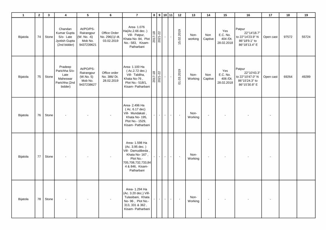
1 2 3 4 5 6 7 8 9 10 11 12 13 14 15 16 17 18 19
Bijatola 74 Stone
Chandan
Kumar Gupta
S/o- Late
Jyotish Gupta
(2nd bidder)
At/PO/PS-
Rairangpur
(W. No. -6)
Mob No.
9437239621
Office Order
No. 296(1)/ dt.
03.02.2019
Area- 1.076
Ha(Ac.2.66 dec. )
Vill- Patpur,
Khata No- 84, Plot
No.- 583, Kisam-
Patharbani
2017-1
8
2021-2
2
- -
15.0
2.2
019
Non-
working
Non
Captive
Yes
E.C. No.
404 /Dt.
28.02.2018
Patpur
22°14'18.7"
to 22°14'23.9" N
86°18'9.1" to
86°18'13.4" E
Open cast 97572 55724
Bijatola 75 Stone
Pradeep
Parichha S/o-
Late
Maheswar
Parichha (2nd
bidder)
At/PO/PS-
Rairangpur
(W.No. 5)
Mob No.
9437238627
Office order
No. 386/ Dt.
28.02.2019
Area- 1.100 Ha
( Ac.2.72 dec.)
Vill- Taldiha,
Khata No-76 ,
Plot No.- 518/1,
Kisam- Patharbani
2017-1
8
2021-2
2
- -
01.0
3.2
019
Non-
Working
Non
Captive
Yes
E.C. No.
406 /Dt.
28.02.2018
Patpur
22°10'43.3"
to 22°10'47.0" N
86°15'24.3" to
86°15'30.8" E
Open cast 69264 49289
Bijatola 76 Stone - - -
Area- 2.496 Ha
( Ac. 6.17 dec)
Vill- Mundakati ,
Khata No- 195,
Plot No.- 1529,
Kisam- Patharbani
- - - - -
Non-
Working- - - -
Bijatola 77 Stone - - -
Area- 1.598 Ha
(Ac. 3.95 dec. )
Vill- Damudibeda ,
Khata No- 167 ,
Plot No.-
705,708,732,733,84
4 & 846, Kisam-
Patharbani
- - - - -
Non-
Working- - - -
Bijatola 78 Stone - - -
Area- 1.294 Ha
(Ac. 3.20 dec.) Vill-
Tulasibani, Khata
No- 96 , Plot No.-
313, 331 & 362 ,
Kisam- Patharbani
- - - - -
Non-
Working- - - -

1 2 3 4 5 6 7 8 9 10 11 12 13 14 15 16 17 18 19
Bijatola 79 Stone - - -
Area- 0.299 Ha
( Ac. 0.74 dec. )
Vill- Dambeda,
Khata No- 66 ,
Plot No.- 485,
Kisam- Patharbani
- - - - -
Non-
Working- - - -
Bijatola 80 Stone - - -
Area- 0.465 Ha (
Ac. 1.15 dec. )
Vill-
Bankadunguri,
Khata No- 60 , Plot
No.- 570, Kisam-
Patharbani
- - - - -
Non-
Working- - - -
Bijatola 81 Stone - - -
Area- 1.315 Ha
( Ac. 3.25 dec.) Vill-
Chhanpal, Khata
No. 120, Plot No.
944, Kisam -
Patharbani &
Khandadeuli,
Khata No- 165,
Plot No.- 791,
Kisam- Patharbani
- - - - -
Non-
Working- - - -
Bijatola 82 Stone - - -
Area- 2.711 Ha (
Ac. 6.70 dec. )
Vill- Barajiani ,
Khata No- 247,
Plot No.- 2461,
Kisam- Patharbani
- - - - -
Non-
Working- - - -
Bijatola 83 Stone - - -
Area- 3.791 Ha
( Ac. 09.37 dec.)
Vill- Jaunti ,
Khata No-65, Plot
No.- 239, 526 , 527
& 561 , Kisam-
Patharbani
- - - - -
Non-
Working- - - - - -

1 2 3 4 5 6 7 8 9 10 11 12 13 14 15 16 17 18 19
Bijatola 84 Stone - - -
Area - 7.203 Ha (
Ac. 17.80 dec.)
Vill- Belpahadi,
Khata No-230, Plot
No.- 921, Kisam-
Abad Ajagya
Anabadi
- - - - -
Non-
Working- - - - - -
Bijatola 85 Stone - - -
Area - 0.530 Ha
( Ac. 1.31 dec. )
Vill- Badjharan,
Khata No-184, Plot
No.- 958, 959 &
960 , Kisam-
Patharbani
- - - - -
Non-
Working- - - - - -
Bijatola 86 Stone - - -
Area- 3.456 Ha
(Ac. 8.54 dec. )
Vill- Asana Khata
No-89 , Plot No.-
388, 403, 695 &
697 , Kisam-
Patharbani
- - - - -
Non-
Working- - - - - -
Kusumi 87 Stone
Bimal Kumar
Swain S/o-
Late
Radhakanta
Swain
At/P.o-
Dhangdimuta,
P.s-
Badampahar, Pin-
757047,
Mayurbhanj ,
Odisha
Contact No-
9437878610
716 Dated
23.03.2015
Area- 0.83 Ha,
Vill-Raipada,
Khata No- 150,
Plot No.-
965,980 & 981,
Kisam- Patharbani
2015-1
6
2019-2
0
- -
29.0
8.2
016
Working Captive
Yes
DEIAA
Letter No.
34 / dt.
27.05.2016
Latitude( 22° 05'
3.0'' to 22° 05'
9.5'' N)
Longitude ( 86°
01' 52.1'' to 86°
01' 52.1'' E)
Open Cast 145190 37500
Kusumi 88 Stone
Dukhishyam
Mandal, S/o-
Upendra
Mandal
At/P.o-
Murumdihi,
P.s-
Badampahar,
Pin-757047,
Mayurbhanj ,
Odisha
718 Dated
23.03.2015
Area - 1.03 Ha,
Village-Langalsila,
Khata No.- 361,
Plot No.- 2243,
Kisam- Patharbani
2015-1
6
2019-2
0
- -
29.0
8.1
6
Working Captive
Yes
DEIAA
Letter No.
38 / dt.
27.05.2016
Latitude( 22° 09'
20.8'' to 22°
9'27.4'' N)
Longitude (
86°12'43.3'' to
86° 12' 53.5'' E)
Open Cast 248196 130332

1 2 3 4 5 6 7 8 9 10 11 12 13 14 15 16 17 18 19
Kusumi 89 Stone
Niranjan Giri
S/o- Srinibasa
Giri
At/P.o-
Langalsila, P.s-
Badampahar, Pin-
757050,
Mayurbhanj ,
Odisha Contact
No-
8018252209/738
1583800.
3102 /Dated
05.11.2015
Area - 0.979 Ha,
Village-Langalsila,
KhataNo.-361, Plot
No.- 1307,
Kisam- Patharbani
2015-1
6
2019-2
0
- -
03.0
3.2
017
Working Captive
Yes
DEIAA
Letter No.
42 / dt.
27.05.2016
Latitude( 22° 10'
21.8''N to 22°
10'25.2'' N)
Longitude (
86°12'55.9''E to
86° 13' 5.9'' E)
Open Cast 70308 29808
Kusumi 90 Stone
Sri Krishna
Kumar, S/o-
Late Chandra
Sekhar
Prasad Sahu
289/2/4, Road
No 10 Near
Hanuman
Mandir, P.o-
Adityapur,
Adityapur2,
Seraikela-
Kharsawan,
Jharkhand
Pin.No-
831013
2314 Dated
30.09.2015
Area - 1.01 Ha,
Village-Langalsila,
Khata No.- 361,
Plot No.-2196,
Kisam- Patharbani
2015-1
6
2019-2
0
- -
25.0
4.2
017
Working Captive
Yes
DEIAA
Letter No.
42 / dt.
27.05.2016
Latitude( 22° 09'
26.4''N to 22° 09'
37.8'' N)
Longitude (
86°12' 43.4'' to
86°12' 48.9'' E)
Open Cast 70344 23676
Kusumi 91 Stone
Bimal Kumar
Swain, S/o-
Late
Radhakanta
Swain
At/P.o-
Dhangdimuta,
P.s-
Badampahar, Pin-
757047,
Mayurbhanj ,
Odisha Contact
No- 9437878610
724Dated
24.03.2015.
Area- 1.32 Ha,
Village-Jodida,
Khata No.-203,
Plot No.- 4, Kisam -
Patharbani2015-1
6
2019-2
0
- -
29.0
8.1
6
Working Captive
Yes
DEIAA
Letter No.
40 / dt.
27.05.2016
Latitude( 22° 7'
29.5''N to 22°
7'45.7'' N)
Longitude (
86°4'11.5'' to 86°
4'25.4'' E)
Open Cast 233000 53300
Kusumi 92 Stone
A- Kumar
Sahu, S/o-
Late Dwarika
Nath Sahu
Vill-
Dhangidimuta,
P.S.-
Badampahar, Pin-
757047,
Mayurbhanj,
Odisha, Contact-
9937134741
788 Dated
31.03.2015
Area - 0.70 Ha,
Village-Tirildihi,
Khata No.-94, Plot
No.-316, Kisam -
Patharbani
2015-1
6
2019-2
0
- -
29.0
8.1
6
Working Captive
Yes
DEIAA
Letter No.
14 / dt.
21.05.2016
Latitude( 22° 03'
43.8'' to 22°
03'50.7'' N)
Longitude (
86°03'50.8'' to
86° 03'54.2'' E)
Open Cast 84560 35475

1 2 3 4 5 6 7 8 9 10 11 12 13 14 15 16 17 18 19
Kusumi 93 Stone
A- Kumar
Sahu, S/o-
Late Dwarika
Nath Sahu
Vill-
Dhangidimuta,
P.S.-
Badampahar, Pin-
757047,
Mayurbhanj,
Odisha, Contact-
9937134741
3122/ Dated
05.11.2015
Area- 0.94 Ha,
Village-
Purunapani, Khata
No.- 265, Plot No.-
104 & 105, Kisam -
Patharbani
2015-1
6
2019-2
0
- -
29.0
8.2
016
Working Captive
Yes
DEIAA
Letter No.
34/ dt.
27.05.2016
Latitude( 22° 07'
48.0''N to 22° 07'
50.9'' N)
Longitude (
86°10' 19.0'' to
86°10' 22.2'' E)
Open Cast 81720 44415
Kusumi 94 Stone
Bimal Kumar
Swain, S/o-
Late
Radhakanta
Swain
At/P.o-
Dhangdimuta,
P.s-
Badampahar, Pin-
757047,
Mayurbhanj ,
Odisha , Contact
No- 9437878610
1373/ Dated
20.05.2015
Area- 0.829 Ha,
Village-
Purunapani, Khata
No.- 265, Plot No. -
280/1, Kisam-
Patharbani
2015-1
6
2019-2
0
- -
29.0
8.2
016
Working Captive
Yes
DEIAA
Letter No.
30/ dt.
27.05.2016
Latitude( 22° 07'
11.4''N to 22° 07'
14'' N)
Longitude (
86°10' 41.5'' to
86°10' 46'' E)
Open Cast 70380 49623
Kusumi 95 Stone
Satyendra
Kumar Mishra,
S/o- Late -
amani Mishra
Being the
Managing
Director of SKM
Infraenture
PVT.Ltd, 242
New
ColonyMining
Road, P.O.-
Keonjhar Garh,
P.S.-Town, Dist-
Keonjhar,
Odisha, Pin -
758001, Contact
No-9437038114.
-
Area - 2.53 Ha,
Village-Hatisikuli,
Khata No.- 56 ,
Plot No- 418 ,
Kisam- Patharbani
2018-1
9
2022-2
3
- -
02.0
2.2
019
Working Captive
Yes
DEIAA
Letter No.
215 / dt.
01.12.2017
Latitude( 22° 07'
59.8''N to 22°
08'6.2'' N)
Longitude (
86°11'47.2'' to
86° 11'53.9'' E)
Open Cast 159348 125874

1 2 3 4 5 6 7 8 9 10 11 12 13 14 15 16 17 18 19
Kusumi 96 Stone
Manoj Kumar
Agrawall, S/o-
Shankar Hari
Agrawall
4th Nagar
Marg
Choubey
Colony ,
P.O/Ps/Dist-
Raipur
-
Area- 2.33Ha,
Village- Uparbeda,
Khata No.-697
,Plot No.- 1100,
Kisam- Patharbani
2018-1
9
2022-2
3
- -
01.0
2.2
019
Working Captive
Yes
DEIAA
Letter No.
216/ dt.
01.12.2017
Latitude( 22° 10'
1.9''N to 22° 10'
06.8'' N)
Longitude (
86°03' 39.3'' to
86°03' 47.3'' E)
Open Cast 176683 136505
Kusumi 97 Stone - -
Area-1.614 Ha,
Village-Langalsila,
Khata No-361, Plot
No- 208 & Village-
Mayurdar, Khata
No.-138, Plot No. -
957, Kisam-
Patharbani
- - - - -
Non
Working- - - - - -
Bahalda 98 StoneBasumati
Sahoo
At/Po/PS-
Bahalda,
9439219921
719/
8.3.2017
Area -1.47 Ha ,
Village - Jhadgan ,
Khata No -141,
Plot No -666,
Kisam - Patharbani
2016-1
7
2020-2
1
- -
8.3
.2017
WorkingNon
Captive
Yes (78/
27.5.2016)
Lat- 22°24'34" to
22°24'47"
Lon-86°4'22.1"
to 86°4'36.1"
Open Cast 158334 72380
Bahalda 99 StoneDhiren Ku.
Misha,
At-Jhadgan
PO/PS-
Bahalda,
9437237493
824/
23.03.2017
Area - 0.53 Ha,
Village - Indkholi,
Khata-544, Plot No
-63/1, Kisam-
patharbani
2015-1
6
2019-2
0
- -
23.0
3.2
017
WorkingNon
Captive
Yes (114/
5.7.2016)
Lat- 22°24'46.3"
to 22°24'49.1"
Lon-86°6'37"
to 86°6'40.3"
Open Cast 61824 41600
Bahalda 100 Stone Rahul Yadav
At/PO/PS-
Bahalda, Mb
No.943754503
6
3404/
9.11.2017
Area - 4.33 Ha,
Village - Kanki,
Khata No -186,
Plot No -
39,185,186 & 187,
Kisam- Patharbani
2016-1
7
2020-2
1
- -
09.1
1.2
017
WorkingNon
Captive
Yes (55/
1.3.2017)
Lat- 21°23'39.5"
to 21°23'51.3"
Lon-85°5'49"
to 85°6'1.1"
Open Cast 268009 160977

1 2 3 4 5 6 7 8 9 10 11 12 13 14 15 16 17 18 19
Bahalda 101 StoneDibyasachi
Mohanta
At/Po/PS-
Bahalda,
8249602769
3715/
12.2.2017
Area - 3.24 Ha,
Village - Bahalda,
Khata No -587,
Plot-2234/3199,
Kisam- Patharbani
2015-1
6
2019-2
0
- -
12.0
2.2
017
WorkingNon
Captive
Yes 162/
22.12.2016
Lat- 22°22'55.8"
to 22°22'59.5"
Lon-86°5'5.07"
to 86°5'11.8"
Open Cast 643800 368298
Bahalda 102 StoneBishnu Ku.
Sarada
At-
Rairangpur,
W.No.-6,Mbj,
3428/
30.12.2016
Area - 1.04 Ha,
Village -
Gambharia, Khata
No -219, Plot No -
1138 & 1147,
Kisam- Patharbani
2016-1
7
2019-2
0
- -
30.1
2.2
016
WorkingNon
Captive
Yes
112/
5.7.2016
Lat- 22°19'43.96"
to 22°20'00.2"
Lon-86°8'55.79"
to 86°8'45.40"
Open Cast 6975 4720.5
Bahalda 103 StoneDinesh Ch.
Das
At- Majhigan
PO- Bahalda
Road- PS-
Tiring,
9583832109
1504/
30.5.2017
Area - 0.59 Ha,
Village - Sovapur,
Khata No -65, Plot
No-22, Kisam-
Patharabni
2015-1
6
2019-2
0
- -
30.5
.2017
WorkingNon
Captive
Yes 76/
27.5.2016
Lat- 22°22'15.1"
to 22°22'18.2"
Lon-86°5'37.9"
to 86°5'41.0"
Open Cast 45210 23120
Bahalda 104 StoneDinesh Ch.
Das
At- Majhigan
PO- Bahalda
Road- PS-
Tiring,
9583832109
1802/
22.6.2017
Area -0.41 Ha,
Village - Tikhia,
Khata No -224,
Plot No -887,
Kisam- Gochar
2015-1
6
2019-2
0
- -
22.6
.2017
WorkingNon
Captive
Yes, 74/
27.5.2016
Lat- 21°19'38.7"
to 21°19'45.3"
Lon-86°09'47.6"
to 86°09'53.2"
Open Cast 42297 22330
Bahalda 105 StoneDinesh Ch.
Das
At- Majhigan
PO- Bahalda
Road- PS-
Tiring,
9583832109
997/
12.4.2017
Area -1.12 Ha,
Village - Asana,
Khata -98, Plot No-
741, Kisam -
Patharbbani
2015-1
6
2019-2
0
- -
12.4
.2017
WorkingNon
Captive
Yes, 72/
27.5.2016
Lat- 22°22'4.0" to
22°22'11.2"
Lon-86°11'42.7"
to 86°11'46.5"
Open Cast 8000 5432

1 2 3 4 5 6 7 8 9 10 11 12 13 14 15 16 17 18 19
Bahalda 106 StoneDinesh Ch.
Das
At- Majhigan
PO- Bahalda
Road- PS-
Tiring,
9583832109
184/
18.1.2018
Area -1.21 Ha,
Village - Tarana,
Khata No - 304,
Plot No -1472,
Kisam -
Patharbbani
2015-1
6
2019-2
0
- -
18.1
.2018
WorkingNon
Captive
Yes, 164/
22.12.2016
Lat- 22°24'50.3"
to 22°25'09.3"
Lon-86°09'14.5"
to 86°09'35.9"
Open Cast 421960 202658.8
Bahalda 107 StoneDinesh Ch.
Das
At- Majhigan
PO- Bahalda
Road- PS-
Tiring,
9583832109
186/
18.1.2018
Area - 1.33 Ha,
Village - Tarana,
Khata No - 304,
Plot No -1240,
Kisam- Patharbbani
2015-1
6
2019-2
0
- -
18.1
.2018
WorkingNon
Captive
Yes, 166/
22.12.2016
Lat- 22°25'18.3"
to 22°25'26.5"
Lon-86°08'39.3"
to 86°08'46.17"
Open Cast 32252 141816
Bahalda 108 Stone
Area - 1.5 Ha,
Village-
Badkedam, Khata
No- 597, Plot No -
2246 & 2273,
Kisam - Patharbani
Non
Working
Bahalda 109 Stone
Area- 1.18 Ha, Vill-
Anlajodi, Khata No -
164, Plot No - 586,
Kisam- Patharbani
Non
Working
Tiring 110 StoneBiswanath
Saha
At- Randisahi,
PO- Tiring
PS- Tiring
Dist
Mayurbhanj
No. 641/
Dt.24.03.2015
Area.- 1.39 Ha
Vill- Randisahi
Khata No-153
Plot No.- 892/1
Kisam-Patharbani
2015-1
6
2019-2
0
- -
12/1
5/2
017
WorkingNon-
Captive
Yes, No.56/
27.05.2016
Latitude-
22°31'27" N to
22°31'65.1" N
Longitude-
86°5'3.0" E to
86°5'10" E
Open Cast147980
Cum90860 Cum

1 2 3 4 5 6 7 8 9 10 11 12 13 14 15 16 17 18 19
Tiring 111 StoneMohini Ranjan
Hota
At-Ichinda,
W.No. 14,
PS-
Rairangpur
Town
Dist
Mayurbhanj
No.393/
Dt.24.02.2015
Area.- 1.962 Ha
Vill- Dolajodi,
Khata No-172,
Plot No.- 190,
Kisam-Patharbani
2015-1
6
2019-2
0
- -
16.0
1.2
017
WorkingNon-
Captive
Yes
No.54/
27.05.2016
Latitude-
22°28'3.5" N to
22°28'10" N
Longitude-
86°05'19.8" E to
86°05'25.1" E
Open Cast328000
Cum
113275
Cum
Tiring 112 StoneSmt. Ranjita
Mishra
At-Jhadgan,
Po- Bahalda,
PS- Bahalda
Dist
Mayurbhanj
No.2054/
Dt.01.10.2015
Area- 0.54 Ha
Vill- Baddalima
Khata No-432,
Plot No.- 208,
Kisam-Patharbani
2015-1
6
2019-2
0
- -
29.0
3.2
017
WorkingNon-
Captive
Yes
No.168/
22.06.2016
Latitude-
22°27'27.42" N to
22°27'30.26" N
Longitude-
86°03'57.92" E to
86°03'59.43" E
Open Cast 21408 Cum 9000 Cum
Tiring 113 Stone Ranjit Sahu
At-Bahalda
PS- Bahalda
Dist
Mayurbhanj
No.687/
Dt.31.03.2015
Area- 0.44 Ha
Vill- Sandalima
Khata No-118,
Plot No.- 1133,
Kisam-Patharbani
2015-1
6
2019-2
0
- -
02.0
6.2
017
WorkingNon-
Captive
Yes
No.58/
27.05.2016
Latitude-
22°25'45.4" N to
22°25'55.2" N
Longitude-
86°04'5.7" E to
86°04'12.7" E
Open Cast126000
Cum71200 Cum
Tiring 114 StoneBipadara
Mandal
At-Pandhada,
PS- Tiring
Dist
Mayurbhanj
No.410/
Dt.27.03.2015
Area- 0.44 Ha
Vill- Rengalbeda,
Khata No-118,
Plot No.- 1133,
Kisam-Patharbani
2015-1
6
2019-2
0
- -
02.0
6.2
017
WorkingNon-
Captive
Yes
No.58/
27.05.2016
Latitude-
22°24'5.0" N to
22°24'58" N
Longitude-
86°4'3.4" E to
86°4'8.7" E
Open Cast 97000 Cum 27600 Cum
Tiring 115 StoneAbhimanyu
Basa
At-Baddalima
PS-Tiring
Dist
Mayurbhanj
No.599/
Dt.18.03.2015
Area- 0.75 Ha
Vill- Nischintpur
Khata No-82,
Plot No.- 2,
Kisam-Patharbani
2015-1
6
2019-2
0
- -
26.0
9.2
016
WorkingNon-
Captive
Yes
No.50/
27.05.2016
Latitude-
22°25'8.8" N to
22°25'15.3" N
Longitude-
86°04'18.8" E to
86°04'27.5" E
Open Cast154360
Cum57139 Cum

1 2 3 4 5 6 7 8 9 10 11 12 13 14 15 16 17 18 19
Tiring 116 Stone - - -
Area- 1.456 Ha
Vill- Bhagabandi,
Khata No-119,
Plot No.- 1125,
Kisam-Patharbani
- - - - - - - -
Latitude-
22°24'41.0" N to
22°24'48.1" N
Longitude-
86°03'53.2" E to
86°03'58.5" E
48457 20790
Tiring 117 Stone - - -
Area- 3.541 Ha
Vill- Henseldihi
Khata No-60,
Plot No.- 707,
Kisam-Patharbani
- - - - - - - -
Latitude-
22°27'6.0" N to
22°27'15.0" N
Longitude-
86°02'55.5" E to
86°03'5.1" E
258215 162225
Tiring 118 Stone - - -
Area- 1.319 Ha
Vill- Mankididihi
Khata No-106,
Plot No.- 876,878
&1114,
Kisam-Patharbani
- - - - - - - -
Latitude-
22°27'46.3" N to
22°27'53.0" N
Longitude-
86°04'0.1" E to
86°04'9.0" E
112408 53239
Tiring 119 Stone
Area - 0.11 Ha ,
Village- Damadihi,
Khata No - 38, Plot
No- 164, Kisam -
Patharbani
Non
Working
Lat-22°16'5.9" to
22°16'12.5"
long-86°05'1.9" to
86°05'9.9"
Jamda Stone2173
DT30.07.15
Area - 2.784 Ha,
Village - Kainpur,
Khata No - 271 ,
Plot No - 251,
Kisam - Patharbani
2016-1
7
120
Deepak
Kumar
Mohanty
At/po
Rairangpur,Di
st-
MBJ,8658040
057
workingNon
Captive
Yes,L No-
130/ dt
5.7.16
open cast 378000
2020-2
1
- - 319500
08.1
1.2
016

1 2 3 4 5 6 7 8 9 10 11 12 13 14 15 16 17 18 19
Lat-22°16'11" to
22°16'18"
long-86°05'6.1" to
86°05'13.9"
late-22°15' 27.8"
to 22°15'37.5"
long-22°15' 27.8"
to 22°15'37.5"
late-22°14' 17" to
22°14'24.3"
long-22°15' 27.8"
to 22°15'37.5"
late-22°14' 17" to
22°14'24.3"
long-22°15' 27.8"
to 22°15'37.5"
Jamda Stone
Jamda Stone
Jamda Stone
Jamda Stone open caste 69988- -
19.0
1.2
019
working
76560- -
07.0
2.2
017
working open caste
119760
123Manoj Kumar
Mohanty263700 238950
2020-2
1
- -
08.1
1.2
016
workingNon
Captive
Non
Captive
Yes,L No-
198/ dt
01.12.17
Non
Captive
Yes, L No -
132/ dt
05.07.16
Yes,L No-
128/ dt
05.07.10
open caste
90360
121 Amiya ku Das
At/po
Rairangpur,Di
st-
MBJ,8658040
057
At/po
Rairangpur,Di
st-
MBJ,8658040
057
Non
Captive
Yes,L No-
126/dt
05.07.16
--
2168 dt
30.07.2016
Area -2.23 Ha, Vill -
Kainpur, Khata
No- 273, Plot No -
260, Kisam-
Patharbani
2016-1
7
2020-2
1
124
Mrs. Diti
Krushna
Mandal
Mrs. Diti
Krushna
Mandal At-
Ichinda,Po/Ps-
Rairangpur,Di
st.-
Mayurbhanj,
Mb-
9437237638
1903/
dt.15.11.2018
Area - 2.064 Ha,
Vill - Mugudi,
Khata No.-112,
Plot No.-
933,936,964 &
967, Kisam-
Patharbani
2178 dt
30.07.15
Area - 0.676 Ha,
Vill - Talgaon,
Khata No- 172,
Plot No - 484 &
477, Kisam -
Patharbani
2016-1
7
2020-2
1
At-Gohira, Po-
Pasna, Ps-
Jamda,Dist.-
Mayurbhanj,
Mb-
9438038762
2163/dt.
30.07.2015
Area -2.064 Ha,
Vill - Deokundi,
Khata No.-201,
Plot. No.- 664,
Kisam -Patharbani
2016-1
72018-1
9
2013-2
4
122
Deepak
Kumar
Mohanty
259200 207450
08.1
1.2
016
working open caste

1 2 3 4 5 6 7 8 9 10 11 12 13 14 15 16 17 18 19
Jamda 126 Stone - - -
Village- Baghia,
Khata No-113, Plot
No. - 52 ( Area-
1.813 Ha) ,Plot No-
60 ( Area-
Ac 0.178 Ha),
Kisam-Patharbani
- - - - -
Non
working- - - - -
Jamda 127 Stone - - -
Village-
Rumapahadi,
Khata No. -149,
Plot No.- 374, Area-
2.125 Ha, Kisam -
Patharbani
- - - - -
Non
working- - - - -
Jamda 128 Stone - - -
Area - 0.773 Ha,
Vill - Kainpur,
Khata No.-271,
Plot No. 1372 &
1376, Kisam-
Patharbani- - - - -
Non
working- - - - -
Karanjia 129 StoneNirbhay
Kumar Palei,
Hi-Tech Rock
Product &
Aggregates,
LTD, R/o
Mount
Poonamallie
Road
Manapakham
P.O. Box 979
Chennai
-
Area-4.198 Ha,
Vill-Murgapat,
Khata No.- 189,
Plot No.-98,
Kissam-
Patharabani
2015-1
6
2019-2
0
- -
11.0
1.2
016
Working Captive
Yes ,13 dt.
01/03/2017
20 49'55.80" to
21 50' 12.60" N
8550' 55.10" to
85 51' 09.40" E
Open Cast 304550 258867.5
Area - 1.63 Ha, Vill
- Laxmiposi, Khata
No.- 85, Plot No.-
71, Kisam -
Patharbani
- - - - -Jamda StoneNon
working- - - --125 - - - -

1 2 3 4 5 6 7 8 9 10 11 12 13 14 15 16 17 18 19
Karanjia 130 Stone
Harish Chandra
Saha, S/o
Sachidananda
Saha,
AT-
SARADHA
KARANJIA
1282//dt.
25.03.2015
Area -0.421 Ha,
Vill-Andharjhari,
Khata No.- 81, Plot
No.-703, Kissam-
Patharabani
2016-1
7
2020-2
1
- -
10.0
3.2
016
Working Captive470//dt.
30.01.2016
La-21'47'32.7" to
21'47'36.3 N Lo-
85'56'46.2 to
85'56,50.4 E
Open Cast 46,800 44460
Karanjia 131 Stone
Sumeet
Kumar
Agarwalla, S/o
Ghanashya
Agarwalla,
Karanjia
AT/PO-
KARANJIA
1362//dt.
27.03.2015
Area -0.817 Ha,
Vill-Pingu, Khata
No.- 146,
Plot No.-1822,
Kissam-
Patharabani
2015-1
6
2019-2
0
- -
18.0
2.2
016
Working Captive468// dt.
30.01.2016
La-21'48'.5" to
21'48'12"N Lo-
85'53'3" to
85'53'6.6" E
Open Cast 13,880 9716.00
Karanjia 132 Stone
Deepak
Kumar Sahu,
S/o Baidhara
Sahu of
Hatiatangar
Hatianagar -
Area -0.615 Ha,
Vill-Chitraposi,
Khata No.- 152,
Plot No.-1383,
Kissam-
Patharabani
2018-1
9
2022-2
3
- -
06.0
5.2
108
Working Captive195/
05.12.2017
21 48'33.29" to
21 48' 38.21" N
85 51' 18.29" to
85 51' 21.73"
Open Cast 1852 1814.96
Karanjia 133 Stone
Susanta
Kumar
Mohanty, S/o
Gojendra
Mohanty of
Zeropoint
Zero Point3047/15.07.201
5
Area -2.004 Ha,
Vill-Murgapat,
Khata No.- 189,
Plot No.-50,
Kissam-
Patharabani
2017-1
8
2021-2
2
- -
03.0
2.2
017
Working Captiveyes ,110/
05/07/2016
21 49' 32.20" to
21 49' 48.50" N
85 50'45.0" to 85
50' 59.00" E
Open Cast 22840 13704
Karanjia 134 Stone
Rajendra
Kumar
Mohanta, S/o
Lt.Naresh
Chandra
Mohanta, AT-
Kerkera,
Karanjia
AT-
KERKERA,
PO-
KARANJIA,
Mayurbhanj
1284//
25.03.2015
Area -1.2955, Vill-
Kerkea, Khata No.-
270 , Plot No.-
1771, Kissam-
Patharabani
2017-1
8
2021-2
2
- -
20.1
2.2
017
Working Captive178//
22.12.2016
La-21'48'37'6" to
21'48'50'9" N Lo-
85'56'07'2" to
85'56'14'3" E
Open Cast 42575 25545

1 2 3 4 5 6 7 8 9 10 11 12 13 14 15 16 17 18 19
Karanjia 135 Stone
Maheswar
Jena, S/o
Kartika Jena,
AT-Machhua,
Balasore
2415//dt.
12.07.2018
Area -3.287 Ha,
Vill-Jhaddumuria,
Khata No.- 63, Plot
No.-36, Kissam-
Patharabani
2018-1
9
2022-2
3
- -
03.0
7.2
018
Working Captive168//dt.
01.12.2017
La- 21'48'4.4'N to
21'48'17.5 N Lo-
85'57'11.8'E to
85'57'17.4'E
Open Cast 125,850 0.90
Karanjia 136 Stone
Maheswar
Jena, S/o
Kartika Jena,
AT-Machhua,
Balasore
AT-Machhua,
Balasore
2523//dt.
21.07.2018
Area -0.607 Ha
Vill-Jhaddumuria
Khata No.-
63, Plot No.-12/1,
Kissam-
Patharabani
2018-1
9
2022-2
3
- -
03.0
7.2
017
Working Captive176//dt.
01.12.2017
La-21'48'8.5N to
21'48'13.1'N Lo-
85'57'10'E to
85'57'14E
Open Cast 6,630 0.60
Karanjia 137 Stone
Sudhamayee
Das, W/o
Harish
Chandra Das,
AT-Karanjia,
AT/PO-
KARANJIA
2970//
30.08.2018
Area -0.736 Ha,
Vill-Diajodi, Khata
No.- 152 , Plot
No.-898,918 &
919, Kissam-
Patharabani
2018-1
9
2022-2
3
- -
06.0
8.2
018
Working Captive182//
01.12.2017
21°48'35.8"N
85°57'57.2"EOpen cast 55665 33399
Karanjia 138 Stone
Akshaya
Kumar
Behera,S/o
Chakradhar
Behera,
AT-Hirapur,
PO-Rambag,
PS-Jajpur,
Dist- Jajpur
2914
/24.08.2018
Area -0.663 Ha,
Vill-Diajodi,
Khata No.- 152,
Plot No.-950 &
952, Kissam-
Patharabani2018-1
9
2022-2
3
- -
12.0
6.2
018
Working Captive166//dt.
01.12.2017
21°48'39.5"N
85°57'55.4"EOpen cast 41374 24825
Karanjia 139 Stone
Md Nasir
Hussen, S/o
Md Abul
Hassim,
AT-
Chadheibhol,
Karanjia
2873/
21.08.2018
Area-0.736 Ha,
Vill-Pahadbhanga,
Khata No.- 81,
Plot No.-273,
Kissam-
Patharabani
2018-1
9
2022-2
3
- -
27.0
6.2
018
Working Captive170//dt.
01.12.2017
La-21"50'17"N to
21'50,21"N Lo-
85'51'58" E to
85'52'8.4"E
Open cast 34,830 0.70
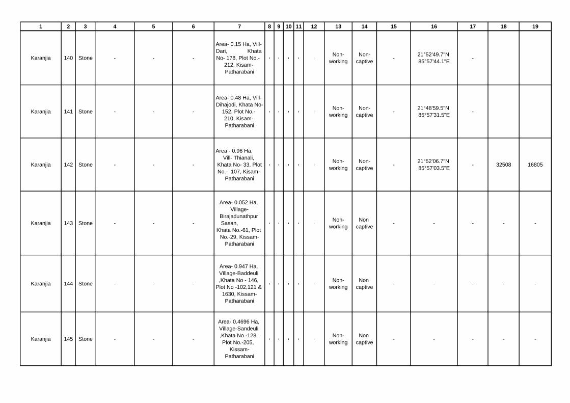
1 2 3 4 5 6 7 8 9 10 11 12 13 14 15 16 17 18 19
Karanjia 140 Stone - - -
Area- 0.15 Ha, Vill-
Dari, Khata
No- 178, Plot No.-
212, Kisam-
Patharabani
- - - - -
Non-
working
Non-
captive-
21°52'49.7"N
85°57'44.1"E-
Karanjia 141 Stone - - -
Area- 0.48 Ha, Vill-
Dihajodi, Khata No-
152, Plot No.-
210, Kisam-
Patharabani
- - - - -
Non-
working
Non-
captive-
21°48'59.5"N
85°57'31.5"E-
Karanjia 142 Stone - - -
Area - 0.96 Ha,
Vill- Thianali,
Khata No- 33, Plot
No.- 107, Kisam-
Patharabani
- - - - -
Non-
working
Non-
captive-
21°52'06.7"N
85°57'03.5"E- 32508 16805
Karanjia 143 Stone - - -
Area- 0.052 Ha,
Village-
Birajadunathpur
Sasan,
Khata No.-61, Plot
No.-29, Kissam-
Patharabani
- - - - -
Non-
working
Non
captive- - - - -
Karanjia 144 Stone - - -
Area- 0.947 Ha,
Village-Baddeuli
,Khata No - 146,
Plot No -102,121 &
1630, Kissam-
Patharabani
- - - - -
Non-
working
Non
captive- - - - -
Karanjia 145 Stone - - -
Area- 0.4696 Ha,
Village-Sandeuli
,Khata No.-128,
Plot No.-205,
Kissam-
Patharabani
- - - - -
Non-
working
Non
captive- - - - -

1 2 3 4 5 6 7 8 9 10 11 12 13 14 15 16 17 18 19
Karanjia 146 Stone - - -
Area- 0.8249 Ha,
Village-Bhanra,
Khata No. 215 ,
Plot No. 1110 ,
Kissam-
Patharabani
- - - - -
Non-
working
Non
captive-
21'47'29.8N to
21'47'32.4N
85'53'57.1 E to
85'53'59.9E
- 18,855 6535.10
Karanjia 147 Stone - - -
Area- 0.9554
Ha,Village-Bhanra
,Khata No. 215 ,
Plot No. 1088,
1998 , Kissam-
Patharabani
- - - - -
Non-
working
Non
captive-
Lt-21'47'25.4 N to
21'47'27.8N Ln-
85'53'45.02E to
85'53'49.3E
- 45,907 16766.40
Karanjia 148 Stone - - -
Area- 0.4777 Ha,
Village-Bhanra ,
Khata No. 215,
Plot No. 1798 ,
Kissam-
Patharabani
- - - - -
Non-
working
Non
captive-
21'47'16.2N to
21'47'18.6N
85'53'55.3E to
85'53'58.9E
- 15985.2 4706.1
Karanjia 149 Stone
Sr Manager
Odisha
Construction
Corporation
Ltd (D.D.
Builders ltd)
Karanjia -
Area- 4.97 Ha ,
Village-
Ramchandrapur ,
Khata No. 54,
Plot No. 654,
Kissam-
Patharabani
- - - - -
Non-
workingCaptive - - - - -
Karanjia 150 Stone - - -
Area- 0.7044 Ha,
Village-Nuagaon,
Khata No. 142 ,
Plot No. 1128,
Kissam-
Patharabani
- - - - -
Non-
working
Non
captive- - - - -

1 2 3 4 5 6 7 8 9 10 11 12 13 14 15 16 17 18 19
Karanjia 151 Stone - - -
Area- 0.5344 Ha,
Village-Kerkera ,
Khata No. 270 ,
Plot No. 1968,
Kissam-
Patharabani
- - - - -
Non-
working
Non
captive- - - - -
Karanjia 152 Stone - - -
Area-0.8056 Ha,
Village-
Rengalbeda, Khata
No. 140, Plot No.
293, Kissam-
Patharbani
- - - - -
Non-
working
Non
captive- - - - -
Karanjia 153 Stone - - -
Area-1.0926 Ha,
Village-
Ghodaghagudi,
Khata No. 117,
Plot No. 110,
Kissam-Patharbani
- - - - -
Non-
working
Non
captive-
21'47'24' N to
21'47'34.3N and
85'58'23.4E to
85'58'31E
- 65718 23004
Karanjia 154 Stone - - -
Area -1.25 Ha, Vill-
Dihajodi, Khata No-
152, Plot No.- 88,
Kisam- Patharabani
- - - - -
Non-
working
Non-
captive-
21°48'28.4"N
85°57'12.0"E- 76752 32799
Karanjia 155 Stone - - -
Area -0.5344 Ha,
Vill- Patulidihi,
Khata No- 46, Plot
No.- 142 & 155,
Kisam- Patharabani
- - - - -
Non-
working
Non
captive-
21'49'14.6N to
21'49'18.1N
86'4'35.8E to
86.4.38.9E
- 28360 15625
Karanjia 156 Stone - - -
Area- 0.4251 Ha,
Village-Ghasada
,Khata No. 275 ,
Plot No. 2453 ,
Kissam-
Patharabani
- - - - -
Non-
working
Non
captive- - - - -
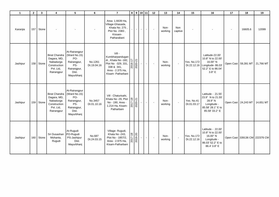
1 2 3 4 5 6 7 8 9 10 11 12 13 14 15 16 17 18 19
Karanjia 157 Stone - - -
Area- 1.6639 Ha,
Village-Ghasada,
Khata No. 275 ,
Plot No. 2383 ,
Kissam-
Patharabani
- - - - -
Non-
working
Non
captive- - - 16605.6 12099
Jashipur 158 Stone
Birat Chandra
Dagara, MD,
Nabadurga
Construction
Pvt. Ltd,
Rairangpur
At-Rairangpur
(Ward No.15)
PO-
Rairangpur,
PS-
Rairangpur,
Dist.
Mayurbhanj
No.1261
Dt.19.04.16
Vill -
Kumbharpandugan
di , Khata No -182,
Plot No -329, 331,
338 & 341,
Area - 2.375 Ha,
Kisam- Patharbani
2016-1
7
2020-2
1
- - -
Non-
working-
Yes. No.172
Dt.22.12.16
Latitude-22.00'
10.8'' N to 22.00'
16.00'' N
Longitude- 86.03'
52.2'' E to 86.04'
3.8'' E
Open Cast 59,391 MT 21,766 MT
Jashipur 159 Stone
Birat Chandra
Dagara, MD,
Nabadurga
Construction
Pvt. Ltd,
Rairangpur
At-Rairangpur
(Ward No.15)
PO-
Rairangpur,
PS-
Rairangpur,
Dist.
Mayurbhanj
No.3457
Dt.01.10.16
Vill - Chaturisahi,
Khata No -29, Plot
No - 190, Area -
1.214 Ha, Kisam-
Patharbani
2017-1
8
2020-2
1
- - -
Non-
working-
Yes. No.41
Dt.01.03.17
Latitude - 21.55'
23.9'' N to 21.55'
28.9'' N
Longitude -
85.58' 28.1'' E to
85.58' 33.2'' E
Open Cast 24,243 MT 14,651 MT
Jashipur 160 Stone
Sri Dusashan
Mohanta,
Rugudi
At-Rugudi
PO-Rugudi
PS-Jashipur
Dist.
Mayurbhanj
No.687
Dt.24.03.15
Village- Rugudi,
Khata No -243,
Plot No - 1857/2,
Area - 2.975 Ha,
Kisam-Patharbani
2017-1
8
2019-2
0
- - -
Non-
working-
Yes. No.172
Dt.22.12.16
Latitude - 22.00'
10.8'' N to 22.00'
16.00'' N
Longitude -
86.03' 52.2'' E to
86.4' 3.8'' E
Open Cast 339136 CM 222376 CM

1 2 3 4 5 6 7 8 9 10 11 12 13 14 15 16 17 18 19
Sukruli 161 StoneBishal Ku.
Agarwalla
At/Po/P.S-
Karanjia, Dist-
Mayurbhanj
Order dt.
6.2.2016
Area -0.461 Ha
Vill- Singda,
Khata No-175,
Plot No.- 1630,
Kisam-Patharbani
2015-1
6
2019-2
0
2016-1
7
2018-1
9
6.2
.2019
Working Captive
Yes, 982
dt
16.03.2016
Location of
Mining Lease(
Latitude-21˚
49'57.3'' to 21˚
50'01.5'' N &
Longitued-85˚
54'55.8'' to 85˚
54'59.2'' E)
Open Cast 39825 11936
Sukruli 162 StoneBishal Ku.
Agarwalla
At/Po/P.S-
Karanjia, Dist-
Mayurbhanj
Oder dt.
17.3.2016
Area -4.451 Ha,
Vill- Badbil ,
Khata No-119 ,
plot No.- 1363/1,
1364 & 1365,
Kisam-Hudi
2015-1
6
2019-2
0
2016-1
7
2018-1
9
17.3
.2016
Working Captive
Yes,
601dt
30.01.2016
Location of
Mining Lease(
Latitude-
21˚51'8.5'' to
21˚51'16.1 N &
Longitued-
85˚53'22.1'' to
85˚53'29.9 E
Open Cast 427310 356395
Sukruli 163 StoneBishal Ku.
Agarwalla
At/Po/P.S-
Karanjia, Dist-
Mayurbhanj
Oder dt.
25.1.2016
Area -0.639 Ha
Vill- Badbil -I,
Khata No-119,
Plot No.- 897,
Kisam-Patharbani
2015-1
6
2019-2
0
2016-1
7
2018-1
9
25.0
1.1
6
Working CaptiveYes, 4152
dt. 17.08.15
Location of
Mining Lease(
Latitude-
21˚51'20.4'' to
20˚51'26.2''N &
Longitued-
85˚53'56.6'' to
85˚54'00.00'')
Open Cast 59735 17635
Sukruli 164 Stone Parwej Alam
At/Po/P.S-
Barbil, Dist-
Keonjhar
Order dt.
30.08.2016
Area -0.809 Ha
Vill- Jambani,
Khata No-16,
Plot No.- 66/1,
Kisam-Patharbani
2015-1
6
2019-2
0
2016-1
7
2018-1
9
30.0
8.1
6
Working Captive
Yes, 122
dt.
05.07.2016
Location of
Mining Lease(
Latitude-
21˚51'44.3'' N to
21˚51'49.6'' &
Longitued-
85˚51'42.0'' E to
85˚51'45.6'' E)
Open Cast 36660 25920

1 2 3 4 5 6 7 8 9 10 11 12 13 14 15 16 17 18 19
Sukruli 165 Stone Wasim Bari
At-
Magurgadia,
Keonjhar
Town, Po/P.S-
Keonjhar,
Dist- Keonjhar
Order dt
28.3.2018
Area -1.833 Ha
Vill- Fulguntha-1,
Khata No-130,
Plot No.- 967,
Kisam-Patharani
2016-1
7
2020-2
1
2017-1
8
2018-1
9
28.0
3.2
018
Working CaptiveYes, 116dt.
05.07.2016
Location of
Mining Lease(
Latitude-
21˚50'27.05'' N to
21˚ 50'37.89 N &
Longitued-
85˚53'04.12''E to
85˚ 53'11..74'' E )
Open Cast 185641 13839
Sukruli 166 Stone Wasim Bari
At-
Magurgadia,
Keonjhar
Town, Po/P.S-
Keonjhar,
Dist- Keonjhar
Order dt.
10.06.2016
Area -0.777 Ha,
Vill- Fulguntha,
Khata No-130,
Plot No.- 671,
Kisam-atharbani
2015-1
6
2019-2
0
2016-1
7
2018-1
9
10.0
6.2
016
Working Captive
Yes, 184
dt.
01.12.2018
Location of
Mining Lease(
Latitude-
21˚50'43''N to
21˚50'47.5 N &
Longitued-
85˚53'7.3'' E to
85˚53'12.9''E)
Open Cast 23856 14616
Sukruli 167 Stone Babish Prusty
At- Pandarsil,
Po- Sukruli,
P.s- Raruan,
Dist-
Mayurbhanj
Order dt.
26.3.2018
Area -4.196 Ha,
Vill- Bhramarposi,
Khata No-169,
Plot No.- 755,
Kisam-Patharbani
2016-1
7
2020-2
1
2017-1
8
2018-1
9
26.3
.2018
Working CaptiveYes, 190
dt. 01.12.17
Location of
Mining Lease(
Latitude-
21˚55'14.10'' N to
21˚55'40.81 N &
Longitued-
85˚53'31.42 E to
85˚53'39.80'' E)
Open Cast 216699.6 113932.8
Sukruli 168 Stone Kalyan Sarkar
At/po- Joda,
(Hudisahi),
P.S- Joda,
Dist- Keonjhar
Order dt.
6.3.2018
Area -3.213 Ha,
Vill- Baliposi,
Khata No-44, Plot
No.- 81, Kisam-
Patharani
2015-1
6
2019-2
0
2016-1
7
2018-1
9
21.3
.2018
working Captive
Yes, 108
dt.05.07.201
6
Location of
Mining Lease(
Latitude-
21˚55'14.10''N to
21˚55'40.81'' N &
Longitued-
85˚48'49.2'' E to
85˚49' 00'' E)
Open Cast 216699.6 113932.8

1 2 3 4 5 6 7 8 9 10 11 12 13 14 15 16 17 18 19
Sukruli 169 StoneParameswar
Sahu
At-Kakharupanha
,po- Sukruli, P.S-
Raruan, Dist-
Mayurbhanj
Order dt 6.3.18
Area -0.797 Ha,
Vill- Kasiaeda,
Khata No-136,
Plot No.-1196,
Kisam-Patharbani
2015-1
6
2019-2
0
2016-1
7
2018-1
9
27.1
.2018
Working CaptiveYes, 124/
05.07.2016
Location of
Mining Lease(
Latitude-N
21˚51'16.62'' to
21˚51'33.49''N &
Longitued-E
85˚26'25.21'' to
85˚49'41.77''E)
Open Cast 67745 24417.95
Sukruli 170 Stone Babish Prusty
At- Pandarsil,
Po- Sukruli,
P.s- Raruan,
Dist-
Mayurbhanj
Order dt.
27.1.2018
Area -2.707 Ha,
Vill- Galusahi,
Khata No-155, Plot
No.- 1528 & 1526,
Kisam-Patharbani
2016-1
7
2020-2
1
2018-1
9
2019-2
0
27.1
.2018
Working CaptiveYes, 186/
01.12.2017
Location of
Mining Lease(
Latitude-
21˚53'05.56 N to
21˚53'20.75'' N &
Longitued-
85˚52'21.34'' E to
85˚52'29.57'' E)
Open Cast 319110 198528
Sukruli 171 StonePradeep
Parichha
At-
Pichhilighaty,
Po/PS-
Rairangpur
town , Dist-
Mayurbhanj
Order/
2.7.2015
Area -0.857 Ha,
Vill- Kusunpur-I,
Khata No-186,
Plot No.- 1987,
Kisam-Parbat-II
Hudi
2015-1
6
2019-2
0
2016-1
7
2018-1
9
-
Non-
workingCaptive
Yes, 118
dt.5.7.2016
Location of
Mining Lease(
Latitude-
21˚50'12.6'' N to
21˚50'17.3''N &
Longitued-
85˚50'58.4'' E to
85˚51'00'' E)
Open Cast 35040 14250

1 2 3 4 5 6 7 8 9 10 11 12 13 14 15 16 17 18 19
Sukruli 172 Stone Parwej Alam
At/Po/P.S-
Barbil, Dist-
Keonjhar
Order/
30.8.2016
Area -0.752 Ha,
Vill- Kusunpur,
Khata No-186,
Plot No.- 1506,
Kisam-Patharbani
2015-1
6
2019-2
0
2016-1
8
2018-2
0
30.8
.2016
Working CaptiveYes, 120
dt.5.7.2016
Location of
Mining Lease(
Latitude-
21˚50'17'' N to
21˚50'24'' N &
Longitued-
85˚50'45.1'' E to
85˚50'47.3'' E)
Open Cast 54894 21734
Sukruli 173 Stone - - -
Area -1.619 Ha,
Vill- Bad Teranti,
Khata No-355, Plot
No.- 1594, Kisam-
Patharbani
2016-1
7
2020-2
1
2017-1
8
2018-1
9
-
Non-
WorkingCaptive -
Location of
Mining Lease(
Latitude-
21˚55'51.23'' N to
21˚55'58.90'' N &
Longitued-
85˚53'40.47'' E to
85˚53'44.46'' E)
Open Cast 92031 72836
Sukruli 174 StoneNo biddr
Found- -
Area -1.254 Ha,
Vill- Nuabeda,
Khata No-193,
Plot No.- 168,
Kisam-Patharbani2016-1
7
2020-2
1
2017-1
8
2018-1
9
-
Non-
WorkingCaptive
Yes, 192
dt.1.12.2017
Location of
Mining Lease(
Latitude-
21˚55'6.6'' N to
21˚55'14.2'' N &
Longitued-
85˚53'24.3'' E to
85˚ 53'29.9'' E)
Open caste 19625 14200
Thakurmunda 175 Stone SK Taslim Arif
At/Po./Ps -
Thakurmunda,
Dist- Mayurbhanj,
Mobile-
8327789225
1127 dt.
14.05.2015 &
1540 dt.
29.6.2015
Area -0.4046 Ha,
Vill-Ghulughulia,
Khata-202, Plot-
10/1, Kisam-
Patharbani
2015-1
6
2019-2
0
- -
8.7
.16
WorkingNon
Captive
Yes Letter
No. DEIAA
/60 dt.
27.05.16
Latitude - 21° 23'
55.4"N to 21° 23'
59.4"N
Longitude - 86°
08' 5.3"E to 86
08' 8.7"E
Open Cast 41000 18300

1 2 3 4 5 6 7 8 9 10 11 12 13 14 15 16 17 18 19
Thakurmunda 176 StoneSri Pradeep
Kumar Muduli
At/Po.-
Anandpur,Dist-
Keonjhar,mobile-
9437179179
1976 dt.
04.06.16
Area-0.2712 Ha,
Vill- Nada, Khata
No -104, Plot No-
134, Kisam-
Patharbani
2017-1
8
2021-2
2
- -
1.1
2.1
7
WorkingNon
Captive
Yes Letter
No. DEIAA
/29 dt.
01.03.17
Latitude - 21° 17'
9.2"N to 21° 17'
11.3"N
Longitude - 85
°10' 54.8"E to 85°
54' 58.8"E
Open Cast 9432 4455
Thakurmunda 177 Stone
Sri Anjan
Kumar
Mohanta
At- Nishaposi, Po-
Padiabeda, Ps-
Thakurmunda
Dist -
Mauurbhanj,
Mobile-
8658002409
3007 dt.
11.12.15
Area -0.165 Ha,
Vill-
Khandabandha,
Khata No - 104,
Plot No - 202,
Kisam-Patharabani
2015-1
6
2019-2
0
- -
23.7
.16
WorkingNon
Captive
Yes Letter
No. DEIAA
/102 dt.
5.7.16
Latitude - 21° 35'
8.7"N to 21° 35'
12.7"N
Longitude - 86°
04' 51.6"E to 86°
04' 53"E
Open Cast 11004 2244
Thakurmunda 178 Stone
Sri Anjan
Kumar
Mohanta
At- Nishaposi, Po-
Padiabeda, Ps-
Thakurmunda
Dist -
Mauurbhanj,
Mobile-
8658002409
3001 dt.
11.12.15
Area -0.623 Ha,
Vill-
Khandabandha,
Khata - 118, Plot-
49 & 49/1, Kisam-
Patharabani,
Patharbani
2015-1
6
2019-2
0
- -
23.7
.16
WorkingNon
Captive
Yes Letter
No. DEIAA
/104 dt.
5.7.16
Latitude - 21° 32'
55.4"N to 21° 32'
1.2"N Longitude -
86° 04' 12.9"E to
86° 04' 16.8"E
Open Cast 26760 12024
Thakurmunda 179 Stone
Sri Basanta
Kumar
Paibarty
At/Po./Ps.-
Thakurmunda,
Dist Mauurbhanj,
Mobile -
9437252261
1126 dt.
14.05.15
Area -0.315 Ha, vill-
Baliposi, Khata No
- 140, Plot No- 297
& 297/1/1, Kissam-
Patharachatana
2015-1
6
2019-2
0
- -
31.1
2.1
6
WorkingNon
Captive
Yes Letter
No. DEIAA
/36 dt.
27.5.16
Latitude - 21° 23'
21.2"N to 21° 23'
26.9"N
Longitude - 86°
04' 26.2"E to 86°
04' 27.8"E
Open Cast 21684 9228

1 2 3 4 5 6 7 8 9 10 11 12 13 14 15 16 17 18 19
Thakurmunda 180 Stone
Sri Anjan
Kumar
Mohanta
At- Nishaposi, Po-
Padiabeda, Ps-
Thakurmunda
Dist -
Mauurbhanj,
Mobile-
8658002409
3005 dt.
11.12.15
Area -0.250, Vill-
Nishaposi, Khata -
45, Plot- 139 &
139/1, Kisam-
Patharabani
2015-1
6
2019-2
0
- -
23.7
.16
WorkingNon
Captive
Yes Letter
No. DEIAA
/106 dt.
5.7.16
Latitude - 21° 35'
26.8"N to 21° 35'
31.3"N
Longitude - 86°
03' 57.8"E to 86°
04' 1.2"E
Open Cast 14832 3198
Thakurmunda 181 Stone
Baikur
Raheman
Khan
At- Kazisahi
Samil
Baliorada,
Po./ Ps-
Purunabazar
Dist -Bhadrak,
2936
dt.07.06.17
Area -0.404 Ha,
Vill- Satkosia,
Khata - 93,
Plot- 1056, Kisam-
Patharabani
- - - - -
Non
Working- -
Latitude - 21° 22'
24.3"N to 21° 22'
28.7"N
Longitude - 86°
07' 56.3"E to 86°
07' 58.1"E
Open Cast 57474 35287
Thakurmunda 182 Stone SK Taslim Arif
At/Po./Ps -
Thakurmunda,
Dist- Mayurbhanj,
Mobile-
8327789225
2937
dt.07.06.17
Area -0.404 Ha,
Vill- Ghulughulia,
Khata - 202,
Plot- 10/2, Kisam-
Patharabani
- - - - -
Non
Working- -
Latitude - 21° 23'
59.1"N to 21° 24'
3.9"N Longitude -
86° 08' 7.3"E to
86° 08' 10.6"E
Open Cast 38304 19152
Thakurmunda 183 Stone
Sri Anjan
Kumar
Mohanta
At- Nishaposi, Po-
Padiabeda, Ps-
Thakurmunda
Dist -
Mauurbhanj,
Mobile-
8658002409
2394
dt.02.08.2018
Area -1.011 Ha,
Vill- Purunapani,
Khata - 170, Plot-
1160/1 & 1160,
Kisam-Patharabani
- - - - -
Non
Working- -
Latitude - 21° 36'
21.5"N to 21° 36'
26.6"N
Longitude - 86°
05' 51.9"E to 86°
05' 58.8"E
Open Cast 77350 40229
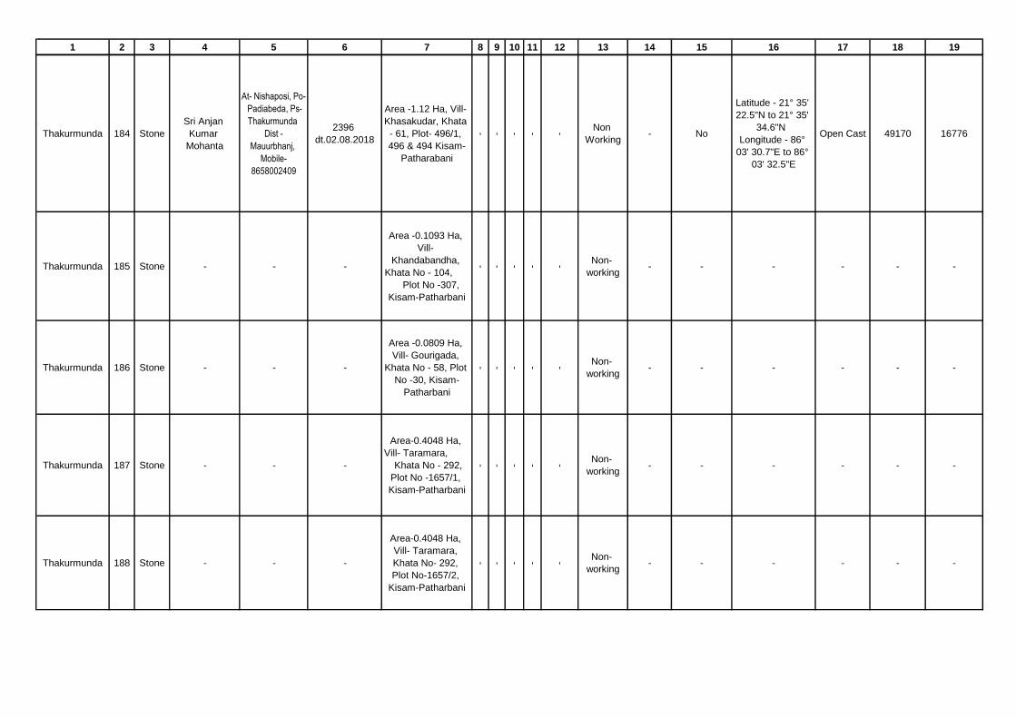
1 2 3 4 5 6 7 8 9 10 11 12 13 14 15 16 17 18 19
Thakurmunda 184 Stone
Sri Anjan
Kumar
Mohanta
At- Nishaposi, Po-
Padiabeda, Ps-
Thakurmunda
Dist -
Mauurbhanj,
Mobile-
8658002409
2396
dt.02.08.2018
Area -1.12 Ha, Vill-
Khasakudar, Khata
- 61, Plot- 496/1,
496 & 494 Kisam-
Patharabani
- - - - -
Non
Working- No
Latitude - 21° 35'
22.5"N to 21° 35'
34.6"N
Longitude - 86°
03' 30.7"E to 86°
03' 32.5"E
Open Cast 49170 16776
Thakurmunda 185 Stone - - -
Area -0.1093 Ha,
Vill-
Khandabandha,
Khata No - 104,
Plot No -307,
Kisam-Patharbani
- - - - -
Non-
working- - - - - -
Thakurmunda 186 Stone - - -
Area -0.0809 Ha,
Vill- Gourigada,
Khata No - 58, Plot
No -30, Kisam-
Patharbani
- - - - -
Non-
working- - - - - -
Thakurmunda 187 Stone - - -
Area-0.4048 Ha,
Vill- Taramara,
Khata No - 292,
Plot No -1657/1,
Kisam-Patharbani- - - - -
Non-
working- - - - - -
Thakurmunda 188 Stone - - -
Area-0.4048 Ha,
Vill- Taramara,
Khata No- 292,
Plot No-1657/2,
Kisam-Patharbani
- - - - -Non-
working- - - - - -

1 2 3 4 5 6 7 8 9 10 11 12 13 14 15 16 17 18 19
Thakurmunda 189 Stone - - -
Area-0.2024 Ha,
Vill- Jadibil, Khata
No - 85, Plot No -
749/1, Kisam-
Patharbani
- - - - -
Non-
working- - - - - -
Thakurmunda 190 Stone - - -
Area-0.2024 Ha,
Vill- Sunariposi,
Khata No - 70, Plot
No -603/1, Kisam-
Patharbani
- - - - -
Non-
working- - - - - -
Thakurmunda 191 Stone
Sri Ajay
Kumar Nayak,
on behalf of
Sri Durga
Condev. Pvt.
Ltd
Vill- Ichhapur,
Po/Ps- Jagatpur,
Dist- Cuttack at
present At/Po/Ps-
Thakurmunda
2016 dated
26.08.15
Area-0.2429 Ha,
Vill- Sunariposi,
Khata No- 70, Plot
No-569/1, Kisam-
Patharbani
- - - - -
Non-
working- - - - - -
Thakurmunda 192 StoneSri Pradeep
kumar Muduli
Vill / Po/Ps-
Anandpur,
Dist- Keonjhar
2033 dated
27.08.15
Area-0.0607 Ha,
Vill- Duarsuni,
Khata No- 39, Plot
No-682/1, Kissam-
Patharbani
- - - - -
Non-
working- - - - - -
Thakurmunda 193 Stone
Area-3.340 Ha, Vill-
Khandabandha,
Khata No - 104,
Plot No -272,
Kisam-Patharbani
- - - - -
Non-
working- - - - - -

1 2 3 4 5 6 7 8 9 10 11 12 13 14 15 16 17 18 19
Thakurmunda 194 Stone
Area -1.655 Ha.,
Vill- Daunlikila,
Khata No - 66, Plot
No-483, Kisam-
Patharbani
- - - - -
Non-
working- - - - - -
Thakurmunda 195 Stone
Area-0.668 Ha, Vill-
Nada, Khata No-
104, Plot No-133,
141 & 146 Kisam-
Patharbani
- - - - -
Non-
working- - - - - -
Raruan 196 Stone
Kamalakanta
Mahanta,
At/P.O-
Nuagan,
P.S-
Ghagarbeda,
Mob.
9439091905
831
Dt.24.03.2015
Area-0.623 Ha
Vill- Bamanposi,
Khata No-174,
Plot No.- 965/1,
Kisam-Patharbani
2015-1
6
2019-2
0
- -
16.0
5.2
017
WorkingNon-
captive
Yes ,
182/DEIAA
22.12.2016
GPS- Lat. 22° 03’
50.1”N to 22° 04’
01” N
Long. 85° 46’
51.9"E to 85° 46’
56.2” E
Open
Cast40843 cum. 21123 cum.
Raruan 197 Stone
Kamalakanta
Mahanta,
At/P.O-
Nuagan,
P.S-
Ghagarbeda,
Mob.
9439091905
810
Dt.23.03.2015
Area-1.133 Ha
Vill- Jamuti
Khata No-179
Plot No.- 602/2
Kisam-Patharbani
2015-1
6
2019-2
0
- -
25.0
3.2
017
WorkingNon-
captive
Yes ,
242/SEIAA
14.01.2016
GPS- Lat. 21° 58’
45.4”N to 21° 58’
55.9” N
Long. 85° 48’
32.2"E to 85° 48’
39.8” E
Open
Cast20505 cum. 15144 cum.
Raruan 198 Stone
Kamalakanta
Mahanta,
At/P.O-
Nuagan,
P.S-
Ghagarbeda,
Mob.
9439091905
823
Dt.23.03.2015
Area-0.404 Ha
Vill- Raikala,
Khata No-151,
Plot No.- 945/1,
Kisam-Hudi
2015-1
6
2019-2
0
- -
28.0
2.2
018
WorkingNon-
captive
Yes ,
68/DEIAA
27.05.2016
GPS- Lat. 22° 01’
31”N to 22° 01’
34.3” N
Long. 85° 41’
52.9"E to 85° 41’
55.9” E
Open
Cast
23587.2
cum.
10034.4
cum.

1 2 3 4 5 6 7 8 9 10 11 12 13 14 15 16 17 18 19
Raruan 199 Stone
M/S S.G
Minerals,
Partner,Sangra
m Kehari
Mohanty
At/P.O-Moudi,
P.S-Jashipur,
Mob.98616360
60
818
Dt.23.03.2015
Area-0.808 Ha
Vill- Balanposi,
Khata No-194,
Plot No.- 225/1 &
225/3
Kisam-Patit
2015-1
6
2019-2
0
- -
14.1
1.2
017
WorkingNon-
captive
Yes ,
94/SEIAA
11.01.2016
GPS- Lat. 22° 00’
41.3”N to 22° 00’
47.4” N
Long. 85° 58’
14.8"E to 85° 58’
20.8” E
Open
Cast
111209.8
cum.35853 cum.
Raruan 200 Stone
Kamalakanta
Mahanta,
At/P.O-
Nuagan,
P.S-
Ghagarbeda,
Mob.
9439091905
820
Dt.23.03.2015
Area-0.389 Ha
Vill- Nayabeda,
Khata No-220,
Plot No.- 648,
Kisam-Patharbani
2015-1
6
2019-2
0
- -
16.0
5.2
017
WorkingNon-
captive
Yes ,
184/DEIAA
22.12.2016
GPS- Lat. 21° 58’
48.1”N to 21° 58’
52.3” N
Long. 85° 47’
18.9"E to 85° 47’
22.0” E
Open
Cast7995 cum. 2835 cum.
Raruan 201 Stone - - -
Area-0.364 Ha
Vill- Rangamatia,
Khata No-173,
Plot No.- 78,
Kisam-Patharbani
2015-1
6
2019-2
0
- - -
Non
Working-
Yes ,
70/DEIAA
27.05.2016
GPS- Lat. 22° 05’
43.9”N to 22° 05’
44.3” N
Long. 85° 47’
07"E to 85° 47’
07.9” E
-15980.8
cum.
7226.47
cum.
Raruan 202 Stone - - -
Area-0.607 Ha
Vill- Jamuti,
Khata No-179 ,
Plot No.- 602/1,
Kisam-
Patharbani2016-1
7
2020-2
1
- - -
Non
Working-
Yes ,
17/DEIAA
01.03.2017
GPS- Lat. 21° 58’
43.7”N to 21°58’
48.1” N
Long. 85° 48’
19.2"E to 85° 48’
25.7” E
- 9701 cum. 4535 cum.
Raruan 203 Stone
SK Immam
Hossain
At/P.O/P.S-
Jashipur,
Mob.94373215
25
3467
Dt.13.12.2016
Area-0.405 Ha ,
Vill- Kantasimila,
Khata No-158, Plot
No.- 381/1, Kisam-
Patharbani
2016-1
7
2020-2
1
- -
16.0
8.2
018
workingNon-
captive
Yes ,
63/DEIAA
Dt.10.05.201
7
GPS- Lat. 21° 59’
56.5”N to 21°59’
59.8” N
Long. 85° 54’
6.2"E to 85° 54’
58.8” E
Open
Cast12744 cum. 7560 cum.

DISTRICT SURVEY REPORT (DSR) OF
MAYURBHANJ DISTRICT, ODISHA. FOR
MOORUM MINING
(FOR PLANNING & EXPLOITING OF MINOR MINERAL RESOURCES)
As per Notification No. S.O. 3611(E) New Delhi
dated 25th July 2018 of
Ministry of Environment, Forest & Climate Change
( MoEF & CC)
( Prepared by DEIAA, Mayurbhanj, Odisha )

MOORUM MINING DSR OF MAYURBHANJ DISTRICT.
1
CONTENT
CH.
NO.
DESCRIPTION PAGE
NO.
Preamble 3
1 Introduction 4
1.1 Location and Geographical Area 4
1.2 Administrative Units 5
1.3 Connectivity 7
2 Overview of Mining Activity in the District 10
3 General Profile of the District 11
3.1 Demography 11
4 Geology of the District 11
4.1 Physiography & Geomorphology 12
4.2 Stratigraphy. 13
4.3 Mineral Resources. 14
4.4 Soil 17
5 Drainage of Irrigation Pattern 17
5.1 River System 19
6 Land Utilization Pattern in the District 21
6.1 Forest and non forest land. 21
6.2 Agricultural land. 24
6.3 Horticultural land. 25
7 Surface Water and Ground Water Scenario of the District 25
7.1 Hydrogeology. 25
7.2 Depth to water level. 25
7.3 Ground Water Quality. 27
7.4 Ground Water Development. 28
7.5 Ground water related issues & problems. 29
7.6 Mass Awareness Campaign on Water Management
Training Programme by CGWB
29
7.7 Area Notified By CGWB/SGWA 29
7.8 Recommendations 29
8 Rainfall of the District and Climate Condition 30
8.1 Month Wise rainfall. 30
8.2 Climate. 31
9 Details of Mining Lease in the District 31
9.1 List of Mines in operation in the district Annexure-C
9.2 List of Mines not in operation in the district Annexure-C
10 Detail of Royalty or Revenue received in last 3 years 32

MOORUM MINING DSR OF MAYURBHANJ DISTRICT.
2
11 Detail of production of minor mineral in last 3 years 33
12 Mineral Map of the District. 34
13 List of Letter of Intent (LOI) Holders in the District along
with its Validity.
34
14 Total Mineral Reserve Available in the District. 35
15 Quality/Grade of Mineral Available in the District. 36
16 Use of Mineral. 36
17 Demand and Supply of the Mineral in the Last Three Years. 36
18 Map of Existing Mining Leases in the District. 39
19 Details of the Area of where there is a cluster of mining
lease viz. Number of mining leases, location (latitude and
longitude).
39
20 Details of Eco-Sensitive Area, if Any, in the District 39
21 Impact of Mining on Environment 39
22 Remedial Measures to Mitigate the Impact of Mining on
the Environment
40
23 Reclamation of Mined Out Area 41
24 Risk Assessment and Disaster Management Plan 42
25 Details of the Occupational Health Issue in the District 45
26 Plantation and Green Belt Development in Respect of
Lease Already Granted in the District
46
27 Conclusion & References 46

MOORUM MINING DSR OF MAYURBHANJ DISTRICT.
3
PREAMBLE
Odisha is the major mineral reach in India. Mayurbhanj is a unique district in Odisha
lies on the northern most part of the state with varied mineral resources. In
pursuance of the order of Hon’ble Supreme Court Petition (C) No. 19628-19629 of
2009, dated 27th Feb. 2012 in the matter of Deepak Kumar Vs State of Haryana and
others etc., prior environmental clearance has now become mandatory for mining of
minor minerals irrespective of the area of Mining Lease. And also in view of the
Hon’ble National Green Tribunal, order dated the 13th Jan. 2015 the matter regarding
Roadmetal/stone, Sand, Brick earth, & burrowed earth cutting for Road Construction
has to take prior Environmental Clearance for Mining Lease area more or less than 5
hectares also suggested making a policy on Environmental Clearance for minor
minerals lease and leases in cluster. As per MOEF & CC Notification S.O.-1533(E)
dated 14th Sept. 2006 and subsequent MoEF & CC Notification S.O. 141(E) dated 15th
Jan. 2016, District Environment Impact Assessment Authority (DEIAA) & District level
Expert Appraisal Committee (DEAC) has been formed for Category –B2 Minor Minerals
having area less than or equal to 5 ha. In compliance to the notification issued by the
Ministry of Environment and Forest and Climate Change Notification no. S.O.3611 (E)
New Delhi dated 25-07-2018; the preparation of district survey report of road
metal/stone mining has been prepared in accordance with Clause II of Appendix X of the
notification.
Keeping in view of the prior information of Odisha Minor Mineral Concession Rule
2004, (OMMCR -2004) the mining operation for minor minerals were carried out in
unscientific manner. Identifying this fact in exercise of power, Conferred by Section 15
by Mines and Minerals (Development and Regulation) Act 1957 as amended in 2015
and all other powers enabling it in that behalf, the Mining & Geology Department,
Govt. of Odisha framed the aforementioned rule. Further, this report will act as a
compendium of available mineral resources, geological set up, environmental and
ecological set up of the district and based on data of various departments like
Revenue, Water Resources, Forest, Geology and Mining in the district as well as
statistical data uploaded by various state Government departments for preparation for
district survey report.

MOORUM MINING DSR OF MAYURBHANJ DISTRICT.
4
1. INTRODUCTION:
Mayurbhanj at a Glance:
1.1 Location and Geographical Area:
Mayurbhanj district is the largest among the thirty districts of Odisha and Baripada is
the District head quarter, spreading over an area of 10,418 sq.km lies between
latitudes 21° 17’ North and 22° 34’ North and longitudes 85°40’ East and 87°10’ East.
It is bounded on the north by the Singhbhum district of Jharkhand and Midnapore
district of West Bengal, on the south by the districts of Balasore and Keonjhar, on the
east by the Midnapore and Balasore districts and on the west by the districts of
Keonjhar and Singhbhum. Mayurbhanj occupies a unique position being endowed
with lush green vegetation, different fauna & flora and rich cultural heritage. The
district has a rich mineral base and is home to the Similipal Biosphere. Iron-ore
(hematite), vanadiferous and titaniferous magnetic, chaina clay, galena (lead ore),
Kyanite, asbestos, steatite (soap stone) and quartzite constitute the principal mineral
resources of Mayurbhanj district, of these the iron-ore deposits of Gorumahisani,
Badampahar and Suleipat, which have been exploited for a period of about half a
century, deserve special mention.

MOORUM MINING DSR OF MAYURBHANJ DISTRICT.
5
1.2 Administrative Units:-
Baripada is the administrative headquarter of Mayurbhanj district. It is located at a
distance of 263 km from Bhubaneswar, state capital of Odisha. In order of size, the
district is the largest among the thirty districts of Odisha. It has 3950 villages
(including 202 uninhabited villages) covering 26 blocks, 26 tahasils and 4 sub-
divisions. The district is divided into 4 Sub-Divisions namely 1) Sadar Sub-Division
Baripada, 2) Kaptipada Sub-Division Udala, 3) Bamanghaty Sub-Division, Rairangpur,
4) Panchapir Sub-Division, Karanjia. which are given below:-

MOORUM MINING DSR OF MAYURBHANJ DISTRICT.
6
Sl No Name of the Block/Tehsil Name of the Sub-Division with
Head quarter
1 Baripada
Sadar Sub-Division, Baripada
2 Samakhunta
3 Kuliana
4 Bangriposi
5 Saraskana
6 Suliapada
7 Betnoti
8 Badsahi
9 Rasgovindapur
10 Moroda
11 Udala
Kaptipada Sub-Division, Udala
12 Kaptipada
13 Khunta
14 Gapabandhu Nagar
15 Rairangpur
Bamanghaty Sub-Division,
Rairangpur
16 Bisoi
17 Bijatala
18 Kusumi
19 Bahalda
20 Tiring Bamanghaty Sub-Division,
Rairangpur 21 Jamda
22 Karanjia
Panchpir Sub-Division, Karanjia
23 Jashipur
24 Sukruli
25 Thakurmunda
26 Raruan
The population of the district 25,19,738 according to the 2011 Census. The district
accounts for 6.69% of the state’s territory and about 6% of state’s population. The
density of population of the district is 242 per square km as against 270 per square
km of the state. As per 2011 census, the population of Scheduled Caste is 1,84,682
(7.30%), that of Scheduled Tribe is 14,79,576 (58.7%). The literacy percentage of the
district covers 63.2 against 72.9 of the state.

MOORUM MINING DSR OF MAYURBHANJ DISTRICT.
7
1.3 Connectivity facilities:-
Road Network
The district is well served by a network of good roads and has been called the
motorists paradise. The chief roads emanating from Mayurbhanj town are NH-18 and
NH-49 passes the district. Baripada is 60 Kms from Mayurbhanj, 103 Kms from
Kharagpur, 163 Kms from Jamshedpur, 231 Kms from Cuttack, 255 Kms from
Bhubaneswar and 368 Kms from Rourkela. It is also connected with other cities such
as Sambalpur, Puri, Bolangir, Bhadrak, Jhargram, Angul, Ranchi and Kolkata via
Odisha State Road Transport Corporation and some private travel services.

MOORUM MINING DSR OF MAYURBHANJ DISTRICT.
8
Rail Network
Mayurbhanj district is well connected by rail link to different places, the city of
Baripada is well connected to many places in India like Mayurbhanj, Bhubaneswar,
Kolkata, Jamshedpur and Cuttack,

MOORUM MINING DSR OF MAYURBHANJ DISTRICT.
9
Air Network
At present, Mayurbhanj has no connection by airway. The site selection for aerodrome
is presently under process. Nearest aerodrome is Dum Dum Airport (International
Airport) Kolkata, roughly 195 Kms from Baripada. The other nearest airport to
Baripada is Biju Patnaik Airport, Bhubaneshwar, 207 Kms from Baripada.

MOORUM MINING DSR OF MAYURBHANJ DISTRICT.
10
2. OVERVIEW OF MINING ACTIVITY IN THE DISTRICT:
Mayurbhanj district is land features of both plain and hilly region. Most of the
mineralized area coming under safety zone eco-sensitive zone, mining activity only
confined out of safety zone of eco-sensitive zone. The mining activity in the district is
not only restricted to minor minerals i.e. of sand, stone, granite and brick clays.
Altogether there are leases of Iron-ore (hematite), vanadiferous and titaniferous
magnetic, chaina clay, galena (lead ore), Kyanite, asbestos, steatite (soap stone) and
quartzite constitute the principal mineral resources of Mayurbhanj district, of these the
iron-ore deposits of Gorumahisani, Badampahar and Suleipat, which have been
exploited for a period of about half a century. Stone, granite and sand which has been
granted to the district is regulated as per minerals concession rules of Odisha. There
is no lease of major mineral in the district. At present Leases of stone, sand and bricks
making units are operational in the district. Stone chips, granite stones, ordinary sand

MOORUM MINING DSR OF MAYURBHANJ DISTRICT.
11
constitute the principal mining activity of Bangirposi, Badasahi, Kaptipada, Kuliana
area etc. of Mayurbhanj district. Out of these huge granite stones deposits are
available near Badasahi, Kaptipada, Kuliana area and major potential sand in G.B
Nagar, Morada & Kaptipada area of the district, which have been provides
tremendous scope for development of few more industries based on this resources.
Iron-ore (hematite), vanadiferous and titaniferous magnetic, chaina clay, galena (lead
ore), Kyanite, asbestos, steatite (soap stone) and quartzite constitute the principal
mineral resources of Mayurbhanj district, of these the iron-ore deposits of
Gorumahisani, Badampahar and Suleipat, which have been exploited for a period of
about half a century.
3.0 GENERAL PROFILE OF THE DISTRICT:
3.1 Demography:
Census - 2011
Geographical Area 10,418 Sq. Km.
Total population 25,19,738
Male Population 12,56,213
Female Population 12,63,525
Male Literacy 794,171
Female Literacy 575,226
SC Male 92,127
SC Female 92,555
ST Male 730,487
ST Female 749,089
OBC 855,480
Illiterate Male 462,042
Illiterate Female 688,299
4.0 GEOLOGY OF THE DISTRICT:
Mayurbhanj is a unique district in Odisha with rich and varied geology. Similipal
Complex being at its central part. The mountain ranges comprise mainly of highland
plateau and valleys with intrusive running through them. The second physiographic
unit is Tertiary Plain occurring in the eastern part of the district. The third
physiographic unit is Alluvial Plain .The drainage density is observed to be fairly
moderate and drainage pattern is dendritic in nature. The major rock types

MOORUM MINING DSR OF MAYURBHANJ DISTRICT.
12
encountered in the district are Granite Gneiss, Quartzite, Orthoquartzite, Arkose,
Shale, Phyllite, Gabbro, Px-granite. The geology of the district is constituted by the
Similipal complex at its central part belonging the Archaean age, unconformably lying
over Singhbhum Granite and Banded Iron Formation (BIF). It consists of three
alternate bands of volcano sedimentary units uniquely disposed in a ring like circular
pattern formed under sub- marine conditions. Baripada Beds outcrops of tertiary
formation occur around Baripada town. These comprise stratified clay and sand with
marly clay or limestone interbands. Important mineral resources include iron, copper,
itanium, vanadium, chinaclay, nickel, kyanite ,quartz, talc, steatite ,soapstone and
bauxite.
4.1 Physiography & Geomorphology:
Mayurbhanj district presents diverse physiographic features, Physiographically the
study area can be divided into 3 categories. The first physiographic unit of the district
is high mountain ranges, Similipal Complex being at its central part (Figure 1). The
mountain ranges comprise mainly of highland plateau and valleys with intrusive
running through them. The second physiographic unit is Tertiary Plain occurring in the
eastern part of the district. The third physiographic unit is Alluvial Plain which lies
partly in Rasgobindpur, Morada, Samakhunta, Betnoti, Baripada, Badasahi and
Suliapada Blocks. The highest elevation of about 559m at Bahalda near Similpal hill
and higher elevations of the district, due to scarp landforms some waterfalls are
observed in the district. The general slope of the district is from north to south.
Geologically the area is comprised with Archean granites and gneisses.
Geomorphologically the district is divided into 3 units:
i) The denudational hills with moderate to high slope occurring in the western part of
the district.
ii) Dissected pediments having gentle slope.

MOORUM MINING DSR OF MAYURBHANJ DISTRICT.
13
iii) Pediplain having slope between 0o to 5o.
4.2 Stratigraphy:
Geological Age Geological Formation / Group
Quaternany : Recent Alluvium, Clays, silt, Sand, Gravel
Tertiary : Older Alluvium, Laterite, Baripada Beds.
Mesozoic/ Palaeozoic : Volcanics / Epidiorite
Precambrian : Slate/ Phyllite/ Schist / Gneiss
Archean : Granite/ Granite Gneiss

MOORUM MINING DSR OF MAYURBHANJ DISTRICT.
14
4.3 Mineral Resources:
The earliest known geological survey in Mayurbhanj dates back to 1903, when P.N.
Bose brought to light the extensive iron-ore deposits of high quantity on the
Gorumahisani and Suleipat hills in Bamanghaty Sub-Division. These deposits were
considered to be almost inexhaustible and were pronounced to be of excellent quality,
perhaps second to none in the whole of Asia by the famous American and English
experts like M/s Perin, Weld and Colonel Staddart, who visited these deposits during
1905-06. This discovery was a momentous one as the steel plant of the Tata Iron &
Steel Co. at Jamshedpur was entirely based on the exploitation of these deposits. By
1915, important discoveries of Steatite near Lulung and placer gold from the sands of
Subarnarekha, Kharkhai and Barhai rivers had been made. The placer gold deposits
were being worked by M/s J.B. Bettie of Calcutta, Mr. V.G. Piggot of Ghatsila and the
Mayurbhanj Prospecting Concession Syndicate.
Gold: The mid-Archaean Gorumahisani-Badampahar schist belt composed of basic
ultrabasic, volcanic rocks and volcanogenic sediments. This belt has been
prognosticated as a rift-type of volcanic dominated one and is highly potential for
economic grade gold mineralization. Likely targets include: a) auriferous quartz veins
close to the contact of sulphide chert volcanics, b) sheared and sulphidised Fe-rich
tholeiite with anomalous copper, c) epigenetic vein type of mineralization and BIF
volcanic association, and d) sulphidic conglomerate resting over the basic volcanics.
Placer gold occurrence are known from rivers and stream of Mayurbhanj district. An
area of about 5 square kilometers of alluvium at the headwaters of Sapgora and Borai
rivers near Kudersai was indicated as promising.
Iron: Bose discovered iron ore deposits in Gorumahisani and Badampahar in the east
while princely state of Mayurbhanj (now Mayurbhanj District). Gorumahisani deposits
were investigated by Perin & Weld (1905). Gorumahisani- Badampahar-Suleipat
deposits are associated with banded hematite / magnetite grunerite and BHJ.
Gorumahisani – Badampahar- Suleipat (Broad geological sequence)
Laterite & Alluvium

MOORUM MINING DSR OF MAYURBHANJ DISTRICT.
15
Newer Dolerite
Gabhro-Anorthosite Granite
---Unconformity---
Ultramafic dyke
Singhbhum Granite
Banded magnetite/ Martite quartzite with Fe-Ores
Quartzite
Basal Conglomerate
----Unconformity----
Older metamorphic
Vanadium Ores & Titanium: Vanadium is an important alloying element. Magnetite
associated with gabbro- anorthosite suite of rocks contain vanadium and titanium.
Deposits of vanadium-magnetite occur in association with gabbro-Anorthosite suite of
rocks in the precambrian metamorphites. Vanadium bearing magnetite belts are :-
(a) Rairangpur – Bisoi belt (Kumardubi, Betjharan Amdabeda)
(b) Bisoi – Joshipur belt (Mayurbeka, Kesham, Sialnoi)
(c) Baripada – Podadiha belt (Andipur, Bahalda)
Pyrophyllite : is mainly used as a high grade ceramic product, electric insulator and
refractory material. The comp. is Al2O34SiO2 H20. It is formed as an alteration product
of feldspar. Pyrophyllite occurrences are reported at Kankrani, Jashipur,
Gorumahisani, Bangriposhi and Manada in Mayurbhanj dist. Ichinda, Khairakocha,
Jamukunda, Nakulkocha, Kapadiha, Dunguridiha, Maheshpur, Kashidiha, Sagragora
and Pokpoka. Dimension stone of the district are granite, granite-gneiss, migmatites,
syenite, gabbro, anorthosite, charnockite, leptynite, pyroxene granulite, dolerite,
pyroxinite and dunite etc.
Bauxite: In Similipal complex (Mayurbhanj) aluminous laterite/ Bauxite are observed
around 1000 m AMSL. The spongy aluminous laterite/bauxite occurs as sheets and
boulders occupying the flat-topped hills made up of metavolcanics. Both
ultramafics and metavolcanics are lateritised giving rise to nickeliferous laterite and
aluminous laterite respectively.

MOORUM MINING DSR OF MAYURBHANJ DISTRICT.
16
China Clay is clay like material approximating the mineral Kaolinite (Al2O3, 2SIO2,
2H2O). China clay is found to occur in a long belt stretching from Singhbhum to
Mayurbhanj. Badampahar-Joshipur- Karanjia – Ramachandrapur belt is the most
important china-clay producing area of the state. The important deposits in
Mayurbhanj district are found near Joshipur, Chanchbani, Dumuria, Jamda, Kodadiha,
Jamkeswar and Thakurmunda. China clay has many industrial applications as filler in
paper, textile, rubber, in the manufacture of potteries, ceramics, sanitary wares,
glazed tiles, white cement, insecticides, paints, cosmetics, refractory bricks etc. Soap
stone and Steatite Asbestos is mined from Mayurbhanj area.
Talc, steatite and soapstone : Important localities of these deposits in Mayurbhanj
dist are Tiring, Kendumundi and Kharidamak.
Kyanite: Kyanite deposits of refractory grade occur in Panijia area of Mayurbhanj
dist, where it is associated with dumortierite bearing rocks, qtz-veins, quartz-mica-
schists and talc-tremolite-schist. Other kyanite occurrence include Purnapani &
Similipal.
Quartz & Quartzite: Quartz and silica sand are mostly used in glass foundry,
ferrosilicon alloy, ceramic industry, abrasive, paint, rubber, textile industries.
Transparent varieties of quartz such as rock crystal, amethyst, citrine, Rosequartz and
smoky quartz are used as semi-precious gemstone. Quartz is a piezoelectric material
and is used in radio circuit, Radars and ultra-sonic devices. Quartzite is a
monomineralic rock constituted predominantly of quartz. There are 6 mining leases
for quartz and quartzite in Mayurbhanj dist.
High Magnesia rock: are found in Notapahar, Thakurmunda, Amjori and
Badampahar of Mayurbhanj Dist.
Nickel: Nickel is concentrated within chemically weathered ultramafic rocks and
found in the laterite and soil capping in Similipal area. The mineral occurs in silicate

MOORUM MINING DSR OF MAYURBHANJ DISTRICT.
17
form i.e. garnierite. The important patches of prospective ore zones are: Gurguria and
Nawana.
4.4 Soil:
The district comprises chiefly of lateritic, sandy loam and clayey loam type of soil
(Figure 3). Laterite soil is mostly marked in the area occupied by crystalline rocks.
The low lying valley fields are covered with clayey loam type of soil.
5. DRAINAGE OF IRRIGATION PATTERN
The district has considerable flat land, which provide suitable site for agricultural use.
The hilly areas are mostly under forest with patches of cultivation on scarp areas.
Major rivers flowing in the district are Budhabalanga, Subarnarekha, Jambhira, Sona,

MOORUM MINING DSR OF MAYURBHANJ DISTRICT.
18
Khadkhai, Deo, Katra, Khairibandhan & Baitarani. Major crops grown in the district are
rice Only. 14.82 percent area of agricultural use are net irrigated and major source of
irrigations are well and tube-wells.
Sl. No.
Name of the River
Area drained (Sq.Km.)
% Area drained in the District
1 Budhabalanga 2143 21%
2 Subarnarekha 265 0.25%
3 Jambhira 1377 13%
4 Sona 1062 10%
5 Khadkhai 1131 10.8%
6 Khairibandhan 1014 0.09%
7 Deo 473 0.04%
8 Katra 352 0.03%
9 Gangahar 594 0.057%
10 Baitarani 260 24.6%
11 Tel 96 0.009%
12 Kantamauli 82 0.007%
13 Sim 165 0.015%
14 Jhagada 30 0.002%
15 Balijori 56 0.005%
16 Kantakhaira 186 0.017%
17 Kanhu 383 0.036%
18 Balisudura 170 0.016%

MOORUM MINING DSR OF MAYURBHANJ DISTRICT.
19
5.1 River System
The Budhabalanga River (also called Balanga River) flows through the districts
of Mayurbhanj & Balasore and finally reached Bay of Bengal. The Budhabalanga, rises
from Similipal hills and plunges through Barehipani Falls, the second-highest waterfall
in India, located in Similipal National Park. It then flows in a northerly direction up to
the village Karanjiapal in Bangiriposi police-station. Thereafter, it turns to the north-
east and flows along the railway track up to the village Jhankapahadi. There it
changes its course to the south and meets the Katra nala. The other tributaries are
the Palpala and the Chipat both of which are hill streams rising from the Similipal hills.
Then the river passes through Baripada. It later flows through Balasore district and
into the Bay of Bengal. The Budhabalanga is about 175 kilometres (109 mi) long and
has a total catchment area of 4,840 square kilometres (1,870 sq mi). Its major
tributaries are the Sona, Gangahar, and the Katra. Burhabalang and its tributaries, viz.

MOORUM MINING DSR OF MAYURBHANJ DISTRICT.
20
Sona Nadi, Amrutia Nadi, Gangahar Nadi drain almost round the year in the present
area. Sona Nadi receives the watery effluent load through a nalah (Sankh nalah) from
the Balgopalpur Industrial Estate and flows from west to east. Amrutia Nadi flows
from NNW to SSE and carries the waste water load of East Coast. Subarnrekha
originate from Nagri of Jharkhand and then enter into Mayurbhanj district, very less
portion of the river flows within Mayurbhanj district, Major portion of Subarnarekha
River passes in the Balasore district. Another river Jambhira runs in Mayurbhanj
district then enters into Balasore district and Renamed as river Jalaka flows into Bay
of Bengal. Other small rivers run in this district like River Khadkhai originates from
Tunhgru R.F. and plunges through Suleipat Dam (Khadkhai Reserviour). It then runs
towards Rairangpur, Bahalda, Tiringi area of western direction of Mayurbhanj district
and finally reached at River Subarnarekha. River Deo rises from Similipal R.F. and
runs towards western part of the district and flows through Karanjia area and then
joins with Baitarani River. River Khairabandhan originates from Similipal R.F. and
flows towards western part of the Mayurbhanj district through Jashipur, Raruan,
Sukruli area of district and then joins with River Baitarani This river maintains a
sluggish flow in the pre-monsoon period, but swells menacingly with the onset of
monsoon often flooding large tracts. Another small tributary named as Kanhu starts
from River Khadkhai and branched into Jalapa, Ghagera nala meets at Jharbeda area
of Mayurbhanj District.
Sl. No.
Name of the River or Stream
Total Length in District (in Km.)
Place of Origin Altitude at Origin
1 Budhabalanga 161 Similipal Hill 940 mrl.
2 Subarnarekha 4 Nagri, Jharkhanda
610 mrl.
3 Jambhira 64 Chandra R.F. Mayurbhanj
60 mrl.
4 Sona 70 Jaymal Hill, Dugdha
Mayurbhanj.
340 mrl.
5 Khadkhai 75 Tunhgru R.F. 500 mrl.
6 Khairibandhan 65 Similipal R.F. 800 mrl.
7 Deo 65 Similipal R.F. 930 mrl.
8 Katra 55 Jari R.F. 700 mrl.
9 Gangahar 55 Similipal R.F. 740 mrl.
10 Baitarani 48 Gonasika, 900 mrl.

MOORUM MINING DSR OF MAYURBHANJ DISTRICT.
21
Guptaganga Hills
11 Tel 20 Similipal R.F. 940 mrl.
12 Kantamauli 25 Similipal R.F. 360 mrl.
13 Sim 85 Similipal R.F. 900 mrl.
14 Jhagada 15 Jhagada R.F. 430 mrl.
15 Balijori 22 Similipal R.F. 520 mrl.
16 Kantakhaira 36 Similipal R.F. 420 mrl.
17 Kanhu 42 Similipal R.F. 400 mrl.
18 Balisudura 15 Similipal R.F. 450 mrl.
6.0 LAND UTILIZATION PATTERN IN THE DISTRICT
6.1 Forest and non forest land
The forest of Mayurbhanj district is full variety of medicinal plants, Kendu leaves,
Bamboo, Sal, Teak, other timber species and a wide range of carnivorous & herbivorous
wild animals. The district has one Wildlife Sanctuaries known as the Similipal Wildlife
Sanctuary situated at the heart of the district, which hosts all type of wildlife even

MOORUM MINING DSR OF MAYURBHANJ DISTRICT.
22
tigers. The area of the sanctuary is 26, 886.23 hectares. And two kilometer safety zone
of eco-sensitive zone of Suleipat Wildlife Sanctuary are coming in Mayurbhanj district. In
these sanctuary areas the principal animals that are found are Elephant, Bear, Nilgai,
Sambhar, Peacock, Wild Boar and Deer, together with variety of snakes and birds.
District-wise Forest Cover Area in Odisha (Area in Km2)
2017 Assessment
District Geograph ical Area Km2
Very Dense Forest
Moder- ate. Dense Forest
Open Forest
Total Percent of GA
Change Scrub
Angul 6375 371 1380 1004 2755 43.22 43 84
Bolangir 6575 70 224 837 1131 17.2 151 142
Balasore 3806 23 127 234 380 9.98 30 48
Bargarh 5837 176 371 484 1031 17.66 88 47
Bouda 3098 263 546 480 1289 41.61 27 57
Bhadrak 2505 0 9 66 75 2.99 2 0
Cuttack 3932 53 226 517 796 20.24 11 68
Deogarh 2940 191 667 614 1472 50.07 -3 14
Dhenkanal 4452 174 418 825 1417 31.83 9 82
Gajapati 4325 84 1490 946 2520 58.27 12 262
Ganjam 8206 164 1075 864 2103 25.63 15 655
Jagatsinghpur 1668 0 5 131 136 8.15 6 0
Jajpur 2899 6 72 225 303 10.45 3 50
Jharsugada 2114 3 140 179 322 15.23 9 36
Kalahandi 7920 362 729 1327 2418 30.53 36 362
Kandhamal 8021 661 2588 2143 5392 67.22 16 380
Kendrapada 2644 84 88 133 305 11.54 14 2
Keonjhar 8303 289 1404 1519 3212 38.68 4 55
Khorda 2813 21 186 250 457 16.25 0 92
Koraput 8807 94 740 1255 2089 23.72 120 944
Malkangiri 5791 158 709 1475 2342 40.44 20 45
Mayurbhanj 10418 1335 1718 1027 4080 39.16 42 34
Nabarangpur 5291 168 428 507 1103 20.85 8 47
Nayagarh 3890 189 965 556 1710 43.96 28 173
Nuapada 3852 86 482 705 1273 33.05 33 109
Puri 3479 0 54 160 214 6.15 8 11
Rayagada 7073 422 853 1851 3126 44.2 7 349

MOORUM MINING DSR OF MAYURBHANJ DISTRICT.
23
Sambalpur 6624 499 1675 1106 3280 49.52 13 40
Subarnapur 2337 2 187 161 350 14.98 26 29
Sundargarh 9712 1019 1814 1431 4264 43.9 107 89
Grand Total 155707 6967 21730 23008 51345 32.98 885 4306
(Source: India state of forest report 2017-Odisha)
The major portion of the district is covered by forest (39.16 % of TGA) and has
scattered settlement pattern. The forest is full of variety of medicinal plants. The
district has considerable flat land, which provide suitable site for agricultural use. The
hilly areas are mostly under forest with patches of cultivation on scarp areas. Major
crops grown in the district are rice and pulses. Only 14.82 percent area of agricultural
use are net irrigated and major source of irrigations are well and tube wells.
Source: Fertilizer and Agriculture Statistics, Eastern Region
Tahasil Forest Area
Misc Tree
Permanent Pasture
Cultivated waste
Non Agricultural
uses
Barren land
Current Fallow
Other Fallow
Net area
sown
Bahalda 964 471 1397 1262 2590 1900 875 944 14031
Bangiriposi 3712 281 1037 1688 3046 684 2054 922 16951
Baripada 216
673
3 128 1628 1376 8 2752 2156 4219
Badasahi 288 180
7 1194 1874 3840 24 3378 2110 17630
Betnoti 2271 911 1198 1728 3227 21 1915 578 17022
Bijatola 2841 224 681 3100 1792 1636 1214 600 11228
Bisoi 3116 471 757 2508 2193 459 2298 1643 15860
G.B.Nagar 191 116 683 582 1147 590 643 1209 10960
Jamda 408 100 1650 434 2060 785 840 1149 13608
Jashipur 8932 141 1389 2655 3637 400 3873 2634 17754
Kaptipada 8745 387 3292 5596 4123 2165 3123 4930 19932
Karanjia 1644 838 1444 2441 3065 462 3493 1362 16690
Khunta 400 226
0 314 672 2061 21 1332 2213 12879
Kuliana 1749 162
6 2222 1902 2529 608 4919 1504 11108
Kusumi 1434 32 2320 2679 2337 587 1086 1682 18032
Morada 993 412
7 513 4340 1941 61 1909 3633 10179
Rairangpur 2260 107 1759 1373 2027 504 1276 631 9713
Raruan 1210 171 890 1120 1899 503 1609 1020 12818
Rasgobindpur 288 214
5 665 1091 2774 142 2002 1537 10054
Shamakhunta 1354 764 1378 2472 1859 334 1861 941 6695
Saraskana 3464 275 689 2658 4042 115 1864 1837 15384
Sukruli 412 211 734 1295 1271 502 1286 1294 10352
Suliapada 2937 553
5 97 2262 2148 86 1589 2906 8971
Thakurmunda 10885 96 1530 1438 2034 795 5317 2670 17681

MOORUM MINING DSR OF MAYURBHANJ DISTRICT.
24
6.2 Agriculture Land:
Mayurbhanj is surrounded by no of forest areas as well as Rocky Mountains. People
used to cultivate Paddy in most parts of the hill slopes and in plain lands. Most of the
cultivators grow short duration local paddy in the un-bonded upland during Kharif
season. The crop suffers moisture stress at different stages due to inadequate rainfall.
The primary objective of Agriculture Department is increase of production as well as
productivity of major crops like paddy, groundnut, mustard, Mung, Biri & vegetables
which is widely covered in this District in both Kharif & Rabi season. Another key
objective is the all round development of the farming community of the District. The
Deputy Director of Agriculture is the head of office so far as agriculture is concerned &
he is the Principal Agriculture Officer of the District. Under him there are 5 District
Agriculture Officers & the block under them. As already pointed out, that agriculture is
the main livelihood of the people in Mayurbhanj District. It is therefore also
designated as the food bowl of Odisha. Rice is the principal crop grown in this district,
followed by other cereals, pulses, oilseeds, vegetables, spices and sugarcane. The
agricultural statistics for the district is shown in subsequent tables below:
Table – 3.6a: Crop Coverage Area of Mayurbhanj District, Odisha
Crop Kharif Rabi Annual TOTAL
Area (ha)
(% of Cropped
Area
Area (ha)
% of Cropped
Area
Area (ha)
Gross Cropped Area (ha)
% of Gross
Cropped Area
Rice 301.37 82.353% 3.80 4.015% --- 305.17 62.051%
Cereals 9.99 2.730% 2.17
2.293% --- 12.16 2.472%
Pulses 32.37 8.846% 36.20 38.255% --- 68.57 13.943%
Oilseeds 5.92 1.617% 28.30 29.906% --- 34.22 6.958%
Vegetables 12.39 3.386% 21.74 22.974% --- 34.13 6.940%
Fibres 2.43 0.664% --- 2.43 0.494% Spices 1.48 0.404% 2.42 2.557% --- 3.90 0.792%
Sugarcane --- --- 00 --- --- 00 ---
Tobacco --- --- 00 --- --- 00 ---
Fruits --- --- --- --- --- 31.23 6.350%
TOTAL 365.95 100.00% 94.63 100.00% --- 491.81 100.00%

MOORUM MINING DSR OF MAYURBHANJ DISTRICT.
25
6.3 Horticulture Land:
The primary objective of Horticulture Department is increase of production as well as
productivity of major fruits like Mango, Guava, Citrus etc., which is widely covered in
this District. Another key objective is the all round development of the farming
community of the District. The Deputy Director of Horticulture is the head of office.
7.0 SURFACE WATER AND GROUND WATER SCENARIO OF THE DISTRICT
7.1 Hydrogeology
Distribution of Saline / fresh water aquifers:
The occurrence of fresh water aquifers in coastal tract of Mayurbhanj restricted by
two important factors‐ (i) Occurrence of hard rocks in the western side and (ii) Salinity
hazard problems in the eastern part. The water bearing formation of the area can be
divided into (a) areas underlain by fractured, fissured and consolidated basement rock
formations (b) areas underlain by recent unconsolidated alluvial formations.
(a) Consolidated Formation - These are most predominant rock types occurring in
the undulating plains of the district. Groundwater occurs under unconfined condition
in the shallow weathered zone and circulates through fractures and joints. The
thickness of the weathered zone varies from 3 to 35 m. Depth of open wells in these
formations varies from 5 to 14 m below ground level.
(b) Unconsolidated alluvial formations - The unconsolidated formations consists of
laterite and alluvium. Laterites at places are highly consolidated and used as building
stones. The laterites have high degree of effective porosity and form potential
aquifers commonly tapped in dug wells. The alluvium comprises an admixture of clay,
silt, sand and calcareous concretions in varying proportions. The coarse sediments like
sand and gravel form the main repository of ground water. Ground water occurs
under both unconfined condition in shallow aquifers and in confined condition in
deeper parts.
7.2 Depth of water level:
The depth to water level map for pre and post monsoon periods 2011 are prepared
based on the ground water monitoring data of 77 Nos of National Hydrograph

MOORUM MINING DSR OF MAYURBHANJ DISTRICT.
26
Stations of C.G.W.B. monitored during the month of April and November 2006 are
presented below respectively . The pre and post monsoon depth to water levels in the
district range from 3.54 to 14.50 m below ground level and 1.39 to 8.20 m below
ground level respectively. It is observed that during pre monsoon about 75% of the
total areas show the water level varying between 5 to 10 m below ground level.
During post monsoon nearly 60% of the area has water levels within 2 to 5 m,
while the rest part has between 0 to 2 and 4 to 6 m below ground levels. In localized
part of Morada, Kaptipada and Thakurmunda the water level is > 5 mt.
Depth & categorization of ground water levels during pre monsoon period (April 2011)
of Mayurbhanj districts is presented below:

MOORUM MINING DSR OF MAYURBHANJ DISTRICT.
27
Depth & categorization of ground water levels during pre monsoon period (November
2011) of Mayurbhanj districts is presented below:
7.3 Ground Water Quality
The chemical quality of ground water in the district has been assessed on the basis of
chemical analysis of ground water samples collected during groundwater monitoring,
Hydrogeological surveys and groundwater exploration. The results of the chemical
analysis are presented in Table.

MOORUM MINING DSR OF MAYURBHANJ DISTRICT.
28
Table showing chemical constituents in aquifers
Constituent Shallow aquifer Deeper aquifer
pH 6.97 – 8.25 6.84 – 8.25
Sp. Conductance (micromohs/cm at 250 C)
53 – 974 92 – 867
TDS (mg/l) 58 – 1430 106 – 429
Calcium (mg/l) 6 – 92 16 – 86
Magnesium (mg/l) 0.6 – 17 3.6 – 22
Sodium (mg/l) 1.6 – 100 3.5 – 168
Potassium (mg/l) 0.4 – 8 <1 --6.4
Bicarbonate (mg/l) 15 – 256 49 – 366
Chloride (mg/l) 7 – 238 5.3 – 85
Sulphate (mg/l) 0.1 – 9 <1 – 82
Nitrate (mg/l) <0.01 – 53 0.1 – 78
Fluoride (mg/l) 0.08 – 20.3 0.21 – 0.61
Total hardness as calcium carbonate
10 – 245 35 - 285
7.4 Ground Water Development
In the rural areas the entire water supply is dependent on ground water. Ground
water development is mainly carried out in the district through dug wells and Hand
pumps. In general dug wells are of 2 m diameter and the depth ranges between 8 to
15 m depending on the thickness of the weathered zone, tapping the shallow aquifer
in the weathered zone and uppermost slice of the basement. Large number of dug
wells used for drinking water is under private ownership for which there is no reliable
data. Over the years Mark II/ Mark III hand pumps are being drilled in large numbers
for ground water development. These hand pumps have the following two major
advantages i) less susceptible to contamination from surface sources and ii) tap
fractures between 20-60m depth which have been found to be less affected by
seasonal water level fluctuation and thus have lesser chances of failure even during
extreme summer. Over all the present level of ground water development is only
27.21 percent in the district with the maximum in Badasahi Block viz. 64.65% and
minimum in Bijatala Block. Block wise development figure indicate that all the blocks
come under the white categories. Thus there is ample scope for development of
groundwater in the district to augment irrigation potentials through suitable ground
water abstraction structure.

MOORUM MINING DSR OF MAYURBHANJ DISTRICT.
29
7.5 Ground Water Related Issue and Problems
Some of key ground water related issues are
I. Locating suitable sites for bore wells
II. Suitable design of dug wells and hand pumps
III. Taking up artificial recharge projects to augment the resource availability in
Mayurbhanj district.
IV. Optimal development of irrigation potential by developing ground water available
for future uses.
V. Creating public awareness for conserving ground water through awareness
camps, NGO’s and mass media.
7.6 Mass Awareness Campaign (MAP) & Water Management Training
Programme (WMTP) by CGWB
NIL
7.7 Area Notified by Cgwb/Sgwa
None
7.8 RECOMMENDATIONS
1) Intensive groundwater exploration should be taken up to delineate deeper
potential water saturated fracture zones and to compute aquifer parameter.
2) Large scale planning for ground water development should be preceded by
intensive hydrogeological and geophysical surveys aided by remote sensing
studies.
3) Effective measures may be taken to conserve the surface run off by contour
bonding at suitable sites. Also proper maintenance of reservoir, tanks and spring
channels by periodical disiltation should be carried out.
4) Existing dug-wells should be deepened to tap the maximum saturated thickness of
the weathered mantle or vertical bores may be drilled through the bottom to
enhance the well yield.
5) Energy station of wells already constructed should be stepped up to ensure
optimal utilization of the irrigation potential already created.
6) The farmers should be educated through agricultural extension services from
adopting suitable cropping pattern for optimal utilization of available groundwater

MOORUM MINING DSR OF MAYURBHANJ DISTRICT.
30
resources.
7) Programmes for artificial recharge may also be taken up for augmentation of
groundwater through construction of percolation tanks, subsurface dykes, and
check dams and through contour bonding etc.
8) An intensive network of groundwater monitoring stations are required to be
established in the command areas of irrigation projects to monitor the changes in
groundwater regime consequent on application of surface water irrigation.
8.0 RAINFALL OF THE DISTRICT AND CLIMATE CONDITION
8.1 Month wise rainfall:
The driest month is November, with 3 mm of rain. There is on average 0 mm of
precipitation in December. In July, the precipitation reaches its peak, with an average
of 324 mm. May is the warmest month of the year. The temperature in May averages
32.3 °C. January has the lowest average temperature of the year. It is 16.5 °C.
Year 2016 2017 2018 Average
Sl. No. Month (mm) (mm) (mm) (mm)
1 Jan 9.23 2.71 0.00 3.98
2 Feb 52.61 0.00 0.04 17.55
3 Mar 12.29 44.87 0.72 19.29
4 Apr 22.38 23.36 172.10 72.61
5 May 118.73 139.31 125.30 127.78
6 Jun 195.46 169.39 208.83 191.22
7 Jul 245.28 385.31 300.05 310.21
8 Aug 351.25 291.03 371.30 337.86
9 Sep 285.27 170.11 285.17 246.85
10 Oct 85.39 189.09 154.08 142.85
11 Nov 12.10 34.79 0.00 15.63
12 Dec 0.00 1.80 36.69 12.83
Total 1389.99 1451.77 1654.28 1498.68
Source: Indian Meteorological Department
The Indian Meteorological Department, Bhubaneswar, vide letter No. BBS/RMC/CS-
312, dated 18th January, 2016 has provided the period of Rainy Season viz. Normal
dates of Onset and Withdrawal of South West Monsoon over India as state-wise. The
duration for the period is 10th June to 15th October.

MOORUM MINING DSR OF MAYURBHANJ DISTRICT.
31
8.2 Climate
The climate in Mayurbhanj is warm and temperate. In winter, there is much less
rainfall in Mayurbhanj than in summer. The general climate of the district is
characterized by oppressive heat in summer, severe cold in winter with high humidity
throughout the year. The rainfall distribution is equal during the monsoon period. The
period from June to October is the rainy season and the district experiences it from
the southwest monsoon. May is the hottest month when the mean daily maximum
temperature rises up to 47º Celsius. The Köppen-Geiger climate classification is Cwa &
as per they the average temperature in Mayurbhanj is 24.7 °C. The temperature in
May averages 32.3 °C. January has the lowest average temperature of the year, it is
16.5 °C. There is a difference of 321 mm of precipitation between the driest and
wettest months. During the year, the average temperatures vary by 15.8 °C., when
the mean daily minimum temperature dips to 4º Celsius. The higher reaches of the
Similipal experiences frosting during the peak of winter.
9.0 DETAILS OF MINING LEASE OF MOORUM IN THE DISTRICT
9.1 List of Mines is operation in the district:
Attached as Annexure - C
9.2 List of Mines is not operation in the district:
Attached as Annexure - C

MOORUM MINING DSR OF MAYURBHANJ DISTRICT.
32
10. DETAIL OF ROYALTY OR REVENUE RECEIVED IN LAST THREE YEARS:
Sl. No. Name of the
Tahasil
2016-17 2017-18 2018-19 Total Amount
(Rs.)
1 Baripada 0 0 0 0
2 Samakhunta 0 0 0 0
3 Kuliana 0 0 0 0
4 Bangriposi 0 0 0 0
5 Saraskana 0 0 0 0
6 Suliapada 0 0 0 0
7 Betnoti 0 0 0 0
8 Badsahi 150000 235200 294000 679200
9 Rasagovindpur 0 0 0 0
10 Morada 0 0 0 0
11 Udala 0 0 0 0
12 Kaptipada 0 0 0 0
13 Khunta 0 0 0 0
14 G.B Nagar 0 0 0 0
15 Rairangpur 0 0 0 0
16 Bisoi 0 0 0 0
17 Bijatala 0 0 0 0
18 Kusumi 0 0 0 0
19 Bahalda 0 0 0 0
20 Tiring 0 0 0 0
21 Jamda 0 0 0 0
22 Karanjia 0 0 0 0
23 Jashipur 0 0 0 0
24 Sukruli 0 0 0 0
25 Thakurmunda 0 0 0 0
26 Raruan 0 0 0 0
Grand Total 150000 235200 294000 679200
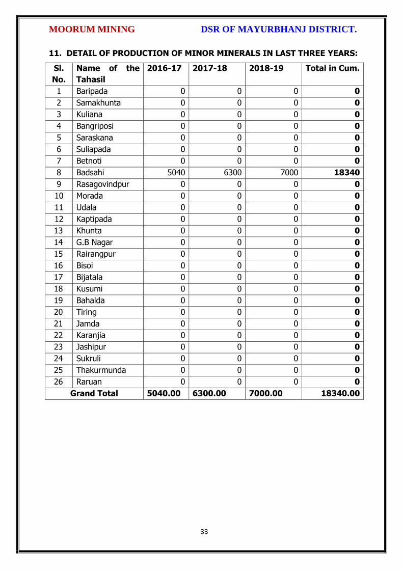
MOORUM MINING DSR OF MAYURBHANJ DISTRICT.
33
11. DETAIL OF PRODUCTION OF MINOR MINERALS IN LAST THREE YEARS:
Sl.
No.
Name of the
Tahasil
2016-17 2017-18 2018-19 Total in Cum.
1 Baripada 0 0 0 0
2 Samakhunta 0 0 0 0
3 Kuliana 0 0 0 0
4 Bangriposi 0 0 0 0
5 Saraskana 0 0 0 0
6 Suliapada 0 0 0 0
7 Betnoti 0 0 0 0
8 Badsahi 5040 6300 7000 18340
9 Rasagovindpur 0 0 0 0
10 Morada 0 0 0 0
11 Udala 0 0 0 0
12 Kaptipada 0 0 0 0
13 Khunta 0 0 0 0
14 G.B Nagar 0 0 0 0
15 Rairangpur 0 0 0 0
16 Bisoi 0 0 0 0
17 Bijatala 0 0 0 0
18 Kusumi 0 0 0 0
19 Bahalda 0 0 0 0
20 Tiring 0 0 0 0
21 Jamda 0 0 0 0
22 Karanjia 0 0 0 0
23 Jashipur 0 0 0 0
24 Sukruli 0 0 0 0
25 Thakurmunda 0 0 0 0
26 Raruan 0 0 0 0
Grand Total 5040.00 6300.00 7000.00 18340.00

MOORUM MINING DSR OF MAYURBHANJ DISTRICT.
34
12. MINERAL MAP OF THE DISTRICT:
13. LIST OF LETTER OF INTENT (LOI) HOLDERS IN THE DISTRICT ALONG
WITH ITS VALIDITY
Sl. No.
Name of the
Mineral
Name of the
Lessee
Address Letter of Intent Grant
Order No. &
date
Area of Mning
lease to be
allotted
Validity of LoI
Use
(Captive/ Non-
Captive)
Location of the Mining
lease (Latitude & Longitude)
1 2 3 4 5 6 7 8 9
Attached as Annexure - C

MOORUM MINING DSR OF MAYURBHANJ DISTRICT.
35
14. TOTAL MINERAL RESERVE AVAILABLE IN THE DISTRICT
Total mineral reserve of moorum will access after detail study or grant of other
potential area, which may investigate as per details below.
(i) Blocks were identified based on geological studies through field observation.
(ii) Mineable resource was calculated by considering detail prospecting.
(iii) Area calculated as per GPS co-ordinates and information obtained from local
people. Land detail need to be verified from revenue record.
(iv) Since this is an interim report, as per the present requirement of minerals, more
such blocks need to be identified and the data should be updated periodically, after
certain intervals to update the data bank of DSR.
Summary of Identified Mineral Potential:
Sl.
No.
Name
of the
mineral
Name
of the
lessee
Address and
contact No. of
the lessee
Letter of
Intent
Grant
Order
No. and
date
Area of
mining
lease to
be
allotted
Validity of LoI
Use
(Captive/ Non- Captive
Location of the Mining lease (Latitude & Longitude)
1 2 3 4 5 6 7
Attached as Annexure - C
Sl. No.
Name of the Tahasil
Mineral Resources in cum.
Mineable Reserve in cum.
1 Baripada Nil Nil
2 Samakhunta Nil Nil
3 Kuliana Nil Nil
4 Bangriposi Nil Nil
5 Saraskana 32110 19960
6 Suliapada Nil Nil
7 Betnoti Nil Nil
8 Badsahi 51380 30800
9 Rasagovindpur Nil Nil
10 Morada Nil Nil
11 Udala Nil Nil
12 Kaptipada Nil Nil
13 Khunta Nil Nil
14 G.B Nagar Nil Nil
15 Rairangpur Nil Nil

MOORUM MINING DSR OF MAYURBHANJ DISTRICT.
36
16 Bisoi Nil Nil
17 Bijatala Nil Nil
18 Kusumi Nil Nil
19 Bahalda Nil Nil
20 Tiring Nil Nil
21 Jamda Nil Nil
22 Karanjia Nil Nil
23 Jashipur Nil Nil
24 Sukruli Nil Nil
25 Thakurmunda Nil Nil
26 Raruan 25800 14940
Total 109290 65700
15. QUALITY/GRADE OF MINERAL AVAILABLE IN THE DISTRICT:
Rocks and Minerals found in Mayurbhanj District:-
The district is endowed with various types of mineral resources like Iron ore, China
Clay, Quartz, Soap stone, Granite, Manganese, etc. Due to presence of huge
mineral resources, mining activities have been undertaken in a big scale. Bahalda,
Jashipur, Karanjia, Koshorpur, Bisoi, Gorumahisani and Rairangpur are the places in
the district having deposits of the above mineral products. The availability of
mineral deposits is given in the table below. The district’s mineral deposits have not
been utilized to maximum extent for industrial purpose. Some of the items like
China clay, Soap stone, Asbestos, etc. can be used in small scale sector. So the
available resources of the district need harnessing properly for industrial and
productive use. Moorum deposit of the district is very much suitable for various
road construction purposes.
16. USE OF MINERAL
Uses of Moorum:
Moorum of the district is very much suitable for road construction purposes. It is used
as a sub base and base material in road and highway construction.
17. DEMAND AND SUPPLY OF THE MINERAL IN THE LAST THREE YEARS:
As such there are huge infrastructural activities such as road, building, railways are
coming up by Govt. of India & PSUs under “Make in India” programme. The Granitic
MOORUM MINING DSR OF MAYURBHANJ DISTRICT.
37
rocks are the main raw minerals for the above activities and considering the last three
years’ actual production of Mayurbhanj with respect to the requirement of the state
has a huge gap. It is proposed to start the stone production from larger block/area to
at least double the production of the district which will enhance the revenue of the
district and also support the livelihood of the local people.
18. MAP OF EXISTING MINING LEASES IN THE DISTRICT:
Enclosed as Plate-I
19. DETAILS OF THE AREA OF WHERE THERE IS A CLUSTER OF MINING
LEASE VIZ. NUMBER OF MINING LEASES, LOCATION (LATITUDE AND
LONGITUDE)
Currently there are two such clusters of mining leases in Kaptipada area of the district
(Enclosed as Annexure-II). However, it is proposed to consider the cluster of mining
lease while planning for new lease area in coming years.
20. DETAILS OF ECO-SENSITIVE AREA, IF ANY, IN THE DISTRICT:
Eco sensitive zone of Similipal wild life sanctuary is located within the district.
21. IMPACTS OF MINING ON ENVIRONMENT:
The most important environmental impact of mining projects is:-
Transportation sources:
Transportation sources of air pollutants include heavy vehicles used in excavation
operations, cars that transport personnel at the mining site, and trucks that transport
mining materials. The level of polluting emissions from these sources depends on the
fuel and conditions of the equipment. Even though individual emissions can be
relatively small, collectively these emissions can be of real concern. In addition,
mobile sources are a major source of particulate matter, carbon monoxide, and volatile
organic compounds that contribute significantly to the formation of ground-level ozone
Fugitive emissions:
Common sources of fugitive emissions include: storage and handling of materials;
mine processing; fugitive dust, blasting, construction activities, and roadways

MOORUM MINING DSR OF MAYURBHANJ DISTRICT.
38
associated with mining activities; leach pads, and tailing piles and ponds; and waste
rock piles. Sources and characteristics of fugitive emissions dust in mining operations
vary in each case, as do their impacts. Impacts are difficult to predict and calculate
but should be considered since they could be a significant source of hazardous air
pollutants.
Noise and vibration:
Noise pollution associated with mining may include noise from vehicle engines,
loading and unloading of rock into steel dumpers, chutes, power generation, and
other sources. Cumulative impacts of shoveling, ripping, drilling, blasting, transport,
crushing, grinding, and stock-piling can significantly affect wildlife and nearby
residents.
Vibrations are associated with many types of equipment used in mining operations,
but blasting is considered the major source. Vibration has affected the stability of
infrastructures, buildings, and homes of people living near large-scale open-pit mining
operations. According to a study commissioned by the European Union in 2000:
“Shocks and vibrations as a result of blasting in connection with mining can lead to
noise, dust and collapse of structures in surrounding inhabited areas. The animal life,
on which the local population may depend, might also be disturbed.”
22. REMEDIAL MEASURES TO MITIGATE THE IMPACT OF MINING ON THE
ENVIRONMENT:
1. Following are the remedial measures to mitigate the in Water sprinkling on haul
road, loading and unloading points.
2. Plantation along the safety zone and dump area.
3. Providing dust masks to workers.
4. Regular monitoring of ambient air quality.
5. Provision of air conditioned cabin of Excavators and Dumpers.
6. Regular and proper maintenance of working equipments.
7. Periodic medical examination of the workers and organize medical camp in the area.
8. Use Milli Second Delay Detonator in blasting operation.
9. Provisions of ear plug to the workers.

MOORUM MINING DSR OF MAYURBHANJ DISTRICT.
39
10. Regular training programme to the mines workers and operators.
23. RECLAMATION OF MINED OUT AREA
Necessity of Reclamation & Rehabilitation:
Exponential growth in mineral production since 1980.
Mining activities causes physical, chemical, biological and socio-economic changes in
the area.
Surface mining activities disturb the original land profile.
In India, mineral production comes mostly from opencast mines & hence land
degradation problems are of serious concern.
An intricate, in-depth and site-specified techniques involving integrated approach is
necessary.
Reclamation has three vital roles:
i. Reclamation – Reclamation means return the mined-out land with useful life. It
implies restoring the land to a form and productivity that is useful and inconformity
with a prior land use. Reclamation always may not be a single- phase operation.
ii. Rehabilitation – Rehabilitation is to bring batch the degraded land to a normal
stage by a special treatment. It is a process of taking some mitigation measures for
disturbed environmental condition created through mining activities.
iii. Restoration – Restoration is the process of returning the mined out land being
fit to an acceptable environmental condition. However, the general acceptable
meaning of the term is bringing the disturbed land to its original form. Restoration is
often used to indicate that biological properties of soil are put back to what they were.
This is a rate phenomenon.
iv. When active mining ceases, mine facilities and the site are reclaimed and closed.
The goal of mine site reclamation and closure should always be to return the site to a
condition that most resembles the pre-mining condition. Mines that are notorious for
their immense impact on the environment often made impacts only during the closure
phase, when active mining operations ceased. These impacts can persist for decades
and even centuries.
Mine reclamation and closure plans must describe in sufficient detail how the mining
company will restore the site to a condition that most resembles pre-mining

MOORUM MINING DSR OF MAYURBHANJ DISTRICT.
40
environmental quality; how it will prevent – in perpetuity – the release of toxic
contaminants from various mine facilities (such as abandoned open pits and tailings
impoundments); and how funds will be set aside to insure that the costs of
reclamation and closure will be paid for.
Proposed future land use after reclamation:
a. Forestry, b. Recreation, c. Water Reservoir, d. Crop Land,
e. residential/Commercial, f. Fish & wildlife Habitat, g. Undeveloped Land,
h. Grazing/Pasture Land
Statutory requirement:
As per the Mineral Conservation Development Rule, 2017, the following rules must be
bare in mind by the mine owner/agent/manager, which is a part of reclamation
activities –
Rule 22, Mine Closure Plan
Rule 23, Submission of Progressive Mine Closure Plan Rule 24, Submission of Final
Mine Closure Plan
Rule 26, Responsibility of holder of mining lease Rule 27, Financial Assurance
Rule 35, Sustainable Mining
24. RISK ASSESSMENT AND DISASTER MANAGEMENT PLAN:
Mining activity because of the very nature of the operation, complexity of the
systems, procedures and methods always involves some amount of hazards. Hazard
identification and risk analysis is carried for identification of undesirable events that
can leads to a hazard, the analysis of hazard mechanism by which this undesirable
event could occur and usually the estimation of extent, magnitude and likelihood of
harmful effects. The activities which can cause high risk related to face stability and
the person blasting the shots. It was observed that on a working face of the mine,
there were large cracks and unsupported rocks were present, which can lead to a
serious hazard and injure workers engaged in loading operation and machineries
because of rock falls or slides. This type of condition turn out because improper
dressing of the bench and improper supervision. To avoid the hazards due to fall of
rocks the face must be examined, made suitable for working and the remedial
measures must be taken to make it safe if there is any doubt that a collapse could
take place. Working of the face should be in the direction taking into account the

MOORUM MINING DSR OF MAYURBHANJ DISTRICT.
41
geology of the area such that face and quarry side remain stable. Another major risk
identified in mines is due to the firing of explosive by an unqualified person. In the
mines there is problem of fly rocks and the village is located close to the mine and so
it is rated high as it can affect may people. Explosives by nature have the potential for
the most serious and catastrophic accident. Planning of round of shots, holes correctly
drilled, direction logged, weight of explosive suitable for good fragmentation are the
few of the steps necessary to ensure its safe use and if the shots are not properly
designed can result in misfires, early ignition and flying rocks. No person is allowed to
use explosives without being properly trained in its handling. In the mine a large
numbers of heavy vehicles were in operation and the roads were not proper for
haulage purpose. The haulage roads were not even and were not wide enough for the
crossing purpose and hence the chances of hazards are very high. The main hazards
arising from the use large earth moving vehicles are incompetent drivers, brake
failure, lack of all-around visibility from the driver position, vehicle movements
particularly reversing, roll over, and maintenance. Those most at risk are the driver
and pedestrians likely to be struck by the vehicle, and drivers of smaller vehicles,
which cannot be seen from the cabs of large vehicles. Edge protection is always
necessary to prevent inadvertent movement over the edge of roadway or a bench.
Seatbelt will protect driver in case of roll. Good maintenance and regular testing are
necessary to reduce the possibility of brake failure. Access to the vehicles should
always be restricted to those people necessary for the work in hand. The use of
personal protective equipment and proper arrangements is essential to check if the
person is wearing protective equipment or not. The personal protective equipment
includes helmet, non-skid safety boots, safety glasses, earmuffs etc. The required
personal protective equipment should be provided and used in a manner that protects
the individual from injury. Few minor injuries which can be prevented are slip, trip, or
fall hazards; hazards due to rock falls and collapse of unstable rocks, atmosphere
containing toxic or combustible gases; protects from chemical or hazardous material
etc. A disaster management plan should be prepared for taking care of for any
disaster. Other risks which are included in this category are noise, as it occurs and it
can lead to permanent disability. There are problems related to road traffic in and out
issuers; inappropriate exposure of moving machines; mechanical failure and because
MOORUM MINING DSR OF MAYURBHANJ DISTRICT.
42
of large number of moving trucks and dumpers there is large quantity of dust present
in roadways which affects the operators and can lead to accidents causing injury.
They are in acceptable range because of precautions measures taken but no step is
taken it can cause hazard hence steps should be taken to reduce the hazards such as
for dust suppression system should be installed. Other problems like occurrence of
lots of mosquitoes in the area due to unhygienic conditions which affect the human
health causing malaria, dengue etc. and causing a person to be hospitalized.
Disaster in the mines like fires, explosions, entrapments, and inundations can occur
any time, so emergency preparedness is a must. The Disaster management plan and
risk assessment in the mines will include all sorts of above mentioned emergency and
the extent that this plan will be implemented will depend on the nature and scope of
the emergency. The basic purpose of Disaster management plan and risk assessment
to ensure that mine rescue and recovery activities are conducted safely for rescuer
and survivors. According to MMR act 1961 a standard operating procedure should be
drawn for involvement different category of staff and officers. The SOP should be
updated periodically to reduce the chaos and response to the emergency should be
quick and smooth. The responsible person should be familiar with his responsibility
during the mock drills. One or two standby should be there to replace the person in
Emergency situation. Rescue operations should not include the survivors for any
assistance.
First Information of Disaster / Emergency should go to the attendance clerk on duty.
Duties of attendance Clerk (Emergency Siren) the attendance clerk or other
designated person should on getting information of major accident, sound a hooter or
a siren immediately declaring a state of emergency at the mine and then to contact
the manager and on his advice to call key personnel using the information listed in the
Emergency Organization Chart. It is important that all telephone calls are recorded in
a telephone log book. Duties of Other Officials should be displayed and handed over
to all concerned. Copy the same should be kept at Manager’s Office for ready
reference. Establishment of Control Room at Unit Level, Area Level and Company
Level is essential. Control Room should keep the contact information about –
Company Manager

MOORUM MINING DSR OF MAYURBHANJ DISTRICT.
43
Company owner/ Administrative officer.
District Administration
Govt. Hospitals in Nearby Localities,
Private Nursing Homes of Localities
Attendance roaster and duty charge register should be properly maintained so the
record of missing people can be obtained.
25. DETAILS OF THE OCCUPATIONAL HEALTH ISSUE IN THE DISTRICT:
The persons employed in the mines are exposed to a number of hazards at work which adversely affect their health. Some of the important ones are dust, noise, heat, humidity, vibration etc. In recent times, there has been increasing awareness among mining industry and the workers about occupational diseases like Pneumoconiosis, Silicosis, Tuberculosis, Hearing Impairment etc. caused by exposure to health hazards at work. Almost all occupational diseases can be prevented by adopting proper occupational health measures and engineering control on airborne dust pollution at workplace. Occupational Diseases in mines or industry are required to conduct medical examinations and health surveillance of workers as per the provisions of Mines Act. The present efforts of mines management are concentrated on detection of silicosis, Pneumoconiosis and other notified diseases. The essential features of health surveillance programme required to be carried out in mines are:
(a) Initial Medical Examination of persons to be conducted at the time of
appointment.
(b) Periodic Medical Examination or General physical examination to be conducted
once in every year.
(c) Maintenance of medical records and health services till the person is in service.
(d) The Details of Tuberculosis cases in last 5 years is given below
RNTCP Activities from 2014 to 2018
Year Projected Population
No of Sputum
Examined
Sputum Examine
d per Lakh/Qr
No of
Sputum Positive
Sputum Positive
%
Total Case
put on
DOTS/No of
TB cases
Child DOTS
out of Total DOTS
Case detectin
per Lakh/Yr
Sputum
Conversion Rate
NSP Cure
Rate
NSP Death
Rate
(in Lakh) Norm- 150
Norm-8-15 %
Norm-170 /L/Y
Norm-90 %
Norm-90%
Norm < 5%
2014 26.01 16848 161.9 2825 16.8% 4883 103 187.7 90.2% 89.0% 7.4%
2015 26.30 18118 172.2 2836 15.7% 4831 123 183.7 90.5% 89.0% 6.7%
2016 26.59 20060 188.6 2975 14.8% 5171 119 194.5 95.0% 90.9% 6.5%
2017 26.88 31035 289.4 3152 11.4% 5127 111 190.7 94.0% 91.6% 5.5%
2018 27.18 21273 195.6 2853 13.4% 4894 95 173.4 95.3% 92.7% 6.4%
MOORUM MINING DSR OF MAYURBHANJ DISTRICT.
44
26. PLANTATION GREEN BELT DEVELOPMENT IN RESPECT OF LEASE
ALREADY GRANTED IN THE DISTRICT:
During mining operation green belt development through plantation is most important
for environment safe guard, which should be supervision by mining department.
Different type of species should be planted near lease periphery to keep environment
clean at post mining period through reclamation. Where specific usefulness of land
could be decided, a forestation is normally planned through the site could have been
considered for better possibilities of land use.
27. CONCLUSION:
Since it is an interim report, to meet the requirement of minerals in the present
scenario, it is proposed to identify such potential areas at certain interval and get the
data bank of DSR to be updated. The insitu mining activity in any area is on one hand
bring revenue and employment (Direct and indirect) and on other hand if not done
properly potential pollution and ecological imbalance increases, the ability of the
ecosystem can also be reduced. Particulate matter transported by the wind as a result
of excavations, blasting, transportation of materials, heavy equipments used raise
these particulate levels; and Gas emissions from the combustion of fuels in stationary
and mobile sources, explosions, and mineral processing. All these activities indirectly
affected the biodiversity of area. Larger potential and smaller areas have been
identified in Mayurbhanj district on the basis of geological study carried out during
field observation, which can be considered for mining concession after all the
parameters for statutory clearances are verified by consulting with concerned
authorities.

MOORUM MINING DSR OF MAYURBHANJ DISTRICT.
45
Plate No.-I

tL
tt\
L.
t.
\
\
{>
L
\
t,
tt
rtt\
\,
ttL.
*
L
L
L
\^r
\,
i\.r
MOORUM MINING DSR OF MAYURBHANJ DISTRICT.
The District Survey Report for Moorum Mining ( Minor Mineral), in respect of
Mayurbhanj District prepared in accordance with Appendix-X, Para -7 (iii) (a) of S.O"
3611 (E) Dt" 25"A7.2018 of Ministry of Environment, Forest and Climate Change, New
Delhi is approved for final publication in the district website.
tn 1\ rrtl
D H.K. hu, S.Mal I.F.S, Sri Di rida, I.A,SProf in Zoology, NOU -cum-Member, DEIAA, Mayurbhanj
DFO-cum-Member,DEIAA, Mayurbhanj
SDM, Sadar-cum -Member SecretaryDEIAA, Mayurbhanj
4
ryq I
Sri ViCollector & DM-cum- Chairman, DEIAA
Mayurbhanj (Odisha)
I
46

Fro
m
To
Fro
m
To
1 2 3 4 5 6 7 8 9 10 11 12 13 14 15 16 17 18 19
Saraskana 1 Moorum L & T Company L & T CompanyNo.1003, Dtd
26.3.18
Area: 0.538 Ha, Vill
: Kendua, Khata
No.76, Plot No.
593, Kisam:
Jalasaya-I (Pvt Land)
Non-
workingNo
Lat: 22'10' 38.1" N to
22'10' 40.2"N Longi :
86'35' 42.8" E to 86'35'
45.9" E
under ground 26280 15120
Saraskana 2 Moorum L & T Company L & T CompanyNo.1003, Dtd
26.3.18
Area: 0.543 Ha ,
Vill : Kendumundi,
Khata No.233,
Plot No. 1000,1003
&1129,
Kisam: Ashu, Ashu &
Gharabari (Pvt Land)
Non-
workingNo
Lat: 22'10' 41.0" N to
22'10' 51.3"N Longi :
86'35' 1.7" E to 86'35'
6.1" E
under ground 5830 4840
Saraskana 3 Moorum - - -
Area:2.023Ha, vill :
Purunapani, Khata
No.220 , Plot No.
397/1 & 411/1 , kisam:
Patit & Ashu
- - - - -Non-
working- - - - - -
OTHER THAN SAND MINING ( MOORUM) Annexure - C
Name of the
TahasilSl No
Name of
Minerals Name of Lessee
Address and
Contact No. of
Lessee
Mining Lease
Grant Order No.
& Date
Area of Mining lease
(Ha.) with
Village,Khata No, Plot
No & Kisam
Period of
mining
Lease
( Initial)
Period of
Mining
Lease
(1st /2nd--
Renewal
Geological
Reserve (In
Cums)
Mineable
reserve
(In Cums)
Location of Mining
Lease( Latitude &
Longitued)
Method of
Mining (Open
Cast/ Under
Ground)
Date of
Commence
ment of
mining
Operation
Status
Working
/Non-
working/tem
p working
for dispatch
etc.)
Captive/N
on-
Captive
Obtained
environmental
Clearance(Ye
s/No). If yes
Letter no with
date of EC

1 2 3 4 5 6 7 8 9 10 11 12 13 14 15 16 17 18 19
Badasahi 4 MoorumSRI SUSANTA
KUMAR NAYAK
AT- BELPAL
PO- KHUNTAPAL
DIST-
MAYURBHANJ
MOB. NO.
9437981526
Order No. 3072
dated
05.12.2015
Area - 0.558 Ha
Vill.- Dhanpota
Khata No. 261
Plot No. 1193
Kisam- Dahi-II
20
15
-16
20
19
-20
- - 09.09.2016 WorkingNon-
Captive
L. No. 100/
Dated
05.07.2016
Lati. 21°44'49'' N to
21°44'253.59.5''N
Long. 86°42'27'' E to
86°42'29.9''E
Open Cast 51,380 30,800
Raruan 5 Moorum - - -
Area -0.574 Ha
Vill- Bhanjakia
Khata No-249
Plot No.- 42/1
Kisam-Parbat
(Khyayat-III)
20
16
-17
20
20
-21
- - -Non
Working-
Yes ,
23/DEIAA
01.03.2017
GPS- Lat. 22° 00’
3.1”N to 22°00’ 05.9”
N, Long. 85° 57’
53.2"E to 85° 57’ 58.3”
E
- 25800 14940

DISTRICT SURVEY REPORT (DSR) OF
MAYURBHANJ DISTRICT, ODISHA. FOR
LATERITE
(FOR PLANNING & EXPLOITING OF MINOR MINERAL RESOURCES)
As per Notification No. S.O. 3611(E) New Delhi
dated 25th July 2018 of
Ministry of Environment, Forest & Climate Change
( MoEF & CC)
( Prepared by DEIAA, Mayurbhanj, Odisha )

LATERITE MINING DSR OF MAYURBHANJ DISTRICT.
1
CONTENT
CH.
NO.
DESCRIPTION PAGE
NO.
Preamble 3
1 Introduction 4
1.1 Location and Geographical Area 4
1.2 Administrative Units 5
1.3 Connectivity 7
2 Overview of Mining Activity in the District 10
3 General Profile of the District 11
3.1 Demography 11
4 Geology of the District 11
4.1 Physiography & Geomorphology 12
4.2 Stratigraphy. 13
4.3 Mineral Resources. 14
4.4 Soil 17
5 Drainage of Irrigation Pattern 17
5.1 River System 19
6 Land Utilization Pattern in the District 21
6.1 Forest and non forest land. 21
6.2 Agricultural land. 24
6.3 Horticultural land. 25
7 Surface Water and Ground Water Scenario of the District 25
7.1 Hydrogeology. 25
7.2 Depth to water level. 26
7.3 Ground Water Quality. 28
7.4 Ground Water Development. 29
7.5 Ground water related issues & problems. 29
7.6 Mass Awareness Campaign on Water Management
Training Programme by CGWB
30
7.7 Area Notified By CGWB/SGWA 30
7.8 Recommendations 30
8 Rainfall of the District and Climate Condition 31
8.1 Month Wise rainfall. 31
8.2 Climate. 31
9 Details of Mining Lease in the District 32
9.1 List of Mines in operation in the district Annexure-D
9.2 List of Mines not in operation in the district Annexure-D
10 Detail of Royalty or Revenue received in last 3 years 33

LATERITE MINING DSR OF MAYURBHANJ DISTRICT.
2
11 Detail of production of minor mineral in last 3 years 34
12 Mineral Map of the District. 35
13 List of Letter of Intent (LOI) Holders in the District along
with its Validity.
35
14 Total Mineral Reserve Available in the District. 36
15 Quality/Grade of Mineral Available in the District. 37
16 Use of Mineral. 37
17 Demand and Supply of the Mineral in the Last Three Years. 38
18 Map of Existing Mining Leases in the District. 38
19 Details of the Area of where there is a cluster of mining
lease viz. Number of mining leases, location (latitude and
longitude).
38
20 Details of Eco-Sensitive Area, if Any, in the District 38
21 Impact of Mining on Environment 38
22 Remedial Measures to Mitigate the Impact of Mining on
the Environment
39
23 Reclamation of Mined Out Area 40
24 Risk Assessment and Disaster Management Plan 41
25 Details of the Occupational Health Issue in the District 44
26 Plantation and Green Belt Development in Respect of
Lease Already Granted in the District
45
27 Conclusion & References 45

LATERITE MINING DSR OF MAYURBHANJ DISTRICT.
3
PREAMBLE
Odisha is the major mineral reach in India. Mayurbhanj is a unique district in Odisha
lies on the northern most part of the state with varied mineral resources. In
pursuance of the order of Hon’ble Supreme Court Petition (C) No. 19628-19629 of
2009, dated 27th Feb. 2012 in the matter of Deepak Kumar Vs State of Haryana and
others etc., prior environmental clearance has now become mandatory for mining of
minor minerals irrespective of the area of Mining Lease. And also in view of the
Hon’ble National Green Tribunal, order dated the 13th Jan. 2015 the matter regarding
Roadmetal/stone, Sand, Brick earth, & burrowed earth cutting for Road Construction
has to take prior Environmental Clearance for Mining Lease area more or less than 5
hectares also suggested making a policy on Environmental Clearance for minor
minerals lease and leases in cluster. As per MOEF & CC Notification S.O.-1533(E)
dated 14th Sept. 2006 and subsequent MoEF & CC Notification S.O. 141(E) dated 15th
Jan. 2016, District Environment Impact Assessment Authority (DEIAA) & District level
Expert Appraisal Committee (DEAC) has been formed for Category –B2 Minor Minerals
having area less than or equal to 5 ha. In compliance to the notification issued by the
Ministry of Environment and Forest and Climate Change Notification no. S.O.3611 (E)
New Delhi dated 25-07-2018; the preparation of district survey report of road
metal/stone mining has been prepared in accordance with Clause II of Appendix X of the
notification.
Keeping in view of the prior information of Odisha Minor Mineral Concession Rule
2004, (OMMCR -2004) the mining operation for minor minerals was carried out in
unscientific manner. Identifying this fact in exercise of power, Conferred by Section 15
by Mines and Minerals (Development and Regulation) Act 1957 as amended in 2015
and all other powers enabling it in that behalf, the Mining & Geology Department,
Govt. of Odisha framed the aforementioned rule. Further, this report will act as a
compendium of available mineral resources, geological set up, environmental and
ecological set up of the district and based on data of various departments like
Revenue, Water Resources, Forest, Geology and Mining in the district as well as
statistical data uploaded by various state Government departments for preparation for
district survey report.

LATERITE MINING DSR OF MAYURBHANJ DISTRICT.
4
1. INTRODUCTION:
Mayurbhanj at a Glance:
1.1 Location and Geographical Area:
Mayurbhanj district is the largest among the thirty districts of Odisha and Baripada is
the District head quarter, spreading over an area of 10,418 sq.km lies between
latitudes 21° 17’ North and 22° 34’ North and longitudes 85°40’ East and 87°10’ East.
It is bounded on the north by the Singhbhum district of Jharkhand and Midnapore
district of West Bengal, on the south by the districts of Balasore and Keonjhar, on the
east by the Midnapore and Balasore districts and on the west by the districts of
Keonjhar and Singhbhum. Mayurbhanj occupies a unique position being endowed
with lush green vegetation, different fauna & flora and rich cultural heritage. The
district has a rich mineral base and is home to the Similipal Biosphere. Iron-ore
(hematite), vanadiferous and titaniferous magnetic, chaina clay, galena (lead ore),
Kyanite, asbestos, steatite (soap stone) and quartzite constitute the principal mineral
resources of Mayurbhanj district, of these the iron-ore deposits of Gorumahisani,
Badampahar and Suleipat, which have been exploited for a period of about half a
century, deserve special mention.

LATERITE MINING DSR OF MAYURBHANJ DISTRICT.
5
1.2 Administrative Units:-
Baripada is the administrative headquarter of Mayurbhanj district. It is located at a
distance of 263 km from Bhubaneswar, state capital of Odisha. In order of size, the
district is the largest among the thirty districts of Odisha. It has 3980 villages
(including 178 uninhabited villages) covering 26 Blocks, 26 Tahasils and 4 Sub-
Divisions. The district is divided into 4 Sub-Divisions namely 1) Sadar Sub-Division
Baripada, 2) Kaptipada Sub-Division Udala, 3) Bamanghaty Sub-Division, Rairangpur,
4) Panchapir Sub-Division, Karanjia. which are given below:-

LATERITE MINING DSR OF MAYURBHANJ DISTRICT.
6
Sl No Name of the Block/Tehsil Name of the Sub-Division with
Head quarter
1 Baripada
Sadar Sub-Division, Baripada
2 Samakhunta
3 Kuliana
4 Bangriposi
5 Saraskana
6 Suliapada
7 Betnoti
8 Badsahi
9 Rasgovindapur
10 Moroda
11 Udala
Kaptipada Sub-Division, Udala
12 Kaptipada
13 Khunta
14 Gapabandhu Nagar
15 Rairangpur
Bamanghaty Sub-Division,
Rairangpur
16 Bisoi
17 Bijatala
18 Kusumi
19 Bahalda
20 Tiring Bamanghaty Sub-Division,
Rairangpur 21 Jamda
22 Karanjia
Panchpir Sub-Division, Karanjia
23 Jashipur
24 Sukruli
25 Thakurmunda
26 Raruan
The population of the district 25,19,738 according to the 2011 Census. The district
accounts for 6.69% of the state’s territory and about 6% of state’s population. The
density of population of the district is 242 per square km as against 270 per square
km of the state. As per 2011 census, the population of Scheduled Caste is 1,84,682
(7.30%), that of Scheduled Tribe is 14,79,576 (58.7%). The literacy percentage of the
district covers 63.2 against 72.9 of the state.

LATERITE MINING DSR OF MAYURBHANJ DISTRICT.
7
1.3 Connectivity facilities:-
Road Network
The district is well served by a network of good roads and has been called the
motorists paradise. The chief roads emanating from Mayurbhanj town are NH-18 and
NH-49 passes the district. Baripada is 60 Kms from Mayurbhanj, 103 Kms from
Kharagpur, 163 Kms from Jamshedpur, 231 Kms from Cuttack, 255 Kms from
Bhubaneswar and 368 Kms from Rourkela. It is also connected with other cities such
as Sambalpur, Puri, Bolangir, Bhadrak, Jhargram, Angul, Ranchi and Kolkata via
Odisha State Road Transport Corporation and some private travel services.

LATERITE MINING DSR OF MAYURBHANJ DISTRICT.
8
Rail Network
Mayurbhanj district is well connected by rail link to different places, the city of
Baripada is well connected to many places in India like Mayurbhanj, Bhubaneswar,
Kolkata, Jamshedpur and Cuttack,
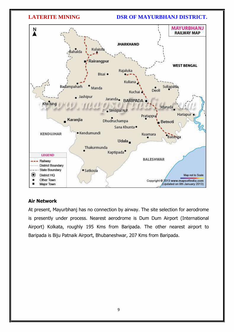
LATERITE MINING DSR OF MAYURBHANJ DISTRICT.
9
Air Network
At present, Mayurbhanj has no connection by airway. The site selection for aerodrome
is presently under process. Nearest aerodrome is Dum Dum Airport (International
Airport) Kolkata, roughly 195 Kms from Baripada. The other nearest airport to
Baripada is Biju Patnaik Airport, Bhubaneshwar, 207 Kms from Baripada.

LATERITE MINING DSR OF MAYURBHANJ DISTRICT.
10
2. OVERVIEW OF MINING ACTIVITY IN THE DISTRICT:
Mayurbhanj district is land features of both plain and hilly region. Most of the
mineralized area coming under safety zone eco-sensitive zone, mining activity only
confined out of safety zone of eco-sensitive zone. The mining activity in the district is
not only restricted to minor minerals i.e. of sand, stone, granite and brick clays.
Altogether there are leases of Iron-ore (hematite), vanadiferous and titaniferous
magnetic, chaina clay, galena (lead ore), Kyanite, asbestos, steatite (soap stone) and
quartzite constitute the principal mineral resources of Mayurbhanj district, of these the
iron-ore deposits of Gorumahisani, Badampahar and Suleipat, which have been
exploited for a period of about half a century. Stone, granite and sand which has been
granted to the district is regulated as per minerals concession rules of Odisha. There
is no lease of major mineral in the district. At present Leases of stone, sand and bricks
making units are operational in the district. Stone chips, granite stones, ordinary sand

LATERITE MINING DSR OF MAYURBHANJ DISTRICT.
11
constitute the principal mining activity of Bangirposi, Badasahi, Kaptipada, Kuliana
area etc. of Mayurbhanj district. Out of these huge granite stones deposits are
available near Badasahi, Kaptipada, Kuliana area and major potential sand in G.B
Nagar, Morada & Kaptipada area of the district, which have been provides
tremendous scope for development of few more industries based on this resources.
Iron-ore (hematite), vanadiferous and titaniferous magnetic, chaina clay, galena (lead
ore), Kyanite, asbestos, steatite (soap stone) and quartzite constitute the principal
mineral resources of Mayurbhanj district, of these the iron-ore deposits of
Gorumahisani, Badampahar and Suleipat, which have been exploited for a period of
about half a century.
3.0 GENERAL PROFILE OF THE DISTRICT:
3.1 Demography:
Census - 2011
Geographical Area 10,418 Sq. Km.
Total population 25,19,738
Male Population 12,56,213
Female Population 12,63,525
Male Literacy 794,171
Female Literacy 575,226
SC Male 92,127
SC Female 92,555
ST Male 730,487
ST Female 749,089
OBC 855,480
Illiterate Male 462,042
Illiterate Female 688,299
4.0 GEOLOGY OF THE DISTRICT:
Mayurbhanj is a unique district in Odisha with rich and varied geology. Similipal
Complex being at its central part. The mountain ranges comprise mainly of highland
plateau and valleys with intrusive running through them. The second physiographic
unit is Tertiary Plain occurring in the eastern part of the district. The third
physiographic unit is Alluvial Plain .The drainage density is observed to be fairly
moderate and drainage pattern is dendritic in nature. The major rock types

LATERITE MINING DSR OF MAYURBHANJ DISTRICT.
12
encountered in the district are Granite Gneiss, Quartzite, Orthoquartzite, Arkose,
Shale, Phyllite, Gabbro, Px-granite. The geology of the district is constituted by the
Similipal complex at its central part belonging the Archaean age, unconformably lying
over Singhbhum Granite and Banded Iron Formation (BIF). It consists of three
alternate bands of volcano sedimentary units uniquely disposed in a ring like circular
pattern formed under sub- marine conditions. Baripada Beds outcrops of tertiary
formation occur around Baripada town. These comprise stratified clay and sand with
marly clay or limestone interbands. Important mineral resources include iron, copper,
itanium, vanadium, chinaclay, nickel, kyanite ,quartz, talc, steatite ,soapstone and
bauxite.
4.1 Physiography & Geomorphology:
Mayurbhanj district presents diverse physiographic features, Physiographically the
study area can be divided into 3 categories. The first physiographic unit of the district
is high mountain ranges, Similipal Complex being at its central part (Figure 1). The
mountain ranges comprise mainly of highland plateau and valleys with intrusive
running through them. The second physiographic unit is Tertiary Plain occurring in the
eastern part of the district. The third physiographic unit is Alluvial Plain which lies
partly in Rasgobindpur, Morada, Samakhunta, Betnoti, Baripada, Badasahi and
Suliapada blocks. The highest elevation of about 559m at Bahalda near Similpal hill
and higher elevations of the district, due to scarp landforms some waterfalls are
observed in the district. The general slope of the district is from north to south.
Geologically the area is comprised with Archean granites and gneisses.
Geomorphologically the district is divided into 3 units:
i) The denudational hills with moderate to high slope occurring in the western part of
the district.
ii) Dissected pediments having gentle slope.

LATERITE MINING DSR OF MAYURBHANJ DISTRICT.
13
iii) Pediplain having slope between 0o to 5o.
4.2 Stratigraphy:
Geological Age Geological Formation / Group
Quaternany : Recent Alluvium, Clays, silt, Sand, Gravel
Tertiary : Older Alluvium, Laterite, Baripada Beds.
Mesozoic/ Palaeozoic : Volcanics / Epidiorite
Precambrian : Slate/ Phyllite/ Schist / Gneiss
Archean : Granite/ Granite Gneiss

LATERITE MINING DSR OF MAYURBHANJ DISTRICT.
14
4.3 Mineral Resources:
The earliest known geological survey in Mayurbhanj dates back to 1903, when P.N.
Bose brought to light the extensive iron-ore deposits of high quantity on the
Gorumahisani and Suleipat hills in Bamanghaty Sub-Division. These deposits were
considered to be almost inexhaustible and were pronounced to be of excellent quality,
perhaps second to none in the whole of Asia by the famous American and English
experts like M/s Perin, Weld and Colonel Staddart, who visited these deposits during
1905-06. This discovery was a momentous one as the steel plant of the Tata Iron &
Steel Co. at Jamshedpur was entirely based on the exploitation of these deposits. By
1915, important discoveries of Steatite near Lulung and placer gold from the sands of
Subarnarekha, Kharkhai and Barhai rivers had been made. The placer gold deposits
were being worked by M/s J.B. Bettie of Calcutta, Mr. V.G. Piggot of Ghatsila and the
Mayurbhanj Prospecting Concession Syndicate.
Gold: The mid-Archaean Gorumahisani-Badampahar schist belt composed of basic
ultrabasic, volcanic rocks and volcanogenic sediments. This belt has been
prognosticated as a rift-type of volcanic dominated one and is highly potential for
economic grade gold mineralization. Likely targets include: a) auriferous quartz veins
close to the contact of sulphide chert volcanics, b) sheared and sulphidised Fe-rich
tholeiite with anomalous copper, c) epigenetic vein type of mineralization and BIF
volcanic association, and d) sulphidic conglomerate resting over the basic volcanics.
Placer gold occurrence are known from rivers and stream of Mayurbhanj district. An
area of about 5 square kilometers of alluvium at the headwaters of Sapgora and Borai
rivers near Kudersai was indicated as promising.
Iron: Bose discovered iron ore deposits in Gorumahisani and Badampahar in the
eastwhile princely state of Mayurbhanj (now Mayurbhanj District). Gorumahisani
deposits were investigated by Perin & Weld (1905). Gorumahisani- Badampahar-
Suleipat deposits are associated with banded hematite / magnetite grunerite and BHJ.

LATERITE MINING DSR OF MAYURBHANJ DISTRICT.
15
Gorumahisani – Badampahar- Sulaipat (Broad geological sequence)
Laterite & Alluvium
Newer Dolerite
Gabhro-Anorthosite Granite
---Unconformity---
Ultramafic dyke
Singhbhum Granite
Banded magnetite/ Martite quartzite with Fe-Ores
Quartzite
Basal Conglomerate
----Unconformity----
Older metamorphic
Vanadium Ores & Titanium: Vanadium is an important alloying element. Magnetite
associated with gabbro- anorthosite suite of rocks contains vanadium and titanium.
Deposits of vanadium-magnetite occur in association with gabbro-Anorthosite suite of
rocks in the precambrian metamorphites. Vanadium bearing magnetite belts are :-
(a) Rairangpur – Bisoi belt (Kumardubi, Betjharan Amdabeda)
(b) Bisoi – Joshipur belt (Mayurbeka, Kesham, Sialnoi)
(c) Baripada – Podadiha belt (Andipur, Bahalda)
Pyrophyllite : is mainly used as a high grade ceramic product, electric insulator and
refractory material. The comp. is Al2O34SiO2 H20. It is formed as an alteration product
of feldspar. Pyrophyllite occurrences are reported at Kankrani, Jashipur,
Gorumahisani, Bangriposhi and Manada in Mayurbhanj dist. Ichinda, Khairakocha,
Jamukunda, Nakulkocha, Kapadiha, Dunguridiha, Maheshpur, Kashidiha, Sagragora
and Pokpoka. Dimension stone of the district are granite, granite-gneiss, migmatites,
syenite, gabbro, anorthosite, charnockite, leptynite, pyroxene granulite, dolerite,
pyroxinite and dunite etc.
Bauxite: In Similipal complex (Mayurbhanj) aluminous laterite/ Bauxite are observed
around 1000 m AMSL. The spongy aluminous laterite/bauxite occurs as sheets and
boulders occupying the flat-topped hills made up of metavolcanics. Both
ultramafics and metavolcanics are lateritised giving rise to nickeliferous laterite and
aluminous laterite respectively.

LATERITE MINING DSR OF MAYURBHANJ DISTRICT.
16
China Clay is clay like material approximating the mineral Kaolinite (Al2O3, 2SIO2,
2H2O). China clay is found to occur in a long belt stretching from Singhbhum to
Mayurbhanj. Badampahar-Joshipur- Karanjia – Ramachandrapur belt is the most
important china-clay producing area of the state. The important deposits in
Mayurbhanj district are found near Joshipur, Chanchbani, Dumuria, Jamoda,
Kodadiha, Jamkeswar and Thakurmunda. China clay has many industrial applications
as filler in paper, textile, rubber, in the manufacture of potteries, ceramics, sanitary
wares, glazed tiles, white cement, insecticides, paints, cosmetics, refractory bricks etc.
Soap stone and Steatite Asbestos is mined from Mayurbhanj area.
Talc, steatite and soapstone : Important localities of these deposits in Mayurbhanj
dist are Tiring, Kendumundi and Kharidamak.
Kyanite: Kyanite deposits of refractory grade occur in Panijia area of Mayurbhanj
dist, where it is associated with dumortierite bearing rocks, qtz-veins, quartz-mica-
schists and talc-tremolite-schist. Other kyanite occurrence includes Purnapani &
Similipal.
Quartz & Quartzite: Quartz and silica sand are mostly used in glass foundry,
ferrosilicon alloy, ceramic industry, abrasive, paint, rubber, textile industries.
Transparent varieties of quartz such as rock crystal, amethyst, citrine, Rosequartz and
smoky quartz are used as semi-precious gemstone. Quartz is a piezoelectric material
and is used in radio circuit, Radars and ultra-sonic devices. Quartzite is a
monomineralic rock constituted predominantly of quartz. There are 6 mining leases
for quartz and quartzite in Mayurbhanj dist.
High Magnesia rock: are found in Notapahar, Thakurmunda, Amjori and
Badampahar of Mayurbhanj Dist.
Nickel: Nickel is concentrated within chemically weathered ultramafic rocks and
found in the laterite and soil capping in Similipal area. The mineral occurs in silicate

LATERITE MINING DSR OF MAYURBHANJ DISTRICT.
17
form i.e. garnierite. The important patches of prospective ore zones are: Gurguria and
Nawana.
4.4 Soil:
The district comprises chiefly of lateritic, sandy loam and clayey loam type of soil
(Figure 3). Laterite soil is mostly marked in the area occupied by crystalline rocks.
The low lying valley fields are covered with clayey loam type of soil.
5. DRAINAGE OF IRRIGATION PATTERN
The district has considerable flat land, which provide suitable site for agricultural use.
The hilly areas are mostly under forest with patches of cultivation on scarp areas.
Major rivers flowing in the district are Budhabalanga, Subarnarekha, jambhira, Sona,

LATERITE MINING DSR OF MAYURBHANJ DISTRICT.
18
Khadkhai, Deo, Katra, Khairibandhan & Baitarani. Major crops grown in the district are
rice Only. 14.82 percent area of agricultural use are net irrigated and major source of
irrigations are well and tube-wells.
Sl. No.
Name of the River
Area drained (Sq.Km.)
% Area drained in the District
1 Budhabalanga 2143 21%
2 Subarnarekha 265 0.25%
3 Jambhira 1377 13%
4 Sona 1062 10%
5 Khadkhai 1131 10.8%
6 Khairibandhan 1014 0.09%
7 Deo 473 0.04%
8 Katra 352 0.03%
9 Gangahar 594 0.057%
10 Baitarani 260 24.6%
11 Tel 96 0.009%
12 Kantamauli 82 0.007%
13 Sim 165 0.015%
14 Jhagada 30 0.002%
15 Balijori 56 0.005%
16 Kantakhaira 186 0.017%
17 Kanhu 383 0.036%
18 Balisudura 170 0.016%

LATERITE MINING DSR OF MAYURBHANJ DISTRICT.
19
5.1 River System
The Budhabalanga River (also called Balanga River) flows through the districts
of Mayurbhanj & Balasore and finally reached Bay of Bengal. The Budhabalanga, rises
from Similipal hills and plunges through Barehipani Falls, the second-highest waterfall
in India, located in Similipal National Park. It then flows in a northerly direction up to
the village Karanjiapal in Bangiriposi police-station. Thereafter, it turns to the north-
east and flows along the railway track up to the village Jhankapahadi. There it
changes its course to the south and meets the Katra nala. The other tributaries are
the Palpala and the Chipat both of which are hill streams rising from the Similipal hills.
Then the river passes through Baripada. It later flows through Balasore district and
into the Bay of Bengal. The Budhabalanga is about 175 kilometres (109 mi) long and
has a total catchment area of 4,840 square kilometres (1,870 sq mi). Its major
tributaries are the Sona, Gangahar, and the Katra. Burhabalang and its tributaries, viz.

LATERITE MINING DSR OF MAYURBHANJ DISTRICT.
20
Sona Nadi, Amrutia Nadi, Gangahar Nadi drain almost round the year in the present
area. Sona Nadi receives the watery effluent load through a nalah (Sankh nalah) from
the Balgopalpur Industrial Estate and flows from west to east. Amrutia Nadi flows
from NNW to SSE and carries the waste water load of East Coast. Subarnrekha
originate from Nagri of Jharkhand and then enter into Mayurbhanj district, very less
portion of the river flows within Mayurbhanj district, Major portion of Subarnarekha
River passes in the Balasore district. Another river Jambhira runs in Mayurbhanj
district then enters into Balasore district and Renamed as river Jalaka flows into Bay
of Bengal. Other small rivers run in this district like River Khadkhai originates from
Tunhgru R.F. and plunges through Suleipat Dam (Khadkhai Reserviour). It then runs
towards Rairangpur, Bahalda, Tiringi area of western direction of Mayurbhanj district
and finally reached at River Subarnarekha. River Deo rises from Similipal R.F. and
runs towards western part of the district and flows through Karanjia area and then
joins with Baitarani River. River Khairabandhan originates from Similipal R.F. and
flows towards western part of the Mayurbhanj district through Jashipur, Raruan,
Sukruli area of district and then joins with River Baitarani This river maintains a
sluggish flow in the pre-monsoon period, but swells menacingly with the onset of
monsoon often flooding large tracts. Another small tributary named as Kanhu starts
from River Khadkhai and branched into Jalapa, Ghagera nala meets at Jharbeda area
of Mayurbhanj District.
Sl. No.
Name of the River or Stream
Total Length in District (in Km.)
Place of Origin Altitude at Origin
1 Budhabalanga 161 Similipal Hill 940 mrl.
2 Subarnarekha 4 Nagri, Jharkhanda
610 mrl.
3 Jambhira 64 Chandra R.F. Mayurbhanj
60 mrl.
4 Sona 70 Jaymal Hill, Dugdha
Mayurbhanj.
340 mrl.
5 Khadkhai 75 Tunhgru R.F. 500 mrl.
6 Khairibandhan 65 Similipal R.F. 800 mrl.
7 Deo 65 Similipal R.F. 930 mrl.
8 Katra 55 Jari R.F. 700 mrl.
9 Gangahar 55 Similipal R.F. 740 mrl.
10 Baitarani 48 Gonasika, 900 mrl.

LATERITE MINING DSR OF MAYURBHANJ DISTRICT.
21
Guptaganga Hills
11 Tel 20 Similipal R.F. 940 mrl.
12 Kantamauli 25 Similipal R.F. 360 mrl.
13 Sim 85 Similipal R.F. 900 mrl.
14 Jhagada 15 Jhagada R.F. 430 mrl.
15 Balijori 22 Similipal R.F. 520 mrl.
16 Kantakhaira 36 Similipal R.F. 420 mrl.
17 Kanhu 42 Similipal R.F. 400 mrl.
18 Balisudura 15 Similipal R.F. 450 mrl.
6.0 LAND UTILIZATION PATTERN IN THE DISTRICT
6.1 Forest and non forest land
The forest of Mayurbhanj district is full variety of medicinal plants, Kendu leaves,
Bamboo, Sal, Teak, other timber species and a wide range of carnivorous & herbivorous
wild animals. The district has one Wildlife Sanctuaries known as the Similipal Wildlife
Sanctuary situated at the heart of the district, which hosts all type of wildlife even

LATERITE MINING DSR OF MAYURBHANJ DISTRICT.
22
tigers. The area of the sanctuary is 26, 886.23 hectares. And two kilometer safety zone
of eco-sensitive zone of Suleipat Wildlife Sanctuary are coming in Mayurbhanj district. In
these sanctuary areas the principal animals that are found are Elephant, Bear, Nilgai,
Sambhar, Peacock, Wild Boar and Deer, together with variety of snakes and birds.
District-wise Forest Cover Area in Odisha (Area in Km2)
2017 Assessment
District Geograph ical Area Km2
Very Dense Forest
Moder- ate. Dense Forest
Open Forest
Total Percent of GA
Change Scrub
Angul 6375 371 1380 1004 2755 43.22 43 84
Bolangir 6575 70 224 837 1131 17.2 151 142
Balasore 3806 23 127 234 380 9.98 30 48
Bargarh 5837 176 371 484 1031 17.66 88 47
Bouda 3098 263 546 480 1289 41.61 27 57
Bhadrak 2505 0 9 66 75 2.99 2 0
Cuttack 3932 53 226 517 796 20.24 11 68
Deogarh 2940 191 667 614 1472 50.07 -3 14
Dhenkanal 4452 174 418 825 1417 31.83 9 82
Gajapati 4325 84 1490 946 2520 58.27 12 262
Ganjam 8206 164 1075 864 2103 25.63 15 655
Jagatsinghpur 1668 0 5 131 136 8.15 6 0
Jajpur 2899 6 72 225 303 10.45 3 50
Jharsugada 2114 3 140 179 322 15.23 9 36
Kalahandi 7920 362 729 1327 2418 30.53 36 362
Kandhamal 8021 661 2588 2143 5392 67.22 16 380
Kendrapada 2644 84 88 133 305 11.54 14 2
Keonjhar 8303 289 1404 1519 3212 38.68 4 55
Khorda 2813 21 186 250 457 16.25 0 92
Koraput 8807 94 740 1255 2089 23.72 120 944
Malkangiri 5791 158 709 1475 2342 40.44 20 45
Mayurbhanj 10418 1335 1718 1027 4080 39.16 42 34
Nabarangpur 5291 168 428 507 1103 20.85 8 47
Nayagarh 3890 189 965 556 1710 43.96 28 173
Nuapada 3852 86 482 705 1273 33.05 33 109
Puri 3479 0 54 160 214 6.15 8 11
Rayagada 7073 422 853 1851 3126 44.2 7 349

LATERITE MINING DSR OF MAYURBHANJ DISTRICT.
23
Sambalpur 6624 499 1675 1106 3280 49.52 13 40
Subarnapur 2337 2 187 161 350 14.98 26 29
Sundargarh 9712 1019 1814 1431 4264 43.9 107 89
Grand Total 155707 6967 21730 23008 51345 32.98 885 4306
(Source: India state of forest report 2017-Odisha)
The major portion of the district is covered by forest (39.16 % of TGA) and has
scattered settlement pattern. The forest is full of variety of medicinal plants. The
district has considerable flat land, which provide suitable site for agricultural use. The
hilly areas are mostly under forest with patches of cultivation on scarp areas. Major
crops grown in the district are rice and pulses. Only 14.82 percent area of agricultural
use are net irrigated and major source of irrigations are well and tube wells.
Source: Fertilizer and Agriculture Statistics, Eastern Region
Tahasil Forest Area
Misc Tree
Permanent Pasture
Cultivated waste
Non Agricultural
uses
Barren land
Current Fallow
Other Fallow
Net area
sown
Bahalda 964 471 1397 1262 2590 1900 875 944 14031
Bangiriposi 3712 281 1037 1688 3046 684 2054 922 16951
Baripada 216
673
3 128 1628 1376 8 2752 2156 4219
Badasahi 288 180
7 1194 1874 3840 24 3378 2110 17630
Betnoti 2271 911 1198 1728 3227 21 1915 578 17022
Bijetola 2841 224 681 3100 1792 1636 1214 600 11228
Bisoi 3116 471 757 2508 2193 459 2298 1643 15860
G.B.Nagar 191 116 683 582 1147 590 643 1209 10960
Jamda 408 100 1650 434 2060 785 840 1149 13608
Jashipur 8932 141 1389 2655 3637 400 3873 2634 17754
Kaptipada 8745 387 3292 5596 4123 2165 3123 4930 19932
Karanjia 1644 838 1444 2441 3065 462 3493 1362 16690
Khunta 400 226
0 314 672 2061 21 1332 2213 12879
Kuliana 1749 162
6 2222 1902 2529 608 4919 1504 11108
Kusumi 1434 32 2320 2679 2337 587 1086 1682 18032
Morada 993 412
7 513 4340 1941 61 1909 3633 10179
Rairangpur 2260 107 1759 1373 2027 504 1276 631 9713
Raruan 1210 171 890 1120 1899 503 1609 1020 12818
Rasgovindpur 288 214
5 665 1091 2774 142 2002 1537 10054
Shamakhunta 1354 764 1378 2472 1859 334 1861 941 6695
Saraskana 3464 275 689 2658 4042 115 1864 1837 15384
Sukruli 412 211 734 1295 1271 502 1286 1294 10352
Suliapada 2937 553
5 97 2262 2148 86 1589 2906 8971
Thakurmunda 10885 96 1530 1438 2034 795 5317 2670 17681

LATERITE MINING DSR OF MAYURBHANJ DISTRICT.
24
6.2 Agriculture Land:
Mayurbhanj is surrounded by no of forest areas as well as Rocky Mountains. People
used to cultivate Paddy in most parts of the hill slopes and in plain lands. Most of the
cultivators grow short duration local paddy in the un-bonded upland during Kharif
season. The crop suffers moisture stress at different stages due to inadequate rainfall.
The primary objective of Agriculture Department is increase of production as well as
productivity of major crops like paddy, groundnut, mustard, Mung, Biri & vegetables
which is widely covered in this District in both Kharif & Rabi season. Another key
objective is the all round development of the farming community of the District. The
Deputy Director of Agriculture is the head of office so far as agriculture is concerned &
he is the Principal Agriculture Officer of the District. Under him there are 5 District
Agriculture Officers & the block under them. As already pointed out, that agriculture is
the main livelihood of the people in Mayurbhanj District. It is therefore also
designated as the food bowl of Odisha. Rice is the principal crop grown in this district,
followed by other cereals, pulses, oilseeds, vegetables, spices and sugarcane. The
agricultural statistics for the district is shown in subsequent tables below:
Table – 3.6a: Crop Coverage Area of Mayurbhanj District, Odisha
Crop Khariff Rabi Annual TOTAL
Area (ha)
(% of Cropped
Area
Area (ha)
% of Cropped
Area
Area (ha)
Gross Cropped Area (ha)
% of Gross
Cropped Area
Rice 301.37 82.353% 3.80 4.015% --- 305.17 62.051%
Cereals 9.99 2.730% 2.17
2.293% --- 12.16 2.472%
Pulses 32.37 8.846% 36.20 38.255% --- 68.57 13.943%
Oilseeds 5.92 1.617% 28.30 29.906% --- 34.22 6.958%
Vegetables 12.39 3.386% 21.74 22.974% --- 34.13 6.940%
Fibres 2.43 0.664% --- 2.43 0.494% Spices 1.48 0.404% 2.42 2.557% --- 3.90 0.792%
Sugarcane --- --- 00 --- --- 00 ---
Tobacco --- --- 00 --- --- 00 ---
Fruits --- --- --- --- --- 31.23 6.350%
TOTAL 365.95 100.00% 94.63 100.00% --- 491.81 100.00%

LATERITE MINING DSR OF MAYURBHANJ DISTRICT.
25
6.3 Horticulture Land:
The primary objective of Horticulture Department is increase of production as well as
productivity of major fruits like Mango, Guava, Citrus etc., which is widely covered in
this District. Another key objective is the all round development of the farming
community of the District. The Deputy Director of Horticulture is the head of office.
7.0 SURFACE WATER AND GROUND WATER SCENARIO OF THE DISTRICT
7.1 Hydrogeology
Distribution of Saline / fresh water aquifers:
The occurrence of fresh water aquifers in coastal tract of Mayurbhanj restricted by
two important factors‐ (i) Occurrence of hard rocks in the western side and (ii) Salinity
hazard problems in the eastern part. The water bearing formation of the area can be
divided into (a) areas underlain by fractured, fissured and consolidated basement rock
formations (b) areas underlain by recent unconsolidated alluvial formations.
(a) Consolidated Formation - These are most predominant rock types occurring in
the undulating plains of the district. Groundwater occurs under unconfined condition
in the shallow weathered zone and circulates through fractures and joints. The
thickness of the weathered zone varies from 3 to 35 m. Depth of open wells in these
formations varies from 5 to 14 m below ground level.
(b) Unconsolidated alluvial formations - The unconsolidated formations consists of
laterite and alluvium. Laterites at places are highly consolidated and used as building
stones. The laterites have high degree of effective porosity and form potential
aquifers commonly tapped in dug wells. The alluvium comprises an admixture of clay,
silt, sand and calcareous concretions in varying proportions. The coarse sediments like
sand and gravel form the main repository of ground water. Ground water occurs
under both unconfined condition in shallow aquifers and in confined condition in
deeper parts.

LATERITE MINING DSR OF MAYURBHANJ DISTRICT.
26
7.2 Depth of water level:
The depth to water level map for pre and post monsoon periods 2011 are prepared
based on the ground water monitoring data of 77 Nos of National Hydrograph
Stations of C.G.W.B. monitored during the month of April and November 2006 are
presented below respectively. The pre and post monsoon depth to water levels in the
district range from 3.54 to 14.50 m below ground level and 1.39 to 8.20 m below
ground level respectively. It is observed that during pre monsoon about 75% of the
total areas show the water level varying between 5 to 10 m below ground level.
During post monsoon nearly 60% of the area has water levels within 2 to 5 m,
while the rest part has between 0 to 2 and 4 to 6 m below ground levels. In localized
part of Morada, Kaptipada and Thakurmunda the water level is > 5 mt.
Depth & categorization of ground water levels during pre monsoon period (April 2011)
of Mayurbhanj districts is presented below:

LATERITE MINING DSR OF MAYURBHANJ DISTRICT.
27
Depth & categorization of ground water levels during pre monsoon period (November
2011) of Mayurbhanj districts is presented below:

LATERITE MINING DSR OF MAYURBHANJ DISTRICT.
28
7.3 Ground Water Quality
The chemical quality of ground water in the district has been assessed on the basis of
chemical analysis of ground water samples collected during groundwater monitoring,
Hydrogeological surveys and groundwater exploration. The results of the chemical
analysis are presented in Table.
Table showing chemical constituents in aquifers
Constituent Shallow aquifer Deeper aquifer
pH 6.97 – 8.25 6.84 – 8.25
Sp. Conductance (micromohs/cm at 250 C)
53 – 974 92 – 867
TDS (mg/l) 58 – 1430 106 – 429

LATERITE MINING DSR OF MAYURBHANJ DISTRICT.
29
Calcium (mg/l) 6 – 92 16 – 86
Magnesium (mg/l) 0.6 – 17 3.6 – 22
Sodium (mg/l) 1.6 – 100 3.5 – 168
Potassium (mg/l) 0.4 – 8 <1 --6.4
Bicarbonate (mg/l) 15 – 256 49 – 366
Chloride (mg/l) 7 – 238 5.3 – 85
Sulphate (mg/l) 0.1 – 9 <1 – 82
Nitrate (mg/l) <0.01 – 53 0.1 – 78
Fluoride (mg/l) 0.08 – 20.3 0.21 – 0.61
Total hardness as calcium carbonate
10 – 245 35 - 285
7.4 Ground Water Development
In the rural areas the entire water supply is dependent on ground water. Ground
water development is mainly carried out in the district through dug wells and Hand
pumps. In general dug wells are of 2 m diameter and the depth ranges between 8 to
15 m depending on the thickness of the weathered zone, tapping the shallow aquifer
in the weathered zone and uppermost slice of the basement. Large number of dug
wells used for drinking water is under private ownership for which there is no reliable
data. Over the years Mark II/ Mark III hand pumps are being drilled in large numbers
for ground water development. These hand pumps have the following two major
advantages i) less susceptible to contamination from surface sources and ii) tap
fractures between 20-60m depth which have been found to be less affected by
seasonal water level fluctuation and thus have lesser chances of failure even during
extreme summer. Over all the present level of ground water development is only
27.21 percent in the district with the maximum in Badasahi block viz. 64.65% and
minimum in Bijatala Block. Block wise development figure indicate that all the blocks
come under the white categories. Thus there is ample scope for development of
groundwater in the district to augment irrigation potentials through suitable ground
water abstraction structure
7.5 Ground Water Related Issue and Problems
Some of key ground water related issues are
I. Locating suitable sites for bore wells
II. Suitable design of dug wells and hand pumps
III. Taking up artificial recharge projects to augment the resource availability in

LATERITE MINING DSR OF MAYURBHANJ DISTRICT.
30
Mayurbhanj district.
IV. Optimal development of irrigation potential by developing ground water available
for future uses.
V. Creating public awareness for conserving ground water through awareness
camps, NGO’s and mass media.
7.6 Mass Awareness Campaign (MAP) & Water Management Training
Programme (WMTP) by CGWB
NIL
7.7 Area Notified by Cgwb/Sgwa
None
7.8 RECOMMENDATIONS:
1) Intensive groundwater exploration should be taken up to delineate deeper
potential water saturated fracture zones and to compute aquifer parameter.
2) Large scale planning for ground water development should be preceded by
intensive hydrogeological and geophysical surveys aided by remote sensing
studies.
3) Effective measures may be taken to conserve the surface run off by contour
bonding at suitable sites. Also proper maintenance of reservoir, tanks and spring
channels by periodical disiltation should be carried out.
4) Existing dug-wells should be deepened to tap the maximum saturated thickness of
the weathered mantle or vertical bores may be drilled through the bottom to
enhance the well yield.
5) Energy station of wells already constructed should be stepped up to ensure
optimal utilization of the irrigation potential already created.
6) The farmers should be educated through agricultural extension services from
adopting suitable cropping pattern for optimal utilization of available groundwater
resources.
7) Programmes for artificial recharge may also be taken up for augmentation of
groundwater through construction of percolation tanks, subsurface dykes, and
check dams and through contour bonding etc.

LATERITE MINING DSR OF MAYURBHANJ DISTRICT.
31
8) An intensive network of groundwater monitoring stations are required to be
established in the command areas of irrigation projects to monitor the changes in
groundwater regime consequent on application of surface water irrigation.
8.0 RAINFALL OF THE DISTRICT AND CLIMATE CONDITION
8.1 Month wise rainfall:
The driest month is November, with 3 mm of rain. There is on average 0 mm of
precipitation in December. In July, the precipitation reaches its peak, with an average
of 324 mm. May is the warmest month of the year. The temperature in May averages
32.3 °C. January has the lowest average temperature of the year. It is 16.5 °C.
Year 2016 2017 2018 Average
Sl. No. Month (mm) (mm) (mm) (mm)
1 Jan 9.23 2.71 0.00 3.98
2 Feb 52.61 0.00 0.04 17.55
3 Mar 12.29 44.87 0.72 19.29
4 Apr 22.38 23.36 172.10 72.61
5 May 118.73 139.31 125.30 127.78
6 Jun 195.46 169.39 208.83 191.22
7 Jul 245.28 385.31 300.05 310.21
8 Aug 351.25 291.03 371.30 337.86
9 Sep 285.27 170.11 285.17 246.85
10 Oct 85.39 189.09 154.08 142.85
11 Nov 12.10 34.79 0.00 15.63
12 Dec 0.00 1.80 36.69 12.83
Total 1389.99 1451.77 1654.28 1498.68
Source: Indian Meteorological Department
The Indian Meteorological Department, Bhubaneswar, vide letter No. BBS/RMC/CS-
312, dated 18th January, 2016 has provided the period of Rainy Season viz. Normal
dates of Onset and Withdrawal of South West Monsoon over India as state-wise. The
duration for the period is 10th June to 15th October.
8.2 Climate
The climate in Mayurbhanj is warm and temperate. In winter, there is much less
rainfall in Mayurbhanj than in summer. The general climate of the district is
characterized by oppressive heat in summer, severe cold in winter with high humidity
throughout the year. The rainfall distribution is equal during the monsoon period. The
period from June to October is the rainy season and the district experiences it from

LATERITE MINING DSR OF MAYURBHANJ DISTRICT.
32
the southwest monsoon. May is the hottest month when the mean daily maximum
temperature rises up to 47º Celsius. The Köppen-Geiger climate classification is Cwa &
as per they the average temperature in Mayurbhanj is 24.7 °C. The temperature in
May averages 32.3 °C. January has the lowest average temperature of the year, it is
16.5 °C. There is a difference of 321 mm of precipitation between the driest and
wettest months. During the year, the average temperatures vary by 15.8 °C., when
the mean daily minimum temperature dips to 4º Celsius. The higher reaches of the
Similipal experiences frosting during the peak of winter.
9.0 DETAILS OF MINING LEASE OF LATERITE IN THE DISTRICT
9.1 List of Mines is operation in the district:
Attached as Annexure-D
9.2 List of Mines is not operation in the district:
Attached as Annexure-D

LATERITE MINING DSR OF MAYURBHANJ DISTRICT.
33
10. DETAIL OF ROYALTY OR REVENUE RECEIVED IN LAST THREE YEARS:
Sl. No. Name of the
Tahasil
2016-17 2017-18 2018-19 Total Amount
(Rs.)
1 Baripada 0 0 0 0
2 Samakhunta 0 0 0 0
3 Kuliana 0 0 0 0
4 Bangriposi 0 0 0 0
5 Saraskana 0 0 0 0
6 Suliapada 0 0 0 0
7 Betnoti 0 0 0 0
8 Badsahi 0 137664 0 137664
9 Rasagovindpur 0 0 0 0
10 Morada 0 0 0 0
11 Udala 0 0 0 0
12 Kaptipada 0 0 0 0
13 Khunta 0 0 0 0
14 G.B Nagar 0 0 0 0
15 Rairangpur 0 0 0 0
16 Bisoi 0 0 0 0
17 Bijatala 0 0 0 0
18 Kusumi 0 0 0 0
19 Bahalda 0 0 0 0
20 Tiring 0 0 0 0
21 Jamda 0 0 0 0
22 Karanjia 0 0 0 0
23 Jashipur 0 0 0 0
24 Sukruli 0 0 0 0
25 Thakurmunda 0 0 0 0
26 Raruan 0 0 0 0
Grand Total 0 137664 0 137664

LATERITE MINING DSR OF MAYURBHANJ DISTRICT.
34
11. DETAIL OF PRODUCTION OF MINOR MINERALS IN LAST THREE YEARS:
Sl. No.
Name of the Tahasil
2016-17 2017-18 2018-19 Total in Cum.
1 Baripada 0 0 0 0
2 Samakhunta 0 0 0 0
3 Kuliana 0 0 0 0
4 Bangriposi 0 0 0 0
5 Saraskana 0 0 0 0
6 Suliapada 0 0 0 0
7 Betnoti 0 0 0 0
8 Badsahi 0 576 0 576
9 Rasagovindpur 0 0 0 0
10 Morada 0 0 0 0
11 Udala 0 0 0 0
12 Kaptipada 0 0 0 0
13 Khunta 0 0 0 0
14 G.B Nagar 0 0 0 0
15 Rairangpur 0 0 0 0
16 Bisoi 0 0 0 0
17 Bijatala 0 0 0 0
18 Kusumi 0 0 0 0
19 Bahalda 0 0 0 0
20 Tiring 0 0 0 0
21 Jamda 0 0 0 0
22 Karanjia 0 0 0 0
23 Jashipur 0 0 0 0
24 Sukruli 0 0 0 0
25 Thakurmunda 0 0 0 0
26 Raruan 0 0 0 0
Grand Total 0 576 0 576

LATERITE MINING DSR OF MAYURBHANJ DISTRICT.
35
12. MINERAL MAP OF THE DISTRICT:
13. LIST OF LETTER OF INTENT (LOI) HOLDERS IN THE DISTRICT ALONG
WITH ITS VALIDITY
Sl. No.
Name of the
Mineral
Name of the
Lessee
Address Letter of Intent Grant
Order No. &
date
Area of Mining lease to
be allotted
Validity of LoI
Use
(Captive/ Non-
Captive)
Location of the Mining
lease (Latitude & Longitude)
1 2 3 4 5 6 7 8 9
Attached as Annexure-D

LATERITE MINING DSR OF MAYURBHANJ DISTRICT.
36
14. TOTAL MINERAL RESERVE AVAILABLE IN THE DISTRICT
15. Total mineral reserve of Brick Earth will access after detail study or grant of
potential area, which may investigate as per details below.
(i) Blocks were identified based on geological studies through field observation.
(ii) Mineable resource was calculated by considering detail prospecting.
(iii) Area calculated as per GPS co-ordinates and information obtained from local
people. Land detail need to be verified from revenue record.
(iv) Since this is an interim report, as per the present requirement of minerals, more
such blocks need to be identified and the data should be updated periodically, after
certain intervals to update the data bank of DSR.
Summary of Identified Mineral Potential:
Sl.
No.
Name
of the
mineral
Name
of the
lessee
Address and
contact No. of
the lessee
Letter of
Intent
Grant
Order
No. and
date
Area of
mining
lease to
be
allotted
Validity of LoI
Use
(Captive/ Non- Captive
Location of the Mining lease (Latitude & Longitude)
1 2 3 4 5 6 7 8 9
Attached as Annexure-D
Sl. No.
Name of the Tahasil
Mineral Resources in cum.
Mineable Reserve in cum.
1 Baripada Nil Nil
2 Samakhunta Nil Nil
3 Kuliana Nil Nil
4 Bangriposi Nil Nil
5 Saraskana Nil Nil
6 Suliapada Nil Nil
7 Betnoti Nil Nil
8 Badsahi 18048 9080
9 Rasagovindpur Nil Nil
10 Morada Nil Nil
11 Udala Nil Nil
12 Kaptipada Nil Nil
13 Khunta Nil Nil
14 G.B Nagar Nil Nil
15 Rairangpur Nil Nil
LATERITE MINING DSR OF MAYURBHANJ DISTRICT.
37
16 Bisoi Nil Nil
17 Bijatala Nil Nil
18 Kusumi Nil Nil
19 Bahalda Nil Nil
20 Tiring Nil Nil
21 Jamda Nil Nil
22 Karanjia Nil Nil
23 Jashipur Nil Nil
24 Sukruli Nil Nil
25 Thakurmunda Nil Nil
26 Raruan Nil Nil
Total 18048 9080
15. QUALITY/GRADE OF MINERAL AVAILABLE IN THE DISTRICT:
Rocks and Minerals found in Mayurbhanj District:-
The district is endowed with various types of mineral resources like Iron ore, China
Clay, Quartz, Soap stone, Granite, Manganese, etc. Due to presence of huge
mineral resources, mining activities have been undertaken in a big scale. Bahalda,
Jashipur, Karanjia, Koshorpur, Bisoi, Gorumahisani and Rairangpur are the places in
the district having deposits of the above mineral products. The availability of
mineral deposits is given in the table below. The district’s mineral deposits have not
been utilized to maximum extent for industrial purpose. Some of the items like
China clay, Soap stone, Asbestos, etc. can be used in small scale sector. So the
available resources of the district need harnessing properly for industrial and
productive use. Road metal/Building stone of the district are very much suitable for
various construction purposes after crushing and screening. The laterite slabs are
used in wall of construction.
16. USE OF MINERAL
Uses of laterite:
Laterite slabs have been extensively used as a dimension stone for construction
of wall of house and construction of various infrastructures in public and commercial
buildings and monuments.

LATERITE MINING DSR OF MAYURBHANJ DISTRICT.
38
17. DEMAND AND SUPPLY OF THE MINERAL IN THE LAST THREE YEARS:
As such there are huge infrastructural activities such as road, building, railways are
coming up by Govt. of India & PSUs under “Make in India” programme. The Granitic
rocks are the main raw minerals for the above activities and considering the last three
years’ actual production of Mayurbhanj with respect to the requirement of the state
has a huge gap. It is proposed to start the stone production from larger block/area to
at least double the production of the district which will enhance the revenue of the
district and also support the livelihood of the local people.
18. MAP OF EXISTING MINING LEASES IN THE DISTRICT:
Enclosed as Plate-I
19. DETAILS OF THE AREA OF WHERE THERE IS A CLUSTER OF MINING
LEASE VIZ. NUMBER OF MINING LEASES, LOCATION (LATITUDE AND
LONGITUDE)
Currently there are two such clusters of mining leases in Kaptipada area of the district
(Enclosed as Annexure-II). However, it is proposed to consider the cluster of mining
lease while planning for new lease area in coming years.
20. DETAILS OF ECO-SENSITIVE AREA, IF ANY, IN THE DISTRICT:
Eco sensitive zone of Similipal wild life sanctuary is located within the district.
21. IMPACTS OF MINING ON ENVIRONMENT:
The most important environmental impact of mining projects is:-
Transportation sources:
Transportation sources of air pollutants include heavy vehicles used in excavation
operations, cars that transport personnel at the mining site, and trucks that transport
mining materials. The level of polluting emissions from these sources depends on the
fuel and conditions of the equipment. Even though individual emissions can be
relatively small, collectively these emissions can be of real concern. In addition,
mobile sources are a major source of particulate matter, carbon monoxide, and volatile
organic compounds that contribute significantly to the formation of ground-level ozone

LATERITE MINING DSR OF MAYURBHANJ DISTRICT.
39
Fugitive emissions:
Common sources of fugitive emissions include: storage and handling of materials;
mine processing; fugitive dust, blasting, construction activities, and roadways
associated with mining activities; leach pads, and tailing piles and ponds; and waste
rock piles. Sources and characteristics of fugitive emissions dust in mining operations
vary in each case, as do their impacts. Impacts are difficult to predict and calculate
but should be considered since they could be a significant source of hazardous air
pollutants.
Noise and vibration:
Noise pollution associated with mining may include noise from vehicle engines,
loading and unloading of rock into steel dumpers, chutes, power generation, and
other sources. Cumulative impacts of shoveling, ripping, drilling, blasting, transport,
crushing, grinding, and stock-piling can significantly affect wildlife and nearby
residents.
Vibrations are associated with many types of equipment used in mining operations,
but blasting is considered the major source. Vibration has affected the stability of
infrastructures, buildings, and homes of people living near large-scale open-pit mining
operations. According to a study commissioned by the European Union in 2000:
“Shocks and vibrations as a result of blasting in connection with mining can lead to
noise, dust and collapse of structures in surrounding inhabited areas. The animal life,
on which the local population may depend, might also be disturbed.”
22. REMEDIAL MEASURES TO MITIGATE THE IMPACT OF MINING ON THE
ENVIRONMENT:
1. Following are the remedial measures to mitigate the in Water sprinkling on haul
road, loading and unloading points.
2. Plantation along the safety zone and dump area.
3. Providing dust masks to workers.
4. Regular monitoring of ambient air quality.
5. Provision of air conditioned cabin of Excavators and Dumpers.
6. Regular and proper maintenance of working equipments.
7. Periodic medical examination of the workers and organize medical camp in the area.

LATERITE MINING DSR OF MAYURBHANJ DISTRICT.
40
8. Use Milli Second Delay Detonator in blasting operation.
9. Provisions of ear plug to the workers.
10. Regular training programme to the mines workers and operators.
23. RECLAMATION OF MINED OUT AREA
Necessity of Reclamation & Rehabilitation:
Exponential growth in mineral production since 1980.
Mining activities causes physical, chemical, biological and socio-economic changes in
the area.
Surface mining activities disturb the original land profile.
In India, mineral production comes mostly from opencast mines & hence land
degradation problems are of serious concern.
An intricate, in-depth and site-specified techniques involving integrated approach is
necessary.
Reclamation has three vital roles:
i. Reclamation – Reclamation means return the mined-out land with useful life. It
implies restoring the land to a form and productivity that is useful and inconformity
with a prior land use. Reclamation always may not be a single- phase operation.
ii. Rehabilitation – Rehabilitation is to bring batch the degraded land to a normal
stage by a special treatment. It is a process of taking some mitigation measures for
disturbed environmental condition created through mining activities.
iii. Restoration – Restoration is the process of returning the mined out land being
fit to an acceptable environmental condition. However, the general acceptable
meaning of the term is bringing the disturbed land to its original form. Restoration is
often used to indicate that biological properties of soil are put back to what they were.
This is a rate phenomenon.
iv. When active mining ceases, mine facilities and the site are reclaimed and closed.
The goal of mine site reclamation and closure should always be to return the site to a
condition that most resembles the pre-mining condition. Mines that are notorious for
their immense impact on the environment often made impacts only during the closure
phase, when active mining operations ceased. These impacts can persist for decades

LATERITE MINING DSR OF MAYURBHANJ DISTRICT.
41
and even centuries.
Mine reclamation and closure plans must describe in sufficient detail how the mining
company will restore the site to a condition that most resembles pre-mining
environmental quality; how it will prevent – in perpetuity – the release of toxic
contaminants from various mine facilities (such as abandoned open pits and tailings
impoundments); and how funds will be set aside to insure that the costs of
reclamation and closure will be paid for.
Proposed future land use after reclamation:
a. Forestry, b. Recreation, c. Water Reservoir, d. Crop Land, e.
residential/Commercial, f. Fish & wildlife Habitat, g. Undeveloped Land,
h. Grazing/Pasture Land
Statutory requirement:
As per the Mineral Conservation Development Rule, 2017, the following rules must be
bare in mind by the mine owner/agent/manager, which is a part of reclamation
activities –
Rule 22, Mine Closure Plan
Rule 23, Submission of Progressive Mine Closure Plan Rule 24, Submission of Final
Mine Closure Plan
Rule 26, Responsibility of holder of mining lease Rule 27, Financial Assurance
Rule 35, Sustainable Mining
24. RISK ASSESSMENT AND DISASTER MANAGEMENT PLAN:
Mining activity because of the very nature of the operation, complexity of the
systems, procedures and methods always involves some amount of hazards. Hazard
identification and risk analysis is carried for identification of undesirable events that
can leads to a hazard, the analysis of hazard mechanism by which this undesirable
event could occur and usually the estimation of extent, magnitude and likelihood of
harmful effects. The activities which can cause high risk related to face stability and
the person blasting the shots. It was observed that on a working face of the mine,

LATERITE MINING DSR OF MAYURBHANJ DISTRICT.
42
there were large cracks and unsupported rocks were present, which can lead to a
serious hazard and injure workers engaged in loading operation and machineries
because of rock falls or slides. This type of condition turn out because improper
dressing of the bench and improper supervision. To avoid the hazards due to fall of
rocks the face must be examined, made suitable for working and the remedial
measures must be taken to make it safe if there is any doubt that a collapse could
take place. Working of the face should be in the direction taking into account the
geology of the area such that face and quarry side remain stable. Another major risk
identified in mines is due to the firing of explosive by an unqualified person. In the
mines there is problem of fly rocks and the village is located close to the mine and so
it is rated high as it can affect may people. Explosives by nature have the potential for
the most serious and catastrophic accident. Planning of round of shots, holes correctly
drilled, direction logged, weight of explosive suitable for good fragmentation are the
few of the steps necessary to ensure its safe use and if the shots are not properly
designed can result in misfires, early ignition and flying rocks. No person is allowed to
use explosives without being properly trained in its handling. In the mine a large
numbers of heavy vehicles were in operation and the roads were not proper for
haulage purpose. The haulage roads were not even and were not wide enough for the
crossing purpose and hence the chances of hazards are very high. The main hazards
arising from the use large earth moving vehicles are incompetent drivers, brake
failure, lack of all-around visibility from the driver position, vehicle movements
particularly reversing, roll over, and maintenance. Those most at risk are the driver
and pedestrians likely to be struck by the vehicle, and drivers of smaller vehicles,
which cannot be seen from the cabs of large vehicles. Edge protection is always
necessary to prevent inadvertent movement over the edge of roadway or a bench.
Seatbelt will protect driver in case of roll. Good maintenance and regular testing are
necessary to reduce the possibility of brake failure. Access to the vehicles should
always be restricted to those people necessary for the work in hand. The use of
personal protective equipment and proper arrangements is essential to check if the
person is wearing protective equipment or not. The personal protective equipment
includes helmet, non-skid safety boots, safety glasses, earmuffs etc. The required
personal protective equipment should be provided and used in a manner that protects

LATERITE MINING DSR OF MAYURBHANJ DISTRICT.
43
the individual from injury. Few minor injuries which can be prevented are slip, trip, or
fall hazards; hazards due to rock falls and collapse of unstable rocks, atmosphere
containing toxic or combustible gases; protects from chemical or hazardous material
etc. A disaster management plan should be prepared for taking care of for any
disaster. Other risks which are included in this category are noise, as it occurs and it
can lead to permanent disability. There are problems related to road traffic in and out
issuers; inappropriate exposure of moving machines; mechanical failure and because
of large number of moving trucks and dumpers there is large quantity of dust present
in roadways which affects the operators and can lead to accidents causing injury.
They are in acceptable range because of precautions measures taken but no step is
taken it can cause hazard hence steps should be taken to reduce the hazards such as
for dust suppression system should be installed. Other problems like occurrence of
lots of mosquitoes in the area due to unhygienic conditions which affect the human
health causing malaria, dengue etc. and causing a person to be hospitalized.
Disaster in the mines like fires, explosions, entrapments, and inundations can occur
any time, so emergency preparedness is a must. The Disaster management plan and
risk assessment in the mines will include all sorts of above mentioned emergency and
the extent that this plan will be implemented will depend on the nature and scope of
the emergency. The basic purpose of Disaster management plan and risk assessment
to ensure that mine rescue and recovery activities are conducted safely for rescuer
and survivors. According to MMR act 1961 a standard operating procedure should be
drawn for involvement different category of staff and officers. The SOP should be
updated periodically to reduce the chaos and response to the emergency should be
quick and smooth. The responsible person should be familiar with his responsibility
during the mock drills. One or two standby should be there to replace the person in
Emergency situation. Rescue operations should not include the survivors for any
assistance.
First Information of Disaster / Emergency should go to the attendance clerk on duty.
Duties of attendance Clerk (Emergency Siren) the attendance clerk or other
designated person should on getting information of major accident, sound a hooter or
a siren immediately declaring a state of emergency at the mine and then to contact

LATERITE MINING DSR OF MAYURBHANJ DISTRICT.
44
the manager and on his advice to call key personnel using the information listed in the
Emergency Organization Chart. It is important that all telephone calls are recorded in
a telephone log book. Duties of Other Officials should be displayed and handed over
to all concerned. Copy the same should be kept at Manager’s Office for ready
reference. Establishment of Control Room at Unit Level, Area Level and Company
Level is essential. Control Room should keep the contact information about –
Company Manager
Company owner/ Administrative officer.
District Administration
Govt. Hospitals in Nearby Localities,
Private Nursing Homes of Localities
Attendance roaster and duty charge register should be properly maintained so the
record of missing people can be obtained.
25. DETAILS OF THE OCCUPATIONAL HEALTH ISSUE IN THE DISTRICT:
The persons employed in the mines are exposed to a number of hazards at work
which adversely affect their health. Some of the important ones are dust, noise, heat,
humidity, vibration etc. In recent times, there has been increasing awareness among
mining industry and the workers about occupational diseases like Pneumoconiosis,
Silicosis, Tuberculosis, Hearing Impairment etc. caused by exposure to health hazards
at work. Almost all occupational diseases can be prevented by adopting proper
occupational health measures and engineering control on airborne dust pollution at
workplace. Occupational Diseases in mines or industry are required to conduct
medical examinations and health surveillance of workers as per the provisions of
Mines Act. The present efforts of mines management are concentrated on detection of
silicosis, Pneumoconiosis and other notified diseases. The essential features of health
surveillance programme required to be carried out in mines are:
(a) Initial Medical Examination of persons to be conducted at the time of
appointment.
(b) Periodic Medical Examination or General physical examination to be conducted
once in every year.
(c) Maintenance of medical records and health services till the person is in service.

LATERITE MINING DSR OF MAYURBHANJ DISTRICT.
45
(d) The Details of Tuberculosis cases in last 5 years is given below
RNTCP Activities from 2014 to 2018
Year Projected Population
No of Sputum Examined
Sputum Examine
d per Lakh/Qr
No of
Sputum Positive
Sputum Positive
%
Total Case put on
DOTS/No of
TB cases
Child DOTS out of Total DOTS
Case detectin
per Lakh/Yr
Sputum
Conversion Rate
NSP Cure Rate
NSP Death Rate
(in Lakh) Norm- 150
Norm-8-15 %
Norm-170 /L/Y
Norm-90 %
Norm-90%
Norm < 5%
2014 26.01 16848 161.9 2825 16.8% 4883 103 187.7 90.2% 89.0% 7.4%
2015 26.30 18118 172.2 2836 15.7% 4831 123 183.7 90.5% 89.0% 6.7%
2016 26.59 20060 188.6 2975 14.8% 5171 119 194.5 95.0% 90.9% 6.5%
2017 26.88 31035 289.4 3152 11.4% 5127 111 190.7 94.0% 91.6% 5.5%
2018 27.18 21273 195.6 2853 13.4% 4894 95 173.4 95.3% 92.7% 6.4%
26. PLANTATION GREEN BELT DEVELOPMENT IN RESPECT OF LEASE
ALREADY GRANTED IN THE DISTRICT:
During mining operation green belt development through plantation is most important
for environment safe guard, which should be supervision by mining department.
Different type of species should be planted near lease periphery to keep environment
clean at post mining period through reclamation. Where specific usefulness of land
could be decided, a forestation is normally planned through the site could have been
considered for better possibilities of land use.
27. CONCLUSION:
Since it is an interim report, to meet the requirement of minerals in the present
scenario, it is proposed to identify such potential areas at certain interval and get the
data bank of DSR to be updated. The insitu mining activity in any area is on one hand
bring revenue and employment (Direct and indirect) and on other hand if not done
properly potential pollution and ecological imbalance increases, the ability of the
ecosystem can also be reduced. Particulate matter transported by the wind as a result
of excavations, blasting, transportation of materials, heavy equipments used raise
these particulate levels; and Gas emissions from the combustion of fuels in stationary
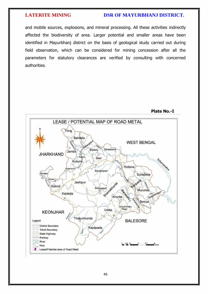
LATERITE MINING DSR OF MAYURBHANJ DISTRICT.
46
and mobile sources, explosions, and mineral processing. All these activities indirectly
affected the biodiversity of area. Larger potential and smaller areas have been
identified in Mayurbhanj district on the basis of geological study carried out during
field observation, which can be considered for mining concession after all the
parameters for statutory clearances are verified by consulting with concerned
authorities.
Plate No.-I
\,
te
tL
*
L
\
!
L
!
t
b
t,
L
L
C
tL
t\
LATERITE MINING DSR OF MAYURBHANJ DISTRICT.
The District Survey Report for Laterite Mining ( Minor Mineral) in respect
of Mayurbhanj District prepared in accordance with Appendix-X, para -7 (iii) (a) of
S.O. 3611 (E) Dt. 25.07.2018 of Ministry of Environment, Forest and Climate Chahg€,
New Delhi is approved for final publication in the district website.
O^ ."s\
Dr. H.K.Sahu,Prof in Zoology, NOU -cum-Member, DEIAA, Mayurbhanj
Sri S.Mall I.F.S, Sri Di Parida, I.A.SDFO-cum-Member,DEIAA, Mayurbhanj
SDM, Sadar-cum -Member SecretaryDEIAA, Mayurbhanj
4
I
Sri ViCollector & DM-cum Chairman, DEIAA
Mayurbhanj (Odisha)
47
%

Fro
m
To
Fro
m
To
1 2 3 4 5 6 7 8 9 10 11 12 13 14 15 16 17 18 19
Bad
asah
i
1
Late
rite
Sto
ne
SRI U
DA
YNA
TH S
AH
U
AT/
PO
- TU
LASI
CH
OU
RA
, BA
RIP
AD
A
DIS
T- M
AYU
RB
HA
NJ
MO
B. N
O. 9
43
70
86
83
6
Ord
er N
o. 2
28
5 d
ated
03
.06
.20
16
Hec
t. 0
.41
hec
.
Vill
.- G
ajad
idam
od
arp
ur
Kh
ata
No
. 22
1
Plo
t N
o. 3
04
Kis
am-
Pat
har
ban
i
20
16
-17
20
20
-21
- -
25
.09
.20
17
Wo
rkin
g
No
n-C
apti
ve
L. N
o. 1
80
/ D
ated
22
.12
.20
16
Lati
. 21
°43
'51
.1''
N t
o 2
1°4
3'5
3.8
''N
Lon
g. 8
6°4
2'3
2.1
'' E
to 8
6°4
2'3
5.3
''E
Op
en C
ast
18
,04
8 c
um
.
9,0
80
cu
m.
Ob
tain
ed
en
viro
nm
en
tal
Cle
aran
ce(Y
es/
No
). If
ye
s Le
tte
r n
o w
ith
dat
e o
f EC
Loca
tio
n o
f M
inin
g Le
ase
( La
titu
de
&
Lon
gitu
ed
)
Me
tho
d o
f M
inin
g O
pe
n C
ast/
Un
de
r
Gro
un
d)
OTHER THAN SAND MINING (Laterite Stone) Annexure - DN
ame
of
the
Tah
asil
Sl N
o
Nam
e o
f M
ine
rals
Nam
e o
f Le
sse
e
Ad
dre
ss a
nd
Co
nta
ct N
o. o
f Le
sse
e
Min
ing
Leas
e G
ran
t O
rde
r N
o. &
Dat
e
Are
a o
f M
inin
g le
ase
(H
a.)
wit
h
Vill
age
,Kh
ata
No
, plo
t N
o &
Kis
am
Pe
rio
d o
f m
inin
g Le
ase
( In
itia
l)
Pe
rio
d o
f M
inin
g Le
ase
(
1st
/2
nd
--R
en
ew
al)
Ge
olo
gica
l Re
serv
e (
MT/
Cu
ms)
Min
eab
le r
ese
rve
(
MT/
Cu
ms)
Dat
e o
f C
om
me
nce
me
nt
of
min
ing
Op
era
tio
n
Stat
us
( W
ork
ing
/no
n-w
ork
ing/
tem
p
wo
rkin
g fo
r d
isp
atch
etc
.
Cap
tive
/No
n-C
apti
ve

DISTRICT SURVEY REPORT (DSR) OF
MAYURBHANJ DISTRICT, ODISHA. FOR
ORDINARY EARTH/BRICK EARTH
(FOR PLANNING & EXPLOITING OF MINOR MINERAL RESOURCES)
As per Notification No. S.O. 3611(E) New Delhi
dated 25th July 2018 of
Ministry of Environment, Forest & Climate Change
( MoEF & CC)
(Prepared by DEIAA, Mayurbhanj, Odisha)

ORDINARY EARTH/BRICK EARTH MINING DSR OF MAYURBHANJ DISTRICT.
1
CONTENT
CH.
NO.
DESCRIPTION PAGE
NO.
Preamble 3
1 Introduction 4
1.1 Location and Geographical Area 4
1.2 Administrative Units 5
1.3 Connectivity 7
2 Overview of Mining Activity in the District 10
3 General Profile of the District 11
3.1 Demography 11
4 Geology of the District 11
4.1 Physiography & Geomorphology 12
4.2 Stratigraphy. 13
4.3 Mineral Resources. 14
4.4 Soil 17
5 Drainage of Irrigation Pattern 17
5.1 River System 19
6 Land Utilization Pattern in the District 21
6.1 Forest and non forest land. 21
6.2 Agricultural land. 24
6.3 Horticultural land. 25
7 Surface Water and Ground Water Scenario of the District 25
7.1 Hydrogeology. 25
7.2 Depth to water level. 26
7.3 Ground Water Quality. 28
7.4 Ground Water Development. 29
7.5 Ground water related issues & problems. 29
7.6 Mass Awareness Campaign on Water Management
Training Programme by CGWB
30
7.7 Area Notified By CGWB/SGWA 30
7.8 Recommendations 30
8 Rainfall of the District and Climate Condition 31
8.1 Month Wise rainfall. 31
8.2 Climate. 31
9 Details of Mining Lease in the District 32
9.1 List of Mines in operation in the district 32
9.2 List of Mines not in operation in the district 32
10 Detail of Royalty or Revenue received in last 3 years 33

ORDINARY EARTH/BRICK EARTH MINING DSR OF MAYURBHANJ DISTRICT.
2
11 Detail of production of minor mineral in last 3 years 34
12 Mineral Map of the District. 35
13 List of Letter of Intent (LOI) Holders in the District along
with its Validity.
35
14 Total Mineral Reserve Available in the District. 36
15 Quality/Grade of Mineral Available in the District. 37
16 Use of Mineral. 37
17 Demand and Supply of the Mineral in the Last Three Years. 38
18 Map of Existing Mining Leases in the District. 40
19 Details of the Area of where there is a cluster of mining
lease viz. Number of mining leases, location (latitude and
longitude).
40
20 Details of Eco-Sensitive Area, if Any, in the District 40
21 Impact of Mining on Environment 40
22 Remedial Measures to Mitigate the Impact of Mining on
the Environment
41
23 Reclamation of Mined Out Area 42
24 Risk Assessment and Disaster Management Plan 43
25 Details of the Occupational Health Issue in the District 46
26 Plantation and Green Belt Development in Respect of
Lease Already Granted in the District
47
27 Conclusion & References 47

ORDINARY EARTH/BRICK EARTH MINING DSR OF MAYURBHANJ DISTRICT.
3
PREAMBLE
Odisha is the major mineral reach in India. Mayurbhanj is a unique district in Odisha
lies on the northern most part of the state with varied mineral resources. In
pursuance of the order of Hon’ble Supreme Court Petition (C) No. 19628-19629 of
2009, dated 27th Feb. 2012 in the matter of Deepak Kumar Vs State of Haryana and
others etc., prior environmental clearance has now become mandatory for mining of
minor minerals irrespective of the area of Mining Lease. And also in view of the
Hon’ble National Green Tribunal, order dated the 13th Jan. 2015 the matter regarding
Roadmetal/stone, Sand, Brick earth, & burrowed earth cutting for Road Construction
has to take prior Environmental Clearance. for Mining Lease area more or less than 5
hectares also suggested making a policy on Environmental Clearance for minor
minerals lease and leases in cluster. As per MOEF & CC Notification S.O.-1533(E)
dated 14th Sept. 2006 and subsequent MoEF & CC Notification S.O. 141(E) dated 15th
Jan. 2016, District Environment Impact Assessment Authority (DEIAA) & District level
Expert Appraisal Committee (DEAC) has been formed for Category –B2 Minor Minerals
having area less than or equal to 5 ha. In compliance to the notification issued by the
Ministry of Environment and Forest and Climate Change Notification no. S.O.3611 (E)
New Delhi dated 25-07-2018; the preparation of district survey report of road
metal/stone mining has been prepared in accordance with Clause II of Appendix X of the
notification.
Keeping in view of the prior information of Odisha Minor Mineral Concession Rule
2004, (OMMCR -2004) the mining operation for minor minerals was carried out in
unscientific manner. Identifying this fact in exercise of power, Conferred by Section 15
by Mines and Minerals (Development and Regulation) Act 1957 as amended in 2015
and all other powers enabling it in that behalf, the Mining & Geology Department,
Govt. of Odisha framed the aforementioned rule. Further, this report will act as a
compendium of available mineral resources, geological set up, environmental and
ecological set up of the district and based on data of various departments like
Revenue, Water Resources, Forest, Geology and Mining in the district as well as
statistical data uploaded by various state Government departments for preparation for
district survey report.

ORDINARY EARTH/BRICK EARTH MINING DSR OF MAYURBHANJ DISTRICT.
4
1. INTRODUCTION:
Mayurbhanj at a Glance:
1.1 Location and Geographical Area:
Mayurbhanj district is the largest among the thirty districts of Odisha and Baripada is
the District head quarter, spreading over an area of 10,418 sq.km lies between
latitudes 21° 17’ North and 22° 34’ North and longitudes 85°40’ East and 87°10’ East.
It is bounded on the north by the Singhbhum district of Jharkhand and Midnapore
district of West Bengal, on the south by the districts of Balasore and Keonjhar, on the
east by the Midnapore and Balasore districts and on the west by the districts of
Keonjhar and Singhbhum. Mayurbhanj occupies a unique position being endowed
with lush green vegetation, different fauna & flora and rich cultural heritage. The
district has a rich mineral base and is home to the Similipal Biosphere. Iron-ore
(hematite), vanadiferous and titaniferous magnetic, chaina clay, galena (lead ore),
Kyanite, asbestos, steatite (soap stone) and quartzite constitute the principal mineral
resources of Mayurbhanj district, of these the iron-ore deposits of Gorumahisani,
Badampahar and Suleipat, which have been exploited for a period of about half a
century, deserve special mention.

ORDINARY EARTH/BRICK EARTH MINING DSR OF MAYURBHANJ DISTRICT.
5
1.2 Administrative Units:-
Baripada is the administrative headquarter of Mayurbhanj district. It is located at a
distance of 263 km from Bhubaneswar, state capital of Odisha. In order of size, the
district is the largest among the thirty districts of Odisha. It has 3980 villages
(including 178 uninhabited villages) covering 26 Blocks, 26 Tahasils and 4 sub-
divisions. The district is divided into 4 Sub-Divisions namely 1) Sadar Sub-Division
Baripada, 2) Kaptipada Sub-Division Udala, 3) Bamanghaty Sub-Division, Rairangpur,
4) Panchapir Sub-Division, Karanjia which are given below:-

ORDINARY EARTH/BRICK EARTH MINING DSR OF MAYURBHANJ DISTRICT.
6
Sl No Name of the Block/Tehsil Name of the Sub-Division with
Head quarter
1 Baripada
Sadar Sub-Division, Baripada
2 Samakhunta
3 Kuliana
4 Bangriposi
5 Saraskana
6 Suliapada
7 Betnoti
8 Badsahi
9 Rasgovindapur
10 Moroda
11 Udala
Kaptipada Sub-Division, Udala
12 Kaptipada
13 Khunta
14 Gapabandhu Nagar
15 Rairangpur
Bamanghaty Sub-Division,
Rairangpur
16 Bisoi
17 Bijatala
18 Kusumi
19 Bahalda
20 Tiring Bamanghaty Sub-Division,
Rairangpur 21 Jamda
22 Karanjia
Panchpir Sub-Division, Karanjia
23 Jashipur
24 Sukruli
25 Thakurmunda
26 Raruan
The population of the district is 25,19,738 according to the 2011 Census. The district
accounts for 6.69% of the state’s territory and about 6% of state’s population. The
density of population of the district is 242 per square km as against 270 per square
km of the state. As per 2011 census, the population of Scheduled Caste is 1,84,682
(7.30%), that of Scheduled Tribe is 14,79,576 (58.7%). The literacy percentage of the
district covers 63.2 against 72.9 of the state.

ORDINARY EARTH/BRICK EARTH MINING DSR OF MAYURBHANJ DISTRICT.
7
1.3 Connectivity facilities:-
Road Network
The district is well served by a network of good roads and has been called the
motorists paradise. The chief roads emanating from Mayurbhanj town are NH-18 and
NH-49 passes the district. Baripada is 60 Kms from Mayurbhanj, 103 Kms from
Kharagpur, 163 Kms from Jamshedpur, 231 Kms from Cuttack, 255 Kms from
Bhubaneswar and 368 Kms from Rourkela. It is also connected with other cities such
as Sambalpur, Puri, Bolangir, Bhadrak, Jhargram, Angul, Ranchi and Kolkata via
Odisha State Road Transport Corporation and some private travel services.

ORDINARY EARTH/BRICK EARTH MINING DSR OF MAYURBHANJ DISTRICT.
8
Rail Network
Mayurbhanj district is well connected by rail link to different places, the city of
Baripada is well connected to many places in India like Mayurbhanj, Bhubaneswar,
Kolkata, Jamshedpur and Cuttack,

ORDINARY EARTH/BRICK EARTH MINING DSR OF MAYURBHANJ DISTRICT.
9
Air Network
At present, Mayurbhanj has no connection by airway. The site selection for aerodrome
is presently under process. Nearest aerodrome is Dum Dum Airport (International
Airport) Kolkata, roughly 195 Kms from Baripada. The other nearest airport to
Baripada is Biju Patnaik Airport, Bhubaneshwar, 207 Kms from Baripada.

ORDINARY EARTH/BRICK EARTH MINING DSR OF MAYURBHANJ DISTRICT.
10
2. OVERVIEW OF MINING ACTIVITY IN THE DISTRICT:
Mayurbhanj district is land features of both plain and hilly region. Most of the
mineralized area coming under safety zone eco-sensitive zone, mining activity only
confined out of safety zone of eco-sensitive zone. The mining activity in the district is
not only restricted to minor minerals i.e. of sand, stone, granite and brick clays.
Altogether there are leases of Iron-ore (hematite), vanadiferous and titaniferous
magnetic, chaina clay, galena (lead ore), Kyanite, asbestos, steatite (soap stone) and
quartzite constitute the principal mineral resources of Mayurbhanj district, of these the
iron-ore deposits of Gorumahisani, Badampahar and Suleipat, which have been
exploited for a period of about half a century. Stone, granite and sand which has been
granted to the district is regulated as per minerals concession rules of Odisha. There
is no lease of major mineral in the district. At present Leases of stone, sand and bricks
making units are operational in the district. Stone chips, granite stones, ordinary sand

ORDINARY EARTH/BRICK EARTH MINING DSR OF MAYURBHANJ DISTRICT.
11
constitute the principal mining activity of Bangirposi, Badasahi, Kaptipada, Kuliana
area etc. of Mayurbhanj district. Out of these huge granite stones deposits are
available near Badasahi, Kaptipada, Kuliana area and major potential sand in G.B
Nagar, Morda & Kaptipada area of the district, which have been provides tremendous
scope for development of few more industries based on this resources.
Iron-ore (hematite), vanadiferous and titaniferous magnetic, chaina clay, galena (lead
ore), Kyanite, asbestos, steatite (soap stone) and quartzite constitute the principal
mineral resources of Mayurbhanj district, of these the iron-ore deposits of
Gorumahisani, Badampahar and Suleipat, which have been exploited for a period of
about half a century.
3.0 GENERAL PROFILE OF THE DISTRICT:
3.1 Demography:
Census - 2011
Geographical Area 10,418 Sq. Km.
Total population 25,19,738
Male Population 12,56,213
Female Population 12,63,525
Male Literacy 794,171
Female Literacy 575,226
SC Male 92,127
SC Female 92,555
ST Male 730,487
ST Female 749,089
OBC 855,480
Illiterate Male 462,042
Illiterate Female 688,299
4.0 GEOLOGY OF THE DISTRICT:
Mayurbhanj is a unique district in Odisha with rich and varied geology. Similipal
Complex being at its central part. The mountain ranges comprise mainly of highland
plateau and valleys with intrusive running through them. The second physiographic
unit is Tertiary Plain occurring in the eastern part of the district. The third
physiographic unit is Alluvial Plain .The drainage density is observed to be fairly
moderate and drainage pattern is dendritic in nature. The major rock types

ORDINARY EARTH/BRICK EARTH MINING DSR OF MAYURBHANJ DISTRICT.
12
encountered in the district are Granite Gneiss, Quartzite, Orthoquartzite, Arkose,
Shale, Phyllite, Gabbro, Px-granite. The geology of the district is constituted by the
Similipal complex at its central part belonging the Archaean age, unconformably lying
over Singhbhum Granite and Banded Iron Formation (BIF). It consists of three
alternate bands of volcano sedimentary units uniquely disposed in a ring like circular
pattern formed under sub- marine conditions. Baripada Beds outcrops of tertiary
formation occur around Baripada town. These comprise stratified clay and sand with
marly clay or limestone interbands. Important mineral resources include iron, copper,
itanium, vanadium, chinaclay, nickel, kyanite ,quartz, talc, steatite ,soapstone and
bauxite.
4.1 Physiography & Geomorphology:
Mayurbhanj district presents diverse physiographic features, Physiographically the
study area can be divided into 3 categories. The first physiographic unit of the district
is high mountain ranges, Similipal Complex being at its central part (Figure 1). The
mountain ranges comprise mainly of highland plateau and valleys with intrusive
running through them. The second physiographic unit is Tertiary Plain occurring in the
eastern part of the district. The third physiographic unit is Alluvial Plain which lies
partly in Rasgovindpur, Morada, Samakhunta, Betnoti, Baripada, Badasahi and
Suliapada blocks. The highest elevation of about 559m at Bahalda near Similpal hill
and higher elevations of the district, due to scarp landforms some waterfalls are
observed in the district. The general slope of the district is from north to south.
Geologically the area is comprised with Archean granites and gneisses.
Geomorphologically the district is divided into 3 units:
i) The denudational hills with moderate to high slope occurring in the western part of
the district.
ii) Dissected pediments having gentle slope.

ORDINARY EARTH/BRICK EARTH MINING DSR OF MAYURBHANJ DISTRICT.
13
iii) Pediplain having slope between 0o to 5o.
4.2 Stratigraphy:
Geological Age Geological Formation / Group
Quaternany : Recent Alluvium, Clays, silt, Sand, Gravel
Tertiary : Older Alluvium, Laterite, Baripada Beds.
Mesozoic/ Palaeozoic : Volcanics / Epidiorite
Precambrian : Slate/ Phyllite/ Schist / Gneiss
Archean : Granite/ Granite Gneiss

ORDINARY EARTH/BRICK EARTH MINING DSR OF MAYURBHANJ DISTRICT.
14
4.3 Mineral Resources:
The earliest known geological survey in Mayurbhanj dates back to 1903, when P.N.
Bose brought to light the extensive iron-ore deposits of high quantity on the
Gorumahisani and Sulaipat hills in Bamanghaty Sub-Division. These deposits were
considered to be almost inexhaustible and were pronounced to be of excellent quality,
perhaps second to none in the whole of Asia by the famous American and English
experts like M/s Perin, Weld and Colonel Staddart, who visited these deposits during
1905-06. This discovery was a momentous one as the steel plant of the Tata Iron &
Steel Co. at Jamshedpur was entirely based on the exploitation of these deposits. By
1915, important discoveries of Steatite near Lulung and placer gold from the sands of
Subarnarekha, Kharkhai and Barhai rivers had been made. The placer gold deposits
were being worked by M/s J.B. Bettie of Calcutta, Mr. V.G. Piggot of Ghatsila and the
Mayurbhanj Prospecting Concession Syndicate.
Gold: The mid-Archaean Gorumahisani-Badampahar schist belt composed of basic
ultrabasic, volcanic rocks and volcanogenic sediments. This belt has been
prognosticated as a rift-type of volcanic dominated one and is highly potential for
economic grade gold mineralization. Likely targets include: a) auriferous quartz veins
close to the contact of sulphide chert volcanics, b) sheared and sulphidised Fe-rich
tholeiite with anomalous copper, c) epigenetic vein type of mineralization and BIF
volcanic association, and d) sulphidic conglomerate resting over the basic volcanics.
Placer gold occurrence is known from rivers and stream of Mayurbhanj district. An
area of about 5 square kilometers of alluvium at the headwaters of Sapgora and Borai
rivers near Kudersai was indicated as promising.
Iron: Bose discovered iron ore deposits in Gorumahisani and Badampahar in the
eastwhile princely state of Mayurbhanj (now Mayurbhanj District). Gorumahisani
deposits were investigated by Perin & Weld (1905). Gorumahisani- Badampahar-
Suleipat deposits are associated with banded hematite / magnetite grunerite and BHJ.
ORDINARY EARTH/BRICK EARTH MINING DSR OF MAYURBHANJ DISTRICT.
15
Gorumahisani – Badampahar- Sulaipat (Broad geological sequence)
Laterite & Alluvium
Newer Dolerite
Gabhro-Anorthosite Granite
---Unconformity---
Ultramafic dyke
Singhbhum Granite
Banded magnetite/ Martite quartzite with Fe-Ores
Quartzite
Basal Conglomerate
----Unconformity----
Older metamorphic
Vanadium Ores & Titanium: Vanadium is an important alloying element. Magnetite
associated with gabbro- anorthosite suite of rocks contains vanadium and titanium.
Deposits of vanadium-magnetite occur in association with Gabbro-Anorthosite suite of
rocks in the Precambrian Metamorphites. Vanadium bearing magnetite belts are:-
(a) Rairangpur – Bisoi belt (Kumardubi, Betjharan Amdabeda)
(b) Bisoi – Jashipur belt (Mayurbeka, Kesham, Sialnoi)
(c) Baripada – Podadiha belt (Andipur, Bahalda)
Pyrophyllite : is mainly used as a high grade ceramic product, electric insulator and
refractory material. The comp. is Al2O34SiO2 H20. It is formed as an alteration product
of feldspar. Pyrophyllite occurrences are reported at Kankrani, Jashipur,
Gorumahisani, Bangriposhi and Manada in Mayurbhanj Dist. Ichinda, Khairakocha,
Jamukunda, Nakulkocha, Kapadiha, Dunguridiha, Maheshpur, Kashidiha, Sagragora
and Pokpoka. Dimension stone of the district are granite, granite-gneiss, migmatites,
syenite, gabbro, anorthosite, charnockite, leptynite, pyroxene granulite, dolerite,
pyroxinite and dunite etc.
Bauxite: In Similipal complex (Mayurbhanj) aluminous laterite/ Bauxite are observed
around 1000 m AMSL. The spongy aluminous laterite/bauxite occurs as sheets and
boulders occupying the flat-topped hills made up of metavolcanics. Both
ultramafics and metavolcanics are lateritised giving rise to nickeliferous laterite and
aluminous laterite respectively.
ORDINARY EARTH/BRICK EARTH MINING DSR OF MAYURBHANJ DISTRICT.
16
China Clay is clay like material approximating the mineral Kaolinite (Al2O3, 2SIO2,
2H2O). China clay is found to occur in a long belt stretching from Singhbhum to
Mayurbhanj. Badampahar-Joshipur- Karanjia – Ramachandrapur belt is the most
important china-clay producing area of the state. The important deposits in
Mayurbhanj district are found near Joshipur, Chanchbani, Dumuria, Jamoda,
Kodadiha, Jamkeswar and Thakurmunda. China clay has many industrial applications
as filler in paper, textile, rubber, in the manufacture of potteries, ceramics, sanitary
wares, glazed tiles, white cement, insecticides, paints, cosmetics, refractory bricks etc.
Soap stone and Steatite Asbestos is mined from Mayurbhanj area.
Talc, steatite and soapstone : Important localities of these deposits in Mayurbhanj
dist are Tiring, Kendumundi and Kharidamak.
Kyanite: Kyanite deposits of refractory grade occur in Panijia area of Mayurbhanj
dist, where it is associated with dumortierite bearing rocks, qtz-veins, quartz-mica-
schists and talc-tremolite-schist. Other kyanite occurrence includes Purnapani &
Similipal.
Quartz & Quartzite: Quartz and silica sand are mostly used in glass foundry,
ferrosilicon alloy, ceramic industry, abrasive, paint, rubber, textile industries.
Transparent varieties of quartz such as rock crystal, amethyst, citrine, Rosequartz and
smoky quartz are used as semi-precious gemstone. Quartz is a piezoelectric material
and is used in radio circuit, Radars and ultra-sonic devices. Quartzite is a
monomineralic rock constituted predominantly of quartz. There are 6 mining leases
for quartz and quartzite in Mayurbhanj dist.
High Magnesia rock: are found in Notapahar, Thakurmunda, Amjori and
Badampahar of Mayurbhanj Dist.
Nickel: Nickel is concentrated within chemically weathered ultramafic rocks and
found in the laterite and soil capping in Similipal area. The mineral occurs in silicate

ORDINARY EARTH/BRICK EARTH MINING DSR OF MAYURBHANJ DISTRICT.
17
form i.e. garnierite. The important patches of prospective ore zones are: Gurguria and
Nawana.
4.4 Soil:
The district comprises chiefly of lateritic, sandy loam and clayey loam type of soil
(Figure 3). Laterite soil is mostly marked in the area occupied by crystalline rocks.
The low lying valley fields are covered with clayey loam type of soil.
5. DRAINAGE OF IRRIGATION PATTERN
The district has considerable flat land, which provide suitable site for agricultural use.
The hilly areas are mostly under forest with patches of cultivation on scarp areas.
Major rivers flowing in the district are Budhabalanga, Subarnarekha, jambhira, Sona,

ORDINARY EARTH/BRICK EARTH MINING DSR OF MAYURBHANJ DISTRICT.
18
Khadkhai, Deo, Katra, Khairibandhan & Baitarani. Major crops grown in the district are
rice Only. 14.82 percent area of agricultural use are net irrigated and major source of
irrigations are well and tube wells.
Sl. No.
Name of the River
Area drained (Sq. Km.)
% Area drained in the District
1 Budhabalanga 2143 21%
2 Subarnarekha 265 0.25%
3 jambhira 1377 13%
4 Sona 1062 10%
5 Khadkhai 1131 10.8%
6 Khairibandhan 1014 0.09%
7 Deo 473 0.04%
8 Katra 352 0.03%
9 Gangahar 594 0.057%
10 Baitarani 260 24.6%
11 Tel 96 0.009%
12 Kantamauli 82 0.007%
13 Sim 165 0.015%
14 Jhagada 30 0.002%
15 Balijori 56 0.005%
16 Kantakhaira 186 0.017%
17 Kanu 383 0.036%
18 Balisudura 170 0.016%

ORDINARY EARTH/BRICK EARTH MINING DSR OF MAYURBHANJ DISTRICT.
19
5.1 River System
The Budhabalanga River (also called Balanga River) flows through the districts
of Mayurbhanj & Balasore and finally reached Bay of Bengal. The Budhabalanga, rises
from Similipal hills and plunges through Barehipani Falls, the second-highest waterfall
in India, located in Similipal National Park. It then flows in a northerly direction up to
the village Karanjiapal in Bangiriposi police-station. Thereafter, it turns to the north-
east and flows along the railway track up to the village Jhankapahadi. There it
changes its course to the south and meets the Katra nala. The other tributaries are
the Palpala and the Chipat both of which are hill streams rising from the Similipal hills.
Then the river passes through Baripada. It later flows through Balasore district and
into the Bay of Bengal. The Budhabalanga is about 175 kilometres (109 mi) long and
has a total catchment area of 4,840 square kilometres (1,870 sq mi). Its major
tributaries are the Sona, Gangahar, and the Katra. Burhabalang and its tributaries, viz.

ORDINARY EARTH/BRICK EARTH MINING DSR OF MAYURBHANJ DISTRICT.
20
Sona Nadi, Amrutia Nadi, Gangahar Nadi drain almost round the year in the present
area. Sona Nadi receives the watery effluent load through a nalah (Sankh nalah) from
the Balgopalpur Industrial Estate and flows from west to east. Amrutia Nadi flows
from NNW to SSE and carries the waste water load of East Coast. Subarnrekha
originate from Nagri of jharkhand and then enter into Mayurbhanj district, very less
portion of the river flows within Mayurbhanj district, Major portion of Subarnarekha
River passes in the Balasore district. Another river Jambhira runs in Mayurbhanj
district then enters into Balasore district and Renamed as river Jalaka flows into Bay
of Bengal. Other small rivers run in this district like River Khadkhai originates from
Tunhgru R.F. and plunges through Suleipat Dam (Khadkhai Reserviour). It then runs
towards Rairangpur, Bahalda, Tiringi area of western direction of Mayurbhanj district
and finally reached at River Subarnarekha. River Deo rises from Similipal R.F. and
runs towards western part of the district and flows through Karanjia area and then
joins with Baitarani River. River Khairabandhan originates from Similipal R.F. and
flows towards western part of the Mayurbhanj district through Jshipur, Raruan, Sukurli
area of district and then joins with River Baitarani This river maintains a sluggish flow
in the pre-monsoon period, but swells menacingly with the onset of monsoon often
flooding large tracts. Another small tributary named as Kanhu starts from River
Khadkhai and branched into Jalapa, Ghagera nala meets at Jharbeda area of
Mayurbhanj District.
Sl. No.
Name of the River or Stream
Total Length in District (in Km.)
Place of Origin Altitude at Origin
1 Budhabalanga 161 Similipal Hill 940 mrl.
2 Subarnarekha 4 Nagri, Jharkhanda
610 mrl.
3 Jambhira 64 Chandra R.F. Mayurbhanj
60 mrl.
4 Sona 70 Jaymal Hill, Dugdha
Mayurbhanj.
340 mrl.
5 Khadkhai 75 Tunhgru R.F. 500 mrl.
6 Khairibandhan 65 Similipal R.F. 800 mrl.
7 Deo 65 Similipal R.F. 930 mrl.
8 Katra 55 Jari R.F. 700 mrl.
9 Gangahar 55 Similipal R.F. 740 mrl.
10 Baitarani 48 Gonasika, 900 mrl.

ORDINARY EARTH/BRICK EARTH MINING DSR OF MAYURBHANJ DISTRICT.
21
Guptaganga Hills
11 Tel 20 Similipal R.F. 940 mrl.
12 Kantamauli 25 Similipal R.F. 360 mrl.
13 Sim 85 Similipal R.F. 900 mrl.
14 Jhagada 15 Jhagada R.F. 430 mrl.
15 Balijori 22 Similipal R.F. 520 mrl.
16 Kantakhaira 36 Similipal R.F. 420 mrl.
17 Kanhu 42 Similipal R.F. 400 mrl.
18 Balisudura 15 Similipal R.F. 450 mrl.
6.0 LAND UTILIZATION PATTERN IN THE DISTRICT
6.1 Forest and non forest land
The forest of Mayurbhanj district is full variety of medicinal plants, Kendu leaves,
Bamboo, Sal, Teak, other timber species and a wide range of carnivorous & herbivorous
wild animals. The district has one Wildlife Sanctuaries known as the Similipal Wildlife
Sanctuary situated at the heart of the district, which hosts all type of wildlife even

ORDINARY EARTH/BRICK EARTH MINING DSR OF MAYURBHANJ DISTRICT.
22
tigers. The area of the sanctuary is 26, 886.23 hectares. And two kilometer safety zone
of eco-sensitive zone of Suleipat Wildlife Sanctuary are coming in Mayurbhanj district. In
these sanctuary areas the principal animals that are found are Elephant, Bear, Nilgai,
Sambhar, Peacock, Wild Boar and Deer, together with variety of snakes and birds.
District-wise Forest Cover Area in Odisha (Area in Km2)
2017 Assessment
District Geograph ical Area Km2
Very Dense Forest
Moder- ate. Dense Forest
Open Forest
Total Percent of GA
Change Scrub
Angul 6375 371 1380 1004 2755 43.22 43 84
Bolangir 6575 70 224 837 1131 17.2 151 142
Balasore 3806 23 127 234 380 9.98 30 48
Bargarh 5837 176 371 484 1031 17.66 88 47
Bouda 3098 263 546 480 1289 41.61 27 57
Bhadrak 2505 0 9 66 75 2.99 2 0
Cuttack 3932 53 226 517 796 20.24 11 68
Deogarh 2940 191 667 614 1472 50.07 -3 14
Dhenkanal 4452 174 418 825 1417 31.83 9 82
Gajapati 4325 84 1490 946 2520 58.27 12 262
Ganjam 8206 164 1075 864 2103 25.63 15 655
Jagatsinghpur 1668 0 5 131 136 8.15 6 0
Jajpur 2899 6 72 225 303 10.45 3 50
Jharsugada 2114 3 140 179 322 15.23 9 36
Kalahandi 7920 362 729 1327 2418 30.53 36 362
Kandhamal 8021 661 2588 2143 5392 67.22 16 380
Kendrapada 2644 84 88 133 305 11.54 14 2
Keonjhar 8303 289 1404 1519 3212 38.68 4 55
Khorda 2813 21 186 250 457 16.25 0 92
Koraput 8807 94 740 1255 2089 23.72 120 944
Malkangiri 5791 158 709 1475 2342 40.44 20 45
Mayurbhanj 10418 1335 1718 1027 4080 39.16 42 34
Nabarangpur 5291 168 428 507 1103 20.85 8 47
Nayagarh 3890 189 965 556 1710 43.96 28 173
Nuapada 3852 86 482 705 1273 33.05 33 109
Puri 3479 0 54 160 214 6.15 8 11
Rayagada 7073 422 853 1851 3126 44.2 7 349

ORDINARY EARTH/BRICK EARTH MINING DSR OF MAYURBHANJ DISTRICT.
23
Sambalpur 6624 499 1675 1106 3280 49.52 13 40
Subarnapur 2337 2 187 161 350 14.98 26 29
Sundargarh 9712 1019 1814 1431 4264 43.9 107 89
Grand Total 155707 6967 21730 23008 51345 32.98 885 4306
(Source: India state of forest report 2017-Odisha)
The major portion of the district is covered by forest (39.16 % of TGA) and has
scattered settlement pattern. The forest is full of variety of medicinal plants. The
district has considerable flat land, which provide suitable site for agricultural use. The
hilly areas are mostly under forest with patches of cultivation on scarp areas. Major
crops grown in the district are rice and pulses. Only 14.82 percent area of agricultural
use are net irrigated and major source of irrigations are well and tube wells.
Source: Fertilizer and Agriculture Statistics, Eastern Region
Tahasil Forest Area
Misc Tree
Permanent Pasture
Cultivated waste
Non Agricultural
uses
Barren land
Current Fallow
Other Fallow
Net area
sown
Bahalda 964 471 1397 1262 2590 1900 875 944 14031
Bangiriposi 3712 281 1037 1688 3046 684 2054 922 16951
Baripada 216
673
3 128 1628 1376 8 2752 2156 4219
Badasahi 288 180
7 1194 1874 3840 24 3378 2110 17630
Betnoti 2271 911 1198 1728 3227 21 1915 578 17022
Bijatola 2841 224 681 3100 1792 1636 1214 600 11228
Bisoi 3116 471 757 2508 2193 459 2298 1643 15860
G.B.Nagar 191 116 683 582 1147 590 643 1209 10960
Jamda 408 100 1650 434 2060 785 840 1149 13608
Jashipur 8932 141 1389 2655 3637 400 3873 2634 17754
Kaptipada 8745 387 3292 5596 4123 2165 3123 4930 19932
Karanjia 1644 838 1444 2441 3065 462 3493 1362 16690
Khunta 400 226
0 314 672 2061 21 1332 2213 12879
Kuliana 1749 162
6 2222 1902 2529 608 4919 1504 11108
Kusumi 1434 32 2320 2679 2337 587 1086 1682 18032
Morada 993 412
7 513 4340 1941 61 1909 3633 10179
Rairangpur 2260 107 1759 1373 2027 504 1276 631 9713
Raruan 1210 171 890 1120 1899 503 1609 1020 12818
Rasgovindpur 288 214
5 665 1091 2774 142 2002 1537 10054
Shamakhunta 1354 764 1378 2472 1859 334 1861 941 6695
Saraskana 3464 275 689 2658 4042 115 1864 1837 15384
Sukrili 412 211 734 1295 1271 502 1286 1294 10352
Suliapada 2937 553
5 97 2262 2148 86 1589 2906 8971
Thakurmunda 10885 96 1530 1438 2034 795 5317 2670 17681

ORDINARY EARTH/BRICK EARTH MINING DSR OF MAYURBHANJ DISTRICT.
24
6.2 Agriculture Land:
Mayurbhanj is surrounded by no of forest areas as well as Rocky Mountains. People
used to cultivate Paddy in most parts of the hill slopes and in plain lands. Most of the
cultivators grow short duration local paddy in the un-bonded upland during Kharif
season. The crop suffers moisture stress at different stages due to inadequate rainfall.
The primary objective of Agriculture Department is increase of production as well as
productivity of major crops like paddy, groundnut, mustard, Mung, Biri & vegetables
which is widely covered in this District in both Kharif & Rabi season. Another key
objective is the all round development of the farming community of the District. The
Deputy Director of Agriculture is the head of office so far as agriculture is concerned &
he is the Principal Agriculture Officer of the District. Under him there are 5 District
Agriculture Officers & the block under them. As already pointed out that, agriculture is
the main livelihood of the people in Mayurbhanj District. It is therefore also
designated as the food bowl of Odisha. Rice is the principal crop grown in this district,
followed by other cereals, pulses, oilseeds, vegetables, spices and sugarcane. The
agricultural statistics for the district is shown in subsequent tables below:
Table – 3.6a: Crop Coverage Area of Mayurbhanj District, Odisha
Crop Khariff Rabi Annual TOTAL
Area (ha)
(% of Cropped
Area
Area (ha)
% of Cropped
Area
Area (ha)
Gross Cropped Area (ha)
% of Gross
Cropped Area
Rice 301.37 82.353% 3.80 4.015% --- 305.17 62.051%
Cereals 9.99 2.730% 2.17
2.293% --- 12.16 2.472%
Pulses 32.37 8.846% 36.20 38.255% --- 68.57 13.943%
Oilseeds 5.92 1.617% 28.30 29.906% --- 34.22 6.958%
Vegetables 12.39 3.386% 21.74 22.974% --- 34.13 6.940%
Fibres 2.43 0.664% --- 2.43 0.494% Spices 1.48 0.404% 2.42 2.557% --- 3.90 0.792%
Sugarcane --- --- 00 --- --- 00 ---
Tobacco --- --- 00 --- --- 00 ---
Fruits --- --- --- --- --- 31.23 6.350%
TOTAL 365.95 100.00% 94.63 100.00% --- 491.81 100.00%

ORDINARY EARTH/BRICK EARTH MINING DSR OF MAYURBHANJ DISTRICT.
25
6.3 Horticulture Land:
The primary objective of Horticulture Department is increase of production as well as
productivity of major fruits like Mango, Guava, Citrus etc., which is widely covered in
this District. Another key objective is the all round development of the farming
community of the District. The Deputy Director of Horticulture is the head of office.
7.0 SURFACE WATER AND GROUND WATER SCENARIO OF THE DISTRICT
7.1 Hydrogeology
Distribution of Saline / fresh water aquifers:
The occurrence of fresh water aquifers in coastal tract of Mayurbhanj restricted by
two important factors‐ (i) Occurrence of hard rocks in the western side and (ii) Salinity
hazard problems in the eastern part. The water bearing formation of the area can be
divided into (a) areas underlain by fractured, fissured and consolidated basement rock
formations (b) areas underlain by recent unconsolidated alluvial formations.
(a) Consolidated Formation - These are most predominant rock types occurring in
the undulating plains of the district. Groundwater occurs under unconfined condition
in the shallow weathered zone and circulates through fractures and joints. The
thickness of the weathered zone varies from 3 to 35 m. Depth of open wells in these
formations varies from 5 to 14 m below ground level.
(b) Unconsolidated alluvial formations - The unconsolidated formations consists of
laterite and alluvium. Laterites at places are highly consolidated and used as building
stones. The laterites have high degree of effective porosity and form potential
aquifers commonly tapped in dug wells. The alluvium comprises an admixture of clay,
silt, sand and calcareous concretions in varying proportions. The coarse sediments like
sand and gravel form the main repository of ground water. Ground water occurs
under both unconfined condition in shallow aquifers and in confined condition in
deeper parts.

ORDINARY EARTH/BRICK EARTH MINING DSR OF MAYURBHANJ DISTRICT.
26
7.2 Depth of water level:
The depth to water level map for pre and post monsoon periods 2011 are prepared
based on the ground water monitoring data of 77 Nos of National Hydrograph
Stations of C.G.W.B. monitored during the month of April and November 2006 are
presented below respectively. The pre and post monsoon depth to water level in the
district range from 3.54 to 14.50 m below ground level and 1.39 to 8.20 m below
ground level respectively. It is observed that during pre monsoon about 75% of the
total areas show the water level varying between 5 to 10 m below ground level.
During post monsoon nearly 60% of the area has water levels within 2 to 5 m,
while the rest part has between 0 to 2 and 4 to 6 m below ground levels. In localized
part of Morada, Kaptipada and Thakurmunda the water level is > 5 mt.
Depth & categorization of ground water levels during pre monsoon period (April 2011)
of Mayurbhanj districts is presented below:

ORDINARY EARTH/BRICK EARTH MINING DSR OF MAYURBHANJ DISTRICT.
27
Depth & categorization of ground water levels during pre monsoon period (November
2011) of Mayurbhanj districts is presented below:

ORDINARY EARTH/BRICK EARTH MINING DSR OF MAYURBHANJ DISTRICT.
28
7.3 Ground Water Quality
The chemical quality of ground water in the district has been assessed on the basis of
chemical analysis of ground water samples collected during groundwater monitoring,
Hydrogeological surveys and groundwater exploration. The results of the chemical
analysis are presented in Table.
Table showing chemical constituents in aquifers
Constituent Shallow aquifer Deeper aquifer
pH 6.97 – 8.25 6.84 – 8.25
Sp. Conductance (micromohs/cm at 250 C)
53 – 974 92 – 867
TDS (mg/l) 58 – 1430 106 – 429

ORDINARY EARTH/BRICK EARTH MINING DSR OF MAYURBHANJ DISTRICT.
29
Calcium (mg/l) 6 – 92 16 – 86
Magnesium (mg/l) 0.6 – 17 3.6 – 22
Sodium (mg/l) 1.6 – 100 3.5 – 168
Potassium (mg/l) 0.4 – 8 <1 --6.4
Bicarbonate (mg/l) 15 – 256 49 – 366
Chloride (mg/l) 7 – 238 5.3 – 85
Sulphate (mg/l) 0.1 – 9 <1 – 82
Nitrate (mg/l) <0.01 – 53 0.1 – 78
Fluoride (mg/l) 0.08 – 20.3 0.21 – 0.61
Total hardness as calcium carbonate
10 – 245 35 - 285
7.4 Ground Water Development
In the rural areas the entire water supply is dependent on ground water. Ground
water development is mainly carried out in the district through dug wells and Hand
pumps. In general dug wells are of 2 m diameter and the depth ranges between 8 to
15 m depending on the thickness of the weathered zone, tapping the shallow aquifer
in the weathered zone and uppermost slice of the basement. Large number of dug
wells used for drinking water is under private ownership for which there is no reliable
data. Over the years Mark II/ Mark III hand pumps are being drilled in large numbers
for ground water development. These hand pumps have the following two major
advantages i) less susceptible to contamination from surface sources and ii) tap
fractures between 20-60m depth which have been found to be less affected by
seasonal water level fluctuation and thus have lesser chances of failure even during
extreme summer. Over all the present level of ground water development is only
27.21 percent in the district with the maximum in Badasahi Block viz. 64.65% and
minimum in Bijatala Block. Block wise development figure indicate that all the blocks
come under the white categories. Thus there is ample scope for development of
groundwater in the district to augment irrigation potentials through suitable ground
water abstraction structure
7.5 Ground Water Related Issue and Problems
Some of key ground water related issues are
I. Locating suitable sites for bore wells
II. Suitable design of dug wells and hand pumps
III. Taking up artificial recharge projects to augment the resource availability in

ORDINARY EARTH/BRICK EARTH MINING DSR OF MAYURBHANJ DISTRICT.
30
Mayurbhanj district.
IV. Optimal development of irrigation potential by developing ground water available
for future uses.
V. Creating public awareness for conserving ground water through awareness
camps, NGO’s and mass media.
7.6 Mass Awareness Campaign (MAP) & Water Management Training
Programme (WMTP) by CGWB
NIL
7.7 Area Notified by Cgwb/Sgwa
None
7.8 RECOMMENDATIONS
1) Intensive groundwater exploration should be taken up to delineate deeper
potential water saturated fracture zones and to compute aquifer parameter.
2) Large scale planning for ground water development should be preceded by
intensive hydrogeological and geophysical surveys aided by remote sensing
studies.
3) Effective measures may be taken to conserve the surface run off by contour
bonding at suitable sites. Also proper maintenance of reservoir, tanks and spring
channels by periodical disiltation should be carried out.
4) Existing dug-wells should be deepened to tap the maximum saturated thickness of
the weathered mantle or vertical bores may be drilled through the bottom to
enhance the well yield.
5) Energy-station of wells already constructed should be stepped up to ensure
optimal utilization of the irrigation potential already created.
6) The farmers should be educated through agricultural extension services from
adopting suitable cropping pattern for optimal utilization of available groundwater
resources.
7) Programmes for artificial recharge may also be taken up for augmentation of
groundwater through construction of percolation tanks, subsurface dykes, and
check dams and through contour bonding etc.
8) An intensive network of groundwater monitoring stations are required to be

ORDINARY EARTH/BRICK EARTH MINING DSR OF MAYURBHANJ DISTRICT.
31
established in the command areas of irrigation projects to monitor the changes in
groundwater regime consequent on application of surface water irrigation.
8.0 RAINFALL OF THE DISTRICT AND CLIMATE CONDITION
8.1 Month wise rainfall:
The driest month is November, with 3 mm of rain. There is on average 0 mm of
precipitation in December. In July, the precipitation reaches its peak, with an average
of 324 mm. May is the warmest month of the year. The temperature in May averages
32.3 °C. January has the lowest average temperature of the year. It is 16.5 °C.
Year 2016 2017 2018 Average
Sl. No. Month (mm) (mm) (mm) (mm)
1 Jan 9.23 2.71 0.00 3.98
2 Feb 52.61 0.00 0.04 17.55
3 Mar 12.29 44.87 0.72 19.29
4 Apr 22.38 23.36 172.10 72.61
5 May 118.73 139.31 125.30 127.78
6 Jun 195.46 169.39 208.83 191.22
7 Jul 245.28 385.31 300.05 310.21
8 Aug 351.25 291.03 371.30 337.86
9 Sep 285.27 170.11 285.17 246.85
10 Oct 85.39 189.09 154.08 142.85
11 Nov 12.10 34.79 0.00 15.63
12 Dec 0.00 1.80 36.69 12.83
Total 1389.99 1451.77 1654.28 1498.68
Source: Indian Meteorological Department
The Indian Meteorological Department, Bhubaneswar, vide letter No. BBS/RMC/CS-
312, dated 18th January, 2016 has provided the period of Rainy Season viz. Normal
dates of Onset and Withdrawal of South West Monsoon over India as state-wise. The
duration for the period is 10th June to 15th October.
8.2 Climate
The climate in Mayurbhanj is warm and temperate. In winter, there is much less
rainfall in Mayurbhanj than in summer. The general climate of the district is
characterized by oppressive heat in summer, severe cold in winter with high humidity
throughout the year. The rainfall distribution is equal during the monsoon period. The
period from June to October is the rainy season and the district experiences it from
the southwest monsoon. May is the hottest month when the mean daily maximum

ORDINARY EARTH/BRICK EARTH MINING DSR OF MAYURBHANJ DISTRICT.
32
temperature rises up to 47º Celsius. The Köppen-Geiger climate classification is Cwa &
as per they the average temperature in Mayurbhanj is 24.7 °C. The temperature in
May averages 32.3 °C. January has the lowest average temperature of the year, it is
16.5 °C. There is a difference of 321 mm of precipitation between the driest and
wettest months. During the year, the average temperatures vary by 15.8 °C., when
the mean daily minimum temperature dips to 4º Celsius. The higher reaches of the
Similipal experiences frosting during the peak of winter.
9.0 DETAILS OF MINING LEASE OF ORDINARY EARTH IN THE DISTRICT
9.1 List of Mines is operation in the district:
Attached as Annexure-E
9.2 List of Mines is not operation in the district:
Attached as Annexure-E

ORDINARY EARTH/BRICK EARTH MINING DSR OF MAYURBHANJ DISTRICT.
33
10. DETAIL OF ROYALTY OR REVENUE RECEIVED IN LAST THREE YEARS:
Sl. No. Name of the
Tahasil
2016-17 2017-18 2018-19 Total Amount
(Rs.)
1 Baripada 0 0 0 0
2 Samakhunta 0 0 0 0
3 Kuliana 0 0 0 0
4 Bangriposi 0 0 0 0
5 Saraskana 0 0 0 0
6 Suliapada 0 0 0 0
7 Betnoti 0 0 0 0
8 Badsahi 0 0 0 0
9 Rasagovindpur 0 0 0 0
10 Morada 0 0 0 0
11 Udala 0 0 0 0
12 Kaptipada 0 0 0 0
13 Khunta 0 0 0 0
14 G.B Nagar 0 0 0 0
15 Rairangapur 0 0 0 0
16 Bisoi 0 0 0 0
17 Bijatala 0 0 0 0
18 Kusumi 0 0 0 0
19 Bahalda 0 0 0 0
20 Tiring 0 0 0 0
21 Jamda 0 0 0 0
22 Karanjia 0 0 0 0
23 Jashipur 0 0 0 0
24 Sukruli 0 0 0 0
25 Thakurmunda 0 0 0 0
26 Raruan 0 0 0 0
Grand Total 0 0 0 0

ORDINARY EARTH/BRICK EARTH MINING DSR OF MAYURBHANJ DISTRICT.
34
11. DETAIL OF PRODUCTION OF MINOR MINERALS IN LAST THREE YEARS:
Sl.
No.
Name of the
Tahasil
2016-17 2017-18 2018-19 Total in Cum.
1 Baripada 0 0 0 0
2 Samakhunta 0 0 0 0
3 Kuliana 0 0 0 0
4 Bangriposi 0 0 0 0
5 Saraskana 0 0 0 0
6 Suliapada 0 0 0 0
7 Betnoti 0 0 0 0
8 Badsahi 0 0 0 0
9 Rasagovindpur 0 0 0 0
10 Morada 0 0 0 0
11 Udala 0 0 0 0
12 Kaptipada 0 0 0 0
13 Khunta 0 0 0 0
14 G.B Nagar 0 0 0 0
15 Rairangpur 0 0 0 0
16 Bisoi 0 0 0 0
17 Bijatala 0 0 0 0
18 Kusumi 0 0 0 0
19 Bahalda 0 0 0 0
20 Tiring 0 0 0 0
21 Jamda 0 0 0 0
22 Karanjia 0 0 0 0
23 Jashipur 0 0 0 0
24 Sukruli 0 0 0 0
25 Thakurmunda 0 0 0 0
26 Raruan 0 0 0 0
Grand Total 0 0 0 0

ORDINARY EARTH/BRICK EARTH MINING DSR OF MAYURBHANJ DISTRICT.
35
12. MINERAL MAP OF THE DISTRICT:
13. LIST OF LETTER OF INTENT (LOI) HOLDERS IN THE DISTRICT ALONG
WITH ITS VALIDITY
Sl. No.
Name of the
Mineral
Name of the
Lessee
Address Letter of Intent Grant
Order No. &
date
Area of Mining lease to
be allotted
Validity of LoI
Use
(Captive/ Non-
Captive)
Location of the Mining
lease (Latitude & Longitude)
1 2 3 4 5 6 7 8 9
Attached as Annexure-E

ORDINARY EARTH/BRICK EARTH MINING DSR OF MAYURBHANJ DISTRICT.
36
14. TOTAL MINERAL RESERVE AVAILABLE IN THE DISTRICT
Total mineral reserve of Brick Earth will access after detail study or grant of potential
area, which may investigate as per details below.
(i) Blocks were identified based on geological studies through field observation.
(ii) Mineable resource was calculated by considering detail prospecting.
(iii) Area calculated as per GPS co-ordinates and information obtained from local
people. Land detail need to be verified from revenue record.
(iv) Since this is an interim report, as per the present requirement of minerals, more
such blocks need to be identified and the data should be updated periodically, after
certain intervals to update the data bank of DSR.
Summary of Identified Mineral Potential:
Sl.
No.
Name
of the
mineral
Name
of the
lessee
Address and
contact No. of
the lessee
Letter of
Intent
Grant
Order
No. and
date
Area of
mining
lease to
be
allotted
Validity of LoI
Use
(Captive/ Non- Captive
Location of the Mining lease (Latitude & Longitude)
1 2 3 4 5 6 7 8 9
Attached as Annexure-E
Sl. No.
Name of the Tahasil
Mineral Resources in cum.
Mineable Reserve in cum.
1 Baripada Nil Nil
2 Samakhunta Nil Nil
3 Kuliana Nil Nil
4 Bangriposi Nil Nil
5 Saraskana Nil Nil
6 Suliapada Nil Nil
7 Betnoti Nil Nil
8 Badsahi Nil Nil
9 Rasagovindpur Nil Nil
10 Morada Nil Nil
11 Udala Nil Nil
12 Kaptipada Nil Nil
13 Khunta Nil Nil
14 G.B Nagar Nil Nil

ORDINARY EARTH/BRICK EARTH MINING DSR OF MAYURBHANJ DISTRICT.
37
15 Rairangpur Nil Nil
16 Bisoi Nil Nil
17 Bijatala Nil Nil
18 Kusumi Nil Nil
19 Bahalda Nil Nil
20 Tiring Nil Nil
21 Jamda Nil Nil
22 Karanjia Nil Nil
23 Jashipur Nil Nil
24 Sukruli Nil Nil
25 Thakurmunda Nil Nil
26 Raruan Nil Nil
Total
15. QUALITY/GRADE OF MINERAL AVAILABLE IN THE DISTRICT:
Rocks and Minerals found in Mayurbhanj District:-
The district is endowed with various types of mineral resources like Iron ore, China
Clay, Quartz, Soap stone, Granite, Manganese, etc. Due to presence of huge
mineral resources, mining activities have been undertaken in a big scale. Bahalda,
Jashipur, Karanjia, Koshorpur, Bisoi, Gorumahisani and Rairangpur are the places in
the district having deposits of the above mineral products. The availability of
mineral deposits is given in the table below. The district’s mineral deposits have not
been utilized to maximum extent for industrial purpose. Some of the items like
China clay, Soap stone, Asbestos, etc. can be used in small scale sector. So the
available resources of the district need harnessing properly for industrial and
productive use. Road metal/Building stone of the district are very much suitable for
various construction purposes after crushing and screening. The granite gneisses
are well foliated, jointed and weathered easily.
16. USE OF MINERAL
Uses of Soil/Brick earth:
Soil/Brick earth have been extensively used for making of raw bricks and filling of
new road construction and various public and commercial purposes.

ORDINARY EARTH/BRICK EARTH MINING DSR OF MAYURBHANJ DISTRICT.
38
17. DEMAND AND SUPPLY OF THE MINERAL IN THE LAST THREE YEARS:
As such there are huge infrastructural activities such as road, building, railways are
coming up by state govt. under Govt. of India & PSUs under “Make in India”
programme. The Granitic rocks are the main raw minerals for the above activities and
considering the last three years’ actual production of Mayurbhanj with respect to the
requirement of the state has a huge gap. It is proposed to start the production from
larger block/area to at least double the production of the district which will enhance
the revenue of the district and also support the livelihood of the local people.
18. MAP OF EXISTING MINING LEASES IN THE DISTRICT:
Enclosed as Plate-I
19. DETAILS OF THE AREA OF WHERE THERE IS A CLUSTER OF MINING
LEASE VIZ. NUMBER OF MINING LEASES, LOCATION (LATITUDE AND
LONGITUDE)
Currently there are no clusters of mining leases in the district. However, it is proposed
to consider the cluster of mining lease while planning for new lease area in coming
years.
20. DETAILS OF ECO-SENSITIVE AREA, IF ANY, IN THE DISTRICT:
Eco sensitive zone of Similipal wild life sanctuary is located within the district.
21. IMPACTS OF MINING ON ENVIRONMENT:
The most important environmental impact of mining projects is:-
Transportation sources:
Transportation sources of air pollutants include heavy vehicles used in excavation
operations, cars that transport personnel at the mining site, and trucks that transport
mining materials. The level of polluting emissions from these sources depends on the
fuel and conditions of the equipment. Even though individual emissions can be
relatively small, collectively these emissions can be of real concern. In addition,

ORDINARY EARTH/BRICK EARTH MINING DSR OF MAYURBHANJ DISTRICT.
39
mobile sources are a major source of particulate matter, carbon monoxide, and volatile
organic compounds that contribute significantly to the formation of ground-level ozone
Fugitive emissions:
Common sources of fugitive emissions include: storage and handling of materials;
mine processing; fugitive dust, blasting, construction activities, and roadways
associated with mining activities; leach pads, and tailing piles and ponds; and waste
rock piles. Sources and characteristics of fugitive emissions dust in mining operations
vary in each case, as do their impacts. Impacts are difficult to predict and calculate
but should be considered since they could be a significant source of hazardous air
pollutants.
Noise and vibration:
Noise pollution associated with mining may include noise from vehicle engines,
loading and unloading of rock into steel dumpers, chutes, power generation, and
other sources. Cumulative impacts of shoveling, ripping, drilling, blasting, transport,
crushing, grinding, and stock-piling can significantly affect wildlife and nearby
residents.
Vibrations are associated with many types of equipment used in mining operations,
but blasting is considered the major source. Vibration has affected the stability of
infrastructures, buildings, and homes of people living near large-scale open-pit mining
operations. According to a study commissioned by the European Union in 2000:
“Shocks and vibrations as a result of blasting in connection with mining can lead to
noise, dust and collapse of structures in surrounding inhabited areas. The animal life,
on which the local population may depend, might also be disturbed.”
22. REMEDIAL MEASURES TO MITIGATE THE IMPACT OF MINING ON THE
ENVIRONMENT:
1. Following are the remedial measures to mitigate the in Water sprinkling on haul
road, loading and unloading points.
2. Plantation along the safety zone and dump area.
3. Providing dust masks to workers.
4. Regular monitoring of ambient air quality.
5. Provision of air conditioned cabin of Excavators and Dumpers.
6. Regular and proper maintenance of working equipments.

ORDINARY EARTH/BRICK EARTH MINING DSR OF MAYURBHANJ DISTRICT.
40
7. Periodic medical examination of the workers and organize medical camp in the
area.
8. Use Milli Second Delay Detonator in blasting operation.
9. Provisions of ear plug to the workers.
10. Regular training programme to the mines workers and operators.
23. RECLAMATION OF MINED OUT AREA
Necessity of Reclamation & Rehabilitation:
Exponential growth in mineral production since 1980.
Mining activities causes physical, chemical, biological and socio-economic changes in
the area.
Surface mining activities disturb the original land profile.
In India, mineral production comes mostly from opencast mines & hence land
degradation problems are of serious concern.
An intricate, in-depth and site-specified techniques involving integrated approach is
necessary.
Reclamation has three vital roles:
i. Reclamation – Reclamation means return the mined-out land with useful life. It
implies restoring the land to a form and productivity that is useful and inconformity
with a prior land use. Reclamation always may not be a single- phase operation.
ii. Rehabilitation – Rehabilitation is to bring batch the degraded land to a normal
stage by a special treatment. It is a process of taking some mitigation measures for
disturbed environmental condition created through mining activities.
iii. Restoration – Restoration is the process of returning the mined out land being
fit to an acceptable environmental condition. However, the general acceptable
meaning of the term is bringing the disturbed land to its original form. Restoration is
often used to indicate that biological properties of soil are put back to what they were.
This is a rate phenomenon.
iv. When active mining ceases, mine facilities and the site are reclaimed and closed.
The goal of mine site reclamation and closure should always be to return the site to a
condition that most resembles the pre-mining condition. Mines that are notorious for
their immense impact on the environment often made impacts only during the closure

ORDINARY EARTH/BRICK EARTH MINING DSR OF MAYURBHANJ DISTRICT.
41
phase, when active mining operations ceased. These impacts can persist for decades
and even centuries.
Mine reclamation and closure plans must describe in sufficient detail how the mining
company will restore the site to a condition that most resembles pre-mining
environmental quality; how it will prevent – in perpetuity – the release of toxic
contaminants from various mine facilities (such as abandoned open pits and tailings
impoundments); and how funds will be set aside to insure that the costs of
reclamation and closure will be paid for.
Proposed future land use after reclamation:
a. Forestry, b. Recreation, c. Water Reservoir, d. Crop Land, e.
residential/Commercial, f. Fish & wildlife Habitat, g. Undeveloped Land,
h. Grazing/Pasture Land.
Statutory requirement:
As per the Mineral Conservation Development Rule, 2017, the following rules must be
based in mind by the mine owner/agent/manager, which is a part of reclamation
activities –
Rule 22, Mine Closure Plan
Rule 23, Submission of Progressive Mine Closure Plan Rule 24, Submission of Final
Mine Closure Plan
Rule 26, Responsibility of holder of mining lease Rule 27, Financial Assurance
Rule 35, Sustainable Mining
24. RISK ASSESSMENT AND DISASTER MANAGEMENT PLAN:
Mining activity because of the very nature of the operation, complexity of the
systems, procedures and methods always involves some amount of hazards. Hazard
identification and risk analysis is carried for identification of undesirable events that
can leads to a hazard, the analysis of hazard mechanism by which this undesirable
event could occur and usually the estimation of extent, magnitude and likelihood of
harmful effects. The activities which can cause high risk related to face stability and
the person blasting the shots. It was observed that on a working face of the mine,
there were large cracks and unsupported rocks were present, which can lead to a
serious hazard and injure workers engaged in loading operation and machineries
because of rock falls or slides. This type of condition turn out because improper

ORDINARY EARTH/BRICK EARTH MINING DSR OF MAYURBHANJ DISTRICT.
42
dressing of the bench and improper supervision. To avoid the hazards due to fall of
rocks the face must be examined, made suitable for working and the remedial
measures must be taken to make it safe if there is any doubt that a collapse could
take place. Working of the face should be in the direction taking into account the
geology of the area such that face and quarry side remain stable. Another major risk
identified in mines is due to the firing of explosive by an unqualified person. In the
mines there is problem of fly rocks and the village is located close to the mine and so
it is rated high as it can affect may people. Explosives by nature have the potential for
the most serious and catastrophic accident. Planning of round of shots, holes correctly
drilled, direction logged, weight of explosive suitable for good fragmentation are the
few of the steps necessary to ensure its safe use and if the shots are not properly
designed can result in misfires, early ignition and flying rocks. No person is allowed to
use explosives without being properly trained in its handling. In the mine a large
numbers of heavy vehicles were in operation and the roads were not proper for
haulage purpose. The haulage roads were not even and were not wide enough for the
crossing purpose and hence the chances of hazards are very high. The main hazards
arising from the use large earth moving vehicles are incompetent drivers, brake
failure, lack of all-around visibility from the driver position, vehicle movements
particularly reversing, roll over, and maintenance. Those most at risk are the driver
and pedestrians likely to be struck by the vehicle, and drivers of smaller vehicles,
which cannot be seen from the cabs of large vehicles. Edge protection is always
necessary to prevent inadvertent movement over the edge of roadway or a bench.
Seatbelt will protect driver in case of roll. Good maintenance and regular testing are
necessary to reduce the possibility of brake failure. Access to the vehicles should
always be restricted to those people necessary for the work in hand. The use of
personal protective equipment and proper arrangements is essential to check if the
person is wearing protective equipment or not. The personal protective equipment
includes helmet, non-skid safety boots, safety glasses, earmuffs etc. The required
personal protective equipment should be provided and used in a manner that protects
the individual from injury. Few minor injuries which can be prevented are slip, trip, or
fall hazards; hazards due to rock falls and collapse of unstable rocks, atmosphere
containing toxic or combustible gases; protects from chemical or hazardous material

ORDINARY EARTH/BRICK EARTH MINING DSR OF MAYURBHANJ DISTRICT.
43
etc. A disaster management plan should be prepared for taking care of for any
disaster. Other risks which are included in this category are noise, as it occurs and it
can lead to permanent disability. There are problems related to road traffic in and out
issuers; inappropriate exposure of moving machines; mechanical failure and because
of large number of moving trucks and dumpers there is large quantity of dust present
in roadways which affects the operators and can lead to accidents causing injury.
They are in acceptable range because of precautions measures taken but no step is
taken it can cause hazard hence steps should be taken to reduce the hazards such as
for dust suppression system should be installed. Other problems like occurrence of
lots of mosquitoes in the area due to unhygienic conditions which affect the human
health causing malaria, dengue etc. and causing a person to be hospitalized.
Disaster in the mines like fires, explosions, entrapments, and inundations can occur
any time, so emergency preparedness is a must. The Disaster management plan and
risk assessment in the mines will include all sorts of above mentioned emergency and
the extent that this plan will be implemented will depend on the nature and scope of
the emergency. The basic purpose of Disaster management plan and risk assessment
to ensure that mine rescue and recovery activities are conducted safely for rescuer
and survivors. According to MMR act 1961 a standard operating procedure should be
drawn for involvement different category of staff and officers. The SOP should be
updated periodically to reduce the chaos and response to the emergency should be
quick and smooth. The responsible person should be familiar with his responsibility
during the mock drills. One or two standby should be there to replace the person in
Emergency situation. Rescue operations should not include the survivors for any
assistance.
First Information of Disaster / Emergency should go to the attendance clerk on duty.
Duties of attendance Clerk (Emergency Siren) the attendance clerk or other
designated person should on getting information of major accident, sound a hooter or
a siren immediately declaring a state of emergency at the mine and then to contact
the manager and on his advice to call key personnel using the information listed in the
Emergency Organization Chart. It is important that all telephone calls are recorded in
a telephone log book. Duties of Other Officials should be displayed and handed over

ORDINARY EARTH/BRICK EARTH MINING DSR OF MAYURBHANJ DISTRICT.
44
to all concerned. Copy the same should be kept at Manager’s Office for ready
reference. Establishment of Control Room at Unit Level, Area Level and Company
Level is essential. Control Room should keep the contact information about –
Company Manager
Company owner/ Administrative officer.
District Administration
Govt. Hospitals in Nearby Localities,
Private Nursing Homes of Localities
Attendance roaster and duty charge register should be properly maintained so the
record of missing people can be obtained.
25. DETAILS OF THE OCCUPATIONAL HEALTH ISSUE IN THE DISTRICT:
The persons employed in the mines are exposed to a number of hazards at work
which adversely affect their health. Some of the important ones are dust, noise, heat,
humidity, vibration etc. In recent times, there has been increasing awareness among
mining industry and the workers about occupational diseases like Pneumoconiosis,
Silicosis, Tuberculosis, Hearing Impairment etc. caused by exposure to health hazards
at work. Almost all occupational diseases can be prevented by adopting proper
occupational health measures and engineering control on airborne dust pollution at
workplace. Occupational Diseases in mines or industry is required to conduct medical
examinations and health surveillance of workers as per the provisions of Mines Act.
The present efforts of mines management are concentrated on detection of silicosis,
Pneumoconiosis and other notified diseases. The essential features of health
surveillance programme required to be carried out in mines are:
(a) Initial Medical Examination of persons to be conducted at the time of
appointment.
(b) Periodic Medical Examination or General physical examination to be conducted
once in every year.
(c) Maintenance of medical records and health services till the person is in service.
(d) The Details of Tuberculosis cases in last 5 years is given below

ORDINARY EARTH/BRICK EARTH MINING DSR OF MAYURBHANJ DISTRICT.
45
RNTCP Activities from 2014 to 2018
Year Projected Population
No of Sputum Examined
Sputum Examine
d per Lakh/Qr
No of
Sputum Positive
Sputum Positive
%
Total Case put on
DOTS/No of
TB cases
Child DOTS out of Total DOTS
Case detectin
per Lakh/Yr
Sputum
Conversion Rate
NSP Cure Rate
NSP Death Rate
(in Lakh) Norm- 150
Norm-8-15 %
Norm-170 /L/Y
Norm-90 %
Norm-90%
Norm < 5%
2014 26.01 16848 161.9 2825 16.8% 4883 103 187.7 90.2% 89.0% 7.4%
2015 26.30 18118 172.2 2836 15.7% 4831 123 183.7 90.5% 89.0% 6.7%
2016 26.59 20060 188.6 2975 14.8% 5171 119 194.5 95.0% 90.9% 6.5%
2017 26.88 31035 289.4 3152 11.4% 5127 111 190.7 94.0% 91.6% 5.5%
2018 27.18 21273 195.6 2853 13.4% 4894 95 173.4 95.3% 92.7% 6.4%
26. PLANTATION GREEN BELT DEVELOPMENT IN RESPECT OF LEASE
ALREADY GRANTED IN THE DISTRICT:
During mining operation green belt development through plantation is most important
for environment safe guard, which should be supervision by mining department.
Different type of species should be planted near lease periphery to keep environment
clean at post mining period through reclamation. Where specific usefulness of land
could be decided, a forestation is normally planned through the site could have been
considered for better possibilities of land use.
27. CONCLUSION:
Since it is an interim report, to meet the requirement of minerals in the present
scenario, it is proposed to identify such potential areas at certain interval and get the
data bank of DSR to be updated. The insitu mining activity in any area is on one hand
bring revenue and employment (Direct and indirect) and on other hand if not done
properly potential pollution and ecological imbalance increases, the ability of the
ecosystem can also be reduced. Particulate matter transported by the wind as a result
of excavations, blasting, transportation of materials, heavy equipments used raise
these particulate levels; and Gas emissions from the combustion of fuels in stationary
and mobile sources, explosions, and mineral processing. All these activities indirectly
affected the biodiversity of area. Larger potential and smaller areas have been
identified in Mayurbhanj district on the basis of geological study carried out during

ORDINARY EARTH/BRICK EARTH MINING DSR OF MAYURBHANJ DISTRICT.
46
field observation, which can be considered for mining concession after all the
parameters for statutory clearances are verified by consulting with concerned
authorities.
Plate No.-I
*
'1"
c
tt
L
3
t
\
-
ORDII{ARY EARTH/BRICK EARTH MINING DSR OF MAYURBHANJ DISTRICT.
The District Survey Report for Ordinary Eafth/ Brick Earth ( Minor Mineral)
in respect of Mayurbhanj District prepared in accordance with Appendix-X, Para -7 (iii)
(a) of S.O" 3611 (E) Dt. 25.07.2018 of Ministry of Environment, Forest and Climate
Change, New Delhi is approved for final publication in the district website.
t.o S
b \\.\
Dr. H,K.Sahu,Prof in Zoology, NOU -cum-Member, DEIAA, Mayurbhanj
s S.Mallic I.F.S, Sri Dibyajyoti Parida, I.A.SSDM, Sadar-cum -Member Secretary
DEIAA, MayurbhanjDFO-cum-Member,DEIAA, Mayurbhanj
4
4 1Sri Vi IASCollector & DM-cum Chairman, DEIAA
Mayurbhanj (Odisha)
47
!
!

Name of the
Tahasil
Sl
No
Name of
Minerals
Name of
Lessee
Address and
Contact No. of
Lessee
Mining Lease
Grant Order No. &
Date
Area of Mining lease
(Ha.) with Village,Khata
No, Plot No & Kisam
Date
of
Comm
encem
ent of
mining
Operati
on
Status (
Working
/non-
working/t
emp
working
for
dispatch
etc.
Captive
/Non-
Captive
Obtained
environme
ntal
Clearance(
Yes/No).
If yes
Letter no
with date
of EC
Location of
Mining Lease
( Latitude &
Longitued)
Method
of Mining
Open
Cast/
Under
Ground)
Geologic
al
Reserve
(MT/
Cums)
Mineable
reserve
(MT/
Cums)
Fro
m
To
Fro
m
To
1 2 3 4 5 6 7 8 9 10 11 12 13 14 15 16 17 18 19
Samakhunta 1
Ordinary
Earth
/Brick
Earth
SSri. Bijay
Kumar Das
M/s Tiger
Bricks.
At-
Palbani,Ward
No-25
Po-Baripada
Dist-Mayurbhanj
Order No of the
Concession –2312
Dated-31/10/2018
Area-1.8 Ha
Vill-Dumukapal
Khata No-23,
Plot No-74,59 & 63
Kisam-74-Ashu, 59-
Sarada-3,63-Sarada-3
_ _ _ _ _
Non-
working_ _ _ _
Samakhunta 2
Ordinary
Earth
/Brick
Earth
Sri Rajendra
Ram
M/s Sarala
Bricks.
At/Po-
Baripada
Dist-Mayurbhanj
Order No of the
Concession –1174
Dated-21/06/2018
Area -0.445 Ha
Vill-Maluha
Khata No-17/5
Plot No-
35/80,34/79,31/78,29/77,
28 & 27
Kisam-
35/80,34/79,31/78-Ashu
29/77-Palo-II
28-Bagayat-II
27-Saradjal-III
_ _ _ _ _
Non-
working_ _ _ _
Samakhunta 3
Ordinary
Earth
/Brick
Earth
Sri Biseswar
Khanda
M/s Prava
Bricks.
At.W.No.11,Sun
amuhin
Po/Ps-Baripada
Dist-Mayurbhnj
Order No of the
Concession –1849
Dated-28/08/2018
Area - 0.554 Ha
Vill-Mohulia
Khata No-248/149
Plot No-350
Kisam-350-Ashu
_ _ _ _ _
Non-
working_ _ _ _
OTHER THAN SAND MINING (Ordinary Earth/Brick Earth) Annexure - E
Period
of
mining
Lease
(Initial)
Period
of
Mining
Lease
(1st
/2nd--
Renew
al

1 2 3 4 5 6 7 8 9 10 11 12 13 14 15 16 17 18 19
Samakhunta 4
Ordinary
Earth
/Brick
Earth
Sri Manoj
Kumar Sahu
M/s OM
Maa Bricks
At-Naharpada,
Ward No-11
Dist-Mayurbhanj Order No of the
Concession –2148
Dated-05/10/2018
Area -0.607 Ha
Vill-Pundura
Khata No-48
Plot No-637
Kisam-637-Ashu
_ _ _ _ _
Non-
working_ _ _ _
Samakhunta 5
Ordinary
Earth
/Brick
Earth
Sri Joyram
Ram.
At-
Madhuban
Po/Ps-Baripada
Dist-Mayurbhanj
Order No of the
Concession –1804
Dated-20/08/2018
Area -0.278 Ha
Vill-Pundura
Khata No-48
Plot No-261,267,268 &
272
Kisam--Ashu
_ _ _ _ _
Non-
working_ _ _ _
Samakhunta 6
Ordinary
Earth
/Brick
Earth
Sri Shailesh
Kumar
Prajapati
At-
W.No.15,Kamim
andir Sahi
Po/Ps-Baripada
Dist-Mayurbhanj Order No of the
Concession –1802
Dated-21/08/2018
Area -0.497 Ha
Vill-Pundura
Khata No-67/10 & 67/11
Plot No-
542,626,659/807,543/80
8,624,625/809,627/810,6
57/811,659/812 &
659/813
Kisam--Ashu
_ _ _ _ _
Non-
working_ _ _ _
Samakhunta 7
Ordinary
Earth
/Brick
Earth
Sri Sahadev
Ram
M/s-NICE
Bricks
At-Ward
No.09,
Madhuban
Po/Ps-Baripada
Dist-Mayurbhanj
Order No of the
Concession –1940
Dated-04/09/2018
Area -0.412 Ha
Vill-Tikarpada
Khata No-81
Plot No-488
Kisam--Ashu
_ _ _ _ _
Non-
working_ _ _ _
Samakhunta 8
Ordinary
Earth
/Brick
Earth
Sri Bhim
Charan Ram
M/S-Gold
Bricks
At-Ward
No.09,
Madhuban
Po/Ps-Baripada
Dist-Mayurbhanj Order No of the
Concession –1468
Dated-17/07/2018
Area -0.346 Ha
Vill-Tikarpada
Khata No-107/21
Plot No-
395,396,311/573 &
308/572
Kisam-395,396-
Saradjala-III
311/573,308/572-
Saradjala-I
_ _ _ _ _
Non-
working_ _ _ _

1 2 3 4 5 6 7 8 9 10 11 12 13 14 15 16 17 18 19
Samakhunta 9
Ordinary
Earth
/Brick
Earth
Sri Anil
Kumar
Panda
M/s Ashok
Bricks
At-Mahulia
Dist-Mayurbhanj
-
Area -1.602 Ha
Vill-Mahulia
Khata No-248/5
Plot No-
88,87,07,08,87/1733,88/
1732 & 88/1826
Kisam-88-Ashu,87-Dahi-
I,07,08-Ashu
87,1733,88/1732,88/182
6-Gharabari
_ _ _ _ _
Non-
working_ _ _ _
Samakhunta 10
Ordinary
Earth
/Brick
Earth
Sri Niranjan
Naik
M/s Shakti
Bricks
At-
Mankadapal
Dist-Mayurbhanj -
Area-0.627 Ha
Vill-Mankadapal
Khata No-42
Plot No-49
Kisam--Ashu
_ _ _ _ _
Non-
working_ _ _ _
Samakhunta 11
Ordinary
Earth
/Brick
Earth
Sri Upendra
Nath Tung
M/s Trisul
Bricks
At-Mahulia
Po-Goudadiha
Dist-Mayurbhanj-
Area -0.574 Ha
Vill-Mankadapal
Khata No-248/49
Plot No-6 & 8
Kissam-6-Nadi,8-AShu
_ _ _ _ _
Non-
working_ _ _ _
Samakhunta 12
Ordinary
Earth
/Brick
Earth
Sri Basudev
Pradhan
M/s Payal
Bricks
At-Maluha
Po-Astia
Dist-Mayurbhanj
-
Area -0.574 Ha
Vill-Maluha
Khata No-15
plot No-1,2,9,26 & 2/87
Kissam-1,2,9-Sarada
Jala -I
26,2/87 - Gharabari
_ _ _ _ _
Non-
working_ _ _ _

1 2 3 4 5 6 7 8 9 10 11 12 13 14 15 16 17 18 19
Samakhunta 13
Ordinary
Earth
/Brick
Earth
Sri Sahadev
Ram
M/s Nice
Bricks
At-Tikarpada
Dist-Mayurbhanj
-
Area -2.116 Ha
Vill-Tikarapada
Khata No-81, Plot No-
39,40,41,42,309,360,
361,401,418,487,488,
489,495& 498
Kissam-39,42,360-
Gharabari,
40,41,418,487,488,489,4
95,498 - Ashu,309-
Sarad Jala-I,361-Sarad
Jala-II,401-Sarad Jala-III
_ _ _ _ _
Non-
working_ _ _ _
Samakhunta 14
Ordinary
Earth
/Brick
Earth
Sri
Ganeswar
Naik
M/s-K.B.
Bricks
At-
Chipat Asia
Ps-Baripada
Dist-Mayurbhanj
Order No of the
Concession –455
Dated-06/09/2018
Area - 0.574 Ha
Vill-Tikarpada
Khata No-859/7
Plot No-238
Kissam-Ashu
_ _ _ _ _
Non-
working_ _ _ _
Kuliana 15
Ordinary
Earth
/Brick
Earth
Sri Bijay Sahaa
M/s
TulsiBricks
At/Po-
Ambadiha
Ps-Kuliana
Dist-Mayurbhanj
Order No of the
Concession –3025
Dated-05/10/2018
Area-2.65 Ha
Vill-Ambadiha
Khata No-24
Plot No-106 & 106/130
Kisam - 106 - Ashu,
106/130 - Gharabari
_ _ _ _ _
Non-
working_ _ _ _
Kuliana 16
Ordinary
Earth
/Brick
Earth
Sri. Raj
Kishore Singh
M/s M/s
Durga Bricks
At/Po-
Kamardiha
Ps-Kuliana
Dist-MayurbhanjOrder No of the
Concession –3027
Dated-05/10/2018
Area -0.971 Ha
Vill-Kamardiha
Khata No-62/2
Plot No-
127,128,157,158,189
Kisam - 127,128 & 157 -
Gharabari,
158 &159 - Ashu_ _ _ _ _
Non-
working_ _ _ _
Kuliana 17
Ordinary
Earth
/Brick
Earth
Sri Purendra
Nath Sahu
M/s Maa
Bricks
At/Po-Pariakuli
Ps-Kuliana
Dist-Mayurbhanj Order No of the
Concession –3023
Dated-05/10/2018
Area -0.421 Ha
Vill-Pariakuli
Khata No-144/23
Plot No-518
Kisam - Sarada - II
_ _ _ _ _
Non-
working_ _ _ _

1 2 3 4 5 6 7 8 9 10 11 12 13 14 15 16 17 18 19
Betnoti 18
Ordinary
Earth
/Brick
Earth
Sri Rabi
Narayan
Panda
M/s Shiva
Bricks
At-
Baisinga
Dist-
Mayurbhanj
Order No of the
Concession –5167
Dated-08/11/2019
Area-0.501
Vill-Belbaria
Khata No-242/46
Plot No-643,646 & 471
Kisam - 643-Pala - I,
646-Sarada-II,471-
Gharabari
_ _ _ _ _
Non-
working_ _ _ _
Betnoti 19
Ordinary
Earth
/Brick
Earth
Sri Abhilas
Dandapat
M/s Rupa
Bricks
At-Betnoti
Dist-MayurbhanjOrder No of the
Concession –5167
Dated-08/11/2019
Area -0.437 Ha
Vill-Pratimadeipur
Khata No-99/47
plot No-59,67 & 68
Kisam - Pal - I
_ _ _ _ _
Non-
working_ _ _ _
Betnoti 20
Ordinary
Earth
/Brick
Earth
Sri
Ganeswar
Swain
M/s Dayal
Bricks
Industry
At-Gobindapur
Dist-Balasore Order No of the
Concession –5167
Dated-08/11/2019
Area-0.574 Ha
Vill-Pratimadeipur
Khata No-99/97 & 99/91
Plot No-330 & 325
Kissam - Pal - I
_ _ _ _ _
Non-
working_ _ _ _
Betnoti 21
Ordinary
Earth
/Brick
Earth
Sri Ajoy
Kumar Rout
M/s Laxmi
Bricks
At/Po-Betnoti
Dist-MayurbhanjOrder No of the
Concession –
Dated-
Area -0.689 Ha
Vill-Kathpal
Khata No-119/28
Plot No-349 & 349/765
Kisam - 349 - Bagayat -
II
349/765 - Gharabari
_ _ _ _ _
Non-
working_ _ _ _
Betnoti 22
Ordinary
Earth
/Brick
Earth
- - -
Area- 0.58 Ha
Village-Dariha
Khata No. 156/34
Plot No. 420 & 422
Kisam-Gharabari
- - - - -
Non-
Working

1 2 3 4 5 6 7 8 9 10 11 12 13 14 15 16 17 18 19
Badasahi 23
Ordinary
Earth
/Brick
Earth
- - -
Area - 0.5169 Ha
Vill.- Aguad
Khata No. 237/115,
Plot No. 967 &
1053/1322/1339
Kisam- Pala II, Sarad II
khata No-237/112, Plot No-
956/1335 & 1064/1336,
Kisam- Pala II, Sarad II
Non-
Working
Non-
Captive
Badasahi 24
Ordinary
Earth
/Brick
Earth
Area - 1.3598 Ha
Vill.- Sarbesarpur
Khata No. 78/44,
Plot No. 21,
Kisam- Pala II Plot No-
25/403/452 & 25/402/456
Kisam- Bagayat II
Non-
Working
Non-
Captive
Badasahi 25
Ordinary
Earth
/Brick
Earth
Area - 0.5101 Ha
Vill.- Khuntapal
Khata No. 195/69, Plot No-
1069,
Kisam- Asu
Non-
Working
Non-
Captive
Badasahi 26
Ordinary
Earth
/Brick
Earth
Area - 1.016 Ha
Vill.- Srirampur
Khata No.242/103, Plot No-
164,
Kisam- Gharabari
Non-
Working
Non-
Captive
Badasahi 27
Ordinary
Earth
/Brick
Earth
Area - 0.2186 Ha
Vill.-Khuntapal
Khata No. 286/102,
Plot No. 622,
Kisam- Gharabari
Non-
Working
Non-
Captive
Badasahi 28
Ordinary
Earth
/Brick
Earth
Area - 0.1943 Ha
Vill.-Sakua
Khata No. 228/91,
Plot No. 1177/1445, Kisam-
Pala II
Non-
Working
Non-
Captive

1 2 3 4 5 6 7 8 9 10 11 12 13 14 15 16 17 18 19
Badasahi 29
Ordinary
Earth
/Brick
Earth
Area - 0.2186 Ha
Vill.-Mahupura
Khata No. 132,
Plot No. 288, Kisam- Pala II
Non-
Working
Non-
Captive
Badasahi 30
Ordinary
Earth
/Brick
Earth
Area - 1.469 Ha
Vill.-Haripur
Khata No. 77,
Plot No. 547,554,555 &
559, Kisam- Asu
Non-
Working
Non-
Captive
GB Nagar 31
Ordinary
Earth
/Brick
Earth
Sairam Bricks
Area - Ac 0.81 dec
Vill.- Patsanipur
Khata No. 155/23 & 1522
Plot No.140 &141, Kisam-
Kaptipada 32
Ordinary
Earth
/Brick
Earth
Sri
Pradeep
Kumar Nayak
M/s Eagle
Bricks
At-Potaldihi
Ps-Udala
Dist-Mayurbhanj Order No of the
Concession –5042
Dated-09/12/2019
Area -1.19 Ha
Vill-Potaldiha
Khata No-8,
Plot No-1333 & 1333/2126
Kisam - 1333 - Asu,
1333/2126 - GHarabari
_ _ _ _ _
Non-
working_ _ _ _
Udala 33
Ordinary
Earth
/Brick
Earth
Sri Indra
Ranjan Sahu
M/s
KalingaBricks
At/Po-Patpur
Ps-Udala
Dist-Mayurbhnj
Area -0.424 Ha
Vill-Patapur,
Khata No-279/221
Plot No-144/939 &
154/940
Kisam-144/939-Sarad Jala-
III,154/940-Chaka
No.10/187
_ _ _ _ _
Non-
working_ _ _ _
Bangriposi 34
Ordinary
Earth
/Brick
Earth
Sri Sishu
Ananta Sahu
M/s Sahu
Bricks
At-Damsol
Po-Pathuri
Dist-Mayurbhanj Order No of the
Concession –4523
Dated-30/11/2017
Area -0.667 Ha
Vill-Damsol
Khata No-38/4
Plot No-
28,29,30,51,52,55,56 & 57
Kissam - Sarada-II
_ _ _ _ _
Non-
working_ _ _ _

1 2 3 4 5 6 7 8 9 10 11 12 13 14 15 16 17 18 19
Bangriposi 35
Ordinary
Earth
/Brick
Earth
Sri
Radhagobinda
Naik
M/s Tarini
Bricks
At-Dhadangri
Po-Pathuri Order No of the
Concession –4770
Dated-18/12/2017
Area -0.829 Ha
Vill-Manaharpur
Khata No-34
Plot No-32,34 & 34/276
Kissam - 32 & 34-
Ashudafasali,
34/276-Gharabari
_ _ _ _ _
Non-
working_ _ _ _
Saraskana 36
Ordinary
Earth
/Brick
Earth
L & T
Company
L & T
Company
No.1003, Dtd
26.3.18
Area: 0.781Ha, vill :
Kanimahuli
Khata No.22
Plot No.
579,580,582& 900
kisam: Sarad-II,
Gharabari, Jalasaya-
II & Sarad-II
Non-
workingNo
Lat: 22'10'
2.9" N to
22'10' 3.9"N
Longi : 86'35'
28.8" E to
86'35' 43.3" E
under
ground20314 10136
Saraskana 37
Ordinary
Earth
/Brick
Earth
L & T
Company
L & T
Company
No.1003, Dtd
26.3.18
Area:4.33Ha, Vill :
Palasia Khata
No.47 & 41 Plot
No.
493,497,529,531,538,
555,558,590,667,543,
544,585 & 591
kisam: Sarad-II,
Gharabari, Jalasaya-
II & Sarad-II
Non-
workingNo
Lat: 22'10'
12.5" N to
22'10' 34.3"N
Longi : 86'36'
51.1" E to
86'37' 6.5" E
under
ground162685 118660
Saraskana 38
Ordinary
Earth
/Brick
Earth
L & T
Company
L & T
Company
No.2180,
Dtd.27.7.18
Area: 0.857Ha
Vill : Dighi, Khata
No.22 Plot No.
488 & 505 kisam:
Sarad-III & Sarad-II
Non-
workingNo
Lat: 22'10'
23.9" N to
22'10' 28.2"N
Longi : 86'37'
47.5" E to
86'38' 4.1" E
under
ground48490 30475

1 2 3 4 5 6 7 8 9 10 11 12 13 14 15 16 17 18 19
Moroda 39
Ordinary
Earth
/Brick
Earth
Sri Muchiram
Behera
M/s Mataa
Bricks
At/Po-Morada
Dist-Mayurbhanj
Dist-MayurbhanjOrder No of the
Concession –93
Dated-04/01/2019
Area -0.246 Ha
Vill-Baladia
Khata No-213/178
Plot No-1022 & 954/1326
Kisam - 1022-Sarada-2,
954/1326-Sarada-1
_ _ _ _ _
Non-
working_ _ _ _
Moroda 40
Ordinary
Earth
/Brick
Earth
Sri. Sri Bijay
Kumar Sahoo
M/s Baba
Bricks
At/Po-Khuruntia
Dist-Mayurbhanj Order No of the
Concession –953
Dated-13/03/2018
Area -0.558 Ha
Vill-Belajhari
Khata No-140
Plot No-34/870
Kisam - 34/870-Gharabari
_ _ _ _ _
Non-
working_ _ _ _
Moroda 41
Ordinary
Earth
/Brick
Earth
Sri Uttama
Ku. Ghadei
M/s Rupa
Bricks
At/Po-
Morada
Dist-Mayurbhanj
Order No of the
Concession –2648
Dated-22/12/2018
Area -1.29 Ha
Vill-Morada
Khata No-312
Plot No-729
Kisam - 729-Sarada - II
_ _ _ _ _
Non-
working_ _ _ _
Rasagovindpur 42
Ordinary
Earth
/Brick
Earth
Sri Ranjit
Kumar Sahu
M/s Ambika
aBricks
At/Po-
Tambakhuri
Po-Rasgobindapur
Dist-Mayurbhnj
Area -1.529 Ha
Vill-Tambakhuri
Khata No-
219/58,219/268,219/210,2
19/211,83,219/157 &
219/144
Plot No-
930,925/1262,929,925,933
,935,921/1391,972,973,97
4,975,976,977,985,985/13
34,962/1336,963,980,981,
962 & 964
Kisam -
930,925/1262,929,925,933
,935,921/1392,972.973,97
4 - Sarad - III
975,976,977,985,985/1334
,962/1336,963,980,981,96
2,964 - Gharabari
_ _ _ _ _
Non-
working_ _ _ _

1 2 3 4 5 6 7 8 9 10 11 12 13 14 15 16 17 18 19
Rairangpur 43
Ordinary
Earth
/Brick
Earth
Sri
Umeswar
Mohanta
M/s Eswar
Bricks
At/Po-
Halda
Ps-Badbaikala
Dist-Mayurbhanj
Order No of the
Concession –4036
Dated-17/12/2018
Area -0.607 Ha
Vill-Badbaikala
Khata No-26
Plot No-502,503 &
502/2090
Kisam - 502-Sarad Jala-
I,503-Sarad Jala-
I,502/2090-Gharabari
_ _ _ _ _
Non-
working_ _ _ _
Sukruli 44
Ordinary
Earth
/Brick
Earth
Sri Dillip
Kumar
Prusty
At/Po-Pandarsil
Ps-Raruan
Dist-Mayurbhanj Order No of the
Concession –3509
Dated-09/12/2019
Area -0.870 Ha
Vill-Jamdapal
Khata No-122/30
Plot No-200
Kisam-200-Palo-II
_ _ _ _ _
Non-
working_ _ _ _
Jashipur 45
Ordinary
Earth
/Brick
Earth
M/S Larsen &
Tourbo Pvt.
Ltd, L. & T.
Construction,
Kanimahuli,
Jharpokharia
At- Kanimahuli
PO-Manbhanj
PS-Jharpokharia,
Dist. Mayurbhanj
No.630 Dt.25.07.18
Area - 0.526 Ha. Vill-
Kenjhera Khata
No.134 Plot
No.1439 Kissam-Asu
- - - - -
Non-
working- No
Latitude-21'53'
27.0"N to 21.53'
30.6" N
Longitude-86.0"
50.8" E to 86'00'
53.8" E
Open Cast 15,664
MT 9344 MT
Jashipur 46
Ordinary
Earth
/Brick
Earth
M/S Larsen &
Tourbo Pvt.
Ltd, L. & T.
Construction,
Kanimahuli,
Jharpokharia
At- Kanimahuli
PO-Manbhanj
PS-Jharpokharia,
Dist. Mayurbhanj
No.630 Dt.25.07.19
Area - 1.95 Ha. Vill-
Kenjhera Khata
No.130 Plot
No.891 & 892
Kissam-Asu
- - - - -
Non-
working- No
1.Latitude-21'53'
43.5'' N to 21.53'
47.9'' N
Longitude- 86'00'
55.4" E to 86' 01'
3.2'' E
Open Cast73,400
MT 58,645 MT

1 2 3 4 5 6 7 8 9 10 11 12 13 14 15 16 17 18 19
Jashipur 47
Ordinary
Earth
/Brick
Earth
M/S Larsen &
Tourbo Pvt.
Ltd, L. & T.
Construction,
Kanimahuli,
Jharpokharia
At- Kanimahuli
PO-Manbhanj
PS-Jharpokharia,
Dist. Mayurbhanj
No.630 Dt.25.07.20
Area - 2.71 Ha. Vill-
Tangabilla Khata
No.101, Plot No.
12,81,86,104, Kissam-
Asu,SJ-1, S-II, S-II Khata
No.152, Plot
No.17,80,89 Kissam-S-1,
S-III, S-IIKhata No.84
Plot No.62,63 Kissam-
S-III, S-I Khata No.17
Plot
No.15,82 Kissam-S-
III, S-III Khata No.2,
Plot No.79,88,90,92
Kissam-S-III,S-II, S-II, S-II,
Khata No.42,
Plot No.11,13, 14, 83
Kissam-S-II, S-II, S-II, S-II,
Khata No.158
Plot No.16,84,
Kissam-S-III, S-III
- - - - -
Non-
working- No
1. Latitude-21.54'
33.1'N to 21.54'
42.9"N
Longitude-86.02'
30.1"E to 86.02'
37.3"E
Open Cast68,495
MT 53,760 MT
Jashipur 48
Ordinary
Earth
/Brick
Earth
M/S Larsen &
Tourbo Pvt.
Ltd, L. & T.
Construction,
Kanimahuli,
Jharpokharia
At- Kanimahuli
PO-Manbhanj
PS-Jharpokharia,
Dist. Mayurbhanj
No.630 Dt.25.07.21
Area - 1.15 Ha. Vill-
Tangabilla Khata
No.102, Plot No.
111,112 & 113
Kissam-S-I,S-I,S-I
Khata No.2, Plot
No.110 Kissam-S-1,
Khata No.42
Plot No.98
Kissam- S-II - - - - -
Non-
working- No
Latitude-21.54'
30.8"N to 21.54'
40"N
Latitude-86.02'
36.1"E to 86.02'
40.2"E
Open Cast 31,800
MT 17,914 MT

1 2 3 4 5 6 7 8 9 10 11 12 13 14 15 16 17 18 19
Jashipur 49
Ordinary
Earth
/Brick
Earth
M/S Larsen &
Tourbo Pvt.
Ltd, L. & T.
Construction,
Kanimahuli,
Jharpokharia
At- Kanimahuli
PO-Manbhanj
PS-Jharpokharia,
Dist. Mayurbhanj
No.630 Dt.25.07.22
Area - 1.87 Ha. Vill-
Kointa Khata No.
39 Plot No.
143,144,145,152,153 &
151 Kissam-
S-II, S-III, S-III, S-III, S-III, S-
II Khata No.10
Plot No.148,149 & 150
Kissm-
S-III, Asu,S-III
- - - - -
Non-
working- No
1. Latitude-21.53'
21.7" N to 21.53'
28.8'N Longitude-
86.0' 52.7"E to
86.01' 2.6"E
Open Cast46,620
MT 33,168 MT
Jashipur 50
Ordinary
Earth
/Brick
Earth
M/S Larsen &
Tourbo Pvt.
Ltd, L. & T.
Construction,
Kanimahuli,
Jharpokharia
At- Kanimahuli
PO-Manbhanj
PS-Jharpokharia,
Dist. Mayurbhanj
No.630 Dt.25.07.23
Area- 1.43 Ha. Vill-
Kointa Khata No.10
Plot No.927 & 943
Kissam-Asu, Asu, Khata
No.79/1 Plot
No.932, 938, Kissam-Asu,
S-III, Khata No. 75
Plot No.939
Kissam-S-III
- - - - -
Non-
working- No
Latiitude-21.53'
5.5"N to 21.53'
14.2"N
Longitude-86.00'
36.2"E to 86.00'
54.2"E
Open Cast 35,764
MT 21,749 MT
Jashipur 51
Ordinary
Earth
/Brick
Earth
M/S Larsen &
Tourbo Pvt.
Ltd, L. & T.
Construction,
Kanimahuli,
Jharpokharia
At- Kanimahuli
PO-Manbhanj
PS-Jharpokharia,
Dist. Mayurbhanj
No.630 Dt.25.07.24
Area - 0.497 Ha.
Vill- Kointa
Khata No. 66
Plot No. 819
Kissam-S-II,
- - - - -
Non-
working- No
Latitude-21.52'
54.5"N to 21.52'
56.2"N
Longitude-86.00'
16.0"E to 86.00'
20.5"E
Open Cast15,345
MT8,760 MT

DISTRICT SURVEY REPORT (DSR) OF
MAYURBHANJ DISTRICT, ODISHA. FOR
CHINA CLAY
(FOR PLANNING & EXPLOITING OF MINOR MINERAL RESOURCES)
As per Notification No. S.O. 3611(E) New Delhi
dated 25th July 2018 of
Ministry of Environment, Forest & Climate Change
(MoEF & CC)
(Prepared by DEIAA, Mayurbhanj, Odisha)

CHINA CLAY MINING DSR OF MAYURBHANJ DISTRICT.
1
CONTENT
CH.
NO.
DESCRIPTION PAGE
NO.
Preamble
1 Introduction 4
1.1 Location and Geographical Area 4
1.2 Administrative Units 5
1.3 Connectivity 7
2 Overview of Mining Activity in the District 10
3 General Profile of the District 11
3.1 Demography 11
4 Geology of the District 11
4.1 Physiography & Geomorphology 12
4.2 Stratigraphy. 13
4.3 Mineral Resources. 14
4.4 Soil 17
5 Drainage of Irrigation Pattern 17
5.1 River System 19
6 Land Utilization Pattern in the District 21
6.1 Forest and non forest land. 21
6.2 Agricultural land. 24
6.3 Horticultural land. 25
7 Surface Water and Ground Water Scenario of the District 25
7.1 Hydrogeology. 25
7.2 Depth to water level. 26
7.3 Ground Water Quality. 28
7.4 Ground Water Development. 29
7.5 Ground water related issues & problems. 29
7.6 Mass Awareness Campaign on Water Management
Training Programme by CGWB
30
7.7 Area Notified By CGWB/SGWA 30
7.8 Recommendations 30
8 Rainfall of the District and Climate Condition 31
8.1 Month Wise rainfall. 31
8.2 Climate. 31
9 Details of Mining Lease in the District 32
9.1 List of Mines in operation in the district Annexure-B
9.2 List of Mines not in operation in the district Annexure-B
10 Detail of Royalty or Revenue received in last 3 years 33

CHINA CLAY MINING DSR OF MAYURBHANJ DISTRICT.
2
11 Detail of production of minor mineral in last 3 years 34
12 Mineral Map of the District. 35
13 List of Letter of Intent (LOI) Holders in the District along
with its Validity.
35
14 Total Mineral Reserve Available in the District. 36
15 Quality/Grade of Mineral Available in the District. 37
16 Use of Mineral. 37
17 Demand and Supply of the Mineral in the Last Three Years. 38
18 Map of Existing Mining Leases in the District. 38
19 Details of the Area of where there is a cluster of mining
lease viz. Number of mining leases, location (latitude and
longitude).
39
20 Details of Eco-Sensitive Area, if Any, in the District 39
21 Impact of Mining on Environment 39
22 Remedial Measures to Mitigate the Impact of Mining on
the Environment
40
23 Reclamation of Mined Out Area 40
24 Risk Assessment and Disaster Management Plan 42
25 Details of the Occupational Health Issue in the District 45
26 Plantation and Green Belt Development in Respect of
Lease Already Granted in the District
46
27 Conclusion & References 46

CHINA CLAY MINING DSR OF MAYURBHANJ DISTRICT.
3
PREAMBLE
Odisha is the major mineral reach in India. Mayurbhanj is a unique district in Odisha
lies on the northern most part of the state with varied mineral resources. In
pursuance of the order of Hon’ble Supreme Court Petition (C) No. 19628-19629 of
2009, dated 27th Feb. 2012 in the matter of Deepak Kumar Vs State of Haryana and
others etc., prior environmental clearance has now become mandatory for mining of
minor minerals irrespective of the area of Mining Lease. And also in view of the
Hon’ble National Green Tribunal, order dated the 13th Jan. 2015 the matter regarding
Road metal/stone, Sand, Brick earth, & burrowed earth cutting for Road Construction
has to take prior Environmental Clearance for Mining Lease area more or less than 5
hectares also suggested making a policy on Environmental Clearance for minor
minerals lease and leases in cluster. As per MOEF & CC Notification S.O.-1533(E)
dated 14th Sept. 2006 and subsequent MoEF & CC Notification S.O. 141(E) dated 15th
Jan. 2016, District Environment Impact Assessment Authority (DEIAA) & District level
Expert Appraisal Committee (DEAC) has been formed for Category –B2 Minor Minerals
having area less than or equal to 5 ha. In compliance to the notification issued by the
Ministry of Environment and Forest and Climate Change Notification no. S.O.3611 (E)
New Delhi dated 25-07-2018; the preparation of district survey report of road
metal/stone mining has been prepared in accordance with Clause II of Appendix X of the
notification.
Keeping in view of the prior information of Odisha Minor Mineral Concession Rule
2004, (OMMCR -2004) the mining operation for minor minerals were carried out in
unscientific manner. Identifying this fact in exercise of power, Conferred by Section 15
by Mines and Minerals (Development and Regulation) Act 1957 as amended in 2015
and all other powers enabling it in that behalf, the Mining & Geology Department,
Govt. of Odisha framed the aforementioned rule. Further, this report will act as a
compendium of available mineral resources, geological set up, environmental and
ecological set up of the district and based on data of various departments like
Revenue, Water Resources, Forest, Geology and Mining in the district as well as
statistical data uploaded by various state Government departments for preparation for
district survey report.

CHINA CLAY MINING DSR OF MAYURBHANJ DISTRICT.
4
1. INTRODUCTION:
Mayurbhanj at a Glance:
1.1 Location and Geographical Area:
Mayurbhanj district is the largest among the thirty districts of Odisha and Baripada is
the District head quarter, spreading over an area of 10,418 sq.km lies between
latitudes 21° 17’ North and 22° 34’ North and longitudes 85°40’ East and 87°10’ East.
It is bounded on the north by the Singhbhum district of Jharkhand and Midnapore
district of West Bengal, on the south by the districts of Balasore and Keonjhar, on the
east by the Midnapore and Balasore districts and on the west by the districts of
Keonjhar and Singhbhum. Mayurbhanj occupies a unique position being endowed
with lush green vegetation, different fauna & flora and rich cultural heritage. The
district has a rich mineral base and is home to the Similipal Biosphere. Iron-ore
(hematite), vanadiferous and titaniferous magnetic, chaina clay, galena (lead ore),
Kyanite, asbestos, steatite (soap stone) and quartzite constitute the principal mineral
resources of Mayurbhanj district, of these the iron-ore deposits of Gorumahisani,
Badampahar and Suleipat, which have been exploited for a period of about half a
century, deserve special mention.

CHINA CLAY MINING DSR OF MAYURBHANJ DISTRICT.
5
1.2 Administrative Units:-
Baripada is the administrative headquarter of Mayurbhanj district. It is located at a
distance of 263 km from Bhubaneswar, state capital of Odisha. In order of size, the
district is the largest among the thirty districts of Odisha. It has 3980 villages
(including 178 uninhabited villages) covering 26 Blocks, 26 Tahasils and 4 Sub-
Divisions. The district is divided into 4 Sub-Divisions namely 1) Sadar Sub-Division
Baripada, 2) Kaptipada Sub-Division Udala, 3) Bamanghaty Sub-Division, Rairangpur,
4) Panchapir Sub-Division, Karanjia. which are given below:-

CHINA CLAY MINING DSR OF MAYURBHANJ DISTRICT.
6
Sl No Name of the Block/Tehsil Name of the Sub-Division with
Head quarter
1 Baripada
Sadar Sub-Division, Baripada
2 Samakhunta
3 Kuliana
4 Bangriposi
5 Saraskana
6 Suliapada
7 Betnoti
8 Badsahi
9 Rasgovindpur
10 Moroda
11 Udala
Kaptipada Sub-Division, Udala
12 Kaptipada
13 Khunta
14 Gapabandhu Nagar
15 Rairangpur
Bamanghaty Sub-Division,
Rairangpur
16 Bisoi
17 Bijatala
18 Kusumi
19 Bahalda
20 Tiring Bamanghaty Sub-Division,
Rairangpur 21 Jamda
22 Karanjia
Panchpir Sub-Division, Karanjia
23 Jashipur
24 Sukruli
25 Thakurmunda
26 Raruan
The population of the district 25,19,738 according to the 2011 Census. The district
accounts for 6.69% of the state’s territory and about 6% of state’s population. The
density of population of the district is 242 per square km as against 270 per square
km of the state. As per 2011 census, the population of Scheduled Caste is 1,84,682
(7.30%), that of Scheduled Tribe is 14,79,576 (58.7%). The literacy percentage of the
district covers 63.2 against 72.9 of the state.

CHINA CLAY MINING DSR OF MAYURBHANJ DISTRICT.
7
1.3 Connectivity facilities:-
Road Network
The district is well served by a network of good roads and has been called the
motorists paradise. The chief roads emanating from Mayurbhanj town are NH-18 and
NH-49 passes the district. Baripada is 60 Kms from Mayurbhanj, 103 Kms from
Kharagpur, 163 Kms from Jamshedpur, 231 Kms from Cuttack, 255 Kms from
Bhubaneswar and 368 Kms from Rourkela. It is also connected with other cities such
as Sambalpur, Puri, Bolangir, Bhadrak, Jhargram, Angul, Ranchi and Kolkata via
Odisha State Road Transport Corporation and some private travel services.

CHINA CLAY MINING DSR OF MAYURBHANJ DISTRICT.
8
Rail Network
Mayurbhanj district is well connected by rail link to different places, the city of
Baripada is well connected to many places in India like Mayurbhanj, Bhubaneswar,
Kolkata, Jamshedpur and Cuttack,

CHINA CLAY MINING DSR OF MAYURBHANJ DISTRICT.
9
Air Network
At present, Mayurbhanj has no connection by airway. The site selection for aerodrome
is presently under process. Nearest aerodrome is Dum Dum Airport (International
Airport) Kolkata, roughly 195 Kms from Baripada. The other nearest airport to
Baripada is Biju Patnaik Airport, Bhubaneshwar, 207 Kms from Baripada.

CHINA CLAY MINING DSR OF MAYURBHANJ DISTRICT.
10
2. OVERVIEW OF MINING ACTIVITY IN THE DISTRICT:
Mayurbhanj district is land features of both plain and hilly region. Most of the
mineralized area coming under safety zone eco-sensitive zone, mining activity only
confined out of safety zone of eco-sensitive zone. The mining activity in the district is
not only restricted to minor minerals i.e. of sand, stone, granite and brick clays.
Altogether there are leases of Iron-ore (hematite), vanadiferous and titaniferous
magnetic, chaina clay, galena (lead ore), Kyanite, asbestos, steatite (soap stone) and
quartzite constitute the principal mineral resources of Mayurbhanj district, of these the
iron-ore deposits of Gorumahisani, Badampahar and Suleipat, which have been
exploited for a period of about half a century. Stone, granite and sand which has been
granted to the district is regulated as per minerals concession rules of Odisha. There
is no lease of major mineral in the district. At present Leases of stone, sand and bricks
making units are operational in the district. Stone chips, granite stones, ordinary sand

CHINA CLAY MINING DSR OF MAYURBHANJ DISTRICT.
11
constitute the principal mining activity of Bangirposi, Badasahi, Kaptipada, Kuliana
area etc. of Mayurbhanj district. Out of these huge granite stones deposits are
available near Badasahi, Kaptipada, Kuliana area and major potential sand in G.B
Nagar, Morada & Kaptipada area of the district, which have been provides
tremendous scope for development of few more industries based on this resources.
Iron-ore (hematite), vanadiferous and titaniferous magnetic, chaina clay, galena (lead
ore), Kyanite, asbestos, steatite (soap stone) and quartzite constitute the principal
mineral resources of Mayurbhanj district, of these the iron-ore deposits of
Gorumahisani, Badampahar and Suleipat, which have been exploited for a period of
about half a century.
3.0 GENERAL PROFILE OF THE DISTRICT:
3.1 Demography:
Census - 2011
Geographical Area 10,418 Sq. Km.
Total population 25,19,738
Male Population 12,56,213
Female Population 12,63,525
Male Literacy 794,171
Female Literacy 575,226
SC Male 92,127
SC Female 92,555
ST Male 730,487
ST Female 749,089
OBC 855,480
Illiterate Male 462,042
Illiterate Female 688,299
4.0 GEOLOGY OF THE DISTRICT:
Mayurbhanj is a unique district in Odisha with rich and varied geology. Similipal
Complex being at its central part. The mountain ranges comprise mainly of highland
plateau and valleys with intrusive running through them. The second physiographic
unit is Tertiary Plain occurring in the eastern part of the district. The third
physiographic unit is Alluvial Plain .The drainage density is observed to be fairly
moderate and drainage pattern is dendritic in nature. The major rock types

CHINA CLAY MINING DSR OF MAYURBHANJ DISTRICT.
12
encountered in the district are Granite Gneiss, Quartzite, Orthoquartzite, Arkose,
Shale, Phyllite, Gabbro, Px-granite. The geology of the district is constituted by the
Similipal complex at its central part belonging the Archaean age, unconformably lying
over Singhbhum Granite and Banded Iron Formation (BIF). It consists of three
alternate bands of volcano sedimentary units uniquely disposed in a ring like circular
pattern formed under sub- marine conditions. Baripada Beds outcrops of tertiary
formation occur around Baripada town. These comprise stratified clay and sand with
marly clay or limestone interbands. Important mineral resources include iron, copper,
itanium, vanadium, chinaclay, nickel, kyanite ,quartz, talc, steatite ,soapstone and
bauxite.
4.1 Physiography & Geomorphology:
Mayurbhanj district presents diverse physiographic features, Physiographically the
study area can be divided into 3 categories. The first physiographic unit of the district
is high mountain ranges, Similipal Complex being at its central part (Figure 1). The
mountain ranges comprise mainly of highland plateau and valleys with intrusive
running through them. The second physiographic unit is Tertiary Plain occurring in the
eastern part of the district. The third physiographic unit is Alluvial Plain which lies
partly in Rasgovindpur, Morada, Samakhunta, Betnoti, Baripada, Badasahi and
Suliapada Blocks. The highest elevation of about 559m at Bahalda near Similpal hill
and higher elevations of the district, due to scarp landforms some waterfalls are
observed in the district. The general slope of the district is from north to south.
Geologically the area is comprised with Archean granites and gneisses.
Geomorphologically the district is divided into 3 units:
i) The denudational hills with moderate to high slope occurring in the western part of
the district.
ii) Dissected pediments having gentle slope.

CHINA CLAY MINING DSR OF MAYURBHANJ DISTRICT.
13
iii) Pediplain having slope between 0o to 5o.
4.2 Stratigraphy:
Geological Age Geological Formation / Group
Quaternany : Recent Alluvium, Clays, silt, Sand, Gravel
Tertiary : Older Alluvium, Laterite, Baripada Beds.
Mesozoic/ Palaeozoic : Volcanics / Epidiorite
Precambrian : Slate/ Phyllite/ Schist / Gneiss
Archean : Granite/ Granite Gneiss

CHINA CLAY MINING DSR OF MAYURBHANJ DISTRICT.
14
4.3 Mineral Resources:
The earliest known geological survey in Mayurbhanj dates back to 1903, when P.N.
Bose brought to light the extensive iron-ore deposits of high quantity on the
Gorumahisani and Suleipat hills in Bamanghaty Sub-Division. These deposits were
considered to be almost inexhaustible and were pronounced to be of excellent quality,
perhaps second to none in the whole of Asia by the famous American and English
experts like M/s Perin, Weld and Colonel Staddart, who visited these deposits during
1905-06. This discovery was a momentous one as the steel plant of the Tata Iron &
Steel Co. at Jamshedpur was entirely based on the exploitation of these deposits. By
1915, important discoveries of Steatite near Lulung and placer gold from the sands of
Subarnarekha, Kharkhai and Barhai rivers had been made. The placer gold deposits
were being worked by M/s J.B. Bettie of Calcutta, Mr. V.G. Piggot of Ghatsila and the
Mayurbhanj Prospecting Concession Syndicate.
Gold: The mid-Archaean Gorumahisani-Badampahar schist belt composed of basic
ultrabasic, volcanic rocks and volcanogenic sediments. This belt has been
prognosticated as a rift-type of volcanic dominated one and is highly potential for
economic grade gold mineralization. Likely targets include: a) auriferous quartz veins
close to the contact of sulphide chert volcanics, b) sheared and sulphidised Fe-rich
tholeiite with anomalous copper, c) epigenetic vein type of mineralization and BIF
volcanic association, and d) sulphidic conglomerate resting over the basic volcanics.
Placer gold occurrence are known from rivers and stream of Mayurbhanj district. An
area of about 5 square kilometers of alluvium at the headwaters of Sapgora and Borai
rivers near Kudersai was indicated as promising.
Iron: Bose discovered iron ore deposits in Gorumahisani and Badampahar in the
eastwhile princely state of Mayurbhanj (now Mayurbhanj District). Gorumahisani
deposits were investigated by Perin & Weld (1905). Gorumahisani- Badampahar-
Suleipat deposits are associated with banded hematite / magnetite grunerite and BHJ.

CHINA CLAY MINING DSR OF MAYURBHANJ DISTRICT.
15
Gorumahisani – Badampahar- Suleipat (Broad geological sequence)
Laterite & Alluvium
Newer Dolerite
Gabhro-Anorthosite Granite
---Unconformity---
Ultramafic dyke
Singhbhum Granite
Banded magnetite/ Martite quartzite with Fe-Ores
Quartzite
Basal Conglomerate
----Unconformity----
Older metamorphic
Vanadium Ores & Titanium: Vanadium is an important alloying element. Magnetite
associated with gabbro- anorthosite suite of rocks contain vanadium and titanium.
Deposits of vanadium-magnetite occur in association with gabbro-Anorthosite suite of
rocks in the precambrian metamorphites. Vanadium bearing magnetite belts are :-
(a) Rairangpur – Bisoi belt (Kumardubi, Betjharan Amdabeda)
(b) Bisoi – Joshipur belt (Mayurbeka, Kesham, Sialnoi)
(c) Baripada – Podadiha belt (Andipur, Bahalda)
Pyrophyllite : is mainly used as a high grade ceramic product, electric insulator and
refractory material. The comp. is Al2O34SiO2 H20. It is formed as an alteration product
of feldspar. Pyrophyllite occurrences are reported at Kankrani, Jashipur,
Gorumahisani, Bangriposhi and Manada in Mayurbhnaj dist. Ichinda, Khairakocha,
Jamukunda, Nakulkocha, Kapadiha, Dunguridiha, Maheshpur, Kashidiha, Sagragora
and Pokpoka. Dimension stone of the district are granite, granite-gneiss, migmatites,
syenite, gabbro, anorthosite, charnockite, leptynite, pyroxene granulite, dolerite,
pyroxinite and dunite etc.
Bauxite: In Similipal complex (Mayurbhanj) aluminous laterite/ Bauxite are observed
around 1000 m AMSL. The spongy aluminous laterite/bauxite occurs as sheets and
boulders occupying the flat-topped hills made up of metavolcanics. Both
ultramafics and metavolcanics are lateritised giving rise to nickeliferous laterite and
aluminous laterite respectively.

CHINA CLAY MINING DSR OF MAYURBHANJ DISTRICT.
16
China Clay clay like material approximating the mineral Kaolinite (Al2O3, 2SIO2,
2H2O). China clay is found to occur in a long belt stretching from Singhbhum to
Mayurbhanj. Badampahar-Joshipur- Karanjia – Ramachandrapur belt is the most
important china-clay producing area of the state. The important deposits in
Mayurbhanj district are found near Jashipur, Chanchbani, Dumuria, Jamda, Kodadiha,
Jamkeswar and Thakurmunda. China clay has many industrial applications as filler in
paper, textile, rubber, in the manufacture of potteries, ceramics, sanitary wares,
glazed tiles, white cement, insecticides, paints, cosmetics, refractory bricks etc. Soap
stone and Steatite Asbestos is mined from Mayurbhanj area.
Talc, Steatite and Soapstone: Important localities of these deposits in Mayurbhanj
dist are Tiring, Kendumundi and Kharidamak.
Kyanite: Kyanite deposits of refractory grade occur in Panijia area of Mayurbhanj
dist, where it is associated with dumortierite bearing rocks, qtz-veins, quartz-mica-
schists and talc-tremolite-schist. Other kyanite occurrence include Purnapani &
Similipal.
Quartz & Quartzite: Quartz and silica sand are mostly used in glass foundry,
ferrosilicon alloy, ceramic industry, abrasive, paint, rubber, textile industries.
Transparent varieties of quartz such as rock crystal, amethyst, citrine, Rosequartz and
smoky quartz are used as semi-precious gemstone. Quartz is a piezoelectric material
and is used in radio circuit, Radars and ultra-sonic devices. Quartzite is a
monomineralic rock constituted predominantly of quartz. There are 6 mining leases
for quartz and quartzite in Mayurbhanj dist.
High Magnesia rock: are found in Notapahar, Thakurmunda, Amjori and
Badampahar of Mayurbhanj Dist.
Nickel: Nickel is concentrated within chemically weathered ultramafic rocks and
found in the laterite and soil capping in Similipal area. The mineral occurs in silicate

CHINA CLAY MINING DSR OF MAYURBHANJ DISTRICT.
17
form i.e. garnierite. The important patches of prospective ore zones are: Gurguria and
Nawana.
4.4 Soil:
The district comprises chiefly of lateritic, sandy loam and clayey loam type of soil
(Figure 3). Laterite soil is mostly marked in the area occupied by crystalline rocks.
The low lying valley fields are covered with clayey loam type of soil.
5. DRAINAGE OF IRRIGATION PATTERN
The district has considerable flat land, which provide suitable site for agricultural use.
The hilly areas are mostly under forest with patches of cultivation on scarp areas.
Major rivers flowing in the district are Budhabalanga, Subarnarekha, Jambhira, Sona,

CHINA CLAY MINING DSR OF MAYURBHANJ DISTRICT.
18
Khadkhai, Deo, Katra, Khairibandhan & Baitarani. Major crops grown in the district are
rice Only. 14.82 percent area of agricultural use are net irrigated and major source of
irrigations are well and tube-wells.
Sl. No.
Name of the River
Area drained (Sq.Km.)
% Area drained in the District
1 Budhabalanga 2143 21%
2 Subarnarekha 265 0.25%
3 Jambhira 1377 13%
4 Sona 1062 10%
5 Khadkhai 1131 10.8%
6 Khairibandhan 1014 0.09%
7 Deo 473 0.04%
8 Katra 352 0.03%
9 Gangahar 594 0.057%
10 Baitarani 260 24.6%
11 Tel 96 0.009%
12 Kantamauli 82 0.007%
13 Sim 165 0.015%
14 Jhagada 30 0.002%
15 Balijori 56 0.005%
16 Kantakhaira 186 0.017%
17 Kanhu 383 0.036%
18 Balisudura 170 0.016%

CHINA CLAY MINING DSR OF MAYURBHANJ DISTRICT.
19
5.1 River System
The Budhabalanga River (also called Balanga River) flows through the districts
of Mayurbhanj & Balasore and finally reached Bay of Bengal. The Budhabalanga, rises
from Similipal hills and plunges through Barehipani Falls, the second-highest waterfall
in India, located in Similipal National Park. It then flows in a northerly direction up to
the village Karanjiapal in Bangiriposi police-station. Thereafter, it turns to the north-
east and flows along the railway track up to the village Jhankapahadi. There it
changes its course to the south and meets the Katra nala. The other tributaries are
the Palpala and the Chipat both of which are hill streams rising from the Similipal hills.
Then the river passes through Baripada. It later flows through Balasore district and
into the Bay of Bengal. The Budhabalanga is about 175 kilometres (109 mi) long and
has a total catchment area of 4,840 square kilometres (1,870 sq mi). Its major
tributaries are the Sona, Gangahar, and the Katra. Burhabalang and its tributaries, viz.

CHINA CLAY MINING DSR OF MAYURBHANJ DISTRICT.
20
Sona Nadi, Amrutia Nadi, Gangahar Nadi drain almost round the year in the present
area. Sona Nadi receives the watery effluent load through a nalah (Sankh nalah) from
the Balgopalpur Industrial Estate and flows from west to east. Amrutia Nadi flows
from NNW to SSE and carries the waste water load of East Coast. Subarnrekha
originate from Nagri of Jharkhand and then enter into Mayurbhanj district, very less
portion of the river flows within Mayurbhanj district, Major portion of Subarnarekha
River passes in the Balasore district. Another river Jambhira runs in Mayurbhanj
district then enters into Balasore district and Renamed as river Jalaka flows into Bay
of Bengal. Other small rivers run in this district like River Khadkhai originates from
Tunhgru R.F. and plunges through Suleipat Dam (Khadkhai Reserviour). It then runs
towards Rairangpur, Bahalda, Tiringi area of western direction of Mayurbhanj district
and finally reached at River Subarnarekha. River Deo rises from Similipal R.F. and
runs towards western part of the district and flows through Karanjia area and then
joins with Baitarani River. River Khairabandhan originates from Similipal R.F. and
flows towards western part of the Mayurbhanj district through Jashipur, Raruan,
Sukruli area of district and then joins with River Baitarani This river maintains a
sluggish flow in the pre-monsoon period, but swells menacingly with the onset of
monsoon often flooding large tracts. Another small tributary named as Kanhu starts
from River Khadkhai and branched into Jalapa, Ghagera nala meets at Jharbeda area
of Mayurbhanj District.
Sl. No.
Name of the River or Stream
Total Length in District (in Km.)
Place of Origin Altitude at Origin
1 Budhabalanga 161 Similipal Hill 940 mrl.
2 Subarnarekha 4 Nagri, Jharkhanda
610 mrl.
3 jambhira 64 Chandra R.F. Mayurbhanj
60 mrl.
4 Sona 70 Jaymal Hill, Dugdha
Mayurbhanj.
340 mrl.
5 Khadkhai 75 Tunhgru R.F. 500 mrl.
6 Khairibandhan 65 Similipal R.F. 800 mrl.
7 Deo 65 Similipal R.F. 930 mrl.
8 Katra 55 Jari R.F. 700 mrl.
9 Gangahar 55 Similipal R.F. 740 mrl.
10 Baitarani 48 Gonasika, 900 mrl.

CHINA CLAY MINING DSR OF MAYURBHANJ DISTRICT.
21
Guptaganga Hills
11 Tel 20 Similipal R.F. 940 mrl.
12 Kantamauli 25 Similipal R.F. 360 mrl.
13 Sim 85 Similipal R.F. 900 mrl.
14 Jhagada 15 Jhagada R.F. 430 mrl.
15 Balijori 22 Similipal R.F. 520 mrl.
16 Kantakhaira 36 Similipal R.F. 420 mrl.
17 Kanhu 42 Similipal R.F. 400 mrl.
18 Balisudura 15 Similipal R.F. 450 mrl.
6.0 LAND UTILIZATION PATTERN IN THE DISTRICT
6.1 Forest and non forest land
The forest of Mayurbhanj district is full variety of medicinal plants, Kendu leaves,
Bamboo, Sal, Teak, other timber species and a wide range of carnivorous & herbivorous
wild animals. The district has one Wildlife Sanctuaries known as the Similipal Wildlife
Sanctuary situated at the heart of the district, which hosts all type of wildlife even

CHINA CLAY MINING DSR OF MAYURBHANJ DISTRICT.
22
tigers. The area of the sanctuary is 26, 886.23 hectares. And two kilometer safety zone
of eco-sensitive zone of Suleipat Wildlife Sanctuary are coming in Mayurbhanj district. In
these sanctuary areas the principal animals that are found are Elephant, Bear, Nilgai,
Sambhar, Peacock, Wild Boar and Deer, together with variety of snakes and birds.
District-wise Forest Cover Area in Odisha (Area in Km2)
2017 Assessment
District Geograph ical Area Km2
Very Dense Forest
Moder- ate. Dense Forest
Open Forest
Total Percent of GA
Change Scrub
Angul 6375 371 1380 1004 2755 43.22 43 84
Bolangir 6575 70 224 837 1131 17.2 151 142
Balasore 3806 23 127 234 380 9.98 30 48
Bargarh 5837 176 371 484 1031 17.66 88 47
Bouda 3098 263 546 480 1289 41.61 27 57
Bhadrak 2505 0 9 66 75 2.99 2 0
Cuttack 3932 53 226 517 796 20.24 11 68
Deogarh 2940 191 667 614 1472 50.07 -3 14
Dhenkanal 4452 174 418 825 1417 31.83 9 82
Gajapati 4325 84 1490 946 2520 58.27 12 262
Ganjam 8206 164 1075 864 2103 25.63 15 655
Jagatsinghpur 1668 0 5 131 136 8.15 6 0
Jajpur 2899 6 72 225 303 10.45 3 50
Jharsugada 2114 3 140 179 322 15.23 9 36
Kalahandi 7920 362 729 1327 2418 30.53 36 362
Kandhamal 8021 661 2588 2143 5392 67.22 16 380
Kendrapada 2644 84 88 133 305 11.54 14 2
Keonjhar 8303 289 1404 1519 3212 38.68 4 55
Khorda 2813 21 186 250 457 16.25 0 92
Koraput 8807 94 740 1255 2089 23.72 120 944
Malkangiri 5791 158 709 1475 2342 40.44 20 45
Mayurbhanj 10418 1335 1718 1027 4080 39.16 42 34
Nabarangpur 5291 168 428 507 1103 20.85 8 47
Nayagarh 3890 189 965 556 1710 43.96 28 173
Nuapada 3852 86 482 705 1273 33.05 33 109
Puri 3479 0 54 160 214 6.15 8 11
Rayagada 7073 422 853 1851 3126 44.2 7 349
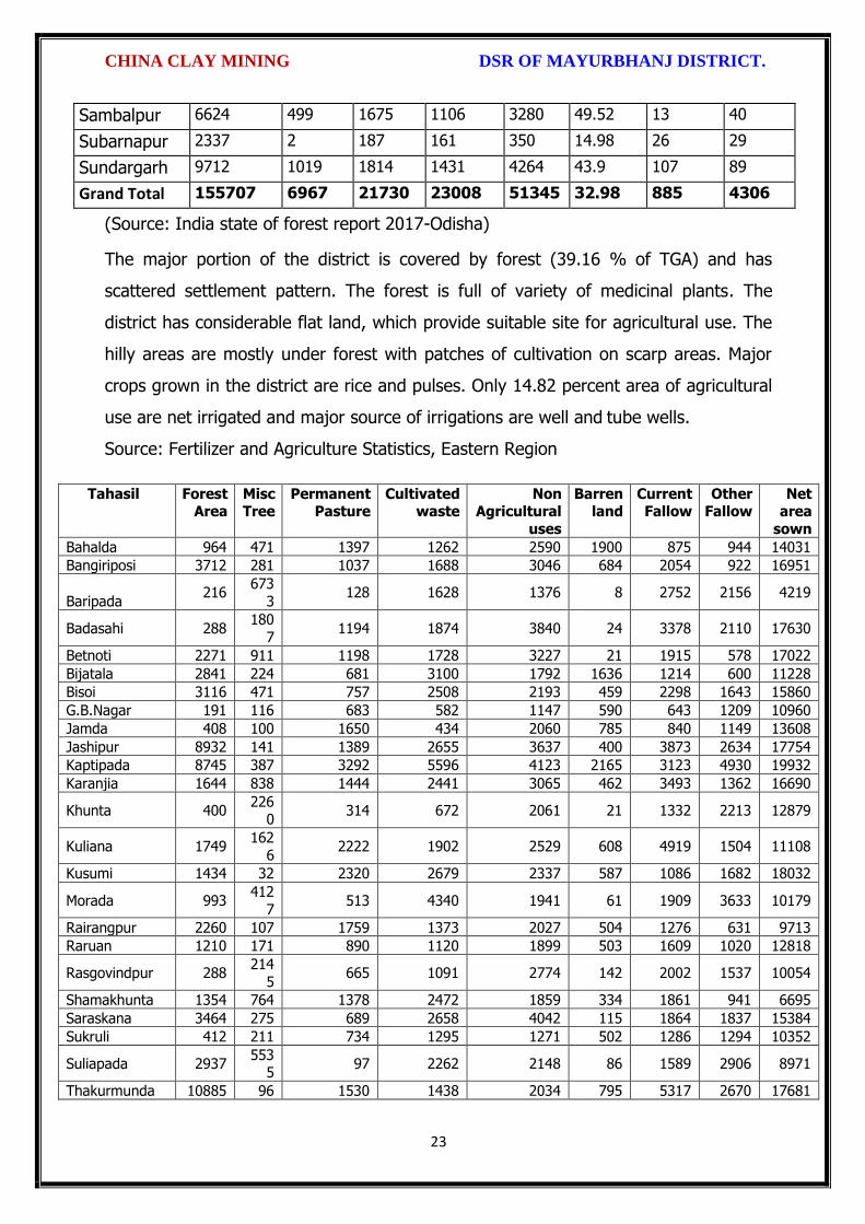
CHINA CLAY MINING DSR OF MAYURBHANJ DISTRICT.
23
Sambalpur 6624 499 1675 1106 3280 49.52 13 40
Subarnapur 2337 2 187 161 350 14.98 26 29
Sundargarh 9712 1019 1814 1431 4264 43.9 107 89
Grand Total 155707 6967 21730 23008 51345 32.98 885 4306
(Source: India state of forest report 2017-Odisha)
The major portion of the district is covered by forest (39.16 % of TGA) and has
scattered settlement pattern. The forest is full of variety of medicinal plants. The
district has considerable flat land, which provide suitable site for agricultural use. The
hilly areas are mostly under forest with patches of cultivation on scarp areas. Major
crops grown in the district are rice and pulses. Only 14.82 percent area of agricultural
use are net irrigated and major source of irrigations are well and tube wells.
Source: Fertilizer and Agriculture Statistics, Eastern Region
Tahasil Forest Area
Misc Tree
Permanent Pasture
Cultivated waste
Non Agricultural
uses
Barren land
Current Fallow
Other Fallow
Net area
sown
Bahalda 964 471 1397 1262 2590 1900 875 944 14031
Bangiriposi 3712 281 1037 1688 3046 684 2054 922 16951
Baripada 216
673
3 128 1628 1376 8 2752 2156 4219
Badasahi 288 180
7 1194 1874 3840 24 3378 2110 17630
Betnoti 2271 911 1198 1728 3227 21 1915 578 17022
Bijatala 2841 224 681 3100 1792 1636 1214 600 11228
Bisoi 3116 471 757 2508 2193 459 2298 1643 15860
G.B.Nagar 191 116 683 582 1147 590 643 1209 10960
Jamda 408 100 1650 434 2060 785 840 1149 13608
Jashipur 8932 141 1389 2655 3637 400 3873 2634 17754
Kaptipada 8745 387 3292 5596 4123 2165 3123 4930 19932
Karanjia 1644 838 1444 2441 3065 462 3493 1362 16690
Khunta 400 226
0 314 672 2061 21 1332 2213 12879
Kuliana 1749 162
6 2222 1902 2529 608 4919 1504 11108
Kusumi 1434 32 2320 2679 2337 587 1086 1682 18032
Morada 993 412
7 513 4340 1941 61 1909 3633 10179
Rairangpur 2260 107 1759 1373 2027 504 1276 631 9713
Raruan 1210 171 890 1120 1899 503 1609 1020 12818
Rasgovindpur 288 214
5 665 1091 2774 142 2002 1537 10054
Shamakhunta 1354 764 1378 2472 1859 334 1861 941 6695
Saraskana 3464 275 689 2658 4042 115 1864 1837 15384
Sukruli 412 211 734 1295 1271 502 1286 1294 10352
Suliapada 2937 553
5 97 2262 2148 86 1589 2906 8971
Thakurmunda 10885 96 1530 1438 2034 795 5317 2670 17681

CHINA CLAY MINING DSR OF MAYURBHANJ DISTRICT.
24
6.2 Agriculture Land:
Mayurbhanj is surrounded by no of forest areas as well as Rocky Mountains. People
used to cultivate Paddy in most parts of the hill slopes and in plain lands. Most of the
cultivators grow short duration local paddy in the un-bonded upland during Kharif
season. The crop suffers moisture stress at different stages due to inadequate rainfall.
The primary objective of Agriculture Department is increase of production as well as
productivity of major crops like paddy, groundnut, mustard, Mung, Biri & vegetables
which is widely covered in this District in both Kharif & Rabi season. Another key
objective is the all round development of the farming community of the District. The
Deputy Director of Agriculture is the head of office so far as agriculture is concerned &
he is the Principal Agriculture Officer of the District. Under him there are 5 District
Agriculture Officers & the block under them. As already pointed out, that agriculture is
the main livelihood of the people in Mayurbhanj District. It is therefore also
designated as the food bowl of Odisha. Rice is the principal crop grown in this district,
followed by other cereals, pulses, oilseeds, vegetables, spices and sugarcane. The
agricultural statistics for the district is shown in subsequent tables below:
Table – 3.6a: Crop Coverage Area of Mayurbhanj District, Odisha
Crop Khariff Rabi Annual TOTAL
Area (ha)
(% of Cropped
Area
Area (ha)
% of Cropped
Area
Area (ha)
Gross Cropped Area (ha)
% of Gross
Cropped Area
Rice 301.37 82.353% 3.80 4.015% --- 305.17 62.051%
Cereals 9.99 2.730% 2.17
2.293% --- 12.16 2.472%
Pulses 32.37 8.846% 36.20 38.255% --- 68.57 13.943%
Oilseeds 5.92 1.617% 28.30 29.906% --- 34.22 6.958%
Vegetables 12.39 3.386% 21.74 22.974% --- 34.13 6.940%
Fibres 2.43 0.664% --- 2.43 0.494% Spices 1.48 0.404% 2.42 2.557% --- 3.90 0.792%
Sugarcane --- --- 00 --- --- 00 ---
Tobacco --- --- 00 --- --- 00 ---
Fruits --- --- --- --- --- 31.23 6.350%
TOTAL 365.95 100.00% 94.63 100.00% --- 491.81 100.00%

CHINA CLAY MINING DSR OF MAYURBHANJ DISTRICT.
25
6.3 Horticulture Land:
The primary objective of Horticulture Department is increase of production as well as
productivity of major fruits like Mango, Guava, Citrus etc., which is widely covered in
this District. Another key objective is the all round development of the farming
community of the District. The Deputy Director of Horticulture is the head of office.
7.0 SURFACE WATER AND GROUND WATER SCENARIO OF THE DISTRICT
7.1 Hydrogeology
Distribution of Saline / fresh water aquifers:
The occurrence of fresh water aquifers in coastal tract of Mayurbhanj restricted by
two important factors‐ (i) Occurrence of hard rocks in the western side and (ii) Salinity
hazard problems in the eastern part. The water bearing formation of the area can be
divided into (a) areas underlain by fractured, fissured and consolidated basement rock
formations (b) areas underlain by recent unconsolidated alluvial formations.
(a) Consolidated Formation - These are most predominant rock types occurring in
the undulating plains of the district. Groundwater occurs under unconfined condition
in the shallow weathered zone and circulates through fractures and joints. The
thickness of the weathered zone varies from 3 to 35 m. Depth of open wells in these
formations varies from 5 to 14 m below ground level.
(b) Unconsolidated alluvial formations - The unconsolidated formations consists of
laterite and alluvium. Laterites at places are highly consolidated and used as building
stones. The laterites have high degree of effective porosity and form potential
aquifers commonly tapped in dug wells. The alluvium comprises an admixture of clay,
silt, sand and calcareous concretions in varying proportions. The coarse sediments like
sand and gravel form the main repository of ground water. Ground water occurs
under both unconfined condition in shallow aquifers and in confined condition in
deeper parts.

CHINA CLAY MINING DSR OF MAYURBHANJ DISTRICT.
26
7.2 Depth of water level:
The depth to water level map for pre and post monsoon periods 2011 are prepared
based on the ground water monitoring data of 77 Nos of National Hydrograph
Stations of C.G.W.B. monitored during the month of April and November 2006 are
presented below respectively. The pre and post monsoon depth to water levels in the
district range from 3.54 to 14.50 m below ground level and 1.39 to 8.20 m below
ground level respectively. It is observed that during pre monsoon about 75% of the
total areas show the water level varying between 5 to 10 m below ground level.
During post monsoon nearly 60% of the area has water levels within 2 to 5 m,
while the rest part has between 0 to 2 and 4 to 6 m below ground levels. In localized
part of Morada, Kaptipada and Thakurmunda the water level is > 5 mt.
Depth & categorization of ground water levels during pre monsoon period (April 2011)
of Mayurbhanj districts is presented below:

CHINA CLAY MINING DSR OF MAYURBHANJ DISTRICT.
27
Depth & categorization of ground water levels during pre monsoon period (November
2011) of Mayurbhanj districts is presented below:

CHINA CLAY MINING DSR OF MAYURBHANJ DISTRICT.
28
7.3 Ground Water Quality
The chemical quality of ground water in the district has been assessed on the basis of
chemical analysis of ground water samples collected during groundwater monitoring,
Hydrogeological surveys and groundwater exploration. The results of the chemical
analysis are presented in Table.
Table showing chemical constituents in aquifers
Constituent Shallow aquifer Deeper aquifer
pH 6.97 – 8.25 6.84 – 8.25
Sp. Conductance (micromohs/cm at 250 C)
53 – 974 92 – 867
TDS (mg/l) 58 – 1430 106 – 429

CHINA CLAY MINING DSR OF MAYURBHANJ DISTRICT.
29
Calcium (mg/l) 6 – 92 16 – 86
Magnesium (mg/l) 0.6 – 17 3.6 – 22
Sodium (mg/l) 1.6 – 100 3.5 – 168
Potassium (mg/l) 0.4 – 8 <1 --6.4
Bicarbonate (mg/l) 15 – 256 49 – 366
Chloride (mg/l) 7 – 238 5.3 – 85
Sulphate (mg/l) 0.1 – 9 <1 – 82
Nitrate (mg/l) <0.01 – 53 0.1 – 78
Fluoride (mg/l) 0.08 – 20.3 0.21 – 0.61
Total hardness as calcium carbonate
10 – 245 35 - 285
7.4 Ground Water Development
In the rural areas the entire water supply is dependent on ground water. Ground
water development is mainly carried out in the district through dug wells and Hand
pumps. In general dug wells are of 2 m diameter and the depth ranges between 8 to
15 m depending on the thickness of the weathered zone, tapping the shallow aquifer
in the weathered zone and uppermost slice of the basement. Large number of dug
wells used for drinking water is under private ownership for which there is no reliable
data. Over the years Mark II/ Mark III hand pumps are being drilled in large numbers
for ground water development. These hand pumps have the following two major
advantages i) less susceptible to contamination from surface sources and ii) tap
fractures between 20-60m depth which have been found to be less affected by
seasonal water level fluctuation and thus have lesser chances of failure even during
extreme summer. Over all the present level of ground water development is only
27.21 percent in the district with the maximum in Badasahi Block viz. 64.65% and
minimum in Bijatala Block. Block wise development figure indicate that all the blocks
come under the white categories. Thus there is ample scope for development of
groundwater in the district to augment irrigation potentials through suitable ground
water abstraction structure
7.5 Ground Water Related Issue and Problems
Some of key ground water related issues are
I. Locating suitable sites for bore wells
II. Suitable design of dug wells and hand pumps
III. Taking up artificial recharge projects to augment the resource availability in

CHINA CLAY MINING DSR OF MAYURBHANJ DISTRICT.
30
Mayurbhanj district.
IV. Optimal development of irrigation potential by developing ground water available
for future uses.
V. Creating public awareness for conserving ground water through awareness
camps, NGO’s and mass media.
7.6 Mass Awareness Campaign (MAP) & Water Management Training
Programme (WMTP) by CGWB
NIL
7.7 Area Notified by Cgwb/Sgwa
None
7.8 RECOMMENDATIONS:
1) Intensive groundwater exploration should be taken up to delineate deeper
potential water saturated fracture zones and to compute aquifer parameter.
2) Large scale planning for ground water development should be preceded by
intensive hydrogeological and geophysical surveys aided by remote sensing
studies.
3) Effective measures may be taken to conserve the surface run off by contour
bonding at suitable sites. Also proper maintenance of reservoir, tanks and spring
channels by periodical disiltation should be carried out.
4) Existing dug-wells should be deepened to tap the maximum saturated thickness of
the weathered mantle or vertical bores may be drilled through the bottom to
enhance the well yield.
5) Energy station of wells already constructed should be stepped up to ensure
optimal utilization of the irrigation potential already created.
6) The farmers should be educated through agricultural extension services fro
adopting suitable cropping pattern for optimal utilization of available groundwater
resources.
7) Programmes for artificial recharge may also be taken up for augmentation of
groundwater through construction of percolation tanks, subsurface dykes, and
check dams and through contour bonding etc.
8) An intensive network of groundwater monitoring stations are required to be

CHINA CLAY MINING DSR OF MAYURBHANJ DISTRICT.
31
established in the command areas of irrigation projects to monitor the changes in
groundwater regime consequent on application of surface water irrigation.
8.0 RAINFALL OF THE DISTRICT AND CLIMATE CONDITION
8.1 Month wise rainfall:
The driest month is November, with 3 mm of rain. There is on average 0 mm of
precipitation in December. In July, the precipitation reaches its peak, with an average
of 324 mm. May is the warmest month of the year. The temperature in May averages
32.3 °C. January has the lowest average temperature of the year. It is 16.5 °C.
Year 2016 2017 2018 Average
Sl. No. Month (mm) (mm) (mm) (mm)
1 Jan 9.23 2.71 0.00 3.98
2 Feb 52.61 0.00 0.04 17.55
3 Mar 12.29 44.87 0.72 19.29
4 Apr 22.38 23.36 172.10 72.61
5 May 118.73 139.31 125.30 127.78
6 Jun 195.46 169.39 208.83 191.22
7 Jul 245.28 385.31 300.05 310.21
8 Aug 351.25 291.03 371.30 337.86
9 Sep 285.27 170.11 285.17 246.85
10 Oct 85.39 189.09 154.08 142.85
11 Nov 12.10 34.79 0.00 15.63
12 Dec 0.00 1.80 36.69 12.83
Total 1389.99 1451.77 1654.28 1498.68
Source: Indian Meteorological Department
The Indian Meteorological Department, Bhubaneswar, vide letter No. BBS/RMC/CS-
312, dated 18th January, 2016 has provided the period of Rainy Season viz. Normal
dates of Onset and Withdrawal of South West Monsoon over India as state-wise. The
duration for the period is 10th June to 15th October.
8.2 Climate
The climate in Mayurbhanj is warm and temperate. In winter, there is much less
rainfall in Mayurbhanj than in summer. The general climate of the district is
characterized by oppressive heat in summer, severe cold in winter with high humidity
throughout the year. The rainfall distribution is equal during the monsoon period. The
period from June to October is the rainy season and the district experiences it from
the southwest monsoon. May is the hottest month when the mean daily maximum

CHINA CLAY MINING DSR OF MAYURBHANJ DISTRICT.
32
temperature rises up to 47º Celsius. The Köppen-Geiger climate classification is Cwa &
as per they the average temperature in Mayurbhanj is 24.7 °C. The temperature in
May averages 32.3 °C. January has the lowest average temperature of the year, it is
16.5 °C. There is a difference of 321 mm of precipitation between the driest and
wettest months. During the year, the average temperatures vary by 15.8 °C., when
the mean daily minimum temperature dips to 4º Celsius. The higher reaches of the
Similipal experiences frosting during the peak of winter.
9.0 DETAILS OF MINING LEASE OF CHINA CLAY IN THE DISTRICT
9.1 List of Mines is operation in the district:
Attached as Annexure- F
9.2 List of Mines is not operation in the district:
Attached as Annexure- F

CHINA CLAY MINING DSR OF MAYURBHANJ DISTRICT.
33
10. DETAIL OF ROYALTY OR REVENUE RECEIVED IN LAST THREE YEARS:
Sl.
No.
Name of the Mining Circle
2016-17 2017-18 2018-19 Total in
tonne
1 Baripada Nil Nil Nil Nil
Total Nil Nil Nil Nil
11. DETAIL OF PRODUCTION OF MINOR MINERALS IN LAST THREE YEARS:
Sl.
No.
Name of the Mining Circle
2016-17 2017-18 2018-19 Total in
tonne
1 Baripada Nil Nil Nil Nil
Total Nil Nil Nil Nil
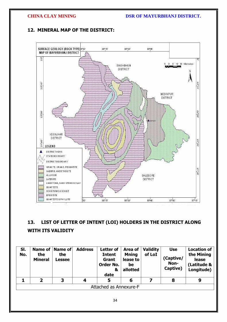
CHINA CLAY MINING DSR OF MAYURBHANJ DISTRICT.
34
12. MINERAL MAP OF THE DISTRICT:
13. LIST OF LETTER OF INTENT (LOI) HOLDERS IN THE DISTRICT ALONG
WITH ITS VALIDITY
Sl. No.
Name of the
Mineral
Name of the
Lessee
Address Letter of Intent Grant
Order No. &
date
Area of Mning
lease to be
allotted
Validity of LoI
Use
(Captive/ Non-
Captive)
Location of the Mining
lease (Latitude & Longitude)
1 2 3 4 5 6 7 8 9
Attached as Annexure-F

CHINA CLAY MINING DSR OF MAYURBHANJ DISTRICT.
35
14. TOTAL MINERAL RESERVE AVAILABLE IN THE DISTRICT
Total mineral reserve of China clay is 18075738 tonne which may increase after detail
investigation as per details below.
(i) Blocks were identified based on geological studies through field observation.
(ii) Mineable resource was calculated by considering detail prospecting.
(iii) Area calculated as per GPS co-ordinates and information obtained from local
people. Land detail need to be verified from revenue record.
(iv) Since this is an interim report, as per the present requirement of minerals, more
such blocks need to be identified and the data should be updated periodically, after
certain intervals to update the data bank of DSR.
Sl. No.
Name of the Mining Circle
Mineral Resources in tonne.
Mineable Reserve in tonne.
1 Baripada 18075738 15074248
Total 18075738 15074248
Summary of Identified Mineral Potential:
Sl.
No.
Name
of the
mineral
Name
of the
lessee
Address and
contact No. of
the lessee
Letter of
Intent
Grant
Order
No. and
date
Area of
mining
lease to
be
allotted
Validity of LoI
Use
(Captive/ Non- Captive
Location of the Mining lease (Latitude & Longitude)
1 2 3 4 5 6 7
Attached as Annexure-F
15. QUALITY/GRADE OF MINERAL AVAILABLE IN THE DISTRICT:
Rocks and Minerals found in Mayurbhanj District:-
The district is endowed with various types of mineral resources like Iron ore, China
Clay, Quartz; Soap stone, Granite, Manganese, etc. Due to presence of huge
mineral resources, mining activities have been undertaken in a big scale. Bahalda,
Jashipur, Karanjia, Koshorpur, Bisoi, Gorumahisani and Rairangpur are the places in
the district having deposits of the above mineral products. The availability of
mineral deposits is given in the table below. The district’s mineral deposits have not
been utilized to maximum extent for industrial purpose. Some of the items like

CHINA CLAY MINING DSR OF MAYURBHANJ DISTRICT.
36
China clay, Soap stone, Asbestos, etc. can be used in small scale sector. So the
available resources of the district need harnessing properly for industrial and
productive use. China clay deposits of the district are very much suitable for various
industrial uses.
16. USE OF MINERAL
Uses of China clay:-
Kaolin, also called china clay, soft white clay that is an essential ingredient in the
manufacture of china and porcelain and is widely used in the making of paper, rubber,
paint, and many other products. Kaolin is named after the hill in China (Kao-ling) from
which it was mined for centuries. In its natural state kaolin is a white, soft powder
consisting principally of the mineral kaolinite, which, under the electron microscope, is
seen to consist of roughly hexagonal, platy crystals ranging in size from about 0.1
micrometer to 10 micrometers or even larger. Kaolin as found in nature usually
contains varying amounts of other minerals such as muscovite, quartz and feldspar. In
addition, crude kaolin is frequently stained yellow by iron hydroxide pigments. It is
often necessary to bleach the clay chemically to remove the iron pigment and to wash
it with water to remove the other minerals in order to prepare kaolin for commercial
use. When kaolin is mixed with water in the range of 20 to 35 percent, it becomes
plastic (i.e., it can be molded under pressure). Approximately 40 percent of the kaolin
produced is used in the filling and coating of paper. In filling, the kaolin is mixed with
the cellulose fibre and forms an integral part of the paper sheet to give it body,
colour, opacity, and printability. In coating, the kaolin is plated along with an adhesive
on the paper’s surface to give gloss, colour, high opacity, and greater printability.
Kaolin is used extensively in the ceramic industry, where its high fusion temperature
and white burning characteristics makes it particularly suitable for the manufacture
of white ware (china), porcelain, and refractories. The absence of any iron, alkalies, or
alkaline earths in the molecular structure of kaolinite confers upon it these desirable
ceramic properties. In the manufacture of whiteware the kaolin is usually mixed with
approximately equal amounts of silica and feldspar and a somewhat smaller amount
of a plastic light-burning clay known as ball clay. Kaolin is generally used alone in the
manufacture of refractories.
Substantial tonnages of kaolin are used for filling rubber to improve its mechanical

CHINA CLAY MINING DSR OF MAYURBHANJ DISTRICT.
37
strength and resistance to abrasion. For this purpose, the clay used must be
extremely pure kaolinite and exceedingly fine grained. Kaolin is also used as an
extender and flattening agent in paints. It is frequently used in adhesives for paper to
control the penetration into the paper. Kaolin is an important ingredient in ink, organic
plastics, some cosmetics, and many other products where it’s very fine particle size,
whiteness, chemical inertness, and absorption properties give it particular value.
17. DEMAND AND SUPPLY OF THE MINERAL IN THE LAST THREE YEARS:
As such there are huge infrastructural and industrial activities are coming up by State
govt., Govt. of India & PSUs under “Make in India” programme. The main raw
minerals for the above activities and considering the last three years actual
productions with respect to the requirement of the state has a huge gap. It is
proposed to start the production from larger block/area to at least double the
production of the district which will enhance the revenue of the district and also
support the livelihood of the local people.
Sl. No. Name of the Mining Circle
Financial Year
China Clay in tonne
1
Baripada 2016-17 Nil
2017-18 Nil
2018-19 Nil
Total Nil
18. MAP OF EXISTING MINING LEASES IN THE DISTRICT:
Enclosed as Plate-I
19. DETAILS OF THE AREA OF WHERE THERE IS A CLUSTER OF MINING
LEASE VIZ. NUMBER OF MINING LEASES, LOCATION (LATITUDE AND
LONGITUDE)
Currently there is no cluster of china clay mining lease in the district. However, it is
proposed to consider the cluster of mining lease while planning for new lease area in
coming years.

CHINA CLAY MINING DSR OF MAYURBHANJ DISTRICT.
38
20. DETAILS OF ECO-SENSITIVE AREA, IF ANY, IN THE DISTRICT:
Eco sensitive zone of Similipal wild life sanctuary is located within the district.
21. IMPACTS OF MINING ON ENVIRONMENT:
The most important environmental impact of mining projects is:-
Transportation sources:
Transportation sources of air pollutants include heavy vehicles used in excavation
operations, cars that transport personnel at the mining site, and trucks that transport
mining materials. The level of polluting emissions from these sources depends on the
fuel and conditions of the equipment. Even though individual emissions can be
relatively small, collectively these emissions can be of real concern. In addition,
mobile sources are a major source of particulate matter, carbon monoxide, and volatile
organic compounds that contribute significantly to the formation of ground-level ozone
Fugitive emissions:
Common sources of fugitive emissions include: storage and handling of materials;
mine processing; fugitive dust, blasting, construction activities, and roadways
associated with mining activities; leach pads, and tailing piles and ponds; and waste
rock piles. Sources and characteristics of fugitive emissions dust in mining operations
vary in each case, as do their impacts. Impacts are difficult to predict and calculate
but should be considered since they could be a significant source of hazardous air
pollutants.
Noise and vibration:
Noise pollution associated with mining may include noise from vehicle engines,
loading and unloading of rock into steel dumpers, chutes, power generation, and
other sources. Cumulative impacts of shoveling, ripping, drilling, blasting, transport,
crushing, grinding, and stock-piling can significantly affect wildlife and nearby
residents.
Vibrations are associated with many types of equipment used in mining operations,
but blasting is considered the major source. Vibration has affected the stability of
infrastructures, buildings, and homes of people living near large-scale open-pit mining
operations. According to a study commissioned by the European Union in 2000:

CHINA CLAY MINING DSR OF MAYURBHANJ DISTRICT.
39
“Shocks and vibrations as a result of blasting in connection with mining can lead to
noise, dust and collapse of structures in surrounding inhabited areas. The animal life,
on which the local population may depend, might also be disturbed.”
22. REMEDIAL MEASURES TO MITIGATE THE IMPACT OF MINING ON THE
ENVIRONMENT:
1. Following are the remedial measures to mitigate the in Water sprinkling on haul
road, loading and unloading points.
2. Plantation along the safety zone and dump area.
3. Providing dust masks to workers.
4. Regular monitoring of ambient air quality.
5. Provision of air conditioned cabin of Excavators and Dumpers.
6. Regular and proper maintenance of working equipments.
7. Periodic medical examination of the workers and organize medical camp in the area.
8. Use Milli Second Delay Detonator in blasting operation.
9. Provisions of ear plug to the workers.
10. Regular training programme to the mines workers and operators.
23. RECLAMATION OF MINED OUT AREA
Necessity of Reclamation & Rehabilitation:
Exponential growth in mineral production since 1980.
Mining activities causes physical, chemical, biological and socio-economic changes in
the area.
Surface mining activities disturb the original land profile.
In India, mineral production comes mostly from opencast mines & hence land
degradation problems are of serious concern.
An intricate, in-depth and site-specified techniques involving integrated approach is
necessary.
Reclamation has three vital roles:
i. Reclamation – Reclamation means return the mined-out land with useful life. It
implies restoring the land to a form and productivity that is useful and inconformity
with a prior land use. Reclamation always may not be a single- phase operation.

CHINA CLAY MINING DSR OF MAYURBHANJ DISTRICT.
40
ii. Rehabilitation – Rehabilitation is to bring batch the degraded land to a normal
stage by a special treatment. It is a process of taking some mitigation measures for
disturbed environmental condition created through mining activities.
iii. Restoration – Restoration is the process of returning the mined out land being
fit to an acceptable environmental condition. However, the general acceptable
meaning of the term is bringing the disturbed land to its original form. Restoration is
often used to indicate that biological properties of soil are put back to what they were.
This is a rate phenomenon.
iv. When active mining ceases, mine facilities and the site are reclaimed and closed.
The goal of mine site reclamation and closure should always be to return the site to a
condition that most resembles the pre-mining condition. Mines that are notorious for
their immense impact on the environment often made impacts only during the closure
phase, when active mining operations ceased. These impacts can persist for decades
and even centuries.
Mine reclamation and closure plans must describe in sufficient detail how the mining
company will restore the site to a condition that most resembles pre-mining
environmental quality; how it will prevent – in perpetuity – the release of toxic
contaminants from various mine facilities (such as abandoned open pits and tailings
impoundments); and how funds will be set aside to insure that the costs of
reclamation and closure will be paid for.
Proposed future land use after reclamation:
a. Forestry, b. Recreation, c. Water Reservoir, d. Crop Land,
e. residential/Commercial, f. Fish & wildlife Habitat, g. Undeveloped Land,
h. Grazing/Pasture Land
Statutory requirement:
As per the Mineral Conservation Development Rule, 2017, the following rules must be
bare in mind by the mine owner/agent/manager, which is a part of reclamation
activities –
Rule 22, Mine Closure Plan
Rule 23, Submission of Progressive Mine Closure Plan Rule 24, Submission of Final
Mine Closure Plan
Rule 26, Responsibility of holder of mining lease Rule 27, Financial Assurance

CHINA CLAY MINING DSR OF MAYURBHANJ DISTRICT.
41
Rule 35, Sustainable Mining
24. RISK ASSESSMENT AND DISASTER MANAGEMENT PLAN:
Mining activity because of the very nature of the operation, complexity of the
systems, procedures and methods always involves some amount of hazards. Hazard
identification and risk analysis is carried for identification of undesirable events that
can leads to a hazard, the analysis of hazard mechanism by which this undesirable
event could occur and usually the estimation of extent, magnitude and likelihood of
harmful effects. The activities which can cause high risk related to face stability and
the person blasting the shots. It was observed that on a working face of the mine,
there were large cracks and unsupported rocks were present, which can lead to a
serious hazard and injure workers engaged in loading operation and machineries
because of rock falls or slides. This type of condition turn out because improper
dressing of the bench and improper supervision. To avoid the hazards due to fall of
rocks the face must be examined, made suitable for working and the remedial
measures must be taken to make it safe if there is any doubt that a collapse could
take place. Working of the face should be in the direction taking into account the
geology of the area such that face and quarry side remain stable. Another major risk
identified in mines is due to the firing of explosive by an unqualified person. In the
mines there is problem of fly rocks and the village is located close to the mine and so
it is rated high as it can affect may people. Explosives by nature have the potential for
the most serious and catastrophic accident. Planning of round of shots, holes correctly
drilled, direction logged, weight of explosive suitable for good fragmentation are the
few of the steps necessary to ensure its safe use and if the shots are not properly
designed can result in misfires, early ignition and flying rocks. No person is allowed to
use explosives without being properly trained in its handling. In the mine a large
numbers of heavy vehicles were in operation and the roads were not proper for
haulage purpose. The haulage roads were not even and were not wide enough for the
crossing purpose and hence the chances of hazards are very high. The main hazards
arising from the use large earth moving vehicles are incompetent drivers, brake
failure, lack of all-around visibility from the driver position, vehicle movements
particularly reversing, roll over, and maintenance. Those most at risk are the driver
and pedestrians likely to be struck by the vehicle, and drivers of smaller vehicles,

CHINA CLAY MINING DSR OF MAYURBHANJ DISTRICT.
42
which cannot be seen from the cabs of large vehicles. Edge protection is always
necessary to prevent inadvertent movement over the edge of roadway or a bench.
Seatbelt will protect driver in case of roll. Good maintenance and regular testing are
necessary to reduce the possibility of brake failure. Access to the vehicles should
always be restricted to those people necessary for the work in hand. The use of
personal protective equipment and proper arrangements is essential to check if the
person is wearing protective equipment or not. The personal protective equipment
includes helmet, non-skid safety boots, safety glasses, earmuffs etc. The required
personal protective equipment should be provided and used in a manner that protects
the individual from injury. Few minor injuries which can be prevented are slip, trip, or
fall hazards; hazards due to rock falls and collapse of unstable rocks, atmosphere
containing toxic or combustible gases; protects from chemical or hazardous material
etc. A disaster management plan should be prepared for taking care of for any
disaster. Other risks which are included in this category are noise, as it occurs and it
can lead to permanent disability. There are problems related to road traffic in and out
issuers; inappropriate exposure of moving machines; mechanical failure and because
of large number of moving trucks and dumpers there is large quantity of dust present
in roadways which affects the operators and can lead to accidents causing injury.
They are in acceptable range because of precautions measures taken but no step is
taken it can cause hazard hence steps should be taken to reduce the hazards such as
for dust suppression system should be installed. Other problems like occurrence of
lots of mosquitoes in the area due to unhygienic conditions which affect the human
health causing malaria, dengue etc. and causing a person to be hospitalized.
Disaster in the mines like fires, explosions, entrapments, and inundations can occur
any time, so emergency preparedness is a must. The Disaster management plan and
risk assessment in the mines will include all sorts of above mentioned emergency and
the extent that this plan will be implemented will depend on the nature and scope of
the emergency. The basic purpose of Disaster management plan and risk assessment
to ensure that mine rescue and recovery activities are conducted safely for rescuer
and survivors. According to MMR act 1961 a standard operating procedure should be
drawn for involvement different category of staff and officers. The SOP should be

CHINA CLAY MINING DSR OF MAYURBHANJ DISTRICT.
43
updated periodically to reduce the chaos and response to the emergency should be
quick and smooth. The responsible person should be familiar with his responsibility
during the mock drills. One or two standby should be there to replace the person in
Emergency situation. Rescue operations should not include the survivors for any
assistance.
First Information of Disaster / Emergency should go to the attendance clerk on duty.
Duties of attendance Clerk (Emergency Siren) the attendance clerk or other
designated person should on getting information of major accident, sound a hooter or
a siren immediately declaring a state of emergency at the mine and then to contact
the manager and on his advice to call key personnel using the information listed in the
Emergency Organization Chart. It is important that all telephone calls are recorded in
a telephone log book. Duties of Other Officials should be displayed and handed over
to all concerned. Copy the same should be kept at Manager’s Office for ready
reference. Establishment of Control Room at Unit Level, Area Level and Company
Level is essential. Control Room should keep the contact information about –
Company Manager
Company owner/ Administrative officer.
District Administration
Govt. Hospitals in Nearby Localities,
Private Nursing Homes of Localities
Attendance roaster and duty charge register should be properly maintained so the
record of missing people can be obtained.
25. DETAILS OF THE OCCUPATIONAL HEALTH ISSUE IN THE DISTRICT:
The persons employed in the mines are exposed to a number of hazards at work
which adversely affect their health. Some of the important ones are dust, noise, heat,
humidity, vibration etc. In recent times, there has been increasing awareness among
mining industry and the workers about occupational diseases like Pneumoconiosis,
Silicosis, Tuberculosis, Hearing Impairment etc. caused by exposure to health hazards
at work. Almost all occupational diseases can be prevented by adopting proper

CHINA CLAY MINING DSR OF MAYURBHANJ DISTRICT.
44
occupational health measures and engineering control on airborne dust pollution at
workplace. Occupational Diseases in mines or industry is required to conduct medical
examinations and health surveillance of workers as per the provisions of Mines Act.
The present efforts of mines management are concentrated on detection of silicosis,
Pneumoconiosis and other notified diseases. The essential features of health
surveillance programme required to be carried out in mines are:
(a) Initial Medical Examination of persons to be conducted at the time of
appointment.
(b) Periodic Medical Examination or General physical examination to be conducted
once in every year.
(c) Maintenance of medical records and health services till the person is in service.
(d) The Details of Tuberculosis cases in last 5 years is given below
RNTCP Activities from 2014 to 2018
Year Projected Population
No of Sputum Examined
Sputum Examine
d per Lakh/Qr
No of
Sputum Positive
Sputum Positive
%
Total Case put on
DOTS/No of
TB cases
Child DOTS out of Total DOTS
Case detectin
per Lakh/Yr
Sputum
Conversion Rate
NSP Cure Rate
NSP Death Rate
(in Lakh) Norm- 150
Norm-8-15 %
Norm-170 /L/Y
Norm-90 %
Norm-90%
Norm < 5%
2014 26.01 16848 161.9 2825 16.8% 4883 103 187.7 90.2% 89.0% 7.4%
2015 26.30 18118 172.2 2836 15.7% 4831 123 183.7 90.5% 89.0% 6.7%
2016 26.59 20060 188.6 2975 14.8% 5171 119 194.5 95.0% 90.9% 6.5%
2017 26.88 31035 289.4 3152 11.4% 5127 111 190.7 94.0% 91.6% 5.5%
2018 27.18 21273 195.6 2853 13.4% 4894 95 173.4 95.3% 92.7% 6.4%
26. PLANTATION GREEN BELT DEVELOPMENT IN RESPECT OF LEASE
ALREADY GRANTED IN THE DISTRICT:
During mining operation green belt development through plantation is most important
for environment safe guard, which should be supervision by mining department.
Different type of species should be planted near lease periphery to keep environment
clean at post mining period through reclamation. Where specific usefulness of land

CHINA CLAY MINING DSR OF MAYURBHANJ DISTRICT.
45
could be decided, a forestation is normally planned through the site could have been
considered for better possibilities of land use.
27. CONCLUSION:
Since it is an interim report, to meet the requirement of minerals in the present
scenario, it is proposed to identify such potential areas at certain interval and get the
data bank of DSR to be updated. The insitu mining activity in any area is on one hand
bring revenue and employment (Direct and indirect) and on other hand if not done
properly potential pollution and ecological imbalance increases, the ability of the
ecosystem can also be reduced. Particulate matter transported by the wind as a result
of excavations, blasting, transportation of materials, heavy equipments used raise
these particulate levels; and Gas emissions from the combustion of fuels in stationary
and mobile sources, explosions, and mineral processing. All these activities indirectly
affected the biodiversity of area. Larger potential and smaller areas have been
identified in Mayurbhanj district on the basis of geological study carried out during
field observation, which can be considered for mining concession after all the
parameters for statutory clearances are verified by consulting with concerned
authorities.

CHINA CLAY MINING DSR OF MAYURBHANJ DISTRICT.
46
Plate No.-I

\
\
\
Y
Y
i'
\
f,
\
\
!
\
I_
\
CHINA CLAY MINING DSR OF MAYURBHANJ DISTRICT.
The District Suruey Repoft for China Clay Mining (Minor Mineral) in
respect of Mayurbhanj District prepared in accordance with Appendix-X, Para -7 (iii)
(a) of S"O, 3611 (E) Dt" 25.07.2018 of Ministry of Environment, Forest and Climate
Change, New Delhi is approved for final publication in the district website.
\o\t6qs. H"K.Sahu,
Prof in Zoology, NOU,-cum-Member, DEIAA, Mayurbhanj
Sri S.Mall I.F.S,DFO-cum-Member,DEIAA, Mayurbhanj
Sri Di rida, I.A.SSDM, Sadar-cum -Member Secretary
DEIAA, Mayurbhanj
tSri Vin rd
Collector & DM-cu Chairman, DEIAAMayurbhanj (Odisha)
47
$iI
\

Fro
m
To
Fro
m
To
1 2 3 4 5 6 7 8 9 10 11 12 13 14 15 16 17 18 19
1 Chinaclay
Ajit
Samantrahy, Ramachandrapur
112.106
Vill-
Ramchandrapur
under Karanjia
Tahasil
04
.05
.19
88
03
.05
.20
08
-
-
-
Lapsed vide Lr.
No.9204/SM,
Dt.15.09.2015.
Non-Captive - Karanjia Open Cast
2 ChinaclayBibhudatta
Sahu
Kumbharapandug
andi
15.532
Vill-
Kumbharapanduga
ndi 02
.03
.20
02
01
.03
.20
22
-
-
-
Lapsed vide Lr.
No.12395/SM,
Dt.21.12.2015.
Non-Captive - Jashipur Open Cast
3 Chinaclay D.C.Dagara Hizli
Granted vide
Proceeding No.
2989/ 20.03.1991
91.52
Vill- Hizli, Jaldiha
under Bamanghaty
Sub division. 18
.05
.19
91
17
.05
.20
11
-
-
01
.03
.19
92
Lapsed vide Lr.
No.9736/SM,
Dt.30.09.2015.
Non-Captive -
Lat- 201°19'30"N -
22°19'45"N
Long- 86°07'58"E-
86°08'15"E
Bisoi Open Cast 1981863 1783677
4 Chinaclay K.P.Singhania
At- P-195,
Ramakrishna
Samadhi Road,
Kakurgachhi,
Kolkata-700054,
West Bengal
119.446
Vill- Chanchabani
25
.04
.19
77
24
.04
.19
87
25
.04
.19
87
24
.04
.19
97
-
Suspended vide
Lr.No.4552, Dt.
27.10.09
Non-Captive -
Lat- 21°47'54"N -
21°48'35"N
Long- 86°00'22"E-
86°01'29"E
Karanjia Open Cast 514800 191100
5 ChinaclayM/s Arun
UdyogJashipur
Granted vide
Proceeding No.
9705/04 Oct 1996
121.567
Vill- Jashipur
-
-
10
.08
.19
83
09
.08
.20
03
-
Lapsed vide Lr.
No.8391/SM,
Dt.31.08.2015.
Non-Captive -
Lat- 21°56'51"N -
21°57'40"N
Long- 86°03'12"E-
86°04'10"E
Jashipur Open Cast 677746 544626
Non-Working Leases
Method of
Mining
(Open
cast/
Under
Ground)
Geological
Reserve
(MT/
Cums)
Mineable
Reserve
(MT/
Cums)
Date of
Commenc
ement of
mining
operation
Status (Working/ Non-
working/ temp.
Working for dispatch
etc.
Captive/ Non-
captive
Obtained
environment
al clearance
(Yes/no). If
Yes, Letter
No. with date
of EC
Location of Mining
Lease (Latitude &
Longitude)
Name of
Tahasil
Annuxure F
SPECIFIED MINOR MINERALS (CHINA CLAY)
Sl
No
Name of
Minerals
Name of
Lessees
Address and
Contact No. of
lessee
Mining Lease Grant
Order No. & Date
Area of Mining
Lease (Ha.) with
village Khata No.,
Plot No. & Kisam
Period of
Mining
Lease
(Initial)
Period of
Mining
Lease
(1st/2nd
Renewal)

1 2 3 4 5 6 7 8 9 10 11 12 13 14 15 16 17 18 19
6 Chinaclay
M/s J.M. &
M.(P) Ltd.,
Jharpada,
Cuttack Road,
BBSR-751007
C. No.- 0671-
2575972
Kadadiha
Granted vide
Proceeding No.
997/SM,BBSR, dt.
29.01.1996
367.058
Vill-
Khandabandha,
Kudarbisida,
Kadadiha & Rugudi
04
.02
.19
75
03
.02
.19
95
03
.02
.20
15
-
Suspended Non-Captive Not obtained
Lat- 21°55'32"N -
21°56'43"N
Long- 85°59'00"E-
86°00'54"E
Jashipur Open Cast 14901329 12554845
7 Chinaclay
M/s Mayur
Electro
Potteries (P)
Ltd.
Jamda154.006
Vill- Jamda
18
.12
.19
74
17
.12
.19
94
Lapsing proposal sent
vide Lr. No. 2888, Dt.
20.07.06 &
suspended vide Lr.
No.478, Dt. 16.02.10
Non-Captive Jashipur Open Cast
8 Chinaclay P.D.Agrawal Khaprasahi
43.674
Vill- Khaprasahi
28
.07
.20
00
27
.07
.20
20
Lapsed vide Lr.
No.12440/SM,
Dt.21.12.2015.
Non-Captive Sukruli Open Cast
9 Chinaclay S.K.AllauddinGadapalasa
Block A
24.352
Vill- Gadapalasa
21
.08
.19
98
20
.08
.20
18
Lapsed vide Lr.
No.12410/SM,
Dt.21.12.2015.
Non-Captive Jashipur Open Cast
10 Chinaclay S.K.AllauddinGadapalasa
Block B
26.442
Vill- Gadapalasa
21
.08
.19
98
20
.08
.20
18
Lapsed vide Lr.
No.12405/SM,
Dt.21.12.2015.
Non-Captive Jashipur Open Cast
11 Chinaclay S.K.AllauddinGadapalasa
Block C
18.451
Vill- Gadapalasa
21
.08
.19
98
20
.08
.20
18
Lapsed vide Lr.
No.12425/SM,
Dt.21.12.2015.
Non-Captive Jashipur Open Cast
12 China Clay OMC Ltd Dumuria
142.7
Vill- Dumuria,
Dhalabani,
Sanabadaposi &
Madrangajodi
09
.08
.19
78
08
.08
.19
98 Rejected RML
application Possesion
has been taken over
on dt.24.04.2015.
Non-Captive Karanjia Open Cast

DISTRICT SURVEY REPORT (DSR) OF
MAYURBHANJ DISTRICT, ODISHA. FOR
QUARTZ & QUARTZITE
(FOR PLANNING & EXPLOITING OF MINOR MINERAL RESOURCES)
As per Notification No. S.O. 3611(E) New Delhi
dated 25th July 2018 of
Ministry of Environment, Forest & Climate Change
(MoEF & CC)
( Prepared by DEIAA, Mayurbhanj, Odisha )

QUARTZ & QUARTZITE MINING DSR OF MAYURBHANJ DISTRICT.
1
CONTENT
CH.
NO.
DESCRIPTION PAGE
NO.
Preamble
1 Introduction 4
1.1 Location and Geographical Area 4
1.2 Administrative Units 5
1.3 Connectivity 7
2 Overview of Mining Activity in the District 10
3 General Profile of the District 11
3.1 Demography 11
4 Geology of the District 11
4.1 Physiography & Geomorphology 12
4.2 Stratigraphy. 13
4.3 Mineral Resources. 14
4.4 Soil 17
5 Drainage of Irrigation Pattern 17
5.1 River System 19
6 Land Utilization Pattern in the District 21
6.1 Forest and non forest land. 21
6.2 Agricultural land. 24
6.3 Horticultural land. 25
7 Surface Water and Ground Water Scenario of the District 25
7.1 Hydrogeology. 25
7.2 Depth to water level. 26
7.3 Ground Water Quality. 28
7.4 Ground Water Development. 29
7.5 Ground water related issues & problems. 29
7.6 Mass Awareness Campaign on Water Management
Training Programme by CGWB
30
7.7 Area Notified By CGWB/SGWA 30
7.8 Recommendations 30
8 Rainfall of the District and Climate Condition 31
8.1 Month Wise rainfall. 31
8.2 Climate. 31
9 Details of Mining Lease in the District 32
9.1 List of Mines in operation in the district Annexure-B
9.2 List of Mines not in operation in the district Annexure-B
10 Detail of Royalty or Revenue received in last 3 years 33
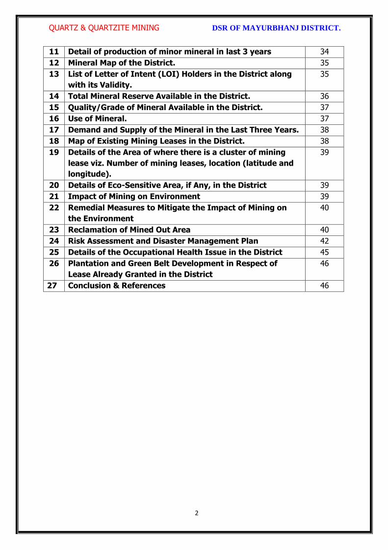
QUARTZ & QUARTZITE MINING DSR OF MAYURBHANJ DISTRICT.
2
11 Detail of production of minor mineral in last 3 years 34
12 Mineral Map of the District. 35
13 List of Letter of Intent (LOI) Holders in the District along
with its Validity.
35
14 Total Mineral Reserve Available in the District. 36
15 Quality/Grade of Mineral Available in the District. 37
16 Use of Mineral. 37
17 Demand and Supply of the Mineral in the Last Three Years. 38
18 Map of Existing Mining Leases in the District. 38
19 Details of the Area of where there is a cluster of mining
lease viz. Number of mining leases, location (latitude and
longitude).
39
20 Details of Eco-Sensitive Area, if Any, in the District 39
21 Impact of Mining on Environment 39
22 Remedial Measures to Mitigate the Impact of Mining on
the Environment
40
23 Reclamation of Mined Out Area 40
24 Risk Assessment and Disaster Management Plan 42
25 Details of the Occupational Health Issue in the District 45
26 Plantation and Green Belt Development in Respect of
Lease Already Granted in the District
46
27 Conclusion & References 46

QUARTZ & QUARTZITE MINING DSR OF MAYURBHANJ DISTRICT.
3
PREAMBLE
Odisha is the major mineral reach in India. Mayurbhanj is a unique district in Odisha
lies on the northern most part of the state with varied mineral resources. In
pursuance of the order of Hon’ble Supreme Court Petition (C) No. 19628-19629 of
2009, dated 27th Feb. 2012 in the matter of Deepak Kumar Vs State of Haryana and
others etc., prior environmental clearance has now become mandatory for mining of
minor minerals irrespective of the area of Mining Lease. And also in view of the
Hon’ble National Green Tribunal, order dated the 13th Jan. 2015 the matter regarding
Road metal/stone, Sand, Brick earth, & burrowed earth cutting for Road Construction
has to take prior Environmental Clearance for Mining Lease area more or less than 5
hectares also suggested making a policy on Environmental Clearance for minor
minerals lease and leases in cluster. As per MOEF & CC Notification S.O.-1533(E)
dated 14th Sept. 2006 and subsequent MoEF & CC Notification S.O. 141(E) dated 15th
Jan. 2016, District Environment Impact Assessment Authority (DEIAA) & District level
Expert Appraisal Committee (DEAC) has been formed for Category –B2 Minor Minerals
having area less than or equal to 5 ha. In compliance to the notification issued by the
Ministry of Environment and Forest and Climate Change Notification no. S.O.3611 (E)
New Delhi dated 25-07-2018; the preparation of district survey report of road
metal/stone mining has been prepared in accordance with Clause II of Appendix X of the
notification.
Keeping in view of the prior information of Odisha Minor Mineral Concession Rule
2004, (OMMCR -2004) the mining operation for minor minerals were carried out in
unscientific manner. Identifying this fact in exercise of power, Conferred by Section 15
by Mines and Minerals (Development and Regulation) Act 1957 as amended in 2015
and all other powers enabling it in that behalf, the Mining & Geology Department,
Govt. of Odisha framed the aforementioned rule. Further, this report will act as a
compendium of available mineral resources, geological set up, environmental and
ecological set up of the district and based on data of various departments like
Revenue, Water Resources, Forest, Geology and Mining in the district as well as
statistical data uploaded by various state Government departments for preparation for
district survey report.

QUARTZ & QUARTZITE MINING DSR OF MAYURBHANJ DISTRICT.
4
1. INTRODUCTION:
Mayurbhanj at a Glance:
1.1 Location and Geographical Area:
Mayurbhanj district is the largest among the thirty districts of Odisha and Baripada is
the District head quarter, spreading over an area of 10,418 sq.km lies between
latitudes 21° 17’ North and 22° 34’ North and longitudes 85°40’ East and 87°10’ East.
It is bounded on the north by the Singhbhum district of Jharkhand and Midnapore
district of West Bengal, on the south by the districts of Balasore and Keonjhar, on the
east by the Midnapore and Balasore districts and on the west by the districts of
Keonjhar and Singhbhum. Mayurbhanj occupies a unique position being endowed
with lush green vegetation, different fauna & flora and rich cultural heritage. The
district has a rich mineral base and is home to the Similipal Biosphere. Iron-ore
(hematite), vanadiferous and titaniferous magnetic, chaina clay, galena (lead ore),
Kyanite, asbestos, steatite (soap stone) and quartzite constitute the principal mineral
resources of Mayurbhanj district, of these the iron-ore deposits of Gorumahisani,
Badampahar and Suleipat, which have been exploited for a period of about half a
century, deserve special mention.

QUARTZ & QUARTZITE MINING DSR OF MAYURBHANJ DISTRICT.
5
1.2 Administrative Units:-
Baripada is the administrative headquarter of Mayurbhanj district. It is located at a
distance of 263 km from Bhubaneswar, state capital of Odisha. In order of size, the
district is the largest among the thirty districts of Odisha. It has 3980 villages
(including 178 uninhabited villages) covering 26 Blocks, 26 Tahasils and 4 Sub-
Divisions. The district is divided into 4 Sub-Divisions namely 1) Sadar Sub-Division
Baripada, 2) Kaptipada Sub-Division Udala, 3) Bamanghaty Sub-Division, Rairangpur,
4) Panchapir Sub-Division, Karanjia. which are given below:-

QUARTZ & QUARTZITE MINING DSR OF MAYURBHANJ DISTRICT.
6
Sl No Name of the Block/Tehsil Name of the Sub-Division with
Head quarter
1 Baripada
Sadar Sub-Division, Baripada
2 Samakhunta
3 Kuliana
4 Bangriposi
5 Saraskana
6 Suliapada
7 Betnoti
8 Badsahi
9 Rasgovindpur
10 Moroda
11 Udala
Kaptipada Sub-Division, Udala
12 Kaptipada
13 Khunta
14 Gapabandhu Nagar
15 Rairangpur
Bamanghaty Sub-Division,
Rairangpur
16 Bisoi
17 Bijatala
18 Kusumi
19 Bahalda
20 Tiring Bamanghaty Sub-Division,
Rairangpur 21 Jamda
22 Karanjia
Panchpir Sub-Division, Karanjia
23 Jashipur
24 Sukruli
25 Thakurmunda
26 Raruan
The population of the district 25,19,738 according to the 2011 Census. The district
accounts for 6.69% of the state’s territory and about 6% of state’s population. The
density of population of the district is 242 per square km as against 270 per square
km of the state. As per 2011 census, the population of Scheduled Caste is 1,84,682
(7.30%), that of Scheduled Tribe is 14,79,576 (58.7%). The literacy percentage of the
district covers 63.2 against 72.9 of the state.

QUARTZ & QUARTZITE MINING DSR OF MAYURBHANJ DISTRICT.
7
1.3 Connectivity facilities:-
Road Network
The district is well served by a network of good roads and has been called the
motorists paradise. The chief roads emanating from Mayurbhanj town are NH-18 and
NH-49 passes the district. Baripada is 60 Kms from Mayurbhanj, 103 Kms from
Kharagpur, 163 Kms from Jamshedpur, 231 Kms from Cuttack, 255 Kms from
Bhubaneswar and 368 Kms from Rourkela. It is also connected with other cities such
as Sambalpur, Puri, Bolangir, Bhadrak, Jhargram, Angul, Ranchi and Kolkata via
Odisha State Road Transport Corporation and some private travel services.

QUARTZ & QUARTZITE MINING DSR OF MAYURBHANJ DISTRICT.
8
Rail Network
Mayurbhanj district is well connected by rail link to different places, the city of
Baripada is well connected to many places in India like Mayurbhanj, Bhubaneswar,
Kolkata, Jamshedpur and Cuttack,

QUARTZ & QUARTZITE MINING DSR OF MAYURBHANJ DISTRICT.
9
Air Network
At present, Mayurbhanj has no connection by airway. The site selection for aerodrome
is presently under process. Nearest aerodrome is Dum Dum Airport (International
Airport) Kolkata, roughly 195 Kms from Baripada. The other nearest airport to
Baripada is Biju Patnaik Airport, Bhubaneshwar, 207 Kms from Baripada.

QUARTZ & QUARTZITE MINING DSR OF MAYURBHANJ DISTRICT.
10
2. OVERVIEW OF MINING ACTIVITY IN THE DISTRICT:
Mayurbhanj district is land features of both plain and hilly region. Most of the
mineralized area coming under safety zone eco-sensitive zone, mining activity only
confined out of safety zone of eco-sensitive zone. The mining activity in the district is
not only restricted to minor minerals i.e. of sand, stone, granite and brick clays.
Altogether there are leases of Iron-ore (hematite), vanadiferous and titaniferous
magnetic, chaina clay, galena (lead ore), Kyanite, asbestos, steatite (soap stone) and
quartzite constitute the principal mineral resources of Mayurbhanj district, of these the
iron-ore deposits of Gorumahisani, Badampahar and Suleipat, which have been
exploited for a period of about half a century. Stone, granite and sand which has been
granted to the district is regulated as per minerals concession rules of Odisha. There
is no lease of major mineral in the district. At present Leases of stone, sand and bricks
making units are operational in the district. Stone chips, granite stones, ordinary sand

QUARTZ & QUARTZITE MINING DSR OF MAYURBHANJ DISTRICT.
11
constitute the principal mining activity of Bangirposi, Badasahi, Kaptipada, Kuliana
area etc. of Mayurbhanj district. Out of these huge granite stones deposits are
available near Badasahi, Kaptipada, Kuliana area and major potential sand in G.B
Nagar, Morada & Kaptipada area of the district, which have been provides
tremendous scope for development of few more industries based on this resources.
Iron-ore (hematite), vanadiferous and titaniferous magnetic, chaina clay, galena (lead
ore), Kyanite, asbestos, steatite (soap stone) and quartzite constitute the principal
mineral resources of Mayurbhanj district, of these the iron-ore deposits of
Gorumahisani, Badampahar and Suleipat, which have been exploited for a period of
about half a century.
3.0 GENERAL PROFILE OF THE DISTRICT:
3.1 Demography:
Census - 2011
Geographical Area 10,418 Sq. Km.
Total population 25,19,738
Male Population 12,56,213
Female Population 12,63,525
Male Literacy 794,171
Female Literacy 575,226
SC Male 92,127
SC Female 92,555
ST Male 730,487
ST Female 749,089
OBC 855,480
Illiterate Male 462,042
Illiterate Female 688,299
4.0 GEOLOGY OF THE DISTRICT:
Mayurbhanj is a unique district in Odisha with rich and varied geology. Similipal
Complex being at its central part. The mountain ranges comprise mainly of highland
plateau and valleys with intrusive running through them. The second physiographic
unit is Tertiary Plain occurring in the eastern part of the district. The third
physiographic unit is Alluvial Plain .The drainage density is observed to be fairly
moderate and drainage pattern is dendritic in nature. The major rock types

QUARTZ & QUARTZITE MINING DSR OF MAYURBHANJ DISTRICT.
12
encountered in the district are Granite Gneiss, Quartzite, Orthoquartzite, Arkose,
Shale, Phyllite, Gabbro, Px-granite. The geology of the district is constituted by the
Similipal complex at its central part belonging the Archaean age, unconformably lying
over Singhbhum Granite and Banded Iron Formation (BIF). It consists of three
alternate bands of volcano sedimentary units uniquely disposed in a ring like circular
pattern formed under sub- marine conditions. Baripada Beds outcrops of tertiary
formation occur around Baripada town. These comprise stratified clay and sand with
marly clay or limestone interbands. Important mineral resources include iron, copper,
itanium, vanadium, chinaclay, nickel, kyanite ,quartz, talc, steatite ,soapstone and
bauxite.
4.1 Physiography & Geomorphology:
Mayurbhanj district presents diverse physiographic features, Physiographically the
study area can be divided into 3 categories. The first physiographic unit of the district
is high mountain ranges, Similipal Complex being at its central part (Figure 1). The
mountain ranges comprise mainly of highland plateau and valleys with intrusive
running through them. The second physiographic unit is Tertiary Plain occurring in the
eastern part of the district. The third physiographic unit is Alluvial Plain which lies
partly in Rasgovindpur, Morada, Samakhunta, Betnoti, Baripada, Badasahi and
Suliapada Blocks. The highest elevation of about 559m at Bahalda near Similpal hill
and higher elevations of the district, due to scarp landforms some waterfalls are
observed in the district. The general slope of the district is from north to south.
Geologically the area is comprised with Archean granites and gneisses.
Geomorphologically the district is divided into 3 units:
i) The denudational hills with moderate to high slope occurring in the western part of
the district.
ii) Dissected pediments having gentle slope.

QUARTZ & QUARTZITE MINING DSR OF MAYURBHANJ DISTRICT.
13
iii) Pediplain having slope between 0o to 5o.
4.2 Stratigraphy:
Geological Age Geological Formation / Group
Quaternany : Recent Alluvium, Clays, silt, Sand, Gravel
Tertiary : Older Alluvium, Laterite, Baripada Beds.
Mesozoic/ Palaeozoic : Volcanics / Epidiorite
Precambrian : Slate/ Phyllite/ Schist / Gneiss
Archean : Granite/ Granite Gneiss

QUARTZ & QUARTZITE MINING DSR OF MAYURBHANJ DISTRICT.
14
4.3 Mineral Resources:
The earliest known geological survey in Mayurbhanj dates back to 1903, when P.N.
Bose brought to light the extensive iron-ore deposits of high quantity on the
Gorumahisani and Suleipat hills in Bamanghaty Sub-Division. These deposits were
considered to be almost inexhaustible and were pronounced to be of excellent quality,
perhaps second to none in the whole of Asia by the famous American and English
experts like M/s Perin, Weld and Colonel Staddart, who visited these deposits during
1905-06. This discovery was a momentous one as the steel plant of the Tata Iron &
Steel Co. at Jamshedpur was entirely based on the exploitation of these deposits. By
1915, important discoveries of Steatite near Lulung and placer gold from the sands of
Subarnarekha, Kharkhai and Barhai rivers had been made. The placer gold deposits
were being worked by M/s J.B. Bettie of Calcutta, Mr. V.G. Piggot of Ghatsila and the
Mayurbhanj Prospecting Concession Syndicate.
Gold: The mid-Archaean Gorumahisani-Badampahar schist belt composed of basic
ultrabasic, volcanic rocks and volcanogenic sediments. This belt has been
prognosticated as a rift-type of volcanic dominated one and is highly potential for
economic grade gold mineralization. Likely targets include: a) auriferous quartz veins
close to the contact of sulphide chert volcanics, b) sheared and sulphidised Fe-rich
tholeiite with anomalous copper, c) epigenetic vein type of mineralization and BIF
volcanic association, and d) sulphidic conglomerate resting over the basic volcanics.
Placer gold occurrence are known from rivers and stream of Mayurbhanj district. An
area of about 5 square kilometers of alluvium at the headwaters of Sapgora and Borai
rivers near Kudersai was indicated as promising.
Iron: Bose discovered iron ore deposits in Gorumahisani and Badampahar in the
eastwhile princely state of Mayurbhanj (now Mayurbhanj District). Gorumahisani
deposits were investigated by Perin & Weld (1905). Gorumahisani- Badampahar-
Suleipat deposits are associated with banded hematite / magnetite grunerite and BHJ.

QUARTZ & QUARTZITE MINING DSR OF MAYURBHANJ DISTRICT.
15
Gorumahisani – Badampahar- Suleipat (Broad geological sequence)
Laterite & Alluvium
Newer Dolerite
Gabhro-Anorthosite Granite
---Unconformity---
Ultramafic dyke
Singhbhum Granite
Banded magnetite/ Martite quartzite with Fe-Ores
Quartzite
Basal Conglomerate
----Unconformity----
Older metamorphic
Vanadium Ores & Titanium: Vanadium is an important alloying element. Magnetite
associated with gabbro- anorthosite suite of rocks contain vanadium and titanium.
Deposits of vanadium-magnetite occur in association with gabbro-Anorthosite suite of
rocks in the precambrian metamorphites. Vanadium bearing magnetite belts are :-
(a) Rairangpur – Bisoi belt (Kumardubi, Betjharan Amdabeda)
(b) Bisoi – Joshipur belt (Mayurbeka, Kesham, Sialnoi)
(c) Baripada – Podadiha belt (Andipur, Bahalda)
Pyrophyllite : is mainly used as a high grade ceramic product, electric insulator and
refractory material. The comp. is Al2O34SiO2 H20. It is formed as an alteration product
of feldspar. Pyrophyllite occurrences are reported at Kankrani, Jashipur,
Gorumahisani, Bangriposhi and Manada in Mayurbhnaj dist. Ichinda, Khairakocha,
Jamukunda, Nakulkocha, Kapadiha, Dunguridiha, Maheshpur, Kashidiha, Sagragora
and Pokpoka. Dimension stone of the district are granite, granite-gneiss, migmatites,
syenite, gabbro, anorthosite, charnockite, leptynite, pyroxene granulite, dolerite,
pyroxinite and dunite etc.
Bauxite: In Similipal complex (Mayurbhanj) aluminous laterite/ Bauxite are observed
around 1000 m AMSL. The spongy aluminous laterite/bauxite occurs as sheets and
boulders occupying the flat-topped hills made up of metavolcanics. Both
ultramafics and metavolcanics are lateritised giving rise to nickeliferous laterite and
aluminous laterite respectively.

QUARTZ & QUARTZITE MINING DSR OF MAYURBHANJ DISTRICT.
16
China Clay clay like material approximating the mineral Kaolinite (Al2O3, 2SIO2,
2H2O). China clay is found to occur in a long belt stretching from Singhbhum to
Mayurbhanj. Badampahar-Joshipur- Karanjia – Ramachandrapur belt is the most
important china-clay producing area of the state. The important deposits in
Mayurbhanj district are found near Jashipur, Chanchbani, Dumuria, Jamda, Kodadiha,
Jamkeswar and Thakurmunda. China clay has many industrial applications as filler in
paper, textile, rubber, in the manufacture of potteries, ceramics, sanitary wares,
glazed tiles, white cement, insecticides, paints, cosmetics, refractory bricks etc. Soap
stone and Steatite Asbestos is mined from Mayurbhanj area.
Talc, Steatite and Soapstone: Important localities of these deposits in Mayurbhanj
dist are Tiring, Kendumundi and Kharidamak.
Kyanite: Kyanite deposits of refractory grade occur in Panijia area of Mayurbhanj
dist, where it is associated with dumortierite bearing rocks, qtz-veins, quartz-mica-
schists and talc-tremolite-schist. Other kyanite occurrence include Purnapani &
Similipal.
Quartz & Quartzite: Quartz and silica sand are mostly used in glass foundry,
ferrosilicon alloy, ceramic industry, abrasive, paint, rubber, textile industries.
Transparent varieties of quartz such as rock crystal, amethyst, citrine, Rosequartz and
smoky quartz are used as semi-precious gemstone. Quartz is a piezoelectric material
and is used in radio circuit, Radars and ultra-sonic devices. Quartzite is a
monomineralic rock constituted predominantly of quartz. There are 6 mining leases
for quartz and quartzite in Mayurbhanj dist.
High Magnesia rock: are found in Notapahar, Thakurmunda, Amjori and
Badampahar of Mayurbhanj Dist.
Nickel: Nickel is concentrated within chemically weathered ultramafic rocks and
found in the laterite and soil capping in Similipal area. The mineral occurs in silicate

QUARTZ & QUARTZITE MINING DSR OF MAYURBHANJ DISTRICT.
17
form i.e. garnierite. The important patches of prospective ore zones are: Gurguria and
Nawana.
4.4 Soil:
The district comprises chiefly of lateritic, sandy loam and clayey loam type of soil
(Figure 3). Laterite soil is mostly marked in the area occupied by crystalline rocks.
The low lying valley fields are covered with clayey loam type of soil.
5. DRAINAGE OF IRRIGATION PATTERN
The district has considerable flat land, which provide suitable site for agricultural use.
The hilly areas are mostly under forest with patches of cultivation on scarp areas.
Major rivers flowing in the district are Budhabalanga, Subarnarekha, Jambhira, Sona,

QUARTZ & QUARTZITE MINING DSR OF MAYURBHANJ DISTRICT.
18
Khadkhai, Deo, Katra, Khairibandhan & Baitarani. Major crops grown in the district are
rice Only. 14.82 percent area of agricultural use are net irrigated and major source of
irrigations are well and tube-wells.
Sl. No.
Name of the River
Area drained (Sq.Km.)
% Area drained in the District
1 Budhabalanga 2143 21%
2 Subarnarekha 265 0.25%
3 Jambhira 1377 13%
4 Sona 1062 10%
5 Khadkhai 1131 10.8%
6 Khairibandhan 1014 0.09%
7 Deo 473 0.04%
8 Katra 352 0.03%
9 Gangahar 594 0.057%
10 Baitarani 260 24.6%
11 Tel 96 0.009%
12 Kantamauli 82 0.007%
13 Sim 165 0.015%
14 Jhagada 30 0.002%
15 Balijori 56 0.005%
16 Kantakhaira 186 0.017%
17 Kanhu 383 0.036%
18 Balisudura 170 0.016%

QUARTZ & QUARTZITE MINING DSR OF MAYURBHANJ DISTRICT.
19
5.1 River System
The Budhabalanga River (also called Balanga River) flows through the districts
of Mayurbhanj & Balasore and finally reached Bay of Bengal. The Budhabalanga, rises
from Similipal hills and plunges through Barehipani Falls, the second-highest waterfall
in India, located in Similipal National Park. It then flows in a northerly direction up to
the village Karanjiapal in Bangiriposi police-station. Thereafter, it turns to the north-
east and flows along the railway track up to the village Jhankapahadi. There it
changes its course to the south and meets the Katra nala. The other tributaries are
the Palpala and the Chipat both of which are hill streams rising from the Similipal hills.
Then the river passes through Baripada. It later flows through Balasore district and
into the Bay of Bengal. The Budhabalanga is about 175 kilometres (109 mi) long and
has a total catchment area of 4,840 square kilometres (1,870 sq mi). Its major
tributaries are the Sona, Gangahar, and the Katra. Burhabalang and its tributaries, viz.

QUARTZ & QUARTZITE MINING DSR OF MAYURBHANJ DISTRICT.
20
Sona Nadi, Amrutia Nadi, Gangahar Nadi drain almost round the year in the present
area. Sona Nadi receives the watery effluent load through a nalah (Sankh nalah) from
the Balgopalpur Industrial Estate and flows from west to east. Amrutia Nadi flows
from NNW to SSE and carries the waste water load of East Coast. Subarnrekha
originate from Nagri of Jharkhand and then enter into Mayurbhanj district, very less
portion of the river flows within Mayurbhanj district, Major portion of Subarnarekha
River passes in the Balasore district. Another river Jambhira runs in Mayurbhanj
district then enters into Balasore district and Renamed as river Jalaka flows into Bay
of Bengal. Other small rivers run in this district like River Khadkhai originates from
Tunhgru R.F. and plunges through Suleipat Dam (Khadkhai Reserviour). It then runs
towards Rairangpur, Bahalda, Tiringi area of western direction of Mayurbhanj district
and finally reached at River Subarnarekha. River Deo rises from Similipal R.F. and
runs towards western part of the district and flows through Karanjia area and then
joins with Baitarani River. River Khairabandhan originates from Similipal R.F. and
flows towards western part of the Mayurbhanj district through Jashipur, Raruan,
Sukruli area of district and then joins with River Baitarani This river maintains a
sluggish flow in the pre-monsoon period, but swells menacingly with the onset of
monsoon often flooding large tracts. Another small tributary named as Kanhu starts
from River Khadkhai and branched into Jalapa, Ghagera nala meets at Jharbeda area
of Mayurbhanj District.
Sl. No.
Name of the River or Stream
Total Length in District (in Km.)
Place of Origin Altitude at Origin
1 Budhabalanga 161 Similipal Hill 940 mrl.
2 Subarnarekha 4 Nagri, Jharkhanda
610 mrl.
3 jambhira 64 Chandra R.F. Mayurbhanj
60 mrl.
4 Sona 70 Jaymal Hill, Dugdha
Mayurbhanj.
340 mrl.
5 Khadkhai 75 Tunhgru R.F. 500 mrl.
6 Khairibandhan 65 Similipal R.F. 800 mrl.
7 Deo 65 Similipal R.F. 930 mrl.
8 Katra 55 Jari R.F. 700 mrl.
9 Gangahar 55 Similipal R.F. 740 mrl.
10 Baitarani 48 Gonasika, 900 mrl.

QUARTZ & QUARTZITE MINING DSR OF MAYURBHANJ DISTRICT.
21
Guptaganga Hills
11 Tel 20 Similipal R.F. 940 mrl.
12 Kantamauli 25 Similipal R.F. 360 mrl.
13 Sim 85 Similipal R.F. 900 mrl.
14 Jhagada 15 Jhagada R.F. 430 mrl.
15 Balijori 22 Similipal R.F. 520 mrl.
16 Kantakhaira 36 Similipal R.F. 420 mrl.
17 Kanhu 42 Similipal R.F. 400 mrl.
18 Balisudura 15 Similipal R.F. 450 mrl.
6.0 LAND UTILIZATION PATTERN IN THE DISTRICT
6.1 Forest and non forest land
The forest of Mayurbhanj district is full variety of medicinal plants, Kendu leaves,
Bamboo, Sal, Teak, other timber species and a wide range of carnivorous & herbivorous
wild animals. The district has one Wildlife Sanctuaries known as the Similipal Wildlife
Sanctuary situated at the heart of the district, which hosts all type of wildlife even

QUARTZ & QUARTZITE MINING DSR OF MAYURBHANJ DISTRICT.
22
tigers. The area of the sanctuary is 26, 886.23 hectares. And two kilometer safety zone
of eco-sensitive zone of Suleipat Wildlife Sanctuary are coming in Mayurbhanj district. In
these sanctuary areas the principal animals that are found are Elephant, Bear, Nilgai,
Sambhar, Peacock, Wild Boar and Deer, together with variety of snakes and birds.
District-wise Forest Cover Area in Odisha (Area in Km2)
2017 Assessment
District Geograph ical Area Km2
Very Dense Forest
Moder- ate. Dense Forest
Open Forest
Total Percent of GA
Change Scrub
Angul 6375 371 1380 1004 2755 43.22 43 84
Bolangir 6575 70 224 837 1131 17.2 151 142
Balasore 3806 23 127 234 380 9.98 30 48
Bargarh 5837 176 371 484 1031 17.66 88 47
Bouda 3098 263 546 480 1289 41.61 27 57
Bhadrak 2505 0 9 66 75 2.99 2 0
Cuttack 3932 53 226 517 796 20.24 11 68
Deogarh 2940 191 667 614 1472 50.07 -3 14
Dhenkanal 4452 174 418 825 1417 31.83 9 82
Gajapati 4325 84 1490 946 2520 58.27 12 262
Ganjam 8206 164 1075 864 2103 25.63 15 655
Jagatsinghpur 1668 0 5 131 136 8.15 6 0
Jajpur 2899 6 72 225 303 10.45 3 50
Jharsugada 2114 3 140 179 322 15.23 9 36
Kalahandi 7920 362 729 1327 2418 30.53 36 362
Kandhamal 8021 661 2588 2143 5392 67.22 16 380
Kendrapada 2644 84 88 133 305 11.54 14 2
Keonjhar 8303 289 1404 1519 3212 38.68 4 55
Khorda 2813 21 186 250 457 16.25 0 92
Koraput 8807 94 740 1255 2089 23.72 120 944
Malkangiri 5791 158 709 1475 2342 40.44 20 45
Mayurbhanj 10418 1335 1718 1027 4080 39.16 42 34
Nabarangpur 5291 168 428 507 1103 20.85 8 47
Nayagarh 3890 189 965 556 1710 43.96 28 173
Nuapada 3852 86 482 705 1273 33.05 33 109
Puri 3479 0 54 160 214 6.15 8 11
Rayagada 7073 422 853 1851 3126 44.2 7 349

QUARTZ & QUARTZITE MINING DSR OF MAYURBHANJ DISTRICT.
23
Sambalpur 6624 499 1675 1106 3280 49.52 13 40
Subarnapur 2337 2 187 161 350 14.98 26 29
Sundargarh 9712 1019 1814 1431 4264 43.9 107 89
Grand Total 155707 6967 21730 23008 51345 32.98 885 4306
(Source: India state of forest report 2017-Odisha)
The major portion of the district is covered by forest (39.16 % of TGA) and has
scattered settlement pattern. The forest is full of variety of medicinal plants. The
district has considerable flat land, which provide suitable site for agricultural use. The
hilly areas are mostly under forest with patches of cultivation on scarp areas. Major
crops grown in the district are rice and pulses. Only 14.82 percent area of agricultural
use are net irrigated and major source of irrigations are well and tube wells.
Source: Fertilizer and Agriculture Statistics, Eastern Region
Tahasil Forest Area
Misc Tree
Permanent Pasture
Cultivated waste
Non Agricultural
uses
Barren land
Current Fallow
Other Fallow
Net area
sown
Bahalda 964 471 1397 1262 2590 1900 875 944 14031
Bangiriposi 3712 281 1037 1688 3046 684 2054 922 16951
Baripada 216
673
3 128 1628 1376 8 2752 2156 4219
Badasahi 288 180
7 1194 1874 3840 24 3378 2110 17630
Betnoti 2271 911 1198 1728 3227 21 1915 578 17022
Bijatala 2841 224 681 3100 1792 1636 1214 600 11228
Bisoi 3116 471 757 2508 2193 459 2298 1643 15860
G.B.Nagar 191 116 683 582 1147 590 643 1209 10960
Jamda 408 100 1650 434 2060 785 840 1149 13608
Jashipur 8932 141 1389 2655 3637 400 3873 2634 17754
Kaptipada 8745 387 3292 5596 4123 2165 3123 4930 19932
Karanjia 1644 838 1444 2441 3065 462 3493 1362 16690
Khunta 400 226
0 314 672 2061 21 1332 2213 12879
Kuliana 1749 162
6 2222 1902 2529 608 4919 1504 11108
Kusumi 1434 32 2320 2679 2337 587 1086 1682 18032
Morada 993 412
7 513 4340 1941 61 1909 3633 10179
Rairangpur 2260 107 1759 1373 2027 504 1276 631 9713
Raruan 1210 171 890 1120 1899 503 1609 1020 12818
Rasgovindpur 288 214
5 665 1091 2774 142 2002 1537 10054
Shamakhunta 1354 764 1378 2472 1859 334 1861 941 6695
Saraskana 3464 275 689 2658 4042 115 1864 1837 15384
Sukruli 412 211 734 1295 1271 502 1286 1294 10352
Suliapada 2937 553
5 97 2262 2148 86 1589 2906 8971
Thakurmunda 10885 96 1530 1438 2034 795 5317 2670 17681

QUARTZ & QUARTZITE MINING DSR OF MAYURBHANJ DISTRICT.
24
6.2 Agriculture Land:
Mayurbhanj is surrounded by no of forest areas as well as Rocky Mountains. People
used to cultivate Paddy in most parts of the hill slopes and in plain lands. Most of the
cultivators grow short duration local paddy in the un-bonded upland during Kharif
season. The crop suffers moisture stress at different stages due to inadequate rainfall.
The primary objective of Agriculture Department is increase of production as well as
productivity of major crops like paddy, groundnut, mustard, Mung, Biri & vegetables
which is widely covered in this District in both Kharif & Rabi season. Another key
objective is the all round development of the farming community of the District. The
Deputy Director of Agriculture is the head of office so far as agriculture is concerned &
he is the Principal Agriculture Officer of the District. Under him there are 5 District
Agriculture Officers & the block under them. As already pointed out, that agriculture is
the main livelihood of the people in Mayurbhanj District. It is therefore also
designated as the food bowl of Odisha. Rice is the principal crop grown in this district,
followed by other cereals, pulses, oilseeds, vegetables, spices and sugarcane. The
agricultural statistics for the district is shown in subsequent tables below:
Table – 3.6a: Crop Coverage Area of Mayurbhanj District, Odisha
Crop Khariff Rabi Annual TOTAL
Area (ha)
(% of Cropped
Area
Area (ha)
% of Cropped
Area
Area (ha)
Gross Cropped Area (ha)
% of Gross
Cropped Area
Rice 301.37 82.353% 3.80 4.015% --- 305.17 62.051%
Cereals 9.99 2.730% 2.17
2.293% --- 12.16 2.472%
Pulses 32.37 8.846% 36.20 38.255% --- 68.57 13.943%
Oilseeds 5.92 1.617% 28.30 29.906% --- 34.22 6.958%
Vegetables 12.39 3.386% 21.74 22.974% --- 34.13 6.940%
Fibres 2.43 0.664% --- 2.43 0.494% Spices 1.48 0.404% 2.42 2.557% --- 3.90 0.792%
Sugarcane --- --- 00 --- --- 00 ---
Tobacco --- --- 00 --- --- 00 ---
Fruits --- --- --- --- --- 31.23 6.350%
TOTAL 365.95 100.00% 94.63 100.00% --- 491.81 100.00%
QUARTZ & QUARTZITE MINING DSR OF MAYURBHANJ DISTRICT.
25
6.3 Horticulture Land:
The primary objective of Horticulture Department is increase of production as well as
productivity of major fruits like Mango, Guava, Citrus etc., which is widely covered in
this District. Another key objective is the all round development of the farming
community of the District. The Deputy Director of Horticulture is the head of office.
7.0 SURFACE WATER AND GROUND WATER SCENARIO OF THE DISTRICT
7.1 Hydrogeology
Distribution of Saline / fresh water aquifers:
The occurrence of fresh water aquifers in coastal tract of Mayurbhanj restricted by
two important factors‐ (i) Occurrence of hard rocks in the western side and (ii) Salinity
hazard problems in the eastern part. The water bearing formation of the area can be
divided into (a) areas underlain by fractured, fissured and consolidated basement rock
formations (b) areas underlain by recent unconsolidated alluvial formations.
(a) Consolidated Formation - These are most predominant rock types occurring in
the undulating plains of the district. Groundwater occurs under unconfined condition
in the shallow weathered zone and circulates through fractures and joints. The
thickness of the weathered zone varies from 3 to 35 m. Depth of open wells in these
formations varies from 5 to 14 m below ground level.
(b) Unconsolidated alluvial formations - The unconsolidated formations consists of
laterite and alluvium. Laterites at places are highly consolidated and used as building
stones. The laterites have high degree of effective porosity and form potential
aquifers commonly tapped in dug wells. The alluvium comprises an admixture of clay,
silt, sand and calcareous concretions in varying proportions. The coarse sediments like
sand and gravel form the main repository of ground water. Ground water occurs
under both unconfined condition in shallow aquifers and in confined condition in
deeper parts.

QUARTZ & QUARTZITE MINING DSR OF MAYURBHANJ DISTRICT.
26
7.2 Depth of water level:
The depth to water level map for pre and post monsoon periods 2011 are prepared
based on the ground water monitoring data of 77 Nos of National Hydrograph
Stations of C.G.W.B. monitored during the month of April and November 2006 are
presented below respectively. The pre and post monsoon depth to water levels in the
district range from 3.54 to 14.50 m below ground level and 1.39 to 8.20 m below
ground level respectively. It is observed that during pre monsoon about 75% of the
total areas show the water level varying between 5 to 10 m below ground level.
During post monsoon nearly 60% of the area has water levels within 2 to 5 m,
while the rest part has between 0 to 2 and 4 to 6 m below ground levels. In localized
part of Morada, Kaptipada and Thakurmunda the water level is > 5 mt.
Depth & categorization of ground water levels during pre monsoon period (April 2011)
of Mayurbhanj districts is presented below:

QUARTZ & QUARTZITE MINING DSR OF MAYURBHANJ DISTRICT.
27
Depth & categorization of ground water levels during pre monsoon period (November
2011) of Mayurbhanj districts is presented below:

QUARTZ & QUARTZITE MINING DSR OF MAYURBHANJ DISTRICT.
28
7.3 Ground Water Quality
The chemical quality of ground water in the district has been assessed on the basis of
chemical analysis of ground water samples collected during groundwater monitoring,
Hydrogeological surveys and groundwater exploration. The results of the chemical
analysis are presented in Table.
Table showing chemical constituents in aquifers
Constituent Shallow aquifer Deeper aquifer
pH 6.97 – 8.25 6.84 – 8.25
Sp. Conductance (micromohs/cm at 250 C)
53 – 974 92 – 867
TDS (mg/l) 58 – 1430 106 – 429

QUARTZ & QUARTZITE MINING DSR OF MAYURBHANJ DISTRICT.
29
Calcium (mg/l) 6 – 92 16 – 86
Magnesium (mg/l) 0.6 – 17 3.6 – 22
Sodium (mg/l) 1.6 – 100 3.5 – 168
Potassium (mg/l) 0.4 – 8 <1 --6.4
Bicarbonate (mg/l) 15 – 256 49 – 366
Chloride (mg/l) 7 – 238 5.3 – 85
Sulphate (mg/l) 0.1 – 9 <1 – 82
Nitrate (mg/l) <0.01 – 53 0.1 – 78
Fluoride (mg/l) 0.08 – 20.3 0.21 – 0.61
Total hardness as calcium carbonate
10 – 245 35 - 285
7.4 Ground Water Development
In the rural areas the entire water supply is dependent on ground water. Ground
water development is mainly carried out in the district through dug wells and Hand
pumps. In general dug wells are of 2 m diameter and the depth ranges between 8 to
15 m depending on the thickness of the weathered zone, tapping the shallow aquifer
in the weathered zone and uppermost slice of the basement. Large number of dug
wells used for drinking water is under private ownership for which there is no reliable
data. Over the years Mark II/ Mark III hand pumps are being drilled in large numbers
for ground water development. These hand pumps have the following two major
advantages i) less susceptible to contamination from surface sources and ii) tap
fractures between 20-60m depth which have been found to be less affected by
seasonal water level fluctuation and thus have lesser chances of failure even during
extreme summer. Over all the present level of ground water development is only
27.21 percent in the district with the maximum in Badasahi Block viz. 64.65% and
minimum in Bijatala Block. Block wise development figure indicate that all the blocks
come under the white categories. Thus there is ample scope for development of
groundwater in the district to augment irrigation potentials through suitable ground
water abstraction structure
7.5 Ground Water Related Issue and Problems
Some of key ground water related issues are
I. Locating suitable sites for bore wells
II. Suitable design of dug wells and hand pumps
III. Taking up artificial recharge projects to augment the resource availability in

QUARTZ & QUARTZITE MINING DSR OF MAYURBHANJ DISTRICT.
30
Mayurbhanj district.
IV. Optimal development of irrigation potential by developing ground water available
for future uses.
V. Creating public awareness for conserving ground water through awareness
camps, NGO’s and mass media.
7.6 Mass Awareness Campaign (MAP) & Water Management Training
Programme (WMTP) by CGWB
NIL
7.7 Area Notified by Cgwb/Sgwa
None
7.8 RECOMMENDATIONS:
1) Intensive groundwater exploration should be taken up to delineate deeper
potential water saturated fracture zones and to compute aquifer parameter.
2) Large scale planning for ground water development should be preceded by
intensive hydrogeological and geophysical surveys aided by remote sensing
studies.
3) Effective measures may be taken to conserve the surface run off by contour
bonding at suitable sites. Also proper maintenance of reservoir, tanks and spring
channels by periodical disiltation should be carried out.
4) Existing dug-wells should be deepened to tap the maximum saturated thickness of
the weathered mantle or vertical bores may be drilled through the bottom to
enhance the well yield.
5) Energy station of wells already constructed should be stepped up to ensure
optimal utilization of the irrigation potential already created.
6) The farmers should be educated through agricultural extension services fro
adopting suitable cropping pattern for optimal utilization of available groundwater
resources.
7) Programmes for artificial recharge may also be taken up for augmentation of
groundwater through construction of percolation tanks, subsurface dykes, and
check dams and through contour bonding etc.
8) An intensive network of groundwater monitoring stations are required to be

QUARTZ & QUARTZITE MINING DSR OF MAYURBHANJ DISTRICT.
31
established in the command areas of irrigation projects to monitor the changes in
groundwater regime consequent on application of surface water irrigation.
8.0 RAINFALL OF THE DISTRICT AND CLIMATE CONDITION
8.1 Month wise rainfall:
The driest month is November, with 3 mm of rain. There is on average 0 mm of
precipitation in December. In July, the precipitation reaches its peak, with an average
of 324 mm. May is the warmest month of the year. The temperature in May averages
32.3 °C. January has the lowest average temperature of the year. It is 16.5 °C.
Year 2016 2017 2018 Average
Sl. No. Month (mm) (mm) (mm) (mm)
1 Jan 9.23 2.71 0.00 3.98
2 Feb 52.61 0.00 0.04 17.55
3 Mar 12.29 44.87 0.72 19.29
4 Apr 22.38 23.36 172.10 72.61
5 May 118.73 139.31 125.30 127.78
6 Jun 195.46 169.39 208.83 191.22
7 Jul 245.28 385.31 300.05 310.21
8 Aug 351.25 291.03 371.30 337.86
9 Sep 285.27 170.11 285.17 246.85
10 Oct 85.39 189.09 154.08 142.85
11 Nov 12.10 34.79 0.00 15.63
12 Dec 0.00 1.80 36.69 12.83
Total 1389.99 1451.77 1654.28 1498.68
Source: Indian Meteorological Department
The Indian Meteorological Department, Bhubaneswar, vide letter No. BBS/RMC/CS-
312, dated 18th January, 2016 has provided the period of Rainy Season viz. Normal
dates of Onset and Withdrawal of South West Monsoon over India as state-wise. The
duration for the period is 10th June to 15th October.
8.2 Climate
The climate in Mayurbhanj is warm and temperate. In winter, there is much less
rainfall in Mayurbhanj than in summer. The general climate of the district is
characterized by oppressive heat in summer, severe cold in winter with high humidity
throughout the year. The rainfall distribution is equal during the monsoon period. The
period from June to October is the rainy season and the district experiences it from
the southwest monsoon. May is the hottest month when the mean daily maximum

QUARTZ & QUARTZITE MINING DSR OF MAYURBHANJ DISTRICT.
32
temperature rises up to 47º Celsius. The Köppen-Geiger climate classification is Cwa &
as per they the average temperature in Mayurbhanj is 24.7 °C. The temperature in
May averages 32.3 °C. January has the lowest average temperature of the year, it is
16.5 °C. There is a difference of 321 mm of precipitation between the driest and
wettest months. During the year, the average temperatures vary by 15.8 °C., when
the mean daily minimum temperature dips to 4º Celsius. The higher reaches of the
Similipal experiences frosting during the peak of winter.
9.0 DETAILS OF MINING LEASE OF QUARTZ & QUARTZITE IN THE
DISTRICT
9.1 List of Mines is operation in the district:
Attached as Annexure- G
9.2 List of Mines is not operation in the district:
Attached as Annexure- G
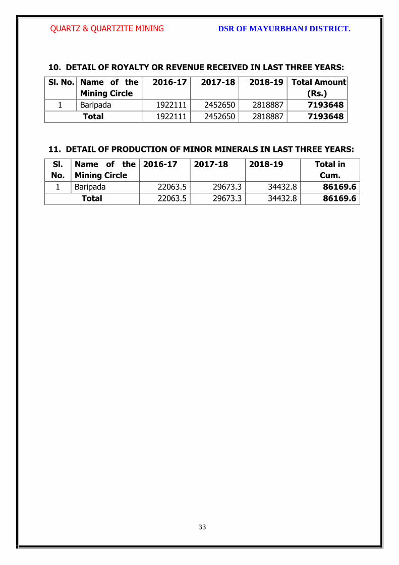
QUARTZ & QUARTZITE MINING DSR OF MAYURBHANJ DISTRICT.
33
10. DETAIL OF ROYALTY OR REVENUE RECEIVED IN LAST THREE YEARS:
Sl. No. Name of the
Mining Circle
2016-17 2017-18 2018-19 Total Amount
(Rs.)
1 Baripada 1922111 2452650 2818887 7193648
Total 1922111 2452650 2818887 7193648
11. DETAIL OF PRODUCTION OF MINOR MINERALS IN LAST THREE YEARS:
Sl.
No.
Name of the
Mining Circle
2016-17 2017-18 2018-19 Total in
Cum.
1 Baripada 22063.5 29673.3 34432.8 86169.6
Total 22063.5 29673.3 34432.8 86169.6

QUARTZ & QUARTZITE MINING DSR OF MAYURBHANJ DISTRICT.
34
12. MINERAL MAP OF THE DISTRICT:
Sl. No.
Name of the
Mineral
Name of the
Lessee
Address Letter of Intent Grant
Order No. &
date
Area of Mning
lease to be
allotted
Validity of LoI
Use
(Captive/ Non-
Captive)
Location of the Mining
lease (Latitude & Longitude)
1 2 3 4 5 6 7 8 9

QUARTZ & QUARTZITE MINING DSR OF MAYURBHANJ DISTRICT.
35
13. LIST OF LETTER OF INTENT (LOI) HOLDERS IN THE DISTRICT ALONG
WITH ITS VALIDITY
14. TOTAL MINERAL RESERVE AVAILABLE IN THE DISTRICT
Total mineral reserve of quartz is 10089783.5 tonne which may increase after detail
investigation as per details below.
(i) Blocks were identified based on geological studies through field observation.
(ii) Mineable resource was calculated by considering detail prospecting.
(iii) Area calculated as per GPS co-ordinates and information obtained from local
people. Land detail need to be verified from revenue record.
(iv) Since this is an interim report, as per the present requirement of minerals, more
such blocks need to be identified and the data should be updated periodically, after
certain intervals to update the data bank of DSR.
Sl. No.
Name of the Mining Circle
Mineral Resources in tonne.
Mineable Reserve in tonne.
1 Baripada 10089783.5 9121836.91
Total 10089783.5 9121836.91
Summary of Identified Mineral Potential:
Sl.
No.
Name
of the
mineral
Name
of the
lessee
Address and
contact No. of
the lessee
Letter of
Intent
Grant
Order
No. and
date
Area of
mining
lease to
be
allotted
Validity of LoI
Use
(Captive/ Non- Captive
Location of the Mining lease (Latitude & Longitude)
1 2 3 4 5 6 7
Attached as Annexure-G
15. QUALITY/GRADE OF MINERAL AVAILABLE IN THE DISTRICT:
Rocks and Minerals found in Mayurbhanj District:-
The district is endowed with various types of mineral resources like Iron ore, China
Attached as Annexure-G

QUARTZ & QUARTZITE MINING DSR OF MAYURBHANJ DISTRICT.
36
Clay, Quartz, Soap stone, Granite, Manganese, etc. Due to presence of huge
mineral resources, mining activities have been undertaken in a big scale. Bahalda,
Jashipur, Karanjia, Koshorpur, Bisoi, Gorumahisani and Rairangpur are the places in
the district having deposits of the above mineral products. The availability of
mineral deposits is given in the table below. The district’s mineral deposits have not
been utilized to maximum extent for industrial purpose. Some of the items like
China clay, Soap stone, Asbestos, etc. can be used in small scale sector. So the
available resources of the district need harnessing properly for industrial and
productive use. Quartz of the district is very much suitable for various industrial
purposes after crushing and screening.
16. USE OF MINERAL
Uses of Quartz -
Quartz :
Quartz is one of the most well-known minerals on earth. It occurs in basically all
mineral environments, and is the important constituent of many rocks. Quartz is also
the most varied of all minerals, occurring in all different forms, habits, and colors.
There are more variety names given to Quartz than any other mineral. Although the
Feldspars as a group are more prevalent than Quartz, as an individual mineral Quartz
is the most common mineral. Most mineral reference guides list Chalcedony as an
individual mineral, but in reality it is a variety of Quartz. It is the microcrystalline form
of Quartz, forming only occurs in microscopic, compacted crystals. This page deals
only with the crystalline forms of Quartz. Chalcedony is listed on its own dedicated
page in this guide. Other important varieties of Quartz, such as Amethyst, Citrine, and
Agate, also have dedicated pages due to their popularity and individual varieties.
Some forms of Quartz, especially the gemstone forms, have their color enhanced.
Almost all forms of the yellow-brown variety Citrine are in fact heat treated. Much
Amethyst is also heat treated to intensify color, and a green transparent form known
as "Green Amethyst" or "Prasiolite" is formed by heat treating certain types of
Amethyst. There is also a transparent sky blue form of Quartz crystals, as well as a
wildly iridescent type that are synthetically colored by irradiation of gold. In some
localities, Hematite forms a thin red or brown layer internally in the Quartz crystal,
giving it a natural bright red to brown coloring, and sometimes even a mild natural

QUARTZ & QUARTZITE MINING DSR OF MAYURBHANJ DISTRICT.
37
iridescence.
Quartz is an important mineral with numerous uses. Sand, which is composed of
tiny Quartz pebbles, is the primary ingredient for the manufacture of glass.
Transparent Rock Crystal has many electronic uses; it is used as oscillators in radios,
watches, and pressure gauges, and in the study of optics. In addition to all the
practical uses, Quartz is essential to the gem trade. Many varieties are faceted as
gems. Amethyst and Citrine are the most well-known gem varieties. Rose Quartz,
Smoky Quartz, Rock Crystal, and Aventurine are also cut or polished into gems.
Small colorless Quartz crystals are worn by some as pendants for good luck.
17. DEMAND AND SUPPLY OF THE MINERAL IN THE LAST THREE YEARS:
As such there are huge infrastructural and industrial activities are coming up by State
govt., Govt. of India & PSUs under “Make in India” programme. The main raw
minerals for the above activities and considering the last three years actual
productions with respect to the requirement of the state has a huge gap. It is
proposed to start the production from larger block/area to at least double the
production of the district which will enhance the revenue of the district and also
support the livelihood of the local people
Sl. No. Name of the Mining Circle
Financial Year
Quartz in tonne
1
Baripada 2016-17 22063.5
2017-18 29673.3
2018-19 34432.8
Total 86169.6
18. MAP OF EXISTING MINING LEASES IN THE DISTRICT:
Enclosed as Plate-I
19. DETAILS OF THE AREA OF WHERE THERE IS A CLUSTER OF MINING
LEASE VIZ. NUMBER OF MINING LEASES, LOCATION (LATITUDE AND
LONGITUDE)
Currently there is no cluster of Quartz mining lease in the district. However, it is
proposed to consider the cluster of mining lease while planning for new lease area in
QUARTZ & QUARTZITE MINING DSR OF MAYURBHANJ DISTRICT.
38
coming years.
20. DETAILS OF ECO-SENSITIVE AREA, IF ANY, IN THE DISTRICT:
Eco sensitive zone of Similipal wild life sanctuary is located within the district.
21. IMPACTS OF MINING ON ENVIRONMENT:
The most important environmental impact of mining projects is:-
Transportation sources:
Transportation sources of air pollutants include heavy vehicles used in excavation
operations, cars that transport personnel at the mining site, and trucks that transport
mining materials. The level of polluting emissions from these sources depends on the
fuel and conditions of the equipment. Even though individual emissions can be
relatively small, collectively these emissions can be of real concern. In addition,
mobile sources are a major source of particulate matter, carbon monoxide, and volatile
organic compounds that contribute significantly to the formation of ground-level ozone
Fugitive emissions:
Common sources of fugitive emissions include: storage and handling of materials;
mine processing; fugitive dust, blasting, construction activities, and roadways
associated with mining activities; leach pads, and tailing piles and ponds; and waste
rock piles. Sources and characteristics of fugitive emissions dust in mining operations
vary in each case, as do their impacts. Impacts are difficult to predict and calculate
but should be considered since they could be a significant source of hazardous air
pollutants.
Noise and vibration:
Noise pollution associated with mining may include noise from vehicle engines,
loading and unloading of rock into steel dumpers, chutes, power generation, and
other sources. Cumulative impacts of shoveling, ripping, drilling, blasting, transport,
crushing, grinding, and stock-piling can significantly affect wildlife and nearby
residents.
Vibrations are associated with many types of equipment used in mining operations,
but blasting is considered the major source. Vibration has affected the stability of
infrastructures, buildings, and homes of people living near large-scale open-pit mining
QUARTZ & QUARTZITE MINING DSR OF MAYURBHANJ DISTRICT.
39
operations. According to a study commissioned by the European Union in 2000:
“Shocks and vibrations as a result of blasting in connection with mining can lead to
noise, dust and collapse of structures in surrounding inhabited areas. The animal life,
on which the local population may depend, might also be disturbed.”
22. REMEDIAL MEASURES TO MITIGATE THE IMPACT OF MINING ON THE
ENVIRONMENT:
1. Following are the remedial measures to mitigate the in Water sprinkling on haul
road, loading and unloading points.
2. Plantation along the safety zone and dump area.
3. Providing dust masks to workers.
4. Regular monitoring of ambient air quality.
5. Provision of air conditioned cabin of Excavators and Dumpers.
6. Regular and proper maintenance of working equipments.
7. Periodic medical examination of the workers and organize medical camp in the area.
8. Use Milli Second Delay Detonator in blasting operation.
9. Provisions of ear plug to the workers.
10. Regular training programme to the mines workers and operators.
23. RECLAMATION OF MINED OUT AREA
Necessity of Reclamation & Rehabilitation:
Exponential growth in mineral production since 1980.
Mining activities causes physical, chemical, biological and socio-economic changes in
the area.
Surface mining activities disturb the original land profile.
In India, mineral production comes mostly from opencast mines & hence land
degradation problems are of serious concern.
An intricate, in-depth and site-specified techniques involving integrated approach is
necessary.
Reclamation has three vital roles:
i. Reclamation – Reclamation means return the mined-out land with useful life. It
implies restoring the land to a form and productivity that is useful and inconformity
QUARTZ & QUARTZITE MINING DSR OF MAYURBHANJ DISTRICT.
40
with a prior land use. Reclamation always may not be a single- phase operation.
ii. Rehabilitation – Rehabilitation is to bring batch the degraded land to a normal
stage by a special treatment. It is a process of taking some mitigation measures for
disturbed environmental condition created through mining activities.
iii. Restoration – Restoration is the process of returning the mined out land being
fit to an acceptable environmental condition. However, the general acceptable
meaning of the term is bringing the disturbed land to its original form. Restoration is
often used to indicate that biological properties of soil are put back to what they were.
This is a rate phenomenon.
iv. When active mining ceases, mine facilities and the site are reclaimed and closed.
The goal of mine site reclamation and closure should always be to return the site to a
condition that most resembles the pre-mining condition. Mines that are notorious for
their immense impact on the environment often made impacts only during the closure
phase, when active mining operations ceased. These impacts can persist for decades
and even centuries.
Mine reclamation and closure plans must describe in sufficient detail how the mining
company will restore the site to a condition that most resembles pre-mining
environmental quality; how it will prevent – in perpetuity – the release of toxic
contaminants from various mine facilities (such as abandoned open pits and tailings
impoundments); and how funds will be set aside to insure that the costs of
reclamation and closure will be paid for.
Proposed future land use after reclamation:
a. Forestry, b. Recreation, c. Water Reservoir, d. Crop Land,
e. residential/Commercial, f. Fish & wildlife Habitat, g. Undeveloped Land,
h. Grazing/Pasture Land
Statutory requirement:
As per the Mineral Conservation Development Rule, 2017, the following rules must be
bare in mind by the mine owner/agent/manager, which is a part of reclamation
activities –
Rule 22, Mine Closure Plan
Rule 23, Submission of Progressive Mine Closure Plan Rule 24, Submission of Final
Mine Closure Plan

QUARTZ & QUARTZITE MINING DSR OF MAYURBHANJ DISTRICT.
41
Rule 26, Responsibility of holder of mining lease Rule 27, Financial Assurance
Rule 35, Sustainable Mining
24. RISK ASSESSMENT AND DISASTER MANAGEMENT PLAN:
Mining activity because of the very nature of the operation, complexity of the
systems, procedures and methods always involves some amount of hazards. Hazard
identification and risk analysis is carried for identification of undesirable events that
can leads to a hazard, the analysis of hazard mechanism by which this undesirable
event could occur and usually the estimation of extent, magnitude and likelihood of
harmful effects. The activities which can cause high risk related to face stability and
the person blasting the shots. It was observed that on a working face of the mine,
there were large cracks and unsupported rocks were present, which can lead to a
serious hazard and injure workers engaged in loading operation and machineries
because of rock falls or slides. This type of condition turn out because improper
dressing of the bench and improper supervision. To avoid the hazards due to fall of
rocks the face must be examined, made suitable for working and the remedial
measures must be taken to make it safe if there is any doubt that a collapse could
take place. Working of the face should be in the direction taking into account the
geology of the area such that face and quarry side remain stable. Another major risk
identified in mines is due to the firing of explosive by an unqualified person. In the
mines there is problem of fly rocks and the village is located close to the mine and so
it is rated high as it can affect may people. Explosives by nature have the potential for
the most serious and catastrophic accident. Planning of round of shots, holes correctly
drilled, direction logged, weight of explosive suitable for good fragmentation are the
few of the steps necessary to ensure its safe use and if the shots are not properly
designed can result in misfires, early ignition and flying rocks. No person is allowed to
use explosives without being properly trained in its handling. In the mine a large
numbers of heavy vehicles were in operation and the roads were not proper for
haulage purpose. The haulage roads were not even and were not wide enough for the
crossing purpose and hence the chances of hazards are very high. The main hazards
arising from the use large earth moving vehicles are incompetent drivers, brake

QUARTZ & QUARTZITE MINING DSR OF MAYURBHANJ DISTRICT.
42
failure, lack of all-around visibility from the driver position, vehicle movements
particularly reversing, roll over, and maintenance. Those most at risk are the driver
and pedestrians likely to be struck by the vehicle, and drivers of smaller vehicles,
which cannot be seen from the cabs of large vehicles. Edge protection is always
necessary to prevent inadvertent movement over the edge of roadway or a bench.
Seatbelt will protect driver in case of roll. Good maintenance and regular testing are
necessary to reduce the possibility of brake failure. Access to the vehicles should
always be restricted to those people necessary for the work in hand. The use of
personal protective equipment and proper arrangements is essential to check if the
person is wearing protective equipment or not. The personal protective equipment
includes helmet, non-skid safety boots, safety glasses, earmuffs etc. The required
personal protective equipment should be provided and used in a manner that protects
the individual from injury. Few minor injuries which can be prevented are slip, trip, or
fall hazards; hazards due to rock falls and collapse of unstable rocks, atmosphere
containing toxic or combustible gases; protects from chemical or hazardous material
etc. A disaster management plan should be prepared for taking care of for any
disaster. Other risks which are included in this category are noise, as it occurs and it
can lead to permanent disability. There are problems related to road traffic in and out
issuers; inappropriate exposure of moving machines; mechanical failure and because
of large number of moving trucks and dumpers there is large quantity of dust present
in roadways which affects the operators and can lead to accidents causing injury.
They are in acceptable range because of precautions measures taken but no step is
taken it can cause hazard hence steps should be taken to reduce the hazards such as
for dust suppression system should be installed. Other problems like occurrence of
lots of mosquitoes in the area due to unhygienic conditions which affect the human
health causing malaria, dengue etc. and causing a person to be hospitalized.
Disaster in the mines like fires, explosions, entrapments, and inundations can occur
any time, so emergency preparedness is a must. The Disaster management plan and
risk assessment in the mines will include all sorts of above mentioned emergency and
the extent that this plan will be implemented will depend on the nature and scope of
the emergency. The basic purpose of Disaster management plan and risk assessment

QUARTZ & QUARTZITE MINING DSR OF MAYURBHANJ DISTRICT.
43
to ensure that mine rescue and recovery activities are conducted safely for rescuer
and survivors. According to MMR act 1961 a standard operating procedure should be
drawn for involvement different category of staff and officers. The SOP should be
updated periodically to reduce the chaos and response to the emergency should be
quick and smooth. The responsible person should be familiar with his responsibility
during the mock drills. One or two standby should be there to replace the person in
Emergency situation. Rescue operations should not include the survivors for any
assistance.
First Information of Disaster / Emergency should go to the attendance clerk on duty.
Duties of attendance Clerk (Emergency Siren) the attendance clerk or other
designated person should on getting information of major accident, sound a hooter or
a siren immediately declaring a state of emergency at the mine and then to contact
the manager and on his advice to call key personnel using the information listed in the
Emergency Organization Chart. It is important that all telephone calls are recorded in
a telephone log book. Duties of Other Officials should be displayed and handed over
to all concerned. Copy the same should be kept at Manager’s Office for ready
reference. Establishment of Control Room at Unit Level, Area Level and Company
Level is essential. Control Room should keep the contact information about –
Company Manager
Company owner/ Administrative officer.
District Administration
Govt. Hospitals in Nearby Localities,
Private Nursing Homes of Localities
Attendance roaster and duty charge register should be properly maintained so the
record of missing people can be obtained.
25. DETAILS OF THE OCCUPATIONAL HEALTH ISSUE IN THE DISTRICT:
The persons employed in the mines are exposed to a number of hazards at work
which adversely affect their health. Some of the important ones are dust, noise, heat,
humidity, vibration etc. In recent times, there has been increasing awareness among

QUARTZ & QUARTZITE MINING DSR OF MAYURBHANJ DISTRICT.
44
mining industry and the workers about occupational diseases like Pneumoconiosis,
Silicosis, Tuberculosis, Hearing Impairment etc. caused by exposure to health hazards
at work. Almost all occupational diseases can be prevented by adopting proper
occupational health measures and engineering control on airborne dust pollution at
workplace. Occupational Diseases in mines or industry is required to conduct medical
examinations and health surveillance of workers as per the provisions of Mines Act.
The present efforts of mines management are concentrated on detection of silicosis,
Pneumoconiosis and other notified diseases. The essential features of health
surveillance programme required to be carried out in mines are:
(a) Initial Medical Examination of persons to be conducted at the time of
appointment.
(b) Periodic Medical Examination or General physical examination to be conducted
once in every year.
(c) Maintenance of medical records and health services till the person is in service.
(d) The Details of Tuberculosis cases in last 5 years is given below
RNTCP Activities from 2014 to 2018
Year Projected Population
No of Sputum Examined
Sputum Examine
d per Lakh/Qr
No of
Sputum Positive
Sputum Positive
%
Total Case put on
DOTS/No of
TB cases
Child DOTS out of Total DOTS
Case detectin
per Lakh/Yr
Sputum
Conversion Rate
NSP Cure Rate
NSP Death Rate
(in Lakh) Norm- 150
Norm-8-15 %
Norm-170 /L/Y
Norm-90 %
Norm-90%
Norm < 5%
2014 26.01 16848 161.9 2825 16.8% 4883 103 187.7 90.2% 89.0% 7.4%
2015 26.30 18118 172.2 2836 15.7% 4831 123 183.7 90.5% 89.0% 6.7%
2016 26.59 20060 188.6 2975 14.8% 5171 119 194.5 95.0% 90.9% 6.5%
2017 26.88 31035 289.4 3152 11.4% 5127 111 190.7 94.0% 91.6% 5.5%
2018 27.18 21273 195.6 2853 13.4% 4894 95 173.4 95.3% 92.7% 6.4%
26. PLANTATION GREEN BELT DEVELOPMENT IN RESPECT OF LEASE
ALREADY GRANTED IN THE DISTRICT:
During mining operation green belt development through plantation is most important

QUARTZ & QUARTZITE MINING DSR OF MAYURBHANJ DISTRICT.
45
for environment safe guard, which should be supervision by mining department.
Different type of species should be planted near lease periphery to keep environment
clean at post mining period through reclamation. Where specific usefulness of land
could be decided, a forestation is normally planned through the site could have been
considered for better possibilities of land use.
27. CONCLUSION:
Since it is an interim report, to meet the requirement of minerals in the present
scenario, it is proposed to identify such potential areas at certain interval and get the
data bank of DSR to be updated. The insitu mining activity in any area is on one hand
bring revenue and employment (Direct and indirect) and on other hand if not done
properly potential pollution and ecological imbalance increases, the ability of the
ecosystem can also be reduced. Particulate matter transported by the wind as a result
of excavations, blasting, transportation of materials, heavy equipments used raise
these particulate levels; and Gas emissions from the combustion of fuels in stationary
and mobile sources, explosions, and mineral processing. All these activities indirectly
affected the biodiversity of area. Larger potential and smaller areas have been
identified in Mayurbhanj district on the basis of geological study carried out during
field observation, which can be considered for mining concession after all the
parameters for statutory clearances are verified by consulting with concerned
authorities.

QUARTZ & QUARTZITE MINING DSR OF MAYURBHANJ DISTRICT.
46
Plate No.-I

\
\
QUARTZ IVIINING DSR OF MAYURBHANJ DISTRICT.
The District Survey Report for Quartz & Quartzite Mining ( Minor Mineral)
in respect of Mayurbhanj District prepared in accordance with Appendix-X, Para -7 (iii)
(a) of S"O. 3611 (E) Dt. 25.07.2018 of Ministry of Environment, Forest and Climate
Change, New Delhi is approved for final publication in the district website.
\os
. H.K.Sahu, Sri S.Mal I.F.S, Sri Di a, I.A.SProf in Zoology, NOU -cum-Member, DEIAA, Mayurbhanj
DFO-cum-Member,DEIAA, Mayurbhanj
SDM, Sadar-cum -Member SecretaryDEIAA, Mayurbhanj
41,,1 ,Sri Vineet Bfrardfraj/ reS
Collector & DM-cuni- Chairman, DEIAAMayurbhanj (Odisha)
47
L
*
IL"
it

Fro
m
To
Fro
m
To
1 2 3 4 5 6 7 8 9 10 11 12 13 14 15 16 17 18 19
1 Quartzite L.K.Das Paktia-I
Granted vide
Proceeding No. -
III(c)M-2/2000- 16981
/30.12.2000
3.581
Vill- Paktia
30
.03
.20
01
29
.03
.20
21
- - - - Non-
Captive
DEIAA/119
Dt.
21.06.2017
Lat- 22°19'15"N -
22°19'30"N
Long- 86°29'00"E-
86°29'15"E
Saraskana Open Cast 457426 435117
2 Quartzite L.K.Das Pandupani
Granted vide
Proceeding No.
10976/MG, dt.
15.09.1982
12.95
Vill- Pandupani under
Bamanghaty Sub-
division 27
.04
.19
83
26
.04
.20
03
- - - Deemed
Extention
Non-
Captive
MoEF L. No. J-
11015/259/20
10-IA(M) dt.
20.05.2014
Lat- 22°29'51"N -
22°29'38"N
Long- 86°00'17"E-
86°00'33"E
Tiring Open Cast 738832 707914
3 QuartziteDinabandhu
Mohapatra
Dalki-I
At- Karunei, PO-
Bijatala, PS- Bisoi
Granted vide
Proceeding No.
54/05.01.2000
3.845
Vill- Dalki
15
.04
.20
00
14
.04
.20
20
- - - -
Non-
Captive
DEIAA/121
Dt.
12.06.2017
Lat- 22°20'50.7"N -
22°20'41.7"N
Long- 86°01'45.5"E-
86°01'54.8"E
Jamda Open Cast 194122.5 144007.5
Annexure-G
SPECIFIED MINOR MINERALS (QUARTZ & QUARTZITE)
Sl
No
Name of
Minerals
Name of
Lessees
Address and
Contact No. of
lessee
Mining Lease Grant
Order No. & Date
Area of Mining Lease
(Ha.) with village
Khata No., Plot No. &
Kisam
Period of
Mining
Lease
(Initial)
Period of
Mining
Lease
(1st/2nd
Renewal)
Method
of Mining
(Open
cast/
Under
Ground)
Geological
Reserve
(MT/
Cums)
Mineable
Reserve
(MT/
Cums)
Working Mining Lease
Date of
Commence
ment of
mining
operation
Status
(Working/
Non-
working/
temp.
Working
for
dispatch
etc.
Captive/
Non-
captive
Obtained
environmenta
l clearance
(Yes/no). If
Yes, Letter
No. with date
of EC
Location of Mining
Lease (Latitude &
Longitude)
Name of
Tahasil

1 2 3 4 5 6 7 8 9 10 11 12 13 14 15 16 17 18 19
4 Quartzite B.K.DasDalki-II
Granted vide
Proceeding No.- 2658,
dt. 10.03.2000
1.295
Vill- Dalki
16
.06
.20
00
15
.06
.20
20
- -
14
.07
.20
00
- Non-
Captive
DEIAA/123
Dt.
21.06.2017
Lat- 22°20'54.8"N -
22°20'59.9"N
Long- 86°02'08.1"E-
86°02'14.8"E
Jamda Open Cast 207480 141375
5 Quartzite N.C.Das
At- Bahalda Road,
Mayurbhanj
Mob. No.-
9937804682
Granted vide
Proceeding No. -
III(c)SM-
14/96/9705/SM, Dt.
04.10.1996
0.898
Vill- Jashipur
06
.01
.19
99
05
.01
.20
19
07
.04
.19
99
Not
reopened
as
application
for RML
pending at
Govt. Level
Non-
CaptiveNo
Lat- 22°26'52"N -
22°26'57"N
Long- 86°12'07"E-
86°12'11"E
Bahalda Open Cast 172392 142753
6Quartz &
QuartziteM.R.Hota
Vill-Lupung &
Hansadihi,
At- Icinda, PO-
Rairangpur
Granted vide
Proceeding No.
8199/III(C) SM, BBSR,
dt.14.10.2004
18.818
Vill-Lupung &
Hansadihi
07
.01
.20
08
06
.01
.20
28
Lapsed
vide Lr.
No.
12400/SM,
Dt.21.12.2
015.
Non-
Captive
Lat- 21°01'50"N -
22°02'05"N
Long- 86°26'07"E-
86°26'17"E
Open Cast 262964 135707
7 Quartzite D.C.Das
At- Bahalda Road,
Mayurbhanj
Granted vide
Proceeding No.
5190/MG, dt.
21.04.1982
4.856
Kuldiha
26
.06
.19
83
25
.06
.20
03
15
.01
.19
84
Expired
from
25.06.03
Non-
Captive
EC not
required as
the lease area
is below
5.00hects.
Lat- 21°28'17"N -
22°28'28"N
Long- 86°11'18"E-
86°11'43"E
Bahalda Open Cast 49612 46173
Non-Working Leases
Ap
plic
atio
n f
or
RM
L p
end
ing
at G
ovt
. Lev
el

1 2 3 4 5 6 7 8 9 10 11 12 13 14 15 16 17 18 19
8Quartz &
Quartzite
Hadibandhu
Putty,
Paktia-II
At/Po- Budamara,
PS- Bangiriposi
4.132
Vill- Paktia under
Saraskana Tahasil
02
.12
.20
02
01
.12
.20
22
Lapsed
vide Lr.
No.
9746/SM,
Dt.30.09.2
015 &
Possesion
has been
taken over
on
dt.18.12.2
015
Non-
CaptiveNo
Lat- 21218'40"N -
22°18'55"N
Long- 86°28'36"E-
86°28'46"E
Saraskana Open Cast - 105423.2
9 Quartzite J.G.Khandelwal Jadunathpur
Granted vide
Proceeding No.
9841/MG, BBSR, dt.
13.10.1989
2.76
19
.02
.19
90
18
.02
.20
10
Lapsed
vide Lr.
No.8345/S
M,
Dt.31.08.2
015.
Non-
CaptiveTiring Open Cast
10 QuartziteK.B.Mohanty,
Tiringdihi
Granted vide
Proceeding
No.6416/MG, dt.
23.06.1983
1.497
Vill-Tiringdihi under
Tiring Tahasil0
5.0
9.1
98
4
04
.09
.20
04
Lapsed
vide Lr.
No.8386/S
M,
Dt.31.08.2
015 &
possesion
taken over
on
dt.10.12.2
015
Non-
CaptiveNo Tiring Open Cast

1 2 3 4 5 6 7 8 9 10 11 12 13 14 15 16 17 18 19
11Quartz &
Quartzite
M/s Balasore
Alloys Ltd., Baghjhumpa
Granted vide
Proceeding No.
10370/SM, dt.
14.11.2002
3.64
Vill- Baghjhumpa ,
P. No. 641/P, Khata
No.- 264
Kisam- Patharbani
24
.07
.20
04
23
.07
.20
24
08
.02
.20
05
Lapsed
vide
Lr.9716/S
M,
Dt.30.09.2
015 . &
Possesion
has been
taken over
on
dt.23.06.2
016
Non-
CaptiveNO
Lat- 22°12'19"N -
22°12'33"N
Long- 86°35'59"E-
86°3608"E
Saraskana Open Cast 257803 213941
12Quartz &
Quartzite
M/s Utkal
Minerals &
Pharma (P) Ltd.
Khasadiha
Granted vide
Proceeding No.
11290/11.10.1983
40.12
20
.06
.19
63
19
.06
.19
83
20
.06
.19
83
19
.06
.20
03
Lapsed
vide Lr.
No.8249/S
M,
Dt.30.10.2
014.
Non-
Captive
Lat- 21°56'36"N -
21°57'24"N
Long- 86°36'48"E-
86°37'9"E
Shamakh
untaOpen Cast 6330509 5798499
13Quartz &
QuartziteS.K.Behera
At/Po- Budamara,
Via- K.M. Kata
Granted vide
Proceeding No. 5646
dt. 29.05.2000
5.419
Vill- Nischinta0
7.0
9.2
00
0
06
.09
.20
20
01
.12
.20
00
Lapsed
vide Lr.
No.9787/S
M,
Dt.30.09.2
015.
Non-
Captive
Lat- 22°07'31"N -
22°07'43"N
Long- 86°29'06"E-
86°29'18"E
Bangiripo
si Open Cast 1022713 858512
14
Kynite/
Quartz
/Quartzite
S.K.BeheraPurnapani
Granted vide
Proceeding No.
9902/SM, dt.
08.08.2001
48.948
Purunapani, Tilagadia
under Sadar Sub-
division 18
.01
.20
02
17
.01
.20
22
Lapsed
vide L. No.
2411/SM,
Dated
19.03.201
6 &
Possesion
has been
taken over
on
dt.23.02.2
017
Non-
Captive
Bangiripo
si Open Cast

1 2 3 4 5 6 7 8 9 10 11 12 13 14 15 16 17 18 19
15
Quartz/
Quartzite
&
Soapston
e
Sri D.C. Das Bhitaramda
Granted vide
Proceeding No.
7300/III(C)SM-
47/2000/SM, dt.
04.05.2006
7.292
Vill- Bhitaramda
Kisam- Pahad, Gochar,
Dahi-II
Lat- 22°24'03"N -
22°24'14"N
Long- 86°11'11"E-
86°11'24"E
Bahalda 395930 392415
DISTRICT SURVEY REPORT (DSR) OF
MAYURBHANJ DISTRICT, ODISHA. FOR
SOAP STONE
(FOR PLANNING & EXPLOITING OF MINOR MINERAL RESOURCES)
As per Notification No. S.O. 3611(E) New Delhi
dated 25th July 2018 of
Ministry of Environment, Forest & Climate Change
(MoEF & CC)
( Prepared by DEIAA, Mayurbhanj, Odisha )

SOAP STONE MINING DSR OF MAYURBHANJ DISTRICT.
1
CONTENT
CH.
NO.
DESCRIPTION PAGE
NO.
Preamble
1 Introduction 4
1.1 Location and Geographical Area 4
1.2 Administrative Units 5
1.3 Connectivity 7
2 Overview of Mining Activity in the District 10
3 General Profile of the District 11
3.1 Demography 11
4 Geology of the District 11
4.1 Physiography & Geomorphology 12
4.2 Stratigraphy. 13
4.3 Mineral Resources. 14
4.4 Soil 17
5 Drainage of Irrigation Pattern 17
5.1 River System 19
6 Land Utilization Pattern in the District 21
6.1 Forest and non forest land. 21
6.2 Agricultural land. 24
6.3 Horticultural land. 25
7 Surface Water and Ground Water Scenario of the District 25
7.1 Hydrogeology. 25
7.2 Depth to water level. 26
7.3 Ground Water Quality. 28
7.4 Ground Water Development. 29
7.5 Ground water related issues & problems. 29
7.6 Mass Awareness Campaign on Water Management
Training Programme by CGWB
30
7.7 Area Notified By CGWB/SGWA 30
7.8 Recommendations 30
8 Rainfall of the District and Climate Condition 31
8.1 Month Wise rainfall. 31
8.2 Climate. 31
9 Details of Mining Lease in the District 32
9.1 List of Mines in operation in the district Annexure-B
9.2 List of Mines not in operation in the district Annexure-B
10 Detail of Royalty or Revenue received in last 3 years 33

SOAP STONE MINING DSR OF MAYURBHANJ DISTRICT.
2
11 Detail of production of minor mineral in last 3 years 34
12 Mineral Map of the District. 35
13 List of Letter of Intent (LOI) Holders in the District along
with its Validity.
35
14 Total Mineral Reserve Available in the District. 36
15 Quality/Grade of Mineral Available in the District. 37
16 Use of Mineral. 37
17 Demand and Supply of the Mineral in the Last Three Years. 38
18 Map of Existing Mining Leases in the District. 38
19 Details of the Area of where there is a cluster of mining
lease viz. Number of mining leases, location (latitude and
longitude).
39
20 Details of Eco-Sensitive Area, if Any, in the District 39
21 Impact of Mining on Environment 39
22 Remedial Measures to Mitigate the Impact of Mining on
the Environment
40
23 Reclamation of Mined Out Area 40
24 Risk Assessment and Disaster Management Plan 42
25 Details of the Occupational Health Issue in the District 45
26 Plantation and Green Belt Development in Respect of
Lease Already Granted in the District
46
27 Conclusion & References 46

SOAP STONE MINING DSR OF MAYURBHANJ DISTRICT.
3
PREAMBLE
Odisha is the major mineral reach in India. Mayurbhanj is a unique district in Odisha
lies on the northern most part of the state with varied mineral resources. In
pursuance of the order of Hon’ble Supreme Court Petition (C) No. 19628-19629 of
2009, dated 27th Feb. 2012 in the matter of Deepak Kumar Vs State of Haryana and
others etc., prior environmental clearance has now become mandatory for mining of
minor minerals irrespective of the area of Mining Lease. And also in view of the
Hon’ble National Green Tribunal, order dated the 13th Jan. 2015 the matter regarding
Road metal/stone, Sand, Brick earth, & burrowed earth cutting for Road Construction
has to take prior Environmental Clearance for Mining Lease area more or less than 5
hectares also suggested making a policy on Environmental Clearance for minor
minerals lease and leases in cluster. As per MOEF & CC Notification S.O.-1533(E)
dated 14th Sept. 2006 and subsequent MoEF & CC Notification S.O. 141(E) dated 15th
Jan. 2016, District Environment Impact Assessment Authority (DEIAA) & District level
Expert Appraisal Committee (DEAC) has been formed for Category –B2 Minor Minerals
having area less than or equal to 5 ha. In compliance to the notification issued by the
Ministry of Environment and Forest and Climate Change Notification no. S.O.3611 (E)
New Delhi dated 25-07-2018; the preparation of district survey report of road
metal/stone mining has been prepared in accordance with Clause II of Appendix X of the
notification.
Keeping in view of the prior information of Odisha Minor Mineral Concession Rule
2004, (OMMCR -2004) the mining operation for minor minerals were carried out in
unscientific manner. Identifying this fact in exercise of power, Conferred by Section 15
by Mines and Minerals (Development and Regulation) Act 1957 as amended in 2015
and all other powers enabling it in that behalf, the Mining & Geology Department,
Govt. of Odisha framed the aforementioned rule. Further, this report will act as a
compendium of available mineral resources, geological set up, environmental and
ecological set up of the district and based on data of various departments like
Revenue, Water Resources, Forest, Geology and Mining in the district as well as
statistical data uploaded by various state Government departments for preparation for
district survey report.

SOAP STONE MINING DSR OF MAYURBHANJ DISTRICT.
4
1. INTRODUCTION:
Mayurbhanj at a Glance:
1.1 Location and Geographical Area:
Mayurbhanj district is the largest among the thirty districts of Odisha and Baripada is
the District head quarter, spreading over an area of 10,418 sq.km lies between
latitudes 21° 17’ North and 22° 34’ North and longitudes 85°40’ East and 87°10’ East.
It is bounded on the north by the Singhbhum district of Jharkhand and Midnapore
district of West Bengal, on the south by the districts of Balasore and Keonjhar, on the
east by the Midnapore and Balasore districts and on the west by the districts of
Keonjhar and Singhbhum. Mayurbhanj occupies a unique position being endowed
with lush green vegetation, different fauna & flora and rich cultural heritage. The
district has a rich mineral base and is home to the Similipal Biosphere. Iron-ore
(hematite), vanadiferous and titaniferous magnetic, chaina clay, galena (lead ore),
Kyanite, asbestos, steatite (soap stone) and quartzite constitute the principal mineral
resources of Mayurbhanj district, of these the iron-ore deposits of Gorumahisani,
Badampahar and Suleipat, which have been exploited for a period of about half a
century, deserve special mention.

SOAP STONE MINING DSR OF MAYURBHANJ DISTRICT.
5
1.2 Administrative Units:-
Baripada is the administrative headquarter of Mayurbhanj district. It is located at a
distance of 263 km from Bhubaneswar, state capital of Odisha. In order of size, the
district is the largest among the thirty districts of Odisha. It has 3980 villages
(including 178 uninhabited villages) covering 26 Blocks, 26 Tahasils and 4 Sub-
Divisions. The district is divided into 4 Sub-Divisions namely 1) Sadar Sub-Division
Baripada, 2) Kaptipada Sub-Division Udala, 3) Bamanghaty Sub-Division, Rairangpur,
4) Panchapir Sub-Division, Karanjia. which are given below:-

SOAP STONE MINING DSR OF MAYURBHANJ DISTRICT.
6
Sl No Name of the Block/Tehsil Name of the Sub-Division with
Head quarter
1 Baripada
Sadar Sub-Division, Baripada
2 Samakhunta
3 Kuliana
4 Bangriposi
5 Saraskana
6 Suliapada
7 Betnoti
8 Badsahi
9 Rasgovindpur
10 Moroda
11 Udala
Kaptipada Sub-Division, Udala
12 Kaptipada
13 Khunta
14 Gapabandhu Nagar
15 Rairangpur
Bamanghaty Sub-Division,
Rairangpur
16 Bisoi
17 Bijatala
18 Kusumi
19 Bahalda
20 Tiring Bamanghaty Sub-Division,
Rairangpur 21 Jamda
22 Karanjia
Panchpir Sub-Division, Karanjia
23 Jashipur
24 Sukruli
25 Thakurmunda
26 Raruan
The population of the district 25,19,738 according to the 2011 Census. The district
accounts for 6.69% of the state’s territory and about 6% of state’s population. The
density of population of the district is 242 per square km as against 270 per square
km of the state. As per 2011 census, the population of Scheduled Caste is 1,84,682
(7.30%), that of Scheduled Tribe is 14,79,576 (58.7%). The literacy percentage of the
district covers 63.2 against 72.9 of the state.

SOAP STONE MINING DSR OF MAYURBHANJ DISTRICT.
7
1.3 Connectivity facilities:-
Road Network
The district is well served by a network of good roads and has been called the
motorists paradise. The chief roads emanating from Mayurbhanj town are NH-18 and
NH-49 passes the district. Baripada is 60 Kms from Mayurbhanj, 103 Kms from
Kharagpur, 163 Kms from Jamshedpur, 231 Kms from Cuttack, 255 Kms from
Bhubaneswar and 368 Kms from Rourkela. It is also connected with other cities such
as Sambalpur, Puri, Bolangir, Bhadrak, Jhargram, Angul, Ranchi and Kolkata via
Odisha State Road Transport Corporation and some private travel services.

SOAP STONE MINING DSR OF MAYURBHANJ DISTRICT.
8
Rail Network
Mayurbhanj district is well connected by rail link to different places, the city of
Baripada is well connected to many places in India like Mayurbhanj, Bhubaneswar,
Kolkata, Jamshedpur and Cuttack,

SOAP STONE MINING DSR OF MAYURBHANJ DISTRICT.
9
Air Network
At present, Mayurbhanj has no connection by airway. The site selection for aerodrome
is presently under process. Nearest aerodrome is Dum Dum Airport (International
Airport) Kolkata, roughly 195 Kms from Baripada. The other nearest airport to
Baripada is Biju Patnaik Airport, Bhubaneshwar, 207 Kms from Baripada.

SOAP STONE MINING DSR OF MAYURBHANJ DISTRICT.
10
2. OVERVIEW OF MINING ACTIVITY IN THE DISTRICT:
Mayurbhanj district is land features of both plain and hilly region. Most of the
mineralized area coming under safety zone eco-sensitive zone, mining activity only
confined out of safety zone of eco-sensitive zone. The mining activity in the district is
not only restricted to minor minerals i.e. of sand, stone, granite and brick clays.
Altogether there are leases of Iron-ore (hematite), vanadiferous and titaniferous
magnetic, chaina clay, galena (lead ore), Kyanite, asbestos, steatite (soap stone) and
quartzite constitute the principal mineral resources of Mayurbhanj district, of these the
iron-ore deposits of Gorumahisani, Badampahar and Suleipat, which have been
exploited for a period of about half a century. Stone, granite and sand which has been
granted to the district is regulated as per minerals concession rules of Odisha. There
is no lease of major mineral in the district. At present Leases of stone, sand and bricks
making units are operational in the district. Stone chips, granite stones, ordinary sand

SOAP STONE MINING DSR OF MAYURBHANJ DISTRICT.
11
constitute the principal mining activity of Bangirposi, Badasahi, Kaptipada, Kuliana
area etc. of Mayurbhanj district. Out of these huge granite stones deposits are
available near Badasahi, Kaptipada, Kuliana area and major potential sand in G.B
Nagar, Morada & Kaptipada area of the district, which have been provides
tremendous scope for development of few more industries based on this resources.
Iron-ore (hematite), vanadiferous and titaniferous magnetic, chaina clay, galena (lead
ore), Kyanite, asbestos, steatite (soap stone) and quartzite constitute the principal
mineral resources of Mayurbhanj district, of these the iron-ore deposits of
Gorumahisani, Badampahar and Suleipat, which have been exploited for a period of
about half a century.
3.0 GENERAL PROFILE OF THE DISTRICT:
3.1 Demography:
Census - 2011
Geographical Area 10,418 Sq. Km.
Total population 25,19,738
Male Population 12,56,213
Female Population 12,63,525
Male Literacy 794,171
Female Literacy 575,226
SC Male 92,127
SC Female 92,555
ST Male 730,487
ST Female 749,089
OBC 855,480
Illiterate Male 462,042
Illiterate Female 688,299
4.0 GEOLOGY OF THE DISTRICT:
Mayurbhanj is a unique district in Odisha with rich and varied geology. Similipal
Complex being at its central part. The mountain ranges comprise mainly of highland
plateau and valleys with intrusive running through them. The second physiographic
unit is Tertiary Plain occurring in the eastern part of the district. The third
physiographic unit is Alluvial Plain .The drainage density is observed to be fairly
moderate and drainage pattern is dendritic in nature. The major rock types

SOAP STONE MINING DSR OF MAYURBHANJ DISTRICT.
12
encountered in the district are Granite Gneiss, Quartzite, Orthoquartzite, Arkose,
Shale, Phyllite, Gabbro, Px-granite. The geology of the district is constituted by the
Similipal complex at its central part belonging the Archaean age, unconformably lying
over Singhbhum Granite and Banded Iron Formation (BIF). It consists of three
alternate bands of volcano sedimentary units uniquely disposed in a ring like circular
pattern formed under sub- marine conditions. Baripada Beds outcrops of tertiary
formation occur around Baripada town. These comprise stratified clay and sand with
marly clay or limestone interbands. Important mineral resources include iron, copper,
itanium, vanadium, chinaclay, nickel, kyanite ,quartz, talc, steatite ,soapstone and
bauxite.
4.1 Physiography & Geomorphology:
Mayurbhanj district presents diverse physiographic features, Physiographically the
study area can be divided into 3 categories. The first physiographic unit of the district
is high mountain ranges, Similipal Complex being at its central part (Figure 1). The
mountain ranges comprise mainly of highland plateau and valleys with intrusive
running through them. The second physiographic unit is Tertiary Plain occurring in the
eastern part of the district. The third physiographic unit is Alluvial Plain which lies
partly in Rasgovindpur, Morada, Samakhunta, Betnoti, Baripada, Badasahi and
Suliapada Blocks. The highest elevation of about 559m at Bahalda near Similpal hill
and higher elevations of the district, due to scarp landforms some waterfalls are
observed in the district. The general slope of the district is from north to south.
Geologically the area is comprised with Archean granites and gneisses.
Geomorphologically the district is divided into 3 units:
i) The denudational hills with moderate to high slope occurring in the western part of
the district.
ii) Dissected pediments having gentle slope.

SOAP STONE MINING DSR OF MAYURBHANJ DISTRICT.
13
iii) Pediplain having slope between 0o to 5o.
4.2 Stratigraphy:
Geological Age Geological Formation / Group
Quaternany : Recent Alluvium, Clays, silt, Sand, Gravel
Tertiary : Older Alluvium, Laterite, Baripada Beds.
Mesozoic/ Palaeozoic : Volcanics / Epidiorite
Precambrian : Slate/ Phyllite/ Schist / Gneiss
Archean : Granite/ Granite Gneiss

SOAP STONE MINING DSR OF MAYURBHANJ DISTRICT.
14
4.3 Mineral Resources:
The earliest known geological survey in Mayurbhanj dates back to 1903, when P.N.
Bose brought to light the extensive iron-ore deposits of high quantity on the
Gorumahisani and Suleipat hills in Bamanghaty Sub-Division. These deposits were
considered to be almost inexhaustible and were pronounced to be of excellent quality,
perhaps second to none in the whole of Asia by the famous American and English
experts like M/s Perin, Weld and Colonel Staddart, who visited these deposits during
1905-06. This discovery was a momentous one as the steel plant of the Tata Iron &
Steel Co. at Jamshedpur was entirely based on the exploitation of these deposits. By
1915, important discoveries of Steatite near Lulung and placer gold from the sands of
Subarnarekha, Kharkhai and Barhai rivers had been made. The placer gold deposits
were being worked by M/s J.B. Bettie of Calcutta, Mr. V.G. Piggot of Ghatsila and the
Mayurbhanj Prospecting Concession Syndicate.
Gold: The mid-Archaean Gorumahisani-Badampahar schist belt composed of basic
ultrabasic, volcanic rocks and volcanogenic sediments. This belt has been
prognosticated as a rift-type of volcanic dominated one and is highly potential for
economic grade gold mineralization. Likely targets include: a) auriferous quartz veins
close to the contact of sulphide chert volcanics, b) sheared and sulphidised Fe-rich
tholeiite with anomalous copper, c) epigenetic vein type of mineralization and BIF
volcanic association, and d) sulphidic conglomerate resting over the basic volcanics.
Placer gold occurrence are known from rivers and stream of Mayurbhanj district. An
area of about 5 square kilometers of alluvium at the headwaters of Sapgora and Borai
rivers near Kudersai was indicated as promising.
Iron: Bose discovered iron ore deposits in Gorumahisani and Badampahar in the
eastwhile princely state of Mayurbhanj (now Mayurbhanj District). Gorumahisani
deposits were investigated by Perin & Weld (1905). Gorumahisani- Badampahar-
Suleipat deposits are associated with banded hematite / magnetite grunerite and BHJ.

SOAP STONE MINING DSR OF MAYURBHANJ DISTRICT.
15
Gorumahisani – Badampahar- Suleipat (Broad geological sequence)
Laterite & Alluvium
Newer Dolerite
Gabhro-Anorthosite Granite
---Unconformity---
Ultramafic dyke
Singhbhum Granite
Banded magnetite/ Martite quartzite with Fe-Ores
Quartzite
Basal Conglomerate
----Unconformity----
Older metamorphic
Vanadium Ores & Titanium: Vanadium is an important alloying element. Magnetite
associated with gabbro- anorthosite suite of rocks contain vanadium and titanium.
Deposits of vanadium-magnetite occur in association with gabbro-Anorthosite suite of
rocks in the precambrian metamorphites. Vanadium bearing magnetite belts are :-
(a) Rairangpur – Bisoi belt (Kumardubi, Betjharan Amdabeda)
(b) Bisoi – Joshipur belt (Mayurbeka, Kesham, Sialnoi)
(c) Baripada – Podadiha belt (Andipur, Bahalda)
Pyrophyllite : is mainly used as a high grade ceramic product, electric insulator and
refractory material. The comp. is Al2O34SiO2 H20. It is formed as an alteration product
of feldspar. Pyrophyllite occurrences are reported at Kankrani, Jashipur,
Gorumahisani, Bangriposhi and Manada in Mayurbhnaj dist. Ichinda, Khairakocha,
Jamukunda, Nakulkocha, Kapadiha, Dunguridiha, Maheshpur, Kashidiha, Sagragora
and Pokpoka. Dimension stone of the district are granite, granite-gneiss, migmatites,
syenite, gabbro, anorthosite, charnockite, leptynite, pyroxene granulite, dolerite,
pyroxinite and dunite etc.
Bauxite: In Similipal complex (Mayurbhanj) aluminous laterite/ Bauxite are observed
around 1000 m AMSL. The spongy aluminous laterite/bauxite occurs as sheets and
boulders occupying the flat-topped hills made up of metavolcanics. Both
ultramafics and metavolcanics are lateritised giving rise to nickeliferous laterite and
aluminous laterite respectively.

SOAP STONE MINING DSR OF MAYURBHANJ DISTRICT.
16
China Clay clay like material approximating the mineral Kaolinite (Al2O3, 2SIO2,
2H2O). China clay is found to occur in a long belt stretching from Singhbhum to
Mayurbhanj. Badampahar-Joshipur- Karanjia – Ramachandrapur belt is the most
important china-clay producing area of the state. The important deposits in
Mayurbhanj district are found near Jashipur, Chanchbani, Dumuria, Jamda, Kodadiha,
Jamkeswar and Thakurmunda. China clay has many industrial applications as filler in
paper, textile, rubber, in the manufacture of potteries, ceramics, sanitary wares,
glazed tiles, white cement, insecticides, paints, cosmetics, refractory bricks etc. Soap
stone and Steatite Asbestos is mined from Mayurbhanj area.
Talc, Steatite and Soapstone: Important localities of these deposits in Mayurbhanj
dist are Tiring, Kendumundi and Kharidamak.
Kyanite: Kyanite deposits of refractory grade occur in Panijia area of Mayurbhanj
dist, where it is associated with dumortierite bearing rocks, qtz-veins, quartz-mica-
schists and talc-tremolite-schist. Other kyanite occurrence include Purnapani &
Similipal.
Quartz & Quartzite: Quartz and silica sand are mostly used in glass foundry,
ferrosilicon alloy, ceramic industry, abrasive, paint, rubber, textile industries.
Transparent varieties of quartz such as rock crystal, amethyst, citrine, Rosequartz and
smoky quartz are used as semi-precious gemstone. Quartz is a piezoelectric material
and is used in radio circuit, Radars and ultra-sonic devices. Quartzite is a
monomineralic rock constituted predominantly of quartz. There are 6 mining leases
for quartz and quartzite in Mayurbhanj dist.
High Magnesia rock: are found in Notapahar, Thakurmunda, Amjori and
Badampahar of Mayurbhanj Dist.
Nickel: Nickel is concentrated within chemically weathered ultramafic rocks and
found in the laterite and soil capping in Similipal area. The mineral occurs in silicate

SOAP STONE MINING DSR OF MAYURBHANJ DISTRICT.
17
form i.e. garnierite. The important patches of prospective ore zones are: Gurguria and
Nawana.
4.4 Soil:
The district comprises chiefly of lateritic, sandy loam and clayey loam type of soil
(Figure 3). Laterite soil is mostly marked in the area occupied by crystalline rocks.
The low lying valley fields are covered with clayey loam type of soil.
5. DRAINAGE OF IRRIGATION PATTERN
The district has considerable flat land, which provide suitable site for agricultural use.
The hilly areas are mostly under forest with patches of cultivation on scarp areas.
Major rivers flowing in the district are Budhabalanga, Subarnarekha, Jambhira, Sona,

SOAP STONE MINING DSR OF MAYURBHANJ DISTRICT.
18
Khadkhai, Deo, Katra, Khairibandhan & Baitarani. Major crops grown in the district are
rice Only. 14.82 percent area of agricultural use are net irrigated and major source of
irrigations are well and tube-wells.
Sl. No.
Name of the River
Area drained (Sq.Km.)
% Area drained in the District
1 Budhabalanga 2143 21%
2 Subarnarekha 265 0.25%
3 Jambhira 1377 13%
4 Sona 1062 10%
5 Khadkhai 1131 10.8%
6 Khairibandhan 1014 0.09%
7 Deo 473 0.04%
8 Katra 352 0.03%
9 Gangahar 594 0.057%
10 Baitarani 260 24.6%
11 Tel 96 0.009%
12 Kantamauli 82 0.007%
13 Sim 165 0.015%
14 Jhagada 30 0.002%
15 Balijori 56 0.005%
16 Kantakhaira 186 0.017%
17 Kanhu 383 0.036%
18 Balisudura 170 0.016%
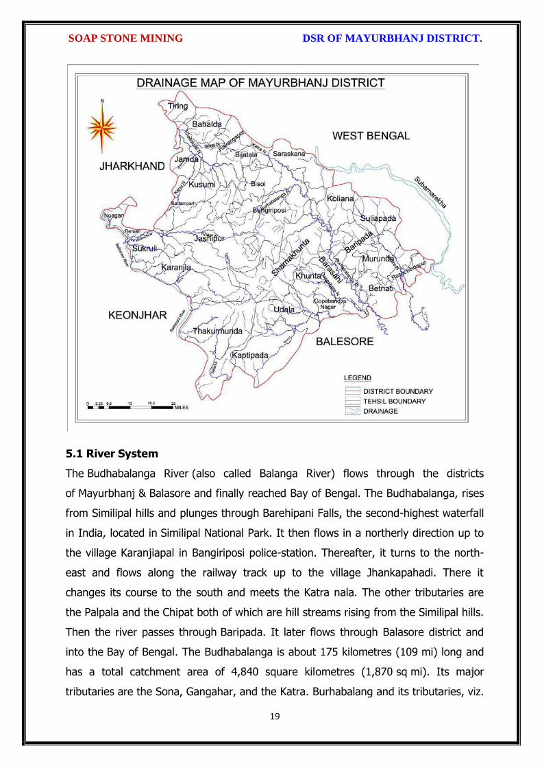
SOAP STONE MINING DSR OF MAYURBHANJ DISTRICT.
19
5.1 River System
The Budhabalanga River (also called Balanga River) flows through the districts
of Mayurbhanj & Balasore and finally reached Bay of Bengal. The Budhabalanga, rises
from Similipal hills and plunges through Barehipani Falls, the second-highest waterfall
in India, located in Similipal National Park. It then flows in a northerly direction up to
the village Karanjiapal in Bangiriposi police-station. Thereafter, it turns to the north-
east and flows along the railway track up to the village Jhankapahadi. There it
changes its course to the south and meets the Katra nala. The other tributaries are
the Palpala and the Chipat both of which are hill streams rising from the Similipal hills.
Then the river passes through Baripada. It later flows through Balasore district and
into the Bay of Bengal. The Budhabalanga is about 175 kilometres (109 mi) long and
has a total catchment area of 4,840 square kilometres (1,870 sq mi). Its major
tributaries are the Sona, Gangahar, and the Katra. Burhabalang and its tributaries, viz.

SOAP STONE MINING DSR OF MAYURBHANJ DISTRICT.
20
Sona Nadi, Amrutia Nadi, Gangahar Nadi drain almost round the year in the present
area. Sona Nadi receives the watery effluent load through a nalah (Sankh nalah) from
the Balgopalpur Industrial Estate and flows from west to east. Amrutia Nadi flows
from NNW to SSE and carries the waste water load of East Coast. Subarnrekha
originate from Nagri of Jharkhand and then enter into Mayurbhanj district, very less
portion of the river flows within Mayurbhanj district, Major portion of Subarnarekha
River passes in the Balasore district. Another river Jambhira runs in Mayurbhanj
district then enters into Balasore district and Renamed as river Jalaka flows into Bay
of Bengal. Other small rivers run in this district like River Khadkhai originates from
Tunhgru R.F. and plunges through Suleipat Dam (Khadkhai Reserviour). It then runs
towards Rairangpur, Bahalda, Tiringi area of western direction of Mayurbhanj district
and finally reached at River Subarnarekha. River Deo rises from Similipal R.F. and
runs towards western part of the district and flows through Karanjia area and then
joins with Baitarani River. River Khairabandhan originates from Similipal R.F. and
flows towards western part of the Mayurbhanj district through Jashipur, Raruan,
Sukruli area of district and then joins with River Baitarani This river maintains a
sluggish flow in the pre-monsoon period, but swells menacingly with the onset of
monsoon often flooding large tracts. Another small tributary named as Kanhu starts
from River Khadkhai and branched into Jalapa, Ghagera nala meets at Jharbeda area
of Mayurbhanj District.
Sl. No.
Name of the River or Stream
Total Length in District (in Km.)
Place of Origin Altitude at Origin
1 Budhabalanga 161 Similipal Hill 940 mrl.
2 Subarnarekha 4 Nagri, Jharkhanda
610 mrl.
3 jambhira 64 Chandra R.F. Mayurbhanj
60 mrl.
4 Sona 70 Jaymal Hill, Dugdha
Mayurbhanj.
340 mrl.
5 Khadkhai 75 Tunhgru R.F. 500 mrl.
6 Khairibandhan 65 Similipal R.F. 800 mrl.
7 Deo 65 Similipal R.F. 930 mrl.
8 Katra 55 Jari R.F. 700 mrl.
9 Gangahar 55 Similipal R.F. 740 mrl.
10 Baitarani 48 Gonasika, 900 mrl.

SOAP STONE MINING DSR OF MAYURBHANJ DISTRICT.
21
Guptaganga Hills
11 Tel 20 Similipal R.F. 940 mrl.
12 Kantamauli 25 Similipal R.F. 360 mrl.
13 Sim 85 Similipal R.F. 900 mrl.
14 Jhagada 15 Jhagada R.F. 430 mrl.
15 Balijori 22 Similipal R.F. 520 mrl.
16 Kantakhaira 36 Similipal R.F. 420 mrl.
17 Kanhu 42 Similipal R.F. 400 mrl.
18 Balisudura 15 Similipal R.F. 450 mrl.
6.0 LAND UTILIZATION PATTERN IN THE DISTRICT
6.1 Forest and non forest land
The forest of Mayurbhanj district is full variety of medicinal plants, Kendu leaves,
Bamboo, Sal, Teak, other timber species and a wide range of carnivorous & herbivorous
wild animals. The district has one Wildlife Sanctuaries known as the Similipal Wildlife
Sanctuary situated at the heart of the district, which hosts all type of wildlife even

SOAP STONE MINING DSR OF MAYURBHANJ DISTRICT.
22
tigers. The area of the sanctuary is 26, 886.23 hectares. And two kilometer safety zone
of eco-sensitive zone of Suleipat Wildlife Sanctuary are coming in Mayurbhanj district. In
these sanctuary areas the principal animals that are found are Elephant, Bear, Nilgai,
Sambhar, Peacock, Wild Boar and Deer, together with variety of snakes and birds.
District-wise Forest Cover Area in Odisha (Area in Km2)
2017 Assessment
District Geograph ical Area Km2
Very Dense Forest
Moder- ate. Dense Forest
Open Forest
Total Percent of GA
Change Scrub
Angul 6375 371 1380 1004 2755 43.22 43 84
Bolangir 6575 70 224 837 1131 17.2 151 142
Balasore 3806 23 127 234 380 9.98 30 48
Bargarh 5837 176 371 484 1031 17.66 88 47
Bouda 3098 263 546 480 1289 41.61 27 57
Bhadrak 2505 0 9 66 75 2.99 2 0
Cuttack 3932 53 226 517 796 20.24 11 68
Deogarh 2940 191 667 614 1472 50.07 -3 14
Dhenkanal 4452 174 418 825 1417 31.83 9 82
Gajapati 4325 84 1490 946 2520 58.27 12 262
Ganjam 8206 164 1075 864 2103 25.63 15 655
Jagatsinghpur 1668 0 5 131 136 8.15 6 0
Jajpur 2899 6 72 225 303 10.45 3 50
Jharsugada 2114 3 140 179 322 15.23 9 36
Kalahandi 7920 362 729 1327 2418 30.53 36 362
Kandhamal 8021 661 2588 2143 5392 67.22 16 380
Kendrapada 2644 84 88 133 305 11.54 14 2
Keonjhar 8303 289 1404 1519 3212 38.68 4 55
Khorda 2813 21 186 250 457 16.25 0 92
Koraput 8807 94 740 1255 2089 23.72 120 944
Malkangiri 5791 158 709 1475 2342 40.44 20 45
Mayurbhanj 10418 1335 1718 1027 4080 39.16 42 34
Nabarangpur 5291 168 428 507 1103 20.85 8 47
Nayagarh 3890 189 965 556 1710 43.96 28 173
Nuapada 3852 86 482 705 1273 33.05 33 109
Puri 3479 0 54 160 214 6.15 8 11
Rayagada 7073 422 853 1851 3126 44.2 7 349

SOAP STONE MINING DSR OF MAYURBHANJ DISTRICT.
23
Sambalpur 6624 499 1675 1106 3280 49.52 13 40
Subarnapur 2337 2 187 161 350 14.98 26 29
Sundargarh 9712 1019 1814 1431 4264 43.9 107 89
Grand Total 155707 6967 21730 23008 51345 32.98 885 4306
(Source: India state of forest report 2017-Odisha)
The major portion of the district is covered by forest (39.16 % of TGA) and has
scattered settlement pattern. The forest is full of variety of medicinal plants. The
district has considerable flat land, which provide suitable site for agricultural use. The
hilly areas are mostly under forest with patches of cultivation on scarp areas. Major
crops grown in the district are rice and pulses. Only 14.82 percent area of agricultural
use are net irrigated and major source of irrigations are well and tube wells.
Source: Fertilizer and Agriculture Statistics, Eastern Region
Tahasil Forest Area
Misc Tree
Permanent Pasture
Cultivated waste
Non Agricultural
uses
Barren land
Current Fallow
Other Fallow
Net area
sown
Bahalda 964 471 1397 1262 2590 1900 875 944 14031
Bangiriposi 3712 281 1037 1688 3046 684 2054 922 16951
Baripada 216
673
3 128 1628 1376 8 2752 2156 4219
Badasahi 288 180
7 1194 1874 3840 24 3378 2110 17630
Betnoti 2271 911 1198 1728 3227 21 1915 578 17022
Bijatala 2841 224 681 3100 1792 1636 1214 600 11228
Bisoi 3116 471 757 2508 2193 459 2298 1643 15860
G.B.Nagar 191 116 683 582 1147 590 643 1209 10960
Jamda 408 100 1650 434 2060 785 840 1149 13608
Jashipur 8932 141 1389 2655 3637 400 3873 2634 17754
Kaptipada 8745 387 3292 5596 4123 2165 3123 4930 19932
Karanjia 1644 838 1444 2441 3065 462 3493 1362 16690
Khunta 400 226
0 314 672 2061 21 1332 2213 12879
Kuliana 1749 162
6 2222 1902 2529 608 4919 1504 11108
Kusumi 1434 32 2320 2679 2337 587 1086 1682 18032
Morada 993 412
7 513 4340 1941 61 1909 3633 10179
Rairangpur 2260 107 1759 1373 2027 504 1276 631 9713
Raruan 1210 171 890 1120 1899 503 1609 1020 12818
Rasgovindpur 288 214
5 665 1091 2774 142 2002 1537 10054
Shamakhunta 1354 764 1378 2472 1859 334 1861 941 6695
Saraskana 3464 275 689 2658 4042 115 1864 1837 15384
Sukruli 412 211 734 1295 1271 502 1286 1294 10352
Suliapada 2937 553
5 97 2262 2148 86 1589 2906 8971
Thakurmunda 10885 96 1530 1438 2034 795 5317 2670 17681

SOAP STONE MINING DSR OF MAYURBHANJ DISTRICT.
24
6.2 Agriculture Land:
Mayurbhanj is surrounded by no of forest areas as well as Rocky Mountains. People
used to cultivate Paddy in most parts of the hill slopes and in plain lands. Most of the
cultivators grow short duration local paddy in the un-bonded upland during Kharif
season. The crop suffers moisture stress at different stages due to inadequate rainfall.
The primary objective of Agriculture Department is increase of production as well as
productivity of major crops like paddy, groundnut, mustard, Mung, Biri & vegetables
which is widely covered in this District in both Kharif & Rabi season. Another key
objective is the all round development of the farming community of the District. The
Deputy Director of Agriculture is the head of office so far as agriculture is concerned &
he is the Principal Agriculture Officer of the District. Under him there are 5 District
Agriculture Officers & the block under them. As already pointed out, that agriculture is
the main livelihood of the people in Mayurbhanj District. It is therefore also
designated as the food bowl of Odisha. Rice is the principal crop grown in this district,
followed by other cereals, pulses, oilseeds, vegetables, spices and sugarcane. The
agricultural statistics for the district is shown in subsequent tables below:
Table – 3.6a: Crop Coverage Area of Mayurbhanj District, Odisha
Crop Khariff Rabi Annual TOTAL
Area (ha)
(% of Cropped
Area
Area (ha)
% of Cropped
Area
Area (ha)
Gross Cropped Area (ha)
% of Gross
Cropped Area
Rice 301.37 82.353% 3.80 4.015% --- 305.17 62.051%
Cereals 9.99 2.730% 2.17
2.293% --- 12.16 2.472%
Pulses 32.37 8.846% 36.20 38.255% --- 68.57 13.943%
Oilseeds 5.92 1.617% 28.30 29.906% --- 34.22 6.958%
Vegetables 12.39 3.386% 21.74 22.974% --- 34.13 6.940%
Fibres 2.43 0.664% --- 2.43 0.494% Spices 1.48 0.404% 2.42 2.557% --- 3.90 0.792%
Sugarcane --- --- 00 --- --- 00 ---
Tobacco --- --- 00 --- --- 00 ---
Fruits --- --- --- --- --- 31.23 6.350%
TOTAL 365.95 100.00% 94.63 100.00% --- 491.81 100.00%

SOAP STONE MINING DSR OF MAYURBHANJ DISTRICT.
25
6.3 Horticulture Land:
The primary objective of Horticulture Department is increase of production as well as
productivity of major fruits like Mango, Guava, Citrus etc., which is widely covered in
this District. Another key objective is the all round development of the farming
community of the District. The Deputy Director of Horticulture is the head of office.
7.0 SURFACE WATER AND GROUND WATER SCENARIO OF THE DISTRICT
7.1 Hydrogeology
Distribution of Saline / fresh water aquifers:
The occurrence of fresh water aquifers in coastal tract of Mayurbhanj restricted by
two important factors‐ (i) Occurrence of hard rocks in the western side and (ii) Salinity
hazard problems in the eastern part. The water bearing formation of the area can be
divided into (a) areas underlain by fractured, fissured and consolidated basement rock
formations (b) areas underlain by recent unconsolidated alluvial formations.
(a) Consolidated Formation - These are most predominant rock types occurring in
the undulating plains of the district. Groundwater occurs under unconfined condition
in the shallow weathered zone and circulates through fractures and joints. The
thickness of the weathered zone varies from 3 to 35 m. Depth of open wells in these
formations varies from 5 to 14 m below ground level.
(b) Unconsolidated alluvial formations - The unconsolidated formations consists of
laterite and alluvium. Laterites at places are highly consolidated and used as building
stones. The laterites have high degree of effective porosity and form potential
aquifers commonly tapped in dug wells. The alluvium comprises an admixture of clay,
silt, sand and calcareous concretions in varying proportions. The coarse sediments like
sand and gravel form the main repository of ground water. Ground water occurs
under both unconfined condition in shallow aquifers and in confined condition in
deeper parts.

SOAP STONE MINING DSR OF MAYURBHANJ DISTRICT.
26
7.2 Depth of water level:
The depth to water level map for pre and post monsoon periods 2011 are prepared
based on the ground water monitoring data of 77 Nos of National Hydrograph
Stations of C.G.W.B. monitored during the month of April and November 2006 are
presented below respectively. The pre and post monsoon depth to water levels in the
district range from 3.54 to 14.50 m below ground level and 1.39 to 8.20 m below
ground level respectively. It is observed that during pre monsoon about 75% of the
total areas show the water level varying between 5 to 10 m below ground level.
During post monsoon nearly 60% of the area has water levels within 2 to 5 m,
while the rest part has between 0 to 2 and 4 to 6 m below ground levels. In localized
part of Morada, Kaptipada and Thakurmunda the water level is > 5 mt.
Depth & categorization of ground water levels during pre monsoon period (April 2011)
of Mayurbhanj districts is presented below:

SOAP STONE MINING DSR OF MAYURBHANJ DISTRICT.
27
Depth & categorization of ground water levels during pre monsoon period (November
2011) of Mayurbhanj districts is presented below:

SOAP STONE MINING DSR OF MAYURBHANJ DISTRICT.
28
7.3 Ground Water Quality
The chemical quality of ground water in the district has been assessed on the basis of
chemical analysis of ground water samples collected during groundwater monitoring,
Hydrogeological surveys and groundwater exploration. The results of the chemical
analysis are presented in Table.
Table showing chemical constituents in aquifers
Constituent Shallow aquifer Deeper aquifer
pH 6.97 – 8.25 6.84 – 8.25
Sp. Conductance (micromohs/cm at 250 C)
53 – 974 92 – 867
TDS (mg/l) 58 – 1430 106 – 429

SOAP STONE MINING DSR OF MAYURBHANJ DISTRICT.
29
Calcium (mg/l) 6 – 92 16 – 86
Magnesium (mg/l) 0.6 – 17 3.6 – 22
Sodium (mg/l) 1.6 – 100 3.5 – 168
Potassium (mg/l) 0.4 – 8 <1 --6.4
Bicarbonate (mg/l) 15 – 256 49 – 366
Chloride (mg/l) 7 – 238 5.3 – 85
Sulphate (mg/l) 0.1 – 9 <1 – 82
Nitrate (mg/l) <0.01 – 53 0.1 – 78
Fluoride (mg/l) 0.08 – 20.3 0.21 – 0.61
Total hardness as calcium carbonate
10 – 245 35 - 285
7.4 Ground Water Development
In the rural areas the entire water supply is dependent on ground water. Ground
water development is mainly carried out in the district through dug wells and Hand
pumps. In general dug wells are of 2 m diameter and the depth ranges between 8 to
15 m depending on the thickness of the weathered zone, tapping the shallow aquifer
in the weathered zone and uppermost slice of the basement. Large number of dug
wells used for drinking water is under private ownership for which there is no reliable
data. Over the years Mark II/ Mark III hand pumps are being drilled in large numbers
for ground water development. These hand pumps have the following two major
advantages i) less susceptible to contamination from surface sources and ii) tap
fractures between 20-60m depth which have been found to be less affected by
seasonal water level fluctuation and thus have lesser chances of failure even during
extreme summer. Over all the present level of ground water development is only
27.21 percent in the district with the maximum in Badasahi Block viz. 64.65% and
minimum in Bijatala Block. Block wise development figure indicate that all the blocks
come under the white categories. Thus there is ample scope for development of
groundwater in the district to augment irrigation potentials through suitable ground
water abstraction structure
7.5 Ground Water Related Issue and Problems
Some of key ground water related issues are
I. Locating suitable sites for bore wells
II. Suitable design of dug wells and hand pumps
III. Taking up artificial recharge projects to augment the resource availability in

SOAP STONE MINING DSR OF MAYURBHANJ DISTRICT.
30
Mayurbhanj district.
IV. Optimal development of irrigation potential by developing ground water available
for future uses.
V. Creating public awareness for conserving ground water through awareness
camps, NGO’s and mass media.
7.6 Mass Awareness Campaign (MAP) & Water Management Training
Programme (WMTP) by CGWB
NIL
7.7 Area Notified by Cgwb/Sgwa
None
7.8 RECOMMENDATIONS:
1) Intensive groundwater exploration should be taken up to delineate deeper
potential water saturated fracture zones and to compute aquifer parameter.
2) Large scale planning for ground water development should be preceded by
intensive hydrogeological and geophysical surveys aided by remote sensing
studies.
3) Effective measures may be taken to conserve the surface run off by contour
bonding at suitable sites. Also proper maintenance of reservoir, tanks and spring
channels by periodical disiltation should be carried out.
4) Existing dug-wells should be deepened to tap the maximum saturated thickness of
the weathered mantle or vertical bores may be drilled through the bottom to
enhance the well yield.
5) Energy station of wells already constructed should be stepped up to ensure
optimal utilization of the irrigation potential already created.
6) The farmers should be educated through agricultural extension services fro
adopting suitable cropping pattern for optimal utilization of available groundwater
resources.
7) Programmes for artificial recharge may also be taken up for augmentation of
groundwater through construction of percolation tanks, subsurface dykes, and
check dams and through contour bonding etc.
8) An intensive network of groundwater monitoring stations are required to be

SOAP STONE MINING DSR OF MAYURBHANJ DISTRICT.
31
established in the command areas of irrigation projects to monitor the changes in
groundwater regime consequent on application of surface water irrigation.
8.0 RAINFALL OF THE DISTRICT AND CLIMATE CONDITION
8.1 Month wise rainfall:
The driest month is November, with 3 mm of rain. There is on average 0 mm of
precipitation in December. In July, the precipitation reaches its peak, with an average
of 324 mm. May is the warmest month of the year. The temperature in May averages
32.3 °C. January has the lowest average temperature of the year. It is 16.5 °C.
Year 2016 2017 2018 Average
Sl. No. Month (mm) (mm) (mm) (mm)
1 Jan 9.23 2.71 0.00 3.98
2 Feb 52.61 0.00 0.04 17.55
3 Mar 12.29 44.87 0.72 19.29
4 Apr 22.38 23.36 172.10 72.61
5 May 118.73 139.31 125.30 127.78
6 Jun 195.46 169.39 208.83 191.22
7 Jul 245.28 385.31 300.05 310.21
8 Aug 351.25 291.03 371.30 337.86
9 Sep 285.27 170.11 285.17 246.85
10 Oct 85.39 189.09 154.08 142.85
11 Nov 12.10 34.79 0.00 15.63
12 Dec 0.00 1.80 36.69 12.83
Total 1389.99 1451.77 1654.28 1498.68
Source: Indian Meteorological Department
The Indian Meteorological Department, Bhubaneswar, vide letter No. BBS/RMC/CS-
312, dated 18th January, 2016 has provided the period of Rainy Season viz. Normal
dates of Onset and Withdrawal of South West Monsoon over India as state-wise. The
duration for the period is 10th June to 15th October.
8.2 Climate
The climate in Mayurbhanj is warm and temperate. In winter, there is much less
rainfall in Mayurbhanj than in summer. The general climate of the district is
characterized by oppressive heat in summer, severe cold in winter with high humidity
throughout the year. The rainfall distribution is equal during the monsoon period. The
period from June to October is the rainy season and the district experiences it from
the southwest monsoon. May is the hottest month when the mean daily maximum

SOAP STONE MINING DSR OF MAYURBHANJ DISTRICT.
32
temperature rises up to 47º Celsius. The Köppen-Geiger climate classification is Cwa &
as per they the average temperature in Mayurbhanj is 24.7 °C. The temperature in
May averages 32.3 °C. January has the lowest average temperature of the year, it is
16.5 °C. There is a difference of 321 mm of precipitation between the driest and
wettest months. During the year, the average temperatures vary by 15.8 °C., when
the mean daily minimum temperature dips to 4º Celsius. The higher reaches of the
Similipal experiences frosting during the peak of winter.
9.0 DETAILS OF MINING LEASE OF SOAP STONE IN THE DISTRICT
9.1 List of Mines is operation in the district:
Attached as Annexure-H
9.2 List of Mines is not operation in the district:
Attached as Annexure- H
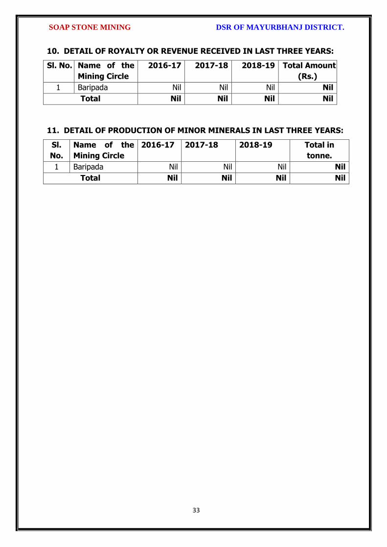
SOAP STONE MINING DSR OF MAYURBHANJ DISTRICT.
33
10. DETAIL OF ROYALTY OR REVENUE RECEIVED IN LAST THREE YEARS:
Sl. No. Name of the
Mining Circle
2016-17 2017-18 2018-19 Total Amount
(Rs.)
1 Baripada Nil Nil Nil Nil
Total Nil Nil Nil Nil
11. DETAIL OF PRODUCTION OF MINOR MINERALS IN LAST THREE YEARS:
Sl.
No.
Name of the
Mining Circle
2016-17 2017-18 2018-19 Total in
tonne.
1 Baripada Nil Nil Nil Nil
Total Nil Nil Nil Nil

SOAP STONE MINING DSR OF MAYURBHANJ DISTRICT.
34
12. MINERAL MAP OF THE DISTRICT:
13. LIST OF LETTER OF INTENT (LOI) HOLDERS IN THE DISTRICT ALONG
WITH ITS VALIDITY
Sl. No.
Name of the
Mineral
Name of the
Lessee
Address Letter of Intent Grant
Order No. &
date
Area of Mning
lease to be
allotted
Validity of LoI
Use
(Captive/ Non-
Captive)
Location of the Mining
lease (Latitude & Longitude)
1 2 3 4 5 6 7 8 9
Attached as Annexure-H

SOAP STONE MINING DSR OF MAYURBHANJ DISTRICT.
35
14. TOTAL MINERAL RESERVE AVAILABLE IN THE DISTRICT
Total mineral reserve of Soap stone is 196428 tonne which may increase after detail
investigation as per details below.
(i) Blocks were identified based on geological studies through field observation.
(ii) Mineable resource was calculated by considering detail prospecting.
(iii) Area calculated as per GPS co-ordinates and information obtained from local
people. Land detail need to be verified from revenue record.
(iv) Since this is an interim report, as per the present requirement of minerals, more
such blocks need to be identified and the data should be updated periodically, after
certain intervals to update the data bank of DSR.
Sl. No.
Name of the Mining Circle
Mineral Resources in tonne.
Mineable Reserve in tonne.
1 Baripada 196428 101021
Total 196428 101021
Summary of Identified Mineral Potential:
Sl.
No.
Name
of the
mineral
Name
of the
lessee
Address and
contact No. of
the lessee
Letter of
Intent
Grant
Order
No. and
date
Area of
mining
lease to
be
allotted
Validity of LoI
Use
(Captive/ Non- Captive
Location of the Mining lease (Latitude & Longitude)
1 2 3 4 5 6 7
Attached as Annexure-H
15. QUALITY/GRADE OF MINERAL AVAILABLE IN THE DISTRICT:
Rocks and Minerals found in Mayurbhanj District:-
The district is endowed with various types of mineral resources like Iron ore, China
Clay, Quartz, Soap stone, Granite, Manganese, etc. Due to presence of huge
mineral resources, mining activities have been undertaken in a big scale. Bahalda,
Jashipur, Karanjia, Koshorpur, Bisoi, Gorumahisani and Rairangpur are the places in
the district having deposits of the above mineral products. The availability of
mineral deposits is given in the table below. The district’s mineral deposits have not

SOAP STONE MINING DSR OF MAYURBHANJ DISTRICT.
36
been utilized to maximum extent for industrial purpose. Some of the items like
China clay, Soap stone, Asbestos, etc. can be used in small scale sector. So the
available resources of the district need harnessing properly for industrial and
productive use. Soapstone of the district is very much suitable for various industrial
purposes after crushing and screening.
16. USE OF MINERAL
Uses Soapstone:
Soapstone is a natural quarried stone and is a metamorphic rock called steatite. This
is the material we use for our countertops, sinks, masonry heaters, flooring, and many
other architectural applications. A form of talc also known as "soapstone" is also
widely known. Soapstone, although soft, is a very dense (non-porous) stone. Most
people are surprised to learn it is more dense than marble, slate, limestone and even
granite. Since soapstone is impenetrable and it will not stain. No liquid will permeate
its surface. This is why through the years soapstone is widely used in chemistry lab
countertops and acid rooms. This soft rock is easily carved and has been used to
make ornamental and practical objects for thousands of years. It has been used to
make sculptures, bowls, countertops, sinks, hearths, pipe bowls, and many other
objects. Although talcum powder and soapstone are two of the more visible uses of
talc, they account for a very small fraction of talc consumption. Its hidden uses are far
more common. Talc's unique properties make it an important ingredient for making
ceramics, paint, paper, roofing materials, plastics, rubber, insecticides, and many
other products.
17. DEMAND AND SUPPLY OF THE MINERAL IN THE LAST THREE YEARS:
As such there are huge infrastructural and industrial activities are coming up by State
govt., Govt. of India & PSUs under “Make in India” programme. The main raw
minerals for the above activities and considering the last three years actual
productions with respect to the requirement of the state has a huge gap. It is
proposed to start the production from larger block/area to at least double the
production of the district which will enhance the revenue of the district and also
support the livelihood of the local people
Sl. No. Name of the Mining Circle
Financial Year
Soap Stone in tonne
1
Baripada 2016-17 Nil
2017-18 Nil
2018-19 Nil
Total Nil

SOAP STONE MINING DSR OF MAYURBHANJ DISTRICT.
37
18. MAP OF EXISTING MINING LEASES IN THE DISTRICT:
Enclosed as Plate-I
19. DETAILS OF THE AREA OF WHERE THERE IS A CLUSTER OF MINING
LEASE VIZ. NUMBER OF MINING LEASES, LOCATION (LATITUDE AND
LONGITUDE)
Currently there is no cluster of Soap stone mining lease in the district. However, it is
proposed to consider the cluster of mining lease while planning for new lease area in
coming years.
20. DETAILS OF ECO-SENSITIVE AREA, IF ANY, IN THE DISTRICT:
Eco sensitive zone of Similipal wild life sanctuary is located within the district.
21. IMPACTS OF MINING ON ENVIRONMENT:
The most important environmental impact of mining projects is:-
Transportation sources:
Transportation sources of air pollutants include heavy vehicles used in excavation
operations, cars that transport personnel at the mining site, and trucks that transport
mining materials. The level of polluting emissions from these sources depends on the
fuel and conditions of the equipment. Even though individual emissions can be
relatively small, collectively these emissions can be of real concern. In addition,
mobile sources are a major source of particulate matter, carbon monoxide, and volatile
organic compounds that contribute significantly to the formation of ground-level ozone
Fugitive emissions:
Common sources of fugitive emissions include: storage and handling of materials;
mine processing; fugitive dust, blasting, construction activities, and roadways
associated with mining activities; leach pads, and tailing piles and ponds; and waste
rock piles. Sources and characteristics of fugitive emissions dust in mining operations
vary in each case, as do their impacts. Impacts are difficult to predict and calculate
but should be considered since they could be a significant source of hazardous air
pollutants.

SOAP STONE MINING DSR OF MAYURBHANJ DISTRICT.
38
Noise and vibration:
Noise pollution associated with mining may include noise from vehicle engines,
loading and unloading of rock into steel dumpers, chutes, power generation, and
other sources. Cumulative impacts of shoveling, ripping, drilling, blasting, transport,
crushing, grinding, and stock-piling can significantly affect wildlife and nearby
residents.
Vibrations are associated with many types of equipment used in mining operations,
but blasting is considered the major source. Vibration has affected the stability of
infrastructures, buildings, and homes of people living near large-scale open-pit mining
operations. According to a study commissioned by the European Union in 2000:
“Shocks and vibrations as a result of blasting in connection with mining can lead to
noise, dust and collapse of structures in surrounding inhabited areas. The animal life,
on which the local population may depend, might also be disturbed.”
22. REMEDIAL MEASURES TO MITIGATE THE IMPACT OF MINING ON THE
ENVIRONMENT:
1. Following are the remedial measures to mitigate the in Water sprinkling on haul
road, loading and unloading points.
2. Plantation along the safety zone and dump area.
3. Providing dust masks to workers.
4. Regular monitoring of ambient air quality.
5. Provision of air conditioned cabin of Excavators and Dumpers.
6. Regular and proper maintenance of working equipments.
7. Periodic medical examination of the workers and organize medical camp in the area.
8. Use Milli Second Delay Detonator in blasting operation.
9. Provisions of ear plug to the workers.
10. Regular training programme to the mines workers and operators.

SOAP STONE MINING DSR OF MAYURBHANJ DISTRICT.
39
23. RECLAMATION OF MINED OUT AREA
Necessity of Reclamation & Rehabilitation:
Exponential growth in mineral production since 1980.
Mining activities causes physical, chemical, biological and socio-economic changes in
the area.
Surface mining activities disturb the original land profile.
In India, mineral production comes mostly from opencast mines & hence land
degradation problems are of serious concern.
An intricate, in-depth and site-specified techniques involving integrated approach is
necessary.
Reclamation has three vital roles:
i. Reclamation – Reclamation means return the mined-out land with useful life. It
implies restoring the land to a form and productivity that is useful and inconformity
with a prior land use. Reclamation always may not be a single- phase operation.
ii. Rehabilitation – Rehabilitation is to bring batch the degraded land to a normal
stage by a special treatment. It is a process of taking some mitigation measures for
disturbed environmental condition created through mining activities.
iii. Restoration – Restoration is the process of returning the mined out land being
fit to an acceptable environmental condition. However, the general acceptable
meaning of the term is bringing the disturbed land to its original form. Restoration is
often used to indicate that biological properties of soil are put back to what they were.
This is a rate phenomenon.
iv. When active mining ceases, mine facilities and the site are reclaimed and closed.
The goal of mine site reclamation and closure should always be to return the site to a
condition that most resembles the pre-mining condition. Mines that are notorious for
their immense impact on the environment often made impacts only during the closure
phase, when active mining operations ceased. These impacts can persist for decades
and even centuries.
Mine reclamation and closure plans must describe in sufficient detail how the mining
company will restore the site to a condition that most resembles pre-mining
environmental quality; how it will prevent – in perpetuity – the release of toxic
contaminants from various mine facilities (such as abandoned open pits and tailings

SOAP STONE MINING DSR OF MAYURBHANJ DISTRICT.
40
impoundments); and how funds will be set aside to insure that the costs of
reclamation and closure will be paid for.
Proposed future land use after reclamation:
a. Forestry, b. Recreation, c. Water Reservoir, d. Crop Land,
e. residential/Commercial, f. Fish & wildlife Habitat, g. Undeveloped Land,
h. Grazing/Pasture Land
Statutory requirement:
As per the Mineral Conservation Development Rule, 2017, the following rules must be
bare in mind by the mine owner/agent/manager, which is a part of reclamation
activities –
Rule 22, Mine Closure Plan
Rule 23, Submission of Progressive Mine Closure Plan Rule 24, Submission of Final
Mine Closure Plan
Rule 26, Responsibility of holder of mining lease Rule 27, Financial Assurance
Rule 35, Sustainable Mining
24. RISK ASSESSMENT AND DISASTER MANAGEMENT PLAN:
Mining activity because of the very nature of the operation, complexity of the
systems, procedures and methods always involves some amount of hazards. Hazard
identification and risk analysis is carried for identification of undesirable events that
can leads to a hazard, the analysis of hazard mechanism by which this undesirable
event could occur and usually the estimation of extent, magnitude and likelihood of
harmful effects. The activities which can cause high risk related to face stability and
the person blasting the shots. It was observed that on a working face of the mine,
there were large cracks and unsupported rocks were present, which can lead to a
serious hazard and injure workers engaged in loading operation and machineries
because of rock falls or slides. This type of condition turn out because improper
dressing of the bench and improper supervision. To avoid the hazards due to fall of
rocks the face must be examined, made suitable for working and the remedial
measures must be taken to make it safe if there is any doubt that a collapse could
take place. Working of the face should be in the direction taking into account the
geology of the area such that face and quarry side remain stable. Another major risk
identified in mines is due to the firing of explosive by an unqualified person. In the

SOAP STONE MINING DSR OF MAYURBHANJ DISTRICT.
41
mines there is problem of fly rocks and the village is located close to the mine and so
it is rated high as it can affect may people. Explosives by nature have the potential for
the most serious and catastrophic accident. Planning of round of shots, holes correctly
drilled, direction logged, weight of explosive suitable for good fragmentation are the
few of the steps necessary to ensure its safe use and if the shots are not properly
designed can result in misfires, early ignition and flying rocks. No person is allowed to
use explosives without being properly trained in its handling. In the mine a large
numbers of heavy vehicles were in operation and the roads were not proper for
haulage purpose. The haulage roads were not even and were not wide enough for the
crossing purpose and hence the chances of hazards are very high. The main hazards
arising from the use large earth moving vehicles are incompetent drivers, brake
failure, lack of all-around visibility from the driver position, vehicle movements
particularly reversing, roll over, and maintenance. Those most at risk are the driver
and pedestrians likely to be struck by the vehicle, and drivers of smaller vehicles,
which cannot be seen from the cabs of large vehicles. Edge protection is always
necessary to prevent inadvertent movement over the edge of roadway or a bench.
Seatbelt will protect driver in case of roll. Good maintenance and regular testing are
necessary to reduce the possibility of brake failure. Access to the vehicles should
always be restricted to those people necessary for the work in hand. The use of
personal protective equipment and proper arrangements is essential to check if the
person is wearing protective equipment or not. The personal protective equipment
includes helmet, non-skid safety boots, safety glasses, earmuffs etc. The required
personal protective equipment should be provided and used in a manner that protects
the individual from injury. Few minor injuries which can be prevented are slip, trip, or
fall hazards; hazards due to rock falls and collapse of unstable rocks, atmosphere
containing toxic or combustible gases; protects from chemical or hazardous material
etc. A disaster management plan should be prepared for taking care of for any
disaster. Other risks which are included in this category are noise, as it occurs and it
can lead to permanent disability. There are problems related to road traffic in and out
issuers; inappropriate exposure of moving machines; mechanical failure and because
of large number of moving trucks and dumpers there is large quantity of dust present
in roadways which affects the operators and can lead to accidents causing injury.
SOAP STONE MINING DSR OF MAYURBHANJ DISTRICT.
42
They are in acceptable range because of precautions measures taken but no step is
taken it can cause hazard hence steps should be taken to reduce the hazards such as
for dust suppression system should be installed. Other problems like occurrence of
lots of mosquitoes in the area due to unhygienic conditions which affect the human
health causing malaria, dengue etc. and causing a person to be hospitalized.
Disaster in the mines like fires, explosions, entrapments, and inundations can occur
any time, so emergency preparedness is a must. The Disaster management plan and
risk assessment in the mines will include all sorts of above mentioned emergency and
the extent that this plan will be implemented will depend on the nature and scope of
the emergency. The basic purpose of Disaster management plan and risk assessment
to ensure that mine rescue and recovery activities are conducted safely for rescuer
and survivors. According to MMR act 1961 a standard operating procedure should be
drawn for involvement different category of staff and officers. The SOP should be
updated periodically to reduce the chaos and response to the emergency should be
quick and smooth. The responsible person should be familiar with his responsibility
during the mock drills. One or two standby should be there to replace the person in
Emergency situation. Rescue operations should not include the survivors for any
assistance.
First Information of Disaster / Emergency should go to the attendance clerk on duty.
Duties of attendance Clerk (Emergency Siren) the attendance clerk or other
designated person should on getting information of major accident, sound a hooter or
a siren immediately declaring a state of emergency at the mine and then to contact
the manager and on his advice to call key personnel using the information listed in the
Emergency Organization Chart. It is important that all telephone calls are recorded in
a telephone log book. Duties of Other Officials should be displayed and handed over
to all concerned. Copy the same should be kept at Manager’s Office for ready
reference. Establishment of Control Room at Unit Level, Area Level and Company
Level is essential. Control Room should keep the contact information about –
Company Manager
Company owner/ Administrative officer.
District Administration
Govt. Hospitals in Nearby Localities,
Private Nursing Homes of Localities

SOAP STONE MINING DSR OF MAYURBHANJ DISTRICT.
43
Attendance roaster and duty charge register should be properly maintained so the
record of missing people can be obtained.
25. DETAILS OF THE OCCUPATIONAL HEALTH ISSUE IN THE DISTRICT:
The persons employed in the mines are exposed to a number of hazards at work
which adversely affect their health. Some of the important ones are dust, noise, heat,
humidity, vibration etc. In recent times, there has been increasing awareness among
mining industry and the workers about occupational diseases like Pneumoconiosis,
Silicosis, Tuberculosis, Hearing Impairment etc. caused by exposure to health hazards
at work. Almost all occupational diseases can be prevented by adopting proper
occupational health measures and engineering control on airborne dust pollution at
workplace. Occupational Diseases in mines or industry is required to conduct medical
examinations and health surveillance of workers as per the provisions of Mines Act.
The present efforts of mines management are concentrated on detection of silicosis,
Pneumoconiosis and other notified diseases. The essential features of health
surveillance programme required to be carried out in mines are:
(a) Initial Medical Examination of persons to be conducted at the time of
appointment.
(b) Periodic Medical Examination or General physical examination to be conducted
once in every year.
(c) Maintenance of medical records and health services till the person is in service.
(d) The Details of Tuberculosis cases in last 5 years is given below
RNTCP Activities from 2014 to 2018
Year Projected Population
No of Sputum
Examined
Sputum Examine
d per Lakh/Qr
No of
Sputum Positive
Sputum Positive
%
Total Case
put on
DOTS/No of
TB cases
Child DOTS
out of Total DOTS
Case detectin
per Lakh/Yr
Sputum
Conversion Rate
NSP Cure
Rate
NSP Death
Rate
(in Lakh) Norm- 150
Norm-8-15 %
Norm-170 /L/Y
Norm-90 %
Norm-90%
Norm < 5%
2014 26.01 16848 161.9 2825 16.8% 4883 103 187.7 90.2% 89.0% 7.4%
2015 26.30 18118 172.2 2836 15.7% 4831 123 183.7 90.5% 89.0% 6.7%
2016 26.59 20060 188.6 2975 14.8% 5171 119 194.5 95.0% 90.9% 6.5%
2017 26.88 31035 289.4 3152 11.4% 5127 111 190.7 94.0% 91.6% 5.5%
2018 27.18 21273 195.6 2853 13.4% 4894 95 173.4 95.3% 92.7% 6.4%

SOAP STONE MINING DSR OF MAYURBHANJ DISTRICT.
44
26. PLANTATION GREEN BELT DEVELOPMENT IN RESPECT OF LEASE
ALREADY GRANTED IN THE DISTRICT:
During mining operation green belt development through plantation is most important
for environment safe guard, which should be supervision by mining department.
Different type of species should be planted near lease periphery to keep environment
clean at post mining period through reclamation. Where specific usefulness of land
could be decided, a forestation is normally planned through the site could have been
considered for better possibilities of land use.
27. CONCLUSION:
Since it is an interim report, to meet the requirement of minerals in the present
scenario, it is proposed to identify such potential areas at certain interval and get the
data bank of DSR to be updated. The insitu mining activity in any area is on one hand
bring revenue and employment (Direct and indirect) and on other hand if not done
properly potential pollution and ecological imbalance increases, the ability of the
ecosystem can also be reduced. Particulate matter transported by the wind as a result
of excavations, blasting, transportation of materials, heavy equipments used raise
these particulate levels; and Gas emissions from the combustion of fuels in stationary
and mobile sources, explosions, and mineral processing. All these activities indirectly
affected the biodiversity of area. Larger potential and smaller areas have been
identified in Mayurbhanj district on the basis of geological study carried out during
field observation, which can be considered for mining concession after all the
parameters for statutory clearances are verified by consulting with concerned
authorities.

SOAP STONE MINING DSR OF MAYURBHANJ DISTRICT.
45
Plate No.-I

SOAP STONE MINING DSR OF MAYURBHANJ DISTRICT.
respect of Mayurbhanj District prepared in accordance with Appendix-X, Para
(a) of S.O. 3611 (E) Dt. 25.07.2018 of Ministry of Environment, Forest and Climate
Change, New Delhi is approved for final publication in the district website.
q \r$\\
Dr. H. Sahu, Sri S.Mal I.F.S, Sri Dibyajyoti a, I"A"SProf in Zoology, NOU -cum-Member, DEIAA, Mayurbhanj
DFO-cum-Member,DEIAA, Mayurbhanj
SDM, Sadar-cum -Member SecretaryDEIAA, Mayurbhanj
&,,'7tr 4q4,1,Sri Vineefihardwaj,
Collector & DM-crnf,- Chairman, DEIAAMayurbhanj (Odisha)
46
t
The District Suruey , Report for Soap Stone Mining (Minor Mineral) in

Fro
m
To
Fro
m
To
1 2 3 4 5 6 7 8 9 10 11 12 13 14 15 16 17 18 19
1
Soap
sto
ne
A.K
.Das
Man
kad
pad
a
Mo
b. N
o.
94
37
01
90
19
Gra
nte
d v
ide
Pro
ceed
ing
No
.
73
94
/SM
, dt.
06
.07
.20
00
13
.31
Vill
- M
anka
dp
ada
17
.01
.20
01
16
.01
.20
21
Lap
sed
vid
e Lr
.
No
.12
42
0/S
M,
Dt.
21
.12
.20
15
.
No
n-C
apti
ve
No
Lat-
21
°25
'N -
21
°27
'N
Lon
g- 8
6°3
0'E
-
86
°32
'E
Kap
tip
ada
Op
en C
ast
19
64
28
10
10
21
2
Soap
sto
ne
J.R
.Tri
pat
hy,
Vill
-
Kh
adik
han
ia-I
31
.86
5
Vill
- K
had
khan
ia
un
der
Ud
ala
Tah
asil
19
.08
.19
70
18
.08
.19
90
Lap
sed
vid
e Lr
.
No
.83
61
/SM
,
Dt.
31
.08
.20
15
.
Po
sses
ion
has
bee
n
take
n o
ver
on
dt.
11
.12
.20
15
No
n-C
apti
ve
No
Kap
tip
ada
Op
en C
ast
3
Soap
sto
ne
K.K
.Das
Kh
adik
han
ia-I
I
14
9.7
33
Vill
- K
had
khan
ia u
nd
er
Ud
ala
Tah
asil
23
.07
.19
79
22
.07
.19
99
Rej
ecte
d v
ide
Go
vt. L
r.
No
.97
94
/SM
, Dt.
20
.06
.11
P
oss
esio
n h
as
bee
n t
aken
ove
r o
n
dt.
11
.12
.20
15
No
n-C
apti
ve
Kap
tip
ada
Op
en C
ast
Annexure-H
SPECIFIED MINOR MINERALS (SOAP STONE)
Sl N
o
Nam
e o
f M
iner
als
Nam
e o
f Le
ssee
s
Ad
dre
ss a
nd
Co
nta
ct N
o. o
f
less
ee
Min
ing
Leas
e G
ran
t O
rder
No
.
& D
ate
Are
a o
f M
inin
g Le
ase
(Ha.
) w
ith
villa
ge K
hat
a N
o.,
Plo
t N
o. &
Kis
am
Per
iod
of
Min
ing
Leas
e (I
nit
ial)
Per
iod
of
Min
ing
Leas
e (1
st/2
nd
Ren
ewal
)
Non-Working Leases
Met
ho
d o
f M
inin
g (O
pen
cas
t/
Un
der
Gro
un
d)
Geo
logi
cal R
eser
ve (
MT/
Cu
ms)
Min
eab
le R
eser
ve (
MT/
Cu
ms)
Dat
e o
f C
om
men
cem
ent
of
min
ing
op
erat
ion
Stat
us
(Wo
rkin
g/ N
on
-wo
rkin
g/
tem
p. W
ork
ing
for
dis
pat
ch
etc.
Cap
tive
/ N
on
-cap
tive
Ob
tain
ed e
nvi
ron
men
tal
clea
ran
ce (
Yes/
no
). If
Yes
,
Lett
er N
o. w
ith
dat
e o
f EC
Loca
tio
n o
f M
inin
g Le
ase
(Lat
itu
de
& L
on
gitu
de)
Nam
e o
f Ta
has
il

DISTRICT SURVEY REPORT (DSR) OF
MAYURBHANJ DISTRICT, ODISHA. FOR
FIRECLAY
(FOR PLANNING & EXPLOITING OF MINOR MINERAL RESOURCES)
As per Notification No. S.O. 3611(E) New Delhi
dated 25th July 2018 of
Ministry of Environment, Forest & Climate Change
(MoEF & CC)
( Prepared by DEIAA, Mayurbhanj, Odisha )

FIRECLAY MINING DSR OF MAYURBHANJ DISTRICT.
1
CONTENT
CH.
NO.
DESCRIPTION PAGE
NO.
Preamble
1 Introduction 4
1.1 Location and Geographical Area 4
1.2 Administrative Units 5
1.3 Connectivity 7
2 Overview of Mining Activity in the District 10
3 General Profile of the District 11
3.1 Demography 11
4 Geology of the District 11
4.1 Physiography & Geomorphology 12
4.2 Stratigraphy. 13
4.3 Mineral Resources. 14
4.4 Soil 17
5 Drainage of Irrigation Pattern 17
5.1 River System 19
6 Land Utilization Pattern in the District 21
6.1 Forest and non forest land. 21
6.2 Agricultural land. 24
6.3 Horticultural land. 25
7 Surface Water and Ground Water Scenario of the District 25
7.1 Hydrogeology. 25
7.2 Depth to water level. 26
7.3 Ground Water Quality. 28
7.4 Ground Water Development. 29
7.5 Ground water related issues & problems. 29
7.6 Mass Awareness Campaign on Water Management
Training Programme by CGWB
30
7.7 Area Notified By CGWB/SGWA 30
7.8 Recommendations 30
8 Rainfall of the District and Climate Condition 31
8.1 Month Wise rainfall. 31
8.2 Climate. 31
9 Details of Mining Lease in the District 32
9.1 List of Mines in operation in the district Annexure-B
9.2 List of Mines not in operation in the district Annexure-B
10 Detail of Royalty or Revenue received in last 3 years 33

FIRECLAY MINING DSR OF MAYURBHANJ DISTRICT.
2
11 Detail of production of minor mineral in last 3 years 34
12 Mineral Map of the District. 35
13 List of Letter of Intent (LOI) Holders in the District along
with its Validity.
35
14 Total Mineral Reserve Available in the District. 36
15 Quality/Grade of Mineral Available in the District. 37
16 Use of Mineral. 37
17 Demand and Supply of the Mineral in the Last Three Years. 38
18 Map of Existing Mining Leases in the District. 38
19 Details of the Area of where there is a cluster of mining
lease viz. Number of mining leases, location (latitude and
longitude).
39
20 Details of Eco-Sensitive Area, if Any, in the District 39
21 Impact of Mining on Environment 39
22 Remedial Measures to Mitigate the Impact of Mining on
the Environment
40
23 Reclamation of Mined Out Area 40
24 Risk Assessment and Disaster Management Plan 42
25 Details of the Occupational Health Issue in the District 45
26 Plantation and Green Belt Development in Respect of
Lease Already Granted in the District
46
27 Conclusion & References 46

FIRECLAY MINING DSR OF MAYURBHANJ DISTRICT.
3
PREAMBLE
Odisha is the major mineral reach in India. Mayurbhanj is a unique district in Odisha
lies on the northern most part of the state with varied mineral resources. In
pursuance of the order of Hon’ble Supreme Court Petition (C) No. 19628-19629 of
2009, dated 27th Feb. 2012 in the matter of Deepak Kumar Vs State of Haryana and
others etc., prior environmental clearance has now become mandatory for mining of
minor minerals irrespective of the area of Mining Lease. And also in view of the
Hon’ble National Green Tribunal, order dated the 13th Jan. 2015 the matter regarding
Road metal/stone, Sand, Brick earth, & burrowed earth cutting for Road Construction
has to take prior Environmental Clearance for Mining Lease area more or less than 5
hectares also suggested making a policy on Environmental Clearance for minor
minerals lease and leases in cluster. As per MOEF & CC Notification S.O.-1533(E)
dated 14th Sept. 2006 and subsequent MoEF & CC Notification S.O. 141(E) dated 15th
Jan. 2016, District Environment Impact Assessment Authority (DEIAA) & District level
Expert Appraisal Committee (DEAC) has been formed for Category –B2 Minor Minerals
having area less than or equal to 5 ha. In compliance to the notification issued by the
Ministry of Environment and Forest and Climate Change Notification no. S.O.3611 (E)
New Delhi dated 25-07-2018; the preparation of district survey report of road
metal/stone mining has been prepared in accordance with Clause II of Appendix X of the
notification.
Keeping in view of the prior information of Odisha Minor Mineral Concession Rule
2004, (OMMCR -2004) the mining operation for minor minerals were carried out in
unscientific manner. Identifying this fact in exercise of power, Conferred by Section 15
by Mines and Minerals (Development and Regulation) Act 1957 as amended in 2015
and all other powers enabling it in that behalf, the Mining & Geology Department,
Govt. of Odisha framed the aforementioned rule. Further, this report will act as a
compendium of available mineral resources, geological set up, environmental and
ecological set up of the district and based on data of various departments like
Revenue, Water Resources, Forest, Geology and Mining in the district as well as
statistical data uploaded by various state Government departments for preparation for
district survey report.

FIRECLAY MINING DSR OF MAYURBHANJ DISTRICT.
4
1. INTRODUCTION:
Mayurbhanj at a Glance:
1.1 Location and Geographical Area:
Mayurbhanj district is the largest among the thirty districts of Odisha and Baripada is
the District head quarter, spreading over an area of 10,418 sq.km lies between
latitudes 21° 17’ North and 22° 34’ North and longitudes 85°40’ East and 87°10’ East.
It is bounded on the north by the Singhbhum district of Jharkhand and Midnapore
district of West Bengal, on the south by the districts of Balasore and Keonjhar, on the
east by the Midnapore and Balasore districts and on the west by the districts of
Keonjhar and Singhbhum. Mayurbhanj occupies a unique position being endowed
with lush green vegetation, different fauna & flora and rich cultural heritage. The
district has a rich mineral base and is home to the Similipal Biosphere. Iron-ore
(hematite), vanadiferous and titaniferous magnetic, chaina clay, galena (lead ore),
Kyanite, asbestos, steatite (soap stone) and quartzite constitute the principal mineral
resources of Mayurbhanj district, of these the iron-ore deposits of Gorumahisani,
Badampahar and Suleipat, which have been exploited for a period of about half a
century, deserve special mention.

FIRECLAY MINING DSR OF MAYURBHANJ DISTRICT.
5
1.2 Administrative Units:-
Baripada is the administrative headquarter of Mayurbhanj district. It is located at a
distance of 263 km from Bhubaneswar, state capital of Odisha. In order of size, the
district is the largest among the thirty districts of Odisha. It has 3980 villages
(including 178 uninhabited villages) covering 26 Blocks, 26 Tahasils and 4 Sub-
Divisions. The district is divided into 4 Sub-Divisions namely 1) Sadar Sub-Division
Baripada, 2) Kaptipada Sub-Division Udala, 3) Bamanghaty Sub-Division, Rairangpur,
4) Panchapir Sub-Division, Karanjia. which are given below:-

FIRECLAY MINING DSR OF MAYURBHANJ DISTRICT.
6
Sl No Name of the Block/Tehsil Name of the Sub-Division with
Head quarter
1 Baripada
Sadar Sub-Division, Baripada
2 Samakhunta
3 Kuliana
4 Bangriposi
5 Saraskana
6 Suliapada
7 Betnoti
8 Badsahi
9 Rasgovindpur
10 Moroda
11 Udala
Kaptipada Sub-Division, Udala
12 Kaptipada
13 Khunta
14 Gapabandhu Nagar
15 Rairangpur
Bamanghaty Sub-Division,
Rairangpur
16 Bisoi
17 Bijatala
18 Kusumi
19 Bahalda
20 Tiring Bamanghaty Sub-Division,
Rairangpur 21 Jamda
22 Karanjia
Panchpir Sub-Division, Karanjia
23 Jashipur
24 Sukruli
25 Thakurmunda
26 Raruan
The population of the district 25,19,738 according to the 2011 Census. The district
accounts for 6.69% of the state’s territory and about 6% of state’s population. The
density of population of the district is 242 per square km as against 270 per square
km of the state. As per 2011 census, the population of Scheduled Caste is 1,84,682
(7.30%), that of Scheduled Tribe is 14,79,576 (58.7%). The literacy percentage of the
district covers 63.2 against 72.9 of the state.

FIRECLAY MINING DSR OF MAYURBHANJ DISTRICT.
7
1.3 Connectivity facilities:-
Road Network
The district is well served by a network of good roads and has been called the
motorists paradise. The chief roads emanating from Mayurbhanj town are NH-18 and
NH-49 passes the district. Baripada is 60 Kms from Mayurbhanj, 103 Kms from
Kharagpur, 163 Kms from Jamshedpur, 231 Kms from Cuttack, 255 Kms from
Bhubaneswar and 368 Kms from Rourkela. It is also connected with other cities such
as Sambalpur, Puri, Bolangir, Bhadrak, Jhargram, Angul, Ranchi and Kolkata via
Odisha State Road Transport Corporation and some private travel services.

FIRECLAY MINING DSR OF MAYURBHANJ DISTRICT.
8
Rail Network
Mayurbhanj district is well connected by rail link to different places, the city of
Baripada is well connected to many places in India like Mayurbhanj, Bhubaneswar,
Kolkata, Jamshedpur and Cuttack,

FIRECLAY MINING DSR OF MAYURBHANJ DISTRICT.
9
Air Network
At present, Mayurbhanj has no connection by airway. The site selection for aerodrome
is presently under process. Nearest aerodrome is Dum Dum Airport (International
Airport) Kolkata, roughly 195 Kms from Baripada. The other nearest airport to
Baripada is Biju Patnaik Airport, Bhubaneshwar, 207 Kms from Baripada.

FIRECLAY MINING DSR OF MAYURBHANJ DISTRICT.
10
2. OVERVIEW OF MINING ACTIVITY IN THE DISTRICT:
Mayurbhanj district is land features of both plain and hilly region. Most of the
mineralized area coming under safety zone eco-sensitive zone, mining activity only
confined out of safety zone of eco-sensitive zone. The mining activity in the district is
not only restricted to minor minerals i.e. of sand, stone, granite and brick clays.
Altogether there are leases of Iron-ore (hematite), vanadiferous and titaniferous
magnetic, chaina clay, galena (lead ore), Kyanite, asbestos, steatite (soap stone) and
quartzite constitute the principal mineral resources of Mayurbhanj district, of these the
iron-ore deposits of Gorumahisani, Badampahar and Suleipat, which have been
exploited for a period of about half a century. Stone, granite and sand which has been
granted to the district is regulated as per minerals concession rules of Odisha. There
is no lease of major mineral in the district. At present Leases of stone, sand and bricks
making units are operational in the district. Stone chips, granite stones, ordinary sand

FIRECLAY MINING DSR OF MAYURBHANJ DISTRICT.
11
constitute the principal mining activity of Bangirposi, Badasahi, Kaptipada, Kuliana
area etc. of Mayurbhanj district. Out of these huge granite stones deposits are
available near Badasahi, Kaptipada, Kuliana area and major potential sand in G.B
Nagar, Morada & Kaptipada area of the district, which have been provides
tremendous scope for development of few more industries based on this resources.
Iron-ore (hematite), vanadiferous and titaniferous magnetic, chaina clay, galena (lead
ore), Kyanite, asbestos, steatite (soap stone) and quartzite constitute the principal
mineral resources of Mayurbhanj district, of these the iron-ore deposits of
Gorumahisani, Badampahar and Suleipat, which have been exploited for a period of
about half a century.
3.0 GENERAL PROFILE OF THE DISTRICT:
3.1 Demography:
Census - 2011
Geographical Area 10,418 Sq. Km.
Total population 25,19,738
Male Population 12,56,213
Female Population 12,63,525
Male Literacy 794,171
Female Literacy 575,226
SC Male 92,127
SC Female 92,555
ST Male 730,487
ST Female 749,089
OBC 855,480
Illiterate Male 462,042
Illiterate Female 688,299
4.0 GEOLOGY OF THE DISTRICT:
Mayurbhanj is a unique district in Odisha with rich and varied geology. Similipal
Complex being at its central part. The mountain ranges comprise mainly of highland
plateau and valleys with intrusive running through them. The second physiographic
unit is Tertiary Plain occurring in the eastern part of the district. The third
physiographic unit is Alluvial Plain .The drainage density is observed to be fairly
moderate and drainage pattern is dendritic in nature. The major rock types

FIRECLAY MINING DSR OF MAYURBHANJ DISTRICT.
12
encountered in the district are Granite Gneiss, Quartzite, Orthoquartzite, Arkose,
Shale, Phyllite, Gabbro, Px-granite. The geology of the district is constituted by the
Similipal complex at its central part belonging the Archaean age, unconformably lying
over Singhbhum Granite and Banded Iron Formation (BIF). It consists of three
alternate bands of volcano sedimentary units uniquely disposed in a ring like circular
pattern formed under sub- marine conditions. Baripada Beds outcrops of tertiary
formation occur around Baripada town. These comprise stratified clay and sand with
marly clay or limestone interbands. Important mineral resources include iron, copper,
itanium, vanadium, chinaclay, nickel, kyanite ,quartz, talc, steatite ,soapstone and
bauxite.
4.1 Physiography & Geomorphology:
Mayurbhanj district presents diverse physiographic features, Physiographically the
study area can be divided into 3 categories. The first physiographic unit of the district
is high mountain ranges, Similipal Complex being at its central part (Figure 1). The
mountain ranges comprise mainly of highland plateau and valleys with intrusive
running through them. The second physiographic unit is Tertiary Plain occurring in the
eastern part of the district. The third physiographic unit is Alluvial Plain which lies
partly in Rasgovindpur, Morada, Samakhunta, Betnoti, Baripada, Badasahi and
Suliapada Blocks. The highest elevation of about 559m at Bahalda near Similpal hill
and higher elevations of the district, due to scarp landforms some waterfalls are
observed in the district. The general slope of the district is from north to south.
Geologically the area is comprised with Archean granites and gneisses.
Geomorphologically the district is divided into 3 units:
i) The denudational hills with moderate to high slope occurring in the western part of
the district.
ii) Dissected pediments having gentle slope.

FIRECLAY MINING DSR OF MAYURBHANJ DISTRICT.
13
iii) Pediplain having slope between 0o to 5o.
4.2 Stratigraphy:
Geological Age Geological Formation / Group
Quaternany : Recent Alluvium, Clays, silt, Sand, Gravel
Tertiary : Older Alluvium, Laterite, Baripada Beds.
Mesozoic/ Palaeozoic : Volcanics / Epidiorite
Precambrian : Slate/ Phyllite/ Schist / Gneiss
Archean : Granite/ Granite Gneiss

FIRECLAY MINING DSR OF MAYURBHANJ DISTRICT.
14
4.3 Mineral Resources:
The earliest known geological survey in Mayurbhanj dates back to 1903, when P.N.
Bose brought to light the extensive iron-ore deposits of high quantity on the
Gorumahisani and Suleipat hills in Bamanghaty Sub-Division. These deposits were
considered to be almost inexhaustible and were pronounced to be of excellent quality,
perhaps second to none in the whole of Asia by the famous American and English
experts like M/s Perin, Weld and Colonel Staddart, who visited these deposits during
1905-06. This discovery was a momentous one as the steel plant of the Tata Iron &
Steel Co. at Jamshedpur was entirely based on the exploitation of these deposits. By
1915, important discoveries of Steatite near Lulung and placer gold from the sands of
Subarnarekha, Kharkhai and Barhai rivers had been made. The placer gold deposits
were being worked by M/s J.B. Bettie of Calcutta, Mr. V.G. Piggot of Ghatsila and the
Mayurbhanj Prospecting Concession Syndicate.
Gold: The mid-Archaean Gorumahisani-Badampahar schist belt composed of basic
ultrabasic, volcanic rocks and volcanogenic sediments. This belt has been
prognosticated as a rift-type of volcanic dominated one and is highly potential for
economic grade gold mineralization. Likely targets include: a) auriferous quartz veins
close to the contact of sulphide chert volcanics, b) sheared and sulphidised Fe-rich
tholeiite with anomalous copper, c) epigenetic vein type of mineralization and BIF
volcanic association, and d) sulphidic conglomerate resting over the basic volcanics.
Placer gold occurrence are known from rivers and stream of Mayurbhanj district. An
area of about 5 square kilometers of alluvium at the headwaters of Sapgora and Borai
rivers near Kudersai was indicated as promising.
Iron: Bose discovered iron ore deposits in Gorumahisani and Badampahar in the
eastwhile princely state of Mayurbhanj (now Mayurbhanj District). Gorumahisani
deposits were investigated by Perin & Weld (1905). Gorumahisani- Badampahar-
Suleipat deposits are associated with banded hematite / magnetite grunerite and BHJ.
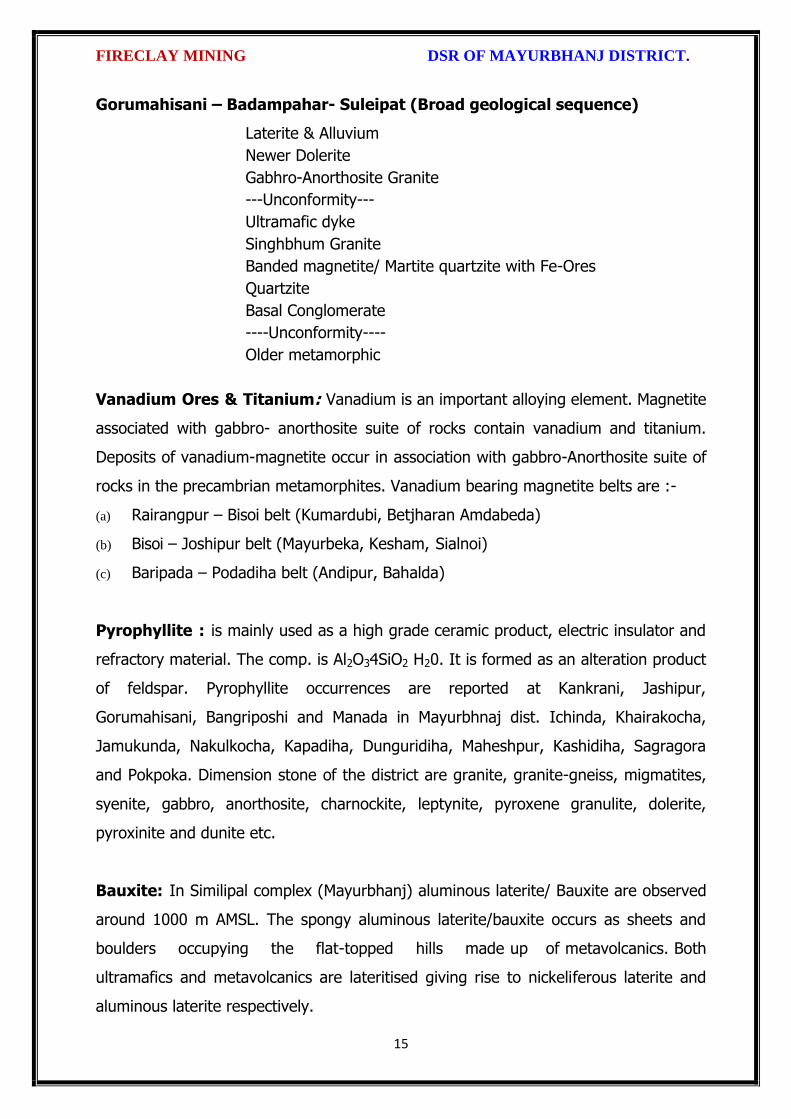
FIRECLAY MINING DSR OF MAYURBHANJ DISTRICT.
15
Gorumahisani – Badampahar- Suleipat (Broad geological sequence)
Laterite & Alluvium
Newer Dolerite
Gabhro-Anorthosite Granite
---Unconformity---
Ultramafic dyke
Singhbhum Granite
Banded magnetite/ Martite quartzite with Fe-Ores
Quartzite
Basal Conglomerate
----Unconformity----
Older metamorphic
Vanadium Ores & Titanium: Vanadium is an important alloying element. Magnetite
associated with gabbro- anorthosite suite of rocks contain vanadium and titanium.
Deposits of vanadium-magnetite occur in association with gabbro-Anorthosite suite of
rocks in the precambrian metamorphites. Vanadium bearing magnetite belts are :-
(a) Rairangpur – Bisoi belt (Kumardubi, Betjharan Amdabeda)
(b) Bisoi – Joshipur belt (Mayurbeka, Kesham, Sialnoi)
(c) Baripada – Podadiha belt (Andipur, Bahalda)
Pyrophyllite : is mainly used as a high grade ceramic product, electric insulator and
refractory material. The comp. is Al2O34SiO2 H20. It is formed as an alteration product
of feldspar. Pyrophyllite occurrences are reported at Kankrani, Jashipur,
Gorumahisani, Bangriposhi and Manada in Mayurbhnaj dist. Ichinda, Khairakocha,
Jamukunda, Nakulkocha, Kapadiha, Dunguridiha, Maheshpur, Kashidiha, Sagragora
and Pokpoka. Dimension stone of the district are granite, granite-gneiss, migmatites,
syenite, gabbro, anorthosite, charnockite, leptynite, pyroxene granulite, dolerite,
pyroxinite and dunite etc.
Bauxite: In Similipal complex (Mayurbhanj) aluminous laterite/ Bauxite are observed
around 1000 m AMSL. The spongy aluminous laterite/bauxite occurs as sheets and
boulders occupying the flat-topped hills made up of metavolcanics. Both
ultramafics and metavolcanics are lateritised giving rise to nickeliferous laterite and
aluminous laterite respectively.

FIRECLAY MINING DSR OF MAYURBHANJ DISTRICT.
16
China Clay clay like material approximating the mineral Kaolinite (Al2O3, 2SIO2,
2H2O). China clay is found to occur in a long belt stretching from Singhbhum to
Mayurbhanj. Badampahar-Joshipur- Karanjia – Ramachandrapur belt is the most
important china-clay producing area of the state. The important deposits in
Mayurbhanj district are found near Jashipur, Chanchbani, Dumuria, Jamda, Kodadiha,
Jamkeswar and Thakurmunda. China clay has many industrial applications as filler in
paper, textile, rubber, in the manufacture of potteries, ceramics, sanitary wares,
glazed tiles, white cement, insecticides, paints, cosmetics, refractory bricks etc. Soap
stone and Steatite Asbestos is mined from Mayurbhanj area.
Talc, Steatite and Soapstone: Important localities of these deposits in Mayurbhanj
dist are Tiring, Kendumundi and Kharidamak.
Kyanite: Kyanite deposits of refractory grade occur in Panijia area of Mayurbhanj
dist, where it is associated with dumortierite bearing rocks, qtz-veins, quartz-mica-
schists and talc-tremolite-schist. Other kyanite occurrence include Purnapani &
Similipal.
Quartz & Quartzite: Quartz and silica sand are mostly used in glass foundry,
ferrosilicon alloy, ceramic industry, abrasive, paint, rubber, textile industries.
Transparent varieties of quartz such as rock crystal, amethyst, citrine, Rosequartz and
smoky quartz are used as semi-precious gemstone. Quartz is a piezoelectric material
and is used in radio circuit, Radars and ultra-sonic devices. Quartzite is a
monomineralic rock constituted predominantly of quartz. There are 6 mining leases
for quartz and quartzite in Mayurbhanj dist.
High Magnesia rock: are found in Notapahar, Thakurmunda, Amjori and
Badampahar of Mayurbhanj Dist.
Nickel: Nickel is concentrated within chemically weathered ultramafic rocks and
found in the laterite and soil capping in Similipal area. The mineral occurs in silicate

FIRECLAY MINING DSR OF MAYURBHANJ DISTRICT.
17
form i.e. garnierite. The important patches of prospective ore zones are: Gurguria and
Nawana.
4.4 Soil:
The district comprises chiefly of lateritic, sandy loam and clayey loam type of soil
(Figure 3). Laterite soil is mostly marked in the area occupied by crystalline rocks.
The low lying valley fields are covered with clayey loam type of soil.
5. DRAINAGE OF IRRIGATION PATTERN
The district has considerable flat land, which provide suitable site for agricultural use.
The hilly areas are mostly under forest with patches of cultivation on scarp areas.
Major rivers flowing in the district are Budhabalanga, Subarnarekha, Jambhira, Sona,

FIRECLAY MINING DSR OF MAYURBHANJ DISTRICT.
18
Khadkhai, Deo, Katra, Khairibandhan & Baitarani. Major crops grown in the district are
rice Only. 14.82 percent area of agricultural use are net irrigated and major source of
irrigations are well and tube-wells.
Sl. No.
Name of the River
Area drained (Sq.Km.)
% Area drained in the District
1 Budhabalanga 2143 21%
2 Subarnarekha 265 0.25%
3 Jambhira 1377 13%
4 Sona 1062 10%
5 Khadkhai 1131 10.8%
6 Khairibandhan 1014 0.09%
7 Deo 473 0.04%
8 Katra 352 0.03%
9 Gangahar 594 0.057%
10 Baitarani 260 24.6%
11 Tel 96 0.009%
12 Kantamauli 82 0.007%
13 Sim 165 0.015%
14 Jhagada 30 0.002%
15 Balijori 56 0.005%
16 Kantakhaira 186 0.017%
17 Kanhu 383 0.036%
18 Balisudura 170 0.016%

FIRECLAY MINING DSR OF MAYURBHANJ DISTRICT.
19
5.1 River System
The Budhabalanga River (also called Balanga River) flows through the districts
of Mayurbhanj & Balasore and finally reached Bay of Bengal. The Budhabalanga, rises
from Similipal hills and plunges through Barehipani Falls, the second-highest waterfall
in India, located in Similipal National Park. It then flows in a northerly direction up to
the village Karanjiapal in Bangiriposi police-station. Thereafter, it turns to the north-
east and flows along the railway track up to the village Jhankapahadi. There it
changes its course to the south and meets the Katra nala. The other tributaries are
the Palpala and the Chipat both of which are hill streams rising from the Similipal hills.
Then the river passes through Baripada. It later flows through Balasore district and
into the Bay of Bengal. The Budhabalanga is about 175 kilometres (109 mi) long and
has a total catchment area of 4,840 square kilometres (1,870 sq mi). Its major
tributaries are the Sona, Gangahar, and the Katra. Burhabalang and its tributaries, viz.

FIRECLAY MINING DSR OF MAYURBHANJ DISTRICT.
20
Sona Nadi, Amrutia Nadi, Gangahar Nadi drain almost round the year in the present
area. Sona Nadi receives the watery effluent load through a nalah (Sankh nalah) from
the Balgopalpur Industrial Estate and flows from west to east. Amrutia Nadi flows
from NNW to SSE and carries the waste water load of East Coast. Subarnrekha
originate from Nagri of Jharkhand and then enter into Mayurbhanj district, very less
portion of the river flows within Mayurbhanj district, Major portion of Subarnarekha
River passes in the Balasore district. Another river Jambhira runs in Mayurbhanj
district then enters into Balasore district and Renamed as river Jalaka flows into Bay
of Bengal. Other small rivers run in this district like River Khadkhai originates from
Tunhgru R.F. and plunges through Suleipat Dam (Khadkhai Reserviour). It then runs
towards Rairangpur, Bahalda, Tiringi area of western direction of Mayurbhanj district
and finally reached at River Subarnarekha. River Deo rises from Similipal R.F. and
runs towards western part of the district and flows through Karanjia area and then
joins with Baitarani River. River Khairabandhan originates from Similipal R.F. and
flows towards western part of the Mayurbhanj district through Jashipur, Raruan,
Sukruli area of district and then joins with River Baitarani This river maintains a
sluggish flow in the pre-monsoon period, but swells menacingly with the onset of
monsoon often flooding large tracts. Another small tributary named as Kanhu starts
from River Khadkhai and branched into Jalapa, Ghagera nala meets at Jharbeda area
of Mayurbhanj District.
Sl. No.
Name of the River or Stream
Total Length in District (in Km.)
Place of Origin Altitude at Origin
1 Budhabalanga 161 Similipal Hill 940 mrl.
2 Subarnarekha 4 Nagri, Jharkhanda
610 mrl.
3 jambhira 64 Chandra R.F. Mayurbhanj
60 mrl.
4 Sona 70 Jaymal Hill, Dugdha
Mayurbhanj.
340 mrl.
5 Khadkhai 75 Tunhgru R.F. 500 mrl.
6 Khairibandhan 65 Similipal R.F. 800 mrl.
7 Deo 65 Similipal R.F. 930 mrl.
8 Katra 55 Jari R.F. 700 mrl.
9 Gangahar 55 Similipal R.F. 740 mrl.
10 Baitarani 48 Gonasika, 900 mrl.

FIRECLAY MINING DSR OF MAYURBHANJ DISTRICT.
21
Guptaganga Hills
11 Tel 20 Similipal R.F. 940 mrl.
12 Kantamauli 25 Similipal R.F. 360 mrl.
13 Sim 85 Similipal R.F. 900 mrl.
14 Jhagada 15 Jhagada R.F. 430 mrl.
15 Balijori 22 Similipal R.F. 520 mrl.
16 Kantakhaira 36 Similipal R.F. 420 mrl.
17 Kanhu 42 Similipal R.F. 400 mrl.
18 Balisudura 15 Similipal R.F. 450 mrl.
6.0 LAND UTILIZATION PATTERN IN THE DISTRICT
6.1 Forest and non forest land
The forest of Mayurbhanj district is full variety of medicinal plants, Kendu leaves,
Bamboo, Sal, Teak, other timber species and a wide range of carnivorous & herbivorous
wild animals. The district has one Wildlife Sanctuaries known as the Similipal Wildlife
Sanctuary situated at the heart of the district, which hosts all type of wildlife even

FIRECLAY MINING DSR OF MAYURBHANJ DISTRICT.
22
tigers. The area of the sanctuary is 26, 886.23 hectares. And two kilometer safety zone
of eco-sensitive zone of Suleipat Wildlife Sanctuary are coming in Mayurbhanj district. In
these sanctuary areas the principal animals that are found are Elephant, Bear, Nilgai,
Sambhar, Peacock, Wild Boar and Deer, together with variety of snakes and birds.
District-wise Forest Cover Area in Odisha (Area in Km2)
2017 Assessment
District Geograph ical Area Km2
Very Dense Forest
Moder- ate. Dense Forest
Open Forest
Total Percent of GA
Change Scrub
Angul 6375 371 1380 1004 2755 43.22 43 84
Bolangir 6575 70 224 837 1131 17.2 151 142
Balasore 3806 23 127 234 380 9.98 30 48
Bargarh 5837 176 371 484 1031 17.66 88 47
Bouda 3098 263 546 480 1289 41.61 27 57
Bhadrak 2505 0 9 66 75 2.99 2 0
Cuttack 3932 53 226 517 796 20.24 11 68
Deogarh 2940 191 667 614 1472 50.07 -3 14
Dhenkanal 4452 174 418 825 1417 31.83 9 82
Gajapati 4325 84 1490 946 2520 58.27 12 262
Ganjam 8206 164 1075 864 2103 25.63 15 655
Jagatsinghpur 1668 0 5 131 136 8.15 6 0
Jajpur 2899 6 72 225 303 10.45 3 50
Jharsugada 2114 3 140 179 322 15.23 9 36
Kalahandi 7920 362 729 1327 2418 30.53 36 362
Kandhamal 8021 661 2588 2143 5392 67.22 16 380
Kendrapada 2644 84 88 133 305 11.54 14 2
Keonjhar 8303 289 1404 1519 3212 38.68 4 55
Khorda 2813 21 186 250 457 16.25 0 92
Koraput 8807 94 740 1255 2089 23.72 120 944
Malkangiri 5791 158 709 1475 2342 40.44 20 45
Mayurbhanj 10418 1335 1718 1027 4080 39.16 42 34
Nabarangpur 5291 168 428 507 1103 20.85 8 47
Nayagarh 3890 189 965 556 1710 43.96 28 173
Nuapada 3852 86 482 705 1273 33.05 33 109
Puri 3479 0 54 160 214 6.15 8 11
Rayagada 7073 422 853 1851 3126 44.2 7 349

FIRECLAY MINING DSR OF MAYURBHANJ DISTRICT.
23
Sambalpur 6624 499 1675 1106 3280 49.52 13 40
Subarnapur 2337 2 187 161 350 14.98 26 29
Sundargarh 9712 1019 1814 1431 4264 43.9 107 89
Grand Total 155707 6967 21730 23008 51345 32.98 885 4306
(Source: India state of forest report 2017-Odisha)
The major portion of the district is covered by forest (39.16 % of TGA) and has
scattered settlement pattern. The forest is full of variety of medicinal plants. The
district has considerable flat land, which provide suitable site for agricultural use. The
hilly areas are mostly under forest with patches of cultivation on scarp areas. Major
crops grown in the district are rice and pulses. Only 14.82 percent area of agricultural
use are net irrigated and major source of irrigations are well and tube wells.
Source: Fertilizer and Agriculture Statistics, Eastern Region
Tahasil Forest Area
Misc Tree
Permanent Pasture
Cultivated waste
Non Agricultural
uses
Barren land
Current Fallow
Other Fallow
Net area
sown
Bahalda 964 471 1397 1262 2590 1900 875 944 14031
Bangiriposi 3712 281 1037 1688 3046 684 2054 922 16951
Baripada 216
673
3 128 1628 1376 8 2752 2156 4219
Badasahi 288 180
7 1194 1874 3840 24 3378 2110 17630
Betnoti 2271 911 1198 1728 3227 21 1915 578 17022
Bijatala 2841 224 681 3100 1792 1636 1214 600 11228
Bisoi 3116 471 757 2508 2193 459 2298 1643 15860
G.B.Nagar 191 116 683 582 1147 590 643 1209 10960
Jamda 408 100 1650 434 2060 785 840 1149 13608
Jashipur 8932 141 1389 2655 3637 400 3873 2634 17754
Kaptipada 8745 387 3292 5596 4123 2165 3123 4930 19932
Karanjia 1644 838 1444 2441 3065 462 3493 1362 16690
Khunta 400 226
0 314 672 2061 21 1332 2213 12879
Kuliana 1749 162
6 2222 1902 2529 608 4919 1504 11108
Kusumi 1434 32 2320 2679 2337 587 1086 1682 18032
Morada 993 412
7 513 4340 1941 61 1909 3633 10179
Rairangpur 2260 107 1759 1373 2027 504 1276 631 9713
Raruan 1210 171 890 1120 1899 503 1609 1020 12818
Rasgovindpur 288 214
5 665 1091 2774 142 2002 1537 10054
Shamakhunta 1354 764 1378 2472 1859 334 1861 941 6695
Saraskana 3464 275 689 2658 4042 115 1864 1837 15384
Sukruli 412 211 734 1295 1271 502 1286 1294 10352
Suliapada 2937 553
5 97 2262 2148 86 1589 2906 8971
Thakurmunda 10885 96 1530 1438 2034 795 5317 2670 17681

FIRECLAY MINING DSR OF MAYURBHANJ DISTRICT.
24
6.2 Agriculture Land:
Mayurbhanj is surrounded by no of forest areas as well as Rocky Mountains. People
used to cultivate Paddy in most parts of the hill slopes and in plain lands. Most of the
cultivators grow short duration local paddy in the un-bonded upland during Kharif
season. The crop suffers moisture stress at different stages due to inadequate rainfall.
The primary objective of Agriculture Department is increase of production as well as
productivity of major crops like paddy, groundnut, mustard, Mung, Biri & vegetables
which is widely covered in this District in both Kharif & Rabi season. Another key
objective is the all round development of the farming community of the District. The
Deputy Director of Agriculture is the head of office so far as agriculture is concerned &
he is the Principal Agriculture Officer of the District. Under him there are 5 District
Agriculture Officers & the block under them. As already pointed out, that agriculture is
the main livelihood of the people in Mayurbhanj District. It is therefore also
designated as the food bowl of Odisha. Rice is the principal crop grown in this district,
followed by other cereals, pulses, oilseeds, vegetables, spices and sugarcane. The
agricultural statistics for the district is shown in subsequent tables below:
Table – 3.6a: Crop Coverage Area of Mayurbhanj District, Odisha
Crop Khariff Rabi Annual TOTAL
Area (ha)
(% of Cropped
Area
Area (ha)
% of Cropped
Area
Area (ha)
Gross Cropped Area (ha)
% of Gross
Cropped Area
Rice 301.37 82.353% 3.80 4.015% --- 305.17 62.051%
Cereals 9.99 2.730% 2.17
2.293% --- 12.16 2.472%
Pulses 32.37 8.846% 36.20 38.255% --- 68.57 13.943%
Oilseeds 5.92 1.617% 28.30 29.906% --- 34.22 6.958%
Vegetables 12.39 3.386% 21.74 22.974% --- 34.13 6.940%
Fibres 2.43 0.664% --- 2.43 0.494% Spices 1.48 0.404% 2.42 2.557% --- 3.90 0.792%
Sugarcane --- --- 00 --- --- 00 ---
Tobacco --- --- 00 --- --- 00 ---
Fruits --- --- --- --- --- 31.23 6.350%
TOTAL 365.95 100.00% 94.63 100.00% --- 491.81 100.00%

FIRECLAY MINING DSR OF MAYURBHANJ DISTRICT.
25
6.3 Horticulture Land:
The primary objective of Horticulture Department is increase of production as well as
productivity of major fruits like Mango, Guava, Citrus etc., which is widely covered in
this District. Another key objective is the all round development of the farming
community of the District. The Deputy Director of Horticulture is the head of office.
7.0 SURFACE WATER AND GROUND WATER SCENARIO OF THE DISTRICT
7.1 Hydrogeology
Distribution of Saline / fresh water aquifers:
The occurrence of fresh water aquifers in coastal tract of Mayurbhanj restricted by
two important factors‐ (i) Occurrence of hard rocks in the western side and (ii) Salinity
hazard problems in the eastern part. The water bearing formation of the area can be
divided into (a) areas underlain by fractured, fissured and consolidated basement rock
formations (b) areas underlain by recent unconsolidated alluvial formations.
(a) Consolidated Formation - These are most predominant rock types occurring in
the undulating plains of the district. Groundwater occurs under unconfined condition
in the shallow weathered zone and circulates through fractures and joints. The
thickness of the weathered zone varies from 3 to 35 m. Depth of open wells in these
formations varies from 5 to 14 m below ground level.
(b) Unconsolidated alluvial formations - The unconsolidated formations consists of
laterite and alluvium. Laterites at places are highly consolidated and used as building
stones. The laterites have high degree of effective porosity and form potential
aquifers commonly tapped in dug wells. The alluvium comprises an admixture of clay,
silt, sand and calcareous concretions in varying proportions. The coarse sediments like
sand and gravel form the main repository of ground water. Ground water occurs
under both unconfined condition in shallow aquifers and in confined condition in
deeper parts.

FIRECLAY MINING DSR OF MAYURBHANJ DISTRICT.
26
7.2 Depth of water level:
The depth to water level map for pre and post monsoon periods 2011 are prepared
based on the ground water monitoring data of 77 Nos of National Hydrograph
Stations of C.G.W.B. monitored during the month of April and November 2006 are
presented below respectively. The pre and post monsoon depth to water levels in the
district range from 3.54 to 14.50 m below ground level and 1.39 to 8.20 m below
ground level respectively. It is observed that during pre monsoon about 75% of the
total areas show the water level varying between 5 to 10 m below ground level.
During post monsoon nearly 60% of the area has water levels within 2 to 5 m,
while the rest part has between 0 to 2 and 4 to 6 m below ground levels. In localized
part of Morada, Kaptipada and Thakurmunda the water level is > 5 mt.
Depth & categorization of ground water levels during pre monsoon period (April 2011)
of Mayurbhanj districts is presented below:

FIRECLAY MINING DSR OF MAYURBHANJ DISTRICT.
27
Depth & categorization of ground water levels during pre monsoon period (November
2011) of Mayurbhanj districts is presented below:

FIRECLAY MINING DSR OF MAYURBHANJ DISTRICT.
28
7.3 Ground Water Quality
The chemical quality of ground water in the district has been assessed on the basis of
chemical analysis of ground water samples collected during groundwater monitoring,
Hydrogeological surveys and groundwater exploration. The results of the chemical
analysis are presented in Table.
Table showing chemical constituents in aquifers
Constituent Shallow aquifer Deeper aquifer
pH 6.97 – 8.25 6.84 – 8.25
Sp. Conductance (micromohs/cm at 250 C)
53 – 974 92 – 867
TDS (mg/l) 58 – 1430 106 – 429
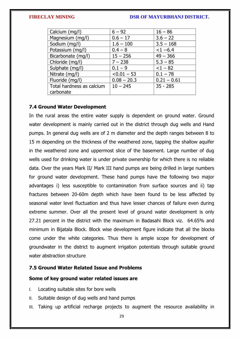
FIRECLAY MINING DSR OF MAYURBHANJ DISTRICT.
29
Calcium (mg/l) 6 – 92 16 – 86
Magnesium (mg/l) 0.6 – 17 3.6 – 22
Sodium (mg/l) 1.6 – 100 3.5 – 168
Potassium (mg/l) 0.4 – 8 <1 --6.4
Bicarbonate (mg/l) 15 – 256 49 – 366
Chloride (mg/l) 7 – 238 5.3 – 85
Sulphate (mg/l) 0.1 – 9 <1 – 82
Nitrate (mg/l) <0.01 – 53 0.1 – 78
Fluoride (mg/l) 0.08 – 20.3 0.21 – 0.61
Total hardness as calcium carbonate
10 – 245 35 - 285
7.4 Ground Water Development
In the rural areas the entire water supply is dependent on ground water. Ground
water development is mainly carried out in the district through dug wells and Hand
pumps. In general dug wells are of 2 m diameter and the depth ranges between 8 to
15 m depending on the thickness of the weathered zone, tapping the shallow aquifer
in the weathered zone and uppermost slice of the basement. Large number of dug
wells used for drinking water is under private ownership for which there is no reliable
data. Over the years Mark II/ Mark III hand pumps are being drilled in large numbers
for ground water development. These hand pumps have the following two major
advantages i) less susceptible to contamination from surface sources and ii) tap
fractures between 20-60m depth which have been found to be less affected by
seasonal water level fluctuation and thus have lesser chances of failure even during
extreme summer. Over all the present level of ground water development is only
27.21 percent in the district with the maximum in Badasahi Block viz. 64.65% and
minimum in Bijatala Block. Block wise development figure indicate that all the blocks
come under the white categories. Thus there is ample scope for development of
groundwater in the district to augment irrigation potentials through suitable ground
water abstraction structure
7.5 Ground Water Related Issue and Problems
Some of key ground water related issues are
I. Locating suitable sites for bore wells
II. Suitable design of dug wells and hand pumps
III. Taking up artificial recharge projects to augment the resource availability in

FIRECLAY MINING DSR OF MAYURBHANJ DISTRICT.
30
Mayurbhanj district.
IV. Optimal development of irrigation potential by developing ground water available
for future uses.
V. Creating public awareness for conserving ground water through awareness
camps, NGO’s and mass media.
7.6 Mass Awareness Campaign (MAP) & Water Management Training
Programme (WMTP) by CGWB
NIL
7.7 Area Notified by Cgwb/Sgwa
None
7.8 RECOMMENDATIONS:
1) Intensive groundwater exploration should be taken up to delineate deeper
potential water saturated fracture zones and to compute aquifer parameter.
2) Large scale planning for ground water development should be preceded by
intensive hydrogeological and geophysical surveys aided by remote sensing
studies.
3) Effective measures may be taken to conserve the surface run off by contour
bonding at suitable sites. Also proper maintenance of reservoir, tanks and spring
channels by periodical disiltation should be carried out.
4) Existing dug-wells should be deepened to tap the maximum saturated thickness of
the weathered mantle or vertical bores may be drilled through the bottom to
enhance the well yield.
5) Energy station of wells already constructed should be stepped up to ensure
optimal utilization of the irrigation potential already created.
6) The farmers should be educated through agricultural extension services fro
adopting suitable cropping pattern for optimal utilization of available groundwater
resources.
7) Programmes for artificial recharge may also be taken up for augmentation of
groundwater through construction of percolation tanks, subsurface dykes, and
check dams and through contour bonding etc.
8) An intensive network of groundwater monitoring stations are required to be
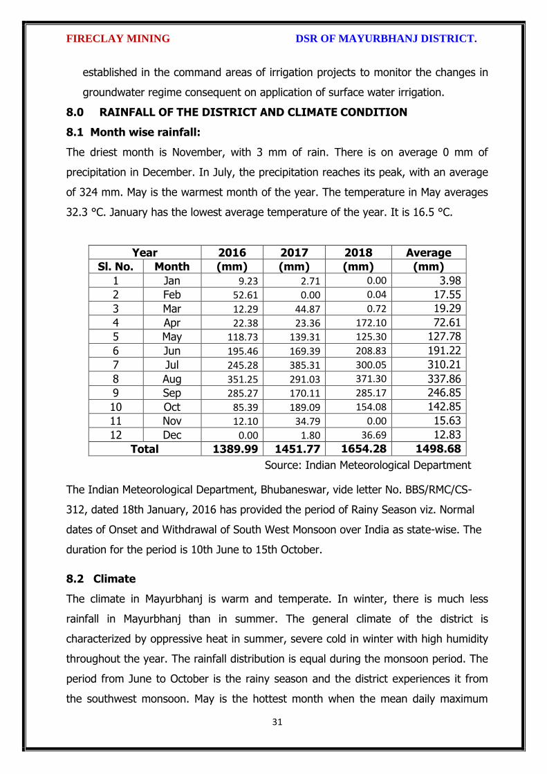
FIRECLAY MINING DSR OF MAYURBHANJ DISTRICT.
31
established in the command areas of irrigation projects to monitor the changes in
groundwater regime consequent on application of surface water irrigation.
8.0 RAINFALL OF THE DISTRICT AND CLIMATE CONDITION
8.1 Month wise rainfall:
The driest month is November, with 3 mm of rain. There is on average 0 mm of
precipitation in December. In July, the precipitation reaches its peak, with an average
of 324 mm. May is the warmest month of the year. The temperature in May averages
32.3 °C. January has the lowest average temperature of the year. It is 16.5 °C.
Year 2016 2017 2018 Average
Sl. No. Month (mm) (mm) (mm) (mm)
1 Jan 9.23 2.71 0.00 3.98
2 Feb 52.61 0.00 0.04 17.55
3 Mar 12.29 44.87 0.72 19.29
4 Apr 22.38 23.36 172.10 72.61
5 May 118.73 139.31 125.30 127.78
6 Jun 195.46 169.39 208.83 191.22
7 Jul 245.28 385.31 300.05 310.21
8 Aug 351.25 291.03 371.30 337.86
9 Sep 285.27 170.11 285.17 246.85
10 Oct 85.39 189.09 154.08 142.85
11 Nov 12.10 34.79 0.00 15.63
12 Dec 0.00 1.80 36.69 12.83
Total 1389.99 1451.77 1654.28 1498.68
Source: Indian Meteorological Department
The Indian Meteorological Department, Bhubaneswar, vide letter No. BBS/RMC/CS-
312, dated 18th January, 2016 has provided the period of Rainy Season viz. Normal
dates of Onset and Withdrawal of South West Monsoon over India as state-wise. The
duration for the period is 10th June to 15th October.
8.2 Climate
The climate in Mayurbhanj is warm and temperate. In winter, there is much less
rainfall in Mayurbhanj than in summer. The general climate of the district is
characterized by oppressive heat in summer, severe cold in winter with high humidity
throughout the year. The rainfall distribution is equal during the monsoon period. The
period from June to October is the rainy season and the district experiences it from
the southwest monsoon. May is the hottest month when the mean daily maximum

FIRECLAY MINING DSR OF MAYURBHANJ DISTRICT.
32
temperature rises up to 47º Celsius. The Köppen-Geiger climate classification is Cwa &
as per they the average temperature in Mayurbhanj is 24.7 °C. The temperature in
May averages 32.3 °C. January has the lowest average temperature of the year, it is
16.5 °C. There is a difference of 321 mm of precipitation between the driest and
wettest months. During the year, the average temperatures vary by 15.8 °C., when
the mean daily minimum temperature dips to 4º Celsius. The higher reaches of the
Similipal experiences frosting during the peak of winter.
9.0 DETAILS OF MINING LEASE OF FIRECLAY STONE IN THE DISTRICT
9.1 List of Mines is operation in the district:
Attached as Annexure- I
9.2 List of Mines is not operation in the district:
Attached as Annexure-I
FIRECLAY MINING DSR OF MAYURBHANJ DISTRICT.
33
10. DETAIL OF ROYALTY OR REVENUE RECEIVED IN LAST THREE YEARS:
Sl.
No.
Name of the Mining Circle
2016-17 2017-18 2018-19 Total in
tonne
1 Baripada Nil Nil Nil Nil
Total Nil Nil Nil Nil
11. DETAIL OF PRODUCTION OF MINOR MINERALS IN LAST THREE YEARS:
Sl.
No.
Name of the Mining Circle
2016-17 2017-18 2018-19 Total in
tonne
1 Baripada Nil Nil Nil Nil
Total Nil Nil Nil Nil

FIRECLAY MINING DSR OF MAYURBHANJ DISTRICT.
34
12. MINERAL MAP OF THE DISTRICT:
13. LIST OF LETTER OF INTENT (LOI) HOLDERS IN THE DISTRICT ALONG
WITH ITS VALIDITY
Sl. No.
Name of the
Mineral
Name of the
Lessee
Address Letter of Intent Grant
Order No. &
date
Area of Mning
lease to be
allotted
Validity of LoI
Use
(Captive/ Non-
Captive)
Location of the Mining
lease (Latitude & Longitude)
1 2 3 4 5 6 7 8 9
Attached as Annexure-I

FIRECLAY MINING DSR OF MAYURBHANJ DISTRICT.
35
14. TOTAL MINERAL RESERVE AVAILABLE IN THE DISTRICT
Total mineral reserve of granite rock as fireclay will access after detail study or grant
of potential area, which may investigation as per details below.
(i) Blocks were identified based on geological studies through field observation.
(ii) Mineable resource was calculated by considering detail prospecting.
(iii) Area calculated as per GPS co-ordinates and information obtained from local
people. Land detail need to be verified from revenue record.
(iv) Since this is an interim report, as per the present requirement of minerals, more
such blocks need to be identified and the data should be updated periodically, after
certain intervals to update the data bank of DSR.
Sl. No.
Name of the Mining Circle
Mineral Resources in tonne.
Mineable Reserve in tonne.
1 Baripada Nil Nil
Total Nil Nil
Summary of Identified Mineral Potential:
Sl.
No.
Name
of the
mineral
Name
of the
lessee
Address and
contact No. of
the lessee
Letter of
Intent
Grant
Order
No. and
date
Area of
mining
lease to
be
allotted
Validity of LoI
Use
(Captive/ Non- Captive
Location of the Mining lease (Latitude & Longitude)
1 2 3 4 5 6 7
Attached as Annexure-I
15. QUALITY/GRADE OF MINERAL AVAILABLE IN THE DISTRICT:
Rocks and Minerals found in Mayurbhanj District:-
The district is endowed with various types of mineral resources like Iron ore, China
Clay, Fireclay, Quartz; Soap stone, Granite, Manganese, etc. Due to presence of
huge mineral resources, mining activities have been undertaken in a big scale.
Bahalda, Jashipur, Karanjia, Koshorpur, Bisoi, Gorumahisani and Rairangpur are the
places in the district having deposits of the above mineral products. The availability
of mineral deposits is given in the table below. The district’s mineral deposits have
not been utilized to maximum extent for industrial purpose. Some of the items like

FIRECLAY MINING DSR OF MAYURBHANJ DISTRICT.
36
China clay, Soap stone, Asbestos, etc. can be used in small scale sector. So the
available resources of the district need harnessing properly for industrial and
productive use. Fireclay deposits of the district are very much suitable for various
industrial uses.
16. USE OF MINERAL
Uses of Fireclay:
Fire clay is resistant to high temperatures, having fusion points higher than 1,600 °C
(2,910 °F); therefore it is suitable for lining furnaces, as fire brick. Because of its
stability during firing in the kiln, it can be used to make complex items of pottery such
as pipes and sanitary ware. Fire clay is clay that has a high degree of resistance to
heat. The term fire clay is commonly held to exclude kaolin and other refractory
potter's clays. Fire clay should contain high percentages of silica and alumina, with as
little as possible of such impurities as lime, magnesia, soda, and potash, which lower
the fusion point of the clay. Fire clay often forms the bed layer of earth under seams
of coal. Two types are recognized—flint clay, exceedingly hard, nonplastic, and
resembling flint in appearance occurring in as plastic fire clay. The principal uses of
fire clay are in the manufacture of firebrick and of various accessory utensils, such as
crucibles, saggers, retorts, and glass pots, used in the metalworking industries.
17. DEMAND AND SUPPLY OF THE MINERAL IN THE LAST THREE YEARS:
As such there are huge infrastructural and industrial activities are coming up by State
govt., Govt. of India & PSUs under ―Make in India‖ programme. The main raw
minerals for the above activities and considering the last three years actual
productions with respect to the requirement of the state has a huge gap. It is
proposed to start the production from larger block/area to at least double the
production of the district which will enhance the revenue of the district and also
support the livelihood of the local people
Sl. No. Name of the Mining Circle
Financial Year
Fireclay in tonne
1
Baripada 2016-17 Nil
2017-18 Nil
2018-19 Nil
Total Nil

FIRECLAY MINING DSR OF MAYURBHANJ DISTRICT.
37
18. MAP OF EXISTING MINING LEASES IN THE DISTRICT:
Enclosed as Plate-I
19. DETAILS OF THE AREA OF WHERE THERE IS A CLUSTER OF MINING
LEASE VIZ. NUMBER OF MINING LEASES, LOCATION (LATITUDE AND
LONGITUDE)
Currently there is no cluster of Fireclay mining lease in the district. However, it is
proposed to consider the cluster of mining lease while planning for new lease area in
coming years.
20. DETAILS OF ECO-SENSITIVE AREA, IF ANY, IN THE DISTRICT:
Eco sensitive zone of Similipal wild life sanctuary is located within the district.
21. IMPACTS OF MINING ON ENVIRONMENT:
The most important environmental impact of mining projects is:-
Transportation sources:
Transportation sources of air pollutants include heavy vehicles used in excavation
operations, cars that transport personnel at the mining site, and trucks that transport
mining materials. The level of polluting emissions from these sources depends on the
fuel and conditions of the equipment. Even though individual emissions can be
relatively small, collectively these emissions can be of real concern. In addition,
mobile sources are a major source of particulate matter, carbon monoxide, and volatile
organic compounds that contribute significantly to the formation of ground-level ozone
Fugitive emissions:
Common sources of fugitive emissions include: storage and handling of materials;
mine processing; fugitive dust, blasting, construction activities, and roadways
associated with mining activities; leach pads, and tailing piles and ponds; and waste
rock piles. Sources and characteristics of fugitive emissions dust in mining operations
vary in each case, as do their impacts. Impacts are difficult to predict and calculate
but should be considered since they could be a significant source of hazardous air
pollutants.

FIRECLAY MINING DSR OF MAYURBHANJ DISTRICT.
38
Noise and vibration:
Noise pollution associated with mining may include noise from vehicle engines,
loading and unloading of rock into steel dumpers, chutes, power generation, and
other sources. Cumulative impacts of shoveling, ripping, drilling, blasting, transport,
crushing, grinding, and stock-piling can significantly affect wildlife and nearby
residents.
Vibrations are associated with many types of equipment used in mining operations,
but blasting is considered the major source. Vibration has affected the stability of
infrastructures, buildings, and homes of people living near large-scale open-pit mining
operations. According to a study commissioned by the European Union in 2000:
―Shocks and vibrations as a result of blasting in connection with mining can lead to
noise, dust and collapse of structures in surrounding inhabited areas. The animal life,
on which the local population may depend, might also be disturbed.‖
22. REMEDIAL MEASURES TO MITIGATE THE IMPACT OF MINING ON THE
ENVIRONMENT:
1. Following are the remedial measures to mitigate the in Water sprinkling on haul
road, loading and unloading points.
2. Plantation along the safety zone and dump area.
3. Providing dust masks to workers.
4. Regular monitoring of ambient air quality.
5. Provision of air conditioned cabin of Excavators and Dumpers.
6. Regular and proper maintenance of working equipments.
7. Periodic medical examination of the workers and organize medical camp in the area.
8. Use Milli Second Delay Detonator in blasting operation.
9. Provisions of ear plug to the workers.
10. Regular training programme to the mines workers and operators.
23. RECLAMATION OF MINED OUT AREA
Necessity of Reclamation & Rehabilitation:
Exponential growth in mineral production since 1980.
Mining activities causes physical, chemical, biological and socio-economic changes in

FIRECLAY MINING DSR OF MAYURBHANJ DISTRICT.
39
the area.
Surface mining activities disturb the original land profile.
In India, mineral production comes mostly from opencast mines & hence land
degradation problems are of serious concern.
An intricate, in-depth and site-specified techniques involving integrated approach is
necessary.
Reclamation has three vital roles:
i. Reclamation – Reclamation means return the mined-out land with useful life. It
implies restoring the land to a form and productivity that is useful and inconformity
with a prior land use. Reclamation always may not be a single- phase operation.
ii. Rehabilitation – Rehabilitation is to bring batch the degraded land to a normal
stage by a special treatment. It is a process of taking some mitigation measures for
disturbed environmental condition created through mining activities.
iii. Restoration – Restoration is the process of returning the mined out land being
fit to an acceptable environmental condition. However, the general acceptable
meaning of the term is bringing the disturbed land to its original form. Restoration is
often used to indicate that biological properties of soil are put back to what they were.
This is a rate phenomenon.
iv. When active mining ceases, mine facilities and the site are reclaimed and closed.
The goal of mine site reclamation and closure should always be to return the site to a
condition that most resembles the pre-mining condition. Mines that are notorious for
their immense impact on the environment often made impacts only during the closure
phase, when active mining operations ceased. These impacts can persist for decades
and even centuries.
Mine reclamation and closure plans must describe in sufficient detail how the mining
company will restore the site to a condition that most resembles pre-mining
environmental quality; how it will prevent – in perpetuity – the release of toxic
contaminants from various mine facilities (such as abandoned open pits and tailings
impoundments); and how funds will be set aside to insure that the costs of
reclamation and closure will be paid for.
Proposed future land use after reclamation:
a. Forestry, b. Recreation, c. Water Reservoir, d. Crop Land,

FIRECLAY MINING DSR OF MAYURBHANJ DISTRICT.
40
e. residential/Commercial, f. Fish & wildlife Habitat, g. Undeveloped Land,
h. Grazing/Pasture Land
Statutory requirement:
As per the Mineral Conservation Development Rule, 2017, the following rules must be
bare in mind by the mine owner/agent/manager, which is a part of reclamation
activities –
Rule 22, Mine Closure Plan
Rule 23, Submission of Progressive Mine Closure Plan Rule 24, Submission of Final
Mine Closure Plan
Rule 26, Responsibility of holder of mining lease Rule 27, Financial Assurance
Rule 35, Sustainable Mining
24. RISK ASSESSMENT AND DISASTER MANAGEMENT PLAN:
Mining activity because of the very nature of the operation, complexity of the
systems, procedures and methods always involves some amount of hazards. Hazard
identification and risk analysis is carried for identification of undesirable events that
can leads to a hazard, the analysis of hazard mechanism by which this undesirable
event could occur and usually the estimation of extent, magnitude and likelihood of
harmful effects. The activities which can cause high risk related to face stability and
the person blasting the shots. It was observed that on a working face of the mine,
there were large cracks and unsupported rocks were present, which can lead to a
serious hazard and injure workers engaged in loading operation and machineries
because of rock falls or slides. This type of condition turn out because improper
dressing of the bench and improper supervision. To avoid the hazards due to fall of
rocks the face must be examined, made suitable for working and the remedial
measures must be taken to make it safe if there is any doubt that a collapse could
take place. Working of the face should be in the direction taking into account the
geology of the area such that face and quarry side remain stable. Another major risk
identified in mines is due to the firing of explosive by an unqualified person. In the
mines there is problem of fly rocks and the village is located close to the mine and so
it is rated high as it can affect may people. Explosives by nature have the potential for
the most serious and catastrophic accident. Planning of round of shots, holes correctly
drilled, direction logged, weight of explosive suitable for good fragmentation are the

FIRECLAY MINING DSR OF MAYURBHANJ DISTRICT.
41
few of the steps necessary to ensure its safe use and if the shots are not properly
designed can result in misfires, early ignition and flying rocks. No person is allowed to
use explosives without being properly trained in its handling. In the mine a large
numbers of heavy vehicles were in operation and the roads were not proper for
haulage purpose. The haulage roads were not even and were not wide enough for the
crossing purpose and hence the chances of hazards are very high. The main hazards
arising from the use large earth moving vehicles are incompetent drivers, brake
failure, lack of all-around visibility from the driver position, vehicle movements
particularly reversing, roll over, and maintenance. Those most at risk are the driver
and pedestrians likely to be struck by the vehicle, and drivers of smaller vehicles,
which cannot be seen from the cabs of large vehicles. Edge protection is always
necessary to prevent inadvertent movement over the edge of roadway or a bench.
Seatbelt will protect driver in case of roll. Good maintenance and regular testing are
necessary to reduce the possibility of brake failure. Access to the vehicles should
always be restricted to those people necessary for the work in hand. The use of
personal protective equipment and proper arrangements is essential to check if the
person is wearing protective equipment or not. The personal protective equipment
includes helmet, non-skid safety boots, safety glasses, earmuffs etc. The required
personal protective equipment should be provided and used in a manner that protects
the individual from injury. Few minor injuries which can be prevented are slip, trip, or
fall hazards; hazards due to rock falls and collapse of unstable rocks, atmosphere
containing toxic or combustible gases; protects from chemical or hazardous material
etc. A disaster management plan should be prepared for taking care of for any
disaster. Other risks which are included in this category are noise, as it occurs and it
can lead to permanent disability. There are problems related to road traffic in and out
issuers; inappropriate exposure of moving machines; mechanical failure and because
of large number of moving trucks and dumpers there is large quantity of dust present
in roadways which affects the operators and can lead to accidents causing injury.
They are in acceptable range because of precautions measures taken but no step is
taken it can cause hazard hence steps should be taken to reduce the hazards such as
for dust suppression system should be installed. Other problems like occurrence of

FIRECLAY MINING DSR OF MAYURBHANJ DISTRICT.
42
lots of mosquitoes in the area due to unhygienic conditions which affect the human
health causing malaria, dengue etc. and causing a person to be hospitalized.
Disaster in the mines like fires, explosions, entrapments, and inundations can occur
any time, so emergency preparedness is a must. The Disaster management plan and
risk assessment in the mines will include all sorts of above mentioned emergency and
the extent that this plan will be implemented will depend on the nature and scope of
the emergency. The basic purpose of Disaster management plan and risk assessment
to ensure that mine rescue and recovery activities are conducted safely for rescuer
and survivors. According to MMR act 1961 a standard operating procedure should be
drawn for involvement different category of staff and officers. The SOP should be
updated periodically to reduce the chaos and response to the emergency should be
quick and smooth. The responsible person should be familiar with his responsibility
during the mock drills. One or two standby should be there to replace the person in
Emergency situation. Rescue operations should not include the survivors for any
assistance.
First Information of Disaster / Emergency should go to the attendance clerk on duty.
Duties of attendance Clerk (Emergency Siren) the attendance clerk or other
designated person should on getting information of major accident, sound a hooter or
a siren immediately declaring a state of emergency at the mine and then to contact
the manager and on his advice to call key personnel using the information listed in the
Emergency Organization Chart. It is important that all telephone calls are recorded in
a telephone log book. Duties of Other Officials should be displayed and handed over
to all concerned. Copy the same should be kept at Manager’s Office for ready
reference. Establishment of Control Room at Unit Level, Area Level and Company
Level is essential. Control Room should keep the contact information about –
Company Manager
Company owner/ Administrative officer.
District Administration
Govt. Hospitals in Nearby Localities,
Private Nursing Homes of Localities
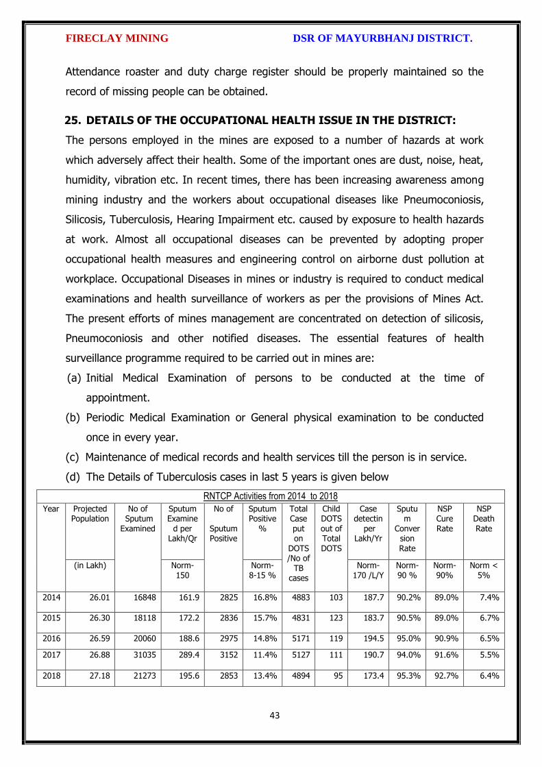
FIRECLAY MINING DSR OF MAYURBHANJ DISTRICT.
43
Attendance roaster and duty charge register should be properly maintained so the
record of missing people can be obtained.
25. DETAILS OF THE OCCUPATIONAL HEALTH ISSUE IN THE DISTRICT:
The persons employed in the mines are exposed to a number of hazards at work
which adversely affect their health. Some of the important ones are dust, noise, heat,
humidity, vibration etc. In recent times, there has been increasing awareness among
mining industry and the workers about occupational diseases like Pneumoconiosis,
Silicosis, Tuberculosis, Hearing Impairment etc. caused by exposure to health hazards
at work. Almost all occupational diseases can be prevented by adopting proper
occupational health measures and engineering control on airborne dust pollution at
workplace. Occupational Diseases in mines or industry is required to conduct medical
examinations and health surveillance of workers as per the provisions of Mines Act.
The present efforts of mines management are concentrated on detection of silicosis,
Pneumoconiosis and other notified diseases. The essential features of health
surveillance programme required to be carried out in mines are:
(a) Initial Medical Examination of persons to be conducted at the time of
appointment.
(b) Periodic Medical Examination or General physical examination to be conducted
once in every year.
(c) Maintenance of medical records and health services till the person is in service.
(d) The Details of Tuberculosis cases in last 5 years is given below
RNTCP Activities from 2014 to 2018
Year Projected Population
No of Sputum
Examined
Sputum Examine
d per Lakh/Qr
No of
Sputum Positive
Sputum Positive
%
Total Case
put on
DOTS/No of
TB cases
Child DOTS
out of Total DOTS
Case detectin
per Lakh/Yr
Sputum
Conversion Rate
NSP Cure
Rate
NSP Death
Rate
(in Lakh) Norm- 150
Norm-8-15 %
Norm-170 /L/Y
Norm-90 %
Norm-90%
Norm < 5%
2014 26.01 16848 161.9 2825 16.8% 4883 103 187.7 90.2% 89.0% 7.4%
2015 26.30 18118 172.2 2836 15.7% 4831 123 183.7 90.5% 89.0% 6.7%
2016 26.59 20060 188.6 2975 14.8% 5171 119 194.5 95.0% 90.9% 6.5%
2017 26.88 31035 289.4 3152 11.4% 5127 111 190.7 94.0% 91.6% 5.5%
2018 27.18 21273 195.6 2853 13.4% 4894 95 173.4 95.3% 92.7% 6.4%

FIRECLAY MINING DSR OF MAYURBHANJ DISTRICT.
44
26. PLANTATION GREEN BELT DEVELOPMENT IN RESPECT OF LEASE
ALREADY GRANTED IN THE DISTRICT:
During mining operation green belt development through plantation is most important
for environment safe guard, which should be supervision by mining department.
Different type of species should be planted near lease periphery to keep environment
clean at post mining period through reclamation. Where specific usefulness of land
could be decided, a forestation is normally planned through the site could have been
considered for better possibilities of land use.
27. CONCLUSION:
Since it is an interim report, to meet the requirement of minerals in the present
scenario, it is proposed to identify such potential areas at certain interval and get the
data bank of DSR to be updated. The insitu mining activity in any area is on one hand
bring revenue and employment (Direct and indirect) and on other hand if not done
properly potential pollution and ecological imbalance increases, the ability of the
ecosystem can also be reduced. Particulate matter transported by the wind as a result
of excavations, blasting, transportation of materials, heavy equipments used raise
these particulate levels; and Gas emissions from the combustion of fuels in stationary
and mobile sources, explosions, and mineral processing. All these activities indirectly
affected the biodiversity of area. Larger potential and smaller areas have been
identified in Mayurbhanj district on the basis of geological study carried out during
field observation, which can be considered for mining concession after all the
parameters for statutory clearances are verified by consulting with concerned
authorities.

FIRECLAY MINING DSR OF MAYURBHANJ DISTRICT.
45
Plate No.-I

\
\,
L
I
t
\
L
L
FIRECLAY MINING DSR OF MAYURBHANJ DISTRICT"
The District Survey Report for Fireclay Stone Mining (Minor Mineral) in
respect of Mayurbhanj District prepared in accordance with Appendix-X, Para .7 (iii)
(a) of S.O" 3611 (E) Dt. 25,07.2018 of Ministry of Environment, Forest and Climate
Change, New Delhi is approved for final publication in the district website.
t\ t.,\'1.8
Dr. H.K.Sahu,Prof in Zoology, NOU -cum-Member, DEIAA, Mayurbhanj
Sri S.Mal I.F.S, Sri Di rida, I.A.SDFO-cum-Member,DEIA& Mayurbhanj
SDM, Sadar-cum -Member SecretaryDEIAA, Mayurbhanj
Sri VineetCollector & DM-cum- Chairman, DEIAA
Mayurbhanj (Odisha)
46

Fro
m
To
Fro
m
To
1 2 3 4 5 6 7 8 9 10 11 12 13 14 15 16 17 18 19
1
Fire
clay
D.C
.Dag
ara
Bru
khya
bh
anu
pu
r
Gra
nte
d v
ide
Pro
ceed
ing
No
. 25
9/M
G
dt.
07
.01
.19
82
29
.49
3, V
ill-
Bru
khya
bh
anu
pu
r
30
.12
.19
83
29
.12
.20
03
Rej
ecte
d v
ide
Lr N
o.5
77
8/S
M,
Dt.
01
.08
.20
14
.
No
n-C
apti
ve
Sara
skan
a
Op
en C
ast
Min
eab
le R
ese
rve
(M
T/C
um
s)
Dat
e o
f C
om
me
nce
me
nt
of
min
ing
op
era
tio
n
Stat
us
(Wo
rkin
g/ N
on
-wo
rkin
g/ t
em
p.
Wo
rkin
g fo
r d
isp
atch
etc
.
Cap
tive
/ N
on
-cap
tive
Ob
tain
ed
en
viro
nm
en
tal c
lear
ance
(Ye
s/n
o).
If Y
es,
Le
tte
r N
o. w
ith
dat
e o
f
EC
Loca
tio
n o
f M
inin
g Le
ase
(La
titu
de
&
Lon
gitu
de
)
Nam
e o
f Ta
has
il
Non-Working Lease
Annexure-I
SPECIFIED MINOR MINERALS (FIRE CLAY)
Sl N
o
Nam
e o
f M
ine
rals
Nam
e o
f Le
sse
es
Ad
dre
ss a
nd
Co
nta
ct N
o. o
f le
sse
e
Min
ing
Leas
e G
ran
t O
rde
r N
o. &
Dat
e
Are
a o
f M
inin
g Le
ase
(H
a.)
wit
h v
illag
e
Kh
ata
No
., P
lot
No
. & K
isam
Pe
rio
d o
f M
inin
g Le
ase
(In
itia
l)
Pe
rio
d o
f M
inin
g Le
ase
(1
st/2
nd
Re
ne
wal
)
Me
tho
d o
f M
inin
g (O
pe
n c
ast/
Un
de
r
Gro
un
d)
Ge
olo
gica
l Re
serv
e (
MT/
Cu
ms)

DISTRICT SURVEY REPORT (DSR) OF
MAYURBHANJ DISTRICT, ODISHA. FOR
DECORATIVE STONE
(FOR PLANNING & EXPLOTTING OF MINOR MINERAL RESOURCES)
As per Notification No. S.O. 3611(E) New Delhi
dated 25th July 2018 of
Ministry of Environment, Forest & Climate Change
(MoEF & CC)
( Prepared by DEIAA, Mayurbhanj, Odisha )

DECORATIVE STONE MINING DSR OF MAYURBHANJ DISTRICT.
1
CONTENT
CH.
NO.
DESCRIPTION PAGE
NO.
Preamble
1 Introduction 4
1.1 Location and Geographical Area 4
1.2 Administrative Units 5
1.3 Connectivity 7
2 Overview of Mining Activity in the District 10
3 General Profile of the District 11
3.1 Demography 11
4 Geology of the District 11
4.1 Physiography & Geomorphology 12
4.2 Stratigraphy. 13
4.3 Mineral Resources. 14
4.4 Soil 17
5 Drainage of Irrigation Pattern 17
5.1 River System 19
6 Land Utilization Pattern in the District 21
6.1 Forest and non forest land. 21
6.2 Agricultural land. 24
6.3 Horticultural land. 25
7 Surface Water and Ground Water Scenario of the District 25
7.1 Hydrogeology. 25
7.2 Depth to water level. 26
7.3 Ground Water Quality. 28
7.4 Ground Water Development. 29
7.5 Ground water related issues & problems. 29
7.6 Mass Awareness Campaign on Water Management
Training Programme by CGWB
30
7.7 Area Notified By CGWB/SGWA 30
7.8 Recommendations 30
8 Rainfall of the District and Climate Condition 31
8.1 Month Wise rainfall. 31
8.2 Climate. 31
9 Details of Mining Lease in the District 32
9.1 List of Mines in operation in the district Annexure-B
9.2 List of Mines not in operation in the district Annexure-B
10 Detail of Royalty or Revenue received in last 3 years 33

DECORATIVE STONE MINING DSR OF MAYURBHANJ DISTRICT.
2
11 Detail of production of minor mineral in last 3 years 34
12 Mineral Map of the District. 35
13 List of Letter of Intent (LOI) Holders in the District along
with its Validity.
35
14 Total Mineral Reserve Available in the District. 36
15 Quality/Grade of Mineral Available in the District. 37
16 Use of Mineral. 37
17 Demand and Supply of the Mineral in the Last Three Years. 38
18 Map of Existing Mining Leases in the District. 38
19 Details of the Area of where there is a cluster of mining
lease viz. Number of mining leases, location (latitude and
longitude).
39
20 Details of Eco-Sensitive Area, if Any, in the District 39
21 Impact of Mining on Environment 39
22 Remedial Measures to Mitigate the Impact of Mining on
the Environment
40
23 Reclamation of Mined Out Area 40
24 Risk Assessment and Disaster Management Plan 42
25 Details of the Occupational Health Issue in the District 45
26 Plantation and Green Belt Development in Respect of
Lease Already Granted in the District
46
27 Conclusion & References 46

DECORATIVE STONE MINING DSR OF MAYURBHANJ DISTRICT.
3
PREAMBLE
Odisha is the major mineral reach in India. Mayurbhanj is a unique district in Odisha
lies on the northern most part of the state with varied mineral resources. In
pursuance of the order of Hon’ble Supreme Court Petition (C) No. 19628-19629 of
2009, dated 27th Feb. 2012 in the matter of Deepak Kumar Vs State of Haryana and
others etc., prior environmental clearance has now become mandatory for mining of
minor minerals irrespective of the area of Mining Lease. And also in view of the
Hon’ble National Green Tribunal, order dated the 13th Jan. 2015 the matter regarding
Road metal/stone, Sand, Brick earth, & burrowed earth cutting for Road Construction
has to take prior Environmental Clearance for Mining Lease area more or less than 5
hectares also suggested making a policy on Environmental Clearance for minor
minerals lease and leases in cluster. As per MOEF & CC Notification S.O.-1533(E)
dated 14th Sept. 2006 and subsequent MoEF & CC Notification S.O. 141(E) dated 15th
Jan. 2016, District Environment Impact Assessment Authority (DEIAA) & District level
Expert Appraisal Committee (DEAC) has been formed for Category –B2 Minor Minerals
having area less than or equal to 5 ha. In compliance to the notification issued by the
Ministry of Environment and Forest and Climate Change Notification no. S.O.3611 (E)
New Delhi dated 25-07-2018; the preparation of district survey report of road
metal/stone mining has been prepared in accordance with Clause II of Appendix X of the
notification.
Keeping in view of the prior information of Odisha Minor Mineral Concession Rule
2004, (OMMCR -2004) the mining operation for minor minerals were carried out in
unscientific manner. Identifying this fact in exercise of power, Conferred by Section 15
by Mines and Minerals (Development and Regulation) Act 1957 as amended in 2015
and all other powers enabling it in that behalf, the Mining & Geology Department,
Govt. of Odisha framed the aforementioned rule. Further, this report will act as a
compendium of available mineral resources, geological set up, environmental and
ecological set up of the district and based on data of various departments like
Revenue, Water Resources, Forest, Geology and Mining in the district as well as
statistical data uploaded by various state Government departments for preparation for
district survey report.

DECORATIVE STONE MINING DSR OF MAYURBHANJ DISTRICT.
4
1. INTRODUCTION:
Mayurbhanj at a Glance:
1.1 Location and Geographical Area:
Mayurbhanj district is the largest among the thirty districts of Odisha and Baripada is
the District head quarter, spreading over an area of 10,418 sq.km lies between
latitudes 21° 17’ North and 22° 34’ North and longitudes 85°40’ East and 87°10’ East.
It is bounded on the north by the Singhbhum district of Jharkhand and Midnapore
district of West Bengal, on the south by the districts of Balasore and Keonjhar, on the
east by the Midnapore and Balasore districts and on the west by the districts of
Keonjhar and Singhbhum. Mayurbhanj occupies a unique position being endowed
with lush green vegetation, different fauna & flora and rich cultural heritage. The
district has a rich mineral base and is home to the Similipal Biosphere. Iron-ore
(hematite), vanadiferous and titaniferous magnetic, chaina clay, galena (lead ore),
Kyanite, asbestos, steatite (soap stone) and quartzite constitute the principal mineral
resources of Mayurbhanj district, of these the iron-ore deposits of Gorumahisani,
Badampahar and Suleipat, which have been exploited for a period of about half a
century, deserve special mention.
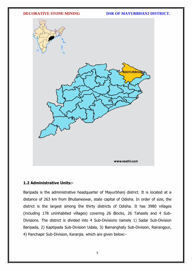
DECORATIVE STONE MINING DSR OF MAYURBHANJ DISTRICT.
5
1.2 Administrative Units:-
Baripada is the administrative headquarter of Mayurbhanj district. It is located at a
distance of 263 km from Bhubaneswar, state capital of Odisha. In order of size, the
district is the largest among the thirty districts of Odisha. It has 3980 villages
(including 178 uninhabited villages) covering 26 Blocks, 26 Tahasils and 4 Sub-
Divisions. The district is divided into 4 Sub-Divisions namely 1) Sadar Sub-Division
Baripada, 2) Kaptipada Sub-Division Udala, 3) Bamanghaty Sub-Division, Rairangpur,
4) Panchapir Sub-Division, Karanjia. which are given below:-

DECORATIVE STONE MINING DSR OF MAYURBHANJ DISTRICT.
6
Sl No Name of the Block/Tehsil Name of the Sub-Division with
Head quarter
1 Baripada
Sadar Sub-Division, Baripada
2 Samakhunta
3 Kuliana
4 Bangriposi
5 Saraskana
6 Suliapada
7 Betnoti
8 Badsahi
9 Rasgovindpur
10 Moroda
11 Udala
Kaptipada Sub-Division, Udala
12 Kaptipada
13 Khunta
14 Gapabandhu Nagar
15 Rairangpur
Bamanghaty Sub-Division,
Rairangpur
16 Bisoi
17 Bijatala
18 Kusumi
19 Bahalda
20 Tiring Bamanghaty Sub-Division,
Rairangpur 21 Jamda
22 Karanjia
Panchpir Sub-Division, Karanjia
23 Jashipur
24 Sukruli
25 Thakurmunda
26 Raruan
The population of the district 25,19,738 according to the 2011 Census. The district
accounts for 6.69% of the state’s territory and about 6% of state’s population. The
density of population of the district is 242 per square km as against 270 per square
km of the state. As per 2011 census, the population of Scheduled Caste is 1,84,682
(7.30%), that of Scheduled Tribe is 14,79,576 (58.7%). The literacy percentage of the
district covers 63.2 against 72.9 of the state.

DECORATIVE STONE MINING DSR OF MAYURBHANJ DISTRICT.
7
1.3 Connectivity facilities:-
Road Network
The district is well served by a network of good roads and has been called the
motorists paradise. The chief roads emanating from Mayurbhanj town are NH-18 and
NH-49 passes the district. Baripada is 60 Kms from Mayurbhanj, 103 Kms from
Kharagpur, 163 Kms from Jamshedpur, 231 Kms from Cuttack, 255 Kms from
Bhubaneswar and 368 Kms from Rourkela. It is also connected with other cities such
as Sambalpur, Puri, Bolangir, Bhadrak, Jhargram, Angul, Ranchi and Kolkata via
Odisha State Road Transport Corporation and some private travel services.

DECORATIVE STONE MINING DSR OF MAYURBHANJ DISTRICT.
8
Rail Network
Mayurbhanj district is well connected by rail link to different places, the city of
Baripada is well connected to many places in India like Mayurbhanj, Bhubaneswar,
Kolkata, Jamshedpur and Cuttack,

DECORATIVE STONE MINING DSR OF MAYURBHANJ DISTRICT.
9
Air Network
At present, Mayurbhanj has no connection by airway. The site selection for aerodrome
is presently under process. Nearest aerodrome is Dum Dum Airport (International
Airport) Kolkata, roughly 195 Kms from Baripada. The other nearest airport to
Baripada is Biju Patnaik Airport, Bhubaneshwar, 207 Kms from Baripada.

DECORATIVE STONE MINING DSR OF MAYURBHANJ DISTRICT.
10
2. OVERVIEW OF MINING ACTIVITY IN THE DISTRICT:
Mayurbhanj district is land features of both plain and hilly region. Most of the
mineralized area coming under safety zone eco-sensitive zone, mining activity only
confined out of safety zone of eco-sensitive zone. The mining activity in the district is
not only restricted to minor minerals i.e. of sand, stone, granite and brick clays.
Altogether there are leases of Iron-ore (hematite), vanadiferous and titaniferous
magnetic, chaina clay, galena (lead ore), Kyanite, asbestos, steatite (soap stone) and
quartzite constitute the principal mineral resources of Mayurbhanj district, of these the
iron-ore deposits of Gorumahisani, Badampahar and Suleipat, which have been
exploited for a period of about half a century. Stone, granite and sand which has been
granted to the district is regulated as per minerals concession rules of Odisha. There
is no lease of major mineral in the district. At present Leases of stone, sand and bricks
making units are operational in the district. Stone chips, granite stones, ordinary sand

DECORATIVE STONE MINING DSR OF MAYURBHANJ DISTRICT.
11
constitute the principal mining activity of Bangirposi, Badasahi, Kaptipada, Kuliana
area etc. of Mayurbhanj district. Out of these huge granite stones deposits are
available near Badasahi, Kaptipada, Kuliana area and major potential sand in G.B
Nagar, Morada & Kaptipada area of the district, which have been provides
tremendous scope for development of few more industries based on this resources.
Iron-ore (hematite), vanadiferous and titaniferous magnetic, chaina clay, galena (lead
ore), Kyanite, asbestos, steatite (soap stone) and quartzite constitute the principal
mineral resources of Mayurbhanj district, of these the iron-ore deposits of
Gorumahisani, Badampahar and Suleipat, which have been exploited for a period of
about half a century.
3.0 GENERAL PROFILE OF THE DISTRICT:
3.1 Demography:
Census - 2011
Geographical Area 10,418 Sq. Km.
Total population 25,19,738
Male Population 12,56,213
Female Population 12,63,525
Male Literacy 794,171
Female Literacy 575,226
SC Male 92,127
SC Female 92,555
ST Male 730,487
ST Female 749,089
OBC 855,480
Illiterate Male 462,042
Illiterate Female 688,299
4.0 GEOLOGY OF THE DISTRICT:
Mayurbhanj is a unique district in Odisha with rich and varied geology. Similipal
Complex being at its central part. The mountain ranges comprise mainly of highland
plateau and valleys with intrusive running through them. The second physiographic
unit is Tertiary Plain occurring in the eastern part of the district. The third
physiographic unit is Alluvial Plain .The drainage density is observed to be fairly
moderate and drainage pattern is dendritic in nature. The major rock types

DECORATIVE STONE MINING DSR OF MAYURBHANJ DISTRICT.
12
encountered in the district are Granite Gneiss, Quartzite, Orthoquartzite, Arkose,
Shale, Phyllite, Gabbro, Px-granite. The geology of the district is constituted by the
Similipal complex at its central part belonging the Archaean age, unconformably lying
over Singhbhum Granite and Banded Iron Formation (BIF). It consists of three
alternate bands of volcano sedimentary units uniquely disposed in a ring like circular
pattern formed under sub- marine conditions. Baripada Beds outcrops of tertiary
formation occur around Baripada town. These comprise stratified clay and sand with
marly clay or limestone interbands. Important mineral resources include iron, copper,
itanium, vanadium, chinaclay, nickel, kyanite ,quartz, talc, steatite ,soapstone and
bauxite.
4.1 Physiography & Geomorphology:
Mayurbhanj district presents diverse physiographic features, Physiographically the
study area can be divided into 3 categories. The first physiographic unit of the district
is high mountain ranges, Similipal Complex being at its central part (Figure 1). The
mountain ranges comprise mainly of highland plateau and valleys with intrusive
running through them. The second physiographic unit is Tertiary Plain occurring in the
eastern part of the district. The third physiographic unit is Alluvial Plain which lies
partly in Rasgovindpur, Morada, Samakhunta, Betnoti, Baripada, Badasahi and
Suliapada Blocks. The highest elevation of about 559m at Bahalda near Similpal hill
and higher elevations of the district, due to scarp landforms some waterfalls are
observed in the district. The general slope of the district is from north to south.
Geologically the area is comprised with Archean granites and gneisses.
Geomorphologically the district is divided into 3 units:
i) The denudational hills with moderate to high slope occurring in the western part of
the district.
ii) Dissected pediments having gentle slope.

DECORATIVE STONE MINING DSR OF MAYURBHANJ DISTRICT.
13
iii) Pediplain having slope between 0o to 5o.
4.2 Stratigraphy:
Geological Age Geological Formation / Group
Quaternany : Recent Alluvium, Clays, silt, Sand, Gravel
Tertiary : Older Alluvium, Laterite, Baripada Beds.
Mesozoic/ Palaeozoic : Volcanics / Epidiorite
Precambrian : Slate/ Phyllite/ Schist / Gneiss
Archean : Granite/ Granite Gneiss

DECORATIVE STONE MINING DSR OF MAYURBHANJ DISTRICT.
14
4.3 Mineral Resources:
The earliest known geological survey in Mayurbhanj dates back to 1903, when P.N.
Bose brought to light the extensive iron-ore deposits of high quantity on the
Gorumahisani and Suleipat hills in Bamanghaty Sub-Division. These deposits were
considered to be almost inexhaustible and were pronounced to be of excellent quality,
perhaps second to none in the whole of Asia by the famous American and English
experts like M/s Perin, Weld and Colonel Staddart, who visited these deposits during
1905-06. This discovery was a momentous one as the steel plant of the Tata Iron &
Steel Co. at Jamshedpur was entirely based on the exploitation of these deposits. By
1915, important discoveries of Steatite near Lulung and placer gold from the sands of
Subarnarekha, Kharkhai and Barhai rivers had been made. The placer gold deposits
were being worked by M/s J.B. Bettie of Calcutta, Mr. V.G. Piggot of Ghatsila and the
Mayurbhanj Prospecting Concession Syndicate.
Gold: The mid-Archaean Gorumahisani-Badampahar schist belt composed of basic
ultrabasic, volcanic rocks and volcanogenic sediments. This belt has been
prognosticated as a rift-type of volcanic dominated one and is highly potential for
economic grade gold mineralization. Likely targets include: a) auriferous quartz veins
close to the contact of sulphide chert volcanics, b) sheared and sulphidised Fe-rich
tholeiite with anomalous copper, c) epigenetic vein type of mineralization and BIF
volcanic association, and d) sulphidic conglomerate resting over the basic volcanics.
Placer gold occurrence are known from rivers and stream of Mayurbhanj district. An
area of about 5 square kilometers of alluvium at the headwaters of Sapgora and Borai
rivers near Kudersai was indicated as promising.
Iron: Bose discovered iron ore deposits in Gorumahisani and Badampahar in the
eastwhile princely state of Mayurbhanj (now Mayurbhanj District). Gorumahisani
deposits were investigated by Perin & Weld (1905). Gorumahisani- Badampahar-
Suleipat deposits are associated with banded hematite / magnetite grunerite and BHJ.

DECORATIVE STONE MINING DSR OF MAYURBHANJ DISTRICT.
15
Gorumahisani – Badampahar- Suleipat (Broad geological sequence)
Laterite & Alluvium
Newer Dolerite
Gabhro-Anorthosite Granite
---Unconformity---
Ultramafic dyke
Singhbhum Granite
Banded magnetite/ Martite quartzite with Fe-Ores
Quartzite
Basal Conglomerate
----Unconformity----
Older metamorphic
Vanadium Ores & Titanium: Vanadium is an important alloying element. Magnetite
associated with gabbro- anorthosite suite of rocks contain vanadium and titanium.
Deposits of vanadium-magnetite occur in association with gabbro-Anorthosite suite of
rocks in the precambrian metamorphites. Vanadium bearing magnetite belts are :-
(a) Rairangpur – Bisoi belt (Kumardubi, Betjharan Amdabeda)
(b) Bisoi – Joshipur belt (Mayurbeka, Kesham, Sialnoi)
(c) Baripada – Podadiha belt (Andipur, Bahalda)
Pyrophyllite : is mainly used as a high grade ceramic product, electric insulator and
refractory material. The comp. is Al2O34SiO2 H20. It is formed as an alteration product
of feldspar. Pyrophyllite occurrences are reported at Kankrani, Jashipur,
Gorumahisani, Bangriposhi and Manada in Mayurbhnaj dist. Ichinda, Khairakocha,
Jamukunda, Nakulkocha, Kapadiha, Dunguridiha, Maheshpur, Kashidiha, Sagragora
and Pokpoka. Dimension stone of the district are granite, granite-gneiss, migmatites,
syenite, gabbro, anorthosite, charnockite, leptynite, pyroxene granulite, dolerite,
pyroxinite and dunite etc.
Bauxite: In Similipal complex (Mayurbhanj) aluminous laterite/ Bauxite are observed
around 1000 m AMSL. The spongy aluminous laterite/bauxite occurs as sheets and
boulders occupying the flat-topped hills made up of metavolcanics. Both
ultramafics and metavolcanics are lateritised giving rise to nickeliferous laterite and
aluminous laterite respectively.
DECORATIVE STONE MINING DSR OF MAYURBHANJ DISTRICT.
16
China Clay clay like material approximating the mineral Kaolinite (Al2O3, 2SIO2,
2H2O). China clay is found to occur in a long belt stretching from Singhbhum to
Mayurbhanj. Badampahar-Joshipur- Karanjia – Ramachandrapur belt is the most
important china-clay producing area of the state. The important deposits in
Mayurbhanj district are found near Jashipur, Chanchbani, Dumuria, Jamda, Kodadiha,
Jamkeswar and Thakurmunda. China clay has many industrial applications as filler in
paper, textile, rubber, in the manufacture of potteries, ceramics, sanitary wares,
glazed tiles, white cement, insecticides, paints, cosmetics, refractory bricks etc. Soap
stone and Steatite Asbestos is mined from Mayurbhanj area.
Talc, Steatite and Soapstone: Important localities of these deposits in Mayurbhanj
dist are Tiring, Kendumundi and Kharidamak.
Kyanite: Kyanite deposits of refractory grade occur in Panijia area of Mayurbhanj
dist, where it is associated with dumortierite bearing rocks, qtz-veins, quartz-mica-
schists and talc-tremolite-schist. Other kyanite occurrence include Purnapani &
Similipal.
Quartz & Quartzite: Quartz and silica sand are mostly used in glass foundry,
ferrosilicon alloy, ceramic industry, abrasive, paint, rubber, textile industries.
Transparent varieties of quartz such as rock crystal, amethyst, citrine, Rosequartz and
smoky quartz are used as semi-precious gemstone. Quartz is a piezoelectric material
and is used in radio circuit, Radars and ultra-sonic devices. Quartzite is a
monomineralic rock constituted predominantly of quartz. There are 6 mining leases
for quartz and quartzite in Mayurbhanj dist.
High Magnesia rock: are found in Notapahar, Thakurmunda, Amjori and
Badampahar of Mayurbhanj Dist.
Nickel: Nickel is concentrated within chemically weathered ultramafic rocks and
found in the laterite and soil capping in Similipal area. The mineral occurs in silicate

DECORATIVE STONE MINING DSR OF MAYURBHANJ DISTRICT.
17
form i.e. garnierite. The important patches of prospective ore zones are: Gurguria and
Nawana.
4.4 Soil:
The district comprises chiefly of lateritic, sandy loam and clayey loam type of soil
(Figure 3). Laterite soil is mostly marked in the area occupied by crystalline rocks.
The low lying valley fields are covered with clayey loam type of soil.
5. DRAINAGE OF IRRIGATION PATTERN
The district has considerable flat land, which provide suitable site for agricultural use.
The hilly areas are mostly under forest with patches of cultivation on scarp areas.
Major rivers flowing in the district are Budhabalanga, Subarnarekha, Jambhira, Sona,

DECORATIVE STONE MINING DSR OF MAYURBHANJ DISTRICT.
18
Khadkhai, Deo, Katra, Khairibandhan & Baitarani. Major crops grown in the district are
rice Only. 14.82 percent area of agricultural use are net irrigated and major source of
irrigations are well and tube-wells.
Sl. No.
Name of the River
Area drained (Sq.Km.)
% Area drained in the District
1 Budhabalanga 2143 21%
2 Subarnarekha 265 0.25%
3 Jambhira 1377 13%
4 Sona 1062 10%
5 Khadkhai 1131 10.8%
6 Khairibandhan 1014 0.09%
7 Deo 473 0.04%
8 Katra 352 0.03%
9 Gangahar 594 0.057%
10 Baitarani 260 24.6%
11 Tel 96 0.009%
12 Kantamauli 82 0.007%
13 Sim 165 0.015%
14 Jhagada 30 0.002%
15 Balijori 56 0.005%
16 Kantakhaira 186 0.017%
17 Kanhu 383 0.036%
18 Balisudura 170 0.016%

DECORATIVE STONE MINING DSR OF MAYURBHANJ DISTRICT.
19
5.1 River System
The Budhabalanga River (also called Balanga River) flows through the districts
of Mayurbhanj & Balasore and finally reached Bay of Bengal. The Budhabalanga, rises
from Similipal hills and plunges through Barehipani Falls, the second-highest waterfall
in India, located in Similipal National Park. It then flows in a northerly direction up to
the village Karanjiapal in Bangiriposi police-station. Thereafter, it turns to the north-
east and flows along the railway track up to the village Jhankapahadi. There it
changes its course to the south and meets the Katra nala. The other tributaries are
the Palpala and the Chipat both of which are hill streams rising from the Similipal hills.
Then the river passes through Baripada. It later flows through Balasore district and
into the Bay of Bengal. The Budhabalanga is about 175 kilometres (109 mi) long and
has a total catchment area of 4,840 square kilometres (1,870 sq mi). Its major
tributaries are the Sona, Gangahar, and the Katra. Burhabalang and its tributaries, viz.

DECORATIVE STONE MINING DSR OF MAYURBHANJ DISTRICT.
20
Sona Nadi, Amrutia Nadi, Gangahar Nadi drain almost round the year in the present
area. Sona Nadi receives the watery effluent load through a nalah (Sankh nalah) from
the Balgopalpur Industrial Estate and flows from west to east. Amrutia Nadi flows
from NNW to SSE and carries the waste water load of East Coast. Subarnrekha
originate from Nagri of Jharkhand and then enter into Mayurbhanj district, very less
portion of the river flows within Mayurbhanj district, Major portion of Subarnarekha
River passes in the Balasore district. Another river Jambhira runs in Mayurbhanj
district then enters into Balasore district and Renamed as river Jalaka flows into Bay
of Bengal. Other small rivers run in this district like River Khadkhai originates from
Tunhgru R.F. and plunges through Suleipat Dam (Khadkhai Reserviour). It then runs
towards Rairangpur, Bahalda, Tiringi area of western direction of Mayurbhanj district
and finally reached at River Subarnarekha. River Deo rises from Similipal R.F. and
runs towards western part of the district and flows through Karanjia area and then
joins with Baitarani River. River Khairabandhan originates from Similipal R.F. and
flows towards western part of the Mayurbhanj district through Jashipur, Raruan,
Sukruli area of district and then joins with River Baitarani This river maintains a
sluggish flow in the pre-monsoon period, but swells menacingly with the onset of
monsoon often flooding large tracts. Another small tributary named as Kanhu starts
from River Khadkhai and branched into Jalapa, Ghagera nala meets at Jharbeda area
of Mayurbhanj District.
Sl. No.
Name of the River or Stream
Total Length in District (in Km.)
Place of Origin Altitude at Origin
1 Budhabalanga 161 Similipal Hill 940 mrl.
2 Subarnarekha 4 Nagri, Jharkhanda
610 mrl.
3 jambhira 64 Chandra R.F. Mayurbhanj
60 mrl.
4 Sona 70 Jaymal Hill, Dugdha
Mayurbhanj.
340 mrl.
5 Khadkhai 75 Tunhgru R.F. 500 mrl.
6 Khairibandhan 65 Similipal R.F. 800 mrl.
7 Deo 65 Similipal R.F. 930 mrl.
8 Katra 55 Jari R.F. 700 mrl.
9 Gangahar 55 Similipal R.F. 740 mrl.
10 Baitarani 48 Gonasika, 900 mrl.

DECORATIVE STONE MINING DSR OF MAYURBHANJ DISTRICT.
21
Guptaganga Hills
11 Tel 20 Similipal R.F. 940 mrl.
12 Kantamauli 25 Similipal R.F. 360 mrl.
13 Sim 85 Similipal R.F. 900 mrl.
14 Jhagada 15 Jhagada R.F. 430 mrl.
15 Balijori 22 Similipal R.F. 520 mrl.
16 Kantakhaira 36 Similipal R.F. 420 mrl.
17 Kanhu 42 Similipal R.F. 400 mrl.
18 Balisudura 15 Similipal R.F. 450 mrl.
6.0 LAND UTILIZATION PATTERN IN THE DISTRICT
6.1 Forest and non forest land
The forest of Mayurbhanj district is full variety of medicinal plants, Kendu leaves,
Bamboo, Sal, Teak, other timber species and a wide range of carnivorous & herbivorous
wild animals. The district has one Wildlife Sanctuaries known as the Similipal Wildlife
Sanctuary situated at the heart of the district, which hosts all type of wildlife even

DECORATIVE STONE MINING DSR OF MAYURBHANJ DISTRICT.
22
tigers. The area of the sanctuary is 26, 886.23 hectares. And two kilometer safety zone
of eco-sensitive zone of Suleipat Wildlife Sanctuary are coming in Mayurbhanj district. In
these sanctuary areas the principal animals that are found are Elephant, Bear, Nilgai,
Sambhar, Peacock, Wild Boar and Deer, together with variety of snakes and birds.
District-wise Forest Cover Area in Odisha (Area in Km2)
2017 Assessment
District Geograph ical Area Km2
Very Dense Forest
Moder- ate. Dense Forest
Open Forest
Total Percent of GA
Change Scrub
Angul 6375 371 1380 1004 2755 43.22 43 84
Bolangir 6575 70 224 837 1131 17.2 151 142
Balasore 3806 23 127 234 380 9.98 30 48
Bargarh 5837 176 371 484 1031 17.66 88 47
Bouda 3098 263 546 480 1289 41.61 27 57
Bhadrak 2505 0 9 66 75 2.99 2 0
Cuttack 3932 53 226 517 796 20.24 11 68
Deogarh 2940 191 667 614 1472 50.07 -3 14
Dhenkanal 4452 174 418 825 1417 31.83 9 82
Gajapati 4325 84 1490 946 2520 58.27 12 262
Ganjam 8206 164 1075 864 2103 25.63 15 655
Jagatsinghpur 1668 0 5 131 136 8.15 6 0
Jajpur 2899 6 72 225 303 10.45 3 50
Jharsugada 2114 3 140 179 322 15.23 9 36
Kalahandi 7920 362 729 1327 2418 30.53 36 362
Kandhamal 8021 661 2588 2143 5392 67.22 16 380
Kendrapada 2644 84 88 133 305 11.54 14 2
Keonjhar 8303 289 1404 1519 3212 38.68 4 55
Khorda 2813 21 186 250 457 16.25 0 92
Koraput 8807 94 740 1255 2089 23.72 120 944
Malkangiri 5791 158 709 1475 2342 40.44 20 45
Mayurbhanj 10418 1335 1718 1027 4080 39.16 42 34
Nabarangpur 5291 168 428 507 1103 20.85 8 47
Nayagarh 3890 189 965 556 1710 43.96 28 173
Nuapada 3852 86 482 705 1273 33.05 33 109
Puri 3479 0 54 160 214 6.15 8 11
Rayagada 7073 422 853 1851 3126 44.2 7 349

DECORATIVE STONE MINING DSR OF MAYURBHANJ DISTRICT.
23
Sambalpur 6624 499 1675 1106 3280 49.52 13 40
Subarnapur 2337 2 187 161 350 14.98 26 29
Sundargarh 9712 1019 1814 1431 4264 43.9 107 89
Grand Total 155707 6967 21730 23008 51345 32.98 885 4306
(Source: India state of forest report 2017-Odisha)
The major portion of the district is covered by forest (39.16 % of TGA) and has
scattered settlement pattern. The forest is full of variety of medicinal plants. The
district has considerable flat land, which provide suitable site for agricultural use. The
hilly areas are mostly under forest with patches of cultivation on scarp areas. Major
crops grown in the district are rice and pulses. Only 14.82 percent area of agricultural
use are net irrigated and major source of irrigations are well and tube wells.
Source: Fertilizer and Agriculture Statistics, Eastern Region
Tahasil Forest Area
Misc Tree
Permanent Pasture
Cultivated waste
Non Agricultural
uses
Barren land
Current Fallow
Other Fallow
Net area
sown
Bahalda 964 471 1397 1262 2590 1900 875 944 14031
Bangiriposi 3712 281 1037 1688 3046 684 2054 922 16951
Baripada 216
673
3 128 1628 1376 8 2752 2156 4219
Badasahi 288 180
7 1194 1874 3840 24 3378 2110 17630
Betnoti 2271 911 1198 1728 3227 21 1915 578 17022
Bijatala 2841 224 681 3100 1792 1636 1214 600 11228
Bisoi 3116 471 757 2508 2193 459 2298 1643 15860
G.B.Nagar 191 116 683 582 1147 590 643 1209 10960
Jamda 408 100 1650 434 2060 785 840 1149 13608
Jashipur 8932 141 1389 2655 3637 400 3873 2634 17754
Kaptipada 8745 387 3292 5596 4123 2165 3123 4930 19932
Karanjia 1644 838 1444 2441 3065 462 3493 1362 16690
Khunta 400 226
0 314 672 2061 21 1332 2213 12879
Kuliana 1749 162
6 2222 1902 2529 608 4919 1504 11108
Kusumi 1434 32 2320 2679 2337 587 1086 1682 18032
Morada 993 412
7 513 4340 1941 61 1909 3633 10179
Rairangpur 2260 107 1759 1373 2027 504 1276 631 9713
Raruan 1210 171 890 1120 1899 503 1609 1020 12818
Rasgovindpur 288 214
5 665 1091 2774 142 2002 1537 10054
Shamakhunta 1354 764 1378 2472 1859 334 1861 941 6695
Saraskana 3464 275 689 2658 4042 115 1864 1837 15384
Sukruli 412 211 734 1295 1271 502 1286 1294 10352
Suliapada 2937 553
5 97 2262 2148 86 1589 2906 8971
Thakurmunda 10885 96 1530 1438 2034 795 5317 2670 17681

DECORATIVE STONE MINING DSR OF MAYURBHANJ DISTRICT.
24
6.2 Agriculture Land:
Mayurbhanj is surrounded by no of forest areas as well as Rocky Mountains. People
used to cultivate Paddy in most parts of the hill slopes and in plain lands. Most of the
cultivators grow short duration local paddy in the un-bonded upland during Kharif
season. The crop suffers moisture stress at different stages due to inadequate rainfall.
The primary objective of Agriculture Department is increase of production as well as
productivity of major crops like paddy, groundnut, mustard, Mung, Biri & vegetables
which is widely covered in this District in both Kharif & Rabi season. Another key
objective is the all round development of the farming community of the District. The
Deputy Director of Agriculture is the head of office so far as agriculture is concerned &
he is the Principal Agriculture Officer of the District. Under him there are 5 District
Agriculture Officers & the block under them. As already pointed out, that agriculture is
the main livelihood of the people in Mayurbhanj District. It is therefore also
designated as the food bowl of Odisha. Rice is the principal crop grown in this district,
followed by other cereals, pulses, oilseeds, vegetables, spices and sugarcane. The
agricultural statistics for the district is shown in subsequent tables below:
Table – 3.6a: Crop Coverage Area of Mayurbhanj District, Odisha
Crop Khariff Rabi Annual TOTAL
Area (ha)
(% of Cropped
Area
Area (ha)
% of Cropped
Area
Area (ha)
Gross Cropped Area (ha)
% of Gross
Cropped Area
Rice 301.37 82.353% 3.80 4.015% --- 305.17 62.051%
Cereals 9.99 2.730% 2.17
2.293% --- 12.16 2.472%
Pulses 32.37 8.846% 36.20 38.255% --- 68.57 13.943%
Oilseeds 5.92 1.617% 28.30 29.906% --- 34.22 6.958%
Vegetables 12.39 3.386% 21.74 22.974% --- 34.13 6.940%
Fibres 2.43 0.664% --- 2.43 0.494% Spices 1.48 0.404% 2.42 2.557% --- 3.90 0.792%
Sugarcane --- --- 00 --- --- 00 ---
Tobacco --- --- 00 --- --- 00 ---
Fruits --- --- --- --- --- 31.23 6.350%
TOTAL 365.95 100.00% 94.63 100.00% --- 491.81 100.00%

DECORATIVE STONE MINING DSR OF MAYURBHANJ DISTRICT.
25
6.3 Horticulture Land:
The primary objective of Horticulture Department is increase of production as well as
productivity of major fruits like Mango, Guava, Citrus etc., which is widely covered in
this District. Another key objective is the all round development of the farming
community of the District. The Deputy Director of Horticulture is the head of office.
7.0 SURFACE WATER AND GROUND WATER SCENARIO OF THE DISTRICT
7.1 Hydrogeology
Distribution of Saline / fresh water aquifers:
The occurrence of fresh water aquifers in coastal tract of Mayurbhanj restricted by
two important factors‐ (i) Occurrence of hard rocks in the western side and (ii) Salinity
hazard problems in the eastern part. The water bearing formation of the area can be
divided into (a) areas underlain by fractured, fissured and consolidated basement rock
formations (b) areas underlain by recent unconsolidated alluvial formations.
(a) Consolidated Formation - These are most predominant rock types occurring in
the undulating plains of the district. Groundwater occurs under unconfined condition
in the shallow weathered zone and circulates through fractures and joints. The
thickness of the weathered zone varies from 3 to 35 m. Depth of open wells in these
formations varies from 5 to 14 m below ground level.
(b) Unconsolidated alluvial formations - The unconsolidated formations consists of
laterite and alluvium. Laterites at places are highly consolidated and used as building
stones. The laterites have high degree of effective porosity and form potential
aquifers commonly tapped in dug wells. The alluvium comprises an admixture of clay,
silt, sand and calcareous concretions in varying proportions. The coarse sediments like
sand and gravel form the main repository of ground water. Ground water occurs
under both unconfined condition in shallow aquifers and in confined condition in
deeper parts.

DECORATIVE STONE MINING DSR OF MAYURBHANJ DISTRICT.
26
7.2 Depth of water level:
The depth to water level map for pre and post monsoon periods 2011 are prepared
based on the ground water monitoring data of 77 Nos of National Hydrograph
Stations of C.G.W.B. monitored during the month of April and November 2006 are
presented below respectively. The pre and post monsoon depth to water levels in the
district range from 3.54 to 14.50 m below ground level and 1.39 to 8.20 m below
ground level respectively. It is observed that during pre monsoon about 75% of the
total areas show the water level varying between 5 to 10 m below ground level.
During post monsoon nearly 60% of the area has water levels within 2 to 5 m,
while the rest part has between 0 to 2 and 4 to 6 m below ground levels. In localized
part of Morada, Kaptipada and Thakurmunda the water level is > 5 mt.
Depth & categorization of ground water levels during pre monsoon period (April 2011)
of Mayurbhanj districts is presented below:

DECORATIVE STONE MINING DSR OF MAYURBHANJ DISTRICT.
27
Depth & categorization of ground water levels during pre monsoon period (November
2011) of Mayurbhanj districts is presented below:

DECORATIVE STONE MINING DSR OF MAYURBHANJ DISTRICT.
28
7.3 Ground Water Quality
The chemical quality of ground water in the district has been assessed on the basis of
chemical analysis of ground water samples collected during groundwater monitoring,
Hydrogeological surveys and groundwater exploration. The results of the chemical
analysis are presented in Table.
Table showing chemical constituents in aquifers
Constituent Shallow aquifer Deeper aquifer
pH 6.97 – 8.25 6.84 – 8.25
Sp. Conductance (micromohs/cm at 250 C)
53 – 974 92 – 867
TDS (mg/l) 58 – 1430 106 – 429

DECORATIVE STONE MINING DSR OF MAYURBHANJ DISTRICT.
29
Calcium (mg/l) 6 – 92 16 – 86
Magnesium (mg/l) 0.6 – 17 3.6 – 22
Sodium (mg/l) 1.6 – 100 3.5 – 168
Potassium (mg/l) 0.4 – 8 <1 --6.4
Bicarbonate (mg/l) 15 – 256 49 – 366
Chloride (mg/l) 7 – 238 5.3 – 85
Sulphate (mg/l) 0.1 – 9 <1 – 82
Nitrate (mg/l) <0.01 – 53 0.1 – 78
Fluoride (mg/l) 0.08 – 20.3 0.21 – 0.61
Total hardness as calcium carbonate
10 – 245 35 - 285
7.4 Ground Water Development
In the rural areas the entire water supply is dependent on ground water. Ground
water development is mainly carried out in the district through dug wells and Hand
pumps. In general dug wells are of 2 m diameter and the depth ranges between 8 to
15 m depending on the thickness of the weathered zone, tapping the shallow aquifer
in the weathered zone and uppermost slice of the basement. Large number of dug
wells used for drinking water is under private ownership for which there is no reliable
data. Over the years Mark II/ Mark III hand pumps are being drilled in large numbers
for ground water development. These hand pumps have the following two major
advantages i) less susceptible to contamination from surface sources and ii) tap
fractures between 20-60m depth which have been found to be less affected by
seasonal water level fluctuation and thus have lesser chances of failure even during
extreme summer. Over all the present level of ground water development is only
27.21 percent in the district with the maximum in Badasahi Block viz. 64.65% and
minimum in Bijatala Block. Block wise development figure indicate that all the blocks
come under the white categories. Thus there is ample scope for development of
groundwater in the district to augment irrigation potentials through suitable ground
water abstraction structure
7.5 Ground Water Related Issue and Problems
Some of key ground water related issues are
I. Locating suitable sites for bore wells
II. Suitable design of dug wells and hand pumps
III. Taking up artificial recharge projects to augment the resource availability in

DECORATIVE STONE MINING DSR OF MAYURBHANJ DISTRICT.
30
Mayurbhanj district.
IV. Optimal development of irrigation potential by developing ground water available
for future uses.
V. Creating public awareness for conserving ground water through awareness
camps, NGO’s and mass media.
7.6 Mass Awareness Campaign (MAP) & Water Management Training
Programme (WMTP) by CGWB
NIL
7.7 Area Notified by Cgwb/Sgwa
None
7.8 RECOMMENDATIONS:
1) Intensive groundwater exploration should be taken up to delineate deeper
potential water saturated fracture zones and to compute aquifer parameter.
2) Large scale planning for ground water development should be preceded by
intensive hydrogeological and geophysical surveys aided by remote sensing
studies.
3) Effective measures may be taken to conserve the surface run off by contour
bonding at suitable sites. Also proper maintenance of reservoir, tanks and spring
channels by periodical disiltation should be carried out.
4) Existing dug-wells should be deepened to tap the maximum saturated thickness of
the weathered mantle or vertical bores may be drilled through the bottom to
enhance the well yield.
5) Energy station of wells already constructed should be stepped up to ensure
optimal utilization of the irrigation potential already created.
6) The farmers should be educated through agricultural extension services fro
adopting suitable cropping pattern for optimal utilization of available groundwater
resources.
7) Programmes for artificial recharge may also be taken up for augmentation of
groundwater through construction of percolation tanks, subsurface dykes, and
check dams and through contour bonding etc.
8) An intensive network of groundwater monitoring stations are required to be

DECORATIVE STONE MINING DSR OF MAYURBHANJ DISTRICT.
31
established in the command areas of irrigation projects to monitor the changes in
groundwater regime consequent on application of surface water irrigation.
8.0 RAINFALL OF THE DISTRICT AND CLIMATE CONDITION
8.1 Month wise rainfall:
The driest month is November, with 3 mm of rain. There is on average 0 mm of
precipitation in December. In July, the precipitation reaches its peak, with an average
of 324 mm. May is the warmest month of the year. The temperature in May averages
32.3 °C. January has the lowest average temperature of the year. It is 16.5 °C.
Year 2016 2017 2018 Average
Sl. No. Month (mm) (mm) (mm) (mm)
1 Jan 9.23 2.71 0.00 3.98
2 Feb 52.61 0.00 0.04 17.55
3 Mar 12.29 44.87 0.72 19.29
4 Apr 22.38 23.36 172.10 72.61
5 May 118.73 139.31 125.30 127.78
6 Jun 195.46 169.39 208.83 191.22
7 Jul 245.28 385.31 300.05 310.21
8 Aug 351.25 291.03 371.30 337.86
9 Sep 285.27 170.11 285.17 246.85
10 Oct 85.39 189.09 154.08 142.85
11 Nov 12.10 34.79 0.00 15.63
12 Dec 0.00 1.80 36.69 12.83
Total 1389.99 1451.77 1654.28 1498.68
Source: Indian Meteorological Department
The Indian Meteorological Department, Bhubaneswar, vide letter No. BBS/RMC/CS-
312, dated 18th January, 2016 has provided the period of Rainy Season viz. Normal
dates of Onset and Withdrawal of South West Monsoon over India as state-wise. The
duration for the period is 10th June to 15th October.
8.2 Climate
The climate in Mayurbhanj is warm and temperate. In winter, there is much less
rainfall in Mayurbhanj than in summer. The general climate of the district is
characterized by oppressive heat in summer, severe cold in winter with high humidity
throughout the year. The rainfall distribution is equal during the monsoon period. The
period from June to October is the rainy season and the district experiences it from
the southwest monsoon. May is the hottest month when the mean daily maximum

DECORATIVE STONE MINING DSR OF MAYURBHANJ DISTRICT.
32
temperature rises up to 47º Celsius. The Köppen-Geiger climate classification is Cwa &
as per they the average temperature in Mayurbhanj is 24.7 °C. The temperature in
May averages 32.3 °C. January has the lowest average temperature of the year, it is
16.5 °C. There is a difference of 321 mm of precipitation between the driest and
wettest months. During the year, the average temperatures vary by 15.8 °C., when
the mean daily minimum temperature dips to 4º Celsius. The higher reaches of the
Similipal experiences frosting during the peak of winter.
9.0 DETAILS OF MINING LEASE OF DECORATIVE STONE IN THE DISTRICT
9.1 List of Mines is operation in the district:
Attached as Annexure- J
9.2 List of Mines is not operation in the district:
Attached as Annexure- J

DECORATIVE STONE MINING DSR OF MAYURBHANJ DISTRICT.
33
10. DETAIL OF ROYALTY OR REVENUE RECEIVED IN LAST THREE YEARS:
Sl. No. Name of the
Mining Circle
2016-17 2017-18 2018-19 Total Amount
(Rs.)
1 Baripada
Total
11. DETAIL OF PRODUCTION OF MINOR MINERALS IN LAST THREE YEARS:
Sl.
No.
Name of the
Mining Circle
2016-17 2017-18 2018-19 Total in
Cum.
1 Baripada
Total

DECORATIVE STONE MINING DSR OF MAYURBHANJ DISTRICT.
34
12. MINERAL MAP OF THE DISTRICT:
13. LIST OF LETTER OF INTENT (LOI) HOLDERS IN THE DISTRICT ALONG
WITH ITS VALIDITY
Sl. No.
Name of the
Mineral
Name of the
Lessee
Address Letter of Intent Grant
Order No. &
date
Area of Mning
lease to be
allotted
Validity of LoI
Use
(Captive/ Non-
Captive)
Location of the Mining
lease (Latitude & Longitude)
1 2 3 4 5 6 7 8 9
Attached as Annexure-J

DECORATIVE STONE MINING DSR OF MAYURBHANJ DISTRICT.
35
14. TOTAL MINERAL RESERVE AVAILABLE IN THE DISTRICT
Total mineral reserve of granite rock as decorative stone will access after detail study
or grant of potential area, which may investigation as per details below.
(i) Blocks were identified based on geological studies through field observation.
(ii) Mineable resource was calculated by considering detail prospecting.
(iii) Area calculated as per GPS co-ordinates and information obtained from local
people. Land detail need to be verified from revenue record.
(iv) Since this is an interim report, as per the present requirement of minerals, more
such blocks need to be identified and the data should be updated periodically, after
certain intervals to update the data bank of DSR.
Sl. No.
Name of the Mining Circle
Mineral Resources in cum.
Mineable Reserve in cum.
1 Baripada
Total
Summary of Identified Mineral Potential:
Sl.
No.
Name
of the
mineral
Name
of the
lessee
Address and
contact No. of
the lessee
Letter of
Intent
Grant
Order
No. and
date
Area of
mining
lease to
be
allotted
Validity of LoI
Use
(Captive/ Non- Captive
Location of the Mining lease (Latitude & Longitude)
1 2 3 4 5 6 7
Attached as Annexure-J
15. QUALITY/GRADE OF MINERAL AVAILABLE IN THE DISTRICT:
Rocks and Minerals found in Mayurbhanj District:-
The district is endowed with various types of mineral resources like Iron ore, China
Clay, Quartz, Soap stone, Granite, Manganese, etc. Due to presence of huge
mineral resources, mining activities have been undertaken in a big scale. Bahalda,
Jashipur, Karanjia, Koshorpur, Bisoi, Gorumahisani and Rairangpur are the places in
the district having deposits of the above mineral products. The availability of

DECORATIVE STONE MINING DSR OF MAYURBHANJ DISTRICT.
36
mineral deposits is given in the table below. The district’s mineral deposits have not
been utilized to maximum extent for industrial purpose. Some of the items like
China clay, Soap stone, Asbestos, etc. can be used in small scale sector. So the
available resources of the district need harnessing properly for industrial and
productive use. Quartz of the district is very much suitable for various industrial
purposes after crushing and screening.
16.USE OF MINERAL
Uses of Decorative Stone (Granite rock):
Granite is the rock most often quarried as a "dimension stone or decorative stone" (a
natural rock material that has been cut into blocks or slabs of specific length, width,
and thickness). Granite is hard enough to resist abrasion, strong enough to bear
significant weight, inert enough to resist weathering, and it accepts a brilliant polish.
These characteristics make it a very desirable and useful dimension stone. Decorative
stone is natural rock that has multiple uses in and around home. Granite is a light-
colored igneous rock with grains large enough to be visible with the unaided eye. It
forms from the slow crystallization of magma below Earth's surface. Granite is
composed mainly of quartz and feldspar with minor amounts of mica, amphiboles, and
other minerals. This mineral composition usually gives granite a red, pink, gray, or
white color with dark mineral grains visible throughout the rock. Many people
recognize granite because it is the most common igneous rock found at Earth's
surface and because granite is used to make many objects that we encounter in daily
life. These include counter tops, floor tiles, paving stone, curbing, stair treads,
building veneer, and cemetery monuments. Granite is used all around us - especially if
you live in a city. It can be used for mulch, ground cover, driveways and filler around
pools and patios. At the surface, granite is exposed in the cores of many mountain
ranges within large areas known as "batholiths," and in the core areas of continents
known as "shields."
17. DEMAND AND SUPPLY OF THE MINERAL IN THE LAST THREE YEARS:
As such there are huge infrastructural and industrial activities are coming up by State
govt., Govt. of India & PSUs under “Make in India” programme. The main raw
minerals for the above activities and considering the last three years actual
productions with respect to the requirement of the state has a huge gap. It is
proposed to start the production from larger block/area to at least double the
production of the district which will enhance the revenue of the district and also
support the livelihood of the local people

DECORATIVE STONE MINING DSR OF MAYURBHANJ DISTRICT.
37
Sl. No. Name of the Mining Circle
Financial Year
Decorative Stone in Cum.
1
Baripada 2016-17 Nil
2017-18 Nil
2018-19 Nil
Total
18. MAP OF EXISTING MINING LEASES IN THE DISTRICT:
Enclosed as Plate-I
19. DETAILS OF THE AREA OF WHERE THERE IS A CLUSTER OF MINING
LEASE VIZ. NUMBER OF MINING LEASES, LOCATION (LATITUDE AND
LONGITUDE)
Currently there is no cluster of Decorative Stone mining lease in the district. However,
it is proposed to consider the cluster of mining lease while planning for new lease area
in coming years.
20. DETAILS OF ECO-SENSITIVE AREA, IF ANY, IN THE DISTRICT:
Eco sensitive zone of Similipal wild life sanctuary is located within the district.
21. IMPACTS OF MINING ON ENVIRONMENT:
The most important environmental impact of mining projects is:-
Transportation sources:
Transportation sources of air pollutants include heavy vehicles used in excavation
operations, cars that transport personnel at the mining site, and trucks that transport
mining materials. The level of polluting emissions from these sources depends on the
fuel and conditions of the equipment. Even though individual emissions can be
relatively small, collectively these emissions can be of real concern. In addition,
mobile sources are a major source of particulate matter, carbon monoxide, and volatile
organic compounds that contribute significantly to the formation of ground-level ozone
Fugitive emissions:
Common sources of fugitive emissions include: storage and handling of materials;
mine processing; fugitive dust, blasting, construction activities, and roadways

DECORATIVE STONE MINING DSR OF MAYURBHANJ DISTRICT.
38
associated with mining activities; leach pads, and tailing piles and ponds; and waste
rock piles. Sources and characteristics of fugitive emissions dust in mining operations
vary in each case, as do their impacts. Impacts are difficult to predict and calculate
but should be considered since they could be a significant source of hazardous air
pollutants.
Noise and vibration:
Noise pollution associated with mining may include noise from vehicle engines,
loading and unloading of rock into steel dumpers, chutes, power generation, and
other sources. Cumulative impacts of shoveling, ripping, drilling, blasting, transport,
crushing, grinding, and stock-piling can significantly affect wildlife and nearby
residents.
Vibrations are associated with many types of equipment used in mining operations,
but blasting is considered the major source. Vibration has affected the stability of
infrastructures, buildings, and homes of people living near large-scale open-pit mining
operations. According to a study commissioned by the European Union in 2000:
“Shocks and vibrations as a result of blasting in connection with mining can lead to
noise, dust and collapse of structures in surrounding inhabited areas. The animal life,
on which the local population may depend, might also be disturbed.”
22. REMEDIAL MEASURES TO MITIGATE THE IMPACT OF MINING ON THE
ENVIRONMENT:
1. Following are the remedial measures to mitigate the in Water sprinkling on haul
road, loading and unloading points.
2. Plantation along the safety zone and dump area.
3. Providing dust masks to workers.
4. Regular monitoring of ambient air quality.
5. Provision of air conditioned cabin of Excavators and Dumpers.
6. Regular and proper maintenance of working equipments.
7. Periodic medical examination of the workers and organize medical camp in the area.
8. Use Milli Second Delay Detonator in blasting operation.
9. Provisions of ear plug to the workers.
DECORATIVE STONE MINING DSR OF MAYURBHANJ DISTRICT.
39
10. Regular training programme to the mines workers and operators.
23. RECLAMATION OF MINED OUT AREA
Necessity of Reclamation & Rehabilitation:
Exponential growth in mineral production since 1980.
Mining activities causes physical, chemical, biological and socio-economic changes in
the area.
Surface mining activities disturb the original land profile.
In India, mineral production comes mostly from opencast mines & hence land
degradation problems are of serious concern.
An intricate, in-depth and site-specified techniques involving integrated approach is
necessary.
Reclamation has three vital roles:
i. Reclamation – Reclamation means return the mined-out land with useful life. It
implies restoring the land to a form and productivity that is useful and inconformity
with a prior land use. Reclamation always may not be a single- phase operation.
ii. Rehabilitation – Rehabilitation is to bring batch the degraded land to a normal
stage by a special treatment. It is a process of taking some mitigation measures for
disturbed environmental condition created through mining activities.
iii. Restoration – Restoration is the process of returning the mined out land being
fit to an acceptable environmental condition. However, the general acceptable
meaning of the term is bringing the disturbed land to its original form. Restoration is
often used to indicate that biological properties of soil are put back to what they were.
This is a rate phenomenon.
iv. When active mining ceases, mine facilities and the site are reclaimed and closed.
The goal of mine site reclamation and closure should always be to return the site to a
condition that most resembles the pre-mining condition. Mines that are notorious for
their immense impact on the environment often made impacts only during the closure
phase, when active mining operations ceased. These impacts can persist for decades
and even centuries.
Mine reclamation and closure plans must describe in sufficient detail how the mining
company will restore the site to a condition that most resembles pre-mining

DECORATIVE STONE MINING DSR OF MAYURBHANJ DISTRICT.
40
environmental quality; how it will prevent – in perpetuity – the release of toxic
contaminants from various mine facilities (such as abandoned open pits and tailings
impoundments); and how funds will be set aside to insure that the costs of
reclamation and closure will be paid for.
Proposed future land use after reclamation:
a. Forestry, b. Recreation, c. Water Reservoir, d. Crop Land,
e. residential/Commercial, f. Fish & wildlife Habitat, g. Undeveloped Land,
h. Grazing/Pasture Land
Statutory requirement:
As per the Mineral Conservation Development Rule, 2017, the following rules must be
bare in mind by the mine owner/agent/manager, which is a part of reclamation
activities –
Rule 22, Mine Closure Plan
Rule 23, Submission of Progressive Mine Closure Plan Rule 24, Submission of Final
Mine Closure Plan
Rule 26, Responsibility of holder of mining lease Rule 27, Financial Assurance
Rule 35, Sustainable Mining
24. RISK ASSESSMENT AND DISASTER MANAGEMENT PLAN:
Mining activity because of the very nature of the operation, complexity of the
systems, procedures and methods always involves some amount of hazards. Hazard
identification and risk analysis is carried for identification of undesirable events that
can leads to a hazard, the analysis of hazard mechanism by which this undesirable
event could occur and usually the estimation of extent, magnitude and likelihood of
harmful effects. The activities which can cause high risk related to face stability and
the person blasting the shots. It was observed that on a working face of the mine,
there were large cracks and unsupported rocks were present, which can lead to a
serious hazard and injure workers engaged in loading operation and machineries
because of rock falls or slides. This type of condition turn out because improper
dressing of the bench and improper supervision. To avoid the hazards due to fall of
rocks the face must be examined, made suitable for working and the remedial
measures must be taken to make it safe if there is any doubt that a collapse could
take place. Working of the face should be in the direction taking into account the

DECORATIVE STONE MINING DSR OF MAYURBHANJ DISTRICT.
41
geology of the area such that face and quarry side remain stable. Another major risk
identified in mines is due to the firing of explosive by an unqualified person. In the
mines there is problem of fly rocks and the village is located close to the mine and so
it is rated high as it can affect may people. Explosives by nature have the potential for
the most serious and catastrophic accident. Planning of round of shots, holes correctly
drilled, direction logged, weight of explosive suitable for good fragmentation are the
few of the steps necessary to ensure its safe use and if the shots are not properly
designed can result in misfires, early ignition and flying rocks. No person is allowed to
use explosives without being properly trained in its handling. In the mine a large
numbers of heavy vehicles were in operation and the roads were not proper for
haulage purpose. The haulage roads were not even and were not wide enough for the
crossing purpose and hence the chances of hazards are very high. The main hazards
arising from the use large earth moving vehicles are incompetent drivers, brake
failure, lack of all-around visibility from the driver position, vehicle movements
particularly reversing, roll over, and maintenance. Those most at risk are the driver
and pedestrians likely to be struck by the vehicle, and drivers of smaller vehicles,
which cannot be seen from the cabs of large vehicles. Edge protection is always
necessary to prevent inadvertent movement over the edge of roadway or a bench.
Seatbelt will protect driver in case of roll. Good maintenance and regular testing are
necessary to reduce the possibility of brake failure. Access to the vehicles should
always be restricted to those people necessary for the work in hand. The use of
personal protective equipment and proper arrangements is essential to check if the
person is wearing protective equipment or not. The personal protective equipment
includes helmet, non-skid safety boots, safety glasses, earmuffs etc. The required
personal protective equipment should be provided and used in a manner that protects
the individual from injury. Few minor injuries which can be prevented are slip, trip, or
fall hazards; hazards due to rock falls and collapse of unstable rocks, atmosphere
containing toxic or combustible gases; protects from chemical or hazardous material
etc. A disaster management plan should be prepared for taking care of for any
disaster. Other risks which are included in this category are noise, as it occurs and it
can lead to permanent disability. There are problems related to road traffic in and out
issuers; inappropriate exposure of moving machines; mechanical failure and because

DECORATIVE STONE MINING DSR OF MAYURBHANJ DISTRICT.
42
of large number of moving trucks and dumpers there is large quantity of dust present
in roadways which affects the operators and can lead to accidents causing injury.
They are in acceptable range because of precautions measures taken but no step is
taken it can cause hazard hence steps should be taken to reduce the hazards such as
for dust suppression system should be installed. Other problems like occurrence of
lots of mosquitoes in the area due to unhygienic conditions which affect the human
health causing malaria, dengue etc. and causing a person to be hospitalized.
Disaster in the mines like fires, explosions, entrapments, and inundations can occur
any time, so emergency preparedness is a must. The Disaster management plan and
risk assessment in the mines will include all sorts of above mentioned emergency and
the extent that this plan will be implemented will depend on the nature and scope of
the emergency. The basic purpose of Disaster management plan and risk assessment
to ensure that mine rescue and recovery activities are conducted safely for rescuer
and survivors. According to MMR act 1961 a standard operating procedure should be
drawn for involvement different category of staff and officers. The SOP should be
updated periodically to reduce the chaos and response to the emergency should be
quick and smooth. The responsible person should be familiar with his responsibility
during the mock drills. One or two standby should be there to replace the person in
Emergency situation. Rescue operations should not include the survivors for any
assistance.
First Information of Disaster / Emergency should go to the attendance clerk on duty.
Duties of attendance Clerk (Emergency Siren) the attendance clerk or other
designated person should on getting information of major accident, sound a hooter or
a siren immediately declaring a state of emergency at the mine and then to contact
the manager and on his advice to call key personnel using the information listed in the
Emergency Organization Chart. It is important that all telephone calls are recorded in
a telephone log book. Duties of Other Officials should be displayed and handed over
to all concerned. Copy the same should be kept at Manager’s Office for ready
reference. Establishment of Control Room at Unit Level, Area Level and Company
Level is essential. Control Room should keep the contact information about –
Company Manager

DECORATIVE STONE MINING DSR OF MAYURBHANJ DISTRICT.
43
Company owner/ Administrative officer.
District Administration
Govt. Hospitals in Nearby Localities,
Private Nursing Homes of Localities
Attendance roaster and duty charge register should be properly maintained so the
record of missing people can be obtained.
25. DETAILS OF THE OCCUPATIONAL HEALTH ISSUE IN THE DISTRICT:
The persons employed in the mines are exposed to a number of hazards at work
which adversely affect their health. Some of the important ones are dust, noise, heat,
humidity, vibration etc. In recent times, there has been increasing awareness among
mining industry and the workers about occupational diseases like Pneumoconiosis,
Silicosis, Tuberculosis, Hearing Impairment etc. caused by exposure to health hazards
at work. Almost all occupational diseases can be prevented by adopting proper
occupational health measures and engineering control on airborne dust pollution at
workplace. Occupational Diseases in mines or industry is required to conduct medical
examinations and health surveillance of workers as per the provisions of Mines Act.
The present efforts of mines management are concentrated on detection of silicosis,
Pneumoconiosis and other notified diseases. The essential features of health
surveillance programme required to be carried out in mines are:
(a) Initial Medical Examination of persons to be conducted at the time of
appointment.
(b) Periodic Medical Examination or General physical examination to be conducted
once in every year.
(c) Maintenance of medical records and health services till the person is in service.
(d) The Details of Tuberculosis cases in last 5 years is given below
RNTCP Activities from 2014 to 2018
Year Projected Population
No of Sputum Examined
Sputum Examine
d per Lakh/Qr
No of
Sputum Positive
Sputum Positive
%
Total Case put on
DOTS/No of
TB cases
Child DOTS out of Total DOTS
Case detectin
per Lakh/Yr
Sputum
Conversion Rate
NSP Cure Rate
NSP Death Rate
(in Lakh) Norm- 150
Norm-8-15 %
Norm-170 /L/Y
Norm-90 %
Norm-90%
Norm < 5%

DECORATIVE STONE MINING DSR OF MAYURBHANJ DISTRICT.
44
2014 26.01 16848 161.9 2825 16.8% 4883 103 187.7 90.2% 89.0% 7.4%
2015 26.30 18118 172.2 2836 15.7% 4831 123 183.7 90.5% 89.0% 6.7%
2016 26.59 20060 188.6 2975 14.8% 5171 119 194.5 95.0% 90.9% 6.5%
2017 26.88 31035 289.4 3152 11.4% 5127 111 190.7 94.0% 91.6% 5.5%
2018 27.18 21273 195.6 2853 13.4% 4894 95 173.4 95.3% 92.7% 6.4%
26. PLANTATION GREEN BELT DEVELOPMENT IN RESPECT OF LEASE
ALREADY GRANTED IN THE DISTRICT:
During mining operation green belt development through plantation is most important
for environment safe guard, which should be supervision by mining department.
Different type of species should be planted near lease periphery to keep environment
clean at post mining period through reclamation. Where specific usefulness of land
could be decided, a forestation is normally planned through the site could have been
considered for better possibilities of land use.
27. CONCLUSION:
Since it is an interim report, to meet the requirement of minerals in the present
scenario, it is proposed to identify such potential areas at certain interval and get the
data bank of DSR to be updated. The insitu mining activity in any area is on one hand
bring revenue and employment (Direct and indirect) and on other hand if not done
properly potential pollution and ecological imbalance increases, the ability of the
ecosystem can also be reduced. Particulate matter transported by the wind as a result
of excavations, blasting, transportation of materials, heavy equipments used raise
these particulate levels; and Gas emissions from the combustion of fuels in stationary
and mobile sources, explosions, and mineral processing. All these activities indirectly
affected the biodiversity of area. Larger potential and smaller areas have been
identified in Mayurbhanj district on the basis of geological study carried out during
field observation, which can be considered for mining concession after all the
parameters for statutory clearances are verified by consulting with concerned
authorities.

DECORATIVE STONE MINING DSR OF MAYURBHANJ DISTRICT.
45
Plate No.-I

L
\
I
b
t,
\
L
\l
t>
r'
DECORATIVE STONE MINING DSR OF MAYURBHANJ DISTRICT.
The District Survey Report for Decorative Stone (Minor Mineral) !n respect
of Mayurbhanj District prepared in accordance with Appendix-X, para -7 (iii) (a) of
S.O. 3611 (E) Dt. 25.07.2018 of Ministry of Environment, Forest and Climate Chang€,
New Delhi is approved for final publication in the district website.
r"\A .so\ \r\Dr. H.K.Sahu,
Prof in Zoology, NOU -cum-Member, DEIAA, Mayurbhanj
II I s, Sri DibyajyotiDFO-cum-Member,DEIAA, Mayurbhanj
SDM, Sadar-cum -Member SecretaryDEIAA, Mayurbhanj
tr"rffiilr,Collector & DM-cum- dn"irr"n, DEIAA
Mayurbhanj (Odisha)
46
A
r.A.s

From To From To
1 2 3 4 5 6 7 8 9 10 11 12 13 14 15 16 17 18 19
1Decorative
Stone
Utkal Stonex
(P) Ltd.
Utkal Stonex (P)
Ltd., At- 17,
Ganeswarpur
Industrial Estate,
Balasore, PO-
Januganj, Balasore-
756019
2.185
Vill-
Uttarbrundabanchandr
apur
Plot No.- 1170
Khata No.- 430
Kisam- Patharbani
- - -Non-
working
Non-
Captive
Lat-21°39'08"N
- 21°39'13"N
Long-
86°37'28"E-
86°37'28"E
Khunta40622.4
m³
32218.08
m³
Annexure-J
SPECIFIED MINOR MINERALS
Sl
No
Name of
Minerals
Name of
Lessees
Address and
Contact No. of
lessee
Mining
Lease
Grant
Order
No. &
Date
Area of Mining Lease
(Ha.) with village Khata
No., Plot No. & Kisam
Period of Mining
Lease (Initial)
Period of
Mining Lease
(1st/2nd
Renewal)
Date of
Commenc
ement of
mining
operation
Status
(Working
/ Non-
working/
temp.
Working
for
dispatch
etc.
Captive/
Non-
captive
Obtained
environme
ntal
clearance
(Yes/no). If
Yes, Letter
No. with
date of EC
Non-Working Leases
Prospecting License
executed on Dt.
21.08.2014 &
registered on Dt.
26.08.2014
Method of
Mining
(Open cast/
Under
Ground)
Geological
Reserve
(MT/
Cums)
Mineable
Reserve
(MT/
Cums)
Location of
Mining Lease
(Latitude &
Longitude)
Name of
Tahasil

DISTRICT SURVEY REPORT (DSR) OF
MAYURBHANJ DISTRICT, ODISHA. FOR
KYANITE
(FOR PLANNING & EXPLOTTING OF MINOR MINERAL RESOURCES)
As per Notification No. S.O. 3611(E) New Delhi
dated 25th July 2018 of
Ministry of Environment, Forest & Climate Change
(MoEF & CC)
( Prepared by DEIAA, Mayurbhanj, Odisha )

KYANITE MINING DSR OF MAYURBHANJ DISTRICT.
1
CONTENT
CH.
NO.
DESCRIPTION PAGE
NO.
Preamble
1 Introduction 4
1.1 Location and Geographical Area 4
1.2 Administrative Units 5
1.3 Connectivity 7
2 Overview of Mining Activity in the District 10
3 General Profile of the District 11
3.1 Demography 11
4 Geology of the District 11
4.1 Physiography & Geomorphology 12
4.2 Stratigraphy. 13
4.3 Mineral Resources. 14
4.4 Soil 17
5 Drainage of Irrigation Pattern 17
5.1 River System 19
6 Land Utilization Pattern in the District 21
6.1 Forest and non forest land. 21
6.2 Agricultural land. 24
6.3 Horticultural land. 25
7 Surface Water and Ground Water Scenario of the District 25
7.1 Hydrogeology. 25
7.2 Depth to water level. 26
7.3 Ground Water Quality. 28
7.4 Ground Water Development. 29
7.5 Ground water related issues & problems. 29
7.6 Mass Awareness Campaign on Water Management
Training Programme by CGWB
30
7.7 Area Notified By CGWB/SGWA 30
7.8 Recommendations 30
8 Rainfall of the District and Climate Condition 31
8.1 Month Wise rainfall. 31
8.2 Climate. 31
9 Details of Mining Lease in the District 32
9.1 List of Mines in operation in the district Annexure-B
9.2 List of Mines not in operation in the district Annexure-B
10 Detail of Royalty or Revenue received in last 3 years 33

KYANITE MINING DSR OF MAYURBHANJ DISTRICT.
2
11 Detail of production of minor mineral in last 3 years 34
12 Mineral Map of the District. 35
13 List of Letter of Intent (LOI) Holders in the District along
with its Validity.
35
14 Total Mineral Reserve Available in the District. 36
15 Quality/Grade of Mineral Available in the District. 37
16 Use of Mineral. 37
17 Demand and Supply of the Mineral in the Last Three Years. 38
18 Map of Existing Mining Leases in the District. 38
19 Details of the Area of where there is a cluster of mining
lease viz. Number of mining leases, location (latitude and
longitude).
39
20 Details of Eco-Sensitive Area, if Any, in the District 39
21 Impact of Mining on Environment 39
22 Remedial Measures to Mitigate the Impact of Mining on
the Environment
40
23 Reclamation of Mined Out Area 40
24 Risk Assessment and Disaster Management Plan 42
25 Details of the Occupational Health Issue in the District 45
26 Plantation and Green Belt Development in Respect of
Lease Already Granted in the District
46
27 Conclusion & References 46

KYANITE MINING DSR OF MAYURBHANJ DISTRICT.
3
PREAMBLE
Odisha is the major mineral reach in India. Mayurbhanj is a unique district in Odisha
lies on the northern most part of the state with varied mineral resources. In
pursuance of the order of Hon’ble Supreme Court Petition (C) No. 19628-19629 of
2009, dated 27th Feb. 2012 in the matter of Deepak Kumar Vs State of Haryana and
others etc., prior environmental clearance has now become mandatory for mining of
minor minerals irrespective of the area of Mining Lease. And also in view of the
Hon’ble National Green Tribunal, order dated the 13th Jan. 2015 the matter regarding
Road metal/stone, Sand, Brick earth, & burrowed earth cutting for Road Construction
has to take prior Environmental Clearance for Mining Lease area more or less than 5
hectares also suggested making a policy on Environmental Clearance for minor
minerals lease and leases in cluster. As per MOEF & CC Notification S.O.-1533(E)
dated 14th Sept. 2006 and subsequent MoEF & CC Notification S.O. 141(E) dated 15th
Jan. 2016, District Environment Impact Assessment Authority (DEIAA) & District level
Expert Appraisal Committee (DEAC) has been formed for Category –B2 Minor Minerals
having area less than or equal to 5 ha. In compliance to the notification issued by the
Ministry of Environment and Forest and Climate Change Notification no. S.O.3611 (E)
New Delhi dated 25-07-2018; the preparation of district survey report of road
metal/stone mining has been prepared in accordance with Clause II of Appendix X of the
notification.
Keeping in view of the prior information of Odisha Minor Mineral Concession Rule
2004, (OMMCR -2004) the mining operation for minor minerals were carried out in
unscientific manner. Identifying this fact in exercise of power, Conferred by Section 15
by Mines and Minerals (Development and Regulation) Act 1957 as amended in 2015
and all other powers enabling it in that behalf, the Mining & Geology Department,
Govt. of Odisha framed the aforementioned rule. Further, this report will act as a
compendium of available mineral resources, geological set up, environmental and
ecological set up of the district and based on data of various departments like
Revenue, Water Resources, Forest, Geology and Mining in the district as well as
statistical data uploaded by various state Government departments for preparation for
district survey report.

KYANITE MINING DSR OF MAYURBHANJ DISTRICT.
4
1. INTRODUCTION:
Mayurbhanj at a Glance:
1.1 Location and Geographical Area:
Mayurbhanj district is the largest among the thirty districts of Odisha and Baripada is
the District head quarter, spreading over an area of 10,418 sq.km lies between
latitudes 21° 17’ North and 22° 34’ North and longitudes 85°40’ East and 87°10’ East.
It is bounded on the north by the Singhbhum district of Jharkhand and Midnapore
district of West Bengal, on the south by the districts of Balasore and Keonjhar, on the
east by the Midnapore and Balasore districts and on the west by the districts of
Keonjhar and Singhbhum. Mayurbhanj occupies a unique position being endowed
with lush green vegetation, different fauna & flora and rich cultural heritage. The
district has a rich mineral base and is home to the Similipal Biosphere. Iron-ore
(hematite), vanadiferous and titaniferous magnetic, chaina clay, galena (lead ore),
Kyanite, asbestos, steatite (soap stone) and quartzite constitute the principal mineral
resources of Mayurbhanj district, of these the iron-ore deposits of Gorumahisani,
Badampahar and Suleipat, which have been exploited for a period of about half a
century, deserve special mention.

KYANITE MINING DSR OF MAYURBHANJ DISTRICT.
5
1.2 Administrative Units:-
Baripada is the administrative headquarter of Mayurbhanj district. It is located at a
distance of 263 km from Bhubaneswar, state capital of Odisha. In order of size, the
district is the largest among the thirty districts of Odisha. It has 3980 villages
(including 178 uninhabited villages) covering 26 Blocks, 26 Tahasils and 4 Sub-
Divisions. The district is divided into 4 Sub-Divisions namely 1) Sadar Sub-Division
Baripada, 2) Kaptipada Sub-Division Udala, 3) Bamanghaty Sub-Division, Rairangpur,
4) Panchapir Sub-Division, Karanjia. which are given below:-

KYANITE MINING DSR OF MAYURBHANJ DISTRICT.
6
Sl No Name of the Block/Tehsil Name of the Sub-Division with
Head quarter
1 Baripada
Sadar Sub-Division, Baripada
2 Samakhunta
3 Kuliana
4 Bangriposi
5 Saraskana
6 Suliapada
7 Betnoti
8 Badsahi
9 Rasgovindpur
10 Moroda
11 Udala
Kaptipada Sub-Division, Udala
12 Kaptipada
13 Khunta
14 Gapabandhu Nagar
15 Rairangpur
Bamanghaty Sub-Division,
Rairangpur
16 Bisoi
17 Bijatala
18 Kusumi
19 Bahalda
20 Tiring Bamanghaty Sub-Division,
Rairangpur 21 Jamda
22 Karanjia
Panchpir Sub-Division, Karanjia
23 Jashipur
24 Sukruli
25 Thakurmunda
26 Raruan
The population of the district 25,19,738 according to the 2011 Census. The district
accounts for 6.69% of the state’s territory and about 6% of state’s population. The
density of population of the district is 242 per square km as against 270 per square
km of the state. As per 2011 census, the population of Scheduled Caste is 1,84,682
(7.30%), that of Scheduled Tribe is 14,79,576 (58.7%). The literacy percentage of the
district covers 63.2 against 72.9 of the state.

KYANITE MINING DSR OF MAYURBHANJ DISTRICT.
7
1.3 Connectivity facilities:-
Road Network
The district is well served by a network of good roads and has been called the
motorists paradise. The chief roads emanating from Mayurbhanj town are NH-18 and
NH-49 passes the district. Baripada is 60 Kms from Mayurbhanj, 103 Kms from
Kharagpur, 163 Kms from Jamshedpur, 231 Kms from Cuttack, 255 Kms from
Bhubaneswar and 368 Kms from Rourkela. It is also connected with other cities such
as Sambalpur, Puri, Bolangir, Bhadrak, Jhargram, Angul, Ranchi and Kolkata via
Odisha State Road Transport Corporation and some private travel services.

KYANITE MINING DSR OF MAYURBHANJ DISTRICT.
8
Rail Network
Mayurbhanj district is well connected by rail link to different places, the city of
Baripada is well connected to many places in India like Mayurbhanj, Bhubaneswar,
Kolkata, Jamshedpur and Cuttack,

KYANITE MINING DSR OF MAYURBHANJ DISTRICT.
9
Air Network
At present, Mayurbhanj has no connection by airway. The site selection for aerodrome
is presently under process. Nearest aerodrome is Dum Dum Airport (International
Airport) Kolkata, roughly 195 Kms from Baripada. The other nearest airport to
Baripada is Biju Patnaik Airport, Bhubaneshwar, 207 Kms from Baripada.

KYANITE MINING DSR OF MAYURBHANJ DISTRICT.
10
2. OVERVIEW OF MINING ACTIVITY IN THE DISTRICT:
Mayurbhanj district is land features of both plain and hilly region. Most of the
mineralized area coming under safety zone eco-sensitive zone, mining activity only
confined out of safety zone of eco-sensitive zone. The mining activity in the district is
not only restricted to minor minerals i.e. of sand, stone, granite and brick clays.
Altogether there are leases of Iron-ore (hematite), vanadiferous and titaniferous
magnetic, chaina clay, galena (lead ore), Kyanite, asbestos, steatite (soap stone) and
quartzite constitute the principal mineral resources of Mayurbhanj district, of these the
iron-ore deposits of Gorumahisani, Badampahar and Suleipat, which have been
exploited for a period of about half a century. Stone, granite and sand which has been
granted to the district is regulated as per minerals concession rules of Odisha. There
is no lease of major mineral in the district. At present Leases of stone, sand and bricks
making units are operational in the district. Stone chips, granite stones, ordinary sand

KYANITE MINING DSR OF MAYURBHANJ DISTRICT.
11
constitute the principal mining activity of Bangirposi, Badasahi, Kaptipada, Kuliana
area etc. of Mayurbhanj district. Out of these huge granite stones deposits are
available near Badasahi, Kaptipada, Kuliana area and major potential sand in G.B
Nagar, Morada & Kaptipada area of the district, which have been provides
tremendous scope for development of few more industries based on this resources.
Iron-ore (hematite), vanadiferous and titaniferous magnetic, chaina clay, galena (lead
ore), Kyanite, asbestos, steatite (soap stone) and quartzite constitute the principal
mineral resources of Mayurbhanj district, of these the iron-ore deposits of
Gorumahisani, Badampahar and Suleipat, which have been exploited for a period of
about half a century.
3.0 GENERAL PROFILE OF THE DISTRICT:
3.1 Demography:
Census - 2011
Geographical Area 10,418 Sq. Km.
Total population 25,19,738
Male Population 12,56,213
Female Population 12,63,525
Male Literacy 794,171
Female Literacy 575,226
SC Male 92,127
SC Female 92,555
ST Male 730,487
ST Female 749,089
OBC 855,480
Illiterate Male 462,042
Illiterate Female 688,299
4.0 GEOLOGY OF THE DISTRICT:
Mayurbhanj is a unique district in Odisha with rich and varied geology. Similipal
Complex being at its central part. The mountain ranges comprise mainly of highland
plateau and valleys with intrusive running through them. The second physiographic
unit is Tertiary Plain occurring in the eastern part of the district. The third
physiographic unit is Alluvial Plain .The drainage density is observed to be fairly
moderate and drainage pattern is dendritic in nature. The major rock types

KYANITE MINING DSR OF MAYURBHANJ DISTRICT.
12
encountered in the district are Granite Gneiss, Quartzite, Orthoquartzite, Arkose,
Shale, Phyllite, Gabbro, Px-granite. The geology of the district is constituted by the
Similipal complex at its central part belonging the Archaean age, unconformably lying
over Singhbhum Granite and Banded Iron Formation (BIF). It consists of three
alternate bands of volcano sedimentary units uniquely disposed in a ring like circular
pattern formed under sub- marine conditions. Baripada Beds outcrops of tertiary
formation occur around Baripada town. These comprise stratified clay and sand with
marly clay or limestone interbands. Important mineral resources include iron, copper,
itanium, vanadium, chinaclay, nickel, kyanite ,quartz, talc, steatite ,soapstone and
bauxite.
4.1 Physiography & Geomorphology:
Mayurbhanj district presents diverse physiographic features, Physiographically the
study area can be divided into 3 categories. The first physiographic unit of the district
is high mountain ranges, Similipal Complex being at its central part (Figure 1). The
mountain ranges comprise mainly of highland plateau and valleys with intrusive
running through them. The second physiographic unit is Tertiary Plain occurring in the
eastern part of the district. The third physiographic unit is Alluvial Plain which lies
partly in Rasgovindpur, Morada, Samakhunta, Betnoti, Baripada, Badasahi and
Suliapada Blocks. The highest elevation of about 559m at Bahalda near Similpal hill
and higher elevations of the district, due to scarp landforms some waterfalls are
observed in the district. The general slope of the district is from north to south.
Geologically the area is comprised with Archean granites and gneisses.
Geomorphologically the district is divided into 3 units:
i) The denudational hills with moderate to high slope occurring in the western part of
the district.
ii) Dissected pediments having gentle slope.

KYANITE MINING DSR OF MAYURBHANJ DISTRICT.
13
iii) Pediplain having slope between 0o to 5o.
4.2 Stratigraphy:
Geological Age Geological Formation / Group
Quaternany : Recent Alluvium, Clays, silt, Sand, Gravel
Tertiary : Older Alluvium, Laterite, Baripada Beds.
Mesozoic/ Palaeozoic : Volcanics / Epidiorite
Precambrian : Slate/ Phyllite/ Schist / Gneiss
Archean : Granite/ Granite Gneiss

KYANITE MINING DSR OF MAYURBHANJ DISTRICT.
14
4.3 Mineral Resources:
The earliest known geological survey in Mayurbhanj dates back to 1903, when P.N.
Bose brought to light the extensive iron-ore deposits of high quantity on the
Gorumahisani and Suleipat hills in Bamanghaty Sub-Division. These deposits were
considered to be almost inexhaustible and were pronounced to be of excellent quality,
perhaps second to none in the whole of Asia by the famous American and English
experts like M/s Perin, Weld and Colonel Staddart, who visited these deposits during
1905-06. This discovery was a momentous one as the steel plant of the Tata Iron &
Steel Co. at Jamshedpur was entirely based on the exploitation of these deposits. By
1915, important discoveries of Steatite near Lulung and placer gold from the sands of
Subarnarekha, Kharkhai and Barhai rivers had been made. The placer gold deposits
were being worked by M/s J.B. Bettie of Calcutta, Mr. V.G. Piggot of Ghatsila and the
Mayurbhanj Prospecting Concession Syndicate.
Gold: The mid-Archaean Gorumahisani-Badampahar schist belt composed of basic
ultrabasic, volcanic rocks and volcanogenic sediments. This belt has been
prognosticated as a rift-type of volcanic dominated one and is highly potential for
economic grade gold mineralization. Likely targets include: a) auriferous quartz veins
close to the contact of sulphide chert volcanics, b) sheared and sulphidised Fe-rich
tholeiite with anomalous copper, c) epigenetic vein type of mineralization and BIF
volcanic association, and d) sulphidic conglomerate resting over the basic volcanics.
Placer gold occurrence are known from rivers and stream of Mayurbhanj district. An
area of about 5 square kilometers of alluvium at the headwaters of Sapgora and Borai
rivers near Kudersai was indicated as promising.
Iron: Bose discovered iron ore deposits in Gorumahisani and Badampahar in the
eastwhile princely state of Mayurbhanj (now Mayurbhanj District). Gorumahisani
deposits were investigated by Perin & Weld (1905). Gorumahisani- Badampahar-
Suleipat deposits are associated with banded hematite / magnetite grunerite and BHJ.

KYANITE MINING DSR OF MAYURBHANJ DISTRICT.
15
Gorumahisani – Badampahar- Suleipat (Broad geological sequence)
Laterite & Alluvium
Newer Dolerite
Gabhro-Anorthosite Granite
---Unconformity---
Ultramafic dyke
Singhbhum Granite
Banded magnetite/ Martite quartzite with Fe-Ores
Quartzite
Basal Conglomerate
----Unconformity----
Older metamorphic
Vanadium Ores & Titanium: Vanadium is an important alloying element. Magnetite
associated with gabbro- anorthosite suite of rocks contain vanadium and titanium.
Deposits of vanadium-magnetite occur in association with gabbro-Anorthosite suite of
rocks in the precambrian metamorphites. Vanadium bearing magnetite belts are :-
(a) Rairangpur – Bisoi belt (Kumardubi, Betjharan Amdabeda)
(b) Bisoi – Joshipur belt (Mayurbeka, Kesham, Sialnoi)
(c) Baripada – Podadiha belt (Andipur, Bahalda)
Pyrophyllite : is mainly used as a high grade ceramic product, electric insulator and
refractory material. The comp. is Al2O34SiO2 H20. It is formed as an alteration product
of feldspar. Pyrophyllite occurrences are reported at Kankrani, Jashipur,
Gorumahisani, Bangriposhi and Manada in Mayurbhnaj dist. Ichinda, Khairakocha,
Jamukunda, Nakulkocha, Kapadiha, Dunguridiha, Maheshpur, Kashidiha, Sagragora
and Pokpoka. Dimension stone of the district are granite, granite-gneiss, migmatites,
syenite, gabbro, anorthosite, charnockite, leptynite, pyroxene granulite, dolerite,
pyroxinite and dunite etc.
Bauxite: In Similipal complex (Mayurbhanj) aluminous laterite/ Bauxite are observed
around 1000 m AMSL. The spongy aluminous laterite/bauxite occurs as sheets and
boulders occupying the flat-topped hills made up of metavolcanics. Both
ultramafics and metavolcanics are lateritised giving rise to nickeliferous laterite and
aluminous laterite respectively.

KYANITE MINING DSR OF MAYURBHANJ DISTRICT.
16
China Clay clay like material approximating the mineral Kaolinite (Al2O3, 2SIO2,
2H2O). China clay is found to occur in a long belt stretching from Singhbhum to
Mayurbhanj. Badampahar-Joshipur- Karanjia – Ramachandrapur belt is the most
important china-clay producing area of the state. The important deposits in
Mayurbhanj district are found near Jashipur, Chanchbani, Dumuria, Jamda, Kodadiha,
Jamkeswar and Thakurmunda. China clay has many industrial applications as filler in
paper, textile, rubber, in the manufacture of potteries, ceramics, sanitary wares,
glazed tiles, white cement, insecticides, paints, cosmetics, refractory bricks etc. Soap
stone and Steatite Asbestos is mined from Mayurbhanj area.
Talc, Steatite and Soapstone: Important localities of these deposits in Mayurbhanj
dist are Tiring, Kendumundi and Kharidamak.
Kyanite: Kyanite deposits of refractory grade occur in Panijia area of Mayurbhanj
dist, where it is associated with dumortierite bearing rocks, qtz-veins, quartz-mica-
schists and talc-tremolite-schist. Other kyanite occurrence include Purnapani &
Similipal.
Quartz & Quartzite: Quartz and silica sand are mostly used in glass foundry,
ferrosilicon alloy, ceramic industry, abrasive, paint, rubber, textile industries.
Transparent varieties of quartz such as rock crystal, amethyst, citrine, Rosequartz and
smoky quartz are used as semi-precious gemstone. Quartz is a piezoelectric material
and is used in radio circuit, Radars and ultra-sonic devices. Quartzite is a
monomineralic rock constituted predominantly of quartz. There are 6 mining leases
for quartz and quartzite in Mayurbhanj dist.
High Magnesia rock: are found in Notapahar, Thakurmunda, Amjori and
Badampahar of Mayurbhanj Dist.
Nickel: Nickel is concentrated within chemically weathered ultramafic rocks and
found in the laterite and soil capping in Similipal area. The mineral occurs in silicate
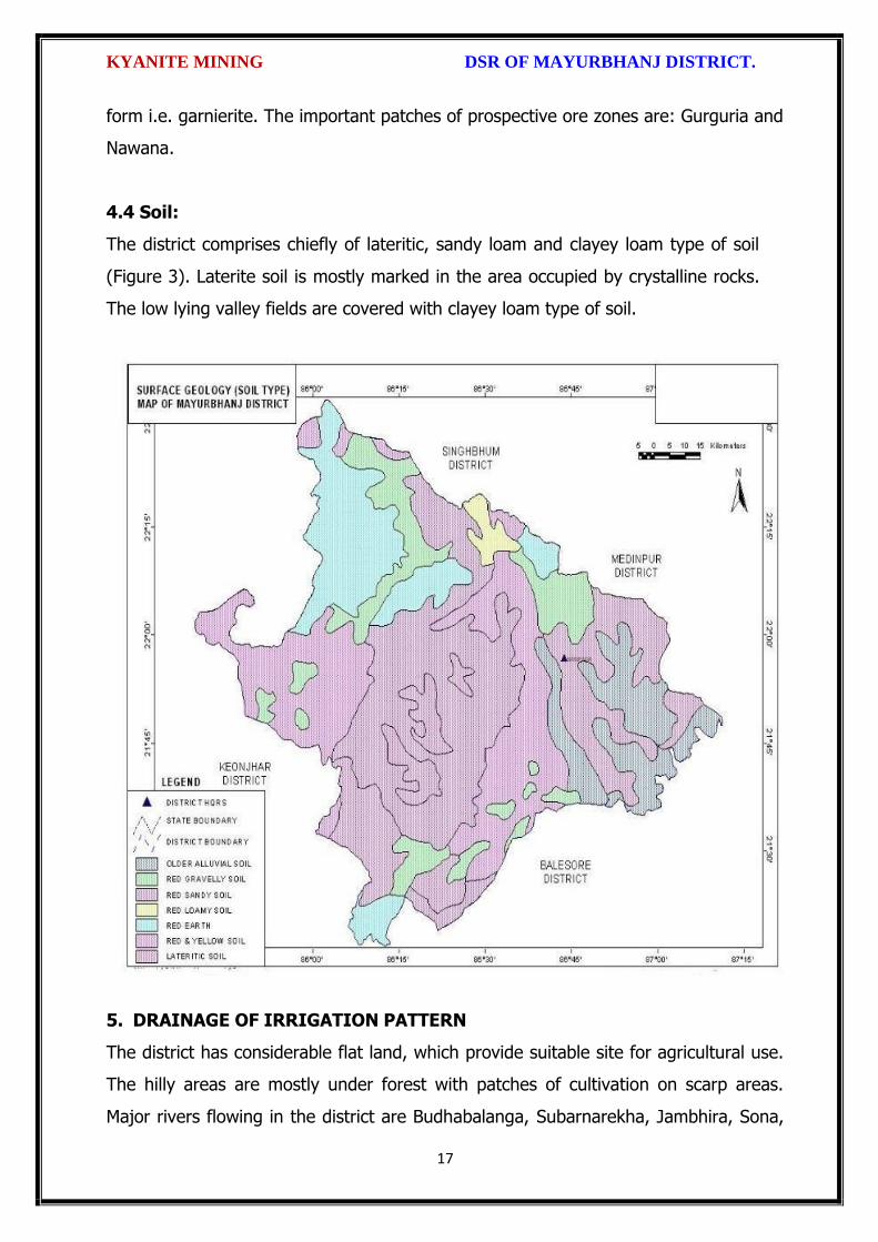
KYANITE MINING DSR OF MAYURBHANJ DISTRICT.
17
form i.e. garnierite. The important patches of prospective ore zones are: Gurguria and
Nawana.
4.4 Soil:
The district comprises chiefly of lateritic, sandy loam and clayey loam type of soil
(Figure 3). Laterite soil is mostly marked in the area occupied by crystalline rocks.
The low lying valley fields are covered with clayey loam type of soil.
5. DRAINAGE OF IRRIGATION PATTERN
The district has considerable flat land, which provide suitable site for agricultural use.
The hilly areas are mostly under forest with patches of cultivation on scarp areas.
Major rivers flowing in the district are Budhabalanga, Subarnarekha, Jambhira, Sona,

KYANITE MINING DSR OF MAYURBHANJ DISTRICT.
18
Khadkhai, Deo, Katra, Khairibandhan & Baitarani. Major crops grown in the district are
rice Only. 14.82 percent area of agricultural use are net irrigated and major source of
irrigations are well and tube-wells.
Sl. No.
Name of the River
Area drained (Sq.Km.)
% Area drained in the District
1 Budhabalanga 2143 21%
2 Subarnarekha 265 0.25%
3 Jambhira 1377 13%
4 Sona 1062 10%
5 Khadkhai 1131 10.8%
6 Khairibandhan 1014 0.09%
7 Deo 473 0.04%
8 Katra 352 0.03%
9 Gangahar 594 0.057%
10 Baitarani 260 24.6%
11 Tel 96 0.009%
12 Kantamauli 82 0.007%
13 Sim 165 0.015%
14 Jhagada 30 0.002%
15 Balijori 56 0.005%
16 Kantakhaira 186 0.017%
17 Kanhu 383 0.036%
18 Balisudura 170 0.016%

KYANITE MINING DSR OF MAYURBHANJ DISTRICT.
19
5.1 River System
The Budhabalanga River (also called Balanga River) flows through the districts
of Mayurbhanj & Balasore and finally reached Bay of Bengal. The Budhabalanga, rises
from Similipal hills and plunges through Barehipani Falls, the second-highest waterfall
in India, located in Similipal National Park. It then flows in a northerly direction up to
the village Karanjiapal in Bangiriposi police-station. Thereafter, it turns to the north-
east and flows along the railway track up to the village Jhankapahadi. There it
changes its course to the south and meets the Katra nala. The other tributaries are
the Palpala and the Chipat both of which are hill streams rising from the Similipal hills.
Then the river passes through Baripada. It later flows through Balasore district and
into the Bay of Bengal. The Budhabalanga is about 175 kilometres (109 mi) long and
has a total catchment area of 4,840 square kilometres (1,870 sq mi). Its major
tributaries are the Sona, Gangahar, and the Katra. Burhabalang and its tributaries, viz.
KYANITE MINING DSR OF MAYURBHANJ DISTRICT.
20
Sona Nadi, Amrutia Nadi, Gangahar Nadi drain almost round the year in the present
area. Sona Nadi receives the watery effluent load through a nalah (Sankh nalah) from
the Balgopalpur Industrial Estate and flows from west to east. Amrutia Nadi flows
from NNW to SSE and carries the waste water load of East Coast. Subarnrekha
originate from Nagri of Jharkhand and then enter into Mayurbhanj district, very less
portion of the river flows within Mayurbhanj district, Major portion of Subarnarekha
River passes in the Balasore district. Another river Jambhira runs in Mayurbhanj
district then enters into Balasore district and Renamed as river Jalaka flows into Bay
of Bengal. Other small rivers run in this district like River Khadkhai originates from
Tunhgru R.F. and plunges through Suleipat Dam (Khadkhai Reserviour). It then runs
towards Rairangpur, Bahalda, Tiringi area of western direction of Mayurbhanj district
and finally reached at River Subarnarekha. River Deo rises from Similipal R.F. and
runs towards western part of the district and flows through Karanjia area and then
joins with Baitarani River. River Khairabandhan originates from Similipal R.F. and
flows towards western part of the Mayurbhanj district through Jashipur, Raruan,
Sukruli area of district and then joins with River Baitarani This river maintains a
sluggish flow in the pre-monsoon period, but swells menacingly with the onset of
monsoon often flooding large tracts. Another small tributary named as Kanhu starts
from River Khadkhai and branched into Jalapa, Ghagera nala meets at Jharbeda area
of Mayurbhanj District.
Sl. No.
Name of the River or Stream
Total Length in District (in Km.)
Place of Origin Altitude at Origin
1 Budhabalanga 161 Similipal Hill 940 mrl.
2 Subarnarekha 4 Nagri, Jharkhanda
610 mrl.
3 jambhira 64 Chandra R.F. Mayurbhanj
60 mrl.
4 Sona 70 Jaymal Hill, Dugdha
Mayurbhanj.
340 mrl.
5 Khadkhai 75 Tunhgru R.F. 500 mrl.
6 Khairibandhan 65 Similipal R.F. 800 mrl.
7 Deo 65 Similipal R.F. 930 mrl.
8 Katra 55 Jari R.F. 700 mrl.
9 Gangahar 55 Similipal R.F. 740 mrl.
10 Baitarani 48 Gonasika, 900 mrl.

KYANITE MINING DSR OF MAYURBHANJ DISTRICT.
21
Guptaganga Hills
11 Tel 20 Similipal R.F. 940 mrl.
12 Kantamauli 25 Similipal R.F. 360 mrl.
13 Sim 85 Similipal R.F. 900 mrl.
14 Jhagada 15 Jhagada R.F. 430 mrl.
15 Balijori 22 Similipal R.F. 520 mrl.
16 Kantakhaira 36 Similipal R.F. 420 mrl.
17 Kanhu 42 Similipal R.F. 400 mrl.
18 Balisudura 15 Similipal R.F. 450 mrl.
6.0 LAND UTILIZATION PATTERN IN THE DISTRICT
6.1 Forest and non forest land
The forest of Mayurbhanj district is full variety of medicinal plants, Kendu leaves,
Bamboo, Sal, Teak, other timber species and a wide range of carnivorous & herbivorous
wild animals. The district has one Wildlife Sanctuaries known as the Similipal Wildlife
Sanctuary situated at the heart of the district, which hosts all type of wildlife even

KYANITE MINING DSR OF MAYURBHANJ DISTRICT.
22
tigers. The area of the sanctuary is 26, 886.23 hectares. And two kilometer safety zone
of eco-sensitive zone of Suleipat Wildlife Sanctuary are coming in Mayurbhanj district. In
these sanctuary areas the principal animals that are found are Elephant, Bear, Nilgai,
Sambhar, Peacock, Wild Boar and Deer, together with variety of snakes and birds.
District-wise Forest Cover Area in Odisha (Area in Km2)
2017 Assessment
District Geograph ical Area Km2
Very Dense Forest
Moder- ate. Dense Forest
Open Forest
Total Percent of GA
Change Scrub
Angul 6375 371 1380 1004 2755 43.22 43 84
Bolangir 6575 70 224 837 1131 17.2 151 142
Balasore 3806 23 127 234 380 9.98 30 48
Bargarh 5837 176 371 484 1031 17.66 88 47
Bouda 3098 263 546 480 1289 41.61 27 57
Bhadrak 2505 0 9 66 75 2.99 2 0
Cuttack 3932 53 226 517 796 20.24 11 68
Deogarh 2940 191 667 614 1472 50.07 -3 14
Dhenkanal 4452 174 418 825 1417 31.83 9 82
Gajapati 4325 84 1490 946 2520 58.27 12 262
Ganjam 8206 164 1075 864 2103 25.63 15 655
Jagatsinghpur 1668 0 5 131 136 8.15 6 0
Jajpur 2899 6 72 225 303 10.45 3 50
Jharsugada 2114 3 140 179 322 15.23 9 36
Kalahandi 7920 362 729 1327 2418 30.53 36 362
Kandhamal 8021 661 2588 2143 5392 67.22 16 380
Kendrapada 2644 84 88 133 305 11.54 14 2
Keonjhar 8303 289 1404 1519 3212 38.68 4 55
Khorda 2813 21 186 250 457 16.25 0 92
Koraput 8807 94 740 1255 2089 23.72 120 944
Malkangiri 5791 158 709 1475 2342 40.44 20 45
Mayurbhanj 10418 1335 1718 1027 4080 39.16 42 34
Nabarangpur 5291 168 428 507 1103 20.85 8 47
Nayagarh 3890 189 965 556 1710 43.96 28 173
Nuapada 3852 86 482 705 1273 33.05 33 109
Puri 3479 0 54 160 214 6.15 8 11
Rayagada 7073 422 853 1851 3126 44.2 7 349
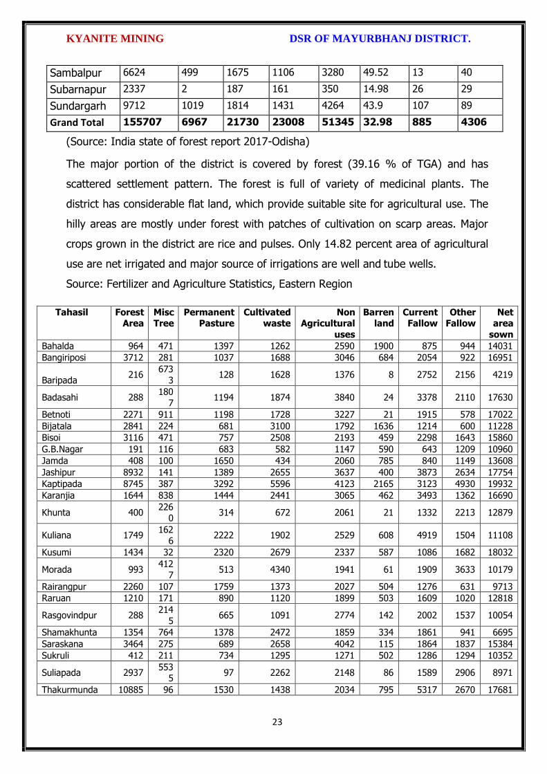
KYANITE MINING DSR OF MAYURBHANJ DISTRICT.
23
Sambalpur 6624 499 1675 1106 3280 49.52 13 40
Subarnapur 2337 2 187 161 350 14.98 26 29
Sundargarh 9712 1019 1814 1431 4264 43.9 107 89
Grand Total 155707 6967 21730 23008 51345 32.98 885 4306
(Source: India state of forest report 2017-Odisha)
The major portion of the district is covered by forest (39.16 % of TGA) and has
scattered settlement pattern. The forest is full of variety of medicinal plants. The
district has considerable flat land, which provide suitable site for agricultural use. The
hilly areas are mostly under forest with patches of cultivation on scarp areas. Major
crops grown in the district are rice and pulses. Only 14.82 percent area of agricultural
use are net irrigated and major source of irrigations are well and tube wells.
Source: Fertilizer and Agriculture Statistics, Eastern Region
Tahasil Forest Area
Misc Tree
Permanent Pasture
Cultivated waste
Non Agricultural
uses
Barren land
Current Fallow
Other Fallow
Net area
sown
Bahalda 964 471 1397 1262 2590 1900 875 944 14031
Bangiriposi 3712 281 1037 1688 3046 684 2054 922 16951
Baripada 216
673
3 128 1628 1376 8 2752 2156 4219
Badasahi 288 180
7 1194 1874 3840 24 3378 2110 17630
Betnoti 2271 911 1198 1728 3227 21 1915 578 17022
Bijatala 2841 224 681 3100 1792 1636 1214 600 11228
Bisoi 3116 471 757 2508 2193 459 2298 1643 15860
G.B.Nagar 191 116 683 582 1147 590 643 1209 10960
Jamda 408 100 1650 434 2060 785 840 1149 13608
Jashipur 8932 141 1389 2655 3637 400 3873 2634 17754
Kaptipada 8745 387 3292 5596 4123 2165 3123 4930 19932
Karanjia 1644 838 1444 2441 3065 462 3493 1362 16690
Khunta 400 226
0 314 672 2061 21 1332 2213 12879
Kuliana 1749 162
6 2222 1902 2529 608 4919 1504 11108
Kusumi 1434 32 2320 2679 2337 587 1086 1682 18032
Morada 993 412
7 513 4340 1941 61 1909 3633 10179
Rairangpur 2260 107 1759 1373 2027 504 1276 631 9713
Raruan 1210 171 890 1120 1899 503 1609 1020 12818
Rasgovindpur 288 214
5 665 1091 2774 142 2002 1537 10054
Shamakhunta 1354 764 1378 2472 1859 334 1861 941 6695
Saraskana 3464 275 689 2658 4042 115 1864 1837 15384
Sukruli 412 211 734 1295 1271 502 1286 1294 10352
Suliapada 2937 553
5 97 2262 2148 86 1589 2906 8971
Thakurmunda 10885 96 1530 1438 2034 795 5317 2670 17681

KYANITE MINING DSR OF MAYURBHANJ DISTRICT.
24
6.2 Agriculture Land:
Mayurbhanj is surrounded by no of forest areas as well as Rocky Mountains. People
used to cultivate Paddy in most parts of the hill slopes and in plain lands. Most of the
cultivators grow short duration local paddy in the un-bonded upland during Kharif
season. The crop suffers moisture stress at different stages due to inadequate rainfall.
The primary objective of Agriculture Department is increase of production as well as
productivity of major crops like paddy, groundnut, mustard, Mung, Biri & vegetables
which is widely covered in this District in both Kharif & Rabi season. Another key
objective is the all round development of the farming community of the District. The
Deputy Director of Agriculture is the head of office so far as agriculture is concerned &
he is the Principal Agriculture Officer of the District. Under him there are 5 District
Agriculture Officers & the block under them. As already pointed out, that agriculture is
the main livelihood of the people in Mayurbhanj District. It is therefore also
designated as the food bowl of Odisha. Rice is the principal crop grown in this district,
followed by other cereals, pulses, oilseeds, vegetables, spices and sugarcane. The
agricultural statistics for the district is shown in subsequent tables below:
Table – 3.6a: Crop Coverage Area of Mayurbhanj District, Odisha
Crop Khariff Rabi Annual TOTAL
Area (ha)
(% of Cropped
Area
Area (ha)
% of Cropped
Area
Area (ha)
Gross Cropped Area (ha)
% of Gross
Cropped Area
Rice 301.37 82.353% 3.80 4.015% --- 305.17 62.051%
Cereals 9.99 2.730% 2.17
2.293% --- 12.16 2.472%
Pulses 32.37 8.846% 36.20 38.255% --- 68.57 13.943%
Oilseeds 5.92 1.617% 28.30 29.906% --- 34.22 6.958%
Vegetables 12.39 3.386% 21.74 22.974% --- 34.13 6.940%
Fibres 2.43 0.664% --- 2.43 0.494% Spices 1.48 0.404% 2.42 2.557% --- 3.90 0.792%
Sugarcane --- --- 00 --- --- 00 ---
Tobacco --- --- 00 --- --- 00 ---
Fruits --- --- --- --- --- 31.23 6.350%
TOTAL 365.95 100.00% 94.63 100.00% --- 491.81 100.00%

KYANITE MINING DSR OF MAYURBHANJ DISTRICT.
25
6.3 Horticulture Land:
The primary objective of Horticulture Department is increase of production as well as
productivity of major fruits like Mango, Guava, Citrus etc., which is widely covered in
this District. Another key objective is the all round development of the farming
community of the District. The Deputy Director of Horticulture is the head of office.
7.0 SURFACE WATER AND GROUND WATER SCENARIO OF THE DISTRICT
7.1 Hydrogeology
Distribution of Saline / fresh water aquifers:
The occurrence of fresh water aquifers in coastal tract of Mayurbhanj restricted by
two important factors‐ (i) Occurrence of hard rocks in the western side and (ii) Salinity
hazard problems in the eastern part. The water bearing formation of the area can be
divided into (a) areas underlain by fractured, fissured and consolidated basement rock
formations (b) areas underlain by recent unconsolidated alluvial formations.
(a) Consolidated Formation - These are most predominant rock types occurring in
the undulating plains of the district. Groundwater occurs under unconfined condition
in the shallow weathered zone and circulates through fractures and joints. The
thickness of the weathered zone varies from 3 to 35 m. Depth of open wells in these
formations varies from 5 to 14 m below ground level.
(b) Unconsolidated alluvial formations - The unconsolidated formations consists of
laterite and alluvium. Laterites at places are highly consolidated and used as building
stones. The laterites have high degree of effective porosity and form potential
aquifers commonly tapped in dug wells. The alluvium comprises an admixture of clay,
silt, sand and calcareous concretions in varying proportions. The coarse sediments like
sand and gravel form the main repository of ground water. Ground water occurs
under both unconfined condition in shallow aquifers and in confined condition in
deeper parts.

KYANITE MINING DSR OF MAYURBHANJ DISTRICT.
26
7.2 Depth of water level:
The depth to water level map for pre and post monsoon periods 2011 are prepared
based on the ground water monitoring data of 77 Nos of National Hydrograph
Stations of C.G.W.B. monitored during the month of April and November 2006 are
presented below respectively. The pre and post monsoon depth to water levels in the
district range from 3.54 to 14.50 m below ground level and 1.39 to 8.20 m below
ground level respectively. It is observed that during pre monsoon about 75% of the
total areas show the water level varying between 5 to 10 m below ground level.
During post monsoon nearly 60% of the area has water levels within 2 to 5 m,
while the rest part has between 0 to 2 and 4 to 6 m below ground levels. In localized
part of Morada, Kaptipada and Thakurmunda the water level is > 5 mt.
Depth & categorization of ground water levels during pre monsoon period (April 2011)
of Mayurbhanj districts is presented below:

KYANITE MINING DSR OF MAYURBHANJ DISTRICT.
27
Depth & categorization of ground water levels during pre monsoon period (November
2011) of Mayurbhanj districts is presented below:

KYANITE MINING DSR OF MAYURBHANJ DISTRICT.
28
7.3 Ground Water Quality
The chemical quality of ground water in the district has been assessed on the basis of
chemical analysis of ground water samples collected during groundwater monitoring,
Hydrogeological surveys and groundwater exploration. The results of the chemical
analysis are presented in Table.
Table showing chemical constituents in aquifers
Constituent Shallow aquifer Deeper aquifer
pH 6.97 – 8.25 6.84 – 8.25
Sp. Conductance (micromohs/cm at 250 C)
53 – 974 92 – 867
TDS (mg/l) 58 – 1430 106 – 429

KYANITE MINING DSR OF MAYURBHANJ DISTRICT.
29
Calcium (mg/l) 6 – 92 16 – 86
Magnesium (mg/l) 0.6 – 17 3.6 – 22
Sodium (mg/l) 1.6 – 100 3.5 – 168
Potassium (mg/l) 0.4 – 8 <1 --6.4
Bicarbonate (mg/l) 15 – 256 49 – 366
Chloride (mg/l) 7 – 238 5.3 – 85
Sulphate (mg/l) 0.1 – 9 <1 – 82
Nitrate (mg/l) <0.01 – 53 0.1 – 78
Fluoride (mg/l) 0.08 – 20.3 0.21 – 0.61
Total hardness as calcium carbonate
10 – 245 35 - 285
7.4 Ground Water Development
In the rural areas the entire water supply is dependent on ground water. Ground
water development is mainly carried out in the district through dug wells and Hand
pumps. In general dug wells are of 2 m diameter and the depth ranges between 8 to
15 m depending on the thickness of the weathered zone, tapping the shallow aquifer
in the weathered zone and uppermost slice of the basement. Large number of dug
wells used for drinking water is under private ownership for which there is no reliable
data. Over the years Mark II/ Mark III hand pumps are being drilled in large numbers
for ground water development. These hand pumps have the following two major
advantages i) less susceptible to contamination from surface sources and ii) tap
fractures between 20-60m depth which have been found to be less affected by
seasonal water level fluctuation and thus have lesser chances of failure even during
extreme summer. Over all the present level of ground water development is only
27.21 percent in the district with the maximum in Badasahi Block viz. 64.65% and
minimum in Bijatala Block. Block wise development figure indicate that all the blocks
come under the white categories. Thus there is ample scope for development of
groundwater in the district to augment irrigation potentials through suitable ground
water abstraction structure
7.5 Ground Water Related Issue and Problems
Some of key ground water related issues are
I. Locating suitable sites for bore wells
II. Suitable design of dug wells and hand pumps
III. Taking up artificial recharge projects to augment the resource availability in

KYANITE MINING DSR OF MAYURBHANJ DISTRICT.
30
Mayurbhanj district.
IV. Optimal development of irrigation potential by developing ground water available
for future uses.
V. Creating public awareness for conserving ground water through awareness
camps, NGO’s and mass media.
7.6 Mass Awareness Campaign (MAP) & Water Management Training
Programme (WMTP) by CGWB
NIL
7.7 Area Notified by Cgwb/Sgwa
None
7.8 RECOMMENDATIONS:
1) Intensive groundwater exploration should be taken up to delineate deeper
potential water saturated fracture zones and to compute aquifer parameter.
2) Large scale planning for ground water development should be preceded by
intensive hydrogeological and geophysical surveys aided by remote sensing
studies.
3) Effective measures may be taken to conserve the surface run off by contour
bonding at suitable sites. Also proper maintenance of reservoir, tanks and spring
channels by periodical disiltation should be carried out.
4) Existing dug-wells should be deepened to tap the maximum saturated thickness of
the weathered mantle or vertical bores may be drilled through the bottom to
enhance the well yield.
5) Energy station of wells already constructed should be stepped up to ensure
optimal utilization of the irrigation potential already created.
6) The farmers should be educated through agricultural extension services fro
adopting suitable cropping pattern for optimal utilization of available groundwater
resources.
7) Programmes for artificial recharge may also be taken up for augmentation of
groundwater through construction of percolation tanks, subsurface dykes, and
check dams and through contour bonding etc.
8) An intensive network of groundwater monitoring stations are required to be
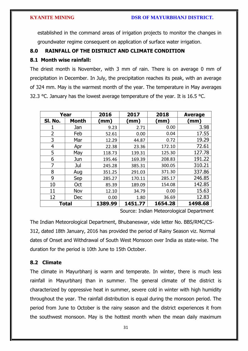
KYANITE MINING DSR OF MAYURBHANJ DISTRICT.
31
established in the command areas of irrigation projects to monitor the changes in
groundwater regime consequent on application of surface water irrigation.
8.0 RAINFALL OF THE DISTRICT AND CLIMATE CONDITION
8.1 Month wise rainfall:
The driest month is November, with 3 mm of rain. There is on average 0 mm of
precipitation in December. In July, the precipitation reaches its peak, with an average
of 324 mm. May is the warmest month of the year. The temperature in May averages
32.3 °C. January has the lowest average temperature of the year. It is 16.5 °C.
Year 2016 2017 2018 Average
Sl. No. Month (mm) (mm) (mm) (mm)
1 Jan 9.23 2.71 0.00 3.98
2 Feb 52.61 0.00 0.04 17.55
3 Mar 12.29 44.87 0.72 19.29
4 Apr 22.38 23.36 172.10 72.61
5 May 118.73 139.31 125.30 127.78
6 Jun 195.46 169.39 208.83 191.22
7 Jul 245.28 385.31 300.05 310.21
8 Aug 351.25 291.03 371.30 337.86
9 Sep 285.27 170.11 285.17 246.85
10 Oct 85.39 189.09 154.08 142.85
11 Nov 12.10 34.79 0.00 15.63
12 Dec 0.00 1.80 36.69 12.83
Total 1389.99 1451.77 1654.28 1498.68
Source: Indian Meteorological Department
The Indian Meteorological Department, Bhubaneswar, vide letter No. BBS/RMC/CS-
312, dated 18th January, 2016 has provided the period of Rainy Season viz. Normal
dates of Onset and Withdrawal of South West Monsoon over India as state-wise. The
duration for the period is 10th June to 15th October.
8.2 Climate
The climate in Mayurbhanj is warm and temperate. In winter, there is much less
rainfall in Mayurbhanj than in summer. The general climate of the district is
characterized by oppressive heat in summer, severe cold in winter with high humidity
throughout the year. The rainfall distribution is equal during the monsoon period. The
period from June to October is the rainy season and the district experiences it from
the southwest monsoon. May is the hottest month when the mean daily maximum

KYANITE MINING DSR OF MAYURBHANJ DISTRICT.
32
temperature rises up to 47º Celsius. The Köppen-Geiger climate classification is Cwa &
as per they the average temperature in Mayurbhanj is 24.7 °C. The temperature in
May averages 32.3 °C. January has the lowest average temperature of the year, it is
16.5 °C. There is a difference of 321 mm of precipitation between the driest and
wettest months. During the year, the average temperatures vary by 15.8 °C., when
the mean daily minimum temperature dips to 4º Celsius. The higher reaches of the
Similipal experiences frosting during the peak of winter.
9.0 DETAILS OF MINING LEASE OF KYANITE IN THE DISTRICT
9.1 List of Mines is operation in the district:
Attached as Annexure- K
9.2 List of Mines is not operation in the district:
Attached as Annexure- K

KYANITE MINING DSR OF MAYURBHANJ DISTRICT.
33
10. DETAIL OF ROYALTY OR REVENUE RECEIVED IN LAST THREE YEARS:
Sl.
No.
Name of the Mining Circle
2016-17 2017-18 2018-19 Total in
tonne
1 Baripada Nil Nil Nil Nil
Total Nil Nil Nil Nil
11. DETAIL OF PRODUCTION OF MINOR MINERALS IN LAST THREE YEARS:
Sl.
No.
Name of the Mining Circle
2016-17 2017-18 2018-19 Total in
tonne
1 Baripada Nil Nil Nil Nil
Grand Total Nil Nil Nil Nil

KYANITE MINING DSR OF MAYURBHANJ DISTRICT.
34
12. MINERAL MAP OF THE DISTRICT:
13. LIST OF LETTER OF INTENT (LOI) HOLDERS IN THE DISTRICT ALONG
WITH ITS VALIDITY
Sl. No.
Name of the
Mineral
Name of the
Lessee
Address Letter of Intent Grant
Order No. &
date
Area of Mning
lease to be
allotted
Validity of LoI
Use
(Captive/ Non-
Captive)
Location of the Mining
lease (Latitude & Longitude)
1 2 3 4 5 6 7 8 9
Attached as Annexure-K
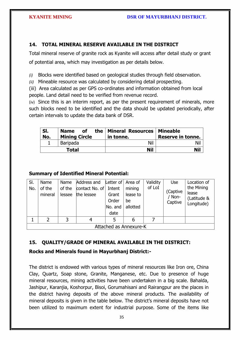
KYANITE MINING DSR OF MAYURBHANJ DISTRICT.
35
14. TOTAL MINERAL RESERVE AVAILABLE IN THE DISTRICT
Total mineral reserve of granite rock as Kyanite will access after detail study or grant
of potential area, which may investigation as per details below.
(i) Blocks were identified based on geological studies through field observation.
(ii) Mineable resource was calculated by considering detail prospecting.
(iii) Area calculated as per GPS co-ordinates and information obtained from local
people. Land detail need to be verified from revenue record.
(iv) Since this is an interim report, as per the present requirement of minerals, more
such blocks need to be identified and the data should be updated periodically, after
certain intervals to update the data bank of DSR.
Sl. No.
Name of the Mining Circle
Mineral Resources in tonne.
Mineable Reserve in tonne.
1 Baripada Nil Nil
Total Nil Nil
Summary of Identified Mineral Potential:
Sl.
No.
Name
of the
mineral
Name
of the
lessee
Address and
contact No. of
the lessee
Letter of
Intent
Grant
Order
No. and
date
Area of
mining
lease to
be
allotted
Validity of LoI
Use
(Captive/ Non- Captive
Location of the Mining lease (Latitude & Longitude)
1 2 3 4 5 6 7
Attached as Annexure-K
15. QUALITY/GRADE OF MINERAL AVAILABLE IN THE DISTRICT:
Rocks and Minerals found in Mayurbhanj District:-
The district is endowed with various types of mineral resources like Iron ore, China
Clay, Quartz, Soap stone, Granite, Manganese, etc. Due to presence of huge
mineral resources, mining activities have been undertaken in a big scale. Bahalda,
Jashipur, Karanjia, Koshorpur, Bisoi, Gorumahisani and Rairangpur are the places in
the district having deposits of the above mineral products. The availability of
mineral deposits is given in the table below. The district’s mineral deposits have not
been utilized to maximum extent for industrial purpose. Some of the items like

KYANITE MINING DSR OF MAYURBHANJ DISTRICT.
36
China clay, Soap stone, Asbestos, etc. can be used in small scale sector. So the
available resources of the district need harnessing properly for industrial and
productive use. Kyanite in the district is very much suitable for various industrial
purposes after crushing and screening.
16. USE OF MINERAL
Uses of Kyanite:
Kyanite is used to manufacture a wide range of products. An important use is in the
manufacture of refractory products such as the bricks, mortars, and kiln furniture
used in high-temperature furnaces. For foundries, the molds that are used for casting
high-temperature metals are often made with kyanite. Kyanite is a mineral found
mainly in metamorphic rocks. It most often forms from the high-pressure alteration of
clay minerals during the metamorphism of sedimentary rocks. It is found in
the schists and gneisses of regionally metamorphosed areas and less often
in quartzite or eclogite. Kyanite's typical habit is a bladed crystal, although it
sometimes occurs as radiating masses of crystals. Kyanite is often associated with
other metamorphic minerals such as garnet, staurolite, and corundum. Kyanite is a
mineral found mainly in metamorphic rocks. It most often forms from the high-
pressure alteration of clay minerals during the metamorphism of sedimentary rocks.
17. DEMAND AND SUPPLY OF THE MINERAL IN THE LAST THREE YEARS:
As such there are huge infrastructural and industrial activities are coming up by State
govt., Govt. of India & PSUs under “Make in India” programme. The main raw
minerals for the above activities and considering the last three years actual
productions with respect to the requirement of the state has a huge gap. It is
proposed to start the production from larger block/area to at least double the
production of the district which will enhance the revenue of the district and also
support the livelihood of the local people
Sl. No. Name of the Mining Circle
Financial Year
Kyanite in tonne
1
Baripada 2016-17 Nil
2017-18 Nil
2018-19 Nil
Total Nil
KYANITE MINING DSR OF MAYURBHANJ DISTRICT.
37
18. MAP OF EXISTING MINING LEASES IN THE DISTRICT:
Enclosed as Plate-I
19. DETAILS OF THE AREA OF WHERE THERE IS A CLUSTER OF MINING
LEASE VIZ. NUMBER OF MINING LEASES, LOCATION (LATITUDE AND
LONGITUDE)
Currently there is no cluster of Kyanite mining lease in the district. However, it is
proposed to consider the cluster of mining lease while planning for new lease area in
coming years.
20. DETAILS OF ECO-SENSITIVE AREA, IF ANY, IN THE DISTRICT:
Eco sensitive zone of Similipal wild life sanctuary is located within the district.
21. IMPACTS OF MINING ON ENVIRONMENT:
The most important environmental impact of mining projects is:-
Transportation sources:
Transportation sources of air pollutants include heavy vehicles used in excavation
operations, cars that transport personnel at the mining site, and trucks that transport
mining materials. The level of polluting emissions from these sources depends on the
fuel and conditions of the equipment. Even though individual emissions can be
relatively small, collectively these emissions can be of real concern. In addition,
mobile sources are a major source of particulate matter, carbon monoxide, and volatile
organic compounds that contribute significantly to the formation of ground-level ozone
Fugitive emissions:
Common sources of fugitive emissions include: storage and handling of materials;
mine processing; fugitive dust, blasting, construction activities, and roadways
associated with mining activities; leach pads, and tailing piles and ponds; and waste
rock piles. Sources and characteristics of fugitive emissions dust in mining operations
vary in each case, as do their impacts. Impacts are difficult to predict and calculate
but should be considered since they could be a significant source of hazardous air
pollutants.

KYANITE MINING DSR OF MAYURBHANJ DISTRICT.
38
Noise and vibration:
Noise pollution associated with mining may include noise from vehicle engines,
loading and unloading of rock into steel dumpers, chutes, power generation, and
other sources. Cumulative impacts of shoveling, ripping, drilling, blasting, transport,
crushing, grinding, and stock-piling can significantly affect wildlife and nearby
residents.
Vibrations are associated with many types of equipment used in mining operations,
but blasting is considered the major source. Vibration has affected the stability of
infrastructures, buildings, and homes of people living near large-scale open-pit mining
operations. According to a study commissioned by the European Union in 2000:
“Shocks and vibrations as a result of blasting in connection with mining can lead to
noise, dust and collapse of structures in surrounding inhabited areas. The animal life,
on which the local population may depend, might also be disturbed.”
22. REMEDIAL MEASURES TO MITIGATE THE IMPACT OF MINING ON THE
ENVIRONMENT:
1. Following are the remedial measures to mitigate the in Water sprinkling on haul
road, loading and unloading points.
2. Plantation along the safety zone and dump area.
3. Providing dust masks to workers.
4. Regular monitoring of ambient air quality.
5. Provision of air conditioned cabin of Excavators and Dumpers.
6. Regular and proper maintenance of working equipments.
7. Periodic medical examination of the workers and organize medical camp in the area.
8. Use Milli Second Delay Detonator in blasting operation.
9. Provisions of ear plug to the workers.
10. Regular training programme to the mines workers and operators.
23. RECLAMATION OF MINED OUT AREA
Necessity of Reclamation & Rehabilitation:
Exponential growth in mineral production since 1980.
Mining activities causes physical, chemical, biological and socio-economic changes in

KYANITE MINING DSR OF MAYURBHANJ DISTRICT.
39
the area.
Surface mining activities disturb the original land profile.
In India, mineral production comes mostly from opencast mines & hence land
degradation problems are of serious concern.
An intricate, in-depth and site-specified techniques involving integrated approach is
necessary.
Reclamation has three vital roles:
i. Reclamation – Reclamation means return the mined-out land with useful life. It
implies restoring the land to a form and productivity that is useful and inconformity
with a prior land use. Reclamation always may not be a single- phase operation.
ii. Rehabilitation – Rehabilitation is to bring batch the degraded land to a normal
stage by a special treatment. It is a process of taking some mitigation measures for
disturbed environmental condition created through mining activities.
iii. Restoration – Restoration is the process of returning the mined out land being
fit to an acceptable environmental condition. However, the general acceptable
meaning of the term is bringing the disturbed land to its original form. Restoration is
often used to indicate that biological properties of soil are put back to what they were.
This is a rate phenomenon.
iv. When active mining ceases, mine facilities and the site are reclaimed and closed.
The goal of mine site reclamation and closure should always be to return the site to a
condition that most resembles the pre-mining condition. Mines that are notorious for
their immense impact on the environment often made impacts only during the closure
phase, when active mining operations ceased. These impacts can persist for decades
and even centuries.
Mine reclamation and closure plans must describe in sufficient detail how the mining
company will restore the site to a condition that most resembles pre-mining
environmental quality; how it will prevent – in perpetuity – the release of toxic
contaminants from various mine facilities (such as abandoned open pits and tailings
impoundments); and how funds will be set aside to insure that the costs of
reclamation and closure will be paid for.
Proposed future land use after reclamation:
a. Forestry, b. Recreation, c. Water Reservoir, d. Crop Land,

KYANITE MINING DSR OF MAYURBHANJ DISTRICT.
40
e. residential/Commercial, f. Fish & wildlife Habitat, g. Undeveloped Land,
h. Grazing/Pasture Land
Statutory requirement:
As per the Mineral Conservation Development Rule, 2017, the following rules must be
bare in mind by the mine owner/agent/manager, which is a part of reclamation
activities –
Rule 22, Mine Closure Plan
Rule 23, Submission of Progressive Mine Closure Plan Rule 24, Submission of Final
Mine Closure Plan
Rule 26, Responsibility of holder of mining lease Rule 27, Financial Assurance
Rule 35, Sustainable Mining
24. RISK ASSESSMENT AND DISASTER MANAGEMENT PLAN:
Mining activity because of the very nature of the operation, complexity of the
systems, procedures and methods always involves some amount of hazards. Hazard
identification and risk analysis is carried for identification of undesirable events that
can leads to a hazard, the analysis of hazard mechanism by which this undesirable
event could occur and usually the estimation of extent, magnitude and likelihood of
harmful effects. The activities which can cause high risk related to face stability and
the person blasting the shots. It was observed that on a working face of the mine,
there were large cracks and unsupported rocks were present, which can lead to a
serious hazard and injure workers engaged in loading operation and machineries
because of rock falls or slides. This type of condition turn out because improper
dressing of the bench and improper supervision. To avoid the hazards due to fall of
rocks the face must be examined, made suitable for working and the remedial
measures must be taken to make it safe if there is any doubt that a collapse could
take place. Working of the face should be in the direction taking into account the
geology of the area such that face and quarry side remain stable. Another major risk
identified in mines is due to the firing of explosive by an unqualified person. In the
mines there is problem of fly rocks and the village is located close to the mine and so
it is rated high as it can affect may people. Explosives by nature have the potential for
the most serious and catastrophic accident. Planning of round of shots, holes correctly
drilled, direction logged, weight of explosive suitable for good fragmentation are the

KYANITE MINING DSR OF MAYURBHANJ DISTRICT.
41
few of the steps necessary to ensure its safe use and if the shots are not properly
designed can result in misfires, early ignition and flying rocks. No person is allowed to
use explosives without being properly trained in its handling. In the mine a large
numbers of heavy vehicles were in operation and the roads were not proper for
haulage purpose. The haulage roads were not even and were not wide enough for the
crossing purpose and hence the chances of hazards are very high. The main hazards
arising from the use large earth moving vehicles are incompetent drivers, brake
failure, lack of all-around visibility from the driver position, vehicle movements
particularly reversing, roll over, and maintenance. Those most at risk are the driver
and pedestrians likely to be struck by the vehicle, and drivers of smaller vehicles,
which cannot be seen from the cabs of large vehicles. Edge protection is always
necessary to prevent inadvertent movement over the edge of roadway or a bench.
Seatbelt will protect driver in case of roll. Good maintenance and regular testing are
necessary to reduce the possibility of brake failure. Access to the vehicles should
always be restricted to those people necessary for the work in hand. The use of
personal protective equipment and proper arrangements is essential to check if the
person is wearing protective equipment or not. The personal protective equipment
includes helmet, non-skid safety boots, safety glasses, earmuffs etc. The required
personal protective equipment should be provided and used in a manner that protects
the individual from injury. Few minor injuries which can be prevented are slip, trip, or
fall hazards; hazards due to rock falls and collapse of unstable rocks, atmosphere
containing toxic or combustible gases; protects from chemical or hazardous material
etc. A disaster management plan should be prepared for taking care of for any
disaster. Other risks which are included in this category are noise, as it occurs and it
can lead to permanent disability. There are problems related to road traffic in and out
issuers; inappropriate exposure of moving machines; mechanical failure and because
of large number of moving trucks and dumpers there is large quantity of dust present
in roadways which affects the operators and can lead to accidents causing injury.
They are in acceptable range because of precautions measures taken but no step is
taken it can cause hazard hence steps should be taken to reduce the hazards such as
for dust suppression system should be installed. Other problems like occurrence of

KYANITE MINING DSR OF MAYURBHANJ DISTRICT.
42
lots of mosquitoes in the area due to unhygienic conditions which affect the human
health causing malaria, dengue etc. and causing a person to be hospitalized.
Disaster in the mines like fires, explosions, entrapments, and inundations can occur
any time, so emergency preparedness is a must. The Disaster management plan and
risk assessment in the mines will include all sorts of above mentioned emergency and
the extent that this plan will be implemented will depend on the nature and scope of
the emergency. The basic purpose of Disaster management plan and risk assessment
to ensure that mine rescue and recovery activities are conducted safely for rescuer
and survivors. According to MMR act 1961 a standard operating procedure should be
drawn for involvement different category of staff and officers. The SOP should be
updated periodically to reduce the chaos and response to the emergency should be
quick and smooth. The responsible person should be familiar with his responsibility
during the mock drills. One or two standby should be there to replace the person in
Emergency situation. Rescue operations should not include the survivors for any
assistance.
First Information of Disaster / Emergency should go to the attendance clerk on duty.
Duties of attendance Clerk (Emergency Siren) the attendance clerk or other
designated person should on getting information of major accident, sound a hooter or
a siren immediately declaring a state of emergency at the mine and then to contact
the manager and on his advice to call key personnel using the information listed in the
Emergency Organization Chart. It is important that all telephone calls are recorded in
a telephone log book. Duties of Other Officials should be displayed and handed over
to all concerned. Copy the same should be kept at Manager’s Office for ready
reference. Establishment of Control Room at Unit Level, Area Level and Company
Level is essential. Control Room should keep the contact information about –
Company Manager
Company owner/ Administrative officer.
District Administration
Govt. Hospitals in Nearby Localities,
Private Nursing Homes of Localities

KYANITE MINING DSR OF MAYURBHANJ DISTRICT.
43
Attendance roaster and duty charge register should be properly maintained so the
record of missing people can be obtained.
25. DETAILS OF THE OCCUPATIONAL HEALTH ISSUE IN THE DISTRICT:
The persons employed in the mines are exposed to a number of hazards at work
which adversely affect their health. Some of the important ones are dust, noise, heat,
humidity, vibration etc. In recent times, there has been increasing awareness among
mining industry and the workers about occupational diseases like Pneumoconiosis,
Silicosis, Tuberculosis, Hearing Impairment etc. caused by exposure to health hazards
at work. Almost all occupational diseases can be prevented by adopting proper
occupational health measures and engineering control on airborne dust pollution at
workplace. Occupational Diseases in mines or industry is required to conduct medical
examinations and health surveillance of workers as per the provisions of Mines Act.
The present efforts of mines management are concentrated on detection of silicosis,
Pneumoconiosis and other notified diseases. The essential features of health
surveillance programme required to be carried out in mines are:
(a) Initial Medical Examination of persons to be conducted at the time of
appointment.
(b) Periodic Medical Examination or General physical examination to be conducted
once in every year.
(c) Maintenance of medical records and health services till the person is in service.
(d) The Details of Tuberculosis cases in last 5 years is given below
RNTCP Activities from 2014 to 2018
Year Projected Population
No of Sputum
Examined
Sputum Examine
d per Lakh/Qr
No of
Sputum Positive
Sputum Positive
%
Total Case
put on
DOTS/No of
TB cases
Child DOTS
out of Total DOTS
Case detectin
per Lakh/Yr
Sputum
Conversion Rate
NSP Cure
Rate
NSP Death
Rate
(in Lakh) Norm- 150
Norm-8-15 %
Norm-170 /L/Y
Norm-90 %
Norm-90%
Norm < 5%
2014 26.01 16848 161.9 2825 16.8% 4883 103 187.7 90.2% 89.0% 7.4%
2015 26.30 18118 172.2 2836 15.7% 4831 123 183.7 90.5% 89.0% 6.7%
2016 26.59 20060 188.6 2975 14.8% 5171 119 194.5 95.0% 90.9% 6.5%
2017 26.88 31035 289.4 3152 11.4% 5127 111 190.7 94.0% 91.6% 5.5%
2018 27.18 21273 195.6 2853 13.4% 4894 95 173.4 95.3% 92.7% 6.4%
KYANITE MINING DSR OF MAYURBHANJ DISTRICT.
44
26. PLANTATION GREEN BELT DEVELOPMENT IN RESPECT OF LEASE
ALREADY GRANTED IN THE DISTRICT:
During mining operation green belt development through plantation is most important
for environment safe guard, which should be supervision by mining department.
Different type of species should be planted near lease periphery to keep environment
clean at post mining period through reclamation. Where specific usefulness of land
could be decided, a forestation is normally planned through the site could have been
considered for better possibilities of land use.
27. CONCLUSION:
Since it is an interim report, to meet the requirement of minerals in the present
scenario, it is proposed to identify such potential areas at certain interval and get the
data bank of DSR to be updated. The insitu mining activity in any area is on one hand
bring revenue and employment (Direct and indirect) and on other hand if not done
properly potential pollution and ecological imbalance increases, the ability of the
ecosystem can also be reduced. Particulate matter transported by the wind as a result
of excavations, blasting, transportation of materials, heavy equipments used raise
these particulate levels; and Gas emissions from the combustion of fuels in stationary
and mobile sources, explosions, and mineral processing. All these activities indirectly
affected the biodiversity of area. Larger potential and smaller areas have been
identified in Mayurbhanj district on the basis of geological study carried out during
field observation, which can be considered for mining concession after all the
parameters for statutory clearances are verified by consulting with concerned
authorities.

KYANITE MINING DSR OF MAYURBHANJ DISTRICT.
45
Plate No.-I

!
L
ttL
KYANITE MINING DSR OF MAYURBHANJ DISTRICT.
The District Survey Report for Kyanite Stone Mining (Minor Mineral) in
respect of Mayurbhanj District prepared in accordance with Appendix-X, Para -7 (iii)
(a) of S.O. 3611 (E) Dt. 25.07.2018 of Ministry of Environment, Forest and Climate
Change, New Delhi is approved for fina't pubtication in the district website.
sO ,.1
Dr. H.K.Sahu,Prof in Zoology, NOU -cum-Member, DEIAA, Mayurbhanj
S.Malli I.F.S, Sri Dibyajyoti a, I.A.SDFO-cum-Member,DEIA& Mayurbhanj
SDM, Sadar-cum ber SecretaryDEIAA, Mayurbhanj
4
Sri VineetCollector & DM-cum- irman, DEIAA
Mayurbhanj (Odisha)
46
W \

Fro
m
To
Fro
m
To
1 2 3 4 5 6 7 8 9 10 11 12 13 14 15 16 17 18 19
1 Kyanite K.K.Chaurasia Panijia55.49
Vill- Panijia
23
.11
.19
81
22
.11
.20
01
Lapsed vide Lr.
No. 12380/SM,
Dt.21.12.2015.
Non-Captive Kuliana Open Cast
Annexure-K
SPECIFIED MINOR MINERALS (KYANITE)
Sl
No
Name of
Minerals
Name of
Lessees
Address
and
Contact
No. of
lessee
Mining
Lease
Grant
Order
No. &
Date
Area of
Mining
Lease (Ha.)
with village
Khata No.,
Plot No. &
Kisam
Period of
Mining
Lease
(Initial)
Period of
Mining
Lease
(1st/2nd
Renewal)
Non-Working Lease
Method of
Mining
(Open cast/
Under
Ground)
Geological
Reserve
(MT/Cums)
Mineable
Reserve
(MT/Cums)
Date of
Commenc
ement of
mining
operation
Status (Working/
Non-working/
temp. Working for
dispatch etc.
Captive/ Non-
captive
Obtained
environmental
clearance
(Yes/no). If Yes,
Letter No. with
date of EC
Location of Mining
Lease (Latitude &
Longitude)
Name of
Tahasil

DISTRICT SURVEY REPORT (DSR) OF
MAYURBHANJ DISTRICT, ODISHA. FOR
TALC
(FOR PLANNING & EXPLOITING OF MINOR MINERAL RESOURCES)
As per Notification No. S.O. 3611(E) New Delhi
dated 25th July 2018 of
Ministry of Environment, Forest & Climate Change
(MoEF & CC)
( Prepared by DEIAA, Mayurbhanj, Odisha)

TALC MINING DSR OF MAYURBHANJ DISTRICT.
1
CONTENT
CH.
NO.
DESCRIPTION PAGE
NO.
Preamble
1 Introduction 4
1.1 Location and Geographical Area 4
1.2 Administrative Units 5
1.3 Connectivity 7
2 Overview of Mining Activity in the District 10
3 General Profile of the District 11
3.1 Demography 11
4 Geology of the District 11
4.1 Physiography & Geomorphology 12
4.2 Stratigraphy. 13
4.3 Mineral Resources. 14
4.4 Soil 17
5 Drainage of Irrigation Pattern 17
5.1 River System 19
6 Land Utilization Pattern in the District 21
6.1 Forest and non forest land. 21
6.2 Agricultural land. 24
6.3 Horticultural land. 25
7 Surface Water and Ground Water Scenario of the District 25
7.1 Hydrogeology. 25
7.2 Depth to water level. 26
7.3 Ground Water Quality. 28
7.4 Ground Water Development. 29
7.5 Ground water related issues & problems. 29
7.6 Mass Awareness Campaign on Water Management
Training Programme by CGWB
30
7.7 Area Notified By CGWB/SGWA 30
7.8 Recommendations 30
8 Rainfall of the District and Climate Condition 31
8.1 Month Wise rainfall. 31
8.2 Climate. 31
9 Details of Mining Lease in the District 32
9.1 List of Mines in operation in the district Annexure-B
9.2 List of Mines not in operation in the district Annexure-B
10 Detail of Royalty or Revenue received in last 3 years 33

TALC MINING DSR OF MAYURBHANJ DISTRICT.
2
11 Detail of production of minor mineral in last 3 years 34
12 Mineral Map of the District. 35
13 List of Letter of Intent (LOI) Holders in the District along
with its Validity.
35
14 Total Mineral Reserve Available in the District. 36
15 Quality/Grade of Mineral Available in the District. 37
16 Use of Mineral. 37
17 Demand and Supply of the Mineral in the Last Three Years. 38
18 Map of Existing Mining Leases in the District. 38
19 Details of the Area of where there is a cluster of mining
lease viz. Number of mining leases, location (latitude and
longitude).
39
20 Details of Eco-Sensitive Area, if Any, in the District 39
21 Impact of Mining on Environment 39
22 Remedial Measures to Mitigate the Impact of Mining on
the Environment
40
23 Reclamation of Mined Out Area 40
24 Risk Assessment and Disaster Management Plan 42
25 Details of the Occupational Health Issue in the District 45
26 Plantation and Green Belt Development in Respect of
Lease Already Granted in the District
46
27 Conclusion & References 46

TALC MINING DSR OF MAYURBHANJ DISTRICT.
3
PREAMBLE
Odisha is the major mineral reach in India. Mayurbhanj is a unique district in Odisha
lies on the northern most part of the state with varied mineral resources. In
pursuance of the order of Hon’ble Supreme Court Petition (C) No. 19628-19629 of
2009, dated 27th Feb. 2012 in the matter of Deepak Kumar Vs State of Haryana and
others etc., prior environmental clearance has now become mandatory for mining of
minor minerals irrespective of the area of Mining Lease. And also in view of the
Hon’ble National Green Tribunal, order dated the 13th Jan. 2015 the matter regarding
Road metal/stone, Sand, Brick earth, & burrowed earth cutting for Road Construction
has to take prior Environmental Clearance for Mining Lease area more or less than 5
hectares also suggested making a policy on Environmental Clearance for minor
minerals lease and leases in cluster. As per MOEF & CC Notification S.O.-1533(E)
dated 14th Sept. 2006 and subsequent MoEF & CC Notification S.O. 141(E) dated 15th
Jan. 2016, District Environment Impact Assessment Authority (DEIAA) & District level
Expert Appraisal Committee (DEAC) has been formed for Category –B2 Minor Minerals
having area less than or equal to 5 ha. In compliance to the notification issued by the
Ministry of Environment and Forest and Climate Change Notification no. S.O.3611 (E)
New Delhi dated 25-07-2018; the preparation of district survey report of road
metal/stone mining has been prepared in accordance with Clause II of Appendix X of the
notification.
Keeping in view of the prior information of Odisha Minor Mineral Concession Rule
2004, (OMMCR -2004) the mining operation for minor minerals were carried out in
unscientific manner. Identifying this fact in exercise of power, Conferred by Section 15
by Mines and Minerals (Development and Regulation) Act 1957 as amended in 2015
and all other powers enabling it in that behalf, the Mining & Geology Department,
Govt. of Odisha framed the aforementioned rule. Further, this report will act as a
compendium of available mineral resources, geological set up, environmental and
ecological set up of the district and based on data of various departments like
Revenue, Water Resources, Forest, Geology and Mining in the district as well as
statistical data uploaded by various state Government departments for preparation for
district survey report.

TALC MINING DSR OF MAYURBHANJ DISTRICT.
4
1. INTRODUCTION:
Mayurbhanj at a Glance:
1.1 Location and Geographical Area:
Mayurbhanj district is the largest among the thirty districts of Odisha and Baripada is
the District head quarter, spreading over an area of 10,418 sq.km lies between
latitudes 21° 17’ North and 22° 34’ North and longitudes 85°40’ East and 87°10’ East.
It is bounded on the north by the Singhbhum district of Jharkhand and Midnapore
district of West Bengal, on the south by the districts of Balasore and Keonjhar, on the
east by the Midnapore and Balasore districts and on the west by the districts of
Keonjhar and Singhbhum. Mayurbhanj occupies a unique position being endowed
with lush green vegetation, different fauna & flora and rich cultural heritage. The
district has a rich mineral base and is home to the Similipal Biosphere. Iron-ore
(hematite), vanadiferous and titaniferous magnetic, chaina clay, galena (lead ore),
Kyanite, asbestos, steatite (soap stone) and quartzite constitute the principal mineral
resources of Mayurbhanj district, of these the iron-ore deposits of Gorumahisani,
Badampahar and Suleipat, which have been exploited for a period of about half a
century, deserve special mention.

TALC MINING DSR OF MAYURBHANJ DISTRICT.
5
1.2 Administrative Units:-
Baripada is the administrative headquarter of Mayurbhanj district. It is located at a
distance of 263 km from Bhubaneswar, state capital of Odisha. In order of size, the
district is the largest among the thirty districts of Odisha. It has 3980 villages
(including 178 uninhabited villages) covering 26 Blocks, 26 Tahasils and 4 Sub-
Divisions. The district is divided into 4 Sub-Divisions namely 1) Sadar Sub-Division
Baripada, 2) Kaptipada Sub-Division Udala, 3) Bamanghaty Sub-Division, Rairangpur,
4) Panchapir Sub-Division, Karanjia. which are given below:-

TALC MINING DSR OF MAYURBHANJ DISTRICT.
6
Sl No Name of the Block/Tehsil Name of the Sub-Division with
Head quarter
1 Baripada
Sadar Sub-Division, Baripada
2 Samakhunta
3 Kuliana
4 Bangriposi
5 Saraskana
6 Suliapada
7 Betnoti
8 Badsahi
9 Rasgovindpur
10 Moroda
11 Udala
Kaptipada Sub-Division, Udala
12 Kaptipada
13 Khunta
14 Gapabandhu Nagar
15 Rairangpur
Bamanghaty Sub-Division,
Rairangpur
16 Bisoi
17 Bijatala
18 Kusumi
19 Bahalda
20 Tiring Bamanghaty Sub-Division,
Rairangpur 21 Jamda
22 Karanjia
Panchpir Sub-Division, Karanjia
23 Jashipur
24 Sukruli
25 Thakurmunda
26 Raruan
The population of the district 25,19,738 according to the 2011 Census. The district
accounts for 6.69% of the state’s territory and about 6% of state’s population. The
density of population of the district is 242 per square km as against 270 per square
km of the state. As per 2011 census, the population of Scheduled Caste is 1,84,682
(7.30%), that of Scheduled Tribe is 14,79,576 (58.7%). The literacy percentage of the
district covers 63.2 against 72.9 of the state.

TALC MINING DSR OF MAYURBHANJ DISTRICT.
7
1.3 Connectivity facilities:-
Road Network
The district is well served by a network of good roads and has been called the
motorists paradise. The chief roads emanating from Mayurbhanj town are NH-18 and
NH-49 passes the district. Baripada is 60 Kms from Mayurbhanj, 103 Kms from
Kharagpur, 163 Kms from Jamshedpur, 231 Kms from Cuttack, 255 Kms from
Bhubaneswar and 368 Kms from Rourkela. It is also connected with other cities such
as Sambalpur, Puri, Bolangir, Bhadrak, Jhargram, Angul, Ranchi and Kolkata via
Odisha State Road Transport Corporation and some private travel services.

TALC MINING DSR OF MAYURBHANJ DISTRICT.
8
Rail Network
Mayurbhanj district is well connected by rail link to different places, the city of
Baripada is well connected to many places in India like Mayurbhanj, Bhubaneswar,
Kolkata, Jamshedpur and Cuttack,

TALC MINING DSR OF MAYURBHANJ DISTRICT.
9
Air Network
At present, Mayurbhanj has no connection by airway. The site selection for aerodrome
is presently under process. Nearest aerodrome is Dum Dum Airport (International
Airport) Kolkata, roughly 195 Kms from Baripada. The other nearest airport to
Baripada is Biju Patnaik Airport, Bhubaneshwar, 207 Kms from Baripada.

TALC MINING DSR OF MAYURBHANJ DISTRICT.
10
2. OVERVIEW OF MINING ACTIVITY IN THE DISTRICT:
Mayurbhanj district is land features of both plain and hilly region. Most of the
mineralized area coming under safety zone eco-sensitive zone, mining activity only
confined out of safety zone of eco-sensitive zone. The mining activity in the district is
not only restricted to minor minerals i.e. of sand, stone, granite and brick clays.
Altogether there are leases of Iron-ore (hematite), vanadiferous and titaniferous
magnetic, chaina clay, galena (lead ore), Kyanite, asbestos, steatite (soap stone) and
quartzite constitute the principal mineral resources of Mayurbhanj district, of these the
iron-ore deposits of Gorumahisani, Badampahar and Suleipat, which have been
exploited for a period of about half a century. Stone, granite and sand which has been
granted to the district is regulated as per minerals concession rules of Odisha. There
is no lease of major mineral in the district. At present Leases of stone, sand and bricks
making units are operational in the district. Stone chips, granite stones, ordinary sand

TALC MINING DSR OF MAYURBHANJ DISTRICT.
11
constitute the principal mining activity of Bangirposi, Badasahi, Kaptipada, Kuliana
area etc. of Mayurbhanj district. Out of these huge granite stones deposits are
available near Badasahi, Kaptipada, Kuliana area and major potential sand in G.B
Nagar, Morada & Kaptipada area of the district, which have been provides
tremendous scope for development of few more industries based on this resources.
Iron-ore (hematite), vanadiferous and titaniferous magnetic, chaina clay, galena (lead
ore), Kyanite, asbestos, steatite (soap stone) and quartzite constitute the principal
mineral resources of Mayurbhanj district, of these the iron-ore deposits of
Gorumahisani, Badampahar and Suleipat, which have been exploited for a period of
about half a century.
3.0 GENERAL PROFILE OF THE DISTRICT:
3.1 Demography:
Census - 2011
Geographical Area 10,418 Sq. Km.
Total population 25,19,738
Male Population 12,56,213
Female Population 12,63,525
Male Literacy 794,171
Female Literacy 575,226
SC Male 92,127
SC Female 92,555
ST Male 730,487
ST Female 749,089
OBC 855,480
Illiterate Male 462,042
Illiterate Female 688,299
4.0 GEOLOGY OF THE DISTRICT:
Mayurbhanj is a unique district in Odisha with rich and varied geology. Similipal
Complex being at its central part. The mountain ranges comprise mainly of highland
plateau and valleys with intrusive running through them. The second physiographic
unit is Tertiary Plain occurring in the eastern part of the district. The third
physiographic unit is Alluvial Plain .The drainage density is observed to be fairly
moderate and drainage pattern is dendritic in nature. The major rock types
TALC MINING DSR OF MAYURBHANJ DISTRICT.
12
encountered in the district are Granite Gneiss, Quartzite, Orthoquartzite, Arkose,
Shale, Phyllite, Gabbro, Px-granite. The geology of the district is constituted by the
Similipal complex at its central part belonging the Archaean age, unconformably lying
over Singhbhum Granite and Banded Iron Formation (BIF). It consists of three
alternate bands of volcano sedimentary units uniquely disposed in a ring like circular
pattern formed under sub- marine conditions. Baripada Beds outcrops of tertiary
formation occur around Baripada town. These comprise stratified clay and sand with
marly clay or limestone interbands. Important mineral resources include iron, copper,
itanium, vanadium, chinaclay, nickel, kyanite ,quartz, talc, steatite ,soapstone and
bauxite.
4.1 Physiography & Geomorphology:
Mayurbhanj district presents diverse physiographic features, Physiographically the
study area can be divided into 3 categories. The first physiographic unit of the district
is high mountain ranges, Similipal Complex being at its central part (Figure 1). The
mountain ranges comprise mainly of highland plateau and valleys with intrusive
running through them. The second physiographic unit is Tertiary Plain occurring in the
eastern part of the district. The third physiographic unit is Alluvial Plain which lies
partly in Rasgovindpur, Morada, Samakhunta, Betnoti, Baripada, Badasahi and
Suliapada Blocks. The highest elevation of about 559m at Bahalda near Similpal hill
and higher elevations of the district, due to scarp landforms some waterfalls are
observed in the district. The general slope of the district is from north to south.
Geologically the area is comprised with Archean granites and gneisses.
Geomorphologically the district is divided into 3 units:
i) The denudational hills with moderate to high slope occurring in the western part of
the district.
ii) Dissected pediments having gentle slope.
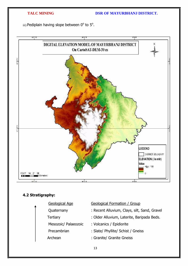
TALC MINING DSR OF MAYURBHANJ DISTRICT.
13
iii) Pediplain having slope between 0o to 5o.
4.2 Stratigraphy:
Geological Age Geological Formation / Group
Quaternany : Recent Alluvium, Clays, silt, Sand, Gravel
Tertiary : Older Alluvium, Laterite, Baripada Beds.
Mesozoic/ Palaeozoic : Volcanics / Epidiorite
Precambrian : Slate/ Phyllite/ Schist / Gneiss
Archean : Granite/ Granite Gneiss

TALC MINING DSR OF MAYURBHANJ DISTRICT.
14
4.3 Mineral Resources:
The earliest known geological survey in Mayurbhanj dates back to 1903, when P.N.
Bose brought to light the extensive iron-ore deposits of high quantity on the
Gorumahisani and Suleipat hills in Bamanghaty Sub-Division. These deposits were
considered to be almost inexhaustible and were pronounced to be of excellent quality,
perhaps second to none in the whole of Asia by the famous American and English
experts like M/s Perin, Weld and Colonel Staddart, who visited these deposits during
1905-06. This discovery was a momentous one as the steel plant of the Tata Iron &
Steel Co. at Jamshedpur was entirely based on the exploitation of these deposits. By
1915, important discoveries of Steatite near Lulung and placer gold from the sands of
Subarnarekha, Kharkhai and Barhai rivers had been made. The placer gold deposits
were being worked by M/s J.B. Bettie of Calcutta, Mr. V.G. Piggot of Ghatsila and the
Mayurbhanj Prospecting Concession Syndicate.
Gold: The mid-Archaean Gorumahisani-Badampahar schist belt composed of basic
ultrabasic, volcanic rocks and volcanogenic sediments. This belt has been
prognosticated as a rift-type of volcanic dominated one and is highly potential for
economic grade gold mineralization. Likely targets include: a) auriferous quartz veins
close to the contact of sulphide chert volcanics, b) sheared and sulphidised Fe-rich
tholeiite with anomalous copper, c) epigenetic vein type of mineralization and BIF
volcanic association, and d) sulphidic conglomerate resting over the basic volcanics.
Placer gold occurrence are known from rivers and stream of Mayurbhanj district. An
area of about 5 square kilometers of alluvium at the headwaters of Sapgora and Borai
rivers near Kudersai was indicated as promising.
Iron: Bose discovered iron ore deposits in Gorumahisani and Badampahar in the
eastwhile princely state of Mayurbhanj (now Mayurbhanj District). Gorumahisani
deposits were investigated by Perin & Weld (1905). Gorumahisani- Badampahar-
Suleipat deposits are associated with banded hematite / magnetite grunerite and BHJ.

TALC MINING DSR OF MAYURBHANJ DISTRICT.
15
Gorumahisani – Badampahar- Suleipat (Broad geological sequence)
Laterite & Alluvium
Newer Dolerite
Gabhro-Anorthosite Granite
---Unconformity---
Ultramafic dyke
Singhbhum Granite
Banded magnetite/ Martite quartzite with Fe-Ores
Quartzite
Basal Conglomerate
----Unconformity----
Older metamorphic
Vanadium Ores & Titanium: Vanadium is an important alloying element. Magnetite
associated with gabbro- anorthosite suite of rocks contain vanadium and titanium.
Deposits of vanadium-magnetite occur in association with gabbro-Anorthosite suite of
rocks in the precambrian metamorphites. Vanadium bearing magnetite belts are :-
(a) Rairangpur – Bisoi belt (Kumardubi, Betjharan Amdabeda)
(b) Bisoi – Joshipur belt (Mayurbeka, Kesham, Sialnoi)
(c) Baripada – Podadiha belt (Andipur, Bahalda)
Pyrophyllite : is mainly used as a high grade ceramic product, electric insulator and
refractory material. The comp. is Al2O34SiO2 H20. It is formed as an alteration product
of feldspar. Pyrophyllite occurrences are reported at Kankrani, Jashipur,
Gorumahisani, Bangriposhi and Manada in Mayurbhnaj dist. Ichinda, Khairakocha,
Jamukunda, Nakulkocha, Kapadiha, Dunguridiha, Maheshpur, Kashidiha, Sagragora
and Pokpoka. Dimension stone of the district are granite, granite-gneiss, migmatites,
syenite, gabbro, anorthosite, charnockite, leptynite, pyroxene granulite, dolerite,
pyroxinite and dunite etc.
Bauxite: In Similipal complex (Mayurbhanj) aluminous laterite/ Bauxite are observed
around 1000 m AMSL. The spongy aluminous laterite/bauxite occurs as sheets and
boulders occupying the flat-topped hills made up of metavolcanics. Both
ultramafics and metavolcanics are lateritised giving rise to nickeliferous laterite and
aluminous laterite respectively.

TALC MINING DSR OF MAYURBHANJ DISTRICT.
16
China Clay clay like material approximating the mineral Kaolinite (Al2O3, 2SIO2,
2H2O). China clay is found to occur in a long belt stretching from Singhbhum to
Mayurbhanj. Badampahar-Joshipur- Karanjia – Ramachandrapur belt is the most
important china-clay producing area of the state. The important deposits in
Mayurbhanj district are found near Jashipur, Chanchbani, Dumuria, Jamda, Kodadiha,
Jamkeswar and Thakurmunda. China clay has many industrial applications as filler in
paper, textile, rubber, in the manufacture of potteries, ceramics, sanitary wares,
glazed tiles, white cement, insecticides, paints, cosmetics, refractory bricks etc. Soap
stone and Steatite Asbestos is mined from Mayurbhanj area.
Talc, Steatite and Soapstone: Important localities of these deposits in Mayurbhanj
dist are Tiring, Kendumundi and Kharidamak.
Kyanite: Kyanite deposits of refractory grade occur in Panijia area of Mayurbhanj
dist, where it is associated with dumortierite bearing rocks, qtz-veins, quartz-mica-
schists and talc-tremolite-schist. Other kyanite occurrence include Purnapani &
Similipal.
Quartz & Quartzite: Quartz and silica sand are mostly used in glass foundry,
ferrosilicon alloy, ceramic industry, abrasive, paint, rubber, textile industries.
Transparent varieties of quartz such as rock crystal, amethyst, citrine, Rosequartz and
smoky quartz are used as semi-precious gemstone. Quartz is a piezoelectric material
and is used in radio circuit, Radars and ultra-sonic devices. Quartzite is a
monomineralic rock constituted predominantly of quartz. There are 6 mining leases
for quartz and quartzite in Mayurbhanj dist.
High Magnesia rock: are found in Notapahar, Thakurmunda, Amjori and
Badampahar of Mayurbhanj Dist.
Nickel: Nickel is concentrated within chemically weathered ultramafic rocks and
found in the laterite and soil capping in Similipal area. The mineral occurs in silicate

TALC MINING DSR OF MAYURBHANJ DISTRICT.
17
form i.e. garnierite. The important patches of prospective ore zones are: Gurguria and
Nawana.
4.4 Soil:
The district comprises chiefly of lateritic, sandy loam and clayey loam type of soil
(Figure 3). Laterite soil is mostly marked in the area occupied by crystalline rocks.
The low lying valley fields are covered with clayey loam type of soil.
5. DRAINAGE OF IRRIGATION PATTERN
The district has considerable flat land, which provide suitable site for agricultural use.
The hilly areas are mostly under forest with patches of cultivation on scarp areas.
Major rivers flowing in the district are Budhabalanga, Subarnarekha, Jambhira, Sona,

TALC MINING DSR OF MAYURBHANJ DISTRICT.
18
Khadkhai, Deo, Katra, Khairibandhan & Baitarani. Major crops grown in the district are
rice Only. 14.82 percent area of agricultural use are net irrigated and major source of
irrigations are well and tube-wells.
Sl. No.
Name of the River
Area drained (Sq.Km.)
% Area drained in the District
1 Budhabalanga 2143 21%
2 Subarnarekha 265 0.25%
3 Jambhira 1377 13%
4 Sona 1062 10%
5 Khadkhai 1131 10.8%
6 Khairibandhan 1014 0.09%
7 Deo 473 0.04%
8 Katra 352 0.03%
9 Gangahar 594 0.057%
10 Baitarani 260 24.6%
11 Tel 96 0.009%
12 Kantamauli 82 0.007%
13 Sim 165 0.015%
14 Jhagada 30 0.002%
15 Balijori 56 0.005%
16 Kantakhaira 186 0.017%
17 Kanhu 383 0.036%
18 Balisudura 170 0.016%

TALC MINING DSR OF MAYURBHANJ DISTRICT.
19
5.1 River System
The Budhabalanga River (also called Balanga River) flows through the districts
of Mayurbhanj & Balasore and finally reached Bay of Bengal. The Budhabalanga, rises
from Similipal hills and plunges through Barehipani Falls, the second-highest waterfall
in India, located in Similipal National Park. It then flows in a northerly direction up to
the village Karanjiapal in Bangiriposi police-station. Thereafter, it turns to the north-
east and flows along the railway track up to the village Jhankapahadi. There it
changes its course to the south and meets the Katra nala. The other tributaries are
the Palpala and the Chipat both of which are hill streams rising from the Similipal hills.
Then the river passes through Baripada. It later flows through Balasore district and
into the Bay of Bengal. The Budhabalanga is about 175 kilometres (109 mi) long and
has a total catchment area of 4,840 square kilometres (1,870 sq mi). Its major
tributaries are the Sona, Gangahar, and the Katra. Burhabalang and its tributaries, viz.

TALC MINING DSR OF MAYURBHANJ DISTRICT.
20
Sona Nadi, Amrutia Nadi, Gangahar Nadi drain almost round the year in the present
area. Sona Nadi receives the watery effluent load through a nalah (Sankh nalah) from
the Balgopalpur Industrial Estate and flows from west to east. Amrutia Nadi flows
from NNW to SSE and carries the waste water load of East Coast. Subarnrekha
originate from Nagri of Jharkhand and then enter into Mayurbhanj district, very less
portion of the river flows within Mayurbhanj district, Major portion of Subarnarekha
River passes in the Balasore district. Another river Jambhira runs in Mayurbhanj
district then enters into Balasore district and Renamed as river Jalaka flows into Bay
of Bengal. Other small rivers run in this district like River Khadkhai originates from
Tunhgru R.F. and plunges through Suleipat Dam (Khadkhai Reserviour). It then runs
towards Rairangpur, Bahalda, Tiringi area of western direction of Mayurbhanj district
and finally reached at River Subarnarekha. River Deo rises from Similipal R.F. and
runs towards western part of the district and flows through Karanjia area and then
joins with Baitarani River. River Khairabandhan originates from Similipal R.F. and
flows towards western part of the Mayurbhanj district through Jashipur, Raruan,
Sukruli area of district and then joins with River Baitarani This river maintains a
sluggish flow in the pre-monsoon period, but swells menacingly with the onset of
monsoon often flooding large tracts. Another small tributary named as Kanhu starts
from River Khadkhai and branched into Jalapa, Ghagera nala meets at Jharbeda area
of Mayurbhanj District.
Sl. No.
Name of the River or Stream
Total Length in District (in Km.)
Place of Origin Altitude at Origin
1 Budhabalanga 161 Similipal Hill 940 mrl.
2 Subarnarekha 4 Nagri, Jharkhanda
610 mrl.
3 jambhira 64 Chandra R.F. Mayurbhanj
60 mrl.
4 Sona 70 Jaymal Hill, Dugdha
Mayurbhanj.
340 mrl.
5 Khadkhai 75 Tunhgru R.F. 500 mrl.
6 Khairibandhan 65 Similipal R.F. 800 mrl.
7 Deo 65 Similipal R.F. 930 mrl.
8 Katra 55 Jari R.F. 700 mrl.
9 Gangahar 55 Similipal R.F. 740 mrl.
10 Baitarani 48 Gonasika, 900 mrl.

TALC MINING DSR OF MAYURBHANJ DISTRICT.
21
Guptaganga Hills
11 Tel 20 Similipal R.F. 940 mrl.
12 Kantamauli 25 Similipal R.F. 360 mrl.
13 Sim 85 Similipal R.F. 900 mrl.
14 Jhagada 15 Jhagada R.F. 430 mrl.
15 Balijori 22 Similipal R.F. 520 mrl.
16 Kantakhaira 36 Similipal R.F. 420 mrl.
17 Kanhu 42 Similipal R.F. 400 mrl.
18 Balisudura 15 Similipal R.F. 450 mrl.
6.0 LAND UTILIZATION PATTERN IN THE DISTRICT
6.1 Forest and non forest land
The forest of Mayurbhanj district is full variety of medicinal plants, Kendu leaves,
Bamboo, Sal, Teak, other timber species and a wide range of carnivorous & herbivorous
wild animals. The district has one Wildlife Sanctuaries known as the Similipal Wildlife
Sanctuary situated at the heart of the district, which hosts all type of wildlife even

TALC MINING DSR OF MAYURBHANJ DISTRICT.
22
tigers. The area of the sanctuary is 26, 886.23 hectares. And two kilometer safety zone
of eco-sensitive zone of Suleipat Wildlife Sanctuary are coming in Mayurbhanj district. In
these sanctuary areas the principal animals that are found are Elephant, Bear, Nilgai,
Sambhar, Peacock, Wild Boar and Deer, together with variety of snakes and birds.
District-wise Forest Cover Area in Odisha (Area in Km2)
2017 Assessment
District Geograph ical Area Km2
Very Dense Forest
Moder- ate. Dense Forest
Open Forest
Total Percent of GA
Change Scrub
Angul 6375 371 1380 1004 2755 43.22 43 84
Bolangir 6575 70 224 837 1131 17.2 151 142
Balasore 3806 23 127 234 380 9.98 30 48
Bargarh 5837 176 371 484 1031 17.66 88 47
Bouda 3098 263 546 480 1289 41.61 27 57
Bhadrak 2505 0 9 66 75 2.99 2 0
Cuttack 3932 53 226 517 796 20.24 11 68
Deogarh 2940 191 667 614 1472 50.07 -3 14
Dhenkanal 4452 174 418 825 1417 31.83 9 82
Gajapati 4325 84 1490 946 2520 58.27 12 262
Ganjam 8206 164 1075 864 2103 25.63 15 655
Jagatsinghpur 1668 0 5 131 136 8.15 6 0
Jajpur 2899 6 72 225 303 10.45 3 50
Jharsugada 2114 3 140 179 322 15.23 9 36
Kalahandi 7920 362 729 1327 2418 30.53 36 362
Kandhamal 8021 661 2588 2143 5392 67.22 16 380
Kendrapada 2644 84 88 133 305 11.54 14 2
Keonjhar 8303 289 1404 1519 3212 38.68 4 55
Khorda 2813 21 186 250 457 16.25 0 92
Koraput 8807 94 740 1255 2089 23.72 120 944
Malkangiri 5791 158 709 1475 2342 40.44 20 45
Mayurbhanj 10418 1335 1718 1027 4080 39.16 42 34
Nabarangpur 5291 168 428 507 1103 20.85 8 47
Nayagarh 3890 189 965 556 1710 43.96 28 173
Nuapada 3852 86 482 705 1273 33.05 33 109
Puri 3479 0 54 160 214 6.15 8 11
Rayagada 7073 422 853 1851 3126 44.2 7 349

TALC MINING DSR OF MAYURBHANJ DISTRICT.
23
Sambalpur 6624 499 1675 1106 3280 49.52 13 40
Subarnapur 2337 2 187 161 350 14.98 26 29
Sundargarh 9712 1019 1814 1431 4264 43.9 107 89
Grand Total 155707 6967 21730 23008 51345 32.98 885 4306
(Source: India state of forest report 2017-Odisha)
The major portion of the district is covered by forest (39.16 % of TGA) and has
scattered settlement pattern. The forest is full of variety of medicinal plants. The
district has considerable flat land, which provide suitable site for agricultural use. The
hilly areas are mostly under forest with patches of cultivation on scarp areas. Major
crops grown in the district are rice and pulses. Only 14.82 percent area of agricultural
use are net irrigated and major source of irrigations are well and tube wells.
Source: Fertilizer and Agriculture Statistics, Eastern Region
Tahasil Forest Area
Misc Tree
Permanent Pasture
Cultivated waste
Non Agricultural
uses
Barren land
Current Fallow
Other Fallow
Net area
sown
Bahalda 964 471 1397 1262 2590 1900 875 944 14031
Bangiriposi 3712 281 1037 1688 3046 684 2054 922 16951
Baripada 216
673
3 128 1628 1376 8 2752 2156 4219
Badasahi 288 180
7 1194 1874 3840 24 3378 2110 17630
Betnoti 2271 911 1198 1728 3227 21 1915 578 17022
Bijatala 2841 224 681 3100 1792 1636 1214 600 11228
Bisoi 3116 471 757 2508 2193 459 2298 1643 15860
G.B.Nagar 191 116 683 582 1147 590 643 1209 10960
Jamda 408 100 1650 434 2060 785 840 1149 13608
Jashipur 8932 141 1389 2655 3637 400 3873 2634 17754
Kaptipada 8745 387 3292 5596 4123 2165 3123 4930 19932
Karanjia 1644 838 1444 2441 3065 462 3493 1362 16690
Khunta 400 226
0 314 672 2061 21 1332 2213 12879
Kuliana 1749 162
6 2222 1902 2529 608 4919 1504 11108
Kusumi 1434 32 2320 2679 2337 587 1086 1682 18032
Morada 993 412
7 513 4340 1941 61 1909 3633 10179
Rairangpur 2260 107 1759 1373 2027 504 1276 631 9713
Raruan 1210 171 890 1120 1899 503 1609 1020 12818
Rasgovindpur 288 214
5 665 1091 2774 142 2002 1537 10054
Shamakhunta 1354 764 1378 2472 1859 334 1861 941 6695
Saraskana 3464 275 689 2658 4042 115 1864 1837 15384
Sukruli 412 211 734 1295 1271 502 1286 1294 10352
Suliapada 2937 553
5 97 2262 2148 86 1589 2906 8971
Thakurmunda 10885 96 1530 1438 2034 795 5317 2670 17681

TALC MINING DSR OF MAYURBHANJ DISTRICT.
24
6.2 Agriculture Land:
Mayurbhanj is surrounded by no of forest areas as well as Rocky Mountains. People
used to cultivate Paddy in most parts of the hill slopes and in plain lands. Most of the
cultivators grow short duration local paddy in the un-bonded upland during Kharif
season. The crop suffers moisture stress at different stages due to inadequate rainfall.
The primary objective of Agriculture Department is increase of production as well as
productivity of major crops like paddy, groundnut, mustard, Mung, Biri & vegetables
which is widely covered in this District in both Kharif & Rabi season. Another key
objective is the all round development of the farming community of the District. The
Deputy Director of Agriculture is the head of office so far as agriculture is concerned &
he is the Principal Agriculture Officer of the District. Under him there are 5 District
Agriculture Officers & the block under them. As already pointed out, that agriculture is
the main livelihood of the people in Mayurbhanj District. It is therefore also
designated as the food bowl of Odisha. Rice is the principal crop grown in this district,
followed by other cereals, pulses, oilseeds, vegetables, spices and sugarcane. The
agricultural statistics for the district is shown in subsequent tables below:
Table – 3.6a: Crop Coverage Area of Mayurbhanj District, Odisha
Crop Khariff Rabi Annual TOTAL
Area (ha)
(% of Cropped
Area
Area (ha)
% of Cropped
Area
Area (ha)
Gross Cropped Area (ha)
% of Gross
Cropped Area
Rice 301.37 82.353% 3.80 4.015% --- 305.17 62.051%
Cereals 9.99 2.730% 2.17
2.293% --- 12.16 2.472%
Pulses 32.37 8.846% 36.20 38.255% --- 68.57 13.943%
Oilseeds 5.92 1.617% 28.30 29.906% --- 34.22 6.958%
Vegetables 12.39 3.386% 21.74 22.974% --- 34.13 6.940%
Fibres 2.43 0.664% --- 2.43 0.494% Spices 1.48 0.404% 2.42 2.557% --- 3.90 0.792%
Sugarcane --- --- 00 --- --- 00 ---
Tobacco --- --- 00 --- --- 00 ---
Fruits --- --- --- --- --- 31.23 6.350%
TOTAL 365.95 100.00% 94.63 100.00% --- 491.81 100.00%

TALC MINING DSR OF MAYURBHANJ DISTRICT.
25
6.3 Horticulture Land:
The primary objective of Horticulture Department is increase of production as well as
productivity of major fruits like Mango, Guava, Citrus etc., which is widely covered in
this District. Another key objective is the all round development of the farming
community of the District. The Deputy Director of Horticulture is the head of office.
7.0 SURFACE WATER AND GROUND WATER SCENARIO OF THE DISTRICT
7.1 Hydrogeology
Distribution of Saline / fresh water aquifers:
The occurrence of fresh water aquifers in coastal tract of Mayurbhanj restricted by
two important factors‐ (i) Occurrence of hard rocks in the western side and (ii) Salinity
hazard problems in the eastern part. The water bearing formation of the area can be
divided into (a) areas underlain by fractured, fissured and consolidated basement rock
formations (b) areas underlain by recent unconsolidated alluvial formations.
(a) Consolidated Formation - These are most predominant rock types occurring in
the undulating plains of the district. Groundwater occurs under unconfined condition
in the shallow weathered zone and circulates through fractures and joints. The
thickness of the weathered zone varies from 3 to 35 m. Depth of open wells in these
formations varies from 5 to 14 m below ground level.
(b) Unconsolidated alluvial formations - The unconsolidated formations consists of
laterite and alluvium. Laterites at places are highly consolidated and used as building
stones. The laterites have high degree of effective porosity and form potential
aquifers commonly tapped in dug wells. The alluvium comprises an admixture of clay,
silt, sand and calcareous concretions in varying proportions. The coarse sediments like
sand and gravel form the main repository of ground water. Ground water occurs
under both unconfined condition in shallow aquifers and in confined condition in
deeper parts.

TALC MINING DSR OF MAYURBHANJ DISTRICT.
26
7.2 Depth of water level:
The depth to water level map for pre and post monsoon periods 2011 are prepared
based on the ground water monitoring data of 77 Nos of National Hydrograph
Stations of C.G.W.B. monitored during the month of April and November 2006 are
presented below respectively. The pre and post monsoon depth to water levels in the
district range from 3.54 to 14.50 m below ground level and 1.39 to 8.20 m below
ground level respectively. It is observed that during pre monsoon about 75% of the
total areas show the water level varying between 5 to 10 m below ground level.
During post monsoon nearly 60% of the area has water levels within 2 to 5 m,
while the rest part has between 0 to 2 and 4 to 6 m below ground levels. In localized
part of Morada, Kaptipada and Thakurmunda the water level is > 5 mt.
Depth & categorization of ground water levels during pre monsoon period (April 2011)
of Mayurbhanj districts is presented below:
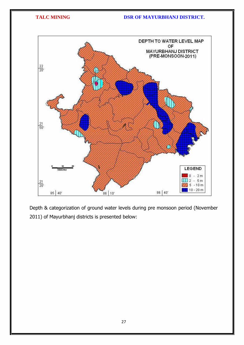
TALC MINING DSR OF MAYURBHANJ DISTRICT.
27
Depth & categorization of ground water levels during pre monsoon period (November
2011) of Mayurbhanj districts is presented below:

TALC MINING DSR OF MAYURBHANJ DISTRICT.
28
7.3 Ground Water Quality
The chemical quality of ground water in the district has been assessed on the basis of
chemical analysis of ground water samples collected during groundwater monitoring,
Hydrogeological surveys and groundwater exploration. The results of the chemical
analysis are presented in Table.
Table showing chemical constituents in aquifers
Constituent Shallow aquifer Deeper aquifer
pH 6.97 – 8.25 6.84 – 8.25
Sp. Conductance (micromohs/cm at 250 C)
53 – 974 92 – 867
TDS (mg/l) 58 – 1430 106 – 429

TALC MINING DSR OF MAYURBHANJ DISTRICT.
29
Calcium (mg/l) 6 – 92 16 – 86
Magnesium (mg/l) 0.6 – 17 3.6 – 22
Sodium (mg/l) 1.6 – 100 3.5 – 168
Potassium (mg/l) 0.4 – 8 <1 --6.4
Bicarbonate (mg/l) 15 – 256 49 – 366
Chloride (mg/l) 7 – 238 5.3 – 85
Sulphate (mg/l) 0.1 – 9 <1 – 82
Nitrate (mg/l) <0.01 – 53 0.1 – 78
Fluoride (mg/l) 0.08 – 20.3 0.21 – 0.61
Total hardness as calcium carbonate
10 – 245 35 - 285
7.4 Ground Water Development
In the rural areas the entire water supply is dependent on ground water. Ground
water development is mainly carried out in the district through dug wells and Hand
pumps. In general dug wells are of 2 m diameter and the depth ranges between 8 to
15 m depending on the thickness of the weathered zone, tapping the shallow aquifer
in the weathered zone and uppermost slice of the basement. Large number of dug
wells used for drinking water is under private ownership for which there is no reliable
data. Over the years Mark II/ Mark III hand pumps are being drilled in large numbers
for ground water development. These hand pumps have the following two major
advantages i) less susceptible to contamination from surface sources and ii) tap
fractures between 20-60m depth which have been found to be less affected by
seasonal water level fluctuation and thus have lesser chances of failure even during
extreme summer. Over all the present level of ground water development is only
27.21 percent in the district with the maximum in Badasahi Block viz. 64.65% and
minimum in Bijatala Block. Block wise development figure indicate that all the blocks
come under the white categories. Thus there is ample scope for development of
groundwater in the district to augment irrigation potentials through suitable ground
water abstraction structure
7.5 Ground Water Related Issue and Problems
Some of key ground water related issues are
I. Locating suitable sites for bore wells
II. Suitable design of dug wells and hand pumps
III. Taking up artificial recharge projects to augment the resource availability in

TALC MINING DSR OF MAYURBHANJ DISTRICT.
30
Mayurbhanj district.
IV. Optimal development of irrigation potential by developing ground water available
for future uses.
V. Creating public awareness for conserving ground water through awareness
camps, NGO’s and mass media.
7.6 Mass Awareness Campaign (MAP) & Water Management Training
Programme (WMTP) by CGWB
NIL
7.7 Area Notified by Cgwb/Sgwa
None
7.8 RECOMMENDATIONS:
1) Intensive groundwater exploration should be taken up to delineate deeper
potential water saturated fracture zones and to compute aquifer parameter.
2) Large scale planning for ground water development should be preceded by
intensive hydrogeological and geophysical surveys aided by remote sensing
studies.
3) Effective measures may be taken to conserve the surface run off by contour
bonding at suitable sites. Also proper maintenance of reservoir, tanks and spring
channels by periodical disiltation should be carried out.
4) Existing dug-wells should be deepened to tap the maximum saturated thickness of
the weathered mantle or vertical bores may be drilled through the bottom to
enhance the well yield.
5) Energy station of wells already constructed should be stepped up to ensure
optimal utilization of the irrigation potential already created.
6) The farmers should be educated through agricultural extension services fro
adopting suitable cropping pattern for optimal utilization of available groundwater
resources.
7) Programmes for artificial recharge may also be taken up for augmentation of
groundwater through construction of percolation tanks, subsurface dykes, and
check dams and through contour bonding etc.
8) An intensive network of groundwater monitoring stations are required to be

TALC MINING DSR OF MAYURBHANJ DISTRICT.
31
established in the command areas of irrigation projects to monitor the changes in
groundwater regime consequent on application of surface water irrigation.
8.0 RAINFALL OF THE DISTRICT AND CLIMATE CONDITION
8.1 Month wise rainfall:
The driest month is November, with 3 mm of rain. There is on average 0 mm of
precipitation in December. In July, the precipitation reaches its peak, with an average
of 324 mm. May is the warmest month of the year. The temperature in May averages
32.3 °C. January has the lowest average temperature of the year. It is 16.5 °C.
Year 2016 2017 2018 Average
Sl. No. Month (mm) (mm) (mm) (mm)
1 Jan 9.23 2.71 0.00 3.98
2 Feb 52.61 0.00 0.04 17.55
3 Mar 12.29 44.87 0.72 19.29
4 Apr 22.38 23.36 172.10 72.61
5 May 118.73 139.31 125.30 127.78
6 Jun 195.46 169.39 208.83 191.22
7 Jul 245.28 385.31 300.05 310.21
8 Aug 351.25 291.03 371.30 337.86
9 Sep 285.27 170.11 285.17 246.85
10 Oct 85.39 189.09 154.08 142.85
11 Nov 12.10 34.79 0.00 15.63
12 Dec 0.00 1.80 36.69 12.83
Total 1389.99 1451.77 1654.28 1498.68
Source: Indian Meteorological Department
The Indian Meteorological Department, Bhubaneswar, vide letter No. BBS/RMC/CS-
312, dated 18th January, 2016 has provided the period of Rainy Season viz. Normal
dates of Onset and Withdrawal of South West Monsoon over India as state-wise. The
duration for the period is 10th June to 15th October.
8.2 Climate
The climate in Mayurbhanj is warm and temperate. In winter, there is much less
rainfall in Mayurbhanj than in summer. The general climate of the district is
characterized by oppressive heat in summer, severe cold in winter with high humidity
throughout the year. The rainfall distribution is equal during the monsoon period. The
period from June to October is the rainy season and the district experiences it from
the southwest monsoon. May is the hottest month when the mean daily maximum

TALC MINING DSR OF MAYURBHANJ DISTRICT.
32
temperature raises up to 47º Celsius. The Köppen-Geiger climate classification is Cwa
& as per they the average temperature in Mayurbhanj is 24.7 °C. The temperature in
May averages 32.3 °C. January has the lowest average temperature of the year, it is
16.5 °C. There is a difference of 321 mm of precipitation between the driest and
wettest months. During the year, the average temperatures vary by 15.8 °C., when
the mean daily minimum temperature dips to 4º Celsius. The higher reaches of the
Similipal experiences frosting during the peak of winter.
9.0 DETAILS OF MINING LEASE OF TALC IN THE DISTRICT
9.1 List of Mines is operation in the district:
Attached as Annexure- L
9.2 List of Mines is not operation in the district:
Attached as Annexure- L

TALC MINING DSR OF MAYURBHANJ DISTRICT.
33
10. DETAIL OF ROYALTY OR REVENUE RECEIVED IN LAST THREE YEARS:
Sl. No. Name of the
Mining Circle
2016-17 2017-18 2018-19 Total Amount
(Rs.)
1 Baripada Nil Nil Nil Nil
Grand Total Nil Nil Nil Nil
11. DETAIL OF PRODUCTION OF MINOR MINERALS IN LAST THREE YEARS:
Sl.
No.
Name of the
Mining Circle
2016-17 2017-18 2018-19 Total in
tonne.
1 Baripada Nil Nil Nil Nil
Grand Total Nil Nil Nil Nil
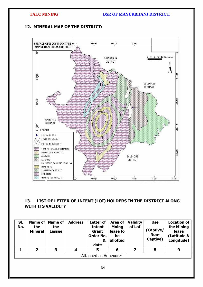
TALC MINING DSR OF MAYURBHANJ DISTRICT.
34
12. MINERAL MAP OF THE DISTRICT:
13. LIST OF LETTER OF INTENT (LOI) HOLDERS IN THE DISTRICT ALONG
WITH ITS VALIDITY
Sl. No.
Name of the
Mineral
Name of the
Lessee
Address Letter of Intent Grant
Order No. &
date
Area of Mning
lease to be
allotted
Validity of LoI
Use
(Captive/ Non-
Captive)
Location of the Mining
lease (Latitude & Longitude)
1 2 3 4 5 6 7 8 9
Attached as Annexure-L

TALC MINING DSR OF MAYURBHANJ DISTRICT.
35
14. TOTAL MINERAL RESERVE AVAILABLE IN THE DISTRICT
Total mineral reserve of granite rock as Talc mining will access after detail study or
grant of potential area, which may investigation as per details below.
(i) Blocks were identified based on geological studies through field observation.
(ii) Mineable resource was calculated by considering detail prospecting.
(iii) Area calculated as per GPS co-ordinates and information obtained from local
people. Land detail need to be verified from revenue record.
(iv) Since this is an interim report, as per the present requirement of minerals, more
such blocks need to be identified and the data should be updated periodically, after
certain intervals to update the data bank of DSR.
Sl. No.
Name of the Mining Circle
Mineral Resources in tonne.
Mineable Reserve in tonne.
1 Baripada Nil Nil
Total Nil Nil
Summary of Identified Mineral Potential:
Sl.
No.
Name
of the
mineral
Name
of the
lessee
Address and
contact No. of
the lessee
Letter of
Intent
Grant
Order
No. and
date
Area of
mining
lease to
be
allotted
Validity of LoI
Use
(Captive/ Non- Captive
Location of the Mining lease (Latitude & Longitude)
1 2 3 4 5 6 7
Attached as Annexure-L
15. QUALITY/GRADE OF MINERAL AVAILABLE IN THE DISTRICT:
Rocks and Minerals found in Mayurbhanj District:-
The district is endowed with various types of mineral resources like Iron ore, China
Clay, Quartz, Soap stone, Granite, Manganese, etc. Due to presence of huge
mineral resources, mining activities have been undertaken in a big scale. Bahalda,
Jashipur, Karanjia, Koshorpur, Bisoi, Gorumahisani and Rairangpur are the places in
the district having deposits of the above mineral products. The availability of
mineral deposits is given in the table below. The district’s mineral deposits have not

TALC MINING DSR OF MAYURBHANJ DISTRICT.
36
been utilized to maximum extent for industrial purpose. Some of the items like
China clay, Soap stone, Asbestos, etc. can be used in small scale sector. So the
available resources of the district need harnessing properly for industrial and
productive use. Road metal/Building stone of the district are very much suitable for
various construction purposes after crushing and screening. The granite gneisses
are well foliated, jointed and weathered easily.
16. USE OF MINERAL
Uses of Talc:
Talc's unique properties make it an important ingredient for making ceramics, paint,
paper, roofing materials, plastics, rubber, insecticides, and many other
products. Talc: Talc is a phyllosilicate mineral that cleaves into thin sheets. Most
people are familiar with the mineral talc. It can be crushed into a white powder that is
widely known as "talcum powder." This powder has the ability to absorb moisture,
absorb oils, absorb odor, serve as a lubricant, and produce an astringent effect with
human skin. These properties make talcum powder an important ingredient in many
baby powders, foot powders, first aid powders, and a variety of cosmetics. Most
people use products made from talc every day; however, they don't realize that talc is
in the product or the special role that it plays.
Talc in Plastics
It is mainly used as filler. The platy shape of talc particles can increase the stiffness of
products such as polypropylene, vinyl, nylon and polyester. It can also increase the
heat resistance of these products and reduce shrinkage. Where the plastic is extruded
in the manufacturing process, talc's very low hardness produces less abrasion on
equipment than harder mineral fillers.
Talc in Ceramics
It used in the manufacturing of ceramics products such as bathroom fixtures, ceramic
tile, pottery, and dinnerware. When used as filler in ceramics, talc can improve the
firing characteristics of the green ware and the strength of the finished product.
Talc in Paint
Most paints are suspensions of mineral particles in a liquid. The liquid portion of the
paint facilitates application, but after the liquid evaporates, the mineral particles
remain on the wall. Talc is used as an extender and filler in paints. The platy shape of

TALC MINING DSR OF MAYURBHANJ DISTRICT.
37
talc particles improves the suspension of solids in the can and helps the liquid paint
adhere to a wall without sagging.
Powdered talc is a very bright white color. This makes talc excellent filler in paint
because it simultaneously serves to whiten and brighten the paint. Talc's low hardness
is valued because it causes less abrasion damage on spray nozzles and other
equipment when paint is applied.
Talc in Paper
Most papers are made from a pulp of organic fibers. This pulp is made from wood,
rags, and other organic materials. Finely ground mineral matter is added to the pulp
to serve as filler. When the pulp is rolled into thin sheets, the mineral matter fills
spaces between the pulp fibers, resulting in a paper with a much smoother writing
surface. Talc as a mineral filler can improve the opacity, brightness, and whiteness of
the paper. Talc also can also improve the paper's ability to absorb ink.
Talc in Cosmetics and Antiperspirants
Finely ground talc is used as the powder base of many cosmetic products. The tiny
platelets of a talc powder readily adhere to the skin but can be washed off easily.
Talc's softness allows it to be applied and removed without causing skin abrasion.
Talc also has the ability to absorb oils and perspiration produced by human skin. The
ability of talc to absorb moisture, absorb odor, adhere to the skin, serve as a
lubricant, and produce an astringent effect in contact with human skin make it an
important ingredient in many antiperspirants. Talc and asbestos occur naturally and
may occur in close proximity in some metamorphic rocks.
Talc in Roofing Materials
Talc is added to the asphaltic materials used to make roofing materials to improve
their weather resistance. It is also dusted onto the surface of roll roofing and shingles
to prevent sticking.

TALC MINING DSR OF MAYURBHANJ DISTRICT.
38
17. DEMAND AND SUPPLY OF THE MINERAL IN THE LAST THREE YEARS:
As such there are huge infrastructural and industrial activities are coming up by State
govt., Govt. of India & PSUs under “Make in India” programme. The main raw
minerals for the above activities and considering the last three years actual
productions with respect to the requirement of the state has a huge gap. It is
proposed to start the production from larger block/area to at least double the
production of the district which will enhance the revenue of the district and also
support the livelihood of the local people
18. MAP OF EXISTING MINING LEASES IN THE DISTRICT:
Enclosed as Plate-I
19. DETAILS OF THE AREA OF WHERE THERE IS A CLUSTER OF MINING
LEASE VIZ. NUMBER OF MINING LEASES, LOCATION (LATITUDE AND
LONGITUDE)
Currently there is no cluster of Talc mining lease in the district. However, it is
proposed to consider the cluster of mining lease while planning for new lease area in
coming years.
20. DETAILS OF ECO-SENSITIVE AREA, IF ANY, IN THE DISTRICT:
Eco sensitive zone of Similipal wild life sanctuary is located within the district.
21. IMPACTS OF MINING ON ENVIRONMENT:
The most important environmental impact of mining projects is:-
Transportation sources:
Transportation sources of air pollutants include heavy vehicles used in excavation
operations, cars that transport personnel at the mining site, and trucks that transport
mining materials. The level of polluting emissions from these sources depends on the
fuel and conditions of the equipment. Even though individual emissions can be
relatively small, collectively these emissions can be of real concern. In addition,
mobile sources are a major source of particulate matter, carbon monoxide, and volatile
organic compounds that contribute significantly to the formation of ground-level ozone

TALC MINING DSR OF MAYURBHANJ DISTRICT.
39
Fugitive emissions:
Common sources of fugitive emissions include: storage and handling of materials;
mine processing; fugitive dust, blasting, construction activities, and roadways
associated with mining activities; leach pads, and tailing piles and ponds; and waste
rock piles. Sources and characteristics of fugitive emissions dust in mining operations
vary in each case, as do their impacts. Impacts are difficult to predict and calculate
but should be considered since they could be a significant source of hazardous air
pollutants.
Noise and vibration:
Noise pollution associated with mining may include noise from vehicle engines,
loading and unloading of rock into steel dumpers, chutes, power generation, and
other sources. Cumulative impacts of shoveling, ripping, drilling, blasting, transport,
crushing, grinding, and stock-piling can significantly affect wildlife and nearby
residents.
Vibrations are associated with many types of equipment used in mining operations,
but blasting is considered the major source. Vibration has affected the stability of
infrastructures, buildings, and homes of people living near large-scale open-pit mining
operations. According to a study commissioned by the European Union in 2000:
“Shocks and vibrations as a result of blasting in connection with mining can lead to
noise, dust and collapse of structures in surrounding inhabited areas. The animal life,
on which the local population may depend, might also be disturbed.”
22. REMEDIAL MEASURES TO MITIGATE THE IMPACT OF MINING ON THE
ENVIRONMENT:
1. Following are the remedial measures to mitigate the in Water sprinkling on haul
road, loading and unloading points.
2. Plantation along the safety zone and dump area.
3. Providing dust masks to workers.
4. Regular monitoring of ambient air quality.
5. Provision of air conditioned cabin of Excavators and Dumpers.
6. Regular and proper maintenance of working equipments.
7. Periodic medical examination of the workers and organize medical camp in the area.

TALC MINING DSR OF MAYURBHANJ DISTRICT.
40
8. Use Milli Second Delay Detonator in blasting operation.
9. Provisions of ear plug to the workers.
10. Regular training programme to the mines workers and operators.
23. RECLAMATION OF MINED OUT AREA
Necessity of Reclamation & Rehabilitation:
Exponential growth in mineral production since 1980.
Mining activities causes physical, chemical, biological and socio-economic changes in
the area.
Surface mining activities disturb the original land profile.
In India, mineral production comes mostly from opencast mines & hence land
degradation problems are of serious concern.
An intricate, in-depth and site-specified techniques involving integrated approach is
necessary.
Reclamation has three vital roles:
i. Reclamation – Reclamation means return the mined-out land with useful life. It
implies restoring the land to a form and productivity that is useful and inconformity
with a prior land use. Reclamation always may not be a single- phase operation.
ii. Rehabilitation – Rehabilitation is to bring batch the degraded land to a normal
stage by a special treatment. It is a process of taking some mitigation measures for
disturbed environmental condition created through mining activities.
iii. Restoration – Restoration is the process of returning the mined out land being
fit to an acceptable environmental condition. However, the general acceptable
meaning of the term is bringing the disturbed land to its original form. Restoration is
often used to indicate that biological properties of soil are put back to what they were.
This is a rate phenomenon.
iv. When active mining ceases, mine facilities and the site are reclaimed and closed.
The goal of mine site reclamation and closure should always be to return the site to a
condition that most resembles the pre-mining condition. Mines that are notorious for
their immense impact on the environment often made impacts only during the closure
phase, when active mining operations ceased. These impacts can persist for decades
and even centuries.

TALC MINING DSR OF MAYURBHANJ DISTRICT.
41
Mine reclamation and closure plans must describe in sufficient detail how the mining
company will restore the site to a condition that most resembles pre-mining
environmental quality; how it will prevent – in perpetuity – the release of toxic
contaminants from various mine facilities (such as abandoned open pits and tailings
impoundments); and how funds will be set aside to insure that the costs of
reclamation and closure will be paid for.
Proposed future land use after reclamation:
a. Forestry, b. Recreation, c. Water Reservoir, d. Crop Land,
e. residential/Commercial, f. Fish & wildlife Habitat, g. Undeveloped Land,
h. Grazing/Pasture Land
Statutory requirement:
As per the Mineral Conservation Development Rule, 2017, the following rules must be
bare in mind by the mine owner/agent/manager, which is a part of reclamation
activities –
Rule 22, Mine Closure Plan
Rule 23, Submission of Progressive Mine Closure Plan Rule 24, Submission of Final
Mine Closure Plan
Rule 26, Responsibility of holder of mining lease Rule 27, Financial Assurance
Rule 35, Sustainable Mining
24. RISK ASSESSMENT AND DISASTER MANAGEMENT PLAN:
Mining activity because of the very nature of the operation, complexity of the
systems, procedures and methods always involves some amount of hazards. Hazard
identification and risk analysis is carried for identification of undesirable events that
can leads to a hazard, the analysis of hazard mechanism by which this undesirable
event could occur and usually the estimation of extent, magnitude and likelihood of
harmful effects. The activities which can cause high risk related to face stability and
the person blasting the shots. It was observed that on a working face of the mine,
there were large cracks and unsupported rocks were present, which can lead to a
serious hazard and injure workers engaged in loading operation and machineries
because of rock falls or slides. This type of condition turn out because improper
dressing of the bench and improper supervision. To avoid the hazards due to fall of
rocks the face must be examined, made suitable for working and the remedial

TALC MINING DSR OF MAYURBHANJ DISTRICT.
42
measures must be taken to make it safe if there is any doubt that a collapse could
take place. Working of the face should be in the direction taking into account the
geology of the area such that face and quarry side remain stable. Another major risk
identified in mines is due to the firing of explosive by an unqualified person. In the
mines there is problem of fly rocks and the village is located close to the mine and so
it is rated high as it can affect may people. Explosives by nature have the potential for
the most serious and catastrophic accident. Planning of round of shots, holes correctly
drilled, direction logged, weight of explosive suitable for good fragmentation are the
few of the steps necessary to ensure its safe use and if the shots are not properly
designed can result in misfires, early ignition and flying rocks. No person is allowed to
use explosives without being properly trained in its handling. In the mine a large
numbers of heavy vehicles were in operation and the roads were not proper for
haulage purpose. The haulage roads were not even and were not wide enough for the
crossing purpose and hence the chances of hazards are very high. The main hazards
arising from the use large earth moving vehicles are incompetent drivers, brake
failure, lack of all-around visibility from the driver position, vehicle movements
particularly reversing, roll over, and maintenance. Those most at risk are the driver
and pedestrians likely to be struck by the vehicle, and drivers of smaller vehicles,
which cannot be seen from the cabs of large vehicles. Edge protection is always
necessary to prevent inadvertent movement over the edge of roadway or a bench.
Seatbelt will protect driver in case of roll. Good maintenance and regular testing are
necessary to reduce the possibility of brake failure. Access to the vehicles should
always be restricted to those people necessary for the work in hand. The use of
personal protective equipment and proper arrangements is essential to check if the
person is wearing protective equipment or not. The personal protective equipment
includes helmet, non-skid safety boots, safety glasses, earmuffs etc. The required
personal protective equipment should be provided and used in a manner that protects
the individual from injury. Few minor injuries which can be prevented are slip, trip, or
fall hazards; hazards due to rock falls and collapse of unstable rocks, atmosphere
containing toxic or combustible gases; protects from chemical or hazardous material
etc. A disaster management plan should be prepared for taking care of for any
disaster. Other risks which are included in this category are noise, as it occurs and it

TALC MINING DSR OF MAYURBHANJ DISTRICT.
43
can lead to permanent disability. There are problems related to road traffic in and out
issuers; inappropriate exposure of moving machines; mechanical failure and because
of large number of moving trucks and dumpers there is large quantity of dust present
in roadways which affects the operators and can lead to accidents causing injury.
They are in acceptable range because of precautions measures taken but no step is
taken it can cause hazard hence steps should be taken to reduce the hazards such as
for dust suppression system should be installed. Other problems like occurrence of
lots of mosquitoes in the area due to unhygienic conditions which affect the human
health causing malaria, dengue etc. and causing a person to be hospitalized.
Disaster in the mines like fires, explosions, entrapments, and inundations can occur
any time, so emergency preparedness is a must. The Disaster management plan and
risk assessment in the mines will include all sorts of above mentioned emergency and
the extent that this plan will be implemented will depend on the nature and scope of
the emergency. The basic purpose of Disaster management plan and risk assessment
to ensure that mine rescue and recovery activities are conducted safely for rescuer
and survivors. According to MMR act 1961 a standard operating procedure should be
drawn for involvement different category of staff and officers. The SOP should be
updated periodically to reduce the chaos and response to the emergency should be
quick and smooth. The responsible person should be familiar with his responsibility
during the mock drills. One or two standby should be there to replace the person in
Emergency situation. Rescue operations should not include the survivors for any
assistance.
First Information of Disaster / Emergency should go to the attendance clerk on duty.
Duties of attendance Clerk (Emergency Siren) the attendance clerk or other
designated person should on getting information of major accident, sound a hooter or
a siren immediately declaring a state of emergency at the mine and then to contact
the manager and on his advice to call key personnel using the information listed in the
Emergency Organization Chart. It is important that all telephone calls are recorded in
a telephone log book. Duties of Other Officials should be displayed and handed over
to all concerned. Copy the same should be kept at Manager’s Office for ready

TALC MINING DSR OF MAYURBHANJ DISTRICT.
44
reference. Establishment of Control Room at Unit Level, Area Level and Company
Level is essential. Control Room should keep the contact information about –
Company Manager
Company owner/ Administrative officer.
District Administration
Govt. Hospitals in Nearby Localities,
Private Nursing Homes of Localities
Attendance roaster and duty charge register should be properly maintained so the
record of missing people can be obtained.
25. DETAILS OF THE OCCUPATIONAL HEALTH ISSUE IN THE DISTRICT:
The persons employed in the mines are exposed to a number of hazards at work
which adversely affect their health. Some of the important ones are dust, noise, heat,
humidity, vibration etc. In recent times, there has been increasing awareness among
mining industry and the workers about occupational diseases like Pneumoconiosis,
Silicosis, Tuberculosis, Hearing Impairment etc. caused by exposure to health hazards
at work. Almost all occupational diseases can be prevented by adopting proper
occupational health measures and engineering control on airborne dust pollution at
workplace. Occupational Diseases in mines or industry is required to conduct medical
examinations and health surveillance of workers as per the provisions of Mines Act.
The present efforts of mines management are concentrated on detection of silicosis,
Pneumoconiosis and other notified diseases. The essential features of health
surveillance programme required to be carried out in mines are:
(a) Initial Medical Examination of persons to be conducted at the time of
appointment.
(b) Periodic Medical Examination or General physical examination to be conducted
once in every year.
(c) Maintenance of medical records and health services till the person is in service.
(d) The Details of Tuberculosis cases in last 5 years is given below

TALC MINING DSR OF MAYURBHANJ DISTRICT.
45
RNTCP Activities from 2014 to 2018
Year Projected Population
No of Sputum Examined
Sputum Examine
d per Lakh/Qr
No of
Sputum Positive
Sputum Positive
%
Total Case put on
DOTS/No of
TB cases
Child DOTS out of Total DOTS
Case detectin
per Lakh/Yr
Sputum
Conversion Rate
NSP Cure Rate
NSP Death Rate
(in Lakh) Norm- 150
Norm-8-15 %
Norm-170 /L/Y
Norm-90 %
Norm-90%
Norm < 5%
2014 26.01 16848 161.9 2825 16.8% 4883 103 187.7 90.2% 89.0% 7.4%
2015 26.30 18118 172.2 2836 15.7% 4831 123 183.7 90.5% 89.0% 6.7%
2016 26.59 20060 188.6 2975 14.8% 5171 119 194.5 95.0% 90.9% 6.5%
2017 26.88 31035 289.4 3152 11.4% 5127 111 190.7 94.0% 91.6% 5.5%
2018 27.18 21273 195.6 2853 13.4% 4894 95 173.4 95.3% 92.7% 6.4%
26. PLANTATION GREEN BELT DEVELOPMENT IN RESPECT OF LEASE
ALREADY GRANTED IN THE DISTRICT:
During mining operation green belt development through plantation is most important
for environment safe guard, which should be supervision by mining department.
Different type of species should be planted near lease periphery to keep environment
clean at post mining period through reclamation. Where specific usefulness of land
could be decided, a forestation is normally planned through the site could have been
considered for better possibilities of land use.
27. CONCLUSION:
Since it is an interim report, to meet the requirement of minerals in the present
scenario, it is proposed to identify such potential areas at certain interval and get the
data bank of DSR to be updated. The insitu mining activity in any area is on one hand
bring revenue and employment (Direct and indirect) and on other hand if not done
properly potential pollution and ecological imbalance increases, the ability of the
ecosystem can also be reduced. Particulate matter transported by the wind as a result
of excavations, blasting, transportation of materials, heavy equipments used raise
these particulate levels; and Gas emissions from the combustion of fuels in stationary
and mobile sources, explosions, and mineral processing. All these activities indirectly
affected the biodiversity of area. Larger potential and smaller areas have been
identified in Mayurbhanj district on the basis of geological study carried out during
field observation, which can be considered for mining concession after all the
parameters for statutory clearances are verified by consulting with concerned
authorities.
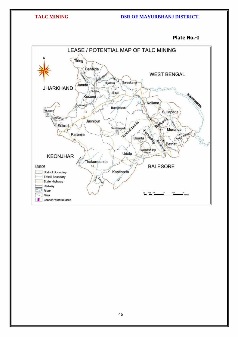
TALC MINING DSR OF MAYURBHANJ DISTRICT.
46
Plate No.-I

\
{>
!
TALC MINING DSR OF MAYURBHANJ DISTRICT"
The District Survey Repoft for Talc Stone Mining (Minor Minera!) ini , :
respect of Mayurbhanj District prepared in accordance with Appendix-X, Para -7 (iii)
(a) of S.O. 3611 (E) Dt. 25.07.2018 of Ministry of Environment, Forest and Climate
Change, New Delhi is approved for final publication in the district website.
\$\ \o
g rl\Dr. H.K"Sahu,
Prof in Zoology, NOU -cum-Member, DEIAA, Mayurbhanj
Sri S.M ck, I.F.S, Sri Di r"A"sDFO-cum-Member,DEIAA, Mayurbhanj
SDM, Sadar-cum -Member SecretaryDEIAA, Mayurbhanj
4
l1Sri Vineet Bh
Collector & DM-cum-l,airman, DEIAA
Mayurbhanj (Odisha)
47

Fro
m
To
Fro
m
To
1 2 3 4 5 6 7 8 9 10 11 12 13 14 15 16 17 18 19
1
Talc
J.G
.Kh
and
elw
al
Ku
nd
alb
ani
62
.48
3
Vill
- K
un
dal
ban
i un
der
Ban
giri
po
si T
ahas
il
22
.08
.19
83
21
.08
.20
03
Surr
end
ered
vid
e L.
No
. 63
50
/SM
, Dt.
13
.07
.20
15
&
Po
sses
ion
has
bee
n t
aken
ove
r o
n d
t.1
9.0
2.2
01
6
No
n-C
apti
ve
Ban
giri
po
si
Op
en C
ast
Non-Working Leases
Annexure-L
SPECIFIED MINOR MINERALS (TALC)Sl
No
Nam
e o
f M
iner
als
Nam
e o
f Le
ssee
s
Ad
dre
ss a
nd
Co
nta
ct N
o. o
f le
ssee
Min
ing
Leas
e G
ran
t O
rder
No
. & D
ate
Are
a o
f M
inin
g Le
ase
(Ha.
) w
ith
vill
age
Kh
ata
No
., P
lot
No
. & K
isam
Per
iod
of
Min
ing
Leas
e
(In
itia
l)
Per
iod
of
Min
ing
Leas
e
(1st
/2n
d R
enew
al)
Met
ho
d o
f M
inin
g (O
pen
cas
t/ U
nd
er
Gro
un
d)
Geo
logi
cal R
eser
ve (
MT/
Cu
ms)
Min
eab
le R
eser
ve (
MT/
Cu
ms)
Dat
e o
f C
om
men
cem
ent
of
min
ing
op
erat
ion
Stat
us
(Wo
rkin
g/ N
on
-wo
rkin
g/ t
emp
.
Wo
rkin
g fo
r d
isp
atch
etc
.
Cap
tive
/ N
on
-cap
tive
Ob
tain
ed e
nvi
ron
men
tal c
lear
ance
(Yes
/no
). If
Yes
, Let
ter
No
. wit
h d
ate
of
EC
Loca
tio
n o
f M
inin
g Le
ase
(Lat
itu
de
&
Lon
gitu
de)
Nam
e o
f Ta
has
il