Brigand 2011_ROMAN CENTURIATIONS IN THE BRENTA ALLUVIAL PLAIN (VENETIA)
17
ROMAN CENTURIATIONS IN THE BRENTA ALLUVIAL PLAIN (VENETIA) Robin Brigand Editions de l'E.H.E.S.S. | Etudes rurales 2011/2 - No 188 pages 19-37 ISSN 0014-2182 This document is a translation of: -------------------------------------------------------------------------------------------------------------------- Robin Brigand, « Centuriations romaines dans la plaine alluviale du Brenta (Vénétie) », Etudes rurales, 2011/2 No 188, p. 19-37. -------------------------------------------------------------------------------------------------------------------- Translated from the French by JPD Systems Available online at: -------------------------------------------------------------------------------------------------------------------- http://www.cairn-int.info/journal-etudes-rurales-2011-2-page-19.htm -------------------------------------------------------------------------------------------------------------------- How to cite this article: -------------------------------------------------------------------------------------------------------------------- Robin Brigand "Centuriations romaines dans la plaine alluviale du Brenta (Vénétie)", Etudes rurales, 2011/2 No 188, p. 19-37. -------------------------------------------------------------------------------------------------------------------- Electronic distribution by Cairn on behalf of Editions de l'E.H.E.S.S.. © Editions de l'E.H.E.S.S.. All rights reserved for all countries. Reproducing this article (including by photocopying) is only authorized in accordance with the general terms and conditions of use for the website, or with the general terms and conditions of the license held by your institution, where applicable. Any other reproduction, in full or in part, or storage in a database, in any form and by any means whatsoever is strictly prohibited without the prior written consent of the publisher, except where permitted under French law. 1 / 1 Document downloaded www.cairn-int.info - - Brigand Robin - 128.78.221.4 - 09/10/2014 15h31. © Editions de l'E.H.E.S.S. Document downloaded from www.cairn-int.info - - Brigand Robin - 128.78.221.4 - 09/10/2014 15h31. © Editions de l'E.H.E.S.S.
-
Upload
univ-paris1 -
Category
Documents
-
view
0 -
download
0
Transcript of Brigand 2011_ROMAN CENTURIATIONS IN THE BRENTA ALLUVIAL PLAIN (VENETIA)

ROMAN CENTURIATIONS IN THE BRENTA ALLUVIAL PLAIN(VENETIA) Robin Brigand
Editions de l'E.H.E.S.S. | Etudes rurales 2011/2 - No 188pages 19-37
ISSN 0014-2182
This document is a translation of:
--------------------------------------------------------------------------------------------------------------------Robin Brigand, « Centuriations romaines dans la plaine alluviale du Brenta (Vénétie) »,
Etudes rurales, 2011/2 No 188, p. 19-37.
--------------------------------------------------------------------------------------------------------------------Translated from the French by JPD Systems
Available online at:
--------------------------------------------------------------------------------------------------------------------http://www.cairn-int.info/journal-etudes-rurales-2011-2-page-19.htm
--------------------------------------------------------------------------------------------------------------------
How to cite this article:
--------------------------------------------------------------------------------------------------------------------Robin Brigand "Centuriations romaines dans la plaine alluviale du Brenta (Vénétie)",
Etudes rurales, 2011/2 No 188, p. 19-37.
--------------------------------------------------------------------------------------------------------------------
Electronic distribution by Cairn on behalf of Editions de l'E.H.E.S.S..
© Editions de l'E.H.E.S.S.. All rights reserved for all countries.
Reproducing this article (including by photocopying) is only authorized in accordance with the general terms and conditions ofuse for the website, or with the general terms and conditions of the license held by your institution, where applicable. Any otherreproduction, in full or in part, or storage in a database, in any form and by any means whatsoever is strictly prohibited withoutthe prior written consent of the publisher, except where permitted under French law.
1 / 1
Doc
umen
t dow
nloa
ded
ww
w.c
airn
-int.i
nfo
- -
Brig
and
Rob
in -
128
.78.
221.
4 -
09/1
0/20
14 1
5h31
. © E
ditio
ns d
e l'E
.H.E
.S.S
. D
ocument dow
nloaded from w
ww
.cairn-int.info - - Brigand R
obin - 128.78.221.4 - 09/10/2014 15h31. © E
ditions de l'E.H
.E.S
.S.

The studies initiated by Gérard Chouquer and his team of archeographers enable us to define the terms by which this important sub-field of agrarian history can be understood.
Our objective is not to reconstruct here the Roman division of land into plots as it was in the past, but to show that above all the centu-riation observed today is as an overall struc-ture displaying what two thousand years of land use planning made of a Roman initiative. In this respect, diachrony is an essential fac-tor since this is a matter of mobilizing all the societies that, over time and under the pressure of a restrictive hydrography, were involved in shaping this ancient heritage.
Centuriations and Landscapes
Roman centuriation continues to be an over- determined subject in the sense that the com-plexity of the visible forms has not been taken into account in favor of a geometric and anachronistic view that omitting processes of dynamic transformation gives a biased view of ancient planimetric realities. In fact, the particularly developed morphology observed today in northern Italy is highly hybridized because it combines what was inherited from antiquity, the functioning of water systems, and land use planning. Nevertheless, it is important to emphasize that research on cen-turiations has shifted from a quest to find their original form to a discussion of the extent to which long-term dynamics were involved in the evolution of these forms.
A Subject for Ancient HiStory
Except for Tunisia, where the first vestiges of centuriation were discovered in 1833, it was in
Robin BrigandROMAN CENTURIATIONS IN THE BRENTA ALLUVIAL PLAIN (VENETIA)
THe countrySide to tHe nortHeASt of Padua leaves a lasting impression on the visitor, with the rural landscape
characterized by a network of roadways and waterways spread over several hundred square kilometers, in the characteristic checker-board pattern of centuriation. The Graticolato Romano (as named on topographic maps) was discovered as early as the second half of the nineteenth century and has been the subject of detailed and focused studies that underscore the remarkable sustainability of this ancient agrarian system. Just like the Colonna Desman project in Mirano, a 300-meter high tower that dominates the graticule to the east, the crea-tion of the Museum of Roman Centuriation in Borgoricco in 2009 contributed to the preser-vation of this heritage landscape.
The explanation for this is implicit: central Venetia and more specifically the Graticolato Romano are living fossils of a system inher-ited from ancient surveying. The portion of the plain measuring more than 3,000 km2 and situated between the Alps and the Venetian lagoon reveals very specific landscapes to the aerial prospector, including roads, paths, and canals that map out several planned networks resulting from land use plans implemented two thousand years ago on the basis of a keen, in-depth understanding of resources and the environment.
Doc
umen
t dow
nloa
ded
ww
w.c
airn
-int.i
nfo
- -
Brig
and
Rob
in -
128
.78.
221.
4 -
09/1
0/20
14 1
5h31
. © E
ditio
ns d
e l'E
.H.E
.S.S
. D
ocument dow
nloaded from w
ww
.cairn-int.info - - Brigand R
obin - 128.78.221.4 - 09/10/2014 15h31. © E
ditions de l'E.H
.E.S
.S.

Robin Brigand
. . .II Venetia and Istria (the Romano Graticolato and
the centuriation of Pola) where Pietro Kandler and Ernesto Nestore Legnazzi highlighted and first mapped ancient graticules in the mid-dle of the nineteenth century (Kandler 1866, Legnazzi 1887). Initiated by questions about ancient surveying, this pioneering research was further enriched by developments in map-ping and the generalization of 1:50-scale and later 1:20-scale maps. Advances in aviation following WWI but especially after WWII systematized the use of aerial photography and enabled improved reconnaissance of the divi-sions of land into plots and of centurial mor-phology. Since then, and especially as a result of the work of Plinio Fraccaro in Venetia, Ferdinando Castagnoli in Emilia-Romagna, Raymond Chevallier in Tunisia and Istria, and John Bradford in sectors of the Western Mediterranean, aerial photographs and top-ographic maps began to be analyzed from a geo-historical perspective closely linked to Romanization and agrarian issues in Roman antiquity. This research, including the catalog for the Misurare la Terra exhibition, which offers a solid overview (Bosio 1984), presents centuriation as a subject that had been rela-tively downgraded in importance, the study of which falls within a morpho-historical per-spective. In this regard, the Venetian case and in particular the Graticolato Romano, come across as a remarkable case in which the struc-ture of the centuriation is detectable and can be transposed to Roman antiquity.
Although in the 1980s and according to the practices of landscape archeology, it was thought that centuriation could be seen by extracting the post-antiquity land plots, the prospects opened up by archeo-geography, preventive archeology, and sediment science
offer a different outlook on the nature of this phenomenon. However, before focusing on the Venetian case, we would like to go back over the scientific steps that in less than twenty years made it possible to substantially recast the outlines of the centuriation.
tHe rediScovery of centuriAtion
Starting in the 1990s, large preventive archeol-ogy projects and more frequent use of sediment science enabled the principal actors in research on centuriation to verify the soundness of the morphological approach by checking it against soil memory. This step, which is fully embraced by geo-archeology, marked a decisive turning point in that the results urge consideration of centuriation as an agrarian planning structure that was intended to be transformed over time. Thus, centuriation is no longer studied purely in terms of its relationship to the social struc-tures of antiquity but also with respect to the social forms and dynamics associated with other periods. Constructing centuriation thus depends as much on medieval and modern societies as it does on ancient ones.
The opening of the high-speed train line to the Mediterranean in France gave rise to an extensive operation of preventive archeology in the central and lower Rhône valley. This made it possible to excavate the lineaments of land plots associated with the Orange B cen-turiation, which is known to have existed only as a result of morphological analysis and epigraphic remains. This centuriation brought to light an early process for transmit-ting ancient planimetric information. Thus, the Malalônes cross-section in Pierrelatte (in the Drôme region) reveals the vertical trans-mission over a span of more than 2 meters of
Doc
umen
t dow
nloa
ded
ww
w.c
airn
-int.i
nfo
- -
Brig
and
Rob
in -
128
.78.
221.
4 -
09/1
0/20
14 1
5h31
. © E
ditio
ns d
e l'E
.H.E
.S.S
. D
ocument dow
nloaded from w
ww
.cairn-int.info - - Brigand R
obin - 128.78.221.4 - 09/10/2014 15h31. © E
ditions de l'E.H
.E.S
.S.

Roman Centuriations in the Brenta Alluvial Plain (Venetia)
. . .IIIa ditch dug during the Roman period in its
current location despite several sequences of aggradation that embedded the previous states (Berger and Jung 1996).
Recent work by two Italian researchers in the area of Lugo (Emilia-Romagna) rein-forces the idea that the transmission of centu-riation can occur despite heavy sedimentation (Franceschelli and Marabini 2007). The allu-vial deposits covering the Roman levels vary in depth between 0.80 and 3.50 meters, with maximum depths of 5 meters, in particular in the Lugo lowlands, which (ironically) due to the soil, is exactly where the ancient networks are best preserved.
Because they distinguish the Roman con-struction from what it became, these results are telling. Nevertheless, they do not enable us to view the processes involved in the construc-tion of the planimetric object as detected by carto- or photo-interpretation.
conStruction of centuriAtionS
Two studies must be taken into account here. The first, which is foundational and which has already been mentioned, was carried out as part of the digging of cuts for the high-speed train line to the Mediterranean, specifically at Bollène (in the Vaucluse region) in the local-ity known as Les Batras (Marchand 2003, 99). The excavation, which was carried out over an extensive area, revealed that one of the two major axes of the centuriation, in this case the kardo maximus, had a distinctive feature. In antiquity, just as today, it is nonexistent in the northern part of the excavation’s footprint. In the southern part, it was nonexistent in antiq-uity and is visible today in the form of a ditch-like boundary dating from early modern times.
As concerns antiquity, this can be explained by the existence of a paleo-riverbed. This comes back to the idea of a division into plots that was deferred and therefore lagged ancient surveying.
This materialization only achieved comple-tion a posteriori, i.e., after a slow evolution of agrarian life. This is indeed “an ancient virtu-ality that has become a modern materiality” (Marchand 2003, 99).
Gérard Chouquer points out that if Roman surveying is a reality in terms of the assign-ment of plots to settlers, it is only a potential-ity in terms of the construction of the agrarian landscape since it would require several gen-erations of farmers to give it materiality as we know it today (Chouquer 2007, 70). To argue against this dynamic approach, it would be necessary to demonstrate that actors in the Middle Ages and early modern times were not in a position to sustainably transform agrarian landforms.
The second study relates to the modeling of medieval planned forms by Cédric Lavigne (2002). This work is critical in that it enables centuriations in northern Italy to be seen with the hindsight provided by knowledge of mor-phological dynamics. Therefore, the observa-tions concerning centuriation near the town of Crevalcore, north of Bologna, are important (Lavigne 2004), because by including medi-eval planning among archeographic objects, they pave the way for a critical reevaluation of Roman planned forms.
Gérard Chouquer (2009) recently formal-ized the suspicion that the remarkable mate-rialization of the ancient grid in some sectors of the Po Plain in Italy was partially due to the medieval and modern agrarian land assign-ment and colonization initiatives.
Doc
umen
t dow
nloa
ded
ww
w.c
airn
-int.i
nfo
- -
Brig
and
Rob
in -
128
.78.
221.
4 -
09/1
0/20
14 1
5h31
. © E
ditio
ns d
e l'E
.H.E
.S.S
. D
ocument dow
nloaded from w
ww
.cairn-int.info - - Brigand R
obin - 128.78.221.4 - 09/10/2014 15h31. © E
ditions de l'E.H
.E.S
.S.

Robin Brigand
. . .IV In central Venetia, centuriations were dev-
eloped over areas with little exposure to sedi-ment accumulation. It is precisely because of this outcropping of the ancient levels that the models for the Romagna and Rhône plains, where the transmission of planimetric features occurred despite significant sedimentation, cannot be transposed to the Venetian case. We will therefore attempt to explain the mech-anisms at play in the development of these landscapes.
The Venetian Case
Travelers visiting Venetia often begin in Venice and its lagoon. They become famil-iar with the water, the lapping of the waves, and the serenity of the place. If they venture onto dry land, motivated by a desire to visit a Palladian villa or walk on the checker-board grid of centuriations, for example at Camposampiero, they suddenly find them-selves plunged into a multiform and jumbled urban universe, that of the Venetian urban sprawl where the extremely dense territorial grid is reminiscent of the features of the large industrial plains of the Mediterranean Basin, beginning with the Po Plain.
Although the Venetian Plain is known for its narrowness, with the distance between St. Mark’s Campanile and the foothills of the Dolomite Alps barely 70 kilometers, its hydro-geological environment is very sim-ilar to that of the Po Plain. The agronomist Arthur Young, and later hydraulic engineer Benjamin Nadault de Buffon, explained the economic development of these plains by the true hydraulic culture that permeated these regions. In Venetia, the principal human activ-ity is based on patient management of water,
involving bringing water to places where it is lacking and draining it from where it is in sur-plus, and therefore regulating flows.
The originality of the Venetian case lies in general in the very high degree of materi-alization of the centuriations in general and in particular that of the two centuriations of the Brenta alluvial plain. This explains why research is often focused on these two agri centuriati, which have traditionally been associated with the Roman municipality of Patavium (Padua).
Our objective here is to show that these two centuriations are in fact a hybrid reality, combining social projects and environmen-tal constraints. Consequently, centuriation is a complex object based on mixed forms that convey both the memory of Roman develop-ments and what post-antiquity societies did with them.
centuriAtionS And environmentS
The idea of a central plain opening onto the Alps where the Gulf of Venice closes in is a fitting image. An obvious spatial continuity clearly exists from the foothills of the Alps to the Upper Adriatic, in particular the allu-vial fan of the Brenta, which from Bassano to Mestre orients and determines the hydrogra-phy (Figure 1).
The high plain, which is almost exclusively composed of limestone in a sandy matrix, is clearly distinguishable from the low plain, which is predominantly silty. One is dry and drains very well, while the other is moist and susceptible to becoming waterlogged. The transition between these two spaces occurs at the middle plain region, where by capil-lary action, the groundwater emerges once the
Doc
umen
t dow
nloa
ded
ww
w.c
airn
-int.i
nfo
- -
Brig
and
Rob
in -
128
.78.
221.
4 -
09/1
0/20
14 1
5h31
. © E
ditio
ns d
e l'E
.H.E
.S.S
. D
ocument dow
nloaded from w
ww
.cairn-int.info - - Brigand R
obin - 128.78.221.4 - 09/10/2014 15h31. © E
ditions de l'E.H
.E.S
.S.

Roman Centuriations in the Brenta Alluvial Plain (Venetia)
. . .Vgravel resulting from the last glacial stage is
depleted. It is at this location that the resurgent waters come together to form the hydrographic network of the low plain, and, depending on the difference in elevation, flow into the depressions located between the late glacial fluvial ridges constituting the sandy ridges.
In the Brenta basin, from Bassano to the lagoon, the arrangement of the so-called North Padua and Northeast Padua centuriations is of special interest, since both are arranged at an angle relative to the alluvial fan (except for the sector situated between Cittadella and Bassano) and completely cover the high and low plains of the Brenta (below the Musone Vecchio). The organic nature of the two extensively cen-turiated complexes from Bassano to Mirano, i.e., from the foothills of the Alps to the lagoon, is reinforced by the fact that they are clearly interlinked south of Cittadella (Figure 2).
This interlinking is fundamental because, as the first structuring system, it establishes the link to the natural environment, and specifically to the organization of the resurgent waters. In fact, the area of contact is situated where the Tergola seeps up at the level of the Onara Marsh, i.e., in a humid sector where the soil tends to become waterlogged. However, although a close adap-tation of the centuriations to the topography of the alluvial fan and the availability of water resources is explicit on a medium scale, it is interesting to observe the plot-related behavior of the two centuriations studied.
centuriAl morpHologieS
The high plain of the Brenta can be formally split into two separate areas (Figure 2).
1. The first, a northern sector, runs from Bassano to the first modern irrigation channels
and is marked by a sharp difference in eleva-tion and a steep gradient of coarse sediment in addition to two closely linked parameters in the vicinity of the late-glacial alluvial fan of the Brenta. Here, the framework of the centuriation is well preserved, with a consist-ent representation of the boundaries, and the decumani (east-west) tend to dissolve, whereas the kardines (north-south) are particularly evi-dent. In fact, only the kardines appear to play a role in the flow of surface water, in particular on the edge of the alluvial fan.
2. The second, a middle sector around Cittadella and Castelfranco, corresponds to all of the areas covered by the modern irrigation network around the two outlets, the Rosà and Dolfina Rivers. Here, the soils here are char-acterized by a reduced particle size and a grad-ual rising of the water table, which heralds the water resurgence occurring in the middle plain, while the relatively clear break in the irrigation network between Cittadella and Castelfranco indicates a less essential availability of water compared to the northern sectors. Moreover, the centurial morphology is sharply different, i.e., very well preserved (Figure 3). The decum-ani and the limites intercisivi help provide an image of the centuriation in which the kardines are never represented, starting with the kardo maximus, despite the fact that its presence was formally established by an epigraphic monu-ment discovered near the Brenta.
As concerns the low plain, the hydraulic node of Camposampiero likewise consists of two sectors.
1. The first, to the northwest and upstream, corresponds to the middle plain, which is char-acterized by prominent paleo-fluvial ridges and inter-ridge depressions subject to defluviation, which is made more difficult by the decreased
Doc
umen
t dow
nloa
ded
ww
w.c
airn
-int.i
nfo
- -
Brig
and
Rob
in -
128
.78.
221.
4 -
09/1
0/20
14 1
5h31
. © E
ditio
ns d
e l'E
.H.E
.S.S
. D
ocument dow
nloaded from w
ww
.cairn-int.info - - Brigand R
obin - 128.78.221.4 - 09/10/2014 15h31. © E
ditions de l'E.H
.E.S
.S.
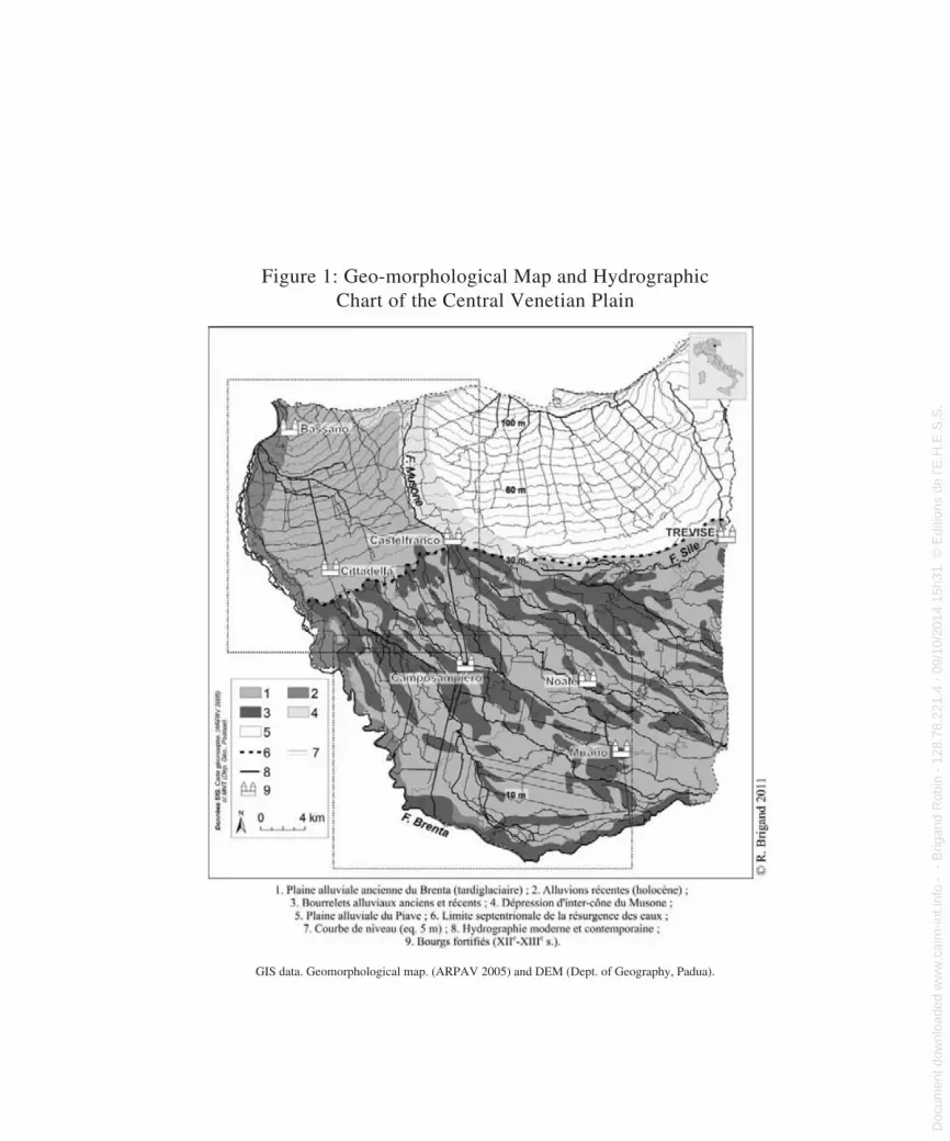
Figure 1: Geo-morphological Map and Hydrographic Chart of the Central Venetian Plain
GIS data. Geomorphological map. (ARPAV 2005) and DEM (Dept. of Geography, Padua).
Fig. 1. Carte géomorphologique et hydrographiquede la plaine centrale de Venise
Doc
umen
t dow
nloa
ded
ww
w.c
airn
-int.i
nfo
- -
Brig
and
Rob
in -
128
.78.
221.
4 -
09/1
0/20
14 1
5h31
. © E
ditio
ns d
e l'E
.H.E
.S.S
. D
ocument dow
nloaded from w
ww
.cairn-int.info - - Brigand R
obin - 128.78.221.4 - 09/10/2014 15h31. © E
ditions de l'E.H
.E.S
.S.

Figure 2: Centuriations and Water Flows from Bassano to Mirano
GIS data. BDVilla (IRVV 2006), Kriegskarte 1798–1802, Hydrography and plot survey.
Fig. 2. Centuriations et circulation des eaux, de Bassano à Mirano
Doc
umen
t dow
nloa
ded
ww
w.c
airn
-int.i
nfo
- -
Brig
and
Rob
in -
128
.78.
221.
4 -
09/1
0/20
14 1
5h31
. © E
ditio
ns d
e l'E
.H.E
.S.S
. D
ocument dow
nloaded from w
ww
.cairn-int.info - - Brigand R
obin - 128.78.221.4 - 09/10/2014 15h31. © E
ditions de l'E.H
.E.S
.S.

Robin Brigand
. . .VIII difference in elevation and a predominantly
argillaceous sediment. These sensitive, often palustrine environments contain the bulk of the modern-day rice fields, which underlines the significant hydraulic head of this space (Figure 2). In fact, the centuriation is present in the depressions in residual form and more obviously on the fluvial ridges.
2. To the south of Camposampiero, the situ-ation is entirely different since nearly all of the centuriae of 20 actus are complete and have a very meticulous internal structuring in which a partitioning into 4 bands of 5 actus can be seen, oriented along the decumani, which are themselves often subdivided into intermediate units consisting of two levels of internal divi-sions (Figure 4).
Moving downstream, the plot elements of the centuriation become hardened parallel to a subsidence of the paleo-fluvial ridges and a decrease in the difference in elevation, which becomes nearly zero from Mirano to the lagoon.
All of the above underlines the significantly hybridized nature of the centuriation, consist-ing on the one hand of the geo-morphological components of the plain, which are linked to the late-glacial formation of the alluvial fans, and on the other the framework of the centuriation, which primarily appears to be an updated tool for improving the water management system.
We would now like to expand upon the last point by showing how the centuriations are involved in regulating water flows in the cen-tral plain.
centuriAtionS And WAter floWS
The water flowing through the irrigation or drainage channels systematically flows along the original ancient axes. The centuriations
still visible today between Bassano and Mirano are formed by these hydraulic networks. All of them are engineered systems of outflow and collecting canals, which are themselves built on the basis of the difference in elevation and the principal streams that spill into the depres-sions while at the same time acting as natural collectors.
Two sectors deserve our full attention. The first relates to the high plain between Cittadella and Castelfranco, the second to the low plain to the southwest of Camposampiero.
1. Close study of the centuriated network between Cittadella, Castione, and Castelfranco reveals an original ranking in that there is a recurrent structuring into two major bands measuring 10 actus in width, in turn divided by a lower-level middle boundary (Figure 3).
However, this ranking is not systematic and often depends on the presence or absence of irrigation canals. This plot morphology accompanies the development of the sedi-ment since it correspondingly adopts a banded arrangement that, since it is perpendicular to the edge of the cone of dejection, enables it to gradually benefit from the slight difference in elevation with the outer surfaces of the allu-vial fan. This comb-like design functions as a water-collecting network that moves toward the depression of the Musone River while avoiding the resurgence sector. This regulation of the sector affected by a gradual rising of the water table and underground channeling can be seen clearly in Figure 3.
The underground channel that gives rise to the Vandura produces a relatively non-peb-bly sediment, which is distinguished from the undifferentiated matrix by an improved avail-ability of water. Its planimetric representation combines two slight upstream depressions in
Doc
umen
t dow
nloa
ded
ww
w.c
airn
-int.i
nfo
- -
Brig
and
Rob
in -
128
.78.
221.
4 -
09/1
0/20
14 1
5h31
. © E
ditio
ns d
e l'E
.H.E
.S.S
. D
ocument dow
nloaded from w
ww
.cairn-int.info - - Brigand R
obin - 128.78.221.4 - 09/10/2014 15h31. © E
ditions de l'E.H
.E.S
.S.

Roman Centuriations in the Brenta Alluvial Plain (Venetia)
. . .IXthe Vandura, which are reinforced by the ris-
ing of the ground water and a disappearance of the design of the centuriation, which is linked to two planned anisoclinic grids. The presence of an archeological indicator (the proto-historic settlement of Le Motte), which is connected to the rest by a path oriented along the opti-mal difference in level, once again shows that this sector benefits from good access to water resources. As for the resurgence of the Vandura, which can be seen further upstream less than 2 kilometers south of Le Motte, it is interest-ing to note how clearly the band-like network partially stabilizes the space by discharging the excess water into the Musone River.
The problems outlined here point to a vital piece of information, namely the fact that the wet depressions of the low and middle plains are closely associated with the centuriation, and that like the limites intercisivi, the limites are involved in draining the sectors with a surplus of water. Acting as both receptacles and reser-voirs, these sectors are intended to facilitate the flow of water via a dual function of upstream collection and downstream distribution. The example of the low plain of the Brenta shows that what was long considered a perfectly pre-served centuriation is in reality nothing more than a particularly successful tool for the artifi-cialization and regulation of water.
2. As concerns the second sector south of Camposampiero, the hybridization between the framework of the centuriation and the hydrographic realities is at its maximum. The canals follow outlines that cause them to fluc-tuate between the axes of natural flow and captures, which cause them to follow the ori-entation of the centuriation over relatively long segments. Take for example the Tergola, to the east of the Musone canal (Figure 2), where
the hydraulic systems intended to regulate the flow of the river are proof of this, especially near the depression that causes it to split in two. Here, the hydrographic system that drains the Tergola depression is reinforced along the kardines for spaces situated to the south and along the decumani for spaces situated to the east. Thus on an average scale, there is a strong connection between the depressed sectors and the road and hydraulic axes that structure the centuriation since the inter-ridge interstices are characterized by a high availability of water that must be drained via detailed structuring of the limites and limites intercisivi.
On a large scale, the design of the centuria east of Camposampiero (Figure 4B) reveals a similar set of problems in that the depression oriented along the northeast/southeast differ-ence in level and the direction of the com-munal stream flowing into it merges with the design of the internal structures of the centuria, which rely on the stream. Along the northern half of the centuria, the stream forms the lim-ites intercisivi as well as their basic subdivi-sion. However, the design is different along the southern half, indicating that the north-south orientation of the boundaries predomi-nates. The communal stream travels over this paleo-fluvial form and becomes the major out-flow channel for this sector.
In light of these examples, it is clear that the centuriation is a hybrid form intended for regulating the flow of water.
Water, Societies, and Resilience
The hydrographic network structures the centuriation by spreading its use according to the standards of antiquity and in so doing structures a cohesive spatial system. The
Doc
umen
t dow
nloa
ded
ww
w.c
airn
-int.i
nfo
- -
Brig
and
Rob
in -
128
.78.
221.
4 -
09/1
0/20
14 1
5h31
. © E
ditio
ns d
e l'E
.H.E
.S.S
. D
ocument dow
nloaded from w
ww
.cairn-int.info - - Brigand R
obin - 128.78.221.4 - 09/10/2014 15h31. © E
ditions de l'E.H
.E.S
.S.

Figure 3: Morphology of the Centuriation between Cittadella and Castelfranco Veneto (outer arrows indicate
the theoretical grid layout of the centuriation)
GIS data. Plot survey and DEM (Dept. of Geography, Padua).
Fig. 3. Morphologie de la centuriation entre Cittadella et Castelfranco Veneto.Les flèches externes indiquent le carroyage théorique de la centuriation
Doc
umen
t dow
nloa
ded
ww
w.c
airn
-int.i
nfo
- -
Brig
and
Rob
in -
128
.78.
221.
4 -
09/1
0/20
14 1
5h31
. © E
ditio
ns d
e l'E
.H.E
.S.S
. D
ocument dow
nloaded from w
ww
.cairn-int.info - - Brigand R
obin - 128.78.221.4 - 09/10/2014 15h31. © E
ditions de l'E.H
.E.S
.S.

Figures 4 A and B: Plot Morphology of Two Centuriae of the Centuriation Northeast of Padua (the three limites intercisvi are
represented by dotted lines)Fig. 4 A et B. Morphologie parcellaire de deux centuries de la centuriationau nord-est de Padoue. Les trois limites intercisivi sont représentés en pointillés
Doc
umen
t dow
nloa
ded
ww
w.c
airn
-int.i
nfo
- -
Brig
and
Rob
in -
128
.78.
221.
4 -
09/1
0/20
14 1
5h31
. © E
ditio
ns d
e l'E
.H.E
.S.S
. D
ocument dow
nloaded from w
ww
.cairn-int.info - - Brigand R
obin - 128.78.221.4 - 09/10/2014 15h31. © E
ditions de l'E.H
.E.S
.S.

Robin Brigand
. . .XII organization of the hydraulic networks is a
result of the modern layouts associated with the conquest of the mainland by Venice at the end of the fourteenth century and the capitali-zation of hereditaments.
However, on both a medium and large scale, the layout of the modern networks of the Brenta plain is not the result of a well-thought-out or concerted decision. In fact, all of these networks were the result of the convergence of local activities, various digging operations, and specific layouts that do not reflect a prop-erly planned overall view. Here and there, a canal dug out at the initiative of a Venetian nobleman to irrigate his property and prevent the risk of flooding contributes to the enrich-ment of a morphological environment without there necessarily being any overall vision. This is especially true for the Brenta sector, where ancient maps reveal a large number of local water systems that are sometimes involved in marking out the limites and limites intercisivi. Although these layouts have a limited spatial footprint, they fall within the overall organiza-tion of the hydrographic networks.
WAter And tHe dynAmicS of form
At this point, mention should be made of the work of Claire Marchand and especially her paper published in Études Rurales (2003). Marchand shows that the organization of forms into networks corresponds to a self-organiza-tion process that expresses the ability of forms to evolve into an organized system without the involvement of any voluntary planning. She states that:
Self-organization represents both the process and the result of this action, the organized form, which is sufficiently
stable to be perceived and capable of producing itself. Therefore, it is organ-ized (result) and organizing (action). But its stability, which is expressed by an organized form generally called the structure, is not the result of a phenom-enon involving the preservation and per-manent establishment of its constituent elements but rather a complex process of successive disorganization and reor-ganization and unending changes at a micro-local level, which is the level of the constituent elements of this structure. The process is based on the ability of the open systems to self-reproduce by means of the exchanges (of material, energy, and information) they carry out with their environment and to complexify as a result of disorder (disturbance, noise, etc.) due to successive reorganizations. (2003, 105)
From this perspective, the centuriation built around hydrographic networks is an autono-mous and resilient system capable of absorb-ing changes and of integrating them into a dynamic framework that self-reproduces and self-reorganizes outside of intentional con-struction processes, i.e., agrarian planning. Therefore, the two centuriations of the Brenta should be understood beyond the specific lay-outs, which as part of a standardized frame-work enable them to be produced by means of a “continentalization” networking process, as described by Gérard Chouquer (2000, 134–6). Thus, the modern layouts of the Brenta plain are not the result of a planned watershed drain-age program. In fact, there is no evidence of a hydrographic network configuration scheme.
Nevertheless, there is an overall cohesive purpose here, which consists in managing both high waters (resulting from flooding) and low waters (mean water level) so as to prevent the
Doc
umen
t dow
nloa
ded
ww
w.c
airn
-int.i
nfo
- -
Brig
and
Rob
in -
128
.78.
221.
4 -
09/1
0/20
14 1
5h31
. © E
ditio
ns d
e l'E
.H.E
.S.S
. D
ocument dow
nloaded from w
ww
.cairn-int.info - - Brigand R
obin - 128.78.221.4 - 09/10/2014 15h31. © E
ditions de l'E.H
.E.S
.S.

Roman Centuriations in the Brenta Alluvial Plain (Venetia)
. . .XIIIwaterlogging of sensitive sectors (in particu-
lar inter-ridge resurgences and depressions) and over-aggradation of the lagoon, its silting, and hence the end of Venetian insularity. The dynamic construction processes associated with water flows resulted in an evolution of centurial morphologies based on a plotting system that was oriented according to changes in elevation and that proceeded step by step. The routine draining of water into the lagoon, which dates back to the Venetian colonial period, resulted in several phases for establish-ing and selecting forms.
Water was the basic building block of the centuriated networks because it acted as a morphogenetic and highly structuring agent. In fact, the irrigation and drainage canals defined the plots’ isoclines. The insertion of an irrigation and drainage network resulted in the establishment of set plot forms and the orthogonalization of the sinuous plot lines that followed the orientation of the centuriations. Significant hybridization of the hydrographic networks with the centuriation resulted in an enhancement of the morphogenetic role of these networks, each canal becoming the element that determined water distribution at the plot level. However, depending on the sector in question, internal structuring varies and organizes its kardines and deumani dif-ferently. Furthermore, beyond a rigidifica-tion of the forms, a selection process occurs between the archival documents and current plot views, which suggests that the inter-nal organization of a centuria depends on the morphological potential it inherits from Roman surveying. Whether medieval or modern, agrarian planning thus contributes to the establishment of an organizational diagram.
AgrAriAn plAnning And regulArizAtion of formS
Before concluding, it is important to remem-ber that with regard to the internal structuring of the centuriation northeast of Padua, John Bradford emphasized that we should question the obsessive regularity of this centuriation and refrain from too hastily attributing certain methods of geometric demarcation to ancient surveying techniques (Bradford 1957). It bears noting that the expression “too good to be true,” as used in the following citation, is ech-oed in a unique manner by Claire Marchand when she speaks of “prettier than ever centuri-ations” (Marchand 2003, 93-95).
Reviewing the north-south field strips that fill the centuriated landscapes to be seen near Padua and Bassano, Prof. Fraccaro suggests that, where most regularly pre-served, they may still substantially repre-sent the outlines of a roman field-pattern. This view seem to posit a survival that is almost too good to be true […]. Of course, even in those areas that were once cen-turiated we can see that the majority of these plots have visibly been shortened or lengthened, sliced or combined at various time; and even where they are regular and of uniform size we must be on the alert for the post-Roman regularization of the field. Particularly from the middle of the 18th century onwards, schemes of land improvement, for more intensive agricul-ture to feed the growing population, have encouraged the rectification of fiels and hydraulic planning which even changed the course of some rivers. […] And as the centuriated areas have been continuously cultivated, the evolution of the field pat-tern has been continuing all the time. In most countries which can show ancient landscapes still in use, it is a false assump-tion to think of continuity as a static con-servatism (Bradford 1957, 160-161).
Doc
umen
t dow
nloa
ded
ww
w.c
airn
-int.i
nfo
- -
Brig
and
Rob
in -
128
.78.
221.
4 -
09/1
0/20
14 1
5h31
. © E
ditio
ns d
e l'E
.H.E
.S.S
. D
ocument dow
nloaded from w
ww
.cairn-int.info - - Brigand R
obin - 128.78.221.4 - 09/10/2014 15h31. © E
ditions de l'E.H
.E.S
.S.

Robin Brigand
. . .XIV By 1957, everything had already been said
when Bradford stated that the socioeconomic conditions subsequent to Roman antiquity led to an adjustment of the plot lines. Although he held hydraulic planning responsible for the almost excessive regularity of some centuria-tions in central Venetia, Bradford still does not view agrarian planning—whether medieval, modern, or contemporary—for what it actually is, i.e., one of the major agents for transmit-ting and transforming ancient surveying. The Middle Ages (from the twelfth to the thirteenth centuries) was a period of significant rural col-onization, surveying, and land allotment during which the centuriations of the Brenta alluvial plain were constructed. Several basic plot divi-sions were identified, for the most part those where the dynamics of the territorial assertion of communal powers were most evident, namely between Bassano and Mirano and specifically in the low plain of the Brenta (Figure 1).
The fact that the centuriations in this plain have a highly developed morphology is due to the fact that the Middle Ages was a period marked by heavy rural colonization, new foun-dations, and the consolidation of urban power structures that prevailed over the rural areas.
All planning systems recognized as medi-eval after the model proposed by Cédric Lavigne (2002) are revealed by the anisoclinic lines that characterize them at Castelfranco, Cittadella, and Bassano. However, it should be acknowledged that although the design of the centuriations is particularly clear, it is because medieval planning and later modern hydraulic systems contributed to perfecting it. Consider, for example, the original morphol-ogy of the centuriation between Cittadella and Castelfranco (Figure 3), which is charac-terized by a complete lack of kardines and a
specific ranking of the decumani and limites intercisivi.
In light of the dynamics observed in these spaces during the twelfth and thirteenth centu-ries, the most visible of which are expressed by plans that are anisoclinic with the centuri-ation, we can rightfully assume that this mor-phology, which is well suited to enabling water to flow in the direction of the natural collector (the Musone River) and well suited to reliev-ing waterlogging due to resurgences, is a result of the medieval and later layouts.
Since then, the centuriation phenomenon has been understood from a new perspective in which the Middle Ages, and later the mod-ern period, contributed to the long-term resil-ience of the ancient forms. In fact, although the centuriations we see by reading the current and sub-actual planimetric drawings are pri-marily modern objects constructed over the long term, their inscription in the Venetian soil was a Roman economic and social project that responded to the need to improve the spaces of the central plain and to promote its occupation.
Although we will never know the degree to which the centuriation was complete at the time when it was marked in the soil, it is likely that the main outlines of its framework had already been established even if they had not yet been entirely implemented. Nevertheless, we can argue that its future development was conditioned from the outset, in particular due to its close adaptation to the topography of the alluvial plain. The assertion of urban power over the countryside during the Middle Ages and the modern period followed by a clearly capitalistic form of power gradually gave the centuriation its current appearance.
Planning, whether medieval or modern, is only one aspect of long-term transmission.
Doc
umen
t dow
nloa
ded
ww
w.c
airn
-int.i
nfo
- -
Brig
and
Rob
in -
128
.78.
221.
4 -
09/1
0/20
14 1
5h31
. © E
ditio
ns d
e l'E
.H.E
.S.S
. D
ocument dow
nloaded from w
ww
.cairn-int.info - - Brigand R
obin - 128.78.221.4 - 09/10/2014 15h31. © E
ditions de l'E.H
.E.S
.S.

Roman Centuriations in the Brenta Alluvial Plain (Venetia)
. . .XVHowever, it also contributes decisively to the
construction of centuriations. Gérard Chouquer (2009) showed that the distribution of newly planned medieval cities coincided very closely with areas where centuriations were most evi-dent. Consequently, it may be assumed that people in the Middle Ages gave preference to spaces where the remains of ancient surveying offered a suitable framework for organizing the territory, in particular for water manage-ment purposes, and that this medieval coloni-zation contributed to the transmission of the centuriations up to the present day.
Beyond the specific planned forms, water and water management play a fundamental role in the resilience of forms. The often-re-markable construction and completion of the
centuriations of the Brenta plain depended on water. We must therefore call upon transmis-sion processes, which cannot be attributed to planning alone. It is the distribution of water according to the difference in level that, by hybridizing with the centuriation, forms a self-organized system consisting of a plurality of local layouts, which in turn serve as a basis for transmission.
Throughout the central Venetian plain, the hydraulic systems of the modern period as well as Patrician colonization undeniably con-tributed to the strengthening and scrupulous construction of the centuriations, in particular by adapting the standardized framework inher-ited from antiquity to hydraulic improvement and sanitation constraints.
References
ARPAV. 2005. Carta dei suoli del bacino scolante in laguna di Venezia. Scala 1: 50 000. Castelfranco-Veneto: Agenzia Regionale per la Prevenzione e Protezione Ambientale del Veneto.Berger, Jean-François, and Cécile Jung. 1996. “Fonction, évolution, et ‘taphonomie’ des parcel-laires en moyenne vallée du Rhône: Un exem-ple d’approche intégrée en archéomorphologie et en géoarchéologie.” In Les formes du paysage. II: Archéologie des parcellaires, edited by Gérard Chouquer, 95–112. Paris: Errance.Bosio, Luciano, ed. 1984. Misurare la terra: Centuriazione e coloni nel mondo romano: Il caso Veneto. Modena: Panini.Bradford, John. 1957. Ancient Landscapes: Studies in Field Archaeology. London: G. Bells and Sons.
Brigand, Robin. 2010. “Centuriations romaines et dynamique des parcellaires: Une approche dia-chronique des formes rurales et urbaines de la plaine centrale de Venise.” PhD dissertation, Université de Franche-Comté and Università di Padova.Chouquer, Gérard. 2000. L’étude des paysages: Essais sur leurs formes et leur histoire. Paris: Errance.Chouquer, Gérard. 2007. Quels scénarios pour l’his-toire du paysage? Orientation de recherche pour l’archéogéographie. Coimbra: Centro de Estudos Arqueológicos das Universidades de Coimbra e Porto.Chouquer, Gérard. 2009. “Ce que le temps fait aux formes planimétriques: Du péché originel de l’an-alyse de morphologie agraire à sa réhabilitation.” Géocarrefour 84 (4): 217–27.
Doc
umen
t dow
nloa
ded
ww
w.c
airn
-int.i
nfo
- -
Brig
and
Rob
in -
128
.78.
221.
4 -
09/1
0/20
14 1
5h31
. © E
ditio
ns d
e l'E
.H.E
.S.S
. D
ocument dow
nloaded from w
ww
.cairn-int.info - - Brigand R
obin - 128.78.221.4 - 09/10/2014 15h31. © E
ditions de l'E.H
.E.S
.S.

Robin Brigand
. . .XVI
Franceschelli, Carlotta, and Stefano Marabini. 2007. Lettura di un territorio sepolto: La pianura lughese in età romana. Bologna: Ante Quem.Kandler, Pietro. 1866. “L’agro colonico di Padova. Pertica dell’agro colonico di Pola. Pertica dell’agro colonico di Padova.” Atti e memorie della Società istriana di archeologia e storia patria 72, 73: 36-79.Lavigne, Cédric. 2002. Essai sur la planification agraire au Moyen Âge: Les paysages neufs de la Gascogne médiévale (xiiie–xive siècle). Bordeaux: Ausonius.
Lavigne, Cédric. 2004. “Une ‘centuriation anormale’ à Villafranca di Verona (Italie).” AGER 14:13–7.Legnazzi, Enrico Nestore 1887. Del catasto romano e di alcuni strumenti antichi di geodesia. Verona: Drucker e Tedeschi.Marchand, Claire. 2003. “Des centuriations plus belles que jamais? Proposition d’un modèle dyn amique d’org-anisation des formes,” Études Rurales 167–168:93–114.
AbstractIn the second half of the nineteenth century and espe-cially in the first half of the twentieth century, the materiality of centuriations in the Venetian plain was measured using vertical photography and medium-scale topographic mapping. The discourse surrounding this issue was thus shaped by a geo-historical perspective that incorporated the broader context of Romanization and the agrarian question in Roman antiquity. Recent findings in archeo-geography, geo-archaeology, and preventive archaeology in France and Italy suggest that the nature of this key aspect of agrarian history needs to be reexamined. In studying the Brenta alluvial plain, the issue is not to seek an original form but to understand the social and environmental factors that contributed to the construction of centuriated landscapes.
Doc
umen
t dow
nloa
ded
ww
w.c
airn
-int.i
nfo
- -
Brig
and
Rob
in -
128
.78.
221.
4 -
09/1
0/20
14 1
5h31
. © E
ditio
ns d
e l'E
.H.E
.S.S
. D
ocument dow
nloaded from w
ww
.cairn-int.info - - Brigand R
obin - 128.78.221.4 - 09/10/2014 15h31. © E
ditions de l'E.H
.E.S
.S.