Late pleistocene evolution of the Venetian–Friulian Plain
16
Late pleistocene evolution of the Venetian–Friulian Plain Alessandro Fontana • Paolo Mozzi • Aldino Bondesan Received: 13 January 2010 / Accepted: 18 June 2010 / Published online: 15 July 2010 Ó Springer-Verlag 2010 Abstract In the last decade, large geological, geomorphological and pedological map- ping projects have been investigating the Venetian–Friulian Plain, strongly improving the available information about late Pleistocene sedimentary processes. This paper presents an overview of the evolution of the alluvial and costal plain since the end of middle Pleis- tocene to the Lateglacial. This was mainly possible through detailed field surveys and 20 stratigraphic cores of 50–270 m of depth. A strong relation between alluvial aggrading phases and glacial periods (final part of MIS 6 and Last Glacial Maximum) is evidenced, whereas during the last interglacial the sedimentation mainly occurred in the coastal sectors. During the Tyrrhenian transgression (MIS 5e) the lagoons reached a more land- ward position than the present. The deposits of middle Wu ¨rm are represented by thin alluvial sequences and an important depositional hiatus lasted tens of thousand of years ended around 35–30,000 years cal BP. The LGM is characterized by a strong phase of deposition until 20,000 years cal BP, then the sedimentary rate lowered and in the Friulian Plain led to apical incision of alluvial systems. Since Lateglacial an important erosive phase affected the whole plain and brought to the formation of deep and wide incision up to the present coast. Keywords NE Italy Tyrrhenian transgression Eemian Wu ¨rm LGM Alluvial geomorphology 1 Introduction Due to the peculiarity of the environment of the Venice Lagoon and to the interest in the preservation of the city, a number of detailed sedimentological and palaeoecological The original version of this paper was presented in Venice (5–6 November 2009) at the Meeting ‘‘Nature and geodynamics of the lithosphere in Northern Adriatic’’ sponsored by the Accademia Nazionale dei Lincei, Accademia Nazionale delle Scienze detta dei XL and Istituto Veneto di Scienze, Lettere ed Arti. A. Fontana (&) P. Mozzi A. Bondesan Dipartimento di Geografia, Universita ` degli Studi di Padova, Via Del Santo, 26, 35123 Padua, Italy e-mail: [email protected] 123 Rend. Fis. Acc. Lincei (2010) 21 (Suppl 1):S181–S196 DOI 10.1007/s12210-010-0093-1
Transcript of Late pleistocene evolution of the Venetian–Friulian Plain

Late pleistocene evolution of the Venetian–Friulian Plain
Alessandro Fontana • Paolo Mozzi • Aldino Bondesan
Received: 13 January 2010 / Accepted: 18 June 2010 / Published online: 15 July 2010� Springer-Verlag 2010
Abstract In the last decade, large geological, geomorphological and pedological map-
ping projects have been investigating the Venetian–Friulian Plain, strongly improving the
available information about late Pleistocene sedimentary processes. This paper presents an
overview of the evolution of the alluvial and costal plain since the end of middle Pleis-
tocene to the Lateglacial. This was mainly possible through detailed field surveys and 20
stratigraphic cores of 50–270 m of depth. A strong relation between alluvial aggrading
phases and glacial periods (final part of MIS 6 and Last Glacial Maximum) is evidenced,
whereas during the last interglacial the sedimentation mainly occurred in the coastal
sectors. During the Tyrrhenian transgression (MIS 5e) the lagoons reached a more land-
ward position than the present. The deposits of middle Wurm are represented by thin
alluvial sequences and an important depositional hiatus lasted tens of thousand of years
ended around 35–30,000 years cal BP. The LGM is characterized by a strong phase of
deposition until 20,000 years cal BP, then the sedimentary rate lowered and in the Friulian
Plain led to apical incision of alluvial systems. Since Lateglacial an important erosive
phase affected the whole plain and brought to the formation of deep and wide incision up to
the present coast.
Keywords NE Italy � Tyrrhenian transgression � Eemian � Wurm � LGM �Alluvial geomorphology
1 Introduction
Due to the peculiarity of the environment of the Venice Lagoon and to the interest in the
preservation of the city, a number of detailed sedimentological and palaeoecological
The original version of this paper was presented in Venice (5–6 November 2009) at the Meeting ‘‘Natureand geodynamics of the lithosphere in Northern Adriatic’’ sponsored by the Accademia Nazionale deiLincei, Accademia Nazionale delle Scienze detta dei XL and Istituto Veneto di Scienze, Lettere ed Arti.
A. Fontana (&) � P. Mozzi � A. BondesanDipartimento di Geografia, Universita degli Studi di Padova, Via Del Santo, 26, 35123 Padua, Italye-mail: [email protected]
123
Rend. Fis. Acc. Lincei (2010) 21 (Suppl 1):S181–S196DOI 10.1007/s12210-010-0093-1

investigations concerning the lagoon area have been carried out since 1960s, almost
exclusively focused on the Holocene and the Last Glacial Maximum (LGM) deposits (e.g.
Gatto and Previatello 1974; Bortolami et al. 1977; Favero and Serandrei Barbero 1980).
Stratigraphic research in the other sectors of the Venetian–Friulian Plain was limited to
small areas or based just on small-scale geomorphological mapping (e.g. Cavallin et al.
1987; Castiglioni 1997) and scant boreholes, generally reaching 15–30 m of depth (e.g.
Calderoni et al. 1996; Marocco 1991; Lenardon et al. 2000). In the last decade, wide
sectors of the Venetian–Friulian Plain have been investigated in detail through large
projects of geological and geomorphological mapping, in most of which the authors have
been directly involved. These data strongly improved the available information about late
Pleistocene and Holocene dynamics of coastal and alluvial sedimentary processes; part of
these new information has been used to reconstruct the post-LGM Northern Adriatic
coastal evolution (Amorosi et al. 2008) and to recognize the main aggrading and erosive
phases affecting the alluvial megafans since LGM (Fontana et al. 2008; Carton et al. 2009).
This paper presents a new overview of the geological evolution of the alluvial and costal
plains since the end of middle Pleistocene to the Lateglacial, thus considering a period
which has been scarcely investigated before in a regional perspective.
In this paper the chronology is generally referred to the regional circumalpine chro-
nostratigraphy (Chaline and Jerz 1984) with the aim to highlight correlations with other
continental sequences from both sides of the Alps; when possible, the correlation with the
Marine Isotopic Stages and substages of the SPECMAP model (Martinson et al. 1987) are
also presented.
2 Geological setting
The structural setting of NE Italy has been considered by several recent papers (e.g.
Fantoni et al. 2002; Carminati et al. 2003; Tosi et al. 2007a; Zanferrari et al. 2008a)
through which a detailed reconstruction of the tectonic evolution and the influences on the
Quaternary deposition are presented. The Venetian–Friulian Plain (Fig. 1) represents the
Tertiary to Quaternary sedimentary infilling of the subsiding foreland basin related to the
opposing thrust belt chains of the Southern Alps and the Northern Apennines (Doglioni
1993). The activity of the northward expanding Apennine foredeep has been affecting the
southern sectors of the Venetian Plain since the late Miocene, leading to a regional
southward tilting recorded up to Venice Lagoon (Carminati et al. 2003). This setting is
testified by characteristic thickness variations of Quaternary deposits, which reach about
2,000 m in the southern part of the Venice Lagoon, and gradually pinch out eastward
(Fantoni et al. 2002; Carminati et al. 2003). The Alpine front is buried in the Venetian
Plain, whereas in the Friulian sector some of the more external thrusts partly crop out in the
middle of the plain, creating some tectonic terraces affecting also the middle Pleistocene
and LGM alluvial sediments (#6 in Fig. 1) (Zanferrari et al. 2008a).
The Pliocene–Quaternary subsurface stratigraphy of the Venetian–Friulian basin is still
not well investigated, and only few detailed stratigraphic studies have been carried out on
sediments older than the Late Pleistocene. Most of the available information derive from
stratigraphic and biostratigraphic analyses of core VE01, which reached the depth of
1,000 m, leading to the reconstruction of the evolution of the Venice Basin (Mullenders
et al. 1996; Kent et al. 2002; Massari et al. 2004). New robust stratigraphic information
about middle and late Pleistocene deposits of the Friulian Plain have been provided by Pini
et al. (2009) from pollen analyses on the 270-m long Azzano core. Similar to the setting
S182 Rend. Fis. Acc. Lincei (2010) 21 (Suppl 1):S181–S196
123

reported from the Romagna coastal plain (Amorosi 2008), vertically stacked transgressive–
regressive Pleistocene sequences are recorded and a regressive trend is recognizable
(Massari et al. 2004). Sequences consist of characteristic alternances of shallow-marine to
continental deposits. The base of transgressive sequences is generally regarded as a major
stratigraphic boundary (Massari et al. 2004; Zanferrari et al. 2008a) (Fig. 2). This type of
unconformity is well documented in the middle and upper Pleistocene, specially in the
distal plain, where marine ravinement surfaces often separate the alluvial deposits of colder
phases from the overlying coastal sediments. Each ravinement surface consists of a
decimetre-thick lag horizon, where abundant shallow-marine shells are embedded in sand.
In many cores the surface eroded by the ravinement is characterized by a well or fairly
well-developed soil which formed in the millennia elapsed between the deactivation of the
alluvial systems and the arrival of the paralic facies; the diagnostic features are represented
by the calcic and mottling horizons which could encompass a total thickness of 1–3 m.
-30
-20
-30
-10
-10
-203 4
5 6 7 8
21
9 10 11 12
13 14 15 16AA’
-20
TdM
km 10 20 30
Karst
Julian Alps
Carnic Alps
Venetian Alps
VeniceLagoon
Caorle Lagoon
GradoLagoon
Astico r.
Sile r.
Stella r. A
ussa r.
Piavon r.
Lemene r.
Reghena r.
Fiume r.
Sile r. Tagliamento r.
Cellina s.
Meschio r.
Monticano r.
Cervada s.
Corno s.
Corm
or r.
Natisone s.
Judrio s.
Isonzo r.
Livenza r.
Meduna r.
Piave r.
Musone r.
F. Musone
Zero r.Dese r.Marzenego r.
Cornio r.
Bacchiglione r.
Bacchiglione r.
Adige r.
MaranoLagoon
Corno N
. r.
TdM
DNVCRT
JESBH1BH2
BH3
PRT
VE01
D
AVRMAL
BOR
Fim
Gal
CaB
IsA
IsB
PRG
MRG
PRA
CNC4
LUG
Lat PCN
Col
Mrz
Arz
VV
AZXA
A’
B
C
B’
C’
Vittorio V.
Oderzo
Nervesa
Castelfranco
CittadellaS. Donà
Cavarzere
MonseliceChioggia
Caorle
Bibione
Lignano Grado
Jesolo
Bassano
Treviso
Vicenza
VeniceBrenta r.
Torre r.
Padua
Rovigo
Pordenone
Udine
CodroipoPozzuolo
Pinzano
LatisanaAquileia
Cividale
Gemona
Maniago
Portogruaro
Palmanova
MonfalconeMontello
Euganei
Berici
Gorizia
Hills
Hills
Este
Mogliano
Montebelluna
Tartaro r.
13° 30'13° 00'
12° 30'12° 00'
46°
00'
45°
30'
Alps
Alluvial fan
Alluvial megafana
b
de
i
f
g
h
l
m
n
p
o
Venice
Adriatic Sea
A
ITALY
B
Fig. 1 A Scheme of the Late Quaternary depositional systems of the Venetian–Friulian Plain (modifiedfrom Fontana et al. 2008). 1 Upper limit of the spring belt, 2 bathymetric lines, 3 limit of depositionalfeatures represented in Fig. 1B, 4 river, 5 fluvial scarp, 6 tectonic terraces, 7 pre-LGM, 8 LGM alluvialdeposits, 9 LGM end-moraines systems, 10 post-LGM alluvial and coastal deposits, 11 post-LGM buriedfluvial incision, 12 inner limit of Tyrrhenian lagoon deposits, 13 area with thick peat horizon of MIS 3, 14inner-most position of Holocene lagoon deposits, 15 trace of section cited in the text, 16 core cited in thetext. B Simplified sketch of the alluvial megafans and fans: a Adige alluvial Plain, b Brenta megafan,c Astico fan, d Montebelluna megafan, e Piave megafan, f Monticano–Cervada–Meschio fans, g Cellina fan,h Meduna fan, i Tagliamento megafan, l Corno fan, m Cormor megafan, n Torre megafan, o Isonzomegafan, p Natisone fan
Rend. Fis. Acc. Lincei (2010) 21 (Suppl 1):S181–S196 S183
123
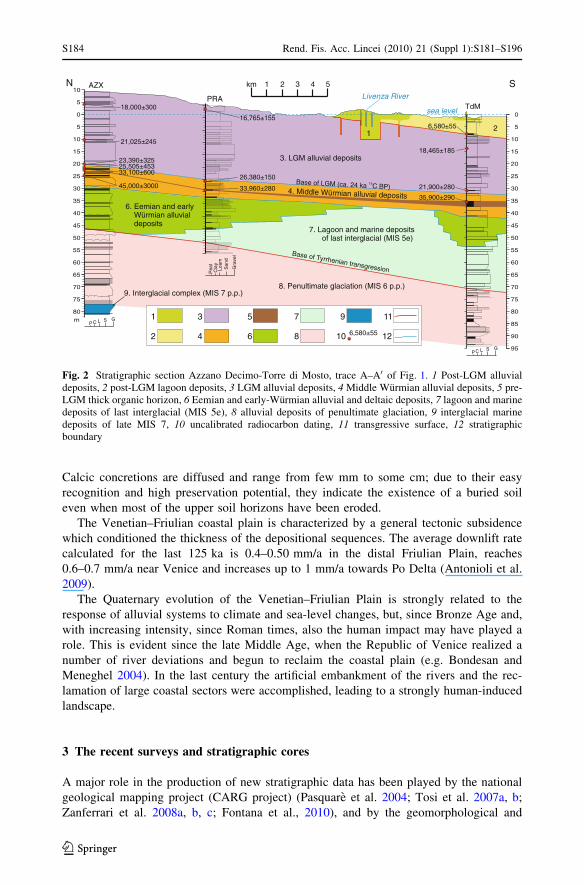
Calcic concretions are diffused and range from few mm to some cm; due to their easy
recognition and high preservation potential, they indicate the existence of a buried soil
even when most of the upper soil horizons have been eroded.
The Venetian–Friulian coastal plain is characterized by a general tectonic subsidence
which conditioned the thickness of the depositional sequences. The average downlift rate
calculated for the last 125 ka is 0.4–0.50 mm/a in the distal Friulian Plain, reaches
0.6–0.7 mm/a near Venice and increases up to 1 mm/a towards Po Delta (Antonioli et al.
2009).
The Quaternary evolution of the Venetian–Friulian Plain is strongly related to the
response of alluvial systems to climate and sea-level changes, but, since Bronze Age and,
with increasing intensity, since Roman times, also the human impact may have played a
role. This is evident since the late Middle Age, when the Republic of Venice realized a
number of river deviations and begun to reclaim the coastal plain (e.g. Bondesan and
Meneghel 2004). In the last century the artificial embankment of the rivers and the rec-
lamation of large coastal sectors were accomplished, leading to a strongly human-induced
landscape.
3 The recent surveys and stratigraphic cores
A major role in the production of new stratigraphic data has been played by the national
geological mapping project (CARG project) (Pasquare et al. 2004; Tosi et al. 2007a, b;
Zanferrari et al. 2008a, b, c; Fontana et al., 2010), and by the geomorphological and
5
10
10
20
30
35
45
40
5
15
25
0
50
60
70
55
65
80
75
10
20
30
35
45
40
5
15
25
0
50
60
70
55
65
75
80
90
85
95
PRATdM
AZX
m
km 2 51 3 4
1
6,580±55
2
3
4
5
6
7
8
9
10
11
12
6. Eemian and earlyW rmian alluvialdeposits
ü
8. Penultimate glaciation (MIS 6 p.p.)9. Interglacial complex (MIS 7 p.p.)
7. Lagoon and marine depositsof last interglacial (MIS 5e)
4. Middle W rmian alluvial depositsü
3. LGM alluvial deposits
12
35,900±290
sea level
Livenza River
33,960±280
26,380±150
16,765±155
33,100±60025,505±453
18,000±300
21,025±245
45,000±3000
23,390±325
21,900±280
18,465±185
6,580±55
Base of Tyrrhenian transgression
)PBCak42.ac(MGLfoesaB 14
N S
taeP
yalC Lo
amdna
S Gra
vel
P C L S G
P C L S G
Fig. 2 Stratigraphic section Azzano Decimo-Torre di Mosto, trace A–A0 of Fig. 1. 1 Post-LGM alluvialdeposits, 2 post-LGM lagoon deposits, 3 LGM alluvial deposits, 4 Middle Wurmian alluvial deposits, 5 pre-LGM thick organic horizon, 6 Eemian and early-Wurmian alluvial and deltaic deposits, 7 lagoon and marinedeposits of last interglacial (MIS 5e), 8 alluvial deposits of penultimate glaciation, 9 interglacial marinedeposits of late MIS 7, 10 uncalibrated radiocarbon dating, 11 transgressive surface, 12 stratigraphicboundary
S184 Rend. Fis. Acc. Lincei (2010) 21 (Suppl 1):S181–S196
123

geological mapping projects funded by the Province of Venice (Bondesan et al. 2004,
2008; Bondesan and Meneghel 2004). Other data have been acquired in the framework of
the ongoing Geo-CGT Project, concerning the geological mapping of distal and coastal
sectors of the Friuli Venezia Giulia Region, realized with the survey standard of the CARG
project. The soil maps of the Veneto Region (ARPAV 2005), Province of Venice (Ragazzi
and Zamarchi 2008), Treviso (ARPAV 2008) and Friuli Venezia Giulia Region (Michelutti
et al. 2003, 2007) provide information on soils and the correlation with ages of outcropping
surfaces. A specific research on the alluvial geomorphology and geoarchaeology of the
distal portion of the Friulian Plain since LGM was carried out (Fontana 2006).
About 500 radiocarbon datings of alluvial and coastal series are available in the
Venetian–Friulian Plain, mostly concerning LGM and Holocene sediments; part of this
database has been published by Bondesan et al. 2002; Bondesan and Meneghel 2004;
Fontana 2006; Carton et al. 2009. In Fig. 3, the datings of Tagliamento and Brenta systems
are presented, allowing to compare the LGM and post-LGM chronologies of two major
alluvial systems.
Some cores realized in the framework of the CARG Project allow to investigate the end
of middle Pleistocene and the Late Pleistocene (#16 in Fig. 1). The deepest one is the
Azzano Decimo core (AZX in Fig. 1), which was drilled down to 271 m from surface and
reached MIS 11 (Zanferrari et al. 2008c). The other new deep cores have a maximum depth
of 100 m, approximately comprising the last 150 ka: TdM (Fontana et al. 2010), PRT (Tosi
et al. 2007a), AVR (Donnici and Serandrei-Barbero 2004), MAL (Fontolan et al. 2008),
IsA and IsB (Carbognin and Tosi 2003), BOR (Mozzi and Cuccato, unpublished), MAR
and PRG (Fontana and Mozzi, unpublished). These cores allow to control the tridimen-
sional geometry of the main sedimentary bodies. A number of cores reaching 30–60 m
(Fig. 1) have also been analysed: CNC4, LUG, PRA and VV (Fontana et al. 2010), Lat
(Fontana 2006), BH1, BH2 and BH3 (Canali et al. 2007), JES, DNV, CaB and CRT
(Bondesan et al. 2008), Col and Mrz (Zanferrari et al. 2008c) and Arz (Zanferrari et al.
2008c).
The new information was compared with the logs available in the subsoil database of
the Geological Survey of Provincia di Venezia. This latter consists of about 11,000
investigation points, consisting of stratigraphic logs for geotechnical purposes, water wells
and auger holes. About 6,000 auger holes were drilled by the Geological Survey along a
homogeneous grid covering the whole Province of Venice (1,550 km2) except the Venice
Lagoon, which have been analysed within CARG Project (Tosi et al. 2007a, b). Also, the
subsoil database of Regione Friuli Venezia Giulia (1990) was considered, consisting of
about 2,000 stratigraphic logs, mainly derived from water wells.
Here, we provide some brief information about the reference logs supporting the pro-
posed stratigraphic framework (Fig. 2), highlighting their most significant characteristics
and the typology of biostratigraphic data (i.e. pollen, micro- and macropaleontological
analyses) supporting the chronostratigraphic interpretations.
In this paper only the first 95 m of the core AZX were considered, for which a detailed
biostratigraphy was published by Pini et al. (2009); between 95 and 78 m the deposits
consist of inner-shelf facies which pass to transitional environment and correspond to an
interglacial period occurred during the late part of MIS 7, locally named as the ‘‘Sile
interglacial complex’’.
The borehole TdM is supported by pollen and micropaleontological biostratigraphy. It
is characterized by alluvial fine-dominated deposits from 94 to 70.5 m depth; a marine
ravinement surface eroded the top of this interval, where a fairly developed soil was
present. From 70.5 m inner-shelf sediments are present, which pass to delta front facies
Rend. Fis. Acc. Lincei (2010) 21 (Suppl 1):S181–S196 S185
123

wide and highfluvial ridges
deltaslagoons
fluvial incisions
peaklate
widespread andfast aggradation
lowerrate
aggradationno surface deposition
wide, highfluvialridges
222 284
22
20
4
6
24
268
26
2410
12
16
32
12
28
18
34
14
30
0
20
0
18
16
14
8
2
6
10
30
Peat or organic horizons coincidingwith flood plain surface
Peat and organic horizons or woodinside fluvial channel
Bar indicating 1-sigma error isrepresented only if exceedingmore than 200 years±
LGM
LGM
Tag
liam
ento
allu
vial
sys
tem
(65
dat
ings
)
GM
CN
C4
PR
A
AZ
X
Lateglacial
Lateglacial
lagoonsdeltas
fluvial incisions
LGM peaklate LGM
widespread aggradationlimited aggradation
limited aggradation
apicalincision
EN
EC
OTSI
EL
P
EN
EC
OL
OH
36
32 34
Radiocarbon conventional age (ka BP, uncalibrated)32 34222 284 206 26428 10 1612 18140
0
30 36
Dep
th o
f dat
ed s
ampl
es fr
om th
e su
rfac
e (m
)D
epth
of d
ated
sam
ples
from
the
surf
ace
(m)
Bre
nta
allu
vial
sys
tem
(95
dat
ings
)
36
22
4
24
26
12
32
28
34
30
20
0
18
16
14
8
2
6
10
38
EN
EC
OTSI
EL
P
EN
EC
OL
OH
no surface deposition
36
Fig. 3 Top Diagram of radiocarbon datings available for the Brenta alluvial system. Bottom Diagram ofradiocarbon datings available for the Tagliamento alluvial system (modified from Fontana 2006); thecoloured areas link samples from the same core (TdM, AZX, CNC4; see Fig. 1 for location)
S186 Rend. Fis. Acc. Lincei (2010) 21 (Suppl 1):S181–S196
123

between 61 and 54.1 m. These latter are covered by alluvial deposits in deltaic or distal-
plain facies up to 50.4 m, where an erosive surface marks the base of sandy fluvial-channel
deposits, passing to floodplain facies from 41.5 to 37.5 m. Between 37.5 and 35.2 m
compressed peat with freshwater pollen is present, which top was dated 35,900 ± 290 14C
years BP. Up to 32.5 m there are floodplain sediments, with a fairly developed soil at the
top. Radiocarbon dating of the A organic horizon provided an age of 21,990 ± 280 14C
years BP. This represents the base of the LGM sediments, which show fine-dominated
floodplain and crevasse splay facies; a well-developed soil at their top marks the base of
the Holocene backbarrier and lagoon deposits which started at 6,580 ± 55 14C years BP.
In core PRA pollen and micropaleontological analyses concentrate from 60 to 44.5 m;
from the base to 55.5 m silt alluvial deposits are present, characterized at their top by a
well-developed soil, sealed by lagoon fine sediments. These arrive up to 49.6 m, where the
top of another calcic soil is present and is buried by alluvial deposits up to the present
surface. The base of LGM should be slightly higher than 30.77 m, where a peat horizon has
a radiocarbon age of 26,380 ± 150 14C years BP. Near core PRA the present surface is
formed by LGM sediments, dating to 16,765 ± 155 14C years BP at 1.5 m of depth, and is
characterized by a well-developed calcic soil.
The profile of Fig. 2 is supported also by the correlations with core CNC4, near Con-
cordia Sagittaria, in which detailed pollen, micro- and macropaleontologic analyses were
carried out. Between 51 and 39 m of depth lagoon deposits are present, with two weak
soils at 45.2 and 43.6 m. Radiocarbon dating of a 3-m thick layer of compressed peat from
39 to 36.2 m provided the following ages: 30,885 ± 825 14C years BP at 36.2 m;
34,225 ± 150 at 37.58 m; 36,330 ± 1615 at 38.38 m. Sand alluvial deposits separate the
top of the peat horizon from the base of LGM sequence; this latter is set at 30.6 m, where
silty sediments bury the organic horizon of a fairly developed soil, dated at its top
24,275 ± 375 14C years BP. From 30.6 to 5 m silt and clayey silts are dominant and at their
top a well-developed soil testifies the time span occurred since the end of LGM till the
protohistoric and Roman occupation that sealed the soil with 5 m of archaeological
sequence.
4 The penultimate glaciation
The oldest litostratigraphic unit which has been intercepted by several high-quality cores
corresponds to the deposits of the penultimate glacial culmination, when the Alpine gla-
ciers reached the plain with their fronts, feeding glaciofluvial streams. The general situ-
ation may be compared to the one characterizing the LGM (see Sect. 7 ‘‘Acme of LGM’’)
and caused the formation of marked downstream differentiation of grain-size and lithof-
acies that brought to the sedimentation of megafans in the alluvial plain. These are
characterized by vertically stacked, amalgamated gravels in the proximal sectors of the
plain and of mud-prone sediments in the distal ones. Downstream of the spring line these
deposits mainly correspond to alternances of silt and clayey silt; secondarily, fine sandy
and silty sand channels are recognized, with an average thickness of less than 1–2 m; some
thin peat and organic layers are quite common and the pollen analyses demonstrate that
their deposition occurred during temperate and dry climate (Mullenders et al. 1996; Pini
et al. 2009; Fontana et al. 2010). These deposits are interpreted as fluvial sequences related
to sandy braided river typology and have a thickness of about 20–30 m. The top of these
sediments is found at a depth of 60–70 m from surface, east of Venice, whereas south-west
of Venice their top is at 80–100 m.
Rend. Fis. Acc. Lincei (2010) 21 (Suppl 1):S181–S196 S187
123

In the core AZX these sediments are framed between two interglacial units, respec-
tively, related to the Eemian (i.e. MIS 5e and MIS 5d p.p.) and to the proposed Sile
integlacial complex (i.e. part of MIS 7), allowing to relate them to the MIS 6 and to
estimate the duration of the penultimate glacial culmination in the southern fringe of the
Alps between 148 ± 1 and [135 ka (Pini et al. 2009). These deposits correlate with the
most external features of the moraine amphitheatres of Tagliamento, named Plaino syn-
them in the new geological maps (Monegato et al. 2007; Zanferrari et al. 2008a). Also, the
moraine system of Isonzo, near Most na Soci (SLO), is referred to the penultimate gla-
ciation (Bavec et al. 2004), whereas, in the Vittorio Veneto amphitheatre, related to the
Piave basin, the most external moraine is characterized by a strongly developed soil, which
is older than the one present on the Plaino synthem and has been attributed to a glaciation
older than the penultimate (Venzo et al. 1977; ARPAV 2008). Stratigraphic and pedologic
correlations allow to tentatively attribute the formation of the Montebelluna megafan (#d,
Fig. 1, B) to the MIS 6 glacial acme; south of the Sile River the gravels forming the apical
portion of this megafan are buried by LGM fine sediments of the distal sector of Brenta
megafan (Bondesan et al. 2002; Mozzi 2005; Ragazzi and Zamarchi 2008).
The sediments related to the penultimate glaciation are found between *60 and 90 m
of depth in the core PCN (Feruglio 1936), their top is at 55 m in PRA, 70.5–100 m in TdM
(Fontana et al. 2010), 55–86 m in AZX (Pini et al. 2009), 71–90 m at PRT (Tosi et al.
2007a), 78–105 m in VE01 (Massari et al. 2004), 86–100 m in MAL (Fontolan et al. 2008)
and 63.6–89 m in AVR (Donnici and Serandrei-Barbero 2004), top at 99 m in BOR
(Mozzi and Cucato, unpublished). The base of these deposits was not reached in TdM
(Fig. 2) but, in some water wells near TdM, the presence of marine shells from a depth of
about 100 m and below has been documented which, thus, probably correlate to highstand
deposits of MIS 7.
At the top of the alluvial deposits sedimented during penultimate glaciation a fairly
well-developed soil has been recognized in cores PRA, AZX, PRG and calcic horizons of a
truncated soil have been recognized also in TdM.
5 The Tyrrhenian transgression (MIS 5e) and the Eemian
In the subsoil of the NW Adriatic plains the first pre-Holocene paralic sediments are found
at depths of 60–90 in the southern Venice Lagoon, whereas east of Venice they occur at
40–70 m from surface. They are described in many cores and could also be recognized in
many water-well logs due to the occurrence of lagoon or marine shells, thus they represent
a major stratigraphic marker (Amorosi et al. 2004; Antonioli et al. 2009). These sediments
form a wedge-shaped coastal body, up to 20–30 m thick, characterized by shallow-marine,
lagoon and deltaic deposits with molluscs (Fig. 2).
Facies analyses and chronostratigraphic correlations suggest that these sediments
probably belongs totally or almost entirely to the MIS 5e (132–116 ka BP), which corre-
sponds to the last interglacial and is called Tyrrhenian in the Mediterranean marine stra-
tigraphy (Asioli et al. 2005). At that period the Adriatic reached an highstand level of
?6 m (±3) a.s.l. which favoured the sedimentation of lagoon facies up to 25 km inland
from the present coastline (Ferranti et al. 2006; Antonioli et al. 2009) (Figs. 1, 2). The
Tyrrhenian transgression is expected to have reached the high stand at the paleo-altitude of
the Venetian Plain at least 3 ka later than the beginning of the interglacial, which is
currently dated 132.5 ± 2 ka BP (Drysdale et al. 2009) and corresponds to an event of
forest expansion recorded in pollen sequences (Shackleton et al. 2003; Pini et al. 2009).
S188 Rend. Fis. Acc. Lincei (2010) 21 (Suppl 1):S181–S196
123

The delay of about 5–10 ka occurred between the end of the alluvial sedimentation related
to the penultimate glaciation and the beginning of paralic facies sedimentation along the
coastal plain allowed to form a well-developed soil. Sometimes the transgressive surface
separating the two depositional units coincide with an important truncation related to the
ravinement surface. An example of stratigraphic geometries and correlations is given in
Fig. 2.
The Tyrrhenian partly correlates with the Eemian period of the continental chronos-
tratigraphy of Europe (Shackleton et al. 2003; Asioli et al. 2005), which begun around
126 ka BP and well extended after the end of last interglacial (i.e. the boundary MIS 5e/5d),
which is dated at 119–117 ± 2 ka BP (Muller and Kukla 2004; Meyer et al. 2008).
The paleogeographic setting at the maximum transgression was characterized by an
inner lagoon margin 10–20 km landward than the Holocene one (#12 in Fig. 1). Key
points to check the position of the lagoon/continental interface are represented by the
couple of cores AZX and PRA: the first completely continental during MIS 5 and the
second where 5 m of lagoon sediments transgresses over the buried soil at the top of
MIS 6 (Fig. 2). A similar setting characterizes the cores PRG (unpublished) and PRT
(Tosi et al. 2007a): the first with only continental deposits in the first 105 m of depth and
with a very well developed soil at 55 m; the second with paralic deposits between 70 and
55 m.
In the circumalpine chronostratigraphy the Wurm period, which lasted up to the end of
Lateglacial at 11.5 ka cal BP (Chaline and Jerz 1984; Orombelli et al. 2005), started at the
end of the Eemian, with the onset of the first stadial, currently dated at 110.5 ± 1.5 ka BP
(NGRIP 2004). After the Eemian, two cold stadials occurred (Melisey I and II in the
French sequences; Woillard 1978) alternated with two mild interstadials (St. Germain I and
II in French literature). These are recorded by alluvial sediments in core AZX (Pini et al.
2009) and VE-01 (Mullenders et al. 1996). At global scale sea level dropped at about
-60 m below the present position during the MIS 5d, whereas during the substages 5c
and 5a it reached about -20 m (Antonioli et al. 2004).
Considering the depth of the top of MIS 5 lagoon or deltaic deposits, the sea-level
position during MIS 5a and 5c and the different subsidence rates occurred along the
Venetian–Friulian coastal plain, it is probable that the MIS 5 paralic deposits belong
completely or almost completely to the MIS 5e (i.e. the Tyrrhenian). The coastal sediments
dating to the post-Tyrrhenian interstadials could be present only in the southern Venetian
Lagoon, but not east of it and in the Friulian Plain, where long-term subsidence rate is
considerably lower (Antonioli et al. 2009). Alluvial deposits dating to MIS 5a has been
recognized in core BH2 (eastern Venice lagoon; see Fig. 1) at 45–47.5 m (Canali et al.
2007).
6 Early and middle Wurm
The deposits embedded between the top of the Tyrrhenian paralic facies and the base of
LGM have a thickness of about 20 m in the area of Venice, which decreases to less than
10 m in the Friulian Plain. In most of the considered cores these sediments are not well
characterized and only where detailed biostratigraphy is available (i.e. pollen analyses) a
chronostratigraphic subdivision could be possible. These deposits consist of an alluvial
sequence which represents part of the early Wurm and the middle Wurm; the boundary
between these two Wurmian phases is currently set around 70 ka BP (Chaline and Jerz
1984; Antonine et al. 2001).
Rend. Fis. Acc. Lincei (2010) 21 (Suppl 1):S181–S196 S189
123

In some cores of the Friulian Plain (CNC4, LUG, VV, PCN), lagoon deposits of MIS 5
are found few meters below a peaty layer, 2- to 3-m thick, whose top is radiocarbon dated
around 35–30 ± 1 14C ka BP (#13 in Fig. 1); this situation points to the existence of a
sedimentary gap which comprises large part of the upper and middle Wurm (Fig. 2). This
hiatus has been recognized also in the Venice Lagoon, in cores VE-01, AVR and BH2,
where the sediments of about 30 ± 1 14C ka BP are found at around 30 m of depth and
important traces of pedogenesis are evident few metres below (Mullenders et al. 1996;
Donnici and Serandrei-Barbero 2004; Canali et al. 2007).
Pollen analysis in cores AZX (Pini et al. 2009), TdM and CNC4 (Fontana et al. 2010),
VE-01 (Mullenders et al. 1996) and BH2 (Canali et al. 2007) highlights the occurrence of a
temperate forest during the second part of middle Wurm. This vegetation cover probably
developed during the MIS 3 marine highstands at which Mediterranean sea level reached
about -60 m below the present sea level (Antonioli et al. 2004). The presence of the thick
peat layer found in the Friulian Plain and in the eastern Venetian Plain may be related
to the existence of the Tyhrrennian coastal wedge, which characterized the distal plain with
a very low topographic gradient, thus favouring surface-water stagnation and peat
accumulation.
7 Acme of LGM
At global scale the LGM acme occurred between 26.5 and 19 ka BP (Clark et al. 2009) and
the evolution of the eastern Alpine glaciers seems to be tuned with this timing (Orombelli
et al. 2005; Monegato et al. 2007; Carton et al. 2009). In the circumalpine chronostra-
tigraphy the term late Wurm comprehends the onset and the decay of the last glacial
culmination (Chaline and Jerz 1984), therefore it corresponds to the LGM and the
Lateglacial.
In the Venetian–Friulian Plain large sectors of the LGM surface still crop out (Fig. 1)
and the LGM alluvial sequences have been analysed with hundred of boreholes drilled for
applied geological purposes and chronologically constrained by tens of radiocarbon datings
(Fig. 3).
At the acme of LGM the glaciers hosted in the main south-eastern Alpine valleys
debouched into the plain, leading to the formation of huge terminal moraines in the
piedmont belt (Castiglioni 2004). The sea level dropped about -140 m below its present
position (Lambeck and Purcell 2005) and the North Adriatic became part of an extensive
alluvial plain (Correggiari et al. 1996). The Isonzo, Tagliamento, Piave, Brenta and Adige
glacio-fluvial systems, fed by the Alpine glaciers, brought to the formation of alluvial
megafans (Fontana et al. 2008). Lowstand deposits are represented by 15- to 35-m thick
megafan bodies made up of vertically stacked, amalgamated gravels in the proximal
sectors and mud-prone deposits at distal locations (Bondesan et al. 2002; 2008; Fontana
2006; Fontana et al. 2008). In the distal sector of megafans, LGM stratigraphy consists of a
characteristic alternation of overbank and natural-levee deposits, with common thin peat
intercalations and fine-sandy channel bodies with a thickness of 0.5–1.5 m (Fig. 4A) (Miola
et al. 2006; Bondesan et al. 2008; Fontana et al. 2008). A remarkably different framework
characterizes the central part of the Venetian Plain and of the Venice Lagoon, where the
sandy channel bodies may reach a thickness of 8–15 m (Fig. 4B) (Serandrei-Barbero et al.
2005; Zezza 2007; Bondesan et al. 2008).
In several cores, the LGM deposits bury a fairly developed soil, characterized by calcic
horizon; it has been found at depths of 32 m in CNC4, 28 m in TdM, ca. 30 in PRA, 35 in
S190 Rend. Fis. Acc. Lincei (2010) 21 (Suppl 1):S181–S196
123

AZX, 30 and 28 m in the industrial area of Porto Marghera, near Mestre (Bondesan et al.
2008).
Radiocarbon datings (Fig. 3) highlight that the sedimentation occurred with a very high
rate in the whole Venetian–Friulian Plain, in the order of 1–3 mm/a. The fact that each
alluvial system apparently aggraded contemporaneously in its whole width may be
explained in terms of efficient avulsion processes, which continuously shifted the river
course across the megafan. This is because of the possibility of high irregularities in the
glacio-fluvial regimes, prone to extreme floods in response to occasional/recurrent out-
bursts of glacial meltwaters.
m
Sile River
NNESSW
Flood plain deposits
Correlation
Overbank and crevasse
Peat
Channel deposits
Silty sand deposits of Sile River
Piave River deposits along Sile channel
Anthropic deposits
14C dating
Core and penetric test
LGM / post-LGM boundary
500 m
250 m
0
2
2
4
6
8
10
12
14
16
18
20
SW NE
m
0
2
4
6
8
10
12
14
16
18
20
22
24
26
28
30
HangarAirport Station
A
B
15,000±500 14C
18,000±200 14C
18,000±200 14C
17,530±120
18,700±200 14C
21,800±300 14C
20,600±250 14C
Base of LGM(ca. 24,000±1000 14C)
3650±40
20,300±220
16,190±50
19,770±140
21,150±190
21,150±190
Age estimated through stratigraphicalcorrelation with core PM1 and PM3(Mozzi et al. 2003)
20,970±140
17,920±130
Fig. 4 a Stratigraphic section of the area of Ca0 Tron (modified from Fontana et al. 2008), b section of theAirport of Venice (modified from Bondesan et al. 2008)
Rend. Fis. Acc. Lincei (2010) 21 (Suppl 1):S181–S196 S191
123

8 End of LGM and Lateglacial
The first contraction of the Alpine glaciers led to the abandonment of the most external
moraines. In the Tagliamento amphitheatre this terminal phase of LGM, the so-called
‘‘cataglacial’’, brought to the formation of some internal moraine ridges (Monegato et al.
2007); in the same phase the Tagliamento, Torre, Cormor and Corno fluvial systems
incised the apical portion of their megafans, down to the spring belt (Fig. 5). A slight
aggradation took place downstream, with the formation of some narrow fluvial ridges with
sandy-gravel wandering riverbeds until 15.5 ± 0.4 14C ka BP (Fontana 2006).
In the Vittorio Veneto amphitheatre the maximum advance of Piave glacier dates back
to 17.6 ± 0.3 14C ka BP (Bondesan et al. 2002), while by 16–15 ± 0.5 14C ka BP the glacier
had likely disappeared from the main valley (Pellegrini et al. 2005). In the Nervesa
megafan, the very intense LGM sedimentary phase stopped at around 16 ± 0.1 14C ka BP,
showing a good connection between glacial activity and alluvial aggradation (Carton et al.
2009). In the Brenta megafan the rate of sedimentation was very high until 18.0 ± 1 14C ka
BP and decreased significantly between 18.0 and 14.5 ± 0.5 14C ka BP (Mozzi 2005).
At the climatic transition between LGM and Lateglacial a dramatic change in the
alluvial dynamics occurred and a strong phase of incision affected all the megafans in the
Venetian–Friulian Plain (Fontana et al. 2008); even the ‘‘cataglacial’’ lobe of Tagliamento
megafan was incised (Fig. 5). This brought to the formation of alluvial valleys encased in
the LGM alluvia with a depth of 40–70 m in the proximal sectors and up to 25 m in the
distal ones, where several incisions are present. For the Tagliamento and Piave systems,
five and four incised valleys are documented, respectively. A similar valley was recognized
also in the Torre-Isonzo system (Arnaud-Fassetta et al. 2003).
A A
B B
C C
Fig. 5 Simplified scheme of the telescopic alluvial megafan of Tagliamento River (modified from Fontanaet al. 2008); 1 middle and late Holocene gravels and sands, (a) fine sediments; 2 Lateglacial and earlyHolocene gravels and sands; 3 Late LGM gravels and sands, (a) fine sediments; 4 acme-LGM gravels andsands, (a) fine sediments; 5 middle Wurmian gravels and sands, (a) fine sediments; 6 peat and organic layerdating at the top 30–35 ka BP cal.; 7 lagoon and shallow-marine deposits of last interglacial
S192 Rend. Fis. Acc. Lincei (2010) 21 (Suppl 1):S181–S196
123

The fluvial-channel entrenchment concentrated the sedimentary fluxes in the incisions
and led to the transport of gravels far downstream than during LGM (Fig. 5). Due to
entrenchment, laterally extensive hiatal surfaces are formed in the interfluvials, marked by
soil development with characteristic overconsolidated calcic horizons, locally called
caranto paleosoil (Mozzi et al. 2003). This discontinuity surface, which is generally
associated with a time gap of about 7–10 ka that encompasses the Pleistocene–Holocene
boundary, can be traced all along the Venetian–Friulian Plain and in the subsoil of the
coastal plain along the western Adriatic (Amorosi et al. 2008).
9 Conclusions
Large volumes of alluvial sediments have been deposited in the megafans of the Venetian–
Friulian Plain during the penultimate glaciation and the LGM, falling within MIS 6 and
MIS 2, respectively. This is due to the high sediment yield of the glacio-fluvial streams
flowing from Alpine glaciers, which then reached their maximum extensions and had their
fronts in the Alpine piedmont. This overwhelming climatic forcing on the fluvial system is
modulated by the specific environmental and orographic conditions of the different
catchments, leading to slight differences in the response to main climate change. This is
evident during the LGM cataglacial phase, when the Tagliamento megafan was interested
by early fan-head incision while the Brenta continued to aggradate, though with lower
rates.
During full glacial periods there is no direct influence of sea level on sedimentary
processes in the Venetian–Friulian Plain. Sea lowstands are generally characterized by
fluvial downcutting of the continental shelf and the formation of basin-ward depositional
wedges. In the shallow northern Adriatic, sea level fall resulted instead in the formation of
a several-hundred-kilometres long, very low-gradient alluvial plain. This led to the
detachment of the Venetian–Friulian sector from the coastal area and prevented it from
being interested by typical falling-stage incision. In fact, the entrenching of the fluvial
system recorded during the Lateglacial is entirely due to changing environmental condi-
tions in the mountain catchments related to deglaciation. The presence of fairly well-
developed soils at the top of the deposits of the penultimate glacial culmination, indicating
a main hiatus before the last interglacial transgression, suggests that river entrenchment
may have took place at the end of the penultimate glaciation as well.
During last interglacial there was the deposition of an alluvial-deltaic to lagoonal-
shallow-marine sedimentary wedge, which base corresponds to the Tyrrhenian transgres-
sive surface. Eustatic-driven fluctuations in the sedimentary processes are recognizable in
the Venetian–Friulian sedimentary series of that period. To be noted is the possibility of
pinpointing the coastline position. During the last interglacial the inner margin of the
lagoons was positioned 10–20 km landward with respect to the Holocene one and this
setting is consistent with the higher sea level reached at the MIS 5e. In the sedimentary
record also the MIS 5c and 5a are testified, but they seem to be characterized only from
alluvial deposits and, probably, paralic sediments of these substages are expected just south
of the present Venice Lagoon.
Between the end of the last interglacial and the onset of LGM, long periods of scarce or
no sedimentation occurred in the plain and the overall thickness of early and middle
Wurmian deposits is less than 10 m in the Friulian Plain. A major hiatus lasted several
thousand of years and ended around 35–31 ± 1 14C ka BP; this phase is testified by soil
Rend. Fis. Acc. Lincei (2010) 21 (Suppl 1):S181–S196 S193
123

development in the central and southern Venice Lagoon, whereas correspond to a thick
peaty layer found between the Friulian Plain and the eastern Venice Lagoon.
Acknowledgments The authors wish to thank Federico Toffoletto, leader of the CARG project in VenetoRegion, Andrea Vitturi and Valentina Bassan of the Servizio Geologico of Provincia di Venezia and PaoloSivieri (Geoservizi s.r.l.) for the possibility to study many of the cores considered in the research. Cor-rections and suggestions proposed by two anonymous reviewers largely improved the quality of themanuscript.
References
Amorosi A (2008) Delineating aquifer geometry within a sequence stratigraphic framework: evidence from theQuaternary of southern Po River Basin, Northern Italy. In: Amorosi A, Haq BU, Sabato L (eds) Advancesin application of sequence stratigraphy in Italy, vol 1. GeoActa Special Publication, pp 1–14
Amorosi A, Colalongo ML, Fiorini F, Fusco F, Pasini G, Vaiani SC, Sarti G (2004) Palaeogeographic andpalaeoclimatic evolution of the Po Plain from 150-ky core records. Global Planet Change 40:55–78
Amorosi A, Fontana A, Antonioli F, Primon S, Bondesan A (2008) Post-LGM sedimentation and Holoceneshoreline evolution in the NW Adriatic coastal area. GeoActa 7:41–67
Antonine P, Rousseau DD, Zoller L, Lang A, Munaut AV, Hatte C, Fontugne M (2001) High-resolutionrecord of the last Interglacial–glacial cycle in the Nussloch loess-palaeosol sequences, Upper RhineArea. Quat Int 76–77:211–229
Antonioli F, Bard E, Silenzi S, Potter EK, Improta S (2004) 215-kyr history of sea level based on submergedspeleothems. Global Planet Change 43:57–68
Antonioli F, Ferranti L, Fontana A, Amorosi A, Bondesan A, Braitenberg C, Fontolan G, Furlani S,Mastronuzzi G, Monaco C, Spada G, Stocchi P (2009) Holocene relative sea-level changes and verticalmovements along the Italian and Istrian coastlines. Quat Int 206:101–133
Arnaud-Fassetta G, Carre MB, Marocco R, Maselli Scotti F, Pugliese N, Zaccaria C, Bandelli A, Bresson V,Manzoni G, Montenegro ME, Morhange C, Pipan M, Prizzon A, Siche I (2003) The site of Aquileia(Northeastern Italy): example of fluvial geoarchaeology in a Mediterranean deltaic plain. Geomor-phologie 4:227–246
ARPAV (2005) Carta dei suoli del Veneto, scala 1:250.000. ARPAV, Osservatorio Regionale Suolo,Castelfranco, Veneto
ARPAV (2008) Carta dei suoli della provincia di Treviso. Scala 1:50.000. LAC, FirenzeAsioli A, Capotondi L, Cita Sironi MB (2005) The Tyrrhenian stage in the Mediterranean: definition, usage
and recognition in the deep-sea record. A proposal. Rendiconti Lincei 16(4):297–310Bavec M, Tulaczyk SM, Mahan SA, Stock GM (2004) Late Quaternary glaciation of the Upper Soca River
Region (Southern Julian Alps, NW Slovenia). Sed Geol 165:265–283Bondesan A, Meneghel M (eds) (2004) Geomorfologia della provincia di Venezia. Esedra, Padova, 516 ppBondesan A, Calderoni G, Mozzi P (2002) L’assetto geomorfologico della pianura veneta centro-orientale:
stato delle conoscenze e nuovi dati. In: Varotto M, Zunica M (eds) Scritti in ricordo di GiovannaBrunetta. Dip Geog. Univ. Padova, Padova, pp 19–38
Bondesan A, Meneghel M, Rosselli R, Vitturi A (eds) (2004) Geomorphological Map of the Province ofVenice. LAC, Firenze (4 sheets)
Bondesan A, Primon S, Bassan V, Fontana A, Mozzi P, Abba’ T, Vitturi A (eds) (2008) Carta delle unitageologiche della provincia di Venezia. Cierre Edizioni, Verona, 2 sheets, 160 pp
Bortolami GC, Fontes JC, Markgraf V, Saliere JF (1977) Land, sea and climate in the northern Adriaticregion during Late Pleistocene. Palaeogeogr Palaeoclimatol Palaeoecol 21:139–156
Calderoni G, Castiglioni GB, Foddai D, Gallo S, Lombardo M, Miola A, Zangheri P (1996) Paleoenvi-ronmental features of a peri-Euganean (Padua, Northern Italy) depression during the Late Quaternary:first results. Il Quaternario 9(2):667–670
Canali G, Capraro L, Donnici S, Rizzetto F, Serandrei Barbero R, Tosi L (2007) Vegetational and envi-ronmental changes in the eastern Venetian coastal plain (Northern Italy) over the past 80, 000 years.Palaeogeogr Palaeoclimatol Palaeoecol 253:300–316
Carbognin L, Tosi L (2003) Il Progetto ISES per l’analisi dei processi d’intrusione salina e subsidenza neiterritori meridionali delle province di Padova e Venezia. Grafiche Erredici, Padova, p 96
Carminati E, Martinelli G, Severi P (2003) Influence of glacial cycles and tectonics on natural subsi-dence in the Po Plain (Northern Italy): insights from 14C ages. Geochem Geophys Geosyst4(10):1–14
S194 Rend. Fis. Acc. Lincei (2010) 21 (Suppl 1):S181–S196
123

Carton A, Bondesan A, Fontana A, Meneghel M, Miola A, Mozzi P, Primon S, Surian N (2009) Geo-morphological evolution and sediment transfer in the Piave River watershed (north-eastern Italy) sincethe LGM. Geomorphologie: relief, Processus. Environment 3:37–58
Castiglioni GB (ed) (1997) Carta Geomorfologica della Pianura Padana (Foglio 3), scala 1:250.000. Selca,Firenze
Castiglioni GB (2004) Quaternary glaciations in the eastern sector of the Italian Alps. In: Gibbard P, EhelersC (eds) Developments in Quaternary science, vol 2, part 1, pp 209–214
Cavallin A, Lauzi S, Marchetti M, Padovani N (1987) Carta geomorfologica della pianura friulana ad est delF. Tagliamento e a sud dell’anfiteatro morenico. Atti Convegno Ricercatori Sc. della Terra, Milano
Chaline J, Jerz H (1984) Arbeitsergebnisse der Sbkommission fur Europaische Quartarstratgraphie. Stra-totypen des Wurm-Glazials. Eiszeitalter und Gegenwart 35:185–206
Clark P, Dyke A, Shakun J, Carlson A, Clark J, Wohlfarth B, Mitrovica J, Hostetler S, McCabe A (2009)The Last Glacial Maximum. Science 325:710–714
Correggiari A, Roveri M, Trincardi F (1996) Late Pleistocene and Holocene evolution of the North AdriaticSea. Il Quaternario 9:697–704
Doglioni C (1993) Some remarks on the origin of foredeeps. Tectonophysics 228:1–20Donnici S, Serandrei-Barbero R (2004) I foraminiferi di ambiente vallivo della Laguna di Venezia. Lavori
della Societa Veneziana di Scienze Naturali 29:101–108Drysdale RN, Hellstrom JC, Zanchetta G, Fallick AE, Sanchez-Goni F, Couchoud I, McDonald J, Maas R,
Lohmann G, Isola I (2009) Evidence for obliquity forcing of glacial termination II. Science325:1527–1531
Fantoni R, Castellani D, Merlini S, Rogledi S, Venturini S (2002) La registrazione degli eventi deformativicenozoici nell’avampaese Veneto-Friulano. Mem Soc Geol It 57:301–313
Favero V, Serandrei Barbero R (1980) Origine ed evoluzione della laguna di Venezia–bacino meridionale.Lavori della Societa Veneziana di Scienze Naturali 5:49–71
Ferranti L, Antonioli F, Mauz B, Amorosi A, Dai Pra G, Mastronuzzi G, Monaco C, Orru P, Pappalardo M,Radtke U, Renda P, Romano P, Sanso P, Verrubbi V (2006) Markers of the last interglacial sea-levelhigh stand along the coast of Italy: Tectonic implications. Quat Int 145–146:30–54
Feruglio E (1936) Sedimenti marini nel sottosuolo della bassa pianura friulana. Boll Soc Geol It55(1):129–138
Fontana A (2006) Evoluzione geomorfologica della bassa pianura friulana e sue relazioni con le dinamicheinsediative antiche. Monografie Museo Friulano Storia Naturale, 47, Udine. Enclosed Geomorpho-logical Map of the Low Friulian Plain
Fontana A, Mozzi P, Bondesan A (2008) Alluvial megafans in the Veneto-Friuli Plain: evidence of ag-grading and erosive phases during Late Pleistocene and Holocene. Quat Int 189:71–89
Fontana A, Bondesan A, Meneghel M, Toffoletto F, Vitturi A, Bassan V (eds) (2010) Note illustrative dellaCarta Geologica d’Italia alla scala 1:50.000. 107, Portogruaro. ISPRA-Regione del Veneto, Roma (inpress)
Fontolan G, Schiozzi V, Colizza E, Bezzi A, Melis R, Pillon S, Lenaz D, Marinoni L, Fonda G (2008)Nuove informazioni stratigrafiche sulla successione pleistocenica dell’area veneziana: il sondaggioCH1M a Malamocco. In: Geologia urbana di Venezia. Atti del convegno, Mestre-Venezia, 24/11/2006.Geologia dell’Ambiente Suppl 3:87–90
Gatto P, Previatello P (1974) Significato stratigrafico, comportamento meccanico e distribuzione nellaLaguna di Venezia di un’argilla sovraconsolidata nota come ‘‘Caranto’’. CNR. Lab. Stud. GrandiMasse, T.R. 70, Venezia, 45 pp
Kent DV, Rio D, Massari F, Kukla G, Lanci L (2002) Emergence of Venice during the Pleistocene. Quat SciRev 21:1719–1727
Lambeck K, Purcell A (2005) Sea-level change in the Mediterranean Sea since the LGM: model predictionsfor tectonically stable areas. Quat Sci Rev 24:1969–1988
Lenardon G, Marocco R, Pugliese N (2000) L’aggradazione Tardiglaciale—olocenica della piana di Por-togruaro (Italia settentrionale). Studi Trentini Sc Nat Acta Geol 77:127–138
Marocco R (1991) Evoluzione tardopleistocenica-olocenica del Delta del F. Tagliamento e delle lagune diMarano e Grado (Golfo di Trieste). Il Quaternario 4:223–232
Martinson DG, Pisias NG, Hays JD, Imbrie J, Moore TC, Shackleton NJ (1987) Age dating and the orbitaltheory of the ice ages: development of a high-resolution 0 to 300, 000-year chronostratigraphy. Quat Res27:1–29
Massari F, Rio D, Serandrei Barbero R, Asioli A, Capraro L, Fornaciari E, Vergerio P (2004) The environmentof Venice area in the past two million years. Palaeogeogr Palaeoclimatol Palaeoecol 202:273–308
Meyer MC, Spotl C, Mangini A (2008) The demise of the Last Interglacial recorded in isotopically datedspeleothems from the Alps. Quat Sci Rev 27:476–496
Rend. Fis. Acc. Lincei (2010) 21 (Suppl 1):S181–S196 S195
123

Michelutti G, Zanolla S, Barbieri S (2003) Suoli e Paesaggi del Friuli-Venezia Giulia, 1. Pianura e collinedel pordenonese. ERSA, Servizio della sperimentazione agraria, Ufficio del suolo. Pozzuolo del Friuli(UD), 510 pp
Michelutti G, Zanolla S, Barbieri S (2007) Suoli e Paesaggi del Friuli-Venezia Giulia, 2. Pianura e collinedella Provincia di Gorizia e Trieste. ERSA, Servizio della sperimentazione agraria, Ufficio del suolo.Pozzuolo del Friuli (UD), 510 pp
Miola A, Bondesan A, Corain L, Favaretto S, Mozzi P, Piovan S, Sostizzo I (2006) Wetlands in the VenetianPo Plain (north-eastern Italy) during the Last Glacial Maximum: vegetation, hydrology, sedimentaryenvironments. Rev Palaeobot Palynol 141:53–81
Monegato G, Ravazzi C, Donegana M, Pini R, Calderoni G, Wick L (2007) Evidence of a two-fold glacialadvance during the last glacial maximum in the Tagliamento end moraine system (eastern Alps). QuatRes 68:284–302
Mozzi P (2005) Alluvial plain formation during the Late Quaternary between the southern Alpine marginand the Lagoon of Venice (northern Italy). Suppl Geogr Fis Dinam Quat Suppl 7:219–230
Mozzi P, Bini C, Zilocchi L, Becattini R, Mariotti Lippi M (2003) Stratigraphy, palaeopedology andpalinology of Late Pleistocene and Holocene deposits in the landward sector of the Lagoon of Venice(Italy), in relation to the ‘‘caranto’’ level. Il Quaternario 16(1b):193–210
Mullenders W, Favero V, Coremans M, Dirickx M (1996) Analyses polliniques des sondages a Venise(VE1, VE1bis, VE2). Aardkundige Mededelingen 7:87–117
Muller UC, Kukla GJ (2004) North Atlantic current and European environments during the declining stageof the last interglacial. Geology 32:1009–1012
Orombelli G, Ravazzi C, Cita MB (2005) Osservazioni sul significato dei termini LGM (UMG), tardog-laciale e postglaciale in ambito globale, italiano ed alpino. Il Quaternario 18(2):147–156
Pasquare G, Venturini C, Groppelli G (2004) Mapping Geology in Italy. APAT, Dipartimento Difesa Suolo,Servizio Geologico, Roma 336 pp
Pellegrini GB, Albanese D, Bertoldi R, Surian N (2005) La deglaciazione nel Vallone Bellunese, AlpiMeridionali Orientali. Supplementi Geografia Fisica e Dinamica Quaternaria 7:271–280
Pini R, Ravazzi C, Donegana M (2009) Pollen stratigraphy, vegetation and climate history of the last 215 kain the Azzano Decimo core (plain of Friuli, north-eastern Italy). Quat Sci Rev 28:1268–1290
Ragazzi F, Zamarchi P (eds) (2008) Carta dei suoli della Provincia di Venezia, scala 1:50.000. LAC,Firenze, 2 fogli, 267 pp
Regione Autonoma Friuli Venezia Giulia (1990) Catasto regionale dei pozzi per acqua e delle perforazionieseguite nelle alluvioni quaternarie e nei depositi sciolti del Friuli. Venezia Giulia. Regione Aut. FriuliVenezia Giulia, Direzione Regionale Ambiente, 7 voll., Trieste
Serandrei-Barbero R, Bertoldi R, Canali G, Donnici S, Lezziero A (2005) Paleoclimatic record of the past 22,000 years in Venice (Northern Italy): biostratigraphic evidence and chronology. Quat Int 140(141):37–52
Shackleton NJ, Sanchez-Goni MF, Pailler D, Lancelot Y (2003) Marine Isotope Substage 5e and the EemianInterglacial. Global Planet Change 36:151–155
Tosi L, Rizzetto F, Bonardi M, Donnici S, Serandrei Barbero R, Toffoletto F (2007a) Note illustrative dellaCarta Geologica d’Italia alla scala 1:50.000. 128, Venezia. APAT, Dipartimento Difesa del Suolo,Servizio Geologico d’Italia, Casa Editrice SystemCart, Roma, pp. 164, 2 fogli
Tosi L, Rizzetto F, Bonardi M, Donnici S, Serandrei Barbero R, Toffoletto F (2007b) Note illustrative dellaCarta Geologica d’Italia alla scala 1:50.000, 148–149. Chioggia-Malamocco. APAT, DipartimentoDifesa del Suolo, Servizio Geologico d’Italia, Casa Editrice SystemCart, Roma, pp 164, 2 fogli
Venzo S, Carraro F, Petrucci F (1977) I depositi quaternari e del Neogene superiore nella bassa valle del Piaveda Quero al Montello e del Paleo-Piave nella valle del Soligo. Mem Ist Geol Min Univ Padova 30:1–63
Woillard GM (1978) Grande Pile peat bog: a continuous pollen record for the last 140, 000 years. Quat Res9:1–21
Zanferrari A, Avigliano R, Monegato G, Paiero G, Poli ME (2008a) Note illustrative della Carta Geologicad’Italia alla scala 1:50.000-Foglio 066 ‘‘Udine’’. Graphic Linea, Tavagnacco 176 pp
Zanferrari A, Avigliano R, Grandesso P, Monegato G, Paiero G, Poli ME, Stefani C (2008b) Note illus-trative della Carta Geologica d’Italia alla scala 1:50.000, Foglio 065 ‘‘Maniago’’. Graphic Linea,Tavagnacco, 224 pp
Zanferrari A, Avigliano R, Fontana A, Paiero G (eds) (2008c) Note Illustrative della Carta Geologicad’Italia alla scala 1:50.000: Foglio 087 ‘‘San Vito al Tagliamento’’. Graphic Linea, Tavagnacco, 178 p
Zezza F (2007) Geologia, proprieta e deformazione dei terreni del centro storico di Venezia. Geologia eProgettazione nel centro storico di Venezia, Secondo Convegno Nazionale: La riqualificazione dellecitta e dei territori, Venezia 7 dicembre 2007, Quad. IUAV 54, Il Poligrafo, pp 9–41
S196 Rend. Fis. Acc. Lincei (2010) 21 (Suppl 1):S181–S196
123