Geophysics Applicable to Alluvial Exploration and Assessment

Este archivo contiene el borrador original del manuscrito. NO es la versión final impresa enriquecida por los comentarios de los dictaminadores, con su inglés pulido y la tipografía compuesta por un profesional. Sin embargo, la versión revisada y aceptada sufrió un mangoneo por parte de un editor hostil, quien ignoró por completo nuestra corrección de las galeras. La presente versión será un poco más basta y más vasta, pero refleja mejor lo que pensamos los autores acerca del tema. Si prefiere leer la versión publicada, pídala por favor enviando un correo a [email protected]. The following is the original draft of the manuscript. It is NOT the published version of the article. The published version has benefited from the input of reviewers, language editing, and professional typesetting. But, the revised and accepted version was mangled by a hostile editor, and our proofreading was ignored. This version may be a little rough around the edges but reflects more fully and more faithfully the authors’ thinking on the subject. If you would rather read the shorter published version, please request one at [email protected].
ALLUVIAL STRATIGRAPHY AND THE SEARCH
FOR PRECERAMIC OPEN-AIR SITES
IN HIGHLAND MESOAMERICA
Aleksander Borejsza, Charles D. Frederick, Luis Morett Alatorre, and Arthur A. Joyce
DO NOT CITE IN ANY CONTEXT WITHOUT PERMISSION OF THE AUTHORS
Aleksander Borejsza, Escuela de Ciencias Sociales y Humanidades, Universidad Autónoma de San Luis Potosí,
Av. Industrias 101A, Fracc. Talleres, San Luis Potosí, S.L.P., C. P. 78494, Mexico ([email protected])
Charles D. Frederick, Department of Geography and the Environment, University of Texas, Austin, TX
78712-1098, United States ([email protected])
Luis Morett Alatorre, Museo Nacional de Agricultura, Universidad Autónoma Chapingo, km 38.5 carretera
México-Texcoco, Chapingo, Estado de México, C. P. 56230, Mexico ([email protected])
Arthur A. Joyce, Department of Anthropology, University of Colorado, Boulder, CO 80309-0233, United
States ([email protected])
1
The Preceramic archaeological record of highland Mesoamerica is biased towards rockshelter sites. We
advocate more fieldwork in streamside settings, where open-air sites are likely to be found for reasons related
both to the systemic context of hunter-gatherer lifeways and the geoarchaeological context of site burial and
preservation. Predicting site location requires attention to the peculiar nature and behavior of barranca-type
streams and the complex alluvial stratigraphic sequences that they leave behind. Four case studies – from the
states of Tlaxcala, México, Morelos, and Oaxaca – reconstruct the geometry and age structure of late
Quaternary alluvium from exposures in cutbanks, brickyards, and purposefully dug trenches. We identify a
few deeply buried locales with the remains of extinct megafauna, intentionally set fires, and lithic debitage. We
distinguish between geographical areas, stream reaches, and time intervals that do or do not hold much
promise for further research. The fragmentary nature of the alluvial record and the paucity of sites can be
explained by the changes in stream behavior wrought by agricultural land use, and are conditioned by the
intensity and antiquity of agriculture in any given area. Deposits and sites of Paleoindian age may be more
commonly preserved than those of Archaic age.
2
El registro arqueológico del Precerámico en las tierras altas de Mesoamérica sufre de un sesgo a favor de
abrigos rocosos. En aras de revertirlo proponemos dirigir mayores esfuerzos hacia los sitios a cielo abierto que
están por descubrir en ambientes fluviales. Su presencia y buena conservación se explica tanto por el contexto
sistémico en el que fueron ocupados por grupos de cazadores-recolectores, como el contexto geoarqueológico
en el que fueron sepultados. Anticipar su ubicación requiere que prestemos más atención a las peculiaridades
geomorfológicas de las barrancas y las complejas secuencias estratigráficas que producen. Cuatro estudios de
caso, en los estados de Tlaxcala, México, Morelos y Oaxaca, reconstruyen la geometría y edad de aluviones del
Cuaternario tardío con base en cortes expuestos en las paredes de las barrancas, ladrilleras y trincheras que
excavamos nosotros. Identificamos algunos lugares con evidencia de megafauna extinta, el uso intencional del
fuego y la talla lítica. Logramos distinguir entre regiones, tramos del mismo río y periodos que tienen mucho o
poco potencial. La escasez y aislamiento de depósitos aluviales y sitios de edad precerámica se debe a los
cambios hidrológicos provocados por la agricultura y guarda una relación con la intensidad y antigüedad de la
misma. Los depósitos que corresponden al periodo paleoindio parecen ser más comunes que los del Arcaico.

3
The Formative period of Mesoamerica begins at ca. 3500 B.P. on the Pacific coast of Chiapas and Guatemala,
and at various later dates in other regions (Clark and Cheetham 2005; Lesure 2008)1. The onset of the
Formative was originally tied to the appearance of agriculture, sedentary life, and ceramics. Chronological and
theoretical refinements have since drawn out in time, and to some extent disassociated the three phenomena.
The two current and not easily reconcilable trends seem to be pushing plant domestication and incipient
agriculture back (Piperno and Pearsall 1998; Ranere et al. 2009; Smith 2005) and sedentism forward (Arnold
2009; Lesure 2009; Vanderwarker 2006) in time. As a result, the cultural significance of the transition from the
Archaic to the Formative is questioned on two different fronts. However, the boundary between one period
and the other still reflects a fundamental break in the nature of the known archaeological record and the way
archaeology is done. The ‘before’ is referred by Mexican archaeologists as prehistoria or etapa lítica (Lorenzo
1967). Anglophone archaeologists prefer the term Preceramic, subdivided at its most basic into the Archaic
and an earlier Paleoindian. All these labels are problematic, but they acknowledge an archaeological reality.
Formative sites number in the thousands, and many have been located through systematic regional surface
surveys. If we exclude isolated finds of projectile points, locales where palaeoecological studies suggest human
activity, and finds of extinct megafauna with dubious evidence of human presence (see Arroyo et al. 2006),
there are probably no more than a hundred Preceramic sites in the whole of Mesoamerica known today. Their
discovery has often been fortuitous.
Because of the geographical location of Mesoamerica, its Preceramic period is key to the understanding of
such ‘big issues’ as the peopling of the Americas or the origins of agriculture. The pioneers who championed
their study – Luis Aveleyra Arroyo de Anda, José Luis Lorenzo, Richard MacNeish – grasped early on the
importance of interdisciplinary collaboration, and the Tehuacan Archaeological-Botanical Project is often
cited as a prime example. Since the conclusion of the “Prehistory and Human Ecology of the Valley of
Oaxaca” project directed by Kent Flannery, however, the pace of discovery seems to have slackened, and
there have been no multi-site excavation projects focused on the Preceramic in the Mesoamerican highlands2.
As MacNeish (1981:46) observed with the irony of the successful old-timer “more and more survey in
Mesoamerica has become dependent on statistical sampling techniques, with the surprising result that fewer

4
and fewer preceramic sites have been discovered since our endeavors in Tehuacan.” Much of the ink spilled
since that time has been devoted to the often acrimonious debates on the validity of inferences based on finds
made before 1970 (e.g., debates re-ignited by Benz and Long 2000; Fritz 1994; Hardy 1996; MacNeish and
Eubanks 2000; see also González et al. 2006; González and Huddart 2008:238-40) and re-interpretations of
curated collections (e.g., Benz and Iltis 1990; Benz et al. 2006; González et al. 2003; Jiménez et al. 2006;
Kaplan and Lynch 1999; Smith 2000; 2005). Today, we are in a situation where progress in disciplines
originally brought in to aid archaeology has outpaced archaeological field exploration and is often driving the
research agenda. Examples include new studies on the genetics of American populations (Meltzer 2009:161-
70), the phylogeny of teosinte and maize (Doebley 2004), historical linguistics (Hill 2001), or paleolimnological
signals of maize dispersal and ecological disturbance attributed to humans (Goman et al. 2013; Kennett et al.
2010; Piperno et al. 2007; 2009; see Lesure 2008 for a review). Their authors issue largely unheeded pleas to
Mesoamerican archaeologists to corroborate or refute their claims with evidence from habitation sites or
simply to provide new samples of ancient bone or plant tissue to work on. Debates, intellectually stimulating
as they may be (e.g., Webster 2011 with comments and reply), often boil down to the question of whether the
absence of evidence is yet enough to be regarded as evidence of absence. We would side with McClung (2011)
on this issue, answering “not yet.” The odds are set so strongly against the preservation and discovery of
Preceramic deposits that any inferences based on the absence of certain categories of ecofact or artifact must
remain suspect. In sum, we believe that today the largest obstacle to progress in understanding the Preceramic
is simply the lack of new sites to work on.
The puny number of known sites is not only a question of the low number of researchers interested in the
Preceramic, the relatively low priority afforded to Preceramic remains by cultural heritage management, and
the widespread perception that the glamour of Mesoamerican archaeology starts with the Olmecs. Preceramic
sites are indeed very difficult to find. We realize this after having participated, over the last 20 years,
sometimes jointly, sometimes separately, in a number of projects in which we were on the lookout for
Preceramic occupations in various parts of the Basin of Mexico, north-central Tlaxcala, the Yautepec valley in
Morelos, the Balsas depression in Guerrero (Morett et al. 1991), the Pátzcuaro basin in Michoacan (Fisher et

5
al. 1999), the Nochixtlán Valley of the Mixteca Alta, the Valley of Oaxaca (Joyce and Mueller 1997), parts of
the Bajío (Frederick 1995), and the department of Huehuetenango in Guatemala (Lohse et al. 2011; see below
for the cases not referenced here). We have also had the chance to observe late Quaternary deposits in a
number of other locations during conference field trips or visits to projects directed by other archaeologists
and earth scientists. The search for Preceramic sites was in some cases part of the explicit research agenda,
while in others we were led to examine geological deposits of Preceramic age by research questions beyond
archaeology. This article is based on the premise that there is something to be learned from our repeated
failure to locate Preceramic sites, as well as from our few hits. We argue for greater attention to alluvial
settings in the search for Preceramic archaeology. We try to answer why it is more difficult to locate the traces
of pre-ceramic populations in Mesoamerica than in many other parts of the world. By contrasting a few
examples taken from our research, we try to identify geological conditions that may diminish or enhance site
preservation or visibility along different stream reaches, and in different subareas of highland Mesoamerica.
We limit our discussion to the highlands because stream size and behavior are radically different in the
lowlands, and because our joint experience is weighed towards the highlands. Whatever the period they
specialize in, lowland archaeologists seem more aware of the effects of alluviation and changes in channel
form and location on site preservation and visibility, and have tried to factor them into their reconstructions
of the past (Mueller et al. 2013; Ortiz and Cyphers 1997; von Nagy 1997; Voorhies et al. 1995)3.
Why Look Along Streams?
In many parts of the world the earliest occupations are known mostly from caves or rockshelters, and a
distinction is drawn between those and so called open-air sites. The latter, more often than not, are a scarce
commodity. The bias is particularly strong in highland Mesoamerica, not only because of the numbers of sites
involved, but also the excellent preservation of organic remains in the dry rockshelters excavated by the
Tehuacán and Valley of Oaxaca projects. Both projects did look for open-air sites along streams, too, but each
ended up excavating only one of Preceramic age, Ts381 and Gheo-Shih respectively. Another case where
important insights have been gained by comparing a set of sites are the rockshelters of the Ocozocoautla

6
valley (Acosta 2010; García and Santamaría 1982; MacNeish and Peterson 1962). In contrast, open-air sites
tend to be one-off jobs. It is only in the Aguacatenango basin that more than one locus was dug for open-air
occupations, situated along former lakeshores (Guevara 1981; García 1982). There are two sets of reasons why
this bias towards rockshelters matters. The first one regards the systemic context of the behavior of
Preceramic groups, the second the geoarchaeological context of the formation processes of Preceramic sites.
The specter of ‘cavemen’ has haunted hunter-gatherer archaeology worldwide. We know today that
relatively few human groups choose caves or rockshelters as their main abodes. They are more often special
purpose camps occupied during a small fraction of the year, by small task groups rather than the whole band
(see Binford 1980). The residential base where people spend more time or congregate in larger groups is likely
to be elsewhere, often close to a stream. This was recognized in Tehuacán even before Ts381 was excavated
(MacNeish 1964), and the sharp distinction between this site and rockshelter camps persisted through later
publications. The interpretive weight of the half-a-pithouse preserved under the alluvium of a small tributary
of the Río Salado at Ts381 comes into focus once we realize that it became the basis on which the existence
of a whole category of sites – called variously “linear valley hamlets,” “hamlet-central bases,” “semi-
permanent hamlets” and “waterway hamlets” (MacNeish 1971a; b; MacNeish et al. 1975) – was hypothesized,
that it became the proof of a shift towards sedentism in the Abejas phase, as well as the model for the widely
reproduced reconstruction of a Preceramic village in the Museo Nacional de Antropología. In Oaxaca Gheo-
Shih, located on a terrace of the Mitla river, was cast in a similar role, as the meeting point of macrobands at a
time of plenty afforded by the ripening of riparian mesquite groves (Flannery et al. 1981; Flannery and Spores
1983). In a lowland example, Vuelta Limón, the only excavated site that was buried under alluvium, is placed
at the center of the settlement pattern as the group’s residential base (Voorhies 2004:397-417). The much
more visible nearby shellmounds are merely one category of satellite special-purpose sites. The posited
systemic importance of Ts381, Gheo-Shih, and Vuelta Limón, however, contrasts with the paucity of
recovered artifacts and ecofacts, as compared to the peripheral rockshelter or shellmound sites.
There are many reasons why we should expect alluvial settings to have been important to Preceramic
lifeways. One of the seminal articles on the origins and diffusion of agriculture in Mesoamerica (Flannery
7
1973) mentioned the “humid barranca-piedmont habitat” as a place where the wild ancestors of several
cultivars grew in above-average densities, together with plants collected for food or tool-manufacture, but
never domesticated. MacNeish (1981) acknowledged very much the same when using terms such as “hydro-
horticulture,” “barranca-horticulture,” or “barranca agriculture.” We would imagine that the intentional
propagation of these cultivars beyond their original native habitat followed barranca floodplains as the nearest
equivalent of the setting in which they had first been manipulated. Worldwide, floodplains have often been
the corridors along which domesticates and the land use practices that encouraged their growth were diffused
(Bogaard 2004; Delcourt and Delcourt 2004; Lehmann et al. 2003). They were attractive to game and humans
because of the absence of mature forests and the natural openness and species-richness of their vegetation
communities. In the strongly seasonal and predominantly semi-arid climates of the highlands, drinking water
would have been a patchy resource, and even where streambeds did not support continuous flow, following
them would have been one of the most dependable ways of locating springs or seeps. The often deeply
incised valleys would have offered sheltered camping grounds throughout the dry season, when the risk of
flooding was practically nil. At the very end of the Preceramic, Flannery (1973) again points to floodplains,
this time as the crucial locus where the clearance of mesquite groves would have made room for the first
permanent fields to be planted in maize.
Even though archaeologists often realize the systemic importance of alluvial settings, they keep returning
to caves and rockshelters because they are relatively safe bets in terms of preservation. Once formed, cave
deposits can be relatively immune to whole-scale removal. In some, however, spring vents periodically flush
out the deposits, leading to hiatuses in the record that may go unrecognized (Abbott and Quigg 1996). Several
of the Tehuacán rockshelters are geologically exceptional, in that the fast weathering of their sandstone or
gypsum walls has produced high sedimentation rates in the absence of much water percolation. The rates
documented at Guilá Naquitz, where the entire Holocene is crammed into 0.4 to 1.2 m of sediment, are more
typical of semi-arid climates. Low sedimentation rates obviously translate into lower chronological resolution
(Waters 1992:92-96), and much of the questioning of the finer inferences of the Guilá Naquitz findings
(Dumond 1987; Fritz 1994; Smith 1995:166-169) revolved precisely around the extent to which it is possible
8
to separate one occupation level from another. Researchers are also coming to appreciate that post-
occupational disturbance of cave sediments is the norm rather than the exception. Cueva de los Portales,
chosen as the least disturbed cave in its study area, provides a good example (Faugère 2006). Careful
excavation showed that pits dug from the ceramic occupation surfaces had churned up much of the volume
of earlier deposits. The taphonomy of the dry caves of highland Mesoamerica has not yet received the kind of
attention lavished on limestone caves in temperate zones of the Old World by several generations of
archaeologists (Laville et al. 1980)4. Open-air sites in lacustrine settings in Mesoamerica are also likely to be
plagued by low sedimentation rates, except where the lakeshore is juxtaposed with a steep slope, such as at
Tlapacoya (Lorenzo and Mirambell 1986; Niederberger 1976), or encroached upon by stream deltas, such as
along the eastern shore of Lake Texcoco (Frederick 1999; Sedov et al. 2010) or Lake Chalco (discussed
below). Palaeoecologists working on the lake basins of the Neovolcanic Axis often have to contend with
hiatuses in deposition and even periods of deflation (Frederick 1996; Metcalfe 1997; Metcalfe and Davies
2007), which affect most severely the stratigraphic record precisely in the near-shore settings where human
occupation is most likely. The climates of highland Mesoamerica are generally not arid enough for the
rhythmical accumulation of evaporites and clastic sediments typical of lakeshores farther north (Waters
1992:222-229). In contrast, the pace of aggradation along streams can be very rapid, along both low- and high-
order reaches. By way of example, we have examined dozens of exposures in which the Holocene alone is
represented by more than 10 m of alluvium (see below). The episodic nature of flooding and alluvial
sedimentation translates into a relatively high probability of rapid burial, which may produce conditions of
preservation as close to Pompeiian as one can get without an active volcano nearby.
The Nature and Behavior of Highland Streams
If we are to reach beyond bland one-size-fits all recommendations, we must try to generalize about the
streams of highland Mesoamerica, asking what sets them apart from streams elsewhere. There are many ways
in which the natural environment of highland Mesoamerica defies textbook knowledge. Most textbooks in the
earth sciences are still written by Europeans or North Americans, for whom the temperate zones of the globe

9
are the most common point of reference. Highland Mesoamerica is dominated by azonal Cw and Aw climates
of the Köppen classification, and by volcanic sediments and soils that do not always fit well into classification
systems that aspire to global coverage (Krasilnikov et al. 2013:33-74; Werner 1988:113-115). Consequently, its
streams are very different from both the perennial rivers of the temperate zone, and the large rivers that
sustained the ‘hydraulic’ civilizations of the desert belt of the Old World. Highland Mesoamerica is not a land
of big rivers5. A large proportion of the low- to medium-order streams are referred to as arroyos, cañadas, or
barrancas, the latter term being the most frequent in toponyms. All three terms stress the deeply incised
(entrenched) nature of the channel, and often of the entire valley. Incision is enhanced by the high rates of
tectonic uplift, the abundance of unconsolidated sediment, and the pronounced seasonality of rainfall.
A first distinction of crucial relevance to archaeology is to be drawn is between regions where bedrock
tends to be close to the modern ground surface, as in the Sierra Madre Occidental and Oriental, and those
mantled by thick deposits of weakly consolidated sediment, such as the pyroclastics (tobas, Heine and
Schönhals 1973) of the Neovolcanic Axis, or the soft mudstones or shales of parts of the Mixteca Alta
(Ferrusquía 1976; Kirkby 1972). In the first case, the streams are dominated by gravelly bedload, inimical both
to human activity, and to site preservation. Stream banks tend to be cut into bedrock pre-dating human
presence in America (e.g., Righter et al. 2010). Even where they are cut into late Quaternary alluvium, the
banks are typically inclined, and therefore covered in vegetation, which drastically reduces site visibility. In the
second case, stream banks are often cut into relatively young alluvium. Where the alluvium is composed of
cohesive particles in size-fractions smaller than fine sand, banks are often vertical. Free of vegetation, they
offer excellent visibility.
Mesoamerican barrancas have not drawn the sustained interest of process geomorphologists. In order to
understand their behavior we often have to rely on analogies with observations on similar landforms in the
U.S. Southwest, Mediterranean Europe, parts of the Middle East, or semi-arid lands thickly mantled in loess
(Darby and Simon 1999; Schumm et al. 1984). Since their narrow floodplains are confined in-between steep
walls, they have little room to respond to changes in discharge and sediment load by shifting course, by
changing their channel form or floodplain architecture. As a result, they respond mostly in the vertical, by

10
degrading or aggrading their bed at varying paces. Figure 1 is a schematic diagram of barranca evolution.
Different bouts of aggradation are accompanied by modest lateral shifts of the channel and the facies formed
at different distances from it (1A). When aggradation stops, the floodplain is colonized by vegetation, soils
develop, and more permanent human occupation is often possible (1B). When aggradation resumes, the soils
get buried and become palaeosols (1C). Gradually the whole barranca may fill up, and become barely
recognizable as such (1D). The crucial step comes when the balance of discharge and sediment load makes the
barranca cut down again (1E). If the downcutting does not exactly follow the course of the old barranca, a
sliver of the old alluvium remains at the edge of the valley. A few cut-and-fill cycles on, we may end up with
rather complex stratigraphy (1F). There are small discontinuous fluvial terraces, but they are not necessarily
paired, and their absolute elevation is a poor guide to their age.
This complex large-scale three-dimensional stratigraphy is one factor that has so far discouraged much
attention on the part of archaeologists and earth scientists (see the rather short list of published alluvial
sequences from central Mexico in Borejsza and Frederick 2010:supplementary file 1). Moreover, the
misconception that the barranca is a landform induced only by forest clearance and agricultural
mismanagement (Cook 1949; 1963; Kirkby 1972; Smith 1976) and therefore something that did not exist in
the Preceramic, lingers on among some archaeologists. Most published survey projects in the highlands
acknowledge the problem of site burial along stream courses, but to our knowledge few systematically walk
stream channels from head to outlet, and none have worked to establish the age structure of the exposed
alluvium, let alone systematically augmented exposure by digging test trenches in streamside locations.
Assurances that opportunistic exposures have indeed been examined, are inevitably followed by a disclaimer
stating that since few cultural remains were seen in those exposures, and since floodplains are and have been
generally ill-suited to settlement, the problem is likely negligible for valley-wide reconstructions of settlement
patterns (Blanton et al. 1982:6-7; Spores 1972:13, 173). Alternatively, alluviation is discounted as “localized”
and the success in locating some (usually the very latest Postclassic) sites on basin floors is adduced as proof
that the survey strategy is adequate (Sanders et al. 1979:61). We are not convinced that this approach does full
justice to ceramic occupations – there are multiple examples of mounds, standing walls, and entire field

11
systems buried by alluvium (Fowler 1987; Frederick 1995:Figures 4.28, 5.5; 1996; 2007; García 1979:202-203)
– and adamant that it fatally hinders detection of aceramic ones. At the level of mental attitudes, the neglect of
the barranca is replicated by natural scientists, who view them as marginal, spatially limited and highly
disturbed biotopes; by agronomists and engineers, for whom they are obstacles to transportation and
irrigation works; and even by peasants, who see them as commons to be used freely for grazing, hunting, and
dumping trash, or dangerous borderlines separating them from the next village over.
The potential of barrancas for rapid burial and high chronological resolution, however, can be matched by
few other sedimentary environments. It is precisely under the intermediate, semi-arid to subhumid climates
characteristic of much of highland Mesoamerica that the highest rates of sediment delivery to streams are
attained (Langbein and Schumm 1958), as are the highest rates of aggradation, because occasional heavy
downpours are coupled with a relatively sparse vegetation cover on slopes. In highland Mesoamerica the rates
are often enhanced by the geologically young relief, and the abundance of unconsolidated sediment. While
they increase the chances of site preservation, the high rates of aggradation simultaneously hide them from
sight, usually beyond the reach of detection by field walking of plowed floodplains or fluvial terraces. The
small size and isolation of Preceramic remains also makes them almost impossible to detect by most
geophysical methods of subsurface prospection. Discovery will thus rely on subsequent re-exposure, by
targeted or incidental use of backhoe or other heavy machinery, or more often on erosion by fluvial processes
themselves. Any such re-exposure naturally threatens to remove the previously stored alluvium and destroy
the archaeological record. Preservation and visibility are nearly always inversely proportional to one another.
The examples that follow are meant to demonstrate how we may try to balance them to our advantage, and
are arranged from the least to the most promising.
Case Studies
North-Central Tlaxcala
The area studied in Tlaxcala is at altitudes in excess of 2300 m a.s.l. (Figure 2). It includes the uplifted Block of
Tlaxcala to the west and the stratovolcano La Malinche to the east, both heavily dissected by barrancas. Plains
12
at their northern foot cross the state from west to east, dotted by small cinder cones. The climate is of the Cw
type. Most streams are of very low order, and sustain only ephemeral flows during the wet season. They
descend the slopes of La Malinche, the Block of Tlaxcala, and the cinder cones. Heavily incised in their upper
reaches, they tend to become less confined as they empty onto the basin floors. The geology is dominated by
the products of Plio-Pleistocene volcanism, and thick deposits of tobas mantle the slopes. They provide much
of the sediment load of the streams, while their cohesiveness allows the formation of deep straight-walled
barrancas (Heine 1971).
Our initial incentive to survey barrancas was to locate buried occupations that would elucidate the
transition from the Archaic to the Formative (Borejsza and Frederick 2002; Lesure et al. 2006). As alluvium of
the right age proved very scarce, in later years we concentrated on the record of Formative and later erosion
that was preserved in younger deposits (Borejsza 2006; Borejsza et al. 2008; 2010; 2011). Exposures that did
contain older alluvium allowed us to discern certain trends in early to mid-Holocene climate that drove stream
behavior (Borejsza and Frederick 2010). We have intensively surveyed some 50 km of water courses and
established a chronology of Holocene alluviation in five separate drainages, ranging in size from 9 to 32 km2.
It is based on 60 radiocarbon dates from alluvial contexts, artifactual inclusions, and aided by the study of
colluvial deposits and the excavation of multiple Formative sites in the same drainages, supported by a further
65 radiocarbon dates (Carballo 2009; 2012; Lesure 2014; Lesure et al. 2006; 2013). More information can be
gleaned from studies by earth scientists that relied to some extent on sections through alluvium and non-
alluvial deposits exposed along streams (Castro and Siebe 2007; Heine 1975; 2003; Sedov et al. 2009; Solís et
al. 2012; von Erffa et al. 1977).
The down-stream distribution of late Quaternary alluvium stored along a typical Tlaxcalan stream tends to
follow a pattern. The stream may be conceptually divided into three reaches. The upper and middle ones take
the form of a deep U-shaped barranca whose walls afford excellent visibility. In the lower reach the depth of
the incision diminishes. The banks are inclined and obscured by vegetation. The upper reach is cut into tobas
or into alluvium that is Pleistocene in age. The latter is on average coarser-textured than Holocene alluvium,
and derived from the reworking of the tobas of the ‘yellow/brown,’ or less frequently ‘white/grey’ series. The
13
age estimates for these tobas range, respectively, from 20,000 to 40,000, and 12,000 to 25,000 B.P. (Miehlich
1991; Sedov et al. 2009; Werner 1988:87-8). It is not clear to what extent the tobas in the dated exposures had
already been reworked by colluvial and alluvial processes, but we surmise that the Pleistocene alluvium is
younger than the dates cited. The palaeosols it contains are pale in color (presumably because of the diagenetic
loss of organic matter) and the substantial age of the alluvium is confirmed by the presence of bones of
extinct megafauna. There may be terrace insets of younger alluvium along the upper reach, but they are very
narrow, and limited to the very distal facies of the floodplain, in which palaeosols of different ages are welded
together (Ruhe and Olson 1980). They usually contain sherds that indicate their ceramic age, which in this part
of Tlaxcala is likely to mean post-2800 B.P. The middle reach is the only one where wider insets of Holocene
alluvium are likely to be preserved and exposed. Proximal floodplain and channel facies of greater thickness
and with neat separation of different palaeosols may be present. There may be more than one fluvial fill-
terrace (sensu Bull 1991), and the main one is made up of early to mid-Holocene (10,000-3100 B.P.) alluvium.
The probability of encountering such insets seems to be highest where the trunk stream is joined by small
tributaries, or where the valleys follow the edges of old faults, and as a consequence are markedly
asymmetrical. As we did not use any coring equipment, we know little about the alluvium stored along the
lower reach. The few sections we have been able to examine suggest that deposits of all ages are present.
It is largely from the alluvium preserved along the middle reaches that we have pieced together a history
of alluviation that explains where and why deposits of Preceramic age are preserved. Our survey and our
radiocarbon budget were targeted at the Holocene. What little we can generalize about Pleistocene alluviation
suggests the prevalence of high-energy flows and rapid deposition. There are nonetheless some low-energy
deposits and palaeosols that reflect periods of landscape stability. Lenses filled with peat-like material have
been dated along Barranca Huexoyucan to 46,320 B.P. (Solís et al. 2012). Other A horizons, some
overthickened by slow aggradation, are in stratigraphic positions that suggests an age intermediate between
that date and 10,000 B.P. At the latter date, which marks the onset of the Holocene, Tlaxcalan streams
underwent a deep incision. Streams began to aggrade fine-grained alluvium, which was transformed by
concurrent soil formation into cumulic A horizons, often more than a meter thick. They reflect flow regimes

14
steadier than those of modern barrancas, and the existence of wet meadows6 that would have attracted game,
including perhaps the last big herbivores. After 9100 B.P. they were buried by several meters of coarser-
grained alluvium, in a series of depositional episodes reflective of more fitful flood regimes. A non-cumulic
soil was forming on floodplains by 3100 B.P., which implies that deposition had largely ceased some time
before that date. The resumption of aggradation at ca. 3100 B.P. is the last event that can be correlated across
drainages. Thereafter, the sequence of alluviation in each small drainage is different. This temporal divide
roughly coincides with the arrival of sedentary farmers in the study area at ca. 2800 B.P. (Lesure et al. 2006;
2013). The impact of local agricultural land use began to override region-wide climatic patterns as the single
most important factor driving stream behavior. The rhythm of cut-and-fill cycles accelerated by an order of
magnitude, with two or more asynchronous incisions documented between the Formative and the present.
Fills that in places exceed 10 m in thickness accumulated in the matter of centuries, often full of redeposited
soil and charcoal produced by the repeated burning of secondary vegetation on slopes.
The crucial relevance of this for Preceramic archaeology is that, given the narrow valleys typical of the
headwater reaches that predominate in Tlaxcala, each incision tended to follow a similar course, flushing out
much of the previously stored alluvium. The repeated ceramic-age incisions removed most of the alluvium
aggraded between 10,000 B.P. and the onset of the Formative (Figure 3). Along many streams the removal has
been complete, so that our conceptual middle reach does not exist. Because the depth of incision varies along
the stream and from one cycle to another, and because alluvium aggraded between 10,000 and ca. 3000 B.P. is
found under the same fluvial terrace, it is actually the older deposits within this interval that stand a better
chance of preservation than the younger ones. It is thus not surprising that we have only one convincing
remnant of Preceramic activity in stratigraphic context. In a cutbank of Barranca Tenexac, 4.3 m under the
surface of its main Holocene terrace and 1.2 m above the top of the early Holocene cumulic A horizon, we
spotted a large slab in a bed indicative of stream energy patently too low to have transported it. It rested on a
surface reddened by heat, along which were strewn several charcoal fragments and spalls refitable to the large
slab. The charcoal was dated to 7900 B.P. As mentioned above, paleontological locales with the bone of
15
extinct Pleistocene mammals are relatively common (Castillo et al. 2005; Martínez et al. 2005; Morett 2004;
von Erffa et al. 1977:45-46), but no associated human activity has so far been suggested.
The Basin of Lake Chalco
Before the chaotic urbanization and drainage projects of the 20th century, the southeastern corner of the
Basin of Mexico was perhaps one of the most dramatic and certainly the most frequently painted landscape of
Mexico. The floor of the basin, at 2240 m a.s.l., was covered by the large freshwater Lake Chalco, fed by
spring discharge from underneath extensive lava fields to the south, and by rivers descending across the wide
piedmont and lakeshore plain to the east and south-east. These in turn collected runoff from a network of
barranca-like headwaters on the slopes of the glacier-capped Iztaccihuatl and Popocatepetl volcanoes, which
rise above 5000 m a.s.l. The climate at the basin floor is of the Cw type, but with higher rainfall than in north-
central Tlaxcala. Higher up, temperatures drop and rainfall increases, as one crosses several belts of different
climate and vegetation. The two major stream corridors belong to the Tlalmanalco and Amecameca rivers,
separated by a very gentle divide. The Tlalmanalco drains the extinct Iztaccihuatl and has a predominantly
fine-textured (muddy) sediment load. The Amecameca drains the Popocatepetl, and its very sandy sediment
load mirrors the ashes generated by the still active vent.
The rationale of fieldwork in the region (Hodge et al. 1996; Frederick 1996), undertaken as an offshoot of
excavations at Aztec Chalco, was to use the periodicity of alluvial sedimentation as a proxy of agricultural land
use and degradation, and to calibrate the results of prior settlement surveys (Parsons et al. 1982; Tolstoy 1975)
for the effects of alluviation on site visibility. Along the Amecameca and the divide to the north of it,
stratigraphic exposures were limited to borrow, silage, and latrine pits, and a sewage pipe trench. In order to
compensate for the lack of exposure, we excavated trenches with a backhoe. These were on average 3 m wide,
5 m long, and 3-4 m deep. The fine-textured deposits of several tributaries of the Tlalmanalco are mined as a
raw material for making bricks on the outskirts of Cuautlalpan (Figure 4; Seele and Siebe 2012). They are thus
exposed on a much larger scale in the brickyards, as well as in barranca walls farther upstream. A
chronological framework was built from 39 radiocarbon dates on charred remains of wood and aquatic plants,

16
and on organic-rich sediments, finds of free-fall and reworked tephras, time-diagnostic artifacts, and historical
references.
The alluvial architecture in each of the two stream corridors is radically different. The Amecameca has
repeatedly avulsed (jumped course), while the Tlalmanalco and its tributaries have tended to aggrade vertically
along specific paths. As a result, it is much more difficult to piece together the alluvial stratigraphy of the
former than the latter. The different lobes of the Amecameca delta have prograded 3-4 km since the
Formative, shifting an enormous volume of sediment. Since soils develop very slowly in its coarse-textured
alluvium, the degree of pedogenic development is of little use in distinguishing young from old. In many
localities all the deposits within reach of the backhoe preserve pristine sedimentary structures and contain
rolled fragments of charcoal less than 500 years old. Some finer alluvium is present in facies away from the
infilled channels and on the delta front, but none was positively identified as prehispanic, let alone Preceramic.
At a few locales the alluvium buries older deposits, but they are either anthropogenic and of ceramic age (a
Toltec mound fill), or lacustrine to palustrine (Formative and older) and compressed into a short sequence of
very low chronological resolution.
The divide between the rivers seems to have been relatively stable, in geomorphic terms, during the
middle to late Holocene. Higher stands of the lake at some time during the late Quaternary, however, have left
in places layer of organic-rich sediment, while wave action has eaten into the southern slope of Cerro
Cocotitlán, a cinder cone that stands on the divide, several kilometers inland from the 20th century lakeshore.
Closer to that shore, Holocene lake muds are underlain by sands indurated with calcium carbonate. The
induration is interpreted to be of phreatic (spring-fed) origin on the basis of the diatom flora of the sands, but
laminae of carbonate in their upper part seem to be pedogenic, and if this interpretation is correct, must have
been formed in a soil profile that was subsequently truncated. The age of the sands is bracketed between a
6820 B.P. date (Table 1) on charcoal from the base of the organic mat overlying them, and a volcanic ash
beneath it. In an exposure where the sand was absent, a piece of charcoal from within that ash yielded an age
of 11,950 B.P., which is close to that of the Upper Toluca Pumice (Arce et al. 2003). Preceramic alluvium of
17
the Amecameca does exist, then, but it is only some 0.5 m thick at the localities studied. Farther inland and
closer to the palaeochannels it is likely thicker, but very deeply buried.
In the brickyards around Cuautlalpan and the barrancas farther east, the most striking stratigraphic units,
up to 1.6 m thick, contain gravels up to boulder size supported by a matrix of clay and silt. The movement of
such debris along stream channels requires the delivery of large amounts of water onto slopes mantled by
large volumes of unconsolidated sediment. This provokes some of the sediments to become fluid, slump into
the channel, and move at a velocity sufficient to sustain the buoyancy of gravel-sized clasts. Such debris flows
are likely in the Chalco basin because of the steep gradient of the streams that descend from the volcanoes.
They could have been triggered by heavy rains or rapid snowmelt, following either a volcanic eruption
delivering fresh sediment onto the slopes or widespread removal of the vegetation growing on older but still
highly erodible pyroclastics. Several lines of evidence place the debris flows between the latest Archaic and the
Middle Formative. They are stratigraphically above levels in which we found a volcanic ash that we presume
to be the same as the “pómez marcadora superior” (Lambert 1986) and the “Upper Pre-Ceramic Plinian
pumice fall” (Siebe and Macías 2004; Siebe et al. 1996). In an exposure where it was present as a free-fall
deposit, a piece of charcoal immediately above it gave an age of 5280 B.P. The same ash is preserved in the
lake sediments that we studied closer to the shore, and in two different locales charcoal immediately below it
gave ages of 4960 and 4780 B.P. In one of the brickyards two successive debris flows bury upwards of 2 m of
incrementally aggraded floodplain deposits of a lower-energy meandering stream. Charcoal from the top of
this older alluvial unit was dated to 3840 B.P. Charcoal recovered from the debris flows themselves dates to
3510 and 2970 in this same brickyard, to 4160 and 2770 in a second one, and to 6050 B.P. in a third. The
three pre-3000BP dates are likely much older than the true age of deposition, as such flows are notorious for
entraining and mixing materials of different ages and proveniences. Formative sherds were recovered below or
at the same level as the 3510 and 4160 dates, while the 6050 B.P. one is suspect in light of our
tephrochronological observations. The 2770 B.P. date is by far the most reliable, as it came from a hearth or
oven-like feature associated with the lowest of seven discrete occupation surfaces with Formative ceramics
and obsidian debitage. Dates obtained on charcoal from finer-grained alluvium just above the debris flows are
18
remarkably consistent at 2640, 2650, and 2670 B.P. The brickyards in question and their immediate
surroundings have long been known for extensive scatters of Formative artifacts (Parsons et al. 1982:sites Ch-
4, Ch-5; Tolstoy 1975:sites 41, 42, 43). The villages defined on their basis may have been occupied as early as
3150 B.P. (Tolstoy 1975:Figure 2, site 42; Parsons et al. 1982:97). Returning to the question of the probable
cause of the debris flows, it is noteworthy that their timing does not coincide with any known eruptions of
Popocatepetl, nor with any abrupt climate change recorded in the local glacial and lacustrine proxies
(Caballero and Ortega 2011:vol. 1) while it approximates that of the oldest known villages in the Chalco basin.
We thus favor the felling of virgin forests in the piedmont as the cause. The time frame established so far
leaves open the possibility that the very first wave of land clearance began a few centuries before the farmers
started using pots.
This tantalizing suggestion apart, there are so far no signs of Preceramic archaeology in alluvial context.
Still, the region’s environment is recognized to have been one of the most benign for hunter-gatherers in the
tierra fría. This assertion is substantiated by the prolific site of Tlapacoya, on the northern shore of Lake
Chalco, which has Paleoindian, Archaic, and Formative occupations (Lorenzo and Mirambell 1986;
Niederberger 1976). Theories of sedentism based on the exploitation of wild wetland resources use Tlapacoya
as their flagship example (Niederberger 1979; Stark 1981:357-359; Zeitlin and Zeitlin 2000:95), and the pass
beyond Amecameca is considered the route along which sedentary farmers from Morelos entered the Basin of
Mexico (Parsons et al. 1982:365-366; Plunket and Uruñuela 2012:10). In geologic terms, the region is blessed
by the abundance of late Quaternary tephras, which may be used as marker horizons along which to survey
exposures of alluvium. Farther north along the western flank of the Sierra Nevada debris flows not unlike the
ones documented near Cuautlalpan entrained mammoth carcasses to Tocuila (Morett and Arroyo 2001;
Morett et al. 2003; González et al. 2006), while other high-energy deltaic deposits buried and preserved
Preceramic and Formative occupations at Santa Isabel Iztapan, Tlatel de Tequexquinahuac, and Tepexpan
(Aveleyra 1955; Frederick 1999; Sedov et al. 2010).
19
Yautepec Valley
The Yautepec is a large perennial river some 50 km long, which crosses the state of Morelos from north to
south. In its middle course, near the village of Ticumán, it occupies a 1.5 km wide valley, whose floor
descends along this reach from 1000 to 950 m a.s.l. This altitude places it at the transition from the tierra
templada to the tierra caliente, with a tropical but strongly seasonal Aw climate. The valley is hemmed in by
limestone mountains, whose ridgetops range from ca. 1600 to 1200 m a.s.l. The mountains are covered in
tropical deciduous forest, its foothills are dry farmed and typically planted in maize, while the valley floor is
irrigated and planted in sugar cane (Figure 5). Irrigation water comes from the main channel of the Yautepec
north of Ticumán, and from springs at Las Estacas to the south of it. The flow of the Yautepec is sustained
through the dry season thanks to its large drainage area, and other springs to the north. In the wet season it is
supplemented by the numerous tributary barrancas that drain the mountains, forming alluvial fans at the
mountain front. Sediment in the river is derived not only from limestone, but also from volcanic bedrock and
unconsolidated pyroclastics in the northern part of the valley. There is a lot of gravel in the active channel,
some 15 m wide, and incised on the order of 4 m below the surface of the first terrace.
The Proyecto Arqueobotánico Ticumán has included surface survey, excavations at two caves and one
rockshelter, as well as at a few open-air sites (Alvarado et al. 1996; Morett et al. 1999; 2000a). The cave
excavations uncovered a wealth of botanical remains, but no convincingly Preceramic deposits. Among the
settlements recorded through surface survey a few dated to the Early Formative, but no site crossed the divide
back into the Preceramic. In the penultimate season of the project an ‘off-site’ strategy was adopted. The main
target was not Preceramic archaeology, but rather the vestiges of irrigation works (Frederick et al. 1999;
Morett et al. 2000b; Nichols et al. 2006; Doolittle 2004:205-206). Their history is of course intimately linked to
that of alluviation. Predicting the location of buried canals, distinguishing them from natural channels, and
dating them required a general understanding of the geometry and history of alluvial fills in the valley.
Along the reach studied, some 8 km long, the modern channel of the Yautepec hugs the eastern side of
the valley, so that little alluvium is stored on its left bank. To the right is the mentioned 4 m terrace, some 20
m wide. The irregular surface of a second terrace, some 50 m wide, rises from ca. 5 to 7 m above the

20
streambed. At ca. 10 m above the streambed starts the third terrace. Its surface rises gently all the way to the
western mountain front. The greatest volume of alluvium is found under that surface, but its topography is
very subdued and reflects the intensive agricultural practices of recent centuries, more than the presence of
different alluvial insets and facies at depth. The only opportunistic exposure of the deposits under this third
terrace is between Ticumán and the abandoned hacienda of Xochimancas north of the village. It was created
by the appearance, within the last few decades, of a gully perpendicular to the main valley axis. Named
Barranca de las Chinampas, it now forms a right tributary of the Yautepec river, and is incised a few meters
deep for 250 m upstream of the confluence. There has never been a channel this deep in this place, so that the
gully exposes alluvium deposited by the Yautepec river on its former floodplain, rather than that of its own
antecedent. It was the discovery of several fossil irrigation canals – some of them precipitated in travertine –
in the Chinampas cutbanks that instigated the off-site study. A 93 m long trench paralleling the barranca was
dug in the field south of it, supplemented by three shorter trenches farther south in the same field. A transect
of fourteen discontinuous trenches spaced at wider intervals was laid out closer to the village, in such a
manner that it spanned the entire valley to the right of the river. A third, more limited set of trenches and test
pits was dug at Las Estacas, to the left of the river and on either side of a set of conduits that collect water
from the springs. All trenches were dug with a backhoe penetrating to a maximum depth of ca. 4 m.
The long valley transect and the natural and artificial exposures at Chinampas have revealed three or four
major sedimentary units under the third terrace of the river. The oldest one, unit I, is a dark-colored clay. It
has a strong pedogenic structure, clay coats with well-developed slickensides, and a significant amount of
secondary carbonate, with some nodules over a centimeter in diameter. We interpret it as overbank alluvium
modified by soil formation to a degree that indicates a prolonged period of weathering under a stable (non-
aggrading) ground surface. In one of the trenches, in the distal half of the long transect, we possibly
uncovered a near-channel facies of unit I, in which a thin veneer of sandy clay was draped over muddy gravel.
Unit I can be found at depths as shallow as 1.1 m near the putative channel, and closer to 2 m elsewhere. In
the proximal half of the long transect it was not within reach of the backhoe. There is, however, no clear
correlation between the depth at which it is found and distance along the transect. Combined with the fact

21
that carbonate nodules normally form in subsoil horizons, this indicates that the top of unit I is an erosional
unconformity. The former topsoil must have been removed prior to or concurrently with the deposition of
unit II. This is the unit that envelops the fossilized irrigation canals. It is a buff-colored mud, little modified by
soil formation. It does not preserve any obvious sedimentary structures, either, possibly because it was tilled as
it aggraded. A thin A horizon has formed from the top of unit II, indicating that flooding subsided for some
time before the deposition of the next higher unit, possibly because the channel of the Yautepec river had
moved away towards its modern position at the eastern edge of the valley. Along the Barranca de las
Chinampas the topmost unit III is a thin layer of sediment probably deposited by the tributary just before the
onset of gullying. At the western edge of the valley fan deposits of the tributary barrancas seem to be wedged
in-between unit I and river silts that seem to correlate with unit II. The alluvial stratigraphy observed at Las
Estacas is difficult to correlate with the other two sets of trenches. If present, unit I must lie below the water
table close to the channels issuing from the springs and beyond the reach of the backhoe farther away. Much
of the alluvium exposed may have been transported by those tributaries, and not the Yautepec river. The
alluvium is on average coarser-grained than that observed elsewhere, and the carbonate seems mostly of
groundwater rather than pedogenic origin.
Almost the entire radiocarbon budget was spent on dating the buried irrigation canals. The youngest of
them is Colonial in age, as its fill contained a ceramic mold for cane sugar and the toe bone of a horse. This
means that the two lower terraces of the Yautepec river are a few centuries old at most. The oldest canals have
been dated, on the basis of charcoal inclusions, to 2459 at Chinampas and to 2883 B.P. at Las Estacas. The
implication is that, because the pedogenic attributes of the sort observed of unit I take a long time to develop
(Birkeland 1999:171-229; Machette 1985), the deposition of unit I alluvium is several thousand years earlier
than the cited Early to Middle Formative dates. Given that the unit is truncated, we would guess that the
deposition of the preserved part took place in the early Holocene or late Pleistocene. Consequently, some of
the fan deposits at the edge of the valley could also be Preceramic in age. We know neither the original nor
the present thickness of unit I, but the shift to coarser-grained deposition in unit II and its more rapid
22
aggradation suggest that agriculture increased sediment loads and altered the hydrology of the valley from the
earliest Formative onwards.
In the most distal trench dug at Las Estacas, at a depth of 1.7 m, we found an earth oven 0.7 m deep, 0.8
m wide at its mouth, and 0.4 m at its bottom, lined with five large slabs set at an angle. The fill contained a
great mass of largely amorphous charcoal, and some ash. The occupation surface from which the oven was
dug had some flaked chert and burnt earth (perhaps daub). The same surface can be recognized in another
trench a few tens of meters towards the center of the valley. Charcoal from the oven was dated to 7407 B.P.,
placing it in the earliest Archaic. If the clays of unit I are found at Las Estacas at greater depth, this would
confirm that they are indeed of Paleoindian age, and suggest that deposits of Archaic age be sought under
fluvial landforms (floodplains, terraces, and fans) shaped by the tributaries issuing from springs and draining
the mountain ranges, rather than under those of the Yautepec river itself.
Nochixtlán Valley
The Nochixtlán Valley is the largest of the intermontane valleys of the Mixteca Alta, covering some 500 km2,
at altitudes between 2000 and 2900 m a.s.l. The degraded landscape and sparse vegetation insinuate a climate
more arid than what is brought out by meteorological data. It is in fact of the Cw type, only marginally warmer
and drier than that of Tlaxcala or the Basin of Mexico. A single dendritic fluvial system drains the entire valley
towards the south, with its two main branches coalescing to give birth to the Río Verde. Few reaches beyond
the main branches sustain a baseflow throughout the year, the input from springs being limited. The red
calcareous shales of the Yanhuitlán Formation (Ferrusquía 1976; Kirkby 1972) are the most common type of
bedrock. Limestone and caliche are common in headwater reaches, while volcanic rocks crop out in a more
irregular pattern. The Yanhuitlán shales are very weakly consolidated, permeable, and rich in bases. They offer
little resistance to incision and other forms of erosion, encouraging the development of dense networks of V-
shaped gullies. They shed enormous amounts of silt- and clay-sized sediment that allows the formation of
cohesive barranca walls. Channels are deeply incised all the way down to the highest-order Río Verde. They
cut through some bedrock in the headwaters, but farther downstream tend to flow in-between vertical walls of

23
alluvium. The higher-order reaches meander amidst wide expanses of almost flat alluvial fill, exposed only
along the active channel. The natural environment of the valley has been studied in detail by scientists
associated with a Vanderbilt University archaeological project (Spores 1969; Kirkby 1972; Smith 1976), but a
few of their key assumptions regarding the fluvial system are challenged by Mueller et al. (2012).
At the outset, our reconnaissance did not target any particular period. We located and logged exposures
expected to yield a representative record of anthropogenic erosion (Joyce and Mueller 1992, 1997). This led to
a more systematic assessment of the different proxies of environmental change that can be obtained from
Quaternary alluvium and the palaeosols buried in it (Mueller et al. 2012). Our chronology rests on 58
radiocarbon dates on soil organic matter and charcoal, on artifactual inclusions, and buried cultural features
exposed in cutbanks, in particular the abundant agricultural cross-channel terraces known as lama-bordos (Pérez
and Anderson 2013; Spores 1969). It is sufficient to generalize about the course of alluviation in the valley,
and to begin mapping surfaces of different age, a task we have undertaken in tandem with an archaeological
survey now focused on buried vestiges of Preceramic and early Formative activity.
The down-stream distribution of alluvium is complex and despite the substantial amount of fieldwork the
preservation and exposure of units of a particular age is still difficult to anticipate along the as yet unsurveyed
reaches. In the limestone-dominated headwaters, alluvium is gravelly and contains few well-defined palaeosols.
Its age is yet to be gauged by radiocarbon, but seems variable, as some exposures contain the remains of
extinct megafauna, while others contain sherds. Many reaches are still crossed by long flights of abandoned
lama-bordo walls. Most are breached by narrowly incised channels, but much of the fill trapped behind them
is still in place, covering any natural alluvium that may be preserved underneath. In reaches of relatively low
order flowing over shales, the alluvium is finer-grained and vertical cutbanks often exceed 10 m in height
(Figure 6). Hundreds of lama-bordo walls jut out of the cutbanks at different heights above the streambed,
making clear that much of the alluvium was deliberately trapped. The oldest one so far documented dates to
2840 B.P. Older alluvium is also present along these reaches, but in smaller volume and more isolated form. It
is among the middle-level reaches that the largest volumes of Preceramic alluvium are present, under one or
two distinct terraces. Along one such reach, the Yuzanu, the main early to mid-Holocene terrace is carved up

24
by the meander scars of later incisions. While removing a large volume of Preceramic alluvium, they have
locally increased the surface area over which it is visible and easily accessible. The sunken semi-circular
bottoms of meander scars where the old alluvium has been exhumed are referred to as joyas and prized as
good farmland. Along the Yuzanu, the Preceramic alluvium is often buried by insets of coarser-grained
alluvium derived from the large-scale erosion of the Yanhuitlán Formation after Conquest. As a result, it is the
alluvium of intermediate age – ceramic but prehispanic – that is missing here. Finally, in the southern part of
the valley, along the highest order reaches, Preceramic alluvium seems to be present in the greatest volumes.
However, the lower levels of each alluviation cycle are sometimes hidden from sight because they lie below
the level of the modern streambed. Also, some cycles represented are probably older than the arrival of the
first human populations in the Mixteca.
Even though alluvium older than 12,100 B.P. is present in the valley, it is only from this date onward that
we have at present radiocarbon control over the history of stream behavior. It was at that time, which may
correspond to the beginning of the last interstadial of the Pleistocene, that an incision swept through the
stream network. Like in Tlaxcala, it was followed by the formation of thick cumulic soils, though with more
developed vertic properties. In the Nochixtlán valley, there may be two generations of these distinctive
palaeosols, the second one dating to the beginning of the Holocene, and therefore contemporaneous with the
Tlaxcalan examples. They disappear from the stratigraphic record after ca. 9000 B.P., buried by the
aggradation of coarser-grained alluvium, punctuated by short episodes in which organic matter accumulated
on inactive floodplains and secondary carbonate was precipitated in the subsoil. These weakly developed
palaeosols of mid-Holocene age testify to the sort of instability that we argued above would make the
floodplains attractive to hunter-gatherers and incipient farmers. Upwards of 10 m of alluvium were deposited
in this fill cycle (number 3 in our nomenclature) along many reaches. At ca. 5000 B.P. an incision initiated on
the Río Verde began to propagate upstream, reaching the headwaters of the western arm of the valley as late
as 4100 B.P. It did not travel all the way up the eastern arm, where deposits of cycle 2 are stacked directly on
top of those of cycle 3. In the lower-order reaches fill cycle 2 is the one that was significantly enhanced by the
construction of lama-bordos. The incision terminating cycle 2 was, in contrast to the previous one, almost

25
synchronous, sweeping through the entire valley and ripping through lama-bordos between 1000 and 850 B.P.
Cycle 1 included a bout of particularly rapid aggradation fed by post-Conquest slope erosion, and was
followed by the incision that created the modern channels.
Each of the at least three late Holocene incisions cut into and removed previously stored alluvium. The
described distribution of Preceramic alluvium and the archaeology it may preserve is largely determined by
how deep and how far these incisions traveled along the stream network. Fortunately, the relatively wide
valleys and the vagaries that the construction of lama-bordos introduced into the behavior of the fluvial
system mean that each incision followed a slightly different course, sparing some Preceramic alluvium.
Because of the timing of incisions, the probability of preservation is highest for deposits spanning the
Pleistocene-Holocene transition, and those closely preceding 4000 B.P. Paleontological and archaeological
finds bring out the high preservation potential of the valley. Finds of Pleistocene fauna are relatively common,
and can often be traced to the cumulic soil horizons. Given the low-energy sedimentary environment in which
they were formed, the animals probably died close to the place of deposition. It was the report of a mammoth
exhumed by the Yuzanu that brought José Luis Lorenzo to the valley in 1953. The skeleton was never found,
but while looking for it, Lorenzo discovered a roasting pit buried in the earliest deposits of our cycle 2, which
he placed with two radiocarbon dates at 4050 to 3950 B.P. (Lorenzo 1958). The excavation of this feature and
associated scatter of stones required the manual removal of over 6 m of overburden, and took place under
salvage-like conditions during the wet season. Performed over half a century ago, this operation remains a
lone example of the kind of open-air site excavation that we aspire to advocate with this article.
Our surveys confirm the paleontological potential of the valley, and have also turned up two locales with
definite proof of human activity of Preceramic age. On the Yutzatoto, one of the low-order streams of the
eastern arm, a small lithic scatter is buried 5 m underneath a terrace that combines alluvium of cycles 3 and 2.
Organic matter from that level dates to 8500 B.P., placing it in the early Archaic. On a tributary of the
Yuzanu, a palaeosol displays, in two different cutbanks, obvious signs of having been burnt. A test unit placed
in one of the cutbanks, the palaeosol yielded several dozen flakes, fragments of burnt bone, and many stones
that are unmodified but for heat-spalling, yet of a lithology that does not occur naturally along this particular

26
tributary. Charcoal from this horizon has been dated to 4435 B.P., placing it in the late Archaic. Moreover, the
alluvial stratigraphy may offer some clues to the activities of Archaic populations that are not tied to finds of
artifacts or campsites. We have observed dense scatters of charcoal in some fluvial facies that may be the
product of fires that consumed riparian vegetation. They seem to become more common towards the end of
cycle 3, i.e. in the late Archaic.
General Patterns of Alluviation and Site Preservation
The case studies demonstrate how closely the chances of discovery of Preceramic open-air sites are tied to the
history of fluvial activity in a particular region. It is important to stress that the alluvial architecture and
archaeological potential of the deposits that we describe were empirically established on the basis of
stratigraphic sequences logged in the field. To take only one example, if our target is very early Paleoindian
remains, in Tlaxcala the alluvium of the right age is stored and best exposed along the headwater reaches. In
Nochixtlán, headwater reaches are dominated by alluvium whose storage was induced by the construction of
lama-bordos in ceramic times, while the largest volume and best exposures of Paleoindian-age alluvium are to
be found in the higher-order reaches of the stream network. This is not something that could be ‘predicted’ by
applying some geomorphological ‘laws’ to a set of maps and air images of sufficient resolution, and handling
them with sufficiently sophisticated GIS software. Alluvial deposits do not make complacent objects of
modeling (see Howard et al. 2001). They are notorious for the difficulty of correlating them among different
facies and exposures. The episodic nature of sedimentation and the presence of numerous erosional
unconformities would make it foolhardy to try to linearly inter- or extrapolate age in the way it is usually done
in lacustrine settings. In this light, it may seem futile to try to extract from our field experience any general
patterns of site preservation at the scale of a region as large and diverse as highland Mesoamerica.
Still, we contend that such generalization is both possible and useful, as long as we leave it at a coarse
enough level. Stream behavior is complex, but not random. If its controls (Schumm 1977:Table 2-1;
1999:Table 2.2) can be shown to vary in unison in Mesoamerica over the millennial scales that we are
concerned with, we should expect some regularities in terms of sedimentation style and soil development. The

27
regularities will be most pronounced and correlations most credible for the lowest-order reaches, which have
the shortest response times to changes in external controls, such as climate or land use in the catchment
(Knighton 1998:56-58). It does emerge, for example, that wet meadows were common along Mesoamerican
barrancas during deglaciation, with examples documented as far apart as Guanajuato and Oaxaca (Borejsza
and Frederick 2010; Mueller et al. 2012; Solís et al. 2012). The relatively rapid but low-energy aggradation
characteristic of them could be expected to produce ideal conditions for artifact burial and preservation – in
one case confirmed by the discovery of a hearth (McAuliffe et al. 2001) – even though the integrity of
occupation surfaces may be compromised by intense bioturbation and the shrinking and swelling of clays
(Ferring 1992:16-20). The difference is that the onset of this sedimentation style came with the Holocene in
Tlaxcala, while in Nochixtlán it is tentatively correlated with the last interstadial of the Pleistocene. Coarser,
higher-energy sedimentation and the formation of carbonate-rich soils may have been more common in the
more arid mid-Holocene. If we do not refer to Chalco and Yautepec here, it is precisely because in these
examples we expended less effort on the small tributary barrancas. Rivers such as the Amecameca, and
especially the Yautepec, are so large that the time lag required for changes in external controls to register may
be so long as to render cross-regional correlations meaningless. Also, the larger rivers tend to evolve more
stable channel forms, which are suited to transport the average volumes of sediment supplied to them with
the average discharge. As a result, overbank flooding and sedimentation are less frequent, which from our
perspective means fewer opportunities for site burial and preservation (Gladfelter 1985:46-47). It is sometimes
tempting to blame the scarcity of sites on such stability, especially for the Archaic, which corresponds to the
relatively stable climate of the mid-Holocene. The lack of preserved and dated alluvial units of any particular
time interval, however, should not be taken to reflect a lack of sedimentation (Lewin and Macklin 2003:117),
especially in the absence of well-developed palaeosols.
It is remarkable that practically all the streams studied, small and large, seem to register the arrival of
sedentary farmers. At some point between 3500 and 2800 B.P. they started to carry larger sediment loads, of
coarser particle size, and to aggrade their floodplains more rapidly. The cut-and-fill cycles of barrancas were
accelerated by an order of magnitude, so that a common pattern along barrancas is for all early and middle
28
Holocene alluvium to be found under the same terrace or in the same inset, while late Holocene alluvium is
distributed under several geomorphic surfaces. The date at which this drastic change in hydrological regimes
took place – presumably in response to sediment delivery and runoff from slopes accelerated by land
clearance and tillage – varies in a way that makes sense in the light of the presumed direction of dispersal of
Formative farming populations (Lesure 2008). It is thus some 500 years earlier in our Yautepec and Chalco
cases than in north-central Tlaxcala. The date is more difficult to pinpoint in Nochixtlán at this stage of the
research.
The incision events that became ever more frequent after this transition removed large volumes of
previously stored alluvium – all of it in many cases – together with any Preceramic archaeology that it may
have contained. Farther downstream the mobilized sediment buried Preceramic levels at depths of several
meters under the modern ground surface. As more regional case studies are carried out, we anticipate that the
degree of hydrological upheaval will correlate positively both with earlier dates of sedentary farming and the
intensity of the agriculture practiced thereafter. These will in turn correlate negatively with the preservation
and visibility of Preceramic open-air sites. This would explain why it is more difficult to find Preceramic
archaeology in Mesoamerica than beyond its borders. One of the traits Kirchhoff (1943) used to delimit this
culture area was the presence of “superior cultivators,” something that translated into the language of more
recent scholarship implies higher agricultural intensity. Some isolated observations we have made on the
northern fringes of Mesoamerica, in Zacatecas and Guanajuato, suggest that Holocene fluvial regimes there
remained unaffected by agriculture until the expansion of farming populations at the end of the Classic, or
even until the arrival of the Spanish. It seems no coincidence that yet farther north, some of the best examples
of Preceramic open-air sites buried under alluvium, and the methodology developed to locate them (e.g.,
Bettis and Mandel 2002; Holliday 1997; Mabry 1996; 1998; Waters 2000) come from the American Southwest
and the Great Plains, areas that supported much less intensive agriculture before European contact, and were
among the last ones to be colonized by Anglo-Americans.
A related and somewhat counter-intuitive generalization that we want to advance is that, other things
being equal, the deposits and sites of the ca. 12,000-7500 B.P. interval in highland Mesoamerica may be easier
29
find than those of the ca. 7500-3000 B.P. interval. All of them are typically part of the same fill cycle, initiated
by the cutting of new barrancas followed by the formation of the wet meadows discussed above. As a result,
deposits of the former interval are in lower topographic positions than those of the latter along a given reach.
As they were all carved up by ceramic-age incisions, the later deposits were at a higher risk of removal (see
Lewin and Macklin 2003:109). The earlier ones often escaped unscathed, especially where the ceramic-age
incisions were not as deep as the incision that had taken place between 12,000 and 10,000 B.P. The very latest
Archaic deposits would have been the most exposed to destruction when Formative farmers let loose the
erosive powers of the barrancas.
Survey Strategies
One possible reaction to what we have expounded in the preceding section, and one that is not infrequently
heard among archaeologists of Mexico, is that the Preceramic is best studied in the ‘North,’ that is beyond the
borders of Mesoamerica. Where chances of site discovery and ease of access are concerned, we can take no
issue with this stance. If everybody assumed it, however, we would condemn ourselves to forever studying
only those populations who never made the transition to agriculture and sedentary life, or did so under the
influence of populations who had made it earlier on, some place farther south. If questions of ‘pristine’
agricultural origins, first domestications of key cultivars, or of even earlier adaptations to tropical highland
biomes still interest us, we need to develop survey strategies aimed at the discovery of remains that are
difficult to get to, and practically impossible to stumble upon by chance.
A first step towards locating sites buried under alluvium is to categorize stream reaches according to their
potential for site preservation and discovery, and according to the different survey strategies that they will
probably require. We have already mentioned the division between valleys with abundant outcrops of
bedrock, and those mantled with unconsolidated sediments, the latter being much more promising. The next
fundamental division is between the barrancas usually found along lower-order reaches in the uplands, and
unincised channel forms with wider and less confined floodplains, in the Mesoamerican highlands often found
where the barrancas exit onto intermontane basin floors. Two of our case studies (Tlaxcala and Nochixtlán)
30
were dominated by the former, the other two (Chalco and Yautepec) by the latter. At a finer scale, it may be
useful to follow the approach of Nials et al. (2011) in formally defining “reaches” and “reach boundaries.” As
they point out, reach boundaries tend to be loci of high archaeological potential, something that we have also
empirically observed in Mesoamerica. The two major types of boundaries are valley constrictions created by
bedrock or sediments resistant to erosion, and stream confluences. The reasons why these should hold more
potential are to be found both in their systemic and their geoarchaeological context. In the first case, rises in
water tables upstream of the constrictions create places that are remain consistently wetter, changes in fluvial
architecture notwithstanding. Their attractiveness in the often water-stressed environments of highland
Mesoamerica needs little explanation. The constriction also encourages sediment storage upstream of it, and is
thus a locus where longer stratigraphic records may be preserved. In the second case, uniting the discharge of
two streams also obviously enhances flow. With respect to sediment storage, as Nials et al. (2011:737) explain
“tributary streams have steeper gradients than the mainstem stream, and transport proportionally larger
amounts of sediment. These sediments may be too coarse or abundant for the mainstem to remove, and a
part is ultimately deposited on the mainstem floodplain at and near the tributary mouth.” This is probably
what explains, for example, the completeness of the stratigraphic record at Cuautlalpan, where piedmont
barrancas emptied into the Tlalmanalco river. To this we may add that the most attractive exposures of
barranca stratigraphy are often found at confluences because the widening of the valley, coupled with slight
changes in the position of the mouth of the tributary and the angle at which it enters the mainstem, allow each
successive incision to follow a slightly different route, sparing some of the older stratigraphic record. If the
streams have meandered lightly, one is often left with ‘islands’ of alluvium exposed in vertical cutbanks on all
sides. This vastly improves visibility and facilitates the reconstruction of three-dimensional fluvial architecture.
Reach boundaries are also where diversion and intake structures for canals can be constructed most profitably
(Nials et al. 2011:Figure 8), and in the light of recent discoveries in the U.S. Southwest (Mabry 2007) and Peru
(Dillehay et al. 2005) their existence in Preceramic Mesoamerica is no longer in the realm of the unthinkable.
Incised and unincised reaches call for very different survey routines. The advantage of incised reaches is
visibility. Walking along the modern channels is usually sufficient to observe the alluvium, exposed in multiple
31
cutbanks. We routinely choose the most vertical cutbanks for closer inspection and the logging of
stratigraphic sequences, even though this requires rappeling up and down faces of unconsolidated sediment
up to 15 m in height. We do this not out of some misguided fondness for sportsmanship, but because it
enormously speeds up the cleaning of exposures. Also, modern vegetation takes hold wherever the cutbanks
become even slightly inclined or stepped, with the consequent risks of bioturbation and addition of new
organic matter to the palaeosols exposed in the face. Survey along incised reaches is in a way a never-ending
task, as each year many cutbanks collapse, exposing fresh faces to be examined. The disadvantage of the
incised reaches is preservation, as the stratigraphic record is often very incomplete and fragmented among
different exposures. Along unincised reaches, preservation and visibility are inverted. Exposures rarely exist,
unless they have been created by recent human activity, such as the extraction of building materials or the
digging of all manners of hydraulic infrastructure, from wells and irrigation canals, to sewers and septic tanks.
In this respect, working in areas that are being developed (such as Chalco in the 1990s) has the advantage of
frequent opportunistic exposure, though the political climate to be negotiated is often very tense7. Even then,
mechanized excavation of trenches at crucial points on the floodplain or terraces is usually indispensable. In
more rural areas (such as Yautepec) it may be the only option available.
If we are to increase the odds of site discovery, our first and most fundamental task must be to grasp the
complex geometry of alluvial deposits, and to understand the age structure of late Quaternary alluvium in any
given study area (Ferring 2001). This is a task that requires considerable experience and heavy analytical
budgets. As has been observed before (Frederick 2001:58-60; Gardner and Donahue 1985:70), this approach
to survey requires an inversion of the usual trajectory of archaeological projects, which start with low-cost
reconnaissance, usually in the form of pedestrian surface survey carried out by crews of students or laborers,
with access to money for radiometric dating and other lab analyses conditioned by the success of both this
and the following excavation seasons. Such an inversion has never been achieved in Mesoamerica. If any of
the case studies we describe is followed up by full-scale excavation, it will be a first, though admittedly after a
lengthy delay. Absolute chronologies that guide such survey are needed very early on in the project, which
means willingness to spend on the radiometric dating of contexts that lack any cultural remains. Apart from

32
radiocarbon, a technique that is in the process of expanding into alluvial contexts is optically stimulated
luminescence (Aiuvalasit et al. 2010; Fuchs and Wagner 2005).
Over the course of a couple of field seasons, the need for more dates diminishes, as one learns to
recognize land forms and deposits that are too young to be of interest for Preceramic archaeology (e.g., on the
basis of ridge-and-swale topography of alluvial surfaces, or the exceedingly good preservation of sedimentary
structures), or too old to expect human presence (e.g., on the basis of diagenetic processes that have affected
alluvium and palaeosols, consolidation, or tectonic deformation). The following task should be to develop
relative chronometric aids, in the form of marker horizons and soil chronosequences. The most useful
stratigraphic markers are the multiple tephras that have been ejected over the highlands in the late Quaternary,
more of which are being recognized every day (e.g, Castro and Siebe 2007; Newton et al. 2005; Siebe and
Macías 2004). Alluvial sedimentary environments offer some of the best conditions for the preservation and
recognition of tephras, and among the four case studies only Nochixtlán seems to lack them. As to buried
soils, it is crucial to distinguish between ephemeral ones that form in response to very localized changes in the
distribution of different channel, bar, and floodplain facies, and more mature ones, whose formation may
have been a response to wider climatic conditions (Ferring 2001). The latter may turn out to be useful as
regional marker horizons, the former are useless in this regard.
By building soil chronosequences for application to the problem at hand we simply mean developing an
appreciation of the pace of formation of different attributes of floodplain soils (clay coats, accumulations of
secondary carbonate) that would allow us to estimate the time elapsed between the accumulation of one
alluvial unit and the next (Bettis 1992; Ferring 1992:10). Another pending task is to measure the mean
residence times (Matthews 1985) of different fractions of organic matter in floodplain soils. This would allow
us to interpret in more precise terms the radiocarbon ages of palaeosols buried under alluvium. Applying rates
of soil formation and residence times that have been established in other latitudes may be misleading in view
of the peculiarities of the environment of highland Mesoamerica. Even though such tools have been
developed in many countries independently of any archaeological endeavors, we have little hope that they will
33
be in highland Mesoamerica. For a variety of reasons, fluvial environments do not figure prominently on the
research agendas of earth scientists active in the region.
With respect to the ‘archaeology’ we hope to find, we probably need to pay more attention to non-
artifactual hints at human activity, and to extract from them as much information as possible. These may
include bone accumulations with taphonomic attributes that are difficult to explain by fluvial transport alone;
unmodified stones that are out of their geological context because of their lithology or a size in excess of the
stream energy implied by the deposit, and may therefore be ‘manuports’; heat spalls washed out of hearths or
produced by fires set to floodplain vegetation; scatters of charcoal produced by the same processes or washed
down from slopes being cleared for early agriculture. Spoiled as we are in Mesoamerica by spectacular finds of
later periods, we may have to reconsider our attitudes as to what is a site worth excavating, especially as the
initial observations made in a cutbank or the wall of a test unit are rarely a good guide to what may lie buried a
few meters away. The discovery accounts of the few sites excavated after being spotted in a cutbank (Lorenzo
1958; MacNeish and García 1975:155-160; Voorhies 2004:100-117) make for instructive reading in this regard.
Many ceramic sites in Mesoamerica are palimpsests situated on surfaces that have remained stable for a long
time, and are covered in abundant cultural material. In contrast, the open-air Preceramic sites we advocate
looking for and excavating will be situated on short-lived surfaces. As a result, they will typically have a small
number of artifacts, but this will often be compensated by an exquisite preservation of activity areas.
Traditional measures of site significance, such as high artifact ubiquity, are best set aside under such
circumstances. In the end, as sophisticated as we may become in our survey strategies, the element of luck will
still thankfully be there.
34
Acknowledgments. We thank our colleagues José Luis Alvarado, Carlos Córdova, Mary Hodge, Richard Lesure,
Jeffrey Parsons, Raymond Mueller, and Fernando Sánchez Martínez, several of them directors or co-directors
of the projects mentioned in the article, for many years of stimulating fieldwork and discussions, and the
Instituto Nacional de Antropología e Historia for all necessary authorizations. Among the multiple sources of
funding, we wish to single out National Science Foundation grant BCS-0096012, Wenner-Gren Foundation
grant 7063, the PROMEP/103.5/10/4412 grant from the Subsecretaría de Educación Superior, and two
grants from the University of Colorado Innovative Grant Program. A preliminary version of this article was
presented at a symposium on the Mesoamerican Preceramic organized by Jon Lohse in Antigua Guatemala in
2011.
35
References Cited
Abbott, James T., and J. Michael Quigg
1996 Summary of Rockshelter Investigations. In Archeological Testing at Fort Hood: 1994-1995, edited by W. N. Trierweiler, vol. 2, pp. 637-651. United States Army, Fort Hood, Texas. Acosta Ochoa, Guillermo
2010 Late-Pleistocene/Early-Holocene Tropical Foragers of Chiapas, Mexico: Recent Studies. Current Research in the Pleistocene 27:1-4. Aiuvalasit, Michael J., James A. Neely, and Mark D. Bateman
2010 New Radiometric Dating of Water Management Features at the Prehistoric Purrón Dam Complex, Tehuacán Valley, Puebla, México. Journal of Archaeological Science 37:1207-1213. Alvarado, José Luis, Jorge Luis Jiménez Meza, Luis Morett Alatorre, Ana María Pelz Marín, and Fernando Sánchez Martínez
1996 Proyecto Arqueobotánico Ticumán 94. Cueva La Chagüera: primeros avances. In Memoria del III Congreso Interno del Centro INAH Morelos, pp. 131-148. Centro Regional Morelos, Instituto Nacional de Antropología e Historia, Cuernavaca. Arce, José Luis, José Luis Macías, and Lorenzo Vázquez Selem
2003 The 10.5 ka Plinian Eruption of Nevado de Toluca Volcano, México: Stratigraphy and Hazard Implications. Geological Society of America Bulletin 115:230-248. Arnold III, Philip J.
2009 Settlement and Subsistence among the Early Formative Gulf Olmec. Journal of Anthropological Archaeology 28:397-411. Arroyo Cabrales, Joaquín, Oscar J. Polaco, and Eileen Johnson
2006 A Preliminary View of the Coexistence of Mammoth and Early Peoples in México. Quaternary International 142-143:79-86. Aveleyra Arroyo de Anda, Luis
1955 El segundo mamut fósil de Santa Isabel Iztapan, México y artefactos asociados. Instituto Nacional de Antropología e Historia, México. Benz, Bruce F, Li Cheng, Steven W. Leavitt, and Chris Easton
2006 El Riego and Early Maize Agricultural Evolution. In Histories of Maize: Multidisciplinary Approaches to the Prehistory, Linguistics, Biogeography, Domestication, and Evolution of Maize, edited by J. E. Staller, R. H. Tykot and B. F. Benz, pp. 73-82. Elsevier, Amsterdam. Benz, Bruce F., and Hugh H. Iltis
1990 Studies of Archaeological Maize, I: The Wild Maize from San Marcos Cave Re-Examined. American Antiquity 55:500-511. Benz, Bruce F., and Austin Long
2000 Prehistoric Maize Evolution in the Tehuacan Valley. Current Anthropology 41:459-465.
36
Bettis III, E. Arthur
1992 Soil Morphologic Properties and Weathering Zone Characteristics as Age Indicators in Holocene Alluvium in the Upper Midwest. In Soils in Archaeology: Landscape Evolution and Human Occupation, edited by V. T. Holliday, pp. 119-144. Smithsonian Institution Press, Washington, D.C. Bettis III, E. Arthur, and Rolfe D. Mandel
2002 The Effects of Temporal and Spatial Patterns of Holocene Erosion and Alluviation on the Archaeological Record of the Central and Eastern Great Plains. Geoarchaeology 17:141-154. Binford, Lewis R.
1980 Willow Smoke and Dogs’ Tails: Hunter-Gatherer Settlement Systems and Archaeological Site Formation. American Antiquity 45:4-20. Birkeland, Peter W.
1999 Soils and Geomorphology. 2nd ed. Oxford University Press, Oxford. Blanton, Richard E., Stephen A. Kowalewski, Gary M. Feinman, and Jill Appel
1982 Monte Alban’s Hinterland: 1. The Prehispanic Settlement Patterns of the Central and Southern Parts of the Valley of Oaxaca. Museum of Anthropology, Ann Arbor, Michigan. Bogaard, Amy
2004 Neolithic Farming in Central Europe. Routledge, London. Borejsza, Aleksander
2006 Agricultural Slope Management and Soil Erosion in Tlaxcala, Mexico. Unpublished Ph.D. dissertation, Archaeology Program, University of California, Los Angeles. Borejsza, Aleksander, and Charles D. Frederick
2002 Recorrido geo-arqueológico. In Segundo Informe Técnico Parcial del Proyecto “Investigaciones del Formativo y Precerámico en Apizaco, Tlaxcala”, edited by R. G. Lesure, pp. 17-52. Report submitted to the Instituto Nacional de Antropología e Historia, México. 2010 Fluvial Response to Holocene Climate Change in Low-Order Streams of Central Mexico. Journal of Quaternary Science 25:762-781. Borejsza, Aleksander, Charles D. Frederick, and Richard G. Lesure
2011 Swidden Agriculture in the Tierra Fría? Evidence from Sedimentary Records in Tlaxcala. Ancient Mesoamerica 22:91-106. Borejsza, Aleksander, Isabel Rodríguez López, Charles D. Frederick, and Mark D. Bateman
2008 Agricultural Slope Management and Soil Erosion at La Laguna, Tlaxcala, Mexico. Journal of Archaeological Science 35:1854-1866.
37
Borejsza, Aleksander, Isabel Rodríguez López, Emily McClung de Tapia, Lorenzo Vázquez Selem, and Cristina Adriano Morán
2010 Informe técnico del proyecto geoarqueológico “Agricultura prehispánica y la degradación del medio ambiente en Tlaxcala”. Report submitted to Instituto Nacional de Antropología e Historia, México. Bull, William B.
1991 Geomorphic Responses to Climatic Change. Oxford University Press, Oxford. Caballero Miranda, Margarita, and Beatriz Ortega Guerrero (editors)
2011 Escenarios de cambio climático: registros del Cuaternario en América Latina. Universidad Nacional Autónoma de México, México. Carballo, David M.
2009 Household and Status in Formative Central Mexico: Domestic Structures, Assemblages, and Practices at La Laguna, Tlaxcala. Latin American Antiquity 20:473-501. 2012 Public Ritual and Urbanization in Central Mexico: Plaza and Temple Offerings from La Laguna, Tlaxcala. Cambridge Archaeological Journal 22:329-352. Castillo Cerón, Jesús Martín, Miguel Ángel Cabral Perdomo, and Víctor Bravo Cuevas
2005 Vertebrados cuaternarios de la región Puebla-Tlaxcala. In Cambios ambientales recientes y pasados del estado de Tlaxcala, edited by B. Ortega Guerrero and G. Vilaclara Fatjó, pp. 11-12. Facultad de Estudios Superiores, Iztacala, México. Castro-Govea, Renato, and Claus Siebe
2007 Late Pleistocene-Holocene Stratigraphy and Radiocarbon Dating of La Malinche Volcano, Central Mexico. Journal of Volcanology and Geothermal Research 162:20-42. Clark, John E., and David Cheetham
2005 Cerámica del Formativo de Chiapas. In La producción alfarera en el México antiguo, edited by B. L. Merino Carrión and Á. García Cook, vol. 1, pp. 285-433. Instituto Nacional de Antropología e Historia, México. Cook, Sherburne F.
1949 Soil Erosion and Population in Central Mexico. University of California Press, Berkeley. 1963 Erosion Morphology and Occupational History in Western Mexico. Anthropological Records 17:281-334. Darby, Stephen E., and Andrews Simon (editors)
1999 Incised River Channels: Processes, Forms, Engineering and Management. Wiley, Chichester, UK. Delcourt, Paul A., and Hazel R. Delcourt
2004 Prehistoric North Americans and Ecological Change. Cambridge University Press, New York. Dillehay, Tom D., Herbert H. Eling Jr., and Jack Rossen
2005 Preceramic Irrigation Canals in the Peruvian Andes. Proceedings of the National Academy of Sciences 102:17241-17244.

38
Doebley, John
2004 The Genetics of Maize Evolution. Annual Review of Genetics 38:37-59. Doolittle, William E.
2004 Canales de riego en el México prehispánico. Universidad Autónoma Chapingo, Chapingo. Dumond, Don E.
1987 Review of Guilá Naquitz: Archaic Foragers and Early Agriculture in Oaxaca, Mexico, edited by K. V. Flannery. American Anthropologist 89:195. Faugère, Brigitte
1996 Entre Zacapu y Río Lerma: culturas en una zona fronteriza. Centre d’Etudes Mexicaines et Centraméricaines, México. 2006 Cueva de los Portales: un sitio arcaico del Norte de Michoacán, México. Instituto Nacional de Antropología e Historia, México. Ferring, C. Reid
1992 Alluvial Pedology and Geoarchaeological Research. In Soils in Archaeology, edited by V. T. Holliday, pp. 1-40. Smithsonian Institution Press, Washington, D.C. 2001 Geoarchaeology in Alluvial Landscapes. In Earth Sciences and Archaeology, edited by P. Goldberg, V. T. Holliday and C. R. Ferring, pp. 77-106. Kluwer, New York. Ferrusquía Villafranca, Ismael
1976 Estudios geológico-paleontológicos en la región mixteca: 1. Geologia del área Tamazulapan-Teposcolula-Yanhuitlan, Mixteca Alta, Estado de Oaxaca, México. Instituto de Geología, México. Fisher, Christopher T., Helen P. Pollard, and Charles Frederick
1999 Intensive Agriculture and Socio-Political Development in the Lake Pátzcuaro Basin, Michoacán, Mexico. Antiquity 73:642-649. Flannery, Kent V.
1973 The Origins of Agriculture. Annual Review of Anthropology 2:271-310. Flannery, Kent V., Joyce Marcus, and Stephen A. Kowalewski
1981 The Preceramic and Formative of the Valley of Oaxaca. In Supplement to the Handbook of Middle American Indians: 1. Archaeology, edited by J. A. Sabloff, pp. 48-93. University of Texas Press, Austin. Flannery, Kent V., and Ronald Spores
1983 Excavated Sites of the Oaxaca Preceramic. In The Cloud People: Divergent Evolution of the Zapotec and Mixtec Civilizations, edited by K. V. Flannery and J. Marcus, pp. 20-26. Academic Press, New York. Fowler, Melvin L.
1987 Early Water Management at Amalucan, State of Puebla, Mexico. National Geographic Research 3:52-68.

39
Frederick, Charles D.
1995 Fluvial Response to Late Quaternary Climate Change and Land Use in Central Mexico. Unpublished Ph.D. dissertation, University of Austin, Austin. 1996 Landscape Change and Human Settlement in the Southeastern Basin of Mexico. Report submitted to the University of Houston, Clear Lake. 1999 Geoarchaeological Investigations at Tx-LF-14. In Tlatel de Tequexquináhuac: informe técnico, temporada 1999, edited by L. Morett Alatorre and F. Sánchez Martínez, pp. 34-67. Report submitted to Instituto Nacional de Antropología e Historia, México. 2001 Evaluating Causality of Landscape Change: Examples from Alluviation. In Earth Sciences and Archaeology, edited by P. Goldberg, V. T. Holliday and C. R. Ferring, pp. 55-76. Kluwer, New York. 2007 Chinampa Cultivation in the Basin of Mexico: Observations on the Evolution of Form and Function. In Seeking a Richer Harvest: The Archaeology of Subsistence Intensification, Innovation and Change, edited by T. L. Thurston and C. T. Fisher, pp. 107-124. Springer, New York. Frederick, Charles D., Luis Morett Alatorre, and Carlos E. Cordova
1999 Investigation of a Prehispanic Irrigation System. In Proyecto Arqueobotánico Ticumán, IV Temporada 1998: 3. Estudios, edited by L. Morett Alatorre, F. Sánchez Martínez and J. L. Alvarado, pp. 92-105. Report submitted to the Instituto Nacional de Antropología e Historia, México. Fritz, Gayle J.
1994 Are the First American Farmers Getting Younger? Current Anthropology 35:305-309. Fuchs, M.arkus, and Günther A. Wagner
2005 The Chronostratigraphy and Geoarchaeological Significance of an Alluvial Geoarchive: Comparative OSL and AMS 14C Dating from Greece. Archaeometry 47:849-860. García Bárcena, Joaquín
1982 El Precerámico en Aguacatenango, Chiapas, México. Instituto Nacional de Antropología e Historia, México. García Bárcena, Joaquín, and Diana Santamaría
1982 La cueva de Santa Marta Ocozocoautla, Chiapas. Instituto Nacional de Antropología e Historia, México. García Payón, José
1979 La zona arqueológica de Tecaxic-Calixtlahuaca y los matlanzincas, etnología y arqueología: textos de la segunda parte. Bliblioteca Enciclopédica del Estado de México, México. Gardner, George D., and Jack Donahue
1985 The Little Platte Drainage, Missouri: A Model for Locating Temporal Surfaces in a Fluvial Environment. In Archaeological Sediments in Context, edited by J. K. Stein and W. R. Farrand, pp. 69-89. Center for the Study of Early Man, Orono, Maine. Gladfelter, Bruce G.
1985 On the Interpretation of Archaeological Sites in Alluvial Settings. In Archaeological Sediments in Context, edited by J. K. Stein and W. R. Farrand, pp. 41-52. Center for the Study of Early Man, Orono, Maine.

40
Goman, Michelle, Arthur A. Joyce, and Raymond G. Mueller
2013 Paleoecological Evidence for Early Agriculture and Forest Clearance in Coastal Oaxaca. In Polity and Ecology in Formative Period Coastal Oaxaca, edited by A. A. Joyce, pp. 43-64. University Press of Colorado, Boulder. González, Silvia, and David Huddart
2008 The Late Pleistocene Human Occupation of Mexico. FUMDHAMentos 7:236-259. González, Silvia, José Concepción Jiménez López, Robert Hedges, David Huddart, James C. Ohman, Alan Turner, and José Antonio Pompa y Padilla
2003 Earliest Humans in the Americas: New Evidence from Mexico. Journal of Human Evolution 44:379-387. González, Silvia, Luis Morett Alatorre, David Huddart, and Joaquín Arroyo-Cabrales
2006 Mammoths from the Basin of Mexico: Stratigraphy and Radiocarbon Dating. In El hombre temprano en América y sus implicaciones en el poblamiento de la cuenca de México: primer simposio internacional, edited by J. C. Jiménez López, S. González, J. A. Pompa y Padilla and F. Ortiz Pedraza, pp. 263-273. Instituto Nacional de Antropología e Historia, México. Guevara Sánchez, Arturo
1981 Los talleres líticos de Aguacatenango, Chis. Instituto Nacional de Antropología e Historia, México. Hardy, Karen
1996 The Preceramic Sequence from the Tehuacán Valley: A Reevaluation. Current Anthropology 37:700-716. Heine, Klaus
1971 Observaciones morfológicas acerca de las barrancas de la región de la Cuenca de Puebla-Tlaxcala. Comunicaciones 4:7-24. 1975 Studien zur jungquartären Glazialmorphologie mexikanischer Vulkane, mit einem Ausblick auf die Klimaentwicklung. Steiner, Wiesbaden. 2003 Paleopedological Evidence of Human-Induced Environmental Change in the Puebla-Tlaxcala Area (Mexico) during the Last 3,500 Years. Revista Mexicana de Ciencias Geológicas 20:235-244. Heine, Klaus, and Ernst Schönhals
1973 Entstehung und Alter der “toba”-Sedimente in Mexiko. Eiszeitalter und Gegenwart 23-24:201-215. Hendrickson, Dean A., and Wendell L. Minckley
1984 Cienegas: Vanishing Climax Communities of the American Southwest. Desert Plants 6:131-175. Hill, Jane H.
2001 Proto-Uto-Aztecan: A Community of Cultivators in Central Mexico? American Anthropologist 103:913-34. Hodge, Mary G., Carlos E. Córdova Fernéndez de Arteaga, and Charles D. Frederick
1996 Los asentamientos prehispánicos y el medio cambiante del sureste de la Cuenca de México. In Tierras, aguas, bosques: historia y medio ambiente en el México Central, edited by A. Tortolero Villaseñor, pp. 49-68. Centre d’Etudes Mexicaines et Centraméricaines, México.
41
Holliday, Vance T.
1997 Paleoindian Geoarchaeology of the Southern High Plains. University of Texas Press, Austin. Howard, Andy J., Keith Challis, and Mark G. Macklin
2001 Archaeological Resources, Preservation and Prospection in the Trent Valley: The Application of Geographical Information Systems to Holocene Fluvial Environments. In River Basin Sediment Systems, edited by D. Maddy, M. G. Macklin and J. C. Woodward, pp. 405-419. Balkema, Abingdon, UK. Jiménez López, José Concepción, Rocío Hernández Flores, Gloria Martínez Sosa, and Gabriel Saucedo Arteaga
2006 La mujer del Peñon III. In El hombre temprano en América y sus implicaciones en el poblamiento de la cuenca de México, edited by J. C. Jiménez López, S. González, J. A. Pompa y Padilla and F. Ortiz Pedraza, pp. 49-66. Instituto Nacional de Antropología e Historia, México. Joyce, Arthur A., and Raymond G. Mueller
1992 The Social Impact of Anthropogenic Landscape Modification in the Río Verde Drainage Basin, Oaxaca, Mexico. Geoarchaeology 7:503-526. 1997 Prehispanic Human Ecology of the Río Verde Drainage Basin, Mexico. World Archaeology 29:75-94. Kaplan, Lawrence, and Thomas F. Lynch
1999 Phaseolus (Fabaceae) in Archaeology: AMS Radiocarbon Dates and Their Significance for Pre-Colombian Agriculture. Economic Botany 53:261-272. Kennett, Douglas J., Dolores R. Piperno, John G. Jones, Hector Neff, Barbara Voorhies, Megan K. Walsh, and Brendan J. Culleton
2010 Pre-Pottery Farmers on the Pacific Coast of Southern Mexico. Journal of Archaeological Science 37:3401-3411. Kirchhoff, Paul
1943 Mesoamérica: sus límites geográficos, composición étnica y caracteres culturales. Acta Americana 1:92-107. Kirkby, Michael
1972 The Physical Environment of the Nochixtlan Valley, Oaxaca. Vanderbilt, Nashville. Knighton, David
1998 Fluvial Forms and Processes: A New Perspective. Arnold, London. Krasilnikov, Pavel, María del Carmen Gutiérrez Castorena, Robert J. Ahrens, Carlos Omar Cruz Gaistardo, Sergey Sedov, and Elizabeth Solleiro Rebolledo
2013 The Soils of Mexico. Springer, Dordrecht, The Netherlands. Lambert, Wayne
1986 Descripción preliminar de los estratos de tefra de Tlapacoya I. In Tlapacoya: 35 000 años de historia del lago de Chalco, edited by J. L. Lorenzo and L. Mirambell, pp. 77-100. Instituto Nacional de Antropología e Historia, México.

42
Langbein, Walter B., and Stanley A. Schumm
1958 Yield of Sediment in Relation to Mean Annual Precipitation. American Geophysical Union Transactions 39:1076-1084. Laville, Henri, Jean-Philippe Rigaud, and James Sackett
1980 Rock Shelters of the Perigord. Academic Press, New York. Lehmann, Johannes, Dirse C. Kern, Bruno Glaser, and William I. Woods (editors)
2003 Dark Earths: Origin, Properties, Management. Kluwer, Dordrecht, The Netherlands. Lesure, Richard G.
2008 The Neolithic Demographic Transition in Mesoamerica? Larger Implications of the Strategy of Relative Chronology. In The Neolithic Demographic Transition and its Consequences, edited by J.-P. Bocquet-Appel and O. Bar-Yosef, pp. 107-138. Springer, New York. 2009 Settlement and Subsistence in Early Formative Soconusco: El Varal and the Problem of Inter-Site Assemblage Variation. Cotsen Institute of Archaeology Press, Los Angeles. 2014 Formative Lifeways in Central Tlaxcala: 1. Excavations, Contexts, and Chronology. Cotsen Institute of Archaeology Press, Los Angeles, in press. Lesure, Richard G., Aleksander Borejsza, Jennifer Carballo, Charles Frederick, Virginia Popper, and Thomas A. Wake
2006 Chronology, Subsistence, and the Earliest Formative of Central Tlaxcala, Mexico. Latin American Antiquity 17:474-492. Lesure, Richard G., Thomas A. Wake, Aleksander Borejsza, Jennifer L. Carballo, David M. Carballo, Isabel Rodríguez López, and Mauro de Ángeles Guzmán
2013 Swidden Agriculture, Village Longevity, and Social Relations in Formative Central Tlaxcala: Towards an Understanding of Macroregional Structure. Journal of Anthropological Archaeology 32:224-241. Lewin, John, and Mark G. Macklin
2003 Preservation Potential for Late Quaternary River Alluvium. Journal of Quaternary Science 18:107-120. Lira López, Yamile, and Agustín García Márquez
2004 Arqueología del valle de Maltrata, Veracruz. Instituto de Investigaciones Antropológicas, México. Lohse, Jon C., Lorena Paiz, Jim Mead, Charles Frederick, and David Yelacic
2011 Exploring for Clovis Adaptations in Highland Mesoamerica. Report submitted to the National Geographic Society, Washington, D.C. Lorenzo, José Luis
1958 Un sitio precerámico en Yanhuitlán, Oaxaca. Instituto Nacional de Antropología e Historia, México. 1967 La etapa lítica en México. Instituto Nacional de Antropología e Historia, México.

43
Lorenzo, José Luis, and Lorena Mirambell (editors)
1986 Tlapacoya: 35 000 años de historia del lago de Chalco. Instituto Nacional de Antropología e Historia, México. Mabry, Jonathan B.
1996 Archaeological Investigations of Early Village Sites in the Middle Santa Cruz Valley: Analyses and Syntheses. Center for Desert Archaeology, Tucson. 1998 Paleoindian and Archaic Sites in Arizona. Arizona State Historic Preservation Office, Phoenix. 2007 Las Capas: Early Irrigation and Sedentism in a Southwestern Floodplain. Center for Desert Archaeology, Tucson. McAuliffe, Joseph R., Peter C. Sundt, Alfonso Casas Valiente-Banuet, and Juan Luis Viveros
2001 Pre-Columbian Soil Erosion, Persistent Ecological Changes, and Collapse of a Subsistence Agricultural Economy in the Semi-Arid Tehuacan Valley, Mexico’s ‘Cradle of Maize’. Journal of Arid Environments 47:47-75. McClung de Tapia, Emily
2011 Comment on “Backward Bottlenecks” by David L. Webster. Current Anthropology 52:97. Machette, Michael N.
1985 Calcic Soils of the Southwestern United States. In Soils and Quaternary Geology of the Southwestern United States edited by D. L. Weide, pp. 1-21. Geological Society of America, Boulder. MacNeish, Richard S.
1964 Ancient Mesoamerican Civilization. Science 143:538-545. 1971 The Evolution of Community Patterns in the Tehuacan Valley of Mexico and Speculations about the Cultural Process. In Man, Settlement and Urbanism, edited by P. J. Ucko, R. Tringham and G. W. Dimbleby, pp. 67-93. Duckworth, London. 1971 Speculation about how and why Food Production and Village Life Developed in the Tehuacan Valley, Mexico. Archaeology 24:307-315. 1981 Tehuacan’s Accomplishments. In Supplement to the Handbook of Middle American Indians: 1. Archaeology, edited by J. A. Sabloff, pp. 31-47. University of Texas Press, Austin. MacNeish, Richard S., and Mary W. Eubanks
2000 Comparative Analysis of the Río Balsas and Tehuacan Models for the Origin of Maize. Latin American Antiquity 11:3-20. MacNeish, Richard S., and Ángel García Cook
1975 Excavations in the San Marcos Locality in the Travertine Slopes. In The Prehistory of the Tehuacan Valley: 5. Excavations and Reconnaissance, edited by R. S. MacNeish, M. L. Fowler, Á. García Cook, F. A. Peterson, A. Nelken-Turner and J. A. Neely, pp. 219-340. University of Texas Press, Austin. MacNeish, Richard S., and Frederick A. Peterson
1962 The Santa Marta Rock Shelter, Ocozocoautla, Chiapas, Mexico. New World Archaeological Foundation, Provo.
44
MacNeish, Richard S., Frederick A. Peterson, and James A. Neely
1975 The Archaeological Reconnaissance. In The Prehistory of the Tehuacan Valley: 5. Excavations and Reconnaissance, edited by R. S. MacNeish, M. L. Fowler, Á. García Cook, F. A. Peterson, A. Nelken-Turner and J. A. Neely, pp. 341-495. University of Texas Press, Austin. Martínez López, Leticia, María del Rosario Fernández Barajas, and Arnulfo Reyes Mata
2005 Vertebrados fósiles de la Barranca de Huexoyucan, Tlaxcala. In Cambios ambientales recientes y pasados del estado de Tlaxcala, edited by B. Ortega Guerrero and G. Vilaclara Fatjó, pp. 35-38. Facultad de Estudios Superiores Iztacala, México. Matthews, John A.
1985 Radiocarbon Dating of Surface and Buried Soils: Principles, Problems and Prospects. In Geomorphology and Soils, edited by K. S. Richards, R. R. Arnett and S. Ellis, pp. 269-288. Allen and Unwin, London. Meltzer, David J.
2009 First Peoples in a New World: Colonizing Ice Age America. University of California Press, Berkeley. Metcalfe, Sarah, and Sarah Davies
2007 Deciphering Recent Climate Change in Central Mexican Lake Records. Climatic Change 83:169-186. Metcalfe, Sarah E.
1997 Palaeolimnological Records of Climate Change in Mexico - Frustrating Past, Promising Future? Quaternary International 43-44:111-116. Miehlich, Günter
1991 Chronosequences of Volcanic Ash Soils. Verein zur Förderung der Bodenkunde, Hamburg. Morett Alatorre, Luis
2004 Restos de fauna pleistocénica. Barrancas de Xilomantla y La Ladera, inmediaciones de San Lucas Tecopilco, Tlaxcala. Report submitted to the Instituto Nacional de Antropología e Historia, México. Morett Alatorre, Luis, and Joaquín Arroyo Cabrales
2001 El yacimiento paleontológico de Tocuila. Museo Nacional de Agricultura, Chapingo. Morett Alatorre, Luis, Charles D. Frederick, Fernando Sánchez Martínez, and José Luis Alvarado
2000 Proyecto Arqueobotánico Ticúman: informe técnico preliminar, VI temporada, 2000. Report submitted to the Instituto Nacional de Antropología e Historia, México. Morett Alatorre, Luis, Silvia González, Joaquín Arroyo Cabrales, Óscar J. Polaco, Graham J. Sherwood, and Alan Turner
2003 The Late Pleistocene Paleoenvironment of the Basin of Mexico - Evidence from the Tocuila Mammoth Site. Deinsea 9:267-272.

45
Morett Alatorre, Luis, Fernando Sánchez Martínez, and José Luis Alvarado
2000 Ofrendas agrarias del formativo en Ticumán, Morelos. In Arqueología, historia y antropología: in memoriam José Luis Lorenzo Bautista, edited by J. Litvak and L. Mirambell, pp. 103-115. Instituto Nacional de Antropología e Historia, México. Morett Alatorre, Luis, Fernando Sánchez Martínez, José Luis Alvarado, and Ana María Pelz Marín
1999 Proyecto Arqueobotánico Ticumán. Arqueología mexicana 6(36):66-71. Morett, Luis, Humberto Medina, Enrique García, and Carlos Córdova
1991 Diagnóstico preliminar para localizar depósitos arqueobotánicos en abrigos rocosos en el bajo Tepecoacuilco, Guerrero. In Memoria del primer simposium sobre origen, desarrollo y actualidad de la agricultura y agronomía en México, pp. 27-46. Universidad Autónoma Chapingo, Chapingo. Mueller, Raymond G., Arthur A. Joyce, and Aleksander Borejsza
2012 Alluvial Archives of the Nochixtlan Valley, Oaxaca, Mexico: Age and Significance for Reconstructions of Environmental Change. Palaeogeography, Palaeoclimatology, Palaeoecology 321-322:121-136. Mueller, Raymond G., Arthur A. Joyce, Aleksander Borejsza, and Michelle Goman
2013 Anthropogenic Landscape Change and the Human Ecology of the Lower Río Verde Valley. In Polity and Ecology in Formative Period Coastal Oaxaca, edited by A. A. Joyce, pp. 65-96. University Press of Colorado, Boulder. Newton, Anthony J., Sarah E. Metcalfe, Sarah J. Davies, Gordon Cook, Philip Barker, and Richard J. Telford
2005 Late Quaternary Volcanic Record from Lakes of Michoacan, Central Mexico. Quaternary Science Reviews 24:91-104. Nials, Fred L., David A. Gregory, and J. Brett Hill
2011 The Stream Reach Concept and the Macro-Scale Study of Riverine Agriculture in Arid and Semiarid Environments. Geoarchaeology 26:724-761. Nichols, Deborah L., Charles D. Frederick, Luis Morett, and Fernando Sánchez
2006 Water Management and Political Economy in Formative Period Central Mexico. In Precolumbian Water Management, edited by L. Lucero and B. Fash, pp. 31-66. University of Arizona Press, Tucson. Niederberger, Christine
1976 Zohapilco: cinco milenios de ocupación humana en un sitio lacustre de la Cuenca de México. Instituto Nacional de Antropología e Historia, México. 1979 Early Sedentary Economy in the Basin of Mexico. Science 4376:131-142. Ortiz Pérez, Mario Arturo, and Ann Cyphers
1997 La geomorfología y las evidencias arqueológicas en la región de San Lorenzo Tenochtitlán, Veracruz. In Población, subsistencia y medio ambiente en San Lorenzo Tenochtitlán, edited by A. Cyphers, pp. 31-53. Instituto de Investigaciones Antropológicas, México.
46
Parsons, Jeffrey R., Elizabeth M. Brumfiel, Mary H. Parsons, and David J. Wilson
1982 Prehispanic Settlement Patterns in the Southern Valley of Mexico: The Chalco-Xochimilco Region. Museum of Anthropology, Ann Arbor. Pérez Rodríguez, Verónica, and Kirk C. Anderson
2013 Terracing in the Mixteca Alta, Mexico: Cycles of Resilience of an Ancient Land-Use Strategy. Human Ecology 41:335-349. Piperno, Dolores R., J. Enrique Moreno, José Iriarte, Irene Holst, Matthew Lachniet, John G. Jones, Anthony J. Ranere, and R. Castanzo
2007 Late Pleistocene and Holocene Environmental History of the Iguala Valley, Central Balsas Watershed of Mexico. Proceedings of the National Academy of Sciences 104:11874-11881. Piperno, Dolores R., and Deborah M. Pearsall
1998 The Origins of Agriculture in the Lowland Neotropics. Academic Press, San Diego. Piperno, Dolores R., Anthony J. Ranere, Irene Holst, José Iriarte, and Ruth Dickau
2009 Starch Grain and Phytolith Evidence of Early Ninth Millennium B.P. Maize from the Central Balsas River Valley, Mexico. Proceedings of the National Academy of Sciences 106:5019-5024. Plunket, Patricia, and Gabriela Uruñuela
2012 Where East Meets West: The Formative in Mexico’s Central Highlands. Journal of Archaeological Research 20:1-51. Ranere, Anthony J., Dolores R. Piperno, Irene Holst, Ruth Dickau, and José Iriarte
2009 The Cultural and Chronological Context of Early Holocene Maize and Squash Domestication in the Central Balsas River Valley, Mexico. Proceedings of the National Academy of Sciences 106:5014-5018. Righter, Kevin, Marc Caffee, José Rosas Elguera, and Victor Valencia
2010 Channel Incision in the Rio Atenguillo, Jalisco, Mexico, Defined by 36Cl Measurements of Bedrock. Geomorphology 120:279-292. Ruhe, Robert V., and Carolyn G. Olson
1980 Soil Welding. Soil Science 130:132-139. Sanders, William T., Jeffrey R. Parsons, and Robert S. Santley
1979 The Basin of Mexico: Ecological Processes in the Evolution of a Civilization. Academic Press, New York. Schumm, Stanley A.
1977 The Fluvial System. Wiley, New York. 1999 Causes and Controls of Stream Incision. In Incised River Channels: Processes, Forms, Engineering and Management, edited by S. E. Darby and A. Simon, pp. 19-33. Wiley, Chichester, UK. Schumm, Stanley A., Michael D. Harvey, and Chester C. Watson
1984 Incised Channels: Morphology, Dynamics and Control. Water Resources Publications, Littleton, Colorado.
47
Sedov, Sergey, Socorro Lozano García, Elizabeth Solleiro Rebolledo, Emily McClung de Tapia, Beatriz Ortega Guerrero, and Susana Sosa Nájera
2010 Tepexpan Revisited: A Multiple Proxy of Local Environmental Changes in Relation to Human Occupation from a Paleolake Shore Section in Central Mexico. Geomorphology 122:309-322. Sedov, Sergey, Elizabeth Solleiro Rebolledo, Birgit Terhorst, Jesús Solé, María de Lourdes Flores Delgadillo, Gerd Werner, and Thomas Poetsch
2009 The Tlaxcala Basin Paleosol Sequence: A Multiscale Proxy of Middle to Late Quaternary Environmental Change in Central Mexico. Revista Mexicana de Ciencias Geológicas 26:448-465. Seele, Enno, and Claus Siebe
2012 Traditionelles Ziegelhandwerk im Hochland von Mexiko: eine Studie und eine Dokumentation über die Verbreitung, die geographischen Grundlagen und die Strukturen an einigen Fallbeispielen aus den Bundesstaaten Puebla und México. Mediantis, Vechta, Germany. Siebe, Claus, Michael Abrams, José Luis Macías, and Johannes Obenholzer
1996 Repeated Volcanic Disasters in Prehispanic Time at Popocatépetl, Central Mexico: Past Key to the Future? Geology 24:399-402. Siebe, Claus, and José Luis Macías
2004 Volcanic Hazards in the Mexico City Metropolitan Area from Eruptions at Popocatépetl, Nevado de Toluca, and Jocotitlán Stratovolcanoes and Monogenetic Scoria Cones in the Sierra Chichinautzin Volcanic Field. Geological Society of America, Boulder. Smith, Bruce D.
1995 The Emergence of Agriculture. Scientific American Library, New York. 2000 Guilá Naquitz Revisited: Agricultural Origins in Oaxaca, Mexico. In Cultural Evolution: Contemporary Viewpoints, edited by G. M. Feinman and L. Manzanilla, pp. 15-60. Kluwer, New York. 2005 Reassessing Coxcatlan Cave and the Early History of Domesticated Plants in Mesoamerica. Proceedings of the National Academy of Sciences 102:9438-9445. Smith Jr., C. Earle
1976 Modern Vegetation and Ancient Plant Remains of the Nochixtlan Valley, Oaxaca. Vanderbilt, Nashville. Solís Castillo, Berenice, Elizabeth Solleiro Rebolledo, Sergey Sedov, and César Salcido Berkovich
2012 Paleosuelos en secuencias coluvio–aluviales del Pleistoceno-Holoceno en Tlaxcala: registros paleoambientales del poblamiento temprano en el centro de México. Boletín de la Sociedad Geológica Mexicana 64:91-108. Spores, Ronald
1969 Settlement, Farming Technology, and Environment in the Nochixtlán Valley. Science 166:557-569. 1972 An Archaeological Settlement Survey of the Nochixtlan Valley, Oaxaca. Vanderbilt, Nashville.

48
Stark, Barbara L.
1981 The Rise of Sedentary Life. In Supplement to the Handbook of Middle American Indians: 1. Archaeology, edited by J. A. Sabloff, pp. 345-372. University of Texas Press, Austin. Stuiver, Minze, and Paula J. Reimer
1993 Extended 14C Database and Revised CALIB Radiocarbon Calibration Program. Radiocarbon 35:215-230. Tolstoy, Paul
1975 Settlement and Population Trends in the Basin of Mexico. Journal of Field Archaeology 2:331-349. Vanderwarker, Amber M.
2006 Farming, Hunting, and Fishing in the Olmec World. University of Texas Press, Austin. von Erffa, Axel, Wolfgang Hilger, Klaus Knoblich, and Richard Weyl
1977 Geologie des Hochbeckens von Puebla-Tlaxcala und seiner Umgebung. Steiner, Wiesbaden. von Nagy, Christopher
1997 The Geoarchaeology of Settlement in the Grijalva Delta. In Olmec to Aztec: Settlement Patterns in the Ancient Gulf Lowlands, edited by B. L. Stark and P. J. Arnold III, pp. 253-277. University of Arizona Press, Tucson. Voorhies, Barbara
2004 Coastal Collectors in the Holocene: The Chantuto People of Southwest Mexico. University Press of Florida, Gainesville. Voorhies, Barbara, and Douglas Kennett
1995 Buried Sites on the Soconusco Coastal Plain, Chiapas, Mexico. Journal of Field Archaeology 22:65-79. Waters, Michael R.
1992 Principles of Geoarchaeology: A North American Perspective. University of Arizona Press, Tucson. 2000 Alluvial Stratigraphy and Geoarchaeology in the American Southwest. Geoarchaeology 15:537-557. Webster, David L.
2011 Backward Bottlenecks: Ancient Teosinte/Maize Selection. Current Anthropology 52:77-104. Werner, Gerd
1988 Die Böden des Staates Tlaxcala im zentralen Hochland von Mexiko: Untersuchungen über ihre Entwicklung, Verbreitung, Erosion und Nutzung unter dem Einfluß 3000-jährigen Ackerbaus. Steiner, Wiesbaden. Wittfogel, Karl A.
1972 The Hydraulic Approach to Pre-Spanish Mesoamerica. In The Prehistory of the Tehuacan Valley: 4. Chronology and Irrigation, edited by F. Johnson, pp. 59-80. University of Texas Press, Austin. Zeitlin, Robert N., and Judith F. Zeitlin
2000 The Paleoindian and Archaic Cultures of Mesoamerica. In The Cambridge History of the Native Peoples of the Americas, edited by R. E. W. Adams and M. J. MacLeod, pp. 45-121. Cambridge University Press, Cambridge.

49
Notes
1. The dates referred to in this article are in uncalibrated radiocarbon years before 1950. Calibrations of
previously unpublished dates are provided in Table 1.
2. The Centre d’Etudes Mexicaines et Centraméricaines tested several potential sites in Michoacan, but
extensive excavation was in the end undertaken only at one of them (Faugère 1996; 2006).
3. Some may object to our use of the term ‘Mesoamerica’ when speaking of the Preceramic. It is only in the
course of the Formative that Mesoamerica comes into being as a coherent culture area. However, as we try to
demonstrate in this article, the Mesoamerican highlands share certain environmental traits that make them a
coherent entity for the discussion at hand. Also, it turns out that issues of Preceramic site preservation and
visibility are inextricably bound up with the intensity of later prehispanic agriculture, which was one of the
crucial criteria used to delimit Mesoamerica (Kirchhoff 1943).
4. To give one example, the hoarding of seeds and other plant parts by the ubiquitous burrowing cacomixtle
(Bassariscus astutus) deserves a taphonomic study in its own right (Morett et al. 2000a:106).
5. A belated appreciation of this was one of the nails in the coffin of Karl Wittfogel’s (1972) theory of
‘Oriental despotism’ and the hydraulic origins of the state in Mesoamerica.
6. We think of the type of linear arroyo-bottom wetland that in the U.S. Southwest is referred to as a ciénega
(Hendrickson and Minckley 1984). We do not use the term, because in Mexican usage it usually refers to a
large shallow lake.
7. A recent study of traditional brick-making techniques (Seele and Siebe 2012) usefully maps the distribution
of brickyards around both Chalco and Cholula. Other reports of relatively early (though still Formative-age)
deposits in brickyards come from Maltrata (Lira 2004: 66).

Table 1. Previously unpublished radiocarbon dates.
Lab no. Provenience Depth Context δ13C 14C B.P. cal 2σ B.C. OS3826 Rancho Amigo (loc. 21)
zone 9 2.78 m lake sediment
just above indurated sand -11.4 6820±40 5770-5640
OS3832 Ayotzingo (loc. 20) zone 10
1.70 m tephra -24.3 11,950±50 12,010-11,710
OS9953 Cuautlalpan Brickyard West 6 zone 4
4.22 m alluvium just above tephra
-21.7 5280±130 4360-3800
Tx8140 Ayotzingo (loc. 15) zone 7
2.5 m mineralic lake sediment just below tephra
-24.1 4960±60 3940-3640
OS3825 Rancho Amigo (loc. 21) zone 8
2.24 m organic-rich lake sediment 0.09 m below tephra
-26.9 4780±40 3650-3380
OS9951 Cuautlalpan Brickyard West 2 zone 10
4.10 m soil A horizon in alluvium buried by lower debris flow
-26.5 3840±80 2550-2040
OS9966 Cuautlalpan Brickyard West 2 zone 8
3.70 m lower debris flow -23.8 3510±35 1930-1740
OS9508 Cuautlalpan Brickyard West 2 zone 5
1.43 m upper debris flow -8.6 2970±35 1310-1060
OS10174 Cuautlalpan Brickyard East 2 zone 14
4.55 m occupation surface on top of debris flow
-25.4 4160±120 3090-2350
OS9967 Cuautlalpan Brickyard East 2 zone 14
4.18 m hearth-like feature on top of debris flow
-27.2 2770±30 1000-840
OS9970 Cuautlalpan Brickyard East 1 zone 7
3.10 m soil in debris flow -8.1 6050±140 5310-4620
OS9965 Cuautlalpan Brickyard East 1 zone 5
2.5 m alluvium burying debris flow
-24.9 2640±25 840-790
OS9493 Cuautlalpan Brickyard East 2 zone 8
2.60 m occupation surface in alluvium
-25.2 2650±35 900-790
OS10175 Barranca La Pistola zone 5
3.60 m soil in alluvium burying debris flow
-10.1 2670±140 1190-410
AA44513 Barranca de las Chinampas trench 1
1.48 m fill of irrigation canal -23.8 2459±51 760-410
AA44522 Yautepec cutbank at Las Estacas
2.76 m fill of irrigation canal -26.0 2883±38 1210-930
AA44521 Las Estacas trench 2
2.8 m inside earth oven -26.0 7407±48 6410-6110
AA101000 Yuz36 cutbank zone 15
2.54 m burnt soil A horizon in alluvium, with lithic scatter
-24.7 4435±48 3330-2920
Note: The dates are listed in the order of their appearance in the text. All dates are on charcoal, by accelerator mass spectrometry. Calibration used the IntCal09 curve in CALIB6.1.0. See Stuiver and Reimer (1993) for previous version of program. The calibrated ages are rounded to the nearest 10 years.

lateralaccretiondeposits:
mostly sands vertical accretion depositson floodplain (T0):
mostly muds
bedrock
floodplain soil
fine horizontalbedding
cross bedding
buried floodplain soil
terrace veneerdeposited just before incision
fluvial terrace (T1)
active floodplain (T0)
T1
T0
T2
T3unpaired terraceswith post-incision soils
of different ages
A
B
C
D
E
F
Figure 1. The cut-and-fill cycles of a barranca.
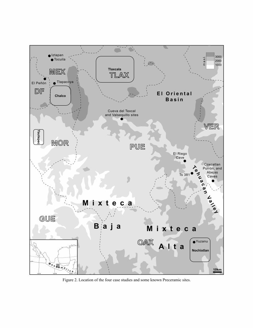
Tehu
a ca
n Va
l l e y
M i x t e c a
A l t a
M i x t e c a
B a j a
E l O r i e n t a lB a s i n
Tlaxcala
Chalco
Yautepec
Nochixtlan
TocuilaIztapan
TlapacoyaEl Peñón
Cueva del Texcaland Valsequillo sites
Yuzanu
El RiegoCave
Ts 381
CoxcatlanPurrón, and
AbejasCaves
10km90oW110oW 100oW
20oN
M e s o a m e r i c a
20003000
1000m a
.s.l.
Figure 2. Location of the four case studies and some known Preceramic sites.
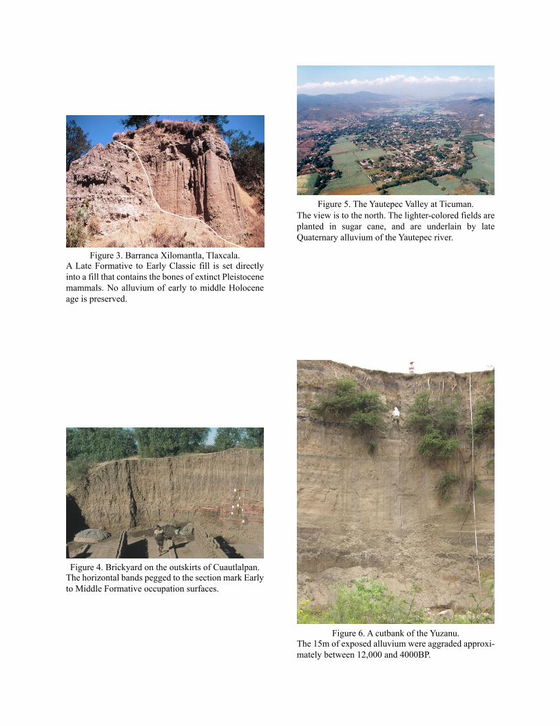
Figure 3. Barranca Xilomantla, Tlaxcala.A Late Formative to Early Classic fill is set directly into a fill that contains the bones of extinct Pleistocene mammals. No alluvium of early to middle Holocene age is preserved.
Figure 4. Brickyard on the outskirts of Cuautlalpan.The horizontal bands pegged to the section mark Early to Middle Formative occupation surfaces.
Figure 5. The Yautepec Valley at Ticuman.The view is to the north. The lighter-colored fields are planted in sugar cane, and are underlain by late Quaternary alluvium of the Yautepec river.
Figure 6. A cutbank of the Yuzanu.The 15m of exposed alluvium were aggraded approxi-mately between 12,000 and 4000BP.
Copyright © 2022 FDOKUMEN