Alluvial Land Reclamation Process of Bangladesh with ...
353
Alluvial Land Reclamation Proce Bangladesh with Special Refere Historical Geography, Geo-polit Environment since the Colonial その他のタイトル バングラデシュ沖積低地の開拓過程 : 英領期以降 の歴史地理・地政学と環境 著者 Abdul Malek year 2016-09-16 学位授与機関 関西大学 学位授与番号 34416乙第491号 URL http://doi.org/10.32286/00000357
-
Upload
khangminh22 -
Category
Documents
-
view
0 -
download
0
Transcript of Alluvial Land Reclamation Process of Bangladesh with ...

Alluvial Land Reclamation Process ofBangladesh with Special Reference toHistorical Geography, Geo-politics andEnvironment since the Colonial Rule
その他のタイトル バングラデシュ沖積低地の開拓過程 : 英領期以降の歴史地理・地政学と環境
著者 Abdul Malekyear 2016-09-16学位授与機関 関西大学学位授与番号 34416乙第491号URL http://doi.org/10.32286/00000357

2016年9月 関関関関関関関関関関
2016 年度論文博士(文学)学位請求論文
Ph.D. Thesis Submitted to Kansai University, Osaka, Japan
バングラデシュ沖積低地の開拓過程
―英領期以降の歴史地理・地政学と環境―
〔英文〕
Alluvial Land Reclamation Process of Bangladesh
with Special Reference to Historical Geography, Geo-politics and Environment since the Colonial Rule
アブドゥル・マレック
AbdulMalek
2016年 5月 27日
May 27,2016

i
Abstract
The word ‘delta’ was first coined by the Greek historian Herodotus (484?-425 B.C.) in the 5th century B.C. in order to describe the Nile delta. Geographers, historians, sociologists and hydrologists of Asia have divided the deltas of this continent in two types looking at their over-all conditions. These two types of delta are commonly known to then as agricultural or peasant delta and mercantile of business delta. The Bengal delta, comprising East and West Bengal, has been created by tectonic activities. Most of Bangladesh, erstwhile named as East Bengal and East Pakistan, lies within the broad delta formed by the Ganges (Ganga), Brahmaputra, and Meghna rivers and is subject to annual flooding and inundations. Much fertile, alluvial soil is deposited by the floodwaters. Most of the land is exceedingly flat and low-lying. The only significant area of hilly terrain, constituting less than one-tenth of the country’s territory, is the Chittagong Hill Tracts District in the narrow southeastern panhandle of the country. Small, scattered hills lie along or near the eastern and northern borders with India. These areas, which receive among the heaviest rainfall in the world, provide the headwaters of the Meghna and its tributaries. This situation is responsible for creating endless char (strips of sandy land rising out of the bed of a river or a sea above the water level) in may parts of Bangladesh. The soil here is much less fertile than the annually replenished alluvium of the surrounding floodplain. Of Course, soil morphology is not similar all over in Bangladesh.
In all civilization reclamation is a common for making any human habitation. So far as Bangladesh is concerned the references to reclamation in this area are found in ancient Sanskrit and medieval Persian texts. With the rapid growth of population, reclamation in Bengal assumed different characters, though there were morality and human loss for a considerable time. The frequent changes of river courses at different time had contributed largely to the topographic scenarios of Bengal. Change in the rivers courses are so much so that central and western parts of Bengal moribund and internal population movements became also frequent. In Bengal the subject of land reclamations was meticulously connected with land revenue administration. After carrying out some experiment in land revenue system permanent settlement of 1793 adopted during the early British rule had created a set of zamindars with large quantities of lands that they could not handle. The most important clause of the permanent settlement was to deposit annual revenue on a fixed day before sun set; otherwise the property would have been put into auction. As a result many zamindars lost their proprietary rights within a couple of years. With a view to avoiding this difficulty, the manager of Burdwan Raj, by applying his shrewd tact for management of an estate had created intermediary right in landed properties which was known as sun-infeudation or pattani system, though this action was against the regulations of the Permanent Settlement. This had, in return, created anomalies among the landed proprietors. With a view to putting an end to the anomalous situation, the British Government decided to recognise the right of the pattanidars by promulgating Pattani Regulation in 1819. However, the pattanidars were not slow to understand the situation and as a result several tiers of pattanidars

ii
were created keeping the zamindars at the apex of the land system. These pattanidars had contributed much in the land reclamation processes in the 19th and early half of 20th century.
In the beginning the aboriginal peoples, who were reluctant to plough cultivation, played important role in the reclamation processes. But they were migratory in character and left land after clearing. The pattanidars then employed village headmen for the search of new-settlers. Meanwhile the waste lands of Bengal proper were almost reclaimed. Then attention was diverted to alluvial (char) lands for reclamation. At the end of the 19th century, the land-man ratio had started to decline, but the population ratio rose high. In these circumstances, greater emphasis was given to alluvial lands for reclamation by the profit mongers.
The topography of Bengal does not unique in character; rather it had some regional variations. Consequently, the diverse geographically and topographically configured areas of Bangladesh posed as a challenge to the reclamation process. These areas were the Barind areas of North Bengal, forest tract of Sundarbans, the Chittagong Hill tracts, Haor areas of Mymensingh and the wetland or Chalan Beel of Pabna and Rajshahi. As the topographic, geomorphologic and hydrological settings of the areas above alluded to area different; the process of reclamation of these are also bound to be diverged. But the basic character is that the reclamation processes carried in these were areas always remained unsustainable. Few years after carrying reclamation works, these areas relapsed to their earlier conditions.
After partition of India and the creation of Pakistan in 1947, Bangladesh witnessed considerable political metamorphosis. The growth population had increased remarkably and the demand of land and food also enhanced surprisingly. In order to cope with the changed circumstances attention towards alluvial lands became very prominent which, in fact, brought geo-political activities in forefront. The subject of geo-political activities was not unique only in the later half of the 2oth century; its origin could be traced even in the later half of the 19th century. However, it had been reiterated earlier that the changes of the course of river was frequent in Bangladesh from historical times. Consequently, a large number of people became homeless and landless owing to erosion of rivers. The homeless and landless people initially rushed to the important urban areas e.g., capital of Bangladesh for shelters and jobs and built slums near railway stations and other vacant places of the towns. Such assemblage of homeless and landless peoples, coming from heterogeneous social and economic background, practically populated the environmental conditions of the urban areas of Bangladesh.
The Government of Bangladesh, the then in power, having no other alternatives in hand, had declared new char land distribution policy where homeless and landless poor families were given priority. Declaration of such new char land distribution policy, in fact, had provided fresh opportunities to the land-grabbers who were greedy for wealth with a view to enrich them. As a result new political polarisation occurred country-wide. The homeless and landless poor families, hearing the official policy of new char land distribution, had assemblage in the new chars with

iii
the solemn hope of beginning life a new. The new chars are situated far away the mainland without any communication facilities. In the beginning the embanked the chars with a view to getting fresh water for drinking and also created huts for living with families. New char dwellers had also tried to cultivate some lands for their livelihood. The lives of the new char dwellers were very much uncertain, because they had no legal rights or documents; moreover the new chars were liable to diluvion at any time. New char distribution policies, as earlier promised by the Government in power, could not have been materialized for many reasons.
In this situation, the land grabbers residing in the semi-urban areas near the char lands, exploiting the opportunities, seized the new char lands by applying many illegal tactics to which they were very much accustomed with.

iv
ACKNOWLEDGEMENT
It is an essential responsibility to acknowledge the persons and institutions through whose kind and sympathetic help and co-operation the writing of this thesis was possible. A pioneer researcher of historical discipline, whatever ancient, medieval or modern cannot conduct research independently. Many kinds of help, co-operations and collaborations are needed for conducting a comprehensible research work. In this research work I received help from many persons and institutions. Among them the name of my supervisor is the first to be mentioned. Dr. NOMA Haruo, Professor, Litt. Dr., Department of Geography and Regional Environment, Kansai University, Osaka, Japan is my supervisor. I am indebted to him in many ways. I am a student of Modern Indian History. But this research requires multi-disciplinary approach e.g., historical geography, geo-politics and environment. Professor NOMA Haruo has taught me the above-mentioned disciplines with profound attention. It may be honestly being said that this research would not be possible, had I not been constantly hammered by Professor NOMA Haruo for its quick completion. It is worthy to mention that I had been associated with Professor NOMA Haruo when he was the Director of a JICA Project in late 1990s. However, I exploit this opportunity to express my heartfelt gratitude to him.
Mention should be made to my esteemed teacher, Dr. Ratan Lal Chakraborty, M.Phil., Ph.D., Professor of Modern Indian History, (now retired), University. He had kindly introduced me with Professor NOMA Haruo. Professor Ratan Lal Chakraborty had not only taught me land systems of Bengal, but also imparted knowledge to me about the methodology of modern historical research. Besides these, he lent to me some rare historical documents which he brought from the British Library (earlier India Office Library and Records) which helped me immensely. Before this, I wrote two articles which were published in the learned journals from abroad. It is right time to express my gratefulness to my esteemed teacher Professor Ratan Lal Chakraborty.
It took considerable time to complete this thesis. Because there no indices of the historical materials available in the Bangladesh National Archives. The services render by the archival staffs are undoubted good, but the absence of indices took long time to get desired materials. The paper clippings of the post colonial period, prepared by the Department of Public Relations have been shifted to the Bangladesh National Archives after the emergence of Bangladesh (erstwhile East Pakistan) are very good, but authority of the Bangladesh National Archives cannot supply any photocopies due to unwieldy size of the paper clippings. However, thanks are due for the Director of the Bangladesh National Archives and his staffs.
There are many valuable and first-hand materials preserved in all the District Collectorate Records Rooms locally known as Muhafezkhana. But it is very dangerous to collect materials from those District Collectorate Records Rooms, due to the presence of highly venomous snakes which search rats at random. The yawn of the snakes can easily be smelled and their fury can also be heard. Withstanding these difficulties I have consulted some records of the District Collectorate Records Rooms. The records of District Collectorate Records Rooms have been

v
shifted after the completion of my work. However, I especially thank Muhammad Murad Ali for his very kind cooperation in this regard.
It is worthy to mention that the records of the colonial India had been divided in between Bangladesh and West Bengal. So for obvious reason, I had to consult the records shelved in the State Archives. Here also no indices of the historical materials are available. Despite this hindrance, Dr. Bidisha Chakraborty, Deputy Director of the West Bengal State Archives, had helped me allowing me taking digital image by the help of camera. I am grateful to Dr. Bidisha Chakraborty for her kind help. I also worked in the National Library of India, (established in 1820s and located at Alipore, Kolkata, West Bengal) from I collected very important materials pertinent to my thesis. In this connection I thank Dr. Prasenjit Chatterji, the then Director of the National Library of India.
The secondary source-materials available in different libraries of Bangladesh are not well arranged excepting the university libraries e.g., Dhaka, Rahshahi, Chittagong, Jahingirnagar. In these libraries only lists of the reports and books have been digitized, but the texts are not available in digital form. All the old books have been shelved in the rare sections, where rigid rules of consulting books are maintained by the concerned authority. Dr. Sirajul Islam, Librarian of the Dhaka University had extended his helping hand by allowing me to take digital image by camera. I humbly express my thanks to Dr. Sirajul Islam.
Last but not the least, the real architects of my thesis were the landless and poor char dwellers, who, in spite of threats of their lives, had divulged information of regarding the highly illegal activities of the revenue and police officials, political power-magnates, armed gangs etc. Their numbers are many, so I refrained to mention their names, but I thank all of them from my core of heart for their undaunted courage.
The authority of the Kansai University is so benevolent that they have very kindly accepted me as a paper Ph.D. candidate and send to me necessary papers to the Japanese Embassy by which I got visa to enter the colourful and dreamland Japan. I am very much astonished experiencing their magnanimity. I express my heartfelt gratitude to the honorable authority of the Kansai University. The Japan Embassy was kind enough to allow me visa which was essentially required for entering Japan, which I consider a rare opportunity. On this auspices occasion I thank all of them.
Finally I am personally indebted to my mother Mrs Hosne Ara Begum, who had taken all the troubles when I left my house in search of source-materials required to reconstruct the history of land reclamation keeping behind my wife and two of ours minor children. At that juncture my mother protected my wife and two of ours minor children. Virtually a son is always bound to be ever grateful to his mother to a very wide extent and it will rather be a sin to express gratefulness to mother. So I refrained myself from committing that sin. My beloved wife Dola has always encouraged me to my research work, even leading hopeless and arrested life with my mother and

vi
two of ours minor children for long days. Excepting silence gratefulness from my heart I have nothing to say her. Our minor son Rahul and daughter Raka, who had allowed me time to work undisturbed being deprived of their child rights.
(Abdul Malek)
Date: 27.05.2016

vii
Abbreviations and Acronyms
ALRD : Association for Land Reform and Development
ASK : Ain o Shalish Kendro
BBS : Bangladesh Bureau of Statistics
BLAST : Bangladesh Legal Aid and Services Trust
BELA : Bangladesh Environmental Lawyers Association
BNP : Bangladesh Nationalist Party
BRAC : Bangladesh Rural Advancement Committee
BWDB : Bangladesh Water Development Board
CARE : Cooperative for American Remittances to Europe
CDSP : Char Development and Settlement Project
DANIDA : Danish International Development Agency
DGIS : The Directorate General for Development Cooperation
EGIS : European Grid Infrastructure Survey
FAO : Food and Agriculture Organization of theUnited Nations
GED : General Economics Division
GOB : Government of Bangladesh
ILO : International Labor Organisation
JICA : Japan International Cooperation Agency
JSARD : Joint Study on Agricultural and Rural Development
LGED : Local Government Engineering Department
NGO : Non-Government Organisation
RAB : Rapid Action Battalion
TNO : Thana Nirbahi Officer or Administrative officer of the Police Station
U.N.O. : United Nations Organisation
UNDP : United Nations Development Program
VGD : Vulnerable Group Development
viii
Table of Contents
Abstract ............................................................................................................................................ i
Acknowledgement ......................................................................................................................... iv
Abbreviations and Acronyms ....................................................................................................... vii
Table of Contents ......................................................................................................................... viii
List of Tables ............................................................................................................................... xiii
List of Figures .............................................................................................................................. xiv
List of Maps ...................................................................................................................................xv
Introduction ....................................................................................................................................1
a. The Bengal Delta..............................................................................................................1
b. Over-view of Existing Literatures ...................................................................................2
c.Chapter Divisions ............................................................................................................10
d.Methodology and source-materials .................................................................................12
Chapter 1 Changing Pattern of the Rivers in Deltaic Bengal with Special Reference to Bangladesh ................................................................................................................18
1.1 On the Changing Course of Rivers in Bengal ........................................................19
1.2 Chronological Account of the Behaviour of the Rivers ........................................21
1.3 The River System of Bangladesh ..........................................................................33
1.3.1 The Ganges and its distributaries ..........................................................................33
1.3.2 The Padma-Meghna Estuary ..................................................................................36
1.3.3 The Meghna and the Surma System ......................................................................37
1.3.4 The Brahmaputra’s Effluents and Channels ..........................................................38
1.3.5 The North Bengal Rivers .......................................................................................39
1.3.6 The Hill Rivers of South-East ................................................................................41
1.3.7 Inactive or Moribund delta.....................................................................................47
1.3.8 Mature Delta ..........................................................................................................48
ix
1.3.9 Active Delta ...........................................................................................................48
Chapter 2 The General Reclamation Process in Bengal .......................................................58
2.1 Factors forcing man to desert .................................................................................59
2.2 Mortality caused by famine ...................................................................................59
2.3 Mortality caused by diseases .................................................................................61
2.4 Malaria and consequent mortality ..........................................................................61
2.5 Early Land system, Permanent Settlement and rise of intermediaries ...................68
2.5.1 Period I - 1765-1773: Period of hesitation .............................................................68
2.5.2 Period II - 1773-1781: Period of centralization .....................................................69
2.5.3 Period III - 1781-1786: Completion of centralization ...........................................70
2.5.4 Period IV - 1786-1793: Decentralization ...............................................................70
2.6 Availability of cultivable lands ..............................................................................74
2.7 Land Policy and Reclamation Process ...................................................................81
2.8 Demographic Situation ..........................................................................................82
2.9 The Driving Force of Reclamation ........................................................................83 2.10 Subinfeudation and Reclamation Process ..............................................................84
2.11 Trends of Reclamation Process in Some Bengal Districts in the later half of the 19th Century...........................................................................................................91
Chapter 3 Reclamation Process in Diverse Geographically and Topographically Configured Areas of Bangladesh .........................................................................105
3.1 The Case of ‘Barind Tract` of Bogra ...................................................................106
3.2 General Description of the District ......................................................................107
3.3 Depopulation ........................................................................................................108
3.4 The Process Reclamation .....................................................................................110
3.5 Land Reclamation: Role of Landlords and Headmen ..........................................110

x
3.6 Development of Cash-Nexus and Its Impact .......................................................113
3.7 The Reclamation Process of the ‘Sundarbans’: A Forest Land of Bangladesh ...117
3.8 Land Management Policy ....................................................................................120
3.9 Physical Reclamation of the Sundarban Forest Tract ..........................................126
3.10 Construction of Dams ..........................................................................................128
3.11 Preparing of a habitat ...........................................................................................129
3.12 Apathy of the European Capitalists and Interest of Local Rich: A Place of Common Interest ..................................................................................................129
3.13 Impact of Sundarban Reclamation on Religious Culture ....................................130
3.14 Concluding Remarks ............................................................................................131
3.15 The Hill Tracts of Chittagong: A Case Study on Hill Cultivation .......................131
3.16 The Reclamation Process of the Wetlands like the Haors of Mymensingh in Post-Colonial Period ....................................................................................................139
3.17 The Conditions Chalan Beel: The Largest Wetland of Bangladesh ....................146
Chapter 4 Alluvial Land Reclamation Process in Bengal During the Colonial Rule .......163
4.1 General View of Reclamation Process in Bengal during the Colonial Period ...164
4.2 Changes in the River Course ..............................................................................165
4.3 Alluvial and Diluvial Formation ........................................................................166
4.4 Laws Regarding Char Land administration ........................................................167
4.5 Act XXXI of 1858 ..............................................................................................169
4.6 The Bengal Alluvial (Amendment) Act, 1868 ...................................................170
4.7 The Bengal Tenancy Act, 1885 ..........................................................................170
4.8 The Alluvial Lands Act, 1920 or Act V of 1920 ................................................170
4.9 Pattern of Char Land Settlement ........................................................................171
4.10 Physical Occupation of Char Lands ...................................................................174
4.11 Production in Char Land ....................................................................................175
xi
4.12 Diara Surveys ....................................................................................................176
4.13 Scenario of Char Reclamation at District-Level in the 19th Century ................178
4.14 Forcible Occupation of Char Land in the earlier half of the 20th Century ........194
Chapter 5 Char Land Reclamation Process in Bangladesh since Independence..............202
5.1 Legal Aspects of Char Land Administration since 1947 ..................................207
5.2 Khas Lands in Bangladesh ................................................................................208
5.3 Survey and Settlement of Char Lands ..............................................................210
5.4 Chronicles of Char Lands Incidents ..................................................................213
5.5 Diara Surveys ...................................................................................................214
5.6 Incidents in Mature Delta ..................................................................................214
5.7 Incidents in Active Delta Districts ....................................................................215
5.8 Successful Movement of the Landless Peoples at Char Bansberia ...................218
5.9 Life in Char .......................................................................................................219
5.10 Lathials ..............................................................................................................220
5.11 Shrimp Culture ...................................................................................................221
5.12 Char Land related literature ...............................................................................222
Chapter 6 Alluvial Land Reclamation Process in Noakhali District Selected Field
Studies ....................................................................................................................225
6.1 Major Char Lands of Noakhali developed in the earlier half of the 20th
Century ..............................................................................................................228
6.2 Frequent Changes of Ferry Ghat.......................................................................234
6.3 Deprivation of the Char Dwellers, Land-Grabbing Activities and Violence....236
6.4 Problems relating to Char Land ........................................................................242
6.5 Shrimp and Prawn Culture in Coastal Areas of Noakhali and There Impacts..247
6.6 Mangroves and Wetlands destruction ...............................................................251

xii
6.7 Acidity of Soil ...................................................................................................252 6.8 Salinity of water and its impact on soil .............................................................252
6.9 Loss of small fry and wild fishes ......................................................................252
6.10 Socio-economic implications ............................................................................252
Chapter 7 Landless People and Geo-Politics in Bangladesh: A Case Study on Selected Char Lands of Noakhali District .........................................................................256
7.1 Introduction .......................................................................................................256
7.2 Source-Materials ...............................................................................................258
7.3 The Locus of Fields ..........................................................................................259
7.4 Landscape of the Fields ....................................................................................259
7.5 Demographic and Socio-Economic Features of the Chars ...............................260
7.6 Historical Background ......................................................................................262
7.7 Present Situation (Char Uria, Char Lakkhi and South Char Clark) ..................264
7.8 Who is Al-Farid?...............................................................................................266
7.9 Boyer Char, Naler Char & Char Carring ..........................................................267
7.10 Char Nangalia ...................................................................................................268
7.11 Char Bagga and Char Ziauddin.........................................................................270
7.12 The Government Plans about the Char Lands Management in Contemporary Historical Perspectives ......................................................................................271
7.13 Public view about the Government plan towards the Char land .......................272
7.14 Major Issues in brief .........................................................................................272
7.15 Concluding Remarks .........................................................................................274
Conclusion ..................................................................................................................................276
Glossary ......................................................................................................................................285
Appendices ..................................................................................................................................294
Bibliography ...............................................................................................................................322

xiii
List of Tables
Table-2.1 Fever Mortality in Bengal (1871-1884) .................................................................62
Table-2.2 Regional Distribution of Malarial Infection ..........................................................63
Table-2.3 Number of Deaths and Ratio per 1,000 Population of Bengal ..............................64
Table-2.4 Estimation of lands in Bengal ................................................................................74
Table- 2.5 Inhabited and uninhabited Villages of Some Parganas of Greater Mymensingh Districts Shown in the Revenue Survey of 1850s. .................................................76
Table- 2.6 Agricultural Operation of the Country 1879 .........................................................78
Table-2.7 Increase in Population of Bengal by Natural Division, 1872-1921 .......................82
Table-2.8 Statistics of Proprietors, Hakikatdars and Rayats in Jhalakati Thana in 1901 ......88
Table- 2.9 Triennial Statements of Perpetual Lease in Bengal Districts,
1870-1899 ..............................................................................................................89
Table- 3.1 Mehal wise Cultivated and Uncultivated Area ....................................................109
Table- 3.2 Percentage of Gross Cultivated Area ...................................................................113
Table- 3.3 Rate of Revenue of Each Bigha Land (in Rupees) ..............................................122
Table- 3.4 Condition of Lease ...............................................................................................125
Table- 3.5 Changing Trend of Ethnic Composition in the Chittagong Hill Tracts (1872-1991) ......................................................................................................139
Table- 3.6 Village wise Quantity of land Reclaimed ............................................................144
Table- 4.1 The area of diaras and their annual demand of rent .............................................182
Table- 5.1 Coastal and Estuarine Islands and Char Lands of Bangladesh ............................204
Table- 5.2 Population of Bangladesh ....................................................................................208
Table- 5.3 Khas Lands of Bangladesh...................................................................................209
Table 6.1 Location of the Char Landsof Noakhali in Early 20th Century ............................228
Table- 6.2 Size of new char lands of Bangladesh .................................................................235

xiv
List of Figure
Figure- 2.1 Fever Mortality in Bengal..............................................................................62
Figure- 2.2 Regional Distribution of Malarial Infection ..........................................................63
Figure- 2.3 Number of Deaths and Ratio per 1,000 Population of Bengal ..............................64
Figure- 2.4 Percentage of Quality of Lands in Bengal .............................................................75
Figure- 2.5 Agricultural Operation of the Country in 1879 ..............................................78
Figure- 2.6 Increase in Population of Bengal by Natural Division, 1872-1921 .......................83
Figure- 2.7 Subinfeudation or Intermediaries or Tenure Tree in Land ....................................86
Figure- 2.8 Subinfeudation or Intermediaries or Tenure Tree in Land ....................................87
Figure- 2.9 Subinfeudation or Intermediaries or Tenure Tree in Land ....................................87
Figure- 2.10 Triennial Statements of Perpetual Lease in Bengal Districts,
1870-1899 ..............................................................................................................89
Figure- 3.1 A Scene of the Area of the Jumias of Chittagong Hill Tracts .............................137
Figure- 3.2 Chalan Beel ..........................................................................................................148
Figure- 5.1 Lathials of Bengal ................................................................................................220
Figure- 7.1 Violence at Char Zia, Noakhali ...........................................................................271
Figure- 7.2 Burning the house of landless family at Char Zia, Noakhali ...............................271

xv
List of Maps
Map-1.1 Regional map of the Bengal Basin showing physiography and geology of the Ganges-Brahmaputra delta and surrounding area ........................................24
Map-1.2 Part of Tassin's Map delineating river navigation .................................................31
Map-1.3 Part of one plate from Princep's Gangetic Atlas 1829 ..........................................34
Map- 1.4 Map of Bengal Delta ..............................................................................................47
Map- 1.5 Catchment Area of the Three Rivers .....................................................................55
Map- 1.6 Gastaldi's map of Asia 1561 as redrawn by Mukerjee (1938) ...............................56
Map- 1.7 Map of the Ganges, Brahmaputra and Meghna river basins ..................................57
Map-3.1 Map of the Barind Tract should be included from Banglapedia with proper acknowledgement ................................................................................................107
Map- 3.2 Map of Sunderbans ..............................................................................................118
Map- 3.3 Chittagong Hill Tracts..........................................................................................132
Map- 3.4 Map of Mymensignh District ...............................................................................140
Map- 3.5 Map of Kishoreganj District ................................................................................141
Map- 3.6 Map of Chalan Beel Area ....................................................................................147
Map- 3.7 Map of Pabna District ..........................................................................................147
Map- 4.1 Map of Char Bhadrasan ..........................................................................................185
Map- 4.2 Chars of Mymensingh .............................................................................................186
Map- 4.3 Map of Chars Immampore, Miami and Phulbari .................................................188
Map- 4.4 Map of Char Fasson ................................................................................................190
Map- 5.1 Mapof Char Rajibpur ............................................................................................212
Map- 5.2 Major Chars of Barisal, Noakhali and Patuakhali ...............................................215
Map- 5.3 Violence in Bangladesh in Map (1970-1990) ......................................................221
Map- 6.1 The Present Conditions of Few Char Lands of Noakhali District .......................229
Map- 7.1 New Char Lands of Noakhali ..............................................................................260
1
Introduction
At present, the term reclamation commonly applies to the utilization and improvement of water and land resources for agricultural and other purposes, through irrigation, drainage of tidal marshes. Right from the dawn of civilization the settlement of population was everywhere invariably related to land reclamation. The process of land reclamation may have regional variations owing to geographical configuration, physical features, soil morphology and environmental hazards. It is not possible to reconstruct the history of land reclamation in the ancient times. Even Vere Gordon Childe (1892 – 1957), better known as V. Gordon Childe, an Australian archaeologist and philologist, who specialized in the study of primitive history, had mentioned that the Italian Etruscan property owners had supported the land reclamation process in and around between 490-392 B.C.1 However, no definite theory can be attributed to the reclamation process applicable throughout the world. One thing is very important here that the author of this thesis has not given italic mark on the Bengali word, because the word char appears very common word of this thesis.
a. The Bengal Delta
The natural functions of the two Himalayan Rivers - the Ganges and the Brahmaputra, had created the popularly known Bengal Delta. These two rivers which from the beginning have started to drain to the Bay of Bengal as a combined river and carry the largest sediments to lower end. Along with these two rivers another non-Himalayan river, the Meghna have helped to built one of the largest deltas in the world known as the Ganges-Brahmaputra Deltaor the Bengal Delta. On its northeastward migration, the Ganges built several deltas and then abandoned them before finally occupying its present shape. The Brahmaputra had an eastward course as revealed by Rennell’s Atlas, building the early Brahmaputra delta near Mymensingh. Later the river has taken a southward course straightway. However, while these two rivers previously emerge into a wider place individually to the Bay of Bengal, but at present they coalesce before finally purging into the bay. According to a contemporary report these delta building activities of the rivers contributed to the formation of nearly 60 per cent of the total Bangladesh coastline.2
Conforming to the occupation of several river courses and shifting tendencies the total deltaic coastline may be generalized as the western inactive delta and the eastern active deltaic plain. Currently Sifatul Quader Chowdhury and M Qumrul Hassan have tried developed some criterion for dividing the delta into different categories using some recently published geological articles on the ‘Ganges-Brahmaputra Delta Complex’. According to their opinion:
While the western inactive delta is relatively old, the Meghna deltaic plain is geologically very young. However, the western inactive delta can be further subdivided into moribund delta, mature delta and tidally active delta. Practically, the area that lies in the west of the Gorai-Madhumati river is the

2
western inactive delta and the area that lies in the east of the river is the eastern active delta. The Bengal delta covers a large area of the Bengal Basin, which occupies about 35% of the total area of Bangladesh. It is bordered by the Indian Shield in the west, the southern margin of the Barind Tract in the north, and the Tippera Surface in the east. The main progradation of the delta is continuing to the south into the Bay of Bengal.3
The western inactive delta covers an area of about 31,500 sq km in Bangladesh. It includes Murshidabad (only the portion east of the Bhagirathi), Nadia and 24-Paraganas of India and the old districts of East Bengal like Kushtia, Jessore, Khulna. The eastern active delta covers an area of about 15,000 sq km. This part of the Ganges-Brahmaputra delta is about 300 km long in the north-south direction and about 100 km and 130 km wide in the upper and middle reaches respectively. The eastern active Ganges-Brahmaputra delta includes Faridpur, Barisal, Patuakhali as the old districts of Eastern Bengal.4 Currently the whole Bengal delta is divided into five categories, e.g., inactive or moribund delta, active delta, mature delta, tidally active delta and subaqueous delta. It will be evident from the map enclosed here about the location of the old districts of Bengal.
b. Over-view of Existing Literatures
The land reclamation of land was consistently related to land and the changing course of rivers which would be discussed with due emphasis in the first chapter of this dissertation, otherwise no fruitful analysis could be achieved. Before this, it is necessary to mention the works hitherto done on the change of the course of rivers and related land reclamation process with a view of showing the feasibility of the present research work. In the beginning of the East India Company’s rule in Bengal, the only source of income was the land revenue and as a corollary, the English authority had suggested their local administrators to collect data on land. Of course, the sole object of the East India Company was to maximize income further. In consequence of the continued directives from the Board of Directors and the Court of Proprietors of the East India Company large volume of materials had been collected by the European scholar-administrators over times wherein land related subjects are enormous. Apart from huge and voluminous records on land revenue administration available in the Bangladesh National Archive and West Bengal State Archive, comprehensive reports and books on land and land revenue administration appeared from the skilled hands and pens of the European scholar-administrators during the colonial rule.
Sir William Wilson Hunter wrote in his Annals of Rural Bengal in 1872 that:
In the cold weather of 1769 Bengal was visited by a famine whose ravages two generations failed to repair. English historians, treating of Indian history as a series of struggles about the Company's charter enlivened with startling military exploits, have naturally little to say regarding an occurrence which involved neither a battle nor a parliamentary debate. Mill, with all his accuracy and minuteness, can spare barely five lines for the subject, and the recent Famine Commissioners confess themselves unable to fill in the details.5
3
In consequence of this famine, the large parts of Bengal were depopulated and covered with dense forest. Even there was a dearth of immigrant labour for reclamation. Henry Thomas Colebrooke (1765-1837) had suggested offering liberal terms and providing additional incentives to the ryots for enticing the distant cultivators.6 This was the beginning of the European scholar-administrators to enter into the land system and reclamation process in Bengal. Nearly around this time, there appeared a large number of exoduses from Arakan due to political turmoil over there. An elaborate policy of the settlement of the Arakanese emigrants had been adopted and they were given noabad lands for reclamation at liberal terms.7 The Ph.D. thesis conducted by Alamgir Serajuddin entitled as The Revenue Administration of Chittagong, 1761-1785 (University of London, 1963-64) shows the nature of noabad settlement operation in Chittagong. Next appears the report prepared by Pargitar A Revenue History of Sundarbans from 1765 to 1870 (published in 1885) and F.D. Ascoli’s Final Report of the Survey and Settlement Operations in Sundarbans, 1870-1920, throws enough light on the plenty of uncultivated lands of Sundarbans. In the presence of plenty of uncultivated lands and the thin density of population, the landlords had to depend on the pioneer-farmers who practically monopolized land to let it to the actual cultivator at a rent higher than the actual demand of the landlord.
The underlying idea of this dissertation is to analyze the land reclamation process of Bengal since the nineteenth century in general and the alluvial land reclamation process of Bangladesh in particular. Erstwhile Bangladesh was in Bengal, which ceded in 1947 as East Bengal or East Pakistan. Later in 1971, Bangladesh emerged with its own national identity. Viewed from topographical, organizational and tenurial pattern Sirajul Islam has classified the reclamation process carried out in Eastern Bengal into four categories, such as Noabad (newly reclaimed), Char-abad, Bil-abad, and Sundarban-abad.8 Undoubtedly, such classifications may be accepted as considerable progress towards our understanding the reclamation process in Bengal. However, such simple and general classification may not entirely be agreeable, since it lacks in complete vision of the whole process of reclamation in the deltaic Bengal. Sirajul Islam has singled out the ‘noabad’ lands are located only in Chittagong. It is worthy to note that the villages inhabited by the Santals (an aboriginal) in Bankura were also known as ‘noabdi’.9 Furthermore, there were ‘noabadi’ lands in Jessore district.10
The situation of reclamation largely changed in the later half of the 19th century, which witnessed tremendous development of many factors contributory to the reclamation process. The principal development was the demographic change that ushered spectacular change in the existing social and economic order of the country. During 1881-1931 the population of Bengal increased by 37.9%. The eastward shift of Bengal rivers ultimately made old delta moribund. It seems that the hydrological character governed the dynamic factor of population growth of Bengal. As a result, population growth and net cropped area declined sharply in the moribund delta in the 19th century. Birendranath Ganguly, who was the first expounder of the ‘moribund delta’ hypothesis:

4
Practically the whole of western and central Bengal with the exception of the littoral tracts lies in a moribund delta, in which the activity of the rivers has almost ceased, and decadent conditions of health and subsistence have checked the growth of population through successive decades. If compared with the moribund delta there is the active delta covering the greater portion of Eastern Bengal. Here the great rivers are building up land and throwing up new alluvial formations rich in agricultural possibilities, while sometimes there of land sufficiently old and supporting a teeming population.11
The ‘moribund delta’ hypothesis had received support from the studies of Arthus Geddes, ‘The Population of India, Geographical Review, Vol. XXXII, 1942; George Blyn, Agricultural Trends of India,1891-1947: Output, Availability and Productivity, (Philadelphia: University of Pennsylvania, 1966; Akbar Ali Khan, Some Aspects Peasant Behaviour in Bengal: N Neo-Classical Study, (Dhaka: Asiatic Society of Bangladesh, 1982 and Sirajul Islam, Rent and Raiyat: Society and Economy of Eastern Bengal, (Dhaka: Asiatic Society of Bangladesh, 1989.
The Census Reports (1872-1941) furnished information regarding the migration of population from moribund delta to active delta. Besides population pressure, there were other factors responsible for such development. The operation of cash-nexus may be attributed to this progress. The rapid population growth was accompanied by the commercialization of agriculture that ultimately encouraged reclamation process. The emergence of jute as cash crop offered remarkable incentive to the cultivators, as they were inclined to market-oriented production. This had also ushered dramatic changes in the agrarian structure and peasant economy of Bengal. The rise of new landholding class was really the outcome of this process. The studies of Benoy Bhushan Chaudhuri entitled as The Growth of Commercial Agriculture in Bengal, Vol. 1, (Calcutta: Indian Studies: Past and Present, 1965; Ratna Ray, Change in Bengal Agrarian Society, 1760-1850, (new Delhi: Manohar, 1979 and Partha Chatterjee, Bengal, 1920-1947, Vol. One: The Land Question (Calcutta: K.P. Bagchi & Company, 1984) throws sufficient light on the development of new landholding class in the 19th century. The emergence of new commerce-interested group was significant and it brought new polarisation in the highly monetised economy of Bengal. The advance system, the emergence of many intermediaries in market structure and the organised money-lending system can be ascribed as the consequences of the operation of cash-nexus.
However, the historians suggest that the reclamation was spontaneously carried out by the landed-interest at their own in-put. Sugata Bose work entitled as Agrarian Bengal: Economy, Social Structure and Politics, 1919-1947, (London: Cambridge University Press, 1986) throws ample light on the rise of jotedar class from the reclamation process. Sirajul Islam in his work offers a similar view of such development that the pioneers of reclamation work were the intermediary landed interests. The case study of Sirajul Islam covers only the Bakarganj district and Sundarbans portion where large waste lands were available. Sirajul Islam discussed the problem of reclamation in the context of the emergence and development of subinfeudation. His study suggests that “there is a direct link between reclamation of
5
Sundarbans Jungles in southern Bengal and the notoriously complicated subinfeudation system which developed in that region.”12 Undoubtedly, the above-mentioned studies are brilliant in terms of the subjects addressed, but no scholars have yet picked up issue of the land reclamation process of Bengal exclusively. Stray references to land reclamation process of Bengal are available during the course of studies mentioned above. However, there is an exception to the above trend. In a very short article, Ratan Lal Chakraborty has contributed on the land reclamation process of Bengal in general.13
However, diametrically opposite this trend is the subject of Sundarbans which lies on the Ganges-Brahmaputra delta at the point where it merges with the Bay of Bengal. This forest tract had attracted many scholars of different disciplines from the beginning of the British colonial rule. A large number of studies have been conducted on different aspects of Sundarbans. The geology, soil morphology, climate, vegetation, flora and fauna, ancient history, deities, local traditions, environment and all other related issues are still attracting the scholars of different dimensions. This subject is replete with official reports, books, articles, brochures. Nevertheless, the reclamation process of Sundarbans received proper attention of the scholars. Like earlier, Ratan Lal Chakraborty has contributed a brief article on the land reclamation process of Sundarbans.14 In this dissertation the land reclamation process of Sundarbans will be studied separately with proper perspectives.
Before addressing the cardinal issue, it is very much pertinent to ask why reclamation is necessary. The process of reclamation is essentially related to the growth of population even at the earliest period of the history of Bengal. According to Peter G. Robb that “ At that time land could be artificially rationed, even where it was in surplus, in order to preserve social and political hierarchies or to distribute risk, and because of the costs of reclamation or the variability of soils and water-supply.15
Though the present dissertation is supposed to deal with the question of reclamations of Bengal delta from the late nineteenth century onward, it is historically imperative to discuss the past in short for a proper understanding of the reclamation process. Here the big question about the ownership of land requires some explanations. The ancient idea is that land belonged to the subject and the ruler was entitled to levy a tax for his revenue. But who was subject in Bengal – the landlord or the raiyat (farmer) The debates on this question have led to disquisitions as to the origin of right in land, when in nascent time all lands were open to any one to go over and cultivate, and thereby retain his right so long as he could by means of force. Bengal is physically separated from the rest of India and as it had distinct political, social organization along with the conceptions of proprietary rights from the earliest known times. But if we ignore the stern facts and coddle in theories of what might have been in the earliest time at the dawn of society, it would simply mean scrapping all developments in human institutions, call them civilization or gradual acclimatization to altered conditions. As the society became more and more complex in the natural process of its growth, the law of prescription functioned at all times as a powerful issue in determining the rights of individuals regarding properties. It is observed that there have always been gradual changes by process of evolution and societies, as they grow rarely thinking of going to the past. The
6
earlier theory that the person who first reclaimed the land, it came under his absolute right. He then could hand over the proprietary rights to his descendants from son to grandson and great-grandson and ultimately to the present-day cultivators. However, this old theory can hardly be applied in Bengal where circumstances were completely different. The societies had organized into kingship and lands allotted to the jurisdiction of various chiefs. The least rights on them in land were recognised either reclaiming by themselves of by inducing the tenants on soil which were still virgin or had been abandoned by the previous cultivators. However, the process of reclamation or colonization in Bengal was not very easy task. The greater part of the deltaic area between the rivers Padma and Bhagirathi and the lower part of Damodar was, as has been observed earlier, covered with dense forest and intersected by large and forceful of the estuaries of the Bay, with very aggressive wild animals on land and the sharks and crocodiles in the saline water. It needed organizations by persons having command over men and money. This was not the incident of ancient history, but within comparative recent history, when societies and kingships had already been well established in Bengal.16
However, reclamation of wastelands in Bengal was a common human activity, which can be traced from the historical times. The process of reclamation was always inseparably related to land system and tenurial pattern. Reference to reclamation process in Bengal delta is available from 7th century when land known as Nabya abakashika (scope of new reclaimable land) was granted to the people by the king. In many copper-plate inscriptions there are references to land grants of jala (marsh) and bil (large inland depression) to the people. Besides this reference to granting of patit bhumi (waste land) by the king available in many inscriptions often characterized as a part of purely royal prerogative. A grant of land given in the 7th century shows that the land located at “outside the pale of human habitation, where there is no distinction between natural and artificial; infested by wild animals and poisonous reptiles, and covered with forest out-growths.”17 Richard M. Eaton found that such grants of waste lands were often given to the ‘groups of Brahmans or to Buddhist monasteries with a view to colonizing the land and bringing it into cultivation’. Richard M. Eaton attributes this to the diffusion of Hindu civilization in Bengal.18 The process of reclamation changed in the medieval time with the change of demographic pattern which was closely related to the spread of Islam in Bengal.
During the Muslim rule in India and Bengal, we find jagir lands which were in most cases as junglebury or uninhabited wasteland in the frontier regions. The word is derived from the Persian word that means place-holding. In fact, it was an assignment of land and its rent as annuity. According to this system the remuneration of an officer was paid not in cash but with right of administering and collecting the revenue of a landed property.19 Initially this system had encouraged the reclamation of wasteland, restricted cliques and factionalism at the centre and made the assignees a kind of frontier guard against outside raiders and invaders. But later it became feudalistic in character and tended to weaken the central authority. Looking at the dismal condition of jagir system the Mughal Emperor Akbar (1556-1605) had wanted its abolition and substitution by a system of payment of the officers in cash.20The later Mughal emperors had revived this jagir system which contributed much to

7
their weakness and decline. But during the Nawabi rule in Bengal the jagirs were granted extensively by the Nawabs with a view to protecting the coastal areas against the incursion of the Mugs of Arakan, the neighbouring country of Bengal.21 The jagir system was abolished by the East India Company in 1772 and all jagir lands were resumed on the ground that the former jagirdars were no more parts of the state administrative system and had no responsibility and function as they discharged earlier.22
There is a set of Bengali literature known a Mangal Kavyas, which have been by regarded the historians as the mirror of social and economic life of rural Bengal. There are considerable numbers of Mangal Kavyas written or composed at different times by different authors in medieval Bengal that dealt with the land reclamation process and social conditions during this period. Among these Mangal Kavyas, the Chandi Mangal was composed by three authors at different times. However the Chandi Mangal which was composed by Mukundaram Chakravati (also known as Kabikankan) (c. 1540-1600) was praiseworthy. It is anticipated that the Chandi Mangal Kavya was composed about 1577 A.D. In the Chandi Mangal Kavya kalketu was characterized as brave huntsman, able to kill or drive away tigers and other ferocious wild animals. By dint of brave activities, he had been able to create place safe for human settlement. Kalketu was a man with considerable resources at his command and he engaged barunias (wood-cutters) with a view to clearing the forest lands. He then brought traders, artisans, barbers, washermen, Brahmins and many others and settled them in the village. However, Kalketu had encountered a trouble not for taking permission from the king in advance, within whose territory the tract lay. Consequently, the king of Raja sent his army in order to restrain Kalketu and put in prison. Ultimately, there was appeasement and Kalketu received recognition of the king who ordered to put tilak (a sectarian mark) on his forehead in the presence of assembled chief.
Such or similar process would seem to be only natural when colonization of the tracts in the deltaic region of the Ganges and the Brahmaputra was first attempted. These tracts were exactly like the areas as envisaged by Baden Henry Baden-Powell that:
But in large areas the most severe and protracted labour has to be undergone in getting the dense forest and jungle cleared, and in digging out masses of stumps and roots, with no aid beyond manual labour, and very rude if not inefficient tools. And this labour has to be unremittingly continued or the jungle again encroaches. In other parts, agriculture is impossible without embanking and terracing fields on the hill side, and making water courses to divert the streams of hill torrents.23
The condition of Bengal delta in those early days and the natural decadence of the rivers required special protection of embankment in order to keep of floods or overflow of the saline water. According to Baden Henry Baden-Powell that “In all these cases the man (or family) whose hands and funds have effected the change, is sure, at an early stage, to regard himself, and be regarded by others, as peculiarly entitled.”24 It is worthy to mention that Kalketu’s venture, as mentioned in the Chandi Mangal Kavya, however mythical, but

8
provides a natural and rational illustration and in understanding the system of the land-tenures in lower Bengal.
The new characteristic phenomenon of reclamation process in the 16th-17th century was accomplished with the advent of Pirs (Muslim religious mendicants) under whose leadership many forest and marshy lands were transformed to rice fields. Richard M. Eaton's exhaustive historical study and field-level empirical data focus this point quite correctly. In the 16th-17th centuries, Pirs had pioneering role in the reclamation of jungle and marshy lands of Jessore, Khulna, Dinajpur, Sundarban, Sylhet, Bakarganj and Dhaka of Eastern Bengal. He describes the process of reclamation that:
Muslim pirs and gazis went directly into uncultivated regions, organized the local population for clearing the jungles and only later, after having established themselves as local men of influence, entered into relations with the Mughal authorities. In such instances the government endeavoured to appropriate men of local influence by designating them petty collectors.25
The Bengal Tenancy Act of 1885 in its chapter X and section 101 had made mandatory to prepare record-of-right of every tenant of Bengal.26 Consequently, the Cadastral Survey of Bengal was introduced and the first Cadastral Survey was conducted in Chittagong during the period of 1888-1898. The by-products of the Cadastral Survey were the report of the survey and settlement, Mouza (lowest revenue unit) Notes, Estate Statistics, Village Statistics and Tenure Tree. The Mouza Notes prepared by the local Kanungoes (Account officer of the Revenue Department appointed at the village) during the Survey and Settlement operation throw some light on the history and other conditions of the Mouza. It is found in the Mouza Notes of Fatullah of Dhaka district that the history of this mouza and of Estates No.305 and 555 was inseparably connected with that of the Choudhuries of Fatulla who were the proprietors of the Estates. According to the Mouza Notes:
…this is a very old and respectable family tracing its origin from one Shah Fatehulla, a renowned Moslem saint .... A legend goes that he was one of the twelve Derwishes (a member of a Muslim religious order) who came from the west landed at Chittagong to spread the light of Islam where Chittagong is also known as ‘Islamabad’. From Islamabad he came to Dacca and first landed at Fatulla then known as Shastapur and said his prayers where a mosque was raised which still exists recreated after it crumbled down. The village now bears the name of Futulla in honour of the renowned saint, the eastern portion of the mouza still being known as Shastapur. His son Shah Abdulla was also a fakir. He is said to have gone to Delhi and pleased the Emperor by working many miracles. He was granted the rent free Zamindary of Tuppa Fattullapur out from Pargana (an administrative division) Kashinagar.27
Apart from personal effort, there were official attempts for reclamation through agents by granting sanadi and jangalbari lands to individuals during the mediaeval Bengal. Leadership of Pir and Gazis in the reclamation process has left some legacy in our socio-cultural history.

9
Naming of places after the names of Pir, Gazis and Darveshes, building of mosque or Dargah (a mausoleum of a holy Muslim saint) in the central place of the reclaimed area and observance of annual fair in those places are very much common and still these are protected and performances observed with all solemnity. Legends regarding these Pirs, Fakirs and Darveshes have added new element of our historical folk literature e.g., folk-songs and folk-ballads and these provide further scope to trace the missing links of history.28 The folk-ballads and folk songs of these local divinities pass on orally from generations to generations and some of the folk-elements are still available in the rural world of Bangladesh.29
It is found that the village headmen were very active in the 17th -18th centuries when they were vested with the task of reclamation and reflections of their activities are found in Bengali literature. The information supplied by the Annadamangala provides enough foci in this regard. Curiously enough, the narration in the Anandamangala about the activities of mondal for the settlement of new village resembles a similar situation that prevailed during the later half of the eighteenth century Bengal. According to Anandamangala, the mondal requested the cultivators of other villages to come to his village; cultivate lands as much as possible and pay tax after 3 years.30
Pratapaditya, one of the twelve Bhuiyas of Bengal, had settled in Jessore and reclaimed forest land for fortification, human settlement and agricultural development. Indigenous communities like the Mundas and Bawalis were settled in the Sundarbans.31 Following the tradition of the Hindus, Pratapaditya had also invited Brahmins, Kayasthas and Baidyas to settle in Jessore.32 According to the Annada Mangala Kavya, Pratapaditya had instructed the Mandala to settle more people in land in order to increase his revenue.
The word Mondal has been derived from the Sanskrit word Mandala means an orbit, a circle, a division of the country and at the same time headman of a village. The glossaries prepared during 19th century express the view that mondal was the headman of a village who worked as an agent of the zamindar and who served the zamindar in letting the lands and receiving the rents from the villagers. It was a class of tenure-holder in some parts of Midnapore district. In the glossary of Wilson it has been remarked:
It is a class of tenure -holders in parts of Midnapore bordering of the Jungle-Mahals. They were originally substantial raiyats or abadkars, who undertook to bring a tract of waste land under cultivation, paying the zemindar a stipulated sum as rent. These abadkars then reclaimed the land, either themselves or with the help of other raiyats whom they induced to settle under them; established a village, to which they usually gave their name, and being heads of the settlements, were called ‘Mandals’ or headmen. In settlement proceedings of 1839 these Mandals were declared to have only the rights of sthani or Khud Kasht raiyats, and not to be entitled to any munafa or profit, but, though not exactly recognized as talukdars, they gradually acquired rights superior to those of ordinary khud kasht raiyats.33

10
It seems that under the leadership of mandal, as being the prodhan (chief) of the rural society, the proja (villagers) left the place as the rent was heavy. Again, when parganas came under the possession of a landlord, the mandal and gomosta paid a visit to landlord with all villagers (Projas). In some cases, the mandal used to shoulder the responsibility of village settlement. Later historical studies also corroborates the information mentioned in these literature that the mandal played a vital role in zamindari management and settlement of villages even in the earlier half of the eighteenth century.34
c. Chapter Divisions
The dissertation has been prepared in seven chapters with a view to analyzing the trends of reclamation processes in Bengal as well as Bangladesh, which has a long and checkered history. The first chapter entitled as “Changing Pattern of the Rivers in Deltaic Bengal with Special Reference to Bangladesh”. In this chapter emphasis has been given on the physical features of the Bengal Delta and the changing course of rivers. The changing pattern of the rivers in Deltaic Bengal with special reference to Bangladesh has been highlighted, which is very much pertinent so far as the geographical configuration is concerned. Undoubtedly, the Bengal Delta is the creation of big rivers of India and the changing course of its rivers is again very important in shaping up of the Bengal Delta that provides further scope of reclamation process. The changing course of river system in some parts of Eastern Bengal have assumed the character as an unending character by providing innumerable alluvial tracts and as inevitable consequence invites geo-political activities and environmental hazards. The second chapter entitled as the “General Reclamation Process in Bengal” where earlier reclamation process has been discussed in detail. Here the general reclamation process of undivided Bengal during the colonial rule has been highlighted along with the law framed by the colonial authority to administer reclaimed lands in order to maximization of their profit by improving agricultural and other economic activities. In the third chapter, the reclamation process in four special topographic zones of Bangladesh have been addressed and highlighted. These topographic zones are Barind Tract, Sundarbans, Bils,Haors and Baors and Chittagong Hill Tracts. Each topographic zone has its own characteristics, which are different from each other and reclamation process undertaken in these zones depict completely different scenarios. In the Barind tract, the soil morphology is entirely different from the rest of Bengal. However, the Barind tract covers most part of the greater Bogra, Rangpur, Dinajpur, Pabna and Rajshahi districts. Nevertheless, in this dissertation the district of Bogra has been taken as case study. The Sundarbans present a different scenario, which is covered with dense jungle, hence it became very difficult to reclaim. The haor is bowl-shaped tectonic depression, where the Beel a large surface water body that gathers surface runoff water through internal drainage channels; these depressions are mostly topographic lows produced by erosions and they are seen all over Bangladesh. The term beel is synonymous to Baor, and familiar in greater Comilla, Faridpur and Pabna districts. Beels are small saucer-like depressions of a marshy character. Many of the beels dry up in the winter but during the rains expand into broad and shallow sheets of water, which may be described as fresh water lagoons. Naturally, it receives surface runoff water by rivers and khals, and consequently, a haor becomes very extensive water body in the monsoon and dries up mostly

11
in the post-monsoon period. In Bangladesh haors are found mainly in greater Sylhet and greater Mymensingh regions. During monsoon, a haor is a vast stretch of turbulent water. In this dissertation, the haors of Mymensingh district have been selected as a case study. The Chittagong Hill Tracts is the only extensive hill area in Bangladesh lies in southeastern part of the country, which is inhabited by the many aboriginal communities of Bangladesh and where the method of shifting cultivation is practised from historical times. Attempt has been taken to address the reclamation processes carried in these topographic zones from historical point of view. The fourth chapter as entitles “Alluvial Land Reclamation Process in Bangladesh during the Colonial Rule” has been discussed in proper demographic setting of Eastern Bengal. It is well known that the land-man ratio of the whole of Bengal had been started to decline in the later part of the 19th century. It was proposed by the Government of Bengal in 1874 that:
If the pressure of the people on the soil were really excessive, we would then thriving off in large numbers to the rich uncultivated lands which surround Bengal and Behar on every side; for instance they could go to the Himalayan Terai, to Julpigoree, to Assam, to Cacher, to the Chittagong Hill Tracts, to the Soonderbuns, or to Chota Nagpore. Yet practically very few settlers do go from Bengal to these tracts.35
In fact, the Bengali speaking peoples, who were accustomed to live in peace in Bengal proper in their own natural habitat, found it difficult stay in those places where the geographical configuration were completely different. Having no other alternative, these people had started to reclaim alluvial tracts without any proper proprietary right of the land. Such reclamation processes were dominant in the alluvial tracts of Eastern Bengal during the colonial rule. Here we find the traces of historical geography, geo-politics and environmental conditions as well. Of course, competition, collaboration, rivalries were common phenomenon. Nevertheless, they preferred to occupy the alluvial tracts of Bengal in the beginning 20th century. This aspect has been formed the principal agenda in the above chapter. Discussion on this chapter will continue upto 1947 when ‘the great divide’ occurs resulting in the creation of new province popularly known as East Pakistan. Erstwhile Bangladesh was in Bengal, which ceded in 1947 as East Pakistan and became a part of Pakistan. Later in 1971, Bangladesh emerged as an independent, sovereign country with its own national identity. In the sixth chapter entitled as “Alluvial Land Reclamation Process in Noakhali District: Selected Field Studies”, where post colonial alluvial land reclamation process in Bangladesh and related geo-politics and consequent environmental condition have studied. In the post colonial Bangladesh the population density is very high if compared with the land in its possession. In such situation, landless people of different districts of Bangladesh coming from heterogeneous social and economic background have started to occupy the alluvial land having no other alternative to survive in those areas where alluvial land formations took an unending shape. The alluvial land gravers, who had played no significant role during the colonial rule, now arrived to grab alluvial lands with the help and support drawing from the political parties and ignoring the official rules framed by the Government of Bangladesh. This has created endless miseries to the landless poor peoples who try to survive in the char

12
lands. In the last chapter entitled as “Landless People and Geo-Politics in Bangladesh: A Case Study on Selected Char Lands of Noakhali District” several issues pertinent to the reclamation alluvial land has been discussed which bear current value. As being directly associated of a Non-Government Organization known as Bangladesh Legal Aid and Services Trust (BLAST), I knew the char land problems from quite a long time. There are several NGOs in Bangladesh who work seriously for the amelioration of the very poor, landless, char dwellers and poverty-ridden people who cannot recourse to the legal authorities for many reasons. Along with these, considerable numbers of NGOs of Bangladesh are very much concerned about the environmental pollutions in the country. Large numbers of writ petitions have been filed in the High Court demanding the solution of the environmental pollution problems and among these NGOs Bangladesh Legal Aid and Services Trust (BLAST) had filed several writ petitions in the High Court being associated with other NGOs. Copies of the three writ petitions have been appended at the end of this thesis. However, the lifestyle of Char dwellers, their occupations, productions in land, fishing activities in the deep sea, deprivation of any help from the Government of Bangladesh, the deplorable and completely uncertain conditions of landless Char dwellers, serious violence committed by the organised gangs, activities of land grabbers, the extremely corrupt local administrative authorities and the police force have been discussed. The dwellers of char land always live in morbid fear and finally such uncertainty is unending for all the time to come.
d. Methodology and source-materials
The methodology applied in the preparation of this dissertation is both fundamental and empirical. The original source-materials, available in the Bangladesh National Archives and the West Bengal State Archives, have been consulted. Several thousand volumes of district records and survey papers are available at the National Archives of Bangladesh. Each chief district has its own historical record series (both letter sent and letter received) of the eighteenth and nineteenth centuries, which deal with a wide range of subjects, notably agriculture, economy, revenue, land system, and local administration etc. Similarly, local and rural-level historical data on the agriculture and economy of Bangladesh are available in the survey papers prepared during the colonial rule. Unfortunately, there are no indices for getting desired materials instantly. Despite the absence of any indices of the original source-materials, attempts have been made to collect data as far as possible. Besides this, there are the Proceedings of the Lieutenant Governors of different nation-building departments. Similarly A and B- Proceedings of the Government of East Bengal and later the Government of East Pakistan of different nation-building departments are also available in the Bangladesh National Archives without proper indices. The historical materials available in the Bangladesh National Archives cover upto 1963 and after this, there is no official record. The authority of the Bangladesh National Archives is unaware of the reason of this incompleteness. However, allowing this incompleteness the paper-clippings available in the Bangladesh National Archives have been consulted in order to fill the gaps. After the creation of Pakistan, the Publicity Department of the Secretariat of East Bengal had started to collect news and articles on different subjects from the daily newspapers for the future use of the Government. The concerned staffs of the Publicity Department had started to cut the

13
necessary news and articles, pasted on a plain paper, and preserved them according to subject. Fortunately, concerned staffs had always written the name of the newspaper along with date. At the end of the year, the concerned authority had arranged several bundles according to subject. The paper-clippings are the outcome of following this system for long years and now appeared important source-materials for historical and sociological research. Apart from this, records of the several district level archives, popularly known as Muhafezkhana, have been consulted, which provided important materials to the author. The most important publications prepared by my respected supervisor Dr. Noma Haruo and my esteemed teacher Dr. Ratan Lal Chakraborty were very much useful to me. These are (1) Selection of Records on Agriculture, Land Tenure and Economy of Mymensingh District, 1787-1866, (Co-authored by Haruo Noma and Ratan Lal Chakraborty), Kyoto : Kyoto University, Japan, 1987 (2) Selected Records on Agriculture and Economy of Comilla District, 1782-1867, (Co-authored by Haruo Noma and Ratan Lal Chakraborty), JICA, Dhaka, Bangladesh, 1989 and (3) Select Records on Agriculture, Land Revenue, Economy and Society of Noakhali District, 1849-1878, (Co-authored by Haruo Noma and Ratan Lal Chakraborty), JICA, Dhaka, Bangladesh, 1990 are extremely helpful in writing this dissertation. It may be very well said that without the above-mention record compilations done by my respected supervisor Dr. Noma Haruo and my esteemed teacher Dr. Ratan Lal Chakraborty this work could not have been accomplished within the very shortest possible time. Last but not the least, as being directed by my respected supervisor Dr. Noma Haruo, I have repeatedly conducted empirical research work in the very remote alluvial formations of the Noakhali district with a view to collect knowledge about the conditions of landless char dwellers living there and to understand the geo-political subject subsisted therein. However the task is very risky for the personal life of the author. But the char situated far from the main land could not have been surveyed in the absence of any communication system. However, the char dwellers are illiterate people and very much unwilling to disclose or divulge all the facts anticipating their fate in near future. It was very difficult to get proper information, because the landless char dwellers were afraid to disclose anything. However, with the help of local police authorities char dwellers disclose the stern reality of their life on the char they inhabit. Following this way, the chapter on “Landless People and Geo-Politics in Bangladesh: A Case Study on Selected Char Lands of Noakhali District” could have been possible to be included in this dissertation.
However, it is my moral obligation to inform the readers and examiners of this thesis that some parts of two articles were published in the learned journals before the completion of this work. The titles of those articles have been given in the bibliography. It is very much pertinent to that a considerable number of field studies on char dwellers and related geo-political situation of different parts of Bangladesh have been carried by geographers, economists and sociologists of their own soil even the number of foreign scholars were not negligible at all . It is neither possible to introduce the enthusiastic readers with all of their works, nor was it very much necessary to record their contributions within limited scope this thesis. However, of all the works hitherto done, the solid contribution of Professor Abul Barkat and his team is really praiseworthy. With a view to have a clear view of the problems under review Professor Abul Barkat has conducted his survey applying both fundamental and

14
empirical methodology and unearthed the stern reality of the dwellers of chars of Bangladesh. The lists which have been provided in the bibliography will show the major works conducted in this line.
(Abdul Malek)
May 27. 2016

15
Notes and References
1. Vere Gordon Childe, What Happened in History, (London: Penguin Books), 1954, p. 113.
2. Bengal Delta, Banglapedia, CD edition 2006.
3. Sifatul Quader Chowdhury and M Qumrul Hassan, ‘Bengal Delta’, Banglapedia, CD edition 2006.
4. It is worthy to note that this paper is aimed at discussing the Geography and history of colonial Bengal, so it is not desirable to include the present names of all the districts later created by fragmenting the old districts.) Earlier Bengal delta was studied by dividing the delta as moribund and active. Sukla Sen (Das Gupta) and Jotirmoy Sen, “Regional Geography of the Moribund Ganga Delta,West Bengal”, in Pattern of Regional Geography: An International Perspective, Vol. 2 ed. R.B. Mandal, New Delhi: R.S. Printers, 1990, pp. 87-103.
5. William Wilson Hunter, Annals of Rural Bengal, (London: Smith, Elder, & Co., 1872), p. 19.
6. Henry Thomas Colebrooke, Remarks on the Husbandry and Internal Commerce of Bengal, (Calcutta, 1795), p. 79.
7. For details see, Ratan Lal Chakraborty, “Some Aspects of the Anglo-Arakanese Relations, 1760-1785”, Journal of the Asiatic Society of Bangladesh, Vol. XX, No.3, pp. 41-50.
8. Sirajul Islam, Bengal Land Tenure: The Origin and Growth of Intermediate Interests in the 19th Century, CASP No. 13, (Rotterdam, 1985), p. 53.
9. For details see, Letter from Collector of Bankura to W.W. Hunter, 17 August, 1885. Letter No. XI, in W.W. Hunter (ed.), Movements of the People and Land Reclamation Schemes, 1885.
10. H. James Rainey, Book Review, A Report on the District of Jessore by J. Westland, Calcutta Review, Vol. 125, 1876, p. 360.
11. Birendranath Ganguly, Trends of Agriculture and Production in the Ganges Valley: A Study in Agricultural Economics, (London: Methuen & Co. Ltd., 1938), pp. 206-207.
12. Sirajul Islam, Bengal Land Tenure: The Origin and Growth of Intermediate Interests in the 19th Century, p. vi).
13. Ratan Lal Chakraborty, “Reclamation Process in the Bengal Delta”, in The Imagescape of Six Great Asian Deltas in the 21st Century. Report of Research Project. Grant-in-Aid for International Scientific Research, (Field Research). Edited by Professor Kaida, Yoshihiro, Center for Southeast Asian Studies, Kyoto University, Kyoto, Japan, 1998, pp. 9-34.
14. Ratan Lal Chakraborty, “Reclamation Process in the Bengal Delta: A Case Study of Sundarban Forest Tract”, in The Imagescape of Six Great Asian Deltas in the 21st Century. Report of Research Project. Grant-in-Aid for International Scientific

16
Research, (Field Research). Edited by Professor Kaida, Yoshihiro, Center for Southeast Asian Studies, Kyoto University, Kyoto, Japan, pp. 35-59.
15. Peter G. Robb, Ancient Rights and Future Comfort: Bihar, the Bengal Tenancy Act of 1885, and British Rule in India, (London: Routledge, 1997), p. xxvii.
16. For details see, Rai Bahadur M.N. Gupta, Land System in Bengal, (Calcutta: University of Calcutta, 1940), pp. 171-74.
17. (Puspa Niyogi, Brahmanic Settlements in Different Subdivisions of Ancient Bengal, (Calcutta: R.K. Maitra, 1967), p. 41.
18. For details see, Richard M. Eaton, The Rise of Islam and the Bengal Frontier, 1204-1760, (Berkley: University of California Press, 1993), pp. 17-21.
19. For details see, W. H.Morelandand P. Geyl,Jahangir’s India:The Remonstrantie of Francisco Pelsaert, (Translated from the Dutch), (Cambridge: W. Heffer & Sons Ltd., 1925.) p. 54; William Harrison Moreland, India at the Akbar – An Economic Study, (London: Macmillan and co., limited,1920), pp. 68, 94, 129.
20. Jadunath Sarkar, The Mughal Administration – Six Lectures, Patna: Government Printing Office, 1920. p. 34.
21. For details see, Michael W. Charney, Arakan, Min Yazagyi, and the Portuguese: The Relationship between the Growth of Arakanese Imperial Power and Portuguese Mercenaries on the Fringe of Mainland Southeast Asia, 1517-1617. SOAS (School of Oriental and African Studies, University of London) Bulletin of Burma Research, Vol. 3, No. 2, Autumn 2005.
22. Frank David Ascoli, Early Revenue History of Bengal, and the Fifth Report, 1812, Oxford: Clarendon Press, 1917), p. 151.
23. Baden Henry Baden-Powell, The Land-Systems of British India: Being a Manual of the Land-Tenures and of the Systems of Land-Revenue Administration Prevalent in the Several Provinces, Vol. I, Book I: General, Book Ii: Bengal, Oxford: At The Clarendon Press, 1892, p. 114.
24. Ibid. 25. Richard M. Eaton, The Rise of Islam and the Bengal Frontier, 1993, p. 195. 26. R.F. Rampini, The Bengal Tenancy Act: being Act VIII of 1885, (as amended by Act
VIII of 1886) with notes and annotations, judicial rulings, the rules made under the act by the local government, the High Court, and the Registration Department, and the forms of registers prescribed by the Board of Revenue, Calcutta: Thacker, 1889. p. 171.
27. Mouza Notes, Jurisdiction List No. 159, Dhaka District, Bangladesh National Archives.
28. Asim Roy, “The Pir-Tradition: A Case Study in Islamic Syncretism in Traditional Bengal”, in Fred W. Clothey, Images of Man: Religious and Historical Progress in South Asia, Madras: New Era Publications, 1978), pp. 112-41.
29. For details see, Dinesh Chandra Sen, Folk Literature of Bengal, Calcutta : University of Calcutta, 1920; Calcutta; Dinesh Chandra Sen, Eastern Bengal Ballads, Calcutta, 1972 and Dr. Dusan Zbavitel, Bengali Folk-Ballads from Mymensingh and the Problem of Their Authenticity, Calcutta: University of Calcutta, 1963.
17
30. Bharatchandra Roy Gunakar, Annada Mangala, Brajendranath Bandhophadaya & Sajankanta Das (ed.), Bharatchandra Granthabali, Calcutta : Bangiya Shahitya Parisad, p. 338.
31. Anuradha Banerjee, Environment, Population, and Human Settlement of Sundarban Delta, New Delhi: Concept Publishing Company, 1998, p. 159.
32. David Arnold, Stuart H. Blackburn, Telling Lives in India: Biography, Autobiography, and Life History, Bloomington: Indiana University Press, 2004, p. 90.
33. H.H. Wilson, A Glossary of Judicial and Revenue Terms, London, MDCCCLV, p. 551.
34. For details see, Ratan Lal Chakraborty, “Mandal and Matbar: Traditional Rural Institutions in Bangladesh under Colonial Rule”, The Dhaka University Studies, Vol. 52, No. 2, December, 1996, pp. 1-37.
35. Note of the Officiating Secretary to the Government of Bengal, Scarcity and Relief Department to Officiating Session Judge of Gya, 14 November, 1874. Proceedings of the Government of Bengal,Scarcity and Relief Department, December, 1874, West Bengal State Archives, Vol. 20, Part - III.

18
Chapter 1
Changing Pattern of Rivers in Deltaic Bengal with Special Reference to Bangladesh
Abstract of the Chapter
In this chapter emphasis has been given on the physical features of the Bengal Delta and the changing course of rivers over a long span of time. The changing pattern of the rivers in Deltaic Bengal with special reference to Bangladesh has been highlighted, which is very much pertinent so far as the geographical configuration is concerned. Undoubtedly, the Bengal Delta is the creation of big rivers of India and the changing course of its rivers is again very important in shaping up of the Bengal Delta that provides further scope of reclamation process. The changing course of river system in some parts of Eastern Bengal have assumed the character as an unending character by providing innumerable alluvial tracts and as inevitable consequence invites geo-political activities and environmental hazards. In this chapter a new frame-work has been added taking all the sources into account.
Herodotus (484?-425 B.C), the Greek historian and known as the father of history had attributed Egypt as the gift of the Nile.1 Likewise, the Bengal delta, one of the greatest deltas of the world, is known as the gift of two very big rivers, the Ganges and the Brahmaputra. The Ganges, the most sacred river of the Hindus, begins its journey from high up in the Himalayas in the Tehri State, in the United Provinces (Tehri-Garwhal of present Uttar Pradesh), and flowing over that province and Bihar enters Bengal after shirking the Rajmahal Hills. Before it comes into Bengal, it is joined by a large number of tributaries, some of which have their source on the other side of the Himalayas. Thus the Jumna, the Gogra, the Son, the Gandak, the Karmanasha and the Kosi, all the big rivers of Northern India with the exception of the Indus and its tributaries, pour their waters into the Ganges.
On the other hand, the Brahmaputra has its source near the Manosarowar Lakes in western Tibet. In its Tibetan course it flows under the name of Tsanpo, and assumes the name of Brahmaputra after it enters Assam. As it flows over that province in a south-westerly direction, it receives a large number of tributaries both from the north and the south. After a course of about 450 miles through the Assam Valley, it enters Bangladesh in the district of Rangpur, and forms the boundary between the Rajshahi and the Dacca division, until it meets the Ganges or Padma at Goalundo. In this part of its course, it is known as the Jamuna. Like the Ganges, the Brahmaputra also has changed its course in Bengal, though not so frequently.
19
1.1 On the Changing Course of Rivers in Bengal
There are several schools of thought on the changing course of rivers in Bengal. According to the first school, the Ganges flowing southwards, waters the whole of upper India and Bengal and the Brahmaputra rising northwards after traversing the table-land of Tibet waters Assam and deltaic Bengal. By an unexpected concurrence, these two rivers join each other after traveling a course of nearly 2000 miles and finally fall into the Meghna before reaching the Bay of Bengal. This amalgam of the rivers in their lower reaches occurred some hundred years ago, though their beds in upper regions have remained unaffected through the geological periods. Their outlets to the sea were detached nearly two hundred years ago throughout the whole breadth of Bengal. Almost whole of Bengal is made of alluvial accumulation and the destiny of its inhabitants is closely related with these rivers and their numerous branches. The entire configuration of the country has undergone considerable changes within last two hundred years. The incidents narrated in the Ramayana2 about the bringing of the Ganges by Bhagirath are supposed by some to be allegorical representation of real historical truth. William Willcocks (1852-1932.) regarded the above-mentioned incident as symbolic representation of digging a canal. However, Captain Sherwill believed that the main river flowed through the present bed of Bhagirathi-Hooghly from Rajmahal Hills to sea in the ancient period. According to Captain Sherwill the present course of river through the Padma is of recent origin, being formed by opening out of the left bank of the Ganges near Maldah. This incident did not occur gradually, but as a catastrophic phenomenon which, according to Captain Sherwill was the sudden giving away of the bank on the left side of the Ganges. The alleged catastrophic phenomenon has been attributed by the theorist to the silting up of all the distributaries of the Ganges from the Bhagirathi up to the Meghna.
The second school of thought consists of engineers, who do not believe in the occurrence of catastrophic incident, nevertheless they agree with the earlier School of thought that the main channel of the Ganges flowed along the bed of the Bhagirathi through the Hooghly and after giving off two distributaries e.g., the Jamuna and the Saraswati near Tribeni ultimately fell into the Bay of Bengal. The School supports the view that from about fourteenth century the Ganges started flowing in the easterly branch situated near Murshidabad. Correspondingly, the main Ganges from the Rajmahal Hills to Sagar declined into the Bhagirathi-Hooghly down to Kolkata. Thenceforth it has been diverted by cutting an artificial canal into the channel of Saraswati which has subsequently become the estuary of the Hooghly from Kolkata to the sea. The eastern branch of the Ganges has become the present Ganges. About 1790 the Ganges was joined at Jaffarganj by the Brahmaputra which changed the course from the eastern part of Dhaka to its western side. According to the opinion of this School of thought, the changes of rivers were attributed to the movement of earth thus making depression at one place and elevation at other place. According to the exponents of this School, the decline of the distributaries of the Ganges is owing to the continued progression of this river to the east; thus depriving the distributaries their constant supply of water, though this eastward shift of the Ganges was rectified to a considerable extent by the change of the Brahmaputra to the west. Captain Hirst, who served as the Director of the Survey of colonial India, was an expounder of this theory.3

20
The third school of thought does not deny the theory of movement of earth relating to the question of the changes in the course of rivers. Nevertheless, they emphasise on the period of earth movement. According to their opinion, such earth movement occurred through geological periods covering millions of years. They neither accept this change to have occurred within a brief period of four to five centuries, nor do they believe the argument about the progressive deterioration of the distributaries of the main rivers. Furthermore, they do not deny the great changes in the rivers resulting in large-scale deterioration of some rivers in one place due to deprivation of their water for some local causes. On the other hand, they cannot accept the same reasons attributable to the improvement of some rivers. According to them, no definite cause may be assigned to the alleged progressive eastward shift of the Ganges. The changes in the Gangetic river system may be attributed to the periodic changes of the beds of the drenching rivers forming part of this system. Because of this, huge quantities of water in terrible torrents along with enormous quantity of debris are brought down every year from the hills. During the change of their beds, the rivers traveled over extensive tracts of the country, of more or less level ground, in order to get outlet for their problematic waters. Ultimately, this process influences the large rivers located lower down in the plains into which they fall. Such process is so complicated and mixed up with so many factors that by applying a single and simple theory this cannot be easily understood. Gopal Chandra Chatterjee provides information that:
The present bed of the Teesta, for example, emptying high up into the Brahmaputra, fell before 1787 into the Ganges near Goalando. There is evidence that the present bed was once its own old bed, which was deserted some centuries ago, to be re-occupied by it again after lapse of centuries. The increased accession of strength of the Brahmaputra caused by this change, further increased by change in direction of one of its distributaries in the interior of Tibet, which formerly passed through the deserts of Tibet, have been the cause of the formation of the bed which was a semi-circular one, skirting round the curved edge of the Garo Hills, to a straight course. In changing this course it has joined the river Janai which fell in its downward path. The two conjoined rivers fell into the Ganges on the west of Dacca instead of passing through the circuitous way, east of it.4
Consequently, this had brought remarkable change in the Ganges by backing of its waters by which the Geria near Biswanathpur became a magnified river from an insignificant khal. Influence of this is also found in the Mathabhanga that has become a prominent river. It has also led to the formation of new river Churni, which did not exist before. The same characteristics are available in the cases of the rivers Koshi, Gandak, Mahananda, Damudar etc. which had changed their courses repeatedly and no proper explanation can be attributed for such changes.
The opinion of the fourth school of thought differs from the above-mentioned three Schools of thought. The members of the fourth School of thought having been appointed from time to time by the committee interested in the Port of Kolkata and navigability of the Nadia rivers,

21
were concerned about the development of trade and commercial activities, prosperity in agriculture and public health. Their views suffer from many limitations. They had not addressed the problem from broader standpoint, rather ignored the original instinct of human being. Since the beginning of agricultural operation man had learnt to utilize rich silt brought down by the rivers and deposited on comparatively level ground of the valley which enabled him to produce the crops. Sir William Willcocks (1852-1932), an expert engineer of that time, was an exponent of this school of thought.5 Sir William Willcocks had viewed the policy of making embankments in the deltaic distributaries asperilous as what can easily explain the recent changes in their condition. This change in the course of big torrential tributaries of the Gangetic river system influenced other rivers as well. In the pre-British times embankments were prepared with a view to irrigate land. But these embankments were removed by a system of voluntary labour known as pulbundhy. This system had helped to pass water into the lower reaches of the rivers and kept them alive and navigable. The fourth School of thought had paid no heed to this age-old system. In fact, the changes in the deltaic distribution are not due to natural causes but due to human interference without understanding the real nature of the problem.
1.2 Chronological Account of the Behaviour of the Rivers
In 1938 Radhakamal Mukherjee had tried to provide a chronological account of the changes of confluence of the rivers of Bengal with the help of reliable source-materials. It is better to note down important chronological accounts of the changes of confluence of the rivers of Bengal before going into further details.6
14th Century
The Ganges and Brahmaputra come close together in Chittagong and release in the sea. The Meghna originates from Kamrupa and goes on to Laknaoti (near Rajmahal).
Source: Ibn Batuta (1225-1354)
16th Century
The Brahmaputra connects with the Ganges near Dhaka. Formation of a number of islands including Sandwip and Jugadin at the mouth of the rivers. Saraswati deviated from the Bhagirathi near Saptagram (Hughli).
Source: De Barros’ Map of Bengal, 1550.
17th Century
Four estuaries are mentioned. These four estuaries are the Rupnarain, the Ganges, the Brahmaputra and the Meghna.
Source: Sebastien Manrique, 1649.

22
17th Century
Three rivers – the Lakshya, the Brahmaputra and the Dhaleswari get together at Kartabe and the combined waters unite with the Meghna. An island is formed near Sonargaon. South of the Dhaleswari is another channel known as Kali Ganga. The Icchamati joins the main channel of the Ganges as Idrakpur.
Sources: Valentine and Van den Broncke’s Map of Bengal (1658-1664)
17th Century
Bikrampur is bounded by the Brahmaputra and Ganges. The Brahmaputra met Meghna through another channel. Source: The Maya Chandrika (Sanskrit), quoted in J.M. Ray, History of Dhaka (in Bengali).
18th Century
The Brahmaputra meets the Meghna towards the east of Dhaka. Source: Herman Moll’s Map (1710)
1770
The Brahmaputra meets the Meghna near Narasinghdi east of Dhaka district. The Ganges and the Meghna meet Dakhin Shabazpur Island near Barisal. Goalando connects the Ganges and the Meghna. The river Icchamati joins with Dhaleswari and the combined water join the Meghna opposite Narainganj. The Lakshya – an old course of the Brahmaputra and the Dhaleswari – an old course of the Ganges have greatly dwindled. The Ganges after meeting Tista and Atrai takes course to the sea.
Source: Major James Rennel’s survey.
1787
During the floods of 1787-89 some of the branches of the Brahmaputra develop into the Jamuna.
The Brahmaputra coursing through the channel of the Jamuna joins the Ganges near Goalundo.
1793
Naya Bhagini – a new river breaks through strip of Srirampur.
1794
The mixed waters of the Ganges and the Brahmaputra cut across Bikrampur through the channel of the Kritinasa and complete the process of obliteration.
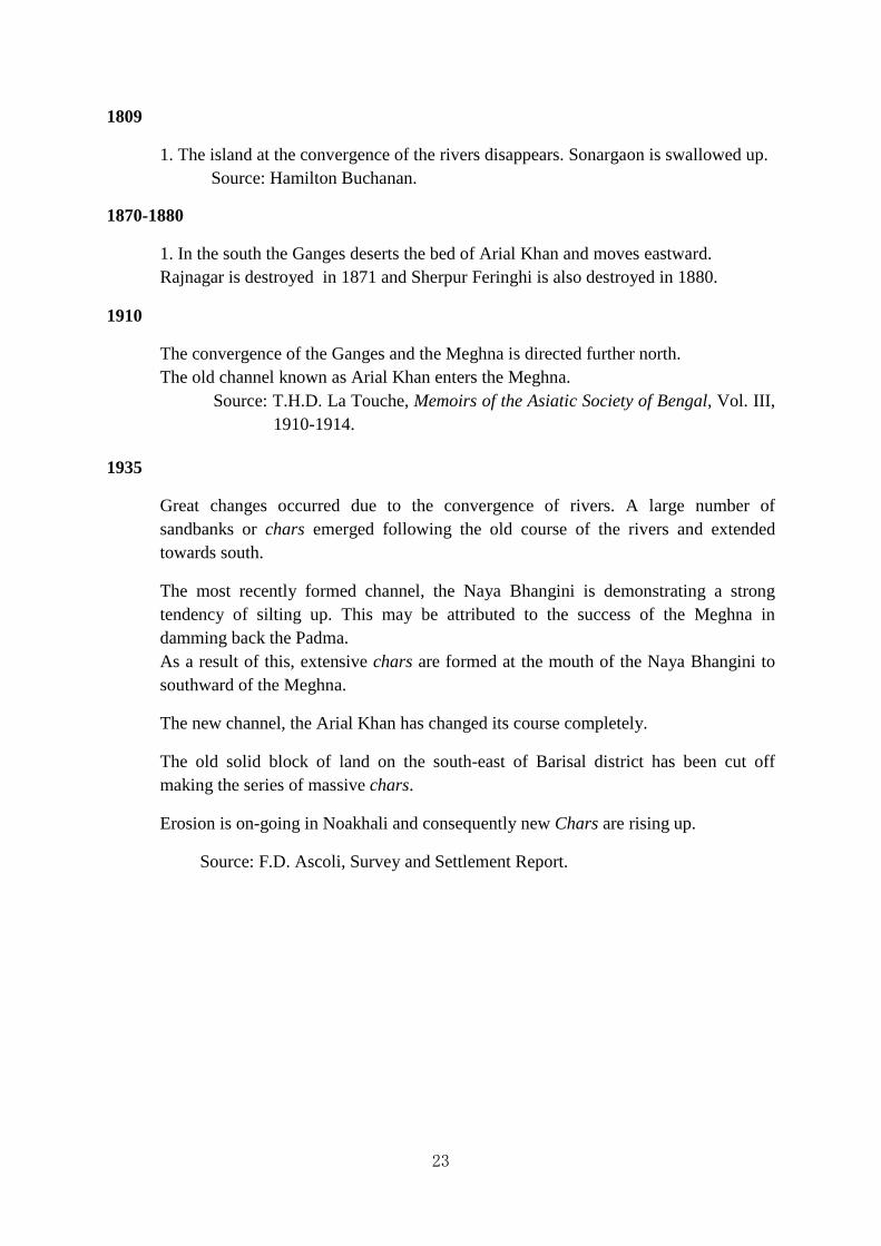
23
1809
1. The island at the convergence of the rivers disappears. Sonargaon is swallowed up. Source: Hamilton Buchanan.
1870-1880
1. In the south the Ganges deserts the bed of Arial Khan and moves eastward. Rajnagar is destroyed in 1871 and Sherpur Feringhi is also destroyed in 1880.
1910
The convergence of the Ganges and the Meghna is directed further north. The old channel known as Arial Khan enters the Meghna.
Source: T.H.D. La Touche, Memoirs of the Asiatic Society of Bengal, Vol. III, 1910-1914.
1935
Great changes occurred due to the convergence of rivers. A large number of sandbanks or chars emerged following the old course of the rivers and extended towards south.
The most recently formed channel, the Naya Bhangini is demonstrating a strong tendency of silting up. This may be attributed to the success of the Meghna in damming back the Padma. As a result of this, extensive chars are formed at the mouth of the Naya Bhangini to southward of the Meghna.
The new channel, the Arial Khan has changed its course completely.
The old solid block of land on the south-east of Barisal district has been cut off making the series of massive chars.
Erosion is on-going in Noakhali and consequently new Chars are rising up.
Source: F.D. Ascoli, Survey and Settlement Report.

24
Map 1.1. Regional map of the Bengal Basin Showing Physiography and Geology of the Ganges-Brahmaputra Delta and Surrounding Area
Source: Goodbred, Jr Steven L., Steven A. Kuehl, Michael S. Steckler and Maminul H. Sarker 2003:Controls on facies distribution and stratigraphic preservation in the Ganges-Brahmaputra delta sequence.
Sedimentary Geology, 155 (3-4), 301. (Quoted in Pat Saunders and Graham Chapman, Human Intervention and Dynamic Environmental Change in Bengal: A Draft Guide to Maps and RelatedGeographical Resources Since 1752, July 2006, p.11)
However, the above account though chronoloical, is stray reference of the changing course of rivers of the Bengal delta, and therefore does not provide elaborate account of the change of the river course for quite a long time. It is very difficult to write a complete account of the changes of rivers taking place since the formation of the delta. In fact, source-materials available about this subject are very few. In this regard, maps, surveys, travelogues and accounts may help us to some extent. However, it is better to go through the maps and surveys for understanding the trends of the change of river course of the Bengal delta. The most important of them, however, appear to be the maps compiled by various foreign

25
geographers who happened to visit this land in those days. There are some maps of Bengal prepared prior to 1750. Giacomo Gastaldi (c.1500-1566) was an Italian cartographer and engineer of the 16th century. The locus operandi of Gaur is found in the map prepared by Giacomo Gastaldi which has been used by Radhakamal Mukherjee.7Father Antonio Monserrate was a Jesuit priest from Portugal. He arrived at the court of Emperor Akbar in 1580, where the interested, inquisitive and open-minded Mughal ruler warmly welcomed him. In the map drawn by Father Antonio Monserrate in 1581 the position of the river was completely different.8Joao de Barros (1496-1570) known as Portuguese Livy, is one of the great Portuguese historians who compiled the book entitled Decadas da Asiainin 1550. Based on his book a map of India had been drawn much later. The sources are not known to us. But Joao de Barros’ map has proved to be a very valuable source of information of river system of Bengal during the sixteenth century.
Another important map was drawn by William Baffin (1584-1622), who was an English navigator and explorer. William Baffin’s map was drawn in 1619 which was based on the travelogue of Sir Thomas Roe (1581-1644) an English diplomat of the Elizabethan and Jacobean periods. From 1615 to 1618 Sir Thomas Roe was ambassador to the court at Agra, India, of the Great Mughal Emperor Jahangir. The principal object of the mission was to obtain protection for the East India Company’s factory at Surat. From reliable sources it does not appear that Sir Thomas Roe had traveled to Bengal. Mattheus van den Broucke (1620-1685) was a director of the Dutch East India Company and Governor of Coromandal from 1658-1663. His map is much more detailed and would appear to be of a much larger scale than the maps so far named though we have been unable to obtain details of how, or if, it was surveyed. According to John Rudd Rainey:
… these maps have evidently not been prepared from actual surveys, so no absolute reliance can be placed on them. The places mentioned in them have merely been conjecturally identified, and inferences drawn from such material cannot be otherwise than vague and uncertain.9
The changing course of rivers of Bengal in the seventeenth century is distinctly perceptible in the map of Mattheus van den Broucke, while JamesRennell (1742-1830), an expert in marine survey and hydrography, and also known as the father of Indian survey had made an exploration of the Bengal river basins and mapped them for the first time. The maps of JamesRennell clearly indicate the thorough changes of various important river courses that almost reshaped the riverine geography of Bengal in the eighteenth century. In this regard, the contribution of JamesRennell will be discussed later. Besides these, maps constructed at different periods, accounts left by the foreigners during their visits to this land may constitute important sources of information. Ralf Fitch (1550-1611) who was a merchant of London and one of the earliest English travelers in India and Bengal had left a vivid account of the prosperity and wealth of the cities like Saptagram, Sripur and Swarnagram that flourished in the sixteenth century.10
Jean-Baptiste Tavernier (1605–1689) was a 17th century French gem merchant and traveler who had began a second journey (1638–43) traveling via Aleppo to Persia, and thence to

26
India as far as Agra and from there to the Kingdom of Golconda. He visited the court of the Great Mughal Emperor Shah Jahan and made his first trip to the diamond mines. According to Jean-Baptiste Tavernier:
Rajmahal is a town on the right bank of the Ganges, and when you approach it by land you find that for one or two coss the roads are paved with brick up to the town. It was formerly the residence of the Governors of Bengal, because it is splendid hunting country. But for various reasons like the river having taken another course, and passing only at a distance of a full half league from the town; for the purpose of restraining the King of Arrakan and Portuguese bandits who have settled at the mouth of the Ganges, and by whom the inhabitants of Dacca, up to which place they made incursions, felt threatened – the Governor and the merchants who dwelt at Rajmahal removed to Dacca, which is today a place of considerable trade.11
It should also be noted, given later problems concerning the silting up of the Bhagirathi that Francois Bernier, who had to travel from the Ganges to Kashimbazar by land, because the river became un-navigable due to the presence of great bank of sand that made advancement a great difficulty. Francois Bernier (1625-1688) was a French physician and traveler. He was the personal physician for the eldest son of Mughal Emperor Shah Jahan, Prince Dara Shikoh for around 12 years during his stay in India. Francois Bernier had recorded that:
In describing the beauty of Bengale, it should be remarked that throughout a country extending nearly a hundred leagues in length, on both banks of the Ganges, from Raje-Mehale to the sea, is an endless number of channels cut, in bygone ages, from that river with immense labour, for the conveyance of merchandise and of the water itself, which is reputed by the Indians to be superior to any in the world. These channels are lined on both sides with towns and villages, thickly peopled with Gentiles, and with extensive fields of rice, sugar, corn, three or four sorts of vegetables, mustard, sesame for oil, and small mulberry-trees, two or three feet in height, for the food of silk-worms. But the most striking and peculiar beauty of Bengale is the innumerable islands filling the vast space between the two banks of the Ganges, in some places six or seven days' journey asunder.12
The Marine surveys of the Bay of Bengal also have a long history and R.H. Phillimore has discussed these in detail in 1945.13 R.H. Phillimore had tried to prepare a map of the Bengal delta by using Thomas Bowrey’s A geographical account of countries round the Bay of Bengal, 1669 to 1679.14The map provides great detail and this was corroborated with John Thornton’s The English Pilot , and entitled ‘A new and correct chart shewing the going over the Braces with the Shoals Depth of water and Anchorage from Point Palmiras to Hughley in the Bay of Bengall’. It shows depth in fathoms and depicts islands and sand bars and is accompanied by ‘Pilot's Directions for Bring of Ships down the River of Hughley’.15

27
Jean Baptiste Bourguignon d’Anville (1697-1782) was a cartographer of the French East India Company and later became secretary to the Duke of Orleans. His Carte de l’Inde was published in 1752 as part 2 of a map of Asia. D’Anville was never himself in India and in fact, his maps were based on information taken from Tibetan lamas and the tales and maps of European traders, explorers and missionaries including Tavernier. Nonetheless, his maps are said to have been better than those that preceded them since he took great pains to verify his information. Unlike earlier cartographers, he left blank spaces on his maps rather than fill them with unverified information. Nonetheless, while they may be taken as showing the extent of knowledge about Bengal current in France at the time, they must be seen as embodying some of the same limitations as earlier maps prepared from secondary sources. Thus while they may be useful as a guide to the relative position of the rivers at the date of his Sources; they should not be treated as an accurate representation of the disposition of the rivers in 1752.
A memoir was appended in the map of D’Anville in which detailed source materials were available and the reasons for differing from earlier material had been added. Translated into English as A Geographical Illustration of the Map of India by William Herbert (1759) it provides explanations for decisions made. For example, like that by de Broucke, his map shows the two main branches of the Ganges separating just below Rajmahal. D’Anville writes:
Raji-mohol … seems to have held the first rank among those in Bengal; and its name signifies a royal town. Its situation on the Ganges is very remarkable, being at the place where the river divides into two principal branches, through which it runs into the sea, about 70 leagues lower, forming a delta more considerable than that of the Nile, of which Raji-mohol is the top. The advantages of this position make me think it more likely than any other to have been the ancient capital of the country, described by Ptolemy under the name of Gange Regia, notwithstanding that he places it between the arms of the river, a great way below its division.16
This lends support to the earlier view that the Bhagirathi-Hooghly was one of the major distributaries, if not themajor distributaries of the Ganges. According to D’Anville the great Ganges led to Dhaka which he found to be a ‘great rambling town’, whose ‘trade and the easy access to it on all sides by rivers, make it a considerable place’. A little below Dhaka, he writes, it is joined by the Brahmaputren, and thus enlarged, discharges itself into the sea, opposite an island, he calls Sun Diva. Moreover, it is worth noting that the name of the river that flows past Dhaka is the Buriganga.17
The East India Company had appointed Major James Rennell for satisfying their administrative and commercial needs. It was officially remarked that “Major James Rennell (1742-1830) of the Engineers, was well-known for his surveys of the province of Bengal and regarded as the father of Indian geography. He was Surveyor General from 8 January, 1767, till he left India in March, 1777.”18 Major James Rennell was later hailed as a founder of modern geography.19

28
The initial duty of Rennell was to find a route to the Ganges in the winter and he avoided
the Hugli, Bhagirathi and the Jalangi, because these rivers were silting up and proving impracticable to navigate in the dry season. According to Andrew S. Cook:
The importance of Rennell’s maps lay in the large scale of its mapping and the unprecedented accuracy of its detail. Until the East India Company took responsibility for a large area of Bengal, no geographer or cartographer had ever produced a reliable map of the mouths of the Ganges and the hinterland of Bengal. Rennell’s arrival to Bengal, with a reputation chiefly for sea surveys, coincided with the spread of the company’s administration, and more particularly, with the death of an earlier surveyor. Rennell developed the use of survey methods to accurately lay down roads, rivers and settlements in a way which delighted his employers, and the maps he produced, of which A Bengal Atlas was the culmination, defined the topography of Bengal for the first time. His maps were not superseded till the larger-scale revenue surveys of the mid-nineteenth century were undertaken, and still bear comparison with equivalent modern maps.20
Rennell was very much fascinated by the constant changes in the rivers of Bengal and tried to understand the dynamics of the major rivers. He was convinced that the Brahmaputra originated as the Tsangpo in Tibet which remained controversial until mid 19th century and that the annual increase in the Ganges ‘owes as much to the rain water that falls in the mountains contiguous to its source, and that of the great northern rivers which flow into it [and a small quantity of snow melt], as to that which falls on the plains of Hindoostan’.21 He had emphasised on the annual inundation resulting in seriousflooding occurred when a strong gale combines with a spring tide and a high level for the annual flood peak. He described a flood in 1763 in which the inhabitants of a considerable district (Luckypour, Noakhali) with their houses and cattle were totally swept away when the water rose 6 feet above the ordinary level. He writes that it was due to a strong gale of wind conspiring with a high spring tide at a time when the ‘periodical flood was within a foot and a half of its highest pitch’.22 The great earthquake devastated this same area on 2 April, 1762. It is possible that Rennell was describing this event, mistaking the date. However, his analysis about the reasons for serious flooding, though correct in all other instances, was a mistake in this case, as the Meghna would not have been in full spate in April. This too bears further investigation. He described the role of dykes or dams, of which he says there are over a thousand English miles, in protecting low-lying land from inundation. ‘These dykes are kept up at enormous expense; and yet do not always succeed for want of tenacity in the soil of which they are composed’.23
Robert Hyde Colebrooke (1762-1808), had started his career as a surveyor with the East India Company in 1778 and became Surveyor General of Bengal in1794, a post he held until his demise in 1808. Robert Hyde Colebrooke had spent his time surveying and mapping the Ganges. His main interest was communications by river from the Ganges to Calcutta. During the season 1796-97, he surveyed the Bhagirathi and continued up the Ganges as far as Colgong (at present Colgong is known as Kahalgaon which is located in the Bhagalpur
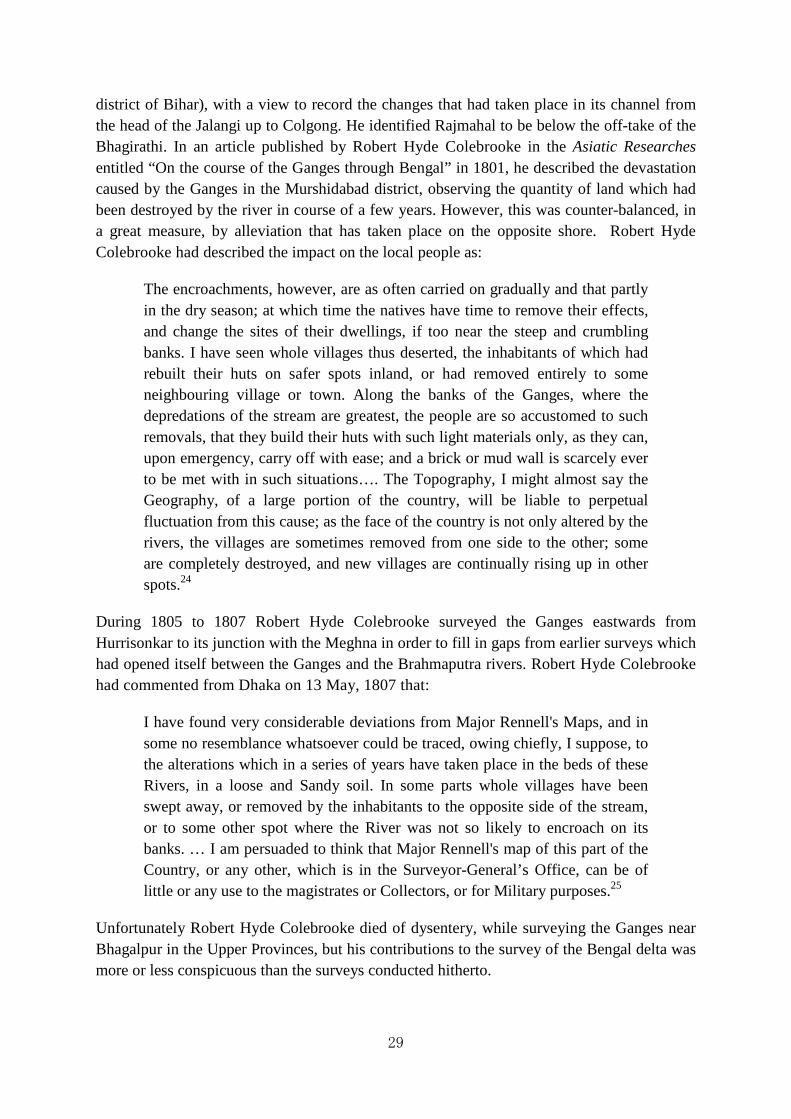
29
district of Bihar), with a view to record the changes that had taken place in its channel from the head of the Jalangi up to Colgong. He identified Rajmahal to be below the off-take of the Bhagirathi. In an article published by Robert Hyde Colebrooke in the Asiatic Researches entitled “On the course of the Ganges through Bengal” in 1801, he described the devastation caused by the Ganges in the Murshidabad district, observing the quantity of land which had been destroyed by the river in course of a few years. However, this was counter-balanced, in a great measure, by alleviation that has taken place on the opposite shore. Robert Hyde Colebrooke had described the impact on the local people as:
The encroachments, however, are as often carried on gradually and that partly in the dry season; at which time the natives have time to remove their effects, and change the sites of their dwellings, if too near the steep and crumbling banks. I have seen whole villages thus deserted, the inhabitants of which had rebuilt their huts on safer spots inland, or had removed entirely to some neighbouring village or town. Along the banks of the Ganges, where the depredations of the stream are greatest, the people are so accustomed to such removals, that they build their huts with such light materials only, as they can, upon emergency, carry off with ease; and a brick or mud wall is scarcely ever to be met with in such situations…. The Topography, I might almost say the Geography, of a large portion of the country, will be liable to perpetual fluctuation from this cause; as the face of the country is not only altered by the rivers, the villages are sometimes removed from one side to the other; some are completely destroyed, and new villages are continually rising up in other spots.24
During 1805 to 1807 Robert Hyde Colebrooke surveyed the Ganges eastwards from Hurrisonkar to its junction with the Meghna in order to fill in gaps from earlier surveys which had opened itself between the Ganges and the Brahmaputra rivers. Robert Hyde Colebrooke had commented from Dhaka on 13 May, 1807 that:
I have found very considerable deviations from Major Rennell's Maps, and in some no resemblance whatsoever could be traced, owing chiefly, I suppose, to the alterations which in a series of years have taken place in the beds of these Rivers, in a loose and Sandy soil. In some parts whole villages have been swept away, or removed by the inhabitants to the opposite side of the stream, or to some other spot where the River was not so likely to encroach on its banks. … I am persuaded to think that Major Rennell's map of this part of the Country, or any other, which is in the Surveyor-General’s Office, can be of little or any use to the magistrates or Collectors, or for Military purposes.25
Unfortunately Robert Hyde Colebrooke died of dysentery, while surveying the Ganges near Bhagalpur in the Upper Provinces, but his contributions to the survey of the Bengal delta was more or less conspicuous than the surveys conducted hitherto.

30
Francis Buchanan (1762-1829) joined the East India Company’s service as a medical officer with the humble hope of establishing himself as a botanist. Immediately after arriving in Bengal in 1794, he was instructed to survey Chittagong, the Chittagong Hill Tracts, Noakhali, and Comilla.26Later Francis Buchanan was promoted to the post of surgeon and directed to conduct a similar survey of Bengal.27 Though his prime area of interest was botany, he was instructed by the Board of Revenue to collect social, economic and archaeological information on the northern districts of Bengal.
We are also of opinion that a full and accurate statistical survey of the country, under the immediate authority of your Presidency would be attended with much utility, we therefore recommend to our Governor General in Council to take proper steps to carrying the same into execution, as far as may be consistent with a due regard to economy and as Doctor Buchanan had acquired considerable experience in investigations of this nature, we recommend that he should be employed in this survey on the same footing as when he was deputed to survey Mysore.28
From 1807 Francis Buchanan had began his most memorable venture by undertaking a study tour through Northern Bengal and Bihar. He spent seven years in surveying the region. The reports prepared by him run into many volumes of statistical, geographical and ethnic descriptions in manuscripts. In 1814, Buchanan was appointed Superintendent of the Calcutta Botanical Gardens. But ill health forced him to return to his homeland. After the demise of Francis Buchanan, a book entitled as A Geographical, Statistical and Historical Description of the District or Zila of Dinajpur in the Province or Subha of Bengal was published from Calcutta in 1833.29
Robert Montgomery Martin (c. 1801-1868) was an Anglo-Irish author and civil servant, who had brought out History of the Antiquities of Eastern India (3 vols.) in 1838 which was actually the survey works of Francis Hamilton. In the last volume Robert Montgomery Martin recognised that the earlier two volumes entitled as History of the Antiquities of Eastern India were also the survey works of Francis Hamilton. But Robert Montgomery Martin justified their publications on the ground that:
With a due sense of importance of the trust reposed in me, and with a desire that a survey, which had cost upwards of £ 30,000 should be accurately investigated, neither labour nor expense was spared to exhibit Dr. Buchanan’s meritorious exertions in the fullest point of view. Unfortunately, owing to the period which has elapsed since the completion of the survey, a great mass of matter was found to be irrelevant to the present position of affairs in the East. I, therefore, deemed it advisable to confine my views to an examination of the geography and physical aspects of the country to its traditional or recorded history to the movements or relics of antiquity; but above all the physical and moral condition of the people (according to the Survey Estimates to nearly 16, 000,000) and to the resources of the soil, which they till, the manufactures which they carry on; and to the products and profits of agricultural and commercial industry. That a survey containing such materials, offering so

vivid a description of the social aspects of millions of our fellow subjects, and corroborating every useful fact by minute statislong in obscurity is needed to be deplored and can only be accounted for by supposing that it was deemed impolitic to publish to the world so painful a picture of human poverty, debasement and wretchedness.
But David Prain, the biographer of Francis Hamilton, had made a stern criticism of these activities of Montgomery Martin for publishing Francis Hamilton Buchanan’s collection in his name.31 In describing the change of Dharla river, situated near Koch Bihar Buchanan provides information that:
The banks of the rivers in this district are scarcely any higher than those in other parts of the Country, on the contrary they are in general very low; and the inundation, far from raising the ground by a deposition of sediment, seems gradually to be sinking the rivers deeper and deeper below the level of the plains, which in a country so well supplied with rain, as Bengal, is a fortunate circumstance. In this part of the course of the Dhorla, I had a most satisfactory proof of this circumstance.
Map 1.2. Part of Tassin's Map delineating river navigation
Source: Tassin, Jean-Baptiste, Inland Navigation in Eastern India (Tassin's Atlas of the Delta). ChartDelineating the River Navigation to Assam from the Presidency, by the SoondurbuRivers; Also to Chittagong, Dacca, Mymensing, and Silhet. Compiled fromthe Most Authentic Materials, in the Office of the
Surveyor General of India, Lithographed by Order of
quarto, cloth. 4 miles to I Inch (1:253,440). (Quoted in Pat Saunders and Graham Chapman, Human Intervention and Dynamic Environmental Changein Bengal: A Draft Guide to Maps and Related Geographical Resources Since 1752, July 2006, p. 69)
James Prinsep (1799-1840), the seventh son of John Prinsep, went to India in 1819 as a servant of the East India Company.1828 which were published in an atlas known as
31
vivid a description of the social aspects of millions of our fellow subjects, and corroborating every useful fact by minute statistics, should have remained so long in obscurity is needed to be deplored and can only be accounted for by supposing that it was deemed impolitic to publish to the world so painful a picture of human poverty, debasement and wretchedness.30
the biographer of Francis Hamilton, had made a stern criticism of these activities of Montgomery Martin for publishing Francis Hamilton Buchanan’s collection in
In describing the change of Dharla river, situated near Koch Bihar Buchanan
The banks of the rivers in this district are scarcely any higher than those in other parts of the Country, on the contrary they are in general very low; and the inundation, far from raising the ground by a deposition of sediment, seems gradually to be sinking the rivers deeper and deeper below the level of the plains, which in a country so well supplied with rain, as Bengal, is a fortunate circumstance. In this part of the course of the Dhorla, I had a most satisfactory
cumstance.32
Part of Tassin's Map delineating river navigation
Inland Navigation in Eastern India (Tassin's Atlas of the Delta). ChartDelineating the River Navigation to Assam from the Presidency, by the Soondurbun Passage, as Well as by Tho Jellinghee and Matabhanga Rivers; Also to Chittagong, Dacca, Mymensing, and Silhet. Compiled fromthe Most Authentic Materials, in the Office of the
Surveyor General of India, Lithographed by Order ofGovernment, and Published with an Index Map.quarto, cloth. 4 miles to I Inch (1:253,440). (Quoted in Pat Saunders and Graham Chapman, Human Intervention and Dynamic Environmental Changein Bengal: A Draft Guide to Maps and Related Geographical
ly 2006, p. 69)
1840), the seventh son of John Prinsep, went to India in 1819 as a servant of the East India Company.33He conducted several surveys of the rivers of Bengal in 1828 which were published in an atlas known as Princep’s Gangetic Atlas
vivid a description of the social aspects of millions of our fellow subjects, and tics, should have remained so
long in obscurity is needed to be deplored and can only be accounted for by supposing that it was deemed impolitic to publish to the world so painful a
the biographer of Francis Hamilton, had made a stern criticism of these activities of Montgomery Martin for publishing Francis Hamilton Buchanan’s collection in
In describing the change of Dharla river, situated near Koch Bihar Buchanan
The banks of the rivers in this district are scarcely any higher than those in other parts of the Country, on the contrary they are in general very low; and the inundation, far from raising the ground by a deposition of sediment, seems gradually to be sinking the rivers deeper and deeper below the level of the plains, which in a country so well supplied with rain, as Bengal, is a fortunate circumstance. In this part of the course of the Dhorla, I had a most satisfactory
Part of Tassin's Map delineating river navigation
Inland Navigation in Eastern India (Tassin's Atlas of the Delta). ChartDelineating the n Passage, as Well as by Tho Jellinghee and Matabhanga
Rivers; Also to Chittagong, Dacca, Mymensing, and Silhet. Compiled fromthe Most Authentic Materials, in the Office of the
th an Index Map. Calcutta. Large quarto, cloth. 4 miles to I Inch (1:253,440). (Quoted in Pat Saunders and Graham Chapman, Human Intervention and Dynamic Environmental Changein Bengal: A Draft Guide to Maps and Related Geographical
1840), the seventh son of John Prinsep, went to India in 1819 as a surveys of the rivers of Bengal in
etic Atlas. James Prinsep

32
found that steamers faced problems in navigating the Nadia rivers. Of the Bhagirathi, he noticed changes. According to James Prinsep “Art has evidently done something in the neighbourhood of Moorshudabad, Dewangunj, and Jungeepour, to check that constant fluctuation in its course, which may be traced in every other part where the population is less, and the value of property not so great.”34
J.S. May had joined the service of the East India Company and was appointed the Superintendent of the Nadia Rivers from 1820 to 1840. William Wilson Hunter (1840-1900) agreed with J.S. May about the causes of the decline of the Nadia Rivers.35 The production of two atlases by Jean Baptiste Tassin (1812-1888)which were entitled Tassin’s Atlas of theDelta in 1835 and The New Bengal Atlas in 1841 provided further information after the Jamuna avulsion and its major significance.36
It was not until the end of the nineteenth century that trigonometrical survey came to be recognized to be the only accurate basis for the mapping of a country. The observations for ascertaining the shape of the earth by measuring an arc of the meridian were commenced a few years after the death of Sir Isaac Newton, but not by his countrymen and these observations were the forerunners of the great trigonometrical surveys.37However, it was noted in 1882 that:
The triangulation followed the course of the Ganges and the Jamoona branch of the Brahmaputra River. The changes in the channels of these streams, which run through a sandy soil, are immense. Islands are annually formed in some places and washed away in others; and the banks undergo considerable alterations during each rainy season. Owing to the breadth of the river and their shifting character it was not always possible to establish stations sufficiently remote from them to ensure safety from destruction; but much care and foresight were observed as possible; and thus up to the present time, 1882, only four stations out of forty-nine have been carried away, viz., Bangaon (xv), Paskoksa (xxvii), Boladanga (xxxv) and Halkachar (xxxvii).38
The first official gazetteer, named as the East India Gazetteer, was published in Calcutta in 1815. Walter Hamilton had never visited Bengal, but following the travelogues, he wrote the gazetteer. There is an entry for Bengal and separate entries for each district, town, river and many of the larger villages. For example, the entry for the Ganges describes 1000 miles of dykes in Bengal ‘which are kept at enormous expense; yet do not always succeed, owing to the want of tenacity in the soil of which they are composed’.39 Presumably, this is an unacknowledged repetition of Major James Rennell’s observations that the Brahmaputra joins the Meghna below Luckipour and the combined rivers join the Ganges near the Bay of Bengal. A second edition in two volumes was published in 1828 entitled as The East India Gazetteer containing Particular Descriptions of the Empires, Kingdoms, Principalities, Provinces, Cities, Towns, Districts etc. and its adjacent territories. Here it was reported that
… in 1809 the Brahmaputra threatened by a change in its course to carry away all in the vicinity of Dewangung, and perhaps to force its current into the Nattore jeels in the Rajshahi

33
district, which would very much disturb the modern geography of Bengal, by submerging a vast extent of surface, while its old bed would become a morass.40
Since the survey of Major Rennell the Rangpur rivers had undergone such changes that there was great difficulty in tracing them.
Their banks are in general low, and the inundation, so far from raising the ground by a deposition of sediment, seems gradually to be taking the river deeper and deeper below the level of the plains. The principal rivers are the Brahmaputra, Teesta, Mahahnanda, Caratoya, Manas, and Chonkosh. In Rungpoor there are several jeels, and in the north-eastern extremity, five miles from Jughigopa, a beautiful cluster of lakes, which in the wet season are overwhelmed by the Brahmaputra.41
However, the above descriptions from the maps, surveys and accounts prepared at different times do not throw succinct idea about the time and course of the changes of the river systems of Eastern Bengal (currently independent sovereign Bangladesh). Now we shall try to give a well tangible shape to the change of important rivers of Bangladesh. From the more easterly portion of the Himalayas all snow and water ultimately finds it way into the Ganges, Brahmaputra and the Meghna and through these mighty rivers it is washed down to the Bay of Bengal across the surface of Bangladesh. The plains and the hills of Bangladesh are inundated with a heavy rainfall and thus the streams are doubly enriched. Furthermore, these three mighty rivers with their numerous branches and appendages intersect the land of Bangladesh in a variety of directions completely navigable throughout the year.42
1.3 The River System of Bangladesh
For better understanding of the river system of Bangladesh, we can happily follow the division made by Nafis Ahmed (1911-1982) in his renowned book entitled as An Economic Geography of East Pakistan. Looking at the physical conditions the rivers of Bangladesh may expediently be divided into five systems:
1. The Ganges, or the Padma, and its deltaic streams;
2. The Meghna and the Surma system;
3. The Brahmaputra’s effluents and channels;
4. The North Bengal rivers
5. The rivers of the Chittagong Hill Tracts and the adjoining plains.
1.3.1 The Ganges and Its Distributaries
The Ganges, or the Padma, is the spindle of the system of deltaic rivers. This includes the area between the west and the Ganges known as Padma running and the east of the region. No streams in the area have the position of a tributary river. Either all the rivers in this area are distributaries of the parent river; or simple offshoots of the bigger ones. They encompass a large area covering the districts of Kushtia, Jessore, Khulna, Faridpur and Barisal. In these

34
districts the prominent rivers from the west to east are respectively Mathabhanga, Ichhamati, Bhairab, Kumar, Kobadak,43 Chitra, Nabaganga, Garai-Madhumati and Arial Khan.
The Ganges or Padma: From the Rajmahal Hills, the Ganges or the Padma enters Bangladesh at the western extremity of the Rajshahi district and at the northern extremity it enters Kushtia district at the point where Mathabhanga leaves it. The Ganges flows east-south-east till it meets the Brahmaputra (Jamuna) near Goalundo. Within Bangladesh, according to Nafis Ahmad “… it forms the boundary first between the districts of Rajshahi and Pabna and Kushtia, later between Pabna and Faridpur, Dacca and Faridpur, Comilla and Barisal and Noakhali and Barisal respectively.”44
Map 1.3. Part of One Plate from Princep's Gangetic Atlas, 1829 Source: An Atlas of the Ganges and Its Outlets, from Allahabad to Calcutta, Accompanying a Letter fromMr.
Secretary Prinsep; Dated 22nd September 1829. (Quoted in Pat Saunders and Graham Chapman, HumanIntervention and Dynamic Environmental Change in Bengal: A Draft Guide to Maps and RelatedGeographical Resources Since 1752, July 2006, p. 38)
In the Bengal delta, the Ganges contributes many distributaries and numerous spill channels in Bangladesh excepting the Bhagirathi-Hooghly. Consequently, these split into numerous channels. After crossing Rampur-Boalia (Rajshahi), the river Baral is thrown off from the left bank and is the only distributary to the north. Baral River is one of the offshoots of the Ganges. Originating from Rajshahi district, the Baral flows through Natore and Pabna and finally meets with the Hurasagar (Hurasagar River is the joint flow of the Atrai-Baral and the Phuljhar (the Bengali-Karatoya) rivers.) after joining with the Karatoya and Shahjadpur. The total length of the river is 147 km, average width is 125m and average depth is about 6m. The river receives water from the Ganges only in the monsoon season. But it maintains its flow throughout the year with local runoff water from Chalan Beel. The Chalan Beel is one of the largest inland depressions of marshy character and also one of the richest wetland areas of Bangladesh. Chalan beel was formed when the old Brahmaputra diverted its water into the

35
new channel of the Jamuna. Chalan beel was probably a back swamp before it was greatly expanded with the inclusion of abandoned courses of the Karatoya and the Atrai and became a vast lake. Its drainage area is about 230 sq km.45
The Ganges is habitually known as the Padma after its convergence with the Jamuna. The Padma carries abundant water and is generally very wide excepting at the places where banks are very high enough to arrest its progress. The Jamuna is constantly shifting and there are many bends in the main channel. The changing course of the Jamuna causes rapid silt formations (locally known as char) every year. Numerous local and inter-district disputes arise frequently over the possession of char land. The Gangetic delta covers nearly about 25,000 square miles and about 80 per cent of it lies in Bangladesh. The seaworthy margin of the delta is known as Sundarban, a special region of dense forest extending from the Hooghly estuary to the Meghna. In terms of length the river Padma is a spacious waterway especially after its conjunction with the Jamuna. The river in its split has created several channels which flow between shifting banks and islands. In the second decade of the twentieth century the Padma destroyed a great deal of land in the southern portion of Munshiganj sub-division of the Dhaka district. This time the Padma had shifted further eastward making large chars hither and thither in the Faridpur district and also made considerable invasion into the Madaripur sub-division.
The Mathabhanga or Hauli, whose lower reach is called the Haulia, leaves the Padma about ten miles below the point where the Jalangi leaves it. It flows first in a southeasterly direction as far as Hatboalia, where it bifurcates into one branch, which is thereafter known as the Kumar or Pangasi. Then it proceeds in the same direction, past Alamdanga, up to the boundary of the district which it forms for a few miles until it passes into Jessore, whilst the other branch pursues a very tortuous course. The general trend of this branch is to the south, until, after passing Chuadanga it reaches Krishnaganj (in India). There a second bifurcation takes place, the two resulting streams being known as the Churni and the Ichhamati and the name of the parent river being lost. Its borderline lies between India and Bangladesh.46
Gorai-Madhumati River,a principal distributary of the Ganges has been named as the Gorai in the upper course and Madhumati in the lower course. Once upon a time the main flow of the Ganges used to be discharged by this river, although previously Hugli-Bhagirathi was the original course of the Ganges. The Gorai takes off from the Ganges at Talbaria, north of Kustia town and 19 km downstream from Hardinge Bridge. South of Kushtia its first offshoot, the Kaliganga branches off to join the Kumar near Shailkupa. The main river bifurcates and rejoins several times as it flows southeast to Mohammadpur upazila in Magura district. From here it changes its name to Madhumati. The Kumar, the Nabaganga and the Chitra join it through several channels south of Mollahat upazila. There it changes its name to Baleshwar, which in turn changes to Haringhata from the Bogi forest outpost of the Sundarbans. All the rivers between the Khulna-Ichamati, Ganges, Gorai-Madhumati and the Bay of Bengal are connected by cross-channels, which are especially numerous in the Sundarbans. They are of great importance for inland navigation in the delta. The Gorai is a very old river. Its early name was Gauri. The famous geographer and astronomer Ptolemy

36
noticed about five estuarine mouths of the Ganges. One of those, the ‘Kambari Khan’, was perhaps the Gorai. The course of the Gorai-Madhumati is wide, long and meandering. From its originating point at Kamarkhali, it is navigable by boats in the monsoon but in the dry season it becomes non-navigable. In the down stream it is navigable throughout the year.
The Gorai-Madhumati is one of the longest rivers in Bangladesh and its basin is also very wide and extensive. It flows through Kushtia, Jessore, Faridpur, Khulna, Pirojpur and Barguna districts. Agriculture and irrigation in these areas are very much dependent on the Gorai-Madhumati. Kumarkhali, Janipur, Sheuria, Ganeshpur, Khulumbari, Langalbandh, Shachilapur, Nacole, Lohagara, Pangsha, Baliakandi, Boalmari, Kashiani, Bhatiapara, Nazirpur, Kachua, Pirojpur, Sarankhola, Mathbaria, Patharghata and Morrelganj are the important places on the banks of the Gorai-Madhumati river.47
Nafis Ahmad has anticipated some change in the course of rivers of Bangladesh in the eighteenth and nineteenth centuries. He remarked that:
This must have happened after the great diversion of the Brahmaputra into the Jamuna (1787) and the damming back of the Padma waters near Goalunndo. Rennell’s survey took place between 1764 and 1772, and his map based on that work, shows the Garain as one of the minor cross-channels, joining the Kumar north-east of Magura, while Madhumati and Baleswar were comparatively smaller streams. Gradually the Kumar dwindled and the Garai flourished. The attempt of the Garai to find a large channel south of this junction was responsible for repeated floods and inundations in the early nineteenth century in the area of Mahammadpur.48
The contemporary European scholar-administrators like J. Fargusson,49James E. Gastrell50 and William Wilson Hunter51 considered that change in the main channel of the Ganges might have been taken at the expense of the Padma.
Arial Khan: The catastrophic earthquakes of 1762 and 1782 are believed to have been partially responsible for the diversion of the main flow of the old Brahmaputra river from the west to present Jamuna river and main flow of the Arial Khan river to the present Padma channel. Bifurcating from the Padma, Arial river flows through Faridpur district before falling into the Tetulia at the northeastern corner of the district of Barisal. The river is navigable throughout the year and is under tidal influence. On its way, the Arial Khan maintains its link with the Padma through a number of streams and Khals such as the Naria, Palang, Moynakata, Bhubaneshwar, Kumar Kailar and Nayabhangi. The river maintains a meander channel through its course and is erosional in nature.52
1.3.2 The Padma-Meghna Estuary
The Padma-Meghna estuary is a very dynamic estuarine system. The gigantic Padma-Meghna estuary stretches from the mainland of Barisal to the coast of Chittagong. It comprises many flat-islands, which appear and disappear following the natural activities of the rivers. There are five large islands e.g., Bhola, Hatia, Sudharam, Ramgati and Sandwip, which are of much significance as they have large permanent settlements. To the extreme western part of the
37
estuary Tetulia channel is located, through which the Arial Khan discharges itself representing the original opening of the Padma towards Bay of Bengal. The Shahbazpur channel of the Meghna flows between Bhola, Sudharam, Ramgati and Hatia islands that is very wide. The widest channel located further east is the Hatia river over twenty miles across, which runs between the island of Hatia and Sandwip.
1.3.3 The Meghna and the Surma System
The Meghna River is one of the major rivers in Bangladesh, especially famous for its great estuary that discharges the flows of the Ganges-Padma, the Brahmaputra-Jamuna and the Meghna itself. The principal part of the Meghna is developed by the union of two rivers hailing from the district of Sylhet, namely the Surma and Kushiara. These two branches are tributaries of Barak which is located in Assam. The Barak separates into two branches, the Surma and the Kushiyara, which rejoin in Sylhet Basin after entering into Bangladesh. The Barak river at places is also known as the Kalni, Bheramohona, Baleshwar and Meghna.53
The Surma basin occupies the northeastern part of River Surma, the right bank tributary of the Barak originating from Manipur and Mizoram of India, passes along Sylhet town and joins the Kushiyara west of Baniachong, the combined flow of which is the mighty Meghna river. The Surma is bifurcated in the south of Mohanganj soon after it receives the Kangsa and further to the south the Mogra. The western channel is known as the Dhanu in its upper course, the Baulai in the middle and the Ghorautra lower down. It joins the Meghna near Kuliarchar. The southern branch of the Barak, receives the Manu on the north of Maulvi Bazar town as the Kushiyara and is bifurcated into a northern channel, the Bibiyana, and a southern one, which resumes the name of the original river, the Barak. The Bibiyana changes its name to Kalni, lower down its course and joins the Surma near Ajmirganj. The Barak (western) receives the Gopla and the Khowal from the Tripura hills, and falls into the Surma at Madna.54
After the confluence of the Surma river with the old Brahmaputra, the Meghna grows speedily and starts to flow as a wide, twisting river with offshoots and branches. However, south of Daudkandi on the right bank, Meghna receives the combined waters of the Buriganga-Dhaleswari-Sitalakhya near Munshiganj and later the Padma at Chandpur. Overall, the Meghna is a river of great depth and velocity often creating numerous chars haphazardly of its own formation. During the rainy season, it spreads to such an extraordinary extent that sometimes it becomes very difficult to see the opposite bank. The Meghna remains navigable all the year round for all sorts of river-crafts irrespective of quantity laden in the craft. But though it remains navigable throughout the year, from November to February the Meghna appears to be very dangerous to all types of river craft in places where surface water is low. The river Meghna is well known for its tide. In this regard, Nafis Ahmad comments that:
Tides are effectively felt in the Meghna as far as the island Ashuganj opposite Bhairab Bazar. Up to Chandpur, the tidal phenomena are a significant feature …the regular rise of the tide is from 10 to 18 feet, and the bores in the estuary are a typical feature. The bores impede

38
navigation at the time of the equinoxes for several days, especially when a southerly wind is raging. The tidal waves advances with a noise like thunder, rushes up as wall of water twenty feet high and turns the river from ebb to flood tide.55
1.3.4 The Brahmaputra’s Effluents and Channels
The Brahmaputra is one of the greatest rivers of southern Asia. It flows from southwestern Tibet, China, through Arunāchal Pradesh and Assam states in India, into Bangladesh, where it empties into the Bay of Bengal. It enters into Bangladesh round the Garo hills near Majhiali in Rangpur district.56 During its course, the Brahmaputra also carries with it the discharge of the Himalayan and Assam Hill streams. As soon as it enters into Bangladesh, it receives the Tista on its right bank and follows a course due south under the name of the Jamuna. In the past, the course of oldBrahmaputra river, the main channel passed through Jamalpur, Mymensingh and Kishoreganj districts to meet the Meghna at Kuliarchar-Bhairab point. In 1762 a major earthquake of 7.5 magnitude caused tectonic uplift of Modhupur tract. As a result, the main channel of the Brahmaputra at Bhahadurabad point switched southwards to open a new channel asJamuna. The eastern branch, formerly the larger, became lesser and came to be known as the lower or old Brahmaputra. On the old bank located near Dewanganj, the old Brahmaputra, which was the main channel of the river until 1787, leaves the main stream. Before joining with the Ganges the Brahmaputra receives Baral-Atrai-Hurasagar combination on the right side and before its meeting with the Padma it throws off the large Dhaleswari on its left bank. The old Brahmaputra which had earlier passed through Mymensingh and met the Meghna river finally dwindled. In 1857 the change of the Brahmaputra river was reported in the District Records of Mymensingh:
The great change taking place in the district has been in the Burrampooter river. The river that runs by the station of Mymensing (sic.) which formerly carried the greater body of the water of the Burrampooter to the Megna and when in flood was from 8 to 10 miles across, still retains that name, but since the river has changed its course, dwindled to a most insignificant stream. It is perceptibly decreasing and shallowing annually. In the cold season it is quite dry at a short distance above the cantonment of Jamalpore and from Jamalpore to Mymensing. It is fordable almost every where, in many places not having six inches of water. It is also fordable in parts for about 30 miles below the station of Mymensing. All water carriage is consequently suspended from about December to May when the river first begins to rise from the melting of the mountain snow but there is no want of water for boats of any burden after the setting in of the rains.57
The character of The Brahmaputra is unreliable for its shifting channel and creation of numerous chars. Later these chars became a continual source of litigation and violence.
The Dhaleswari Buriganga: From economic point of view the Dhaleswari along with its distributary, the Buriganga river is considered very important for the western and southern parts of Dhaka. The river is of considerable size and is also related to the district of
39
Mymensingh. Many old channels of the Jamuna inside the Mymensingh district have been silted up. The case of thana Nagarpur may be cited for easy illustration. The principal channel Elasin now flows in an extremely meandering course through the south-western part of the Dhaka district keeping vast mass of old alluvium well to the south and western part of the district. Previously the Dhaleswari river had joined with the Sitalakhaya river below Munshiganj. Although the Shitalakshya River had originated from the old Brahmaputra it bifurcates into two courses at Toke in Gazipur. One of the courses named the Banar flows southwest and at Lakpur is renamed as the Shitalakshya. It then flows east of Narayanganj town. The Shitalakshya falls into the Dhaleswari near Kalagachhiya.58
The Buriganga riveris a tide-influenced river passing through west and south of Dhaka City. There is a traditional story behind naming it. In ancient times one course of the Ganges used to reach the Bay of Bengal through Dhaleswari. This course gradually shifted and ultimately lost its link with the main channel of the Ganges and was renamed as the Buriganga. The water levels during high and low tides in this river astonished the Mughals. The Buriganga originated from the Dhaleshwari near Kalatia. Its average width and depth are 400m and 10m respectively. This river is only 27 km long. The Turag has joined the Buriganga at Kamrangirchar of Dhaka City. In fact, the main flow of the Buriganga comes from the Turag. It meets with the Dhaleshwari at Munshiganj. The present head of the Buriganga near Chhaglakandi has silted up and opens only during floods, but the lower part is still open throughout the year. The downstream junction with the Dhaleshwari fluctuates from time to time according to changes in the position of the latter river. The Buriganga is of great economic importance to Dhaka. It provides river connection by launch and country boats. Large steamers can no longer ascend the river in the dry season.59
The Shitalakshya River originates from the old Brahmaputra and is of considerable importance between the Dhaleswari system and the Meghna. It bifurcates into two courses at Toke in Gazipur district. One of the courses named the Banar flows southwest and at Lakpur is renamed as the Shitalakshya. It then flows east of Narayanganj town. The Shitalakshya falls into the Dhaleswari river near Kalagachhiya. The river is navigable throughout the year and shows little erosional tendency.
1.3.5 The North Bengal Rivers
The North Bengal rivers present an interesting spectacle in terms of the changing course of rivers and topographic situation. In fact, some of the most dramatic changes in the river geography of Bangladesh have occurred here. Out of the psychedelic changes, two aspects project prominently and these are the far-reaching changes since 1787 and the present condition of rivers that affect agriculture, economy, health and communications. In the general drainage pattern in north Bengal direction is first north-south and then south-west and south-east. In the western part the Nagar (in Bogra district), Kulik Tangam and Purnabhaba (located in the Thakurgaon sub-division) join the Mahananda.
The Punarbhaba River originates from the depressed lowlands of Baliadangi in Thakurgaon sub-division of Dinajpur district and ultimately becomes a tributary of the Ganges. The upper
40
course of this river is just a few kilometres west of the Atrai. The main source of the Punarbhaba is the Brahmanpur of the Barind Tract. After flowing south the Punarbhaba meets with the Dhepa river which is a distributary of the Karatoya.60 It joins the Mahananda south of Nawabganj sub-division of the Rajshahi district. The Mahananda River isa major tributary of the Ganges in Bangladesh. Originating from the Himalayas southwest of Nepal, the river crosses Karsiang and Shiliguri in West Bengal (India). Flowing southeast through the Purniah and Maldaha districts of West Bengal, it enters Bangladesh through the Rajshahi district. The Mahananda then falls into the Ganges at Godagari keeping Chapai Nawabganj town on the left.
According to William Wilson Hunter: This delta between the two streams is gradually being eroded by the action of the Ganges, and the point of confluence of the rivers slowly pushed further northward. The Collector of the District reports to me that, at the end of the last century, the two rivers flowed parallel to each other for about twenty-five miles below their present place of junction, separated by a narrow split of land studded with villages, which have now been either carried away, or have allotted their names to the shifting islands and sandbanks (Chars) in the river. Below the junction of Mahananda, for about twenty miles, the left or north bank of the Ganges consists of a stiffish clay soil, which yields very little to the action of water; but just above the town of Rampur Beauleah, the soil is sandy and easily washed away.61
The Teesta River originates as Chhombo Chhu from a glacial lake, known as, Khangchung Chho, in the northeast Indian state of Sikkim, at an elevation of 5,280 meters. The glacial lake is located at the tip of the Teesta Khangse glacier which descends from Pauhunri peak. The Chhombo Chhu, the headstream of the Teesta, flows eastwards joining the Zemu Chhu to become the Lachen Chhu. At Chungthang, the Lachen Chhu is joined by the Lachung Chhu to become the Teesta. The Teesta drains nearly 95 percent of the mountainous state of Sikkim. Throughout its course in Sikkim, the river is turbulent, flowing with high velocity through narrow and deep valleys. Within a distance of 100 kilometers, the elevation of the Teesta basin varies from 8,598 meters to 213 meters. The Teesta is the fourth largest trans-boundary river in Bangladesh. The river flows through five northern districts of Bangladesh, i.e. Gaibandha, Kurigram, Lalmonirhat, Nilphamari, and Rangpur.62
In the past, the Teesta river occupied central position in the drainage of North Bengal. Till the occurrence of the mighty flood in 1787, Teesta fed Purnabhaba, Atrai and Karatoya. But after the flood, it left Atrai and joined the Jamuna. This dramatic shift had ultimately led to the development of Jamuna as the Brahmaputra’s principal channel.63 The earthquake, floods and geological structural changes in the northern part of Bangladesh affected the original flows of the Karatoya and Atrai rivers. “The present Tista is the result of these changes and the accumulated flows of the Karaotoya, Atrai and Jamuneshwari rivers. Actually the Bangla name Tista comes from Tri-Srota or three flows. Tista has a mean monthly discharge of about 2,430 cumec. A number of old channels that were occupied by this river and the Karatoya through which it joined the Ganges are still known as the Buri Tista or Old Tista.”64

41
1.3.6 The Hill Rivers of South-East
The rivers of the Chittagong and the Chittagong Hill Tracts present a completely different scenario in juxtaposition to the plain land of Bangladesh. The drainage system of the rivers of the Chittagong and the Chittagong Hill Tracts is directed towards the Bay of Bengal. In these areas the watershed lies in the Lushai Hills, the Chittagong Hill Tracts and the Tripura Hills. But in their earlier courses the principal rivers, watercourse and their feeders seize altitudinal valleys in between the hills and their spurs. The numerous streams ultimately join up and drain into the four main rivers. These rivers are Feny, Karnafuli, Sangu and Matamuhari.65
Though originating in the hills of Tippera, the Feni river exists in two sections i.e., little Feni or Dakatia river and big Feni river. The little Feni or Dakatia river, after passing through the plains close to the Comilla district, enters the Noakhali district near Sikandarpur and follows a tortuous course through the western part of the Feni sub-division. On the other hand, the big Feni river enters the Noakhali district at its extreme eastern point constituting the boundary of the Noakhali and Chittagong districts and from there to the Bay of Bengal.66
The Karnafuli Riveristhe largest and most important river in Chittagong and the Chittagong Hill Tracts. The river originating in the Lushai hills in Mizoram State of India travels through 180 km of mountainous wilderness making a narrow loop at Rangamati and then follows a crisscross course before it forms two other prominent loops, the Dhuliachhari and the Kaptai.
Francis Hamilton, also known as Francis Buchanan, had surveyed this area in 1798. Later in 1825 he wrote an article entitled “An Account of the Frontier Between Ava and the Part of Bengal Adjacent to the Karnaphuli River” which was published in The Edinburgh Journal of Science. Francis Hamilton’s description of the Karnafuli river is as follows:
To the east of these hills is a fine valley watered by the Havildar river, which falls into the Karnaphuli. This valley is level, and cultivated for rice by the Bengalese. East of this is a chain of low hills called Korilliya pahar, which extends far south beyond the Karnaphuli, on the southern bank of which are two steep cliffs, that return the most distinct echo which I have ever heard. These hills are of negligible height; but, like those north from Islamabad, are neglected by the Bengalese, and allowed to remain with the Muggs, who cultivate after the joom fashion. The Karnaphuli (Ear-ring) river, which Rennell calls Curumfullee, forms at its mouth a good harbour for ships of considerable burthen, and would be of great importance, were it not so deeply embayed, that in the S. W. monsoon, ships cannot proceed to sea without danger.67
Captain T.H. Lewin in his book on The Hill Tracts of Chittagong and the Dwellers therein had commented on the nature of Karnafuli in the Chittagong Hill Tracts areas in the following manner:
The scenery along the course of the Karnaphuli and its tributaries is for the most part dull and uninteresting, the river flowing between high banks of

42
earth, covered either with tall elephant-grass or dense jungle, which effectually prevents any view being obtained of the surrounding country. Only at one point of the Karnaphuli, i.e. shortly after reaching the small police station of Rangamati, the character of the scenery changes from its usual dull monotony of reaches of still water and walls of dark-green verdure, to a scene of marvelous beauty, resembling somewhat the view of the Rhine near Lurleiberg. Dark cliffs of a brown vitreous rock patched and mottled with lichens and mosses of various colours, tower up on either side; while occasionally, on the right or left, shoots back a dark gorge of impenetrable jungle. At this place the river runs with great rapidity through a rocky defile, and during some seasons of the year it is difficult for boats to make a head against the strength of the current.68
In Chittagong the Karnafuli made a most significant change in its course from Kalurghat downwards more than a century ago. Formerly, the river had a western and southwestern course from Kalurghat and then flowing through Sampanghata, Suloop Bahar, Kapashgola, Chowk Bazar, Roomghata, Ghat Farhadbeg, Boxirhat, Patharghata on its right bank. But gradually it receded to the left throwing up vast and extensive alluvial lands along its right bank, now known as Char Bakalia, Chandgaon, Char Chaktai, etc. The above ghats and bazars which once dotted the right bank of the Karnafuli along the eastern limits of the town are now important localities within and outside the municipality, far away from the present course of the river. This fact is of much historical importance in so far as it helps to locate the eastern bounds of the town during the Mughal and early British period.69
Sangu River has its source in the North Arakan Hills, which form the boundary between Arakan and the Chittagong Hill Tracts. It is worthy to note that Arakan was an independent country, but in 1785 it was annexed to the Burma (Myanmar) by the Burmese king Bodawpaya.70 However, it follows a northerly meandering course in the Hill Tracts up to Bandarbans and enters the district from the east and flows west across the district and finally falls into the Bay of Bengal. The principal tributary of the Sangu is the Dolukhal,which drains the Satkania plain. The Chand Khali flowing through the Patiya plains also joins it on its right-bank. Further down, it is joined by the Kumira Khali and ultimately falls into the Kutubdia Channel. The Sangu is, therefore, a very important river in so far as it drains off the waters of three important places e.g., Patiya, Satkania and Banskhali. It has also a connection with the Karnafuli through the Chand Khali. The Sangu is a shallow river but it becomes violent during rains with rapid currents.71
Matamuhuri River originates from the Sangu river in the ranges of hills that divide Arakan from Chittagong. Flowing west it falls into the Bay of Bengal forming a broad delta at its mouth extending from Bhola Khal to Khuta Khali. The delta is of the same character as the Sundarban, consisting of groups of islets intersected by a network of tidal creeks and covered by mangrove vegetation. However, the above-mentioned four big rivers cut across hills, flow west, and south-west transversely the coastal plain and finally fall into the Bay of Bengal.72

43
From the above discussion, some descriptions of using different source-materials regarding the rivers of Bengal along with their change in course within the vast passage of time could be understood to some extent. However, no well-corroborated history and the reason of the changes of the river course of Bengal have yet been found. An attempt has been made here to provide a chronological account of the changes of the rivers of Bengal. Though the changes of rivers have taken place from the very earliest times, even more than two hundred years ago, there was a more or less uniform distribution of rivers throughout the delta maintaining the health and prosperity of the country. In the course of the last two hundred years catastrophic changes have taken place in the river system of Bengal resulting in a thorough readjustment of rivers. Thus, many portions like the central and northern Bengal were dispossessed of rivers, while in others there was too much crowding of rivers as in Bangladesh. So while there was a cry for silt-laden water in the former place, Bangladesh became the playground of regular floods, leading to wastage of enormous quantity of water supply.
According to geologists, the Bengal delta is of rather recent origin. The delta-building process of the rivers hardly began as late as some thousand years ago. The sea used to rage and foam at the mouth where one finds the present portion of Bengal. The Bay used to wash the foot of the Rajmahal hills in Bihar where the Ganges used to fall into the sea. Probably as a result of some geological upheaval an elevation of the land took place and sea receded further towards the south. Silt and the soft alluvium carried by the river gradually deposited upon this plain and built up the delta.
For many centuries the Bhairab remained a prominent river and flowed through Murshidabd, Nadia, Jessore and Khulna, that is, almost diagonally through central Bengal. The steady and systematic decay of this river dates back to twelfth century when rivers like the Saraswati and the Bhagirathi were gradually springing up into prominence. In the sixteenth century, one notices the south-flowing branches of the Ganges namely the Saraswati and the Bhagirathi firmly established. Upon their banks flourished a series of cities, marts and large important villages which contributed largely to the commercial importance of the country at that time. These two mighty rivers had their confluences at Tribeni on the north and Howrah in the south. The inclination of the Ganges to flow towards the south for the Bay on entering the delta near Rajmahal hill continued relentlessly up to the sixteenth century when the great topographic changes took place resulting in the emergence of the eastern branch of the Ganges, namely, the Padma. For centuries this eastern branch was no better than a thin rivulet which ultimately lost itself into a series of jhils and bils. Various reasons have been attributed to the subsequent development of this eastern branch. The change of the course suffered by the river Koshi, an old Himalayan river, appears to be one of the most important factors. Emerging from the Himalayas the Kosi traversed a good length of North Bengal, met the rivers Mahananda and Atrai and ultimately discharged itself into the Brahmaputra. In the fourteenth or fifteenth century the river forsook its century-old route, detoured westward and discharged its great volume of water into the Ganges. Under the existing circumstances the eastern branch offered a natural outlet to this extra discharge of the Ganges, and the Padma gradually came into existence proceeding ever eastward. Among other causes may be

44
mentioned the clearing of the jungles on the eastern slope of Chhotonagpur hills for the cultivation of rice. The natural obstruction of the jungles having thus been removed, the east-flowing rivers received fresh impetus to follow their course with greater ease and force. Of course, it must be admitted that the slope of the land that was obtained at that time was quite favourable for the development of any such eastern branch of the river Ganges.
So, in the sixteenth century one finds the river Padma or the Ganges, as it is called, firmly established. It coursed through the districts of Dhaka and had its confluence with the rivers Brahmaputra near Sripur of historic fame. The emergence of the Padma sounded the death knell to the southern branches of the Ganges. From the sixteenth century onward the Saraswati was on the wane, and this process of deterioration was complete by the end of seventeenth century. In the seventeenth century the river Bhagirathi made an attempt to revive her past glory, but soon fell victim to the steady and systematic process of deterioration which sealed the fate of most of the south-flowing rivers of the delta. From the beginning of the eighteenth century the river Bhagirathi almost ceased to be navigable. The seventeenth century is also marked by the birth of a number of rivers like the Jalangi, the Mathabhanga, the Icchamati etc., all more or less moving towards the east through central Bengal. The emergence of these rivers was quite welcome at a time when central Bengal was rapidly turning out to be a moribund land owing to the silting up of rivers that had maintained its fertility for centuries. But they could hardly arrest the inevitable process of deterioration of land productivity that was already in action.73
The precipitous changes of the rivers of northern Bengal also deserve proper attention. The most ancient of all the rivers that traversed North Bengal was the Karatoya having origin in the snow-fed heights of the Himalayas. The Atrai was also another old river in this region. Their existence is quite well marked in the map of Van den Brouke prepared in the seventeenth century. In the eighteenth century, as the map of Major Rennell indicated, both these rivers lost their importance and the Tista, a new river snatched their glory and rose to be the most prominent river of North Bengal. Till a certain length it followed the old course of the Karatoya, met the Atrai at Dinajpur and finally had its confluence with the Ganges. The emergence of Tista had far reaching consequences inasmuch as it was largely responsible for a catastrophic change which the two principal rivers of Bengal, namely the Ganges and Brahmaputra, underwent towards the close of the eighteenth century and marked the beginning of a new era in the riverine geography of Bengal.
For a long time the Brahmaputra was trying to enter the Gangetic delta. But its attempt was frustrated owing to a number of geographical causes. On the west of the river the sudden elevation of the land, nearly hundred feet, over a wide area north of Dhaka and the Madhupur jungles, and on the east the mountain range of Hill Tipperah compelled the Brahmaputra to stick to its own old bed. Of course, for some time the river was trying to develop a western branch without much success. In such state of affairs, there took place in 1787 a mighty flooding of the Tista, the type which had hardly been known before. The whole basis of the river was under water, and when the flood water retreated, the river was found to have detoured eastward and affected a confluence with the Brahmaputra near Fulcharighat instead of with the Ganges as it did before. The great volume of water borne by the Tista and now

45
discharged into the Brahmaputra made the development of the western branch of the Brahmaputra easy, and the river Jamuna came into existence. The Jamuna discharged the combined water of the Tista and the Brahmaputra into the Ganges near Goalundo. Formerly the main branch of the Ganges flowed through Dhaka district under the name of Dhaleswari. However, the Jamuna proceeding southward with an enormous volume of water arrested considerably the tendency of the Ganges to flow eastward and forced it to follow a comparatively unimportant branch of the Ganges south of Dhaleswari also known as Kali Ganga. The combined waters of the mighty rivers overflowed the banks of the new channel and destroyed the historical inhabitations of Kedar Roy, Raja Rajballav and others and finally reached the Bay under the name of Kirtinasha. The creation of the new confluences of the principal rivers, the Tista, the Brahmaputra and the Ganges which formerly used to fall separately into the Bay profoundly disturbed the river system of Bangladesh in a way not experienced before.
In short, this is the general history of the changes of the river system in Bengal. In this section, no attempt has been made to embark upon a detailed discussion on the causes and consequences of the changes of rivers in Bengal, only barely touching upon the important changes suffered by the main rivers during the period under review. It will be immediately apparent from this discussion that the swerving of the Ganges to the east and consequent deterioration of the rivers in the southern direction are largely responsible for the quick transformation of the prosperous central and western Bengal into a moribund tract. The easterning of the Tista has similarly affected Northern Bengal. Forsaking their century-old course these rivers have joined hands in building up the prosperity and wealth of Eastern Bengal. Chandpurstanding on the bank of the Meghna river has developed into a great Commercial centre. It is needless to say that such changes of the river course are still in progress. The Ganges is still following an uncertain course. Near the Hardinge Bridge74 the Ganges has specified its inclination to modify its course which has caused no small apprehension to the Railway authorities. The condition of the Hooghly river near Kolkata is anything but satisfactory threatening the future of the great mega city. Already the rapid silting up of Bidhadhari river situated near Haringhata in Nadia district has become a puzzle in modern times.75
It cannot be denied that the follies of man, want of planning and sagacity has led to the inevitable deterioration of the soil consequent upon the unfortunate swerving of the rivers, thus resulting in the deterioration of the river system of Bengal. Otherwise, such deterioration would not have proceeded at such a rapid stride. The construction of the railway lines throughout the country is a blatant example of how profoundly faulty planning, want of foresight and profit-earning mentality can affect the welfare of the country. Undoubtedly, railways have largely contributed towards fostering communication system, but the country has pay heavily for it. The railways were introduced in Bengal in 1850s and it was roughly from that time onwards that the rivers of the western and central Bengal started to silt up rapidly. The deterioration of Damodar, the Rupnarayan, the Ajay, the Maurakshi etc. in West Bengal and the Jalangi, the Mathabhanga, the Icchamati, the Kapotakshi, etc. in Central Bengal may be traced to the middle of the nineteenth century. Long before the railways were

46
introduced the people of Bengal had started to construct earthen embankments with a view to preventing flood water from inundating the countryside. But before the introduction of railways the Government of Bengal followed the principle of laissez-faire and as such the maintenance and protection of the embankments were entrusted to the local zamindars. Breaches occurred frequently and flood water being allowed entry into the field, enriched the soil by the deposition of silt. The introduction of the railways had made the strict protection of the embankments inevitable and any such breaches were made illegal on pain of severe penalty. The consequence became simply disastrous. The silt carried by the river from the upper reaches deposited layer after layer every year at the bottom of the river thus increasing the level of the river-bed itself. This necessitated the raising of the height of the embankments to prevent flood water for the protection of the railway lines. This process continued for decades. Every year the embankments were increased in height, till the rivers ceased to be the natural drainage of the countryside which became water-logged and ultimately malarious. At the same time the land being systematically deprived of the rich silt-laden flood water lost its previous fertility.
In the introductory chapter discussion of the Bengal delta has been divided into four categories e.g.,
Inactive or Moribund delta, Active delta, Mature delta and Tidally active delta. An explanation for such typical division is essentially necessary in order to have clear understanding of the subject under review.

47
Map 1.4. Map of Bengal Delta
Source: 'Bengal Delta', Banglapedia, 2004 CD edition.
1.3.7 Inactive or Moribund delta
The western part of the delta has therefore been designated as moribund Delta The geographical area of the Gangetic delta is 23305 sq. kilometer which covered the district of Murshidabad, Nadia, Jessore. The landscape of the delta region is formed by the riverine system. This area is the northwestern portion of the delta through which the Ganges has been flowing for a very long time. The first distributary of the Ganges roughly relate to the present course of the Bhagirathi river which passes through Murshidabad and Nadia districts under the name of Hooghly, surges past Kolkata and into the Bay of Bengal. The activities that have rendered the oldest portions of the delta are associated with load of silt which for centuries the Ganges borne down into Bengal from North India. Virtually a speedily flowing stream can carry substantial load of silt, but any decrease in speed may result in simultaneous reduction in the very carrying capacity of the stream. When the Ganges comes around the

48
Rajmahal bend the slope of its bed is alarmingly reduced and in consequence it has deposited huge quantity of silt onto the plain of Bengal. Thus making an area of raised land it acts as an obstruction and forces the stream into an easterly course. Undoubtedly, the tectonic activity has largely contributed to the eastward shift of the Ganges. It seems that this activity occurred in two ways. Firstly, earth movements generated in the mountains east of the delta and secondly, earth movements linked with the unpredictability of the sea face of the delta when it is forced to carry any weight. The rivers originating in the northeast, Bhagirathi, Jalangi and the Bhairab, all the distributaries of the Ganges carry decreasing volume of water owing to the damming of their headwaters. The land in the delta has a very slight slope and as a result, the silt is soon deposited on the bed of the river, thereby decreasing its carrying capacity and making it increasingly liable to flood or any type of inundation.
When the silt-laden waters overflow, a large proportion of the silt is deposited immediately on the banks because of the slowing down of the water when it encounters non-fluvial surface features. This process, occurring in all parts of the delta, results in the gradual building up of natural levees alongside the river. Natural levees figure importantly in Bengali rural life since they are the only naturally raised surface featured in the delta…. Because the streams of the moribund delta carry relatively little water, they do not often flood, but when the floods occur they have intense destructive effects. They leave water standing in the depressions between rivers, or, occasionally, a river shifts its course to more low-lying areas, wiping out villages and thousands of acres of cultivable land. Large stagnant water areas are also sources of endemic malaria and gastrointestinal disease.76
1.3.8 Mature Delta
The thin belt of region lying between the moribund and active delta is known as mature delta. The rivers of the mature delta are deteriorating, but can still carry a good deal of water from the local rain and deposit silt on the land during periodic flood season. Historians and geographers agree that the mature delta includes parts of Jessore, Khulna and 24 Parganas.
1.3.9 Active Delta
The Gangetic delta is an active young one with every stream, whether large or small flowing through such a flat streaks. It tends to raise its own bed or channel by the deposition of the silt, sand and clay. It holds suspended in its waters, and by the gradual deposition the channel bed of the streaks is raised above the actual level same as this accumulation. The active delta includes Faridpur, Barisal and Noakhali which are all in present Bangladesh. The tract of Sundarbans is also included in active delta. According to F.D. Ascoli:
In Bakarganj, the land has already been created and fertilised, and the rivers distribute the produce of the granary of Bengal. To a lesser extent creation and fertilisation of the land is complete in the Khulna-Sundarbans, but the value of the natural produce of the soil – the sundry trees – has compelled the tiller of the soil to yield precedence to the hewer of wood. In the 24 – Parganas, however, the stage of fertilisation is not yet complete and over. In the greater part of the area the time has not yet arrived when the rice field will supplant the less precarious jungle.77

49
These forests do not include all the lands of the active, but take into account all the regions in its enclave. This is because the active zones of Bengal delta cover wider range of the Sundarbans tract. The zone of the active delta lies in the course of the Ganges, Brahmaputra and Meghna rivers to the Bay of Bengal. Consequently, the active delta receives considerable supply of silt annually. The districts included in the active seem to be liable to annual flooding.
The district of Barisal is consisted of two sharply defined parts. On the east, the island Sahabazpur is situated which is well raised and generally free from marsh and a network of streams. On the west, the great mainland is situated with stiff clay soil. This disappears for nearly three months every year under flood water and is intersected in every direction not only by big rivers but also by a multitude of large and small streams. Between Sahabazpur and the mainland at the mouth of the estuary of the river Meghna, there is large number of dispersed islands which are gradually being consolidated into a block. It is worthy to mention that south Sahabazpur was submerged under water during the flood of 1883. The same situation continued in case of the district of Faridpur. According to James Charles Jack:
For eight months of the year the country is a lake, 700 square miles in extent, whose surface is broken only by the village clumps and by the two narrow strips of land which mark the course of winding streams; in the other four months large parts dry up and enable crops to be grown upon them, but the centre, away from the rivers, is still marsh and unfit for cultivation. In all this portion of the district the villages are small and cluster round a tank or large pond. When the village was founded the tank was dug first and the earth heaped up until the banks were raised above the level of the marsh. Houses were then built on the top of the banks.78
The active delta is located very close to the sea tides moving up the estuary of Bangladesh into the Padma and Meghna rivers. Despite that, the salinity of Bay of Bengal affects only a comparatively narrow strip, because of the fact that huge volume of fresh water is carried by the Padma and Meghna rivers throughout the year. The tidally active delta is formed by taking the parts of 24 Parganas and Khulna which are always liable to face high tide every year. The tidally active delta behaves differently from river and wave-dominated deltas, which tend to have a few main distributaries. Once a wave or river distributary silts up, it is abandoned, and a new channel forms elsewhere. In a tidal delta, new distributaries are formed during times when there is a lot of water around such as floods or storm surges.

50
Notes and References
1. Herodotus,An Account of Egypt, Translated by G. C. Macaulay,E-Book, released in 2006.
2. Sanskrit epic composed between 400 BC and AD 200. 3. F.C. Hirst, Notes on the Old Revenue Survey of Bengal, Bihar, Orissa and Assam,
Calcutta : Thacker, Spink & Co., 1912. 4. Rai Bahadur Gopal Chandra Chatterjee, “The Romance of the Rivers of the Gangetic
Delta”, Modern Review, July, 1931, p. 72. 5. For details see,William Willcocks, Lectures on the Ancient System of Irrigation in
Bengal. Calcutta: University of Calcutta Press, 1930. 6. Radhakamal Mukherjee, The Changing Face of Bengal: A Study of Riverine
Economy, Calcutta: University of Calcutta, first published by University of Calcutta, 1938, revised edition 2008-2009, pp. 148-52.
7. Ibid., p. 97. 8. For details see, The commentary of Father Monserrate: S. J., on his journey to the
court of Akbar by S.N. Banerjee, London: Oxford University Press, 1922. 9. John Rudd Rainey, The Sundarban: Its Physical Features and Rules. Proceedings
ofthe Royal Geographical Society and Monthly Record of Geography, New Monthly Series, 13(5), 1891, p. 279.
10. For detail see, John Horton Ryley, Ralph Fitch: England's pioneer to India and Burma; His companions and contemporaries with his remarkable narrative told in his own words. London, 1899.
11. Jean Baptiste Tavernier,Travels in India, Baron of Aubonne, translated from the original French edition of 1676, with a biographical sketch of the author, notes, appendices, etc., by V. Ball.Travels in India, London: Macmillan and co., 1889, in 2 volumes, Vol. 1, p. 125.
12. Francois Bernier, Travels in the Mogul Empire, A.D. 1656-1668, London: Oxford University Press, 1916, pp. 441-42.
13. R.H. Phillimore, Historical records of the Survey of India, Volume I: 18th Century, Dehra Dun: Survey of India, 1945.
14. Thomas Bowrey and Sir Richard Carnac Temple,A geographical account of countries round the Bay of Bengal, 1669 to 1679. Cambridge: Printed for the Hakluyt Society, 1905.
15. For details see, John Thornton, The English Pilot. The third book, describing the sea-coasts,capes, headlands, straits. islands, bays, road and ports in the Oriental navigation, shewing the properties and nature of the winds and moussons in these seas and many other things gathered from navigators of our English nation, etc. Another edition. London: John How. Facsimile of third series, Vol. 3, 1970: Amsterdam.
16. WilliamHerbert, ed.A Geographical Illustration of the Map of India. London, 1759, quoted in Pat Saunders and Graham Chapman,Human Intervention and Dynamic Environmental Change in Bengal: A Draft Guide to Maps and Related Geographical Resources Since 1752, Lancaster University: 2006, p. 22.

51
17. Ibid. 18. Fort William–India House Correspondence, 1770-1772, Bisheshwar Prasad ed., Vol
VI, Delhi, 1960, p. 488. 19. For the life and achievements of Major James Rennell see, Clements R. Markham,
Major James Rennell and the Rise of Modern English Geography, Macmillan, New York, 1895
20. 20.Andrew S. Cook, Major James Rennell and a Bengal Atlas (1780 and 1781). India Office Library and Records Report for the Year 1976. London: Foreign and Commonwealth Office, p. 1, quoted in WilliamHerbert, ed.A geographical illustration of the map of India. London, 1759, quoted in Pat Saunders and Graham Chapman, Human Intervention and Dynamic Environmental Change in Bengal: A Draft Guide to Maps and Related Geographical Resources Since 1752, Lancaster University, 2006, pp. 25-26.
21. James Rennell,A Bengal Atlas: containing Maps of the Theatre of War and Commerce on that side of Hindoostan,London: 1781, p. 393.
22. Ibid., p. 396. 23. Ibid. 24. Robert Hyde Colebrooke, “On the course of the Ganges through Bengal”, Asiatic
Researches or Transactions of the Society Instituted in Bengal, for Inquiring into the History and Antiquities, the Arts, Sciences, and Literature of Asia, Vol. 7, 1803, p. 2.
25. Quoted in R. H. Phillimore,Historical Records of the Survey of India, Volume Li, 1800-1815. Dehra Dun: Survey of India, 1950, pp. 22-23.
26. For Details see Willem Van Schendel, Francis Buchanan in Southeast Bengal 1798: His Journey to Chittagong, the Chittagong Hill Tracts, Noakhali and Comilla, Dhaka: University Press limited, 1992.
27. For the biography of Francis Buchanan see, David Prain, A Sketch of the Life of Francis Hamilton (once Buchanan), Sometime Superintendent of the Honorable Company's Botanic Garden, Calcutta: Bengal Secretariat Press, 1905.
28. Circular from Fort William, Public Department, Rangpur District Records, Letter Received, Bangladesh National Archives, Vol. 66, p. 525.
29. David Prain, A Sketch of the Life of Francis Hamilton (once Buchanan), Sometime Superintendent of the Honorable Company's Botanic Garden, Calcutta: Bengal Secretariat Press, 1905, p. 63.
30. Montgomery Martin, The History, Antiquities, Topography and Statistics of Eastern India; comprising the districts of Behar, Shahabad, Bhagulpoor, Goruckpoor, Dinajpur, Puraniya, Rangpoor and Assam, London: William H. Allen & Co., 1838, Vol. III, p. iv.
31. David Prain, A Sketch of the Life of Francis Hamilton (once Buchanan) p. LXIII. 32. Montgomery Martin, The History, Antiquities, Topography and Statistics of Eastern
India, Vol. 3, 1838,p. 378. 33. Charles Edward Buckland, Dictionary of Indian Biography, London: S.
Sonnenschein, 1906, pp. 344-45. 34. James Prinsep, Notes to Accompany the Charts of the Ganges, Government
Lithographic Press, 1828, p. 34.

52
35. W.W. Hunter, A Statistical Account of Bengal, Vol. II: Nadiya, Jessore, London: Trubner, 1875-77, pp.21-32.
36. Jean-Baptiste Tassin, Map of Central Bengal and the Delta of the Ganges, Calcutta, 1841.
37. Clements Robert Markham, A Memoir on the Indian Surveys, London: W.H. Allen and co., 1871, p. 44.
38. J.T. Walker,Account of the Operations of the Great Trigonometrical Survey,Volume 8: General Description of the Principal Triangulation of the North-East Quadrilateral Including Details of Eleven of the Component Series (including the Calcutta Meridional, the East Calcutta Longitudinal, the Brahmaputra Meridional), Dehra Dun: Office of the Trigonometrical Branch of the Survey of India, 1882, section iii, page v.
39. Walter Hamilton, The East India Gazetteer, London, 1815, p. 362. 40. Quoted in Pat Saunders and Graham Chapman,Human Intervention and Dynamic
Environmental Change in Bengal: A Draft Guide to Maps and Related Geographical Resources Since 1752, Lancaster University: 2006, p. 22.
41. Ibid. 42. For details see, Major James Rennell, “An Account of Ganges and Burrampooter
River”, Philosophical Transactions of the Royal Society, London (Abridged), Vol. XV, 1781-1785, p. 39.
43. Kobadak is pre-Dravidian term now transformed into ‘Kapotaksha’. 44. Nafis Ahmad, An Economic Geography of East Pakistan, London: Oxford University
Press, 1968, pp. 13-14. 45. Ashok Ghosh, Bangladesher NadiKosh (Cyclopedia of rivers of Bangladesh), Dhaka:
Gatidhara, 2011, pp. 265-66. 46. Willem Van Schendel, The Bengal Borderland Beyond State and Nation in South
Asia, London: Anthem Press, 2004, pp. 63, 65, 74. 47. ‘Gorai-Madhumati’ Masud Hasan Chowdhury, Banglapedia, C.D. 2004. 48. Nafis Ahmad, An Economic Geography of East Pakistan, p. 15. 49. J. Fargusson, “On Recent Changes in the Delta of the Ganges”, Quarterly Journal of
the Geological Society, London, Vol. XIX, Part-I, 1863. 50. James E. Gastrell, Geographical and Statistical Report of the Districts of Jessore,
Fureedpore and Backergunge, Calcutta, 1868. 51. W.W. Hunter, A Statistical Account of Bengal, Vol. VIII: Rajshahi and Bogra,
London: Trubner & Co., 1876. 52. Ashok Ghosh, Bangladesher NadiKoshCyclopedia of rivers of Bangladesh,2011, pp.
132-34. 53. Physical and Political Geography of the Province of Assam, Shillong: Assam
Secretariat Printing Office, 1896, (reprinted from the Report on the Administration of the Province of Assam), pp. 5-6.
54. For details see, Alec H. Walker, Rivers, Roads and Tea Gardens of Cachar and Sylhet (with Route Chart and Tea Garden Map, Alphabetical List of Gardens with their Shipping Ghats, Post and Telegraph Offices), Calcutta, 1895, pp. 7-11.
55. Nafis Ahmad, An Economic Geography of East Pakistan, 1968,p. 17.
53
56. J.A. Vas, Eastern Bengal and Assam District Gazetteers: Rangpur, Allahabad: Pioneer Press, 1911, p. 5.
57. “Letter from B. Cooper, Collector of Mymensing to the Commissioner of Revenue for the Division of Dacca, 8 July, 1857”. Mymensingh District Records, Vol. 34, Letter Sent, p. 127. Quoted in Selection of Records on Agriculture, Land Tenure and Economy of Mymensingh District, 1787-1866, ed. Haruo Noma and Ratan Lal Chakraborty, JICA Joint Study Project, JSARD Working Paper No. 4, Kyoto University, Japan, 1987, pp. 112-13.
58. James Taylor, A Sketch of the Topography and Statistics of Dacca, Calcutta, 1840, p. 2.
59. A.L. Clay, Principal Heads of the History and Statistics of Dacca Division, Calcutta: Calcutta Central Press Co., Ltd., 1868, p. 1.
60. F.W. Strong, Eastern Bengal District Gazetteer, Dinajpur, Allahabad: Pioneer Press, 1912, p. 3.
61. W.W. Hunter, A Statistical Account of Bengal, Vol. VIII: Rajshahi and Bogra, London: Trubner ,1875-77, pp. 22-23.
62. E.G. Glazier, A Report on the District of Rungpur, Calcutta, 1873, pp. 1-2. 63. J. Fargusson “On Recent Changes in the Delta of the Ganges”, Quarterly Journal of
the Geological Society, London, Vol. XIX, Part-I, 1863, p. 341. 64. Mesbah-us-Saleheen, Tista River, Banglapedia, C.D. 2004. 65. R.H. Sneyd Hutchinson, Eastern Bengal and Assam District Gazetteers, Chittagong
Hill Tracts, Allahabad, 1909, pp. 2-3. 66. W.W. Hunter, A Statistical Account of Bengal, Vol. VI: Chittagong Hill Tracts,
Chittagong, Noakhali, Tipperah, Hill Tipperah, London: Trubner, 1875-77, pp. 250-51.
67. Francis Hamilton Buchanan, “An Account of the Frontier Between Ava and the Part of Bengal Adjacent to the Karnaphuli River”, TheEdinburgh Journal of Science,Vol. 3, April-October, 1825, p. 12.
68. T.H. Lewin, “The Hill Tracts of Chittagong and the Dwellers therein: With Comparative Vocabularies of the Hill Dialects, Calcutta, 1869”. Quoted in W.W. Hunter, A Statistical Account of Bengal, Vol. VI: Chittagong Hill Tracts, Chittagong, Noakhali, Tipperah, Hill Tipperah, London: Trubner, 1875-77, p. 23.
69. Mesbah-us-Saleheen and Sifatul Quader Chowdhury, ‘Karnafuli River’, Banglapedia, C.D. 2004.
70. For details see, Ratan Lal Chakraborty, “Some Aspects of the Anglo-Arakanese Relations, 1760-1785”, Journal of the Asiatic Society of Bangladesh, Vol. XX, No.3, 1975, pp. 41-50.
71. Ashok Ghosh, Bangladesher NadiKoshCyclopedia of rivers of Bangladesh, p. 345; Sifatul Quader Chowdhury, ‘Sangu River’, Banglapedia, C.D. 2004.
72. For details see, Nafis Ahmad, An Economic Geography of East Pakistan, 1968, pp. 19-20.
73. Radhakamal Mukherjee, The Changing Face of Bengal: A Study of Riverine Economy, 1938, p. 54.

54
74. The bridge was named after Lord CharlesHardinge(1858-1944), Governor General and Viceroy of India from 1910 to 1916 and constructed in 1915.
75. For details see, G.C. Mukherjee, “The Menace to the Hardinge Bridge and Its Lessons”, The Modern Review, May, 1934, pp. 635-38.
76. Ralf Wallace Nicholas, “Villages of the Bengal Delta: A Study of Ecology and Peasant Society”. Ph. D. Thesis, University of Chicago, 1962, pp. 21-22. The part of Ph. D. thesis of Ralf Wallace Nicholas has been supplied to me by my esteemed teacher Professor Ratan Lal Chakraborty, to whom I am very much grateful.
77. F.D. Ascoli, A Revenue History of the Sundarbans, from 1870 to 1920, Calcutta: The Bengal Secretariat Book Depot. 1921, p. 156.
78. James Charles Jack, The Economic Life of a Bengal District: A Study, Oxford: At The Clarendon Press, 1916, p. 18.
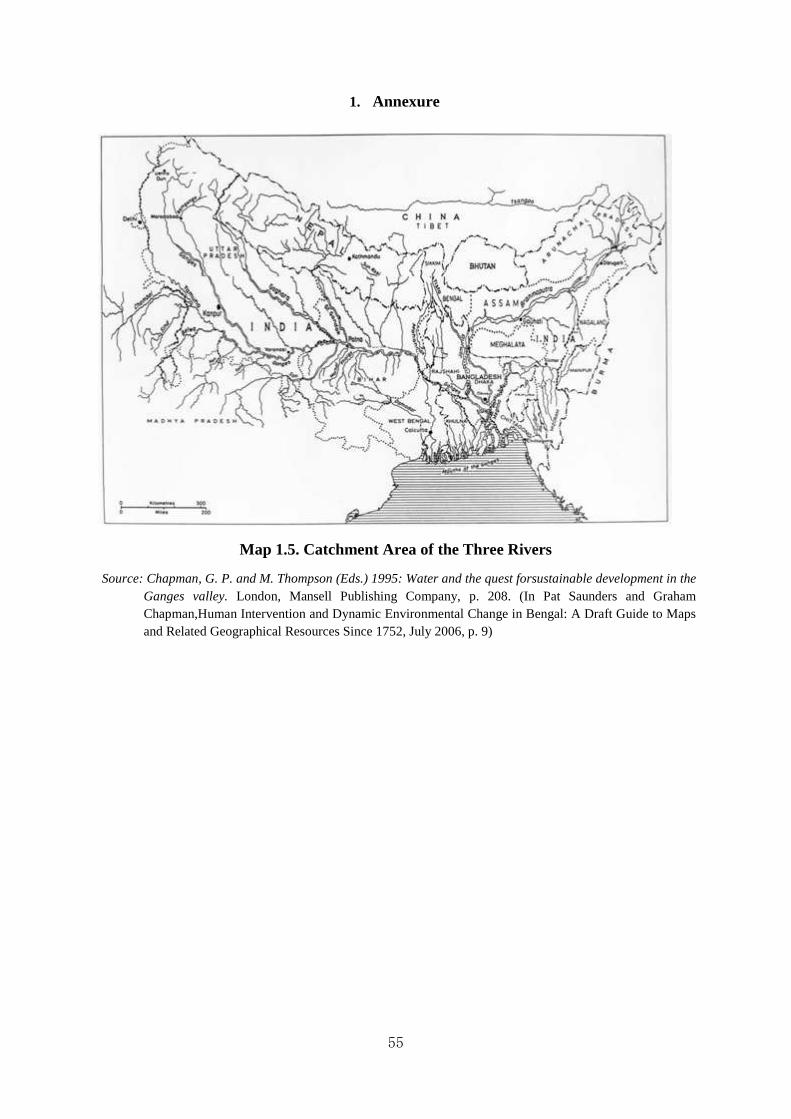
55
1. Annexure
Map 1.5. Catchment Area of the Three Rivers
Source: Chapman, G. P. and M. Thompson (Eds.) 1995: Water and the quest forsustainable development in the Ganges valley. London, Mansell Publishing Company, p. 208. (In Pat Saunders and Graham Chapman,Human Intervention and Dynamic Environmental Change in Bengal: A Draft Guide to Maps and Related Geographical Resources Since 1752, July 2006, p. 9)
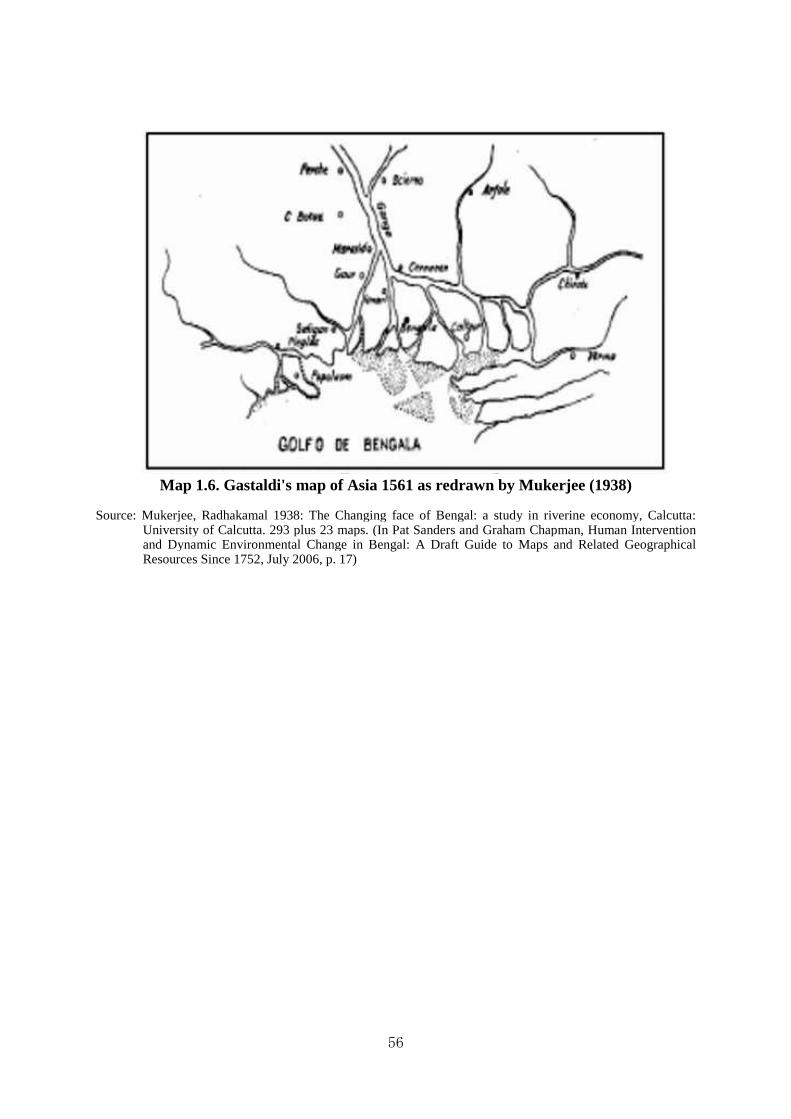
56
Map 1.6. Gastaldi's map of Asia 1561 as redrawn by Mukerjee (1938)
Source: Mukerjee, Radhakamal 1938: The Changing face of Bengal: a study in riverine economy, Calcutta: University of Calcutta. 293 plus 23 maps. (In Pat Sanders and Graham Chapman, Human Intervention and Dynamic Environmental Change in Bengal: A Draft Guide to Maps and Related Geographical Resources Since 1752, July 2006, p. 17)

57
Map 1.7. Map of the Ganges, Brahmaputra and Meghna River Basins.
Source: https://en.wikipedia.org/wiki/List_of_rivers_of_India

58
Chapter 2
The General Reclamation Process in Bengal
Abstract of the Chapter
In the second chapter a nearly complete story of the reclamation process has been discussed covering whole process where main foci were problems and prospects. The soil textures of Bengal are naturally different which do not encourage the farmers to produce all what they like. Here the general reclamation process of undivided Bengal during the colonial rule has been highlighted along with the law framed by the colonial authority to administer reclaimed lands in order to maximization of their profit by improving agricultural and other economic activities. This chapter is completely new, because no historians have highlighted this point yet.
“The land-revenue of India is a very large subject. A man of more than ordinary intelligence may confess, without discredit, that after thirty years’ study he but imperfectly comprehends it, in all its bearings and relations. I know very few men who have attained to anything beyond this imperfect comprehension. It is a subject on which volumes might be written without exhausting it, and on which volumes, indeed, have been written, only to leave it as obscure as before. As for myself, I purpose only in this volume to give a very slight account of the systems of land- assessment introduced into different parts of India under the British Government, and the influence which they seem to have had upon the happiness of the people.”1
John William Kaye, The Administration of the East India Company, p. 162.
Reclamation is a common feature all over the world and Bengal is no exception. In the introductory chapter, it has been discussed that land reclamation was being carried out in Bengal since ancient times. There is higher degree of correlation between reclamation and population growth. When agricultural production has been enough for the local population, much land has remained waste and uncultivated. Growth of population associated with development of communications, micro and macro size of markets, money economy etc., provide fresh allurement to the cultivator to produce more not only to feed the growing population, but also to enrich the producers. Such situation may be applicable to ancient and medieval Bengal. However, the situation assumed a different character during the rule of the East India Company.
This chapter aims at discussing the following subjects:
1. Factors forcing man to desert;

59
2. Mortality caused by famine; 3. Mortality caused by diseases; 4. Land system and rise of intermediaries; 5. Availability of cultivable lands; 6. Beginning of land reclamation ; 7. Land reclamation and land system; 8. Demographic condition and land reclamation process. For unavoidable reasons, it will not be possible to write a complete chronological account of the subject as above alluded because above incidents had not occurred following chronological order. These had happened at various time following the natural conditions and circumstances.
2.1 Factors Forcing Man to Desert
The Bengalis were accustomed to desertion and migration since they were common phenomenon in Bengal from historical time. The Maratha raidswereamenace occurring in eighteenth-century Bengal during Mughal rule in India. The Marathas, inhabitants of Maharastra, were known to the people of Bengal as Bargi.2 The Marathas had made six expeditions to Bengal, from 1741 to 1748, for the collection of tribute annually known as chauth. As a result of these incursions, the inhabitants of the districts of Murshidabad, Burdwan and Midnapur were badly affected in early eighteenth century. From Maharastra Puran, a Bengali tract, we come to know that considerable demographic changes occurred in some areas of Bengal due to the Maratha incursion.3 Similarly, the Magh of Arakan in association with the Portuguese pirates had created a party known as ‘Harmad’or ‘Firinghi’, who continued their piratical and slave trade activities in the coastal areas of Bengal. The Hindus had strong taboos relating to ‘Harmad’or ‘Firinghi’. If any ‘ Harmad’or ‘Firinghi’ touched a Hindu, he was looked down upon as he was considered to have lost his caste. Naturally the Hindus left the coastal areas of Bangladesh. It had also caused demographic changes from 17th and 18thcenturies.4 Changes of the courses of river and river erosion also created situation for human desertion. It has been discussed in the first chapter how the rivers of Bengal delta were liable to continuous changes over time. Migration of population centering round the changes of river course was unavoidable. Similarly, the impact of river bank erosion can be felt on the desertion of population in Bangladesh.
2.2 Mortality Caused by Famine
After the battle of Buxar in 1764 a treaty was signed on 12 August, 1765 between the East India Company and the Mughal Emperor Shah Alam II (1761-1805), by which the Mughal Emperor was forced to issue a farman appointing East India Company as the diwan of Bengal, Bihar and Orissa. The farman had constitutionally vested the East India Company with power of dealing with collection of revenues of Bengal, Bihar and Orissa. The East India Company, having no previous knowledge about the land system and collections of revenue, had embarked on revenue experiments for more than a decade. Meanwhile great famine occurred in Bengal in 1769 and 1770. It is popularly known as Chhiyattarer

60
Manvantar (The Great Famine of 1176 Bengli year). According to William Wilson Hunter one-third of the population of Bengal was perished in the famine of 1769 making large areas unpopulated and land uncultivable waste. It is found in the contemporary historical literature that the crops from December, 1768 to August, 1769 were both scanty and prices became very high; and throughout the month of October, 1769, there was hardly a drop of rain fall. The famine was felt in all the northern part of Bengal as early as November,1769, but by January, 1770, the daily deaths from starvation in Patna were up to fifty; and before the end of May, one hundred and fifty. The tanks were dried up, and the springs had ceased to reach the surface, and before the end of April, 1770, famine had spread desolation. In Murshidabad, at length, the dead were left un-interred; dogs, jackals, and vultures were the sole scavengers. Three millions of people were supposed to have been perished.
All through the hot season the people went on dying. The husbandmen sold their cattle; they sold their implements of agriculture; they devoured their seed grain; they sold their sons and daughters, till at length no buyer of children could be found; they ate the leaves of the trees and the grass of the field, and in June it was reported that the living were feeding on the dead. Two years after the dearth, Warren Hastings made a journey through Bengal, and he states the loss to have been at least one-third of the inhabitants, or, probably, about ten millions of people. Nineteen years later Lord Cornwallis reported that one-third of Bengal was a jungle inhabited only by wild beasts.5
Again in 1784 before the country had time to regain, another severe famine took heavy toll resulting further desertion of population.6John Shore, afterwards Lord Teignmouth, pronounced his opposition to Lord Cornwallis with regard to making the settlement of 1789 permanent at once. Shore thought that a country only half-peopled and with one-third of its surface lying waste, was not ready for such a measure. However, the natural process of settlement of land started slowly.
In fact, there were several famines in British India in the nineteenth century, but fortunately, Bengal was spared sometimes. In Jessore, Nadia and parts of Central Bengal the rice crops were destroyed and the people were isolated by a series of floods and cyclone, which swept across almost the whole of that province. Consequently famine situation prevailed in those areas.7 W.W. Hunter in his book entitled Famine Aspects of Bengal Districts, mentioned all the divisions of Bengal excepting Dhaka and Chittagong divisions. W.W. Hunter collected his materials from the collectors of the districts concerned. In 1866-67 a famine was severely felt in some of the districts of Bengal. But through famine relief operation on the part of the government, the situation could never be the famine of 1769.8
A terrible famine occurring in 1896-98affected Bengal and other provinces of India. However, here also the failure of rainfall was suggested to be the triggering factor. According to the nationalist historian Romesh Chunder Dutt (1848-1909):
If we honestly seek for the true causes of recent famines in India, without prejudice or bias, we shall not seek in vain. The immediate cause of famines in

61
almost every instance is the failure of rains, and this cause will continue to operate until we have a more extensive system of irrigation than has yet been provided. But the intensity and the frequency of recent famines are greatly due to the resourceless condition and the chronic poverty of the cultivators, caused by the over-assessment of the soil on which they depend for their living.9
Food items were available in market, but these were beyond the reach of the majority of the population who lacked any purchasing power. Moreover, the Government had no control over market price. However, this famine which was followed by desertion had also brought miseries in the lives of the poor people of Bengal. The Man Made Famine or the Great Bengal Famine of 1943was one of the worst famines occurring after 1769. Large-scale of mass migration to urban areas happened on the mistaken presumption that relief would be provided in the city. Nearly four million people of Bengal were forced to die.10
2.3 Mortality Caused by Diseases
It is commonly known that disease like cholera has been originated from Bengal. It is a contaminated disease and spreads very quickly. In the Gangetic delta of which Bangladesh is a part, cholera has been known to wreck havoc, and to wipe out villages after villages killing men, women and children by the thousands. In 1859, an outbreak in Bengal contributed to transmission of the disease by travelers and troops. Later, it was reported that:
Hindostan, especially the Presidency of Bengal, or more particularly the valley and delta of the Ganges, may justly be regarded as the home or place of origin of epidemic cholera. Hindostan has peculiarities of season, climate, winds, and productions; and the Hindoos have anomalies of manners, customs, religious ceremonies, etc., which distinguish them from all other countries and peoples.11
2.4 Malaria and Consequent Mortality
Malaria was one of the most important factors that brought spectacular changes in the demographic and economic life of Bengal. It was not unique in Bengal, but it ravaged Bengal seriously from the late nineteenth century to the early twentieth century. The crux of the problem of malaria had been viewed differently by different persons e.g., the British civilians and the emerging Bengali elites as long as the scientific diagnosis of malaria was undiscovered. After the epoch-making discovery of Ronald Ross (1858-1932), a British physician, new dimension appeared in health science and the colonial Government had to respond to meet the emerging public need. But the magnitude of malaria was so heavy that it became an unmanageable task for the colonial Government in an already aggravated environmental condition of Bengal.
The word ‘malaria’ means bad or tinted air. It had originated from the Italian word ‘mal’ and ‘aria’, because at that time it was anticipated that, the disease was due to ‘miasmata’, the inhalation of poisonous emanations from the ground mainly of marshy places. The
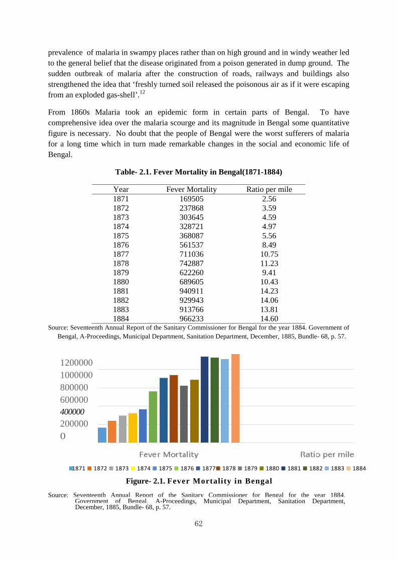
62
prevalence of malaria in swampy places rather than on high ground and in windy weather led to the general belief that the disease originated from a poison generated in dump ground. The sudden outbreak of malaria after the construction of roads, railways and buildings also strengthened the idea that ‘freshly turned soil released the poisonous air as if it were escaping from an exploded gas-shell’.12
From 1860s Malaria took an epidemic form in certain parts of Bengal. To have comprehensive idea over the malaria scourge and its magnitude in Bengal some quantitative figure is necessary. No doubt that the people of Bengal were the worst sufferers of malaria for a long time which in turn made remarkable changes in the social and economic life of Bengal.
Table- 2.1. Fever Mortality in Bengal(1871-1884)
Year Fever Mortality Ratio per mile 1871 169505 2.56 1872 237868 3.59 1873 303645 4.59 1874 328721 4.97 1875 368087 5.56 1876 561537 8.49 1877 711036 10.75 1878 742887 11.23 1879 622260 9.41 1880 689605 10.43 1881 940911 14.23 1882 929943 14.06 1883 913766 13.81 1884 966233 14.60
Source: Seventeenth Annual Report of the Sanitary Commissioner for Bengal for the year 1884. Government of Bengal, A-Proceedings, Municipal Department, Sanitation Department, December, 1885, Bundle- 68, p. 57.
1200000 1000000 800000 600000 400000
200000 0
Figure- 2.1. Fever Mortali ty in Bengal
Source: Seventeenth Annual Report of the Sanitary Commissioner for Bengal for the year 1884. Government of Bengal, A-Proceedings, Municipal Department, Sanitation Department, December, 1885, Bundle- 68, p. 57.
■1871 ■ 1872 ■ 1873 ■ 1874 ■ 1875 ■ 1876 ■ 1877■ 1878 ■ 1879 ■ 1880 ■ 1881 ■ 1882 ■ 1883 ■ 1884
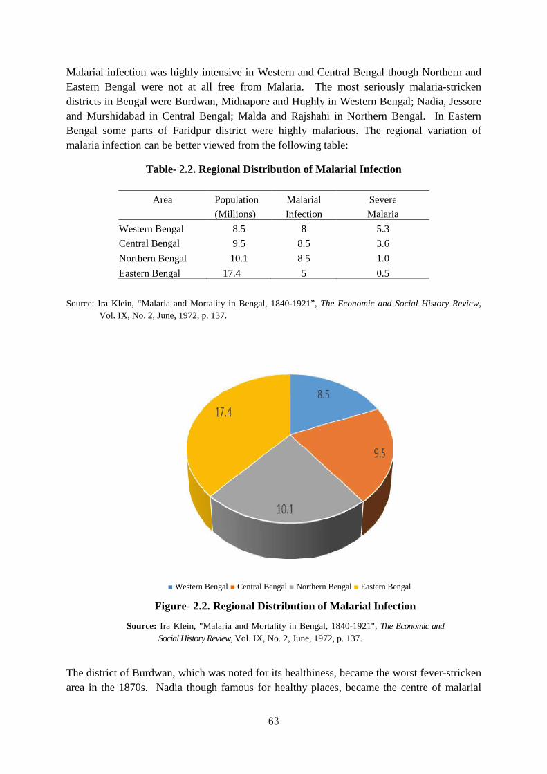
63
Malarial infection was highly intensive in Western and Central Bengal though Northern and Eastern Bengal were not at all free from Malaria. The most seriously malaria-stricken districts in Bengal were Burdwan, Midnapore and Hughly in Western Bengal; Nadia, Jessore and Murshidabad in Central Bengal; Malda and Rajshahi in Northern Bengal. In Eastern Bengal some parts of Faridpur district were highly malarious. The regional variation of malaria infection can be better viewed from the following table:
Table- 2.2. Regional Distribution of Malarial Infection
Source: Ira Klein, “Malaria and Mortality in Bengal, 1840-1921”, The Economic and Social History Review, Vol. IX, No. 2, June, 1972, p. 137.
The district of Burdwan, which was noted for its healthiness, became the worst fever-stricken area in the 1870s. Nadia though famous for healthy places, became the centre of malarial
Area Population Malarial Severe
(Millions) Infection Malaria
Western Bengal 8.5 8 5.3
Central Bengal 9.5 8.5 3.6
Northern Bengal 10.1 8.5 1.0
Eastern Bengal 17.4 5 0.5
■ Western Bengal ■ Central Bengal ■ Northern Bengal ■ Eastern Bengal
Figure- 2.2. Regional Distribution of Malarial Infection
Source: Ira Klein, "Malaria and Mortality in Bengal, 1840-1921", The Economic and Social History Review, Vol. IX, No. 2, June, 1972, p. 137.

64
infection. Jessore and Murshidabad were unhealthy areas and known as salubrious compared to the conditions of Hughly and Birbhum districts. Approximately from 1860s to 1910s many district of the Western and Central Bengal were seriously ravaged by malarial infection and resulted in heavy loss of population and production.
Table- 2.3. Number of Deaths and Ratio per 1,000 Population of Bengal
Source: W.H. Gregg, “Malarial Fever in Bengal”, Calcutta Review, 1887.
Figure- 2.3. Number of Deaths and Ratio per 1,000 Population of Bengal
Source: W.H. Gregg, "Malarial Fever in Bengal", Calcutta Review, 1887.
After the epoch-making discovery of Ronald Ross and subsequent development of quinine prophylaxis and other anti-malarial measures Malaria became a preventable disease and its severity ceased temporarily. But Malaria recurred again in the eastern and southern parts of Bengal in 1936 with all its severity. A. C. Chatterji, Director of Public Health of Bengal, blamed the defective construction of roads, railways, canals and embankments. According to him the construction of railways and roadways right across the spill area of the rivers had prevented ‘the spill and flood water during the monsoon from draining away and killing the mosquito larvae with silt’. Moreover, the indiscriminate killing of fish and lack of systematic
0
200000
400000
600000
800000
1000000
1200000
1400000
1600000
1800000
Nu
mb
er
Ra
tio
Nu
mb
er
Ra
tio
Nu
mb
er
Ra
tio
Nu
mb
er
Ra
tio
Nu
mb
er
Ra
tio
1883 1884 1886 1886 1887
Cholera
Small-pox
Fever
Bowel
Complaints
Injuries
Others
Total
Name of Disease
1883 1884 1886 1886 1887
Number of deaths
Ratio Number of deaths
Ratio Number of deaths
Ratio Number of deaths
Ratio Number of deaths
Ratio
Cholera 90,439 1.36 134,421 2.03 173,767 2.62 118,368 1.78 172,578 2.60
Small-pox 9,714 0 .14 18,533 0 .28 9,863 0.14 4,049 .06 3,846 0.05
Fever 913,766 13.81 966,233 14.60 1,042,142 15.75 1,057,296 15.97 1,087,768 16.44
Bowel Complaints
55,270 0 .83 58,376 0.88 63,808 0.96 55,693 0.84 56,893 0.85
Injuries 23,670 0.35 24,674 0.37 38,956 0.43 29,081 0.43 26,630 0.40
Others 152,87 2.30 176,373 2.66 18,209 2.81 190,818 2.88 204,813 3.09
Total 1,245,676 18.82 1,378,610 20.83 1,504,745 22.74 1,455,305 21.99 1,552,528 23.46

65
pisciculture contributed further to the spread of malaria. About the pernicious situation of recurring malarial infection, A. C. Chatterji remarked:
It is a serious matter that malaria is spreading towards the eastern and southern parts of this province into those districts which were comparatively healthy only a few years ago. Districts like Dacca, Mymensingh, Noakhali and Bakarganj were comparatively healthy even as late as 6 or 7 years ago that what they are now. A serious epidemic of malaria broke out in Mymensingh and in Bakarganj 3 years ago. The spleen index in some parts was as high as 60 per cent and in others even more. If the present conditions are not tackled properly and early, and are allowed to continue, history will repeat itself and these areas will meet the same fate as those of western and central Bengal.13
The Malaria, set its basis in Jessore and soon conquered the healthy places of Burdwan, Birbhoom and Bankura, and spread almost all over Bengal. Even in many districts of Eastern Bengal people deserted villages being horrified by the magnitude of malaria. With alluvial but dry soil Burdwan was once a prosperous district and it was salutiferous than central or eastern Bengal of the lower Gangetic delta. During the later half of the nineteenth century, its natural drainage system was obstructed by silt at its outlets. As a result of water-logging, long prevalence of epidemic malaria and an alarming increase in mortality rate fighting them out took a long time. The magnitude of malaria was so great that the Indian Mirror commented that:
Within a few miles of the seat of Government this, on either side of the Hooghly, north of Calcutta, may be seen as one continued scene of human suffering, caused by a full epidemic, whose ravages every year during this time are most fearful. So great, indeed, is the calamity felt that those who have the means to remove have moved to Calcutta and elsewhere for the safety of their lives, while others have taken refuge under the roof of relatives and friends. Helpless men and women and children are left in the midst of the epidemic, and who can save them? Pale, emaciated, skeleton-like sufferers as they are, they one and all under the baneful influence of spleen and fever which at times attack them and contribute to the acceleration of their death.14
The progressive decline of population and labour force in Bengal may be considered the remarkable consequences of malaria. As a result many villages disappeared as many wealthy villagers migrated to town areas where medical facilities were easier and authority took possible initiative for good drainage and sanitation. The Census Reports provide us with information regarding the desertion and depopulation of villages owing to virulence of malaria, sometimes villagers left their villages being terrified by malaria alarm. By 1900 vast tracts of the Rajshahi district had become depopulated when malaria mortality reached an extreme level. A contemporary writer deplored looking at the dismal picture of malaria during the period under review that:

66
…this is the history of a part of Bengal during the last tri-quarter century during which period she has been losing progressively in population and labour power, and in productivity of land. This is the etiology of the decline of the Bengal village, of the disappearance of her man-power, of the backwardness in industrial life, and of the fell disease which has become a constant accompaniment of her village life. This should partly explain why her finest people, the Bhadraloks, have had to leave the comfortable rural homes of their ancestors for the dingy and over-crowded city-bustees.15
The villagers staggered about their villages like drunken men, haggard and emaciated, more or less jaundice being a frequent complication. The condition of the villages of some districts, with exception of less surrounded by jungle, was in every respect destitute of sanitation. While suggesting improved drainage W.H. Gregg, Sanitary Commissioner for Bengal, deplored looking at the consequence of malaria on human body in the following lines that:
If surface and sub-soil drainage accomplished nothing else, it would be worth all the money expended on it, as making an era in the history of Indian sanitation. But there can be no doubt whatever that improved health and better physique would follow its introduction. Where now are to be seen wretched beings of sallow and ghastly countenance, looking twice their real age, with attenuated frames, shrunken limbs, muscles thin and powerless, tongues of silvery whiteness (certain index of deadly marsh fever), pulses feeble and irregular, spleen and livers enormously enlarged, and pitiable languid gait, would be found men well knit, with their muscles, developed, and their vital organs sound - altogether powerful, vigorous, healthy and happy.16
Malaria decreased the vitality of the vast mass of population and their working power enfeebled for many months. The infinitely greater sacrifice of life had, in fact, been produced by excessive prevalence of malaria. In those tracts of Bengal where short rainfall and scanty inundation favoured anopheles mosquitoes, agricultural deterioration and poor harvests followed. The immediate results of this combination of factors greatly intensified malarial infection, which manifested either in the form of acute epidemic outbreaks of the disease or by the more gradual depopulation of the affected areas. A plethora of evidences of economic decline due to malaria are available in the contemporary reports, books and brochure written both in the Bengali and English languages. The impact of malaria on population and production was serious. Undoubtedly in some districts where malaria assumed the character of epidemic and endemic nature, the population had tended to decline remarkably for several years. It can be better understood from the chapter on demographic pattern about the nature and extent of change in population growth and its consequence in economic areas.
The change in the course of river ultimately led to the change in cropping pattern in moribund deltaic Bengal. With the diminution of water supply remarkable change occurred in rice production. The aman which thrives well under inundation was gradually replaced by aus a

67
coarse variety of rice which can be produced with less quantity of water. Radhakamal Mukerjee commented:
The suppression of aman by aus itself represents a degradation of the climatic climax in the Bengal delta. It is true that the ecological succession is mainly connected with the natural history of the deltaic system, but there is no doubt that man’s interference with the natural distribution of rain and flood water by the construction of embankments along the margin of the rivers and for the purposes of roads and railways is also responsible for the loss of balance between vegetative growth and water- supply. Apart from this, the enormous pressure of population constantly tends to thwart the growth of the appropriate stages in the vegetation cycle in the moribund delta.17
Thus, the symptomatic loss of hydrological balance in turn brought spectacular changes in cropping pattern and demographic condition in moribund deltaic districts of Bengal. Agricultural operation became increasingly difficult owing to deficiency of water supply and quantity of fallow lands increased remarkably. Many moribund deltaic districts e.g., Murshidabad, Nadia, Burdwan, Hooghly and Jessore were overrun with jungles and production and population declined as jungles gained ground at the expense of cultivable lands. All these factors ultimately affected balance between man and nature.
The havoc caused by malaria created multifarious problems in the social and economic life of rural Bengal. Not only it resulted in serious decline of population and production, malaria also became a scourge for many aspects of rural life of Bengal. The decline of cultivation in some district was significant where malaria took epidemic and endemic form. The study of Suranjan Chatterjee throws sufficient light on the decline of agriculture in the districts of Burdwan, Hooghly, Nadia and Jessore. His study further shows the decline in acreage in his selected districts of Bengal. According to Suranjan Chatterjee:
… the fever malady had brought to an end the reclamation of wastes that had been going on for the last four decades in village Jowgram. Peasants were abandoning their existing holdings, and the Commissioner of Burdwan attributed this to the epidemic fever and decline in output. It was correctly observed that the labour problem in the district was nothing but malaria problem. Malaria had hindered the agricultural population from reaping the kharif crops at the proper time and interfered in the preparing of the usual land for the rabi crops.18
In many district the peasants willingly relinquished their holding as they were unable to cultivate lands owing to the want of man-power. In many cases villages were overgrown with jungle and brushwood and resembled a condition of complete destitute. D.G. Crawford gave a vivid description about the devastating impact of malaria in the countryside of Hughli district in 1903:
In villages of the Pandua, Bansbaria and Dhaniakhali stations, where the mortality had been great, one-fourth of the land is lying uncultivated. The

68
uncultivated lands in Dwarbasini, Megshar, Mahanad, and Hasnan are much greater in extent. The loss of population is the sole cause of this. It may be noted that on an average about 1/8th of the cultivable lands in the three thanas is lying uncultivated from the want of man ... and looking to the conditions of the majority of villages, and population appears to be small as compared with the area of cultivable land. The people who have survived are unable to bring their ancestral jotes under cultivation.19
The magnitude of malaria was so heavy that in some districts of Bengal it made remarkable changes in tenurial pattern. The high percentage of under-raiyats was attributed to the high malarial mortality. K.A.L. Hill, the Survey and Settlement Officer of Burdwan, remarked:
There are many villages in the east where cent. percent are attacked annually. Though the survey staffs were mostly from outside, they did not escape; and annually in November about one-third were continuously off duty. In a district so fertile, the decline in population is striking, and may chiefly be ascribed to this cause. In police-station Purbasthali, where the incidence of malaria is high, the decline is also most marked. Another curious effect is the high percentage of under-raiyats, due to bhadralok raiyats being unable to stand the climate.20
Contemporary Bengali literature throws enough light about death, desertion, migration and corresponding decrease in cultivation in many districts of Bengal as consequences of malaria epidemic. Large-scale immigrant labour force worked for cultivation in seriously malaria-stricken areas. Another striking feature during this period was the decline in aman acreage in the moribund deltaic districts of Bengal.
2.5 Early Land System, Permanent Settlement and Rise of Intermediaries
The revenue administration of Bengal from 1765-1793 may be divided into four periods, each of which has its own particular characteristic:
Period I - 1765-1773: Period of hesitation.
Period II - 1773-1781: Period of centralization
Period III - 1781-1786: Completion of centralization.
Period IV - 1786-1793: Decentralization.
2.5.1 Period I - 1765-1773: Period of Hesitation
Even after the devastating famine of 1769 the East India Company had carried out a number of land revenue experiments which caused hardship to cultivators. They extracted taxes from the farmers to finance their policies and war efforts. Direct and indirect means were carried out to bring about this collection of revenue for the British. This affected the lives of the people who could not meet their daily needs because they had to provide the landowners and the collectors their share in the produce. Local administration failed to provide relief and

69
natural justice to the rural poor. During this time the task of collection of the land revenues was vested to Reza Khan. It is worthy to mention that in 1769 European Supervisors were appointed in every district for writing the fiscal history of the district and to watch the revenue collections.
You are to collect, under this head, the form of the ancient constitution of the province, compared with the present; an account of the possessors or rulers, the orders of their succession, the revolutions in their families, and their connections; the peculiar customs and privileges which they, or their people have established and enjoyed; and in short, every transaction which can serve to trace their origin and progress, or has produced any material changes in the affairs of the province.21
These Supervisors were placed under the control of two Councils of Revenue, established at Patna and Murshidabad in the year 1770. The inquiries of the Supervisors revealed rampant corruption and depravity of the collecting agency. In 1771 the Company decided to stand forth as diwan in order to collect revenues and administer the fiscal system of Bengal. This involved the abolition of the office of Muhammad Reza Khan as Naib Dewan and the appointment of the Supervisors as collectors of revenue in the place of the former officials. A Committee of Revenue was constituted at Calcutta. This time a settlement was made:
…by letting out all estates to the highest bidders for a period of five years—irrespective of rights claimed by the zemindars—a policy in its disregard for the zemindar not dissimilar to that of Murshid Quli Khan. Such temporary leases were known as ijards or farms, and the system adopted was called the farming system as opposed to the zemindari system.22
It is not true that the Company’s officials had neither any knowledge about the land revenue administration system of Bengal, nor had they any command over the language of the subject. So it was thought prudent that in the auction system to the highest bidder proper person would come forward who had knowledge about the yields of an estate. However, this policy proved to be completely unsatisfactory and brought serious disastrous consequences. This system overlooked the old zamindars who were naturally eager to retain their ancestral property. The new stake-holders had made excessive commitments in their bids, but it was impossible to collect the stipulated land revenues. The result was bound to lead to arbitrary enhancements of the rents of the tenants and oppressive exactions from them.
The first effort of the Company to manage its revenue affairs had resulted in the complete extinction of a skilled, though corrupt, collecting agency and the substitution of an untrained and foreign agency, appointed to collect a revenue that must be, by the very manner of its assessment, excessive.23
2.5.2 Period II - 1773-1781: Period of Centralization
The Council was bound by the terms of settlement for a period of five years, but it soon realized that the collecting agencies were corrupt and greedy. However, it was decided to

70
centralize the whole system by the creation of a Controlling Committee of Revenue at Calcutta, with six Provincial Councils subordinate to it, at Calcutta, Murshidabad, Patna, Dacca, Burdwan, and Dinajpur. Collectors were abolished, and a body of native amils was appointed to attempt to collect the revenue as fixed in the previous year. The result was not better than before. The Council realized that the fault lay not so much with the administrative machinery as with the method of assessment. In 1775, Barwell recommended that long-term settlement should be made with the zemindars to which Grant-Shore opposed.
2.5.3 Period III - 1781-1786: Completion of Centralization
In this phase drastic reforms were now taken. It was thought that the Europeans had gained considerable knowledge about the land system of Bengal and consequently decision was taken for complete centralization at Calcutta. In 1781, the Provincial Councils were abolished and Collectors were appointed over the various districts. Local officers like Kanungos were appointed as helper of the Collectors.
2.5.4 Period IV - 1786-1793: Decentralization
In 1786 the East India Company Court of Directors first proposed a permanent settlement for Bengal, changing the policy then being followed by Calcutta, which was attempting to increase taxation of zamindars. In 1786 the new Governor-General Lord Cornwallis and Sir John Shore entered a heated debate over whether or not to introduce a permanent settlement with the zamindars. Shore argued that the native zamindars would not trust the permanent settlement to be permanent, and that it would take time before they realised it was genuine. Cornwallis believed that they would immediately accept it and begin investing in improving their land. The reappointment of Collectors appears to suggest an idea of decentralization. During 1787 and 1788 annual settlements of the revenue were made by the Collectors, who were at the same time engaged in investigations prescribed by the Governor-General. At the close of the year 1789 and the beginning of the year 1790, regulations were issued for the Decennial Settlements. Later in 1793 Lord Charles Cornwallis (1738-1835) had declared this settlement as the Permanent Settlement.24
The architects of the Permanent Settlement had expressed high hope that it would bring revolutionary changes land market. As Lord Cornwallis hoped:
This system will excite a spirit of industry and economy, and be the means of bringing into cultivation the very great proportion of desolate land which is to be found in almost every district throughout the Provinces … the proprietors of the soil will be enabled from the profits arising from their estates to keep the embankments and reservoirs in proper repair … and instead of being necessitated to oppress their tenants … they will have it in their power to afford them relief.25
The basic principles laid down by the Permanent Settlement were the following:
1. The landholders or zamindars were admitted into the colonial state system as the absolute proprietors of landed property;

71
2. The land revenue to be paid by the zamindars to the state was fixed in perpetuity. 3. The zamindars had the right to transfer their land freely by way of sale, mortgage or
gift; 4. If the zamindars fail to pay their kists on stipulated date, their land would be put to
sale in auction under the execution of revenue sale law, popularly known as the sun-set law.
5. The revenue payable by the zamindars was fixed, but the land tax payable by the ryots was not fixed.
However, the zamindars were instructed to give patta and kabuliyat to the ryots with a view to enticing them for cultivation and at the same time collecting the stipulated rent from them. The terms of patta included the boundaries of land, quality and quantity of land, lease period, rate of rent, and mode of payment of rent. A peasant holding a patta and giving a kabuliyat, in turn, was known as pattadari raiyat. To collect rent from the pattadars there was a class of state-appointed intermediary called patwari. The pattadari raiyats were privileged in the sense that they paid rent individually according to the patta direct to the state agents and that their rent was unalterable during the term of the patta and kabuliyat. The villages in most parts of Bengal were either very small or scattered households. Rent collection from those villages was normally done through the village headman locally called pradhan, paramanik, basunia, chowdhuri, bera, mukaddam, matbar etc.26
The formation of great territorial zamindaries had invariably led to the numerous difficulties in their management on the part of the zamindars with the introduction of the Permanent Settlement. The punctual payment of revenue installments or kists emerged as a formidable challenge to the zamindars. Analyzing the situation Sirajul Islam commented:
The management of every great zamindari consisted of numerous officials and farmers organised hierarchically. Because of hereditary employment of amla and ijaradars, every layer in the management structure tended to form a class in itself. When the zamindari began to decay, these elements showed greater capacity for survival than their masters. The zamindars, who had already been weakened and impoverished before the challenge of the Permanent Settlement, were now compelled to share their authority with these managers. It is from this angle that we must view the rise of the multi-tenurial society in the 19th century.27
Such situation had ultimately led to the emergence of the Pattani tenure immediately after the Permanent Settlement. According to the glossary of Horace Hayman Wilson (1786-1860):
A tenure by which the occupant holds of a Zamindar, apportion of the Zamindari in perpetuity, with the right of hereditary succession, and of letting or selling the whole or part as long as a stipulated amount of rent is paid to the Zamindar, who retains the power of sale for arrears, and is entitled to a regulated fee or fine upon any transfer; the tenure created by an under-letting in the second degree is termed by Dar-Patni (or lease within lease); and a third under-letting is denominated Seh-patni: this description of sub-tenures

72
originated in Burdwan, being created by the Raja or Zamindar: it has been extended and sanctioned by Regulation.28
The consequence of this system had far-reaching impact on agrarian relations as well as land system. By this system talukdars, howladars, ijaradars, rentiers, joteders of various denominations of landed-interests emerged and virtually changed the socio-economic conditions of Bengal, which would be apparent in the future discourse in this line.
In fact, the callous exercise of the revenue-sale law amounted to such a huge pressure on the zamindars that within a decade, all the great zamindaries of Bengal had been disarticulated and on this debris, a new class of landholders had appeared. The big zamindaries of Nadia, Birbhum, Rajshahi, Dinajpur, Bishnupur and Bakla29, which once controlled nearly half of the land of Bengal for generations, fell separately within a decade of the operation of sun-set law. The only exception was the zamindar Raja Tejchandra of Burdwan, who was able to identify this inconsistency before he was completely ruined. The story is very interesting as explained by Sirajul Islam how his diwan and father-in-law, Pran Babu at the right moment explained to Raja Tejchandra of Burdwan about the servants of the zamindaris who had enriched themselves by the revenue sales or such transactions.30 In between 1793 and 1799, seven profitable parganas of the zamindari were sold for default at public auction and furthermore twenty four more parganas were advertised for public sale. In this situation of utter ruin of the Burdwan zamindari, Raja Tejchandra had played a historic role by turning the whole zamindari into a union of talukdari estates without overthrowing the ijaradari interests. The owners of these were known as pattanidars, who would be regulated according to the same terms and conditions meant for the zamindars.
It is worthy to note that under the Regulations of the Permanent Settlement, the two permanent interests in land i.e. zamindars as proprietors and ryots as tenants were recognised. In consequence the legal positions of all intermediaries remained undefined. In order to safeguard their interests, the intermediaries raised serious obstacles through their local influence against zamindars in the punctual collection of revenue. Describing the situation Sirajul Islam stated that:
At their (intermediaries) instigation the ordinary rayats began to challenge the bonafides of zamindari demands on them. Regulation XVII, 1793, provided that the zamindars must withdraw their attachment of defaulters’ property if the latter preferred to contest the distrainer’s demands in law courts. It was further enacted that the zamindars were prohibited from distraining upon ploughs, seed grains, implements of husbandry and cattle actually trained to the plough. Zamindars were also strictly prohibited from confining of inflicting corporal punishment on any defaulting tenants or dependent talukdars as ways of enforcing the payment of arrears.31
These protective rules had, in fact, helped the recalcitrant rayats to challenge the demands and illegal exactions of the zamindars in civil and criminal courts and their legal claims or litigations reached to the climax. Nothing could be done against these legal claims or
73
litigations and since it had remained in sub judice, payment of rent was withheld under legal protection. It was not a problem unique to Burdwan alone; it was also a problem for all the rest of the districts of Bengalwhere extensive estates were predominant. In this regard the experience of the Rajas Rajshahi, Birbhum, Nadia and Bishnupur were the same. The creation of pattani tenure by the Raja of Burdwan was utter violation of the cardinal rule of the Permanent Settlement. As a result a prolonged legal struggle started between the Government of Bengal and the zamindars especially the Raja of Burdwan. “The lower courts gave conflicting verdicts on this issue, some confirming the validity of pattani tenure on the ground of traditional custom, and others rejecting it on the ground of Regulation 44 of 1793.”32 However, while investigating the foundation of the pattani system of tenure, W. J. Prinsep reported:
The Rajah created the pattani tenure with the intention of transferring his entire rights over the cultivating classes, after having found that he could not, by transfer of minor interest, secure in the intermediate holders sufficiently constant efforts to realize the highest rent procurable from the land. If he farmed for a period, the farmer would rack-rent and otherwise injure the tenure for a present profit towards the end of his lease. If he employs agents, they would embezzle and further sell for a consideration the means of establishing an advantageous, or perhaps a (rent free) tenancy against the zamindar (sic); at least it was the interest, and experience had shown it to be the practice, of such agents to do. But by creating permanent interest that is one yielding permanent profit from maintaining the rent at the highest, the proprietor of an estate would be secure of the conduct of those to whom he might assign the management of his concerns with the cultivating classes; and if the Estate was too large to allow his personal superintendence of the whole, it would obviously be his interest to adopt the plan in preferring to any other…33
Ultimately, the Raja of Burdwan succeeded to achieve his objective and in 1812 the Government of Bengal amended the Regulation 44 of 1793. This amendment, in fact, provided indirect recognition to the pattani tenure, which sanctioned the zamindars to lease out their lands for an unlimited period at any rate, the zamindars considered suitable.34 This resulted in the emergence of huge numbers and tiers of intermediaries interested in land. Nevertheless, there aroused serious difficulties and confusions that resulted in huge legal cases for progressive increase of revenue defaulter of the pattanidars and all other sub-tenures. In order to put an end to the anomalous situation, the Governor General in Council decided to recognise all grades of pattani tenures that they thought politically convenient and they passed an elaborate regulation commonly known as the Pattani Regulation in 1819. However, the authorities found the pattani system very effective as far as the collection of revenue was concerned. Consequently in 1825 the government estates were brought under the pattani system considering it less expansive and most efficient. But the reaction of the Sadar Dewani Adalat to this system was different. They found that the general ryots were forced to surrender their entire surplus for satisfying the long chain of intermediaries. The Sadar Dewani Adalat remarked:
The Patni has benefited all superior landed interests, but no general change for the better can be expected in the condition of the cultivating classes, until some general, clear and positive rule shall have been enacted to guard them

74
against the oppression an extortion to which the present system they are necessarily exposed.35
2.6 Availability of Cultivable Lands
Reference to this is also available in the Baharistan-i-Ghaybi which says that the northern parts of Dinajpur and Rangpur districts supported thick jungles, while some parts of the banks of the Brahmaputra were covered with impenetrable forest. According to Ain-i-Akbari Madhupur jungle was much more extensive while the Sundarbans extended further to the north and east taking a vast area of Barisal. In the riverine tract of Bangladesh, there were numerous marshes and jheels, especially on the abandoned courses of the rivers and in the area of subsidence.
However, migration became an important problem even in 19th and 20th century Bengal. Practically in the early 17th century many parts of present Bangladesh were uninhabited and consequently covered with extensive thick jungles. The present districts of Pabna and Rajshahi were over-grown with jungles. In consequence of the great famine of 1769-70 large parts of Bengal were depopulated and came to be covered with dense forest. Even there was a dearth of immigrant labour for reclamation. Officially, liberal terms and additional incentives were given to the ryots for the purpose of enticing the distant cultivators. Contemporary historical literature supplies enough information that a considerable portion of land of Bengal remained waste and not permanently settled to any landlord. James Rennell (1742-1830), the East India Company’s surveyor, wrote in 1772 that:
…the Bengal provinces are far from being well inhabited; for tho’ there are full three times as big as England, I reckon they do not contain quite so many inhabitants. Whole tracts of the most fertile land in the universe are lying for want of hands to cultivate them.36
According to Henry Thomas Colebrooke’s (1765-1836) estimation of lands in Bengal (1804)37:
Table- 2.4. Estimation of Lands in Bengal
Quality of Land Percentage
Arable land 37.5
Free land (having no revenue demand) 12.5
Irreclaimable and barren land 16.7
River and lakes 12.5
Site for towns, villages, highways and Ponds etc. 4.1 Cultivable waste 16.1
Source:R.T. Colebroke, Remarks on the Husbandry and Internal Commerce in Bengal, (Calcutta, 1804), p. 18.

75
Figure- 2.4. Percentage of Quality Lands in Bengal
Source:R.T. Colebroke, Remarks on the Husbandry and Internal Commerce in Bengal, (Calcutta, 1804), p. 18.
In 1812 W.B. Bayley found Burdwan to be one of most productive and highly populated district. He wrote that:
It should be observed, however, that the district of Burdwan is one of the most productive and highly cultivated portions of the British territories in India, and that contains scarcely any jungle or waste lands…. The result of such a general inquiry, conducted on uniform principles, would not merely be gratifying to public curiosity, but might eventually prove of great practical importance in the improvement of the police, and in the general administration of the extensive territories subject to the British Government in India.38
However, the Fifth Report, submitted to the British Parliament in 1812 supplies information regarding the uncultivated waste lands of Bengal which fell outside the Permanent Settlement:
1. Island thrown up in navigable rivers;
2. Private Estate purchased by Government;
3. Tracts in Sunderban and Chittagong which were covered with jungle in 1793;
4. Alluvial accretions to permanently settled estate.39
These waste lands were estimated nearly one third of the total area by Lord Cornwallis. With the growth of population, these lands were reclaimed gradually. Even at the time of

76
Permanent Settlement of 1793 the total acreage under cultivation in Bengal was 3 million acres. Gradually such acreage extended and in 1867 it was estimated at 70 million acres.
Robert Montgomery Martin (1803-1868) in the third volume of his Eastern India noticed in Rangpur that:
This eastern part of the district, therefore, comprehends land, which from its elevation may be divided into three kinds, mountains, or hills, land exempt from inundation, and land that is inundated. This last is usually called Chor, is situated near great rivers, has in general a loose sandy soil, is usually cultivated three years, is then deserted, and is allowed to remain fallow until new farmers can be induced to settle on it.40
A study of the Revenue Survey papers of Mymensingh district conducted under the JSARD (Japan-Bangladesh Joint Study on Agricultural and Rural Development Project) revealed interesting information regarding population settlement. It is found in the Revenue Survey data that in 1850s a considerable number of villages of Mymensingh district were completely uninhabited by any population. H.J. Reynolds mentioned that nearly 1,120 square miles land of Mymensingh district were unfit for cultivation.
Table- 2.5. Inhabited and uninhabited Villages of Some Parganas of Greater MymensinghDistricts Shown in the Revenue Survey of 1850s.
Name of Total No. of % No. of %
the Village Inhabited
Uninhabited
Parganas Village Village
Surveyed
Atia 617 550 89.14 67 10.86 Barobazu 763 625 81.91 138 18.09 Jafarshahi 550 489 88.90 61 10.10 Kagmari 779 646 82.93 133 17.07 Phukhuria 1120 964 86.07 156 13.93 Ran Bhowal 249 206 82.73 43 17.25 Total 4078 3480 82.82 598 17.18
Source : Pargana Register, Revenue Survey, Mymensingh District Collectorate Record Room, Bangladesh.
It seems from the table that out of 4078 villages 598 villages were uninhabited. In the middle of the 19th century, 17.18 percent of the total villages were completely uninhabited in the district of Mymensingh. The pressure of population was not heavy until the late 19th century. So it was probable that many villages remained uninhabited even during the mid-nineteenth century. H. Muspratt, Superintendent of Revenue Survey, 3rd Division, remarked that:
…there is infinitely more uncertainty as to boundaries which entails the decision of numberless disputes the face of the country almost in many places is covered with jungles, jheels, waste land & ca. which no one in fact can be said ever to have had possession.41

77
A. J. M. Mills reported about Sirajganj of Pubna that:
The lands of the Serajgunge and Shazadpore thannah are highly cultivated, but the soil is sandy and not particularly good. The principal productions are indigo, jute, hemp, rice, oil-seeds and pulses. At least half of the lands in the Raegunje Thana are covered with heavy jungles, but the soil is good, and the crops are very good in the cultivated parts. In the Serajgunge and Shazadpore Thannahs the population is very large and the villages numerous. While in the Raegunge thanah the villages are few and the population scanty. The whole country is so low as to be inundated during the six months of the year, when the model of communication is by boat. During the dry season communication is carried on across the country, but there no regular roads.42
However, according to the Revenue Survey information, it was apparent that the people of the adjoining inhabited villages cultivated some of the uninhabited villages. The reclamation process in Bengal gained a momentum in the 19th century. At the initial stage the sub-tenure holders had played important role in the reclamation process. They took the advantage of an increasing population and the liberty of letting waste and unoccupied land on their own terms in order to push up rents to the highest rates. But when ‘there was plenty of unoccupied lands, and population was sparse, the competition was not amongst the tenants for land, but amongst zemindars for raiyats.’43 Nearly eight decades later, above hypothesis fits well with Esther Boserup’s concept on agrarian change under population pressure.44
A large part of the Barind tract of Rajshahi district was found depopulated in mid-nineteenth century. Barind tract is well-known for its soil taxonomy - a very distinctive physiographic unit occupying vast areas of Rajshahi division of north-west of Bangladesh.45 W.H. Nelson, the Survey and Settlement Officer of Rajshahi district quoted from the Letters of Sports in Eastern Bengal written in 1850 that:
…beyond the cultivations was the Burrin (barind); this consisted of dry and almost useless soil so high above the valley that people sometimes called it Burrin hills ….The Burrin was so unlimited, so hard to beat, so difficult to shoot in and considered so unsatisfactory that sportsmen seldom looked it up; nevertheless it was here the most of the games found breeding shelter – deer, dogs, tigers, and leopards.46
According to F.C. Hirst that out of about 44,000 square miles in Eastern Bengal 34,000 square miles were permanently settled.47
According to another survey report of 1879 shows48 that:

78
Table- 2.6. Agricultural Operation of the Country 1879
Class of land Quantity
Total cultivated area 54,691,002
Cultural fallow 17,195,840
Uncultivable waste and forest 22,844,633
Source: Draft Report on Agricultural Operation of the Country, 1879. Proceedings of the Lieutenant Governor, Famine Department, 1880, Bangladesh National Archives.
Figure- 2.5. Agricultural Operation of the Country 1879
Source: Draft Report on Agricultural Operation of the Country, 1879. Proceedings of the Lieutenant Governor, Famine Department, 1880, Bangladesh National Archives.
But the reclamation process of Mymensingh was not a very easy process, since the history of population of Mymensingh had some peculiar characteristics. The Census Report of 1921 has ascribed the ‘Mymensingh population more mobile than is usually found to be the case’.49 Thus the symptomatic loss of hydrological balance in turn brought spectacular changes in cropping pattern and demographic condition in moribund deltaic districts of Bengal. Agricultural operation became increasingly difficult owing to deficiency of water supply and quantity of fallow lands increased remarkably. Many moribund deltaic districts e.g., Murshidabad, Nadia, Burdwan, Hooghly and Jessore were overrun with jungles, production and population declined as jungles gained ground at the expense of cultivable lands. All these factors ultimately affected balance between man and nature. The change in the course of river ultimately led to the change in cropping pattern in moribund deltaic Bengal. With the diminution of water supply remarkable change occurred in rice production. The aman which thrives well under inundation was gradually replaced by aus, a coarse variety of rice which can be produced in drier condition. Radhakamal Mukerjee commented that:

79
…the supersession of aman by aus itself represents a degradation of the climatic climax in the Bengal delta. It is true that the ecological succession is mainly connected with the natural history of the deltaic system, but there is no doubt that man’s interference with the natural distribution of rain and flood water by the construction of embankments along the margin of the rivers and for the purposes of roads and railways is also responsible for the loss of balance between vegetative growth and water-supply. Apart from this, the enormous pressure of population constantly tends to thwart the growth of the appropriate stages in the vegetation cycle in the moribund delta.50
The havoc caused by malaria created multifarious problems in the social and economic life of rural Bengal. Not only it resulted in serious decline of population and production, it also became a scourge for many aspects of rural life of Bengal. The decline of cultivation in some district was significant where malaria took epidemic and endemic form. The study of Suranjan Chatterjee throws sufficient light on the decline of agriculture in the districts of Burdwan, Hooghly, Nadia and Jessore. His study further shows the decline in acreage in his selected districts of Bengal. According to Suranjan Chatterjee:
… the fever malady had brought to an end the reclamation of wastes that had been going on for the last four decades in village Jowgram. Peasants were abandoning their existing holdings, and the Commissioner of Burdwan attributed this to the epidemic fever and decline in output. It was correctly observed that the labour problem in the district was nothing but malaria problem. Malaria had hindered the agricultural population from reaping the kharif crops at the proper time and interfered in the preparing of the usual land for the rabi crops.51
In many districts the peasants willingly relinquished their holding as they were unable to cultivate lands owing to the want of man-power. In many cases villages were overgrown with jungle and brushwood and resembled a condition of complete destitute. D.G. Crawford gave a vivid description about the devastating impact of malaria in the countryside of Hughli district in 1903:
…in the villages of the Pandua, Bansbaria and Dhaniakhali stations, where the mortality had been great, one-fourth of the land is lying uncultivated. The uncultivated lands in Dwarbasini, Megshar, Mahanad, and Hasnan are much greater in extent. The loss of population is the sole cause of this. It may be noted that on an average about 1/8th of the cultivable lands in the three thanas is lying uncultivated from the want of man ... and looking to the conditions of majority of villages, and population appears to be small as compared with the area of cultivable land. The people who have survived are unable to bring their ancestral jotes under cultivation.52
In addition to malaria, cholera, small pox, kalazar and other vulnerable epidemic diseases created serious demographic changes at different times during the period under review.

80
Besides these, other important factors were famine and scarcities that ruled over several times during 18-19th centuries taking heavy toll on population. Huge amount of land remained uncultivated owing to the scarcity of labour forces.
However, it seems that many parts of villages of Bengal remained unpopulated even in the earlier half of the 19th century. The settlement developed with the growth of population. After the disaster of 1769 the remaining population started to reclaim at the first instance. To this Henry Thomas Colebroke remarked:
The New settlers may occupy the whole or a part, of the abandoned or deserted by his predecessor; or of that which has been surrendered or resigned by the former occupant; or he may obtain ground, which has lain fallow one or more years. If it has lain for a period of three or more years, according as custom may have determined, it becomes waste, or forest, land: and from this, a progress of years, regulated by usage or by local circumstances, restores it to the first class of arable.53
Remarkable change in the reclamation process is noticeable during the colonial rule when new land system was introduced. Demographic growth, collapse of indigenous industries, increased monetization of the economy, European participation in land exploitation, changes of cropping pattern, the growth of district towns, and rise of an urban-based middle class marked such changes. With the change of land system the nature, form and extent of reclamation changed. The chaos in the land revenue administration during the early years of the Company’s rule led to the rise of superior peasants to the rank of lower class of landlords. These superior peasants were undoubtedly the village oligarchs or village headmen known as mandal. The consecutive famines and recurrent natural calamities in the decades between 1770 and 1790 resulted in serious loss of lives, large-scale desertion of population and increase of waste lands which finally brought spectacular change in the existing land-man ratio in Bengal. Land became abundant in comparison with density of population during this period. This situation gave splendid opportunity to the superior ryots to increase their land holding through reclamation by investing their reserved capital.
The assessment, distribution of land and settlement of ryots were under the control of the mandals or village headmen of various denominations, who could dictate terms of land management in the rural areas of Bengal. Recent researches provide support to the view that there was gradual emergence of middleman from the rank of village headman in the local land revenue administration before the acquisition of Diwani by the East India Company. The unwieldy size of zamindaries in Bengal necessitated the landlords to develop multi-tiered revenue collection units. These middlemen known as ‘Shah Ryot’, ‘ Shiro Pradhan’ and ‘Shah Proja’ worked as contact person between the landlords and the villagers.54 They offered protection to the villagers from the tyranny of the landlords and at the same time ensured punctual collection of rent from the village. These ‘Shah Ryots’ exploited the opportunity brought to them by famine and consequent depopulation and they occupied many lands at nominal rents. According to Sirajul Islam:

81
…the administrative and political role of the shah rayat had ceased to exist, this title ‘shah’ became irrelevant and he began to assume more egalitarian titles such as jotedar, guntidar, mandal, pradhan. These terms had no political connotations, but implied social dominance through land control.55
S. Taniguchi, Sirajul Islam and R. Ray support the view that headmen or village mandal held lesser intermediary rights in land as patnidars during the early decades of nineteenth century. S. Taniguchi remarked: “Thus patnidars of the lower gradations were in many cases men of small local influence and there were more of continuity than of the innovation in point of the human composition of this strata of the agrarian society.”56 The study of Chittabrata Palit suggests that headman either mondal or pramanik who had been the ‘pioneer-farmers’ earlier now became the ‘real master’ of the land in view of their pioneering role in reclamation with complete control over supply in a situation of more land and less people.57 In return they were allowed to hold some rent-free land and a towfir or concealed land in possession. Palit assumes that the khud-khast ryots were headmen and consequently they were the pioneers of reclamation process. But such generalization may lead us to over simplification considering the numerical strength of the khud-khast ryots in a Bengal village. They might be the leading or principal khud-khast ryots who were simultaneously the headmen of the village.
2.7. Land Policy and Reclamation Process
The Decennial Settlement of 1789-90, which was the basis of the Permanent Settlement, made revenue fixed for ever. As a result of this the permanently settled areas of Bengal were not further liable to any increase of revenue from 22 March, 1793. It is well-known that the permanent settlement was too precipitately completed without conducting any previous survey on the condition of land and people. This produced many administrative difficulties and caused sufferings of the people in the country-side. Within a short span of time the disintegration of the original zemindari estate took place and this entangled the situation. According to F. C. Hirst that:
…the information so far collected previous to 1789, regarding the limits and areas of existing estates, was incomplete, and probably, some times, very inaccurate, and it is easy, therefore, to say that, early in the nineteenth century, Collectors of Districts affected by the Permanent Settlement found themselves in difficulty as to what land had actually been included in the Permanent Settlement. The true limits of that land were, at the best, ill defined by the papers in the hands of the collectors. The people were not slow to push forward cultivation into jungle tracts; and as the cultivation extended, rents were collected by Zamindars for lands which, often were not actually covered by the Permanent Settlement.58
Practically in the beginning of the nineteenth century the zamindars found it profitable to reclaim waste land to withstand the pressure of the Permanent Settlement. This situation had forced the authority of the East India Company to undertake some measures to arrest such trend. The Company lost no time to declare that all jungle lands were to be government property. Another measure was the introduction of survey system to demarcate boundary

82
under the possession of individual zamindars. All-Bengal survey on this line was the thakbustsurvey.59
The main objective of the thakbust survey was to demarcate the exact village (mouza) boundary. It may be otherwise said that the primary objective of the survey was to guide the revenue surveyor to correctly follow the boundary as demarcated by the settlement officer. After the thakbust survey fresh initiative was taken for conducting revenue survey. The great land-mark of revenue administration of Bengal was the Revenue Survey in the late nineteenth century. It is found that:
…the chief objective of the Revenue Survey in India is either the formation of a new settlement with the zemindars and other petty land owners and tenants, or where the provinces are permanently settled under Lord Cornwallis’ Act of 1790, as in Bengal and Behar, the definement of every estate on the Collector’s Rent Roll, and to determine the relation of land to Jumma by the ascertainment of the areas and boundaries of estates and mehals.60
The Revenue Survey of Bengal started in 1847 continued upto 1863. Introduction of Revenue Survey induced the zemindars to believe that the intention of the Government was to resume all excess villages. This had naturally caused alarm among the landlords who consequently in many instances tried “to conceal the lands to be measured with other mauzas (of course feeing the ameen to induce him to acquiesce in their wishes) a measure which would tend considerably to vitiate the objective of the survey”.61
2.8 Demographic Situation
It is true that the population of Bengal had been occasionally exposed to famine, diseases of various types and natural disaster. Nevertheless, the demographic pattern of East and West Bengal started to deviate sharply from mid-nineteenth century. The decay of river system and high mortality rate owing to ‘malaria epidemics resulted in a demographic arrest and a reduction in the area under cultivation and output in west Bengal’ while ‘east Bengal witnessed a secular rise in population and rapid expansion of cultivation and total output through the extensive proliferation of peasant smallholdings.’62The change in the demographic pattern may be viewed from the following table.
Table- 2.7. Increase in Population of Bengal by Natural Division, 1872-1921
Source: B. Narayan, Population of India (1925), quoted in M. Ataharul Islam, 'Population and Environment', History of Bangladesh, (ed.) Sirajul Islam, (Dhaka : Asiatic Society of Bangladesh, 1997), second edition, Vol. 2, p. 702.)
Natural Division Variation ofPopulation 1872 – 1921(%)
West Bengal + 5.9 Central Bengal +27.8 North Bengal +25.1
East Bengal +72.4
Population of Inc ia (1925), quoted in

83
Figure- 2.6. Increase in Population of Bengal by Natural Division, 1872-1921
Source: B. Narayan, Population of India (1925), quoted in M. Ataharul Islam, 'Population and Environment', History of Bangladesh, (ed.) Sirajul Islam, (Dhaka : Asiatic Society of Bangladesh, 1997), second edition, Vol. 2, p. 702.)
2.9 The Driving Force of Reclamation
The situation of reclamation process of Bengal delta changed remarkably in the later half of the 19th century which witnessed tremendous development of many contributory factors. The demographic change brought spectacular change in the existing social and economic condition of the country. According to the census carried in between 1881 and 1931 the population of Bengal increased by 37.9 per cent. The continued shift of major rivers of Bengal towards east ultimately made old delta moribund. The dynamic factors of population growth of Bengal were largely governed by the hydrological conditions. In consequence, population growth and net cropped area of moribund delta sharply declined in the 19th century. Birendranath Ganguly, the first expounder of the ‘moribund delta’ hypothesis comments on the consequence of such development that:
…practically the whole of western and central Bengal with the exception of littoral tracts lies in moribund delta, in which the activity of the rivers has almost ceased, and decadent conditions of health and subsistence have checked the growth of population through successive decades. As contrasted with the moribund delta there was scope of further reclamation in the active delta which covered the greater portion of Eastern Bengal. Here the great rivers are building up land and throwing up new alluvial formations rich in agricultural possibilities, while sometimes thereof land sufficiently old and supporting a teeming population.63
The new facilities available in active delta led to migration of population of moribund delta.64 However, the pressure of growing population was undoubtedly one of the most important factors of reclamation movement in eastern Bengal. Besides this there were other factors responsible for such development. Among these the emergence of cash-crop in the later half of the 19th century may be considered one of the contributory factors. It seems that with the establishment of British rule in Bengal the nature of cash crop production changed greatly as the British commercial interests were directed to collect raw materials from their colonies.

84
The production of cash crops was facilitated by the trading opportunities brought by the advent of railways in 1870s. The rapid population growth was accompanied by commercialization of agriculture which ultimately encouraged reclamation process. The emergence of jute as a cash-crop offered lucrative incentive to the cultivators as they were prone to market-oriented production. Jute alone was not the only cash-fetching agricultural produce because commercialization of agriculture in Bengal had regional variations according to different topographical, environmental and hydrological conditions prevailing in different areas.65However, the operation of cash-nexus in turn brought spectacular changes in the agrarian structure and peasant economy of Bengal. The emergence of a commerce-interested group was significant and it brought new polarization in the highly monetised economy. New system of giving money to cultivators in advance for production, emergence of multi-tiered intermediaries in market structure and organized informal money-lending system may be considered as consequences of the operation of cash-nexus. The price structure of agricultural produces also provided incentive for reclamation movement. In 1878 the Bengal Famine Commission remarked that:
…there can be no doubt that within the last few years the ryots of lower Bengal have, owing to the springing up of the jute manufacture and the high prices of all agricultural produce, taken a great step towards putting themselves on a better and more independent footing.66
2.10 Subinfeudation and Reclamation Process
The zamindars stood at the apex of a pyramid of revenue-collecting rights, next there remained several tiers of intermediaries with regional variation. They were known as talukdars and haoladars of several denominations. The upper level intermediary had no intention of reclaiming waste lands personally and they preferred to sublet waste lands to lower tier on better terms. But it was impossible for the agriculturists to undertake the arduous task of forest reclamation in the situation of an insecure tenure. They were attracted by granting heritable and transferable tenure. “Many cultivators in Bakarganj possessed haolas and enjoyed the same superior and influential position as that held by the big jotedars in Dinajpur and Rangpur.”67
It seems that both capital and enterprise required for reclamation was provided not by zamindars but by cultivating intermediaries. But sometimes the zamindars usually leased out lands to their own raiyats in nearby settlements for avoiding the hazard of finding settlers and the expense of collecting rent in small sums. Ratnalekha Ray’s study on Dhaka, Faridpur and Bakerganj throws enough light how the extremely fertile alluvial lands were reclaimed mostly by the Muslims and low caste Namasudras (Hindus). While arguing the demographic composition Ratnalekha Ray comments that:
…the preponderance of the Muslims in the population was evident, specially in the south, where new land was being reclaimed; as hardy cultivators they were better able than the Hindu gentry to endure the unhealthy climate on the seaboard, especially its salt air....The hardy and enterprising sections of the

85
Muslim peasantry who were engaged in reclaiming chars and forests formed the main Faraizi settlements along the banks of the great rivers.68
Investment means spending or setting aside money for future financial gain. It appears that the District Records that large landholders were not at all interested to make any investment in land, because most of them lived in Calcutta enjoying the available amenities there. In their place, comparative small landholders were, who used to stay in their own locality were interested to invest money in land for future profit. In a report from the Collector of Bhullea mentioned that:
This instead of one large, there should be a number of small landholders each of whom should be directly interested in improving his estates. In practice it is found that the larger landholder does not expend his capital upon his land, he is to far remove his ryot, there is often some intermediate holder who would claim a share on the whole of the profit which night be obtained by any improvement in agriculture, and more over he is generally ignorant of the art of cultivation; the petty landholder on the other hand would have no one between himself and the ryot to have the profits, and having in many instances been originally a cultivator himself he would understand to some little extent how to improve the soil, would appreciate any improved mode of cultivation and I would think lay out his money for the benefit of the field which he could call his own.69
Furthermore:
Many persons would object to this plan urging European precedents and arguments which applicable to Europe are not so to this country. There the large landholder does not expend his capital upon his land whilst the small landholder has no capital to expend and can only barely subsist. On the other hand in this country 70 years have proved that large landholders do not devote their capital to the improvement of their estates and the small Talookdars whom I would now place in the position of petty landholders are generally possessed of sums quite sufficient for this purpose.70
It has been earlier discussed that the introduction of the Permanent Settlement in Bengal in 1793 led to the formation of very great territorial zamindaries whose proper administration and regular collection of revenue was formidable task to the landlords. In order to overcome this difficulty, the naib of the Maharaja of Burdwan had invented a system known as Pattani, which, in turn created many intermediaries in land very much significant to the history of land revenue administration. In such system land was distributed or leased to some talukdars and again these talukdars leased out to some lower grades of intermediaries where the rate of jamma was comparative little high. This system had ultimately created multi-tiered landed interests and was very much effective in the collection of revenues. The legal rights of these intermediaries were recognised in 1815 by the Government of Bengal. This was very well-

86
known subinfeudation or Madhyasvatva created artificially in the land revenue administration of Bengal, which had ultimately helped the reclamation process.
Subinfeudation or Intermediaries or Madhyasvatva whatever it may call, had wide regional variations in Bengal. It will be wild goose chase to trace them all. However, the few cases given below will certainly to understand its wide regional variations. Such variation can be seen even in a district.
A Case of Bakerganj
Zamindar (Landlord)
Talukdar (Lease-holder from Zamindar)
Osat Talukdar (Lease-holder from Talukdar)
Nim Osat Talukdar (Lease-holder from Osat Talukdar)
Hawladar (Lease-holder from Osat Nim Talukdar)
Nim Hawladar (Lease-holder from Hawladar)
Nim Osatdar (Lease-holder from Nim Hawladar)
Nim Osat Hawladar (Lease-holder from Nim Hawladar)
Rayat (Peasant)
Khudkhast Rayat Pai-kakhast Rayat (Having right in land) (Having no right in land)
Figure: 2.7.Subinfeudation or Intermediaries or Tenure Tree in Land
Source: Kaliparsanna Sengupta, Zamindari O Mahajani Hishab (Landlord and Reckoning of Moneylending system) (in Bengali), (Calcutta, 1875), pp. 14-15.

87
A Case of Taki of Jessore
Zamindar (Landlord)
Gantidar\
(Lease-holder from Zamindar)
Dar Gantidar (Lease-holder from Gantidar)
Rayat
(Peasant)
Khudkhast Rayat Pai-kakhast Rayat (Having right in land) (Having no right in land)
Figure: 2.8.Subinfeudation or Intermediaries or Tenure Tree in Land
Source: Samir Roychaudhury, Zamidar Darpaney: Taki (Taki in the Mirror of Zamindar), (in Bengali), Calcutta, 1996, pp. 132-33.
A case of Bogra District
Zamindar (Landlord)
Patnidar
(Lease-holder from Zamindar)
Darpatnidar (Lease-holder from Patnidar)
Shepatnidar (Lease-holder from Dar Patnidar)
Rayat (Peasant)
Khudkhast Rayat Pai-kakhast Rayat
(Having right in land) (Having no right in land)
Figure: 2.9.Subinfeudation or Intermediaries or Tenure Tree in Land
Source: Bogra District Records, Vo. 8, 1856, p. 2.
The growth of subinfeudation at the village level was sometimes scanty which forbade us to make any detailed analysis. In case of Barisal district it is sometimes confusing in many

88
regards to a large extent. The hakikatdar of Barisal, especially Jhalakati was very lower intermediary there, but they were numerous and sometimes formed the majority. The clause 115 of the Bengal Tenancy Act of 1885 had made it obligatory to make survey and settlement operations in all lands of every district.71 Owing to the operation of the survey and settlement three kinds of by-product records were produced. These were mouza note, tenure-tree and mouza statistics. However, the Mouza Notes of Jhalakati provide interesting information regarding the number of hakikatdas at the village level.
Table-2.8. Statistics of Proprietors, Hakikatdars and Rayats in Jhalakati Thana in 1901
Name of the Mouza Number of Number of Number of
Proprietors Hakikatdars Rayats Kamalapur N/A 232 110 Barapaka 6 148 80 Hanna 3 366 328 Asaur 43 165 100 Banna 5 132 122 North Madarkati N/A 19 44 South Madarkati N/A 44 33
East Narayanpur N/A 404 187 Banakati 6 149 64 Haridarpur 8 193 85 Rai Bhadradi 4 349 90 Nitai Nandi N/A 154 114 Fakir Char 2 48 31
Chanyuria 4 410 147 Teradrou 6 154 137 Sukunpur 5 119 108 Cutia 2 252 186 Baraikandi 4 57 41
Maisbari N/A 224 98 Nayana N/A 125 116 Bhatsali 3 100 87 Kankadhari 2 404 207 Khalatkul 1 8 16
Source: Mouza Notes, Jhalakati Thana, Vo. 1 quoted in Sirajul Islam, Bengal Land Tenure: The Origin and Growth of Intermediate Interests in the 19th century, (Rotterdam, 1985), p. 105.
Before the introduction of Road Cess Valuation of 1868 and Registration of Property Lease Act of 1869, we were aware of the qualitative information regarding subinfeudation or Madhyasvatva. But from the operation of the Road Cess Valuation of 1868 and Registration of Property Lease Act of 1869 we found the quantitative data of the condition of subinfeudation in each district of Bengal at the end of the 19th century. The statistics of perpetual leases 1870 and 1899 provide us detailed view of the development of subinfeudation in each district of Bengal.

89
Table-2.9.Triennial Statements of Perpetual Lease in Bengal Districts, 1870-1899
District/Y ear
1870-2 1873-5 1876-8 1879-81 1882-4 1885-7 1888-9 1891-2 1894-6 1897-99 Total
Dinajpur 54 60 148 196 263 266 152 275 270 176 1860 Rangpur 202 158 285 305 403 218 232 201 222 226 2452
Bograh 112 121 192 177 459 340 246 460 327 3-5 2739 Rajshahi 383 1026 940 1151 918 949 272 889 878 1041 8902 Mymensingh 497 879 1361 1462 1516 1565 1633 1552 1451 1487 13403 Birbhum 150 842 1600 4399 1893 2029 1719 1899 1967 2303 18801 Murshidabad 1402 2592 2521 4169 1127 1317 558 759 1398 1573 18416 Dacca 915 2803 3839 2791 3092 3747 3772 3186 2461 2593 29199 Pabna 1972 2780 4727 6820 1078 896 932 887 1107 902 22101 Midnapur 1012 1756 7840 7664 4437 5109 3904 4108 4502 6571 46939 Durdwan 6239 4200 6618 8479 5045 6254 3810 4433 6591 6980 58649
T ipperah 2083 4231 4878 6712 5864 4695 6177 6174 4890 6037 51642 Nadia 3153 4680 9874 11398 5700 5739 4937 5427 5816 6388 63112 24-Pargana 3115 8520 13777 21397 21609 24887 20359 20781 24381 5142 163968 Noakhali 9670 19389 20413 17945 17555 15111 14606 18592 14831 15303 163415 Faridpur 16554 20166 31833 28146 30486 30154 24714 30893 28304 30945 272195 Bakarganj 234907 26392 54997 54924 26379 21797 20711 24741 23971 22122 309531 Khulna 15045 14842 18845 19730 68462 Jessore 31893 42509 85019 87850 18479 26650 11661 15847 23874 37533 381315 Chittagong 31191 51526 44419 54789 76878 64074 53643 78580 67463 52265 574828 Bankura 8175 9944 11451 14063 43633 Hughli 1989 2040 2124 2197 8350 Total 134094 204531 296281 320774 223181 215797 199738 246510 247124 235882 2323912
Source: Annual Report of the Department of Registrations from 1872 to 1899 (Govt. of Bengal), Section: Registration of Perpetual Lease.
[
Figure- 2.10. Triennial Statements of Perpetual Lease in Bengal Districts, 1870-1899
Source: Annual Report of the Department of Registrations from 1872 to 1899 (Govt. of Bengal), Section: Registration of Perpetual Lease.

90
Another set of rich peasants inhabited in village and associated with land reclamation process was know as ‘jodetar’. Along with the pattanidars of various denominations, these rich peasants also played very important role in the reclamation process of Bengal as well. Earlier they were known as shah rayats or village headman and helped landlords in the collection of revenues. Some of them worked in some capacity at the zamindari established. Sirajul Islam thinks that later they:
…assume more egalitarian titles such as jotedar, guntidar, mandal, pradhan. These terms had no political connotations, but implied social dominance through land control. The word jotedar ordinarily means a husbandman and in the eastern and southern a Bengal a jotedar was an ordinary peasant. But in Rajshahi and Dinajpur a jotedar was a leading village rayat. Such a rayat was called a guntidar in Jessore and Nadia, mandal in Midnapur, haoladar in Bakerganj, mural in Sylhet, and chaudhuri in Noakhali and Chittagong.72
However, the word ‘jotedar’, its emergence and activities have created much debate among the historians.73 The situation that helped to the rise of jotedars in land control was not similar everywhere.
2.11. Trends of Reclamation Process in Some Bengal Districts in the Later Half of the 19th Century
While compiling the Statistical Account of Bengal in twenty volumes in 1870s William Wilson Hunter (1840-1900) had not given much emphasis on the reclamation process in Bengal and India. In 1885 as the Director General of Statistics to the Government of India William Wilson Hunter launched a study programme to understand the ‘movements of the people and land reclamation schemes’ in India. A set of questionnaire was sent to all the District Collectors and Divisional Commissioners of India. This venture resulted in the collection of excellent information about movements of the people and land reclamation schemes in the later half of 19th century. It is possible to understand the trend of reclamation process and movement of population of Bengal in the 19th century based on the information provided by the concerned collectors and other knowledgeable persons. Archdeacon Hill, a landholder and indigo planter informed that in between 1825 and 1827 the lands of Nishchindipore and Katchikatta of Nadia district were purchased by his father and uncle when the greater part of the area was covered with heavy jungle where large number of buffaloes and pigs lived. The Kodalis and Coolies cleared these lands for building an indigo concern. Gradually the ryots accepted the lands, who were allowed to squat on peppercorn rent. Attempt had been made for the cultivation of sugarcane largely, but such scheme was abandoned as a heavy inundation swept all the sugarcane. In 1851, when Archdeacon Hill visited India for the first time, he found “all that remained was an enormous building full of steam machinery, which had cost, I believe, two lakhs of rupees, and a Frenchman imported to work sugar with it.”74The ryots who were in the possession of the lands had no occupancy right. Nevertheless, they tried to cultivate paddy and other grains in these lands. With the fall in the price of rice and grains, the ryots relinquished cultivation, left the lands into the hands of their proprietors and dispersed. Finally, Archdeacon Hill remarked: “Reclamation by

91
landlords by means of hand-labour or machinery will be impossible under the new state of things if passed into law except when he is accidentally protected by some local tenure, such as the utbandi.”75 The Uthbandi system was, in fact, a settlement of revenue with reference to the quality of the land, the description of produce and customary rate of assessment. Such system prevailed especially in the Nadia district.
Francis Henry Bennet Skrine (1847-1933), the officiating Collector of Tipperah, responded to the call of William Wilson Hunter by writing a big memorandum on the reclamation process of Tipperah. He mentioned the earlier work of Henry Thomas Colebrooke (1765-1837) that in 1798 Chittagong and Tipperah embraced a total area of 9, 567 square miles of which 5, 250 square miles were uncultivated.76 Tracing the history of Tipperah from 1350 down to the epoch of the 18th century, Francis Henry Bennet Skrine remarked that:
In the south of the district the extreme fertility of the soil offered a powerful incentive to the extension of cultivation and a vast immigration from the neighbouring districts of Dacca, Faridpur and Bakarganj marked the earlier period of our rule. The areca-nut Palm (Superi), in particular was cultivated on a gigantic scale till every village was surrounded with an impenetrable belt of these plantations which prevented the access of fresh air and favoured the growth of jungle. The result of this state of things coupled with the fact that this part of the district is swampy, and that the habits of the people were and are, insanitary in the extreme, was the spread of fever of highly malarious type, which more than declined the population.77
In 1840s, Chandpur had fallen out of cultivation and relapsed to its primaeval jungle. However, the pressure of population compelled the surplus to seek fresh lands. The talukdars had come forward to the occasion and granted long lease of waste lands at nominal rate of rent and advanced considerable amount of takavi for cultivation.78
In January, 1860, independent Tipperah was raided by the Kukis. Kuki is an aboriginal population residing in many places of North-East India.79 Consequently great panic ensued among the unwarlike Independent Tipperahs and followed by a general exodus in Tipperah.80The immigrants were allowed to squat rent-free waste lands which were still then considerable. The Tipperahs had brought with them their system of jum, cleared the jungle, and utilized the virgin soil in raising their miserable food crops. At the first sign of diminished fertility, the cultivated area was abandoned and juming process proceeded further on. Then stepped in the cultivators of the plains and took deserted clearings on long lease from the zamindar. Thus a very considerable tract of dense jungle had been brought into cultivation. In conclusion, Francis Henry Bennet Skrine remarked:
I regret to record the fact that nothing has been done directly by the British Government to encourage such reclamations. They are indeed, in a large measure, a corollary of the Permanent Settlement; as it was only when the talukdars became alive to the fact that the soil now (sic) really their own and

92
held it mere quit-rent that they thought themselves of turning their wastes into gardens by means of imported labour.81
In the Khulna district, excluding the Sundarbans, there had been no cases of reclamation on a considerable scale of waste or nearly waste lands. Besides there were large swamps in this district which were continually in a gradual process of reclamation, but the extent was not remarkably large. The peasants of Khulna themselves cultivated their own land. During the season harvesting immigrant labours arrived from Jessore and Nadia, but they returned to their home after harvesting. The system of joint property appeared to be the main obstacle in the way of reclamation of reclaimable lands located in the permanently settled estates.82
The condition of the Pabna district was not entirely different. Like other districts of Bengal there were considerable waste lands in Rajganj in the subdivision of Sirajganj close to vicinity of Randial. But these lands were jungles, swamps and dirty pools of water which seldom dried before the month of every February. These areas were located on the estate of the Tarash zamindari. These lands had remained in the same situation since famine and pestilence of 1780s. No efforts had been made for the reclamation of these waste lands. After the closing of the indigo factories in 1860s, the zamindars of Tarash induced the Buna coolies to settle in these waste lands. Similarly, the Government estates situated in the neighbourhood of the Tarash zamindar witnessed the same predicament. In some of the Government estates the Bunas were settled at moderate rates of rents. After attaining some sort of development of the land, the rates of rent were increased. In the estate of Banberia 40 ryots with their families were induced to settle. Another Government estate named as Dihi Khalkulla, where vast waste lands were situated, could not be settled on account of most unhealthy conditions prevailing there. The Bunas were an innocent class of aboriginal who possessed the habit of migration, even very lucrative terms could not keep the Bunas settled in any lands more than two years. It is worthy to mention that the Government was not interested in fostering the reclamation process.83
The situation of the district of Rangpur was somewhat different. The waste lands of the Bardhankuti Wards estate were all previously cultivated, which were all abandoned in consequence of pestilence in the past and again retrieved into jungles. However, the jungles were reclaimed at the cost of the estate by employing the up-countrymen, Garo and Bunacoolies. There was a colony of the Bunas at Bardhankuti consisting of fourteen families. To them cash installments was offered without any interest, but payable at yearly installments of Rs 5 on condition of their clearing jungle and bringing the reclaimed portions of land under cultivation.
Another colony of the Garos consisting of fifteen families developed at Shebganj Kantabari near Ghoraghat. They reclaimed bout 500 bighas of jungle at Kantabari of Bardhankuti. In a letter to W.W. Hunter, the Collector of Rangpur wrote that:
…the Garos cut the jungle in their own fashion, leaving the stumps 2 or 3 feet high. They abandoned the reclaimed portion after two of three years, and move on to another plot, which they clear during the cold season and sow their

93
rice, maize, cotton, and other vegetables all promiscuously in their own way. They do not use the plough to break the soil. The Garos when first brought from the hills have to be maintained at the cost of the estate until they can raise a crop for themselves and learn Bengali. They occasionally take small advances of money when their crops fail in any unfavourable year.84
The method employed for the reclamation of jungle and waste lands as proposed was long lease at small rent. But the want of capitalists among the native capitalists and unavailability of immigrants ultimately resulted in the failure of the method stated above.85
The reclamation process applied in the district of Bankura was interesting to some extent. Even in the earlier half of the nineteenth century, most part of the district was covered with jungle and waste lands. However, these lands were converted to Sali lands applying the following conditions:
1. An agreement was earlier reached in between the tenants and landlords that tenant would hold lands cultivated by them and after reclaiming the jungles and excavating tanks at their own expense, they would pay rent originally fixed in perpetuity without any enhancement.
2. In other cases, after excavating tanks and bringing the land under cultivation, the lease-holders would enjoy certain proportion of lands as rent-free and for the rest land on payment of fair rent. The lands so enjoyed as rent-free were known as ‘Jalshashan lakhiraj`in Bankura district.
3. The lease-holders would pay a ‘rasadi’ or progressive rent for certain periods until the maximum rent fixed earlier was reached. There remained an agreement in between the landlords and the lease-holders that the reclamation of the waste lands must be completed before the maximum rent was reached.
4. The lease-holders would pay a small quiet rent for certain period and later they would pay a fair and equitable rent according to the quality and quantity of the lands reclaimed by them.86
No other reclamation works had been carried out by any body in Bankura district excepting the Santals.
But the Santals have come and settled at several places of this district. They have reclaimed jungles and brought them under cultivation. The lands they cultivate are generally high lands, which are sown mostly by kodo, kang, kheri, marowa, gundhlu, bajra, joar&ca., as these are the articles of food upon which they live chiefly, rice being considered to them as a luxury. There are numerous Santali villages, called nawabadi in this district, especially in Parganas Supur, Raipur, Fulkusma, Syamsundarpur, Ambikanagar, Simlapal, Bhalaidihi and Chhatna and thana Oudah.87

94
Their number cannot correctly be estimated. The Santals, of course, pay a quit-rent for lands they cultivate. But it not unfrequently happens that as soon as the Santals, by their indefatigable labour improve the condition of the lands reclaimed by them, the landlords demand a high rate of rent, which the poor Santals are unable to pay; consequently they are sometimes obliged to give up the lands so reclaimed by them and migrate to other places.88
Although there were provisions in the regulation of land to provide takavi advances for the improvement of lands nevertheless, such provisions remained a dead letter until the introduction of Land Improvement Act of 1871. Since the introduction of the Land Improvement Act nearly 1000 bighas of waste and jungle land could have been reclaimed in the Bankura district and brought into cultivation. Curiously enough, no reclamation projects were undertaken directly by the Government and finally the private persons or intermediaries engaged the Santals again by advancing them takavi loans under the Land Improvement Act for the reclamation works.89
Besides the Sundarbans, in the 24 Parganas there were large tract of jungles swamps and beels and the Salt Water Lake. Among them, the beels named as Barti, Dhokra and Bul were worthy to be mentioned. Attempts at reclaiming the beels were made under the provisions of the Bengal Act VI of 1880, but the persons interested in this regard were not willing to accede to the execution of the projects as takvi works. However, the subject of beel reclamation will be discussed later.
In Malda district, there were considerable tracts of waste lands covered with grass and Katal (jackfruit) trees. According to the report of C.R. Marindin:
… a great portion of which is still was till recently waste and had been in former times under cultivation or the site of large town and villages. Such lands, which were deserted from various causes relapsed into dense jungle and became abode of tigers, deer, and other animals. The most notable instances of previously cultivated and inhabited areas which this became waste are at the sites of the two cities of Gaur and Panduah; but throughout the district, especially in the Barendra country, there are signs of old village sits, and the numerous tanks on their vicinity, now surrounded by a dense jungle, point to the fact that in these places there was once a large and thriving population.90
A systematic and successful attempt of clearing the ridge of waste land had been undertaken in 1870s in the Chanchal estate in Malda situated under the Court of Wards. The European Manager of Chanchal estate Mr. Reilly had been successful to settle the Santals for bringing the land under cultivation. Such trail attracted some more Santals and other aboriginals along with the Muslim cultivators to reclaim gradually large tract of waste lands to bring under cultivation. C.R. Marindin, the Officiating Collector of Malda, reported in 1885 that:
The Muhammadans, by whom the partial reclamation of the waste lands of Gour and Panduah has been affected, have settled permanently on these areas. In the reclaimed tract of the Chanchal Ward Estate 30 families of Santal and Dhangars originally settled, and the number has since been increased to over

95
30 families, but only one of the original families now remains. About 400 Muhammadan families have settled during the past five or six years on the Sambalpur reclamation.91
Such reclamation activities were not initiated by the Government, but by the zamindars and the Manager of the Court of Wards. The main difficulties of reclamation schemes encountered by the sponsors were unsettled habits of the Santals and other aboriginals and inabilities of the Muslims to clear the jungle. In fact, it was practically impossible to keep the Santals inhabited for long time. The perpetual habits of the Santals were to clear the jungle and fit lands for cultivation. Thereupon the Santals preferred to sell those lands to the Muslim cultivators and spend the price of land in feasting and drinking and left the place for a new place of reclamation. On the other hand, the Muslims, though able to clear the grass land but unable to clear to jungle, waited upon the Santals and profiting on their labour, settled on the lands permanently which had been cleared and made fit for cultivation by the Santals. As the pioneer settlers of lands the Santals left behind the reclaimed lands to more permanent settlers and searched for more land for reclamation. About the profit that may be drawn from reclamation of waste lands, C.R. Marindin, the Officiating Collector of Malda remarked that:
The point is one of such importance in a District like this, where there are large areas of land lying waste simply from the lack of cultivators to clear and till the ground, that I hope it may not be considered inopportune if I gave briefly the outline of a scheme for overcoming the difficulties which now exist, and thereby increasing the productive power of the District and opening out a way to relieve to some extent the pressure of population in other parts of Bengal.92
In Dinajpur reclamation process continued to operate in the zamindari estates, Ward estates and Government estates where the Santals took active role. Besides Santals, there were Bunas and Kols who were encouraged in the work of reclamation.93 But after completion of reclamation work the Santals were forced to relinquish the property. F.W. Strong, the writer of Dinajpur Gazetteer, comments that:
…it must not be supposed that these Santal settlers retain possession of all the jungle lands they have cleared. The general practice is for the zamindar to settle the lands to be cleared by them for a period of years at very low rent. At the expiry of the period, the lands having been brought under cultivation and having greatly gone up in value in consequence, the rent is raised to the level of that of similar lands in the neighbourhood, whereupon the Santals promptly move on to some other spot where uncultivated waste lands are to be had, while the native cultivators take their place.94
However, apart from this, many santal, Kol and Buna families were settled by Mr. Payter who did the same thing in Bogra. Similarly Mr. Ricketts, the Manager of Sankarpur Estate settled the Bunas. In Pabna efforts were taken by the Zamindars of Tarash to settle Buna coolies, who earlier served in the indigo factory, to reclaim the swamps and jungle lands.

96
Due to nomadic habit the Bunas left the place. When the ‘Blue Mutiny (1859-1862) put an end to the indigo production these tribal immigrants started leading a semi-nomadic life. They were employed by the zamindars as labourers or hunters. With the abolition of indigo the European planters had shifted their interest to landlordism. Probably they took up the reclamation movement in order to minimize the loss sustained by the withdrawal of indigo investment. In northern, central and western Bengal European entrepreneurs took active interest in reclamation work and most of them were proprietors of ward estates.
It has been discussed earlier that some areas of Mymensingh had not come immediately under the operation of Permanent Settlement in 1793. The presence of many taluks of various denominations and many temporarily settled estates also suggest the view that this area was not under strict operation of the Permanent Settlement. Considerable lands of this areas were reclaimed either by people coming from adjacent districts or by the tribal people. Some of the temporarily-settled estates were settled permanently in between 1860 and 1871 and thenceforth these were known as Daimi bandobast mahals (temporarily-settled estates). There were two major earthquakes in this area, one in 1854 which changed the course of the Brahmaputra river95 and the other earthquake occurred in 1897 when sand broke through the surface.
Looking at the dismal picture of the consequences of reclamation movement and growth of multi-tiered intermediaries, Sirajul Islam comments that:
…with the depletion of waste land, the system was bound to degenerate into an unproductive, rather anti-productive, rentier relations between the hierarchical tenurial tiers ... the tenurial society became rigid and immobile, and under the circumstance, the erstwhile madhyasvatva (intermediary) entrepreneurs showed pervasive tendencies and got degenerated into sheer rent receivers who, from economic point of view, were mere parasites.96
Bengal delta represents more or less a continuous history of reclamation process. Several Copper Plate Inscriptions dating from 6th century onwards provide us information of waste land grants to individuals by the ruling authority which show reclamation and human settlement was encouraged in a situation where vast alluvial land was available for reclamation. Such trend continued to operate over the centuries keeping pace with population growth. The contemporary literature written by courtiers, court- poets and individual poets also throw much light on reclamation process in Bengal delta beginning from 14th to 18th century. However, large scale reclamation occurred in the nineteenth century when land-man ratio started to diminish. Most of the lands were reclaimed by the peasant as an agency of rich peasants or landlords of several denominations. Only with the exceptional case of Sundarban Forest Tract, the swampy or marshy lands were reclaimed by physical labour including cultivation and human habitation. The driving force was population pressure and market-oriented production. In most cases jute emerged as cash-nexus in the late nineteenth century, but at micro-level several other agricultural crops may be identified as cash-fetching agricultural produce according to soil condition well-suited to their production. People moved in group with kith and kin and settled in some parts preferably nearby a favourable

97
hydrological condition e.g., canals, small depression and other water resources. Community ties became strong for many reasons e.g., security, social like-mindedness, homogenous cultural and religion - all may be considered for the formation of a strong community consciousness at the grass root level or para level. Village is usually very small, but clustered in most cases.
The common characteristic feature that we can see in all the deltaic countries of Asia is the reclamation process which largely depends on their respective topographic, environmental and economic conditions. Like other deltaic countries of Asia the Bengal delta also represents a unique characteristic of reclamation process over historical time. In Bengal, especially in eastern Bengal, reclamation was and is so a common phenomenon that it can be traced even by place names. There are so many place names with a suffix abad whose origin could even be traced from mediaeval times. Undoubtedly the place names of Bengal are reliable indices to understand the reclamation processes in general and tenurial pattern in particular.
The demographic movements during reclamation process over time brought important change in social organization. People came sometime independently, sometimes in groups consisting mostly of their relatives and sometimes under the leadership of Matbars. They settled in paras and people of different paras united together in order to protect themselves jointly from various inroads and difficulties. This led to rise of common identity and unity. Leadership as a corollary of this situation emerged. In the reclaimed areas village organization assumes a different pattern - completely different from the ancient village communities as described by Henry Maine. Similarly, the settlers in the Sundarbans were unable to form themselves into large villages, rather they were scattered too much from the beginning. Consequently, they could not establish any strong bond of a village community.
Apart from this, it is clear that the reclamation process was accelerated by the activities of the intermediaries who received legal rights on land by the Government in 1812 and the rich peasants or jotedars were with them making the land system of Bengal seriously complicated. Pertinent to the land system, the case of waste lands should be mentioned here in order to understand reclamation process within this shortage of land. The existence of huge waste lands in Bengal was a tremendous challenge to the authority of the East India Company for materializing its objectives in land policy. It was estimated by Lord Cornwallis that at the time of declaring the Permanent Settlement one-third of the cultivable area of Bengal was waste and jungle.97Such situation was mitigated by the landed interests themselves through their own ways. The sub-infeudation system introduced by the Raja of Burdwan through Pattani tenures received legal recognition in 1818 created multi-tiered landed interests or large-scale intermediaries in innumerable denominations. However, the complicated situation regarding rights of land among the intermediaries created by the Pattini system might have been easy if the duties and activities of any of the intermediaries were discussed. The hawaladari rights, though very popular in Barisal district, may be taken as a case study, because it affords a graphic and typical description of the process by which most of the waste-lands had been brought under cultivation in the eastern district of Bengal. ‘Hawala’ tenure meant grant by the landlord of a certain limited area of waste-land to a small

98
agricultural capitalist called ‘hawaladar’, in order that he might reclaim the land. The hawaladar settled down some cultivators on the land and advanced them some little money wherewith to erect homesteads, buy ploughs and cattle. Moreover, the hawaladar distributed among them seeds for sowing and the like. Thenceforth, the hawaladar started to collect rents from the cultivators after harvesting season and immediately paid some quit-rent to the landlord. The rent realizable by the hawaladar from the cultivators always followed the conditions of all other rents. On the other hand, the quit-rent payable by the hawaladar was generally variable and might be enhanced according to circumstances. However, the permanency of the tenure of the hawaladar and his position as middleman between the landlord and the cultivator was not open to question. So long the hawaladar paid quit-rent to the landlord, he could keep his tenure and also his own arrangement with the cultivator. Through this process of subletting the waste lands were brought under cultivation under the zamindari system. Within two generations these waste-lands were cultivated in every direction, and every year teeming agricultural wealth was produced in tracts of country which were formerly wilderness or lands devastated by famine. However, the gantidars of Jessore and 24 Parganas, the chakdars of in the Sunderbans, the jotedars in the part of Jessore, the hawaladars of Jesore, Bakerganj and Noakhali, the talukdars of Chittagong, the amildars of Midnapur, the mandals bordering on the jungle mehal of the Midnapur district, the jotedars of Rangpur – all these and many other were but different names for the reclaimers of jungle, who exercising a sub-proprietary right and interest in the land had brought them under cultivation. All of them were tenure-holders, who got the land to clear on favourable terms from the zamindars of the parent estate, had acquired a property in it – as abadkari or jangalbari-swatya or reclamation right. The land was sublet to them in all cases by a superior landlord.98
Finally as we understand from the above discussion the reclamation process of the main land of Bengal proper was completed by the end of 19th century when no fresh land was further available. Famine, diseases and mortality were common phenomena in Bengal; nevertheless population which gradually started mounting high required extra agricultural production for surviving. So men were forced to reclaim lands in order to meet their own requirements. In this connection the new land system introduced by the East India Company was not favourable at all in the beginning. However, the zamindars by applying their proprietary rights in land, created new rights in between themselves and rayats. These new interests had created further sub-rights below them. The practice of creating a chain of intermediate interests locally known as ‘Madhyasvatva’ in land ownership had been described by the nineteenth century revenue surveyors as subinfeudation. The presence of these intermediaries, in fact, was helpful to conduct reclamation activities of all kinds of lands. Another most striking feature of the land reclamation process, common in nearly all Bengal, that many aboriginal or tribal peoples had played important role in clearing jungle lands, nevertheless they did not settle themselves in lands. The aboriginal or tribal peoples were very much skilled in reclaiming the jungles, but they were averse to agricultural operations. The driving factors of reclamation process were different according to the wide region variations in respect to the conditions of soil. However, the pattern of formation of society was influenced by assemblage of heterogeneous group of people with different social and
99
economic background. It may safely be said that there were many contributory factors that were responsible for the development discussed in this chapter.
Notes and References
1. John William Kaye, The Administration of the East India Company: A History of Indian Progress, London: Richard Bentley, New Burlington Street, 1853, p. 162.
2. The word ‘Bargi’ was used to denote people of the Maharastra, who carried nearly regular raids on the people of Bengal in the 18th century for money and wealth.
3. For detail see, Kalikinkar Datta, “The Marathas in Bengal (1740-1765)”, The Journal of Bombay Historical Society, Vol. 3, 1930, pp. 201-22, Vol. 4, 1931, pp. 1-18 and 192-208.
4. For details see, J.N. Sarkar, “The Feringhi Pirates of Chatgaon”, Journal and Proceedings of the Asiatic Society of Bengal, New Series, Vo. 3, 1917, pp. 419-25; also Francois Bernier, Travels in the Mogul Empire, Delhi, 1968, p. 175, Jamini Mohan Ghosh, Magh Raiders in Bengal, Calcutta, 1960.
5. Jefferson Ellsworth Scott, In Famine Land – Observations and Experiences in India During the Great Draught of 1899-1900, New York: Harper, 1904, p. 4.
6. M.N. Gupta, Land System of Bengal, Calcutta: University of Calcutta, 1940, p. 121. 7. Alexander Loveday, The History and Economics of Indian Famines, London: G. Bell
and sons ltd., 1914, p. 36. 8. For detail see, W.W. Hunter, Famine Aspects of Bengal Districts, London: Trubner
and Co., 1874. 9. Romesh Chunder Dutt (1848-1909), Famine and Land Assessments in India, London:
K. Paul, Trench, Trubner, 1900, p.17. 10. For details see, Amartya Sen, 11. John C. Peters, The Asiatic or Bengal Cholera, (1867 To 1873), Cambridge, 1874, p.
121. 12. C.A. Bentley, Malaria: Anti-Malaria Measures and Anti-Mosquito Work, Calcutta
:Bengal Secretariat Book Depot, 1928, p. 21. 13. A.C. Chatterji, “The Problem of Malaria in Bengal”, Science and Culture, Vol. V. No.
1, July, 1939, p. 48. 14. Indian Mirror, 15 January, 1878. 15. Akshaykumar Sarkar, “Socio-Economic Revolution in Bengal During the Later Half
of the Nineteenth Century”, Modern Review, July, 1927, p. 15. 16. W.H. Gregg, “Malarial Fever in Bengal” The Calcutta Review, Vol. 88, 1890, p. 384. 17. Radhakamala Mukerjee, The Regional Balance of Man: An Ecological Theory of
Population, Madras: University of Madras, 1938, pp. 120-21. 18. Suranjan Chatterjee, Land Utilisation and Government Policy in Select Districts of
Bengal, 1870 - 1920, unpublished Ph.D. Thesis, Jadavpur University, 1989, p.240. 19. D.G. Crawford, Hughli Medical Gazetteer, Calcutta: 1903, p. 143. 20. K.A.L. Hill, Final Report on the Survey and Settlement Operations in the District of
Burdwan, 1927-1934, Alipore : Bengal Government Press, 1940, p. 7.
100
21. Extract of Fort Select Committee Proceedings, 16 August, 1769. Quoted in Harry Verelst, A View of the Rise, Progress and Present State of the English Government in Bengal, London: 1772, Appendix No.134, p. 227.
22. F. D. Ascoli, Early Revenue History of Bengal and the Fifth Report, 1812, Oxford: At the Clarendon Press, 1917, p. 32.
23. F. D. Ascoli, Early Revenue History of Bengal and the Fifth Report, 1917p. 33. 24. B.H. Baden-Powell, A Short Account of the Land Revenue Administration in British
India; With a Sketch of the Land Tenures, Oxford: At The Clarendon Press, 1894, p 103.
25. Quoted in Sirajul Islam, “Permanent Settlement and Peasant Economy”, in History of Bangladesh, ed. Sirajul Islam, Dhaka: Asiatic Society of Bangladesh, 1992, Vol. 2, p. 251.
26. Sirajul Islam, “Patta”, Banglapedia, C.D. 2004. 27. Sirajul Islam, Bengal Land Tenure: The Origin and Growth of Intermediate Interests
in the 19th century, Rotterdam, 1985, p. 8. 28. Horace Hayman Wilson, A Glossary of Judicial and Revenue Terms and Useful
Words Occurring in the Official Documents relating to the Administration of the Government of British India etc., London: W.H. Allen, 1855, p. 410.
29. ‘Bakla’ is the earlier name of Bakerganj. 30. Sirajul Islam, Bengal Land Tenure: The Origin and Growth of Intermediate Interests
in the 19th century, 1985, p. 8. 31. Ibid. 32. W.J. Prinsep to Judicial Department, 12 July, 1819, quoted in S. Taniguchi, “The
‘Patni’ System: A Modern Origin of the “Subinfeudation” of Bengal in the Ninetenth Century”, Hitotsubashi Journal of Economics, Vo. 22, No. 1, June, 1981, p. 37.
33. Sirajul Islam, Bengal Land Tenure: The Origin and Growth of Intermediate Interests in the 19th century, p. 14.
34. Ibid., p. 21. 35. Quoted in S. Taniguchi, “The ‘Patni’ System: A Modern Origin of the
“Subinfeudation” of Bengal in the Ninetenth Century”, Hitotsubashi Journal of Economics, Vo. 22, No. 1, June, 1981, p. 53.
36. Letter to G. Burrington, 9 April, 1772, India Office Records, Home Miscellaneous, 815. Quoted in P. J. Marshall, “General Economic Condition under the East India Company” in History of Bangladesh, ed. Sirajul Islam, Dhaka: Asiatic Society of Bangladesh, 1997, second edition, Vol. 2, p. 74.
37. R.T. Colebroke, Remarks on the Husbandry and Internal Commerce in Bengal, Calcutta, 1804, p. 18.
38. W. B. Bayley, “Statistical View of the Population of Burdwan &ca”, Asiatic Researches, Vol. 12, 1816, p. 553.
39. F. D. Ascoli, Early Revenue History of Bengal and the Fifth Report, 1812, pp. 132-33, foot note.
40. Robert Montgomery Martin, The History, Antiquities, Topography, and Statistics of Eastern India, London: W.H. Allen and co., 1838, Vol. 3, p. 356.

101
41. Memoranda on the Revenue Survey of the Lower Provinces, 30 August, 1858, Mymensingh District Revenue Survey Records, Vol. V, Letter No. 166, Bangladesh National Archives.
42. A. J. M. Mills, Report on Serajgunge, Selections from the Records of the Bengal Government, No. XXV, Calcutta: Calcutta Gazette Office, 1857, p. 28.
43. C.D. Field, Introduction to the Regulation of the Bengal Code, London, 1888, reprinted, Calcutta, 1933, p. 33.
44. For details, see Esther Boserup, The Condition of Agricultural Growth: The Economies of Agrarian Change under Population Pressure, Chicago: Adline Publishing Company, 1965.
45. For details, see Tetulia Village in Bogra, ed. Yoshihiro Kaida, JSARD Working Paper No. 16, Dhaka, 1990.
46. W.H. Nelson, Final Report on the Survey and Settlement Operations in the District of Rajshahi, 1912-1922, Calcutta: Bengal Secretariat Book Depot, 1923, pp. 25-26.
47. F.C. Hirst, Notes on the Old Revenue Survey of Bengal, Bihar, Orissa and Assam, Calcutta: Thacker, Spink & Co., 1912, p.1.
48. Draft Report on Agricultural Operation of the Country, 1879. Proceedings of the Lieutenant Governor, Famine Department, 1880, Bangladesh National Archives.
49. Census of India, 1921, Vol. V, Bengal, Part-1, Report, p.78. 50. Radha Kamala Mukerjee, The Regional Balance of Man: An Ecological Theory of
Population, pp. 120-21. 51. Suranjan Chatterjee, Land Utilisation and Government Policy in Select Districts of
Bengal, 1870-1920, unpublished Ph.D. Thesis, Jadavpur University, 1989, p.240. 52. D.G. Crawford, Hughli Medical Gazetteer, 1903, p. 143. 53. R.T. Colebroke, Remarks on the Husbandry and Internal Commerce in Bengal, p. 48. 54. Jogendra Chandra Ghosh, “The Village Community of Bengal and Upper India”,
Calcutta Review, Vol. 74, 1882, p. 249. 55. Sirajul Islam,Bengal Land Tenure:The Origin and Growth of Intermediate Interests in
the 19th century, Rotterdam. 1985, p. 7. 56. For details see, S. Taniguchi, “ The 'Patni' System - A Modern Origin of the
“Subinfeudation” of Bengal in the Nineteenth Century”, Hitotsubashi Journal of Economics, Vol. 22, No. 1, June, 1981, p. 43 ; Ratnalekha Ray, Change in Bengal Agrarian Society, chapter - 3 and Sirajul Islam, Bengal Land Tenure, p. 7 and Sirajul Islam, “ The Problems of Madhya-Svatvas in Nineteenth Century Bengal”, Journal of the Asiatic society of Bangladesh, Vol. XXXII, No. 1, June, 1987, p. 4.
57. Chittabrata Palit, Perspectives on Agrarian Bengal, p. 6. 58. F.C. Hirst, Notes on the Old Revenue Survey of Bengal, Bihar, Orissa and
Assam,1912, p.1. 59. Thakbust means a small boundary demarcation mark. 60. Robert B. Smart, Geographical and Statistical Report of the District of Tipperah,
Calcutta: Bengal Secretariat Press, 1866, p.14. 61. C. H. Campbell, Superintendent of Survey, 3rd Division, to Secretary to the
Government of Bengal, 24 August, 1854, Mymensingh District Revenue Survey Records, Vol. Vl, Letter No.151, Bangladesh National Archives.
102
62. Sugata Bose, Peasant Labour and Colonial Capital: Rural Bengal Since 1770, The New Cambridge History of India, Vol. III:2., Cambridge : Cambridge University Press, 1993, pp. 14-15.
63. Birendranath Ganguly, Trends of Agriculture and Production in the Ganges Valley: A Study in Agricultural Economics, London: Methuen & Co. Ltd, 1938, pp. 206-207.
64. For more detailed study on population migration from moribund delta to active delta of Bengal see, Haraprasad Chattopadhyaya, Internal Migration in India : A Case Study of Bengal, Calcutta : K.P. Bagchi, & Company, 1987.
65. For details of commercialization of agriculture, see Benoy Chowdhury, The Growth of Commercial Agriculture in Bengal, 1757-1900, Calcutta, 1964.
66. “Famine Commission of India. Answer given to the Famine Commissioner of Bengal”, 1878. Proceeding of the Lieutenant Governor General of Bengal, Revenue Department, December, 1878, Vol. 82, para. 9, Bangladesh National Archives.
67. Ratnalekha Ray, Change in Bengal Agrarian Society, 1979,p. 219. 68. Ibid., pp. 201-11. 69. “Letter from C.E. Lane, collector of Bhulloah to the Commissioner of Revenue, 16th
Division, Chittagong, 7 September, 1859”. Noakhali District Records, Letter Sent, Vol. 41, pp. 114-16, quoted in Haruo Noma and Ratan Lal Chakraborty, Select Records on Agriculture, Land Revenue, Economy and Society of Noakhali District, 1849-1878, JICA, Dhaka, Bangladesh,1990, p. 73.
70. Ibid.
71. R.F. Rampini, The Bengal Tenancy Act: being Act VIII of 1885, (as amended by Act VIII of 1886) with notes and annotations, judicial rulings, the rules made under the act by the local government, the High Court, and the Registration Department, and the forms of registers prescribed by the Board of Revenue, Calcutta: Thacker, 1889, p. 188.
72. Sirajul Islam, Bengal Land Tenure: The Origin and Growth of Intermediate Interests in the 19th century, Rotterdam. 1985, p. 7.
73. For details see, Sugata Bose, Agrarian Bengal, Social Structure and Politics, 1919-1947, Cambridge: Cambridge University Press, 1986; Akinobu Kawai, Landlords and Imperial Rule: Change in Bengal Agrarian Society, c1885-1940, 2 Vols., Tokyo, March 1986 and February, 1987; Rajat and Ratna Ray, “The Dynamics of Continuity in Rural Bengal under the British Imperium: A Study of Quasi-Stable Equilibrium in Underdeveloped Societies in a Changing World”, Indian Economic and Social History Review, Vol. X, No. 2, June, 1973, pp. 103-28; Rajat and Ratna Ray, “Zamindars and Jotedars: A Study of Rural Politics in Bengal”, Modern Asian Studies, Vol. 9, Part-1, 1975, pp. 81-102; Ratna Ray, “The Changing Fortunes of the Bengali Gentry: The Pal Chaudhuris of Maheshganj 1800-1950”, Modern Asian Studies, Vol. 21, Part-3, 1987.
74. “Letter from Archdeacon Hill, a landholder and indigo planter to William Wilson Hunter, 13 February, 1885”. W.W. Hunter, Movements of the People and Land Reclamation Schemes, 1885, p 10.
75. Ibid.

103
76. Henry Thomas Colebrooke, Remarks on the Husbandry and Internal Commerce of Bengal, 1804,p. 18.
77. “Letter from Officiating Collector of Tipperah to W.W. Hunter, 8 August, 1885”. Letter No. 6 in Movements of the People and Land Reclamation Schemes, 1885, p. 6.
78. Ibid. 79. For details, see Lt.-Colonel J. Shakespear, The Lushei Kuki clans, London: Macmillan
and Co., limited, 1912. 80. E. J. Webster, East Bengal and Assam District Gazetteers, Vol. III, Tippera,
Allahabad: Pioneer Press, 1910, p. 20. 81. “Letter from Officiating Collector of Tipperah to W.W. Hunter, 8 August, 1885.
Letter No. 6 in Movements of the People and Land Reclamation Schemes, 1885”, p. 9. 82. “Letter from W.M. Clay, Collector of Khulna to W.W. Hunter, 31 August, 1885”.
Letter No. 725 in Movements of the People and Land Reclamation Schemes, 1885, p. 7.
83. “Letter from C. Tute, the Officiating Collector of Pabna to W.W. Hunter, 5 August, 1885”. Letter No. 530 in Movements of the People and Land Reclamation Schemes, 1885, pp. 12-13.
84. Letter from Collector of Rangpur to W.W. Hunter, 8 August, 1885. Letter No. 688G in Movements of the People and Land Reclamation Schemes, 1885, p 15.
85. Ibid. 86. “Letter from W.T.G. Taylor, the Collector of Bankura to W.W. Hunter, 17 August,
1885”. Letter No. 5979 in Movements of the People and Land Reclamation Schemes, 1885, p. 16.
87. So it is difficult for us to agree with Sirajul Islam that ‘noabad is peculiar to Chittagong’ only. Sirajul Islam, Bengal Land Tenure: The Origin and Growth of Intermediate Interests in the 19th century, p. 53.
88. “Letter from W.T.G. Taylor, the Collector of Bankura to W.W. Hunter, 17 August, 1885”. Letter No. 5979 in Movements of the People and Land Reclamation Schemes, 1885, p. 16.
89. Ibid. 90. “Letter from C.R. Marindin, the Officiating Collector of Malda to W.W. Hunter, 28
October, 1885”. Letter No. 844 in Movements of the People and Land Reclamation Schemes, 1885, p. 28.
91. Ibid. 92. Ibid. 93. “Letter from H.S. Beadon, Collector of Dinajpur to W.W. Hunter, 29 November,
1885”. Letter No. 537G in Movements of the People and Land Reclamation Schemes, 1885, p. 28.
94. F.W. Strong, East Bengal District Gazetteer: Dinajpur, Calcutta, 1911, pp. 60-61 95. “Letter from B. Cooper, Collector of Mymensingh to the Commissioner of Revenue
for the Division of Dacca, 8 July, 1857”. Mymensingh District Records in Haruo Noma and Ratan Lal Chakraborty, Selection of Records on Agriculture, Land Tenure and Economy of Mymensingh District, 1787-1866, Kyoto : Kyoto University, Japan, 1987.

104
96. Sirajul Islam, “Permanent Settlement and Peasant Economy”, in History of Bangladesh, (edited by the author himself), Vol. 2, Dhaka: Asiatic Society of Bangladesh, 1997, second edition, pp. 281-82.
97. Fifth Report from the Select Committee in the Affairs of the East India Company, London, 1812, p. 18.
98. For details see, S.B. Chaudhuri, “Pattani (Putnee) Tenures”, Calcutta Review, Vol. 62, 1876, pp. 330-64.

105
Chapter 3
Reclamation Process in Diverse Geographically and Topographically Configured Areas of Bangladesh
Abstract of the Chapter
In the third chapter, the reclamation process in four special topographic zones of Bangladesh have been addressed and highlighted. These topographic zones are Barind Tract (largest Pleistocene physiographic unit of the Bengal Basin), Sundarbans (dense forest land), Bils (alarge surface water body that accumulates surface RUNOFF WATER through internal drainage), Haors (bowl-shaped large tectonic Depressions), and Baors (dead arm of a river in the Moribund Delta) and Chittagong Hill Tracts (the only extensive hill area in Bangladesh lies in southeastern part of the country). Each topographic zone has its own characteristics, which are different from each other and reclamation process undertaken in these zones depict completely different scenarios. In the Barind tract, the soil morphology is entirely different from the rest of Bengal. However, the Barind tract covers most part of the greater Bogra, Rangpur, Dinajpur, Pabna and Rajshahi districts. In this dissertation the district of Bogra has been taken as case study. The Sundarbans present a different scenario, which is covered with dense jungle, hence it became very difficult to reclaim. The haor is bowl-shaped tectonic depression, where the Beel a large surface water body that gathers surface runoff water through internal drainage channels; these depressions are mostly topographic; produced by erosions and they are seen all over Bangladesh. The term beel is synonymous to Baor, and familiar in greater Comilla, Faridpur and Pabna districts. Beels are small saucer-like depressions of a marshy character. Many of the beels dry up in the winter but during the rains expand into broad and shallow sheets of water, which may be described as fresh water lagoons. Naturally, it receives surface runoff water by rivers and canals, and consequently, a haor becomes very extensive water body in the monsoon and dries up mostly in the post-monsoon period. In Bangladesh haors are found mainly in greater Sylhet and greater Mymensingh regions. During monsoon, a haor becomes a vast stretch of turbulent water-body. In this dissertation, the haors of Mymensingh district have been selected as a case

106
study. The Chittagong Hill Tracts is the only extensive hill area in Bangladesh lies in southeastern part of the country, which is inhabited by the many aboriginal communities of Bangladesh and where the method of shifting cultivation is practised from historical times. The basic characteristics of these topographical conditions are that once they were reclaimed, they relapsed in the same conditions. Attempts have been taken here to address the reclamation processes carried in these topographic zones from historical point of view. Only the geologists and hydrologists have analysed the above-mentioned problems scientifically. But the historians touched some portion or only fringe the problems mentioned above.
The object of this chapter is to highlight the reclamation process of diverse geographically configured areas of Bangladesh. The diverse geographically configured area, in fact, means the lands situated in different geographical and environmental conditions, not easily reclaimable as in the case of general reclamation process. To give a tangible and succinct description, it may fairly be said that the Barind Tract of Bogra, the forest land of the Sundarbans, the Hill Tracts of Chittagong, the wetlands like the ‘Haors’ of Mymensingh and Sylhet and ‘Chalan beel’ of Rajshahi and Pubna will be discussed in this chapter. Apart from the ‘char lands’ the basic characteristics, soil morphology and environment of the lands mentioned above are completely different from the rest of the land of Bangladesh. With a view to get a detail and comprehensive idea each of the land mentioned above will be discussed separately. It is noteworthy that reclamation processes in some of these lands were undertaken and completed during the colonial rule and it continued even after the partition of India in 1947.
3.1 The Case of Barind Tract of Bogra
The Barind Tract covers most parts of the greater Dinajpur, Rangpur, Pabna, Rajshahi and Bogra district. Physiographically this region is divided into three units. These are recent alluvial fan, Barind Pleistocene, and recent floodplain. These morphologic units are separated by long, narrow bands of recent alluvium. The floodplain of the Mahananda flanks the west side while the Karatoya delineates the eastern margin. In order to have deeper outlook we shall emphasis on the reclamation process of Bogra district only as a case study, otherwise it will take long discussion to cover all the districts that are included in the Barind Tract.1

107
Map-3.1. Map of the Barind Tract
Source: Banglapedia, 2004 CD edition.
3.2. General Description of the District
The district of Bogra is bounded by the districts of Rangpur and Dinajpur on the north, the Brahmaputra river on the east, Pabna and Rajshahi on the south and Rajshahi and Dinajpur on the west. During the great inundation of 1787 much of the lands of this area were covered with sand.2 With a view to provide facilities required for the administration of criminal justice in 1821 the district of Bogra was established. Initially this district was organized taking three thanas of Rajshahi district, three thanas of Dinajpur district and two thanas of Rangpur district and in between 1828 and 1896 several changes took place in its jurisdiction.3 It is a plain low-lying district intersected by numerous canals. Both the eastern and western part of the district marked a contrast vision in terms of their respective geo-morphological
108
condition. The soil, locally known as Khiar, is “hard, compact clay, resting on sand, and of reddish colour, thus presenting some of the characteristics of the old Tertiary formation of more western District.”4 Rains make the mud very sticky while during winter it becomes too hard. The difference can also be seen in their respective hydrological situation where the khiar is above flood level and the poli is sometimes over flown by the rivers. Bogra shares the water resource from the Atrai tributary system through the Brahmaputra consisting of the Phulijhur, Karatoya, Nagar, and Jamuna. In the middle of 19th century, river Karotoya declined to a considerable extent and streams flowed through the rivers Dacoba and Bangali. An Engineer was appointed to look after the situation. A tax was then levied on all laden boats passing through the Karotoya and Prasanna Kumar Tagore (1801-1868) was appointed for that purpose. Finally an embankment was constructed on the Bangali river in order to put a stop to these activities, such project proved to be abortive.5 However, according to the legend, the river Karotoa was once a very big river and worshipped by the Hindus as a sacred river like the Ganges.6 However it started to deteriorate and after the great earthquake of 1897 its fall became obvious. As present it is many times less than a canal and sometimes has no existence at all.7
3.3 Depopulation
In the beginning of the 19th century some places of Bogra were found depopulated owing to the change in climate and soil fertility. The earliest survey conducted in 1808 by Francis Buchanan (1762-1829) reported the Khetlal, the north-west part of Bogra, was sparsely settled with huge uncultivated land. Rice and sugarcane were the principal crops, but a considerable area was uncultivated. It is said that Bogra was depopulated by endemic cholera, decreased fertility owing to the shrinkage of the Jamuna River, exhaustation of soil from over-cultivation and high assessment of land revenue. Hamilton Buchanan wrote that:
Owing to the drying up of the rivers, which has encouraged the breed of harmful insects, much land formerly cultivated for sugarcane was now applied to other purpose or waste. Neither can it be considered advisable to extend the cultivation to a less profitable soil, with a view to speculation to foreign markets, which are already over-loaded.8
M. Wylie, who was the First Judge of Calcutta Court of Small Causes, mentioned that:
In 1817-18, fully three-fourth of a populous part of the country fell (sic) victims to cholera – a shock which that district has not yet recovered. Considerable quantities of silk are produced, good sugar, cotton, flax, and excellent rice. The ganja plant (which yields a well known intoxicating drug) is cultivated to a large extent and by all classes. The chief rivers are, a branch of the Brahmaputra, (under the three names of Doncopa, Chutlal and Koneye), and the Kuratea.9
Sugarcane nearly disappeared from some places owing to a peculiar disease of the cane. The contraction in the sugarcane cultivation and diminished productivity of soil owing to the change of river course may be responsible for such depopulation. These waste lands were

109
attributed to a want of farmers and common workmen. Montagomery Martin (c1801-1865), a member of the Court of East India Company, exploiting the sources collected by Francis Hamilton Buchanan wrote in 1830 that:
The difficulty in procuring farmers for waste lands, I imagine, is owing to the extreme poverty of the generality of that class of men, who have no further means that will just enable them to cultivate lands, that is in good condition, and from which they can receive an immediate and certain return; while the immense profit, which those, who have any capital, make by lending out their money on improving the soil. The difficulty of procuring workmen and porters proceeds, in my opinion, chiefly from the want of skill and proper implements to facilitate labour, so that the quantity, which individuals can perform, is exceedingly small, and almost every person is therefore engaged. It must, however, I am afraid, be allowed, that a want of energy and activity in the people contribute also to the end.10
Cultivable and uncultivable waste lands were available in Punchbibi, Khetlal, Sherpur, and Shariakandi of Bogra district in the mid-nineteenth century. From 1830s the Europeans were empowered to buy lands and settled in Bengal. J. W. Peter, who was earlier an Indigo Planter, later became an opulent landholder of Bogra. Several mehals were under his direct possession. In the 1850s J. W. Peter, being a farmer of the Jaipurhat Government Estate, reported to the higher authority that considerable parts of his estate were entirely uncultivated owing to the scarcity of interested farmers and labourers.
Table- 3.1. Mehal wise Cultivated and Uncultivated Area
Mehal Cultivated Area Uncultivated Area
Bigha Bigha No. 1 1,658 972 No. 2 1,502 705 No. 3 2.740 1,745 No. 4 3,226 4,093 No. 5 19,717 13,795 Total 28,233 21,290
Source: Bogra District Records, 17 May, 1854, Vol. 23, pp. 519-24, Bangladesh National Archives.11
It appears from the above table that nearly half of the Jaipurhat Government Estate remained uncultivated. Furthermore, it also appears from the above table that greater the size of mehal was, greater of its portions remained uncultivated. William Wilson Hunter reported that Adamdighi was nearly depopulated by some virulent disease, but it was soon settled by the people of the other parts of the district as the quality of its soil was relatively rich. Kalikamal Sarbabhoumya, a contemporary teacher of Bangya Viddalaya and the first author of the local histories of Bengal, mentioned in his book that considerable parts of Bogra was depopulated and consequently uncultivated.12 Ratan Lal Chakraborty remarked that Kalikamal Sarbabhoumya’s book on Bogra had highlighted the contemporary history of the locality, because many information provided in the book are available in the Bogra District Records.
110
However, the existence of large scale uncultivable land meant scarcity of labour supply, because the inhabitants preferred to farm independently than to work as labourers. To this W.V. Schendel attributed that “the local people had scarcely any interest in bringing waste land under cultivation, since most cultivators had sufficient cultivable land and those who wanted to invest found moneylending much more profitable than opening up new land.”13 The clearance of jungle and reclamation of Punchbibi and south Sherpur was carried mostly by the semi-hinduised aboriginals of Chota Nagpur of Bihar proper. The local classifications of the lands of Bogra were of various kinds. The lands were known as suom (bad quality), duom (cultivable), awal (fine) baluka (sandy) and laik patit (nearly waste). With the decline of the Karatoya river cultivable lands were transformed.14
3.4 The Process Reclamation
Compared to other districts of Bengal char lands of Bogra were few. In 1843, char Bara Kustia of Mamudshahi Pargana emerged on the bank of Karotoya and consequently Taraparsanna Sundari, wife of a deceased landlord applied for its settlement in perpetuity. Following the rules laid down by the Regulation XI of 1825 an ameen was appointed by the concerned authority, char Bara Kustia was surveyed. The survey conducted by the ameen revealed the fact that char Bara Kustia was progressively increasing in size and shape. So the Revenue Commissioner of Rajshahi allowed only annual settlement until the char Bara Kustia formed completely.15 Afew bathans were created there for grazing of the livestock. But other parts of Bogra were then covered with dense jungle without any human habitation.
The large scale desertion of population, in turn, made the landholders unable to meet their engagements with the Government and ultimately these estates became khas land. This situation allowed the growth of European entrepreneurship. The estates of Punchbibi and Joypurhat were leased to J.W.Peter, an indigo planter of Bogra, who had brought about 80 families of Bunas and Santals from Nagpur to work in his indigo factory. They were later induced to settle in the Jaipurhat estate by granting them takavi(agricultural loan) for buying cattle, agricultural implements and grains.16 In order to settle them permanently, the Collector of Bogra requested to:
“…make advance to any at a low rate of interest of the ryots who require such advances and with an authority to expend a certain portion of the rental upon the improvement might be looked for. A percentage on the net collections equal to commission that would be allowed to the farmer would probably cover the expenses of the necessary establishment.17
In these ways, the clearance of jungle and reclamation of Punchbibi and south Sherpur were accomplished by the semi-hinduised aboriginals of Choto Nagpur of Bihar.
3.5 Land Reclamation: Role of Landlords and Headmen
Large-scale desertion of population had, in turn, made the landholders incapable to pay out the annual revenue to the Government in due time. Consequently under the operation of the sun-set law many of the estates became khas and liable to auction. Recent researches support the view that there was a gradual emergence of the middlemen from the rank of village

111
headmen in local land revenue administration even before the acquisition of dewani by the East India Company. The unwieldy size of the zamindaries forced the landlords to develop multi-tired revenue collection units. In these circumstances, these middlemen who were earlier known as Shah Ryot, Shiro Pradhan, Shah Proja, worked as contact persons between landlords and villagers, took leases of land in many capacities. Earlier they offered protection to the villagers from the tyrannical activities of the gangs coming from outside and at the same time ensured punctual collection of rent from the villagers. The Shah Ryots exploited the opportunities brought to them by famine and consequent depopulation, occupied many lands at nominal rents. Sirajul Islam remarked that:
Now, that the administrative and political role of the Shah Ryots has ceased to exist, this title “Shah’ became irrelevant and the he began to assume more egalitarian titles as jotedar, guntidar, mandal, pradhan. These terms had no political connotations, but implied social dominance through land control.18
S. Taniguchi supports the view that the headmen of the village known as mandal held lesser intermediary rights in land as patnidars during the early decades of the nineteenth century.19 The study of Chittabrata Palit suggests that the headman, either mandal or pramanik who had been the pioneer-farmers earlier, now became the “real master of the land in view of their pioneering role in the reclamation with complete control over supply in a situation of more landless people.”20 In the district of Bogra the headman were designated as mandal, paramanik, pradhan, matbar and bhadra.21 In some cases the mandals and pradhans were the same, but in Bogra district they were different in terms of affiliations and functions. Here the pradhans were the traditional leaders of the rural society, whereas the mandals were related to rent collection activities of the landlords. S.C. Mukherjee mentioned that:
These pradhans were not, as might be supposed, only one for each village, but several, according to its size and other circumstances. There were also what called siro-pradhans or chief pradhans. These pradhans are to be carefully distinguished from ‘mandals’ who were the zamindar’s men and used to receive perquisites. The pradhans were not appointed by the zamindars, but were naturally approved of by them generally; as they act as a sort of useful ‘buffer’ between zamindars and the villagers.22
The Bogra District Records, which ranges from 1820 – 1866, do not provide us with enough information about the activities of the headmen at the rural level. Notwithstanding the presence of considerable number of zamindars in the district of Bogra, there appeared no noticeable venture on their part to encourage reclamation process. Even Babu Prasanna Kumar Tagore, who possessed considerable lands in Bogra, had no positive role excepting digging up an embankment after the river Karotoya became moribund.23
The process of settlement of population and reclamation of lands were disturbed by the enhancement of rent and the claims of mahajans or money-lenders. The escaping of farmers from the land was a regular and common phenomenon in Bogra district in the earlier half of the nineteenth century for various reasons. Owing to special character of the formation and
112
contents of land, agricultural operation was not profitable and because of unhealthy situation it was thought uninhabitable. It is evident from the remarks of collector of Bogra who made a report in 1854 pointing out that:
It is certain that in all directions there are large tracts of country now waste or covered with jungle, which how signs of having been at one time well and carefully cultivated. The primary cause to which I have heared this ascribed is the high rates at which the estates were originally assessed. Those lands which were unable to bear the rates so fixed fell out of cultivation, the jungle increased, and with it sickness and the pleague of wild beasts. As these evils grew, those zamindars who found their estates no longer profitable allowed them to be sold. Purchasers could not be found, and the lands consequently became the property of Government. When nothing is done to check the progress of the jungle, the deterioration goes on till at last the village becomes uninhabitable. In one of the villages I visited last year, Gangura, this process had been completed; there was not a single inhabitant or a rood of cultivated land. The reasons for deserting are probably various. In bad seasons, a rayat unable to meet the demand of rent or the claims of his mahajan will frequently leave his village. The demand for rayat is also so great that temptations are held out to them to desert by the neighbouring zamindars. Many of the desertions took place several years ago, as far as I can learn; some, it is said, before the mahal was let in farm.24
It appears that nearly every district of Bengal, lease was a common instrument for proper land management and furthermore a sub-lease or sub-tenure was also essential for carrying out reclamation process. In a circular forwarded to the Deputy Collector of Bogra W. Carey, Secretary to the Government of Bengal mentioned that:
There may probably be tenure subordinate to the Talooks of Dacca, Tipperah and Mymensingh to the Jotes of Rungpore, the Ganties of Jessore, the Tickahs and Chucks of the 24 Parganas, the Mookuddemees of Cuttack and Mookurrerres and Shikmee Talooks in Behar.25
Similarly in order to accelerate the process of reclamation of jungle a temporary lease or sub-lease known a pail tenure was granted which allowed the settlers to enjoy the land at a rent increased gradually. In this system of lease rent was payable not on the entire acreage, but on the amount of land brought into cultivation. This system was prevalent in the Apail and Punchbibi thanas of Bogra district.26The development of tenancy act posed a challenge against reclamation process. The introduction of Act X of 1859 in turn placed some embargo on the quick and whimsical enhancement of rents by the zamindars. The zamindars, in their turn, levied large amount of abwab (miscellaneous taxes) in order to compensate the probable loss sustained by the lower rates of the rents. But in order to induce people to clear jungle and cultivate them, the promise of low rent was a pre-condition. However, the work of clearing the jungle in Joypurhat Government Estate continued upto 1910.27
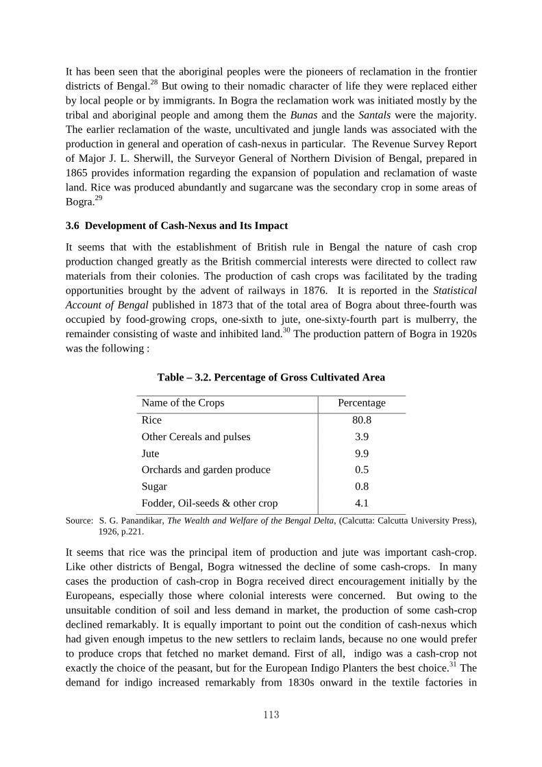
113
It has been seen that the aboriginal peoples were the pioneers of reclamation in the frontier districts of Bengal.28 But owing to their nomadic character of life they were replaced either by local people or by immigrants. In Bogra the reclamation work was initiated mostly by the tribal and aboriginal people and among them the Bunas and the Santals were the majority. The earlier reclamation of the waste, uncultivated and jungle lands was associated with the production in general and operation of cash-nexus in particular. The Revenue Survey Report of Major J. L. Sherwill, the Surveyor General of Northern Division of Bengal, prepared in 1865 provides information regarding the expansion of population and reclamation of waste land. Rice was produced abundantly and sugarcane was the secondary crop in some areas of Bogra.29
3.6 Development of Cash-Nexus and Its Impact
It seems that with the establishment of British rule in Bengal the nature of cash crop production changed greatly as the British commercial interests were directed to collect raw materials from their colonies. The production of cash crops was facilitated by the trading opportunities brought by the advent of railways in 1876. It is reported in the Statistical Account of Bengal published in 1873 that of the total area of Bogra about three-fourth was occupied by food-growing crops, one-sixth to jute, one-sixty-fourth part is mulberry, the remainder consisting of waste and inhibited land.30 The production pattern of Bogra in 1920s was the following :
Table – 3.2. Percentage of Gross Cultivated Area
Name of the Crops Percentage
Rice 80.8
Other Cereals and pulses 3.9
Jute 9.9
Orchards and garden produce 0.5
Sugar 0.8
Fodder, Oil-seeds & other crop 4.1
Source: S. G. Panandikar, The Wealth and Welfare of the Bengal Delta, (Calcutta: Calcutta University Press), 1926, p.221.
It seems that rice was the principal item of production and jute was important cash-crop. Like other districts of Bengal, Bogra witnessed the decline of some cash-crops. In many cases the production of cash-crop in Bogra received direct encouragement initially by the Europeans, especially those where colonial interests were concerned. But owing to the unsuitable condition of soil and less demand in market, the production of some cash-crop declined remarkably. It is equally important to point out the condition of cash-nexus which had given enough impetus to the new settlers to reclaim lands, because no one would prefer to produce crops that fetched no market demand. First of all, indigo was a cash-crop not exactly the choice of the peasant, but for the European Indigo Planters the best choice.31 The demand for indigo increased remarkably from 1830s onward in the textile factories in

114
Europe. But its local impact was diametrically opposite. It is noteworthy that the forced production of indigo by the European Planters led to the change in the traditional population settlement pattern. In Bogra district, the important indigo concern was Dhunot where eight out-factories were established by the European planters. Besides Dhunot, Shariakandi was also important for indigo farming in many villages.32 The santals, who were earlier engaged in clearing the jungle and reclaiming the lands, later worked in the indigo factories. W. W. Hunter reported that the principal immigrants in Bogra were Bunas who were brought from the various districts of Chota Nagpur. The Bunas were brought by the European Planters for assisting the manufacture of indigo. In Bogra the indigo factory was manned by the Buna and Bagdi coolies brought from upper regions of the Presidency.
When the ‘Blue Mutiny’ (1859-1862) put an end to indigo production, these tribal immigrants started to lead a semi-nomadic life. They were employed by the zamindars as labourers or hunters. With the abolition of indigo the European planters shifted their capital and interest to landlordism. Probably they took up the reclamation movement in order to minimize the loss sustained by the withdrawal of indigo investment. Most of the immigrants were brought and settled by them with rent free lands for some years with interest free loan. W. W. Hunter reported:
They now settle in the waste parts of the west of the district in the police circles of Adamdighi and Panchbibi, where they receive land rent-free for two or three years with small advances of money without interest, on condition of clearing the dense brushwood that abounds, and killing or driving off the jungle animals. They live in separate villages, or on the outskirts of villages inhabited by Hindus or Musalmans, in separate wards known as buna para.33
In 1880s, W.W. Hunter, the Surveyor General of India, made an attempt to study the movement of population and land reclamation schemes. In answer to his questionnaire, J. J. Livesay, the Collector of Bogra reported that reclamation of land and settlement of population were not encouraged by zamindars and other private persons. About the new settlement of population the collector mentioned seasonal immigration of different population.
During the cold season a number of Dhangars, up-country labourers and few Bunas and Kols, immigrate into the District from Chutia Nagpur, & ca., and get employment as reapers for 4 or 5 annas per diem and return home as soon as the hervests are over. They come with their women and children, and are employed also in making roads, digging tanks, and cutting jungles. Some of these men, as well as a few Kols and Santals, settle in the District (and when they do so, they settle, not as units, but in groups forming small villages of their own), getting lands sometimes free of rent for a year or two, but generally on payment of rent at the rate of 4 annas to 8 annas a bigha during the first three or five years. But the number of such settlers is very few, for, as soon as an enhanced rent is demanded from them after the expiry of the term of their settlements, they leave this District and go elsewhere.34
115
The Census Report of 1891 also provides evidence regarding the settlement of tribal especially the Santals in the unoccupied lands of Barind tract. These immigrant santals were not permanent and merely acted as the pioneers of reclamation process. “They move from plot to plot, their place being usually taken by resident Bengalis, who, though unwilling to undertake the arduous labour of forest clearing, are quite ready to pay rent for the cleared land.”35 But ultimately the santals had left the Barind area by beginning of the twentieth century and most of them went to their own original homeland. The departure of the Santals from the Barind area seems to be less related to their migratory habits than lacking of formal rights to the land that they reclaimed and cultivated.
The role of the European in the production and operation of cash-nexus is also noticed for other crops of Bogra. Bogra was one of the most prominent sugar-cane producing tracts in Bengal in the early half of the 19th century. It is evident from Dr. Francis Hamilton Buchanan’s Account of Dinajpur an 1810 publication. He wrote much about the cultivation of sugar-cane and preparation of condensed juice or gur. But later the cultivation of sugar-cane declined. Major J.R.Sherwill, the Revenue Surveyor, reported in 1863 about the reason of such deterioration of sugar-cane cultivation, that it was supposed that the land had become less favourable for the growth of the sugar-cane, since the waters of the old Tista river left this part of the country.36 The cultivation of Oatheitean and Bourbon varieties of sugar-cane introduced by one European planter later became popular in this region as its production (gur) commanded an enhanced market price owing to its superior quality. But sudden deterioration of sugar-cane cultivation made all this out of way.
The soil of Bogra was suited for the cultivation of cotton. In Bogra cotton was grown in the paulan (a small field) adjoining the dwelling house of the cultivator. The land of the field is called kheear, a sort of dry land exclusively fit for the cultivation of paddy (Ropa dhan), mulberry and cotton. Two varieties of cotton, changtale and Bureattee were produced in Bogra. Cotton was cultivated in the thanas of Govindaganj, Nowkhila, Shibganj, Adamdighi and Bogra. In Sherpur it was not cultivated to any extent in the 1860s. When the American Civil War of 1861 stopped cotton supply to Manchester, the attention of the English merchants was directed to the colony and consequently the search for source of new supply started. Some European gentlemen associated with commercial enterprises deputed people to enquire into the capabilities of Bogra to be the centre for cotton cultivation. It was seen in 1862 that some European entrepreneur settled down in Bogra in order to promote cotton cultivation. They tried to inspire local cultivator by making necessary advance. But their ventures soon proved to be abortive. As regards to its failure the Collector of Bogra remarked that “There being no demand of country cotton in the market of cultivation is very indifferent at present. If proper encouragement was held out a vast extent of land could be cultivated in this district.37 But in 1864 A.W. Russell, the collector of Bogra attributed successive failure of season to the abandonment of cotton cultivation in Bogra.38 Captain J. L. Sherwill reported in 1868 that: ‘Its cultivation might be enlarged, but it can never become a cotton producing country, from the nature of its soil’.39 But the information available in the Bogra District Records show different development in this regard. In a report submitted by the Collector of Bogra in 1863 where he mentioned that cotton had ceased to be a produce of Bogra, rather

116
1500 maunds of cotton were imported from adjoining places like Sirajganj and Sultanganj of Pubna district.40 It appears that owing to the unavailability of local cotton, the manufacture of local cloth dwindled and consequently the local people started to use English cotton goods for their consumption. A. B. Falcon, the Officiating Collector of Bogra informed the Secretary of the Board of Revenue that:
The manufacture of native cloth is I am informed languishing in this District to such an extent that though the price of English cotton goods has so much increased of late years the demand has not decreased. The yearly demand of English cotton goods for this District estimated at sums 3 lakhs of Rupees while the sale of the country cloth hardly reaches 12,000 Rupees. This is of course a mere rough calculation. The demand for English cotton goods is not likely to increase largely for the simple reason that almost everyone already uses them instead of Country Cloth and native wants in respect of cloth are almost stationary.41
The substitution of jute for cotton was a very important change in the cropping pattern of the agriculturists of Bogra. But initially such substitution was not a spontaneous action o the part of the agriculturists, rather several forces worked together in order to create such atmosphere for jute cultivation. Jute trade in Bogra began in 1847. In 1872 the total area in the whole District was 49,599 acres. But in 1873 jute cultivation tended to slightly decline. Such decline may be attributed to the huge crops produced in the previous year that had glutted the market. Moreover, the cyclone which occurred in September, 1872, diminished the overall acreage. Hem Chunder Kerr in his Report on the Cultivation of, and Trade in, Jute in Bengal mentioned the principal jute marts and centres of Bogra were Mathrapara, Gurabhanga, Madhupur, Phulbari, Gosainbari, Balughat, Makamtala, Sonatala, Elangi, Dhunot, Mirzapur, Khanpur, Sherpur, Garanduha, Sonamukhi, Dhupchanchia, Sibganj and Tilakpur.42 Jute occupied more than 25% of the net cultivated land of Shariakandi and Dhunot thanas. The cultivation of jute was centred in the Jamuna valley but the increased demand and consequent high price of jute led to its intensive cultivation in many places. D. MacPherson, the Survey and Settlement Officer of Bogra and Pubna wrote that: “In 1924-25 jute had grown in the most unlikely places, where it had never grown before. In the Barind, small plots, which being near to the homesteads, are easy to irrigate had their patch of jute.”43 Jute was, however, considered to be a profitable cash-crop as it could bring a fairly good return of labour. It is supported by the contemporary evidences that the jute growing tracts can support a larger population.
The reclamation process in Bogra initiated by the Europeans can be studied in different phases which were inspired by their profit-making motives. Their direct encouragement only succeeded, to some extent, to settle some tribal people temporarily who had mainly cleared up jungle and encouraged further population settlement. As a corollary to this the European landlords encouraged cash-crop production in order to maximize the profit in the existing situation. But before the emergence of jute as cash-crop, such attempt failed to achieve any positive success. Jute fetched a high price in the market owing to its high demand and it received spontaneous response from the agriculturists. It was obvious that the agriculturist
117
would be more inclined to market-oriented production. But the initiation of settling people in the uncultivated and waste land had only affected the pattern of population settlement. The trace of the population settlement is still found in the presence of Santals, Konch and other minor aboriginal people in Bogra. The reclamation process in the Barind tract ended in the first decade of the twentieth century.
3.7 The Reclamation Process of the ‘Sundarbans’: A Forest Land of Bangladesh
“Egypt is the Gift of the Nile
Sunderban is the Gift of the Ganges”.
H. James Rainey
‘Sunderbunds’, ‘Soonderbuns’, or ‘Sunderban’ – whatever term may be attributed – it means ‘beautiful forests’. Earlier it was included in the coast at the south of Twenty Four Parganas proper, Barasat, Jessore and Bakerganj. It consisted of about 5,000 square miles and a well cultivated and populous country. In 1798, Francis Buchanan (1762-1829), a surveyor of the East India Company found that:
A particular class of men makes a profession of collection of honey, and wax. They are Mohammedans and pay a duty to the Zemeendars for liberty to follow their profession. The woods, however, are not considered as property; for every ryot may go into them and cut whatever timber he wants.44
Sundarban45 is bounded on the north by the districts of 24 Parganas, Jessore and greater Barisal; on the east by the estuary of the great river Meghna and on the west by the estuary of the Hooghly River; and on the south by the Bay of Bengal. The tidal action of the sea inundates the whole of Sundarbans in varying depths. Due to the natural tidal action, the silts carried down to the sea are pushed back to the channels and get deposited there. The bed of the channel thus gets steadily raised, thereby blocking the flow of water and gradually evolving a small island. This is the basic geographical historyabout the origin of innumerable islands of the region.

118
Map 3.2. Map of Sunderbans Source: www.google.co.in/search?sa=G&hl=en
The jurisdictions of Sundarbans were liable to changes in between the districts of Jessore, Khulna, Bakerganj and 24 Parganas from 1816 to 1905.46 After the Partition of India in 1947 and according to the recommendations of the Boundary Commission headed by Cyril John Radcliffe (1899-1977) the Sundarbans were divided amongst Wes Bengal and Bangladesh, erstwhile East Pakistan. However, larger portions of the Sundarbans were included in Bangladesh.
Apart from official source-materials created at different times, there are numerous books in Bengali like Debi Prasad Jana’s Srikhanda Sundarban, Sibsankar Mitra’s Sundarban Samagra, Abdul Jalil’s Sundarbaner Itihas which provide important information on several aspects of Sundarbans. Amitav Ghosh’s novel The Hungry Tide provides picturesque account of man-animal-nature relationship in the Sundarbans. The present tidal delta Sundarbans was originally occupied by vast stretches of grassland filled with saline marshes and tropical wetlands containing one of the worlds’ largest stretches of biodiversity-rich forests. It appears that the history of the Sundarbans is one of continuous conversion of forest tracts to wet-rice cultivation under the influence of pioneers professing an Islamic Sufi identity.
Richard M. Eaton47 had found no other reliable information about Khan Jahan Ali, one of the earlier preachers of Islam in southern Bengal, and his followers settled in the tracts in 15th century. For that one must take recourse to the report of J. A. Westland. According to a local tradition collected by J. Westland in 1870, the purpose of the visit of Khan Jahan Ali was:
…to reclaim and cultivate the lands in the Sundarbans, which were at that time waste and covered with forest. He obtained from the emperor, or from the king of Gaur, a jaghir of these lands, and in accordance with it established himself on them. The tradition of his cutcherry site in both places corresponds with this view of his position, and the fact of his undertaking such large works – works which involve the necessity of supporting quite an army of labourers

119
– also points to his position as receiver of rents, or chief of the cultivation of the soil…. After he had lived a long time as a great zamindar, he withdrew himself from worldly affairs and dwelt as a faqir.48
But later the settlement was abandoned for unknown reasons. These tracts may have been deserted in consequence of stormy waves. It is generally believed that the Sundarban was deserted due to the attacks of the Arakanese Maghs and Portuguese pirates under the leader ship of Gonzales locally known as harmad, who were engaged in slave trade.49 But later some Maghs settled in the deep forest in the 18th century when Arakan was conquered by the Burma. Rennell’s map shows that in the years 1764 to 1772 very little land of Sundarbans had been brought under cultivation. The consolidation of the island formation advanced very considerably since the days of Rennell. The survey conducted by Captain Lloyd in 1835-36 found rapid growth of the delta seaward.
Historically the Sundarban figures well in modern times, well-known traces of its ancient and medieval history could not be found in the contemporary and near-contemporary records.50The history of Sundarbans may be well traced right from the initial stage of rule of the English East India Company. Regarding the cultivation of the Sundarbans prior to the establishment of the British rule in Bengal, Lord Clive's narrative may be quoted as he wrote to the Court of Directors of the East India Company.
The extent of the Pergunnah of Cuney Turies is unknown, it reaches as Gaunga Saugor to the south, the Sunderbunds to the east; the revenue it formerly yielded, we are informed on good authority, amounted to 40 lacks of rupees, but the greater part of this Pergunnah is uncultivated, uninhabited, and overgrown with jungle. The rent of it amount to no more than Rs. 2,925-9-0, and we pay the Nawab only Rs. 562-8-0.51
However, gradually we can perceive varied development of capitalist intervention and colonial domination within a given ecological regime in Sundarbans. The Sundarban was assigned by Mir Jafar to the English East India Company on 20 December, 1757, when he became the so-called ruler of Bengal. By this assignment the East India Company occupied the right of landholders over the area under review. The annual jamma or the land revenue of the estate of Sundarban was Rs. 2,22,958. The sum having been assessed upon the estate was made over to the East India Company in 1757. It is also found in James Long's Selections that in 1766 Captain Tolley was engaged in working a factory on the borders of the Sundarbans.
The acquisition of some ceded districts e.g., Burdwan, Medinipur and Chittagong during the rule of Mir Qasim, a Nawab nominated by the East India Company, had not affected the policy of the East India Company to any greater extent. But the East India Company having acquired the Dewani of Bengal in 1765 took the Sundarbans as its property, it being an uncleared forest region. It appears that this uncleared forest region of the Sundarbans constituted a ‘no man's land’ and was taken to be the property of the state. In this paper two

120
aspects of the reclamation process of the Sundarbans forest tract has been discussed viz., land management policy and organizational structure.
3.8 Land Management Policy
The history of Sundarbans in between 1765 and 1853 is mainly the history of reclamation and a detailed account of this is available in Pargiter's revenue history. The first attempt of reclaiming the vast forest was made by the East India Company in 1784. Tilman Henckle, the Judge and Magistrate of Jessore, found that several navigable rivers would render transportation of all kinds of merchandise conveniently and its vicinity to Calcutta would afford the merchants and manufacturer a sure prospect of receiving their reward of their labour by the speedy sale of their merchandise, the greatest encouragement to revenue.
That it is practicable to populate this wild and extensive forest and not mere speculative idea, we have only to recur to the times of the Mogul Government, and we shall find that prior to the invasion of the Maghs in Bengal, in the year 1128, these lands were in the finest state of cultivation, and the villages in general well populated. The number of mosques and other places of worship still remaining fully demonstrate its former splendour and magnificence.52
In 1784 Tilman Henckle was appointed as the Superintendent for the Cultivation of the Sundarbans and devoted himself with usual zeal and vigour to reclaim the jungle tract. The first scheme for the reclamation of Sundarbans submitted by Tilman Henckle was approved by the Board of Revenue which provided that grantees or taluqdars would receive a large portion of the land leased to them rent free and pay rent for the remainder after a certain number of years at the rate of two anas per bigha. The rent would be gradually increased and maximum rate of rent would be eight anas per bigha. The revenues thus created were evidently intended to be of a permanent character. In the first four years nearly fifty thousand bighas were leased out. After some years the grantees or taluqdars were obliged to pay rents and rent increased quite progressively with the progress of cultivation. But such scheme was abolished in 1790 due to severe boundary disputes. Under the Bengal Regulation IX of 1816 the post of a Special Commissioner for the Sundarbans was created and William Dampier held that post up to 1844. However, the rule for the grant of waste land in Sundarbans was again promulgated during the administration of Marquis Dalhousie which had tended to give impetus to private enterprise for reclaiming the Sundarbans. Consequently the number of grantees increased and large extent of forest land was thus cleared and cultivated.
The first comprehensive sets of rules for land management in the Sundarbans were issued in 1853 which provided impetus to private enterprise for reclaiming the Sundarbans. According to these rules leases were sold to the highest bidder where there was more than one applicant. The number of leases granted under these rules in the 24 Parganas and Khulna Sundarbans was 131; the rent payable was Rs. 1,33,447 which eventually rose up to Rs. 1,35,802. This also laid down certain conditions that in case the “grantee could not fulfill the clearance condition the entire grant shall be resumed and the grantee shall forfeit all right and interest in the lands, both those which may have yet uncleared, and those which may have been cleared and brought to cultivation.”53 It may be mentioned here that these rules could neither protect

121
the rights of under-tenants, nor provide solution for cases where a grantee encroached on the lands of another.
The Fee Simple Rules of 1861, as chalked out by the Government, extended certain facilities to the concerned parties. (1) The land would be granted in perpetuity on a heritable and transferable property subject to no enhancement of land revenue. (2) All prospective land revenue would be redeemable at the grantee's option by a payment in full when the grant was made or a sum might be paid as earnest, at the rate of 10% leaving the unpaid portion of the price of the grant which would then be hypothecation until the price is paid in full. (3) There should be no condition obliging the grantee to cultivate or clear any specific portion within any specific time. (4) The minimum price of the fee-simple was fined at Rs. 2.8 an acre, so that by paying 10 per cent; of this or 4 annas an acre, a title was obtained.
In the 19th century attempts were made both by Government and by private individuals (Bengali and European landlords) to reclaim portions of the Sundarban and put the fertile alluvial soil to use. Innumerable difficulties stood on the way and many schemes set on foot came to naught. Most successful scheme of reclamation was carried on by Morrel brothers. In 1849 they bought three large plots of non-reclaimed jungle on the bank of the Baleswar river. Overcoming the scarcity of labour they brought large stretches of land under cultivation. Within a decade Morrelganj appeared as an important trade center in this area. Morrelganj, being situated on one of the broadest rivers, within reach of Calcutta and on the direct route to Eastern Bengal and Assam, was declared a port by government, but later it proved to be a failure. After a brief spell of prosperity the fortunes of the Morrels dwindled. The estate was finally purchased by the great Laha family of Calcutta and became an extremely flourishing and paying zamindari concern. Another ambitious scheme was undertaken on the western boundary of the Sundarban. The difficulties of navigation on the Hooghly River forced the Government to make a subsidiary port for Calcutta. The scheme was implemented in 1858 and the port was named 'Port Canning' after the then Viceroy of India. A company was also formed as the 'Port Canning Land Investment, Reclamation and Dock Company, Limited' for the purpose of acquiring waste lands from government. Messrs. Schiller and Kilburn applied for long lease on behalf of the 'Port Canning Land Investment, Reclamation and Dock Company, Limited' in 1865 which created serious debate among the official circle.54 Later the Port Canning had to be abandoned due to decline in its navigability. It was urged upon the Government of Bengal in 1874 that:
to consider the urgent necessity that exists for promoting to their utmost ability the reclamation of the Sundarban, not only as a means of augmenting the rice supply of Bengal, and thereby mitigating famines, but also to provide available lands for the rapidly-increasing population of the Lower Provinces.55
The fee simple (revenue free) rules superseded those of 1853 and remained in force until 1879, when they were withdrawn and a fresh set of rules was issued. The rules of 1879 provided for two kinds of grants, viz., (i) blocks of land not exceeding 200 acres leased to small settlers, known as Small Capitalist Rule, and (ii) blocks of land exceeding 200 acres but not less than 5000 bighas, leased to big farmers who were prepared to spend time and money
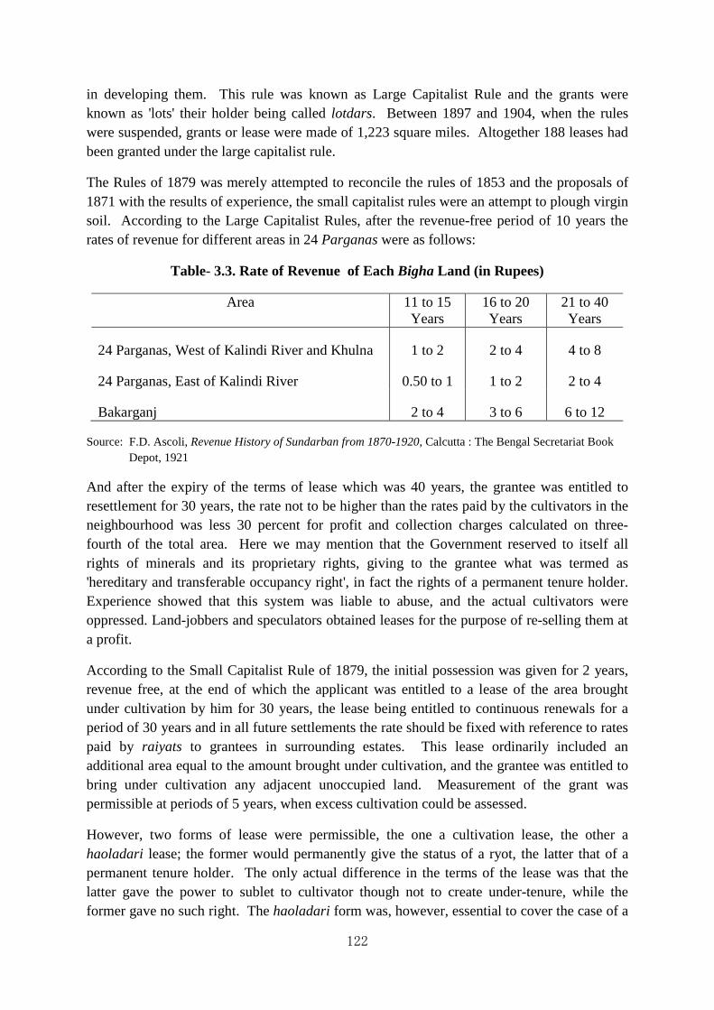
122
in developing them. This rule was known as Large Capitalist Rule and the grants were known as 'lots' their holder being called lotdars. Between 1897 and 1904, when the rules were suspended, grants or lease were made of 1,223 square miles. Altogether 188 leases had been granted under the large capitalist rule.
The Rules of 1879 was merely attempted to reconcile the rules of 1853 and the proposals of 1871 with the results of experience, the small capitalist rules were an attempt to plough virgin soil. According to the Large Capitalist Rules, after the revenue-free period of 10 years the rates of revenue for different areas in 24 Parganas were as follows:
Table- 3.3. Rate of Revenue of Each Bigha Land (in Rupees)
Area 11 to 15 Years
16 to 20 Years
21 to 40 Years
24 Parganas, West of Kalindi River and Khulna 1 to 2 2 to 4 4 to 8
24 Parganas, East of Kalindi River 0.50 to 1 1 to 2 2 to 4
Bakarganj 2 to 4 3 to 6 6 to 12
Source: F.D. Ascoli, Revenue History of Sundarban from 1870-1920, Calcutta : The Bengal Secretariat Book Depot, 1921
And after the expiry of the terms of lease which was 40 years, the grantee was entitled to resettlement for 30 years, the rate not to be higher than the rates paid by the cultivators in the neighbourhood was less 30 percent for profit and collection charges calculated on three-fourth of the total area. Here we may mention that the Government reserved to itself all rights of minerals and its proprietary rights, giving to the grantee what was termed as 'hereditary and transferable occupancy right', in fact the rights of a permanent tenure holder. Experience showed that this system was liable to abuse, and the actual cultivators were oppressed. Land-jobbers and speculators obtained leases for the purpose of re-selling them at a profit.
According to the Small Capitalist Rule of 1879, the initial possession was given for 2 years, revenue free, at the end of which the applicant was entitled to a lease of the area brought under cultivation by him for 30 years, the lease being entitled to continuous renewals for a period of 30 years and in all future settlements the rate should be fixed with reference to rates paid by raiyats to grantees in surrounding estates. This lease ordinarily included an additional area equal to the amount brought under cultivation, and the grantee was entitled to bring under cultivation any adjacent unoccupied land. Measurement of the grant was permissible at periods of 5 years, when excess cultivation could be assessed.
However, two forms of lease were permissible, the one a cultivation lease, the other a haoladari lease; the former would permanently give the status of a ryot, the latter that of a permanent tenure holder. The only actual difference in the terms of the lease was that the latter gave the power to sublet to cultivator though not to create under-tenure, while the former gave no such right. The haoladari form was, however, essential to cover the case of a

123
grantee, who had cultivated his 200 bighas within 2 years and was accordingly entitled to an additional 200 bighas and of leases, who cleared and cultivated lands outside the area leased as permitted by the rules.56
Between the year 1830 and 1872 in the 24 Parganas Sundarbans, 212,659 acres or 332.28 square miles were cleared of jungle and rendered fit for cultivation within this period.57 Under the above set-up, a new class of grantees, however, had entered into speculation - men who by buying and selling, had amassed fortunes, but who did not possess an acre of land; men, in fact, with money but no lands. These men lending the cultivated tracts occupied by the landed aristocracy or the zamindars and feeling their inferiority in society naturally turned to the unoccupied lands in Sundarbans. They were liberal in expending capital to improve their grants, and on securing a body of tenants to give them a status in society as landed proprietors. Under these circumstances a contradiction between the old zamindars and the new grantee was inevitable which Pargitar noted frequently in his Revenue History of Sundarbans.
Under these circumstances, a committee appointed by the Board of Revenue in 1903 decided that it was essential to abolish the system of leases to capitalists, large or small and to proceed by direct settlement with cultivating riots, because the capitalist system involved heavy loss to Government both during the period of original lease and thereafter and perpetuity on renewal and it further involved all evils of subinfeudation with the consequent danger of rack-renting. So it was decided by the Board of Revenue in 1904 to abandon the system of grants to large capitalists and to introduce raiyatwari settlements as an experimental measure, small areas (maximum 75 bighas and minimum 10 bighas) being let out to actual cultivators, whom the Government assisted by means of advances, by constructing tanks and embankments and by clearing jungle. It was proposed that Fraseeganj should form the first centre for raiyatwari colonization. In Fraseeganj where direct reclamation and raiyatwari settlement were tried on a large scale, the reclamation proved unexpectedly expensive and cultivators could not be induced to settle on the land on remunerative terms.
But as late as the year 1915, the total revenue derived from the resumed estates amounted to Rs. 6,368 only averaging 1.50 annas per bigha. So a new policy was instituted in the year 1915 which aimed at the colonization on a raiyatwari basis of the whole area resumed. In 1915, Sir C.J. Stevenson-More, after an extensive tour through the Sundarban, prepared a note on the development of the area. After describing the great success achieved in the colonization of Bakarganj Sundarban, he proceeded to show that the failure of Fraseeganj experiment had not been sufficient justification for the abandonment of the raiyatwari system in Khulna and the 24 Parganas. He propounded a scheme for raiyatwari colonization. In forwarding the draft rule to the Government of India, it was proposed that while raiyatwari settlements should be ordinary method of reclamation, the Board of Revenue should be authorized to make settlement with capitalists in specific cases. The Government of India accepted these proposals and on 15th February, 1919 the new rules were published. These rules and raiyatwari settlements were ordinarily the sole means of reclamation process in the whole of the Sundarban tracts.

124
It seems that after long and arduous planning of reclamation scheme for Sundarbans the Board of Directors realized that much of its enterprise had remained abortive. Most of the landholdings remained concentrated in the hands of absentee landlords based in Calcutta. The peasantry was oppressed and there was no question of amelioration in the condition of the peasantry. Landlords were only interested in appropriating the major portion of the crop and never thought about the survival of the peasantry on the meager amount they got. Again their relation with the state was also deceptive in the sense that they never disclosed the actual acreage of land reclaimed or actual amount of crops that they accrued from the peasantry. So at both levels at the level of the Government as well as that of stabilizing landlord-tenant relations the scheme was a conspicuous failure.
Whatever be the changes that the Sundarbans underwent during this period (1853-1890) it needs hardly to be stressed that the welfare measure for the peasantry were minimal. The Company was actually groping in the darkness for such measures that would ensure more and more revenue from the land and having no experience of colonial system was actually cutting out a tangible system. As a measure they rejected the middlemen system but fell back upon raiyatwari system, though both were equally endangering the new socio-economic condition of peasantry in Sundarbans and their erroneous system in all respect continued for the time to come.

125
Table- 3.4 Condition of Lease in 19 Century at Sundarbans Ara
Source: Ratan Lal chakraborty, “Reclamation Process in the Bengal Delta: A Case Study of Sundarban Forest Tract”, in The Imagescape of Six Great Asian Deltas in the 21st Century. Report of Research Project. Grant-in-Aid for International Scientific Research, (Field Research). Edited by Professor Kaida, Yoshihiro, Center for Southeast Asian Studies, Kyoto University, Kyoto, Japan, 1998.
Sir Daniel Hamilton took settlement of lands from Government in the Sunderbans in or about 1903 for deforestation and colonization (human settlement). His object was to create an ideal estate and to afford the agriculturists an opportunity of relieving themselves from chronic indebtedness and also to solve the problem of unemployment among the middle classes by settling them on the colony as agriculturists. The underlying idea for the acquisition of this state was to create a zemindary which would be an ideal of its kind not only in the Sunderbans area but also for all other estates in Bengal similarly placed. The estate used to finance the tenants initially but the experiment failed to improve the economic condition of the settlers. Sir Daniel Hamilton organized 18 agricultural co-operative credit societies,
Condition of Lease
1853 Rule 1871 Rule 1877 Rule 1897 Rule
Term 99 Years 30 Years 40 Years 35 Years Maximum area Unrestricted 3000 acres 5000 Bighas 10,000 Bighas Revenue-free period
20 Years 3 Years 10 Years 15 Years
Area exempted from assessment
one-fourth of the total area
Nil Nil Nil
Rates of Revenue (per Bigha) upto 3rd Year
Nil Nil Nil Nil
4 to 10 Year Nil 1.50 to 9 annas Nil Nil 11 to 15 Year Nil 4.50 to 15 annas 2 annas Nil
16 to 20 Year Nil 4.50 to 15 annas 4 annas 2 annas 21 to 30 Year 0.50 anna 9 annas to Rs. 1.50 8 annas 4 annas 31 to 40 Year 1 anna - 8 annas 4 annas 41 to 50 Year 1.50 annas 51 to 99 Year 2 annas - - - Clearance Conditions
one-eighth after 5 Years
Nil one-eighth by the end of 5th
Year
Nil
one-fourth after 10 Years
Half portion after 20 Years
Three-fourth after 30 Years
Penalty for failure to Observe Clearance condition Sale Price
Forfeiture of the grant no re-entry
Nil Forfeiture or re-entry on new
settlement Rs. 1 per acre
Forfeiture of Penalty of 4
Years 8 annas per acre

126
where 1800 families settled on his property. About the success of the Gosava Scheme of Sir Daniel Hamilton it is officially reported in 1934 that:
…the tenants by themselves live in their own world both commercial and otherwise and the zemindari being intersected by a network of rivers conveniently isolated and any enterprising middlemen or other exploiters can be effectively ousted with the exercise of slight vigilence.58
This was possible because of the fact that the place was almost immune from adverse outside influence and the tenants had been trained and disciplined to carry out their part in the general scheme without demur or resentment. Sir Daniel Hamilton had the advantage, over and above the physical ones, of selecting his own tenants very carefully and evicting those who were found to be undesirable to be replaced by better ones, and providing them with economic holdings. He had all the advantages of regulating the destinies of his tenants and even shaping their daily lives immune from adverse influences. However, reclamation in the eastern of the Baleswar River of the Sundarban tract was nearly complete in the early twentieth century and after that Government declared western part as Reserve Forest.
3.9 Physical Reclamation of the Sundarbans Forest Tract
The reclamation process carried out in the Sundarbans area was very complicated and it needed long and continued attempt on the part of several classes of labourers and farmers. It has already been explained earlier that this wide forest was densely covered by numerous types of trees and it was a virgin field of unending growth of reeds and grass. The reclamation would have been carried out in several stages which took 10-15 years uninterrupted effort of the labourers and farmers.59
J. A. Westland, a scholar-administrator of British India had mentioned in his account entitled A Report on the District of Jessore in 1878 about the difficulties of physical reclamation of Sundarbans that:
The clearing of the Sundarbans forest is a most arduous undertaking. The trees intertwine with each other to such an extent that each supports and upholds the others. Some of these trees too are of immense size …. Trees like these cannot be cut down and removed from the bulk; they must be taken piecemeal and the tree must be cut into pieces. But the trees are not the only difficulty, for there is low and almost impenetrable brushwood which covers the whole surface. This has simply to be hacked bit by bit by anyone who attempts to penetrate the forest. And here is no small danger from wild animals. Sometimes a tiger takes possession of a tract of land and commits fearful havoc there. The depredations of some unusually fierce tiger or tigers, again often compel an advanced colony of cleaners to abandon, through fear, their land which they reclaimed after years of labour. A deforested land springs back into jungle to become as bad as ever, unless the greatest care is taken of the land so cleared. So great is the evil of fertility of the soil that the reclaimed land neglected for a single year will present to the next year’s cultivator a forest of reeds? He may

127
cut it or burn it down but it springs up again almost thick as ever; and it takes about three eradications to expel this reed when once it has grown. The soil too must be cultivated for ten or twelve years before it loses this tendency to cover itself with reed jungle.60
The reclamation process followed in the Sundarbans forest was neither a very easy task nor it could bring any instant benefit to grantee. It was a long-drawn process where the investors had to wait long time for lucrative return from these reclaimed lands. The clearing of jungle was done in two seasons, the first in January and that could be extended upto March and the second started in November and continued upto December. In the beginning the explorer (10-15 cutters) armed with bill-hooks and axes proceeded to the Sundarbans by boat with a fakir (Muslim religious mendicant) for their safety. The fakir was supposed to exercise superficial influence over tigers and wild-beasts. The party had to come back for lunch and go out again and return before dusk. The bawalis (wood-cutters) did the rest of the work of clearing the jungle. H. James Rainey has given a beautiful account on the importance and activities of fakirs while reviewing Westland's book one Jessore. According to the account:
the Bailis (Bawalis), or professional wood-cutters, have a regular system of operation; and as it is rather curious in some respects ....they invariably proceed to a temporary location of a Fakir in the Sundarban, termed Sai, to whom they give a small sum of money, varying according to the reputation he has gained for protecting them from tigers, etc., which he is supposed to be able to do through the kind interposition of the sylvan spirits, who are propitiated by sacrifice and prayer. The Fakir is also expected to be able to point out to them the best description of timber, and as he is generally an old wood-cutter himself he is not deficient in wood-craft. Any one day in the week is a day of rest, especially set apart for the worship of the local deities. Their images, made of mud and paint, are kept within small huts, and they are also regularly worshipped every morning by the wood-cutters and the Fakir before proceeding to their work. If the timber is either inferior or scanty and a single man is carried off by a tiger, the location is abandoned at once, especially if the wood-cutters have brought with them a special Fakir, which is sometimes the case; but, if the wood is good and plentiful, the Sai will not break up until many men are taken away, in fact till it becomes absolutely untenable. These Fakirs, who are all arrant impostors, usually make a good thing of it, and they are tempted to follow this precarious mode of life, for such in reality it is, from sheer love of gain. Once a woman to our knowledge set up a Sai, accompanied by a so-called disciple and a couple of goats, and for some time had a great run; but she afterwards had her two goats killed by tigers, and eventually her chela, or disciple, when she prudently decamped at once. The wood-cutters have, undoubtedly, a hard life of it; and none proceed there from choice, as the saying common among them shows:

128
He who (unfortunately) lacks pelf,
To the Sundarban transports himself.61
After cutting the trees fire was given branch of the trees and the main trees were to wood business centre as valuable product of the forest. But the trunks of the trees remained in the field for long time until it was cleared off by the bawalis. The usual practice followed in the reclamation of Sundarbans was that after clearance of the jungle a spot was selected and paddy seed was sown on it without following any other means except scratching the virgin soil with achras (a single-toothed scraper) in order to make land cultivable.
However, when the selected land became saturated and softened by rain water (July-October) as well as tidal water transplantation was carried out by means of a wood peg locally known as goicha by which farmers could drive into soil for a hole with left hand and struck a handful of seedlings by right hand. After the transplantation of seedlings were completed, then work of the activities of the Shikaries started who were the hunters armed with gun in order to protect the growing field from the inroads of wild beast. Usually they lived on macha (two storied thatched house) and watched the crops of the field during the absence of the farmers. Harvesting was carried out by another set of people known as dawals (grain-cutters) who would flocked from the neighbouring districts of Jessore, Nadia, Faridpur and Pabna.62 They used to cut the upper half of the standing crop leaving the stubble to use as manure in the field. In practice all the stubble was used as fuel for the field for fire so that ashes accrued from them could be used as manure.
The common problem of reclaiming Sundarban was to keep sustained effort to clearing the land from the attack of jungle. However, ploughing could not be done even in the second year as the roots of the stumps still standing on the fields. Ploughing was done by scraper (achra) and transplantation was also done by the same peg-driving process. This process continued for nearly five years until land was thoroughly cleared and admitted plough being driven over. But harrowing was impossible for long time at least ten years as the roots and stamps rendered soil uneven.
3.10 Construction of Dams
Construction of Dams constituted an important work in the whole reclamation scheme, because for cropping it was necessary to prevent the tides running up laden with salt water. The method followed in erecting dams was different from that of carried in other parts of the country. The dams were erected in November and grantee provided all cost necessary for this. Large quantities of reds gathered from the jungle were heaped up and a coating of earth was given on it raising its height upto 2 meters. A sluice was also erected by tal tree for the egress of water from inland and stopper made of a bundle of hay was also prepared for closing up the outer mouth of the sluice. Such system was locally known as hateabandi. These dams were broken in order to allow sweet and brackish water run in the paddy field. This was done in the months of April and May when the brackish water driven down by the rain and floods begun to give place to sweet water.

129
3.11 Preparing of a habitat
In the reclaimed areas no houses or residential plots were built, since the cultivator did not stay there. Only a watch-tower locally known as tong was built near the field to guard the growing crop against the attack of wild animals. But as the years rolled on when clearance was sufficiently advanced and land became suitable for ploughing the cultivators started to settle down with family and all other belongings. Explaining the progress of Sundarban reclamation, Ramshunkar Sen, a contemporary writer reported that:
…the areca and cocoa are planted beneath the plantain, the date is first introduced, and after which it propagates from the seed, and the tal (palmyra) shoots up itself from the seed thrown away by the first sojourners after the sap has been sucked from the fruit. The bamboo also finds a place in the third or fourth year, but generally it has had no footing yet as its growth is not so rapid here. The jute, which is cultivated in very small plots adjoining the homestead, scarcely suffices for domestic use. And thus at the end of the 15th year the Sunderbun colony standing on the brink of a broad creek is a thriving village skirted by the graceful areca and cocoa in all beneath of luxuriant growth, and a forest of plantains of gigantic size beneath which these young palms delight to flourish.63
From the later half of the nineteenth century to the end of colonial rule several attempts were made by the Government to draw maximum benefit. In 1854 improvement of the Sundarban channels was sought to foster trade and commerce.64 In 1858 Major Ralph Smyth reported on the commercial importance of Sundarban and its future prospects. His report contains possibility of growing rice and cotton, establishment of salt factory and high quality of timber might provide the Company further access to resources of the Sundarban.65 In 1938 the possibilities of the salt industry in the Sundarban was again examined.66
3.12 Apathy of the European Capitalists and Interest of Local Rich: A Place of Common Interest
At the beginning of the 20th century it was found that the British entrepreneurs were no longer interested in fostering the reclamation process of the Sundarbans and they were gradually replaced by the local rich of various denominations e.g., landlords and moneylenders or a stereotype agent. Most of the British entrepreneurs sold their land to the local rich at a high price after the formal grants were made to them by the proper authority. The financial strength of the local landlords or moneylenders increased because of their high accumulation of wealth through extraction of surplus from their tenants or usury by collecting interest at high and compound interest rate from their borrowers. The time was very crucial to the local capitalists since they had no other opportunities of investment excepting local land market. It is found in W.W. Hunter’s survey papers that Nag Chaudhuries of Arabalia, the Babus of Taki, the Ghoshes of Sripur and some pleaders of Calcutta High Court had purchased the lots of Sundarban and tried reclamation by creating sub-tenure. Such tenure was locally called seka. However, the industrial development, a potential sector for

130
investment, was controlled by the colonial state and the European merchants enjoyed absolute monopoly in trade. Maximization of profit was the sole objective of the British colonial power in India and all policies were directed to achieve that end. So change in the land management policy by abandoning the large ‘Capitalist Rule’ was no more innovative but rather an urge of the time. It is evident that the production of surplus rice in the Sundarbans was not hampered to any extent even after the transfer of land ownership from the hands of European capitalists to local landlord, pleaders of Calcutta High Court and moneylenders. These groups who had entrenched interest in Sundarban reclamation protested the suggestion offered by the Floud Commission (1946) that direct contact with the actual cultivators with the Government would facilitate agricultural improvement.67
Reclamation of the Sundarban forest tract was not done directly by the grantee (talukdar) who had obtained the grant from his superior landlords, rather the subordinate tenants knows as haoladars undertook the task of clearing the land apportioned by them. As the grantee (talukdar) had enough capital he would obviously insist on quick clearing of the land. To ensure this the grantee advanced some money that varied according to the amount of forest land to be brought under cultivation and the money thus laid out was never taken back. Such advance may be treated as incentive money. The haoladars too were not so much directly associated in the reclamation process of Sundarban forest land. They engaged men in gangs mostly hired from the neighbouring districts with his own man to supervise the reclamation work. They worked as intermediaries in the land system very much well known in the land system of Bengal. In all spheres maximization of profit was the common objective of all tiers.
3.13 Impact of Sundarbans Reclamation on Religious Culture
As the forest of Sundarban was a threshold of the Royal Bengal Tiger, leopards and various kinds of wild animals, its reclamation obviously brought religion in advanced. Religious mendicants or fakir was believed to have an occult power and also known as Sai or Guni (exerciser) had important influence among the wood-cutters and cultivators. They were superstitious in the extreme and believed in the existence of jins or spirit of woods and fairies. They were invariably accompanied by a fakir or sai or gunin whom they believed to possess certain cabalistic words to have power over the tigers. Baghai-devata (god of the tigers), Dakshminarai (the presiding tiger-deity) and the cult of Satyapir (Satyanarayana as worshipped by the Muslims) seem to have been originated primarily from the reclamation process of the Sundarban. In Islamic theory of jihad (strivings) there are two strict consequences viz., gazi or shahid. If in the struggle the fighter survives he becomes a gazi (victor), but if dies he becomes a shahid (martyr). In the Sundarban gazi was widely believed by the Muslims and the Hindus alike. It was also believed that gazi always carried a peculiar shaped stick called asa-danda which was a symbol of his power. It is also known that the asa was the stick often carried by one of the Khalifs of Islam. Gazir git or Gazir gan (songs of Gazi) is now-a-days sung as folk-songs in southern Bangladesh and when it is performed the image of gazir asa is kept in front of the audience which is “a long handle which is surmounted by a round disc-shaped tin with a deep crescent-shaped cavity on either

131
side. Parties of villagers who sing Gazir gan or Gazis's song use the asa as the symbol of the Gaizi” .68
3.14 Concluding Remarks
Reclamation in the Sunderban tracts was encouraged on the part of the Government by settlements at long leases, with progressive and low rates of rent But Sundarban failed to draw the desired benefit to the colonial ruler. The creation of intermediary leaseholders and their profit-sharing motive ultimately failed as a scheme. Another drive was taken by adopting a new policy of farming the uncultivated lands of Sundarban directly to the ryots. The Government policy of reclamation by prosperous and capitalist farmers failed to achieve any success. It is evident from the enquiry of W.W. Hunter (1885) that the official policy of reclamation proved to be the most discouraging failure. Hunter's paper has been largely used by D. Rothermund who found Arthur Boserup's hypothesis in the context of labour migration inapplicable to the reclamation process of Bengal.
3.15 The Hill Tracts of Chittagong: A Case Study on Hill Cultivation
The Hill Tracts of Chittagong lies on the northern parts of Bangladesh. It is bounded on the north by the State of Hill Tripura of India, on the west by the Chittagong district, on the south and the east by Myanmar. The Chittagong Hill Tracts is divided into four principal valleys formed by four main rivers. These are the Feni, Karnafuli, Sangu and Matamuhuri. The river Karnafuli rises in the of hill range of Lushai flowing with most tortuous course through the hills emerges into the plains of Chittagong at Chandraghona and falls into the Bay of Bengal. The Feni River rises from the hill ranges of the Indian state of Tripura and flows southwest marking the boundary with the Chittagong Hill Tracts then flows west, separating Tripura from Chittagong and then emerges out of the hills and passes through the plains dividing Chittagong from Noakhali before falling into the Bay of Bengal. The river Sangu has its origin in the north Arakan province of Myanmar and forms the boundary between Myanmar and the Chittagong Hill Tracts. It follows through Bandarban and enters Chittagong Hill Tracts from the east and flows west across it and finally falls into the Bay of Bengal. The river Matamuhuri also originates from Arakan province of Myanmar and flowing northwest in the Chittagong Hill Tracts enters Cox’s Bazar from the east and then falls into the Bay of Bengal. About the river Matamuhuri, Captain T.H. Lewin wrote in 1869 that:
The stream ran briskly in a narrow pebbly bed between banks that rose nearly perpendicularly, and so high the sun only came down to us by glints here and there. Enormous tree ferns hung over our heads some fifty feet up, while the straight stems of the Garjan tree shot up without a branch like white pillars in a temple; plantains, with their broad drooping fronds of transparent emerald, broke at intervals the dark green all of jungle that towered up in the background, and from some gnarled old forest giant here and there, the long creepers threw across the stream a bridge of nature’s own making.69
Apart from huge archival sources, available at the National Archives of Bangladesh, there are many published works written in Bengali and English, which will help us to highlight the

above-mentioned subjects properly. The Chittagong Hill Tracts is at present inhabited by many aboriginals along with the Bengali speaking people. But earlier it was settled by the aboriginals only and among them some hailed from Myanmar at different times.
Map Source:http://www.assignmentpoint.com/arts/sociology/development
chittagong-hill tracts-problems
Historically, the Chittagong Hill Tracts wereidentities. Nearly all of them are Mongolian stocks; nevertheless they maintain their own cultural identities among themselves. Among them Khyeng, Tripura, Riang, Mru, Bawn, to trace the ancient history of these aboriginal peoples. It is known that this region was ruled by the king of Arakan (present Maynmar) in the later part of the 10Tripura occupied this region in 1240 A.D. and kept the region in their possession for more than two centuries. Later the Arakanese King recaptured the region in 1575 and continued their possession till 1666. The Arakanese ascendancy in this region was terminated conquest by Shaista Khan’s General Buzurg Ummed Khan in 1666 and thenceforth Chittagong turned out to be the extreme southregards to their early connection with the Mughals, it appears that Jalal Khan, thindependent Chakmas, obtained a permission from Emperor Farrukhsiyar in 1713 A.D. to trade with the people of the plains in articles like dried fish, hens, salt, molasses, tobacco, black cloth etc. which would not be available or produced inpermission was accorded against the pledge of voluntary payment of a tribute in cotton. But
132
mentioned subjects properly. The Chittagong Hill Tracts is at present inhabited by s along with the Bengali speaking people. But earlier it was settled by the
aboriginals only and among them some hailed from Myanmar at different times.
Map- 3.3. Chittagong Hill Tracts http://www.assignmentpoint.com/arts/sociology/development-of-eco
problems-and-prospects-part-1.
Historically, the Chittagong Hill Tracts were inhabited mostly by the aboriginals with many identities. Nearly all of them are Mongolian stocks; nevertheless they maintain their own cultural identities among themselves. Among them Chakma, Marma, Taungchengya, Sak, Khyeng, Tripura, Riang, Mru, Bawn, Khumi, Lusai, Mizo are dominant.70
to trace the ancient history of these aboriginal peoples. It is known that this region was ruled by the king of Arakan (present Maynmar) in the later part of the 10th century. But the ruler of
occupied this region in 1240 A.D. and kept the region in their possession for more than two centuries. Later the Arakanese King recaptured the region in 1575 and continued their possession till 1666. The Arakanese ascendancy in this region was terminated conquest by Shaista Khan’s General Buzurg Ummed Khan in 1666 and thenceforth Chittagong turned out to be the extreme south-eastern limit of the Mughal Empire.regards to their early connection with the Mughals, it appears that Jalal Khan, thindependent Chakmas, obtained a permission from Emperor Farrukhsiyar in 1713 A.D. to trade with the people of the plains in articles like dried fish, hens, salt, molasses, tobacco, black cloth etc. which would not be available or produced in the hills. But such imperial permission was accorded against the pledge of voluntary payment of a tribute in cotton. But
mentioned subjects properly. The Chittagong Hill Tracts is at present inhabited by s along with the Bengali speaking people. But earlier it was settled by the
aboriginals only and among them some hailed from Myanmar at different times.
eco-tourism-in
inhabited mostly by the aboriginals with many identities. Nearly all of them are Mongolian stocks; nevertheless they maintain their own
Chakma, Marma, Taungchengya, Sak, 70 It is very difficult
to trace the ancient history of these aboriginal peoples. It is known that this region was ruled century. But the ruler of
occupied this region in 1240 A.D. and kept the region in their possession for more than two centuries. Later the Arakanese King recaptured the region in 1575 and continued their possession till 1666. The Arakanese ascendancy in this region was terminated since its conquest by Shaista Khan’s General Buzurg Ummed Khan in 1666 and thenceforth
eastern limit of the Mughal Empire.71 As regards to their early connection with the Mughals, it appears that Jalal Khan, the chief of the independent Chakmas, obtained a permission from Emperor Farrukhsiyar in 1713 A.D. to trade with the people of the plains in articles like dried fish, hens, salt, molasses, tobacco,
the hills. But such imperial permission was accorded against the pledge of voluntary payment of a tribute in cotton. But
133
later this tribute was very irregularly paid and ultimately Jalal Khan violated his agreement by stopping the voluntary payment of tribute in cotton. In consequence of an inevitable Mughal attack Jalal Khan fled to Arakan. This agreement was renewed by Shermast Khan, another chief from Arakan, who agreed to pay the tribute and in return he received a grant of waste land in Chittagong proper for which he had pay separate revenue to the local Mughal authority. From that time onwards the hill people paid a nominal tribute in cotton to the Mughal authority through local stewards out of their total production in the sterile and hilly lands.
Without entering into an anthropological discourse about the people of Chittagong Hill Tracts, who from long time practiced joom, were aboriginal peoples and curiously enough some of them had arrived from Myanmar long ago because of its historical connection with Arakan. However, among the aboriginals, the Chakma formed the majority. These people were the early pioneer settlers in this area. Although most of the Chakmas were Buddhist, nevertheless the chiefs of this aboriginal fancied to keep their titles as ‘Khan’ after the ruling Mughals. Undoubtedly the joom is a pre-plough age of the mode of cultivation, but the ancient historical corpus remains silent about the conditions of joom cultivation and the Joomias of the Chittagong Hill Tracts.
Like the primitive system of shifting cultivation as the ‘Coomry’ of South India, the ‘Chena’ of Ceylon, the ‘Toung-gyan’ of Burma, the Dahya of North India, ‘Ponacaud’ of Malabar, ‘Gainges’ of Philippine and the ‘Sartage’ of Sweden, the people of Chittagong Hill Tracts cultivated their lands under the primitive system of Joom as shifting cultivation. About the Jooming condition Francis Bucanan wrote in the first decade of the 19th century that “In this hilly tract are a number of people ... who use a kind of cultivation called ‘Cotucadu’, which a good deal resemble that which in the Eastern parts of Bengal is called Jumea”.72The Indian Agriculturist reported in 1883 that the Government, seeing the waste of forest caused by juming endeavoured to put a stop to the practice. Lieutenant Colonel Lewin, a prolific writer on Eastern India described in his work entitled A Fly on the Wheel that:
Juming disputes often arose, one village against another, both desiring to jum the same tract of jungle, and these cases were very troublesome to deal with. The juming season commences about the middle of May, and the air is then darkened by the smoke from the numerous clearings.73
About joom cultivation Alexander Mackenzie’s description provides a vivid picture of the joom cultivation then in operation. According to his description:
A village settler down in formidable site, and yearly, in the month in April, each family proceeds to fell the jungle and clear enough ground for purpose of tillage. The timber and bamboos so cut down are fired in May, and thereafter on the first token of approaching rains, holes are dibbled in the ground, into which five or six kinds of seeds are thrown together – cotton, rice pumpkin or what not, calculated the nature in regular ripening, the whole village bivouacs on the jooms to protect them from beast and bird. Two years later such

134
cultivation exhausts the soil, and when the people move en masse to another site.74
The rate of production in this mode of cultivation was always uncertain and could not be forecasted. Under this mode of cultivation neither the joomeas, who would cultivate hilly lands, had any permanent right in land, nor could they find any practical means to pay off the stipulated amount of revenue to the Mughal authority. Before the East India Company’s rule in Chittagong, tribute paid by the tribal chiefs of the Chittagong Hill Tracts to the Mughal authority was originally realized in kind through roajas or headmen and the amount of the tribute was uncertain and irregularly paid. It seems that the Mughal authority was satisfied to see the hill people accepted the suzerainty of the Mughals, and did not bother with the conditions and amount of tribute they paid.
The East India Company acquired possession of Chittagong in 1760 as one of the ‘Ceded districts’ and at that time the Company had no contact with the hill people of the Chittagong Hill Tracts. The East India Company spread its tentacles after the grant of Dewani in 1765 by the Mughal Emperor. In 1772 the kapas mehal of the Chittagong Hill Tracts became an additional item of the Company’s revenue. Attempts of collecting revenue from the kapas mehal had been made by the Company in the shape of a tax to be levied on cotton brought down from the hill, which was farmed out to some second party. These farmers of the Company would make contract with the tribal chiefs for the delivery of fixed amount of cotton annually. Ranu Khan, who later revolted against these farmers, was the contractor of the Company’s farmers who had agreed to pay 501 maunds of cotton annually to the Company.75
But strained relation developed between the Company and the hill people later. Being prompted by the theory of ‘maximization of profit’, the Company made settlement with some individuals other than the hill people to collect cotton as revenue. In fact the Company tried to lease out the lands of hilly areas to men not directly connected with the tribal leaders. Alexander Mackenzie pointed out that the Kapas Mehal was farmed out yearly to some speculators, who made contract to realize the tribute, and enjoyed a monopoly of the staple in which it was paid. These lease-holders, through applying some techniques of their own, collected cotton from the hill people. The amount of cotton, so collected by the new lease-holders, was several times greater than the tribute they usually paid to the Company. The farmers deposited the fixed amount of cotton and they themselves appropriated the remainder. They earned huge profit by selling the cotton thus appropriated, which indirectly helped the speculator of the plains. Again, the Company’s authority made contract with another party with a view to converting the cotton-revenue into money and in this contract the amount of money was fixed. These contractors used to sell the amount of cotton which was enough to pay the stipulated amount fixed by the Company, and they made huge profit for themselves from the residue as well through exploitation. The introduction of intermediary class and lease-holders in the Company’s arrangement with the hill chiefs practically meant the exclusion of the hill people in the whole process. This arrangement, in fact, paved way for direct and indirect exploitation. The introduction of the new system had disastrous effect on the economic life of the hill people and they lost incentive for cotton
135
cultivation from which most of the hill people used to eke out their livelihood. Earlier the Mughal authority recognized the inequalities and weakness in the mode of taxation of the hill people. But as a result of the oppression and exploitation of the new intermediary class and the speculators the traditional system of paying revenue by the hill people disappeared. On the other hand, cotton as tribute, which was produced by joom cultivation, was not proportionately fixed and consequently the lease-holders could, in the name of revenue, snatch away almost the entire amount of cotton from the hill people. The cotton still remaining with the hill people after such exploitation was sold in the markets of the plain land of Chittagong. But by the sale proceeds of cotton the hill people could hardly afford to collect the bare necessities of their life. The situation became so complicated for the hill people that it was impossible for them to go out of the sprocket. The speculators twisting the market mechanism extended their clutches of exploitation through monopoly business. As monopolists they could dictate the terms of business e.g., the price level and kept the price of cotton at the lowest possible level. The speculators, through this market mechanism, compelled the hill people to sell their cotton at a nominal price. Moreover, the hill people were traditionally used to barter their cotton for other products. But it was found that the merchants, who dealt in cotton, also availed of this barter opportunity and exploited the hill people to the fullest extent. They managed to exchange a maund of salt, worth Taka 2, for a maund of cotton, worth Taka 6. The hill people were left with a small amount of cotton after the exploitation of Company’s agents, and they could hardly procure their daily necessities by selling or bartering the remaining amount of cotton.76
Diverse exploitation and the resultant extreme hardship ultimately generated discontent among the tribal people. Though this system of revenue collection from the hill tracts continued to operate for nearly four years, it seemed that the tribal people were very much reluctant to carry on this system any more. The oppressions and extortions of the Company’s people produced intense dissatisfaction among the tribal people. Finally the dwellers of the Chittagong Hill Tracts started to resist the Company’s rule. Their resistance began in 1776 when Sher Daulat Khan denied the Company’s authority and withheld payment of revenues of his zamindari at Rangunia. His Lieutenant Ranu Khan had organized resistance adopting guerrilla tactics. It is noteworthy that the very topographical configuration virtually allowed them to launch out into such mode of warfare. The Company’s officers at all levels were articulate to record all insurgencies committed against their newly created colonial state. The Chakmas made constant and sporadic attacks on the landholders and farmers of the plains and in consequence the collection of revenue was delayed and sometimes the Company incurred a loss. There were several skirmishes between the soldiers of the Company and the revolting Chakmas. Failing to subjugate the Chakmas the Company adopted conciliatory measures.
The Company’s attitude of conciliating with the hill people was exclusively based on their commercial considerations. First, cotton was abundantly sown by the hill people, and the weaving production of Dhaka factory at Kapas mahal received special consideration from the Company’s government. Second, the Company had the need of huge firewood from the hills for boiling salt. But owing to the unrest in the hill tracts the people of the malangies could not collect firewood and consequently salt industry suffered from loss. Third the Company’s

136
coolies were reluctant to cut timbers from Rangunia for the preparation of the Company’s barracks due to the opposition of the Kukies. Finally, the Company’s elephant trade was impeded because of the opposition of the Kukies. It seemed that some of the important commercial interest of the Company was wrapped round with the question of peace and tranquility in the hills. So the Company thought that any conciliation with the hill people might bring peace in this locality and safety to their revenue and commerce. But the Company, in fact, did not try to find out the actual causes of the unrest among the hill people. So the Company’s attempt at conciliation got no response from the hill people who continued their violent and sporadic attacks.
It seemed that the task of subduing the hill people was not as easy as the Company thought. The key clue of the sustained war against the Company’s army was the special topographical features of the Chittagong Hill Tracts which allowed the revolting Chakmas to continue the guerrilla tactics of warfare. Having failed to subdue them through sending detachment the Company adopted new strategy to confine their movement into the hills. The new strategy was, in effect, an economic blockade for the hill people, who came to the markets of the plains in order to procure salt, tobacco, dried fish and other commodities through barter trade.
Ultimately, this economic blockade forced the Chakmas of the Chittagong Hill Tracts to cease their resistance. In sum, the resistance of the Chakmas of the Chittagong Hill Tracts, under the leadership of Sher Daulat Khan, Jan Baksh Khan and Ranu Khan, originated mainly from the Company’s revenue policy on the one hand and the multifarious exploitations of the Company’s farmers and speculators on the other. Their resistance started in 1776 and continued roughly to 1786. In 1787 Jan Baksh Khan came to terms with the Company and agreed to pay revenue to the Company regularly.77This was not the end of the history of the Chakma resistance against the Company and the British Raj. There occurred several resistances in the 19th century. Finally the British occupied the Chittagong Hill Tracts in 1860 and made it a part of British India. The British administration named it ‘Chittagong Hill Tracts’. In fact the intensity of jhum cultivation varied with changing conditions of rainfall, topography, accessibility, and density of population. Historically the jhum cultivation was controlled by the headmen who were known as roaza and the influence of the roaza over the hill people was essential for the proper administration of jhum cultivation in the Chittagong Hill Tracts.
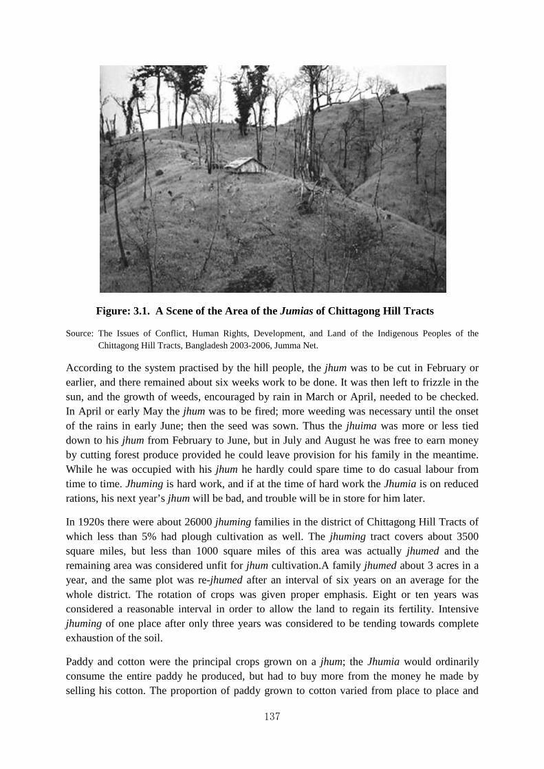
137
Figure: 3.1. A Scene of the Area of the Jumias of Chittagong Hill Tracts
Source: The Issues of Conflict, Human Rights, Development, and Land of the Indigenous Peoples of the Chittagong Hill Tracts, Bangladesh 2003-2006, Jumma Net.
According to the system practised by the hill people, the jhum was to be cut in February or earlier, and there remained about six weeks work to be done. It was then left to frizzle in the sun, and the growth of weeds, encouraged by rain in March or April, needed to be checked. In April or early May the jhum was to be fired; more weeding was necessary until the onset of the rains in early June; then the seed was sown. Thus the jhuima was more or less tied down to his jhum from February to June, but in July and August he was free to earn money by cutting forest produce provided he could leave provision for his family in the meantime. While he was occupied with his jhum he hardly could spare time to do casual labour from time to time. Jhuming is hard work, and if at the time of hard work the Jhumia is on reduced rations, his next year’s jhum will be bad, and trouble will be in store for him later.
In 1920s there were about 26000 jhuming families in the district of Chittagong Hill Tracts of which less than 5% had plough cultivation as well. The jhuming tract covers about 3500 square miles, but less than 1000 square miles of this area was actually jhumed and the remaining area was considered unfit for jhum cultivation.A family jhumed about 3 acres in a year, and the same plot was re-jhumed after an interval of six years on an average for the whole district. The rotation of crops was given proper emphasis. Eight or ten years was considered a reasonable interval in order to allow the land to regain its fertility. Intensive jhuming of one place after only three years was considered to be tending towards complete exhaustion of the soil.
Paddy and cotton were the principal crops grown on a jhum; the Jhumia would ordinarily consume the entire paddy he produced, but had to buy more from the money he made by selling his cotton. The proportion of paddy grown to cotton varied from place to place and

138
from year to year. Earlier the Jhumias used to grow more cotton on speculation that it would fetch high market price. But the broad underlying idea that prevailed among them was that the paddy together with the sell proceeds of cotton would support the family round the year.
Nothing had been done by the government to stop the practice of the Jhumias, nor advised them to introduce plough cultivation for long time. As a result all the best land in the Chittagong Hill tracts got into the possession of Bengalis. It was reported that:
… any land vacated by a Jhumia taking to the plough was immediately occupied by Jhumias from the neighboring hilly tracts, since nothing is ever done to check emigration and immigration. The jhuming population is steadily on the increase, being at least double of what it was thirty years ago.78
Economic conditions of the Jhumias at the end of 1926 started to deteriorate. The Jhumias encountered serious economic problems due to ceaseless rains that hampered their shifting cultivation. The price of cotton dropped, on the other hand the market prices of all the commodities rose making their lives miserable. Worst of all, in certain areas, notably the Upper Maini and Chengi valleys, and the parts of the Sangu valley near the Renikhyong Forest Reserve, a plague of rats appeared in July and August and destroyed nearly all the paddy and cotton. In order to alleviate the economic conditions of the Jhumias extensive relief operations ware carried on by the government.75 It was reported by the Relief officer that:
It may be asked why the burden of relieving the Jhumias should not be borne by the chiefs; certainly the traditional duty of chiefs of this type is to relieve their people when in distress, and they have duties to their people just as important and binding as those which the people have towards them; but the chiefs have always them; but the chiefs have always neglected their own obligations, and it is quite useless for us to expect any assistance whatever for them; they are far more likely to try and make money out of the scarcity. For the present, since I do not desire it to the believed that government will put down exactly what the Jhumias would like I am referring disgruntled persons to their chiefs, with instructions to report what the chief does; I do not however expect that the chiefs will do anything; and as they, like their people, are extravagant spendthrifts, it is unlikely that could assist them even if they had the power.79
For long time the people of the Chittagong Hill Tracts had continued joom cultivation or shifting cultivation along with plough cultivation. But later Bengali people started to enter in the Chittagong Hill Tracts. Slowly but gradually Bengali people took the possession of lands of the aboriginal people of the Chittagong Hill Tracts.80 The infiltration of the Bengali speaking in large scale created a new geo-political situation which was different from the geo-political situation of the char lands.81

139
Table- 3.5. Changing Trend of Ethnic Composition in the Chittagong Hill Tracts (1872-1991)
Year Aboriginal Bengali Speaking People Total
1872 61,957 (98.27%) 1,097 (1.73%) 63,054 (100%)
1901 1,13,074 (92.81%) 8,762 (7.19%) 1,21, 836 (100%)
1959 2,60,517 (90.39%) 27,171 (9.61%) 2,87, 688 (100%)
1981 4,41,796 (59.17%) 3,04,873 (40.83%) 7,46,669 (100%)
1991 5,00,190 (51.34%) 4,74,255 (48.66%) 9,74,445 (100%)
Source: B.H. Shurawardi, “Parbottya Chattogramer Arthonik Abokathamo: Akti Parjalochana (in Bengali) (Economic Infrastructure of the Chittagong Hill Tracts: An Analysis), Vision, (A Magazine Published on the Occasion of Baushabi Celebration, 1995.
From the above table it appears that the infiltration of the Bengali speaking people had increased considerably after the independence of Bangladesh in 1971. As a result of this Bengali infiltration in the Chittagong Hill Tracts became nearly half of the total population and consequently the geo-politics of this area assumed serious character. This was done with the deliberate policy of the Government in power.82There was no doubt that jum cultivation was harmful to in terms of production and land use and environment, but the present situation relating to infiltration of the Bengali speaking population had led to new dimension in geo-political situation.
3.16 The Reclamation Process of the Wetlands like the Haors of Mymensingh in Post-Colonial Period
Haor, Baor Mosher Sing
Ei Tiney Mymensingh
Most popular local proverb of Mymensingh
It means that Haor (bowl-shaped large tectonic depression), Baor (dead arm of a river) and Mosher Sing (horns of buffalo) are three popular items of Mymenhsingh district. The peoples of Mymensingh are fond of and proud in chanting this proverb.
The word ‘Haor’ is a corrupt pronunciation of the Bengali word ‘Sagar’, though well-known to the people of Bangladesh. The existence of such saucer-shaped vast water-bodies is seen in two districts of Bangladesh, like Sylhet and Mymensingh. An in-depth study of the Haor of Sylhet has been made by Sirajul Islam nearly three decades ago.83 In this section of the chapter an attempt has been made to discuss the reclamation process carried out at Kishorganj in the greater district of Mymensingh during the post colonial period. Mention of the word ‘haor’ is only available in the Report of the Survey and Settlement Operation of
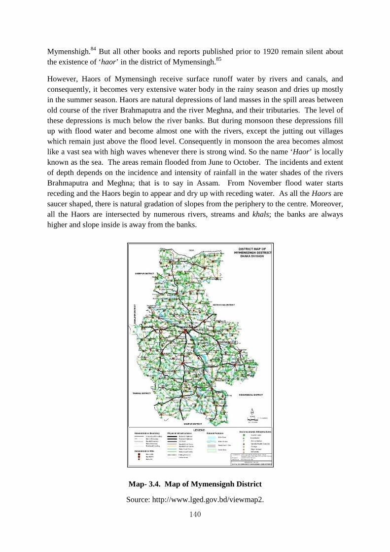
140
Mymenshigh.84 But all other books and reports published prior to 1920 remain silent about the existence of ‘haor’ in the district of Mymensingh.85
However, Haors of Mymensingh receive surface runoff water by rivers and canals, and consequently, it becomes very extensive water body in the rainy season and dries up mostly in the summer season. Haors are natural depressions of land masses in the spill areas between old course of the river Brahmaputra and the river Meghna, and their tributaries. The level of these depressions is much below the river banks. But during monsoon these depressions fill up with flood water and become almost one with the rivers, except the jutting out villages which remain just above the flood level. Consequently in monsoon the area becomes almost like a vast sea with high waves whenever there is strong wind. So the name ‘Haor’ is locally known as the sea. The areas remain flooded from June to October. The incidents and extent of depth depends on the incidence and intensity of rainfall in the water shades of the rivers Brahmaputra and Meghna; that is to say in Assam. From November flood water starts receding and the Haors begin to appear and dry up with receding water. As all the Haors are saucer shaped, there is natural gradation of slopes from the periphery to the centre. Moreover, all the Haors are intersected by numerous rivers, streams and khals; the banks are always higher and slope inside is away from the banks.
Map- 3.4. Map of Mymensignh District
Source: http://www.lged.gov.bd/viewmap2.

141
In the past, it is said that most of these haors were used to be cultivated for growing long stem winter paddy which was also very difficult to cultivate. However, most of the haors were not being fully utilized and the cultivation of long steam winter paddy has become a word of the past. On the fringes, however, i.e. on the banks of the river, sweet potato, groundnut, chilly, kaon etc. are grown in certain places depending on facilities available with the cultivators. In all the haors there are a few pockets of low land here and there which are banded for cultivation of boro paddy by a particular class of farmer. All the lands cannot be used for the purpose of boro cultivation because due to sufficient moisture condition of the soil thick mat of grass grows very quickly after recede of flood water and soon become very hard on account of prevalence of dry weather at the time. During winter these lands with thickly grown grasses were used for grassing cattle which were brought from distant places. It may be mentioned here that the fringes of haors i.e. lands on the bank of the rivers are cultivated by local villagers; whereas the interior pockets of low land are cultivated by farmers hailing from the districts of Noakhali and Sylhet. As soon as flood recedes they arrive with their cattle and ploughs, and start boro cultivation. They make temporary sheds and remain there till the harvest of boro paddy and after harvest they leave the place. This sort of cultivators is known by the name ‘zirati’, it does not necessarily mean tenure or sub-tenure.
Map- 3.5. Map of Kishoreganj District
Source: http://www.lged.gov.bd/uploadeddocument/map/ kishoreganj
The cultivation of deep water aman paddy became obsolete mainly due to two reasons. Firstly, construction of railways and roads impaired the natural drainage system leading to

142
alteration of the natural and incidence of flood in these areas. Instead of gradual or slow rise as well as recedence it had become abrupt and sudden. Hence the crops used to get submerged by sudden rise and due to slow recede flood water could not drain out quickly and the whole submerged crop used to succumb. To add to this, the obnoxious growth of water hyacinth during monsoon destroyed the entire crop by choking. After sustaining continuous loss for a number of years, the cultivators in these areas gave up growing deep water aman paddy.
The great man-made famine of 1943 and protected shortage of rice since that time led the anxious cultivators of these areas to utilize the haors for growing boro paddy. Wherever possible, suitable patches were reclaimed and grown with boro paddy according to their needs. However, this voluntary effort on the part of cultivators did not matter very much as to the utilization of the haor area. It only touched a fringe of the problem.
This vast tract of haor lands of Kishorganj were not owned by any landlord or individual. However, before the abolition of zamindari system, the landlords of these areas had tried to establish their rights by demanding rent from cultivators. The haor lands of Kishorganj were cultivated by the agriculturalists mutually who resided in the adjacent villages without having any record of right in land. When Karanal haor was being cultivated in 1940s, the concerned cultivators were asked by the landlord to take possession of the land and pay 3 years rent only before harvest. Subsequently, the cultivators refused to pay any arrear rent before harvest, but agreed to pay some rent after harvest. It appears that the landlord having no legal right on land had tried to exert illegal pressure on the cultivators for getting share of the profit. Under the East Bengal State Acquisition and Tenancy Act of 1950, the zamindari system was finally abolished and these lands became khas land of the Government and consequently all these lands were distributed among the villagers with nominal rent since the production of these lands were unpredictable.
The problem of utilization of the area came to the forefront for the Government of Bangladesh (erstwhile East Pakistan) due to the shortage of rice and consequent high price of commodity.86It was realised by the Directorate of Agriculture that there is great possibility of introducing mechanization for the utilizations of the haor area. The main obstacles for the cultivators to utilize the area were:
1. Quick hardening of the soil after the recedence of flood, which disable their implements and bullock power to work the area; and
2. Absence of proper irrigation facilities in those areas.
Besides, a new problem emerged out of the distribution of khas lands among the cultivators. The long practised tradition of the cultivators was to make ails or a ridge of earth set up around a piece of agricultural land in order to demarcate the boundary of lands under their possessions. This long practised tradition of the cultivators of Bangladesh was possible in the main and plain lands, but was soon felt impossible by the cultivators of the haor areas because of its hydrological condition. In this circumstance, the cultivators of the haors tried to drive long bamboo poles on the haor land. But owing to submergence of the haors by huge

143
water and high tide therein, these bamboo poles were sometimes washed away. Such situation sometimes created confusions and misunderstandings among the cultivators of the haors regarding the jurisdiction of their lands.
Meanwhile a Japanese Agricultural Mission visited both parts of Pakistan under the auspices of Food and Agricultural Organization. Agricultural technicians and expert hydrological personalities in the Japanese Agricultural Mission suggested introducing mechanization in the area, viz. tractors and power pumps.87 The Government of East Bengal had also launched ‘Grow More Food’ with a view of meeting the food demands of the growing population. The tractors and power pumps were imported from abroad and skilled drivers of tractors were also employed, for the cultivators of haors were unaware of the operations of tractors. Accordingly, the Directorate of Agriculture took up one scheme in the year 1950s Nannir haor and this was followed next year in two other places viz. Karnal and Baraibari of the Kishoreganj Subdivision. In the first year at first 600 acres were ploughed with water, which was pumped out from adjacent rivers by power pumps. A report on the work so far done and result obtained showing the detail of cost and income was given. It was found from the report that the running cost was realised in cash almost in the very first year. It may, however, be mentioned that in connection with Nannir haor Government, in order to encourage cultivators, deferred the realisation to the 4th year, realising only the cost of cultivation by tractors in successive years by installments; whereas the cost of irrigation was realised in the very first year. In the second case, the cost of cultivation as well as the cost of irrigation realised as soon as crop was harvested.88 Fresh problem arose out of the operations of tractors, because the tractors destroyed the ‘ails’, which were posted by the haor cultivators as marks of demarcation of their own boundaries and in consequence disputes over the possession of lands arose among the cultivators. The breaking and finally diminishing of ails was considered by the cultivators as encroachment on their land rights, which was again very difficult to solve. Simultaneously it was also impossible to cultivate those lands by the help of tractors keeping jurisdiction of every cultivator intact. The problem was not so easy to overcome. Finally it was decided to make block-wise co-operative societies, where every cultivator would have share according to the quantity of land possessed by the cultivator. Such concept of agricultural co-operative in Bangladesh was a new innovation for the cultivators, because collective farming was unknown to them. Considering the task of organizing co-operative societies hectic, the Department of Food and Agriculture was reluctant to shoulder such responsibilities and suggested that the Directorate of Co-operative should take over and handle such situation. In a note, the Department of Food and Agriculture suggested that compact areas should be selected considering the nature of the soil, permanent source of water and above all enthusiasm of the landowners were requisites for this scheme.89
However, the Co-operative Directorate ultimately agreed to the proposal of the Department of Food and Agriculture and requested the local office of Mymensingh to reorganize these cultivators on Co-operative lines to grow the crop there. Some progress was also made in this direction to organize them into co-operatives. Necessary arrangements for collection of records of rights were taken along with necessary arrangement with the people for realising the land for reclamation and also for arranging with the people to grow crops on reclamation.

144
As a result of these nearly four thousands acres of haor lands of several villages of Kishorganj, Mymensingh was reclaimed.
Table- 3.6. Village wise Quantity of land Reclaimed
Name of the Village Quantity of land Reclaimed
1. Karanol
2. Alongjuri
3. Mamudpur
4. Itna
5. Badla
6. Dubi
7. Karikanda
8. Panchkahania
9. Shaila
10. Uttorghaneshpur
11. Singpur
12. Baribari
Total
500 acres
400 acres
400 acres
400acres
300 acres
300 acres
300 acres
300 acres
200 acres
200 acres
300 acres
300 acres
3,900 acres90
Source: Department of Co-operative Credit and Rural Indebtedness, Bundle - 1, August, 1936, Proceedings No. 32-35.
The above is the preliminary selection. I will suggest that we have less number of centres with more land in each centre. We will be keeping ready requisite number of tractors ready at Dacca for timely dispatch to the centers and arrangements on that line is being made.
Being encouraged with the result of the work done at Nunni in connection with the utilization of haor area arrangement was made to open up some more area at Baraibari and Karanal in the haor during 1952-53. Accordingly 6 tractors and 15 pumping sets were transported to the area as soon as the flood water receded and the haor land reappeared. 1031.48 acres were opened and ploughed by tractors for cultivators to puddle and transplant boro paddy. As soon as the lands were started to be irrigated, cultivators came with their plough and bullocks to puddle the acres and in an about 200 acres early broadcast aus was sown. The rest of the area could not be sown or planted as the time for sowing and planting was already over.
The project ultimately failed because the Central Government of Pakistan remained apathetic to the progress of East Pakistan. No financial assistance from the Government of Pakistan

145
was available. Attention of the Central Government of Pakistan was directed towards the development of its western wing neglecting the necessity of East Pakistan. This disparity ultimately became a much-debated subject among the economists of East Pakistan. Finally, having no other alternatives, the concerned Departments and Directorates formed a committee of their own and placed the suggestions for the reclamation of the haor areas of Mymensingh. The suggestions were the followings:
1. Reclamation of haor should be on planned basis so that every union can have a sizeable garaging land and some haors should be reserved for production of elephantine grass known as ‘Chalya’ which was essentially necessary for protection of homesteads in rainy season.
2. Mechanized cultivation could not be a success unless joint cultivation was introduced. This could be achieved by forming Co-operative Agricultural production societies. Shares of which should be on the basis of one kani of land as a unit. The shares would be divided amongst the members of society in accordance with quantity of land he had in the haor. One kani should be the minimum Unit.
3. The system of reclamation on the basis of hiring out tractors and pumps to individuals would defeat the very object of reclamation as after some times the individuals would not be in a position to hire pumps or tractors. Besides this has led to litigation and ill feeling in places due to replacement of ails after being broken by tractors. In case of Joint cultivation these problems would not arise and private ownership with right and title to land would remain intact as transfer of land can be affected by transfer of the share only.
4. The haor area was dependent on one crop i.e. boro which was very uncertain due to vagaries of nature such as flood and hailstorm. Attempt to grow paddy to be taken up which can be grown and harvested in three months including the period of transplantation and growth of seedlings. In higher lands ground nuts, master seeds, Chilies, teel etc. also could be grown.
5. A factory for manufacturing oil from ground nut should be set up at Kuliarchar. This would give great impetus to cultivation of ground nut which had become a very important cash crop of haor area.
6. An industry based on fish should be set at Kuliarchar. Such a plant would be very successful encouraging rearing of fish in the subdivision which had very large number of good fisheries. This would increase wealth and prosperity of the subdivision.
7. Cropping pattern in the haor areas should follow the given outline:
(a) The basin area with heavy clay soil should be utilized for growing boro paddy provided the sources of surface water was enough and easily obtainable.
(b) The basin area with light sandy soil or sandy loamy soil from where monsoon water drained out by the middle of October should be utilized from growing ground nut crop and sweet potato.
146
(c) The banks and the area near the banks should be utilized for mustard, sweet potato and vegetable. This type of land might also be used for growing wheat and barley after irrigation.91 It is known from the study project undertaken by JICA (Japan International Cooperation Agency) in 1980s that this scheme of reclaiming the haor lands of Mymensingh, especially in Kishoreganj, did not develop and the haor lands of Kishoreganj relapsed to their earlier position.. The JICA experts carried on intensive survey in the haor areas of Kishoreganj, but they had not seen any such activities there. All the haors retained their earlier position. The pressing need of the growing population the Government of Bangladesh (erstwhile East Pakistan) was forced to reclaim the haor lands of Kishorganj sub-division of greater Mymensingh through investment of capital by the Government itself. Undoubtedly, such venture was unique so far as the history of reclamation process in Bangladesh is concerned. The reclamation of haor lands required mechanical and technical help, because soil texture of the haor became different after water receded in the summer. The idea of mechanization received supports from the experts of the Japanese Agricultural Mission and Food technicians of Agricultural Organization (FAO). Such venture would be fruitful in future had it been continued for a long time. Establishment of agricultural co-operatives block-wise was an essential corollary for carrying agricultural operation using tractors. But the apathetic attitude of the Central Government towards these developments had ultimately led to the termination of this project and consequently the haors relapsed to its earlier condition.
3.17 The Conditions Chalan Beel: The Largest Wetland of Bangladesh
In this chapter attempts have been made to highlight the reclamation processes carried out at different times in diverse geographically and topographically configured areas of Bangladesh. But such discussion will remain incomplete if the conditions of another type of land remains untouched. Bangladesh is the playground of rivers and streams. Apart from the principal rivers there are many haor (bowl-shaped large tectonic depression), baor (dead arm of river), jheel (a local term representing a reach of an old river channel bed) and beel (alarge surface water body that accumulates surface runoff water through internal drainage channels) in Bangladesh, which has contributed to its panoramic beauty and diversified topographical configuration.

Map
Map
Source: http://en.banglapedia.org/index.php?title=Pabna_District
147
Map 3.6. Map of Chalan Beel Area
Source: httpswww.researchgate.net
Map 3.7. Map of Pabna District
http://en.banglapedia.org/index.php?title=Pabna_District
http://en.banglapedia.org/index.php?title=Pabna_District

148
Figure 3.2. Chalan Beel Source: httpwww.chalanbeel.com
However, we are not going to discuss all the water bodies and lands in this section of the chapter, because it will be unwieldy to include all. There are numerous beels located separately all over Bangladesh. Here attempt has been made to highlight some aspects of the Chalan beel which is the largest wetland of Bangladesh. Initially, Chalan beel covered an area of watershed about 1547 square miles (4,010 kilometers).92 The Chalan beel, being the largest wetland of Bangladesh is situated in the colonial districts of Pabna and Rajshahi. According to William Wislon Hunter (1840-1900), the Chalan beel was situated in three districts of Bangladesh, e.g., Rajshahi, Pubna and Bogra.93 Such error may occur due to the change of jurisdiction. Hunter had mentioned the Chalan beel more emphatically in the district of Rajshahi than the district of Pabna, while Lewis Sydney Steward O'malley (1874-1941) had mentioned the Chalan beelmore emphatically in the district of Pabna than in the district of Rajshahi. The reason is not far to seek. The Chalan beel had not received much attention of the concerned authorities in the 19th century and it was only in the first half of the 20th century that it received proper attention. It is found in local legend that the Chalan beel was a safe abode of pirates or robbers, who after committing piracy or robbery, took shelter in the interior of the depression where police could not chase them despite definite complaint being lodged against them. However, according to Lewis Sydney Steward O'Malley (1874-1941) that:
Chalan Bil is the name applied to a low-lying marshy tract extending over about 140 square miles on the borders of Rajshahi and Pabna districts. It lies between Singra, a police station in the Nator subdivision of Rajshahi, on the north-west and Astamanisha in the Pabna district on the south-east, close to Nunnagar, where the rivers Gumani and Baral meet. The portion lying in this district is about 22 miles long and 4 miles wide. The principal feeder of the Chalan Bil is the river Atrai, which conveys into it water which it brings down

149
during its passage through the districts of Dinajpur and Rajshahi. Its chief outlet is the Baral, by which its water is carried off and eventually finds its way into the Brahmaputra. The bil is a .depressed basin, sunk on all sides below the level of the adjastment country except at the south-eastern extremity where its water esapes into the Baral through the Gumani. When the Brahmaputra is in flood, the current of the Baral is held back, and the water of the bil remains pent up until the Brahmaputra falls again. During the dry season the greater portion of the bil dries up, leaving a -water basin of about 15 square miles.94
Earlier in the rainy season the Chalan beel appeared as a very large water sheet interrupted by small villages where the inhabitants lived only by fishing. During the dry season the greater portion of the bil dried up, leaving a water basin of about 15 square miles which allowed production of rice of local variety.
The history of the creation of such a large depression is obscure. It appeared that several rivers and channels had joined and helped to build such very large depression. Somebody believes that the Chalan beel is an abandoned bed of river Ganges.95 Originally this idea was nourished by W.W. Hunter, Rajshahi.96 However, this hypothesis was supported by S.C. Mitra that:
Lastly, since the main volume of the Ganges flood began to flow through the Padma channel early in the 16th century this latter river also must have been helping in raising the southern portion of North Bengal. This probably explains the existence of the vast depression round about Chalan Bil in Rajshahi and Pabna districts which, it seems to me, defines the boundary as between the land raised from the north by the Teesta river systems when they were active and that from the south of the Ganges.97
Contrary to this hypothesis, the Chalan beel was said to have been formed when the old Brahmaputra River sidetracked its water into the new channel of the Jamuna. Chalan beel was probably a back swamp before it was greatly expanded with the inclusion of abandoned courses of the Karatoya and the Atrai and became a vast lake.
The formation of the Chalan beel is historically linked with the demise of the Atrai and the Baral. The Atrai or the Gur was the principal feeder channel of Chalan beel, which used to drain the districts of Dinajpur and northern Rajshahi. The Baral worked as an outlet of the beeland eventually found its way into the Jamuna. It was about 1,088 sq km in area at the time it was formed.98
It is also believed that the Chalan beel is not itself a beel, rather several beels joined and formed a big water sheet known as the Chalan beel. According to Pabna District Gazetteer, thebeel is said to formerly had length over as much as 421 square miles, but owing to the incursion of silt-laden water brought in from the Ganges by the Baral and other rivers in

150
Rajshahi, nearly the whole of this large area has now become dry land. An enquiry held in the middle of February, 1909 by the Public Works Department regarding the question of its drainage, found the area of the beel had been reduced to 142 square miles. The area that it was formerly consisted of had been reclaimed due to deposition of silt for long. Even in this reduced area, only 33 square mile remained under water all the year round. The rest area was under water for part of the year, but the rising in level every year with the deposition of silt. It is worthy to note that even then, 49 square miles were low land, which could only be cultivated in between February to April, while 22 square miles were raised land, which was cultivable for dry crops from January or February, and 38 square miles were cultivable from November. It was estimated that every year 2221 million cubic feet of silt were brought in by the feeder rivers, while 53 million cubic feet were carried off by the rivers draining the beel. However, the balance of 1691 million cubic feet was deposited annually and this deposit distributed equally over the whole 142 square miles and it means a raising the level of the beel at the rate of half an inch a year.99
With a view to determining the condition of the Chalan beel in the dry season another enquiry was conducted in May 1910. The findings of the enquiry suggested that the area of the beel under review had been further reduced. The portion lying in the Pabna district was dry and under cultivation, while the depth of water in the Rajshahi district was only 1 foot. A further inspection was made in 1913 and it revealed the fact that only 12 to 15 square miles remained under water throughout the year which was nearly tripple if compared with 33 square miles in 1909. However, it was apparent that the Chalan beel was silting up rapidly. It was reported that:
... the banks all round being high and under cultivation, while the depth of water in the month of April varied from 9 inches to 18 inches.... Land is being reclaimed, new villages are springing up along its titles, and the watery waste is yielding place to settled tilth.100
It is assumed that in the reclamation process of the Chalan beel several parties that assembled there originated from heterogeneous social and economic background. So in the beginning no village community existed among them. The only means of communication was obviously boat. In this depression long-stemmed variety of paddy is cultivated which adjusted itself to the rising level of water. Paddy is harvested in boats and the straws remain untouched in the beel.101The banks of the beel area are raised well and under cultivation of a variety of crops. Soil morphology of the Chalan beel is clayey and as a result jute has a smaller percentage of the cropped area. It is worthy to mention that the Chalan beel covers considerable territories of the districts of Rajshahi and Pabna, but it as a low density of population due to limitation inhabitable land.102
The Chalan beel was important from the viewpoints of its flora, fauna, fish and other productions. Earlier this beel had provided only fishes for the consumption of the local inhabitants. The marketing and drying of fishes were later features. There were many species of fishes available in this wetland, but it was never included in the list of fishery mahal during the colonial rule. The list of jalkar mahals or fishery mahals of both Rajshahi and

151
Pabna districts are available in W.W. Hunter’s Statistical Account, but the Chalan beel was not included in it.
Gradually a large portion of the Chalan beel has been silted up for many reasons and these areas have also been reclaimed. Among other factors, the railway embankments were largely responsible. In the early 1900s, Chalan beel began to raise the hemline by the construction of the Eastern Bengal Railway on the west and the Santahar-Bogra branch line on the north. The natural pattern of the water's drainage channels in this area was disrupted by the obstruction caused by the railway construction since railways in these low lands had to be built on embankments.103 The Chalan beel served as a natural drainage to several rivers located in this area.
The natural arrangement of drainage of the water regime of this part of the active Delta thus met with formidable obstacles in the form of railways built on embankments. Such situation of hindrance put against the waterways was further aggravated, for instance, by the reduction of the number of spans on the bridges of the EBR since the broad gauge line was constructed. In this area the total existing outlets in early 1920s was reported to be 440 feet as compared to 967 in this part of the railway when the line was first constructed.104
Havoc created on Chalan beel by the construction of embankments for railway lines resulted in the destruction of natural drainage, thus helping in deterioration of the Chalan beel to a great extent. Along with this, the emergence of water-hyacinth in every rainy season had created water-logging situation round the year. All these factors combined and contributed largely for deterioration of the Chalan beel.
According to present law all these lands are khas lands of the Government that are supposed to be distributed among the landless people of the locality. However, such rules could not materialize due to geo-political activities of local landlords, who obtain support from the influential political parties. This is an open secret.105
However, sometimes it is said that in history, excepting dates and names everything is incorrect and in literature everything is correct excepting dates and names. The true history would not have been revealed had I not gone through the book written by Pramatha Nath Bishi entitled ‘Chalan beel’. Pramatha Nath Bishi (1901-1985) a gifted son of Rajshahi was a prolific writer of his time who composed several novels. Among those, ‘Chalan beel’ and ‘Jora Dighir Chowdhury Paribar’ deal with Chalan beel in detail. The novel entitled ‘Chalan beel’ provides us vivid picture of the growth and decay of the Chalan beel. Of course, Pramatha Nath Bishi had consulted available official records, but he emphasised on local legend which certainly bore valuable information in this regard. He mentioned the condition of Chalan beel during the rainy and summer seasons with detail of the life and style of the communities inhabiting there. Mention of the glories of Handial (a place of Chalan beel), Kuchary of the zamindars, ruined structure of buildings, tol and Chatuspathi (place of Sanskrit learning), temple of the goddess Kali, large tanks (dighi), Kuti Bari of the Fouzdar,

152
old fort of the East India Company, health clinic and charitable dispensary – all help to record the past glories of the Chalan beel. Many people left the place when the area became unhealthy due to environmental hazards.106 Emigrants from Chota Nagpur started to settle in the deserted villages of the Chalan beel.
Pramatha Nath Bishi mentioned the three gangs of robbers known as Rama, Shyama and Beni Roy who deliberately conducted sporadic raids on the rich people in and around the Chalan beel. In order to put a stop to the sporadic raids of the gangs the East India Company had to arrange for considerable size of boats with rows along with armed jamadars. There existed a small piece of elevated land known as ‘Beni Raier Bhita’ where worship of the goddess Kali was performed. It is local legend that the leader of the famous gang Beni Roy had established the temple in the name of goddess Kali after founding his gang for sporadic raids. During the worship of the goddess Kali many goats and buffaloes were sacrificed from the remote past. The legend of Beni Roy was dated from the second decade of the 17th century when Pratapditya, one of the twelve Bhuiyas, lost in the battle against the Mughal (1612).
The story of the rise of Beni Roy’s gang is far more interesting. Initially Beny Roy was a Kulin Brahmin who had a very beautiful wife. A Muslim Sardar suddenly pilferaged her and ultimately forced her to be converted to the utter disillusionment of Beni Roy. Enraged by this unhappy incident Beni Roy renounced family life, established a temple of goddess Kali known as Yayanmardini, and organized a gang of his own drawn from the low caste Hindus. The gangs of Beni Roy, by their sporadic raids, captured the innocent Muslims and sacrificed them in Yayanmardini temple, as retaliation of the forced conversion of his innocent wife to Islam. He also kept the heads of the sacrificed Muslim as his disposal. The Muslims of the locality named the place as satanic ground. Curiously enough, Beni Roy had also earned the name as ‘Pandit Dacoit’ by both the Muslim and Hindus alike. However, Beni Roy had never conducted any activity or sporadic raids on any Hindu family.107 The story or legend of the activities may or may not be true; nevertheless, it speaks the spirit of the time under review. After the demise of Beni Roy his principal disciple, Jugal Kishore Roy had become the zamidnar of Sherpur of Bogra district in accordance to the request of Beni Roy. However, Pramatha Nath Bishi has mentioned that Chalan beel was no-man’s property.
Mentions of Chalan beel are available in all the regional or local histories of Rajshahi and Pabna. Apart from the District Gazetteers, the Bengali books Rajshahir Itihas and Pabna Jelar Itihas (History of Pabna District, 1924) (History of Rajshahi, 1901) written by Sri Kalinath Choudhury and Radha Raman Saha respectively, have dealt with this subject. However, during Pakistan regime Principal Abdul Hamid, whose subject was chemistry, wrote a book entitled Chalan beeler Itikatha in 1967. His approach was virtually quite different from the true term of history. As being the son of the soil, Principal Abdul Hamid had profound love for Chalan beel. After the emergence of Bangladesh in 1971, he established Chalan beel Research Council with the help of local people. Chalan beel Museum was individually started in 1978 by Principal Abdul Hamid for his personal interest on the subject. The museum was established at Khubjipur in Natore subdivision of the Rajshahi district. Several subject items were displaced e.g., very big horn of buffalos, several non-
153
denominational skeletons of animals, conk shell etc. It was believed to be very old, though not very old, as the writer of this article personally saw those subject items. Later in 1980s Abdul Hamid personally established the Chalan beel Enquiry Committee with the help of some local supporters and under the initiative of the Chalan beel Enquiry Committee several biographies and books related to Chalan beel were published. Folk-literature is essentially common in all societies of the world. Every region has its own folk-literature. The Chalan beel has its own folk-literature which was collected by Principal Abdul Hamid and published by the Bangla Academy (Dhaka) in 1981.108
It has been discussed earlier that the Chalan beel started to shrink due to various reasons created by nature and man. Some of the rivers are drying out in the Chalan beel. During the dry season, some of the rivers Gumani, Atrai and other rivers are drying and that leads to damage of Chalan beel. Now the Chalan beel has shrunk to a serious extent, its land is being reclaimed, and new villages are springing up alongside. In the dry season, all the smaller and larger beels dry up excluding their deeper centre. The outlying marginal lands are being cultivated with boro and high yielding varieties (HYV) of rice in the dry season. In the rainy season, the shallow peripheries are cultivated for long-stemmed deep-water aman rice and jute. During the monsoon, the area of the Bil increases and touches four upazilas (sub-districts) of the Natore district. Picnic parties come to Chalan Bils during certain times of the year. They cook, sing, dance, and do everything they wish in their boats. It looks like a sea, especially during the monsoon. 34 kilometers road in Sirajganj and Natore districts have already been constructed on the silted up portions of the Chalan beel. The road remains submerged during the rains but emerge from water in late autumn and remain usable until the next monsoon. Inhabitants of the remote areas adjacent to the wetland in Pabna, Sirajganj and Natore districts walk or travel on bullock carts during the dry seasons and on boats during the rainy season.
Poverty with the rapid population growth and their consequent needs compelled men to over-exploit the natural resources like the land and water. In fact the land use pattern practised in the Chalan beel is contributing largely to the loss of its potentialities gradually. The extensive monopoly of high yielding varieties (HYV) of rice cultivation has already been replaced by other crops in the Chalan beel area, which are friendly to environment and are important sources of nutrition. The intensification of land use and its associate externalities have produced environmental imbalances in the Chalan beel. These are very critical if looked at the necessity of ensuring food security for growing population of the country.
During the last half-century, development interventions have been undertaken in this area, mainly to increase food production for an increasing population, improve road systems, industrialize, urbanize etc. This all came at the cost of valuable wetlands and their resources. The development interventions like construction of embankments, dams, hydraulic structures, roads and railway lines have not only reduced the total water body, but have led to widely spread damage of the wetland ecology, its resources and navigation. This in turn causes limitless misery to the livelihoods of thousands of people, particularly the poor fishers and others who are dependent on fisheries and other wetland resources and navigation. The Chalan beel has not yet been declared as heritage spot or ecologically critical area by

154
Government. The Chalan beel is verging towards utter ruin and complete destruction.
However, in this chapter the process of reclamation and land use pattern of the diverse geographically and topographically configured areas of Bangladesh have been analysed historically. After setting the basic historical background of each different tract, attempts have also been taken to go into the detailed account of each tract, considering the view that the diverse geographically and topographically configured areas of Bangladesh had its own pattern so far as reclamation and land use is concerned. As a result of this, we have succeeded to know briefly the different characteristics of different land use pattern which were closely related to certain geographical and topographical conditions. The principal factor was always watercourse which had always been emphasised. It appears to us that the diverse geographically and topographically configured areas of Bangladesh had different situation at all levels.

155
Notes and References
1. It is noteworthy that part of this paper has been published in the referred journal entitled CLIO (An Annual Interdisciplinary Journal of History), Corpus Research Institute, Kolkata with my highly respectable teacher Professor Ratan Lal Chakraborty in 2009, pp. 7-.19.
2. W.W. Hunter, A Statistical Account of Bengal, Vol. Vol. VIII: Districts of Rajshahi and Bogra, p. 142-43.
3. Rai Monmohan Chakrabartti, A Summary of the Changes in the Jurisdiction of Districts in Bengal, 1757-1916. Revised and updated by Kumud Ranjan Biswas, Calcutta: Government of West Bengal, 1999, pp. 75-76.
4. Provash Chandra Sen, Mohasthan and Its Environs, (Bogra, 1926), p.1-2.
5. Bogra District Records, Vol 4, pp. 65-68.
6. Rajchandra Nayapanchanan, Karotoya Mahatyam (The Devine Power of Karotoya), (both in Bengali and Sanskrit), Calcutta, 1891; Haragopal Daskundu, Poundravardana and Karotoya, (in Bengali), Calcutta, 1919 (Historical Discourse) and Provash Chandra Sen, Bagurar Itihas (History of Bogra) (in Bengali), Bogra, 1929, 2nd edition, 1929, pp. 21-25.
7. Said-ur Rahman, ‘Karotoya Nadi’, (The River Karotoya in Bengali), in Dinajpur: History and Tradition, edited by Sharif Uddin Ahmed, Dhaka: Bangladesh Historical Association, 1996, pp. 18-20.
8. Quoted in D. MacPherson, Final Report on the Survey and Settlement Operations in the Districts of Pubna and Bogra, Calcutta: Bengal Secretariat Press, 1930, p. 31.
9. M. Wylie, Bengal As a Field of Missions, Calcutta: Thacker, Spink and Co., 1854, p. 254.
10. Montgomery Martin, The History, Antiquities, Topography, and Statistics of Eastern India, Delhi: Cosmo Publication, 1976, (Reprinted), First Printed, 1838, Vol.III, p. 687.
11. Prior to writing this paper the District Records of Bogra were preserved at the Bogra District Collectorate Record Room and permission from the Deputy Collector was necessary to consult the records every time. Now all the District Records of Bogra has been transferred to the Bangladesh National Archives and as a result consultation of these records has become easy. But the condition of the age-old District Records of Bogra is painful, as most of these are brittle and verging towards destruction.
12. Kalikamal Sarbabhoumya, Shetihas Bogura Britanta, Bogra, 1861, pp. 10-15. This book was later reprinted by the Universal Academy, Dhaka in 2011 with the editorial large comments of Ratan Lal Chakraborty.
13. Williem Van Schendel, The Odds from the Rural Life of Bangladesh, New Delhi: Monohar, 1982, p. 119.

156
14. A.J. Jackson, Officiating Deputy Collector of Bogra to the Commissioner of Revenue, Rajshaye, 9 October, 1858, Bogra District Records, Vol. 17, pp. 92-93.
15. “Letter from A. J. Jackson, Officiating Deputy Collector of Bogra to Commissioner of Rajshahi, Revenue Division, 13 November, 1858”. Bogra District Records, Vol. 17, pp. 145-48.
16. W.W. Hunter, Movement of the People and Land Reclamation Schemes of India, Calcutta, 1885, Lower Bengal, Letter No. XIX.
17. “Letter from Collector of Bogra to Commissioner of Revenue, Rajshahi Division, 10 July, 1854”, Bogra District Collectorate Records, Letter Sent, Vol. 19, pp. 5-7.
18. Sirajul Islam, Bengal Land Tenure: The Origin and Growth of Intermediate Interests in the 19th Century, p. 7.
19. S. Tanuguchi, “The ‘Patni’ System – A Modern Origin of the ‘Subinfeudation’ of Bengal in the Nineteenth Century”, Hitosubashi Journal of Economics, Vo. 22, No. 1, June, 1981, p. 43.
20. Cittabrata Palit, Perspectives on Agrarian Bengal, p. 6.
21. For details see, Ratan Lal Chakraborty, “Mandal and Matbar: Traditinal Rural Institutions in Bangladesh under the Colonial Rule”, The Dhaka University Studies, Vol. 52, No. 2, December, 1995, pp. 1-37.
22. “Letter from S.C. Mukherjee, Collector of Bogra to the Commissioner, Rajshahi Division, 15 February, 1911”. Letter of the Eastern Bengal and Assam Board of Revenue, No. 1131Misc.-T., dated 7th August, 1911, p. 44.
23. “Letter from F.B. Falcom, the Officiating Collector of Bogra to the Commissioner of Revenue, Rajshahi Division, 17 January, 1865”. Bogra District Records, Vol. 40, p. 5.
24. Quoted in W.W. Hunter, A Statistical Account of Bengal, Vol. VIII: Districts of Rajshahi and Bogra, London: Trubner & Co., 1876, p.227.
25. Circular, 3 October, 1856. Bogra District Records, Vol. 8, p. 2.
26. W.W. Hunter, A Statistical Account of Bengal, Vol. VIII: Districts of Rajshahi and Bogra, p. 235.
27. D. MacPherson, Final Report on the Survey and Settlement Operations in the Districts of Pubna and Bogra, p. 50.
28. Kazuo Ando, Haruo Uchida and Ratan Lalchakraborty, “Some Aspects of Society and Economy of a Haor-Basin Village of Greater Mymensingh”. Paper presented at the monthly meeting of the Asiatic Society of Bangladesh and published in Lecture Series, Vol. I, Dhaka: The Asiatic Society of Bangladesh, pp. 89-106.

157
29. J. L. Sherwill, A Geographical and Statistical Report of the Dinagepore District, Calcutta: 1863, pp. 9-11 & 40-41.
30. W.W. Hunter, A Statistical Account of Bengal, Vol. VIII: Districts of Rajshahi and Bogra, p. 222.
31. Benoy Chowdhuri, Growth of Commercial Agriculture in Bengal, 1757-1900, Vol. I, Calcutta: Indian Studies, 1964, pp. 74-78.
32. A. J. M.Shamsuddin Tarafdar, Bogra During Two Centuries, (in Bengali), Bogra: 1970, pp.50-60.
33. W.W. Hunter, A Statistical Account of Bengal, Vol. VIII: Districts of Rajshahi and Bogra, p. 167.
34. W.W. Hunter, Movement of the People and Land Reclamation Schemes of India, Calcutta, 1885, Lower Bengal, No. XIX.
35. Census of India, 1891, Bengal, p. 4.
36. J. L. Sherwill, A Geographical and Statistical Report of the Dinagepore District, p. 41.
37. “Letter from Collector of Bogra to Commissioner of Revenue, Rajshahi Division, 19 February, 1862”, Bogra District Collectorate Records, Letter Sent, Vol. 28, p. 236.
38. “Letter from Collector of Bogra to Commissioner of Revenue, Rajshahi Division, 10 May, 1864”, Bogra District Collectorate Records, Letter Sent, Vol. 37, pp. 39-40.
39. J. L. Sherwill, A Geographical and Statistical Report of the Dinagepore District, p. 21.
40. “Letter from Collector of Bogra to Commissioner of Revenue, Rajshahi Division, 19 January, 1863”, Bogra District Collectorate Records, Letter Sent, Vol. 38, pp. 9-10.
41. “Letter from A.B. Falcon, Officiating Collector of Bogra to Secretary, Board of Revenue, 4 October, 1864”, Bogra District Collectorate Records, Letter Sent, Vol. 40, p. 2.
42. Hem Chunder Kerr, Report on the Cultivation of, and Trade in, Jute in Bengal, Calcutta: 1873, p. 84.
43. D. MacPherson, Final Report on the Survey and Settlement Operations in the Districts of Pubna and Bogra, p. 22.
44. Francis Buchanan, “An Account of a Journey Undertaken by Order of the Bd. of Trade through the Provinces of Chittagong and Tipperah in Order to Look Out for the Places Most Proper for the Cultivation of Spices.” (March-May 1798).
45. Sundarbans has been named for the abundance of Sundari tree whose generic names are Heritiera littoralis and Heritiera minor.

158
46. Rai Monmohan Chakrabartti Bahadur, A Summary of the Changes of Jurisdiction of Districts in Bengal, 1757-1916, revised and updated by Kumud Ranjan Biswas, West Bengal District Gazetteers, Calcutta: Government of West Bengal, 1999, pp. 44-46, 51-53 and 60-61.
47. Richard M. Eaton, The Rise of Islam and the Bengal Frontier, 1204-1960, Barkley: University of California Press, 1993, Footnote Number 52.
48. J. A. Westland, A Report on the District of Jessore: Its Antiquities, Its History and Its Commerce, Calcutta: Bengal Secretariat Press, 1871, pp. 20-21.
49. M. Wylie, Bengal As a Field of Missions, , p. 130.
50. For the details of early history of the Sundarban the following articles may be consulted. F.B. Bradely-Birt, 'Sunderbans', Calcutta Review, Vol. 289, 1917, pp, 213-27; H.Beveridge, 'Were the Sundarbans inhabited in Ancient Times', Journal of the Asiatic Society of Bengal, Vol. XLV, 1876; Gourdas Basak, 'Antiquities of Bagherhat', Journal of the Asiatic Society of Bengal, Vol, XLVI, 1867; Khan Sahib Abdul Latif, 'A Fifteen Century Mosque in the Sundarban', The Dacca Review', Vol. VII, 1918-18, Nos. 1-2, pp. 123-27; Benoy Chandra Sen and Devaprasad Ghosh, 'Dated Copper Plate Grant from Sundarban', Indian Historical Quarterly, Vol. 10, 1934, p. 321-34.
51. Lord Clive's letter to the Court of Directors of the East India Company, 31 December, 1757. James Long, Selections from the Unpublished Records of Government, 1748-69, (Calcutta, 1869), Vol. 1, p. 152.
52. Frederick Eden Pargiter, Revenue History of Sundarban from 1765-1870, Calcutta, 1885 (reprinted 1934), p. 16.
53. Ibid., pp. 36-37.
54. Proceedings of the Lieutenant Governors of Bengal, Revenue Department, 25 July, 1865, Proceeding No. 389, Bangladesh National Archives..
55. H. James Rainey, “Famines in Bengal and the Reclamation of the Sundarbans as a means of mitigating them”, Calcutta Review, Vol. 59 (118), 1874, p. 349.
56. The source materials of the history land revenue administration of the Sundarban used in this has been taken from Frederick Eden Pargiter, Revenue History of Sundarban from 1765-1870, Calcutta, 1885 (reprinted 1934); F.D. Ascoli, Revenue History of Sundarban from 1870-1920, Calcutta : The Bengal Secretariat Book Depot, 1921; and Pramodranjan Das Gupta, Supplement to the Final Report on the Survey and Settlement Operations in the District of Khulna for the Period 1926-1927, Alipore: Bengal Government Press, 1935.
57. A detailed on the same subject has been conducted by Ratan Lal Chakraborty. The author has also used the materials of the article with his kind permission. For details see, Ratan Lal chakraborty, “Reclamation Process in the Bengal Delta: A Case Study of Sundarban

159
Forest Tract”, in The Imagescape of Six Great Asian Deltas in the 21st Century. Report of Research Project. Grant-in-Aid for International Scientific Research, (Field Research). Edited by Professor Kaida, Yoshihiro, Center for Southeast Asian Studies, Kyoto University, Kyoto, Japan, 1998, pp. 35-59.
58. Annual Report on the Working of the Cooperative Societies in the Circle of Gosaba for the year 1932-33. Government of Bengal, B-Proceedings, Co-operative Credit and Rural Indebtedness Department, Bangladesh National Archives, Bundle - 1, August, 1936, Proceedings No. 32-35.
59. The physical reclamation process followed in the Sundarban has been written following the account of a contemporary writer. For details see, Ramshunker Sen, Report on the Agricultural Statistics of Jhenidah, Magurah and Sundarbuns Sub-Divisions, District Jessore, 1872-73, Calcutta : Bengal Secretariat Press, 1874, pp. 17-21.
60. H. James Rainey, 'Jessore', Book Review of J. A. Westland, A Report on the District of Jessore: Its Antiquities, Its History and Its Commerce, Calcutta: Bengal Secretariat Press, 1871, Calcutta Review, Vol. 125, 1876, pp. 267-68.
61. H. James Rainey, “Famines in Bengal and the Reclamation of the Sundarbans as a means of Mitigating them”, Calcutta Review, Vol. 59 (118), 1874, pp. 323- 49.
62. Such seasonal migration of labour force has been still in force. For details, see Aminul Haque Faraizi, Bangladesh: Peasant Migration and the World Capitalist Economy, Dhaka: University Press Limited, 1994, pp. 121-41.
63. Ramshunker Sen, Report on the Agricultural Statistics of Jhenidah, Magurah and Sundarbuns Sub-Divisions, District Jessore, p. 21.
64. Papers Relating to the Improvement of the Soonderbun Channels, Selections from the Records of the Bengal Government, Calcutta: Gazette Office, 1854.
65. Major Ralph Smyth, “The Sundarbans: Their Commercial Importance”, Calcutta Review, Vol. XXXI, July-December, 1858, 385-411.
66. D.N. Mukherjee and V.S. Rao, Report on the Possibilities of the Salt Industry in the Sunderbans, Alipore : Bengal Government Press, 1938.
67. Sanat Kumar Roy Choudhury, an Advocate and Ex-Mayor of Calcutta, wrote an article protesting the suggestions of the Floud Commission. For details see, Sanat Kumar Roy Choudhury, “The Land Revenue Commission Report and the Sunderbans: Notes on the Floud Commission Report”, The Modern Review, Vol. 68, No. 2, August, 1940, pp. 152-55.
68. For details, G.S. Dutt, “The Tiger's God in Bengal Art”, Modern Review, Vol. LII, November, 1932, pp. 520-29.
160
69. T.H. Lewin, The Hill Tracts of Chittagong and the Dwellers therein: With Comparative Vocabularies of the Hill Dialects, Calcutta, 1869, p. 3.
70. For details, see, Abdul Malek et al., “Bangladesher Khudra Adibashi ‘Bawm’, (“Bawm’ A Small Aboriginal of Bangladesh), (in Bengali), Dhaka Vishavidyalaya Patrika, Vol. 82, June, 2005, pp. 61-94.
71. J. N. Sarkar, “The Conquest of Chatgaon, 1666 A.D.”, Journal and Proceedings of the Asiatic Society of Bengal, New Series, 1907, Vol. III, pp. 405-18.
72. Buchanan, Mysore, II, p. 177.
73. A Fly on the Wheel, p. 348.
74. Alexander Mackenzie, History of the Relations of the Government with the Hill Tribe of North East Frontier of Bengal, Calcutta, 1884, pp. 131-32.
75. For details, see R.B. Ramsbotham, “Chittagong in 1785: The War’ Against Jan Baksh Khan”. Bengal Past and Present, Vol. 39, Part –III, 1930, pp. 81-89; Ratan Lal Chakraborty, “Chakma Resistance to Early British Rule”, Bangladesh Historical Studies, Vol. II, 1976, pp. 133-56.
76. Francis Hamilton Buchanan, “An Account of the Frontier Between Ava and the Part of Bengal Adjacent to the Karnaphuli River, 1825”, SOAS Bulletin of Burma Research, Vol. 1, No. 2, Autumn 2003, pp. 1-10.
77. R.H. Hutchinson, Eastern Bengal and Assam District Gazetteers, Chittagong Hill Tracts, Allahabab, 1909, p. 22.
78. Government of Bengal, B-Proceeding, Revenue Department, Branch–Excluded Areas, Bangladesh National Archives, Bundle-1, November, 1927, Proceedings Nos. 47-60.
79. Ibid.
80. For details see, M. M. Haq, “Changing Nature of Dominant Social Forces and Interventions in the Chittagong Hill Tracts”, The Journal of Social Studies, Center of Social Studies, University Dhaka, Vol. 56.
81. Life is not ours: Land Human Rights in the Chittagong Hill Tracts, Vol. 1, 1991, The Hill Tracts Commission, Bangladesh.
82. Bangladesh: Land Forest and Forest People,ed., Philip Gain, Dhaka: Society for Environment and Human Development, 1995, p. 41.
83. Sirajul Islam, Villages in the Haor-Basin of Bangladesh, Studies in Socio-Cultural Change in Rural Bangladesh, Institute for the Study of Language and Cultures of Asia and Africa, Tokyo: Tokyo University, 1985.

161
84. F.A. Sachse, Final Report on the Survey and Settlement Operations in the District of Mymensingh, 1908-1919, Calcutta: Bengal Secretariat Book Depot, 1920.
85. H. J. Reynolds, Report on the History and Statistics of District of Mymensingh, in A.L. Clay, Principal Heads on the History and Statistics of the Dacca Division, Calcutta: E.M. Lewis Calcutta Central Press Company Limited, 1868; W.W. Hunter, A Statistical Account of Bengal, Vol. V: Dacca, Bakarganj, Faridpur, Mymensingh, London:Trubner, 1875-77; Nishi Kanta Ghosh, The Report on the Genesis and History of the Mymensingh Drainage Scheme, Mymensingh, 1915; Umesh Chandra Chakladar, History of the Mymensingh Raj Rajeswari Water-works, Mymensingh, 1916; F.A. Sachse, Bengal District Gazetteers: Mymensingh, Calcutta, 1917; Nishi Kanta Ghose, Mymensingh Water-Supply: A Treatise on the Origin, Development, Construction and subsequent Improvements of Raj Rajeswari Water-works, 1917.
86. Government of East Bengal, B-Proceedings, Department of Agriculture, Vol. 9, September, 1956, Proceedings Nos. 104-14.
87. The detailed reports of the Japanese Agricultural Mission are available in the following sources: Government of East Bengal, B-Proceedings, Department of Planning, Bangladesh National Archives, Bundle No. 3, December, 1950, Proceedings Nos. 16-24; Government of East Bengal, B-Proceedings, Department of Planning, Bangladesh National Archives, Bundle No. 5, August, 1952, Proceedings Nos. 70-90; Government of East Pakistan, B-Proceedings, Department of Home (Political), Bangladesh National Archives, Bundle No. 155, September, 1957, Proceedings Nos. 940-41.
88. Government of East Pakistan, B-Proceedings, Department of Agriculture, Branch – Development, Vol. 9, Bangladesh National Archives, September, 1956, Proceedings Nos. 211-23.
89. Government of East Pakistan, B-Proceedings, Department of Food and Agriculture, Branch- Development, Bundle No. 16, Bangladesh National Archives, November, 1956, Proceeding No. 16.
90. Government of East Pakistan, B-Proceedings, Department of Food and Agriculture, Branch – Development, Bundle No. 16, Bangladesh National Archives, November, 1956, Proceedings Nos. 55-58.
91. Government of East Pakistan, B-Proceedings, Department of Food and Agriculture, Branch – Development, Bundle No. 20, Bangladesh National Archives, November, 1957, Proceedings Nos. 91-99.
92. M. Abu Hanif Sheikh et.al., “Chalan beel Anchaler Nadimalar Shankyatattik Bissleshon” (Statistical Analysis of the rivers of the Chalan beel), Journal of the Institute of Bangladesh Studies, 1999, Vol. 7, pp. 125 and 127.
93. William Wislon Hunter, A Statistical Account of Bengal, Vol. VIII: Rajshahi and Bogra, London: Trubner ,1875-77, pp. 25-26.

162
94. Lewis Sydney Steward O'Malley, Bengal District Gazetteers, Pabna, Calcutta, 1923,. pp. 4-5.
95. Bisheswar Vattacharya, ‘Bange Ganga’ (The Ganges in Bengal), Bangabani, Vol. 3, No. 2, Ashwin, 1331 BS, 171.
96. William Wislon Hunter, A Statistical Account of Bengal, Vol. VIII: Rajshahi and Bogra, p. 27.
97. S.C. Majundar, Rivers of the Bengal Delta, Alipore: Bengal Government Press, 1941, reprinted in West Bengal District Gazetteers, Kolkata, 2001, p. 46.
98. Mohd Shamsul Alam and Md Sazzad Hossain ‘Chalan beel, Banglapedia, Dhaka: Asiatic Society of Bangladesh, 2008 C.D. edition.
99. Lewis Sydney Steward O'Malley, Bengal District Gazetteers, Pabna, pp. 5-6.
100. Ibid. p. 6.
101. Nafis Ahmad, An Economic Geography of East Pakistan, London: Oxford University Press, 1968, p. 23.
102. Ibid., p. 296.
103. Roopa Srinivasan et al, Our Indian Railways: Themes in India’s Railway History, New Delhi: Foundation Books, 2007, pp. 11-29.
104. For details see, Khondker Iftekhar Iqbal, “The Railways and the Water Regime of the Eastern Bengal Delta c.1845-1943.” Internationales Asienforum: International Quarterly for Asian Studies, Vol. 38, Nos. 3-4, 2007, pp. 329-52.
105.‘Conservation of Chalan beel demanded’, Dhaka Tribune, 14 June, 2014.
106. Pramatha Nath Bishi, Chalan beel, Calcutta, 1930s, p. 18.
107. Ibid., pp. 28-29.
108. Abdul Hamid,Chalan beeler Loke Sahitya, Dhaka: Bangla Academy, Bengali, (Folk Literature Chalan beel), 1981.
163
Chapter 4
Alluvial Land Reclamation Process in Bengal During the Colonial Rule
Abstract of the Chapter
In the fourth chapter the proper demographic setting of Eastern Bengal has been briefly discussed in. It is well known that the land-man ratio of the whole of Bengal had been started to decline in the later part of the 19th century. In the absence of reclaimable lands, people had started to search new lands for reclamation. Ultimately they found vacant char lands as new scope of further reclamation. This time also leadership of reclamation came from earlier entrepreneurs, such as, rich cultivators known as jotedars and intermediaries. Initially they had built bathan (cow shed) and raised their herds over there. With process of time char lands became fit for habitation and reclamation. This time the broadcasted Boro (kind of inferior paddy) and jute became major incentives for reclamation. Here the incidence of judicial cases centering round the reclamation of char land became higher. Another interesting feature of the char lands was the illegal occupation of armed gangs who had formed a party of their own. The armed gang had their own system of administration within a definite jurisdiction of the char. Consequently clashes with the British Police became inevitable. No historical discussions are not available which has been narrated here.
“Nadir Ekul Garey Okul Bhangey – Ei to Nadir Khela,
Shakal Bela Amir Re Bhai, Fakir Shadhya Bela”
(“It is the game of the river to break one side and build up another side.
The king in the morning becomes beggar in the evening.”)
Ballad chant by the people of riparian areas
The Bengal delta, so far known as the largest in the world, was created by the two Himalayan rivers - the Ganges and the Brahmaputra and a non-Himalayan river namely the Meghna. This is also known as Ganges-Brahmaputra Delta. On its journey towards the north-east the Ganges built several deltas and then abandoned them before finally reaching to its present position. Modern researchers have divided the Bengal delta into five parts. These are the inactive or moribund delta, active delta, mature delta, tidally active delta and subaqusous delta. However, the main cause of the formation of Bengal delta may be attributed to numerous streams, descending precipitously from the mountain of the Himalayas, depositing the silt and sand they held in suspension of their waters on their own beds. This had gradually raised the beds above the level of adjacent plains and caused the streams to change their

164
channels. With this the annual inundation brought deposits on the surface of the country, rapidly creating the land in the level swampy terrain. Such alluvial formation is still a continuous process in the eastern part of the Bengal delta. As being the active delta, the creation of islands and bars is a common natural phenomenon of the country which may be considered as the by-product of the hydro-morphological dynamics of its rivers. The alluvial formation of Bengal is an ever-ending natural process and shall remain to continue in future endlessly. Such alluvial formation is locally known as ‘char’ (a sandbank of a river or sea). This chapter aims at explaining in brief the reclamation process of alluvial land of Bengal during the British colonial rule. On the backdrop of the decline of land-man ratio and pressure of population growth, the reclamation of alluvial land became the only source of human settlement and agricultural operation. In the absence of any proper regulation illegal and forcible occupation of char land by the jotedars became the general order of the day during the British colonial rule.
4.1 General View of Reclamation Process in Bengal During the Colonial Period
The important aspect of the agrarian history of Bengal is the reclamation process which is obviously inseparable with the land system and its administration. With the change of land system the nature, form and extent of reclamation changed. The famine of 1770 caused considerable depopulation in different parts of Bengal and as a result vast tracts of land left cultivable waste towards the end of the 18th century.1 Even there was dearth of immigrant labour for reclamation. In such situation liberal terms and additional incentives were given to the ryots for the purpose of enticing the distant cultivators. In the second half of the 18th century the noabad (newly cultivated) lands of Chittagong were reclaimed by the Arakanese, known as Mughs, who fled to Chittagong in consequence of the annexation of Arakan in 1785 by the Burmese king. An elaborate policy of the settlement
of the Arakanese emigrants had been adopted and they were given noabad lands at liberal terms.2 But the nature of noabad settlement in Chittagong was different, if compared with other areas of Bengal. Similarly the reclamation work of Sundarban was started before 18th century. The Survey and Settlement Reports of Sundarbans by Frederick Eden Pargiter (1885) and F.D. Ascoli (1921) throw light on this aspect of history.3 In the situation of plenty of uncultivated lands and thin density of population, the landlords had to depend on the pioneer-farmers who practically monopolized land and leased it out to the actual cultivator at a rent higher than the demand of the landlord. The situation of reclamation largely changed in the later half of the 19th century which witnessed tremendous development of many factors contributory to the reclamation process. The principal development was the demographic that ushered spectacular change in the existing social and economic order of the country. According to the ideas of the Physiocratic School of thought and the classical economists the demand of ownership of property increases largely when agricultural land becomes scarce under population pressure. Because then “there was plenty of unoccupied lands, the population was sparse, the competition was not amongst the tenant for land, but amongst zamindars for raiyats.”4 The situation changed further in the late 19th century when the resources of the country could not support the growth of population and this was mingled with the intricate and defected land system.

165
But the growth of population forced the extension of cultivation further, because population pressure became so much so acute that reclamation of waste land and jungle became inevitable. The collection of William Wilson Hunter shows that reclamation process was in full swing both in the active and inactive delta in the late 19th century.5 It appeared that the greater part of waste lands of Bengal were reclaimed during the 19th century. At the initial stage the sub-tenure holders had played important role in the reclamation process. They took up the advantage of an increasing population and the liberty of letting waste and unoccupied land on their own terms in order to push up rents to the highest rates. The most remarkable characteristic of reclamation process in Bengal was that in most cases reclamation created a new type of tenure which had wide regional variations. However, the subject of the reclamation process in the mainland of Bengal has not remained untouched. Several scholars of different disciplines have contributed several articles and books on the above-mentioned subject.6 But the subject of the alluvial land or the char land reclamation process of Bengal has not yet been addressed historically. The reclamation process in the main land was relatively easier than the Charland and as a result the reclamation process of the Char land was remarkably slower than the main land in the 19th century. Of course, this does not necessarily mean that the Charlands remained untouched in the whole reclamation process in the 19th century. Initially the reclamation of Char land was not entirely directed for human settlement, rather it was found lucrative to the stakeholders e.g., zamindars and other subordinate landed-interests to occupy the possession of the Char keeping its future legal right in view.
4.2 Changes in the River Course
The alluvial and diluvial formation of land is obviously related to the changes in the river course. It is very difficult to give a complete history of the changes of river courses since the formation of the Bengal delta in such a brief article. The historical records so far available show that the changes of river system of Bengal before the 16th century. The most outstanding work in this regard is the map of Major James Rennell (1742-1830) who had largely surveyed the Ganges, Brahmaputra and Meghna river-systems. The survey map of James Rennell clearly indicates considerable changes of various major rivers that almost reshaped the riverine geography of Bengal in the 18th century.7
The rivers of Bengal had changed their courses under the operation of natural causes and thereby the old courses of rivers ceased to be the main drainage. The eastward movement of the Ganges was possibly occurred due to the denudation of trees on the hill-slopes in north and west resulting in an early silting up of old channels. In the sixteenth century the Ganges took turn eastward quitting the Bhagirathi and found its principal outlet through the channel of the Jalangi, Mathabhanga, Kumar, Nabaganga and Gorai. As a result the process of land formation had ended and the rivers ceased their natural function of depositing fertilizing silt to land. On the other hand the land elevation of many of the central and western Bengal districts like Nadia, 24 Parganas, Murshidabad and Jessore rose above the level of periodical inundation by silt deposit due to the change of river course. The river beds of western and central Bengal gradually became fit for cultivation. Consequently the natural drainage system became practically inoperative and public health deteriorated to a serious extent. The

166
Brahmaputra, deserting its former course eastward of Dhaka, turned around over to the west into the bed of Teesta and Jenai rivers.8Before 1787 the river Tista used to flow into the Ganges above Goalando through the Atrai. But as soon as a dam (sand bar) was formed at its junction with the Atrai its channel was cut off. Such a catastrophic change took place owing to exceptionally heavy flood which brought down large quantity of timber from the Himalayas. There is no doubt that the rivers of Bengal had undergone a series of serious changes over the centuries which ultimately led some parts of Bengal to moribund condition. The long-term eastward movement of Bengal’s major river systems and continuous deposition of rich silt made the cultivation of wet rice possible.9 Beside this, the earthquakes and floods that occurred during the 17-19th centuries were responsible for the creation of several new rivers. However, the gradual movement of the delta to the eastward provided further scope of reclamation where the pioneering peasants cut the virgin forests, thereby throwing open a widening zone for agricultural operation. Describing the reclamation process R.K. Mukherjee comments:
…man has carried on the work of reclamation here, fighting with the jungle, the tiger, the wild buffalo, the pig, and the crocodile, until at the present day nearly half of what was formerly an impenetrable forest has been converted into gardens of graceful palm and fields of waving rice.10
4.3 Alluvial and Diluvial Formation
The mighty rivers known as the Ganges, Padma, Brahmaputra, Jamuna and Meghna originating mostly from the Himalayas carry millions of tons of mud and sand every year on their way to the Bay of Bengal. The huge mud and sand get accumulated in their sinuous courses raising the river beds and forming chars or accretions along the course of the rivers and at their confluence. Since the torrential rain flow is unable to discharge itself through the expanded river bed, consequently it inundates the vast tracts of land on both sides and swallows up the land mass on one side of the bank, and gradually and discernibly forms accretions on the other side. Traces of administration and management of alluvial and diluvial lands during the ancient and medieval Bengal are not directly available. It may be considered in terms of growth of population and demand for lands. But we find two Persian terms probably prevalent during the medieval time. The Persian word ‘payist’ or ‘payaisit’ means formation of alluvial land due to the change of rivers or deposition of silt due to inundations. Similarly ‘Shekustee’ is also a Persian word that denotes loss of land by river erosion and its emergence at the other side of the river.
The Brahmaputra river forms a complex river system characterized by the most dynamic and unique water and sediment transport patterns. It is the fourth largest river in the world in terms of average water discharge. The river with such a high volume of water discharge and sediment load represents the most dynamic fluvial regime. Its wide alluvial channel is dotted with several hundred small and large sand bars, locally called ‘char’. The emerging lands are generally known as ‘Char’ which grows up gradually in the geo-morphological process. Chars vary considerably in terms of their ecological and environmental setting. Generally the Char is divided in two groups, e.g., island Chars, attached Chars. Both the island Chars and

167
attached Charsare inhabitable though they are also liable to periodical inundation. Island Char may be defined as land which is communicable from the main land by crossing a main channel even in the dry season. Attached Char is communicable from the main land without crossing a main channel even during the dry season. Consequently the formation process and characteristics of both the types of chars in both the meandering and braided rivers are naturally different and entirely unpredictable about their stability. It takes some long time to start human settlement in the char after its formation and it is accomplished after natural progress and much human effort. Sometimes the Chars become connected with the main land. Some Chars are not inhabitable; though these are vegetated but remained submerged under water for a long time of the year.
It has already been discussed that the alluvial and diluvial character of the rivers of Bengal is very common phenomenon and unpredictable. Reference to these is available in the noted literary works. Manik Bandyopadhyay's (1908-1956) Padmanadir Majhi (The Boatman of the River Padma) ) is a story set in a fisherman’s village standing on the banks of the river Padma. In some place it has been remarked that “It is true Padma gives us a lot, but in return it also takes a lot from us.” Similarly AdwaitaMallavarman’s(1914-1951) Titash Ekti Nadir Naam (A River Named Titash), where the author has realistically portrayed the life of the fishermen on the banks of the river Titas.
4.4 Laws Regarding Char Land Administration
Bengal is widely known as a ‘riverine’ land it was mostly created by fluvial action. Simultaneously Bengal is one of the most densely settled parts of the world with large numbers of people living on the deltaic meadows. In consequence, a very large number of people live on and make their livelihoods from chars. In ancient time disputed on char lands were settled by the traditional local councils which determined the ownership of such lands. The Mughal rule provided elaborate regulations for the administration of land but those regulations had not been in strict operation for the administration of these ‘char’ lands. The low growth of population and less demand for land may be attributed for this situation. The colonial rule introduced new land system which in turn provided a new process for the reclamation and administration of these ‘char’ lands. In fact, char land remained outside the regulation of the Permanent Settlement of 1793 and no official initiative was taken by the Government of Bengal till 1819, because it was neither a problem of the landlords nor of the government itself.
The Regulation XI of 1825 which was popularly known as the Bengal Alluvion and Diluvion Regulation of 1825 enacted on 26 May, 1825 with a view to codifying those rules of law regarding the alluvion and diluvion of lands. It is worthy to note that these clauses were in existence from time immemorial though an un-codified state. The preamble of the Bengal Regulation XI of 1825 was as follows:
In consequence of the frequent changes which take place in the channel of the principal rivers that intersect the Provinces immediately subject to the Presidency immediately subject to the Presidency of Fort William and the

168
shifting of the sands which lie in the beds of those rivers, chars or small islands are often thrown up by alluvion in the midst of the stream, or near one of the banks, and large portions of land are carried away by an encroachment of the river on one side, whilst accessions of land are at the same time, or in subsequent years, gained by dereliction of the water on the opposite side; similar instances of alluvion, encroachment and dereliction also sometimes occur on the sea-coast which borders the southern and south eastern limits of Bengal.11
The regulation provided rules for two kinds of accretion, viz. (1) lands gained by alluvion, and (2) lands gained by dereliction of a river or the sea. It also provided for the chars of islands thrown up (a) in the large navigable river or the sea, and (b) in small and shallow rivers. This regulation was not only applicable to settle the disputes between the riparian landholders, but also to cases where no riparian proprietor was concerned and the dispute was of the landholder and his tenant on the same side of river. In fact, the object of this regulation was to lessen disputes relating to the rights and claim on newly accreted char or dereliction of land. Earlier to this regulation some of the problems discussed above were settled through local usages e.g. ‘Shikast’ and ‘Paiwast’. The word ‘Shikast’ means broken and it was applied to land lost by diluvion. He word ‘Paiwast’ means joined and it was applied to land gained by alluvion. Keeping these traditional usages in mind the Regulation XI of 1825 prescribed three kinds of rules of better management. When land was gained by gradual accession from the recess of river or sea, it should be considered an increment to the tenure of the person to whose land or estate it was thus annexed subject to the payment of revenue to the crown.
The above rule shall not be considered applicable to cases in which a river may break through by a sudden change of its course and intersect an estate without any gradual encroachment or violence of stream separate a considerable piece of land from one estate and join it to another estate without destroying the identity and preventing the recognition of the land, so removed. In such cases the land, on being clearly recognised as the property of the original owners. When the char risen on the riverbed as a distinct island and which is not a property of an individual and there is no distinct link between link between the shore of the river and the newly formed char. This would be property of the Government following the traditional usage. However, if the channels are fordable at any season of the year, the land should be considered as the accreted of the tenure of persons whose estates are situated near it.12
In fact, the Bengal Alluvion and Diluvion Regulation of 1825 could not all the aspects of the subject of alluvion and diluvion. So the Government of Bengal had to make another act to cope with the prevailing circumstances. On 8 May, 1847, The Bengal Alluvion and Diluvion Act was passed where the principal object of the Government was to conduct survey on alluvial accretions to confirm its rights for getting further increment of the financial profit. Because the law in force was not satisfactory at all in so far as the interest of the Government was concerned. According to the provision of the Bengal Alluvion and Diluvion Act:
169
Within the said Provinces it shall be lawful for the Provincial Government, in all districts of which a revenue-survey may have been or may hereafter be completed and approved by Government, to direct from time to time, wherever ten years from the approval of any such survey shall have expired, a new survey of lands on the banks of rivers and on the shores of sea, in order to ascertain the change that may have taken place since the date of the last previous survey, and to cause new maps to be made according to such new survey.13
However, the Act IX of 1847 or the Bengal Alluvion and Diluvion Act 1847 provided the Government with the power to direct new surveys of riparian lands at an interval of 10 years on the banks of rivers and on he sea shores. Moreover, it allowed deduction from the Sadar jama of estates which had been washed away in the proportion of Mafassal jam of the whole estate. If mafassal jama could not be ascertained, it would be decided on the basis of area and assessment of increments to revenue paying estates for addition of land. This assessment would be valid under law and the survey is carried out for the purpose of determining the alterations that had existed from the date of the prior assessment conducted.14
The Bengal Alluvial Land Settlement Act of 1848 was the third series of the British Government for the proper administration of the char lands. It had made provisions for the alluvial land settlement and the revenue of the accreted land acquired by the alluvial succession which were not elucidated in the previously enacted regulations. This act, in fact, had widened to a large extent the scope of settlement of any alluvial land ‘subject to the proprietors of the primary jama did not agree to get settlement of the newly accreted land and paying revenue thereto’.15
The act allowed the concerned authority to make settlement of char land to anybody irrespective of nay classification. This category of settlement would be considered as independent settlement in perpetuity and also confirmed the rights of the under tenants. The significant change of this act over the previous rules was the right of the under tenants on the alluvial formations. The Bengal Alluvial Land Settlement Act of 1848 suggested that:
It shall be the duty of all officers making settlements of such land, whether the land be settled separately or incorporated with the original estate, to ascertain and record all such rights according to the rules prescribed in Regulation VII, 1822; and to determine whether any and what additional rent shall be payable in respect of the alluvial land by the person or persons entitled to any under-tenure in the original estate.16
4.5 Act XXXI of 1858
The act also contained several provisions of the settlement of land accumulated by alluvion if the following manner that it suggested additional revenue be assessed upon alluvial land to jama of the original estate. In case the proprietors challenged such arrangement, the alluvial should be land should be treated separately and assessed as a separate estate with a separate

170
jama.In such case the separate might be permanent if the settlement of the original estate was given in perpetuity.
4.6 The Bengal Alluvial (Amendment) Act, 1868
In order to make more successful operation of the regulations of char land an amendment was made on the Bengal Alluvion and Diluvion Act of 1847 on 8 July 1868 which replaced earlier laws hitherto passed. About the newly accreted land the amendment suggested that:
Any island of which possession may have been taken by the local revenue-authorities on behalf of the Government under section 3 of this Act shall not be deemed to have become an accession to the property of any person by reason of such channel becoming fordable after possession of such island shall have been so taken. Whenever an island of which possession shall have been taken by Government under section 3 of this Act, shall become attached to the mainland, any person having an estate or interest in any part of the riparian mainland to which such island may become attached while it is in the possession of the Government may apply to the Collector to take measures for the construction of any ways, paths and roads on the island; the cost thereof to be equally divided between the applicant and the Government.17
The Bengal Alluvial (Amendment) Act, 1868 had kept provisions open for instituting any suit in the civil court for any grievance.
4.7 The Bengal Tenancy Act, 1885
The Bengal Tenancy Act of 1885 was, in fact, brought relief, to some extent, to the peasantry of Bengal. The Section 86.A of the Bengal Tenancy Act of 1885 had conferred rights of the peasant on the diluvium lands provided the reappearance of the site within twenty years of the erosion of land. This act also provided opportunity to the tenants for reduction and fixation of alluvial and diluvion lands. Nevertheless, the Bengal Tenancy Act of 1885 could not solve all the problems of the tenants in case of alluvial lands.18
4.8 The Alluvial Lands Act, 1920 or Act V of 1920
Before the Partition of India in 1947 the last act relating to alluvial and diluvion subject was the Alluvial Lands Act of 1920 which was aimed at preventing disputes of different parties concerned it this subject. In the course of population growth char lands appeared to be very valuable to many parties which, in turn, created a host of disputes among the various sections of population. The salient features of the Alluvial Lands Act of 1920 were the following:
1. The District Collectors were given power to attach alluvial lands if there were any possibility of breach of peace. In such case the Collector would demarcate the boundary and appoint a receiver thereof;
2. The District Collectors would give proper instruction for survey and preparation of a comparative map;
171
3. The District Collectors and the legal court would jointly decide person or persons entitled for the possession of the alluvial.19
It appears from the above-mentioned section of the chapter that right from 1825 to 1920 many legislative measures were taken for the better administration of the char lands. The British authorities did their best on order to upholding their own interest, so as to maximize their profit from the land. The colonial policy worked although behind this progress. From 1819 to 1825 several half-hearted regulations and acts were passed relating to the proprietorship of the char land, but all these efforts went in vain as the Government was busy otherwise. The Bengal Rent Act of 1859 recognised the corollary principle that the tenant was liable to enhancement and remission of rent in case of increase of area of his land by alluvial and of decrease of the area of land by diluvial process. In the later half of the 19th century, when land-man ratio started to decline and the population pressure became considerably high, people had started to settle on the char land. Such situation ultimately led to considerable litigation and power-struggle relating to the proprietorship of the char land and consequently the Government was forced to enact some laws and regulations about the subject under review. The Bengal Tenancy Act of 1885 provided some regulations relating to the proprietorship of the char land, but these regulations had created debates in the Executive Council on the one hand and difference of opinions of the officialdom on the other. As a result the regulations and acts passed in between 1819 to 1920 relating to the proprietorship of the char land remained ineffective during the colonial rule.The later amendments of the Bengal Tenancy Act were aimed at giving relief to the tenants, but those amendments were carried out after 1947.
4.9 Pattern of Char Land Settlement
Apparently the settlement of char land was simple, because no stringent provision was included in the administration and management of char lands from the beginning. But in fact it encouraged litigation among the contending parties always. Any denomination of landed-interest and even the individual could procure legal status from the Government for the char lands. In the later half of the 19th century many people invested heavy money for buying marshlands and char as because they found this venture profitable in future in the given situation of high growth of population. Initially the char remains uninhabitable for some years, when a kind of grass locally known as ‘Khaila’ (in some places it is also know as ‘Chaliha’) abundantly grows which is used as fodder of the livestock.20 Human settlement starts at later years. Generally very bold, courageous and stronger class of people were engaged in the reclamation and habitation of these newly formed chars, because they could encounter all sort of natural hazards and maintain their livelihood over there. The general practice of taking occupation of a char was very interesting. Some influential man of the nearby locality sowed some species of productive nature on the char and kept it under his possession over some years. After the lapse of some time he applied to the Government for legal rights known as malikana. Curiously enough that such practice was so common that many of these place names appeared identifying the first agricultural operation. The name of places like Bansbunia (bansh is bamboo and bunia is sowing the bamboo), Marichbunia (sowing chilly), Bethbunia (sowing cane) and ChurVictoria seem to carry the image of the

172
above mentioned historical incidence.21 In the coastal area of Bengal considerable place-names are available embracing with the Bengali word char either in the prefix or at the suffix. In fact, Bengal is predominantly a creation of the Ganges and the Bhahmaputra and as such, rivers are very important factors in the life in Bengal. Therefore, place-names containing words connected with hydrological aspects are peculiarly restricted to the deltaic Bengal.
The modus operandi for the settlement of char land developed during the colonial rule was in principle very simple. In case of formation of new chars it was usual practice to send a party consisted of Ameen (staff of revenue department) and a Police force for enquiry and investigation. The next step was to send a Tahsildar for the settlement of the charland. But the operation of this system was practically difficult as the designing persons usually lodged frivolous and false complaints against the Ameen and Tahsildar(a native collector of revenue). As a result of this, the local administration had to summon the Ameen and Tahsildar at the headquarters. The object of the designing persons was to keep the possession of charland and draw benefits as long as possible without paying rent to government.22
Both alluvial and diluvial process created complications for survey and settlement works. The land originally appertained to one estate was encroached upon and washed away by the river and again formed. In such case advertisement was issued inviting those who had claims on the char to come forward and prefer them. This ultimately led to serious disputes among the contending zamindars and settlement of such char became a prolonged procedure. The intricate land system introduced during the colonial rule provided enough scope to the landlords irrespective of the size of their holding to embark upon dispute over land possession. Private entrepreneurship was also noticeable in the possession of char land. It was a practice prevalent there to occupy char land and establish its legal right through payment of stipulated money directly either to zamindars or to the Government. The zamindars also preferred those parties, enough to encounter the opposition of the rival landed interest and capable of establishing the authority in favour of the zamindars. Because competition of the land market of any form was too high in view of the growth of population and to cope with the competition of other landlords or neighbouring zamindars, it became essential for them to hire lathials (clubmen) to show their strength. The profits from the char land could be drawn sometimes paying nominal rent and sometimes without paying any rent. Curiously enough that among the settlers of char 90% were Muslims and 10% were Hindus of the Namasudra (Hindu community placed low in the social order) caste. Literacy rate among the settlers of char was very negligible. In most cases the char land was very fertile and production of crops was very high. Most of the char lands are known as Ashli jomi (highly fertile land), they get new silt every year through the works of river. The cultivation of paddy, fishing and raring of livestock were common professions of the dwellers of the islands.23
The settled families in the char land played important role in the power struggle between the contending zamindars by supporting any of them. In fact, they earn huge benefit or profit, either cash or kind, for rendering services to the landlords during this crucial time. This was very much dangerous as their lives become at a risk during this power struggle. The history

173
of occupation of a new alluvial accretion or char was always marked by bloodshed. Litigations of both civil and criminal were also common phenomenon in the life of char dwellers. The bulk of the income drawn from the productions of char was spent in litigation and they frequently became easy prey in the hands of amla (clerk) and muktiars (lawyer) in the legal court. Consequently they fell in the clutches of money-lenders too. Having no other alternative to survive they were forced to migrate to another char and start settlement anew.
The chars could not be instantly used for habitation. In Bakerganj they were used as bathan (fodder ground) which would provide fodder to the livestock. There were numerous bathansin the south of Bakerganj and the Meghna islands where a fee of one rupee per head was charged. Such estates in South Shahabazpur were let out on a local settlement known as gorkati(a tax levied for the privilege of cutting firewood in the jungle). The char appeared to have assumed a special importance as pastures after the disappearance of bathans and other grazing grounds in other parts of the Dhaka Division. Thatching grass was important for rural economy and it grown purposely for selling in the market. In this background the behaviour of so-called jotedars was very interesting.
It seems that not only the jotedars but also European Indigo Planters were also associated in the reclamation process of charland. It is well-known that the British planters made large investments in indigo during the early 19th century. Gradually the European indigo planters also obtained new powers and concessions in regard to the land with the acquisition of zamindari rights. It was too much irritating to the Bengali zamindars to see the emergence of a rival group backed by the government. On the other hand, coercion and oppression were common features of the indigo cultivation and ryots of Bengal became averse to cultivate indigo in their paddy lands. As an alternative measure the interest of the European indigo planters was directed towards the charlands which were fit for indigo cultivation. So rivalry and litigations between the European indigo planters and the Bengali zamindars and other subordinate tenure holders centering round the occupation of charlands appeared as a common feature in the early 19th century Bengal.24 However, the indigo cultivation was ceased to exist after the great Indigo Resistance Movement (1859-1862) and consequent legislative promulgation. There are instances where both the Bengali zamindar and European planter collected lathials for taking the possession of the disputed char by harvesting paddy forcefully.25
Ratnalekha Ray's study on Dhaka, Faridpur and Bakerganj throws enough light how the extremely fertile alluvial lands were reclaimed mostly by the Muslims and low caste Hindus (Namasudras). While arguing the demographic composition Ratnalekha Ray comments that:
… the preponderance of the Muslims in the population was evident, specially in the south, where new land was being reclaimed; as hardy cultivators they were better able than the Hindu gentry to endure the unhealthy climate on the seaboard, especially its salt air....The hardy and enterprising sections of the Muslim peasantry who were engaged in reclaiming chars and forests formed the main Faraizi settlements along the banks of the great rivers.”26

174
In Barisal Chars were let on cultivating leases by Government and measured after every five years. The areas, being extensive and compact, had afforded possible scope for colonization. But the main physical obstacle to reclamation in the brackish-water parts of the district was the intrusive canals that broke the line of protective embankments. Far more serious obstacle stood on the way of reclamation was the scramble of the co-sharers having undivided fractional interests in the settlement. Frequent quarrel over the division of profits or payment of rent was inevitable nearly in every case. The net result was endless litigation.
The story of a French citizen is very interesting in this regard. Purchasing a share of a zamindary through auction sale Mr. Courzen, a French citizen, became a zamindar of Noakhali. His attention was then directed to occupy the khas land of Char Bamni that was then occupied by the local peasants and some of them held khas land legally in perpetuity. Applying his high tactics and connection with the Government officials Mr. Courzen succeeded to take lease of the khas land of Char Bamni and then again leased out to subordinate tenants at a higher rate adding many conditions. Mr. Courzen also filed law suit against those local peasants who held khas land legally in order to evict them. He also kept retainers or lathials for frightening the peasant. This had ultimately led to a peasant revolt in the Char Bamni and in consequence of this Mr. Courzen had to give up his idea of forcible occupation.27 Practically, the activities of heterogeneous landed interests in the situation of scarcity of land created a complicated social and economic situation.
4.10 Physical Occupation of Char Lands
Using two different reports written by different writers at different places and different times Sirajul Islam has attempted to depict visually the on char reclamation process in deltaic Bengal. However, such scenario should not be accepted as unique or general everywhere in Bengal. In fact, historically, the char reclamation process has also some differentiations in respect of spatial, local and watercourses as well. Nevertheless, let us go through the story composed by Sirajul Islam using the official records.
A new char called degichar when it is visible during the ebb and goes under water at full tide. Some adventurer may choose the char for future settlement and as token of possession, may plant on it such acquatics (sic) as may flourish in such sinking situation of the char formation. He and his associates frequently visit the spot and fish there by giving proper publicity all around. The degichar gradually emerges from the water and as soon as it ceases to be overflowed by the tide, an engagement for the land at an absolutely nominal rent is entered into as a venture. It is usually done with a powerful neighbouring landholder in order to enlist his support at times of feuds and litigations which are almost inevitable to take place. When grass and underwoods spring up roving herdsmen (bathania) are invited to pasture large herds of cattle on the young herbage, putting up sheds for the beasts, while they themselves bivouac in the open air. The man or men behind the venture on the land now compels the cattle-owners to pay a grazing rent, at so much a head per year for their cattle, and rent for cutting fuel is also taken. All these

175
are collected as tokens of their rights. In course of time, as the land becomes fit for the plough, a tough husbandman called haoladar is invited to take charge, and cultivate as much as possible. The haoladar receives a repayable loan from the abadkar talukdar and takes a lease from the taluqdar for a term of years. The haoladar, who is a pioneer coloniser, and afterwards often a leader of the colony of resident cultivators, will induce non-resident (paikasht) rayats at first from the neighbouring places, to plough and sow the lands; crops will be watched from temporary huts, reaped, gathered, thrashed, and then carted away from the fixed holdings (khudkasht) of the cultivators. As time progresses and the land improves, rival claimants, litigations, deadly land-wars begin and to tackle these, professional club-men (lathials) and witnesses are marshaled. Till claims and counter claims and consequent fights and litigations are finally solved lands are cultivated mainly by pikashta rayats under the umbrella of the abadkar taluqdar and haoladars. After final conquest, the raiyats begin to settle in large numbers and become resident rayats. They dig tanks for fresh water and around their habitation and tanks are planted betel, coconut, palm plantains other shed giving and fruit trees. To cater to the needs of new settlers the taluqdas and haoladarsmake pathways, dig canals, establish market places. Thus in a generation or so the new formation becomes like the rest of the selected villages.28
Certainly, Sirajul Islam’s attempt provides us some clues for better understanding the reclamation process of the char lands, yet such hypothesis does not fit well in everywhere in Bangladesh in the nineteenth and twentieth centuries. In fact, here place names of certain areas, especially of the alluvial tracts of southern Bangladesh, where formation of char is numerous. In some cases, in the prefix of a place starts with char e.g., Char Bhadrasan (Faridpur), Char Kukri Mukri, Dhalchar, Char Manika, Char Aicha, Char Nizam, Char Newton, Char fasson. (Bakerganj) Even some char was named after people who had settled population there. Char fasson was named after J H Fashion, District Magistrate of Bakerganj during 1885 to 1887. He established settlement here bringing ten educated and ten Ukhrait families from different parts of the country.29In some cases, in the prefix of the place name a staple of food or plant name is also available. In the present Patuakhali district many place names are available whose prefix is well related to the name a staple of food or plant e.g., Marichbunia (Marich means chilly), Dhanbunia (Dhan means paddy), Bethbunia (Beth means cane). In fact, those places were once chars and the possession of those places were available by cultivating a staple of food or plant. It appears that the analysis of the name of the char may unearth the history of the reclamation of the char.
4.11 Production in Char Land
Major Henry Thomas Colebrooke(1765-1836) found that char lands had invited immediate cultivation even in the first decade of the 19th century. According to his experience:
…such islands as are found, on their first appearance, to have any soil, are immediately cultivated; and water melons, cucumbers, and sursoo, or mustard,

176
become the produce of the first year. It is not uncommon even to see rice growing in those parts where a quantity of mud has been deposited near the water’s edge.30
The information gathered from various sources reveal the fact that production of char lands varied widely according to the variety of soil texture and other reasons. However, it seems that boro (a sort of rice sown in January and reaped in April), aus (paddy crop grown in the monsoon), aman (a kind of paddy commonly produced everywhere), indigo, jute, sweet potato, fodder and miscellaneous varieties of fuel are usually produced in the char lands, though all these have wide regional variations.31 In some instances, char lands were used for the production of salt, from which the company was benefited at the initial stage. It is worthy to note that shrimp culture wan not at all carried out during this period under review.
4.12 Diara Surveys
Diara is a Hindi word which literally means the alluvion on the bank of river and shores of the sea. In Bengal this survey was carried under the provisions of Act IX of 1847 which also meant as alluvial and diluvial Act. Sometimes this survey was carried out by the professional surveyor under the supervision of the Survey of India and sometimes it was taken up by non-professional men under the collectors of the concerned districts. The object of the diara survey was to make settlement of lands formed in the rivers since the Decennial Settlement of 1786 and which were not included in the Permanent Settlement of 1793. The results of DiaraSurveys were helpful in making accurate comparative maps, which could be made to show revenue, diara and modern boundaries geographically. The significance of this work cannot be overestimated, because it was very often the true basis of settlement of riverbed disputes. Between the year 1862 and 1883 Diara Surveys were conducted in the beds of the Ganges and other large rivers excepting upper Brahmaputra. No professional Diara Surveys were conducted excepting the Ganges north of Sirajganj of Pabna district. Non-professional Diara surveys exist for many of the rivers of Sylhet and Eastern Bengal.32
In the district of Mymensingh, the numbers of temporarily-settled estates were 180 with the amount of revenue was Rupees 80,299 in 1941. All these were consisted of accretions to permanently-settled estates in the beds of rivers which had dried up or changed their course. Diara surveys under Act IX of 1847 for assessing these lands were conducted in the lower part of the Jamuna by Captain Stuart in 1867. This was followed by Parbati Charan Ray, the Deputy Collector of Mymensingh, in the old Brahmaputra in 1880-82.33 Of these surveys conducted hitherto, Parbati Charan Ray’s Diara survey was interesting to such an extent that it was popularly known as ‘Parbati Babu’sDiara’. His survey was supposed to have been connected with the Revenue Survey trijunctions but the traverse data were not generally available. Under Regulation II of 1819 the resumption proceedings were not instituted on a large scale between 1834 and 1846 for newly formed chars in the river Jamuna. As the landlords of Mymensingh had never claimed reduction of land revenue for diluvion, it was held at the Permanent Settlement at the site of Jamuna was navigable only by insignificant streams, most of the cases were struck off as reformation in situ or in its natural and original place. A vast area like 37 square miles in dispersed blocks were shown on the reel of

177
temporarily-settled estates seems to be due to the fact that the proprietors of these lands had not made any appeal. As a result some temporarily-settled estates were permanently settled in between 1860 and 1871 and these were known as Daimi bandbast mahals.34
After the great Revenue Survey of Bengal in the years of 1859-1865, the survey of the Meghna diara including the Arial Khan river was initiated in 1882 under the Act IX of 1847. The object of this survey was to readjustment in accordance with the changes in the riparian areas by the movements of these rivers. Lewis Sydney Steward O'Malley (1874-1941), the author of Bakarganj District Gazetteers remarked:
The Dakhin Sahabazpur estate was surveyed in 1889 and a record-of-right was prepared in order to pacify the disputes which had made the estate a serious administrative difficulty. A survey and a record-of-rights have made in considerable number of other smaller estates usually for the purpose of the revision of the revenue, but sometimes for the purpose of adjusting disputes. With the exception of these areas, a survey and a record-of-rights were made of the entire district in 1900-1908. The specific object for which these measures were undertaken was to remove or to pacify the unrest and lawlessness which were so rife in this district, but there were also a part of the general policy which aimed at providing the whole province with a detailed record of the lands, rights and rents of every tenant as ascertained after accurate survey and investigation.35
In fact, the diara survey operation in this area was undertaken in the interests of tenants, landlords and administration of land, which were affected by unrest and lawlessness. Following the directive of the Bengal Tenancy Act of 1885, the cadastral survey of Bakarganj was conducted in 1900-1908. On the backdrop of this, the diara survey conducted here also reveled interesting information. It was found that the area occupied by the landlords and tenants (not including unleased land at the disposal of Government) was 3,270 square miles. Of which 1 percent land was kept reserved by the owners, 3 percent land covered by rivers, streams and roads, 5 percent land granted rent free, 91 percent land leased to tenure-holders. Curiously enough that there were 5,594 proprietary interests altogether. The area held by the private proprietors in their own occupation were 28,255 acres, of which 5,000 acres of land were under cultivation and the remainder was mainly waste and marshes. The DiaraSurvey of Malda district in the bed of the Ganges was conducted in 1866 with a view to searching out new formations of land not assessed during the Permanent Settlement. It had been found much litigation on account of land assessed as excess during the diara survey were claimed by others.36
Numerous alluviums and diluvium had occurred in consequence of the considerable changes that took place in the position of the river Ganges and other large rivers. The fluvial actions of the rivers had made it very difficulty to determine the true multi-junction points and the boundaries of the diara villages could not be ascertain with complete accuracy.37Consequently, numerous disputes had arisen between zamindars and zamindars

178
and between Government and zamindars regarding possession of newly formed lands, which often resulted in riots and bloodshed.38
4.13 Scenario of Char Reclamation at District-Level in the 19th Century
The formation of alluvial or char land is a common feature in Bengal delta. For natural causes e.g., continuous changes in the river course chars formed in nearly all districts of Bengal. The process of reclamation of char land had wide regional variations. A detailed description of this subject is extremely necessary, but neither time nor space is available for such prolonged discourse. Consequently the author has been forced to make a brief account of the char reclamation process at the district-level in the 19th century Bengal.
The behaviour of the principal rivers of Bengal was unpredictable. In the district of Murshidabad the river Bhagarathi remained congested for eight months in a year in the 19th century. During the monsoon the freshets from the Ganges was used to come down the Bhagarathi and their permanent influences obliterated by the large deposits of mud and silt which they brought with them and also by the vast quantity of dry soil that was blown over every year by the hot winds from the western high lands. In addition to this situation the most important thing to notice that the general line of drainage in Murshidabad was not from north to south along the channel of Bhagirathi, but from the north-west to the south east. As a result, in the first, the main waters of the Ganges exhibited a greater leaning to proceed in their present channel than to strike into Bhagirathi. Secondly the floods of the river Bhagirathi had always a tendency to overflow its left or eastern bank and meander over in the old river beds towards the river Jalangi.39
The larger rivers like the Ganges of Padma had always been working through its changes by a constant alternation of alluvion and diluvion. During the monsoon the current imposed heavy weight upon banks composed of loose soil. As a result large island emerged. Gradually these islands were covered with grass and jungles. According Captain Sherwill that these islands gradually “become inhabited, cleared, and cultivated;
the population increases, large villages start up; the land revenue is collected for ten or twelve years; and then the whole fabric will disappear within one rainy season”40 The report of the Deputy Collector of Murshidabad provided far more important information. He found the largest char of Murshidabad was the Baghdanga Island which had covered an extent of ten square miles where the Ganges receded completely long time ago.41The banks of the Bhagirathi were usually gently sloping on the one side, and abruptly shelving on the other. These changes of slope were due to the varying set of the current, and occurred on the same bank by regular alterations from reach to reach, The stream shifts from side to side, sandbanks and other obstructions are constantly formed, and consequently the bed had largely silted up. Later all these land were reclaimed by the local people.42
Accretions or chars of different shape and size formed at various places of the Howrah district on the side of river Damodar e.g., Ghusuri, Ramprishnapur, Sibpur, Sarenga and Uluberia. These chars were found very important in term of income of the Port Commissioner. An embankment was constructed to the mouth of river Damodar which was

179
under the charge of a number of zamindars co-sharing with a view to preventing floods for causing serious damages of the crops. The embankment was later kept in charge of the Public Works Department.43 Several grass-covered chars were found on the river channel of Rupnarayan but as they were inundated by the spring tides rendered unfit for cultivation saline impregnations. The embankment constructed later made them cultivable.44
Changes in the course of the river Hugli were frequent and such changes were owing to large accretions of sand deposited in the river during the rainy season. The only important of case of alluvion during the middle of the 19th century was the formation of an island in the bed of Hugli. During that time a char or island first rose above high water level and soon it was covered with long grass. When the char became settled a colony of the Buna coolies who worked in the nearby indigo factory had established themselves on this plot of char land. The Buna coolies started to grow cucumbers in large quantities and other vegetables which received good market.45It was also reported by the local people that the char at Mahishrakha in the Hugli district had increased remarkably in size owing to the shift of the stream. Besides this, there were several chars covered with large grass and some of them were under cultivation by the local people.46
The scenario of the district was not different altogether. According to William Wilson Hunter (1840-1900):
Alluvion and diluvion are perpetually taking place all down the Maldah bank, which is itself a comparatively modern creation of the river, but it is impossible to specify particular instances. The bed of the river is sandy, and the banks on the Maldah side are rather abrupt, except in the localities where new chars and sandbanks adjoining the land, which are known as diaras, are in course of formation. The banks are well cultivated throughout.47
An embankment was constructed in the mid-nineteenth century just above the Civil Station and the English Bazar with a view to defending against the dangers of inundation. In consequence, both alluvion and diluvion could not occur to any considerable extent. It is noteworthy that the Mahananda forms a most important channel of communication between Lower Bengal and the upper districts. In Maldah marshes and artificial water-courses were numerous if compared to alluvion formation. The district of Maldah was represented as riparian type. As a result the areas of cultivated and homestead land were cut away by the river and the inhabitants of the whole village were reduced to the position of landless labourers overnight. On the other hand, G. E. Lambourn commented that: “… new chars form, and the layer of silt which a high Ganges flood deposits every where ensures as a rule good crops of several succeeding years.”48
The district of Rajshahi was much affected by the activities of the river Padma. Generally, it divided into the channels flowing between sandbanks, islands and alluvial accretions which were generically known as chars or diaras. In fact the chars of Rajshahi were the result of the shifting nature of the river Padma. The river Padma was liable to great changes in every year and as a result extensive islands or accretions formed in different places. Formerly indigo was

180
cultivated on the char, but gradually char dwellers started to favour country crops or paddy of different types. In 1850, H. Torrens, an I.C.S. officer recorded an account of the chars covered with dense jungle which was published in Simson’s Sport in Eastern Bengal (1886). According to H. Torrens:
The jungles are long strips of thick reedy cover lying in hallows about water and scattered about an immense extent of alluvial plain-lands, the cleared portions of which grow indigo, which have formed at the confluence of the Ganges and Jellinghee rivers. It is called in the local dialect a dher (sic), and being covered with water in the rains, is in drier seasons not unhandsomely with pank or phassin as they call it up-country, that treacherous amalgam of bog, morass and quicksand which is none of them and yet beats them each and all in abomination. The open ground between these covers, across new sown indigo lands afforded excellent riding; but there was no want of variety. Virgin jungles, self-sown on the new alluvial lands called churs, afforded to the curious is equitation every obstacle combined that could tempt a man, even with game afoot, to hold hard; now miles of thick-set cane-like reeds, semi-impervious to appearances, rising above the head of mounted man and covering an expanse where every eddy and counter current of the tumultuous waters that formed it had left its individual foss (sic) and hollow in the new indurated sand; or else ragged scrubby brakes of ill-conditioned attempts as low trees which, being unable to stretch their heads as high as they would like, stretch their meagre arms abroad, or else grass so thick that the boar before you is only traceable by the wake his rushing progress leaves of shaking stems; this grass grows on lumpy uneven soil where the subterranean labours of Sir Rat have favoured its spreading roots. And yet again there is a variety which deserves notice in the above jungle, and that is when, growing in thick tufts, it has forced up tussocks or little hummocks of earth from a foot to 18 inches high; these lie close together and, when the jungle has been partially burned, offer alternately the bush of half-scorched reeds or the stumps of those fully consumed, hardened with fire and sticking out from the earth like a vegetable hedge-hog.49
However, all the chars were not like this as above alluded to. The greater part of the chars of Rajshahi was cleared, but again it repulsed for not taking adequate care.
The district of Pabna is bounded on the north by the district of Bogra, on the east by the river Brahmaputra or Jamuna, which separates it from the districts of Mymensingh and Dacca, on the south by the river Padma or Ganges, which separates it from the districts of Farldpur and Nadia, and on the west and northwest by the district of Rajshahi.In shape, the district resembles an irregular triangle, lying at the head of the Bengal delta within the angle formed by the confluence of the Ganges and Brahmaputra. It is a wide alluvial plain, but not altogether uniform in character. The south-western portion, which constitutes the Sadar or headquarters subdivision, is higher in level, except for a portion of the Mathura thana bordering the river Jamuna on the east. It resembles the northern districts of the Presidency
181
Division and is an area of silted-up river beds, obstructed drainage and marshy depressions. The Sirajganj received the benefit of an annual deposit of silt from the Jamuna. Alluvion and diluvion were constantly taking place along the courses of the principal rivers of the district, especially the Padma and the Jamuna. Further north the Jamuna made amends for these ravages, and in the Shahzadpur and Sirajganj thanas extensivechars were formed, which became sufficiently high to admit of cultivation and permanent habitation. According to Lewis Sydney Steward O’Malley (1874-1941):
On thechars or diaras the homesteads are grouped close together in long rows along the high banks of dead or dying channels of the river. Unlike the inland villages there is a great scarcity of trees and vegetation, as well as of thatching grass, but plantains grow well and are prized for the protection they afford against storms. Owing to the shifting of the rivers, the people are frequently compelled to move their houses, but the danger and inconvenience of such a life are compensated for by bumper crops, especially in the Jamuna where the soil is quickly fertilized by silt. It does not take long for a newly- formedchar to become capable of bearing excellent crops, and the competition for land is keen. On the other hand, good land is often spoilt by deposits of sand, so that cultivation is speculative, but the cultivators are amply repaid if they get one crop in three or four years. A handsome profit is made from jute; and even the lands which are uncultivable are a source of income on account of the jhdo or tamarisk jungle, which is sold for fuel, and of grass, which is in great demand for feeding cattle during the rainy season.50
A considerable number of chars or diaras were found in the Pabna district. The Diara survey found numerous chars in different Police Station of Pabna which were declared Khas Mahal of the Government. All these were settled with the former owners or with the individuals. The area of these diaras and their annual demand of rent may be well understood from the following table:

182
Table 4.1. The Area of Diaras and their Annual Demand of Rent

183
Source: Lewis Sydney Steward O’Malley, Pabna, pp. 84-88.

184
It is noteworthy that the Island Char Bell of Sirajganj was named after Sir Nicholas Beatson-Bell who then served their in the capacity of Sub-divisional Officer. However, more than 80 islands or chars appeared from the rivers surrounding the Pabna district or in the riparian areas of the Pabna district. These islands or chars were taken as Government Khas-mehals and settlements were also made with the proprietor’s whose lands were situated adjacent to these islands or chars or with the individuals. The amount of annual demand of was not negligible if compared with the price current of that time. All these islands or chars were reclaimed by them in the early 2oth century.
According to William Wilson Hunter the behaviour of the rivers Madhumati and Nabaganga were the key factors of the alluvial and diluvion processes in the district of Jessore. The river Kobadak was also liable for these accretions to some extent. The reclamation of the main lands of Jessore was nearly completed in the 19th century. Parts of Jessore were considered as mature delta and in some places it became moribund. The only opportunity favourable for the reclamation work there were the activities of the rivers Madhumati, Nabaganga and Kobadad where alluvion had been in force, but it were never remarkable to any considerable extent.
The district of Faridpur was well-known for the existence of several water-bodies. The mighty river Padma had kept important bearing on the alluvial and diluvion nature of the district of Faridpur. Such alluvial accretions could be noticed even in the 1820s to 1830s, when a number of chars had emerged. Among them the name of char Panchas Hazari, char Khanpur, char Raja, char Dattapara, char Sonasir Tek, char Jamalpur were noteworthy. But some of the chars were also diluviated in the course of time. But the alluvial actions were more or less continuous. William Wilson Hunter had reported the situation in the 19th century that:
The banks of the rivers in the District are generally high and abrupt on one side and shelving on the other. The beds of the rivers Padma, Chandna, Madhumati, and Barasia are sandy; that of Kumar being of clay and vegetable mould. This vegetable mould is formed of a species of water-weed called Pata Saola, which is used in the manufacture of sugar. The banks of the Faridpur river are, for the most part, cultivated, and dotted with numerous villages, sometimes extending in a continuous line for many miles. The alluvial accretions (chars) formed by the Padma are generally covered with jungle on the Faridpur side of the river, but on the opposite bank they are cultivated, and contain numerous villages, apparently densely populated. The Ganges or Padma has formed numerous islands in its course along the boundary of this District, of which the following are the principal, with their approximate area: (1) Ujan Char, area about 9179 acres; (2) Char Teprakandi area about 5127 acres; (3) Char Nasirpur, area about 11, 735 acres; and (4) Char Bhadrasan, area about 7340 acres. The rivers in this District nowhere enter the earth by any subterraneous course, nor do they anywhere expand into large lakes. None of them have a bore. The rivers Arial Khan, Padma, Kumar, Madhumati, in the south and south-east of the District, are affected by the tide, but very slightly, and in some places it is scarcely perceptible. During the rainy season, not a

185
single river of the District is fordable, but in the dry season there are numerous fords on the Chandana and Kumar rivers. The Padma, Madhumati, and Arial Khan are not fordable at any time of the year at any places throughout on the entire course of within the District.51
Map 4.1. Map of Char Bhadrasan Source: Banglapedia, CD edition, 2004.
The char Bhdrashan which appeared in the middle of the 19th century had become a Police station in 1914. During its formation char Bhadrashan was only 7340 acres, later it increased in size and became populous. Currently the area of CharBhadrasan(Town) is 27.82 sq km. It has a population of 21127; male 51.5%, female 48.85%. The density of population is 759 per sq km. Literacy rate among the town people is 28%.52
The great rivers of the district of Mymensigh are the Brahmaputra and the Jamuna. From 1820s Mymensingh District Records provide information regarding formation of chars and disputes over their possession. After the enactment of the Bengal Alluvion and Diluvion Regulation XI of 1825, H. Mackenzie, Secretary to the Board of Revenue ordered on 29 May, 1828 that:
In districts where a regular rotation of crops may prevail, the circumstances will of course be specially adverted to. The process by which in different quarters waste lands are reclaimed, as well as steps by which alluvial accretions gradually become fit for the plough are also points deserving of attention.53
From the beginning of 1840s resumption proceedings connected with the char lands started in Mymensingh district. Such proceedings connected with the char lands crated large scale disputes among the proprietors of lands centering round the questions that alluvial formations were attached to the property of permanently settled and the alluvial accretions were new
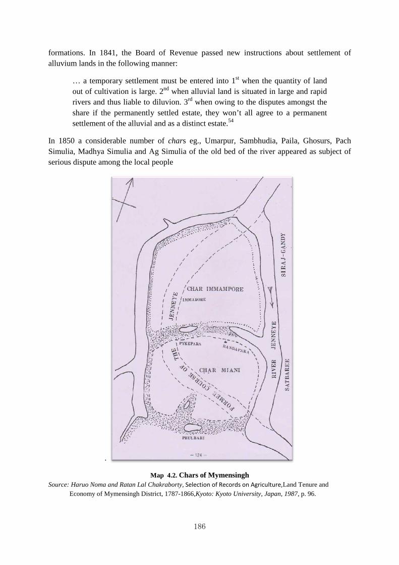
formations. In 1841, the Board of Revenue passed new instructions about sealluvium lands in the following manner:
… a temporary settlement must be entered into 1out of cultivation is large. 2rivers and thus liable to diluvion. 3share if the permanently settled estate, they won’t all agree to a permanent settlement of the alluvial and as a distinct estate.
In 1850 a considerable number of Simulia, Madhya Simulia and Ag Simulia of the old bed of the river appeared as subject of serious dispute among the local people
.
Source: Haruo Noma and Ratan Lal Chakraborty,Economy of Mymensingh District, 1787
186
formations. In 1841, the Board of Revenue passed new instructions about sealluvium lands in the following manner:
… a temporary settlement must be entered into 1st when the quantity of land out of cultivation is large. 2nd when alluvial land is situated in large and rapid rivers and thus liable to diluvion. 3rd when owing to the disputes amongst the share if the permanently settled estate, they won’t all agree to a permanent settlement of the alluvial and as a distinct estate.54
In 1850 a considerable number of chars eg., Umarpur, Sambhudia, Paila, Ghosurs, Pach ia, Madhya Simulia and Ag Simulia of the old bed of the river appeared as subject of
serious dispute among the local people
Map 4.2. Chars of Mymensingh Haruo Noma and Ratan Lal Chakraborty, Selection of Records on Agriculture,Land Tenure and
of Mymensingh District, 1787-1866,Kyoto: Kyoto University, Japan, 1987
formations. In 1841, the Board of Revenue passed new instructions about settlement of
when the quantity of land when alluvial land is situated in large and rapid
owing to the disputes amongst the share if the permanently settled estate, they won’t all agree to a permanent
s eg., Umarpur, Sambhudia, Paila, Ghosurs, Pach ia, Madhya Simulia and Ag Simulia of the old bed of the river appeared as subject of
Land Tenure and : Kyoto University, Japan, 1987, p. 96.

187
The authority was forced to provide new rule with a view to settling the disputes. The rule was:
The local Commissioner shall determine, with reference to the circumstances of each alluvial formation whether a temporary lease for any number of years, as a permanent settlement, shall be made. Should the party entitled to a settlement object to the consolidation of the Jumma assessed on the increment, with that of the original estate, the increment shall be settled at a distinct Mehal, and shall thenceforth be held separately liable for the Jumma assessed upon it. In all such cases the Commissioner will take special care that the boundary line between the alluvion and the settled estate is accurately and clearly defined in a map to be prepared for that purpose and recorded with the settlement proceeding, so as to prevent the occurrence of future doubt or dispute.55
Again in 1852 when a char consisted of 4637 bighas of cultivable fallow lands appeared opposite the Jail in pargana Alapsing, neither any farmer nor any proprietor agreed to pay any for the said lands. Following the Regulation XI of 1825 it was decided by the authority that:
… uncultivated tracts of good lands are to be given land free for four years, but the churs in this district are far from good and the fallow lands of the worst description being comprised chiefly of sand and grass-jungle. The lease is therefore extended from seven to ten years to give every possible encouragement to cultivators and farmers to come forward and take the lands.56
With the change of the course of rivers several chars sprang and contentions between the claimant parties were not infrequent. The authority, following the prescribed Regulation XI of 1825, conducted survey and necessary action was taken accordingly. The cases of chars Immampore, Miami and Phulbari may be mentioned in this regard.

Map 4.3. Map of
Source: Haruo Noma and Ratan LalLand Tenure and Economy of Mymensingh District, 1787University, Japan, 1987, p. 124.
The root cause of all these was the change of the course of river. In 1868 H. J. Reynolds,
Magistrate and Collector of Mymensingh reported that:
The days are past in which the Brahmaputra was here entitled to rank as one of the great rivers of India. The gradual formation of the upper part of its bed has diverted the greatchannel of Jamuna. The Brahmaputra is now a stream, which, in Mainmansinh at least, probably averages less than a quarter of a mile in width in the dry
188
Map of Chars Immampore, Miami and Phulbari
Haruo Noma and Ratan Lal Chakraborty, Selection of Records on Agriculture,Land Tenure and Economy of Mymensingh District, 1787University, Japan, 1987, p. 124.
The root cause of all these was the change of the course of river. In 1868 H. J. Reynolds,
strate and Collector of Mymensingh reported that:
The days are past in which the Brahmaputra was here entitled to rank as one of the great rivers of India. The gradual formation of chars and bars of sand in the upper part of its bed has diverted the great volume of water into the present channel of Jamuna. The Brahmaputra is now a stream, which, in Mainmansinh at least, probably averages less than a quarter of a mile in width in the dry
s Immampore, Miami and Phulbari
Selection of Records on Agriculture, Land Tenure and Economy of Mymensingh District, 1787-1866,Kyoto: Kyoto
The root cause of all these was the change of the course of river. In 1868 H. J. Reynolds,
The days are past in which the Brahmaputra was here entitled to rank as one of and bars of sand in
volume of water into the present channel of Jamuna. The Brahmaputra is now a stream, which, in Mainmansinh at least, probably averages less than a quarter of a mile in width in the dry

189
season, and which is in most places easily fordable. Two places in the District may specially be noted in which the course of the river was considerably changed within a comparatively recent period. One of these is the tract between Jamalpur and Pirapur; the other lies between Katiadi and Napit char in the south-eastern part of the District. From my recollections of Maimansinh, ten years ago, I can state with confidence, that in the interval the volume of water in the Brahmaputra has sensibly diminished; and it is not impossible, that in the lapse of another quarter of a century, this once great river may have dwindled away into an entirely insignificant. On the other hand, there is the chance that by the shifting of the sandbeds in the upper channel, the mass of water which now forms the Jamuna may be again diverted back to its old bed in the Brahmaputra. The diminution of water in the Brahmaputra, while it has exercised an unfavourable influence on the commercial prosperity of the District, has added greatly to its agricultural capabilities. The chars formed by the river are found to be extremely well-adapted to the growth of indigo and jute; and in process of time they become suited to other crops also. In the rainy season, the Brahmaputra is navigable for boats of the largest burden, and the current flows with great rapidity.57
Since then the process of silting up had gone on quickly making the river Jamuna most important. Later through diara survey the Government owned 180 estates which were settled temporarily.
In the district of Barisal rivers were liable to tidal action of two sources, from the Meghna to the north and from the Bay of Bengal to the south. Earlier in consequence of the influence of the current from the Bay of Bengal, the brackish water extended almost to half of the length of the district. But during the rains the water had become less brackish from the greater force and influence of the current and left the effect of commingling the water more completely than was practicable in the dry season when the current was naturally less active. The large rivers were so vigorously active in their courses that chars constantly emerged and sometimes disappeared. Both the alluvion and diluvion process was in action especially in the east where district of Barisal was washed away by the great stream of the mighty river Meghna. Several large island chars were formed by the estuary of Meghna of which the most important within the jurisdiction of Barisal were Dakhain Shahabazpur, Manpura, Bhaduria and Rabnabad. In the nineteenth century several chars developed at the mouth of Meghna and among them char Alexander, Falcon char, Brown char, Drummond char, char Fassion, char Victoria, char Bhuta and Lord Hardinge’s char were noteworthy. Char Bhuta was resumed in 1839 and an abadkari taluk was also granted with a view to reclaiming more lands. The Char Fasson situated further south of the river Meghna under the Bhola subdivision was reclaimed during the late nineteenth century.

190
Map 4.4. Map of Char Fasson
Curtsey: Banglapedia, 2004 edition.
At that time char Fassion contained about 3,830 acres of cultivated and 12,762 acres of cultivable land. Char Fasson was named after J H Fashion, District Magistrate of Barisal during 1885 to 1887. He established settlement here bringing ten educated and ten Ukhrait families from different parts of the country. The first two settled areas are known as Bhadrapara and Ukhrait Para even today. After 1910 Ramani Mohan Roy had conducted the survey and settlement work.58Char Fasson is now Upzila. There are more than 100 chars in the upazila, most noted of which are Char Kukri Mukri, Dhalchar, Char Manika, Char Aicha, Char Nizam and Char Newton.
Tippera was a district of undivided Bengal and after the Partition of India in 1947 a portion of it known as Comilla was ceded to Bangladesh, erstwhile East Pakistan by the Boundary Commission headed by Sir (Later Viscount) Cyril John Radcliffe (1899-1977). It would be better to emphasis on Comilla owing to the dearth of historical source-materials. The Meghna formed the eastern boundary of the old district Tippera, but the geographical and hydrological conditions of the district was influenced by other rivers like Brahmaputra and other hill rivers. J.E. Webster commented in his district gazetteers that:
The general characteristics of the Meghna are everywhere the same, a mighty rolling flood of great depth and velocity, sometimes spilt up into half a dozen

191
channels by sandbanks of its own formation, sometimes spreading out into a wide expanse of water which the eye cannot see across.59
The principal rivers of the Comilla district are the Meghna, the Titas and Gomati. Intermediate rivers are the Dakatia, the little Feni and Kala Dumoria. The river Gomati or Gumti posed serious problems during the rains and it was embanked in 19-669. Nevertheless, it was liable to frequent breaches, especially during the rains, which led ultimately to serious inundation and injury of crops in the field. Earlier the chars of the district were not inhibited due to their diluvion character, there were only used as source of collecting fuel for the use of salt making. However, the alluvial formations of Comilla had also important bearing upon its land system and reclamation process. In 1811, it was reported by the collector of Tipperah that:
As new churs were forming in the district daily which are capable of immediate cultivation, being a fine rice soil it has been for some time past my intention strenuously to have recommended to the Board that all unclaimed char lands should be attached and if possible immediately let it firm and that if there were any claims on the sequestered lands that the claimants should be ordered to prosecute for them and prove their right in the Zillah court.60
In fact, the char lands of Comilla had been much used by the agent of Malangies or the Salt Agent of whom most of them were Europeans. Because, the preparation of salt from the saline water of Comilla district was very easy and from the early nineteenth century it formed a lucrative business of the European entrepreneurs and it brought some ready to the East India Company also. It was earlier considered that:
… not to interfere with the salt lands or salt department as some of the churs are much more profitable to government from the quantity of salt they yield and which is made upon them, than any revenue government would derive from their being bought into cultivation. But there is a much larger tract of land occupied by the salt agents’ people than is required for the salt manufacture. Such land is cultivated indirectly and had kept under the pretext of Jarrah land. The zamindars I have been told would cultivate the churs and give up the Nairah or paddy straw which is much used as fuel in boiling the salt and there must be some of the churs and great part of the land become sweet and unfit for salt manufacture.61
But the Salt agent always pressed the authority hard for their possessions over the chars. According to the claims of the Salt Agent it was reported in 1811 that:
At present the claimants of the churs allege that the greater part of the churs is fit only for cultivation and a very small portion of them in deed is required or used by the salt agent. On the other hand the local officers of the salt department assert that the whole of the churs are required for Jarrah and Barrah and that no part of them at present uncultivated ought to be relinquished to the land holders.62
192
However, in 1827 the chars of the Comilla district number 82 were temporarily leased out following Regulation XI of 1825 as all thesechars were not situated in and around of any individual proprietors rather all of them were new accretions from the rivers.63 According the Regulation XI of 1825 a survey would have been conducted by Jarib Ameen with the help of Muherer and Peadas before giving lease of those char lands. The survey included the measurement of the char land and the jama assessed on it. In Comilla district many newly settled owners of char lands favoured Goorakatty rent which was levied on salt makers for the privilege of cutting firewood from the jungle. Even in the earlier half of the nineteenth century 27 char lands were leased out at with the opportunity of Goorakatty rent.64Because if Goorakatty rent was allowed, the original jama would have been reduced to a large extent. Later the demand of Goorakatty rent was reduced considerably. Sometimes char lands of Comilla, Sylhet, Noakhali and Mymensingh were interspersed due to the change of the course of the rivers and consequently claims of the landholders in all these cases were obvious. In 1840s a large portion of Chandpur had fallen out of cultivation and relapsed to its primeval jungle due to spread of malarial fever. Later the pressure of population impelled the surplus to seek fresh fields and the talukdars had granted long lease of waste lands at nominal rates along with the takavi (agricultural loan) advances.
In Chittagong general reclamation was known as 'noabad' which had its origin during the Mughal period. The East India Company too followed the same policy from the beginning of their rule in Chittagong. The Company had even tried to settle the Mughs in Chittagong who took asylum there following the political turmoil in Arakan. The noabad grants continued to operate for long time.65 The district of Noakhali, a part of tidally active delta, is bounded by Comilla district on the north, the Meghna estuary and the Bay of Bengal on the south, Feni and Chittagong on the east and Lakhmipur and Bhola on the west. Earlier it was very difficult to locate the western boundary of the district owing to the constant changes in the channel of Meghna. The Meghna is the great river, but originally it had been the only estuary of the rivers of Surma Valley. The most striking feature of the town and villages of Noakhali is the presence of numerous tanks of ponds which worked to prevent the entering of brackish water and to provide drinking water, as water in and around the district was always very salty. The number of tanks in Noakhali in 1904-05 was 17,985.66Whatever the historical discourse about the Noakhali district presents its long antiquity, there is not doubt about the fact that the district was in a constant process of alluvion and diluvion. Another interesting physical and geographical configuration of the district of Noakhali was the presence of many canals or khals and some of them were dug by the people for utmost necessity. Among those canals Dakatia Khal, Bhawanganj Khal, Mahendra Khal, Noakhali Khal etc. Many surveys which were conducted at different times demonstrate changes in the physical and geographical configuration of the district of Noakhali. It is worthy to note that the district of Noakhali was exposed to constant and cyclones and inundations from the time immemorial.
The district of Noakhali was and still is composed of innumerable chars forming constantly. In the later half of the nineteenth century reclamation of the chars of Noakhali received momentum when land man had started to decline. It was reported by the Collector of Noakhali in 1859 that:

193
The Chur Victoria was taken possession of as a new formation on the 7th December, 1858 by planting a bamboo stake on the spot in the usual manner and preparing a vernacular proceeding as a record of the fact.67
Planting a bamboo on a place symbolize the initial possession of a land, the system was current in many places of Bengal. The formation of a char does not necessarily mean a permanent place fit for dwelling. It was liable to erosion due to flood, cyclone and inundation that might be occurred at any time of the year and such cases were not infrequent. It is evident from the report of the Collector of Bhulloah (Noakhali) that:
The land is an old formation secure against any thing but such floods as would affect ever the mainland, and not only free from jungle but the greater portion had been previously brought under cultivation so that the ryots who had deserted it on the approach of the waters would in a few months have returned or at least within a year, and the greater portion of the formerly cultivated land soon redeemed.68
The formation of alluvial land was very much common in Noakhali side of the Meghna estuary. Many chars were not inhabitable; cultivation commenced thereon and most part was left for pasturage where cattle remained day and night. The condition of the chars inhabited by people and located in the vicinity of the seawas different. The inhabitants of this chars had to build some sort of embankment round the char commonly called by them ‘Mogra’ in order to prevent penetration of salt water.69 The char lands of Noakhali always suffered much from cyclone and inundation and the colonial government provided them necessary help in the form of takavi loan under the Land Improvement Act. The terms and period of settlement of the chars were not uniform in any district, rather it varied according to the location and condition and the principles laid down in the Khas Mahal regulations.70 In Noakhali the reclamation process assumed a complex character and resulted in an intricate land tenure pattern. The local authority pursued the colonial policy of ‘maximization of profit’ without paying any heed to the position of actual cultivators.71 The char land of the Noakhali district was divided into two groups e.g., Sonatpateet (and left uncultivated for a year)and Laikabad (land fit for cultivation and population habitation). In 1860s the local authority was forced to limit the period of lease. But after a decade the jotedars of Noakhali became reluctant to extend cultivation in the charlands. Because they incurred serious loss due to inundation and cyclone; moreover they had no certainty of their tenure holding in perpetuity. Furthermore, there were obstacles in getting the lease of the char land when other contending parties who created situation completely different. The Muslims of Bengal, in general, believed that if any mosque of ‘Dargah’ of their so-called saint was built in any place, it could never be settled to any other parties considering the place holy. But the British Government had not paid any heed to these activities. It was reported by Edward Paxwell, the Agent of Messers Courzon Zemindar that:
In support of this statement I have respectfully to submit that several cases have already been decided by the Deputy Magistrate if this district implicating the Bownchurn zamindar servants as the promotees (sic) of the present

194
disturbed state of the public peace, as conniving at unlawful assemblies and that several others cases are pending in which they with the said Dinonath Banerjee are defendants. Further that some 25 men have been arrested for creating a ‘Durgah’ and 25 or more are still at large. Having resisted the first attempt of the Police to arrest them and the succeeding effort of Police to do so have failed in consequence of the departments having either left the chur, or, being warned conceal (sic) themselves at the approach of the Police.72
In addition to these, the British authorities seldom trust on the general character of the char dwellers. It had often been said that:
The people of chur lands are very wicked, famous for telling lies. The residents of Sidhi combined together and tried best to conceal their profits by various means, but failed on their attempt.73
However, in spite of such impediments large numbers of Chars were reclaimed in the later half of nineteenth century. Some chars of Noakhali were belonged to gang of dacoits who carried on their plundering activities in some areas. The Officiating Magistrate of Noakhali remarked that:
I have the honour to state that the inhabitants of chur Balmmara number 8224 and those in chur Monasha 7895 they are Mussulman; the old inhabitants are said to have belonged to gangs of dacoits, who plunder without detection enough to enable them to purchase cultivators of the soil. The convicted and arrested thieves and those suspected are Mussalmans; they all profess themselves to be respectable cultivators of the land – they are able boatmen, leave their homes on pretence of trading –visit the surrounding districts as hide merchants – commit dacoities whenever an opportunity offers – conceal the plunder and return to their homes.74
4.14 Forcible Occupation of Char Land in the Earlier Half of the 20th Century
In Bengal the forcible occupation of char is locally known as ‘char dakhal’ which is in reality a common feature during the colonial rule and even now. The trend of forcible occupation of char land, which gained some importance in the later half of the 19th century, continued almost unabated and received its momentum in the earlier half of the 20th century. The forcible occupation of char lands by the gangsters was sometime noticeable in the 19th and the 20thcenturies Bengal. Usually the khaschars or Government islands were their main targets. It will be a futile exercise if attempt is taken to record such history as a whole in view of the vastness and magnitude of such forcible occupation of the chars by the gangsters. Henceforward, it is better to provide the readers a peep into the problem through case studies. In the district of Mymensingh a leader and his men had succeeded in establishing a reign of terror by mobilizing all the bad characters of the neighbourhood into a gang and the number of recruits was going up by leaps and bounds. They also used to cut and forcibly take away paddy from the fields of the char without the least pretensions to any right or possession and they even went the length of extorting tolls or rents from persons whom they could fleece

195
with impunity. The grave situation ultimately called for Police intervention and consequently a fierce fighting ensued between the gangsters and the Police, who being forced opened fire leading several causalities. According to the report:
Should anybody happen to raise his voice to protest against their misdeeds, he was forcibly dragged out his house and beaten. On the pretence of settling dispute by arbitration, they used to enforce their decision on the unwilling parties by terrorising them. They urged local people to join their parties (tarika) and freely assaulted any person who refused to do it at their bidding. We were shown a number of processes and parwanahs which these self-appointed rulers served through their peadas and which clearly revealed the gangster methods they were employing for bringing the people under their tyrannical away.75
As a mater of fact the party had set up parallel machinery for the administration of the char. They had their own courts and imposed fines which they realized from their unfortunate victims under the threats of physical torture. The entire population of the char was terror-stricken by their acts of oppression. Another singular feature of the organization was that the members of the party had their own uniforms made for them by a tailor brought from elsewhere for the purpose. Practically the party gave the char dwellers the impression that Government had abdicated in their favour, and any person who was bold enough to cross over to the other side of the river and report their activities to the Police at would be met with condign punishment. Such was the scenario of the char land reclamation in the early half of the 20th century Bengal. Spectacular changes occurred in char land reclamation after the Partition of India and the creation of Pakistan in 1947. The pressure of population had increased significantly on the one hand and political polarization centering round the char land reclamation assumed complicated nature.
196
Notes and References
1. W.W. Hunter, The Annals of Rural Bengal, London: Smith, Elder and Co., 1868, pp. 26-30.
2. Ratan Lal Chakraborty, “Some Aspects of the Anglo-Arakanese Relations, 1760-1785”, Journal of the Asiatic Society of Bengal, Vol. XX, No.3, pp. 41-50.
3. Frederick Eden Pargiter, Revenue History of Sundarban from 1765-1870, Calcutta, 1885 (reprinted 1934) and F.D. Ascoli, Revenue History of Sundarban from 1870-1920, Calcutta: The Bengal Secretariat Book Depot, 1921.
4. C.D. Field, Introduction to the Regulation of the Bengal Code, London, 1888 (reprinted 1930), p. 33.
5. For details see, W.W. Hunter, Movement of the People and Land Reclamation Schemes: Collection of District Reports, Calcutta, 1885; D. Rothermund, “A Survey of Rural Migration and Land Reclamation in India, 1885”, The Journal of Peasant Studies, Vol. 4, No.3, April, 1977.
6. In this regard the following works namely S. G. Panandikar, The Wealth and Welfare of the Bengal Delta, Calcutta: Calcutta University Press, 1926; Birendranath Ganguly, Trends of Agriculture and Production in the Ganges Valley: A Study in Agricultural Economics, London: Methuen & co. Ltd, 1938; George Blyn, Agricultural Trends in India, 1891-1947: Output, Availability and Productivity, Philadelphia: University of Pensylvania, 1966; Sirajul Islam, Rent and Raiyat Society and Economy of Eastern Bengal, 1859-1928, Dhaka: Asiatic Society of Bengal, 1989; Ratan Lal Chakraborty, “Reclamation Process in Bengal Delta”, in Imagescapes of the Six Great Asian Deltas in the 21st Century, Yoshihiro Kaida ed., Center for Southeast Asian Studies, Kyoto, University, Japan, 2001 are worthy to mention.
7. Clements K. Markham, Major James Rennell and the Rise of Modern English Geography, London: Cassell And Company, Limited, 1895.
8. “Letter from the Collector of Mymensingh to the Commissioner of Revenue for the Division of Dhaka, 8 July, 1857”. Mymensingh District Records, Letter Sent, Vol. 34, pp. 127. Quoted from Haruo Noma and Ratan Lal Chakraborty, Selection of Records on Agriculture, Land Tenure and Economy of Mymensingh District, 1787-1866, JSARD Working Paper No. 4, CSEAS Research Report Series, Kyoto, 1987, pp. 112-13.
9. The Changes of riverine of Bengal have been discussed in detail by R.K. Mukherjee and Kanangopal Bagchi. For details see, R.K. Mukherjee, The Changing Face of Bengal: A Study of Riverine Economy, Calcutta: University of Calcutta, 1938; Kanangopal Bagchi, The Ganges Delta, Calcutta: University of Calcutta, 1944.
10. R.K. Mukherjee, The Changing Face of Bengal, p. 137.
197
11. F.G. Wigley, The Bengal Code, Vol. 1, Calcutta: The Bengal Secretariat Book Depot, 1913, Fourth Edition, p. 79.
12. Ibid.
13.Ibid., p. 323.
14. T. Hussain, Land Rights in Bangladesh: Problems and Management, (Dhaka: University Press Limited, 1995), p. 43.
15. Abul Barkat, Prosanta K. Roy and Mr. Shahnewaz Khan, Charland in Bangladesh: Political Economy of Ignored Resources, Dhaka: Pathak Shamabesh, 2007, p. 80.
16. F.G. Wigley, The Bengal Code, Vol. 1, p. 368.
17. F.G. Wigley, The Bengal Code, Vol. 2, Calcutta: The Bengal Secretariat Book Depot, 1914, Fourth Edition, p. 154.
18. Abul Barkat, Prosanta K. Roy and Mr. Shahnewaz Khan, Charland in Bangladesh: Political Economy of Ignored Resources, p. 82.
19. For details, see, Md. Altaf Hossain, Land Laws of Bangladesh, Dhaka: Hira Publications, 2008, pp. 161-64.
20. Government of East Bengal, B-Proceedings, Department of Food and Agriculture, Branch- Development, Bengadesh National Archives, Bundle No. 16, November,1956, Proceeding No. 5.
21. “The Chur Victoria was taken possession of as a new formation on the 7th December, 1858 by planting a bamboo stake on the spot in the usual manner and preparing a vernacular proceeding as a record of the fact.” Letter from the Collector of Noakhali to the Commissioner of Revenue, 16th Division, Chittagong, 13 December, 1859. Noakhali District Records, Letter Sent, Vol. 41, pp. 146-47. Haruo Noma and Ratan Lal Chakraborty, Selected Records on Agriculture, Land Revenue, Economy and Society of Noakhali District, 1849-1878, JSARD Working Paper, No. 15, Dhaka, 1990, pp. 102-103.
22. “Letter from the Collector of Tipperah to the President and Members of the Board of Revenue, 14 May, 1811”. Comilla District Records, Letters Sent, Vol. 338, pp 143-56. Ratan Lal Chakraborty and Haruo Noma, Selected Records on Agriculture and Economy of Comilla District, 1782-1867, JSARD Working Paper No. 13, Dhaka, 1989, p. 95.
23. Prafulla Chandra Guha, “Chare Bashati” (Settlement in the Char), Bharatbarsha (a Bengali Monthly), 1927, pp. 773-75.
24. “Letter from W.H. Martin, Collector of Faridpur to J. Sowis, Commissioner of Revenue, 15th Division, Dacca, 18 May, 1836”, Faridpur District Records, Bengal National Archives, Letter Sent, Vol. 69, pp. 50-51.

198
25. “Letter from H.S. Dampeir, the Judge of the Foujdary Adawlat to J.D. Ward, Assistant Magistrate of Panba, 4 June, 1857”. Pabna District Records, Bengal National Archives, Letter Sent, Vol. 229, pp. 259-61.
26. Ratnalekha Roy, Change in Bengal Agrarian Society, c1760-1850, Delhi: Manohar, 1979, p. 210.
27. Dhaka Prakash, a vernacular weekly newspaper published from Dhaka, 2 August, 1872, pp. 250-51.
28. Sirajul Islam, Bengal Land Tenure: The Origin and Growth of Intermediate Interests in the 19th century, 1985, pp. 58-59.
29. Mr. Harun Rashid Helali, “Chaffasson Upazila”, in Banglapedia, The Asiatic Society of Bangladesh, CD edition, 2004.
30. R.H. Colebrooke, “On the Course of the Ganges through Bengal”, Asiatick Researches, Vol. 7, 1803, p. 4.
31. H. J. Reynolds, Report on the History and Statistics of District of Mymensingh, in Principal Heads on the History and Statistics of the Dacca Division, Calcutta: E.M. Lewis, Calcutta Central Press Company Limited, 1868, p. 220.
32. Rajendra Lal Banerji, Notes on Surveying, Calcutta: Bengal Secretariat Book Depot, 1921, p. 93.
33. F.A. Sachse, Bengal District Gazetteers, Mymensingh, Calcutta: Bengal Secretariat Book Depot, 1917, p. 102.
34. Ibid.
35. J.C. Jack, Bengal District Gazetteers, Bakarganj, Calcutta: Bengal Secretariat Book Depot, 1918, pp. 92-93.
36. G.E. Lambourn, Bengal District Gazetteers, Malda, Calcutta: Bengal Secretariat Book Depot, 1918, p. 79.
37. Rajani Kanta Sen, Report of the Special Ganges Diara Survey, 1908-1915, Patna: Superintendent, Government Printing, Bihar and Orissa, 1915, p. 1.
38. For the diara surveys and surveys of riparian areas, the following books may be consulted: Hara Kishor Biswas, Final Report on the Diara Operations in the Bakarganj District, 1910-15, Calcutta, 1916; B.C. Prance, Final Report on the Survey and Settlement Operations in the Riparian Area of District Tippera conducted with the Faridpur District Settlement, 1909-15, Calcutta, 1916; B.C. Prance, Final Report on the Survey and Settlement Operations in the Riparian Areas of District Pubna Surveyed in the Course of Faridpur Settlement, 1917, Calcutta: Bengal Secretariat Press 1918.
39. Lewis Sydney Steward O’Malley, Bengal District Gazetteers,Murshidabad, Calcutta: Bengal Secretariat Book Depot, 1914, pp. 10-11.
199
40. Quoted in William Wilson Hunter, A Statistical Account of Bengal, Vol. 9, Murshidabad and Pabna, London: Trubner & Co, 1874, pp. 27-28.
41. Ibid., p. 28.
42. Lewis Sydney Steward O’Malley, Bengal District Gazetteers,Murshidabad, p. 7.
43. Lewis Sydney Steward O’Malley and Monomohon Chakraborti, Bengal District Gazetteers, Howrah, Calcutta: Bengal Secretariat Book Depot, 1909, p.7.
44. Ibid., p. 9.
45. William Wilson Hunter, A Statistical Account of Bengal, Vol. 3, Midnapur, Hugli (including Howrah), (London: Trubner & Co, 1874), p. 255.
46. Ibid., p. 257.
47. William Wilson Hunter, A Statistical Account of Bengal, Vol. 7, Maldah, London: Trubner & Co, 1874, p. 24.
48. G.E. Lambourn, Bengal District Gazetteers, Malda, Calcutta: Bengal Secretariat, 1919), p. 56.
49. Quoted in Lewis Sydney Steward O’Malley, Bengal District Gazetteers, Rajshahi, Calcutta: Bengal Secretariat Book Depot, 1916, pp. 12-13.
50. Lewis Sydney Steward O’Malley, Bengal District Gazetteers,Pabna, Calcutta: Bengal Secretariat Book Depot, 1923, p. 8.
51. William Wilson Hunter, A Statistical Account of Bengal, Vol. 5, Faridpur, London: Trubner & Co, 1874, p. 268.
52. Masud Reza, ‘Char Bhdrashan Upazila’, Banglapedia, CD edition, 2004.
53. Haruo Noma and Ratan Lal Chakraborty, Selection of Records on Agriculture, Land Tenure and Economy of Mymensingh District, 1787-1866, (Kyoto: Kyoto University, Japan, 1987), p. 73.
54. Ibid., p. 95.
55. Ibid., p. 97.
56. Ibid., p. 109-110.
57. H. J. Reynolds, Report on the History and Statistics of the District of Mymensingh, in A.L. Clay, Principal Heads of the History and Statistics of Dacca Division, Calcutta: Calcutta Central Press Co., Ltd., 1868, p. 223.
58. In the stock list of the Barisal District Collectorate Record the typed copy of the Survey and Settlement Report of Char Fasson is found in name, but the copy is not available. Ramani Mohan Roy, The Survey and Settlement Report of Char Fasson (typed), Barisal Collectorate Record Room, 1913.

200
59. E.J. Webster, East Bengal and Assam District Gazetteers, Vol. III, Tippera, Allahabad: Pioneer Press, 1910, p. 4.
60. Letter from J.Wemyss, Collector of Tipperah to President and Members of the Board of Revenue, 14May, 1811. Comilla District Records, Letter Sent, Vo. 338, pp. 148. Quoted from Ratan Lal Chakraborty and Haru Noma, Selected Records on Agriculture and Economy of Comilla District 1782-1867, JICA, Dhaka: Bangladesh, 1989, pp. 95-96.
61. Ibid.
62. Ibid.
63. Letter from J. Lowis, Acting Collector of Comilla to the Secretary to the Board of Revenue, 25 May, 1827. Comilla District Records, Letter Sent, Vol. 350, pp. 220-25. Quoted from Ratan Lal Chakraborty and Haru Noma, Selected Records on Agriculture and Economy of Comilla District, 1782-1867, JICA, Dhaka: Bangladesh, 1989, pp. 104-11.
64. Letter from T. Bruce, Deputy Collector of Comilla to the Commissioner of Chittagong, 8 December, 1835. Comilla District Records, Letter Sent, Vol. 362, pp. 64-73. Quoted from Ratan Lal Chakraborty and Haruo Noma, Selected Records on Agriculture and Economy of Comilla District, 1782-1867, JICA, Dhaka: Bangladesh, 1989, pp. 118-25.
65. Letter Magistrate of Noakhali to the Commissioner of Revenue, 9 April, 1872. Noakhali District Records, Letter sent, Vol. 61, pp. 353-54. Quoted from Haruo Noma and Ratan Lal Chakraborty, Selected Records on Agriculture, Land Revenue, Economy and Society of Noakhali District, 1849-1878, JSARD Working Paper, No. 15, Dhaka, 1990, p. 142.
66. J.E. Webstar, Bengal District Gazetteers, Noakhali, Allahabad: Pioneer Press, 1911, p.10.
67. “Letter from C.E. Lance, Collector of Noakhali to the Commissioner of Revenue, Chittagong Division, 13 December, 1859”. Noakhali District Records, Letter sent, Vol. 41, pp. 146-47. Quoted from Haruo Noma and Ratan Lal Chakraborty, Selection of Records on Agriculture, Land Tenure and Economy of Mymensingh District, 1787-1866, Dhaka: JICA, 1987, pp. 102-103.
68. “Letter from the Collector of Bhulloah to the Commissioner of Revenue, Chittagong Division, 6 April, 1861”. Noakhali District Records, Letter sent, Vol. 43, pp. 68-77. Quoted from Haruo Noma and Ratan Lal Chakraborty, Selection of Records on Agriculture, Land Tenure and Economy of Mymensingh District, 1787-1866, Dhaka: JICA, 1987, p. 109.
69. “Letter Deputy Magistrate of Noakhali to the Magistrate of Noakhali, 27 November, 1867”. Noakhali District Records, Letter Received, Vol. 31, pp.629-33. Quoted from Haruo Noma and Ratan Lal Chakraborty, Selected Records on Agriculture, Land Revenue, Economy and Society of Noakhali District, 1849-1878, JSARD Working Paper, No. 15, Dhaka, 1990, p. 11.

201
70. For some details of the Khas Mahal, see “Khas Mahal”, Memorials of India Government; being a Selection from the Papers of Henry St. George Tucker (Land Revenue), The Calcutta Review, Vol. XXV, July-December, 1855, pp. 1-19.
71. “Letter from the Collector of Noakhali to the Commissioner of Revenue, 16th Division, Chittagong, 7 September, 1859”. Noakhali District Records, Letter Sent, Vol. 41, pp. 114-16. Quoted from Haruo Noma and Ratan Lal Chakraborty, Selected Records on Agriculture, Land Revenue, Economy and Society of Noakhali District, 1849-1878, JSARD Working Paper, No. 15, Dhaka, 1990, p. 73.
72. “Letter from Edward Paxwell, the Agent of Messers Courzon Zemindar to W. Goron Young, Commissioner of Chittagong, 30 March, 1865”. Noakhali District Records, Letter Received, Vol. 26, pp. 399-403. Quoted from Haruo Noma and Ratan Lal Chakraborty, Selection of Records on Agriculture, Land Tenure and Economy of Mymensingh District, 1787-1866, Dhaka: JICA, 1987, p. 132.
73. “Letter from an Assessor to the Collector of Noacally, 17 November, 1869”. Noakhali District Records, Letter Received, Vol. 29, pp. 471-72. Quoted from Haruo Noma and Ratan Lal Chakraborty, Selection of Records on Agriculture, Land Tenure and Economy of Mymensingh District, 1787-1866, Dhaka: JICA, 1987, p. 140.
74. “Letter from L. L .B. King, Officiating Magistrate to the Commissioner of Revenue, Chittagong Division, 9 April, 1872”. Noakhali District Records, Letter Sent, Vol. 61, pp. 353-54. Quoted from Haruo Noma and Ratan Lal Chakraborty, Selection of Records on Agriculture, Land Tenure and Economy of Mymensingh District, 1787-1866, Dhaka: JICA, 1987, p. 109.
75. Report on the Enquiry held by S.N. Chatterjee, Additional District Magistrate, Mymensingh, into the Police Firing Incident at the Khas Amarpur on the 10th December, 1943, under Police Regulation. Mymensingh District Collectorate Record Room, Fly-Leaf English Correspondence, Branch – Miscellaneous, No. XXIII.

202
Chapter 5
Char Land Reclamation Process in Bangladesh since Independence
Abstract of the Chapter
In fact, the Bengali speaking peoples, who were accustomed to live in peace in Bengal proper in their own natural habitat, found it difficult stay in those places where the geographical configuration were completely different. Having no other alternative, these people had started to reclaim alluvial tracts without any proper proprietary right of the land. Such reclamation processes were dominant in the alluvial tracts of Eastern Bengal during the colonial rule. Here we find the traces of historical geography, geo-politics and environmental conditions as well. Of course, competition, collaboration, rivalries were common phenomenon. Nevertheless, they preferred to occupy the alluvial tracts of Bengal in the beginning 20th century. This aspect has been formed the principal agenda in the above chapter. Discussion on this chapter will continue upto 1947 when ‘the great divide’ occurs resulting in the creation of new province popularly known as East Pakistan. Erstwhile Bangladesh was in Bengal, which ceded in 1947 as East Pakistan and became a part of Pakistan. Later in 1971, Bangladesh emerged as an independent, sovereign country with its own national identity. This aspect has not been highlighted by the economist, sociologist, anthropologist and also historian.
The main foci of this thesis are to analyse the process of land reclamation in Bengal delta since the colonial rule. In the preceding chapters attempts have been made to examine the changing course of the principal rivers of the Bengal delta, the basic characteristics of the Bengal delta, general reclamation process in Bengal, reclamation process in diverse geographically and topographically configured areas of Bengal and alluvial land reclamation process in Bengal during the colonial rule. From now on our discussion will concentrate on Bangladesh – a newly independent country, where formation of chars is a continuous process especially in the active and tidally active delta consistently. The formation of chars in the Western part of Bengal has almost ceased, but in the Eastern part of Bengal or Bangladesh the formation of chars is regular phenomenon. Interestingly enough, geo-politics is also associated with the reclamation process which assumes different characters in different areas.
Bangladesh is well-known for recurrent floods because the country is situated on the deltaic floodplains of the Brahmaputra, Jamuna, Gagnes, Padma and Meghna rivers. The Brahmaputra-Jamuna river channel is strongly interweaved owing the presence of multiple channels, in most cases separated by alluvial islands which through their constant shifting of
203
course erode the islands and adjoining river banks. In the process, they deposit new alluvium in places which, in turn, forms new alluvial chars. The Jamuna is tarnished for its shifting sub channels and for the formation of fertile silt islands or chars. These alluvial river chars are different from islands for the reasons that the chars are sometimes temporary in nature, they are easily vulnerable to frequent floods and finally the identity of the char people are quite different from that of the mainland.
Long before the partition of India many rivers of west Bengal had lost its flow and became stagnant. But many of the rivers of East Bengal, though originated from mainly India, continue its normal flow and sometimes with serious velocity. As a result of this situation both the alluvion and diluvion activities of river continues unabatedly. However, during the course of our study we come across a considerable number of marine and estuarine chars, detached riverine char and chars attached with mainland. This aspect will be discussed later.
After the Partition of India in 1947 some shot of uncertainty prevailed in Bangladesh, erstwhile East Pakistan. During the partition India it was decided by the British Government and the political parties to divide Bengal in two parts as the Muslim-majority East Bengal wanted to join with Pakistan, which was 1200 square miles away from them. As a result a boundary commission was instituted under the chairmanship of Sir (Later Viscount) Cyril John Radcliffe (1899-1977) and in consequence East Bengal became East Pakistan. But unfortunately the authority of Pakistan had initially ignored the demand of state-language Bengal and finally East Pakistan was deprived from all sorts of economic development and also the demand of provincial autonomy. Such situation continued for nearly for 24 years. Finally the Bengali nationalism emerged and East Pakistan earned its independence through War of Liberation in 1971 and appeared as a new independent state known as Bangladesh. However, during these 24 years all the sectors of Bangladesh were seriously neglected. These include preservation of archival documents, development administrative structure and legal rights of land and so on. The result was very much damaging in many cases. We do not have enough archival source-materials at our disposal for constructing the history of char lands during the period 1947 and 1971.
This chapter is based on newspaper clippings, published and unpublished reports of several NGOs available in the websites, books and articles published in learned journals of home and abroad. But as we know that numerous marine and estuarine chars, detached riverine char and chars attached with mainland had formed during this period and some of them were eroded after sometime. It is neither possible to list up all the marine and estuarine chars, detached riverine char and chars attached with mainland, nor to discuss them in detail within the short frame of this chapter. Rather a wise way is left for us to highlight the main points and important issues regarding marine and estuarine chars, detached riverine char and chars attached with mainland. However, following is the short list of marine and estuarine chars, detached riverine char and chars attached with mainland developed during this period. Administratively, Bangladesh is now divided into 64 Zila (district) and 469 Police Stations (Upazilas). Upazilas are the lowest administrative units of Bangladesh.
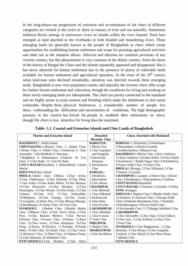
204
In the long-drawn-out progression of corrosion and accumulation of silt chars of different categories are created in the rivers or shore or estuary of river and sea naturally. Sometimes midmost blocks emerge in interweave rivers as islands within the river channel. Point bars emerged as land attached to the riverbanks in both braided and meandering rivers. These emerging lands are generally known to the people of Bangladesh as chars which create opportunities for establishing human settlement and scope for pursuing agricultural activities and other use as the situation allows. Alluvion and diluvion are common processes of any riverine country, but this phenomenon is very common in the deltaic country. From the dawn of the history of Bengal the Chars and the islands repeatedly appeared and disappeared. But it has never attracted for human settlement due to the presence of plenty of cultivable lands available for human settlement and agricultural operation. At the close of the 19th century when land-man ratio declined remarkably, attention was directed towards these emerging lands. Bangladesh is now over-populated country and naturally the riverine chars offer scope for further human settlement and cultivation, though the conditions for living and working on these newly emerging lands are inhospitable. The chars are poorly connected to the mainland and are highly prone to acute erosion and flooding which make the inhabitants to feel easily vulnerable. Despite these physical hindrances, a considerable number of people live there, withstanding the difficulties and uncertainties of conditions. The high demographic pressure in the country has forced the people to establish their settlements on chars, though life chars is less attractive for living than the mainland.
Table- 5.1. Coastal and Estuarine Islands and Char Lands of Bangladesh
Marine and Estuarine Island Detached Riverine Char
Chars Attached with Mainland
BAGERHAT :1. Dubla Island CHITTAGONG: 1.Bhasan Char; 2. Jahajir Char; 3.Dimer Char; 4. Pakhir Char; 5.Sandwip; 6. Char Amanulla; 7.Huridrakhali; 8. Haramia; 7.Magdhara; 8. Rahamatpur; 9.Sakrait; 10. Urir Char; 11.Char Badu; 12. Char Pir Baks COX’S BAZAR: Kutubdia; 2. Moheshkhali; 3.Saint Martin KHULNA: Putney Island BHOLA: 1.Balur Char; 2.Bhola; 3.Char Aicha; 4.Char Chakrimara; 5.Char Darbesh; 6.Char Dhal; 7.Char Kabir; 8.Char Kukri Mukri; 9.Char Mamun; 10.Char Moazzem; 11.Char Motahar; 12.Char Neamatpur; 13.Char Nizam; 14.Char Patila; 15.Char Tufania; 16.Char Uril; 17.Char Zahiruddin; 18.Manpura; 19.Char Changa; 20.Char Goala; 21.Gangalia; 22.Hazir Hat; 23.Char Bhusan Bhanga; 24.Ramdaspur; 25.Sonar Char; 26.Totar Char NOAKHALI : 1.Badner Char; 2.Bakshi Majhir Char; 3.Bhasan Char; 4.Char Nurul Islam; 5.Char Piya; 6.Char Ramani Mohon; 7.Char Parvez; 8.Damar Char; 9.Gosair Char; 10.Hatia; 11.Burir Char; 12.Char Iswar; 13.Char Jahajmara; 14.Char King; 15.Harni; 16.Nilchira; 17.Sonadia; 18.South Hatia; 19.Suk Char; 20.Jahajir Char; 21.Char Clark; 22.Moulovir Char; 23.Dhal Char; 24.Nijhum Dwip; 25.Char Mukaria; 26.Shahebnir Char PATUAKHALI: 1.Char Burhan; 2.Char Hare;
BARGUNA: 1. Bhola Char 2. Char Gopalpur
and Nangalia 3. Dariarchar
Khajuria 4. Kachubariar
Char BARISAL: 1. Dhulkhola 2. Shyastabad 3. Char Monai CHANDPUR: 1. Char Bhairabi 2. Char Nilkamal 3. Riskhatwali 4. Ishan Bala 5. Char Koralia LAKSHMIPUR: 1. Char Abdullah 2. Char Gazaria 3. Tailer Char PIROJPUR: 1. Majher Char SHARIATPUR: 1.Char Kachikata
BARISAL: 1.Alimabad; 2.Gobindapur; 3.Harinathpur; 4.Hazila Gurabdi; 5.Andharmanika; 6.Bhasan Char BAGERHAT: 1.Bholar Char; 2.Boro Ambaria; 3.Choto Ambaria; 4.Kotkar Khali; 5.Kobor Khali; 6.Kokilmoni; 7.Mujib Nagar Char; 8.Narkelbaria; 9.Passur Nadir Char; 10.Selar Char BHOLA: 1.Bhanga; 2.Char Nilkamal; 3.Char Velumia; 3.Gazaria CHANDPUR:1.Gazipur; 2.Haim Char; 3.Hanar Char; 4.Ibrahimpur; 5.Rajrajeshwar; 6.Sakhua CHITTAGONG: Banskhali COX’S BAZAR: 1.Chakaria; 2.Sonadia; 3.Ukhia FENI: Sonagazi KHULNA: 1.Bagilar Char; 2.Bhadra Nadir Char; 3.Chunkuri; 4.Chunkuri Char; 5.Dacope Nadir Char; 6.Dakshin Banishanta Char; 7.Dashalia; 8.Haliabaranpara; 9.Koyra Nadir Char; 10.Kuchanadir Char; 11.Tildanga Jaliakhali Char LAKSHMIPUR: 1.Char Alexander; 2.Char Algi; 3.Char Falkon; 4.Char Gazi ; 5.Char Kalkini; 6.Jaliar Char; 7.Patar Char NOAKHALI: 1.Char Baggardona ; 2.Char Benirtek; 3.Char Bouya; 4.Char Gangchil Torabali; 5.Char Majid; 6.Char Mora Dona; 7.Muhuri Char PATUAKHALI:

205
3.Char Kachua; 4.Jailar Char; 5.Char Kasem; 6.Char Montaz; 7.Char Bastin; 8.Char Rustam; 9.Char Taposhi; 10.Char Yunus; 11.Char Chhota Basdia; 12.Char Bangla; 13.Char Haldar; 14.Char Halim; 15.Rangabali; 16.Taktabunia; 17.Rupar Char; 18.Shibar Char; 19.Char Biswas; 20.Char Kazal; 21.Char Monohar; 22.Char Nazir; 23.Char Nilkamal; 24.North Char; 25.Sonar Char; 26.Under Char.
1.Bara Baisdia; 2.Chalita Bunia; 3.Char Ganga; 4.Kalapara PIROJPUR: 1.Char Lakhakati; 2.Soyna Raghunathpur; 3.Nileti Bijoynagar SATKHIRA: 1.Chakla; 2.Chuna Nadir Char SHARIATPUR: 1.Char Jalapur; 2.Char Kumaria; 3.Char Tarabunia
Source:Inventory of Coastal and Estuarine Islands and Char Lands, 2001.
It appears from the above table that the number of Marine and Estuarine Islands is 70, and the Detached Riverine Char is 19, while the number of Char Attached with the Mainland is 68. This survey was done in 2001 and within the last 15 years many Islands and Chars may have been appeared and disappeared. Unfortunately, the Bangladesh Bureau of Statistics has no upto-date account of the chars and islands of the country. The Marine and estuarine islands of Bangladesh have certain characteristics which are different from other lands. Naturally the Marine and estuarine islands of Bangladesh are submerged under water. But these could be protected from the tidal erosion through constructing embankments. Interestingly, while these islands in the Ganges–Brahmaputra river delta are fast submerging, putting millions of inhabitants at risk of flooding, the neighbouring Sundarbans mangroves are stable from their natural shield of vegetation. The striking contrast between the tidal inundation patterns of these landscapes highlights the impact of sediment starvation and the historical loss of elevation, which has severely exacerbated the effects of tidal inundation.
Bangladesh is mainly formed by sedimentation and accretion of rivers as they flow from the Himalayas to the Bay of Bengal. Extensive char areas have been created along the bed or basin of big rivers the Jamuna, the Padma and the Meghna. Char lands are the sandbars that emerge as islands within the river channel or as attached land to the riverbanks. The entire process of char formation would be completed within twelve to fifteen years. After fifteen years it is turn into stable char. The present study explores six-step development process of char livelihood and four-step development of agricultural practices. The resources of the less stable attached char like Char Konabari is agricultural dominated but most of the char dwellers are engaged in off farm activities. The bulk amount of yearly income comes from on farming activities rather than off farming activities. However off farming activities is also popular in an attached char dwellers due to easy communication but their contribution is not remarkable in respect to on farming activities. The present study shows that the char dwellers’ economic status stands below the poverty line compared to the present poverty data.
Despite poor living conditions, households continue to live in the chars because they simply have no alternative. Moving the char dwellers to safer areas is not feasible because land is so scarce in Bangladesh and is becoming increasingly so with the rising population. And experience has shown that attempts to prevent erosion and flooding through structural measures require constant and costly maintenance that is often not sustainable.' Interventions should therefore aim to support the livelihoods of char people so that they can make best use of their available resources and cope better with the hazardous environment.

206
“Who has a might, also has right” – it is an age-old Bengali epigram very commonly to that ‘might is right. The suitable expression of this proverb is found in the life of the char land dwellers whose lives are almost uncertain in the man-make situation there. There are many chars already settled by population where economic activities are conducted in full swing. But such scenario may change by illegal and forcible occupation of char lands. Before the enactment of East Bengal State Acquisition and Tenancy Act of 1950 there were the presence of multi-tired subinfeudation system and as a result the land interested intermediaries carried on many illegal activities not only their own areas but also other areas. As almost plain, waste and jungle lands were completely reclaimed by the first half of the 20th century, char lands became the prime target of these intermediaries. When a piece of char land emerged on the estuary of a river which was either declared khas land or distributed officially to any landless people. The char land was not then in a condition of human settlement. Some local ignorant poor people cleared the land and broadcasted aman or boro as was suitable. Taking this opportunity the intermediaries hired local lathials (armed people) with a view of harvesting paddy when paddy was ripen enough for garnering. The use of lathials was an age-old practice of the landed-interests of Bangladesh. At times of big strife between parties of intermediaries on grave issues like occupying newly emerged chars or settling any other dispute affecting possession or dispossession the lathials were employed.
The appearance of any char immediately invited attention of the land-grabbers who carried on illegal multifarious and nefarious activities according to the situation allowed. Sometimes powerful people or groups, drawn from heterogeneous social and economic background, from different localities were associated in these land grabbing activities. A vivid picture may be gleaned from a near-contemporary account. This was an account of violence centering round the occupation of a char or harvesting a char for future occupation. According to the account such violence may occur all on a sudden or on a definite date. A number of lathials were hired by the contending parties, where allurement of considerable amount of money constituted important factor. In the beginning the lathials bid farewell from their very near relations (parents of wives) before coming to the field for fighting. They carried with them Ramda (large chopper), bows and arrows, shields, spear or harpoon and many other local weapons. The lathials formed a gang of their own and dressed in the same manner so as to identify immediately. In most cases, the lathials came by boat, sheltered in it and stayed in a place a few days before the incidence. Before the incidence they used to watch the place of attack several times. Before starting the fighting for paddy, the lathials jointly attended for a prayer with a humble pray of sure success. They had their own flags with them and started hostility shouting “Allah–o-Akbar” (God is great). The lathials had continued their fighting and sometimes thrown large quantity of chilly power if air was favourable to them. The chilly powder had its immediate effects on the other parties which caused their eyes inoperative. Such situation allowed the lathials to conduct their violence more vigorously than before. Both the groups of lathials fought against each other until they won or defeated. If a party of lathials won, a big feast was arranged for them and the land-grabber had to pay the stipulated money to the members of lathials which was earlier promised. In most cases, such incidents happened in a place from where the Police Station was situated very far. But the cases were not few when the Police authority was kept unknown. But in many cases the Police authority

207
remained indifferent getting bribe in advance. This was a common scenario of the activities of lathials when guns and other modern fighting weapons were not easily available. Later the situation changed and the nature and forms of violence in the char land also changed.1
5.1 Legal Aspects of Char Land Administration since 1947
The enactment of the East Bengal State Acquisition and Tenancy Act 1950 had important had manifold consequences on the society and economy of East of East Pakistan erstwhile Bangladesh. First of all, it abolished the Permanent Settlement system introduced in 1793 and virtually with this the zamindari system came to an end. Secondly all the intermediary interest between the government and tenant had lost its importance. Thirdly, it arranged a policy of redistribution of lands among the tenants.
Bangladesh is a delta and its landscapes are liable to changes due to the unpredictable change of the course of innumerable rivers. The existing laws that deal with the question of new formation by accretion were not favourable to the poor peasant. So the East Bengal State Acquisition and Tenancy Act 1950 laid down several new principles through which the new accretions were guided. The sections 87 and 88 dealt exclusively with the alluvion and diluvion conditions of the lands. However, the major changes that brought few changes were the following:
1. Rate of deduction of diluvion would be determined by the Government of Bangladesh;
2. According to section 86 of the East Bengal State Acquisition and Tenancy Act of 1950 that if land is lost due to river erosion, it can be given back to the original owner but on the conditions that the resurgence of the land must occur within 20 years and in such cases the original owner may get the land back by paying rent as settled by the revenue officer;
3. In case of the reappearance of land in situ, the original proprietors would be allowed to retain land “in his possession under section 20, or the limit laid down in section 90, whichever be greater, and such tenant or his successors-in-interest shall not have the right of re-possession of such excess area of land; such excess area shall vest in and be at the disposal of the Provincial Government.”2
4. Land gained by gradual attainment either from the recess of a river or of the sea, it would be considered as an increment to the holding of the tenant and he would be entitled to possess the land on payment of rent determined by the authority.
5. But in no case a tenant could possess land that exceeded his land ceiling in no circumstances.
Nevertheless, the above legal actions were not enough in the circumstances arose from the land-man ratio of Bangladesh. The area of present Bangladesh is 147,570 square kilometers and the population density is 834 persons per square kilometer. The growth of population is the following:

208
Table 5.2. Population of Bangladesh1801-2001 (in million)
Year 1801 1851 1901 1921 1941 1961 1981 2001
Population 14.5 20.3 28.9 33.3 42.0 50.8 89.9 129.25
Source: Banglapedia, CD edition, 2004.
It appears from the above table the population of Bangladesh has increased considerably. It has become triple than what was in 1941. But the inhabitable or main land has not increased coping with the growth of population. The number of landless population of Bangladesh is quite considerable and many of them are very poor. These landless people were either forced to leave their habitations owing to the river erosion or having no other alternative sheltered themselves in slums of the town. Nearly 300,000 and 400,000 new migrants arrive in towns each year in search of a better life, placing additional strain on already stretched services. Thousands settle in makeshift shelters in large informal settlements on government land, where there is no healthy situation. The slum dwellers try to earn livelihood from miscellaneous odd jobs in the city. Sometimes, they are evicted by the administrative authorities from the city.3Being debarred from the ancestral properties due to river erosion and having no secured life either in towns or in the villages most of them sailed in the hunt of new life somewhere else in the country. Many of them took shelter in the newly emerged char lands with the hope of getting a new lease of life.
5.2 Khas Lands in Bangladesh
The subject like the khas lands in Bangladesh is a complex topic to address. Khas land means lands owned by the Government. In fact, immediately after the Partition of India, the Government of Bangladesh erstwhile East Pakistan had no khas lands at its disposal. The Partition of India of India in 1947 had created serious political trouble and communal frenzy which, in turn, led to the large scale migration of the Hindu population to India. The Hindu community being puzzled with recurrent communal frenzy quickly left their mother land leaving their properties and belongings. At the same time, the migrants from Bihar came to East Bengal before and after the partition of India in 1947. The communal riots in Bihar immediately before and after the partition led to a large scale migration of the Muslims to East Bengal from Bihar, Orissa and West Bengal.4The Bihari population illegally had occupied some of lands left by the Hindus. Moreover, after the abolition of zamindari system, some lands came in the possession of the Government as khas lands. After the India Pakistan War of 1965, the lands left by the Hindus were declared as ‘enemy property’ and became khas property of the Government of East Pakistan.5 After the emergence of Bangladesh, an egalitarian term was used to denote the ‘enemy property’ as ‘vested property’ and also treated as khas lands.6 Meanwhile some waste lands of different districts of Bangladesh became cultivable and were treated as khas lands. Besides these, the gradually emerging char lands became settled char lands where settlement of population was also possible. These char lands were accepted by the Government of Bangladesh as khas lands.

209
Table 5.3. Khas Lands of Bangladesh
Division
Agricultural Khas land
(acres)
Non Agricultural Khas land (acres)
Khas Water bodies
Total
Closed (acres)
Open (acres)
Dhaka
207,135.97
62,282.00
17,146.53
110,801.15
397,365.65
Chi t tagong
156,734.31
1,339,115.43
11,279.48
31,429.13
1,538,558.2
0 Sylhet
129,764.12
120,491.82
72,746.94
26,196.49
349,199.37
Raj shahi
163,007.96
125,945.72
212,321.53
71,727.45
573,002.66
Khulna
51,714.01
36,728.04
27,407.00
33,626.49
149,475.54
Bar isal
94,652.45
1,790.92
4,834.33
210,838.67
312,416.37
Bangladesh
803,308.80
1,686,354.00
245,736.00
848,619.38
3,320,017.50
Source: Selim Raihan and Sohani Fatehin and Iftakharul Jaque, Access to Land and Other Natural Resources by the Poor: The Case of Bangladesh, South Asian Network on Economic Modeling (SANEM), Department of Economics, University of Dhaka, Bangladesh, June, 2009, p. 26.
The quantities of char lands as khas lands were not few, although most of those lands were located in different coastal areas of Bangladesh. However, considering the magnitude of the problems of landless people the Government of Bangladesh made several attempts to protect landless. As a result the Presidential Order No. 98 of 1972 was promulgated and this order laid down the following principle for the distribution of khas lands:
The landless family and family having land below 1.5 acres would be eligible for getting possession of khas land;
Each family would be eligible to get 1.5 acres of khas land, but this principle may be flexible for the joint family;
Formation of agricultural co-operative is obligatory in case of getting lease of large quantity or size of khas lands.
The Awami League Government formed another Land Revenue Committee in 1974, suggested that all char lands would thus be at the disposal of the government and would be available for settlement by the poorer classes of agriculturists in accordance with government policy and the provisions of the law. There were further amendments to this provision done at different times following the principles of the East Bengal State Acquisition and Tenancy Act of 1950. But in practice, the rule of acquisition of the alluvion and diluvion lands by the state and their proper distribution among the rural poor and landless

210
was always manipulated by the changes made in the section 90 of the East Bengal State Acquisition and Tenancy Act of 1950.
5.3 Survey and Settlement of Char Lands
Generally the District Collector sent a requisition to the Director of Land Records and Surveys for traverse and cadastral survey and settlement of a new char emerges and becomes stable. Accordingly, a team of well trained survey personnel visit the char, prepare map after measurement and take all initiative to settle the char according to its physical conditions. The underlying principle for settlement of the char land is to give lease year to year basis for grazing or for cultivation, as the case may be, in order to fetch some amount of revenue. This is the first phase when the act of deception begins. The landed intermediaries who had entrenched interest in land during the colonial lost their former power after the abolition of the Permanent settlement in 1950. They appear then with there with their money and man and influence the char settlement authority by hook or crook with a view to procuring the settlement of char lands in anonymous and thereby deprive the actual landless from their rights on khas lands. Even they do not fail of offer bribe to the char settlement authorities either. In most cases these vested interested groups are local power-lords or power-magnates who were earlier intermediaries of lands under the zamindars at the apex. Their faces have not changed, but the patterns of behaviour have changed to a remarkable extent. They became lords of the char land and consequently the landless poor people fell under their clutches. These lords of the char land are very influential, because of the fact that they keep good relations not only of the local power-magnates but also with the powerful members of the ruling political party. The powerful members of the ruling political party and the lords of the char lands are dependant on each other. During elections at all levels e.g., Village Union Council, Upazila Parisad, District Board, Municipality and National Assembly votes are very important for getting involved in power circle. Constitutionally, Bangladesh is a democratic country and its manifestation can be observed by the process of election in all levels. Unfortunately the people of Bangladesh can not cast their votes independently to any person they like. Rather in most cases, people is obliged to cast their votes to the members of the party they support, but sometimes they are also obliged to follow the commands of the powerful persons of the locality for many reasons. Through this process the lords or the char lands and powerful members of the ruling political party depend on each other in order to fulfill their own ends. The powerful members of the ruling political party can exert influence on administrative paraphernalia and succeed to establish their control on all these. The officialdom also exploits this opportunity and takes bribes in many forms they like. As a result corruption is obvious in all sectors which include Police, survey and settlement officer, Tehsildar and its office bearers, chairman of the Union Council, local touts and so on. If the former intermediaries of jotedars do not succeed to procure a legal document of the land rights of char land, they prefer to recourse another way. They prepare forged documents and illegally destroy the original documents of the Tehsil office by giving the office-bearers enough bribe and ultimately became the lord of the char lands. Prompted by the desire of getting lease of the char lands, the lords of the char created a vicious circle of corrupted people from which the landless could not procure justice. The landless people, ignorant of the

211
law and practice, could not proceed to the law courts for getting justice. This is not the regular scenario of the char land distribution. Sometimes the real landless gets khas land of the char from the settlement office. But such cases are very few in this regard. In most cases, the lords of the char land in a well-planned process monopolized the khas land distribution and established their own system for all the time to come. Consequently, the landless char dwellers always remained landless.
However, the landless people become victims of circumstances in many ways and deprived of their rights on land. These circumstances are the following:
1. It is a system that the landless people requires certificate from the chairman of the Union Parishad that they are really landless in the true sense of the term. The chairman of the Union Parishad provides such certificate to his own people keeping in view of future election result. Initially the chairman of the Union Parishad demanded some amount of money from his own people for giving such certificate. At the same time the chairman of the Union Parishad demand certainty of voting him again in advance.
Another interesting process of giving certificate to a family as landless whose name is false. There reside no family bearing this name – this is well-known as benami-certificate. Any body can collect such certificate in lieu of money.
2. The powerful jotedars collect those certificates and virtually became owners of khas land of the char.
3. Another illegal way is to fade away the name of landless from the original list and enlist new name according to their choice.
4. Curiously enough, sometimes rich peasants or jotedars procure settlement of char land in lieu of money and using some other sources.
However, at appears that considerable number of Char lands became stable in the middle of 20th century Bangladesh in some parts of the country. Char Rajibpur of Rangpur had started to emerge in the beginning of 20th century. It is noteworthy that Char Rajibpur is situated on the estuary of the river Brahmaputra and covers an area of 111.3 square kilometers. Local inhabitants reclaimed this char where they were settled.

212
Map 5.1. Map of Char Rajibpur
Source: Banglapedia, CD edition, 2004.
The total population of Char Rajibpur is 58,049 of which male is 49.54%, female is 50.46%, Muslim is 99.51%; Hindu is 0.49%.
The occupational character of Char Rajibpur is the following:
Agriculture 45.84% Fishing 3.32% Commerce 9.94% Service 6.12% Agricultural labourer 16.72% Wage labourer 4.53% Construction 1.31% Others 12.22%.
The land usepatterns are cultivable land 222899 hectares, fallow land 3,694 hectares; single crop 59.02%, double crop 37% and triple crop land 3.98%; cultivable land under irrigation 3.8%. Main cropsare paddy, jute, potato, mug, lentil, khesari, gram, sesame, chili, mustard, linseed, coriander seed, ground nut, betel leaf, sugarcane, watermelon, vegetables.7It is impossible to provide further tangible evidences in this regard.

213
5.4 Chronicles of Char Lands Incidents
1. It appeared in the Newspaper ‘Sainik’ in 1949 published from Dhaka which contained the following information:
Several chars were emerging in the middle of the river Padma from Goalando to Char Pasha in the Faridpur district. When the chars were submerged under water local people had raised subscriptions and paid regular revenues to the Government with the hope of getting lease of those chars when these would be stable. According to the law then in practice that persons paying revenues continuously for 12 years become the owners of these lands when it would be stable. The wide-spread propaganda of the abolition of the zamindari system made them much more optimistic. But when these chars emerged completely and became stable, Yusuf Ali Chowdhury alias Mohom Mia (1905-1971), the Secretary of East Bengal Muslim League and Member of the Legislative Assembly had forcibly taken these chars in his own possession and leased out those chars to his own persons. As a result many poor people who had voluntarily paid revenues of those chars were deprived. Yusuf Ali Chowdhury was then a very powerful political leader of the East Bengal Muslim League, so no action could be taken against his illegal works. As a result of this nearly 40,000 landless people suffered seriously. In fact, Yusuf Ali Chowdhury was a corrupt politician and his anti-Bangladesh feeling was expressed at different times. But the journalists of Bangladesh write history without consulting source-materials. In 2004 an article was published in the Daily Star in the following manner:
If any politician of this country is to be remembered for uncommon qualities of head and heart and for nearly half a century of dedicated and selfless public service, the name of Yusuf Ali Chowdhury comes to the fore. He knew from his own commitment to the cause of the Bengali language and the issue of political, economic and social justice for the Bengali people that liberation was imminent and it would need all the wisdom and efforts of the people and the political leaders to reconstruct the shattered land and take it on to the path of progress and prosperity. The post-liberation Bangladesh surely needed the services of an extraordinarily wise, selfless and incorruptible politician like Mohan Mia.8
In 1978 some ‘paiwasti’ or land gained by alluvion located near the char lands of the river Padma could not have been demarcated because jurisdictionally these chars were situated within the districts of Pabna, Faridpur and Kushtia. The revenue authorities of the three districts distributed these chars separately which had created serious problem centering round the possession of these chars. For these problems all of the char lands remained uncultivated for a long time.
In the midst of the river Padma several char lands appeared in the nine Natore Police stations of Rajshahi during the early period of 1970s. These chars were Char Bazia, Char Mahadia, Char Balur Piyar, Char Ramkrishnapur, Char Tilakpur, Char Nimtali and Char Bahadurpur. The Char lands were declared as Khas lands and these were supposed to lease out to the

214
landless people. Nearly 1500 landless had applied for granting lease, but the rich peasants obtained lease of all the lands mentioned above.
Serious armed struggle had ensued among the inhabitants of Hatia and Char Ckerk centering the possession of KhasChar lands of Batirtek and Karampur of Sudharam Police. The dissidents had started to attack the general people of Hatia and Char Ckerk.
On 20 June of 1975, nearly three thousand peoples had assembled armed with serous lethal weapons on the north of Char Ckerk with a view to attacking the members of other contending party. The incident assumed a very serious nature and as a result more than 100 people had succumbed to their injuries.
The Char locally known as Char Siddique had disappeared for diluvion nearly half a century ago. As a result of this, the inhabitants of this Char took shelter at Shahabazpur, a place which was situated nearby. Later this Char reappeared and the earlier inhabitants of Char Siddique took shelter on the Char and started cultivation as they did before. Suddenly a considerable number of hooligans armed with heavy lethal weapons had started serious attacks on the dwellers of Char Siddique. The unexpected attacks of the hooligans on the dwellers of Char Siddique made them completely utterly confused. Before understanding the nature and gravity of these attacks the lathials had sprinkled chilly powder on the dwellers of Char Siddique as air was favourable to them. As a result of this, the dwellers of Char Siddique became helpless. Taking opportunity of this adverse situation, the hooligans killed many Char dwellers and indiscriminately burnt their houses. In consequence, more that two hundreds Char dwellers died on the spot and the hooligans carried many wounded Char dwellers in machine-driven boat and their bodies were thrown in the sea.
5.5 Diara Surveys
A considerable number of DiaraSurveys were carried on during the earlier half of the 20th century. But after the end of the British rule no significant attempt has been taken for conducting DiaraSurvey. The headquarters of the Survey and Settlement was in existence in Dhaka where separate zones or area of DiaraSurvey have also been in existence. Nevertheless these offices seem to be very active in conducting the DiaraSurveys. Now-a-days, DiaraSurvey is only conducted when the District Commissioner (Revenue) requests for such survey. It was known by interviewing some personnel of the Survey and Settlement office that no such request had been made by any District Commissioner (Revenue) in the recent past.
5.6 Incidents in Mature Delta
In Satkhira district erstwhile included in the district of Khulna several Chars had emerged in early 20th century and became stable and inhabited by local landless population. Among these chars Bairagir chak and Chingrikhali, Kumrar Char of Kaliganj, Basukhali and Kazla of Ashahuni Upazila are considered important for fishing. In 2005 organized gangs had carried attack on the landless people and killed some of them. Police was indifferent in all issues, because they received enough booties from the ringleaders. Despite repeated visits of the
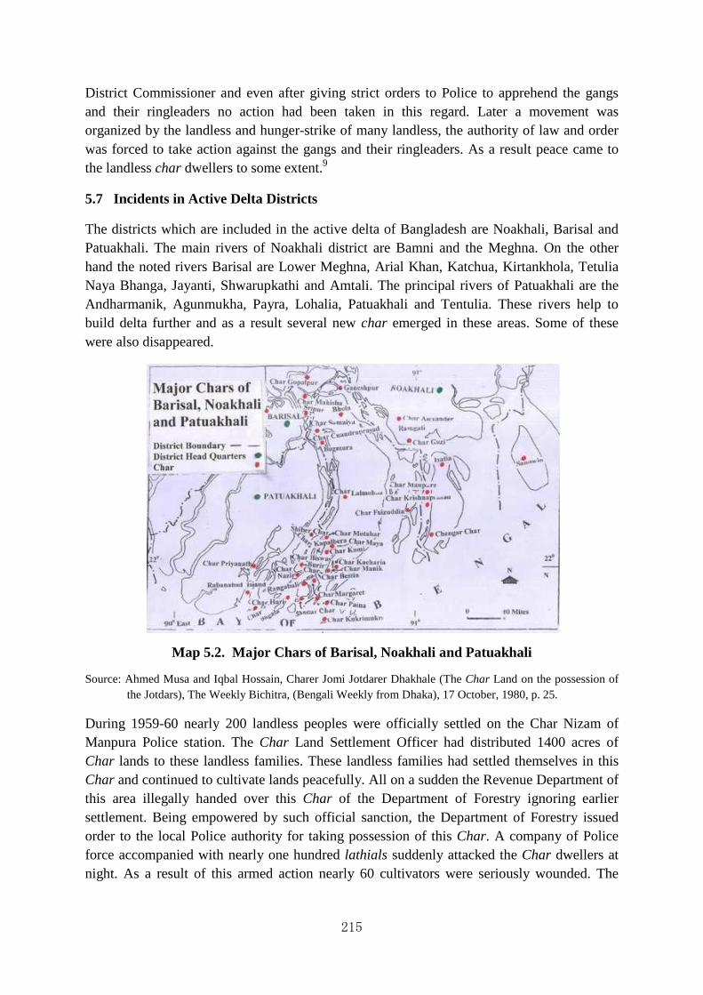
215
District Commissioner and even after giving strict orders to Police to apprehend the gangs and their ringleaders no action had been taken in this regard. Later a movement was organized by the landless and hunger-strike of many landless, the authority of law and order was forced to take action against the gangs and their ringleaders. As a result peace came to the landless char dwellers to some extent.9
5.7 Incidents in Active Delta Districts
The districts which are included in the active delta of Bangladesh are Noakhali, Barisal and Patuakhali. The main rivers of Noakhali district are Bamni and the Meghna. On the other hand the noted rivers Barisal are Lower Meghna, Arial Khan, Katchua, Kirtankhola, Tetulia Naya Bhanga, Jayanti, Shwarupkathi and Amtali. The principal rivers of Patuakhali are the Andharmanik, Agunmukha, Payra, Lohalia, Patuakhali and Tentulia. These rivers help to build delta further and as a result several new char emerged in these areas. Some of these were also disappeared.
Map 5.2. Major Chars of Barisal, Noakhali and Patuakhali
Source: Ahmed Musa and Iqbal Hossain, Charer Jomi Jotdarer Dhakhale (The Char Land on the possession of the Jotdars), The Weekly Bichitra, (Bengali Weekly from Dhaka), 17 October, 1980, p. 25.
During 1959-60 nearly 200 landless peoples were officially settled on the Char Nizam of Manpura Police station. The Char Land Settlement Officer had distributed 1400 acres of Char lands to these landless families. These landless families had settled themselves in this Char and continued to cultivate lands peacefully. All on a sudden the Revenue Department of this area illegally handed over this Char of the Department of Forestry ignoring earlier settlement. Being empowered by such official sanction, the Department of Forestry issued order to the local Police authority for taking possession of this Char. A company of Police force accompanied with nearly one hundred lathials suddenly attacked the Char dwellers at night. As a result of this armed action nearly 60 cultivators were seriously wounded. The
216
lathials, on the other hand, conducted rape on Kulsum Bibi in front of her father and brother. No action had been taken against this incident.
However, these were not complete accounts held in many places of Bangladesh. A few incidents have here been described in order to point out the basic trends of incidents. Some of the incidents that occurred in 1979 were the followings:
1979
1. Char Tabliga under the Police Station of Borhanuddin of Bhola District was inhabited by large number of cultivators. Paddy was the principal staple of crops and grown well in this char. But the char was insecure because many lathials had threatened the char dwellers to harvest paddy forcibly. Anticipating the possible occurrence the char dwellers informed the Police Station of Borhanuddin and asked their kind help in this regard in advance before coming of the harvesting season. The authority of the Police Station of Borhanuddin being sympathetic to the prayers of the poor cultivators posted 5 armed Police personnel. But ultimately such arrangement had proved futile. During the harvesting season large number of well-armed lathials arrived by boats on the Char and forcibly harvesting three thousand of paddies and fled away in boats taking the entire paddy so far harvested by them. Before dispersing they took two Polices and a teachers of the locality who protested the activities of the lathials. They left the police men and the teacher in another char which was far from the Char Tabliga. This incident had created enough sensation in the area.
2. The khas lands of the char areas of Jamalpur could not have been settled to the landless, the rich people grabbed all of those char lands forcibly.
3. The relations of the Officer-in-charge of Birol Police Station of Dinajpur District grabbed 214 acres of Char lands in their possession by showing forged documents and they had also registered those char lands in their names. This incident came to the notice of the Government. Consequently a case was instituted against the Officer-in-charge of Birol Police Station and 14 persons. The Officer-in-charge of Birol Police Station was dismissed and his relation faced trial. After this incident more than 800 acres of char lands were recovered from the local touts who possessed these char lands by fraudulent practices.
4. It was reported in the press that 14 acres char lands of Feni were given lease to two Chairmen of Feni Union Parisads and 10 acres of char lands were given lease to local influential persons. There were 7,992 acres of khas char lands of in Feni of which 3,600 acres of khas char lands had been distributed through shrewdness.
5. Jahangir Hossain and 64 persons of his associates received 44 acres of char lands from settlement officer for cultivation. The place of this incident was Mehendiganj Police Station of Barisal district. But finally it was discovered that the quantities of khas lands were 644 acres. The high handedness of the Settlement Office held responsible for this incident. As a result the whole settlement work was declared illegal and new settlement work initiated by employing new settlement officer.

217
6. The freedom fighters of Shyampur Char under the Bhola district obtained 160 acres of Khas char lands from the Government. A gang consisting of 1,000 armed lathials arrived at Shyampur Char for harvesting paddy forcibly. But finally they were forced to retreat by Police actions. Similar incidents happened at Char Jatabart, Char Gazi and Char Tamizuddin.
1980
1. In Comilla District a new char had emerged near the river Saraswati. A serious strife ensued in between tow villages centering round the possession of the Char resulting in the loss of lives of two persons. Moreover, 17 persons of both the contending parties were severely wounded.
2. Large quantities of Khas lands of Char Jabbar and Char Jubilee were under the possession of the jotedars. As a result both the Government and general people faced enormous difficulties and heavy financial loss.
3. In the Goalando district out of 4,709 acres of Khas lands 3,159 acres of Khas lands had been distributed among the landless poor. But the remaining Khas lands were leased out to rich peasants. Such situation, in turn, created tense relations among the landless poor.
4. On the northern part of Daudkandi there were 513 acres of char lands which included Char Jagatpur, Char Brahman, Sonar Char. These Khas char lands were supposed to be distributed among the landless poor. But only 213.92 acres of Khas char lands had been distributed among the landless poor and rest of the Khas char lands were leased out to local influential persons. Besides these, 80 acres of Khas char lands of 24 Kathalia mouza had been acquired by the local jotedars.
5. In the estuary of river Baluai of Netrokona district, a serious struggle was supervened among the villages for harvesting activities of the char land. This struggle led to the killing of 8 persons and many others were seriously injured.
6. The fertile land of Char Bagra and its productions had attracted the attention of the lathials. The dwellers of this char had sold out most of their productions immediately after harvestating in advance anticipating possible attacks of the lathials. Moreover, most of the char dwellers had transferred their ready money elsewhere. When the lathials arrived in this char for harvesting, they found neither produces in land nor cash money at the hands of the char dwellers. In such situation, the lathials had conducted brutal torture on the char dwellers irrespective of gender and being seriously furious finally they burnt the houses of the char dwellers as an act of retaliation.
7. There were huge Khas lands in the Leshra union of Harirampur Police station under Manikganj district. Some local touts hailed from the district of Faridpur illegally and forcibly had taken possession of these Khas char lands. These peoples also extorted forcible subscriptions from the poor landless. Nearly 12 thousand poor landless people became victims of their illegal exactions. Finally these poor landless people organized co-operative cultivation according to the advice of the then Honourable Minister Abdul

218
Halim. But the lathials had continued their sporadic attacks on the helpless poor people. Sometimes the lathials did not hesitate to burn their properties.
These are, in a nutshell, the fateful lives of the landless char dwellers. Many incidents of the illegal possession of char lands, oppressions and several kinds of torture were remained untold. There are many incidents still sharp in the memory of many contemporary persons. Interestingly enough, we have been able to unearth the real history where landless char dwellers had established their rights and became victorious. In the char lands of Bansberia and Char Hadi and Char Borhanuddin situated at Dashmina of Patuakhali district and the Char Osman of Hatia Island, the landless poor char dwellers had established their own right and extirpated the entrenched interest of the jotedars. Many chars are situated in the coastal areas of Bangladesh where litigations and counter-litigations are common characteristics. Among those the names of the Char Kalkini, Char Shiringa, Char Kukrimukri, Char Kaikoma, Ghashir Char, Charbel Char, Char Margaret, Bostom Maier Char, Hatiar Char, Char Borhan Char, Char Shiraj, Char Kasem, Char Kutubdia, Char Chakoria, Char Raienda, Char Bargi, Char Clerk, Char jubilee, Char Bagua, Dhal Char, Char Gajaria, Char Aicha Lata, Char Kanibag, Char Kalshi, Char Bangla, Sonar Char, Tanter Kati, Char Bansberia, Char Alim, Burir Char, Char Chandramoha, Char Gangarampur, Char Hijla and Char Mehendi are noteworthy.
5.8 Successful Movement of the Landless Peoples at Char Bansberia
The Char Bansberia is located at the Dashmina Police Station under Patuakhali district. The total cultivable land of this char was about 1800 acres. After prolonged movement the landless char dwellers of Banberia had eradicated the hegemony of the entrenched interested groups of local jotedars and touts and established the power of the toiling mass in February, 1981. Before this movement, the Chairman of Bansberia Union had formed a fake society of the landless people and appointed his son as Secretary of the Society for Landless People. But the society was practically established with ulterior motive of deceiving the landless poor amidst complete uncertainty. The Secretary of the Society for Landless Peoplearrangeddistribution Khascharlands of Char Bansberia to opulent persons in lieu of illegal money collected from them. A local tout was also appointed as the Director of the above mentioned society and raised subscription from the landless poor at the rate 500 Taka for initiating co-operative farming of the char dwellers. Meanwhile another tout named as Abdur Razzak was included in the society. Practically they had created a vicious circle of their own only for raising fund from the landless poor through coercion. But Abdur Razzak was not given proper share of the money so far raised by coercion. As a result Abdur Razzak had pointed out the question of regionalism and tried to excite general feeling of the landless poor. However, being spiteful Abdur Razzak also established in a counter co-operative taking the landless poor from whom he took only 50 Taka for membership. Such situation had attracted the notice of the ‘Krishak Samiti’ a peasant organ of the Bangladesh Communist Party and Abdus Shahid, a member of the Communist Party, who was wounded during the Khapra Ward Firing incident at the Rajshahi Jail in 1950, provided leadership to the landless poor of Char Bansberia. Abdus Shahid had succeeded to win over the support of the landless poor and informed about the actual state of affairs. In consequence, the landless poor were

219
properly able to comprehend the astuteness of forming the so-called co-operative of the landless poor and demanded to Abdur Razzak to show the proper and authentic documents and also the expenditure of the money raised by him hitherto. Abdur Razzak finally failed to show the proper and authentic documents of the so-called co-operative along with its expenditure. These had infuriated the sentiments of the landless poor and being inspired by the ‘Krishak Samiti’ they established an organization of their own. Under the leadership of this organization a party of 30-40 members of the landless poor took possession of the char lands. The landless poor became organized and established their own co-operative society and started co-operative farming by hiring buffalos and carried on joint agricultural operation. Nearly 5000 landless poor were associated with this movement which ultimately became successful.
In 1977 the Coastal Island Development Board was organized and they contributed important role in char development work. Basically the Islands situated on the estuaries of the rivers Meghna, Agunmukha and Matamuhuri were included in this project. However, the principal Islands and chars of greater Chittagong district e.g., Saint Martin, Moheshkhali, Kutubdia and Sandwip; Hatia of greater Noakhali district; Bhola, Monpura, Char Kukrimukri of greater Barisal district and Char Duani, Kalomegh, Nontola, Manashatali, Baliatali, Nilganj, Mithaganj, Lalua, Khagradanga, Lata Chapli, Dhankhali, Pocha KLoralia, Karoibari, Barobari, Panpatti, Ratan-Taltali, Char Kajal, Baro Baishdia, Choto Baishdia, and Ranglbali etc. It is estimated that 28 Islands are under the direct inspection of this Board. Several development works have been performed by this Board and among them setting of cyclone shelters, construction of roads and bridges, establishment of schools, public health care centres are noteworthy. In fact, the contribution of this Board in praiseworthy in many regards.10
5.9 Life in Char
Life in char land is not very easy as in the case of mainland. The inhabitants of the char land are commonly known as ‘Charua’ – a local dialect is usually applied in order to identify them quickly and separately. In the char struggle for survival is very much common. The dwellers of char land was earlier members of villages either situated in the riparian areas or settled villages. Some of them lost their lands due to river erosion and some of them lost their source of income in the villages and initially migrate to the town with a view to generate income for their livelihood. They used to live in the slums of many towns. But the administrative authorities of the cities or towns do not like the presence of slums for a long time. So they are driven away from the slums and having no alternative to survive these people are forced to settle in the chars. Here they face enormous difficulties both natural and unnatural. If they are entitle to be the owners of khas land, but can not cultivate those lands by investing their own capital. It is always true that cultivation requires capital for buying cattle, seed and other implements essential for agricultural operation; moreover regular food in-take is also bear necessity. Life in the char is always full of struggle. Repeated cyclone and inundations may be very much common in the char land. Those who have no entitlement in the khas land of the char, virtually they become wage-earners and forced to eke-out by doing miscellaneous works. char is always considered as dangerous place where some of the dwellers had fight

220
against poverty, some of the dwellers had fight against natural calamities. Sometimes the char dwellers had to fight against external enemies like dacoits, lathials and organized armed gangs. The landless char dwellers become easy victims of many circumstances. They have to collect fresh water for drinking from a very long distance, fuel for cocking and money for surviving. Usually they prepare huts in cluster to live in and are forced to choice a very poor life. Some of them are forced to choice a life of fishermen and for that they have to travel in the deep sea where life is uncertain. The landless char dwellers are always helpless. They seldom get official help or relief. In most cases the landless char dwellers are deprived in many ways. The most dangerous aspect of the char dwellers is unsecured lives because of the sporadic activities of dacoits, lathials and organized armed gangs. In most cases the children of the char dwellers are deprived from many facilities such as education and health services.
5.10 Lathials
The lathial can be traced in history mostly from the mediaeval times. They were a distinct social group in Bengal in the Mughal and British rule. Earlier they had rendered services to several revenue and administrative authorities. They worked as retainers in the feudal age of Europe and received remunerations for their services. With the introduction of village police system in 1870s the official position of lathial was ceased to exist.11
Figure 5.1. Lathials of Bengal Source: Banglapedia, CD edition, 2004.
Later, lathial appeared with a completely different identity. At the end of the 19th century lathials became a hired people of the landed-interested people of Bengal and had acted according to the will of the man who hired them for forcible harvesting. They are different from dacoits and fought openly and boldly with country-made lethal weapons and could earn enough money for their services. But their lives were not free of danger. Sometimes the lathials succumbed to their injuries caused during fighting with lethal weapons of the rival parties. Their presence was felt even in the 1970s in Bangladesh.
Gradually, their habits, professions and nature of activities had transformed. After the liberation of Bangladesh, it had become easy to procure modern arms and weapons made in

221
abroad. Earlier the lathials used local lethal weapons and commute by country-boat, but now they are well armed, sometimes heavily armed with modern weapons made in abroad and commute by machine-driven speed boats. They have transformed into different modern groups of gangs with definite identities of their own. They are the members of a definite gang, who bear the name of the definite ringleaders. Most of the ringleaders are now engaged in deliberate and sporadic attacks on the char dwellers.
Map 5.3. Violence in Bangladesh in Map (1970-1990) Source: Abdul Baqee, Peopling in the Land of Allah Jaane: Power, Peopling andEnvironment – The Case of
Char-Lands of Bangladesh, Dhaka: The University Press Limited, 1998, p. 77.
Sometimes they work as hired gangs. Interestingly enough, some of the ringleaders maintain good relations with the Police, who receive regular booties from the ringleaders and remain indifferent in any occasion of anarchic activities. Sometimes, the lives of the char dwellers are at the hands of their mercy. Even they do not hesitate to conduct rapes on women irrespective of ages. The activities of these ringleaders are to some extent unrestrained. The activities of the lathials or heavily armed have been noted by nearly all the contemporary researchers or writers in their articles and books on char lands of Bangladesh.
5.11 Shrimp Culture
Introduction of intensive shrimp culture in Bangladesh was started in 1980s when the price of shrimp fetches high in the international market. Although shrimp culture brought some ready money necessary for the poor, but it is not environmentally friendly. Practically, the owner of large Shrimp Farm in collaboration with the land officials, administration and social touts

222
forced the helpless farmers to sign the deed of lease for shrimp culture; otherwise they might be evicted from his habitation. Sometimes the poor man became a victim of torture. But the shrimp culture, in fact, brought salinity to the land and as a result the agricultural productions might be declined remarkably. The shrimp culture is not economically beneficial, rather ecologically suicidal. In consequence the property rights including human rights are on the verge of serious threat in the coastal areas of Bangladesh.12Some of the NGos have protested against the shrimp culture in the coastal area and have even submit writ petition to the High Court considering the subject not environmentally feasible.
After the liberation of Bangladesh and more precisely after 1980s the studies of char land appear important subject of research to economists, sociologists, geographers, historians and anthropologists. Academic researches on several aspects of char land, its dwellers, their livelihood, legal possession of khas lands, Life and style of the char dwellers, accounts of the harmful activities of jotedars, lathials, organized gangs, corruptions at various levels, development works of the NGOs, development policy of the Government of Bangladesh and all other things related to char lands have been carried out with proper emphasis. Case studies of some char lands have constituted important subjects of M. Phil, candidates at home and abroad. A considerable number of reports and brochures prepared by foreign agencies are also available in this regard. As we know that all the local or national problems have their respective historical origin, but all the studies on char land of Bangladesh conducted hitherto lack in the view to treat these problems in true historical perspectives. Because char land reclamation and char land problems was phenomenon of earlier half of the 19th century Bengal (both East and West Bengal) and not a phenomenon of later half of the 20th century.13
However, despite the presence of considerable number articles, brochures, reports on the char lands of Bangladesh, the books written by Abdul Baqee and Abul Barkat and his co-authors may be termed as commendable. Though these two books are based on empirical surveys in 1990s and 2000s which encompass different areas of Bangladesh have given proper emphasis on the conditions of the dwellers of char lands. While an attempt has been made by Abdul Baqee, following empirical research methodology, portray the true picture of helpless and fateful lives and livelihood of the char dwellers of some places of Bangladesh who live in complete uncertainties.14 Correspondingly Abul Barkat and his co-authors have shown the stern realities of the lives of char dwellers of some areas of Bangladesh following the similar methodology.15 Both of them have tried to see the problem in historical perspectives. Nevertheless, none of them had succeeded to properly address the problem in detail in appropriate historical perspectives. However, the author has tried his best not to reiterate those incidents here. It is also worthy to mention that both the works encompass some areas of Bangladesh, though it is impossible to highlight the total picture of Bangladesh. Nevertheless, both the books can certainly demand strong command on the subject above alluded to.
5.12 Char Land Related Literature
Literature is the mirror of the society. Reflections of all the social and economic problems of the society are indispensable in contemporary of near-contemporary literatures. The char land

223
and its dwellers, their life and style, nature of struggles, love and miseries are reflected both in the colonial and post-colonial rule. It is often said that: “In history everything is incorrect excepting dates and names and in literature everything is correct excepting dates and names”. Practically, the true scenario of society and economy is reflected available in literature. It is quite natural that the burning problems of the time are always reflected in the contemporary literary works of the litterateurs, who can not avoid the circumstances of the time. The chars of Bangladesh is and was always liable to create social, economic and cultural problems. So its reflections are also available in the literary works. Virtually the char land had created many problems in the later half of the 20th century and it attracted the litterateurs of its soil to highlight to narrate the problems in their own works. In most cases the litterateurs has viewed the problems differently and consequently different kinds of literatures appeared in different times. The litterateurs who wrote their works were well-known persons of the time and society. A host of literary works on the char land appeared in between 1930 and 1988 where different problems have been addressed differently. However, among the litterateurs and their literary works the following were very important: Bibhuti Bhushan Banerjee (1894-1950), ‘Ichhamati’,(1950); Jashimuddin (1903-1976), ‘Baluchar’, (1930); Humayun Kabir(1906-1969), ‘Nadi and Nari’, (1952); Amarendra Nath Ghosh, (1907-1961), ‘Char Kasem’, (1949); Bishnu Dey ( 1909-1982), ‘Swandiper Char’, (1947); Ohidul Alam (1911- ), ‘Karnafulir Majhi’, (1972); Samaresh Basu (1924-1988), ‘Ganga’, (1955); Abu Ishaque (1926-2003) ‘Padmar Palidwip’, (1986); Alauddin Al Azad (1932-2009), ‘Karnafuli’, (1962); Dipendra Nath Banerjee (1933-1979), ‘Agami’, (1951); Shyamal Ganguli (1933-), ‘Ganga Ekti Nadir Nam’; article ‘Char’, (1953) Debesh Roy, (1936- ), ‘Tista Parer Britanta’, (1988). The central themes of these literary works are the dweller of the char moves hither and thither in the search of safe abode and security of life, because the character of the char is always unpredictable. The continuous struggle is the main factor for survival. char dwellers struggle not only against natural calamity, but also sporadic attacks of the lathials. The lathials like young girls, for an early marriage of their daughters always favoured. The life and style of the char dwellers are always different from that of the main land. Homicide or murder is so common that a char was named as ‘Khuner Char’ (char land of murder). Sometimes dacoits and anti social elements of the society select char as a safe place of hiding. char provides various food items having different taste than the main land. In the char area it is often said that:
“Lati Jar Mati Tar” “He who possesses band, He also possesses land.”
The above proverb suggests that in the char land ‘might is right’.16 This means that power always works as very important factor for surviving. Interestingly enough that the char land has its own language which is different from the mainland. Most of the time char dwellers use their own vocabularies while speaking among themselves.

224
Notes and References
1. Ahmed Musa and Iqbal Hossain Badal, “Charer Jomi Jotdarer Dhakhaley” (The Char Land on the Possession of the Jotdars), The Weekly Bichitra, (Bengali Weekly from Dhaka), 17 October, 1980, pp. p. 26.
2. Abul Barkat, Prosanta K. Roy and Md. Shahnewaz Khan, Charland in Bangladesh: Political Economy of Ignored Resources, p. 84.
3. “Bangladesh: 40,000 slum residents face eviction”, The Daily Star, 12 May, 2012. 4. B-Proceedings, Home, Political, Bangladesh National Bundle-54, January, 1951,
Proceedings Nos.438-63. 5. For detail, see, D.C. Bhattacharya, Enemy (Vested) Property Law in Bangladesh,
Dhaka: MS Chitra Bhattacharya, 1991. 6. For detail, see, Abul Barkat, Shafique uz Zaman, Azizur Rahman, Avijit Poddar,
Political Economy of the Vested Property Act in Rural Bangladesh, Dhaka: Association for Land Reform and Development, (ALRD), 1997.
7. Iffat Jerin, ‘Upazila Rajibpur’, Banglapedia, CD edition, 2004. 8. The Daily Star, 4 December, 2004. 9. Paper clippings of ‘Bhorer Kagaj’, ‘Ittefaq’, ‘Janakanta’ and some other local
newspapers of different dates of 2005. 10. Ahmed Musa and Iqbal Hossain Badal, “Charer Jomi Jotdarer Dhakhaley” (The Char
Land on the Possession of the Jotdars) The Weekly Bichitra, (Bengali Weekly from Dhaka), 17 October, 1980, pp. 30-31.
11. For details see, Sirajul Islam, ‘Lathial’, Banglapedia, CD edition, 2004. 12. Abul Barkat, Poverty and Access to Land in South Asia: Bangladesh Country Study,
The National Resources Institute, University of Greenwich, Dhaka, 2004, p. 4. 13. For details see, Badrul Alam and M. Azizul Huque, Selected Geoscience Bibliography
on Bengal Delta Basin and its Surroundings, Dhaka: Delta Study Centre, University of Dhaka, 2006.
14. For details, see Abdul Baqee, Peopling in the Land of Allah Jaane: Power, Peopling and Environment – The Case of Char-Lands of Bangladesh, Dhaka: The University Press Limited, 1998.
15. For details, see, Abul Barkat, Prosanta K Roy and Md. Shahnewaz Khan, Charland in Bangladesh: Political Economy of Ignored Resources, Dhaka: Pathak Shamabesh, 2006.
16. For details, see Abu Ishaque-er Padmar Palidwip: Mullyan and Bisheleshan (The Evaluation and Analysis of a novel written by Abu Ishaque), Mohammad Shakereullah ed., (in Bengali), Dhaka:Janantik, 2013.

225
Chapter 6
Alluvial Land Reclamation Process in Noakhali District: Selected Field Studies
Abstract of the Chapter
In the sixth chapter, post colonial alluvial land reclamation process in Bangladesh and related geo-politics and consequent environmental condition have studied. In the post colonial Bangladesh the population density is very high if compared with the land in its possession. In such situation, landless people of different districts of Bangladesh coming from heterogeneous social and economic background have started to occupy the alluvial land having no other alternative to survive in those areas where alluvial land formations took an unending shape. The alluvial land gravers, who had played no significant role during the colonial rule, now arrived to grab alluvial lands with the help and support drawing from the political parties and ignoring the official rules framed by the Government of Bangladesh. This has created endless miseries to the landless poor peoples who try to survive in the char lands. In general, the processes of alluvial land reclamation are available along with the case studies. But exclusively the district of Noakhali was out of arena of their discussion. This aspect has also been neglect by the modern writers.
In order to have a comprehensive knowledge about the process of alluvial land reclamation in the active and tidal delta of Bangladesh a field survey seemed to be urgently necessary. For this purpose, the chars situated in the district of Noakhali were found suitable from the considerations of its formation and geo-political satiation. But the number of chars is so huge that it becomes impossible to conduct study on all them in a short period. The researcher had no other option other than recourse to the methodology of random selection. In the district of Noakhali chars of any denomination are located sometimes very far from the mainland and even in dry season they remain quite unapproachable. The means of communication with these chars is only boats which are not frequently available. However, so far as methodology is concerned for writing this chapter, the author has extensively used both the fundamental and empirical methodologies as it is necessary to get fruitful and tangible result.
Administration of any questionnaire was thought impractical since these innumerable chars are inhabited by ignorant and illiterate dwellers. The only option left to the researcher is to ask questions privately. Here also the researcher confronted a problem. Each char has oneor two lords whose prior permission is required for collecting information from the char dwellers. Without such permission of the respective lords the object of the researcher may be

226
frustrated at any moment. The lord of the char is not a permanent dweller of the char but make visits from time to time. But a regular spy of the lord stays at the char at day time and keeps the lord of the char well aware of the situation prevailing therein and receives some remuneration in lieu of the services he renders. In fact, the lord of the char has no legal or legitimate right of the newly inhabited place. They are sycophants and having no roots, they exploit the poor char dwellers by creating fear of eviction from the char land. Again the lord of the char gets support from the political magnates residing in the town. In lieu of this, the political magnates receive support during elections. The political magnates lend police protection to the lords when necessary.
It has been mentioned earlier that the char dwellers are illiterates to the highest extent. The char dwellers generally hail from heterogeneous social and economic background who took shelter in the unoccupied char, being rendered landless by erosion of the river and being extremely poverty-stricken, selected the unoccupied char as the last resort of survival. They have no knowledge either about the quantity of land under their agricultural operation or about the production. A large portion of their production is appropriated by the lord and the residual are for the char dwellers to eke out a living for their entire family. However, the fateful story will be discussed in detail in the forthcoming analysis of the condition of the char dwellers in the district of Noakhali.
Bangladesh is mainly consisted of a naturally silt enriched plain land where numerous rivers intersect. The continued activities of the rivers like the Ganges, Padma, Meghna and Jamuna have helped to form the great delta which is known as the Ganges Delta. A vast quantity of silt, stones and other miscellaneous things hail from the Himalayan Mountain and before reaching the Bay of Bengal these accumulate in some places of the river, thus starting the alluvium land formation, locally known as char.
In the past Noakhali was known as Bhulua. In mediaeval time the agricultural activities of the north-eastern region of Bhulua were seriously hampered by floodwater of the river Dakatia flowing from the Tripura hills. In order to save the situation, a canal was excavated in 1660 running from the Dakatia through Ramganj, Sonaimudi and Chaumuhani to divert water flow to the junction of the rivers Meghna and Feni. After excavating this long canal Bhulua was renamed ‘Noakhali’ after ‘Noa’ (new) and ‘khal’ (canal) in 1668.
The term ‘alluvion’ has derived from the Latin word alluvius which means sediment deposited by running water, especially the type of soil formed in river valleys and deltas from material washed down by the river. John Andrew Hamilton, 1st Viscount Sumner (1859-1934), was a British lawyer and judge. While giving verdict in the case of Raja Srinath Roy versus Dinabandhu Sen in 1847, Lord Sumner described the mode of the formation of char in the following terms:
The streams in the Gangetic delta are capricious and powerful. In the course of ages the land itself has been deposited by the river, which always carries a prodigious quantity of mud in suspension. The river comes down in flood with resistless force and throughout its various branches in consistently corroding

227
its banks and building them up again. It crawls or races through a shifting net work of Streams. Sometimes its Course changes by imperceptible degrees; sometimes a broad Channel will shift or a new one open in a single night. Slowly or fast it raises islands of a substantial height standing above high water level and many square miles in extent. Lands so thrown up are called ‘Chars’.1
Usually there are three ways in which a char is formed in a river. These are:
1. When the river flows round land which was not used to be part of the bed; 2. When it leaves a place which used to be a part of the bed dry and begins to flow on either
side of it; 3. When by the gradual deposit it has made, a spot emerges above its bed, and has increased
it by alluvion. 4. In fact, there are two kinds of lands, e.g., alluvial lands and firm lands. In order to
understand the difference between the two kinds of lands, it is essential to know the proper meaning of each kind of land. The alluvial lands mean land which is gained either from a river or the sea. On the other hand, firm land, as distinguished from alluvial lands, means land which has its existence in contact with the flow of the river or the sea from before. Sometimes alluvial lands are annexed in the course of time due to the action of the river or the sea.
In the deltaic area of Eastern Bengal, the rivers in general could not flow on its own course for long time. The rivers flowing from the plain lands carrying large quantity of silt with them, deposited the silt on their ways which gradually became char or island, though submerged under water for some time. The main river then takes another way and proceeds further until it reaches the sea. Such is the usual net work of the rivers in the active delta. The Bengali word ‘char’ may be characterized as a large, sandy, unconsolidated and nebulous piece of land emerged in a river through accretion process. In Bangladesh the char and ‘island’ bears the same meaning, but if looked at on the basis of its location and physical formation, different kinds or types of char may be noticed. A char situated little away from a river is locally known as ‘Kuler-char’ (char situated near the river bank). The ‘Kuler-chars’ are neither always clearly separated from the river banks, nor are they always attached to river banks. A depression may easily be found in between the main land and the ‘Kuler-char’ when it is located very near the river bank. Such depression usually becomes a channel during the monsoon. But in the dry season such ‘Kuler-char’ is easily accessible because the channel losses its depth. With knee-deep water of channel, man can easily approach to the ‘Kuler-char’. But if a char is formed in the middle of river, it is locally known as ‘Duba-char’ (submerged Char under water). No one can approach this ‘Duba-char’ even during dry season without the help of a boat. This ‘Duba-char’ is entirely submerged under water during the rainy season.
During the summer season such ‘Duba-char’ is used for grazing field for the livestock; particularly the cows and buffaloes. It takes long years to be a firmly established char where full-scale agricultural operation and human habitation become possible. All the ‘Duba-char’

228
has common characteristics so far its soil formation is concerned. The central part of the ‘Duba-char’ is relatively elevated than the fringe. Again, central part is sandy, whereas peripheral is silted. When full-scale agricultural operation and human habitation becomes possible in ‘Duba-char’, the central part is used for making habitations, and other parts are used for agricultural operation. It is noticeable that large-size usually attract people for settlement; while small ones are used for vegetation and grazing.2
Two kinds of lands are available in the landscape of the char e.g., kaim-land (permanent land) and shabek-land (old land) and the texture of the soil is different. The water-body of the rivers heading towards sea is unexceptionally salty, and the water-bodies surrounding these char are salty as well. In order to get sweet water, the char dwellers prepare embankment surrounding the char and kaim-land usually refers to landform between the river and embankment. In order to prevent overflowing during monsoon and high tide, attempts are made by the dwellers to channelise the rivers. It is matter of great anxiety that kaim-land is venerable to regular inundations and erosion. The landform well equipped with embankments and free from inundation is locally known as shabek-land. The new comers prefer large shabek-land suitable for human settlement.
6.1 Major Char Lands of Noakhali developed in the earlier half of the 20th Century
The rivers of Noakhali depict a changing character that occurs naturally. Several small char emerge annually near the shore or midst of the Noakhali rivers and disappear automatically. For these reasons no definite conclusion can be reached about these small char in question. Such change can be noticed for the last two centuries. However, the major char lands of Noakhali developed in the earlier half of the 20th Century are the following:
Table 6.1. Location of the Char Landsof Noakhali in Early 20th Century
Location of the Char Name of the Char
Chars in between the river Feni and river Bamni
1.Dhopa Char or Char Khaia; 2. Kachhapia char; 3. Fishki char; 4. Char Ramnarayan
Char in Sandwip 1. Char Pirbox; 2. Char Badu or Char Lakhmi Char near Hatia Island 1. Char Bharat; 2. Char Iswar; 3. Char King; 4.
Char Lanch; 5. Nilakhmi char; 6. Char Gazi; 7. Char Nalchira; 8. Char Mir Mohammad; 9. Char Amanulla; 10. Char Gossain; 11. Char Alexander; 12. Char Hasen Hossain; 13. Char Neyamat; 14. Char Dula Gazi; 15. Char Fakir;16. Char Neshar
Char in the Hatia River 1.Char Jabbar; 2. Char Jublee; 3. Char Madhab; 4. Char MacPherson; 5. Char Alexandra; 6. Char Boibi; 7. Char Poragachha; 8. Char Bedama; 9. Sita Char
Char outside Hatia 1. Char Behari; 2. Char Larence; 3. Char Basu Char located on the estuary of Dakatia River
1. Char Ababil; 2. Char Banshi; 3. Char Udmara; 4. Char Mirjamara
Source: Bharat Chandra Majumdar, “Noakhalir Char, Diwip O Nadi”, (River, Char and Island of Noakhali),
(in Bengali), Bangasri (a Bengali Monthly), Vol. 1, No. 1, 1937

Map 6.1. The Present Conditions of Few
Badner Char: It is an island of Hatia Police Station which is located in the middle of Hatia and the Manpura islands and the south of embankment and is completely isolated from the main land of Hatia. According to the European Grid Infrastructure
square kilometers. The total households in this 4,372 of which 2,244 males and 2places with heterogeneous social and economic background. They eke ocultivation, wage labour and miscellaneous professions. Almost all the children are engaged in collecting fuel from natural resources e.g., jungles, trees etc. The bulk of the inhabitants possess khas lands granted to them by Governrate of literacy is 8.3 percent. It is noteworthy that here literacy means writing names and ability to count money. These peoples are obviously old. There is no facility for imparting elementary education among the children. There are free primary schools established at other chars that are bifurcated by rivers and streams which prevent the children to attend schools. The communication with the mainland is maintained by boat.
Char Ramani Mohon: This charStation. Char Ramani Mohon is located in one ShakcharUnion. The number of villages included in this that mouza is the lowest revenue uChar Ramani Mohon is well protected by embankments and annexed to the mainland of
229
The Present Conditions of Few Char Lands of Noakhali District
It is an island of Hatia Police Station which is located in the middle of Hatia he Manpura islands and the south of char Parvej. Badner Char is not well protected with
embankment and is completely isolated from the main land of Hatia. According to the European Grid Infrastructure Survey (EGIS) map of 2,000 this char covers the area ofsquare kilometers. The total households in this char are 855 and the total inhabitants are
244 males and 2,128 females. All the inhabitants are drawn from different places with heterogeneous social and economic background. They eke out their livelihood by cultivation, wage labour and miscellaneous professions. Almost all the children are engaged in collecting fuel from natural resources e.g., jungles, trees etc. The bulk of the inhabitants
lands granted to them by Government following the char settlement rules. The rate of literacy is 8.3 percent. It is noteworthy that here literacy means writing names and ability to count money. These peoples are obviously old. There is no facility for imparting
g the children. There are free primary schools established at other s that are bifurcated by rivers and streams which prevent the children to attend schools.
The communication with the mainland is maintained by boat.
char is situated in the Shakchar Union under Lakshmipur Police Ramani Mohon is located in one mouza out of seven
Union. The number of villages included in this mouza is five. It is worthy to note is the lowest revenue unit; where village is psycho-sociological unit. The area of
Ramani Mohon is well protected by embankments and annexed to the mainland of
Lands of Noakhali District 3
It is an island of Hatia Police Station which is located in the middle of Hatia is not well protected with
embankment and is completely isolated from the main land of Hatia. According to the covers the area of 5.04
are 855 and the total inhabitants are 128 females. All the inhabitants are drawn from different
ut their livelihood by cultivation, wage labour and miscellaneous professions. Almost all the children are engaged in collecting fuel from natural resources e.g., jungles, trees etc. The bulk of the inhabitants
settlement rules. The rate of literacy is 8.3 percent. It is noteworthy that here literacy means writing names and ability to count money. These peoples are obviously old. There is no facility for imparting
g the children. There are free primary schools established at other s that are bifurcated by rivers and streams which prevent the children to attend schools.
Union under Lakshmipur Police out of seven mouzas of the
is five. It is worthy to note sociological unit. The area of
Ramani Mohon is well protected by embankments and annexed to the mainland of
230
Lakshmipur Police Station. This char is liable to alluvium and diluvium actions of the river. There are two cyclone shelter centres. This char is bounded at the west by Loharkandi Union of Lakshmipur and Begamganj Police Station, at the East by the river Meghna and Hijal Police Station of Barishal district, at the south Ruhita Union (union is rural administrative division) of Lakshmipur and at the north Ramgati Police Station. According to the European
Grid Infrastructure Survey (EGIS) map of 2,000 this char covers the area of 14,359 acres of land. The total households of this char are 2,810 and the total inhabitants are 15,074 of which 8,013 males and 7,061females. The principal occupations are fishing, boat driving, wage labour. Besides these, agricultural operations and share-cropping are other occupations. The rate of literacy is 9 percent. There are seven (7) free primary schools for imparting elementary education among the children. About the infrastructural development, one go-down or warehouse, six (6) markets, one health-care centre and 25 kilometers (non-metaled) road have been built. The communication is maintained by boat trawler. Most of the households possess khas lands granted to them by Government following the char settlement rules. Nevertheless, landless households are not entirely uncommon. There are few landless families who survive through wage labour and share-cropping.
Damar Damar Char or Char Bandartila: Char Bandartila is located far below the Muktaria char of the Hatia Police forest. This char is insecure and liable to serious hazard that may occur at any time. Some people from the neighboring char venture to come here with a view to carrying temporary agricultural operations, cutting grass for their livestock and catching fish for marketing or family consumption. On the west and the north of Damar Char or Bandartila Char lies the Bay of Bengal, on the east island Nijhum and on the south Jahajmara Union of Hatia. Nearly 86.41 percent of the land of this chars is waterlogged and clayish, while quantity of forest land is 13.59 percent. According to the European Grid Infrastructure Survey (EGIS) map of 2000 this char covers the area of 7.03 square kilometers. This char is used for occasional agricultural operation, fishing and supplier of fodder for the livestock. The only communication from the mainland or from other chars is the boat.
Char Hatia: Char Hatia is very large consisting of 17 mouzas and 10 unions. The land of this char is secured by two (2) strong polders. On the northern part of this char Sudharam and Ramgati Police Stations are situated, on the east Chittagong and Bay of Bengal, on the south again the Bay of Bengal and on the west Bhola. According to the European Grid
Infrastructure Survey (EGIS) map of 2,000 this char covers an area of 370.69 square kilometers.
Burir Char: Burir Char is consisted of eight (8) mouzas and located at Burir Char Union of Hatia Police Station. The land of this char is secure by the construction of roads and embankments and throwing polders. On the east of Burir Char lie Hatia Police Station and the Bay of Bengal, on the west again the Bay of Bengal, Sonadia Island on the east, Hatia mainland and char Iswar on the south and on the north the Nijhum Island and the Bay of Bengal. According to the European Grid Infrastructure Survey (EGIS) map of 2,000 this char covers the area of 2,145 square kilometers. The total inhabitants of this char are 7,311 of which 3,748 males and 3,563 females. The principal occupations are agriculture, share-
231
cropping, wage labour, fishing, rickshaw and van driving etc. The rate of literacy is 17 percent. There are fourteen (14) free primary secondary schools for imparting education among the students. Curiously enough there is a Government college in this char which provides further facilities for advanced studies. The noticeable infrastructural developments of this char are four (4) cyclone centers, one (1) go-down or warehouse, six (6) markets, 25 kilometers roads and embankments, ten (10) industries, one health care centre, one Post Office, one Bank, several ferry ghats and launch ghats. Communications with the main land and with other chars are maintained by Rickshaw, Auto- Rickshaw, Van- Rickshaw, Sea Truck, Trawlers and boats.
Char Jahajmara: Char Jahajmara is consisted of 9 mouzas of Hatia Police Station. Of these char Macpherson, char Yunus and char Birbiri are significant in terms of their location and geo-political situation. The land of this char is secure by the construction of roads and embankments and by polders. It is well connected with the main land of Hatia Police Station. Char Jahajmara is bounded on the south by Hatia Police station and the Bay of Bengal, on the north by Nijhum Island and again the Bay of Bengal, on the west again by the Bay of Bengal, on the east by river Shahabajpur and Police station of Monpura of Bhola. The area of this char is 14,323 hector. The total population of Char Jahajmara is 33,135. Out of these populations 17,148 are males and 15,987 are females. Among the principal occupations agricultural operation, share-cropping, day labour, fishing, rickshaw and van driving are important. The rate of literacy is 15.5%. There are fourteen (14) primary and secondary schools and a college, established for imparting education among the young and children. About the noticeable infrastructural developments of this char there are 1 warehouse, 6 markets, 165 shops of miscellaneous items, 1 post office, 1 health care center, 2 ferry docks for boat and lunches, 1 bank, several embankments, 30 kilometers road. The communication within the char and with other places is maintained by auto-rickshaw, rickshaw, van rickshaw, sea track, trawler and boat. It is noteworthy that electricity is also available here.
Char King: Char King is a newly formed char and it is closely associated with the char Bata, char Majid, and char Maradona. This char is not at all secure and very much liable to potential danger. On the south of this are situated char Majid and char Jubilee, on the north the river Meghna, Char Moulvi, Char Gosair, Dhal char and main land of Hatia and on the west Hatia channel and Chandandi Union and on the east Ramgoti Police station. The area or this char is 55.1 square kilometers. Out of total population of 2000, the number of male is 995 and female 1,005. The rate of literacy is 16%, though there is no educational facility. It is anticipated that the dwellers had taken some sort of education before settling themselves in this char. The main occupations of the char dwellers are miscellaneous business and fishing. There is a cluster village, 1 market and 1 kilometer road in this char. The communication with mainland is maintained by machine-driven boats and trawler.
Char Sonadia: Char Sonadia4 is consisted of 5 mouzas of the mainland of Hatia. It is a union. Though Char Sonadia is well protected by roads, embankments and polders, nevertheless it is naturally very hazardous. On the south of this Char Bara Maheshkahli and Dhaldhapa Union Parishad are situated, on the north the Bay of Bengal, Ramu and Cox’s Bazar, on the south the Kutubdia channel and Chokoria Maghnamara and on the east lays the

232
Bay of Bengal. The area of Char Sonadia is 3962 acres. The total population of this char is approximately 36,554. The principal occupations of this char are fishing in the river and the sea, shrimp culture and manufacture of salt. The rate of literacy is 19%. There are 8 schools for imparting education among the children. About the noticeable infrastructural developments of this char there are 6 cyclone centers, 7 markets, 1 health care center, 5 salt manufacturing industries, 20 kilometers road and several embankments, 1 ferry and I launch terminal.
CharDarigan of Hatia: Char Darigan is located on the south of Hatia Island. This is a very big char with an area of s 27 square kilometers. The total population of this char is 18,307 of which 9,407 males and 8,900 females. About the occupational status of the char dwellers the information gathered from the concerned office are the following: 34% day labours, 15% fishing, labourers engaged in fishing 13%, agriculturists 15%, agricultural labour 8%. About the noticeable infrastructural developments of this char there are 53 sanitary latrines, 469 tube wells and a market.
Moulavir Char or Decreer Char: This char is located at the Harni Union Parisad of Hatia and also a part of Decreer Char. It is also associated with the Dhal Char. Moulavir Char has emerged from the estuary of the river Meghna and is completely insecure. This char is liable to monsoon floods and other natural hazards. On the north of this char lie Dhal Char and the Bay of Bengal, on the south-east char Basair, on the east Char Bakshi Majhir char and north of Parvej and char Badna, on the west Shukh char and Harni Union Parisad. The area of this char is 1,622 acres. The total population of this char is 60 and out of this males 54 and females 6. The occupational status of the char dwellers is mainly fishing and miscellaneous business. The rate of literacy is 19.1% and there are 8 primary and secondary schools. About the noticeable infrastructural developments of this char there are 7 markets, 5 salt industries, health care center 1, roads 20 kilometers, and embankment 10 kilometers. There is a terminal for boat and launch. The means of communications with the mainland are machine driven boats and trawlers. Natural resources of this char are rich. It allows fishermen to catch large quantities of sea and rivers fishes of various kinds. This char is used as fish processing zone and as a result dried or seasoned fishes are available in large quantities. The presence of several markets reveal the fact that many people from different char and places assemble here for buying fresh, dried or seasoned fishes. There are several factories established here for preparing salt from the sea water.
Dhal Char or Char Satyen: This char is attached with the Moulavir Char or Decreer Char. It is an Island and no population settlement has been yet started. In this char alluvial formation is still on-going. This char is liable to monsoon floods and other natural hazards. On the south of this char are situated Moulavir Char and the Bay of Bengal, on the south-east char Ghashair, on the east Char Bakshi Majhir char, on the north Parvej and char Badna, on the west Shukh Char and Harni Union Parisad.
Nijhum Dwip or Char Osman: Nijhum Dwip(Char Osman) a cluster of islands mainly, Ballar Char, Kamlar char, Char Osman and Char Muri, with a total landmass of about 14,050 acres emerged in the early 1950s as an alluvium in the shallow estuary of the Bay of Bengal

233
on the south of Noakhali. These new sandbanks first drew the notice of a group of fishermen, who named it Baular Char (literally, the alluvium of sand) later transformed into Ballar Char. During the winter, thousands of migratory birds flocked to this char. The fishermen used the airy and sunny land as an ideal place for drying fishes caught from the sea. Sometimes many also constructed straw huts on the islands as seasonal residence. Naturally the islands got covered with various aquatic rank grasses and became a rich grazing field. Later, the chars were surveyed professionally and were given the name Char Osman after the name of a pioneer settler Osman, the owner of a large cattle herd who used the islands as the grazing ground.
People had not come here for settlement until 1970. Many lived there on purely seasonal basis and the territory, popularly called Nijhum Dwip (the quiet island) was included in the Hatiya constituency in early 1970s. At about the same time, a large number of people losing their lands and homes because of riverbank erosion in nearby areas, especially Hatiya, Shahbajpur and Ramgati migrated to the island as new settlers. Nijhum Dwip has six big markets with mainly grocery shops, small restaurants and drug stores. These markets are the only places in the islands to have electricity from generators.
The forest department of the government of Bangladesh created mangrove forests in Nijhum Dwip and the main attraction of these forests is the herd of about 5000 spotted dear. The most important type of tree planted in the island is keora or the screw pine and its plants, also known as kerfa, which has fast growing roots holding the sandy land. The plant also supplies pillars for houses, materials for making boats and agricultural implements, and fuel for domestic use. In 2001, the government of Bangladesh declared Nijhum Dwip forests as National Park for the protection and development of the biodiversity of the forest.
In 1999 the area of Nijhum Dwip was 36.36 hectors. But according to the survey carried out by the Char Development and Settlement Project in 2000 was 516 hectors. In 2001 the population in Nijhum Dwip was 10,670, but now the number of population has increased remarkably. Their main occupations are cultivation, fishing and livestock farming. The island produces vegetables in large quantities. Life in the island is hard and risky. People live here together amidst natural calamities. Notwithstanding, more and more people are migrating to the island in search of new land for homestead and cultivation. While in Nijhum Dwip one can stay at any of several motels. Some of them have electricity supplied by generators. Bangladesh Parjatan Corporation also has a motel there which is the earliest of all.
Some of the chars mentioned above have already been lost but some still exist. A large quantity of silt amounting nearly 2.4 billion tons is deposited each year from the Meghna to the coastal areas of the district of Noakhali. Sometimes the quantity of silt raises upto 4 billion tons and this amount of silt helps to raise the elevation of the coastal areas. The continued deposition of silt, in turn, has helped to create 8 vast char lands centering round Hatia with population settlement. Such settlement has been possible owing to making cross-dam with direct patronage of the Government. On the other, the areas of several chars on the south of Nijhum island that appear during the ebb-tide are not so much optimistic, though these are located very near to the main land of Noakhali.

234
The appearance of new char near the coastal areas of Noakhali is age-old process. During late 1940s vast lands of the city of Noakhali dissolved in the river. With a view to stopping this continued trend of breaking the vast mass of lands several attempts were made to prepare cross-dam at different times. During the financial year of 1960-61 the Government was successful to build a cross-dam from Bhabaniganj of Lakhamipur to Torabnagar. Again in the financial year of 1965-66 another cross-dam was built from Manannagar of Noakhali to Haris Chowdhury Bazar (Atpalkia). These two cross-dams proved very much effective ultimately leading to the emergence of nearly 1,000 square kilometer new lands in the coastal area of Noakhali. This area is now under a full scale human settlement. Several big buildings having been constructed in this newly emerged area and expansion of this is also now in full swing. The Sea-Track which had earlier its dock or station located at Charbata of Subarnachar and bound for Hatia expanded further 10 kilometer south. Such accretion of char land has become a continuous process accompanied with illegal human settlement due to official carelessness. No official infrastructures have been built for distributing these lands amongst the poor and no services have yet been provided to the citizens settled over there.
The project entitled as ‘Actuary Development Programme’ undertaken with the financial help from the Government of the Netherlands had conducted researches and surveys from 1973 to 2008. The important findings of the researches and surveys, hitherto conducted, show that in the coastal area of Noakhali nearly 162 square kilometers of these lands had lost for diluvion. It is expected that the lands so diminished for diluvion would be regained within 30 years.
If the char located near Sandwip channel of Chittagong district could be joined with the Urir Char situated near the coastal area of the Noakhali district through cross-dam, approximately 940 square kilometer of new lands might emerge from the river. Through the alluvial behaviour of the rivers and other water-bodies considerable char lands are gradually rising on the coastal areas of the river Meghna and if such trends continue further rise of char, though different in size and shape, will be a regular phenomenon. Again the deposition of sediment, carried from the Himalayas down to the eastern part of active delta of Bangladesh, ultimately help to the rise of huge number of char lands in Noakhali as well as other districts. Char Canning, Char Nangalia and Char of Hatia island consist of approximately 100 square kilometers are being inhabited by 65, 000 new comers.
6.2 Frequent Changes of FerryGhat
Diametrically opposite to this scenario, several char of Noakhali district were subject to diluvion in the 1970s displaced several thousand men and this trend continued for several years. Such instability of the chars may be characterized as the natural behaviour of the rivers of the district. Poor people displaced from their original habitations always search new areas for settlement, but looking at the instable conditions of the chars, they do not dare to settle in new chars until they are well durable. The internal communication network of the Noakhali district is covered both by roads and water-ways. It is always essential to prepare a landing-stage for launch or ship for the communication through water-ways and these landing-stages for launch or steamer are popularly and locally known as launch-ghat or steamer-ghat. As the places of launch-ghat or steamer-ghat are stuffed with the deposition of silt of the river,

235
consequently the places of launch-ghats or steamer-ghats have to change every year. Frequent Changes of Ferry Ghat are the resultant effect of deposition of sand on the bank of the river. As a result the size of the mainland increases every year. However, such change of landing-stages of launch or steamer is common phenomenon in Noakhali and some other districts situated in the active delta. Of course, the situation varies according to season.
It has been discussed earlier that in Noakhali district there are numerous Duba-chars (submerged chars) in the midst of the river and identification of the existence of such Duba-chars is not clear to several hundred fishermen who sail to the deep sea by Trawlers or motorized vessels for catching fishes from the sea in the rainy season. The existence of Duba-chars is considered highly dangerous by the sailors, because these may cause fatal situation for their lives. Sometimes red-flags are hoisted in these Duba-chars for easy identification, but high-tides destroy those red-flags. So sailors bound for deep sea with the intension of catching fishes have to be very careful about the location of these Duba-chars. It takes long time for these Duba-chars to emerge as full-fledged permanent lands which provides fresh scope for further population settlement.
However, in 2011 the areas of new char lands available in the active delta of Bangladesh are the following:
Table 6.2. Size of New Char Lands of Bangladesh
However, it appears from the above figures that Noakhali stands at the apex of the area of char lands emerged from the river. These lands are known as ‘khas’ (Government) land which is supposed to be officially distributed among the landless after proper survey. Accordingly some directives were sent from the Prime Minister’s Secretariat to the Ministry of Land Revenue and Management in 2011. Because some press media had published articles of large-scale corruptions and mis-management in the distribution of the aforesaid char lands. New directives sent from the Prime Minister’s Secretariat had nullified earlier distribution of land and instructed a fresh survey of the newly formed chars to be undertaken by the Director-General of Land Records and Survey Department according to the clauses laid down in 299 and 300 sections of the Bengal Survey and Settlement Manual of 1935. It was further instructed that survey of the char lands would be conducted under active supervision of the concerned District Magistrate and after the completion of survey char lands would be
Place Size of new char lands (acres) Noakhali 55,701Acres Bhola 49,450 Acres Kustia 21, 150 Acres Pabna 20, 727 Acres Patuakhali 18,155 Acres Pirojpur 10,398 Acres Bagerhat 5,1400 Acres Jhalakati 819 Acres Chapainawabganj 241 Acres

236
distributed among the real landless families. In order to ensure proper distribution of the char lands, clauses and the rules of the Bengal Survey and Settlement Manual of 1935 may be changed on the concurrence of the concerned Department and the Ministry as well.
6.3 Deprivation of the Char Dwellers, Land-Grabbing Activities and Violence
The Char dwellers of Noakhali district are the victims of deprivation, land-grabbing activities and violence of armed gangs. This is not only in theory, but also in practice. The press-clippings available in the National Archives of Bangladesh, the reports of the Non-government Organizations and articles published in local vernacular journals corroborate the subjects mentioned above. Along with these, secret interviews of the Char dwellers of different chars taken by the authors at different times also support this view. In fact, the char dwellers feel afraid to divulge any information to anybody, because they know well that this may, in turn, bring miserable torture on them and their families. When they were assured with the solemn promise by the author that their names would be kept secret they revealed the actual facts which were extremely alarming. However, this information will be provided in proper place.
During 1990s several chars appeared centering round coastal areas of Hatia of the Noakhali district and among these chars Boyer Char, Naler Char, Dhal Char, Caring Char and Nangaliar Char are noteworthy. The Forest Department of Bangladesh had taken up mangrove project there. But local pirates and wood plunders destroyed those mangroves in a planned way with a view to creating habitation for human settlement. This had led to the creation of a regime of the gang of freebooters.
It had come to light by the activities of Press Media and the reports of the Non-government Organizations (NGOs) that those people living in the islands and Char were debarred from social facilities. A survey conducted by the MES in 1997 provided by the Government. Surveys conducted by the Non-government Organizations at different times reveal the fact that 79% char dwellers do not come under the official social security programme shows that, one-third population of Durlabpur Union of Chanpainabanganj live in the Char lands. Under the patronage of the World Food Programme of U.N.O. the Government of Bangladesh had initiated a programme in order to ensure food security to the rural poor 1990s. The project is known as ‘Vulnerable Group Development’ (VGD) which was aimed at protecting the rural poor from starvation. A VGD card is provided to the financially distressed person. In other union of Chanpainabanganj 133 VGD cards had been distributed, whereas only 8 persons of Durlabpur Union had received VGD cards.
However, the vast char lands of Noakhali district appears as an isolated tract of human habitation. The people living on these chars are always subject to capricious activities of the nature which they cannot avoid in any way. Under these circumstances, the illegal activities of the local touts residing in the towns close to the Char lands and sporadic raids of the gangs for money and wealth makes their lives full of miseries beyond description. These entrenched interested groups maintain close liaison with the urban elites who have again relation with the representatives of the influential political parties. These circumstances ultimately help to the

237
growth of geo-political activities centering round the Char lands. As a result the Char dwellers become the victims of coastal terrorism.
In fact, corruption is rampant everywhere in Bangladesh. All the welfare programmes of the Government aimed at the improvement of the lifestyle of rural poor could not be materialized owing to uncontrolled corruptions deep-rooted in every sector of administration. As a corollary of these situations, lives of the Char dwellers are uncertain and they become easy victim of local influential who, in turn, get benefits through their illegal activities. Rapes on girls and women, irrespective of their ages, kidnapping of girls, assassinations and forceful occupation of Char lands, illegal evictions from the Char lands are regular incidents. Educational facilities and official health services could not be extended to the distant Char lands. Being helpless, parents are obliged to arrange early marriages of their daughters; here also they encounter compulsory dowry system, though both early marriage and dowry system are illegal according to law.
Lack of proper administrative system and maintenance of law and order in the remote char areas have paved the way for organizations of several armed-gangs of various denominations. Sometimes these armed-gangs carry on their activities mutually, but there are cases when these armed-gangs fight each other in order to establish their own hegemony on the concerned char lands. The armed-gang leaders fear nothing, as they have close contact with Police force and local elites residing in the town and the local elites draw necessary support from the influential political representatives and concerned political parties. Examples are not few about some chars that have not been officially surveyed and subsequently settlement of the char lands was made with landless poor. These char lands are occupied by landless poor; they build huts and cultivate the fertile char land in the hope of good production. Meanwhile, the armed-gang leader appears with his party and demands money for the huts where the poor family resides and also for the lands he cultivates. If ready-money is not available on the spot, the armed-gang leader demands assurance from the poor cultivator that lump-sum will be offered to him after the harvest. If the assurance from the poor cultivator appears baseless and if the leader of the armed-gang and his party is relatively weak there are chances of appearance of several armed-gangs, and the poor family becomes victim of loot, merciless torture finally followed by arson. Not only a single family is victim of such action, similar actions are taken against all the house-holds of the char. The poor landless families residing on the char can neither prevent the activities of the gangs, nor do they have any other alternative to protest against the gang.
Oppression, killing, looting and forcible eviction of the landless poor from the land are normal and regular incidents on the char lands of Noakhali district. On 22 April, 2008, a serious incident happened at Police Station of char Jabbar, the area situated in the Jublee union of Noakhali district. At the dead of night several miscreants entered the house of Nurunnahar, a landless poor woman, who was asleep at that time. The miscreants tied her hands and feet and ultimately killed her by setting fire to her house. The body of Nurunnahar was burnt into ashes. The Police Station was located nearby, but till date no action has been taken. Press Media, several Human Rights Organizations including Bangladesh Legal Aids Trust (BLAST), Woman Lawyers Association of Bangladesh and many other Non-
238
government Organizations raised the question of security of lives of the char dwellers. Being a member of the Bangladesh Legal Aids Trust, the author had made enquiry with the Police authority about the actions they had hitherto taken in this case. A ridiculous argument was put forward by the local Police authority that they were unaware about this incident and finally the hooligans could not be apprehended and brought for justice. However, through secret interviews taken by the author, it was known that the case of Nurunnahar was nothing but forcible eviction from the char land. The miscreants succeeded to manage the local Police through local power-magnates who were well connected with the members of Bangladesh Parliament. However, such sensational incident had created much agony among the char dwellers. The case of Nurunnahar is nothing but the continuity of the regular events that occur frequently in the char lands of Noakhali district.
During the harvesting season, the scenario of the chars located in the coastal area assumes a different character. Forcible collections of subscription from the char dwellers are very common and this is again mingled with the forcible occupation of char lands by the several gangs resulting in firing and cross-firing between the contending gangs. Every gang is always named after the leader of the gang. Nearly 20,000 char dwellers are settled in the coastal area of Hatia and the gang of Bashar Majhi was powerful there. Bashar Majhi had established unquestionable authority over the Char Nangalia, Naler Char, Cering Char and Char Jahajia and controlled these chars with the help of his men. Being well-informed about the activities of Bashar Majhi’s gang, in 2010, the Government in power deployed Rapid Action Battalion (RAB) in the area during harvesting season. The Government in power was well-informed about the evil relationship of the local Police with the gang, and with a view to protecting the char dwellers deployed Rapid Action Battalion against the gangs had been deployed several times. However, on 6 June, 2010, during cross-firing between Bashar Majhi’s gang and Rapid Action Battalion, Bashar Majhi was seriously wounded and finally succumbed to his injuries.
The book entitled List of Active Dacoit Gangs in Bengal published during the colonial rule provides some clues on the characteristics of gang leadership in Bangladesh.5 The gangs are like the pomegranate and have never ceased to exist. Available information suggests that a number of identifiable criminal groups did have a peripheral status from the socio-religious point of view. With the demise of Bashar Majhi, his close associate Nasir Commander became the leader of the gang and tried to carry on their activities as before. Meanwhile a rift ensued within the gang owing to clash of personality, leadership, financial share gained from booty and these had ultimately led to the creation of several units in the gang. The existence of units in the gang was harmful, because it ultimately weakened the solidarity. Taking this into consideration the system of creating units within the gang was abolished and the members of the gang started to work unitedly. However, after the elapse of few months the earlier rift of the gang reappeared and chief of the units like Mian Shikdar, Kashem, Baghraj, Babar Kasai, Bahar Kerani, Ismail, Malek Faraji Emran, and Nizam revolted openly against the leadership of Nasir Commander. During the harvesting season of aman paddy an open revolt against Nasir Commander was declared under the leadership of Mian Shikdar.

239
With a view to annihilating the hegemony of Nasir Commander, the insurgents had unitedly attacked him under the leadership of Mian Shikdar. On 11 October, 2012, the Nasir Commander was attacked in the evening at Jahajia Char. In this fight leaders of other gangs like Munir Chora and Prakash Gaisha from South Hatia had joined with Mian Shikdar along with their associates. Finally all of them attacked Nasir Commander at Bhumihin Char and Caring Charsimultaneously. Nasir Commander, being baffled by the repeated attacks of the combined gangs, ultimately fled away leaving his control over the chars and consequently all the chars under the dominance of Nasir Commander came under the direct control of Mian Shikdar. After establishing the supremacy on all the chars on 12 October Mian Shikdar and his party again attacked the houses of Nasir Commander and his associates at Janata Bazar and destroyed their houses. It is important to mention here on the day when severe actions were taken against the leadership of Nasir Commander, the Assistant leaders like Babar Kasai, Bahar Kerani, Ismail, Malek Faraji Emran, and Nizam had demanded money for each plot of land of the landless char dwellers of Naler Char, Nangaliar Char and Char Bashar.
In order to recover the lost supremacy of the chars, on 13 October, 2012, Nasir Commander again accumulated his strength and attacked the rival party. In consequence, serious scuffle ensued among both the parties and before evening the leader Mian Shikdar, his associates Munia Chora, Giasuddin and other members of the gang disappeared leaving their control over the char lands. The top-rank leaders of the gang had succeeded to escape from the area and saved their lives from the impending danger, but its members coming from the southern chars of Sandwip, Ramgati and Hatia became victims of the attack of the gang of Nasir Commander not knowing well the correct escape-route.
The number of the members of the gang of Mian Shikdar, who were caught by the members of the gang of Nasir Commander was 7 (seven) and their names were Ibrahim Majhi (age about 65), Afsaruddin (age about 35), Rafiquddin (age about 35) Dulaluddin (age about 40), Belal Majhi (age about 38) Kamaluddin (age about 35) and Muhammad Abdul Khaleque (age about 45). All of them were executed near Adarsha char at night by the members of the gang of Nasir Commander and their corpses were concealed. Curiously enough, after slaughtering and concealing the corpses, Nasir Commander had lodged a fake complaint at the nearest Police station. Reverse action was taken by Nazimuddin, the son of Ibrahim Majhi, by lodging fresh complaint at the same Police station against Nasir Commander for killing and concealing the corpses of his father and others. Nearly 108 persons were made defendant in this criminal case.
It appears from the above discussion that ferocious activities of the gangs of several denominations, armed people drawing from heterogeneous social and economic background, commenced mainly during the harvesting seasons, are endless phenomenon in the coastal areas of Noakhali district. In some areas, supremacy over char lands is fixed by mutual understandings of the gang leaders and interferences of other gangs seldom happen. As a result of the mutual arrangement, gang leaders could carry their illegal oppressions on the char dwellers without any impediment. Situation becomes ominous when several groups of gang want to achieve supremacy on a definite area. Under such circumstances, fighting between the groups of gang for the supremacy of the chars in question becomes inevitable

240
which ultimately result in bloodshed and killings of persons. Earlier the gang men used traditional and local weapons, such as large chopper (Ramda), sword (Tarabari), and dagger (Khanjar) etc. which were prepared by the blacksmiths. But recently the gangs are well-armed with modern lethal weapons like rifle, revolver, bomb, even automatic rifle. These modern lethal weapons are available in every towns of Bangladesh. Compared with the local Police force sometimes gangsters are much well-equipped. Easy access to modern arms and ammunitions helps the gang leaders to organize large company in order to extend their activities in larger areas of the coastal region. Sometimes when the illegal activities and oppressions of the gangs become boisterously mischievous, they lose lives by cross firing with the Police and Rapid Action Battalion (RAB). But such occurrence is very few in comparison with the abominable activities of the gangs.
Now-a-days it has become a general trend among the local Police to generate illegal and higher amount of income by patronizing the buccaneers indirectly. They rather prefer to cocker the gangs than to apprehend them. Sometimes the activities of the local Police are controlled by the power-magnates or so-called political elites who receive support from the higher authority of the political parties as well. Politicization of corruption was not exclusively unknown during the British colonial rule, but the scope and extent of these activities were rare. With the withdrawal of the British colonial rule, gradually the process of politicization started and ultimately it covered every sectors of public life. In spite of the presence of elaborate official policy regarding the survey, settlement and administration of char lands in Bangladesh, the objects of the Government could not have been successfully materialized. The principal reasons are the corruption at every level, right from the Survey and Settlement Office to the Distribution Officer and also the Police authority who are supposed to maintain law and order and peace and tranquility in the areas where char lands are situated. All the agencies concerned with char land are being used by the local, regional and national level politicians for their own ends. So all the agencies concerned with char land exploit this advantage for associating them with corruption fearlessly. This is, in fact, a hard reality of life of the char land dwellers.
The char lands of Noakhali may be termed as the hot-bed of terrorist activities. Gangs after gangs appear and disappear endlessly. After the disappearance of the earlier gangs, a number of new gangs appear who are far more ferocious in all terrorist activities than their earlier pathfinders. The new regime started with new gangs of Jahangir Majhi, Nabba Chora, Kala Badsha, Ibrahim Dakat, Joynal Speaker, Suman Bahini, Picchi Khoka, Nashir Bahini. But this time these gangs survived for a very short time owing to repeated and severe clashes between the gangs. The reasons of very abrupt departure of these gangs are not far to seek. It may safely be said that the numbers of the gangs were numerous if compared with the areas of char lands, so competition was heavy amongst the gangs in order to establish supremacy on the chars. Such situation had forced the gangs to attack each other for complete annihilation. Furthermore, with a view to strengthen their power, each of the gang had recruited large retainers well-equipped with modern lethal weapons. Constant fighting among the gangs was regular event in the coastal areas of Noakhali. In consequence, members of the

241
gangs were either injured seriously or they fled elsewhere for the sake of life and never returned.
After complete annihilation of the gangs as a whole, a new gang under the leadership of Nizamuddin appeared with much more ferocity than before. The char area falling under their clutches was vast which included new area like Monpura, Lakhmipur and Ramgati along with the old chars of Hatia and Sandwip. Nearly all the members of the gang of Nizamuddin were well-equipped with not only automatic rifles but also sten guns. By sporadic raids on the char-dwellers, forcible collection of subscriptions from them, cold-blooded killings, robberies, collection of ransom after taking someone in secret custody, rape and gang-rape and forcible occupation of char lands, the gang of Nizamuddin had succeeded to establish complete supremacy nearly on all the char lands of Noakhali district. In consequence of these activities the fishermen and the landless char dwellers became his easy prey. Nizamuddin maintained good liaison with the local Police authority. This situation had forced the landless char dwellers of Nangalia Char to be united and on 12 December, 2012, they collectively detained Nizamuddin and 38 persons with arms while committing robbery at mid-night and handed over them to the Police force then deployed there for vigilance. The Police force took Nizamuddin and 38 persons with arms in their custody. On the morning of 13 December, 2012, the Police force left Nangalia Char for the mainland; on the way the Police force set free armed Nizamuddin and 38 persons to go elsewhere they liked. Being an under-world mafia Nizamuddin did not like such insubordination on the part of the landless char dwellers; he started to retaliate on those landless persons who were closely associated with this incident. In consequence, many of landless char dwellers had left the char land forever and migrated to the town considering their lives at a risk. On the other hand, Nizamuddin and his gang continue their unlawful works endlessly without any further obstruction. He is now the single ‘lord of the chars’ with huge arms and ammunitions at his disposal.
The creation of char in the coastal areas of Noakhali district is the basic characteristic of this part of active delta. Here both alluvion and diluvion are normal processes of the behaviour of the river and sea. From quantitative analysis it appears that alluvion process ranks higher than diluvion in this region. So it is hoped that possibly large areas will be included in this district in future. Land-man ratio of Bangladesh had diminished nearly half a century ago, consequently the country become over-populated. The emergence of numerous char lands in the active delta of Bangladesh may be considered as an alternative natural solution of the problem of over-population which requires well chalked-out plans and programmes for proper utilization. After the Independence of Bangladesh in 1971 it has been decided by the Government of Bangladesh that all the char lands will be distributed amongst the landless people and again the distribution work will commence after careful survey of the concerned office and then settlements will be made under the direct and active supervision of the concerned District Magistrate. Moreover, all the nation-building organizations and Institution will extend their services to the landless char dwellers who have received official settlements from the concerned authorities. The ultimate under-lying idea of these plans and programmes is to alleviate poverty prevailing among the landless poor and marginal population residing on the char lands in the active delta. From the view point of the welfare activities of the
242
Government the above plans and programmes sound well, nevertheless they are very much difficult to materialize owing to the presence of heterogeneous groups of people having entrenched interest for their own economic development. These people may be termed as social and political symbiosis emerging from the uncertain political and economic conditions. They always keep themselves well-associated with the political party in power and draw benefit for their own end. By constantly changing political allegiance they always succeed to receive all sorts of support necessary for them at any time. Almost all the political parties in the countries of the south and south-east Asia have no fixed political ideology they follow for all the time to come. This situation is very congenial for the group of people whom we call social and political symbiosis. So the gangs active in the char lands get patronage of these people when in need, be in lieu of illegal money or other facilities. Such situation helps to the rise of geo-political problems in the country. Police and all other administrative paraphernalia are forced to act according to their will. Through applying proper management system, development of administrative and infrastructure, maintaining law and order and providing enough security to the char dwellers and marginal people residing in the char land a peaceful situation may be ensured.
In this section of this chapter, I have tried to single out the present problems of the char dwellers of Noakhali district in a nutshell. In order to have a comprehensive idea about the present practical problems, everything has been analysed on the basis of subject.
6.4 Problems relating to Char Land
Land: At the initial stage of the emergence of a char land, it is supposed that a proper survey will be conducted by concerned authority. But such work is not correctly and completely accomplished. The char land will be considered as ‘khas’ or Government land according to the present land law and this land will be distributed to the landless families residing on the char. But there appears corruption in the process of char land distribution. The real landless does not always receive land for corruption in the distribution and for interference of influential persons forbidding any proper distribution. The officer and other persons who are assigned with responsibilities of char land are corrupt and money monger and allow other persons to do whatever they like. So at the outset the landless people are debarred from their own legal rights. Here begins chapter of deprivation and non-entitlement. It appears that the administrative paraphernalia of the Government does not co-operate with the landless poor people properly, and are rather exploiting. It has come to the notice that if a landless poor family gets a small piece of land of the char through official settlement, suddenly he finds another person with same settlement document and ultimately he has to face judicial procedure in order to establish his right on char land. Fake ownership title is big problem to the real landless poor family. As being a poor person it becomes nearly impossible to prove his legal right. In fact, there are persons who prepare fake documents in lieu of money and the party engaged in this deal knows very well that it will not be possible for the poor person to prove his legal right on char land since the local judicial court is situated at a far distance and the cost of civil case suit is heavy. In consequence, a legal owner of a piece of char land is forced to work as share-cropper or wage labour. But being a share-cropper, a cultivator requires capital for production. Here capital includes plough, cows or buffalos and other

243
agricultural implements, daily food for him and his family. The share-cropper does not have any ability to afford all these facilities necessary for agricultural operation. As a result the share-cropper is forced to take recourse to the local moneylenders. Virtually the share-cropper has no credibility to get loan on general terms, so he has to borrow money at a usurious rate of interest. After harvesting the share-cropper is obliged to pay back the money with compound interest and finally finds his income marginal. There is the presence of large number landless char dwellers. They become easy victims of the activities of the organized gangs and their sporadic attacks several times in a year. They are forced to lead a very miserable life.
Educational Facilities: This is not entirely true that educational facility has not been extended to the char land. There are schools, even a few colleges, but only at some char lands. Number of teacher of these schools is few, if compared with the schools situated in the main land. Among the teachers there exists large-scale aversion to go the schools of the char land for imparting education since the teachers work for money and teaching is not their mission. From the point of natural calamities, char land is vulnerable to flood, cyclone and inundation and this situation also works in the mind of the teachers before they opt for teaching in the schools located in the char land. Adequate numbers of cyclone shelters have not been built on char lands as corollary to the infrastructural development activities there. It is true that the char dwellers are all drawn mainly from very poor families. They prefer income generation rather than sending their children to school for education. Usually many of the char dwellers send their children for generating income, either by catching fish, or pouring fresh drinking water or collecting fuel for the family. They consider the fact that imparting knowledge will not, in its turn, bring better future for their children in life. On the other hand facility of education is not available everywhere in the char land. If compared with its necessity, the numbers of schools are few. It is not possible for the Government of Bangladesh to establish school in all the char land from the small budget allocation for imparting education for all the children. Each char is separated from the other by big channel, so it is very difficult for the children to cross the channel for getting educated in school. Moreover, there are few schools in the chars of Bangladesh, and adequate facilities could not have been provided by supplying books and other requirements.
Health: The subject like health has been avoided to some extent. Scarcity of pure drinking water, insufficient tube-well, misuse of drinking water, salinity of water, insufficient facilities of purification of water, few health care centers, disease of various kinds, insufficient treatment facilities, scarcity of doctors and nurses are commonly noticeable. It can be safely said that the infrastructural developments relating to the health sector are not at all satisfactory if compared with the necessity of the area. It seems that the Government is apathetic to this nation building services that should be rendered even in the remote areas.
Communication: The chars of Noakhali are very much dispersed and in most cases every char is isolated and situated very far from each other. In such a condition it is very difficult to build a good and comfortable communication network in this area. In some chars there are katcha (not metalled) road within the char. But communication with the mainland is done by boat, machine-driven boat, trawler which is hazardous and sometimes liable to capsize. The

244
communication system in the char areas of Noakhali is expensive and time consuming that the poor char dwellers cannot always afford. The parliamentary representatives of the concerned localities promise development in this regard during election for getting their support. But none of them visits these areas after election is over. Official allocation of money for the development of communication of these areas is paltry and this money is seldom used for the said purpose. In most cases the parliamentary representatives of the concerned localities misappropriate this amount of money for their own end. No positive effort for the development of the communication system in the char areas has even been chalked out and as a result the communication system is always a subject of utter neglect. Even if any development programme is suggested by the authority, such programme has never materialized. The construction of roads, embankments, culverts, bridges has always been deliberately neglected by the concerned authority, as if there is no need of these.
Disaster Management: The char areas of Noakhali are always liable to seasonal and occasional disasters. The char dwellers always live in uncertainty of their lives as the climatic conditions cannot be predicted in advance. There are some cyclone shelters, but those are not enough to meet the impending danger that may occur from cyclone, tidal wave and unpredicted disasters. No adequate measures have been taken to forecast weather report among the char dwellers. In many occasions the weather forecast report is proved wrong and such situation sometimes create unnecessary tension among the char dwellers and in the want of cyclone shelters they quickly try to take shelter in the mainland situated nearby. Such situation is exploited by the gangs and thieves to loot their belongings. In consequence, the lives of the char dwellers become very miserable.
Persecution on Women and Children: Abduction and gang rapes are common incidence among the char dwellers. The gangs, if unsatisfied in their pillage, conduct rape on the womenfolk of the char. Sexual harassment is often conducted by the gang men irrespective of their ages. Most of the gang leaders favour unmarried girls for their sexual enjoyment. Terrified by these repugnant activities of the gangs, the char dwellers prefer to arrange marriage of their daughters at a minor age. As a result child-marriage is very much common in the char areas. Dowry system is common phenomenon and in all child-marriage dowry is essential. It is worthy to note that trafficking of girls often happens if the gang leaders are not satisfied in their pillage activities. Sexual harassments are common complaints of the char dwellers. The authorities that control law and order are apathetic to these common complaints of the char dwellers. Because all the gangs who are continuing sporadic raids and consequent torture have good connection with the authorities that control law and order.
Problems of Livestock: Besides fishing the agricultural operation is the common profession of char dwellers. Cows and buffalos are essentially necessary for carrying agricultural operation. They are necessary not only for ploughing, but also for carrying the products from the field to their homestead. Moreover, children need cow milk, because sucking mothers’ breast is not enough for them. It is very difficult to convey the livestock to the remote chars. Sometimes trawlers are used for this purpose, but many char dwellers cannot afford this costly vehicle. However, if they succeed to convey the livestock to the remote chars, then they encounter the dearth of grazing grounds which is scarce in the char due to salinity, on

245
the other hand most of the straw is used for preparing the houses. Another problem associated with livestock problem is breeding and rearing. Moreover, there is no facility for the treatment of cow and cattle, because no cow-leech is available in the char lands of Noakhali. Sometimes their cattle die causing very great loss to the poor char dwellers. They cannot afford tractor and get no support from the Government in this regard. Moreover, cow-lifting is very common phenomenon in the char lands especially when violence ensues.
Administration: In fact, there is no direct communication of the administrative authorities and the char dwellers. It is well-known to everybody that the administration in Bangladesh is very weak and sometimes completely corrupted. On the other hand, administration, especially the Police administration prefers to keep close contact with the gangs and deliberately avoid the char dwellers. Even in case of serious riots among the gangs and the char dwellers the Police administration remains unperturbed, because they have entrenched interest in this matter. The Police administration prefers to allow the activities of the gangs undisturbed and get money for their apathetic attitude towards the char dwellers. Moreover, the Police administrations face serious trouble from the political magnates if and when they intervene in any case between the gangs and the char dwellers. Sometimes the political magnates willingly arrange transfer of the Police to some backward places from where Police cannot generate any extra income illegally. In Bangladesh low rank police is half-educated, gets minimum salary, receives regular ration at a nominal cost. The only way is left to them for generating further income is through corruption. They are always afraid of the low or high political magnates and do whatever the political magnates instruct. Under the unleashed support of the Police the powerful gangs continue to do whatever they like. All this, in turn, makes the lives of the char dwellers miserable.
Vote: The char dwellers have no other options than to vote the person as directed by the gang leaders. If the char dwellers behave differently, they become the victims of the gangs and finally they have to leave the char forever. For this reason the political leaders and the gangsters co-operate with each other in all cases for their personal benefits. As vote is the strongest instrument to be peoples’ representative and thereby come closer to power and earn illegal money and wealth, the political magnates engage the gangsters in order to fulfil their objects. In lieu of this, the political leaders help the gangsters in time of need. However, in the char areas women do not cast their votes.
Credit: There is complete absence of any Government or non-government agency to provide char dwellers with credit facilities. It is well known that there are many NGOs in Bangladesh for micro finance, but curiously enough none prefers the char dwellers as their target. But in the char areas credit is extremely essential for agricultural operation or for fishing. In such situation, the char dwellers are forced to go to the rich peasants who act as moneylenders. Normally there is no credibility of the char dwellers excepting the lands they own. So the factor of risk works here as the determinant of interest. Obviously the char dwellers are forced to fall in the clutches of the local moneylenders. They provide money to the char dwellers at an exorbitant rate of interest. Sometimes, it happens that 80% production of the char dwellers is spent for repayment of the demand of moneylenders. So the poor dwellers always remain indebted to the moneylenders.

246
Voluntary Organization and Voluntary Activities: There is no voluntary organization for carrying out voluntary activities in the char lands of Noakhali. Voluntary activities are conducted by those who dedicate their interest for the purpose of humanitarian benefits. It has been earlier said that there are many NGOs in Bangladesh for micro finance, but there is no NGOs in the char lands of Noakhali. Nevertheless, there some NGOs located at Dhaka e.g., BELA (Bangladesh Environment Lawyers Association) and BLAST (Bangladesh Legal Aid and Services Trust) who work with the cardinal issues relating to the char lands. The issues are environmental hazards, deforestations and violence in the char lands of Bangladesh. It has come to our notice that these NGOs submit writ petitions to the High Court and Supreme Court several times for the protection of the char land and char land dwellers of Bangladesh. But no voluntary activities are seen in the char lands. If any voluntary organizations conduct humanitarian activities in the char land, the dwellers of the char land would be relieved from injustice, torture, oppressions of many kinds.
Terrorism: Terrorism is essentially associated with the lives of helpless and poor char dwellers. The char lands of Noakhali are playground of freebooters who capitalize on char dwellers for earning money and wealth illegally. It has been repeatedly said that there are many gangs operating in all the char areas for plundering and conducting inhuman oppressions on the char dwellers. In fact, they are all dacoits by profession. They carry oppressions and many kinds of tortures freely or deliberately on the char dwellers and the booties gathered through their plundering activities are shared among the members of gangs. Terrorism is rampant in the char lands and oppressions conducted by the gangs include compulsory subscriptions, rapes, arsons and pillages that are carried unabatedly. Such ominous activities increase during the harvesting season. Police does not intervene and apprehend the gangsters but rather allow them to continue their activities unhindered. The local administration too is indifferent in this matter. Both the Police and local administration get regular premium from the gangsters who have close liaisons with the political magnates. The political magnates, administration, police and the gangsters are all united in this regard, because they help each other in time of crisis.
Law and Justice: The rule of law is completely absent in the char areas. In view of the complex interpretation of law, prolonged system of justice the char dwellers suffer in most cases. The char dwellers have no idea about the law of char land settlement as in most cases they are illiterate. Ignorance of the char dwellers has been extremely exploited by the clever land grabbers and debarred them from their legal rights in land. As a result the char dwellers become very easy victims of deprivation and non-entitlement. There are informal local courts in the charfor settling disputes among the char dwellers on miscellaneous grievances. Here also the char dwellers become easy prey of local arbitration due to the presence of local influential who act as an agent of the local circle of corruption. It is very difficult for the char dwellers to avoid the vicious circle of local corruption. The local influential and political magnates, who have entrenched interest in the char lands, always try to keep the law enforcing authorities in their favour so they can continue their unlawful activities unabatedly. In consequence, the helpless char dwellers are deprived of their legal rights always. There is

247
no agency to provide free legal protection to the char dwellers. However, the poor char dwellers become easy prey to all the parties endlessly.
Inadequate Information about the Char Dwellers: While the national and local newspapers and other mass media are busy in publishing the news of the political parties and political situation, they seldom highlight the unfortunate lives and livelihoods of the char dwellers. Despite that sometimes reports are published when very serious violence is committed on the char dwellers. The reporters of the national level news media seldom visit the char land and publish the accounts of the miserable lives of the char dwellers. It is only local reporters who try to publish the accounts of the violence of the char dwellers collecting information through local people; they seldom visit the char personally. It is also true the chars of Noakhali are so well dispersed and located so far distance where sometimes means of communications are not at all available. Such situation makes the local reporters completely dependent on the information provided by the local people.
Problems of the Fishermen of the Char: The Fishermen of the char lands of Noakhali suffer from manifold problems. They do not have enough capital to carry out their fishing profession independently. Adequate nets and boats are essential for fishing in the river or in the sea which the fishermen do not possess. In consequence, they have to depend on the moneylenders for capital necessary for fishing. The moneylenders exploit this opportunity to the fullest extent, because the credibility of the fishermen is very low. So they lend money at an exorbitant rate of interest. Machine-driven boats or trawlers are essentially required for catching fishes from the deep sea. The poor fishermen of the char lands of Noakhali cannot afford the machine-driven boats or trawlers with their own money. Even if they succeed to collect the machine-driven boats or trawlers through money lending from the moneylenders, they do not get proper price of the fishes they catch. The poor fishermen of the char lands of Noakhali are obliged to sell their fishes to the dealers immediately after catching, because they cannot preserve fishes for long time due to want of ice. As a result they become easy victim of the speculative marketing network run by the local dealers. Moreover, there are dangers waiting for them in the deep sea. Their machine-driven boats or trawlers may be capsized by the high tide of the sea. Besides, they sometimes become victims of the pirates which are not uncommon in the sea. There is no security system available in the sea.
6.5 Shrimp and Prawn Culture in Coastal Areas of Noakhali and There Impacts
Fish is essentially required for Bengali speaking people. It has long and well decorated history corroborated by authentic evidences. Extreme desire has been expressed in the Annadamanal Kavya (epic on goddess Annapurna (provider of food) composed by Bharat Chandra Raigunakar in 1752-53 where a person boldly said:
“Kijey Aasha Jagchey Buke
Mathshaw Marib Khaiba Shukhey.”6
It means that a person extremely desires to catch fish and eat it with happiness. The shrimp and prawn sometimes blur each other, though both are different in form and taste. Bengalis always prefer non-vegetarian food. The vegetarians are very rare in Bengal. In the

248
preparation of non-vegetarian food items shrimp and prawn is essential ingredients and this cannot be avoided at all. In the daily market of the urban areas and weekly markets in the rural areas shrimp and prawn will certainly be a common item of selling and purchasing. Apart from the micro-marketing system, shrimp and prawn had started to fetch good price in macro-market in 1960s. Because then prawn culture was scientifically started especially in the coastal areas of active delta owing to easy availability of saline water. Prawn was started to export in the United States of America, United Kingdom of England, Canada and also the pacific zones.
Both the shrimp and prawn naturally grow in ponds, canals, rivers, marsh and in miscellaneous water bodies. But recently the shrimp and prawn may be grown in pond, gher (loose enclosure) and in the chars in the coastal landscape of Bangladesh. The shrimp and prawn are of many kinds e.g; galda, bagda etc.8 Naturally the Shrimp and Prawn may be raised in the pond, river and in any water-body, but all these are also cultivable. Artificial farming of the shrimp and prawn had started half a century ago. The Shrimp and Prawn fetch good international market. Bangladesh started to export some freshwater prawn from capture fisheries to America, United Kingdom, Italy, France, and Belgium in the 1960s.7 This situation had remarkably increased in 1970s. But all on a sudden, the catches from capture fisheries had started to decline in the 1990s owing to construction of embankments for dams, irrigation, flood control and water flow regulators all over the country resulting blockage of the migratory routes of many freshwater species. At the same time, the breeding and spawning grounds of many species were cut off from the main habitat areas resulting in serious impacts on recruitment and proliferation of the wild stocks. All these factors combined together which resulted in the deterioration of the freshwater prawn capture fishery in Bangladesh. On the other hand, many rice farmers and some capture fishermen had changed their traditional profession and switched to prawn farming, which increased rapidly due to the high demand both in national and international markets. In consequence, prawn farming largely develops in the coastal areas of Bangladesh, especially in the Noakhali district, where water is naturally saline and other facilities available.
But the other side of the medal is different. Entrenched interested groups of people, coming from heterogeneous social, economic and political background had entered in this business with a view to enrich themselves with much more money. The Shrimp and Prawn are sometimes growing naturally and sometimes artificially. For artificial growing of prawn hatcheries are used to cultivate and breed a large number of fish in an enclosed environment. Of course, the owners of the hatcheries are miscellaneous influential persons e.g., local landlords, business personalities even Bangladeshi citizens working in Dubai and political magnates’ having easy and quick access to money, muscles and powers. They can manipulate many things in many ways through applying these ugly qualifications above alluded to. To them the coastal areas of Bangladesh, especially the char lands of the district of Noakhali are the fittest place of their willful and illegal activities whatever they like.9
The method of shrimp culture is very interesting. In case of pond, gheri (enclosure) and in paddy the farmers apply different methodology in some stages for shrimp culture. When the khas lands of chars of Noakhali are distributed among the landless people, most households

249
keep a small area around the homestead including a ditch due to land selling or mortgage repayment failure. Curiously enough, that apparently those households are matriarchal which appear to be exceptional in Bangladesh exceptional. Their ditches are not suitable for prawn growing as they do not retain water for long time, but these are suitable at nursery stage. Ferdous Ahmed and his co-authors have addressed this point elaborately by applying their practical field-level experiences.10It is not exclusively necessary to discuss the method of shrimp culture in details. We should give very minute attention to geo-political conditions and environment situations which constitute the cardinal issues of the problems under review. Nevertheless, brief discuss is required in this regard.
In the char areas lands are divided into several parts with elevated enclosures and then pour saline water in little quantity. Poor men, women and children collect larvae from the nearby water-bodies and raised those eggs in these enclosures. When the larvae attain considerable size, these are transferred to large ponds dug out in the chars. Here prawns develop in considerable size and sometimes take the shape of lobsters.However, the situation allows the owners of the hatcheries to create a vicious circle of their own in associating with the utterly corrupt local administrations, police force, armed gangs and hooligans which permit them to forcible occupations of the chars by illegal evicting the char land dwellers and conduct on them merciless oppressions with a view to gaining much more wealth what they had in their disposal even before. In consequence, the char lands of Noakhali, irrespective of paddy lands and fishery mehal, are under the strict control of the political power-magnates. Neither the Government had any control on them nor do they obey any Government control? In the char lands of Noakhali, the geo-political has assumed an ugly form. Being prompted by directions of the political power-magnates, the hired armed gangs attack the landless poor char dwellers sporadically and conduct murder, rape, gang-rape arson and all other heinous activities according to their evil will. Neither the landless poor char dwellers are united, nor have they any arms and ammunitions in order to withstand the sporadic raids of the armed gangs. In consequences, the landless poor char dwellers were forced to change frequently their shelter from a char to other and finally forced to lead a nomadic life. The police administrations take any action against these gangs, because they fear the political power-magnates for understandable reason. Moreover, the police administrations were already well briefed and bribed in advance. These provided significant inspiration to those hired gangs, because now they were well equipped and armed with for taking any sort of dangerous actions on the landless poor char dwellers as they like. As a result, the lives of the landless poor char dwellers are more miserable than before.
The freshwater prawn fishery plays an important role in theeconomy of Bangladesh through foreign exchange earnings andits contribution to the overall food production. The sector isalso an important employer of many rural fishers and farmersthus supporting the rural economies immensely. Despite thefew environmental and ecological problems associated withthis industry, the fishery provides an opportunity to increaseincomes for farmers and associated groups. The recent recordsof production and export value from this sector demonstrate bright future prospect of this sector in the country. However,the current freshwater prawn fishery is mostly based on culture of M. rosenbergii (Macrobrachium

250
rosenbergii, also known as the giant river prawn) and therefore, the development ofthe capture fishery has largely been neglected leading to stagnation in its growth. Although the freshwater prawn cultureof M. rosenbergii contributes a lot to the national economy ofBangladesh, the contribution from the fishery can be greatlyimproved by development of proper culture technology andmanagement systems for commercialization of this species.11 At the beginning, the freshwater capture prawn fishery of Bangladesh was very rich and was sufficient to adequate supply the country with enough harvests, but at present thenatural stocks have greatly reduced and can not to meet the demands of the rapidlyincreasing population. The condition is aggravated byradical man-made changes in the environment with pollutantdischarge from the urban centers or from established industries, and building of multi-purpose dams in river systems as well as silting. To alleviate these negative impacts, several approaches have been recommended: first, by preserving and maintaining environmental quality and designating sanctuary areas as conservation measures for the natural prawn fishery. Further, by promoting the culture of other commercial species such as M. malcolmsonii(monsoon river prawn), M. villosimanus and M. lamarii. The M. malcolmsonii has a tremendous potential for culture in Bangladesh due to its fast growth, good taste and high prices in international markets similar to M. rosenbergii. Thirdly, there is a need for continuous monitoring, research and development into sustaining the excellence of this sub-sector. Some studies have been conducted on the culture and marketing system of M. rosenbergii. However, comprehensive studies on the biological aspects of the freshwater prawns including reproduction, growth, and stock assessment of these commercially important prawns of Bangladesh are still lacking, thus hampering their sustainable management.13Research on different biological aspects of these freshwater prawn species is therefore a key to the sustainable management of this fishery. M. malcolmsonii (monsoon river prawn) is found in the waters of Bangladesh and India. M. rosenbergii remains the species most used for commercial farming and utilize larger pieces of organic material, both of animal and vegetable origin of the Dimua river prawn (M. villosimanus), and the hairy river prawn (M. rude).14
The chars of Noakhali have largely solved the settlement of many homeless; these have also provided food from the natural sources, though the question remains about sustainability. But the pernicious effects lie in creation of environmental pollutions which affect man and animal as well. The detrimental effects of the prawn and shrimp culture are the wholesale destructions of environment which, in turn, bring perilous conditions to poor and landless char land inhabitants of Noakhali district. The crux of the prawn fisheries lies in the:
Large scale water abstraction for irrigation, construction of embankments for flood control resulted in siltation, soil erosion due to deforestation in the catchments water, pollution from industrial, agriculture and municipal waste, high production costs, poor quality of feed, disease and flood. However, the disease outbreaks associated with poor management and husbandry, lack of technical knowledge among the farmers, and most importantly, the lack of continuous research and monitoring within this prawn industry. A wide variety of diseases are occur in the freshwater prawns culture systems every year, including the white spot

251
disease, soft shell, black spot and gill disease. Black spot, the most widespread disease of prawn is caused by bacteria, and often followed by fungal and viral attacks causing mass mortalities and losses in the aquaculture industry. In cases where the mortalities are checked by fast prophylaxis, the recovered harvests command a substantially lower market value due to defacement of the prawns. Secondly, the lacks of technical knowledge among the farmers reduce the productivity of the shrimp production. They have no knowledge about the modern method of shrimp farming that reduce the productivity.15
However, with the rapid increase of prawn farming concentrated mostly in southwest areas of thecountry, the growing concerns of the impacts of this fisheryon the environment as well as on other types of fisheriescannot be ignored. Environmental and ecological impactsassociated with the gher construction and expansion intovirgin wetland ecosystems, collection of wild post-larvae forstocking of the aquaculture industry, and snail harvestingfor feed materials in the freshwater prawn culture systemsare but some of the noticeable activities of concern in thisindustry. In the prawn farming region, large areas of wetlandhave been converted to gher and pond systems which hasnegative impacted the environment with decline in riceproduction as well as wetland biodiversity. Moreover,the gher systems block fish migration routes and hamper thenormal life cycles of some indigenous species. Consequently, many fish species have been rendered extinct while manyothers have been endangered. Moreover, the decline in rice production due to conversion of rice paddies to ghersystems and aquaculture ponds has serious socio-economicimplication for many rural folks whose staple food is riceand other cereals associated with the paddy systems.Secondly, the collection of wild post-larvae for stockingof the gher ponds is another concern for negative environmental and ecological impacts of the freshwaterprawn fisheries. The unchecked harvesting of the post-larvae has substantially reduced the wild productionof freshwater prawns, and may further threaten the natural populations of these species. Moreover, a large number ofjuveniles of other fish species are also caught and discardedduring the collection of post-larvae and this is likely to havesevere long-term impacts on overall biodiversity in thecoastal and wetland ecosystems.
However, in order to have more comprehensive discussion of the pernicious effect of the shrimp and prawn on environment and ecology have again been discussed in some detail with due emphasis. The environmental and social impacts of shrimp farming include large-scale destruction of mangroves, alteration of wetlands, land subsidence, salinity of ground and surface water, pollution of agricultural lands and coastal waters by pond effluents and sludge, introduction of different species orpathogens into the coastal environment, loss of wild larvae and subsequent loss of goods and services generated by natural common property resources. Followings key issues may be discussed so far as environmental problems are concerned:
6.6 Mangroves and Wetlands Destruction
Globally, more than a third of mangrove forests have disappeared in the recent decades, and shrimp culture may be considered as major human activity for the destruction of environment. In the district of Noakhali relatively small mangrove area has been converted to

252
shrimp farms. The loss of mangrove may be directly attributed to shrimp culture. A considerable area in this district of both tidally influenced and freshwater wetlands has been converted to shrimp farms. As a result the ecological and economic importance of mangroves and wetlands has been widely recognized.
6.7 Acidity of Soil:
In ponds, usually developed in mangrove areas, highly pyretic soils are formed resulting in high acid sulfate soil and aluminum concentrations in and around the fishing farms. Potential acidity causes severe stress for the cultured animals which causes them vulnerable to diseases or parasites and even death. In Bangladesh several shrimp disease and production losses were linked to acid sulfate soils. Many shrimp farms of coastal zones in Noakhali have been derelict due to acid sulfate soils and mingled with other associated problems.
6.8 Salinity of Water and its Impact on Soil In the 1980s to mid 1990s a large volume of underground water was used to achieve brackish water which led to the pulling down of groundwater levels, emptying of aquifers, land subsidence and saline of adjacent land and waterways where shrimp farming was on-going. Eventually the discharge of saltwater from shrimp farms also affects salinity in adjoining rice fields and other agricultural lands. In Noakhali district, the saltwater intrusion has created crisis of freshwater and its consequences gastrointestinal disease, loss of diversified crops, poultry and fodders are much affected.
6.9 Loss of Small Fry and Wild Fishes Though hatchery produced post larvae are now available in many countries of the world, while wild fry still provides a significant source of seed in many areas. The wild post larvae harvesting has assumed a tarnished a notorious image considering it responsible for ecological destruction. In Bangladesh approximately 2,000 million shrimp fry is collected annually from wild sources. With respect to fresh water shrimp (M. rosenbergii) more than 90% of the total for the post larvae is derived from natural sources and in the case of black tiger shrimp (P. monodon), more than 50% derives from wild sources Nearly 40% of the collected seeds die before stocking in culture facilities due to very poor handling and transportation. The shrimp hatchery operation depends largely on wild-caught young stock rather than farmed ones. The hatchery operation is often hampered by a lack of berried female. By catch during the capture of wild brood stock is a critical point of shrimp farming.
6.10 Socio-economic Implications The lack of planning of coastal land use is the major cause of the social problems resulting from shrimp aquaculture. In southeast and south Asia lands like forest, agricultural lands, pasture lands, burial ground and other common property wetlands are being converted into shrimp farms. But in Bangladesh government owned (khash jamin-a common property resource) coastal lands leased out to so called shrimp farmers who are mostly urban residents. According to the land reform act of 1989, the government owned suitable agricultural lands should be distributed to the landless people, but regretfully enough, most

253
of these lands finally transferred to powerful shrimp farmers including political leaders, relatives of bureaucrats, bankers and businessmen. Beside this, huge areas of public lands in the coastal zone have been illegally occupied by the so called political leaders and local power elites. In the southwest region most of the farms have been constructed in the beel (natural depression) area, which has contributed to reduction of spawning and nursery grounds of small indigenous species. The dike construction has reduced the normal water flows of connecting channels and blocked the migration routes of fishes. In consequence, the landless poor char-dwellers suffer from the nutrition and employment opportunities.
The press media and Non-Government Organizations had attracted the attention of Government to this point and asked to stop it and redress the grievances. Most of the Newspapers categorically divulged the atrocious activities of the armed gangs and illegal activities of the political power-magnets. The Non-Government Organizations like the Bangladesh Environmental Layers’ Association (BELA), Nijera KoriI (We do ourselves), Association for Land Reform and Development (ALRD), Ain O Salish Kendra (Law and Arbitration Center), Bangladesh Legal Aid Services Trust (BLAST) etc. legally fought against these inhuman activities to the down-trodden landless poor people conducted by the armed gangs and political power-magnets. In fact, the Government failed to assure any redress to these occurrences. The NGOs, mentioned above, had suited writ petitions to the Bangladesh Supreme Court, (High Court Division) continuously since 2002.
After reviewing the above problems it appears that the char land of Bangladesh is an ignored human habitation which is not combatable for proper human settlement in the true sense that the sentence bears. Having no other alternative, poor and landless peoples try to take asylum on the char land as last abode available to them. Basic needs of lives are absent here and very poor and landless families are forced to live there for the sake of their lives. The peoples residing on the char land are ignored and so its resources are also ignored simultaneously. A better place of human habitation could have been developed on the char land if proper distribution of lands to the landless poor; good governance; corruption-free administration; non-interference of unnecessary and illegal political activities; complete annihilation of violent gangs, maintenance of proper law and order could be ensured. Along with these, there should be a long-term planning for comprehensive uninterrupted development of the char land. In the given circumstance of Bangladesh currently this appears as a waking dream. But looking at the over-populated country like Bangladesh this is urgently needed as the demand of the time. More critical situation had been created in char lands of Noakhali by the political power-magnates in collaboration with the police and organized armed gangs on the helpless, poor and landless char-dwellers. The political power-magnates directed the hired armed gangs to start attack the helpless, poor and landless char-dwellers and evict them from the char so as to enable them to carry shrimp and prawn culture which, in return, would bring more money for them in future. The shrimp and prawn culture on the chars of Noakhali had ultimately led to vitiate the environmental conditions of the char. Consequently, the helpless, poor and landless char-dwellers suffer from various health hazards.

254
Notes and References
1. Ashwini Kumar Rakshit, The Law of Alluvial Lands and Fishery in India, Pakistan and Burma, Calcutta: Eastern Law House Private LTD., 1956, p. 43.
2. Abdul Baqee, Peopling in the Land of Allah Jaane, Power, People and Environment – The Case of Char Lands of Bangladesh, Dhaka: University Press Ltd, 1998, pp.17-19.
3. In the compilation of this section of this chapter the following source-materials have also been consulted: Satellite Image Mosaic, 1999-2001 Landsat TM/ETM+ (grid is Bangladesh Transverse Mercator), EGIS; Water Management & Drainage Data, Sept 1998, MES, BWDB, DGIS/ DANIDA & GOB; GED Base Map, Thana Hatia, UNDP/ILO Project BGD/ 89/ 041. 1994; Bangladesh Population Census, 1981, Zila- Noakhali, BBS, Published October1992; Bangladesh Population Census, 1991, Zila- Noakhali, BBS, Published October 1993; Bangladesh Census of Agriculture and Livestock, BBS, 1983-84; Cyclone Shelter Preparatory Study, BGD/B-7-3000/91-419-04, Main Report, DGERD; Cyclone Protection Project II- FAP 7, Annex E – Socio-Economics, May 1992; Name of Islands with District & Thana for MES Project Area, 1997; Household Agricultural Survey, MES, March, 1997; Livestock Population in Nijhum Dwip Integrated Development Project Area, 1996; Baseline Survey of Coastal Chars in CDSP (Char Development and Settlement Project) Areas 1999-2000, Vol. V, WFP, CDSP-II, South Hatia, RDC, Dhaka, June 2000; Multipurpose Cyclone Shelter Programme, Main Report, Vol.1, UNDP/WB, July, 1992; Cyclone Protection Project II- FAP 7, Annex E–Socio-Economics, May 1992; Nijhum Dwip Integrated Development Project, MES, 1997; Feasibility Study of Fisheries Component, Fishery Resources of NIJHUM DWIP, March 1997, MES.
4. There is another place in the district of Noakhali known as Sonadia where a riot occurred in 1872 centering round the First Census Operation in Bengal. For details see, Ratan Lal Chakraborty, “Census in Bengal and Reaction of the People”, (co-author with Mr. Sharifullah Bhuiyan), Journal of the Bangladesh Historical Association, (in Bengali), Vol. 19-20, 1994, pp. 21-32.
5. Government of Bengal, List of Active Dacoit Gangs in Bengal, Alipore: Bengal Government Press, 1940.
6. Goswami, Dr Madan Mohan, ed. 1961. Bharatchandra [A Selection of Bharatchandra's Works] (in Bengali) 3rd ed.. New Delhi: Sahitya Akademi. p. 8.
7. Ali AMS. 2006, “Rice to shrimp: land use/land cover changes and soil degradation in southwestern Bangladesh”, Land Use Policy, Vol. 23, No. 4, pp. 421-435.
8. For detail see, Williams D, Khan NA. 2001, “Freshwater Prawn Farming in Gher
System: Indigenous Technology Developed in South-West Bangladesh. GOLDA
Project, CARE, Bangladesh. 9. For detail see, Ferdous Ahmed et al., “An Overview of Fresh Water Prawn Fishery in
Bangladesh: Present status and Future Prospect”, Journal of Coastal Life Medicine, Vol. 2, No. 7, 2014, pp. 580-88.

255
10. Ibid.
11. Azad AK, Lin CK, Jensen KR. 2007, “Wild Shrimp Larvae Harvesting in the Coastal Zone ofBangladesh: Socio-economic Perspectives”, Asian Fisheries Science, Vol. 20, No. 4, pp. 339-357.
12. Chowdhury, A.; Uddin, K.; Halder, S.; Colavito, L.; Collis, W. 2003. “Environmental Impact Assessment of GNAEC Freshwater Prawn (Macrobrachium) Farming Promotion”, GNAEP W Working Paper, Winrock International, April, 2003, p. 47.
13. Azad, Abul Kalam Azad et al., 2008, “Coastal Aquaculture Development in Bangladesh: Un-Sustainable and Sustainable Experiences”, IIEFT, Vietnam Proceedings, 2008.
14. Islam MS, Milstein A, Wahab MA, Kamal AHM, Dewan S. 2005, “Production and Economic Return of Shrimp Aquaculture in Coastal Ponds of Different Sizes and with Different Management Regimes”. Aquaculture International, Vol.13, pp.489-500.
15. For detail see, Wameq Raza et al., Impact of Char Development and Settlement Project on Improving the Livelihood of Char Dwellers, Working Paper No. 17, Working Paper No. 17, January, 2011, Research and Evaluation Division, BRAC.

256
Chapter 7
Landless People and Geo-Politics in Bangladesh: A Case Study on Selected Char Lands of Noakhali District
Abstract of the Chapter
In the last chapter several issues pertinent to the reclamation alluvial land has been discussed which bear current value. As being associated of a Non-Government Organization known as Bangladesh Legal Aid and Services Trust (BLAST), I knew the char land problems for quite a long time. There are several NGOs in Bangladesh who work for the amelioration of the very poor, landless, char dwellers and poverty-ridden people who cannot recourse to the legal authorities for many reasons. Along with these, considerable numbers of NGOs of Bangladesh are very much concerned about the environmental pollutions in the country. Large numbers of writ petitions have been filed in the High Court demanding the solution of the environmental pollution problems and among these NGOs Bangladesh Legal Aid and Services Trust (BLAST) had filed several writ petitions in the High Court being associated with other NGOs. Copies of the three writ petitions have appended at the end of this thesis. However, the lifestyle of Char dwellers, their occupations, productions in land, fishing activities in the deep sea, deprivation of any help from the Government of Bangladesh, the deplorable and completely uncertain conditions of landless Char dwellers, serious violence committed by the organised gangs, activities of land grabbers, the extremely corrupt local administrative authorities and the police force have been discussed. The dwellers of char land always live in morbid fear and finally such uncertainty is unending for all the time to come. There are many studies on this aspect. Surprisingly enough, interviews with the landless char dwellers are rare.
7.1 Introduction
The paper is aimed at collecting information and understanding the problem of the Geo-political situation in relation to the landless people of the chars who are being evicted from the char lands of southern Noakhali. Before going into a detailed discourse, it is very much pertinent to have a clear idea about the char lands of Bangladesh. The word char as it usually means a tract of land surrounded by the waters of an ocean, sea, lake, or stream or any accretion in a river course or estuary. It includes all types of bars including both lateral (point-bars) and medial (braid-bars). In the dynamics of erosion and accretion in the rivers of Bangladesh, the sand bars emerging as islands within the river channel (island chars) or as attached land to the riverbanks known as attached chars, often create new opportunities to

257
establish settlements and pursue agricultural activities on the land. A distinction should be made between island chars, which are surrounded by water year-round and attached chars, which are connected to the mainland under normal flow. Such vegetated lands are commonly called chars in Bangladesh. Chars in Bangladesh can be considered a by-product of the hydro-morphological dynamics of its rivers. In the active delta of Bangladesh such char is the common feature of its hydrological behaviour. But the appearance or disappearance of chars in Bangladesh is always unpredictable in the given hydrological condition. An interesting aspect to note is the formation of char as an endless process of the geographical configuration in Bangladesh. Similarly, the term ‘landless’ also needs some clarification in order to have proper understanding of the term. In the late 19th century when the land-man ratio in Bengal declined to a large extent, we find a section of people known as ‘landless’. In the beginning the term ‘landless’ was applied to those who had homesteads, but no land suitable for cultivation. But after the elapse of half a century the term ‘landless’ was applied to those who had no homestead even. It might have so happened that they lost their homestead either due to river erosion or acute poverty and became homeless. These homeless people tried to settle themselves in newly formed lands through a process of reclamation. Attempt has been made in this paper to understand the problems of the landless people who assembled in the char for settlement.
The district of Noakhali has been selected as the field for the study, not only because of the presence of many chars in present Noakhali but also because of its past which have a long and chequered history.1 In the present study several chars of Noakhali have been taken up for investigation where there is common geographical configuration and social features, nevertheless the problems of the inhabitants are not the same. Though the problems are different, one common feature is that the sufferers are the same, the ‘landless’ whose local vocabulary is the ‘Bhumihin’.2 In the past especially from the later half of the 19th and the earlier half of the 20th century, the forcible occupations of the char land and dispute regarding the char lands were also common in Bengal.3 But from the later half of the 20th century the forcible occupation of the char land had assumed different character with the metamorphosis in the body politics of the newly created state ‘Pakistan’.4 Such trend had continued unabated even after the independence of Bangladesh. If compared with the nature of hegemony in the char lands of Bangladesh during the British colonial rule and after there will appear some differences in the form and content. The pressure of population was not so much heavy during the British colonial days and consequently the number of landless and homeless was low. But gradually the demographic situation changed considerably and its resultant effect was manifested in the emergence of large-scale landless and homeless.
A few of the landless and homeless assemble in the urban areas and settle near the railway station or unoccupied places in the town. They build slums, engage in miscellaneous odd jobs and lead woeful life in the slums. They hardly have any access to fresh water or sanitary facilities. Slum in Bangladesh is a very common thing noticeable everywhere in the country. But slums invariably develop beside railway-lines. The drift of population from rural areas of the district and elsewhere to the cities has become a common phenomenon. Such movement of population from rural to town area becomes obvious in the given economic condition of
258
the country. The empirical investigations conducted at different times suggest that a bulk of the slum people came to town being homeless by river erosion. In search of employments and in quest of new opportunities poverty-ridden people are forced to rush to town and form floating population.5 which is also liable to forcible eviction by the administration several times.
On the other hand considerable number of the landless and homeless people had ventured to settle themselves in the newly formed chars of Bangladesh having no other alternative to settle elsewhere. These landless and homeless people preferred the char land for settlement with a view of getting the proprietary right in land legally, because according to the present rules for the settlement of char land, the landless populations get priority. The landless population reclaims char lands by cutting jungles and forests and try to settle there. But theybecomevictims of local powerful groups who have close liaison with the top political magnates. Thus the landless people are being evicted and toll is extorted from them as capitation tax. In some chars they are evicted on the ground of shrimp and fish culture and in other chars the locally powerful entrenched interested groups evict the dwellers and occupy the lands and later sell all these plots at a higher rate or establish their own farms over there. Recently people from other areas and sectors including influential politicians, greedy government officials and business magnates at the local and national level are invading this region for establishing shrimp farms and spreading their hegemony over the area as well. In many cases, local administration and police do not protect the landless settlers from eviction; rather they always help the forceful occupiers who have command over power and money. In the opinion of these landless people, the outsiders cannot evict them or occupy their land for any purpose without the help of the police. Though the landless think that they are united and can withstand the pressure of the Police, the fact is that they are easy preys, at the mercy of the Police, who generally trap them in false cases if needed.
7.2 Source-Materials The source-materials of this paper are mostly empirical or interviews and personal observation. Some secondary materials have also been used in this article. But the author of this article has found enough sources in the news and views published in the contemporary Bengali newspapers. The practice of keeping newspaper clippings by the Public Relation Department of the Government was started after the emergence of Bangladesh in 1971. Such system has, in turn, helped to develop considerable volume of archival corpus. Unfortunately such system had ceased to operate since the 1980s. After the promulgation of the Bangladesh National Archive Ordinance in 1981 more than one thousand volumes of paper clippings had been transferred from the Bangladesh Secretariat to the National Archives of Bangladesh in 1989. These paper clippings deal with many contemporary subjects on home and abroad. Curiously enough land disputes, specially possession of char lands and related violence centering round char lands and life and style of char dwellers, also occupy considerable place in the paper clippings which cover a wide range of time, i.e. 1971-1988. Thanks are due to the Newspaper and reporters who have continued to highlight the question of poverty and landless people of char land relentlessly. Taking a clue from the writings of the different reporters of various newspapers the author has conducted an investigation with the help of
259
some of his research associates.6 However, the author has ventured to conduct empirical research on a very small scale on the landless people of the char lands of Noakhali district. The information and data on the subject have been collected directly by field works which include interviews and personal observation. Regarding interviews the author accepts the doubt about the authenticity of the materials collected, because the landless char dwellers are reluctant to answer the questions asked, fearing future oppression by the gang-men for providing authentic information. Such limitations of the field survey could not be avoided.
7.3 The Locus of Fields The research area consists some chars of active delta in the Meghna estuary within the territory of ‘Sadarer Char Jabbar’ and ‘Hatia Thana’ in the Noakhali district. The area consists of many chars locally known as Char Uria, South Char Clark, Char Nangalia, Boyar Char, Naler Char, Char Carring, Char Bagga and Char Ziauddin or Ziar Char. In official or more precisely in revenue records these chars do not exist at all. It happens because of the fact of the rapid shifting nature of the chars; the common scenario of this area is that an existing char erodes and disappears into the rivers quickly and another new char rises nearby from the silt sedimentation. These new chars are sometimes named after the old one or sometimes with a new name. So, confusion about names and locations of the chars is common; though the local people know well about the old and new names and locations of the chars, but no one can assure it, because it is liable to frequent changes and consequently a greater part of the region remains un-surveyed and unmarked. As a result these chars could not be enlisted in the jurisdiction list of the concerned District.
7.4 Landscape of the Fields
It is learnt through our investigation that Char Uria, South Char Clark, Char Nangalia, Char Bagga and Char Ziauddin are attached to the mainland and in some cases occasionally separated by narrow canals. These Chars are relatively old; previously they were the habitat of mixed tropical and mangrove forests but now stripped off by using the illegal method of logging and slash and burn for farming purpose. Other chars are isolated by rivers and channels. Among the new chars, only the Boyar Char was forested. These chars are not very high from the sea level; but, usually rain water does not stand on in most places if not stagnated by banks. Formation process of the chars is quite old. The oldest parts of the chars are approximately thirty years old though large parts of those are only five to ten years old. Soil of these chars is very fertile because of the deposition of good quality of silt. Some creeks flow, cutting every char, that supply water deep inside the land. Most parts of the chars are under the process of reclamation by inhabitation and cultivation and as a result human settlements older than five years are found only in few areas.

260
Map 7.1. New Char Lands of Noakhali
Source: Char Development and Settlement Project (CDSP)-III, Govt. Of Netherlands, September
2005-December 2010.
Landscape of the area is very unpredictable because of the fact that both the appearance of new chars and disappearance of the existing chars by erosion is a frequent phenomenon in this area. Consequently the rate of erosion and desolation is greater here because considerable number of the chars are inhabited and cultivated recently i.e. within few years after their appearance from under the sea level. As these chars are being put into the pressure of farming and settlement before gaining enough strength for being sustainable, they start to erode early and quickly. Usually a char of island requires approximately hundred years or more to stabilize. Forestation is very important for providing the new land with natural anchorage; roots of the plants keep soil tight together and these naturally work as reinforcement for stabilization. But the helpless ‘landless people’ who lost their ancestral home and property elsewhere by river erosion have no other alternative than settling and cultivating those newly formed chars.
7.5 Demographic and Socio-Economic Features of the Chars
For obvious reason there is dearth of information regarding the demographic and socio-economic features of the chars under review. The changing nature of the landscape, inexorable geographical mobility, lack of survey, census and research – all these contributed

261
largely for the absence of reliable demographic and socio-economic information of this area. Most of the data have been gathered from the inference of the local people through interviews and later corroborated with some additional information in order to obtain reliable data.
Approximately five to seven hundred thousand people live in the area; all or to be more precise mostly all of them are victims of river erosion in their former habitats and so they are obviously landless and very poor. Most of them are peasants, agricultural and wage laborers and a few others are fishermen, shopkeepers by occupation. In the lean season, especially during the rain, adult male inhabitants of the chars usually move to other places for income. Even in these circumstances there is the presence of a handful number of persons whose main profession is occupying lands in the new chars by any means and sell them off later when the price of land gets considerably higher. These people are comparatively financially prosperous enough because they have good liquid money for investment, so they move in every new char and occupy vast areas through their financial strength.
The staple production of the chars is paddy. Curiously enough, despite being awkwardly located at remote position the paddy fields are ploughed by rented tractors. It is more convenient because most of the landless people cannot afford livestock necessary for carrying out traditional agricultural activities. Moreover, in the past, the members of bandit groups, who controlled the area, used to snatch cattle very often; so farmers were unwilling to take the risk of raising cattle on their own.
The rate of literacy among the newly formed char dwellers is remarkably low. In many cases there is no school for imparting education among the children. If there is any educational institution even that is located in such distant places that children cannot attend due to lack of communication facilities. Another main cause for low rate of education is poverty; parents cannot afford the expenses of education of their children, rather they employ children as additional labor in the household and farming activities. The children fetch much needed drinking water for the consumption of the members of the households and collect fuel regularly. When the firewood available in the char is completely exhausted by human interference in the nature, the children have to move long distance for collecting firewood. Besides this, the children help the family by catching fish and working for the agricultural operation of the household. There are other reasons which affect education to some extent and among those, shifting of dwelling-place for unforeseen reasons may be considered important.
Health care facilities are not available in the chars; even a medicine shop could not be found within miles. Government and non government health workers and other facilities never reach there. Some village doctors who are obviously quacks are the only hope for treatment of any disease. Sources of pure drinking water are very rare; the fortunate one can find a tube well within one or two miles distance, others drink water from nearby ponds and ditches which certainly bring diseases closer to the char-dwellers. Sanitation facilities are not up to the mark as well; in some cases people go to the open field before dawn for excretory purpose and some socially conscious people excrete in ditches under open sky surrounded by banana leafs and bamboo mats besides their houses.

262
Communication is also amazingly poor. In many cases there is rural road through the open field formed by frequent movement of people. Besides this, there are a few roads but most villages and houses hardly have any approach roads. In some places people walk through swamps of knee deep water during the rainy season; in some of these places water is chest deep and stretched more than a mile. Some places are also conveniently accessibly by boats.
The facility of marketing is not easily available, though there are some petty shops scattered over the chars where a few daily necessaries are sold at a relatively high price. But strangely enough, in some Bazars (market places) some comparatively well-off and influential dwellers of chars set generators, powered by plough tractors, to supply electricity commercially.
7.6 Historical Background
On 12 and 13 November 1970 a cyclone with a wind speed of 222 km per hour occurred during high tide causing an appalling natural disaster that claimed 0.5 million human lives. The cyclone mainly hit Barisal, Noakhali, Patuakhali, Barguna and Khulna. After the emergence of Bangladesh in 1971 the Government of Bangladesh initiated a forestation programme to build a natural barrier against the cyclone and tidal bore; a forest of precious mangrove and other native plants had been gradually raised covering a large coastal area of the present Noakhali and Lakkhipur districts and those forests are known as coastal green belt.
It is very difficult to single out the definite time when the people had started to settle on the char lands. It is learnt from an octogenarian that since 1990s some ‘landless people’ had started to cut down the forests and settled in Ramgoti area of present Lakkhipur district.7 In the beginning they were inspired by some local leaders. Encouraged by this example more ‘landless people’ started to rush there and began to cut down the forest to settle from the North to the South-East. Some vested interest groups also exploited the opportunity and finally joined in for logging or felling trees. The local forest department that was in-charge of overseeing the conservation of the forest tried utmost to prevent this illegal work. But the situation appeared to be complicated when it was found that many of the staff of forest department joined hands with the loggers for satisfying their own ends. This staff of the forest department, who were indirect collaborators of the loggers, were also implicating the ‘landless settlers’ with new tactics of bringing charges against them for logging. In consequence the landless paid the ultimate price and they became the victims of circumstances created by the loggers, policemen and corrupt forest staff. While the landless were harassed to the extreme extent, the influential loggers remained untouched and in some cases were helped by the local authority concerned. In consequence ‘landless settlers’ became hostile to the police and forest department staff as well; they also tried to resist this oppression collectively. Ultimately there appeared some leaders from the ‘landless settlers’ who organized others under their leadership and collected sophisticated arms, ammunitions and logistic equipments to fight against the police and forest guards. But gradually they became involved in various illegal activities. Ironically, earlier who were committed to protect the indigent ‘landless people’ from the repression of local government authorities,

263
later turned oppressors themselves. Some of the loggers also succeeded to form large organized groups. All these groups later came to be known as ‘Bahini’ (force) locally.
The history of the forcible occupation and re-occupation of char lands of this area is very interesting and here facts are stranger than fictions. In the beginning Muhammad Soleman Commander controlled the Boyar Char; he recruited Jahangir dakat (robber) from Ramgoti and later Jahangir ousted him and took over the control of Boyar Char, Naler Char and Char Carring. Another person Bashar Majhi ruled Char Nangalia; he was initially hostile to Jahangir but later they worked together but finally they were separated again, immediately before being driven out. South Char Clark, Char Lakkhi, Char Uria all were controlled by Nabba chora (thief); he had prolonged conflict with Jahangir and Bashar. Char Bagga, Char Zia were dominated by Safi Bataynnia (cattle herder) and Rana. Earlier Rana was Safi’s enemy but later turned an ally after marrying Safi’s daughter. In fact such matrimonial relation had helped in strengthening their combined power. All of them always tried to expand their occupational jurisdiction by pushing forcibly others border-areas and frequently getting involved in violent skirmishes. They were also accustomed to raid other ‘Bahini’s’ area for looting cattle, crop, money and even women. Every settler, who was eager to occupy a plot of land, had to negotiate with the leaders of the ‘Bahini’ or with their representatives and pay money amounted from taka 1,000 to 10,000 for one or two acres of land; while in the beginning some of them were settled free of cost. But all of them had to pay taka 100 to 150 per month as toll or capitation tax. The ‘Bahini’ members also often extorted money, crop and cattle from them. Killing, abduction and rape were rampant and frequent events ultimately becoming the order of the day. Actually, these chars were states within a state; local administrative authorities had no control over the region and as a result these self-declared leaders, in fact, possessed absolute power over the land and lives of people of the chars. Over a short span of time these ‘Bahinies’ succeeded to gain more power through collaboration with the local influential political leaders, government officials and finally the Members of Parliament and so on. According to the information supplied by the local people the present Member of Parliament from the constituency (Noakhali Sadar) had attended the marriage ceremony of Safi Bataynnia’s daughter with local rogue Rana. The local people also believe that beneficiaries of their illegal income were extended to the highest positions of the government bodies. Besides, they also had the natural advantages, since these chars are not easily accessible, seldom there are roads and paths; mere walking is a challenging task here. These places are not easily accessible by rivers as well. No force could reach quickly enough there with security. They were also well equipped with modern fire arms. On many occasions they had face to face encounter with police and in consequence several members of police force lost lives.
Such situation in the chars continued for nearly a decade and after that good will prevailed upon. Under the leadership of Member of Parliament of Noakhali Sadar, local leaders of all parties decided to eliminate the ‘Bahinies’. They launched a drive against them in December 2003 with the help of police. The aggrieved mob of the area participated in the operation and started to lynch the members of the ‘Bahini’, their associates, friends and relatives. It was officially declared that 40 people were beaten to death by the mob without any trial; but local

264
people said that the number might approximately be 150 or even more. Many innocent people were executed during the operation and many of them were victimized for personal rivalries. The ‘Bahini’ leaders like Safi and Nabba were caught but Bashar and Jahangir had managed to escape. Safi and Nabba are believed to be absconding even now.
The local people also said that those very persons, who had led the lynching mob, once patronized the ‘Bahinies’. They also believe that ‘Bahinies’ were no more profitable for them since they were going out of their control; instead they found new sources of profit and interest that could be rather hindered by the less obedient ‘Bahinies’. These new interested groups are setting up commercial shrimp and fish firms.
Though the inhabitants of the chars feel safer and better after the elimination of the ‘Bahinies’, things have not changed much for the poor and landless peoples. New ‘lords’8 with new egalitarian titles and new devices have emerged. But due to the presence of the Member of Parliament of Noakhali Sadar Thana and the president of Hatia Thana, belonging to the ruling party at the apex, the oppression continued as usual.
7.7 Present Situation (Char Uria, Char Lakkhi and South Char Clark )
The above-mentioned chars are attached to the main land. These are located in Char Clark union and in the East of Char Bata; South-East of Char Amanullah and in the North of Char Nangalia. Here the elevation of land is low but protected from tidal wave of the sea in the south-east by Veri Bandh (coastal embankment).
Char Uria is situated in the eastern part of the area; it was once forested but now completely deforested, reclaimed, cultivated and inhabited. Human settlement in the char is presumably six-seven years old. South Char Clark is situated at the western part; though its forest has been cut down the stocks are still visible everywhere. They are still standing raising their destructed top through the paddy saplings. The landless people are now gradually clearing those for better cultivation. Human settlement has been started here four-five years ago. They were in the disputed border region of Nabba Chora’s territory. Bashar Majhi’s ‘Bahini’ often invaded the area, burnt houses, killed people for confiscating their belongings and tried to occupy the area; though very often they had to retreat due to the fierce counter-attack from ‘Nabba’s party. In return the poor inhabitants of this char used to pay him with a down payment and monthly toll. Some fisheries were also established in the area during this period with the consent of Nabba and his associates.
A power vacuum in both form and structure was created in the area after the fall of Nabba, but it was quickly filled up by local political elites or local leaders. Khairul Alam (Selim), the Chairman of the Char Clark Union Parishad and the then ruling party BNP’s (Bangladesh Nationalist Party) leader, emerged as the savior. With the help of handful of power magnets e.g., Anaetullah, president Char Clark BNP and leaders of Thana BNP - Mosharrof Member, Abul Kalam Bulu Member and others Khairul Alam (Selim) has taken over the total control of the area which virtually filled in for Nabba. He also has got the patronization of local Member of Parliament Md. Sajahan.

265
Meanwhile two large fisheries in the area have suddenly begun to extend their boundary; they were supported by the leaders mentioned above and assisted by two land settlement office employees namely Fanaullah Peshkar and Mohibullah Peshkar. One of the fisheries entitled as ‘‘Lakkhi Agro-Fisheries Complex Pvt. Ltd.”, locally known as ‘Al Farid’ or ‘Farid Shahib’s Project’ has been using a force of about hundred hired musclemen known as lathial (who uses lethal weapons) from adjacent areas to forcefully evict ‘landless’ settlers. They are being paid by Al Farid at the rate of 1 or 2 hundred taka per day. These lathials destroy the huts of the char dwellers, dismantle the slightest signs of the existence of a family living there and ultimately drive them out of the area. He has already grabbed more than a thousand acres of land and going to encroach further more. When the landless people try to resist them collectively, Al Farid implicates them with false cases as ‘Bahini’ members, robbers, extortionist and terrorist who disturb peace and tranquility of that place as well as his business. The briefed and well bribed police usually arrive quickly and arrest, beat and torture landless people mercilessly. Under these circumstances when a police party comes, they all go at large out of the area leaving their women and children at home. Even in this situation the ruffians of Al-Farid demolish their houses and drive them out from their homestead. On the other hand, when landless people want protection against such unauthorized eviction, destruction of homes and encroachment of cultivable lands, neither police force nor the local leaders help them to any extent. Though there is a police camp in the area, staff of the camp have never protected any landless settler from eviction. They are alleged to live there on Al-Farids expenses and accompany his staffs to subdue landless people. Matching the activities of the police camp, it is ironically called Al-Farid Camp. As stated by the inhabitants the firm area is already huge, as the firm owner had to buy two horses for patrolling purpose. And from this one can infer the size of area that Al-Farid has grabbed. Sarcastically the local people have started to call him ‘Ghora Farid’ (Horse Farid). Rejecting all these knickknacks Al-Farid sometimes says that his project will be as large as 6 thousand acres and he bought all these lands from Nabba Chora. But the Deputy Commissioner of Noakhali told the press that not a single plot of land had been allocated, so far, for the shrimp firm and fishery.9
Finally the gangs of Al-Farid had forcibly ousted approximately three hundred landless families from the locality with the help of police. They had also blocked a canal with a dam ignoring the demand of the local farmers who had protested against it, because it was the main source of irrigation and drainage there. Having no other alternative, the peasants being united had recourse to cut off the dam on 21st July 2004. Al-Farid’s gang and the police camp had tried their best to upset the attempt. They clashed with the peasants and as a result several persons, including some policemen were injured. A rifle had also gone missing during the conflict but later it was found intact.
After this incident, the aggrieved and disconcerted landlesspeople, being inspired by some of the local leaders, moved collectively to the Thana headquarters and expressed their deep concern over the matter to the Officer-in-Charge of the Thana. Accordingly the landless people organized themselves and headed towards in a procession to the Thana shouting several slogans against the aforesaid incident. The Officer-in-Charge of the Thana met the procession of around five hundred men and women advancing near Khasher Hat Bazar with a
266
force of Thana police. He suggested the processionists to sit down and listen to him. Accordingly the crowd sat on the road and the Officer-in-Charge assured the processionists that he would investigate the incident and try to solve their problems. But while the Officer-in-Charge was addressing the processionists, suddenly the police force cordoned the crowd and started beating indiscriminately without any provocation and finally arrested 67 persons without any proper identification and put them behind the bar. Later on 46 persons were shown arrested till Thursday, 22nd July, 2004. Finally the police had arrested 2-3 hundred more landless people ignoring their involvement in the incident and charged them for attacking police and looting their firearms.
In another case the police had arrested nearly 100 unidentified persons including several women and they were allegedly charged for attacking and injuring the members of the police force with the intention of killing and snatching their possessions etc.10 Many of the allegations brought against them by the police were false; some arrested persons were not even present at the place during the alleged incident. One of them was Hazari member, who was in Noakhali town for appearing before the court on the day of the alleged incident.11 Local people believe that he was implicated for political purposes.
The landless people are now anxious that this situation will allow Al-Farid to capture more land and much easily than before with the help of the police. The innocent and poor people are now afraid of probable arrest by the police on false charges. The situation is now so tense that the people believe that with the appearance of the police all the people will try to move out of sight for avoiding arrest and meanwhile Al-Farid’s armed gang will demolish their houses and oust them from the land for taking possession.
7.8 Who is Al-Farid? The real name of Al-Farid is Md. Farid Akhtar. He is known to the local people as businessman, but such identity is untrustworthy. After conducting in-depth and secret investigation it is learnt from the people close to Al-Farid that Al-Farid earned huge amount of money illegally by sending manpower or labours from Bangladesh to abroad especially in the Muslim countries of the world. But he also became scandalous for carrying out fraudulent practice for a long time. In some cases Al Farid had succeeded in sending some labourers through forged documents, but these labourers had to return to Bangladesh with bare hand because the documents relating to their jobs abroad were found to be counterfeited. On returning to Bangladesh these helpless labourers made a demand to Al Farid to return the money which was never complied with. In some cases Al-Farid had taken huge money from the poor villagers promising them to send abroad. The poor villagers had collected big money even by selling their ancestral properties and deposited such money to Al Farid in advance with the hope of getting lucrative job abroad. But Al Farid had neither sent them abroad nor returned their money to them.12 As a result both the media and public expressed their great concern when the BCIC Bank suffered bankruptcy. Al Farid was one of the major partners of that commercial institution.13 It is learnt from the local people that Al Farid was convicted by the courts for his misconduct.14

267
After that Al-Farid had initiated a fishery located in an area that touched many chars, namely, Char Uria, Char Lakkhi, Char South Clark. This fishery had started functioning with the active collaboration of Nabba Chora. But later Al Farid had started to claim that all the lands under his possession were bought by him from Nabba. Curiously enough, all the ill-designs of Al-Farid received enthusiastic support from the local power magnates especially the local police, political leaders and even from the local journalists. The Deputy Commissioner of Noakhali district emphatically reacted to this and expressed his opinion that no allotment or lease of any single plot of land had been given to Al-Farid. Nevertheless Al-Farid had continued to keep all the lands under his possession (more than one thousand acres of land) and was trying to expand further. The local elites and advantaged persons believe that Al-Farid was not working for himself alone, rather he worked as an agent of a very powerful vested interest group at the national level. That belief is strengthened by occupation of several hundred acres of land there by an employee of ‘Haowa Bhaban’.15
7.9 Boyer Char, Naler Char & Char Carring
Boyer Char is in the south of Char Bata, south-west of Char Lakkhi and in the north of Naler Char. It is isolated from the main land by river and situated within the jurisdiction of Hatia Thana. Once Boyer Char was densely forested but now totally deforested. Human settlement and paddy fields have been established everywhere and hardly any shrub can be seen anywhere. Settlement here is six or seven years old. Naler Char is a recent formation and is being inhabited only for last three or four years. A police camp has been set here in Thanar Hat of Chanandi Bazar. Char Carring is the newest of all the chars and settlement has been started nearly a year ago. It is so young that cultivation has started for the very first time during the visit of research team. It is for the first time that the vegetations are just peeping through the maiden soil. Parts of Naler Char and Char Carring are officially known as Char Ajmol and part of another part of Naler Char is known as Char Rashid. Soleman Commander initiated the logging work in Boyer Char, later his disciple Jahangir ousted him and took control of these chars until the lynching operation in December 2003 - but he is still at large.
After driving out the ‘Bahinies’ and the departure of Jahangir in December 2003 from the scene, Serajul Maula Bhutto alias Bhutto Miah, the president of Jubo Dal (an organ of Bangladesh Nationalist Party of the youth) of the Hatia Thana has taken control over the area on behalf of president of Bangladesh Nationalist Party (BNP) of Hatia Thana and former Member of Parliament Mr. Azim who is also a well known businessman and relation of Khaleda Zia, the then Prime Minister of the country.
Bhutto Miah had formed ‘peace committee’ throughout all the chars with the members taken only from the ruling BNP activists and took the sole agency of land allocation. He allotted plots to the ‘landless people’ by issuing a hand written slip and received money for it. The slip is considered as the document of tenure. Such activities are illegal, but these can be carried out under the protective umbrella of the members of ruling government who control power structure. Every allottee has to pay 1,100 Taka for a plot of one acre land along with 125 Taka per month as rent. Moreover, the members of the ‘peace committee’ obtain toll from the ‘landless people’ by threat and encroach their lands with a view to sell the same

268
lands to others again. For conducting such mischievous activities the members of the ‘peace committee’ sometimes accuse the landless people for collaborating with ‘Bahini’ in order to justify their mischievous deeds. The ‘landless people’ could hardly resist them because Mukul Bose, the officer-in-charge of the Thanar Hat Police Camp, acted as an agent of Azim and Bhutto and also of the ‘peace committees’. If someone protests, he is threatened and is also falsely accused as miscreant of ‘Bahini member’. Mukul Bose also gives slips and collects money for Bhutto. The members of the research team met him in the Thanar Hat Bazar, and he claimed that he is doing a lot for the ‘landless people’ of the area with the help of Azim Sahib and Bhutto Miah. Interestingly enough Mukul Bose has built some infrastructure for roads by forcing the local people to work without any payment and established several Madrashas (Islamic religious school), cut ponds for fresh water - quite philanthropic activities for a police officer indeed. Yet, local people disagreed with him; they said that all the Madrashas and adjacent pond had been established by the notorious ‘Bahini’ leader Jahangir. The research team has found another primary school near Saddam Bazar under-construction which the president of the local ward of BNP and member of ‘peace committee’ (local agent of Bhutto) Abdul Mannan claims to be the result of his own determination and persuasion, but in fact this was initiated by Jahangir. It may appear to the readers unusual for a bandit, but he was the practical authority and ruler of the area, so he had to operate a local justice system, at the same time providing some services to the people living there. The author can assume from the circumstances that he may have some sort of feeling of responsibility for the people under his lead.
When the research team reached Saddam Bazar, an old man rushed up to the team anticipating the team as journalists and said that a robbery was committed in Char Carring the previous night. The research team accompanied by him quickly reached spot of crime along a mud-spattered terrain crossing some deep muddy canal during the low-tide. The research team found that the family had just erected a tiny hut there and clearing field for cultivation. Their neighbours had gone somewhere and could not return that day, so they were virtually alone there. Suddenly at midnight a gang of eight unknown persons came and demolished the hut. They snatched practically everything, including cash (200 Taka), a few golden ornaments, fishing net, utensils, umbrella and Da (indigenous knife for daily use). They also demanded 5,000 Taka. The house dwellers said that since they are very poor, they do not have so much money. The gang had beaten them and said that they would come again the next night for collecting the stipulated money. The helpless dwellers of the hut agreed to give them 2000 Taka during their next visit. The research team informed Mukul Bose of the news and requested him to do something on that occasion. But he replied that the spot of the incident was not within his jurisdiction and so he would not go there for patrolling purposes. Despite that Mukul Bose assured that he would consider what could be done though the area was not easily accessible to them. In fact, Mukul Bose had indirectly kept himself isolated from performing his own legal duty.
7.10 Char Nangalia
Char Nangalia is situated in the south-east of Char Bata, south of south Char Clark and Char Lakkhi and in the north-east of Boyer Char. It is officially known as part of Char Majid. The

269
rich forest of Nangalia has been cut down more recently though there are still some remaining scattered patches. Human settlement of some parts of the char is three years old only and in some parts the settlement has just been started. Nangalia is the most inaccessible of all the Chars though it is not separated by any river. A large part of its eastern flank is marshy land; people move around through waist deep water. Trunks of cut-off trees are scattered everywhere like destitute children. The landless people are still trying to reclaim the land by clearing the patches and making it fit for cultivation
This area was controlled by Bashar Majhi. People settled here are landless but unlike other chars they have not come here from their ancestral home for river erosion, rather majority of the people have shifted from other chars like Char Bata, Char Jabbar. According to the opinion of some local people, most of them were previously known to each other and also to Bashar Majhi and they had relatives nearby, for this reason ‘Basharia Bahini’ (the cadres of Bashar Majhi) could not extort much money from them. Considering the business unprofitable Bashir Majhi did nothing for the welfare of the community e.g., building mosques for prayers or cutting ponds for fresh water, as his ally Jahangir did in his area. Bashar Majhi abandoned the Char Nangalia finding the possession neither remunerative nor lucrative.
This situation has helped Lutfar Rahman (Renu) to take the control of the Nangalia area. Lutfar Rahman is the member of the Union Parishad (Union Council) of Char Majid and at the same time he is local leader of Bangladesh Nationalist Party. He is also allegedly the ‘God Father’ of Bashar Majhi. He is acting here as the representative of Md. Sajahan, who was the Member of Parliament of the Bangladesh Nationalist Party, when the party was in power. However, Renu and his elder brother Kaium had distributed land among the people and received money from them in the eastern part of Char Nangalia. They had encroached upon lands for themselves cleared by the ‘landless people’ and also allowed other influential persons for further encroachment. It is found that they have occupied more than hundred acres of land for Bakhtiar, who is the President of Noakhali Press Club and thus encompassing the names of other newsmen and consequently this area is now locally known as the ‘territory of the journalists’. Besides this, they have taken lands of the landless by force and sold those lands to other landless people again, a new avenue for illegal income generation indeed. The local people have informed the investigation team that nearly a decade ago approximately one hundred landless people had migrated from Char Bata with a view to clearing forest areas in the eastern Nangalia for settlement. But owing to the continuous assaults of the party of Renu only thirty-five of them could still stay there. Accordingly all of them are obliged to pay toll to the party of Renu regularly.
The southern edge of the Char Nangalia which is adjacent to Darbesh Bazar has been dominated by Oil Sawdagar (oil merchant). Being amply powerful through his close association with Md. Sajahan, the then Member of Parliament from the B.N.P., Oil Sawdagar had also engaged himself in the task of snatching the land of ‘landless people’ and collection of regular toll from them. Moreover, he claimed an ultimate control over the daily life and style of the subjugated inhabitants of the area. As a demonstration of his strength he has prohibited the char dwellers to organize any cooperative or club. In addition to regular toll

270
the Oil Sawdagar and his men have started to collect one taka (the name of Bangladesh rupee) per week for raising fund if required for any unknown emergency purposes. The char dwellers being disturbed by the recent development went to the TNO (Thana Nirbahi Officer or Administrative officer of the Police Station) with a demonstration to seek help. It was of no use, rather they were warned by the party of Oil Sawdagar not to do so and refrain from any such collective activities. They are now under constant pressure of Oil Sawdagar and his gang. The so called ‘Peace Committees’ have also been established in Nangalia by the local ‘lords’ and they are keeping the char settlers under close observation, as well as collecting money from them as usual.
7.11 Char Bagga and Char Ziauddin
Char Bagga is located in the eastern part of the Char Jabbar and Char Ziauddin is situated to its south. Here land is low, so trunks of trees and reminiscent of fallen forest are evident everywhere. Settlements in these chars are only three to four years old. These areas were formerly controlled by Safi Bataynnia (cattle harder) and Rana. The situation of these two chars is the same, though the nature of oppression is little different. Nothing could be heard about any new ‘lord’ for the area. But the settlers of this area have singled out the problems of the existence of several big fisheries, particularly the fishery of Fazle Elahi; former Member of Parliament elected from Jatiya Party (Nationalist Party of Ershad), and Chairman of Pauroshava (Municipality) and at the same time a businessman. He established the largest fishery in the area jointly with Jahangir and Selim. It was established with the help of Safi Bataynnia. Last year he evicted eighty families from their possession with the assistance of Safi Bataynnia in order to expand his farm. Now he is trying to drive out seventy more families from the area. He is offering five thousands Taka per family for withdrawing from the place and at the same time promising to rehabilitate them elsewhere. Otherwise Fazle Elahi has threatened the landless inhabitants of flooding the area by building dam which would wash away their homesteads. He has already washed a large area by encircling with embankment that cut the residents off from the only mosque there and submerged their graveyard. The landless inhabitants have complained to the local authority with great grief that they have no alternative place to bury the dead bodies when they die. Further they have complained that the civil administration and police are always supporting the farm owner as he is rich and influential. The second largest fishery is just on the south of it. Its owner is some ’Pir Shahib’ (religious instructor). Other fishery owners are Nabi Ukil (Advocate), Faruk Ukil, Monir Chairman and so on. They all stay in the Noakhali Sadar or town. Though they are not disturbing the ‘landless people’ now, if and when the encroachment bonanza starts they will not hesitate to join in; because the ‘landless people’ have no official and legal documents regarding the ownership of the land. So the landless people can only take shelter in the chars where they can live in and these tiny patches are their only means to live on. If they are evicted from their homesteads, they have nowhere to go or live. That is the mere truth about all of the char dwellers known as ‘landless people’ regardless of the differences in the situation and in the power structures of different Chars as well.

271
Figure 7.1 Violence at Char Zia, Noakhali Figure 7.2 Burning the house of a landless family at
Char Zia, Noakhali Source: Photographs taken by the author himself. 7.12 The Government Plans about the Char Lands Management in Contemporary
Historical Perspectives Since 1972 according to the instruction of the Bangladesh Government the Noakhali District Commissioner has been empowered to allocate char lands obeying the directives given to him at different times. The statistical account of the allotment of char lands has been given below:
• 63,000 acres of land was allocated to landless people;
• 2, 11,300 acres of land was given to Forest Department (including Nijhum Dip which means perfectly silent Island);
• 3,593. 39 acres of land was given for shrimp firming;
• 97,000 acres of land has been eroded into the river.
But the present scenario completely differs from the past. At present only 47,000 acres of land is considered as forest land. Nearly 1,500.75 acres of land is under the process of allocation to the ‘landless people’ inhabiting in the chars. An amount of 11,761.86 acres of land is under process of allocation for shrimp firming.
According to an inter-ministry meeting held in 2004 it was decided that 9,462.56 acres out of 27,668 acres of land would be distributed among the ‘landless people’ for rehabilitation and 9,144.37 acres of land would be allotted for afforestation and Eco-tourism while 9,061.23 acres of land would be given for shrimp firming. But from these quantities of lands 19,333.84 acres of land would be given to the Char Development and Settlement Project (CDSP) for development programme on the part of the Government. According to the information provided by a concerned local surveyor government have decided to allocate one-third of the
272
Char land to the ‘landless people’ for rehabilitation, one-third to Forest department for afforestation and if there is any low land it will be distributed for shrimp firming.
According to the information available in the office of the Deputy Commissioner of Noakhali already 875 applications have been selected primarily for allocation of land for shrimp firming and fisheries. According to the procedure stated by the informant the local Deputy Commissioner’s office is entitled to recommend allocation up to 10 acres of land and the Assistant Commissioner (land) has to submit a report to the Deputy Commissioner after a field investigation on the basis of the application and finally the Deputy Commissioner will decide about the implementation and other processes as well. Legally the allotment of very large plots requires recommendation from the Ministry of land. In many cases the applicants have applied for several hundred acres of land for shrimp firming. But the policies of the Government regarding the allocation of land for shrimp firming, rehabilitation and settlement of ‘landless people’ in the chars has remained unchanged.
7.13 Public View about the Government Plan towards the Char land The ‘landless people’ inhabiting in the chars are very much worried about implementation of the official plan for leasing out only low lands and one-third land of a char for shrimp firming. They know from their experience in the past that eventually most of the land of the chars will be allocated among different vested interest groups who are in any manner related to the circle of power and politics. These vested interest groups will certainly impinge the land and the adjacent settlement of the landless people forcefully, and they will be evicted from their place of shelter forever. They have learned from their past experiences that Government authorities seldom help the ‘landless people’, but chant high-sounded words for the landless Char dwellers at times going by their political culture. So, the landless people of the chars will definitely become very vulnerable to the influential leaseholders.
The Char dwellers are also reasonably suspicions about the implementation of law of allotment as evinced by the Government in power several times. Consequently there are allegations of the concerned people about the process of giving allotment of plots for shrimp firming and other activities which they consider not fair at all. They believe that some influential and vested interest groups using economic power, political and other influences will certainly be benefited by manipulating the process of the char land allocation. At the time of our field investigation, we came know that a Bank employee (some Anwar Hossain, of Agrani Bank) was interested to know about the progress of his application (NO-408) for shrimp firm. He said that he had applied within the quota of some Kazi Rafiq, a journalist of national newspaper entitled as the New Nation. Some well informed local persons of Noakhali have divulged to us the information that the whole process is monopolized and total allotment has been divided into some quotas of politicians, businessmen and each quota is controlled by few powerful political persons.
7.14 Major Issues in Brief The major issues of the landless peoples of the char lands of Noakhali are many. Primarily they are very poor and they have been forced to take shelter on the chars having no other

273
alternative recourse. But the landless people are being continuously evicted. They cannot seek legal remedy because they have no official or legal tenure rights of possession over the land. But if looked at from the humanitarian point there are many things to consider in the case of these landless people. First of all, these landless people have lost their ancestral home and consequently they have no other place to dwell. Secondly, the landless people have somehow settled themselves by clearing the jungles or forest and thus making the char land habitable. But eventually they are being evicted forcefully by other powerful illegal occupiers ignoring the provisions of the Special Relief Act. According to the provisions of the Special Relief Act, landless people have the right to possession and they cannot be evicted by any means. Despite the presence of the law the landless people of the chars are not rehabilitated even after being evicted, rather the vested interest groups and their gang-men carry out inhuman torture during eviction. Notwithstanding several decisions passed by the Government at times the landless people do not have any official tenure right, partly because the governments are not very serious to implement their former decisions in this regard. In these circumstances, the total land allocation and settlement is totally controlled by local vested interest groups keeping the stronger political magnates in the apex of the whole procedure for their own protection. Neither local administration nor Police interfere into the business of the vested interest groups.
According to the rules and regulations passed from the beginning of the British colonial rule and later followed by all the Governments in power the char land was considered as khash (Government) land and in principle all khash lands were distributed or leased out only to landless or very poor people. But the principles and policies of leasing out the khash land to the landless or very poor people had in practice been implemented during the British colonial rule. Even after 1947 the above principle remained unaltered, though its implementation had never been materialized. After 1947 a new political polarization had started and consequently people from heterogeneous social and economic background had also started to join the race for the scarce resources. Such situation helped the leaders of political parties to buy their chosen cadre by giving them easy access to resources. As a result the corruption in the allotment of char lands became unrestrained. The operation of such vicious circle is still in practice, though its form and content has undergone some changes.
Curiously enough, even after paying the stipulated money to the local influential party and cultivating the jungle by unimaginable labour, the landless people of the char lands of Noakhali do not get legal rights on the land. It is a well known fact that clearing land and cutting jungles is also an expensive business, costing nearly ten to fifteen thousand taka per acre of land. So, some local people suspect that the influential groups exploit the landless people in several ways – firstly, they take money for allowing them to inhabit and cultivate inaccessible forested land, but when the land is cleared and access roads are constructed the influential groups drive the indigent landless mass out and occupy the land and thus, save the money and effort of clearing jungle.
The influential vested interest groups who are evicting the landless people from the char do not have any legal right on the lands. They encroach illegally through their evil power, though the forceful eviction without rehabilitation is not permissible even for the adverse

274
possessors. The local administration and police do not prevent these vested interest groups from invading and evicting landless people, contrary to this, they help the intruders directly or indirectly to continue with their oppression. It is presumed that even if the police force remain neutral the encroachment of the lands of landless people would not have been so easy to accomplish for the intruders. Rather the Police forces are abusing their power by helping the powerful vested interest groups in their eviction job. As a result criminal activities like killing, rape, robbery, dacoity, etc. are very common in the region.
7.15 Concluding Remarks Notwithstanding the presence of official directives resulting from the decisions of Bangladesh Government taken at different times these char lands have not been properly surveyed and consequently settlement of the char land to the landless people could have been executed. It appears from the study that no official control over the char land has been established. As a result a ‘reign of terror’ prevails there with money and muscle power operating jointly in order to strengthen the intruders who have direct or indirect liaison with the top political magnets. The local authority who is supposed to be responsible for maintaining law and order in those areas appears to be utterly expressionless; rather they directly or indirectly join with the powerful intruders with a view to satisfying their own interest. The intruders are by and large united in one respect, i.e. in conducting oppression, extracting money from the downtrodden landless people and finally evicting them in order to expand their possessions. Nevertheless, the intruders sometimes fight against each other for establishing their power and control over the landless Char dwellers. The unfortunate landless char dwellers having no alternative are forced to be the victims of circumstances created by a group of people who have entrenched interest in the char land. The colonial rule was replaced by national rule, governments changed several times, high-sounding words and promises regarding development of landless people of the Chars were expressed by every government, numerous policies were devised and numerous plans were formulated, models were also chalked out, much money was collected from abroad as aid for the development of the unfortunate landless Char dwellers. But all in vain – the condition of the unfortunate landless char dwellers remains unchanged.

275
Notes and References
1. For details see, Haruo Noma and Ratan Lal Chakraborty, Select Records on Agriculture, Land Revenue, Economy and Society of Noakhali District, 1849-1878, JICA, Dhaka, Bangladesh, 1990.
2. The term Bhumi is a very well-known Bengali word which means ‘land’ and ‘hin’ means less or lacking. So the term Bhumihin means landless.
3. This aspect has been exhaustively discussed in the earlier chapters of this dissertation entitled as “Some Aspects of Reclamation Process of the Char Lands of Noakhali in Historical Perspectives” and “Reclamation Process in the Bengal Delta”.
4. From 1947 to 1971 the area of present Bangladesh was a province of Pakistan. Its official designation was changed from East Bengal to East Pakistan in 1955. On March 26, 1971, East Pakistan declared independence and its independence was assured on December 16, 1971, when Pakistani troops in the region had been forced to surrender to a joint force of Bangladesh and Indian troops.
5. For details see, Sayeda Rowshan Qadir, Bastees of Dacca: A study of Squatter Settlement, Dhaka: Local Government Institute, 1975 and Nazrul Islam,Dhaka: From City to Megacity, Dhaka: Bangladesh Urban Studies, 1996.
6. The author is greatly indebted to Rabiul Islam and Abu Ala Mahmudul Hasan, who acted as his research associate during the field work. Their role is no less conspicuous than the author in the preparation of this account.
7. The creation of the district and its increase in number and change of jurisdiction of the district had started during the colonial rule. There were only 14 districts during the Partition of India and the creation of Pakistan in 1947. After the independence of Bangladesh all these were again divided in some phases. Now there are 64 districts in Bangladesh. The present district of Lakkhipur has been created by taking several areas of the greater Noakhali district.
8. The word ‘Lord’ has been used here to denote the local leaders, members of the Union Parishad (Union Council) etc.
9. The Daily Janakantha, 11 July, 2004. 10. G.R. No. 402/2004, 20.7.2004. 11. G.R. No. 262 /2004. 12. This information has not been verified by any written document. 13. The Partham Alo - one of the leading daily newspapers of Bangladesh, 21 June, 2004.) 14. This information has not been verified by any written document. 15. The Haowa Bhaban is the name of a building located at Gulshan of Dhaka Mega city. It is
an important office of the Bangladesh Nationalist Party (BNP). It is a much disputed office in the political circle.

276
Conclusion
Situated in the northern half of the India sub-continent, the Ganges-Brahmaputra basin represents the second largest hydrologic region in the world. The total drainage area of the basin region is about 174 million hectare scattering over India, Bangladesh, Nepal and Bhutan in South Asia and Tibet region of China north of Himalayan divide. Settled amidst the natural watersheds of the Himalayas in the north (and outside into Tibet), Vindhayas in the south, the Aravalis in the west, Patkai, Naga and Lushai hills in the east. The Ganges-Brahmaputra basin is a single, straggling, integrated, transboundary drainage system with a common terminus. The basin consists of two major river systems of the Ganges and the Brahmaputra and one more relatively smaller river system of the Barak, which becomes the Meghna in Bangladesh. The complex geological history of the Himalaya and the tectonic stresses thrown up by dynamic geological process of seismicity, weathering, mass wastage and erosion affect and modify the environment of the basin. The geologically young Himalaya, with its residual stresses and highly compressed and tectonic rocks, is very susceptible to weathering and damage by seismic activity. The Himalayas have not only given shelter the great plains in south from the cold winds of central Asia in winter and check the moisture laden southwest monsoons causing rainfall in the plains in summer, but also they are mainly responsible for the monsoon type climate prevailing in the subcontinent.
The Brahmaputra has its sources near Lake Manasarovar in Tibet. It crosses the Great Himalaya through a deep and narrow valley before entering India. According to the opinion of the geologists, the present course of the river was already in existence fore the Himalayas close. Subsequently as the Himalayan rose, the river cut their beds deeper and deeper leading to the formation of the present gorges. The rivers thus form an antecedent drainage through the Himalayas. Headwaters of many other rives including the Bhagirathi, Alakananda, Karnali, Gandak, Kosi, Teesta, and Manas have cut deep gorges in Himadri on its southern slopes.
The Ganges, undoubtedly the master stream of the river system, is formed by two streams namely Alakananda and Bhagirathi, they met at Devaprayag. The Alakananda rises near the Garhwal-Tibet border and Bhagirathi has its source at Gangotri Glacier. The Ganges then enters the Great Plains at Haridwar from where it follows towards south and southeast to Allahabad. Between Allahabad and the Bihar West Bengal border, the course is roughly from west to east and from there onwards towards south. The Ganges then jointed by considerable tributaries on the right and left banks. The Jamuna and Son constitute the important right bank tributaries. The Ghaghra, the Gandak and the Kosi, which flow from the Nepal, form left bank tributaries and contribute a significant part pf the flows on the Ganges particularly in the dry season.
After its confluence, the Ganges continues its eastward flow in Bihar and as it enters West Bengal it swings around the Rahmahal hill range. From below Farakka, it forms the common river boundary between India and Bangladesh. Downstream of Farraka the river divides into

277
two arms, one flows eastward into Bangladesh as the Padma (Ganges) and other flows southwest becomes the Hooghly. The river then flows eastwards inside Bangladesh and joins the Brahamaputra at Goalundo.
The Brahamaputra after swinging the spurs of the Garo hills near Goalpara, the river enters Bangladesh and flows southwardly until it joins the Ganges at Goalundo. Many tributaries join the Brahamaputra in this reach, of which the major ones are the Dudhkumar, Dharla and the Teesta. Below the confluence of the Teesta the old channel of the Brahamaputra branches off the left bank. From here to Goalundo the river is called the Jamuna. The joint stream of the Brahamaputra and the Ganges beyond Goalundo continues to flow southeast under the name of the Padma. The Padma is joined by the Meghna River on the left at chandpur below Goalundo.
The Barak River, which rises in the hills of Manipur state in India, forms the headstream of the Meghna. It flows south; winding its way through the hills it takes a sharp turn at Tipaimukh and flow and flows north. At Lakhipur it emerges into the plains and stats flowing west, in a meandering course. The Barak bifurcates into the Surma and the Kushiyara near the India and Bangladesh border and both enter Bangladesh. The Surma flows along northern Sylhet and is joined ny a number of tributaries from the hills. The Kushiyara receives water of the north flowing tributaries like the Singla, the Langai, the Manu, and the Khowai.
The Surma and the Kushiyara join at Markuli after which the united stream is called Kalni, which flows in a southerly direction. Near Kuliarchar, the Kalni receives waters of Ghorautia (which carries the flows of the Someswari, the Kangsa, the Balui and the Mogra) and thereafter the river is called the Meghna. From there the Meghna flows southwest to meet the Padma (which carried the combined flows of the Brahamaputra and Ganges0 at Chandpur. The Meghna is joined by Titas and the Gumti from the right, and the Lakhya and Buriganga from the left, between the stretch of Kuliarchar and Chandpur. Below Chandpur the combined river is known as the lower Meghna and it soon forms wide and deep estuary. The lower Meghna enters the Bay of Bengal through four principal mouths, the Tetulia, the Shahbazpur, the Hati and the Bamni. The Meghna and the Padma throw huge sediments in their courses which is always unpredictable. Consequently huge numbers of chars develop every year in the active and tidally active delta areas of Bangladesh.
The later half to the eighteenth century had witness many changes in the body politics of Bengal. Besides it had witnessed a very serious famine. The famine of 1770 occurred in 1769 and 1770. It is popularly known as Chhiyattarer Manvantar (The Great Famine of 1176 Bangla Year). It was considered the worst famine in Bengal in the 18th century. The excessive rainfall in 1770 did not relieve the people from the sufferings of drought of the year before; on the contrary, it caused overflowing of rivers and damaged standing crops. The existing revenue system of land and activities of middlemen in the food grain market further deteriorated the situation. The company administration of British Raj blamed for the famine on the vagary of nature. However, about 10 million people were perished in this famine. Practically, the East India Company having no prior knowledge about the people, society and revenue system of Bengal become dependent on local people revenue administration. As a

278
result of this the famine become inevitable, as the local agents exploit this opportunities with a view to enrich themselves. Thenceforth, a series of experiments were conducted with a view to resolve the problems relating to land. The revenue administration of Bengal from 1765-1793 may be divided into four periods e.g., period of hesitation, period of centralization, Completion of centralization and finally period of decentralization. A study of land revenue system is essentially required to understand the land reclamation process. The system created by the British led to landlords with huge number of subinfeudation under his disposal. Peasants were forced to leave in the mercy of the subinfeudation system.
From the later-half of the eighteenth century many causes contributed largely for reclamation process and among those desertion of human being, mortality caused by famines and diseases and finally availability of cultivable lands. During the British period the process of reclamation of land had started in the last decade of the 18th century which Francis Buchanan noticed in 1798 that rapid expansion of land under cultivation in these areas after famine of 1769-70. Evidences regarding the spread of cultivable land suggest that the following districts underwent a rapid reclamation in during the earlier half of the 19th century. In Western BengalMidnapur and 24-Parganas and in Eastern Bengal Bakarganj, Jessore, Sylhet and Chittagong land reclamation was carried on extensively as those areas free lands were available to a consideration extent during this period. The reclamation process in Bengal gained impetus especially in the 19th century owing to easy availability of land. In the beginning the intermediate tenure holders had played significant role in the reclamation process. The increasing growth of population and the right of letting waste and unoccupied land on their own terms in order to push up rents to the highest rates. In most cases, initially the adibashi or the aboriginals, who were earlier migratory in their life and style, took pioneer role in land reclamation throughout the 19th century. The evidence of such historical truth is available in a contemporary survey of Joint Study of Agricultural and Rural Development (from known on JSARD) sponsored by Japan Inter-national Co-operation Agency in 1980s. A study of three village situating in the remote area of Kishoreganj district known as Biri Jawar, Cheng Jawar and Ratanpur approves this hypothesis.
It was found that all these three villages were at the beginning reclaimed by the aboriginals and later they abandoned the settlements and went somewhere in search of new reclaimable village. Traditionally the aboriginals of many parts of the world were and still are reluctant to plough cultivation; rather they prefer shifting cultivation.
Like the primitive system of cultivation as the Coomry of South India, the Chenaof Ceylon, the Toung-gyan of Burma, the Dahya of North India, Ponacaud of Malabar, gainges of Philippine and the Sartage of Sweden, the people of the Chittagong Hill Tracts cultivated their lands under the primitive system of joom of shifting cultivation. During the 19th century in many places land reclamation was carried on by the aboriginal peoples which had been mentioned in this thesis with due emphasis. In the district of Bogra, J.D. Peter, who was earlier an indigo planter, appointed the bunas for land reclamation after indigo plantation was prohibited by the Government of Bengal. J.D. Peter had tried seriously to settle the bunas in his zamindari areas at a minimum land tax. As the bunas were migratory in character they all dispersed making a palatable feast with the money they earned from J.W. Pater. Similar

279
incidents took place in Nadia, Malda, Mymensingh, Rangpur and some other districts. Bunas were not the only set of aboriginal, Garo, Santal, Hajonj, Chuckma and many others with them who took active part in land reclamation process during the 19th century. But none of them were willing the settle in those lands permanently.
It has been mentioned earlier that the intermediary tenures or the pattani were key-factors for land reclamation process. After the promulgation of Regulation V of 1812, the rights of the pattaidars were recognized. The tiers of the pattaidars were many but it had wide regional variations in their numbers. According to the estimate of Henry Thomas Colebrooke’s (1765-1836) done in 1804 that only 40,000 square miles were under Permanent settlement of 1793. This brought enough opportunities for the Pattaidars to reclaim lands to the extreme extent to their ability. They hired people or given lease by creating another Pattanidar below them; the newly created pattanidar again engaged his own people for land reclamation and in this process the number of Pattanidar increased to a great extent. Apart from these pattanidars, there were rich peasants whose title varied in several denominations according to the local dialectics. These rich peasants were known as ‘Shah Ryot’ and ‘Shiro Pradhan’ etc. and ultimately as ‘jotedars’ in rural Bengal, who also played dominant role in land reclamation process in the later half of the 19th century. As the century progressed, the land-man ratio was declined slowly in the end of the century and consequently no cultivable land was available to reclaim. Thenceforth, jotedars attention was directed to alluvial lands with a view to providing shelter and food to the increasing populations of Bengal. There were no reclaimable land in central, western and north Bengal excepting the emerging the alluvial lands throughout Bengal. The district records throw enough examples for reclamation process even in the later half of the 19th century. The district records compiled by Professor Haruo Noma and Professor Ratan Lal chakraborty show that reclamation process was in force during this time.
Naturally the topography all over the countries is not similar, for obvious reasons there are differentiations both in forms and contents. Likewise the reclamation processes of all the deltaic countries are bound to different. Most of Bangladesh lies within the broad delta formed by the Ganges (Ganga), Brahmaputra, and Meghna rivers and is subject to annual flooding. Much fertile, alluvial soil is deposited by the floodwaters. Most of the land is exceedingly flat and low-lying. The only significant area of hilly terrain, constituting less than one-tenth of the country’s territory, is the Chittagong Hill Tracts District in the narrow southeastern panhandle of the country. Small, scattered hills lie along or near the eastern and northern borders with India. These areas, which receive among the heaviest rainfall in the world, provide the headwaters of the Meghna and its tributaries. The eroded remnants of two old alluvial terraces—the Madhupur Tract, in the north central part of the country, and the Barind, straddling the northwestern boundary with India—attain elevations of about 30 m (100 ft). The soil here is much less fertile than the annually replenished alluvium of the surrounding floodplain. A huge tract of mangrove swamp, the Sundarbans (Sunderbans), lies along the coast of Bangladesh and West Bengal between the estuaries of the Meghna and Hugli (Hooghly) rivers. The Sundarbans extends about 274 km (170 miles) along the Bay of Bengal and about 100 km (62 miles) inland. It contains a vast number of tidal rivers and

280
innumerable islands, but very little development or agriculture. In this thesis the reclamation process in diverse geographically and topographically configured areas of Bangladesh has been discussed in a new chapter for its topographical featured quite different from the rest of Bangladesh.
Practically, the diverse geographically configured area, in fact, means the lands situated in different geographical and environmental conditions, not easily reclaimable as in the case of general reclamation process. To give a tangible and succinct description, four regions have been dealt with separately. These regions are ‘Barind Tract` of Bogra, the forest land of the ‘Sundarbans’, the ‘Hill Tracts` of Chittagong, the wetlands like the ‘Haors’ of Mymensingh and Sylhet and ‘ChalanBeel’ of Rajshahi and Pubna. Each of the regions mentioned in this chapter has its own topographical characteristics which largely differ from one another. The reclamation works carried here were also different. But the reclamation scheme had ultimately proved unsustainable, since mostly all them relapsed and turned to its original conditions due to many reasons. On the other hand the haors and beels were covered by enormous water hyacinth making enough landmass. In consequence natural drainage hampered and environmental condition deteriorated to a remarkable extent during the summer season. But in the rainy season these reappear as a vast depression and become important tourist spot by boat. In the dry season, all the smaller and larger beels dry up except their deeper centre. The villagers living nearby cultivate boro paddy and high yielding varieties of paddy in outlying marginal lands. During the rainy season the shallow peripheries are cultivated for deep-water aman rice and jute. In the Hill Tracts of Chittagong, the traditional practice of joom or shifting cultivation is gradually declining by the initiative of the Bangladesh Government for protecting the hills from landslides. In the Hill Tracts of Chittagong, there are some geo-political problems among the Bengali speaking peoples and the aboriginals. Time and again, these geo-political problems have been settled, but yet these have not been successful. The Bengali speaking peoples are intruders and they are unlawfully and forcibly occupying lands at the indirect instructions of the Bangladeshi army deployed there for making fake peaceful situation. The geo-political problem is still on. The history reclamation of the Sundarban is very old. After the partition of India the Sundarban was bifurcated and now existing in two different parts in West Bengal and East Bengal. But now as the Sundarban has been declared reserved forest, the reclamation process has been put a stop. It has been discussed in chapter three that the hydrological behaviour of haorsof Mymensingh and its soil morphology represents a peculiar characteristics in the diverse geographically and topographically configured areas of Bangladesh. During the rainy season the haors appear like a sea with tidal wave. But during the summer and after the recedence of flood the soil quickly hardened which disable the neighbouring farmers to use their traditional implements and bullock power to work the area. Moreover, the haors were not under proprietorship of any individual and it was treated as the property of the Government. But the neighbouring people used to enjoy the benefits (fish etc.) of the ‘haors .̀ In order to overcome these difficulties, Japanese Agricultural Expert Team, associated with FAO, visited Pakistan and they suggested co-operative farming with the help of tractors. These suggestions were implemented for a very short time, as the central authority of Pakistan was reluctant to

281
continue this programme as East Pakistan became insubordinate to Pakistan centering the official language issue. Ultimately the haors of Mymensingh relapsed to its original form.
The subject of alluvial land reclamation process in Bengal during the colonial rule has been discussed in the fourth chapter. During the close of the 19th century when land and man ratio had been started to decline, the reclamation of alluvial or char lands remained the only alternative to provide shelter and food to the increasing population of Bengal. Laws and regulations regarding the possessions of the alluvial lands and their reclamation had been started right from 1819 and time to time necessary amendments according to the changed circumstances. The change of the course was frequent which resulted in alluvion and diluvion conditions of landed property. Such situation gave rise to litigations among the proprietors regarding the legal right of possession. Numerous cases were filed in the civil courts of nearly all the districts for quick adjudication and without any definite clause all these cases could not have been resolved. Such situation had forced the Government to change the alluvion and diluvion rules, regulations and acts. But these rules, regulations and acts of the alluvion and diluvion lands could not mitigate the bone of contention of the concerned parties. On the other hand, Bengal, being the play ground of rivers, many char lands emerged in the active and tidally active delta centering round the flow of the rivers. Such char lands, in turn, had attracted the landlords, intermediaries and jotedars alike to take possession with a view of increasing their wealth. No wonder, it was rat’s race for scarce resource and also order of the day. The story of reclamation of a newly formed char is very interesting if looked at from historically. Interestingly, various records prepared during the colonial periods, available in several depositories, through enough light on the whole situation for the possession of a char. When a char was been apparent at the man’s eye-sight, the landlords, intermediaries and jotedars received information through their paid agent. One of them engaged a person to keep constant watch on the growth of the char. After sometimes elapsed, the char became little mature, the concerned party send his persons to plant some roots on it. Gradually, they prepared bathan (cattle-shed) and took some of the live-stock for pasturing. When the char became completely mature, the concerned party then applied to the local administrative authority with a view confirming legal right on the char. According to law the local administrative authority sent a canungoe for measurement of the char and determination rent to be paid annually to Government. But one should not be complacent with the reclamation process of the alluvial or char land as above alluded to. In many cases there appeared quarrels among the interested parties and civil suits in this respect were not rear at all. Sometimes quarrels among the interested parties resulted in loot, arson and murders. The sure resultant effects of these were instituting civil and criminal cases. During the British colonial rule geo-political problems had not come into existence. But curiously enough, that sometimes chars were used as a safe abode of gangs of robbers. Some of them had own rule of law prevalent therein. We have found a gang in the Mymensingh district who had their own dress, manner and code of conduct. The gang had set up parallel machinery for the administration of the char, though the local authority did not tolerate such insubordination.
Reclamation process and geo-politics which constitutes one of the important agenda of this thesis could be traced from the fifth chapter onwards. The year 1947 is considered very
282
important from the view point of political polarization in the India sub-continent. In 1947 India had achieved independence through prolonged struggle and Pakistan was created. During the political turmoil centering round communal frenzy and partition process of India, the original geographical configuration of the India sub-continent had changed significantly creating two independent countries with separate identities. Two provinces of India had been readjusted in order to make two different entities. On the basis of religious identities Paujab was divided into two separate provinces. In east Punjab Muslim community formed majority with poor economical status, where in west Punjab Hindu community formed majority with comparatively very rich economical status. It was decided to transfer population of Punjab on the basis of religion. Similarly Bengal was divided into two separate provinces on the basis of religion. Sir Cyril John Radcliffe (1899-1977), who was called upon to chair the Boundary Commissions in India, had succeeded to make Bengal as two different provinces on the basis of religion. East Bengal was renamed as East Pakistan and joined with Pakistan – territory located as 1200 miles away from Pakistan. Geographically, historically, and culturally, East Pakistan was different from West Pakistan. From 1947 to 1971 the area of East Pakistan was a province of Pakistan. As such, its official designation was changed from East Bengal to East Pakistan in 1955. The state language issue (Bengali) had become the bone of contention between two provinces. As a result East Bengal emerged as independent Bangladesh in 1971 by armed struggle with the help of India.
However, during the period of nearly 25 years the problems of char land had not appeared as a vital issue of Bangladesh, because the Government of Pakistan had over- looked the problem. Meanwhile attention was directed towards these emerging char lands as Bangladesh became over-populated country and naturally the riverine chars offer scope for further human settlement and cultivation, though the conditions for living and working on these newly emerging lands are inhospitable. The chars are poorly connected to the mainland and are highly prone to acute erosion and flooding which make the inhabitants to feel easily vulnerable. Despite these physical hindrances, a considerable number of people had to live there, withstanding all the difficulties and uncertainties of conditions. The high demographic pressure in the country has forced the people to establish their settlements on chars, though life chars is less attractive for living than the mainland. In these circumstances geo-political issues became prominent. After the independence of Bangladesh new political polarization emerged, as the political parties sought support in the election for gaining political control. During the Pakistani regime the citizens of Bangladesh (erstwhile East Pakistan) were deprived of their political rights. After the independence of Bangladesh the political rights had undergone new metamorphosis which, in turn, paved the way to the formation of multiple political parties having different ideologies of their own. These political parties always needed support of general people for wining the election. Practically, Bangladesh was predominantly rural and as a result the rate of literacy bound to be low. The rural population was always dependant of rural elites for casting the voting rights. The rural elites always exploited this opportunity to the extreme extent with a view to satisfying their own ends. In fact, some of the political parties of Bangladesh had grass-root level party offices, but these were existed merely in name. All the activities of the political parties centering round elections had been directly manipulated by the rural elites who were the

283
supporters of the concerned political parties. In lieu of the support and activities during the elections the rural elites also received unreserved support from the leaders of the concerned political parties to their illogical and illegal activities especially in the forcible seizure of the char lands. The char dwellers were consisted of different heterogeneous poor people drawn from different social and economic background, who being homeless either diluvion, erosion of rivers or forcefully expelled from the temporary slums of the urban areas of Bangladesh. Having no shelter to survive or non-entitlement to food these poor people are forced to take shelter in char land which may be venerable at any time of the year.
There are definite instructions in the laws and regulations promulgated after the independence of Bangladesh that about the distribution of the char lands among the landless peasants. But these alluvion laws and regulations are in-operative owing to indolence of the concerned land revenue officers and illegal activities of the rural elites of the neighbouring areas adjacent to the chars. On the other hand the rural elites dwelling of the neighbouring areas of the chars prepare fake documents by bribing the already corrupted officers and staffs of the concerned land revenue officialdom. The entrenched-interested rural elites dwelling of the neighbouring areas of the chars provide bribes to the local law-enforcing authorities in the forms of women, wine and wealth, whatever they like to protect them from all possible dangers. Juxtaposition to this, the local law-enforcing authorities know very well about illegal relations of the rural elites of the neighbouring areas adjacent to the chars and the political magnates. Here the magnanimity, the cardinal human quality of man, remains absent. The political parties, their local supporters or rural elites, local land revenue officialdom or the nation-building departments, local police or the law-enforcing agency, local touts – all entirely corrupt bodies for a vicious circle from where the very poor and landless char dwellers have to chance to escape. In every district this vicious circle is in operation to its own direction. These vicious circles works from hand to hand for their own interest, no matters what political party wins the next election. In the next election, the name of the political parties may be changed, but a new vicious circle will be formed, where everybody will retain their own place and position. The activities of this vicious circle will be similar and it is endless.
The district of Noakhali is most prominent so far as char land reclamation process is related. The district is entirely the active delta where alluvion and diluvion process occur frequently. We have conducted research in some places of Noakhali applying fundamental and empirical methodologies. The information we obtained here are so much so remarkable that our minds shuddering with horrors and thrills about the face of the innocent, poor and very much vulnerable char dwellers. It appears that these areas are outside of the world as the lands may be considered as valley of death. It has been reiterated that landless, very poor and poverty ridden char dwellers take shelter in these chars having no alternative at their hands to survive. They are debarred from minimum facilities to live and very often they become victims of the heinous activities of numerous armed gangs. Land grabbing is a very common feature and uncertainty of lives is also very much common. In some chars of Noakhali there are few infrastructural developments, very much inadequate if compare with the needs and requirements. There are few scopes of education, health service, transportations, market

284
places and official paraphernalia. But what else remains? There are constant and impending threats, hazards of all sorts both natural and unnatural. Amenities for life cannot be thought at all. Lives of the char dwellers depend on nature and mercy of god, if there is any. The char dwellers live like creatures, they eat anything they could collect and find, drinks whatever water available and lead a nomadic life.
Presence of gangs, robbers and venomous snakes can be easily found. Sound of fury and gunshot may be frequently listened to. The char dwellers are forced to live there in these circumstances until messenger of death comes to annihilate them finally. The numbers of organised gangs may be countless. Followers of gangs are very much subordinate to their ringmaster. Insubordination is not tolerated at all and that may cause rifts in the gangs and finally death. The gangs are known by the name of their leaders. Hegemony among the gangs is frequent. Law enforcing members or police inspire the gangs rather apprehending them. The activities of the gangs make the area as a reign of terror. Cross-encounters among the gangs are not infrequent. The members of the gangs conduct loot, rape, arson according to their will if the char dwellers became insubordinate. It is difficult for the char dwellers to recourse to the Police stations, for those stations are located too far which cannot be communicated by foot. The gangs do not vacillate to cut crops of the land; neither have they delayed to conduct rape on women indiscriminately. char dwellers are easy prey to them. The orders of things remain endless. Now, whither the char dwellers of the active delta in Bangladesh!

285
Glossary
Abad : Cultivation, mostly in the reclaimed lands from forests and alluvial formations.
Abadkari : One who clears jungle and cultivate Abwab : Miscellaneous cesses, imposts and charges levied by
zemindars andpublic officers. Adibashi : Aboriginal.
Achras : A single-toothed scraper. Ail : A bank or mound of earth forming a division between
field, boundary work, an embankment. Aman : A kind of paddy cultivated everywhere in Bangladesh. Ameen : An officer of Government employed either to take charge
of an estate and collect the revenues of account of Government or to investigate and report their amount; also a surveyor.
Amla : A Collective head native officers of a judicial or revenue court under the European judge or collector. Sometime some people of the zamindari establishment were known so.
Amildar : A factor or manager in Colonial India, particularly one who collects revenue having jurisdiction over several villages.
Anna : The sixteen part of a rupee. Annadamangala : Verses composed in 17 and 18th centuries. Asa : The stick used by Muslim mendicant Gazi. Asa-danda : The stick used by Muslim mendicant Gazi. Aus : Paddy crop grown in the monsoon (harvested in August
September). Babu : This term was applied to the elite hindu people. But later
it had some thing of its respectability, and was commonly given to natives who managed the pecuniary concerns of the English, and to native clerks who could write English.
Bagda : A type of shrimp or prawn. Bagdi : The Bagdis are indigenous people descended from people
with Dravidian links found in the Indianstate of West Bengal and Bangladesh.
Baghai-devata : God of the tigers. Baidya : A caste among the Hindu community. Bailis/ Bawali : The professional wood-cutters. Baor : Low lands running like water channels in jungle areas;
used also forsheets of water ordinarily cut off from rivers. Bargi : The word ‘Bargi’ was used to denote people of the
Maharastra, whocarried nearly regular raids on the people of Bengal in the 18th century for money and wealth.
Barunias : Wood-cutters. Basunia : Village headman especially of Rangpur District. Bawm : Bawm is an ethnic group concentrated in the Chittagong
286
Hill Tracts of Bangladesh. Beel/Bil : Marsh, discarded beds of rivers; uncultivable land
producing grasses only or low cultivable land growing ‘boro’ variety of paddy.
Bera : Thatching for covering an area. Bhadra : Gentlefolk Bhadralok : Literally gentleman or people belonging to professional elite
classes. Bigha : About one-third of an acre Bhita : Uncommonly place of worship of goddess. Bhuiya : Ruler of some area. Brahmin : Highest caste of the Hindu community. Boro : A kind of paddy. Buna : Aboriginal Buna Para : Places where aboriginal Bunas reside. Chakdar : A native land tenant of India intermediate in position
between the proprietor and cultivator.
Chakma : The Chakma, also known as the Daingnet people, is an ethnic group concentrated in the Chittagong Hill Tracts of Bangladesh.
Chalya : Elephantine grass. Chandimangal : Verses composed appreciating the Hindu goddess Chandi. Chatuspathi : Old traditional primary school. Chauth : The Maratha people forcible collected tribute from Bengal. Chela : Deciple. Chena : Mode of shifting cultivation conducted by the aboriginal of
Ceylon. Char/Chor : Newly formed land. Chakma : The Chakma, also known as the Daingnet people, is an
ethnic group concentrated in the Chittagong Hill Tracts of Bangladesh.
Chhikyattarer Manvantar : The Great Famine of 1176 Bengali year. Chowdhuri : Landed interest. Chuck : Aboriginals of South and South-east Asia. Coolies : A coolie, during the 19th and early 20th century, was a
term for a locally sourced unskilled labourer hired by a company, mainly from the Indian sub-continent or South China.
Coomry : Mode of shifting cultivation conducted by the aboriginal of South India.
Cutcherry/ Kuchary : Sanskrit- An office from where revenue collections were made and general administrations were conducted.
Dakshminarai : God of the Tigers. Daimi bandobast mahal : Temporary settled estates. Dahya : Mode of shifting cultivation conducted by the aboriginal of
North India. Dargah : Sacred place of Muslim community. Dar-Patni : A talook held at a fixed rent in perpetuity by the lessee and his
heirs for ever.This particular tenure is regulated by Regulation VIII of 1819. The lessee iscalled the putneedar, or holder of the putnee. He has the power of sub-letting the talook, and the sub

287
lessee is then called the dur-putneedar. Dawal : Grain-cutters. Derwishes : A Muslim Mendicant. Dhangar : Scavenger. Dighi : Large artificial water-body. Dihi : Unit of land measurement. Diwan : The originally Persian title of dewan (also quite
commonly knownas diwan; also spelled -van) has, at various points inIslamic history, designated a powerful government official, minister or ruler. During the effective rule of the Mughal empire, the dewan servedas the chief revenue officer of aprovince.
Dewani : Hindi- civil justice, of relating to a Diwan, the office, jurisdiction, emolument, of a Diwan. The right to receive the collections of Bengal, Bihar and Orissa, conferred on the East India Company by the titular Mogulin 1765. It is usedalso in the early reports for the territory of which the revenuewas receivable under the grant of Bengal.
Duba-char : Char submerged under water. Fakir/Faqir : Saint, Beggar. Properly an indigent person, but specially `
one poor in the sight of God,’ applied to a Mohammadan religious mendicant, and then, loosely and inaccurately, to Hindu devotees and naked ascetics.
Farman : Farman was a royal order bearing the seal of the emperor during the Mughal period of Indian history. Every piece of official document was not a farman. A farman was an order directly from the Emperor.
Faraizi : The name of sect of Mohammadan reformers, who object to many ofthe practices of their Indian brethren, established in and about Dhaka in 188,v by a man Shariatullah.
Firinghi : A kind of pirate existed in the coastal part of south Bengal. Fouzdar : Faujdar was a title awarded by Mughal and other Muslim
rulers in southasia to garrison commanders. In pre-Mughal times, the termreferred to a military officer but did not refer to a specific rank. With the administrative reforms performed byMughal emperor Akbar, this rank was systemized. The empire as a whole was divided into provinces known as subah, which were further divided into sarkars, and then parganas. One of the names used to describe the officer posted to act as theadministrator of the sarkar was faujdar.
Gainges : Mode of shifting cultivation conducted by the aboriginal of Philippine.
Galda : A type of shrimp or prawn. Garo : An indigenous Community in India and Bangladesh. Gantidar/ Guntidar : Kind of intermediary landholder. Garjan : A kind of tree. Gazi : The Muslim mendicant of Sundarbuns. Gazir asa : The stick used by Muslim mendicant Gazi. Gazir gan/ Gazir git : Songs chanted in appreciating Gazi. Ghat : Launching place water vehicle. Gher : Loose enclosure.

288
Goicha : Branch of inferior tree. Guni/ Gunin : Rural magician Gur : Molasses Hakikatdar : A sub-tenure holder. Haolas : A description of tenure in Eastern Bengal, an intermediate
holdingunder Zamindar.
Haor : Great depression full of water-bodies in the rainy season. Harmad : The Arakanese and the Portuguese pirates were known locally as
Harmad. Howladar : Landed intermediary. Hateabandi : A kind of embankment to prevent salt water in paddy fields.Hawaladar/ Howladar : Landed intermediary and also one who takes tenures to clear land
and settle raiyats, mostly in the Sundarbans and in the chars.
Hawaladari : An intermediary right in land. Ijard (a?) : Lease Ijaradar : A farmer of any item of public revenue, whether from
land,customs, or any other source; the renter of a village or estate at a stipulated rate.
Ijaradari : Sub-lease holder. Jaghir : A tenure common under the Mohammudan Government
on which the public revenues of a given tract of land were made over to a servant of the state, together with the powers requisite to enable him to collectand appropriate such revenue, and administer the general governmentof the district ; now considered family property of which theholders cannot be rightfully dispossessed, and to which their legal heirs succeed without fine.
Jala : Marsh. Jalkar Mahal : Water-bodies liable to revenue collection. Jalshashan : Tenure relating to the right on water-bodies. Jamma : A mount, aggregate, total in general, but applied
especially to the debit or receipt side of an account, and to the rental of an estate; also to the total amount of rent or revenue payble by a cultivator or a zamindar,including all cesses as well as land tax. Latterly it is more especiallyapplied to the revenue assessed upon the land alone.
Jangalbari- swatya : The right to Jangal estate. Jheel : Small depression of water-body. Jihad : Holy war Jin : Illusive existence of some thing. Joar : A Staple of food. Jote : A holding. Land, lot; may constitute a tenure or holding. Joteder : Most common kind of intermediary landholder between
zamindar and lower peasants. Jhum : Jhum (Shifting) cultivation is a primitive practice of
cultivation in States of North Eastern Hill Region of India and Bangladesh and people involved in such cultivation
289
are called Jhumia. The practice involves clearingvegetative/forest cover on land/slopes of hills, drying and burning itbefore onset of monsoon and cropping on it thereafter. After harvest, this landis leftfallow and vegetative regeneration is allowed on it till the plot ecomes reusable for same purpose in a cycle. Meanwhile, the process is repeated in a new plot designated for Jhum cultivation during next year.
Joom/ Jum : Mode of shifting cultivation conducted mostly in the Chittagong Hill Tracts.
Joomea : Those who engaged in shifting cultivationin the Chittagong Hill Tracts.
Juming : Shifting cultivation. Jumma : Assessment of revenue. Kabuliyat : Hindi- a written agreement; especially one signifying
assent, as the counterpart of a revenue lease, or the document in which a payer of revenue, whether to the government, the zamindar, or the farmer,expresses hisconsent to pay the amount assessed upon his land.
Kaim-land : Permanent land. Kalazar : A kind of fever prevalent in Bengal. Kali : The powerful goddess of the Hindus. Kang : A Staple of food. Kani : A unit of land measure in Mymensingh district, little less
than half and a English acre. 16 kanis make a dhon which contains about 7 English acres.
Kanungo : Pergunnah accountant.Village and district revenue-officerrecorded all circumstances within their sphere which concerned landed property and the realization of the revenue, keeping registers of the value, tenure, extent and transfers of lands, assisting in the measurement and survey of the lands. etc.
Kaon : A kind of paddy. Keora : A Kind of plant. Kapas mehal : Cotton producing estate. Kerfa : A Kind of plant. Katal : Jackfruit. Khal : Natural or artificial small water body. Khalif : A spiritual leader of Islam, claiming succession from Prophet
Muhammad any of the former Muslim rulers of Baghdad (until1258)and of the Ottoman Empire (from1571until1924).
Khanjar : Dagger Kharif : Vegetables. Kha (n) : Management of estates and the collection of their revenue by the
officers of Government, without any intermediate person them and the ryots.
Khanjar : Dagger Khash : Government. Khash jamin : Common property resource. Kheear / Khiar : A quality of land. Kheri : A Staple of food. Khud-khast : Resident raiyats, those who were of the nature of permanent
cultivators permanently livingin the village in whichthey held

290
their lands. Khumi : Aboriginal of Chittagong Hill Tracts. Khyeng : Aboriginal of Chittagong Hill Tracts. Kist : Installment. Kodalis : Workers who work by using spade. Kol : An aboriginal. Konch : An aboriginal. Kuki : An aboriginal. Kuler-char : Char situated near the river bank katcha : Not metal. Kuti Bari : House of influential person. Lakh : One hundred thousand Latdar/Lotdars : Intermediary landholder in Khulna and Jessore districts. Lusai : Aboriginal of Chittagong Hill Tracts. Macha : Two-storied thatched house. Magh : Aboriginal of Arakan. Madhyasvatva : Intermediary Mahal/ Mehal : Patches of land, estate Mahafezkhana : District Collectorate Record Room. Mahajan : Money-lender, creditor. Maharaja : A title endowed by the highest authority any person. Malangi : Salt maker. Mandal : Village headman. Mangal-kavya : A set of Bengali literature composed during the 17-18thcenturies.Maratha : Inhabitants of Maratha kingdom. Marma : Aboriginal of Chittagong Hill Tracts. Marowa : A Staple of food. Matbar : Village Headman. Maund : A measure of weight, about 84 lbs. Mauza/ Mouza : A revenue unit corresponding to a village or a number of villagesMizo : Aboriginal of Chittagong Hill Tracts. Mookuddemee : Sub-ordinate tenure. Mookurrerres : Sub-ordinate tenure. Mosher Sing : Horns of Buffalo. Mru : Aboriginal of Chittagong Hill Tracts. Mukaddam : Village official. Mundhlu : A Staple of food. Nabya-abakashika : Scope of newly reclaimed lands. Naib : Hindi- a deputy, a presentative, a lieutenant, a viceroy, a
sub-or deputy-collector. Noa (Naya) : New. Noabad/Noabdi : Noabad literally means newly cultivated lands hitherto
under forest. In Bengal revenue history noabad technically means lands brought under plough subsequent to the last measurement. It was basically a phenomenon of the agrarian history of Chittagong.
Nawabadi : Lands reclaimed earlier. Pail : Kind of land. Para : Lower unit of village. Pargana : Revenue unit.

291
Patit-bhumi : Waste-land. Patni : Permanent lease at fixed rate of rent. A land tenure at first
practiced by the raja of Burdwan after the permanent settlement.
Patnidar : A talook held at a fixed rent in perpetuity by the lessee and his heirs for ever. This particular tenure is regulated by Regulation VIII of 1819. The lessee is called the putneedar, or holder of the putnee. He has the power of sub-letting the talook.
Patta : A deed of lease. A document given by the zamindar to under tenants specifying the condition on which the lands were held and the value to be paid to the authority or person from whom the lands were held.
Pattadari : Right of granting lease. Pattani : Intermediary. Pattanidar : Intermediary landholder. Patwari : Village official. Paulan : A small field. Poli : Type of land. Ponacaud : Mode of shifting cultivation practiced in Malabar. Pradhan : Pradhan is a ministerial title used in regions of Hindu
cultural tradition that equates to the more popular term Vizier in rank and function. The Sanskritpradhan translates to "major" or "prime"; however, the more modern Hindi definitions also include "chief" and "leader". The precise interpretation can differ significantly by region. The style was abandoned by many Indian princely states during the Mughal era in favor of Persian styles such as Wasir and Diwan.
Pramanik : Village headman. Rabi/Rubby : Arabic- the spring. In India applied to the crops, or harvest of
the crops, which are sown after the rains reaped in the following spring or early summer. Such crops are wheat, barley, Gram, linseed,tobacco, onions, carrots and turnips, etc.
Raj : The egalitarian title of the British authority. Raja : Raja is a term for a monarch or princely ruler in South and
Southeast Asia. The title has a long history in the subcontinent and South East Asia, being attested from the Rigveda, where a rājan- is a ruler.
Raiya : Cultivator holding lands from the zemindars under various rights and obligations
Raiyatwari : System of settlement of land directly between the government and the tenant.
Ramda : Chopper Rasadi : Progressively increasing or decreasing, as the annual amount of
revenue. Riang : Aboriginal of Chittagong Hill Tracts. Roaja : Headman of aboriginal of Chittagong Hill Tracts. Ropa dhan : Planted paddy. Sai : Muslim mendicant of Sunderbauns. Sak : Aboriginal of Chittagong Hill Tracts. Sali : Kind of paddy. Sanadi : Land granted by Royal charter.

292
Santal : The Santal are a scheduled tribe of people indigenous to Terai of Nepal and India, who live mainly in Nepal and the Indian States of Jharkhand,West Bengal, Bihar, Odisha, and Assam. There is also a significant Santhalminority in neighboring Bangladesh, and a small population in Nepal(known as Satar in Nepal). They are one of the largest tribal communities in India. The Santhals mostly speak Santali, a member of the Munda language family.
Sardar : Leader of party or gang. Sartage : Mode of shifting cultivation practiced in Sweden. Satyanarayana : Hindu god popular in rural Bengal. Satyapir : Muslim mendicant of Sundarbans. Seh-patni : A talook held at a fixed rent in perpetuity by the lessee
and his heirs for ever.This particular tenure is regulated by Regulation VIII of 1819. The lesseeis called the putneedar, or holder of the putnee. He has the power of sub-letting the talook, and the sub-lessee is then called the dur-putneedar.The dur- putneedar in his turn has the power of sub-letting the talook, andthe third lessee is called the se-putneedar
Shabek-land : Old land. Shah : Title of the village headman. Shah Proja : Title of the village chief cultivator. Shah Ryot : Title of the village chief cultivator. Shahid : A martyr. Shikari : Hunter. Santali : Related to Santal – an aboriginal. Seka : Right gained by reclamation especially in Barisal district. Shikmee : Permanent Talook / Taluk : Administrative subdivision of a district. Shiro Pradhan / Siro-pradhan : Chief village headman. Superi : Betel nut Takavi : Advance of money made by the government to the cultivators in
order to encourage extension of cultivation or sometimes made to the cultivators at the time of bad seasons.
Taka : The Bangladeshi taka is the official currency of the People’s Republic of Bangladesh. The word ‘taka’ in Bangali is also commonly used generically to mean any money, currency, or notes. Thus, colloquially, a person speaking Bangla may use‘taka’ to refer to money regardless of what currency it is denominated in. This is common in the Indian state of Bengal and Tripura, where the official name of theIndian rupeesis "taka" as well.
Tal : Palm tree. Talook / Taluk : Hindi- a land-holding, usually intermediate between a
Zamindari and ryot holding. Talukdar : A holder of small estate, often a ceded portion of a zamindariTalukdari : The district or estate ruled by a Taluqdar was known as talukdariTarabari : Sword

293
Taungchengya : Aboriginal of Chittagong Hill Tracts. Tripura : Aboriginal. Teel : Sesame. Thakbust : A small boundary demarcation mark. Thana : Thana means "police station" in South Asian countries,
and can also mean the district controlled by a police station.
Tickah : Tobacco used in hookah (hubble-bubble). Tol : Tax. Toung-gyan : An aboriginal of the Chittagong Hill Tracts. Towfir : Present. Upazilas : Upazila formerly calledthana, is a geographical region
Bangladesh used for administrative or other purposes. They function as sub-units of districts.
Uthbandi : A land system prevalent in Nadia. Yayanmardini : Hindu goddess named as Durga. Zemeendar : Landord. Zamindari : Landordship. Zirati : Land used for taking rest.

294
Appendices
Appendix-A
Reclamation Process in East Bengal: A Case Study of Dinajpur District No. 573G., dated Camp Pirganj, 29 November, 1885. From: S.S. Beadon, Collector of Dinajpur. To: The Director – General of Statistics to the Government of India.
1. With reference to your letter dated the 10th March, 1885, and subsequent reminder, I have the honour to offer the following remarks regarding the reclamation of waste land.
2. The subject is one upon which it is most difficult to get facts. I have searched Major Sherwill’s Statistical Report of the District, the Census Reports, the Annual Administration Reports since 1874, the Bengal Gazetteer, and old correspondence in the Office. I also addressed the Maharaja of Dinajpur and the three Managers of the Court of Wards Estates, viz., Churaman, Sankerpur, and Haripur, with the hope of gaining some information regarding Migration at the present time, and it has been on account of the Maharaja report that my reply has been delayed so long.
3. The present area of the District is 2,635,520 acres. Two-fifths of the total area is roughly calculated to be waste. There is, therefore, full scope for the reclamation of waste land. At the outset I may say that I can learn of no reclamation of a considerable scale such as you refer to in paragraph (i) of your letter, but restricted operation have undoubtedly been carried on in this District for some years, though I regret that I can find such meager details only as I now offer.
4. The idea of reclaiming lands by fostering the immigration of people from Nagpur and Santal Pargana was, as far as I can gather, started by Mr. Payter, who took the form of the Government Estate, Pargana Saguna, in the District of Bograh, now bordering, but once a part of this district. He settled, it is said, many Santal and Kol families on the estate, and since that time these people have been gradually coming to this District and cultivating jungle lands in the southern and eastern parts of the District.
5. The following is quoted from the District Administration Report for the year 1874-75: “Immigration is confined to people of Chutia Nagpur, who come for a season’s labour and go away again. Occasionally a Santal of Dhangar family settles or cultivates waste land.”
6. I find mention of Coolie settlements in the Report of the year 1881-82, which is quoted in the following: “The great stimulus give to labour in the new Railway Works between Parbatipur and Dinajpur has resulted in the enormous influx of up-countrymen from all the North-West Provinces Districts, chiefly however, from Tirhut and Chapra. In addition to this other heavy road works have been undertaken, and employment has thus been given to a great number of foreigners.”

295
7. “The work of clearing and excavating tanks also give employment to a large number of up-countrymen, the people of this District preferring the employment of foreign labour for this purpose. Some Santals and Dhangars are now settling in certain parts of this District; of thee former, the largest settlement is at Birampur, where they cleared the jungle and settled down. Both men and women readily find employment in the golas of the of the Mahajans there, where they husk the rice previous to its being exported by rail. The Dhangars have now a large settlement near Kumarganj, in the jurisdiction of Potiram; they find employment as labourers in cultivation, and they also hold some land themselves.”
8. The following is an extract from the Gazetteer: “A little immigration is attracted to the District, but it is mostly of a temporary character. At harvest time a number of labourers come to Dinajpur from neighbouring Districts as reapers, and readily obtain 4 annas to a day for their work. Day labourers also come from Rajmahal to the large river-side marts, from January to March, to husk rice for grain merchants. Dhangar coolies also come regularly every year to Dinajpur to work on the roads or to clear jungle for the zamindars. The usually return to their home about April or May, but many are willing to remain all the year round if assured of permanent good wages, i.e., not less Rs. 5 a month.
9. Temporary migration of Santals and Dhangars from Chutia Nagpur takes places annually for the purpose of cultivation and harvesting. They begin to arrive in November and return to their homes in April. They also work as coolies on roads. On both side of the river Atrai, close to large rice marts, may be seen small villages entirely composed of Bunas. They have settled down permanently in the District, and their number is increasing every year.
10. There is a place some 17 miles south-west from sadar station, called the residence of ‘Ban Raja’, which was for years covered with dense jungle and infested with tigers. Some 200 Bunas have recently settled on the place, cleared jungle, and brought under cultivation a large portion of the lands. I have been informed that Zamindar Dinabandhu Nandi of the place has been wisely assisting the Bunas with bullocks and ploughs, and has given the lands rent-free for three years.
11. Other instances of such settlements are not unknown in this District. The following is an extract from a letter I have received from a native preacher of this District, Babu Surja Kumar se, relating to a Christian colony of Kols in Thana Potiram: “There are at present 50 families, consisting of about 255 individuals, Christian Kols inhabiting four villages, viz., Kalikapur, Kusran, Dakra, and Pogal Dewan, in the south of the Police Station Potiram in this District.” Again, “As far as can be gathered from information that the oldest among them could supply. It appears that about 25 years ago, large number of people, driven by scarcity of food, had to leave Nagpur and immigrate to different places. Some of these found their way to this District and settled in Patiram. Among them were a few who had received Christian training from the Missionaries of Nagpur. The Christian settlers soon brought themselves to the notice of the preaching agencies of the Baptist Missionary Society who were then

296
itinerating between Dacca and Dinajpur and had often to travel along the Atrai. In the course of the last 10 years or so the number has been increased to 255, chiefly by new converts joining them from among the surrounding heathen Kols. They are an independent, innocent, and industrious people who maintain themselves chiefly by cultivation. The Baptist Missionary Society’s agent look after their spiritual welfare and opened a school for the education of their children.
12. Besides the above, there are a good number of Bunas in village Banihari, near Pransagar, in the south of this District. Some 40 families are living there, and some of them are very well off. They are all engaged solely in agriculture. The Bunas as a class become lazy in the District and adapt themselves to the semi-Hindu and semi-Musalman customs that prevail throughout the District. Buna Settlement are also to be found in the jurisdiction of Thanas Parsha, Mahadebpur, Putnitala, Chintaman, and Nawabganj. These are all the southern and south-eastern thanas of the District. I know of no settlements in the west or north.
13. Mr. Beverley’s Report of the Bengal census taken in 1872 showed the Santal population of the District to be 1,039 and the Dhangars as 2,735. Mr. Bourdillon’s report for 1881 gives the former population at 1,434 but does not supply any figures for the latter. It is most probable that, owing to the ignorance of the village enumerators, the Dhangars have been classed at the late census under Hindu, for there is no doubt that the Buna population has much increased since the taking of the Census in 1872.
14. The Manager of Sankarpur reports that there are 1,011 holdings in that estate alone, owned by the Bunas, which all have all been made out of reclaimed jungle lands. Taking four persons for each holding, the number of Bunas in that estate alone comes to 4,044. The total number of new settlers in the District canot be less than 5,000 at the present time.
15. The difficulties in the way of executing schemes of reclamation and making new settlement seem to me to e these: (1) Lands are generally given to be held rent-free for three years, an afterwards a low rent, rising from 2 annas to annas, is paid for it. Newly cleared lands yield good profit, but at the end of three years they are exhausted by an ignorant system of agriculture that leave no fallow and ignores the proper rotation of crops. The Buna after that period seeks fresh pastures and leaves his landlord with cleared but temporarily exhausted land. A good landlord, who also possesses some capital, may turn this to good account at once by manuring or by establishing local rayats at some further expense. But the majority look at the land, till after a succession of two or three rains the jungle has once again usurped its domain. It does not immediately pay a landlord to introduce tenants from a distance who find no attraction in his land at the time when he should look for some return, though he is willing enough in most cases to allow people who come to his door and ask for waste land to settle down and reclaim it on the chance of retaining their services thereafter, or of finding a tenant when they leave. (2) Few zamindars care to go to the expense of

297
bringing labourers from long distance to Dinajpur, for there is so much uncultivated land and so many neighbours and equally anxious to bring such lands into cultivation that immigrant settlers can be on the slightest pretext desert them and move on to some other property. (3) The Sankarpur Manager, Mr. Ricketts, reports that on their way from their homes the settlers to whom he gives the general names of Bunas complain of meeting with great hardship and oppression from the police; and further, that when settled they are forced to abscond from one place to another to evade the clutches of the police, who, they assert, are in the habit of arresting them on suspicion of making illicit pachwal, or rice beer. Saved from these two evils, Mr. Ricketts is sanguine that the coolies would immigrate and settle. I am not satisfied that this would be the case to any much greater extent than at present. Dinajpur has long borne an excessively bad reputation for unhealthiness in former years and to the present time this offers a great obstacle to all efforts to induce immigrants from other districts. This District, too, lies on the direct routes from Behar and foreigners, who have no deep-rooted associations with the District, are easily induced by labour agents to yield to their roving propensity and push on to the tea gardens in hopes of greater gain. The fact, too, that they pass through the District in numbers, precludes the idea that they are stopped on the way to Dinajpur by police oppression, whatever may happen after they have settled. (4) Real hindrances to action in this direction on the part of the zamindars are the want of co-operation among the co-sharers in an estate and absentee landlordism, and I am disposed to place these two causes and general ignorance foremost in the list of difficulties; and (5) Santals, Dhangars, and Kols, are fond of an agricultural life as long as they can cut down trees and with little labour secure a crop out of virgin soil, enriched by the ashes of the trees and underwood which they burn. When this is once done and the land requires more careful culture, their old restless habits assert themselves, and it takes but slight temptation to leave them to change their ground. They are, too, the pioneers of cultivation. As soon as they clear the jungle, the local men easily induce them for very small consideration to make over their holdings and rights to them, and this they do partly from weakness and partly from their love of change.
16. With all these causes for uncertainty as to the result, it is not wonderful proprietors should hold back from the trouble and expense of importing such fickle tenants. But efforts have been made from time to time by District officers to reclaim portion of waste lands not, however, with any success. The cause of failure is in some measure due to the fact that, owing to the frequent changes in the particular officer is often found to slip out of sight with his transfer to another District.
17. The following are a few instances I have been able to gather of unsuccessful efforts made by the District officer. - In 1878, Mr. Glazier, when Collector of the District, endeavoured to have the well-known jungle lands of Govindanagar, Prannagar, and Phatkibar in the north reclaimed. He suggested to the zamindars owing these lands that they should improve their property by letting out the lands on clearing leases. The terms were as follows: Rent-free leases for 7 years, 2 anna per bigha for 7 yearsand

298
after that period fixed rent for 3 annas the bigha. This suggestion was accepted by the proprietors, but nothing was effected at the time, as Mr. Glazier had taken no step to secure the very important factor. The scheme dropped with the departure of Mr. Glazier from the District in the early part of 1881, and nothing was done afterwards.
18. In 1883 Messrs. Barrow, Mylne, and Thomson of Bihia, expressed to Government their wish to thin out the population on their property in Sahabad, and enquired if Government could provide lands for such of their rayats as were willing to emigrate and settle either on Government or Wards Estate. On receipt of the information as to their desire, the officiating Collector, Mr. Tute, and the Manager of the Churaman Estate, immediately selected and marked. Out lands best suited for the purpose in Pargana Tajpur in the Wards Estate. An application was made to the Commissioner to provide funds for advancing money to the new settlers; this was sanctioned. Some of the Santal families from Sahabad expressed their willingness to settle in the Wards Estate, and it was arranged that ten of the men should come and select sites for their homesteads. The matter, however, from cause best known to the gentlemen who first made the proposal fell away.
19. In May 1884 Mr. Tute was informed by the Executive Engineer of the Behar-Assam State Railway that a number of Nagpur coolies, whose work would be over on the Railway in the rains, were anxious and willing to take up jungle lands and other waste lands in this District. He thereupon addressed the Managers of the Churaman and Haripur Wards Estates with the view to settling these coolies in the waste lands of those estates. Lands were selected and the Executive Engineer was informed that about 1,800 families could be settled within easy distance of line. Mr. Tute personally went to the Executive Engineer to make necessary arrangements, but the coolies went off without settling and no trace of them was found afterwards.
20. I have, since I have been here, made efforts to get coolies from the Hazaribagh District to place them on the Churaman Estate, but the agent I employed was unable to send the men he at first thought he could find.
21. There is no doubt that any voluntary immigrants would be hailed by nearly every landholder in the District but few care to run the risk of trouble, expense, and loss by active measures secure them.
22. The immigrants from Chutia Nagpur and Santal Pargana who settle permanently in this District, came by families and are gradually becoming assimilated to their neighbours in manners and customs. They obey the village mandals and live in harmony with their neighbours. I have, however, of late had reason to fear that some of them were implicated in a dakaiti which tool place in that part of the District.
Source: W.W. Hunter, Movements of the People and Land Reclamation Schemes, Calcutta: Bengal Government Press, 1885, pp. 31-35.
.

299
Appendix-B
Reclamation Process in West Bengal: A Case Study of Maldah District No. 844, dated Maldah, 28 October, 1885. From: C.R. Marindin, Esq., Officiating Collector of Maldah. To The Hon’ble W.W. Hunter, Director – General of Statistics to the Government of India.
1. I have the honour to furnish the information called for in your circular of the 10th of May, on the subject of the reclamation of waste lands in this district.
2. There are considerable tracts of waste lands in the Maldah District both grass and Katal jungle, a great portion of which is still was till recently waste and had been in former times under cultivation or the site of large town and villages. Such lands, which were deserted from various causes relapsed into dense jungle and became abode of tigers, deer, and other animals. The most notable instances of previously cultivated and inhabited areas which this became waste are at the sites of the two cities of Gaur and Panduah; but throughout the district, especially in the Barendra country, there are signs of old village sits, and the numerous tanks on their vicinity, now surrounded by a dense jungle, point to the fact that in these places there was once a large and thriving population.
3. The site of the ancient city of Gour is estimated to be about 30 square miles, and a portion of this, principally about the suburbs, has been brought under cultivation by people from the surrounding villages. The large portion, however, within the city ramparts, is still covered with jungle and uninhabited. The deadly fever which is prevalent in this tract will make its complete reclamation a matter of great difficulty.
4. The area of Pandua is roughly estimated at 25 square miles, of which about 15 square miles have been reclaimed by Santals and Dhangars, Koch and Pobas, and Muhamadan cultivators, who have from time to time settled there.
5. Within the last ten years a systematic and successful attempt to clear a ridge of waste land about 6 miles in length in the Chanchal Estate under the Court of Wards was made by the Maneger Mr. Reilly, who induced some Santal families to settle there, clear the jungle and bring the tract under cultivation. Other portions of waste in the District are from year to year being slowly reclaimed by the Santals and other aboriginal tribes, and by Muhammadans cultivators of the District, but not under any regular system. In Sambalpur, on the Chanchal Estate, a large tract of waste land is being brought under cultivation by Muhammadans cultivators, who from time to time migrate from the Shibganj Thana in this District and from across the Ganges on the Jangipur subdivision.
6. Cases of temporary immigration area of frequent occurrence in this District. Large number of agricultural labourers migrate for this purpose to Barindra every year about the beginning of December, and return to their homes after harvest of paddy crop is over. These people come generally from Bhagalpur, Monghyr, Chapra, and the

300
neighbouring Districts of Rajshahi and Purneah. They cut and thrash the paddy, and are paid in kind. It is also the practice for cultivators to come from Bhagulpur and Durbhangah, and even from as far north as Chapra, to cultivate the newly-formed chars thrown up by the rivers, with rabi crops, and to return after the spring harvest to their homes in time to sow their rice lands there.
7. The Muhammedans, by whom the partial reclamation of the waste lands of Gour and Panduah has been affected, has been affected, have settled permanently on these areas. In the reclaimed tract of the Chanchal Ward Estates 30 families of Santals and Dhangars originally settled, and the number has since increased to over 300 families, but one only of the original 30 families now remains. About 400 Muhammedan families have settled during the past five or six years on the Sambalpur reclamation.
8. There are no native states in the District, and in the reclamations of the waste lands of this District no part was taken by Government.
9. The reclamations of Gour and Panduah were effected by the Zamindars without any aid of Chanchal Ward Estate under was carried at the cost of the estate under the Board’s sanction.
10. The main difficulties which attend in the way of schemes of reclamations and new settlements are the wayward and unsettled habits of the Santals. The inability of the Muhammedan cultivators to clear tree jungle and the dislike of the settled classes in over-populated Districts to leave their homes. To these, I think, should be added the pestilential nature of the climate of Gour.
11. It has been found by Mr. Reilly in dealing with the Chanchal Estate that it is very difficult to induce the Santals to stay permanently in any settlement. Their habit is to clear the tree jungle and then make the land fit for cultivation. As soon as they have done this, they sell their holdings to Muhammedan cultivators, spend the price of it in feasting and drinking, and move off to clear new pieces of lands. The Mumemmedans, on the other hand, though able to reclaim in grass waste, are quite helpless at clearing tree jungle. They, therefore wait upon the Santals, and, profiting by the latter’s labour, settle permanently on the land which has been already cleared and made fit for cultivation by the hardier immigrants.
12. The Santal thus acts as pioneer, and, constantly moving forward, leaves behind him reclaimed lands fit for cultivation by more permanent settlers. The great difficulty lies in inducing persons of the latter class of emigrate from the more populous Districts. The Manager of the Chanchal, Mr. Reilly, has made more than one attempt, without success, to obtain immigrants from Arrah and Jessor and Hazaribagh. In one of these attempts he entered into correspondence with Messrs. Mylne and Thomson of Jaidispur in Arrah, but though a large number of families promised to emigrate, none of them eventually could be induced to do so. A similar attempt made to get emigrants from Hazaribagh proved most equally unsuccessful, and on the arrival of one family, consisting of a man and his wife, with seven children, the father was in bad health and the entire family nearly starving.
301
13. I doubt whether the ordinary cultivators form Behar could be set down to reclaim the tree jungle waste in this District with much chance to success. This is work for which the hardier hill tribes, like the Santalis are better adapted. As, however, the Santalis will not settle down for any length of time, the clearings they made soon become available for the regular agriculturists and thus the nomadic habits of the former may be turned to good advantage in the reclamation of waste lands, provided that cultivators can be found to step in and succeed the pioneers.
14. The difficulty of obtaining immigrants of the regular cultivating class has been pointed out. The point is one of such importance in a District like this, where there are large areas of land lying waste simply from the lack of cultivators to clear and till the ground, that I hope it may not be considered inopportune if I gave briefly the outline of a scheme for overcoming the difficulties which now exist, and thereby increasing the productive power of the District and opening out a way to relieve to some extent the pressure of population in other parts of Bengal.
15. It would seem at first sight a simple matter enough for a land-owner with large tracts of waste in his estate to invite immigrants from other Districts where land is scarce and the population excessive, but it is evident from the attempt in this directions made by the Manager of the Chanchal Estate and its comparative failure, that individual efforts cannot successfully cope with the difficulties that arise from the innate dislike of the Bengali or Behari peasant to leave his home. It is also improbable that similar efforts have been made to any appreciable extent by the native Zamindars. Under such circumstances what seems to be wanted is concerted action on the part of the Zamindars interested in the matter; but this is not likely to take place until Government initiates some step of the sort. I would suggest, therefore, the Government should write to the zamindarsof estates where there is any large extent of waste lands (in which I would include the Chanchal Estate) to form an association for the purpose of importing immigrants. The Association should be asked to frame rules containing the terms it would be prepared to offer to immigrate upon which, after approval by Government, contracts might be based. Government would then license recruiters to work to work upon the same system now in force in recruiting labour for the ten Districts, and might determine the District or portions of the Districts where recruiters would be allowed to work so as to regulate the relief of pressure in over populated parts of the country. This is not the place to do more than indicate the nature of the scheme I have proposed, or to go further into details. I would merely add that it might be inferred from the existence of Tirhut Landholders Association that the project of forming association in this and other Districts similarly situated for the reclamation of waste lands is not altogether visionary, though from the special circumstances of the cases the movement would require to be set on foot and assisted by Government.
16. I annex paragraphs 2, 3, 4, 5, 6 from Mr. Reily’s report, giving the details of the organization of his Santal Settlement which may prove interesting.
302
Extract from the Manager of Chanchal’s letter No. 198, dated 4th October, 1885.
“2. In 1871-72 I obtained sanction from the Board to clear a tract of high land that was under jungle and a sure find for tigers and buffaloes, as a place of refuge the cattle during high floods. I found, however, that the cost of clearing this jungle would account to a much larger sum than I was prepared to spend at the time, and the matter was, for the time, allowed to slide. While out shooting in the Santal Hills a year or 18 months later, I had long conversations with the beaters I employed to drive game. These beaters never ceased to complain of the oppression (Zulum) of the Bengali money-lender, who, they declared, was gradually acquiring all the land in their village. I offered these men to find them unlimited lands on the Chanchal Estate at easy rates if they would come over and settle on the estate. Over 100 families promised to come. Subsequently only 30 came, and I put them down on the high ridge of country previously mentioned, helping them with seed-grain for the first year, and giving them odd jobs of work on roads, &ca, to enable them to keep body and soul together till their crops were ripe. The arrangement made with these men was that they were permitted to out and sell all trees in their respective holdings, with the exception of a few fruit and other trees that I especially marked. The rates of any lands they might bring under cultivation were to be as follow:
“3. Homestead lands rent-free the first year, half rates for the next five years, and full rates after that.
“4. For crop lands in lands where the tenants had to clear forest or brushwood, which is a much more expensive and troublesome process than clearing lands under grass, the rates were to be rent-free for the first year, two annas a bigha the next five years, and the rates were to rise progressively to full rates in the next five years.
“5. In grass lands the rates were to be rent-free the first year, half rates the second year, and full rates the third year.
“6. The small colony of Santals were gradually increased, and now exceed 300 families I have, however, been very much disappointed with the result of my attempt to settle Santals. I find that no sooner does a Santal clear the jungle and made the land fit for cultivation then sells his holding to a Muhammedan tenant for a consideration and immediately begins to take up a new plot, the money obtained as the value of the original holding being expanded in feasting and a big drink. The easy terms given him are really of little benefit to the original settlers. Out of the 30 original settlers, only one man, Binda Dhangar, still retains his original holding and has steadily gone on increasing its area. He is now, I am glad to say, a well-to-do tenant with over 15 heads of cattle and a heard of buffaloes, and a home-stead containing over 11 houses of different sizes. This man when he first came over, Now 14 years ago, was glad to get 2 annas a day for work done on the roads,”
Source: W.W. Hunter, Movements of the People and Land Reclamation Schemes, Calcutta: Bengal Government Press, 1885, pp. 28-31.

303
Appendix – C
Armed Gangs and the Possession of the Char
On the 12th December morning, I along with Mr. Leslie, Superintendent of Police, proceeded to Khas Amarpur where the firing incident reported by Mr. Joshua occurred. We were accompanied by Mr. Sinha, Addl. S.P., Mr. Joshua, S.D.P.O. and Mr. Karim, S.D.O. with an armed contingent of the police force.
A wired picture with desolation was presented to our view as we reached the village after a long trudge through the sands. The houses were completely deserted and not a single soul was stirring anywhere. It was apparent that these villagers, getting scent of our intended visit, hurriedly fled the place with women-folk and children, leaving their livestock, paddy and domestic utensils behind. We found sundry articles of every day use scattered pell-mell all over the houses. There were sign of panicky haste and some places, the confusion was so great that being unable readily to get at the keys, the broke open small wooden boxes in their eagerness to take away with them whatever valuables they could collect in a short space of time.
On our way to the village we met 4 or 5 men from whom we learned that these men had started to evacuation from the day before for fear of molestation by the police, a few persons who still remained had left in the morning. They further stated that the population throughout the entire length of the char was being systematically terrorised by Kachia Dewan’s gang of which Erfan, Momin, Romali, Jamir Bepari, Palan and others were the prominent members. None of the people from the neighbouring villages, we were told, would come forward to make any statement unless they were assured of effective protection by the police against the atrocities of the gang. Such an assurance having been given, a large number of people came next morning from the char, and from their evidence it was gathered that Kachia Dewan and his men had succeeded to establishing a reign of terror by mobilising all the bad characters of the neighbourhood into a gang and recently the number of recruits was going up by leaps and bounds. The activities of these men extended to committing dacoities in distant places from where they carried their booty in their boats. They also used to cut and forcibly take away paddy from the fields of the char without the least pretensions to any right or possession and they even went the length of extorting tolls or rents from persons whom they could fleece with impunity. Should anyone happen to raise his voice of protest against their misdeeds, he was forcibly dragged out of his house and beaten. On the pretence of settling dispute by arbitration, they used to enforce their decision on the unwilling parties by terrorising them. They urged local people to join their parties (tarika) and freely assaulted any person who refused to do it at their bidding. We were shown a number of processes and parwanahas which these self-appointed rulers had served through their peadas and which clearly revealed the gangster methods they were employing for bringing the people under their tyrannical sway. As a matter of fact even Romanali, a prominent member of the gang, who was arrested on the spot by the police party on the day of occurrence and whom I examined in the sub-jail, when question about the modus operandi, had to admit that Kachia Dewan and his party had set up a parallel machinery for the administration of the char, that they did bichar and
304
imposed fines which they realised from their unfortunate victims under threats of physical torture, and that the entire population of the char was terror-stricken by their acts of oppression. Another singular feature of the organisation was that the members of the party had uniform made for them by a tailor brought from elsewhere for the purpose. The4 gave the people the impression that Government had abdicated in their favour, and any person who was bold enough to cross over to the other side of the river and report their activities to the police at Tangail would be visited with condign punishment. We also actually met several men who had been severely beaten for violation of their orders and who still bore marks of violence of their persons.
Let us now give a detailed account of the events which led to the opening of fire by the police party on the 10th instant in the small hours of the morning. On a report from the police in which some, but not all of these atrocities and oppressions of the gang were enumerated, S.D.O. drew up a proceeding u/s 110(f) Cr. P. C. against certain members of the gang and issued warrants for the arrest of 4 leaders, viz, 1) Kachia Dewan, 2) Mokim Moulvi, 3) Arfan Sheikh and 4) Rais Sheikh, on the ground that were men of dangerous and desperate character. These warrants were made over to S.I. Mohsinuddin Ahmed of Tangail P.S. by the O. C. for execution. As the S. I. had reasons to believe that there might be resistance from these dangerous and desperate men, he consulted S.D.P.O. who expressed his desire to lead the force himself and fixed 10th December as the on which these warrants were to be executed. On the 9th midnight S.D.P.O. started from Tangail with a force consisting of two S.Is, and 12 men, including one H.C. and two naiks, of whom 10 were provided with 20 rounds of ball ammunition and two with 10 rounds. Besides the above one unnamed constable and the S.D.P.O’s orderly also accompanied the party. They reached Amarpur ghat at 0.1 hour and left for Khas Amarpur Char at 1.30 hours where they arrived at 4 A.M. At 4.25 A.M. they reached the village where in an enclosed place in which there was a cluster of huts they found many people talking and were led to believe that a mela was being held. Naturally they thought they would find all the persons they wanted to arrest gather together on the mela ground. Thereupon the S.D.P.O. ordered his men to surround the house. The men scattered and stood at their respective posts about 10 steps from each other outside the enclosure, while S.D.P.O. along with O.C., T.N. Ghatak, S.I. M. Ahmed and the orderly, besides one or two constables entered the compound through an opening on the west side. The first thing they noticed was a line of 20 men eating out of plantain leaves. As soon as they entered, these men got excited and began to run helter skelter (sic.). S.D.P.O. told them who they were and asked them to sit down quietly as there was nothing to fear or worry about. He also informed then that they had come to arrest to certain persons against whom warrants had been issued by the magistrate. A number of men came out of two or three huts inside the enclosure, shouting and yelling, rushing about and calling men to help and indulging in all sorts of hostile demonstration S.D.P.O. and O.C. again tried to pacify the crowd but they did not pay and heed in their assurances. On the contrary they began armed with lathis, daos etc. which they had in the chars. One of these men whom the S.D.P.O. cake to know afterwards as Arfar Shiek against whom a warrant had been issued was seem brandishing a sword-stick. S.D.P.O. and the S.I. warned them shouting ‘Stop or we fire’ and kept on repeating the warning but this had no affect on the rowdies who on the other hand

305
seem more and more violent. The constables in the meantime had entered the enclosure and they pointed their bayonets at them and repeated the warning. This too had no effect. Some of them attacked the police party and in the course of time S. D.P.O. received a blow from the lathies on his right elbow. By this time the number of men had increased to 50 or 60 all armed with deadly weapons e.g., daos, lathiesramdaos etc. Arfar Shiek ran at the S.D.P.O. with a sword-stick, the S.D.P.O. then found that the revolver he had in his right hand had been broken open and the cartridges had fallen out. He had a torch in his left hand and with which he the man on his head. Meanwhile Constable Safiq Ahmed who was with S.D.P.O. was threatened by a man (Arfar) who brandishing a sword-stick when he asked to desist. As they falling back a man then cut the fencing of the hut and walk of the hut behind and emerging through the opening attacked a constable with a dao on his head. He managed to escape and charged him with the bayonet. Then the man who was brandishing his sword-stick seized holding of his riffle and struck him on his left arm. The constable began to shout for help. He was also hit with a lathi when he received the blow the riffle dropped from his hand and he fell down. But then successive sounds of firing were heard. The enquiry reveals the constable Chandra Bahadur Gurung fored one shot a t man on his buttock and the men fell down. Constable Birbahadur Gurung fired a shot in self-defence at a hostile crowd one of whom was hit on the chest and he fell down, Constable Nur Bahadur Sarki found a man running straight up to him with a ramdao. He fired in self-defence and one man fell down. Constable Lal Behari Tewari fired two shots at the man who was rushing forward to S.D.P.O. None fell down. Naik Asfandia was hit by a man with a lathi on his left arm. The blow fell partly on his rifle and consequently its force was somewhat deadened. He charged the man who ran away but he brought other men who attacked him with deadly weapons which they had in their hands. The constable fired at then in self-defence, and they ran away. Constable Safi Mahmud was attacked by 5 or 6 men with ramdaos and other weapons. In self-defence he fired one shot but none seemed to have been hurt. Constable Maizuddin was attacked inside the enclosure by a man who came behind him unnoticed and dealt a blow with a lathi. The constable fell down and fired a shot which hit hit the man who fell on the ground. He fired another shot at a man who attacked him with a dao but he cannot say if it had any effect. Another shot he fired at a man running to attack him and two shots at a crowd or 10 or 15 men who surrounded him. In all he fired 6 shots.
As the firing was going on simultaneously with the shoutings (sic.) from a hostile crowd a large number of people from the neighbouring villages came streaming in. It became evident that the firings, instead of scaring away the people actually attracted hostile crowds from other villages who were swelling the number of the assailants. S.D.P.O. considered it to be unwise to remain there any longer without risk to his forces and accordingly he ordered him men to close up and withdraw. Then they moved away to their boats at the ghat. All the time they found crowds of men following them at some distance and shouting hostile slogans. The police party got on to their boats and proceeded down stream. Some of them took a boat and followed the police to some distance, others moved along the shore with the police boats threatening and shouting and firing at the police with guns which they evidently had in their possession and which they had brought out in the meantime, while a third party crossed the river and raided a police outpost at Dhalan. Constable Atiar Rahman who was left in charge

306
of Dhalan camp rose from his sleep, startled by the noise and was just then informed by a man that the outpost was going to be looted by a hostile mob. He took up his rifles and fled. Then the mob raided the outpost and took away some police equipments and personal property.
On reaching Fatehpur S.D.P.O. counted ammunitions, examined rifles etc. and found that 16 (sixteen) rounds had been fired from 9 rifles. From the evident before me, I find that 7 constables fired 13 shots. 3 rounds remained unaccounted for.
None of the villagers whom I examined admit having been present at Erfan’s house on the night of occurrence. Nor do they admit that any of them had joined the hostile crowd from the neighbouring villages at the call of the assailants. It has however transpired from their evidence that Palan (a prominent member of the gang), Monser, Miulla, a boy and another person (Akalia) – five in all – had been killed by firing. The dead bodies are said to have been thrown into the river. It may be noted here that, except for Akali and Palania the dead bodies of other persons were not seen by any of these witnesses. Witness Jabbar Bepari and Monser Bepari (who was not present at the enquiry) came to the spot next evening and saw the dead body of Akali lying on the ground. Palania who was also hit by a bullet had been removed to his house where he died. It further transpired that Mokim’s daughter, a seven year-old girl had been trampled over during the melee and was seen bleeding from the mouth and that she subsequently died and was buried in Mokim’s house. As a matter of fact we saw a new grave marked by 4 bamboo posts in the yard adjoining Mokim’s house.
The above narrative, I believe, carries with it sufficient justification for firing by the police on an unruly mob armed with deadly weapons who were bent on assaulting, if not annihilating, the small force the S.D.P.O. had with him. Nevertheless I think I should proceed to examine in some detail each individual case of firing as it transpired in the evidence of police witness and see how far it was justified.
1. Constable 803, Chandra Bahadur Gurung says that he saw some men inside the ghar brandishing deadly weapons. The constable was standing outside and he did not permit them to come out. Then some body cut the mat wall from inside and some men came out through an opening on the top of it. A man jumped through the opening on the top with a sword-stick. He stopped him. The man raised his sword-stick to strike the constable who aimed his rifle at him. Thereupon the man turned round and the constable shot him on his buttocks. The man fell down. After a while he saw the injured man picking up his sword-stick. He then gave him a thrust with his bayonet. 2. Constable No. 605 – Bir Bahadur Gurung – was posted at the gate on the eastern side outside the enclosure. 15 or 16 men came out from inside but he stopped them. He saw constable Safiq Ahmed being hurt and his rifle snatched away. Several men with Ramdao and Koches threatened the constable shouting ‘kill those swains of police men’. In self-defence he fired a shot at them one of whom was hit on the chest and he fell down. 3. Constable No. 423 Nur Bahadur Sarki stood on the south side of the enclosure facing the north. A man came right up to him and threatened to strike him with a ramdao. He took three steps backwards and then fired in self-defence. One man fell down.

307
4. Constable 306 Lal Behari Tewari was on duty on the north west side of the house outside the enclosure. He saw rowdies with ramdaos, sword-sticks etc. rushing toward S.D.P.O.and himself and in self defence he fired two shots. He cannot say if any body was hit because none fell down. 5. Naik Asfandia No. 141 was posted on the eastern side. He saw some men cutting mat walls and heard others ordering the daos. Some were trying to come out through the fencing whom the constables stopped. One man jumped over the fencing and dealt with a blow with a lathi on his left arms. The blow fell partly on his riffle and its force was somewhat desdened (sic). The constable charged the man who ran away. He then brought many men who had deadly weapons with them and who ran at him to strike. Then in self-defence he fired at them. He cannot say if anybody was hit. 6. Constable 233 Safi Mahmud stood outside the compound fencing on the north side. He heard Constable Safiq Ahmed’s cries and going up to him saw a cut injury on his arm and another on his head. The constable bandaged his wounds. Just then 5 or 6 men charged him with a ramdao and other deadly weapons. In self-defence he fired one shot. None seemed to have been hurt. 7. Constable 1715 Md. Maizuddin mounted outside the enclosure on the eastern side. On hearing golmal he entered the compound and found that Safiq Ahmed had received cut-wounds and his riffle had been taken away. At that time a man came to him unnoticed and dealt the constable a blow with a lathi. The constable fell down and fired a shot. The man fell on the ground. Another man came with a dao yelling. A third man came running to assault him. He fired at him. The man turned back and ran away. 10 or 15 men surrounded him. Thereupon he fired two or more shots in self-defence. I have obtained injury reports from the Hospital in respect of the persons who had received injuries in the hands of their assailants. Mr. Joshua, S.D.P.O. had one bruise with swelling on the right elbow and one bruise on the left thumb. Constable Safiq Ahmed received 4 injuries (1) one incised wound 1"x ¼ mascle (sic.) deep on the back of the left joint (2) one incised wound 1¼" x ¼" bone deep on the back of the parietal bone, severe, (3) one bruise on the left tibia, (4) one swelling on the back and behind right shoulder. This constable is still being detained in the hospital for treatment. I went to the hospital along with S.I. and S.D.P.O. to record his statement.
Constable Chandra Bahadur Gurung one wound on the left ring finger. Naik Asfandia Khan – one swelling on the index of finger. Constable Maizuddin – one swelling on the back and behind the left shoulder. From what I have said above regarding the circumstances in which each Constable was compelled to open fire as also from the nature of the injuries sustained by the S.D.P.O. and some constables, it will not be clear that the firing was neither premature nor in excess of the minimum required in the exigency of self-defence. As a matter of fact, it is my considered opinion that the S.D.P.O. and his force had shown greater restraint than their assailants had a right to expect and it speaks a volume for the coolness, moderation and good sense of the police that despite grave provocation, the number of causalities had not been more than what they actually were. The mere fact that these men abandoned their houses and fled the place in a panic leaving their livestock, paddy etc. behind clearly shows thast they were more anxious

308
to evade the consequences of their atrocious deeds than to make a grievance of the firing of the police had resorted to under stress of circumstances. It is quite clear that neither the S.D.P.O. nor the O.C. had expected such a tough resistance from the villagers who had all combined with Kachia Dewan’s gang and responded to his call by rushing forward to extirpate the small force. One man named Romali was arrested by S.I. Moshinuddin Ahmed while he was inciting men to assault police. When he began to shout for help others came to rescue him. Villagers numbering 400 or 500 came pouring in from all sides to assault the police. In these circumstances I believe the S.D.P.O. exercised his discretion wisely by ordering the police to withdraw because otherwise the small force had the risk of being overpowered by a gang of desperadoes who did not shrink back inspite of firing which resulted in no less than 5 of them dropping down injured or dead on the ground. The desperate character of these men is further apparent from the fact that after firing incident they crossed over to the other side of the river and raided a police outpost. For these reasons I have not the slightest hesitation in declaring the firing was completely justified and no more force was used than was absolutely necessary for the purpose of self-defence. I further hold that all the regulations in the Police Regulation, Bengal were properly obeyed. Throughout this enquiry Mr. Leslie, S.P. and Mr. Sinha, Addl. S.P. whole-heartedly associated themselves and collaborated with me and I am grateful to them for the assistance they had rendered to me to bring out the facts and circumstances connected with the firing incident. I am also glad to mention that Mr. Karim, S.D.O. did yoeman’s (sic) service by tactfully eliciting information from a band of witness who though weighing under a sense of grievous wrongs could not easily be persuaded to shake off fears of reprisal at the hands of a desperate gang.
Signed: S.N. Chatterjee Additional District Magistrate, Mymensingh, 16 December, 1943. Source: Report on the Enquiry held by S.N. Chatterjee, Additional District Magistrate,
Mymensingh, into the Police Firing Incident at the Khas Amarpur on the 10th December, 1943, under Police Regulation 780G. Mymensingh District Collectorate Record Room, Fly-Leaf English Correspondence, Branch – Miscellaneous, No. I.XXIII.

309
Appendix - D
Writ Petition submitted by the NGOs against Deforestations and Loss of the Noakhali Coastal Areas.
IN THE SUPREME COURT OF BANGLADESH HIGH COURT DIVIS ION (Special Original Jurisdiction)
Writ Petition No. 5194 of 2004 IN THE MATTER OF NijeraKori represented by Ms. Khushu Kabir and others
Petioners Versus
Bangladesh and others Respondents
INDEX SL. Annexure Description Date Page 1. Application 22.06.2006 1-8 2. Annexure -A Letter of the Deputy
Commissioner, Noakhali 12.05.2005 10-43
Imtiaz Mahmood Advocate
IN THE SUPREME COURT OF BANGLADESH HIGH COURT DIVIS ION (Special Original Jurisdiction)
Writ Petition No. 5194 of 2004 IN THE MATTER OF An application for addition of party AND IN THE MATTER OF Nijera Kori represented by its Coordinator Ms. KhushiKabir and five others.
Petitioners -Versus
Bangladesh and others Respondents AND IN THE MATTER OF Moitri Agro Fisheries (PVT) Ltd., a private company limited by shares having its office at 84/3, Naya Paltan, Police Station Paltan, Dhaka – 1000 represented by its Director Md. Firoz Alam Applicant To, Mr. Justice syed J.R. MudasirHussain, the chief Justice of Bangladesh, and his companion Justices of the said Hon’ble Court. The humble petition of the petitioners above named most respectfully. SHEWETH
1. That the petitioners above named moved the above writ petition impleading Bangladesh and 7 other public functionaries as the respondents impugning declaration of shrimp mahal comprising of 11955.59 acres of land by a letter bearing Memo No.Bhumo/sha 8/rajasha/600/2002/320 dated 06.05.2003 and the alleged harassment of landless peoples of certain char areas in Noakhali. By an order dated 01.09.2004 this Hon’ble Court was pleased to issue a Rule Nisi calling upon the respondents to show cause as to why the impugned declaration of 11955.59 acres of char lands as shrimp mohal by letter bearing Memo No. bhumo/sha/8/rejasha/600/2002/320 dated 6.5.2003 and the harassment intimidation and

310
eviction of the landless people from the said char area being violative of Articles 14, 15, 19, 27, 31 and 42 of the Constitution of the People Republic of Bangladesh, and contrary to the judicial pronouncement dated 14th January, 2004 passed in writ Petition No. 7248 of 2003 shall not be declared to have been made and done without lawful authority and are of no legal effect and as to why the respondents shall not be directed to protect the landless people living un the 11955.59 acres on char lands as shrimp mohal and compensate those landless people who have been affected by the unlawful harassment, intimidation and eviction of the land grabbers and/or pass such other order or further order or orders as to this court may seem fit and proper. Pending hearing of the rule this Hon’ble Court was also pleased to stay operation of the impugned memo no. bhumo/sha/8/rejasha/600/2002/320 dated 6.5.2003 restrain the respondents from settling the area fro shrimp cultivation.
2. That upon declaration of a shrimp mahal comprising of certain lands within several mouzas under sadar and Companiganj Upazila the Government incited application for allotment of khas land from the interested persons or entities for shrimp cultivation. In response to such invitation the present applicant for allotment of 270 acres of land located at plots Nos. 502, 1001, 743, 77-81 in Char-BagyaMouza under NoakhaliSadarUpazila.
3. That upon consideration of all those 4881 applicants the Noakhali District Shrimp Resouces Development and Management Committee, in its meeting dated 08.04.2004. proposed that out of the total 27,668.16 acres of available khas land 9,462 acres of land may be retained for rehabilitation of landless peoples, 9,144 acres of land may be retained for forestation and development of eco-park and tourist spots and 9,061.23 acres of land may be allotted to 621 persons and entities including the applicant for shrimp cultivation. The proposal of the Noakhali District Shrimp Resources Development and Management Committee dated 08.04.2004 along with the list of the proposed allottees was forwarded by the Deputy Commissioner of Noakhali District with his recommendation for approval to the respondent No. 1 under cover of a letter dated 12.05.2004. A true copy of a letter dated 12.05.2004. A true copy of the letter dated 12.05.2005 along with proposal dated 08.04.2004 is annexed hereto and marked as Annexure –“A”.
4. That several months after the name of the applicant and the other proposed allottees was forwarded for approval, the writ petition was moved on behalf of the eight petitioners on 01.09.2004. The petitioners however did not implead the present applicant or any one of the proposed allottees as respondent to the writ petition and refrained from disclosing the fact that a part of the khas land in the area in question was already proposed for allotment to persons and entities for shrimp cultivation. The petitioners also refrained form disclosing the fact for allotment to the landless people area of which is much bigger than the are proposed for shrimp cultivation.
5. That once its name is proposed for allotment of 270 acres of land for shrimp cultivation the present applicant has already made huge investment for development of the project and the present applicant is one of the entities who are likely to be effected most if the rule is made absolute. Therefore the present applicant is a necessary and proper party to the above writ petition.
6. That in order to protect its legitimate interest and fundamental right of freedom of

311
trade and occupation the present applicant needs to be added as a respondent to the writ petition so that it can oppose the rule by filling affidavit in opposition to the writ petition.
7. oppose the Rule the petitioner would suffer irreparable loss and injury and if the present applicant is added as a respondent the petitioners are not likely to be affected in any way.
8. That it is submitted that for the ends of justice and proper and complete Adjudication of the issues involved in the writ petition it is necessary that the present applicant be added as a respondent to the writ petition so that it can oppose the rule. Wherefore it is most humbly prayed that your Lordships would graciously be pleased to
A. Pass an order allowing this application and adding the present applicant as the respondent No. 9 to the writ petition and direct the office of this Hon’ble Court to take necessary steps to give effect to the addition of the applicant as a party; and/or
B. Pass such other or further order or orders as your Lordships may deem fit and proper.
And for such act of kindness your petitioner as in duty bound shall ever pray.
AFFIDVIT I, Md. FirozAlam son of Late Amran Mia, of 84/3, NayaPaltan, Police Station Paltan, Dhaka – 1000, aged about 45 years, by faith Muslim, by nationality Bangladeshi, by occupation Business, do hereby solemnly affirm and say as follows :
1. That I am a Director of the applicant company and being conversant with the facts and circumstances of the case am competent to swear this affidavit.
2. That the statements of facts made herein above in paragraph Nos. 1-6 and 9 are true to my knowledge derived from the records maintained by me which I verily believe to be true and the rest are submissions before the Hon’ble Court. Prepared in my office (ImtiazMahmood) Deponent Advocate the deponent is known to me and identified by me. Solemnly affirmed by the deponent before at the High Court premises on this the 22th day of June at a.m./p.m.
Commissioner of Affidavits, Supreme Court of Bangladesh, High Court Division. Annexure (s) Referred to paragraph No.3 in the petition /affidavit affirmed by the Deponent before me. Commissioner of affidavit/othas Supreme Court of Bangladesh Hugh Court Division, Dhaka.
IN THE SUPREME COURT OF BANGLADESH HIGH COURT DIVISION
(SPECIAL ORIGINAL JURISDICTION) WRIT PETITION NO. 5194 OF 2004 IN THE MATTER OF : NIJERA KORI, represented by its Coordinator Ms. KhushiKabir and others. ……..Petitioners = VERSES= Bangladesh and others. …Respondents AND IN THE MATTER OF:

312
Bangladesh Agricultural Development Corporation, represented by its Chairman, KrishiBhaban, 49-51m Dilkusha Commercial Area, Dhaka. …. Applicant Added Respondent No. 10 INDEX SL. NO.
Description of Papers Date Page No.
1. An application on behalf of the Respondent No. 10. /07/14 1-20 2. ANNEXURES-1&2 respectively : ECNEC meeting
and Memo of the Ministry of planning 04/02/14 13/04/14
22-26 27-28
3. ANNEXURES-3&4 : Letter of BADC and UpazilaNirbahi Officer
31/05/12 17/01/13
30 31-35
4. ANNEXURES-5&6 respectively : Letter od BADC and the Deputy Commissioner, Noakhali.
18/01/14 09/09/13
37,38
Advocate For the Applicant Respondent No. 10
IN THE SUPREME COURT OF BANGLADESH HIGH COURT DIVIS ION (SPECIAL ORIGINAL JURISDICTION)
WRIT PETITION NO. 5194 OF 2004 IN THE MATTER OF : An application filed on behalf of the Respondent No. 10 for vacating the order of stay and restraint dated 01.09.2004 passed by the High Court Division so far it relates to the “Pulse and Oil Seed Multiplication Farm and Seed Processing Centre” project land described in the schedule of this application.
AND IN THE MATTER OF NIJERA KORI, represented by its Coordinator Ms. KhushiKabir and others…….Petitioners = VERSES=
Bangladesh represented by the Secretary, Ministry of Land, Government of Bangladesh and others. ………. Respondents AND IN THE MATTER OF Bangladesh Agricultural Development Corporation, represented by its Chairman, KrishiBhaban 49-51, Dilkusha Commercial Area, Dhaka……Applicant /Aded Respondent No. 10 To Mr. Justic Md. MuzammelHossain, the Hon’ble Chief Justice of Bangladesh and his campanion justices of the said Hon’ble Court. The humble petition on behalf of the Respondent No. 10 above named most respectfuuly.
SHEWETH :
That the Petitioners filed the instant writ petition challenging the letter bearing Memo No. dated 06/05/2003 issued by the Respondent No. 1 approving the proposal for declaring 11,955.59 acres of Char Khas land of 19 Mouzas within Sadar and CompanygonjUpazilla under District Noakhali as “Shrimp Mohal” and the harassment, intimidation and eviction of landless people from the said Char Area alleging lands (Char) covering huge areas have formed within the Sadar and CompanigonjUpazillas of Noakhali District and soon after such char lands emerge, landless families from various parts of the country moved to such lands and within the knowledge of the Respondents and other relevant authorities of the said char

313
areas, started settling therein in small huts engaging themselves in agricultural activities for livelihood.
2.That it is also alleged in the Writ petition that in the line with the commitments under the legal and policy regime it was estimated that around 13,000 landless families with not less than 40,000 members have so far settled in the 11,995.59 acres of char land and that khas land of 2039.77 acres has been settled with some of these families in the mouzas of the Noakhali District namely uttar Char Bagga, Maddha Char Bagga, Dakkhin Char Bagga, Char Bagga, Dakkhin Char Mazid, Char Laxmi, Char Kalmi, and Char Elahi and the mere declaration and approval of the entire khas char land as Shrimp Mohal vide Memo dated 06.05.2003, few vested interested corners started applying force to grab the public land while the fact was that the Government did not allot land to any specific enterpruners and without any allotment from the Government did not allot land to any specific enterpruners and without any allotment from the Government, the land grabbers, in their heirnous efforts to take possession of Public lands started intimidating the landless people, evicting them from their homestead and jeopardizing their very existence against wihich the Respondents, though statutorily responsible, miserable failed to accord any legal protection. 3.That the Hon’ble High Court Division upon hearing the Writ Petition order dated 01.09.2004 issued Rule Nisi and also passed an ad-interim order in the following trms and manner :
“Let a Rule Nisi be issued calling upon the respondents to show cause as to why the impugned declaration of 11,955.59 acres of char lands as shrimp mohal by letter bearing Memo No. Bhumo/sha8/rajasha/600/2002/320 dated 6.5.2003 and the harassment, intimidation and eviction of the landless people from the said char area being violative of Article 14, 15, 19, 27, 31 and 42 of the constitution of the peoples Republic of Bangladesh and contrary the judicial pronouncement dated 14th January, 2004 passed in writ petition no. 7248 of 2003, shall not be declared to have been made and done without lawful authority and of no legal effect and as to why the respondents shall not be directed to protect the landless people living in the 11959.59 acres of char lands declared as shrimp Mohal and compensate those landless people who have been affected by the unlawful harassment, intimidation and eviction of the land grabbers and/or pass such other or further order or orders as to this court may seem fit and proper.
Pending hearing of the Rule let the operation of the impugned memo no. Bhumo/sha8/rajasha/600/2002/320 dated 6.5.2003 be stayed for six (6) months and the respondents are restrained from setting the area for shrimp cultivation for the said period.”
The said order of stay and restraint was exrtended from time to time by order of the High Court Division and lastly it was extended till disposal of the Rule vide order dated 23.02.2005 ond the area could not be set up for shrimp cultivation.
4.That it is stated that Protein and fat are the essential nutrients for human body and the main sources of plant fat are oil seed crops and the oil seed crops are mainly nustard, seasame, groundnut, soybean, sunflower etc. and that Bangladesh has been highly deficient in edible

314
oil production for last few decades,although according to the recommendation of WHO/FAO 22gm, edible oil/person/day is required to fulfill the daily nutritional requirements, actual availability is much lower in Bangladesh (10gm/day/person). For providing balanced nutrition and reducing the import of edible oil, intensification of the production of this crop is essential to make the country self sefficient. That it is stated that Soybean is grown in plenty at Subarnacharupazilla in Noakhali District Acreage under soyabean in increasing every year as farmers find the crop slightly saline tolerant. But due to shortange of the dehumidified storage facility and lack of technical assistance the farmers can not preserve soybean seed and in dehumidified storage facilities, seeds can be stored for a whole year maintain low humidity (40-45%) and low temperature (18-22 C). seed quality such as germination capacity, viability, vigonetc is ensured in dehumidified storage. Farmers will be able to get quality seeds in time if seeds are stored in dehumidified condition. So, establishment of a dehumidified storage is necessary at Subornachar in Noakhali District under pulse & Oil Seed Division of Bangladesh Agricultural Development Corporation (BADC).
According to Department of Agricultural Extension (DAE) soybean is cultivated in 6000 ha of land and usually, sobean is cultivated after the Aman harvest and BADC has only 87.50 acre land under pulse and oil seed multiplication farm for production of foundation seed. The quantum of land being inadequate to meet the demand for soybean seed a new farm with much larger area is felt.
5.That it is stated that to supply quality seed, provide balanced nutrition and reduce the import of edible oil and pulses, initiative for establishment of a development project at the estimated cost of Tk. 34,13,06,000/- named “Pulse and Oil Seed Multiplication Farm and Seed processing Centre” at SubarnacharUpazilla in Noakhali District has been taken by the respondent No. 10 for implementation during the next five years (February, 2014 to June 2018) with the following objects : And the said project was approved in the ECNEC meeting on 04.02.2014 and the same was communicated to the Ministry of Agriculture with a copy of BADC vide momo dated 13.04.2014.
Minutes of the ECNEC meeting dated 04.02.2014 and memo dated 13.04.2014 of the Ministry of Planning are annexed hereto and marked as ANNEXURES – 1&2 respectively.
6.That for implementation of the project BADC vide letter dated 31.05.2012 requested the Deputy Commissioner Noakhali for long term lease of the land scheduled below the BDAC and accordingly the Deputy Commissioner vide memo dated 24.12.2012 asked the assistant Commissioner (Land), Subornochar to open a lease case for the scheduled land and assess the lease money and accordingly the said Assistant Commissioner (Land) opened the lease case being no. 41/12-13 (long term lease) and upon survey and assessment forwarded the same to Deputy Commissioner through UpazillaNirbahi Officer vide memo dated 17.01.2013.
Copy of the letter of BDAC dated 31.05.2012, letter of the UpazillaNirbahi Officer 17.01.2013 are annexed hereto and marked as ANNEXURES – 3&4.

315
7.That BADC vide memo dated 18.02.2014 requested the Deputy Commissioner, Noakhali to lease out the scheduled land to BADC for implementation of the project and the Deputy Commissioner informed that on the proposal of the Deputy Commissioner, Noakhali dated 21.11.2002 for setting up “ShriptMohal” in the schedule land along with other land the Ministry of land approved the same vide memo dated 06.05.2003 challenging which 6 environmental Associations as petitioners filed the instant writ petition No. 5194/2004 wherein in Hon’ble High Court Division passed an order of stay and restraint in respect of the land of 19 Mouza including the land of Dakkhin char MajidMouza totalling an area of 15,000/- acres of land and hence he is not in a position to lease out the schedule land.
Copy of the letter of BADC dated 18.01.2014, and the letter of the Deputy Commissioner, Noakhali dated 09/09/2013 are annexed hereto and marked as ANNEXURES – 5& 6 respectively.
8.That it is stated that the land selected for establishment of the project as described in the scheduled are vacant khas char land and no landless people is residing/dwelling there and the same has not been leased out to any body and as such there is no question of eviction or rehabitation of any landless people and violation of their fundamental right rather the landless people of the surrounding area would be benifited by way of employment in the project may be vacated to secure the ends of justice and public interest. 9.That it is stated that as there is no there is no question of eviction of any landless people from the scheduled land for establishment of the project, there would cause nothing contrary to the sprit of the judicial pronouncement dated 24.01.2004 in writ petition No. 7248 of 2003.
10.That it is stated that the objectives for establishment of the project are :
i) To ensure proper use of quality pulse & oil seeds at farmers level of char area in Noakhali and Lakshmipur district for increasing the national production.
ii) To enrich the nutritional status of the poor people of the char area through increasing the per acre yield.
iii) To create facilities for processing and preservation of pulse and oil seeds.
iv) To ensure biodiversity of the farm and surrounding area by following environment friendly practices.
V) To develop the skill and knowledge of contract growers and farmers surrounding the farm on seed technology, gardening, food processing, agro-ecoilogical farming, biodiversity, conservation and agribusiness through training and demonstration at farm and project area and if the project is established 100 unemployed poor farmers and women surrounding the farm would get opportunity of employment in the project and 3300 farmers would get quality seeds and training and the socio economic status of the poor people of the char area would be upgraded and the national production would be increased and in that view of the matter the order of stay and restraint so far it relates to the land of the project may be vacated for the national interest as well.

316
11.That it is stated that none of the purposes of the writ petition and the Rule would be affected/frustrated if the order of stay and restraint dated 01.09.2014 is vacated so far it relates to the scheduled land of the project and the balance of convenience and inconvenience is in favour of the Applicant –Respondent No. 10.
12.That in the above facts and circumstands of the case your lordships may be pleased to vacate the order of stay and restraint dated 01.09.2004 so far it relates to the project land described in the schedule in this application otherwise the Respondent No. 10 would be seriously prejudiced and the national and public interest would be hampered.
Wherefore, it is humbly prayed that your Lordships would graciously be pleased to vacate the order of stay and restraint dated 01.09.2004 passed by the High Court Division so far it relates to “Pulse and Oil seed Multiplication Farm and seed processing Centre” land described in the schedule of this application or pass such other or further order or orders as your lordships may deem fit and proper.
And for this act of kindness, the Respondent No. 10, as in duty bound, shall ever pray.
AFFIDAVIT
I, Md. GolamRabbani, Son of Md. HabibarRahman and Most.Sitara Begum, aged about 28 years, by faith Muslim, by occupation – Government Service, by Nationality – Bangladeshi, National I.D. No. 1985381161196718, Present Address – KrishiBhaban 49-51, Dilkusha C/A, Dhaka hereby solemnly affirm and say as follows :
1. That I am the assistant Secretary (Law) of Bangladesh Agricultural Development Corporation and authorized person of the Respondent No. 10 and as such I am acquainted with the facts and circumstances of the case and competent to swear this affidavit.
2. That the statements made herein above are true to my knowledge and belief as derived from the record and the rests are my submission before this Hon’ble Court. Prepared in my office (ImtiazMahmood) Deponent Advocate the deponent is known to me and identified by me. Solemnly affirmed by the deponent before at the High Court premises on this the 22th day of June at a.m./p.m.
Commissioner of Affidavits, Supreme Court of Bangladesh, High Court Division. Annexure (s) Referred to paragraph No.3 in the petition /affidavit affirmed by the Deponent before me. Commissioner of affidavit/othas Supreme Court of Bangladesh Hugh Court Division, Dhaka.

317
IN THE SUPREME COURT OF BANGLADESH HIGH COURT DIVISION
(SPECIAL ORIGINAL JURISDICTION)
WRIT PETITION NO. 5194 OF 2004 IN THE MATTER OF : NIJERA KORI, represented by its Coordinator Ms. KhushiKabir and others. ……..Petitioners = VERSES= Bangladesh and others. …Respondents AND IN THE MATTER OF: Bangladesh Agricultural Development Corporation, represented by its Chairman, KrishiBhaban, 49-51,Dilkusha Commercial Area, Dhaka. …. Applicant Added Respondent No.
INDEX SL. NO. Description of Papers Date PageNo. 1. An application on behalf of the Respondent No. 9. 16/06/14 1-18 2. ANNEXURES-1&2 respectively : ECNEC
meeting and Memo of the Ministry of planning 04/02/14 13/04/14
20-24 25-26
3. ANNEXURES-3&4 : Letter of BADC and UpazilaNirbahi Officer
31/05/12 17/01/13
28 29, 33
4. ANNEXURES-5&6 respectively : Letter od BADC and the Deputy Commissioner, Noakhali.
18/01/14 09/09/13
35,36
Advocate For the Applicant Respondent No. 10 IN THE SUPREME COURT OF BANGLADESH HIGH COURT DIVISION (SPECIAL ORIGINAL JURISDICTION) WRIT PETITION NO. 5194 OF 2004 IN THE MATTER OF : An application filed on behalf of the Respondent No. in the Writ Petition. AND IN THE MATTER OF NIJERA KORI, represented by its Coordinator Ms. KhushiKabir and others…….Petitioners
= VERSES= Bangladesh represented by the Secretary, Ministry of Land, Government of Bangladesh and others. ………. Respondents AND IN THE MATTER OF Bangladesh Agricultural Development Corporation, represented by its Chairman, KrishiBhaban 49-51, Dilkusha Commercial Area, Dhaka……Applicant /Aded Respondent No. 9 To Mr. Justic Md. MuzammelHossain, the Hon’ble Chief Justice of Bangladesh and his campanion justices of the said Hon’ble Court. The humble petition on behalf of the applicant above named most respectfully:
SHEWETH :
That the Petitioners filed the instant writ petition challenging the letter bearing Memo No. dated 06/05/2003 issued by the Respondent No. 1 approving the proposal for declaring 11,955.59 acres of Char Khas land of 19 Mouzas within Sadar and CompanygonjUpazilla under District Noakhali as “Shrimp Mohal” and the harassment, intimidation and eviction of landless people from the said Char Area alleging lands (Char) covering huge areas have

318
formed within the Sadar and CompanigonjUpazillas of Noakhali District and soon after such char lands emerge, landless families from various parts of the country moved to such lands and within the knowledge of the Respondents and other relevant authorities of the said char areas, started settling therein in small huts engaging themselves in agricultural activities for livelihood.
2.That it is also alleged in the Writ petition that in the line with the commitments under the legal and policy regime it was estimated that around 13,000 landless families with not less than 40,000 members have so far settled in the 11,995.59 acres of char land and that khas land of 2039.77 acres has been settled with some of these families in the mouzas of the Noakhali District namely uttar Char Bagga, Maddha Char Bagga, Dakkhin Char Bagga, Char Bagga, Dakkhin Char Mazid, Char Laxmi, Char Kalmi, and Char Elahi and the mere declaration and approval of the entire khas char land as Shrimp Mohal vide Memo dated 06.05.2003, few vested interested corners started applying force to grab the public land while the fact was that the Government did not allot land to any specific enterpruners and without any allotment from the Government did not allot land to any specific enterpruners and without any allotment from the Government, the land grabbers, in their heirnous efforts to take possession of Public lands started intimidating the landless people, evicting them from their homestead and jeopardizing their very existence against wihich the Respondents, though statutorily responsible, miserable failed to accord any legal protection.
3.That the Hon’ble High Court Division upon hearing the Writ Petition order dated 01.09.2004 issued Rule Nisi and also passed an ad-interim order in the following trms and manner :
“Let a Rule Nisi be issued calling upon the respondents to show cause as to why the impugned declaration of 11,955.59 acres of char lands as shrimp mohal by letter bearing Memo No. Bhumo/sha8/rajasha/600/2002/320 dated 6.5.2003 and the harassment, intimidation and eviction of the landless people from the said char area being violative of Article 14, 15, 19, 27, 31 and 42 of the constitution of the peoples Republic of Bangladesh and contrary the judicial pronouncement dated 14th January, 2004 passed in writ petition no. 7248 of 2003, shall not be declared to have been made and done without lawful authority and of no legal effect and as to why the respondents shall not be directed to protect the landless people living in the 11959.59 acres of char lands declared as shrimp Mohal and compensate those landless people who have been affected by the unlawful harassment, intimidation and eviction of the land grabbers and/or pass such other or further order or orders as to this court may seem fit and proper. Pending hearing of the Rule let the operation of the impugned memo no. Bhumo/sha8/rajasha/600/2002/320 dated 6.5.2003 be stayed for six (6) months and the respondents are restrained from setting the area for shrimp cultivation for the said period.”
The said order of stay and restraint was extended from time to time by order of the High Court Division and lastly it was extended till disposal of the Rule vide order dated 23.02.2005 and the area could not be set up for shrimp cultivation.

319
4.That it is stated that Protein and fat are the essential nutrients for human body and the main sources of plant fat are oil seed crops and the oil seed crops are mainly nustard, seasame, groundnut, soybean, sunflower etc. and that Bangladesh has been highly deficient in edible oil production for last few decades,although according to the recommendation of WHO/FAO 22gm, edible oil/person/day is required to fulfill the daily nutritional requirements, actual availability is much lower in Bangladesh (10gm/day/person). For providing balanced nutrition and reducing the import of edible oil, intensification of the production of this crop is essential to make the country self sefficient.
That it is stated that Soybean is grown in plenty at Subarnacharupazilla in Noakhali District Acreage under soyabean in increasing every year as farmers find the crop slightly saline tolerant. But due to shortange of the dehumidified storage facility and lack of technical assistance the farmers can not preserve soybean seed and in dehumidified storage facilities, seeds can be stored for a whole year maintain low humidity (40-45%) and low temperature (18-22 C). seed quality such as germination capacity, viability, vigonetc is ensured in dehumidified storage. Farmers will be able to get quality seeds in time if seeds are stored in dehumidified condition. So, establishment of a dehumidified storage is necessary at Subornachar in Noakhali District under pulse & Oil Seed Division of Bangladesh Agricultural Development Corporation (BADC).
According to Department of Agricultural Extension (DAE) soybean is cultivated in 6000 ha of land and usually, sobean is cultivated after the Aman harvest and BADC has only 87.50 acre land under pulse and oil seed multiplication farm for production of foundation seed. The quantum of land being inadequate to meet the demand for soybean seed a new farm with much larger area is felt.
So, to supply quality seed, provide balanced nutrition and reduce the import of edible oil and pulses, initiative for establishment of a development project at the estimated cost of Tk. 34,13,06,000/- named “Pulse and oil seed Multiplication Farm and Seed Processing Centre” at SubarnacharUpazilla in Noakhali District has been taken for implementation during the next five years (February 2014 to June 2018) with the following objects :
Objectives of the project : i. To ensure proper use of quality pulse & oil seeds at farmers level of char area in
Noakhali and Lakshmipur district for increasing the national production; ii. To enrich the nutritional status of the poor people of the char area through increasing
the per acre yield. iii. To create facilities for processing and preservation of pulse and oil seeds. iv. To ensure biodiversity of the farm and surrounding area by following environment
friendly practices. v. To develop the skill and knowledge of contract growers and farmers surrounding the
farm on seed technology, gardening, food processing, agro-ecological farming, biodiversity conservation and agribusiness through training and demonstration at farm and project area.

320
And the said project was approved in the ECNEC meeting on 04.02.2014 and the same was communicated to the Ministry of Agriculture with a copy to BADC vide memo dated 13.04.2014.
Minutes of the ECNEC meeting dated 04.02.2014 and memo dated 13.04.2014 of the Ministry of Planning are annexed hereto and marked as ANNEXURES – 1& 2 respectively.
5.That for implementation of the project BADC vide letter dated 31.05.2012 requested the Deputy Commissioner Noakhali for long term lease of the land scheduled below the BDAC and accordingly the Deputy Commissioner vide memo dated 24.12.2012 asked the assistant Commissioner (Land), Subornochar to open a lease case for the scheduled land and assess the lease money and accordingly the said Assistant Commissioner (Land) opened the lease case being no. 41/12-13 (long term lease) and upon survey and assessment forwarded the same to Deputy Commissioner through UpazillaNirbahi Officer vide memo dated 17.01.2013. Copy of the letter of BDAC dated 31.05.2012, letter of the UpazillaNirbahi Officer 17.01.2013 are annexed hereto and marked as ANNEXURES – 3&4. 6.That BADC vide memo dated 18.02.2014 requested the Deputy Commissioner, Noakhali to lease out the scheduled land to BADC for implementation of the project and the Deputy Commissioner informed that on the proposal of the Deputy Commissioner, Noakhali dated 21.11.2002 for setting up “ShriptMohal” in the schedule land along with other land the Ministry of land approved the same vide memo dated 06.05.2003 challenging which 6 environmental Associations as petitioners filed the instant writ petition No. 5194/2004 wherein in Hon’ble High Court Division passed an order of stay and restraint and hence he is unable to lease out the scheduled land.
Copy of the letter of BADC dated 18.01.2014, and the letter of the Deputy Commissioner, Noakhali dated 09/09/2013 are annexed hereto and marked as ANNEXURES – 5& 6 respectively. 7.That in view of the above Applicant Bangladesh Agricultural Development Corporation is the necessary as well as proper party in the Writ Petition and its interest and if the Writ Petition is heard and disposed of without adding them in the Writ Petition, BADC would be seriously prejudiced.
Wherefore, it is most humbly prayed that your Lordships would graciously be pleased to pass an order for addition of applicant, Bangladesh Agricultural Development Corpration as Respondent No. 10 in the Writ Petition or pass such other or further order or orders as your Lordships may deem fit and proper. And for this act of kindness, the applicant as in duty bound shall ever pray.
AFFIDAVIT
I, Md. GolamRabbani, Son of Md. HabibarRahman and Most.Sitara Begum, aged about 28 years, by faith Muslim, by occupation – Government Service, by Nationality – Bangladeshi, National I.D. No. 1985381161196718, Present Address – KrishiBhaban 49-51, Dilkusha C/A, Dhaka hereby solemnly affirm and say as follows :
1. That I am the assistant Secretary (Law) of Bangladesh Agricultural Development

321
Corporation and authorized person of the Respondent No. 10 and as such I am acquainted with the facts and circumstances of the case and competent to swear this affidavit.
2. That the statements made herein above are true to my knowledge and belief as
derived from the record and the rests are my submission before this Hon’ble Court. Prepared in my office (ImtiazMahmood) Deponent Advocate the deponent is known to me and identified by me. Solemnly affirmed by the deponent before at the High Court premises on this the 22th day of June at a.m./p.m.
Commissioner of Affidavits, Supreme Court of Bangladesh, High Court Division. Annexure (s) Referred to paragraph No.3 in the petition /affidavit affirmed by the Deponent before me. Commissioner of affidavit/others Supreme Court of Bangladesh Hugh Court Division, Dhaka. Source: Bangladesh High Court Record Room (Collected by paying fees and showing all
necessary formalities).

322
Select Bibliography
Unpublished Sources
Districts Records Available in the Bangladesh National Archives.
Bogra District Records, Letter Sent, Bangladesh National Archives, Vols. ,l. 4, 8, 17, 19, 24, 28, 37, 38, 40.
Comilla District Records, Letters Sent, Bangladesh National Archives, Vols. 338, 350, 362.
Faridpur District Records, Letter Sent, Bangladesh National Archives, Vol. 69.
Mymensingh District Records, Letter Sent, Bangladesh National Archives, Vol. 34.
Mymensingh District Revenue Survey Records, Vol. Vl, Letter No.151. (Now shifted to the Bangladesh National Archives).
Mymensingh District Collectorate Record Room, Fly-Leaf English Correspondence, Branch – Miscellaneous, No. XXIII.
Noakhali District Records, Letter Received, Bangladesh National Archives, Vols. 26, 29, 31, 41, 43,61.
Pabna District Records, Letter Sent, BangladeshNational Archives, Vol. 229.
Rangpur District Records, Letter Received, Bangladesh National Archives, Vol. 66.
District Collectorate Record Room locally known as Muhafezkhana:
B-Proceedings of the Government of East Bengal and Government of East Pakistan available in the Bangladesh National Archives: Officially B-Proceedings prepared from colonial rule to 1956 were known as Government of East Bengal and in 1956 East Bengal was renamed as East Pakistan. Thenceforth, all the B-Proceedings were known as Government of East Pakistan.
Government of East Bengal
Department of Agriculture, Vol. 9, September, 1956, Proceedings Nos. 104-14.
Department of Agriculture Political, Bundle No. 155, September, 1957, Proceedings Nos. 940-41., Branch – Development, Vol. 9, September, 1956, Proceedings Nos. 211-23.
Department of Co-operative Credit and Rural Indebtedness, Bundle - 1, August, 1936, Proceedings No. 32-35.
Department of Food and Agriculture, Branch- Development, Bundle No. 16, November, 1956, Proceeding No. 16.
Department of Food and Agriculture, Branch – Development, Bundle No. 16, November, 1956, Proceedings Nos. 55-58.Department of Planning, Bundle No. 3, December, 1950, Proceedings Nos. 16-24.

323
Department of Home
Department of Planning, Bundle No. 5, August, 1952, Proceedings Nos. 70-90.
Department of Revenue, Branch–Excluded Areas, Bundle-1, November, 1927, Proceedings Nos. 47-60.
Government of East Pakistan
Department of Food and Agriculture, Branch- Development, Bundle No. 16, November, 1956, Proceeding No. 5.
Department of Food and Agriculture, Branch – Development, Bundle No. 20, November, 1957, Proceedings Nos. 91-99.
Department of Home, Political, Bundle-54, January, 1951, Proceedings Nos.438-63.
Proceedings of the Lieutenant Governors of Bengal, Revenue Department, 25 July, 1865, Proceeding No. 389, Bangladesh National Archives.
Miscellaneous Printed Collections
Ascoli, F. D. 1917. Early Revenue History of Bengal and the Fifth Report, 1812, Oxford: At the Clarendon Press.
Letter of the Eastern Bengal and Assam Board of Revenue, No. 1131Misc.-T. from the personal collections of Ratan Lal Chakraborty.
Letter to G. Burrington, 9 April, 1772, India Office Records, Home Miscellaneous Series. from the personal collections of Ratan Lal Chakraborty.
Memoranda on the Revenue Survey of the Lower Provinces, 30 August, 1858, Mymensingh District Revenue Survey Records, Vol. V, Letter No. 166, Bangladesh National Archives.
Thesises
Chatterjee, Suranjan 1989. Land Utilisation and Government Policy in Select Districts of Bengal, 1870 - 1920, unpublished Ph.D. Thesis, Calcutta: Jadavpur University.
Datta, Rajat 1990, Rural Bengal: Social Structure and Agrarian Economy in the Late Eighteenth Century, Ph.D. Thesis, Kings College, London
Nicholas, Ralf Wallace 1962. Villages of the Bengal Delta: A Study of Ecology and Peasant Society. Ph. D. Thesis, University of Chicago.
Reports (Published and Unpublished)
Biswas, Hara Kishor 1916. Final Report on the Diara Operations in the Bakarganj District, 1910-15, Calcutta.
Census of India, 1891, Bengal

324
Census of India, 1921, Vol. V, Bengal, Part-1.
Das Gupta, Pramodranjan 1935. Supplement to the Final Report on the Survey and Settlement Operations in the District of Khulna for the Period 1926-1927, Alipore: Bengal Government Press.
Draft Report on Agricultural Operation of the Country, 1879. Proceedings of the Lieutenant Governor, Famine Department, 1880, Bangladesh National Archives.
Famine Commission of India. Answer given to the Famine Commissioner of Bengal, 1878. Proceeding of the Lieutenant Governor General of Bengal, Revenue Department, December, 1878, Vol. 82, para. 9, Bangladesh National Archives.
Fifth Report from the Select Committee in the Affairs of the East India Company, London, 1812.
Ghosh, Nishi Kanta 1915. The Report on the Genesis and History of the Mymensingh Drainage Scheme, Mymensingh.
Ghose, Nishi Kanta 1917. Mymensingh Water-Supply: A Treatise on the Origin, Development, Construction and subsequent Improvements of Raj Rajeswari Water-works.
Glazier, E.G. 1873. A Report on the District of Rungpur, Calcutta.
Hill, K.A.L. 1940. Final Report on the Survey and Settlement Operations in the District of Burdwan, 1927-1934, Alipore : Bengal Government Press.
Hirst, F.C. 1912. Notes on the Old Revenue Survey of Bengal, Bihar, Orissa and Assam, Calcutta: Thacker, Spink & Co..
Kaida, Yoshihiro ed. 1990. Tetulia Village in Bogra, Working Paper No. 16, Dhaka: JSARD.
Kerr, Hem Chunder 1873. Report on the Cultivation of, and Trade in, Jute in Bengal, Calcutta.
MacPherson, D. 1930. Final Report on the Survey and Settlement Operations in the Districts of Pubna and Bogra, Calcutta: Bengal Secretariat Press.
Markham, Clements K. 1895. Major James Rennell and the Rise of Modern English Geography, London: Cassell And Company, Limited.
Mukherjee, D.N. and V.S. Rao 1938. Report on the Possibilities of the Salt Industry in the Sunderbans, Alipore : Bengal Government Press.
Nelson, W.H. 1923. Final Report on the Survey and Settlement Operations in the District of Rajshahi, 1912-1922, Calcutta: Bengal Secretariat Book Depot.
Physical and Political Geography of the Province of Assam 1896. Shillong: Assam Secretariat Printing Office, reprinted from the Report on the Administration of the Province of Assam.
Prance, B.C. 1916. Final Report on the Survey and Settlement Operations in the Riparian Area of District Tippera conducted with the Faridpur District Settlement, 1909-15, Calcutta.
325
Prance, B.C. 1918. Final Report on the Survey and Settlement Operations in the Riparian Areas of District Pubna Surveyed in the Course of Faridpur Settlement, 1917, Calcutta: Bengal Secretariat Press.
Reynolds, H. J. 1868. Report on the History and Statistics of District of Mymensingh, in Principal Heads on the History and Statistics of the Dacca Division, Calcutta: E.M. Lewis, Calcutta Central Press Company Limited.
Roy, Ramani Mohan 1913. The Survey and Settlement Report of Char Fasson typed, Barisal Collectorate Record Room.
Sachse, F.A. 1920. Final Report on the Survey and Settlement Operations in the District of Mymensingh, 1908-1919, Calcutta: Bengal Secretariat Book Depot.
Sen, Rajani Kanta 1915. Report of the Special Ganges Diara Survey, 1908-1915, Patna: Superintendent, Government Printing, Bihar and Orissa.
Sen, Ramshunker 1874. Report on the Agricultural Statistics of Jhenidah, Magurah and Sundarbuns Sub-Divisions, District Jessore, 1872-73, Calcutta : Bengal Secretariat Press.
Sherwill, J. L. 1863. A Geographical and Statistical Report of the Dinagepore District, Calcutta.
Smart, Robert B. 1866. Geographical and Statistical Report of the District of Tipperah, Calcutta: Bengal Secretariat Press.
Westland, J. A. 1871. A Report on the District of Jessore: Its Antiquities, Its History and Its Commerce, Calcutta: Bengal Secretariat Press.
Gazetteers
Crawford, D.G. 1903. Hughli Medical Gazetteer, Calcutta.
Hamilton, Walter 1815. The East India Gazetteer, London.
Hunter, W.W. 1872-78, A Statistical Account of Bengal, (all the districts of Bengal).
Hutchinson, R.H. Sneyd 1909. Eastern Bengal and Assam District Gazetteers, Chittagong Hill Tracts, Allahabad.
Lambourn, G.E. 1918. Bengal District Gazetteers, Malda, Calcutta: Bengal Secretariat Book Depot.
O’Malley, Lewis Sydney Steward and Monomohon Chakraborti 1909. Bengal District Gazetteers, Howrah, Calcutta: Bengal Secretariat Book Depot.
O’Malley, Lewis Sydney Steward 1916. Bengal District Gazetteers, Rajshahi, Calcutta: Bengal Secretariat Book Depot.
O'Malley, Lewis Sydney Steward 1923. Bengal District Gazetteers, Pabna, Calcutta: Bengal Secretariat Book Depot.
Sachse, F.A. 1917. Bengal District Gazetteers: Mymensingh, Calcutta.
Strong, F.W. 1912. Eastern Bengal District Gazetteer, Dinajpur, Allahabad: Pioneer Press.

326
Strong, F.W. 1911. East Bengal District Gazetteer: Dinajpur, Calcutta.
Vas, J.A. 1911. Eastern Bengal and Assam District Gazetteers: Rangpur, Allahabad: Pioneer Press
Webster, E. J. 1910. East Bengal and Assam District Gazetteers, Vol. III, Tippera, Allahabad: Pioneer Press.
Selections
Biswas, Kumud Ranjan 2002, Rivers of Bengal: A Compilation, Government of West Bengal, Kolkata.
Chakraborty, Ratan Lal and Haruo Noma 1989. Selected Records on Agriculture and Economy of Comilla District, 1782-1867, Working Paper No. 13, Dhaka: JSARD.
Haruo, Noma and Ratan Lal Chakraborty ed. 1987. Selection of Records on Agriculture, Land Tenure and Economy of Mymensingh District, 1787-1866, Japan: JICA Joint Study Project, JSARD Working Paper No. 4, Kyoto University.
Haruo, Noma and Ratan Lal Chakrabortyed. 1990. Select Records on Agriculture, Land Revenue, Economy and Society of Noakhali District, 1849-1878, Dhaka: JICA.
Hosdon, Brian Hodgson 1857, Selections from the Records of Government of Bengal, No. 27, Papers Relation to the Colonization, Commerce, Physical Geography on the Himalayan Mountains and Nepal, Calcutta.
Long, James 1869 Selections from the Unpublished Records of Government, 1748-69, Vol. 1, Calcutta.
Mills, A. J. M. 1857. Report on Serajgunge, Selections from the Records of the Bengal Government, No. XXV, Calcutta: Calcutta Gazette Office.
Selections from the Records of the Bengal Government, Calcutta: Gazette Office, 1854.
Acts
Field, C.D. 1888. Introduction to the Regulation of the Bengal Code, London, reprinted, Calcutta, 1933.
Rakshit, Aswini Kumar, 1956. The Law of Alluvial Lands and Fishery: As Applicable to India, Pakistan and Burma, Calcutta.
Rampini,R.F. 1889. The Bengal Tenancy Act: being Act VIII of 1885, as amended by Act VIII of 1886 with notes and annotations, judicial rulings, the rules made under the act by the local government, the High Court, and the Registration Department, and the forms of registers prescribed by the Board of Revenue, Calcutta: Thacker.
Wigley, F.G. 1913-1916. The Bengal Code, Vols. 1-IV, Calcutta: The Bengal Secretariat Book Depot.
Books
Ahmad, Nafis 1968. An Economic Geography of East Pakistan, London: Oxford University Press.

327
Ahmed, Sharif Uddin ed. 1996. Dinajpur: History and Tradition, Dhaka: Bangladesh Historical Association.
Al, Roopa Srinivasan ed. 2007. Our Indian Railways: Themes in India’s Railway History, New Delhi: Foundation Books.
Ascoli, F.D. 1921. A Revenue History of the Sundarbans, from 1870 to 1920, Calcutta: The Bengal Secretariat Book Depot.
Baden-Powell, B.H. 1894. A Short Account of the Land Revenue Administration in British India; With a Sketch of the Land Tenures, Oxford: At The Clarendon Press.
Bagchi, Kanangopal 1944. The Ganges Delta, Calcutta: University of Calcutta.
Ball, V. 1899. Travels in India by Jean Baptiste Tavernier, Baron of Aubonne, translated from the original French edition of 1676, with a biographical sketch of the author, notes, appendices, etc., Travels in India, London: Macmillan and co., 1889, in 2 Volumes, Vol. 1.
Banerjee, S.N. 1922. The Commentary of Father Monserrate: S. J., on his journey to the court of Akbar by, London: Oxford University Press.
Banerji, Rajendra Lal 1921. Notes on Surveying, Calcutta: Bengal Secretariat Book Depot.
Barkat, Abul, Prosanta K. Roy and Mr. Shahnewaz Khan 2007. Charland in Bangladesh: Political Economy of Ignored Resources, Dhaka: Pathak Shamabesh.
Bentley, C.A. 1928. Malaria: Anti-Malaria Measures and Anti-Mosquito Work, Calcutta: Bengal Secretariat Book Depot..
Bernier, Francois 1916. Travels in the Mogul Empire, A.D. 1656-1668, London: Oxford University Press.
Blyn, George 1966. Agricultural Trends in India, 1891-1947: Output, Availability and Productivity, Philadelphia: University of Pennsylvania.
Boserup, Esther 1965. The Condition of Agricultural Growth: The Economies of Agrarian Change under Population Pressure, Chicago: Adline Publishing Company.
Bose, Sugata 1986. Agrarian Bengal, Social Structure and Politics, 1919-1947, Cambridge: Cambridge University Press.
Bose, Sugata 1993. Peasant Labour and Colonial Capital: Rural Bengal Since 1770, The New Cambridge History of India, Vol. III:2, Cambridge : Cambridge University Press.
Bosu, Tara Krishna, 1962 The Bengal Peasant from Time to Time, Calcutta: Indian Statistical Institute.
Bowrey, Thomas and Temple, Sir Richard Carnac 1905. A geographical account of countries round the Bay of Bengal, 1669 to 1679. Cambridge: Printed for the Hakluyt Society.
Buckland, Charles Edward 1906. Dictionary of Indian Biography, London: S. Sonnenschein.

328
Chakladar, Umesh Chandra 1916. History of the Mymensingh Raj Rajeswari Water-works, Mymensingh.
Chakrabartti, Rai Monmohan 1999. A Summary of the Changes in the Jurisdiction of Districts in Bengal, 1757-1916. Revised and updated by Kumud Ranjan Biswas, Calcutta: Government of West Bengal.
Chatterjee, Partha 1984. Bengal 1920-1947, Vol. 1: Land Question, K.P. Bagchi & Company, Calcutta.
Chatterjee, Sutapa 2010. The Sundarbans: Folk Deities, Monsters and Mortals, Delhi: D. K Publishers and Distributors.
Chattopadhyaya, Haraprasad 1987. Internal Migration in India : A Case Study of Bengal, Calcutta : K.P. Bagchi, & Company.
Childe, Vere Gordon. 1954 What Happened in History, London: Penguin Books.
Chowdhury, Benoy 1964. The Growth of Commercial Agriculture in Bengal, 1757-1900, Calcutta.
Clay, A.L. 1868. Principal Heads of the History and Statistics of Dacca Division, Calcutta: E.M. Lewis Calcutta Central Press Co., Ltd..
Colebroke, H..T. 1804. Remarks on the Husbandry and Internal Commerce in Bengal, Calcutta.
Daskundu, Haragopal 1919. Poundravardana and Karotoya, in Bengali, Calcutta.
Dutt, Romesh Chunder 1900. Famine and Land Assessments in India, London: K. Paul, Trench, Trubner.
Eaton, Richard M. 1993. The Rise of Islam and the Bengal Frontier, 1204-1960, Barkley: University of California Press.
Faraizi, Aminul Haque 1994. Bangladesh: Peasant Migration and the World Capitalist Economy, Dhaka: University Press Limited.
Gain, Philip ed. 1995. Bangladesh: Land Forest and Forest People, Dhaka: Society for Environment and Human Development.
Ganguly, Birendranath 1938. Trends of Agriculture and Production in the Ganges Valley: A Study in Agricultural Economics, London: Methuen & Co. Ltd..
Gastrell, James E. 1868. Geographical and Statistical Report of the Districts of Jessore, Fureedpore and Backergunge, Calcutta.
Ghosh, Jamini Mohan 1960. Magh Raiders in Bengal, Calcutta.
Gupta, M.N 1940. Land System of Bengal, Calcutta: University of Calcutta.
Herodotus, Translated by G. C. Macaulay. 2006. An Account of Egypt. E-Book.
Hirst, F.C. 1912. Notes on the Old Revenue Survey of Bengal, Bihar, Orissa and Assam, Calcutta: Thacker, Spink & Co.

329
Hossain, Md. Altaf 2008. Land Laws of Bangladesh, Dhaka: Hira Publications.
Hunter, W.W. 1875-77 A Statistical Account of Bengal, Vol. II: Nadiya, Jessore, London: Trubner.
Hunter, W.W. 1874. A Statistical Account of Bengal, Vol. 3, Midnapur, Hugli including Howrah, London: Trubner & Co.
Hunter, W.W. 1874. A Statistical Account of Bengal, Vol. 5, Faridpur, London: Trubner & Co.
Hunter, W.W. 1875-77. A Statistical Account of Bengal, Vol. V: Dacca, Bakarganj, Faridpur, Mymensingh, London:Trubner.
Hunter, W.W. 1875-77. A Statistical Account of Bengal, Vol. VI: Chittagong Hill Tracts, Chittagong, Noakhali, Tipperah, Hill Tipperah, London: Trubner.
Hunter, W. W. 1874. A Statistical Account of Bengal, Vol. 7, Maldah, London: Trubner & Co.
Hunter, W.W. 1876. A Statistical Account of Bengal, Vol. VIII: Rajshahi and Bogra, London: Trubner & Co..
Hunter, W.W. 1874. A Statistical Account of Bengal, Vol. 9, Murshidabad and Pabna, London: Trubner & Co.
Hunter, W.W. 1874. Famine Aspects of Bengal Districts, London: Trubner and Co.
Hunter, W.W. 1885. Movement of the People and Land Reclamation Schemes of India, Calcutta.
Hunter, W.W. 1868. The Annals of Rural Bengal, London: Smith, Elder and Co..
Hussain, T. 1995. Land Rights in Bangladesh: Problems and Management, Dhaka: University Press Limited.
Islam, Sirajul 1985. Bengal Land Tenure: The Origin and Growth of Intermediate Interests in the 19th century, Rotterdam.
Islam, Sirajul ed. 1992. History of Bangladesh, Vol. 2, Dhaka: Asiatic Society of Bangladesh.
Islam, Sirajul 1989. Rent and Raiyat Society and Economy of Eastern Bengal, 1859-1928, Dhaka: Asiatic Society of Bengal.
Jack, James Charles 1916. The Economic Life of a Bengal District: A Study, Oxford: At The Clarendon Press.
Kawai, Akinobu March 1986 and February, 1987 Landlords and Imperial Rule: Change in Bengal Agrarian Society, c1885-1940, 2 Vols., Tokyo.
Kaye, John William MDCCCLIII (1853). The Administration of the East India Company: A History of Indian Progress, London: Richard Bentley, New Burlington Street.
Lewin, T.H. 1869. The Hill Tracts of Chittagong and the Dwellers therein: With Comparative Vocabularies of the Hill Dialects, Calcutta.
Loveday, Alexander 1914. The History and Economics of Indian Famines, London: G. Bell and sons ltd..

330
Mackenzie, Alexander 1884. History of the Relations of the Government with the Hill Tribe of North East Frontier of Bengal, Calcutta.
Majundar, S.C. 1941. Rivers of the Bengal Delta, Alipore: Bengal Government Press, reprinted in West Bengal District Gazetteers, Kolkata, 2001
Markham, Clements Robert 1871. A Memoir on the Indian Surveys, London: W.H. Allen and co.
Markham, Clements R. 1895. Major James Rennell and the Rise of Modern English Geography, Macmillan, New York.
Martin, Montgomery 1838. The History, Antiquities, Topography and Statistics of Eastern India; comprising the districts of Behar, Shahabad, Bhagulpoor, Goruckpoor, Dinajpur, Puraniya, Rangpoor and Assam, London: William H. Allen & Co., Vol. III..
Mukherjee, Radhakamal 1938. The Changing Face of Bengal: A Study of Riverine Economy, Calcutta: University of Calcutta, first published by University of Calcutta, revised edition.
Mukerjee, Radhakamala 1938. The Regional Balance of Man: An Ecological Theory of Population, Madras: University of Madras.
Nayapanchanan, Rajchandra 1891. Karotoya Mahatyam The Devine Power of Karotoya, both in Bengali and Sanskrit, Calcutta.
Panandikar, S. G. 1926. The Wealth and Welfare of the Bengal Delta, Calcutta: Calcutta University Press.
Pargiter, Frederick Eden 1885. Revenue History of Sundarban from 1765-1870, Calcutta, reprinted 1934.
Peters, John C. 1874. The Asiatic or Bengal Cholera, 1867 To 1873, Cambridge.
Phillimore, R.H. 1945. Historical records of the Survey of India, Volume I: 18th Century, Dehra Dun: Survey of India.
Prasad, Bisheshwar ed. 1960. Fort William – India House Correspondence, 1770-1772, Vol. VI, Delhi.
Prain, David 1905. A Sketch of the Life of Francis Hamilton once Buchanan, Sometime Superintendent of the Honorable Company's Botanic Garden, Calcutta: Bengal Secretariat Press.
Prinsep, James 1828. Notes to Accompany the Charts of the Ganges, Calcutta: Government Lithographic Press.
Rennell, James 1781. A Bengal Atlas: containing Maps of the Theatre of War and Commerce on that side of Hindoostan,London.
Roy, Ratnalekha 1979. Change in Bengal Agrarian Society, c1760-1850, Delhi: Manohar.
Ryley, John Horton 1899. Ralph Fitch: England's pioneer to India and Burma; His companions and contemporaries with his remarkable narrative told in his own words. London.

331
Saunders, Pat and Chapman, Graham 2006. Human Intervention and Dynamic Environmental Change in Bengal: A Draft Guide to Maps and Related Geographical Resources Since 1752, Lancaster University.
Schendel, Willem Van 1992. Francis Buchanan in Southeast Bengal 1798: His Journey to Chittagong, the Chittagong Hill Tracts, Noakhali and Comilla, Dhaka: University Press limited.
Schendel, Willem Van 2004. The Bengal Borderland Beyond State and Nation in South Asia, London: Anthem Press.
Schendel, Williem Van 1982. The Odds from the Rural Life of Bangladesh, New Delhi: Monohar.
Schendel, Willem Van 1991, Three Deltas: Accumulation and Poverty in Rural Burma, Bengal and South India, New Delhi: Sage Publications.
Scott, Jefferson Ellsworth 1904. In Famine Land – Observations and Experiences in India During the Great Draught of 1899-1900, New York: Harper.
Sen, Provash Chandra 1926. Mohasthan and Its Environs, Bogra.
Shakespear, Lt.-Colonel J. 1912. The Lushei Kuki clans, London: Macmillan and Co., limited.
Srimani, Soumitra 2011. The Gangetic Delta (c. Seventeenth – Nineteenth Centry), Kolkata: New Central Book Agency (Pvt.) Ltd.
Tassin, Jean-Baptiste 1841. Map of Central Bengal and the Delta of the Ganges, Calcutta.
Taylor, James 1840. A Sketch of the Topography and Statistics of Dacca, Calcutta.
Thornton, John 1970. The English Pilot: The third book, describing the sea-coasts,capes, headlands, straits. islands, bays, road and ports in the Oriental navigation, shewing the properties and nature of the winds and moussons in these seas and many other things gathered from navigators of our English nation, etc. Another edition. London: John How. Facsimile of third series, Vol. 3, Amsterdam.
Verelst, Harry 1772. A View of the Rise, Progress and Present State of the English Government in Bengal, London.
Walker, Alec H. 1895. Rivers, Roads and Tea Gardens of Cachar and Sylhet with
Walker, J.T. 1882. Account of the Operations of the Great Trigonometrical Survey,Volume 8: General Description of the Principal Triangulation of the North-East Quadrilateral Including Details of Eleven of the Component Series including the Calcutta Meridional, the East Calcutta Longitudinal, the Brahmaputra Meridional, Dehra Dun: Office of the Trigonometrical Branch of the Survey of India,.
Willcocks, William 1930. Lectures on the Ancient System of Irrigation in Bengal. Calcutta, University of Calcutta Press.
Wilson, Horace Hayman 1855. A Glossary of Judicial and Revenue Terms and Useful Words Occurring in the Official Documents relating to the Administration of the Government of British India etc., London: W.H. Allen.
332
Wylie, M. 1854. Bengal As a Field of Missions, Calcutta: Thacker, Spink and Co..
Article
Ali AMS. 2006, “Rice to shrimp: land use/land cover changes and soil degradation in southwestern Bangladesh”. Land Use Policy, Vol. 23, No. 4, pp. 421-435.
Ando, Kazuo et al., 2011 “Some Aspects of Society and Economy of a Haor-Basin Village of Greater Mymensingh”. Paper presented at the monthly meeting of the Asiatic Society of Bangladesh and published in Lecture Series, Vol. I, Dhaka: The Asiatic Society of Bangladesh, pp. 89-106.
Azad AK, Lin CK, Jensen KR. 2007, “Wild shrimp larvae harvesting in the coastal zone of Bangladesh: socio-economic perspectives”. Asian Fisheries Science, Vol. 20, No. 4, pp. 339-357.
Bannerjee, Sailendran Nath. 1932. “Bengal, the Land of Rivers.” Modern Review, pp. 631-635.
Barmon, Basanta Kumar et al. 2005, “Historical Background and Diffusion Process of Rice Prawn
Gher Farming System in Bangladesh -A case study of Khulna District”. fSQHokkaido University, pp. 85-100.
Basak, Gourdas. 1867. “Antiquities of Bagherhat”, Journal of the Asiatic Society of Bengal, Vol. XLVI.
Bayley, W. B. 1816 “Statistical View of the Population of Burdwan &ca”, Asiatic Researches, Vol. 12, pp. 553-61.
Beveridge, H. 1876 “Were the Sundarbans inhabited in Ancient Times”, Journal of the Asiatic Society of Bengal, Vol. XLV.
Bradely-Birt, F.B. 1917 “Sunderbans”, Calcutta Review, Vol. 289, pp. 213-27.
Buchanan, Francis Hamilton. 1825. “An Account of the Frontier Between Ava and the Part of Bengal Adjacent to the Karnaphuli River”, The Edinburgh Journal of Science, Vol. 3, April-October, pp. 12-21.
Chakraborty, Ratan Lal. 1975. “Some Aspects of the Anglo-Arakanese Relations, 1760-1785”, Journal of the Asiatic Society of Bangladesh, Vol. XX, No.3, pp. 41-50.
Chakraborty, Ratan Lal. 1976. “Chakma Resistance to Early British Rule”, Bangladesh Historical Studies, Vol. II, pp. 133-56.
Chakraborty, Ratan Lal. 1995. “Mandal and Matbar: Traditinal Rural Institutions in Bangladesh under the Colonial Rule”, The Dhaka University Studies, Vol. 52, No. 2, December, pp. 1-37.
Chakraborty, Ratan Lal. 1998. “Reclamation Process in the Bengal Delta: A Case Study of Sundarban Forest Tract”, in The Imagescape of Six Great Asian Deltas in the 21st Century. Report of Research Project. Grant-in-Aid for International Scientific Research, Field Research. Edited by Professor Kaida, Yoshihiro, Center for Southeast Asian Studies, Kyoto University, Kyoto, Japan, 1998, pp. 35-59.

333
Chatterjee, Gopal Chandra. 1931. “Romance of the Rivers of the Bengal Delta.” Modern Review, pp. 69-75.
Chatterjee, Rai Bahadur Gopal Chandra. 1931. “The Romance of the Rivers of the Gangetic Delta”, Modern Review, July, pp. 72-79.
Chatterji, A.C. 1939. “The Problem of Malaria in Bengal”, Science and Culture, Vol. V. No. 1, July, pp. 48-57.
Chowdhury, A. (et al. (2003). “Environmental Impact Assessment of GNAEC Freshwater Prawn
Macrobrachium Farming Promotion”, GNAEP working paper, Winrock International, April, p. 47.
Chaudhuri, S.B. 1876. “Pattani Putnee Tenures”, Calcutta Review, Vol. 62, pp. 330-64.
Choudhury, Sanat Kumar Roy. 1940. “The Land Revenue Commission Report and the Sunderbans: Notes on the Floud Commission Report”, The Modern Review, Vol. LXVIII, No. 2, August, pp. 152-55.
Colebrooke. Robert Hyde. 1803. “On the course of the Ganges through Bengal”, Asiatic Researches; or Transactions of the Society Instituted in Bengal, for Inquiring into the History and Antiquities, the Arts, Sciences, and Literature of Asia, Vol. 7, pp. 29-40.
Dutt, G.S. 1932. “The Tiger's God in Bengal Art”, Modern Review, Vol. LII, November, pp. 520-29.
Datta, Kalikinkar. 1930-1931. “The Marathas in Bengal 1740-1765”, The Journal of Bombay Historical Society, Vol. 3, pp. 201-22; Vol. 4, pp. 1-18 and 192-208.
De Wilde, K. 2000. “The development potential of char areas and the required interventions. In: Out of the periphery: Development of Coastal Chars in Southeastern Bangladesh”, Dhaka: The University Press Limited.
Fargusson, J. 1863. “On Recent Changes in the Delta of the Ganges”, Quarterly Journal of the Geological Society, London, Vol. XIX, Part-I, page numbers worm-eaten.
Ghosh, Jogendra Chandra, 1882. “The Village Community of Bengal and Upper India”, Calcutta Review, Vol. 74, 1882, pp. 249-61.
Gilmartin, David. 2003. “Imperial Rivers: Irrigation and British Visions of Empire.” Paper delivered for University of California conference, “How Empire Mattered: Imperial Structures and Globalization in the Era of British Imperialism,” April 4-5, Berkeley, California. Available at ias.berkeley.edu/southasia/Gilmartin.doc, accessed 30 April 2007.
Gregg, W.H. 1890. “Malarial Fever in Bengal” The Calcutta Review, Vol. 88, pp. 384-93.
Haq, M. M. 1987. “Changing Nature of Dominant Social Forces and Interventions in the Chittagong Hill Tracts”, The Journal of Social Studies, Center of Social Studies, University Dhaka, Vol. 56.
Iftekhar, IqbalKhondker. 2007. “The Railways and the Water Regime of the Eastern Bengal Delta c.1845-1943.” Internationales Asienforum: International Quarterly for Asian Studies, Vol. 38, Nos. 3-4, pp. 329-52.
334
Islam, Sirajul. 1987. “The Problems of Madhya-Svatvas in Nineteenth Century Bengal”, Journal of the Asiatic society of Bangladesh, Vol. XXXII, No. 1, June, pp.1-2 4.
Islam, Sirajul. 1992. “Permanent Settlement and Peasant Economy”, in History of Bangladesh, ed. Sirajul Islam, Dhaka: Asiatic Society of Bangladesh, Vol. 2, pp. 251-71.
Ito S. 2004. “Globalization and agrarian change: A case of fresh water prawn farming in Bangladesh”.Journal of International Development, Vol.16, pp.1003-1013.
Latif, Khan Sahib Abdul. (918-19. “A Fifteen Century Mosque in the Sundarban”, The Dacca Review, Vol. VII, Nos. 1-2, pp. 123-27.
Malek, Abdul. 2009. “Some Aspects of Land Reclamation and Population Movement of Bengal During The Colonial Rule: A Case Study of Bogra District”, co-author, CLIO An Annual Interdisciplinary Journal of History, Vol. 9, January-December, Corpus Research Institute, Kolkata, West Bengal, India, pp. 7-19.
Malek, Abdul. 2012-13, “Some Aspects of Alluvial Land Reclamation Process in Bangladesh during the Colonial Rule”, Vidyasagar University Journal of History, Vidyasagar University, West Bengal, India, Vol. 1, pp. 205-222.
Marshall, P. J. 1997. “General Economic Condition under the East India Company” in History of Bangladesh, ed. Sirajul Islam, Dhaka: Asiatic Society of Bangladesh, second edition, Vol. 2, p. 74-91.
Mukherjee, G.C. 1934. “The Menace to the Hardinge Bridge and Its Lessons”, The Modern Review, May, pp. 635-38.
Noma, Haruo. 1990, “Land Reclamation and Agriculture in the Bengal Lowland in the British Period: A Historicogeographic Sketch”, Special Issue, Agricultural and Rural Development in Bangladesh in Japanese, Vo. 28, No. 3, pp. 321-53.
Rainey, J. H. 1874. “Famines in Bengal and the Reclamation of the Sundarbans as a means of mitigating them”, Calcutta Review, Vol. 59 118, pp. 349-56.
Rainey, J. H. 1876. “Jessore”, Book Review of J. A. Westland, A Report on the District of Jessore: Its Antiquities, Its History and Its Commerce, Calcutta: Bengal Secretariat Press, 1871, Calcutta Review, Vol. CXXV, pp. 267-68.
Rainey, John Rudd. 1891. “The Sundarban: Its Physical Features and Rules”, Proceedings of the Royal Geographical Society and Monthly Record of Geography, New Monthly Series,Vol. 13, No. 5, pp. 279-83.
Ramsbotham, R.B. 1930. “Chittagong in 1785: The War’ Against Jan Baksh Khan”. Bengal Past and Present, Vol. 39, Part –III, pp. 81-89.
Ranjan Das, Sukumar. 1933. “The Early History of Irrigation.” Modern Review, pp. 521-23.
Ranjan Das, Sukumar. 1934. “Suggestions for the Solution of the Problem of Irrigation in Bengal.” Modern Review, pp. 491-96.

335
Ray, Rajat and Ratna. 1973. “The Dynamics of Continuity in Rural Bengal under the British Imperium: A Study of Quasi-Stable Equilibrium in Underdeveloped Societies in a Changing World”, Indian Economic and Social History Review, Vol. X, No. 2, June, pp. 103-28.
Ray, Rajat and Ratna. 1975. “Zamindars and Jotedars: A Study of Rural Politics in Bengal”, Modern Asian Studies, Vol. 9, Part-1, pp. 81-102.
Ray, Ratna. 1987. “The Changing Fortunes of the Bengali Gentry: The Pal Chaudhuris of Maheshganj 1800-1950. Modern Asian Studies, Vol. 21, Part-3.
Rennell. Major James. 1781-1785. “An Account of Ganges and Burrampooter River”, Philosophical Transactions of the Royal Society, London Abridged, Vol. XV, pp. 39-51.
Rothermund, D. 1977. “A Survey of Rural Migration and Land Reclamation in India, 1885”, The Journal of Peasant Studies, Vol. 4, No.3, April. 7.
Roy, Asim. 1978. “The Pir-Tradition: A Case Study in Islamic Syncretism in Traditional Bengal”, in Fred W. Clothey, Images of Man: Religious and Historical Progress in South Asia, Madras: New Era Publications, pp. 112-41.
Sarkar, Akshaykumar. 1927. “Socio-Economic Revolution in Bengal During the Later Half of the Nineteenth Century”, Modern Review, July, pp. 15-26.
Sarkar, J. N. 1907. “The Conquest of Chatgaon, 1666 A.D.”, Journal and Proceedings of the Asiatic Society of Bengal, New Series, 1907, Vol. III, pp. 405-18.
Sarkar, J.N. 1917. “The Feringhi Pirates of Chatgaon”, Journal and Proceedings of the Asiatic Society of Bengal, New Series, Vo. 3, pp. 419-25.
Sen, Benoy Chandra and Ghosh, Devaprasad. 1934. “Dated Copper Plate Grant from Sundarban”, Indian Historical Quarterly, Vol. 10, p. 321-34.
Sen, Sukla Das Gupta and Sen, Jotirmoy Sen. 1990. “Regional Geography of the Moribund Ganga Delta,West Bengal”, in Pattern of Regional Geography: An International Perspective, Vol. 2 ed. R.B. Mandal, New Delhi: R.S. Printers, pp. 87-103.
Smyth, Major Ralph. 1858. “The Sundarbans: Their Commercial Importance”, Calcutta Review, Vol. XXXI, July-December, 385-411.
Taniguchi, S. 1981. “The ‘Patni’ System: A Modern Origin of the “Subinfeudation” of Bengal in the Ninetenth Century”, Hitotsubashi Journal of Economics, Vo. 22, No. 1, June, pp. 53-67.
Willcocks, William. 1928. “Bhagirath: the Grand Old Engineer of Bengal.” Viswa Bharati Quarterly, Sravan 1335/July 1928, pp. 204-214.
Mimeograph
Islam, Sirajul. 1985 Villages in the Haor-Basin of Bangladesh, Studies in Socio-Cultural Change in Rural Bangladesh, Institute for the Study of Language and Cultures of Asia and Africa, Tokyo: Tokyo University.

336
Kaida, Yoshihiro ed., 2000. The Imagescape of Six Great Asian Deltas in the 21st Century. Report of Research Project. Grant-in-Aid for International Scientific Research, Field Research, Japan: Center for Southeast Asian Studies, Kyoto University.
Bengali Books
Bishi, Pramatha Nath. 1930 Chalan Beel, Calcutta.
Ghosh, Ashok 2011. Bangladesher NadiKosh Cyclopedia of rivers of Bangladesh, Dhaka: Gatidhara.
Hamid, Abdul. 1981 Chalan Beeler Loke Sahitya, Dhaka: Bangla Academy, Bengali Folk Literature of Chalan Beel.
Ishahaque, Abu, 2013. Padmar Palidwipey, (Silty Soil of river Padma) Shakerullah, Muhammad ed., Dhaka: Mirror Printers.
Sarbabhoumya, Kalikamal 1861. Shetihas Bogura Britanta, Bogra. This book was later reprinted by the Universal Academy, Dhaka in 2011 with the editorial large comments of Ratan Lal Chakraborty.
Sen, Provash Chandra 1929. Bagurar Itihas History of Bogra in Bengali, Bogra.
Bengali Articles
Ahmed, Musa, and Iqbal Hossain Badal. 1980 “Charer Jomi Jotdarer Dhakhaley” The Char Land on the Possession of the Jotdars The Weekly Bichitra, Bengali Weekly from Dhaka, 17 October, pp. p. 26.
Hanif, Sheikh, M. Abu et.al., 1999. “Chalan Beel Anchaler Nadimalar Shankyatattik Bissleshon” Statistical Analysis of the rivers of the Chalan Beel, Journal of the Institute of Bangladesh Studies, Vol. 7, pp. 125-37.
Guha, Prafulla Chandra 1927. “Chare Bashati” Settlement in the Char, Bharatbarsha a Bengali Monthly, pp. 773-75.
Rahman, Said-ur. 1996, “Karotoya Nadi”, The River Karotoya in Bengali, in Dinajpur: History and Tradition, by Sharif Uddin Ahmed, Dhaka: Bangladesh Historical Association, pp. 18-20.
Newspapers
English Newspapers:
The Daily Star, Indian Miror, Dhaka Tribune, The Pakistan Observer, The Morning Post, The Dhaka Courier, The Dawn.
Bengali Newspapers
‘Bhorer Kagaj’, ‘Ittefaq’, ‘Janakanta’‘The Daily Janakantha’, ‘The Partham Alo’, ‘Dhaka Prakash’, ‘Sambad’, ‘Purba Desh’.