Technical Study on Reclamation at Lung Kwu Tan - CEDD
70
Agreement No. CE27/2015(CE) Technical Study on Reclamation at Lung Kwu Tan – Feasibility Study Final Final Report Ref. 246382/REP/024/02
-
Upload
khangminh22 -
Category
Documents
-
view
3 -
download
0
Transcript of Technical Study on Reclamation at Lung Kwu Tan - CEDD

Agreement No. CE27/2015(CE)
Technical Study on Reclamation at Lung Kwu Tan – Feasibility Study
Final Final Report Ref. 246382/REP/024/02
chaneth
文字方塊
Addendum No. 1 Incorporated
chaneth
文字方塊
由於有關報告於2018年完成,所以報告的部分內容或未反映現時的最新情況。 As the report was completed in 2018, some information of the report may not reflect the latest situation.
chaneth
矩形

Civil Engineering and Development Department Agreement No. CE27/2015(CE) Technical Study on Reclamation at Lung Kwu Tan - Feasibility Study
Final Final Report
246382/REP/024/02
Issue 02P26 May 2018 |
This report takes into account the particular instructions and requirements of our client.
It is not intended for and should not be relied upon by any third party and no responsibility is undertaken to any third party. Job number 246382
Ove Arup & Partners Hong Kong Ltd
Level 5 Festival Walk 80 Tat Chee Avenue Kowloon Tong Kowloon Hong Kong www.arup.com
chaneth
文字方塊
Addendum No. 1 Incorporated

Civil Engineering and Development Department Agreement No. CE27/2015(CE) Technical Study on Reclamation
at Lung Kwu Tan - Feasibility Study Final Final Report
246382/REP/024/02 |
Contents
Page
1 Introduction 1
1.1 Background 1 1.2 The Study 1 1.3 Main Objectives of the Study 2 1.4 Scope of “Final Report” 3 1.5 Structure of the Report 3 1.6 Nomenclature and Abbreviation 3
2 Site Description 6
2.1 North West New Territories 6 2.2 Tuen Mun West 8 2.3 Lung Kwu Tan Study Area 8
3 Land Use Assumptions 13
3.1 Guiding Principles for the “Preliminary Land Use Themes” 13 3.2 Potential Land Uses Included for Assessment 15
4 Engineering and Environmental Assessments 17
4.1 Assessment Assumptions 17 4.2 Geotechnical Appraisal and Reclamation Study 17 4.3 Marine Traffic 24 4.4 Traffic and Transport 29 4.5 Environmental Assessments 33 4.6 Infrastructure 52 4.7 Cost and Programme 55 4.8 Assessment of Preliminary Land Use Theme 55
5 Next Step 59
Tables Table 1.1 Abbreviations of Government Departments
Table 1.2 Abbreviations for Expressions Adopted in this Report
Table 3.1 Land Uses in Preliminary Land Use Themes
Table 4.1 Summary of Soil and Rock Stratigraphy from the Project Specific Data within the Site
Table 4.2 Estimated Trip Generation of Preliminary Land Use Themes Table 4.3 Summary of Fisheries Survey Figures Figure 1.1 Location of Lung Kwu Tan

Civil Engineering and Development Department Agreement No. CE27/2015(CE) Technical Study on Reclamation
at Lung Kwu Tan - Feasibility Study Final Final Report
246382/REP/024/02 |
Figure 2.1 Tuen Mun West Area in North West New Territories
Figure 2.2 View of Lung Kwu Tan and Lung Kwu Sheung Tan from Headland
Figure 2.3 Industrial Operations at Lung Kwu Sheung Tan
Figure 2.4 Location of Lung Kwu Tan Village
Figure 2.5 Lung Kwu Tan Village
Figure 2.6 Clusters of Burial Grounds, Graves and Urns within Study Area
Figure 4.1 Potential Reclamation Extent
Figure 4.2 Layout of Existing Submarine Outfall
Figure 4.3 Topography of Study Area
Figure 4.4 Typical Sections of Proposed Seawall Scheme along Reclamation Edge
Figure 4.5 Key Marine Traffic Movements
Figure 4.6 Wind Roses at Sha Chau and Tai Mo To Stations
Figure 4.7 Wind Rose at Hong Kong International Airport Station
Figure 4.8 Depth-averaged Current Speed (knots) in Flood Tides during Wet Season
Figure 4.9 Depth-averaged Current Speed (knots) in Ebb Tides during Wet Season
Figure 4.10 Proposed Road Improvement along Lung Mun Road and Siu Lang Shui Road
Figure 4.11 Location of Proposed Slip Road connecting Tuen Mun Road (Northbound) to Hoi Wing Road (Westbound)
Figure 4.12 Major Species Recorded in the Adult Fish Survey
Figure 4.13 Green Channel
Figure 4.14 CWD Tracklines acquired from Theodolite Tracking Survey
Figure 4.15 Location of Lung Kwu Tan Valley SSSI and Fung Shui Woods
Figure 4.16 Air Quality Exceedance Zone
Figure 4.17 Helipads and Noise Buffer Zone
Figure 4.18 Locations of Cultural Heritage Resources
Figure 4.19 Lau Ancestral Hall at Tuk Mei Chung
Figure 4.20 Tin Hau Temple
Drawings 246382/GEN/001 Potential Reclamation at Lung Kwu Tan

Civil Engineering and Development Department Agreement No. CE27/2015(CE) Technical Study on Reclamation
at Lung Kwu Tan - Feasibility Study Final Final Report
246382/REP/024/02
Page 1
1 Introduction
1.1 Background
On 30 October 2015, Civil Engineering and Development Department (CEDD) of the Government of the Hong Kong Special Administrative Region commissioned Ove Arup and Partners Hong Kong Limited (Arup) to provide consultancy services for Agreement No. CE 27/2015 (CE) “Technical Study on Reclamation at Lung Kwu Tan – Feasibility Study” (the Study).
1.2 The Study
In 2011, CEDD had commissioned Arup under Agreement No. CE9/2011(CE) “Increasing Land Supply by Reclamation and Rock Cavern Development cum Public Engagement” Feasibility Study (the Land Supply Study) to identify suitable locations for reclamation outside Victoria Harbour and rock cavern development. Lung Kwu Tan (LKT), with a possible reclamation area of 200 to 300 hectares, was identified as one of the potential nearshore reclamation sites for further consideration.
LKT is located at the western side of Tuen Mun (Refer to Figure 1.1). Its relatively large reclamation area is conducive to comprehensive planning for mixed and balanced land uses, creating jobs and supporting the development of Tuen Mun New Town and Hong Kong.
Figure 1.1 Location of Lung Kwu Tan
The public opinions received during the Stage 2 Public Engagement (PE2) of the Land Supply Study suggested that LKT reclamation site could be specifically considered for land reserve, residential

Civil Engineering and Development Department Agreement No. CE27/2015(CE) Technical Study on Reclamation
at Lung Kwu Tan - Feasibility Study Final Final Report
246382/REP/024/02
Page 2
development, utilities uses including solid waste handling and recycling facilities and power supply facilities, recreational or leisure facilities, public parks, industrial, and tourism related facilities such as hotels. Impact on marine ecology, including possible encroachment on habitat of Chinese White Dolphin (CWD), ecological conservation, transportation, cost effectiveness and the need to expedite land supply were major concerns as regards to the LKT reclamation.
In addition, the reclamation and the subsequent development at LKT are subject to various constraints including the development constraints imposed by the nearby existing industrial facilities / installations and village-type development, the identified CWD habitat just outside the site, and the capacity of existing road network in view of the many developments in Tuen Mun.
In view of the various constraints at LKT which may limit the development potential of LKT reclamation, this Study was commissioned to assess the feasible reclamation extent at LKT and to ascertain key constraints and possible options on future land use before proceeding with more detailed studies including planning and engineering study and statutory environmental impact assessment (EIA).
The findings of the Study will be further investigated, elaborated and supplemented in the proposed detailed planning and engineering study for the reclamation proposal in the next stage in order to meet the requirement stipulated in the relevant planning and environmental protection ordinances (e.g. Town Planning Ordinance, Foreshore and Sea-bed (Reclamations) Ordinance, Environmental Impact Assessment Ordinance (EIAO), etc.) to proceed with the requisite statutory procedures required for a reclamation project.
1.3 Main Objectives of the Study
1.3.1 The overall objectives of the Study are to ascertain the engineering feasibility of reclamation at LKT and to provide insight on the possible land use options for LKT reclamation in consideration of many development constraints and interfacing projects before taking forward the reclamation proposal to detailed studies including planning and engineering study and statutory EIA.
1.3.2 The main objectives of the Study are:-
(a) To determine the feasible extent of reclamation;
(b) To assess the preliminary engineering feasibility for reclamation; and
(c) To identify the key constraints and possible options on future land use.

Civil Engineering and Development Department Agreement No. CE27/2015(CE) Technical Study on Reclamation
at Lung Kwu Tan - Feasibility Study Final Final Report
246382/REP/024/02
Page 3
1.4 Scope of “Final Report”
1.4.1 The Final Report summarises the findings of various assessments in this Study, and highlights the key issues and possible mitigation options for future consideration. Further studies are also listed.
1.5 Structure of the Report
1.5.1 The Report is structured as follows:-
(a) Section 1 introduces the Study;
(b) Section 2 describes the Study Area and its surrounding;
(c) Section 3 presents the land use assumptions adopted in the Study for assessment;
(d) Section 4 presents the results of the engineering and environmental assessments; and
(e) Section 5 concludes the assessments, advises the potential development theme of Lung Kwu Tan reclamation, the key constraints on land use, and further studies required for future consideration.
1.6 Nomenclature and Abbreviation
1.6.1 Table 1.1 lists out the abbreviated titles of government departments mentioned in this Report.
Table 1.1 Abbreviations of Government Departments
Abbreviation Full title
CEDD Civil Engineering and Development Department DSD Drainage Services Department EPD Environmental Protection Department GEO Geotechnical Engineering Office GFS Government Flying Services MD Marine Department TD Transport Department WSD Water Supplies Department
1.6.2 Table 1.2 lists out the meaning of abbreviation for expressions adopted in this Report.
Table 1.2 Abbreviations for Expressions Adopted in this
Report
Abbreviation Full meaning
AHR Airport Height Restriction ALARP As Low As Reasonably Practicable AIS Automatic Identification System AQO Air Quality Objective

Civil Engineering and Development Department Agreement No. CE27/2015(CE) Technical Study on Reclamation
at Lung Kwu Tan - Feasibility Study Final Final Report
246382/REP/024/02
Page 4
Abbreviation Full meaning
BOD5 5-days Biochemical Oxygen Demand BPPS Black Point Power Station C&D Construction and Demolition C&DMHF Construction and Demolition Materials Handling
Facilities CD Chart Datum CPPS Castle Peak Power Station CWD Chinese White Dolphin DCM Deep Cement Mixing DI Departmental Instruction DO Dissolved Oxygen EIA Environmental Impact Assessment EIAO Environmental Impact Assessment Ordinance, Cap
499 GI Ground Investigation HK 2030+ The study of “Hong Kong 2030+: Towards a
Planning Vision and Strategy Transcending 2030” HKIA3RS Expansion of Hong Kong International Airport into
a Three-Runway System ICAO International Civil Aviation Organization LATM Local Area Traffic Model LKST Lung Kwu Sheung Tan LKT Lung Kwu Tan MAI Marine Archaeological Investigation MTIA Marine Traffic Impact Assessment NDA New Development Area NSR Noise Sensitive Receiver NTHS Natural Terrain Hazard Studies NWNT North West New Territories PAM Passive Acoustic Monitoring PD Principal Datum PE2 Stage 2 Public Engagement conducted under
Agreement No. CE 9/2011(CE) “Increasing Land Supply by Reclamation and Rock Cavern Development cum Public Engagement – Feasibility Study” (the Land Supply Study)
PER Preliminary Environmental Review PLUT preliminary land use theme QPME Quite Powered Mechanical Equipment RTT River Trade Terminal SAI Site of Archaeological Interest SCLKCMP Sha Chau and Lung Kwu Chau Marine Park SME Small and Medium Enterprise SS Suspended Sediments (or Solids) SSSI Site of Special Scientific Interest STM Strategic Transport Model STW Sewage Treatment Works

Civil Engineering and Development Department Agreement No. CE27/2015(CE) Technical Study on Reclamation
at Lung Kwu Tan - Feasibility Study Final Final Report
246382/REP/024/02
Page 5
Abbreviation Full meaning
TGN Technical Guidance Note TIN Total Inorganic Nitrogen TTIA Traffic and Transport Impact Assessment UIA Unionised Ammonia WCZ Water Control Zone WENT West New Territories Landfill WSR Water Sensitive Receiver WTW Water Treatment Works

Civil Engineering and Development Department Agreement No. CE27/2015(CE) Technical Study on Reclamation
at Lung Kwu Tan - Feasibility Study Final Final Report
246382/REP/024/02
Page 6
2 Site Description
2.1 North West New Territories
North West New Territories (NWNT) is geographically located near the boundary of Hong Kong and Mainland, and it has an extensive low-lying area. With the provision of major transportation linkage of Deep Bay Link and Tuen Mun-Chek Lap Kok Link, and the proposed Tuen Mun Western Bypass and Route 11, the connectivity of Hong Kong West internally including NWNT and Lantau as well as externally with the Pearl River Delta can be greatly enhanced. Figure 2.1 shows the area around Tuen Mun West in NWNT. Coupled with a number of major development projects under planning in NWNT and various development initiatives in North Lantau, Hong Kong West will be the growth pole for both housing and strategic economic infrastructure in the future.
Figure 2.1 Tuen Mun West Area in North West New
Territories
The imbalance in spatial distribution of population and jobs in the territory has long been identified, as the employment opportunities are centralised at the existing urban areas whilst there is vast amount of population at Tuen Mun, Yuen Long and Tin Shui Wai. According to the study “Hong Kong 2030+: Towards a Planning Vision and Strategy Transcending 2030” (HK 2030+), despite a sizeable proportion of Hong Kong’s population (about 41%) lived in the non-Metro Area1 in 2014, only about 24% of the job opportunities were provided in the same area. Such unbalanced distribution has resulted in congestion of key commuting corridors, more and longer home-to-work journeys, hence more carbon emission, less family / leisure time, lower productivity,
1 Tsuen Wan and Kwai Tsing are regarded as Metro Area in the analysis.

Civil Engineering and Development Department Agreement No. CE27/2015(CE) Technical Study on Reclamation
at Lung Kwu Tan - Feasibility Study Final Final Report
246382/REP/024/02
Page 7
etc. Addressing this imbalance will be one of the key tasks in HK 2030+. It is suggested in HK 2030+ to create strategic economic nodes outside Metro Area to bring about high-impact solutions. With the New Development Areas (NDAs), some of the future employment can decentralise to NWNT to strive towards the above goal.
The study “2014 Area Assessments on Industrial Land in the Territory” suggested that there would be an increasing demand forecast in industrial floor space in 2018 and 2023 at a territorial level, taking into account the arising needs for general logistics and warehousing, and the limited existing industrial stock to meet such demand.
Major studies for developments in NWNT, including Hung Shui Kiu NDA, housing sites in Yuen Long South and Tuen Mun Areas 40 and 46 development, are being carried out under separate consultancy studies to explore new employment opportunities and address long-term housing demand.
Hung Shui Kiu New Development Area
Hung Shui Kiu NDA is one of the areas under planning for short-to-long term land supply. As a regional economic and civic hub for the NWNT, it will be the next-generation new town of Hong Kong complementing the new towns of Tin Shui Wai, Yuen Long and Tuen Mun for provision of housing, employment opportunities and civic facilities. With a total population of about 218,000, Hung Shui Kiu NDA will provide about 61,000 new flats and 150,000 new job opportunities.
It has been discussed to turn the existing land inefficient uses which are largely accommodated in the open area and occupying sizable land, such as container storage, construction material/ machinery storage, car repair workshops, recycling yards, rural workshops, and other brownfield operations to other more beneficial uses. From development perspective, decanting brownfield operations to make way for development through comprehensive planning and infrastructure upgrading is important as a major future source of land supply and to enhance the utilisation of limited land resource. However, the need for certain brownfield operations cannot be ignored. Some services are part and parcel of certain sectors of Hong Kong’s overall economy, and should be provided locally. More importantly, brownfield operations offer local business and job opportunities for certain small and medium enterprises (i.e. SMEs) and low-skilled labour. In this regard, the Government will take Hung Shui Kiu NDA as a pilot area for examining the feasibility of accommodating brownfield operations that are still needed in Hong Kong in a more land efficient manner. Feasibility studies on technical aspects, operation model and business viability of the proposed multi-storey buildings for brownfield operations already commenced.

Civil Engineering and Development Department Agreement No. CE27/2015(CE) Technical Study on Reclamation
at Lung Kwu Tan - Feasibility Study Final Final Report
246382/REP/024/02
Page 8
Tuen Mun Areas 40 and 46
Tuen Mun Areas 40 and 46 will connect with the Hong Kong-Zhuhai-Macao Bridge Hong Kong Boundary Crossing Facilities and North Lantau via Tuen Mun – Chek Lap Kok Link, and will also link up with the proposed Tuen Mun Western Bypass to other parts of the NWNT. The enhanced accessibility of Tuen Mun Areas 40 and 46 will provide opportunities for optimising development potential. Four parcels of land are identified as Potential Development Areas, which cover a total area of about 50 hectares.
There is vision to transform Tuen Mun Areas 40 and 46 into a major economic activity area in the NWNT, capturing the geographical advantage, enhanced accessibility and opportunity of bridgehead economy brought by new road infrastructure and development projects. To capture the geographical advantage, the areas are proposed to be developed as a modern logistics/green industry hub to address the demand in Hong Kong and to create job opportunities for the Tuen Mun District and the Territory.
2.2 Tuen Mun West
The industrial sector plays an important role in supporting the Tuen Mun New Town with two major industrial clusters in Tuen Mun: one is at the core of the New Town designated for light industry such as food manufacturing, and the other one is located to the west of Butterfly Bay (i.e. to the southeast of LKT) used by special industries such as steel manufacturing and material recycling. There are also some logistic firms in the southeast of LKT, taking the location advantage near the River Trade Terminal (RTT).
Being remote and separated from the major developments and population centre, groups of special facilities and industrial operations are gathered at the further west of Tuen Mun near LKT. These facilities include: (a) To the north of LKT near Tsang Tsui: West New Territories (WENT) landfill and its proposed extension, T. Park (or previously known as Sludge Treatment Facilities), proposed columbarium at Tsang Tsui, Black Point Power Station (BPPS), and (b) To the southeast of LKT near Tuen Mun Area 40: Castle Peak Power Station (CPPS), Green Island Cement Plant, Shui Wing Steel Mill, Eco-Park, proposed development in Tuen Mun Areas 38 & 49 and 40 & 46, RTT, aviation fuel depot and cargo working area in Tuen Mun Area 16.
2.3 Lung Kwu Tan Study Area
2.3.1 The Study Area mainly covers the sea area outside the shore of LKT, namely the bay outside Lung Kwu Sheung Tan (LKST) in the north and LKT in the south separated by a headland (Refer to Figure 2.2). To the east of the Study Area lies the vast hilly terrain of Castle Peak Ridge of

Civil Engineering and Development Department Agreement No. CE27/2015(CE) Technical Study on Reclamation
at Lung Kwu Tan - Feasibility Study Final Final Report
246382/REP/024/02
Page 9
restricted access, which is used by the People’s Liberation Army for regular military practices.
2.3.2 The area is accessible by Lung Kwu Tan Road, a north-south single 2-way carriageway, which links to Nim Wan Road in the north and Lung Mun Road in the south connecting to Tuen Mun Town Centre. Lung Mun Road is the only external access linking up the LKT area to Tuen Mun New Town and thus the rest of the territory. The LKT area is separated from the major developments and population centre in Tuen Mun not only geographically by the Castle Peak Ridge but also physically by the limited transport infrastructure.
2.3.3 The shore stretches from Lan Kok Tsui in the north to the material handling berth of CPPS in the south. The total length of shoreline is about 5.3 km including 4.3 km natural shoreline and 1.0 km artificial shoreline. Two coastal and alluvial plains occur around the shoreline, and the shorelines within the bays are mostly narrow sandy beaches. On the seaward side of the beaches is generally shallow water. The seabed level within the embayment where reclamation is being considered ranges from approximately 0.2m to 5m below Principal Datum (PD) (i.e. -0.2mPD to -5.0mPD) throughout most of its area, with a general trend of increasing depth towards the sea.
Figure 2.2 View of Lung Kwu Tan and Lung Kwu Sheung Tan
from Headland
2.3.4 The shallow water embayment offers opportunity for nearshore reclamation. In fact, outside the bays is the heavily trafficked navigation channel – Urmston Road. Within the bays, there is a submarine effluent outfall extending from the northern part of LKST to Urmston Road, and berthing facilities near CPPS. These features help define the potential reclamation extent.
2.3.5 The LKT area and its surroundings have a wide variety of natural landscapes of environmental significance / ecological value. Lung Kwu Tan Valley Site of Special Scientific Interest (SSSI) is located approximately 400m from the reclamation area, in-between are roads, villages, field and woodland. This SSSI is widely recognised as one of the most important butterfly habitats in Hong Kong with a high diversity of butterfly species recorded.
2.3.6 The reclamation area is also close to Sha Chau and Lung Kwu Chau Marine Park. It is located about 2km from the reclamation area, and is known to be the major feeding area for CWD. A CWD Lookout is stationed at the headland between LKT and LKST. Other well-known
Civil Engineering and Development Department Agreement No. CE27/2015(CE) Technical Study on Reclamation
at Lung Kwu Tan - Feasibility Study Final Final Report
246382/REP/024/02
Page 10
tourist spots include the Tin Hau Temple, Emperor's Cave (皇帝巖) and Lau Ancestral Hall.
The development at LKT area is subject to the Airport Height Restriction (AHR), i.e. the height restriction prescribed under the Hong Kong Airport (Control of Obstructions) Ordinance (Cap. 301). Under the current operation of the Two-Runway System at the Hong Kong International Airport, the AHR over the potential reclamation varies from +130mPD to +155mPD. However, more stringent height restriction may be considered over the southern portion of the LKT area for the future operation of the Expansion of Hong Kong International Airport into a Three-Runway System (HKIA3RS).
Lung Kwu Sheung Tan
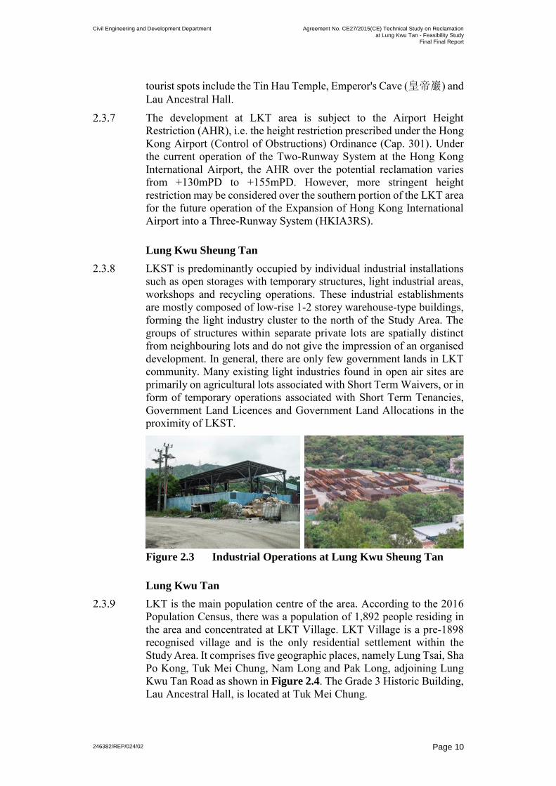
2.3.8 LKST is predominantly occupied by individual industrial installations such as open storages with temporary structures, light industrial areas, workshops and recycling operations. These industrial establishments are mostly composed of low-rise 1-2 storey warehouse-type buildings, forming the light industry cluster to the north of the Study Area. The groups of structures within separate private lots are spatially distinct from neighbouring lots and do not give the impression of an organised development. In general, there are only few government lands in LKT community. Many existing light industries found in open air sites are primarily on agricultural lots associated with Short Term Waivers, or in form of temporary operations associated with Short Term Tenancies, Government Land Licences and Government Land Allocations in the proximity of LKST.
Figure 2.3 Industrial Operations at Lung Kwu Sheung Tan
Lung Kwu Tan
LKT is the main population centre of the area. According to the 2016 Population Census, there was a population of 1,892 people residing in the area and concentrated at LKT Village. LKT Village is a pre-1898 recognised village and is the only residential settlement within the Study Area. It comprises five geographic places, namely Lung Tsai, Sha Po Kong, Tuk Mei Chung, Nam Long and Pak Long, adjoining Lung Kwu Tan Road as shown in Figure 2.4. The Grade 3 Historic Building, Lau Ancestral Hall, is located at Tuk Mei Chung.

Civil Engineering and Development Department Agreement No. CE27/2015(CE) Technical Study on Reclamation
at Lung Kwu Tan - Feasibility Study Final Final Report
246382/REP/024/02
Page 11
Figure 2.4 Location of Lung Kwu Tan Village
2.3.10 There are numerous private lots within LKT Village and some of them are with building status which includes building licences/ New Grant/ Old Schedule house lots. In addition to private lots with building status, there are private agricultural lots, structures for agricultural purposes covered by letter of approval, and tolerated structures covered by surveyed number at LKT.
Figure 2.5 Lung Kwu Tan Village
Similar to the indigenous villages throughout Hong Kong, the village-type development in LKT Village is mostly composed of clusters of three-storey village houses along informally organised rural roads with limited overall planning.
The geographical places within LKT Village also adjoin and mix with rural small businesses, rural industries and operations/storage on open space.

Civil Engineering and Development Department Agreement No. CE27/2015(CE) Technical Study on Reclamation
at Lung Kwu Tan - Feasibility Study Final Final Report
246382/REP/024/02
Page 12
Indigenous villagers in the New Territories are entitled to burial rights in permitted burial grounds, which usually are located in the same village settlements, in the vicinity or on Government land. There are four main burial grounds in LKT area and a number of individual burial urns or graves scattered around the community.
Three of the permitted burial grounds are situated around foothills (one is next to Lung Tsai, and the other two are near Pak Long) and one is located at upper hills right next to the existing CWD lookout point. They are part of the LKT community and as observed on-site, they are all maintained in good condition.
Figure 2.6 Clusters of Burial Grounds, Graves and Urns within
Study Area
Opportunities provided by Lung Kwu Tan Reclamation
Knowing the drastic planning change in the NWNT, LKT reclamation could play a part in the strategic planning of the whole region, complementary to other developments in the NWNT. For instance, the new space formed by LKT reclamation could provide decanting sites for any resumption / relocation of brownfield operations at the NDAs, and other redevelopment proposals in Tuen Mun.
Due consideration should be given to the unique characteristic of Tuen Mun West and LKT area, i.e. the existing industrial setting and the remoteness, when formulating the development plan for LKT reclamation. The vast area of new land and the long seafront that can be provided by the reclamation proposal make it a valuable land resource for certain types of land use.

Civil Engineering and Development Department Agreement No. CE27/2015(CE) Technical Study on Reclamation
at Lung Kwu Tan - Feasibility Study Final Final Report
246382/REP/024/02
Page 13
3 Land Use Assumptions
3.1 Guiding Principles for the “Preliminary Land
Use Themes”
Considering the opportunities and constraints for the reclamation proposal, the possible land uses and combination were set out in the form of “preliminary land use themes” for assessment in the Study. A set of guiding principles, described below, were established to direct the formulation of the preliminary land use themes to assist the assessments and, after completion of the technical and environmental assessments, to evaluate the relative performance of the preliminary land use themes. At the end, potential development theme(s) for LKT reclamation would be identified with due consideration given to the vision of this reclamation project as well as the site constraints.
Enhance Land Supply to meet Territorial Needs
The sizeable reclamation at LKT would provide ample opportunities to increase and expedite land supply as the fundamental solution to meet various land demands of Hong Kong and to complement with other developments in Tuen Mun West. The opportunities provided by its location advantages and the marine access of LKT should be captured to meet the regional and territorial needs and provide new employment opportunities.
Meet Local Needs
Being a small and remote village cluster, LKT community has limited economic opportunities with its local business mostly taking place in mini-stores run by home-makers in daytime. There is no clinic, public library, post office and market in LKT; the residents have to travel about 15 minutes driving distance to Butterfly Estate in Tuen Mun South for these community facilities and there is only one bus line running in-between. Currently, there is no suitable government land in the LKT area to meet the shortfall of community facilities.
With the proposal of reclamation development, there are opportunities to improve the livelihood of the locals in three aspects: provision of more local business opportunities, provision of various new facilities, and improvement on the accessibility of LKT area with new public transport services.
Compatibility with Nearby Village and Industries
The existing land uses in LKST and LKT, which fall within the northern and southern portions of the Study Area respectively, are distinct: industrial in the north and village housing in the south. The new developments on the reclamation will adjoin these existing land uses, and should preferably be compatible with these existing usage.

Civil Engineering and Development Department Agreement No. CE27/2015(CE) Technical Study on Reclamation
at Lung Kwu Tan - Feasibility Study Final Final Report
246382/REP/024/02
Page 14
The northern portion of the Study Area comprises mainly light industrial operations. Non-residential developments could be considered.
In contrast, the southern portion of the Study Area is generally residential in nature with village-type development just next to the coast near the reclamation area. Buildings in lower development density could be compatible with the existing villages.
Minimise Impacts on Existing Road Network and Provision of New Transport Infrastructure
3.1.8 Development inevitably involves movements of goods and people in one or more mode(s) of transport. The LKT area is linked to the Tuen Mun New Town by Lung Mun Road and the rest of the territory by Wong Chu Road and Tuen Mun Road. These three key roads form an important east-west spine for road traffic associated with the new development on the reclamation at LKT. These key roads are serving road traffic in Tuen Mun and the NWNT, and these key roads have only limited traffic flow capacity to spare for the new development.
The planning of the proposed development on LKT reclamation should therefore consider the need to minimise impact on these key roads. It would be more desirable to have land uses at LKT reclamation that can capitalise the spare capacity of the existing transport infrastructure in the reverse direction of peak hour flow, or else substantial input would be required for the strategic transport infrastructure.
Respect the Environment and Minimise Impacts
Besides human needs, reclamation works and the associated developments must respect the nature and environment, including terrestrial and marine ecology. This principle is evolved around the overarching strategic goal of sustainable development.
It is of particular importance for LKT reclamation development, given the natural resources of environmental significance / ecological value present in the surroundings. The developments at LKT should pay due respect to these ecological assets and facilitate their conservation.
For the goodness of the society, impacts on the environment given rise by any kind of development have to be minimised, confined and mitigated as much as possible. These include the pollution that would affect humans, such as noise and deterioration of air quality and water quality, and disturbance to the terrestrial and marine lives. Apart from minimising the impact, opportunities should be explored to provide some form of ecological enhancement to restore the damaged habitat.

Civil Engineering and Development Department Agreement No. CE27/2015(CE) Technical Study on Reclamation
at Lung Kwu Tan - Feasibility Study Final Final Report
246382/REP/024/02
Page 15
Adopt a Flexible Design and Adaptable Implementation
Programme
Possibility to undertake the whole development in phases should be explored for earlier commissioning to meet the urgent need of land. It would be desirable if some part(s) of new development can be commissioned before the completion of supporting infrastructures such as water supply and sewage treatment. The land use planning should therefore take into account the possible phasing and the construction time required for the land formation and the provision of associated infrastructures.
The existing road connection to Tuen Mun is at the south of LKT. As such, it would be more desirable to reclaim the southern portion and construct the new connecting road to Lung Mun Road first to minimise traffic impact on the Lung Kwu Tan Road.
Land resumption should be avoided as far as possible. Apart from the concerns over the impact on the villagers, it would induce uncertainty to the implementation programme of the development because the required process may be lengthy.
3.2 Potential Land Uses Included for Assessment
3.2.1 In order to meet the objectives of the Study, five preliminary land use themes were formulated to facilitate the assessments required by this Study. They were adopted as the development assumptions to identify possible worst-case scenarios for technical and environmental assessments in order to assess the development opportunities and constraints of the LKT reclamation development. These themes were set out solely for the purposes of preliminary assessments required in this Study and do not represent the actual proposals. The actual development proposal for the reclamation will be developed in the future detailed studies and assessments, including the statutory EIA, with the involvement of the public.
3.2.2 Major land use types considered include residential and industrial uses, whilst commercial areas for office space, local retail outlets, etc. were only considered alongside with the residential / industrial development to support the future development.
• Residential uses – With the opportunities presented in the reclamation proposal to help address the major territorial needs including housing demands, utilising suitable parts of the reclamation area for housing development should be considered. In fact, under the public engagement activities done under the Land Supply Study, residential development was suggested as a potential land use by the public. A range of housing including private and subsidised housing could be considered to provide a suitable housing mix. The scale and density of the future housing developments should consider the low density village-type housing in the surrounding areas to ensure a compatible development scale.

Civil Engineering and Development Department Agreement No. CE27/2015(CE) Technical Study on Reclamation
at Lung Kwu Tan - Feasibility Study Final Final Report
246382/REP/024/02
Page 16
• Industrial uses – The success of Hong Kong’s future development hinges on securing the necessary land resources to improve productivity and remain competitive in the Pearl River Delta region. Strong demand has been noted in the territory for industrial estates and science parks within which Hong Kong’s manufacturing as well as research and development sectors can blossom. In addition, there is a growing demand in the territory for the industrial operations with special requirements (i.e. modern logistics and warehousing, green industries and industrial parks proposed in the studies for Hung Shui Kiu NDA and Tuen Mun Areas 40 and 46). Some of them may require marine access. LKT reclamation, if pursued, would offer opportunity to provide new, dedicated and modern industrial accommodation to cater for the new industrial processes requiring higher standard of accommodation to meet the territorial demand.
Some territorial facilities and installations which have played important roles in supporting Hong Kong’s growth and prosperity were also considered. The remote location and neighbouring industrial setting of LKT provide this reclamation site with a strong potential as solution space for such uses to serve the territory’s growth. Special uses such as Construction and Demolition Materials Handling Facilities (C&DMHF), which are set up for production of recyclable materials and/or public fill for reclamation and should be equipped with barging point(s) at seafront for material loading/unloading, were considered in the Study for assessment purpose. Placing these facilities in relative isolation from major population centres is one of the options from strategic town planning perspective.
3.2.4 The land use combinations of the five preliminary land use themes (PLUT) are summarised in Table 3.1.
Table 3.1 Land Uses in Preliminary Land Use Themes
Area Preliminary Land Use Theme (PLUT)
A B C D E
Northern Portion (near LKST)
Residential Industrial
Special Use Residential Industrial
Southern Portion (near LKT)
Industrial Special Use
Special Use
Each preliminary land use theme may have different associated infrastructure requirements (e.g. new access roads, freshwater / flushing water mains, pumping stations or service reservoir, sewerage and drainage systems, sewage pumping stations, sewage treatment works, and berthing facilities). However, in this preliminary project stage, these requirements were not investigated in detail in this Study. They will be proposed and designed in details when the actual development proposal is formulated in the future studies.
Civil Engineering and Development Department Agreement No. CE27/2015(CE) Technical Study on Reclamation
at Lung Kwu Tan - Feasibility Study Final Final Report
246382/REP/024/02
Page 17
4 Engineering and Environmental
Assessments
4.1 Assessment Assumptions
At this very preliminary stage of the project, the assessments were done based on various assumptions such as reclamation extent, construction methods and programme, and possible land uses and combination set out in the preliminary land use themes. The assumptions were established to facilitate the assessments under reasonably conservative and possible worst-case scenario, and do not represent the actual proposals. The actual proposal and details will be developed in detailed studies in the future, including the subsequent planning and engineering studies and statutory EIA, with the involvement of the public.
Possible interfacing projects were also identified, with reference to the best available information regarding the ongoing, committed, planned and proposed projects at the time of the assessment. The interfacing issues and the cumulative effects, in particular to the environmental and traffic conditions during operation, were identified and assessed in advance, with a view to identify the implication, if any, on the reclamation proposal due to other interfacing projects.
The aspects investigated and the key findings are summarised in this Section.
4.2 Geotechnical Appraisal and Reclamation Study
Potential Reclamation Extent
LKST and LKT together has an extensive coastal area with shallow seabed level. Reclamation is technically feasible, and the potential reclamation area is approximately 220 to 250 hectares on plan as shown in Figure 4.1. It stretches about 3 km in the north-south direction and 700m to 1 km in the east-west direction between the existing shore and the new reclamation edge. With such a sizeable reclaimed area, there are countless potential for development.

Civil Engineering and Development Department Agreement No. CE27/2015(CE) Technical Study on Reclamation
at Lung Kwu Tan - Feasibility Study Final Final Report
246382/REP/024/02
Page 18
Figure 4.1 Potential Reclamation Extent
The potential reclamation extent was assessed in consideration of hydrodynamic, existing marine traffic pattern in Urmston Road and the sightings of CWD. It is limited within the embayment of shallow water to avoid changing the hydrodynamic regime within the nearby water bodies, to avoid encroaching upon the key navigation channel and the key CWD habitat just outside the bay (see Section 4.5 on “Chinese White Dolphin”). This extent is preliminary only and subject to review when the future land uses on the reclamation area, in particular the land uses along the shore, are determined and when detailed studies and investigation including EIA are undertaken.
Industrial uses might need marine transportation and loading or unloading of goods at the berths on the waterfront. Straight reclamation edge was initially proposed in the southern portion of the site that could allow marine access and berthing of vessels along the seaward edge of the reclamation. Vertical seawall would be required where berthing facilities are proposed. To provide sufficient space between the existing marine traffic using Urmston Road and the vessels berthing at the reclamation edge, the straight reclamation edge is set back by 100m from the line joining the Black Point headland in the north and the existing berth at the CPPS in the south. The existing seabed level along this straight reclamation edge is higher than 5m below Chart Datum

Civil Engineering and Development Department Agreement No. CE27/2015(CE) Technical Study on Reclamation
at Lung Kwu Tan - Feasibility Study Final Final Report
246382/REP/024/02
Page 19
(CD) (i.e. -5.0mCD) [Note: Chart Datum is 0.146m below the Principal Datum.]. Dredging might be required to provide adequate water depth for vessel berthing and manoeuvring along this reclamation edge.
An existing submarine effluent outfall, maintained by the Drainage Services Department (DSD), was identified within the northern portion of the potential reclamation area as shown in Figure 4.2. This outfall connects to the North West New Territories Sewage Tunnel to convey and discharge the treated effluent from San Wai Sewage Treatment Works (STW) to Urmston Road, serving the catchments of Yuen Long peripheral area, North Tuen Mun and the Tuen Mun-Yuen Long Corridor, Tin Shui Wai and Au Tau/Long Ping.
Considering the importance of the existing submarine outfall to its catchments and the significant challenges in re-provisioning of this outfall at the heavily trafficked Urmston Road, the existing outfall should be retained and kept intact. Reclaiming over the outfall is not recommended as this would load the outfall and its surrounding soil that they were not originally designed for. Due to the no-dredging requirement near the outfall, on-shore berthing is not allowed in the northern portion of the reclamation site in the preliminary layout.
Figure 4.2 Layout of Existing Submarine Outfall
Ground Condition
The potential reclamation area predominantly comprises a nearshore area with coastal features such as headlands, narrow beaches and reclaimed land located along the existing shore. Natural terrain hillsides are present at several locations to the north, east and south of the potential reclamation area respectively and are generally characterised

Civil Engineering and Development Department Agreement No. CE27/2015(CE) Technical Study on Reclamation
at Lung Kwu Tan - Feasibility Study Final Final Report
246382/REP/024/02
Page 20
by rugged terrain with the presence of a series of dominantly west-trending drainage lines along the topographic depressions in the hillsides.
Figure 4.3 Topography of Study Area
The coastal areas abutting the eastern boundary of the potential reclamation area are generally at elevations ranging between +2.5mPD and +7.0mPD, with elevations of +5.0mPD recorded at the then barging point at LKST in the north, +2.5mPD at LKST beach in the northeast, +4.5mPD at Sha Po Kong in the southeast and +7.0mPD at the CPPS in the south respectively.
The seabed level within the potential reclamation area generally ranges from approximately -0.2mPD to -5.0mPD throughout most of its areas, with a general trend of lower level towards the west of the site.
The superficial deposits within the potential reclamation area predominantly comprise a layer of marine deposits (marine mud and marine sand) underlain by alluvium. The marine sand is mainly concentrated along the shoreline.
Onshore superficial deposits comprise mainly debris flow deposits, raised beach deposits, beach deposits and occasional areas of fill associated with past reclamation and seawall construction within the coastal area. The onshore superficial deposits are predominantly concentrated within the two low-lying bay areas, with the beach deposits present in the near-coastal areas and debris flow deposits commonly located further inland within the valley floors, footslopes and topographic depressions.
The solid rock below the superficial deposits is predominantly medium grained granite of the Tsing Shan Granite, which forms an elliptical pluton in the western New Territories that is invariably microcrystic within the LKT area.
Minor intrusions of aplite and lamprophyre were recorded in the region in the form of northeast trending dykes, in particular within the area of the Black Point headland abutting the northern boundary of the potential reclamation area.

Civil Engineering and Development Department Agreement No. CE27/2015(CE) Technical Study on Reclamation
at Lung Kwu Tan - Feasibility Study Final Final Report
246382/REP/024/02
Page 21
Desktop study and review of existing ground investigation (GI) records were undertaken as part of this Study. Additional project-specific marine GI works were carried out in the Study Area to supplement the available data and to verify the geological profiles. Field tests and laboratory testing on soil/rock samples were undertaken to enable better understanding of the ground characteristics.
The project-specific GI works comprised a total of ten (10) marine drillholes together with in-situ vane shear tests and standard penetration tests, five (5) vibrocores as well as five (5) grab samples. The GI works found that the marine deposits were variable in composition and comprised a mixture of clay, silt and sand. A relatively high percentage of gravel (up to 40%) was occasionally found within the marine deposits. The marine deposit was found to vary from 5.9m to 12.5m in thickness. Alluvium was found to be highly variable in composition, comprising predominantly clay and sand, with the sandy strata often being very gravelly. Completely to highly decomposed granite was reasonably well-graded and comprised typically silty gravelly-sand. The soil and rock stratigraphy of the project specific GI data is summarised in Table 4.1.
Table 4.1 Summary of Soil and Rock Stratigraphy from the
Project Specific Data within the Site
Type Thickness (m), if
present
Top Level (mPD), if
present
Marine Deposits 5.9m to 12.5m -1.05mPD to -3.15mPD
Alluvium 1.5m to 10.0m -7.5mPD to -17.1mPD
CDG to HDG 1.0m to 41.9m -11.15mPD to -21.6mPD
Corestone Layer 1.09m to 10.82m -12.2mPD to -63.5mPD
Engineering Rockhead
- -13.29mPD to -74.32mPD
Natural Terrain
A number of natural terrain catchments are situated within the hillside areas directly abutting the shoreline in the northern and central portions of the potential reclamation area. Initial assessments, based on desktop study, review of landslide records / inventory and boulder field inventory kept by the Geotechnical Engineering Office (GEO), indicated limited historical landslide activity within these catchments but highlighted the presence of extensive rock outcrop and boulder coverage within them.
A preliminary screening in accordance with Geotechnical Engineering Office (GEO) Report No. 138 “Guidelines for Natural Terrain Hazard Studies” (NTHS) was carried out for the credible flowpaths for each natural terrain catchment. Some of these catchments, mostly near the central portion of the potential reclamation area, were found meeting “Alert Criteria” which will require an NTHS depending on the nature

Civil Engineering and Development Department Agreement No. CE27/2015(CE) Technical Study on Reclamation
at Lung Kwu Tan - Feasibility Study Final Final Report
246382/REP/024/02
Page 22
of the proposed developments and their locations from the toe of the catchment. In the next stage studies when the land uses and detailed facility layouts are available, the location and the extent of hillside requiring a detailed NTHS will be reviewed. Subject to the results of the detailed NTHS, mitigation measures will be designed and considered in the land use planning. Possible mitigation measures, such as the provision of flexible debris resisting barriers at the toe of catchments and in-situ stabilisation of potential landslide source areas using soil nails which can be determined following the prescriptive approach outlined in GEO Technical Note (TGN) No. 37, were identified for the relatively small-scale catchments.
The boulder fields in the proximity of the potential reclamation area falls within areas that generally have very dense boulder coverage (>75%), with “boulder” types recorded are predominantly tors and rock outcrops. This information indicates that the bedrock may possibly be quite shallow within the hillside areas abutting the site. In view of the presence of numerous boulders and rock outcrops within the hillside area overlooking the future development within the reclamation area, assessment of the potential boulder fall / rockfall hazard will be required in the next stage studies when the land uses and detailed facility layouts are available. To mitigate the boulder / rockfall hazards which might affect future developments within the potential reclamation area adjacent to them, stabilisation works against such hazards will need to be investigated in the detailed studies.
Man-made Slopes and Retaining Walls
There are a number of registered man-made slopes/retaining walls (referred to as “features”) close to the reclamation, and these features are mainly located along Lung Kwu Tan Road at LKT. There is no previous study report on these features identified. As such, a preliminary assessment of these features was carried out according to TGN No. 15 in this Study. In view of their locations, it is anticipated that these features would have low potential to affect or be affected by the proposed reclamation works, and features near the junction of Lung Fai Street and Lung Kwu Tan Road overlooking the reclamation area were found to be directly affected by the proposed road connecting Lung Mun Road to the reclamation. Nevertheless, detailed review and assessment should be conducted for all existing man-made features which could affect or be affected by the proposed reclamation works and their associated road works in the next detailed studies.
Preliminary Reclamation Study
The potential reclamation area is shown in Figure 4.1. The formation of reclamation was preliminarily suggested at the level of +6.0mPD considering a number of factors, including connectivity to the adjoining land and infrastructure, risk of wave overtopping and proper function of new drainage system which operates by gravity only. Other factors to be considered include the vulnerability of the land uses to coastal
Civil Engineering and Development Department Agreement No. CE27/2015(CE) Technical Study on Reclamation
at Lung Kwu Tan - Feasibility Study Final Final Report
246382/REP/024/02
Page 23
flooding and backwater drainage flow and availability of fill materials, which will need to be investigated in the detailed studies.
Common types of reclamation fills used in Hong Kong include sand fill collected from a marine source and public fill. The total volume of fill material for forming the reclamation platform above the existing seabed was estimated to be in the order of 20 Million m3, and additional fill would be needed for accommodating the settlement occurred during construction and for imposing surcharge to preload and treat the in-situ materials below seabed and the reclamation fill. Public fill is generally preferred for better utilisation of available resources; close coordination with the Public Fill Committee of CEDD will be required in the next detailed studies stage to ascertain the availability of fill materials so as to review and revise the reclamation design.
The reclamation works should be phased to match with the development programme of various land uses within the reclamation area and to facilitate the early handover of site for infrastructure construction. The detailed reclamation programme and phasing will be firmed up in the detailed studies when the future land uses on the reclamation area and the infrastructure needs are determined.
The seabed of the potential reclamation area is underlain by soft marine clay up to 12.5m thick, which would be compressed by reclamation fill deposited on the existing seabed, resulting in settlement of the reclaimed area. For large area reclamations, a post-construction residual ground settlement of 500mm is generally acceptable in accordance with the current code – Port Works Design Manual Part 3. In order to limit the residual settlement within the reclamation area to below this maximum allowable value, a preliminary ground treatment scheme involving temporary placement of 6m high surcharge and installation of vertical drains at 1.2m centre-to-centre (c/c) spacing is recommended. This will be reviewed in the detailed studies when additional ground investigation information is collected and phasing of reclamation is determined.
Proposed Seawall Scheme
The location, alignment, form, structure and foundation types of seawall depend on their functional requirements and programme requirements for land formation.
Non-dredged seawall schemes are preferred due to its less potential impact to water quality. However, the thick in-situ sediments are not strong and stiff enough to support the seawall above and the reclaimed land behind the seawall. From preliminary stability analyses, deep cement mixing (DCM) is found technically feasible in this site to enhance the strength and stiffness of the in-situ soft materials to support the seawall. Preliminary stability assessments show that a minimum width of 65 to 70m DCM-treated zone at 50% replacement ratio is needed below a 1v:2h gradient rubble mound sloping seawall to support the reclamation and the temporary placement of 6m high surcharge. The

Civil Engineering and Development Department Agreement No. CE27/2015(CE) Technical Study on Reclamation
at Lung Kwu Tan - Feasibility Study Final Final Report
246382/REP/024/02
Page 24
actual ground treatment types and seawall scheme are subject to review taking into account of the possible cost, programme constraints, availability of plant, land uses requirements, etc. This will be reviewed in the detailed studies and the detailed design stage.
Figure 4.4 Typical Sections of Proposed Seawall Scheme
along Reclamation Edge – vertical seawall (top) and sloping seawall (bottom)
In addition to meeting the functional requirements, seawalls should be designed to be more environmentally and/or ecologically friendly to provide opportunities for enhancing marine ecology. Soft or semi-soft shorelines that can allow vegetation growth are generally preferred, but they are less resilient to the rough wave conditions facing the open sea and these may only be applicable to the shorelines under protected environment. For the seawalls facing the Urmston Road, it would be technically difficult to adopt soft or semi-soft solution. In this case, hard solutions that can provide some sheltered pockets or features for fouling should be considered; these include rubble mound structure or be-spoke concrete featured blockwork walls.
4.3 Marine Traffic
Risk Assessment
A preliminary marine traffic impact assessment (MTIA) was undertaken according to the Formal Safety Assessment process by the International Maritime Organisation as a structured approach to the assessment of marine risks and the effectiveness of control mechanisms. The risk assessment was completed to review if the cumulative risk resulted from the proposed development during the construction and operation phases are acceptable based on the acceptable criteria listed in the International Maritime Organisation Formal Safety Assessment and determine whether mitigation measures are required.

Civil Engineering and Development Department Agreement No. CE27/2015(CE) Technical Study on Reclamation
at Lung Kwu Tan - Feasibility Study Final Final Report
246382/REP/024/02
Page 25
The marine traffic pattern is a combination of vessel types, dimensions, routings and traffic frequency, and is represented by four time-step series: existing, future baseline, future during construction phase of the project and future during operation phase of the project.
Marine traffic data, including Automatic Identification System (AIS) data and radar data, for the waters near the potential reclamation at LKT in July 2015 was collected from the Vessel Traffic Centre of the Marine Department (MD) for analysis. The bulk of the traffic, including bulk carriers, cargo ships, container ships, tug boats, pilot ships, tankers and other vessels, along Urmston Road outside the potential reclamation area is either northbound or southbound. The analysis of the data showed that the average daily vessel movement was about 250 to 280 vessel movements per day in each direction.
Local marine activities within the bays of LKT and LKST were recorded during the project-specific ground investigation works carried out in April and May 2016. These activities included standby of pilot boats and tugs, operation of sand barges, fishing, wind surfing and kite surfing. A total of 26 events was recorded in the day time of these two months. Most of the fishing activities involved small vessels like mechanised vessels (P4) or sampan.
Types and movement patterns of marine traffic during the operation phase depends on the waterfront usage and the provision of vessel-berthing facilities and would vary with the future land use on the reclamation. For instance, C&DMHF would have waterfront berthing facilities for bulk carriers and lighters for material loading/unloading. The feasibility of setting up the facilities at LKT reclamation in terms of navigation spatial requirements and navigation risk was preliminarily assessed in this Study.
The marine risks during both construction and operation phases were preliminarily assessed based on the estimated future marine traffic pattern (type, length overall, speed, movement frequency and tracks) and the broadbrush estimate of additional vessel movements associated with the construction and the daily operation of the assumed special uses respectively. Arup marine traffic model, based on the ship domain theory, was used to model the marine traffic pattern and estimate the number of collision within the Study Area. The average individual risk in the waters around the potential reclamation area was considered to be either negligible or as low as reasonably practicable (ALARP). In the next detailed study stage when the future land uses on the reclamation area and the associated marine traffic pattern are more certain, a comprehensive MTIA will need to be carried out and risk control options should be developed to minimise the impacts. Possible interface issues with other projects in the vicinity and the cumulative marine traffic impact will also be studied in the comprehensive MTIA.

Civil Engineering and Development Department Agreement No. CE27/2015(CE) Technical Study on Reclamation
at Lung Kwu Tan - Feasibility Study Final Final Report
246382/REP/024/02
Page 26
Figure 4.5 Key Marine Traffic Movements
A full navigation simulation should be carried out in the comprehensive MTIA in the next stage to simulate the vessel manoeuvring between Urmston Road and the future waterfront of the reclamation and to assess if any navigation measures or aids is required.
Preliminary Assessment on Setting up Marine Facilities at Future
Waterfront
A preliminary met-ocean study was undertaken as part of this Study to determine the sea levels, wave conditions and water currents for the purpose of assessments of reclamation works and possible waterfront facilities. Historical measurements at the wind stations and tide stations in the vicinity of the potential reclamation at LKT, including the stations at Sha Chau, Tai Mo To and Hong Kong International Airport, were used for assessing the metocean conditions at the site. The wind roses at these three stations are shown in Figure 4.6 and Figure 4.7.

Civil Engineering and Development Department Agreement No. CE27/2015(CE) Technical Study on Reclamation
at Lung Kwu Tan - Feasibility Study Final Final Report
246382/REP/024/02
Page 27
Figure 4.6 Wind Roses at Sha Chau and Tai Mo To Station
Figure 4.7 Wind Rose at Hong Kong International Airport
Station
A wave climate study was undertaken to assess the characteristics of the wave conditions at the reclamation site for evaluating the feasibility of vessels berthing at the reclamation edge. This wave hindcast exercise was completed using the historical measured hourly wind data collected at the Hong Kong International Airport. The wave conditions were generally calm over a significant portion of the time of the year (about 87%), with the significant wave height at 0.3m or less.
When vessels berth at the waterfront of the reclamation or nearshore jetties, the ease to unload or load goods and people alighting depends on the significant wave height at the berths and the type of vessels. A threshold wave height of 0.7m was considered for vessels handling goods in the assessment, and it was found that the percentages of

Civil Engineering and Development Department Agreement No. CE27/2015(CE) Technical Study on Reclamation
at Lung Kwu Tan - Feasibility Study Final Final Report
246382/REP/024/02
Page 28
downtime, i.e. time that vessels cannot berth due to severe wave conditions, were acceptable. This is consistent with the marine facilities nearby, such as the jetties of CPPS, where vessels can berth against without wave protection structures such as breakwater. However this will need to be reviewed in the detailed studies when the land use at waterfront and berthing requirement are determined.
Figure 4.8 Depth-averaged Current Speed (knots) in Flood
Tides during Wet Season
Figure 4.9 Depth-averaged Current Speed (knots) in Ebb Tides
during Wet Season
The depth-averaged current speed in front of the potential reclamation area ranges from 1 to 1.9 knots, i.e. 0.5 to 1.0m/s. This water current can be used for designing the mooring facilities and piled jetties.

Civil Engineering and Development Department Agreement No. CE27/2015(CE) Technical Study on Reclamation
at Lung Kwu Tan - Feasibility Study Final Final Report
246382/REP/024/02
Page 29
A visual survey will be undertaken as part of the more comprehensive MTIA to be carried out in the next stage detailed studies to supplement the AIS data and radar data to establish full-profile marine traffic pattern at the Study Area. The marine traffic pattern detailing the vessel type, movement rate and travel/manoeuvring patterns can facilitate assessing the feasibility of vessel berthing at the waterfront or jetty associated with the proposed development, and review the impact on marine traffic during construction.
LKT bay is next to Urmston Road, and this bay is understood to be used by vessels as a beaching site, i.e. a site of shallow water used by vessels to lay ashore or to ground to avoid complete sinking into the sea. Historical records between 2011 and 2015 kept by MD show that there was one reported grounding/stranding accident near LKT involving a River Trade Cargo vessel of 4.8m draft. It is recommended that the reclamation extent be delineated to provide a water space of water depth shallower than 5m for future beaching of river trade vessels.
MD’s radar station, Black Point Radar Station, is located at the peak of Black Point overseeing the marine traffic at Urmston Road. The buildings on the reclamation area should adopt stepped height profile towards the sea and the structures along seafront should be carefully designed to avoid blocking the radar coverage at Urmston Road to ensure marine safety.
4.4 Traffic and Transport
The new development at LKT reclamation would likely generate or attract traffic that use the key roads in Tuen Mun District. A preliminary traffic and transport impact assessment (TTIA) was undertaken to assess the future traffic condition, if LKT reclamation development is pursued, within and around the Study Area.
The preliminary TTIA was conducted based on two levels of transport models, namely Strategic Transport Model (STM) and Local Area Traffic Model (LATM). On the upper level, Arup’s in-house STM produced traffic forecasts on a strategic basis. It mainly estimated the traffic demand in the district-to-district movements by different transport modes with respect to the planning data and transport infrastructures for the whole territory. On the lower level, matrices cordoned from the STM were input into the LATM, which was used to predict the network performance on a more local perspective. With the incorporation of local area junction characteristics, the LATM provided the capability to estimate the junction delay and traffic queuing for route choice in assigning the traffic flow in local areas.
The STM was validated to match with the traffic data collected in TD’s Annual Traffic Census data. On the other hand, the LATM was validated by surveys at local road and at-grade junctions.
The development proposal in Tuen Mun Areas 38 and 49, Tuen Mun Areas 40 and 46, and Tuen Mun Town Centre for industrial, logistic or

Civil Engineering and Development Department Agreement No. CE27/2015(CE) Technical Study on Reclamation
at Lung Kwu Tan - Feasibility Study Final Final Report
246382/REP/024/02
Page 30
residential development would generate additional road traffic on existing roads such as Lung Mun Road, Lung Fu Road, Wong Chu Road and Tuen Mun Road. As a result, this would have direct interface with the LKT development on traffic and transport aspects. On the other hand, the proposed Tuen Mun Western Bypass and Route 11 should be able to improve the overall traffic condition of Tuen Mun district. They were considered in the STM for year 2036 which were adopted as the design year for assessing the traffic impacts on the strategic roads and major highways within the Area of Influence by the LKT reclamation development.
To assess the possible traffic impact with the LKT reclamation development, the traffic demand of each preliminary land use theme was estimated, considering the split of different transport modes. The vehicular traffic in peak hour estimated from the model is presented in Table 4.2.
Table 4.2 Estimated Trip Generation of Preliminary Land
Use Themes
PLUT
Development Traffic (pcu/hr)
AM Peak PM Peak
Generation Attraction 2-way Generation Attraction 2-way
A 2,150 1,570 3,720 1,430 1,540 2,970
B 840 1,270 2,110 1,050 770 1,810
C 890 1,090 1,980 950 820 1,770
D 2,120 1,830 3,950 1,680 1,660 3,340
E 1,210 1,570 2,780 1,330 1,130 2,460
In preliminary land use themes A and D, the direction of trip generation would be the peak direction in AM peak while in preliminary land use themes B, C and E, the direction of trip attraction would be the peak direction in AM peak. It is consistent with the nature of land use, with residential cum employment in former and employment major in others. Preliminary land use themes B and C would generate similar order of traffic and they are the least among the five preliminary land use themes.
Assessment and Possible Mitigation Options
The assessment shows that, being the only external access linking up the LKT area to Tuen Mun New Town, Lung Mun Road would likely have congestion problem with LKT reclamation development, in particular at the junction of Lung Mun Road and Lung Fat Street, the junction of Lung Mun Road and Gate 2 of RTT, the junction of Lung Mun Road and Mong Tat Street and the junction of Lung Mun Road and Lung Fu Road and require enhancement to meet the future traffic needs. Widening of Lung Mun Road and upgrading of Siu Lang Shui Road to provide a bypass route bypassing the critical junctions along Lung Mun Road are therefore proposed based on the preliminary
chaneth
文字方塊
*
chaneth
文字方塊
* The following are ballpark assumption for TTIA without detailed land use planning: PLUT A: Population 146,000, Employment 43,000; PLUT B: Employment 85,000; PLUT C: Employment 30,000; PLUT D: Population 94,000, Employment: 22,000; PLUT E: Employment 61,000
chaneth
文字方塊
Addendum No. 1

Civil Engineering and Development Department Agreement No. CE27/2015(CE) Technical Study on Reclamation
at Lung Kwu Tan - Feasibility Study Final Final Report
246382/REP/024/02
Page 31
analyses in this Study. The proposed improvement scheme should be reviewed and adjusted in the detailed studies, taking into account the actual traffic demand of the proposed development and the detailed investigation of the local traffic arrangement during construction stage.
Figure 4.10 Proposed Road Improvement along Lung Mun
Road and Siu Lang Shui Road
There would also be congestion problem at Wong Chu Road and the slip road connecting Tuen Mun Road (northbound) to Wong Chu Road (westbound). Due to the dense existing development on both sides of Wong Chu Road, there is no room available for road improvement works. Building a new slip road connecting Tuen Mun Road (northbound) and Hoi Wing Road (westbound) to provide an alternative route to Tuen Mun West is a possible measure to mitigate this congestion problem.
However, based on the preliminary assessment done for different preliminary land use themes, it was revealed that residential development would generate much higher traffic flow than the industrial uses, and aggravate the traffic condition in the already critical traffic flow direction even if only part of the reclamation is reserved for the purpose. With this new slip road, the traffic flow at Wong Chu Road and its westbound slip road from Tuen Mun Road relative to their road capacities, i.e. volume/capacity ratio, would be reduced to acceptable levels in the preliminary land use themes B and C, in which residential development was not considered. Meanwhile, despite the diversion of traffic flow to Hoi Wing Road, it was assessed that the road itself, the junction of Hoi Wing Road and Tuen Mun Rural Committee Road and the junction of Hoi Wing Road and Castle Peak Road would still operate satisfactorily with the increase in road traffic.

Civil Engineering and Development Department Agreement No. CE27/2015(CE) Technical Study on Reclamation
at Lung Kwu Tan - Feasibility Study Final Final Report
246382/REP/024/02
Page 32
Furthermore, for some uses such as C&DMHF, opportunities should be explored to maximise the use of marine traffic to further enhance the road performance.
Figure 4.11 Location of Proposed Slip Road connecting Tuen
Mun Road (Northbound) to Hoi Wing Road (Westbound)
The proposed road improvement works at Lung Mun Road, Siu Lang Shui Road, Lung Fu Road and the proposed slip road connecting Tuen Mun Road and Hoi Wing Road are under a number of natural terrain catchments. Initial assessments, based on desktop study, review of landslide records / inventory and boulder field inventory kept by GEO indicated limited historical activity within these catchments. A preliminary screening on the natural terrain catchments based on GEO Report No. 138 found that some catchments meet the “Alert Criteria” and a detailed NTHS is required for these catchments in the next stage studies. In addition, there are numerous boulders and rock outcrops within the hillside areas overlooking the proposed road improvement works. An assessment of the potential boulder fall / rockfall hazard will be required in the next stage. Subject to the result of detailed NTHS and boulder fall / rockfall hazard assessment, if the hazard affecting the widened sections are confirmed, mitigation measures against such hazards will need to be investigated in the detailed studies.
A number of registered and non-registered man-made roadside features, which consist of mainly man-made slopes, are along Lung Mun Road. These registered and non-registered features were preliminarily assessed according to TGN No. 15, and features at Siu Lang Shui Road/Lung Mun Road were found to be directly affected by the proposed connecting roads. Detailed stability assessment and design of slope modification works will be required. In addition, detailed review and assessment should be conducted for all existing man-made features which could affect or be affected by the road improvement works in the next stage studies. Stability assessment will be conducted to ensure that these features can meet the current safety standard and upgrading measures will be designed as appropriate. Similar detailed assessment
Civil Engineering and Development Department Agreement No. CE27/2015(CE) Technical Study on Reclamation
at Lung Kwu Tan - Feasibility Study Final Final Report
246382/REP/024/02
Page 33
and design works would be required for the features at Tuen Mun Road/ Hoi Wing Road which would be directly affected by the proposed slip road.
As for the congestion anticipated at Tuen Mun Road – Siu Lam Section, long-term strategic traffic solution will be necessary to alleviate the congestion along this strategic road. One possible solution is to encourage more road users to use the Route 11 which is anticipated to have spare capacity, for instance, by a more attractive toll level, such that some traffic would be diverted from Tuen Mun Road – Siu Lam Section and other strategic road links to Route 11. A proper toll strategy for Route 11 would be essential to promote more balanced utilisation of road capacity and help to relieve the problem at Tuen Mun Road – Siu Lam Section.
The new slip road off Tuen Mun Road to Hoi Wing Road would not be enough to alleviate the congestion problem at Wong Chu Road if the residential development is pursued at LKT reclamation as in preliminary land use theme A and D. The development scale and/or trip generations should be reduced to avoid traffic impact if they are to be pursued further. Alternatively, a new strategic road between Tuen Mun West and Tuen Mun Road bypassing the Wong Chu Road was considered necessary. Also, if extensive residential development was proposed, alternative access other than Lung Mun Road should be proposed to cater for emergency situations during which the Lung Mun Road was blocked / closed. Therefore, significant input on new transport infrastructure is anticipated if LKT reclamation goes for residential development.
In short, industrial and special uses that generate lower traffic flow in critical direction during peak hours than residential development are preferable at LKT reclamation. In particular, uses that can optimise the marine access provided at reclamation site, which in turn further reduce the traffic flow, should be given priority to effectively utilise the vast new land while minimising the burden on the key roads.
In the next detailed study stage when the future land uses on the reclamation area are formulated, a comprehensive TTIA will need to be carried out to demonstrate that no unacceptable traffic impacts will be resulted from the proposed reclamation development, taking into account the latest programme and project information of the key proposed road links and other development projects in the area.
4.5 Environmental Assessments In this Study, various environmental and ecological aspects were
preliminarily investigated based on the assumed potential reclamation extent and land uses. The review was undertaken to identify the key issues and constraints in environmental and ecological aspects for consideration in the future planning of the reclamation development. It should not be regarded in any form or depth to form part of the statutory

Civil Engineering and Development Department Agreement No. CE27/2015(CE) Technical Study on Reclamation
at Lung Kwu Tan - Feasibility Study Final Final Report
246382/REP/024/02
Page 34
EIA for Designated Project or Preliminary Environmental Review (PER) for Non-Designated Project.
Environmental concerns as related to reclamation works mainly include potential impact on water quality, fisheries resources and marine ecology, in particular CWD for works in the western waters of Hong Kong. The potential impacts were preliminarily assessed in the Study with possible mitigation options suggested. The possible impact on areas of significant ecological value such as marine park and SSSI were evaluated. As for the future development, the possible impact on air quality, noise, landscape and visual and cultural heritage which may impose constraints on future land uses were identified for future consideration.
4.5.3 A baseline review was undertaken to examine all relevant desktop information available at the time of assessment. Sensitive receivers, sources of pollution/impacts and any potential key environmental constraints that might have significant bearings on the land use proposals were identified. Areas/ sites of high ecological, landscape and cultural heritage value within and in the vicinity of the development and infrastructure proposals were also highlighted.
The assessment methodology and modelling tools were designed with a view to providing information on the possible nature and extent of environmental impacts arising from the construction and operation of the LKT reclamation and any concurrent projects, and identifying constraints imposed on future land uses of the reclamation area. Recommendations were also given to provide directions on mitigation strategies and further assessments in the EIA stage, during which detailed and comprehensive assessment would be conducted in accordance with the statutory requirement.
Water Quality
The potential reclamation site is located within the North Western Water Control Zone (WCZ) and adjacent to the boundary of the Deep Bay WCZ. The potential reclamation site is about 2 km from Sha Chau and Lung Kwu Chau Marine Park and is close to the spawning ground for commercial fisheries resources in the north of Lantau.
Preliminary water quality assessments for both operation and construction phases were carried out.
Operation Phase
Preliminary hydrodynamic assessment and water quality assessment were carried out to evaluate the impacts from the largest possible reclamation area for LKT reclamation. The hydrodynamic assessment showed that under such possible worst-case condition, LKT reclamation would cause a change of flow of the nearest channel at Urmston Road by 0.2% which was several times smaller than the change caused by HKIA3RS (0.9%). Hence, it was anticipated that no significant change in the hydrodynamic regime within the north-

Civil Engineering and Development Department Agreement No. CE27/2015(CE) Technical Study on Reclamation
at Lung Kwu Tan - Feasibility Study Final Final Report
246382/REP/024/02
Page 35
western waters would be induced from the reclamation in the embayment areas of LKT and LKST, and the impacts would be insignificant.
For water quality assessment, the pollution load inventory has referred to the background pollution inventory for year 2030 in EIA Report of DSD’s Harbour Area Treatment Scheme Stage 2A, with the effluent discharge from major STWs, including Siu Ho Wan STW, Pillar Point STW, Yuen Long STW, San Wai STW, Stonecutters Island STW and Sham Tseng STW in the Deep Bay WCZ, North Western WCZ and Western Buffer WCZ updated with the latest information on design plant capacity and discharge license requirement for the pollution loads. The estimated effluent discharge from the new on-site secondary treatment STW proposed for LKT reclamation development and additional surface runoff from the reclamation area were also included in the pollution load inventory. Based on the modelling result on the possible worst-case scenario for operation phase, i.e. highest sewage generation amongst the preliminary land use themes, there would be no significant change in terms of the Dissolved Oxygen (DO), 5-days Biochemical Oxygen Demand (BOD5), Suspended Sediment (or Solids) (SS), Total Inorganic Nitrogen (TIN), Unionised Ammonia (UIA), sedimentation rate and E. Coli. With proper implementation of mitigation measures, adverse water quality impact during operation phase is not anticipated.
Construction Phase
The major possible impact during the construction phase would be the release of SS due to the marine construction works. Water quality modelling for the construction phase was performed for the possible worst case scenario which assumed, on top of filling activities for reclamation, construction works such as 1) dredging works for berths at the reclamation edge and 2) dredging works for the re-provisioning of the existing submarine sewage outfall (hypothetical assumption only) were implemented simultaneously. The quantitative assessment showed that, with the implementation of environmentally friendly construction method and mitigation measures such as non-dredged seawall, leading seawall and silt curtain, SS release due to the marine work for reclamation alone would not result in significant change in water quality at the concerned Water Control Zones.
However, together with the concurrent projects, the SS releases could result in exceedance in the Water Sensitive Receivers (WSRs) at The Brothers Marine Park. A review showed that these exceedances were mainly attributed to the substantial disposal rate of contaminated mud pits assumed in the model which however was unlikely to occur by comparing with the historical peak dumping rate. Also, the contribution of the construction of LKT reclamation to these exceedances was less than 0.6%. Hence, the exceedance was considered to be very unlikely to occur and was not induced by LKT reclamation.
Civil Engineering and Development Department Agreement No. CE27/2015(CE) Technical Study on Reclamation
at Lung Kwu Tan - Feasibility Study Final Final Report
246382/REP/024/02
Page 36
Pore water assessment and elutriate assessment were also carried out to examine the amount of contaminant that could be released, if any, when the marine sediment is disturbed during the filling and dredging activities. Exceedances were observed in TIN and in UIA in the samples for Pore Water Test and in As, TIN and UIA in the samples for Elutriate Test. To evaluate the possible impact on the WSRs, quantitative assessment was carried out based on the above test results. The assessment showed that only exceedances in TIN would exist at WSRs. However, significant impact is not expected as the N:P ratio would still be much higher than the 16:1 Redfield Ratio, meaning that the algal growth was limited by phosphorus and chance for algal growth and thus red tide is low.
Based on the above, adverse water quality impact is not anticipated at the nearby water bodies including the Sha Chau and Lung Kwu Chau Marine Park and the spawning ground for commercial fisheries resources during the operation and construction phases. The impact on fisheries resources and marine ecology due to the water quality change is expected to be insignificant.
Fisheries Resources
In order to supplement the existing information on fisheries resources in the embayment areas of LKT and LKST, a preliminary fisheries survey was carried out.
Table 4.3 Summary of Fisheries Survey
Survey Survey method Survey
frequency
Survey Schedule
Adult Fish Survey
Gill netting and cage trapping
2 times in dry season and 2 times in wet season
February and March 2016 (dry season); May and June 2016 (wet season)
Juvenile Fish Survey
Seine netting 3 times in wet seasons
April, May and June 2016
Fishing Operation survey
Observed on-board for 10 minutes at each sampling location
Perform concurrently with the above survey and marine ground investigation
February to June 2016
Gill netting and cage trapping are common fishing methods adopted by local fishermen on small vessels. These methods together with juvenile fish survey by small seine net were adopted for this preliminary field survey. Fishing operation survey was carried out concurrently with other fish surveys and during the marine ground investigation conducted between 8 April and 31 May 2016, aiming to record the commercial fishing activities inside and in the vicinity of potential

Civil Engineering and Development Department Agreement No. CE27/2015(CE) Technical Study on Reclamation
at Lung Kwu Tan - Feasibility Study Final Final Report
246382/REP/024/02
Page 37
reclamation site. A summary of the fisheries survey is presented in Table 4.3.
Adult Fish Survey
Low production of adult fish fisheries resources was recorded within the embayment areas of LKT and LKST. Only a total 19,364 g of 346 individuals comprising of 34 species from 26 families (including fish and other invertebrate species) were recorded. High commercial value fish species had only a small contribution (< 15% of biomass) to the total catch. The majority of recorded fish species are of low to moderate catch value.
Figure 4.12 Major Species Recorded in the Adult Fish Survey
Juvenile Fish Survey
4.5.16 A total 898 g of 573 individuals comprising 16 fish species from 14 families were recorded during the juvenile fish survey, of which the majority of recorded juvenile fish species were of low to moderate catch value. The dominant species in terms of biomass were Flathead mullet (Mugil cephalus), Yellowfin puffer (Takifugu xanthopterus) and Shortnose ponyfish (Leiognathus brevirostris). The highest abundance was contributed by Shortnose ponyfish (Leiognathus brevirostris). The average catch per unit effort of each sampling location ranged between 0.0002 – 0.005 no./m3. Hence, the potential reclamation area is not likely be an important spawning and nursery grounds.
Fishing Operation Survey
4.5.17 A total of 22 fishing activities were recorded, including twelve fishing activities with non-mechanised vessels (sampan), five activities with mechanised vessels (P4), one shrimp trawler at the North of Sha Chau (but trawling operation was not observed during the survey), two fishing activities with fishing kayak, and two rock fishing activities. Most of the fishing activities were gillnetting and handlining. No large fishing vessels were recorded within the potential reclamation area.
4.5.18 The fishing operation survey showed that the commercial fishing activities at the potential reclamation area were small scale only, which may be due to the shallow water depth (less than 5m) limiting the large vessels to operate there.
4.5.19 The preliminary impact assessment on fisheries resources were discussed in the following paragraphs.

Civil Engineering and Development Department Agreement No. CE27/2015(CE) Technical Study on Reclamation
at Lung Kwu Tan - Feasibility Study Final Final Report
246382/REP/024/02
Page 38
Loss of Fishing Ground (Direct impact in both Construction and
Operation Phases)
There will be a loss of fishing ground of about 220 – 250 hectares as a result of the potential reclamation. But the fisheries production of the embayment is low, and the loss of fishing ground would have minor to moderate impact to fisheries. Provision of eco-shorelines, deployment of artificial reefs or fish stocking are possible mitigation / enhancement measures for the impact due to the fishing ground loss.
Change in Marine Water Quality (Indirect impact in both Construction
and Operation Phases) Fishery resources might be adversely but indirectly affected by the
deterioration of water quality in the nearby water bodies in particular the spawning ground for commercial fisheries resources during the construction and operation phases. The preliminary water quality modelling conducted for both construction and operation phases indicated that with the suggested mitigation measures implemented, no significant change of water quality is expected and thus no significant impact on fisheries resources is expected. Disturbance to Fishing Operation (Indirect impact in both
Construction and Operation Phases) 4.5.22 The disturbance to the fishing operation due to construction marine
vessel traffic is considered as an indirect impact but the impact would be minor. For the operation phase, the marine vessel traffic generated by some industrial or special land uses might affect the fishing operation but the effect would be minor.
Marine Ecology
LKT reclamation will cause direct loss of coastal water habitat, intertidal habitat and stream outlet. Based on the information obtained from literature review and site surveys done in the Land Supply Study, no species of conservation importance were found at the said habitat. Nonetheless, to mitigate the impact of habitat loss for other marine organisms such as fishes, mitigation or enhancement measures such as eco-shoreline could be added to support marine lives.
Eco-shoreline can be implemented at the sheltered area of the reclamation edge to enhance the ecological condition around the reclamation site. It provides a sheltered habitat and a higher diversity of plant species for juvenile terrestrial and marine organisms. It can also serve as access to the sea side and provide food sources for wildlife. This will help establish food chain to enhance the ecological equilibrium locally.
The drainage system, in the form of either open channel or multi-cell box culvert, will be constructed on the reclamation area (see Section
4.6) to receive surface runoff from the development and the foothills and mountains in the east of the potential reclamation, via the existing
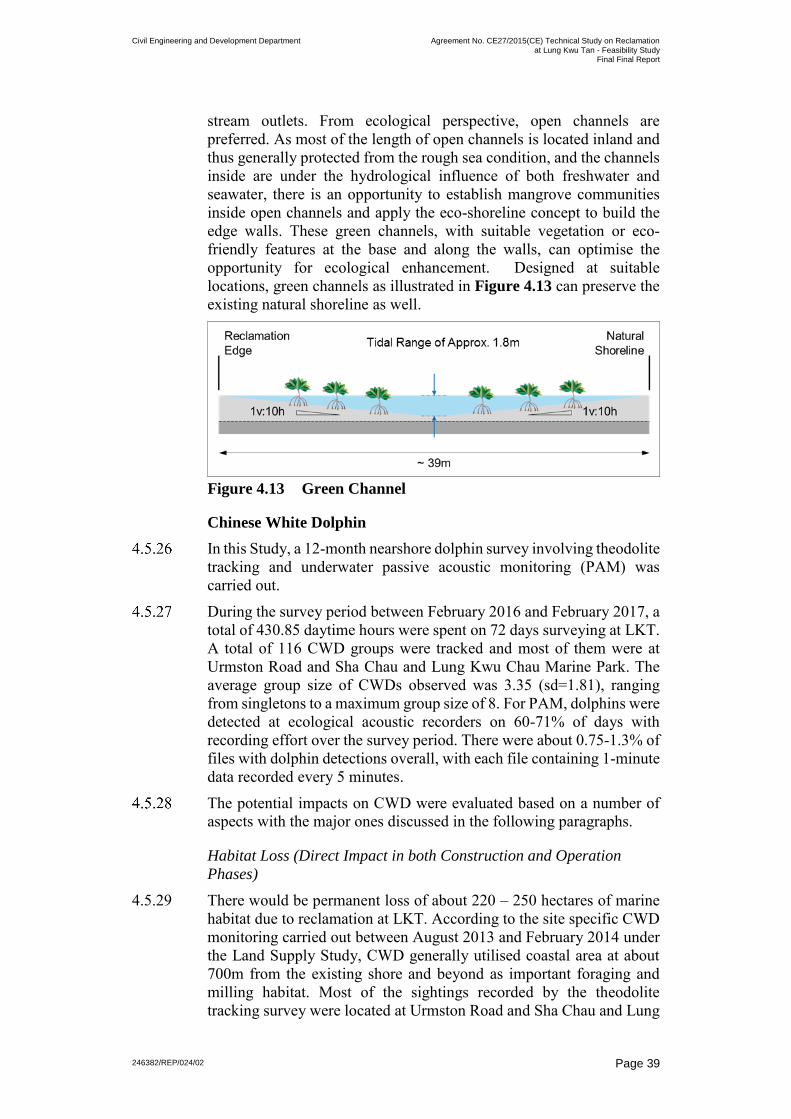
Civil Engineering and Development Department Agreement No. CE27/2015(CE) Technical Study on Reclamation
at Lung Kwu Tan - Feasibility Study Final Final Report
246382/REP/024/02
Page 39
stream outlets. From ecological perspective, open channels are preferred. As most of the length of open channels is located inland and thus generally protected from the rough sea condition, and the channels inside are under the hydrological influence of both freshwater and seawater, there is an opportunity to establish mangrove communities inside open channels and apply the eco-shoreline concept to build the edge walls. These green channels, with suitable vegetation or eco-friendly features at the base and along the walls, can optimise the opportunity for ecological enhancement. Designed at suitable locations, green channels as illustrated in Figure 4.13 can preserve the existing natural shoreline as well.
Figure 4.13 Green Channel
Chinese White Dolphin
In this Study, a 12-month nearshore dolphin survey involving theodolite tracking and underwater passive acoustic monitoring (PAM) was carried out.
During the survey period between February 2016 and February 2017, a total of 430.85 daytime hours were spent on 72 days surveying at LKT. A total of 116 CWD groups were tracked and most of them were at Urmston Road and Sha Chau and Lung Kwu Chau Marine Park. The average group size of CWDs observed was 3.35 (sd=1.81), ranging from singletons to a maximum group size of 8. For PAM, dolphins were detected at ecological acoustic recorders on 60-71% of days with recording effort over the survey period. There were about 0.75-1.3% of files with dolphin detections overall, with each file containing 1-minute data recorded every 5 minutes.
The potential impacts on CWD were evaluated based on a number of aspects with the major ones discussed in the following paragraphs.
Habitat Loss (Direct Impact in both Construction and Operation
Phases)
4.5.29 There would be permanent loss of about 220 – 250 hectares of marine habitat due to reclamation at LKT. According to the site specific CWD monitoring carried out between August 2013 and February 2014 under the Land Supply Study, CWD generally utilised coastal area at about 700m from the existing shore and beyond as important foraging and milling habitat. Most of the sightings recorded by the theodolite tracking survey were located at Urmston Road and Sha Chau and Lung

Civil Engineering and Development Department Agreement No. CE27/2015(CE) Technical Study on Reclamation
at Lung Kwu Tan - Feasibility Study Final Final Report
246382/REP/024/02
Page 40
Kwu Chau Marine Park. Similar CWD distribution was recorded from the theodolite tracking surveys carried out in this Study. The activites of dolphins sighted were recorded during the survey, and dolphins were found to be travelling at most of the time.
Figure 4.14 CWD Tracklines acquired from Theodolite Tracking Survey
4.5.30 Although the potential reclamation extent has already avoided encroaching upon the critically important CWD habitat, the impacts caused by reclamation are still likely to be significant due to its close proximity to the area of high dolphin usage (such as the Urmston Road) primarily during the construction phase. Stringent protection and mitigation measures would need to be developed to avoid and minimise the possible impact on CWD.
Reduction of Species Diversity/Abundance and Loss of Feeding
Grounds (Direct Impact in both Construction and Operation Phases)
4.5.31 According to the findings of the preliminary fisheries survey undertaken in this Study, some CWD prey were recorded and these prey were fish of the families Engraulidae, Sciaenidae and Clupeidae. The abundance of CWD prey recorded in the adult fish survey constituted only around 8.66% (in terms of weight) and around 9.54% (in terms of quantity) of the relatively low fisheries resources in the LKT nearshore. Therefore, initial assessment suggested that the potential impact due to the reduction of species abundance/ diversity of marine life and loss of CWD’s feeding grounds would not be expected to be a serious impact from the proposed reclamation.

Civil Engineering and Development Department Agreement No. CE27/2015(CE) Technical Study on Reclamation
at Lung Kwu Tan - Feasibility Study Final Final Report
246382/REP/024/02
Page 41
Change in species distribution, abundance and Impacts from
Underwater Noise/Construction Vessels (Direct Impact in both
Construction and Operation Phases)
4.5.32 During reclamation and construction, the increase in construction vessels may cause underwater noise impact on CWD and cause disturbance in behavior and distribution. There are studies reporting that the faster the speed of vessels, the greater the noise disturbance that would be created. Since the majority of the construction vessels are slow-moving barges and tugs, the noise disturbance from the movement of these slow-moving vessels on CWD would not be expected to be severe. However, the physical presence of these vessels moving through important travelling corridor in Urmston Road and dolphin feeding habitats near the Lung Kwu Chau area might cause disturbace to CWDs. Designated route for navigation of these construction vessels as well as land access for the transportation of construction materials shall be considered, so as to minimise the disturbance to CWDs.
4.5.33 Under the operation phase of LKT reclamation, marine traffic may be generated should the area be developed for industrial and/ or special uses such as C&DMHF for the import and export operations of these facilities. As these vessels such as barges travel at low speed (10 knots or lower), the potential impact of collision with dolphin would not be anticipated. Marine traffic may result in acoustic disturbance to CWDs, but as the large and slow moving vessels produce noise at lower frequencies, which is below the frequencies typically used by CWDs for echolocation, the noise disturbance on CWDs will not be significant.
Impacts on the Existing Sha Chau and Lung Kwu Chau Marine Park
(Indirect Impact in Construction Phase)
4.5.34 Sha Chau and Lung Kwu Cha Marine Park (SCLKCMP) is located at about 2km from the potential reclamation at LKT. Lung Kwu Chau is known to be the major feeding area and the highest density area for dolphins in all of northwest Lantau, and not all of this habitat is protected by the marine park. Given LKT reclamation is at a reasonable distance from SCLKCMP, the direct impact on the marine park is not expected to be significant. However, indirect impacts such as water quality impact due to the increase in SS level during dredging activities (to provide enough water depth for on-shore berth required by industrial uses and C&DMHF) may disturb and reduce prey availability for dolphins using the waters of SCLKCMP. If CWDs avoided the general area, including the waters of SCLKCMP, then this indirect impact from LKT reclamation could be significant.
Preliminary Assessment on Overall Impact on CWD and Mitigation
Measures
4.5.35 The major impacts on CWDs from the potential reclamation could be the likely disturbance to CWD’s use of the historical habitat in close proximity to the proposed reclamation. It would also be expected that there could be some indirect negative impacts on the function of

Civil Engineering and Development Department Agreement No. CE27/2015(CE) Technical Study on Reclamation
at Lung Kwu Tan - Feasibility Study Final Final Report
246382/REP/024/02
Page 42
SCLKCMP and Urmston Road areas (which are used heavily by dolphins), due to the close proximity of the marine park and the reclamation area, primarily during the construction phase. Stringent protection and mitigation measures would need to be developed to avoid and/or minimise the possible impacts on CWD from LKT reclamation.
4.5.36 If the reclamation proposal moves ahead, there are several mitigation measures that should be considered to avoid and/or minimise the potential impacts. Amongst these are:
(a) Non-dredged methods for site preparation, e.g. deep cement mixing for seawall construction, to reduce impact on water quality;
(b) Land-based delivery and disposal of fill materials to the site to reduce the risk of water contamination and traffic volume of construction vessels;
(c) Acoustic decoupling of any noisy equipment on barges to reduce noise disturbance to CWDs;
(d) Restriction of speed and number of trips of vessel transits in the area, so as to reduce disturbance from construction vessels and reduce risk of ship strikes;
(e) Avoidance of underwater construction during the peak calving seasons of CWDs, which is between March and June;
(f) Use of Dolphin Exclusion Zones for noisy activities during construction;
(g) Avoid potentially harmful construction methods, such as percussive piling and underwater explosions, that could injure the dolphins’ hearing and drive them away from the area;
(h) A commitment of no fast ferry service to the site upon completion; and
(i) Although not truly a mitigation measure, compensation for habitat loss would likely need to be explored.
Lung Kwu Tan Valley Site of Special Scientific Interest
Lung Kwu Tan Valley SSSI is located approximately 400m from the southern portion of the potential reclamation area. The SSSI is about 6.72 hectares in size and covers a valley with natural woodland, hill slopes and streams flowing into the LKT area. The site is widely recognised as one of the most important butterfly habitats in Hong Kong with a high diversity of butterfly species recorded.

Civil Engineering and Development Department Agreement No. CE27/2015(CE) Technical Study on Reclamation
at Lung Kwu Tan - Feasibility Study Final Final Report
246382/REP/024/02
Page 43
Figure 4.15 Location of Lung Kwu Tan Valley SSSI and Fung
Shui Woods
The development confined to the reclamation area should not have any significant effect to the SSSI as it is far away from the SSSI. However, outside the reclamation area, it may be of ecological interest to preserve the existing villages, as any transformation there will inevitably affect the SSSI and the Fung Shui Woods due to their close vicinity. Disturbance (e.g. dust and noise) generated during construction phase might affect the SSSI and the Fung Shui Woods and the utilisation of these areas by wildlife.
It is of scientific interest that butterflies growth could be affected by the presence of artificial lights. It is recommended that the development in the southern portion of the reclamation site should not have strong flood light. Territorial facilities which may be lit up in the evenings should avoid sitting at the southern portion of the reclamation close to the SSSI. Rather, they can sit at the northern portion of the reclamation, where the facilities would be over 1 km away from the SSSI, and the potential impact to the wildlife is expected to be low.
Air Quality
With the heavy industrial setting around LKT, the relatively high emissions from the fixed plant sources, in particular from CPPS and BPPS, may be of concern.

Civil Engineering and Development Department Agreement No. CE27/2015(CE) Technical Study on Reclamation
at Lung Kwu Tan - Feasibility Study Final Final Report
246382/REP/024/02
Page 44
Previous assessment has identified a small area of air quality exceedance zone in the southern portion of the potential reclamation area. The exceedance is mainly due to the emissions from the chimneys of the neighbouring CPPS. Non-air sensitive uses such as industrial development could be considered at the air quality exceedance zone, provided that air-conditioning system with elevated fresh-air-intake be provided to maintain an air quality condition acceptable for indoor air sensitive uses.
On the other hand, air sensitive uses are not recommended to be placed at this air quality exceedance zone. Such restriction does not exist in the northern portion of the potential reclamation area due to the shielding effect from Black Point headland.
There are village houses located next to Lung Kwu Tan Road. To avoid the air quality impact on these houses, the traffic to the new development on the reclamation area should be directed to the reclamation site as far as possible without recourse to LKT Road.
Figure 4.16 Air Quality Exceedance Zone
There may be concern over odour nuisance from some land uses such as the new on-site STW. It is anticipated that with the implementation of appropriate mitigation measures commonly adopted in Hong Kong (e.g. enclosing the odourous facilities, maintaining negative pressure to prevent foul air from escaping the building, provision of deodouriser at the ventilation exhaust, orienting exhaust of deodouriser away from sensitive receivers and vertically upwards, and conducting regular maintenance of deodouriser to ensure good condition), the potential odour impact on nearby air sensitive uses could be properly controlled.

Civil Engineering and Development Department Agreement No. CE27/2015(CE) Technical Study on Reclamation
at Lung Kwu Tan - Feasibility Study Final Final Report
246382/REP/024/02 Page 45
Noise
Various sources of noise during the operation phase were considered in the noise impact assessment; this included road traffic noise, fixed plant noise, aircraft noise, helicopter noise and marine traffic noise.
Road Traffic Noise
Potential road traffic noise hinges on the numbers of vehicles using the road, where different vehicles have different noise emission rate. Road traffic noise assessment was conducted for the possible worst case scenario, i.e. preliminary land uses themes A and D, with the highest estimated number of vehicles. The calculations of potential road traffic noise in operation phase were done based on the peak hourly traffic flow projected within a 15-years’ period upon full operation of the road works or full occupation of the Noise Sensitive Receivers (NSRs), whichever the latest. The most important existing NSRs within the Study Area are the existing village houses located next to Lung Kwu Tan Road. As for the air quality, the traffic to the new development on the reclamation area should be directed to the reclamation site without recourse to Lung Kwu Tan Road to minimise road traffic noise. With all the traffic from /to the new development on LKT reclamation be directed to the southern end of the reclamation far away from the LKT village, the contribution by the additional traffic to the predicted noise level at the village houses next to Lung Kwu Tan Road is small and is less than 1 dB(A). Noise mitigation measures along Lung Kwu Tan Road, during the operation phase, are not required.
Fixed Plant Source
Existing and planned fixed plant noise sources were considered in the assessment. The existing sources close to the reclamation site include CPPS, BPPS, open storage and industrial operations at LKST. For fixed noise associated with the operation of CPPS, the predicted fixed noise level would comply with the night-time noise criterion of 45 dB(A) with reference to the approved EIA for Emissions Control Project at CPPS "B" Units (AEIAR-102/2006). For BPPS, reference was made to the approved EIA Proposed 6000 MW Thermal Power Station at Black Point: Initial Assessment (Volume 1, 2 & 3) and Key Issue Assessment (EIA-015/BC). They should not constitute significant constraints on the future land uses on the reclamation area. The existing fixed noise from open storage and industrial operations are located at distant from the proposed development on the LKT reclamation, and thus this buffer distance would have already mitigated any noise impact from these operations. Therefore, they should not affect the future land uses on the reclamation area.To assess the potential noise impacts on the existing NSRs due to possible special uses on the reclamation at LKT such as C&DMHF

Civil Engineering and Development Department Agreement No. CE27/2015(CE) Technical Study on Reclamation
at Lung Kwu Tan - Feasibility Study Final Final Report
246382/REP/024/02 Page 46
which would operate in open air, quantitative assessment was conducted assuming that the facility was placed in the southern portion of the reclamation site in front of the existing villages. It was revealed that various mitigation measures such as using quiet plant in the C&DMHF, and allowing a buffer zone or building a terraced landscape feature between C&DMHF and the existing villages should be considered to mitigate the impact.
Aircraft Noise.
The site is in the proximity of the Hong Kong International Airport, in particular the third runway under construction. According to HKIA3RS EIA (EIA – 223/2015), the potential reclamation will be located outside the Noise Exposure Forecast (NEF) 25 contours. Although the potential reclamation is outside the NEF25 contours and adverse aircraft noise impact on the development at the potential reclamation is not anticipated, given its close proximity to the departure and arrival flight paths of the planned third runway of the HKIA, which is a very busy airport operating on a 24-hour basis, considerations should be given in the future detailed planning on the type of land uses and design of buildings to alleviate the aircraft noise impact. For areas with concerns, non-noise sensitive use would be considered. Industrial-based developments are recommended on this reclamation, and these would be less noise-sensitive in general.
Helicopter Noise
CPPS, BPPS and Black Point Radar Station are equipped with helipads to meet operation needs. Helicopters will generate noise when flying through, approaching, taking-off from or hovering and idling above the helipads. Due to the close proximity to the reclamation site, the potential noise impact from the helicopters on future development was considered. Helicopter types and flight routes were obtained from the operators providing service at the helipads, including the Government Flying Service (GFS) and Heliservices (HK) Ltd. The helicopter noise impacts under various modes of operation were assessed; these modes can mainly be classified into two categories – one with lateral movement (i.e. approach and departure) and the other one without (i.e. hovering and idling). Based on the types of helicopter (including Super puma AS332 L2, EC155 B1, EC175 and MD 902 Explorer), the helicopter noise data for both with and without lateral movement were obtained from the International Civil Aviation Organization (ICAO) and the approved Environmental Impact Assessment Study for Helipad at Yung Shue Wan, Lamma Island (EIA-114/2005). Together with the flight routes, the noise standards of helicopters were used to establish the corresponding buffer zone for each helicopter at each helipad using the general acoustic principles. For helicopter with lateral movement (i.e. approaching to and departing from the helipads), a buffer distance from the flight path is required to meet the “Lmax less than 85dB(A)” noise criteria for daytime (0700 –

Civil Engineering and Development Department Agreement No. CE27/2015(CE) Technical Study on Reclamation
at Lung Kwu Tan - Feasibility Study Final Final Report
246382/REP/024/02 Page 47
1900). For helicopter approach and departing at the helipad at the Black Point Radar Station, a horizontal distance of 880m is required to achieve the required buffer of 180m from the flight path for daytime. Whilst for the helipad at CPPS, a horizontal distance of 1150m is required to achieve the required buffer of 120m from the flight path for daytime. The buffer zone on the potential reclamation area was determined based on these required horizontal buffer distances. Development(s) of noise sensitive use would be subject to height restriction or should be avoided altogether within the buffer zones due to the possible exceedance of noise level.For helicopters without lateral movement, assessments show that a buffer distance of 400m from the helipads are required to achieve the noise level of less than Lmax 85dB(A) criteria for daytime (0700 – 1900). Development(s) of noise sensitive use should be avoided within this 400m radius buffer zone.
Figure 4.17 Helipads and Noise Buffer Zone
Marine Traffic Noise
It is expected that the marine traffic noise from vessels at Urmston Road would not have significant noise impacts to the future development due to the large separation distance.For future uses that would induce marine traffic and require vessel berthing at the edge of the reclamation, the marine traffic route should be designated at more than 300m away from noise sensitive uses and the future noise sensitive uses should be located away from seafront as far as practicable.

Civil Engineering and Development Department Agreement No. CE27/2015(CE) Technical Study on Reclamation
at Lung Kwu Tan - Feasibility Study Final Final Report
246382/REP/024/02 Page 48
Landscape and Visual
The preliminary assessments on landscape and visual impact were carried out taking into consideration of the baseline condition of the landscape resources in LKT area. The actual impacts to individual receiver will depend very much on the final land use plan for the reclamation proposal. The preliminary assessments conducted in this Study however provided useful guidelines and highlighted key areas for attention in the detailed studies. Landscape Impact
It was considered that a number of initiatives would be incorporated at the outset of land use planning to avoid and minimise landscape impact, such as the preservation of natural watercourse, Fung Shui Woods and secondary woodland, and avoiding any disturbance on SCLKCMP and SSSIs. However, given its nature and scale, the reclamation proposal would inevitably involve permanent loss of water bodies and natural seafront environment in LKT area. The physical loss of those natural resources will lead to changes on the existing landscape character, changing from a rural coastal plain landscape setting to an urban landscape area. Whilst the residual landscape impact on open seawater, inshore marine water, beaches and inshore water landscape cannot be fully mitigated, there are plenty of room to provide open space and green channels on the reclamation area, which may be considered beneficial to the local community.Visual Impact
The existing visual character is dominated by the industrial facilities / operations. Thus, the visual quality of LKT area is considered of low value. Nonetheless, the new buildings on the reclamation area, depending on height and massing, may result in loss of sea view to some of the visual receivers, particularly at LKST and Sha Po Kong.
4.5.63 In addition to the compatibility with the existing developments in the area which are mostly low-rise structures, the building height of the future development should respect the ridgeline of the surrounding hillslopes (about +50mPD) from major vantage points. Stepped building height profile descending from the hillslopes to the waterfront should be considered in response to the topographical setting. This would allow the future development to be better integrated with the natural surrounding and the existing built-up environment, and would also help optimise the wind capturing capacity of the future development. Preliminary assessment considered that the visual impact to the sensitive receivers to be moderate after mitigation. Features that can be considered in the future land use planning to mitigate the impact include: (a) A wide visual corridor should be provided in front of the existing
LKT village. This can be in the form of a wide green space or road

Civil Engineering and Development Department Agreement No. CE27/2015(CE) Technical Study on Reclamation
at Lung Kwu Tan - Feasibility Study Final Final Report
246382/REP/024/02 Page 49
aligned from the existing shoreline to the new reclamation edge. Both sides of the corridor should be lined with trees.
(b) High-rise buildings immediately in front of the existing LKT villageshould be avoided. Land uses with buildings of low to moderateheight would be preferred.
(c) The development on the reclamation area should be set at a distanceaway from the existing LKT village to provide an environmentalbuffer zone. This can be in the form of either a drainage channel orgreen open space.
Cultural Heritage
The impacts on cultural heritage were preliminarily assessed in this Study. While the reclamation works would be carried out on the sea, there may be concerns over the works on land associated with development, or the indirect impact such as visual intrusion. Some key areas were highlighted for attention in the next stage of detailed studies. It is noted that the consultation of local community is an important step in assessing the impact on cultural heritage. Relevant stakeholders should be consulted earlier when carrying out the detailed studies to gauge their views and address their concerns at appropriate juncture.
Terrestrial Archaeology
The reclamation works would be carried out on the sea and thus is not expected to directly affect the identified heritage resources including the LKST Site of Archaeological Interest and LKT Site of Archaeological Interest. However, both Sites of Archaeological Interest (SAI) may be affected by the associated work to occur on land to meet the infrastructure needs (road improvements, drainage works, utilities, etc.). The archaeological deposits may be directly and adversely affected by the excavation works. During the design stage, impacts to the SAI should be avoided or kept to a minimum. An Archaeological Impact Assessment, with field investigation if required, would be required to identify the extent of archaeological deposits affected. More specifically at this stage, transformation of existing land uses within the SAI (i.e. open storage or industrial workshop at LKST and villages at LKT) will adversely and directly affect the archaeological deposits during the construction phase unless alternative proposals are formulated in a way which could avoid subsurface works.

Civil Engineering and Development Department Agreement No. CE27/2015(CE) Technical Study on Reclamation
at Lung Kwu Tan - Feasibility Study Final Final Report
246382/REP/024/02 Page 50
Figure 4.18 Locations of Cultural Heritage Resources
Preservation in situ is the preferred option for all SAIs. However, if such preservation is not practicable and the development needs outweigh the destruction of the SAI, Archaeological Impact Assessment and mitigation (if necessary) prior to the construction will be required. These may include archaeological field survey(s), rescue excavation(s) prior to constructions phase and/or watching brief programme(s) during the construction phase. Built Heritage
The reclamation works and the subsequent development would not affect any built heritage directly. However, the only graded historic building known in the Study Area - Lau Ancestral Hall in Tuk Mei Chung - may be affected by the large scale development within the existing villages. It is recommended to retain the graded historic building on-site with sufficient buffer from the works. If the land use change within existing villages goes ahead, Built Heritage Impact Assessment will be required to identify the range of impacts and potential mitigation options. Generally speaking, condition survey, vibration monitoring, provision of screening or buffer zones should be considered as possible protection measures in the construction phase. Similarly for the Lau Ancestral Hall at LKST which is currently located within the existing light industrial area, it may be affected if the area is redeveloped. The same mitigation options should be considered to safeguard the hall. During operation phase, possible impacts on built heritage include, depending on the type and scale of development, visual intrusions, access issues and vibration. They should be addressed with due consideration in the design stage. For Tin Hau Temple, mitigation

Civil Engineering and Development Department Agreement No. CE27/2015(CE) Technical Study on Reclamation
at Lung Kwu Tan - Feasibility Study Final Final Report
246382/REP/024/02 Page 51
measure may be required for the potential impact, such as degradation of its setting. As the connection to the sea is relevant for the temple dedicated to the goddess of the sea, open space and view corridor towards the sea should be allowed in front of the temple for inducing green and open environment and connecting the temple to the sea visually. The area has the potential to contain further heritage resources as defined in the Guidelines for Cultural Heritage Impact Assessment by Antiquities and Monuments Office, hence a built heritage survey should be undertaken to identify heritage resources within the development area when it is defined in the detailed studies.
Figure 4.19 Lau Ancestral Hall at Tuk Mei Chung
Figure 4.20 Tin Hau Temple

Civil Engineering and Development Department Agreement No. CE27/2015(CE) Technical Study on Reclamation
at Lung Kwu Tan - Feasibility Study Final Final Report
246382/REP/024/02 Page 52
Marine Archaeology
The Marine Archaeological Review of marine archaeological potential within the Study Area was conducted based on historical evidence and review of previous Marine Archaeological Investigation (MAI) Studies. No actual marine archaeological resources were identified within the potential reclamation area. However, the two previous MAI studies taken reference in the baseline review covered very small sections of the potential reclamation area. It is recommended that MAI will be carried out in the EIA during the next stage of detailed studies and will need to cover the whole reclamation area and the construction space including the related marine works affecting the seabed.
4.6 Infrastructure
General
To identify if there will be any constraint on the development or future land use planning with respect to infrastructure capacity, the need for some key infrastructures including drainage, sewerage and water supply was broadly assessed in this Study based on various assumptions on the types or combinations of land uses. As discussed previously in this Report, the preliminary land use themes formulated in this Study were proposed for the purpose of assessment only. The actual land uses composition and their planning parameters, including residing and working populations, Gross Floor Area, etc. will be determined in the next stage detailed studies.
Drainage
The existing lands at LKT and LKST are bounded by the mountain range of Castle Peak, and runoff from the mountain is collected and discharged at four (4) points/outfalls along the shore to the sea. Drainage system needs to be provided on the reclamation area to collect and divert the runoff from these upstream catchments. The runoff at these four existing points/outfalls were estimated for a 200-year design event, and the peak runoff varies from about 7m3/s to 50m3/s. In view of the size of the reclamation, 4 nos. of drainage structures, in the form of either open channel or multi-cell box culvert, are recommended to collect the surface runoff from the reclamation and the existing hillside catchments. They should be connected to the four existing runoff discharge points/outfalls along the shore. Apart from acting as a storm drain, i.e. dimensioned to provide the necessary capacity to discharge the runoff collected, an open channel can be designed as a water feature to enhance the environment within the development site. In order to maximise the opportunities of developing mangrove communities on gentle sloping bed, the width of water space between the natural shoreline and the new reclamation edge would be approximately 40m. Compared with box culverts, open channels would occupy more surface land and have a much greater land

Civil Engineering and Development Department Agreement No. CE27/2015(CE) Technical Study on Reclamation
at Lung Kwu Tan - Feasibility Study Final Final Report
246382/REP/024/02 Page 53
requirement. Therefore, it should be considered and properly placed in consideration of spatial arrangement of various land uses in the detailed studies. Landscaped areas which could reduce and retard runoff are important features for the development. Since the landscaped areas could allow inundation during higher flood events, the need for the drainage provision could be reduced. This will minimise the cost of drainage works while offering an opportunity to enhance the environment. In addition to landscaped area, for a development proposal of a large parcel of land, provision of lakes could be considered for flood retention.
Sewerage
The existing sewerage infrastructure in the vicinity of the potential reclamation at LKT includes Pillar Point STW and San Wai STW. As advised by EPD, both STWs have no spare capacity to take up sewage flow from the new development at LKT reclamation. A new on-site STW is therefore required. The new STW should handle the sewage discharged from the existing villages as well to bring about environmental enhancement. The footprint of the STW depends on the estimated sewage flows, which in turn relate to the land uses and the size of contributing population, and the treatment level. For the purpose of estimating the land demand of the new on-site STW, the sewage flow that might be generated from the LKT reclamation development were estimated based on the preliminary land use themes. Also, a tertiary treatment level STW was assumed for a conservative assessment of the STW footprint. With reference to “EPD Guidelines for Estimating Sewage Flows for Sewage Infrastructure Planning No. EPD/TP/1/105”, the estimated Average Dry Weather Flow ranges from about 24,700m3/day to 58,400m3/day amongst the five preliminary land use themes. The corresponding peak flows were estimated to be 830L/s to 1860L/s. If a tertiary treatment level STW was provided, a site area of 11 to 14 hectare would be required. In order to achieve the objective of Total Water Management and to minimise the pollution to water bodies, consideration should be given to re-use the treated effluent from the STW for non-potable uses such as toilet flushing, irrigation, street washing, etc. The excess effluent will be discharged to the sea via an outlet at reclamation edge. Considering the marine traffic risk involved in carrying out the marine works for a new submarine outfall laid across the heavily trafficked Urmston Road, the feasibility of discharging the treated effluent nearshore was investigated. The preliminary water quality model revealed that discharging at the seawall would not have any impact on the water sensitive receivers near the reclamation site if the effluent has gone through a treatment of secondary level or above.

Civil Engineering and Development Department Agreement No. CE27/2015(CE) Technical Study on Reclamation
at Lung Kwu Tan - Feasibility Study Final Final Report
246382/REP/024/02 Page 54
Water Supply
The freshwater and flushing water demands for the potential development were broadly estimated based on the unit water demands in Water Supplies Department (WSD) Departmental Instruction (DI) 1309. The flushing water demand was then adjusted based on the actual and design capacities of the existing Tuen Mun Salt Water Pumping Station The fresh water demand was estimated to vary from 53,000m3/day to 69,000m3/day for the five preliminary land use themes. The flushing water demand was estimated to vary from 12,000m3/day to 16,000m3/day based on WSD DI 1309; these increases to 14,880m3/day to 19,840m3/day to include an additional 24% allowance as the committed flushing water demand exceeds the planned demand of the Tuen Mun Salt Water Pumping Station supply zone. Generally, water demands for industrial land use were found to be higher than those for residential land use when referring to the water demand for industrial land use in Tuen Mun New Town. The actual water demand for industrial land varies quite a lot with the type of industries adopted. This should be reviewed in the detailed studies for estimating the water demands. Tuen Mun district is currently served by Tuen Mun Water Treatment Works (WTW) at Fu Tei in the north of Tuen Mun. As advised by WSD, it would not have any spare capacity for the development on LKT reclamation. The capacity of the existing Tuen Mun WTW should be increased or a new WTW will be required to cope with the water demand arisen. Tuen Mun WTW is identified as one of the government facilities that could be relocated to caverns under the Preliminary Land Use Study for Lam Tei Quarry and the Adjoining Areas (the Lam Tei Quarry Study). If pursued, the relocated WTW could be designed to cater for additional water demand of the LKT reclamation development. Alternatively, the capacity of the Tuen Mun WTW can be increased by expanding it in caverns near the existing WTW. Based on a mean daily demand (MDD) of 69,000m3/day for freshwater, the design capacity of the expanded part of WTW is 103,500m3/day, i.e. 1.5 times the MDD. The footprint of the expanded part of WTWwas estimated to be 1 to 2 hectares (whilst the cavern size is yet to bedetermined) and it is preferably to be located close to the existing TuenMun WTW to enhance efficient and to facilitate share use of somefacilities. Other waterworks required may include new fresh waterprimary service reservoir, fresh water service reservoirs, fresh waterpumping station, trunk transfer and distribution mains.For flushing water, both seawater and reclaimed water (if tertiary treatment is adopted in the new STW) are possible and available sources locally. Again, new service reservoirs, new pumping station and distribution mains will be required but the scale of works will be smaller as compared with freshwater supply.

Civil Engineering and Development Department Agreement No. CE27/2015(CE) Technical Study on Reclamation
at Lung Kwu Tan - Feasibility Study Final Final Report
246382/REP/024/02
Page 55
4.7 Cost and Programme
4 to 5 years would be required for reclaiming 220-250 hectares,
depending on the fill materials to be used, the numbers of workfront to
be deployed and the actual construction method for the seawall. If more
public fill is used as fill materials or the phasing of works is constrained
by the nearby construction projects, a longer construction period should
be allowed and well co-ordination with these projects on the
construction programmes and sequences would become essential. In
addition, the implementation of environmental mitigation measures,
such as pause period for underwater construction during peak CWD
calving seasons, would most likely further extend the construction
period.
It is anticipated that another 4 to 5 years would be required for the
supporting infrastructures, in particular the new on-site STW and the
road improvement works at Lung Mun Road. Given that Lung Mun
Road has been heavily used by heavy vehicles and different
improvement schemes have been proposed by projects in the area, the
local traffic arrangement during the construction phase should be
investigated in details in the next stage detailed studies. As such, a more
realistic construction programme could be formulated for better project
planning to ensure that this only access to LKT could be enhanced on
time to tie in with the target commissioning year of development at
LKT reclamation.
The construction of WTW in caverns, either for relocating the whole
Tuen Mun WTW as proposed by the Lam Tei Quarry Study or for the
expanded part of WTW, may require a long duration of about 8 to 10
years. Subject to further design, the duration is largely the same as the
gross construction period for reclamation and the associated
infrastructures. Earlier planning for the investigation and detailed
studies for the cavern WTW is recommended.
4.8 Assessment of Preliminary Land Use Theme
Guiding principles were established in this Study to direct the
formulation of the Preliminary Land Use Theme (PLUT) for the
potential reclamation at LKT as mentioned in Section 3.1. These are:
1) enhancing land supply to meet territorial needs;
2) meeting local needs;

Civil Engineering and Development Department Agreement No. CE27/2015(CE) Technical Study on Reclamation
at Lung Kwu Tan - Feasibility Study Final Final Report
246382/REP/024/02 Page 56
3) compatibility with nearby village and industries;4) minimise impacts on existing road network and provision of new
transport infrastructure;5) respect the environment and minimise impacts; and6) adopt a flexible design and adaptable implementation programme.
Evaluation criteria were proposed for each guiding principle to facilitate the assessment of the performance of each PLUT in the principle. The relative performance of each PLUT in each guiding principle was assessed in a scale ranging from Relatively Low Performance (•),Lower than Average Performance (••), Average Performance (•••),Fair Performance (••••) to Good performance (•••••), correspondingto the least performed to the most performed category. The relative performance of the PLUTs in each guiding principle can be summarised in the table below.
Guiding Principles Preliminary Land Use Theme
A B C D E
Enhancing land supply to meet territorial needs
•••• •••• •••• ••••• •••••
Meet local needs ••••• ••• ••• •••• •• Compatibility with nearby village and industries
•••• ••••• •••• •• •••
Minimise impacts on existing road network and provision of new transport infrastructure
• ••• •••• • ••••
Respect the environment and minimise impacts
••• •••• ••• • ••
Adopt a flexible design and adaptable implementation programme
•• •••• ••••• • •
This assessment shows that both PLUT-B and PLUT-C have above-average performance in all guiding principles, meaning that they can best balance all the needs. PLUT-B and PLUT-C can meet the territorial needs in providing industrial uses that can be synergic with the existing development in Tuen Mun West and NWNT and in providing new employment opportunities in the region. In particular, for facilities requiring marine access for transportation of materials and products that can only be located near the waterfront, LKT reclamation would be one of the major sources for such uses. Moreover, they are largely compatible with the nearby village and industries. Whilst for other PLUTs, there are some major issues to be overcome if pursued further. For instance, traffic issues should be properly

Civil Engineering and Development Department Agreement No. CE27/2015(CE) Technical Study on Reclamation
at Lung Kwu Tan - Feasibility StudyFinal Final Report
246382/REP/024/02 Page 57
addressed, with substantial input on the strategic transport
infrastructures, if residential development are proposed at LKT
reclamation as in PLUT-A and PLUT-D.
Nonetheless, some concerns are identified for PLUT-B and PLUT-C
which should be investigated further in the next stage detailed studies.
It is expected that they may not perform well in meeting local needs in
the provision of commercial, recreational and/or GIC facilities and new
public transport services as the residential-based development does.
Under the constraints in quantity and variety of the new provision, the
local should be consulted so that their needs can be acceded to as far as
possible. The impact on existing traffic should be minimized as far as
possible as well and extra traffic management measures, for example,
which can improve the road performance should be explored. As
regards the environmental nuisance, further investigation will be
carried out to minimise the nuisance from the industrial and special uses
and to enhance the ecology.
chaneth
文字方塊
Addendum No. 1

Civil Engineering and Development Department Agreement No. CE27/2015(CE) Technical Study on Reclamation
at Lung Kwu Tan - Feasibility Study Final Final Report
246382/REP/024/02 Page 58
Based on the above, either PLUT-B (industrial development over the whole reclamation) or PLUT-C (territorial facilities in the north, coupled with industrial development in the south) is likely to be suitable at LKT reclamation, and could be further investigated, depending on the need of the society.
chaneth
文字方塊
Addendum No. 1

Civil Engineering and Development Department Agreement No. CE27/2015(CE) Technical Study on Reclamation
at Lung Kwu Tan - Feasibility Study Final Final Report
246382/REP/024/02 Page 59
5 Next Step
Potential Development Theme and Key
Constraints on Land Uses for Future
Consideration
This Technical Study was to investigate the key issues and considerations in relation to the potential reclamation at LKT and the subsequent development. The findings from various assessments done in this Study will be reviewed in the next stage detailed studies including the planning and engineering study and statutory EIA to finalise the land use plans and to develop details for both the reclamation works and the associated infrastructure works. The Study assesses that the potential reclamation area at LKT could be approximately 220 to 250 hectares. Having considered the opportunities, constraints and potential impacts, it was suggested that industrial-based development would be more suitable at LKT reclamation, when compared with residential uses, to fit in the existing industrial setting of Tuen Mun West and be more likely be synergic with the industrial developments including logistics, warehousing and green industry in Tuen Mun West and NWNT. These synergic developments also provide employment opportunities which would benefit the local and the region. Territorial facilities such as C&DMHF and other special uses, which can optimise the marine access and in turn minimise the traffic flow added to the road networks in Tuen Mun district, could be considered at LKT reclamation. These facilities requiring marine access for transportation of materials and products can only be located nearshore such as reclamation. LKT reclamation, coupled with its ample size, would be one of the major sources for such land uses if they are in need. That said, these facilities should be placed on the northern portion of the reclamation site only to promote compatibility with the existing villages at LKT and avoid disturbance to the butterfly species at Lung Kwu Tan Valley SSSI due to flood lighting in the evenings. In contrast, if residential development is pursued even in part of the site, it would lead to increase in traffic in critical direction and hence severe traffic congestion. Significant input on new transport infrastructure would be required. Sufficient buffer area, such as open space, should be provided between the existing villages and the new development. Open space and view corridor toward seaside should be allowed in front of the Tin Hau Temple for inducing green and open environment and connecting the temple to the sea visually. Opportunities should be explored to build green channel for ecological enhancement and beautification, while meeting the drainage need.

Civil Engineering and Development Department Agreement No. CE27/2015(CE) Technical Study on Reclamation
at Lung Kwu Tan - Feasibility Study Final Final Report
246382/REP/024/02 Page 60
Other key constraints on future land use will include the air quality exceedance zone at the southern end of the potential reclamation area adjacent to the CPPS. The future land uses should avoid any air sensitive use within this exceedance zone. The building height of the future development should be limited to below the ridgeline of the surrounding hillslopes and key vantage points, with due consideration of other restriction in view of the potential helicopter noise, operation of Black Point Radar Station and visual impact as well. The locals could benefit from the development by additional community facilities in the neighbourhood, and more choices of new public transport services. New roads provided on reclamation site could, depending on the management and operation requirement, provide an alternative route for refuse vehicles to reduce the nuisance from refuse vehicles on existing residents along Lung Kwu Tan Road. Land resumption should be avoided as far as possible. Apart from the concerns over the impact on the villagers, it would induce uncertainty to the implementation programme of the development. Moreover, it may be of ecological interest to preserve the existing villages, as any transformation there will inevitably affect the Lung Kwu Tan Valley SSSI and the Fung Shui Woods due to their close vicinity. The subsurface works that may be required during construction will also adversely and directly affect the archaeological deposits of the LKT SAI underneath the villages.
Future Studies
This Technical Study provided only a broadbrush assessment of various aspects and identifies constraints and key issues that will need to be addressed in the detailed studies and EIA. To pursue the reclamation proposal further, more detailed investigation and assessments should be carried out to firm up the development proposal and land use planning. Statutory EIA should be carried out to ascertain the environmental acceptability of the development proposal and to explore further mitigation / enhancement measures. Some key areas in respect of geotechnical appraisal and reclamation study, marine traffic, traffic and transport, environmental assessments, infrastructures and building height restriction which require attention in the detailed studies are summarised below. Need to have consultation of the local community is also highlighted.
Geotechnical Appraisal and Reclamation Study
Additional site-specific ground investigation should be carried out to identify and ascertain the uncertainties on the presence of the potentially problematic ground, and for review of parameters for design of reclamation and associated works. The proposed additional GI should target on better characterisation of the geological and

Civil Engineering and Development Department Agreement No. CE27/2015(CE) Technical Study on Reclamation
at Lung Kwu Tan - Feasibility Study Final Final Report
246382/REP/024/02 Page 61
geotechnical conditions to facilitate preliminary and detailed design, including of the following aspects:
(a) Zone of interests (e.g. the silty sand layer within the marinedeposits);
(b) Engineering properties of the soil and rock types and the designedgroundwater table within the site area to refine the geotechnicaldesign parameters;
(c) Provision of hydrogeological monitoring for the inland terrain toassess the impacts of the proposed reclamation works;
(d) Presence of obstructions or antiquity and archaeological valueswithin the proposed reclamation area.
Geophysical survey is recommended to facilitate identification of the full extent of the silty sand layer within the marine deposits, to provide refinement of other stratigraphic boundaries within the superficial deposits and to provide information on the location of any zone of organic material within the marine deposits and alluvium, which are prone to decay to release potentially hazardous gases including methane. A preliminary screening on potential natural terrain catchments was completed based on GEO Report No. 138, and it identified that some natural terrain catchments abutting the shoreline near the central portion of the potential reclamation area will require an NTHS, depending on the land uses of the proposed developments and their proximity to the toe of the catchment. The need for detailed NTHS for the natural terrain catchments, including the location and extent of the hillside, will be reviewed, taking into account the actual land uses on the reclamation site near to the hillslope and the detailed facility layouts especially their proximity to the hillside. Mitigation measures to protect the future facilities against the natural terrain hazard, if required, would be identified in the detailed NTHS. In addition, an assessment of the potential boulder fall / rockfall hazard is recommended for the next stage of study. Stabilisation works against such hazards will need to be investigated in the detailed studies. Detailed review and assessment of the man-made slopes/retaining walls in the vicinity of the reclamation should be carried out to investigate the features which would have potential to affect or to be affected by the proposed reclamation works. Slope upgrading works, if any, should be proposed.
Marine Traffic
A comprehensive MTIA should be undertaken with a more certain traffic pattern of both the reclamation development and other projects in the vicinity. A full navigation simulation should be included to simulate the vessel manoeuvring between Urmston Road and the future

Civil Engineering and Development Department Agreement No. CE27/2015(CE) Technical Study on Reclamation
at Lung Kwu Tan - Feasibility Study Final Final Report
246382/REP/024/02 Page 62
waterfront of the reclamation and to assess if any navigation measures or aids is required.
Traffic and Transport
Further detailed investigation on the proposed improvement scheme of roads, both local and district levels, is recommended, taking into account the actual traffic demand of the proposed development, and the latest programme and project information of the key proposed road links and other development projects in the area. Preliminary assessments of both natural terrain and man-made features suggested that detailed NTHS and slope stability review will be required to evaluate the potential risk from these natural terrain catchments and man-made features on the proposed road improvement works. In addition, in view of the presence of numerous boulders on the uphill side of the proposed road improvement works, an assessment on the potential of boulder fall / rockfall is recommended for the next detailed studies. In addition, a number of registered slopes at Siu Lang Shui Road/Lung Mun Road and at Tuen Mun Road/Hoi Wing Road were found to be directly affected by the proposed connecting roads and the proposed slip road respectively. Detailed stability review and proper design of slope modification works will be required. The local traffic arrangement during the construction phase should be investigated in details for the proposed improvement works at Lung Mun Road to avoid impacting on the existing uses along Lung Mun Road and to formulate a more realistic construction programme.
Environmental Assessments
The preliminary environmental assessments completed were based on the best available information at the time of the assessment and a number of assumptions under some conservative assessment scenarios. The assessment assumptions, potential environmental issues, and proposed mitigation options should be further investigated and followed up in subsequent detailed studies and assessment for LKT Reclamation. Assessment assumptions should be reviewed when more detailed information on the development proposals of LKT Reclamation and other interfacing projects becomes available in future studies. Some key issues to be followed up in future statutory EIA are listed below:
(a) Review and adopt the latest details of all the potential interfacingand concurrent projects in vicinity of the proposed reclamation site,which may have cumulative environmental impacts during itsconstruction and operation stages.
(b) Review and update on emission inventories in PATH for air qualityimpact assessment, particularly those local industrial emissionsources in the vicinity of the proposed reclamation site.

Civil Engineering and Development Department Agreement No. CE27/2015(CE) Technical Study on Reclamation
at Lung Kwu Tan - Feasibility Study Final Final Report
246382/REP/024/02
Page 63
(c) Review and update the pollution load inventory and construction methods to carry out the water quality assessment.
(d) Revisit the helicopter noise assessment based on updated helicopter operation details of the helipads occupied by GFS and CLP at northern and southern side of the proposed reclamation site, including type of helicopters, approach and departure areas, etc.
(e) Explore measures to reduce traffic volume and speed of construction vessels to reduce disturbance on CWD and the indirect impact on SCLKCMP which is an important CWD feeding habitat.
(f) Carry out the detailed ecological survey and assessments to explore suitable arrangement for eco-shoreline and green channel to retain the natural shoreline and explore opportunities for ecological enhancement.
(g) Conduct another fisheries survey to provide a more areal investigation of the embayment area over a longer period of survey time, with particular attention to CWD prey species to review the potential impact to CWDs.
(h) Explore further mitigation measures in the reclamation proposal (e.g. introducing enough open space, limiting building height and roof planting for industrial buildings / science park buildings) to minimise the visual impact as far as possible.
(i) Carry out a built heritage survey, a built heritage impact assessment and an archaeological impact assessment when the extent of the associated works to occur on land is defined.
(j) Carry out a MAI which should cover the whole reclamation area and the construction space including the related marine works affecting the seabed, particularly a geophysical survey is recommended to confirm that no wreckage of archaeological importance is within the reclamation extent.
(k) Carry out a hazard assessment, if required, for the proposed land uses and the interface with nearby existing and proposed developments.
Infrastructures
Further studies on the water supply infrastructure, including water treatment works, service reservoirs and pumping station, will be required to formulate the implementation programme to ensure that this essential infrastructure could be completed on time to tie in with the target commissioning year of development at LKT reclamation.
Building Height Restriction
Due consideration should be given to the restriction on the building heights when formulating the land use plan. The future amendment to the AHR for the operation of HKIA3RS should be considered

Civil Engineering and Development Department Agreement No. CE27/2015(CE) Technical Study on Reclamation
at Lung Kwu Tan - Feasibility Study Final Final Report
246382/REP/024/02
Page 64
holistically with the building height restriction for maintaining the operation of Black Point Radar Station and for minimising environmental impact due to helicopter noise and visual intrusion.
Consultation
Apart from the needs of the society, views of the local community are equally important in determining the development theme of the LKT reclamation. The locals and villages concerned should be engaged in the process of formulating the land use proposals.
Consultation of local community is an important step in assessing the impact on cultural heritage. Relevant stakeholders should be consulted earlier to gauge their views and address their concerns.

Civil Engineering and Development Department Agreement No. CE27/2015(CE) Technical Study on Reclamation
at Lung Kwu Tan - Feasibility Study Final Final Report
246382/REP/024/02
Page 65
Drawings

«C¤s½m¹
281
135
310
269
54
68
75
100
100
200
100
20
0
100
200100100
20
20
100
50
200
ÁA±Lookout
Ser Res
°t¤
Às¹
Às¹ª
Sheung Tan
Lung Kwu
Às¹LUNG KWU TAN
ÀsLung Tsai
«nNam Long
¥_Pak Long
¨F®
½ñ¥Tap Shek Kok
¿w§
Chung
Tuk Mei
¤j§
ÀsÀÜ
¹q¤Power Station
Äê¨Black Point
(Lan Kok Tsui)
¹
¤
¹
À
¹q¤Power Station
¤ôªCement Works
Àô«EcoPark
Kong
Sha Po
Cove
Dragon
¸Z
Æ
Às¹ª
LU
NG
KW
U
TA
N R
OA
D
Àsª LUNG MUN ROAD
¿U®
LUNG KWU CHAU
TAI LANG SHUI
NIM
WA
N
ROA
D
Fuel Tank
R
U
M S T
O N R O
A D
2
6
8
2
2
1
1
6
3
7
3
3
4
1
8
8
6
7
7
6
9
9
4
33
1
1
8
3
1
18
21
16
20
16
14
11
17
21
17
21
22
21
21
21
21
21
21
21
18
17
17
16
17
12
14
11
12
14
13
18
2.3
1.5
6.8
5.5
2.8
2.3
2.1
2.3
2.4
2.2
2.6
1.7
9.5
7.4
4.81.7
7.7
8.6
2.4
2.3
3.9
2.7
7.3
4.1
0.9
7.2
4.2
3.8
7.9
6.7
5.8
9.7
7.6
4.7
0.9
7.8
2.1
4.5
1.7
1.6
3.9
1.5
4.4
2.6
2.4
2.2
3.1
3.4
2.4
3.1
2.2
3.5
4.8
4.3
3.8
2.8
1.7
7.4
6.9
5.4
4.6
2.7
4.4
2.5
1.5
0.6
0.6
0.5
5.2
5.3
8.5
8.1
6.3
7.9
7.8
7.4
2.1
4.8
2.8
2.7
4.7
3.5
1.2
1.3
1.6
0.9
1.6
1.7
1.6
1.1
1.5
5.9
9.3
7.9
9.5
7.4
6.4
7.7
7.9
5.8
5.6
5.6
5.6
5.4
7.8
7.5
5.3
8.3
8.2
8.2
7.7
7.6
7.5
7.2
6.7
6.7
6.3
6.1
6.1
6.1
9.7
6.7
8.5
2.6
2.4
3.3
4.4
3.9
3.8
3.8
3.7
2.1
3.7
3.6
3.4
3.3
2.4
2.9
4.3
4.1
4.1
3.5
2.5
2.4
4.5
4.6
4.7
4.8
4.9
1.3
1.1
1.1
1.8
1.5
1.5
1.7
1.6
1.5
0.1
0.4
1.8 0.7
1.4
1.3
1.7
0.5
1.6
1.7
1.4
1.7
1.61.7
1.4
0.7
1.8
0.8
1.8
8.3
9.6
5.6
5.4
7.6
7.2
5.6
7.1
7.9
7.6
2.8
3.3
4.5
4.5
2.7
2.6
2.1
4.34.1
3.8
2.6
2.7
2.8
2.2
2.9
3.1
3.3
0.6
0.8
1.8
1.6
1.7
1.7
0.7
0.4
0.9
1.6
1.3
1.2
0.8
0.5
8.7
3.6
13.2
19.2
15.5
20.4
20.5
16.8
11.3
19.9
16.2
13.8
11.5
18.1
18.7
19.1
16.1
12.2
10.7
10.3
15.4
20.5
16.1
17.6
16.1
11.3
13.8
13.9
11.9
11.6
-0.5
-0.4
-0.3
20.2
20.2
20.3
20.7
20.7
20.6
18.4
19.219.1
17.8
17.9
16.5
18.9
18.2
16.2
13.3
12.3
10.6
12.3
12.5
11.9
12.7
-0.3
21.5
20.3
20.8
20.8
20.2
21.5
20.8
21.5
20.4
20.9
20.9
20.6
20.8
20.6
20.4
20.8
20.1
20.6
20.1
20.6
20.4
18.1
19.6
18.7
19.4
19.7
16.6
17.9
15.6
15.2
15.8
18.5
17.8
17.3
17.8
17.5
16.6
18.7
17.3
19.9
16.1
15.8
19.7
19.6
19.4
18.9
19.6
18.8
19.6
19.3
13.4
12.1
13.6
13.4
10.5
11.3
14.1
12.6
13.7
12.8
12.7
14.9
13.8
13.7
14.1
14.2
13.7
13.8
13.7
10.7
13.9
13.5
11.9
13.3
12.5
-0.3
-0.2
-0.3
-0.3
-0.3
-0.2
-0.2
-0.4
20.3
16.9
-0.4
-0.5
20.4
16.9
19.7
14.2
TL
-
ACRL
PRELIMINARY1:20000 @ A3
N
LU
NG
KW
U T
AN
RO
AD
LUNG MUN ROAD
NIM
WAN ROAD
830000 N
829000 N
828000 N
827000 N
826000 N
807000 E
UR
MSTON ROAD
04/18
808000 E
809000 E
810000 E
811000 E
METRES
1000
1 : 20000
200 400 600 8000
NOTES
LEGEND
1.8
THE TOE LEVEL OF SEAWALL IS NOT SHOWN.2.
GRID CO-ORDINATE SYSTEM.
ALL CO-ORDINATES ARE IN ACCORDANCE WITH HK(1980)1.
ROAD CONNECTION TO THE ADJOINING AREA
OPEN STORAGE OR WORKSHOP
LUNG KWU TAN VILLAGE
SUBMARINE OUTFALL
EXISTING
SHEUNG TAN
LUNG KWU
(METRE BELOW CHART DATUM)
INDICATIVE EXISTING SEABED LEVEL
HELIPAD
SIU LANG SHUI SSSI
246382/GEN/001
POTENTIAL RECLAMATION AT
LUNG KWU TAN
FOR INDUSTRIAL-BASED DEVELOPMENT
POTENTIAL RECLAMATION AREA
806000 E
805000 E
Impact Assessment.
studies including Environmental
to review in the next detailed
preliminary only and is subject
The reclamation extent shown is
RADAR STATION
BLACK POINT
POWER STATION
BLACK POINT
LAU ANCESTRAL HALL
TIN HAU TEMPLE
BUILDING)
(GRADE 3 HISTORIC
LAU ANCESTRAL HALL
POWER STATION
CASTLE PEAK LUNG KWU CHAU
VALLEY SSSI
LUNG KWU TAN
SHA CHAU AND LUNG KWU CHAU MARINE PARK
TAN
KWU
LUNG
Filena
me :
J:\
24
6382\
AR
UP\
GE
O\
24
63
82
_G
EN001.d
gn
30/04/2018
Printed by :
Rev.
Status
Rev DateByDescription
Drawn
Drawing no.
Date Checked
Drawing title
Scale
Consultant
Approved
COPYRIGHT RESERVED
c OVE ARUP & PARTNERS HONG KONG LIMITED.
ALL RIGHTS RESERVED.
DO NOT SCALE DRAWING. CHECK ALL DIMENSIONS ON SITE.
Civil Engineering and
Development Department
COPYRIGHT RESERVED
Contract No. and Title
Agreement No. CE27/2015(CE)
Feasibility Study
Reclamation at Lung Kwu Tan -
Technical Study on