69 - appendix a site characterisation study project brief - CEDD
78
- 69 - APPENDIX A SITE CHARACTERISATION STUDY PROJECT BRIEF
-
Upload
khangminh22 -
Category
Documents
-
view
0 -
download
0
Transcript of 69 - appendix a site characterisation study project brief - CEDD

- 69 -
APPENDIX A
SITE CHARACTERISATION STUDY PROJECT BRIEF
- 70 -
CONTENTS
Page No
CONTENTS 70
A1 OBJECTIVE 71
A2 BACKGROUND 71
A3 CURRENT METHODS OF CHARACTERISING SLOPES AND WALLS 71
A4 EXISTING INVESTIGATION METHODS USED IN HONG KONG AND 72 POSSIBLE IMPROVEMENTS
A5 POSSIBLE NEW METHODS 73
A6 PROCUREMENT OPTIONS 74
A7 INFORMATION SOURCES 74
A8 PRELIMINARY THOUGHTS ON FIELD TRIALS 75
A9 PROJECT MANAGEMENT 75
A10 RESOURCES 76
A11 OUTLINE PROGRAMME 76
A12 REFERENCES 76
- 71 -
A1 OBJECTIVE
To assess the capability of new investigation methods or enhanced existing methods in order to obtain better information on the geometry of old retaining walls and ground conditions behind slopes and walls
A2 BACKGROUND
One of the recommendations in Volume 1 of the Report on the Kwun Lung Lau Landslide of 23 July 1994 (Hong Kong Government 1994) was
The GEO should undertake and support elsewhere in Hong Kong research into improved means of site characterisation focused on the factors that affect slope instability in Hong Kong The Writer does not think that the development of slope warning systems for the conditions found in Hong Kong is promising The critical features are small and numerous and instability often develops in an abrupt manner However there are a number of new developments in geophysics such as radar and non-contact resistivity that might be found useful in discovering subsurface defects and enhanced moisture zones
The opinion on slope warning systems given above is supported It is not proposed to consider such methods further
Research should be aimed at identifying improvements to existing ground investigation techniques used in Hong Kong and the testing of newly-developed techniques There are two main areas of application viz (a) improved means of assessing the geometry of retaining walls and related structures (eg hard slope surfaces masonry and other facings) and (b) better understanding of ground conditions behind slopes and walls with emphasis on how the ground may deteriorate with time through sub-surface erosion weathering saturation or volume change
Given the large numbers of old slopes and walls in Hong Kong and the difficult ground access in many cases new or improved existing investigation methods should ideally be quick to apply and easily transportable Indirect non-contact and non-intrusive methods based on remote measurements or soundings are the most attractive however any results from such methods should be readily interpretable by non-specialist geotechnical engineers
A3 CURRENT METHODS OF CHARACTERISING SLOPES AND WALLS
Site characterisation for the purpose of this project is interpreted as meaning all the work done in investigating describing and classifying the condition of retaining walls and the ground behind slopes and walls The traditional means of characterising sites in Hong Kong is well established in Geoguides 2 and 3 (GCO 1987 1988) It usually consists of four main steps
- 72 -
(a) Desk study including aerial photograph interpretation inspection of old maps plans drawings and existing records of ground investigations on the site or adjacent sites
(b) Site inspectionreconnaissance involving a walkover of the site and its surroundings and gathering information on relevant surface features
(c) Ground investigation including some or all of geological mapping geophysical survey drilling or boring trial pitting sampling in situ testing and laboratory testing
(d) Reporting to cover preparation of field reports maps plans and borehole logs interpretation of data obtained and preparation of final site investigation report
In the context of the KLL landslide where there were no obvious signs of surface distress prior to failure and other recommendations in the KLL Landslide Report which address integration of information from surrounding sites it is not proposed to undertake research for this project under (a) and (b) above Research should be devoted to methods of ground investigation (item (c) above) Following on from Section 2 above it is proposed that the research be concentrated on geophysical survey methods but other methods may also be examined
A4 EXISTING INVESTIGATION METHODS USED IN HONG KONG AND POSSIBLE IMPROVEMENTS
One of the main difficulties in the investigation of old masonry walls is to determine the wall thickness The conventional methods used in Hong Kong and their weaknesses are
Method Weaknesses
(a) Approved building plans records Some have been found to be unreliable
(b) Probing weepholes Weepholes often blocked by rubbish debris
or
(c) Coring through wall Poor sample recovered due to single tudrilling
be
(d) Horizontal drilling Expensive and mobilisation difficult
In view of the demonstrated unreliability of some approved building plans research is needed into ways of improving the other techniques
The usual practice of weephole probing should be reviewed Initial ideas for improvement are to require weepholes to be cleared of debris and rubbish before probing and
- 73 -
to take a driven sample at the end of some holes to ensure they are cleared and to determine the geological materials behind the wall In the longer term other improvements might be feasible through liaison with ground investigation equipment manufacturers such as
(a) developing remote-control downhole viewers to examine the insides of weepholes
(b) improving core recovery technique in coreholes and
(c) reducing the rig size for drilling short horizontal holes through masonry walls in Hong Kongs congested conditions
A5 POSSIBLE NEW METHODS
While conventional drilling and other field test techniques are well-established in Hong Kong engineering geophysical methods are not commonly used for investigation of slopes and retaining structures At present seismic refraction is the only popular on-land geophysical method Ground radar cross-hole seismic tomography electromagnetic tomography and well-logging techniques have been tested in a few projects but with limited success and little reporting in the technical literature
The application of modern engineering geophysics to Hong Kong conditions should be further explored In view of rapid recent developments in geophysical equipment data logging and limits of resolution a detailed literature review is warranted as the first step
The next stage is likely to be field trials of some non-contact methods aimed at rapid coverage of whole slopes and structures with a view to identifying anomalies such as voids zones of increased moisture and materials of relatively low strength or stiffness Based on an initial literature review and discussions the following techniques are likely to be worth pursuing
(a) Ground radar This provides a record of continuous electromagnetic subsurface probing The technique may be useful in detecting cavities identifying buried services and groundwater tables and determining the thickness of retaining walls Initial trials carried out in GEO in 1991-2 were generally unsuccessful in identifying variations in soil and rock materials Further trials are warranted
(b) Relative ground resistivity survey This is a rapidly-applied non-contact technique based on current induction using portable equipment It has been found effective elsewhere in detecting cavities groundwater and subsurface profiles
- 74 -
Other techniques which may warrant further study and possibly trials are time domain reflectometry (TDR) and spectral analysis of surface waves (SASW) Consideration will also be given to density and magnetic methods and to relatively new insertion techniques such as the seismic cone penetration test although the initial view is that such methods are likely to be less attractive due to difficult access variable penetrability of decomposed igneous rocks and colluvium etc
One of the important findings in the Kwun Lung Lau failure investigation was the presence of groundwater flow pathways into the landslide site Research into the use of tracing methods to identify groundwater flow lines will also be considered
A6 PROCUREMENT OPTIONS
The main options are
(a) In-house research by GEO using existing ground investigation and geophysical term contractors andor other specialist contractors by invitation
(b) Funded external research by a local consultant or tertiary institution employing their own contractors with overall management by GEO
The project cannot be specified precisely at the outset The research is best done in several phases involving field trials of techniques with a review of findings before proceeding to the next phase
Option (a) is preferable in order to preserve flexibility but option (b) may be more expedient if adequate GEO professional staff resources are not identified Both options will be fully explored
A7 INFORMATION SOURCES
A full review of previous trials of novel investigation techniques carried out in Hong Kong by or on behalf of GEO will be conducted and a written summary provided Initial suggestions for other literature to be reviewed are as follows Geological Society Engineering Group Working Party (1988) Proceedings of the Annual Symposia on the Application of Geophysics to Engineering amp Environmental Problems (SAGEEP 1-6 1989-1994) Proceedings of the Waterloo Conference on Ground Penetrating Radar (GPR 1994) and Woods (1994)
- 75 -
A8 PRELIMINARY THOUGHTS ON FIELD TRIALS
An initial phase of field trials should be set up in two stages
(a) The first stage should be on sites where a detailed high-quality ground investigation (GI) has already been carried out The GI results will form the basis for correlation with non-contact geophysical survey results Contractors will be given access to the existing GI records This will assist them in calibrating their equipment and appreciating local ground conditions
(b) The second stage will involve trials carried out as properly-controlled research experiments using class A prediction wherever practicable ie the contractor undertaking the non-contact survey and any other party assisting in interpretation of the results should have no prior knowledge of ground conditions behind the structure or slope under investigation This may be difficult to achieve in practice but could be feasible if suitable sites with minimal previous investigation records can be identified In this situation the GEO would arrange independent conventional GI for correlation with the results of non-contact methods either concurrently or shortly after the work done by the geophysical contractor Alternatively sites already investigated by detailed conventional GI would be used but the results would not be made available to the geophysical contractor
An additional option to be considered although more complicated and time-consuming is to modify an existing site by deliberately forming anomalies such as voids and weak zones near the surface of the slope or structure and then reinstate the surface prior to geophysical survey Minor site formation works by another contractor will be required This may prove difficult to arrange in respect of lands matters and safety aspects
Further phases of fieldwork would only be contemplated if the first phase produces promising results
A9 PROJECT MANAGEMENT
Overall management of the project will be through a small working party chaired by GGEDevelopment with representatives from the Planning Division Special Projects and Materials Divisions of GEO CGEPlanning is the proposed project manager
- 76 -
A10 RESOURCES
The preliminary estimate for professional staff resources is 6 man-months of GE input spread over the full study period assisted by a TO(G) for an equivalent period SGEEG will oversee the day-to-day running of the project Regular liaison with Materials Division staff on employment of contractors is anticipated
Approval will be sought to fund the research from existing GEO RampD funds under the Capital Account or from the Landslip Preventive Measures Block Vote If existing funds cannot be identified a request will be made to the Finance Branch for new funds The final expenditure will depend on the scope of field trials attempted $2-3M should be sufficient for the first phase
A11 OUTLINE PROGRAMME
It is estimated the project will be completed within 12-18 months The literature review will be carried out within the first two months Consultant selection if required would need a minimum of three months The time for site selection and arranging the first field trials including resolving landsaccess matters will be of a similar order
A12 REFERENCES
Geological Society Engineering Group Party (1988) Engineering Geophysics Quarterly Journal of Engineering Geology Vol 21 pp 207-271
GPR (1994) Proceedings of the Fifth International Conference on Ground Penetrating Radar Waterloo Canada June 1994
Hong Kong Government (1994) Report on the Kwun Lung Lau Landslide of 23 July 1994 Geotechnical Engineering Office Civil Engineering Department 2 volumes
SAGEEP 1-6 (1989-1994) Proceedings of the Symposia on the Application of Geophysics to Engineering and Environmental Problems Organised by the Environmental and Engineering Geophysical Society (EEGS) Denver Colorado USA
Woods RD (Editor) (1994) Geophysical Characterisation of Sites Volume prepared by ISSMFE Technical Committee 10 for XIII ICSMFE 1994 New Delhi India 141p
- 77 -
APPENDIX B
GEOPHYSICS LITERATURE REVIEW
- 78 -
CONTENTS
Page No
CONTENTS 78
B1 LAND-BASED ENGINEERING GEOPHYSICS PRACTICE IN 80 HONG KONG
B11 General 80
B12 Seismic Refraction 80
B13 Cross-Hole Seismic Survey 80
B14 Gravity Surveys 81
B15 Resistivity Survey 81
B16 Previous Engineering Geophysics Trials by GEO 81
B161 Ground Penetrating Radar 81
B162 Geophysical Borehole Logging Trial 82
B163 Thermography 82
B164 Seismic Survey of Wall Thickness 83
B165 Magnetometer and Gravity Survey Trials 83
B2 INTERNATIONAL ENGINEERING GEOPHYSICS PRACTICE 83
B21 Introduction 83
B22 The Seismic Method 84
B221 Shallow Seismic Reflection 84
B222 Seismic Refraction Method 84
B223 Surface Wave Methods 84
B23 Electrical 85
B231 Electrical Resistivity Surveying 85
B232 Self Potential Method 86
B24 Electromagnetic 86
B241 Introduction 86
B242 Frequency-Domain Electromagnetics 87
B243 Time-Domain Electromagnetics 88
B25 Ground Penetrating Radar (GPR) 88
B251 Introduction 88
- 79 -
Page No
B252 Case Histories 89
B253 Applications in Hong Kong 89
B3 CONCLUSIONS 90
B4 RECOMMENDATIONS 90
B5 REFERENCES 91
B51 References Cited in the Text 91
B52 Other References Reviewed 96
LIST OF TABLES 104
LIST OF FIGURES 110
- 80 -
B1 LAND-BASED ENGINEERING GEOPHYSICS PRACTICE IN HONG KONG
B11 General
A summary of all land-based geophysics made for the Geotechnical Engineering Office (GEO) since 1987 is presented in Table B1 This list broadly represents engineering geophysics practice in Hong Kong in both the private and public sectors Electronic and Geophysical Services (EGS) has been the GEO term geophysical contractor exclusively since 1987 apart from a brief period in 1993 when the term contract was awarded to Geoteam (HK) Ltd but was later novated to EGS
The land-based techniques carried out for GEO have generally been limited to seismic refraction gravity and resistivity surveys Seismic tomography has been attempted at two sites in Hong Kong Information obtained from the EGS data base which extends back to 1973 indicates that pre-1987 land geophysics for both public and private clients was limited to seismic surveys This is similar to the practice up to the early 1980s described by Ridley-Thomas (1982) Several trials of the more modern invasive and non-invasive techniques such as ground penetrating radar (GPR) geophysical borehole logging thermography seismic reflection magnetometer and gravity surveys have been made by GEO over the past few years (see Section B16)
B12 Seismic Refraction
Seismic refraction surveys in Hong Kong are generally made to assist in selection and development of land borrow areas The depth of weathering and P-wave velocity are the main site characteristics for which seismic refraction has been utilised Twelve and more recently 24 channel seismographs are used for data acquisition The most commonly-used energy source is a 8kg sledge hammer and plate however from 1991 onwards explosives have been used In wet ground conditions a Buffalo gun is used as the energy source
Unsatisfactory results due to low signal to noise ratios are common in Hong Kong This is mainly due to environmental noise and the low energy source This problem has been overcome by the use of explosives as the energy source and carrying out the surveys at night when the environmental noise is low Another limitation is the complex weathering profile which commonly exists in Hong Kong This makes interpretation of the refraction data difficult if a simple planar non-dipping layer cake model with linearly-increasing velocity with depth is assumed in the analysis The simple intercept-time methods of analysis generally used are not valid in such complex geological situations
B13 Cross-Hole Seismic Survey
Cross-hole seismic investigations have been made at two sites in Hong Kong for engineering purposes They were used in an attempt to delineate fault or shear zones at the Tsing Ma Bridge tunnel anchoragersquos and to map caverns within buried marble below a housing development site in Ma On Shan Area 90
- 81 -
Acoustic P-wave velocity measurements were made between three boreholes using EGampG ES 2401 24-channel seismographs 24-element hydrophone streamers and a BOLT 2000 psi borehole airgun at the Tsing Ma Bridge anchor site Tomographic construction was made on the p-wave velocity data using a Perkin Elmer 3212 and a ICC DRS 6000 mini main-frame computer Poor results were obtained due to low signal to noise ratios (blamed mainly on high environmental noise despite the surveys being done at night) and poor grouting of the plastic liners into the boreholes To overcome the environmental noise problem the seismographs were fitted with variable high cut low cut and notch filters so that the gain of the individual traces could be increased or decreased The results were still less than satisfactory
A cross-hole seismic survey was made in 118 borehole pairs at the Ma On Shan housing project using the same equipment as at the Tsing Ma Bridge anchor site The survey was also carried out at night Several low velocity zones were detected and were interpreted as cavities within the marble which would tend to cause dispersion attenuation and delay to the P-waves The low velocity zones were not investigated using physical techniques therefore the accuracy of the seismic survey could not be verified
B14 Gravity Surveys
Gravity surveys have been carried out for the Hong Kong Geological Survey of the GEO with the aim to produce a Bouguer Anomaly Map of Hong Kong The final survey was carried out by EGS in conjunction with the British Geological Survey (BGS) in 1990-91 Evans (1990) reports that four new gravity base stations were established in Hong Kong by BGS for the regional gravity survey
B15 Resistivity Survey
Simple applications of resistivity surveys to determine the soil corrosivity have been made in connection with water supply pipelines The Wenner electrode configuration is generally used with stainless steel electrodes
B16 Previous Engineering Geophysics Trials by GEO
B161 Ground Penetrating Radar
A ground penetrating radar (GPR) trial was made in August and September 1991 The objective was to determine the effectiveness of GPR in Hong Kong in the detection of corestones weathering interfaces to 20m retaining wall thickness and location of services The trial was made by EGS who sub-contracted the works to a Canadian geophysical company multi-VIEW Geoservices Incorporated The GPR used was the pulseEKKO IV Radar of Sensors amp Software (Canada) using 50 100 and 200MHz antennas
Nine sites were surveyed The general conclusions were that the maximum penetration obtainable regardless of frequency of the antennas was about 10m The location of corestones within a slope could be postulated however their presence was not confirmed by subsequent physical exploration Two reinforced concrete walls were tested but the determination of wall
- 82 -
thickness was not successful It should be noted that reinforcement bars can completely attenuate electromagnetic waves thus resulting in no reflections beyond the bars embedded in the concrete The GPR had limited success in locating near-surface utilities including water-bearing pipes
A GPR demonstration was made for GEO in December 1994 by Forest Engineering Geophysics Exploration Co in conjunction with the Chinese Academy of Geoexploration at an LPM site being investigated by the Design Division of GEO The purpose of the test was to determine the thickness of a thin masonry retaining wall (feature no 8SW-CR1) behind a village house in Sai Kung The radar equipment used in the demonstration was the SIR Systems 10A manufactured by Geophysics Survey System Inc A 500MHz antenna was used in both the pulse and continuous profiling mode Five vertical and two horizontal traverses were made at the site The thickness of the retaining wall in question was determined to be between 035m and 050m thick using GPR This correlated well with corehole information
B162 Geophysical Borehole Logging Trial
A trial was made in December 1989 in the Yuen Long Scheduled Area of Hong Kong to evaluate whether geophysical borehole logging techniques could help in the interpretation of the complex geology which consists of marble meta-sediments and metamorphosed volcanic rock intruded by granites EGS carried out the trial for the Geotechnical Control Office using an EG amp G Mount Sopris Model II logging system Three techniques were used namely natural gamma self potential and single point resistivity all housed in a single probe The natural gamma technique measures the natural radioactivity of the rock mass and is traditionally used in oil exploration to determine the percentage shale content As the probe measures natural radiation it can be used in cased boreholes The self potential and single-point resistivity methods measure the natural potential resistivity between the logging tool and an electrode at the ground surface Self potential is sensitive to fluid flow that produces electrical currents in the ground and hence can be used to detect open fissures or permeable zones Resistivity is sensitive to changes in moisture content and clay content and can be used to detect permeable zones rock quality and formation fluid
Twenty boreholes were logged however no additional information other than that which could be gained from the borehole logs themselves was obtained from the trials
B163 Thermography
A thermography demonstration was made by Materials Laboratory for the Design Division of GEO in September and October 1993 The objective was to demonstrate whether thermography would be able to detect voids and ground water behind hard slope surface coverings in Hong Kong There is no report on the trials however notes from a meeting to discuss the trials indicate that the technique was unsuccessful Two slopes (one a cut slope and one a fill slope) and one wall were investigated The main points of the note state that the technique did not work on the vegetated fill slope and there was insufficient space available in front of the wall to obtain a clear thermographic image of the feature Thermographic images of
- 83 -
a cut slope were successfully made in Siu Sai Wan Hot and cold areas were identified but no interpretation was made because no physical data were available
B164 Seismic Survey of Wall Thickness
Shelton (1980) and Chan (1982) (see Section 6) both refer to a field demonstration of a seismic method for the determination of wall thickness made by Integrity Testing Services The seismic reflection method was used but was unsuccessful due to the seismic velocity variation in the different wall components not being accurately quantified
B165 Magnetometer and Gravity Survey Trials
Both magnetic and gravity trial surveys have been made in Yuen Long in an attempt to map the shallow cavitous marble subcrop Between 1987 and 1989 a large number of magnetometer measurements were made in the Yuen Long Industrial Estate (Langford 1990) The instrument used was the Geometrics Unimag Proton procession magnetometer The survey did not show a correlation between a negative anomaly and the presence of marble at depth Significant sources of error were the unquantifiable anomalies related to the fill platform and more importantly the influence of steel H-pile foundations in the area Collar et al (1990) conducted a detailed trial gravity anomaly survey of the Yuen Long area They had some limited success in correlating gravity anomalies with the approximate extent of the buried marble formation
B2 INTERNATIONAL ENGINEERING GEOPHYSICS PRACTICE
B21 Introduction
This Section summarises a review of the available literature in Hong Kong on non-invasive engineering geophysics and its applicability in identifying the features described in the main body of the report in Section 2 Geophysical methods identified as not being applicable to the project such as induced polarisation gravity and magnetic methods are not discussed further Each geophysical method is discussed separately beginning with a brief explanation of the theory followed by selected case histories and comments on the applicability of the method in identifying instability indicators
Papers and articles concerning engineering geophysics are contained in a wide variety of English language publications ranging from journals such as Geoexploration and Geophysical Prospecting to Geotechnique and the Quarterly Journal of Engineering Geology However since the late 1980s the Society of Engineering and Mineral Exploration Geophysics (SEMEG) now known as the Environmental and Engineering Geophysical Society (EEGS) has been sponsoring an annual Symposium on the Application of Geophysics to Engineering and Environmental Problems (SAGEEP) which has published many useful papers in their proceedings General texts by Dobrin amp Savit (1988) and Griffiths amp King (1983) describe the theory and general application of geophysical prospecting the latter being directed towards geologists and engineers Another valuable source of information is the collection of papers edited by Ward (1990) focusing on theory and practice in geotechnical and environmental geophysics
- 84 -
The reference list in Section B3 is split into references cited in the text and others which have been reviewed as part of the project but not cited
B22 The Seismic Method
B221 Shallow Seismic Reflection
Seismic reflection methods exploit subsurface acoustic impedance contrasts which reflect body waves back to geophones located at the surface (Figure B1) Acoustic impedance is the product of related parameters seismic velocity and density
Non-invasive high-resolution seismic reflection is mostly used to identify interfaces between soft or loose sediments and underlying consolidated soil or bedrock In such geological conditions the impedance contrast is large and therefore the reflected p-wave energy is high Miller et al (1990) describe a case history where seismic reflection was successful in imaging an alluvial bedrock interface as shallow as 4m below the ground surface The standard common depth point (CDP) method (Figure B1(a)) was used with an air rifle as the energy source This produced a repeatable high frequency wave for CDP stacking The use of an air rifle as the energy source also reduces the amount of ground roll and air wave noise Long spiked geophones helped improve ground coupling in areas of dry loose rocky ground
Pullan amp Hunter (1990) describe the Optimum Offset Technique (Figure B1(b)) of shallow seismic reflection and illustrate its usefulness with three case histories where bed rock was delineated below saturated sediments They note that the high frequencies required for high resolution are preferentially attenuated especially if the surface layers are dry and coarse grained and that high resolution seismics are best suited to bedrock mapping where bedrock is overlain by fine-grained saturated soils They also note that even if small amounts of gas are present in the near surface sediments seismic signals are subject to extreme attenuation This could be significant in partly-saturated soils in Hong Kong
High resolution seismic reflection may be successful in mapping fill bodies Although environmental noise may be a problem the use of CDP stacking and other modern methods of analysis may allow the method to be utilised in certain circumstances in Hong Kong
B222 Seismic Refraction Method
As noted in Section B1 the refraction method (Figure B2) is used in Hong Kong to determine bedrock depth and form with variable success Its use in identifying instability indicators other than mapping simple stratigraphy is considered limited
B223 Surface Wave Methods
There are two main surface wave methods in use depending on the energy source Impact sources such as a hammer or a drop weight produce a transient impulse while vibrators produce continuous waves The choice of source affects the details of the way in which field data is acquired and processed The data from impact sources is processed using the Spectral
- 85 -
Analysis of Surface Waves (SASW) The vibrator source data is processed using the Continuous Wave Method (CWM) (Matthews et al in pressa) Stokoe et al (1994) describe the fundamentals of SASW and Matthews et al (in pressb) describe in detail the CWM
Surface wave methods have been extensively used as a non-destructive test to determine the shear stiffness and thickness of concrete pavements An annotated bibliography by Hiltumen amp Gucunski (1990) contains over 40 references on SASW most of which are concerned with concrete pavement measurements however case histories where the method has been used to monitor the effectiveness of ground improvement and in liquefaction studies are also included With advancement in the understanding of small strain stiffness of soil and rock surface wave methods have been used to determine ground stiffness profiles for use in geotechnical design This is because the strain associated with a seismic wave propagating through soil or rock is in the order of about 0001 (Matthews et al in pressb) which is comparable with the strains measured around excavations and below foundations Al-Shayea et al (1994) suggest that there should be further development of the SASW method for the purpose of locating voids They present research in which the dispersion curve showed marked differences for free field lines and lines over voided areas
Although no case histories have been found which relate directly to features associated with slope instability in Hong Kong the determination of stiffness-depth profiles using surface seismic methods could be useful if the profiles can be correlated with typical weathering grades of local granitic and volcanic rock found in Hong Kong SASW may also be useful in determining the thickness of masonry retaining walls
B23 Electrical
B231 Electrical Resistivity Surveying
Ward (1990) describes the fundamentals of resistivity surveying data acquisition and processing including detailed discussion of the pros and cons of various electrode configurations (Figure B3) He also describes case histories where the resistivity method has been used to detect unfilled and filled cavities in limestone where a marked resistivity high was associated with an air-filled void and resistivity lows associated with clay-filled voids
Resistivity image profiling utilises the dipole-dipole electrode configuration (Figure B4) which produces a 2D apparent resistivity pseudo section The pseudo section is then inverted to produce the final resistivity section Hiromasa amp Hideki (1990) present a case study of a rock investigation in which resistivity imaging was used to characterise the ground along a proposed tunnel route The technique was used to identify faults fracture zones and altered zones along a 1600m long survey line The depth of investigation was about 300m in weathered and fresh granite Zones of different resistivity values were identified and related to weathering grade and alteration of the granite rock mass With the aid of air photo interpretation the locations of major faults shear zones and altered zones were identified
Northmore amp Jackson (1995) successfully used a British Geological Survey-designed resistivity imaging system (RESCAN) to monitor moisture migration in a soil embankment in Kenya to obtain an understanding of the mechanisms which trigger landslides and serious cracking in the embankments
- 86 -
Resistivity methods may be useful in mapping fault or shear zones zones of elevated moisture content and possible voids The method has a distinct disadvantage over other electromagnetic methods as it requires insertion of electrodes into the ground but has the marked advantage of being able to produce a 2-D resistivity section of the site
B232 Self Potential Method
The self-potential (SP) is based on surface measurement of natural differences in electric potential resulting from subsurface electrochemical reactions SP anomalies are generated by subsurface currents in the earth SP investigations have been used to help locate and delineate the sources responsible for the production of such flows As the method offers relatively rapid field data acquisition and the ability to respond directly to flows of interest it is a cost effective reconnaissance investigation method prior to more intensive studies (Corwin 1990)
SP surveys are conducted by measuring the potential difference in the ground using a pair of non-polarising electrodes and a high-impedance voltmeter Corwin (1990) recommends the fixed-base configuration which uses a stationary electrode and a moving measuring electrode The advantage of the fixed base configuration over the gradient configuration (which utilises two electrodes and a connecting wire of fixed length equal to the separation between measurement stations) is that errors associated with the gradient configuration such as soil contact effects electrode polarisation and time varying potentials are not cumulative
For engineering purposes the SP method is used almost exclusively to study of ground water movement Corwin (1990) cites many examples of SP investigations of dam seepage Geological features such as faults shear zones and major discontinuities which tend to form preferential paths for water flows have also been identified using the SP method
SP data are qualitative and are often severely affected by spatial factors and errors caused by large time-varying potentials such as those generated by corrosion or telluric currents In engineering applications the severity of these effects is compounded by relatively low SP anomaly levels and high artificial noise sources in urban areas (Corwin 1990)
The SP method may be useful in Hong Kong to detect water flow associated with leaking services if the problems associated with noise can be overcome
B24 Electromagnetic
B241 Introduction
Electromagnetic methods are used to determine ground conductivity by measuring the response of the ground to induced electromagnetic fields The advantage over conventional resistivity methods is that they are non-invasive and measurements are relatively quick and easy to make Measurements can be either made in the frequency domain or the time domain which have different applications Comprehensive reviews of electromagnetic methods and their applications to environmental and engineering problems are given by Nobes (1994) and McNeill (1995)
- 87 -
B242 Frequency-Domain Electromagnetics
Frequency-domain electromagnetic measurements are primarily used for profiling to detect and map lateral changes in conductivity A typical conductivity meter such as the Geonics EM-31 (McDowell 1981) consists of transmitting and receiving coils located at the ends of a 4m-long boom Surveys are carried out by one person taking readings of direct conductivity on a set of parallel traverses or a grid of stations McDowell (1981) notes that the orientation of the boom relative to the traverse direction depends on the nature of the target also that the readings are a measure of the conductivity of the ground between the ends of the boom and could vary with boom orientation where lateral inhomogeneity exists The basic principle of the equipment is to pass an alternating current of a certain frequency through a transmitter coil which induces circular eddy current loops into the earth The magnetic field at the surface as measured by the receiving coil is the combination of the secondary field created by the induced current loops and the primary field Normally there is both a difference in direction and phase between the primary and secondary fields The magnitude of the magnetic generated in one of these eddy loops is proportional to the value of the current within the loop which inturn is directly proportional to the terrain conductivity The second component is the in-phase component the ratio of the secondary to primary magnetic field measured in parts per thousand of the primary field This component is useful because it is very sensitive to metallic objects
From a number of case histories McDowell (1981) compares three types of electromagnetic devices the terrain conductivity meter conventional resistivity meter and the fluxgate magnetic field gradiometer He notes that use of the conductivity meter such as the Geonics EM-31 is quick and inexpensive as compared with conventional resistivity measurements At two sites where resistivity and magnetic surveys were impossible due to concrete and metal surface cover the electromagnetic survey was relatively unaffected Conductivity surveys have been successful in locating sand lenses in clays mine shafts backfilled basements and cess pits
Anon (1988) describe several applications of the frequency-domain electromagnetic method Where low resistivity bedrock is overlain by clay-rich soils the depth to bedrock can be mapped because conductivity can be crudely related to clay thickness They note that measurements made with the Geonics EM34 and EM31 compared very closely with the results obtained with conventional resistivity profiling There is little reason to consider resistivity profiling therefore if ground conductivity surveys can be carried out with approximately the same depth of penetration Faults and shear zones can be located owing to the different electrical properties within such zones as compared with the surrounding rock (normally conductivity highs due to deep weathering) or of one rock being faulted against another Ground conductivity profiling methods are commonly used in Africa to locate water-bearing shear zones in basement areas for water supply The location of either air-filled (conductivity lows) or clay-filled (conductivity highs) voids is more cost effective than resistivity profiling for depths in the range of 0m to 30m
Electromagnetic profiling can be considered as a favourable means of investigation in Hong Kong since it is truly non-invasive quick and relatively inexpensive It is potentially useful for mapping high moisture content zones voids and altered shear zones or weathered dykes
- 88 -
B243 Time-Domain Electromagnetics
Time-domain electromagnetics (TDEM) involves measuring the electrical conductivity of soil and rock by inducing pulsating currents in the ground with a large transmitter coil and then monitoring the decay of the secondary eddy current between the pulses with a separate receiver coil (Figure 5B(a amp b)) TDEM is primarily used to the determine depth and thickness of soil and rock layers (Frischnecht amp Raab 1984)
Nelson amp Haigh (1990) describe a case history where TDEM was used in conjunction with high resolution seismic methods to delineate the location of sinkholes in lateritic terrain Whiteley (1983) describes a joint TDEM and resistivity sounding to locate bedrock and to resolve a thin saline layer above bedrock The TDEM gave a better estimate of bedrock depth whilst joint inversion of both methods gave accurate estimates of the saline layer and depth to bedrock Hoekstra amp Blohn (1990) describe a case history where two thin basalt flows were identified using shallow TDEM surveys Changes in resistivity profile correlated well with the interface between the two basalt flows and the underlying tuff
Time Domain Electromagnetics has possible applications in Hong Kong in the determination of stratigraphy as different weathering grades in either granite or volcanic rocks contain different clay contents It may also be possible to use TDEM to determine high moisture zones and ground water table conditions and to a lesser extent altered zones and embedded clay lenses
B25 Ground Penetrating Radar (GPR)
B251 Introduction
Due to its popularity and growing importance a separate section has been devoted to GPR instead of including it as a sub-section under B24 Ground Penetrating Radar uses the principle of reflected electromagnetic waves to locate buried objects (Figure B6) The basic principles and theory of GPR are given in many technical papers notably Daniels (1989) and Daniels amp Roberts (1994) Over the past five years GPR has improved significantly mainly due to advances in electronic signal processing Data acquisition and analysis have taken advantage of powerful quick and portable computers Since GPR and seismic survey share the same principles much of the software used to perform CDP stacking migration and deconvolution can be applied to the GPR signals GPR and seismic surveys complement each other since one is sensitive to contrasts in electromagnetic properties and the other to contrasts in mechanical properties
Siggins (1990) and Daniels amp Roberts (1994) recommend measurement of the site-specific electrical properties of representative soil and rock prior to carrying out the GPR survey especially at sites with deep weathering as GPR may not yield good results in clay-rich soils Annan amp Chua (1992) used three types of modelling to help evaluate GPR success in a particular situation Radar range predictions were used to predict depth of penetration Synthetic radargrams were used to assess the type of response from a given target Simple two-dimensional ray tracing was used to determine two-way travel times to evaluate the effect of antenna separation depth of target and radius of target on the observed response
- 89 -
The depth of penetration of a radar wave depends upon the electrical properties of the ground centre band frequency of the antenna and the power output of the antenna Dry homogenous rock can be penetrated up to 35m but 10m-15m is more common Conversely the maximum penetration though a montmorilonite-rich clay could be as small as 50mm Roggenthen (1993) demonstrates that by using higher power output to the antennas deeper penetration can be obtained in highly conductive soils Gogh et al (1994) suggest that based on the pulseEKKO IV system penetration of 10m to 25m can be obtained with 25-100MHz antennas and 1m to 5m penetration can be obtained with 300-1000MHz antennas They suggest using 100MHz antennas for investigations up to 10m deep Grasmueck (1994) reports 40m to 50m penetration in dry granite using a GSSI SIR-3 unit with 100MHz antenna Siggins (1990) reports penetration of about 10-15 wavelengths in high resistivity rocks and about 1 wavelength in conductive materials Generation of very low frequency waves is not feasible due to the large antennas required for long wavelength production
Conventional GPR equipment offers antennas with fixed centre-band frequency and hence a fixed range and resolution Frequency selection for a given survey is a function of range resolution field conditions and what is available to the end user Often the user requires several antennas with different centre frequencies to perform a survey Economic constraints will result in the geophysicist only owning a certain number of antennas with a range of commonly-used frequencies The variable frequency antenna helps solve some of these problems Thomas (1992) describes an antenna with a variable frequency capability Both Noon et al (1994) and Steven amp Michael (1992) describe the development of the step frequency GPR This system synthesises a step frequency which matches the spectrum of the antenna band width It has advantages over conventional impulse systems eg the control of the signal waveform leads to better target resolution ringing is reduced through the use of windowing and penetration is improved as the signal bandwidth matches the antenna frequency and energy contained in the lower frequencies is not lost
The following features have a high dielectric contrast and are therefore potentially detectable with GPR cavities changes in rock porosity water table plastic containers concrete foundations oil and petroleum spills and geological contrasts Other features which are highly conductive and therefore also detectable by GPR are barrels tanks pipes clay and salts dissolved in the ground water
B252 Case Histories
A summary of case histories obtained from published literature on GPR in identifying both man-made and natural sub-surface anomalies is contained in Table B2
B253 Applications in Hong Kong
GPR has potential applications to determine the thickness of retaining walls and detect clay-filled discontinuities hydrothermally altered zones voids and zones of enhanced moisture content The combined use of GPR and thermography may also be useful in mapping voids and elevated zones of moisture behind hard surface protection to slopes (see Table B2 Gourry et al 1995)
- 90 -
B3 CONCLUSIONS
The main conclusions from the review of relevant literature are as follows
(i) Shallow seismic reflection may be useful in mapping the base of extensive fill bodies Seismic refraction is unlikely to be successful in identifying instability indicators other than the bedrock level Surface wave methods could be useful in the mapping of weathering profiles if a relationship exists between stiffness and weathering grade
(ii) Resistivity imaging may be useful in the location of shear zones or faults and the mapping of zones of elevated moisture content and high clay content Void mapping may also be possible The self potential method could be utilised in the detection of leaking services
(iii) Both frequency-domain and time-domain electromagnetic methods could be utilised in the mapping of zones of high moisture content location of voids and the location of shear zones and altered dykes
(iv) It is unlikely that gravity or magnetic methods would be particularly useful in Hong Kong
(vi) It is possible that GPR will be able to determine the thickness of retaining walls detect clay filled discontinuities hydrothermally altered zones voids and zones of enhanced moisture content The combined use of GPR and thermography may also be useful in mapping voids and elevated zones of moisture behind hard surface protection to slopes
B4 RECOMMENDATIONS
(a) The applicability of the following non-invasive engineering geophysical methods should be tested in Hong Kong
(i) Shallow Seismic Reflection
(ii) Spectral Analysis of Surface Waves
(iii) Resistivity Imaging
(vi) Self Potential
(v) Electromagnetic Methods
- 91 -
(vi) Ground Penetrating Radar and
(vii) Thermal Imaging
B5 REFERENCES
B51 References Cited in the Text
Al-Shayea N Gilmore P amp Woods R (1994) Detection of buried objects by the GPR method Proceedings of the Fifth International Conference on Ground Penetrating Radar Waterloo Centre for Ground water Research Ontario pp 1-18
Annan AP amp Chua LT (1992) Ground Penetrating Radar Performance Predictions Ground Penetrating Radar Edited by Pilon JA Canada Communications Group Ottawa pp 5-13
Anon (1988) Engineering geophysics Quarterly Journal of Engineering Geology Report by the Geological Society Engineering Group Working Party vol21 pp 207-271
Arzi AA (1975) Microgavity for engineering applications Geophysical Prospecting 23 (3) pp 408-425
Beck A amp Ronen A (1994) The application of ground penetrating radar in Israel Selected Case Histories Proceedings of the Fifth International Conference on Ground Penetrating Radar Waterloo Centre for Groundwater Research Waterloo Ontario pp 1101-1105
Bjelm L Follin S amp Svensson C (1983) A radar in geological subsurface investigation International Symposium on Soil and Rock Investigations by In situ Testing International Association of Engineering Geologists Paris pp 175-179
Butler DK (1991) Microgravimetric Techniques for detection and delineation of subsurface cavities Proceedings of the Symposium on the Applications of Geophysics to Engineering and Environmental Problems (SAGEEP 91) Knoxville pp 179-215
Chignell RJ (1993) Sixteen channel ground probing radar detection and imaging of tunnels and other sub-surface features Proceedings of the Fourth Tunnel Detection Symposium on Subsurface Exploration Technology Golden Colerado pp 65-69
Cisar D Dickerson J amp Novotny T (1993) Electromagnetic data evaluation using a neural network initial investigation-underground storage tanks Proceeding of the Symposium on the Application of Geophysics to Engineering and Environmental Problems (SAGEEP 93) San Diego pp 599-612
Collar FA Ridley-Thomas WN amp Lai WC (1990) A detailed gravity survey in the Yuen Long area to map the shallow limestone subcrop Proceedings of a Conference on Karst Geology in Hong Kong Edited by Langford RL Hansen A amp Shaw R Geological Society of Hong Kong Bulletin 4 pp 227-243
- 92 -
Colley GC (1962) The detection of caves by gravity measurements Geophysical Prospecting 11 pp 1-9
Corwin RF (1990) The Self-Potential Method for Environmental and Engineering Applications Geotechnical and Environmental Geophysics edited by Ward SH Society of Exploration Geophysicists Tulsa pp 127-145
Daniels JJ amp Roberts RL (1994) Ground Penetrating Radar for Geotechnical Applications Geophysical Characterisation of Sites pp 1-13 Volume Prepared by ISSME Technical Commitee 10 for XIII International Conference on Soil Mechanics and Foundation Engineering New Deli India
Davis JL amp Annan AP (1992) Applications of Ground Penetrating Radar to Mining Groundwater and Geotechnical Projects Selected Case Histories Ground Penetrating Radar edited by Pilon JA Canada Communications Group Ottawa pp49-55
Deng S Zuo Z amp Wang H (1994) The application of ground penetrating radar to detection of shallow faults and caves Proceedings of the Fifth International Conference on Ground Penetrating Radar (GPR 94) Ontario pp 1115-1120
Dobrin MB and Savit CH (1988) Introduction to Geophysical Prospecting (Fourth Edition) McGraw-Hill Book Company New York p 867
Evans RB (1990) Hong Kong Gravity Observations in July 1990 with BGS Lacoste and Romberg Meter NoG97 and International Connections to IGSN 71 British Geological Survey Technical Report WK9024R
Frischnecht FC amp Raab PV (1984) TDES at the Nevada Test Site Nevada Geophysics 49 pp 981-892
Gogh E Pattantyus-A M amp Pronay Z (1994) Application of Ground Penetrating Radar for Site Characterisation Geotechnical and Environmental Geophysics edited by Ward SH Society of Exploration Geophysicists Tulsa pp 69-70
Gourry JC Sirieix C Bertrand L amp Mathieu F (1995) 3D diagnosis of a tunnel through infrared thermograpy combined with ground penetrating radar Proceedings of the Symposium on the Application of Geophysics to Engineering and Environmental Problems (SAGEEP 95) Orlando Florida edited by Bell RS pp 139-148
Grasmueck M (1994) Application of seismic processing techniques to discontinuity mapping with ground penetrating radar in crystalline rock of the Gothard Massif Switzerland Proceedings of the Fifth International Conference on Ground Penetrating Radar GPR94 Ontario pp 1135-1149
Griffiths DH and King RF (1983) Applied Geophysics for Geologists and Engineers (Second Edition) Pergmon Press Oxford p 230
- 93 -
Hall DH and Hajnal Z (1962) The gravimeter in studies of buried valleys Geophysics Volume XXVII No 6 Part II pp 939-951
Hiltunen DR and Gucunski N (1994) Annotated Bibliography on SASW Geophysical Characterisation of Sites Volume Prepared by ISSME Technical Commitee 10 for XIII International Conference on Soil Mechanics and Foundation Engineering New Deli Indiapp 27-34
Hinze WJ (1990) The Role of Gravity and Magnetic Methods in Engineering and Environmental Studies Geotechnical and Environmental Geophysics edited by Ward SH Oklahoma pp 75-126
Hiromasa S amp Hideki K (1990) A case study of rock investigation using resistivity image profiling Proceedings of the Symposium on the Applications of Geophysics to Engineering and Environmental Problems SAGEEP 1990 Golden Colorado pp 295-307
Hoekstra P and Blohm MW (1990) Case Histories of Time Domain Electromagnetic Soundings in Environmental Geophysics Geotechncal and Environmental Geophysics 1st Edition Vol 2 edited by Ward SH Series Editor Neitzel EB Investigations in Geophysics No 5 Society of Exploration Geophysicists Tulsa pp 1-14
King RF (1992) High resolution shallow seismology history principles and problems Quarterly Journal of Engineering Geology Volume 25 No3 pp 177-182
Larkston RW (1990) High Resolution Refraction Seismic Data Acquisition and Interpretation Geotechncal and Environmental Geophysics 1st Edition Vol 2 edited by Ward SH Series Editor Neitzel EB Investigations in Geophysics No 5 Society of Exploration Geophysicists Tulsa pp 45-73
Langford RL (1990) Trial magnetometer survey in Yuen Long Industrial Estate Hong Kong Proceedings of a Conference on Karst Geology in Hong Kong Edited by Langford RL Hansen A amp Shaw R Geological Society of Hong Kong Bulletin 4 pp 215-245
McCann DM Jackson PD Culshaw MG (1987) The use of geophysical surveying methods in the detection of natural cavities and mine shafts Quarterly Journal of Engineering Geology Volume 20 pp 59-73
McCann DM Baria R Jackson PD Culshaw MG Green ASP Suddaby DL and Hallam JR (1982) The use of geophysical methods in the detection of natural cavities mineshafts and anomalous ground conditions British Geological Survey Engineering Geology Research Group Report 825 p 272
Matthews MC Hope VS Clayton CRI (in pressa) The geotechnical value of ground stiffness determined using seismic methods To be published in the Proceedings of the 30th Annual Conference of the Engineering Geology Group of the Geological Society Modern Geophysics in Engineering Geology Liege Belgium p 15
- 94 -
Matthews MC Hope VS Clayton CRI (in pressb) The use of surface waves in the determination of ground stiffness profiles To be published in the Proceedings of the Institution of Civil Engineers Geotechnical Journal p 20
McDowell PW (1975) Detection of clay filled pipes Quarterly Journal of Engineering Geology 8 pp 303-310
McDowell P (1981) Recent developments in geophysical techniques for the rapid location of near surface anomalous ground conditions Ground Engineering vol 14 no pp 20-23
McNeill DJ (1995) Application of electromagnetic techniques to environmental geophysical surveys Geonics Limited booklet of selected papers and examples in groundwater environmental geotechnical and buried hazardous waste detection Unpublished Ontario Canada p 8
Miller RD Steeples DW Hill RW Jr amp Gaddis BL (1990) Identifying Intra-Alluvial and Bedrock Structures Shallower than 30 Meters using Seismic Reflection Techniques Geotechncal and Environmental Geophysics 1st Edition edited by Ward SH Series Editor Neitzel EB Investigations in Geophysics No 5 Society of Exploration Geophysicists Tulsa pp 89-97
Nelson RG amp Haigh JH (1990) Geophysical Investigations of Sinkholes in Lateritic Terrainrsquos Geotechncal and Environmental Geophysics 1st Edition edited by Ward SH Series Editor Neitzel EB Investigations in Geophysics No 5 Society of Exploration Geophysicists Tulsa pp 133-153
Nobes DC (1994) Troubled waters environmental applications of electric and electromagnetic methods 12th Workshop Brest pp 125-158
Noon DA Longstaff D amp Yelf RJ (1994) Advances in the development of step frequency ground penetrating radar Proceedings of the Fifth International Conference on Ground Penetrating Radar (GPR94) Ontario pp 117-131
Northmore K and Jackson P(1995) Tropical roads-preventing embankment collapse Earthworks ODA Issue 7 British Geological Survey Keyworth pp 5
Papamarinopoulos StP Papaioannou MG Kappopoulos X amp Balatsas Y (1995) Multiple geophysical studies at urban central environment of Athens in connection with the construction of metros main station Symposium on the Application of Geophysics to Engineering and Environmental Problems SAGEEP 95 Florida pp 159-169
Piccolo M amp Zanelli A (1994) GPR surveys inside an hydroelectric water supply tunnel to investigate the rock-concrete interface and the fractures affecting the host rocks Proceedings of the Fifth International Conference on Ground Penetrating Radar GPR94 Ontario pp 914-923
- 95 -
Pullan SE amp Hunter JA (1990) Delineation of Buried Bedrock Valleys Using the Optimum Offset Shallow Seismic Reflection Technique Geotechnical and Environmental Geophysics 1st Edition edited by Ward SH Series Editor Neitzel EB Investigations in Geophysics No 5 Society of Exploration Geophysicists Tulsa pp 75-87
Ridley Thomas NW (1982) The application of engineering geophysical techniques to site investigations in Hong Kong Proceedings of the Seventh South East Asian Geotechnical Conference vol 1 Hong Kong pp 205-226
Robillard C Niccolas P Armirat P Gariepy M amp Goupil F (1994) Shallow bedrock profiling using GPR Proceedings of The Fifth International Conference on Ground Penetrating Radar GPR94 Ontario pp 1167-1179
Roggenthen WM (1993) Pulsed GPR detection of voids in layered geologic materials Proceedings of the Fourth Tunnel Detection Symposium on Subsurface Exploration Technology Golden Colorado pp 85-92
Sasahara K Tsuchida T amp Fenner TJ (1995) An investigation of cracks in rock slope using ground penetrating radar Proceedings of the Symposium on the Application of Geophysics to Engineering and Environmental Problems SAGEEP 95 Florida pp 149-158
Scullion T amp Saarenketo T (1995) Ground penetrating radar technique in monitoring defects in roads and highways Proceedings of the Symposium on the Application of Geophysics to Engineering and Environmental Problems SAGEEP 95 Florida pp 63-72
Siggins AF (1990) Ground penetrating radar in geotechnical applications Exploration Geophysics vol 21 no pp 175-186
Steven K amp Michael B (1992) The development of energys ground penetrating radar (gpr) an fm-cw system Unknown Source pp 44-64
Stokoe KH Wright SG Bay JA amp Roesset JM (1994) Characterisation of Geotechnical Sites by SASW Method Geophysical Characterisation of Sites Volume Prepared by ISSME Technical Commitee 10 for XIII International Conference on Soil Mechanics and Foundation Engineering New Deli Indiapp 15-25
Thomas JF (1992) Recent advances in subsurface interface radar technology Proceedings of the Fourth International Conference on Ground Penetrating Radar Geological Survey of Finland Espoo Finland pp 13-19
Vaish JN amp Gupta SC (1994) Detection of an abandoned mining channel under a residential complex by ground penetrating radar Proceedings of the Fifth International Conference on Ground Penetrating Radar GPR94 Florida pp 1193-1199
Ward SH (1990) Resistivity and Induced Polarisation Geotechnical and Environmental Geophysics 1st Edition edited by Ward SH Series Editor Neitzel EB Investigations in Geophysics No 5 Society of Exploration Geophysicists Tulsa pp 147-189
- 96 -
Ward SH (1990) Geotechnical and Environmental Geophysics (First Edition) Investigations in Geophysics No5 (Serise Editor Neitzel EB) Society of Exploration Geophysicists Tulsa
Whiteley RJ (1983) Recent developments in the application of geophysics to geotechnical investigation Proceedings of an Extension Course on In Situ Testing for Geotechnical Investigations Sydney edited by MCErvin AABalkema Rotterdam pp 87-110
B52 Other References Reviewed
Adams JM amp Hinze WJ (1990) The Gravity Geologic Technique of Mapping Buried Bedrock Topography Geotechnical and Environmental Geophysics (1st edition) edited by SH Ward series editor EB Neitzel Investigations in Geophysics vol 3 Society of Exploration Geophysicists Tulsa pp 99-105
Aigotti D Armando E Barla G amp Forlati F (1983) Geophysical and geomechanical measurements along a natural slope International Symposium on Field Measurements in Geomechanics vol 1 Zurich pp 98-109
Allen DM Moorman BJ amp Michel FA (1994) Gravity and ground penetrating radar as investigative methods for delineating fault structures for a ground water energy system Geological Association of Canada Mineralogical Association of Canada Annual Meeting Waterloo Geological Association of Canada Waterloo p 2
Annan AP amp Cosway SW (1992) Ground penetrating radar survey design Proceedings of the Symposium on the Application of Geophysics to Engineering and Environmental Problems SAGEEP 92 vol 2 Oakbrook pp 329-351
Becker SR Richard BH amp Wolfe PJ (1990) Delineation of buried valleys using integrated geophysical techniques Proceedings of the Symposium on the Application of Geophysics to Engineering and Environmental Problems SAGEEP 90 Golden pp 309-322
Benson RC amp Yuhr L (1992) Summary of methods for locating and mapping fractures and cavities with emphasis on geophysical methods Proceedings of the Symposium on the Application of Geophysics to Engineering and Environmental Problems SAGEEP 92 vol 2 Oakbrook pp 471-486
Borns DJ Newman G Stolarczyk L amp Mondt W (1993) Cross borehole electromagnetic imaging of chemical and mixed waste landfills Proceeding of the Symposium on the Application of Geophysics to Engineering and Environmental Problems SAGEEP 93 vol 1 San Diego pp 91-105
Bullard RF Cuenod Y amp Jenni JP (1983) Detection of karst cavities by geophysical methods International Symposium on Soil and Rock Investigations by In situ Testing vol 1 International Association of Engineering Geology Paris pp 153-157
- 97 -
Butler D amp Pedersen EP (1993) Shear-wave investigations in poorly consolidated materials Proceeding of the Symposium on the Application of Geophysics to Engineering and Environmental Problems SAGEEP 93 vol 1 San Diego pp 78-89
Catherine KS amp Dong C (1990) Use of the seismo-electric effect in engineering problems Proceedings of the Symposium on the Applications of Geophysics to Environmental and Engineering Problems SAGEEP 90 The Environmental and Engineering Geophysics Society USA pp 341-347
Coetsee VDA Meyer R Elphinstone Bezuidenbout H amp Watson A (1992) Hydraulic aquifer characteristics determined from resistivity sounding parameters using empirical formulae and geostatistical techniques Proceeding of the Symposium on the Application of Geophysics to Engineering and Environmental Problems SAGEEP 92 vol 1 Oakbrook pp 291-307
Corwin RF (1990) Applications of the self-potential method for engineering and environmental investigation Proceeding of the Symposium on the Applications of Geophysics to Engineering and Environmental Problems SAGEEP 90 Golden pp 107-121
Daniels JJ Gunton DJ amp Scott HF (1988) Introduction to surface radar Institution of Electrical Engineers Proceedings vol 135 pp 278-320
Daniels JJ (1989) Fundamentals of ground penetrating radar Proceedings of the Symposium on the Application of Geophysics to Engineering and Environmental Problems SAGEEP 89 Society of Mining and Engineering Geophysics Denver pp 62-142
Daniels JJ Harris D Roberts R amp Schilling B (1992) GPR measurements for locating underground mine workings at an active open pit mine Proceedings of the Fourth International Conference on Ground Penetrating Radar Rovaniemi pp 237-246
Davis JL amp Annan AP (1989) Ground penetrating radar for high resolution mapping of soil and rock stratigraphy Geophysical Prospecting vol 37 pp 531-551
Davis JL Killey RWD Annan AP amp Vaughan C (1984) Surface and borehole ground penetrating radar surveys for mapping geological structure Proceedings of the Environmental Protection Agency Conference on Surface and Borehole Geophysical Methods National Well Water AssociationUS San Antonio Texas pp 1-26
Dobecki TL amp Markiewicz RD (1989) A seismic investigation of fracturing within an earth embankment Proceedings of the Symposium on the Applications of Geophysics to Engineering and Environmental Problems SAGEEP 89 Golden pp 221-234
Du S amp Rummel P (1994) Reconnaissance studies of moisture in the subsurface with GPR Proceedings of the Fifth International Conference on Ground Penetrating Radar vol 3 Waterloo Centre of Groundwater Research Kitchener Waterloo pp 1241-1247
- 98 -
Duval JS (1989) Radioactivity and some of its applications in geology Proceedings of the Symposium on the Applications of Geophysics to Engineering and Environmental Problems SAGEEP 89 Golden pp 1-61
Emilsson GR amp Simonson JGB (1989) Integrated geophysical and geological techniques important first steps in the investigation of a Superfund Site in South-eastern Pennsylvania Proceedings of the Symposium on the Applications of Geophysics to Engineering and Environmental Problems SAGEEP 89 Golden pp 354-367
Flynn CR Blair MS amp Nyquist JE (1992) Geophysical investigation and characterisation with USRADS Proceedings of the Symposium on the Application of Geophysics to Engineering and Environmental Problems SAGEEP 92 vol 2 Oakbrook pp 401-409
Frangos W (1990) Interpretation of data from electrical resistivity measurements Proceedings of the Symposium on the Application of Geophysics to Engineering and Environmental Problems SAGEEP 90 Golden pp 29-58
Gary JW (1992) Non-destructive testing of bridge highway and airport pavements Fourth International Conference on Ground Penetrating Radar edited by H Pauli amp A Sini Geological Survey of Finland Espoo Finland pp 259-266
Gary RO (1988) Selected bibliography on ground penetrating radar The Proceedings of the Symposium on the Applications of Geophysics to Engineering and Environmental Problems SAGEEP 1988 vol 1 The Environmental and Engineering Geophysics Society USA pp 462-520
Gene S George F amp Jutta H (1990) Application of GPR and seismic techniques to investigation of bridge abutments Proceedings of the Symposium on the Applications of Geophysics to Engineering and Environmental Problems SAGEEP 1990 The Environmental and Engineering Geophysics Society USA p 241
Gerlitz K Knoll MD Cross GM Luzitano RD amp Knight R (1993) Processing ground penetrating radar data to improve resolution of near surface Targets Proceedings of the Symposium on the Applications of Geophysics to Engineering and Environmental Problems SAGEEP 93 vol 2 San Diego pp 561-574
Glover JM (1992) Void Detection Using Standing Wave Analysis Ground Penetrating Radar edited by J Pilon Geological Survey of Canada pp 63-73
Gucunski N amp Woods RD (1991) Use of rayleigh modes in interpretation of SASW test Proceedings 2nd International Conference on Recent Advances in Geotechnical Earthquake Engineering and Soil Dynamics University of Missouri Rolla USA pp 1399-1408
Gucunski N amp Woods RD (1991) Instrumentation for SASW testing Geotechnical Special Publication No29 Recent Advances in Instrumentation Data Acquisition and Testing in Soil Dynamics American Society of Civil Engineers pp 1-16
- 99 -
Guenther M amp Kathage AF (1994) The geophysical investigation of drilling obstacles for microtunnelling projects by means of GPR Proceedings of the Fifth International Conference on Ground Penetrating Radar vol 3 Waterloo Centre of Groundwater Research Kitchener Waterloo pp 1151-1165
Harry MJ amp Derald GS (1991) Ground penetrating radar of northern lacustrine deltas Can J Earth Sci vol 28 Department of Geography The University of Calgary Calgary Alta Canada pp 1939-1947
Heimmer D H Davenport C Lindeman J amp Gilmore J (1989) Geophysics for archaeological assessment Fort William discovered Fort Laramie national historical site Wyoming Proceedings of the Symposium on the Applications of Geophysics to Engineering and Environmental Problems SAGEEP 89 Golden pp 448-455
Hoekstra P (1991) Ground water geophysics Proceedings of the Symposium on the Application of Geophysics to Engineering and Environmental Problems SAGEEP 91 Knoxville p 111
Hollyway AL (1992) Fracture Mapping in Granitic Rock Using Ground Probing Radar Ground Penetrating Radar edited by J Pilon Geological Survey of Canada pp 85-100
Horne WA Stevens D amp Baston G (1991) Ground penetrating radar study of bridge scour in New York State Proceedings of the 42nd Annual Highway Geology Symposium New York Geologic Complexities in the Highway Environment Highway Geology Symposium Atlanta pp 179-186
Huggenburger P Meier E amp Pugin A (1994) Ground probing radar as a tool for heterogeneity estimation in gravel deposits advances in data processing and facies analysis International Symposium on Geophysics and Environment Lausanne Elsevier Amsterdam pp 14-16
Irons L (1989) Investigation of ordnance disposal sites using ground and aerial geophysics Proceedings of the Symposium on the Application of Geophysics to Engineering and Environmental Problems SAGEEP 89 Golden pp 412-423
Isiorho SA Taylor-Wehn KS amp Nikereuwerm TO (1992) The relationship between lineaments and fractures in Chad Basin Proceedings of the Symposium on the Application of Geophysics to Engineering and Environmental Problems SAGEEP 92 vol 2 Oakbrook pp 509-518
James BA amp Borns DJ (1993) Two-dimensional subsurface imaging with transient em for mapping of a buried dissolution structure near the waste isolation pilot plant Proceedings of the Symposium on the Application of Geophysics to Engineering and Environmental Problems SAGEEP 93 vol 2 San Diego pp 633-656
Jansen J Pencak M Gnat R amp Haddad B (1993) Some applications of frequency domain electromagnetic induction surveys for landfill characterisation studies Proceedings of the Symposium on the Application of Geophysics to Engineering and Environmental Problems SAGEEP 93 vol 2 San Diego pp 633-656
- 100 -
Johnston MA amp Carpenter PJ (1993) Fracturing of glacial drift and bedrock over longwall mine panels integrated geophysical and hydrological measurements Proceedings of the Symposium on the Application of Geophysics to Engineering and Environmental Problems SAGEEP 93 vol 2 San Diego pp 395-414
Jones R (1962) Surface wave techniques for measuring the elastic properties and thickness of roads British Journal of Applied Physics vol 13 pp 13 21-29
Kilty KT amp Lange AL (1990) Acoustic tomography in shallow geophysical exploration using a transform reconstruction Geotechnical and Environmental Geophysics (1st edition) edited by SH Ward series editor EB Neitzel Investigations in Geophysics vol 3 Society of Exploration Geophysicists Tulsa pp 23-35
Kofman L Canaan D Gadot I amp Klar I (1994) Detection of underground caves and voids using georadar Israel Geological Society Annual Meeting Israel Geological Society Jerusalem
Lahti RM amp Hoekstra P (1991) Geophysical surveys for mapping migration of brines from evaporation pits and ponds Proceedings of the Symposium on the Application of Geophysics to Engineering and Environmental Problems SAGEEP 91 KnoxvilleTN pp 65-79
Langman A amp Inggs MR (1994) A SFCW polarimetric ground penetrating radar Proceedings of the Fifth International Conference on Ground Penetrating Radar vol 1 Waterloo Centre for Groundwater Research Waterloo Ontario pp 63-77
Leggo PJ Glover JM amp Wajzer MR (1992) The detection and mapping of kaolinitic clay by ground probing radar in the cornish granites of southwest England Proceedings of the Fourth International Conference on Ground Penetrating Radar edited by H Pauli amp A Sini Geological Survey of Finland Espoo Finland pp 205-215
Lepper CM amp Dennen RS (1990) Selection of antennas for GPR system Proceedings of the Symposium on the Applications of Geophysics to Engineering and Environmental Problems SAGEEP 90 Golden p 229
Madsen JA McGeary S Pizzuto JE Macintire SS amp Petaccia MJ (1994) Using ground penetrating radar to characterise the geologic setting of shallow unconfined aquifer systems Geological Society of America 1994 Annual Meeting Geological Society of America Boulder pp 24-27
Mark S (1993) Architectural element analysis within the kayenta formation (Lower Jurassic) using ground-probing radar and sedimentological profiling South-western Colorado Sedimentary Geology 90 (1994) Department of Geology University of Toronto Toronto pp 179-211
- 101 -
Maynard KC amp Field OK (1992) Geophysical evaluation of rock mass conditions for sub-sea tunnelling Strategic Sewage Disposal Scheme Hong Kong Proceedings of the Sixth Australia-New Zealand Conference on Geomechanics (in press edition) Christchurch
Mellett JS amp Maccarillo BJ (1991) Highway construction in karst terranes avoiding and remediating collapse features Proceedings of the 42nd Annual Highway Geology Symposium Albany Geologic Complexities in the Highway Environment Highway Geology Symposium Atlanta pp 37-43
Minior DV amp Smith S (1993) Neutral networks for highway maintenance investigations using ground penetrating radar Proceedings of the Symposium on the Applications of Geophysics to Engineering and Environmental Problems SAGEEP 93 vol 2 San Diego pp 449-462
Nazarian S (1990) Detection of the deterioration within and beneath concrete pavements with sonic and ultrasonic waves Proceedings Non-destructive Evaluation of Civil Structures and Materials University of Colorado Boulder Colorado pp 391-406
Nazarian S amp Stokoe KHII (1984) In situ shear wave velocities from spectral analysis of surface waves Proceedings of the Eighth World Conference on Earthquake Engineering vol 3 San Francisco pp 31-38
Ohya S (1983) Current state of field measurement in japan - on the new developments in geophysical and geotechnical instruments International Symposium on Field Measurements in Geomechanics vol 1 Zurich pp 128-137
Pieter H amp Mark B (1988) Surface geophysics for mapping faults shear zones and karstification Proceedings of the Symposium on the Applications of Geophysics to Engineering and Environmental Problems SAGEEP 1988 vol I The Environmental and Engineering Geophysics Society USA pp 598-620
Ridley Thomas WN (1986) Contribution to the session site investigation and geophysics Proceedings of the Conference on Rock Engineering and Excavation in the Urban Environment Hong Kong p 441
Ridley Thomas WN Lai MWC amp Nieuwenhuijs GK (1987) Marine geophysical methods Proceedings of the Seminar on Marine Sources of Sand edited by PGD Whiteside amp N Wragge-Morley Marine and Sand Resources of Hong Kong Hong Kong pp 109-120
Robert R Daniels JJ amp Peters L (1992) Improved GPR interpretation from analysis of buried target polarisation properties Proceedings of the Symposium on the Application of Geophysics to Engineering and Environmental Problems SAGEEP 92 vol 2 Oakbrook pp 353-373
- 102 -
Roberts R Daniels JJ amp Peters L (1993) Accounting for near field conditions when interpreting 3-D GPR data Proceedings of the Symposium on the Applications of Geophysics to Engineering and Environmental Problems SAGEEP 93 vol 2 San Diego pp 575-594
Rossiter JR amp Davis JL (1991) Environmental geophysics-breaking the cost barrier Proceedings of the Symposium on the Applications of Geophysics to Engineering and Environmental Problems SAGEEP 91 Knoxville pp 347-356
Saito H Shima H amp Toshioka T (1990) Applications of geotomography to rock investigations Proceedings of the Symposium on the Applications of Geophysics to Engineering and Environmental Problems SAGEEP 90 Golden pp 279-293
Sakayama T Hara T amp Imai T (1983) Study of the combined use of ground probing radar and electric profiling in soil exploration International Symposium on Soil and Rock Investigations by In situ Testing vol 1 International Association of Engineering Geology Paris pp 309-313
Sauman P Sallomy J Wong T amp Hardisty P (1993) Geophysical data processing techniques as related to groundwater contamination studies Proceedings of the Symposium on the Application of Geophysics to Engineering and Environmental Problems SAGEEP 93 vol 1 San Diego pp 167-180
Simmons G Fields G Hanger J amp Conboy D (1990) Application of GPR and seismic techniques to investigate bridge abutments Proceedings of the Symposium on the Applications of Geophysics to Engineering and Environmental Problems SAGEEP 90 Golden p 241
Sirles PC amp Viksne A (1990) Site-Specific Shear Wave Velocity Determinations for Geotechnical Engineering Applications Geotechnical and Environmental Geophysics (1st edition) edited by SH Ward series editor EB Neitzel Investigations in Geophysics vol 3 Society of Exploration Geophysicists Oklahoma pp 121-131
Snodgrass JJ amp Lepper CM (1993) Geophysical characterisation of mineral waste sites Proceedings of the Symposium on the Applications of Geophysics to Engineering and Environmental Problems SAGEEP 93 vol 2 San Diego p 433
Steeples DW amp Miller RD (1990) Seismic Reflection Methods Applied to Engineering Environmental and Groundwater Problems Geotechnical and Environmental Geophysics (1st edition) edited by SH Ward series editor EB Neitzel Investigations in Geophysics vol 1 Society of Exploration Geophysicists Oklahoma pp 1-30
Stokoe KH amp Nazarian S (1985) Use of Rayleigh Waves in liquefaction studies Proceedings of a Geotechnical Engineering Division Session at ASCE Convention Measurement and Use of Shear Wave Velocity for Evaluating Dynamic Soil Properties Denver pp 1-17
- 103 -
Stokoe KH Nazarian S Ricks GJ Sanchez-Salinero I Sheu JC amp Mok YJ (1988) In situ seismic testing of hard to sample soils by surface wave method Proceedings of an ASCE Geotechnical Engineering Division Specialty Conference Earthquake Engineering and Soil Dynamics II - Recent Advances in Ground Motion Evaluation Geotechnical Special Publication No 20 Park City Utah pp 264-278
Ticken EJ (1993) A geophysical program to aid in the environmental investigation of the us army base at Fort Ord California Proceedings of the Symposium on the Applications of Geophysics to Engineering and Environmental Problems SAGEEP 93 vol 1 San Diego p 107
Tillard S (1994) Radar experiments in isotropic and anisotropic formations (granites and schistrsquos) Geophysical Prospecting vol 42 pp 615-636
Tl D (1989) A seismic investigation of fracturing within an earth embankment Proceedings of the Symposium on the Applications of Geophysics to Engineering and Environmental Problems SAGEEP 1989 The Environmental and Engineering Geophysics Society USA pp 221-234
Wang H Li D Qi M amp Deng S (1992) Application of ground penetrating radar to engineering geology in China Proceedings of the Fourth International Conference on Ground Penetrating Radar edited by H Pauli amp A Sini Geological Survey of Finland Espoo Finland pp 79-83
Wightman WE (1988) Water table depth estimation using electrical sounding and refraction seismic measurements Proceedings of the Symposium on the Applications of Geophysics to Engineering and Environmental Problems SAGEEP 1988 vol 1 The Environmental and Engineering Geophysics Society USA p 597
Whiteley RJ (1990) Engineering geophysics - a geophysicistrsquos view Exploration Geophysics vol 21 pp 7-16
Wilfred PH (1990) Results of shear-wave measurements Proceedings of the Symposium on the Applications of Geophysics to Engineering and Environmental Problems SAGEEP 1990 The Environmental and Engineering Geophysics Society USA p 201
Wolfe PJ amp Richard BH (1992) Integrated geophysical studies over buried valleys Proceedings of the Symposium on the Application of Geophysics to Engineering and Environmental Problems vol 2 Oakbrook pp 531-550
- 104 -
LIST OF TABLES
Table Page No No
B1 Summary of Land Geophysics Carried Out for GEO to 1995 105
B2 A Summary of GPR Case Histories 109
- 109 -
Table B2 - A Summary of GPR Case Histories
Authors Year Equipment Features Detected Comments Daniels amp Roberts
1994 Not given in paper Stopes drifts and rises in a sulphide mine in Montana
Voids detected to a depth exceeding 10m
Gogh et al 1994 pulseEKKO IV (i) Loosely backfilled mine shafts
(ii) Cellars and a cave system in Budapest
(iii) Junction between limestone clay and sandy sediments along a 200m length of highway
(iv) Seismics combined with GPR -fault system below a proposed power station
(v) Buried bunkers at a disused military site
(i) Combined approach using electrical electromagnetic and GPR
(ii) Cellars detected 15 to 2m bgl and the caves to about 15m bgl
(iii) 100MHz antennas to map the layer to about 10m
(iv) Fault system mapped to 100m using the combined approach
Roggenthen 1993 GSSI Inc with 100MHz antenna
Old mine stopes and caves High power output to the antennas produced 10m penetration at sites with highly conductive soils
Vaish amp Gupta 1994 pulseEKKO III with 200MHz antennas
Depth and lateral extent of abandoned mica and kaolin mine in south Delhi
Mining works located to 3m bgl
Deng et al 1994 pulseEKKO IV Karstic features in dolomite Voids within Quaternary superficials together with karstic features within dolomite were identified to 14m bgl
Beck amp Ronen 1994 SIR-10 with 500MHz and 100MHz antennas
(i) Dolomite cave system in Israel
(ii) Location of a smugglers tunnel
(iii) Concrete road pavement thickness
(i) GRP towed across survey area using an ATV at 15kmhr
(ii) Tunnels located 35m bgl in a sandy clay
Davis amp Annan 1992 pulseEKKO III with 100MHz antennas
(i) Bedrock surface
(ii) Fractures and dykes in granite
Bedrock surface mapped through saturated sands to 20m
Bjelm et al 1983 Not given in paper Bedrock and water table below glacial till in Sweden
Good correlation with excavations to 5m Ground water at 11m bgl
Robillard et al 1994 SIR 10 Bedrock along a cable route to 2m Mapped alternating limestone and marl beds and identified a fault Penetration greatly reduced when soils were clay rich
Grasmueck 1994 SIR 3 with 100MHz antennas
Sub-horizontal stress relief discontinuities in dry granite
Penetration depths of 50m achieved CDP and migration techniques were used to obtain better depth resolution and signal to noise ratio
Siggins 1990 SIR 8 WITH 500MHz antennas
Clay filled sheeting joints in a granite quarry
Sheeting joints identified to 6m
Sasahara 1995 SIR 10 with 100MHz to 900MHz antennas
Landslip prevention study to locate potential critical rock mass discontinuities in a tuff quarry
Only clay filled discontinuities or discontinuities with water percolation were identified
Scullion amp Saarenketo
1995 Various GPR systems Various types of road damage Investigate frost damage subgrade compressibility cracks stripping and voids
Piccolo amp Zanelli 1994 SIR 10 with 100MHz and 500MHz antennas
Cavities and fractures behind concrete tunnel lining
Delamination of the rock concrete interface geo-structural features open fractures voids and honeycomb alteration identified
Gourry et al 1995 pulseEKKO 1000 with 275MHz to 900MHz antenna
Location of anomalies behind a masonry tunnel lining
Thermography was used to detect small voids in the masonry only GPR located voids at the masonry host rock interface
- 110 -
LIST OF FIGURES
Figure Page No No
after Larkston (1990)
after Ward (1990)
after Shima et al (1990)
TDEM after McNeil (1994)
(1994)
B1 Shallow Seismic Reflection Ray Paths 111
B2 Seismic Refraction Ray Paths and Time-Distance Graph 112
B3 Common Arrays Used in Resistivity and Induced-Polarisation 113
B4 Pole-pole Electrode Array used in Resistivity Imaging 114
B5 Sounding Configuration and Transient Current Flow in 115
B6 The GPR Reflection Process after Daniels and Roberts 116
- 117 -
APPENDIX C
PROFILES OF CONTRACTOR AND FIELD WORK PROGRESS
- 118 -
CONTENTS Page No
CONTENTS 118
C1 PHASE 1 FIELD TRIALS 119
C2 PHASE 2 FIELD TRIALS 120
C3 REFERENCES 121
LIST OF TABLES 123
- 119 -
C1 PHASE 1 FIELD TRIALS
Bachy Soletanche (BS) tested seven geophysical methods between 5 and 13 December 1995 The contractor completed the trials eight days ahead of programme The field team consisted of four geophysicists and two labourers The exact location of the additional traverses made by BS can be found in the contractors report (Bachy Soletanche 1996a) During the GPR survey at Sites A and B the contractor combined different frequency antennas in bistatic mode The lower frequency (500MHz) antenna was used as the transmitter in order to obtain better penetration and the higher frequency (900MHz and 1GHz) antenna was used as the receiver to obtain higher resolution The contractor profile and field records for Phase 1 can be found on Tables C1 and C2 respectively
Fugro Geotechnical Services (HK) Ltd (FGS) tested three geophysical methods between 6 and 13 December 1995 (Fugro Geotechnical Services (HK) Ltd 1996a) FGS completed the trials on programme The field team consisted of three geophysicists and two labourers FGS were the only contractor to use two different types of GPR equipment They used the SIR 2 system manufactured by Geophysical Survey Systems Inc and also the pulseEKKO 1000 system manufactured by Sensors and Software Inc They also used a 35MHz antenna manufactured by Swedish firm Radarteam with the SIR 2 system The contractor profile and field records for Phase 1 can be found on Tables C3 and C4 respectively
Guandong South China EGTD Co(GSC) tested four geophysical methods between 10 and 17 January 1996 They completed all the works one day ahead of programme They had twelve geophysicists on site working in teams of three to four with one senior geophysicist in charge of each method The exact location of the additional traverses made by GSC can be found in the contractorrsquos report (Guandong South China EGTD Co 1996a) The contractor profile and field records for Phase 1 can be found on Tables C5 and C6 respectively
The Institute of Geophysical and Geochemical Exploration (IGGE) tested five geophysical methods between 15 to 29 January 1996 They completed all the works on programme They had fifteen personnel on site split into five teams Each team had a senior geophysicist dedicated to one of the geophysical methods The exact location of the additional traverses made by IGGE can be found in the contractorrsquos report (Institute of Geophysical and Geochemical Exploration 1996a) For the GPR survey the contractor used the SIR 10 system which is designed for mounting into a vehicle for highway investigations and can utilise up to 4 channels allowing simultaneous operation of antennas with different frequencies The system is not as compact as the SIR 2 system which is designed for field use The contractor profile and field records for Phase 1 can be found on Tables C7 and C8 respectively
Meinhardt Works (MW) tested five geophysical methods between 15 and 27 January 1996 They completed the trials on programme The field work team consisted of two geophysicists and three labourers The exact location of the additional traverses made by MW can be found in the contractorrsquos report (Meinhardt Works 1996a) The contractor profile and field records for Phase 1 can be found on Tables C9 and C10 respectively
Golder Associates (GA) tested eight geophysical methods between 16 January and 12 February 1996 They completed the trials on programme The field trial team consisted of two geophysicists and one labourer The exact location of the additional traverses made by GA can
- 120 -
be found in the contractorrsquos report (Golder Associates 1996a) The field work team made detailed site plans for each traverse identifying every source of potential noise that could influence the geophysical results They also used magnetic and electromagnetic utility detectors to locate metallic services which ran close to or across the traverse lines The contractor profile and field records for Phase 1 can be found on Tables C11 and C12 respectively
C2 PHASE 2 FIELD TRIALS
Golder Associates carried out the full suite of tests between 1 and 10 October 1996 The works were carried by one senior geophysicist and a graduate geotechnical engineer The preliminary results and interpretation based on the geophysics only can be found in the contractorrsquos preliminary report (Golders 1996b) The equipment and site methodology used was essentially the same as described in Appendix D apart from the following the AGI model Sting R1 Earth Resistivity Meter was combined with the Swift system of 28 smart electrodes for the RI which improved the speed of the survey and the seismic data for the SASW were collected using an Iotech Wavebook 512 instead of a spectral analyser The team completed the works to programme The contractor profile and field records for Phase 2 can be found on Tables C13 and C14 respectively
Bachy Soletanche Group carried out the full suite of tests between 5 and 16 October 1996 The works were carried out by three geophysicists and two labourers The preliminary results and interpretation based on the geophysics only can be found in the contractorrsquos preliminary report (Bachy Soletanche 1996b) The equipment and site methodology used was essentially the same as described in Appendix D The contractor profile and field records for Phase 2 can be found on Tables C15 and C16 respectively
Fugro Geotechnical Services (HK) Ltd carried out GPR RI and FDEM between 10 and 22 October 1996 The works were carried out by one senior geophysicist graduate geophysicist and one labourer The preliminary results and interpretation based on the geophysics only can be found in the contractorrsquos preliminary report (Fugro 1996b) The equipment and site methodology used was essentially the same as described in Appendix D apart from the following the pulsEKKO 1000 GPR equipment was not used and the Geopulse resistivity metre combined with an Imager 50 control module was used for the RI which improved the speed of the survey Due to problems with the resistivity equipment the team completed the trials three days later than programmed The contractor profile and field records for Phase 2 can be found on Tables C17 and C18 respectively
Guandong South China EGTDC carried out GPR RI and SASW between 22 and 29 October 1996 The RI survey was carried out at their own cost since they did not use this method in the Phase 1 trials The works were carried out by a team of eight geophysicists The preliminary results and interpretation based on the geophysics only can be found in the contractors preliminary report (Guandong South China EGTDC 1996b) The equipment and site methodology used was essentially the same as described in Appendix D apart from the RI equipment which is described in Table C19 The contractor also carried out SASW at all four sites at his own cost The field trials were completed on programme the contractor profile and field records for Phase 2 can be found on Tables C19 and C20 respectively
- 121 -
The Institute of Geophysical and Geochemical Exploration (IGGE) carried out GPR RI and SASW between 24 October 1996 to 1 November 1996 The works were carried out by a team of nine geophysicists The preliminary results and interpretation based on the geophysics only can be found in the contractorrsquos preliminary report (Institute of Geophysical and Geochemical Exploration 1996b) The equipment and site methodology used was essentially the same as described in Appendix D SASW was carried out at all four sites at the contractors own cost The field trials were completed to programme The contractor profile and field records for Phase 2 can be found on Tables C21 and C22 respectively
C3 REFERENCES
Bachy Soletanche (1996a) Site Characterisation Study Phase 1 Field Trials Engineering Geophysical Methods Dated June 1996
Bachy Soletanche Group (1996b) Preliminary Report Site Characterisation Study Phase II Field Trials Engineering Geophysical Methods 34p 65 Figures 2 Appendices
Fugro Geotechnical Services (HK) Ltd (1996a) Final Interpretative Report Site Characterisation Study Non-Invasive Engineering Geophysical Field Trials Phase I Report No572048 Revision No02 dated 19 April 1996
Fugro Geotechnical Services (HK) Ltd (1996b) Preliminary Interpretative Report Site Characterisation Study Non-invasive Engineering Geophysical Trials Phase II in four Volumes Vol1 13p 22 Figures Vol2 6p 34 Figures Vol3 6p 25 Figures Vol4 7p 33 Figures
Golder Associates (1996a) Final Report to Government Engineering Office of Hong Kong -Field Trial of Eight Geophysical Techniques to Investigate Retaining Walls and Man-Made Slopes in Hong Kong Dated May 17 1996 Reference 959-1029IC3-1216
Golder Associates Inc (1996b) Preliminary Interpretative Report to Government Engineering Office of Hong Kong Site Characterisation Study Non-Invasive Trials Phase II Field Trials Hong Kong 969-1010IC3-1278 39p 48 Figures 1 Appendix
Guangdong South China EGTDC (1996a) Site Characterisation Study Phase 1 Field Trials Engineering Geophysical Methods Final Interpretative Report of GPR SASW HRSR and TDEM on Site A B C and D Dated March 1996
Guandong South China EGTDC (1996b) Preliminary Interpretative Report of GPR SASW and RI on Site E F G and H Site Characterisation Study Phase 2 Field Trials Engineering Geophysical Methods 19p Appendix 1-48 Figures Appendix 2-71 Figures
Institute of Geophysical and Geochemical Exploration (1996a) Final Interpretative Report on Engineering Geophysical Methods Dated June 3 1996
- 122 -
Institute of Geophysical and Geochemical Exploration (1996b) Preliminary Interpretative Report on Site Characterisation Study - Phase 2 Field Trials Engineering Geophysical Methods 23p 120 Figures
Meinhardt Works (Hong Kong) Ltd (1996) Final Report Site Characterisation Study Geophysical Field Trials - Phase 1 Dated January 1996
- 123 -
LIST OF TABLES
Table Page No No
Group
Services (HK) Ltd
Services (HK) Ltd
China EGTD Co
EGTD Co
Geophysical and Geochemical Exploration
and Geochemical Exploration
(HK) Ltd
Ltd
(HK) Ltd
Ltd
Group
C1 Contractor Profile - Phase 1 Field Trials - Bachy Soletanche 125
C2 Field Records - Phase 1 Field Trials - Bachy Soletanche Group 126
C3 Contractor Profile - Phase 1 Field Trials - Fugro Geotechnical 127
C4 Field Records - Phase 1 Field Trials - Fugro Geotechnical 128
C5 Contractor Profile - Phase 1 Field Trials - Guandong South 129
C6 Field Records - Phase 1 Field Trials - Guandong South China 130
C7 Contractor Profile - Phase 1 Field Trials - Institute of 131
C8 Field Records - Phase 1 Field Trials - Institute of Geophysical 132
C9 Contractor Profile - Phase 1 Field Trials - Meinhardt Works 133
C10 Field Records - Phase 1 Field Trials - Meinhardt Works 134
C11 Contractor Profile - Phase 1 Field Trials - Golder Associates 135
C12 Field Records - Phase 1 Field Trials - Golder Associates (HK) 136
C13 Contractor Profile - Phase 2 Field Trials - Golder Associates 137
C14 Field Records - Phase 2 Field Trials - Golder Associates (HK) 138
C15 Contractor Profile - Phase 2 Field Trials - Bachy Soletanche 139
C16 Field Records - Phase 2 Field Trials - Bachy Soletanche Group 140
- 124 -
Table Page No No
C17 Contractor Profile - Phase 2 Field Trials - Fugro Geotechnical 141 Services (HK) Ltd
C18 Field Records - Phase 2 Field Trials - Fugro Geotechnical 142 Services (HK) Ltd
C19 Contractor Profile - Phase 2 Field Trials - Guandong South 143 China EGTD Co
C20 Field Records - Phase 2 Field Trials - Guandong South China 144 EGTD Co
C21 Contractor Profile - Phase 2 Field Trials - Institute of 145 Geophysical and Geochemical Exploration
C22 Field Records - Phase 2 Field Trials - Institute of Geophysical 146 and Geochemical Exploration
- 結構書籤
-
- -109 Table B2 - A Summary of GPR Case Histories
-
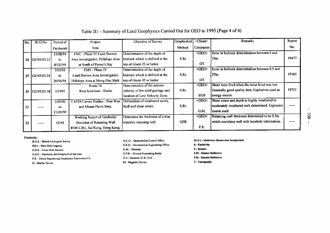
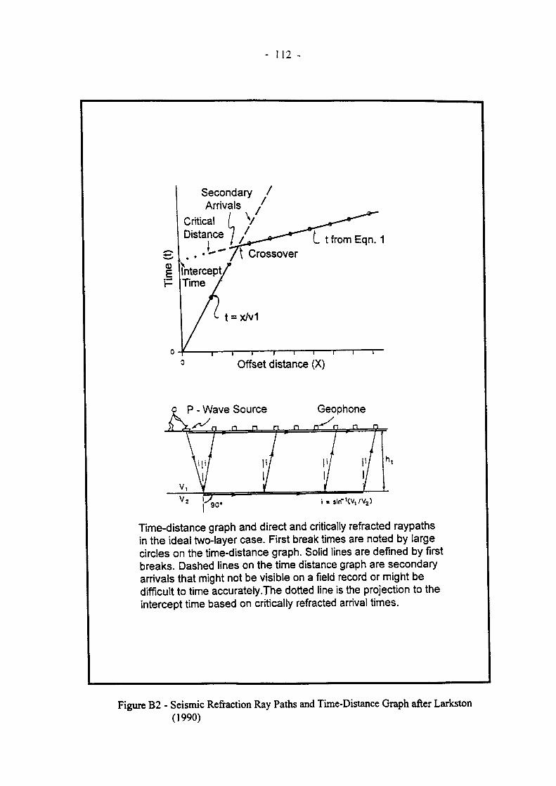
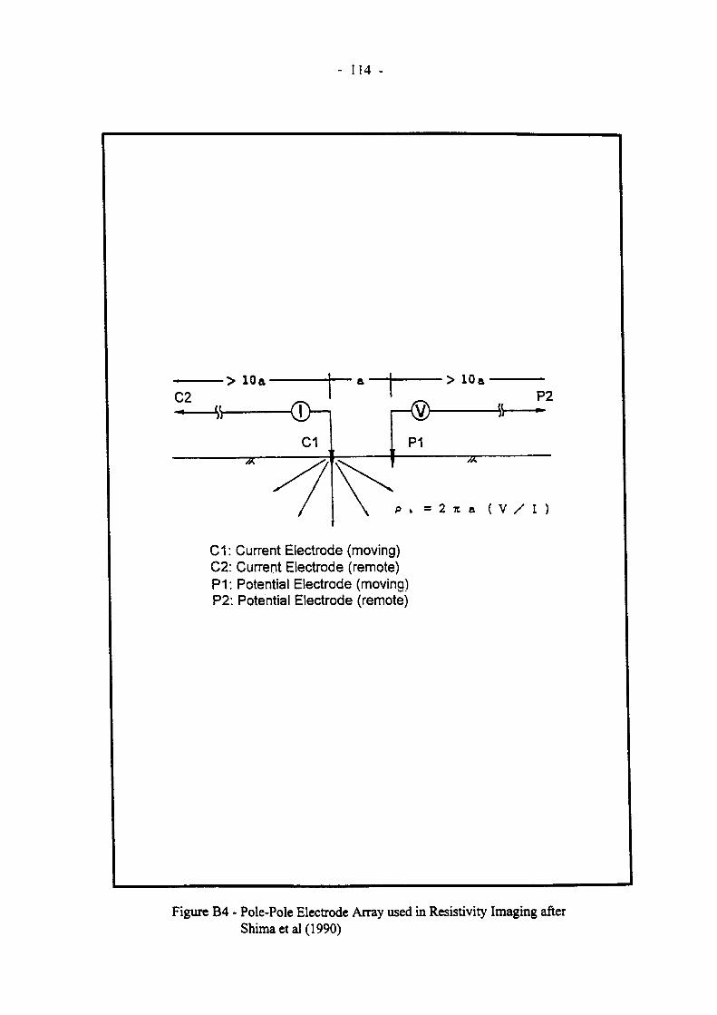

- 結構書籤
-
- -109 Table B2 - A Summary of GPR Case Histories
-