4 OTHER REQUIRED SECTIONS - Bureau of Reclamation
82
Upper Truckee River Restoration and State Parks/Reclamation/TRPA Golf Course Reconfiguration Draft EIR/EIS/EIS 4-1 Other Required Sections 4 OTHER REQUIRED SECTIONS 4.1 SIGNIFICANT ENVIRONMENTAL EFFECTS THAT CANNOT BE AVOIDED CEQA Section 21100(b)(2)(A) states that an EIR shall include a detailed statement setting forth “[i]n a separate section…[a]ny significant effect on the environment that cannot be avoided if the project is implemented.” State CEQA Guidelines Section 15126.2(b) requires that an EIR describe any significant impacts, including those that can be mitigated but not reduced to a less-than-significant level. In addition, Code of Federal Regulations (CFR) Title 40 Section 1502.16 and Section 5.8.B (2) of the TRPA Code of Ordinances requires an EIS to include any significant adverse environmental effects which cannot be avoided should any of the alternatives be implemented. Table 4.1-1 presents a summary of significant environmental effects that cannot be avoided. Chapter 3 of this draft EIR/EIS/EIS addresses the potential environmental effects of the project alternatives for all applicable environmental topic areas and recommends mitigation measures, as necessary, to mitigate project effects to the extent feasible. Cumulative impacts of the project alternatives are discussed in Section 3.16, “Cumulative Impacts,” of this draft EIR/EIS/EIS. Table 4.1-1 Significant Environmental Effects that Cannot Be Avoided Resource Topic/Impact Alt LOS 1 after Mitigation Land Use None Hydrology and Flooding None Geomorphology and Water Quality 3.4-6 Short-Term Risk of Surface Water or Groundwater Degradation during Construction. 2, 3, 4, & 5 SU 3.4-7 Short-Term Risk of Surface Water or Groundwater Degradation Following Construction. 2, 3, 4, & 5 SU Biological Resources None Earth Resources None Scenic Resources None Recreation 3.8-1 Reduction in Recreation Opportunities, Uses, and Experiences Related to Golf. 3 & 5 SU Cultural Resources None Transportation, Parking, and Circulation None
-
Upload
khangminh22 -
Category
Documents
-
view
2 -
download
0
Transcript of 4 OTHER REQUIRED SECTIONS - Bureau of Reclamation
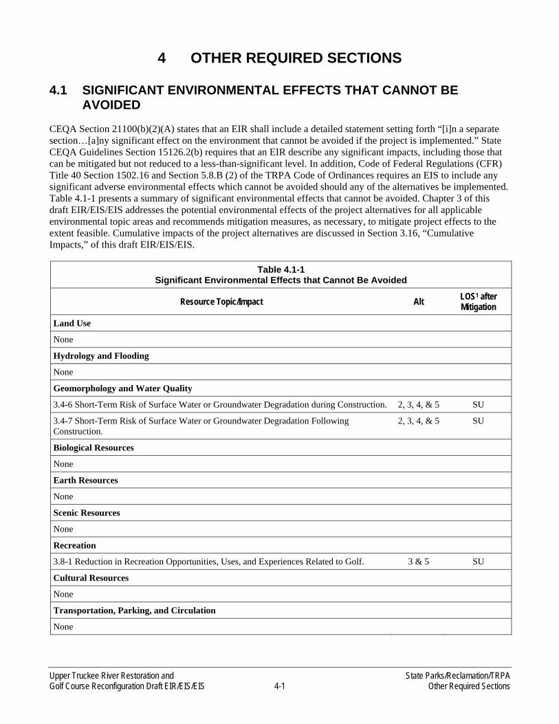
Upper Truckee River Restoration and State Parks/Reclamation/TRPA Golf Course Reconfiguration Draft EIR/EIS/EIS 4-1 Other Required Sections
4 OTHER REQUIRED SECTIONS
4.1 SIGNIFICANT ENVIRONMENTAL EFFECTS THAT CANNOT BE AVOIDED
CEQA Section 21100(b)(2)(A) states that an EIR shall include a detailed statement setting forth “[i]n a separate section…[a]ny significant effect on the environment that cannot be avoided if the project is implemented.” State CEQA Guidelines Section 15126.2(b) requires that an EIR describe any significant impacts, including those that can be mitigated but not reduced to a less-than-significant level. In addition, Code of Federal Regulations (CFR) Title 40 Section 1502.16 and Section 5.8.B (2) of the TRPA Code of Ordinances requires an EIS to include any significant adverse environmental effects which cannot be avoided should any of the alternatives be implemented. Table 4.1-1 presents a summary of significant environmental effects that cannot be avoided. Chapter 3 of this draft EIR/EIS/EIS addresses the potential environmental effects of the project alternatives for all applicable environmental topic areas and recommends mitigation measures, as necessary, to mitigate project effects to the extent feasible. Cumulative impacts of the project alternatives are discussed in Section 3.16, “Cumulative Impacts,” of this draft EIR/EIS/EIS.
Table 4.1-1 Significant Environmental Effects that Cannot Be Avoided
Resource Topic/Impact Alt LOS1 after Mitigation
Land Use
None
Hydrology and Flooding
None
Geomorphology and Water Quality
3.4-6 Short-Term Risk of Surface Water or Groundwater Degradation during Construction. 2, 3, 4, & 5 SU
3.4-7 Short-Term Risk of Surface Water or Groundwater Degradation Following Construction.
2, 3, 4, & 5 SU
Biological Resources
None
Earth Resources
None
Scenic Resources
None
Recreation
3.8-1 Reduction in Recreation Opportunities, Uses, and Experiences Related to Golf. 3 & 5 SU
Cultural Resources
None
Transportation, Parking, and Circulation
None
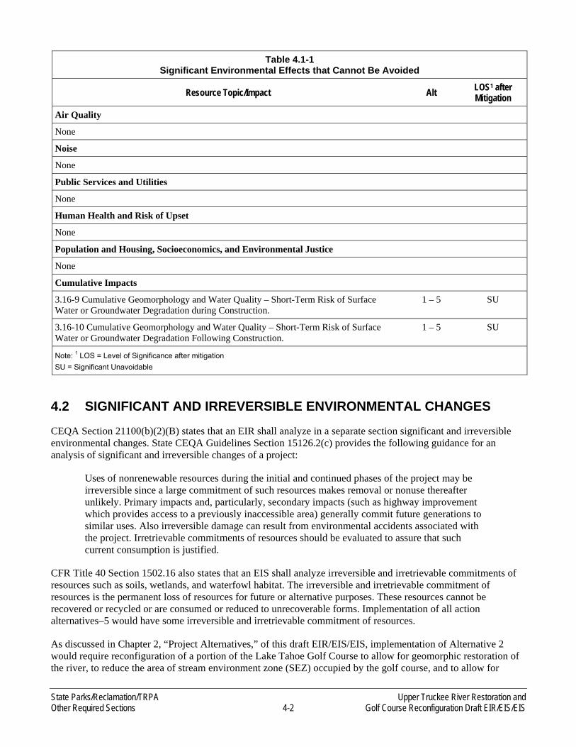
State Parks/Reclamation/TRPA Upper Truckee River Restoration and Other Required Sections 4-2 Golf Course Reconfiguration Draft EIR/EIS/EIS
Table 4.1-1 Significant Environmental Effects that Cannot Be Avoided
Resource Topic/Impact Alt LOS1 after Mitigation
Air Quality
None
Noise
None
Public Services and Utilities
None
Human Health and Risk of Upset
None
Population and Housing, Socioeconomics, and Environmental Justice
None
Cumulative Impacts
3.16-9 Cumulative Geomorphology and Water Quality – Short-Term Risk of Surface Water or Groundwater Degradation during Construction.
1 – 5 SU
3.16-10 Cumulative Geomorphology and Water Quality – Short-Term Risk of Surface Water or Groundwater Degradation Following Construction.
1 – 5 SU
Note: 1 LOS = Level of Significance after mitigation
SU = Significant Unavoidable
4.2 SIGNIFICANT AND IRREVERSIBLE ENVIRONMENTAL CHANGES
CEQA Section 21100(b)(2)(B) states that an EIR shall analyze in a separate section significant and irreversible environmental changes. State CEQA Guidelines Section 15126.2(c) provides the following guidance for an analysis of significant and irreversible changes of a project:
Uses of nonrenewable resources during the initial and continued phases of the project may be irreversible since a large commitment of such resources makes removal or nonuse thereafter unlikely. Primary impacts and, particularly, secondary impacts (such as highway improvement which provides access to a previously inaccessible area) generally commit future generations to similar uses. Also irreversible damage can result from environmental accidents associated with the project. Irretrievable commitments of resources should be evaluated to assure that such current consumption is justified.
CFR Title 40 Section 1502.16 also states that an EIS shall analyze irreversible and irretrievable commitments of resources such as soils, wetlands, and waterfowl habitat. The irreversible and irretrievable commitment of resources is the permanent loss of resources for future or alternative purposes. These resources cannot be recovered or recycled or are consumed or reduced to unrecoverable forms. Implementation of all action alternatives–5 would have some irreversible and irretrievable commitment of resources.
As discussed in Chapter 2, “Project Alternatives,” of this draft EIR/EIS/EIS, implementation of Alternative 2 would require reconfiguration of a portion of the Lake Tahoe Golf Course to allow for geomorphic restoration of the river, to reduce the area of stream environment zone (SEZ) occupied by the golf course, and to allow for

Upper Truckee River Restoration and State Parks/Reclamation/TRPA Golf Course Reconfiguration Draft EIR/EIS/EIS 4-3 Other Required Sections
establishment of a riparian habitat zone and buffer area between the golf course and the river. The project also involves a general plan amendment realigning the boundaries of Washoe Meadows State Park (SP) and Lake Valley State Recreation Area (SRA) so that restored habitat areas are within the state park and the reconfigured golf course holes are located entirely within the SRA. Implementation of Alternative 2 would, to some extent, commit future generations to the change in use of portions of the State Park and SRA.
Implementing Alternative 3 would commit future generations to the change in use of the SRA by modifying the type of play at the Lake Tahoe Golf Course. A reduced play golf course, such as an 18-hole executive or 9-hole regulation course, would be constructed on the east side of the river and would be designed to minimize the footprint of disturbed areas within the SEZ. All bridges would be removed. No construction would occur on the west side of the river in Washoe Meadows SP under Alternative 3 (Exhibit 2-8). A general plan amendment would be needed for Alternative 3 that would, to some extent, commit future generations to the change in use of portions of the State Park and SRA; changes in the boundaries between Washoe Meadows SP and Lake Valley SRA would be necessary to adjust the SRA boundary to fit the smaller golf course. In keeping with the respective purposes of Washoe Meadows SP and Lake Valley SRA, the boundary of Washoe Meadows SP would be adjusted (in this case, expanded) to encompass all of the restored river and riparian corridor.
Implementing the No Project/No Action Alternative or Alternative 4 would commit future generations to continue golf uses adjacent to the Upper Truckee River and Angora Creek, forgoing potential geomorphic restoration and instead continuing minor spot repairs to protect infrastructure or stabilizing the channel in place. Furthermore, implementing Alternative 4 would lock the river into its current disturbed configuration, not allowing for natural adjustment or processes and would commit future generations to maintain the stabilization infrastructure.
Implementing Alternative 5 would commit future generations to the change in use of the SRA to state park. Alternative 5 would involve restoring a portion of the river, decommissioning the entire 18-hole regulation Lake Tahoe Golf Course, and restoring the area once occupied by the golf course. Approximately 13,430 feet of the river and adjacent floodplain would be restored to geomorphic function as in Alternative 2 and 3, but more meadow area would be restored. All bridges would be removed, and there would be minor changes to trails. The restoration of the golf course would reestablish meadow and riparian habitats (Exhibit 2-12). The SRA would be reclassified as part of Washoe Meadows SP. State Parks would embark on a separate planning process to evaluate alternative uses of Washoe Meadows SP and Lake Valley SRA. The clubhouse and maintenance facilities would remain and their uses evaluated during this future process.
While the selection of one of the project alternatives would commit future generations to the approved uses, the commitment could be reversed in the future. The currently proposed project involves such a modification of use, i.e., from golf course to restored aquatic and riparian habitat or from forest and formerly disturbed quarry to golf course. Changes in use and/or restoration of natural resources in the state park units would be feasible, if future decisions by the state directed such changes. Therefore, the impacts on land use related to all of the action alternatives are not irreversible.
Implementation of Alternative 2 –5 would result in the irreversible and irretrievable commitment of energy and material resources during construction and operations. Energy would be expended in the form of gasoline, diesel fuel, and oil for equipment and transportation vehicles, and human labor. Building materials for the project would include rocks, sand, asphalt, concrete, sod, steel, and other materials. Construction activities would generate nonrecyclable materials, such as solid waste and construction debris. The use of these nonrenewable resources is expected to account for a small portion of the resources in the Tahoe Basin and their area of origin (generally, northern California and Nevada) and would not affect the availability of these resources for other needs within the basin.

State Parks/Reclamation/TRPA Upper Truckee River Restoration and Other Required Sections 4-4 Golf Course Reconfiguration Draft EIR/EIS/EIS
4.3 RELATIONSHIP BETWEEN SHORT-TERM USES OF THE ENVIRONMENT AND THE MAINTENANCE AND ENHANCEMENT OF LONG-TERM PRODUCTIVITY
Chapter 5 of TRPA’s Code of Ordinances and CFR Title 40 Section 1502.16 require a discussion of the relationship between a project’s local short-term uses of the environment and the maintenance and enhancement of long-term productivity. The following discussion addresses how implementing the proposed project would affect the short-term use and the long-term productivity of the environment. In general, “short-term” is used here to refer to the construction period, and “long-term” refers to the operational life of the project and beyond.
The study area consists of the Lake Valley SRA, the southern portion of Washoe Meadows SP, and a small parcel of Conservancy property.
Implementation of Alternative 2–5 would result in short-term construction-related impacts in the study area. Impacts would include limiting recreational access of the area, local traffic and circulation interference, limited air emissions, water quality impacts, and increased ambient noise levels. These impacts would be temporary, occurring only during construction or during the interim adjustment period, and are not expected to alter the long-term productivity of the natural environment.
Implementing Alternative 2 would assist in the long-term productivity of the Lake Tahoe Golf Course while restoring the river and reducing sediment delivery to the lake, which would help to sustain and support the social and economic health of the South Lake Tahoe area by providing an improved 18-hole regulation golf course. The golf course would support seasonal tourism in the South Lake Tahoe area, which would provide an economic benefit to the Lake Tahoe business community and foster employee retention. In contrast, implementing Alternative 5 would result in an economic impact related to the loss of approximately $7.5 million in direct visitor spending and $0.5 million in tax revenue, for a total of $8.0 million annually (HEC 2008:63). Alternative 3 would result in reduced revenues between approximately $3.5 million and $5.2 million with a nontraditional golf course (HEC 2008:7). Because these revenues would be lost under Alternative 5 and decrease under Alternative 3, implementing the alternative would have an overall adverse economic impact on the community of South Lake Tahoe and would result in a decrease in the long-term productivity of the South Lake Tahoe area. Implementing Alternative 1 or 4 would result in long-term productivity similar to existing conditions.
4.4 GROWTH-INDUCING IMPACTS OF THE PROPOSED PROJECT
CEQA Section 21100(b)(5) specifies that the growth-inducing impacts of a project must be addressed in an EIR. Section 15126.2(d) of the State CEQA Guidelines states that a proposed project alternative is growth inducing if it could “foster economic or population growth, or the construction of additional housing, either directly or indirectly, in the surrounding environment.” Direct growth inducement would result if a project involved, for example, the construction of new housing. Indirect growth inducement would result if a project established substantial new permanent employment opportunities (e.g., new commercial, industrial, or governmental enterprises), involved a construction effort with substantial short-term employment opportunities that would indirectly stimulate the need for additional housing and services, or removed an obstacle to housing development. Examples of growth-inducing actions include developing water, wastewater, fire, or other types of service areas in areas not previously served; extending transportation routes into previously undeveloped areas; and establishing major new employment opportunities.
Growth would not be induced under any of the project alternatives because none of the project alternatives propose additional housing. In addition, implementing the project would not indirectly induce growth because none of the alternatives would result in substantial new permanent employment opportunities. Construction of Alternative 2–5 would generate short-term employment opportunities; however, the work would be temporary and would occur over several years, with certain activities starting and stopping for shorter durations within that
Upper Truckee River Restoration and State Parks/Reclamation/TRPA Golf Course Reconfiguration Draft EIR/EIS/EIS 4-5 Other Required Sections
time period. Because of the limited number and type of new jobs that would be generated and the temporary nature of those jobs, it is anticipated that the new jobs would be filled using the existing local employment pool. Existing available housing in the region would easily accommodate any workers who relocate from outside the area, if needed. As described in Chapter 2, “Project Alternatives,” of this draft EIR/EIS/EIS, the maximum increase in permanent employees under any alternative would be four additional employees. Therefore, the proposed project would require few permanent workers and would have little effect on the local workforce.
In addition, the proposed alternatives would not include any new services or utilities to the study area that would be constructed with more capacity than needed for uses currently being proposed, even with the proposed restroom facility under Alternatives 2 and 4. No road improvements are proposed as part of any alternatives. For these reasons, indirect growth-inducing impacts resulting from implementation of the proposed project would be less than significant.
As discussed in Section 3.15, “Population and Housing, Socioeconomics, and Environmental Justice,” a slight increase in economic growth may be realized under Alternative 2, which includes construction of an improved golf course. However, the increase in funding from implementation of Alternative 2 is expected to be minimal, resulting in no significant indirect growth-inducing effects. Implementation of Alternative 1, 3, 4, or 5 would result in either a reduction in economic growth or economic growth similar to existing conditions associated with the golf course.
4.5 ENVIRONMENTALLY SUPERIOR ALTERNATIVE/ENVIRONMENTALLY PREFERRED ALTERNATIVE
The action alternatives present trade-offs related to overall environmental advantages. Alternatives 2, 3, and 5 include geomorphic restoration of the river, which would create benefits for long-term water quality, amount and quality of aquatic and riparian habitat, and restoration of stream environment zone (SEZ). Alternative 4 would stabilize the river in place, and have some water quality and habitat benefits, although less than Alternatives 2, 3, and 5. Implementing the No Project/No Action Alternative would avoid the adverse impacts generated by construction activity and golf course reconfiguration resulting from the action alternatives; however, the water quality and river restoration benefits would not occur. Consequently, the No Project/No Action Alternative is not environmentally superior or environmentally preferred. Of the action alternatives, Alternative 5, River Ecosystem Restoration with Decommissioned Golf Course, is the environmentally superior alternative because it would:
► reduce the amount of land coverage the most among the alternatives, which would reduce soils, hydrologic, and biological impacts,
► restore the largest area of SEZ, and
► provide the long-term water quality and habitat benefits of geomorphic river restoration.
While Alternative 5 would be environmentally superior, it includes non-environmental trade-offs. The removal of the golf course would eliminate the revenue stream received by State Parks, a small number of existing local jobs, and the contribution of golfing activity to the local economy. Furthermore, State Parks would embark on a separate planning process to evaluate alternative uses of both Lake Valley State Recreation Area and Washoe Meadows SP.
State Parks/Reclamation/TRPA Upper Truckee River Restoration and Other Required Sections 4-6 Golf Course Reconfiguration Draft EIR/EIS/EIS
4.6 CONSEQUENCES FOR ENVIRONMENTAL THRESHOLD CARRYING CAPACITIES
TRPA Threshold Carrying Capacities (thresholds) are standards of environmental quality to be achieved in the Tahoe Region. The standards identify the level of human impact the Lake Tahoe environment can take before irreparable damage occurs. There are nine resource areas for which thresholds have been established:
► soil conservation, ► water quality, ► fish habitat, ► vegetation, ► wildlife habitat, ► scenic resources, ► recreation, ► air quality, and ► noise.
The thresholds and indicators used to measure compliance of a project with TRPA Threshold Carrying Capacities were adopted in 1987 and remain in effect today. The analysis of attainment status (i.e., whether each threshold is being achieved and/or maintained) is updated approximately every 5 years and was most recently assessed in the 2006 Threshold Evaluation Report (TRPA 2007). Thresholds are under review at this time as part of the Pathways process to update the Regional Plan for the Lake Tahoe Basin (Regional Plan).
An evaluation of the effects of each of the project alternatives on the thresholds is provided below for the nine resource areas that have applicable thresholds. For each threshold, it is stated whether the threshold is applicable to the proposed project and, if so, what the consequences of implementing each alternative would be on each applicable threshold. The evaluation of the project’s effects on the threshold carrying capacities focuses on long-term changes in attainment. Short-term impacts associated with construction of each of the alternatives would be temporary and intermittent and would not change the attainment status of any of the threshold. Thresholds in “attainment,” are those meeting the adopted TRPA standard, thresholds in “nonattainment” are not meeting the TRPA standard, and thresholds are designated as “unknown” when TRPA did not have adequate data to make a determination of attainment.
4.6.1 SOIL CONSERVATION
This section describes the effects of implementing each alternative on the thresholds established for soil conservation by TRPA. As described in Chapter 3, Section 3.3, “Hydrology and Flooding,” and Section 3.6, “Earth Resources,” two soil conservation thresholds have been established by TRPA:
► SC-1, Land Coverage (Impervious Cover), and ► SC-2, Stream Environment Zone.
The Tahoe Basin’s status in 2006 was nonattainment for both SC-1 and SC-2. However, the 2006 Threshold Evaluation Report states, “There has been significant progress and an upward trend in the area of Soil Conservation” (TRPA 2007:9). The report indicates that the key cause for the nonattainment determination for SC-1 is unmitigated excess coverage associated with pre-1987 development (i.e., development that occurred before adoption of the 1987 Regional Plan). New projects must comply with TRPA’s land capability classification requirements; therefore, the basin may be better described as being in “partial attainment” of SC-1 (TRPA 2007:9).

Upper Truckee River Restoration and State Parks/Reclamation/TRPA Golf Course Reconfiguration Draft EIR/EIS/EIS 4-7 Other Required Sections
SC-1, LAND COVERAGE (IMPERVIOUS COVER)
Implementing Alternative 2, 3, or 5 would decrease coverage in the most sensitive lands (LCD 1b) adjacent to the Upper Truckee River, Angora Creek, and the unnamed creek, therefore decreasing existing land coverage of sensitive lands in the watershed. Alternative 4 would increase coverage within LCD 1b; however, proposed coverage is still within that allowed by TRPA. Because implementing any of the action alternatives would either contribute to attainment of the threshold by decreasing land coverage in sensitive lands (Alternatives 2, 3, and 5) or propose coverage that is consistent with TRPA requirements (Alternative 2 and 4), the action alternatives would be consistent with the threshold for land coverage.
SC-2, STREAM ENVIRONMENT ZONE
Attainment of the Stream Environment Zone threshold is tracked basinwide and tracked for three categories: naturally functioning SEZs; SEZs in undeveloped, unsubdivided lands; and SEZs in disturbed, developed, or subdivided areas. The SEZ threshold has a “nonattainment” status. Implementing the project would not adversely affect or interfere with attainment of the SEZ threshold.
Existing SEZ lands within the study area are in primarily disturbed areas with limited function. Implementing Alternative 1 or 4 would not restore SEZ lands that have been identified as disturbed, developed, or subdivided. Although implementing Alternative 4 would stabilize the river channel and prevent further channel erosion that continues to degrade or erode existing SEZ lands, it would not improve SEZ function.
Implementing Alternative 2, 3, or 5 would directly restore SEZ lands that have been identified as disturbed, developed, or subdivided, achieving restoration of 37, 43, and 123 acres of SEZ lands, respectively. Implementing any of these three alternatives would improve stream channel floodplain connectivity to allow overbanking more frequently, which would enlarge the active floodplain from 36 to 77 acres. In addition, implementing any of these three alternatives would modify land uses and include corrective actions within the disturbed SEZ. The remaining golf course footprint in SEZ would vary from 96 acres under Alternative 2 and 80 acres under Alternative 3 to 2.5 acres (continued use of structures) under Alternative 5. Corrective measures would be taken within the portions of SEZ no longer under golf course land uses, including removing nonnative landscaping and coverage, removing fill and reshaping the topography, amending disturbed soils, and replanting native vegetation.
The basinwide target for this threshold is to restore 1,100 acres (25 percent) of the 4,400 acres of SEZ lands identified as disturbed, developed, or subdivided. Approximately 378.9 acres have been restored since 1980, leaving 721.1 acres as the balance needed to attain the threshold. Implementing Alternative 5 would make a substantial contribution to attaining this threshold because it would restore 17.1 percent of the outstanding acreage balance. Implementing Alternative 2 or 3 also would make measureable contributions to attaining this threshold, restoring 5.1 and 6.0 percent of the outstanding acreage balance, respectively.
4.6.2 WATER QUALITY
This section describes the effects of implementing the different alternative on the environmental thresholds established for water quality by TRPA. As described in Section 3.4, “Geomorphology and Water Quality,” seven narrative and numeric standards for the adopted TRPA water quality thresholds have been established by TRPA:
► WQ-1, Littoral Lake Tahoe; ► WQ-2, Pelagic Lake Tahoe, Deep Water Clarity; ► WQ-3, Pelagic Lake Tahoe, Phytoplankton Primary Productivity; ► WQ-4, Tributaries; ► WQ-5, Stormwater Runoff, Surface Water; ► WQ-6, Stormwater Runoff, Groundwater; and ► WQ-7, Other Lakes.
State Parks/Reclamation/TRPA Upper Truckee River Restoration and Other Required Sections 4-8 Golf Course Reconfiguration Draft EIR/EIS/EIS
None of the project alternatives would produce a discernable effect on four of the TRPA water quality thresholds: WQ-1, Littoral Lake Tahoe (attainment); WQ-2, Pelagic Lake Tahoe, Deep Water Clarity (nonattainment); WQ-3, Pelagic Lake Tahoe, Phytoplankton Primary Productivity (nonattainment); or, WQ-7, Other Lakes (nonattainment). Therefore, these thresholds are not discussed further.
Water Quality thresholds are applied basinwide; that is, the entire Tahoe Basin is considered in attainment or in nonattainment. However, spatial data by stream, lake, or other water body is tracked, and local attainment status is reported by TRPA. No spatially discrete targets have been established. The three directly related water quality thresholds all have a “nonattainment” status. Implementing the project would not adversely affect or interfere with attainment of any of TRPA’s seven water quality thresholds. The relevant thresholds are discussed in more detail below.
WQ-4, TRIBUTARIES
The TRPA threshold numeric standards that could be affected by the project include the attainment of State standards for concentrations of total nitrogen (0.15 to 0.22 milligrams per liter [mg/l]), total phosphorus (0.010 to 0.030 mg/l), and total iron (0.015 to 0.03mg/l) and attainment of a 90th percentile value for suspended sediment concentration of 60 mg/L (annual average). Most of the tributaries to Lake Tahoe, including the Upper Truckee River, are in attainment for suspended sediment concentration, based on monthly data through 2005 water year, but no California streams are in attainment for total nitrogen or total phosphorus.
Implementing Alternative 1 would not modify the sources and/or potential treatment (sinks) of suspended sediment, nitrogen, phosphorous, or iron within the study area, and it would not make a contribution toward attaining this threshold.
Implementing Alternative 2, 3, or 5 not only would reduce local sources of sediment from channel erosion but would enhance opportunities for treatment of suspended sediment, nitrogen, phosphorous, and iron within the study area. Reduced channel erosion and increased streambank vegetation would lower the total sediment and fine sediment generated and the release of nitrogen and phosphorous in the study area. Increased overbank flow frequency, the enlargement of the active floodplain, and the increased channel length of overbanking would foster substantial opportunities for floodplain deposition of fine sediment under Alternative 2, 3, or 5. Implementing any of these three alternatives would also restore varied areas of floodplain and SEZ vegetation and soil conditions. Improved opportunities for net sequestration of fine sediment and net uptake of nutrients would be expected to occur in proportion to the areas of restored soil and native vegetation. No discernable change in iron would be expected. These improvements to both source control and treatment would make substantial contributions toward attaining the water quality tributaries threshold. Implementing Alternative 5 would be expected to produce the largest benefit, although implementing either Alternative 2 or 3 would also make measurable contributions toward attaining this threshold.
Implementing Alternative 4 would not modify the potential treatment of suspended sediment, nitrogen, phosphorous, or iron within the study area, but it would substantially reduce local sources of sediment from channel erosion. Reducing the total sediment and fine sediment generated from channel erosion within the treatment reaches and improving channel bank vegetation could also lower the release of nitrogen and phosphorous as sources are reduced and uptake is encouraged. No discernable change in iron would be expected. Implementing Alternative 4 would result in source control that would make a measureable contribution toward attaining the water quality tributaries threshold. Alternative 4 would have more parking lot area paved, but would include BMP’s.
WQ-5, STORMWATER RUNOFF, SURFACE WATER
The Tahoe Basin is in nonattainment for standards focused on limiting nitrogen, phosphorous, iron, grease, oil and suspended sediment in stormwater surface water discharges.
Upper Truckee River Restoration and State Parks/Reclamation/TRPA Golf Course Reconfiguration Draft EIR/EIS/EIS 4-9 Other Required Sections
Implementing Alternative 1 or 4 would not modify sources of nutrient, sediment, or hydrocarbon pollutants to stormwater within the study area, and it would not incorporate any modifications to the stormwater system or runoff treatment facilities. Implementing either of these alternatives would have no effect on the stormwater runoff-surface water threshold.
Implementing Alternative 2 would potentially increase the sources and/or modify the locations of nutrient, sediment, or hydrocarbon pollutants to stormwater within the study area. However, Alternative 2 would also involve incorporating upgrades to the stormwater drainage systems, relocating some of the source activities and materials further away from receiving waters, and installing and operating upgraded stormwater runoff pretreatment facilities. These measures would make a measureable contribution toward attainment of the stormwater runoff-surface water threshold.
Implementing Alternative 3 or 5 would decrease the sources and modify the locations of nutrient, sediment, or hydrocarbon pollutants within the study area, with improvements proportional to area of golf course land uses removed. Implementing Alternative 3 would retain some area of golf course, but would incorporate upgrades to the stormwater drainage system and would involve relocating some of the source activities further away from receiving waters. Implementing Alternative 5 would remove the golf course and, therefore, substantially decrease stormwater generated in the study area and sources of potential stormwater contaminants, thereby reducing the need for runoff pretreatment facilities. Implementing Alternative 3 or 5 would make substantial contributions toward attainment of the stormwater runoff-surface water threshold, with the expectation that implementing Alternative 5 would have a larger total benefit.
WQ-6, STORMWATER RUNOFF, GROUNDWATER
The Tahoe Basin is in nonattainment for standards focused on limiting nitrogen, phosphorous, iron, grease, oil, and turbidity in stormwater discharges for infiltration.
Implementing Alternative 1 or 4 would not modify sources of nutrient, sediment, or hydrocarbon pollutants to stormwater within the study area, and it would not incorporate any modifications to the stormwater system or runoff treatment facilities or to groundwater levels, flows, or recharge. Implementing either of these alternatives would have no effect on the stormwater runoff-groundwater threshold.
Implementing Alternative 2 would potentially increase the sources and modify the locations of nutrient, sediment, or hydrocarbon pollutants within the study area. However, Alternative 2 would also involve incorporating upgrades to the stormwater drainage systems, relocating some of the source activities and materials further away from receiving waters, and installing and operating upgraded stormwater runoff pretreatment facilities. Locations of potential changes in land use, drainage, and stormwater treatment would be closer to a few surface water-groundwater interface sites west of the river, but design measures and mitigation measures would be incorporated to limit surface runoff from recharging groundwater. The net effect of implementing Alternative 2 measures on attainment of the stormwater runoff-groundwater threshold would not be adverse but may not constitute a discernable benefit.
Implementing Alternative 3 or 5 would decrease the sources and modify the locations of nutrient, sediment, or hydrocarbon pollutants within the study area, with improvements proportional to area of golf course land uses removed. Implementing Alternative 3 would retain some area of golf course but would incorporate upgrades to the stormwater drainage system and would involve relocating some of the source activities further from surface water-groundwater interface locations. Alternative 5 would involve removing the golf course and, therefore, would substantially decrease stormwater generated in the study area and sources of potential stormwater contaminants, thereby reducing the need for runoff pretreatment facilities. Implementing either Alternative 3 or 5 would make substantial contributions toward attainment of the stormwater runoff-groundwater threshold, with the expectation that implementing Alternative 5 would have a larger total benefit.
State Parks/Reclamation/TRPA Upper Truckee River Restoration and Other Required Sections 4-10 Golf Course Reconfiguration Draft EIR/EIS/EIS
4.6.3 FISH HABITAT
This section summarizes the effects of implementing each of the alternatives on the environmental thresholds established by TRPA for fish habitat. As described in Section 3.5, “Biological Resources,” four fish habitat thresholds have been established by TRPA:
► F-1, Lake Habitat; ► F-2, Stream Habitat; ► F-3, Instream Flow; and ► F-4, Lahontan Cutthroat Trout.
F-1, LAKE HABITAT
The F-1 threshold is to apply a nondegradation standard to fish habitat in Lake Tahoe and achieve the equivalent of 5,948 total acres of excellent (prime) habitat. The current status of this threshold is nonattainment. Implementing Alternative 1 would not change fish habitat conditions in the lake; therefore, implementing this alternative would not affect nonattainment of the F-1 threshold. Implementing Alternative 2, 3, 4, or 5 would reduce suspended sediment loads to Lake Tahoe that originate from the study area. Therefore, implementing any of these alternatives would not contribute to nonattainment of the F-1 threshold.
F-2, STREAM HABITAT
The F-2 threshold is to “maintain 75 miles of excellent, 105 miles of good, and 38 miles of marginal stream habitat.” The current status of this threshold is unknown because of lack of data (TRPA 2007). Implementing Alternative 1 would not change stream habitat conditions in the study area; therefore, implementing this alternative would not affect the attainment status of the F-2 threshold. Implementing Alternative 2, 3, 4, or 5 would improve stream habitat conditions in the Upper Truckee River to varying degrees and would contribute to the attainment of threshold F-2. Habitat in the segment of the Upper Truckee River within the study area would gradually change from “migratory marginal” to “migratory good” as the restoration project is completed and channel conditions improve.
F-3, INSTREAM FLOW
The F-3 threshold states that “until instream flow standards are established in the Regional Plan to protect fishery values, a nondegradation standard shall apply to instream flows.” The current status of the threshold is attainment. Implementing any of the project alternatives would not change instream flows in the Upper Truckee River. Therefore, it would not affect the attainment status of the F-3 threshold.
F-4, LAHONTAN CUTTHROAT TROUT
The F-4 threshold is to “support, in response to justifiable evidence, State and Federal efforts to reintroduce Lahontan cutthroat trout.” The current status of the threshold is attainment. Implementing Alternative 1 would not change habitat conditions for Lahontan cutthroat trout in the study area; therefore, implementing this alternative would not affect attainment of the F-4 threshold. Implementing Alternative 2, 3, 4, or 5 would improve stream habitat conditions in the Upper Truckee River to varying degrees for native fish species, including Lahontan cutthroat trout; therefore, it would contribute to further attainment of the F-4 threshold.

Upper Truckee River Restoration and State Parks/Reclamation/TRPA Golf Course Reconfiguration Draft EIR/EIS/EIS 4-11 Other Required Sections
4.6.4 VEGETATION
This section summarizes the effects of implementing each of the alternatives on the environmental thresholds established by TRPA for vegetation. As described in Section 3.5, “Biological Resources,” four vegetation thresholds have been established by TRPA:
► V-1, Common Vegetation; ► V-2, Uncommon Plant Communities; ► V-3, Sensitive Plants; and ► V-4, Late Seral/Old Growth Ecosystems.
V-1, COMMON VEGETATION
The V-1 threshold is to increase plant and structural diversity of forest communities through appropriate management practices as measured by diversity indices of species richness, relative abundance, and pattern. The V-1 threshold includes separate standards for diversity and pattern of vegetation types and relative abundance for conifer forest types, meadow and wetland vegetation types, and deciduous riparian vegetation types that are applied basinwide.
In its 2006 Threshold Evaluation Report, TRPA determined that the diversity and pattern standards for common vegetation were in attainment. Implementing any of the alternatives would not affect the attainment status of these thresholds, because none of the alternatives would affect the overall diversity or pattern of common vegetation types throughout the Tahoe Basin. To achieve the threshold for pattern across the basin, TRPA attempts to “provide for the proper juxtaposition of vegetation communities and age classes” partly by “limiting acreage size of new forest openings to no more than 8 acres” (TRPA 2007). Implementing Alternative 2 would result in the loss of up to 60 acres (includes17 acres of previously disturbed quarry lands, Jeffrey pine, lodgepole pine, and other common vegetation types) for golf course reconfiguration west of the Upper Truckee River. Although conversion to golf course would affect more than 8 acres, the existing forest cover that would be affected is patchy, disturbed, and relatively open. Furthermore, the final acres, number, and stand condition of trees removed will be determined in cooperation with TRPA prior to construction. The tree removal estimates for include trees that may be removed in the future for additional forest health and fuels treatments prior to, or in the absence of, project implementation, as part of State Parks’ existing Lake Sector Wildfire Management Plan. Although State Parks has treated much of the study area for fuels reduction, some proportion of trees estimated for removal may be removed in the future regardless of project implementation (Walck, pers. comm., 2010), to further reduce densities in some areas. Additionally, some lodgepole pines that would be removed within the riparian corridor as part of the geomorphic restoration would also be removed as part of State Parks’ existing management objectives to reduce conifer encroachment in riparian and meadow habitats and to enhance riparian hardwood growth (as part of the Riparian Hardwood Restoration Project). Therefore, loss of common vegetation under Alternative 2 would not contribute to nonattainment of the overall forest pattern threshold for the Tahoe Basin.
The threshold for relative abundance of Jeffrey pine forest is to maintain 15–25 percent of the Jeffrey pine forest in seral stages other than mature to ensure that relatively young age classes of this forest type are represented in the Tahoe Basin. In the 2006 Threshold Evaluation Report, TRPA stated that “92% of Jeffrey pine have average stand diameters of less than 24 inches and therefore would be classified as stages other than mature.” (TRPA cites Nearctica [2000], which defines mature Jeffrey pine as ranging between 24 and 48 inches diameter at breast height [dbh].) However, the threshold evaluation report also states that attainment of this standard “cannot be well quantified with available metrics because ‘seral stages other than mature’ has not been defined with respect to this standard, and complete surveys of the demographics of Jeffrey pine forest types in the Basin have not been completed.” The report further explains that “the intent of the threshold as written was to increase the diversity of stand ages on the landscape and create more young stands. The diameter distribution [shown in Figure 5-1 of the report] illustrates that most stands contain large trees and there are few young stands on the landscape. Therefore, this threshold can be considered to be in nonattainment.” (Note: This conclusion appears to be based on the low
State Parks/Reclamation/TRPA Upper Truckee River Restoration and Other Required Sections 4-12 Golf Course Reconfiguration Draft EIR/EIS/EIS
proportion of stands that lack the presence of large trees, as opposed to the high proportion of stands with average tree diameters of less than 24 inches.) Whether the loss of variable-aged Jeffrey pine forest under Alternative 2 would affect attainment of the relative abundance threshold is not clear and would depend on how TRPA ultimately defines “seral stages other than mature.” Based on TRPA’s discussion (in the 2006 Threshold Evaluation Report) of the intent of the relative abundance threshold, this analysis assumes that stands that “contain large trees” are excluded from the definition of “seral stages other than mature” (i.e., “seral stages other than mature” are generally limited to stands with relatively even age structure, dominated by small-diameter trees). The mixed-age stands of Jeffrey pine forest that would be affected under all action alternatives include large trees (including some greater than 30 inches dbh). Therefore, removal of this stand type would not affect TRPA’s threshold to create or maintain young stands of Jeffrey pine on the landscape, and it would not contribute to further nonattainment of the relative abundance threshold.
Implementing Alternative 2, 3, or 5 would result in an increase in acreage and quality of deciduous riparian vegetation and meadow and wetland vegetation. Although the relative abundance threshold for these vegetation types is presently in nonattainment, implementing any of these alternatives would contribute to attainment of this threshold.
V-2, UNCOMMON PLANT COMMUNITIES
The V-2 threshold calls for providing the nondegradation of the natural qualities of any plant community that is uncommon to the Tahoe Basin or of exceptional scientific, ecological, or scenic quality. The spring/fen complexes in Washoe Meadows SP are examples of plant communities that are uncommon in the Tahoe Basin and are included under this threshold. None of the alternatives would contribute to nonattainment of this threshold. Construction activities would be conducted adjacent to the spring/fen complexes under Alternative 2, but avoidance and protection measures would ensure that these resources would not be degraded. None of the alternatives include any restoration activities at the spring/fen complexes that would bring this threshold closer to attainment.
V-3, SENSITIVE PLANTS
The V-3 threshold is to maintain the following minimum number of population sites for TRPA special-interest plant species: Galena Creek rockcress (Arabis rigidissima var. demota) (seven sites), long-petaled lewisia (Lewisia longipetala) (two sites), Cup Lake draba (Draba asterophora var. macrocarpa) (two sites), Tahoe draba (Draba asterophora var. asterophora) (five sites), and Tahoe yellow cress (Rorippa subumbellata) (26 sites). None of these special-interest plants has potential to occur within the study area. Under Alternatives 2, 3, 4, and 5, short-term disturbances or loss of other special-status plants that do have potential to occur within the study area would be avoided through preconstruction surveys and avoidance measures; therefore, suitable habitat for these species is expected to improve over the long term. For this reason, implementing any of these alternatives would not contribute to nonattainment of the V-3 threshold. Because habitat for TRPA special-interest plant species does not exist within the study area, project implementation under any of the alternatives would not result in any opportunity to contribute to attainment of this threshold.
As discussed in Impact 3.16-12 (All Alts.), “Cumulative Biological Resources – Effects on Special-Status Plants and Sensitive Habitats (Jurisdictional Wetlands, Riparian Vegetation, and SEZ),” any changes to beach erosion processes near the river mouth as a cumulative result of any project alternative could affect habitat for Tahoe yellow cress. However, after thorough investigation and given the distance between the study area and the mouth of the river, this impact remains too speculative for a meaningful conclusion regarding long-term effects on attainment status.
V-4, LATE SERAL/OLD GROWTH ECOSYSTEMS
The study area does not contain any late seral/old growth forest. Implementing any of the five alternatives would not affect the attainment status of this threshold. Because of the long period over which late seral/old growth
Upper Truckee River Restoration and State Parks/Reclamation/TRPA Golf Course Reconfiguration Draft EIR/EIS/EIS 4-13 Other Required Sections
ecosystems develop, project implementation under any of the alternatives would not result in any opportunity to contribute to attainment of this threshold.
4.6.5 WILDLIFE HABITAT
This section summarizes the effects of each alternative on the environmental thresholds established by TRPA for wildlife habitat. As described in Section 3.5, “Biological Resources,” two wildlife habitat thresholds have been established by TRPA:
► W-1, Wildlife Species of Special Interest, and ► W-2, Habitats of Special Significance.
W-1, WILDLIFE SPECIES OF SPECIAL INTEREST
The W-1 threshold is to provide a minimum number of population sites for six TRPA special-interest wildlife taxa: northern goshawk (12 sites), osprey (four sites), bald eagle (two winter sites and one nesting site), golden eagle (four sites), peregrine falcon (two sites), and waterfowl (18 sites). Mule deer is also a special-interest species; however, no threshold site number for deer has been specified. None of the project alternatives would affect designated waterfowl threshold areas or breeding sites of other special-interest species. Therefore, implementing any of these alternatives would not affect the attainment status of the W-1 threshold. Under Alternatives 2, 3, 4, and 5, short-term disturbances or loss of nesting waterfowl would be avoided through preconstruction surveys and avoidance measures, and waterfowl habitat is expected to improve over the long term as a result of river and riparian habitat restoration.
W-2, HABITATS OF SPECIAL SIGNIFICANCE
The W-2 threshold is to apply a nondegradation standard to habitats consisting of deciduous trees, wetlands, and meadows while providing for opportunities to increase the acreage of such riparian associations. These opportunities include but are not limited to preserving existing naturally functioning SEZ lands in their natural hydrologic condition; restoring all disturbed SEZ lands in undeveloped, unsubdivided lands; and restoring 25 percent of the SEZ lands that have been identified as disturbed, developed, or subdivided, to attain a 5-percent total increase in the naturally functioning SEZ land. River and floodplain restoration under Alternatives 2, 3, and 5would enhance the quality and increase the size of riparian, wetland, and aquatic habitat. Alternative 4, riverbank stabilization and inset floodplain creation would also enhance these habitats but less than Alternatives 2, 3, and 5. Therefore, implementing any of these alternatives would contribute to attainment of the W-2 threshold. Under Alternative 1, continued operation of the golf course would continue to limit riparian habitat functions along the Upper Truckee River but would not contribute to nonattainment of the W-2 threshold.
4.6.6 SCENIC RESOURCES
This section describes the effects of each alternative on the environmental thresholds established for scenic resources by TRPA. As described in Section 3.7, “Scenic Resources,” four scenic thresholds have been established by TRPA:
► SR-1, Travel Route Ratings; ► SR-2, Scenic Quality Ratings; ► SR-3, Public Recreation Area Scenic Quality Thresholds; and ► SR-4, Community Design.

State Parks/Reclamation/TRPA Upper Truckee River Restoration and Other Required Sections 4-14 Golf Course Reconfiguration Draft EIR/EIS/EIS
SR-1, TRAVEL ROUTE RATINGS
The only travel unit with views of the study area is Roadway Travel Unit 36B, which includes a portion of U.S. Highway 50 (U.S. 50). The 2006 Threshold Evaluation Report determined that this area is in attainment. Implementing any of the alternatives would not affect attainment of any scenic quality threshold. It would not adversely affect attainment of SR-1, Travel Route Ratings, because none of the alternatives would degrade views from Roadway Travel Unit 36B, and no new project facilities would be visible from this travel unit.
SR-2, SCENIC QUALITY RATINGS
SR-2, Scenic Quality Ratings, also would not be adversely affected by implementing any of the alternatives. Scenic resources identified in the project vicinity include views of the golf course (Roadway Scenic Resource 36-3), forest and river corridor views (Roadway Scenic Resource 36-7), and the Truckee River stream zone (Roadway Scenic Resource 36-5). Implementing Alternative 1, 2, 3, or 4 would result in little to no change in views of the golf course from U.S. 50 and would not affect any other identified scenic resources. Implementing Alternative 5 would result in changes in views of the golf course, which is identified as a scenic resource. Alternative 5 involves decommissioning the golf course and returning the area to restored meadow and riparian habitat. Although implementing this alternative would result in a substantial change in views of an identified scenic resource, the change in views from golf course to natural landscape is considered desirable and would be consistent with the surrounding natural landscape. The Tahoe Basin is known for its natural beauty, and changes in views from human-made features to natural meadow habitat are considered desirable.
SR-3, PUBLIC RECREATION AREA SCENIC QUALITY THRESHOLDS
TRPA’s 1993 Lake Tahoe Scenic Resource Evaluation did not identify any TRPA-designated public recreation areas with views of the study area. Neither Lake Valley SRA nor Washoe Meadows SP is designated by TRPA as a public recreation area subject to these thresholds. The public recreation area nearest to the study area is Heavenly Valley Ski Resort. The study area is located approximately 7 miles from the ski resort. Based on this evaluation, the study area would not be visible from any TRPA-identified public campgrounds or segments of TRPA-identified bike trails. There is no current update to the 1993 scenic inventory. The Sawmill bike trail is considered a designated Class I Shared Use Path but has not been added to the list of scenic bikeways. Since the trail is immediately adjacent to U.S. Highway 50, scenic impacts on the bike path are addressed through scenic corridor impacts in Section 3.7, “Scenic Resources,” where findings were less than significant. Therefore, no project alternatives would negatively affect SR-3, Public Recreation Area Scenic Quality Thresholds.
SR-4, COMMUNITY DESIGN
The community design threshold is a policy statement that applies to the built environment and is not restricted to roadways or shoreline units. Design standards and guidelines found in the Code of Ordinances, the Scenic Quality Improvement Program, and in the adopted Community Plans provide specific implementation direction. Alternatives 1, 3, and 5 do not propose any new development. Under Alternatives 2 and 4, additional lightning would be installed at the newly paved parking area adjacent to the golf course entrance. The golf course parking area lighting is currently used to light the parking areas for clubhouse events that may occur in the evening and end by 10 p.m. Lighting is not used to light the golf course, which is closed at dusk. Lighting use would continue to be for the purpose of lighting the parking area for specific events, ending at 10 p.m. According to the TRPA Design Review Guidelines lighting standards, lighting shall be directed downward, and lighting fixtures shall not exceed 10–12 feet in height (TRPA 1989a:30-5 and 30-6). All new lighting would comply with TRPA’s Design Review Guidelines. In addition, the restroom facilities would be small, designed with natural colors to blend in with the surrounding landscape, blocked from view with strategically placed vegetative cover and constructed of nonreflective materials and would not include any exterior lighting. Because the new lighting would be near the existing parking area and clubhouse, which are existing sources of light and glare, and because the proposed lighting would be minimal and would be consistent with TRPA’s lighting design guidelines, and restroom

Upper Truckee River Restoration and State Parks/Reclamation/TRPA Golf Course Reconfiguration Draft EIR/EIS/EIS 4-15 Other Required Sections
facilities would be designed to comply with TRPA’s Design Review Guidelines and Alternatives 1, 3, and 5 do not propose any new development implementation of any of the alternatives would have no effect on SR-4 community design threshold.
4.6.7 RECREATION
This section describes the effects of each alternative on the environmental thresholds established for recreation resources by TRPA. As described in Section 3.8, “Recreation,” two recreation thresholds have been established by TRPA:
► R-1, High Quality Recreational Experience & Access, and ► R-2, Capacity Available to the General Public.
R-1, HIGH QUALITY RECREATIONAL EXPERIENCE & ACCESS, AND R-2, CAPACITY AVAILABLE TO THE
GENERAL PUBLIC
The R-1 threshold is intended to preserve and enhance the high-quality recreational experience by preserving high-quality, undeveloped shorezone and other natural areas. The R-2 threshold ensures that a fair share of the Tahoe Basin’s capacity for outdoor recreation is available to the general public. TRPA’s 2006 Threshold Evaluation Report concluded that the R-1 and R-2 thresholds are considered to be in attainment (TRPA 2007:10-3, 10-8). Continuation of existing recreation opportunities in the study area would likely result in assignment of PAOTs under all alternatives. The Upper Truckee River Restoration and Golf Course Reconfiguration Project qualifies under the EIP for PAOT allocation from the existing pool (6,215 available for summer-day use and 7,927 available for winter-day use [TRPA 2007: 10-9]) available for the Golf Course and for the driving range snowmobile uses.
Under Alternative 1, existing recreational opportunities or capacities would not change. Therefore, implementing Alternative 1 would not cause any changes to the existing threshold attainment status.
Alternative 2 would involve reconfiguring the Lake Tahoe Golf Course. Some volunteer trails within Washoe Meadows SP would be removed under this alternative; however, new trails would be added to provide access around the reconfigured golf course. Although reconfiguring the golf course would result in a reduction in dispersed outdoor recreation within a portion of Washoe Meadows SP and a reduction in public access to natural areas, the recreation opportunities that would be reduced would be replaced with other trail and river recreation opportunities in the restored river corridor. Furthermore, connectors to the Sawmill bike trail would increase connectivity to the existing bike trail.
Although the locations of recreation opportunities within a portion of the study area would change, recreation opportunities provided in the study area as a whole would not substantially change. Currently, no PAOTs are assigned to recreational facilities within the study area. Therefore, Alternative 2 would not have an adverse effect on PAOT capacity for the study area or Tahoe Basin. Implementing Alternative 2 would not cause changes to the attainment status of the R-1 and R-2 thresholds.
Alternative 3 would involve substantially modifying the existing golf course in the study area. The golf course would be modified to a regulation 9-hole course or an 18-hole executive course. Although Alternative 3 would not include a regulation-level golf course, implementing this alternative would still provide high-quality recreation. The changes to the golf course would allow restoration of the Upper Truckee River, which would enhance and preserve a natural area. Alternative 3 would involve reducing access across the river; however, some access would be maintained via a new trail system that would also provide connectivity to the Sawmill bike trail. In addition, no PAOTs have been assigned to the golf course or other recreational facilities within the study area. Therefore, although the reduced golf course would result in slightly less golfing opportunities, it would not result in a loss of PAOTs. Because PAOTs have not been assigned to the golf course, this alternative would not reduce
State Parks/Reclamation/TRPA Upper Truckee River Restoration and Other Required Sections 4-16 Golf Course Reconfiguration Draft EIR/EIS/EIS
recreation PAOT capacity. Because high-quality recreation and access to natural areas would remain available in the study area, implementing this alternative would not alter the attainment status of the R-1 and R-2 thresholds.
Implementing Alternative 4 would not result in impacts on existing recreation opportunities. This alternative would not involve substantial changes to the Lake Valley SRA or Washoe Meadows SP. Only minor changes would be made to the golf course, and they would not alter the existing golfing or winter recreational opportunities or experiences, or reduce PAOT capacity. Therefore, implementing Alternative 4 would not cause changes to the existing attainment status of the R-1 and R-2 thresholds.
Alternative 5 would involve substantially modifying existing recreation facilities in the study area. The existing golf course would be decommissioned. A 9-hole course may be developed in the short term until future planning efforts determine uses and development of Washoe Meadows SP and Lake Valley SRA could. The changes to the golf course would allow restoration of the Upper Truckee River and the entire footprint of the golf course, which would enhance and preserve a natural area. Existing informal trails would remain in place, except in locations where restoration is proposed to occur. The less intensive recreational resources, such as hiking/walking, nature/wildlife viewing, biking, and equestrian use, would remain available to the general public. In addition, water-related recreation would continue informally under Alterative 5. No PAOTs have been assigned to the golf course or other recreational facilities within the study area. Therefore, although eliminating the golf course and snowmobile track would result in reduced recreation opportunities within the study area, there would not be a loss of PAOTs or a reduction in PAOT capacity. Thus, Alternative 5 would not cause changes to the existing attainment status of the R-1 and R-2 thresholds.
4.6.8 AIR QUALITY
This section describes the effects of each alternative on the environmental thresholds established for air quality by TRPA. As described in Section 3.11, “Air Quality,” eight air quality thresholds have been established by TRPA:
► AQ-1, Carbon Monoxide; ► AQ-2, Ozone (ROG and NOX); ► AQ-3, PM10; ► AQ-4, Visibility; ► AQ-5, U.S. 50 Traffic Volumes; ► AQ-6, Wood Smoke Emissions; ► AQ-7, Vehicle Miles Traveled; and ► AQ-8, Atmospheric Nutrient Loading.
AQ-1, CARBON MONOXIDE, AQ-2, OZONE (ROG AND NOX), AQ-3, PM10, AQ-4, VISIBILITY, AND
AQ-8, ATMOSPHERIC NUTRIENT LOADING
Air quality thresholds are applied basinwide; that is, the entire basin is considered in attainment or in nonattainment. No local attainment designations are used. The AQ-1, AQ-2, and AQ-3, thresholds have been designated “nonattainment”; the AQ-4 threshold has been designated “attainment”; and the AQ-8 threshold has been designated “unknown.” The thresholds for air quality are established by TRPA for long-term operational emissions only. Therefore, temporary, short-term, construction-related emissions are not considered in determining compliance with TRPA thresholds.
Implementing Alternative 1 would not create any new sources of carbon monoxide (CO), reactive organic gases (ROG), oxides of nitrogen (NOX), respirable particulate matter (PM10), or trip generation (see Chapter 3, Section 3.11, “Air Quality,” for discussion). As a result, attainment of thresholds AQ-1, AQ-2, AQ-3, and AQ-8 would not be affected by implementing Alternative 1. In addition, because no increase in ozone (ROG and NOX) and PM10 emissions would occur, attainment of threshold AQ-4 would not be affected under Alternative 1.
Upper Truckee River Restoration and State Parks/Reclamation/TRPA Golf Course Reconfiguration Draft EIR/EIS/EIS 4-17 Other Required Sections
Implementing Alternative 2, 3, 4, or 5 would not exceed any long-term operational emissions thresholds set by TRPA or increase trip generation or vehicle miles traveled (VMT). Thus, long-term operational emissions of CO or criteria air pollutants (ozone [ROG and NOX] and PM10) would not violate the air quality standards established by thresholds AQ-1, AQ-2 or AQ-3. Because thresholds AQ-4 and AQ-8 are based on the formation of criteria air pollutants regulated under thresholds AQ-2 and AQ-3 (e.g., visibility: ozone and PM10; atmospheric nutrient loading: NOX), they also would not be violated by long-term project operation.
AQ-5, U.S. 50 TRAFFIC VOLUMES AND AQ-7, VEHICLE MILES TRAVELED
The AQ-5 threshold has been designated “attainment,” and AQ-7 threshold has been designated “nonattainment.” No substantial increase in trip generation would occur from implementing Alternative 1, and there would be no long-term increases in NOX; therefore, attainment of thresholds AQ-5 and AQ-8 would not be affected by implementing Alternative 1.
None of the action alternatives would cause long-term level of service (LOS) levels to deteriorate at any intersection or route, including U.S. 50. Thus, long-term operational (local) emissions of CO by mobile sources and resulting changes in LOS levels (i.e., U.S. 50 traffic volumes) related to the project would not violate the air quality standards established by threshold AQ-5. In addition, basinwide VMT would not increase under any of the action alternatives; thus, threshold AQ-7 would not violated by long-term project operations.
AQ-6, WOOD SMOKE EMISSIONS
The AQ-6 threshold has been designated “unknown.” Because no increase in prescribed burning or other wood smoke sources would occur with implementation of any of the alternatives, attainment of threshold AQ-6 would not be affected.
4.6.9 NOISE
This section describes the effects of each alternative on the environmental thresholds established for noise by TRPA. As described in Section 3.12, “Noise,” three noise thresholds have been established by TRPA:
► N-1, Aircraft Noise; ► N-2, Single Event Noise; and ► N-3, Community Noise Equivalent Levels.
Noise thresholds are applied basinwide, and no local attainment designations are used. The three noise thresholds have a “nonattainment” status. The project would not adversely affect or interfere with attainment of any of TRPA’s noise thresholds.
N-1, AIRCRAFT NOISE
Implementing Alternative 1, 2, 3, 4, or 5 would not affect N-1, Aircraft Noise, because none of the alternatives would have an impact on aircraft operations.
N-2, SINGLE EVENT NOISE
Implementing Alternative 1, 2, 3, 4, or 5 would not affect attainment of N-2, Single Event Noise, as defined in the TRPA Environmental Threshold Carrying Capacity Noise Standards, because single-event noise from haul trucks would not exceed 82 A-weighted decibels (dBA) maximum noise level (Lmax) at 50 feet (see Tables 3.12-2 and 3.12-10), and no other single-event noise sources would be created or modified.

State Parks/Reclamation/TRPA Upper Truckee River Restoration and Other Required Sections 4-18 Golf Course Reconfiguration Draft EIR/EIS/EIS
N-3, COMMUNITY NOISE EQUIVALENT LEVELS
Implementing Alternative 1, 2, 3, 4, or 5 would have a less-than-significant impact on short-term and long-term noise levels, as described in Section 3.12, “Noise.” Implementing any of the alternatives would not affect attainment of threshold N-3, Community Noise Equivalent Levels (CNEL). Implementing the project would increase noise levels in the short term because construction equipment would be involved in restoration activities and reconfiguration of the golf course, and in the long term, noise levels would vary depending on the alternative implemented; however, both traffic and area noise sources would be unchanged (Alternative 1), would not increase substantially (Alternative 2), would remain similar to existing levels (Alternatives 3 and 4), or would be reduced (Alternative 5). Construction noise is exempt under the TRPA Code of Ordinances. Operational noise would be insufficient to cause perceptible noise increases at nearby sensitive receptors and thus would not increase CNELs sufficiently to adversely affect or interfere with attainment of community noise thresholds established by TRPA (Table 3.12-3). Implementing Alternative 2, which would involve reconfiguring golf holes west of the river, would result in the greatest change to CNEL in the study area and surrounding residential areas. The CNEL under Alternative 2 is estimated to increase by 1.3 dBA CNEL, to 44.6 dBA CNEL in the area west of the river, which is below the minimum perceptible increase and well within the TRPA threshold of 50 dBA CNEL for low-density residential and rural outdoor recreation uses. For Alternative 2, 3, or 4, CNEL is not estimated to substantially change because existing land uses would continue at similar levels of intensity and in approximately the same location as existing conditions (or in smaller areas, as is the case for golf activity under Alternative 3). Under Alternative 5, overall CNEL noise levels would be reduced because traffic related to golf course employees and patronage and related to golf course maintenance activities would be eliminated. Therefore, changes to the existing attainment status of any of the noise thresholds would not occur under any of the alternatives.
Upper Truckee River Restoration and State Parks/Reclamation/TRPA Golf Course Reconfiguration Draft EIR/EIS/EIS 5-1 Compliance
5 COMPLIANCE WITH APPLICABLE FEDERAL LAWS AND EXECUTIVE ORDERS AND STATE LAWS AND REGULATIONS
This environmental impact report/environmental impact statement/environmental impact statement (EIR/EIS/EIS) presents a thorough evaluation of the project alternatives, in accordance with the California Environmental Quality Act (CEQA), National Environmental Policy Act (NEPA), and Tahoe Regional Planning Agency (TRPA) requirements. This chapter describes the proposed project’s compliance with applicable Federal statutes and executive orders and State statutes and regulations additional to NEPA, CEQA, and TRPA environmental review provisions. Regulatory settings that discuss applicable Federal, State, and local laws and regulations are also included in each of the resource sections (see Chapter 3, “Affected Environment and Environmental Consequences”).
5.1 FEDERAL STATUTES AND REGULATIONS
5.1.1 FEDERAL ENDANGERED SPECIES ACT OF 1973, AS AMENDED (PL 93-205, 87 STAT. 884, 16 USC SECTION 1531 ET. SEQ.)
The Federal Endangered Species Act protects threatened and endangered species, as listed by U.S. Fish and Wildlife Service (USFWS) and National Marine Fisheries Service (NMFS), from unauthorized take, and directs federal agencies to ensure that their actions do not jeopardize the continued existence of such species. Section 7 of the Act defines federal agency responsibilities for consultation with USFWS and requires preparation of a Biological Assessment to identify any threatened or endangered species that are likely to be affected by the proposed project. State Parks, TRPA, and Reclamation have coordinated with USFWS and NMFS regarding potential project effects on federally listed species. As discussed in Section 3.5, “Biological Resources,” EDAW (now AECOM), on behalf of State Parks, TRPA, and Reclamation, has conducted surveys for endangered and threatened species, and has determined that the proposed project would not affect any Federally listed species. Therefore, consultation with FWS and NMFS is not necessary.
5.1.2 FISH AND WILDLIFE COORDINATION ACT (16 U.S.C. SEC 661)
The Fish and Wildlife Coordination Act (FWCA), as amended, proposes to assure that fish and wildlife resources receive equal consideration with other values during the planning of water resources development projects. The FWCA was passed because the goals of water-related projects (e.g., flood control, irrigation, navigation, hydroelectric power) may conflict with the goal of conserving fish and wildlife resources (DOE 2004). As discussed in Section 3.5, “Biological Resources,” impacts to fish and wildlife are less than significant or would be mitigated with measure such as conducting pre-construction surveys to avoid the loss of individuals, nests, or roost sites, developing and implementing a native fish and mussel capture and translocation plan, implementing vegetation protection measures and revegetate disturbed areas, and minimizing tree removal, and developing a tree removal and management plan. The U.S. Fish and Wildlife Service has been sent a copy of the draft EIR/EIS/EIS for review and comment to facilitate consultation on fish and wildlife issues.
5.1.3 MIGRATORY BIRD TREATY ACT
The Migratory Bird Treaty Act (MBTA), first enacted in 1918, domestically implements a series of international treaties that provide protection for migratory birds. It authorizes the Secretary of the Interior to regulate the taking of migratory birds and provides that it shall be unlawful, except as permitted by regulations, to pursue, take, or kill any migratory bird, or any part, nest, or egg of any such bird (16 USC 703). This prohibition includes both direct and indirect acts, although harassment and habitat modification are not included unless they result in direct loss of birds, nests, or eggs. The current list of species protected by the MBTA includes several hundred species,
State Parks/Reclamation/TRPA Upper Truckee River Restoration and Compliance 5-2 Golf Course Reconfiguration Draft EIR/EIS/EIS
which essentially comprises all native birds. As discussed in Section 3.5, “Biological Resources,” adverse impacts to birds would be mitigated by conducting pre-construction surveys for individuals, nests, and roost sites of bird species and, to the extent reasonable and feasible, avoid the loss of by limiting the operating periods to avoid nesting seasons or modifying the project design, if necessary, to avoid removal of occupied habitat while still achieving project objectives. Also, with the completion of riparian and meadow habitat restoration in the action alternatives, habitat quality for birds would be improved. Because the adverse impacts of the proposed project on birds would be mitigated and the outcome of the restoration component of the project on habitat quality for birds would be beneficial in the long-term, the project would include all reasonable and feasible measures to protect migratory birds.
5.1.4 BALD AND GOLDEN EAGLE PROTECTION ACT
The Bald and Golden Eagle Protection Act, enacted in 1940 and amended multiple times since, prohibits the taking of bald and golden eagles without a permit from the Secretary of the Interior. Similar to the ESA, the Bald and Golden Eagle Protection Act defines “take” to include “pursue, shoot, shoot at, poison, wound, kill, capture, trap, collect, molest or disturb” (16 USC 668-668c). For the purpose of the Act, disturbance that would injure an eagle, decrease productivity, or cause nest abandonment, including habitat alterations that could have these results, are considered take and can result in civil or criminal penalties. As discussed in Section 3.5, “Biological Resources,” bald eagle and golden eagle do not nest in the study area. It was determined that the proposed project would not likely affect these species. Therefore, a permit is not needed for the proposed project. The proposed project would comply with the Bald and Golden Eagle Protection Act.
5.1.5 FEDERAL WATER POLLUTION CONTROL ACT (COMMONLY REFERRED TO AS THE CLEAN WATER ACT) OF 1977 33 U.S.C. 1251 ET. SEQ.)
The Clean Water Act (CWA) provides for the restoration and maintenance of the physical, chemical, and biological integrity of the nation’s waters. Section 404 of the CWA requires projects to receive authorization from the Secretary of the Army, acting through the U.S. Army Corps of Engineers (USACE), to discharge dredged or fill material into waters of the United States, including wetlands, whether the discharge is temporary or permanent. USACE Regional General Permit 16 authorizes activities with minimal individual and cumulative impacts on waters of the United States, including wetlands, in the Tahoe Basin. Ecosystem restoration is an activity covered by Regional General Permit 16. In conjunction with USACE’s CWA Section 404 permits, CWA Section 401 requires that water quality certifications or waivers be issued by the U.S. Environmental Protection Agency (EPA), the states, or both.CWA Section 402 establishes the National Pollutant Discharge Elimination System (NPDES) permit program to regulate discharges of pollutants into waters of the United States. A NPDES permit sets specific discharge limits for point sources discharging pollutants into waters of the United States and establishes monitoring and reporting requirements, as well as special conditions. Discharges of stormwater to surface waters associated with construction activity including clearing, grading, and excavation activities mush also obtain an NPDES permit and implement measures to reduce or eliminate stormwater pollution. The Federal government delegates water pollution control authority under Section 402 of the CWA to the states and the states oversee compliance. As discussed in Sections 3.4, “Geomorphology and Water Quality” it is anticipated that State Parks will seek an exemption for potential violations of turbidity standards during the NPDES permit process through the Lahontan RWQCB and potential impacts to beneficial uses will be mitigated. Furthermore, a wetland delineation will be prepared for the proposed project after a preferred alternative is selected and a Regional General Permit 16 will be obtained prior to construction. Because the project would identify the location of sensitive habitats, minimize impacts, receive an exemption for violation of turbidity standards, and compensate for any losses through the permit process, it would comply with the CWA.

Upper Truckee River Restoration and State Parks/Reclamation/TRPA Golf Course Reconfiguration Draft EIR/EIS/EIS 5-3 Compliance
5.1.6 FEDERAL CLEAN AIR ACT
The Federal Clean Air Act (CAA) was enacted to protect and enhance the nation’s air quality to promote public health and welfare and the productive capacity of the nation’s population. The CAA requires an evaluation of any Federal action to determine its potential impact on air quality in the project region. California has a corresponding law, which also must be considered during the EIR/EIS/EIS process. As discussed in Section 3.11, “Air Quality,” long-term effects of the proposed project on air quality would be less than significant. Because the effects of the proposed project on air quality have been evaluated and mitigated to the extent possible, the proposed project would comply with the CAA.
5.1.7 SECTION 106 OF THE NATIONAL HISTORIC PRESERVATION ACT OF 1966, AS
AMENDED (PL 89-665, 80 STAT. 915, 16 U.S.C. SECTION 470 ET. SEQ. AND
36 CFR 18, 60, 61, 63, 68, 79, 800)
The National Historic Preservation Act requires agencies to take into account the effects of their actions on properties listed in or eligible for listing in the National Register of Historic Places (NRHP). The Advisory Council on Historic Preservation has developed implementing regulation (36 CFR 800), which allows agencies to develop agreements for consideration of these historic properties. In accordance with Section 106 requirements, the Washoe Tribe of Nevada and California was contacted regarding the proposed project, surveys have been conducted to identify historic properties and evaluate their eligibility for inclusion in the NRHP, and conditions have been proposed to resolve all potential adverse effects on the eligible resources.
Studies of the area of potential effect and consultation with the Washoe Tribe and the California State Historic Preservation Officer determined that four prehistoric cultural resources have been documented within the study area that could be affected by the proposed alternatives. These include sites showing evidence of early Native American occupation and retain integrity and data potential; rendering them eligible for NRHP listing under Criterion d. A representative of the Washoe Tribe has been involved in reviewing previous study findings, the results of the archival and field research, and conditions for preservation designed to reduce potential impacts on cultural resources. The State Historic Preservation Officer (SHPO) will be sent the draft EIR/EIS/EIS for use in consultation between Reclamation and SHPO to confirm that no adverse effect would occur to resources that are listed in or eligible to the NRHP. For these reasons, the project would comply with Section 106 of the National Historic Preservation Act.
5.1.8 INDIAN TRUST ASSETS
Indian Trust Assets (ITAs) are legal interests in property held in trust by the United States for Native American tribes or individuals. The Secretary of the Interior, acting as the trustee, holds many assets in trust. Examples of trust assets include lands, minerals, hunting and fishing rights, and water rights. The United States has an Indian trust responsibility to protect and maintain rights reserved by or granted to Native American tribes or individuals by treaties, statutes, and executive orders. This duty, founded in law and restated in Departmental policy, requires Reclamation to carry out its activities in a manner that avoids adverse impacts to ITAs when possible. When adverse impacts cannot be avoided, appropriate mitigation or compensation will be provided. Tribal lands ITAs consist of lands that have been deeded to tribes or upon which tribes have a historical legal claim. However, there are no such lands within or in the immediate vicinity of the project vicinity and, for this reason, it was determined that the proposed project would have no impact on ITAs. Because ITAs have been evaluated and the project would have no impact on these resources, the proposed project would comply with ITAs.
5.1.9 FARMLAND PROTECTION POLICY
The Farmland Protection Policy Act of 1981 requires federal agencies to include in an EIS an assessment of effects on farmlands, which is required to focus on minimizing adverse impacts on prime and unique farmlands.

State Parks/Reclamation/TRPA Upper Truckee River Restoration and Compliance 5-4 Golf Course Reconfiguration Draft EIR/EIS/EIS
Agricultural lands at and in the project vicinity are limited to timberlands. As discussed in Chapter 1, “Introduction,” the study area is located on State property not designated as Prime Farmland, Unique Farmland, or Farmland of Statewide Importance and is not under Williamson Act contract. However, as discussed in Section 3.5, “Biological Resources,” the study area contains a Sierra mixed conifer forest vegetation community and the proposed project would require substantial tree removal from the study area related to the golf course reconfiguration. Potentially significant tree removal impacts would be reduced to less-than-significant levels with preparation of a Tree Removal and Management Plan or Timber Harvesting Plan. In addition, the timberlands within the study area are not considered prime and unique farmlands in accordance with the Farmland Protection Policy Act, and as such, the project would not result in loss of farmland acreage. Because no impacts on farmland have been identified, the proposed project would comply with the Farmland Protection Policy.
5.1.10 EXECUTIVE ORDER 11988 (FLOODPLAIN MANAGEMENT)
This Executive Order requires federal agencies to avoid, to the extent possible, adverse impacts associated with the occupancy and modification of floodplains, and to avoid development in floodplains whenever there is a practical alternative. If a project alternative is found to be in the applicable regulatory floodplain, State Parks shall prepare a floodplain assessment, known as a Statement of Findings. Implementing Alternatives 2, 3, and 5 would directly modify the size and configuration of the Upper Truckee River channel within the study area, which could allow the water surface elevation for the 100-year flood to increase or the boundary of the 100-year floodplain to expand. The expanded floodplain would be contained within open space areas and not include any residential areas. Alternative 2 would also include a new bridge that would span the floodplain and would replace existing smaller bridges. Alternatives 3 and 5 would remove bridges and not have replacement bridges. Alternative 4 would remove two bridges and replace them with one longer span bridge. In addition, implementation of any of the action alternatives would provide on-site storm drainage facilities and accompanying stormwater drainage plan to prevent damage from increased runoff discharged to creek or river channels to mitigate impacts on the Upper Truckee River hydrology and floodplain function related to increased stormwater runoff volumes. Because an increase in flood elevation and/or floodplain would occur under Alternatives 2, 3, and 5 mitigation has been developed to accurately model the hydraulics of the proposed channel configuration to be used iteratively to identify and incorporate modifications to final design that would prevent increases in the future 100-year water surface elevation or inundation area as needed to prevent an increase flood hazards or potential damage to existing structures, residences, or public infrastructure. Because, either there would be no effect on the flood elevation or the project’s effects would be mitigated, all alternatives comply with Executive Order 11988.
5.1.11 EXECUTIVE ORDER 11990 (PROTECTION OF WETLANDS)
This Executive Order established the protection of wetlands and riparian systems as the official policy of the federal government. It requires all federal agencies to consider wetland protection as an important part of their policies and take action to minimize the destruction, loss, or degradation of wetlands, and to preserve and enhance the natural and beneficial values of wetlands. As discussed in Sections 3.4 “Geomorphology and Water Quality” and 3.5, “Biological Resources,” a wetland delineation will be prepared for the proposed project after a preferred alternative is selected and a USACE Section 404 permit will be obtained prior to construction. Because the project would identify the location of sensitive habitats by conducting a wetland delineation, avoid and minimize impacts by ensuring the final design of golf course holes avoid the southernmost spring complex, erecting protective fencing around the spring complex to protect it from project-related effects, and complying with all of the terms of the Regional General Permit 16 for the construction of all aspects of the project, and compensate for any losses, it would mitigate impacts on wetlands. In addition, implementing any of the action alternatives would result in a net increase in the amount of wetlands in the study area. Therefore, the proposed project would comply with Section 404 of the Executive Order 11990.
Upper Truckee River Restoration and State Parks/Reclamation/TRPA Golf Course Reconfiguration Draft EIR/EIS/EIS 5-5 Compliance
5.1.12 EXECUTIVE ORDER 12898 (ENVIRONMENTAL JUSTICE)
This Executive Order requires that federal agencies ensure that their actions do not disproportionately affect minority and disadvantaged populations or communities with adverse human health effects or environmental effects. As discussed in Section 3.15, “Population and Housing, Socioeconomics, and Environmental Justice,” the project would have no significant long-term or short-term disproportionate adverse impacts on low-income or minority populations. Because the proposed project has evaluated environmental justice and there would be no impacts, the project would comply with Executive Order 12898.
5.1.13 EXECUTIVE ORDER 13007 (INDIAN SACRED SITES) AND APRIL 29, 1994, EXECUTIVE MEMORANDUM
Executive Order 13007 (May 24, 1996) requires federal agencies with land management responsibilities to accommodate access to and ceremonial use of Indian sacred sites by Indian religious practitioners and avoid adversely affecting the physical integrity of such sacred sites. Among other things, federal agencies must provide reasonable notice of proposed actions or land management policies that may restrict future access to or ceremonial use of, or adversely affect the physical integrity of, sacred sites. As described in Section 3.9, “Cultural Resources,” cultural resource investigations for the project consisted of a phased approach that included Native American consultation, prefield research, field reconnaissance surveys, and resource documentation. Based on the investigations, it was determined no Indian Sacred Sites are located within the study area or project vicinity. Therefore, the project would have no effect on any Indian Sacred Sites. Because the proposed project has evaluated Indian Sacred Sites in the study area and there would be no impacts, the project would comply with Executive Order 13007.
5.2 STATE STATUTES AND REGULATIONS
5.2.1 CALIFORNIA ENDANGERED SPECIES ACT
The California Endangered Species Act expanded upon the original plant protection act and enhanced legal protection for plants and wildlife. The California Endangered Species Act parallels the policies of the Federal Endangered Species Act. The state legislation was written to protect state endangered and threatened plant and animal species whose continued existence in California is in jeopardy. The California Endangered Species Act and Sections 2050 and 2097 of the Fish and Game Code prohibit “take” of plant and animal species designated by the California Fish and Game Commission as either endangered or threatened. As discussed in Section 3.5, “Biological Resources,” evaluations have been conducted for State-listed endangered and threatened species, and have determined that the proposed project would not likely affect any State listed species. Therefore, a take permit is not needed for the proposed project. Because surveys have been conducted and effects to listed species would be avoided, the proposed project would comply with the California Endangered Species Act.
5.2.2 FISH AND GAME CODE SECTION 1602
Section 1602 of the Fish and Game Code requires a streambed alteration agreement to be granted prior to any action that may divert or obstruct the natural channel flow, substantially change the bed, channel, or bank of any river, stream, or lake designated by California Department of Fish and Game (CDFG), or use any material from the streambed of a CDFG designated waterway. As discussed in Section 3.5, “Biological Resources,” implementation of the proposed project will require a streambed alteration agreement from CDFG for work on the bed and banks of the Upper Truckee River. State Parks shall obtain the streambed alteration agreement from CDFG and implement all terms required for permit compliance. Therefore, the project would be in compliance with Fish and Game Code Section 1602.

State Parks/Reclamation/TRPA Upper Truckee River Restoration and Compliance 5-6 Golf Course Reconfiguration Draft EIR/EIS/EIS
5.2.3 CALIFORNIA SCENIC HIGHWAY PROGRAM
California’s Scenic Highway Program was created by the California State Legislature in 1963 and is managed by the California Department of Transportation (Caltrans). The goal of this program is to preserve and protect scenic highway corridors from changes that would affect the aesthetic value of the land adjacent to highways. A highway may be designated “scenic” depending on how much of the natural landscape travelers can see, the scenic quality of the landscape, and the extent to which development intrudes on travelers’ enjoyment of the view. Official designation requires a local jurisdiction to enact a scenic corridor protection program that protects and enhances scenic resources (Caltrans 2005). As discussed in Section 3.7, “Scenic Resources,” U.S. 50, which is visible from the study area, is officially designated as a scenic highway; however, the proposed project would have no significant effects on views from U.S. 50. Because the impacts of the proposed project on scenic highways have been evaluated and the project would not have any significant adverse effects, the project would comply with the California Scenic Highway Program.
5.2.3 STATE HISTORIC PRESERVATION PROGRAM
When a project will affect state-owned historical resources, as described in Public Resources Code Section 5024, and the lead agency is a state agency, the lead agency shall consult with the State Historic Preservation Officer as provided in Public Resources Code Section 5024.5. Consultation should be coordinated in a timely fashion with the preparation of environmental documents.
Only significant cultural resources (e.g., “historical resources” and “unique archaeological resources”) need to be addressed. The State CEQA Guidelines define a historical resource as, among other things, “a resource listed or eligible for listing on the California Register of Historical Resources” (CRHR) (State CEQA Guidelines, Section 15064.5[a][1]; see also Sections 5024.1 and 21084.1 of the California Public Resources Code. A historical resource may be eligible for inclusion in the CRHR, as determined by the State Historical Resources Commission or the lead agency, if the resource:
► is associated with events that have made a significant contribution to the broad patterns of California’s history and cultural heritage;
► is associated with the lives of persons important in our past;
► embodies the distinctive characteristics of a type, period, region, or method of construction, or represents the work of an important creative individual, or possesses high artistic values; or
► has yielded, or may be likely to yield, information important in prehistory or history.
As described in Section 3.9, “Cultural Resources” State Parks prepared and submitted a findings of effect to the State Historic Preservation Officer. Any historic property treatment plans related to the project will be submitted and approved by the State Historic Preservation Officer; therefore, the proposed alternatives would comply with Public Resources Code Section 5024.5.
5.2.4 PORTER-COLOGNE WATER QUALITY CONTROL ACT (CALIFORNIA WATER CODE SECTION 13000 ET SEQ.)
The study area is under the jurisdiction of the Lahontan RWQCB. The Lahontan RWQCB administers CWA Section 401 water quality certifications in conjunction with USACE’s CWA Section 404 permit. In addition, the Lahontan RWQCB regulates discharge of stormwater from construction projects (as well as municipal and industrial stormwater) under the CWA Section 402 NPDES permit program. Because the project would disturb more than 1 acre of land, State Parks would need to obtain and comply with the Lahontan RWQCB’s NPDES General Permit Number CAG616002 for discharge of stormwater runoff associated with construction activity.

Upper Truckee River Restoration and State Parks/Reclamation/TRPA Golf Course Reconfiguration Draft EIR/EIS/EIS 5-7 Compliance
The Porter-Cologne Water Quality Control Act (California Water Code Section 13000 et seq.) requires establishment of water quality objectives and standards to protect water quality for beneficial uses. This act is implemented by the State Water Resources Control Board (SWRCB) and nine regional water quality control boards (RWQCBs), which are responsible for preserving California’s water quality. The SWRCB protects water quality by setting Statewide policy, coordinating and supporting RWQCB efforts, and reviewing petitions that contest RWQCB actions. The RWQCBs issue waste discharge permits, take enforcement action against violators, and monitor water quality for the protection of waters in their specified regions. The SWRCB and the RWQCBs jointly administer Federal and State laws related to water quality in coordination with EPA and USACE.
As discussed in Sections 3.4, “Geomorphology and Water Quality” it is anticipated that State Parks will seek an exemption for potential violations of turbidity standards during the NPDES permit process through the Lahontan RWQCB and potential impacts to beneficial uses will be mitigated. Because the project would identify the location of sensitive habitats, minimize impacts, receive an exemption for violation of turbidity standards, and compensate for any losses through the permit process, it would comply with Porter-Cologne Water Quality Control Act (California Water Code Section 13000 et seq.).

State Parks/Reclamation/TRPA Upper Truckee River Restoration and Compliance 5-8 Golf Course Reconfiguration Draft EIR/EIS/EIS
This page intentionally left blank.

Upper Truckee River Restoration and State Parks/Reclamation/TRPA Golf Course Reconfiguration Draft EIR/EIS/EIS 6-1 List of Preparers
6 LIST OF PREPARERS
California Department of Parks and Recreation
Cyndie Walck ................................................................................... Project Manager/Hydrologist/Geomorphologist Dan Shaw ...................................................................................................................................................... Ecologist Nathan Shasha ....................................................................................................................................................... GIS Curtis Grey ............................................................................................................................................................ GIS Tamara Sasaki ................................................................................................................................................ Botanist Lisa Fields ....................................................................................................................................... Wildlife Biologist Denise Jaffke ......................................................................................................................................... Archaeologist
Tahoe Regional Planning Agency
Michael Elam .................................................................................................................................... Project Manager
U.S. Bureau of Reclamation
Myrnie Mayville ................................................................................................................... Tahoe Program Manager
AECOM—Primary Consultant
Steve Heipel ................................................................................................................................. Principal-in-Charge Danielle Hughes ................................................................................................................................ Project Manager Deb Vreeland ..................................................................................................................................... Project Manager Nanette Hansel .................................................................................................................................. Project Manager Stephanie Rasmussen ........................................................................................... Assistant Project Manager/Analyst Patricia Hickson ................................................................................................... Assistant Project Manager/Analyst Jenifer King ............................................................................................................................. Environmental Analyst Kendra Ryan ............................................................................................................................ Environmental Analyst Chris Fitzer ..................................................................................................................................... Fisheries Biologist Brian Ludwig ........................................................................................................................................... Archeologist Honey Walters .................................................................................................. Senior Air Quality and Noise Analyst Jake Weirich ............................................................................................................. Air Quality and Noise Specialist Steve Henderson ................................................................................................................................. Senior Biologist Petra Unger .......................................................................................................................................... Senior Botanist Andy Hatch .......................................................................................................................... Senior Wildlife Biologist Mark Bibbo ..................................................................................................................................................... Botanist Ellen Dean ...................................................................................................................................................... Botanist Chad Schneckenburger ............................................................................................................... Recreation Specialist Kelley Savage ............................................................................................................................. Recreation Specialist Heather Valentine .................................................................................................................. GIS Specialist/Biologist Lisa Clement .......................................................................................................................................... GIS Specialist Phi Ngo .................................................................................................................................................. GIS Specialist Christy Anderson ........................................................................................................................................... Graphics Amber Giffin ................................................................................................................... Senior Publishing Associate Debby Jew .................................................................................................................................. Publishing Associate Gayiety Lane .............................................................................................................................. Publishing Associate Jim Merk ............................................................................................................................................................. Editor Julie Nichols ....................................................................................................................................................... Editor
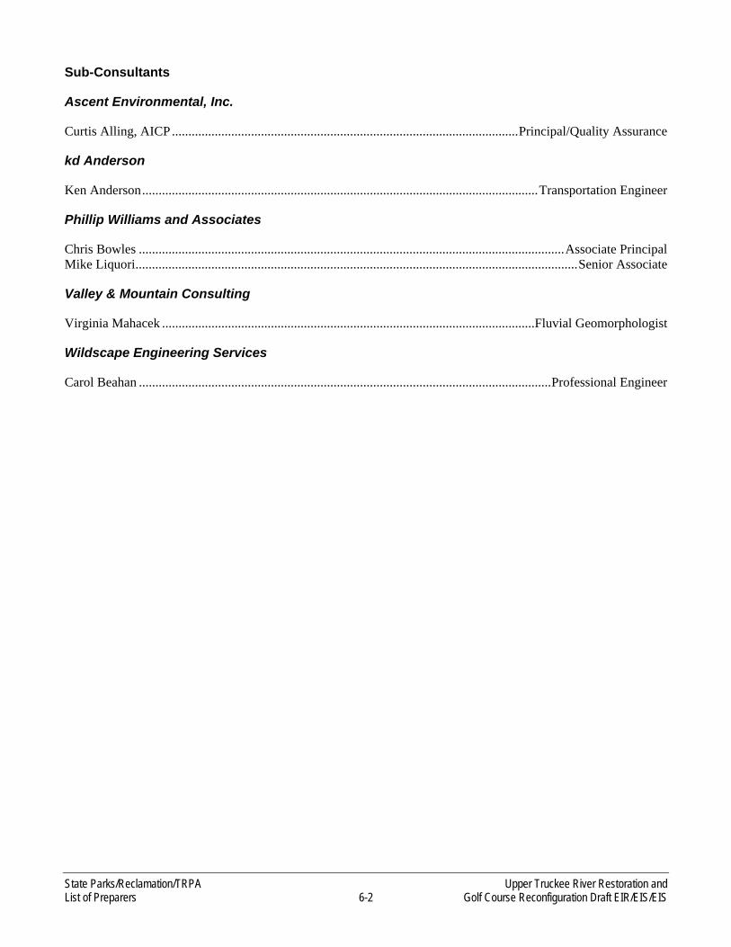
State Parks/Reclamation/TRPA Upper Truckee River Restoration and List of Preparers 6-2 Golf Course Reconfiguration Draft EIR/EIS/EIS
Sub-Consultants
Ascent Environmental, Inc.
Curtis Alling, AICP ......................................................................................................... Principal/Quality Assurance
kd Anderson
Ken Anderson ........................................................................................................................ Transportation Engineer
Phillip Williams and Associates
Chris Bowles ................................................................................................................................. Associate Principal Mike Liquori ...................................................................................................................................... Senior Associate
Valley & Mountain Consulting
Virginia Mahacek .................................................................................................................Fluvial Geomorphologist
Wildscape Engineering Services
Carol Beahan ............................................................................................................................. Professional Engineer
Upper Truckee River Restoration and State Parks/Reclamation/TRPA Golf Course Reconfiguration Draft EIR/EIS/EIS 7-1 EIR/EIS/EIS Distribution List
7 EIR/EIS/EIS DISTRIBUTION LIST
Elected Officials and Representatives
U.S. House of Representatives
U.S. Government Departments and Agencies
U.S. Army Corps of Engineers U.S. Department of Agriculture, Natural Resources
Conservation Service U.S. Environmental Protection Agency – Region 9
U.S. Fish and Wildlife Services U.S. Forest Service – Lake Tahoe Basin
Management Unit U.S. Geological Survey U.S. Coast Guard
State of California Government Agencies
Assembly California Legislature California Department of Fish and Game California Department of Pesticide Regulation California State Lands Commission Department of Boating & Waterways Department of General Services, Office of Real
Estate Services Division
Lahontan Regional Water Quality Control Board Office of the Attorney General Caltrans, District 3 – Tahoe California Tahoe Conservancy State of Nevada, Department of Environmental Protection Sierra Nevada Conservancy
Local Government & Agencies
City of South Lake Tahoe South Tahoe Chamber of Commerce El Dorado County
Board of Supervisors, District 5 Department of Transportation Parks and Recreation Department Public Works
South Tahoe Public Utility District Lake Tahoe Unified School District Lake Valley Fire Protection District Tahoe Resource Conservation District
Organizations
American Golf Caltrout Entrix, Inc. Fishy Business Consulting John Harbottle Design Lake Tahoe Environmental Science Magnet School Lake Valley Fire Protection District Lake Tahoe Visitors Authority League to Save Lake Tahoe Meyers Round Table Mountain Democrat Nevada Fire Safe Council River Run Consulting SBC California Swanson Hydrology and Geomorphology Sierra Nevada Alliance
Sierra Pacific Sierra Sun South Tahoe Public Utility District Southwest Gas Corporation Sugarpine Foundation Tahoe Area Sierra Club Tahoe Daily Tribune Tahoe Mountain News Tahoe World Tahoe-Douglas Chamber of Commerce Tahoe Science Consortium Valley & Mountain Consulting Tahoe Paradise Resort Improvement District Washoe Tribe of Nevada and California, Environmental Department

State Parks/Reclamation/TRPA Upper Truckee River Restoration and EIR/EIS/EIS Distribution List 7-2 Golf Course Reconfiguration Draft EIR/EIS/EIS
Individuals
Names withheld for privacy.

Upper Truckee River Restoration and State Parks/Reclamation/TRPA Golf Course Reconfiguration Draft EIR/EIS/EIS 8-1 References Cited
8 REFERENCES CITED
Chapter 1, “Introduction and Statement of Purpose and Need”
California Department of Conservation, Division of Land Resource Protection. 2006. Available: <ftp://ftp.consrv.ca.gov/pub/dlrp/FMMP/pdf/2006/eld06.pdf>. Accessed August 20, 2009.
Goldman, C. R. 1974. Eutrophication of Lake Tahoe. U.S. Environmental Protection Agency Report, EPA-660/3-74-034, 408 p.
Lahontan Regional Water Quality Control Board. 1995. Water Quality Control Plan for the Lahontan Region.
LRWQCB. See Lahontan Regional Water Quality Control Board.
River Run Consulting. 2006 (March 6). Upper Truckee River Restoration Project, California Department of Parks and Recreation, Riparian Ecosystem Restoration Feasibility Report.
State Water Resource Control Boards and Nevada Division of Environmental Protection. 2007. Lake Tahoe TMDL Pollutant Reduction Opportunity Report. V1.01, September 2007.
Swanson Hydrology + Geomorphology. 2003 (December 15). Draft Report, Upper Truckee River Upper Reach Environmental Assessment. Prepared for Tahoe Resource Conservation District and U.S. Bureau of Reclamation.
U.S. Geological Survey. 2010. USGS Lake Tahoe Clearing House, Facts About Lake Tahoe. Available at: http://tahoe.usgs.gov/facts.html Accessed January 26, 2010.
USGS. See U.S. Geological Survey.
Chapter 2, “Project Alternatives”
ACSP. See Audubon Cooperative Sanctuary Program for Golf Courses.
Audubon Cooperative Sanctuary Program for Golf Courses. 2006. Audubon International Fact Sheet, Golf and Environment. Available: <http://www.auduboninternational.org/PDFs/G-E-%20Golf%20and%20Environment%20overview%20.pdf>. Accessed August 3, 2009.
California Department of Parks and Recreation. 1988 (October). Lake Valley State Recreation Area General Plan. Sierra Unit, Tahoe City, CA.
ENTRIX, Inc. 2003. Final Draft: Upper Truckee River and Wetland Restoration – Channel Forming Flow Technical Memorandum. South Lake Tahoe, CA. Prepared for California Tahoe Conservancy, South Lake Tahoe, CA.
Hansford Economic Consulting. 2008 (September 8). Lake Tahoe Golf Course Lake Tahoe Golf Course Economic Feasibility Analysis. Truckee, CA. Prepared under contract with EDAW/AECOM, Inc. Sacramento, CA.
Harris, James. Hydrologist, Geologist, Emergency Response Coordinator. U.S. Forest Service, Lake Tahoe Basin Management Unit. South Lake Tahoe, CA. September 2, 2008.—e-mail conversation with Stephanie Rasmussen of EDAW regarding Meyer’s Landfill.
State Parks/Reclamation/TRPA Upper Truckee River Restoration and References Cited 8-2 Golf Course Reconfiguration Draft EIR/EIS/EIS
Knighton, D. 1998. Fluvial Forms and Processes: A New Perspective. Oxford University Press, New York, NY. Cited in River Run Consulting 2006.
Lahontan Regional Water Quality Control Board. 2000a (June 14). Board Order No. 6-00-48 (WDID No. 6A098811003): Updated Waste Discharge Requirements for California Department of Parks and Recreation and American Golf Corporation, Lake Valley State Recreation Area. South Lake Tahoe, CA.
———. 2000b (June 14). Monitoring and Reporting Program (6-00-48) for California Department of Parks and Recreation and American Golf Corporation, Lake Valley State Recreation Area. South Lake Tahoe, CA.
Lahontan RWQCB. See Lahontan Regional Water Quality Control Board.
Lake Tahoe Golf Course and Restaurant. 2000 (January). Lake Tahoe Golf Course 2001: Waste Discharge Requirements Maintenance Plan. South Lake Tahoe, CA.
Russell D. Mitchell Associates. 2008 (July 1). Lake Tahoe Golf Course Irrigation Report. Walnut Creek, CA. Prepared for California Department of Parks and Recreation, Sierra Unit, Tahoe City, CA.
Mussetter Engineering, Inc. 2000. Geomorphic Assessment of Upper Truckee River Watershed and Section 206 Aquatic Ecosystem Restoration Project Reach. Fort Collins, CO. Submitted to U.S. Army Corps of Engineers, Sacramento District, Sacramento, CA.
River Run Consulting. 2006. Upper Truckee River Restoration Project California Department of Parks and Recreation Reach Riparian Ecosystem Restoration Feasibility Report. Truckee, CA. Prepared for California Department of Parks and Recreation, Sacramento, CA.
SH&G. See Swanson Hydrology + Geomorphology.
Simon, A., E. Langendoen, R. Bingner, R. Wells, A. Heins, N. Jokay, and I. Jaramillo. 2003 (December). Lake Tahoe Basin Framework Implementation Study: Sediment Loadings and Channel Erosion. Prepared for U.S. Army Corps of Engineers, Sacramento District, Sacramento, CA. USDA-Agricultural Research Service, National Sedimentation Laboratory, Oxford MS.
State Parks. See California Department of Parks and Recreation.
Swanson Hydrology + Geomorphology. 2004a (March). Upper Truckee River, Upper Reach Environmental Assessment (Final). Santa Cruz, CA. Prepared for U.S. Bureau of Reclamation, Tahoe Resource Conservation District, and Regional Water Quality Control Board-Lahontan Region., South Lake Tahoe, CA.
———. 2004b (October). Amendment Report: Upper Truckee River Upper Reach Reclamation Project (Final). Santa Cruz, CA. Prepared for Tahoe Resource Conservation District and U.S. Bureau of Reclamation. South Lake Tahoe, CA.
———. 2004c (January). Upper Truckee River Lake Tahoe Golf Course Hole 6 Design Report (Draft). Santa Cruz, CA. Prepared for California Department of Parks and Recreation, Sacramento, CA, and American Golf Corporation, Berkley, CA.
Tahoe Paradise Golf Course. 2009. Rates. Available: <http://www.tahoeparadisegc.com/rates.php>. Accessed: October 14, 2009.

Upper Truckee River Restoration and State Parks/Reclamation/TRPA Golf Course Reconfiguration Draft EIR/EIS/EIS 8-3 References Cited
Tahoe Regional Planning Agency. 1981. Volume I: Water Quality Management Plan. Available: <http://www.trpa.org/documents/docdwnlds/208_Vol_I.pdf>. Accessed August 15, 2008.
TRPA. See Tahoe Regional Planning Agency.
Section 3.1, “Evaluation Methodology”
No sources are cited in this chapter.
Section 3.2, “Land Use”
California Department of Parks and Recreation. 1988 (October). Lake Valley State Recreation Area General Plan. Sacramento, CA.
———. 2000a (February). Lake Valley State Recreation Area River Management Plan—Upper Truckee River.
———. 2000b (October). Purpose Statements. Washoe Meadows SP #390. Sacramento, CA.
City of South Lake Tahoe. 1999. City of South Lake Tahoe General Plan. Amended 2002 and 2003. South Lake Tahoe, CA.
———. 2007 (May 10). Lake Tahoe Airport Comprehensive Land Use Plan. South Lake Tahoe, CA.
El Dorado County. 2004. El Dorado County General Plan. Adopted July 2004. Placerville, CA.
Shasha, Nathan. Skilled Laborer. California Department of Parks and Recreation. Tahoe City, CA. February 1, 2007—e-mail to Stephanie Bradley of EDAW regarding the quarry site in the Washoe Meadows State Park.
State Parks. See California Department of Parks and Recreation.
Tahoe Regional Planning Agency. 1991. Code of Ordinances. Zephyr Cove, NV.
———. 2004. Regional Plan for the Lake Tahoe Basin: Goals and Policies. Adopted by the Governing Board September 17, 1986; updated December 2004. Stateline, NV. Available: <http://www.trpa.org/documents/docdwnlds/goals.pdf>. Accessed December 30, 2008.
———. 2005 (January). TRPA Plan Area Statements. 119—Country Club Meadow. Available: <http://www.trpa.org/default.aspx?tabindex=5&tabid=204#num>. Accessed: August 25, 2009.
———. 2007. (September). 2006 Threshold Evaluation Report. Stateline, NV.
———. 2009. Plan Area Statements GIS data. Stateline, NV.
TRPA. See Tahoe Regional Planning Agency.
Section 3.3, “Hydrology and Flooding”
California Department of Water Resources. 2004. California’s Groundwater. Bulletin 118. Available: <http://www.dpla2.water.ca.gov/publications/groundwater/bulletin118/basins/pdfs_desc/6-5.03.pdf>.

State Parks/Reclamation/TRPA Upper Truckee River Restoration and References Cited 8-4 Golf Course Reconfiguration Draft EIR/EIS/EIS
Cayan, D., E. Maurer, M. Dettinger, M. Tyree, K. Hayhoe, C. Bonfils, P. Duffy, and B. Santer. 2006 (March). Climate Scenarios for California. White Paper Report from the California Climate Change Center. CEC-500-2005-203-SF. Berkeley, CA.
Coats, R. N., and C. R. Goldman. 2001. Patterns of nitrogen transport in streams of the Lake Tahoe basin, California-Nevada. Water Resources Research 37(2):405–415.
Coats, R., J. Perez-Losada, G. Schladow, R. Richards, and C. Goldman. 2006. The Warming of Lake Tahoe. Climatic Change 76:121–148.
Dettinger, M. 2005. From Climate-Change Spaghetti to Climate-Change Distributions for 21st Century California. San Francisco Estuary and Watershed Science 3(1).
DWR. See California Department of Water Resources.
El Dorado County. 2007a. Final Revised Grading Ordinance. Available: <http://www.co.el-dorado.ca.us/building/PDF/GradingOrdinance3-13-07.pdf>. Adopted by El Dorado County on March 13, 2007. Accessed October 2008.
————. 2007b. Final Revised Grading Design Manual. Available: <http://www.co.el-dorado.ca.us/dot/pdf/GradingDesignManual3-13-07.pdf>. Adopted by El Dorado County on March 13, 2007. Accessed October 2008.
————. 2008. Planning Services, Draft Flood Damage Prevention Ordinance. Available: < http://www.co.el-dorado.ca.us/Planning/ZoningOrdinance/Chapter17-33.pdf > Last Updated December 3, 2008. Accessed December 2008.
EPA. See U.S. Environmental Protection Agency.
FEMA. See Federal Emergency Management Agency.
Federal Emergency Management Agency. 2008. El Dorado County, California and Incorporated Areas Flood Insurance Rate Maps (Map Numbers 06017C0632E and 06017C0369E). Effective September 26, 2008. Washington, DC. GIS data downloaded from <http://msc.fema.gov/webapp/wcs/stores/servlet/ CategoryDisplay?storeId=1000>. Accessed December 2008.
Haen, James F. Civil Engineer. Haen Engineering, Tahoe Paradise, CA. July 5, 1991—memorandum with attached clubhouse site plan sent to Dave Rowe of American Golf Corporation, South Lake Tahoe, CA, regarding the Lake Tahoe Golf Course Clubhouse.
Jassby, A. D., J. E. Reuter, and C. R. Goldman 2003. Determining long-term water quality change in the presence of climate variability: Lake Tahoe (U.S.A.). Canadian Journal of Fisheries and Aquatic Science 60:1452–1461.
Jeton, A. E., M. D. Dettinger, and J. LaRue Smith. 1996. Potential Effects of Climate Change on Streamflow, Eastern and Western Slopes of the Sierra Nevada, California and Nevada. U.S. Geological Survey Water-Resources Investigations Report 95-4260.
Knowles, N., and D. R. Cayan. 2004. Elevational Dependence of Projected Hydrologic Changes in the San Francisco Estuary and Watershed. Climatic Change 62:319–336.
Lahontan Regional Water Quality Control Board. 1995. Water Quality Control Plan for the Lahontan Region. South Lake Tahoe, CA.
Upper Truckee River Restoration and State Parks/Reclamation/TRPA Golf Course Reconfiguration Draft EIR/EIS/EIS 8-5 References Cited
Lahontan RWQCB. See Lahontan Regional Water Quality Control Board.
Lake Tahoe Golf Course and Restaurant. 2000 (January). Lake Tahoe Golf Course 2001: Waste Discharge Requirements Maintenance Plan. South Lake Tahoe, CA.
Millar, C. I., R. D. Westfall, D. L. Delany, J. C. King, and L. J. Graumlich. 2004. Response of Subalpine Conifers in the Sierra Nevada, California, U.S.A., to 20th-Century Warming and Decadal Climate Variability. Arctic, Antarctic, and Alpine Research 36(2):181–200.
River Run Consulting. 2006 (March 6). Riparian Ecosystems Restoration Feasibility Report. Upper Truckee River Restoration Project. California Department of Parks and Recreation Reach. Truckee, CA. Prepared for California Department of Parks and Recreation. Tahoe City, CA.
Rowe, T. G., and K. K. Allander. 2000. Surface- and Ground-Water Characteristics in the Upper Truckee River and Trout Creek Watersheds, South Lake Tahoe, California and Nevada, July-December 1996. U.S. Geological Survey Water-Resources Investigation Report 00-4001.
Rowe, T. G., Saleh, Dina K., Watkins, Sharon A., and Charles R. Kratzer. 2002. Streamflow and Water-Quality Data for Selected Watersheds in the Lake Tahoe Basin, California and Nevada, through September 1998. U.S. Geological Survey Water-Resources Investigations Report 02-4030. NV.
SH+G. See Swanson Hydrology + Geomorphology.
Sound Watershed Consulting. 2007 (October). Flood Frequency Memorandum for the Upper Truckee River Restoration and Golf Course Reconfiguration Project. Oakland, CA. Prepared for California Department of Parks and Recreation Tahoe City, CA.
Stanowski, John. Superintendent. Lake Tahoe Golf Course. South Lake Tahoe, CA. March 26, 2008—in-person meeting with Virginia Mahacek and Danielle Hughes regarding golf course management; December 1, 2008—telecommuncation with Danielle Hughes regarding golf course water supply.
Stantec Consulting, Inc. 2006 (December). Sawmill 1 Bike Path Upper Truckee River Bridge Hydraulic Analysis. Sacramento, CA. Prepared for California Department of Transportation Sacramento, CA, and El Dorado County Department of Transportation, South Lake Tahoe, CA.
Swanson Hydrology + Geomorphology. 2004a (March). Final Report: Upper Truckee River Upper Reach Environmental Assessment. Santa Cruz, CA. Prepared for Tahoe Resource Conservation District, Lahontan Regional Water Quality Control Board, and U.S. Bureau of Reclamation, South Lake Tahoe, CA.
———. 2004b (October). Amendment Report: Upper Truckee River Upper Reach Reclamation Project. Santa Cruz, CA. Prepared for Tahoe Resource Conservation District and U.S. Bureau of Reclamation, South Lake Tahoe, CA.
———. 2004c (January). Draft Report: Upper Truckee River Lake Tahoe Golf Course: Hole 6 Design Report. Santa Cruz, CA. Prepared for California Department of Parks and Recreation, Tahoe City, CA, and American Golf Corporation, South Lake Tahoe, CA.
SWC. See Sound Watershed Consulting.
Tahoe Regional Planning Agency. 2002 (July). 2001 Threshold Evaluation. Zephyr Cove, NV.
______. 2004 (March). Annual Water Quality Report. Zephyr Cove, NV.
State Parks/Reclamation/TRPA Upper Truckee River Restoration and References Cited 8-6 Golf Course Reconfiguration Draft EIR/EIS/EIS
———. 2005. Plan Area Statements. Available: <http://www.trpa.org/default.aspx?tabid=204>. Last updated January 2005. Accessed November 2008.
———. 2007 (September). 2006 Threshold Evaluation Report. Stateline, NV.
Tetra Tech, Inc. 2007 (February). Watershed Hydrology Modeling and Sediment and Nutrient Loading Estimation for the Lake Tahoe Total Maximum Daily Load. Revised. Prepared for the Lahontan Regional Water Quality Control Board, South Lake Tahoe, CA, and University of California, Davis, CA.
TRPA. See Tahoe Regional Planning Agency.
USACE. See U.S. Army Corps of Engineers.
U.S. Army Corps of Engineers. 1999. Hydrology Report for Upper Truckee River Aquatic Ecosystem Restoration Project. Sacramento District. Sacramento, CA.
______. 2003 (October). Lake Tahoe Basin Framework Study Groundwater Evaluation, Lake Tahoe Basin, California and Nevada (Final). Sacramento District. Sacramento, CA.
———. 2007 (September). Summary Report: Investigations to Determine Regional Flow-Frequency Relationships and Watershed Modeling Recommendations for Hydrologic Design Criteria for the Lake Tahoe Basin. Sacramento District, Sacramento, CA. Prepared for the Lake Tahoe Storm Water Quality Improvement Committee, Stateline, NV.
U.S. Environmental Protection Agency. 2008 (September 5). Wetlands: Floodplain Management Executive Order No. 11988. Available: <http://www.epa.gov/owow/wetlands/regs/eo11988.html>. Last updated February 22, 2006. Accessed January 2, 2009.
U.S. Geological Survey. 2008. USGS Water Data for California. Available: <http:/waterdata.usgs.gov/ca/nwis>. Accessed January 2008.
USGS. See U.S. Geological Survey.
Walck, Cyndie. Hydrologist. California State Parks. Tahoe City, CA. January 26, 2010— telecommunication to Virginia Mahacek, Fluvial Geomorphologist, Valley Mountain Consulting regarding irrigation.
Section 3.4, “Geomorphology and Water Quality”
2ndNature, Inc. 2006 (March). Final Report: CSLT Upper Truckee River Sediment Monitoring: Middle Reach (2002–2005). Prepared for the City of South Lake Tahoe (CSLT).
Adams, Mike. Supervisor for Collections. South Tahoe Public Utility District. South Lake Tahoe, CA. September 24, 2009—telephone call with Danielle Hughes of EDAW regarding sewer crossings in the Washoe Meadows State Park.
Amorfini, Bud. April 20, 2010. Personal Communication with Danielle Hughes at the Lahontan Regional Water Board Construction General Permit Overview Workshop.
California State Water Resources Control Board. 2010. National Pollutant Discharge Elimination System (NPDES) General Permit for Storm Water Discharges associated with Construction and Land Disturbance Activities Order No. 2009-0009-DWQ NPDES No. CAS000002. Accessed on the SWRCB web site April 2010 http://www.waterboards.ca.gov/water_issues/programs/stormwater/constpermits.shtml.
Upper Truckee River Restoration and State Parks/Reclamation/TRPA Golf Course Reconfiguration Draft EIR/EIS/EIS 8-7 References Cited
California Water Boards and NDEP. 2009 (June). Lake Tahoe Total Maximum Daily Load Technical Report. South Lake Tahoe, Available at: CA http://www.waterboards.ca.gov/lahontan/water_issues/ programs/tmdl/lake_tahoe/docs/2_tmdl_techrpt.pdf. Accessed on March 1, 2010.
California Water Boards and NDEP. 2007 (September). Lake Tahoe TMDL Pollutant Reduction Opportunity Report. South Lake Tahoe, CA. Available: <http://www.swrcb.ca.gov/lahontan/water_issues/ programs/tmdl/lake_tahoe/docs/presentations/pro_rpt_final.pdf>.
California Water Boards and Nevada Division of Environmental Protection. See California Water Boards and NDEP.
Conservancy and DGS. See California Tahoe Conservancy and California Department of General Services.
EDAW, Inc. In prep. Upper Truckee River and Marsh Restoration Project Draft EIR/EIS/EIS. South Lake Tahoe, CA. In preparation for California Tahoe Conservancy and California Department of General Services.
EDAW, Inc., and ENTRIX, Inc. 2003. Upper Truckee River and Marsh Restoration Project Processes and Functions of the Upper Truckee Marsh, South Lake Tahoe, California. Sacramento, CA. Prepared for California Tahoe Conservancy, South Lake Tahoe, CA, and California Department of General Services, West Sacramento, CA.
———. 2005. (September). Upper Truckee River and Marsh Restoration Project Alternatives Evaluation Report. Sacramento, CA. Prepared for California Tahoe Conservancy, South Lake Tahoe, CA, and California Department of General Services, West Sacramento, CA.
El Dorado County. 2004. 2004 El Dorado County General Plan: A Plan for Managed Growth and Open Roads; A Plan for Quality Neighborhoods and Traffic Relief. Adopted by the Board of Supervisors July 19, 2004, Resolution Number 235-2004. Placerville, CA.
———. 2007 (March). El Dorado County Grading Design Manual and El Dorado County Chapter 15.14 Grading, Erosion and Sediment Control Ordinance. Volume III of the County Design and Improvements Standards Manual. Available: <http://www.co.el-dorado.ca.us/building/ Permit_Grading.html#info>. Accepted by El Dorado County on March 13, 2007.
ENTRIX, Inc. 2006 (July). Upper Truckee River Middle Reach Restoration Project, Reaches 3 and 4: Alternatives Evaluation Memorandum. Sacramento, CA. Prepared for City of South Lake Tahoe, CA.
———. 2008 (February). Sunset Stables Restoration & Resource Management Project Draft: Alternatives Evaluation Memorandum. Prepared for California Tahoe Conservancy, South Lake Tahoe, CA, and California Department of General Services, West Sacramento, CA.
———. 2009 (September 28). Construction Site Discharge Report-Monday September 29, 2008. Memo to Lahontan Regional Water Quality Control Board. Prepared for the City of South Lake Tahoe, regarding the Upper Truckee River Restoration Project Reaches 3 & 4.
Heyvaert, A. C. 1998. The Biogeochemistry and Paleolimnology of Sediments from Lake Tahoe, California-Nevada. Ph.D. dissertation. University of California, Davis, Davis, CA.
Kemper, Lauri, P.E. 2010 (March 26, 2010). Lahontan Regional Water Quality Control Board, Assistant Executive Officer & Ombudsman. Personal Communication during interagency consultation teleconference.
State Parks/Reclamation/TRPA Upper Truckee River Restoration and References Cited 8-8 Golf Course Reconfiguration Draft EIR/EIS/EIS
Kroll, C. G. 1976. Sediment Discharge from Cut-Slopes in the Lake Tahoe Basin, California. Water Resources Investigations 76-19. U.S. Geological Survey. Prepared in cooperation with the California Department of Transportation Division of Highways.
Lahontan Regional Water Quality Control Board. 1995. Water Quality Control Plan for the Lahontan Region. Available: <http://www.swrcb.ca.gov/rwqcb6/BPlan/Bplan.pdf>. Last updated July 31, 2008. Accessed August 2008.
———. 2000a (June 14). Board Order No. 6-00-48 (WDID No. 6A098811003): Updated Waste Discharge Requirements for California Department of Parks and Recreation and American Golf Corporation, Lake Valley State Recreation Area. South Lake Tahoe, CA.
———. 2000b (June 14). Monitoring and Reporting Program (6-00-48) for California Department of Parks and Recreation and American Golf Corporation, Lake Valley State Recreation Area. South Lake Tahoe, CA.
Lahontan Regional Water Quality Control Board and Nevada Division of Environmental Protection. 2007 (September). Draft Lake Tahoe Total Maximum Daily Load Technical Report: California and Nevada. Lead authors: D. M. Roberts and J. E. Reuter. South Lake Tahoe, CA, and Carson City, NV.
Lahontan RWQCB. See Lahontan Regional Water Quality Control Board.
Lahontan RWQCB and NDEP. See Lahontan Regional Water Quality Control Board and Nevada Division of Environmental Protection.
Lake Tahoe Golf Course and Restaurant. 2000 (January). Lake Tahoe Golf Course 2001: Waste Discharge Requirements Maintenance Plan. South Lake Tahoe, CA.
Reuter, J. R., and W. W. Miller. 2000. Aquatic Resources, Water Quality, and Limnology of Lake Tahoe and Its Upland Watershed. Chapter 4 (pages 215–399) in D. D. Murphy and C. M. Knopp (eds.), The Lake Tahoe Watershed Assessment. Volume I. U.S. Forest Service, Tahoe Regional Planning Agency, University of California, Davis, and University of Nevada, Reno, Desert Research Institute.
River Run Consulting. 2006 (March 6). Riparian Ecosystems Restoration Feasibility Report. Upper Truckee River Restoration Project. California Department of Parks and Recreation Reach. Truckee, CA. Prepared for California Department of Parks and Recreation, Tahoe City, CA.
Rowe, T. G., D. K. Saleh, S. A. Watkins, and C. R. Kratzer. 2002. Streamflow and Water-Quality Data for Selected Watersheds in the Lake Tahoe Basin, California and Nevada, through September 1998. Water Resources Investigations Report 02-4030. U.S. Geological Survey. Carson City, NV.
Rudd, Michael, P. E. Restoration engineering manager, ENTRIX, Inc. December 1, 2008—e-mail communication with Virginia Mahacek of Valley & Mountain Consulting regarding the status of engineering analysis for the Upper Truckee River Restoration Project, Middle Reaches 1 and 2.
SH&G. See Swanson Hydrology + Geomorphology.
Sierra Nevada Alliance. 2008 (December). South Lake Tahoe Monitoring Project: Citizen Volunteer Water Quality Monitoring, 2008 Annual Data Report. Downloaded from web site: http://www.sierranevadaalliance.org/publications/db/pics/1229722392_31834.f_pdf.pdf.

Upper Truckee River Restoration and State Parks/Reclamation/TRPA Golf Course Reconfiguration Draft EIR/EIS/EIS 8-9 References Cited
Simon, A. 2006 (May). Estimates of Fine-Sediment Loadings to Lake Tahoe from Channel and Watershed Sources. U.S. Department of Agriculture–Agricultural Research Service, National Sedimentation Laboratory Technical Report 52. Prepared for University of California, Davis; Nevada Division of Environmental Protection; and Lahontan Regional Water Quality Control Board.
Simon, A., E. Langendoen, R. Bingner, R. Wells, A. Heins, N. Jokay, and L. Jaramillo. 2003. Lake Tahoe Basin Framework Implementation Study: Sediment Loadings and Channel Erosion. U.S. Department of Agriculture–Agricultural Research Service, National Sedimentation Laboratory. Prepared for U.S. Army Corps of Engineers.
Stubblefield, A. P., M. I. Escobar, and E. W. Larsen. 2006. Retention of Suspended Sediment and Phosphorus on a Freshwater Delta, South Lake Tahoe, California. Wetlands Ecology and Management 14(4):287–302.
Swanson Hydrology + Geomorphology. 2004a (March). Final Report: Upper Truckee River Upper Reach Environmental Assessment. Santa Cruz, CA. Prepared for Tahoe Resource Conservation District, Lahontan Regional Water Quality Control Board, and U.S. Bureau of Reclamation, South Lake Tahoe, CA.
———. 2004b (October). Amendment Report: Upper Truckee River Upper Reach Reclamation Project. Santa Cruz, CA. Prepared for Tahoe Resource Conservation District and U.S. Bureau of Reclamation, South Lake Tahoe, CA.
———. 2004c (January). Draft Report: Upper Truckee River Lake Tahoe Golf Course: Hole 6 Design Report. Santa Cruz, CA. Prepared for California Department of Parks and Recreation, Tahoe City, CA and American Golf Corporation, South Lake Tahoe, CA.
SWRCB. See State Water Resources Control Board.
Tahoe-Baikal Institute. 2008 (June). Development and Demonstration of a Field Method for Assessing the Algal Productivity of Lake Tahoe Tributaries: a water quality investigation of selected lake Tahoe Tributaries. Project Activity report by Gary Litton, Project Leader. Downloaded from web site: http://www.tahoebaikal.org/.
Tahoe Regional Planning Agency. 1980. TRPA Code of Ordinances. Zephyr Cove, NV.
———. 1981. Volume I: Water Quality Management Plan. Available: <http://www.trpa.org/documents/ docdwnlds/208_Vol_I.pdf>. Accessed August 15, 2008.
———. 1986. Regional Plan for the Lake Tahoe Basin: Goals and Policies. Stateline, NV. Available: <http://www.trpa.org/documents/docdwnlds/goals.pdf>. Accessed October 9, 2008.
———. Lake Tahoe and Truckee Watershed Annual Snapshot Day Data and Summaries: 2001, 2002, 2003, 2004, 2005. downloaded from TIIMS.org website. http://www.tiims.org/Science-Research/TIIMS-Toolbox/TIIMS-Metadata-Explorer.aspx.
———. 2004. Regional Plan for the Lake Tahoe Basin: Goals and Policies. Adopted by the Governing Board on September 17, 1986; updated December 2004. Stateline, NV. Available: <http://www.trpa.org/ documents/docdwnlds/goals.pdf>. Accessed September 23, 2008.
———. 2005. Plan Area Statement 119 Country Club Meadow. Available: <http://www.trpa.org/documents/ docdwnlds/PAS/119.pdf>. Last updated January 2005. Accessed November 4, 2008.

State Parks/Reclamation/TRPA Upper Truckee River Restoration and References Cited 8-10 Golf Course Reconfiguration Draft EIR/EIS/EIS
———. 2007a. Pathway 2007 Partner Agencies. Available: <http://www.pathway2007.org/partners.html>. Last updated 2007. Accessed June 2008.
———. 2007b (September). 2006 Threshold Evaluation Report. Available: <http://www.trpa.org/ default.aspx?tabindex=1&tabid=174>. Accessed August 2008.
Taylor, Jennifer, Assistant Engineer, City of South Lake Tahoe. 2010 (April 12, 2010). Unpublished turbidity monitoring data from the 2008 construction period on the Upper Truckee River reaches 3 & 4 restoration project. Provided in electronic format via e-mail.
Tetra Tech, Inc. February 2007 (revised). Watershed Hydrology Modeling and Sediment and Nutrient Loading Estimation for the Lake Tahoe Total Maximum Daily Load. Prepared for Lahontan Regional Water Quality Control Board and University of California, Davis.
TRPA. See Tahoe Regional Planning Agency.
USACE. See U.S. Army Corps of Engineers.
U.S. Army Corps of Engineers. 2005 (October 1). Department of the Army Permit General Permit No. 16 Minimal Impact Activities The Lake Tahoe Basin.
U.S. Geological Survey. 2005. USGS Techniques of Water-Resources Investigations (TWRI) Book 9:Handbooks for Water-Resources Investigations, Section A: National Field Manual for the Collection of Water-Quality Data, Chapter A6 “Field Measurements”, Section 6.7 ‘Turbidity. Prepared by Chauncey W. Anderson.
Valley & Mountain Consulting. Unpublished. Analyzed and compiled data provided by public sources. South Lake Tahoe, CA.
Walck, Cyndie. Hydrologist. California State Parks. Tahoe City, CA. January 26, 2010— telecommunication to Virginia Mahacek, Fluvial Geomorphologist, Valley Mountain Consulting regarding active floodplain width.
Winter, S. M. 2003. Sediment Retention on a Deltaic Floodplain in Response to Climate and Land-Use Changes. Master’s thesis. University of California, Davis. Davis, CA.
Section 3.5, “Biological Resources (Fisheries and Aquatic Resources, Vegetation and Wildlife)”
Allen, A. W. 1987. The Relationship between Habitat and Furbearers. Pages 164–179 in M. Novak, J. A. Baker, M. E. Obbard, and B. Mallock (eds.), Wild Furbearer Management and Conservation in North America. Ontario Ministry of Natural Resources, Canada.
Bissonette, J. A., R. J. Fredrickson, and B. J. Tucker. 1988. The Effects of Forest Harvesting on Marten and Small Mammals in Western Newfoundland. Final Report, for The Newfoundland and Labrador Wildlife Division and Corner Brook Pulp and Paper, Ltd. (Kruger). Utah Cooperative Fish and Wildlife Research Unit, Department of Fisheries and Wildlife, College of Natural Resources, Utah State University, Logan, UT.
Bjornn, T. C., and D. W. Reiser. 1979. Habitat Requirements of Salmonids. Pages 83–138 in Influences of Forest and Rangeland Management of Salmonid Fishes and Their Habits.
Bloom, P. H. 1994. The Biology and Current Status of the Long-Eared Owl in Coastal Southern California. Bulletin of the Southern California Academy of Science 93:1–12.

Upper Truckee River Restoration and State Parks/Reclamation/TRPA Golf Course Reconfiguration Draft EIR/EIS/EIS 8-11 References Cited
Bombay, H. L. 1999. Scale Perspectives in Habitat Selection and Reproductive Success for Willow Flycatchers (Empidonax traillii) in the Central Sierra Nevada, California. Master’s thesis, California State University, Sacramento, CA.
Bombay, H. L., T. M. Benson, B. E. Valentine, and R. A. Stefani. 2003 (May 29). A Willow Flycatcher Survey Protocol for California.
Borgmann, K. L., and M. L. Morrison. 2004. Wildlife Inventory and Monitoring in the Lake Tahoe Basin, California: Pre-Restoration. A report to the Lake Tahoe Basin Management Unit, U.S. Forest Service, South Lake Tahoe, CA.
Brinson, M. M., L. J. MacDonnell, D. J. Austen, R. L. Beschta, T. A. Dillaha, D. L. Donahue, S. V. Gregory, J. W. Harvey, M. C. Molles, E. I. Rogers, and J. A. Stanford. 2002. Riparian areas: functions and strategies for management. Committee on Riparian Zone Functioning, National Research Council, Washington, D.C.
Bull, E. L., A. L. Wright, and M. G. Henjum. 1989. Nesting and Diet of Long-Eared Owls in Conifer Forests, Oregon. Condor 91:908–912.
Buskirk, S., and L. Ruggiero. 1994. American Marten. In L. F. Ruggiero, K. B. Aubry, S. W. Buskirk, L. J. Lyon, and W. J. Zielinski (tech eds.), The Scientific Basis for Conserving Forest Carnivores: American Marten, Fisher, Lynx, and Wolverine in the Western United States. U.S. Forest Service, General Technical Report RM-254. Washington, D.C.
Buskirk, S. W., and R. A. Powell. 1994. Habitat Ecology of Fishers and American Martens. Pages 283–296 in S. W. Buskirk, A. Harestad, and M. Raphael (eds.), Martens, Sables and Fishers: Biology and Conservation. Cornell University Press. Ithaca, NY.
Buskirk, S. W., and W. J. Zielinski. 1997. American Marten (Martes americana) Ecology and Conservation. Pages 17–22 in J. E. Harris, and C. V. Ogan (eds.), Mesocarnivores of Northern California: Biology, Management, and Survey Techniques. Workshop manual, August 12–15, 1997, Humboldt State University, Arcata, CA. The Wildlife Society, California North Coast Chapter, Arcata, CA.
California Department of Fish and Game. 2000. Guidelines for Assessing the Effects of Proposed Projects on Rare, Threatened, and Endangered Plants and Natural Communities. Revision of the 1983 Guidelines. Sacramento, CA.
————. 2008. Special Animals. Biogeographic Data Branch, California Natural Diversity Database. Sacramento, CA.
California Native Plant Society. 2007. Electronic Inventory of Rare and Endangered Vascular Plants of California. Available: <http://northcoast.com/~cnps/cgi-bin/cnps/sensinv.cgi>. Last updated June 1, 2007. Accessed June 13, 2007.
California Natural Diversity Database. 2008. Rarefind: A Database Application for the Use of the California Department of Fish and Game’s Natural Diversity Database. California Natural Heritage Division, California Department of Fish and Game. Sacramento, CA.
CDFG. See California Department of Fish and Game.
CNDDB. See California Natural Diversity Database.
CNPS. See California Native Plant Society.
State Parks/Reclamation/TRPA Upper Truckee River Restoration and References Cited 8-12 Golf Course Reconfiguration Draft EIR/EIS/EIS
Cordone, A. J., and T. C. Frantz. 1966. The Lake Tahoe Sport Fishery. California Fish and Game 52(4):240–274.
————. 1968. An Evaluation of Trout Planting in Lake Tahoe. California Fish and Game 54(2):68–89.
Corn, J. G., and M. G. Raphael. 1992. Habitat Characteristic at Marten Subnivean Access Sites. Journal of Wildlife Management 56:442–448.
Dickson, J. G., J. H. Williamson, R. N. Conner, and B. Ortego. 1995. Streamside zones and breeding birds in eastern Texas. Wildlife Society Bulletin 23:750–755.
Dill, W. A., and A. J. Cordone. 1997. History and Status of Introduced Fishes in California, 1871–1996. California Department of Fish and Game, Fish Bulletin 178.
EDAW. 2009. Aquatic Resources Technical Memorandum for the Upper Truckee River Restoration and Golf Course Relocation Project. Sacramento, CA. Prepared for California Department of Parks and Recreation.
Ehrlich, P. R., D. S. Dobkin, and D. Wheye. 1988. The Birder’s Handbook. Simon and Schuster, NY.
Entrix, Inc. 2007. Western Pearlshell Mussel Survey Report for the Sunset Stables Restoration and Resource Management Plan. Prepared for the California Tahoe Conservancy. 13 pp.
Fields, Lisa. Environmental Scientist. California Department of Parks and Recreation (State Parks), Sacramento, CA. June 21, 2005a—internal memorandum to Cyndie Walck of State Parks: Upper Truckee Report/Existing Data Summary; August 8, 2005b—internal memorandum to Cyndie Walck of State Parks: Upper Truckee River and Vicinity Surveys. 2005c—excerpt of wildlife survey report provided to Cyndie Walck of State Parks.
Fields, Lisa. Environmental Scientist. California Department of Parks and Recreation (State Parks), Sacramento, CA. 2006—excerpt of 2006 Wildlife Field Season Summary for the Sierra District provided to Cyndie Walck of State Parks.
Fields, Lisa. Environmental Scientist. California Department of Parks and Recreation (State Parks), Sacramento, CA. February 22, 2007a—internal memorandum to Cyndie Walck of State Parks: Upper Truckee River and Vicinity Surveys–2006; September 2007b—e-mail to Cyndie Walck of State Parks and Steve Henderson of EDAW regarding 2007 wildlife data collection in Washoe Meadows State Park.
Fields, Lisa. Environmental Scientist. California Department of Parks and Recreation (State Parks), Sacramento, CA. June 13, 2008—e-mail to Steve Henderson of EDAW regarding wildlife survey results for Washoe Meadows State Park.
Fields, Lisa. Environmental Scientist. California Department of Parks and Recreation (State Parks), Sacramento, CA. September 10, 2009—e-mail to Steve Henderson of EDAW regarding wildlife survey results for Washoe Meadows State Park.
Garrison, B. A. 1998. Bank Swallow (Riparia riparia). In The Riparian Bird Conservation Plan: a strategy for reversing the decline of riparian-associated birds in California. California Partners in Flight. Available at http://www.prbo.org/calpif/htmldocs/riparian_v-2.html.
Green, G. A., H. L. Bombay, and M. L. Morrison. 2003. Conservation Assessment of the Willow Flycatcher in the Sierra Nevada. Unpublished report.

Upper Truckee River Restoration and State Parks/Reclamation/TRPA Golf Course Reconfiguration Draft EIR/EIS/EIS 8-13 References Cited
Grinnell, J., and A. H. Miller. 1944. Distribution of the Birds of California. Pacific Coast Avifauna, No. 27. Berkeley, CA.
Hagar, J. C. 1999. Influence of riparian buffer width on bird assemblages in western Oregon. Journal of Wildlife Management 63:484–496.
Hannon, S. J., C. A. Paszkowski, S. Boutin, J. DeGroot, S. E. Macdonald, M. Wheatley, and B. R. Eaton. 2002. Abundance and species composition of amphibians, small mammals, and songbirds in riparian forest buffer strips of varying widths in the boreal mixedwood of Alberta. Canadian Journal of Forest Research 32:1784–1800.
Hargis, C. D., and D. R. McCullough. 1984. Winter Diet and Habitat Selection of Marten in Yosemite National Park. Journal of Wildlife Management 48:140–146.
Harrington, J., and M. Born. 2000. Measuring the Health of California Streams and Rivers: A Methods Manual for Water Resource Professionals, Citizen Monitors and Natural Resource Students. Sustainable Lands Stewardship International Institute, Sacramento, CA.
Harris, J. H., S. D. Sanders, and M. A. Flett. 1987. Willow Flycatcher Surveys in the Sierra Nevada. Western Birds 18:27–36.
Heath, S. and G. Ballard. 2003. Patterns of Breeding Songbird Diversity and Occurrence in Riparian Habitats of the Eastern Sierra Nevada. In California Riparian Systems: Processes and Floodplain Management, Ecology, and Restoration, Riparian Habitat and Floodplains Conference, ed. P. M. Faber. Sacramento, CA: Riparian Habitat Joint Venture.
Herbst, D. B. 2001. Biomonitoring in the Upper Truckee River Using Aquatic Macroinvertebrates: Watershed Restoration Baseline Data for 1998–2000. Prepared for Lahontan Regional Water Quality Control Board. Prepared by Sierra Nevada Aquatic Research Laboratory, University of California.
Holt, D. 1997. The Long-Eared Owl (Asio otus) and Forest Management: A Review of the Literature. Journal of Raptor Research 31:175–186.
Juncosa, Adrian. Botanist. River Run Consulting. August 3, 2006—telephone conversation with Mark Bibbo of EDAW regarding the potential for occurrence of special-status plant species on the project site.
Keddy, P. A. 2000. Wetland Ecology: Principles and Conservation. Cambridge: Cambridge University Press.
Keller, C. M. E., C. S. Robbins, and J. S. Hatfield. 1993. Avian communities in riparian forests of different widths in Maryland and Delaware. Wetlands 13:137–144.
Kilgo, J. C., R. A. Sargent, B. R. Chapman, and K. V. Miller. 1998. Effect of stand width and adjacent habitat on breeding bird communities in bottomland hardwoods. Journal of Wildlife Management 62:72–83.
King River Conservation District. 1985. Studies on Willow Flycatcher in the Central Sierra Nevada Conducted during 1983–1984. Report No. 85-107, King River Conservation District Research.
Knight, C. B., and D. N. Cole. 1995. Wildlife Responses to Recreationists. Pages 51–69 in R. L. Knight and J. K. Gutzwiller (eds.), Wildlife and Recreationists. Island Press, Covelo, CA.
Knutson, Chuck. Fish Hatchery Program Manager. California Department of Fish and Game, Rancho Cordova, CA. March 10, 2005—telephone conversation with Chris Fitzer of EDAW regarding trout stocking in the Tahoe Basin.

State Parks/Reclamation/TRPA Upper Truckee River Restoration and References Cited 8-14 Golf Course Reconfiguration Draft EIR/EIS/EIS
KRCD. See King River Conservation District.
Lake Tahoe Basin Weed Coordinating Group 2009. Top Priority Weeds of the Lake Tahoe Basin. [Online] Available: <http://tahoeinvasiveweeds.org/weeds/priority.php>. Accessed July 26, 2009.
Lehr, Stafford. Associate Fish Biologist. California Department of Fish and Game, Rancho Cordova, CA. March 22, 2005—telephone conversation with Chris Fitzer of EDAW regarding trout stocking in the Tahoe Basin.
Lyon, Victor. 2010. Wildlife Biologist, USFS-Lake Tahoe Basin Management Unit. January 13. Telephone conversation with Andy Hatch regarding golden eagle nesting in the Angora Peak area.
Manley, P. N., and M. D. Schlesinger. 2001. Riparian Biological Diversity in the Lake Tahoe Basin. A Final Report for the California Tahoe Conservancy and the U.S. Forest Service.
Manley, P. N., J. A. Fites-Kaufman, M. G. Barbour, M. D. Schlesinger, and D. M. Rizzo. 2000. Biological integrity. In Murphy, D. D. and C. M. Knopp, technical editors. Lake Tahoe Watershed Assessment. Pp. 403–598. Gen. Tech. Rep. PSW-GTR-175. Pacific Southwest Research Station, Forest Service, U.S. Department of Agriculture. Albany, CA.
MacWhirter, R. B., and K. L. Bildstein. 1996. Northern Harrier (Circus cyaneus). In A. Poole and F. Gill (eds.), The Birds of North America. The Academy of Natural Sciences, Philadelphia, PA, and The American Ornithologists’ Union, Washington, DC.
Marks, J. S., D. L. Evans, and D. W. Holt. 1994. Long-Eared Owl (Asio otus). In A. Poole and F. Gill (eds.), The Birds of North America. The Academy of Natural Sciences, Philadelphia, PA, and The American Ornithologists’ Union, Washington, DC.
Martin, J. W. 1987. Behavior and Habitat Use of Breeding Northern Harriers in Southwestern Idaho. Journal of Raptor Research 21:57–66.
Martin, S. K. 1987. The Ecology of the Pine Marten (Martes americana) at Sagehen Creek, California. Ph.D. Dissertation, University of California, Berkeley, CA.
McMorrow, S. 2003 (September). Special-Status Wildlife Occurrence Review for Lake Valley State Recreation Area Stream Restoration Project. California Department of Parks and Recreation. Tahoe City, CA.
Moyle, P. 2002. Inland Fishes of California, Revised and Expanded. University of California Press. Berkeley, CA.
Murphy, D. D., and C. M. Knopp (eds.). 2000. Lake Tahoe Watershed Assessment. General Technical Report PSW-GTR-175. Pacific Southwest Research Station, U.S. Forest Service. Albany, CA.
National Marine Fisheries Service. 2004. Sediment Removal from Freshwater Salmonid Habitat: Guidelines to NOAA Fisheries Staff for the Evaluation of Sediment Removal Actions from California Streams. Southwest Region. Long Beach, CA.
Nearctica. 2000. Jeffrey pine (Pinus jeffreyi). Available: <http://www.nearctica.com/trees/conifer/pinus/ Pjeff.htm>. Accessed October 7, 2009.
Nedeau, E., A. K. Smith, and J. Stone. 2005. Freshwater mussels of the Pacific Northwest. United States Fish and Wildlife Service. The Xerces Society. Portland, OR.
Upper Truckee River Restoration and State Parks/Reclamation/TRPA Golf Course Reconfiguration Draft EIR/EIS/EIS 8-15 References Cited
Noss, R. F., H. B. Quigley, M. G. Hornocker, T. Merrill, and P. Paquet. 1996. Conservation biology and carnivore conservation. Conservation Biology 10:949–963.
Raleigh, R. F., T. Hickman, R. C. Solomon, and P. C. Nelson. 1984. Habitat suitability information: rainbow trout. U. S. Fish and Wildlife Service, Division of Biological Services (FWS/OBS-82d/10.60).
RHJV. See Riparian Habitat Joint Venture.
Riparian Habitat Joint Venture. 2004. The Riparian Bird Conservation Plan: A Strategy for Reversing the Decline of Riparian Associated Birds in California. Version 2.0. California Partners in Flight. Available: <http://www.prbo.org/calpif/pdfs/riparian_v-2.pdf>. Accessed September 5, 2008.
River Run Consulting. 2006 (March 6). Upper Truckee River and Wetlands Restoration Project, California Department of Parks and Recreation Reach: Riparian Ecosystem Restoration Feasibility Report. Prepared for Lake Tahoe Golf Course and State Parks, South Lake Tahoe and Tahoe City, CA. Prepared by River Run Consulting, Truckee, CA, in association with Eco Synthesis, Wildlife Resource Consultants, Hydro Science, Piedmont Engineering, Haen Engineering, and Elizabeth Doherty Graphic Design.
Rosenberg, D. K., B. R. Noon, and E. C. Meslow. 1997. Biological Corridors: Form, Function, and Efficacy. Bioscience 47:677–687.
Rottenborn, S. C. 1999. Predicting the impacts of urbanization on riparian bird communities. Biological Conservation 88:289–299.
Roth, Julie. Wildlife biologist, Lake Tahoe Basin Management Unit, U.S. Forest Service, South Lake Tahoe, California, 2008 (March 4)—telephone conversation with Steve Henderson of EDAW regarding recent detections of Townsend’s big-eared bat (Corynorhinus townsendii pallescens) in the Tahoe Basin.
Roukey, Kevin. Senior Regulatory Project Manager. U.S. Army Corps of Engineers, Sacramento District, Regulatory Branch, Sacramento, CA. April 4, 2008—telephone conversation with Mark Bibbo, Petra Unger, and Gina Hamilton of EDAW regarding wetland delineation needs for the Upper Truckee River and Marsh Restoration Project.
Sanders, T. A. and W. D. Edge. 1998. Breeding bird community composition in relation to riparian vegetation structure in the western United States. Journal of Wildlife Management 62:461–473.
Sanders, S. D., and M. A. Flett. 1989. Ecology of a Sierra Nevada Population of Willow Flycatchers (Epidonax trailii) 1986–1987. Wildlife Management Branch Administrative Report 88-3. California Department of Fish and Game, Sacramento, CA.
Schlesinger, M. D., and J. S. Romsos. 2000. Vertebrate Species of the Lake Tahoe Basin. Pages G1–G15 in D. D. Murphy and C. M. Knopp (eds.). Lake Tahoe Watershed Assessment: Volume II, Appendices. General Technical Report PSW-GTR-176. U.S. Forest Service, Albany, CA.
Sedgwick, J. A. 2000. Willow Flycatcher. In A. Poole and R. Fill. (eds.), The Birds of North America. The Academy of Natural Sciences, Philadelphia, PA, and The American Ornithologists’ Union, Washington, DC.
Serena, M. 1982. The Status and Distribution of the Willow Flycatcher (Empidonax traillii) in Selected Portions of the Sierra Nevada, 1982. Wildlife Management Branch Administrative Report 82-5. California Department of Fish and Game, Sacramento, CA.
State Parks/Reclamation/TRPA Upper Truckee River Restoration and References Cited 8-16 Golf Course Reconfiguration Draft EIR/EIS/EIS
Shasha, Nathan. Skilled Laborer. California State Park Sierra District Resources, Tahoe City, CA. June 17, 2009—email conversation with Danielle Hughes of EDAW regarding estimating tree removal for the Upper Truckee River Restoration and Golf Course Reconfiguration project.
Shuford, W. D., and Gardali, T., editors. 2008. California Bird Species of Special Concern: A ranked assessment of species, subspecies, and distinct populations of birds of immediate conservation concern in California. Studies of Western Birds 1. Western Field Ornithologists, Camarillo, California, and California Department of Fish and Game, Sacramento. Available at http://www.dfg.ca.gov/wildlife/nongame/ ssc/birds.html.
Siegel, R. B., and D. F. DeSante. 1999. The Draft Avian Conservation Plan for the Sierra Nevada Bioregion: Conservation Priorities and Strategies for Safeguarding Sierra Bird Populations. Version 1.0. Institute for Bird Populations Report to California Partners in Flight. Available: <http://www.prbo.org/calpif/ htmldocs/sierra/sierraplan.html>. Accessed September 5, 2008.
Small, A. 1994. California Birds: Their Status and Distribution. Ibis Publishing. Vista, CA.
Smith, Z. 2002. Sierra-Tahoe Owl Migration Project; Fall 2001, Final Report. A report to the Lake Tahoe Basin Management Unit, U.S. Forest Service, South Lake Tahoe, CA.
Spencer, W. D., R. H. Barrett, and W. J. Zielinski. 1983. Marten Habitat Preferences in the Northern Sierra Nevada. Journal of Wildlife Management 47:1181–1186.
Spencer, W. D., P. Beier, K. Penrod, K. Winters, C. Paulman, H. Rustigian-Romsos, J. Strittholt, M. Parisi, and A. Pettler. 2010. California Essential Habitat Connectivity Project: A Strategy for Conserving a Connected California. Prepared for California Department of Transportation, California Department of Fish and Game, and Federal Highways Administration. Available: http://www.dfg.ca.gov/habcon/ connectivity/.
Tahoe Regional Planning Agency. 2002. 2001 Threshold Evaluation Report. Chapter 7, Wildlife. Tahoe Regional Planning Agency, Stateline, NV.
————. 2004a. Code of Ordinances. Available: <http://www.trpa.org/default.aspx?tabindex=2&tabid=172>. Last updated December 2004.
————. 2004b. Regional Plan for the Lake Tahoe Basin: Goals and Policies. Adopted by the Governing Board on September 17, 1986; updated December 2004. Stateline, NV. Available: <http://www.trpa.org/ documents/docdwnlds/goals.pdf>.
————. 2007 (September). 2006 Threshold Evaluation Report. Stateline, NV. Available: <http://www.tiims.org/Content/BasinTopics/thresholds.asp>.
Taylor, Tom. Senior Fisheries Biologist. Entrix, Sacramento, CA. September 21, 2009—telephone conversation with Chris Fitzer of EDAW regarding pearlshell mussel surveys in the Upper Truckee River.
Thayer, Ted. Natural Resource and Science Team Leader, Tahoe Regional Planning Agency. March 28, 2008— e-mail correspondence with Steve Henderson, EDAW (including memo attachment) regarding revisions to tree removal provisions of the TRPA Code of Ordinances.
Thompson, I. D., and A. S. Harestad. 1994. Effects of Logging on American Martens, and Models for Habitat Management. Pages 283–296 in S. W. Buskirk, A. Harestad, and M. Raphael (eds.), Martens, Sables and Fishers: Biology and Conservation. Cornell University Press, Ithaca, NY.

Upper Truckee River Restoration and State Parks/Reclamation/TRPA Golf Course Reconfiguration Draft EIR/EIS/EIS 8-17 References Cited
TRPA. See Tahoe Regional Planning Agency.
UC Davis Center for Plant Diversity. 2007 (December). Vegetation Monitoring Report for the Upper Truckee River Restoration and Golf Course Relocation Project. Davis, CA. Prepared for California Department of Parks and Recreation.
USACE. See U.S. Army Corps of Engineers.
U.S. Army Corps of Engineers. 2009. Lake Tahoe Region Aquatic Invasive Species Management Plan, California –Nevada. 84 pp + Appendices.
U.S. Army Corps of Engineers. 2008. Interim Regional Supplement to the Corps of Engineers Wetland Delineation Manual: Western Mountains, Valleys, and Coast Region, ed. J. S. Wakeley, R. W. Lichvar, and C. V. Noble. ERDC/EL TR-08-13. Vicksburg, MS: U.S. Army Engineer Research and Development Center.
U.S. Fish and Wildlife Service. 2008. List of Endangered and Threatened Species that May Be Affected by Projects in the Lake Tahoe Basin.
U.S. Forest Service. 1988. Land and Resource Management Plan. Lake Tahoe Basin Management Unit, South Lake Tahoe, CA.
————. 2000. Draft Lake Tahoe Basin Management Unit Bald Eagle Management Plan. Lake Tahoe Basin Management Unit, South Lake Tahoe, CA.
————. 2001. Sierra Nevada Forest Plan Amendment Environmental Impact Statement and Record of Decision. Pacific Southwest Region. Vallejo, CA.
————. 2004. Sierra Nevada Forest Plan Amendment Supplemental Environmental Impact Statement. Pacific Southwest Region. Vallejo, CA.
————. 2005. Lake Tahoe Basin Management Unit Sensitive Species List. Amended from USFS Region 5 Sensitive Species List (1998). Region 5, Vallejo, CA.
USFS. See U.S. Forest Service.
USFWS. See U.S. Fish and Wildlife Service.
Walck, Cyndie. 2010. Comments provided on Administrative Draft EIR/EIS/EIS.
Waters, T. F. 1995. Sediment in Streams: Sources, Biological Effects, and Control. American Fisheries Society Monograph 7. Bethesda, MD.
Wildlife Resource Consultants. 2007 (August 23). Upper Truckee River Reach Y Restoration Feasibility Assessment—Willow Flycatcher Surveys. Letter report prepared for California Department of Parks and Recreation, Sierra District Resource Office, CA.
————. 2008a (December 14). Sierra Nevada Yellow-Legged Frog Survey for Upper Truckee River Restoration Project. Letter report prepared for California Department of Parks and Recreation, Sierra District Resource Office, CA.

State Parks/Reclamation/TRPA Upper Truckee River Restoration and References Cited 8-18 Golf Course Reconfiguration Draft EIR/EIS/EIS
————. 2008b (December). Riparian Walk and Small Mammal Trapping Surveys. Upper Truckee River Restoration Project, California Department of Parks and Recreation Reach. Final Report. Prepared for California Department of Parks and Recreation, Sierra District Resource Office, CA.
Zeiner, D. C., W. F. Laudenslayer Jr., K. E. Mayer, and M. White (eds.). 1988. California’s Wildlife: Volume I– III: Mammals. California Department of Fish and Game. Sacramento, CA.
Zeiner, D. C., W. F. Laudenslayer Jr., K. E. Mayer, and M. White (eds.). 1990. California’s Wildlife: Volume I- III: Birds. California Department of Fish and Game. Sacramento, CA.
Zielinski, W. J., T. E. Kucera, and R. H. Ba. 1995. The Current Distribution of Fisher, Martes pennanti, in California. California Fish and Game 81:104–112.
Section 3.6, “Earth Resources”
Argus, D. F., and R. G. Gordon. 1991. Current Sierra Nevada–North American Motion from Very Long Baseline Interferometry: Implications for the Kinematics of the Western United States. Geology 19:1085–1088.
Bailey, R. G. 1974. Land-Capability Classification of the Lake Tahoe Basin, California-Nevada: A Guide to Planning. U.S. Forest Service and Tahoe Regional Planning Agency. South Lake Tahoe, CA.
Birkeland. 1963. Pleistocene Glaciation of the Northern Sierra Nevada, North of Lake Tahoe. Journal of Geology, 72:810-825. Cited in River Run Consulting 2006.
California Department of Parks and Recreation. 1988 (October). Lake Valley State Recreation Area General Plan. Sacramento, CA.
California Geological Survey. 2005. Earthquake Shaking Potential Map for Portions of Eastern California and Western Nevada. Sacramento, CA.
California Geological Survey. 2003. Seismic Shaking Hazards in California. Available at: http://redirect.conservation.ca.gov/cgs/rghm/pshamap/pshamain.html. Accessed on March 18, 2010.
CGS. See California Geological Survey.
El Dorado County. 2004 (July 19). El Dorado County General Plan. Placerville, CA.
———. 2007. Grading, Erosion, and Sediment Control Ordinance. Chapter 15.14 of the County Code. Adopted March 13, 2007. Placerville, CA.
Federal Emergency Management Agency. 1977. National Earthquake Hazards Reduction Program Public Laws. Available: <http://www.fema.gov/plan/prevent/earthquake/laws.shtm>. Accessed November 17, 2008.
FEMA. See Federal Emergency Management Agency.
Gustafson, Heather. Senior Planner Land Capability Program Manager, Tahoe Regional Planning Agency, Stateline NV. January 13, 2010 —e-mail to Walck, Cyndie. Hydrologist. California State Parks. Tahoe City, CA. January 26, 2010 regarding coverage relocation ratio per the Code of Ordinances.
Hart, E. W., and W. A. Bryant. 1999. Fault-Rupture Hazard Zones in California, Alquist-Priolo Earthquake Fault Zoning Act with Index to Earthquake Fault Zone Maps. Special Publication 42. California Department of Conservation, Division of Mines and Geology. Sacramento, CA.
Upper Truckee River Restoration and State Parks/Reclamation/TRPA Golf Course Reconfiguration Draft EIR/EIS/EIS 8-19 References Cited
Ichinose, G. A., S. Kenji, J. G. Anderson, R. A. Schweickert, and M. M. Lahren. 1999. The Potential Hazard from Tsunami and Seiche Waves Generated by Future Large Earthquakes within the Lake Tahoe Basin, California-Nevada. Geophysical Research Letters 27:1203–1206. Available: <http://www.seismo.unr.edu/htdocs/WGB/LakeTahoeTsunami/>. Last accessed July 26, 2006.
Loyd, R. 1995. Mineral Land Classification of Placer County, California. Open File Report 95-10. California Department of Conservation Division of Mines and Geology. Sacramento, CA.
Mussetter Engineering, Inc. 2000. Geomorphic Assessment of Upper Truckee River Watershed and Section 206 Aquatic Ecosystem Restoration Project Reach. Fort Collins, CO. Submitted to U.S. Army Corps of Engineers, Sacramento District, Sacramento, CA.
NRCS. See U.S. Natural Resources Conservation Service.
River Run Consulting. 2006 (March 6). Upper Truckee River Restoration Project, California Department of Parks and Recreation, Riparian Ecosystem Restoration Feasibility Report.
Saucedo, G. J. 2005. Geologic Map of the Lake Tahoe Basin, California and Nevada. Regional Geologic Map Series, Map No. 4. California Geological Survey. Sacramento, CA.
Sawyer, T. L. 1999. East Tahoe Fault. In Quaternary Fault and Fold Database of the United States. Available: <http://earthquakes.usgs.gov/regional/qfaults>. Accessed September 24, 2008.
Schweickert, R. A., M. M. Lahren, K. Smith, and R. Karlin. 1999. Holocene Megalandslides in Lake Tahoe Triggered by Earthquakes Along Active Faults. Geological Society of America Abstracts with Programs 31(6):A-93.
Seitz, G. G., and G. Kent. 2004. Closing the Gap Between On and Offshore Paleoseismic Records in the Lake Tahoe Basin. Volume 46, U.S. Geological Survey External Research Support, Annual Project Summaries.
SH+G. See Swanson Hydrology + Geomorphology.
Simon, A., E. Langendoen, R. Bingner, R. Wells, A. Heins, N. Jokay, and L. Jaramillo. 2003. Lake Tahoe Basin Framework Implementation Study: Sediment Loadings and Channel Erosion. U.S. Department of Agriculture–Agricultural Research Service, National Sedimentation Laboratory. Prepared for U.S. Army Corps of Engineers.
Smith, K. D., D. von Seggern, G. Blewitt, L. Preston, J. G. Anderson, B. P. Wernicke, and J. L. Davis. 2004. Evidence for Deep Magma Injection Beneath Lake Tahoe, Nevada-California. Science 305:1277–1280.
State Parks. See California Department of Parks and Recreation.
Swanson Hydrology + Geomorphology. 2004 (March). Final Report: Upper Truckee River Upper Reach Environmental Assessment. Santa Cruz, CA. Prepared for Tahoe Resource Conservation District, Lahontan Regional Water Quality Control Board, and U.S. Bureau of Reclamation, South Lake Tahoe, CA.
Tahoe Regional Planning Agency. 2004. Regional Plan for the Lake Tahoe Basin: Goals and Policies. Adopted by the Governing Board on September 17, 1986; updated December 2004. Stateline, NV. Available: <http://www.trpa.org/documents/docdwnlds/goals.pdf>. Accessed September 23, 2008.
———. 2007a. Regional Plan Update Information: Pathway 2007. Available: <http://www.trpa.org/default.aspx?tabindex=10&tabid=130>. Accessed January 3, 2008.
State Parks/Reclamation/TRPA Upper Truckee River Restoration and References Cited 8-20 Golf Course Reconfiguration Draft EIR/EIS/EIS
———. 2007b (September). 2006 Threshold Evaluation Report. Stateline, NV.
———. 2008. TRPA Code of Ordinances. Available: <http://www.trpa.org/ default.aspx?tabindex=2&tabid=172>. Accessed September 23, 2008.
TRPA. See Tahoe Regional Planning Agency.
U.S. Natural Resources Conservation Service. 2007. Soil Survey for the Tahoe Basin Area, California and Nevada. Available: <http://soildatamart.nrcs.usda.gov/Manuscripts/CA693/0/Tahoe_CA.pdf>. Accessed March 11, 2008.
Wakabayashi, J., and T. L. Sawyer. 2000. Neotectonics of the Sierra Nevada and the Sierra Nevada—Basin and Range Transition, California, with Field Trip Stop Descriptions for the Northeastern Sierra Nevada. Pages 173–212 in Field Guide to the Geology and Tectonics of the Northern Sierra Nevada. Prepared for California Department of Conservation, Division of Mines and Geology, Sacramento, CA.
Section 3.7, “Scenic Resources”
California Department of Parks and Recreation. 1988 (October). Lake Valley State Recreation Area General Plan. Sacramento, CA.
California Department of Transportation. 2005. The California Scenic Highway System. Available: <http://www.dot.ca.gov/hq/LandArch/scenic/cahisys.htm>. Accessed October 12, 2006.
Caltrans. See California Department of Transportation.
Federal Highway Administration. 1983. Visual Impact Assessment for Highway Projects. Contract DOT-FH-11-9694. Washington, DC.
FHWA. See Federal Highway Administration.
State Parks. See California Department of Parks and Recreation.
Tahoe Regional Planning Agency. 1989a (September). Regional Plan for Lake Tahoe Basin: Design Review Guidelines. Zephyr Cove, NV.
———. 1989b (September). Regional Plan for Lake Tahoe Basin: Scenic Quality Improvement Program and Technical Appendices. Zephyr Cove, NV.
———. 1998 (May). Regional Plan for the Lake Tahoe Basin. Appendix 8-1—Travel Route Ratings. Zephyr Cove, NV.
———. 2001 (April 25). Environmental Improvement Program for the Lake Tahoe Region: Volume 2. Zephyr Cove, NV.
———. 2002 (December). 2001 Threshold Evaluation Report. Zephyr Cove, NV.
———. 2005 (January). TRPA Plan Area Statements. 119—Country Club Meadow. Available: <http://www.trpa.org/default.aspx?tabindex=5&tabid=204#num>. Accessed: August 25, 2009.
———. 2007 (September). 2006 Threshold Evaluation Report. Stateline, NV.
TRPA. See Tahoe Regional Planning Agency.
Upper Truckee River Restoration and State Parks/Reclamation/TRPA Golf Course Reconfiguration Draft EIR/EIS/EIS 8-21 References Cited
Wagstaff and Brady. 1993 (November). Scenic Resource Evaluation. Berkeley, CA. Prepared for Tahoe Regional Planning Agency. Zephyr Cove, NV.
Section 3.8, “Recreation”
California Department of Parks and Recreation. 1988 (October). Lake Valley State Recreation Area General Plan.
———. 1995. State of California Department of Parks and Recreation Concession Contract American Golf Corporation Lake Tahoe Golf Course and Winter Recreation Area Lake Valley State Recreation Area Located in El Dorado County. Adopted 1989, amended 1995. South Lake Tahoe, CA.
———. 2001. The Seventh Generation, The Strategic Vision of California State Parks. Available: <http://www.parks.ca.gov/pages/23071/files/seven01.pdf>. Accessed June 23, 2009.
———. 2006a (June–September). Washoe Meadows State Park/Lake Valley State Recreation Area User Survey.
———. 2006b. Washoe Meadows State Park. Available: <http://www.parks.ca.gov/default.asp?page_id=516>. Accessed October 5, 2006.
———. 2008. California State Parks. Available: <http://www.parks.ca.gov/default.asp?page_id=515>. Accessed December 30, 2008.
———. 2009. Recreation Use and Access Survey Summary Washoe Meadows State Park & Lake Valley State Recreation Area. Adopted March 5, 2008, amended April 3, 2009.
City of South Lake Tahoe. 2008. Outdoor Recreation. Available: <http://www.recreationintahoe.com/outdoor_recreation>. Accessed November 25, 2008.
El Dorado County. 2004. El Dorado County General Plan. Prepared by El Dorado County Planning Department. Adopted by the El Dorado County Board of Supervisors on July 19, 2004. South Lake Tahoe, CA.
Hansford Economic Consulting. 2008 (September 8). Lake Tahoe Golf Course Lake Tahoe Golf Course Economic Feasibility Analysis. Truckee, CA. Prepared under contract with EDAW/AECOM, Inc. Sacramento, CA.
HEC. See Hansford Economic Consulting.
Lake Tahoe. 2008. Lake Tahoe Golf Courses. Available: <http://www.tahoeactivities.com/golf_courses.cfm> Accessed November 25, 2008.
Pacific Crest Trail Association. 2008. Website. Available: <http://www.pcta.org/>. Accessed December 30, 2008.
PCTA. See Pacific Crest Trail Association.
State Parks. See California Department of Parks and Recreation.
Tahoe 360.com. 2007. Lake Tahoe Winter Recreation Guide. Available: <http://www.tahoe360.com/flashmaps2/tahoe_winter.php>. Accessed July 29, 2009.
Tahoe Regional Planning Agency. 1991. Code of Ordinances. Zephyr Cove, NV.
———. 2002 (July). 2001 Threshold Evaluation Report. Stateline, NV.
State Parks/Reclamation/TRPA Upper Truckee River Restoration and References Cited 8-22 Golf Course Reconfiguration Draft EIR/EIS/EIS
———. 2006 (October). Lake Tahoe Regional Bicycle and Pedestrian Master Plan. Final Report. Prepared with the Tahoe Metropolitan Planning Organization. Stateline, NV.
———. 2004. Regional Plan for the Lake Tahoe Basin: Goals and Policies. Adopted by the Governing Board September 17, 1986; updated December 2004. Stateline, NV. Available: <http://www.trpa.org/documents/docdwnlds/goals.pdf>. Accessed December 30, 2008.
———. 2007 (September). 2006 Threshold Evaluation Report. Stateline, NV.
Tahoe Rim Trail Association. 2008. Website. Available: <http://www.tahoerimtrail.org/index.html>. Accessed November 13, 2008.
TRPA. See Tahoe Regional Planning Agency.
TRTA. See Tahoe Rim Trail Association.
U.S. Forest Service. 2006. Eldorado National Forest. Available: <http://www.fs.fed.us/r5/eldorado>. Accessed October 10, 2006.
Section 3.9, “Cultural Resources”
Barrett, S. A. 1917. The Washoe Indians. Bulletin of Public Museum of Milwaukee 2(1):1–52.
Bloomer, W. W., S. A. Waechter, S. Lindström, and H. McCarthy. 1997. Basalt Quarrying on Watson Creek: An Archaeological and Ethnographic Study in the Northern Lake Tahoe Basin, Volume I: Report. Prepared for U.S. Forest Service. Prepared by Far Western Anthropological Group, Inc. Davis, CA.
Carlson, A. 1986. Tahoe National Forest Cultural Resources Overview Part II: Ethnography. Report on file at the U.S. Forest Service, Tahoe National Forest.
Clewlow, W. C. 1984. Stage II Final Report for CA-Nev-407, Archaeological Data Recovery Program. Volumes I and II. Report submitted to California Department of Transportation, District 3, Marysville, CA.
d’Azevedo, W. 1986. Comments on Tribal Distribution. Pages 315–334 in W. L. d’Azevedo, W. A. Davis, D. D. Fowler, and W. Suttles (eds.), The Current Status of Anthropological Research in the Great Basin: 1964. Desert Research Institute Technical Report Series S-H, Social Sciences and Humanities Publications No. 1. Reno, NV.
Downs, J. F. 1966. The Two Worlds of the Washo. Holt, Rinehart, and Winston. New York, NY.
Duke, D. G. 1998. Basalt Resource Use and Technological Organization in the North-Central Sierra Nevada (California). Unpublished M.A. thesis. University of Nevada, Reno. Reno, NV.
Elsasser, A. E., and W. A. Gortner. 1991. The Martis Complex Revisited. North American Archaeologist 12(4):361–376.
Elston, R. 1970. A Test Excavation at the Dangberg Hot Spring Site (26-Do-1), Douglas County, Nevada. Nevada Archaeological Survey Reporter 1(2):3–5.
———. 1972. The Steamboat Assemblage and its Relationship to the Martis Complex. Paper presented at the Annual Meeting of the Society for California Archaeology. Long Beach, CA.

Upper Truckee River Restoration and State Parks/Reclamation/TRPA Golf Course Reconfiguration Draft EIR/EIS/EIS 8-23 References Cited
———. 1986. Prehistory of the Western Area. Pages 135–148 in W. L. d’Azevedo (ed.), Handbook of North American Indians, Volume II: Great Basin. Smithsonian Institution. Washington, DC.
Elston, R. G., K. Ataman, and D. Dugas. 1995. A Research Design for the Southern Truckee Meadows Prehistoric Archaeological District. Prepared for the for the American Land Conservancy for the U.S. Forest Service, Humbolt and Toiyabe National Forests, Sparks, NV. Prepared by Intermountain Research, Silver City, NV.
Elston, R. G., and J. O. Davis. 1972. An Archeological Investigation of the Steamboat Springs Locality, Washoe County, Nevada. Nevada Archeological Reporter 6(1):9–14.
Elston, R., J. O. Davis, and G. Townsend. 1976. An Intensive Archaeological Investigation of the Hawkins Land Exchange Site (FS-05-17-57-33), 4-Nev-184. Report submitted to the U.S. Forest Service.
Heizer, R. F., and A. B. Elsasser. 1953. Some Archaeological Sites and Cultures of the Central Sierra Nevada. University of California, Archaeological Survey Reports 21. Berkeley, CA.
Hoover, M. B., H. E. Rensch, and E. G. Rensch. 1966. Historic Spots in California. Stanford University Press. Stanford, CA.
Jackson, R. J., T. L. Jackson, C. Miksicek, K. Roper, and D. Simons. 1994. The Framework for Archaeological Research and Management in the North-Central Sierra Nevada Mountains of California. Available from the Forest Archaeologist, Tahoe National Forest. Nevada City, CA.
Jaffke, D. 2006. Phase II Archaeological Field Testing Report and Evaluation for Four Prehistoric Sites: CA-ELD-2152, CA-ELD-2157, CA-ELD-2158, CA-ELD-2160, Washoe Meadows State Park, El Dorado County, California. Upper Truckee River Restoration Project. California Department of Parks and Recreation, Sierra District, Tahoma, CA.
———. 2007. Archaeological Field Testing Report and Evaluation for Two Prehistoric Sites: CA-Eld-2156 and CA-Eld-2159. California Department of Parks and Recreation, Sierra District. Tahoma, CA. Kroeber, A. L. 1925. Handbook of the Indians of California. Bureau of American Ethnology Bulletin 78. Washington, DC. Reprinted in 1976 by Dover Publications, Inc. New York, N.Y.
Jaffke, D., and W. Bloomer. 2007. Archaeological Field Testing Report and Evaluation for Two Prehistoric Sites: CA-Eld-2156 and CA-Eld02159 Washoe Meadows State Park, El Dorado County, California. Upper Truckee River Restoration Project Cultural Resources Addendum Report. Prepared by the California Department of Parks and Recreation, Sacramento, CA.
Kroeber, A. L. 1925. Handbook of the Indians of California. Bureau of American Ethnology Bulletin 78. Smithsonian Institution, Government Printing Office, Washington, D.C.
Lincoln Highway Association. 2008. Information about the Lincoln Highway. Available: <www.lincolnhighwayassoc.org/info>. Accessed in 2008.
Lindström, S. G. 1985. Archaeological Investigations at Tallac Point, South Lake Tahoe. On file at the U.S. Forest Service, Lake Tahoe Basin Management Unit, South Lake Tahoe, CA.
———. 1992. Great Basin Fisherfolk: Optimal Diet Breadth Modeling the Truckee River Aboriginal Subsistence Fishery. Unpublished Ph.D. dissertation. Department of Anthropology, University of California, Davis. Davis, CA.
State Parks/Reclamation/TRPA Upper Truckee River Restoration and References Cited 8-24 Golf Course Reconfiguration Draft EIR/EIS/EIS
———. 2004. Heritage Resource Inventory—Sierra Tract Project Erosion Control Project. Report prepared for City of South Lake Tahoe, CA.
Lindström, S. G., and W. Bloomer. 1994. Evaluation of Site Data Potential for 26Wa5322 (TY3437/05-10-280) Tahoe Meadows Prehistoric Site Complex Segment 17 of the Tahoe Rim Trail near Mt. Rose, Lake Tahoe, Nevada, Washoe County. Submitted to U.S. Forest Service. Manuscript on file at U.S. Forest Service, Toiyabe National Forest. Sparks, NV.
Lindström, S. G., and P. Rucks. 2002. Upper Truckee River Reclamation Project Upper Reach Planning and Design Heritage Resource Study Phase 1. Report prepared for Swanson Hydrology + Geomorphology.
Mathewson, C. C. 1989. Logic-Based Qualitative Site Decay Model for the Preservation of Archaeological Sites: An Interdisciplinary Workshop on the Physical-Chemical-Biological Processes Affecting Archaeological Sites to Develop an Archaeological Site Decay Model. Technical Report EL-89-1. U.S. Army Engineer Waterways Experiment Station. Vicksburg, MS.
Mathewson, C. C., and T. Gonzalez. 1988. Burial of Archaeological Sites for Protection and Preservation. Pages 443–452 in Proceedings for 24th Annual Symposium on Engineering Geology and Soils Engineering. University of Idaho Press. Coeur d’Alene, ID.
Mathewson, C. C., T. Gonzalez, and J. S. Eblen. 1992. Burial as a Method of Archaeological Site Protection. Environmental Impact Research Program. Contract Report EL-92-1. Center for Engineering Geosciences. Texas A&M University. College Station, TX. Prepared for U.S. Army Corps of Engineers, Washington, D.C.
Milliken, R., and W. R. Hildebrandt. 1997. Culture Change along the Eastern Sierra Nevada/Cascade Front, Volume V: Honey Lake Basin. Prepared for Tuscarora Gas Transmission Company. Prepared by Far Western Anthropological Group, Inc. Davis, CA.
Pacific Legacy. 2004. Cultural Resources Survey, Inventory, and Evaluation: Washoe Meadows State Park, El Dorado County, California. Cameron Park, CA.
Price, A. 1962. Washo Economy. Nevada State Museum Anthropological Papers 6.
———. 1980. The Washo Indians: History, Life Cycle, Religion, Technology, and Modern Life. D. R. Tuohy (ed.). Nevada State Museum Occasional Papers 4.
Scott, E. B. 1957. The Saga of Lake Tahoe. Volume I. Sierra-Tahoe Publishing Company. Crystal Bay, NV.
———. 1973. The Saga of Lake Tahoe. Volume II. Sierra-Tahoe Publishing Company. Crystal Bay, NV.
Shapiro, L. A., R. J. Jackson, and T. Fernandez. 2004. Cultural Resources Survey, Inventory, and Site Evaluations, Washoe Meadows State Park, El Dorado County, California. Prepared for California Department of Parks and Recreation. Prepared by Pacific Legacy, Inc., Cameron Park, CA.
Tahoe Regional Planning Agency. 1991. Code of Ordinances. Zephyr Cove, NV.
TRPA. See Tahoe Regional Planning Agency.
Zeier, C. D., and R. G. Elston. 1986. Conclusions. In The Archaeology of the Vista Site 26WA3017. Prepared for Cultural Resources Section, Environmental Services Division, Nevada Department of Transportation, Carson City, NV. Prepared by Intermountain Research, Silver City, NV.
Upper Truckee River Restoration and State Parks/Reclamation/TRPA Golf Course Reconfiguration Draft EIR/EIS/EIS 8-25 References Cited
———. 1992. Changes in Washoe Land Use Patterns: A Study of Three Archaeological Sites in Diamond Valley, Alpine County, CA. Prehistory Press, Madison, WI.
Section 3.10, “Transportation, Parking, and Circulation”
California Department of Transportation. 1998. U.S. 50 Transportation Concept Report. Marysville, CA.
Caltrans. See California Department of Transportation.
El Dorado County. 2004. El Dorado County General Plan: A Plan for Managed Growth and Open Roads; A Plan for Quality Neighborhoods and Traffic Relief. Adopted by the Board of Supervisors July 19, 2004, Resolution Number 235-2004. Placerville, CA.
Tahoe Metropolitan Planning Organization. 2006 (August). Lake Tahoe Regional Bicycle and Pedestrian Master Plan. Final Report. South Lake Tahoe, CA.
Tahoe Regional Planning Agency. 1995. Regional Transportation Plan–Air Quality Plan (RTP-AQP) for the Lake Tahoe Region. Zephyr Cove, NV.
———. 2002. 2001 Threshold Evaluation Report. Zephyr Cove, NV.
———. 2004. Transportation Element. Regional Plan for the Lake Tahoe Basin: Goals and Policies. Adopted by the Governing Board September 17, 1986; printed December 2004. Zephyr Cove, NV.
———. 2007a (April 12). 2006 Threshold Evaluation Report. Stateline, NV.
———. 2007b. Regional Plan Update Information: Pathway 2007. Available: <http://www.trpa.org/default.aspx?tabindex=10&tabid=130>. Accessed January 3, 2008.
———. 2008. Code of Ordinances, Chapter 93. Stateline, NV.
TMPO. See Tahoe Metropolitan Planning Organization.
Transportation Research Board. 2000. Highway Capacity Manual. Special Report 209. Washington, DC.
TRB. See Transportation Research Board.
TRPA. See Tahoe Regional Planning Agency.
Section 3.11, “Air Quality”
Ahrens, D. C. 2003. Meteorology Today; an Introduction to Weather, Climate, & the Environment. Brooks Cole, Inc. Pacific Grove, CA.
ARB. See California Air Resources Board.
Cahill, T., and S. Cliff. 2000. Air Quality Modeling and Its Role in Ecosystem Management at Lake Tahoe. Available: <http://trg.ucdavis.edu/research/annualreport/contents/air/article2.html>. Accessed September 1, 2009.
California Air Resources Board. 2003. HARP User Guide. Sacramento, CA.
State Parks/Reclamation/TRPA Upper Truckee River Restoration and References Cited 8-26 Golf Course Reconfiguration Draft EIR/EIS/EIS
———. 2008a. State and National Ambient Air Quality Standards. Available: <http://www.arb.ca.gov/research/aaqs/aaqs2.pdf>. Accessed June 2008.
———. 2008b. Proposed State Strategy for California’s State Implementation Plan. Available: <http://www.arb.ca.gov/planning/sip/2007sip/2007sip.htm>. Accessed August 2008.
———. 2008c. The California Almanac of Emissions and Air Quality. 2007 edition. Sacramento, CA.
———. 2008d. Air Quality Data Statistics. Available: <www.arb.ca.gov/adam/welcome.html>. Accessed June 2008.
———. 2008e. Area Designation Maps/State and National. Available: <http://www.arb.ca.gov/desig/adm/adm.htm>. Accessed June 2008.
———. 2008f. Emissions Inventory for Lake Tahoe Basin, El Dorado County Portion. Available: <http://www.arb.ca.gov/ei/ei.htm>. Accessed June 2008.
———. 2008g. Community Health Air Pollution Information System. Available: <http://www.arb.ca.gov/gismo2/chapis_v01_6_1_04/>. Accessed June 2008.
———. 2008h. Facility Search Engine. Available: <http://www.arb.ca.gov/app/emsinv/facinfo/facinfo.php>. Accessed June 2008.
———. 2008i. AB 32 Climate Change Scoping Plan. Available: <http://www.arb.ca.gov/cc/scopingplan/ document/scopingplandocument.htm>. Last updated December 11, 2008. Accessed December 12, 2008.
Churchill, R. 2000. Areas More Likely to Contain Naturally Occurring Asbestos in Western El Dorado County. California Division of Mines and Geology. Sacramento, CA.
Churchill, R. and R. Hill. 2000. A General Location Guide to Ultramafic Rocks in California—Areas More Likely to Contain Naturally Occurring Asbestos. California Division of Mines and Geology. Sacramento, CA.
EDCAQMD. See El Dorado County Air Quality Management District.
El Dorado County Air Quality Management District. 2002. Guidance to Air Quality Assessment. Placerville, CA.
EPA. See U.S. Environmental Protection Agency.
Ewing, R., and R. Cervero. 2001. Travel and the Built Environment: A Synthesis. Paper No. 01-3515. Transportation Research Record 1780:87–114.
Garza, V., P. Graney, and D. Sperling. 1997. University of California, Davis (UC Davis) Institute of Transportation Studies (ITS) Transportation Project-Level Carbon Monoxide Protocol. Available: <http://www.dot.ca.gov/hq/env/air/pages/coprot.htm>. Last updated May 5, 2008. Accessed July 1, 2009.
Godish, T. 2004. Air Quality. Lewis Publishers. Chelsea, MI.
Intergovernmental Panel on Climate Change. 2007 (February). Climate Change 2007: The Physical Science Basis. Contribution of Working Group I to the Fourth Assessment Report of the IPCC. Geneva, Switzerland.
IPCC. See Intergovernmental Panel on Climate Change.
Upper Truckee River Restoration and State Parks/Reclamation/TRPA Golf Course Reconfiguration Draft EIR/EIS/EIS 8-27 References Cited
Reed, Glenn. Staff. San Joaquin Valley Air Pollution Control District, Fresno, CA. January 4, 2007―telephone conversation with Honey Walters of EDAW regarding the preparation of health risk assessments for construction-related emissions.
Salinas, Julio. Staff Toxicologist. Office of Health Hazard Assessment, Sacramento, CA. August 3, 2004―telephone conversation with Kurt Legleiter of EDAW regarding exposure period for determining heath risk.
Seinfeld, J. H., and S. N. Pandis. 1998. Atmospheric Chemistry and Physics. John Wiley & Sons, Inc. New York, NY.
Tahoe Regional Planning Agency. 1982. Study Report for the Establishment of Environmental Threshold Carrying Capacities. Zephyr Cove, NV.
————. 1987. Regional Plan for the Lake Tahoe Basin. Goals and Policies. Stateline, NV.
————. 2004. TRPA Code of Ordinances. Available: <http://www.trpa.org/default.aspx?tabindex=2&tabid=172>. Accessed May 2008.
————. 2007a. 2006 Thresholds Evaluation Report. Available: <http://www.trpa.org/default.aspx?tabid=174>. Accessed June 2008.
————. 2007b (September). Governing Board Meeting Notes. Stateline, NV. September 26, 2007.
TRPA. See Tahoe Regional Planning Agency.
U.S. Environmental Protection Agency. 2008a. Carbon Monoxide Information. Available: <http://www.epa.gov/air/urbanair/co/hlth1.html>. Accessed June 2008.
————. 2008b. Nitrogen Dioxide Information. Available: <http://www.epa.gov/air/urbanair/nox/index.html>. Accessed June 2008.
————. 2008c. Particulate Matter Information. Available: <http://www.epa.gov/air/particlepollution/index.html>. Accessed June 2008
————. 2008d. Sulfur Dioxide Information. Available: < http://www.epa.gov/air/urbanair/so2/index.html >. Accessed June 2008.
————. 2008e. Lead Information. Available: <http://www.epa.gov/air/lead/>. Accessed June 2008.
————. 2008f. The Green Book Nonattainment Areas for Criteria Pollutants. Available: <http://www.epa.gov/oar/oaqps/greenbk/index.html>. Accessed June 2008.
————. 2008g. California State Motor Vehicle Pollution Control Standards; Notice of Decision Denying a Waiver of Clean Air Act Preemption for California’s 2009 and Subsequent Model Year Greenhouse Gas Emission Standards for New Motor Vehicles. Available: <http://www.epa.gov/EPA-AIR/2008/March/Day-06/a4350.htm>. Accessed October 14, 2008.
Western Regional Air Partnership. 2006 (September). WRAP Fugitive Dust Handbook. Available: <http://www.wrapair.org/forums/dejf/fdh/content/FDHandbook_Rev_06.pdf>. Accessed: July 31, 2009.
Western Regional Climate Center. 2008a. Monthly Data Run for South LT/ Lake Tahoe. AP Calif. Available: <http://www.wrcc.dri.edu/cgi-bin/cliMAIN.pl?ca8762>. Accessed: June 10, 2008.

State Parks/Reclamation/TRPA Upper Truckee River Restoration and References Cited 8-28 Golf Course Reconfiguration Draft EIR/EIS/EIS
———. 2008b. South LT/Lake Tahoe AP Calif – Wind Frequency Table. Available: <http://www.wrcc.dri.edu/CLIMATEDATA.html>. Accessed: June 10, 2008.
WRAP. See Western Regional Air Partnership.
WRCC. See Western Regional Climate Center.
Zhu, Y., W. C. Hinds, S. Kim, and S. Shen. 2002. Study of Ultrafine Particles Near a Major Highway with Heavy-duty Diesel Traffic. Atmospheric Environment 36:4323–4335.
Section 3.12, “Noise”
California Department of Transportation. 1998 (October). Traffic Noise Analysis Protocol: Technical Noise Supplement. Sacramento, CA.
————. 2002 (February 20). Transportation Related Earthborne Vibrations. Sacramento, CA.
Caltrans. See California Department of Transportation.
County of El Dorado. 1988. Chapter 9.16 Noise, of the County of El Dorado County Code of Ordinances.
————. 2004. Noise Element of the County of El Dorado General Plan Public Health, Safety, and Noise Element. Originally adopted July, 2004.
Egan, M. D. 1988. Architectural Acoustics. McGraw-Hill, Inc.
El Dorado County. 1988. Chapter 9.16, Noise, of the El Dorado County Code of Ordinances. Placerville, CA.
————. 2004. Noise Element of the El Dorado County General Plan Public Health, Safety, and Noise Element. Originally adopted July 2004. Placerville, CA.
Federal Highway Administration (FHWA). 2006 (January). Roadway Construction Noise Model Version 1.0 (FHWA RCNM V. 1.0). Washington DC.
Federal Transit Administration. 2006 (May). Transit Noise and Vibration Impact Assessment. Washington, DC.
FTA. See Federal Transit Administration.
Lipscomb, D. M., and A. C. Taylor. 1978. Noise Control Handbook of Principles and Practices. Van Nostrand Reinhold Company. New York, NY.
Governor’s Office of Planning and Research. 2003 (October). General Plan Guidelines. Sacramento, CA.
OPR. See Governor’s Office of Planning and Research.
Paul S. Veneklasen & Associates 1973. Noise Insulation Problems in Buildings. Cited in Caltrans 2002.
Stanowski, John. Superintendent. Lake Tahoe Golf Course, South Lake Tahoe, CA. June 4, 2009—e-mail correspondence with Danielle Hughes of EDAW, regarding the mowing patterns that would occur in the nine relocated golf holes under Alternative 2.
State of California. 2003. (October). Governor’s Office of Planning and Research. General Plan Guidelines. Sacramento, CA.
Upper Truckee River Restoration and State Parks/Reclamation/TRPA Golf Course Reconfiguration Draft EIR/EIS/EIS 8-29 References Cited
Tahoe Regional Planning Agency. 2002a (May 22). TRPA Plan Area Statements. Zephyr Cove, NV.
————. 2002b (December). 2001 Threshold Evaluation Report. Zephyr Cove, NV.
————. 2003 (July). Regional Plan for the Lake Tahoe Basin Goals and Policies, Noise Sub-element. Stateline, NV.
————. 2004. Code of Ordinances. Available: <http://www.trpa.org/default.aspx?tabindex=2&tabid=172>. Accessed November 20, 2007.
————. 2007a (September). 2006 Threshold Evaluation Report. Stateline, NV.
————. 2007b (September 26). Governing Board Meeting Notes. Stateline, NV.
TRPA. See Tahoe Regional Planning Agency.
Veneklasen, Paul S., & Associates. 1973. Noise Insulation Problems in Buildings. California Airport Land Use Handbook. Available <www.dot.ca.gov/hq/planning/aeronaut/htmlfile/landuse.html>. Accessed July 2009. Cited in Caltrans 2002.
Section 3.13, “Public Services and Utilities”
Adams, Mike. Supervisor for Collections. South Tahoe Public Utility District, South Lake Tahoe, CA. September 24, 2009—telephone call to Danielle Hughes of EDAW regarding sewer crossings in the Washoe Meadows State Park.
El Dorado County. 2004. Public Services and Utilities Element of the County of El Dorado General Plan. Originally adopted July 2004. Placerville, CA.
El Dorado Local Agency Formation Commission. 2006 (August 23). Countywide Fire Suppression and Emergency Services, Municipal Services Review.
Hammond, Jim. Underground Repair Leadman. South Tahoe Public Utility District, South Lake Tahoe, CA. November 19, 2008—telephone conversation with Jake Weirich of EDAW regarding sewer line routes, maintenance, and access in the study area.
Grove, Susan. California State Park Ranger Superintendent. Sierra District, Tahoe City, CA. December 30, 2008—telephone conversation with Danielle Hughes of EDAW regarding park ranger roles and responsibilities in the study area.
Lovell, Les. Lieutenant. El Dorado County Sheriff’s Department, South Lake Tahoe, CA. October 24, 2008—telephone conversation with Jake Weirich of EDAW regarding law enforcement access and response times to the study area.
Matthews, Jeff. Engineering. NV Energy, South Lake Tahoe, CA. October 24, 2008—telephone conversation with Jake Weirich of EDAW regarding electricity transmission wires and site access to the study area.
NV Energy. 2007 (December 31). NV Energy Power Facts. Available: <http://www.nvenergy.com/company/facts.cfm>. Accessed September 10, 2008.
South Tahoe Refuse. 2007. General Information. Available: <http://southtahoerefuse.com>. Accessed September 10, 2008.
State Parks/Reclamation/TRPA Upper Truckee River Restoration and References Cited 8-30 Golf Course Reconfiguration Draft EIR/EIS/EIS
Southwest Gas Corporation. 2008. Company Profile. Available: <http://www.swgas.com/investorrelations/shareholder/index.php>. Accessed September 10, 2008.
STPUD. See South Tahoe Public Utility District.
STR. See South Tahoe Refuse.
Tahoe Basin Fire Commission. 2008 (May). The Emergency California-Nevada Tahoe Basin Fire Commission Report. California Office of State Publishing. Sacramento, CA.
Tahoe Basin Fire Safe Council, Fallen Leaf Fire Department, Lake Valley Fire Protection District, Meeks Bay Fire Protection District, and North Tahoe Fire Protection District. 2004 (November 20). Community Wildfire Protection Plan for the California Portion of the Lake Tahoe Basin. Prepared by C. G. Celio & Sons Co., Steve Holl Consulting, and Wildland Rx.
Tahoe Regional Planning Agency. 1986 (September 17). Regional Plan for the Lake Tahoe Basin: Goals and Policies. Stateline, NV.
———. 2002 (May 22). Plan Area Statement 119. Stateline, NV.
———. 2007 (January). Fuel Reduction and Forest Restoration Plan for the Lake Tahoe Basin Wildland Urban Interface. Prepared by Steve Holl Consulting and Wildland Rx. Stateline, NV.
———. 2008 (September). Memorandum Regarding the Status and Update on the Fire Commission Recommendations. Stateline, NV.
TBFC. See Tahoe Basin Fire Commission.
TBFSC et al. See Tahoe Basin Fire Safe Council, Fallen Leaf Fire Department, Lake Valley Fire Protection District, Meeks Bay Fire Protection District, and North Tahoe Fire Protection District.
TRPA. See Tahoe Regional Planning Agency.
U.S. Forest Service. 2007. An Assessment of Fuel Treatment Effects on Fire Behavior, Suppression Effectiveness, and Structure Ignition on the Angora Fire. Pacific Southwest Region. Available: <http://www.fs.fed.us/r5/angorafuelsassessment>. Accessed December 17, 2008.
USFS. See U.S. Forest Service.
Section 3.14, “Human Health and Risk of Upset”
Avalex, Inc. 1999. Summary of Contaminated Soil Removal and Sampling Work – Lake Tahoe Winter Sports Center Diesel Spill Site, Lake Tahoe Golf Course, El Dorado County.
CAL FIRE California Department of Forestry and Fire Protection. 2007. (September 17). Local Responsibility Area Draft Fire Hazard Severity Zone Map for El Dorado County. Available: <http://www.fire.ca.gov/wildland_zones_maps.php>. Accessed: September, 2008.
California Department of Transportation. 2002 (January). California Airport Land Use Planning Handbook. Division of Aeronautics. Sacramento, CA.
California State Parks. 2006 (February). Lake Sector Wildfire Management Plan. California.
Upper Truckee River Restoration and State Parks/Reclamation/TRPA Golf Course Reconfiguration Draft EIR/EIS/EIS 8-31 References Cited
California State Water Resource Control Board Geotracker Database. 2008 Available at http://geotracker.waterboards.ca.gov/map/. Accessed Decmber 22, 2008.
Caltrans. See California Department of Transportation.
CDM. 2007. Preliminary Wildlife Hazard Assessment, Lake Tahoe Airport, South Lake Tahoe, California. Truckee, CA.
City of South Lake Tahoe. 2007 (July). Lake Tahoe Airport Comprehensive Land Use Plan. South Lake Tahoe, CA. Prepared by Janis G. Brand & Richard D. French, South Lake Tahoe, CA.
EDCDEM. See El Dorado County Department of Environmental Management.
El Dorado County. 2008. Tahoe Division Vector Control. Available: <http://www.co.el-dorado.ca.us//emd/vectorcontrol/vector_control.html> Accessed: September 30, 2008.
El Dorado County Department of Environmental Management. 2006 (August 23). Press Release, Environmental Management Department and the Public Health Department. Second Human Case of West Nile Virus in El Dorado County for 2006.
Enviromapper. 2006 (November 20). Results of electronic record search. Environmental Protection Agency. South Lake Tahoe, CA.
EPA. See U.S. Environmental Protection Agency.
Federal Aviation Administration. 2005. FAA National Wildlife Strike Database. Available: <http://wildlife.pr.erau.edu/database/select_iv.php>. Accessed: November 19, 2007.
———–. 2007 (August 28). Advisory Circular: Hazardous Wildlife Attractants on or Near Airports. AC No. 150/5200-33B. Available: <http://www.faa.gov/airports_airtraffic/airports/resources/advisory_circulars/ media/150-5200-33A/150_5200_33b.pdf>. U.S. Department of Transportation. Accessed November 19, 2007.
Hansford Economic Consulting. September 2008.Lake Tahoe Golf Course Economic Feasibility Analysis.
HEC. See Hansford Economic Consulting.
Huber, Virginia. Tahoe Branch Manager. El Dorado County Vector Control District, Tahoe Division. October 25, 2007–Telephone conversation with Patricia Hickson of EDAW regarding the District’s mosquito abatement activities in the Tahoe Basin.
Lake Tahoe Golf Course and Restaurant. January 2000. Lake Tahoe Golf Course 2001: Waste Discharge Requirements Maintenance Plan.
Martin, Shane. Inspector. County of El Dorado—Environmental Management, Department Solid Waste and Hazardous Materials Division. April 26, 2005—Inspection Report and Notice of Correction to the Lake Tahoe Golf Course regarding inspection results.
Martin, Shane. Inspector. County of El Dorado—Environmental Management, Department Solid Waste and Hazardous Materials Division. May 31, 2005─Inspection Report to the Lake Tahoe Golf Course regarding inspection results.

State Parks/Reclamation/TRPA Upper Truckee River Restoration and References Cited 8-32 Golf Course Reconfiguration Draft EIR/EIS/EIS
Morgan, Craig W. Principal Engineer. AVALEX INC. Jun7, 1999─letter to Valerie Kauffman of the El Dorado County Environmental Management Department regarding soil contamination from the Lake Tahoe Winter Sports Center Diesel Spill Site.
Stanowski, John. Golf Course Superintendent. Lake Tahoe Golf Course, South Lake Tahoe, CA. August 28, 2008─telephone conversation with Marianne Lowenthal of EDAW regarding mosquito abatement and fuel reductions programs.
Tahoe Basin Fire Commission. 2008 (May). The Emergency California-Nevada Tahoe Basin Fire Commission Report. California Office of State Publishing. Sacramento, CA.
Tahoe Basin Fire Safe Council. Fallen Leaf Fire Department. Lake Valley Fire Protection District. Meeks Bay Fire Protection District. North Tahoe Fire Protection District. 2004 (November 20). Community Wildfire Protection Plan for the California Portion of the Lake Tahoe Basin. Prepared by C. G. Celio & Sons Co., Steve Holl Consulting, and Wildland Rx.
Tahoe Regional Planning Agency. 1987. Regional Plan for the Lake Tahoe Basin: Goals and Policies. TRPA, Stateline, NV.
————. 2004. Code of Ordinances. Updated December 2004. Stateline, Nevada.
————. 2007. Pathway 2007. Available: <http://www.trpa.org/default.aspx?tabindex=9&tabid=130> Accessed: October 17, 2007.
————. 2007 (January). Fuel Reduction and Forest Restoration Plan for the Lake Tahoe Basin Wildland Urban Interface. Prepared by Steve Holl Consulting, and Wildland Rx. Stateline, NV.
————. 2008 (September). Memorandum regarding the Status and Update on the Fire Commission Recommendations. Stateline, NV.
TBFC. See Tahoe Basin Fire Commission.
TBFSC et al. See Tahoe Basin Fire Safe Council.
TKPOA. See Tahoe Keys Property Owners Association.
TRPA. See Tahoe Regional Planning Agency.
Tahoe Keys Property Owners Association. 2006. Regular Meeting of the Board of Director’s Minutes. Friday, March 17, 2006.
U.S. Department of Transportation. 2007. Transportation Safety Institute. Available: <http://www.tsi.dot.gov/divisions/hazmat> Accessed: October 16, 2007.
U.S. Environmental Protection Agency (EPA). 2007b (February). Cal/EPA List of Hazardous Waste and Substances sites from Department of Toxic Substances Control (DTSC) EnviroStor database. Available: http://www.calepa.ca.gov/SiteCleanup/CorteseList/default.htm. Accessed: October 1, 2008.
Section 3.15, “Population and Housing, Socioeconomics, and Environmental Justice”
Cal/EPA. See California Environmental Protection Agency.

Upper Truckee River Restoration and State Parks/Reclamation/TRPA Golf Course Reconfiguration Draft EIR/EIS/EIS 8-33 References Cited
California Department of Finance. 2008a (May). E-1 Population Estimates for Cities, Counties and the State with Annual Percent Change—January 1, 2007 and 2008. Demographic Research Unit. Sacramento, CA. Available: <http://www.dof.ca.gov/HTML/DEMOGRAP/ReportsPapers/ReportsPapers.php>. Accessed September 2008.
————. 2008b (May). E-5 Population and Housing Estimates for Cities, Counties and the State, 2001–2008, with 2000 Benchmark. Demographic Research Unit. Sacramento, CA. Available: <http://www.dof.ca.gov/HTML/DEMOGRAP/ReportsPapers/ReportsPapers.php>. Accessed September 2008.
California Department of Housing and Community Development. 2000 (May 22). Raising the Roof—California Housing Development Projections and Constraints 1997–2020. Sacramento, CA.
California Environmental Protection Agency. 2004 (August). Intra-Agency Environmental Justice Strategy. Sacramento, CA. Available: <http://www.calepa.ca.gov/EnvJustice/Documents/2004/Strategy/Final.pdf>. Accessed September 2008.
CEQ. See U.S. Council on Environmental Quality.
City of South Lake Tahoe. 2008a (June). City of South Lake Tahoe General Plan Background Report. Public Review Draft. South Lake Tahoe, CA. Prepared by Mintier & Associates, Pacific Municipal Consultants, LSC Transportation Consultants, JC Brennan, and Ambient. Available: <http://sltgpu.com/docs.html>. Accessed September 2008.
————. 2008b (March 17). City of South Lake Tahoe Housing Element: Background Report and Policy Document. Public Review Draft. South Lake Tahoe, CA. Prepared by Mintier & Associates. Available: <http://sltgpu.com/pdf/SLT_HE.pdf>. Accessed September 2008.
DOF. See California Department of Finance.
EPA. See U.S. Environmental Protection Agency.
Hansford Economic Consulting. 2008 (September). Lake Tahoe Golf Course Economic Feasibility Analysis. Truckee, CA.
HCD. See California Department of Housing and Community Development.
HEC. See Hansford Economic Consulting.
Lake Tahoe Real Estate. 2008. South Lake Tahoe, CA Market Statistics. Available: <http://www.laketahoerealestateblog.com/?p=514>. Accessed November 2008.
Modesto Bee. 2009 (August 16). Tourists spending less on shorter Tahoe visits. Available: <http://www.modbee.com/business/story/818739.html>. Accessed September 2009.
NEPAnet. 2008 (September). Regulations for Implementing NEPA from CEQ. Available: <http://ceq.hss.doe.gov/nepa/nepanet.htm>. Accessed September 2008.
Tahoe Regional Planning Agency. 1980 (December). Compact. Zephyr Cove, NV. Available: <http://www.trpa.org/documents/about_trpa/Bistate_Compact.pdf>. Accessed September 2008.
————. 2002 (July). Chapter 11—Economics. 2001 Threshold Evaluation. Stateline, NV.
State Parks/Reclamation/TRPA Upper Truckee River Restoration and References Cited 8-34 Golf Course Reconfiguration Draft EIR/EIS/EIS
————. 2004 (September). Regional Plan for the Lake Tahoe Basin. Goals and Policies. Adopted by the Governing Board September 17, 1986. Available: <http://www.trpa.org/documents/docdwnlds/ Goals.pdf>. Accessed September 2008.
TRPA. See Tahoe Regional Planning Agency.
U.S. Census Bureau. 2000. American FactFinder. South Lake Tahoe and El Dorado County, California. Census 2000 Demographic Profile. Available: <http://factfinder.census.gov/home/saff/main.html?_lang=en>. Accessed September 2008.
U.S. Council on Environmental Quality. 1997 (December 10). Environmental Justice: Guidance under the National Environmental Policy Act. Executive Office of the President. Washington, DC. Available: <http://www.epa.gov/compliance/resources/policies/ej/ej_guidance_nepa_ceq1297.pdf>. Accessed September 2008.
U.S. Environmental Protection Agency. 1998 (April). Final Guidance for Incorporating Environmental Justice Concerns in EPA’s NEPA Compliance Analysis. Available: <http://www.epa.gov/ compliance/resources/policies/ej/ej_guidance_nepa_epa0498.pdf>. Accessed September 2008.
————. 2009. Environmental Justice—Basic Information. Available: <http://www.epa.gov/oecaerth/basics/ejbackground.html.> Accessed July 13, 2009.
Section 3.16, “Cumulative Impacts”
Ahrens, D. C. 2003. Meteorology Today: An Introduction to Weather, Climate, and the Environment. Brooks Cole, Inc. Pacific Grove, CA.
Applied Geographic Solutions. 2007. City of South Lake Tahoe Demographic Report. Thousand Oaks, CA. Prepared for City of South Lake Tahoe, South Lake Tahoe, CA. Available: <http://www.cityofslt.us/economicdevelopment/reports.html>. Accessed May 6, 2008.
Barbour, M. G., E. Kelly, P. Maloney, D. Rizzo, E. Royce, and J. Fites-Kaufman. 2002. Present and Past Old-growth Forests of the Lake Tahoe Basin, California, Sierra Nevada. Journal of Vegetation Science 13:461–472.
Brand, J. G., and R. D. French. 1990. Lake Tahoe Airport Comprehensive Land Use Plan. Prepared for City of South Lake Tahoe Airport Land Use Commission, South Lake Tahoe, CA. Revised May 10, 2007 by City of South Lake Tahoe, Lake Tahoe, CA.
California Department of Forestry and Fire Protection. 2002. Multi-source Land Cover Data (v02_2). Sacramento, CA. Available: <http://frap.cdf.ca.gov/data/frapgisdata>. Accessed May 6, 2008.
California Department of Parks and Recreation. 1988 (October). Lake Valley State Recreation Area General Plan. Sacramento, CA.
———. 2000 (February). Lake Valley State Recreation Area River Management Plan—Upper Truckee River. Sacramento, CA.
———. 2006 (February). Lake Sector Wildfire Management Plan. Sacramento, CA.

Upper Truckee River Restoration and State Parks/Reclamation/TRPA Golf Course Reconfiguration Draft EIR/EIS/EIS 8-35 References Cited
California Department of Parks and Recreation and U.S. Bureau of Reclamation. 2007. Riparian Hardwoods Restoration and Enhancement Burton Creek State Park, D.L. Bliss State Park, Ed Z’berg-Sugar Pine Point State Park, Ward Creek Unit, and Washoe Meadows State Park, Final Initial Study/Environmental Assessment. Tahoe City and Sacramento, CA.
California Department of Transportation. 2007a. El Dorado 50, Segment 2 – Lake Tahoe Airport to US 50/SR 89 Junction Water Quality Improvement Project Initial Study with Proposed Negative Declaration. District 3 – ED – 50 PM 73.7 / 75.4, 03-1A7320. Sacramento, CA.
———. 2007b. El Dorado 89, Segment 1 – Luther Pass to Meyers Water Quality Improvement Project Initial Study with Proposed Negative Declaration. District 3 – ED – 89 PM 0.0 / 8.6, 03-1A841. Sacramento, CA.
California Interagency Watershed Mapping Committee. 2004. California Interagency Watershed Map of 1999 (CalWater 2.2.1). Available: <http://gis.ca.gov/BrowseCatalog.epl>. Accessed May 6, 2008.
California Tahoe Conservancy, U.S. Bureau of Reclamation, and Tahoe Regional Planning Agency. 2006. Notice of Preparation of a Draft Environmental Impact Report (EIR)/Environmental Impact Statement (EIS)/EIS for the Upper Truckee River and Marsh Restoration Project, South Lake Tahoe, California. California Tahoe Conservancy, South Lake Tahoe, CA; U.S. Department of the Interior, Bureau of Reclamation, Sacramento, CA; and Tahoe Regional Planning Agency, Stateline, NV.
Caltrans. See California Department of Transportation.
Camp, Dresser & McKee. 2007. Preliminary Wildlife Hazard Assessment, Lake Tahoe Airport, South Lake Tahoe, California. Truckee, CA.
Carroll, Scott. California Tahoe Conservancy, South Lake Tahoe, CA. June 13, 2007—e-mail to John Hunter, ecologist, EDAW, Sacramento, CA, with information on Upper Truckee River Middle Reaches 1 and 2 stream restoration project.
CDF. See California Department of Forestry and Fire Protection.
CDM. See Camp, Dresser & McKee.
CEQ. See Council on Environmental Quality.
City of South Lake Tahoe. 2003. 1999 General Plan City of South Lake Tahoe. Amended September 16, 2003. City Planning Division, Public Works Department, City of South Lake Tahoe, South Lake Tahoe, CA. Available: <http://www.cityofslt.us/economicdevelopment/aboutsouthlaketahoe.html>. Accessed May 6, 2008.
———. 2007 (July). Lake Tahoe Airport Comprehensive Land Use Plan. South Lake Tahoe, CA. Prepared by J. G. Brand and R. D. French. South Lake Tahoe, CA.
Conservancy, Reclamation, and TRPA. See California Tahoe Conservancy, U.S. Bureau of Reclamation, and Tahoe Regional Planning Agency.
Council on Environmental Quality. 1997. Considering Cumulative Effects under the National Environmental Policy Act. Council on Environmental Quality, Executive Office of the President, Washington, D.C.
State Parks/Reclamation/TRPA Upper Truckee River Restoration and References Cited 8-36 Golf Course Reconfiguration Draft EIR/EIS/EIS
———. 2005. Guidance on the Consideration of Past Actions in Cumulative Effects Analysis. Environmental Statement Memorandum No. ESM05-2. Council on Environmental Quality, Executive Office of the President, Washington, D.C.
EDAW, Inc., and ENTRIX Inc. 2003. Upper Truckee River and Wetland Processes and Functions of the Upper Truckee Marsh. Sacramento, CA. Prepared for California Tahoe Conservancy, South Lake Tahoe, CA, and Department of General Services, Real Estate Services Division, West Sacramento, CA.
———. 2006. Upper Truckee River and Wetland Restoration Project Concept Plan Report Final. EDAW, Stateline, NV; and ENTRIX, Sacramento, CA. Prepared for California Tahoe Conservancy, South Lake Tahoe, CA; and Department of General Services, Real Estate Services Division, West Sacramento, CA.
El Dorado County Department of Transportation. 2006. Final Initial Study/Mitigated Negative Declaration for Angora 3 Erosion Control Project and Fisheries Enhancement Project. State Clearinghouse #2005122039. Placerville, CA.
————. 2007a. Lake Tahoe Boulevard Bike Trail Project CIP Project No. 95186. Capital Improvement Program Project Factsheet. Available: <http://www.co.el-dorado.ca.us/dot/roadwork.asp>. Accessed May 1, 2008.
————. 2007b. Lake Tahoe Boulevard Erosion Control Project CIP Project No. 95163. Capital Improvement Program Project Factsheet. Available: <http://www.co.el-dorado.ca.us/dot/roadwork.asp>. Accessed May 1, 2008.
————. 2007c. Lake Tahoe Boulevard SEZ Project CIP Project No. 95175. Capital Improvement Program Project Factsheet. Available: <http://www.co.el-dorado.ca.us/dot/roadwork.asp>. Accessed May 1, 2008.
El Dorado County DOT. See El Dorado County Department of Transportation.
El Dorado County Planning Department. 2004. 2004 El Dorado County General Plan A Plan for Managed Growth and Open Roads; a Plan for Quality Neighborhoods and Traffic Relief. El Dorado County Planning Department, Placerville, CA.
———. 2007. Angora Fire Rebuilding Frequently Asked Questions (FAQs) Available: <http://www.co.el-dorado.ca.us/building/AngoraRebuildFAQs.html>. Accessed March 12, 2009.
ENTRIX, Inc. 2008. Final Alternatives Evaluation Memorandum for the Sunset Stables Restoration and Resource Management Plan Project. Sacramento, CA. Prepared for California Department of General Services, Real Estate Services Division, West Sacramento, CA, and California Tahoe Conservancy, South Lake Tahoe, CA.
Ferry, Brendan, Senior Planner, El Dorado County Department of Transportation, South Lake Tahoe, CA. August 29, 2007—e-mail to Gretchen Eichar, Environmental Planner, EDAW.
Governor’s Office of Planning and Research. 2001. A Citizen’s Guide to Planning. Governor’s Office of Planning and Research, Sacramento, CA. Available: <http://ceres.ca.gov/planning/planning_guide/ plan_index.html#anchor156525>. Accessed May 1, 2008.
Heller, Stephanie, Hydrologist, U.S. Forest Service, South Lake Tahoe, CA. February 22, 2008—e-mail to Danielle Hughes, hydrologist, EDAW.
Horvath, Mary, Professional Engineer, Wood Rogers, Reno NV. May 13, 2008—telephone conversation with Danielle Hughes, hydrologist, EDAW.

Upper Truckee River Restoration and State Parks/Reclamation/TRPA Golf Course Reconfiguration Draft EIR/EIS/EIS 8-37 References Cited
Irelan, Sue Rae, California Tahoe Conservancy, South Lake Tahoe, CA, February 21, 2008—e-mail to Danielle Hughes, hydrologist, EDAW.
McNamara, Jean. Principal planner/planning team leader. Tahoe Regional Planning Agency, Stateline, NV. November 21, 2007—e-mail to Gretchen Eichar, regarding the El Dorado SR 89, Segment 1–Luther Pass to Meyers Water Quality Improvement Project.
Modesto Bee. 2009 (August 16). Tourists Spending Less on Shorter Tahoe Visits. Available: <http://www.modbee.com/business/story/818739.html>. Accessed September 2009.
Murphy, D. D., and C. M. Knopp (eds.). 2000. Lake Tahoe Watershed Assessment. General Technical Report PSW-GTR-175. Pacific Southwest Research Station, U.S. Forest Service. Albany, CA.
OPR. See Governor’s Office of Planning and Research.
Pepi, Joseph. California Tahoe Conservancy, South Lake Tahoe, CA. December 14, 2007—e-mail to Danielle Hughes, hydrologist, EDAW.
Reclamation. See U.S. Bureau of Reclamation.
Reclamation, City, and TRPA. See U.S. Bureau of Reclamation, City of South Lake Tahoe, and Tahoe Regional Planning Agency.
Reclamation and DWR. See U.S. Bureau of Reclamation and California Department of Water Resources.
SH+G. See Swanson Hydrology + Geomorphology.
Stantec Consulting. 2006. Project Description/CEQA Initial Study/Mitigated Negative Declaration/Mitigation Monitoring Plan Sawmill I Bicycle Path Project. Sacramento, CA. Prepared for El Dorado County Department of Transportation, Placerville, CA.
State Parks. See California Department of Parks and Recreation.
Swanson Hydrology + Geomorphology. 2004 (March). Final Report: Upper Truckee River Upper Reach Environmental Assessment. Santa Cruz, CA. Prepared for Tahoe Resource Conservation District, Lahontan Regional Water Quality Control Board, and U.S. Bureau of Reclamation, South Lake Tahoe, CA.
Tahoe Regional Planning Agency. 1982. Environmental Threshold Carrying Capacities. Zephyr Cove, NV.
———. 1986. Regional Plan for the Lake Tahoe Basin: Goals and Policies. Zephyr Cove, NV.
———. 1989 (September). Regional Plan for Lake Tahoe Basin: Design Review Guidelines. Zephyr Cove, NV.
———. 1991. Code of Ordinances. Zephyr Cove, NV.
———. 2008a. Revised Notice of Preparation of a Draft Environmental Impact Report (EIR)/Environmental Impact Statement (EIS) for the South Tahoe Greenway Shared-Use Trail Project, South Lake Tahoe, California. Stateline, NV.
———. 2008b. Resolution of Enforcement Action, Unauthorized Tree Removal, Lake Tahoe Airport, 1901 Airport Road, South Lake Tahoe, El Dorado County, California, Assessor’s Parcel Numbers (APN) 033-050-06 & 11. March 18, 2008 memorandum to TRPA Governing Board. Stateline, NV.

State Parks/Reclamation/TRPA Upper Truckee River Restoration and References Cited 8-38 Golf Course Reconfiguration Draft EIR/EIS/EIS
TRPA. See Tahoe Regional Planning Agency.
UCD. See University of California, Davis.
University of California, Davis. 2004. California General Plans. Available: <http://gis.ca.gov/search.epl>. Accessed May 6, 2008.
U.S. Bureau of Reclamation. 2000. Public Review Draft National Environmental Policy Act Handbook. Washington, DC.
U.S. Bureau of Reclamation and California Department of Water Resources. 2008. Truckee River Operating Agreement Final Environmental Impact Statement/Environmental Impact Report. Carson City, NV.
U.S. Bureau of Reclamation, City of South Lake Tahoe, and Tahoe Regional Planning Agency. 2008. Upper Truckee River Restoration Project, Middle Reaches 3 and 4, Joint NEPA/CEQA/TRPA Environmental Document. Truckee, CA. Prepared for U.S. Department of Interior, Bureau of Reclamation, Sacramento, CA; City of South Lake Tahoe, South Lake Tahoe, CA; and Tahoe Regional Planning Agency, Stateline, NV. Prepared by Camp, Dresser & McKee, Truckee, CA.
U.S. Forest Service. 1988. Land and Resource Management Plan Lake Tahoe Basin Management Unit Land and Resource Management Plan Lake Tahoe Basin Management Unit. Lake Tahoe Basin Management Unit, South Lake Tahoe, CA. Available: <http://www.fs.fed.us/r5/ltbmu/ publications/1988-forest-plan>. Accessed May 1, 2008.
————. 2007. Schedule of proposed actions (SOPA) 07/01/2007 to 09/30/2007 Lake Tahoe Basin MGT Unit. Available: <http://www.fs.fed.us/sopa/components/reports/sopa-110519-2007-07.html>. Accessed May 1, 2008.
————. 2008a. Proposed Action for the High Meadows Forest Plan Designation; Ecosystem Restoration; and Access Travel management Project. Available: <http://www.fs.fed.us/r5/ltbmu/projects>. Accessed May 2, 2008.
————. 2008b. Lake Tahoe Basin Management Unit, California, South Tahoe Greenway Shared-Use Trail Project. Federal Register 73(63):17300–17302.
————. 2009. Angora Fire Restoration Project. Available: <http://www.fs.fed.us/r5/ltbmu/documents/ltfac/ pps-2009/Angora_Fire_presentation_LTFAC.pdf>. Accessed March 16, 2009.
USFS. See U.S. Forest Service.
Vail Resorts. 2007. Heavenly Mountain Resort Master Plan Amendment EIR/EIS/EIS. Vail Resorts, Broomfield, CO. Available: <http://www.trpa.org/default.aspx?tabindex=2&tabid=223>. Accessed May 2, 2008.
Wood-Rodgers. 2007 (December 19). Al Tahoe Formulation of Alternatives. Memorandum to Al Tahoe TAC members from Mary Worvath, Wood-Rodgers, Reno, NV.
Wurgler, Rob. ENTRIX, Sacramento, CA. April 2, 2008—e-mail to Danielle Hughes, hydrologist, EDAW.
Chapter 4, “Other Required Sections”
Bailey, R. G. 1974. Land-Capability Classification of the Lake Tahoe Basin, California-Nevada: A Guide to Planning. USDA Forest Service and Tahoe Regional Planning Agency.

Upper Truckee River Restoration and State Parks/Reclamation/TRPA Golf Course Reconfiguration Draft EIR/EIS/EIS 8-39 References Cited
Hansford Economic Consulting. 2008 (September 8). Lake Tahoe Golf Course Lake Tahoe Golf Course Economic Feasibility Analysis. Truckee, CA. Prepared under contract with EDAW/AECOM, Inc.
HEC. See Hansford Economic Consulting.
Nearctica. 2000. Jeffrey pine (Pinus jeffreyi). Available: <http://www.nearctica.com/trees/conifer/pinus/ Pjeff.htm>. Accessed October 7, 2009.
Tahoe Regional Planning Agency. 2002 (July). 2001 Threshold Evaluation. Zephyr Cove, NV.
———. 2007 (September). 2006 Threshold Evaluation Report. Stateline, NV.
TRPA. See Tahoe Regional Planning Agency.
Chapter 5, “Environmental Review and Agency Consultation/Coordination”
California Department of Transportation. 2005. The California Scenic Highway System. Available: <http://www.dot.ca.gov/hq/LandArch/scenic/cahisys.htm>. Accessed October 12, 2006.
California Water Boards and NDEP. 2007 (September). Lake Tahoe TMDL Pollutant Reduction Opportunity Report. South Lake Tahoe, CA. Available: <http://www.swrcb.ca.gov/lahontan/water_issues/ programs/tmdl/lake_tahoe/docs/presentations/pro_rpt_final.pdf>.
California Water Boards and Nevada Division of Environmental Protection. See California Water Boards and NDEP.
Caltrans. See California Department of Transportation.
DOE. See U.S. Department of Energy.
U.S. Department of Energy. 2004 (April 6). Environmental Policy and Guidance. Endangered Species Act and the Wildlife Coordination Act. http://www.gc.energy.gov/NEPA/nepa_documents/ TOOLS/GUIDANCE/Volume3/Regulations/50_CFR_402_ESA.pdf. Accessed on February, 25, 2010.
Chapter 6, “List of EIR/EIS/EIS Preparers”
No sources are cited in this chapter.
Chapter 7, “EIR/EIS/EIS Distribution List”
No sources are cited in this chapter.

State Parks/Reclamation/TRPA Upper Truckee River Restoration and References Cited 8-40 Golf Course Reconfiguration Draft EIR/EIS/EIS
This page intentionally left blank.
Upper Truckee River Restoration and State Parks/Reclamation/TRPA Golf Course Reconfiguration Draft EIR/EIS/EIS 9-1 Index
9 INDEX
100-year floodplain ES-3, 2-25, 2-26, 2-27, 2-33, 2-38, 2-47, 2-49, 2-50, 2-60, 2-70, 2-71, 2-73, 2-77, 2-81, 2-88, 2-92, 2-98, 2-106, 3.16-20, 3.2-24, 3.3-2, 3.3-3, 3.3-32, 3.3-34, 3.3-46, 3.3-55, 3.3-60, 3.3-33, 3.3-50, 3.4-3, 3.4-4, 3.4-7, 3.4-53, 3.4-54, 3.4-62, 3.4-67, 3.4-74, 3.5-73, 3.5-97, 3.5-112, 3.5-113, 3.6-26, 3.6-28, 3.6-36, 5-4
aggradation 2-28, 2-32, 2-33, 2-42, 2-86, 2-87, 3.16-27, 3.4-12, 3.4-34, 3.4-38
Air Quality ES-22, ES-29, ES-30, 1-12, 1-16, 1-21, 1-22, 1-23, 1-25, 1-26, 2-57, 3.1-2, 3.2-7, 3.2-26, 3.3-4, 3.4-7, 3.4-10, 3.5-2, 3.5-4, 3.5-8, 3.6-3, 3.8-2, 3.10-1, 3.10-2, 3.10-4, 3.11-1, 3.11-2, 3.11-3, 3.11-4, 3.11-5, 3.11-6, 3.11-7, 3.11-9, 3.11-10, 3.11-11, 3.11-12, 3.11-14, 3.11-15, 3.11-16, 3.11-17, 3.11-20, 3.11-22, 3.11-23, 3.11-24, 3.11-25, 3.11-27, 3.11-28, 3.11-30, 3.11-31, 3.11-32, 3.11-33, 3.11-34, 3.11-35, 3.11-36, 3.11-37, 3.11-38, 3.11-39, 3.11-40, 3.14-5, 3.16-2, 3.16-5, 3.16-15, 3.16-44, 3.16-45, 3.16-46, 3.16-48, 3.16-49, 3.16-50, 4-2, 4-6, 4-16, 4-17, 5-3
Alternative 1: No-Project/No-Action: Existing River and 18-Hole Regulation Golf Course
ES-1, ES-3, 1-5, 2-1, 2-3, 2-22, 2-25, 2-27, 2-28, 2-29, 2-31, 2-32, 2-33, 2-34, 2-35, 2-36, 2-37, 2-47, 2-53, 2-74, 2-88, 2-89, 2-101, 2-103, 3.1-3, 3.1-4 ,3.2-12, 3.2-13, 3.2-19, 3.2-20, 3.2-21, 3.2-22, 3.2-24, 3.2-25, 3.2-26, 3.2-27, 3.2-28, 3.2-29, 3.2-30, 3.2-31, 3.2-32, 3.2-33, 3.2-34, 3.2-35, 3.2-36, 3.2-38, 3.2-39, 3.3-37, 3.3-38, 3.3-39, 3.3-40, 3.3-57, 3.3-58, 3.3-59, 3.3-61, 3.4-31, 3.4-33, 3.4-34, 3.4-36, 3.4-37, 3.4-38, 3.4-40, 3.4-41, 3.4-42, 3.4-43, 3.4-47, 3.4-48, 3.4-49, 3.4-51, 3.4-52, 3.4-55, 3.4-56, 3.4-58, 3.4-59, 3.4-60, 3.4-63, 3.4-64, 3.4-65, 3.4-67, 3.4-69, 3.4-70, 3.4-71, 3.4-74, 3.5-59, 3.5-60, 3.5-61, 3.5-62, 3.5-63, 3.6-23, 3.6-24, 3.6-25, 3.6-26, 3.7-26, 3.7-27, 3.8-19, 3.8-20, 3.8-21, 3.8-26, 3.8-29, 3.9-13, 3.9-17, 3.9-19, 3.10-16, 3.10-17, 3.10-20, 3.10-33, 3.10-41, 3.11-25, 3.11-26, 3.12-19, 3.12-20, 3.13-11, 3.13-12, 3.13-13, 3.13-14, 3.13-15, 3.13-18, 3.14-14, 3.14-15, 3.14-16, 3.15-12, 3.15-13, 3.15-19, 3.16-17, 3.16-18, 3.16-19, 3.16-20, 3.16-21, 3.16-22, 3.16-23, 3.16-24, 3.16-25, 3.16-26, 3.16-27, 3.16-28, 3.16-29, 3.16-31, 3.16-32, 3.16-34, 3.16-35, 3.16-36, 3.16-37, 3.16-39, 3.16-41, 3.16-42, 3.16-43, 3.16-44, 3.16-45, 3.16-47, 3.16-48, 3.16-50, 3.16-52, 3.16-53, 3.16-54, 4-3, 4-4, 4-5, 4-7, 4-8, 4-9, 4-10, 4-13, 4-14, 4-15, 4-16, 4-17, 4-18

State Parks/Reclamation/TRPA Upper Truckee River Restoration and Index 9-2 Golf Course Reconfiguration Draft EIR/EIS/EIS
Alternative 2: River Ecosystem Restoration with Reconfigured 18-Hole Regulation Golf Course
ES-4, ES-7, ES-8, 1-5, 2-3, 2-22, 2-25, 2-37, 2-38, 2-39, 2-41, 2-44, 2-45, 2-46, 2-47, 2-50, 2-51, 2-53, 2-55, 2-56, 2-57, 2-59, 2-62, 2-63, 2-65, 2-66, 2-69, 2-70, 2-71, 2-72, 2-73, 2-75, 2-76, 2-87, 2-89, 2-90, 2-98, 2-101, 2-105, 2-108, 3.2-14, 3.2-15, 3.2-16, 3.2-18, 3.2-20, 3.2-21, 3.2-22, 3.2-25, 3.2-26, 3.2-27, 3.2-28, 3.2-30, 3.2-30, 3.2-31, 3.2-33, 3.2-34, 3.2-35, 3.2-35, 3.2-36, 3.2-36, 3.2-38, 3.3-40, 3.3-43, 3.3-44, 3.3-46, 3.3-52, 3.3-53, 3.3-54, 3.3-55, 3.3-56, 3.4-42, 3.4-43, 3.4-47, 3.4-48, 3.4-49, 3.4-50, 3.4-51, 3.4-52, 3.4-53, 3.4-55, 3.4-57, 3.4-58, 3.4-59, 3.4-60, 3.4-61, 3.4-62, 3.4-63, 3.4-66, 3.4-67, 3.4-68, 3.4-69, 3.4-70, 3.4-71, 3.4-72, 3.4-73, 3.4-74, 3.5-64, 3.5-65, 3.5-66, 3.5-68, 3.5-69, 3.5-70, 3.5-71, 3.5-72, 3.5-73, 3.5-74, 3.5-75, 3.5-76, 3.5-79, 3.5-81, 3.5-82, 3.5-83, 3.5-84, 3.5-86, 3.5-87, 3.5-88, 3.5-89, 3.5-90, 3.5-91, 3.5-92, 3.5-94, 3.5-95, 3.5-96, 3.5-97, 3.5-98, 3.5-100, 3.5-101, 3.5-102, 3.5-103, 3.5-104, 3.5-106, 3.5-107, 3.5-110, 3.5-111, 3.5-113, 3.6-17, 3.6-23, 3.6-26, 3.6-27, 3.6-29, 3.6-30, 3.6-31, 3.6-32, 3.6-33, 3.6-34, 3.6-36, 3.6-37, 3.6-38, 3.6-40, 3.7-27, 3.7-28, 3.7-29, 3.7-30, 3.7-31, 3.7-32, 3.7-33, 3.7-34, 3.7-35, 3.8-21, 3.8-22, 3.8-23, 3.8-24, 3.8-25, 3.8-26, 3.8-27, 3.8-28, 3.8-30, 3.8-31, 3.8-32, 3.9-14, 3.9-15, 3.9-18, 3.9-19, 3.9-20, 3.10-14, 3.10-17, 3.10-18, 3.10-19, 3.10-20, 3.10-21, 3.10-22, 3.10-23, 3.10-24, 3.10-25, 3.10-26, 3.10-27, 3.10-29, 3.10-33, 3.10-34, 3.10-35, 3.10-40, 3.10-41, 3.10-43, 3.10-47, 3.11-27, 3.11-28, 3.11-30, 3.11-31, 3.11-32, 3.11-33, 3.11-34, 3.11-35, 3.11-36, 3.11-37, 3.11-38, 3.11-39, 3.11-40, 3.12-21, 3.12-22, 3.12-23, 3.12-24, 3.12-25, 3.12-26, 3.12-27, 3.12-28, 3.12-29, 3.12-30, 3.12-31, 3.1-3, 3.1-4, 3.13-12, 3.13-13, 3.13-14, 3.13-15, 3.13-16, 3.13-17, 3.13-18, 3.14-8, 3.14-16, 3.14-17, 3.14-18, 3.14-19, 3.14-20, 3.14-21, 3.14-22, 3.14-23, 3.14-25, 3.14-26, 3.15-14, 3.15-15, 3.15-16, 3.15-17, 3.15-18, 3.15-19, 3.15-20, 3.15-21, 3.16-17, 3.16-18, 3.16-19, 3.16-20, 3.16-21, 3.16-23, 3.16-24, 3.16-27, 3.16-33, 3.16-34, 3.16-35, 3.16-36, 3.16-37, 3.16-38, 3.16-39, 3.16-40, 3.16-44, 3.16-47, 3.16-48, 3.16-49, 3.16-50, 3.16-51, 3.16-52, 3.16-53, 4-2, 4-3, 4-4, 4-5, 4-7, 4-8, 4-9, 4-10, 4-11, 4-12, 4-15, 4-17, 4-18, 5-4
Alternative 3: River Ecosystem Restoration with Reduced-Play Golf Course
ES-4, ES-6, 1-5, 2-3, 2-7, 2-22, 2-25, 2-66, 2-67, 2-69, 2-70, 2-71, 2-72, 2-73, 2-74, 2-75, 2-76, 2-77, 2-79, 2-81, 2-97, 2-103, 3.2-16, 3.2-17, 3.2-20, 3.2-25, 3.2-30, 3.3-54, 3.3-55, 3.3-56, 3.4-58, 3.4-59, 3.4-60, 3.4-61, 3.4-62, 3.4-63, 3.4-70, 3.4-73, 3.4-74, 3.5-89, 3.5-90, 3.5-91, 3.5-92, 3.5-93, 3.5-94, 3.5-95, 3.5-96, 3.5-97, 3.5-98, 3.5-102, 3.5-110, 3.5-111, 3.5-113, 3.6-33, 3.6-34, 3.6-35, 3.6-36, 3.6-42, 3.7-31, 3.7-32, 3.7-33, 3.8-26, 3.8-27, 3.8-28, 3.8-29, 3.8-31, 3.9-18, 3.9-20, 3.10-26, 3.10-27, 3.10-28, 3.10-29, 3.10-30, 3.10-31, 3.10-32, 3.10-33, 3.10-34, 3.10-35, 3.10-40, 3.10-41, 3.10-47, 3.11-33, 3.11-34, 3.11-35, 3.11-39, 3.12-25, 3.12-26, 3.12-27, 3.12-28, 3.13-15, 3.13-16, 3.14-20, 3.14-21, 3.14-22, 3.15-16, 3.15-17, 3.15-18, 3.16-17, 3.16-18, 3.16-39, 3.16-40, 3.16-41, 4-3, 4-4, 4-7, 4-9, 4-15, 4-18
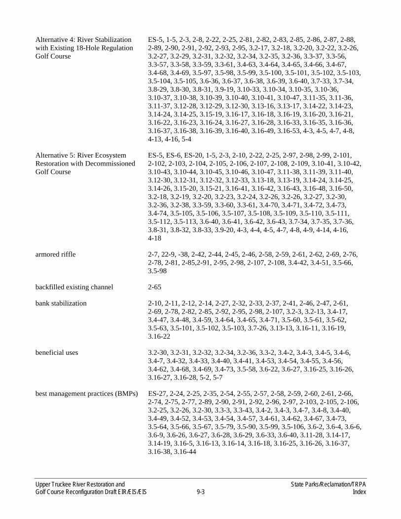
Upper Truckee River Restoration and State Parks/Reclamation/TRPA Golf Course Reconfiguration Draft EIR/EIS/EIS 9-3 Index
Alternative 4: River Stabilization with Existing 18-Hole Regulation Golf Course
ES-5, 1-5, 2-3, 2-8, 2-22, 2-25, 2-81, 2-82, 2-83, 2-85, 2-86, 2-87, 2-88, 2-89, 2-90, 2-91, 2-92, 2-93, 2-95, 3.2-17, 3.2-18, 3.2-20, 3.2-22, 3.2-26, 3.2-27, 3.2-29, 3.2-31, 3.2-32, 3.2-34, 3.2-35, 3.2-36, 3.3-37, 3.3-56, 3.3-57, 3.3-58, 3.3-59, 3.3-61, 3.4-63, 3.4-64, 3.4-65, 3.4-66, 3.4-67, 3.4-68, 3.4-69, 3.5-97, 3.5-98, 3.5-99, 3.5-100, 3.5-101, 3.5-102, 3.5-103, 3.5-104, 3.5-105, 3.6-36, 3.6-37, 3.6-38, 3.6-39, 3.6-40, 3.7-33, 3.7-34, 3.8-29, 3.8-30, 3.8-31, 3.9-19, 3.10-33, 3.10-34, 3.10-35, 3.10-36, 3.10-37, 3.10-38, 3.10-39, 3.10-40, 3.10-41, 3.10-47, 3.11-35, 3.11-36, 3.11-37, 3.12-28, 3.12-29, 3.12-30, 3.13-16, 3.13-17, 3.14-22, 3.14-23, 3.14-24, 3.14-25, 3.15-19, 3.16-17, 3.16-18, 3.16-19, 3.16-20, 3.16-21, 3.16-22, 3.16-23, 3.16-24, 3.16-27, 3.16-28, 3.16-33, 3.16-35, 3.16-36, 3.16-37, 3.16-38, 3.16-39, 3.16-40, 3.16-49, 3.16-53, 4-3, 4-5, 4-7, 4-8, 4-13, 4-16, 5-4
Alternative 5: River Ecosystem Restoration with Decommissioned Golf Course
ES-5, ES-6, ES-20, 1-5, 2-3, 2-10, 2-22, 2-25, 2-97, 2-98, 2-99, 2-101, 2-102, 2-103, 2-104, 2-105, 2-106, 2-107, 2-108, 2-109, 3.10-41, 3.10-42, 3.10-43, 3.10-44, 3.10-45, 3.10-46, 3.10-47, 3.11-38, 3.11-39, 3.11-40, 3.12-30, 3.12-31, 3.12-32, 3.12-33, 3.13-18, 3.13-19, 3.14-24, 3.14-25, 3.14-26, 3.15-20, 3.15-21, 3.16-41, 3.16-42, 3.16-43, 3.16-48, 3.16-50, 3.2-18, 3.2-19, 3.2-20, 3.2-23, 3.2-24, 3.2-26, 3.2-26, 3.2-27, 3.2-30, 3.2-36, 3.2-38, 3.3-59, 3.3-60, 3.3-61, 3.4-70, 3.4-71, 3.4-72, 3.4-73, 3.4-74, 3.5-105, 3.5-106, 3.5-107, 3.5-108, 3.5-109, 3.5-110, 3.5-111, 3.5-112, 3.5-113, 3.6-40, 3.6-41, 3.6-42, 3.6-43, 3.7-34, 3.7-35, 3.7-36, 3.8-31, 3.8-32, 3.8-33, 3.9-20, 4-3, 4-4, 4-5, 4-7, 4-8, 4-9, 4-14, 4-16, 4-18
armored riffle 2-7, 22-9, -38, 2-42, 2-44, 2-45, 2-46, 2-58, 2-59, 2-61, 2-62, 2-69, 2-76, 2-78, 2-81, 2-85,2-91, 2-95, 2-98, 2-107, 2-108, 3.4-42, 3.4-51, 3.5-66, 3.5-98
backfilled existing channel 2-65
bank stabilization 2-10, 2-11, 2-12, 2-14, 2-27, 2-32, 2-33, 2-37, 2-41, 2-46, 2-47, 2-61, 2-69, 2-78, 2-82, 2-85, 2-92, 2-95, 2-98, 2-107, 3.2-3, 3.2-13, 3.4-17, 3.4-47, 3.4-48, 3.4-59, 3.4-64, 3.4-65, 3.4-71, 3.5-60, 3.5-61, 3.5-62, 3.5-63, 3.5-101, 3.5-102, 3.5-103, 3.7-26, 3.13-13, 3.16-11, 3.16-19, 3.16-22
beneficial uses 3.2-30, 3.2-31, 3.2-32, 3.2-34, 3.2-36, 3.3-2, 3.4-2, 3.4-3, 3.4-5, 3.4-6, 3.4-7, 3.4-32, 3.4-33, 3.4-40, 3.4-41, 3.4-53, 3.4-54, 3.4-55, 3.4-56, 3.4-62, 3.4-68, 3.4-69, 3.4-73, 3.5-58, 3.6-22, 3.6-27, 3.16-25, 3.16-26, 3.16-27, 3.16-28, 5-2, 5-7
best management practices (BMPs) ES-27, 2-24, 2-25, 2-35, 2-54, 2-55, 2-57, 2-58, 2-59, 2-60, 2-61, 2-66, 2-74, 2-75, 2-77, 2-89, 2-90, 2-91, 2-92, 2-96, 2-97, 2-103, 2-105, 2-106, 3.2-25, 3.2-26, 3.2-30, 3.3-3, 3.3-43, 3.4-2, 3.4-3, 3.4-7, 3.4-8, 3.4-40, 3.4-49, 3.4-52, 3.4-53, 3.4-54, 3.4-57, 3.4-61, 3.4-62, 3.4-67, 3.4-73, 3.5-64, 3.5-66, 3.5-67, 3.5-79, 3.5-90, 3.5-99, 3.5-106, 3.6-2, 3.6-4, 3.6-6, 3.6-9, 3.6-26, 3.6-27, 3.6-28, 3.6-29, 3.6-33, 3.6-40, 3.11-28, 3.14-17, 3.14-19, 3.16-5, 3.16-13, 3.16-14, 3.16-18, 3.16-25, 3.16-26, 3.16-37, 3.16-38, 3.16-44

State Parks/Reclamation/TRPA Upper Truckee River Restoration and Index 9-4 Golf Course Reconfiguration Draft EIR/EIS/EIS
biotechnical stabilization ES-5, 2-90
boulder step 2-7, 2-9, 2-14, 2-38, 2-42, 2-47, 2-53, 2-58, 2-59, 2-62, 2-69, 2-70, 2-74, 2-76, 2-81, 2-82, 2-85, 2-88, 2-91, 2-95, 2-101, 2-107, 2-108, 3.4-51, 3.4-63, 3.4-65, 3.4-67, 3.5-97, 3.5-98, 3.5-99
bridge ES-4, ES-5, ES-11, ES-13, 1-21, 2-4, 2-8, 2-10, 2-12, 2-13, 2-14, 2-15, 2-23, 2-28, 2-32, 2-37, 2-38, 2-41, 2-46, 2-47, 2-48, 2-50, 2-52, 2-53, 2-54, 2-55, 2-56, 2-57, 2-58, 2-59, 2-60, 2-61, 2-62, 2-65, 2-66, 2-70, 2-71, 2-73, 2-74, 2-75, 2-76, 2-78, 2-82, 2-85, 2-86, 2-87, 2-88, 2-89, 2-90, 2-91, 2-92, 2-95, 2-96, 2-101, 2-103, 2-108, 3.2-5, 3.2-10, 3.2-14, 3.2-15, 3.2-16, 3.2-17, 3.2-18, 3.2-24, 3.2-28, 3.2-33, 3.3-28, 3.3-31, 3.3-32, 3.3-39, 3.3-44, 3.3-46, 3.3-54, 3.3-56, 3.3-58, 3.3-59, 3.4-12, 3.4-17, 3.4-40, 3.4-42, 3.4-43, 3.4-47, 3.4-48, 3.4-53, 3.4-58, 3.4-59, 3.4-63, 3.4-64, 3.4-65, 3.4-70, 3.5-64, 3.5-67, 3.5-70, 3.5-73, 3.5-74, 3.5-79, 3.5-82, 3.5-83, 3.5-87, 3.5-91, 3.5-98, 3.5-99, 3.5-100, 3.5-101, 3.5-102, 3.5-103, 3.5-107, 3.6-26, 3.6-29, 3.6-36, 3.6-37, 3.6-38, 3.6-39, 3.7-8, 3.7-27, 3.7-28, 3.8-11, 3.8-23, 3.8-24, 3.8-27, 3.8-29, 3.12-21, 3.12-25, 3.12-28, 3.14-16, 3.14-24, 3.16-8, 3.16-11, 3.16-12, 3.16-14, 3.16-16, 3.16-17, 3.16-18, 3.16-20, 3.16-22, 3.16-23, 3.16-47, 5-4
California Air Resources Board (ARB)
1-16, 1-22, 3.11-1, 3.11-3, 3.11-4, 3.11-5, 3.11-9, 3.11-10, 3.11-12, 3.11-14, 3.11-15, 3.11-16, 3.11-17, 3.11-18, 3.11-20, 3.11-21, 3.11-24, 3.11-25, 3.11-29, 3.11-32, 3.16-48, 3.16-49
California Department of Fish and Game (DFG)
1-15, 1-16, 1-22, 3.4-53, 3.5-3, 3.5-35, 3.5-48, 3.14-4, 5-5
California Endangered Species Act (CESA)
1-16, 1-22, 3.5-3, 3.5-7, 3.5-32, 3.5-37, 3.5-81, 3.5-82, 5-5
California Fish and Game Code 3.5-3, 3.5-32, 3.5-37, 3.5-82
California Native Plant Society (CNPS)
1-23, 3.5-3, 3.5-11, 3.5-32, 3.5-33, 3.5-34, 3.5-35, 3.5-36, 3.5-74
California Natural Diversity Database (CNDDB)
1-22, 3.5-11, 3.5-32, 3.5-37, 3.5-42, 3.5-54
California Register of Historical Resources (CRHR)
3.9-2, 3.9-3, 3.9-10, 3.9-13, 3.9-14, 3.9-16, 3.9-17, 3.9-18, 3.9-19, 3.9-20, 5-6
California Scenic Highway Program 5-6
California Surface Mining and Reclamation Act (SMARA)
1-27, 3.6-3, 3.6-17
cart path ES-3, 2-22, 2-23, 2-24, 2-27, 2-32, 2-33, 2-47, 2-50, 2-52, 2-53, 2-54, 2-55, 2-60, 2-62, 2-65, 2-70, 2-71, 2-72, 2-74, 2-77, 2-87, 2-89, 2-92, 2-96, 2-98, 2-101, 2-102, 2-103, 2-106, 3.2-14, 3.2-16, 3.3-43, 3.3-56, 3.5-17, 3.5-70, 3.5-93, 3.5-105, 3.6-19, 3.6-24, 3.6-30, 3.6-32, 3.6-34, 3.6-38, 3.6-39, 3.6-41, 3.6-42, 3.7-29, 3.7-35, 3.8-14, 3.8-22, 3.8-23, 3.8-24, 3.8-27, 3.8-29, 3.8-31, 3.8-32, 3.12-21

Upper Truckee River Restoration and State Parks/Reclamation/TRPA Golf Course Reconfiguration Draft EIR/EIS/EIS 9-5 Index
channel capacity 2-11, 2-32, 2-45, 2-46, 2-47, 2-86, 2-101, 2-102, 3.3-31, 3.3-44, 3.3-46, 3.4-17, 3.4-29, 3.4-37, 3.4-50, 3.4-60, 3.4-64, 3.4-66, 3.4-72, 3.5-69, 3.16-19, 3.16-23, 3.16-32
Clean Air Act (CAA) 1-22, 3.11-1, 3.11-4, 3.11-9, 3.11-18, 3.11-19, 5-3
Clean Water Act (CWA) 1-16, 1-21, 1-23, 3.3-1, 3.3-2, 3.4-1, 3.4-2, 3.4-3, 3.4-8, 3.4-21, 3.4-53, 3.4-56, 3.4-62, 3.4-68, 3.4-69, 3.4-73, 3.5-2, 3.5-4, 3.5-32, 3.5-54, 3.5-56, 3.5-70, 3.5-92, 3.5-100, 3.5-108, 3.6-1, 3.13-2, 5-2, 5-6
climate change 3.3-10, 3.3-13, 3.3-14, 3.3-37, 3.3-38, 3.4-31, 3.4-36, 3.4-37, 3.4-38, 3.4-40, 3.4-51, 3.4-52, 3.4-61, 3.4-66, 3.4-67, 3.4-72, 3.5-76, 3.11-19, 3.11-20, 3.11-21, 3.11-22, 3.11-24, 3.11-25, 3.16-3, 3.16-20, 3.16-21, 3.16-23, 3.16-24, 3.16-34, 3.16-35, 3.16-46, 3.16-48
construction schedule 2-57, 2-58, 2-75, 2-90, 2-105, 3.4-53, 3.4-67, 3.6-26, 3.6-36, 3.10-15, 3.12-21, 3.15-16, 3.15-19, 3.15-20
criteria air pollutants ES-22, ES-29, ES-30, 3.11-1, 3.11-4, 3.11-9, 3.11-12, 3.11-14, 3.11-15, 3.11-17, 3.11-22, 3.11-24, 3.11-25, 3.11-26, 3.11-27, 3.11-30, 3.11-33, 3.11-34, 3.11-35, 3.11-37, 3.11-38, 3.11-39, 3.16-44, 3.16-45, 4-17
driving range ES-20, 2-23, 2-35, 2-36, 2-55, 2-74, 2-88, 2-89, 2-103, 3.2-9, 3.2-14, 3.2-23, 3.2-38, 3.2-39, 3.3-34, 3.4-53, 3.6-26, 3.7-1, 3.7-6, 3.7-18, 3.7-27, 3.7-28, 3.7-32, 3.8-11, 3.8-13, 3.8-16, 3.8-20, 3.8-24, 3.8-25, 3.8-26, 3.8-28, 3.8-29, 3.8-30, 3.8-32, 3.8-33, 3.10-15, 3.12-17, 3.15-8, 3.15-15, 3.15-16, 3.15-17, 3.15-18, 3.15-20, 3.16-41, 3.16-42, 4-15
economics 1-12, 3.10-25
Endangered Species Act (ESA) 1-10, 1-16, 1-23, 2-27, 3.5-1, 3.5-3, 3.5-7, 3.5-32, 3.5-37, 3.5-48, 3.5-56, 5-1, 5-2, 5-5
Environmentally Superior Alternative/Environmentally Preferred Alternative
4-5

State Parks/Reclamation/TRPA Upper Truckee River Restoration and Index 9-6 Golf Course Reconfiguration Draft EIR/EIS/EIS
erosion ES-2, ES-5, ES-6, ES-8, ES-10, ES-11, ES-13, ES-17, ES-19, ES-27, ES-28, 1-2, 1-5, 1-8, 1-9, 2-6, 2-7, 2-11, 2-12, 2-13, 2-14, 2-16, 2-27, 2-28, 2-32, 2-33, 2-34, 2-37, 2-42, 2-44, 2-45, 2-46, 2-48, 2-49, 2-50, 2-53, 2-54, 2-57, 2-58, 2-65, 2-74, 2-75, 2-81, 2-82, 2-85, 2-86, 2-88, 2-89, 2-91, 2-96, 2-103, 2-108, 3.2-3, 3.2-5, 3.2-7, 3.2-12, 3.2-13, 3.2-20, 3.2-30, 3.2-30, 3.2-32, 3.2-33, 3.2-34, 3.2-36, 3.3-2, 3.3-3, 3.3-4, 3.3-32, 3.3-35, 3.3-39, 3.3-43, 3.3-57, 3.3-58, 3.4-1, 3.4-3, 3.4-8, 3.4-9, 3.4-10, 3.4-11, 3.4-12, 3.4-15, 3.4-17, 3.4-18, 3.4-19, 3.4-21, 3.4-23, 3.4-28, 3.4-29, 3.4-30, 3.4-31, 3.4-33, 3.4-34, 3.4-36, 3.4-37, 3.4-38, 3.4-40, 3.4-41, 3.4-42, 3.4-43, 3.4-47, 3.4-48, 3.4-49, 3.4-50, 3.4-51, 3.4-52, 3.4-53, 3.4-54, 3.4-55, 3.4-56, 3.4-58, 3.4-59, 3.4-60, 3.4-61, 3.4-63, 3.4-64, 3.4-65, 3.4-66, 3.4-67, 3.4-68, 3.4-69, 3.4-70, 3.4-71, 3.4-72, 3.5-15, 3.5-16, 3.5-59, 3.5-60, 3.5-61, 3.5-63, 3.5-64, 3.5-67, 3.5-68, 3.5-69, 3.5-75, 3.5-80, 3.5-86, 3.5-90, 3.5-91, 3.5-93, 3.5-98, 3.5-99, 3.5-100, 3.5-101, 3.5-106, 3.5-107, 3.6-1, 3.6-2, 3.6-3, 3.6-5, 3.6-6, 3.6-7, 3.6-9, 3.6-10, 3.6-11, 3.6-12, 3.6-13, 3.6-14, 3.6-17, 3.6-18, 3.6-19, 3.6-21, 3.6-22, 3.6-24, 3.6-26, 3.6-27, 3.6-28, 3.6-29, 3.6-33, 3.6-36, 3.6-37, 3.6-40, 3.6-41, 3.7-6, 3.7-26, 3.9-13, 3.9-14, 3.9-15, 3.13-3, 3.13-11, 3.13-13, 3.13-16, 3.14-6, 3.14-9, 3.14-16, 3.16-4, 3.16-7, 3.16-8, 3.16-9, 3.16-10, 3.16-11, 3.16-12, 3.16-13, 3.16-14, 3.16-15, 3.16-16, 3.16-18, 3.16-21, 3.16-22, 3.16-24, 3.16-25, 3.16-26, 3.16-27, 3.16-28, 3.16-30, 3.16-32, 3.16-33, 3.16-34, 3.16-35, 3.16-37, 3.16-38, 3.16-41, 3.16-42, 4-7, 4-8, 4-12
fairway 2-23, 2-24, 2-52, 2-66, 3.5-70, 3.7-9
Federal Aviation Administration (FAA)
1-16, 1-23, 3.14-1, 3.14-2, 3.14-3, 3.14-10, 3.14-15, 3.14-19, 3.14-22, 3.16-53
Federal Emergency Management Agency (FEMA)
1-23, 3.3-2, 3.3-31, 3.3-32, 3.3-33, 3.3-34, 3.3-37, 3.3-39, 3.3-58, 3.13-6, 3.16-20
Fish and Wildlife Coordination Act 1-16, 1-24, 5-1
Flood Insurance Rate Map (FIRM) 1-23, 3.3-2, 3.3-3, 3.3-34, 3.3-35
forestland 3.2-9, 3.16-35
general plan ES-3, ES-4, ES-5, ES-6, 2-15, 2-27, 2-36, 2-37, 2-56, 2-57, 2-66, 2-75, 2-82, 2-90, 2-97, 2-104, 3.1-5, 3.2-1, 3.2-2, 3.2-3, 3.2-7, 3.2-8, 3.2-11, 3.2-13, 3.2-15, 3.2-16, 3.2-17, 3.2-18, 3.2-19, 3.2-24, 3.2-29, 3.4-10, 3.4-50, 3.4-60, 3.4-66, 3.5-4, 3.5-8, 3.6-3, 3.6-12, 3.6-13, 3.7-1, 3.7-2, 3.8-1, 3.8-2, 3.8-7, 3.10-1, 3.10-2, 3.10-5, 3.11-7, 3.12-1, 3.12-5, 3.12-7, 3.12-8, 3.12-9, 3.12-10, 3.12-18, 3.13-3, 3.13-4, 3.13-5, 3.13-9, 3.14-5, 3.14-11, 3.14-14, 3.16-3, 3.16-4, 3.16-5, 3.16-6, 3.16-17, 3.16-18, 3.16-52, 4-3
global climate change 1-12, 3.11-20, 3.11-22, 3.11-23, 3.11-24, 3.16-2, 3.16-46, 3.16-47

Upper Truckee River Restoration and State Parks/Reclamation/TRPA Golf Course Reconfiguration Draft EIR/EIS/EIS 9-7 Index
grade control ES-5, 2-7, 2-9, 2-12, 2-13, 2-14, 2-32, 2-38, 2-42, 2-44, 2-46, 2-47, 2-48, 2-53, 2-69, 2-74, 2-81, 2-85, 2-86, 2-88, 2-92, 2-98, 2-102, 3.3-32, 3.4-15, 3.4-37, 3.4-42, 3.4-48, 3.4-50, 3.4-53, 3.4-55, 3.4-65, 3.4-69, 3.5-66, 3.5-97, 3.5-98, 3.5-99, 3.5-102, 3.5-103, 3.6-26, 3.13-13, 3.16-11, 3.16-27
greenhouse gases ES-30, 1-24, 3.11-20, 3.11-19, 3.11-23, 3.16-46, 3.16-48, 3.16-49
greens 2-16, 2-23, 2-24, 2-34, 2-35, 2-49, 2-52, 2-53, 2-72, 2-73, 2-88, 2-102, 2-103, 2-106, 3.3-34, 3.3-35, 3.3-38, 3.4-30, 3.5-17, 3.5-75, 3.5-87, 3.6-7, 3.7-6, 3.7-18, 3.7-28, 3.7-29, 3.7-32, 3.7-34, 3.7-35, 3.8-14, 3.8-22, 3.8-26, 3.8-31, 3.14-11, 3.16-40
groundwater ES-10, ES-12, ES-27, 2-7, 2-11, 2-25, 2-34, 2-35, 2-48, 2-49, 2-58, 2-61, 2-75, 2-78, 2-91, 2-102, 2-107, 3.2-30, 3.2-31, 3.2-31, 3.3-2, 3.3-5, 3.3-8, 3.3-13, 3.3-15, 3.3-16, 3.3-17, 3.3-18, 3.3-19, 3.3-20, 3.3-21, 3.3-22, 3.3-23, 3.3-24, 3.3-25, 3.3-26, 3.3-34, 3.3-35, 3.3-36, 3.3-39, 3.3-40, 3.3-52, 3.3-53, 3.3-55, 3.3-58, 3.3-59, 3.3-60, 3.3-61, 3.4-2, 3.4-3, 3.4-4, 3.4-6, 3.4-8, 3.4-10, 3.4-11, 3.4-22, 3.4-30, 3.4-31, 3.4-40, 3.4-41, 3.4-42, 3.4-52, 3.4-53, 3.4-54, 3.4-57, 3.4-58, 3.4-61, 3.4-62, 3.4-63, 3.4-67, 3.4-68, 3.4-69, 3.4-73, 3.4-74, 3.5-4, 3.5-5, 3.5-16, 3.5-17, 3.5-19, 3.5-57, 3.5-70, 3.5-72, 3.6-7, 3.6-10, 3.6-23, 3.6-27, 3.6-28, 3.6-29, 3.11-8, 3.13-2, 3.13-3, 3.13-5, 3.14-17, 3.16-10, 3.16-21, 3.16-25, 3.16-26, 4-1, 4-2, 4-7, 4-9
hazardous air pollutants (HAPs) 1-24, 1-25, 3.11-1, 3.11-4, 3.11-5, 3.11-23, 3.11-26, 3.11-32, 3.11-35, 3.11-37, 3.11-40, 3.16-45
historical resources 3.5-5, 3.9-2, 3.9-3, 3.9-11, 5-6
inset floodplain 1-8, 2-7, 2-8, 2-12, 2-13, 2-25, 2-32, 2-38, 2-46, 2-47, 2-48, 2-57, 2-61, 2-62, 2-69, 2-71, 2-78, 2-81, 2-85, 2-87, 2-91, 2-92, 2-95, 2-96, 2-98, 2-102, 2-107, 2-108, 3.3-31, 3.3-38, 3.3-39, 3.3-46, 3.3-57, 3.3-58, 3.4-37, 3.4-64, 3.4-66, 3.5-59, 3.5-98, 3.5-100, 3.5-101, 3.5-104, 3.5-105, 3.14-24, 3.16-12, 3.16-19, 3.16-23, 3.16-33, 4-13
intensively managed landscape 2-23, 2-26, 2-34, 3.3-34, 3.3-53, 3.3-56, 3.3-61
Jeffrey pine ES-16, 3.2-3, 3.2-9, 3.5-12, 3.5-15, 3.5-18, 3.5-36, 3.5-38, 3.5-51, 3.5-73, 3.5-75, 3.5-76, 3.5-79, 3.5-87, 3.7-6, 3.7-29, 3.16-37, 4-11
Lahontan cutthroat trout 3.5-8, 3.5-10, 3.5-24, 3.5-25, 3.5-38, 3.9-7, 4-10
Lahontan Regional Water Quality Control Board
1-15, 1-16, 1-24, 2-15, 3.4-3, 3.5-2, 3.14-4
land coverage 3.2-5, 3.2-22, 3.2-33, 3.2-34, 3.2-36, 3.3-4, 3.4-9, 3.6-4, 3.6-5, 3.6-6, 3.6-7, 3.6-9, 3.6-10, 3.6-12, 3.6-13, 3.6-19, 3.8-6, 3.16-38, 3.16-39, 4-5, 4-7
land use designations 3.12-8, 3.12-9, 3.16-17

State Parks/Reclamation/TRPA Upper Truckee River Restoration and Index 9-8 Golf Course Reconfiguration Draft EIR/EIS/EIS
lead agency ES-1, ES-2, 1-1, 1-10, 1-11, 1-14, 1-15, 1-19, 2-1, 2-6, 2-15, 3.1-2, 3.6-2, 3.9-1, 3.9-2, 3.9-3, 3.13-3, 3.14-6, 3.16-28, 5-6
level of service (LOS) ES-9, ES-22, 1-24, 3.10-1, 3.10-2, 3.10-4, 3.10-5, 3.10-6, 3.10-8, 3.10-10, 3.10-11, 3.10-12, 3.10-14, 3.10-15, 3.10-16, 3.10-17, 3.10-20, 3.10-22, 3.10-26, 3.10-29, 3.10-31, 3.10-33, 3.10-35, 3.10-38, 3.10-41, 3.10-43, 3.10-45, 3.10-47, 3.10-48, 3.11-26, 3.11-31, 3.11-35, 3.11-37, 3.11-40, 3.16-43, 3.16-45, 4-2, 4-17
lodgepole pine ES-16, 3.2-3, 3.2-9, 3.5-12, 3.5-15, 3.5-16, 3.5-17, 3.5-18, 3.5-20, 3.5-36, 3.5-38, 3.5-51, 3.5-58, 3.5-62, 3.5-73, 3.5-75, 3.5-76, 3.5-79, 3.5-87, 3.5-94, 3.5-102, 3.5-110, 3.13-9, 3.14-11, 3.14-18, 3.16-12, 3.16-16, 3.16-35, 3.16-37, 3.16-47, 4-11
meander ES-4, 1-2, 2-4, 2-9, 2-14, 2-25, 2-33, 2-41, 2-42, 2-45, 2-47, 2-48, 2-49, 2-50, 2-59, 2-66, 2-69, 2-71, 2-73, 2-76, 2-101, 2-103, 2-105, 3.3-8, 3.3-53, 3.3-55, 3.4-12, 3.4-15, 3.4-18, 3.4-51, 3.4-58, 3.4-70, 3.5-100, 3.6-36, 3.6-43, 3.8-27, 3.8-32
Migratory Bird Treaty Act (MBTA) 1-24, 3.5-1, 3.5-55, 3.5-56, 5-1
minimally managed landscape 2-26, 2-34, 3.3-34, 3.3-53, 3.3-56, 3.5-72, 3.5-80, 3.5-87
montane meadow 3.5-18, 3.5-21, 3.5-42, 3.5-50, 3.5-70
National Pollutant Discharge Elimination System (NPDES)
1-16, 1-25, 2-25, 3.3-1, 3.4-1, 3.4-2, 3.6-1, 5-2, 5-6, 5-7
Native American Heritage Commission (NAHC)
1-25, 3.9-3, 3.9-17, 3.9-18
Native Americans 3.8-8, 3.9-3
Naturalized landscape 2-26, 2-47, 2-50, 2-73, 3.3-53, 3.3-56, 3.3-61, 3.5-72, 3.5-80, 3.5-82, 3.5-87, 3.5-96
Notice of Intent (NOI) ES-2, 1-11, 1-12, 1-13, 1-16, 1-25, 2-3, 3.4-2, 3.5-37, 3.6-2, 3.16-3
Notice of Preparation (NOP) ES-1, ES-2, 1-11, 1-12, 1-13, 1-25, 2-3
overbank flows 2-8, 2-47, 2-102, 3.3-16, 3.3-31, 3.4-17, 3.4-28, 3.4-50, 3.4-56, 3.16-53
Ozone 1-26, 3.10-4, 3.11-1, 3.11-3, 3.11-4, 3.11-5, 3.11-7, 3.11-8, 3.11-9, 3.11-12, 3.11-13, 3.11-14, 3.11-16, 3.11-22, 3.11-24, 3.11-27, 3.11-34, 3.11-36, 3.11-39, 4-16, 4-17
par 2-23, 2-33, 2-51, 2-52, 2-73, 2-88, 3.8-13, 3.8-17, 3.8-22, 3.8-26
persons at one time (PAOT) 1-26, 3.8-4, 3.8-5, 3.8-7, 3.8-19, 3.8-21, 3.8-25, 3.8-26, 3.8-28, 3.8-29, 3.8-31, 3.8-33, 3.16-41, 3.16-42, 4-15, 4-16
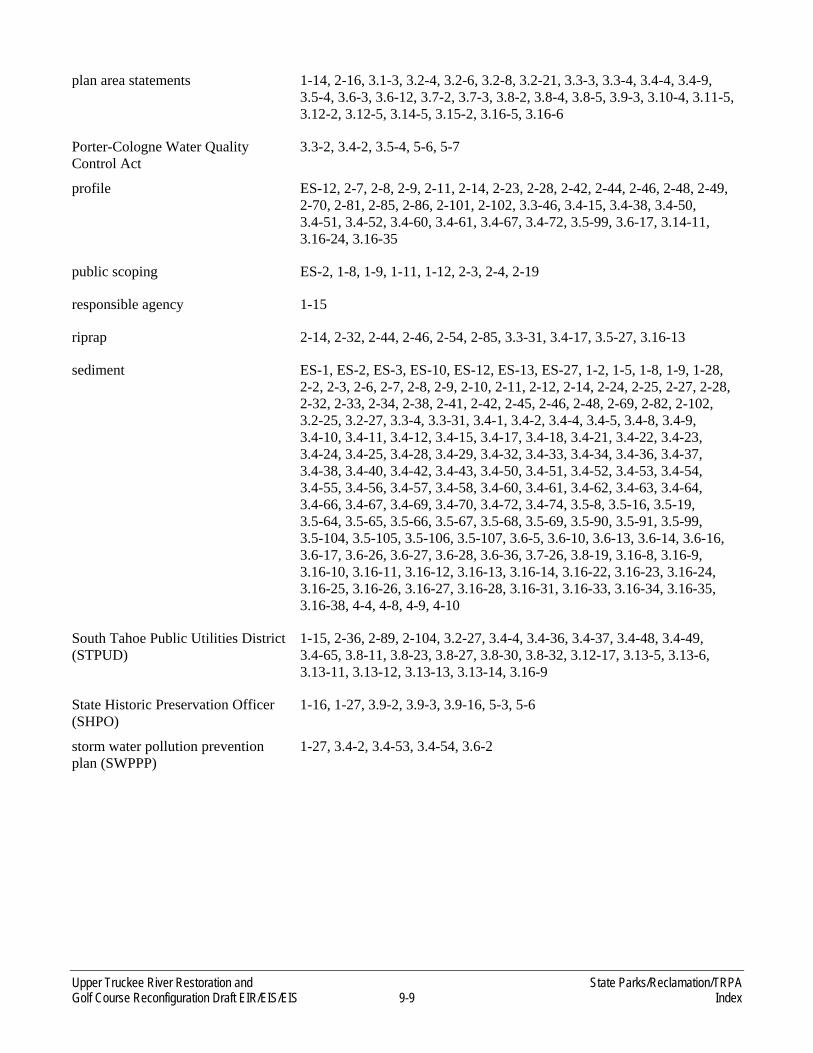
Upper Truckee River Restoration and State Parks/Reclamation/TRPA Golf Course Reconfiguration Draft EIR/EIS/EIS 9-9 Index
plan area statements 1-14, 2-16, 3.1-3, 3.2-4, 3.2-6, 3.2-8, 3.2-21, 3.3-3, 3.3-4, 3.4-4, 3.4-9, 3.5-4, 3.6-3, 3.6-12, 3.7-2, 3.7-3, 3.8-2, 3.8-4, 3.8-5, 3.9-3, 3.10-4, 3.11-5, 3.12-2, 3.12-5, 3.14-5, 3.15-2, 3.16-5, 3.16-6
Porter-Cologne Water Quality Control Act
3.3-2, 3.4-2, 3.5-4, 5-6, 5-7
profile ES-12, 2-7, 2-8, 2-9, 2-11, 2-14, 2-23, 2-28, 2-42, 2-44, 2-46, 2-48, 2-49, 2-70, 2-81, 2-85, 2-86, 2-101, 2-102, 3.3-46, 3.4-15, 3.4-38, 3.4-50, 3.4-51, 3.4-52, 3.4-60, 3.4-61, 3.4-67, 3.4-72, 3.5-99, 3.6-17, 3.14-11, 3.16-24, 3.16-35
public scoping ES-2, 1-8, 1-9, 1-11, 1-12, 2-3, 2-4, 2-19
responsible agency 1-15
riprap 2-14, 2-32, 2-44, 2-46, 2-54, 2-85, 3.3-31, 3.4-17, 3.5-27, 3.16-13
sediment ES-1, ES-2, ES-3, ES-10, ES-12, ES-13, ES-27, 1-2, 1-5, 1-8, 1-9, 1-28, 2-2, 2-3, 2-6, 2-7, 2-8, 2-9, 2-10, 2-11, 2-12, 2-14, 2-24, 2-25, 2-27, 2-28, 2-32, 2-33, 2-34, 2-38, 2-41, 2-42, 2-45, 2-46, 2-48, 2-69, 2-82, 2-102, 3.2-25, 3.2-27, 3.3-4, 3.3-31, 3.4-1, 3.4-2, 3.4-4, 3.4-5, 3.4-8, 3.4-9, 3.4-10, 3.4-11, 3.4-12, 3.4-15, 3.4-17, 3.4-18, 3.4-21, 3.4-22, 3.4-23, 3.4-24, 3.4-25, 3.4-28, 3.4-29, 3.4-32, 3.4-33, 3.4-34, 3.4-36, 3.4-37, 3.4-38, 3.4-40, 3.4-42, 3.4-43, 3.4-50, 3.4-51, 3.4-52, 3.4-53, 3.4-54, 3.4-55, 3.4-56, 3.4-57, 3.4-58, 3.4-60, 3.4-61, 3.4-62, 3.4-63, 3.4-64, 3.4-66, 3.4-67, 3.4-69, 3.4-70, 3.4-72, 3.4-74, 3.5-8, 3.5-16, 3.5-19, 3.5-64, 3.5-65, 3.5-66, 3.5-67, 3.5-68, 3.5-69, 3.5-90, 3.5-91, 3.5-99, 3.5-104, 3.5-105, 3.5-106, 3.5-107, 3.6-5, 3.6-10, 3.6-13, 3.6-14, 3.6-16, 3.6-17, 3.6-26, 3.6-27, 3.6-28, 3.6-36, 3.7-26, 3.8-19, 3.16-8, 3.16-9, 3.16-10, 3.16-11, 3.16-12, 3.16-13, 3.16-14, 3.16-22, 3.16-23, 3.16-24, 3.16-25, 3.16-26, 3.16-27, 3.16-28, 3.16-31, 3.16-33, 3.16-34, 3.16-35, 3.16-38, 4-4, 4-8, 4-9, 4-10
South Tahoe Public Utilities District (STPUD)
1-15, 2-36, 2-89, 2-104, 3.2-27, 3.4-4, 3.4-36, 3.4-37, 3.4-48, 3.4-49, 3.4-65, 3.8-11, 3.8-23, 3.8-27, 3.8-30, 3.8-32, 3.12-17, 3.13-5, 3.13-6, 3.13-11, 3.13-12, 3.13-13, 3.13-14, 3.16-9
State Historic Preservation Officer (SHPO)
1-16, 1-27, 3.9-2, 3.9-3, 3.9-16, 5-3, 5-6
storm water pollution prevention plan (SWPPP)
1-27, 3.4-2, 3.4-53, 3.4-54, 3.6-2

State Parks/Reclamation/TRPA Upper Truckee River Restoration and Index 9-10 Golf Course Reconfiguration Draft EIR/EIS/EIS
Stream Environment Zone (SEZ) ES-1, ES-3, ES-4, ES-14, ES-15, ES-16, ES-17, ES-28, 1-5, 1-9, 1-27, 2-4, 2-6, 2-7, 2-9, 2-11, 2-12, 2-14, 2-15, 2-16, 2-18, 2-20, 2-21, 2-22, 2-25, 2-26, 2-27, 2-28, 2-33, 2-37, 2-38, 2-50, 2-51, 2-71, 2-72, 2-73, 2-81, 2-88, 2-98, 3.2-5, 3.2-7, 3.2-12, 3.2-14, 3.2-22, 3.2-25, 3.2-34, 3.2-35, 3.2-36, 3.2-36, 3.3-2, 3.3-3, 3.3-4, 3.3-43, 3.3-54, 3.3-56, 3.3-59, 3.4-3, 3.4-4, 3.4-7, 3.4-9, 3.4-10, 3.4-42, 3.4-57, 3.4-63, 3.4-69, 3.4-74, 3.5-5, 3.5-6, 3.5-7, 3.5-9, 3.5-54, 3.5-58, 3.5-60, 3.5-61, 3.5-64, 3.5-66, 3.5-68, 3.5-69, 3.5-70, 3.5-71, 3.5-72, 3.5-73, 3.5-74, 3.5-75, 3.5-76, 3.5-79, 3.5-86, 3.5-88, 3.5-89, 3.5-90, 3.5-92, 3.5-93, 3.5-94, 3.5-97, 3.5-100, 3.5-101, 3.5-105, 3.5-107, 3.5-108, 3.5-109, 3.5-110, 3.5-111, 3.5-112, 3.5-113, 3.6-5, 3.6-7, 3.6-8, 3.6-9, 3.6-10, 3.6-12, 3.6-13, 3.6-30, 3.6-32, 3.6-33, 3.6-34, 3.6-36, 3.6-38, 3.6-40, 3.6-41, 3.6-42, 3.7-31, 3.16-14, 3.16-15, 3.16-16, 3.16-28, 3.16-34, 3.16-36, 3.16-38, 3.16-49, 4-2, 4-3, 4-5, 4-6, 4-7, 4-8, 4-12, 4-13
streambed alteration agreement 1-16, 3.5-3, 3.5-70, 3.5-71, 5-5
tee 2-23, 2-24, 2-49, 2-52, 2-53, 2-54, 2-72, 3.5-70, 3.8-22, 3.12-16, 3.12-17
total maximum daily load (TMDL) 1-27, 3.3-13, 3.4-1, 3.4-18, 3.4-21, 3.4-28, 3.4-34, 3.4-36, 3.4-42, 3.4-64, 3.4-18, 3.16-6
toxic air contaminants (TACs) 1-27, 3.11-1, 3.11-3, 3.11-4, 3.11-5, 3.11-10, 3.11-16, 3.11-17, 3.11-18, 3.11-22, 3.11-23, 3.11-26, 3.11-32, 3.11-35, 3.11-37, 3.11-40
traffic noise levels 3.12-8, 3.12-9, 3.12-14, 3.12-16, 3.12-19, 3.12-22, 3.12-23, 3.12-24, 3.12-26, 3.12-27, 3.12-29, 3.12-30, 3.12-31, 3.12-32, 3.16-50
trails ES-3, ES-4, ES-5, ES-20, 2-22, 2-24, 2-26, 2-27, 2-36, 2-37, 2-46, 2-52, 2-54, 2-55, 2-56, 2-62, 2-65, 2-74, 2-75, 2-81, 2-82, 2-89, 2-90, 2-95, 2-96, 2-104, 2-108, 3.2-3, 3.2-5, 3.2-7, 3.2-12, 3.2-14, 3.2-21, 3.2-23, 3.2-26, 3.2-28, 3.2-33, 3.2-35, 3.2-37, 3.2-38, 3.3-13, 3.4-7, 3.4-37, 3.4-50, 3.4-57, 3.5-87, 3.6-8, 3.6-11, 3.6-12, 3.6-19, 3.6-24, 3.6-26, 3.6-30, 3.6-34, 3.6-39, 3.6-41, 3.6-42, 3.7-3, 3.7-5, 3.7-6, 3.7-26, 3.7-27, 3.7-28, 3.7-29, 3.7-30, 3.7-31, 3.7-32, 3.7-33, 3.7-34, 3.7-35, 3.8-4, 3.8-5, 3.8-6, 3.8-7, 3.8-8, 3.8-9, 3.8-11, 3.8-16, 3.8-17, 3.8-19, 3.8-20, 3.8-23, 3.8-24, 3.8-25, 3.8-27, 3.8-30, 3.8-32, 3.10-10, 3.10-16, 3.10-24, 3.10-29, 3.10-40, 3.10-47, 3.12-4, 3.12-14, 3.16-12, 3.16-16, 3.16-17, 3.16-19, 3.16-22, 3.16-37, 3.16-39, 3.16-40, 3.16-41, 4-3, 4-14, 4-15, 4-16
TRPA Code of Ordinance ES-1, ES-2, 1-1, 1-9, 1-10, 1-11, 1-14, 1-28, 2-2, 3.1-2, 3.1-3, 3.1-4, 3.1-5, 3.2-4, 3.2-5, 3.2-8, 3.3-3, 3.3-4, 3.4-4, 3.5-4, 3.5-5, 3.5-6, 3.5-7, 3.5-11, 3.5-32, 3.5-54, 3.5-55, 3.5-75, 3.5-76, 3.5-77, 3.5-78, 3.5-94, 3.5-101, 3.5-102, 3.5-109, 3.5-110, 3.6-9, 3.6-12, 3.7-1, 3.7-3, 3.8-4, 3.8-5, 3.9-1, 3.9-4, 3.10-1, 3.10-4, 3.11-6, 3.11-7, 3.11-28, 3.11-29, 3.11-32, 3.12-5, 3.13-2, 3.14-6, 3.16-5, 3.16-6, 3.16-35, 3.16-36, 3.16-44, 3.16-45, 4-1, 4-18
TRPA thresholds 1-14, 3.3-3, 3.3-4, 3.5-5, 3.5-8, 3.5-78, 3.6-12, 3.7-4, 3.10-1, 3.10-4, 3.11-2, 3.11-7, 4-16
trustee agency 1-15

Upper Truckee River Restoration and State Parks/Reclamation/TRPA Golf Course Reconfiguration Draft EIR/EIS/EIS 9-11 Index
turbidity ES-8, 2-8, 2-35, 2-58, 3.4-2, 3.4-6, 3.4-9, 3.4-10, 3.4-23, 3.4-30, 3.4-31, 3.4-32, 3.4-33, 3.4-40, 3.4-41, 3.4-52, 3.4-53, 3.4-54, 3.4-55, 3.4-56, 3.4-57, 3.4-61, 3.4-62, 3.4-67, 3.4-68, 3.4-69, 3.4-73, 3.5-58, 3.5-64, 3.5-65, 3.5-66, 3.5-90, 3.5-98, 3.5-105, 3.5-106, 3.6-22, 3.6-28, 3.16-25, 3.16-26, 3.16-27, 3.16-28, 3.16-29, 3.16-30, 4-9, 5-2, 5-7
turf 1-2, 1-5, 2-4, 2-23, 2-24, 2-34, 2-47, 2-49, 2-50, 2-51, 2-52, 2-53, 2-54, 2-72, 2-73, 2-74, 2-87, 2-88, 2-103, 3.2-26, 3.3-8, 3.3-53, 3.3-56, 3.4-14, 3.4-22, 3.4-29, 3.4-30, 3.4-57, 3.4-58, 3.4-63, 3.5-16, 3.5-27, 3.5-72, 3.5-87, 3.5-107, 3.5-108, 3.6-32, 3.7-28, 3.7-30, 3.8-17, 3.8-22, 3.16-5, 3.16-27, 3.16-49
U.S. Army Corps of Engineers (USACE)
1-16, 1-28, 3.3-1, 3.3-2, 3.3-13, 3.3-15, 3.3-27, 3.4-1, 3.4-2, 3.4-10, 3.4-53, 3.5-2, 3.5-4, 3.5-31, 3.5-54, 3.5-58, 3.5-70, 3.5-71, 3.5-80, 3.5-92, 3.5-100, 3.5-108, 3.6-1, 3.6-27, 5-2, 5-4, 5-6, 5-7
U.S. Fish and Wildlife Service (USFWS)
1-16, 1-28, 3.5-1, 3.5-3, 3.5-11, 3.5-32, 3.5-36, 3.5-37, 3.5-48, 3.5-55, 3.5-56, 3.5-71, 3.5-101, 5-1
U.S. Forest Service 1-16, 1-28, 3.3-3, 3.4-3, 3.5-2, 3.5-35, 3.5-48, 3.13-8
Washoe Tribe of California and Nevada
1-16
waste discharge requirement (WDR)
2-25
waste discharge requirements 1-16, 2-25, 2-34, 3.4-3, 3.4-29, 3.14-9
Water Quality Control Plan 1-22, 3.3-2, 3.4-2, 3.4-3, 3.4-6
water quality ES-2, ES-3, ES-8, ES-10, ES-12, ES-27, ES-28, 1-2, 1-5, 1-9, 1-12, 1-14, 1-21, 1-22, 1-26, 2-6, 2-7, 2-8, 2-10, 2-11, 2-13, 2-14, 2-25, 2-37, 2-47, 2-55, 2-57, 2-58, 2-59, 2-65, 2-90, 2-96, 2-101, 3.1-2, 3.2-3, 3.2-4, 3.2-7, 3.2-13, 3.2-26, 3.2-25, 3.2-26, 3.2-26, 3.2-27, 3.2-29, 3.2-30, 3.2-36, 3.2-37, 3.3-1, 3.3-2, 3.3-3, 3.3-4, 3.3-8, 3.3-13, 3.3-15, 3.4-1, 3.4-2, 3.4-3, 3.4-4, 3.4-5, 3.4-6, 3.4-7, 3.4-8, 3.4-9, 3.4-10, 3.4-17, 3.4-18, 3.4-21, 3.4-22, 3.4-28, 3.4-29, 3.4-30, 3.4-31, 3.4-32, 3.4-33, 3.4-37, 3.4-40, 3.4-41, 3.4-42, 3.4-49, 3.4-52, 3.4-53, 3.4-54, 3.4-55, 3.4-56, 3.4-57, 3.4-58, 3.4-60, 3.4-61, 3.4-62, 3.4-63, 3.4-67, 3.4-68, 3.4-69, 3.4-70, 3.4-73, 3.4-74, 3.4-3, 3.4-21, 3.5-2, 3.5-4, 3.5-8, 3.5-26, 3.5-28, 3.5-29, 3.5-58, 3.5-64, 3.5-65, 3.5-66, 3.5-67, 3.5-68, 3.5-71, 3.5-89, 3.5-90, 3.5-97, 3.5-98, 3.5-105, 3.5-106, 3.5-108, 3.6-1, 3.6-3, 3.6-6, 3.6-7, 3.6-9, 3.6-10, 3.6-11, 3.6-22, 3.6-27, 3.6-28, 3.6-29, 3.6-30, 3.6-34, 3.6-38, 3.6-41, 3.7-2, 3.7-4, 3.8-1, 3.8-2, 3.8-23, 3.9-3, 3.10-4, 3.11-5, 3.11-7, 3.11-8, 3.11-9, 3.12-4, 3.13-1, 3.13-11, 3.13-13, 3.13-15, 3.13-16, 3.13-17, 3.14-5, 3.15-2, 3.16-2, 3.16-4, 3.16-5, 3.16-7, 3.16-8, 3.16-9, 3.16-10, 3.16-11, 3.16-12, 3.16-13, 3.16-14, 3.16-21, 3.16-22, 3.16-23, 3.16-24, 3.16-25, 3.16-26, 3.16-27, 3.16-28, 3.16-29, 3.16-30, 3.16-31, 3.16-32, 3.16-34, 3.16-38, 3.16-43, 4-1, 4-2, 4-4, 4-5, 4-6, 4-7, 4-8, 5-2, 5-4, 5-6, 5-7

State Parks/Reclamation/TRPA Upper Truckee River Restoration and Index 9-12 Golf Course Reconfiguration Draft EIR/EIS/EIS
waters of the United States ES-14, 1-10, 1-16, 3.3-1, 3.4-1, 3.5-2, 3.5-4, 3.5-70, 3.5-71, 3.5-92, 3.5-100, 3.5-108, 3.6-1, 5-2
wildfire 1-23, 3.2-24, 3.2-29, 3.4-4, 3.5-12, 3.5-62, 3.5-76, 3.5-94, 3.5-102, 3.5-110, 3.13-1, 3.13-2, 3.13-8, 3.13-9, 3.13-10, 3.14-5, 3.14-6, 3.14-10, 3.14-11, 3.14-14, 3.14-15, 3.14-18, 3.14-21, 3.14-23, 3.14-25, 3.16-35, 3.16-47, 3.16-52, 4-11