Toward tighter integration of web search with a geographic information system
10
Toward Tighter Integration of Web Search with a Geographic Information System Taro Tezuka Kyoto University Yoshida-honmachi, Sakyo-ku Kyoto, Japan [email protected] u.ac.jp Takeshi Kurashima Kyoto University Yoshida-honmachi, Sakyo-ku Kyoto, Japan [email protected] u.ac.jp Katsumi Tanaka Kyoto University Yoshida-honmachi, Sakyo-ku Kyoto, Japan [email protected] u.ac.jp ABSTRACT Integration of Web search with geographic information has recently attracted much attention. There are a number of local Web search systems enabling users to find location- specific Web content. In this paper, however, we point out that this integration is still at a superficial level. Most lo- cal Web search systems today only link local Web content to a map interface. They are extensions of a conventional stand-alone geographic information system (GIS), applied to a Web-based client-server architecture. In this paper, we discuss the directions available for tighter integration of Web search with a GIS, in terms of extraction, knowledge discov- ery, and presentation. We also describe implementations to support our argument that the integration must go beyond the simple map-and-hyperlink architecture. Categories and Subject Descriptors H.3.3 [Information Search and Retrieval]: Retrieval models General Terms Design Keywords Web-GIS integration, Local Web search, Web mining 1. INTRODUCTION Local Web search is attracting much attention recently. Many practical applications have been implemented for search- ing Web content related to specific regions. Major search engines and portal sites, such as Google, Yahoo!, Ask Jeeves, and MSN, provide local search ser- vices [32][33][34][35][36]. Most of these services, however, are based on what we call the map-and-hyperlink architec- ture. That is, the Web content and geographic information are weakly bonded: the Web pages only refer to geographic locations in their content. A system based on the map-and-hyperlink architecture is illustrated in Figure 1. On one side of the interface, there is a map. On the other side, a list of snippets, the page Copyright is held by the International World Wide Web Conference Com- mittee (IW3C2). Distribution of these papers is limited to classroom use, and personal use by others. WWW 2006, May 23–26, 2006, Edinburgh, Scotland. ACM 1-59593-323-9/06/0005. Figure 1: Map-and-hyperlink architecture title, and link URLs are presented. The user can click on the URL, the page title, or a marker on the map to see the linked Web content. Although this architecture is very convenient for the user in many cases, it nevertheless has limited capability in other situations. For example, a user searching for information on restaurants while driving cannot pay much attention to a map interface, since it would take his or her attention away from driving. Another user might want a list of all the restaurants in a certain area. Showing a list of their URLs would not be very satisfactory if the list was extensive, since it would take much time to open all the pages and check their content. Summarizing the content would be more useful. A third user might want to learn about people’s opinions of a region, according to what is being said on the Web. Such information is not provided by existing local Web search systems. These services can be enabled through the tighter inte- gration of Web search with a geographic information sys- tem (GIS). In this paper, we discuss the integration issues in terms of extraction, knowledge discovery, and presenta- tion. We argue that the integration should go beyond the simple map-and-hyperlink architecture, and we support our argument by describing several implementations. The rest of the paper is organized as follows. We discuss related work in the next section. In Section 3, we give an overview of the tighter integration of Web search with a GIS. In Section 4, we discuss the extraction of geographic infor- mation from the Web. Sections 5 and 6 discuss knowledge discovery and presentation, respectively. Finally, Section 7 is the conclusion.
Transcript of Toward tighter integration of web search with a geographic information system

Toward Tighter Integration ofWeb Search with a Geographic Information System
Taro TezukaKyoto University
Yoshida-honmachi, Sakyo-kuKyoto, Japan
Takeshi KurashimaKyoto University
Yoshida-honmachi, Sakyo-kuKyoto, Japan
Katsumi TanakaKyoto University
Yoshida-honmachi, Sakyo-kuKyoto, Japan
ABSTRACTIntegration of Web search with geographic information hasrecently attracted much attention. There are a number oflocal Web search systems enabling users to find location-specific Web content. In this paper, however, we point outthat this integration is still at a superficial level. Most lo-cal Web search systems today only link local Web contentto a map interface. They are extensions of a conventionalstand-alone geographic information system (GIS), appliedto a Web-based client-server architecture. In this paper, wediscuss the directions available for tighter integration of Websearch with a GIS, in terms of extraction, knowledge discov-ery, and presentation. We also describe implementations tosupport our argument that the integration must go beyondthe simple map-and-hyperlink architecture.
Categories and Subject DescriptorsH.3.3 [Information Search and Retrieval]: Retrievalmodels
General TermsDesign
KeywordsWeb-GIS integration, Local Web search, Web mining
1. INTRODUCTIONLocal Web search is attracting much attention recently.
Many practical applications have been implemented for search-ing Web content related to specific regions.
Major search engines and portal sites, such as Google,Yahoo!, Ask Jeeves, and MSN, provide local search ser-vices [32][33][34][35][36]. Most of these services, however,are based on what we call the map-and-hyperlink architec-ture. That is, the Web content and geographic informationare weakly bonded: the Web pages only refer to geographiclocations in their content.
A system based on the map-and-hyperlink architecture isillustrated in Figure 1. On one side of the interface, thereis a map. On the other side, a list of snippets, the page
Copyright is held by the International World Wide Web Conference Com-mittee (IW3C2). Distribution of these papers is limited to classroom use,and personal use by others.WWW 2006, May 23–26, 2006, Edinburgh, Scotland.ACM 1-59593-323-9/06/0005.
Figure 1: Map-and-hyperlink architecture
title, and link URLs are presented. The user can click onthe URL, the page title, or a marker on the map to see thelinked Web content.
Although this architecture is very convenient for the userin many cases, it nevertheless has limited capability in othersituations. For example, a user searching for informationon restaurants while driving cannot pay much attention toa map interface, since it would take his or her attentionaway from driving. Another user might want a list of all therestaurants in a certain area. Showing a list of their URLswould not be very satisfactory if the list was extensive, sinceit would take much time to open all the pages and check theircontent. Summarizing the content would be more useful. Athird user might want to learn about people’s opinions of aregion, according to what is being said on the Web. Suchinformation is not provided by existing local Web searchsystems.
These services can be enabled through the tighter inte-gration of Web search with a geographic information sys-tem (GIS). In this paper, we discuss the integration issuesin terms of extraction, knowledge discovery, and presenta-tion. We argue that the integration should go beyond thesimple map-and-hyperlink architecture, and we support ourargument by describing several implementations.
The rest of the paper is organized as follows. We discussrelated work in the next section. In Section 3, we give anoverview of the tighter integration of Web search with a GIS.In Section 4, we discuss the extraction of geographic infor-mation from the Web. Sections 5 and 6 discuss knowledgediscovery and presentation, respectively. Finally, Section 7is the conclusion.

2. RELATED WORKThere are now a number of local Web search systems open
to the public. Most of these are based on the map-and-hyperlink architecture, including those developed both asresearch projects and as commercial applications.
A typical example is the system developed by McCurley[1]. The system maps Web pages to geographic locations ac-cording to IP addresses, physical addresses, telephone num-bers, and other information. The spatial browser consistsof a map interface and a regular Web browser. When theuser clicks on a point on the map interface, a menu appears,showing the URLs of pages related to that location on themap.
Larson discussed geographic information retrieval on theInternet [2]. He described the concept of a hypermap, whichis a map version of hyperlinks; the maps and geographiccontent are provided on the Web and linked to each other ina similar manner as with hyperlinks. Plewe also describedvarious means of providing geographic information over theInternet. Most of these means involve map interfaces [3].
Many search engines and portal sites now provide localWeb search services. Google, Yahoo!, Ask Jeeves, and MSN,to name a few, have their own local search systems. Theseservices are also based on the map-and-hyperlink architec-ture.
Google’s local search service, Google Local, shows searchresults on a map interface [32]. Its geographic databasecontains the locations of shops, hotels, restaurants, and soforth. Unlike Google’s original Web search engine, GoogleLocal is heavily dependent on databases provided by cityinformation sites, such as CitySearch and WCities [41][42].In other words, Google Local is more like a city guide systemprovided on the Web, rather than a system for geographicinformation retrieval from the Web. MSN City Guides andAsk Jeeves Local also use data from city guide sites [36][35].
Google Earth is another geographic information serviceon the Web provided by Google [33]. This system providessatelite images for a wide range of the Earth’s surface. It isnot linked to local Web content, other than those providedby Google Local.
Yahoo! Local Maps is a map-based local Web search sys-tem provided by the major portal site, Yahoo! [34]. It isalso integrated with real-time data such as traffic informa-tion. AOL Local is a service provided by America Online. Itis integrated with AOL’s rich content, including local eventsand movie information [37].
In addition to these major Web search engines and por-tal sites, there are also sites that provide local content astheir main feature. CitySearch, mentioned above, provideswell-classified regional information, through much effort byits editors [41]. Its database includes information on restau-rants, hotels, and various public facilities for a number of U.S. cities. Since it requires human editing, however, it doesnot contain much of the valuable local information availableon the Web. Switchboard provides an Internet version ofthe yellow pages [38]. Since its search results are not linkedto Web content, it only provides a limited amount of infor-mation, such as locations and phone numbers. ShopLocalenables users to search local shop information by specifyinga city name [40]. MapQuest has its own map interface andprovides categorized links to location-related Web sites [39].
There are also services that enable local search of weblogsites and articles. DC Metro Blogmap and nyc bloggers
Figure 2: Directions for Web search and GIS inte-gration
provide services that link one’s personal weblogs, or blogs,to metro maps for Washington, D.C. and New York City.With these services, a user can find bloggers located in spe-cific areas in the city [44][45]. There are also services thatmap each blog entry to a geographic location. Uematsu etal. proposed Ba-log, in which users upload their blog en-tries by using a cellular phone equipped with a camera anda GPS extension [4]. WorldKit is a toolkit for creating map-based applications on the Web, and it has also been appliedto a blog mapping service [43]. These services require man-ual registration and do not support automatic extraction ofinformation from blog entries.
3. TIGHTER INTEGRATION OF WEBSEARCH WITH A GIS
The aim of this paper is to discuss directions for the deeperintegration of Web search and a GIS. Various issues playimportant roles in improving the user’s experience while ob-taining geographic information on the Web. Figure 2 illus-trates the issues involved in the integration of Web searchwith a GIS.
One direction of advancement is to increase the amount ofdata involved. Another is to increase the variety of devicesused. Increasing the data quantity enables higher-resolutionmaps and enhances existing applications. Increasing the va-riety of devices enables Web search with GIS at any time,anywhere. On the other hand, tighter integration enablesentirely new services and experiences for the user.
Various issues play a role in the integration process, butwe have listed the four most significant ones below:
1: Linking: The simplest integration of Web search with aGIS is to link a Web page to a geographic point or region.Such integration is already implemented in many existinglocal Web search systems. The user can search Web contentby specifying geographic location, and also find location re-ferred by Web content.
2: Extraction: The extraction of relevant pieces of geo-graphic information from a Web page increases user conve-nience by eliminating unrelated parts. It also enables furtherprocessing of the extracted data for various applications.

3: Knowledge discovery: The knowledge discovery fromWeb and GIS is aggregation of extracted information intoknowledge on geographic space. The aggregation createsknowledge that is not available in a conventional GIS.
4: Presentation: Presenting URLs and snippets alongwith a map interface is the most common presentation schemein local Web search systems. However, more useful ways ofpresenting Web search results with geographic informationcan be investigated.
Since linking is already provided by many local Web searchsystems, we focus on the last three issues in this paper.
4. EXTRACTIONThe extraction of information from local Web search re-
sults is one of the most important issues in local Web search.At present, most local Web search systems retrieve Webpages as the search results. In many cases, however, onlypart of a retrieved page contains regional information. Ex-traction of that regional information would make the pre-sentation to the user more efficient.
Extraction of parts of Web pages has been investigated byseveral groups. Sagara et al. built a system that extractsgeographic terms from Web content, enabling geographicsearching [5]. Woodruff and Plaunt developed the Geo-referenced Information Processing SYstem (GIPSY), whichparses Web documents and assigns coordinates to each page[6]. Yang and Claramunt mined user preferences regardingsightseeing spots for tourism applications [27].
Several methods can be used for extraction of geographicinformation:
› simple text matching;
› natural language processing of text, such as morphologicalanalysis and structural analysis;
› ontology-based extraction, such as using dictionary data.
We next describe an application that extracts snippets oflocal information from Web pages.
4.1 Blog Map of ExperiencesInformation on what people experience at sightseeing spots
is often unavailable from city guides. Such information shouldbe of interest to tourists, however, because it would helpthem plan their trips. The Web is one of the best sourcesfor gathering this type of information. We previously devel-oped a system that extracts the region-specific experiencesof people from weblogs.
The prevalence of blogs enables the accumulation of per-sonal experiences specific to location and time. Such infor-mation has traditionally been unavailable, except indirectlythrough commercial city guides, local newspapers and peri-odicals. This kind of information is particularly valuable forpotential tourists and marketing analysts interested in lo-cal trends. In addition, each blog entry has the time it waspublished as an attribute. This enables the extraction ofthe writer’s experiences during a specific time period. Whencombined with the extraction of geographic keywords fromblog entries, tourist experiences related to a specific place
Figure 3: Blog Map of Experiences
and time can be obtained. For example, in spring, manypeople visit various locations to enjoy flower blossoms. Atfamous sightseeing spots, a certain percentage of people en-joys local specialties. Such information is formalized as rulesamong place, time, action, and object. We implemented asystem, the Blog Map of Experiences, which extractsthese rules from blog entries and present them visually. Thesystem’s configuration is illustrated in Figure 3.
The aim of the Blog Map of Experiences is to presenttourists’ real-life experiences through a map interface, in anintegrated manner. Compared to conventional local infor-mation search systems, the Blog Map of Experiences hastwo notable features. One is that the results are based oninformation provided directly from a large number of blogauthors. The other is that both the type of experience andthe time, in addition to the location, can be specified in asearch query.
Since not all of the blog entries refer to users’ experiences,we restrict the search to phrases that involve actions. Thefollowing subsection describes the extraction process in de-tail.
4.2 System ArchitectureThe system first collects blog entries from blog search en-
gines. The collected blogs are stored in a database. Thesystem performs morphological analysis to each entry, inwhich sentences into words and their parts of speech areestimated.
Sentences containing these verbs indicating motion areeliminated, since their original sentences likely describedmotion toward a location, rather than actions at the lo-cation, which are what we want to extract and present tothe users. As preprocessing for the association rule mining,which is done using the APRIORI algorithm [8], the timeattributes of the entries were grouped by month, so that theresulting association rules would have higher support values.
Three types of rules can be extracted:
Type 1: [ Time, Place ] ⇒ [ Action ]Type 2: [ Time, Place, Action ] ⇒ [ Object ]Type 3: [ Time, Place ] ⇒ [ Action, Object ]
Other rules, such as those between actions, were not usedin this system, because they do not match our goal of ex-tracting spatially and temporally specific experiences.
The results of a preliminary experiment showed that Type-3 rules contain too much noise and could not be used withoutfurther improving the refinement methods. The precisionsof these rules were around 10%.
The extraction is performed in two steps. First, Type-1rules are extracted, and a set of typical verbs for a givenplace name is obtained. Second, Type-2 rules are extractedfor pairs consisting of the given place name and the extractedtypical verbs.
The process is described by the following pseudocode:
Code: Experience extractionDefine a place name set P = p1, ..., pn.For i = 1 to n do
Obtain m association rules pi → v,in decreasing order of support.
Obtain the set of verbs Vi = vi1, ..., vim
For j = 1 to m doObtain k association rules pi, vij → n,
in decreasing order of support.Store k rules.
DoneDone
After the extraction, we refine the results in two ways:
Refinement 1: Identify and extract sentences referringto actions.
Refinement 2: Eliminate sentences indicating movementfrom one place to another.
The former refinement is applied because sentences refer-ring to the states of the objects are not needed. The latterrefinement is applied because our goal is to extract experi-ences at certain places, not in between.
The results are then stored in a rule database and pre-sented to the user in various formats.
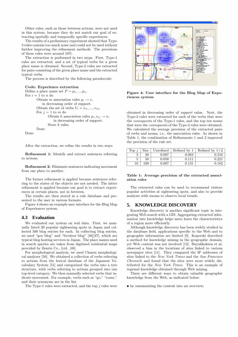
Figure 4 shows an example user interface for the Blog Mapof Experiences system.
4.3 EvaluationWe evaluated our system on real data. First, we man-
ually listed 20 popular sightseeing spots in Japan and col-lected 500 blog entries for each. In collecting blog entries,we used “goo blog” and “livedoor blog” [46][47], which aretypical blog hosting services in Japan. The place names usedin search queries are taken from digitized residential mapsprovided by Zenrin Co., Ltd. [48].
For morphological analysis, we used Chasen morphologi-cal analyzer [50]. We obtained a collection of verbs referringto actions from the lexical database of the Japanese Vo-cabulary System [51] and categorized the verbs into a treestructure, with verbs referring to actions grouped into onetop-level category. We then manually selected verbs that in-dicate movement. For example, verbs such as “go,” “come,”and their synonyms are in the list.
The Type-1 rules were extracted, and the top j rules were
Figure 4: User interface for the Blog Map of Expe-riences system
obtained in decreasing order of support value. Next, theType-2 rules were extracted for each of the verbs that werethe consequents of the Type-1 rules, and the top ten nounsthat were the consequents of the Type-2 rules were obtained.We calculated the average precision of the extracted pairsof verbs and nouns, i.e., the association rules. As shown inTable 1, the combination of Refinements 1 and 2 improvedthe precision of the rule set.
Top j Size Unrefined Refined by 1 Refined by 1+23 30 0.007 0.083 0.2165 50 0.058 0.111 0.221
10 100 0.087 0.131 0.182
Table 1: Average precision of the extracted associ-ation rules
The extracted rules can be used to recommend visitorspopular activities at sightseeing spots, and also to provideanalysts with means to observe local trends.
5. KNOWLEDGE DISCOVERYKnowledge discovery is another significant topic in inte-
grating Web search with a GIS. Aggregating extracted infor-mation into knowledge helps users learn the characteristicsof a region more efficiently.
Although knowledge discovery has been widely studied inthe database field, applications specific to the Web and togeographic information are limited [9]. Koperski describeda method for knowledge mining in the geographic domain,yet Web content was not involved [12]. Buyukkokten et al.observed a bias in the locations of sites linked to variousnewspaper sites [11]. They compared the IP addresses ofsites linked to the New York Times and the San FranciscoChronicle and found that the sites were more widely dis-tributed for the New York Times. This is an example ofregional knowledge obtained through Web mining.
There are different ways to obtain valuable geographicknowledge from the Web, as indicated below:
› by summarizing the content into an overview;
› by removing the overlaps among content;
› by identifying rules or patterns (i.e., association rules) inthe content;
› by identifying the statistical tendencies in the contentdata.
We next describe a system that creates one of the simplestkinds of geographic knowledge, the cognitive significance ofa place name. Focusing on a simple type of knowledge en-ables the system to obtain knowledge with a relatively smallamount of data.
5.1 Place Name RankerIn general, maps present place names that are significant
within its region. Significance of a place name is cogni-tive information, rather than physical information. Usually,mapmakers select place names for a map manually. Thisis a labor intensive task, especially for a city map, wherefrequent updating is necessary. A selection is based on asubjective judgment, and may not match intuitions of manyusers. In addition, the result of a selection is qualitative, di-viding place names into significant ones and non-significantones. If the cognitive significance of place names were mea-sured quantitatively, place names presented on a map candynamically be selected as a map zooms.
The term landmark is often used to indicate a cognitivelysignificant geographic object [20][21]. Landmarks have beenstudied as a part of a cognitive map, which is a mental modelof geographic space that a person has in mind [17][18][19].Such cognitive information is important in applications thatinvolves human behavior on a geographic scale. This is indi-cated in that maps without names of significant geographicobjects are often inconvenient for daily use.
Since the value of cognitive significance for a place nameis a type of information that is not present in an ordinaryGIS, we considered it an appropriate target for knowledgediscovery from the Web.
We implemented a system, Place Name Ranker, whichranks place names by their significance based on the waythey appear on Web content. The method applies conven-tional text mining techniques to Web pages collected by aWeb crawler. Although the cognitive significance of a geo-graphic object is a subjective measure differing from personto person, we assumed that the average figure is still use-ful for many applications. The following subsections definemeasures which are expected to represent the cognitive sig-nificance of geographic objects.
5.1.1 Document FrequencyThe document frequency (DF) of a term is defined as the
number of documents (Web pages) that contain the term.This measure is commonly used in text mining [14]. It iscalculated as follows:
d(pi) = |{d ∈ D|pi ∈ s ∧ s ∈ d}|, (1)
where pi indicates the target place name (for which the DFis calculated), D is the document set, and s is a sentence.This is one of the simplest measures of word frequency in aset of documents.
5.1.2 Regional Co-occurrence SummationA shortcoming of the DF is that it does not examine
whether a place name is used in a spatial context or not.Therefore, branches of enterprises, universities, or chain storesare often highly ranked in terms of DF. To avoid this, weneed to measure the frequency with which a place name isactually used in a spatial context. We do this by calculat-ing the regional co-occurrence summation (RS). We assumethat when two neighboring place names appear in the samedocument, they likely are both used in a spatial context. Interms of text mining, we consider the co-occurrence of twoneighboring place names to be an indicator of spatial con-text. Co-occurrence is a commonly used measure for termrelationships in text mining [14, 16].
The RS is defined as the total number of co-occurrencesthat the target place name has with the surrounding placenames. Before calculating it, we must first define the sur-rounding place names. We call this set the physical prox-imity of the target place name. One way to define this isto use a threshold distance:
P ′(p) = {pi|pi ∈ Pall ∧ δ(p, pi) ≤ R ∧ pi ̸= p}, (2)
where p is the target place name, P ′ is the threshold-basedphysical proximity, Pall is the original set of place names,the function δ gives the distance between place names, andR indicates the threshold distance.
This simple model, however, is inappropriate if the targetarea contains both dense and sparse distributions of placenames, because some place names will have a large numberof neighboring place names and others will have only a few.As a result, this measure will have low reliability.
We thus define the physical proximity instead as the setof n-closest place names from the target place name. Sucha set can be obtained by sorting the place names accordingto their distances from the target place name:
P (p) = {pi|pj ∈ Pall∧δ(p, pj) ≤ δ(p, pj+1)∧1 ≤ i ≤ n∧pi ̸= p}.(3)
Next, the formula for the RS is
r(pi) =X
pj∈P (pi)
κ(pi, pj), (4)
where κ(pi, pj) is the number of documents (Web pages)containing both pi and pj . In other words, κ(pi, pj) is thenumber of co-occurrences between pi and pj , in terms ofdocuments.
The use of the RS reduces the effect of ambiguity in placenames. Suppose that place name a indicates two differentcoordinates, xa and xa′ , while place name b indicates co-ordinate xb. Suppose also that the distances between thethree coordinates follow the order
˛
˛xa ` xb
˛
˛ <˛
˛xa′ ` xb
˛
˛.If a and b co-occur in document A, a in document A likelyrefers to coordinate xa, rather than to xa′ . Because the DFdoes not account for such ambiguity, we expect the RS toperform better than the DF in extracting significance in aspatially restricted sense.
Although various distances can be defined (i.e., the net-work metric distance and the time distance), we use theEuclidean distance between coordinates, since the data nec-

essary for calculating the other distances are not as easilyobtained for many regions.
5.2 System ArchitectureBased on these two measures, we implemented our Place
Name Ranker system. The main components are shown inFigure 5. The basic data used by the system are (1) placenames and their coordinates from a GIS and (2) text contentfrom the Web.
Figure 5: Architecture of Place Name Ranker
A focused crawler is a special type of Web crawler thatcollects pages that only fulfill certain conditions. In otherwords, links are traced only when a page satisfies these con-ditions. The conditions can include the existence of certainkeywords or high similarity to given example pages. Focusedcrawlers have been reported to have higher efficiency in re-trieving Web pages for certain topics [13]. The underlyingassumption is that pages concerning certain topics are morelikely to be linked to pages discussing the same topic.
Because our objective is to extract significant place namesfor a certain target region, we use a focused crawler for ef-ficient retrieval, and we set one condition-the page mustcontain at least one place name from within the region ofinterest. Due to the ambiguity of place names, not all of theretrieved pages will discuss the target region. Nevertheless,the ratio of related pages is higher than with a conventionalcrawler.
After measuring the values for cognitive significance, themap interface presents the place names with the top k mea-sured values.
5.3 EvaluationWe tested this system by determining how well it could
assign values to place names. To evaluate the appropriate-ness of the proposed measures, DF and RS, we performedan experiment using the data indicated below.
Participants: 36 residents of the target region, plus 14people from outside the region.
Responses: Each participant was asked to select the 20most significant place names in the target region. The resultcontained 275 distinct place names.
GIS data: The place name data were taken from a regu-
lar GIS, a digitized residential map for Kyoto, Japan, pro-vided by Zenrin Co., Ltd. [48]. The map data were dividedinto layers, including a “significant objects” layer contain-ing 7109 place names. Although we could assume objects inthis layer to be significant, their levels of significance var-ied. Famous temples and ordinary elementary schools wereall included in the same layer, and no quantitative value ofsignificance was assigned to the objects. Our goal in this ex-periment was to see if the system could assign a significancevalue to each of these names.
Web documents: As a document set, we used 157,297 Webpages collected by the focused crawler. Only the text partswere used in the information extraction. The total data sizewas 2.45 GB. To calculate the DF, we used the Namazu full-text search engine [49]. Prior to the search, we added placenames taken from the GIS to the Namazu indexed word list.The RS was calculated in the same manner.
We used precision and recall to evaluate the two proposedmeasures. The definitions for the precision and recall are asfollows:
Precision =No. of Retrieved Correct Objects
No. of Retrieved Objects, (5)
Recall =No. of Retrieved Correct Objects
No. of Correct Objects in Population. (6)
We sorted the place names taken from the GIS in decreas-ing order of the two measures. Rank position k indicatesthat the precision and recall were calculated for the top kentries in the ranking. If k was small, the set was likelyto have high precision and low recall, while if k was large,the opposite situation was likely. The precision and recallare functions of k. A precision-recall curve (P-R curve) iscommonly used to visualize a series of precision and recallpairs obtained by varying k [16].
We then sorted the place names from the GIS in decreas-ing order of the calculated DF and RS values. The top kplace names were selected, and their precision and recall val-ues were calculated with respect to a set of significant placenames judged manually.
We graphed the points where the recall increased in or-der to make the P-R curve smooth. By renumbering theextracted pairs, we obtained a series of P-R pairs as a func-tion of a new parameter, j. We then averaged the P-R pairscollected from different participants for each j and obtainedan averaged P-R curve. This curve was a function of j.This method is called averaging by micro-evaluation [16].The value of k ranged from 1 to 7109 (= the number of sig-nificant place names in the GIS), j ranged from 1 to 20 (=the number of “correct answers” given by each participant),and the number of P-R pairs (to be averaged) was 50 (= thenumber of participants).
The averaged P-R curves for the DF and the RS are shownin Figure 6, and the precisions at different rank positions arelisted in Table 2. These results indicate that that RS per-formed relatively well as a measure for evaluating the cogni-tive significance of place names, especially when comparedto the DF. A more detailed discussion is given elsewhere[31].

Figure 6: P-R curves for the DF and the RS
Rank pos. DF RS5 0.016 0.368
10 0.140 0.21215 0.096 0.25920 0.106 0.239
Table 2: Precisions at different rank positions
The results show that by selecting an appropriate mea-sure, geographic knowledge can be effectively extracted fromthe Web.
6. PRESENTATIONA map interface is not the only way to present the re-
sult of local Web search. There are various other means ofpresentation, in different styles and media.
A number of methods have been proposed as new pre-sentation schemes for geographic information, especially forpresentation on mobile devices Since mobile devices havelimited display capacity, the presentation method is of greatimportance. Kim et al. implemented a mobile tour-guidesystem that automatically finds Web services and presentsthe integrated results on a map interface [23]. Gardinerand Carswell developed a system that processes directionalqueries with respect to the user’s view [24]. Their CulturalHeritage Interface enables the user to obtain informationabout locations by specifying directions with respect to him-self or herself. Huang et al. implemented a system that inte-grates a GIS, virtual reality (VR), and the Internet throughthe Virtual Reality Modeling Language (VRML) [25]. Theintegration discussed in their paper covers only VRML dataand does not involve other types of media on the Web, suchas text.
The presentation schemes for the Web with GIS, however,can proceed in several different directions:
1. unrestricted by maps (the map interface is not the onlyway to present geographic content);
2. unrestricted by (conventional) Web browsers (the Webbrowser is not the only way to present local Web searchresults);
3. unrestricted by explicitly specifying queries (proactivepresentation).
The last item indicates that most of the conventional dig-itized map applications are built on the query-and-responsemodel. The map interface waits for a user query and presentsthe result in response. That is, these are query-driven sys-tems.
In the following subsections, we describe an example of anew mode of presentation for the Web search integrated witha GIS. This system uses neither a map nor a Web browser,and it is also proactive presentation.
6.1 Web Car RadioThe Web Car Radio enables users to listen to Web con-
tent as they drive a vehicle. The location of the vehicle isconstantly tracked using GPS. As with listening to a carradio, a user can select various channels, each focusing onvarious topics of interest, such as restaurants, events, andsightseeing spots. The concept of this system is illustratedin Figure 7.
Figure 7: Web Car Radio
The Web Car Radio has a user interface that uses a vehi-cle’s motion as input. The user obtains Web content withoutexplicitly specifying queries. In return, the system presentsWeb content through sound by using speech synthesis. Thesystem is thus based on the concept of proactive or query-free browsing [26].
6.2 System ArchitectureWeb Car Radio extracts regional information from the
Web and presents it to the driver and his fellow passengersby speech synthesis.
The primary source of information used is personal diarysites on the Web. Since diaries are generally expressed ina conversational style, we considered them appropriate forpresentation as radio programs. Many of Web diary sites to-day are provided as Weblogs (blogs), and data are availablein the RSS style. Now that there are many non-commercialRSS search engines, the content for Web Car Radio can eas-ily be collected [46][47].
In the process, the system first map blog entries to geo-graphic locations. By using various location identificationtechniques, the sytem maps the addresses and place namescontained in a blog entry[1][7]. Some blog entries now havespatial tags as well, making them easier to use, althoughthe tags may not contain all of the locations to which a blogentry refers.
The location of the vehicle is obtained by GPS. Geo-graphic data in the GIS provide the set of addresses andwell-known place names located close to the vehicle’s loca-tion. Next, the system performs a Web search and obtainWeb pages. It extracts phrases that contain addresses orplace names, as well as their surrounding phrases. The ex-tracted phrases are then provided through audio by speechsynthesis. The audio output is suitable for the driver, sincehe or she is unable to watch a screen.
Selecting a channel on Web Car Radio corresponds to se-lecting keywords for a Web search. Each channel has a setof keywords representing certain topics. The system usesthese keywords to filter the retrieved search results. Therelevance between the document and the selected channel iscalculated by the cosine measure [15]. The system also se-lects Web content that contains place names, and rank themin the order of proximity to the vehicle’s present location.For example, if the user sets “restaurants” as the topic, theWeb content concerning local restaurants is searched andpresented by speech synthesis.
Entries are ordered by the measure m(xc, p, D,vk), whichis calculated as:
m(xc, p, D,vk) = −kad(xc, x(p)) + kbS(C)(vk,vD), (7)
where d is the distance function, xc is the current vehiclelocation, x(p) is the location of the place name p containedin the document D, vk is the selected channel’s keywordvector, vD is the document vector for document D, S(C) isthe cosine similarity measure, and ka and kb are arbitrarypositive coefficients, optimized through learning.
Once an entry is selected, it is presented to its end, sincethe discontinuity in speech would confuse the user. Whilethe vehicle is moving, the measurement is repeatedly calcu-lated after a set time interval t passes.
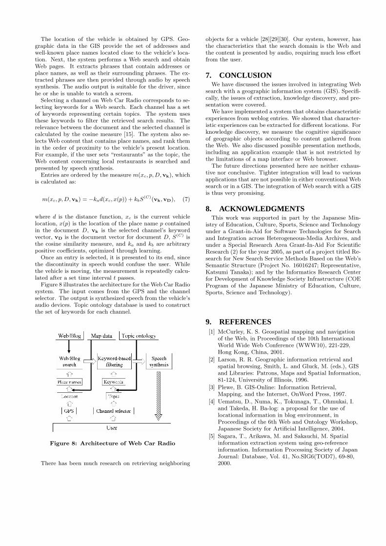
Figure 8 illustrates the architecture for the Web Car Radiosystem. The input comes from the GPS and the channelselector. The output is synthesized speech from the vehicle’saudio devices. Topic ontology database is used to constructthe set of keywords for each channel.
Figure 8: Architecture of Web Car Radio
There has been much research on retrieving neighboring
objects for a vehicle [28][29][30]. Our system, however, hasthe characteristics that the search domain is the Web andthe content is presented by audio, requiring much less effortfrom the user.
7. CONCLUSIONWe have discussed the issues involved in integrating Web
search with a geographic information system (GIS). Specifi-cally, the issues of extraction, knowledge discovery, and pre-sentation were covered.
We have implemented a system that obtains characteristicexperiences from weblog entries. We showed that character-istic experiences can be extracted for different locations. Forknowledge discovery, we measure the cognitive significanceof geographic objects according to content gathered fromthe Web. We also discussed possible presentation methods,including an application example that is not restricted bythe limitations of a map interface or Web browser.
The future directions presented here are neither exhaus-tive nor conclusive. Tighter integration will lead to variousapplications that are not possible in either conventional Websearch or in a GIS. The integration of Web search with a GISis thus very promising.
8. ACKNOWLEDGMENTSThis work was supported in part by the Japanese Min-
istry of Education, Culture, Sports, Science and Technologyunder a Grant-in-Aid for Software Technologies for Searchand Integration across Heterogeneous-Media Archives, andunder a Special Research Area Grant-In-Aid For ScientificResearch (2) for the year 2005, as part of a project titled Re-search for New Search Service Methods Based on the Web’sSemantic Structure (Project No. 16016247; Representative,Katsumi Tanaka); and by the Informatics Research Centerfor Development of Knowledge Society Infrastructure (COEProgram of the Japanese Ministry of Education, Culture,Sports, Science and Technology).
9. REFERENCES[1] McCurley, K. S. Geospatial mapping and navigation
of the Web, in Proceedings of the 10th InternationalWorld Wide Web Conference (WWW10), 221-229,Hong Kong, China, 2001.
[2] Larson, R. R. Geographic information retrieval andspatial browsing, Smith, L. and Gluck, M. (eds.), GISand Libraries: Patrons, Maps and Spatial Information,81-124, University of Illinois, 1996.
[3] Plewe, B. GIS-Online: Information Retrieval,Mapping, and the Internet, OnWord Press, 1997.
[4] Uematsu, D., Numa, K., Tokunaga, T., Ohmukai, I.and Takeda, H. Ba-log: a proposal for the use oflocational information in blog environment, inProceedings of the 6th Web and Ontology Workshop,Japanese Society for Artificial Intelligence, 2004.
[5] Sagara, T., Arikawa, M. and Sakauchi, M. Spatialinformation extraction system using geo-referenceinformation. Information Processing Society of JapanJournal: Database, Vol. 41, No.SIG6(TOD7), 69-80,2000.

[6] Woodruff, A. G. and Plaunt, C. GIPSY: Automatedgeographic indexing of text documents. Journal of theAmerican Society for Information Science, 45, 9,645-655, 1994.
[7] Kanada, Y. A method of geographical name extractionfrom Japanese text for thematic geographical search,in Proceedings of the 8th International Conference onInformation and Knowledge Management, 46-54,Kansas City, Missouri, 1999.
[8] Agrawal, R. and Srikant, R. Fast algorithms formining association rules in large databases, inProceedings of the 20th International Conference onVery Large Data Bases (VLDB’94), 487-499, 1994.
[9] Piatestsky-Shapiro, G. and Frawley, W. J. (eds.).Knowledge Discovery in Databases, MIT Press,Boston, Massachusetts, 1991.
[10] Lim, E. P., Goh, D., Liu, Z., Ng, W. K., Khoo C. andHiggins, S. E. G-Portal: A map-based digital libraryfor distributed geospatial and georeferenced resources,in Proceedings of the 2nd ACM+IEEE JointConference on Digital Libraries (JCDL 2002), 351-358,Portland, Oregon, 2002.
[11] Buyukkokten, O., Cho, J., Garcia-Molina, H.,Gravano, L. and Shivakumar, N., Exploitinggeographical location information of Web pages, inProceedings of the ACM SIGMOD Workshop on theWeb and Databases (WebDB’99), Philadelphia,Pennsylvania, 1999.
[12] Koperski, K., Han, J. and Adhikary, J. Miningknowledge in geographical data. Communications ofthe ACM, 26, 1, 65-74, 1998.
[13] Chakrabarti, S., van den Berg, M. and Dom, B.Focused crawling: a new approach to topic-specificWeb resource discovery, in Proceedings of the 8thInternational World Wide Web Conference (WWW8),Toronto, Canada, 1999.
[14] Salton, G. Automatic Information Organization andRetrieval, McGraw-Hill Inc., 1968.
[15] Salton G. and Buckley, C. Term-weighting approachesin automatic text retrieval. Information Processingand Management, 24, 5, 513-523, 1988.
[16] van Rijsbergen, C. J. Information Retrieval - SecondEdition, Butterworth & Co Publishers Ltd, 1979.
[17] Lynch, K. The Image of the City, MIT Press, 1960.
[18] Neisser, U. Cognition and Reality: Principles andImplications of Cognitive Psychology, W. H. Freemanand Company, 1976.
[19] Couclelis, H., Golledge, R., Gale, N. and Tobler, W.Exploring the anchor-point hypothesis of spatialcognition. Journal of Environmental Psychology, 7, 2,99-122, 1987.
[20] Raubal, M. and Winter, S. Enriching wayfindinginstructions with local landmarks. GeographicInformation Science, Lecture Notes in ComputerScience 2478, 243-259, Springer-Verlag, 2003.
[21] Elias, B. Extracting landmarks with data miningmethods. Spatial Information Theory: Foundations ofGeographic Information Science, Lecture Notes inComputer Science 2825, 375-389, Springer-Verlag,2003.
[22] Avesani, P., Cova, M., Hayes, C. and Massa, P. (eds.).
Proceedings of the WWW2005 2nd Annual Workshopon the Weblogging Ecosystem: Aggregation, Analysisand Dynamics, Chiba, Japan, 2005 (entire issue).
[23] Kim, J. W., Kim, C. S., Gautam, A. and Lee, Y.Location-based tour guide system using mobile GISand Web crawling. Web and Wireless GeographicalInformation Systems, Lecture Notes in ComputerScience 3428, 51-63, Springer-Verlag, 2005.
[24] Gardiner, K. and Carswell, J. D. Viewer-baseddirectional querying for mobile applications, inProceedings of the 3rd International Workshop onWeb and Wireless Geographical Information Systems(W2GIS 2003), 73-83, Rome, Italy, 2003.
[25] Huang, B., Jiang, B. and Lin, H. An integration ofGIS, virtual reality and the Internet for spatial dataexploration. International Journal of GeographicalInformation Science, 15, 5, 439-456, 2001.
[26] Nadamoto, A., Kondo, H. and Tanaka, K.WebCarousel: Restructuring Web search results forpassive viewing in mobile environments, inProceedings of the 7th International Conference onDatabase Systems for Advanced Applications(DASFAA 2001), Hong Kong, China, 2001.
[27] Yang, Y. and Claramunt, C. A Hybrid Approach forSpatial Web Personalization. Web and WirelessGeographical Information Systems, Lecture Notes inComputer Science 3428, 206-221, Springer-Verlag,2005.
[28] Zhang, J., Zhu, M., Papadias, D., Tao, Y. and Lee, D.L. Location-based spatial queries, in Proceedings ofthe 2003 ACM SIGMOD International Conference onManagement of Data, 443-454, San Diego, California,2003.
[29] Mokbel, M. F., Xiong, X. and Aref, W. G. SINA:Scalable incremental processing of continuous queriesin spatio-temporal databases, in Proceedings of the2004 ACM SIGMOD International Conference onManagement of Data, 623-634, Paris, France, 2004.
[30] Ishikawa Y., Tsukamoto, Y. and Kitagawa, H.Implementation and evaluation of an adaptiveneighborhood information retrieval system for mobileusers, in Proceedings of the 3rd InternationalWorkshop on Web and Wireless GeographicalInformation Systems (W2GIS 2003), 17-26, Rome,Italy, 2003.
[31] Tezuka, T. and Tanaka, K. Landmark extraction: aWeb mining approach. Spatial Information Theory,Lecture Notes in Computer Science 3693, 379-396,Springer-Verlag, 2005.
[32] Google Local, http://local.google.com/
[33] Google Earth, http://earth.google.com/
[34] Yahoo! Local Maps, http://maps.yahoo.com/
[35] Ask Jeeves Local, http://local.ask.com/
[36] MSN City Guides, http://local.msn.com/
[37] AOL Local Search, http://localsearch.aol.com/
[38] Switchboard, http://www.switchboard.com/
[39] MapQuest, http://www.mapquest.com/
[40] ShopLocal, http://www.shoplocal.com/
[41] CitySearch, http://www.citysearch.com/
[42] WCities, http://www.wcities.com

[43] WorldKit,http://www.brainoff.com/worldkit/index.php
[44] DC Metro Blogmap,http://www.reenhead.com/map/metroblogmap.html
[45] nyc bloggers, http://www.nycbloggers.com/
[46] goo blog, http://blog.goo.ne.jp
[47] livedoor blog, http://blog.livedoor.com/
[48] Zenrin Co., Ltd., http://www.zenrin.co.jp/
[49] Namazu: a Full-Text Search Engine,http://www.namazu.org/index.html.en
[50] Chasen, http://chasen.aist-nara.ac.jp/index.html
[51] Japanese Vocabulary System,http://www.ntt-tec.jp/technology/C404.html