The Development of Settlement Patterns in.the Wandle Valley ...
272
The Development of Settlement Patterns in.the Wandle Valley from Earliest Times to the Saxon Period Collaborative M.Phil Thesis by Lesley Adkins Department of General Studies, University of Surrey
-
Upload
khangminh22 -
Category
Documents
-
view
0 -
download
0
Transcript of The Development of Settlement Patterns in.the Wandle Valley ...
The Development of Settlement Patterns in.the Wandle
Valley from Earliest Times to the Saxon Period
Collaborative M.Phil Thesis
by
Lesley Adkins
Department of General Studies, University of Surrey
ProQuest Number: 10797510
All rights reserved
INFORMATION TO ALL USERS The quality of this reproduction is dependent upon the quality of the copy submitted.
In the unlikely event that the author did not send a com p le te manuscript and there are missing pages, these will be noted. Also, if material had to be removed,
a note will indicate the deletion.
uestProQuest 10797510
Published by ProQuest LLC(2018). Copyright of the Dissertation is held by the Author.
All rights reserved.This work is protected against unauthorized copying under Title 17, United States C ode
Microform Edition © ProQuest LLC.
ProQuest LLC.789 East Eisenhower Parkway
P.O. Box 1346 Ann Arbor, Ml 48106- 1346
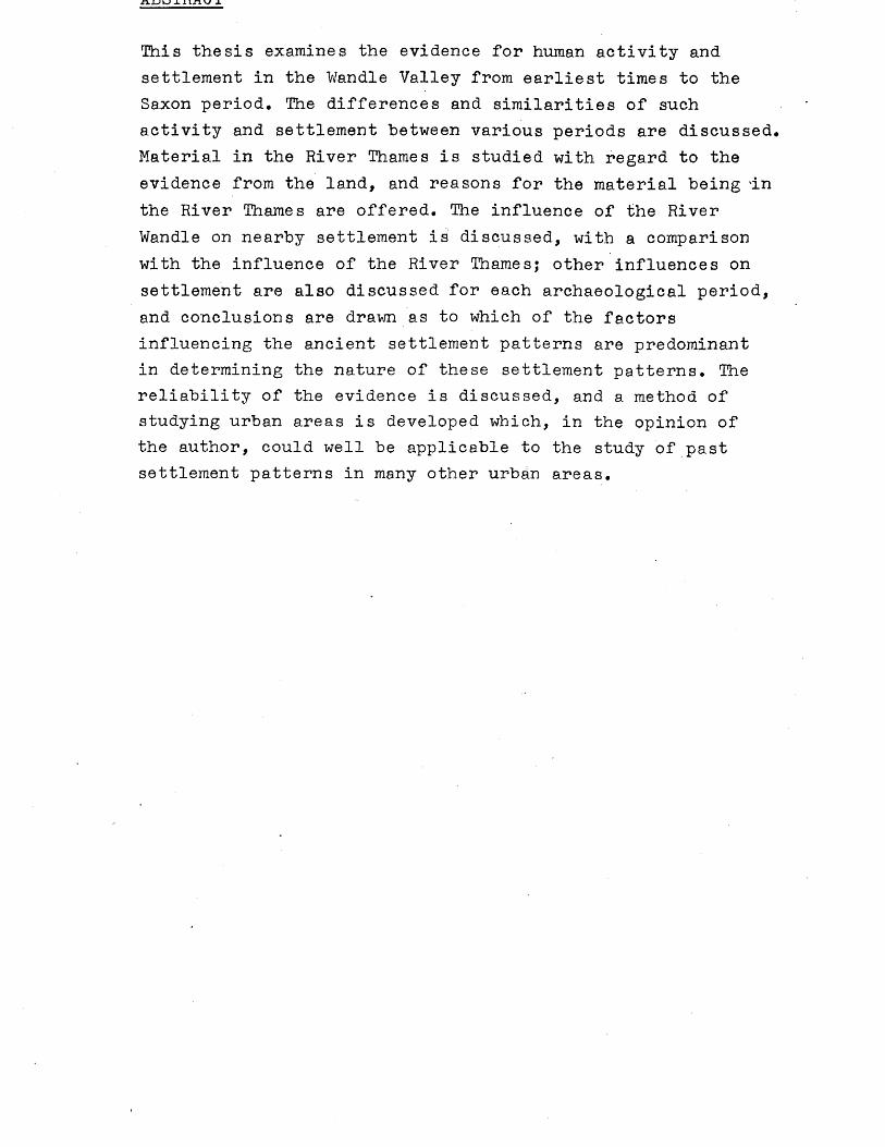
This thesis examines the evidence for human activity and settlement in the Wandle Valley from earliest times to the Saxon period. The differences and similarities of such activity and settlement between various periods are discussed. Material in the River Thames is studied with regard to the evidence from the land, and reasons for the material being In the River Thames are offered. The influence of the River Wandle on nearby settlement is discussed, with a comparison with the influence of the River Thames; other influences on settlement are also discussed for each archaeological period, and conclusions are drawn as to which of the factors influencing the ancient settlement patterns are predominant in determining the nature of these settlement patterns. The reliability of the evidence is discussed, and a method of studying urban areas is developed which, in the opinion of the author, could well be applicable to the study of past settlement patterns in many other urban areas.
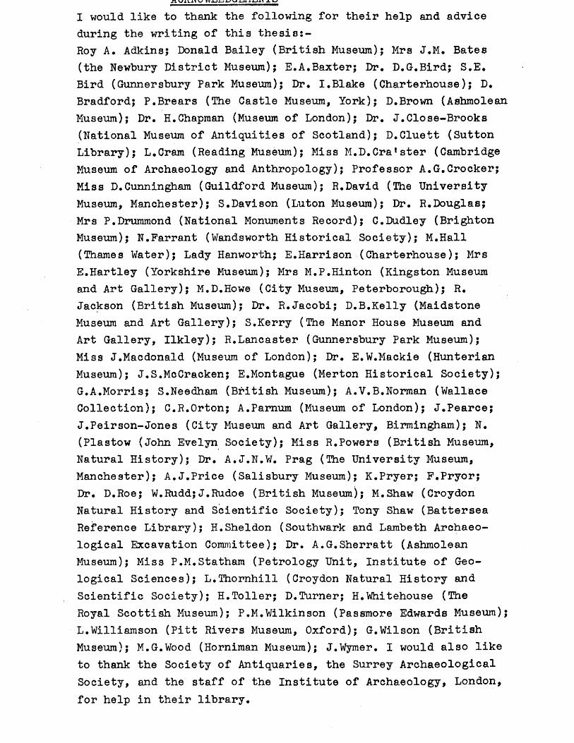
I would like to thank the following for their help and advice during the writing of this thesis:-Roy A. Adkins; Donald Bailey (British Museum); Mrs J.M. Bates (the Newbury District Museum); E.A.Baxter; Dr. D.G.Bird; S.E. Bird (Gunnersbury Park Museum); Dr. I.Blake (Charterhouse); D. Bradford; P.Brears (The Castle Museum, York); D.Brown (Ashmolean Museum); Dr. H.Chapman (Museum of London); Dr. J.Close-Brooks (National Museum of Antiquities of Scotland); D.Cluett (Sutton Library); L.Cram (Reading Museum); Miss M.D.Cra!ster (Cambridge Museum of Archaeology and Anthropology); Professor A.G.Crocker; Miss D.Cunningham (Guildford Museum); R.David (The University Museum, Manchester); S.Davison (Luton Museum); Dr. R.Douglas;Mrs P.Drummond (National Monuments Record); C.Dudley (Brighton Museum); N.Farrant (Wandsworth Historical Society); M.Hall (Thames Water); Lady Hanworth; E.Harrison (Charterhouse); Mrs E.Hartley (Yorkshire Museum); Mrs M.P.Hinton (Kingston Museum and Art Gallery); M.D.Howe (City Museum, Peterborough); R. Jackson (British Museum); Dr. R.Jacobi; D.B.Kelly (Maidstone Museum and Art Gallery); S.Kerry (The Manor House Museum and Art Gallery, Ilkley); R.Lancaster (Gunnersbury Park Museum);Miss J.Macdonald (Museum of London); Dr. E.W.Mackie (Hunterian Museum); J.S.McCracken; E.Montague (Merton Historical Society); G.A.Morris; S.Needham (British Museum); A.V.B.Norman (Wallace Collection); C.R.Orton; A.Pamum (Museum of London); J.Pearce; J.Peirson-Jones (City Museum and Art Gallery, Birmingham); N. (Plastow (John Evelyn Society); Miss R.Powers (British Museum, Natural History); Dr. A.J.N.W. Prag (The University Museum, Manchester); A.J.Price (Salisbury Museum); K.Pryer; F.Pryor;Dr. D.Roe; W.Rudd;J.Rudoe (British Museum); M.Shaw (Croydon Natural History and Scientific Society); Tony Shaw (Battersea Reference Library); H.Sheldon (Southwark and Lambeth Archaeological Excavation Committee); Dr. A.G.Sherratt (Ashmolean Museum); Miss P.M.Statham (Petrology Unit, Institute of Geological Sciences); L.Thornhill (Croydon Natural History and Scientific Society); H.Toller; D.Turner; H.Whitehouse (The Royal Scottish Museum); P.M.Wilkinson (Passmore Edwards Museum); L.Williamson (Pitt Rivers Museum, Oxford); G.Wilson (British Museum); M.G.Wood (Horniman Museum); J.Wyraer. I would also like to thank the Society of Antiquaries, the Surrey Archaeological Society, and the staff of the Institute of Archaeology, London, for help in their library.
CONTENTS Page numberAbstract .....;.............................. iAcknowledgements ........................... iiContents ............................... iii - viIntroduction
Relief, drainage and geology 1 - 3Earlier Research on the Wandle Valley. 3 - 4Comparable Work on Other A r e a s ....... 4 - 5Sources of Data .................. 5 - 7Use of Data ..................... 8Statistical Analysis .................. 8 - 9Map 1 : Built-up Areas in theWandle V a l l e y ...................... . 10Map 2 : Place-Names .................. 11Map 3 : Drift Geology................ 12Key to map 3 .......................... 13Map 4 : Relief and Drainage ...... . 14
Chapter 1 : The Palaeolithic PeriodIntroduction .................... ...... 15Statistical Analysis.. ................ 15 - 16Data for Statistical Analysis ........ 17 - 22Discussion ...................... 23 - 25Gazetteer of Sites and Finds ........ 2 6 - 3 6Map 5 : All Palaeolithic Findspots ... 37Map 6 : Distribution of PalaeolithicHandaxes ............................... 38Map 7 • Palaeolithic Implementsexcept Handaxes .................... 39Map 8 : Distribution of PalaeolithicFlake s ................................ . 40
Chapter 2 : The Mesolithic PeriodIntroduction .................. 41Statistical Analysis.. ................ 41 - 42Data for Statistical Analysis ...... 4 3 - 4 7Discussion .......................... 48 - 50Gazetteer of Sites and Finds ......... 51 - 58Map 9 : All Mesolithic Sites andFindspots ........................... .. 59Map 10 : Distribution of MesolithicTranchet Axes ......................... 60Map 11 : Mesolithic Implementsexcept Tranchet Axes.. ...... ......... 61
Map 12 : Distribution ofMesolithic Flint Flakes ............. 62
Chapter 3 : The Neolithic PeriodIntroduction ............... 63Statistical Analysis ................ 63 - 64Data for Statistical Analysis........ 6 5 - 6 9Discussion ........................... 65 - 69Gazetteer of Sites and Finds ....... 7 2 - 8 0Map 13 : All Neolithic Sites andFindspots ............................ 81Map 14 : Neolithic Flint Flakesand Artifacts (except axes) ....... 82Map 15 1 Distribution of NeolithicFlint and Stone Axes ................ 83
Chapter 4 : The Bronze AgeIntroduction ......................... 84Statistical Analysis ................ 8 4 - 8 5Data for Statistical Analysis ....... 8 6 - 8 9Discussion ........................... 90 - 91Gazetteer of Sites and Finds ........ 92 - 100Map 16 : All Bronze Age Sites andFindspots .............. . 101Map 17 : Bronze Age Flint and StoneArtifacts ........................... . 102Map 18 : Distribution of Bronze Age Hoards and Artifacts of Bronze ...... 103
Chapter 5 : The Iron AgeIntroduction ....................... 104Statistical Analysis................ 104 - 105Data for Statistical Analysis ....... 106 - 109Discussion........................... 110 - 111Gazetteer of Sites and Finds ........ 112 - 117Map 19 : All Iron Age Sites andFindspots ............................ 118Map 20 : Distribution of Iron AgeMetal Artifacts ..................... 119Map 21 : Distribution of Iron Age pottery, and artifacts of bone,stone and w o o d ....................... 120
Chapter 6 : The Roman PeriodIntroduction ...................... 121Statistical Analysis ................ 121 - 122
Data for Statistical Analysis ..... 123 - 129Discussion' ...................... 130 - 132Gazetteer of Sites and F i n d s ........ 133 - 146Map 22 : All Roman Sites andFindspots ....................... . 147Map 23 : Distribution of Roman coins. 148 Map 24 : Distribution of Romanpottery ............................... 149
Chapter 7 : The Saxon PeriodIntroduction ......................... 150Statistical Analysis .......... 150Data for Statistical Analysis ...... 151 - 155Discussion ...................... . 156 - 158Gazetteer of Sites and Finds ...... 159 - 164Map 25 : All Saxon Sites andFindspots .... ................ . 165
Chapter 8 : Discussion of the SettlementPatterns in the Wandle Valley ..... 166 - 194APPENDICESAppendix 1 : Gazetteer of Sites and Findsof Uncertain or Unknown Date ............. 195 - 199Appendix 2 : "Non-sites” .......... . 199Appendix 3 : Map 26 : 1-kilometre squaresused in statistical analysis ............. 200
Map 27 : 2-kilometre squares usedin statistical analysis .......... 201
Appendix 4 : 1-kilometre squares used in quadrat analysis :- list of square numbersand corresponding place names ............ 202 - 204
2-kilometre squares used in quadrat analysis:- list of square numbersand corresponding place n a m e s ..... . 205
Appendix 5 : Analysis of Data from theWandle V a l l e y .............................. 206 - 207Appendix 6 : Problems in Data Collectionand the Reliability of the Evidence ..... 207 - 212Appendix 7 : Discussion of Thames Finds 2 1 2 - 2 1 7Appendix 8 : List of accession numbers ofmaterial held in museums .................. 218 - 227Appendix 9 : Concordance table:- thesis numbers related to S.W. London Archaeological Unit site numbers ................. 228 - 239
UOnX>en^ S nuiuuci-Appendix 10 : Extracts from the Domesday-Book relevant to the Wandle V a l l e y ........ 240 - 243Appendix 11 : Work Outstanding............ 244 - 250Appendix 12 : Abbreviations used in thesis/Key used in thesis 251 - 252Bibliography............................... 253 - 264
inLroouc"cion
The Wandle Valley is now part of the south west quarter of Greater London, and is largely built.over. The object of this thesis is to cast some light on settlement patterns within this area, and to compare settlement patterns between periods. The thesis includes all archaeological periods from earliest times to the end of the Saxon period. The nature and credibility of the available evidence, the evidence for the distribution of material reflecting real settlement patterns rather than the distribution of archaeological fieldwork, and the methods of studying such an urban area have also been assessed (see below p. 5 and appendix 9); since there is very little opportunity for discovering new sites in this area (apart from areas such as Beddington sewage farm currently under excavation by R.Adkins and the author), a totally different approach to the study of past settlement is required than is normally applicable to a rural area. The author has concentrated on the evidence of past discoveries in order to find out about settlement patterns, a method of study which has never previously been seriously adopted (see below p . 4 ). Some material will inevitably have beenaccidentally omitted (see appendix 9), but it is very unlikely that any such material would fundamentally change the general conclusions of this thesis.
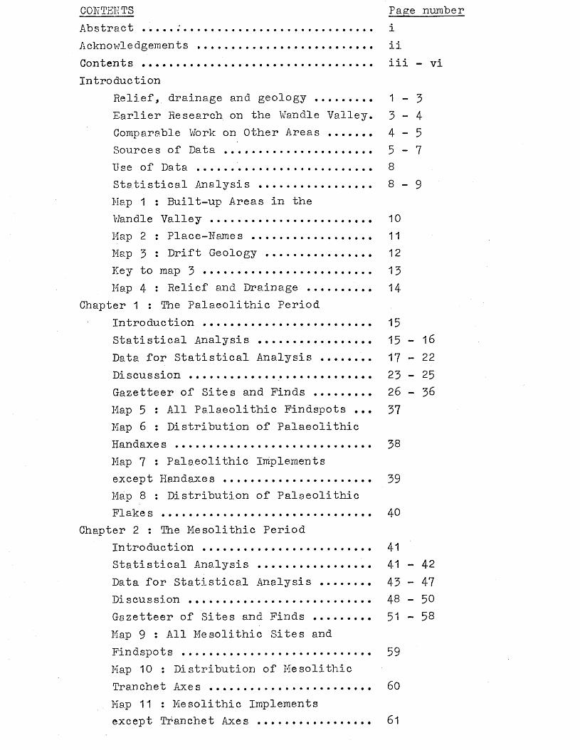
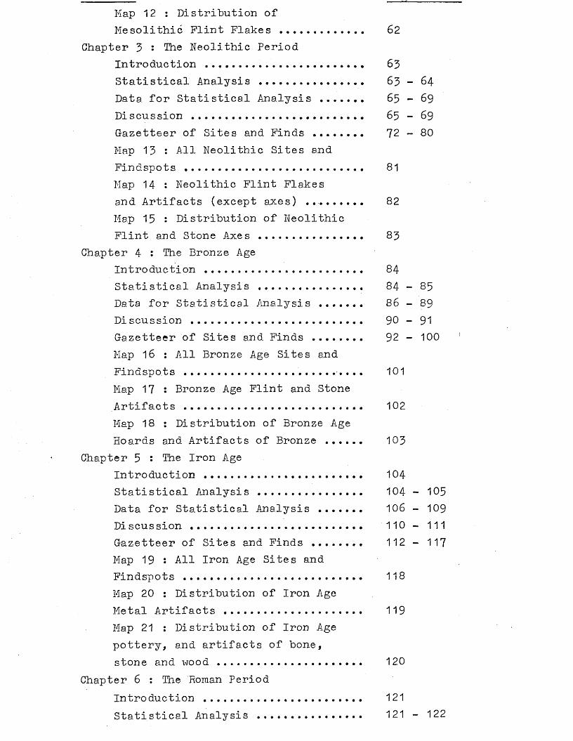
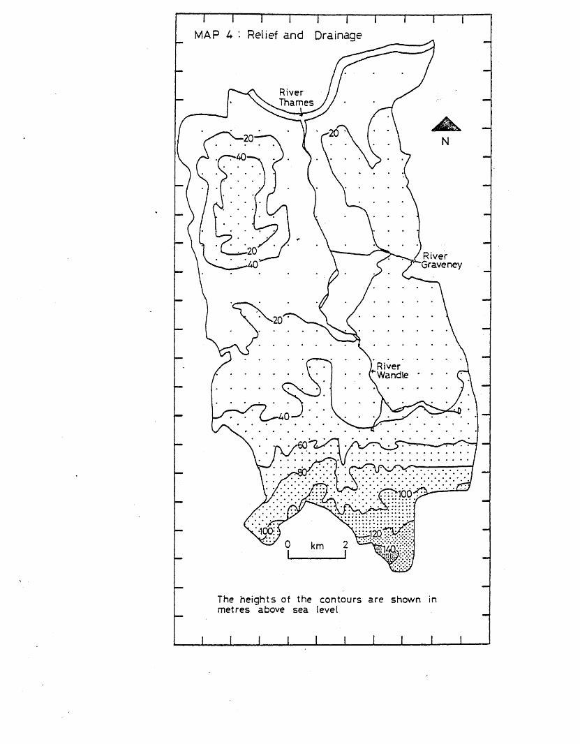
Relief, drainage and geologyThe area under consideration (termed the Wandle Valley) lies within the modern administrative boundary of Greater London, and is roughly equivalent to the London Boroughs of Wandsworth, Merton and Sutton. It covers 122 square kilometres in area.The Wandle Valley is almost completely urban in character, and bears little or no relation to the character of the area in earlier archaeological periods (see maps 1 and 2).
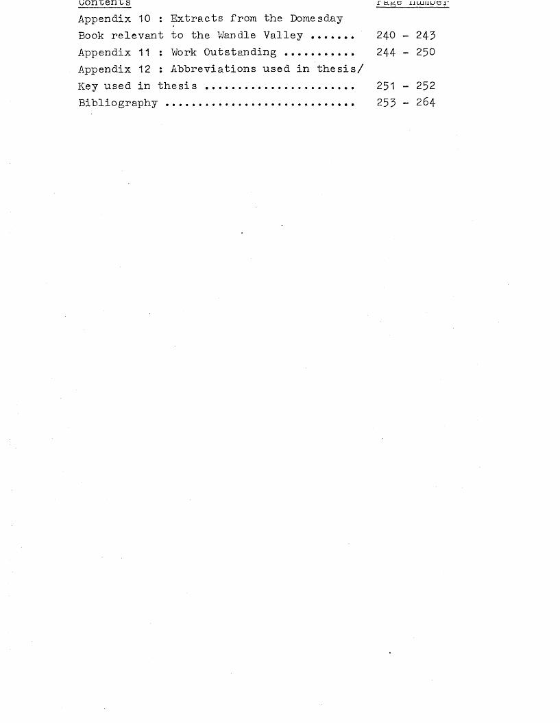
Tne River Wandle rises in the Wandle Park, Croydon, and at Carshalton Ponds, Carshalton, and flows northwards to drain into the River Thames (see map 4). The River Graveney, which is a small stream, runs into the River Wandle at Morden. The area under study varies from about 5 metres above sea level in the north near the River Thames to more steeply rising ground in the south, where the land is over 140 metres in
been artificially embanked and the flow of water controlled by locks and weirs in order to minimise flooding. Before this, the river would have flowed largely uncontrolled in a much wider channel, with more shallow water. The river may have flowed in several channels over a broad flood plain. (Evans 1975, 3 ) • There is no evidence to suggest any significant control of the River Thames in earlier periods, although there are discoveries such as the Bronze Age timber waterfront at Runnymede Bridge, Surrey, (Needham & Longley 1981) and the timber waterfronts along the Thames in the City of London dating from the Roman period onwards (Milne & Hobley 1981), which may imply extensive control of the River Thames in many archaeological periods not hitherto appreciated. However, it is believed that the course of the Thames has not changed since the end of the last glacial period (Wymer 1968, 22).The River Wandle would also have had a wider flood plain as it is unlikely to have been artificially embanked and channelled until very recent times. It is sometimes argued that the Wandle had its source in the Weald in prehistoric times, and flowed across the North Downs, finally meeting up with its present course and flowing into the Thames. It is more widely accepted, however, that the Wandle originated in the chalk downs. There ’are two arms of the Wandle; one rises in Carshalton from powerful springs which form ponds there, and the other main arm rises in Wandle Park, Croydon. There are numerous dry valleys running into the Downs which once contained streams, although they may have been formed by karst processes and not by the action of former streams. Peake says that karst processes probably played only a small part in the formation of dry valleys (1982, 97). Some dry valleys do sometimes have streams known as bournes. These flow after exceptionally heavy autumn rainfall which causes the water table to rise and intermittent springs to form. (Sherlock 1960; Twilley & Wilks 1974; Peake 1982).
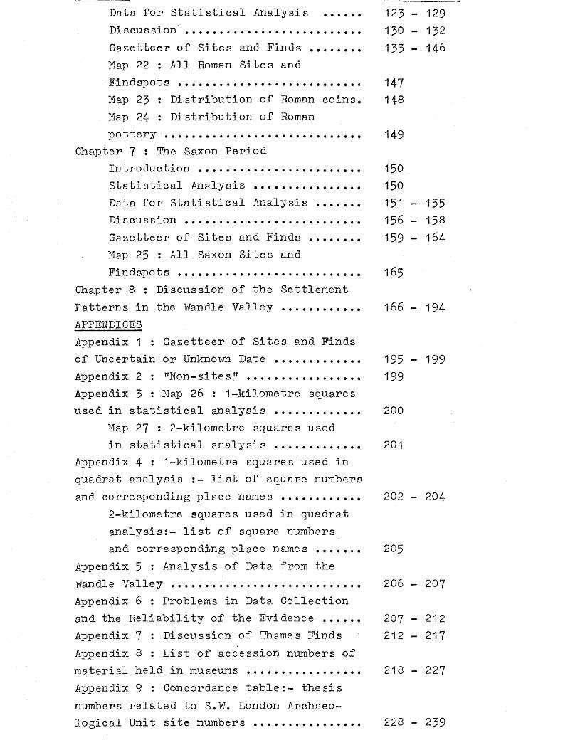
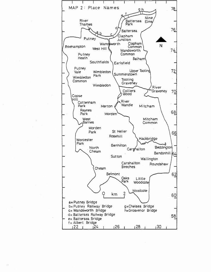
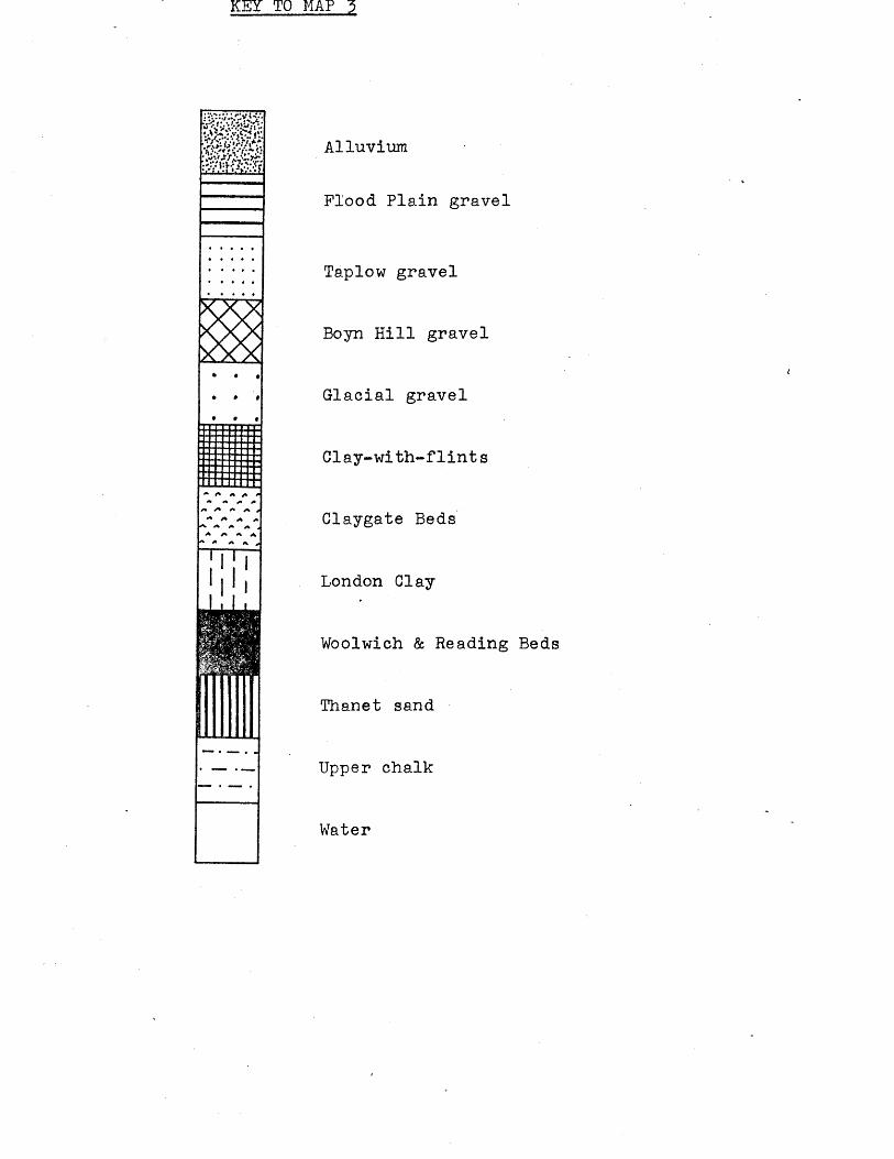
The Wandle Valley area consists of Eocene (Tertiary) deposits and chalk, with some recent and Pleistocene (Quaternary) deposits around the River Thames (see map 3). The chalk deposits are Upper Chalk which contains an abundance of flint. Chalk is the oldest geological deposit in the area. The Eocene deposits in the area in increasing order of age consist of London Clay, Claygate Beds, Woolwich and Reading Beds, and
Thanet Beds. Thanet Beds are the oldest Eocene deposit in tne area and occur as a narrow outcrop along the edge of the chalk; they consist of fine pale yellow or grey sand, with a layer of green loam and green-coated flints at the base. The Woolwich Beds pass laterally into the Reading Beds with no clear-cut division between them. The Woolwich Beds consist of clays, loams, sands and pebble beds, and the Reading Beds consist of clays and sands with thin bands of flint pebbles'. London Clay is a stiff dark grey or bluish-grey clay which weathers to a brown colour. In some areas (such as the area of Wimbledon Common) London Clay passes into Claygate Beds which consist of alternating beds of sand, and clay.
Pleistocene and recent deposits in the Wandle Valley in increasing order of age consist of alluvium,Flood Plain gravel, Taplow gravel, Boyn Hill gravel, Glacial gravel, and clay- with-flints. The Thames river terraces were formed by the action of the .River Thames and its tributaries. The highest terrace is the oldest one, and has been more widely denuded and incorporated in the lower terraces by river action. Each terrace consists of a sheet of gravel and sand with a deposit of brickearth over it: the gravels are mainly derived from flints from chalk. In decreasing order of age the terraces consist of the Boyn Hill terrace, Taplow terrace and Flood Plain terrace. Alluvium forms the most recent deposit, and appears to date from the Neolithic period onwards. (Sherlock 1960; Peake 1982).
Earlier Research on the Wandle Valley Some of the evidence in this area has been previously recorded in various publications (for example, Anderson 1882; Guildhall Museum 1908), but no attempt has ever been made to produce a systematic record of all the sites and finds for any archaeological period within the Wandle Valley, still less to interpret them. The closest approach is made in Time on our Side? A Survey of Archaeological Needs in Greater London. Report of a joint working party of the Department of the Environment, the Greater London Council, and the Museum of London (1976). The aim of Time on our Side? was to publish the known archaeology of the whole of the Greater London area (which excludes the City of London), to define threats to the archaeology, and to establish what resources were available to deal lAJ(fh these threats, and whether these resources were
a u ^ ^ u a w v . j - l x w a. w ̂ ̂ ̂ w j. ^ -------- ---------. w
propagandist rather than scholarly in its objectives. There are also several surveys on particular artifacts of a single archaeological period which cover a wide area and incorporate material from all or part of the Wandle Valley (for example, Adkins & Jackson 1978; Clarke 1970; Haselgrove 1978).
Comparable work on other areasThere are several surveys of successive archaeological periods in other areas, many of them popularly entitled "Sites and Monuments Records" ("SMRs"). These surveys are usually carried out by full-time archaeological bodies in Britain, usually as a basis for future archaeological work in those areas. SMRs usually consist of a card index or computer record of all the known sites and findspots in that area, with no interpretation. They are generally not published (such as the SMR of the Archaeology Unit, Milton Keynes Development Corporation).Some of the surveys have been published, in varying forms, and with a variety of emphases. Most published surveys deal with largely rural areas such as The Archaeology of the Berkshire Downs: an introductory survey 1978 by Julian C. Richards which studies an area of about 875 square kilometres of chalk downland. Another example of a rural-based survey is The North Derbyshire Archaeological Survey to AD 1500 1981 by C.R.Hart which studies the archaeology of rural North Derbyshire.
There are a few archaeological surveys which, undertake studies of urban areas. Time on our Side? has already been mentioned (see p. 3 ) and covers the Greater London area. Many of thesesurveys are limited in their approach, dealing only with a particular aspect of the archaeology of their urban area.The Archaeology of Warrington1s Past 1978 by Archaeological Surveys Ltd has its main emphasis on industrial archaeology. Historic Towns in Berkshire: an archaeological appraisal 1978 by Grenville G. Astill deals, as it suggests, with the archaeology of several towns from the early Medieval period only. Archaeology in the North. Report of the Northern Archaeological Survey 1978 by P.A.G.Clack & P.F.Gosling covers a large area of northern England, including 6 detailed surveys (Barnard Castle, Berwick, Carlisle, Durham, Morpeth and Newcastle). Very little attention is given to pre-Roman settlement. Indeed, the survey of the large urban area of Newcastle-upon-Tyne starts at the Roman period. The survey of
Durham aeais very oriei±y witn prenistory, saying insufficient fieldwork has taken place and cites two finds only. The survey of Berwick-upon-Tweed does not mention prehistory, and the survey of Carlisle starts only at the Roman period, although later on (p.171) it states "no pre- Roman find has yet been discovered within the walled area. However, a considerable number of chance finds (stone axes and hammers, arrowheads and spearheads, food vessels), principally of Bronze Age date, have been made in the vicinity", indicating that there would have been grounds for at least discussing the absence of material in Carlisle itself. The Archaeology of Cleveland 1979 edited by D.A.Pratt does mention prehistoric material but the publication is aimed at a popular market and so does not treat the subject in depth. Similarly, Lincoln the archaeology of an historic city 1975 by C.Colyer refers very briefly to prehistory (one page with photographs), as the booklet is aimed at a wide public.
It is therefore clear that little study has taken place in urban areas to evaluate settlement of these areas before the towns themselves came into being. Any interpretative survey of early archaeological periods (such as Richards 1978) is restricted to rural areas only, where much of the evidence can be supplemented by systematic fieldwork and aerial photography. Indeed, the general emphasis on surveys in rural areas is highlighted in Schadla-Hall & Shennan (1978, 87) where an archaeological survey is defined as "fieldwalking, combined with aerial photography and limited excavation", thereby excluding an urban area such as the Wandle Valley.The small amount of attention given to urban sites within general surveys usually only deals with the Saxon and Medieval development of the urban area itself, as seen above.
Sources of DataAs already mentioned, the area under study in this thesis is overwhelmingly urban in character, and so requires a totally different approach from the rural-based surveys in order to obtain information on past settlement. Fieldwork and aerial photography are of extremely limited use in such an area, but there is a wealth of other information which, when brought together, has provided a valuable source of evidence for past settlement and activity in the Wandle Valley. Much of the, evidence comes from non-scientific recovery of finds
or sixes irom une i^un or eany uii ueuuury. xne loiiowing sources of data on which this thesis is based have been used:-
a) Ordnance Survey cards:- the Ordnance Survey used to have an active Archaeology Division which undertook research and surveys throughout Great Britain. All information was kept as a card index and on maps, and was constantly updated. Much information was reported to and collected by the Ordnance Survey, and was never published, so the information on this card index is not often found in other sources. Although the card index is still accessible for study, the Archaeology Division is no longer active and its future remains uncertain; furthermore, the card index for the Greater London area including the Wandle Valley is in a fairly poor state, and so cannot be used as a basis for the survey of this area, as itso often is in other areas (cf Basford 1930, 11 where the chief source of information for the survey is said to be the Archaeology Division of the Ordnance Survey).b) Written and published sources:- one of the major sourcesof information in this area is published records dating mainly from 1850, although there are a few earlier relevant publications. These sources contain references to finds recently discovered at the time of publication (for example, Bidder 1931; Carpenter 1981), excavation reports (for example, Laws & Woolridge 1980; Warren 1977), and reports on specific facets of archaeology, such as a class of artifact,over a wide geographical area (for example, Clarke 1970; Haselgrove 1978; Meaney 1984)*
Museums:- museums are another major source of information for archaeological evidence for past settlement in the Wandle Valley. Many museums contain material from this area, which is often unpublished. Many apparently unlikely museums not connected with the region hold material from this area, and the tracing of such artifacts can increase the amount of data available. For example, material has strayed as far afield as Glasgow, Scotland, and Toronto, Canada. The two major museums holding material from this area in their collections are the British Museum and the Museum of London. As many potentially useful museums as possible were contacted, and appendix 8 gives a list of museums and the relevant accession numbers of material in their collections.
dj Local societies:- ix is possiDie xo oDxam miorraaxioii from the various amateur archaeological and historical societies within the Wan ell e Valley, whose activiti-es include the search for finds such as by fieldwalking open areas (for example, Wimbledon Common) or the Thames foreshore, or searching' the spoil thrown up from service and construction trenches, and examining the trenches themselves, or by excavations, and research into various aspects of local archaeology and history. Some of the information collected is published in the societies1 newsletters or journals, and societies often hold collections of material. The local societies contacted are the Beddington, Carshalton and Wallington Archaeological Society, the Surrey Archaeological Society, the Wandsworth Historical Society, the Thames Basin Archaeological Observers Group (now disbanded), the Merton Historical Society, the Nonsuch Historical Society, the John Evelyn Society (Wimbledon), and the Croydon Natural History and Scientific Society.e) Local individuals:- it is often possible to obtain information on archaeological finds from local people who have not communicated their finds through official channels such as local societies and museums. These people collect finds in a number of ways, such as chance finds while digging the garden, or by concentrated searches using metal detectors. Tracing such people is an entirely haphazard method.f) Local history:- it has been possible to obtain further information on findspots, and consequently greater precision, by researching the more recent local history of the Wandle Valley. For example, the barrows on Wimbledon Common were said to be at Tibbett’s Corner near the fire house. Tracing the fire house allows a better idea of the position of the barrows, which are now destroyed. The finds from Watney’s Estate, Wandsworth, have been previously attributed to Wandsworth, as Watney’s Estate no longer exists, but local history research has shown that the former estate was in the area of the present-day Jews Row.
All potentially useful sources of data were used
All the available data was sorted into archaeological periods, a rigid division between periods being regarded as the best method of dealing with this sort of material. Treatment within such periods always carries the danger of omitting to take into account the gradual changes which generally occurred before, for example, the Bronze Age became the Iron Age, but on the whole it is by far the best method for obtaining mos,t information about the gradual change in settlement patterns. Each site or findspot was given one number. For example, Battersea' has the number 52, the Thames at Putney has the number 79, and Caesar’s Camp, Wimbledon Common, has the number 291- Archaeological periods have the following prefixes A= Palaeolithic, B= Mesolithic, C= Neolithic, D= Bronze Age,E= Iron Age, F= Roman, G= Saxon/Early Medieval, and K= unknown or uncertain. Post-Saxon material has not been included in this investigation, as an entirely different approach of analysis would be needed in this urban area, with a heavy bias towards documentary evidence. There are occasions when the artifact or site is of uncertain date, such as D281 and G281 where the barrows could reasonably be supposed to be Bronze Age or Saxon in date, and C218 and D218 where the flint knife may be Neolithic or Bronze Age in date. In such instances the artifact or site is considered within all relevant periods. Sites or artifacts of completely unknown date are listed in appendix 1 and are generally not taken into consideration for any period.
All sites and findspots have been given a 4, 6 or 8-figure National Grid Reference, 8-figure being most precise.
Statistical AnalysisStatistical analysis of the data has been used to see whether the distribution of finds and sites for the various archaeological periods is random or non-random. The quadrat method of spatial analysis was used. The area under study was divided into 1-kilometre and 2-kilometre squares, and all the sites and findspots for each archaeological period within each quadrat of the grid were counted. See appendix 4 for the squares used, and maps 26 and 27 showing the grid. Observed distributions were then compared with a Poisson distribution to see if the observed distribution was random, clustered or regular» A Poisson distribution defines how many findspots
or sites exist per square ̂i-Kiioinei-re or ^-Kiioraeure squaresin this instance) when the distribution is random, and is -defined by the formula e ~m mx = e ~m This gives the
x •probability of x occurring in a square where x= the number offindspots or sites, and m= the mean number of findspots persquare (Hodder & Orton 1976, 30-52), The deviation between thePoisson distribution and the actual distribution gives the »information whether the distribution is random, clustered orregular. The results were then chi-squared to test thisinformation, the formula being (observed - expected) •
expectedHowever, this test is only approximate and is not very accurate in cases where the expected distribution is less than 5 (Hodder 6c Orton 1976, 37)*
MAP 1 : Built-up Areas in the Wandle Valley
o
Built-up areas
Open areas
[22 i |24 i 126 i |28 i »30 i
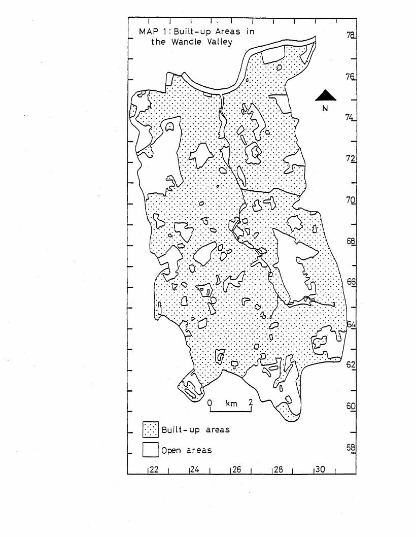
MAP-2- Place Names
Mine Battersea Elm Park
River Thames
BatterseaClapham Junction
Clapham Common
Wandsworth Common
BalhamEarlsfield
Putney
RoehamptonWandsworth
West HillPutneyHeath
Southfields
Putney Vale Upper Tootin
Summer stow nWimbledon ParkWimbledon
Common Tooting GraveneyWimbledon River
GraveneyColliers WoodCopse
HillCottenham Park
Raynes Park
*JRiver Wandle MitchamMerton
MordenMitchamCommon
Morden Park St Helier
Rosehill Hackbridge
Carshalton
Worcester Park
North Benhilton BeddmgtonBandonhillCheam
SuttonWallmgton
Carshalton Roundshaw BeechesCheam
BelmontL ittle
Woodcote
Woodcote
a= Putney Bridge b= Putney Railway Bridge c= Wandsworth Bridge d= Battersea Railway Bridge e= Battersea Bridge f= Albert Bridge
22 i i2A i 126
g=Chelsea Bridge h=Grosvenor Bridge
MAP 3 : Drift Geology
See over for key58
122 i |24 i |26 i |28 i |30 i
KEY TO MAP 3
/.rv.V /.’-f
• » I• 9 f
A <* /*
A A A
Alluvium
Flood Plain gravel
Taplow gravel
Boyn Hill gravel
Glacial gravel
Clay-with-flints
Glaygate Beds
London Clay
Woolwich & Reading Beds
Thanet sand
Upper chalk
Water
MAP U Relief and Drainage
RiverThames
RiverGraveney
RiverWandle * *
.120km
The heights of the contours are shown metres above sea level
Chapter 1The Palaeolithic Period
IntroductionThe term Palaeolithic is used to describe the earliest period for which there is evidence of man in Britain. It dates from at lea.st 250,000 be to c.8,300 be. The major artifacts by which man’s presence is recognised in this period are flint tools and flakes (Adkins & Adkins 1982, 9-20).
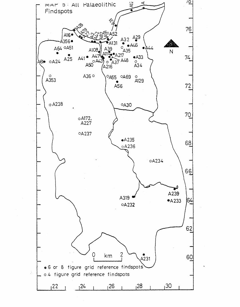
Statistical Analysis (see p.8 for details of method used). When all the findspots of the Palaeolithic period are plotted within 1-kilometre squares, more squares have no findspots than would be expected in a random distribution. This suggests that there are areas of clustering of findspots. Observed pronounced concentrations of finds, which would not be expected if the distribution was random, are those squares with 3 i 4 f 5 , and 6 findspots (the areas of Putney, Wandsworth Clapham Junction and Battersea, and the Thames from Putney to Battersea). Using 2-kilometre squares, the most noticeable difference between the actual observed distribution and a random one is the instance of clusterings of 7 findspots,9 findspots, and 16 findspots in different squares in the observed distribution. These squares include the area of the Thames from Putney to Battersea and a band of findspots from Putney right across to Lavender Hill, Battersea.(see map 5) •
When particular kinds of Palaeolithic artifacts are studied, further variations from a random distribution can be seen. Although finds which are definitely unrolled can be shown to have a fairly random distribution within the 1-kilometre squares, there is an instance of a cluster of 3 findspots shown in the 2-kilometre squares (Wandsworth to Battersea and the Thames from Wandsworth to Battersea).(see maps 6, 7 ,
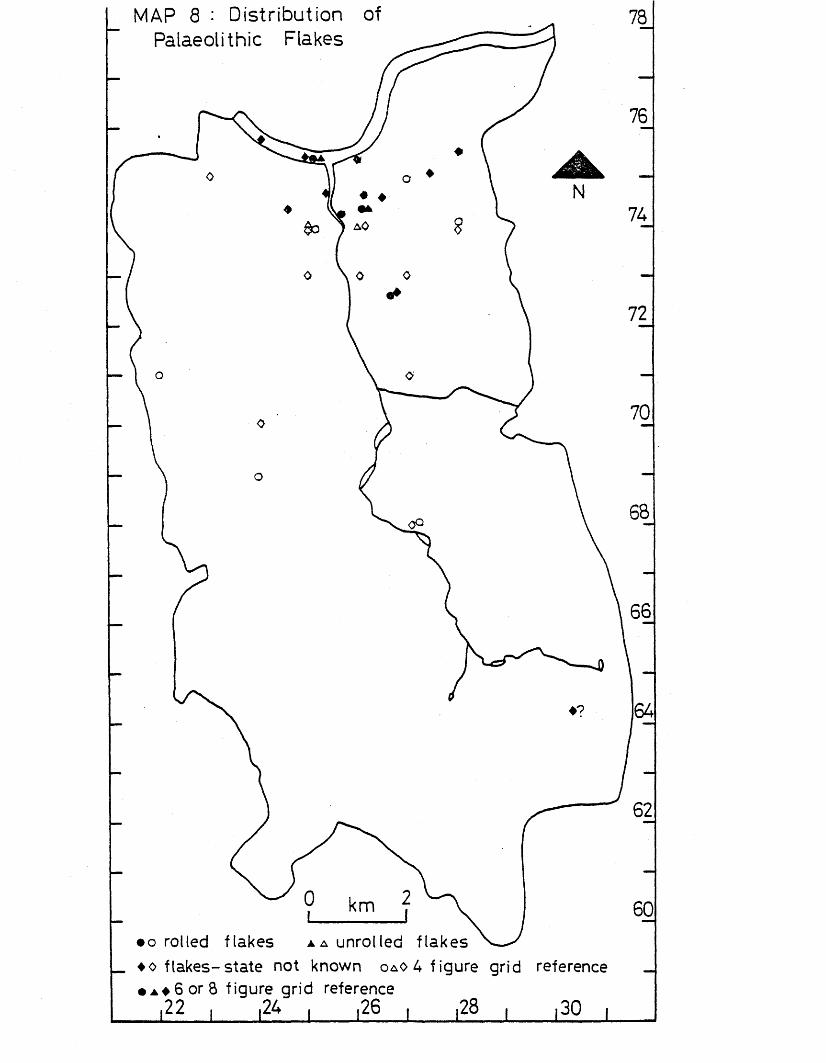
and 8). Finds of rolled and unrolled flakes have a non-random distribution with particular concentrations of 3 and 4 findspots in the Thames from Putney tD Battersea and from Putney to East Hill, Wandsworth). Using 2-kilometre squares, the non-random distribution is even more accentuated, showing a concentration of 4 findspots in the area of Clapham Junction Wandsworth Common and Clapham Common), and 10 findspots in
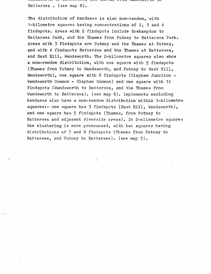
• * W I V V J . \SJ.X V W Wl. £ W * * u -1- X V/i U VI a i l U Q « V I u i i L/V>
Battersea . (see map 8).
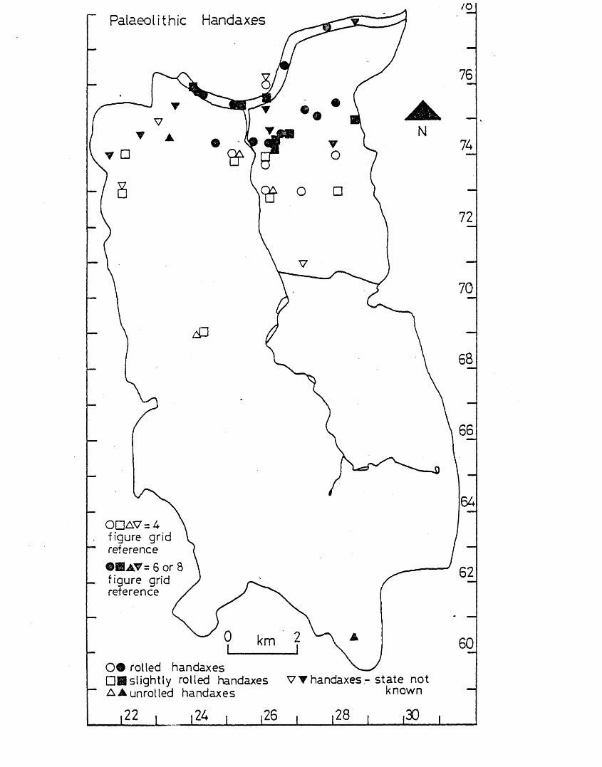
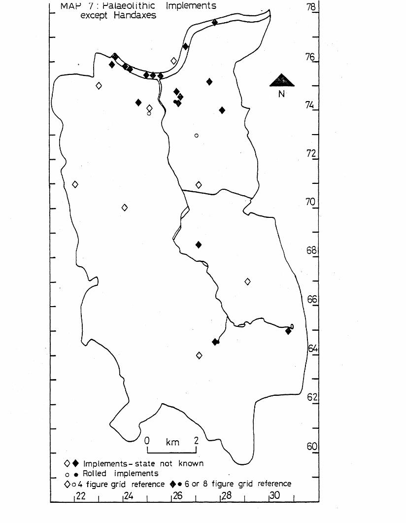
The distribution of handaxes is also non-random, with1-kilometre squares having concentrations of 2, 3 and 4 findspots. Areas with 2 findspots include Roehampton to Battersea Park, and the Thames from Putney to Battersea Park. Areas with 3 findspots are Putney and the Thames at Putney, and with 4 findspots Battersea and the Thames at Battersea, and East Hill, Wandsworth. The 2-kilometre squares also show a non-random distribution, with one square with 5 findspots (Thames from Putney to Wandsworth, and Putney to West Hill, Wandsworth), one square with 6 findspots (Clapham Junction - Wandsworth Common - Clapham Common) and one square with 12 findspots (Wandsworth to Battersea, and the Thames from Wandsworth to Battersea), (see map 6). Implements excluding handaxes also have a non-random distribution within 1-kilometre squares:- one square has 3 findspots (East Hill, Wandsworth), and one square has 5 findspots (Thames, from Putney to Battersea and adjacent riverside areas). In 2-kilometre squares the clustering is more pronounced, with two squares having distributions of 7 and 8 findspots (Thames from Putney to Battersea., and Putney to Battersea), (see map 7)*
J
All Palaeolithic Sites and Findspots
1-kilometre squares with;-i — -tx-jl j l u i i i g u x w o q u a i c o rv a . is x x • —
1 findspot: A4, B2/3/C2, B5, B7, C4, D4, G7, G5, G4, H5, H18/19,I19, 111, J13, J14 findspots)•
, C4, D4, D8, D9, E5, F5, H3, F6, . J1’3;. .T1A (= 20 squares, 20
findspots) •2 findspots: B4, G1/H1, H4, 010, G14 (= 5 squares, 10 findspots).3 findspots: G3, C3 (= 2 squares, 6 findspots).4 findspots; E4, F1/2/3 (= 2 squares, 8 findspots).5 findspots: D3/E3 (= 1 square, 5 findspots).6 findspots: F4 (= 1 square, 6 findspots).
2-kilometre squares with:-1 findspot: A3, A4, B4, B5, D4, E6, D9/E9 (« 7 squares, 7findspots).2 findspots: D1/E1, D3, D5, D7, E7 (= 5 squares, 10 findspots).3 findspots; A1/2, 03 (= 2 squares, 6 findspots).7 findspots: D2 (= 1 square, 7 findspots).9 findspots: B1/2 (= 1 square, 9 findspots).16 findspots; 01/2 (= 1 square, 16 findspots).
Total number of findspots = 55
Distribution of All Sites and Findspots compared with a Poisson Di stribution
Numbers of 1-kilometre squares with sites and findspots:Number of Actual Poisson Deviation Chi-findspots distribution distribution squared0 91 77.7 +13.3 2.31 20 25.1 -15.1 6.52 5 7.9 - 2.9 1.13 2 1.2 + 0.8 )4 2 0.1 + 1.9 ) 17.05 1 - + 1.0 )6 1 — + 1.0 )Total 122 122.0 0 26.9=x ^
Number of Actual Poisson Deviation Chi-findspots distribution distribution squared0 14 5.2 +8.8 14.91 7 9.3 -2.3 0.62 5 8.3 -3.3 1.33 2 4.9 -2.9 1.74 0 2.2 -2.2 )5 0 o • 00 -0.8 )6 0 CVJ•o i o • ro
7 1 0.1 +0.9 )8 0 - - )9 1 - + 1.0 ) 0.0210 0 - - )11 0 - - )12 0 - - )13 0 - - )14 0 - )15 0 - - )16 * 1 — +1.0 )
Total 31 31.0 0 18.52=X2
Handaxe s
1-kilometre squares with:-1 findspot: A3/4, B5, C4, D4, D9, ?5, G5, G7, G4, H3, H5, H18/19/ 119 (= 12 squares, 12 findspots).2 findspots: B4, D3/E3, E4, G1/H1, G3, H4 (= 6 squares, 12 findspots)•3 findspots: C3 (= 1 square, 3 findspots),4 findspots: F3, F4 ( = 2 squares, 8 findspots).
2-kilometre squares with:-1 findspot: A3> B5, C3, D4, D9/E9 ( = 5 squares, 5 findspots).2 findspots: D1/E1, D3 ( = 2 squares, 4 findspots).3 findspots: A1/2 ( = 1 square, 3 findspots).5 findspots; B1/2 ( = 1 square, 5 findspots).6 findspots: D2 ( = 1 square, 6 findspots).12 findspots; C1/2 ( = 1 square, 12 findspots).
Total number of findspots = 35
Numbers of 1-kilometre squares with findspots:Number of Actual Poisson Deviation Chi-findspots distribution distribution squared0 101 91.6 +9.4 1.01 12 26.3 -14.3 7.82 6 3.8 + 2.2 )3 1 0.3 + 0.7 ) 5.94 2 — + 2.0 )Total 122 122.0 0 14.7=^
Numbers of 2-kilometre squares with findspots:Number of Actual Poisson Deviation Chi-findspots distribution distribution squared0 20 10.0 +10.0 101 5 11.3 - 6.3 3.52 2 6.4 - 4.4 3.03 1 *2.4 - 1.4 )4 0 0.7 - 0.7 )5 1 0.2 + 0.8 )6 1 - + 1.0 ) 0.17 0 -8 0 -9 0 -10 0 - )11 0 -12 1 — + 1.0 )Total 31 31.0 0 16.6=X2
Implements excluding Handaxes
1-kilometre squares with:-1 findspot; B2/3/C3, B7, D4, D8, E4, G1/H1, 03, G5, 07, J13, 111 H4, 010 (=13 squares, 13 findspots),2 findspots; C3, P1/2/3, 014 (= 3 squares, 6 findspots).3 findspots: F4 (= 1 square, 3 findspots),5 findspots; D3/E3 (=-1 square, 5 findspots).
1 findspot; A4, B4, D1/E1, D3, D4, D5, E6, E7 (« 8 squares, 8 findspots),2 findspots: D2, D7 (= 2 squares, 4 findspots).7 findspots: B1/2 (=1 square, 7 findspots).8 findspots: C1/2 (= 1 square, 8 findspots).
Total number of findspots = 27
Distribution of Implements excluding Handaxes compared with a Poisson Distribution
Numbers of 1-kilometre squares with findspots:Number of Actual Poisson Deviation Chi-findspots distribution distribution squared0 104 97.8 +6.2 0.41 13 21.6 -8.6 3.42 3 2.4 +0.6 )3 1 0.2 +0.8 ) 2.24 0 - - )5 1 — +1.0 )Total 122 122.0 0 6 = x ^
Numbers of 2-kilometre squares with findspots:Number of Actual Poisson Deviation Chi-findspots distribution distribution squared0 19 13.0 +6.0 2.81 8 11.3 -3.3 1.02 2 5.0 -3.0 1.83 0 1.4 -1.4 )4 0 0.3 -0.3 )5 0 - - ) 0.16 0 - - )7 1 - +1.0 )8 1 + 1.0 )Total 31 31.0 0 C r, 25.7-x 2
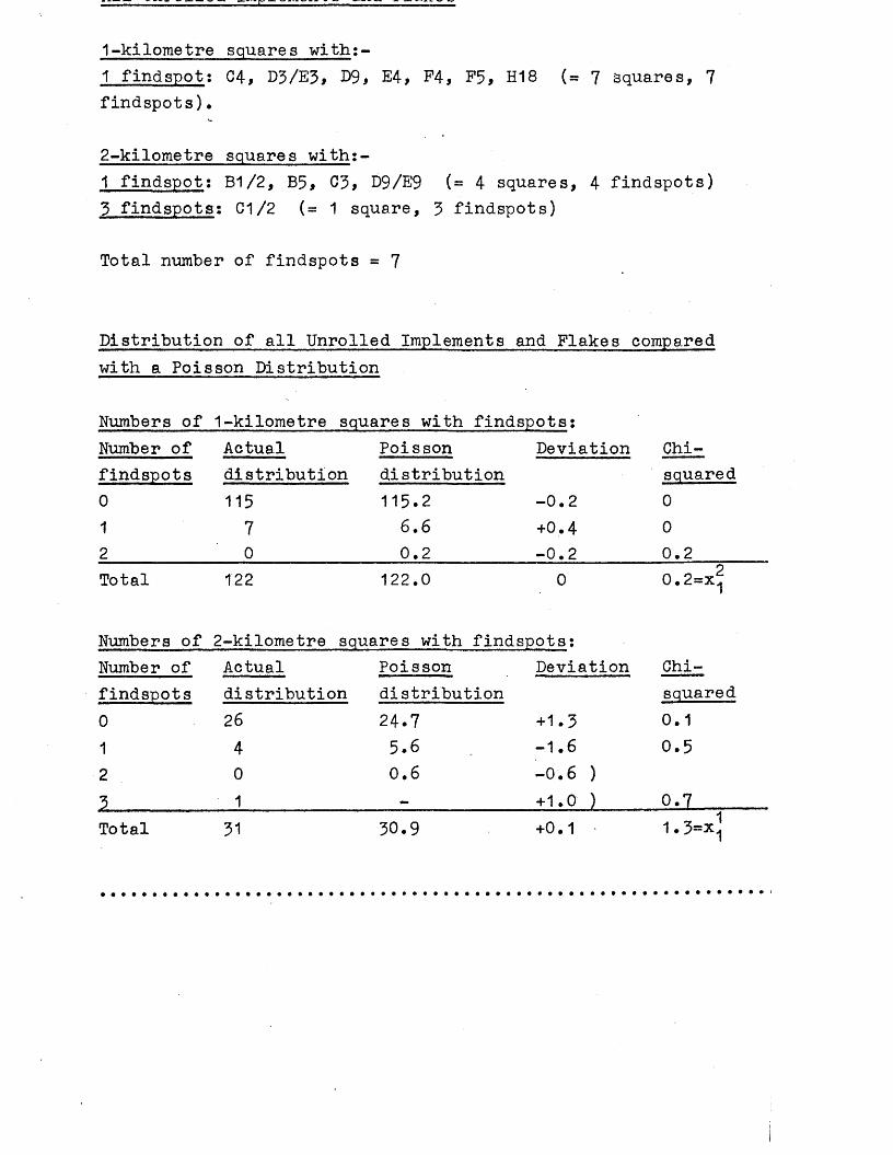
1-kilometre squares with:-1 findspot: C4, D3/E3, D9, E4, P4, F5, H18 (= 7 squares, 7findspots)•
2-kilometre squares with;-1 findspot: B1/2, B5, C3, D9/E9 (= 4 squares, 4 findspots)3 findspots; G1/2 (=1 square, 3 findspots)
Total number of findspots = 7
Distribution of all Unrolled Implements and Flakes compared with a Poisson Distribution
Numbers of 1-kilometre squares with findspots:Number of findspots 0 1 2
Actualdistribution115
70
Poisson distribution 115.2
6,6 0.2
Deviation
-0.2+0.4-0.2
Chi-squared000.2
Total 122 122.0 0 0.2=x^
Numbers of 2-kilometre squares with findspots:Number of findspots 0 1 2 3
Actualdistribution26401
Poissondistribution24.75.60.6
Deviation
+1.3 -1.6 -0.6 ) +1.0 )
Chi-squared0.10.5
0.7 _____Total 31 30.9 +0 • 1 „ , 1 1. 3=x1
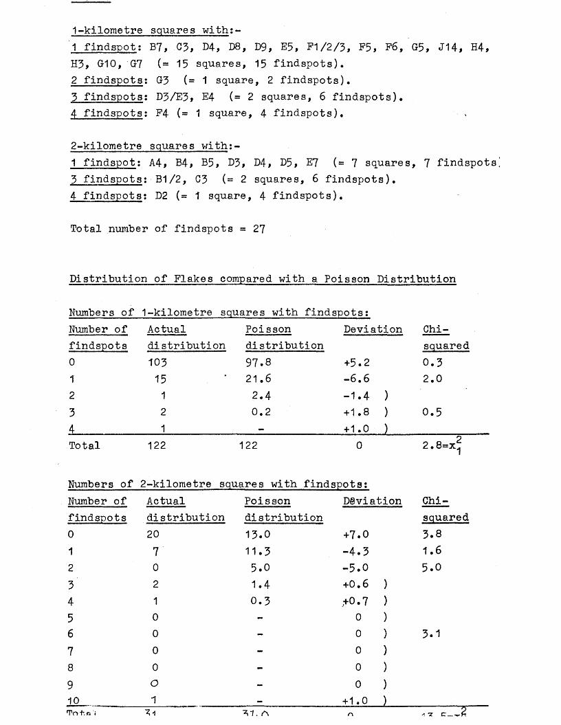
1-kilometre squares with:-1 findspot: B7, 03, D4, D8, D9, E5, F1/2/3, F5, F6, G5, J14, H4, H3, G10, G7 (= 15 squares, 15 findspots).2 findspots: G3 (= 1 square, 2 findspots).3 findspots: D3/E3, E4 (= 2 squares, 6 findspots).4 findspots; F4 (= 1 square, 4 findspots).
2-kilometre squares with:-1 findspot: A4, B4, B5, D3, D4, D5, E7 ( = 7 squares, 7 findspots]3 findspots: B1/2, 03 (= 2 squares, 6 findspots).4 findspots: D2 ( = 1 square, 4 findspots).
Total number of findspots = 2 7
Distribution of Flakes compared with a Poisson Distribution
Numbers of 1-kilometre squares with findspots:Chi-squared0.32.0
0.5
Number of findspots 0 1 234
Actualdistribution10315121
Poisson Deviation distribution 97.8 +5.2 21.6 -6.6 2.4 -1.4 ) 0.2 +1.8 )
+ 1.0 )Total 122 122 0 2 .8=x^
Numbers of 2-kilometre squares with findspotsjNumber of Actual Poisson Deviation Chi-findspots distribution distribution squared0 20 13.0 +7.0 3.81 7 11.3 -4.3 1.62 0 5.0 -5.0 5.03 2 1.4 +0.6 )4 1 0.3 ,+0.7 )5 0 - 0 )6 0 - 0 ) 3.17 0 - 0 )8 0 - 0 )9 O - 0 )10 1 _ + 1.0 )Tn +, a « 1̂. A r\ -i n
Numerous flint artifacts provide evidence for the activity of Palaeolithic man in the Wandie Valley. All the material from this area is dated to the Lower and Middle Palaeolithic periods, and has been studied in detail within a wider context by J. Wymer (Wymer 1968) and D.Roe (Roe 1968).
The material from the Wandle Valley is a mixture of waste flakes, flake implements, and core implements including several handaxes, both rolled and unrolled. Most of the material comes from the/gravels of the Thames terraces, and as such is rarely in situ, but has been redeposited by fluvio-glacial action (cf Wymer 1968, 19). The extent of transportation can be assessed by the condition of the artifacts - transportation by fluvio-glacial activity rolls flint flakes and implements, and so the material can be described as very rolled, slightly rolled or unrolled. Those which are unrolled can be judged to have travelled little from their original point of deposition, or possibly even be in situ.
When all the findspots of flint artifacts are plotted regardless of date or condition, a riverine distribution is noticeable, with a band of findspots stretching from Roeharapton to Lavender Hill, Battersea, with the area now occupied by Battersea Park being free of findspots. This distribution is largely on gravel near the River Thames, (see map 5).
The riverine distribution is more marked when certain types of artifact such as handaxes only are plotted, with very few extending beyond the main area of clustering of all the findspots (see maps 6, 7, and 8). There is a particular clustering of findspots to the east of the present mouth of the V/andle which corroborates Wymer* s statement that ’’the wider and thicker spreads of gravel in the Wandsworth-Clapham area probably represent the ancient confluence of the Wandle and Thames in 100ft terrace times..." (Wymer 1968, 279)*River Wandle does seem to have moved westwards at some stage since the Lower and Middle Palaeolithic.
The absence of finds from the area of Battersea Park and Nine Elms may also suggest that the River Thames has shifted southwards in this reach, carrying away material from the higher terraces. However, there are numerous difficulties in
tracing the changing course of the Thames; few artifacts can be relied on to be in situ, and so evidence for the physical environment is based largely on the evidence of geology. Wymer has outlined the difficulties in interpreting material from the Thames Valley (Wymer 1968). The Flood Plain terrace gravel was probably laid down in the Weichselian Glaciation (Wymer 1968, 390-1) which coincides with the activity of Upper Palaeolithic man in Britain; as seen below (p.25 ) there is no evidence for Upper Palaeolithic man in the area under study. The Battersea Park region consists of Flood Plain gravel (see map 3) which could therefore explain the absence of material from this area, and may not necessarily indicate a change in the course of the River Thames.
There have been very few reports of animal bones in the Wandle Valley, and none of these finds has been associated with man- made implements. There is no evidence in this area for definite habitation sites, working floors, or finds from recognisable contexts such as quarry faces. The only known occupation site lies just to the east of the present-day course of the River Wandle at St Ann’s Hill, Wandsworth (see site A48 in the gazetteer). The site was discovered during building operations in the 19th century, and is generally described as a Levalloisian working floor (Whimster 1931, 30; Wymer 1968, 277; Lawrence 1890, 78). Wymer also describes it as a site of "considerable importance" (1968, 277). Over 3,000 flakes and implements were mentioned, but were never properly recorded, and even in the most recent surveys (Roe 1968, 205 and Wymer 1968, 277) it was believed that only a few flakes were known to survive in museums. However, the author has examined much of the material from the whole Wandle Valley, and it is clear that many flint flakes and implements do survive in museums, although the number is nothing like the original 3,000. Much of the material is recorded only as from Wandsworth, but is often marked with symbols such as "SAH"(St Ann’s Hill), and the date 1885 or 85 is often marked as well, which is further evidence that these finds probably came from this site, as 1885 seems to have been the year when most of the finds were discovered. The material is a mixture of rolled, very rolled and unrolled flakes and implements, a variety of conditions difficult to reconcile with the theory 0:f an in situ working floor, where the finds should be in a
a r a i n y rresn conai-cion.
It seems most likely that the finds from St Ann’s Hill, Wandsworth, represent an accumulation of material from different sources in a former bed of the River Wandle. This interpretation fits in very well with the idea that the River Wandle has moved to the west as seen above (p.23 )* anc* with the idea that the gravels around Wandsworth and Clapham represent a former confluence of the Thames and Wandle (see above p.23 ).
Very f e w finds dating to the Lower and Middle Palaeolithic phases have been recovered away from the Thames and mouth of the Wandle. It would appear from the distribution of findspots that all activity and settlement (which in any case was probably of a temporary nature) in this area was limited to the vicinity of the River Thames and around the mouth of the River Wandle, although there are alternative reasons for the absence of material i n ■the rest of the Wandle Valley (see P.168).
In the Upper Palaeolithic period there is very little evidence for activity by man in the Lowland Zone of Britain. The Wandle Valley certainly conforms to this model and provides no evidence at all for any activity by Upper Palaeolithic man (cf Campbell 1977 passim; Morrison 1981, 85-100).
Information given:- site number, National Grid Reference (all prefixed by TQ), site name, type of site or find, further information, key references.
A11 262 745 Geraldine Road, Wandsworth. Flint scraper (1).In Guildford Museum AG184 (1); not examined by author.(1) Information from Guildford Museum.
A16 235 759 Road ballast, Festing Road, Flint scraper (1).Putney.
In Guildford Museum (1). Ballast may have come from elsewhere* not examined by author (2).(1) Information from Guildford Museum. (2) L.Adkins.
A24 22 74 Dover House Estate, Two handaxes.Roehampton.
In BM: 1928.1-19*1 & 2 si. rolled (1)(3)• Dover House Estate no longer exists (2).(1) Wymer 1968, 276. (2) A.Shaw pers.comm. (3) Evans 1897*604.
A25* 233 746 Chartfield Ave, Putney Ovate handaxe.Sharp, si. patinated. In Museum of London 46.2/11 (2)(1) Wymer 1968,276. (2)'R o e .1968,200.
A26* ? ’ 34 Keswick Rd,Putney Handaxe.Slightly rolled. In Museum of London 46.2/13*(1) Roe 1968,200. (2) Wymer 1968,276.
A29 280 756 Battersea Rise* Handaxe, flake**At junction of Wandsworth and Grayshot Roads (4 ). In Pitt Rivers Museum, Oxford (5). Handaxe is very rolled (5)(1) Roe 1968,192; (2) Wymer 1968,278. (3) Whitaker 1889,341*(4) Evans 1897,604. (5) L.Adkins.
A30 27 71 Tooting Flint artifacts,Handaxe, damaged, in MoL A26646 (1), Ochreous flake and *Le Moustier1 implement in Sturge coll (2) not traced (3)* Levallois tortoise core in BM Sturge coll deep box 34 (3)(1) Roe 1968,294. (2) Smith 1931,125. (3) L.Adkins.
A32 271 753 St John’s Hill, Battersea Ovate Handaxe.Rolled. Found 1901. In BM Sturge coll Thameside box (3)
A33 279 744 Broomwood Estate* Ovate handaxe.*Was on west side of Clapham Common (2). Was in Pitt Rivers Museum, Farnham, now Salisbury Museum, cannot be traced (3)* (1) Roe 1968,193. (2) A.Shaw pers.comm. (3) Salisbury Museum.
A34 28 74 Clapham Common. Flint artifacts.V.rolled handaxe BM 1932.10-6.1, 8 flakes si.rolled BM Wrightcoll, 3 flakes unretouched BM (1) not traced (3). Implement in Museum of London A5083, not examined (3).(1) Roe 1968,193. (2) Wymer 1968,277. (3) L.Adkins.
A35 27 75 Clapham Junction. Levallois flintIn BM Sturge coll London misc box flake(3), rolled, stained (1).(1) Wymer 1968,278. (2) Roe 1968,193. (3) L.Adkins.
A36 25 73 Southfields. Flint flake (1)(2)In British Museum Wandsworth Sturge coll box 8 (3).(1) Roe 1968,201. (2) Smith 1931,125. (3) British Museum.
A37 262 742 Allfarthing Lane,Wandsworth Handaxe.Stained and si.rolled. In British Museum Wandsworth London Sturge coll box 2 (3).(1) Roe 1968,205. (2) British Museum. (3) Roe CBA card.
A39 261 747 East Hill, Wandsworth. Flint artifacts.2 handaxes in BM Trenchman coll handaxes box 1965.2-9 (1)(2) • Various flint flakes and implements (3).(1) Roe 1968,205. (2) British Museum. (3) Lawrence 1893,86.
A41 246 744 West Hill, Wandsworth. Flint artifacts.Rolled handaxe BM Wandsworth London Sturge coll box 2 (1)(4), ovate and v.rolled handaxe, stained, in MoL 4 6.2 /6 (1)(5), v. rolled handaxe AM 1928.126 (1)(6). Scraper Guildford Museum AG185 (7). Flakes (3).(1) Roe 1968,206. (2) Evans 1897,604. (3) Davis 1902,184. (4) British Museum. (5) Museum of London. (6) AM. (7) GM.
A43 257 743 South Street*,Wandsworth. Retouched flake.Rolled. In Camb A&A 27.530 (1)(2). *Now the northern end of Garratt Lame (3).
A44 280 756 Lavender Hill. Handaxe.Found by Lawrence (1). Possibly the handaxe in Manchester University Museum unreg, slightly rolled (3)(4).(1) Evans 1897,604. (2) Roe 1968,199. (3) MUM. (4 ) L.Adkins.
A46 274 751 Battersea Rise. Flint artifacts.V.rolled handaxe Camb A&A unreg (1)(2), Levallois flake Camb A&A (1), implement (3), flake PRMO 881 (4 )(5 ), flake and flake implements unreg Luton Museum (1) - no further information available (6).(1) Roe 1968,192. (2) Wymer 1968,278. (3) Smith 1883,230. (4) PRMO. (5) L.Adkins. (6) Luton Museum.
A47 257 742 Merton Rd, Wandsworth. landaxe (1).In BM 1927.2-9.1 v.rolled. Found south of aqueduct (3) now demolished, but was just north of Marieton and Borroidaile Roads (2).(1) Roe 1968,205. (2) A.Shaw pers.comm. (3) British Museum.
A48 261 744 St Ann’s Hill, Wandsworth. Levallois workingSt Ann’s Hill used to consist of St Ann’s floor?Crescent and part of St'Ann’s Hill (1). Over 3,000 implements and waste flakes were found in 1885. Most are lost; some are classified under ’Wandsworth* in museums. So far traced:- Handaxes: MoL A26939 (6), rolled BM unreg (10) (11), 2 almost unrolled BM Sturge coll (12), v.rolled BM Sturge coll (10)(11), ?handaxe v.rolled BM (10)(11); scraper BM Sturge coll 288 (7), side scraper BM Sturge coll (12), cleaver Bradford Museum 16 9• 32 (9), implement Brighton Museum R 675/23 (3) (8), implement BM Sturge coll v.rolled (12), 3 implements Edinburgh Museum B0 261- 2, B0 264, hamraerstone BM Sturge coll (2); flakes: v.rolled BM Sturge coll (12), unrolled BM Sturge coll (12), hardly rolled BM Sturge coll (12), v.rolled BM Sturge coll (12), unrolled BM Sturge coll (12), rolled BM unreg (10)(11).(I) A.Shaw pers.comm. (2) Wymer 1968,277. (3) Roe 1968,205. (4) Whimster 1931,30-1. (5) Lawrence 1890,78. (6) MoL. (7) Smith 1931,288. (8) Brighton Museum. (9) Bradford Museum. (10) BM.(II) L.Adkins. (12) Roe CBA card.
A50 25 74 Wadsworth 200+ flint artifacts
3 handaxes in MoL: ex Guildhall no. 6 (4 ), no.7 (4), no.14 (4), 19 handaxes in BM: Wandsworth London & Earlsfield box 1 (5), Wellcome coll London areas box 2 193604 (5), Trenchman coll handaxes box (6), Wandsworth Sturge box 3 ”8 4.Jan..?..?..85” sharp (5), rolled unreg (5), encrusted ex G F Lawrence ”+8113 13.x.88” unreg (5), encrusted "Wandsworth 7.12.85" "+8112" (5), v.rolled and stained unreg (5), v.rolled and stained unreg Wandsworth Sturge box 3 (5), si.rolled unreg Wandsworth Sturge box 3 (5), rolled Wandsworth Sturge box 3 (5), v.rolled and damaged "Wandsworth 80 0D" Wandsworth Sturge box 3 unreg (5), broken London Wandsworth Sturge box 2 rolled (5), rolled London Wandsworth Sturge coll box 2 (5), si.rolled London Wandsworth Sturge coll box 2 (5), v.rolled "Wandsworth 75 ft 0D" Wandsworth Sturge coll box 2 (5), si.rolled London Wandsworth Sturge coll box 2 (5), "Wandsworth 80 O.D." London Wandsworth Sturge coll box 2 (5), rolled London Wandsworth Sturge coll box 2 (5). Other handaxes: unrolled Maidstone Museum 22-1901 (6), si.rolled Yorkshire Museum unreg (6), ex G F Lawrence coll Manchester University Museum unreg (5), ex G F Lawrence si.rolled PRMF (6) now lost (8), flWandle Valley, Wandsworth" si.rolled Manchester University Museum (5), 154.32 Bradford Museum (12), 177.32 Bradford Museum (12), si.rolled PRMF (6) now lost (8), si. rolled PRMF (6) now lost (8), PRMF (6) now lost (8), Canterbury Royal Museum rolled (6). ?Handaxes:Wdamaged and worn Manchester University Museum (5), BM Wandsworth Sturge box 3 v.rolled (5), v.damaged and rolled BM Wandsworth Sturge box 3 (5), v.rolled and stained BM Wandsworth Sturge coll box 10 (5). Implements: ?worked (5) MoL ex Guildhall no.8 (4 ), 5 implements National Museum of Antiquities, Edinburgh B0 263,265,279-81 (9) not examined (5), Bradford Museum ex G F Lawrence 134.32 (12), Bradford Museum 135.32 (12), si.rolled BM unreg (5), flake implement rolled BM Wandsworth Sturge coll box 6 (5), blade implement stained and rolled BM Wandsworth Sturge coll box 6 (5), flake implement rolled BM Wandsworth Sturge coll box 6 (5), flake implement rolled BM Wandsworth Sturge coll box 6 (5), 6 flake implements ?palaeolithic BM Wandsworth Sturge coll box 6 (5), flake implement rolled Wandsworth Sturge coll box 6 (5), implement si.rolled BM Wandsworth Sturge coll box 10 (5), implement v.rolled, stained and encrusted BM Wandsworth Sturge coll box 10 (5), implement "Wandsworth 80 O.D." BM Wandsworth Sturge coll box 10 (5), implement rolled ex GFL BM Wandsworth Sturge col I \>ol 10 (5), implement v.rolled BM Wandsworth Sturge
box 10 (5). 7 flakes in MoLj ex Guildhall no.9 (4), no.10(4) not examined (5), no.11 (4) not examined (5), 3 flakes no.16( 4 ) , 49 .1 0 7 /3 8 7 ?palaeolithic ( 1 1 ) . 104 flakes in BM: unrolled Sturge coll no. 287 ( 3 ) , Levalloisian Wellcome London areas box 1 828633 ( 2 ) , rolled unreg ex G F Lawrence "No +8119 13.x. 88" (5), encrusted unreg ex G F Lawrence "8117 1 3 .X .8 8 " (5), rolled ex G F Lawrence "Drift Wandsworth +8114 G F Lawrence ^13. x.88" unreg (5), damaged unreg (5), rolled "+8115 G F Lawrence 1 3 * x . 88" (5), stained and encrusted unreg "Wandsworth 80 OD"(5), stained unreg (5), 11 flakes (one found 1885) Sturge box 5 (5), unreg Wandsworth Sturge coll box 6 found 13.12.85 ex GF Lawrence (5), stained Wandsworth Sturge coll box 6 (5), rolled Wandsworth Sturge coll box 6 (5), 17 Levallois flakes Wandsworth Sturge coll box 7 (5), Levallois ex G F Lawrence WandsworthSturge coll box 7 (5), 20 flakes Wandsworth Sturge coll box 8(5), ?palaeolithic ex GFL Wandsworth Sturge coll box 8 (5), unregWandsworth drift 80 O.D. Wandsworth Sturge coll box 8 (5), 30 flakes Wandsworth Sturge coll box 9 (5), 3 Levallois flakes Wandsworth Sturge coll box 9 (5), 2 flakes ex GFL Wandsworth Sturge coll box 9 (5), Levallois flake Wellcome coll 271957 (2)London areas box 1 (5), 65405 in Wellcome coll London areas box1 (5), 3 v.rolled flakes Wandsworth Sturge coll box 10 (5), si. rolled Wandsworth Sturgd coll box 10 (5), Wandsworth Sturge coll box 10 (5). 15 other flakes: worn flake Manchester University Museum unreg (5), unworn flake Manchester University Museum unreg (5), flake Guildford Museum AG187 (7), v.wora flake Manchester University Museum unreg (5), flake Luton Museum (10), flake Bradford Museum 156.32 (12), 9 flakes Royal Scottish Museum, Edinburgh (6). Scrapers: MoL ex Guildhall no.15 (4), side scraper BM Sturge coll no.289 (3), side scraper BM Sturge coll no.290 (3), Guildford Museum AG 177 & 181 ( 7 ) , side scraper Bradford Museum Cudforth coll 115.32 (12), Bradford Museum Cudforth coll 118.32 (12), ex G F Lawrence BM Wandsworth Sturge coll box 6 (5). Others: s.rolled cleaver Ashmolean Museum 1955.78 (2), borer Bradford Museum 155*32 (12), 2 ?borers BM Wandsworth Sturge coll box 6, Levallois tortoise core BM Wandsworth Sturge coll box 7.(1) Roe 1968,205. (2) Wymer 1968,276. (3) Smith 1931,62. (4) Guildhall Museum 1908,1. (5) L.Adkins. (6) Roe CBA card. (7) Guildford Museum. (8) Salisbury Museum. (9) National Museum of Antiquities of Scotland. (10) Luton Museum. (11) MoL. (12) Bradford Musawn,
Handaxe BM WG 66 (4), scraper Ashmolean Museum 1941.925 (5), flake (1) Sturge deep box 34, 2 Le Moustier implements (2). (1) Wymer 1968,276. (2) Smith 1931,125. (3) Roe 1968,200. (4) Roe CBA card. (5) Ashmolean Museum.
A52 26 76 Battersea Flint artifacts.Rolled handaxe Ashmolean Museum 1928.175 (3), handaxe BM Sturge coll deep box 24 (5)(1), 2 drift implements Sturge coll (1), handaxe Camb A&A (2).(1) Smith 1931,125. (2) Roe CBA card. (3 ) Wymer 19.68,278.(4 ) Roe 1968,191. (5) L.Adkins.
A55 26 73 Earlsfield Flint artifacts.In BM; unrolled handaxe Sturge coll no.285 (1), si.rolled handaxe Sturge coll no.286 (1), rolled handaxe Sturge deep box 34(3), v.rolled handaxe Sturge box 1 (3), Wellcome colls v.rolled handaxe 80907, si.rolled handaxe 80888, si.rolled handaxe 80909, si.rolled handaxe 80908, v.rolled handaxe 80910 (3), flake (2) not traced (3).(1) Smith 1931,62. (2) Roe 1968,195. (3) L.Adkins.
A56 267 727 Burntwood Lane, Earlsfield. Flint flakes.V.rolled flake BM Sturge deep box 34 (3) published as Berrywood Lane (1), flake Museum of London no.17 (2).(1) Roe 1968,195. (2) Guildhall Museum 1908,1. (3) L.Adkins.
A61* 215 740 Richmond Park, near HandaxeBeverley Brook
Ochreous, stained flint (1).(1) Museum of London information.
A64 2247 7475 Allotment to rear of 178 HandaxeDover House Rd, Roehampton.
In collection of Wandsworth Historical Society (1). (1) Bird 1977.
A69 27 73 Wandsworth Common Flint artifacts.In BMs 3 flakes , Levallpis flake, implement si.rolled, ?hand- axe v.rolled (3), 2 flakes, 2 v.rolled handaxes, v.rolled handaxe fragment (1), all unregistered.(1) Roe CBA card. (2) Roe 1968,206. (3) L.Adkins.
Museum of London 68.9/5 ex G.F.Lawrence (1). (1) Museum of London information.
A129* 28 73 Balham Handaxe.fIn Museum of London A14532, slightly rolled (2).(1) Roe 1968,281. (2) Roe CBA card.
A131 260 753 Watney’s Estate,Wandsworth# Flint artifacts.*Now area of Jew’s Row (2). Implements (1), handaxe MoL 68.9/3(3), Levallois flake BM unreg Wandsworth Sturge coll box 7 (3)* (1) Lawrence 1893,86. (2) A.Shaw pers.comm. (3) L.Adkins.
A153* ? Miller’s Farm, Waddon. Handaxe (1).Acheulian (1). See also C153.(1) Row 1914-9,xviii.
A172 24 70 Wimbledon 3 flakesBM unreg (2), MoL A25013 and A25014 (Levallois) (1)(3).(1) Roe 1968,294* (2) British Museum. (3) Museum of London.
A216 26 74 Davies Estate, Earlsfield. Flint artifacts.Handaxe BM unreg Wandsworth Sturge box 3 stained v.si.rolled(2), unrolled flake MoL’A20015 (3), handaxe BM unreg Wellcome coll various sites Surrey box battered, stained and encrusted(2), flake BM unreg Wandsworth Sturge coll box 5 (2).(1) Roe 1968,206. (2) Roe CBA card. (3) Museum of London.
A217 263 746 Bramblebury Estate, 3 handaxes,Wandsworth. flake
V.rolled and stained ?handaxe, damaged BM unreg Wandsworth Sturge box 3 (1), rolled handaxe "75 0D" BM unreg (1), Levallois flake Wandsworth Sturge box 7 (1), handaxe fragment si. rolled Camb A&A (2).(1) L.Adkins. (2) Roe CBA card.
A227 24 70 Wimbledon Recreation Grounds Flint scraperIn British Museum unreg. Found in 1887 (1).(1) British Museum information.
A231 683 605 Woodcote North Downs at 400’.Handaxe•In Kingston seum 1229. Purchased from G.F.Lawrence. Sharp ridges, sb&inecL f patinated (1).
A232 27 64 Carshalton Implements"Considerable finds in gravels of Wandle (1). No further information.(1) Whiraster 1931,30.
A233 302 642 Bandon Hill? 3 flint flakes.Listed under Brandon in catalogue (1). Were in Grangewood Museum destroyed in war; most contents dispersed before war (2). (1) Newnham 1913,137. (2) CNHSS.
A234 29 67 Mitcham Common Flake implement.Stained. In BM unreg in London misc Sturge coll box. Found in 1885.(1) L.Adkins.
A235* 270 686 Miles Lane*, Mitcham. Flint implement.*Now Miles Road (2).(1) Martin 1923,28. (2) L.Adkins.
A236 27 68 Mitcham. 6 flint flakes.,4 ochreous and 2 Le Moustier (2) including one v.rolled and stained flake in BM Sturge coll deep box 34 unreg (1). Rest not traced (4). "Considerable finds" (5).(1) Wymer 1968,275. (2) Smith 1931,130. (3) Roe 1968,292.(4) L.Adkins. (5) Whimster 1931,30.
A237* 24 69 Kingston Rd, Wimbledon. Flint artifacts.Pointed handaxe unrolled, stained and recently broken cordate handaxe unrolled in BM Sturge coll unreg (1), cordate handaxe si.rolled BM unreg (1)(2), si.rolled flake (1), ovate handaxe in British Museum unregistered (4).(1) Wymer 1968,275. (2) Smith 1931,80,125. (3) Roe 1968,295. (4) L.Adkins.
A238 22 71 Wimbledon Common. Implements foundby Lawrence (1).
Include a rolled flake in BM London misc Sturge coll box unreg (J (1) VCH Surrey 1 1902,231. (2) L.Adkins.
A239 3072 6503 Aldwick Rd, Waddon Flint implements (1)(2 )•
E239 and F239.(1) Richardson 1925,xliv-v. (2) Richardson 1923# 14-8,
A319 2782 6452 Honey Lodge, Carshalton. Flint scraper.In Guildford Museum RB 1868 (1). Not examined (2). Found instream bed (1).(1) Guildford Museum. (2) L.Adkins. ‘
A336* ? Tooting Hospital. Handaxe.In British Museum unreg in London misc Sturge box (1).(1) British Museum.
A353 22 73 Roehampton. 2 handaxes.Ovate handaxe (1) not traced . Cordate handaxe (2) in BritishMuseum Sturge box 34 si.rolled (4 ).(1) Evans 1897,604. (2) Wymer 1968,276. (3) Smith 1931,125.(4) L.Adkins.
A356 234 754 Clarendon Rd*, Putney. Handaxe•*Now Clardendon Drive(2). In BM unreg in London misc Sturgecoll box (1).(1) L.Adkins. (2) A.Shaw pers.comm.
THAMES SITES AND FINDS
A2 249 755 Thames,opposite Wandsworth Flint implements.Park.
4 drift implements, flakes, Levallois flake in Museum of London(1), not traced (2).(1) Lawrence 1929,91. (2) L.Adkins.
A27 242 757 Thames,Putney Bridge. Pointed handaxePointed rolled handaxe in MoL 46.2/4 (1), "Drift(1). Drift implement found by Lawrence (2). implement" (2)(1) Wymer 1968,276. (2) Lawrence 1929,89.
A28 236 762 Thames, near Beverley Implements (1)Brook
No further information (2).(1) Lawrence 1893,86. (2) L.Adkins.
285 7783 drift implements in Sturge coll (2) include 1 v.rolled handaxe (4). Truncated flint blade (1) in BM Christy coll cc St 104e (5)*(1) Evans 1897,587. (2) Smith 1931,151. (3) Lawrence 1929,91.(4) L.Adkins. (5) British Museum.
A42* 245 756 to Thames, Wandsworth. Flint artifacts.260 755
In MoL:- Handaxes: rolled 36.217/31 (2), ovate, v.rolled A7115(2), rolled A5082 (2), si.worn AI6963 (4 ), v.rolled A26295 (4), rolled A6424 (4), large flake A10839 (4), Levallois flake rolled A26963 (1), rolled flake A16 (4 ), flake retouched as flat knife, sharp A2584 (4). In BM:- handaxes: si.rolled Wellcome coll 84176(2), si.rolled (3), rolled (3), 5 flakes Sturge coll (3), v. rolled flake Sturge coll (3), si.rolled scraper Wellcome coll(3), backed blade unreg (3), blade 1965.2-9.457 (3), implement ex G.F.Lawrence coll in Sturge coll (3). Handaxe in Ashmolean Museum Goldie coll 1966.1439, rolled (2).(1) Roe 1968,205. (2) Wymer 1968,277-8. (3) BM. (4) MoL.
A72 2858 7772 Thames, Chelsea Bridge. Handaxe.Found 18 feet below bed of river in construction of bridge pier on the Surrey side (1).(1) Atkinson 1883,437. (2) Roe 1977,193. (3) Evans 1897,588.
A79* 236 763 to Thames, Putney. Flint artifacts.245 756
MoL: si.rolled handaxe 46.2/14 (1)(4), rolled handaxe A25775 (1)(4); v.rolled handaxe Camb A&A (2); BM: handaxe and flake unreg(5), implement (3) not traced (5).(1) Roe 1968,201. (2) Wymer 1968,276. (3) Smith 1931,131.(4 ) Museum of London. (5) L.Adkins.
A82 255 754 Thames, mouth of Wandle. Flint implementsImplements not traced (3). (1)(1) J.A.I. 15 1886, 452. (2) Lawrence 1929,91. (3) L.Adkins.
A91 259 755 Thames, Wandsworth Bridge. Ovate handaxe.In Museum of London 46.2/5 (2) si.rolled (3).(1) Lawrence 1929,91. (2) Museum of London. (3) Roe CBA card.
Handaxe in Pitt Rivers Museum, Farah am, rolled (1) (2) now lost. Le Moustier artifact (3) not traced in British Museum (4).(1) Roe 1968,200. (2) Roe CBA card. (3) Smith 1931,131.(4) L.Adkins.
m a r o • A lFindspots
A16* A356*
A 64 °A51
Palaeolithic
&̂ S | A 5 2
*"*A131
A6I* oA2AAA1
A108, • AAl
A39ffl5»*A217
e A/ 16 ■* ,#AAA A35 *
o A43) o *A37 AA8 A50 /a 216
°A55 °A69 oA129
N
oA172,A227
OA237•A235oA236
oA23A
A319 OA232
• 6 or 8 figure grid reference findspots oA figure grid reference findspots
,22 ,24 126 ,28 ,30
Palaeol i t hie Handaxes
O® rolled handaxes□Hslightly rolled handaxes V T handaxes - state not A A unrolled handaxes known
ill i \2U i i26 i i28 i i30 i
MAH 7 : Palaeolithic Implements except Handaxes
km
<>♦ Implements-state not known ^_ o • Rolled implements
0 o 4 figure grid reference ♦ • 6 o r 8 figure grid reference
MAP 8 •' Distribution of Palaeolithic Flakes
km
• o rolled flakes aa unrolled flakes \— '_ 40 flakes-state not known oaO 4 figure grid reference
• * ♦ 6 or 8 figure grid reference
The Mesolithic Period
IntroductionThe term Mesolithic is used to describe the period following the end of the last glacial period (c. 8,300 be) to c. 4,500 BC. Man was dependant on hunting and gathering, and the main artifacts of this period are flint and stone tools, and bone artifacts. Settlement sites are rare. (Adkins & Adkins 1982, 21-6).
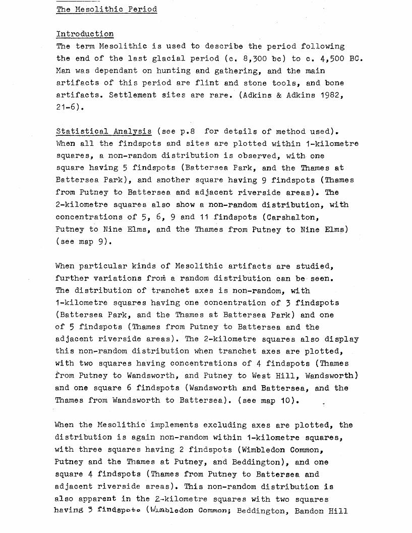
Statistical Analysis (see p.8 for details of method used)*When all the findspots and sites are plotted within 1-kilometre squares, a non-random distribution is observed, with one square having 3 findspots (Battersea Park, and the Thames at Battersea Park), and another square having 9 findspots (Thames from Putney to Battersea and adjacent riverside areas)* The 2-kilometre squares also show a non-random distribution, with concentrations of 5, 6, 9 and 11 findspots (Carshalton,Putney to Nine Elms, and the Thames from Putney to Nine Elms)( see map 9) •
When particular kinds of Mesolithic artifacts are studied, further variations from a random distribution can be seen.The distribution of tranchet axes is non-random, with1-kilometre squares having one concentration of 3 findspots (Battersea Park, and the Thames at Battersea Park) and one of 5 findspots (Thames from Putney to Battersea and the adjacent riverside areas). The 2-kilometre squares also display this non-random distribution when tranchet axes are plotted, with two squares having concentrations of 4 findspots (Thames from Putney to Wandsworth, and Putney to West Hill, Wandsworth) and one square 6 findspots (Wandsworth and Battersea, and the Thames from Wandsworth to Battersea), (see map 10)*
When the Mesolithic implements excluding axes are plotted, the distribution is again non-random within 1-kilometre squares, with three squares having 2 findspots (Wimbledon Common,Putney and the Thames at Putney, and Beddington), and one square 4 findspots (Thames from Putney to Battersea and adjacent riverside areas). This non-random distribution is also apparent in the 2.-kilometre squares with two squares having 3 fin<3.spe»-fc© (Vvlflftbledon Common; Beddington, Bandon Hill
and. Waddonj, and one square 5 nnaspots putney to west m n , Wandsworth, and the Thames at Putney), (see map 11).
However, the distribution of flint flakes within 1-kilometre squares is fairly random:- 107 squares have no findspots compared with 104*4- squares expected in a random distribution, 12 squares rather than the expected 16*2 have one findspot, and two squares rather than the expected 1*2 have 2 findspots; the only square which shows some signs of clustering is Carshalton with 3 findspots. In the 2-kilometre squares there is some evidence of clustering, with 1 square with 3 findspots (Putney to West Hill, Wandsworth, and the Thames at Putney), and two squares with 5 findspots (Wandsworth and Battersea, the Thames from Wandsworth to Battersea, and Carshalton),(see map 12).
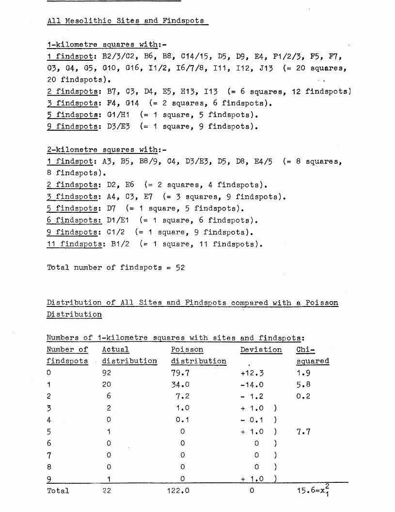
All Mesolithic Sites and Findspots
1-kilometre squares with:-1 findspot: B2/3/C2, B6, Bff, C14/15, D5, D9, E4, F1/2/3, F5, F7, G3, G4, G5, G10, G16, 11/2, 16/7/8, 111, 112, J13 (= 20 squares,20 findspots)•2 findspots: B7, C3, D4, E5, H13, 113 ( = 6 squares, 12 findspots)3 findspots: F4, G14 (= 2 squares, 6 findspots),5 findspots: 01/H1 (= 1 square, 5 findspots).9 findspots; D3/E3 (= 1 square, 9 findspots).
2-kilometre squares with:-1 findspot: A3, B5, B8/9, 04, D3/E3, D5, D8, E4/5 (= 8 squares,8 findspots).2 findspots: D2, E6 (= 2 squares, 4 findspots).3 findspots: A4, 03, E7 (= 3 squares, 9 findspots).5 findspots: D7 (=1 square, 5 findspots).6 findspots; D1/E1 (= 1 square, 6 findspots).9 findspots: C1/2 (= 1 square, 9 findspots).11 findspots: B1/2 (= 1 square, 11 findspots).
Total number of findspots = 52
Distribution of All Sites and Findspots compared with a Poisson Distribution
Numbers of 1-kilometre squares with sites and findspots:Number of Actual Poisson Deviation Chi-findspots distribution distribution # squared0 92 79.7 +12.3 1 .91 20 34.0 -14.0 5.82 6 7.2 - 1.2 0.23 2 1.0 + 1.0 )4 0 0.1 - 0.1 )5 1 0 + 1 .0 ) 7 . 76 0 0 0 )7 0 0 0 )8 0 0 0 )9______________ 1________________ 0______________ + 1 . 0 )_____________Total 22 122.0 0 15.6=x!j
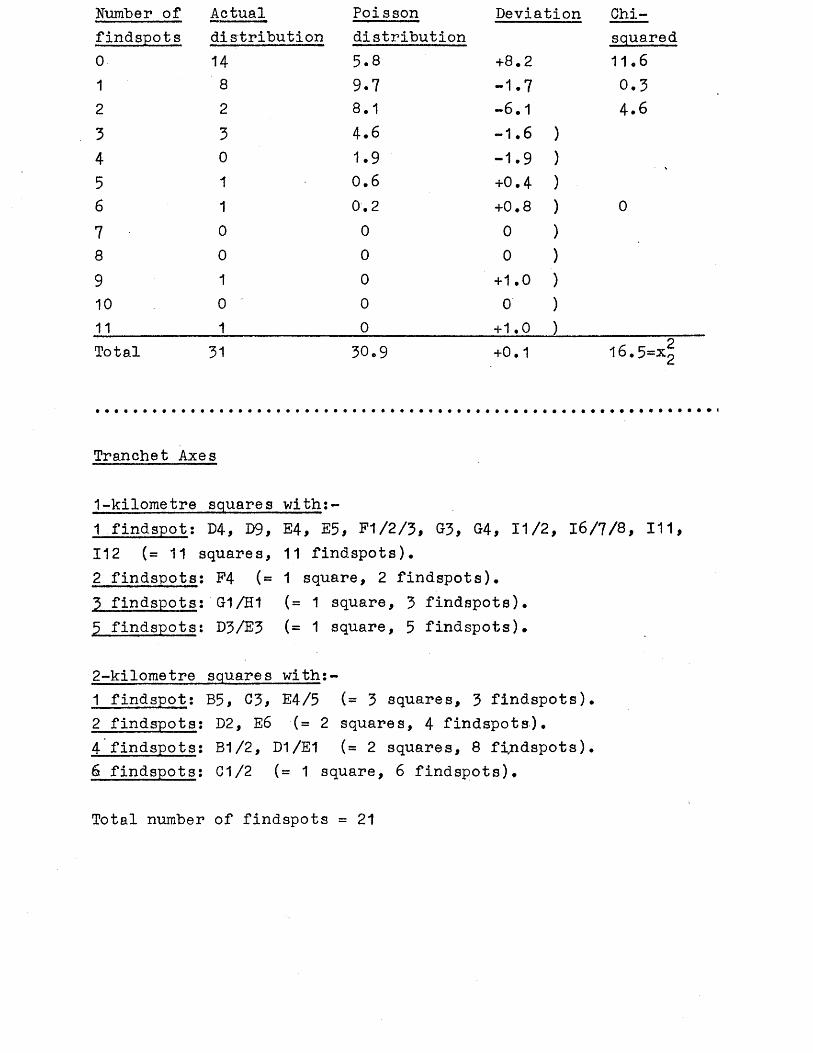
Number of Actual Poisson Deviation Chi-findspots distribution distribution squared0 14 5.8 +8.2 11.61 8 9.7 -1.7 0.32 2 8.1 -6.1 4.63 3 4.6 -1.6 )4 0 1.9 -1.9 )5 1 0.6 +0.4 )6 1 0.2 +0.8 ) 07 0 0 0 )8 0 0 0 )9 1 0 +1.0 )10 0 0 o )11 1 0 +1.0 )Total 31 30.9 +0.1 16.5=
Tranchet Axes
1-kilometre squares with:-1 findspot: D4, D9, E4, E5, F1/2/3, 83, 84, 11/2, 16/7/8 , 111, 112 (= 11 squares, 11 findspots).2 findspots: F4 ( = 1 square, 2 findspots).3 findspots: G1/H1 (= 1 square, 3 findspots).5 findspots: D3/E3 (-- 1 square, 5 findspots).
2-kilometre squares with:-1 findspot; B5, 03, E4/5 (= 3 squares, 3 findspots).2 findspots; D2, E6 (= 2 squares, 4 findspots).4 findspots: B1/2, D1/E1 (= 2 squares, 8 findspots).6 findspots: C1/2 (= 1 square, 6 findspots).
Total number of findspots = 21
Distribution
Numbers of 1-kilometre squares with findspots:Number of Actual Poisson Deviation Chi-findspots distribution distribution squared0 108 102.7 +5.3 0.31 11 17.7 -6.7 2.5 .2 1 1.5 -0.5 )3 1. 0.1 +0.9 ) 1.24 0 0 0 )5 1 0 +1.0 )Total 122 122.0 0 4.o=x!j
Numbers of 2-kilometre squares with findspots:Number of Actual Poisson Deviation Chi-findspots distribution distribution squared0 23 15.7 +7.3 3.41 3 10.7 -7.7 5.02 2 3.6 -1.6 )3 0 0.8 -0.8 )4 2 0.1 +1.9 ) 0.055 0 0 0 )6 1 0 + 1.0 )Total 31 30.9 0.1 8.45=X2
Implements excluding Axes
1 -kilometre squares with:1 findspot: B6, B8, C2/B2/B3, E5, F5, 014, 'G16, H13, J13 (= 9 squares, 9 findspots),2 findspots; B7, C3, 113 (= 3 squares, 6 findspots).3 findspots: G1/H1 (= 1 square, 3 findspots).4 findspots: D3/E3 (= 1 square, 4 findspots).
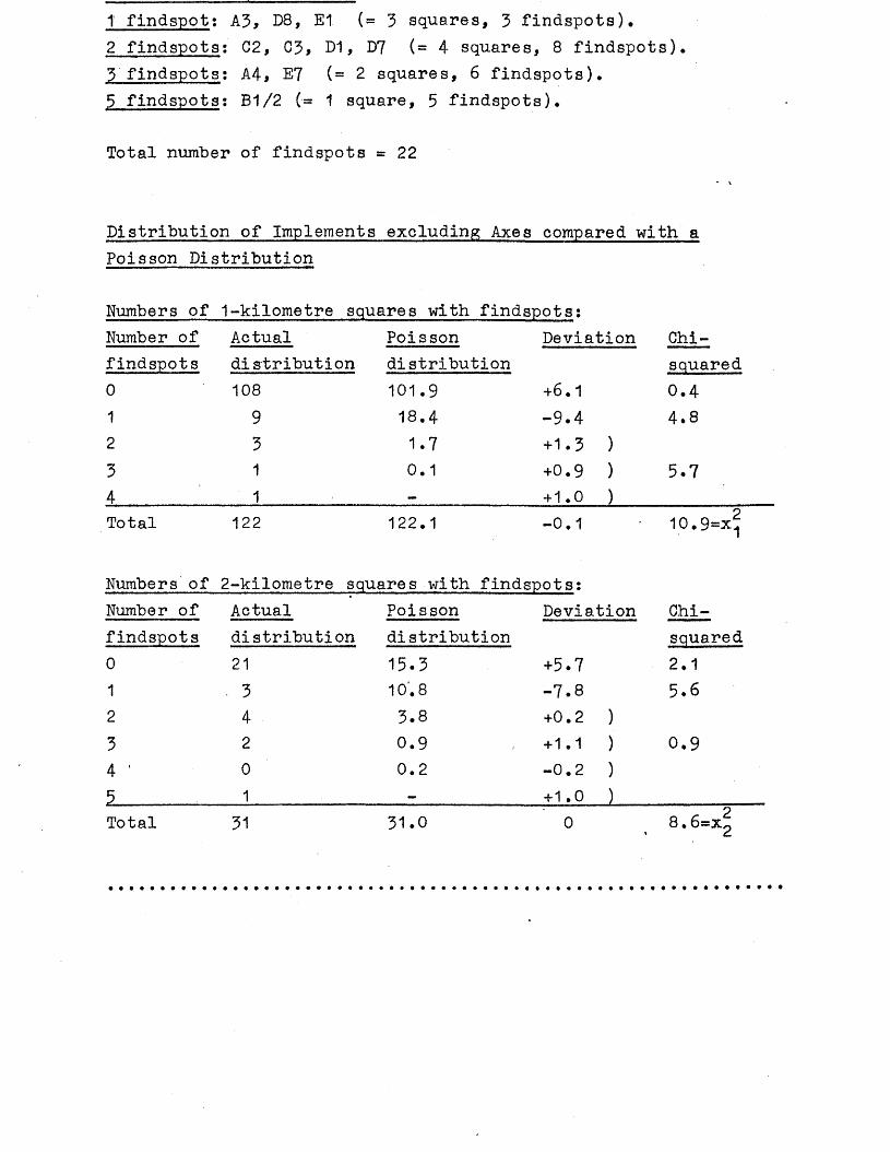
1 findspot: A3, D8, E1 (= 3 squares, 3 findspots),2 findspots: C2, C3, D1, D7 (= 4 squares, 8 findspots),3 findspots: A4* E7 (= 2 squares, 6 findspots),5 findspots; B1/2 (- 1 square, 5 findspots).
Total number of findspots = 22
Distribution of Implements excluding Axes compared with a Poisson Distribution
Numbers of 1-kilometre squares with findspots;Number of Actual Poisson Deviation Chi-findspots distribution distribution squared0 108 101.9 +6.1 0.41 9 18.4 -9.4 4.82 3 1.7 +1.3 )3 1 0.1 +0.9 ) 5.74 1 — + 1.0 )Total 122 122.1 -0.1 10.9=x^
Numbers of 2-kilometre squares with find spots:Number of Actual Poisson Deviation Chi-findspots distribution distribution squared0 21 15.3 +5.7 2.11 • 3 10.8 -7.8 5.62 4 3.8 +0.2 )3 2 0.9 + 1.1 ) 0.94 ' 0 0.2 -0.2 )5 1 _ + 1.0 )Total 31 31.0 0 8.6=*2
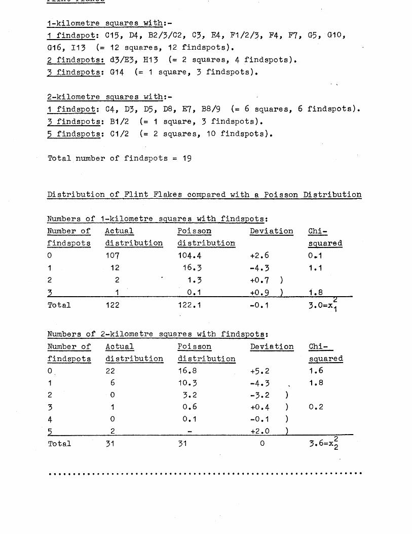
1-kilometre squares with:-1 findspot: 013, D4, B2/3/C2, 03, E4, F1/2/3, F4, F7, G5, G10, G16, 113 (® 12 squares, 12 findspots).2 findspots: d3/E3, H13 ( = 2 squares, 4 findspots).3 findspots: G14 ( =1 square, 3 findspots).
2-kilometre squares with:-1 findspot: 04, D3, D5, D8, E7, B8/9 ( = 6 squares, 6 findspots).3 findspots: B1/2 ( = 1 square, 3 findspots).5 findspots: C1/2 (= 2 squares, 10 findspots).
Total number of findspots = 1 9
Distribution of Flint Flakes compared with a Poisson Distribution
Numbers of 1-kilometre squares with findspots:Number of Actual Poisson Deviation Chi-findspots distribution distribution squared0 107 104.4 +2.6 0.11 12 16.3 -4.3 1.12 2 1.3 +0.7 )3____ ____ 1 0.1 +0.9 ) 1.8Total 122 122.1 -0.1 23.0=x1
Numbers of 2-kilometre squares with findspots:Number of Actual Poisson Deviation Chi-findspots distribution distribution squared0. 22 16.8 +5.2 1.61 6 10.3 -4.3 1.82 0 3.2 -3.2 >3 1 0.6 +0.4 ) 0.24 0 0.1 -0.1 )5 2 — +2.0 )Total 31 31 0 3.6=xi;
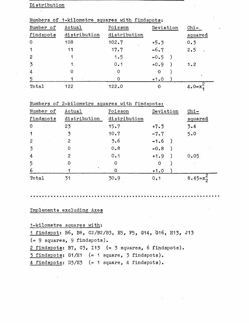
ni scussionEvidence for human occupation in the Mesolithic period in the Wandle Valley consists mainly of flint artifacts, with a few stone, bone and antler implements. Much of the material.has been studied in detail within a wider context by J.Wymer (Wyraer 1977). Some of the material has also been studied in detail by A.D.Lacaille (Lacaille 1966). There have also been a few smaller studies (see Mesolithic gazetteer for details).
The material from the Wandle Valley is mainly a mixture of flint waste flakes, and various flint artifacts including several tranchet axes. Unlike the artifacts of the Palaeolithic period, those of the Mesolithic period are generally unrolled, as they have not been subject to fluvio-glacial activity. Any artifacts of the Mesolithic period which are rolled can usually be expected to have been transported in a river for some distance - in this area the River Thames* Most of the artifacts of the Mesolithic period in the Wandle Valley can be judged to be mostly in situ, and so their distribution can be treated with a much greater degree of confidence than that of the Palaeolithic period.
The distribution of all the finds and sites of Mesolithic date in the Wandle Valley is noticeably riverine, with a concentratio: of findspots and sites near the River Thames and either side of the mouth of the River Wandle, and another clustering at the two southerly arms of the Wandle (see map 9). When classes of artifact are plotted (see maps 10, 11 and 12), this distribution is largely similar, except for the distribution of tranchet axes (see map 10) which has no findspots around the southerly arms of the Wandle. All the artifacts of bone and antler come only from the River Thames, and consist of a barbed bone point from the Thames opposite Wandsworth Park (see B2 in the gazetteer), a perforated antler sleeve from the Thames at Putney Bridge (see B27 in the gazetteer), an antler axe sleeve, a perforated antler axe, a perforated antler end, a bone scoop, a bone awl, a barbed antler point and a bone point from the Thames at Battersea (see B31 in the gazetteer), a perforated bone awl, 2 antler axes and a bone awl from the Thames at Wandsworth (see B42 in the gazetteer), a perforated antler hammer from the Thames at Battersea Park (see B54 in the gazetteer), and a perforated shaft bone, a bone implement and an antler implement from the Thames at Putney
Areas which seem to have been avoided in this period include the chalk downs and areas of London Clay. However, numerous sites are known from other chalk areas outside the Wandle Valley, but usually only where sources of water were available, such as areas of chalk capped with clay-with-flints. The erosion of early Post-glacial soils in later periods (such as in the Bronze Age) through woodland clearance and intensive agriculture may have caused the erosion of earlier archaeological sites, such as on the chalk downs of the Wandle Valley (cf Jacobi 1978).
As with the Palaeolithic period, there are no known findspots or sites within the Battersea Park region. The reasons for the absence of material put forward for the Palaeolithic period (see p. 24 ) are not relevant to the Mesolithic period. It is possible that after the last glacial period the area was low-lying and was deliberately avoided because of its excessively marshy nature. It consists of a spread of Flood Plain gravel and forms a particularly wide strip of low-lying ground (0-20*metres above sea level) (see maps 3 and 4). There is no evidence (such as from alluvium deposits) that the course of the River Thames actually covered the region of Battersea Park.
The most significant distribution is that seen in the rest of the Wandle Valley, away from the River Thames, an p.rea which may have been avoided in the Palaeolithic period (see p. 25
9
and p .168 ). The distribution of Mesolithic material consists mainly of findspots of chance finds. The only possible occupation site is at Orchard Hill, Carshalton, which has been described as a working floor consisting of 15,000 waste flakes and implements (Turner 1965). However, the finds from this excavation have not been published, and so interpretation of this site must necessarily be tentative. From the number of finds, though, a working floor seems most likely, particularly since the finds represent mostly waste material left after the manufacture of flint implements. The site is close to Carshalton Ponds which is part of the spring line between the chalk downs and Thanet sand. The Orchard Hill site may well represent a tern /cerary camp of itinerant Mesolithic people.
in the Wandle Valley. The bone and antler artifacts from the River Thames almost certainly date to the Earlier Mesolithic (Mellars 1974, 85-7)• One tranchet axe from the River Thames in Reading Museum had its "limy deposit" analysed and appears to belong to Zone VII of the post-glacial climatic sequence (Lacaille 1966, 9) which is equivalent to the later Mesolithic and earlier Neolithic periods.
Information given:- site number, National Grid Reference (all prefixed by TQ), site name, type of site or find, further information, key references.
B4 2328 7600 38-46 Sefton St,Putney.Pound in excavation of neolithic date site by Wandsworth Historical Society. See (1) Warren 1977,1-13.
B36 25 73 Southfields. Flint graver.In Cambridge Museum of Archaeology and Anthropology Z.15Hd. (1) Wymer 1977,199. (2) Camb A&A.
B41 246 744 West Hill, Wandsworth. Flint blade.In BM Sturge Mesolithic Wandsworth and Thames box (1).(1) British Museum.
B46 274 751 Battersea Rise. Tranchet axe (1).In Museum of London A1558.(1) Wymer 1977,198. (2) Museum of London.
B48 261 744 St Ann!s Hill*,Wandsworth. Unretouched flake*Used to consist of St Ahn*s Crescent and (2).part of St Ann*s Hill (1). In British Museum Sturge coll mesolithic Wandsworth and Thames etc box(3).(1) A.Shaw pers.comm. (2) Wymer 1977,200. (3) L.Adkins.
B50 25 74 Wandsworth Flint artifacts.Flakes: BM unreg (2), 2 in BM unreg Sturge Mesolithic and Thames etc box (3). Axes: BM unreg fl...s Estate, Wandsworth11 (3), unreg MUM (3), unreg BM Thameside box 1 (3), ?axe MoL 49.107/60 (3), 4 picks Sturge coll BM (1); cores: KM no.35 (4), BM unreg Wandsworth Sturge coll box 7 (3), BM unreg Thame side box 1 (3); micro- liths: BM unreg Sturge Mesolithic Wandsworth & Thames eta box(3), 10 in BM Thameside box 1(3), blades in BM Thameside box 1(2), scraper in BM Thame side box 1 (3), ?scraper in BM Sturge Mesolithic Wandsworth & Thames etc box (3).(1) Smith 1931,125. (2) Wymer 1977,201. (3) L.Adkins. (4)KM.
B51 23 75 Putney Microlith.In BM Sturge Mesolithic WTandsworth & Thames etc box (1). (1) L.Adkins
Implements and flakes,
also C4 and F4. '
Mesolithic-Neolithic. In GPM 2274 Sadler coll (1). See C55* (1) Gunnersbury Park Museum.
B58 269 717 Khartoum Rd, Tooting. Unretouched flake. •In Cambridge Museum of Archaeology and Anthropology E.15147d (1), (1) Wymer 1977,199. (2) Camb A&A. (2)
B67 276 745 Bolingbroke Estate* Tranchet axe.*Probably the manor house near Battersea church (1). In BM unreg (2). In Wandsworth etc London Thames picks box (5).(11 A.Shaw pers.comm. (2) Wymer 1977,199. (5) L.Adkins.
B69 27 73 Wandsworth Common Flint flake.In MoL AI6433, 11.5 cm long, sl.patinated (2).(1) Wymer 1977,199. (2) Wymer CBA card.
B71 246 748 Oakhill Rd,Wandsworth. Flint flake.Plunging flake from blade core. In British Museum Sturge coll (2) (1) Wymer 1977,200. (2) Wymer CBA card.B78* 225 725 Wimbledon Common near mill. Flint artifacts.Blades, scrapers, blade cores, microlith (1)(2).(1) Carpenter 1958,156. (2) Lacaille 1966,34*
B85 247 752 Putney Bridge Rd, Flint blade.Wandsworth Park.
Found in 1902. 12cm long. In Museum of London 46.2/18.(1) Wymer 1977,200. (2) Museum of London.
B90 253 734 Merton Rd,Wandsworth. Tranchet axe.In MoL 36.217/19 (3). Found 12* down (1).(1) Lacaille 1966,13. (2) Wymer 1977,199. (3) Museum of London.
B114 289 776 Waterworks, Battersea. Perforated hammer'In Charterhouse Museum. Has hour-glass head,perforation (1)(2).(1) VCH Surrey 1 1902,234,251. (2) Charterhouse Museum.
B141 2371 7500 14 Gwendolen Ave,Putney. ' Flints.Could be neolithic. Excavation by WHS (1). See also C141 and F141. Not examined (2).(1) WHS News-sheet 120 1975. (2) L.Adkins.
Held by D.Turner. Excavation by D.Turner (2). See also G147.(1)Wymer 1977,198. (2) Turner 1970,49.
and flakes.
B160 2975 6505 Beddington sandpits* *Probably the Warren (2). No further information (2).(1) Carpenter 1958,156. (2) OS Records.
Worked flint of microlithic industries (1).
B180* 223 714 Wimbledon Common.No further information (2).(1) Carpenter 1958,155. (2) L.Adkins.
Flint artifacts (1)
B190 222 707 Shadwell Wood, WimbledonCommon.
Possibly early neolithic (1). See C190. (1) Johnson 1912,99*
Implement (1).
B212 252 752 Harley’s Factory,Wandsworth. 2 flakes.One in BM unreg Sturge Mesolithic Wandsworth and Thames etc box (3). One flake in BM (2) from ’Waterside, Wandsworth* not traced (3).(1) Wymer 1977,200. (2)’Wymer CBA card. (3) L.Adkins.
B216 26 74 Davies Estate, Wandsworth. 2 tranchet axes (1)In BM unreg Wandsworth etc London Thames picks box (2).(1) Wymer 1977,199. (2) L.Adkins.
B217 263 746 Bramblebury Estate, Tranchet axe.Wandsworth.
In BM unreg Wandsworth etc London Thames picks box (2).(1) Wymer 1977,199. (2) L.Adkins.
B234 29 67 Mitcham Common. Tranchet axe.Not traced in a museum. Found 4 ! deep in ”501 Thames terrace1. Published as palaeolithic. Deeply patinated (1).(1) Dewey 1918,111,112.
B238* 22 71 Wimbledon Common Flint artifacts.(1) Rankine 1956,22. (2) Carpenter 1958,155-6.
B239 3072. 6503 Aldwick Rd, Waddon. Flint implements and cores (1) (2)
j / v / i x i x u . j l x x u g » o x w p j o u u \j j. u g u a u o * u e > o q x d u n.C. y yjC.'J'Jf UC. j y y SUtLJ'J y
and F239. Some flints in possession of CNHSS (2).(1) Richardson 1925,xliv-v. (2) CNHSS.
B240 2888 6502 Blinker’s Field,Wellington. Found in excavation. See also D240,E240, F240, and G240. In Brighton Museum R2497 (2).(1) Wymer 1977,198. (2) Brighton Museum.
19 flint flakes, blades and implements (1)
B242 2793 6236 Queen Mary’s Hospital, Flint artifacts.Carshalton.
2 cores, several blades and flakes, 4 scrapers (1). See alsoC2.42, D242, E242, F242 and G242.(1) Wymer 1977,198.
B243 2790 6440 Orchard Hill,Carshalton. Working floor.15,000 waste flakes and implements in possession of D.Turner(1). See also D243,F243 and G243.(1) Turner 1965.
B244 2890 6501 Wellington High School Waste flakes.for Boys.
Found in excavation (1).' See also C244 and K244.(1) Laws & Woolridge 1980,18-22.
B248 2375 6371 Cheam Park Flint flakes (1)No further information (1).(1) OS Records.
B249* ?2914 652 Beddington Park Worked flints.Found by J.S.McCracken in excavation (1).(1) J.S.McCracken pers.comm.
B250 2790 6408 7,9 & 10 The Park, Over 300 flintCarshalton. flakes.
Possibly mesolithic. Found in excavation (1). See also E250.(1) Pryer 1974,2-9.
B252 2986 6680 Gravel pit, Beddington. Tranchet axe.Found in 1912(1).(1) Wymer 1977,197.
In Bateman coll, BM (1). Site located 11 microlithsnear Beddington church by B.Hope-Taylor (2). No further information on the precise location of this site (3).(1) Wymer- 1977,197. (2) Rankine 1956,41. (3) L.Adkins.
B257 2788 6898 29 Upper Green, Mitcham. Waste flint flakes.Found in excavation by MHS (1). See also F257.(1) Montague 1970.
B259* 2484 6961 3 Mostyn Rd, Merton Park. Tranchet axeIn BM 1892.4-10.1 (1). fragment.(1) British Museum.
B332 292 710 Mitcham Lane,Streatham. Tranchet axe.Mitcham Lane is partially in the area under consideration. The axe is in British Museum box 1A 18 W1, damaged and rolled (1) (1) L.Adkins.
THAMES SITES AND FINDS
B2 249 755 Thames, opposite Barbed boneWandsworth Park* (3) point (1)(2)
*Most sources incorrectly say Thames, Wandsworth. In Museum of London A4907.(1) Clark 1932,18,123. (2) Wymer,1977,200. (3) Lawrence 1929,91.
B27 242 757 Thames, Putney Bridge (1). Perforated antlersleeve.
Usually published as Thames, Putney. In MoL A13497.(1) Lawrence 1929,90. (2) Wymer 1977,199.
B27* 242 757 Thames, Putney Bridge. Flint artifacts.Tranchet axe in MoL (3) not traced (4), scraper (1), microliths (2). (3) totally confuses the finds.(1) Lacaille 1966,11. (2) Rankine 1956,22. (3) Wymer 1977,199. (4) L.Adkins.
B31 260 755 to Thames, Battersea Bone and antler285 778 implements.
Antler axe sleeve in MUM (2) 01910 (3), perforated antler axe MoL A7350 (3)7 perforated antler end MoL A7964 (3), bone scoop MoL C723 (3)^ one awl MoL C722 (3), barbed antler point MoL
(1) Clark 1932,18,123. (2) Wymer 1977,199 (not accurate). (3) Wymer CBA card.
B31 260 755 to Thames, Battersea. Flint artifacts.285 778
9 tranchet axes: AM 1927*3797 (3), Peterborough Museum (3) cannot be traced (4), CNHSS Museum (3), MoL A7 (1), MoL A2010(3), MoL 36.217/18 (3), BM (3) cc St 98g, BM unreg Thames picks box 6 (5), broken axe BM London raise Sturge coll box (5)? 5 flakes PRMO (3) 860 + 800, flake BM unreg Thameside box 2 (5), pick Sturge coll (2) not traced (5).(1) Lacaille 1966,7,10. (2) Smith 1931,131. (3) Wymer 1977,199.(4 ) Peterborough Museum. (5) L.Adkins.
B42 245 756 to Thames, Wandsworth. . Bone artifacts.260 755
Perforated bone awl MoL (1) not traced (3), antler axe BM (2), bone awl Geological Museum (1), antler axe BM (2).(1) Wymer 1977,200. (2) Wymer CBA card. (3) L.Adkins.
B42* 245 756 to Thames, Wandsworth. Flint artifacts.260 755
Tranchet axes: MoL A814 (4), MoL 49.107/37 (4), MoL 60.176/76 (6), 7 in BM unreg (4), one v. rolled and damaged (4)(7), one not traced (7), Passmore Edwards Museum 15704 (4), Reading Museum 173.47 (1), Camb A&A A15445 (4); adze MoL 0.224 (5), adze MoL A609 (4), pick MoL A1 (4 ), pick Yorkshire Museum (9). Cores: MoL A8124 (4), 2 in BM unreg (4 ) not traced (7), Geological Museum (5) not traced (8), MoL no. 16,862 (6). Flakes: MoL (4),MoL A4908 (4 ), Passmore Edwards Museum 15707 (4), 19 in Camb A&A (4), 8 in Geological Museum (5) M.I. 5575 (8), 5 blades (4) not traced (7), 3 scrapers Camb A&A Z15147b (4), 5 microliths BM (4), pestle of diorite MoL A26461 (6).(1) Smith 1931,131. (2) Lacaille 1966,8,9. (3) Rankine et al 1960. (4) Wymer CBA card. ‘(5) Wymer 1977,200. (6) Museum of London. (7) L.Adkins.* (8) Geological Museum. (9) Yorkshire Museum.
B54 275 775 to Thames, Battersea Park. Perforated antler285 778 hammer.
In Museum of London A13971 (2).(1) Wymer 1977,198. (2) Museum of London.
285 778 In S.Palmer collection (1). (1) Lacaille 1966,11.
B65 2545 7535 Thames foreshore, Tranchet axe.Wandsworth.
Not neolithic (1) as published (2). Undamaged and very good ' condition (2).(1) L.Adkins. (2) Warren 1972.
B79 236 763 to Thames, Putney Bone and antler245 756 artifacts.
Perforated shaft bone (1)(3) not traced (2), one antler and bone implement MoL both 28.181/13 (1)(3).(1) Wymer CBA card. (2) L.Adkins. (3) Wymer 1977,199*
B79 236 763 to Thames, Putney. Flint artifacts.245 756
Tranchet axes: Horniman Museum H8-89 (1), Camb A&A Z.15448 (4), MoL A10968 (4), MoL 0.686 (4), BM unreg (2); pick CNHSS coll B418 (2), pick (3), microlith BM Sturge coll (4), microlith BM unreg (5), blade MoL 60.176/175 (4), 5 blades BM unreg (4 ), flake BM Sturge coll (4), 26 fiakes Camb A&A Z.15147a (4 ), core Manchester Museum (4) not traced (5).(1) Lacaille 1966,7. (2) Wymer 1977,199. (3) Smith 1931, 131-.(4) Wymer CBA card. (5) L.Adkins.
B82 255 754 Thames, mouth of Wandle. Flint borer.2-platformed blade core in Museum of London 36.217/25 (1)(2) (1) Wymer 1977,200. (2) Wymer CBA card.
B87 285 778 to Thames, Nine Elms. Tranchet axe.300 780
In Museum of London A13260 (1)(2).(1) Wymer 1977,199. (2) Wymer CBA card.
B117 2745 7744 Thames foreshore, Tranchet axe.Battersea.
In possession of WHS. In good condition (1).(1) Warren 1974.
286 778Tranchet axes: MUM (1) not traced (2), Camb A&A Z.15444 (3), MoL 60.176/53 (v.encrusted), 60.176/32, 60.176/36 and 60.176/49 all found in filling of Ham gravel pit with river ballast (3), BM ex Trenchman coll (3) not traced (2), MoL (said Chiswick in Guildhall catalogue, but Chelsea on axe)(3); 2 very fresh blades in British Museum Sturge coll (3) not traced (2).(1) Wymer 1977,199* (2) L.Adkins. (3) Wymer CBA card. (4 )Guildhall Museum 1908,2.
B339 2462 7548 Thames foreshore, Putney. Tranchet axe.Damaged, but not rolled. 7*5 cm long (1).(1) Warren 1974*
B341 2706 7734 Thames foreshore, Battersea. Tranchet axe (1).Very encrusted and damaged (2).(1) Wandsworth Historical Society. (2) L.Adkins.
MAP 9 : All Mesolithic Sitesand Findspots
PO fN£ > ^ 0) vj-<\Cr) QO CN
B 5U B14i B85B71* ° m
*B41 iB2144 *
*B180a B238*B190
do/, j b240VB254 a 60 8239 B243 ^ B244
B147 *8250
60a findspots and sites with 4 figure
grid referencea findspots and sites with 6 or 8 figure grid
,22 , ,24 , , 2 8 ,
Tranchet Axes
A Tranchet axes with 6 or 8 \ __'figure grid reference
A Tranchet axes with 4 figure grid reference
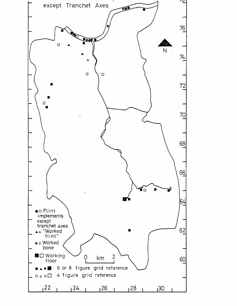
/ KJ
except Tranchet Axes
■ □ Fl i nt \ implements V except 1 tranchet axes \
▲ a "Worked ) f l in t" /
♦ o Worked / s' N.bone S, CBDEing 0 km 2floor |____ i
■ a ♦ ■ 6 or 8 figure grid reference□ A oO 4 figure grid reference
l22 l l 22> I l26 l l 28 l |30 i
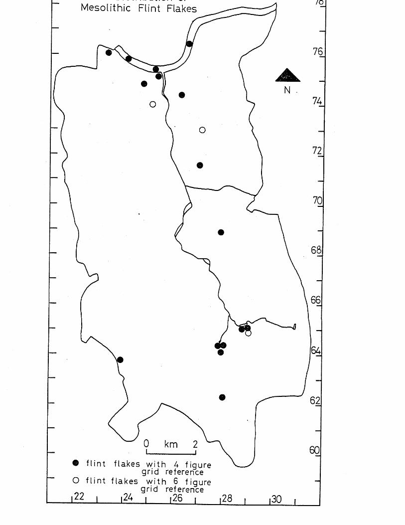
/oMesolithic Flint Flakes
km
Q flin t flakes w ith A figure grid reference
O f l in t flakes w ith 6 figure grid reference
A A • ------
,.r — r..The Neolithic Period
IntroductionThe Neolithic period dates from c. 4,500 BG to c.2300 BC, and marks the first period of settled life based on agriculture.The main artifacts of this period include flint and stone artifacts, bone and antler artifacts, and pottery. Settlement sites are more common, as are funerary monuments such as barrows (Adkins & Adkins 1982, 27-44).
Statistical Analysis (see p,8 for details of method used).When every site and findspot of the Neolithic period was plotted within 1-kilometre squares, a non-random distribution was noticeable, with one square having a clustering of 4 findspots (Thames at Beverley Brook and part of Barnes Common), one square 6 findspots (Battersea and the Thames at Battersea), and two squares 9 findspots (Putney and the Thames from Putney to Battersea and adjacent riverside areas). The 2-kilometre squares also display a non-random distribution, with one square having 12 findspots (Wandsworth and Battersea, and the Thames from Wandsworth to Battersea), and one square 22 findspots (Thames at Putney, and Putney to West Hill, Wandsworth] (see map 13).
When particular kinds of Neolithic artifacts are studied, further variations from a random distribution can be seen.The distribution of axes can be seen to be non-random,WTithin 1-kilometre squares there are clusterings of 3 findspots (Putney and the Thames at Putney), 4 findspots (Battersea Park, and the Thames at Battersea Park), and 6 findspots (Thames from Putney to Battersea and adjacent riverside areas). This clustering is also seen within 2-kilometre squares, with clusterings of 6 findspots (Battersea Park and Nine Elms, ans the adjacent stretch of the Thames), 7 findspots (Wandsworth and Battersea, and ,the Thames from Wandsworth to Battersea), and 10 findspots (Thames at Putney, and Putney to West Hill, Wandsworth), (see map 15).
The distribution of flakes and flint and stone artifacts excluding axes is also non-random. Within 1-kilometre squares there are distributions of 3 findspots (Wimbledon Common, Battersea, a <̂3 bbe Thames at Battersea), and 4 findspots

\ x x* x/xxv^ jr , cxxx\x uiiv/ j.xxcxxij.v_/ u c l <-/ i u u i H / j f / • vvjl UJ.XJ.iJ. C “ K . X X U 1 I 1 C l/I’C £3
there are concentrations of 4 findspots (Wimbledon Common), 6 findspots (Thames at Putney, and Putney to West Hill, Wandsworth), and 7 findspots (Wandsworth and Battersea, and the Thames from Wandsworth to Battersea).
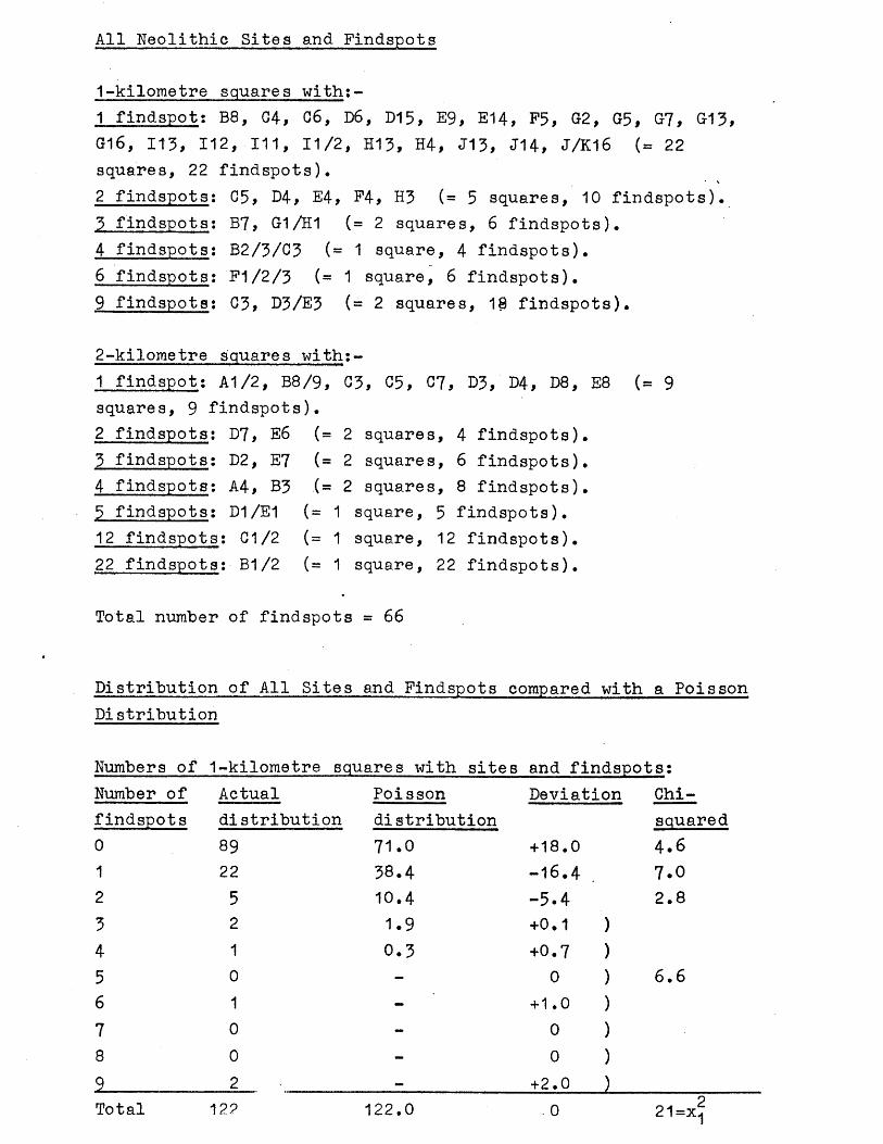
All Neolithic Sites and Findspots
1-kilometre squares with:-1 findspot: B8, C4, C6, D6, D15, E9, E14, F5, G2, G5, G7, G13 G16, 113, 112, 111, 11/2, H13, H4, J13, J14, J/K16 (= 22 squares, 22 findspots).2 findspots: C5, D4, E4, P4, H3 (= 5 squares, 10 findspots).
C -n • „ j _ \3 findspots4 findspots6 findspots9 findspots
* *T j \ — ^ o ^ u a j. w o j iw x.
B7, G-1/H1 (= 2 squares, 6 findspots).B2/3/C3 (- 1 square, 4 findspots).P1/2/3 (= 1 square, 6 findspots).C3> D3/E3 (= 2 squares, 18 findspots).
2-kilometre squares with:-1 findspot: A1/2, B8/9, C3, C5, 07, D3,'D4, 08, E8 squares, 9 findspots).2 findspots: D7, E6 (= 2 squares, 4 findspots).3 findspots; D2, E7 (=2 squares, 6 findspots).4 findspots: A4, B3 .(= 2 squares, 8 findspots).3 findspots; D1/E1 (= 1 square, 5 findspots).12 findspots: G1/2 (= 1 square, 12 findspots).22 findspots: B1/2 (= 1 square, 22 findspots).
Total number of findspots = 66
(= 9
Distribution of All Sites and Findspots compared with a Poisson Distribution
Numbers of 1-kilometre squares with sites and findspot s :
Number of Actual Poisson Deviation Chi-findspots distribution distribution squared0 89 71.0 + 18.0 4.61 22 38.4 -16.4 7.02 5 10.4 -5.4 2.83 2 1.9 +0.1 )4 1 0.3 +0.7 )5 0 - 0 ) 6.66 1 - + 1.0 )7 0 - 0 )8 0 - 0 )9 2 — +2.0 )Total 12? 122.0 - 0 21=x?
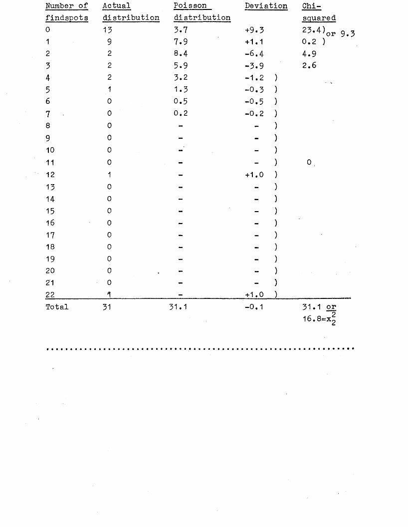
Number of Actual Poisson Deviation Chi-findspots distribution distribution squared0 13 3-7 +9.3 23.4)or1 9 7.9 +1.1 0.2 )2 2 8.4 -6.4 4.95 2 5.9 -3.9 2.64 2 3.2 -1.2 )5 1 1.3 -0.3 )6 0 0.5 -0.5 )7 0 0.2 i o • ro
8 0 - - )9 0 - - )10 0 - - )11 0 - - ) 0 ,12 1 - +1.0 )13 0 - - )14 0 ~ - )15 0 - - )16 0 - - )17 0 - - )18 0 - - )19 0 - )20 0 - )21 0 - - )22 1 — +1.0 )Total 31 31.1 -0.1 31.1 or
16.8=X2
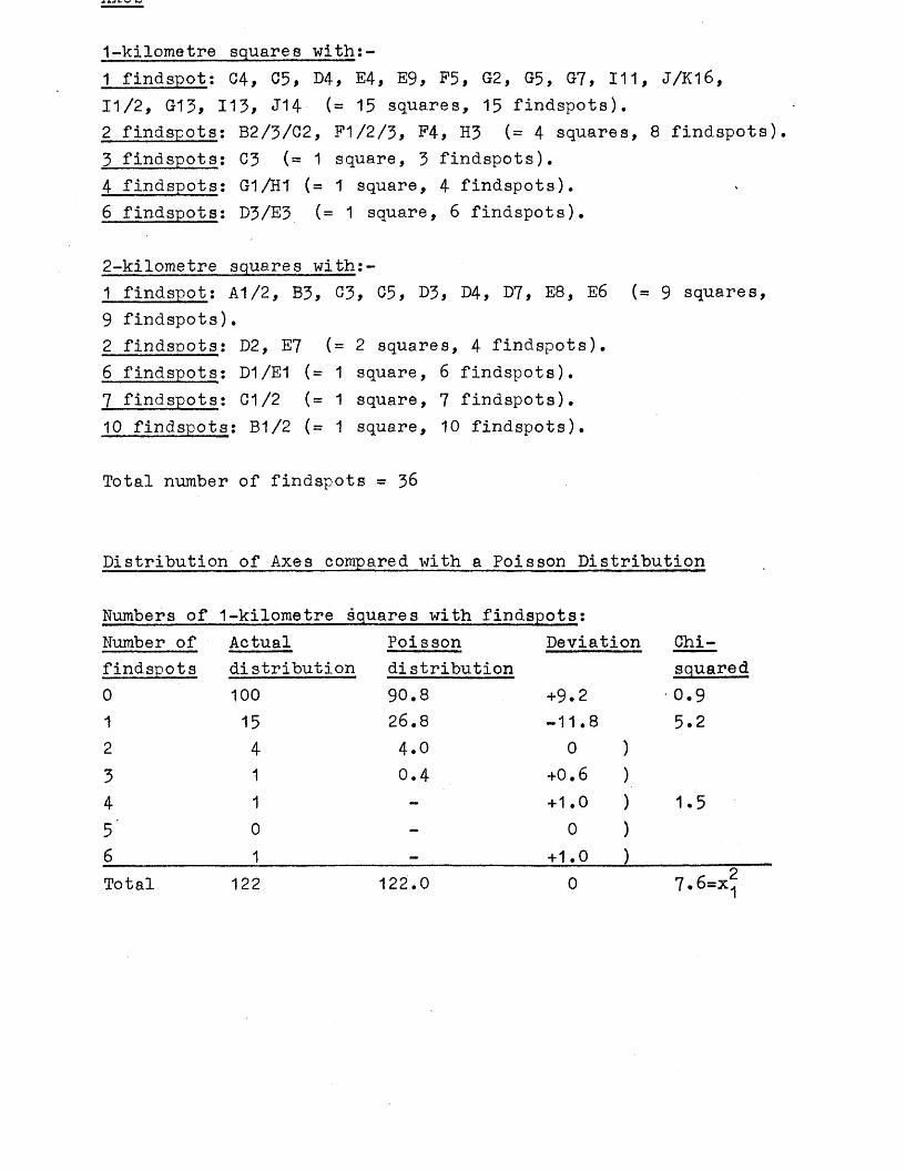
1-kilometre squares with:-1 findspot; C4, C5, D4, E4, E9, F5, G2, G5, G7, 111, J/K16,11/2, G13, 113, J14- (= 15 squares, 15 findspots).2 findspots: B2/3/C2, F1/2/3, P4, H3 (= 4 squares, 8 findspots).3 findspots: C3 (= 1 square, 3 findspots).4 findspots: G1/H1 (= 1 square, 4 findspots).6 findspots: D3/E3 (= 1 square, 6 findspots).
2-kilometre squares with;-1 findspot: A1/2, B3, G3, C5, D3> D4, E8, E6 (= 9 squares,9 findspots).2 findspots: D2, E7 (= 2 squares, 4 findspots).6 findspots: D1/E1 (= 1 square, 6 findspots).7 findspots: C1/2 (= 1 square, 7 findspots).10 findspots: B1/2 (= 1 square, 10 findspots).
Total number of findspots = 36
Distribution of Axes compared with a Poisson Distribution
Numbers of 1-kilometre squares with findspots:Number of Actual Poisson Deviation Chi-findspots distribution distribution squared0 100 90.8 +9.2 -0.91 15 26.8 - 11.8 5.22 4 4 .0 0 )3 1 0.4 + 0 . 6 )4 1 - +1.0 ) 1.55 ’ 0 - 0 )
6_____________1______________ =___________ +1.0 )___________Total 122 122.0 0 7.6=x^
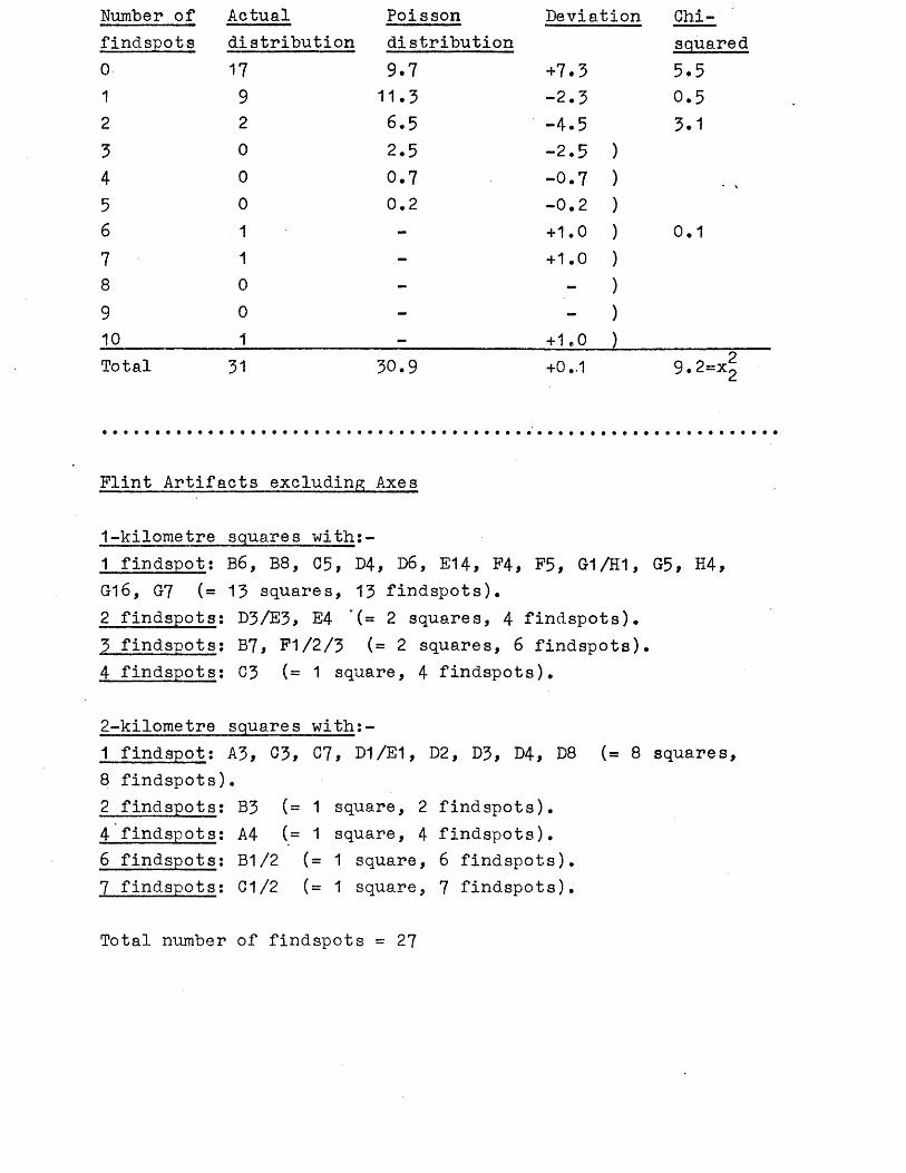
Number of Actual Poisson Deviation Chi-findspots distribution distribution squared0 17 9 . 7 + 7 . 3 5 . 51 9 1 1 . 3 - 2 . 3 0 . 52 2 6 . 5 - 4 . 5 3.13 0 2 . 5 - 2 . 5 )4 0 0 . 7 - 0 . 7 )5 0 0 . 2
OJ.
O1
6 1 - + 1 . 0 ) 0 . 1
7 1 - + 1 . 0 )8 0 - - )9 0 - - )10 1 — + 1 . 0 )Total 31 3 0 . 9 +0..1 9 . 2=Xg
Flint Artifacts excluding Axes
1-kilometre squares with:-1 findspot: B6, B8, 05, D4, D6f E14, F4, F5, G1/H1, G5, H4, G16, G7 (= 13 squares, 13 findspots).2 findspots: D3/E3, E4 (=2 squares, 4 findspots).3 findspots; B7, F1/2/3 (= 2 squares, 6 findspots).4 findspots: C3 (= 1 square, 4 findspots).
2-kilometre squares with:-1 findspot: A3, C3> G7, D1/E1, D2, D3, D4, D8 (= 8 squares, 8 findspots).2 findspots: B3 (= 1 square, 2 findspots).4 findspots; A4 (= 1 square, 4 findspots).6 findspots: B1/2 (= 1 square, 6 findspots).7 findspots: G1/2 (= 1 square, 7 findspots).
Total number of findspots = 27
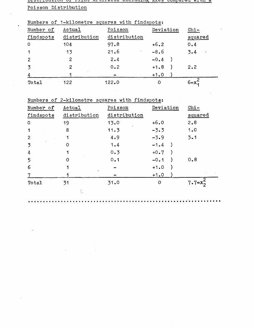
■UJL S U U i / J - U l l U X T - L - L l l l / J i r U l J . a U U D C A U X U U l l l ^ , i t A C a U U X I i j J t L J L ' g U W X UXJL ti
Poisson Distribution
Numbers of 1-kilometre squares with findspots:Number of Actual Poisson Deviation Chi-findspots distribution distribution squared0 104 97.8 +6.2 0.41 13 21.6 -8.6 3.4 '2 2 2.4 -0.4 )3 2 0.2 +1.8 ) 2.24 1 _ +1.0 )Total 122 122.0 0 £ 2 6=x1
Numbers of 2-kilometre squares with findspots:Number of Actual Poisson Deviation Chi-findspots distribution distribution squared0 19 13.0 +6.0 2.81 8 11.3 -3.3 1.02 1 4.9 -3.9 3.-13 0 1.4 -1.4 )4 1 0.3 +0.7 )5 0 0.1 -0.1 ) 0.86 1 - + 1.0 )7 1 - + 1.0 )Total 31 31.0 0 7.7°*2
Evidence for man in the Neolithic period in the Wandle Valley is represented by finds of flint and stone artifacts, pottery, bonework, and also some in situ features (hearths, postholes and gulleys). Unlike the material of the Palaeolithic and Mesolithic periods which has been subject to intensive study (see p.2 3/if little of the material of the Neolithic period from the Wandle Valley has ever been studied in detail, apart from the flint and stone axes from the River Thames (Adkins & Jackson 1978).
When all the findspots and sites of Neolithic date are plotted, a fairly widespread distribution is evident, with particular clusterings near and in the River Thames, and on either side of the River Wandle from Putney to Battersea.There is also some clustering of findspots on Wimbledon Common (see map 13). Distribution of classes of finds (see maps 14 and 15) also display clusterings in and near the Thames from Putney to Battersea and on Wimbledon Common. Areas which seem to have been completely avoided are the areas overlying London Clay, and the area of Battersea Park, although some other areas, such as the chalk downs and Boyn Hill gravel, have only a sparse distribution of finds.
Most of the finds from the Wandle Valley of Neolithic date are chance or stray finds, and the Thames finds are largely a result of dredging. No settlement sites are known apart from a site at Sefton Street, Putney, where 34 potsherds,2,500 flint flakes and implements, hearths and postholes were recorded during an excavation by Wandsworth Historical Society (Warren 1977). No radiocarbon dates were obtained, but the features do seem to represent a Neolithic settlement situated very close to the River Thames. There are also worked flints associated with gulleys and postholes at Erpingham Road, Putney (see C92 in gazetteer), which may be Neolithic in date, and again may represent settlement very close to the Thame s.
The finds of pottery from the Wandle Valley could represent settlements, but this is by no means certain since, without further evidence, the pottery could have been lost in areas away from settlements. The finds of pottery are from Aldwick Road, W&JcJon (Richardson 1923,147), and from a gravel pit
Felsham Road, Putney (see C343 in gazetteer) and Bemish Road, Putney (see C36O in gazetteer), both very close to the possible settlement sites in Putney which were mentioned above. Also from near these sites is a barbed wire beaker bowl which was found in the Thames (see C79 in gazetteer), but could have been washed away from a riverside settlement site. One potsherd is also recorded from the Thames foreshore at Putney (see 'G119 in gazetteer).
Apart from chance finds of flint artifacts, and the possible settlement sites, including those represented by finds of pottery, there is one other site which may be Neolithic in date. This is a possible earthen long barrow on Wimbledon Common, called Queen’s Butt (see K197 in gazetteer). It is known to have been used as a rifle butt in recent times, but it has not been possible to find out when it was constructed, and so there is a possibility that it may have been converted to a rifle butt from an earlier mound, such as a Neolithic long barrow. Time on our Side? shows a second possible long barrow at Tooting (Time on our Side? Neolithic map) but this was proved fairly conclusively to have been a post-medieval park feature during site watching while the mound was being destroyed (Bonner 1929, 180-1). In view of the fact that long barrows are not known in this particular part of the Thames Valley, there is also no reason to suppose that the Queen’s Butt mound is Neolithic; only excavation will give the final answer.
Information given:- site number, National Grid Reference (all prefixed by TQ), site name, type of site or find, further information, key references.
C4 2328 7600 38-46 Sefton St-,* Putney. 34 potsherds,Found in excavation by WHS. Finds in 2,500 flint flakespossession of WHS. See also B4 and F4. and implements,(1) Warren 1977. hearths and post
holes.
07* ?232 752 Dealtry Rd, Putney. Flints.No further information.(1) Warren 1971,276.
C8 24 63 Cheam 1 waisted imple-In BM Sturge coll (1) not traced (2). ment, core, flake(1) Smith 1931,130. (2) L.Adkins. (1)
C30* 27 71 Tooting Flint artifacts.Axe (2) BM cc St 137a (3). 2 implements in Sturge coll (1) not traced (4).(1) Smith 1931,125. (2) Blyth 1872,30. (3) BM. (4) L.Adkins.
C39* 261 747 East Hill, Wandsworth. Ground axe (1)(2),Not traced (3) knife (2).(1) Green— , 3. (2) Lawrence 1898,7. (3) L.Adkins.
C41* 246 744 West Hill, Wandsworth. Flint artifacts.Scrapers and flakes, chipped flint axe (1)(2)(3).(1) Green — ,3. (2) Lawrence 1893,7. (3) Davis 1902,184.
C44 280 756 Lavender Hill, near Axe.Clapham Junction.
In Manchester University Museum unregistered.(1) Manchester University Museum. (2) L.Adkins.
049 2372 7322 8 Inner Park Rd, AxeWimbledon.
Of hornfels (1). Cannot be traced (2).(1) Celoria 1974,89. (2) L.Adkins.
050 25 74- Wands worth Flint artifacts.
(4), BM unreg broken and reflaked (5), 2 axes (1), axe (1), i
axe (1), ?axe MoL 49*107/60 (5). Bifacial implement BM unreg Cabinet J London & Middlesex (4), core ?neolithic GM AG180 (6), core MoL 46.2/21 (8), scraper no.38 KM (7), scrapers (1), saw (1), arrowhead unreg BM (5), 2 flakes BM unreg (5), flakes (1), 57 implements (2), borers (1), adze (1), knife (1).(1) Lawrence 1890,78. (2) Smith 1931,125* (3) Guildhall Museum 1908,2. (4) BM. (5) L.Adkins. (6) GM. (7) KM. (8) MoL.
C51 23 75 Putney Flint artifacts.Chipped hoe 7 ” long in Charterhouse Museum (1) not traced (5), Thames pick in Charterhouse Museum (2) not traced (5) possibly same as hoe (6). Flint axe 4i” long Charterhouse Museum (5), polished flint axe (2)(3), ground axe MUM 25945 (6), 3 implements in Sturge coll (4) not traced (6), arrowhead BM unreg (6).(1) VCH Surrey 1 1902,252. (2) Whimster 1931,234. (3) Davis 1902, 184. (4) Smith 1931,125. (5) Charterhouse Museum. (6) L.Adkins.
C52 26 76 Battersea 2 axesOne in Reading Museum B.Coll 390.57 not found for study (1), onein MUM 26135 (2) ("Thames” on attached card - not proven)(3).(1) Reading Museum. (2) MUM. (3) L.Adkins.
C55 26 73 Earlsfield Axe, scraperGround flint axe recently broken in BM unreg (1). End scraper mesolithic-neolithic 2274 Sadler coll GPM (2). See also B55* (1) L.Adkins. (2) Gunnersbury Park Museum.
C57 238 745 Putney Hill AdzeIn MoL 0.385, flaked and ground, still sharp (1). (1) L.Adkins.
C69 27 73 Wandsworth Common Flint artifactsPartly polished axe (1)(2). 2 flakes and 1 scraper in BM unreg (3) (1) Lawrence 1898,7. (2) Davis 1902,184. (3) L.Adkins.
C86 223 750 Huntingfield Road, Flint axe.Roehampnton.
Badly damaged. In Museum of London 35.187 (1).(1) Museum of London.
*Gulley and postholes. Excavation by associatedWHS (1)(2). See also F92. features*(1) WHS news-sheet ?1 1969* (2) WHS news-sheet 6 1968.
C101 2346 7601 33-39 Danemere St,Putney. Flints.Found by WHS in 1973. Finds held by WHS (1) (2). See also F101. (1) WHS news-sheet 105 1973* (2) London Archaeologist vol 2 no. 6 1974.
0103 230 758(1) Putney Lower Common. Found in 1st World War (1).(1) Museum of London records.
Flint axe.
C121 ? Golf Course, Flint arrowhead.Wimbledon Common.
Held by John Evelyn Society. Found near 13th green.(1) N.Plastow pers.coram.
C124 261 752 Eltringham Street,Wandsworth.
Not traced in a museum (2).(1) Lawrence 1898,7. (2) L.Adkins.
Scrapers and flakes (1).
C125 258 748 North Street*, Wandsworth. *Now Fairfield Street (2). Not traced in a museum (3).(1) Lawrence 1898,7. (2) A.Shaw pers.comm. (3)
Scrapers and flakes (1)
L.Adkins.
C131 260 753 Watney's Estate*Wandsworth.
Not traced in a museum (3). *Now area of Jew’s (1) Lawrence 1898,7. (2) A.Shaw pers.comm. (3)
Axes, flakes and scrapers (1)Row (2).L.Adkins.
C132 280 753 Sister’s Estate, LavenderHill, Battersea.
In BM cc 84 + 2817. Found in 1884 (1).(1) British Museum.
Flint axe
C134 22 73 Putney Heath* Flint flakes andscrapers
*Near old barrows (1). Not traced in a museum (3).(1) Johnson & Wright 1903,127. (2) Johnson 1912,99.
In MoL (1). Lawrence may mean Thames, flint axe withso axe may be A7907. See C31 and C54 (2) flattened sides(1) WHS news-sheet 120 1975* (2) L.Adkins.
C141 2371 7500 14 Gwendolen Ave,Putney. Could be mesolithic (1). Excavation by WHS. P141. Not examined (3)*(1) WHS news-sheet 120 1975• (2) L.Adkins.
Flints.See also B141 and
C153* ? Miller1s Farm, Waddon. See also A153.(1) Row 1914-9*xviii.
End of axe.
C155 3014 6426 Bandon Hill Not traced in a museum (3).(1) Robarts 1899-1903*52. (2) Anderson 1882,
Part of a flint axe.
8.
C173 230 724 Wimbledon Common *by thewindmill1
In Museum of London A17394 (1)(2).(1) Museum of London. (2) OS Records.
Flint borer.
C180 223 714 Wimbledon Common near Flint flakes andCaesar^ Well. implements (1) (3)
&
Arrowhead in British Museum unregistered (1) (2).(1) Johnson & Wright 1903*125-7. (2) BM. (3) Johnson 1912,99.
C190 222 707 Shadwell Wood,Wimbledon Common.
Possibly neolithic (1). See B190. (1) Johnson 1912,99.
Implement (1)
C198 248 752 Wandsworth Park.In Ashmolean Museum 1966,1464 (1). Could be (1) Ashmolean Museum.
Flint scraper, later in date.
C214 243 740 Rucker1s Estate, Wandsworth. 2 flint flakes. Not traced in a museum (2).(1) Lawrence 1890,78. (2) L.Adkins.
C216 26 74 Davies Estate, Wandsworth. 2 axes.In GM S^GGl ( 2 ) , and BM unreg (1) broken (3).
C218* 2820 7493 Opposite Wakehurst Drive, Discoidal flintClaphain Gominon. knife.
May be Bronze Age, In BM 1935•10-21,1 (1), See D218.(1) British Museum.
C219* ? Fairfax Estate. "Specimens”.No further information (2).(1) Lawrence 1893*87. (2) L.Adkins.
C225 25 69 Merton. Stone axe•Of Group IX stone (Ireland). In GM S7648 (2).(1) SyAC 45. 166. (2) Guildford Museum.
C234 29 67 Mitcham Common. Part of ground axeOnce in Charterhouse Museum (1), now lost (2).(1) VCH Surrey 4 1912,233*252. (2) Charterhousei Museum.
C238 22 71 Wimbledon Common. Flint flakes andIn Museum of London B5-23* A17394 (3). implements (1)(2)Scraper in Ashmolean Museum 1970.943 (4).(1) Johnson 1912,99. (2) Whiraster 1931,239. (3) MoL. (4) AM.
0239 3072 6503 Aldwick Rd, Waddon. Pottery (1).Found in development of estate. See also A239*B239*D239*E239>F239(1.) Richardson 1923,147*
C242* 2793 6236 Queen Maryfs Hospital, Flint artifactsCarshalton. (1).
Includes a hoe (2). See also B242,D242,E242,F242 and G242.(1) Lowther 1944*60. (2) Robarts 1905*389.
C244 2890 6501 Wellington High School Flint flakes.for Boys.
Found in excavation (1). See also B244 and K244.(1) Laws & Woolridge 1980,18-22.
C251* ? Lawn Estate. "Specimens".No further information (2).(1) Lawrence 1893*87. (2) L.Adkins.
0261 3071 6237 5 Hillcrest Rd,Purley. Part of a polishedfH lirh .
(1) Ordnance Survey Records.
C262 2984 6662 Gravel pit, Beddington. Bowl**Thougfrt to be a Peterborough bowl from a sketch. It was smashed by a workman (1).(1) Ordnance Survey Records.
C264* ? North Downs, nr Sutton.Not traced in a museum (2).(1) Johnson 1901,117* (2) L.Adkins.
C265 2793 6570 49 Dale Park Avenue, Flint axe.Garshalton.
In British Museum 1936.2-6.1. Found at a depth of 3* in sand (1). (1) Ordnance Survey Records.
C267 250 645 West Sutton Flint arrowheads.In Museum of London 49*107/769-770 (1).(1) Museum of London.
C268* ? Lonesome, Mitcham. Flint axe.In British Museum 1905*6-5*1 (1).(1) British Museum.
C269 24 72 Wimbledon Park. Flint fabricator.In British Museum unregistered (1).(1) Smith 1931,125.
C291 224 711 Caesarfs Camp, Wimbledon Flint implement (1)Common.
Not traced in a museum (2). See also D291, E291 and F291*(1) Johnson & Wright 1903,127* (2) L.Adkins.
C304 2978 6583 Beddington sewage farm. Flint axe.Found in a Roman context on an excavation by SWLAU (1). See also D304, E304, F304 and G304.(1) L.Adkins.
C343 2397 7558 38 Felsham Rd, Putney. Potsherds.Possibly neolithic. Excavation by WHS. See also E343, F343 and K343*(1) Wandsworth Fisborical Society.
Flint flakes and artifacts (1).
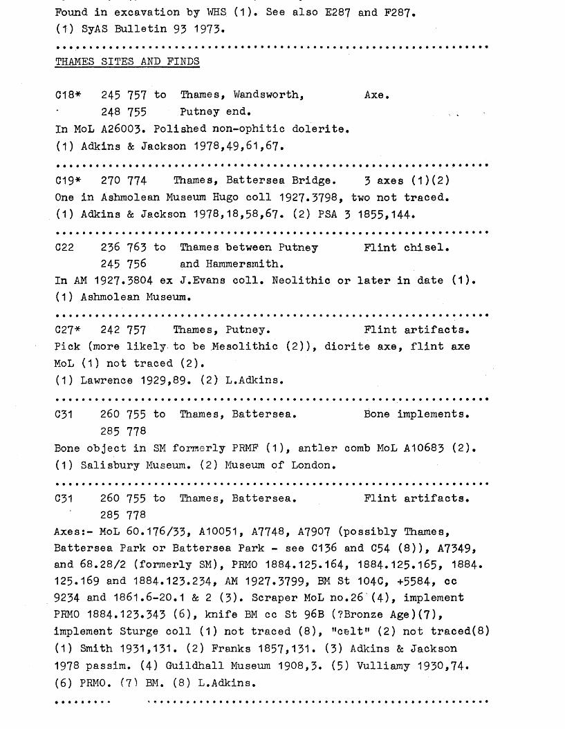
Pound in excavation by WHS (1). See also E287 and F287. (1) SyAS Bulletin 93 1973.
THAMES SITES AND FINDS
018* 245 757 to Thames, Wandsworth, Axe.248 755 Putney end.
In MoL A26003. Polished non-ophitic dolerite.(1) Adkins & Jackson 1978,49,61,67.
019* 270 774 Thames, Battersea Bridge. 3 axes (1)(2)One in Ashmolean Museum Hugo coll 1927.3798, two not traced. (1) Adkins & Jackson 1978,18,58,67. (2) PSA 3 1855,144.
C22 236 763 to Thames between Putney Flint chisel.245 756 and Hammersmith.
In AM 1927.3804 ex J.Evans coll. Neolithic or later in date (1). (1) Ashmolean Museum.
027* 242 757 Thames, Putney. Flint artifacts.Pick (more likely to be Mesolithic (2)), diorite axe, flint axe MoL (1) not traced (2).(1) Lawrence 1929,89. (2) L.Adkins.
031 260 755 to Thames, Battersea. Bone implements.285 778
Bone object in SM formerly PRMF (1), antler comb MoL A10683 (2). (1) Salisbury Museum. (2) Museum of London.
031 260 755 to Thames, Battersea. Flint artifacts.285 778
Axes;- MoL 60.176/33, A10051, A7748, A7907 (possibly Thames, Battersea Park or Battersea Park - see 0136 and 054 (8)), A7349, and 68.28/2 (formerly SM), PRM0 1884.125.164, 1884.125.165, 1884. 125.169 and 1884.123.234, AM 1927.3799, BM St 104C, +5584, cc 9234 and 1861.6-20.1 & 2 (3). Scraper MoL no.26 (4 ), implement PHM0 1884.123.343 (6), knife BM cc St 96B (?Bronze Age)(7), implement Sturge coll (1) not traced (8), !,celtM (2) not traced(8) (1) Smith 1931,131. (2) Franks 1857,131. (3) Adkins & Jackson 1978 passim. (4) Guildhall Museum 1908,3. (5) Vulliamy 1930,74.(6) PRM0. (7) BM. (8) L.Adkins.
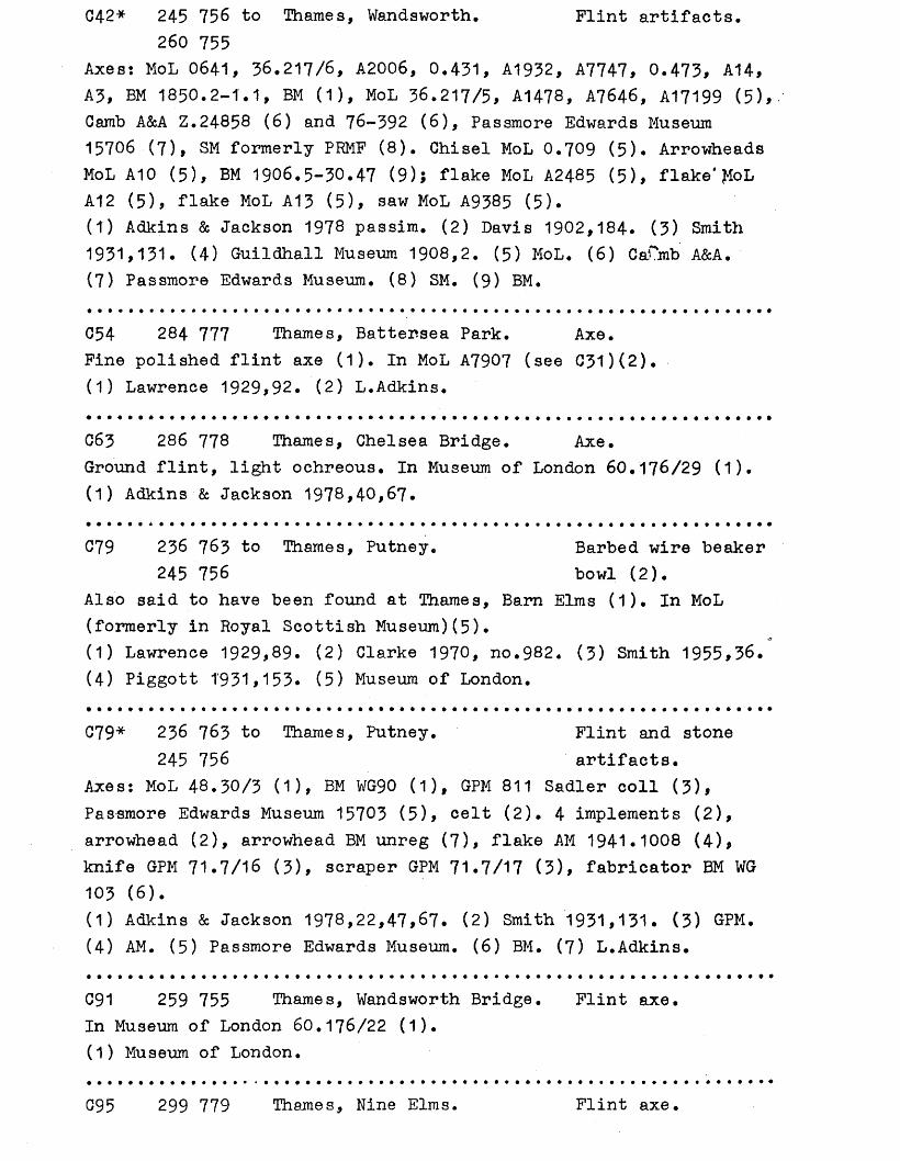
C42* 245 756 to Thames, Wandsworth. Flint artifacts.260 755
Axes: MoL 0641, 36.217/6, A2006, 0.431, A1932, A7747, 0.473, A14, A3, BM 1850.2-1.1, BM (1), MoL 36.217/5, A1478, A7646, A17199 (5), Camb A&A Z.24858 (6 ) and 76-392 (6 ), Passmore Edwards Museum 15706 (7), SM formerly PRMF (8). Chisel MoL 0.709 (5). Arrowheads MoL A10 (5), BM 1906.5-30.47 (9); flake MoL A2485 (5), flake* JfoL A12 (5), flake MoL A13 (5), saw MoL A9385 (5).(1) Adkins & Jackson 1978 passim. (2) Davis 1902,184. (3) Smith 1931,131. (4) Guildhall Museum 1908,2. (5) MoL. (6) CaCmb A&A.(7) Passmore Edwards Museum. (8) SM. (9) BM.
054 284 777 Thames, Battersea Park. Axe.Fine polished flint axe (1). In MoL A7907 (see C31)(2). (1) Lawrence 1929,92. (2) L.Adkins.
C63 286 778 Thames, Chelsea Bridge. Axe.Ground flint, light ochreous. In Museum of London 60.176/29 (1). (1) Adkins & Jackson 1978,40,67.
C79 236 763 to Thames, Putney. Barbed wire beaker245 756 bowl (2).
Also said to have been found at Thames, Barn Elms (1). In MoL (formerly in Royal Scottish Museum)(5).(1) Lawrence 1929,89. (2) Clarke 1970, no.982. (3) Smith 1955,36.(4) Piggott 1'931,153. (5) Museum of London.
C7 9 * 236 763 to Thames, Putney. Flint and stone245 756 artifacts.
Axes: MoL 48.30/3 (1), BM WG90 (1), GPM 811 Sadler coll (3), Passmore Edwards Museum 15703 (5), celt (2). 4 implements (2), arrowhead (2), arrowhead BM unreg (7), flake AM 1941.1008 (4), knife GPM 71.7/16 (3), scraper GPM 71.7/17 (3), fabricator BM WG 103 (6).(1) Adkins & Jackson 1978,22,47,67. (2) Smith 1931,131. (3) GPM.(4) AM. (5) Passmore Edwards Museum. (6) BM. (7) L.Adkins.
C91 259 755 Thames, Wandsworth Bridge. Flint axe.In Museum of London 60.176/22 (1).(1) Museum of London.
095 299 779 Thames, Nine Elms. Flint axe
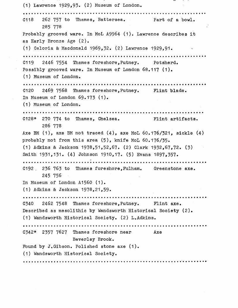
(1) Lawrence 1929,93. (2) Museum of London.
G118 262 737 to Thames, Battersea. Part of a bowl.285 778
Probably grooved ware. In MoL A9964 (1). Lawrence describes itas Early Bronze Age (2).(1) Celoria & Macdonald 1969,32. (2) Lawrence 1929,91.
0119 2446 7554 Thames foreshore,Putney. Potsherd.Possibly grooved ware. In Museum of London 68. 117 (1).(1) Museum of London.
C120 2469 7568 Thames foreshore,Putney. Flint blade.In Museum of London 69.173 (1).(1) Museum of London.
C1!28* 270 774 to Thames, Chelsea. Flint artifacts.286 778
Axe BM (1), axe BM not traced (4), axe MoL 60. 176/321, sickle (4)probably not from this area (5), knife MoL 60. 176/35.(1) Adkins & Jackson 1978,51,52,67. (2) Clark 1932,6.7,72. (3)Smith 1931,131. (4) Johnson 1910,17. (5) Evans 1897,357.
C192 „ 256 763 to Thames foreshore,Fulham. Gre en s tone axe•245 756
In Museum of London A1560 (1).(1) Adkins & Jackson 1978,21,59.
C340 2462 7548 Thames foreshore,Putney. Flint axe•Described as mesolithic by Wandsworth Historical Society (2).(1) Wandsworth Historical Society. (2) L.Adkins.
C342* 2357 7627 Thames foreshore near AxeBeverley Brook.
Found by J.Gibson. Polished stone axe (1).(1) Wandsworth Historical Society.
I— IVIMr I J • Mil IN C U I I L I 11Sites and Findspots
°V C\j
C103* - rq?L36C) ®a C 3 4 J a ^ — *rv>/
C86^ <&f VT/i t:i98 C12A C51 £ 141 l/%A+C 39
G7 1 5 7 CA1( C125a AO \ 0
C214 C50/ C216
C134* "C49
‘C173
aC180_c23aA aC291
♦032aC218
*o o^C69 C55
aC269
♦ 0 axes oradzes
a a 1-5/unkn_ number of flint flakes or artifacts
A A 6+ flint flakes or artifacts
♦ <> boneartifacts
♦ o pottery d □ settlement♦ a A $ ob 6 or 8 figure grid reference o a A O o d 4 figure grid reference
122 1 124 1 j 26 1 128
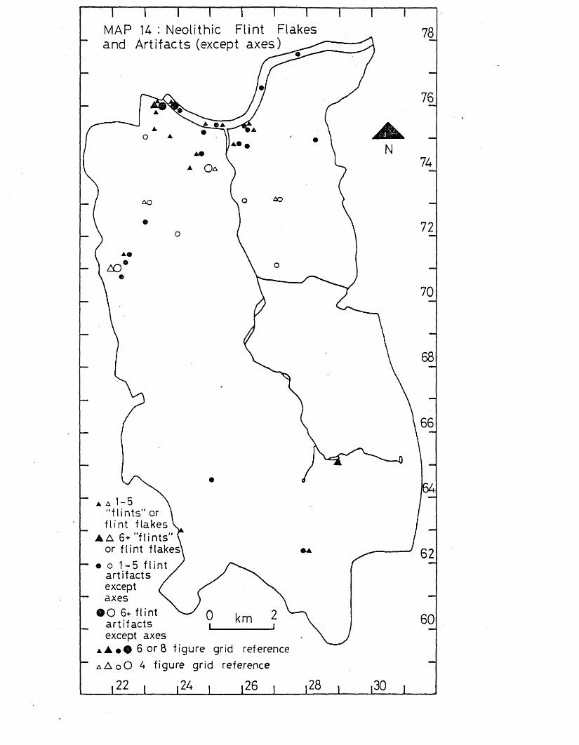
MAP 14 : Neolithic Flint Flakes and Artifacts (except axes)
68
▲ A 1-5 "flints" or flint flakes
A A 6+ "flints" or flint flakes'
• o 1-5 fIint artifacts except axes'O 6+ flint artifacts except axes
i A t O 6 ord figure grid referencea A o O 4 figure grid reference
I22 I l2̂ I |26 , ,28 , 130 |
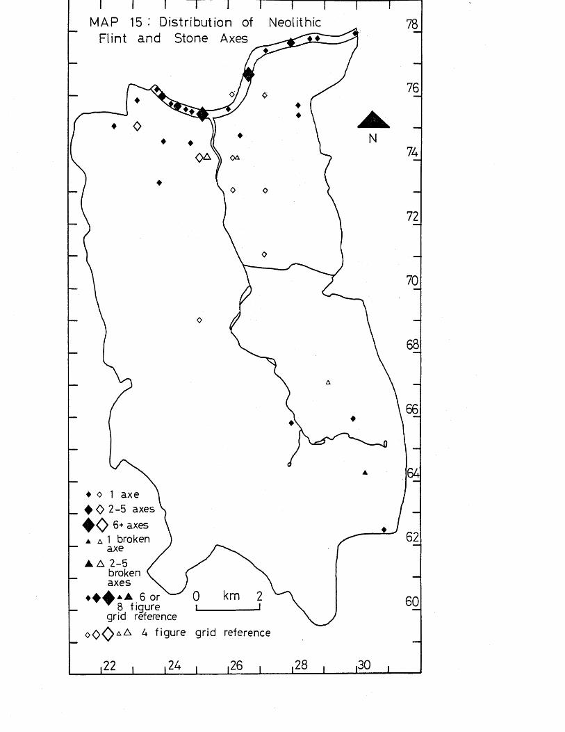
TMAP 15 Distribution of Neolithic
Flint and Stone Axes
♦ o 1 axe 4 0 2 -5 axes
♦ 0 6+ axes▲ a 1 broken
axe▲ A 2 -5
broken axes
6 or 8 figure
grid reference
o O O a A A figure grid reference
,22 24 .26 ,28
IntroductionThe Bronze Age dates from c. 2,300 BC to c. 700 BC, and is characterised by the first use of copper and bronze by man.The culture is broadly represented by^e^tleme^it sites, including the first use of hillforts,/^funerary monuments (in particular round barrows), pottery, flint and stone work, and metalwork. (Adkins & Adkins 1982, 45-73)*
Statistical Analysis (see p. 8 for details of method used).When every site and findspot of Bronze Age date was plotted within 1-kilometre squares, a non-random distribution could be seen, with different squares having 4, 5, 6 and 10 findspots (Carshalton, Battersea, Battersea Park, and the Thames from Putney to Battersea Park). The distribution within 2-kilometre squares is also non-random, with two squares with 5 findspots (Thames at Putney, and Putney to West Hill, Wandsworth, and Carshalton), one square with 5 findspots (Battersea Park and Nine Elms and the adjacent stretch of the Thames), and one square with 14 findspots (Wandworth and Battersea, and the Thames from Wandsworth to Battersea"), (see map 16).
When particular kinds of Bronze Age artifacts are studied, further variations from a random distribution can be seen.The distribution of bronze artifacts and hoards can be seen to be non-random, with one square having a clustering of 6 findspots (Battersea Park, and the Thames at Battersea Park), and one 9 findspots (Thames from Putney to Battersea and the adjacent riverside areas). The non-random distribution is further highlighted in the 2-kilometre squares, with two squares having concentrations of 4 findspots (Thames at Putney, and Putney to West Hill, Wandsworth; and Carshalton), one square a concentration of 7 findspots (Battersea Park and Nine Elms and the adjacent stretch of Thames), and one square a concentration of 11 findspots (Wandsworth and Battersea, and the Thames from Wandsworth to Battersea), (see map 18).
Flint and stone artifacts also have a non-random distribution, with five squares having 2 findspots (Thames from Putney to Battersea* S omthfields and the adjacent Wandle, Putney to
(Battersea Park and the Thames at Battersea Park), The 2- kiloraetre squares also have a non-random distribution with two squares having 3 findspots (Thames from Putney to Battersea, and Putney to Battersea), and one square 5 findspots (Battersea Park and Nine Elms and the adjacent stretch of the Thames), (see map 17).
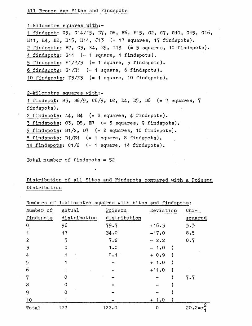
All Bronze Age Sites and Findspots
1-kilometre squares with:-1 findspot: C5, 014/15, 07, D8, E6, F15, G2, G7, G10, G15, G16, H11, H4, H2, H15, H14, J13 (= 17 squares, 17 findspots).2 findspots: B7, 03, E4, E5, 113 (= 5 squares, 10 findspots).4 findspots: G14 (= 1 square, 4 findspots).5 findspots: F1/2/3 (= 1 square, 5 findspots).6 findspots: G1/H1 (= 1 square, 6 findspots)»10 findspots: D3/E3 (= 1 square, 10 findspots).
2-kilometre squares with;-1 findspot: B3, B8/9, C8/9, D2, D4, D5, D6 (= 7 squares, 7 findspots).2 findspots: A4, B4 (= 2 squares, 4 findspots).3 findspots; C3, D8, E7 (= 3 squares, 9 findspots).5 findspots: B1/2, D7 (= 2 squares, 10 findspots).8 findspots: D1/E1 (= 1 square, 8 findspots).14 findspots: C1/2 (= 1 square, 14 findspots).
Total number of findspots = 5 2
Distribution of all Sites and Findspots compared with a Poisson Distribution
Numbers of 1-kilometre squares with sites and findspots;Number of Actual Poisson Deviation Chi-findspots distribution distribution sauared0 96 79.7 +16.3 3.31 17 34.0 -17.0 8.52 5 7.2 - 2.2 0.73 0 1.0 - 1.0 )4 1 0.1 + 0.9 )5 1 - + 1.0 )6 1 - + 41.0 )7 0 - - ) 7.78 0 - )9 0 - - )10 1 — + 1.0 )Total 192 122.0 0 20.2=x^
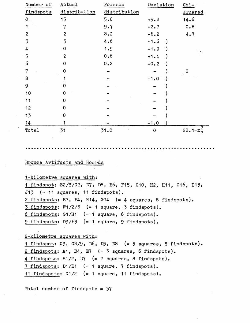
Number of Actual Poisson Deviation Chi-findspots distribution distribution squared0 15 5.8 +9.2 14*61 7 9.7 -2.7 0.82 2 8.2 -6.2 4.73 3 4.6 -1.6 )4 0 1.9 -1.9 )5 2 0.6 +1.4 )6 0 0.2 OJ.O1
7 0 - ) 08 1 - + 1.0 )9 0 - )10 0 - - )11 0 - )12 0 - )13 0 - - )14 1 — + 1.0 )Total 31 31.0 0 20.1.
Bronze Artifacts and Hoards
1-kilometre squares with:1 findspot: B2/3/C2, D7, D8, E6, F15, G1-0, H2, H11, G16, 113, J13 (=11 squares, 11 findspots),2 findspots: B7, E4, H14, 014 (= 4 squares, 8 findspots).3 findspots: F1/2/3 (= 1 square, 3 findspots).6 findspots; G-1/H1 (= 1 square, 6 findspots).9 findspots: D3/E3 (= 1 square, 9 findspots).
2-kilometre squares with:1 findspot: C3, C8/9, D6, D5, D8 (=5 squares, 5 findspots).2 findspots: A4, B4, E7 (= 3 squares, 6 findspots).4 findspots: B1/2, D7 (= 2 squares, 8 findspots).7 findspots: D1/E1 (= 1 square, 7 findspots).11 findspots: C1/2 (= 1 square, 11 findspots).
Total number of findspots = 37
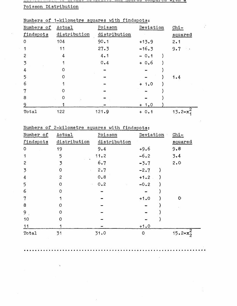
vx v m p d X V U W J L Lf±± d
Poisson Distribution
Numbers of 1-kilometre squares with findspots:Numbers of Actual Poisson Deviation Chi-findspots distribution distribution squared0 104 90.1 + 13.9 2.11 11 27.3 -16.3 9.7 ‘2 4 4.1 -0.1 )3 1 0.4 + 0.6 )4 0 - - )
5 0 - - ) 1.46 1 - + 1.0 )7 0 - - )
8 0 - - )
9 1 — + 1.0 )Total 122 121.9 + 0.1 13.2=x^
Numbers of 2-kilometre squares with findspots:Number of Actual Poisson Deviation Chi-findspots distribution distribution squared0 19 9.4 +9.6 9.81 5 11.2 -6.2 3.42 3 6.7 -3.7 2.0*3 0 2.7 -2.7 )
4 2 CD•O +1.2 )
5 0 0.2 CM.O1
6 0 - )
7 1 - +1.0 ) 0>
8 0 - - )
9 . 0 - )
10 0 - - )
11 1 — + 1.0Total 31 31.0 0 15.2=x?
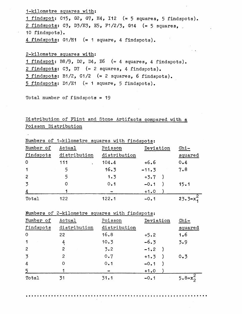
1-kilometre squares with:1 findspot: C15* G2, G7, H4> 112 ( = 5 squares, 5 findspots),2 findspots: 0 3 , D3/E3, E5, F1/2/3, G14 («='5 squares,10 findspots),4 findspots: G1/H1 (= 1 square, 4 findspots).
2-kilometre squares with:1 findspot: B8/9, D2, D4, E6 (= 4 squares, 4 findspots).2 findspots: C3, D7 (=2 squares, 4 findspots).3 findspots: B1/2, C1/2 ( = 2 squares, 6 findspots).5 findspots; D1/E1 (= 1 square, 5 findspots).
Total number of findspots = 1 9
Distribution of Flint and Stone Artifacts compared with a Poisson Distribution
Numbers of 1-kilometre squares with findspots;Number of Actual Poisson Deviation Chi-findspots distribution distribution squared0 111 104.4 +6.6 0.41 5 16.3 -11.3 7.82 5 1.3 +3.7 )3 0 0.1 -0.1 ) 15.14 1 — +1.0 )Total 122 122.1 -0.1 23.3=x^
<♦-1o09&© 2-kilometre squares with findspots:Number of Actual Poi sson Deviation Chi-findspots distribution distribution squared0 22 16.8 +5.2 1 *61 4 10.3 -6.3 3.92 2 3.2 -1.2 )3 2 0.7 +1.3 ) 0.34 0 0.1 -0.1 )5 1 — + 1.0 )Total 31 31.1 -0.1 5.8=Xg
The evidence for the activity by man in the Bronze Age in the Wandle Valley consists mainly of hoards and artifacts of bronze, as well as flint and stone artifacts, burials, settlement sites, and pottery. Like the material of the Neolithic period, none of the material from the area as a whole has undergone intensive study, although S.Needham is studying much of the evidence of the bronze artifacts within a wider area as a postgraduate thesis (S.Needham pers.comm.).
When all the findspots and sites of Bronze Age date are plotted regardless of dating within the Bronze Age, a distribution similar to that of the Neolithic period is seen, with concentrations of finds and sites in and near the River Thames from Putney to Battersea. A greater clustering of finds than seen in the Neolithic period on Wimbledon Common is evident, and also right across the Thanet sand spring line from Cheam to Beddington, with a more widespread presence on the chalk downs to the south (see map 16). The distribution of bronze hoards and artifacts reflects this distribution, although there are not many finds near the Thames (see map 18). The distribution of flint and stone artifacts is also similar, although there are no findspots on Wimbledon Common (see map 17). One area’which seems to have been avoided still is London Clay. The area from Battersea to Nine Elms-jwhich provides no evidence of activity or settlement up to the Neolithic period (see p. 70 )? does, for the first time, have a dispersed distribution of finds in the Bronze Age.
Many of the finds of Bronze Age date are a result of chance discoveries such as a great deg.1 of the metalwork and flintwork. However some evidence for this period has been a result of material being found in excavations (see gazetteer for details). One definite settlement site of Later Bronze Age date is at Queen Mary’s Hospital, Carshalton. Pottery of the Later Bronze Age has been found in association with ditches which formed a hill-top' enclosure set on an area of Thanet sand overlooking the chalk downs (see maps 3 and 16). Other Bronze Age finds from this site were a loomweight, perforated clay plaques, and copper cake (Lowther 1944;Robarts 1905). See p.178for an assessment of the role of this site.
rne oii-Ly u u n e r se u u i e m e n u sjl ue ± a auuui iour KiJ.oraet.re s uo the north-east of Queen Mary’s Hospital, Carshalton, at Aldwick Road, Waddon, where a bronze awl and pottery of Later Bronze Age date were found, but no other features of Bronze Age date were noted (Richardson 1923). Pottery of Later Bronze Age date has also been found in recent excavations (by R.Adkins and the author) to the north of the River Wandle at Beddington, about 1*5 kilometres north-west of the Aldwick Road site. Although the pottery is largely residual, the quantity suggests nearby occupation in this low-lying gravel area.
Apart from known settlement sites, there are several possible burial sites. At Barrow Hedges three barrows of possible Bronze Age date once existed (Grinsell 1934, 38), and at Wimbledon Common several barrows once existed which may also have been of Bronze Age date (Grinsell 1934, 27). Unfortunately, these barrows have been destroyed, and so there is no way of proving their date. A pot of possible Roman date was found in one of the Wimbledon Common barrows (see p.187 ), but some Bronze Age barrows are known to have been reused in the Roman period. A bronze adze was found at Wallington associated with burials, and so these burials may be of Bronze Age date (see D276 in gazetteer).
All the other evidence for settlement in the Bronze Age in the Wandle Valley is represented by chance finds of metalwork and flintwork, with a particularly large quantity of finds from the River Thames.
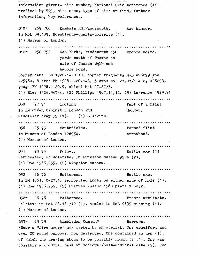
Information given:- site number, National £ft?id Reference (all prefixed by TQ), site name, type of site or find, further information, key references.
D10* 269 760 Kambala Rd,Wandsworth. Axe hammer.In MoL 69.189. Hornblende-quartz-dolerite (1).(1) Museum of London.
D12* 258 752 Gas Works, Wandsworth 150 Bronze hoard.yards south of Thames on site of Church Wailk and Warple Road.
Copper cake BM 1928.1-20.10, copper fragments MoL A26299 and A25760, 8 axes BM 1928.1-20.1-8, 3 axes MoL 27.87/1 & 2, A26298, gouge BM 1928.1-20.9, chisel MoL.27.87/3.(1) Rice 1924,343-4. (2) Phillips 1967,11,14. (3) Lawrence 1929,91
D30 27 71 Tooting Part of a flintIn BM unreg Cabinet J London and dagger.Middlesex tray 39 (1). (1) L.Adkins.
D36 25 73 Southfields.In Museum of London A26954.(1) Museum of London.
D51 23 75 Putney. Battle axe (1)Perforated, of dolerite. In Kingston Museum 998b (2).(1) Roe 1966,235. (2) Kingston Museum.
D52 26 76 Battersea. Battle axe.In BM 1861.10-27.1• Perforated knobs on either side of hole (1). (1) Roe 1966,235. (2) British Museum 1968 plate x no.2.
D52* 26 76 Battersea. Bronze artifacts.Palstave in MoL 28.181/12 (1), armlet in MoL C899 missing (1). (1) Museum of London.
D5 3* 23 73 Wimbledon Common* Barrows.*Near a "fire house" now marked by an obelisk. One cruciform and over 20 round barrows, now destroyed. One contained an urn (1), of which the drawing shows to be possibly Roman (2)(4). One was possibly a windmill base of medieval/post-medieval date (2). The
Barbed flint arrowhead.
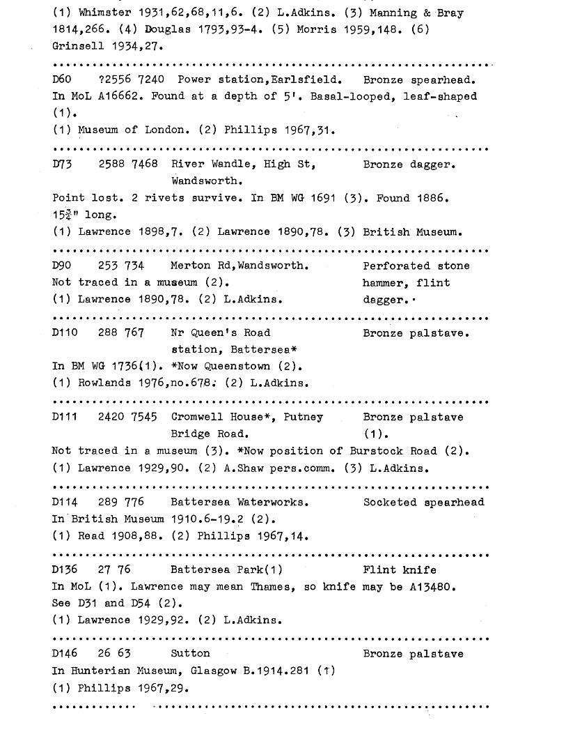
(1) Whimster 1931>62,68,11,6, (2) L.Adkins* (3) Manning & Bray 1814,266. (4) Douglas 1793,93-4. (5) Morris 1959*148. (6) Grinsell 1934,27.
D60 72556 7240 Power station,Earlsfield. Bronze spearhead.In MoL A16662. Pound at a depth of 5 1. Basal-looped, leaf-shaped(1). - V
(1) Museum of London. (2) Phillips 1967,31.
D73 2588 7468 River Wandle, High St, Bronze dagger.Wandsworth.
Point lost. 2 rivets survive. In BM WG 1691 (3). Pound 1886.15f" long.(1) Lawrence 1898,7. (2) Lawrence 1890,78. (3) British Museum.
D90 253 734 Merton Rd,Wandsworth. Perforated stoneNot traced in a museum (2). hammer, flint(1) Lawrence 1890,78. (2) L.Adkins. dagger.•
D110 288 767 Nr Queen*s Road Bronze palstave.station, Battersea*
In BM WG 1736(1). *Now Queenstown (2).(1) Rowlands 1976,no.678; (2) L.Adkins.
D111 2420 7545 Cromwell House*, Putney Bronze palstaveBridge Road. (1).
Not traced in a museum (3). *Now position of Burstock Road (2).(1) Lawrence 1929,90. (2) A.Shaw pers.comm. (3) L.Adkins.
D114 289 776 Battersea Waterworks. Socketed spearheadIn British Museum 1910.6-19.2 (2).(1) Read 1908,88. (2) Phillips 1967,14.
D136 27 76 Battersea Park(1) Flint knifeIn MoL (1). Lawrence may mean Thames, so knife may be A13480.See D31 and D54 (2).(1) Lawrence 1929>92. (2) L.Adkins.
D146 26 63 Sutton Bronze palstaveIn Hunterian Museum, Glasgow B.1914.281 (T)(1) Phillips 1967,29.
Palstave KM no.737 (1)(4)• 4 socketed axes and 1 winged axe Royal Ontario Museum, Toronto 930.83-l6-r20) (3), spearhead (1)(2)(4) not traced (5).(1) Phillips 1967,33* (2) Needham, S. pers.comm. (3) Pryor 1980, 22. (4) Devenish 1964,6. (5) L.Adkins.
D203 2564 7467 Ram Brewery, Red Lion St*, Small bronzeWandsworth. spearhead.
*Now York Road (3). Not traced (2).(1) Lawrence 1898,7. (2) L.Adkins. (3) A.Shaw pers.comm.
D218* 2820 7493 Clapham Common opposite Discoidal flintWakehurst Drive knife
May be neolithic. In British Museum 1935.10-21.1 (1). See C218. (1) British Museum.
D232 27 64 Carshalton Flint dagger.Has 2 notches. Was in collection of Samuel Meyrick (1)(2) but did not pass into the collection of Sir Richard Wallace (4). (1) Evans 1897,351. (2) Skelton 1830,pl.xlvi. (3) Grimes 1931, 353. (4) A.V.B. Norman (Wallace collection) pers.comm.
D236 27 68 Mitcham. 3 palstaves.In BM WG 1863 (2), Wellcome coll P.1964.12-1.120 (3), and Royal Ontario Museum, Toronto 929.16.15 (1).(1) Pryor 1980,7. (2) Rowlands 1976,317. (3) British Museum.
D238 22 71 Wimbledon Common. Socketed axe.Formerly Pitt Rivers Museum, Farnham. Now lost (2).(1) Phillips 1967,33. (2) S.Needham pers.comm.
D239 3072 6503 Aldwick Rd, Waddon. Bronze awl (1),Awl is held by CNHSS (3). Found in pottery (2).development of estate. See also A239, B239, C239, E239 and F239. (1) Richardson 1923,147-8. (2) Barrett 1973,127. (3) CNHSS.
D242* 2793 6236 Queen Maryfs Hospital, Pottery, copperCarshalton. cake, loomweight*,
Later Bronze Age date. *In BM 1931.12-8. enclosure (1)(3)•1 (2). Some material is in Guildford Museum 1223,S3707-11 not examined (2). See also B242, C242, E242, F242 and G242.(1) Lowther 1944. (2) L.Adkins. (3) Robarts 1905.
Found in excavation (1). See also B243, tanged flintF243 and G243. arrowheads.(1) Turner 1965.
D273 2719 6428 Railway cuttings,Carshalton.
Now lost (1).(1) Birch 1925,103.
D275 238 636 Cheam Park.Not traced in a museum (2).(1) Carpenter 1961,111. (2) L.Adkins.
D276 2875 6453 Junction of Alcester and Several gravesManor Rds, Wallington. and a bronze
*Not traced, although there is an adze spearhead (1)*labelled ’'bronze spear from Beddington" in CNHSS Museum (2). (1) Brock 1871,517-8. (2) S.Needham pers.comm.
D278* 2921 6504 Beddington Park opposite Hoard.the Rectory*
*312 Croydon Rd. 3 copper ingots (1), 6 socketed axes (1) (one in MoL 28.181/4 (3)), 2 broken spearheads (1), % celt mould (1), gouge (1).(1) Flower 1874,124-6. (2) Phillips 1967,10,14. (3) S.Needham pers.comm.
D279 281 640 Carshalton Park* Hoard.*Found in building work (1). Consisted of 10 axes (3)(3 incorrectly described as palstaves (2)); some broken and damaged. Now in Birmingham Museum 850!53A-I.(1) Collyer 1908,208-9. (2) Phillips 1968,130. (3) S.Needham pers. comm.
D280 2709 6420 Railway cuttings, Hoard.Carshalton.
Many axeheads and spearheads (1). Now lost.(1) Birch 1925,103.
D281 272 630 Barrow Hedges,Carshalton. 3 barrows (1)Possibly Saxon. Now built over (2). See G281.(1) Salmon 1736,46-7. (2) Grinsell 1934,38.
Barbed and tanged flint arrowhead
Hoard of bronze ingots.
Station.In Museum of London 73.52/6 & 7 (1)(2).(1) Rowlands 1976,237. (2) Phillips 1967,27.
D289 247 710 Woodside, Wimbledon 2 winged axes.Common.
*Wrongly published as Woodside Common (1). In Salisbury Museum formerly Pitt Rivers Museum, Farnham (1)(2).(1) Phillips 1967,33. (2) Salisbury Museum. (3) L.Adkins.
D291 224 711 Caesar1s Camp, WimbledonCommon•
Not traced in a museum (2). See also C291, E291 (1) PSA ii 2 1862,8. (2) L.Adkins.
Copper cake,
and F291.
D304 2978 6583 Beddington sewage farm. Found in excavation by SWLATJ (1). See also C304, E304, F304 and G304.(1) L.Adkins.
Potsherds,hammerhead.
THAMES SITES AND FINDS
D5 2571 7539 Thames'fore shore,Battersea. Group XIV stone. In possession of WHS.(1) Loobey 1975.
Perforated battle axe.
D14 259 755 Thames, i mile belowmouth of Wandle (1)*
*Usually published as Thames, m~outh of Wandle. Museum 1850.7-25.1-4 (1).(1) BM. (2) Evans 1881,282,316,368. (3) Hawkes 1852.
Sword, spearhead, pin and palstave. In British
1942. (4 ) Franks
D19 270 774 Thames, Battersea Bridge(1). Usually published as Thames, Battersea.In Museum of London A14982.(1) Lawrence 1929,92. (2) Roe 1966,235.
Perforated axe hammer.
D19 270 774 Thames, Battersea Bridge. Bronze artifacts.Sword AM 1927.2531 (1)(2), sword BM 1850.12-26.1 (3), sword MoL A21 (6), sword BM (4) not traced, ferrule BM (5) not traced (7), axe MoL A15457, axe BM WG 1746, palstave BM 1858.8-28.1, palstave
dagger BM (4) not traced.(1) Burgess 1969 fig 9. (2) Evans 1881,278. (3) Cowen 1967,442.(4) Lawrence 1929,92. (5) Greenwell & Brewis 1909 plate 80 fig 76 (6). Trump 1962,98. (7) L.Adkins.
D27 242 757 Thames, Putney Bridge. Flint artifacts.Perforated flint hammer Museum of L0ndon (1) A26816. Discoidal flint knife MoL A24954 (2),(1) Lawrence 1929,90. (2) Clark 1928,41,50.
D27* 242 757 Thames, Putney Bridge. Bronze artifacts.Spearhead MoL (3) A24803, spearhead MoL (3) A24997, spearhead MoL A24794 (4), pin MoL A25397 (4), rapier MoL A25186 (1), palstave MoL (3) A25396.(1) Trump 1962,96. (2) Burgess 1969 fig 5. (3) Lawrence 1929,90.
D31 260 755 to Thames, Battersea. Flint and stone285 778 artifacts.
Perforated stone hammer MoL A27000 (4), perforated battle axe MUM 01909 (6), dagger MoL A13480 (2) possibly Thames, Battersea Park, or Battersea Park: see D54 and D136 (5), dagger BM cc St 135a (1)(3), knife BM cc St 96B (7).(1) Grimes 1931,353. (2) Celoria & Macdonald 1969,39,41. (3) Smith 1919,16. (4) MoL. (5) L.Adkins. (6) MUM. (7) BM.
D31* 260 755 to Thames, Battersea. Bronze artifacts.285 778
Swords: Hallstatt in BM WG 2272 (4), Hallstatt in BM 1857.9-20.1(4), point of MoL A19780 (2), BM WG 1245 (5), BM WG 1249 (5), BM WG 2425 (5), BM 1854.10-28.1 (5), Newbury Museum S.223 (9) not traced (10), i sword MoL A24934 (2). Rapiers: BM WG 1684 (5), MoL A19786 (3), PRM0 1884 (6), Bradford coll (3) not traced (8), BM 1870.9-21.1 (5), BM WG 1254 (5), BM WG 1700 (3), BM WG 1701 (3),BM WG 1701 (3), BM WG 1698 (3). Dirk in Royal Ontario Museum, Toronto, 910.153.2 (3). Spearheads BM WG 1644 (5), BM 1856.7-19.1(5), BM WG 1666 (11), BM 1854.10-28.2. Cauldron (1) is in BM 1861.3-9.1. Armlet MoL C899 missing (7), gouge BM (1) 1873*7-2.1, socketed axe MoL 54.32 (7).(1) Evans 1881,175,281,321,411. (2) Lawrence 1929,91. (3) Trump1962,96,97. (4) Cowen 1967,412,442,453. (5) BM. (6) Allen et al 1970,48,150. (7) MoL. (8) L.Adkins. (9) Pamphlett by Newbury Museum in Institute of Archaeology, London (Coghlan undated).
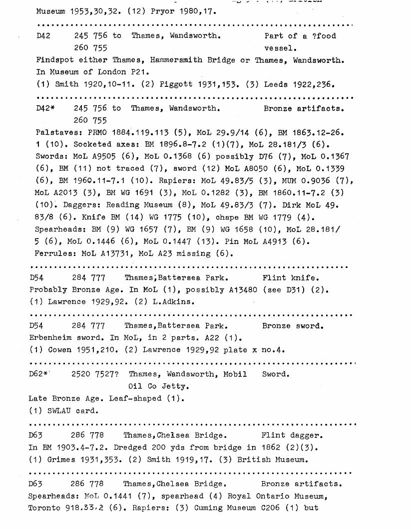
Museum 1953,30,32. (12) Pryor 1980,17.
D42 245 756 to Thames, Wandsworth. Part of a ?food260 755 vessel.
Findspot either Thames, Hammersmith Bridge or Thames, Wandsworth. In Museum of London P21.(1) Smith 1920,10-11. (2) Piggott 1931,153. (3) Leeds 1922,236.
D42* 245 756 to Thames, Wandsworth. Bronze artifacts.260 755
Palstaves: PRMO 1884.119.113 (5), MoL 29.9/14 (6), BM 1863.12-26.1 (10). Socketed axes: BM 1896.8-7.2 (1)(7), MoL 28.181/3 (6). Swords: MoL A9505 (6), MoL 0.1368 (6) possibly I f f 6 (7), MoL 0.1367 (6), BM (11) not traced (7), sword (12) MoL A8050 (6), MoL 0.1339 (6), BM 1960.11-7.1 (10). Rapiers: MoL 49.83/5 (3), MUM 0.9036 (7), MoL A2013 (3), BM WG 1691 (3), MoL 0.1282 (3), BM 1860.11-7.2 (3)(10). Daggers: Reading Museum (8), MoL 49.83/3 (7). Dirk MoL 49* 83/8 (6). Knife BM (14) WG 1775 (10), chape BM WG 1779 (4). Spearheads: BM (9) WG 1657 (7), BM (9) WG 1658 (10), MoL 28.181/5 (6), MoL 0.1446 (6), MoL 0.1447 (13). Pin MoL A4913 (6).Ferrules: MoL A13731, MoL A23 missing (6).
D54 284 777 Thames;Battersea Park. Flint knife.Probably Bronze Age. In MoL (1), possibly A13480 (see D31) (2). (1) Lawrence 1929,92. (2) L.Adkins.
D54 284 777 Thames,Battersea Park. Bronze sword.Erbenheim sword. In MoL, in 2 parts. A22 (1).(1) Cowen 1951,210. (2) Lawrence 1929,92 plate x no.4.
D62*' 2520 7527? Thames, Wandsworth, Mobil Sword.Oil Co Jetty.
Late Bronze Age. Leaf-shaped (1).(1) SWLAU card.
D63 286 778 Thames,Chelsea Bridge. Flint dagger.In BM 1903.4-7.2. Dredged 200 yds from bridge in 1862 (2)(3). (1) Grimes 1931,353. (2) Smith 1919,17. (3) British Museum.
D63 286 778 Thames,Chelsea Bridge. Bronze artifacts.Spearheads: MoL 0.1441 (7), spearhead (4 ) Royal Ontario Museum, Toronto 918,33*2 (6). Rapiers: (3) Cuming Museum C206 (1) but
Sword (3) not traced (9). Sword (3) BM WG 1243 (9), part of a cauldron (5) BM 1861.3-4*5 (9).(1) WHS. (2) Cuming 1857,238. (3) Cuming 1858,326,328,329,330. (4) Evans 1881,245,279,327* (5) Smith 1907,328,329* (6) Pryor 1980,14. (7) MoL. (8) Cuming Museum. (9) L.Adkins. (10) Trump1962,97.
TfJ0 284 777 Thames,east end of Perforated stoneBattersea Park. hammer (1).
In Museum of London A 15; 80 cm long, on display (2).(1) Lawrence 1929,92. (2) Museum of L0ndon.
D75* ? Thames, Price's Candle Sword, flat axe.Factory.
Ballintober sword in MoL 0.1339 (1). Axe in BM (2) not traced (3) (1) MoL. (2) Lawrence 1929,91. (3) L.Adkins.
D76* ? Thames, Wandsworth nearly Rapier, sword.opposite "Feathers".
Rapier in MoL 0.1318 (1). Wilburton sword in MoL (2).(1) Trump 1962,96. (2) Museum of London.
D79 236 763 to Thames, Putney. Portion of flint245 756 dagger.
In British Museum "Thames, Putney 1696" unregistered (1).(1) L.Adkins.
D79* 236 763 to Thames, Putney. Bronze artifacts.245 756
Palstaves: MoL 0.1197 (1), MoL 28.181/11 (1). Rapiers: MoL 0.1307(3), BM WG 1688 (3), MUM 0.9034 (5), St Albans Museum (3). AxeMoL 50.2/1 missing (4). Swords: in 2 parts MoL 49.83/1 & 4 (4),BM WG 1689 (6). Spearhead MoL 50.2/2 (4)* Razor BM (2). Pins:BM WG 1771 (6), BM WG 1778 (6), BM WG 1769 (6).
D82 255 754 Thames, mouth of Wandle. Bronze artifacts.Palstave MoL A15441 (5), rapier MoL A13942 (1)(4), Hallstatt sword BM WG 1246 (2)(3).(1) Trump 1962,97* (2) Cowen 1967,449. (3) Cowen 1952,145.(4 ) Wheeler 1927,296. .(5) Museum of London. ......i ..............................................................D83 244 1-56 Thames, east of Putney Socketed pegged
Early Bronze Age* In Museum of London A26394. Tip missing (2)* (1) Lawrence 1929,90. (2) Needham 1979,25-6. (3) Ant.J. 4 1924,49.
D91* 259 755 Thames, Wandsworth Bridge. Bronze artifacts.Palstave BM WG 1738 (3). Hallstatt sword MoL ex Royal Scottish Museum (1)(2). Hallstatt sword (1) not traced.(1) Lawrence 1929,91. (2) Cowen 1967,442. (3) British Museum.
D116* 262 755 Thames, nearly opposite 2 palstaves.Wandsworth distillery.
In British Museum 1858.7-13.1 & 2 (1).(1) British Museum.
D128* 270 774 to Thames, Chelsea. Flint knife.286 778
In Museum of London A15328.(1) Museum of London.
D128 270 774 to Thames, Chelsea. Bronze artifacts.286 778
Palstave GPM 0.1179, Ballintober sword MoL A6366, spearhead BM 1896.6-24.8, ferrule BM'WG 1674.(1) Trump 1962,98. (2) PSA 5 1870-3,430.
D274 256 753 Thames foreshore in wall Sword, socketedof Gas Works, Wandsworth. axe.
Sword in BM with 6 rivets and V-shaped handle (1). Neither traced (2).(1) Lawrence 1929,91. (2) L.Adkins.
D363 287 778 Thames, near Battersea Late Bronze AgeBridge. socketed axe (2),
2 copper cakes. (1) Guildhall Museum 1908,3. (2) Burgess 1969 fig 13 no.5.
I I
— co-f.f—'s ■s"J CO cOrJRjfiUDfOO J r ^ Q Q QMAP 16 '• Ail Bronze Age Sites and Findspots ^
DIO ■bD136
D52QD111 Y l* 012
D73^a D203D51 □
□53 □
D289
aD236
jp D304
□273 D280*
D232D
a#D276 D243*D279d □ f lin t a
stone artifacts
□146 A♦ o bronze
hoardsA bronze
artifacts□ barrowsA pottery
• o burial O settlement
a ♦ a ia A • © 6 or 8 figure grid reference
□ O a D A o O 4 figu re grid reference
22 , .24
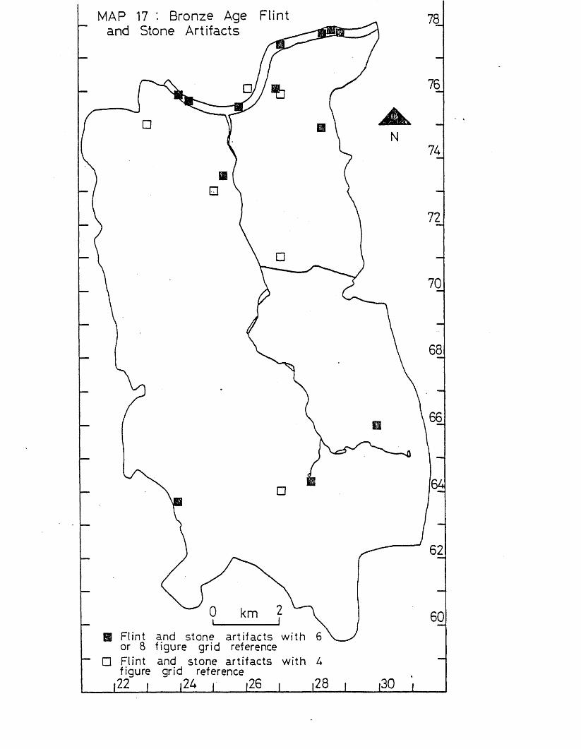
MAP 17 '• Bronze Age Flint and Stone Artifacts
El Flint and stone artifacts with 6or 8 figure grid reference
□ Flint and stone artifacts with Afigure grid reference

MAP 18 Distribution of Bronze Age Hoards and Artifacts of Bronze
■ □ bronze hoards
▲ a bronze artifacts
figure / grid C reference
kmgrid reference
The Iron Age
IntroductionThe Iron Age dates from c.700 BC to the invasion by the Romans in AD 4 3 , and is characterised by the first use of iron by man. The period is represented in southern England by settlement sites and hillforts, and some burials, and the material culture includes metalwork (including coins), bone- work and pottery, (Adkins & Adkins 1982, 74-98).
Statistical Analysis (see p.8 for details of method used). When every site and findspot of Iron Age date was plotted within 1-kiloraetre squares, a non-random distribution was observed, with two squares with 3 findspots (Putney and the Thames at Putney, and Battersea and the Thames at Battersea), and one square with 5 findspots (Thames from Putney to Battersea and adjacent riverside areas). This non-random distribution is also apparent in 2-kilometre squares, with one square having 4 findspots (Beddington, Bandon Hill and Waddon), one square 6 findspots (Thames at Putney, and Putney to West Hill, Wandsworth), and one square 9 findspots (Wandsworth and Battersea, and the Thames from Wandsworth to Battersea). (See map 19%
When particular kinds of Iron Age artifacts are studied, further variations from a random distribution can be seen.The distribution of Iron Age metal artifacts in the Wandle Valley is non-random, with two squares within the 1-kilometre grid having 2 findspots (Wandsworth either side of the Wandle, and Battersea and the Thames at Battersea), and one square.having 5 findspots (Thames from Putney to Battersea and adjacent riverside areas). The 2-kilometre squares also display this non-random distribution, withrone square having 3 findspots (Thames at Putney, and Putney to West Hill, Wandsworth), and one square 6 findspots (Wandsworth and Battersea, and the Thames from Wandsworth to Battersea) (see map 20).
Finds of pottery have a non-random distribution within 1- kilometre squares, with three squares with 2 findspots (Putney snd the Thames at Putney, East Hill, Wandsworth, and Battersea Park and the Thames at Battersea Park), and two
adjacent riverside areas; and Beddington). The 2-kilometre squares also display this non-random distribution, with one square with 3 findspots (Wandsworth and Battersea, and the Thames from Wandsworth to Battersea), and two squares with 4 findspots (Thames at Putney, and Putney to West Hill, Wandsworth; and Beddington, Bandon Hill and Waddon). (see map 2 1).
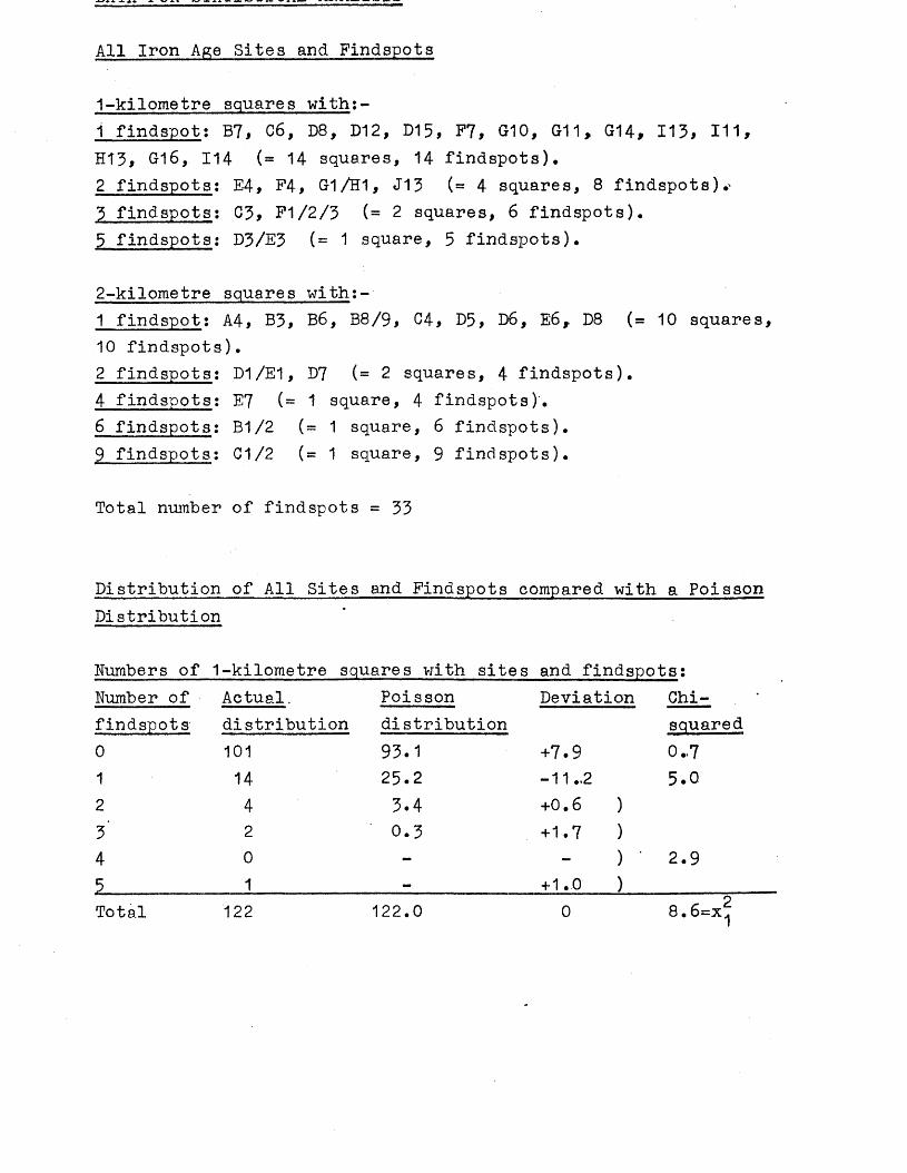
All Iron Age Sites and Findspots
1-kilometre squares with:-1 findspot: B7, C6, D8, D12, D15, P7, G10, G11, G14, 113, 111, H13, G16, 114 (= 14 squares, 14 findspots),2 findspots: E4, F4, G1 /H1, J13 (= 4 squares, 8 findspots).^3 findspots: C3, P1/2/3 (= 2 squares, 6 findspots).5 findspots: D3/E3 (= 1 square, 5 findspots).
2-kilometre squares with:-1 findspot: A4, B3, B6, B8/9, C4, D5, D6, E6, D8 (= 10 squares, 10 findspots).2 findspots: D1/E1, D7 (= 2 squares, 4 findspots).4 findspots: E7 (= 1 square, 4 findspots).6 findspots: B1/2 (= 1 square, 6 findspots).9 findspots: C1/2 (= 1 square, 9 findspots).
Total number of findspots = 33
Distribution of All Sites and Findspots compared with a Poisson Distribution
Numbers of 1-kilometre squares with sites and findspots:Number of Actual. Poisson Deviation Chi-findspots distribution distribution squared0 101 93.1 +7.9 0.-71 14 25.2 -11.,2 5.02 4 3.4 +0.6 )3' 2 0.3 +1.7 )4 0 - ) • 2.9 5_______________ 1_______________ =_____________ +1.0 )____________Total 122 122.0 0 8.6=x!j
Number of Actual Poisson Deviation Chi-findspots distribution distribution squared0 16 10.7 +5.3 2.61 10' 11..4 -1.4 0..22 2 6.1 -4.1 00•CM
3 0 2.2 -2.2 )4 1 0.6 +0.4 ) - *5 0 0.1 -0.1 )6 1 - +1.0 ) 07 0 - • •8 0 - )9 1 + 1.0 )Total 31 31.1 -0.1 5.6=X2
Metal Artifacts, including Coins
1-kilometre squares witb:1 findspot: G1/H1, D8, G10 , D12, 111 (= 5 squares, 5 findspot2 findspots : E4, P1/2/3 (- 2 squares, 4 findspots).5 findspots : D3/E3 (= 1 square, 5 findspots).
2-kilometre squares wi th:
3 findspots: B1/2 (= 1 square, 3 findspots), 6 findspots: C1/2 (= 1 square, 6 findspots).
Total number of findspots = 14
a Poisson Distribution
Numbers of 1-kilometre squares with findspots:Number of Actual Poisson Deviation Chi-findspots distribution distribution squared0 114 108.8 +5.2 0.31 5 12.5 -7.5 4.5 *2 2 0.7 +1.3 )3 0 - )4 0 - ) 7.65 1 — +1.0 )Total 122 122.0 0 12.4=x^
Numbers of 2-kilometre squares with findspots:Number of Actual Poisson Deviation Chi-findspots distribution distribution squared0 24 19.7 +4.3 0.91 5 8.9 -3.9 1.72 0 2.0 -2.0 )3 1 0.3 +0.7 )4 0 - ) 05 0 - )6 1 _ + 1.0 )Total 31 30.9 +0.1 2.6=x^
Pottery
1*»kilometre squares with:-1 findspot: B7, C6, D15, F7, £16, H13, H U , J14 (= 8 squares,8 findspots).2 findspots: C3, F4, G-1/H1 (= 3 squares, 6 findspots).3 findspots: D3/E3, 113 (- 2 squares, 6 findspots).
^-Kilometre squares wipn:-1 findspot: A4, B3, B8, C4* D8 (= 5 squares, 5 findspots).2 findspots: D1/E1, D7 (= 2 squares, 4 findspots).3 findspots: C1/2 (= 1 square, 3 findspots).4 findspots: B1/2, E7 (= 2 squares, 8 findspots).
Total number of findspots = 20
Distribution of Pottery compared with a Poisson Distribution
Numbers of 1-kilometre squares with findspots;Number of Actual Poisson Deviation Chi-findspots distribution distribution squared0 109 103.6 +5.4 0.31 8 17.0 -9.0 4.82 3 1.4 +1.6 )5 2 0.1 +1.9 ) 8.2Total 122 122.1 -0.1 13.3=x^
Numbers of 2-kilometre squares with findspots:Number of Actual Poi sson Deviation Chi-findspots distribution distribution squared0 21 16.3 +4.7 1.41 5 10.5 -5.5 2.92 2 3.4 -1.4 )3 1 0.7 +0.3 ) 0.24 2 0.1 +1.9 )Total 31 31.0 0 * c 24.5=x 2
DiscussionEvidence for man in the Iron Age in the Wandle Valley is represented by few sites and finds. This includes a mixture of metalwork including coins, and also pottery, two enclosures, and other features relating to settlement. Finds from the River Thames form a contrast to the finds from the land, as they consist largely of metal artifacts.
When all the sites and findspots of the Iron Age are plotted, a clustering of finds in the Thames is noticeable, particularly from Putney to Wandsworth. Distribution of other sites and findspots appear from the map to be fairly random, with some clustering from Carshalton to Beddington, and this is matched by statistical analysis (see p.106 ). When only metal artifacts are plotted, there is a concentration of finds in the Thames with very few on the land, a complete contrast to the distribution of metal artifacts seen in the Bronze Age, where there were several finds on land as well (see map 18). The distribution of other artifacts of Iron Age date, such as pottery and bone, shows concentrations in the Thames and along the Thanet sand spring line.There is a virtual absence of material from along the Thames banks.
In the Bronze Age, Queen Mary's Hospital, Carshalton, was the site of a Later Bronze Age enclosure. Pottery from the later silts of the ditches is dated to the early Iron Age, and so this site probably continued in use from the Later Bronze Age until at least the early Iron Age (Needham &Burgess 1980, 459). The only other similar site in the Wandle Valley is Caesar's Camp, Wimbledon, which seems to be a univallate hillfort of Iron Age date (Lowther 1945, 15-20), although the possibility of it also having a Bronze Age origin must also be considered (see p. 90). Occupation at this site may have continued into the late Iron Age, since a Belgic pot was found on the site (Dunning 1932). About 1*5 kilometres to the north-east of this site a bone knife and potsherds were found which the Museum of London records as Iron Age (see E173), although the finds are not available for study.
Other possible settlements are less easy to demonstrate. Iron Age potsherds were recorded at Bemish Road, Putney (see E360), and from Pel sham Road, Putney (Richardson 1978, 162). Iron
Age potsherds and a grain rubber have been recorded from Dault Road, Wandsworth, close to the Wandle and Thames, and nearby Iron Age potsherds associated with calcined bones were found at St Ann's Crescent, Wandsworth, (see E316 and E350). All these finds could represent settlement sites. Further south in the Wandle Valley a complete pot has been found at Tooting right by the Wandle (see E354), but this could be Later Bronze Age in date. Further south again a bone shuttle was found at Mitcham right by the River Wandle (see E189), but it is considered to have been imported to the area by a collector in recent times (Orton 1930, 17). Further south just north of the Croydon arm of the Wandle, pottery associated with pits has been found in recent excavations at Beddington (by R.Adkins and the author) which must represent settlement in this area, first seen in this area in the Later Bronze Age (see p. 91). Near this site but just to the south of the Wandle, pottery and a skull alleged to be Iron Age in date were found at Aldwick Road, Waddon (see E239), and at Bandon Hill to the west 20 potsherds and part of a loomweight were found (see E163). About 100 potsherds were found at Bunker's Field, Wallington (see E240), pottery, an oven at Burleigh Avenue, Wallington (Pryer 1977), and one potsherd at Carshalton^(Pryer 1974, 9). Iron Age pottery has also been recorded at Cheam (Marshall 1 9 5 6 , 10).
\ X M 4 J J L i JL X X J X D J .k V X ’ JL JL .L J k-J a w u- j . n v i . 1 a a \ - 4 j l - j x / x i > a x j
Information given:- site number, National Grid Reference (all prefixed by TQ), site name, type of site or find, further information, key references.
E50 25 74 Wandsworth Dagger sheathPound by Lawrence; in Greenwell collection (10), not traced (2). (1) Lawrence 1890,78. (2) L.Adkins.
E127 2418 6626 3 Kingsbridge Rd,Morden. Bronze coin. Finder R.Mash used a metal detector; he thought it Iron Age but lost the coin (1) so identification cannot be checked.(1) Montague,E. pers.comm.
E163 2995 6461 Ban don Hill. 20 potsherds,Found in excavation by BC&WAS (1). See triangularalso F163 and K163. loomweight.(1) Orton,C. forthcoming.
E172 24 70 Wimbledon. Bronze coin.Greek (1). Not traced in a museum (2).(1) Milne 1948,38. (2) L.Adkins.
E175 230 724 Near windmill, Wimbledon Bone knife,Common. potsherds.
In Museum of London A20055 (1). Not examined (2).(1) Museum of London. (2) L.Adkins.
E189 2706 6788 Mitcham Grove Bone shuttle.Used in weaving. May be a recent loss as Samuel Hoare lived in the house (2). See also F189.(1) Bird 1977,284-5. (2) Orton 1980,17.
E234 29 67 Mitcham Common. Gold stater.Gallo-Belgic B. In Museum of London A17673 (1)»(1) Allen 1960,154.
E236 27 68 Mitcham. Gold coin.Gallo-Belgic A (1). Not traced in a museum (2).(1) Allen 1960,151. (2) L.Adkins.
E238: see E328
Found in development of estate. See also pottery (1)(2)(3)A239, B239; C239, D239 and F239.(1) Row 1923,80-2. (2) Frere 1944,59. (3) Bishop 1971,22.
E240 2888 6502 Bunker's Field,Wallington. Pottery**About 100 sherds found in excavation (3). See also B240, F240 and G240. In possession of Sutton library (2).(1) Major 1925,113-4. (2) Sutton library. (3) Morris 1959,134.
E242* 2793 6236 Queen Mary's Hospital, Pottery,Carshalton. ?hillfort.
Possibly represents continuous occupation from the Bronze Age (see D242)(2). See also B242, C242, D242, F242 and G242.(1) Eowther 1944* (2) L.Adkins. (3) Robarts 1905.
E250 2790 6408 7,9 & 10 The Park, Potsherd.Carshalton.
Found in excavation (1). See also B250.(1) Pryer 1974,9.
E290 2474 6307 Manor Lane*, Cheara. Pottery.*Now Manor Road (2). See also F290.(1) Marshall 1936,10. (2) L.Adkins.
E291 2240 7107 Wimbledon Common. UnivallateCalled "Caesar's Camp". Potsherds found hillfort.on site, and a Belgic pot in MoL 32.166 (5). Some material is in GM RB 1084 (6). See also D291 and F291.(1) Whimster 1931,116,239. (2) Bishop 1971,22. (3) Tregellas 1866,261-9. (4) Lowther 1945,15-20. (5) Dunning 1932,437.(6) Guildford Museum.
E304 2978 6583 Beddington sewage farm. Potsherds,Found in excavation by SWLAU (1). See features,also C304, F304 and G304.(1) L*Adkins.
E316 262 744(1) Dault Rd, WandsworthNo further information.(1) Former Field Officer, SWLAU. *
Potsherds, grain rubber.
Found in excavation by C.Orton (1). See also F326 and G326. (1) Pryer 1977*
E328 255 747 River Wandle, Wandsworth. Iron blade. Not examined. In Museum of London C752 (1).(1) Museum of London. Plotted as E238 on map.
E343 2397 7558 38 Felsham Rd, Putney. Potsherds.Excavation by WHS (1). See also C343, F343 and K343.(1) Richardson 1978,162.
E350* 262 744 51 St Ann's Crescent, Potsherds*Wandsworth.
*Associated with calcined bones and flints. Excavation by Wandsworth Historical Society. See also K350.(11) Hurst 1971,6-7.
E354 260 716 Near Copper Mills, UrnSummerstown, Tooting.
Possibly Late Bronze Age(1). In Museum of London A23465 (1). (1) Museum of London. (2) L.Adkins.
E360* 238 756 10 Bemish Road, Putney. Potsherds.Found in excavation by WHS (1). See also C36O and F36O. (1) SyAS Bulletin 93 1973.
THAMES SITES AND FINDS
E2* 249 755 Thames, Wandsworth Park. Potsherds.Found by Wandsworth Historical Society (1).('1) Wandsworth Historical Society.
E3 284 776 Thames foreshore, Battersea. Potsherds. Belgic. Found by S.Palmer. See also F3 and K3*(1) Palmer 1965.
E19* 270 774 Thames, Battersea Bridge. Metal artifacts.Sword MoL (3) not traced. Iron spearhead with bronze rivet MoL(3) not traced, spearhead BM 1915.12-8.215. Bronze dagger sheath BM 1898.6-18.1 (1 )(2).(1) Jope 1961 passim. (2) Smith 1925,109. (3) Lawrence 1929,92.
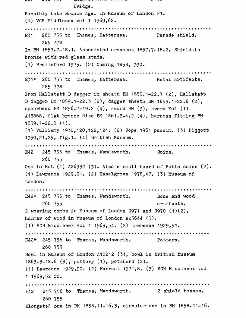
Bridge.Possibly Late Bronze Age. In Museum of London P1. (1) VCH Middlesex vol 1 1969,62.
E31 260 755 to Thames, Battersea. Parade shield.285 778
In BM 1857.7-18.1. Associated ornament 1857*7-18.2. Shield Is bronze with red glass studs.(1) Brailsford 1975. (2) Cuming 1858, 330.
E31* 260 755 to Thames, Battersea. Metal artifacts.285 778
Iron Hallstatt D dagger in sheath BM 1859.1-22.7 (2), Hallstatt D dagger BM 1859.1-22.3 (2), dagger sheath BM 1859.1-22.8 (2), spearhead BM 1856.7-19.2 (4), sword BM (3), sword MoL (1)A13868, flat bronze disc BM 1861.3-4.2 (4 ), harness fitting BM 1859.1-22.6 (4 ).(1) Vulliamy 1930,120,122,124. (2) Jope 1961 passim. (3) Piggott 1950,21,25, fig.1. (4) British Museum.
E42 245 756 to Thames, Wandsworth. Coins.260 755
One in MoL (1) A26932 (3). Also a small hoard of Potin coins (2). (1) Lawrence 1929,91. (2) Haselgrove 1978,47* (3) Museum of London.
E42* 245 756 to Thames, Wandsworth. Bone .and wood260 755 artifacts.
2 weaving combs in Museum of London C971 and C970 (1)(2), hammer of wood in Museum of London A25644 (3).C D VCH Middlesex vol 1 1969,54. (2) Lawrence 1929,91.
E42* 245 756 to Thames, Wandsworth. Pottery.260 755
Bowl in Museum of London A10212 (3), bowl in British Museum 1863.3-18.6 (3), pottery (1), potsherd (2).(1) Lawrence 1929,90. (2) Farrant 1971,8. (3) VCH Middlesex vol 1 1969,52 ff.
E42 245 756 to Thames, Wandsworth. 2 shield bosses.260 755
Elongated one in BM 1858.11-16.3, circular one in BM 1858.11-16.
(1) Brailsford 1975,14-16,21.
E42* 245 756 to Thames, Wandsworth. Metal artifacts.260 755
Dagger sheath BM 1853.3-24*1 (1), dagger MoL 0.1767 (6), brooch Royal Scottish Museum (3)(4) probably transferred to MoL but not traced (5), spearhead MoL A15460 (6), spearhead PRMO (7)* ‘(1 ) Jope 1 9 6 1 ,3 3 7 . ( 2 ) PSA 21 1 9 0 6 ,1 1 6 . ( 3 ) Lawrence 1 9 2 9 , 9 1 .(4) Ridgeway & Smith 1 9 0 6 ,1 1 6 . (5) L . Adkins. ( 6 ) MoL. (7) PRMO.
E79 236 763 to Thames, Putney. Potsherds (1),245 756 lamp (2).
Lamp is Etruscan in Museum of London P792 (2) not examined (3). Sherds are held by Wandsworth Historical Society.(!) Parrant 1971,8. (2) Museum of Lgndon. (3) L.Adkins.
E79 236 763 to Thames, Putney. Metal artifacts.245 756
Chariot horn-cap BM 1863.9-17.1 (1)(2), 3 spearheads MoL (3) A24940, A15442 (4) and one not traced.(1) Smith 1920,22. (2) Pox 1958,16,17. (3) Lawrence 1929,90.(4) Museum of London. (5) L .Adkins.
E87 285 778 to Thames, Nine Elms. Potsherd.300 780
Iron Age? In possession of WHS, found on foreshore (1). (1) Wandsworth Historical Society.
E105 258 755 Thames between mouth of Dagger sheathWandle and Wandsworth Bridge.
Portion of iron dagger survives. Sheath of ornamented bronze with bone or ivory handle now missing (2). In BM 1898.6-18.2 (1)(3).
E185 2525 7535 Thames foreshare, Iron sword.Wandsworth.
Has fragmentary iron scabbard. On loan to MoL 73/1-3 (1). (1) Farrant 1973,157-8.
Battersea church. In British Museum 1938.10-11.1 (1). (1) British Museum.
E207 242 757 to Thames between Putney-245 756 Road and railway
bridges.In Museum of London A24910 (1).(1) Museum of London.
Socketed iron spearhead.
MAP 19 : All Iron Age Sites and Findspots
ro cO
E3602|^ S 5 'E343 " a E238
fE316E50 A \ E350
♦■E291
oE234
'♦E127E304 *
A metal artifacts
o coins □ pottery
o bonea r t i fa c ts
• O feature
♦ 0 hi l l f o r ta stone
a r t i fa c ts
□ buria l 6 or 8 f igure g r id reference
A o ooO O a 4 f ig u re g r id reference
22 , .24 , ,26 , ,28
MAP 20: Distribution of Age Metal Artifacts
Iron 78
76
NO 74
72
A 70
68
? A
O metal artifacts except coins1
— A A coins
® A 6 or 8 figure gridreference
A66
64
62
O A a figure grid reference60
i22 J24 J26 j28 j30
- MAP 21 : Distribution of Iron Age pottery and artifacts of bone, /stone and wood /,
H ♦ A 6 or 8 f igure grid reference
“ D O A 4 f igure g rid reference
i22 i i24 i i26 i
unayber uThe Roman Period
IntroductionThe Roman period in Britain extended from AD 43 to the early 5th century. In southern Britain Roman remains include towns, small settlements and villas, burials, religious sites and roads. A rich material culture is evident. (Adkins & Adkins 1982, 99-142)*
Statistical Analysis (see p. 8 for details of method used).When every site and findspot of Roman date was plotted within1-kilometre squares, a non-random distribution could be seen with four squares with 4 findspots (Barnes Common, and the Thames at Beverley Brook; Carshalton; Hackbridge; and Wallington and Bandon Hill), one square with 5 findspots (Beddington),one square with 6 findspots (Battersea Park and the Thames at Battersea Park), one square with 8 findspots (Thames from Putney to Battersea and adjacent riverside areas) and one square with 19 findspots (Putney, and the Thames at Putney).This non-random distribution is even more apparent within2-kilometre squares, with two squares having findspots (Battersea Park and Nine Elms and the adjacent stretch of Thames, and Carshalton), and one square having 29 findspots (Thames at Putney, and Putney to West Hill, Wandsworth).(see map 22).
Finds of Roman pottery also have a non-random distribution, with two squares with 5 findspots (Merton, and Battersea Park and the Thames at Battersea Park), one square with 4 findspots (Thames from Putney to Battersea, and adjacent riverside areas), and one square with 6 findspots (Putney, and the Thames at Putney). The 2-kilometre squares also show a non-random distribution with four squares with 3 findspots (Merton and Morden; Battersea Park and Nine Elms, and the adjacent stretch of the Thames, Carshalton Beeches, Beddington, Bandon Hill and Waddon), one square with 6 findspots (Carshalton), and one square with 12 findspots (Thames at Putney, and Putney to West Hill, Wandsworth). (see map 24)*
The distribution of Roman coins within 1-kilometre squares is fairly random, but within 2-kilometre squares is non-random, with seven squares with 2 findspots, as against 4* 7 squares
W11XUX1 WUUXU. U O C A p c i i i c u ex x u x o u x i u u u x u n \ilucii&uujj i/uu.
Putney, Wimbledon Common, Cheam, Battersea Park, Nine Elms and the adjacent stretch of Thames, Merton, Morden, Rosehill belmont and Suttorj). (see map 23).
The distribution of Roman burials, however, is non-random within 1-kilometre squares with one square with 2 findspots (Putney, and the Thames at Putney), and one square with 3 v findspots (Beddington). The 2-kilometre squares also show this non-random distribution, with one square with 4 findspots (Beddington, Bandon Hill and Waddon). (see map 22).
All Roman Sites and Findspots
1-kilometre squares with:-1 findspot: A5/6, B6, C5, D6, D8, D14, D16, D17, E14, E16, J15, J13, 118/19, 115, F10, F11, F16, G2, Q9, H14, G16 ( = 21 squares, 21 findspots).2 findspots; B7, D4, D15, E9, F4, P9, P15, G11, 11/2, 112 ( = 10 squares, 20 findspots).3 findspots: E4, E11, F1/2/3, G10, G15 (= 5 squares, 15findspots).4 findspots; B2/3/C2, G14, H13, 114 (= 4 squares, 16 findspots).5 findspots: 113 (= 1 square, 5 findspots).6 findspots; G1/H1 (= 1 square, 6 findspots).8 findspots: D3/E3 (= 1 square, 8 findspots).19 findspots: C3 (=1 square, 19 findspots).
2-kilometre squares with:-1 findspot: A7/B7, B4, G7, D9/E9 (= 4 squares, 4 findspots).2 findspots: A1/2, A3, A4, B3, D6, E6, E8 (= 7 squares, 14findspots).3 findspots; C8/9 (= 1 square, 3 findspots).4 findspots: B8/9, 06, D5 (= 3 squares, 12 findspots).5 findspots: C5, D8 (= 2 squares, 10 findspots)9 findspots: D1/E1, D7 (= 2 squares, 18 findspots).10 findspots: C1/2, E7 (= 2 squares, 20 findspots).29 findspots: B1/2 (= 1 square, 29 findspots).
Total number of findspots = 1 1 0
Poiason Distribution
Numbers of 1-kilometre squares with sites and findspots:Number of Actual Poisson Deviation Chi-findspots distribution distribution squared0 78 4 9 .5 + 28 .5 1 6 .41 21 4 4 .7 - 2 3 . 7 12.62 10 20.1 - 1 0 . 1 5 .1
3 5 6.1 - 1 .1 0.24 4 1 .4 + 2 . 6 )
5 1 0 . 3 + 0 . 7 )6 1 - + 1 .0 )
7 0 - )8 1 - + 1 .0 )
9 0 - )10 0 - - ) 2 3 . 411 0 - - )12 0 • - )
15 0 - )
14 0 - )
13 0 - )16 0 - )17 0 - - )18 0 - )19 1 — + 1 .0 )Total 122 122.1 - 0 . 1 5 7 .7 = x ?
Number of Actual Poisson Deviation Chi-findspots distribution distribution squared0 8 0.9 +7.11 4 3.2 +0.82 7 5.6 +1.43 1 6.6 -5.64 3 5.9 «2.95 2 4.2 -2.26 1 2.5 -1.57 0 1.3 -1.38 0 0.6 -0.69 2 0.2 + 1.810 . 2 0.1 +1.911 0 - -12 0 - -13 0 - -14 0 - -15 0 - -16 0 - -17 0 - -18 0 - -19 0 - -20 0 - -21 0 - -22 0 - -23 0 - -24 0 - -25 0 - -26 0 - -27 0 - -28 0 - -29 1 _ +1.0Total 31 31.1 -0.1
15.2
0 . 44 . 8
1 . 4
0.1
21.9=x!
1-kilometre squares with:-1 findspot: B7, D15, F14, G11, G15, H14, J13, 112 (= 8squares, 8 findspots).2 findspots: B2/3/C2, E11, G10, G14, G17/18, H13, 114 (= 7squares, 14 findspots).3 findspots: F9, G1/H1 (= 2 squares, 6 findspots).4 findspots: D3/E3 (= 1 square, 4 findspots).6 findspots: G3 (= 1 square, 6 findspots).
2-kilometre squares with:-1 findspot: A4, B8/9, D6, E6 ( = 4 squares, 4 findspots).2 findspots; C6, D5 (= 2 squares, 4 findspots).3 findspots: C5, D1/E1, D8, E7 (= 4 squares, 12 findspots). 6 findspots: D7 (= 1 square, 6 findspots).12 findspots: B1/2 (= 1 square, 12 findspots)
Total number of findspots = 38
Distribution of Pottery compared with a Poisson Distribution
Numbers of 1-kilometre squares with findspots:Number of Actual Poisson Deviation Chi-findspots distribution distribution squared0 103 89.4 + 13.6 2.11 . 8 27.8 -19.8 14.12 7 4.3 + 2.7 )3 2 0.5 + 1.5 )4 1 - + 1.0 ) 8.05' 0 - )6 1 _ + 1.0 )Total 122 122.0 0 24.2=x^
At U i U .
Number of Actual Poisson Deviation Chi-findspots distribution distribution squared0 19 9.1 +9.9 10.81 4 11.2 - 7 . 2 4 .62 2 6 .8 - 4 . 8 3 .43 4 2 .8 + 1 .2 )
4 0 0 . 9 - 0 . 9 ) - V5 0 0 . 2
CNJ•o1
6 1 + 1 .0 )
7 0 - - ) 1.18 0 - . - )9 0 - )10 0 - )11 0 - - )12 1 — — )Total 31 31.0 0 l9 .9=Xp
Goins
1-kilometre squares with:-1 findspot: B6, C3, D3/E3, D4, D6, D8, D14, D15, D16, E11, E14, E16, F1/2/3, F9, F10, F11, F15, G2, G15, 112, 11/2 (« 21squares, 21 findspots),2 findspots; B7 (= 1 square, 2 findspots),3 findspots: B2/3/C2 (= 1 square, 3 findspots).
2-kilometre squares with:-1 findspot: A3, B3, B4, A7/B7, C1/2, C7, D8, E6 (= 8 squares,8 findspots).2 findspots: A1/2, A4, B8/9, 05, 06, C8/9, D1/E1 (= 7 squares,14 findspots).4 findspots; B1/2 (= 1 square, 4 findspots).
Total number of findspots = 26
Numbers of 1-kilometre squares with findspots:Number of findspots 0 1 234 .... .
Actualdistribution99 21 •110
Poissondistribution98.621.02.20.2
Deviation
+0 • 4 0
-1.2 ) +0.8 )
)
Chi- square d 0 0
0.1
Total 122 122 0 0.1=x^
Numbers of 2-kilometre squares with findspots:.Number of findspots 0 1 234
Actualdistribution158701
Poissondistribution13.411.24.71.30.3
Deviation
+1.6 -3.2+2.3 ) -1.3 ) +0.7 )
Chi-squared0.20.9
0.5
Total 31 30.9 +0.1 1,6=X2
Burial
1-kilometre squares with:-1 findspot: D17/18, F1/2/3, F4, P9, G1/H1, G11, 114 (= 7squares, 7 findspots),2 findspots: C3 (= 1 square, 2 findspots),3'findspots: 113 (= 1 square, 3 findspots),
2-kilometre squares with:-1 findspot: B8/9, C5, D1/E1, D6 ( = 4 squares, 4 findspots),2 findspots: B1 /2, G1/2 (= 2 squares, 4 findspots).4 findspots: E7 (= 1 square, 4 findspots).
Total number of findspots = 12
numbers of 1-kilometre squares with sites and findspots:Humber of Actual Poisson Deviation Chi-findspots distribution distribution squared0 113 110.6 +2.4 0.11 7 10.9 -3.9 1.42 1 0.5 +0.5 ) 3______________ 1 ;;_____ +1.0 ) 4.5Total 122 122.0 0 6=x?
Humbers of 2-kllometre squares with sites and findspots: Humber of Actual Poisson Deviation Chi-findspots distribution distribution squared0 24 21.1 +2.9 0 .41 4 8.1 -4.1 2.12 2 1.6 +0.4 )3 0 0.2 -0.2 ) 0.8 4 1 - +1.0 )______________Total 31 31.0 0 3.3=Xg
There is a much greater variety of evidence for the Roman period in the Wandle Valley than for any of the preceding periods. This evidence includes settlement sites, roads, burials, pottery and coins. There is a large increase in the number of sites and findspots for the Roman period in the Wandle Valley, and three major areas of clustering are noticeable along the Thames from Putney to Nine Elms, in the area of Mitcham, and along the Thanet sand spring line and chalk downs from Sutton to Beddington (see map 22). This pattern shows most clearly in the distribution of Roman pottery only (see map 24), although the distribution of coins only is more random (see map 23).
There is a great deal more evidence for settlement in the Roman period than for earlier periods. In the area along the Thames there is a particular concentration of finds and sites at Putney with over 200 potsherds, several finds of coins, and some metalwork from the area (see gazetteer for further details). So far no definite buildings of Roman date have been found in Putney, although a small amount of roofing tile has been found (see F141, F142, F176, F286 and F359). Two possible timber structures have also been found at Felsham Road, Putney (see F221’and F343). There is also some evidence of Roman roads or trackways in this area in the form of ditches either side of stretches of cambered gravel (such as F141 &nd F343). The amount of evidence from Putney certainly points to an intensively occupied area, and this is also witnessed by finds of several cremations in urns which are likely to have been buried in or just outside a settlement (see F138 and F142).
There is a dispersed group of finds eastwards from Putney to Nine Elms, with very few finds of pottery. No traces of buildings or building debris have ever been found in this area (see map 22). Further south foundations of a building were noted at Putney Vale. Although they were assumed to be of Roman date, they are more likely to have been the foundations of a modern public house (see F15), and so the site is unlikely to have been the site of a Roman villa.
t o tne sou^n-easi. 01 ruiney vaie, nowever, mere appears t o
be an extensive area of settlement situated either side of the River Wandle and by the Roman road from Chichester to London known as Stane Street (see map 22). Numerous finds have been recorded here, including over 300 coins, pottery and a brooch (Winbolt 1936, 135). There is a total absence of building debris and other evidence for buildings. It is likely that the buildings were constructed of timber, and have never been recognised, probably representing a roadside posting station (see p.188 ).
Further south a villa lies on gravel to the north of the River Wandle. It is currently being excavated by R.Adkins and the author. It was probably a farm, and is known to have included a bath-house, and main buildings. There is evidence for at least two phases of rebuilding. Just to the south of the Wandle, along the Thanet sand spring line, is an area of settlement, with finds from the area consisting largely of pottery. No definite settlement sites are known (see map 22), although there are several burials ivhich must indicate nearby settlement on the land to the south of the Wandle, and are therefore unconnected with the Beddington villa to the north of the Wandle. The burials consist of cinerary urns from Bandon Hill (Orton forthcoming), and a lead coffin and a stnne coffin from Beddington (see F307 and F309). Fragments of cinerary urns were also recorded at Aldwick Road, Waddon (see F239).
Further west the site of Bunker1s Field, Wellington, may have been the site of a settlement. About 90 potsherds, tile, tufa, a bronze bracelet and a spindle whorl were recorded from the site (Major 1925). The tufa suggests the presence of a Romano-British bath-house, as tufa was often used in bath-house buildings, and a bath-house is most likely to have been connected with a villa. The only danger of interpreting this material is that it may have been imported from elsewhere, such as from the Beddington villa to the north of the Wandle. However, it seems most unlikely that the material would have been dumped on the opposite side of the river, and the excavators of Bunker*s Field obviously did not regard this as a possibility. It is not possible to test this theory without further excavation at Bunker*s Field.
and Wallington is another group of finds consisting of a small pot - possibly a cinerary urn - from Upland Road, Carshalton (Gilbert 1967, 164-5), a coin from Kayemoor Road, Sutton (see F295), two large fragments of samian bowls from Barrow Hedges farm (Birch 1925, 106), and a silver spoon from Barrow Hedges (Smee 1872,5). (See map 22) The concentration of finds suggests that this area may be the site of another villa or farming estate.
It has been stated that a Roman toxm existed at Woodcote.. The surviving description, however, is more applicable to a Deserted Medieval Village. The theory that the site is indeed a Deserted Medieval Village has been convincingly demonstrated by Muckelroy (1973,37-45). It is highly unlikely that this site has any connection with a Roman settlement.
Information given:- site number, National Grid Reference (all prefixed by TQ), site name, type of site or find, further information, key references.
F4 2328 7600 38-46 Sefton St, Putney. Potsherds.Found in excavation by WHS. Finds held by WHS. See B4 and C4.(1) Warren 1977• '
F6 2316 6448 tojNonsuch Park to Balham. Road.2882 7429
Called Stane Street:- the London to Chichester road.(1) Winbolt 1936. (2) Turner 1959,22,23. (3) Frere 1945,75.
F13 28 77 Battersea Fields. Lead coffin, 4Found in 1794 (1)(2)(3)» Battersea skeletons.Fields is now partly covered by Battersea Park (4)* Finds havenot been traced (5).(1) RCHM London III 1928,169. (2) VCH London 1909,20.(3) Manning & Bray 1814,328. (4 ) A.Shaw pers • comm.
F15 2187 7257 Putney Vale. Building?Foundations said to have been found when constructing an airraid shelter (1), although these could have been the foundationsof an inn called Halfway House (2).(1) Ordnance Survey Records. (2) A.Shaw pers . comm.
F21 29 77 Nine Elms CoinDuponsius of Antoninus Pius (1). Not traced.(1) Cuming 1857,248.
F23 2379 7590 Spring Passage, Putney. 4 potsherds.Found in service trenches by WHS (1). Finds held by WHS.(1) Slade 1979.
F39 261 747 East Hill, Wandsworth. Bronze key (1).Not traced in a museum (2).(1) Lawrence 1893,88. (2) L.Adkins.
F40 2854 6501 30 & 32 Burleigh Ave, 2 potsherds.Wellington.
In possession of Sutton library (1). Found in excavation of aMedieval chapel (2). See K40.
F45 22 72 Wimbledon Common. Coins.London Electricity workmen reported finds of Roman coins on Wimbledon Common between Kingston Road and a cottage not far from Queensmere (1). No further information (2).(1) Loobey,P. of WHS. (2) L.Adkins.
F52 26 76 Battersea. Samian.With potter1s Btamp of Gaius. In MoL (1) not traced (2).(11) Wheeler 1930,172. (2) L.Adkins.
F53 23 73 Wimbledon Common* Barrows.*Near a ”fire house” now marked by an obelisk. One cruciform and over 20 round barrows - possibly Bronze Age or Saxon. See D53 and G53. One barrow contained an urn (1), the drawing of which is possibly Roman (2)(4). The barrows have been destroyed. (1) Whimster 1931,62,68,116. (2) L.Adkins. (3) Manning & Bray 1814,266. (4 ) Douglas 1793,93-4. (5) Morris 1959,148.(6) Grinsell 1934,27.
F74* ? Battersea Park.Probably lead (2). Found in 1862-3near the western extremity of the park (1).(1) Johnson 1910, 17, 18. (2) L.Adkins.
F92* 2325 7571 34-6 Erpinghara Rd, Putney. Potsherds.3rd-4th century. Found in excavation by WHS (1). See C92. (1) WHS news-sheet no.6 1968.
F96 2385 7562 70-76 Felsham Rd, Putney. Pottery, coins,Excavation in 1965/6 by WHS. Pottery ditches, postholes,and coins date to 1st-4th centuries. 2 ditches possibly Roman although no dating evidence. Finds are held by WHS (1)(2).(1) SyAS Bulletin 15 1966. (2) Bailey 1966.
F101 2346 7601 33-39 Danemere St, Putney. Potsherds, coin**Possibly late 3rd century. Found in 1973 by WHS. Finds are in possession of WHS (1)(2). See also C101.(1) WHS news-sheet 105 1973* (2) London Archaeologist vol.2 no. 6 1974.
2 lumps of metal with stamps.
F102 265 670 Bishopsford Rd, St Helier. 2 coins.
(1) Guildford Museum
F108 254 747 High St, Wandsworth* Bronze spoon.In British Museum 1889.2-1.6 (2).(1) VCH Surrey 4 1912,370. (2) British Museum.
F125 258 748 Fairfield St, Wandsworth. Globular bottle.In Museum of London A27336 (1).(1) Museum of London.
F130 2413 6186 Ouddington Golf Course* Skeleton,Include quantities of Roman flue tile, associated finds,roof tile, fragment of a dish and some metal and stone work (2). *The site is near the 5th bunker (4).(1) Morris 1959,156. (2) Marshall 1927,242-3. (3) Marshall 1936, 10,105.
F136 27 76 Battersea Park. 2 coins, jet pin.In MoL: coins of Doraitian A7957 and Vespasian A7709. Pin A16048 (1)(2). These are possibly finds from the River Thames (3).(1) Wheeler-1930,193. (2) Lawrence 1929,92. (3) L.Adkins.
F138 2385 7572 4 Beraish Rd, Putney. 2 burial urns,In Museum of London 62.46. The finds fragments of othersare of 3rd-4th century in date (1). calcined bones (1)(1) Celoria 1967,140.
F139 262 743 St Ann*s Hill, Wandsworth. Urn and calcinedFound on the site of temporary huts at bones.Allfarthing School (3). In Museum of London A20902 (1)(2).(1) Celoria 1967,140. (2) Wheeler 1930,43* (3) Hurst 1971,7*
F141 2371 7500 14 Gwendolen Ave, Putney. ?Road, rim sherd,Gravel found with ditches either side tile.(=?road). 1 potsherd, possible Roman tile. Overlain by 15th c. disturbance. Excavation by WHS (1)(2)(3). See B141 and C141.(1) WHS news-sheet 120 1975. (2) Farrant 1975,2. (3) Farrant 1976,1.
F142 2391 7568 6-12 the Platt, Putney. Ditch*, coins, 2*Contained roof tile, pot and coins, cinerary urns,and was overlain by a possible hut floor. Excavation by WHS.
(1) WHS news-sheet 1 & 2 1967* (2) Farrant 1975
PI43 2412 7440 8 Holmbush Rd, Putney. In Museum of London 56.170 (1).(1) Museum of London.
Part of lead vessel with handle.
F145* 2409 7495 125 Upper Richmond Rd,Putney.
Dupondius of Marcus Aurelius (1).(1) Wandsworth Historical Society.
Coin.
F146 25 64 Sutton.Found c.1900-1920. Coins not traced. One of of Constantine I (1).(1) Ordnance Survey Records.
3 coins. Augustus and two
F148* 298 648 Wallington. No further information.(1) Sraee 1872,5*
Glass.
F159* 29 66 Near Mitcham Common. Found with a hypocaust in 1889 (1). (1) VCH Surrey 4 1912,358.
2 apj^tments c.6 feet wide.
F160 2975 6506 The Warren Pit,Beddington. 2 pots. One was broken at discovery. Other is now lost (1). (1) K.Pryer pers.comm.
F163 2995 6461 Bandon Hill Found while grave digging (2).Excavation by BC&WAS revealed 14 potsherds See also E163 and KI63.(1) Orton forthcoming. (2) Pryer 1977*
Several cinerary urns,
and some glass (1).
F168 247 621 Warren Road, Sutton.
Not traced in a museum (2).(1) Clicnh 1912,124. (2) L.Adkins.
Coin of Gallienus (1).
F169 2999 6572 Beddington sewage farm. Foundations of*20 feet square. One 1st and 2 late buildings*, pottery3rd century coins (1)(2). coins.
F170 2878 6503 to Bunker's Field, Road.2855 6506 Wallington.
Found in excavation in 1923* Points towards Beddington church.Layer of flint and gravel 10" thick and 13* across bedded insand (1).(1) Major 1925,113-4* *
F1-71 2772 6899 Durham House, Upper Green Potsherd,West, Mitcham. possibly Roman.
Found in excavation by MHS. Finds held by MHS (1).(1) MHS Quarterly Bulletin 28 January 1972.
F176 2418 7559 St Mary's church,Putney. Piece of roof tileFound in excavation of church by WHS. Finds held by WHS (1).(1) SyAS Bulletin 107 1974.
F182* 258 693 Near Stane Street,Merton. Bronze fibula(1)Possibly found with site number F317 (2).(1) Findlater,Mackie Todd pers.comm. (2) Winbolt 1936,125.
F186 274 691 Mitcham Gas Works. Urn and well.In BM 1933.4-6.164 (2).-Found in Roman well (1).(1) Bidder & Morris 1959,52. (2) British Museum.
F189 2706 6788 Mitcham Grove. Tile, potsherds.Found in excavation by D.Bird (1). See also E189.(1) Bird 1977,284-5.
F191 2555 6710 2 Glastonbury Rd, Morden. 21 potsherds.FOund by W. Rudd and in his possession (1).(1) Merton Historical Society Bulletin 45 1976.
F193 2662 6886 Rear of Bath Tavern, Coin ofMitcham. Ve spasian.
In possession of G.Morris, 2 Westmoreland Square, PollardsHill, Mitcham. (1).(1) G.Morris pers.comm.
F194* 248 703 Graham Rd, Wimbledon. Coin.Of Faustina. Mid 2nd century. In John Evelyn Museum (1).(1) Wandsworth Historical Society.
Since lost (2). Of P.Lurius Agrippa. Minted in 7BC (1). (1) Turner 1963*84. (2) Ordnance Survey Records.
F211 ? Putney Common* Urn s •*Found near gallows (1). Possibly same ias F220 (2).(1) Besant 1912,220. (2) L.Adkins.
F220* ? Putney Common. Child's cremationPossibly same as site number F211 (2). urn and cover.(1)•Wpodhouse 1883,197* (2) L.Adkins.
F221* 2386 7555 55 Felsham Rd, Putney. Ditch, variouspotsherds, timber
See also K221 and 0221. feature, rubbish(1) Farrant 1977* pits (1)
F223 222 751 Roeharapton Close, Coin (1)Roehampton.
No further information.(1) Wandsworth Historical Society.
F224* 2372 7548 64 Lacey Road,Putney. Potsherd (1).(1) Museum of London.
F226 269 644 Ringstead Rd, Sutton. 2 coins.In possession of Sutton library (Peatling collection). (1).One is late 3rd century, one late Roman in date.(1) Sutton library.
F228 22 72 Putney Vale 15 coins.Not traced in a museum (2). Of Hadrian, Constantine the Great,Gordian III, Gallienus and Galerius (1) •
(1) Cook 1952-4,288. (2) L.Adkins.
F239 3072 6503 Aldwick Rd, Waddon. PotteryIncludes cinerary urns and samian found in development of estate(1)(2)(3). See also A239,B239,C239,D239 and E239.(1) Richardson 1923,147-8. (2) Richardson 1925,xliv-v.(3) Row 1925,80-2.
F240 2888 6502 Bunker's Field, Wallington. Various.c. 50 potsherds (3)* tile, bronze bracelet, tufa, spindle whorl
are in possession of Sutton library (2).(1) Major 1925,113-4. (2) Sutton library, (3) Morris 1959,134.
F242* 2793 6236 Queen Mary!s Hospital, Pottery.Carshalton,
Found in excavation of Late Bronze Age enclosure. See also B242,C242, D242, E242 and G242.(1) Robarts 1905.
F243 2790 6440 Orchard Hill, Carshalton. Tile, potsherds.Found in excavation (1). See also B243, D243 and G243.(1) Turner 1965*
F247 29 61 Woodcote. VillageFoundations of Roman buildings and (?Medieval)(2).finds reported (1). Probably a Deserted Medieval Village (2).The exact location of the site is not known.(t) Bray ed. 1854,329-30. (2) Muckelroy 1973 ,37-45.
F253 270 646 Westmead Rd, Carshalton. 5 potsherds.In possession of Sutton library (1).(1) Sutton library.
F257 2788 6898 29 Upper Green,Mitcham. Potsherds.Found in excavation by MHS (1). See also B257.(1) Montague 1970.
F260* 284 643 61-67 Ruskin Rd, Potsherd.Carshalton.
See also K260 and G260.(1) Cotton 1979.
F263 299 663 Beddington Lane, Lamp.Beddington.
Found in a spoil heap, probably near villa (sde F304). In EM1974.7-23.1. Finest lamp found in Britain (1).(1) Bailey 1976,71-3.
F281* 272 630 Barrow Hedges Silver spoon (1)•Not traced in a museum (2).(1) Smee 1872,5. (2) L.Adkins.
Late 2nd-early 3rd century. In possession of finder (1). (1) WHS news-sheet 93 1971•
F286 2376 7586 22 Bendemeer Rd, Putney. Potsherds, 2 tiles..Found in a trial trench by WHS. In possession of WHS (1). See also K242.(1) Farrant 1977,11. ,
F290 2474 6307 Manor Lane*, Cheara, Pottery.*Now Manor Road (2). See also E290.(1) Marshall 1936,10. (2) L.Adkins.
F291 224 711 Caesar^ Gamp, 8 brass coins,Wimbledon Common. potsherds.
Not traced in a museum (1).(1) VCH Surrey 4 1912,370.
F292 2988 6479 32 Royston Ave, Potsherds.Wallington.
Found in underpinning of house. Sherds from 5 vessels (1). (1) Orton 1978.
F293 2922 6495 Beddington National Samian pottery.School.
In CNHSS Museum, ex Dr. A.Carpenter *s collection (1)(2). (l).Pryer 1975. (2) M.Shaw pers.comm.
F294 308 633 Croydon aerodrome,Waddon. Road.North-south direction; of rammed chalk on flints. (1) Dunning 1925,244. (2) Learmouth et al 1977,36.
F295 2704 6352 7 Kayemoor Rd, Sutton. Coin of Augustus.Identified at Kingston Museum. (1).(1) Kingston Museum.
F296 2576 6209 20 Pelton Ave, Belmont. Coin of Trajan.Was originally part of 22 Pelton Avenue (1).(1) Ordnance Survey Records.
F297 2757 6489 Near Carshalton station. Road.On line of Banstead Road and Shorts Lane (1).(1) Birch 1925,106.
Road, Carshalton. Possibly associated with bones (1). (1) Birch 1925,104.
F299 2716 6343 Barrow Hedges farm. Area is now developed (2).(1) Birch 1925,106. (2) L.Adkins.
2 large fragments of samian bowls (1)
F300 2428 6397 St Dunstans churchyard,Che am.
In Guildford Museum RB 469 (1)•
Coin of Tetricus I.
F301 274 648 Colston Ave, Carshalton.In possession of Sutton library (2). See also (1) Morris 1959,135. (2) Sutton library.
5 potsherds (1) G301.
F302 293 637 11Windmill Field"* Roman fragments (1) *Seems to have been near Manor and Woodcote Roads,' Wallington.(1) Brock 1871,517. (2) Tithe Map 1841.
F303 2699 6207 The Gallop, CarshaltonDowns.
Sherds are in Guildford*Museum RB 2888 (2). (1) Lambert 1930,93. (2) Guildford Museum.
Globular amphora, horse skeleton.
F304 2978 6583 Beddington sewage farm. Bath-house and Found in 1871 associated with coins, villa pottery and tile. Current excavations have unearthed hearths, main villa building, postholes, and timber buildings, one with painted wall plaster. Vast quantities of Roman finds. (3). Excavations also in 1959-60 (2) and 1972. Some material in GM G6401-7, and CNHSS Museum. See C304,D304,E304 and G304.(1) Addy 1874,118-21. (2) Keulemans 1963,37-44. (3) L.Adkins.
F305 2690 6304 105 Upland Rd, Carshalton. Of Marcus Aurelius (1).(1) Gilbert 1967,164-5.
Coin.
F307 2951 6523 Church Rd, Beddington. Lead coffin.Now in Beddington church. Scallop shell design (1)(2).(1) Johnston 1933,229-30. (2) Ordnance Survey Records.
In possession of Sutton library (3).(1) Whimster 1931,166. (2) 0.S.Records. (3) Sutton library.
F311 2550 6716 to East of St Helier Potsherds.2547 6708 station.
In possession of W.Rudd of Merton Historical Society (1). See G311(1) Montague 1976. - «
F312 2703 6814 Morden Lane, Mitcham. Glass vessels,Found in discovery of Saxon cemetery coins, pottery,in 19th century. Some finds in MoL stylus.A19900, A20289, and Camb A&A 385b,54-408 and 54.400b (1) (2).See also G312 and K312.(1) Whimster 1931,177,178. (2) Morris & Bidder 1959,73,108,109,110,115,127.
F313 2652 6992 Station Rd, Merton. Pottery, tile.Found in the excavation of Merton Priory (1).(1) J.S.McCracken pers.comm.
F314 243 729 Oaklands House, Albert Urn, 16 bronzeRd, Wimbledon. coins.
2nd century. In BM 1865,6-20.1 but could not be found (2).(1) Franks 1865,145. (2) British Museum.
F315 2781 6751 Gravel pits near 5 complete potsMitcham Junction. associated with
Now lost. 3rd-4th century ceraetery(3). remains of coffin(1) Bidder 1929,93. (2) Bidder 1931, and skeleton(1)(2)145. (3) Bidder & Morris 1959,52.
F317* 259 692 to Near Morden station. 300 coins, pottery.261 692
Found during making of railway. Possibly site of posting station.Some confusion over numbers of coins (1)(2). See F182.(1) Bidder 1924,123. (2) Winbolt 1936,125 e
F318 2673 6918 Short Batsworth,Mitcham. Ditch, 2 skeletons.Skeletons not dated. In possession of MHS (1) (2) •(1) Wilson & Hurst 1967,271. (2) Turner 1967.
Found in excavation by BC&WAS (1), See also E326 and G326. (1) Pryer 1977.
F328 255 747 Wandle,Wandsworth. Metal artifacts.Iron spud MoL C729 (1), bronze knife MoL A15446 (2).(1) Manning 1976,30. (2) Wheeler 1930,77,79.
F331 2388 7574 51 Lower Richmond Rd,Putney.
Found in 1965.(1) Wandsworth Historical Society.
F333 2670 7565 St Peters church, Coin.Battersea.
Follis of Maximianus. On loan to Wandsworth Historical Society. May have been imported to the site in soil from elsewhere (1). (1) WHS news-sheet 93 1971.
F335* ? Park Hill Estate,Tooting. ?Villa.Pavement 12* x 3* found of Roman bricks under a house on Park Hill estate being built; also Roman bricks under Park House(1). (1) Winbolt 1936,184.
F343 2397 7558 38 Felsham Rd, Putney. Pits, ditches,*Possibly a timber hut. Ditches thought stakeholes*to form part of a road. See 0343,E343 and K343. Excavation carried out by Wandsworth Historical Society.(1) Richardson 1978,162.
F344 2304 7529 319 & 321 Upper Richmond 2 potsherds,Rd, Putney. ?road.
No dating evidence for gravel road. Excavation by WHS. Finds are in possession of WHS (1) (2 ).(1) Richardson 1976,39. (2) Wandsworth Historian 14 1976.
F345 2384 7528 44-58 Chelverton Rd, 4 potsherds.Putney.
In possession of Wandsworth Historical Society (1).(1) Wandsworth Historical Society.
F346 2392 7544 51/57 Lacy Rd, 1/3 3 potsherds.Stratford Grove,Putney.
Coin of Vespasian(1).
(1) Wandsworth Historical Society
F348* ? 96-98 Putney High St. 3 potsherds.Foundations and inscribed stones found last century not noted in recent excavation (1).(1) WHS news-sheet no.3 1966.
F355 239 754 Cooper1s Arm Row*, 6 complete potteryPutney. vessels.
Shown in a lantern slide held by Battersea library*. Now Lacy Road (1).(1) A.Shaw pers.comm.
F358* ? 17 Freke Rd,Battersea. Pottery,coin**0f Victorianus (1).(1) WHS news-sheet May 1977•
F359* 2390 7566 24-38 the Platt,Putney. 19 potsherds,tile**2 pieces of tegula. In possession of WHS.(1) Wandsworth Historical Society.
F36O* 238 756 10 Bemish Rd,Putney. Much pottery,10Excavation by WHS. *Includes key, part coins,metal work*of a hinge and a bronze circular brooch. Coins date from 70 - 346 AD (1). See C36O and E36O.(1) SyAS Bulletin 93 1973.
F366* ? Olivette St,Putney. 2 potsherds,?road.Seen in sewer trench by Wandsworth Historical Society.(1) Farrant 1978,13*
THAMES SITES AND FINDS
F2 249 755 Thames,opposite Potsherd.Wandsworth Park.
Decorated colour-coated sherd. Found by WHS on foreshore. (1) Wandsworth Historical Society.
F3 284 776 Thames foreshore,Battersea. Potsherds Found by S.Palmer. See E3 and K3.(1) Palmer 1965.
In EM 1891.2-17.1, Museum of London stamped lead cakes.0.2004-5, and Yorkshire Museum H 1065-6.(1) Franks 1861-4,87,88,235,238. (2) Franks 1869,381. (3) British Museum 1971,46. (4) ROHM London 1928,175. (5) Haverfield 1892,184.
F27 242 757 Thames, near Putney Bridge. Vase.In BM 1863.6-24.13. Probably Nene Valley ware (1).(1) British Museum. (2) VCH Surrey 4 1912,370. • • • • • • • • • • • • • • • • • • • • • • • • • • « • «
F31* 260 755 to Thames, Battersea. Various.285 778
Part of flue tile MoL A7604 (1), salt cellar MoL A8428 (1), urn containing bones BM 1857.7-20.2 (4)(5), urn containing bones BM 1857.7-20.3 (4)(5), urn BM 1868.3-18.3 (5), pot BM 1864.3-15. 6 (5), jug BM 1864.3-15.7 (5), pottery found by Wandsworth Historical Society (3), silver bracelet (2).(1) MoL. (2) Lawrence 1929,91. (3) WHS. (4) VCH Middlesex vol.1 1969,59. (5) British Museum.
F38 2442 7554 Thames foreshore, Putney.Was in possession of R.Lancaster (1).Could not be confirmed (2).(1) Museum of London. (2) L.Adkins.
F42 240 75:6 to Thames, Wandsworth. Various.260 755
Bone flute MoL 1242 (2), bone game piece MoL A6489 missing (4), silver armlet MoL A2576 (4), bronze ornament BM 1880.11-24.54 (6), horseshoe (1), pruning hook EM 1898.6-18.35 (6), reaping hook BM 1906.5-30.37 (3), ferrule BM 1906.5-30.36 (6), bottle MoL P51 (4), pottery found by WHS (5).(1) Davis 1902,184. (2) Guildhall Museum 1908,42. (3) Rees 1979, 521. (4) Museum of London. (5) WHS. (6) British Museum.
F54 284 777 Thames, Battersea Park. Samian sherd.Found on foreshore by WHS between TQ 2743 7741 and 2800 7756(1). (1) Wandsworth Historical Society.
F63 286 778 Thames, Chelsea Bridge. Various.Spearhead, javelin head and leather sole of shoe (3). In Cuming Museum inventory (1) but Cuming Museum does not have material (2 ).
Base of samian bowl 18/31.
F79 236 763 to Thames, Putney. Pottery.245 756
15 potsherds in GPM 71.7/1-3,5-14,21,22 (2), cover of cinerary urn MoL 2828 (1), pottery held by WHS (3).(1) Guildhall Museum 1908,84. (2) GPM. (3) WHS.
F87 285 778 to Thames, Nine Elms. 300 780
In Museum of London A13262 (1).(1) Museum of London.
Pottery lamp.
F91 259 755 Thames,Wandsworth Bridge. Not traced in a museum (2).(1) Lawrence 1929,91. (2) L.Adkins.
Horseshoe (1).
F106 285 777 Thames foreshore nearBattersea Park.
Excavated by Wandsworth Historical Society (1) Warren 1968.
Potsherds,
on foreshore (1).
F192 236 763 to Thames, Fulham.245 756
In British Museum 1883.4-7.1 (2).(1) Layton 1874,157. (2) British Museum.
Iron sword with bronze sheath (1).
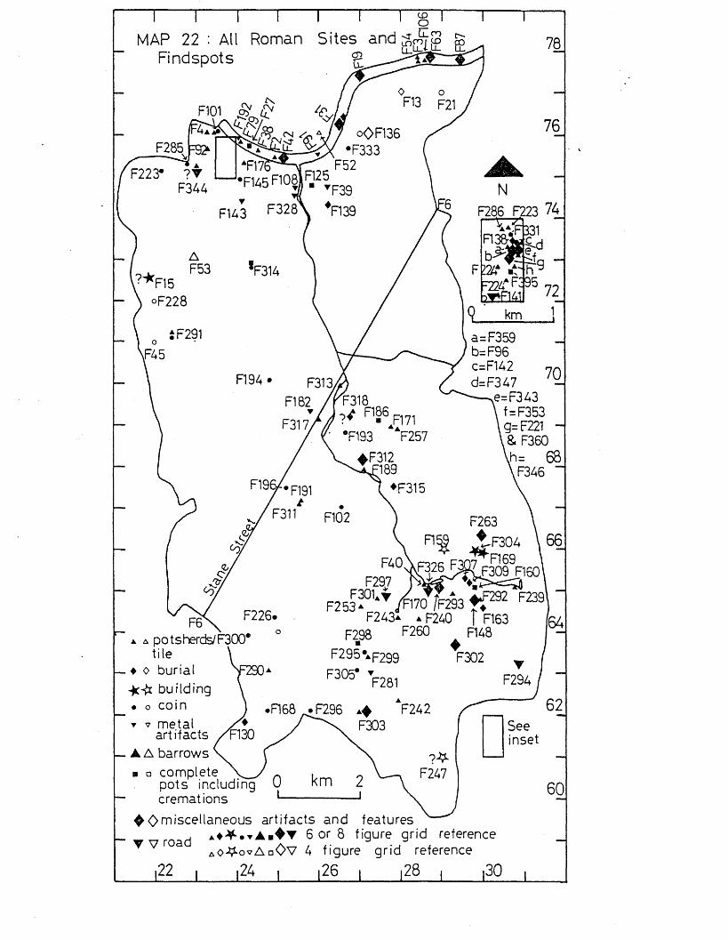
CDOMAP 22 : All
FindspotsRoman S ite s a n d g jg j j? g
CD70
F145 ™ 2
I
♦F315
♦
F298 F260F295\p299
F305*
a a potsherds/F300* tile
♦ o burial ■jc# build ing• o co i n▼ v metal
artifacts_ A A barrows
a a complete _pots including cremations
^<C>miscellaneous artifacts and features6 or 8 figure grid reference
iO-ff-ovAaOv 4 figure grid reference,22 , ,24 , ,26 , ,28 , ,30
60
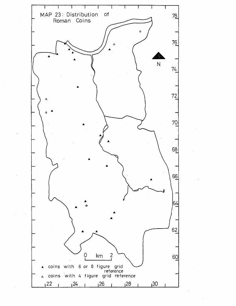
MAP 23: Distribution of Roman Coins
co ins w i th 6 or 8 f igu re gridreference
co ins w i th 4 f ig u re g rid reference
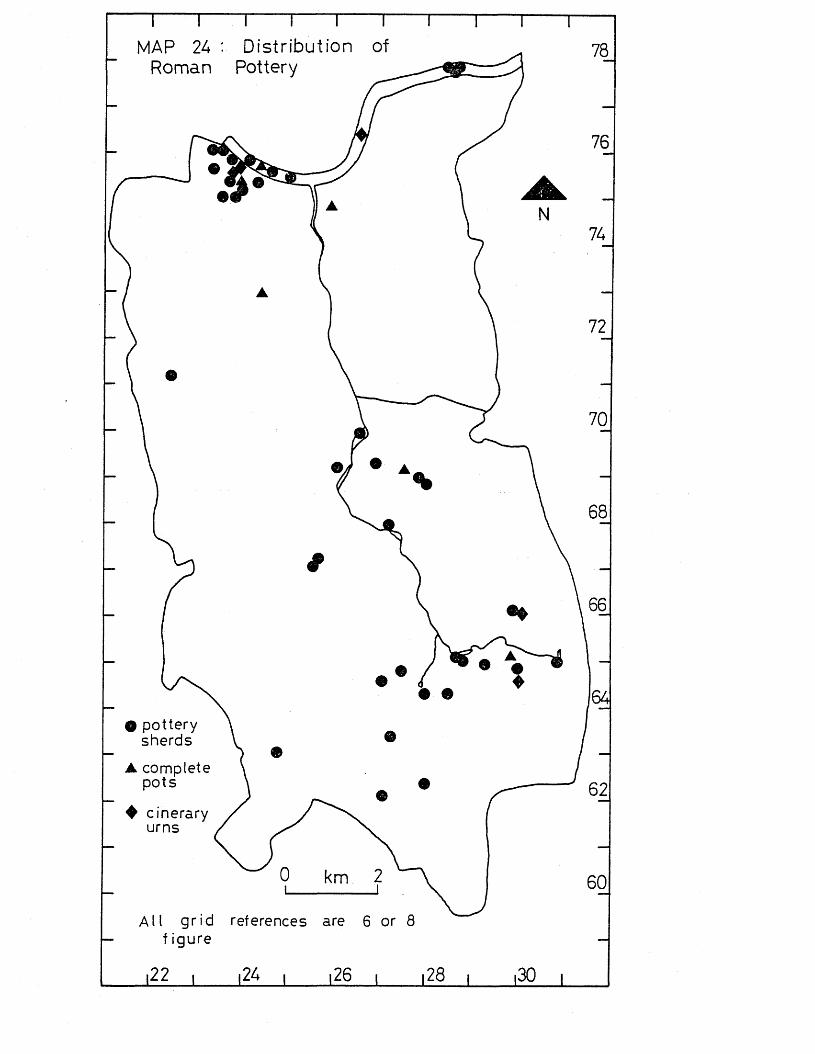
MAP 24 : Distribution of Roman Pottery
78
©
76
N74
72
70
68
O po tte ry sherds
A complete p o ts
♦ c inerary urns
A l l g r id references are 6 or 8 f igu re
%
66
64
62
60
\22 |____ |24 |____ 126 i____ 128 i |30
unap~per (
The Saxon Period
IntroductionThe Saxon period dates from the early 5th century to 1066.The material culture in southern England is similar to that of the Iron Age. In the first half of the period, pagan cemeteries are fairly common, although settlement sites are not common; in the later Saxon period these pagan cemeteries went out of use with the introduction of Christianity. Archaeological evidence for settlement sites and the material culture of the later Saxon period is scanty. (Adkins & Adkins 1982, 143-66).
Statistical Analysis (see p.8 for details of method used).When every site and findspot was plotted within 1-kilometre squares, a non-random distribution could be seen, with one square with 3 findspots (Putney, and the Thames at Putney) one square with 4 findspots (Carshalton), and one square with 7 findspots (Thames from Putney to Batersea and adjacent riverside areas). Within 2-kilometre squares this non-random distribution can also be seen, with one square with 6 findspot (Wandsworth and Battersea, and the Thames from Wandsworth to Battersea), one square with 7 findspots (Carshalton), and one square with.8 findspots (Thames at Putney, and Putney to West Hill, Wandsworth), (see map 25).
When particular kinds of Saxon artifacts are studied, further variations from a random distribution can be seen. Finds of pottery are few but have a non-random distribution, with one1-kilometre square with 5 findspots (Carshalton), and one2-kilometre square with 5 findspots (Carshalton). (see map 25)
The distribution of Saxon metal artifacts (excluding grave goods) is non-random, with one square with 4 findspots (Putney and the Thames at Putney), and one square with 5 findspots (Thames from Putney to Battersea and adjacent riverside areas). Within 2-kilometre squares the distribution is also non-random, with one square with 4 findspots
• (Wandsworth and Battersea and the Thames from Wandsworth to Battersea) and one square with 8 findspots (Thames at Putney, and Putney to West Hill, Wandsworth), (see map 25).
All Saxon Sites and Findspots
1-kilometre squares with:-1 findspot; B2/3/C2, C5, C13, D14, M , E9, F14, G1/H1, G16, H14, 113, J/K16 (= 12 squares, 12 findspots).2 findspots; E11, P1/2/3, G10, G15, H13, J13 (= 6 squares, *12 findspots).3 findspots: 03 (= 1 squsre, 3 findspots).4 findspots: G14 (= 1 square, 4 findspots).7 findspots; D3/E3 (= 1 square, 7 findspots).
2-kilometre squares with;-1 findspot: B3, C5, G7, D1/E1, E8 (= 5 squares, 5 findspots).2 findspots: A7/B7, C6, D5 (= 3 squares, 6 findspots).3 findspots: D8, E7 (=2 squares, 6 findspots).6 findspots: C1/2 (= 1 square, 6 findspots).
findspots: D7 (=1 square, 7 findspots).8 findspots: B1/2 (= 1 square, 8 findspots).
Total number of findspots = 38
Distribution of All Sites and Findspots compared with a Poisson Distribution
'Numbers of 1-kilometre squares with sites and findspots:Number of Actual Poisson Deviation Chi-findspots distribution distribution squared0 101 89.4 +11.6 1.51‘ 12 27.8 -15.8 9.02 6 4.3 + 1.73 1 0.5 + 0.54 1 - + 1.0 3.75 0 - 06 0 - 07 1 _ + 1.0Total 122 122.0 0 14.
Number of Actual Poisson Deviation Chi-findspots distribution distribution squared0 18 9.1 +8.9 8.71 5 11.2 -6.2 3.42 3 6.8 -3.8 2.13 2 2.8 -0.8 )4 0 0.9 -0.9 )5 0 0.2 C\l•O1 0.36 1 - + 1.0 )7 1 - + 1.0 )8 1 — + 1.0 )Total 31 31.0 0 14.!
Pottery
1-kilometre squares with:-'1 findspot: C3, D3/E3, E11, G16, H13, H14, 113 (= 7 squares,7 findspots).4 findspots: G14 (=1 square, 3 findspots).
2-kilometre squares with:-1 findspot: C6, D8, E7 (= 3 squares, 3 findspots).2 findspots: B1/2 ( = 1 square, 2 findspots).5 findspots; D7 (= 1 square, 5 findspots).
Total number of findspots = 1 0
Distribution of Pottery compared with a Poisson Distribution
Numbers of 1-kilometre squares with findspots:Number of Actual Poisson Deviation Chi-findspots distribution distribution squared0 114 112.4 . +1.61 7 9.2 -2.2 0.52 0 0.4 -0.4 )3.______________ 1________________ =___________ +1.0 ) 0.9Total 122 122.0 0 1.4=x^
/
Mumber of Actual Poisson Deviation Chi-findspots distribution distribution squared0 27 22.5 +4.5 0.91 3 7.2 -4.2 2.52 0 1.2 -1.2 )3 0 0.1 -0.1 )4 0 - 0 ) 0.1 . . ̂ __1 r +1.0 ) ___Total 31 31.0 0 3.5=^2
Metal Artifacts
1-kilometre squares with:-1 findspot: B1/2/G2, C13, D14, E4, E9, E11, F1/2/3, G1/H1, G10 (= 9 squares, 9 findspots).4 findspots: C3 (= 1 square, 4 findspots).3 findspots: D3/E3 (= 1 square, 3 findspots).
2-kilometre squares with:-1 findspot: C5, D1/E1, D5, C6 (= 4 squares, 4 findspots).2 findspots: A7/B7 (= 1 square, 2 findspots).4 findspots: C1/2 (= 1 square, 4 findspots).8 findspots: B1/2 (= 1 square, 8 findspots).
Total number of findspots = 18
Distribution
Numbers of 1-kilometre squares with findspots:Number of Actual Poisson Deviation Chi- *findspots distribution distribution squared0 111 105.3 +5.7 0.31 9 15.5 -6.5 2.7 *2 0 1.1 -1.1 )3 0 0.1 -0.1 )4 1 - +1.0 ) 0.55 ......... 1 - +1.0 )Total 122 122.0 0 3.5=x^
Numbers of 2-kilometre squares with findspots:Number of Actual Poisson Deviation Chi-findspots distribution distribution squared0 24 17.3 +6.7 2.61 4 10.1 -6.1 3.72 1 2.9 -1.9 )3 0 0.6 -0.6 )4 1 0.1 +0.9 )5 0 0.1 -0.1 ) 0.16 0 - )7 0 - )8 1 — + 1.0 )Total 31 31.1- -0.1 6.4=x^
Burials
1-kilometre squares with:-1 findspot: D14, H13> H14> J13> J16/K16 ( = 5 squares, 5 findspots).2 findspots: G14 (= 1 square, 2 findspots).
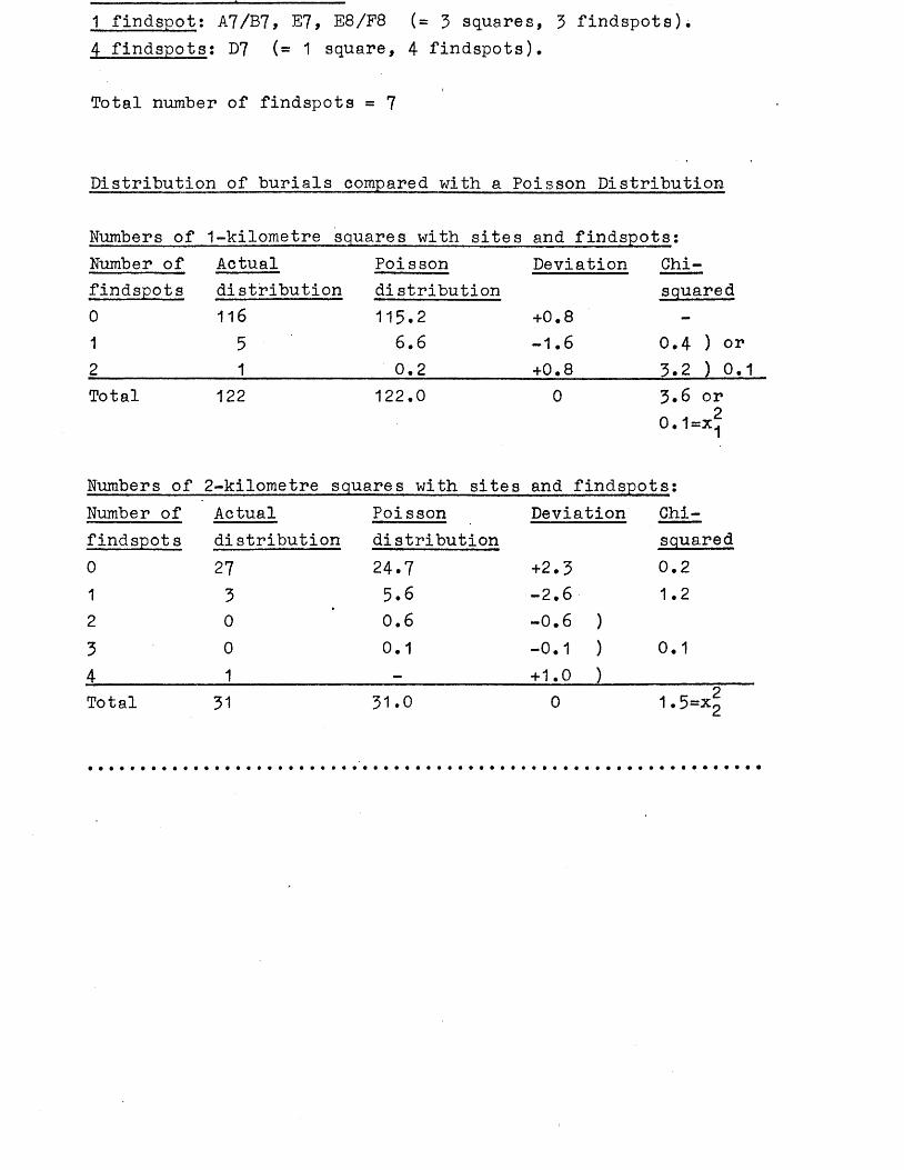
1 findspot: A7/B7, E7, E8/F8 (= 3 squares, 3 findspots).4 findspots: D7 (= 1 square, 4 findspots).
Total number of findspots = 7
Distribution of burials compared with a Poisson Distribution
Numbers of 1-kilometre squares with sites and findspots:Number of Actualfindspots012
Poisson Deviation Chi-distribution distribution116
51
115.26.60.2
+0.8- 1.6+0.8
squared
0.4 ) or 3.2 ) 0.1
Total 122 122.0 0 3.6 or 0 . 1=x^
Numbers of 2-kilometre squares with sites and findspots:Number of Actual Poisson Deviation Chi-findspots distribution distribution squared0 27 24.7 +2.3 0.21 3 5 .6 - 2 . 6 1.22 0 ’ 0.6 - 0.6 )
3 0 0.1 -0.1 ) 0.1
4 1 - +1.0 )_____________Total 31 31.0 0 1.5=Xg
DiscussionThere is considerably less archaeological evidence for the Saxon period than for the preceding Roman period in the Wandle Valley. The period can be roughly divided into an earlier pagan Saxon phase to which many cemeteries can be dated, and a later Saxon period. With Christianity becoming more important in the later Saxon period, the use of pagan cemeteries declined, and so the archaeological evidence for the later Saxon period is even less than for the earlier period, as early Christian burials have so far not been recognised in the Wandle Valley.
There is a.sharp decrease in the number of sites and findspots for the Saxon period in the Wandle Valley when compared with the preceding Roman period. Three areas of clusterings of sites and finds are noticeable in the Wandle Valleysin the Thame.s from Putney to Battersea, along the Thanet sand spring line from Sutton to Beddington, and a third less marked area of clustering at Merton (see map 25).
There is very little evidence for settlement of Saxon date in the Wandle Valley. Along the Thanet sand spring line there are a few sites and finds including two possible Saxon skeletons at Burleigh Avenue, Wallington (Pryer 1977)# a possible Saxon skeleton at Wallington (Meaney 1964# 245)# possible Saxon skeletons at Carshalton (Quinton 1969)# and several graves and spearheads at Carshalton (Clinch 1910, 213) There is no evidence that these burials were the graves of warriors killed in battle, and so they may indicate nearby settlement, particularly in view of the evidence to the north of the Wandle (see p.757). Other indications of settlement in this area include a few finds of potsherds from Queen’s Well, Carshalton (Turner 1970,51-2), from Colston Avenue, Carshalton (Morris 1959# 155), from Orchard Hill, Carshalton (Turner 1965)# from Ruskin Road, Carshalton (Cotton 1979)# and from Bunker’ Field, Wallington (Morris 1959 134). Several of these reports are not well authenticated, yet there does seem to be a pattern of settlement along the Thanet sand spring line. The nature of that settlement cannot be established on the present evidence, although Domesday gives information about late Saxon settlement (see apperdix 10) which is probably largely applicable to the earlier period as well. By the time of Domesday it is clear
that several villages had become established along this spring line. Sutton, Carshalton, Beddington and Wallington are mentioned in Domesday as possessing mills, churches, dwellings, woodland and farmland (see appendix 10). Further to the west at Cheam there was a find of spearheads with a single reference to burials (Copley 1958, 291). Although Cheam has little evidence for Saxon settlement, it is mentioned in Domesday as possessing a church, meadow and woodland (see appendix 10), and so it is very probable that there was some settlement here in the earlier Saxon period as well.
Just to the north of the River Wandle near the Beddington sewage works is a mixed cremation and inhumation cemetery (Perry 1980), with a possible outlying skeleton of Saxon date from Beddington Lane (see 098). The cemetery is unlikely to be a battle cemetery, as there are a few female burials, and the weapons are mainly knives and spearheads which were probably used for hunting rather than warfare (Perry 1980, 26-7). Some nearby settlement must therefore be expected.One coin has been found on the site of the Roman villa at Beddington (Addy 1874# 121), and so it is possible that there was a continuation of settlement from the Roman period. However, there is no evidence for any Saxon occupation at the villa from current excavations by R.Adkins and the author, and so continued use of the site into the Saxon period is extremely unlikely. It is more probable that the cemetery was positioned in an area not so well suited or needed for agriculture; the cemetery may relate to settlement on the south side of the Wandle. Beddington is mentioned in Domesday as having two mills and a church (see appendix 10). The church was probably on the site of the present-day St, Mary’s church, and may well have been built near or in the middle of an earlier Saxon settlement.The mills are likely to have been further to the east on the Wandle where post-medieval mills survive today.
Another clustering of finds is in the Merton-Morden-Mitcham area, near the Roman Stane Street (Chichester to London road). The evidence for settlement is not so pronounced as along the Thanet sand as seen above, and consists mainly of a large inhumation cemetery dating to the 5th and 6th centuries at Morden Lane, Mitcham (Meaney 1964# 243-4). Other
Saxon date from near St. Helier station (Montague 1976), a bronze bowl from near the inhumation cemetery (Rice 1923# 70-1), a saucer brooch from Merton (Morris 1959#143)# and an enamelled bronze disc from Morden (Smith 1908). It is likely that the area did have clusters of settlement which have never been recognised, a situation which was also seen in the Roman period for this area (see p . 131). Settlements' did develop in this area as seen in later documentary evidence, where the villages of Mitcham, Merton and Morden are all entered in Domesday (see appendix 10).
Other villages in the Wandle Valley which appear in Domesday are Tooting (with one church), Balham, Battersea (with 7 mills), and WTa.ndsworth (with two halls) (see appendix 10), although there is no archaeological evidence to support the documentary evidence. Tooting and Balham seem to have been very small settlements; Battersea and Wandsworth iere more substantial. .
GAZETTEER OF SITES AND KINDS UK SAAUN DATEInformation given:- site number, National Grid Reference (all prefixed by TQ), site name, type of site or find, further information, key references.
G50 25 74 Wandsworth. Knife handle,Bronze knife handle in Museum of buckle.London A1950, bronze buckle in Museum of London A8057 (1)« '(1) Museum of London.
G51 23 75 Putney. SocketedIn Museum of Lgndon 02058. Received spearhead.in 1876 (1). Not examined (2).(1) Museum of London. (2) L.Adkins.
G53 23 13 Wimbledon Common* Barrows.*Near a ,ffire-house* now marked by an obelisk • One cruciformand over 20 round barrows, now destroyed. Possibly Saxon. Seealso D53 and F53.(1) Morris 1959,148. (2) Grinsell 1934,27.
G77 2686 7684 Althorpe Grove, Battersea. Postholes, beam*Pottery is of 6th-10th century date. slots, pottery*,Excavation by SWLAU. Finds held by bone comb.SWLAU (1).(1) McCracken,S. 1976.
G93 3002 6548 Near Beddington sewage At least 25 interfarm. ments and grave
Cremations in urns and inhumations of 5th-6th gendtery. Excavationin 1871. Finds in AM Powell coll, and GM AS 656,S8978, AS 653,657,665,668,674,S8977,AS 677,S8981,8980, AS 664,662,S8979,RB1012,AS 658,665,668, AS 671-4,659. Some finds held by CNHSS.(1) Perry 1980.
G94 270 644 Area of Ringstead Rd, Skeletons.Carshalton.
Found in 1876 (1). Possibly Saxon as found near G104 (2).(1) Quinton 1969,116-7. (2) L.Adkins.
G97 25 67 Morden. Enamelled bronzeProbably from a hanging bowl. In disc.
(1) British Museum. (2) Smith 1908.
G98 3015 6549 Aristone Alloys, Skull and otherBeddington Lane. bones.
Said to be ”oldn by pathologist. Some bones were those of animals. Possibly an outlier of the nearby Saxon cemetery (1). (1) Ordnance Survey Records.
G99 2312 6519 3 Shrubland Grove,Cheam. Socketed spearheads.Found three feet deep in clay (1).(1) Carpenter 1949,151-2.
G100 245 640 (1) Cheam. Saxon spearheadsNo further information. (burials)(1)(1) Copley 1958,291.
G104 2704 6424 Carshalton Rd,Carshalton. Several graves andFound in 1906 (1) near site of G94. spearheads (1)(1) Clinch 1910,213.
G107 3120 6245 3 Overhill Rd,Purley. Skeleton.Probably an outlier of the nearby Russell Hill Saxon cemetery(1). (1) Morris 1959,144.
G147 2792 6449 Queen1s Well,Carshalton. 3 potsherds.Found in excavation by D.Turner (1). See also B147*(1) Turner 1970,51,52.
G221 2386 7555 55 Felsham Rd,Putney. Saex, 5th centuryExcavation by Wandsworth Historical potsherds.Society (1). See also F221 and K221.(1) Farrant 1977.
G225 25 69 Merton. Saucer brooch.Late 5th-early 6th century. Possibly a stray from the nearby Mitcham cemetery G312. In BM 1923.5-7 (1).(1) Morris 1959,143.
G236 27 68 Mitcham. Bronze bowl.Found near church in 1866(1). In BM 1933*4-6.122.(1) Rice 1923,70,71. (2) Morris 1959,104-8.
Found in excavation. In possession of potsherds (1).Sutton library (2)(3). See also B240,E240 and F240.(1) Morris 1959,134. (2) Major 1925,113-4. (3) Sutton library.
G241 28 64 Wallington. Glass beads, Possibly Saxon. Since lost. Found in skeleton. 1896 (1)(2).(1) VCH Surrey 1 1902,268. (2) Meaney 1964,245.
G242 2793 6236 Queen Mary's Hospital,Carshalton.
Found in excavation of Late Bronze enclosure B242,C242,D242,E242 and F242.(1) Morris 1959,135.
4 potsherds.
(1). See also
G243 2790 6440 Orchard Hill,Carshalton. Found in excavation (1). See also B243,D243 (1) Turner 1965*
Pottery, and F243.
G260 284 643 61-7 Ruskin Rd,Carshalton. Possibly Saxon. See also F260 and K260.(1) Cotton 1979.
Few potsherds.
G281 272 63O Barrow Hedges,Carshalton. Possibly Bronze Age. Now built over (2). See (1) Salmon 1736,46-7. (2) Grinsell 1934,38.
3 barrows (1) also D281.
G301 274 648 Colston Ave, Carshalton. In possession of Sutton library (2).See also site number F301.(1) Morris 1959,135. (2) Sutton library.
5 pagan Saxon potsherds (1).
G304 2978 6583 Beddington sewage farm. Found in Roman bath-house (1). Now lost (2). D304,E304 and F304.(1) Addy 1874,121. (2) L.Adkins.
Coin of Athelstan. See also C304,
G311 2550 6716 to East of St Helier 2547 6708 station.
Possibly Saxon. In possession of W.Rudd, MHS (1) Montague 1976.
2 potsherds.
(1). See F311.
5th-6th century. Accompanied by many cemetery,grave goods some of which are in MoL, Camb A&A and KM (3). Too many to detail (4). See also F312 and K312.(1) Meaney 1964,243-4. (2) Bidder 1908,1-25. (3) Bidder & Morris 1959,51-131. (4) L.Adkins.
G326 2853 6502 Burleigh Ave,Wallington. Pottery, 2Skeletons possibly Saxon. Found in skeletons,excavation by BC&WAS (1). See also E326 and F326.(1) Pryer 1977.
THAMES SITES AND FINDS
G27 242 757 Thames,Putney Bridge. Iron sickle.In Museum of London A24915.(1) Museum of London.
G31 260 755 to Thames, Battersea. Stone pendant,285 778 clay loomweight.
Pendant in MoL 3987, date not certain (1). Loomweight in MoL C928 (2).(1) Guildhall Museum 1908,121. (2) Wheeler 1935,155.
G31 260 755 to Thames, Battersea. Metal artifacts.285 778
Some may be from Thames,Battersea Park, or Thames, Chelsea (1). Spearheads: MoL A7347 (2), MoL A8840 (2), MoL A15462 (2), BM 1858.5-14.1 (10), BM 1857.6-23.3 (10), BM 1857.6-23.4 (10). Scramsaxes: MoL A13921 (2), BM 1857*6-23.1 (3)(4), MoL A9981 (9), BM 1857.6-23.2 (10). Sword PRM0 1884.121.21 (Viking)(3)(6). Stirrup BM 1854*4-24.1 (Viking)(3). Axe MoL 27*54 (Viking). Axe MoL A15338 (Viking)(7)•(1)Lawrence 1929,92. (2) Wheeler 1935,163-6,168,180. (3) Wilson 1973,92,125. (4) Swanton 1973,92,125. (5) Elliott 1959,34-5,79. (6) Wilson 1965. . (7) Wheeler 1927,26,53. (8) B j t f r n & Sheletig 1940,87,88. (9) Museum of London. (10) British Museum.
G42 245 756 to Thames, Wandsworth. Comb, spindle260 755 whorl.
Comb handle in MoL A7346 (1), spindle whorl in MoL A1680. (1) Wheeler 1935,152. (2) Museum of London.
260 755In Museum of London no.83 (1) and A7723 (2).(1) Guildhall Museum 1908,120. (2) Wheeler 1935,146.
G42* 245 756 to Thames, Wandsworth. Metal artifacts.260 755
Ring MoL A83394 (1). Spearheads: MoL A15461 (1), MoL A7443 (1), MoL A15458 (1), MoL A3085 (1 ), MoL A5605 (1), MoL A13866 (1)‘,SM formerly PRMF (5), MoL 0.2044 (6), MoL A6395 (3), Society of Antiquaries 1.53 (7), MoL (6). Scramsaxes: MoL C727 (1), MoL A1655 (1), MoL A7444 (D, MoL A1655 (1). Knife MoL A7445 (1). Sickle MoL A13933 (6). Sword MoL 0.2108 (6), Plate BM 1863.7-3- 1 (4). 2 axes in SM formerly PRMF (5).(1) Wheeler 1935 passim. (2) Lawrence 1929,91. (3) Wheeler 1927, 28. (4) BM. (5) SM. (6) MoL. (7) Society of Antiquaries.
G79 236 763 to Thames, Putney. Potsherd.245 756
?Saxon. In Gunnersbury Park Museum 71.7/4 (1).(1) Gunnersbury Park Museum.
G79 236 763 to Thames, Putney. Metal artifacts.245 756
In MoL: 2 scramsaxes A24909 and A1657, 2 spearheads A24938 and A11911 (1), axehead (2).(1) Wheeler 1935,163,168. (2) Guildhall Museum 1908,123. (3) Lawrence 1929,89.
G80 ? Thames, Putney, at Viking sword.the boathouses.
Point of sword in MoL 27.55. Hilt and rest of blade found in another part of the Thames - see G84.(1) Lawrence 1929,91. (2) Wheeler 1927,37.
G81 238 760 Thames, Putney Bridge* Metal artifacts.*0pposite the reputed site of Danes Camp (2). In MoL: spearhead A25395, scramjpax A25147, axe A25844 (1 ) (3) • Also in MoL: sickle, weaving sword and scramasax (2) not traced (4 ) - see G192.(1) Wheeler 1927,29,36. (2) Lawrence 1929,80. (3) Museum of London. (4) L.Adkins.
G83 244 756 Thames, Putney railway Small iron bell.bridge.

(1) Lawrence 1929,90. (2) L.Adkins
G84 245 756 Thames, near Putney Sword (hilt andrailway bridge* most of blade)
*c.50 yards from bridge on Wandsworth side. In MoL (1) A2373*Point of sword has also been found (1)(3) - see G80.(1) Price 1906,147-50. (2) Lawrence 1929,90. (3) Wheeler 1927,37*
G88 2535 7535 Thames foreshore, Saex in leatherWandsworth. sheath.
In Museum of London 73/1-3 (1)*(1) Parrant 1973,158.
G91 259 755 Thames, Wandsworth Bridge. 4 coins ofIn MoL A5882-5 dating to c.AD 870 (1)(2). Burgred.(1) Lawrence 1929,91* (2) Dolley 1959,42,43, 47*
G128* 270 774 to Thames, Chelsea. Ring, axe,286 778 francisca.
Silver ring (2) not traced (3). Other two in MoL (1) nottraced (3)*(1) Lawrence 1929,92. (2) PSA 4 1859,309* (3) L.Adkins.
G192 236 763 to Thames, Fulham. Iron artifacts.245 756
In MoL: scraraasax A24349 (1) found at reputed site of Danish camp (1) - see G81, spearhead A24367, scramasax A24909, scram- asax A243499 (2).(1) Museum of London. (2) Wheeler 1935,173,180.
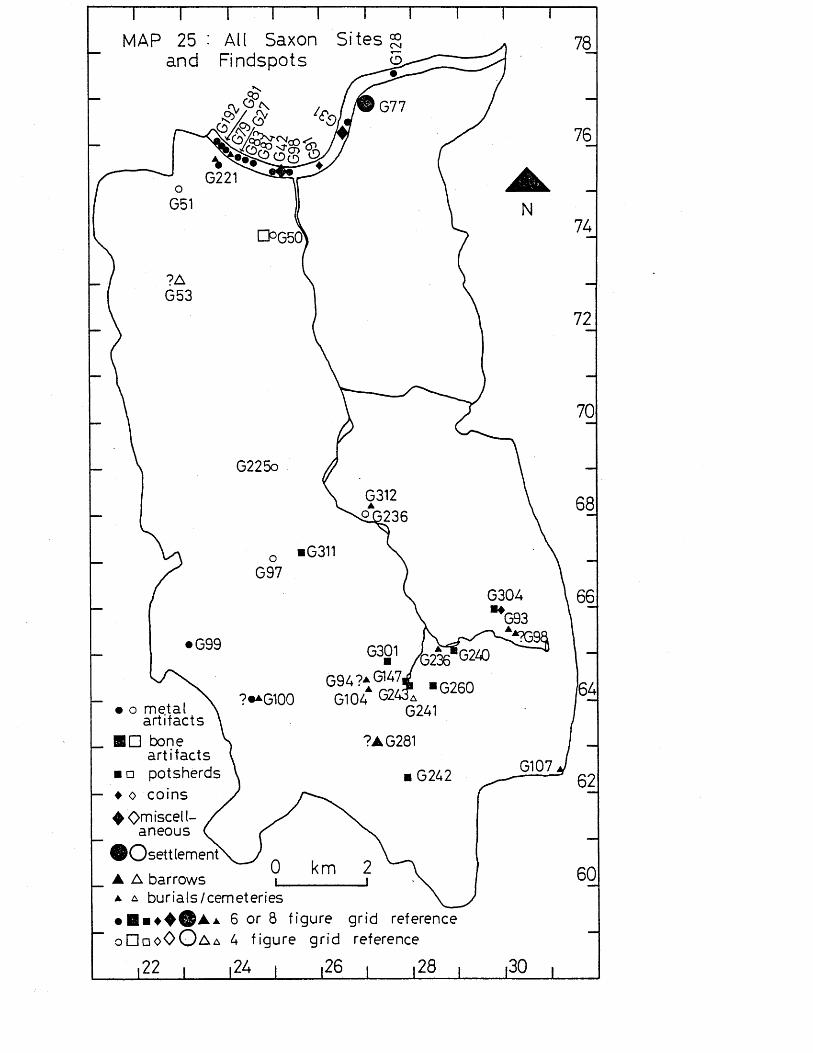
MAP 25 : All Saxon Sites § and Findspots
u°G5d
• o meta l artifacts
ID bone a rt i fac ts
□ potsherds
, t3236"G2ZOG94?aG147,gioaa G24Ga
G241
7AG281
t— ♦ o co ins4 0 m 'scell-
aneous
®Osettlement▲ A barrows a a burials/cemeteries• 6 or 8 f igure grid reference
a 4 f igu re g r id reference
i22> I i26 I 128 i
60
o □ □ oO O a
,30
Vy-Uap IPX' u
Discussion of the Development of Settlement Patterns in theWandle Valley
This final chapter attempts to provide a general appraisal of settlement in the Wandle Valley from Palaeolithic to Saxon times as seen in chapters 1 to 7*
The Palaeolithic PeriodDuring the Palaeolithic period the River Thames and the Thames Valley underwent continual changes as the sea level and the land rose and fell during the glacial and interglacial periods, and as a result the Thames gravel terraces were formed (cf Morrison 1980,19-20), At this time the River Thames would have been considerably wider than the present-day Thames, with a more extensive flood plain, and it probably consisted of several meandering channels (cf Evans 1975,1-3)• The River Wandle probably existed in the Palaeolithic period, but again it would have had a wider flood plain, and it may have had its headwaters in the North Downs,
The River Thames seems to have gradually shifted southwards in this area of the Thames Valley, resulting in the erosion of the higher gravel terraces (Wymer 1968,271), so that very little of the- older terraces survive in the area under study (see map 3). The confluence of the Thames and Wandle in the Lower Palaeolithic seems to be represented by the gravel spread around Wandsworth and Clapham (Wymer 1968,279), and the former channel of the Wandle may be indicated by the site at St, Ann’s Hill, Wandsworth (see p.24 )•
The Palaeolithic period would have experienced a considerable range of environments and climates in the successive glacial and interglacial periods, and at times Britain would have been too inhospitable for occupation by man. Any changes, however, would have been too gradual to have been noticed by man (Wymer 1981,21-6; Mellars 1974).
Most of the flint artifacts are chance discoveries, several being found during building operations on the gravel terraces - none from this area is known to have come from gravel
Geological Survey maps from the 19th century onwards, it appears that very little gravel quarrying has taken place in the Wandle Valley, probably because the area had been built up before the need for large-scale gravel quarrying arose. Wymer states that the finds from the Thames Valley as a whole are a random sample as they are largely derived from pits (Wymer 1968,365). The fact that the finds from the Wandle Valley are from sources which might appear even less likely to produce finds than are quarries, highlights the potential for discovery of finds and sites of the Palaeolithic period in the Wandle Valley.
Current research shows that most evidence for Lower and Middle Palaeolithic occupation and activity in Britain is confined to the south and east of the country, particularly in river valleys or on lake shores (cf Morrison 1980,72-4; Wymer 1981, 79; Mellars 1974). Sites such as at Clacton and Swanscombe show that Palaeolithic man was living right by the edge of rivers (Wymer 1981,56). This preference for activity by rivers is reflected in the distribution of finds in the Wandle Valley where most finds are along the River Thames, and by the mouth of the Wandle as it then existed (see p.25). This preference was no doubt dictated by the plentiful supply of fish, wild fowl and herds of animals, as well as vegetable foods, water supply and a means of transport. The Thames Valley itself would have been a natural routeway.
As is the case with much of Britain, the surviving evidence is a poor witness to the type of life and environment experienced during the thousands of years of the Palaeolithic period. However, it is clear from the evidence available in the Wandle Valley that the confluence of the Wandle and Thames was a particularly favoured area. Several of the artifacts from this area are unrolled which indicates that they have moved little from their original point of deposition. It is more difficult to consider the rolled implements as evidence for activity in the Wandle Valley, but they might indicate activity in areas of the Thames Valley further upstream. However, W'ymer suggests that it is unlikley that recognisable flint artifacts could have
uxa. v c i i c u v c i j x o . x x x v j i i i u u c x i p j l « c ; w x u s c j a.a t - i i c ty w u ixx. >~i.otherwise have been rolled and abraded beyond recognition.He says that there are often concentrations of artifacts where major tributaries joined the Thames and where wide shallow sheets of water might be expected. Such places would have been, .favourable environments for activity by Palaeolithic man (Wymer 1981,60), and this is certainly the case in the confluence of the Thames and Wandle. It seems probable that had gravel extraction taken place, vast numbers of flint artifacts would have been found which would have further highlighted the importance of this area.
Part of the importance of this area may have been the use of the Wandle Valley as a means of transport to areas where a good supply of flint was available. There is no evidence that Palaeolithic man mined flint from the chalk, and it is likely that the River Thames banks provided a source of flint pebbles for use in manufacturing flint artifacts. However it is apparent that flint from chalk was used, though this was not necessarily derived from mining (Wymer 1968, 14-17). There has been no petrological study of the flint material of Palaeolithic date from the handle Valley, and so there is no indication as to the likely source of the flint. Iron staining has tended to obscure the true character of many of the flint artifacts from this area, as is the case with most flint implements of this period (Wymer 1968, 16).
Against the theory that the Wandle Valley was used as a means of communication with the areas of chalk, is the fact that the remainder of the Wandle Valley has produced very few finds. However, Wymer in his study of the Lower Palaeolithic of the Thames Valley, noted patches of concentrated finds on the North Downs, particularly at Banstead Heath, where the palaeoliths seem to have been dragged from some depth by wartime ploughing (Wymer 1968, 271). Wymer suggests that this area could have been as densely populated as areas alongside rivers such as the Thames, and that most of the old land surface could have been destroyed by intense solifluction, with odd patches surviving, for example, at Woodcote, where a handaxe. was found (Wymer 1968, 273).However, even such surviving finds cannot be regarded as in situ in the strict sense of the term because cryoturbation (the alternate freezing and thawing of the ground), and
chemical weathering could, nave altered ana movea tne upper levels of soil (Wymer 1968, 279). However, the Woodcote handaxe is still sharp and so is unlikely to have been moved any distance. It therefore seems quite likely that the River Wandle provided a means of transport and communication for Palaeolithic man. Without further evidence, however, the use of the Wandle Valley as a whole by man in the Lower and Middle Palaeolithic period must remain speculative.
There is at present no evidence for Upper Palaeolithic activity in the V/andle Valley. Most Upper Palaeolithic finds in Britain are in caves or on the borders between the Highland and Lowland Zones (Campbell 1977; Mellars 1974). Some open-air sites have been found in the south and east of Britain, but very little is known about these sites (Campbell 1977* 332).As a result of the inhospitable climate at this time, occupation may have been necessarily confined to sites such as caves and rock shelters, and such sites do not occur in the Wandle Valley. The landscape of the area would probably have resembled steppe or tundra at this time. Any open-air sites in this part of Britain are likely to have been summer camps, and were probably very sparsely distributed (Morrison 1980 passim). However, it has been noted that one could reasonably expect more open-air sites of Upper Palaeolithic date in Lowland Britain, since large numbers of people must have passed through the area, particularly the Thames Valley, until they reached the margins of the Highland Zone, where suitable shelter could be found (Wymer 1981, 75). They must have made use of temporary shelters, animals would have been hunted for a food supply, and flint and bone artifacts would have been used. In spite of this probable activity, very little evidence survives in south-east England, and none at all in the Wandle Valley (Wymer 1981 , 1 5 ) • Wymer suggests that this absence of material may be due to the periglacial conditions on the edges of the later ice sheets which may have disturbed any Upper Palaeolithic sites in this area, and dispersed and destroyed other evidence such as flint artifacts (Wymer 1981, 76-7). At present this seems the most likely explanation for the lack of evidence for Upper Palaeolithic activity in this area.
m e jyiesoj.n:nic r e n o aThe Mesolithic period is characterised by an improvement in climate following the end of the last glacial period. The end of the glacial period resulted in a rise in sea level and land which led to the separation of Britain from the Continent. The improvement in climate (to one warmer than the modern-day climate) led to the replacement of the tundra-like environment by deciduous woodland and forests. South-east ‘ Britain was once more inhabited by man, although the traditional hunting communities of Palaeolithic man adapted themselves to a way of life described as Mesolithic. Large animals were superseded by forest-dwelling animals, and so hunting methods had to adapt to a different type of hunting, which in turn led to a change in the type of weapons used (Simmons et al 1981; Mellars 1974* 77-81; Grigson 1978;Evans 1973)* This change is reflected in the finds from the Wandle Valley which consist mainly of small flint artifacts and flakes, including several raicroliths. The Wandle Valley itself must have been largely wooded, as’seen from the evidence from pollen analysis elsewhere (Simmons et al 1981), and from the use of flint artifacts necessarily adapted to woodland conditions. The River Thames and River Wandle would have provided natural routeways through this area of woodland
As seen in chapter 2, the distribution of Mesolithic material is largely riverine. One clustering of finds is around the mouth of the Wandle and by the Thames, similar to that seen in the Palaeolithic period, and reflects the continuing importance of the Thames as an area attractive to man for the abundant supply of fish, water fowl and animals to hunt, for a water supply, for transport and communication, and presumably for the supply of vegetable food, although no evidence survives for the utilization of vegetable food.
The number of tranchet axes found in the Thames and on gravel and alluvium near the Thames on either side of the Wandle (see map 10) must indicate that the Thames riverside areas were heavily wooded and needed clearing, using axes and probably aided by the use of fire. Clearances were probably intended for ease of communication and to provide areas for settlement, for the trapping of game, and for herding animals (Simmons et al 1981, 102-3). The axes may also have
been used ror Doat ouiiding, and ior m e construction 01 huts in temporary camps. More permanent settlements are unlikely as there is no evidence for cultivation of the land at this period. The number of axes in the Thames could be a result of axes being lost overboard in log- boats (for which there is no evidence in the Wandle Valley), or else a result of axes being lost right by the Thames and being washed into the river by a process of continual erosion. A few axes are damaged and rolled, but most are relatively unrolled, suggesting little transportation by fluvial action. The possibility of axes being eroded from riverside camps or from areas of riverside activity does not account for the axe finds from the River Thames from Battersea to Nine Elms, where no occupation or activity is apparent on either bank of the river. Loss from river craft seems the best explanation for these finds. It is unlikely that the finds have become incorporated in the Thames as a result of a change in its course, as it has been suggested that there has been little change from the early Mesolithic period onwards (Wymer 1968, 22).
There is also a concentration of Mesolithic bone and antler implements which are found only in the River Thames in this area (see p. 48), and which date to the earlier Mesolithic (Mellars 1974, 85-7). Only a few artifacts of bone and antler of the Mesolithic period are known in south-east Britain which makes the artifacts from the Thames worthy of special attention (cf Morrison 1981, 124: Mellars 1974, 85). These artifacts may have had a variety of uses such as working skins, working bone tools, and use in wood working. The barbed point in particular was probably used for fishing; it has been pointed out, however, that in all stages of the Mesolithic, there is very little evidence for fishing or for fish bones, even from lakeside communities (Simmons et al 1981, 119-20; Mellars 1974, 85-7), hut this may be due to lack of preservation of the evidence or a failure to recognise it on the part of the excavators. It still remains highly likely that fishing was being carried out in the Thames. These finds, together with the clustering of tranchet axes and the distribution of other flint flakes and artifacts, suggest temporary riverside encampments. Time on our Side? shows no concentration of finds north of the River Thames (Time on our Side? Mesolithic map), some v settlement appears to be on the south bank,
route•
There is some dispersed activity away from the Thames including waste flakes and artifacts on Wimbledon Common.This suggests that this area-was being used for intermittent hunting, but not for any temporary settlement, being too far from the Beverley Brook (1*5 kilometres to the west), or from the Wandle to the east, for a water supply to be readily available. The absence of tranchet axes further suggests that the land was not subject to forest clearance.
The scattered finds elsewhere point to activity throughout the Wandle Valley, probably due to the use of the valley as a communication route (see below p.173). A more significant concentration of worked flints is by the River Wandle along the Thanet sand spring line from Beddington to Carshalton.The only site indicating settlement rather than finds lost during use is at Orchard Hill, Carshalton, which is situated on the spring line (see p. 49), but all the other finds collectively show that this area was being utilised for temporary settlement, relying on the River Wandle for water and transport, and the spring line for water. A variety of sources of food must have been available. The River Wandle was probably the overriding influence for settlement and activity rather than the spring line, as there is no evidence for any Mesolithic activity westwards from Carshalton away from the Wandle, apart from a few flint flakes at Cheam (see B248). Time on our Side? shows concentrations of finds of flint artifacts eastwards through Purley, Sanderstead, Shirley, West Wickham, Hayes and Orpington (Time on our Side? Mesolithic map). It is likely that there was a band of settlement, or a trackway, or both, right across this zone, probably turning northwards to follow the River Wandle to the Thames. The absence of tranchet axes from this area is surprising, but it may be that the chalk and gravels were not so densely forested as further north, and any desired clearances may have been effected by the use of fire, with little manual felling of trees.
The evidence for the rest of the River Wandle being used for transport or hunting is very limited until Wandsworth is reached. There is little except scattered finds such as
B234 la trancnei: a x e ) , \a trancnet axe;, ana d o / vwasx>eflakes). On the present evidence, therefore, it seems probable that the Wandle formed part of a long-distance communication route, with parties of hunter/gatherers travelling from the south-east, with temporary camps around Beddington and the ponds at Carshalton. The River Wandle and its environs may not have been suitable for any temporary settlement for most of its length, possibly because of very dense forests which were not worth clearing when the better environments of the River Thames to the north and the spring line to the south were available. Alternatively, pressure on land for temporary settlement and hunting may have led to the use of the whole length of the Wandle, but this evidence may have become sealed by later deposition of alluvium (see map 3) (Sherlock 1960, 52).
The Neolithic PeriodThe Neolithic period witnesses the beginnings of agriculture, and a gradual end to the itinerant life of the hunter- gatherer. The earliest known pottery is made in this period.
Clearances of woodland had begun in the Mesolithic period with the use of fire (Evans 1975, 94-6). The environment in the Neolithic period underwent various changes as a result of further clearances of woodland for agriculture, and a decline in woodland took place. Some clearances were probably localised while others were widespread leading to some open.conditions, as on the chalk downs (Evans 1975, 108-116; Smith et al 1981)* Molluscan and pollen evidence from sites outside the Wandle Valley shows that areas such as chalk began to be cleared of woodland in this period (Evans 1975, 116-21; Smith et a.1 1981, 145-7).
In the Wandle Valley most of the findspots of flint and stone artifacts and waste material are concentrated in the Thames and near the Thames from Putney to Battersea, which is the land lying either side of the mouth of.the River Wandle. As seen in chapter 3 (p* 71), there is some evidence for settlement at Putney near the River Thames. This is a distribution similar to that seen in the Mesolithic period (see p. 48), although there are greater numbers of finds in the Neolithic period, particularly in the River Thames (see map , It seems likely that there was riverside
not yet known. No other traces of settlement have been recorded near the Thames, but it is likely from the number of finds that there was settlement in the area on both sides of the River Wandle near the Thames. However, the proximity of the Thames may imply that arable and pastoral farming was carried out in conjunction with industries based on the Thames and Wandle, such as fishing and trading, with the rivers.being used as a means of transport. There are some finds of flint sickles from the Thames which may have been eroded from riverside settlement, and would therefore suggest nearby agriculture.
The land by the Thames was probably already partially cleared of forest by Mesolithic hunter-gatherers, Wid this clearance would have been carried on for settlement and agriculture in the Neolithic period. Evidence for such clearance is seen in the finds of flint and stone axes from the area from Putney to Battersea (see map 15). Axes may have been used for cutting down trees, in conjunction with the use of fire, and also for cutting timber for building items such as huts or- boats Some of the axes are broken. These were probably broken through use and subsequently discarded. However, it has been suggested that evidence from the Lake district indicates that axes did not play a great part in that region in the clearance of land for settlement, but were used mainly for the collection of fodder (Evans 1975, 128).
&As in the Mesolithic period, the area from Battersea Park to Nine Elms seems to have been avoided, possibly because the area was low-lying, as suggested earlier (see p. 49).
There is a concentration of flint flakes and implements from Wimbledon Common, which could represent settlement on this fairly high ground (see map 13). However, no axes or pottery have ever been recorded from Wimbledon Common apart from two outlying axes (C225 = a stone axe from Merton, ans C49 = a stone axe from Wimbledon), and so without any environmental evidence to the contrary, it must be assumed that the Wimbledon Common area was being utilized in a way similar to that in the Mesolithic period - for hunting, and gathering vegetable foods in a forested environment. There is evidence outside the Wandle Valley that wild animals were exploited
m tne jNeoiitmc period e-c a± nycn, Tyo;. However,if future excavations prove that the Queen’s Butt mound is Neolithic in date, then the interpretation of this forested area being used for hunting would be invalid because long barrows are considered to have been built in areas cleared of woodland to be seen as a monument from far off (Evans 1975, 110).
There are scattered finds of Neolithic date throughout the rest of the Wandle Valley, except for the area on London Clay which was no doubt avoided because Neolithic farmers did not have the technology to plough this land or obtain a supply of water. The small number of finds may mean, that most of the Wandle Valley was only thinly populated and remained largely forested, its main function being a routeway used, for example, by traders of qxes. Numerous axes imported from other parts of Britain have been found in the Wandle Valley, such as an axe of non-ophitic dolerite from the Thames at Wandsworth (Adkins & Jackson 1978, 49, 81, 67).This is a phenomenon occurring in many areas during the Neolithic period. Most of the axes are of flint and were probably brought into the area from the Downs along the Wandle Valley. The use of this area as part of a long-distance trackway was also suggested for the Mesolithic period (see p.173)
There is some clustering of finds around the two southerly arms of the River Wandle. Such finds include several axes:- C234 = a ground axe from Mitcham Common, C304 = a flint axe from Beddington sewage farm, and C155 = part of a flint axe from Bandon Hill, (see map 15). These finds indicate that the area was being cleared of woodland, probably for settlement. A few finds from chalk, including one axe, point to the beginning of the use of chalk land for clearance and grazing.
The Thanet sand spring line and River Wandle may have been used as a long-distance trackway as suggested for the Mesolithic period, with scattered settlement on the spring line. Transhumance may have been practised, with, animals being grazed on the chalk downs. Available molluscan evidence from beneath barrows on chalk land suggests that chalk land was used for grassland and therefore for grazing and not for cultivation (Smith et al 1981, 147). The most unusual
le w . OUi’C X » OilC i i u u 'u x an aAc euiu. JJU uucxj \ ycut. ; uui. u ii.
of the River Wandle on low-lying gravel, which has been seen to have been avoided up to this period. However, the axe may not have been derived from this area as it was found in a Roman context in recent excavations by R.Adkins and the author, and the find of the pottery was not precisely reported and cannot be checked.
Numerous artifacts, particularly axes, have been found in the river Thames. It is possible that the axes were eroded from riverside settlements on the southern bank of the Thames. Knowledge of evidence for occupation to the north of the river is very scanty (see Time on our Side? Neolithic map). However, if settlement sites were being eroded, one would expect a similar amount of other Neolithic finds in the Thames such as pottery, which is not the case, although this could be due to differing survival factors, with most Neolithic pottery being too fragmentary to be found or recognised, or unattractive to collectors. Other reasons for the deposition of finds in the Thames must be sought. They may have been lost through boating accidents which perhaps occurred while farmers or traders of axes were being carried along or across the Thames. It is also possible that axes in particular were deposited in the Thames for a ritual purpose* A good number of finds of axes have been found in parts of the Thames with no known adjacent settlement, such as in the stretch from Battersea to Nine Elms (Adkins & Jackson passim). If the deposits were ritual in nature, they could mark religious foci. Many of the problems of the distributions of axes have been discuss^ed by Adkins &Jackson (1978, 8-10).
When all the findspots and sites are considered for the Neolithic period, the mean number per one year of the Neolithic period is greater than the mean number per one year of the Mesolithic period. This may indicate an increase in population brought about by a more settled way of life based on agriculture.
•rne jsronze r r g
The Bronze Age is characterised by the first use of bronze, probably introduced by invaders or traders from the Continent. Clearance of woodland by man continued, aided by the more efficient bronze tools (Tinsley et al 1981, 248-9). There is evidence from various sites in Britain that much of the chalk downland continued to be cleared of woodland, a process which had begun in the Neolithic period, end that clearances in valleys were less extensive (Tinsley et al 1981). The climate was very dry in the Earlier Bronze Age (Evans 1975, 143-5; Tinsley et al 1981,211), but in the Later Bronze Age from c.800-500 be there was a climatic deterioration (Evans 1975,146-7; Tinsley et al 1981,211-7). There was an increasing dependence on agriculture, and areas of chalk downs are believed to have been cultivated.Evidence for this is based on a study of grain impressions on pottery associated with chalk sites. The main crop seems to have been barley, with some emmer and spelt (Tinsley et al 1981, 233). It is also clear that Bronze Age people were dependent on domesticated flocks and herds, and very little on wild animals, possibly because wool from sheep superseded the need for fur skins, and.intensive farming no longer necessitated reliance on wild animals for food (Tinsley et al 1981,223-5). A decline in soil fertility and an accompanying erosion took place in the Bronze Age as a result of the more widespread clearance of woodland (Tinsley et al 1981,248-9).
In the Wandle Valley there are fewer sites and findspots in this period than in the preceding Neolithic period. However, the mean number per year is slightly higher than in the Neolithic period (see p. 206 ), so the implication is that the population may have remained steady or rose slightly in the Bronze Age. There is a large number of finds from the River Thames, and this phenomenon will be discussed in more detail below (p. 180). There are fewer findspots from the area next to the River Thames than in the preceding Neolithic period; the finds consist of bronze artifacts (see maps 16 and 18), and flint and stone artifacts (see map 17). The artifacts are largely bronze weapons or broken bronze artifacts in hoards. They do not seem to represent metal artifacts used in the clearance of woodland or for agriculture.
but it seems likely that a significant change took place in the Bronze Age, with a shift of occupation to other areas away from the Thames. In the Later Bronze Age this may have been due to flooding which resulted from the climatic deterioration (see p .177 above). Pile dwellings have been found along other parts of the Themes which may have been in response to marshier conditions (Burgess 1980,239). Against this theory is the fact that there is also no evidence for agriculture in this area in the Earlier Bronze Age. The shift in settlement is probably because the area was no longer favoured for fishing and the exploitation of wild animals and vegetation, a factor seen in earlier periods.
Instead of occupation along the Thames, there seems to have been a shift in settlement towards higher land (Wimbledon Common, the chalk downs and the Thanet sand spring line), possibly because more secure habitation sites were needed* particularly in the Later Bronze Age when a climatic deterioration led to increased pressure on any land still available for cultivation. On the chalk downs the most important site is at Queen Mary’s Hospital, Carshalton (see p.90 ). The site was once thought to be part of an Iron Age hillfort, but the pottery and other finds have since been reassessed, and are now known to be Later Bronze Age in date (Needham & Burgess 1980,459). The site is about three kilometres from the River Wandle, and is the first instance of settlement away'from the rivers, although woodland clearance for agriculture was probably carried out in this area in previous periods. The Queen Mary’s Hospital site may represent settlement, with the occupants possibly obtaining water from natural sources as the chalk is capped with Thanet sand at this point, or else from ponds which were coming into use at this time (Bradley 1978a, 102). The climatic deterioration in the Later Bronze Age may have led to a rise in the water table making the supply of water easier (Needham & Burgess 1980,459).
The Queen Mary’s Hospital site is similar to ones in Kent (Champion 1980,238), and seems to represent a new tradition of exploitation of the chalk downs, a pattern which is matched elsewhere in the Thames Valley (Barrett & Bradley
use of defensive enclosures as pressure on land increased (Burgess 1974,196). It has also been suggested that the site may have been associated with metalworking, since copper cake and an ingot were discovered there (Needham & Burgess 1980,459; Barrett & Bradley 1980,259-60), and metalworking may have been a seasonal activity (see p. 179 below).
Just to the north of Carshalton Camp there is a distribution of sites and finds right along the Thanet sand spring line at the foothills of the Downs. The number of hoards and bronze artifacts may represent an area of settlement close to the River Wandle, taking advantage of the range of environmental conditions associated with the gravels, sands and chalk. The distribution of sites and finds shown on the Bronze Age map in Time on our Side? shows that the concentration of finds extended into Croydon. This distribution may indicate the route of traders in metal goods who visited settlements for scrap metal, possibly in return for goods, and then buried the scrap for recovery on the return journey Scrap metal was traded over large distances, even from the Continent, as south-east Britain has no local copper ores (Burgess 1980,276), so the items may have little association with this perticular area. They may merely represent the scrap from similar farming communities which had been hoarded and left in the Beddington and Carshalton area. The River Wandle probably formed the main routeway from the chalk hinterland to the major routeway of the Thames. Alternatively, the hoards and artifacts of bronze may represent scrap metal from local communities hoarded by farmers in local settlements. The farmers may have been seasonal smiths (Phillips 1980,198-9; Needham & Burgess 1980 460). In either case, metal manufacturing was probably carried out locally, and the bronzework most certainly represents settlement. The bronze mould from Beddington (see D278) would probably have been used locally to manufacture axes. All the bronze artifacts found in this area could well have been used by a farming community, as they consist mainly of axes, palstaves, snd spearheads. The latter need not have been used solely for warfare, but may have been used for hunting from horseback (Bradley 1978b, 82-3).
There are very few finds along the rest of the River Wandle, and Needham & Burgess explain this and other similar areas as being of a lower status (Needham & Burgess 1980, 461).
There are also several finds of bronze artifacts snd hoards from Wimbledon Common which again may represent founders1 hoards buried near settlements and awaiting recovery. If this was the case, this is the first evidence for settlement in this, area, and probably indicates that much of the woodland had been cleared. Most of the artifacts are from unknown contexts, although just north of them several barrows were recorded which may have been Bronze Age in date (see p. 91 ). This area was obviously a focus for activity, although there is no evidence for settlement, unless the barrows are Bronze Age in date and the dead were actually buried near the settlements. The supposed Iron Age hillfort (Caesar’s Camp) on Wimbledon Common may, like the Queen Mary’s Hospital site, be Bronze Age in origin, but insufficient excavation has taken place for any inference to be made.
The number of finds fr<?m the River Thames of this period is very large, but is not disproportionate to the finds from the land when compared with preceding periods. Finds of pottery are very few, as in the Neolithic period; there are several finds of flint and stone artifacts, but there are far more bronze artifacts. The presence of artifacts in the River Thames is also seen in other stretches (cf Ehrenberg 1980), and cannot be convincingly explained by having been eroded from riverside settlements, mainly because the artifacts are mostly weapons, with few domestic items. It is more likely that most of the material found in the Thames was either accidentally or deliberately deposited in the river. However, bronzes found at Runnymede Bridge, Surrey, do seem to have been eroded from riverside settlements as they are of a more domestic nature (Needham & Burgess 1980, 445), and so this possibility cannot be dismissed with regard to the domestic bronzework.
Some of the finds from the area under study (such as D12: a hoard from the Gas Works at Wandsworth; D10: am axe hammer
spearhead from Battersea Waterworks) may have been originally deposited in the River Thames, but have since become incorporated in the land, as channels of the Thames gradually silted up, as seen at Runnymede Bridge, and so there may be fewer sites originally from the land than it appears. The finds from the land beside the Thames also consist of several bronze artifacts, and flint and stone artifacts. It seems “ likely that agriculture was not a major activity in this area (see pl.82 below). Any settlement here was more likely to be based on the organization of trade and shipping along the Thames, in connection with the thriving trade in metal artifacts and scrap metal. It is also possible that artifacts were being manufactured locally.
Needham & Burgess have plotted findspots of Later Bronze Age metal artifacts from the Lower-Middle Thames regions, and conclude that in the Penard period there is an emphasis on the Battersea-V/andsworth-Hammersmith reaches, with a thin distribution below Battersea, whereas in the later Wilburton phase there is some shift upstream away from Battersea and Wandsworth; this trend continued in the Ewart Perk phase 0 (Needham & Burgess 1980,343-5).
It is most likely that the artifacts in the Thames were deposited there as votive offerings; the sheer quantity and quality of these finds and the numbers of swords supports this idea. As little of the material is Earlier Bronze Age in date, but mostly of Later Bronze Age date, this accords well with the idea that a religion based on water gods developed with the climatic deterioration, and indeed votive offerings of this date are known from bogs (Burgess 1980,350-2). One bronze dagger has been found in the River Wandle, and more may be awaiting discovery should large-scale dredging take place, as in the Thames.
In view of the distribution pattern of the bronzework seen in the Thames in the Later Bronze Age (see above p .181 ), s series of religious centres becoming popular and then declining is a possibility, with votive offerings of metalwork to the Thames being part of that religion. Alternatively, the distributions may reflect centres of trade and manufacture,
the chalk downs and Wandle as a. main routeway, as well as the River Thames. Votive offerings may have been deposited in the Thames as part of the industries’ ritual. This would explain why there are items such as axes and scrap metal from the Thames and also exotic weapons, all of which may have become deposited in the Thames for quite different reasons.
Less likely theories for the artifacts being in the Thames are a result of skirmishes or boating accidents, although a few artifacts may have become deposited in the river for these reasons. Artifacts could have been washed into the river as boats overturned, or when goods were being loaded or unloaded along the Thames. There may have been several wharfs serving each community, such as the timber waterfront found at Runnymede Bridge (Needham & Longley 1981; Needham &-Burgess 1980). Boating accidents would certainly explain why the Wandle has virtually no finds including bronze artifacts, since Evans points out that many rivers would have been wider and shallower, and therefore not easily navigable by river transport (Evans 1975/ 142). However, although large river craft were probably not able to use the Wandle, it does seem likely that small river craft were used.
The Iron AgeThe Iron Age sees the first use of iron and the first use of coins; contemporary classical literature gives some' informatinn about the later Iron Age. Clearance of woodland is known from other areas of Britain to have been extensive (Turner 1981), and so on that evidence it is reasonable to suppose that much of the Wandle Valley was cleared of woodland in this period. The use of iron tools made the clearance of woodland and ploughing of soils much more effective (Evans 1975, 150).
The climate of the Iron Age continued to be very wet, like that of the Later Bronze Age, but from the late Iron Age (c. 400 be onwards), the climate was much drier and warmer (Turner 1981, 261). Prom the'beginning of the Iron Age, use of fields on chalk downs became more widespread (Evans 1975, 152), although if such fields existed in the Wandle Valley, none has survived. To the south-east, however, field systems a ire known on Farthing Down, near Croydon, (Hope-Taylor 1946-7), and so this likely that a system of fields covered the
O.J. ^ ^ . j.i.i^j. v, J. ,_, V V X U U U V / U o . v y A J- olj. —
scale corn growing in the Iron Age, and sheep also became more important (Turner 1981; Evans 1975* 152). That manuring of fields took place can be deduced from the evidence of potsherds and animal bones from domestic refuse which was spread over the fields, and which to some extent offset the erosion and loss of soil fertility seen in the Bronze Age (see p. >177) (Evans 1975* 153).
In the Wandle Valley there is a concentration of artifacts from the Thames, as well as some clustering along the Thanet sand spring line (see map 19). There appears to have been a continuation of settlement on the chalk downs and the Thanet sand spring line from the Later Bronze Age. The enclosure at Queen Mary's Hospital, Carshalton, seems to have continued in use until at least the early Iron Age, and the inhabitants probably farmed the surrounding chalkland. The part of the Thanet sand spring line just south of the Wandle seems to have witnessed settlement in the Iron Age (see p . m ) , probably continuously from the Eronze Age, although little detailed excavation has taken place. In the Bronze Age this area was marked by several finds of bronzework, either buried by itinerant smiths collecting scrap along this trade route, or else buried by local farmers who manufactured bronze goods as seasonal smiths (see p.179); there is no evidence at all in the Iron Age either for a scrap iron industry, or for the local manufacture of iron goods. Ho Iron Age metal artifacts at all have been found in this area, and it does seem unlikely that they were manufactured here due to the large fuel supply needed for such work. However, metal artifacts must have been used, and it has been suggested that farms and villages received ingots of iron ore, and made their own tools and fittings, whereas products such as swords and daggers were the work of craftsmen organised in distinct schools (Cunliffe 1978,295). The absence of metal artifacts is probably due to the poor survival factor of iron objects of this date. They would also be unattractive to modern collect-/; ors.
As in the Bronze Age, the Iron Age occupation along the spring line probably represents a farming community taking advantage of the River Wandle, natural springs, and the
with transhumance probably being practised (Needham &Burgess 1980, 460-1). As in the Bronze Age, there is also evidence for Iron Age occupation at Beddington just north of the Wandle from the excavations there by R.Adkins and the author. Although possibly subject to flooding in the winter months, this low-lying gravel land was probably utilised for grazing in the summer; the land would have been made more fertile by flooding from the Wandle. This is certainly the case for sites on the gravel terraces in Oxfordshire where intensive environmental investigation has taken place. At these sites it was believed that grazing took place in the summer and that the winter folds and the corn pits were above the flooding levels (Robinson 1978, 37). The area around Beddington would fit this pattern very well.
On Wimbledon Common activity was evident in the Bronze Age (see p.180); in the Iron Age a univallate hillfort (an enclosure with one bank and ditch) was used, probably containing huts in the interior. The surrounding land may have been intensively farmed, with the hillfort providing a defensive enclosure. The presence pf a hillfort certainly shows that the area was cleared of woodland, as it could not otherwise occupy a- commanding position; it is therefore quite likely that the clearance suggested for the Bronze Age was maintained. There is no evidence to suggest that this hillfort continued in use in the late I-ron Age, apart from one find of a Belgic pot (see p .110). More detailed excavation of the hillfort would give a better picture, although its situation under a golf course would probably prevent this.
It is probable that occupation became less restricted to the farming of high ground, and that the improved technology allowed Iron Age farmers to move into the valley of the Wandle itself, and this may have led to the abandonment of Wimbledon Common and even the Queen Mary’s Hospital site.Even so, the area overlying London Clay was still avoided,8nd there is little evidence for occupation near the rivers, although this may be due to the poor survival factor of the material assemblage as noted above (p.183). There are several coins which indicate trade, but they cannot be used as evidence for settlement as they may have been lost during
from Mitcham Common (Allen 1960,154)* a very dubious coin from Morden (see E127 in gazetteer), a Gallo-Belgic A gold coin from Mitcham (Allen 1960,154)* and a Greek bronze coin from Wimbledon (Milne 1948*38). There are also Potin coins from the Thames at Wandsworth (Haselgrove 1978,47). The Gallo-Belgic coins would have been imported from the Continent in the 2nd century BC, and the Potin coins are found particularly in the Thames Valley and Kent from the 1st century BC. The Greek coin is one of several found in Britain dating from the 5th to 2nd centuries BC (Adkins & Adkins 1982,94-5). The distribution of these coins may indicate preferred areas of settlement along the Wandle Valley in the later Iron Age, or else indicate that the Wandle was still used as a major communication route between the Thames and chalk downs. The coins may relate to incursions by Belgic settlers from the Continent.
Near the Thames a few settlement sites were noted in chapter 5 (p. 110). The only recognised Iron Age metal artifacts have been found in this area (apart from coins which have been found elsewhere), and consist of a dagger sheath from Wandsworth (Lawrence 1890, 78), and an iron blade from the River Wandle at Wandsworth (see E328 in gazetteer). The finds from along the Thames point to some activity, possibly farming. However, an industry based on trade and metal manufacturing may have been carried out in this area, as seen in the Bronze Age (p.181). As in the Bronze Age, there are large numbers of metal artifacts from the Thames, including some fine quality dagger sheaths, a parade shield, and shield bosses (see gazetteer for further details), which indicate skilled craftsmen in bronze and iron, and point to a wealthy level of society (Jope 1960, 74) not apparent from the evidence of the rest of the Wandle Valley. It is likely that the reasons for their deposition in the Thames are very similar to those of the Bronze Age (p.181), even so far as having an industry based along the Thames for manufacturing good quality weapons and trading them up and down the Thames. Since reasons for their deposition appear to be very similar to the Bronze Age, likely explanations will not be repeated here except to say that the idea of goods being thrown
more accentuated in the Iron Age, since many of the weapons, such as the Battersea shield, are more ceremonial than functional, and are •unlikely to have been used in bottle, although accidental loss cannot be ruled out.
There are very few articles of Iron Age date from the Thames of a domestic character which might have given further information on the nature of the nearby settlement, except for two weaving combs from the Thames at Wandsworth (see E42) which suggest the manufacture of textiles nearby.
The Roman PeriodThe Roman period is characterised by a general increase in the wealth of material goods and settlement sites (see p .121 )
The climate and environment of Roman Britain has hot been subject to the same degree of study as that of earlier periods. It appears that the main impact of the Roman period was on the communication system in Britain, and the development of military sites and towns (Evans 1975*154). Exploitation of the land differed little from that of the later Iron Age (Evans 1975*157). There may have been some flooding in the Roman period, but generally the climate was similar to that of today (Evans 1975*157).
In the Wandle Valley there are far more sites and finds than in preceding periods (see map 22), and as seen in chapter 6, there are three main areas of settlement - along the Thames* particularly at Putney, around the Wandle and Stane Street at Merton, and along the Thanet sand spring line.
The area near the Thames at Putney has produced evidence for settlement, including possible timber buildings, cremations and roadways (see p. 130 ). The settlement probably consisted of a farming or fishing community. Alternatively, Putney may have been a crossing point of the Thames by bridge or ferry. Numerous finds from other periods have been found in this reach of the Themes which may signify that this area has been a crossing point since prehistoric times. The settlement may therefore have been one which grew up around a bridge head or ferry crossing, dependent on trade and fishing. The finds from the Thames at this point may have been eroded from a settlement sloping down to the edge
Middlesex, where flimsy huts were found on the Thames foreshore; these huts have ben interpreted as fishermen’s huts (Canham 1978).
The amount of finds eastwards from Putney is not so prolific (see map 22). Although no traces of buildings or building debris have ever been found in this area, the various finds (such as a few burials, coins, pottery and metalwork: see gazetteer for further details) probably represent scattered farms or villas. The latter may have been constructed mainly of wood, leaving no recognisable trace for the 19th century antiquarians who watched much of the suburban development in the area. The fact that settlement is more dispersed in this area may signify that there were probahly no bridges or ferry crossings at all eastwards from Putney, probably not until the Roman City of London was reached, and so no satellite communities grew up. Indeed, settlement along the Thames was very dispersed, apart from Staines, Brentford, Putney, and the City of London and Southwark (Sheldon & Schaaf 1978 passim), and so all these settlements may have formed round a system of well-spaced bridges, fords or ferries.
To the south-west on Wimbledon Common there are a few finds including two coin hoards. Although there is a report of a Roman villa at Putney Vale, this is probably erroneous (see p.130). However, if the barrows on the common were reused in the Roman period (see F53), there is a possibilty of a nearby settlement, for which there is as yet no evidence.
To the south east of Wimbledon Common there is considerable evidence for Romano-British settlement on either side of Stane Street (the Chichester to London road), near the point where it crossed the River Wandle at Merton. As seen on p.757 there is an absence of known settlement, despite the large quantity of finds from this area. However, the numerous finds from the area do suggest occupation, and the large numbers of coins suggest occupation of a commercial nature.It was once thought that this area, was the site of a posting station for people travelling along Stane Street, but this view was recently questioned, as Merton seemed inappropriate,
it does seem that there was some sort of settlement at the point where Stane Street crossed the River Wandle, by ford or bridge. The absence of building debris may simply be because the buildings were not constructed of stone, buifc of timber, and the evidence for timber buildings was not recognised, or was destroyed before it could be recognised, when redevelopment of the area was taking place. Such a - , quantity of coins suggests fairly dense occupation, particularly of a commercial nature, and so it is very likely that this was in fact the site of a posting station with inns and shops serving travellers. The community would have relied on the existence of Stane Street for its survival, rather than farming. Roman tile found nearby on the site of Merton Priory (J.S.McCracken pers.comm.) may in fact indicate that buildings of a more substantial nature once existed in the vicinity. The surrounding settlement may have consisted of scattered farms; the evidence for the latter is provided by finds of coins, pottery, tile, and two probably Roman inhumation burials and one definite inhumation burial (see gazetteer for details).
Further south lies a Roman villa on Beddington sewage works about 500 metres to the north of the present course of the Wandle (see F304). Occupation, probably of a seasonal nature, was first seen in the Iron Age (see p.184 )• The villa is currently undergoing excavation by R.Adkins and the author, and it appears to be a small farm making use of this low-lying fertile ground close to the Wandle. There are no signs that the area was flooded in the Roman period. The villa is only 15 kilometres from the Roman City of London, and probably supplied London with agricultural produce.
To the south of the Wandle along the Thanet sand spring line is 8 concentration of sites and finds distributed mainly between Carshalton end Beddington at the headwaters of the two southerly arms of the River Wandle (see map 22). Many of the sites and finds in this locality are within one kilometre of the River Wandle. No definite settlement site is known, although there are various indications of settlement as seen in chapter 6 (see p.131 )• The area between Carshalton and Beddington does seem to have been
all utilizing the River Wandle for water and transport, and the various soils associated with the gravels, sands and chalk for mixed agriculture (see map 3). This is one of a few areas of clusters of farms south of the Thames in Greater London, and like other areas it does not seem to lie directly on a major road (Sheldon & Schaaf 1978* 74-5). However, the farms may have been situated along a minor road or trackway, as seen in earlier periods; only short stretches of road of varying authenticity have ever been recorded (see gazetteer for details). These farms probably had a similar economic function to that of the villa on Beddington sewage works. A road system would have been needed to enable trade with London to be carried out. The River Wandle could have been used but this would have entailed a longer and probably more hazardous journey to reach the City of London. It is also possible that the villa on Beddington sewage works was the controlling centre for a wide area of land, and that all the farms south of the Wandle (in particular Bunker’s Field, Wellington, and Barrow Hedges, Carshalton) were all subsidiary estates.
A few findspots are known in the Cheam area, but they do not provide sufficient.evidence to reconstruct an idea of the type of settlement. It is likely that the findspots are either associated with the settlement to the south-east at Ewell, or else represent scattered occupation at Cheam near the Thanet sand spring-line.
The Saxon PeriodIt is likely that the environment in the Saxon period was ■similar to that of the Roman period, although little systematic research from archaeological sources has been carried out on this topic (Fowler 1976*24). Occupation of Roman villas does not seem to have continued far into the Saxon period, and there is evidence that much farmland tended to be neglected, reverting to grassland and scrub and then to woodland (Fowler 1976,26-7; Clutton-Brock 1976, 374). Mixed agriculture was practised; the pig (a woodland animal in its wild state) became predominant, and hunting became increasingly important (Clutton-Brock 1976). In many areas Saxon occupation tended to be along rivers, with an avoidance of Roman roads (Fowler 1976,32), although
Evidence for Saxon settlement in Britain is much more sparse than in the Roman period since buildings were generally of organic materials which leave little trace (Fowler 1976; Rahtz 1976). As seen in chapter 7* in the Wandle Valley there is very little evidence for settlement, although the evidence of place names and the evidence of Domesday does indicate that settlement was probably more dense that appears from the archaeological record, a phenomenon seen in much of Britain (see p.211 ).
Evidence for settlement along the Thanet sand spring line has already been discussed (p.156 ). From this evidenceit appears that the Roman villa on Beddington sewage works fits into a pattern seen in other parts of Britain: that is, it was abandoned towards the end of the Roman period. The presence of the Saxon cemetery just to the south of the villa, but in an area previously part of the Roman farming estate, may be an indication that the villa was completely abandoned. The area may have reverted to grassland and woodland, and part of this abandoned land may have been taken over for use as a cemetery.
That there were farming estates or small fsrms to the south of the Wandle is shown by the evidence of place-names - for example, Sutton = south farm or estate of Beadda (cf Cameron 1961), and the name of Carshalton suggests that the River Wandle was being utilized for the growing of watercress (Cameron 1961,103). It is reasonable to suppose that the Saxon period saw a gradual change from the well-spaced villa system suggested in this area for the Roman period (see p. 189) to a pattern of villages at Cheam, Sutton, Carshalton, Wallington and Beddington. The only marked change is the abandonment of the low-lying land to the north of the Wandle for settlement. Documents show that the parishes were long and narrow in a north-south direction, thereby taking advantage of the varying soil conditions associated with the gravels, clays, sands and chalk (D.Cluett pers.comm.); since Saxon occupation tends to reflect the previous Roman occupation along this spring line (see p. 189 ), the shape of these parish boundaries may well have
Another area of settlement is at Mitcham, Merton and Morden by the River Wandle and near the Roman Stane Street (Chichester to London road)(see p . 157). It is therefore obvious that Stane Street continued to be used throughout the Saxon period and continued to influence settlement. The Roman posting station probably continued in use, but may have developed into a farming community rather than a commercial one, with farming estates centred at Mitcham, Morden and Merton, villages which all appear in Domesday (see appendix 10). The name of Mitcham implies the existence of a large settlement (Cameron 1961,146), which may account for the large inhumation cemetery of early Saxon date at Mitcham.
Other villages or farmsteads which appear in Domesday from the Wandle Valley are Balham, Wandsworth, Battersea and Tooting (see appendix 10), but there is virtually nothing to confirm the existence of these settlements in the archaeological record, apart from a knife handle and a buckle from Wandsworth (see G50), and some evidence for occupation of early-mid Saxon date from excavations at Battersea. This evidence consists of postholes, beam slots, pottery and a bone comb (J.S.McCracken pers.comm.). The name of Battersea means "island of Beaduric" (Cameron 1961, 167), and so this Thame side occupation may well be that particular settlement.
Putney does not feature in Domesday, although there could have been early Saxon occupation continuing from that seen in earlier periods (for example, p . 186 ), as a socketed spearhead has been found at Putney (see G51), and a saex' and 5th century potsherds at Felsham Road, Putney (see G221). There are also numerous artifacts of Saxon date from the Thames from Putney to Wandsworth (see gazetteer for details). If there was a bridge across the Thames at Putney in Roman times, this probably continued in use. Putney as a settlement probably declined, but the reasons for this decline are not at present apparent.
ConclusionBy examining an area throughout successive archaeological periods, it is possible to obtain some idea of the changing patterns of human activity across the landscape, even in an area as urbanised as the Wandle Valley.
In the Palaeolithic period activity appears to have been centred around the Thames and the mouth of the Wandle, with an emphasis on hunting (and probably exploitation of other natural resources). There is a possibility that the rest of the Wandle Valley was used, possibly as a link to the flint- bearing chalk downs. The Mesolithic period sees a continuation of this activity along the Thames, with the beginning of woodland clearance in the area. Intermittent hunting on Wimbledon Common has been suggested, and activity near the Wandle and Carshalton lake along the Thanet sand spring line is apparent, probably forming part of a long-distance trackway.
The Neolithic period sees a continuation of this trend, though with more permanent occupation. Clearance of woodland near the Thames seems to have continued, as well as along the Thanet sand spring line. Activity on the chalk downs is seen for the first time, probably mostly farming such as grazing animals, and Wimbledon Common was probably" still used for hunting. An increase in the population at this time is probable.
The Bronze Age occupation can be seen to move to higher land, with the first occupation of the chalk downs. There is also probable settlement on Wimbledon Common, and occupation continues along the Thanet sand spring line. The spring line and the River Wandle appear to have continued in use as a trade route. Hie area along the Thames seems to lose its importance for occupation in this period, although it may have been important as a metal manufacturing and/or religious centre.
This pattern is continued into the early Iron Age, with definite settlement on Wimbledon Common, the chalk downs and along the Thanet sand spring line, but in the later period there is an abandonment of hilltop settlement, and,
for the first time, the prooaDie clearance or wooaiana m the valley bottom of the River Wandie. As in the Bronze Age, the spring line and River Wandie probably continued as communication routes, and the area alongside the Thames may have continued as a metal manufacturing and/or religious centre.
The Roman period sees the first radical change in settlement pattern, with m8.n-made factors rather than natural environmental factors such as the spring line influencing settlement. Settlement developed around the Roman road Stane Street where it crossed the River Wandle, and settlement also became more important along the Thames again, particularly at the probable bridge crossing at Putney. Settlement developed right across the Thanet sand spring line and onto the chalk do m s . Stane Street became the main communication and trade route, but the spring line and Wandle probably continued as a link between the settlements. There appears to be an increase in population during this period.
The Saxon period sees a contraction of occupation from the widespread Roman settlement; there is probably a parallel contraction in the population, although the pattern of settlement remains largely similar to that of the Roman period along the Thanet sand spring line, and near the crossing point of Stane Street over the Wandle. However, the documentary evidence of Domesday shows that there were other settlements for which there is, as yet, little archaeological evidence.
Although highlighting changes in the settlement pattern, this survey also highlights the many gaps in the knowledge of human activity in this a rea, and some of the difficulties and pitfalls which are always present in any archaeological study, of attempting to draw generalised conclusions from a disparate, but essentially specific, body of evidence. The most serious gap in our knowledge of the archaeology of the Wandle Valley is the lack of environmental evidence; river terraces and chalk tend to yield, little environmental evidence in any case (Simmons 1981,283), but there is very little information available that relates specifically to the area under study. Another serious gap is the inability
evidence of the Saxon period, and the consequent question this raises about the validity of archaeological evidence for earlier settlement patterns but this is a phenomenon which has a widepsread occurrence in Britain as a whole, and is a constant problem with all archaeological evidence which cannot be easily solved. See appendix 9 for a further discussion on the disparity between archaeological and documentary evidence, and the activities of archaeologists affecting settlement patterns. It is clear, however, that the techniques used in this thesis may be applicable to other areas of an urban nature, or areas inaccessible for other reasons, even with such apparent gaps in our knowledge.
GAZETTEER OF SITES AND FINDS OF UNCERTAIN OR UNKNOWN DATE Information given:- site number, National Grid Reference (611 prefixed by TQ), site name, type of site or find, further information, key references.
K1 285 615 Woodcote. 8 flint flakes,Found by Baxter in gas main trenches. 1 core.Examined by L.Adkins.(1) Baxter 1969,118.
K17 276 760 Pig Hill*, Wandsworth. 5 flint implements.Said to be forgeries (1). *Pig Hill is now Latchmere Road (2).(1) PSA 13 1890,151-2. (2) A.Shaw pers.comm.
K24 22 74 Dover House Estate, Flint flake.Roehampton.
In BM 1928.1-19.3 (1). Dover House Estate no longer exists (2).(1) British Museum. (2) A.Shaw pers.coram.
K40 2854 6501 30-32 Burleigh Avenue, 11 pot boilers(1)Wallington. (2). Wattle and
In possession of Sutton library (1). daub structure -Found in excavation of Medieval chapel kiln (2).by Mrs Birch (2). See F40.(1) Sutton library. (2) Major 1925,114*
K50 25 74 Wandsworth. Various.Flint flakes unreg MUM, BM London gravels Christy coll box 2 + 8120 and Wandsworth Sturge coll box 5. 5 keys and spindle whorl in Pitt Rivers Museum, Oxford.(1) BM. (2) Manchester University Museum. (5) PRMO.
K51 23 75 Putney. Flint flakes.In AM 1941.925, two in MUM unreg, and in BM Wandsworth Sturge coll box 9.(1) Ashmolean Museum. (2) MUM. (3) British Museum.
K57 238 745 Putney Hill. Hone stone.In Museum of London no.9952 (1).(1) Guildhall Museum 1908,388.
K59* ? Tooting asylum. Stone implements.
(1) Besant 1912,233.
K154* 288 651 Wallington near paper mill. "Celtic stone" Probably a neolithic axe (3).(1) Smee 1872,2. (2) Williams 1873,2. (3) L.Adkins.
K1'56* ? Near Stafford Rd,Waddon. Waste flakes (1).No further information.(1) Row 1914-9,xviii.
K157 ? Near Bandon Hill, Waste flakes (1).Beddington.
No further information.(1) Row 1914-9,xviii.
K158* ? Near Cross Shaws. Flint artifacts.Flint knife and roughly worked flints (1).(1) Row 1914-9, xviii.
K163 2995 6461 Bandon Hill. Waste flint flakes.Found in excavation by BC&WAS (1). See also E163 and Ft63.(1) Orton forthcoming.
K167 288 626 Wallington High Schoolfor Girls.
Found in contractors poilheaps (1).(1) K.Pryer pers.comm.
K184* ? Upper Tooting. Long barrow.May be a modern park feature. Area now developed (1)(2)(3)« (1) Grinsell 1934,27. (2) Bonner 1929,180,181. (3) Johnson & Wright 1903,64.
K197 2254 7177 Wimbledon Common. Queen1s ButtUsed as a rifle butt. Possibly mound,converted from a Neolithic long barrow (1).(1) Whimster 1931,62,68. (2) Grinsell 1934,27.
K199* 24 63 Perrett's Pit*,Cheara. Flint core.In BM unreg (1). *In Gander Green Lane, now a park (2). (1) British Museum. (2) Sutton library.
Scraper, waste flakes.
In Manchester University Museum unregistered (1), (1) L.Adkins.
K221* 2386 7555 55 Felsham Rd, Putney. Worked flints,No features. Found by WHS (1). See pottery.also F221 and G221.(1) Farrant 1977. ■ ,
K238* 22 71 Wimbledon Common. Potsherds.In Museum of London A28547 missing (1).(1) Museum of London.
K244 2890 6501 Wellington High School Pottery.for Boys.
Over 240 potsherds. Possibly prehistoric or Saxon (1).(1) Laws & Woolridge 1980,18-22.
K260* ? Ruskin Rd,Carshalton. Flint flakes.See also F260 and G260.(1) Cotton 1979.
K286 2376 7586 22 Bendemeer Rd,Putney. Flint flakes.Found in trial trench by WHS. In possession of WHS (1). See F286.(1) Farrant 1977,11.
K288 2279 7295 Putney Heath. Tumulus.No dating evidence. Still survives (1).(1) Ordnance Survey Records.
K306 2930 6584 Beddington sewage farm. ’•Newly discoveredNo further information. site”(1) Keulemans 1963,44.
K312 2703 6814 Morden Lane, Mitcham. Flint flakes,Found in discovery of Saxon cemetery arrowheads,in 19th century. Not traced in a scrapers,cores;museum. See also F312 and G312. possible pre
historic barrow(2).(1) Meaney 1964,243-4. (2) Morris & Bidder 1959,55,57.
K325 2646 6986 Near Merton Priory. Flint flakes, 2Found in excavation by D.Turner (1). scrapers.
(1) Turner 1967,46. (2) Guildford Museum.
K343 2397 7558 38 Felsham Rd, Putney. Worked flints**Including an arrowhead and spearhead. Excavation by Wandsworth Historical Society. See also C343,E343 and F343.(1) Richardson 1978,162.
K349 2294 7532 329 Upper Richmond Rd, 2 ditches*,Putney. flint flakes.
*No dating evidence. Excavation by WHS. Finds held by WHS(1). (1) Farrant 1975,5*
K350* 262 744 52 St Ann’s Crescent, Flint flakes.Wandsworth.
Found in excavation by WHS (1). See also E350.(1) Hurst 1971,6-7*
THAMES SITES AND FINDS
K3 284 776 Thames foreshore,Battersea. Worked flint. Found by S.Palmer. See E3 end F3.(1) Palmer 1965.
K19 270 774 Thames, Battersea Bridge. Net sinkersCommon in this part of the river (1). possibly Roman (1).None have been traced in museums (2).(1) Lawrence 1929,92. (2) L.Adkins.
K31 260 755 to Thames, Battersea. Various.285 778
Flat rubbing stone BM cc St 96c (2), stone loomweight (1) not traced (3), flint flake PRMO (4 ), flint fabricator PRMO (4), copper hook PRMO (4).(1) Burning 1858,327. (2) BM. (3) L.Adkins. (4) PRMO.
K42 245 756 to Thames, Wandsworth. Various260 755 '
Triangular implement Sturge coll (1), pierced stone pebble BM 1906.5-30.18 (2), flake BM unreg Wandsworth Sturge coll box 5 (3), flint flake BM 1906.5-30.47 (2), loomweight BM 1858.7-13.3 (2) ?Bronze Age (3), bone ?spindle whorl BM 1906.5-30.27 (2), bone b u r n h e r BM 1906.5-30.26 (2), piece of worked bone BM
BM 1906.5-30.35 (2), wooden dish BM 1906.5-30.33 (2), wooden handle BM 1906.5-30.34, human skull MoL A18883 (4), pottery fragment BM 1906.5-30.3 (2), pottery BM 1858.7-13.3 (2).
K63 286 778 Thames, Chelsea Bridge. Human skulls.Of 2 types. Found with iron and bronze weapons (1) (2) • See D63 and F63.(1) Cuming 1857. (2) Johnson 1910.
K79 236 763 to Thames, Putney. Various.245 756
Arrowhead (1), 3 flint flakes and quern fragment inGunnersbury Park Museum 71.7/15, 18-20 (2), 2 flint flakes (3),bronze ring in Museum of London AI6962 (4).(1) Smith 1931,131. (2) GPM. (3) Chasemore 1881,183. (4) MoL.
APPENDIX 2 »N0N-SITES»
The following finds are "non-sites115 they are sites which have previously been regarded as belonging to the Wandle Valley, but have since been proved to originate from outside the area.
Blenheim Gardens, Sanderstead. Worked flints: 1 core, 12 blades/flakes, 1 graver (2). In GM RB 1619 (1). This has been erroneously published as Beddington (2).(1) Guildford Museum. (2) Wymer 1977,198.
Onslow Gardens, Sanderstead. Worked flints: 8 cores, 54 blades/ flakes, 2 scrapers, 1 borer, 1 punch, 1 microlith (2). This has been erroneously published as Beddington (2).(1) Guildford Museum. (2) Wymer 1977,198.
Transverse arrowhead found in Cheam playing field in sand imported from Shepperton (1).(1) Carpenter 1961,111.
MAP 26 : 1- kilometre squares used in statistical analysis 11/2G/H1
D/E3 FV2/332/3/C2
A3/A
G5
G6
16/7/8
G8
09 I/J9
F10B10 D10 H10E10 G10aoBI/12
D11C11 H11E11 G11 J10/11
H12D12 E12 F12 G1202
F13B13/ 03 D13 G13 H13 J13E13
D1A E1A H1A 114 J14
F15D15 H15 J15E15 G15 115
F16D16 G16 H16 116E16 J/H16 /•
G17/18D17/18O It
FI18/19-
Area under study
Area outside area understudy
MAP 27 : 2 - kilometre squares used in statistical analysis "
D/E1
C1/2B1/2A1/2
D/E3A3 B3
DA
E4/5A5/6
D6B6
A/B7 E/F7
E/F8B8/9 C8/9!62
D9/10/E9/I0
Area under study
Area outside area under study
1-KILOMETRE SQUARES USED IN QUADRAT ANALYSIS: List of squarenumbers and corresponding place names.
A3/4 = Roehampton A5/6 = Richmond Park A'7/8/9 = Kingston ValeB2/3/C2 = Barnes Common and the Thames at Beverley BrookB4 = Roehampton and PutneyB5 = Putney HeathB6 = Putney ValeB7 = Wimbledon CommonB8 = Wimbledon CommonB9 = Cottenhara ParkB10 as Raynes ParkB11/12 = Mot spur ParkB13/14 = Worcester ParkC3 = Putney and the Thames at PutneyC4 = PutneyC5 = Putney HeathC6 = Wimbledon Common and Putney HeathC7 = Wimbledon CommonC8 = WimbledonC9 = CottenhamC10 = Raynes Park011 = West BarnesC12 = Morden ParkC13/14 = Worcester Park and North Cheam C17/18 = CuddingtonD1/E3 = Thames from Putney to Battersea and adjacent riverside
areas *D4 = West Hill, WandsworthD5 = SouthfieldsD6 = V/irabledon ParkD7 = Wimbledon Park and WimbledonD8 as WimbledonD9 = Merton ParkD10 = Bushey MeadD11 = Morden ParkD12 = Morden ParkD13 = North CheamD14 = Sutton CommonD15 = Cheam
D17/18 = Cheam and BansteadE4 = Wandsworth either side of the WandleE5 = Southfields and adjacent WandleE6 = Wimbledon Park and adjacent WandleE7 = Wimbledon and adjacent WandleE8 = South WimbledonE9 = Merton ParkE10 = Merton ParkE11 = MordenE12 = RosehillE13 = BenhiltonE14 *= SuttonE15 “ SuttonE16 = BelmontE/F17 = Banstead DownsF1/2/3 = Battersea and the Thames at BatterseaF4 = East Hill, WandsworthF5 = EarlsfieldF6 = SummerstownF7 = Summerstown and TootingF8 = South Wimbledon and Colliers WoodF9 = MertonF10 *= MordenF11 = Morden and St HelierF12 = Rosehill and St HelierF13 = Benhilton and The WrytheF14 = Sutton and CarshaltonF15 = Sutton and Carshalton BeechesF16 = Belmont and Carshalton BeechesG-1/H1 = Battersea Park and the Thames at Battersea ParkG2 = BatterseaG-3 = Clapham JunctionG4 = Wandsworth CommonG5 = Wandsworth CommonG6 = Upper TootingG7 = Tooting GraveneyG8 = Colliers WoodG9 = Merton and MitchamG10 = Morden and MitchamG11 = St Helier and MitchamG12 = St HelierG13 & The Wrythe
G15 = Carshalton and Carshalton BeechesG16 = Carshalton BeechesG17/18 = Oaks ParkH2 = Battersea and Queen*s RoadH3 = Battersea and Clapham CommonH4 = Clapham CommonH5 = BalhamH6 = Tooting BeeH7 = Tooting Bee and FurzedownH8 = Colliers Wood and FurzedownH9 « MitchamH10 = Mitcham and Mitcham CommonH11 = Mitcham CommonH12 = Beddington CornerH13 = HackbridgeH14 = WallingtonH15 — Wallington and Carshalton BeechesH16 = Carshalton on the HillH17 = Little Woodcote H18/19/I19 - Woodcote11/2 = Nine Elms and the Thames at Nine Elms 16/7/8 = Streatham Park I/J9 = Mitcham and Norbury110 = Mitcham and Mitcham Common111 = Mitcham Common and Beddington Lane112 = Beddington Sewage Farm113 - Beddington114 = Wallington and Bandon Hill.115 = Wallington and South BeddingtonI16 = Purley and Woodcote117/18 = Woodcote and Clock HouseJ10/11 = Norbury and Thornton HeathJ12 = Mitcham and CroydonJ13 = Beddington and WaddonJ14 = Bandon HillJ15 = RoundshawJ/K16 = Roundshaw and Russell Hill (wrongly marked on map as
J/H16)K12/13 = Broad GreenK14/15 = Waddon (wrongly marked on map as 114/15)
TOTAL NUMBER OF SQUARES = 122
numbers and corresponding place names.
A1/2 = Roehampton and PutneyA3 = Richmond Park and Putney ValeA4 = Wimbledon CommonA5/6 = Raynes Park and Motspur ParkA/B7 = Worcester Park and North CheamB1/2 - Thames at Putney and Putney to West Hill, WandsworthB3 = Putney Heath and Wimbledon ParkB4 = WimbledonB5 = Merton and WimbledonB8 = Morden ParkB8/9 = CheamCl/2 = Wandsworth and Battersea, and the Thames from Wandsworth
to BatterseaC3 = Southfields, Earlsfield and Summerstown C4 = South Wimbledon and Colliers Wood C5 = Merton end Morden C6 Rosehill and Morden C7 = SuttonC8/9 = Belmont and SuttonD/E1 = Battersea Park and Nine Elms, and the adjacent stretch
of the ThamesD2 = Clapham Junction, Wandsworth Common and Clapham Common D/E3 = Upper Tooting and Balham D4 = Colliers Wood snd Tooting Common D5 = MitchamD6 =5 Hackbridge and Mitcham CommonD7 = CarshaltonD8 = Carshalton BeechesD9/10/E9/10 as Oaks Park and WoodcoteE4/5 * Mitcham and StreatharaE6 = Beddington Sewage FarmE/F7 = Beddington, Bandon Hill and WaddonE/F8 = Roundshaw
TOTAL NUMBER OF SQUARES = 31
aebendia 5Analysis of Data from the Wandle. Valley
Th6 total number of findspots and sites for each period is given below in order to enable a comparison to be made between them. Each findspot or site is counted as one unit, regardless of the number of finds at each findspot, or the size of the sites themselves. This gives the maximum number' of sites and findspots at present known in the area for each of the major archaeological periods.
Palaeolithic period = 55 Mesolithic period = 52 Neolithic period = 66 Bronze Age = 52 Iron Age = 33 Roman period = 110 Saxon period = 38
The mean number of findspots and sites per one year of each period is as follows:-Pa.laeolith.ic period (approximate duration 250,000 years): Mean number of sites and findspots per one year = 0.00022
Mesolithic period (approximate duration 3*500 years):Mean number of sites and findspots per one year = 0.02
Neolithic period (approximate duration 2,200 years):Mean number of sites and findspots per one year = 0.03
Bronze Age (approximate duration 1,600 years):Mean number of sites and findspots per one year = 0.03
Iron Age (approximate duration 700 years):Mean number of sites and findspots per one year = 0.05
Roman period (approximate duration 400 years):Mean number of sites and findspots per one year = 0.3
Mean number of sites and findspots = 0.06
Although it is self-evident that this method of analysis is simplistic in its approach and can only give approximate results, it is useful in giving at least a tentative comparison of the occupation and settlement in the area between the various archaeological periods.
APPENDIX 6Problems in Data Collection and the Reliability of the Evidence
This thesis has attempted to examine the changing patterns of human activity in the Wandle Valley through successive archaeological periods, and various conclusions have been reached. However, it should be noted that there have been various problems in collecting and evaluating the data for this thesis, which are present in most archaeological research, and these problems have to be taken into account.
In collecting the data itself, the following problems were encountered:-a) Ordnance Survey cards: although the Ordnance Survey has a national index of archaeology, the coverage of the L0ndon area, including the Wandle Valley, is poorly researched and out-of-date. In other areas the Ordnance Survey provides such a good coverage that archaeological surveys generally use it as the basis for study. For example, the recent survey on the Isle of Wight is composed almost entirely of information from the Archaeology Division of the Ordnance Survey (Basford 1980,11), but the data for the Wandle Valley is in need of drastic revision.b) Written and published sources: these vary in quality.The earlier sources tend to be reports of finds recently discovered at that date, though often without any meaningful context. Museum accession numbers are rarely given, either because the material was in a private collection, or because it had not yet been allocated an accession number. This makes it difficult to correlate some museum material with old published sources. These early sources rarely give
accurate findspots, and the dating of the material is not always accurate and so cannot always be trusted. More recently published sources also record finds and sites recently discovered or excavated at the time, which are usually more fully or accurately documented, although mistakes can occur. The surveys on particular classes of material which incorporate material from the Wandle ■ Valley can provide useful information, but because of the wide nature of these surveys, little is done to research findspots, which are often imprecise or inaccurate. Also, mistakes sometimes occur in these surveys, often repeating mistakes made in earlier publications,c) MuseumsBritish Museum: the provenance index of this museum does not contain references to the findspots of all material held, so some material may have been overlooked, except where there were references to it elsewhere. The large collection of unregistered material has some indices, but it is inevitable that a proportion of this material has been overlooked. Some of the findspot labels on the material have become detached or torn, and as the material is unregistered, it has not been possible to check the provenances of these finds.Museum of London: no sketches of the material held by the museum are given in the registers (unlike the British Museum), and as the dating is extremely inaccurate (or nonexistent) in these registers, it has usually been necessary to examine the material - except in those instances where materi a.1 has been reliably published, or has been subject to specific study within the museum and is accurately described in the ’objects’ card’ index. Examination of the material can be problematical as much cannot be found in the stores, and a great deal of it is still packed away following the move from the old London Museum to the new Museum of London. Other Museums: some museums contain unregistered material which necess itates a visit to the museum, particularly as many museums have no specialist staff who can give an accurate dating of material. However, it is not always feasible to visit a museum only to examine two flint implements. For example, material in the National Museum of Antiquities, Scotland, has not been examined. It is also inevitable that some museums holding material from the
Wandle Valley w i n nave oeen ovenooKea. mere is no overall record of which museum holds particular material, and finding museums which hold material from the Wandle Valley is largely a matter of trial and error.d) Local Societies: excavations by some local societies are not always carried out to a satisfactory standard, and so interpretations reached have to be treated with caution. Excavations and recent finds are not always published, or ' else only published in the societies’ newsletters which have sometimes not been possible to obtain, particularly where the society no longer exists. Furthermore, the dating and interpretation of material by society members is not always accurate, and so it has usually been necessary to examine the material. This has not posed too many problems when the material has been presented to the societies’ collections, but occasionally the material is retained by the finders, who cannot always be traced.e) Local Individuals: local individuals do not always belong to an archaeological society and so do not alwjays communicate their finds to an official body; Included in this category are many people using metal detectors whose desire is to ’treasure hunt’ and not to further archaeological evidence. These local individuals do not always give accurate findspots, and have been known to deliberately falsify findspots in order to obtain a favourable treasure trove ruling when the finds are of precious metal.f) Aerial Photography: there are not many aerial photographs of this area, although all photographs have been examined. Those photographs which exist have rarely been 1aken for archaeological purposes, and no new information has been obtained Jrom them. Results from aerial photographs in this area are mainly rather poor, because so much of the area is built up. The remaining open areas are mostly grassland (for example, commons and parks), and so no crop marks are visible except in conditions of extreme drought.g) Fieldwralking: in rural areas it is usually possible to add significantly to the number of sites and finds byan intensive programme of fieldwalking, How/ever, except in a few open areas such as Wimbledon Common, fieldwalking is not possible in the Wandle Valley as the area is largely built over. Even in open areas results tend to be very limited, as they are not subject to ploughing.
Wandle Valley, of data which is not available; many finds and sites in the Wandle Valley are likely to have been destroyed without being recorded, or else still await discovery.
Since the discovery of sites is likely to be uneven and haphazard, the distribution of sites and findspots could . , be unrepresentative of the original but unknown distribution. Various factors could affect this distribution. For example, an intense programme of site watching and excavation in a particular area may bring to light hitherto unknown sites and finds, and therefore overstress the importance of the area, since a similar pattern could be revealed in another area through similar research. Furthermore, activities of collectors in particular regions may overemphasise that region1 s importance. For example, the collector G.F.Lawrence recorded many objects from the area of Battersea and Wandsworth, including the Thames. During the time he was collecting, much building work was going on in this area, and so he was able to acquire and record many objects found in the building work. He also acquired many objects from the Thames’ dredgers. Collectors such as Lawrence relied on dredgers and builders offering them goods for purchase (cf Lawrence 1929)* hut it is not known if they or he were selective. However, a wide range of artifacts can be attributed to Lawrence, and so it is probable that he was not particularly selective.
Such intensive searches in particular areas may not greatly affect the overall distribution pattern, as many areas have been subject to some intensive research at some stage, as highlighted in the bibliography. The problems of differential survival and differential detection have been discussed by C.Orton (Orton 1980,179-94)* and it is also discussed in his book with I.Hodder (Hodder & Orton 1976,17-29)* where a research project in Germany is cited as showing that the pattern of findspots of the Tumulus grave Bronze Age did not change between 1820 and 1964 - only the intensity changed (Hodder & Orton 1976,21-4). However, it is admitted that there can be serious problems associated with the analysis of archaeological distribution maps, which can usually be
29). Such a spatial study has been undertaken in this thesis (see pp.8-9).
The most serious problem in the analysis.of data is shown in the Saxon period, when the documetary record is not strongly supported by the archaeological evidence (see pp.157-8 and p.191). This is not a problem confined to the Wandle Valley. For example, in a survey on North Derbyshire it is said for the Saxon period that M A lack of recognisable archaeological sites makes it difficult to assess the nature of the settlements. Only from charters, Domesday book and sculptural evidence can we gain an impression of their general character. Many may frequently be obscured in surviving villages and towns” (Hart 1981,124). In the Isle of Wight survey the problem of a conflict betx^een the archaeological and documentary evidence was also encountered, with only a. few burial sites providing the main archaeological evidence (Basford 1980,35). Likewise in a survey on northern England ”0ur knowledge of the settlement of the region during the Early Medieval Period fro m archaeology alone is very poor, bearing little relation to the documentary and place-name evidence” (Clack & Gosling 1976, 42),and this conflict is to be found in many areas of Britain (Rowley 1978,81-107).
This conflicting evidence naturally appears to throi* doubt on the validity of any interpretation of settlement patterns that is based solely on archaeological evidence. However, documentary evidence itself must be treated with some caution, since it may not always be factually correct (cf Rowley 1978, 86-7, 105-6) or may be wrongly interpreted by historians (Rahtz 1976,52). The fact that the available evidence is always incomplete is a concept that every archaeologist must come to terms with, and the limitations of such evidence must always be acknowledged. Nevertheless, as long as all the available evidence is considered, it is reasonable to attempt-to extract from it the maximum amount of information. While settlement patterns based solely on archaeological evidence may. be misleading because they are incomplete, it is only further archaeological evidence that will prove or disprove their validity, since documentary evidence is
problems of interpretation and possible inaccuracy which surround the available documents cause them to be far less reliable in relation to specific sites than the available archaeological evidence. For example, it is now known that a Domesday Manor could cover several settlements including dispersed farmsteads, and not just one nucleated settlement (Rowley 1978,87), and that the survey could include a degree of artificiality as it was basically a tax assessment and not a survey of the true settlement patterns (Rowley 1978, 106).
It is perhaps best to follow the lead of D.M.Wilson when he says of the archaeologist in general "In the Anglo-Saxon period his material is as thin, as one-sided, as full of gaps as the historian’s material: fortunately, however, archaeological and historical evidence often complement each other. Thus the historian identifies a royal palace at Yeavering and the archaeologist reconstructs by excavation its appearance. But the interpretation of the document that records the site is just as open to reinterpretation as is the archaeologist’s interpretation of the site plan” (Wilson 1976,2).
appp:n di x ioDiscussion of Thames Finds
There have been a great deal,of finds discovered in the River Thames, particularly as a result of dredging, and the reasons for such large numbers of finds have long been a matter for discussion (e.g. Lawrence 1929; Ehrenberg 1980). The proportion of findspots from the Thames to the number of sites and findspots on land in the area being considered is given below for each archaeological period.Iron Age 1 : 1.222 Saxon 1 : 1.69 Mesolithic 1 : 2.105 Neolithic 1 : 2.7 Bronze Age 1 : 2.8 Palaeolithic 1 : 4.9 Roman 1 : 7*36
in relation to the area of land under consideration, there is a disproportionate number of findspots in the Thames, even in the Roman period, which has a large number of sites and finds on land, snd so reasons for this imbalance must be sought.
Any interpretation of the Thames material must be treated . with some caution for several reasons. Finds, particularly those discovered during dredging, are often recorded as found at the nearest town or bridge, and this can distort the true distribution of these finds. However, this is not a serious distortion in the particular stretch of the river being considered, as bridges and place names to which finds can be related are fairly closely spaced (see map 2). The major distortion will lie between Wandsworth and Battersea. This distortion may not be particularly serious since the finds themselves probably rarely sank immediately, to become incorporated in the river silts exactly where they were lost; those artifacts with wooden handles or hafts would have remained fairly buoyant for some time and would have been carried at least a little way downstream. Dredging has also disturbed the picture in other -ways - the dredged material was often used as ballast for boats, or else was dumped on foreshores and towpaths (Adkins & Jackson 1978,8; Ehrenherg 1977*17). The material dumped on the foreshore could b» washed into the river again at different points, and that dumped on the land could affect land distributions.It is not known if the dredgers were selective in their activities in bringing artifacts to the attention of collectors, although it was obviously easier to recognise large objects. However, since the Thames Conservancy Board has been keeping accurate records, the number of small objects, such as potsherds, has increased, possibly indicating some previous selectivity (Ehrenberg 1980,4-5), The survival factor of the Thames finds must also be considered before interpreting them; until recently the Thames has been safe from redevelopment, so that the archaeological record would have remained intact, a nd the anaerobic conditions in the river would lessen the deterioration rate of many artifacts.On land, however, many finds (in particular metal and organic objects) would completely disintegrate, and would also be
development in later periods. The number of finds in the Thames might not, therefore, be disproportionate to that from the land, if the complete record of possible finds on land were known. Moreover, once finds xere lost in the river, they were largely irretriveable, unlike anything lost on land; an Iron Age sword lost on land might be found some years later and be reused as a sword or be melted down for scrap.' Such rediscoveries could also affect the proportion of river finds to land finds.
Nevertheless, there is without doubt a great deal of material from the Thames, and this requires some consideration, particularly if it can add further to the knowledge of settlement patterns on land.
A possible reason for the large amount of finds being in the Thames may be the continual erosion of the land'by the river, with some banks being eroded and other areas becoming silted up, covering finds and riverside settlement with alluvium, Finds such as the Bronze Age hoard at Wandsworth Gas Works may be a result of the silting up of a river channel. There has been sufficient evidence to show that the Thames has been subject to erosion, aid that the alluvium dates from before the Bronze Age (Ehrenberg 1980,11-12). It is possible that tranchet axes of the Mesolithic period were eroded from riverside settlement or areas of activity, although no activity is known at Battersea Park or Nine Elms where a large nimber of artifacts has been found in the Thames. Flint sickles of Neolithic date may have been eroded from riverside settlement, but the large numbers of flint and stone axes from the Thames of this d ate cannot be so easily explained. Adkins & Jackson (1978,9) state that complete or semi-complete axes are rarely found on Neolithic settlement sites, so erosion from settlement sites for this period is unlikely, particularly as very little in the way of domestic items has been found in the river. The large numbers of weapons from the Thames of Bronze Age and Iron A.ge date could possibly have been eroded from riverside weapon-using or manufacturing settlements, although this does seem unlikely. Erosion from riverside settlement is a possibility for the Roman period, such as at Putney, particularly as riverside settlement is
known from Brentford. Erosion may also De a possibility m the Saxon period since riverside settlement is known at Battersea, but the number of weapons is less easy to explain.
Of course, if a community was living by the river, the easiestway of disposing of any refuse would be by throwing it intothe river; so far, little in the way of "refuse” (such assherds of broken pottery, animal bones and other broken or ‘ worn-out articles) for any period has been found in this part of the Thames. If non-refuse finds arrive in the river due to the erosion of riverside settlements, these same settlements would be likely to have deposited their refuse in the river, and a much larger quantity of "refuse” finds would therefore be expected. Despite the fact that "refuse” finds would be more likely to be rejected by selective collectors, the original quantity of "refuse” finds could be expected to be larger. The lack of many finds which can be classified as refuse therefore argues against the erosion of settlements being a main source of finds in the river.
If the banks of the Thames were fairly densely occupied, there may have been several wharfs serving each community, such, as the waterfront at Runnymede Bridge, and so artifacts such as metal goods may have been lost when vessels were being unloaded or loaded. So far no indication of wharfs has been found in this particular stretch of the Paver Thames.
Accidental losses from river craft may be another explanation for the occurrence in the river of so many finds, particularly as in many periods river transport was probably easier than land transport. For example, Neolithic flint 8nd stone axes may have been brought in from other parts of the country by boat. However, no craft has been found in this stretch of the River Thames to substantiate this theory.
Another possible reason for material being in the Thames is the loss of equipment during skirmishes and battles, but the nature of the artifacts themselves does not really support this theory. There are metal weapons surviving of the Bronze Age to Saxon periods, but these rarely show signs of damage through warfare, and some are ceremonial rather than functional.
Accidental losses from bridges or fords is another possible reason for material being in the Thames. There is a possible bridge crossing at Putney in the Roman period, the site of which coincides with a large number of Roman finds from the Thames. Similar concentrations of finds have been found at this point from other archaeological periods, although this does not explain the reasons for the occurrence of artifacts from along the whole of this Wretch of the Thames in most archaeological periods. Adkins and Jackson, however, (1978*9) say where there is the definite Thames crossing known as the Goring gap, there is no increase in the number of Neolithic axes in comparison with other parts of the river, so it would not seem correct to attribute many of the finds to losses while crossing bridges or fords. Of course, artifacts may have been eroded from settlements clustered around crossing points.
The most uBual explanation for artifacts being in the river is that of ritual deposition (cf Ehrenberg 1980; Ehrenberg 1977*18; Needham & Burgess 1980,442 ff). It is assumed that many of the objects were deliberately deposited in the river to placate a water deity or as part of a more complex ritual, and this could explain .the number of axes in the Neolithic period, fine metalwork in the Bronze Age, weapons including the fine shield from Battersea in the -Lron Age, objects such as the lead plates from Battersea in the Roman period, and weapons in the Saxon period. It does seem strange, however, that hardly any artifacts have been found in the Wandle, although it was subject to small-scale dredging and clearance. However, water cults are documented in later archaeological periods, so the idea could still be valid. It is also possible that the objects accompanied the dead, which may have been deposited in the river either as cremated remains or as corpses, but this does not explain why, for example, there are so many Neolithic axes in the river, when the phenomenon of accompanying the dead with axes in that period is unknown on land. Ehrenberg, though, has shown that there are many more Later Bronze Age weapons than ones of earlier date from the river, which could coincide with the tradition of burial under barrows going out of fashion in the Later Bronze Age. Little is known of Iron Age burial methods, but it is feasible that burials, accompanied by weapons were
deposited in the river. Again, in the Saxon period burials accompanied by weapons are common which could explain the presence of so many Saxon artifacts such as shields, scramasaxes and spearheads (cf Ehrenberg 1980,10). One factor against burial is the very low incidence of finds of bones, although cremations, of course, would stand virtually no chance of being rediscovered in later periods. Some artifacts may have been deposited in the river as part of a cult connected with an industry.
It is obvious from the above discussion that no clear-cut reasons for so many artifacts being in the Thames can be established, and it would seem most likely that a combination of several, if not all, the varied possibilities discussed above, is responsible for the deposition of finds in the River Thames. It is possible that the apparently high survival rate of finds from the river may tend to exaggerate the importance of the river in some periods.
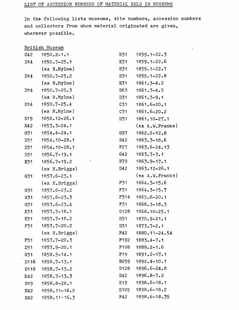
LIST OF ACCESSION NUMBERS OF MATERIAL HELD IN MUSEUMS
In the following lists museums, site numbers, accession numbers and collectors from whom material originated are given, wherever possible.
British MuseumC42 1850.2-1.1 E31 1859.1-22.3D14 1850.7-25.1 E31 1859.1-22.6
(ex R.Mylne) E31 1859.1-22*7D14 1850.7-25.2 E31 1859.1-22.8
(ex R.Mylne) E31 1861.3-4.2D14 1850.7-25.3 D63 1861.3-4.5
(ex R.Mylne) D31 1861.3-9.1D14 1850.7-25.4 C31 1861.6-20.1
(ex R.Mylne) C31 1861.6-20.2D19 1850.12-26.1 D31 1861.10-27.1E42 1853.3-24.1 (ex A.W.Franks)G31 1854.4-24.1 097 1862.2-12.-8D31 1854.10-28.1 E42 1863.3-18.6D31 1854.10-28.1 F27 1863.6-24.13D31 1856.7-19.1 042 1863.7-3.1E31 1856.7-19.2 E79 1863.9-17.1
(ex H.Briggs) D42 1863.12-26.1031 1857.6-23.1 (ex A.W.Franks)
(ex H.Briggs) P31 1864.3-15.6031 1857.6-23.2 P31 1864.3-15.7G31 1857.6-23.3 F314 1865.6-20.1G31 1857.6-23.4 F31 1868.3-18.3E31 1857.7-18.1 C128 1868.10-25.1E31 1857.7-18.2 D31 1870.9-21.1P31 1857.7-20.2 D31 1873.7-2.1
(ex H.Briggs) F42 1880.11-24.54P31 1857.7-20.3 F192 1883.4-7-1D31 1857.9-20.1 F108 1889.2-1.6G31 1858.5-14.1 F19 1891.2-17.1D116 1858.7-13.1 B259 1892.4-10.1D116 1858.7-13.2 D128 1896.6-24.8K42 1858.7-13.3 D42 1896.8-7.2D19 1858.8-28.1 E19 1898.6-18.1E42 1858.11-16.2 E105 1898.6-18.2E42 1858.11-16.3 F42 1898.6-18.35
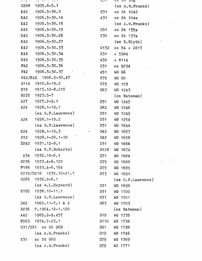
C268 1905.6-5.1 (ex A.W.Franks)K42 1906.5-30.3 031 cc St 104CK42 1906.5-30.14 A31 cc St 104eK42 1906.5-30.18 (ex A,W.Franks)K42 1906.5-30.19 D31 cc St 135aK42 1906.5-30.26 C30 cc St 137aK42 1906.5-30.27 (ex E.Blyth)K42 1906.5-30.33 G132 cc 84 + 2817K42 1906.5-30.34 031 + 5584K42 1906.5-30.35 A50 + 8114F42 1906.5-30.36 C31 cc 9234F42 1906.5-30.37 A51 WG 66C42A42 1906.5-30.47 C79 WG 90D114 1910.6-19.2 079 WG 103E19 1915.12-8.215 D63 WG 1243G225 1923.5-7 (ex Bateman)A27 1927.2-9.1 D31 WG 1245A24 1928.1-19.1 D82 WG 1246
(ex G.F.Lawrence) D31 WG 1249A24 1928.1-19.2 D31 WG 1254
(ex G.F.Lawrence) D31 WG 1644K24 1928.1-19.3 D42 WG 1657D12 1928.1-20.1-10 D42 WG 1658D242 1931.12-8.1 D31 WG 1666
(ex N.F.Robarts) D128 WG 1674A34 1932.10-6.1 D31 WG 1684G236 1933.4-6.122 D79 WG 1688F186 1933.4-6.164 D79 WG 1689C215/D218 1935.10-21.1 D73 WG 1691C265 1936.2-6.1 (ex G.F.Lawrence)
(ex W.L.Hayward) D31 WG 1698E195 1938.10-11.1 D31 WG 1700
(ex G.F.Lawrence) D31 WG 1701D42 1960.11-7.1 & 2 D63 WG 1703D2.36 P.1964.12-1.120 (ex Bafoeman)A42 1965.2-9.457 D19 WG 1735F263 1974.7-23.1 D110 WG 1736C31/D31 cc St 96B D91 WG 1738
(ex A.W.Franks) D19 WG 1746K31 cc St 96C D79 WG 1769
(ex A.W.Franks) D79 WG 1771
D79 WG 1778D42 WG 1779D236 WG 1863D31 WG 2272D31 WG 2425Unregistered material:-A48 (some ex G.F.Lawrence)C51C55A69C69C79C180C269A172A227A79A50 (some ex G.F.Lawrence) Sturge collection:A31A42A55 no.285 A55 no.286 A50 no.287 A48 no.288 A50 no.289
(ex G.F.Lawrence)A50 no.190
(ex G.F.Lawrence)A237B71A48B79A42 (ex G.F.Lawrence)Sturge box 1 A55Wandsworth London Sturge collBox 2A37A41 (ex G.F.Lawrence)A50Wandsworth turge box 3 A50 (one ex-G.F.Lawrence )
A217A48 (ex G.F.Lawrence) Wandsworth Sturge coll box 5 A50 (one ex G.F.Lawrence)A216K50K42Wandsworth Sturge coll box 6 A50 (two ex G.F.Lawrence) Wandsworth Sturge coll box 7 A50 (one ex G.F.Lawrence)A48A 131 (©x G.F.Lawrence)A217B50Wandsworth Sturge coll box 8 A36A50 (one ex G.F.Lawrence)A48Wandsworth Sturge coll box 9 A50 some ex G.F.Lawrence A48 K51Wandsworth Sturge coll box 10A50 (one ex G.F.Lawrence)Sturge coll London misc boxA35A234A238A336A356B31Sturge Mesolithic Wandsworth& Thames etc boxB41B48B50B51B212Sturge coll deep box 34A30A51A55
A236 B31A353 Ex Trenchman collSturge coll Thameside box B128 not tracedA32 Cabinet J London & MiddlesexBateman coll C50B254 Cabinet J London & MiddlesexWright coll Tray 39A34 D30Box 1A 18 W1 London gravels Christy collB332 box 2! + 8120Wandsworth London & Earlsfield box 1 K50A50A48 (ex G.F.Lawrence)Wellcome coll Museum of LondonA42 84176 B42 A1A50 80907 C42 A3A50 80888 B31 A7A50 80909 C42 A10A50 80908 C42 A12A50 80910 C42 A13Wellcome London areas box 1 C42 A14A50 271957 D70 A15A50 828633 A42 A16A50 65405 D19 A21Wellcome London areas box 2 D54 A22A50 193604 D42 A23 missingWellcome coll various sites B42 A609Surrey box B42 A814A216 C42 A1478 ex W.M.NewtonThameside box 1 B46 A1558B50 C192 A1560Thame side box 2 G42 A1655B31 G79 A1657Trenchman coll handaxes box G42 A1680 ex Hilton Price1965.2-9 C42 A1932A39 G50 A1950A50 C42 A2006Wandsworth etc London Thames B31 A2010picks box D42 A2013B67 G84 A2373B214 C42 A2485B216 F42 A2576B217 A42 A2584
B2 A4907B42 A4908D42 A4913A42 A5082A34 A5083G42 A5605G91 A5882-5D128 A6366G4-2 A6395A42 A6424P42 A6489A42 A7115G42 A7346 ex Hilton PriceG31 A7347031 A7349B31 A7350G42 A7444G42 A7445F31 A7604C42 A7646P136 A7709G42 A7723G42 A7743C42 A7747031 A77480136/031/C54 A7907P136 A7957B31 A7964D42 A8050G50 A8057B42 A8124F31 A8428G31 A8840042 A9385D42 A9505C118 A9964G31 A9981C31 A11051E42 A10212031 A10683A42 A10839B79 A10968
G79 A11911B87 A13260P87 A13262D31 A13480B27 A13497D42 A13731G42 A13866E31 A13868G31 A13921G42 A13933D82 A13942B42 A13971A129 A14532D19 A14982D128 A15328G31 A15338D82 A15441G79 A15442P328 A15446D19 A15457G42 A15458E42 A15460G42 A15461G31 A15462P136 A16048B69 A16433D60 A16662 ex G.F.LawrenceK79 A16962A42 A16963042 A17199C173/C238 A17394E234 A17673K42 A18883D31 A19780D31 A19786 ex Greenwell collB31 A19788F312 A19900A216 A20015 ex T.H.PowellE173 A20055 ex W.PearceF139 A20902F312 A20989E354 A23465
G192 A24367 C42 0.431D27 A24794 ex G.F.Lawrence C42 0.473D27 A24803 C42 0.641G79/G192 A24909 B79 0.686E207 A24910 C42 0.709G27 A24915 D79 0.1197D31 A24934 D79 0.1307G79 A24938 D76 0.1318E79 A24940 D42/D79 0.1:D27 A24954 D42 0.1367D27 A24997 D42 0.1368A172 A25013 D63 0.1441A172 A25014 D42 0.1446G81 A25147 D42 0.1447D27 A25186 E42 0.1767G81 A25395 F19 0.2004D27 A25396 F19 0.2005D27 A25397 G42 0.2044E42 A25644 G51 0.2058D12 A25760 G42 0..2108A79 A25775G81 A25844 E27 P1C18 A26003 D42 P21A42 A26295 F42 P51D12 A26298 E79 P792D12 A26299D83 A26394 B31 C722B42 A26461 B31 C723A30 A26646 G42 G727 e:D27 A26816 F328 C729E42 A26932 ex Gregory E328 0752 e:A48 A26939 ex G.F.Lawrence D31/D52 C89!D36 A26954 ex H.E.Jackson 031 C928A42 A26963 E42 C970D31 A27000 E42 C971F125 A27336K238 A28547G42 A83394 (this is probably
wrong)G192 A243499 (this is probably
wrong)
B42 0-224-
C238 B5-23
Ex Guildhall MuseumA50A50A50A50A50
no. 6 no. 7 no. 8 no. 9 no. 10
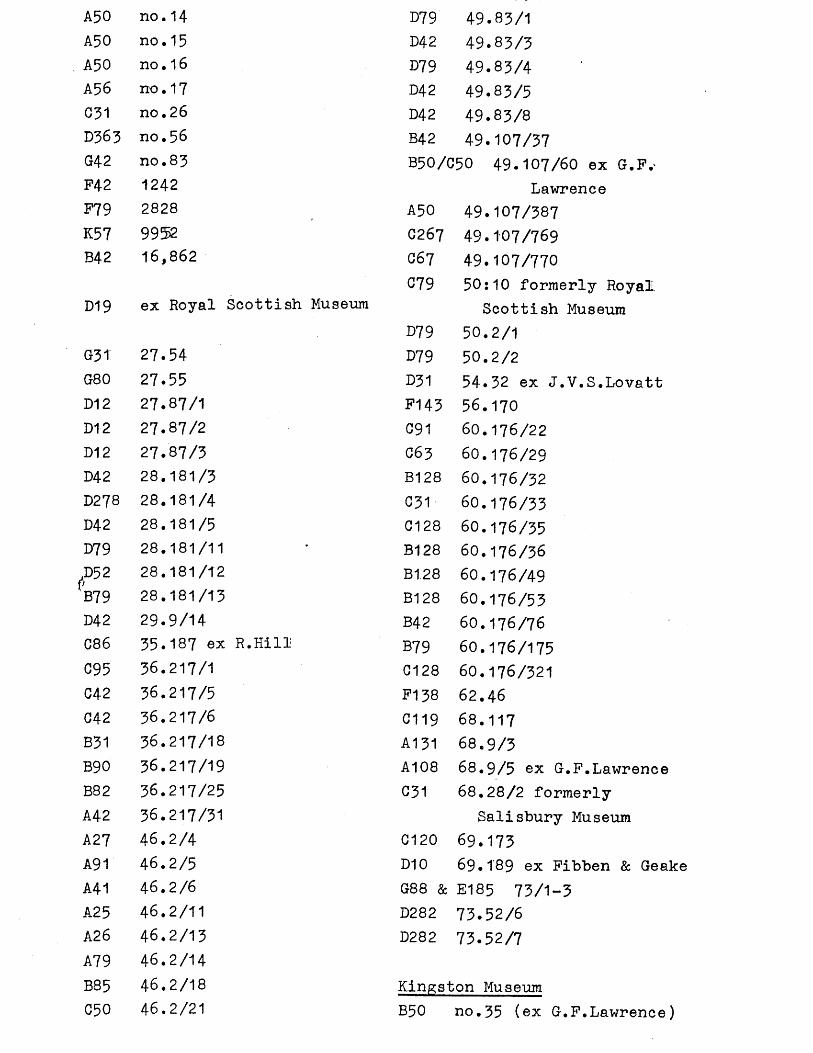
A50 no. 14 D79 49.83/1A50 no. 15 D42 49.83/3A50 no • 16 D79 49.83/4A56 no. 17 D42 49.83/5C31 no. 26 D42 49.83/8D363 no. 56 B42 49.107/37G42 no. 83 B50/C50 49.107/60 ex G.P.'P42 1242 LawrenceF79 2828 A50 49.107/387K57 9952 C267 49.107/769B42 16,862 G6 7
C7949.107/77050:10 formerly Royal
D19 ex Royal Scottish MuseumD79
Scottish Museum 50.2/1
G31 27.54 D79 50.2/2G80 27.55 D31 54.32 ex J.V.S.LovattD12 27.87/1 P143 56.170D12 27.87/2 C91 60.176/22D12 27.87/3 C63 60.176/29D42 28.181/3 B128 60.176/32D278 28.181/4 C31 60.176/33D42 28.181/5 C128 60.176/35D79 28.181/11 B128 60.176/36,D52VB79
28.181/12 B1.28 60.176/4928.181/13 B128 60.176/53
D42 29.9/14 B42 60.176/76C86 35.187 ex R.Hill B79 60.176/175G95 36.217/1 G128 60.176/321C42 36.217/5 F138 62.46G42 36.217/6 C119 68.117B31 36.217/18 A131 68.9/3B90 36.217/19 A108 68.9/5 ex G.P.LawrenceB82 36.217/25 G31 68.28/2 formerlyA42 36.217/31 Salisbury MuseumA27 46.2/4 G120 69.173A91 46.2/5 D10 69.189 ex Pibben & GeakeA41 46.2/6 Q CD CD 8° E185 73/1-3A25 46.2/11 D282 73.52/6A26 46.2/13 D282 73.52/7A79 46.2/14B85 46.2/18 Kinp;ston MuseumC50 46.2/21 B50 no.35 (ex G.P.Lawrence)
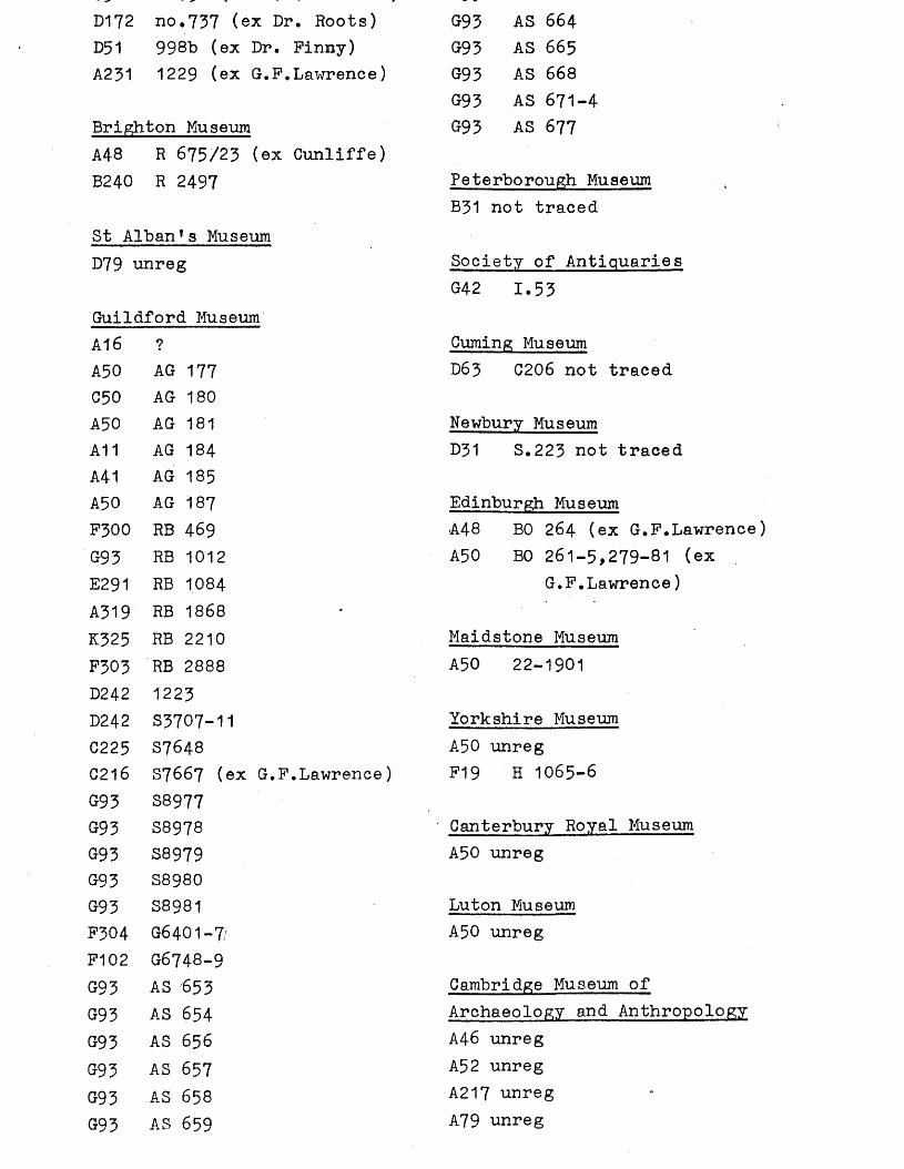
D172 no.737 (ex Dr. Roots) G93 AS 664D51 998b (ex Dr. Pinny) G93 AS 665A231 1229 (ex G.P.Lawrence) G93 AS 668
G93 AS 671-4Brighton Museum G93 AS 677A48 R 675/23 (ex Cunliffe)B240 R 2497 Peterborough Museum
B31 not tracedSt Alban*s MuseumD79 unreg Society of Antiquaries
G42 1.53Guildford MuseumA16 ? Cuming MuseumA50 AG 177 D63 C206 not tracedC50 AG 180A50 AG 181 Newbury MuseumA11 AG 184 D31 S.223 not tracedA41 AG 185A50 AG 187 Edinburgh MuseumP300 RB 469 A48 BO 264 (ex G.P.Lawrence)G93 RB 1012 A50 BO 261-5,279-81 (exE291 RB 1084 G.P.Lawrence)A319 RB 1868K325 RB 2210 Maidstone MuseumP303 RB 2888 A50 22-1901D242 1223D242 S3707-11 Yorkshire MuseumC225 S7648 A50 unregC216 S7667 (ex G.F.Lawrence) P19 H 1065-6G93 S8977G93 S8978 Canterbury Royal MuseumG93 S8979 A50 unregG93 S8980G93 S8981 Luton MuseumF304 G6401-7/ A50 unregP102 G6748-9G93 AS 653 Cambridge Museum ofG93 AS 654 Archaeology and AnthropologyG93 AS 656 A46 unreg093 AS 657 A52 unregG93 AS 658 A217 unregG93 AS 659 A79 unreg
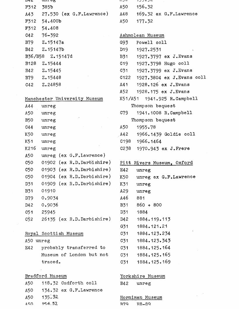
F312 385b A50 156.32A43 27*530 (ex G.F.Lawrence) A48 169.32 ex G.F.LawrenceF312 54.400b A50 177.32F312 54.408C42 76-392 Ashmolean MuseumB79 Z.15147a G93 Powell collB42 Z.15147b D19 1927.2531B36/B58 Z.15147d B31 1927.3797 ex J.EvansB128 Z.15444 C19 1927.3798 Hugo collB42 Z.15445 C31 1927.3799 ex J.EvansB79 Z.15448 C122 1927.3804 ex J.Evans collC42 Z.24858 A41 1928.126 ex J.Evans
A52 1928.175 ex J.EvansManchester University Museum K51/A51 1941.925 R.CampbellA44 unreg Thompson bequestA50 unreg C79 1941.1008 R.CampbellB50 unreg Thompson bequestG44 unreg A50 1955.78K50 unreg A42 1966.1439 Goldie collK51 unreg C198 1966.1464K216 unreg C238 1970.943 ex J.FrereA50 unreg (ex G.F.Lawrence)C50 01902 (ex R.D.Darbishire) Pitt Rivers Museum. OxfordC50 01903 (ex R.D.Darbishire) E42 unregG50 01904 (ex R.D.Darbishire) K50 unreg ex G.F.LawrenceD31 01909 (ex R.D.Darbishire) K31 unregB31 01910 A29 unregD79 0.9034 A46 881D42 0.9036 B31 860 + 800C51 25945 D31 1884G52 26135 (ex R.D.Darbishire) D42 1884.119.113
G31 1884.121.21Royal Scottish Museum 031 1884.123.234A50 unreg C31 1884.123.343E42 probably transferred to C31 1884.125.164
Museum of London but not C31 1884.125.165traced. 031 1884.125.169
Bradford Museum Yorkshire MuseumA50 118.32 Gudforth coll B42 unregA50 134.32 ex G.F.LawrenceA50 135*32 Horniman Museum
1^4.32 R7Q H8-8Q
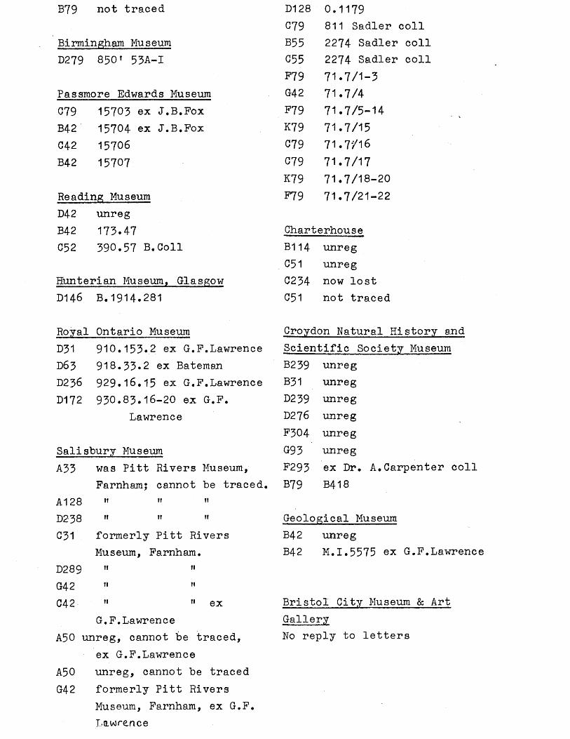
B79 not traced
Birmingham MuseumD279 8301 53A-I
Passmore Edwards MuseumC79 15703 ex J.B.FoxB42 15704 ex J.B.FoxC42 15706B42 15707
Reading MuseumD42 unregB42 173.47C52 390.57 B.Coll
Hunterian Museum, GlasgowD146 B.1914.281
Royal Ontario MuseumD31 910.153.2 ex G.F.LawrenceD63 918.33*2 ex BatemanD236 929.16.15 ex G.F.LawrenceD172 930.83.16-20 ex G.F.
Lawrence
Salisbury MuseumA33 was Pitt Rivers Museum,
Farnham; cannot be tracedA128 »t H If
D238 i» 11 i i
C31 formerly Pitt RiversMuseum, Farnham.
D289 t i »i
G42 11 11
C42 M n exG.F.Lawrence
A50 unreg, cannot be traced,ex G.F.Lawrence
A50 unreg, cannot be tracedG42 formerly Pitt Rivers
Museum, Farnham, ex G.F.Lawrence
D128 0.1179C79 811 Sadler collB55 2274 Sadler collC55 2274 Sadler collF79 71.7/1-3G42 71.7/4F79 71.7/5-14K79 71.7/15C79 71.7/16C79 71.7/17K79 71.7/18-20F79 71.7/21-22
Charterhouse B114 unreg C51 unreg C234 now lost 051 not traced
Croydon Natural History andScientific Society MuseumB239 unregB31 unregD239 unregD276 unregF304 unregG93 unregF293 ex Dr. A.Carpenter coll B79 B418
Geological Museum B42 unregB42 M.I.5575 ex G.F.Lawrence
Bristol City Museum & Art GalleryNo reply to letters

CONCORDANCE TABLE : Thesis site numbers related to S.W.LondonArchaeological Unit site numbers
This collaborative M.Phil research is being undertaken in conjunction with the S.W.London Archaeological Unit. The unit has allocated site numbers according to individual London boroughs, so that more than one site within the Wandle Valley could carry the same site number. It was therefore decided in this particular research to allocate each site or findspot an individual number, and correlate them below with S.W.London Archaeological Unit numbers.
A= Palaeolithic, B= Mesolithic, C= Neolithic, D= Bronze Age, E= Iron Age, F= Roman, G= Saxon, K= Uncertain or unknown, M= London Borough of Merton, S= London Borough of Sutton, W= London Borough of Wandsworth.
THESIS SWLAU NUMBER NUMBER K1 K107SA2 A2WB2 B2WE2 E2WF2 F2WE3 E3WF3 F3WK3 K3WB4 B4WC4 C4WF4 F4WD5 D5WF6 F6WMSC7 C7WC8 C104SD10 D10WA11 A11W Geraldine Road, Wandsworth.D12 D12W Gas Works, Wandsworth.F13 F13W Battersea Fields.D14 D14W Thames, ̂ mile below mouth of Wandle.F15 F15W Putney Vale.A16 A16W Festing Road, Putney.K17 K17W Pig Hill, Wandsworth.C18 C18W Thames, Wandsworth, Putney end.
SITE
Woodcote.Thames, opposite Wandsworth Park.
n it h n
n it i t t i
it it i t i t
Thames foreshore, Battersea.it i» n
h it it
38-46 Sefton Street, Putney.it i t 11
11 it 11
Thames foreshore, Battersea.Across the Wandle Valley Dealtry Road, Putney.Cheam.Kambala Road, Wandsworth.
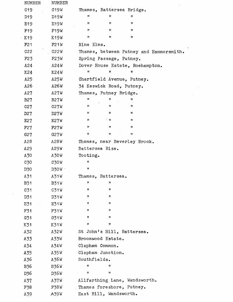
NUMBER NUMBER019 C19W Thames, Battersea Bridge.D19 D19W " " "E19 E19W " " "p-jg F19W !f n nK19 K19W " " "F21 F21W Nine Elms.022 C22W Thames, between Putney and Hammersmith.F23 F23W Spring Passage, Putney.A24 A24W Dover House Estate, Roehampton.K24 K24W " » "A25 A25W Chartfield Avenue, Putney.A26 A26W 34 Keswick Road, Putney.A27 A27W Thames, Putney Bridge.B27 B27W " " »C 27 C27W »» »» "D27 D27W ” ” "E27 E27W « ’ « «F27 F27W »» " »G27 G27W " '» »'A28 A28W Thames, near Beverley Brook.A29 A29W Battersea Rise.A30 A30W Tooting.030 C30W »'D30 D30W • "A31 A31W Thames, Battersea.B31 B31W ” »'031 C31W » '•D31 D31W " ”E31 E31W ” ”F31 F31W « ”G31 G31W ” ,JK31 K31W ” ”
A32 A32W St Johnfs Hill, Battersea.A33 A33W Broomwood Estate.A34 A34Wr Clapham Common.A35 A35W Clapham Junction.A36 A36W Southfields.B36 B36W »» »»D36 D36W " ”A37 A37W Allfarthing Lane, Wandsworth.F38 F38W Thames foreshore, Putney.A39 A39W East Hill, Wandsworth.
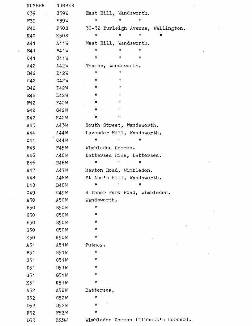
NUMBER NUMBERC39 C39W East Hill, Wandsworth.F39 F39W n n n
P4 0 F50S 30-32 Burleigh Avenue, Wallington.K40 K50S i i i i i t i t
A41 A41W West Hill, Wandsworth.B41 B41W i t i i i t
041 G41W i t i i i i
A42 A42W Thames, Wandsworth.B42 B42W i i i i
C42 C42W i i i i
D42 D42W i t i t
E42 E42W i t i t
P42 F42W i i n
G42 G42W i i i t
K42 K42W i i i t
A43 A43W South Street, Wandsworth.A44 A44W Lavender Hill, Wandsworth.C44 C44W i i i t i t
P45 P45W Wimbledon Common.A46 A46W Battersea Rise, Battersea.B46 B46W i t n i t
A47 A47W Merton Road, Wimbledon.A48 A48¥ St Ann’s Hill, Wandsworth.B48 B48W i t i i i i
C49 C49W 8 Inner Park Road, Wimbledon.A50 A50W Wandsworth.B50 B50W ii
C50 C50W t i
E50 E50W i t
G$0 G50V/ i t
K50 K50W t i
A51 A51W Putney.B51 B51W i i
C51 G51W ii
D51 D51W ii
G51 G51W i i
K51 K51W i t
A52 A52W Battersea,C52 C52W i i
D52 D52W i i
F52 F52W i t
D53 D53W Wimbledon Common (Tibbett’s Corner).
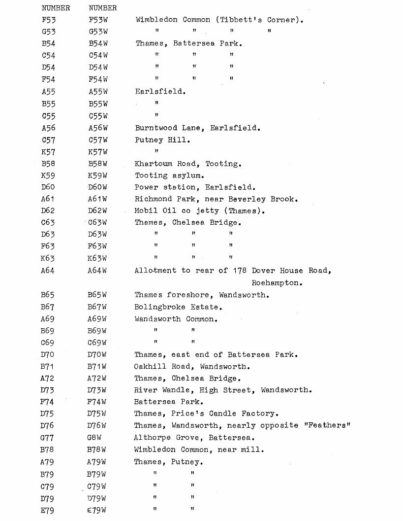
NUMBER NUMBERF53 F53W Wimbledon Common (Tibbett’s Corner).G33 G53W ” ” " ”B54 B54W Thames, Battersea Park.C54 C54W ” ” ’’D54 D54W ” ” nF54 F54W ” ” ”A55 A55W Earlsfield.B55 B53W ”C55 C55W ,fA56 A56W Burntwood Lane, Earlsfield.C57 C57W Putney Hill.K57 K57W »B58 B58W Khartoum Road, Tooting,K59 K59W Tooting asylum.D60 D60W Power station, Earlsfield.A61 A61W Richmond Park, near Beverley Brook.D62 D62W Mobil Oil co jetty (Thames).C63 C63W Thames, Chelsea Bridge.D63 D63W " ” »F63 F63W » ” »K63 K63W 11 M MA64 A64W Allotment to rear of 178 Dover House Road,
Roehampton.B65 B65W Thames foreshore, Wandsworth.B67 B67W Bolingbroke Estate.A69 A69W Wandsworth Common.B69 B69W «» «C69 C69W ” ”D70 D70W Thames, east end of Battersea Park.B7'1 B71W Oakhill Road, Wandsworth.A72 A72W Thames, Chelsea Bridge.D73 D73W River Wandle, High Street, Wandsworth.F74 F74W Battersea Park.D75 D75W Thames, Price’s Candle Factory.D76 D76W Thames, Wandsworth, nearly opposite ’’Feathers”G77 08W Althorpe Grove, Battersea.B78 B78W Wimbledon Common, near mill.A79 A79W Thames, Putney.B79 B79W ” ”C79 079 W ” ”D79 D79W ” ”E79 £79W ” ”
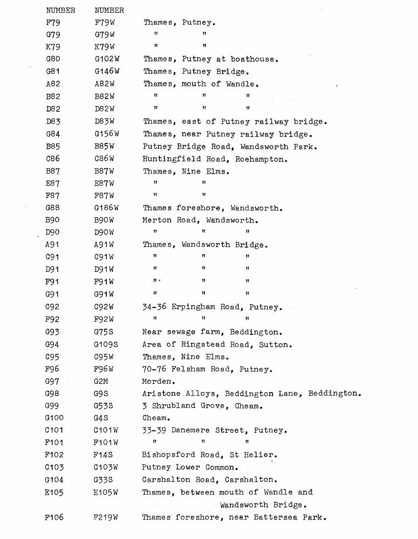
NUMBER NUMBERF79 F79W Thames, Putney.G79 G79W »r ft
K79 K79W I I I I
G80 G102W Thames, Putney at boathouse.G81 G146W Thames, Putney Bridge.A82 A82W Thames, mouth of Wandle.B82 B82W 11 11 11
D82 D82W 11 it 11
D83 D83W Thames, east of Putney railway bridge.G84 G156W Thames, near Putney railway bridge.B85 B85W Putney Bridge Road, Wandsworth Park.C86 C86W Huntingfield Road, Roehampton.B87 B87W Thames, Nine Elms.E87 E87W 11 11
F87 F87W i i 11
G88 G186W Thames foreshore, Wandsworth.B90 B90W Merton Road, Wandsworth.D90 D90W 11 11 11
A91 A91W Thames, Wandsworth Bridge.091 C91W i t 11 n
D91 D91W 11 11 i i
F91 F91W i t • 11 11
G91 G91W 11 n 11C92 C92W 34-36 Erpingham Road, Putney.F92 F92W 11 11 ti
G93 G75S Near sewage farm, Beddington.G94 G109S Area of Ringstead Road, Sutton.C95 C95W Thames, Nine Elms.F96 F96W 70-76 Felsham Road, Putney.G97 G2M Morden.G98 G9S Aristone Alloys, Beddington Lane, BeddingtonG99 G53S 3 Shrubland Grove, Cheam.G100 G4S Cheam.0101 C101W 33-39 Danemere Street, Putney.F101 F101W it 11 11
F102 F14S Bishopsford Road, St Helier.C103 C103V7 Putney Lower Common.G104 G33S Carshalton Road, Carshalton.E105 E105W Thames, between mouth of Wandle and
Wandsworth Bridge.F106 F219W Thames foreshore, near Battersea Park.
NUMBER NUMBERG107 G65S 3 Overhill Road, Purley.A108 A108W High Street, Wandsworth.P108 F108W " ",D110 D110W Near Queen's Road station, Battersea.D11 D111W ' Cromwell House, Putney Bridge Road.B114 B114W Battersea Waterworks.D114 D114W " "D116 D116W Thames, nearly opposite Wandsworth distilleryB117 B117W Thames foreshore, Battersea.C118 C118W Thames, Battersea.C119 C119W Thames foreshore, Putney.C120 C120W Thames foreshore, Putney.C121 C108M Golf Course, Wimbledon Common.C124 C124W Eltringham Street, Wandsworth.C125 C125W North Street, Wandsworth.Ft 25 F125W » " "E127 E107M 3 Kingsbridge Road, Morden.A128 A- W Thames, Chelsea.B128 B- W " "
4
C128 C- W " "D128 D- W " "G128 G- W ». "A129 A129W Balham.F130 F25S Cuddington Golf Course.A131 A131W Watney's Estate, Wandsworth.C131 C131W " » "C132 C132W Sister's Estate, Lavender Hill, Battersea.C134 C134W Putney Heath.G136 C136W Battersea Park.D1-36 D136W " "F136 F136W " »'F138 F138W 4 Bemish Road, Putney.F139 F139W St Ann's Hill, Wandsworth.B141 B141W 14 Gwendolen Avenue, Putney.C141 C141W " '» "F141 F141W " " "F142 F142W 6-12 the Platt, Putney.F143 F143W 8 Holmbush Road, Putney.F145 F145W 125 Upper Richmond Road, Putney.D146 D102S Sutton.F146 FjOS Sutton.
NUMBER NUMBERB147 B101S Queen’s Well, Carshalton.G147 G101S ft H ftP148 F100S Wallington.A153 A96S Miller’s Farm, Waddon.G153 C96S it ttK154 K94S Wallington, near paper mill.C155 C92S Bandon Hill.K156 K91S Near Stafford Road, Waddon.K157 K90S Near Bandon Hill, Beddington.K158 K89S Cross Shaws.F159 F88M Near Mitcham Common.B160 B27S Beddington sandpits.F160 F87S ti itE163 E85S Bandon Hill.F163 F85S itK163 K85S nK167 K84S Wallington High School for Girls.F168 F82S Warren Road, Sutton.F169 . F56S Beddington sewage farm.F170 F79S Bunker’s Field, Wallington.F171 F10.4M Durham House, Upper Green West, Mitcham.A172 A98M, A65M Wimbledon.D172 D57M, D36M, D48M "E172 E73M ttC173 G96M Wimbledon Common by the windmill.E173 E97M it tt ttF176 F176W St Mary's Church, Putney.B180 B54M, B70M Wimbledon Common.C180 G94M it itFI 82 F92M Near Stane Street, Merton.K184 K207W Upper Tooting.E185 E185W Thames foreshore, Wandsworth.F186 F49M Mitcham Gas Works.E189 E85M Mitcham Grove.F189 F85M ti tiB190 B82M Shadwell Wood, Wimbledon Common.G190 C82M ti it it .F191 F81M 2 Glastonbury Road, Merton.C192 C- W Thames, Fulham.F192 F- W it ttG192 G- W tt tt
NUMBER NUMBERF1 9 3 F79M Rear of Bath Tavern, Mitcham.F194 F78M Graham Road, Wimbledon.E195 E- W Thames, opposite Battersea church.F196 F76M 18 Hatfield Mead, Morden.K197 K75M Wimbledon Common.C198 C192W Wandsworth Park.K199 - Perrett!s Pit, Cheam.D203 D203W Ram Brewery, Red Lion Street, WandsworthE207 -E184W Thames between Putney Road and railway
bridges.F211 F211W Putney Common.B212 B212W HarleyTs Factory, Wandsworth.B214 B214W Rucker1s Estate, Wandsworth.C214 C214W 1! IT IT
A216 A216W Davies Estate, Wandsworth.B216 B216W n it
C216 C216W 11 it
K216 K216W 11 11
A217 A217W' Brarablebury Estate, Wandsworth.B217 B217W n 11 11
C218 C218W Opposite Wakehurst Drive, ClaphamD218 D218W . 11 11 11 11
C219 C225W Fairfax Estate.F220 F220W Putney Common.F221 F221W 55 Felsham Road, Putney.G221 G221W ti 11
K221 K221W 11 11
F223 F223W Roehampton Close, Roehampton.F224 F224W 64 Lacey Road, Putney.C225 C66M ’ Merton.G225 G52M ti
F226 F144S Ringstead Road, Sutton.F228 F228W Putney Vale.A231 A8S Woodcote, North Downs.A232 A58S Carshalton.D232 D19S 11
A233 A121S Bandon Hill?A234 - Mitcham Common.B234 B11M 11
C234 C27M 11
E234 ^77M ti
A235 A 32m Miles Lane, Mitcham.
NUMBER NUMBERA236 A55M Mitcham.D236 D33M, D35M "E236 E90M itG236 G67M ttA237 A56M Kingston Road, Wimbledon.A238 A57M Wimbledon CommonB238 B54M, B70M " «C238 C88M ti itD238 D34M it 11K238 K61M 11 i»A239 A68S Aldwick Road, Waddon.B239 B68S 11 nC239 C68S tt 11D239 D68S 11 tiE239 E68S 11 itP239 F68S 11 itB24-0 B52S Bunker’s Field, Wallington.E240 E52S 11 11 11P240 F52S 11 11 11G240 G52S ti 11 11G241 G12S Wallington.B242 B21S Queen Mary’s Hospital, CarshaltonG242 C21S ti 11 11 11D242 D21S 11 11 11 11E242 E21S it ti 11 11P242 F21S tt it tt 11G242 G21S 1! II II II
B243 B71S Orchard Hill, Carshalton.D243 D71S n it 11F243 F71S n 11 11G243 G71S 11 11 itB244 B140S Wallington High School for Boys.C244 C140S 11 11 tt nK244 K140S i» 11 11 11F247 F70S Woodcote.B248 B24S Cheam Park.B249 B130S Beddington Park.B250 B63S 7,9 & 10 the Park, Carshalton.E250 E63S 11 it i»C251 C227W Lawn Estate.B252 B135S Gravel pit, Beddington.
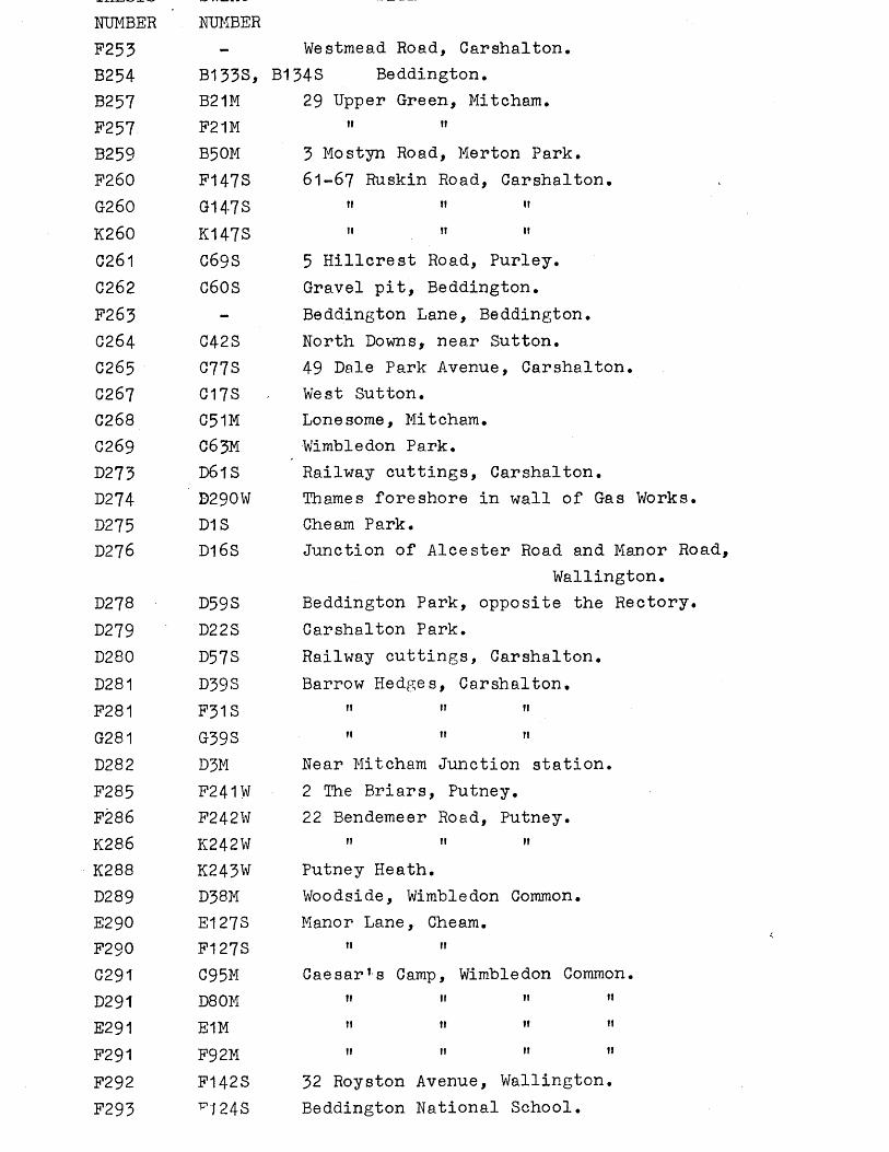
NUMBER NUMBERF253 - Westmead Road, Carshalton.B254 B133S, B134S Beddington.B257 B21M 29 Upper Green, Mitcham.F257 F21M it u
B259 B50M 3 Mostyn Road, Merton Park.F260 F147S 61-67 Ruskin Road, Carshalton.G260 G147S it ii it
K260 K147S 11 fi if
C261 069S 5 Hillcrest Road, Purley.C262 C60S Gravel pit, Beddington.F263 - Beddington Lane, Beddington.G264 042S North Downs, near Sutton.C265 077S 49 Dale Park Avenue, Carshalton.0267 G17S West Sutton.0268 C51M Lonesome, Mitcham.0269 06 3M Wimbledon Park.D273 D61S Railway cuttings, Carshalton.D274 D290W Thames foreshore in wall of Gas WorkD275 D1S Cheam Park.D276 D16S Junction of Alcester Road and Manor !
Wallington.D278 D59S Beddington Park, opposite the Rector;D279 D22S Carshalton Park.D280 D57S Railway cuttings, Carshalton.D281 D39S Barrow Hedges, Carshalton.F281 F31S ii 11 11
G281 G39S ii 11 11
D282 D3M Near Mitcham Junction station.F285 F241W 2 The Briars, Putney.F286 F242W 22 Bendemeer Road, Putney.K286 K242W 11 11 »i
K288 K243W Putney Heath.D289 D38M Woodside, Wimbledon Common.E290 E127S Manor Lane, Cheam.F290 F127S it ii
0291 C95M Caesar1s Camp, Wimbledon Common.D291 D80M ii 11 n 11
E291 E1M 11 ti 11 fi
F291 F92M 11 11 ii 11
F292 F142S 32 Royston Avenue, Wallington.F293 * 1 24S Beddington National School.
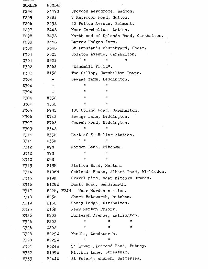
NUMBER NUMBERF294 F117S Croydon aerodrome, Waddon.F295 F28S 7 Kayemoor Road, Sutton.F296 F29S 20 Pelton Avenue, Belmont.F297 F44S Near Carshalton station.F298 F43S North end of Uplands Road, Carshalton.F299 F41S Barrow Hedges farm.F300 F34S St Dunstan’s churchyard, Cheam.F301 F32S Colston Avenue, Carshalton.G301 G32S " " "F302 F26S ( "Windmill Field".F303 F15S The Gallop, Carshalton Downs.C304 - Sewage farm, Beddington.D304 - " 11E304 - " ”F304 F53S " "G304 G53S " "F305 F73S 105 Upland Road, Carshalton.K306 K74S Sewage farm, Beddington.F307 F76S Church Road, Beddington.F309' F34S " "F311 F53M East of St Helier station.G311 G53M * 11 "F312 F9M Morden Lane, Mitcham.G312 G9M " "K312 K9M " "F313 F13M Station Road, Merton.F314 F106M Oaklands House, Albert Road, Wimbledon.F315 F19M Gravel pits, near Mitcham Common.E316 E128W Dault Road, Wandsworth.F317 F22M, F24M Near Morden station.F318 F25M Short Batsworth, Mitcham.A319 K13S Honey Lodge, Carshalton.K325 K46M Near Merton Priory.E326 E80S Burleigh Avenue, Wallington.F326 F80S " " "G326 G80S " " "E328 E229W Wandle, Wandsworth.F328 F229W " "F331 F324W 51 Lower Richmond Road, Putney.B332 B199W Mitcham Lane, Streatham.E333 F244W St Peter*s church, Battersea.
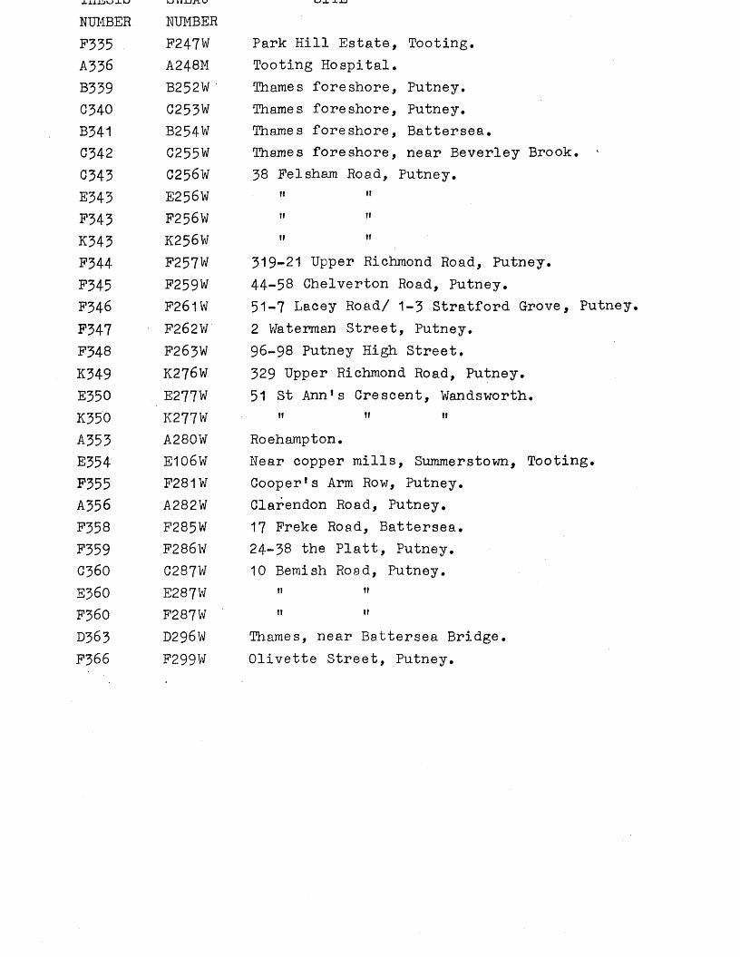
NUMBER NUMBERF335 F247W Park Hill Estate, Tooting.AJ36 A248M Tooting Hospital.B339 B252W Thames foreshore, Putney.C340 C253W Thames foreshore, Putney.B341 B254W Thames foreshore, Battersea.C342 C255W Thames foreshore, near Beverley Brook.G343 C256W 38 Felsham Road, Putney.E343 E256W IT II
F343 F256W 11 11K343 K256W ii ii
F344 F257W 319-21 Upper Richmond Road, Putney.F345 F259W 44-58 Chelverton Road, Putney.F346 F261W 51-7 Lacey Road/ 1-3 Stratford Grove, Putney.F347 F262V/ 2 Waterman Street, Putney.F348 F263W 96-98 Putney High Street.K349 K276W 329 Upper Richmond Road, Putney.E350 E277W 51 St Ann’s Crescent, Wandsworth.K350 K277W 11 i i ff
A353 A280W Roehampton.E354 E106W Near copper mills, Summerstown, Tooting.F355 F281W Cooper’s Arm Row, Putney.A356 A282W Clarendon Road, Putney.F358 F285W 17 Freke Road, Battersea.F359 F286W 24-38 the Platt, Putney.C36O C287W 10 Bemish Road, Putney.E360 E287W fi if
F36O F287W if fi
D363 D296W Thames, near Battersea Bridge.F366 F299W Olivette Street, Putney.
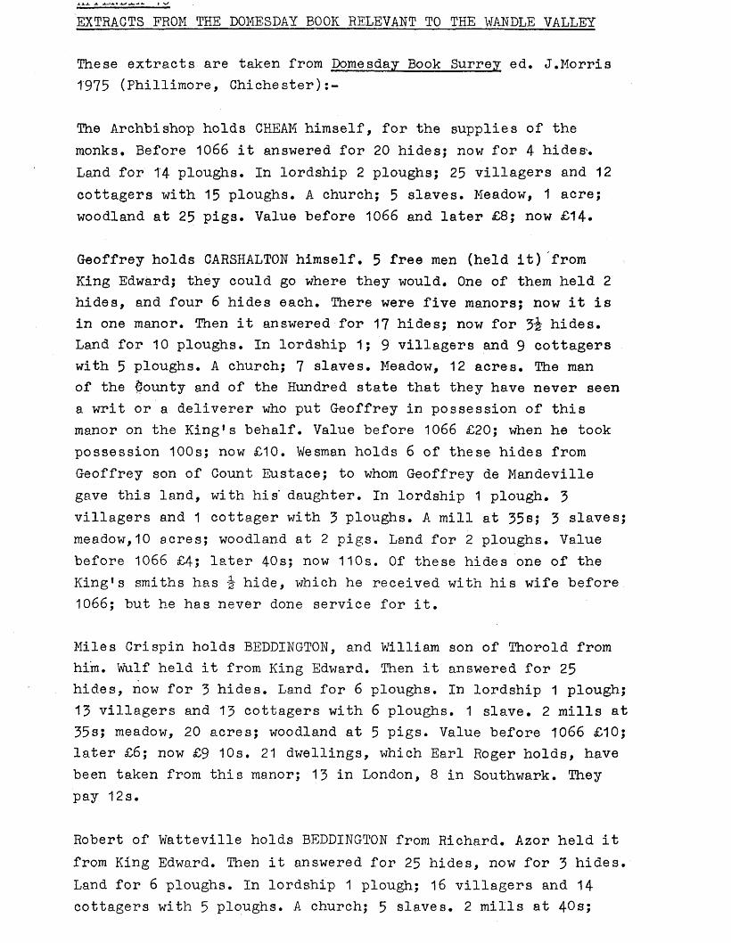
EXTRACTS FROM THE DOMESDAY BOOK RELEVANT TO THE WANDLE VALLEY
These extracts are taken from Domesday Book Surrey ed. J.Morris 1975 (Phillimore, Chichester):-
The Archbishop holds CHEAM himself, for the supplies of the monks. Before 1066 it answered for 20 hides; now for 4 hides'.Land for 14 ploughs. In lordship 2 ploughs; 25 villagers and 12 cottagers with 15 ploughs. A church; 5 slaves. Meadow, 1 acre; woodland at 25 pigs. Value before 1066 and later £8; now £14.
Geoffrey holds CARSHALTON himself. 5 free men (held it) from King Edward; they could go where they would. One of them held 2 hides, and four 6 hides each. There were five manors; now it is in one manor. Then it answered for 17 hides; now for hides. Land for 10 ploughs. In lordship 1; 9 villagers and 9 cottagers with 5 ploughs. A church; 7 slaves. Meadow, 12 acres. The man of the bounty and of the Hundred state that they have never seen a writ or a deliverer who put Geoffrey in possession of this manor on the King’s behalf. Value before 1066 £20; when he took possession 100s; now £10. Wesman holds 6 of these hides from Geoffrey son of Count Eustace; to whom Geoffrey de Mandeville gave this land, with his' daughter. In lordship 1 plough. 3 villagers and 1 cottager with 3 ploughs. A mill at 35s; 3 slaves; meadow,10 acres; woodland at 2 pigs. Land for 2 ploughs. Value before 1066 £4; later 40s; now 110s. Of these hides one of the King’s smiths has -J- hide, which he received with his wife before 1066; but he has never done service for it.
Miles Crispin holds BEDDINGTON, and William son of Thorold from him. Wulf held it from King Edward. Then it answered for 25 hides, now for 3 hides. Land for 6 ploughs. In lordship 1 plough; 13 villagers and 13 cottagers with 6 ploughs. 1 slave. 2 mills at 35s; meadow, 20 acres; woodland at 5 pigs. Value before 1066 £10; later £6; now £9 10s. 21 dwellings, which Earl Roger holds, have been taken from this manor; 13 in London, 8 in Southwark. They pay 12s.
Robert of Watteville holds BEDDINGTON from Richard. Azor held it from King Edward. Then it answered for 25 hides, now for 3 hides. Land for 6 ploughs. In lordship 1 plough; 16 villagers and 14 cottagers with 5 ploughs. A church; 5 slaves. 2 mills at 40s;
belong to this manor pay 12s 3d. Value before 1066 and now £10; when acquired £6.
WALLINGTON, in lordship. Before 1066 and now it answered for 11 hides. Land for 11 ploughs. In lordship 1 plough; 15 villagers and 14 smallholders with 10 ploughs. 3 slaves. 2 mills at 30s; meadow, 8 acres; woodland, which is in Kent. Richard of Tonbridge holds 1 virgate of this manor, with the woodland, whence he removed a countryman who dwelt there. Now it pays the Sheriff 10s a year. Value of the whole manor before 1066 £15; now £10.
The Abbey holds SUTTON (-by Cheara) itself. Before 1066 it answered for 30 hides, now for Q£ hides. Land for 15 ploughs.In lordship 2 ploughs; 21 villagers and 4 cottagers with 13 ploughs. 2 churches; 2 slaves. Meadow, 2 acres; woodland at 10 pigs. Value before 1066 £20; now £15.
William also holds MITCHAM. Ledmer held it from King Edward.Then and now it answered for 2 hides and 1 virgate. 2 villagers and 6 cottagers. £ mill at 20s. Value before 1066 and now 40s; when acquired 13s 4d.
The Canons of Bayeux hold MITCHAM from the Bishop for 5 hides. Brictric held it from King Edward. He had 6£ hides himself, but Odbert holds one, which his predecessor held in pledge from Brictric for i.gold mark. On the Canons’ land 4 villagers and 1 cottager with 2 ploughs and 1 slave. Meadow, 40 acres. Land for 2 ploughs. The value was and is 40s. On Odbert’s land, meadow,4 acres. Value 7s; nothing more. Ansgot holds £ hide from the Bishop. Value 5s. In this manot the Canons hold 2 £ hides themselves from the Bishop, which 2 men held from King Edward. In lordship 1 plough, with 1 villager, 2 smallholders and 1 slave, and £ plough. Meadow, 12 acres. (Value) always 20s.
MERTON. Earl Harold held it. Then and now it answered for 20 hides. Land for 21 ploughs. In lordship 2 ploughs: 56 villagers and 13 smallholders with 18 ploughs. 2 mills at 60s; meadow, 10 acres; woodland, 80 pigs. Value before 1066 £25; now £35; however its holder pays £43*
The Abbey of Westminster holds MORDEN itself. Before 1066 it answered far 12 Aides, now for 3 hides. Land for .... In lordship
1 mill at 40s. Value before 1066 £6; now £10; however, it pays £15.
The Abbey holds TOOTING itself. Swein held it from King Edward.It answered for 4 hides. Land for 1£ ploughs. 2 villagers with £ plough. Meadow, 3 acres. Value before 1066 and now 40s; when acquired 20s. Earl Waltheof received this land from Swein after King Edward’s death. He pledged it for 2 gold marks to Alnoth of London, who assigned it to St. Peter’s for his soul’s sake; that is, what he had there. Odbert holds it from St. Peter’s, but has paid nothing in tax.
Hamp also holds TOOTING from the Abbot of Chertsey. It answered for 6 hides less 1 virgate before 1066; now for nothing. Land for ploughs. In lordship 1 plough; 3 villagers and 2 smallholders with 1 plough. A church. Meadow, 4 acres. Value before 1066, 40s; later 20s; now 70s.
Hamo also holds 1 hide in TOOTING from the Abbot of Chertsey.0sward held it from King Edward; he could go where he would. 1 villager with £ plough. Meadow, 1 acre. (Value) before 1066,15s; now 10s.
St. Mary’s of Bee holds TOOTING (Bee) by gift of Richard, Stacker held it from King Edward. Then it answered for 11 hides, now for 1 hide. Land for 4 ploughs. In lordship 2 ploughs; 5 villagers and 4 smallholders with 3 ploughs. Meadow, 10 acres. Value before 1066 and now 100s; when acquired 20s.
Geoffrey Orlateile holds BALHAM, without the King’s gift or warrant. Askell held it from Earl Harold. Then it answered for 5 hides, now for nothing. Land for 2 ploughs. In lordship 1; 1 villager and 1 smallholder with £ plough. 1 slave. Meadow, 8 acres. Value before 1066 £6; later 20s; now 40s.
St., Peter’s of V/estminster holds BATTERSEA. Earl Harold held it.Then it answered for 72 hides, now for 18 hides. Land f o r ....In lordship 3 ploughs; 45 villagers and 16 smallholders with 14 ploughs. 8 slaves. 7 mills at £42 9s 8d, or corn of the same price; meadow, 82 acres; woodland at 50 pigs from pasturage.
William holds WANDSWORTH himself. 6 Freemen held it from King
Then and now it answered for 12 hides. Land for 4 ploughs. Ansculf has this land after he received the Sheriffdom, but the men of the Hundred say that they have seen neither seal or a deliverer. Ansfrid 5 hides, now for 1 hide; Heldred, 3 hides, now for nothing; Wulfsard, 3 hides; Walter the Vinedresser, 1 hide; they did not pay tax. On their lands, ploughs in lordship; 5 villagers and 22 smallholders with 2 ploughs. Meadow,22 acres. Value of the whole manor before 1066, 110s; later 50s now £8 in all.
The Abbot of St. Wandrille*s holds WANDSWORTH' through the monk Ingulf. Swein held it from the King, and could go where he would. Then it answered for 1 hide; now for nothing. 3 villager and 2 smallholders with 1 plough. The value was and is 20s.
APPENDIX 11 WORK OUTSTANDING
A certain amount of research on the data from the Wandle Valley still needs to be carried out. Since there was insufficient time to complete this, it was decided to compile a list of this work which needs to be done. The gazetteer is marked * next to the site number when work still needs to be completed.
Site number CommentsE2 The WHS needs to be contacted to see if it holds
the potsherds,07 The WHS needs to be contacted as more information
is required on Dealtry Road, including the NGR.D10 The object should be examined to see if it is
actually Bronze Age, The details of rock analysis and the circumstances of the finding are in a file in MoL, and should be checked, NGR TQ 269 760 should be checked for its accuracy,
D12 Axes 1928.1-20,6 and 7 in BM should .be examined tomatch them with Garroway Rice’s pictures,
C18 MoL should be asked when axe A26003 was found; itmay be the diorite axe mentioned by Lawrence 1929 p.90 if it was found before 1929 ̂ in which case it should be classified under site C27 and not C18.
C19 PSA 3 1855 p.144: the exact title of the meetingbeing reported is needed for the bibliography.
D19 The register number of the ferrule in BM is needed.BIC should be checked as it says that object A21 is from Battersea. Lawrence 1929 mentions a ’’clock hand” Hallstatt sword in BM found c.1890. This needs to be traced in BM.
E19 An iron spearhead with a bronze rivet and an EarlyIron Age sword blade found before 1929 are in MoL and need to be traced.
F19 ‘ Hilibner p.225 no. 1321, CIL 1221 and Epehm. Epigr. IX1263 need to be read. 02004-5 in MoL should be examined to ensure that they are not the ones mentioned by Haverfield, which ought to be in BM.A more precise provenance other than Thames, Battersea, should be checked. If only Thames, Battersea, they should be classified under site
F19
A25
A26
B27
C27
D27
D27
A29
C30
D31
E31
F31
C39C41
cont. F31, not F19. These may be the ones mentioned by Vulliamy. Franks mentions a 5th specimen in BM which could be from this site. BM 1864.3-15*2 should be examined to see which one it is. "Chartfield Ave in 1902 only went as far west as Gwendolen Ave” would make it a very short road off Putney. Check to see if east was intended.NGR is needed for 34 Keswick Road (approximately 244 744/747).A tranchet axe needs to be traced in MoL which was found ”off new bridge near Putney 1888”If the axe classified under C18 was in fact found before 1929, this is probably that particular axe.If not, a diorite axe needs to be traced in MoL from Thames, Putney Bridge, as well as a flint axe in MoL (which may be classified under C79).A26816 in MoL needs to be examined to see if it is Bronze Age.A24794 needs to be checked in MoL register to see if it is really from the Thames, Putney Bridge.The Quarterly Journal of the Geological Society of London 28 1872 p.462 should be read.2 /\f eolithlc implements from Tooting need to be traced in Sturge coll. JAI 1 1872 p^30 should be read to see if there is a title for the meeting reported for the bibliography.A24934 needs to be checked in MoL register to see if it is really from the Thames opposite Fulham Electricity Works, Battersea. Franks 1858 refers to a spearhead (probably found in 1858) which may be WG 1666 in BM. However 1858.12-14.1 in BM should be examined in case it is this. The whereabouts of the Bradford coll should be researched.The title of the meeting reported in PSA ii 4 1859, p.257 is needed for the bibliography. A34 should be examined in MoL to see if it is Early Iron Age. The accession number of the sword in BM is needed.A8428 in MoL should be examined to see if it is a salt cellar.The page number of Lawrence 1883 needs to be checked The local history librarian should be consulted as to the crossroads.
A42
B42
042
D42
E42
E42E42
G42
Axe S7650 in GM should he checked to see if it the axe incorrectly displayed as /Ueolithic. 46.2/20 and 22 in MoL should be examined for dating.Wymer quotes 49.107/37 as from Thames, Wandsworth, but it is Twickenham in MoL register. Wymer!.s card should be checked in the Institute of Archaeology as he may have said 49.107/137* The figures in Lawrence 1929 should be correlated by examining A609':, A814, 49.107/37 and AT in MoL. 0.686 in MoL should be examined to see if it is Mesolithic; likewise A2315A. "Church Marl" needs to be traced. In MoL the following should be checked to see if they are Neolithic: A18832, A25247, A26296, A27838, A6396, A3828, no. 28 (formerly 10), no.29 (formerly 11), no.38 (formerly no.28), no.40 (formerly no.22), no.48 (formerly no.30). Adkins & Jackson 1978 no.206 in BM should be traced, as well as theaccession number. An object 233mm long in MoLneeds to be traced - shown on Lawrence 1929 plate III no.4. 60.176/37 axe in MoL should be examined to see if it is |\feolithic and to see if Wandsworth Bridge is marked on it. A17199 in MoL should be checked to see if it is Neolithic. 0223 in MoL needs to be examined and the register checked. A27455 in MoL should be checked to see if it is a Bronze Age razor.The sword Lawrence 1929 illustrate* from Thames, Wandsworth, needs to be traced. The ferrule A13731 in MoL needs checking to see if it is Bronze Age. WG 1270 in BM should be checked to see if it is the one published by Burgess - if notthen this is WG 1226, and WG 1270 should be made aseparate find. C194 should be checked in MoL register to see if it is definitely from Thames, Wandsworth; likewise 49.83/7.0974,0715 and C969 in MoL should be checked to see if they are Iron Age. The author of the Iron Age section of VCIi Middlesex is needed.The BM register should be examined for 1863.3-18.6. C.81 in MoL should be examined to see if it is Iron Age. Ring no.157 (formerly no.77) should be examined.Wheeler 1935 p.154 should be checked to see if the
G42 cont.
G50D52
G53/D53B54
K39
D60
A61
D62
F74
D75
D76
B78A79
B79
finger-ring is A83394 or A8394. There are 2 implements in MoL with number A1655 which needs to be verified, and objects examined. 02108 and A11910 in MoL should be checked for dating. Wilson ■ 1965 may have a figure of this sword. Wheeler 1927 needs to be traced.A1950 and A8057 in MoL need checking for dating. 28.181/12 should be checked in MoL register to see if it is from the Thames. If not, it should be examined.NGR is needed for Hartley’s firehouse or obelisk.S.Palmer should be contacted to see if she still has the scraper.The asylum needs to be traced; from this the brickfield and NGR can be established.The power station near Earlsfield needs to be traced (it existed in 1915 about 100 yards from the Wandle). A previous SWLAU Field Officer said the power station supplied electricity to the Southern Railway and was now demolished, but was situated to the north-east of Durnsford Road Bridge TQ 2556 7240.MoL says there is a drawing in Record Mags file which should be traced. It needs to be checked whether the Battles are still at the same address and whether they still possess the handaxe. Illustrated London News 22.6.57 p.1022 (illus) should be examined. The local history librarian should be asked where the Mobil Oil Co. is situated, whether it is TQ 2520 7527 or 2612 7556. The area which Battersea Park covered in 1862-3 needs to be researched, and then the NGR.NGR is needed for Price’s Candle Factory,and the axe needs to be traced in BM.The Feathers is supposed to be Feathers Wharf off Frogmore Street, but there is a reference to the Feathers Public House off Putney Hill which needs to be traced.The Wymer 1977 Reference is required.Camb A&A should be contacted (3). The drift implement needs to be traced in Sturge coll.A25776 should be examined in MoL to see if it is
B79 cont.
C79
D79
D91
FC92
C103
D116 C121 B128 C128
D128
G128
A129
F145F148
ACT53
K154
K156 & 7 K158
F159
a Mesolithic pick. The register in MoL should be checked to see if 60.176/175 is Thames, Putney. 0.379 in MoL should be checked for dating. 71*7/16 and 17 should be examined in GPM to see if they are Neolithic.The accession number of the razor in BM is needed. St Alban’s Museum should be contacted.A Hallstatt sword 27fH long transferred from Royal Scottish Museum to MoL needs to be traced. Another Hallstatt sword needs to be traced - it was found C.1907 (?) in dredging and is in the "Laking collection in Brentford Public Library”. Laking may be a misprint for Layton.WHS News-sheet no.5 1968 Farrant on Erpingham Road needs to be read,SyAS Bulletin Oct/Nov needs to be traced, or else Mr. Stevenson traced.The NGR of Wandsworth distillery should be traced. The 13th green, and then NGR, needs to be traced. Axe 60.176/58 in MoL should be examined for dating. Tlamas XX 1961 p.225 needs to be checked.60.176/35 and 60.176/351 in MoL should be examined, and also 60.176/32T, not always available for study in MoL. The register for 1896.6-24*8 should beoxamined in the BM.A francisca and an axe of T-forra mentioned by Lawrence should be traced in MoL.A15432 and A15482 need to be checked to see which is meant.WHS Newsletter no.3 1964 needs to be traced.JBAA 27 P*517 by Brock should be checked to see where the Roman glass was found at Wallington. The NGR should be amended if necessary.Miller’s Farm, Waddon, needs tracing, and an NGR allocated. If the BM keeps old indeob.ifications, then this one is needed.Smee My Garden p.2 needs examining to see the top of the Celtic stone.The NGR needs establishing.The NGR needs establishing by finkng out where Cross Shaws existed.JBAA xlv, 200 needs checking. It would be useful to
F159 cont.
B180
FT82
K184
G192
F194K199
F211
CD218
C219F220
FGK221
F224
A235G236
A237
attempt to find out where Keuleraans obtained his "mile away", by checking F304 and Antiq xx, 130 (1889), Arch Rev IV (1889-90). It is not marked on Anderson’s map.The Wymer reference and the Johnson & Wright reference are needed.An exact copy of the communication with Findlater is needed. It may be necessary to classify this under F317*The OS map 6" 1865-70 should be checked for the exact position of the site.A24349 in MoL may have been found opposite Danes Camp, so the register should be checked. If so, it should be classified with G81. The register should also be checked to see if A24909 is from Fulham or Putney (site number G79)*The John Evelyn Museum should be contacted.Maps should be consulted to see if there was a brickfield in Gander Green Lane or the park. If not, Sutton library Should be consulted about the brickfield. The map is TQ 26 NW or SW.The local history librarian should be asked where the gallows were on Putney Common. The Aubrey reference needs to be traced.It should be ascertained whether the Avenue,Clapham Common, was ever called the Drive (the reference is pre-1919)*The Fairfax Estate and NGR needs to be traced.JBAA 39 1883 p.197 should be checked to see if it is Putney or Putney Lower Common (map TQ 27 NW).If Putney, this should be classified as F51* The local history librarian should be asked if Putney Common is the same as Putney Lower Common.WHS News-sheet 132 August 1977 should be checked to see if this refers to 55 Felsham Road. The NGR of 2386 7555 should be checked.The NGR of 2372 7548 needs to be checked for 64 Lacey Road, as 2384 7550 is also mentioned.Science Gossip new series 1900-01 needs to be read. The title of the article in Ant.J. 3 1923, p.70-1 is needed.A 6-figure NGR should be worked out for Kingston
A237 cont. B238
K238BCDEF242
B249C251B259FK260
C264
C268
D278F317
F335
A336
C342P343F348
EK350F358F359F366
Road (map TQ 26 NW, approximately TQ 24 69).The Wymer 1977 reference is needed. The position of Glen Albyn is needed (a 1912 reference).A28547 in Mo L should be examined for dating.The material in GM (1223, S3707-11) should be examined. The author and date of SyAC 22, p.195-6 is needed. Prehistory of Famham p. 180 or other references should be checked for the mention of the spearhead. The position of the other finds should be pinpointed by checking the OS NGRs, and identifying the buildings Robarts mentions. The bronze bar needs tracing.The NGR needs checking.The Lawn Estate needs tracing.The Wymer 1977 reference is needed.An 8-figure NGR is needed for 61—7 Rusking Road (184 643).Research is needed on what was regarded as the North Downs in the neighbourhood of Sutton in 1901. An NGR is needed.The position of the brickfield at Lonesome should be checked with Sutton library. The find was 30* deep in clay - this should be verified with BM. Phillip’s sword needs checking.SyAC 2, xii needs reading. The NGR of the site needs checking on map TQ 26 NE - it seems to have been on the line of Stane Street c.150 yards SSE of Morden station. TQ 259 692 and 261 692 have been listed. F182 may have some bearing on this.Evening News June 13 1924 needs reading and the NGR established.Tooting asylum (early 1900’s reference) should be established. The NGR is needed.J.Gibson should be contacted and the NGR decided. More evidence of dating is needed.Miss Guthrie’s Old Houses of Putney needs reading for reference to 96-8 Putney High Street. The NGR is needed. Any other finds at 58 Putney High Street need to be established.More information and an exact NGR is needed.The NGR is needed for 17 Freke Road, Battersea.The NGR should be checked.An 8-figure NGR is needed (likewise CEF360).
ABBREVIATIONS USED IN THESIS / KEY USED IN THESIS
* below site numbers in gazetteers = work outstanding (see appendix 11).A= Palaeolithic B= Mesolithic C= Neolithic D= Bronze Age E= Iron Age F= RomanG= Saxon or Viking K= Uncertain or unknown
AM= Ashmolean Museum of Art and ArchaeologyANL= Archaeological NewsletterAnt J= Antiquaries JournalArch J= Archaeological JournalAve= AvenueBAR= British Archaeological ReportBC&WAS= Beddington, Carshalton and Wallington Archaeological
SocietyBIC= Bronze Implements Catalogue (in British Museum)BM= British MuseumCamb A&A= Cambridge Museum of Archaeology and Anthropology CBA= Council for British ArchaeologyCNHSS= Croydon Natural History and Scientific SocietyColl= collectionGM= Guildford MuseumGPM= Gunnersbury Park MuseumJAI= Journal of the Anthropological InstituteJBAA= Journal of the British Archaeological AssociationJRS= Journal of Roman StudiesKM= Kingston upon Thames Museum and Art GalleryMHS= Merton Historical SocietyMoL= Museum of LondonMUM= Manchester University MuseumNGR= National Grid Reference0S= Ordnance Surveypers comm= personal communicationPPS= Proceedings of the Prehistoric SocietyPPSEA= Proceedings of the Prehistoric Society of East Anglia PRMF= Pitt Rivers Museum, Farnham
PSA= Proceedings of the Society of AntiquariesRd= Roadsi•— slightlySM= Salisbury and South Wiltshire Museum SWLAU= South West London Archaeological Unit SyAC= Surrey Archaeological Collections SyAS= Surrey Archaeological SocietyTime on our Side?= Joint Working Party of the Department of
Environment, the Greater London Council and the Museum of London 1976 Time on our Side? A Survey of Archaeological Needs in Greater London
TLAMAS= Transactions of the London and Middlesex Archaeological Society
unreg= unregistered v.= veryVCH= Victoria County History WHS= Wandsworth Historical Society
Many general works have been consulted but because of theirnumber they have not been included in this bibliography. For afuller and more general bibliography see Adkins & Adkins 1982.ADDY,J. 1874 "Account .of a Roman villa lately discovered at
Beddington, Surrey" SyAC 6, 117-21.ADKINS,L. & ADKINS,R.A. 1982 A Thesaurus of British Archaeology
(David & Charles, Newton Abbot).ADKINS,R. & JACKSON,R. 1978 Neolithic Stone and Flint Axes from
the River Thames; An illustrated corpus (British Museum occasional paper no.1).
ALLEN,D.F. 1960 "The origins of coinage in Britain: a reappraisal" pp.97-308 in Problems of the Iron Age in Southern Britain ed. S.S.Frere (Institute of Archaeology occasional paper no.11).
ALLEN,I.M., BRITTON,D. & C0GHLAN,H.H. 1970 Metallurgical Reports on British and Irish Bronze Age Implements and Weapons in the Pitt Rivers Museum (OUP).
ANDERSON,J.C. 1871 Croydon: prehistoric and Roman.ANDERSON,J.C. 1882 Parish of Croydon.ARCHAEOLOGICAL SURVEYS LTD 1976 The Archaeology of Warrington’s
Past.ASTILL,G.G. 1978 Historic towns in Berkshire: an archaeological
appraisal (Reading).ATKINSON,G.M. 1883 "Palaeolithic implement from the bed of the
Thames" Journal of the Anthropological Institute of Great Britain and Ireland 12, 436-7.
BAILEY,D. 1976 "Attls on a cult-car" Antiquaries Journal 56,71-3.BAILEY,K.A. ed. 1966 Wandsworth Historical News-sheet 3*BARRETT,J.C. 1973 "Four Bronze Age Cremation cemeteries from
Middlesex" TLAMAS 24, 111-34.BARRETT,J. & BRADLEY,R. 1980 "The Later Bronze Age in the Thames
Valley" pp.247-69 in Settlement and Society in the British Later Bronze Age ed. J.Barrett & R.Bradley (BAR 83).
BASF0RD,H.V. 1980 The Vectis Report. A Survey of Isle of Wight archaeology.
BAXTER,E.A. 1969 "Operation pipeline again" SyAC 66,16.BESANT,W. 1912 London South of the Thames (Survey of London
volume 3, Adam & Charles Black).BIDDER,K.F. 1908 "Excavations in an Anglo-Saxon burial ground at
Mitcham, Surrey" SyAC 21, 1-23.
38, 93.BIDDER,H.F. 1931 "Roman pottery found at Mitcham" SyAC 39, 145-6.BIDDER,H.F. & MORRIS,J. 1959 "The Anglo-Saxon, cemetery at Mitcham
SyAC 56, 51-131.BIRCH, Mrs 1925 "A Carshalton camp" SyAC 36, 102-6.BIRD,C.P.M. 1977 "A palaeolithic implement from Putney"
Wandsworth Historian 17, 12-13*BIRD,D.G. 1977 “Merton: Mitcham Grove (TQ 271 679)" SyAC 71,'
284-5.BISHOP,M.W. 1971 "The non-Belgic Iron Age in Surrey" SyAC 69,1-30BJ0RN,A. & SHELETIG,H. 1940 Viking antiquities in England with a
Supplement of Viking antiquities on the continent of Western Europe (Oslo).
BLYTH 1872 J.A.I. 1, 30.BONNER,A. 1929 "Mounds at Clapham and Balham" SyAC 38, 175-83*BRADLEY,R. 1978a "Colonization and land use in the Late Neolithic
and Early Bronze Age" pp.95-103 in Limbrey & Evans 1978.BRADLEY,R. 1978b The Prehistoric Settlement of Britain (Routledge
Kegan & Paul Ltd.).BRAILSFORD,J. 1975 Early Celtic Masterpieces from Britain in the
British Museum (BM Publications Ltd).BRAY,W. 1854 Diary and correspondence of John Evelyn volume 1
(London).BRITISH'MUSEUM 1920 A Guide to the antiquities of the Bronze Age
2nd edition (BM publications).BRITISH MUSEUM 1968 Flint implements: an account of stone age
techniques and cultures (BM publications).BRITISH MUSEUM 1971 Guide to the antiquities of Roman Britain
(BM publications).BR0CK,L.E.P. 1871 "Roman remains at Beddington, Surrey’* JBAA
27, 514-9.BURGESS,C.B. 1969 "The later Bronze Age in the British Isles
and north-western France" Arch.J. 125, 1—45•BURGESS,C.B. 1980 The Age of Stonehenge (J.M.Dent, London).CAMERON,K. 1961 English Place-Names (Batsford).CAMPBELL,J. 1977 The Upper Palaeolithic in Britain: a study of
Man and Nature in the Late Ice Age (Oxford).CANHAM,R. 1978 2000 years of Brentford (HMS0, London).CARPENTER,L.W. 1949 "Saxon spearheads from Cheam" SyAC 51, 151-2.CARPENTER,L .W. 1958 "Some mesolithic sites in North-East Surrey"
ANL 6 no.7, 155-8.CARPENTER,L.W. 1961 "Flint arrowheads from Surrey - some recent
CELORIA,F. 1967 "Archaeological finds from the counties ofLondon and Middlesex added to the collections of the London Museum during 1962" TLAMAS 21,140-2.
CEL0RIA,F. 1974 "Preliminary list of Neolithic axes from London region with petrographic data" London Studies 1, 87-92.
CEL0RIA,F.S.C. & MACDONALD,J. 1969 "The neolithic age" pp.29-36 in VCH Middlesex volume 1.
CELORIA,F.S.C.. & MACDONALD,J. 1969 "The beaker period" pp.36-41 in VCH Middlesex volume 1
CHAMPION,T. 1980 "Settlement and environment in Later Bronze Age Kent" pp.223-46 in The British Later Bronze Age ed.J. Barrett & R.Bradley (BAR 83).
CHASEMORE 1881 JBAA 37, 183.CHERRY,J.F., GAMBLE,C. & SHENNAN,S. eds. 1978 Sampling in
contemporary British archaeology (BAR 50).CLACK,P.A.G. & GOSLING,P.F. 1976 Archaeology in the North. Report
of the Northern Archaeological Survey.CLARK,J.G.D. 1928 "Discoidal polished flint knives «* their
typology and distribution" PPSEA 6, 40-54.CLARK,J.G.D. 1932a "The curved flint sickle blades of Britain"
PPSEA 7, 67-81.CLARKE,D.L. 1970 Beaker pottery of Great Britain and Ireland 2
volumes (Cambridge),CLINCH,G. 1910 "Discovery of Anglo-Saxon graves at Carshalton"
SyAC 23, 213.CLINCH,G. 1912 SyAC 25, 147.CLUTTON-BROCK,J. 1976 "The animal resources" pp.373-92 in
Wilson 1976.COLLYER,H.C. 1908 "Bronze implements found at Carshalton and
Croydon" SyAC 21, 208-9.COLYER,C• 1975 Lincoln the archaeology of an historic city.C00K,N.C. 1952-3 "Archaeological Notes" TLAMAS 17, 288-9.COPLEY,G. 1958 Archaeology of South-East England (Phoenix House,
London).COTTON,J. 1979 "Carshalton: Pottery from Ruskin Road (TQ 284
643)" SyAS Bulletin 156.C0WEN,J.D. 1951 "The earliest bronze swords in Britain and their
origins on the continent of Europe" PPS 17, 195-213.C0WEN,J.D. 1952 "Bronze swords in northern Europe: a reconsider
ation of Spockhoff's Griffzungenschwerter" PPS 18,129-47.C0WEN,J.D. 1967 "The Hallstatt sword of bronze on the continent
and in Britain" PPS 33, 377-454.
vicinity of London" JBAA 13, 237-40.CUMING,H.S. 1857b JBAA 13, 248.CUMING,H.S. 1858 "On further discoveries of Celtic and Roman
remains in the Thames, off Battersea" JBAA 14, 326-30.CUNLIFFE,B. 1978 Iron Age Communities in Britain 2nd edition
(Routledge & Kegan Paul Ltd, London).* DAVIS,C.T. 1902 "Discoveries in Wandsworth and neighbourhood'"
SyAC 17, 184.DEVENISH,D .C . 1964 "Local bronze implements in Kingston-upon-
Thames museum" SyAC 61, 1-9.DEWEY,H. 1918 "Surface changes since the palaeolithic period in
Kent and Surrey" PPSEA 2, 107-116.D0LLEY,R.H.M. 1959 "Coin hoards from the London area" TLAMAS 20,
57-50.DOUGLAS,J. 1793DUNNING,G.C. 1952 "Iron Age: pot from Caesar’s camp, Wimbledon
Common" Antiquaries Journal 12, 437.DUNNING,Major 1925 JRS 15, 244.EHRENBERG,M. 1977 Bronze Age Spearheads from Berkshire, Bucking
hamshire and Oxfordshire (BAR 54).EHRENBERG,M. 1980 "The occurrence of Bronze Age metalwork in the
Thames: an investigation" TLAMAS 31, 1-15.ELLIOTT,R.W.V. 1959 Runes (Manchester University Press).EVANS,J. 1897 Ancient Stone Implements of Great Britain
(Longmans, Green & Co, London).EVANS,J. 1881 The Ancient Bronze Implements, weapons and
ornaments of Great Britain and Ireland.EVANS,J.G. 1975 The Environment of Early Man in the British Isles
(Paul Elek Ltd).FARRANT,N. 1971 "Finds from the river" Wandsworth Historian 2,
8-9.FARRANT,N. 1975 "Two weapons from the Thames" TLAMAS 24, 157-8.FARRANT,N. 1975 "The road system in and around Putney"
Wandsworth Historian 13, 1-7.FARRANT,N. 1976 "Some thoughts on medieval Putney" Wandsworth
Hi storian 14, 1-5*FARRANT,N. 1977a "Felsham Road excavations" Wandsworth Historical
Society News-sheet 132.FARRANT,N. 1977b "Excavation at 22 Bendemeer Road, Putney. An
interim report" Wandsworth Historian 17, 11-12.FARRANT,N. 1978 "Felsham Road excavation" Wandsworth Historian
18, 13.
at Beddington, Surrey" SyAC 6, 124-6.FOWLER,P.J. 1976 "Agriculture and rural settlement" pp.23-48
in Wilson 1976.FOX,C. 1958 Pattern and purpose. A survey of Early Celtic Art in
BritainFRANKS,A.W. 1852 "The collection of British antiquities in the
British Museum" Arch.J. 9, 7-15.FRANKS,A.W. 1857 PSA 4, 131.FRANKS,A.W. 1861-4 PSA 2, 87-8.FRANKS,A.W. 1869 PSA ii 4, 381.FRERE,S.S. 1943 JRS 33,75.FRERE,S.S. 1944 "An iron age site at West Clandon, Surrey, and
some aspects of the iron age and romano-british culture in the Wealden area" Arch.J. 101, 59.
GILBERT,A.S. 1967 "Roman coin from Sutton" SyAC 64, 164•GREEN,G.W.C. undated The Story of Wandsworth and Putney (London,
Sampson Low, Marston & Co Ltd).GREEN,H.S. 1978 "Later Bronze Age Wooden Hafts from Llyn Fawr
and Penwyllt" The Bulletin of the Board of Celtic Studies 28,136-41.
GREENWELL,W. & BREWIS,W.P. 1909 "The origin, evolution andclassification of the bronze spearhead in Great Britain and Ireland" Archaeologia 61, 439-72.
GRIGS0N,C. 1978 "The Late Glacial and Early Flandrian ungulatesof England and Wales - an interim review" pp.46-56 in Limbrey & Evans 1978.
GRIMES,Y/.F. 1931 "The early bronze age flint dagger in England and Wales" PPSEA 6, 340-55.
GRINSELL,L.V. 1934 "An analysis and list of Surrey barrows"SyAC 42, 27-60.
GUILDHALL-MUSEUM 1908 Catalogue of the collection of Londonantiquities in the Guildhall Museum 2nd edition (London).
HART,C.R. 1981 The North Derbyshire Archaeological Survey to AD 1500.
HASELGROVE,C. 1978 Supplementary gazetteer of findspots ofCeltic coins in Britain 1977 (Institute of Archaeology occasional psper no.11a).
HAVERFIELD,F. 1892 "Roman inscriptions in Britain 1890-91" Arch. Ji 49, 176-201.
HAWKES,C.F.C. 1942 "The Deverel Rimbury Urn and the Picardy Pin: a phase of Bronze Age settlement in Kent" PPS 8, 26-47*
H0DDER,I. & ORTON,C. 1976 Spatial analysis in archaeology (Cambridge).
Historian 2, 6-7.JACOBI,R.M. 1978 "Population and landscape in Mesolithic lowland
Britain" pp.75-85 in Limbrey & Evans 1978.JOHNSON,J.P. 1901 "Neolithic implements from the North Downs
near Sutton, Surrey" Essex Naturalist 12, 117-9.JOHNSON,W. 1910 Battersea Park.JOHNSON,W. 1912 Wimbledon CommonJOHNSON,W. & WRIGHT,W. 1903 Neolithic Man in North-East Surrey.JOHNSTON,P.M. 1933 JBAA new series 38, 229-30.JOINT WORKING PARTY OF THE DEPARTMENT OF ENVIRONMENT, THE
GREATER LONDON COUNCIL AND THE MUSEUM OF LONDON 1976 Time on our Side? A Survey of Archaeological Needs in Greater London (London).
J0PE,E.M. 1960 "The beginnings of La Tene Ornamental Style inthe British Isles" pp.69-96 in Frere,S.S. 1960 Problems of the Iron Age in Lowland Britain (University of London Institute of Archaeology occasional paper no.11).
KEULEMANS,M. 1963 "New light on the Roman bath building at Beddington. An interim report" SyAC 60, 37-44.
LACAILLE,A.D. 1966 "Mesolithic facies in the transpontine fringes SyAC 63, 1-43.
LAMBERT,H. 1930 "Pottery finds near Banstead" SyAC 38, 93.LAWRENCE,G.F. 1890 "The .prehistoric antiquities of Wandsworth"
JBAA 46, 78.LAWRENCE,G.F. 1893 "The prehistoric age" pp.86-8 in Coward,E.G.
Wandsworth and Putney, past and present.LAWRENCE,G.F. 1898 "Prehistoric Wandsworth" pp.4-8 in Wandsworth
Notes and Queries part 1 (M.A.Knapp, Wimbledon, Kingston and Surbiton).
LAWRENCE,G.F. 1929 "Antiquities from the Middle Thames" Arch.J. 86, 69-98.
LAWS,A. & W00LRIDGE,M. 1980 "Excavations at Wallington High School for Boys, 1971" pp.18-22 in Orton,C. ed. The Past - Our Future (Beddington, Carshalton and Wallington Archaeological Society occasional paper no.4).
LAYTON,T. 1874 PSA 6, 156-7.LEARMOUTH,B. NASII,J. & CLUETT,D. 1977 The First Croydon Airport
1915-1928 (Sutton Library and Arts Services).LEEDS,E.T. 1922 "Further discoveries of the Neolithic and Bronze
Ages at Peterborough" Ant.J. 2, 220-37.LIMBREY,S. & EVANS,J.G. 1978 The effect of man on the landscape:
the Lowland Zone.
TLAMAS 26, 283.LOWTHER,A.W.G. 1944 "Report on Excavations at the site of the
Early Iron Age camp in the grounds of Queen Mary’sHospital, Carshalton, Surrey" SyAC 49, 56-74.
MCCRACKEN,S. 1976 "Battersea,Althorpe Grove TQ 62997699" SyAS Bulletin 123.
MAJOR,A.F. 1925 "Wallington" SyAC 36, 113-4.MANNING,0. & BRAY,W. 1814 The History and Antiquities of the
county of Surrey volume 3 (John White, London).MANNING,W.H. 1976 Catalogue of Romano-British ironwork in the
Museum of Antiquities, Newcastle-upon-Tyne.MARSHALL,C.J. 1927 "Discovery of a Roman skeleton near Banstead"
SyAC 37, 242-3.MARSHALL,C.J. 1936 History of Cheam and Sutton.MARTIN,E.A. 1923 Natural History and Antiquities of CroydonMEANEY,A. 1964 Gazetteer of Early Anglo-Saxon burial sites.MILNE,G. & H0BLEY,B. eds 1981 Waterfront archaeology in Britain
and northern Europe CBA Research Report no.41.MILNE,J.G. 1948 Finds of Greek coins in the British Isles
(London).MONTAGUE,E.N. 1970 "Mitcham: excavation at Upper Green 278 689"
SyAS Bulletin 66.MONTAGUE,E.N. 1976 "Morden: Green Lane" SyAS Bulletin 129.MORRIS,J. 1959 "Anglo-Saxon Surrey" SyAC 56, 132-58.MORRISON,A. 1980 Early Man in Britain and Ireland (Croom Helm,
London).MUCKELR0Y,K.W. 1973 "Woodcote, or Woodcote Warren, once a City,
according to Tradition" SyAC 69, 37-45.NEEDHAM,S. 1979 "A pair of early Bronze Age spearheads from
Lightwater, Surrey" pp.1-40 in Burgess,c. & Coombs,D.eds. Bronze Age Hoards (BAR 67).
NEEDHAM,S. & BURGESS,C. 1980 "The Later Bronze Age in the Lower Thames Valley: The metalwork evidence" pp.437-69 in Barrett,J. & Bradley,R. eds Settlement and Society in the British Later Bronze Age (BAR 83).
NEEDHAM,S.P. & L0NGLEY,D. 1981 "Runnymede Bridge" pp.48-50 inMilne,G. & Hobley,B. eds Waterfront archaeology in Britain end northern Europe CBA Research Report no.41.
NEWNHAM,J.M. 1913 County Borough of Croydon Grangewood Museum Exhibits
ORTON,C. 1978 "Wallington: Roman pottery from 32 Royston Avenue TQ 298 648" SyAS Bulletin 148.
PALMER,S. 1965 "Recent finds from the Thames Fore-shore at Battersea" SyAC 62, 124-5*
PEAKE,D.S. 1982 "The ground upon which Croydon was built. A reappraisal of the Pleistocene history of the River Wandle and its basin" Proceedings of CNHSS 17, 89-116.
PERRY,J. 1980 "Anglo-Saxon Cemetery at Beddington" pp.23-8 inOrton,C. ed The Past - our Future (Beddington, Carshalton and Wallington archaeological society occasional paper no.4).
PHILLIPS,P. 1980 The Prehistory of Europe (Allen Lane).PHILLIPS,W. 1967 "Bronze Age metal objects in Surrey" SyAC 64,
1-34.PHILLIPS,W. 1968 "A note on the Carshalton hoard" SyAC 65, 130-2.PIGG0TT,C.M. 1946 "The Late Bronze Age Razors of the British
Isles" PPS 12, 121-41.PIGG0TT,S. 1931 "The Neolithic pottery of the British Isles"
Arch.J. 88, 67-158.PIGG0TT,S. 1950 "Swords and scabbards of the British Early Iron
Age" PPS 16, 1-28.PRATT,D.A. ed 1979 The Archaeology of Cleveland.PRICE,F.G.H. 1906 "On a Viking sword from the Thames at
Wandsworth" PSA 21, 147-50.PRYER,K. 1974 "Excavations at the Park, Carshalton" SyAC 70, 1-13.PRYER,K. 1975 SyAS Bulletin 116.PRYER,K. 1977a "Wallington, Burleigh Avenue" SyAS Bulletin 133.PRYER,K. 1977b "Wallington (London Borough of Sutton): Romano-
British Cinerary Urn and Other Vessels, in Modern Cemetery, Bandon Hill (TQ 299 647)" SyAC 71, 289-91.
PRYOR,F. 1980 A catalogue of British and Irish PrehistoricBronzes in the Royal Ontario Museum.
QUINTON,C.L. 1969 "Carshalton: burials" SyAC 66, 116-7.RAHTZ,P. 1976 "Buildings and rural settlement" pp.49-98 in
Wilson 1976.RANKINE,W.F. 1956 The mesolithic of southern England (Surrey
Archaeological Society Research paper no.4).RANKINE,W.F. 1956 A mesolithic survey of the West Surrey Green-
sand (Surrey Archaeological Society research paper).RANKINE,W.F., RANKINE,W.M. & DIMBLEBY,G.W. 1960 "Further
excavations at Mesolithic site, Oakhanger" PPS 26, 246-62.RCHM London 1928 volume 3READ,C,H. 1908 PSA ii 22, 88.REE®,S. 1979 Agricultural implements in prehistoric and Roman
RICE,R.G. 1923 Antiquaries Journal 3, 70-1.RICE,R.G. 1924 "Wandsworth: discovery of a late Bronze Age
founders hoard" SyAC 35/ 125-6.RICHARDS,J.C. 1978 The Archaeology of the Berkshire Downs: An
Introductory Survey (Berkshire Archaeological Committee Publication no.3, Reading).
RICHARDSON,B. 1976 London Archaeologist volume 3 no.2 p.39.RICHARDSON,C.J. 1923 "Discovery of a prehistoric site at Waddon,
Croydon" Antiquaries Journal 3, 147-8.RICHARDSON,C.J. 1925 "Notes on a prehistoric site at Waddon,
discovered 1921" Proceedings of CNHSS 9 , xliv-xlv.RIDGEWAY,W. 5c SMITH,R.A. 1906 "Early Italian brooches" PSA 21,
97-117.R0BARTS,N.F. 1901 "Stone and bronze celts ecently discovered
in Croydon and neighbourhood" Proceedings of CNHSS 5, 51-6.
R0BARTS,N.F. 1905 "Notes on a recently discovered British campnear Wallington" Journal of the Anthropological Institute NS 8, 387-97.
ROBINSON,M.A. 1978 "A comparison between the effects of man on the environment of the first gravel terrace and flood- plain of the Upper Thames Valley during the Iron Age and Roman periods" pp.35-43 in Limbrey 5c Evans 1978.
R0E,D. 1968 A Gazetteer of British Lower and Middle Palaeolithic sites (CBA Research Report no.8).
R0E,F.E.S. 1966 "The Battle Axe series in Britain" PPS 32, 199— 245.
ROW,P. 1915 "Notes on the worked prehistoric flints of the Waddon district" Proceedings of CNHSS 8, xviii.
ROW,P. 1925 "A late Celtic burial and a series of Early Iron Age occupation sites at Waddon, Croydon, Surrey" PPSEA 5, 80-2.
ROWLANDS,M.J. 1976 The organisation of Middle Bronze Age metalworking parts 1 and ii (BAR 31).
ROWLEY,T. 1978 Villages in the Landscape (J.M.Dent, London).SALMON,N. 1736 Antiquities of Surrey.SCHADLA-HALL,T. 5c SHENNAN,S. 1978 "Some suggestions for a
sampling approach to archaeological survey in Wessex" pp.87-104 in Cherry,J.F., Gamble,C. 5c Shennan,S.eds Sampling in Contemporary British Archaeology (BAR 50).
SHELDON,H. 5c SCHAAF,L. 1978 "A survey of Roman sites in Greater London" pp. 59-88 in Bird, J., Chapman, H. 5c Clark, J. eds
and history (London and Middlesex Archaeological Society special paper no.2).
SHERLOCK,R .L . 1960 British Regional Geology; London and the Thames Valley 3rd edition (HMSO, London).
SIMMONS,I.G. 1981 "Culture and Environment" pp.282-91 in Simmons et al 1981.
SIMMONS,I.G., DIMBLEBY,G.W. & GRIGS0N,C. 1981 "The Mesolithic" pp.82-124 in Simmons et al 1981.
SIMMONS,I. & T00LEY,M. 1981 The Environment in British Prehistory (Duckxvorth, London).
SLADE,J. 1979 "Spring Passage, Putney" Wandsworth Historian 22, 1-2.
SKELTON,J. 1830 Ancient Armour and Arms Volume 1.SMEE,A. 1872 My Garden.SMITH,A.G. et al 1981 "The Neolithic" pp.125-209 in Simmons et
al 1981.SMITH,I.F. 1955 "Late Beaker pottery from the Lyonesse surface
and the date of the transgression" Institute of Archaeology annual report 11, 29-42.
SMITH,R. 1907 "Time-Keepers of the Ancient Britons" PSA 21, 319-35.
SMITH,R.A. 1908 PSA ii 22, 71.SMITH,R.A. 1919 "The Chronology of Flint Daggers" PSA 32, 6-22.SMITH,R.A. 1920 "Specimens from the Layton collection in the
*Brentford Public Library" Archaeologia 69, 1-30.SMITH,R.A. 1925 Guide to early Iron Age antiquities 2nd edition.SMITH,R.A. 1931. The Sturge collection; an illsutrated selection
of flints from Britain bequeathed in 1919 by William Allen Sturge (British Museum).
SMITH,V/. 1883 Journal of the Anthropological Institute of Great Britain and Ireland 12, 230-1.
SWANTON,M.J. 1973 The spearheads of the Anglo-Saxon settlements (Royal Archaeological Institute).
TINSLEY,H.M. et al 1981 "The Bronze Age" pp.210-49 in Simmons et al 1981.
TITFORD,C.E. 1969 "Stane Street: location of the posting station" pp.90-2 in London Archaeologist volume 1.
TREGELLAS,W.H. 1866 "Caesar’s camp, Wimbledon" Arch.J. 23, 261-9.TRUMP,B.A.V. 1962 "The origin and development of British Bronze
Age rapiers" PPS 28, 80-102.TURNER,D.J. 1959 "Stane Street at Morden, Surrey" The London
Naturalist 38, 22-3.
TURNER,D.J. 1965 SyAS Bulletin 12.TURNER,D.J. 1967a "Mitcham: discovery of burials TQ 267 691"
SyAS Bulletin 26.TURNER,D.J. 1967b "Excavations near Merton Priory - 1962-3"
SyAC 64, 35-70.TURNER,D.J. 1970 "Queen's Well, Carshalton" SyAC 67, 37-53.TURNER,J. 1981 "The Iron Age" pp.250-81 in Simmons et al 1981.TWILLEY,R. & WILKS,M. eds 1974 The River Wandle. A guide and
handbook.VCH London 1909.VCH Middlesex 1969 volume 1 (OUP).VCH Surrey 1902 volume 1.VCH Surrey 1912 volume 4.VULLIAMY,C.E. 1930 The Archaeology of Middlesex and London.WARREN,S. 1968 "Excavation on the Thames foreshore, Battersea
Park" Wandsworth Historical Society News-sheet 5.WARREN,S. 1971 "Neolithic occupation at Putney" London Archaeologis
volume 1 no.12, 276-9.WARREN,S.E. 1972 "Putney Sefton St" SyAS Bulletin 85.WARRENS,S.E. 1974 "Recent archaeological discoveries" Wandsworth
Historical Society News-sheet 112.WARREN,S.E. 1977 "Excavation of a neolithic site at Sefton Street,
Putney, London" TLAMAS 28, 1-13.WHEELER,R.E.M. 1927a "Bronze Implements from the City of London"
Antiquaries Journal 7, 294-8.WHEELER,R.E.M. 1927b London and the Vikings (London Museum
catalogue no.1).WHEELER,R.E.M. 1930 London in Roman Times (London Museum
catalogue no.3).WHEELER,R.E.M. 1935 London and the Saxons (London Museum
catalogue no.6).WHIMSTER,D.C. 3Ehe Archaeology of Surrey.WHITAKER,W. 1889 Memoirs of the Geological Survey of England and
Wales Volume 1 Geology of London (HMS0 London).WILLIAMS,J. 1873 Historical notes on Wallington.WILSON,D.M. 1964 Catalogue of the antiquities of the later Saxon
period I Anglo-Saxon ornamental metalwork 700-11QQ (BM)WILSON,D.M. 1976 The Archaeology of Anglo-Saxon England (CUP).WILSON,D. & HURST,D.G. 1967 Medieval Archaeology 11,271.WINB0LT,S.E. 1936 With a Spade on Stane Street.W00DH.0USE,Dr. 1883 JBAA 39, 197.WYMER,J.J. 1968 Lower Palaeolithic Archaeology as represented in

WXMERjJ.J. 1981 "The Palaeolithic" pp.49-81 in Simmons et al 1981.