settlement types
25
Physical content of space consists of natural resources and built environment of structures, roads and other facilities. This natural and built features can be summarized as the basic geometric forms of points, lines and areas to which attributes of content can be assigned. Settlement pattern research seeks to define the social, economic and symbolic behaviours that facilitate or inhibit interaction among humans and between humans and physical environment.
-
Upload
independent -
Category
Documents
-
view
0 -
download
0
Transcript of settlement types

Physical content of space consists of natural resources and built environment of structures, roads and other facilities. This natural and built features can be summarized as the basic geometric forms of points, lines and areas to which attributes of content can be assigned.Settlement pattern research seeks to define the social, economic and symbolic behaviours that facilitate or inhibit interaction among humans and between humans and physical environment.

Distribution of dwellings within a settlement, or of settlements within a region, can easily be conceived of as a scatter of points across the landscape at varying scales of resolution.A clustered settlement pattern implies some element of attraction among the settlement units, or between settlement units and some restricted resource.Geographer Hudson has proposed a locational theory for rural settlement pattern change through time that identifies three successive phases of settlement pattern development and the patterns associated with each.Colonization is the first of these phases by which a population expands into a region resulting in a random settlement distribution; spread then occurs, resulting in clustered pattern as settlements. This is followed by competition, the process that results in a regular spacing of settlements as increasing number of rural settlers compete for land.

As settlement patterns develop in a region, so do hierarchies of settlements. Hamlets, villages, towns and cities differing in size and character develop and grow in response to settlements that surround them.

Geographers have described an empirical regularity displayed among settlements within a region that have been rank-ordered according to population size.According to the ‘rank-size rule’, the population of a particular ranked settlement can be predicted by knowing the population size of the largest settlement in the region.Thus, second ranked settlement should have a population one-half the size of the first-ranked, while the tenth-ranked settlement should have a population one-tenth the size of the first-ranked.A settlement size distribution that follows the rank-size rule is generally interpreted as representing a well integrated regional economic system, while distributions dominated by an overly large primate city suggest hypercentralization. Distributions with a multiplicity of mid-sized settlements indicate low system integration.

The spatial implications of regional settlement hierarchies are addressed by central place theory, as developed by German economic geographers, Walter Christaller and August Losch.Central place theory offers an explanation for the relative location of urban places that vary in size and in the number of support activities offered to people living in the surrounding rural area.The relative spacing of urban places is determined by the ‘range’, or maximum distance a consumer is willing to travel in order to obtain a particular goods and service, and the ‘threshold’, or minimum number of prospective customers a supplier needs in order for business to remain profitable.

An alternative approach to settlement pattern studies is to focus on the networks that are formed by settlements and their interconnecting transportation and communication corridors such as trails, roads and streams.The study of routes among settlements can provide many insights into patterns of social and economic interactions. The same set of settlements can be joined by potential routes ranging from maximum connectivity to maximum centrality; with many possible intermediary solutions, natural corridors, such as streams, can structure the physical pattern of settlements as well as hierarchical relationships among those settlements.
In societies based upon an agricultural economy, the distribution of land resources and the spatial structure of landuse are significant factors in settlement pattern.Most commonly recognized goal in decisions relating to settlement location and cultivation pattern is the optimization of returns for the amount of labour invested in agriculture.Economists refer to the factors that influence differential returns to agricultural labour as ‘fertility differentials’ and ‘locational differentials’.Theoretical foundations for these two complementary perspectives on agricultural land use patterns can be found in the works of David Ricardo and Johann Heinrich Von Thunen.Richardo emphasized the economics of natural variability in land fertility, while von Thunen concentrated on locational economics as related to travel and transport costs.

Ricardo is credited with formalizing the observation that natural variability in productivity of land resources will effect the returns to labour and thus the pattern of settlement and land use. According to Ricardo, the more fertile the land, the more intense will be its use, because of more favorable returns in crop yields per unit of labour invested. Extending this to a temporal sequence, Ricardo reasoned that the more fertile land would first be cultivated, followed by land of successively poorer quality as demand for agricultural production increased.

In contrast to Ricardo, von Thunen held land quality constant and modelled land use according to spatial relationshipVon Thunen developed his original models from empirical observations of localized landuse as integrated with an isolated market town. He recognized that his basic principles are applicable not only to the localized marketing system but also to the smaller scale of the farming household and to the larger scale of regional marketing.Von Thunen’s models would predict that farming plots located in close proximity to a settlement (residence, village or market town) would be more intensively cultivated or would be used to produce crops with high transportation costs, while more distant plots would be less intensively or be used for production of crops requiring less attention, , in general the lower transportation costs.

Essential nature of the cluster is that it is used to identify group of people or dwellings.A characteristic of many clusters is the similarity of building units to each other.Single access touts, shortage of agricultural land or other limiting factors may necessitate their close proximity.Buildings have often been constructed by collective local labour and share the same form, scale and materials.People who cluster in groups may share a common objective or gather about a feature of common interest.Caste and class may also account for the clustering of dwellings and their occupants of similar social status.Many villages and towns may have clusters within them.


Compact settlements are those in which the amount of built-up area is maximized, with buildings that are either contiguous or nearly so.Compact settlements are characteristic of cultures in hot, dry climates where the close packing of building reduces the external surface area that is exposed to the sun, and puts a good deal of both private and open public space in shade. It also include another reasons security and defense consideration.Characteristic house types in compact settlements include the courtyard, atrium, linear and hall forms, all of these shapes allowing both the adjacent placing of houses as well as a relatively efficient means of public access to the entrance gained by only a narrow alley.In all of the cases street arrangement tends to be highly efficient with no more than minimum length of street absolutely required for access to house entrances.Compact settlements may have different origins and modes of transformation, ranging from planned villages to those that emerge and grow organically.


In 20th century usage a compound refers principally to a composite habitation formed by the enclosure of a number of dwelling of other separate units of accommodation.‘compound’ is customarily applied to indigenous household settlements within an enclosing wall, fence or hedge.Compound houses anything from four to over a hundered members whose lineage can be traced to a male ancestor.Inside of compound is space where most of the women’s activity occur.

Patterns of may be differently defined at various scales or levels of resolution.A village may consist of many dwelling groups that are dispersed in a very regular pattern, providing each household with adequate land for dooryard gardens.These villages may in turn be spread randomly across the landscape or may cluster within certain land resource zones.Dispersed patterns are those whose trend is away from random and towards a regular spacing, width equal distance among nearest neighbours.In agriculture societies, dispersion is associated with competition over cultivatable land resources.The large settlement, the greater need for cultivatable land separating settlements.A dispersed pattern of settlement in which each dwelling group surrounded by an intensively cultivated garden area of approximately 0.5-1 ha.


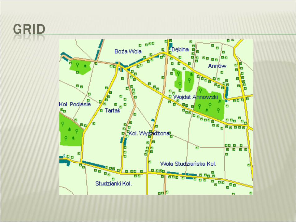
An organization of streets that lie perpendicular to one another, the grid is among the most controlled of settlement patterns.The square or rectangular plots which the grid defines exercise a discipline upon the form of buildings within its compass.Grid plans are rarely the result of social imperatives within the vernacular cultures, but are almost invariable imposed.Uniform ‘modules’ of plots and buildings on grid plans have been traced in the Indus valley from the 3rd millennium B.C.Grid plans have extensively adopted by planners to regularized and contain the world’s squatter settlements of the late-20th century.Efficiency in the use of public land, minimizing of street lengths, the provision of sites and services, sewage disposal and electricity supply are among the economic arguments mustered in support of modern grid planning policies.

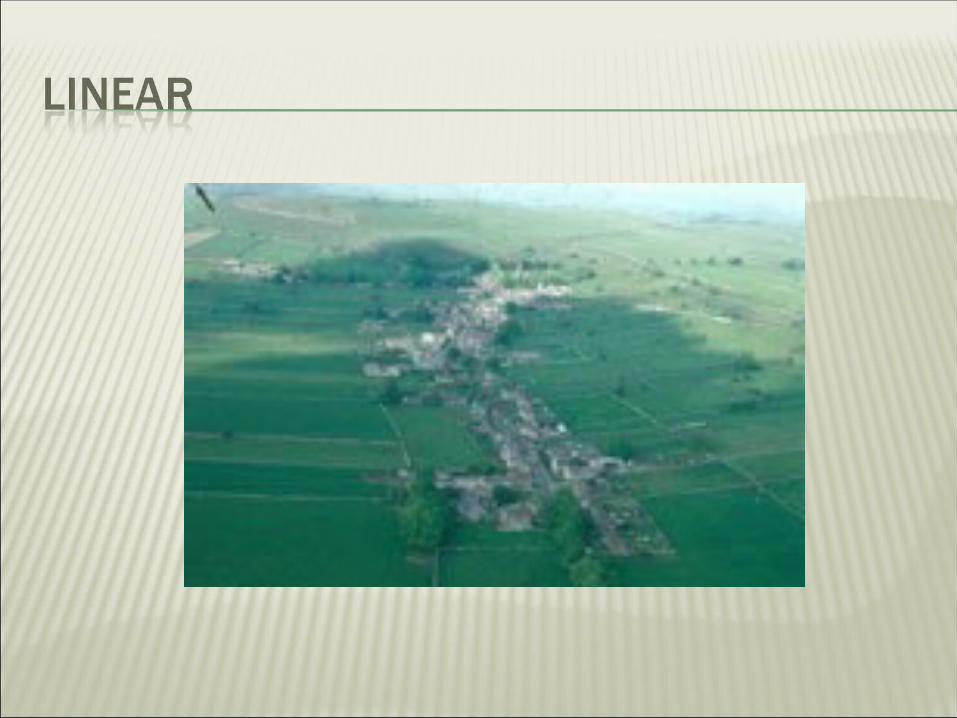
Linear settlement patterns can be considered special cases of point pattern distributions that vary in one dimension as points along a line.Linear settlement patterns are generally associated with linear features, either natural or human built. Linear feature in nature that may influence settlement patterns include water courses. Shorelines, canyons, ridge-tops and boundaries between environmental zones. Built of defined linear features associated with linear settlement patterns including roads and rails, canals and even political boundaries.Development and expansion of linear settlement patterns is not restricted to points directly on or adjacent to linear feature.

Nodal settlement whether towns of villages, have come to be identified as those on which roads and routes converge. Routes, however, are seldom unidirectional, but are two-way elements in a system or networks of communications.Nodal settlement acts both as a focus and as a distributor, a target for traveler and a base from which the merchant ventures, but it is more than this, for the vary nature of its incoming and outgoing traffic also facilitates exchange.Clustered village may be self sufficient and autonomous, and the linear village may lie upon a single route, the nodal village extends its roads to others which depend upon it, or to towns on which it partially depends.

An organic settlement is one that grows over time without being planned in advance, its order generate by the accumulation of many different acts of building, all of which are carried out with similar rules and goals.Organic settlements are often contrasted with planned settlements.Such settlements are never static or ‘complete’, and there are often buildings being erected at the same time that other buildings are in a state of decay, as normal part of ongoing evolution of settlement.Settlements that grow in an organic way may be dispersed or compact, linear or centralized, and include large cities and small villages.Streets follow paths that are slightly ‘irregular,’ building lots and house plans deviated slightly from perfect rectangles, positions of windows and doors may vary from house to house.There are also settlements that combine both planned and organic aspects.

Settlements that are at the boundaries of a territory or site which define its circumference are ‘peripheral’.From building of Great wall of China to the 600 Roman cities built in North Africa or the construction of border castles of the Welsh Marches, the definition, exploitation and protection of frontiers mark territorial peripheries.At macro scale the pushing of the boundaries of territorial expansion, the penetration of new lands, the advancing of the frontier, the breaking of ground and the establishment of pioneer homesteads are the total circumference. Such peripheral expansion did not end.