Chapter 3: WAYANA SETTLEMENT HISTORY
54
109 CHAPTER 3 WAYANA SETTLEMENT HISTORY By their very nature, complex systems are composed of many interacting components, each varying continuously across a multitude of measurable contexts. Because of this, there is no simple way of visualizing all the patterns and processes within a complex system in a single representation. —Malcolm Ridges, Scale and Its Effects on Understanding Regional Behavioural Systems: An Australian Case Study (2006:145). Figure 3-1. Wayana settlement of Talhuwen as seen from a hill across the Lawa River (1997). Following on the broader history and geography of Guiana, this chapter is focused on the history and geography of Wayana settlement patterning and organization. Settlements are complex systems of many interacting elements, such as houses, plazas, paths, and people, requiring a multiscalar approach as they cannot simply be depicted in a single image. After an outline of intra-settlement structure, house types, and construction elements, I will discuss these topics based on (ethno-) historic and ethnographic accounts on Wayana regional settlements. While mapping out houses, plazas, and trails—aided by a handheld Global Positioning System (GPS)—I realized that not all Wayana settlements comply with the typical intra-settlement
Transcript of Chapter 3: WAYANA SETTLEMENT HISTORY

109
CHAPTER 3 WAYANA SETTLEMENT HISTORY
By their very nature, complex systems are composed of many interacting components, each varying continuously across a multitude of measurable contexts. Because of this, there is no simple way of visualizing all the patterns and processes within a complex system in a single representation.
—Malcolm Ridges, Scale and Its Effects on Understanding Regional Behavioural Systems: An Australian Case Study (2006:145).
Figure 3-1. Wayana settlement of Talhuwen as seen from a hill across the Lawa River (1997).
Following on the broader history and geography of Guiana, this chapter is focused on the
history and geography of Wayana settlement patterning and organization. Settlements are
complex systems of many interacting elements, such as houses, plazas, paths, and people,
requiring a multiscalar approach as they cannot simply be depicted in a single image. After an
outline of intra-settlement structure, house types, and construction elements, I will discuss these
topics based on (ethno-) historic and ethnographic accounts on Wayana regional settlements.
While mapping out houses, plazas, and trails—aided by a handheld Global Positioning System
(GPS)—I realized that not all Wayana settlements comply with the typical intra-settlement
110
pattern as described in Guiana literature. In addition, while living among Wayana, I noticed
interrelationships among settlements, which were supported by genealogical data. On occasion,
genealogical data correlated with names and places mentioned in the late nineteenth century by
Jules Crevaux (1881) and Henri Coudreau (1893), or recorded at times during the twentieth
century by ethnographers, geographers, and anthropologists, providing insight in Wayana
settlement organization during the last 125 years. This chapter concludes with an analysis of
Wayana perspectives on the history and geography of settlement patterning.
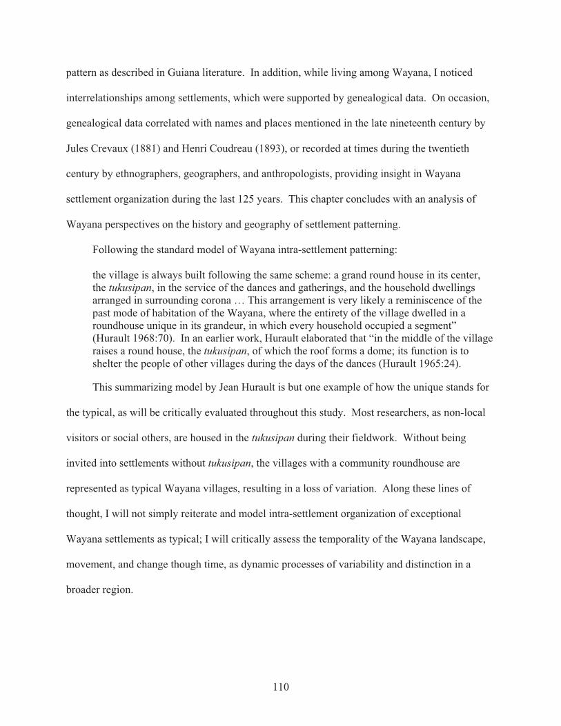
Following the standard model of Wayana intra-settlement patterning:
the village is always built following the same scheme: a grand round house in its center, the tukusipan, in the service of the dances and gatherings, and the household dwellings arranged in surrounding corona … This arrangement is very likely a reminiscence of the past mode of habitation of the Wayana, where the entirety of the village dwelled in a roundhouse unique in its grandeur, in which every household occupied a segment” (Hurault 1968:70). In an earlier work, Hurault elaborated that “in the middle of the village raises a round house, the tukusipan, of which the roof forms a dome; its function is to shelter the people of other villages during the days of the dances (Hurault 1965:24).
This summarizing model by Jean Hurault is but one example of how the unique stands for
the typical, as will be critically evaluated throughout this study. Most researchers, as non-local
visitors or social others, are housed in the tukusipan during their fieldwork. Without being
invited into settlements without tukusipan, the villages with a community roundhouse are
represented as typical Wayana villages, resulting in a loss of variation. Along these lines of
thought, I will not simply reiterate and model intra-settlement organization of exceptional
Wayana settlements as typical; I will critically assess the temporality of the Wayana landscape,
movement, and change though time, as dynamic processes of variability and distinction in a
broader region.

111
3.1 From Tour to Map, and Back Again
Rethinking Guiana sociality in terms of interactions and interrelationships, between local
and regional scales of social reproduction, follows from a “dwelling perspective” (Ingold 1993,
1995, 2000), situating the researcher in an intersubjective space. Claudius de Goeje, after a
lifetime of research and longtime dwelling while map-making in the region (de Goeje 1905,
1908a, 1908b, 1941), concluded his academic career with a study on Space, Time, and Life,
incorporating a Wayana perspective (de Goeje 1951).1 With his passing, his original thought
into a dwelling perspective in Guiana ceased to exist. A dwelling perspective is more than
simply “being in the field.” As a theoretical approach, rooted in phenomenology, it focuses on
intersubjective relationships between the units, rather than essentially defining each unit in and
of itself:
in a landscape, each component enfolds within its essence the totality of its relations with each and every other” (Ingold 1993:154), “the landscape tells—or rather is—a story. It enfolds the lives and times of predecessors who, over the generations, have moved around it and played their part in its formation. To perceive the landscape is therefore to carry out an act of remembrance (Ingold 1993:152).
My fieldwork, at times, included map-making and charting genealogies along with
participant observation, at other times I was moving along with the landscape. In 1996, I
participated in archaeological excavations in French Guiana, from which I began to explore
possibilities for ethno-archaeological fieldwork on the coast among the Kaliña and Arawakan
groups. That year, an archaeological prospection of the rivers Tampok and Waki was my first
visit to the land of the Wayana.2 My research developed from the tradition of Caribbean
archaeology drawing on ethnographic studies in Amazonia (Guiana particularly) following Peter
Siegel’s (1990a, 1990b) ethno-archaeological studies in Guyana among the Waiwai.; to aid
reconstruction of house structures based on posthole formations found during archaeological
excavations at Anse à la Gourde, Guadeloupe (Duin 1998; Jansen, Duin, and Hofman 2001).

112
While living among the Wayana, explaining ethno-archaeology as the study of
contemporary people to gain understanding of past practices, they said to me that “since you are
so interested in the past, why don’t you study OUR past?” We thus found a common research
goal, as Wayana of my generation were eager to know what had happened in the past; in their
past.3 Wayana Elders told us stories of times long ago (uhpak aptau eitoponpë). I studied
ethnographic collections and ethno-historical records of Guiana. Upon returning with
photocopies of my findings (glossed: uhpak aptau pampilan), we continued the dialogue.
Together we visited the Tumuc-Humac area in the footsteps of their Wayana ancestors.
In total I conducted over nineteen months of fieldwork among the Wayana, among which
about five months in 2000 (July 20 – December 30)4 and a five-and-a-half months period in
2002/3 (December 2 – May 15). Upon arriving in the Wayana village of Talhuwen, I was asked
whether I intended to stay where the anthropologist (Jean Chapuis) resided or whether I wanted
to hang my hammock in the tukusipan (community roundhouse). I choose the latter. Wayana
invited me to fish and hunt with them, and they invited me to help clearing their garden plots and
paths. They invited me to their cassava beer parties. During these activities, all Wayana saw
that there was in their midst a new palasisi (Wayana for “white man”). In due process of
participating in all daily life activities, I learned their Wayana language, customs, and beliefs.5
Data collected during my fieldwork, at times, did not fit the conventional model of social
and political organization of Guiana tropical forest cultures, which was more diverse and
multifaceted. It appeared that several Wayana settlements are small and impermanent (less than
ten inhabitants and lasting only a few years), whereas some villages were relatively large and
enduring (about and over one hundred inhabitants and lasting for several decades). When
linking genealogical charts to settlement plans, pattern recognition demonstrated a preference for

113
post-marital uxorilocal residence, whereas in some cases married men decided to stay in the
village of their parents. After completing the technical drawing of a community roundhouse, I
asked who had built the first tukusipan and the reply was the narration of the myth of the Creator
Twins (Appendix C: Mopo Kujuli). While drawing house structures, village plans, and kinship
charts, I realized that in order to make sense of Wayana settlement organization and above all the
role of community roundhouses tukusipan, I had to dwell among the Wayana.
3.2 Wayana Settlement Patterning through Time and Space
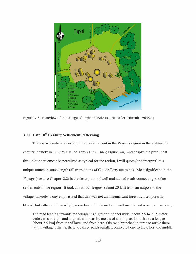
First published planview of a Wayana settlement was drawn by geographer Jean Hurault in
1962 of the village of Tïpiti (Hurault 1965:23; Figure 3-3), and reduced to its essentials by
Audrey Butt Colson (1977:11). Hurault (1965:24-25) discussed some house types, illustrated
only by a technical drawing of an otopan from the village of Tïpiti in 1957 (ibid.: facing 88;
planche XIX). On settlement patterning he said that “houses are distributed without order, but
often the village has a common tendency to a circular distribution, reserving a place of about
thirty meters in diameter of which the center is the round house tukusipan; it is here where take
place the dances and the customary ceremonies” (ibid.:25). Stating that “often” villages have a
tendency to a circular distribution implies that not all Wayana settlements have this intra-
settlement patterning. Hurault did not publish planview drawings of other Wayana settlements.
A decade before Hurault drew his planview of the village of Tïpiti it was Dominique
Darbois who—during a visit in the spring of 1952 (March-April)—photographed the daily live
of Wayana Indians in Yanamale, village of the Amazon (Darbois 1956; Mazière and Darbois
1953), presenting an idyllic picture soon to be lost forever due to change incurred by the
penetration of modern life. Another photo book, intended for children, was based on the life of
Janamale’s son: Paranam (Mazière and Darbois 1959). Together with Paranam and his sister
Kali, I discussed Darbois’s photos to reconstruct a planview of settlement of Janamale in 1952
114
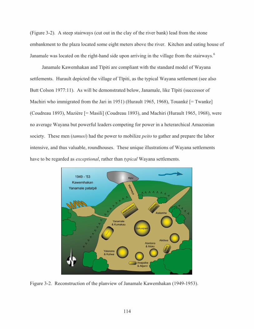
(Figure 3-2). A steep stairways (cut out in the clay of the river bank) lead from the stone
embankment to the plaza located some eight meters above the river. Kitchen and eating house of
Janamale was located on the right-hand side upon arriving in the village from the stairways.6
Janamale Kawemhakan and Tïpiti are compliant with the standard model of Wayana
settlements. Hurault depicted the village of Tïpiti, as the typical Wayana settlement (see also
Butt Colson 1977:11). As will be demonstrated below, Janamale, like Tïpiti (successor of
Machiri who immigrated from the Jari in 1951) (Hurault 1965, 1968), Touanké [= Twanke]
(Coudreau 1893), Mazière [= Masili] (Coudreau 1893), and Machiri (Hurault 1965, 1968), were
no average Wayana but powerful leaders competing for power in a heterarchical Amazonian
society. These men (tamusi) had the power to mobilize peito to gather and prepare the labor
intensive, and thus valuable, roundhouses. These unique illustrations of Wayana settlements
have to be regarded as exceptional, rather than typical Wayana settlements.
Figure 3-2. Reconstruction of the planview of Janamale Kawemhakan (1949-1953).
115
Figure 3-3. Planview of the village of Tïpiti in 1962 (source: after: Hurault 1965:23).
3.2.1 Late 18th Century Settlement Patterning
There exists only one description of a settlement in the Wayana region in the eighteenth
century, namely in 1769 by Claude Tony (1835, 1843; Figure 3-4), and despite the pitfall that
this unique settlement be perceived as typical for the region, I will quote (and interpret) this
unique source in some length (all translations of Claude Tony are mine). Most significant in the
Voyage (see also Chapter 2.2) is the description of well maintained roads connecting to other
settlements in the region. It took about four leagues (about 20 km) from an outpost to the
village, whereby Tony emphasized that this was not an insignificant forest trail temporarily
blazed, but rather an increasingly more beautiful cleared and well maintained road upon arriving:
The road leading towards the village “is eight or nine feet wide [about 2.5 to 2.75 meter wide]; it is straight and aligned, as it was by means of a string, as far as halve a league [about 2.5 km] from the village; and from here, this road branched in three to arrive there [at the village], that is, there are three roads parallel, connected one to the other; the middle

116
one is about nine feet [about 2.75 meter] wide and all along, at both sides, it is fenced off with pickets [palisades], similar to gardens in the new city of Cayenne; all three roads are maintained in a utmost cleanness (Tony 1843:222; all translations are mine).
Claude Tony (1843:221) described a sort of advanced guard, or outpost, where a dozen
armed men were gathered (Figure 3-4; left: about four hours walk from the river, and about 20
km from the village).7 Between this outpost and the river was a hiding place (tokai). The road
from the canoe landing place (in East-South-Eastern direction, according to Tony) was nice, and
became increasingly better after the outpost and upon approaching the village. Near the village
this road was about 2.5 to 2.75 meter wide. About 2.5 km before the village, this road split into
three branches; the middle road being about 2.75 meter wide with a picked fence (palisade) on
both sides.8 Without a doubt, indigenous people in the Wayana region were landscaping their
environment, by building straight roads that were up to 2.75 meter wide, and near the village off-
set by palisades, and parallel roads (Table 3-1 indicates the potential directions of the other three
roads departing from the village).
Figure 3-4. Reconstruction of a Wayana settlement in 1769; after Claude Tony (1835, 1843).
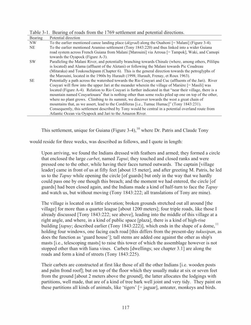
117
Table 3-1. Bearing of roads from the 1769 settlement and potential directions. Bearing Potential direction NW To the earlier mentioned canoe landing place (dégrad) along the Ouahoni [= Malani] (Figure 3-4). NE To the earlier mentioned Aramiso settlement (Tony 1843:220) and thus linked into a wider Guiana
road system across French Guiana from Malani [Marouini] via Arroua [= Tampok], Waki, and Camopi towards the Oyapock (Figure A-3).
SW Paralleling the Malani River, and potentially branching towards Chinale (where, among others, Pililipu is located) and Alama (affluent of the Aletani) or following the Malani towards Pic Coudreau (Mitaraka) and Toukouchipann (Chapter 6). This is the general direction towards the petroglyphs of the Marouini, located in the 1960s by Hurault (1998; Hurault, Frenay, et Roux 1963).
SE Potentially a path across the watershed towards the Rio Couyari and Cuc (affluents of the Jari). River Couyari will flow into the upper Jari at the meander wherein the village of Marière [= Masili] was located (Figure A-4). Relation to Rio Couyari is further indicated in that “near their village, there is a mountain named Couyarïouara9 that is nothing other than some rocks piled up one on top of the other, where no plant grows. Climbing to its summit, we discover towards the west a great chain of mountains that, as we assert, lead to the Cordilleras [i.e., Tumuc Humac]” (Tony 1843:231). Consequently, this settlement described by Tony would be central in a potential overland route from Atlantic Ocean via Oyapock and Jari to the Amazon River.
This settlement, unique for Guiana (Figure 3-4),10 where Dr. Patris and Claude Tony
would reside for three weeks, was described as follows, and I quote in length:
Upon arriving, we found the Indians dressed with feathers and armed; they formed a circle that enclosed the large carbet, named Tapui; they touched and closed ranks and were pressed one to the other, while having their faces turned outwards. The captain [village leader] came in front of us at fifty feet [about 15 meter], and after greeting M. Patris, he led us to the Tapuy while opening the circle [of guards] but only in the way that we hardly could pass one by one though this breach; and the moment we had entered, the circle [of guards] had been closed again, and the Indians made a kind of half-turn to face the Tapuyand watch us, but without moving (Tony 1843:222; all translations of Tony are mine).
The village is located on a little elevation; broken grounds stretched out all around [the village] for more than a quarter league [about 1200 meters]; four triple roads, like those I already discussed [Tony 1843:222; see above], leading into the middle of this village at a right angle, and where, in a kind of public space [plaza], there is a kind of high-rise building [tapuy; described earlier (Tony 1843:222)], which ends in the shape of a dome,80F
11
holding four windows, one facing each road [this differs from the present-day tukusipan, as does the function as ‘guard house’]; tall stems are added one against the other as ship's masts [i.e., telescoping masts] to raise this tower of which the assemblage however is not stopped other than with liana vines. Carbets [dwellings; see chapter 3.1] are along the roads and form a kind of streets (Tony 1843:225).
Their carbets are constructed at first like those of all the other Indians [i.e. wooden posts and palm frond roof]; but on top of the floor which they usually make at six or seven feet from the ground [about 2 meters above the ground], the latter allocates the lodgings with partitions, well made, that are of a kind of tree bark well joint and very tidy. They paint on these partitions all kinds of animals, like ‘tigers’ [= jaguar], anteater, monkeys and birds.
118
Although these paintings are executed very crudely, they nonetheless resemble the object, to distinguish the same attitude that one wants to give to the animal (Tony 1843:226).
Upon arriving, Claude Tony (1843:222) described a military drill of armed men guarding a
central building, while a hierarchically higher individual approached the strangers and guided
them inside. Several pages later, he continued to describe this highly militaristic central guard:
tapuy, that is to them a kind of guard building (= corps de garde). They [feathered guards] all have there their marked place where they have their hammock; their weapons and a small bench. They are provided with food, and they can never move without order of the chef (Tony 1843:226).
After we [Patris and Tony] sat down, the captain [= village leader] asked us many questions and wanted to know what we came undertaking among them; we replied him that we came as friend to make trade, to exchange merchandise for curiosities. Immediately he wanted to see all our merchandise, all our things and till the least of our old cloths. He opened himself the cases, all our packs or bundles, he drew the cloths out, one piece after another; and after examining all that, he replaced everything back with the same persistence and without asking anything” (Tony 1843:222-223).
After this operation that had taken hours, he [the chief] ordered the women to prepare us food; and after having talked half an hour with us, he ordered his Indians who had stayed in the same position to guard us, to march one after the other making a tour from the place where we were seated, to salute us and enter the tapuy, where they arranged themselves around taking each their place, that they could not leave, nor change without orders of the chief (Tony 1843:223).
After all these ceremonies, they had us eat, and subsequently they gave us a carbet to lodge us, save M. Patris, who he [the chief] placed near him, in a separate accommodation (Tony 1843:223).
After an initial welcome and the examination of the merchandise in the central communal
building, Tony (1843:223) wrote that the chief ordered his women to prepare food for his guests
(compare with Crevaux 1983:132). Tony elaborated upon the relation between men and women
with regard to food and space some pages later:
[To the men who] stayed in the village, their wives bring them food in the grand tapuy where they serve them, and when they are finished eating, the woman returns home to eat with her family. They only have two meals a day: in the morning at eight o’clock, and in the afternoon at half past five (Tony 1843:227).
119
Claude Tony (1843:227) did not separate male from female domains, other than
engendering space wherein women brought food to the central place where their men resided,
only to return to their dwellings after the men had finished eating, to eat with their family. The
central guard house was not excluded for women, and is therefore not a “men’s house” in the
traditional sense. Central guard house is a public communal place, open to strangers, in contrast
to private dwellings where families reside and kin members sleep and eat.
Even if Tony described only a single settlement in the Wayana region in detail, it was here,
while standing on top of a barren inselberg, that local Indians told him about a series of villages
of the Roucouyennes [= Wayana], and of the nations Amicouane [= Amikwan; possibly Upului]
and Appareille [= Apalai], all friends and allies, who communicate via a beautiful road stretching
till nearby the mountain range (most likely the trail of Kailawa bridging the Tumuc-Humac
mountains). Concluding that “these united nations [confederation of the Wayana] have
established a leader (‘chef’), a kind of general chief (‘capitaine général’) who resides in the last
of these villages, which is also the most important” (Tony 1843:231), indicative that the
settlements in this area (i.e., the Wayana region), in 1769, were far from autonomous units.
3.2.2 Late 19th Century Settlement Patterning.
About a century after Claude Tony (1835, 1843 [1769]), Jules Crevaux (1881) and Henri
Coudreau (1893) did not recognize such a regional organization in this area. Crevaux and
Coudreau are not very specific on Wayana intra-settlement organization, other than some
architectural elements can be read from accompanying engravings, illustrating diversity in
settlement arrangement and house types (Figure 4-3). Most detailed is Crevaux’s description of
the settlement of Namaoli at the junction of the Mapahoni and the Jari (Figure 3-5): “The village
of Namaoli is located about 10 meters above the river. In order to arrive here, we are obliged to
climb a steep stair, which is cut out in the clay of the river bank” (Crevaux 1987:132; all
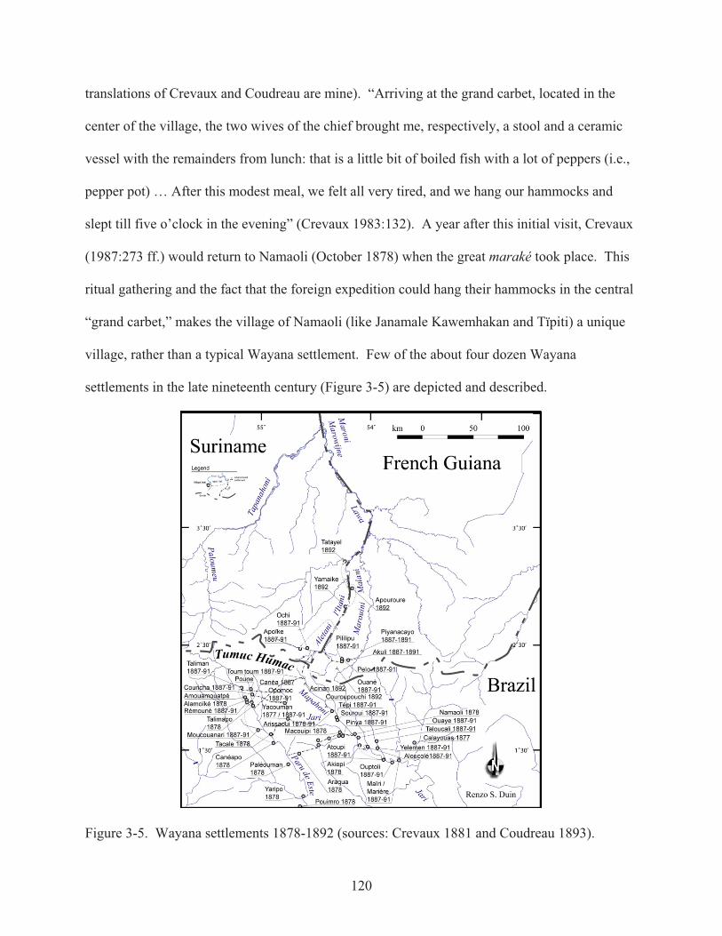
120
translations of Crevaux and Coudreau are mine). “Arriving at the grand carbet, located in the
center of the village, the two wives of the chief brought me, respectively, a stool and a ceramic
vessel with the remainders from lunch: that is a little bit of boiled fish with a lot of peppers (i.e.,
pepper pot) … After this modest meal, we felt all very tired, and we hang our hammocks and
slept till five o’clock in the evening” (Crevaux 1983:132). A year after this initial visit, Crevaux
(1987:273 ff.) would return to Namaoli (October 1878) when the great maraké took place. This
ritual gathering and the fact that the foreign expedition could hang their hammocks in the central
“grand carbet,” makes the village of Namaoli (like Janamale Kawemhakan and Tïpiti) a unique
village, rather than a typical Wayana settlement. Few of the about four dozen Wayana
settlements in the late nineteenth century (Figure 3-5) are depicted and described.
Figure 3-5. Wayana settlements 1878-1892 (sources: Crevaux 1881 and Coudreau 1893).
121
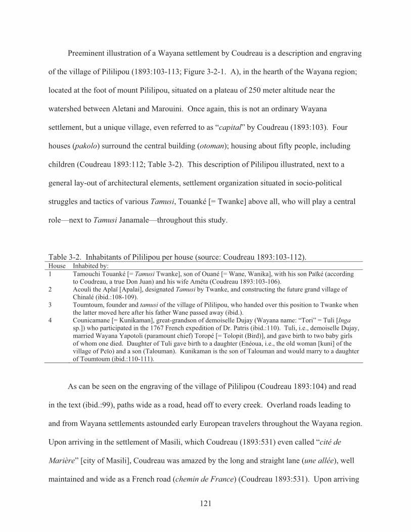
Preeminent illustration of a Wayana settlement by Coudreau is a description and engraving
of the village of Pililipou (1893:103-113; Figure 3-2-1. A), in the hearth of the Wayana region;
located at the foot of mount Pililipou, situated on a plateau of 250 meter altitude near the
watershed between Aletani and Marouini. Once again, this is not an ordinary Wayana
settlement, but a unique village, even referred to as “capital” by Coudreau (1893:103). Four
houses (pakolo) surround the central building (otoman); housing about fifty people, including
children (Coudreau 1893:112; Table 3-2). This description of Pililipou illustrated, next to a
general lay-out of architectural elements, settlement organization situated in socio-political
struggles and tactics of various Tamusi, Touanké [= Twanke] above all, who will play a central
role—next to Tamusi Janamale—throughout this study.
Table 3-2. Inhabitants of Pililipou per house (source: Coudreau 1893:103-112). House Inhabited by: 1 Tamouchi Touanké [= Tamusi Twanke], son of Ouané [= Wane, Wanika], with his son Païké (according
to Coudreau, a true Don Juan) and his wife Améta (Coudreau 1893:103-106). 2 Acouli the Aplaï [Apalai], designated Tamusi by Twanke, and constructing the future grand village of
Chinalé (ibid.:108-109). 3 Toumtoum, founder and tamusi of the village of Pililipou, who handed over this position to Twanke when
the latter moved here after his father Wane passed away (ibid.). 4 Counicamane [= Kunikaman], great-grandson of demoiselle Dujay (Wayana name: “Tori” = Tuli [Inga
sp.]) who participated in the 1767 French expedition of Dr. Patris (ibid.:110). Tuli, i.e., demoiselle Dujay, married Wayana Yapotoli (paramount chief) Toropé [= Tolopit (Bird)], and gave birth to two baby girls of whom one died. Daughter of Tuli gave birth to a daughter (Enéoua, i.e., the old woman [kuni] of the village of Peïo) and a son (Talouman). Kunikaman is the son of Talouman and would marry to a daughter of Toumtoum (ibid.:110-111).
As can be seen on the engraving of the village of Pililipou (Coudreau 1893:104) and read
in the text (ibid.:99), paths wide as a road, head off to every creek. Overland roads leading to
and from Wayana settlements astounded early European travelers throughout the Wayana region.
Upon arriving in the settlement of Masili, which Coudreau (1893:531) even called “cité de
Marière” [city of Masili], Coudreau was amazed by the long and straight lane (une allée), well
maintained and wide as a French road (chemin de France) (Coudreau 1893:531). Upon arriving

122
in the village, he noticed that the village is encircled by old garden plots overgrown with weeds,
while vast new slash-and-char agricultural fields stretch from here to the first perimeter (ibid.).
About a century earlier, Claude Tony (1769) had also noted that “the broken grounds stretched
out all around [the village] for more than a quarter league [about 1200 meters]” (Tony
1843:225). Arrival upon a village is thus made visible by well maintained roads as by broken
grounds and a charred landscape of slash-and-burn agricultural plots. Even before perceiving the
actual buildings of a settlement, presence of the settlement is made visible in roads and charred
(or weed overgrown) agricultural plots.12
Similar landscaping was described in the mid-twentieth century as roads connected the
settlement of Tïpiti with the villages of Malavat, habitation Tolinga (Boni Granman), and to a
landing place (dégrad) at the Aletani near the former village of Machiri (Hurault 1965). Arrow
cane fields (wide between 30–60 meters) surrounded Tïpiti, whereby the arrow cane fields are
deepest on the north side towards Machiri and Tolinga.82F
13 Hurault also mapped agricultural
zones (“zones de cultures itinérantes”), indicating old (cleared prior to 1960) slash-and-burn
fields surrounding Tïpiti stretch for 1.5 kilometers along the river and about 0.7 kilometers
inland. New garden plots would be cleared outside this zone (mainly in 1960 and 1962) as well
as within this zone (1961) (Hurault 1965:60-65). Arrow cane fields and slash-and-burn garden
plots allowed for a clear view—along with a “soundscape”—surrounding the settlement of
Tïpiti.
Hurault (1968:71) republished the village plan of Tïpiti in 1962 as illustration of typical
social relations within a Wayana village. Tïpiti, who, in 1955, founded his village (Figure 3-2)
on the high left bank of the Malani (Marouini), about 12 to 15 meter above the river (Hurault
1965:60), was not an average Wayana; he was the successor of Machiri who had migrated into

123
this region in 1951,and in the running text Hurault (ibid.:70) explained that Tïpiti and his brother
Touliné founded this village when the village of Massili II moved; and they split off.14 In order
to understand settlement patterning and organization we have to go beyond the boundaries of a
single Guiana village, and acknowledge their temporality situated in socio-political history.
3.3 Late Twentieth Century Wayana Settlement Organization
While dwelling among the Wayana I noticed variability between, and interrelationships
among settlements that I did not recognize from my Guiana literature reading. Arriving in 1997,
being a visiting outsider (a dangerous “Other”), I attached my hammock in the outer-circle of the
roundhouse of Talhuwen. Ronnie Tïkaime had heard that a Dutch student had arrived, and since
he was a Wayana originating from the Suriname bank, he sought to talk in Dutch; as other
researchers passing through Talhuwen were always French. The following morning there would
be a fishing party and Ronnie invited me to come with him in his canoe. After a day fishing in
the cataracts upstream, I returned to my hammock in the tukusipan. Ronnie invited me that
evening to have some cassava beer. There was a party because a lot of fish had been caught that
day. The following day, Ronnie invited me to bring my hammock to his place. He had
discussed it with his wife and mother-in-law, and they had agreed to house me; because it is not
good to stay by oneself in the tukusipan. They say spirits roam there at night, and they asked me
if I had seen some ghosts. So I untied my hammock, and they indicated me to tie it under the
largest house of Espérance. This house belonged to Senita, who was out of town. Her married
daughters with husband and children were sleeping upstairs. Espérance became my home base
during fieldwork among the Wayana in the upper Maroni basin during the following years.
Ronnie became my classificatory brother, and thus I was given a place in their kinship system.
During my fieldwork, I drew planviews and architectural drawings—beginning in Espérance—
which radiated out, and changed through time, forming the fundamental data for this study.

124
Figure 3-6. Espérance, ward of Talhuwen (2002); view towards the southeast.
When discussing Wayana intra-settlement patterning and organization, socio-political
aspects grounded in history have to be taken into consideration, yet there are some basics that
need to be taken into consideration: Wayana settle near fertile soils (indicated by locations of
former settlements), near creeks or bends in the river where there are rapids (fishing grounds),
where rocks are situated in the river so that one can bath and clean game and fish without fear of
being stung by stingrays (sipali; Potamotrygon hystrix). Wayana do not like to settle near places
invested with monsters (kaikui), malicious spirits (jolok), or where water monsters (ipo) have
been sighted. Wayana prefer returning to abandoned village locations to clear garden plots as it
is easier to clear secondary forest than to cut down large diameter trees of primary forest. New
settlements are founded on prior garden plots; resulting in an overlapping or layering of garden
plot, settlement, garden plot, settlement, etcetera.
Long ago Wayana did build their villages. They did not built their village no matter where. First, Wayana looked for good grounds, where the manioc grows well, the bananas grow well, well all the plants [grow well]. When they saw that the grounds were good, they started to clear a space for their village. … He who clears the forest becomes chief of his proper village. However, it is not immediately that Wayana built their proper village. How many years he hears that he is not liked, but he stays there anyways. Maybe, when the village leader interfered with someone else’s business. When [the villager] had a

125
problem with a chief. If he does not like someone [in his village], the chief says: “Leave from here, this isn’t your village.” So he who is insulted looks for another village. This happens, when [the villager] has enough from the insults. When there is less game, Wayana also leave their village. Also [they leave] when there is a deceased buried in the house, or several dead in the village. … People are frightened [of the evil spirits] of he who has been buried (Tasikale, 2000. Excerpts from Table C-4).
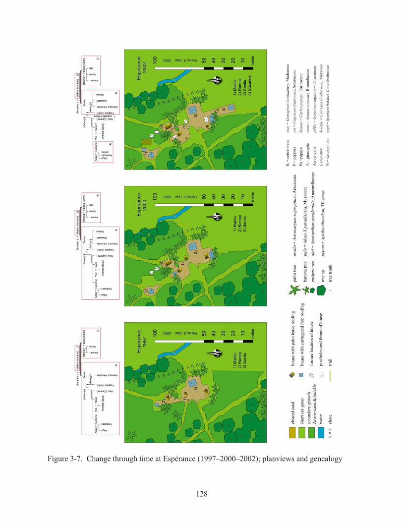
Let me now elaborate on the intra-settlement patterning and organization of Espérance,
constructed in the early 1990s on the former garden plots of the people of Twenke. Building
activities were initiated by Senita. As her mother (Makilu Mukuwa; grandmother of the ward) is
a first degree parallel cousin of Twenke, she was allowed to settle here. Espérance is entirely
fenced of by trees, secondary growth, and arrow cane (Figures 3-6 and 3-7). Banana trees are
planted all around the cleared grounds surrounding the houses. Widest road (ëhema; Figure 3-8:
trail # 10) leads west-southwest from the main plaza (# 3; pulolop) towards the tukusipan of
Talhuwen. On the other side of the plaza (seen from the main road) is the house of Senita (S21);
built in Surinamese style with stilts and a galvanized corrugated roof. East of this dwelling is a
trail (# 8) that goes down into a gully where a little creek runs; providing Espérance with fresh
drinking water. Next to this road, down the slope, trash is deposited (midden # 6). At the south
side of this plaza is a work hut (S28) where is located the griddle (metal plate of one meter
diameter; supported by three stones) to bake cassava bread. On the north side of this plaza is
located the place of Makilu, grandmother (kuni) of this ward (1).
Several rebuilding stages have been taken place in the northern zone. Let me discuss this
process chronologically, beginning with 1997. Makilu’s house (S18; Figure 3-2-4) has an
oblong roof with malalia palm fronds, and the floor is about seventy-five centimeters from the
ground. West of this dwelling is a small work hut (S19). From here a path (trail 7) leads
towards the northwest (towards the house of Aloupki) and joins the path (trail 9) that goes from
Awala kampu to the garden plots southeast of Talhuwen. North of the dwelling of Makilu is the

126
house of Ronnie (S7), who is married to the second daughter of Makilu. In 1997, Ronnie and his
wife together with their two children had recently moved here from Kawemhakan. Their house
is on stilts, with a floor about 1.75 meter above the ground, and a roof of malalia palm fronds.
Behind their house goes a path (# 5) connecting the plaza with the landing place (tunakuwao
kanawa) (bathing place etc.) on the Lawa River. North of their house is located a work hut with
corrugated iron roof (S4), which had been relocated the following year (S3).
Upon my return in 2000, Ronnie had abandoned his former house (S7) and was finishing
the construction of his new house in Surinamese style with on stilts with galvanized corrugated
roof (S2). I had helped him building this house in 1998. This house is further removed from the
house of his mother-in-law and located in a small cleared space (2) apart from the main plaza (3).
A separate road (trail 1) led to a separate landing zone, next to the previously mentioned landing
zone at the Lawa River; the latter now only used by grandmother Makilu and family of Senita.
Grandmother had abandoned her house (S18), which was now used as storage place. Her former
work hut (S19) had been taken apart. A new, and bigger, house (S7) was built for grandmother
on the exact location of the abandoned house of Ronnie (Figure 3-8); a new place had been
cleared (1), separate from the main plaza (2). Drip zones formed alongside Ronnie’s former
house had to be filled-in to prevent water running through grandmother’s house. A little plank
inserted at the upper side of the former gully prevented from water eroding the recent (loose) fill.
A new work hut (S10; kuluwata pakolon) with manioc grater trough (kuluwata) was built
southwest of her new dwelling. To keep this place cool, upon request of grandmother Makilu,
the roof was of malalia palm fronds, as was the roof of her new house. A galvanized corrugated
roof work hut (S9; tilaka) was placed by Ronnie, just north of the grandmother’s work hut, built
from material recuperated from earlier work huts (S3 and S4). Husband of Suzanne, Senita’s
127
oldest child, had built a house with a galvanized corrugated roof (S29) parallel of Senita’s
kitchen (S27) south of the plaza (Figure 3-9).
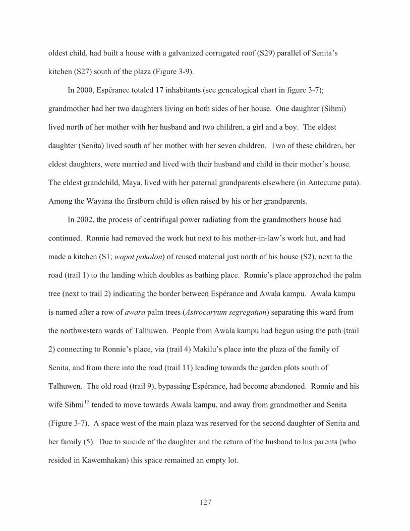
In 2000, Espérance totaled 17 inhabitants (see genealogical chart in figure 3-7);
grandmother had her two daughters living on both sides of her house. One daughter (Sihmi)
lived north of her mother with her husband and two children, a girl and a boy. The eldest
daughter (Senita) lived south of her mother with her seven children. Two of these children, her
eldest daughters, were married and lived with their husband and child in their mother’s house.
The eldest grandchild, Maya, lived with her paternal grandparents elsewhere (in Antecume pata).
Among the Wayana the firstborn child is often raised by his or her grandparents.
In 2002, the process of centrifugal power radiating from the grandmothers house had
continued. Ronnie had removed the work hut next to his mother-in-law’s work hut, and had
made a kitchen (S1; wapot pakolon) of reused material just north of his house (S2), next to the
road (trail 1) to the landing which doubles as bathing place. Ronnie’s place approached the palm
tree (next to trail 2) indicating the border between Espérance and Awala kampu. Awala kampu
is named after a row of awara palm trees (Astrocaryum segregatum) separating this ward from
the northwestern wards of Talhuwen. People from Awala kampu had begun using the path (trail
2) connecting to Ronnie’s place, via (trail 4) Makilu’s place into the plaza of the family of
Senita, and from there into the road (trail 11) leading towards the garden plots south of
Talhuwen. The old road (trail 9), bypassing Espérance, had become abandoned. Ronnie and his
wife Sihmi15 tended to move towards Awala kampu, and away from grandmother and Senita
(Figure 3-7). A space west of the main plaza was reserved for the second daughter of Senita and
her family (5). Due to suicide of the daughter and the return of the husband to his parents (who
resided in Kawemhakan) this space remained an empty lot.
128
Figure 3-7. Change through time at Espérance (1997–2000–2002); planviews and genealogy

129
Figure 3-8. Structures (S #) at Espérance (location of posts is indicated with dots) (2002).Divided in five sectors belonging to 1) grandmother Makilu, 2) Ronnie, 3) Senita, 4) Suzanne, and 5) a potential building space for one of the daughters of Senita.
4)
130
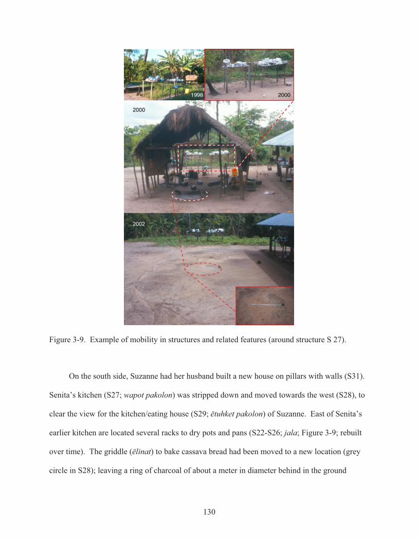
Figure 3-9. Example of mobility in structures and related features (around structure S 27).
On the south side, Suzanne had her husband built a new house on pillars with walls (S31).
Senita’s kitchen (S27; wapot pakolon) was stripped down and moved towards the west (S28), to
clear the view for the kitchen/eating house (S29; ëtuhket pakolon) of Suzanne. East of Senita’s
earlier kitchen are located several racks to dry pots and pans (S22-S26; jala; Figure 3-9; rebuilt
over time). The griddle (ëlinat) to bake cassava bread had been moved to a new location (grey
circle in S28); leaving a ring of charcoal of about a meter in diameter behind in the ground

131
(Figure 3-9). Suzanne did not have a griddle in her kitchen, and used her mother’s (grey circle in
S28) to bake cassava bread. Neither did Sihmi own a griddle; she used her mother’s griddle
instead, to which was made a little shelter of palm leaves just southwest of grandmother’s work
hut (S15, replacing the prior roofed structure S13). Manioc was pressed on location S14
(tëwuhkai katop; one standing post and one vertical beam to hold the tinkïi (manioc press) was
attached at its other end to a burned tree trunk). Additional drying racks (S16, S17; jala) had
been constructed west of the kitchen area. In 2002, the former house of grandmother Makilu
(S18) had been stripped down and its posts pulled out of the ground; resulting in empty
postholes. Main road (trail 10) towards the tukusipan was always maintained clean and wide
open, as was the trail towards the creek in the east (trail 8), and the roads (trails 5 and 6) towards
the canoe landing place in the north, that now led directly to the grandmother’s new house (S6),
of which the ground floor became a gathering place for visitors, friends, and family.
Espérance resonates with the typical tropical forest village as portrayed in the literature.
Grandmother and her daughters (matrilocal) are able to grow manioc and sustain the settlement
(ëutë) with cassava bread and cassava beer. Husbands, originating from other villages, bring in
enough fish and meat to make this place self-sufficient. Techno-economically, Espérance is self-
sufficient, other than roads lead to all cardinal directions, and visitors, mostly family, always stop
by for a chat and some cassava beer; trail east, leads to Halam pata (place of Halam) who is the
first husband of Senita and father of her first two daughters and eldest son; trail south leads to the
garden plots; trail north leads to Awala kampu; and the main road west-southwest heads directly
to the tukusipan of Talhuwen. Espérance, therefore, has to be perceived in relation to its broader
context: the village of Talhuwen proper (Figure 3-10).
132
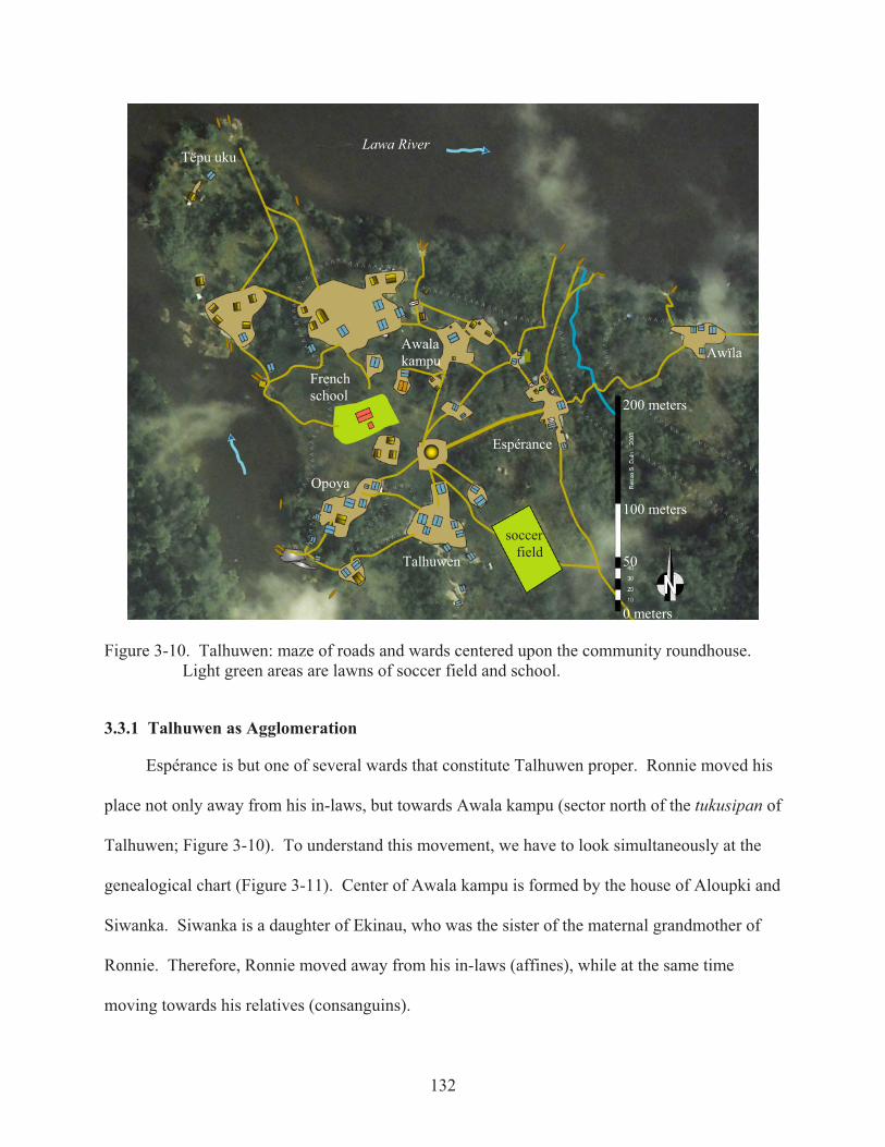
Figure 3-10. Talhuwen: maze of roads and wards centered upon the community roundhouse. Light green areas are lawns of soccer field and school.
3.3.1 Talhuwen as Agglomeration
Espérance is but one of several wards that constitute Talhuwen proper. Ronnie moved his
place not only away from his in-laws, but towards Awala kampu (sector north of the tukusipan of
Talhuwen; Figure 3-10). To understand this movement, we have to look simultaneously at the
genealogical chart (Figure 3-11). Center of Awala kampu is formed by the house of Aloupki and
Siwanka. Siwanka is a daughter of Ekinau, who was the sister of the maternal grandmother of
Ronnie. Therefore, Ronnie moved away from his in-laws (affines), while at the same time
moving towards his relatives (consanguins).
200 meters
100 meters
0 meters
French school
50
soccer field
Opoya
Talhuwen
Tëpu uku
Awalakampu Awïla
Espérance
Lawa River

133
Figure 3-11. Genealogical tree to demonstrate kinship and affine relations among Wayana mentioned in the present study. This is not a complete genealogical chart.
134
Road from Ronnie’s place towards the tukusipan of Talhuwen crosses the place of Tasikale
and Rinja (Figure 3-8: trail 3). Tasikale, son of Aloupki, is married to Rinja, daughter of
Paranam and Melidu. Paranam is Ronnie’s maternal uncle. It’s all in the family. There is more
to the location of the house of Tasikale and Rinja. Once more, we have to scale up and consider
the village of Talhuwen as a whole. The village of Talhuwen is named after its village chief,
Talhuwen, son of Opoya.16 This village is located just upstream of the former Boni settlement
Doméké (as labeled on some older maps). On maps, the village of Talhuwen is still labeled
“Opoya” (IGN 1995). Opoya used to live in the house today owned by Aimawale Opoya; first
son of Melidu and Paranam, named after the father of Opoya: Aimawale. Aimawale and his
younger sister Rinja are maternal grandchildren of former village leader Opoya, and their father
Paranam (son of former paramount chief Janamale) had hoped to become village leader
(especially after marrying the daughter of former village leader Opoya), but he was considered
too young, and Wayana choose Talhuwen as their village leader. Talhuwen resides with his
family on a cleared space south of the tukusipan. Rinja and Tasikale not only live midway their
in-laws and relatives; their place is cleared north of the tukusipan, that is, on the opposite side of
the village seen from the canoe landing place of the former village of Opoya; the rocky outcrops
next to Aimawale’s place. Alternatively, Tasikale’s place is located opposite from the canoe
landing place used by French governmental officials, with the school in the middle (Figure 3-10;
red roof in green-zone. Other green-zone indicates a soccer field).
In the central space next to the community roundhouse of Talhuwen are located: a school
and the house of Takwali (since 1988 “mediateur culturel” assisting French teachers to instruct
children in their Wayana mother tongue). The school was built in 1991 as annex to the school in
Twenke that had opened its doors in 1974. Teacher Jean-Paul Klingelhoffer was in office for

135
twenty years (1973-1993),17 during which time he became founder and president of CAWAI
(Culture et Artisanat Wayana), of which Aimawale today is president. Guillaume Costes was
teacher at Talhuwen from 1993-1998. It was during this time that the tukusipan of Talhuwen
was built in 1996 under the program of APFT (Avenir des Peoples des Forest Tropicales [Future
of the Tropical Forest Peoples]). Costes was succeeded by Laëtitia Jobard (1998-2000) who was
employed at Talhuwen for two years. Ever since, the rate of change of teachers in the Wayana
area increased significantly. School, house for teachers, and community roundhouse (as were
some of the dwellings, e.g., house of Aimawale Opoya built for the then village leader Opoya, as
was the house of present village leader Talhuwen) were built with French resources.
When Aimawale and Tasikale organized the 2004 rites of passage (Chapter 5.2), they had
the tall maripa palm tree cut down (an act of clearing boundaries, and thus unifying the village of
Talhuwen) that was just north of the tukusipan (Figure 5.2-8). They had ordered to clear this
space between the tukusipan and Tasikale’s house; creating a public arena (a plaza) for the
upcoming rites of passage, and allowing space for the seclusion hut (tëpijem pakolon) along the
road from Espérance to the tukusipan. This, intentional or not, was favorable for Tasikale and
placed Aimawale on the immediate right-hand side of the canoe landing place: the place within a
Wayana village where his paternal grandfather had lived some fifty years ago (Figure 3-3).
Immediate right-hand side of the canoe landing appears to be the place where is located the
house of a paramount chief. The house of Amaipotï, current granman or overall leader of the
Wayana, and son of granman Twenke, is located on the immediate right-hand side of the canoe
landing place of Twenke. On the opposite side of the village, across from the tukusipan is the
house of the elder sister of Amaipotï. After the death of Twenke (who gave his name to his
village), this settlement is referred to as Kulumuli pata (place of bamboo). Mother of Twenke

136
(Ëki) was a sister of the mother of Anamaila. Ëki and her sister Kuli, were granddaughters of
Tamusi Twanke, mentioned by Crevaux and Coudreau at the end of the nineteenth century.
Anamaila is of a second marriage of his mother Kuli. The first marriage of Kuli and Taponaike
resulted in a daughter Makilu; grandmother of Espérance. This makes kuni Makilu a first degree
parallel cousin of Twenke (mothers’ sisters’ son). Social and political relations are thus played
out spatially.
Northwest of the tukusipan is a large cleared plaza between the houses of Kawet, and the
former house of Tënepo (son of Wempi and adopted son of Twenke, and a powerful pïjai).
Kawet married, consecutively, two sisters; granddaughters of Twenke. These cleared spaces are
located on the highest part of the bank; a kind of peninsula around which the Lawa River
meanders. Two other cleared plazas are located northwest, at a lower level of the riverbank;
these being in the west the houses of Ëutetpë and his family, Romeo and Pavon. In the north, at
the lowest end of the peninsula of Talhuwen, is the now abandoned place of Tëpu uku, where
Alikot and his family had build their houses. When the genealogical chart is reviewed spatially;
people descending from Twanke (great-grandfather of Twenke) appear living in the northwest
quarter of Talhuwen, that is, in proximity of the village of Twenke. Members of the other
quarters are descendents (or related to descendants) of Maipo and Tailu (Figure 3-11).
3.3.2 Twenke – Talhuwen, and Beyond
West from Talhuwen, on an island in the Lawa River, is located Kulumuli pata (place of
kulumuli-bamboo) the former place of Granman Twenke (Figure 3-12: left). Around the
tukusipan are located the houses of the children of Twenke (house of Granman Amaipotï [son of
Twenke] is located on the immediate right-hand side of the canoe landing place), as well as a
school, the house for school teachers, and a dispensary. The green zone in the west is a soccer
field, doubling as helicopter landing place for the French army. At the east side, near the river,

137
are the houses of grandmother (kuni) Kïiwa (widow of Alemïn, brother of Alewuike [= Aloike]),
with her daughter and grandson. South of the citrus trees planted by teacher Klingelhoffer, are
the houses of the children of Granman Amaipotï. Also located in this southern part of Twenke
were the houses of Anamaila, parallel first cousin (classificatory brother) to Twenke, and his
wife’s children from her first marriage.
Figure 3-12. Planview of Twenke (left), Talhuwen (center-left), and beyond (2003).
After 2000, Anamaila and Tënepo, respectively (classificatory) brother and (adoptive) son
of the late Twenke, decided to clear new garden plots to found a new settlement east of
Talhuwen (Figure 3-12; center-right). Tënepo, a pïjai, has his house in the center of these higher
Espérance Talhuwen
Twenke (Kulumuli pata)
Lomeke
Alawataime enï
Liu
Anamaila
AwïlaHalam
Tënepo Sherif
Baiwa
Tëpu
Lawa River
SURINAME
FRENCH GUIANA

138
grounds. Anamaila has, also in the center a rather provisory house. In the near future, a more
permanent house will be built. On the far south side of this cleared space, Baiwa (son-in-law of
Anamaila) has his house. South of this cleared area begin the garden plots for the residents of
Talhuwen. East of this cleared area lies another gully with a creek. This creek contains rocks
with grinding grooves; indicative for earlier (prehistoric) habitation in this area. When entering
from the river, the space “reserved” for the granman (immediate right-hand side) is still
available. West of this space is the place of Awïla (son of Poloman, who inhabits the exact same
location in Twenke). Relational layout for a new, and large, settlement is outlined. Further to
the east, across the creek, roads lead to the place of Tëpu, continuing to Alawataimë enï (place of
Kulienpë), and even to Lomeke (place cleared in 2003) (Figure 3-12; upper-right). Latter
settlements are being inhabited by Wayana leaving Kawemhakan / Anapaike, to be closer to
Talhuwen and its institutions, schools above all.
Villages of Twenke and Talhuwen are unique in the upper Maroni basin (Figure 3-13) as
materialized in their sheer number of inhabitants (90 and 110 respectively) as well as duration of
a continuous fifty years of Wayana occupation. These numbers are only surpassed by Antecume
pata (150 inhabitants). Numbers of inhabitants in other settlements in the upper Maroni basin are
estimates, as a complete census is lacking. Near Maripasoula, settlements of Aloike [Alewuike]
and Telamale comprise about 100 Wayana total.18 Two villages on the Tampok River (Elae [or
Malipahpan] and Kajode) comprise about respectively 50 and 70 Wayana, Emerillon, and even
some Wayãpi, and two Akulio in Malipahpan. On the Lawa, Kawemhakan houses about 70
people, whereas Alawateimë eni and Kumakahpan comprise each about two dozen former
inhabitants of Kawemhakan (Lawa Station, Anapaike). On the Aletani, Pilima, the most
southern village houses some 40 inhabitants, whereas Palasisi (= Wapahpan) (Figure 3-14; right),

139
Pelea, and Palimino (Figure 3-14; left) each comprise about 15 inhabitants. Of these and
recently abandoned settlements in the upper Maroni basin, only four villages (28.5%) own a
community roundhouse, namely Twenke, Talhuwen, Antecume pata, and Pilima. These four
unique villages with a roundhouse, and their history, are vital to this study, but it should not be
forgotten that these settlements are situated in a matrix that also includes settlements without
roundhouses; actually most of the Wayana settlements do not own a tukusipan.19
Figure 3-13. Wayana settlements along the Lawa and Aletani (2000).

140
Figure 3-14. Planviews of two Wayana settlements without community roundhouse (2000).
141
3.4 Historically situated Movements of Wayana Settlements
It is generally acknowledged that modern globalization impacted Guiana in the 1950s and
1960, nevertheless, change in settlement movements were already in motion by that time, and
what has been commonly perceived as typical for tropical forest cultures is merely a snapshot in
a much longer historical process. In the 1960s a Missionary Station was created at Apetina along
the Tapanahoni to where surrounding Wayana and Trio populations migrated (Frikel 1971),
however prior to that, Arabi (Maroon leader in Suriname) went to the Wayana and Apalai of the
Paru requesting them to settle along the Tapanahoni to facilitate trading relations (de Goeje
1905a:975). Intercultural studies on the complex trading interactions between Wayana, Trio,
Maroons, and Dutch Government in Suriname, such as tabulated by Gabriel Coutinho Barbosa
(2005), as well as American evangelical missionaries, goes beyond the present study, as do the
current problems in the Wayana region regarding gold mining and mercury pollution.
The history of modern globalization impacting the upper Maroni basin was recounted by
Kawet (December 18, 2002), who had learned Dutch at Lawa Station and was eager to tell me
this story in Dutch:
Many people [Wayana] now reside on the French Bank. This is because the schools are located here [on the French Bank]. Therefore [as many people reside here] there is a lack of fish and game. In the past people moved every ten to fifteen years, so one had enough game. Today, with the schools, this [moving of settlements] is no longer possible. In the past, [Wayana] were frightened and resided far into the forest, near a creek. Then came the Boni [Maroons; settled in the Lawa area in the 1790s] and [Wayana] saw how they made dug-out canoes [before Wayana had tree bark canoes]. Also the Wayana began to built dug-out canoes, that they did not have before; there were though canoes from tree bark. Also the Taira [generally assumed to be Kaliña from the mouth of the Maroni] knew how to navigate, they dominated the rivers and migrated south via the Aletani. At Mulokotïimë enï [north bank of Aletani between Walemapan and Kulekule at N 2°26.66’ W 54°31.24’] they encountered the Tïlïjo [= Trio]. The war began and the Trio made the Taira retreat. The last stand of the Taira was at Jakutouku. After the Boni came Lanti (Dutch governmental [lands-] officials). These governmental officials arrived with many beads and presents. Then [Wayana] were no longer frightened [and resettled along the main river]. French officials realized that the Wayana then moved towards the Surinamese Bank. At that moment, Boni were settled at Awara kampu and
142
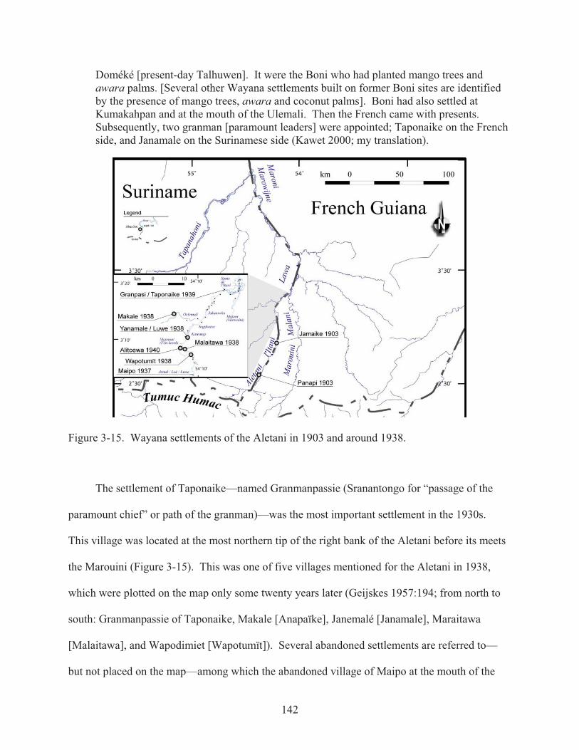
Doméké [present-day Talhuwen]. It were the Boni who had planted mango trees and awara palms. [Several other Wayana settlements built on former Boni sites are identified by the presence of mango trees, awara and coconut palms]. Boni had also settled at Kumakahpan and at the mouth of the Ulemali. Then the French came with presents. Subsequently, two granman [paramount leaders] were appointed; Taponaike on the French side, and Janamale on the Surinamese side (Kawet 2000; my translation).
Figure 3-15. Wayana settlements of the Aletani in 1903 and around 1938.
The settlement of Taponaike—named Granmanpassie (Sranantongo for “passage of the
paramount chief” or path of the granman)—was the most important settlement in the 1930s.
This village was located at the most northern tip of the right bank of the Aletani before its meets
the Marouini (Figure 3-15). This was one of five villages mentioned for the Aletani in 1938,
which were plotted on the map only some twenty years later (Geijskes 1957:194; from north to
south: Granmanpassie of Taponaike, Makale [Anapaïke], Janemalé [Janamale], Maraitawa
[Malaitawa], and Wapodimiet [Wapotumït]). Several abandoned settlements are referred to—
but not placed on the map—among which the abandoned village of Maipo at the mouth of the

143
Loë (Luwe). Maipo was the father of Malaitawa who had founded his new village between Feti
kreek [Mapaoni; not the Mapahoni, affluent of Jari] and Tëpu pepta, named after a large rock
formation (tëpu pepta) in the Aletani River. Maipo and Tailu were parents of Malaitawa, Ekinau
and Kumakau; the latter two wives of respectively Tasikali and Janamale.20
Janamale was granman among the Wayana till his death in 1958. 90F
21 Before I will discuss
the biography of Janamale, I want to mention that Pilima—a great pïjai (shaman) who even
began his own prophetic movement (Butt 1964) and a son of Janamale—named his firstborn son
Jamaike (Wese), after Jamaike who had his own village on the Aletani around 1900 (map
accompanying Franssen Herderschee 1905a; Figure 3-15; located just north of where Coudreau
(1893) had mapped Yamaïké a decade earlier). A second village was mapped along the Aletani
in 1903: Panapi (father of Wempi [a.k.a. Sampati, Jean-Baptiste] who in 1962 would have
founded his own village at the mouth of the Tampok; Figure 3-16). Since the 1903 Gonini
expedition did not explore the Marouini (neither did the 1935–1938 boundary expeditions), no
data is known about village locations in the Marouini basin, and a historical reconstruction of
settlement patterning of Aletani–Marouini basins is inherently deficient.
When I discussed the Wayana history narrated by Kawet (cited above) with Aputu (village
leader of Kumakahpan), his wife Kali (daughter of Janamale) began to narrate this history in
more detail; particularly the movements of her father Janamale and his grounds to resettle, as
well as a more detailed introduction of the last stand at Jakutouku, just downstream of Janamale
Kawemhakan, the village where she and Aputu grew up (Figure 3-3). This is the narrative of
Kali, as translated by her son Ronnie Tïkaime into Dutch (my translation into English):
Kulumulijinpë [founded by Tëpëputse, son of Ouptoli]91F
22 is the first village at the Aletani of Alijakalu. Alijakalu [father of Toko and grandfather of Janamale] came from the Jari. Alijakalu returned to the Jari when the Taila attacked Kulumulijinpë. Upon arrival at the Aletani, [Alijakalu] with his son Toko founded the village of Tïkolokem. Later, Toko with

144
his son Janamale founded the village Ëtëmanu, and next Pilikaju [Figure 3-16]. Those who remained at the Aletani founded a village that was located downstream. The name of this village is Kasujinpë. The third village is named Enëkuhenpë. It is from this latter village that [Wayana] return to the Jari to request support from the Tïlïjo [Trio].
At this point, Kali began to narrate the story of Tapanawale, i.e., the last stand of the Taira
at Jakutouku. War with the Taira sets the stage for Janamale’s biography, and will be discussed
in the closing of this chapter. Next, Kali continued with the biography of her father Janamale
and his settlements (between square brackets are notes resulting from discussions of Janamale’s
biography): “After the war with the Taira, Janamale founded his first village at Kawatop”
[Figure 3-16; labeled Gramanponsoe in 1938; this settlement consists of two villages, one named
Luwe located on the French Bank, and a second village, named Tulamïtpë located across the
river on the Surinamese Bank]. Janamale is kapitein [village leader] of both villages [and is thus
engaged in a political play with Dutch and French Governments who are eager to draw the
Wayana to their side]. [Forced by Dutch Government] Janamale founded his village Janamale
on the Surinamese Bank; left or north bank of the Ulemali, about one and a halve kilometers
from the mouth of the Aletani. Later [forced by French Government], just downstream of
Janamale, Janamale founds his village Kawemhakan [“High place”] on the high right or south
bank of the Aletani [This village of Janamale, Kawemhakan, was visited by a French expedition
in 1952 and photographed by Dominique Darbois (1956; Mazière and Darbois 1953). Her
photos clearly show that Janamale had a community roundhouse tukusipan in his village].23
Forced by the French, Paina [Painawale or Awelisi; half-brother of Janamale], was made
village leader of Kawemhakan. Subsequently, Janamale moved downstream and founded
Wapahpan [Falls of Jakutouku are located between Kawemhakan and Wapahpan], only to settle
further downstream [just upstream of Awara soula] and founded a second Kawemhakan [not so
high above the river as the original Kawemhakan]. This latter settlement of Kawemhakan is

145
located at the end of the landing strip of Lawa Station [built by the Missionaries]. People
[Wayana] are still buried here [on the location of the former village of Janamale]. Also Paina
moved downstream, across isoli (falls) Jakutouku; first Paina settled on the big island (pau
pepta) and founded a village with the same name (Pau pepta), together with Malavat, only to
later resettle across the river on the French Bank, where [Paina] passed away. Americans
[evangelical missionaries in the 1960s] brought together several villages, among which Pau
pepta, and called this settlement near Granman Janamale’s second Kawemhakan: Lawa Station.
This village [Kawemhakan/Lawa Station] would later receive the name from Granman Anapaike
[who passed away on July 30, 2002; and who was a son of the above named Tëpëputse].
This biography of Janamale, and his tactical play of settlement movements, is uniquely
situated in Guiana history. Instead of treating the place of Janamale—or any village with a
community roundhouse—as the “typical” model Wayana village, I argue that this is the unique
settlement organization of the village of the Wayana Granman (paramount chief). Critical in the
biography of settlement movements in the early twentieth century is the census data provided by
Lodewijk Schmidt (1942; Appendix D), which allows to trace back and locate ancestors. There
were only five Wayana settlements along the Aletani, in 1940, and migrations from the Jari and
Paru can be construed.24 This data emphasizes the importance of Janamale’s village in 1940.
Studies on Wayana demographics refer to this data, or actually they refer to Gerold Stahel
summarizing that there was an average of 17 inhabitants per village, and a total of 358 (sic. sum
equals 338) Wayana in Suriname (and French Guiana) and Brazil (Schmidt 1942:50). Stahel,
who edited Schmidt’s work, was a Swiss agricultural scientist and director of the Agricultural
Experiment Station (Landbouwproefstation) in Paramaribo, Suriname. Dirk Geijskes (stationed
at the Landbouwproefstation in Paramaribo) briefly mentioned that Baas Lodewijk Schmidt
146
(a.k.a. “Smitje”)—a Saramakaner Maroon who had been head of supplies (voorman en
magazijnmeester) during the 1930s boundary expeditions—volunteered to accompany Geijskes
in the 1939 expedition in search of curare arrow-poison (1957:196). After that an expedition was
planned to explore the Wayana and Trio on the Brazilian side of the watershed. Due to World
War II, the latter expedition came into jeopardy as military officers were called to their posts. It
was the Saramakaner Maroon Lodewijk Schmidt (1942) who would conduct the proposed
exploration. His non-European ontology would be critical for the present study as he named
each individual Wayana and Trio residing in a given village (Appendix D).
When the names written down by Schmidt are converted into numbers of inhabitants, a
different picture emerges than Stahel simply concluding that there was an average of 17
inhabitants per village. Four out of five villages of the Aletani have a total number of inhabitants
below the average of 17 (ranging from 9 to 15), whereas one village with 27 inhabitants is above
average; this unique village is Janemale. With 13 men, Janemale housed almost double the
average number of men (average number of men per Wayana village is 7). Mean average of the
total number of inhabitants of the five Wayana settlements along the Aletani is 14.4, with a
standard deviation of 6.62. This is in contrast to, for example, Wayana settlements along the
Mapahoni with a mean average of 14.5 and a standard deviation of 1.5. Demographic variation
between Wayana settlements, as recorded by Schmidt, has been evened out by Stahel’s
summarizing compilation of mean averages. Janamale’s village was unique.
Janamale’s biography was not discussed by Jean Hurault, who did not even name or
properly place the settlement of Kawemhakan (~1949-1953) on his otherwise comprehensive
map of village movements from 1948 to 1968 (Hurault 1965 planche VIII facing page 24; Figure

147
3-16). Then again, political movements in settlement patterning after 1948—not discussed in
Janamale’s biography—can be read from Hurault’s data, as will be discussed next.
Figure 3-16. Wayana settlements 1948-1968 (source: Hurault 1965 planche VIII facing p. 24).

148
Table 3-3. Settlements in the upper Maroni basin, 1962 (source: Hurault 1965: planche VIII). Name Alias [village name] Additional information 1 Wampi Wempi, Sampati,
Jean-Baptiste Had first founded his village at the mouth of the Tampok (Ouaqui), and would later migrate upstream the Tampok River to Kajode.
2 Elaké Elahe, [Lawa Mofou Tabiki]
Fissioned from the village of Alewuike (see # 6) and would later settle at the mouth of the Tampok [Elae, Malipahpan].
3 Pléiké Pïleike, Pïlaikë, Pleike
Son of former village leader Wapotumït, founded his village first near his fathers village (1948), to migrate some forty kilometres north near Lawa Mofou Tabiki (Island at the Mouth of Tampok). He would later settle across from Twenke (# 5) and Talhuwen (Figure 3-12).
4 Anapaïke Makale, [Lawa Station, Kawemhakan]
Named after Janamale’s Kawemhakan. Named “Lawa Station” by the American missionaries, and later known as “Anapaike” after Granman Anapaïke succeeded Granman Janamale after his death in 1958.
5 Touanké Twenke, Toeanké, [Kulumuli pata]
Seat of Granman Twenke, located on an island in the Lawa, founded in the 1950s (Figure 3-12; left).
6 Aloïké Aloike, Alewuike, Alawaike
Mentioned by Lodewijk Schmidt as resident of Masili (Machiri) along the Mapahoni. Settled in 1948 in the cataracts of the Aletani near present-day Antecume pata, to finally settle near Maripasoula.
7 Tiliwé Migrated about 20 km from Jalawale patatpë at the mouth of the Oelemari (1948), to a place just north of present-day Talhuwen (1956), to finally settle about 9 km south in the cataracts of the Aletani near present-day Antecume pata (1962).
8 Tipiti Tïpiti Figure 3-6. Successor of Machiri (a.k.a. Masili, Massili II, Alipoya) who migrated to the Aletani in 1951. Tïpiti resided in the village of Machiri in 1958 (Hurault 1968:35).
9 Nanou[k] [Makalahpan] Brother of Malavat (see # 10). 10 Malavate
(Pau pepta) Malavat, Malwat [Pau pepta]
On the big island (pau pepta), joined by people from Janamale’s Wapahpan (Kali pers. comm. 2000). Janamale had died in 1958.
11 Ilikwa Fissioned from the village of Pïleike (see # 3) 12 Yaroukana Jalukana Most southern settlement. Hurault does not mention that Jalukana
was an Apalai who had first settled in Janamale Kawemhakan (Kali pers. comm. 2000; Figure 3-3).
3.4.1 After World War II
Settlement locations and migrations in the upper Maroni basin after WWII, particularly
from 1948 to 1968, is fairly well known due to map-making and kinship charting by French
geographer Jean Hurault (1965: planche VIII facing page 24; Figure 3-16).25 The 1948 village
of Touanké / Malavate, which Hurault located just south of Taponaike’s Granmanpassie (1939),
is of particular interest as Schmidt (1942) mentioned Malwat [= Malavat, a.k.a. Kapauwet] as
resident of Taponaike’s Granmanpassie, and Toeanké [= Twenke] as resident of Janamale’s
village of Ulemale kumta (mouth of the Oelemari); respectively settlements of the Wayana

149
Granman of the French bank and Dutch bank. Some twenty years later, Twenke (#5) and
Anapaike (#4) had succeeded as Granman of French and Dutch bank respectively (Table 3-3).
Between 1948 and 1962 an event took place that was mentioned by Hurault, although he
underestimated the socio-political impact of this migration of Machiri [= Massili II] from Jari to
Aletani in 1951.26 Hurault (1965:24) noted that from the 240 individuals censed in December
1958 in the upper Maroni basin, almost half of them arrived in 1951 from the Jari. Machiri
would found his new settlement just above the cataracts of the Aletani, at less than three
kilometers east of the village of Touanké/Malavate (Figure 3-16). Next the village of
Touanké/Malavate fissioned: Malavat would resettle five kilometers to the southwest (upstream)
(and soon resettle at pau pepta (big island); Table 3-3; #10), and Twenke would resettle five
kilometers to the northeast (downstream) (and soon resettle at the island of kulimuli-bamboo;
Table 3-3; #5). Distinction between Wayana “above” the great waterfall complex of the Sauts de
L’Itani (e.g., people of Malavat and Tipiti [successor of Machiri]), and those “below” (e.g.,
people of Touanké, Aloiké, and Tiliwe [see Table 3-3; #7]), was now in effect. During this
process, Janamale (not at all discussed by Hurault) was settled about ten kilometers south (just
south of Jakutouku), in Kawemhakan (from about 1949 till 1953) (Figure 3-16).
Late Boni Granman Tolinga had his habitation on an island amidst the Falls of the Aletani
(Sauts de l’Itani; Hurault 1965:23), as this island is located west of the mid-river border it was
officially located on Surinamese territory. It goes beyond the present study to thoroughly
evaluate the interrelationships between Wayana and Maroons, other than it would be on this
exact location of the former village of Boni Granman Tolinga, that in 1967 the twenty-nine year
old Frenchman André Cognat (born in Lyon but “chosen to be an Indian”) would found his
village: Antecume pata (Cognat 1977, 1989). Cognat had married a Wayana (Alasawani;

150
illegitimate daughter of Janamale and Iliwu), and was adopted by Malavat. Possibly Malavat
joint the young Frenchman in resettling at the former village of Boni Granman Tolinga to regain
potential political power some fifteen years after the fission of the village of Touanké/Malavate
(following the immigration of Machiri, as discussed above). As André “Antëkë” Cognat is a
French citizen, his place (Antecume pata), is for political reasons mapped in the contested zone
between Aletani and Marouini (IGN 1995), rather than on Surinamese grounds.
Where Antecume pata grew in the 1960s and 1970s due to French involvement,
Janamale’s new Kawemhakan (on the Surinamese bank) would thrive and attract new
immigrants from the Tapanahoni (Hurault 1965: planche VIII), in part due to the American
evangelical missionaries under whose supervision was constructed a dispensary (policlinic),
Sunday school, shops, an airstrip (doubling as soccer field), and a church, among others (Boven
2006:131). Due to missionary intervention, Kawemhakan (renamed: Lawa Station) would, under
Janamale’s successor Anapaïke, grow to the most important Wayana settlement of the upper
Maroni basin. In 1969 a total of 359 Wayana had gathered at Lawa Station (data: Medische
Zending; in Boven 2006:128).27 This growth would last for little over a decade till the incursion
of Ronnie Brunswijk and his Surinamese Jungle Commando (Boven 2006).
When Granman Janamale died in 1958, the Surinamese government inaugurated Anapaikë
as succeeding granman. From this succession, without emphasis on Dutch involvement, Hurault
(1968:74) concluded that every Wayana can succeed a tamusi, because there was no known kin
relationship between Anapaikë and Janamale. Nonetheless, there were familial relationships
between the former granman and his successor as Anapaikë was married to Janamale’s daughter
Maleu (Boven 2006:127), and what neither Hurault or Boven mention was that Anapaikë had
been married to Alijamle, sister of Janamale. The son of Janamale, Paranam, was considered too
151
young to follow in his father’s footsteps, and his daughter, Kali, was married to Aputu, who was
made village leader of Lawa Station. However, when Anapaikë began to clash with Kali, she
and her husband Aputu left to Pilima from where they founded Kumakahpan, a new village on
old grounds (this place is specified as a former Taira settlement [see below]). Nevertheless,
when Aputu returns on occasion to Kawemhakan, he is seen as its village leader.
Kawemhakan used to have a community roundhouse in the 1970s (Miller pers. comm.
2009), which is absent on the village plan provided by Boven (2006:131; figure 5.5) yet when
comparing her plan view with the associated table of inhabitants (ibid.: table 5.2), the house of
the village leader (Kapitein) Aputu (# 10) is located on the opposite side of the plaza when
arriving from the canoe landing place and the house of Granman Anapaikë (# 1) is located on the
immediate right-hand side of the path entering the plaza from the canoe landing place. Though
Lawa Station was a missionary village, the basic spatial lay-out of the houses of village leader
and paramount chief were according to conventional Wayana logic as discussed in this chapter.
A process of migration from Kawemhakan / Lawa Station that began in the 1980s (after
the incursion of Ronnie Brunswijk and his Jungle Commando) continues today, grounded in
push factors from Suriname, as well as pull factors from the French; most recently due to French
identity cards for Wayana, and associated monetary funding. Karin Boven (2006:128) counted
in 1991 “only” 157 inhabitants, that is less than half of the heydays of the missionary times in the
1960s. Impact of globalization on Wayana of Kawemhakan, and how Wayana managed to
survive, is discussed elsewhere (Boven 2006). Acknowledging the deep impact of a continuing
globalization on “traditional” Wayana life, I argue that some processes taking place today
(including, but not restricted to, materialization of socio-political formations) are deeply rooted
in a pre-colonial, and pre-historic, past. From the above biographies can be concluded that,
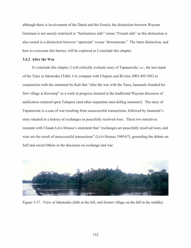
152
although there is involvement of the Dutch and the French, the distinction between Wayana
Granman is not merely restricted to “Surinamese side” versus “French side” as this distinction is
also rooted in a distinction between “upstream” versus “downstream.” The latter distinction, and
how to overcome this barrier, will be explored as I conclude this chapter.
3.4.2 After the War
To conclude this chapter, I will critically evaluate story of Tapanawale, i.e., the last stand
of the Taira at Jakutouku (Table 3-4; compare with Chapuis and Rivière 2003:495-505) in
conjunction with the statement by Kali that “after the war with the Taira, Janamale founded his
first village at Kawatop” as a work in progress situated in the traditional Wayana discourse of
unification centered upon Tulupere (and other serpentine men-killing monsters). The story of
Tapanawale is a case of war resulting from unsuccessful transactions, followed by Janamale’s
story situated in a history of exchanges as peacefully resolved wars. These two narratives
resonate with Claude Lévi-Strauss’s statement that “exchanges are peacefully resolved wars, and
wars are the result of unsuccessful transactions” (Lévi-Strauss 1969:67), grounding the debate on
Self and social Others in the discourse on exchange and war.
Figure 3-17. View of Jakutouku (falls at the left, and former village on the hill in the middle).

153
Table 3-4. Narrative of Tapanawale, or the last stand of the Taira at Jakutouku. The story of Tapanawale as narrated by Kali on January 13, 2003, at Kumakahpan. 1 At a certain day, two brothers (who were residing in the village Kulumulijinpë founded by Tëpëputse)
asked their sister who had made her pregnant. 2 First the one brother asked: “did my brother get you pregnant?” 3 “No!” she replied. 4 Then the brothers went into the forest, near the house of their sister, to keep watch on her and see who is
visiting her. 5 Then two Taila from Jakutouku arrived. In those days the Taila (Akaina or Galibeans [coastal Caribs]) had
a large village at Jakutouku. They approached the sister. 6 Then the brothers shoot their arrows. One Taila is killed and the other escaped and returned to his village. 7 One of the two brothers, named Tapanawale, pursuits him. [Tapanawale] will never return to his village. 8 Next, his brother will search Tapanawale. 9 Taila ask him [brother of Tapanawale]: “What do you want! Come visit our village and see what you
like!” Because the Taila have large canisters and tinboxes, like pakala, about three chests filled with axes, knives, beads, mirrors, and what have you.
note: [Taira are thus in the interior of Suriname / French Guiana to establish trading relations with the Wayana.] 10 The brother stays that night at Jakutouku. 11 The next morning he hears someone playing the deer bone flute kapaujetpë: “ti, ti, ti, tuh, Tapanawale
uputpë, ti, ti, ti, tuh, Tapanawale uputpë …” 12 “What?” he says, “the head of Tapanawale?” But he remains in his hammock, while listening to the flute
play of the Taila: ““ti, ti, ti, tuh, Tapanawale uputpë, ti, ti, ti, tuh, Tapanawale uputpë …” note: uputpë means head; hence Tapanawale uputpë refers to the head of Tapanawale. 13 After it dawned [when it is light], the village leader summons him [brother of Tapanawale]. 14 “Here is a tinbox,” says the village leader, “see what you want: beads, axes, knives …” 15 But the brother asks: “What is in that tinbox over there?” 16 “It is better not to look into that one,” the village leader says. 17 “But I want to see what is in that one,” the brother [of Tapanawale] says. 18 “OK,” the village leader says, and he opens the tinbox. 19 “What is wrapped in those red cloths?” the brother [of Tapanawale] asks. 20 “You do not want to see that,” the village leader says. 21 But the brother wants to see for himself. When the cloth is unwrapped, the brother sees that it contained
the decapitated head of Tapanawale. 22 Without reconsideration, and without taking anything, the brother of Tapanawale returns to his village. 23 “Mah, they have cut off the head of Tapanawale, those Taila!” the brother says. note: At this point, Ronnie Tïkaime (son of Kali and Aputu) (who translates Kali’s narrative from Wayana into
Dutch) asked why they did not simply give their sister to those Taila; then nobody would have died. 24 Next, the brother [of Tapanawale] goes to the Jari and requests support. 25 Tïlïjo [= Trio] are pugnacious and immediately willing to go to the Aletani [where Jakutouku is located]. 26 Same with the belligerent Okomëyana [aggressive as the okomë wasp] and Wayana/Upului. 27 A fourth group joins them, perhaps Waiwai [Kali is not certain of the name of the fourth group]. 28 These four groups set out for the Aletani with many canoes, armed with many bows and many arrows. 29 At night they first circumscribe Jakutouku, the village of the Taila, and sprinkle hemït (charm, poison).
Hemït for the Taila become blinded and will get weak arms. Hemït that they know of through Kailawa.30 When the hemït is sprinkled around the village, they return to their camp to attack at daybreak. 31 Attack is from the forest and the water. 32 All Taila are massacred. 33 Because of the hemït they [the Taira] cannot fight. 34 Only three Taila succeed to shelter under a reversed canoe and float downstream… towards Albina.
Situating this narrative in time and space is more complex than it seems. Jakutouku
(Figure 3-17)—a cataract in the Aletani just north of the former village of Janamale

154
Kawemhakan (Figure 3-16)—is where Wayana situate this battle, indicating that the former
village of the Taira was located on the hill where can be found lots of quartzite flakes used in
manioc grinders.28 As Janamale’s village at Kawatop was located in 1938 (Ahlbrinck 1956), it
can be concluded that the story of Tapanawale—the last stand of the Taira—took place before
1938. Since Ouptoli, father of Tëpëputse (founder of the village where the grandfather of
Janamale settled), was mentioned by Coudreau (1893:545), this story must have taken place after
1889. However, according to de Goeje (1943:342), at the cataracts of Jakutouku—or Indji
foetoe (Ingi foetoe = Indian foot)—Maroons took their revenge around 1840-1845, which would
end terribly wrong. Maroons had taken Waya(ri)kule children after the skirmishes, and raised
them in their village.98F
29 This revenge was a result of an attack by Waya(ri)kule on Maroons, after
which attack this affluent became known as Feti kreek (“fighting creek” in Sranantongo) (de
Goeje 1943:342).99F
30 De Goeje referred to Crevaux who wrote that “men and women, the Boni
took to flight in all directions; only three among them were able to regain their canoes. Others,
in their escape, stumbling over hidden liana vines that the Waya(ri)kule had attached across from
feet of trees, were massacred by their merciless enemies” (Crevaux 1993:71).100F
31
The story by Crevaux resonates with the ending of the narrative of Tapanawale; all Taira
are killed, except three who were able to flee in their canoe (Table 3-4: line 34). All others trip
over booby-traps placed by their attackers the night before (Table 3-4: line 29). Crevaux stated
that the attack on the Maroons was signaled by the Waya(ri)kule in their beating of tree trunks
with their “tomahawks” and an attack of some hundred Indians with stone axes followed.101F
32
Today, Wayana fear the echoing sound of clubs beating tree buttresses. Wayana declare it is the
Akulijo [= Akurio] who have this habit of beating clubs on buttresses. Waya(ri)kule nor Akulijo
155
were mentioned in the narrative by Kali, and Crevaux wrote about a battle between Oyacoulets
and Boni, whereas the narrative of Tapanawale recounts a battle between Wayana and Taira.
Though these two stories resonate, there are several discrepancies. First discrepancy is
rather straightforward to resolve as Kali was uncertain about the fourth group joining ranks with
Tapanawale (Table 3-4: line 27), it is possible that Waya(ri)kule or Akulijo, rather than Waiwai,
are the fourth group joining ranks with Wayana/Upului, Tïlïjo [Trio], and Okomëjana. If so
there must be a relation between Maroons and Taira, who are generally perceived as Kaliña from
the mouth of the Maroni River, as I will discuss in a moment. Second discrepancy is its
timeframe as de Goeje (1943:342) estimated that this battle described by Crevaux took place
around 1840-1845, whereas the battle narrated by Kali is estimated to have taken place between
1889 and 1938. The historical analysis by Coudreau makes the picture even more complicated,
referring to an attack by Oyaricoulets [= Waya(ri)kule] at “saut Yacoutoc (l’homme qui a vu la
bataille) [the man who saw the battle]” (Coudreau 1893:78), and mentioned in a footnote that “in
November 1888, two creoles of Cayenne, gold miners of the Lawa, were exploring up to
Yacoutoc [= Jakutouku] where they were attacked by Oyaricoulets [= Waya(ri)kule]: one of
them was killed, the other wounded” (Coudreau 1893:79; my translation).33 While about five
hundred pages later, Coudreau referred to a battle between Wayana and Galibis [= Kaliña]
resulting from exchange of merchandise for women gone wrong:
Galibis, with their merchandise they require from the coast, the Galibis who lack women, as states the tradition, the Galibis seduce and take away women of the Roucouyennes [= Wayana]. These [actions] resolve in such evil neighbors and they will bring it to war. The Galibis have as allies the Aramichaux [= Aramiso] (named Alamessons by the Roucouyennes). … in the village of Tribici [unknown settlement], at the upper Aletani, of Péléoua, a roucouyenne woman of such grand beauty that the Galibis engaged in war for her in the garden fields of Tribici, a battle in which the Roucouyennes [= Wayana] lost many souls, Galibis and Aramichaux [= Aramiso] defeated, were driven away and descended the Lawa and the Maroni till its mouth (Coudreau 1893:558). 103F
34

156
While the place of action is the same, namely the cataract of Jakutouku, Coudreau
(1893:558) stated that this skirmish took place around 1775. Time-lapse between the different
versions—from 1775 to 1840 and from 1845 to 1910—is sixty-five years, i.e., about one
lifetime. Although Coudreau (1893:558) does not equal Galibis [Kaliña] with Taira, the third
discrepancy, this history narrates about an unsuccessful exchange after which the defeated party
is forced to retreat to the coast. Debatable is how Galibis and Aramiso could have ever traveled
up and down the Maroni River controlled by Maroons: Boni (Aluku) had at this time settled at
the Lawa at the foot of Cottica Mountains, whereas Ndjuka (Aukaners) controlled the Maroni
River downstream. Unless, Taira refers to participants in expeditions of Caribs and Maroons
combined, or perhaps refers to people similar to the Black Caribs of the Caribbean. According to
Wayana, “Taila” refers to Galibis or Kaliña (coastal Caribs), yet it is remarkable that several
settlements indicated by Wayana as Taira villages, were later inhabited by Boni Maroons (and
more recently by Wayana) (Figure 3-18). Further studies on interrelationships between Wayana
and Maroons are needed for a better understanding of these complex processes. If the story of
Tapanawale refers to trading expeditions lead by multiethnic groups of coastal Caribs and
Maroons, without direct intervention of Dutch or French Government, these stories most likely
will not have entered the written historical record.
Coudreau’s (1893:558) mentioning of a battle at Jakutouku a hundred years earlier,
resonates approximately in time with the only historically recorded event of decapitation in the
upper Maroni basin (Hoogbergen 1984:30-31; compare with table 3-4: line 21): on February 20,
1793, Bambi killed and decapitated Boni. Aukaners (Ndjuka) lead by Bambi descended the river
rapidly, but capsized between Marouini and Inini, and the decapitated head of Boni was lost in
the falls (Hoogbergen 1984:30-31). With place as virtual constant and time as variable, it
157
appears that the cataract of Jakutouku became a gathering place to materialize social memory.
Rather than posing the question what actually took place here at Jakutouku, and when, we have
to pose the question: what is the meaning of these histories placed at Jakutouku? Fundamental in
all versions of the battle(s) at the cataract of Jakutouku is a unification of social subgroups
(dialectic Self) against a common enemy (social Other).
Wayana discourse on unification of social subgroups against a common enemy is found in
narratives on the water monster (ipo) Tulupere. Name of Tulupere is onomatopoeic in that it,
according to Wayana, refers to the sound when it runs down hill; TTTTTLLLLLPPPPrrrrr. Then
it is said that this monster (kaikui) plunges into the water, turns around canoes, killing Wayana
and Apalai. Tulupere has different appearances (Aimawale 2000 pers. comm.): Tulupere of the
Jari River looks like an ëlukë (caterpillar); the one of the Aletani is like a tapir (maipuli) and does
not have any motifs on his skin; the third Tulupere, the one of the Paru de Este, is the real
monster. The latter is the Tulupere with a decorated reptilian skin holding designs used today in
basketry, as is the focus of research of Lucia van Velthem (1976, 1995, 1998, 2001). Daniel
Schoepf (1972:54) located this “Touloupèré” [= Tulupere] on the upper Paru, near the mouth of
creek Achiki. Just south of creek Achiki is located creek Tapeucourou [= Tëpu kulu] along
which was located a path joining the Apalai of Rio Maicuru (Rauschert 1982). This serpentine
monster is unique rather than typical, and its sighting location at creek Achiki, I realized, is on
the latitude of the demarcation in the nineteenth century between Apalai in the south and
Wayana in the north (Schoepf 1972:53; following Crevaux 1881 and Coudreau 1893; Figures A-
3 and 3-18), or more accurately: Upului in the north (Chapuis 2003:819).
This “classic” Tulupere story, I argue, narrates about a frontier zone between Wayana and
Apalai that is abridged (Appendix C: Tulupere). After killing this serpentine monster, Wayana
158
and Apalai of the Paru de Este unite as Wayana-Apalai, and basketry weaving is a mnemonic
device of identification. With combined efforts Apalai and Wayana killed Tulupere, whereby
Apalai took one side of the reptilian skin as template for their basketry motifs while Wayana
took the other side. Therefore Wayana and Apalai basketry motifs resemble, though slightly
differ, as the left and right side of the reptilian body slightly differed. Unification of Wayana and
Apalai (as a dialectic Self) materialized while facing a dangerous social Other: Tulupere.
Tulupere being the archetypal serpentine dangerous social Other was a metaphor, I posit,
for the Pijanokoto as quintessential enemy to the Wayana. Creek Achiki could have connected
with a path to nearby Rio Urucuriana (Igarapé dos rucuyannas) where it joined the Pijanokoto of
the Rio Cúmina or Paru de Oeste (Coudreau 1901). Tulupere of the Jari (similar to a caterpillar)
is another example of a frontier zone abridged, as Jean Chapuis located this monster above the
mouth of Rio Kuyali, that is, near the frontier between Upului and Kaikusiyana (Figures 3-18
and A-3). In the latter case the dangerous social Other most likely were the recently immigrating
Wayãpi, whereby Kaikusiyana united with these newly settling Wayãpi.
The narratives of Tulupere, according to Chapuis (2003:815), took place in modern times,
without intervention of Kailawa, however, in Azeima’s version (Appendix C-3: lines:12, 18) it is
stated that Wayana went to Kailawa requesting him to lead the expedition to kill this (water)
monster Tulupere, because Kailawa had the knowledge and power; he owned powerful hemït
(charms). Chapuis marked in a footnote, yet did not explore further, the fact that the Tulupere of
Aletani (proper name is Matawanaimë) is entirely black, as is possibly related to a symbolic
reference to Aluku (Boni) and Ndjuka Maroons (Chapuis and Rivière 2003:817; footnote 1962,
827). Erroneously, Chapuis placed Tulupere of the Aletani between Kulekule and Alama
(Chapuis and Rivière 2003:825, then again maps by Chapuis are rather sketchy). Relative

159
proximity of Tulupere sightings along the Aletani and the locations of Taira sites Pakilaimë enï
and Mulepan enï (Figure 3-18; these sites were pointed out to me on several occasions, by
several Wayana, while navigating the Aletani in canoe with GPS and map in hand) appears to me
as a memory work in progress; situating the conventional Tulupere narratives of overcoming
frontiers into historical context of Maroons (mekolo taliliman) as dangerous social Others.
Figure 3-18. Location of Taira sites and sightings of Tulupere.
With the Maroons/Taira as dangerous social Others, the narrative of Tapanawale is about
unification of a dialectic Self (Wayana) along the Aletani. I posit that the histories of the Wars at
the cataract of Jakutouku, as well as the various locations of Tulupere sightings along the

160
Aletani, are a means to materialize while making sense of historical events. Different sightings
of Tulupere along the Aletani (Figure 3-18) resonate with the shifting frontier between
Okomëyana (downstream of Kiboï soula or isoli ëtakima [first falls when arriving from the
watershed]) and Kukuiyana (upstream of these falls) (Figure A-3). As will be discussed
elsewhere (Chapter 6.3), Okomëyana and Kukuiyana are at the core of Wayana society.
As such the falls of Jakutouku, a frontier between Okomëyana (represented by Janamale)
upstream and Kukuiyana (represented by Twenke) downstream materialized as a bridging
frontier to the dialectic Self (Wayana sociality) while facing dangerous social Others (Taira,
Maroons). Events that possibly occurred at one point in time near these falls are incorporated in
a memory work, in that the mythstory is being created in order to make sense to the Wayana, and
materialize a social memory of belonging to Wayana sociality.
This chapter demonstrated that Wayana (Guiana) settlement organization is more diverse
and more complex than previously assumed. Succeeding chapters are additional lines of
evidence of the regionality of Wayana sociality beyond the in this chapter discussed temporality
of the built environment and settlement patterning emerging out of socio-political processes in
the Wayana (Guiana) landscape. In the next chapter, I will discuss the various dimensions of the
community roundhouse and its relation to the surrounding Guiana landscape.
1 Though the phenomenological language in this monograph resonates with Martin Heidegger, Claudius de Goeje emphasized in his conclusion that nobody else was writing on the subject..2 We saw some grinding grooves and the French archaeologists went up the riverbank. Instead, I asked the Wayana pilot—who originated from the Suriname Bank and hence spoke some Dutch—if there used to be a village around here. “No, not here. A little further upstream, there used to be a village” he answered.3 Some Wayana of my generation admitted that they had frequently fallen asleep during nighttime narration of stories of times long ago (uhpak aptau eitoponpë). They knew about, but they could not narrate, these stories.4 November 6, 2000, I was given a Wayana name: Imso. First of all, Imso resonated with my proper name Renzo. More importantly, imso are winged male leaf-cutter ants departing from the ground in December to fly away. In 1998 and 1999 I departed mid-October and in 2000 I would depart December 30; per Cessna from Maripasoula to Cayenne. Winged ants imso always return, as I always returned; an irresistible analogy. Furthermore, imso is living underground, walks on the earth, and flies into the sky; yet this small insect is not as powerful as other animals roaming different worlds as caiman, harpy eagle, or jaguar. Correspondingly, I did not have the knowledge of a powerful pïjai (shaman), but I appeared to know about their powerful knowledge from gazing into their worlds.
161
5 Difference between Participant Observation in the sense of Malinowski and Observant Participation (Whitehead 2009) can best be illustrated by sixteenth century Brazilian ethnographies by Hans Staden (1557), André Thevet (1558), and Jean de Léry (1578). Hans Staden (1634 [1557]; Whitehead and Harbsmeier 2008) described and illustrated the daily lives of indigenous people of Brazil while being captive with the prospect of being killed and eaten. In contrast, André Thevet and Jean de Léry (1994 [1578]) intentionally set out to conduct detailed descriptions and illustrations of the indigenous people of Brazil with the prospect of returning to their respective churches. While “observation” was the main objective of Thevet and de Léry, it was Hans Staden who made his observations while “participating” in local traditions, i.e., Observant Participation avant la lettre.6 Kali (2003) stated that the oblong dwelling (with four main posts) of Janamale is named mamhalipan.7 Eithne Carlin and Karin Boven (2003:27) translated that this outpost, or “camp,” was located on a “man-made mound.” There is no mention of a man-made mound by Tony (1843:221); other than this structure is located in the middle of a garden plot. 8 Carlin and Boven (2003:27) do not mention the impressive size of these roads, moreover they translated “palisadé avec des gaulettes” (Tony 1843:222) as “cordoned off by a balustrade” (Carlin and Boven 2003:27), and stated that these “three parallel paths [were] just where it entered the village” (ibid.) whereas Tony (1843:222) wrote that these parallel roads branched off about halve a league (about 2.5 km) before the village; thus not “just before.” 9 Kujaliwala, unidentified mountain; kujali is the Wayana name for the red-and-green macaw; Ara chloroptera.10 Analogous galactic systems of garden cities in the upper Xingu (Heckenberger 2005; Heckenberger et al. 2008). 11 Without further consideration, Carlin and Boven stated that this “central hut named tapui … nowadays is referred to as the tukusipan” (2003:27-28). Aimawale (pers. comm. 2000) named this structure in the center of the public plaza, as described by Claude Tony, kwepi, and stated that this was a roofed platform where weapons were stocked and guarded by keepers of arms. 12 Following Tim Ingold (2000) the landscape is visible, whereas the taskscape is audible. Even before visually laying eye on buildings of a settlement; activities within a settlement produce a soundscape surrounding the settlement. In narratives, announcement of a nearby village is not by means of its visibility, but through the deep sounds of fluteplay (luwe bamboo flutes) and songs performed in the nearby village. Alternatively, visitors announce their presence by playing flutes (high pitched kapaujetpë [deer bone flute] above all) upon arriving. 13 Settlements of Tolinga and Machiri (just south of Tolinga [present-day Antecume pata]) can be perceived on an aerial photograph from 1956 (Hurault 1965:planche IX; commentary 25-26). 14 In 1958, Tïpiti and most of the residents (including Opoya and Wéyoukou) resided with Massili II (ibid.:plate II).15 In 2005, I heard that Sihmi had divorced her husband and had married Tuwoli from Awala kampu.16 Wife of Opoya, Alimina, is a daughter of the second marriage of the mother of Tïpiti, which makes Alimina and Tïpiti (discussed above) half-brother and sister. 17 Granman Amaipotï dismissed Klingelhoffer in 1993 in the context of information gathered by the French Officials for French Identity Cards based on his negative interpretation of the origin of several Wayana. At the arrival of the Gendarmes and city hall officials among the Wayana with regard to French ID-cards, a meeting that took place in the tukusipan with Granman Amaipotï and Kapitein Anamaila, and according to Wayana, Klingelhoffer did not take the side of the Wayana, resulting in the fact that several Wayana did not obtain French ID-cards nor the social security that comes with it. This is not the place to elaborate further on this highly political debate. 18 Considering demographic data, Henri Coudreau (1892a:8) stated that: “Nothing is more variable than the total of the indigenous population” (Rien n’est plus variable d’ailleurs, que le total d’une population indienne) as the entire population moved along so that the researcher could not make a distinction between hosts and guests of a given village. Sometimes women and children left the village and fled into the woods. On occasion, a single house contained thirty people, at times merely a single couple (ibid.). Instead of meticulously recording a census, Coudreau, as other researchers, simply ignored demographics, only to list some averages and general total numbers of inhabitants. I will later return to the topic of demographics and ramifications of averaging total number of inhabitants (Chapter 6). 19 An initial survey with Google Earth demonstrated that neither all settlements in the Jari Basin (research area of Daniel Schoepf and Lucia van Velthem) hold a community roundhouse (tukusipan). On the ground fieldwork will determine whether similar socio-political forces, as discussed in the present study, are at work. 20 Janamale [synonyms: Janemalé, Yanamale] had founded his new village, named Luwe (also referred to as Gramanponsoe), at Kawatop (Figure 3-16). He had moved here from Pilikaju or Toko patatpë, the former place of his father Toko. Former place of Pilikaju was located just south of the village of Wapotumït [synonyms:

162
Wapotmouine, Wapoedoemit, Wapodimiet]. Pleike, son of Wapotumït would have his village in 1948 (Hurault 1965: planche VIII facing page 24) in this area. 21 Anapaikë (brother-in-law of Janamale in his first mariage and son-in-law in his second marriage) was made Granman of the Wayana of Suriname under influence of the Dutch Government (Boven 2006:127). Anapaikë and his wife Alijamï (Aliwame) are named by Schmidt (1942:51) as inhabitant of the village of Janemale in 1940. Parents of Amaipotï (Granman of the Wayana of French Guiana), namely Twenke (Toeanké) and Alilupïn (Malehoepin), were also residents of the village of Janemale. 22 Coudreau depicted the village of Ouptoli, father of Tëpëputse, at the Jari River (1893:545; Figure 3-2 D) 23 Aputu told (on January 13, 2003) that he was as old as Cevin (then 10 years of age) when the village was founded, and as old as Jelibon (then 14 years of age) when the village was abandoned. If it is correct that Aputu was born in 1938 and 65 years of age in 2003, then Kawemhakan was founded about 1949 and abandoned around 1953. Aputu and Kali emphasize that four people died in this village: Wejuku, Polina, Wantapïn, and Jakuman. All four were cremated and their ashes collected in a ceramic vessel that was buried in the tukusipan (community roundhouse). 24 For example, Kulienpë (village leader of Alawateime enï located northeast of Talhuwen), who narrated several stories (Appendix C), was named by Schmidt as residing in Moelepaneimi along the Jari, just east of Coudreau’s village of Marière; Kalijimpe [= Kulienpë] with his mother Jamike [Jonika] and father Toloemale [Talumale], village leader of Moelepaneimi. Also Ikakan is named as residing in Moelepaneimi; Ikakan is the maternal grandmother of Alasawani (Inamï) who is married to André Cognat, village leader of Antecume pata. 25 As illustration of arbitrariness of data; where Hurault mapped in 1948 the location of six Wayana settlements along the Aletani (from north to south: Aloïké, Touanké/Malavate, Yanamalé, Tiliwé, Païna and Pléiké), in the same year, medical doctor André Sausse (1951:100) recognized only four settlements (three on the French bank and one on the Dutch bank; unnamed). Where Docteur André Sausse (1951) wrote a broad historical overview of the Populations primitives du Maroni (Primitive Peoples of the Maroni), he apparently “missed” two Wayana settlements south of Ingifoetoe (south of the Oelemari): Païna and Pléiké. The late Pïleike (Pléiké) was the son of former village leader Wapotumït. Païna will later join Janamale in his village Kawemhakan. 26 Several other movements can be traced, for example, Aloike (Alewuike, Alawaike), located in 1948 in the Sauts du Litani (1965: planche VIII facing p. 24), Alawaike (Alewuike, Aloike) was named by Schmidt (1942) as resident of the village of Masili along the Mapahoni, with his brother Alaimin (Alemin) who was married to Kiwak (Kïiwa). Alemin and Kïiwa first remained along the Mapahony when Masili [Machiri] migrated with most of his people from the Jari to the Aletani. Today, Kïiwa resides in Kulumuli pata [Twenke]. 27 That is more that the total number of Wayana according to the 1940 census (Schmidt 1942:50). 28 The history of this site goes back to prehistoric times as a boulder with several dozen grinding grooves is located at the bank overlooking the cataract Jakutouku, where some other stones with grinding grooves are located as well. 29 “Hier [at Curmotibo along the Lawa] fanden wir auch einen jungen Burschen und ein Mädchen vom Stamme der Irakuleh-Indianer [Waya(ri)kule], die in ihrere Kindheit von den Bonninegern entweder geraubt oder als Geiseln mitgenommen waren. … Sie waren, wie manche Neger, tätouiert und hatten ganz die Manieren ihrer Gebieter angenommen” (Kappler 1861, in de Goeje 1943:343).30 In Wayana this affluent is named Mapaoni (on the west bank of the Aletani, between Toko patatpë Pilikaju and Janamale patatpë Kawatop [Figure 3-16; N 3°10’]; not to be confused with Mapahoni, affluent of Jari). 31 “Hommes et femmes, les Bonis prirent la fuite dans toutes les directions; trois seulement d’entre eux purent regagner leur canots. Les autres, dans leur fuite, butant contre des lianes invisibles que les Oyacoulets avaient tendues en travers au pied des arbres, furent massacrés par ces ennemis impitoyables” (Crevaux 1993:71).32 “Au moment où les Bonis terminaient leur repas, le chef des Oyacoulets frappa sur un tronc d’arbre de son gigantesque tomahawk: c’était un signal convenu pour l’extermination des visiteurs. Une centaine d’Indiens tombèrent sur eux à coups de haches en pierre” (Crevaux 1993:71).33 “En novembre 1888, deux créoles de Cayenne, chercheurs d’or à l’Aoua, s’étant aventurés jusqu’à Yacoutoc, ont été attaques par les Oyaricoulets: l’un d’eux a été tué. l’autre blessé” (Coudreau 1893:79).34 “les Galibis, avec les marchandises qu’ils tenaient de la côte, les Galibis qui manquaient de femmes, dit toujours la tradition, les Galibis séduisaient et enlevaient les femmes des Roucouyennes. Ceux-ci résolurent d’en finir avec d’aussi mauvais voisins et ils leur firent la guerre. Les Galibis eurent pour alliés les Aramichaux [= Aramiso] (appelés Alamessons par les Roucouyennes). … au village de Tribici, dans le Haute Itany, de Péléoua, femme roucouyenne d’une grande beauté pour laquelle les Galibis livrèrent, dans les abatis de Tribici, un combat dans lequel les Roucouyennes perdirent beaucoup de monde, les Galibis et les Aramichaux, vaincus, furent chassés, et descendirent ensemble l’Aoua, puis le Maroni jusqu’à l’embouchure” (Coudreau 1893:558).