Medieval Settlement Research Group
84
Medieval Settlement Research Group c- r'-- -' '\) 1-' ' , , M.S. R.G. -,' Annual Report 22, 2007
-
Upload
khangminh22 -
Category
Documents
-
view
0 -
download
0
Transcript of Medieval Settlement Research Group

Medieval Settlement Research Group
Q~/0 c-r'-- -' '\) 1-' ' , ,
M.S. R.G. -,'
Annual Report 22, 2007


Medieval Settlement
Research Group
Annual Report 22, 2007

PRESIDENT
HON. VICE-PRESIDENTS
SECRETARY
TREASURER
EDITOR
COMMITTEE
OFFICERS FOR 2007
Dr. M. Gardincr School of Geography, Archaeology and Palaeoecology The Queen 's Univers ity Belfast Belfast BT7 INN
F. A. Abcrg C. C. Dyer J. Le Patourcl C. C. Taylor
Dr. N. Christie School of Archaeology and Ancient History Un iversity of Leicester Leicester LE I 7RH
Dr. R. E. Glasscock St John's College University of Cambridge Cambridge eB2 I TP
Dr. S. Turner School of Historical Studies Newcastle University Newcastle upon Tyne NEI7RU,UK [email protected]
R. Jones (Leicester University) (Web Officer) J. Kissock (University of Wales) H. Hamerow (University 0/ Oxford) E. Martin (Suffolk County Council) A. Reynolds (University College, London) J. Richards (University of York) R. Faith (Kellogg College, Oxford) R. Silvester (Clywd-Powys Archaeological Trust)
2

CONTENTS
Officers for 2007 2
Conlents 3
Announcements 4
MSRG spring conference, 11-13 April 2007: The landscape of Anglo-Saxon England, Nick Higham 5
Perceptions of Medieval Landscape and Settlement 6
Workshop 1: Planning and meaning 6
Workshop 2: Working and sharing 12
Workshop 3: New people, new farms 15
Workshop 4: Belonging, communication, and interaction 22
Workshop 5: Plenary conference 24
John Hurs! dissertation prize 2007 32
Leicestershire settlements through the latc fourteenth century poll tax records - urban or rural? Michael Busby 32
Fieldwork on the southern escarpment of the Mendip Hills, Graham Brown and Elaine Jamieson 38
Hazleton, Gloucestershire, Christopher Dyer and David Aldred 41
A deserted medieval village site at Mullaghmast Townland. Co. Kildare, Ireland, Angus Stephenson 44
Test pit excavation within currently occupied rural settlement in East Anglia - results of the HEFA CORS project in 2007, Carenza Lewis 48
Trewyn Chapel, Monmouthshire, Eddie Procler 56
Worthy farms on the edge of Dartmoor: a preliminary report, Ros Faith, Andrew Fleming and Richard Kilchin 57
Discovery and excavations in 2007 58
Book reviews 69
Membership changes 2007 77
Trustees' report & independent examiner's report 78
Accounts of the MSRG 79
3

ANNOUNCEMENTS ANNUAL GENERAL MEETING
Th e MSRG AGM 2008 and Winter Seminar The Winter Seminar will take place on Saturday 6th December 2008, II.OOam·5.00pm, in the Centre for English Local History, Salisbury Road, Leicester, with the AGM at 12.50pm. Eight papers 011 the theme of 'Fishing, Transhumance and Woodland in Medieval Britain' will be given in memory of Harold Fox.
CONFERENCES T he MS RG Spring Conference 2009
The MSRG Spring Weekend Conference 2009 will take place al the University of Leicester on April 4-5, on 'Monks in the Midlands: Medieval Monasteries and Landscapes in the Midlands' , A flier with further details and a registration ronn is inc luded with this report.
JOHN HURST MEMORIAL PRIZE T he annual award in memory of John Uurst
The Medieval Settlement Research Group is dedicated to enhancing our understanding of the rural landscape and its settlement in the period c. AD 400-1600. The late John HUTst was a major fib'1lre in the development of the Group and in his honour, and to encourage new and young scholars, an annual prize of £200 is offered for the best Masters dissertation on any theme in the ficld of medieval settlement and landscape exploitation in Britain and Ireland. MA directors in Archaeology, English Local History, Landscape Studies or related fields are encouraged to subm it high quali ty, complete dissertations by students in the academic year 2007-8 to the Secretary of the MSRG by 31st December 2008. A panel will judge the entries and an award will be made at the end of March 2009. A summary of the winning entry may also be published in the Group 's Annual Report.
RESEARCH GRANTS The group can make grants up to a maximum of £500 annually for the support of research by members of the Group within its fie ld of interest. Preference will normally be given to field survey, documentary research and preparation of graphics rather than to excavation and the preparation of reports fo r publication. A summary report of the work will be required within a ycar and, subject to editorial consideration, may be published in the MSRG 's Annual Report. Applicants shou ld apply by letter (4 copies) summarising the proposed research and the costs involved. Mention should be made of other applications for funding. The names of two rcferees should be included. Letters should be addressed to the Treasurer (Dr. R. E. Glasscock, St John's College, Cambridge, CB2 ITP). To be received by 1st December in thc year preccding that in which work will be carried out. Applicants will normally be notified of the outcome in the following March.
MSRG ANNUAL REPORT 23, 2008 Next year's journal will include rcferecd rescarch papers and fieldwork, excavation and research reports on work undcrtaken during 2008. All submissions should be focused on topics relevant to the core interests of the Group, which is rural medieval settlement in Britain, Ireland and Europe. Please submit all copy to the editor ([email protected]) by May 31st 2009. Please note: I. Short reports on fieldwork or' projects should be kept concise, generally no more than 300-600 words plus one illustration (un less the work is of a scale that necessitates a longer article - for example reports on major projects or regional surveys). 2. Research articles should be 3,000-5,000 words in length. All submissions to th is section will be peer-reviewed. a. It is the responsibility of contributors to ensure that they have copyright of all material submitted. b. References to principal sites should be accompanied by national grid references (in the UK Ordnance Survey NGR as 2 letters and 6 figures (min.); for other countries use appropriate national grid systems or WGS84 fonnat). Please also give the local government areafcounty name (with the pre-1974 county name if different in the UK). c. Images should be supplied initially by email as low-resolution digital files. High-resol ution digital images (preferably TlFFs) will be required for printing (usually for photos this means at least30Odpi, line drawings 1200dpi): submit these by emai l or on CD if over 15MB. We prefer to avoid handling hard copy illustrations but if submittcd they should be clean, clear originals that arc capable of reproduction at either column or page width. Please ensure that small details (hachuring, stipple and lettering) are capable of such small reproduction. d. Measurements should be in metric units. e. Use Harvard references not footnotes. In the reference list, bibliographical details should be quoted in fu ll . For articles in journals the tit le, date, volume number and inclusive pages are required. In the case of books, date, place of publication and publisher should be cited in addition to the author and title. r. Please do not hesitate to contact the editor at an early stage for advice on your submission ([email protected]).
4

MSRG spring conference, 11-13 April 2007: The landscape of Anglo-Saxon England
By Nick Higham, University of Manchester
The Spring Conference, which took place just after Easter 2007, was organised by Nick Higham and the Manchester Centre for Anglo-Saxon Studies at the University of Manchester. Over 100 delegates participated and there was a packed lecture programme of very high class, with the focus quite specifically on the pre-conquest landscape but shifting in terms of disciplinary speciaiism across place-name studies, archaeology and landscape history, with many speakers, of course, using several approaches to enrich their contributions.
The conference began with a group of papers on placename studies, fronted by Alex Rumble who offered an historiographical approach to the sub-disci pline spanning the twentieth century and the bulk of England. Margaret Gelling then reminded her audience of the spccificity of many Old English place-name elements, implying that in many instances (as beorg, for example, a 'rounded hill, tumulus') terminology was tied in some detail to particular features of the local landscape, and Anne Cole discussed how place-names related to the way that travellers found their way across what were presumably uncharted landscapes at this date. The ' place-namcs' section was then rounded off by GiUian Fellows-lensen, whose focus was on Scandinavian place-name elements in the later Anglo-Saxon landscape, their distribution and particular meanings.
After lunch, the focus shifted to archaeology, and Julian Richards and lohn Naylor discussed some of the results of their current project, based on the new portable antiquities database, which has allowed them to amass considerable new data through which to investigate the pattern of settlement and land-use in the period 700-1000. Thereafter Carenza Lewis described her on-going work in community archaeology, systematically testpitting Cambridgeshire villages as a way of exploring thei r early development. Stephen Rippon focused on the 'Long Eighth Century', suggesting that this was a period of fundamental importance to the later development of regiona l landscapes across England and the subsequent emergencc of 'champion ' versus 'woodland ' or 'ancient' landscapes. After a break for tea, Peter Murphy offered a well-i llustrated paper which offered new evidence for Anglo-Saxon exploitation of the shoreline including numerous fish traps, particularly around the East Anglian coast. Richard Watson discussed the landscape of central Lancashire in the Viking Age, attempting to reconstitute the balance between wetlands and farm land via palaeobotany, field names and soils, while Chris Lewis exp lored the landscapes of the AngloSaxonlWelsh border areas around Offa's and Wat's Dykes. In the cvening, Christopher Grocock captivated the audience with a beautifully illustrated paper, drawing on his experience at Bede's World and elsewhere, on the production and use of coppiced timber.
5
On the Thursday morning, Linda Corrigan and Simon Draper led off with papers centring on particular research problems. Linda tackled the problem of Norse settlement in southern Cumbria, which she approached predominantly via place-names, and Simon examined the relationship between archaeology and place~names across a wider canvas. Dom Van Dommelen then proposed placing later Anglo-Saxon boroughs in their social and political landscapes, and suggested that their development is likely to have a profound effect on the local landscape and its utilisation. Don Scragg read a paper from Catherine Karkov, which focused on the well-known calendar illustrations from late AngloSaxon England, and ~ Derek Berryman discussed the significance of woodlands to a varicty of local industries, but particularly iron working.
A fier lunch, Tom Williamson discussed the ecology of Anglo-Saxon settlement strategies, highlighting their sensitivity no comparatively minor shifts in environmental factors , and Debby Banham focused on Anglo-Saxon arable land and the production of cereals. Stuart Brookes re-opened the issues surrounding the Anglo-Saxon 'multiple estate', with particular reference to eastern Kent, and Susan OOSlhuizen hypothesised the origins of open field agriculture in eighth-century Mercia and Middle Anglia. Ros Faith presented a paper on Anglo-Saxon farms in their landscapes and David Hill talked about oxen, ploughs and carts, drawing on recent styles still to be found in Iceland and the Spanish peninsula. Following dinner, Della Hooke gave a highly illustrated paper on the woodland landscapes of early medieval England, which reminded her audience not only how important woodland was but also how photogenic.
On the Friday morning the audience were treated to a series of case studies, by Rik Hoggett on the early churches and parochial landscape of East Anglia, by Duncan Probert (in absentia, his paper was read by Nick Higham) on the lands and parish of the pre-eonquest minster of Crediton, Devon, and by Peter Stokes, who talked in detail about the charter boundaries of estates at Powick and Leigh, in Worcestershire. The conference was closed by Martin Ryan, who discussed the origins of the Anglo-Saxon hide and its landscape setting.
Overall, this was a very exciting event which drew together experts from several different disciplines and allowed them to share their approaches to Anglo-Saxon settlement and landscape. Most of the papers will appear shortly in two forthcoming volumes to be publ ished by Boydell and Brewer, edited by Nick Higham and Martin Ryan.

Perceptions of medieval landscape and settlement A series of workshops, with a plenary conference, funded by the
Arts and Humanities Research Council, and sponsored by the Medieval Settlement Research Group
This collaboration between the Arts and Humanities Research Council and the Medieval Settlement Research Group began when the AHRC announced its initiative on the theme of 'Landscape and Environment'. At first the document outlining the projects that the AHRC had in mind, with, for example, its references to the performing arts, seemed incompatible with the aims of the MSRG. Neil Christie was anxious that the MSRG should become involved, and after discussions, he and Chris Dyer found that the MSRG could make a proposal which accorded with both the AHRC agenda and the MSRG's needs. Importantly, this was at a time when the MSRG was starting to discuss and draw up a sizeable revision, updating and expansion of the MSRG Policy Statement on ' Medieval Rural Settlement Research, Conservation and Excavation ' (now circulated); in addition to the Review of research for 1996-2006 (Published in the Annual Report for 2006). It was thus more than opportune to use the AHRC programme to examine the ways in which current and recent research in medieval settlement and landscape exploitation are -or should be - heading. Neil was inspired to devise the series of workshop titles to flag some of the key questions - these very much centered around identity and belonging but drawing out also the bonds with the landscapes and their resources. The title that we chose for the series of workshops, Perceptions of Medieval Settlement and Landscape created inadvertently the acronym POMLAS, which has now been adopted by many of those involved in the project.
The workshops were held in every corner of the United Kingdom in order to demonstrate the inelusiveness of the series, but the list of those participating had to be selective in order to maintain a seminar format. We were keen also to attracl a full range of ages and interests and enable younger scholars to havc a voice. We set out to bring together disciplines + nOI just the archaeologists, geographers and historians already active in the MSRG, but a lso linguists, literature specialists, palaeocnvironmentalists and other specialists not always fully involved in settlement studies. The speakers and other participams 'included university academics and students, researchers in such organizations as English Heri tage and the RCAHMS, archaeologists working in commercial units and for local authorities, historians fro m the VCH: as wide a spectrum as possible. Those who could not attend could keep themselves informed of the content of the workshops through the POMLAS websitc. The plenary was envisaged as open to all so as to share something of the output of the various workshops and related discussions.
The purpose of POMLAS was to refresh the subject, to engage with other disciplines, and to enable us to sec settlements or even individuals in a new light. The focus would be on the people who organized and lived in the medieval landscape: to understand their experiences; to
6
visualize their attachments and loyalties to places and regions; to see more of their activi ties in the landscape and their use of it; to reveal their dec ision making; and to rcconstruct the ideas that lay behind their decisions. During the workshops people have asked 'Whose perceptions are we considering - theirs or ours?' The answer is, of course, both, as we have to adapt and develop our own perceptions if we can aspire to comprehend their ideas and outlook.
The following pages give an account of the contributions to the workshops and plenary conference. The description of the content of each paper is based when possible on the summaries submitted by the speakers, but they have sometimes been edited, and reports on the workshops made al the time by those attending have been used to fill in gaps. If readers wish to sec the original summaries, they will be found on the MSRG website.
Thanks arc due to the speakers and those who participated in the discussions (in all well over a hundred people), and in particular to the organi zers of workshops:
Mark Gardiner, Keith Lilley, Piers Dixon, Oli vcr Creighton, Steve Rippon, Kate Oiles and Julian Richards. Invaluable administrative support at Leicester was provided by Julie Deeming. Chris Dyer
Workshop I: Planning and Meaning
held at Belfast on 23 February 2007
Inhabiting medieval buildings: theorising place and space in pre-modem England Kale Giles
In recent years, medieval domestic bui ldings have been a fertile ground for debate and study amongst academics and vernacular buildings enthusiasts. Scholars have sought to theorize more explicitly the study of the plan fonn, appearance and use of houses and other building types. Such debates are perhaps best represented in the lively exchanges of the journal Vernacular Architecture, and in the writings of scholars such as Dyer, Austin, lohnson and Pearson. However, they have also exerted a profound impact on the day-to-day recording of such buildings by local and regional scholars and recording groups in the UK.
Guildhalls are a type of building with important spatial and structural parallels not only with houses but also with other building types, such as parish churches. Increasingly, within the literature, emphasis has been placed on the remarkable and apparently universal use of the 'tripartite' organization of domcstic buildings, across a long chronological period and across a widc social and geographical range of houses. This 'consensus' has been interpreted not only as a reflection of deeply-embedded principles of social organization, but also as the very
mechanism by which such principles were reproduced over time. In other words, the existence of these 'templates' appear to provide evidence of the perception of medieval domestic space and household relations. These ideas are, however, rather difficult to square with the apparent diversity and flexibility of medieval houses.
Categories such as 'open, 'transitional' and ' closed' house types serve to reproduce a homogenous and static view of medieval life, which can be contrasted with the changes of the early modem period ..
Rather than simply relying on the evidence of surviving buildings, medievalists can turn to such sources as the writings of philosophers and imaginative literature. These sources allow us to be much more selective and critical about our use of contemporary spatial theory in the analysis of medieval buildings. This paper highlights thc idea of 'inhabitation' as a useful way of thinking about such buildings.
The archaeological evidence itself demonstrates the adaptability of medieval 'peasant' buildings. I want to suggest that the differences between peasant houses, particularly those within the same settlement, have imponant things to tell us about the differences between households: the composition of family and wider household, the domestic and industrial activities which occurred within them, the social use of spaces by the household but also by other members of the community. These differences are profoundly important to our understanding of the dynamism of medieval communities and their active manipulation of domestic space, creating particular kinds of visual impression on their fami lies, kin groups, neighbours and guests. Such differences were significant means by which the relative social and economic divisions within peasant craft and mercantile commun ities were structured and negotiated. Domestic buildings were central to the construction of identity and status amongst the emerging middle classes of pre-modern England.
We need a much more integrated understanding of the relationship between house forms , settlement forms and landscape use, particularly the kinds of agricultural, industrial and mercantile activities in which peasants, craftsmen and traders were involved. The idea of 'pays' provides a means of understanding building materials, structure and appearance and plan fonn. Here too is an opportunity for us to consider the significance of time and the changing seasons in our search for the perception and meaning of medieval buildings.
We cannot study domestic buildings in isolation. The form and function of medieval buildings depended on many influences outside the walls of the houses themselves. The study of houses should be reintegrated with that of churches and public buildings to ask how both public and private bUildings, situated as they were in streets and fields , marketplaces and churchyards, were inhabited by medieval communities.
Reading the late medieval peasant dwelling: notes towards a social archaeology of power, resistance and community Sally V Smith
7
The domestic space of the medieval peasant has received very little archaeological attention. The Iypes of conclusions on these matters, where they have been drawn at all, have been limited to suggestions concerning 'universal codes ' of spatial meaning existing throughout medieval society, and interpretation of the space of the home in tenns of structuralist opposites -private and public, for example. In a sense, these conclusions reflect present-day conceptions about 'the domestic' , part of which involve characterizing the meanings of this space as essential and unchanging. Explanations of this son are lacking in context; in other words, they universalize peasant experience in all periods and places. Moreover, important aspects of peasant domestic space remain undiscussed.
The archaeological evidence of peasant domestic space allows us to talk about perceptions of community. It must be noted here that I, following Dyer, feel that it is reasonable to aSSUQ1e that peasants were usually responsible for the fonn and layout of their domestic space. Even if peasants were not in charge of the construction of their buildings, they almost certainly were for their maintenance. The peasantry were to some extent agents in the ordering of their lives.
At Wharram Percy in the Yorkshire Wolds peasant domestic space can be seen to have been generating, as well as of reflecting, peasant perceptions of community cohesion. Firstly, there would have been a substantial similarity in the external appearance of the houses of this village; all were of eruck construction, many had a cross-passage and opposed entrance plan. As well as this broad similarity in house lay-out and appearance, the suggested change in house alignment that happened later in the period is also of interest. It has been convincingly argued by Wrathmell that the six tofts in the northern half of the east row of the village reveals a change from each toft containing a building aligned parallcl to the toft frontage to a lay-out in which each messuage accommodated two buildings separated by a yard with both buildings running at right angles to the toft frontage. We cannot be certain why this happened, but it is likely that peasants at this time changed their toft layouts in basically identical fashion. Throughout the late medieval period at Wharram Pefcy, with only one exception, toft boundaries stayed fixed , and there was only minimal household encroachment onto the public spaces of green or track-way. Material culture can be viewed not as simply reflecting the workings of technological, political or environmental processes, but as evidence for people's decisions. The evidence from Wharram Percy seems to suggest that peasant domestic space was used to produce mcanings of unity, cooperation and community.
The configuration of domestic spaces could also serve to create and reflect gender-group identities, as can be seen by the arrangement of the foldyards at the vi llage of Wawne, in the East Riding. The sharing of these yards, in combination with what we know about women's taskscapes (that is, the spaces within which women's work was done) allows us to suggest that these spaces would have been important sites in the creation of a fema le gender identity. Domestic space can provide us with information pertaining to the peasant perceptions of
'community', and does not simply demonstrate the existence of peasant community. Sometimes houses and tofts in other villages show distinctions and differences between households.
Resistance to seigneurial power is indicated at Wharram around the domestic sphere. We can see this through the material traces of stone robbing, hand-milling and poaching. Objects, which are normally simply listed in small-finds calalogues, can give meaning to the material cuhure of the medicval peasant dwelling.
One ofthe important conclusions that can be drawn from the above discussion is that the term 'domestic ' carries too many assumptions and modem meanings for it to be helpful for those interpreting past societies. Of course, there is no doubting that the house or ' domestic building' was a particular 'place' in medieval peasant lives; distinct activities went on there, thereby evoking distinct meanings. Similarly, there are differences as well as similarities between peasant houses. For examplc, a household might own a particular type of decorated pottery which gave it an identity. The term 'domestic' suggests thc separation of work inside and outside the home, and is connected with the idea of a distinction between public and private. Perhaps another tenn, such as ' household' might be helpful in removing the baggage associated with the word 'domestic'. Both political resistance and the creation of peasant community werc embedded in the space of thc peasant house and the activities which it containcd.
A history of domestic space, or a spatial history of domesticity? Tadhg O'Keefe
' Space ' appears in the title of this section of the workshop but nOI in the title of the workshop itself. Thai is an observation, nOI a criticism. Deliberately or subliminally, this workshop's identification of ' landscape ' and 'settlement' as the objects of medieval perception reflects our own contemporary perceptions of landscapes and settlements as tangible entities, experienced and comprehended primarily through our visual senses, and susccptible to ncar-objectivc comparative analysis. ' Spaec ', as traditionally understood by mcdievalists (weti, archaeologists and historical geographers!), simply does not lend itself to such investigation. But my suggestion in this (entirely theoretical) paper -is that the exploration of medieval meanings and perceptions demands a serious reengagement with the concept of space, and not in the Cartesian sense but in Lefevrian and Foucaultian senses.
Delegates at this workshop will know, perhaps, how the conceptual relationship of 'space ' to ' place' has been exercising humanist geographers (as well as a small cabal of theoretically-aware archaeologists) for some time now. They will know that the preference today is for describing landscapes and settlements as species of 'place ', with the word 'place ' being favoured because it connotes intimacy or familiarity. And thcy may sense, as I do, that this concept of 'place' has actually driven a wedge through our understanding of space and spatiality, isolating those scholars who conceive of space
8
as fundamentally measurable from those who conceive of it as Soja dO'es: time and space are, he maintains, the 'co-equal and mutually formative aspects of social life' .
Medievalists, on the whole, still conceive of space in the former, very narrow, way, whether it is with rcspect to the macro-scales or to the micro-scales of domesticity. They regard space solely in tenns of structure and structuring, and take for granted 'the existential spatiality of being in the world ' (as Soja again expresses it), so as to deal with ' the temporal and social aspects of being in the world'. The very phrases ' planned landscapes' and 'planned settlements', for example, derive from then often-unconscious privilcging of spatial structure. The study of the domestic arena, which is a smaller-scaled landscape, may seem a little more daring, thanks to the incorporation of ideas about architectural permeability from architectural theorists, but domestic space is still understood as fundamenta lly structured: access analysis, for example, purports to offer an alternative strategy for reading medieval builtspace, but one could argue that it merely offers an alternative strategy for representing built-space as structured and controlling.
This rather narrow view of space and spatiality can be understood historically, and it is critical that wc are aware of its historiographical roots. Vesely identified how, undcr the' growing sway of modem science, a new fascinalion with encyclopaedism, taxonomies, comparative studies, different kinds of measured observations, and the like profoundly altered architectural thinking and architectural practice at the end of the eig:lteenth century. He characterized this as a shift from symbolic representation to instrumental representation (what Aristotle described respectively as poiesis and techne). At the risk of misrepresenting his complex argument, we might understand it as a shift from a metaphysical and aesthetic understanding of architecture to one that is overtly technical and scicntific. The susceptibility of the technical/scientific to evaluation by experiment, and so to some measure of ' truthfulness', gave it primacy during the nineteenth and early twentieth centuries over the aesthetic/ metaphysical, both in the creation of new architecture and, especially, in the consideration of historic architecture. And it also gave it primacy over the experiential, in the sense that the aesthetic/metaphysical were, in part, experienced. Although the postmodem turn has changed things around again, the study of medieval architccture - indecd of medieval space in general - remains timc-lockcd.
Some of the empirical and theoretical research since the 1970s into the (sometimes-domestic) spaces of modernity and postmodemity have relevance for medieval architectural-residential thinking. The richness of thc theoretical work can be illuminatcd by reference to Virilio, Vidler and Soja; the empirical rcsearch is represented by assorted geographers. Following the lead of Bonta, who argued in 1979 that architectural history needs to be a history of meanings and not just of forms, I suggest that we reflect on the meanings of domestic built spaces by developing ideas about architectural transparency and what I clumsily cal1 spatial inbetweenness.

Discussion Mark Gardiner and others
How should we look at buildings? Did planned spaces and buildings change the people who lived in them? What was the role of the builder and the 'cl ient' in deciding a building's fonn? How can the fonn of settlement and buildings tell us about community, unity, egalitarian ideas and resistance? Was there an element of nostalgia (or regard for the past) in the perpetuation of archaic layouts in buildings and settlements? It was pointed out that literature has a IQ[ to tell us about buildings, as houses and spaces within them are often used as metaphors, and they can tell us about expectations of how a house would be used or inhabited.
Settlement space Morphology and meaning in the late medieval Yorkshire Wolds Briony McDonagh
This paper examined what settlement morphology reveals about the ways space was conceived and experienced in the fifteenth and sixteenth centuries, and consequently how power, status and identity might be articulated through the landscape. It draws on the author's recent doctoral thesis, and combines new theoretical perspectives in cultural geography and archaeology with more traditional methodologies.
Focusing in panicular on the Yorkshire Wolds, a region of low chalk hills stretching across the East Riding of Yorkshire, the paper examines the geographical relationships between manor houses, parish churches and other settlement clements as the entry point for exploring how people regarded and experienced the spaces around them. Manorial, church and villagc space overlapped and interacted in complex ways. The paper also cxplores how manor houses and churches might be interpreted as public, private, secular, religious, elite, community or gendered spaces. In thinking about the construction and meaning of public and private space, the paper also draws attention to the connections between spaces on the small scale, on the scale of the settlement, and on the scale of the landscape.
Yet to argue that public and private space might overlap in churches, manor houses and settlements is not to suggest that medieval space was incohercnt or organized without logical order. A series of holdings may have consisted of distinct and incongruous parts, but to talk of 'incoherent space' implies that space was obscure or even chaotic, a theme echoed by geographers who rcfer to the 'chaotic political geography' of Europe in 1500 or the 'untidy geography' of madness in medieval England. Space was organized in a meaningful way in medieval and early modem England, though it was also frequently subject to multiple uses. Moreover, power did not operate without referencc to space but was rather articulated through specific local sites, of which manor houses and parish churches were some of the most imponant examples.
Questions about continuity and change within the rural landscape are also addressed here. Whilst we must recognize that settlement patterns were rarely static,
9
continuities can be identified in the organization and meaning of space across the medieval and early modem centuries. There were continuities in the ways communities used and thought about manorial and church space in the period 1300-1600, showing that the spatial relationships between manor houses, churches and settlements were not radically transfonned in the later medieval period as some scholars have suggested. In fact, many manor houses in the Yorkshire Wolds maintained their sites into the early modem period, thereby preserving relationships that can be first documented in the twelfth or thirteenth centuries, ifnot before.
As a corollary to this, the paper interrogated the notion of a radical break from pre-modem to modern understandings of space around 1500, arguing that concepts such as landscape, space and territory existed in late medieval England. In this sense, the paper underlines the importl;tnce of the longue duree, as well as highlighting the value of thinking geographically about medieval society.
Measures of meaning: medicval perceptions of settlement fonn? Keith D. Lilley
I have often made use of an extract from a description of Chester written in c. 1195 by a local monk called Lucian. His is a laudatory description of Chester in which he refers to the cross-shaped form of the city and offcrs us his interpretations of it (sce Palliser, ed., Chester: contemporary descriptions by residenls and visitors, 1980). My use of Lucian's description has tended to raise two objections among audiences: they say, firsl , that Lucian 's reading of Chester's urban fonn is an interpretation of an ex.isting urban plan, rather than evidence of the meanings of settlcment fomls by their creators; sccond ly, Lucian, they point out , is a churchman, learned in letters, and offers us a c1ergybased view of the urban landscape rather than a generally held one. These two themes were pursued in
! .......1\10
Figure 1: Keith D. Lilley disclIssed the meaning/iil forll/ of medieval urban landscapes, e.g. Grenade sur Garonlle (above, and .~ee pp.26-7 below) '.
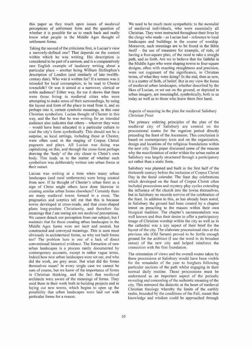
this paper as they touch upon issues of medieval perceptions of settlement form and the question of whether it is possible for us to reach back and really know what people in the Middle Ages thought of settlement fonns.
Taking the second of the criticisms first, is Lucian's view a narrowly-defined one? That depends on the context within which he was writing. His description is considered to be part of a sermon, and is a comparatively rare English example of laudatory writing about a particular place - another being William fitzStephen's description of London (and similarly of latc twclf'thcentury date). Who was it written for? If a sennon was it intended for local consumption, to be read 10 Chester townsfolk? Or was it aimed at a narrower, clerical or noble audience? Either way, for me it shows that there were those living in medieval cities who were attempting to make sense of their surroundings, by using the layout and form of the place to read from it, and so perhaps into it, certain symbolic meanings, in this case Christian symbolism. Lucian thought of Chester in this way, and the fact that he was writing for an intended audience also indicates that others - whoever they were - would have been educated in a particular culture to read the city 's fonn symbolically. This should not be a surprise, as local settings, including those at Chester, were often used in the staging of Corpus Chri sti pageants and plays. All Lucian was doing was capitalizing on this, and through the cross-fonn perhaps drawing the 'body' of the city closer to Christ's own body. This leads us to the matter of whether such symbolism was deliberately written into urban fonns at their outset.
Lucian was writ ing at a time when many urban landscapes (and rural settlements) were being created from new. If hc thought of Chester's urban foml as a sign of Christ might others have done li kewise in creating sim ilar urban fonns elsewhere? Certainly there are many medieval towns formed in a cross. The pragmatics and sceptics tell me that this is because towns developed at cross-roads, and that cross-shaped plans long-predate Christianity, and therefore the meanings that / am seeing are not medieval perceptions. Wc cannot dctach our perception from our subject, but I maintain that for those creating urban landscapes in the Middle Agcs fonns were not inert and neutral, but constructed and conveyed meanings. This is seen most obviously in architectural fonns , so why not built forms too? The problem here is onc of a lack of direct conventional historical evidence. The fonnation of new urban landscapes is a process rarely documented by contemporary accounts, except in rather vague termS. Indeed how new urban landscapes were set out, and who did the work, are grey areas. But what did the forms themselves mean? In every single case wc cannot be sure of course, but we know of the importance of fonns in Christian th inking, and the fact that medieval architects were aware of the meanings of fonns. They uscd them in their work both in building projects and in laying out new towns, which begins to open up the possibility that urban landscapes were laid out with particular forms for a reason.
10
We need to be much more sympathetic to the menlalite of medieval individuals, who were essentially all Christian. They were instructed throughout their lives by the clergy who made - as Lucian had - rcference to local landscapes and buildings in the course of worship. Moreover, such meanings are to be found in the Bible itself - the use of measures for example, of rods, of having a four-square plan, of the need to take a straight path, and so forth. Are we to believe that the fa ithful in the Middle Ages who were shaping towns to four-square designs, often with exacting straightness and precision, were not cognisant of the significance, in Christian terms, of what they were doing? In the end, then as now, it is a matter of faith, of belief. But in my view the forms of medieval urban landscapes, whether described by the likes of Lucian, or set out on the ground, or depicted in urban imagery, are meaningful, symbolically, both to us today as well as to those who knew them first hand.
Aspects of meaning in the plan for medieval Salisbury Christian Frost
The primary ordering principles of the plan of the medieval city of Sa li sbury arc centred on the processional routes for the rogation period directly preceding the feast of the Ascension. This conclusion is based on contemporary texts and on the organization, design and locations of the rel igious foundations within the ncw city. This paper discussed some of the reasons why the manifestation of order within the urban realm at Salisbury was largely structured through a participatory act rathcr than a static form.
Salisbury was planned and built in the first half of the thirteenth century before the inelusion of Corpus Christi Day in the festal calendar. The feas t day celebrations which developed on the feast of Corpus Christi often included processions and mystery play cycles extend ing the influence of the church into the towns themselves, but in Salisbury no records survive of the celebration of the feast. In addition to this, as has already been noted, in Salisbury the ground had been creatcd by a chapter intent on preaching to the masses wi thin their own liturgical tradition. The chapter's sacramcntalism was wcll known and thus their desire to offer a partici patory image of Christian worship within the city as well as in the cathedral was a key aspect of their brief for the layout of the city. The elaborate processional rites at the previous site (Old Sarum) proved to be fertile enough ground for the architect (1 use the word in its broadest sense) of the new city and helped reinforce the connection with the fi rst foundation.
The orientation of views and the overall routes taken by these processions at Salisbury would have becn visible for the remainder of the year to burghers following particular sections of the path whilst engaging in thei r nonnal daily routine. These processions must be understood as an important aspect of the periodic revealing and concealing of the authentic mean ing of the city. This mirrored the dialectic at the heart of medieval Christian theology whereby the li mits of the earthly realm, boundcd by the conditions of the Fall, meant that knowledge and wisdom could be approached through

experience, but never absolutely attained. Any manifestation of order in the structure or layout of the city was, therefore, nOI designcd to signal God's presence, but to reprcsent aspe<:ts of the relationship between idea and reality. between the world and our understanding of it. Issues of both time and place were addressed within the city, and were perhaps most clearly revealed in processions which utilized themes relating to origins. repetition and eterni ty through the experience of a par1icular place.
In Salisbury the rogationtide processions engaged in a threefold mapping of the city. This type of action was also enacted in normal circumstances in the consecration rites of a church, which were also processional. Thc yearly rogation rituals imitated the 'original act' of consecration which expressed man's desire to communicate with that which is beyond. Gadamer describes this mechanism thus:
.. the essence of the imitation consists precisely in lhe recognition of the represented 10 the representation ... When I recognise someone or something, what 1 see is freed from the contingency of this or that moment of time. For what imitation reveals is preciscly the real essence of the thing.'
The revelation that one of the most important, if not the most impor1ant, cathedral and city foundation of the thineenth century was organized around processions suggest that spatial and temporal renewal may have been the primary factors in the medieval understanding of the order of towns of this period. As such it may be more fiuing for us to accept that the symbolic order of Salisbury (and other cities) was revealed by the choreography of the movement through the city rather than through its fonn.
Landscape space Placing the dead in lale mcdieval culture Stephen Kel/y
Concerning the ghost of Rober1, son of Rober1 Botleby of Kilburn. seized in a cemetery (circa 1400):
'Remember that the said Rober1 junior died and was buried in the cemetery. But it was his custom to go for1h from his grave at night and disturb and frighten the villagers; the dogs in the village followed behind him barking ferocious ly. Finally, the young men of the village were talking together and they proposed to capture him any way they could. They met at the cemetery. but at the sight of him they fled. except for two of them. Of these, Roben Foxton grabbed him as he going out of the cemetery and put him on the churchstile. His friend shouted bravely. "Hold him tight till I get there." Rober1 yelled back. "Run to the parish priest who can conjure him. For God willing. what I've got. I'll hold till the priest gels here." His friend hurned swiftly to the parish priest and he came and conjured Ihe ghost in thc name of the holy Trinity and by the power of Jesus Christ to tell them what they asked. So conjured. the ghost slar1ed speaking not with his tongue but from deep within his guts, echoing like an empty barrel. He confessed his various sins. After the priest heard these, he gave him absolution. But he cautioned
J J
the two young men who had captured the ghost not to reveal any par1 of his confession. Afterwards he left the ghost to rest in peace. God willing.
BUI it is said that before his absolution, he would stand at the doors and windows of houses, and beneath their walls and par1itions as if listening. perhaps waiting for someone to come Oul and conjure him to help him in his need ... •
(James. "Twelve Medieval Ghost Stories." English Historical Review 37 (1922). 413 - 22.)
The division, organization and management of space ar1iculates relationships not just between living human beings - neighbours. traders. enemies. and foreigners -but also between the non-human and, of course, the dead. While the definition and location of the 11011-
human is becoming an increasingly central preoccupation of philosophers and theorists in the humaniti es, the role. of the dead in the construction of place has received little attention until very recently. If medieval scholarship has provided us with an extensive understanding of the 'culturcs of death' in the later Middle Ages. it has not satisfactorily accounted for how perceptions of the locations of the dead contribute to the larger medieval projcct of defining space, community and identity for those who live on.
This paper explored what happens to the perception of landscape when the dead arc thought to disturb il. Medieval ghost stories have an almost obsessive concern with the places in which apparitions are witnessed. The extent to which the reappearing dead enjoy a disturbing mobility - the extent to which they are forever in transit, moving between houses and streets in villages, across fields, along roads - suggests that the issue of settlement is itself fraught with myriad forms of anxiety.
High-status landscapes and designed space Robert Uddiard
The term 'medieval designed landscape ' is now a familiar one to landscape historians and has become shonhand for describing a par1icular 'type' of medieval settlement form, the immediate environs of high-status residences. These residential surroundings were. il has been suggested. provided with features. which although found elsewhere in the medieval landscape. when placed next 10 imponant buildings assumed a greater significance. Thus the provision of gardens, ponds and parkland around castles and palaces in par1icular, together with the apparent care with which they werc integrated with residential accommodation. suggests an aesthetic appreciation of the- landscape of some imponance - hence the impor1ation of a term used in the study of post-medieval parks and gardens. The use of the tenn 'designed landscape' is also judged to be appropriate when the often elaborale access arrangements to the great house are considered, par1icularly where emphasis seems to have been placed on 'viewing' the residence at key points in the approach.
Despite the popularity of the term 'designed landscape' . it is argued here that when used 10 describe specific

spatial contexts in the Middle Ages it suffers from a lack of precision. This paper also suggested that its application to the medieval landscape is questionable, or at the very least requires qualification. The sum of much recent work on this topic has been to demonstrate that medieval elites wished their residences to look magnificent, and that this concern extended to the wider environs. Whether Ihis concern was a manifestation of proto-renaissance attitudes to the countryside is perhaps more open to debate.
This paper raised the following concerns over the idea of medieval landscape 'design', which includes elements of self criticism:
Firstly, the tenn has been imported from the postmedieval period where what we would call 'design' is clearly apparent from a wide range of sources. The lenn 'design ' is of sixteenth --century origin and derives from a Dutch word meaning '10 mark out'. The closest medieval equivalent 1 have managed to find is the Latin 'composilas', which is normally translated as 'ordered' or 'regular '. While Ihis might indeed be compatible with design, it might just as easily refer to a well-run estate and need not, therefore, be concerned with aesthetics.
Secondly, the evidence that is oftcn invoked to support acsthetic intent is frequently non-archaeological in scope and open to many differenl interpretations. Gerald of Wales' famous description of Manorbier castle clearly depicts a pleasant spot, but not necessarily one that has been specifically engineered with aesthetics in mind. Equally, the much cherry-picked account of the surroundings ofSycharth in Clwyd is simply one section of a long poem in which barns, enclosed ficlds and haystacks are eulogized - landscape features to which we would not readily ascribe an aesthetic significance.
Thirdly, despitc the author of this paper being responsible for putting the case for an aesthetic significance 10 high-starus landscapes, therc is limited archaeological evidence for landscape design - at least as we see it in its post-medieval manifestations. Relatively few detailed examples can be specifically dated to the Middle Ages which demonstrate the kind of visual manipulation associated with thc post-medieval period. Onc such example was one ofthc first to be recognizcd, at Somersham in Cambridgeshire, where a line of ponds appears to have been arranged in order 10 correct the line of perspective when viewed from a specific angle. In addition the location of park pales appears to have been governed by a concern to give the impression of greater size. While such sites have been used to identify designed landscapes it is fair to say that thcre is no clear theoretical underpinning to their significance, other than the fact that they represent 'design'. Where a deer park pale disappears over the horizon it is judged to be 'designed' to make the park look bigger, when all of the pale is clearly visible it is ' designed' to give the viewer the sense that the area is enclosed and controlled.
Fourthly, recent studies have highlighted the difficulty of recognizing design from archaeological evidence, which raises the question of what can be tenned the 'design threshold' - the level at which those features such as ponds and moats cease to be part of the
12
vernacular landscape of the manorial coumryside and instead part of a more specific landscape of seigneurial vocabulary. It remains difficult, if not impossible, to distinguish what makes a landscape such as that at the royal palace at Clarendon 'designed', yet the small fief at Lavendon in Buckinghamshire seemingly not so, other than the scale of the enterprise. Such a problem would not ex.ist if the label designed landscape is discarded and the two are simply considered as variations on a similar theme of emphasizing control of resources.
It might be the case that, despite some inherent difficulties of definition, the tenn 'designed landscape' remains a useful one in the study of high-status residences of the Middle Ages. At present the term requires clarification.
General discussion
A commonly agreed meaning of such terms as ' landscape' would help future discussions. It was important to attempt joined-up thinking so that those concerned with medieval landscapes and settlements were aware of the work of prehistorians (for example) and were willing to learn from neglected specialisms, such as literature.
Workshop 2: Working and sharing
held at Edinburgh, 20 April 2007
Transhumance, pasture and landscapes
The shifting balance of hunting forest, transhumance. pasture and outfield in medieval and post-medieval Aberdeenshire. Piers Dixon
This paper about the relationships between outfields, grazing and cultivation was based on systematic field work in Donside and Deeside by the Royal Commission on the Ancient and Historical Monumems of Scotland, using documents, archaeology and palaeoenvironmental work. The various inter-related themes arising from the study of Donside (Aberdeenshire) are forest reserves, shielings and commonties; dcer dykes, outfield folds and crofts; and the disappearance of lowland shielings. The main aim is to identify the relationships befWcen forests and shielings; crofts, outfield cnclosures and head dykes; and lastly the expansion of settlement and the disappearance of shielings. The various kinds of boundaries, crofts and settlements that existed in Aberdeenshire can be identified and their relationship discussed. Field survey data enables a better understanding of the origin of different types of settlements, whereas documentary analysis suggests that by the twelfth century there was already an established settlement landscape with detached portions of parishes in highland areas. Grants of free forest were made to monasteries and private landowners in lowland Aberdeenshire during the thirteenth and fourteenth centuries, as at Fintray and Tarves. There is a strong possibility that these lands were subsequently enclosed for fanning, but no physical evidence has survived. They were defined areas, and the documented boundaries of Cordyce forest, for example, can still be traced

topographically. In the early sixteenth century. the crown was granting lands in highland areas in free forest, such as the forest of Corcarff to Lord Elphinstone in 1507. This forest contained no shielings, but revealed a postmedieval settlement expansion, visible as buildings with turf-covered walls. Shielings, as in the core of the forest of Mar, were excluded, but were to be found in neighbouring glens. In Gleneman, there was also documental)' and archaeological evidence for settlement expansion during the sixteenth and seventeenth centuries, and for the enclosure of outfield. This locality had been treeless since 230 AD according to palaeoenvironmental data and it is suggested that it had been used mainly for grazing with some spatial management of grazing, possibly enclosure, in the postmedieval period. On the face of it, this data was indicating the same thing as the archaeological and documentary evidence for the post-medieval period. Can the presence of 'Shiel ' place-names in lowland areas of Aberdeenshire be an indication of shieli ng grounds transformed to fanns during this same period of expansion? The study of the shifting balance of hunting forest, transhumance, pasture and outfield in medieval and post-medieval Aberdeenshire should be extended further and a comparative study with other parts of Scotland might help us to grasp more precisely when changing patterns occurred and under what circumstances.
Medieval marginal landscapes: regions and perceptions Sam Turner
The language and concepts used in the study of landscape varies from one discipline 10 another. For instance, cultural geographers (whose work has dominated much recent landscape scholarship) and landscape historians have often used conflicting definilions of 'landscape' in their work. While many cu ltural geographers claim that landscape is best understood as a way of seeing through a cultural lens, most landscape historians have viewed it as a neutral reflection of past social realities. Such differences can lead to misunderstanding.
The idea of marginality is a case in point. Marginality is a relat ive construct, varying according to context. Archaeologists writ ing about both prehistoric and historic periods have commonly made a range of assumptions about margins and marginality, and their discussions have often categorized marginality as ecological , economic, or socio-political. Whilst it has been common to privilege one or other of these categories in order to explain how societies worked, they are rarely mutual1y exclusive. In addition, since marginality is relative, virtually any group might be made marginal depending on people's perspectives in the past or present. Sometimes marginality can be imposed (economically or politically), and sometimes even actively chosen.
When studying places that are often considered as marginal, scholars from various disciplines should bear in mind the specific meanings those places had for the inhabitants and examine them within an appropriate historical, cultural and political context.
13
A fragment of medieval landscape near Strata Florida, Ceredigion Andrew Fleming
The 'home-grange' medieval and post-medieval site of Penardd belonged to the Cistercian abbey of Strata Florida, Ceredigion. Founded in 1164 by Robert Fitz Stephen, the abbey was relocated two miles north-east of its original site between e. 11 80 and 1200 and its dissolution re<:orded in 1539. A group of medieval fanns belonging to Strata Florida has recently been excavated. The site offers natural resources, such as woodlands, rivers and a pond, allowing the monastic community to develop a mixed economy based on husbandry and fishing. The farms presented similarities regarding building layout and structure. The Penarddoppa fann had enclosed buildings facing each other, separated by a corridor that was thought to be an animal entrance from the medieval period. The Penardscubo fann's buildings were not enclosed..and no 'animal' corridor has been found. This structure seems to be of a later period. At Troody, buildings are not parallel. four entrances are present, and there is both a back garden and a pond within the enclosure. Eighteenth- and nineteenth-century enclosures are clearly visible. There is also a sheepcote. The next step would be to assess the relationships between the abbey and the medieval farms. Although historians' and archaeologists' interpretations regarding monastic landscape vary, collaboration between them can offer a better comprehension of the site and its landuse by this medieval community.
Just some huts in the hills ? Shielings and upland pasture on Ben Lawers (Perthshire) Stel'e Boyle
On Ben Lawef1'i near Loch Tay an interdisciplinary approach to landscape analysis is made possible by the survival of both archaeological and documentary evidence. Eight shieling grounds can be identifi ed on five different sites. where tenants grazed their livestock during a period of six weeks each spring/summer. An eighteenth-century survcy identified 450 huts. the structures of which were either in stone and rectangular, or in turf and circular. The turf circu lar structures are the earliest examples while the stone rectangular huts are from a later period. There are in total 1200 mapped structures related to peat-cutting. During the sixteenth century, tenants were responsible for the maintenance of dykes and structures. Shieling grazing was regulated: from I May to 8 June, livestock could graze on ' low shieling' i.e. above the head-dykes and from 8 June onwards. it was extended 10 'high shielings' or upland pastures/shielings. Furthermore, in order to avoid soil erosion and to improve grazing, tenants also had to alternate shielings every five years. Recent excavations by the University of Glasgow have shown that during the thirteenth and fourteenth centuries there was an increase in grassland that could have been promoted by 'commercialization' of grazing grounds for milking cattle. In order 10 understand better the use of shielings and upland pastures, the relationships between ' Iow' and 'high' shielings should be addressed within an interdisciplinary framework of historians, archaeologists and palaeoenvironmentalists.

Discussion Richard Oram and others.
Three issues needed 10 be addressed. The first concerned the language used by the various disciplines involved in environmental history and the consequent potential for misunderstanding between these disciplines. The second regards our perception and understanding of the landscape, as well as the narure of its exploitation by past generations. The third arises from the concept of marginality. The interdiscipl inary character of environmenlai history requires a common language that will enable the di sc iplines involved to communicate with one another. Participants discussed the cultural and socio-economic characteristics of the landscape in tcnns of ideals and rights attached to it. For instance, rented shielings for milking cattle and pasture brought incomes and were worth morc than arable land, whereas nowadays arable lands are often considered more valuable than upland pastures. In England, peat-cutting and the cutting of wood were highly controlled by owners and peat was used in ordcr to preserve timber for deer forest, whereas in Scotland legislation regulated peat-culling from the fifteen th century until the eighteenth when it began to be commercially exploited. This firs t session demonstrated two importanl points: the totality of the landscape as a resource and that shiclings represented an economic asset that must be further investigated.
Woods and Pastures
Reconstructing medieval woodland: linking resource access 10 vcgetation character Philip Sallsum
The paper examined the long-tenn exploitation of woodland resources from c.lOOO to c.1700 and the eITect of such land-use on the character of the vegetation. By exploring documentary records on Campbelllands in the west coast of Scot land, and especially the Lochaweside area, it has been possible to reconstruct woodland management and exploitation throughout the medieval period. Four main uses of woodland for cuning wood, bark peeling, herbivore grazing (domestic livestock) and planting can be identified. Wood was cut for small poles and rods for house and boat building but also for smaller items such as baskets. Woodland management was essential for a regular wood harvest. Bark peeling for tanning was another use, although it was a criminal offence to pecl bark without pennissioTl from the owner. Cattle grazing in woodland and collection of scrub used for hedging material, in order to enclose and protect woods, arc recorded activities during this period. It seems that planting was developed at a later period. Among Ihe most common species were oak, birch and alder. From c. IOOO to c. I 700, the owners of woodlands achieved sustainability through the development of woodland management.
Environmental and socio-economic drivers behind medieval upland land-use Althea L. DlII'ies
This paper noted that thc paucity of both high-resolution
14
pollen sequences and integrated, detailed srudies impede a full appraisal of the Scottish medieval environment. Thinking about changes in upland agriculture has been dominated by environmentally detcmlinistic models (for example. invoking the Litlle Ice Age), both in prehistory and in the Middle Ages. Documentary evidence indicates the extent 10 which socio-economic incentives shaped upland land use in the historical period. Approaches which focus exclusively either on environment or on economic factors are inadequate for understanding the dynamics of medieval land use. Ecological changcs could have been induced by developments in the summer grazing regime, and palynologists have tended to fit pollen evidencc into known historica l events. This paper applicd a palaeoecologicaJ approach (pollen-based) in order to examine forces behind environmental change betwccn the thirteenth and the seventeenth centuries, using two case studies: Wether Hill in Northumberland and Leadour in Perthshire. Dating evidence in Wether Hill is rather poor. Monastic sheep grazing during the twelfth and thirteenth centuries, the fonnation of nucleated villagcs by Ihc twelfth century, and population growth, together with the development of upland cultivation, drove environmental changes in the area. From the thineenth to the seventeenth century, warfare and disease ended the population expansion and the area witnessed agricultural recession with the enclosure and conversion of some arable to pasture. In Leadour, Perth shire, it seems that since the fourtccnth century land management was the most important force behind environmental changes. In c. 1400, birch, ash, rowan and wi llow grew in the fi elds but although genera l regulations protected trees and tree planting fro m thc sixteenth century, barony court records show the destruction of woods for the years 1614-20. During the first half of the seventeenth century, it seems that, in response to cconomic and market incentives, owners cleared the remaining trees in order to gain more grazing and cultivation grounds at shielings. The transition from species-rich grassland to grass heath in Wether Hill was caused by a change in grazing regime, possibly to summer grazing, but thc lack of detailed shieling and hill grazing documentation in both England and Scotland leave the debate open. Funher enqu iry needs to be made in order to get a clcarer picture of environmental and socio-cconomic drivers behind upland land-use during thc medieval period.
Townships and managing forest resources in sixteenthcenrury Strathavon Alasdair Ross
A document of c. 1590 records a survey of the numbers and types of trees required by the townsh ips in twothirds of the parish of Kirkmichael (Banffshire), which fonned pan of thc lordship of Strathavon in the eastern Caimgomls. This survey detai led the Irces ncedcd to maintain all the township structures and everything else made from wood on an annual basis. The document was produced fo r a coun case, where the defendant had becn accused of destroying the forest resource by his superior lord. Thanks to this document, the judges agreed with

the defendant that he only used as many trees as were absolutely necessary and dismissed the prosecution case agai nst him. Th is would tend to imply that the information contained in this survey was not misleading. The survey lists every building in the fourteen townships, a 10lal of 361 structures (excluding shielings). To maintain all these buildings, in addition to the wooden ploughs, wooden utensils, and other tools needed for husbandry, required a total of around 120,000 birch, alder, hazel, aspen and rowan trees per annum. The local woodland must have been a carefully managed resource in order to sustain this annual requirement for wood products. Because the survey also lists every structure in the townships, it demonstrates that no two townships were identical in the numbers and types of buildings. An analysis of this data further indicates that these townships may have performed different functions within the economy of the whole lordship.
Changing perceptions of moorland and fell in medieval northern England Allgus Winchester
We do not know enough about the medieval perception of upland areas. Though thinly populated, they were of vital importance for the people as peat resources and pastures. Furthennore, the division of land by lords throughout the medieval period separated de facto the population of tenants and proprietors. Land was divided into 'open forest', where tenant settlements were allowed, and 'closed forest' , or hunting grounds. This could be compared to the difference between demesne and tenant land, with the maintenance of game stock in the 'closed' areas for the owner's use. The tenn 'forest' in the later Middle Ages often did little more than preserve the memory of hunting, while the valleys in particular were transformcd into demesne livestock farms, or werc opened to peasant colonisation. A useful comparison can be made between the settlement patterns in the Miterdale!Eskdale valleys and those situated in the Wasdale valley, the most mountainous of the Lake District valleys. During the fourteenth century, four vaccaries within the deer forest with seigneurial enclosures can be identified in Wasdale. Tenants had to pay for the right to graze their livestock, whereas in the Miterdale!Eskdale valleys, grazing was free of charge and tenants shared common rights over the lands. In addition, each fann was assigned a cow pasture. From the seventeenth century onwards, cow pastures were enclosed. Farming and settlement patterns were diverse: ' forests' were private/seigneurial lands where grazing was controlled. Tenants could take and feed their livestock by paying for the agistment. The manorial or hill wastes were public/community lands, which were not stinted and where tenants had common rights over grazmg.
Discussion Richard Tipping and others
Collaboration between disciplines was a key factor for the successful outcome of environmental history research, and Ihis requires us to address language and
15
definitions, so that scholars arc discussing the same issues. Our perception of the landscape plays a role in the assessment of past land-use, and our emotional responses should be balanced by critical analysis. Then we will better understand decision-making processes in the past. We should also explore the mentality and culture of the inhabitants because wc cannot isolate people from the landscape. Painting and literature from the Middle Ages would enable scholars to appreciate contemporary views of their environment. Place names should also be integrated into research because they are evidence of people's perception of their natural surroundings and their use/exploitat ion of natural resources.
Workshop 3: New people, new farll!s held at Exeter, 6 July 2007
Early medieval: the s~gnificance of migration for the medieval landscape Anglo-Saxon immigration and the early medieval landscape Nick Higham
Opinions popular in the early twentieth century envisaged England being populated in the fifth and sixth centuries almost entirely via mass migration from Denmark and western Germany, the so-called 'AngloSaxon Settlement'. Whole communities comprising numerous families were envisaged moving by boat across the North Sea and establishing a new and thoroughly 'Germanic' colony in Britain, cutting down the native forests to clear the land, found villages and plant fields. and cutting down as well, of course, any impertinent Britons who got in the way. Their cemeteries, their houses, their metalwork, their language and the world of ideas which they inhabited were all deemed to be quite separate from what had been Roman Britain, befitting a 'new' people.
This picture has been subjcct to considcrable change over the last half century, and has even been challenged to its core. Some of the processes of change visible in fifth-century Britain can already be identified in the late Roman period, as for example the shift away from stone and tile to timber in building. The landscape had already been long cleared by the time that Anglo-Saxon immigrants arrived. The population of Roman Britain is generally now estimated at some 3-4 million, so wholesale replacemcnt seems less probable. Pollen analysis suggests that there was no large-scale reversion to woodland; although regional variation occurred, the general trend was not to abandonment of land, but toward using it less intensively. The population did not collapse, and Roman-period field systems survived in much of eastern England.
Production of pottery, metalwork, coinage, masonry, sculpture and epigraphy collapsed around 400 AD, and towns went into terminal decl ine. There is still very little evidence for continuity at numerous sites, be they towns, villas or fanus. Gennanie types of material culture appear during the fifth century, and new architectural styles, represented by Sunken-Featured Buildi ngs

(SFBs) and hall-type buildings, which are often found on the same sites, sometimes over considerable areas. SFBs were clearly quite variable in size and complexity, their function is not entirely clear. Once thought to be dwellings, we now do not know whether or not they were all built for storage and/or work space (particularly for weaving). But their near ubiquity on early AngloSaxon settlements does imply a certain connection with the cultural shift that was occurring over the fifth century. The earliest insular SFBs are closely associated with late-Roman m.aterial culture, as at Monkton in eastern Kent, and these seem to be a style of building which should be associated with the north-western Roman frontier zones, rather than to the barbarian world. They may not be indicative of immigrants.
Hall-type buildings are similarly difficult to link very clearly with any particular ethnic group, occurring as they do in a thoroughly non-Germanic context at South Cadbury, for example, or Tatton Park. Yet these post-inhole or post-in-construction- trench buildings are easily paralleled by examples across the Germanic world in the fourth-sixth centuries. In England, they generally display a degree of organization, so for example they are often oriented on a common axis and spaced out in a comparatively similar way, with or without clusters of SFBs in attendance. Some fences have been identified dividing one from another, but they are not linked to new field systems, and they seem to have fitled in to preexisting systems of landscape exploitation. There is a dramatic contrast between Romano-British villas and the hall-style buildings which effectively replaced them, but whether this was due to migration or social changes is not known, and one explanation does not exclude the other.
A strong feature of the debate about hall-type buildings has been the assumption that they belong in a social structure without much hierarchy. Yet at Mucking, for example, although the halls are comparatively uniform in size, there is a considerable gradient in the grave goods in the two cemeteries, which may imply social distinclions. The finds, especially the metalwork, from West Stow, suggest a community not of equal fanners, but one embedded in a system of elite exchange.
Anothcr difficulty with the viey.r that these buildings were occupied ell masse by immigrants is the discontinuity between architectural styles in Gennany and England. Massive long houses were characteristic of such terpen seitlements as Feddersen Wierde across the third to fifth centuries, built to provide accommodation not only for people but livestock as well. Such longhouses are virtually non-ex.istent in England, though other aspects of the material culture are morc similar.
The earliest Middle Ages displays, therefore, a confusing pattern of continuity and discontinuity as regards its settlements. As regards material culture, such items as styles of clothing and decoration, pottcry and metalwork all bear the stamp of Anglo-Saxon manufacture, although these were not just lifted from anyone settlement or locality in Germany and re-located in England. We need to think of early Anglo-Saxon
16
England as neither entirely immigrant in origin, nor entirely a local and insular development. but as a society which evolved out of processes of contact and social transfonnations which resulted in very different types of settlements than those found in either the Roman or the Gennanic worlds.
Reflections on the early medieval landscape of the Vale of Pickering Dominic Pow/es/and
Work on the Vale of Pickering has shown that the most cffective research tools are extensive excavation, aerial photography and large-scale remote sensing. The land had been cleared in the Bronze Age, and intensively settled with Iron Age and Romano-British ladder settlements. Five large middle Saxon settlements with many halls and SFBs were sited near to the ladder settlement. The cemetery was located near a still -visible prehistoric henge. Within the settlement, there were separate zones of housing, industry and crop processing. The occupation in 400-900 AD was just as dense as in the late Roman period, so there was no evidence for a dip in population. There was no 'shuffle' in settlement because the medieval vi llages had grown from early settlements, though ridge and furrow from c. 900 extended over the fonner settlement sites. Many churches were already in existence in the vale villages, showing the antiquity of the settlements and the wealth of society. Settlement continuity was more important than linguistic and cultural change. The inhabitants may have thought of themselves as Deirans, but they were natives who had always been there.
Discussion Bob Higham and others
Regional differences means that the experience of migration varied. In the south-west the British and Anglo-Saxons who encountered each other in the sixth and seventh centuries had been changed by cultural contact and other developments since 400. The sense of identity everywhere was more likely to be regional and tribal, rather than ethnic, and that sense of identity changed through time.
Late medieval: the clash of cultures Fortifications in twelfth- and early thirteenth-century Ireland Kieran 0 'Conor
Our knowledge of the development of castles built by the Anglo·Nonnans in Ireland in the years after 1169 is now quite detailed in comparison to what we know about contemporary fortresses built by Gaelic Irish princes and lords. Two aspects of Anglo-Nonnan castles need to be studied in more detail. Firstly, the long-held view in [reland that mottes were ideal in an invasion context because they could be quickly erected needs 10 be questioned in thc light of recent research. There is little concrete evidence for motle building across Leinster and Meath during the early to mid 11 70s. The first-large scale building of mottes in Ireland seems to

have occurred in the early 1180s. The actual places used during the invasion period by the Anglo-Normans consist of a variety of different forms of fortification, including large ringworks, walled Hibemo-Norse towns and embanked and palisaded Irish monastic lowns. These fortifications have one thing in common, despite their differences. They are large enough to accommodate a field force bent on conquest - something that even a large motte and bailey could not have done.
Secondly, historians often bemoan the fact that there are few documents for the social and economic life of the Anglo-Norman colony in Ireland during its first century. Archaeology could fill this gap by the excavation of an important motte castle, for example, which would provide much-needed infonnation about the initial colonization period, and the developing manorial economy and rural life.
There is relatively little evidence for European-style masonry and timber castles being built by Irish dynasts during this whole period. Most castles built in Ireland between the twelfth century and c. 1380 were constructed by the Anglo-Normans or their descendants. Irish princes and lords demonstrated their high status in different ways. Early medieval settlement forms such as crannogs, cashels and less clearly earthen ringfons continued to be used by the Irish into the high medieval period and beyond. The difficulty here lies in being able to identify which crannogs and ringforts continued to be occupied into the twelfth century and beyond without costly excavation.
Princely fonresses that arc mentioned in the pre-Norman annals are called cais/ein or caisfeoil. It has been argued, in view of the increase in warfare in late cleventh- and twelfth-cenrury Ireland and the centralizing tendency of various provincial kings, that these sites represent something new in terms of fortification and were possibly a pre-1169 Irish importation of Norman-type castles from England and Wales. Some attempt has been made to suggest that these cais/ein or caisteoi/ sites were moltes despite the fact that no evidence for such castles exists in the vicinity of these places. Certainly one site mentioned as a caislell in the annals appears to have been a crannog. Some twelfth-century caislidll or caisdeoil sites in Connacht consist of what can be described as impressive cashels whose extra-high walls were built ofmortared stone blocks rather than drystone ones. No battlements, arrow-loops, gatehouses or stone keeps exist at these sites - they are simply very impressive cashcls. These sites do represent an increase in defensibility over earlier and indeed contemporary cashels and ringforts and presumably this is why new words are used to describe them. Yet these sites are still demonstrably with in the native tradition of fortification.
Scholars interested in reconstructing the landscape of the parts of Ireland that remained in some way under the control of Iri sh dynasts in the twelfth-fourteenth centuries must realize that there was much continuity in terms of settlement type from the preceding early medieval period.
17
'Mountainous and rocky and almost wholly inarable': conflicting cultural perceptions of landscape in twelfthand thirteenth-century Scotland Richard Oram
Conflicting perceptions of wealth, value, and economic development, medieval and modem, have together served to produce a badly skewed view of the socioeconomic systems and settlement patterns of medieval Scotland. Uncritical acceptance of models developed for lowland England, further coloured by the postImprovement view of the supremacy of arable regimes over pastoral, has given rise to an image of agriculture in medieval Scotland as underdeveloped or primitive. This image has been reinforced by the traditional historiography of twelfth- and thirteenth-century Scotland, which presents the period as onc characterized by cultural changes - social, economic, technological and artistic - brought about by the settlement of colonists of diverse backgrounds but generically labelled as 'Anglo-Norman'. Settler society and the cultural baggage which they imported became the norm against which the indigenous cultures of medieval Scotland have been measured.
Onc modem perception of conflict between a dominant colonial culture supported by the Scottish crown and a sullenly conservative Gaelic nobility is grounded in the language of the medieval records. Produced by and for that same alien cultural group, the chronicles and charters provide prima facie evidence for a collision between native and newcomer that is viewed commonly as a clash of culrures and ideas rather than politically motivated conflict. Wrapped in the language of Frankish cultural superiority and projecting the propagandist claims of the kings of Scots to mastery of all of what is now recognized as Scotland, thesc documents present conflict in terms of civilization and legitimate authority ranged against barbarity and rebellion, of an innovating 'feudalizing' monarchy against a retrograde, conservative and xenophobic Gaelic nobili ty, rather Ihan as a civil war fought for possession oflhe crown. It is a representation which has helped to entrench a view of Scotland as a land caught betwecn economic development and social or cultural backwardness, but this perception owes more to nineteenth-century socioeconomic agendas than to the realities of twell'th- and thirteenth-century Scotland.
A growing body of research is emphasizi ng thc continuation of quite different perceptions of relative value in types of land between native and newcomer through the twelfth and thirteenth centuries and beyond. While some colon ists may have gravitated towards zones of arable potential and preferred settlement as lords over peasant communities practising a mode of agricultural exploitation with which they could mosl readily identify, Gaelic lords maintained their interest in the uplands and a style of lordship supported by a primarily meat- and dairy-producing pastoral regime. Post-medieval perceptions of the backwardness of the Gaelic cultural zones of Scotland, particularly in the seventeenth and eighteenth centuries, where 'improved' agricultural capacity was used as the measure of economic potential, have servcd to entrench the

medieval image of an economic dichotomy expressed purely in tenns of arable capability.
Discussion Oliver Creighton and others
Castles fonned part of the settlement pattern, and is some contexts, such as medieval Ireland, they occupied an especially important place. Castles were perceived differently in different cultures, and changed over time. Comparisons were made between the castle dependent settlements in Britain and the phenomenon of incastellamento in the Mediterranean world. The use of literary and artistic sources were debated, and caution urged in their use without careful consideration of the circumstances of their creation.
The colonization of upla nd Negotiating the settlement of anc ient commons in medieval Cornwall Peter Herring
Medieval lives were enjoyed and actions perfonned in complex inherited places, shaped to varying degrees by prehistoric and Roman-period people.
Cornish commons had a particularly deep history, probably having been used as such since the mid second millennium BC, extended and reorganized in the early fi rst millennium BC, and then gradually divided and managed on more local levels in later prehistory, and the Romano-Cornish and post-Roman periods. Throughout it seems that people took flocks and herds to the commons in the summer months, practising a fonn of transhumance. They developed relationships with worlds in which there were numerous remains from earl ier prehistoric periods - standing stones, circles, rows, cairns, etc - as well as the natural monuments like tors, pools, springs and marshes around which culturally meaningful associations developed.
When lords encouraged settlement of these uplands in the early second millennium AD, they were therefore not si mply comprom ising the established rights of commoners, gradually reducing summer grazing and fucl grounds. They were also disturbing individual and communal relationships with a familiar inherited world.
Most later medieval settlements on Bodmin Moor were small ham lets (2-6 households) established within ringfenced townlands in which hamlet-level 'commons' were separated from the manorial common beyond. Abandoned hamlets survive well on Bodmin Moor. Fannsteads consisting of longhouses, individually held cowhouses, outbuildings, yards and mowhays were carefully arranged [0 be away from thc communally defined and used townplace, reflecting what was probably a universal tcnsion between the basic economic and social unit, the household, and the unit of agricultural cooperation and action, the hamlet.
Prehistorians have for some time been studying how memories, meaning and communal!y understood symbols framed and influenced action in Neolithic, Bronze Age and Iron Age Britain. Garden historians and
18
archaeologists do the same for post-medieval ornamental landscapes and a small industry considers how our own lives are guided by a plethora of often conflicting symbols and messages.
For the medieval period good recent archaeological work shows how churches, castles, deer parks and early gardens etc were designed to be approached and appreciated in subtle ways to reveal similar cultural infonnation.
An experiential archaeology of medieval peasant life, however, has yet to be fully developed. As a result, our interpretive models, still document-led, continue to place medieval peasants within controlled and functionalist worlds, denying them freedoms and agency as severely as any feudal lord ever did. And yet we know these people moved around, and left undisturbed many prehistoric monuments, curatcd them even. This visible, experienced and challenging inheritance rrom a distant past must have been discussed, mythologized and so negotiated, just as modem archaeologists help our own society cope with the very same monuments. We also know, perhaps too well, that medieval people carried with them structured but nevertheless personal views of power relations, sensitive appreciations of property and tenure, problematic schemes of Christian ideologies, and as we have seen in the hamlets, tense awareness of distinctions between the individual and the communal.
Daily or occasional encounters with material symbols or reminders of this problematized world must have reinforced or revised relationships, for instance sett ing off oppositional thoughts: owned/held; ind ividua l/ communal; mine/his/ours; inherited/altered; cenainl uncertain; safe/risky, etc. All of these must surely have influenced ways of experiencing, being, pondering and doing. We know from court rolls that medieval peasants certainly acted, often against convention, custom and law. They were not so very constrained. On Bodmin Moor we may see the apparently bottom-up, locallydetennined reorganizations of hamlets and strip field systems, that left the individual rather than the communal dominant, as being a direct result of tensions between the two, tensions that had been rcinforccd virtually every waking moment.
So few of the processes that preh istorians study are now considered to have been unmediated by personal agency that functionalist economic and soc ial factors are rarely invoked as the sole explanations of change. This may prove to be less the case in medieval Britain wherc commercial and political forces were probably stronger. But an experiential medieval archaeology will surely not only enrich representations of peasant lives, but also open up access to a much wider range of plausible causes of change.
Colonizing the uplands of Wales: changing perceptions Bob Silvester
Wales and its rural medieval settlement docs not slot readily into the themes of POMLAS, the reason being that the study has not advanced as fast nor as fa r as in England, though we are now probably at the end of an
era, and one would like to think at the beginning of a new one, with the publication of Cadw's Lost Farmsteads, and as importantly the compilation of the data that infonned the various papers within it.
Much of the infonnation on medieval rural settlement available to us comes from the uplands, and in one respect this is, perhaps, not entirely surprising as in the medieval period Wales exhibited vast tracts of unenclosed upland. While no reliable figures exist, in 1873 5.2 per cent of England as a whole was classed as common land, in Wales it was 13.8 per cent. And it was not just about the great wastes extending along the central mountainous spine of Wales, but numerous smaller commons in rural areas and close to towns, many of which disappeared as late as the eighteenth century. Neither the large upland commons nor their lower land counterparts were marginal, except in tenns of lowland agricultural exploitation. They were lands to be used, providing a range of resources which played their part in an integrated agrarian system that had developed over hundreds of years without any fundamental political interruptions; not only grazing grounds, but also fuel, fodder, bedding materials, and water supplies.
Of the two elements that constitute the use of the medieval uplands - pennanent settlement and seasonal activity - only the fonner can be classed as a colonization movement, and generally it seems to have been on a small scale. Settlement growth implies population growth, the scale of which has yet to be adequately revealed fo r Wales. The evidence for medieval fanus and fields extending onto the waste is not as widespread as might be assumed, rather it is localized. The Berwyn, still the upland with the best evidence, does not suggest that this was organized or controlled settlement, but opportunistic land intake, captured for agriculture as and when it was required. The waste thus provided an exploitable resource within striking distance of the core settlement in the valley below, and if there was manorial control, it is not apparent.
Seasonal use of the waste ought to be straightforward, but is not. The associated settlements are the most widely spread elements of the medieval uplands, the ha/od a part of a well-organized agrarian system, but arguably they remain the least understood. Existing perceptions of the use of the waste for seasonal grazing range widely, and quite a number of issues remain to be clarified, but what we can say is that it is not a colonizing ntovement. The uplands were not 'new' landscapes in the sense that the wetlands were, but have a long history, which perhaps originated in the prehistoric period, and was certainly in place before the eighth century AD. It has been assumed that the Welsh were completely given over to seasonal grazing, with those who tended the herds travelling long distances into the hi lls in what might be considered classic transhumant fashion. Instead we should probably see a more pragmatic method of ensuring that the home fann could still be observed while the stock were grazed for the summer on the hills. This would seem to be the explanation for the presence of ha/od sites around the
19
edges of the commons. There seems to be little documentary evidence for this seasonal activity, and where it does exist it may be that the circumstances were atypical, as with seasonal usage of the Forest of Snowdon.
Within the compass of POMLAS the detailed area study may appear rather old-fashioned, but in Wales it is argued that there is a still an important place for it, not least because so few such studies have been conducted. The upper Vyrnwy valley is cited because it is an area where much systematic fieldwork has been completed, and where the balance between pennanent agricultural settlements and seasonal hill settlements can be readily observed and assessed.
Discussion fan Whyte and others
The rich, varied and complicated nature of the uplands needs to be emphasized. We need to know more about the colonizers, as they may have been newcomers, or local people expanding their holdings. They may not have been propelled by population pressure. Uplands were divided, but are the boundaries visible? Cairn lines and watersheds could have defined the edges of territories. In analysing transhumance, we should not underestimate the reluctance of people to move further than was necessary to find grazing. Transhumance had an important social dimension, in that women often occupied the shielings to work al dairying. Part-time industry was also practised by the inhabitants of the uplands, both from the pennanent settlements and Ihe seasonally settlements.
The colonization of wetlands Perceptions and usage of marsh land after Guthlac and Postan Mark Gardiner
Wetlands, perhaps more than any Olher type of landscape in Britain, have evoked a wide variety of perceptions. In literature, for example, the Thames marshes are used to dramatic effect in the opening chapters of Dickens' Great Expectations as a liminal place haunted by the escaped convict, Magwitch. The Fens, in a much earlier
Figure 2: Mark Gardiner: the perception and use 0/ medievalmarshland.

evocation of marshland, Felix's Life of Sf Guthlac, are similarly used as a forsaken place haunted by demons which needed to be tamed by the saintly figure. Archaeologists and historians too have not been dispassionate in their appraisal of marsh land. Often they have viewed it as watery waste, sometimes as an environment with a rich wildlife of fish and fowl to be exploited by hunters, but almost always they have praised the extraordinary late medieval works which tamed the floods and transfonned the marsh into fertile farmland.
The more recent views of the medieval marshlands provide a starting place for consideration of this issue. Much of our thinking about waste has been framed in terms which might be characterized as 'Postanian'. This is not to suggest that they owe their origin to the work of Michael Postan alone, but rather to the generation of rural historians who were writing in the early 1950s, but wbose ideas had begun to crystallize in the late 19405. Many of that generation were present at a seminal meeting convened by Postan in Cambridge in June 1948 when Axel Steensberg spoke about his experience of excavating medieval sites in Denmark. One of those was Mauricc Beresford, who later summarized Postanian thinking with the phrase, 'the journey to the margin' , describing the outward expansion of population under the pressure of growing numbers from the lighter loams and on to the heavy clays and poor sands. These marginal soils included also the uplands, and the areas still occupied by woodland and the marshes. Beresford illustrated this perspective with a number of photographs in Medieval England: An Aerial Survey (1958), including a depiction of ass arts made high on the moors at Cholwich in Devon. Hoskins, another writer influenced by Postan, shows a similar approach, depicting the advance of settlement into the Lincolnshire marshes in the direction of the coast. However, wetlands were rather different from uplands, for the land was not intrinsically infertile. Wetlands, Postan argued, lay on the 'technological margin', requiring considerable knowledge and ingenuity to drain and protect from flooding , but, like the poor soils of the uplands, were not exploited until the demand for food forced people into those areas.
This Postanian or neo-Ricardian. view of medieval agriculture has been said to ' resonate through the regional chapters of the second volume of the Agrarian History, published in 1988', This volume represented a high-point of enthusiasm for the model. As historians began to take a critical view of the assumptions which underlay the model, they became increasingly critical of its explanatory value for the period between the tenth and sixteenth centuries. Bailey, in particular, argued that the concept of marginal land was based upon a number of unrealistic assumptions. There were not inferior lands awaiting colonization as the pressure of population increased. Marginality was partially a function of economy and society; it was not intrinsic to the soil. His critique led 10 thc development ofa more complex view of the operation of medieval agricultural economics, which included the costs of moving goods to the market and the demand represented by those markets or level of commercialization.
20
The Postanian view was intrinsic to the development of thinking about late medieval landscape history. The idea that medieval populations pushed outwards in the years before 1300 and expanded into new lands runs through Chapter 3 of Hoskins' The Making of the English Landscape. Indeed, even now it remains at least residually in the common perception of landscape history, and marsh lands, more than any other environmental type, seem to provide substance to the Postanian view. There, the frontier apparently can be mapped as a series of marshland embankments which progressively took in larger areas of land. Lands which were waste were transformed into fertile arable or pasture, and refinements of the chronology of embankment, which places much of the work in the late twelfth and early thirteenth century when the population was growing strongly, have appeared to support this view,
Recent work has questioned this view. One misapprehension has been to imagine that both salt marsh and fen have limited value and usage before they were enclosed and drained. It is wrong to envisage these environments as dangerous or impassable terrain. Unenclosed marsh land may be firm ground and often will provide grazing land suitable for cattle and sheep. Indeed, the act of grazing may improve the land, promoting the growth of grass instead of sedge. Studies of coastal salt marsh in Norfolk and excavation in Rornney Marsh have shown that land was used in the past in this way. Trackways were laid out across the marsh, bridges constructed over the larger tidal creeks and some of the land was even divided into fields. Equally, work on the Fens have shown how the unenclosed freshwater marsh might be divided into long strips of meadow land known as 'doles'. The purpose of embankments was to improve marshland further by controlling the water-levels, so that it might be used more reliably for arable or pasture. The risk of flooding could be reduced and the land used more productively.
We may substitute for the Postanian view of landscape history, a rathcr different one which considers land in tenns of investment and intensification. As the dcmand for pasture and arable rose as a consequence of a growing population, it was worthwhile investing in measures to increase the productivity of land. Instead of viewing the increase in the productive capacity in lhe eleventh, twelfth and thirteenth centuries in tenns of extensification (the expansion of area of land) and intensification (getting more from the same area), we should regard the changes in landscape quite simply as different forms of intensification. In marsh lands, a low stocking level might be replaced by higher numbers of animals, and arable or meadow might replace pasture.
We can turn now to medieval perceptions of wetlands and consider how far they reflect this rather different view of the transformation of marshland. The Life of Sf Guthlac stands apart from later medieval literature for it adopts an unusual, negative appraisal of marshlands. Henry of Huntingdon, who was a native of the Fenland edge, wrote in the early twelfth century about the area around Ramsey, ' the marshland of which I am speaking is very wide and beautiful to behold' . The marshes

around Thorney are described by William of Malmesbury as a smooth plain on which trees for timber grew and grass flourished. Likewise Matthew Paris, seeking to explain the gap between Guthlac's Life comments,
• A marvellous thing has happened on these marshes in our time, which was, that where in past years they had been pathless and inaccessible, and where there were no means of travelling for men or cattle, and no habitation, only sedge, deep mud, and marshy beds of rushes, inhabited only by birds, not to mention evil spirits .. those places are now converted into charming meadows, and even into arable land. Those parts of the same which do nol produce corn or hay, supply an abundance of sedge, peat, and other fuel , useful to the inhabitants. '
No doubt the marshes had been transformed within living memory, but it seems that Paris was in fact trying to bridge the gap in perception between Guthlac's Life and the then prevalent appraisal of marshland. Marshes were generally seen as places of abundance and potential, a view reflected, for example, in the Liber Eliensis which describes the conditions in Hereward's camp, even though he was besieged by the Normans.
Postan and Guthlac have been used to typifY some of the attitudes to marshland. We need to think carefully about the idea of the colonization of marshlands, since, as I have argued, this was not the movement of peoples into a new and empty space, but a process by which it was used in a progressively more intensive manner.
'U ncommonly rich and fertile ' but 'not very salubrious ': the perception and value of coastal wctlands Stephen Rippon
Coastal wetlands wcre often pcrceived in the twentieth ecntury as being of relatively low or moderate agricultural value, although in the past they were seen very differenlly. In thc eighteenth and nineteenth ccnturies agricultural writers were imprcssed with the fertility of the soils and the rich pasture and meadows that they supported. In the sixteenth century, John Leland described how thc position of Banwell, on the edge of thc North Somerset Levels 'with the fcnncs close by. is nol very salubrious, and Wick is worse'. This was, however, very much an outsider's view as a survey of the manor of Congresbury - that extended across both the coastal wetlands and the adjacent dryland arcas -rated the marshland as the best agricultural land. Clearly, perception of the value of a landscape depends on how well informed the writer is (and any preconccptions they might have about a particular environment), and the changing sodo-economic climate within which agriculrure is practised.
By the end of the medieval period most coastal wetlands around Britain wcrc protected from tidal flooding through the construction of eanhen cmbankmcnts and subsequently drained, a process known as reclamation. It is a common assumption that this was achieved as a deliberate policy of agricultural improvement with major landowners playing an important rolc. In some cases this may well have been what happened, but on the
21
North Somerset Levels at least the process appears 10 have occurred in a more piecemeal fashion: while the end result was a substantial sea wall built all along the coast this was not the original idea. Initially, the landscape appears 10 have been modified through the construction of low embankments that acted as seasonal flood protection for relatively small areas. In some cases the construction of dams and sluices across creeks and rivers could have achieved the same thing. Over time, more land was enclosed, and the embankments raised to provide year-round protection. Eventually, the extent of individual reclamations grew to the point at which they could easily be joined up, with the result that there was a continuous sea wall all along the coast: a feature that, while vital to the present character of the landscape, was not created by design.
This very piecemeal approach towards reclamation suggests that it was local communities who took Ihe lead. rather than tht:; major landowner - the bishops of Bath and Wells - and this is also seen in the character of the landscape that was created following embankment. Areas of both nucleated settlement and conunon field , and dispersed settlement and closes held in severalty, were created on land belonging to the bi shops suggesting that they took little direct interest in shaping how their estates were managed. These reclaimed wetlands were very much the product of local farming communities and thcir perceptions of how best 10 managc their environment.
Discussion Aidan 0 'Sullivan and others
'Wetland' was a relatively recent coinage, but people in the Middle Ages developed specific attitudes towards this type oflandscape. Marshes and fens had a symbolic dimension, which was emphasized by the religious authorities, and they were liminal. In discussion the imponance of monasteries and peasants as colonizers was debated. In relation to the ritual significance of wetlands, the causeways had an important role, and werc uscd to make votive deposits.
General Discussion Christopher Dyer alld others
The influence of ethnicity on settlements and landscapcs is debatable, as the practical demands of fanning and the imperatives of social cohesion and hierarchy could have been of greater significance. For example, palaeocnvironmental research suggcsts thal changes arc undetectable in the periods when migrants were supposedly taking over the land. Migration involved both the 'wandcring of peoples' and short distance movements from the valleys to the hills. Many people influenced the landscape by deciding not to move.
Colonization was closely connected with ideas of property, and schemes to drain or improve land often curtailed the common rights of the existing settlements. Not all of the impetus for enclosure and reclamation came from the clites, as peasants could take initiatives. The medieval perception of the usc of land did not

accord with ours, as they valued the resources of uplands and wetlands, and did not think of them as inferior to cultivated fields. This was partly because of the practical value of pastures, turbaries, fisheries etc., and partly because Ihey took pleasure in hunting reserves for noneconomic reasons.
Workshop 4: Belonging, communication, and interaction
held at York, 21 September 2007
Perceptions of landscape: antecedent landscapes and senses of belonging and identity Personal pas's: individualized and localized identities in Sussex in the early medieval pcriod Sarah Semp/e
Monument re-use is a well-recognized phenomenon of many eras and has broadly been interpreted as the product of attempts to legitimate power and forge cOIUlections between communities and the landscape. An increasing number of studics focusing on regional and localized communities in the fifth-eighth ccnturies show, however, that choices and uses of ancient remains can be highly diverse, and were influenced by the types of landscape and monument available and the needs of communities to articulate differing identities. In west Sussex barrows, hill forts and field boundaries, often located on crests of hills and in other visually promincnt locations, helped to mark territories. The names given to these features , such as Thunderbarrow, emphasized their recognition by local communities
Ancient remains were selected and used as burial places in west Sussex between the fifth and seventh centuries AD. Thc choices of monumcnt for burial can be explored within the wider context of the landscape. Burials in Wiltshi re were intrusive in relation to prehistoric barrows, whereas in west Sussex they were associated with the earlier features, and clustered round them. The re-use of such monuments reflected thc wider life of communities wilhin the South Saxon kingdom and foml one pan of the visible articulation of identity.
Medicval landscapcs and the modem mind Jon Finch -.
Landscape studies show that earlier features often detennine the fonn aud structure of modem landscapes, but the meaning of the inherited landscape can change radically. Attitudes in the eighteenth ccntury towards the Middle Ages wcre ambiguous. On the onc hand open fields werc rcgardcd as primitive and barbaric, which in an age of improvemcnt and enclosure represented the mindless repetition of traditional practices. On the other hand, in the period of admiration for the picturesque, the garden designers sought to incorporate into their estate landscapes such 'ancient' features as ruined buildings or deer parks. At Castle Howard, with iL<; name cvoking the carlicr settlement of Henderskelfe, the eighteenthcentury visitor experienced a number of medieval features, including ridge and furrow, mock-Gothick battlements, the deer park, and Ray Wood, a surviving piece of ancient woodland. Woods were symbolic of a
22
tamed, ordered and controlled landscape, which was much admired.
Identity: cultural, regional and local
Representing perception and identity David Austin
Issues of identity can, in medieval tenns, bc related to both the Aristotelian and the Platonic traditions of thought and intellectual practice. They are governed by time and contingency, and they can be seen as either Dualist and causal or as Monist and inherent. We can ask whether our responsibility as scholars is 10 analyse the past and produce, in modem tenns, empirical causalities or to represent the past and suggest incomprehensible complexities. The tendency in landscape studies toward the certainties of the map, now heightened by Geographical Information Systems and Historic Landscape Characterization, lead us too strongly in one direction, and disable us from the possibilities of the other. This is especially true of that slippery concept, identity. We must extend our range of representation and the allusiveness of our language to transmit both complcxity and uncertainty.
Research on Bamard Castle has been infonned by verbal and graphic reconstructions of the different perceptions of the castle and its landscape, from the point of view of the lord, servants and peasants. The castle's meaning changed over time, as it descended in significance through familial and dynastic change. At Strata Florida in Wales, we are beginning to acknowledge the diversity of past and present meanings of the locus of the Welsh language through the burial place of the poet Oafydd, whose memory was sustained through 'inscribing practices ' and cultural memories. A modem sculptor exp lores through his art the rhetorical power of illusion, and represents the complexities in the meaning of the site, both past and present.
Identity in a Danelaw Village Dawn Hadley
This paper explored the contexts within which villagers in a part of the Danelaw constructed aspects of their identities between 700 and \100. The identities of villages and their inhabitants can be explored on many levels, and were undoubtedly informed by, and expressed through manorial structure, parochial organization, units of administration (such as wapentakes), language, material culture (e.g. dress accessories, pottery, and the built environment) and the spatial layout of settlements. All of these dimensions of rural socicty in the Danclaw have been extensively explored, but the implications of only a few of thcse facets of later Anglo-Saxon life for the foonation of local identities have received extended attention. Moreover, studies that have explored aspects of identity have tended to focus on discrete bodies of evidence, and, therefore, the contrasting impressions conveyed by different sources of infonnation have rcceived little comment.
The subject of this paper was a group of inter-related settlements in the north-west corner of Lincolnshi re in

the vicinity of West Halton, where fieldwork has been conducted. The villages concerned were located in manorial, administrative, and ecclesiastical contexts within which the group identities of individual communities were articulated through, and shaped by, estate organization, ecclesiastical status, material culture, place-names, settlement layout and landscape setting. Contrary to some of our existing, quite static, models of late Anglo-Saxon society, fluidity of organization was an important aspect of this society and landscape, and that this has important implications for understanding the identities of villages and villagers in the region that fonns my case-study. West Halton was sited on the edge of the wetlands south of the Humber, and near the edge of the wolds, and the location, with panoramic views of the hills and the estuary, must have given the inhabitants a sense of living in a special place. There may have been an early monastery here, but secure evidence is lacking. The early medieval features were associated with prehistoric barrows.
Discussion
Tania Dickinson and others discussed the wider landscape context of Lincolnshire, and the impact that its distinctive coastline and scarps had on both inhabitants and visitors.
Inhabitation: buildings and artefacts
The blessed plot ... churches in the landscape and the expression of community David Srocker
Based on a Lincolnshire study undertaken jointly by the speaker and by Paul Everson, this paper sought to ask questions about the place of the church in the revolutionary landscape changes in England's Central Province in the tenth and eleventh centuries. It explored whether we can understand anything useful about contemporary perceptions of these landscapes by assessing ritual, as opposed to social and economic landscapes. The 'village moment' can be considered in tenns of ideology and power, and specifically through religious landscapes represented by paril;h churches. Plan fonn analysis on 60 Lincolnshire churches in fonnerly nucleated settlements identified four different types of location within villages. The results challenged traditional assumptions that churches were always founded by manorial lords : only in 42 per cent of cases were churches directly associated with manorial enclosures. Thirteen of the 60 churches occupied a position at the gates of the manorial centres, between thc curia and the peasant holdings, and in 31 per cent of cases the church was associated, not with the manor but with the green or open space in the centre of settlements. These were the spaces associated with other communal fac il ities such as the pound and pond. In these examples large numbers of sokement were recorded in Domesday Book, suggesting that these groups of influential peasants werc the key players in the founding of churches. Rectories were often also established alongside these churches, and in later periods the rectors themselves often claimed ownership of the church.
23
Burials were significant factors in settlement history. The communal dead were considered part of the community in canon law, and burial might be moved to maintain the link between the living and the dead.
Dress and identity in post-conversion England: new al1efactual perspectives Gabor Thomas
Concentrating mainly on ornamental metalwork, this paper explored new perspectives on portable artefacts as a window on social identity and cultural interaction in the period 800-1100. The main area of debate is whether the designs of jewellery reflected the identity of their owners and wearers. The analysis of finds such as strap ends, buckles and brooches, call contribute to an understanding of cultural contacts between Anglo-Saxon England and her continental neighbours, with reference to Scandinavian settlement in the Danelaw and crosschannel relations between England and Frankia. Scandinavian styles of metalwork do not coincide with the distribution of Dan ish place names. and there may not have been a dichotomy between Anglo-Saxon and Scandinavian culture. Carolingian influence on metalwork has been underestimated, and brooches in thc Carolingian style were apparently manufactured on the east coast of England. In Scandinavia brooches were worn by women in ways different from those intended by their makers. There is also evidence for regional and national identity as expressed in dress-styles. giving us a new source for examining of the growth of the Late Anglo-Saxon state. Excavated assemblages can be set against the backdrop of metal-detected single finds to discern diachronic and regional trends in the production/consumption of metalwork, ra ising important implications for the ways in which contemporary settlements arc interpreted in social and economic terms.
Discussion Richard Morris and others
The relationship between the living and the dead throughout the middle ages was debated, with some providing evidence of apparent indifference to the bones of ancestors. Other topics included Carolingian material culture in north-west Europe, and the issues of gender relations with regard to the appropriat ion and performative aspects of wearing metalwork.
Communication and contact Communication and contact: a landscape approach Andrew Reynolds
This paper considered the various contexts of communication and contact in early medieval societies. including places of assembly, judicial activity, and travel. All too oftcn archaeology and history deal with 'sites' and 'places', often appearing as dots on distribution maps, but we need to think about connections within the landscape. We can reconstruct the itineraries and movements of people, and onc aid to that research are the prominent features, such as

Wansdyke, which acted as waymarkers for travellers. The numerous minor routes as well as Roman roads must be taken into account. In Wiltshire beacons placed strategically on site lines between Yatesbury, Silbury and Totterdown provided means of communication between Avebury and Marlborough, which were not themselves connected visually.
Places of gathering and public assembly can be discovered from place-names - Swanborough Tump for example translates as 'barrow mound of the people', and ephemeral archaeological evidence for assemblies has been identified at Saltwood in Kent, where near a cemetery on a significant boundary a series of small pits suggest a camp site. These meetings were not just to serve the interests of the elite. as they could also have served to construct a sense of community among local people
Languages, nammg and identity in eleventh-century Yorkshire Matt Townend
The linguistic complexity of the early Middle Ages is demonstrated by a Scandinavian poem which refers to books in Latin. The famous K.irkdale inscription shows that Old Norse, Old English and Latin formed part of the cultural mix of east Yorkshire in the eleventh-century. What was the significance of a Norse name? Personal naming depended on traditions, so that a newly born child was named after parents or grand parents. People rarely named their children after outsiders - kings, for example. Therefore the use of Scandinavian names can be taken as evidence for descent from Scandinavian migrants Old Norse personal names are found in considerable number in Domesday throughout the country, but they were in a minority in the SW (15 per cent in Dorset) but in a clear majority in Yorkshire (70 per cent). Names were obviously a marker of cultural differences, as was the language spoken. In east Yorkshire Scandinavian names are found among the elite. and the distinct identity of these people was presumably a matter of pride - they were not an isolated minority in a hostile social environment.
Discussion Julian Richards and others
The importance of -Roman roads in the post-Roman landscape was debated. Names were also discussed, with an emphasis on the revolution in the twelfth and thirteenth centuries. when Norman and biblical forenames dominated, and hereditary surnames developed. English and Welsh naming practices were compared.
S. Plenary conference
held at Leicester, 2 December 2007
Perceptions: where do you think we came from? Chris Tay/or
The concern of this paper was with the origins of three
24
separate methodological strands that came together and thus controlled the way we look on medieval landscapes and settlements in the last fifty years. These strands are landscape analysis, monuments and a good story. All three strands existed long before landscape history began to evolve as a proper subject.
Landscape analysis came from geography, and in particular from French geographers' concern with Regional Geography and especially detenninism, both physical and sociaL When in the 1950s geographers abandoned Regional Geography, it was left to another generation of scholars to take up its principles in their development of medieval landscape history.
The second element that helped to produce medieval landscape history was the monumental approach. This originated from the work of the earliest antiquaries who saw the past as a series of discrete, often relict, sites, at first mainly prehistoric and Roman in date. With the increase in knowledge of and interest in the past, more types of site. for example churches, castles and monasteries, became worthy of study. By the 1930s inquiries extended into medieval settlements, and after the Second World War came an explosion of interest, first in deserted villages and then in all settlement sites.
The final strand in the study of the landscape and settlement of medieval times was the 'good story'. This is the narrative tradition, embedded in most British historical writing. Even the earliest antiquaries were concerned to fit their sites into a historical narrative and this method has been the principal fonn of such writing until recently and still remains an important way of disseminating history. Today this narrative approach is being overtaken by more thematic and theoretical ways of looking at medieval landscapes. But, while exciting for scholars. and convenient for heritage managers, the demise of the narrative fonn means the loss of the very people whose interest in medieval settlement and landscapes we should be aiming to capture. Few outside academia now read, or can understand, much of what we write. As a result we lose influence and our chance to educate the wider world.
Our subject emerged from the work of scholars as far back as the sixteenth century. It had developed before the 1950s but it was strengthened and given a coherence by scholars such as Finberg and Beresford, popularized by Hoskins and then taken forward by successive generations of students. most of whom came from one or other of the disciplines that produced the original three strands.
Pastures, woods and fields: how (he land and its margins were understood
Piers DixoII
The workshop in Edinburgh addressed medieval landscape and settlement, and particularly woods and pasture, from the point of view of the different disciplines - paleoenvironmentalists, landscape and environmental historians and archaeologists - allowing them to speak for themselves and to understand the differences in perception.

Before c.1750, all land in Scotland was pasture in some degree, and that includes woodland and cultivated land Outfield was pasture more of the time than it was arable, and even infield could be grazed every year after the harvest. Of course in a world of common rights, most grazing was stinted or soumed as it is called in Scotland. In a context where most land was unenclosed, what was the perception of the land? Did the different qualities advertise themselves and enable their varying use to be understood at a glance or not? Were infield, outfield, and rough pasture readily distinguished by vegetation andlor physical structures?
The infield-outfield system that was common in Scotland has been written about since work on field systems began, but archaeologists made little contribution. The advent of EO M and digital mapping in the late 1980s changed this, and it was only in the 1990s that the significance of the new observations became apparent. A key piece of work in this respect was that of Menstrie Glen near Stirling, in 1997, where a survey recorded a landscape of irregular, earthen-banked enclosures containing rig, which historical research helped us to interpret as tathe folds, or enclosures of outfield that were stocked overnight to dress the land with manure in preparation for cultivation.
The Ben Lawers Landscape History Project in 2002 brought together for the first time in Scotland all the various disciplines interested in studying the history ofa highland landscape. This included palaeocnvironmental research, led by Tipping, whose work has shown that pollen rain is often derived from a very localized area of perhaps a few hundred square metres, a small field-sized unit The presence oftathed outfield folds depicted on an estate map of 1769 presented an opportunity to examine their vegetational signature. Interestingly the small irregular fields on the estate map, whether infield or outfield, were similar and apparently enclosed. Tipping designed his pollen analysis of the Ben Lawers mountainside with a transect that ran from the high shielings via the head-dyke and outfields to the shores of Loch Tay. There is no palynologieal trace of any sudden restructuring of the landscape in the late eighteenth century when the outfields were enclosed as small fanns; thc outfields area had always been cropped and grazed since c.350SC. The site above the head-dyke was not clcared until c. AD I lOO, becoming pcrmanent gra~sland managed with burning episodes leading to heather regeneration, without any sign of settlement; and the vegetation at the high shielings had changed little in the last 2000 years.
This important result alters our view of the past. It shows that for much of the landscape there is a continuity of land use since prehistory that archacological models currently fail to match, but it fails to regi~ter the documented enclosure of small farm units on the outfields, presumably because there was little change in agricultural practice at the time. It is difficult to use pollen analysis to tell us about land management changes such as enclosure, and the use of infield and outfield.
Our view of woodland management, especially of highland woods, has changed significantly as a result of
25
recent research led by Smout amongst others. Sansum combined Campbell estate documents relating to wch Awe with pollen analysis to develop an understanding of the woodland management in the medieval and later periods. He documented woodland use, be it bark peeling, grazing, burning and cutting wood for large or small timber and argued that the Lochaweside estate attained sustainability with a heterogeneous woodland management during the medieval period c. 1000-1700, before a monoculture of oak was developed in the eighteenth century to serve the needs of the iron industry. He illustrated this with relict examples of pollards, coppiced trees and bark-peeled trees. This dovetailed with Ross's work on a rare example of a detailed survey in c. 1590 of the use of timber and wood in the buildings on the Strathavon estate in the northern Cairngonns, which shows township by township the quantities of wood that were used, indicating that this ran to thousands of pieces of wood, year-on-year. The details of the use of wood in buildings shouts out to be compared with archaeological data, e.g. deserted touns in the strath. Clearly there is much potential here for complementary study.
In conclusion, our perception of past landscapes has been altered and broadened by inter-disciplinary working, each discipline providing evidence that other disciplines cannot provide and complementary data that help elucidate our understanding of medieval and later landscapes. Our changing appreciation of infieldoutfield systems outlined above is a case in point, as is our growing appreciation of the symbiosis of highland seulemenlS and woodland managemenl.
Discussion: reflections on uplands and how the land and its margins were understood Mark Gardiner
The Edinburgh workshop had been focussed upon the uplands with their pastoral use of land. The soils were often poor and unsuitable for arable agriculture, though they could be exploited for extensive grazing. Grazing provided one means of concentrating the nutrients !Tom the poor upland soils in the fonn of dung which cou ld be collected and spread on the land around the fannstead. The improvement of land, through the use of animal manure or by the addition of turf or sea-weed, produced artificial or plaggen soils. These improved fields might be used for meadow land to provide hay for winter feed, or indeed for small-scale arable.
The tenn 'upland' has been used rather loosely by historians and archacologists to refer to any area in the 'upland zone', regardless of the height above sea-level. We might distinguish between upland, referring to land at a high altitude, and Upland as a Tenn of Art, referring to areas regardless of elevation with a predominantly pastoral eeonomy and with poor soils. Upland then becomes a useful concept to dcscribe such diverse areas as the South Downs, which were not very high, the moors of south-west England, the mountains of Wales and Scotland, and Orkney and Shetland.
These Uplands have never received the attcntion which has been accorded to lowland settlements and, in truth,

are much more difficult to study. The pastoral economy leaves few traces. There may be no field boundaries, because the animals grazed freely on the moors. The settlements sites are often difficult to find and to date: they have few, if any, associated artefacts, and even radiocarbon dating can be problematic because of the burning of peat and bog timber which grew many centuries or even millennia before their period of use for fueL
Prehistorians, however, have developed approaches for working in such situations which might be usefully applied to the medieval period. Bradley, for example, has argued that prehistoric populations invested places with meaning and significance. This enculturation of the landscape is often difficult to pick out in lowland situations where thcre is simply too much evidence; by contrast in the uplands, whcre human impact is so much less, enculturation is thrown into clearer relief.
One example will suffice to demonstrate how enculturation might be identified in the Uplands. Work undertaken in the Moume mountains in the north of Ireland has begun to identity numerous summer huts, called shielings in England, but referred to there as booley huts. Three conclusions havc cmerged from our initial study. First, though the huts could bc situated almost anywhere in the upland landscape, they lie in almost predictable positions whcre they overlook an area of flatter land and are located by streams, frequent ly at a confl uence. Second, booley huts tend to occur in groups. This is a feature also of shielings in the uplands on the Scots borders, and in the Black Mountains in Wales. Wc appear to sce the establishment of, or the seasonal movement of whole communities into the uplands. Third, some of the Moume booley huts were apparently built on sites which had been used for many years. The buildings seem to overlie or partially overlie earlier structures. These are long- lived places.
In upland landscapes places have been established. They have been given meaning through repeated use over a long period and this sense of place has been crystallized through giving them place-names. Thc often featureless landscapes of the Uplands has acquired an order and meaning which, I would suggest from our Irish experience, can be rccovered, at le~sl in part.
Maps of medieval thought? Interpreting, imagining and inhab iting settlement spaces.
Keith Lilley
Observing from above has an enduring place in English landscape history. In the Making of the English Landscape WG Hoskins describes how: 'there are certain sheets of the one-inch Ordnance Survey maps which one can sit down and read like a book ... '
Hoskins' delight comes from having a view from above, of seeing the landscape as it cannot be seen from the ground. The map has values and subjeetivities, and even pol itics. Harlcy reminds us that there are silences on maps, just as significant and important as the features that are shown, and that thcre are 'rulcs' by which the maps are created that underpin their claims to objectivity
26
and truth. The one-inch Ordnance Survey map itself is socially constructed and culturally cmbedded, so what should we make of the patterns of landscape and settlement it shows'? How does understanding the rules and language of the map change our perception of the features it represents?
Although mapping was touched upon by all who presented papers at Belfast it was not itself given full discussion or attention. This paper refl ects on how we interpret our maps of medieval settlement spaces and how settlements are themselves, in a sense, 'maps' of medieval thought.
Drawing a map gives us a fecling of being close to a landscape, an intimacy of the kind that Hoskins describes. Selecting those features we wish to show, and tracing them off detailed Ordnance Survey maps helps to give greater insight and understanding of thc various patterns, in village morphology, or in town plans. Selfreflective mapping takes us closer to the thinking and practices of those who inhabited and shaped these places in the Middle Ages.
Mapping thc paths taken by local inhabitants can also provide a way into the medieval imagination. Boogaart in his work on the procession of the Holy Blood in Bruges shows that the route reflects cosmologicallyrooted beliefs about the city and its place in the Christian world. Mapping out the ritual paths performed by the social body of Bruges' citizens brings us closer to their perceptions of their city, their world, and their Saviour.
Medieval maps, often viewed as either quaint or 'wrong' are social constructions, and all reflect certain kinds of truth. The fifteenth-century view of Bristol appears in the city's mayoral registcr compiled by Robert Ricart, then the town clerk. The image shows the inner part of medieval Bristol, the area cOnlained within the earliest defences, with its two main streets meeting at the High Cross. Ralph calls it a 'plan' and seeks to relate its features to those of Bristol's urban landscape. But we need to look at the image not as a map in the modem sense but as a stylized image of the city.
Ricart's Bristol, a circle of walls and a cross of streets, adapts its fonn to an idealized urban model. Images of the heavenly and eanhly Jerusalem throughout the Middle Ages used the same motifs. The map tells us about a perception of Bristol's local gcography and history. The city's form had meani ng.
Harvey compares the Image of Boarslall , a Buckinghamshire village, of c. 1450 with contemporary historical records and tries to identify the topographical features it shows. The settlement itself is placed at the centre. Its prominent T-shapc of roads, with a cross positioned at their intersection, may be an idealized rendering of the streets on the ground, as it shows some of the motifs evident in Rican's depiction of Bristol. The form of the blessed cross linkcd the village to Christ's body in a way analogous to thc T-O configurat ion of certain mappae 1I/!lIIdi. A depiction of one of Rede's predecessors presenting a boar to Edward the Confessor connects the mythical origins of the place to imagined local geography and spiritual topography.

Something simi lar can be found in textual mappings, that is the descriptions of places. Here too the fonn of streets can be seen to have symbolic and allegorical importance to their viewers, a case in point is the description of Chester by one of its residents, Lucian, in the later twelfth century. Interpreting such 'maps' from a literary or an art historical perspective, rather than a ' traditional' landscape history point of view, might help us to read and map landscapes and settlements metaphorically.
When it comes to questions of planning, there are very few contemporary accounts telling who was involved and why and how things were done. What we have often are simply the physical forms left behind, but if viewed contextually, by drawing lesons from such evidence as processional routes and the early maps, there is some scope 10 think through not only the meaning of planfo nns but also the act of planning itself. Some places were given highly geometrical forms. It was not that these were 'planned' and others were not, for planning resulted in all kinds of forms, not just regular ones. A case of a plan with precise geometry is the new town of Grenade sur Garolme in south-west France, where a highly orthogonal layout comprising straighl streets intersect at right-angles, with a central market place. Its geometrical form is of course only fully appreciated through mapping it, from viewing it from above. Was Grenade's geomelry designed 10 please God? After all, the universe itself was, according to Christian cosmology, geometrically ordered.
The geometrical design was particularly sophisticated too, for it was based upon an architectural principle of rotating squares used al the lime especially to create pinnacles to adorn churches and cathedrals. Grenade was visualized by its creator as a kind of threedimensional space, a virtual pinnacle.
An account of the construction of a new set of defences around Ardres in Flanders was written by Lambert of Ardres in around 1200, which paints an admiring picture ofSimon, the master in charge of works. We are told that no-one ' could have fai led to rejoice in the sight of that Master Simon the Dyker, so learned in geometrical work, pacing with rod in hand, and with all a master's dignity, and setting out hither and thither, not so much with Ihat actual rod as with the spiritual rod of his mind, the work which in imagination he had already conceived?' Lambert's choice of language hints there is some deeper meaning attached to the 'geometrical work'.
Again therefore, when it came to 'planning', that is planning in the sense of both fashioning a ground-plan and also preparing for and forward-thinking, fo r those involved, and for those who witnessed them, there were clear Christian meanings in what was being done.
To conclude, the question poscd in my title derives from Kline's sntdy of the Hereford mappa mundi. She looks at how the Hereford map was understood as an 'aid to memory and association' by those who saw it. The map reflected and reinforced perceptions of the earthly realm and wider world. Her interpretation was akin to the aims of POM LAS, to try to connect and capture a sense of
27
how landscapes and settlements were seen and understood by those who inhabitcd them. Clearly, senlement spaces can be and are interpreted by us in all sorts of ways, and we need to understand the ideas and practices of those who made maps and plans in the Middle Ages.
The Belfast POMLAS papers aired differing views on how we might approach medieval perceptions of landscape and settlement and served as a kind of leveling exercise between our different disciplines. For example, the cultural theory that has so much influenced geographers' recent thinking has come especially from literary criticism. It is worth thinking more carefully about wider issues, such as cognition, memory and perfonnance, for which of course we wi ll need to turn to broader theoretical debates. This approach offers a challenge and I think. now is the time to anempt a more integrative approach to medieval landscape and settlement.
Colonization and the clash of cultures : the perception of new landscapes SIeve Rippon
The Exeter session - on New People, New Fanns - saw discussion between archaeologists, historians, and historical geographers, from England, Ireland, Scotland and Wales, drawn from universities, govenunent bodies and commercial archaeology.
The first two sessions examined issues of landscape change potentially brought about by conquest andlor migration. Although this has been debated within archaeology and history for many years, it remains a very topical issue in the light of current issues fac ing Britain and the rest of Europe. There remain problems in identifying ethnic identity in the archaeological record, and a tendency to talk in very general tenns about issues such as the extent of the Anglo-Saxon migrations. Onc view of the evidence, however, suggests that instead we should be looking at regional patterns with areas such as northern East Anglia (Norfolk and north and east Suffolk) clearly seeing a very different experience to areas further south; there is far greater evidence for Anglian settlement in East Anglia than there is Saxon settlement in the kingdom of the East Saxons. The Anglo-Nonnan expansion into Ireland and Scotland provides us with other examples of how new people could influence the landscapc though we must remember that much of our literary evidence for these periods may confuse perception (which mayor may not be accurate) of the landscape before and after conquest and colonization, and depictions of, for example, the native people and their landscape by newcomers, that may be deliberately misleading.
The second session examined perceptions of landscapes that were not ideally suited to arable-based agriculture: uplands and wetlands. Traditional, Postanian, models of marginality were found wanting as such environments can provide a wealth of natural resources, including areas of grazing. This does, however, raise the issue of whether the well-preserved archaeology in such areas really tells us anything about landscape and society as a

whole, or just these partit:ular environments. They pose the problem of how modem-day art:haeologists should pert:eive this aspects of their resourt:e. Once again, we t:an also study dot:umentary at:t:ounts of these landst:apes, when it bet:Omes dear that the perception of different writers depended very much on whether they reflect a well-infonncd local view, or the potentially less-reliable outsider's perspective.
Dist:ussion: colonization and the dash of cultures Catherine A M Clarke
This discussion look its cue from Rippon's suggestion that 'we need to think more about how writers write about landscapes', exploring medieval representations of redaimed or newly colonized land from the perspective of a literary scholar. Three texts will be examined: Fe\ix's Life of SI Guth/ac, a short panegyric from the Glastonbury Chronicle, and a poem to Little Downham from the twelfth-t:entury Ely Libellus.
The topics of 'colonization' and 'the perception of new landscapes' provide particularly interesting room for interdist:iplinary discussion, calling attention to the complexities, challenges and benefits of these approaches. When examining new landscapes and processes of colonization, literary sources cannot corroborate or 'back up ' the historical and archaeological evidence. In fact, the different kinds of evidence can actually speak against each other. Those differences and apparent contradictions can give us the opportunity 10 look not only at the realities of land colonisation and management, but also at the ideological work which those processes are made to do in literary texts and contemporary cultural contexts. The textual representation and cultural or symbolic value of those processes can be very ditTerent from the historical, agricultural or et:Onomic realities, but can tell us valid stories about cultural practice and belief, and force us to think carefully about thc distinctions between actualities and perceptions.
Gardiner spoke at the Exeter workshop, for example, about Felix's Life ofSt Guth/ac as a text which presents the East Anglian fcns of the Middle Saxon period as a hostile, wild environment - when in fact they werc undergoing extensive settlement. Bincs has also recently looked at the Life of SI Gllth/ac and has suggested that its narrative of one brave saint claiming a hostile site in the fens represent:; a kind of symbolic engagemcnt with the processes of colonization. So, while it seems that Fclix's Life of SI GI/rh/ac does not givc us an accurate picture of the fenland in the Middle Saxon period - reimagining the fens instead as a threatening, remote, haunted landscape - wc can perhaps uncover within it an intercst in colonization and settlement which is highly engagcd with contemporary concerns and practice.
Thc Guthlac cult was apparently appropriated by Glastonbury Abbey in the early post-Conquest period. At first, this seems a rather odd borrowing of a saint whose shrine is based at Crowland in Lincolnshire, and the culling of Guthlac at Glastonbury has been dismissed in various ways as either confusion with a Glastonbury abbot Guthlac, a spurious political strategy, or just plain
28
accident. Yet, once again, land rcclamation may offer some answers. Prose and verse Lives of St Guthlae all focus on the saint's settlement of a difficult, hosti le wetland site, and his subsequcnt transfonnation of it into a delightful pastoral place - a locus amoenus. The spiritual symbolism of this is clear: the conversion of this land to tillage forms an allegory for the cultivation of the Christian soul. At the time of its culting of Guthlac, Glastonbury Abbey was engaged in major projects for reclaiming land across the Somerset Levels. The Guthlac cult allowed the Abbey to transfonn agricultural and economic practicalities into a powerful metaphor for spiritual cultivation and refinement.
These examples related to Guthlac do perhaps offer, then, a direct (though complex and coded) relationship between changes in land use and their representation through literature. Yet other literary texts appear to completely contradict what we know about land colonization and management. Texts from Glastonbury which describc the abbey's landscape directly deny the existcnce of any need to manage the land. A typical poem in John of Glastonbury'S Chronicle (c. 1350) claims that the Abbey land 'brings forth all things of its own accord', 'needs no fanners to till the fields' and that 'there is no cultivation save that which nature provides.' The poem also draws on imagery resonant with the mythical Avalon or biblical Eden - both crucial metaphors in the Abbey's strategies of self-fashioning. Here the textual evidence speaks against the archaeological story - in this case denying the arduous realities of reclamation in favour of a myth of natural fenility and effortless exploitation. There is obviously an ideological, political imperative for this: Glastonbury's assertion of its status as a miraculous, magical location. The evidencc of panegyric texts like this, alongside the evidence for the Glastonbury Guthlac cult, shows that the Abbey mythologized itself in two different - and mutually exclusive - ways: by at once exploiting and also denying the expansion of the estate over fonner wetlands.
Finally, moving to a different wetland location, a poem in the twclfth-ccntury Ely Libellus praises the Ely subsidiary site of Little Downham. This intriguing text again draws on conventional 10cIAs amoenllS imagery to present Little Downham as 'a dclightful place, rich, fcrtile, glad', 'Where ploughland gives fertility enough'. Again, we have an elision of the problems of drainage and flood defence for this island site in the East Anglian fens. The whole poem is full of highly classicizing allusions which cclcbrate the effortless perfection of the location. But if we look closely, there are hints about the agricultural realities. The monastic site at Downham is prcsentcd as a delightful enclosed gardcn or cloister -but many of the tenns used are ambiguous and equally suggest a fortress or earthwork defences. For example, the sitc is cnclosed with 'ramparts' (Ierrarum) . Throughout the poem, there are words which suggest effort and contrivance - like the expression 'things arc contrived ' (res agitllr) in the final line. It is also significant that the garden to which Downham is compared is not thc biblical Eden, but the mythical Garden of the Hesperides, where Herculcs perfonned one of his mythic labours. The idea of labour and effort

is constantly hinted at in the background. So, on the surface, this text speaks against our knowledge of the problems of fenland farming but continually hint at the challenges and labours of colonising new land.
The examples examined here make clear the difficulties of assimilating textual and material evidence. What do we do when a text tells a different story from our archaeological evidence? With the Little Downbam poem, we can unpick it and uncover something more consonant with our understanding of the realities of medicval land management. But what do we do with a text like Felix 's Life of St Guthlac, which insists on the fens as a hostile, unexplored wilderness; or the Glastonbury Chronicle which claims that the Abbey lands need no cultivation? The difference of the textual material from the material evidence doesn't imply deficit or failing - or render it less useful in comparative work. Instead, this difference forms the space within which we can begin to recover medieval 'perceptions'. Here we are forced to confront medieval representations - the constructedness and ideologically-driven nature of the world depicted in texts. Texts, of course, are not straightforward mediators of reality - in literature, landscape is always made to do ideological work of onc kind or another. Although we must be cautious about the ways in which we try to be 'interdisciplinary', bringing together these different kinds of sources can enrich -and, crucially, complicate - our understanding of a topic in productive ways.
General Discussion Paul Stamper
Rippon's valuable summation ofthe seminar papers, and Clarke's stimulating introduction to the insights that literary sources can bring to colonization in the Middle Ages, prompted animated discussion. One interesting topic, which may bear fuller examination, was whether those who promoted the expansion of settlement and cultivation in the medieval centuries - apart from the arguably special case of the Cistercians - had any motivc beyond the purely economic. Was there any sense of social or other dllty in their actions, and are there any parallels to be drawn with the ideals of improvement which were so much a part of the Enlightenment half a millennium later?
Belonging, identity, communication and interaction Kate Giles
At York, the last of the four POMLAS workshops, we encouraged speakers, discussants and delegates to think about how communities perceived their landscapes, enqui ring about the influence of pre-medieval landscapes, the construction and experience of different forms of identity, and indeed, how the landscape was manipulated to develop a sense of identity. Furthermore, we wanted to consider what material culture could tell us about forms of contact; and how we can reconstruct networks and communication through study of artefacts, routeways and road networks, places of assembly. and language. Finally, we wanted to make important links with another AHRC-funded network on historic
29
landscapes, by considering the legacy of medieval landscapes within the post-medieval period. Throughout Ihe aims of the AHRC's Landscape and Environment project and its themes of performance, mobility and memory informed our discussion.
Through all the workshops we have been wrestling with the issue of 'perception'. During the York workshop we returned 10 the issue of what we mean by this word:
What perception meant to medieval communities -'cultural sensibility' (different kinds of medieval community, different levels of perception and understanding)
How this is transfonned by later perceptions (e.g. in the eighteenth century)
What approach to perceptions- enables us to use landscape as an analytical framework.
Austin at York addressed some of these issues, arguing that we need to engage with contemporary medieval philosophies, particularly Platonic thought, as a way of getting to grips with the multiple perceptions of landscapes and settlements which may have operated in the past.
Wc might shy away from engagement with complex philosophical ideas. However, the understanding of perception requircs us to think about the cultural sensibility of past communities, as Daniels urgcd us to do. One mcthod, Austin suggested was to engage critically with medieval culture, ineluding poetry, such as that of Dafydd. And many of our speakers did this, such as the Life of St. Wilfrid cited by Semple to show how communities used landscape features , or Townend's analysis of the Trondheim poem of the sacred nail to think about linguistic complexity. But we need to acknowledge the need for a critical approach 10 such sources: to appreciate their rhetoric, and their agenda. Another point raised by Austin in discussion was about our ability to get at ' intention ' in the construction of meaning in the past.
Related to this is the need 10 understand that the analytical framework of landscapes is a pa limpsest whose meanings arc partially obscured/erased and transfomled by the cultural sensibilities of other past and present communities - ourselves included. Finch explored the multiple and complex meanings in eighteenth-century perceptions of open fields as primitive and barbaric. Fearures such as deer parks, woodlands and ruins, however, as elements of antiquity were incorporated into picturesque landscapes.
We should think critically about the kinds of theories, methodologies and practices we want to use to write new kinds of medieval settlement stories.
A name which was invoked several times in discussion was that of the prehistorian Richard Bradley, who provides a model for thinking through ideas of movemcnt and perfonnancc. The sheer amount of evidence available to medievalists both opens up the possibilities of investigating perception, but also constrains us in many ways from the more imaginative/creative approaches of prehistorians. We

can select the most usefuVapposite approachcs, which might include, as Austin demonstrated, collaborating with poets, artists, photographers, actors. It might also involve theories deriving from anthropology, sociology and culrural geography
Now we 10 consider how the speakers at the York conference dea lt with these theoretical issues in practice.
One theme, based on local and regional case studies, concerned the perception and use of earlier, often prehistoric features , such as barrows. Scmple emphasized visually prominent features such as Thunderbarrow, as territorial markers, which infonn us about perceptions predicated on local knowledge and mobility. Reynold's paper, too, demonstrated how prehistoric features such as Wansdyke (Woden's dyke), were sim ilarly appropriated and re-named as important visual foci or waymarkers for those moving through landscapes. Here, then we might begin to see how medieval pcrceptions were bound up with the cultural memories not just of places. but also of journeys through places by means of lesser here paths and trackways as well as the Roman roads.
Semple argued that prehistoric monuments were also used as burial places in the fifth to seventh centuries in ways which indicated senses of identity. In Wiltshire, such practices were inlrusive, whereas in West Sussex they tended 10 be associative. In Lincolnshire, Dawn Hadley also showed us Ihat a prehistoric barrow appeared to be incorporatcd into a settlement at West Halton in the sevcnth century. We were encouraged to appreciate cultural sensibility be seeing how medieval commun ities ' rc-worked' earl ier landscape features, and how later slories/legends overlaid sites with subsequent meanings/assumptions.
The issue of lordship. landscape and settlement was addressed by a number of thelie speakers. For Semple, the complex territorial markers of West Sussex both structured and reflected and the large numbers of petty kingdoms. For Hadley, the complex processes of alienation and systems of lordship in the seven neighbouring settlemcnts around West I-Iaiton, raised important questions about what different kinds ofpeoplc perceived as the horizons of their SClllemenl.
Stocker challenged us to move beyond the rather funct ional, soc io-economic view of the 'village moment', towards ' a more ideological and political understanding of the ' landscape archaeology of reli gion ' . He showed how the systcmatic study of 60 (fonnerly) nucleated villagcs in Lincolnshire shed light on pallerns of church foundation: some were located in manorial enclosures, some at the gates of manorial enclosures but also a high percentage were sited near green or open space suggesting an active role for the peasant community. The importance of the ritual aspects of settlements can be seen throughout the Middle Ages. Stocker and Morris reminded us that the community of the dcad were eonsidcred pan of the community of the living throughout the period. Late medievalists tend to think about power, and are less comfortable with belief and superstition
30
Both Thomas and Townend explored indigenous and Scandinavian perceptions of identity. Metalwork threw up possibilities about the diverse uses of material culture - to signal strong regional differences along the east coast during the tenth and eleventh centuries, and in other areas to blur the distinctions between Anglo-Saxon and Scandinavian identity.
Townend argued a more direct relationship between Scandinavian surnames and ethnic identity, noting the conservatism of Norse naming practices, and thcir use to signal real and meaningful regional and local differences in the pre- and post-Conquest eommunitics of North Yorkshire.
Perceptions of identity were contingent both upon movement and moments within landscapes - pennanenl settlements and much more materially ephemeral traces • but these were embedded in the social practices and cultural memories of communities. Wc have to move beyond our familiar, functional interpretations of settlements, and look beyond, to the ritual and symbolic practices and beliefs.
Discussing belonging, identity, communication and interaction Chris Gerrard
Three points need to be made, the first on fieldwork and prcsentation of resuits, the second on re-use and the third on exploring identity. Recent experiences in writing up two fieldwork projects at Clarendon in Wiltshire and at Shapwick in Somerset have influenced these comments.
Perceiving the medieval landscape is a task of great complexity, especially when our ethnographical case studies tell us that so much knowledge was ora lly transmitted. The challenge is not new. In Ladurie's Montaillou. a reconstruction of life in south-east France in thc fourtcenth century first published in 1978, a chapter is called 'the shepherds mental outlook'. The concept of 'selling' is also a familiar one to the world of heritage and tourism (for an early statement on this. see the 1985 Convention for the Protection of the Architectural Heritage of Europe). In so many respects the approaches now being advocated arc borrowed from our prehistorian colleagues, who have been ' th inking their way' into landscapes for more than a decade. How should wc modify our fieldwork practices to take these ideas on board? How do wc record sensuous geographies, soundscapes and smellscapes? Would it be right to say that we should be as interested in the gaps and spaces as in sites and monuments, and does that place grcater emphasis on large-scale geophysics, fieldwalking and other extensive tcchniqucs? And how should wc pay closer regard to natural landfornls and how best to record them? We nced dcbate in medieval archaeology to explore these issues further; explicit applications are still hard 10 find.
How should wc prcsent our results? Do we pen imaginative reconstructions of medieval scenes, short narratives, in the ' hyper-interpretative' style of Edmonds? This is something attempted for Shapwick, through narratives for each phase. ASlOn started to do

tllis tcn years ago. Tllough not casy, it Ilas potential and we should attempt to prcsent thc detail of medieval life, and turn pollen diagrams and faunal remains into trees and sheep.
Semple talked about tbe fifth and seventb cenruries in West Sussex and bow tbe re-use of barrows and enclosures helped to tic communities to pbysical symbols of the ancestral past Other re-used elements include place- and field-names. What does it tell us about attitudes to village formation when more ancient locations of earlier dispersed fannsteads and hamlets are remembered in late Saxon field-names? Who does the naming and when and wily are some names fluid and others not?
Artefacts too have something to say about medieval attitudes towards the past. At Shapwick there are several artefacts which I think of as being 'out of time' - mainly Roman artefacts in medieval contexts. These include a broken hoc or rakc, made of antler. Prehistorians have long been familiar with the idea that some of the deposits thcy excavate are placed there intentiona!ly and one possibility is that this artefact has been deliberately ' killed' by being broken, Other later medieval artefacts such as pi lgrim badges werc certainly deliberately mutilated before being disposed of'as iflo take them out of circulation' and the rake may be one of the items cleared from a house at a change of tenancy, perhaps after death. Other artefacts at Shapwick, similarly out of time, include Roman coins. To the finder they would have been exotic but unusable. Some were pierced and presumably suspended and displayed. Perhaps the coins were used as a kind of secular badge and intended as a lucky chann, a kind of sympathetic magic to attract good fortune. Or were they thought to recall the classical world?
A cautionary tale concerns our aim to consider the idcntity of the inhabitants of the latcr medieval village. Historians and archaeologists had already written at length about the different layers of administration -ecclesiastical, estate and so on, so the data was there, but not expressed with quite the same rescarch questions in mind. There was nothing to tell us of the discomfort and danger, the rhythm of medieval work, friendships based on family rclationships and so on.
Shapwick village has a ladder plan, with equally sized plots. It is clearly a planned village. But although the basic elements were the same, the disposition of land use was not the same in each plot. Numbers and types of buildings, proportions of pasture, vegetable garden and orchards; all these varied from plot to plot, so that walking down the main strcet of Shapwick these would not be homogeneous or indistinguishable. This indicates a degree of agency on the part of the peasantry which evcn the most decisive seigncurial influence could not erase. Thcre is a contrast to be drawn between the macro-scale at which fields and village layout were structured within a regulated framework of spatial order and the micro-scale wherc individual plots show 110t only considerable diversity of spaces and uses but also fluidity over time.
31
Ideas arising from the disc ussions at the POMLAS plenary
Christopher Dyer, Neil Christie and others
We should beware of assuming that contemporaries shared the same perceptions: their views varied and could be in opposition . Landscapes could be contentious, especially in pastoral areas and uplands where the boundaries were invisible and rivals quarrelled over the same resource (c.g. sheep pasture). or the uses of the resources were in competition (e.g. hunting and fanning).
Maps and plans, which are the key to understanding past landscapes, are value-laden sources, and this applies as much to recent OS maps, and our own archaeological plans, as to the maps drawn in tbe Middle Ages. Those compiling maps select what to show, and distort the infonnation for their own ends, or in accordance with their ideas. The pr~blem was raised of pre-cartographic or non-cartographic understanding of their surroundings. Did the people who lived in a planned village appreciate the rcgularity ofthe plan? Was the plan visible at ground level? Did people without cartography develop alternative mapping concepts, for example through place names and field names - i.e. maps in the mind?
Literature has more relevance to settlemcnt and landscape studies than is commonly appreciated. For example, the Middle English romance Havelock the Dane provides not just an origin myth for Grimsby, but also traditions about the Danish migration applicable to a whole region.
There were many references to prehistorians' contributions to landscape history and perceptions, and the influence that their approach has had on those working on later periods. For example, the concept of ineulruration had been used. We should also pay more attention to ideas deriving from 'historical archaeology'. An example was given of the deposition of animal bones, which suggestcd magical or folkloric practices; perhaps post-medieval deposits, such as witch bottles, had a longer ancestry.
We were aware that the field we sought to study and question is very extensive and that gaps would inevitably occur in the workshop coverage. The plenary thus sought also to ask what had been omitted fiom POMLAS? Gender was there, but not very prominently; children had been omitted; likewise animals (though there had been much about pasture); midland landscapes were neglected, so the nucleated village and champion landscape had not been adequately represented. Even if these gaps could not be fully addressed, it is clear that discussion was stimulated, and the rangc of the audience identified that a varied set of interests contributed. It is of course crucial that interest, discussion and research questions continue to develop, and the AHRC-funded POMLAS workshops are an important step to pushing these forward. Contributors, discussants, convenors and audiences are thus all thanked wanniy for their time and support in making POMLAS a fruitful entcrprise.

JOHN HURST DISSERTATION PRIZE 2007 In 2004 , the Medieval Settlement Research Group announced the launch of a prize, set up in hOnour of the late John Hurs!, who did SO much tQ promote the field of medieval archaeology and in particular the study of medieval settlement. To encourage new and young scholars in the field, an annual prize of £200 is offered to graduate students for the best Masters dissertation on any theme in the field of medieval settlement and landscape in Britain and Ireland (c. AD 400 - 1600) . Directors of Masters courses in Archaeology, English Local History, Landscape Srudics and related fields are invited to submit high-quality completed dissertations for consideration by the MSRG Committee. We are delighted to present below a summary by the 2007 prize winner, Michael Busby, of hi s innovative study of towns, villages and markets in medieval Leicestershire:
Leicestershire settlements through the late fourteenth century poll tax records - urban or rural?
Michael Busby (Centre for English Local History, Universi ty of Leicester)
Introduction
Leicestershire's medieval settlement pattern consisted of nucleated villages, generally 1·2 miles apart; these followed a regimc of mixed farming on common fields. In the fourteenth century Leieestcrshire had more than 300 settlements, but only Leicester qualified as one of the top ranking English towns. Thcre wcre a few small market lowns, but many of the settlements were totally dependent on agriculture. Betwecn these lay a range of vi ll types, some of which offered limited ' urban' services. Can the position of individual settlements on this urban-rural spectrum be determined? If so, then can their status be attributed to factors other than chance?
The poll lax returns for Leicestershire for 1377-81 give an except ional opportunity to investigate these questions. They provide details of settlement size (1377) and individual taxpayer names (1379 and 1381). The 1381 records fo r eastern Leicestershire also record occupat ions, al lowing the relative importance of agricultural and non-agricultural occupations to be established. Clues for the rest of the county are offered by occupational surnames and tax details from the 1379 rceords. The analysis of occupational-mix patterns allowed each settlement 10 be categorised into one of five vill-types. The mapping of the different viII types across the county .supported an investigation into their geographical distribution and into possible factors influencing urbanisation: castles and religious houses; markets and fairs; significant mcdieval routes. Of particular interest was the influence of the pays or 'contrasting countrysides' (sec Fig. I). t
Research Context
Ascribing to any particular place the status of a town can be fraught with difficulty; such status cou ld have been ambiguous and might have changed from time to time. In practice thcre mllst have been an urban-rural spectrum of settlement-types. At onc end of the spectrum is the town, .... a permanent and concentrated human settlement in which a significant proportion of the
32
population is engaged in non-agricultural occupations'.2 This suggests the model wh ich underpins thi s investigation; that a settlement 's occupations can be categorised as agricultural or non-agricultural and that the mix. of these categories relates to its level of urbanisation.
At the national and regional level the urban history of the period has been extensively investigated.3 Important work has also been done on the economic and social history of individual settlements IQ medieval Leicestershire, using borough, manorial and other records. Some of these clearly conformed to Reynolds' definition of a town e.g. Loughborough and Market Harborough.4 In order 10 obtain a more comprehensive, albeit less focused, view of the county as a whole a different source is needed. Leicestersh ire, of all counties, is well served in this respect. The wide coverage of the county provided by the 1377-1381 polltax records and their availability in a scholarly modern edition make them a truly invaluable resource which includes, for 1381, detailed occupational information for about a third of the county's settlements.5
Methodology
The collection and recording of tax.ation was organised by wapentake (the major administrative sub-division of the county). In 1377 the county was di vided into Guthlaxton, Gartree, Goscote and Framland. By 1379 part of Guthlaxton had been separately designated as Sparkenhoe. The number of vills covered by the records is 289 for 1377; 259 for 1379; and 134 (mainly Gartree and Framland) for 1381. A particular vi II may, of course, appear in the extant records for one year but not for another; adjacent places were also sometimcs paired together for the purpose of collection and recording.
This investigation focused on the mix of individual occupations. The records of the three poll taxes are of varying usefulness in this respect. The 1377 returns provide comprehensive coveragc of the number of taxpayers and tax for each settlement, but there is no

Figure 1: The pays of Leicestershire and Rutland
L ________ _________________________ ~ (So!lrce: Phylhian-Adams)
detail on individual taxpayers. These viII records can however be used to understand the relative sizes of almost all of the Leicestershire settlements. The 1379 records have a more restricted geographical coverage than those of 1377, but the names of individual taxpayers are given, the tax paid by each, and whether male taxpayers were married. This tax was levied on a graduated basis; a 4d tax. was payable by most taxpayers, with higher levels for defined categories of taxpayer. The records of over 13,500 Leicestershire taxpayers are available; less than 500 paid more than the basic 4d levy, the hi ghest payments being two instances of 40s. Unfonunate ly few occupations are stated, perhaps only whcn needed 10 justify the levy of a higher rate. The 1381 data is invaluable, with over 5,500 records. Ind ividual taxpayers and their wives are listed for each vi II with the tax levied on them. The occupation of the main taxpayer is generally rccorded; in Melton Mowbray, for cxamplc, 'Alan Halman, webst' (weaverJ, 2s0d'. These comprehensive occupational records form the core sourcc for the investigation, dcspite their limitations in geographical coverage. The eastern pan of the county (the wapentakes of Framland and Gartree) is largely complete but coverage is limitcd for Goscote and Sparkcnhoe, non-existent for Guthlaxton.
The fi rst stcp was to propose five classes of urbanisation along the urban-rural spectrum: urban, proto-urban, mixed economy, serviced agriculture, and pure agricultural. These were given broad qualitative definitions. Proto-urban , for example - 'enough nonagricultural jobs to encourage the idea that it could evolve into an urban settlement (or could be in the process of decay from a previously urban settlement)" or for Serviced Agriculture - 'as pure agriculture, but with a very fcw non-agricultural jobs relative to the size of the settlement'. For each settlement the stages of analysis of the 1381 data were: first , the clarification of occupational titles; second, the allocation of jobs to
33
occupational groups; third, relating occupational groups to the agricultural and non-agricultural sectors. An example would be the interpretation of the recorded occupations of baxster and furnor ' as 'baker' , their inclusion in the 'Food ' occupational group, and therefore allocation to the 'Non-agricultural ' sector. The fourth stage was to classifY each vi II , based on the relative balance of its agricultural and non-agricultural jobs.
TIle 1377 and 1379 returns, though containing much less (1379) or no (1377) direct infonnation on occupations, proved valuable in extending the geographically limited 1381 analysis across the county. The 1377 returns cover the whole county; 289 vi lis are mentioned across all wapentakes, the number of taxpayers being recorded for each viiI. This 1377 data was used to rank the settlements by number of taxpayers. Some gaps in the ranking were filled by applying a 10% downward adjustment to the 1379 figure (the average difference estimated from vi lis with records for both years). In the ranked list those viII-types established from the 1381 data were noted, as were settlements identified as early modern market towns.6 Further evidence was provided by the 1379 records in the form of tax payments higher than the basic 4d; the associated occupational descriptions; and surnames from which an occupation could reasonably be inferred. This body of evidence was used to extend the classification of vi lis, albeit on a more subjective basis than that used for the 138 1 analysis. The complete list of all settlements was mapped by viii-type, as were factors possibly hav ing an influence on urbanisation (castles and religious houses; markets and fairs . and significant medieval communication routes). Their relative impact was then assessed.
The techniques used during the investigation reflected Ihe requirements imposed by the quantity of data and the importance of spatial analysis. Extensive use was

therefore made of spreadsheel analysis (Excel) and GlS mapping (Arcgis9).
Discussion and Results Issues which had 10 be resolved in analysing the 1381 dala were: missing occupations, often because the surname apparently indicated the occupation; the (unrecorded) occupations of wives, children, and servants; and the apparent failure to record some unmarried sons and daughters as taxpayers, possibly as a means of tax evasion. In the absence of a declared occupation for a main taxpayer an occupational surname was treated as a firm indicator of his role. In order to address the other issues the chosen approach was to include in the occupational analysis only those whose occupation could be determined with a reasonable degree of certainty (described here as 'qualifying taxpayers'); wives, ch ildren and servants were excluded. A detailed examination of one viII indicated that the method is directionally sound. It is not claimed that the non-agricultural percentage calculated in this way is ' right' in some absolute sense, but that it does provide a consistenl method of ranking vills using the avai lable records.
Although the proportion of non-agricultural jobs is of particular importance it became clear thallhe size of the viii also needed to be considered. Both of these variables were therefore examined for the 126 vi lis so far analysed and a view formed as to the status of each one. This provisional classification based on judgement was tested for consistency; a fai rly systematic pattern is exhibited (sce Fig. 2), and smooth boundary lines between the classes could be drawn if one so wished. There therefore seemed to be no good reason to alter the original provisional classification. Though a small settlement, the 'Suburb of Leicester' (with 24 qualifying taxpayers of whom 83% were in non-agricultural occupations) was
Urban or Rural?
H""' ""' c
0 00% c
." 70% • • -. · -1:' e 60% ~-
• • "'" s" ~-
~ .~ <{,%
.- ~ ;; , • "'" " ,.,. 0 ..
"" 0%
0 20 " 00 80
Qualifying tax payers
contiguous with the Borough of Leicester and was clearly of an urban character. This analysis of the 1381 records classified three settlements as urban and four as proto-urban.
As previously described, a composite list of settlements was drawn up, ranked by number of 1377 taxpayers (using where necessary a figure estimated from the 1377 data). The 1381 vill classifications were noted, as were those settlements designated early modem market towns by Everitt. Examples of vi lis classified from the 1381 data appeared throughout the list; the analysis had therefore included settlements from across the whole range. It was noted that those places given a 138 1 classification but lying below position 192 in the 1377 list are only of the ' pure agriculture' or 'serviced agriculture'types. It was judged that settlements below this size were therefore likely to be agricultural, rather than having urban or proto-urban characteristics; all such vills wcre therefore assumed to be agriculrural in nature.
At the lOp of the list, special considerat ion was given to the first twenty five towns, as perhaps being more li kely to exhibit urban characteristics. Any assumption of a simple correlation was dispelled by the example of Wigston Magna, ranked fourth , of which WG. Hoskins commented that 'it had no industries beyond those of Ihe most rudimenlary kind ... '.7 It is clear from Hoskins' comprehensive description that had the re levant occupational data been available for the 1381 analysis, Wigston would not have been designated an urban or proto-urban settlement despite its size.
First consideration was given to the early modem market towns on the assumption that this status in the seventeenth century probably reflected a comparable status in earlier times. In addition to Leicester, Everitt lists twelve Leicestershire market towns, of which seven appear in this top twenty five. Three were classified as
)00 >2" '"
• Urban • Proto-urban ... Mixed Economy • SeI'\Aced Agricultural • Pure Agricultural
Figure 2: The si:e of/he non-agricultural sector versus the size of seU/ement
34

urban from the 1381 data; from the evidence it was considered that the other four were also likely to have been urban or prolO-urban in medieval times. The five 'market towns' lower down the composite list (between positions 36 and 155) were evaluated by using the few available occupational details; occupational surnames; and the possibility that a diversity of topographical surnames suggests a level of immigration consistent with a degree of urbanisation. This evidence supported the conclusion that three were almost certainly in the proto-urban! urban group at the time of the poil taxes, but that the non-urban categorisation based on the 1381 records for the other two should not be changed.
In between the ' top twenty five' settlements and the (presumed) agricultural places below position 192 there were still many unclassified settlements. The 1379 records of these vills were used to make a judgement on their classification. Criteria used were: taxation levels deviating from the common 4d level; job titles, where given; and occupations inferred from surnames. Surnames could, at that time, have been inherited; there are therefore risks attached to tbis process. Some settlements, however, had no occupational surnames, so a number of such names in one placc was felt to havc significance.
The mapping of the combined results from the 1381 and the 1377/1379 exercises provided a comprehensive picture for the whole county. As would be expected, dependence on agriculture was widely distributed . The indications provided by the 1381 analysis werc reinforced; the southern pan of the county had more settlements in the pure agriculture and sctviccdagriculturc groups than the northern part, while examples of the mixed category were more frequent in the nonh. The 1381 analysis had generated few results for the western (former wood pasture) pays; the inclusion of the 1379 data indicated an almost entirely agricultural area. The settlemcnts of the urban! protourban type are mapped in Fig. 3. The pays boundaries displayed in Fig. I are also shown; so is Leicester, plotted as a large disc (not to scale) in the centre of the county. In most cases there is a clear correlation betwcen the urban or partially urbanised status and a geograph ical position close to a pays boundary.
The final stage of the investigation was to consider the relationsh ip between the development of urban characteristics and possible influencing factors such as castles and religious houses; the status of neighbouring places, the presence or markets and rairs in the area, and the relationship of the settlement to the pays.
Any causal link between urban characteristics and the presence of a castle was found to be unprovcn. Somc castles were at urban sites, many were not. Since castles were located to meet strategic considerations some of these locations could also have encouraged the growth of any local settlement; this would give correlation but not necessarily causation. The impact of religious houses was also judged to be limited, even though Hilton remarked that 'the ecclesiastical estates ... were in some regions often the most important detenninants of regional economy'.8 He went on to say, however, that in Leicestershire no abbeys were foundcd earlier than
35
the twelfth century; this gave them the chance only to build up estates piecemeal rather than benefiting from the 'generosity of Saxon kings and thegns'. Mapping religious houses and urbanised settlements indicated that there is little locational relationship betwecn the two. In this investigation Hilton's valuable descriptions of the estates of Leicester and Owston Abbeys were examined in relation to the vill-types of their demesnes. This found no significant urbanisation of these settlements. The overall picture seems to suppons Hilton's view that 'there is no reason to suppose that Leicester's monastic estates had any great influence on the county's economic strucrure' .
The majority of chaners for markcts and fairs werc gmnte<! in the thirteenth century; at some point markets and fairs are known at thirty fo.ur of the Leicestershirc settlements.9 These were associated with almost all types of viII, although only one was in the 1381 'pure agriculture' class. All of the vills classified as 'urban ' demonstrated possession of market rights. The three (of eight) proto-urban places lacking rights can be demonstrated to have had ready access to nearby markets. Markets were certainly morc likely to have becn associated with urbanised than with agriculruml settlements. Only 3% of the highly agricultural settlements had markets, for cxample, even assuming that all of the markets were still active a century or more after their foundation. Not unexpectedly, most of the places with markets could be shown to lie on known medieval routes. Others lay on routes which could reasonably be assumed to be well used, given their position in relation to other significant settlements.
In the discussion so far settlements have been treated as essentially independent; the evidence for each place has been weighed Oil its own merits. This is clearly simplistic; consideration needs to be given to the overall network of places - their physical location and thcir intcractions. A valuable conceptual structure covering the relationship between an urban settlement and its surroundings is provided by Christaller 's Central Place Theory. A key featurc is the provision by a 'centml placc' of both low order services (eg sa le of food) and high order (eg specialised) services to settlements within its 'sphere of influence', from which people are prepared to travel to the town. A second is the fonnation of a hierarchy, with larger settlements providing high order services to a wider area, including some lower order towns.
It is commonly accepted that the hinterland of a sma ll central place can be regarded as lying within a 7 mile (11.2 km) radius. to This would allow the inhabitants of surrounding vills to travel , to transacllheir business and 10 be home within the day. The hinterlands of Everiu's early modem market lowns, for example, cover almost the whole of Leicestershire, without cnonnous overlaps. Such a pattern would therefore provide urban scrviees to most of the more specialised rural settlements in an 'economically efficient' way. 'Out of county' settlements would, of course, also have had an important role in servicing the requirements of the county. It is inherent in the concept of the urban hierarchy that settlements lower in Ihe urban pecking order would also

o
+
o 4.5 9 Miles
N
A
1381 • PmIO...wban
• Urbln
1379 Q M;~.oi'PrcllHlrbln
• Prot>..,.gn
+ Ulban
+ Urbln cha .. <;t«
Figure 3: Distribution of urbanised vills (138/ and /377179 duta)
have served local communities, probably for a smaller range of transactions and with a reduced hinterland. Fig. 4 for example shows the coverage provided by a 3.5 mile hinterland (5.6 km), half that of the market towns, around all of the vi lis deemed in this study 10 have urban or proto-urban characteristics. There are notable gaps in the coverage: to the east of the Soar Valley; to the west of Leicester in the Leicester Forest and Chamwood areas; in the far west; and in the north (part of the Wolds and the Vale of Bclvoir). Fig. 4 is of course based on the more urbanised settlements. IfinSlead all of those places with a market are considered the coverage becomes almost complete (Fig. 5). As previously noted, these are places which had a market charter at some point. It has not been established which of . these survived and what the pattern of markets might actually have been at any particular time. A comparison of Figs 4 and 5 suggcsts that in areas where urbanisation was less in evidence the market villages could be regarded as having provided 'occasional urbanisation'. Some of the specialisation provided by urban settlements on a day to day basis cou ld be transferred 10 more remote settlements once a week.
Conclusions
For most of the settlements of late fourteenth century Leicestersh ire il proved possible to propose a viII-type. The evidencc thal smaller settlements had some urban characteristics must not obscure the overall picturc; of morc than three hundred scttlements only a handful were definitely or potentially urban. Even these 'urbanised' settlements retained a significant agricultural element.
36
What, then, were the main influences on urbanisation in Leicestershire? Any special place for centres of prestige, castles and religious houses was rejected. It is clear that the influence of markets and fairs was of much greater significance, although many places had the opportuni ty or the reality of a market but did not develop urban characteristics; other factors must therefore have been important.
The association of 'places with urban characteri stics' with pays boundaries is evident from Fig. 3; it is best seen in the case of the eastern and western boundaries of the woodland pays (to the west of Leicester). This region was largely populated with agricultural vi\1 s, with a sprink ling of mixcd settlements; it was bare of urbanisation. Its boundaries reflect a change in elcvation; significant through-routes also followed the boundaries. The advantage for a seulemelli in being a ' funnelling ' point between pays for the collection and distribution or goods has been noted in relat ion to Stratford on Avon in the West Midlands. t 1 Melton Mowbray was close to three pays; at a crossing point on the Wrcake; and at a junction of important roads. Such factors arc likely to be reasons for onc settlement having an advantage over others.
The analysis of hinterlands showed that, considered together, a hierarchy of places met the needs of the county. The market towns covered the entire county in an 'economically efficient' way (with little overlap). The othcr placcs with urban characteristics provided a fairly comprehensive network of smaller hinterlands, albeit with gaps in the northeast, High Leicestershire,

o
o 4.5
9 Miles I
9 Miles
Chamwood, and the far west. The third level of the hierarchy (market villages) largely filled the gaps. These markets therefore provided 'occasional urbanisation'; some of the specialisation provided by urban settlements on a day IQ day basis could be offered to more remote senlements once a week, perhaps the maximum level of service that they needed. This three-level hierarchy
37
Figure 4: The 3.5-mile hinter/allds oJ urbanised vills
Figure 5: The 3.5-mile hillIer/a lids oJ places with market alld fair charters
wou ld therefore have met local requirements. It is arguable that Ihis proposed structure would be a stable one. Additional urban services might be superfluous; had they been avai lable they could have remained unexploited. The network was saturated! Circumstances changed later, but perhaps in the medieval context the people of Leicestershire had what was needed at that

lime. Places able 10 offer some urban services 10 a small hinterland met the wants of those communities and never needed to develop into something completely urban.
Acknowledgements
I would like to thank Or Carolyn Fenwick for her generosity in making available in machine-readable fonn the Leicestershire data from her monumental edition of the 1379- 1381 poll taxes. Or Richard lanes gave freely of his time to provide one-ta-one tuition and support in the Arcgis9 GIS package; Dr. Mark Gil1ings also gave valuable advice. I would also like to thank Prof. Chris Dyer for his guidance throughout.
C. Phyfhian-Adams (cd.), The Norma" Conques/ of Leicestershire a"d RUflalld (Leicester, 1986), p. 35, Fig. 16.
2 Susan Reynolds quotcd in D.M. Palliser ed., The Cambridge Urball History of Britain. Vol. 1 (Cambridge, 2(00), p. 5.
3 n.M. Palliser (cd.), The Cambridge Urban History of Britain. Vol I (Cambridge, 2000).
4 D. Postles, 'An English small town in the later Middle Ages: Loughborough' . Urbo" History, 20 part I (1993); w'G. Hoskins. 'The origin and rise of Market Harborough', Transactions of the Leicestershire Archaeological Society. 25 (1949).
s e.C. Fenwick (cd.), The Poll Taxes of 1377, 1379 and 1381: Part I (Oxford, 1998), pp, 479-637, Additional records appear in Pari 3 (2005). pp. 499-506.
6 A. Even«, 'The market towns' , in P. Clark (cd.), The Early Modern To",n (London, 1976), p. 175.
7 w'G Hoskins, Th e Midlalld Peasant (1957; London, 1965 edn), p. 6 1.
8 R.H. Hilton, The Development of some leiceuershire ESlOtes ill the 14th alld 15th centuries (London, 1947), pp. 5 -6. The other two quotations from Hihon in the same paragraph come from the same worX, pp. 5·7.
9 S. Letten;, Gazelleer of Markets ond Fairs ill Ellglond alld Wale.' to 1516. ParI I (Kew. 2003). On-line update at http://www.history.ac.uklcmhlgazlga?.1lav.hlml. Leicestershire listing last updated 23 Feb 2005.
10 e. Dyer, 'Market towns !lnd the countryside in late medieval England·, Canadiall Journal ofl/Lvtory, 31 (1996), p. 25.
11 C. Dyer, 'Medieval Stratford: A Successful Small Town', in R. Beannan (cd.), The History of all English Borough: StratfordupOIl-Avon 1196·1996 (Stroud, 1997), p. 54.
Fieldwork on the Southern Escarpment of the Mendip Hills
Graham Brown and Elaine J amieson
During 2007, earthwork surveys were undertaken of several medieval fannsteads in the parishes of Easton and Rodney Stoke on the southern escarpment of the Mendip Hills, Somerset. The surveys fonn part of an ongoing programme of fieldwork that is being undertaken by English Heritage within the Mendip Hills AONB. Analysis of these settlements, together with previous fieldwork by Ihe RCHME at neighbouring Ramspits, provides additional evidence and underslanding of the settlement and land-use pattern of whal has been tenned marginal or communal land during the later medieval period,
Easlon, Somer-set
In the parish of Easton the earthwork remains of five fannsteads with associated track-ways and fields were investigated. Pottery found at two of them would suggest that they date to at least the 12th century although some may have earlier origins, possibly as seasonal settlements. The morphological similarity and regularity of spacing between the farmsteads is striking and would suggest that some were part of a planned expansion from the valley settlements.
Three of the farmsteads lie in fields known as Hope or Lower Hope from the Tithe Award map, Two of them survive extremely well, while the third has been ploughed down. They are all remarkably similar and
38
comprise a rectilinear enclosure measuring c, 20m x 30m with at least two buildings in each. The buiJdings are defined by either earthen or stone banks. The western-most fannstead, Hope, is situated on the edge of the escarpment beside woodland (ST 51964886; fig . I). A hollow-way extends from the fannSlead onto the
t
Figure 1: Earthwork survey of Hope

higher plateau. Set within the enclosure are two buildings (a and b) measuring 8m x 4m and 5m x 3m respectively. A small open area between the two may have been a yard. Further banks in the north and northeast are probably the remains of a wall that fanned another small yard.
Situated 240m to the east of Hope is the farmstead known as Lower Hope (ST 522 14888; fig. 2). In a similar manner to Hope, a hollow-way extends onto the higher ground. At its southern end, by the enclosure, the hollow-way cuts a probable 'Celtic' field lynchet (a). The farmstead itself is set wirhin an embanked rectilinear enclosure, which in turn overlies a probable ·Celtic' field system. Within the farmstead there are at least two buildings. The larger building (b) measures 8m x 5m and has an entrance on the western side. The second building Cc) is positioned at right-angles to (b) and measures 5rn x 3.4m. The area formed between thesc two buildings was probably a small yard which is bordered in the west by a bank. This bank effectively divides the farmstead into twO distinct parts with habitation on the eastem side and a yard or paddock in the west. Two other possible buildings arc marked by rectilinear depressions; the first (d) borders the small yard in the south whi le the second (c) lies on the western side of the farmstead. On a ledge that extends the length of the enclosure on the higher ground to the north of building (c) is a level area which may be the remains of a small garden. On the southern side of the farmstead is a sub-rectangular area (t) which is defined in the south by a lynchet and in the east by a slightly curving bank. This area forms a flat open area and was possibly another small paddock.
The eanhworks of the third farmstead were degraded and rather amorphous (ST 52334897). It lies 140m east
I
25 o 25 Metres
Figure 1: Earthwork survey of Lower Hope
39
of Lower Hope and in many respects is similar to the other two farmsteads in that a broad hollow-way extends north-west towards the higher ground. Little detail of internal structures could be usefully interpreted.
The~c three farmsteads were probably the three toRs that were documented in the 14th century. Later, in 1402-3 , they were given to the Carthusian monks at Hinton Charterhouse. Two of the tofts included 30a of land and 4a of woodland, while the third had 12a ofland and 2Y2a of meadow. How long the farmsteads survived is unclear; however, in 1535 Hinton was still receiving rents from Hope but whether they were still occupied at this time, or being farmed from elsewhere, is unclear.
To the north of the Hope farmsteads lie the remains of another small farmstead known as Dursden (ST 52664933). The earthworks are ploughed down and amorphous; nevcrtheless the outlinc of an enclosure ean be seen defined as a spread' L' -shaped bank in the north and the west and a scarp in the east. It measures c25m x 20m, which is similar to those at Hope and Lower Hope. Within the enclosure there ate further amorphous earthworks that are so degraded as 10 make any meaningful interpretation impossible. However, an earlier survey that was undertaken before the area was ploughed would suggest that there were at least two buildings set parallel to onc another within the enclosure; they measured c 14m x 7.5m and 13m x 7.5m. Extending in a westerly direction from the enclosure as far as a field boundary is a hollow-way. Pottery recovered from the plough-soil indicates Ihat the farmstead was occupied from at least the 12th or 13th century. There was also a large amount of prehistoric material in the area. A 13th century date is also suggested since a Nicholas de Duddesdene and Henry his son were witnesses to a grant of land in Priddy in the 13th eentury to the monks of Bruerne Abbey.
Between the Hope and Dursden farmsteads is a wedgeshaped enclosure with at least two buildings. This enclosure represents the earthwork remains of a 19th century farmstead at Andrews Green (ST 52614898). However, apart from the two stone rubble buildings, there are the much-degraded earthworks of a possible earlier fannstead along the northern perimeter wall. The farmstead is defined by a reclangular platform containing the remains of two probable buildings.
Rodney Stoke Two further earthwork surveys were carried out in the parish of Rodney Stoke. A small rectilinear enclosure of probable medieval or post-medieval date lies at Stoke Wood (ST 49725072; fig. 3). In the east the enclosure is defined by a stone bank whi le there is no discernible boundary in the west, although there are two traeks. The first, which is embanked on the western side. lies in the northwest corner of the enclosure and extends in a northerly direction up the escarpment. The second track lies almost along the central axis of the enclosure and extends west along the contour before ascending the escarpment. On the southern side of the second traek is a reclangular hollow (a) which is a possible building stance.

~ 0 ~ ·-=~_~~_~~ _______ ~r Metres
Figure 3: Stoke Wood
Within the enclosure. a building platform (b) lies on the western side beside the open area that defines the junction of the two tracks. It measures c. 5.5m x 4m internally; and a wall-face is visible on the north side. Abutting the eastern side of this building is a large rectangular bank (c), which may be a stock enclosure.
Set on the escarpment above Rodney Stoke are the earthwork remains of a farmstead and its associated fields. The platform on which the farmstead is situated
40
measures c. 40 x 20m (Rodney Stoke - Airfield Site ST 48805164; fig. 4), and contains a probable dwelling house and several outbuildings. The dwelling house lies on the western side of the platform where there are the remains of a rectangular stone structure measuring c. 12m x 5m (a). Beyond the building (a) are two, or possibly three, out-buildings; the first is defined by a slight rectilinear scarp that abuts the bottom of the enclosure scarp (b). A more substantial example can be seen at (c), where there is another rectil inear stone building with an entrance on the southern side. Finally, on the southern end of the diagonal scarp, is another possible structure (d).
Surrounding the farmstead are several closes enclosing ridge-and-furrow cultivation. These closes probably represent progressive phases of assarting on the escarpment. Along the northern side of the farmstead is a 'contour' trackway that extends onto the plateau and continues around the first 'intake'.
Fieldwork is continuing throughout 2008 and sites that will be investigated include Richmont Castle in East Harptrce and several grange estates.
25 , 25 Metres o
Figure 4: Rodney Slake airfield site

Hazleton, Gloucestershire By Christopher Dyer and David Aldred
The authors have recently completed their long-term study of the parish of Hazleton (SP080180) based on documents, earthworks and fieldwalking (MSRG Annual Reports 10, 11 , 12). Hazleton is a Cotswold parish comprising 634 ha (1566 acres) with half lying above 225m (738ft). The streams flow east eventually to join the Thames and the underlying geology is oolitic with stoney but easily cultivated soils. Apart from the historic Hazleton Grove to the north of the village very little land was left unploughed by the later Middle Ages.
The prehistory of Hazleton is well known through the excavation of Hazleton North long barrow in 1979-82 with evidence for the earliest occupation coming from Mesalithic hunter-gatherers in the 5th and 6th millennia BC. Two millennia later the site was again occupied, by farmers who lived there before the cairn was built c. 3700BC. More widespread evidence for human activity in the parish before c. IOOOBC came from the flint scatters found in every field available for fie\dwalking (slightly more than half the parish). Evidence for the Bronze and Iron Ages was much less common but enough worked flint and pottery fragments were found to suggest some continuity of occupation. The RomanoBritish period provided ponery scaners throughout the
area walked, with four likely settlement sites. Also in this period it seems the north-south and east-west routeways which helped to define the later village had already been fonned, together with a strong north eastsouth west Iynchet lying to the south of Priory Farm (Fig. I). The few sherds of grass-tempered ware found in or near these sites provide evidence of dispersed settlement pre-900. The fonnation of the village probably occurred c. 1000.
The focus of the medieval village was the church, the manor house, which belonged to Winchcombe Abbey from 1201 and the rectory (Fig. 2). From this northern edge the village stretched southwards to a cross at the Tjunction. The socket of a cross survives in the garden of nearby Priory Farm. This is the site of a large freeholding of 167 ha (4ooacres) of the Hall family from at least the early 13th century until the mid 16th century. To the east farmsteads and conages flanked Townwell Lane until the settlement faded out by the modem Lower Barn, the site of the medieval mill, frustratingly recorded only in the mid 15th century.
A key aim of the study was to try to understand how a village of nearly thirty tenants by c. 1300 declined to six
I I I I " I • I " " "
Figure 1: The village c. 2000 with existing roads, buildings and earthworks. On the east the mill site lies near Lower Barn, with feats converging on it.
41

Figure 2: The complex of high status structures on rising ground to the north of the villageJrom the south·east: Glebe Farm (originally the rectory) to the right, the church behind, and Mal/or Farm, the site of the manor house, to the left.
"
t
, , \ ---C,
" " " " n,
WoIl .~
Figure 3: The Village with the outline of observed alld presumed pre·modern features.
42
-S .. nding buOkIOng ", .. ,650
r;J 8uiJdin9 ......... ttrrwotIt...--0 UIAIy 01 .. 01 building
iI<IuNIl'l' In UH.-.>w. probably ...... 1500 BoundMy .... ' h .. _ ovIOtnoo
UktoI~ bour><lo'l'
• ,~

fanns by 1540, but escaped total desertion . Intensive earthwork surveying allowed the identification of a number of house sites and toft boundaries, which enabled a hypothetical reconstruction of the village c. 1300 (Figs 3 and 4). However, the working out of the plan was complicated by the Halls' holding which possessed its own sub-tenants who remained hidden from the abbey's record. A second freeho lding of 40 ha (100 acres) remained totally hidden, except for its name, Nether House, and a possible location towards the mill.
Thc court rolls of Winchcombe Abbey and an important estate survey of 1355 provided the main documentary evidence. The survey caught the village as it suffered after the Black Death; only ten tenants remained and a third of the customary land lay untenanted in the abbey's own hands. Holdings had been amalgamated, which led to the neglect of duplicate buildings. Here was the dilemma faced by all landowners at this time: should engrossing be encouraged to guarantee rents, or
Hall holding
discouraged because it led to the physical decay of the lord 's assets? This problem was encapsulated by John Mason, who in 1443 took over his father's engrossed holding of four yardlands. Instead of the traditional payment of I3s 4d a yardland, John paid just two capons. In 142 1 John senior had been ordered to repair his ruinous buildings under penalty of 2s; in 1443 his son was threatened with a token 6d. There is no evidence either complied but the incident throws light on the process by which standing buildings decayed into the visible earthworks which provide the clues to the fonner extent of the settlement. It also provided a clue to the survival of Hazleton, for it shows the land continued to be cultivated and have value for the smal1er number of fanners , thus ensuring the village did not follow many of its Cotswold neighbours into total desertion.
(The full report will appear in the Transactions of the Bri stol and Gloucestershire Archaeological Society in 2009).
-- Mill -
N
+ lOOm
Figure 4: The medieval village: a speculative reconstruction of the streets and buildings c. 1300.
43

A Deserted Medieval Village Site at Mullaghmast Townland, Co. Kildare, Ireland By Angus Stephenson. Headland Archaeology Ltd, Cork
This project was funded by the Irish Government and the European Union through Ki ldare County Council and the National Roads Authority and under the National Development Plan 2000-2006. It forms part of the roadscheme to upgrade the N9 and NI 0, Kilcullen to Carlow, Archaeological Services Contract No. 5. Headland Archaeology Ltd. was commissioned to undertake the resolution works by Kildare County Council under excavation numbers E2856 and E2858.
This site (centred at NOR S 278130 195837) was identified as having archaeological potential in the Environmental Impact Statement because of its proximity to a suspected medieval castle site (RMP No. KD036-018), although the castle's location is uncertain (Fitzgerald, Mullaghmast).
A geophysical survey within the road-lake zone (Banlett 2002) and aerial photographs of the route (taken by Markus Casey on behalf of the National Roads Authority) revealed a number of features of probable archaeological origin. This was confirmed by testwork
in the fonn of trial-trenching (Bayley 2006). Full excavation of a 45m wide corridor running for c. 470m length began in April and was completed in December 2007. Post-excavation assessment and analysis are therefore at an early stage at the time of writing in May 2008. This report is intended to give a broad and necessarily provisional picture of what was found rather than a detailed account of the remains recorded in c. 4,000 context descriptions, with more than 10,000 associated individual finds.
The site lay on the north-facing slope of a low hill in the southern part of County Kildare rising 10 c. 140m above OD. Approximately I kilometre to the west, a large ringfort, controlled by the Gaelic rulers of southern Kildare, the Rath of Mullamast, lies on the eastern escarpment of the broad fl at valley of the river Barrow. This site and the Rath are easily visible from each other and the Rath was a conspicuous landmark before the Nonnan invasions (O'Byme 2006).
Plate I .- North end a/site with pond and medieval ditches (Gavin Duffy).
44

The basic layout of the medieval village, although modified several times during its existence, seems to have been planned from the outset and to have affected the subsequent topography of the immediate area well after its abandonment.
The greater part of the site was dated by a large assemblage of over 10,000 sherds of medieval pottery. This was found scatlered over the whole site in positive features, cut features, horizontal layers and layers disturbed by later agricultural activi ty. Substantial numbers of metal finds and other household objects were also recovered.
A silver long-cross penny dating to the reign of King Edward I st was found in the backfill of a well. This was minted in the city of Canterbury in England between 1294 and 1299 and may suggest a date towards the end of the period of occupation of the site. Coins were generally rare on the site.
If this settlement dates from the late 12th century, it is likely to have been planted by the Nonnan knight, Waiter de Riddlesford, whose holding of this part of south Kildare was con finned in 1175. Waiter was from southern Wales and was one of the first wave of military invaders, to many of whom he was related. His family and successors acquired senior feudal righlS over land in
various parts of Ireland, including Bray and in Kildare. Roscommon and Mayo. These estates were passed down in a series of inheritance dispositions until the barony in which Mullaghmast lay was surrendered to King Edward I in exchange for land in England (Orpen 2005: 319ff, 330, 369, 388, 460).
If Waiter had followed a typical Nonnan pattern of the time he might have laid his settlement out in the fonn of tofts, the places where houses stood, adjoining crofts, pieces of land enclosed by boundary ditches around them and oriented along access routes in the fonn of roads or pathways. This seems to have been the procedure followed at this settlement. One might also expect a Welsh Marcher lord to have built a castle, although such a site was not definitely identified during the recent fieldwork.
The site sloped down sharply to the north and a series of springs on the slope fed the streams at the bottom of it. These two modem streams were straightened to fonn fie ld boundaries and they flow downhill to the east. Their meandering fonner courses were clearly visible and contained medieval pottery in their fills.
Although the majority of the remains on the site were obviously datable 10 the medieval period, the remains of three possible/ulachtaifiadh were also excavated near
Plate 2: South part of site with excavated features picked out by rainwater. The three shelters cover paris o/the three main blocks a/buildings 011 the east side a/the central road. (Angus Stephensoll).
45

to the fonner stream channels. In Ireland the vast majority of such si tes have been radiocarbon-dated to the Bronze Age and the presumption must be that these examples were also of that date. Examples from southern Wales have also usually proved to be prehistoric and in the typical absence of conclusive artefactual dating evidence we must assume that that is the case here, although the possibility ofa medieval date should not be entirely dismissed (see Buckley (cd.) 1990: 55-56 (Bronze Age dates from Ireland); 47-48 (a medieval example from Waterford); 138 (prehistoric dating from Wales); 102 (medieval dates from Scotland».
The bounds of the occupied part of the settlement seem to have been established by two substantial east-west oriented V-profiled ditches approximately 240m apart. Midway between these ditches a roughly square open area c. 20-25m across appeared to have been laid out in the centre of the settlement without its ever being built upon. To the north of the open space, a compacted, slightly cambered surface lay on the interface with the glacial till, with side di tches to the east and west. This ran fo r c. 80m from south-west to north-east with the side ditches converging slightly to the north. A similar arrangement seems to have been made on the eastern and southern sides of the central open space. The full layout appears to represent a village-green-type space in the centre of the settlement at a crossroads with roadways with flanking drainage ditches approaching it from all sides.
Plate 3: SiOlle building foundation on the west side of the cetllral road. (Angus StephensQIl).
46
The presumed roadway in the northern part of the site crossed it obliquely so that there were triangular areas defined by it on both sides. A complex and evolving series of ditches seems to have marked out the settlement plots within them. There appear to have been ditched enclosures marked out at the northern cnd of the settlement backing on to the major boundary ditch, with building plots between them generally slightly up the slope on the flatter areas. On the eastern side of the road at the northern end at least two phases of building took place, whilst on the western side there were at least three. Within the plots, buildings appear in the first instance 10 have been fonned as clay-and-timber or wattle-and-daub structures, with beaten clay floor surfaces. A few features have been identified as postholes, stakeholes and sill beams but the evidence they supply of plans of structures was fairly scrappy.
On the western side of the northern road the buildings were extended physically over the first roadside ditch. A 1.20m wide stone-packed trench foundation initially running parallel to it at the southern end with an internal clay floor and linked to another with a curved foundation could have supported a very substantial slTUcture. At the southern end of the curved structure, rammed metalling from the road ran up to a cobbled gap c. 1.50m wide representing an entrance way into the main part of the structure. To the south, a further foundation represented by a double line of rocks parallel to the original roadside ditch was recorded for a furthe r 8.00m. There was no evidence of mortar being used in any part of the site, suggesting that any buildings may have been made using a drystone-walling technique, combined with timber and clay.
As the ditches of the roadway running downhi ll from the south would have tended to flood the green, at some point this access route was blocked with a dense metalled surface covering the ditches. A much larger ditch to the east, c. 2.00m wide and 1.00 to 1.5m deep, was dug at the same time, which linked in with the ditch to the east and drained the central area in that direction. Another similar-sized ditch ran ofT it to the east, roughly at right angles. The north-south ditch was excavated for c. 7Sm, with the ditches at right angles being excavated for c. 15 and 3Sm respectively. These latter dilches lay c. 45m apart.
When combined with the southern boundary ditch, two large compounds were marked out by these ditches. The basic initial layout may have been roughly similar, with a metalled access road or path on the west side between the ditch and the buildings and individual plots marked out within them by furthe r ditches. Much of the planning seems 10 have involved marking out plots roughly 5.00m square and later extended. This simplistic scheme is more applicable as an interpretation of the southern compound, than the central one which was radically realigned on at least onc occasion.
The southern compound measured c. 70m from north to south and involved a series of buildings fronting on to the edge of the metalling beside the western ditch. These buildings were set at the western ends of a series of ditched enclosures, with an alleyway behind them and a

matching series of workshop areas set back across the lane. To the east a series of parallel di tches crossed the site to meet the eastern arm of the southern boundary ditch. A large hearth was excavated in one of the rear workshops and another had been truncated by the modem field boundary ditch. The area immediately to the north of the buildings had numerous intercutting linear features, most of which appeared to be atlempts at improving drainage. Three deep pits were excavated in this area to depths of c. 2.00m which may have corresponded 10 the medieval water table and were probably wells; another two were excavated in the northern part of the site. This part of the site was complicated by further curving ditches marking out other enclosures, across the modem boundary ditch to the south and linked to the southern medieval boundary ditch for the settlement.
The central compound was similar to the southern one but was more concerned with industrial activities, with a realigned, partially stone-revelled, ditch arrangement involving a central water-filled pool. Features in this area included a keyhole-shaped corn-drying kiln, with a wind-break and possible clamp; a stone-lined pit in a ditched enclosure with an extensive spread of charcoal, ash and stakeholes; a deep enclosure ditch filled with charcoal and ash; and a large hearth, standing separately in its own enclosure; this latter group of features included a square-shaped cut with rounded corners, which was 3.00m across. It lay beside a stone foundation c. 2.00m long by l.OOm wide. The cut contained a
sequence of ash and charcoal layers c. 0.30m deep overlying the impression of what may have been a metal structure. The stone rectangle appears to have been a flat base for something heavy, possibly a stone water trough. This group of featu res is currently being interpreted as a communal fo rge or smithy for the settlement.
The finds recovered from the medieval settlement suggest that it was abandoned in the first halfoflhe 14th century. Between 1315 and 13 18, the Scottish army of Edward Bruce ravaged the area and was known to have passed very close to the site when an isolated settlement like this might have been vulnerable to hostile forces. There was, however, no evidence for widespread destruction anywhere on the site. At the same time, a series of bad harvests resulted in severe famine in Ireland and elsewhere in Europe. This was followed by an outbreak of plague in 1320. A combination of these military and natural disasters is likely to have put an end to the occupation of Ihis settlement during the medieval period, especially as the land had passed to English kings who were preoccupied elsewhere.
Medieval settlements of Ihis time should be viewed as functioning within a landscape setting rather than as independent islands of activity. There was evidence of such activity beyond both ends of the central ly occupied part of the village. To the south a series of north-soulh ditches may have marked trackways and boundaries between worked fields , possibly linking with the original southern access route into the settlement.
Plate 4: Hearth ill cell/re of site (1IlIder cell/ral shelter) . (Anglls Stephensoll).
47

To the north gravel pathways could be traced coming down the slope from the settlement to the former stream channels at the bOllom of il. Between the settlement and the stream lay a 25m-wide pond apparently fonned and fi lled by one of the springs on the slope and regulated usi ng a nearby ditch. The sedimentary sequence contained two peat layers and several sherds of medieval pottery.
Bibliography Bayley, D., 2006. Kilcuflen /0 Waterford Scheme: Kilcullell la
Powers/awn. ArchaMlogical Services Controet. COlltract I.
Kilcullen to Mul/amas/. Archaeological Assessment, N91N10 for Irish Archaeological Consultancy Ltd.
Banlell, A.D.H., 2002. N91NIO Northern Section. Repart on Archaeogeophysical SUI"l'I.'Y, Bartlett-Clark COllSullaney.
Buckley, V. (ed.), 1990. Burnt Offerings, Dublin. FilZgcrald, Lord Waiter, 'Mul1agbmast: Its bistory and traditions ',
Journal of the Cowlty Kildare Archaeolagical Society, I (1895) and 6 (1906).
O'Syrne, E .. 2006. 'Conflict and change: the Irish of Kildare 1000-1269' in W. Nolan and T. McGrath (eds), Kiidare:I/i.,tory and Society, Dublin.
Orpen. G.l I, 2005. Ireland lmder the Normans 1169-1333. Dublin (first pUblished 1911).
Test pit excavation within currently occupied rural settlement in East Anglia - Results of the
HEFA CORS project in 2007 by Carenza Lewis
(Mc Don aid Institute fo r Archaeological Research, University of Cambridge)
This paper reports on the third year of the University of Cambridge Higher Education Field Academy (HEFA) project which combines education and outreach with the archaeological investigation of currently occupied rural settlemcnts (CORS). It fo llows earlier reports in MSRG Annual Rcport 20 (Lewis 2006) and 21 (Lewis 2007a), where the ai ms and methods of this projcct arc detailed.
HEFA in East Anglia in 2007
In 2007 a total of 12 Field Academics were carried out across six counties in eastern England (fig I). This expansion into two new counties (Bedfordshire and Hertfordshire) was made possible by an increase in demand and consequent funding generated by positive
• Wisbech St Mary
• Terrington Ufford 0 St Clement • Norwich
Lelceste< eThorney e Carleton
Houghtpn Rode e o and Wyton Hessett
.. • Codd.
Pirton Cambridge • . • G.... -,. Sharnbrook e
• Shelford Ipsw~ Minon L.~I • Keynes I .. e
Mill 0 Hallingbury
Green London •
o
feedback in 2005~6. More than 400 14-1 5+year-olds dug scores of test pits in 13 different CORS. Excavation in eight of these built on the results obtained in 2006, with five other CORS being investigated by HEFA for the first time in 2007. A total of three of the six settlements investigated in Cambridgeshire in 2006 were omitted from the HEFA programme in 2007 (Houghton and Wyton, Terrington St Clement and Ufford), as was Wiveton in Norfolk. It is anticipated that HEFA will return to these settlements in future years.
This report will provide a preliminary summary of the archaeological interventions in 2007, with sites listed in alphabetical order by county and then site name. Archive reports have been prepared for each settlement
t N
Chediston
o
• Settlement investigated by HEFA in 2005 or 2006 but not in 2007 Settlement investigated by HEFA in 2007
kilometres 100
Figure I: Map of southern England showing the loco/ions of the 12 CORS investigated by the HEFA project in Ew;t Anglia in 2006. \0 CroWIl Copyrighll database right 2008. All Ordnance Survey/EDINA supplied service.

investigated in 2007, while a preliminary consideration of the implications of the results in three sites have been discussed in more detail elsewhere (Lewis 2007b). Fuller fonnal publication will take place at a later stage in the project.
Sharnbrook, Bedfordshire (NGR SP 995595)
Sharnbrook (fig 2) today is large village, with a range of shops, primary and secondary schools and large areas of relati vely recent housing, less than nine miles north of Bedford. It lies between 50m and 60m OD on Oxford Clay. The village today is a nucleated settlement mainly arranged as a double row along the NW-SE oriented High Street which runs parallel with the Sham Brook to the north. The parish church lies c. 200m south of the High Street within a large churchyard, while c. 0.5 km west of the church are the oval banked and ditched remains of a probable medieval moated site (Beds HER 994).
Figure 2: Sharnbrook, Bedfordshire, showing approximate locations of HEFA excavated test pits. © Crown Copyright/database right 2008. An Ordnallce Survey/EDINA supplied service.
Five test pits were excavated in Shambrook in 2007, selected to focus mainly on the High Street. With such a small number of pits excavated 10 date only the most general of preliminary observations can presently be made, but it is notable that test pit SHA0712 produced a large (21 g) sherd of Iron Age scored ware, and also the only sherd of St Neots ware from Sharnbrook in 2007, while SHA07!3, less than 50m to the north-west, produced 6 sherds of medieval shelly ware dating to 1100-1400 AD, two of which were above 109 in weight. No Roman material was recovered from any of the sites. Further test pitting will be carried out in Shambrook in 2008.
Great Shelford, Cambridgeshire (NGR TL 458518)
8 test pits were excavated in Great Shelford in 2007 by university srudents (fig 3) adding 10 the 15 excavated in 2006. The earliest ceramic finds recovered were dated to 850-1100AD, from lest pits GTS07!3, GTS0715 and
49
Figure 3: Great Shelford, Cambridgeshire. showing approximate locations of excavated test pits. «) Crown Copyright/database right 2008. An Ordnance Survey/EDINA supplied service.
GTS07/6. Considered together with the evidence from 2006, the focus of activity in the late Anglo-Saxon period appears to be in two areas, one immediately south of the church and the other 200m to its north-east. The distribution of ceramic material in 2007 adds support to the possibility previously advanced (Lewis 2007b. 40) that these may be two separate foci of activity. Notably, the northernmost one of these is an area identified in the Village Design as lying within a large green (SCDC 2004, 4). Activity in the 11th-14th centuries appears to have expanded out from these areas. There was notably less ceramic material of post-1400 date recovered, possibly indicative of some contraction of settlement in the later medieval period.
Thorney, Cambridgeshire (NGR TF 283042)
13 test pits were dug by HEFA in Thomey in 2007 (fig 4), complementing the nine excavated in 2006 and bringing the total to 22. The lower-lying eastern pan of the present village was avoided as 2006 test pits showed that this area was probably not occupied in the premodem period (Lewis 2007, 39-40). As in 2006, none of the 2007 test pits produced any material of Roman date, with the earliest recovered ceramics dating to the late Anglo-Saxon period (850-1100AD). Three test pits (TH006/4; TH00717 and TH0071\ I) have now produced material of this date. Although none have yielded more than one late Anglo-Saxon sherd, it is notable that these three test pits are all located in the same area, near the abbey church and south-east of the present road crossing. Although inferences based on three sherds must inevitably be regarded as tentative, it may be that late Saxon settlement at Thorney was present in this area, barely extending beyond the abbey precinct. Several test pits around Ihe present road crossing produced pottery of 11 th-14th cenrury date, but only in very small quantities which would normally be interpreted as more likely to indicate moderately non-

Figure 4 ' Thorney, Cambridgeshire, showing approximate locations of excavated test pits. Cl Crown Copyrightldatabase right 2008. An Ordnance Survey/EDINA sl/pplied service.
intensive activity such as cultivation or horticulture (Lewis 2007b, 139-40). Almost all of the ten pits around the present cross-roads produced 2-4 sherds of pollery dating to e. 1400-1540. This has been interpreted as indicating an increase in activity compared to the preBlack Death period, but not to any very high level of intensity. Such an increase is, however, very apparent in the post-Dissolution period, with most of the test pits producing large quantities of a range of wares dating to 1550· 1700.
UfTord , Cambridgeshire (NGR T F 094040)
Following the discovery of late Anglo-Saxon pottery and a stone-built wall of possibly medieval date at Ufford Fann during HEFA test-pitting in 2006, a larger trench was opened in July 2007 by the University of Cambridge team working with a group of year I1 pupils from four schools near Peterborough, many of whom had previously attended HEFAs when they were in year 10. The excavation revealed a shallow ditch/gully of late Anglo-Saxon date (c. 850- IIOOAD) oriented approx imately norlh-south which was tentatively interpreted as the boundary of a field or property, overlain by the wall which was dated to l450-1550AD (Ranson, forthcoming). There was no evidence for activity on this site between c, 1 I 00-1 450AD. The excavation was particularly useful in that it was able to establish that here the presence of unstratified late Anglo-Saxon sherds recovered from the subsoil during lest pitting did in fact coincide with cut features of contemporary date in the immediate vicinity.
Wisbech St Mary, Camb ridgeshire (NG R TF 420081)
Seven test pits were excavated in Wisbech St Mal)' in 2007 (fig 5) adding to the seven excavated in 2006 (Lewis 2007a, 39). Three of these (WSM071l , WSM07/5 and WSM07J6, all occupying the more elevated, easterly margins of the present village , produccd small amounts of Romano-British pottery. In
50
excavated in 2006 excavated in 2007
Figure 5: Wisbech St Mary. Cambridgeshire. showing approximate locations of excavated test pits. © Crown Copyright/database right 2008. An Ordnance Survey/EDINA supplied service.
test pit WSM07Jl a total of six sherds included a vcry large fragment (59g) of 2nd century AD Romano-British shelly ware, which was onc of two sherds recovered from undisturbed Icvels 0.6-0.8m below the present ground surface, which were interpreted as a probable buried ploughsoil of early Roman date. Three fragments of Roman ceramic building material including part of a box flue ti le found in WSM07/6 seem 10 hint at the presence of a higher-status building nearby. Ovcrall, the distribution of Roman material from Wisbeeh St Mary suggests a quite extensive spread of low-intensity activity, probably cultivation, east of the present church, perhaps associated with a nearby villa, and much more intensive activity 600rn east of the eastcrn limit of the present village, originating in the Iron Age as saltem and continuing in some ronn into the early Roman period.
No pottery dating to the Anglo-Saxon period has been found in any of the 14 test pits excavated at Wisbech St Mary to date. However, in 2007 test pits WSM07/ 1 and 07/5 were the fi rst of the excavations carried out by HEFA to produce medieval matcrial ofpre-14th century date, with WSM07l1 containing a total of 6 sherds, which may hint at the presence of settlcment nearby. A smaller number of high medieval sherds from WSM07/5, well outside the present village, arc more likely to represent low-intensity act ivity such as cultivation. Small amounts of 14th and 15th century pottery from these same two test pits complement the material found in pits 0611 and 06/2 near the church in 2006. It is impossible to say at this stage whether these two zones indicate that settlement in thc later medieval period was arranged as two sepamte nodes, but it does seem likely that occupation at Wisbech St Mary in the medieval period was of very limited extent and intensity.
Little HaJlingbury, Essex (NGR TL 503175)
Little Hallingbury (fig 6) is situated sevcn miles north east of Harlow in Essex immediately west of the M II

Figure 6: Litlle Hallingbury, Essex, showing approximate locatiolls of excavaled leSl pilS. Cl Crown Copyrighl/database righl 2008. An Ordnance SlIrvey/EDINA slIpplied service.
motorway. It is today a sprawling but still very rural settlement, much of which appears 10 be the result of 20th century expansion and infilling. The medieval church is surrounded by a small cl uster of houses incl uding Monksbury Fann. More then 0.5m to the south-east lies a medieval moated site within which is a still-occupied timber-framed fannhouse. The dispersed nature of the pre-modem settlement is hinted at by the presence of several green names, now agglomerated within the semi-continuous spread of settlement but presumed fonnerly to have been separate. Ribbon development extending for more than a kilometre lies either side of the main modem road through the settlement which leads north to the nearby market town of Bishop's Stortford. No archaeological investigation has previously been carried out within the village, although excavations along the line of the M 11 have revealed several sites including Roman occupation near to the eastern limits of the modem village of Little Hallingbury (Essex HER 43 18).
Thirteen I m2 test pits were dug in 2007 by year 10 ch ildren from five local schools and onc excavated by pupils at Little Hal1ingbury Primary School. The latter, rather unexpectedly, revealed an undisturbed Bronze Age horizon, with 20 sherds of pottery (52g weight in total) and several very fresh Ilint Ilakes found in a layer with no later material just O.4m below the surface. Thereafter, however, activity in this area seems to have been very much less intensive for several thousand years. A single sherd of Romano-British grcyware from LHA07/ 12 indicatcs Roman activity of some sort somewhere ncarby but is not suggestive of intensive acti vi ty in thc immediate vicinity. A total of six test pits excavated near the church revcaled nothing of AngloSaxon date and limited quantity of medieval material (one sherd of early medieval sandy ware from LHA07/2 and four from UIA07/P). Activity in the area around the
51
church, it seems on current evidence, may have been of limited extent and/or intensity until the post-medieval period.
Other pans of Lin1e Hal1ingbury were more productive. Ipswich Ware (720-850 AD) was recovered from two separate locations, one (a single large sherd weighing 25g from LHA07/ 1) on the edge of Gaston Green and the other (LHA07/6), more than a kilometre away, from within the garden of the moated site on the easternmost margins of the present village, a site which also produced seven sherds of Romano-British greyware. Three of these sherds were residual within a beamslot which also containcd a large piece of Ipswich Ware, which was itself onc of four from this test pi t. This evidence points clearly to the presence of Roman occupation nearby succeeded by a previously unknown substantial timber-framed building of middle Saxon date. Nothing dating to the later Anglo-Saxon period was recovered, but LHA07/6 also produced seven sherds of medieval sandy ware (dating to 1100-1400 AD) and five sherds of late medieval transitional ware. The latter were all found in a single post hole, thereby dated to between 1400 and 1500AD, which was intrusive into the middle Saxon beamslot. The presence of four sherds of medieval sandy ware in LHA07/8 at Wright's Green brings to three the number of separate areas which produced sufficient quantities 1100-1400 AD pottery to tentatively indicate settlement. Further test pitting is planned for Little Hallingbury in 2008.
Thorrington, Essex (NGR TM 099196)
Ten test pits were excavated during the 2007 HEFA at Thorrington (fig 7), bringing the total over 2006-7 to 18. Over these two years, two pits (TIN06/6 and TTN07/6) have produced grog-tempered pottery dating to between 50Be and JOOAD. In both cases, these included a large
VigllTe 7: Thorrillgtoll, Essex. showjng approximate locatiollS of excavaled lest pits. Cl Crown Copyright! database righl 2008. All Ordflance Surwy/EDINA supplied service.

sherd (27g and 28g) in the lowest contexts, which were otherwise undisturbed and appear to represent intact levels of this date. That both these pits lie relatively close together in similar locations is interesting, as it hints at the survival of a late prehistoric and/or early Roman ground surface on the edge of a presently wooded area to the south of the area currently under invesligalion. No evidence dating to the period between the 2nd and 12th centuries was recovered from any of the 2007 test pits, reflecting a similar absence of evidence for the Anglo-Saxon period from Thorrington in 2006. Evidence for the l3th- earlyl6th centuries was only a little more plentiful, with only three pits (LHA07/2, LHA07/4 and LH~07/6) producing any ceramic material of this date, none of which yielded more than three sherds. This apparently dispersed settlement appears on current evidence to be very thinly occupied until the later post-medieval period.
West Mersea, Esse x (NGR TM 009125)
Ten new test pits were dug in West Mersea in 2007 (fig 8), bringing the total to date to 16. Three of these (WME07/3, WME07/5 and WME07/9), in two separate locations, produced pottery of Bronze Age and/or Iron Age date, and three pits (WME06/l, WME07/3 and WME07/9), sited in the same two areas, contained
STREeT MAP WEST MERBEA .... " 'uu ~ .. ...... .. ' . ... . . .. ...... _.
[]Test pit excavated in 2006 []Test pit excavated in 2007
...,'
Roman material. The area around pits WME06/l , WME07/S and WME07/9 is known to contain a Roman mosaic-floored building (Lewis 2007a, 43), but the evidence for prehistoric activity in this area is new. As in 2006, no material dating to between the end of the Roman period and the 12th century was found in any of the pits in West Mersea. Limited quantities of pottery dating to the 13th-16th centuries were found in a total of nine of the 162006-7 pits, suggestive ofa low level of activity over a wide, possibly geographically discontinuous, area.
Pirton, Hert rordshire (NGR TL 145315)
Pirton (fig 9) is today a nucleated village clustered around the church and adjacent earthwork remains of an imposing motte and bailey castle, situated just over SIcm north west of Hitehin in Hertfordshire. Extensive earthworks south and east of the motte are variously considered to represent the remains of either village or manorial settlement. Surge End Fann, containing the remains ofa possible moat, lies c. 0.3km to the nonh of the present village, while a second, better-preserved, moat lies SOOm 10 the south-west at Rectory Fann. Both thesc sites arc to the north of the present village, with other farms lying on the southern fringes of the settlement.
Figure 8: West Mersea. E~sex, showing approximate locatiOIlS of excavated test pits.
52

Figure 9: Pirton, Hertfordshire, showing approximate locations of excavated test pits. C Crown Copyright/database right 2008. An Ordnance Survey/ED/NA supplied service.
Five test pits were dug in Pirton in 2007. With this small number of pits excavated, only the most preliminary observations can presently be made, Most notably, however, PIR07!4 in a field between the present village of Pirton and Burge End produced substantial quantities of pottery ( 18 sherds from 4 spits) dating to 1100-1400AD, strongly suggestive of the presence of settlement in this area in this period. This test pit also produced the only sherd of possible pre-Norman date, a single fragment of SI Neots ware (900- 1200AD). Further test pitting will be carried out in Pirton in 2008.
Carleton Rode, Norfolk (NGR TM 115925)
Carlelon Rode (fig 10) is today a small rural village situated less than 16 miles south west of Notwich in Norfolk. The settlement now falls into two distinct parts: a small cluster around the church whieh includes a primary school, Church Farm and the old and new rectories. and a more attenuated arrangement of housing which extends for more than O.5km along two sinuous roads (Flaxlands and King Street) intersecting at a crossroads on the western margin of the settlement. The area to the west of the approximately north-south oriented King Street is shown on the tithe map as a large common, and this part of Carleton Rode thus appears to be common-edge settlement, which would be considered most likely, on the basis of field-work in other parts of this region (Davison 1990), to be of 12th to 14th century date.
Thirteen test pits were dug in Carleton Rode from which several observations could be made. Four pits (CR0 07/6, CR00717, CR007/9 and CR007!11) produced Thetford ware (850-1I00AD), all of which were in the FlaxlandsIKing Street common-edge part of the settlement. All six ofthc ex.cavated pits in this part of
53
• N
I
Figure 10: Carleton Rode, Norfolk, showing approximate locations of excavated test pits. to Crown Copyright/database right 2008. An Ordnance Survey/ED/NA supplied service.
the village containing medieval pottery dating to between c. 1200 and c. 1400. Of these, CR007!6, CROO7l7, CR007! 9 and CR007!1l all produced substantial quantities likely to indicate settlement in the near vicinity, with CROO7/9 revealing a beam-slot containing twelfth century pottery, sealed by undisturbed deposits containing no pottery later than e. 1400AD. CROO7/9 was the only site to produce any post-1400AD material, yielding just four small sherds (14g total assemblage weight) of Cistercian ware (1475-1700), which could equally well date to the early postmedieval period. Post-medieval pottery was recovered from five of the six pits in this part of the village (the ex.ception being the easternmost, CR007/5). A very different pattern was noted from the seven pits excavated around the church, which together produced a total of just one sherd of pre.1700AD date, possibly indicative of medieval manuring, but highly suggestive of an absence of settlement in this area until the postmedieval period, when CR0071l and CR007!4 produced modest quantities of glazed red earthen wares (c. 1550-CI9thAD). Although investigation at Carelton Rode is still at a very early stage, the evidence does seem at present to point towards the presence of an interrupted row medieval settlement near che common (which may or may not be contemporary) which probably originated in the later Anglo-Saxon period and which all but ceased to exist in the last couple of centuries of the middle ages before being re-colonised in the post-medieval period; while the area around the church was unoccupied, possibly used as arable, until quite reccntly. Further work will be carried oUl in Carlcton Rode in 2008.
Hindringham. Norfolk (NGR TF 985365)
Hindringham (fig 11) is a small village situated seven miles north east of Fakenham in Norfolk. Settlement in

the parish today is dispcrsed in character with the village itself comprising an intennittent scatter of fanns with intennediate infilling mostly appearing to bc the result of development within the last century. The church lies on rising ground just on the northcrly side of the most concentrated area of present settlement, c. 600m southeast of Hall Faml, a building dating mostly to the Tudor period but associated with a moat and fishponds which may be earlier. Mctal detccting in the parish has revealed evidence for all periods, including metalwork of pagan Anglo-Saxon date from an area south-east of the church (pers comm. Andrew Rogerson, Philip West).
Eleven test pits were dug in Hindringham in 2007, distributed widely ovcr more than lion within the present settlement. None of these sites produced any material prc-dating the late Anglo-Saxon period, but four pits (HIN07! l , HIN07!3, HIN07/4 and HfN07/1O) did produce Thetford ware dating to c. 850-llooAD. HlN0711, HIN07!3 and HlN07110 produced five, 14 and 15 sherds respectivcly of this material from undisturbed UJU\t'f..\'i-. an.d ate c.1.:m~ideted \i.ke\y to indicate contemporary settlement in the immediate vicinity. HIN07/4 produce just one sherd, but of a reasonable size (lOg), and is more difficult to interpret. These four sites were all separated from one another by at least 400m and extended over more than 1 km, so may bc separate nodcs of activity in this period, although further test pitting in the interstices will clearly bc needed to test this hypothesis. The only pits not to produce material of 12th-14th dare were HIN07/6, HIN07/9 and HlN071l1 , although material of this date overall appeared in smallcr quantities than the Thctford. ware, with. HIN0712, HIN0717 and HIN07/8 in particular producmg only a single sherd, which cannot be regarded as persuasive evidence for intensive activity in thc vicinity. Notably, the four pits which produced late Anglo-Saxon material also produced larger quantitics of high medieval
Figure 11: Hindringham. Noifolk. showing approximate locations of excavated lest pits. © Crown Copyright/database right 2008. An Ordnance Survey/EDINA sllpplied service.
54
ceramics. Very little pottery dating to the 15th and 16th centuries was found in any of the pits excavated in 2007. possibly suggesting that activity in this period was very limited in extent.
Coddenham, Suffolk (NG R TM 133545)
Elcven test pits were excavated in Coddenham in 2007 (fig 12), adding to the ten excavated in 2006. Whereas investigation then focussed on the north and west of the village, most of the 2007 test pi ts were sited in the south and east part of the village, along the High Street.
No further ceramic material of iron age date was found in 2007. A single sherd ofRomano-British greyware was recovered from COD07/3, the southernmost of the test pits excavated to date in Coddenham, but this lone sma ll fragmenl (6g in weighl) can in no way be interpreted as evidence of any intensivc activity at this dale in this area. Two 2007 test pits contained single sherds of pottery of early-middle Anglo-Saxon date: COD07/ 1 yielded a 9g sherd of early Saxon ware dating to 450·700AD, while CC'iD!Jl!l 'PTot\\l.ted. 'n \log, 'ioneTd 0\ \}l'iow\d\ WMe ,110-850AD}. Located eithcr side of COD06/9 which contained both thcse wares, this evidence strongly suggests thc presence of settlement of some kind in this area at this datc. Ten sherds of Thetford ware (850-lIOOAD) from COD07/2 reinforced the pattern noted in 2006 indicating that this same area was the main focus of expanded activity in the later Anglo-Saxon period. A single small (3g) sherd of the same ware from COD07/8 was interpreted as most likely to represent manuring outside the late Saxon scttlement. Ceramic matcrial of twelfth to fourtecnth ccntury date is slightly more widespread than that ofpre-Nonnan date, occurring both sides of the road past the church (COD07/4, COD07/5, COD07/6, COD0717), but none of the 2007 pits produced morc than 3 shcrds ofpottcry of this date. No
Figure 12: Coddenham. SlIffolk. showing approximate locations of excavatecl test pitS. e Crown Copyright/database right 2008. An Ordnance Survey/EDINA supplied service.

pottery dating to between c. 1400 and c. 1550 was recovered ITom any of the pits excavated in 2007, a similar pattern to that observed in 2006 which gives weight to the suggestion that there may have been minimal activity in Coddenham in the later medieval period.
Chedislon, Suffolk (NGR TM 355775)
Nine test pits were dug in Chediston in 2007 (fig 13), bringing the total excavated over tbe two years to 2 1. A single sherd of Romano·British greyware fonn CHE07n was interpreted as most likely to be evidence for low~intensity activity such as manuring. As in 2007, no material dating to the early or middle Anglo·Saxon period was found, and latcr Anglo·Saxon pottery was restricted to CHE07/2, ncar the church, supponi ng the evidence for material of this date from this area found in 2006. Pottery dating to the 12th to early 16th centuries was found in several (but by no means all) of the test pits around the church, and also in Chediston Green, although pottery of 12th to 14th century date was not recovered from any of the three westernmost pits in this part of the village. One particularly notable discovery was an inhumation burial revealed just west of the present graveyard. Supine and oriented facing east, it appears likely 10 be Christian, but it was not excavated and thus no further information or firm dating evidence has yet been recovered. Its presence does raise a number of interesting questions regard ing the possible changing fonn of the graveyard, which it is hoped to pursue in the fiJlure.
•
Figure 13: Chedislon, Suffolk, approximate loca/ioll,r of I-IEFA lest pits excavated in 2006, 0 CrowII Copyright/database right 2008. An Ordnance SlIrvey/EDINA supplied !>·en'ice.
55
Hessett. Suffolk (NGR TL 936618)
Six test pits were excavated in Hessett in 2007, adding to the nine dug in 2006. No further Romano·British material was found , supponing the observation in 2006 (fig 14) that the site of the present village was not intensively exploited at this date. Similarly, the pattern, noted in 2006, of activity in the period 850- II OOAD restricted to the area immediately around the ehureh was also reflected in the 2007 excavations, with nearly all the pits in this area (but none elsewhere) producing pottery of this dale. On present evidence, it seems thal il is not until the 12th to 14th centuries that more intensive usc was made of the area to the south, including Hessel Green, Maltings Fann and the moated site 600m to the west of the latter.
Figllre 14: Hessett. Suffolk, showing locations of excavated test pits. Copyright/database right 2008. An SlIn>ey/EDINA sllpplie(/ service.
Conclusion
approximate o Crown
Ordnance
HEFA test pining in 2007, excavating more Ihan 100 test pits in \3 settlements, has continued and expanded investigations into these CORS which was begun in 2005 and 2006. Detailed consideration of the further implications of the results are beyond the scope of this paper and would be premature as work will be continuing on most sites in the future. Archive reports (held by the Department of Archaeology, University of Cambridge) have been prepared for each settlement, and details of the HEFA 2007 test pit sites and the pottery reports for eaeh of the sites investigated to date are available on www.arch .cam.ac.uk/acalfatpfievjdence. hlm! Test pit investigation in most of the 2007 settlements will be ongoing in 2008. The results ofthese excavations will be reported in the next MSRG Annual Rcpon.
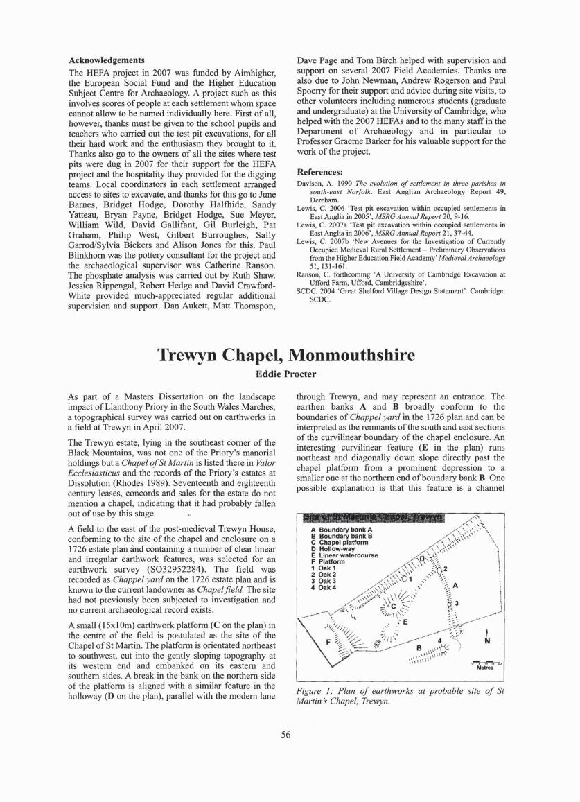
Acknowledgements The HEFA project in 2007 was funded by Aimhigher, the European Social Fund and the Higher Education Subject Centre for Archaeology. A project such as this involves scores of people at each settlement whom space cannot allow to be named individually here. First of all, however, thanks must be given to the school pupils and tcachers who carried out the test pit excavations, for all their hard work and the enthusiasm they brought to it. Thanks also go to the owners of all the sites where test pits were dug in 2007 for their support for the HEFA project and the hospitality they providcd for the digging teams. Local coordinators in each settlement arranged access to sites to excavate, and thanks for this go to June Bames, Bridget Hodge, Dorothy Halfhide, Sandy Yaueau, Bryan Payne, Bridget Hodge, Sue Meyer, William Wild, David Gallifant, Gil Burleigh, Pat Graham, Philip West, Gilbert Burroughes, Sally GarrodlSylvia Bickers and Alison Jones for this. Paul Blinkhom was the pottery consultant for the project and the archaeological supervisor was Catherine RansoD. The phosphate analysis was carried out by Ruth Shaw. Jessica Rippengal, Robert Hedge and David CrawfordWhite provided much-appreciated regular additional supervision and support, Dan Auken, Matt Thomspon,
Dave Page and Tom Birch helped with supervision and support on several 2007 Field Academies. Thanks are also due to John Newman, Andrew Rogerson and Paul Spoerry for their support and advice during site visits, to other volunteers including numerous students (graduate and undergraduate) at the University of Cambridge, who helped with the 2007 HEFAs and 10 the many staff in the Department of Archaeology and in particular to Professor Graeme Barker for his valuable support for the work of the project.
References: Davison, A. 1990 The evolution of settlement In three parishes in
south-east Norfolk. East Anglian Archaeology Report 49, Dereham.
Lewis. C. 2006 'Test pit excavation within occupied seutemenls in East Anglia in 2005', MSRG Annual Report 20, 9-16.
Lewis, C. 2oo7a 'Test pit excavation wilhin oc<:upicd settlemenlS in East Anglia in 2006', MSRG Annual Repor/21. 37-44.
[.ewis, C. 2oo7b 'New Avenues for the Investigation of Currently Occupied Medieval RU11I1 Sett lement - Preliminary Observations from the Higher Education Field Academy' Medl~1 Archaeology 51,01-161.
Ranson, C. forthcoming' A University of Cambridge Excavation at Ulford Farm. Ufford, Cambridgeshire' .
SCDC. 2004 ·Great Shelford Village Design Statement' . Cambridge: SCOC.
Trewyn Chapel, Monmouthshire Eddie Procter
As part of a Masters Dissertation on the landscapc impact of Llanlhony Priory in the South Wales Marches, a topographical survey was carried out on earthworks in a field at Trewyn in April 2007 .
The Trewyn estate, lying in the southeast corner of the Black Mountains, was not one of the Priory's manorial holdings but a Chapel afSt Martin is listed there in Valor Ecclesiasticus and the records of the Priory's eslates at Dissolution (Rhodes \989). Seventeenth and eighteenth century leases, concords and sales for the estate do not mention a chapel, indicating that it had probably fallen out of use by this stage.
A field to the east of the post-medieval Trewyn House, conforming to the site of the chapel and enclosure on a 1726 estate plan and containing a number of clear linear and irregular earthwork features, was selected for an earthwork survey (S032952284). The fie ld was recorded as Chappel yard on the 1726 estate plan and is known to the eUrTent landowner as Chapel field. The site had not previously been subjected to investigation and no current archaeologica l record exists.
A small (15xl Om) earthwork platfonn (C on the plan) in the centre of the fie ld is postulated as the site of the Chapel ofSt Martin. The platform is orientated northeast to southwesl, cut into the gently sloping topography at its western cnd and embanked on its eastern and southern sides. A break in the bank on the northern side of the platfornl is aligned with a similar feature in the holloway (D on the plan), parallel with the modem lane
56
through Trewyn, and may represent an entrance. The earthen banks A and B broadly confonn to the boundaries of Chappel yard in the 1726 plan and can be interprcted as the rcmnants of the south and cast sections of the curvilinear boundary of the chapel enclosure. An interesting curvilinear feature (E in the plan) runs northeast and diagonally down slope directly past the chapel platfonn from a prominent depression to a smaller one at the northern cnd of boundary bank B. One possible explanation is that this feature is a channel
A Bound.IV bank A B BoundalV bank B C Chapel platform o Hollow-way E LilW!ar watercourse F PI.tform 1 O.k 1 2 Oak 2 3 Oak 3 "' Oak"'
Figure J: Plan of earlhworks at probable site of Sf Marlin s Chapel, Treuyn.

constructed to divert the stream issuing from a now dried-up spring to a small pool, dammed by the boundary bank; given its location adjacent to the chapel, this could be interpreted as a baptism pool associated with a venerated spring (Bond 2004).
The earth works can convincingly be interpreted as representing the site of the chapel of St Martin and its associated boundary enclosure and access track. The chapel fanned part of a group of local spiritualities that contributed significantly to the Priory's income and may have functioned as a wayside chapel on a pilgrimage route associated with the Priory. The chapel may have conlinued to be used as a private place of worship for the estate owners for a time but disappears from the
documented record in the post-medieval period; its memory only surviving through the long-standing field name given 10 its location and the earthworks now surveyed. The site, together with other evidence of a medieval and post-medieval estate throughout the surrounding landscape, merits further archaeological investigation.
Bibliography
Bond, J. 2004. Monastic Wndscopes. Stroud. Cale)" 1. and Hunter 1. (eds) 1814. Va!or £Cclesiasticu$ temp. Henry
VIII auctoritate Regia InstilUlU$ 153$ Vol. 11, London. Rhodes, J. 1989. 'Uanthony Priory' , G!evensis (The GlollCe.lter and
Dis/rict Arc:hae%giC"Q! Research Group Review) 23, 16-30.
Worthy Farms on the Edge of Dartmoor: a Preliminary Report
Ros Faith, Andrew Fleming and Richa rd Kitc hin
RF: As part of work on pre-Conquest farming in moorland regions RF became interested in a string of places on the edges of Dartmoor whose names were composed of the suffix - worthy and a prefix derived from an Old English personal name, as for example 'Cada's worthy', now Cadaver. (RF's short introduction to these fonned part oflas! year's MSRG Easter Seminar and is printed in the Report for 2006.) AF became part of the project as a result of his interest in the history of Dartmoor over the long tenn. RK. is a local resident with a longstanding interest in, and knowledge of, the fanns in his area, the Walkham Valley.
A week's work in April 2008 was principally devoted to fieldwork involving the long sinuous boundaries which fonn the perimeter of the worthy fanns and hamlets
Correction
today, with a view to dating them. RF was concerned to bear in mind the needs of fanners in this region to have had land suitable for arable, as well as enclosed rough pasture and woodland, distinct from the open moorland. She felt that to lay claim to this 'package' of resources would always have necessitated visible boundaries, and that fanning on the edge of open moorland itself would have needed a defence of some kind against encroachments by deer and other fanners' livestock. Further work will be needed on the apparently early ring-fenced enclosures of the area (not all of which now carry 'worthy' names) and their internal features and sub-divisions, with a view to understanding them bener and evaluating arguments for their dating, in relative and absolute tenns.
In Ros Faith's article 'Worthys and enclosures', MSRG Annual Report 21 (2006), 9-14, the captions to Figures 1 (p.10) and 3 (p.12) were misprinted. They should have read:
Fig. I, Cadworthy, Meavy, Devon. NMR WAP 16191102 and West Air Photography. Reproduced with the permission of NMR. (West Air Photography now untraceable) .
Fig. 3. Yadsworthy. Cornwood, Devon. NMR 2600/146 reproduced with permission of NMR.
57

Discovery and Excavations in 2007 BEDFORDSHIRE
Great Billington, PraU's Quarry (SP9350 2320) OASIS ID 35051
Andrcw Mundin carried out an evaluation for Thames Valley Archaeological Services on a site of around 25ha, which revealed a large number of features, mainly very narrow parallel gullies, almost all of which arc undated. Where any dating evidence was found, there was very little of it (30 sherds of pottery from 18 contexts, no more than four in anyone context), but it is nearly all latc medieval and post-medieval. The features probably represent agricultural activity, perhaps a hop field, possibly a vineyard.
Ravcnsden - WildeR, Anglian Water Reinforcement Main (TL 10205522 to TL 0888 5727) A watching brief was carried out along the c. 2.1 km long by 24m wide easement of a reinforcement water main, which ran across open farmland between Barford Road and Kimbolton Road, east to north-northwest of Wild en. A single large feature was revealed during the groundworks for the reinforcement water main. The Historic Environment Record lists the location of a medieval/post medieval mill or windmill (HER 3139) in the area of the revealed feature. Datable finds were not recovered from the fill and it could define the position of an infilled field pond although it is possible that it was the borrow pit from which material was excavated to form a windmill mound.
Alastair Hancock
Silsoe, Cranfield University (TL 0791 3550)
Oxford Archaeology carried out a field evaluation, supervised by Andy Simmonds, for CgMs Consulting on behalf of Miller Homes. SI Neots-type pottery, dating from the I Oth-Il th centuries, was recovered from a number of features dug in the central part of the evaluation area. These included al least two postholes, a pit, and a small ditch . A third posthole, which contained no datable material, Ilad a similar form and fill to the dated examples and is likely to be of similar date. The postholes perhaps indicate the presence of a building or fenceline, and were probably associated with landholdings fronling onto West End Road. Given the currency of SI Neots type pottery, it is not possible to say whether this pre- or post-dates the Nonnan Conquest. A second period of occupation, dating to the late 12th-13th centuries, is represented by four ditches at the western end of the area. most likely defining plots adjacent to the south side of West End Lane. Three pits date to the same period. An undated cobbled surface was recorded at the junction of two trenches. The surface was not substantial enough to be a road, although its full extent could not be established within the confines of the evaluation trench. Its proximity and strati graphic position, however, suggest that it is contemporary with onc of the pits. The occupation activity represented by these features is likely to be associated with plots of land fronting onto West End Road.
58
BUCKINGHAMSHIRE
Akeley, The Roses, Chapel Lane (SP 7088 3777)
An archaeological watching brief was carried out during trenching to reroute two foul sewers, replacement of a storm drain and excavation of two level platforms and the footings of two houses at the rear of a bungalow called The Roses, Akeley. An archaeological evaluation at The Roses in 2003 revealed 11th- 14th century archaeological features buried beneath c .I .8m of sed iment infilling a deep natural depression. A subsequent archaeological "strip and record" excavation by ASC Ltd on the footprint of the developments access road confinned that the majority of archaeological features were located below the deepest area of overburden in a natural channeUhollow. The depth of overburden suggested that rerouting of the sewers, replacement of the stonn drain, excavation of level house platforms and footing trenches would not disturb the buried archaeological features.
Archaeological finds or features were not observed during excavation of the trenches for the sewer and drain. However, seven unstratified sherds of 11 th- 14th century pottery and an undated infi1led pond were discovered during excavation of the footings of the western house plot.
Alastair Hancock
Broughton, Broughton Northern lnfill (SP 839 1 4024)
An open area excavation at Broughton Northern Infill was undertaken in advance of development. During the early medieval period a close/plot of land was enclosed. This was later decreased in size to accommodate a drove way and a field boundary which were added to the northern side. Within the enclosure was a small slone bake or brew house structure. The boundary was between two enclosed fields, one of which contained remains of ridge and furrow earthworks until the start of redevelopment.
Lizzie Gill
Broughton, Manor Farm (SP 8459 1379)
Mick Parsons and John Moore for John Moore Heritage Services conducted an evaluation Ihat revealed evidence for the presence of continuous medieval activity dating from the 12th century through to the 16th century. A large outer enclosure to the moated site to the east was found. This appears to have originated in the 12th century and was enlarged perhaps in the mid 13th to 14th century. Ditches appear to have sub-divided this enclosure. Remains indicating a probable building were encountered. A possibly long-used path was fOUlld along with pits. A gully external 10 the outer enclosure was found. This may pre-date the ouler enclosure along with another ditch/gully on the same alignment but found within the area of the enclosure. The area under the prescnt barns is considered to have been low-lying with an earlier stream course. This appears to have been

levelled up, perhaps at the same time as the enclosure was enlarged. It is therefore argued that the Tithe Barn cannot pre-date the 13th century and probably not the mid 13th century at the earliest. Remains of postmedieval barns and a yard surface were found. When the post-medieval fann was laid out it appears that evidence for the later medieval activity was destroyed. The stonebunressed building found in the 1960s was not encountered. A small assemblage of hand-built Saxon pollery suggests that there are likely to be features of that date on the site. Residual Iron Age and Romano British pollery found indicates activity of that date in the vicinity.
Haddenham, 5 Townsend (SP74 14 0912) OASIS ID 27711
Scan Wallis for Thames Valley Archaeological Services conducted an evaluation in advance of detennination of a planning application, which demonstrated the survival of a substantial number of medieval occupation features (pits, ditches, walls) across the entire site. A reasonably large pottcry assemblage (for a limited trenching exercise) suggests occupation from the 11th to 13th centuries, with a smaller amount of late post-medieval wares and onc sherd of early/middle Saxon ware also present. Other finds were sparse.
Haddenham, 23 High Street (SP7414 0912) OASIS ID 36582
Evaluation trenching was carried out by Andrew Weale for Thames Valley Archaeological Services. Two medieval pits were revealed, onc in the south-west of the site, onc below a post-medieval building on the street frontage. A number of post-medieval features were found, along with an old stream course. The small assemblage of early medieval pottery suggests that activity at the site was short li ved, and probably restricted 10 the later I1 th and 12th centuries.
High Wyeombe, Bassetsbury Manor (SU 8780 9236)
David G ilbe rt for John Moore Heritage Services conducted a recording action to the north of the Tithe Bam associated with Bassetsbury Manor during the construction of a new building. A possible earlier water channel was recorded that is li kely to have been associated with milling activi ties on the Wye. This channel was later infi lled with buildings erected over it
Taplow, Taplow Cou r t (SU 907 823)
Oxford Archaeology, supervised by James Mumford, carried out an excavation with in the 18th-century listed building at Taplow Court for SGI-UK. Wal1s contcmporary with the standi ng building overlay a deep medieval soil of the 13th or 14th ccntury that filled a large feature of uncertain function.
Wing, Church Street, Wing Care Home (SP8808 2240) OAS IS ID 26456
Steve Ford and Andy Taylor for Thames Va l1 ey Archaeological Services conducted cvaluation in advance of detennination ofa planning application. Two 12th- to 14th-century ditches were recorded, along with a number of undated features.
59
CAMBRIDGESHIRE
Burwell, Kingfisher Drive, land behind IS and 42 (TL 58590 67527) This excavation lay to thc rear of properties fronting North Street, one of the main medieval streets in North Butwell. It was bounded by watetways on two sides: the Weirs to the west and a disused spur lode to the south. The site was sub-divided in the medieval period by a series of ditches running parallel with and at right angles to the Weirs. Rectangular, tank-shaped pits clustered together towards the western end of the site may have been medieval fish tanks. At the eastern cnd of the site a small circular gully may be the remains of a dovecote, along with possible evidence for a barn or other timber structure. The recorded evidence mainly relates to medieval and post-medieval backyard and waterfront activities (CAM ARC Report 937).
BurweJl, Land Sou th oflsaacson Road (TL 59 10 6587)
Work at this site encountered important archaeological remains relating to early medieval industrial activity, which included five limekilns (three with stoke holes), a series of large, contemporary quarry pits and a slightly later post-built windmi ll with surrounding C-shaped ditch. Numerous postholes, whilst not fonning any clear structure, may have fonned temporary buildings associated with the lime processing activity and chalk extraction (CAM ARC Report 951).
Mo Muldowney
Castor, C hurch Hill (TL 12429859)
Construction of an extension in an area of Roman and later remains in the historic core of Castor was the subject of a watching brief, carried out on behalf of Mr & Mrs Higton by staff of Archaeological Project Services. In addition to Roman remains and artefacts, a Middle Saxon pit containing Maxey and Ipswich-type ware was revealed. This is almost certainly associated with the nearby nunnery dedicated to SI. Kyneburgha, cstab lished in the 7th century. Medicval and latcr ceramics were al so retrieved.
Paul Cope-Faulkner
Foxton, Mortimers Lane (TL 4141 4846)
Medieval remains included a structure adjacent to the modem street, to the west of which was evidence of domestic activity, small-scale animal husbandry and boundaries. A series of depressions up to 5m wide may bc associated with thc medieval moated site just to thc north. Activity dating to the 11th to 19th centuries indicatcs continuous use for this plot of land. (CA M ARC Report 975)
Gareth Rees
Guyhirn, High Road (TF 3984 0349)
An evaluation was supervised by K. Murphy of Archaeological Project Services fo r Robert Powel1 Surveyor near 10 previous discoveries of Saxon and medieval remains. Beneath deep deposits of modem

demolition debris were buried soils or subsoil containing 16th-17th century pottery and 17th century and later clay pipe.
Katie Murphy
Huntingdon, Brookside TL 23861 72135
This site lies just outside the probable line of the town ditch of medieval Huntingdon, which is believed to lie approximately under the current ring road. Cartographic evidence indicates a crossing of this town ditch, just beyond the area of excavation to the southwest, where Ambury Road meets the ring road. Excavation revealed the remains of two Late Saxon or medieval (lOth to 13th century) buildings, with a strong suggestion of a third, as well as other evidence of contemporary activity including pits and boundary ditches.
Nick Gi lmour
Papworth Everard, Land to the West of St Peter's Church (TL 28156271) Work undertaken on the west side of Papworth Everard, between Cow Brook and St Peter's Church, revealed evidence for Late Saxon and early medieval activity, in the fonn of ditches and a cobbled surface at the bottom of the slope 10 the north-west of the church. On higher ground further south was a medieval hollow way, as well as evidence for medieval or post-medieval enclosure. (CAM ARC Report 983)
Tom Lyons
Peakirk, St. Pega's Road (TF 16930682) On behalf of Mr W Roberts, a watching brief wa." undertaken by F. Walker of Archaeological Project Services during test pitting near to the Saxon hennitage and monastery at Peakirk. A pond of post-medieval datc was idcntified and artefacts of thc 16th century and latcr were recovered.
Paul Cope-Faulkner
Peterborough, Midland Road (TL 18389912)
Devclopment in an area where a Roman settlement and cemetery and a 12th century leper hospital had previously been identified was the subject ofa watching brief, carried out by Archaeological Project Services for GB Oils Ltd. Disarticulated human bones were recovered in ' abundance but were undated. Consequently, these may derivc from eithcr the Roman or medieval burial grounds, and although no signs of leprosy werc evident on the remains this does not preclude them being medieval. Pottery of 10th-12th century date was also retrieved as unstratified material.
Paul Cope-Faulkner
St Neots, Former Youth Centre, Priory Road (TL 5 18190 260610)
The presence of three ditches suggests that this area was in agricul tural use during the medieval/post-medieval periods. The work did not find anticipated evidence for Anglo-Saxon activity, nor any remains relating to the Benedictine priory (established by the 12th century)
60
which may have been removed by later truncation (CAM ARC Report 947).
Neil Wright
Thorney, Wisbech Road (TF 2823 0428) An evaluation, supervised by V. Melior of ArchaeologicaL Project Services for Cherrybum Properties, was undertaken in the medieval settlement area and adjacent to the outer precinct of Thomey Abbey. Flood silts of perhaps 16th -17th century date were revealed and these yielded pieces of limestone masonry, including a rebated window or door surround, that probably derive from demolition of the nearby abbey buildings following the Di ssolution. Early modem structural remains were also recorded.
Vicky Melior
Whittlesey, Station Road (TL 27 14 9676)
On behalf of Al!en Warner Ltd, Archaeological Project Services carried out an evaluation close to the medieval core of Whittlesey. Post-medieval quarries and dumped layers were identified and artefacts of 15th century and later date were recovered.
Thomas Bradley-Lovekin
Whittlesey, Stonald Field (TL 2636 9792)
An evaluation, supervised by K. Murphy of Archaeological Project Services for Cannon Kirk UK Ltd, was undertaken in an area where geophysical survey and aerial photographic evidence revealed buried remains considered to be of prehistoric date. In addition to prehistoric remains, boundary and drainage ditches of post-medieval date were recorded and a small amount of medieval pottery was recovered.
Katie Murphy
Willingham, High Street (TL 4040 7037) Settlement-related activity during the Middle to Late Saxon period included posthole structurc(s), cess-pits and boundary ditches. Remains found towards the eastern edge of the excavation area may relate to the Early to Middle Saxon settlement identified by excavation in 1996. Significant finds include an AngloSaxon spear and a possible sword.
Amongst the ditches was a widc (over 3m) and deep (over lm) cxample locatcd in the north-cast conler of the site. This appeared to be making a sharp near rightangled turn, close to a possible entrance. Evidence for an internal mound or bank was identified in secti on immediately to the cast of the ditch. Finds from the fi lls of the ditch included a complete cow skull.
By the medieval period the influenec of the High Street is suggested by a boundary ditch that lay parallel with it. The excavated area otherwise appears 10 have been open ground, interrupted only by small-sca le quarryi ng activity, which continued on a sli ghtly larger scale imo the post-medieval period. A row of rectangular pits parallel with the High Street may indicate a hedge or line of trees at the rear of a propcrty.
Taleyna Fletcher

Wimblington, Norfolk Street (TL 416 924)
R. Hoh of Archaeological Project SelVices supervised an evaluation, for Robert Doughty Consultancy and Rose Homes (EA) Ltd, near the centre of the village and adjacent to where Mesolithic and post-medieval remains had previously been found. Numerous pits of postmedieval date, containing nothing earlier than the 17th century, were recorded. However, no earlier remains or artefacts were revealed.
Mary Nugent
DERBYSHIRE
Winster, Tearsall Quarry (SK 263 60 I) Archaeological Project Services produced an earthwork survey of remains of lead mining for Wardell Annstrong. Documentary evidence indicates lead mining in the area from the 16th century. though most of the recorded remains are probably 18th-19th century. Numerous shafts and spoil mounds were recorded, together with a probable buddle dam (a platfonn used for ore washing). Additionally. probable Iynchets were identified.
Paul Cope-Faulkner
HUMBERSIDE - NORTH LINCOLNSHIRE UA
Holme, Belle Vue Farm (SE 918 043)
Although in an area of Saxon and medieval remains, a watchi ng brief, by M. Nugent of Archaeological Project Services for Yorkshire Electricity, did nOt identify any archaeological remains as groundwork was minimal.
Paul Cope-Faulkner
Holme, Raventhorpe Farm (SE 936 079)
On behalf of Yorkshire Electricity, a new cable trench adjacent 10 the Scheduled Ancient Monument of Ravcnthorpe deserted medieval village was monitored by M. Wood of Archaeological Project Services. However, no archaeological remains were identified.
Paul Cope-Faulkner
LElCESTERSHJRE
Bittesby, Land Adjacent to Bittesby House (SP 4990 8585) A geophysical survey and DBA was undertaken on land northwest of Bittcsby House, Bittesby near Lutterworth, Leicestershire, locatcd on the western side of the disused Midland railway line over part of the site ofthe medieval vi llage of Biltesby. The western extent of the village and the location and orientation of part of the village's open field system was defined by the geophysical survey. Finds recovered by the Lutterworth Fieldwalking Group have hinted that the village may have its origin in the early/mid Anglo Saxon period. The Norse origin of the village name certainly shows that an extant settlement was renamed, or that a settlement was established during the 9th or 10th century. Records illustrate that the village ex isted until its arable land was inclosed for sheep pasture and the majority of tenants evicted at Ihe end of the 15th century.
61
Fenny Dray ton, Old Forge Road (SP 350 967) Investigations in an area of medieval settlement and pottery production were carried out by M. Peachey of Archaeological Project Services for Mr & Mrs Masters. A boundary ditch of post-medieval date was revealed, together with pieces of roof tile of the period, and a single sherd ofSaxo-Norman pottery.
Mark Peaehey
Garthorpe, St. Mary 's Church (SK 8315 2092)
On behalf ofTim Ratcliffe Associates and the Churches Conservation Trust, staff of Archaeological Project Services carried out a watching brief during groundwork at the 13th century church. A medieval made ground containing disarticulated human bone was identified and upon this was constructed the nortH aisle of the church. This suggests that the aisle was later than the main body of the church, and it is possible it dates from the late 19th century restoration. A later buttress was also recorded, in addition to the graveyard soil which contained burials. Saxo-Norman pottery was recovered, along with postmedieval artefacts.
Paul Cope-Faulkner
HallatoD, North End (SP 7888 9679) Although in one of the historic 'Ends' of Hallaton, a watching brief by Archaeological Project Services for Mr & Mrs Bluck did not reveal any archaeological remains.
Paul Cope-Faulkner
Long Clawson, Church Lane (SK 7253 2745)
Watching briefs, by M. Peachey of Archaeological Project Services for Mr & Mrs Doubleday, were undertaken in the present centre of the village but what was perhaps open land between two medieval 'ends'. A pit was identified and although undated it was below the subsoil and is probably ancient. Artefacts of 18th-19th century date were recovered. The results from these investigations supported the suggestion that the medieval settlement was polyfoeal, with this area being later infil1 between occupation foci.
Mark Peachey
Melton Mowbray, Somerset Close (SK 7563 1745) Development on the southern edge side of Melton Mowbray and near to previous discoveries suggesting a Saxon cemetery was the subject of a watch ing brief, carried out by Archaeological Project Services for Front Row Construction. A pond was revealcd but was undated as no artefacts were recovered.
Paul Cope-Faulkner
Sproxton, Saltby, Back Street (SK 8507 26 18) Development in the historic core of Saltby was monitored by Archaeological Project SelVices for Duffin Builders Ltd. No archaeological remains were revealed, though medieval pottery was recovered and 16th-18th century ceramics were abundant.
Paul Cope-Faulkner

Whitwick, SI John the Baptist Church (SK 4349 1619)
On behalf of C. A. Underwood Ltd and the PCC, B. Garlant of Archaeological Project Services carried out a watching brief during groundwork for an extension at the 13th-14th century church. The foundations of the 14th century tower were exposed and there was evidence of later, though undated, burials.
Paul Cope-FauUcner
Wymondharn, Land to rear of 58 Main Street and Nurses Lane (SK 8526 1870)
This site lies approximately IOkm to the east of Melton Mowbray, on the notth bank of a stream. It had previously been suggested as the location of a possible medieval manor house on the basis of a map dating to 1652 suppotted by entries in the Domesday Book which state that Wymondham comprised two manors. The earliest features found during excavation were possible prehistoric ditches and pits. These were later succeeded by a timber structure and separate sunken room or building. The main feature was a large stone multiphased building spanning the ? 15th to 18th centuries. Two cellars/cess pits, a fireplace, heatths and surfaces were identified. A boundary wall visible on the tythe map of 1844 was also recorded and appeared to incorporate the main notth to south wall of the manor house. It was constructed from robbed stone, some of which was very decorative, and includes late 13thcentury window tracery, possibly originating from an ecclesiastical bui lding.
Alex Pickstone
LINCOLNSHIRE
Allington, Bottesford Road (SK 8542 4024)
Development at the medieval core of the village and close to 17th-18th century AI lington Hall was examined in a watching brief by Archaeological Project Services for Mrs P Jackson. Pits and a pond, all of late postmedieval date, were revealed, together with a substantial stone wall that was probably associated with nearby Allington Hall .
Paul Cope-Faulkner
Anderby and Cbapel St. Leonards, Laogham Farm (TF 5451 7558) •
Archaeological Project Services carried out fieldwalking, for CgMs Consulting, on sma!! areas on eithcr side of the parish boundary between Anderby and Chapel St Leonards, in the general vicinity of Roman and later remains. However, the attefact scatter was very thin, perhaps suggestive of manuring scatter, with just a few medieva l and later items recovered.
Paul Copc-Faulkner
Bassingham, High Street (SK 9113 6010) On behalf of Mr P Tu!!y, a watching brief was camcd out by B. Garlant of Archaeological Project Services in the historic village core. A large feature with nearvettical sides but of indeterminate nature was revealed
62
and although undated it was sealed by the subsoil and is probably early.
Jennifer Wood
Bassingham, Water Lane (SK 91 14 60 J5)
Staff of Archaeological Project Services camed out a watching brief, for Ryland Design Services, near to the medieval manorial complex. Ditches and pits, probably all of post-medieval date though only one yielded attefacts, were recorded. In addition, a sherd of Torksey ware of 9th-1 I th century dale was recovered.
Andrew Failes
Boston, Wainfleet Road (TF 3440 4520)
A watching brief, by Archaeological Project Services for Mr G Staniland, was undertaken during development close to the extinct medieval hamlet of Fennc. However, archaeological remains were restricted to a 19th century brick cistern. Attefacts were mostly early modem, though a vitrified medieval brick was also found.
Mark Peachey
Burgh Le Marsh, East End (TF 5042 6492) Artefacts of 16th century and later date were recovered, though no archaeological remains were revea led, during a watching brief, by Archaeological Project Services for Or RN Hattzenberg.
Paul Copc-Faulkner
Carlby, Church Street (TF 0449 1394)
Although in the historic centre of the village, a watching brief, by Archaeological Project Services for Silver Heron Developments Ltd, did not reveal any archaeological remains.
Paul Cope-Faullmer
Croft, Spencer Farm (TF 495 631) On behalf of CgMs, staff of Archaeological Project Services carried out a watChing brief during development in an area of Roman remains. Two ditches forming part of a rectangular enclosure were identified. These were undated but were truncated by a pond of probable medieval date. Artefacts of 12th century and later date were recovered.
Rachael Hall
C rowland, Trinity Close (TF 23791009)
Development in the centre of Crowland was monilOred by F. Walker of Archaeological Project Services for Wyer Brothers Ltd. Two quarry pits separated by a ditch were revealed and although only the ditch yielded attefaclS all three features are likely to be medieval. Post-medieval subsoil and dumps were also recorded.
Paul Cope-Faullmer
Fishtoft, Fishtoft Manor, Clampgate Road (TF 3640 4235) Development in an area of Middle Saxon and medieval

remains was the subject of a watching brief, by Archaeological Project Services for KMB Ltd. A di tch and a buried soil were revealed and although undated probably correlate with similar evidence previously found at the site and are Late Saxon. Post-medieval refuse pits were also identified and pottery of Late Saxon and medieval date was recovered as redeposited artefacts.
Paul Cope-Faulkner
Harlaxton, Pond Street (SK 8835 3244)
Development on the line of an ann of a medieval moat was examined by Archaeological Project Services for Mr G. Sharp. Possible upper fills of the moat were encountered but were undated. A stone culvert, similarly undated, was also revealed and may have served as a drain into the moat. Post-medieval remains included a brick culvert and a boundary wall, and artefacts of 17th century and later date were recovered.
Paul Cope-Faulkner
Holdingham, Rising Main (TF 067 471 -TF 083 473)
On behalf of Anglian Water Services Ltd, investigations, supervised by F. Walker of Archaeological Project Serv ices, were undertaken in an area of prchistoric and Roman remains near to Sleaford. Medieval and later fi eld system ditches and rcmains of ridge and furrow were recorded. Prehistoric remains were extensive.
Carol Alien
Horbling, Sandygate L.ane (TF 1197 3529)
Development in the historic core of the village was monitored for Util ity Consu ltancy Services Ltd by Archaeological Project Services. A medieval pit was encountered and other pits, although lacking artefactual evidence, may be of the same date. Medieval and early post-medieval pottery was recovered as rcdeposited material.
Paul Cope-Faulkner
Kirton, London Road (TF 302 380) Land in the southern part of Kirton, near to remains of Late Saxon and latcr date, was the subject of an evaluation, supervised by V. Melior of Archaeological Project Services for the Robert Doughty Consultancy on behalf of Messrs JF, AP and HJ Dennis. Previous geophysical survey identified several pit and ditch-like anomalies at the site. Trenching revea led a few probable fi eld boundary ditches of post-medieval date. A small artefact assemblage, with items of medieval and later date, though mostly from thc 17th century onwards, was recovered.
Vicky Melior
Martin, Mill Lane (TF 1230 5995)
Development near the core of the medieval hamlet was the subject ofa watching briefby Archaeological Project Services for Ryland Design Services Ltd. Other than
63
recent make-up deposits no archaeological remains were revealed, though medieval and late post-medieva l pottery was recovered.
Paul Cope-Faulkner
l\1etheringham, Station Road (TF 0742 6132)
A watching brief, by Archaeological Project Services for Anglian Water Services Ltd, close to known Roman and medieval remains revealed a stone-lined well of probably post-medieval date.
Paul Cope-Faulkner
Pinchbeck, Church Street (TF 2420 2630) Development on the north side of Pinchbeck was mon itored on behalf of Patter.son Properties by Archaeological Project Services. A network of ditches of post-medieval date was exposed, as well as pi ts, a pond, and a posthole. Pottery of 10th-12th century date occurred abundantly in association with these featu res, indicating settlement of this period at the site or very close by. Occupation appears to have declined in about the 14th-15th centuries, and the area probably had an agricultural usage until the 17th century, and ridge and furrow was previously recorded at the site. Later postmedieval ditches and pits were also recorded.
Paul Cope-Faulkner
Pinchbeck, Flax mill Lane (TF 2405 2653)
Although in an area of Roman and medieval remains, an evaluation, supervised by K. Murphy of Archaeological Project Services for Eastern Shires Housing GrouplNew Linx Homes, revealed only recent remains including ditches and service trenches.
Katie Murphy
Pinchbeck, Milestone L.ane (TF 2417 2662) On behalf of Taylor Developments, M. Nugent of Archaeological Project Services carried out a watching brief in one of the medieval hamlets of Pinchbeck. A post-medieval ditch was identified together with dumped deposits of probably the same date. A small quantity of post-medieval pottery, including Chinese cxpon porcelain, was recovered.
Paul Cope-Faulkner
Quadrin g, Cowley and Brown's Primary School (TF 2239 3403) Although near to previous discoveries of Saxon and medieval remains, a watching brief by Archaeological Project Services for DB Lawrence and Associates, revealed only post-medieval subsoil , though artefacts of 15th century and later date were recovered.
Andrew Fai les
Ruskington, Rectory Road (TF 0805 5107) Development close to the historic core ofthe village was monitored by Archaeological Project Services for M.J. Green (Navenby) Ltd. Although no archaeological

remains were revealed, artefaCfS of 17th century and laler date were recovered.
Paul Cope-Faulkner
Sleaford. Holdingham, Lincoln Road (TF 0595 4730)
Investigations, supervised by P. Cope-Faulkner of Archaeological Project Services for NCHA Ltd, were undertaken to exami ne a medieval stone building encountered during previous evaluation in the shrunken hamlet of Holdingham (see Annual Report 21 (2006) 71-2). The location of the west wall was confinncd but no evidence of eastern or southern walls. This might suggest the structure was not a building but some fonn of L-shaped enclosure, though it is possible that the east wall had been removed by the later creation of a pond, and the southern limit of the structure may lie beyond the extents of the investigation.
Paul Cope-Faulkner
South Somereotes, Village Core (TF 416 938) A watching brief, by staff of Archaeological Project Services, was undertaken on behalf of Anglian Water Services Ltd during sewerage works in the historic core of South Somercotes and in an area of deserted settlement remains evident as earthworks. A buried ploughsoil was revealed but was undated. Artefacts of medieval and later date were recovered.
Jcnnifer Kitch
Spalding, Roman Bank (TF 2576 2384) Land alongside a flood bank created by AD 1300, and near to remains of Late Saxon and medieval date, was the subject of an evaluation supervised by T. BradleyLovekin of Archaeological Project Services for Fieldview Homes. However, post-medieval remains occurred to over 2m depth and no earlier features were encountered, though a gully of 16th-18th ccntury datc was revealed.
Thomas Bradlcy-Lovckin
Stamford, Gwash Valley Business Park (TF 0426 0804)
An evaluation, supervised by K. Murphy of Archaeological Project Services for F H Gilman and Co, was undertaken in an area near to the previous discovery of a Saxon cemetery. However, there was no evidence of Sax-on or later activity, though Roman remains were revealed.
Katie Murphy
Stubton, fenton Road (SK 87274891)
Developmcnt in thc historic core of Fenton was monitored by T. Bradley-Lovekin of Archaeological Project Services for Mr T Senior. A pit of probable 12th cenrury dale was revealed and contained Stamford and South Lincolnshire Shell-Tempered wares. Unstratified pottery of medieval and Late Saxon date, including a sherd of Torksey-typc ware or the 9th-11th centurics, was also rctrieved.
l ennifer Wood
64
Sutton St. James, Fishergate-Jarvisga te (TF 382 184 - TF 400188)
A sewerage scheme through the historic core of Sutton S1. James was monitorcd by Archaeological Project Services for Anglian Water Services Ltd. Buried soils were revealed and are perhaps medieval, as they yielded a pottery sherd of this date. Unstratified artefacts of 15th century and later date were recovered. Aspects of the artefact assemblage were unusual, with the pottery from the buried soil being BrilVBoarstall ware of 15th- 16th century date and a London-made clay pipe of c. 1690-1710 also recovered.
Michael Wood
Swineshead, Dray ton, Abbey La ne (TF 2450 3929) Development in the shrunken medieval hamlet of Drayton was monitored on behalf of Mr & Mrs Searson by T. Bradley-Lovekin of Archaeologica l Project Services. Pits, a ditch and posthole were revealed but were undated. Other pits and ditches of post-medieval date were also recorded. Pottery and other artefacts of 13th century and later date were retrieved.
Paul Cope-Faulkner
Wainfleet St. Mary, St. Michael's Lane (TF 4980 5761) Development adjacent to medieval salt-making sites was the subject of a watch ing brief, carried out by Archaeological Project Services for Mr RH Kirkland. A localised dumped deposit containing burnt material was revealed and although undated this is likely to be waste from salt-making and of medieval date.
Paul Cope-Faulkner
Welton, Healthlinc House, Cliff Road (TF 0078 7976)
Development near 10 previous discoveries of $axon and medieval date was the subject of a watching brief by T. Bradley-Lovekin of Archaeological Project Scrvices for Mike Alford (Welton) Ltd. A Late Saxon ditch was encountered and medieval pits and ditches were also recorded. Artefacts of 12th century and later date were fairly abundant, indicating probable domestic occupation of the site at that time.
Andy Failes
Welton, Lincoln Road (TF 0112 7970)
An evaluation, supervised by N. Parker of Archaeological Project Services for Ryland Properties (Welton) Ltd, was undcrtaken immediately south of the parish church and near to a known Saxon cemetery. In addition to revealing Roman remains and artefacts, the evaluation recovered iliOlated fragments of Early-Mid Saxon and medicval pottery.
Neil Parker
West Deeping, King Street (TF 11060868)
Development alongside the King Street Roman road and in an area of medieval and post-medieval remains, including 18th century barns, was monitored on behalf

of Mr B. Small by V. Melior of Archaeological Project Services. An undated but probably post-medieval fire pit was revealed, and wall footings and levelling layers associated with the barns were recorded. Post-medieval brick and ti le was recovered, as well as Roman pottery.
Neil Parker
Witham on the Hill, Witham Hall School (TF 0499 1667)
R. Holt of Archaeological Project Services carried out a watching brief, for Stephen Dunn Architects, close to a probable windmill mound on the fringe of the village. Ridge and furrow of probable medieval date was exposed and an assemblage of artefacts of 15th century and later date was recovered, with 16th-17th century items being distinctly common and perhaps implying occupation of this period close by.
Thomas Bradley-Lovekin
NORFOLK
Baconsthorpe, Baconsthorpe Castle (NHER 6561; TG 1210 3820)
An archaeological watching brief was carried out for English. Heritage on the erection of four new infonnation panels at Baconsthorpe Castle. Several fragments of medieval ceramic building material were recovered, although the holes were too shallow to reveal any subsurface featu res (NAU Archaeology Report No. 1318).
Ben Hobbs
Barton Bendish, Barton Bendish Hall (TF 710 056)
Archaeological monitoring was carried out during the restoration of the Horse Pond and the instalment of a new drain leading from a glasshouse to the pond. No medieval sediments were identified within the pond and had probably been removed during a previous cleaning phase in the early 20th century. The drainage trench was positioned along the line of the southern ann of the medieval moat. No early moat deposits were identified during the monitoring of this trench, although three medieval cess pits and the possible location of a pathway leading to St Mary's church were found. A single sherd of pottery indicates that the pits may be as early as the 13th century pre-dating the present manor house (CAM ARC Report 969).
Mo Muldowney
Beeslon with Billering, SI Mary's church (NHER 4093; TF 8939 1529)
An archaeological watching brief was carried out for BirdsaU, Swash and Blackman Chartered Architects on the excavation of new drains. Several sherds of medieval and post-medieval pottery were recovered and one fragment of stained glass. The foundations of the church were partially exposed (NAU Archaeology Report No. 1303).
Ben Hobbs
Binham, Binham Priory (TF 9817 3994)
P. Cope-Faulkncr of Archaeological Project Services
65
supervised an excavation at the I1 th century priory for WS Lusher & Son Lld and Norfolk Archaeological Trust. The investigation examined an area immediately south of the gatehouse on a length of the precincT wall which had collapsed in the 1980s. Foundations of the inner, east, face of the wall were revealed but there was no corresponding evidence fo r the outer face. Levelling deposits, a chalk or mortar floor, a wall and a possible foundation trench, perhaps all medieval in date, were identified butting against the interior of the precinct wall. Post-medieval demolition depos its, probably related to the buildings indicated by the medieval chalk floors, were revealed, together with two buttresses. Medieval and early post-medieval pottery was recovered.
Paul Cope-Faulkner
Castle Acre, Castle Square (TG 8184 1507)
An evaluation, supervised by N. Parker of Archaeological Project Serv ices for Parworth Developments Ltd, was undertaken on land adjacent to the castle bailey. However, archaeological remai ns were limited to an area of demolition rubble of post-medieval date.
Neil Parker
E!sing, Elsing Hall (NHER 3009; TG 0400 1601)
An archaeological watching brief was carried out for Purcell Miller Tritton on the excavation of service trenches. Sections of medieval flint wall associated with extant stonework within the moat were revealed. A fragment of stone window tracery was recovered that corresponded to one of the main windows in the l5thcentury hall. A post-medieval rubbish pit was located to the south of the hall (NAU Archaeology Report No. 1267).
Ben Hobbs
Great Fransbam, All Sainh' church (NHER 4206; TF89801310) An archaeological excavation was carried out fo r Nicholas Warns Architect Ltd ahead of new drainage works in the churchyard. A wall uncovered during the work was almost certainly part of a separate building known from previous drainage operations. A layer of possible foundation material, which may once have supported the wall of the south aisle of the church, was also revealed (NAU Archaeology Report No. 1285).
Peter Crawley
Heacbam, Ringstead Road (TF 6842 3782) An evaluation was supervised by M. Peachey of Archaeological Project Services for Mrs M Wells in an area where Late Saxon and medieval ceramics and ki ln furniture had previously been found. The tenn inal of a probable boundary ditch or gully was identified and yielded fragments of 9th-1 I th century Thetford-type ware pottery and animal bone.
Mark Peaehey

Loddon, Beccles Road (TM 3706 9789)
M. Peachey of Archaeological Project Services supervised an evaluation for C & M Architects on behalf of Wiltow Builders Ltd. Previous investigations in the vicinity had identified remains of prehistoric and later date. Several ditches were revealed and included a postmedieval field boundary and more recent drainage features . An undated but probably earlier gully was also recorded. Artefacts ofprchistoric and post-medieval date were recovered.
Mark Peachey
Reepbam, C hurch Street and Ch urcb HiU (NHER 49886; TG 6101 3228)
An archaeological watching brief was carried out for Norfolk County Council monitoring the construction of a ncw storm drain. The development involved excavating a deep pipe trench around St Mary's church. The trench disrurbed medieval burials on the eastern side of the church, but on the northern side of the church followed the course of a 19th-century culverted drain. Only one burial was disturbed on the southern side ofthe church. Fifty human skeletons were found during the watching brief. At the point where Church Street meets Church Hill, a possible Late Saxonlmedieval ditch was found, the fill of which was truncated by a medieval burial (NAU Archaeology Report No. 1286).
Peter Crawley
Riddlesworth, Devil 's Ditcb (NHER 6115; TL 9897 8273)
An archaeological watching brief and excavation were carried out for Anglian Water monitoring the laying of a new pipeline. During the work a section was dug across the Devil's Ditch showing evidence for a recut or cleaning out of the bottom of the ditch. No significant datable fmds were recovered, but Optically Stimulated Luminescence (OSL) dating of samples from the ditch fi lls provided dates of 2590±30 (~590 BC), 1190±160 (- 820 AD) and I 220±140 (- 790 AD). These suggest that the ditch might have been originally dug during the Iron Age, but continued in use - or was reused - during the Anglo-Saxon period (NA U Archaeology Report No. 1307).
Sarah Bates
Southery, Westgate Street (TL 6209 9456)
Land in the historic core of Southery and near to previous discoveries of Roman and Saxon remains was the subject of an evaluation, supervised by V. Melior of Archaeological Project Services for O. Aguila-Agon and Nicholson Machinery Ltd. A pit of probable Late Saxon date containing evidence of occupation and industrial activity was revealed, together with several other pits that, although undated, were similar to the Late Saxon example and are perhaps contemporary. These remains were sealed by a buried soil of medieval date. Structural remains oflate post-medieval date were extensive and a collection of horsc shoes indicated a farrier at the site at this time.
Vicky Mellor
66
Sustead, Land nr SS. Peter & Paul's C hurch (TG 180370 - 184372)
Soil stripping for a new watermain near to the possible Late Saxon church and earth works of a prObable medieval manorial complex at Sustead was monitored by M. Nugent of Archaeological Project Services for Anglian Water Services Ltd. Several ditches were revealed but were undated. However, two were parallel to, and either side of, an extant hedgerow and probably mark a post-medieval version of that boundary. The third ditch had survived as an earthwork until recently and is likely to be no earlier than medieval.
Paul Cope-Faulkner
LONDON
Hillingdon, West Dray ton, Hubbard's Farm (TQ07610 81370) OASIS ID 22958
Sean Wallis for Thames Valley Archaeological Services conducted an evaluation in advance of a barn conversion, which revealed a buried soil horizon, containing 12 sherds of pottery very similar to Camley Gardens ware, probably 12th- to 13th-century. This was sealed below a 17th-century floor layer, which seems too substantial for a barn and may suggest the building had been used as a dwelling or workshop.
NOITINGHAMSHIRE
Hodsock, Hodsock Priory (SK 61158541)
Groundwork at Hodsock Priory, a 19th century country house associated with a medieval moated enclosure, was monitored by Archaeological Project Services for CgMs Consulting. No medieval remains were encountered, though it is possible that the site had been truncated. Walls and drainage features, probably associated with the garden of the 19th eentury house were recorded.
Paul Cope-Faulkner
Ordsall, All Hallows Street (SK 7058 7966) Staff of Archaeological Project Services carried out watching briefs during development in the historic core of Ordsall for Gusto Construction and Mr & Mrs Atkins. A post-medieval brick wall was revealed runn ing parallel to and I m from the current site perimeter and implies some boundary re-alignment. Artefacts of 15th century and later date were recovered.
Thomas Bradley-Lovekin
Sibthorpe, Main Street - C hurch Lane (SK 7620 4554 - SK 7639 4529) A watching brief on service trenches in the hislOric core of the village was carried out by staff of Archaeological Project Services for Severn Trent Water. Foundations for a fonner bridge across a watercourse were revealed but were undated. A post-medieval subsoil with 17th century and later artefacts was also identified.
Paul Cope-Faulkner

OXFORDSHIRE
Fritwell, Heatb Farm, North Street (SP 523 293)
Oxford Archaeology's watching brief, supervised by Mike Sims and commissioned by Luke Annaly, revealed a possible foundation plinth, which may relate to the medieval settlement of Fritwell, and the presence of ridge and furrow.
Oddington (SP 553-148)
Mike Sims of Oxford Archaeology carried out a watching brief on land to the south of the village for Scottish and Southem Energy Ltd. The work revealed a probable Burgage boundary ditch located within the level area at the top of the field.
Upper Heyford, Heyford Park (SP 504 270)
Oxford Archaeology carried out an evaluation, supervised by Mike Sims, on behalf ofTim Lamacraft of Trench Farrow. One trench produced evidence of ridge and furrow sealed by post-medieval disturbances and a layer of made ground, probably associated with levelling and landscaping of the airfield.
RUTLAND
Ashwell, The Old Hall (SK 865 138)
Staff of Archaeological Project Services carried out watching briefs, for Ancastcr Properties Ltd, during development and tree planting in the Scheduled Ancient Monument of medieval settlement remains at Ashwell. Evidence of garden landscaping was identified, together with a possible garden path. Small quantities of 16th-17th century pottery may suggest the date of these remains. This evidence supports the interpretation of this area of earthworks as the remains of a terraced garden rather than an occupied site. Variations in subsoil depth in the tree pits probably also relates to the earthworks. A small quantity of medieval pottery was also recovered.
Vicky Melior
Caldecott, The Green, Churcb Lane (SP 8682 9359) A watching brief, by T. Brad1ey-Lovekin of Archaeological Project Services for Twinfit Ltd, was undertaken in the historic village core and close to known Roman remains. A pit and boundary ditch wcre revealed but were undated. The boundary di tch was subsequently rep laced by an extant stone wall.
Paul Cope-Faulkner
Edith Weston, Tyler C lose (SK 9289 OS I 8)
M. Wood of Archaeological Project Services supervised an evaluation, on behalf of Ms L. Tykr, close to the historic core of Edith Weston and near to several 18th century and later buildings. However, no archaeological remains were found and recent deposits directly overlay natura l, suggesti ng the sile had been previously stripped. A small quantity of post-medieva l artefacts was recovered, together with two tile fragments that may be Roman.
Michad Wood
67
Market Overton, Main Street (SK 8872 1640)
Development in the western part of Market Overton and near to previous discoveries of Roman remains was the subject of a watching brief, carried out by staff of Archaeological Project Services for Mr M. Howard. No archaeological remains were identified though artefacts of 17th century and later date were plentiful.
Paul Cope-Faulkner
South Luffenham, Angle Lane (SK 9392 0205) On behalf of Francis Jackson Homes, staff of Archaeological Project Services carried out a watching brief during development in the historic core of the village, first recorded in the early 13th century. A pit, perhaps a quarry, was recorded but was undated. Other remains were of relatively recent date and related to the use of the area as a farmyard.
Victoria Melior
Tixover, 8ankside (SK 976 005) B. Garlant of Archaeological Project Services carried out a watching brief, for the Richard Oakley Partnership, during development in the historic core of Tixover. No archaeological remains were revealed though artefacts of 12th century and later date were recovered.
Paul Cope-Faulkner
SUFFOLK
Haverhill, Ehringhausen Way (TL 6752 4542)
On behalf of CNP Building & Property Consultants, R.Holt of Archaeological Project Services supervised an evaluation close to where Early Saxon occupation had previously been identified. However, only early modem remains were revealed, and artefacts were all postmedieval to recent.
Ray Holt
WARWICKSHIRE
Brailes, adjacent to Midcot, Upper Brailes (SP 3050 3990) An evaluation followed by observation of foundation trenches was carried out in September-October 2007 a site within the medieval settlement. A sherd of RomanoBritish greyware was found in a pit although the majority of features on the site were Ilth- to 13thcentury in date. There were several pi ts, a gully and a possible ditch all containing medieval pottery. At the southern edge of the foundation trenches was a probable boundary ditch. The brick foundations for a building shown on the I st edition Ordnance Survey map were found during work on the site and dumps of 18th and 19th-century pottery were found within the topsoil.
Caroline Rann
C hurch Lawford, Reading Room, School Road (SP 4493 7636) Observation was undertaken during the constnJction of a new village hall and associated car parking on a site
within thc medieval settlement in August 2007. A series of gullies and an intercutting ditch were recorded across the site, along with several pits. The majority of these features contained I 3th- to 15th-century pottery.
Peter Thompson
Princethorpe, The Manor House, Oxford Road (SP 4009 7082)
Observation of foundations for an extension to the north of the Listed late medieval manor house in September 2007 revealed the stone foundations of the north end of an eastern solar range built in the late 15th/early 16th century and shortened in the mid- J 9th century. Thc solar had been constructed over an earlier, otherwise undated ditch. A quantity of glazed floor tiles and medieval window glass, some painted, from the site suggest a fomerly high status for the building, and a small group of coins of Elizabeth I and Charles Il and dress pins from within the solar suggest the later addition of a wooden floor. Further foundation trenches to the south-east of the building revealed part of an 18th/early 19th-century brick structure to the south of the solar r.mge, and other 18th/19th-century brick features including a garden wall, well and a cistern.
Stuart C Palmer
Tredington, Manor Farm Barns, Blackwell (SP 241 433)
Building recording and observation of ground works for the conversion of a group of six stone and brick agricultural buildings took place between December 2006 and October 2007 on a site within the medieval settlement, reputedly associated with a monastic cell of the church of Worccstcr.
Ground reduction north of the northern building revealed stone foundations of the north-cast corner of a bui lding with a narrower, probable boundary wall running eastwards from it. I3thll4th-ccntUIY pottery came from demolition material over these walls. This was overlaid by the north wall of the northern stone building, a complicated, L·shaped structurc whose north wall had angled corner buttresses and slot windows in splayed openings. This might be late medieval, or later, possibly even later 18th-century.
To the south-west was a Grade I1 Listed, Slone barn with opposing central doorways, and to the east of this a ruined stone barn also with opposing central doorways and a central area of flagged floor. Both these arc shown on an estate plan of 1754. Forming a courtyard with these were two later, brick buildings, a mid 19th-century, open-sided shelter to the south (probably preceded by a longer stone building depicted in 1843), and a barn built between 1868 and 1887. To thc west of the northern stone building there was a brick, two-storey cart shed with stables either side, probably built by 1843.
Catherine Coutts
68
WEST MIDLANDS
Birmingham, Pool HaIl, Over Green, Sutton Coldfield (SP 167 941)
Excavation took place in November 2007 in advance of an extcnsion to the south of the house built in 1872. The site lies opposite the medieval moated site of Hermitage Farm and it is thought that Pool Hall may also have been moated, as there are ponds, and possible traces of ponds, around the property. The manor of Pool Hall is first mentioned in 1581 and the deeds for the property date back to 1632. Maps of 1824 and 1857 show a house on roughly the same site, but with a different plan.
A number of medieval features were recorded during the excavation, including a ditch whieh contained pottery of 12th- to mid-13th century date. The remains of two sandstone walls and an associated floor which produced pottery of 12th- to 15th-century date overlay the ditch. These walls are likely to have belonged to a substantial medieval building, the majority of which lies below the standing house. Later features included a ditch which contained pottery of later 17th- to early 18th-century date and is presumably associated with a post-medieval phase of the hall.
Catherine Couns
WILTSHIRE
Heytesbury, Park Street (ST9285 4270) OASIS ID 28189
Evaluation trenching by Jo Pine of Thames VaJ1ey Archaeological Services showed that ' earthworks' on the site, previously considered to be possible medieval building platforms, were the result of modern dumping. However, this had sealed archaeological features from several periods, including medieval pits and a ditch.
Wanborough, Marsh Farm (SU20JO 8370) OAS IS ID 33474
Andy Taylor for Thames Valley Archaeological Services conducted an evaluation in advance of determination of a planning application. which showed two medieval and one undated ditches crossing the site, which is next to a known moated site. A small ceramic assemblage dates to the 12th to 14th centuries.

Book Reviews Tournament. By David Crouch. 16 x 23 cm. xv + 235 pp., 8 b&w pis. Hambledon: London & New York, 200S. ISBN 1-85285-460-X. Price: £12.99 pb.
This is a fasc inating volume, which, though focussed fully on the documentary data - historical text, biographies and poems - with some use of art historical materials, will be of interest to anyone interested in medieval society, lordship and warfare. The book offers detail on the (ann, content, ritual, technology and politics of tournaments, which saw their heyday from the 12th to 14th centuries (the last major such event in England being held at Dunstable in 1342, but enduring another generation on the continent) and which comprised grand mock battles and/or fields of noble jousting and attracted vast numbers of knights from all quarters of western Europe. France is shown as the focal point, with these knightly training and competitive events rapidly being taken up in England and Gennany. Crouch shows these tournaments not only as aristocratic assemblies but also as recruiting grounds for crusades; at the same time, as with large scale modem sporting events, we hear much about cheating, corporate viewing space and post~match meals. In France, it is noticeable that venues are in open field and valley sites, often at borders between duchies or counties, whereas in Gennany and England sites were fields beside larger towns which had to be licensed by the King; these were not numerous, but were suitably scattered and included London, Northampton and York; however, for 1194 only five licences were granted - Salisbury, WarwickKenilworth, Brackley, Stamford and Tickhill (pp.49-55). Crouch highlights the substantial logistics of organising, provisioning and joining these tournaments; some of these towns must have heaved with nobility and their retinues, a long with general visitors, smiths, merchants and peddlars, with major demands on lodgings, food, etc. At the same time Crouch identifies that journeying between events was almost a constant for many knights and the roads and taverns and towns often suffered from boisterous drunken behaviour. Smaller scale jousting and parades eventually replaced the . large mass team melees, the kings viewing the latter as disruptive and distracting to the nobility. Crouch does not consider the archaeology of these tournaments - in part because they may be minimal or simply open space (or perhaps now simply documented space), but we can of course note how jousting spaces do occasionally survive, best known perhaps being the Tiltyard and the earthworks of the Brays at Keni lwonh castle - used for a four day royal event in 1279 and a frequent noble arena in subsequent centuries.
Neil Christie
Tile Churchyurd. Wharram. A Study of Settlement on the York!;hire Wolds, Xl. (York University Archaeological Publications 13). By S. Mays, C. Harding & C. Heighway. 21 x 30 cm. xx + 470 pp., 120 b&w pis. , 159 figs. , 163 tables. Exeter; University of York, 2007. ISBN 978-0-946722-20-4 . Price: £25.00 hb.
69
For almost 30 years Wharram has been central to our understanding of senlement on the Yorkshire Wolds and to medieval villages in general. After the publication of the first volume in 1979 (DomestiC Settlement I: Areas 10 and 6), a series of subsequent volumes furthered our knowledge of rural settlement in the area, enabling readers 10 piece together the vast amount of evidcnce collected over many years of excavation, since the site's initial discovery in 1948. But it was not unti l the publication of the third volume in 1987 (Wharram Percy: The Church of St Martin) that the structural history and excavations of the church and immediate vicinity were discussed. Unfortunately only a fractio n of the data pertaining to the individuals buried at Wharram was included then. This eleventh volume puts right the omissions in Vol. Ill. Human remains are a direct link to our past and are pivotal to our understanding of past human settlement; central to this volume is the analysis by Simon Mays ofthe 687 articulated individuals, dating from the mid-I I th to the mid- 19th century. The analysis is supported by over 90 radiocarbon dates and statistical analyses.
In Part 3 of this volume, the results of the osteological and scientific analysis are considered. Mays begins with an overview of the demography of the burial population of Wharram, including data on metric and non-metric variation, miscellaneous variants, congenital and developmental conditions, dental and oral disease, pathOlogy, trauma and metabolic disease. Mays employs useful comparisons with other skeletal assemblages and provides thoughtful discussion, linking the find ings to historical and documentary evidence. The results of relatively new osteological techniques used upon the assemblage arc reviewed, such as the assessment of nonadult sex using craniofacial morphology and pelvic measurements. It is widely recogni sed that these techniques need further testing on juvenile remains of documented age and sex to enable them to be used as standard. but providing such methods here is a welcome step forward in the advancement of osteological practice. Various scientific analyses are discussed in detail, including radiocarbon dating which has enabled the phasing of 326 individuals, and stable isotope analysis which has been used to look at the duration of breast feeding in infants and the diet in both adults and children. Growth studies are also investigated, examining the stature and body weight of the non-adult population. The use of pathogen aDNA is used to discover the specific strain of tuberculosis identified in a number of individuals.
Contained within this volume arc a number of very useful appendices, notably Appendix I : Catalogue of Burials (which includes details of sex, age, stature, preservation. complcteness and phasing), Appendix 2: Notes on the Individual Burials, and Appendix 3: Keywords for Individual Burials. This volume also draws together details on the pottery (Part 5), small finds (Part 6) and environmental evidence associated with the burials (Part 7), coupled with discussions of the burial trends (part 4), evolution of the church and cemetery

(Part I) and the stratigraphy (Part 2). The whole is well supported by detailed b&w illustrations, plans, sections and photographs. This volume is a useful edition to any collection for those interested in medieval settlement and osteology; it should also appeal more widely as it documents the changing face of archaeological practice developing from wall chasing and annotated plans and notebooks in the 1940s, to the much more scienlific archaeology of today.
Haniet Jacklin University of Leicester Archaeological Services (ULAS)
Medieval Devon and Corn wall: Shaping an Ancient Countryside. Edited by Sam Turner. 19 x 25 cm. ltvi + 170 pp., 67 colour and b&w pis. and figs . Macclesfie1d: Windgalher Press, 2006. ISBN 978-1-905119-07-3. Price: £19.99 pb.
The diversity of topics covered and approaches employed by the contributors to this accessible and engaging book is unsurprising when one considers their varied backgrounds and perspectives, ranging from academics to heritage professionals. The eight chapters encompass an assortment of disciplines and methodologies that cover the entire span of the medieval period, only occasionally straying into post-medieval contexts. Some are in-depth summaries of long tenn, site-specific projects, others are more themat ic overviews, illustrated with selected examples, but all arise from rigorous research. Similarities and differences between Devonian and Cornish sites and landscape features fonn a recurring theme and many of the authors address or invite comparison to the wider region and beyond. As Turner says in his introductory chapter, the diverse themes combine to produce a cohercnt view of the development of the landscape in the far south west
The exceptionally well-preserved medieval landscape of the south-western peninsula has had the benefit of sustained interest from medieval scholars over many years and the Foreword by the significant figure of the late Harold Fox provides a concise scene-setting. Taking the chapters in turn, following Turner's introduction, Fyfe 's paper convincingly summari ses the palaeoenvironmental evidence for an 8lh-century horizon for the establishment of the unique southwestern pattern of medieval agriculture, which crucially seems unrelated to the previous - essentially later prehistoric and Roman - pattern of land organisation. Fyfe offers a clear introduction of a scientific methodology to non-specialists, and a good overview for specialists of the current work in this geographic area.
Both Turner and Herring address intcresting inter-county differences in some depth: Hcrring explores the myth of the isolated Cornishman, while Turner dips a toe into the disputed territory of Cornish 'Celtic ' identity. Turner places the origin of numerous south western religious sites, including early churches and stone crosses, in the 8th/9th century; he discusses them within a wider context, arguing that changing political situations and new pallerns of land use arc reflected in their positioning. Exploration of these sites' multiplicity of
70
meanings usefully renects some of the analytical techniques more often employed by prehistoric scholars and it is encouraging to see this cross-over working so successfully both here and in the final chapter by Franklin.
Herring's chapter on the development of Cornish strip fields is a thorough work which convincingly argues for a distinctive Cornish form of small settlement nucleation, but for readers without a background in landscape archaeology. some of the issues raised in his subsequent di scussion may at first seem to need more explanation. However, most points are addressed in his second chapter and the two should be read together, not treated as isolated pieces of work. Although the settlement patterns under discussion may not have been dense, these chapters certainly arc; but this is no criticism, as they both merit close reading.
Creighton and Freeman's chapter is easier to read and contains numerous challenges to lazy perceptions of what might be seen as a straightforward subject - castles _ as they present a timely re-evaluation of the function and perception of these fami liar siles. It is a shame that some of the photographs are a Iillle blurry, with somewhat poor colour balance, but this is really a minor complaint. The summarised research illustrates how new insights and even 'new' castle sites can emerge from original fieldwork and the reassessment of well-known sites. This chapter also considers the significance of the distributions of masonry, Nomlan-style castles and Cornish earthen ringworks, which complements Turner 's discussion of the conflict between secular, lordly power and ecclesiastical sites and monuments discussed in his Chapter 3.
Newman discusses mining, explaining the current state of knowledge and offering a good introduction for the amateur, highlighting the basic processes, and describing remains in sufficient detail that they can act as a field guide to identification. The remit was Dartmoor, but more examples from fun her afield would have provided useful comparisons. This chapter in fact eltpands on some of the issues raised by Herring with regard to the integrated nature of agriculture and industry, and it is good to see coverage of the industrial heritage. The final chapter, by Franklin, assesses myths and folk tales, seeking to merge the actual and the pereeived, thereby looking beyond the material evidence alone. As with many of the other authors she stresses the need to integrate different strands of evidence and this is fruitfully demonstrated by the results, particularly the links between place names, physical characteristics and past activities, on both a large and a small scale.
The emphasis on the 7th to 9th centuries as being significant in the development ohhe landscape in Devon and Cornwall is perhaps the most notable theme of the book. Ways of using and perceiving the land established at this time have been carried through the following centuries. leaving a finn imprint on the landscape we see today. While this volume is a little light on discussion of why the region's agricultural practices changed at Ihis lime, it is perhaps best left to future publications to explore the stimulus for this change more fully. Overall, this compact volume provides a good and well ordered

outline of current knowledge in a varied and valuable range of themes; the whole is set out in a fashion to make the papers and results accessible and useful to a wide range of readers.
Stephanie Knight & Cain Hegarty
The Archaeology of Medieval Europe. Volume I: Eigltth 10 Twelfth Centuries AD. Edited by lames Graham-Campbell with Magdalena Valor. 17 x 24 cm. 479 pp., 180 colour and b&w pis. and figs. Aarhus: Aarhus Univer~ity Press, 2007. ISBN 978-87-7934-290-3. Price: £35.00 pb.
Conceived as a synthetic textbook by a consortium of teachers of European archaeology in 1999, this impressive collection is both a delight to the cye and a real breakthrough in the production of material for student use. The first part of a two volume publishing project, it includes contributions by 41 authors in 15 chapters. Given the scope of the study it is understandable that some difficult decisions about what to include and omit and what to put where were made; the contents naturally also reflect the expertise of individual contributors. Some chapters helpfully offer a binary approach, contrasting the northern and Mediterranean worlds. The chapters are all based on recent publications, but there are no references to internet or online sources.
From the perspective of a university teaching aid, it would have been better if there had been a bit more editorial control of style, a fuller index and a slightly different ordering of material. A major strength is the incorporation of material from both Spain and Central Europe, in addition to the Scandinavian and French evidence with which an English-speaking audience is more likely to be familiar.
The book gets off to a rather slow start with some navel contemplation about the development of medieval archaeology and a superfluous introduction to general archaeological methodology, neither likely to fire and inspire students at an introductory level. The best wine has been kept to the end: the last chapter in the book, "Life, Death and Memory" does both, offering a lucid and broad-ranging comparative discussion of medieval palaeodemography that would have served as a much more exciting point of dcparture. The "Display of Secular Power" (Chapter 12) is also excellent, flagging up the way in which secular elites defined themselves through material culture.
The consideration ofmral settlement (Ch. 3) exemplifies the difficulties of pleasing everyone. The chapter has a usefu l theoretical thread, offering a very clear presentation of Riddersporre 's simple framework of rura l settlement types, and some useful syntheses, including an overview of the archaeological evidence for plough ing. However, the discussion is confined to Northern Europe, and too much space is devoted to Vorbasse at the expense of lesser-known sites. British material barely features.
The lack of any real consideration of the development of mints and coinage is the most seriOllS overall omission;
71
surely this is a key theme to which all budding students of medieval archaeology should be introduced? The division drawn between 'religion' and 're ligious buildings' (Chs l3 and 14) is also curious. It is good to see a discussion of medieval Judaism, and the pagan sites in Eastern and Northern Europe are very usefully reviewed here but both monastic and Islamic sites get short-changed.
At £35.00, the book is a bit too expensive to pick up a big undergraduate market - a point (he publishers should address for any future editions.
Deirdre O'Sullivan University of Leicester
By a Cryslal Brook. Early Riversitle Settlement and a Medieval Chapel at Sutton Poyntz, Dorset. By Mick Rawlings. 22 x 3Ocm. viii + 102 pp., 40 b&w pIs. and figs., 21 tables. Salisbury: Wesscx Archaeology Ltd., 2007. ISBN 978-1-874350-44-6. Price: £9.95 hb.
Sulton Poyntz lies in southern Dorset, north of Weymouth, set in view of the coast in a fa irly busy prehistoric landscape, with barrows variously scattcred on the South Dorset Ridgeway. The area also features Roman finds and sites, notably a villa and a late temple or ritual structure with activity cxtending into the early fifth century. Not surprisingly, therefore, evaluations and test-pitting in advance of the installation of Water Treatment Works at Sutton in 1993 found new evidencc for both prehistoric (Mesolithic to Iron Age) and Roman period presences; these and indications of mcdieval site usage prompted an excavation across 1500 m2 from Oclober that year. The excavation and its related finds are detailed in this niccly presented report, along with summary comments on data from evaluation trenches near the site in 2001 and 2003; no comments arc made on the causes for the delayed publ ication of the main excavation.
Six phases of activity were identified, with Period 4 comprising colluvial deposits postdating Roman agricultural features (Pcriod 3); early prehistoric finds, followed by Iron Age evidence fanned the fi rst two phases. Key to this review, however, is Period 5, when at least two stone-founded buildings were established, although only onc of these buildings was explored ful ly. This latter structure was a fortunate find, since it appears to have been the chapel 10 a documcnted, but otherwise unlocated manor complex (pp.26-37). Of E-W orientation, but of simple rectangu lar fonn , c. 12 x 6.5m, the building featured an intriguing sequence of internal features , comprising soakaways, culverts and cobblc and paved flooring; the levelling layers to the second phase floor were particularly helpful in tenns of associated ceramic finds. The ceramics are well discussed by Lorrianc Mepham (pp.5R-66), who highlights a prominent assemblage of 13th- and 14th-century imported vessels - four Saintogne polychrome jugs and 30 Poole Harbour glazed jugs; these finds contrast somewhat with the rather functional tools recovered (pp.53-55), although thc analysis of the worked stone recovered from the bui lding does reinforces the likelihood that it is indeed of religious nature (pp.55-58).

The chapel was not, however, an enduring complex, with disuse followcd by partial robbing and demolition occurring in the 15th century. Unfortunately little is known of the manor site or the earlier phases of the replacement village of Preston (which features an early 14th-century parish church) and, as a result, this chapel rather floats as a medieval unit in the landscape of Sutton Poyntz (pp.94-95). Since earlier features are far less tangible and belong more to agricultural works and domestic waste (though with some burial data for the Roman phase), the materials discussed here offer no detailed windows in the local pasts. Whilst interesting overall, one might therefore question why publication is as a monograph rather than an extended journal report.
Neil Christie
Clllrendon. Landscape of Kings. By Tom Beaumont James & Christopher Gerrard, 19 x 25 cm. xvii + 268pp., 100 colour and b&w pis. and figs. Macclesfield: Windgather Press, 2007. ISBN 978-1-905119-11-0. Price: £25.00 pb.
Largest of the 150 medieval royal deer parks, favoured royal residence between the 11 th and 15th centuries, location at which the Constitution of Clarendon and Assize of Clarendon were mmed: Clarendon Park and Palace boast many accolades. In this book, lames and Gerrard masterfully pull together thirty years of archaeological and documentary research to produce a holistic understanding of Clarendon within its landscape context. The book has three aims: ( \ ) to detail the entirety of human occupation, exploitation and experience within the landscape in and around medieval Clarendon Park; (2) to consider the significance of archaeological monuments within their landscape setting; and (3) understand the landscape using a multidisciplinary approach. All three aims arc fully achicved.
Thc book begins by taking the reader on a chrono logical journey though the Clarendon landscape. Mesolithic flint scallers, a Neolithic long barrow (Fussell's Lodge), Bronze Age round barrows and Iron Age and RomanoBritish field systems, settlements and cemeteries, all bear witness to the longevity and continuity of landscapc use. Little is unfortunately known of early mcdicval (5th- I I th centuries) occupation, although it is clear that extensive woodland regeneration occurred, creating a potentially ideal environmem for hunting.
The medieval park was likely defined during the reign of Henry I (l 100-1135), although it was embellished to such an extent by subsequent monarchs that by 1350 it covered an area that exceeded 1700 hectares. The park encompassed three distinct environments (coppiced woodland, wood pasture and launds), and the authors explore in consummate detail the multiplicity of ways in which the resources of the park were exploited and how these changed over time. Production and exploitation were not the sole purposes of the park, however. The Clarendon landscape was also a stage upon which social and political relationships were negotiated and symbolic messages made, and views of the landscape were deliberately manipulated for this purpose: routes to the palace and through the park were purposefully dictated,
72
royal apartments were constructed with viewing galleries over the wider landscape and walled gardens, and even the types of animals visible from the palace were carefully controlled. This study clearl y demonstrates that while local resources were heavily exploited (200-400 fallow deer may have been hunted per year), the Palace and its occupants were also part of a dynamic and inter-connected medieval world. This is testified by the presence of azurite from Hungary, lapis lazuli from Afghanistan, stone from Caen, pottery from France, Italy and Spain and gyrfalcons (Falco mstico{us) from NOlWay.
By 1500, although the Palace was still largely intact it was no longer occupied and, by the later 17th century, the Clarendon landscape had been transfonned from a royal residence and park to a country estate. Two chapters deal with the post-medieval and modern history and archaeology of the landscape before a further two thematic chapters are presemed. The first of these considers the 'value' of the Clarendon landscape in academic, aesthetic, economic social, recreational and symbolic tcrms, while the final chapter presents a diachronic overview of the landscape, identifying long periods of stasis and shol1 periods of activity.
This book is richly illustrated and a pleasure to read. For me, one of the greatest strengths of this volume is the way in which different forms of evidence, in particular thc oft-neglected specialist archaeological repol1S, are seamlessly integrated. All too often calls for integration are made, but so rarely is it done so successfully.
Richard Thomas, School of Archaeology and Ancient History, University of Leicester.
Medieval Landscapes. Landscape History aper J/oskin~· Volllme Z. Edited by Mark Gardiner & Stephen Rippon. 19 x 25 cm. xiv + 273 pp., 5 colour pIs., 62 b&w pIs. and figs. Macclesfield: Windgather Press, 2007. ISBN 978-1-905119-18-9. Price: £25.00 pb.
If the spirit of w.G. Hoskins had been present at the proceedings of the conference held at Leicester in 2005 to mark fifty years since the publication of The Making of the English Landscape, the papers from which arc now published by Windgather to their usual high standard, it is hard to know what would have start led him most: the sheer size of the profession of landscape history, the fact that such a profession exists; or the bartery of techniques it now employs. We now include geographers and archaeologists and in a process of scicntification which has overtakcn many strands of English life wc don' t simply pull on our boots, we attack the landscape with spades, count its pollen and sample its mud, photograph it from the air and from space, observe thc most minute variations of soi ls and detect geophysical anomalies invisible from the surface. We count woodland and forest as having histories as interesting as villages and can date timbers and thatch. As well as the very considerable revisions of many of his views - currcnt in his time - on the history of the early landscape, the origins of villages, or the degree of postRoman forest regeneration , he would find theoretical

wars raging undreamed of in his time and in which he would find himself condemned as not only Wrong but, worse, Romantic and worse still, Right-wing. He would find (and this would surely have pleased him) that the historic landscape in the shape of Historic Landscape Characterisations (HLC) now has a voice in planning departments. He might be pleased that traditional methods of land and stock management are reviving, often in company with the new cult of the local, in the revival of traditional breeds, of small-scale producers, in farmers' markets, the Grazing Animals Projects run by English Nature, even in the crassly-named government programme 'Eat the View'. He would find allies against some of his old enemies and would make plenty of new ones too with remarks like 'every single change in the English countryside has either uglified it or destroyed its meaning, or both.' It is encouraging to know that if he went out ' in the field ' he would have a good chance of meeting someone (quite elderly) who had first become interested in the history of their surroundings through his broadcasts and books, or someone (a little younger) who had taken a local history course or watched Time Team, or even someone (very young) who had done some real excavation as pari of a school programme or membership ofCarenza Lewis ' 'Field Academy'. They are all in his debt, as were the contributors to this splendid and very well-organised occasion.
Mark Gardiner and Stephen Rippon have divided the published papers of the medieval section ofthe Leicester conference under four headings:
Urban landscapes - Military and political influence are considered here in the first two essays devoted to town plan analysis and it remains to Nick Higham to set towns in the economic context of thcir hinterlands, and in a longer historical perspective. Thrce of these authors are wrong to think that Hoskins did not take town history seriously; what hc did was to look for the drivers behind the plan. His account in The Making of the English Landscape of the impact on the town plan and housing of the different stages and techniques of industrialised production, though malTed by his choleric outbursts about 'the decent people' and 'the born squalid', still reads as an exceptional piece of analysis of the built environment.
Regional perspectives - ( am not sure to what extent these con tributions were expressly intended as a response to Robcrts and Wrathmell's mapping of what they consider to be historic landscape regions but the studies in this section all emphasise the impOrlance of distinctions and divisions within and across them. Some of this work is now in print: Brian Roberts appears here in a wide consideration of the long-running origins of the villagc debate; Tom Williamson has produced an important regional analysis of'woodland and champion' in Shapillg Medieval Landscapes; and Stevc Rippon has for some time now been urging the case for 'the long eighth century' as a significant turning-point for English rural economy, as has been argued for the European. But Edward Robcrts ' work on 'Greater East Anglia' was commissioned by Suffolk County Council and English Heritage for HLC purposes and its publication hcre will bring it to a much wider audiencc. It raises some
73
important themes: field and ploughing types, the origin of demesnes and the significance of their differences, and intriguingly, Scandinavian influence.
Settlement - Rather ironically, but happily for students of the landscape, RCAHMS still exists in post-devolution Scotland so that Piers Dixon's work on the 'elearances before the clearances' - the sweeping away of the medieval townships and their replacement with 'improved farms in Abcrdeenshirc - is based on their splendid and very large scale maps and air photographs. The varied development of the Whittlewood Forest villages, now published by Windgather (and reviewed in MSRG Annual Report last year) is usefully summarised here by its authors Mark Page and Richard Jones: it will be interesting to see how long it will take historians of settlement fully to take its findings "n board for it upsets some cherished established views. Mark Gardiner follows his own injunction to integrate study of buildings with wider historical change in a rich survey of the chronology and archaeology of manor houses. He lays down the foundations with a summary of their chronology and duration which will be enonnously useful when published, as it should be, with full illustrations.
Perceived alld ritual - This approach to landscape is now very much in favour: I am not convinced that it is really as new as is claimed here, or that Hoskins was really unaware that 'space, territory and landscape can be conceived as mediums through which social relations are produced and reproduced' he just wouldn't have used that kind of language. Briony McDonagh usefully includes Wharram Percy in her survey of manor houses and churches in late medieval and early modem England focusing on the Yorkshire Wolds. J found Paul Evcrson and David Stocker's characterisation of the precinct of St Leonard's, Kirkstead in Lincolnshire particularly poignant because of Stocker's discovery, not published here, that well into the thirteenth century pious Lincolnshire gentry of the kind who were patrons of such a site were among those who 'ritually deposited' their swords in the Witham before venturing the dangerous journey along the Fen causeway. Robert Liddiard, prominent in thc very welcome reaction against the purely functional interpretation of castles, shows how their landscape settings were manipulated for effect, although as with all interpretations which detect symbol and meaning in the man-made world, one needs surely always to ask just who it is that is reading them in the intended way. Do a deer park or a moat 'mean' to the neighbouring farmers just what they 'mean' to their noble owners and their class?
Looking forward, the editors call for more integration of building and landscape history, for place-names as evidence for pcrception of landscape (and I hope too for land-usc), and they raise the problems of using nineteenth century maps as evidence of earlier vi llage fonns. Perhaps the economy needs to come back into the picture too: the work of Chris Dyer, the overall chair of the conference and editor of the series in which thi s appears, is exemplary in this respect. After all, Hoskins also wrote The Age of Plunder: as well as being an historian of the landscape he was an historian of the

economy and society as a whole over the long tenn. How many of us today can claim that? We are getting ever more skilful at close-ups, but I hope we do not lose sight entirely of the long view.
Rosamond Faith Kellogg College, Oxford
Witch marks and wayfaring trees:
A review of The Shapwick Project, Somerset. A Rural Landscape Explored. By Chris Gerrard and Mick Aston. 21 x 3Ocm. xxviii + 1047pp., b&w figs, CDRom. Leeds: Society for Medieval Archaeology Monograph 25, 2007. ISBN 978-1 -905981 -86-1. Price: £45.00 pb.
First ofal! somc statistics: thi s book is 1047 pagcs long (1191 including the Appendices) and incorporates 779 figures (841 including the Appendices) and four colour plates. The monograph presents, in considerable detail , the results of the Shapwick Project, a project which, over ten years of fieldwork and five years of post-excavation, endeavoured 10 investigate the archaeology, history and topography of a single parish in Somerset.
The report, an academic monograph set out in the style of a traditional excavation report, is one of three major publ ications resulting from the project (a concise digest of techniques, interpretations and conclusions and a colour booklet for schools arc pi armed). In the Preface. the author sets a challenge to Ihe reader (and to this reviewer): 'such is the mu lli-vocality of the data presented here that, as an ideal, it should be possible to start reading this book on any page within the text, weave a path through it and emerge with conclusions about the rlataset as a whole or a sub-set of that data' (xvii i).
This feast of a book is divided into six parts: Background and Previous Discoveries which effectively sets the scene for the main course. The dishes on offer arc: The Surveys; The Excavation.~: The Objects. Industry and Structural Materials: The Environment. Diet and Human Remains. The meal is rounded off with a set of refl ective Conclusions, whilst those still hungry for more can nibble at the 45 Appendices on the accompanying CD. ..
Shapwick lies on the edge of the Somerset Levels and Moors, closeJo the Polden Hills, and lies at the heart of the area considered by the Somcrset Levels Project: as a result the parish was already rich in known archaeological sites at the beginning of the project: 117 were recorded in the Somerset Historic Environment Record, ranging from Mesolithie nints to a postmedieval bathing house and including several of the well known prehistoric timber trackways. What more did we need to know? Just aboUl everything: although the Project focussed on the evolution of early and Iste medieval settlement patterns, the investigation of the landscape, using archaeologica l and ecological fieldwork, standing building recording and documentary study, has resulted in a detailed 'micro-history ' of a community and its lands from early prehistory to the present day.
74
The surveys, detailed in Part 11, were many and wide ranging. First the results of researches into the documentary material are presented. The documentation allowed the production of a map of the furlongs in the two common fields at Shapwick in 15 15 and the suggestion of areas which may have been occupied by settlements prior to the creation of these fields. A detailed history of thc process of enclosure in the parish follows. Fieldchecking, earthwork survey, fieldwalking, the examination of aerial photographs, archaeological soil analysis, geophysical survey, test-pitting by hand, gardens survey and shovel-pitting were carried out and the results of all of these surveys are presented in the section titled Archaeological Survey. The Architectural Survey considered 38 buildings in the village of Shapwick, including the two manor houses. Thc slUdy of the vernacular buildings in the parish is particularly useful and contains important detail about the layout of fanns and ancillary buildings, as well as an intriguing diversion into 'witch marks' found in two buildings -scratched on fireplace lintels, attic stair doorways or roof timbers to deter evil spirits and witches.
The ecological surveys included a survey, over fi ve years, of the hedgerows of Shapwick, together with a survey of invcrtebrates associated with selected hedgerows and a study of woodland trees and fauna. A difference in hedgerow species was found between the areas offonner open fie lds and the rest of the parish. The importance of including local plants, in this case wild madder, in such surveys was noted.
Part III is devoted to reports on the excavations undertaken in the parish as part of the project, mostly training excavations carried out by King Alfred's College, Winchester and a community excavation run by Somerset County Council ; it also incorporates the results of several excavations in thc parish which occurred during the lifetime of the project as a result of planning applications: a total of 75 trenches in all. Twenty-four trenches were examined outside the village itself. Several Romano-British sett lement sites, including the Shapwick Roman villa and associated coin hoard, were investigated. Just to the east of Shapwick village, the si te of a church, identified through documentary research, visible on ai r photographs, surviving as an earthwork complex and located using geophysical survey was examined by excavation, and to the south of this the site of the medieval curia was identified and partially excavated.
In the village itself 33 excavations were carried om. Anglo-Saxon pottery was only found in the topsoil, although there werc a few poss ible pre-Conquest features. A timber bui lding, perhaps dating from the 12th century, was excavated and there were a wide variety or post-medieval reatures, including Shapwick's Poor House. Excavations in the park of the Shapwick House Hotel provided some evidence for pre-Conquest features , including a boundary ditch containing late 10th/1 1th-century pottcry. Later medieval pits and road surfaces, together with post-medieval buildings, demol ished prior to cmparkmcnt in thc later 18th century, were also investigated. Combined with the infonnation from the nine excavations close to

Shapwick House, a clear account of the development of the site, beginning with the later prehistoric and Roman periods, and ending in the 19th century is given. The evidence for the sequence of occupation in and around what was the demesne manor housc of Glastonbury Abbey's Sbapwick estate is particularly valuable, as is the detail provided about the Glastonbury Great Barn, now demolished.
Thc fi nds from all of thesc excavations arc reported on the following two parts: Objects, Industry and Slructural Materials, and E"vironment, Diet and Human Remains. Both parts emphasise the imponance of this project in providing large assemblages of material from a rural context from this part of the south-west. The 48,000 fragments of medieval and post-medieval pottery fonn the largest group of domestic pottery from a rural site in Somerset. Although the project's main focus was not prehistory, the li thic assemb lage recorded from fie ldwalking and cxcavation comprised 2613 picces of flint and chert: a large assemblagc for this part of southwest England, away from the Wessex chalk, and a section on the 'Shapwick lithic assemblage and the regional landscape' integrates this data with material from the Somerset Levels Project. The 1816 fragments ofpre mid-20th century glass from the project fonn one of only a few comprehensive assemblages in the county. The ai m of the palaeoenvironmental programme was to recover a range of assemblages from a small rural parish and examine changes in agricultural and plant use over time. This was not fully realised due to the lack of material recovered from waterLogged or anoxic contexts,
75
but the material still fonns an important body of evidence for medievaL fanning practice in Somerset. The integration of the documentary evidence with the archaeobotanical data is particularly informative.
The final section provides a narrative: a rural landscape (well and truly) explored: people settlement and land use at Shapwick from prehistory to the present day. This is a masterLy synthesis of the data presented in the preceding sections.
Given that this is the academic study, perhaps it is churlish to want just a little more help with undcrstanding the character of Shapwick - the sense of place. Photographs of the landscape; air photographs of the area; photographs of the village and its people - past and present would aIL have helped. The reconstructions of the hall at Shapwick House and ttie comparison of the old and current church buildings are particularly welcome in this contex.t, as are the full page photographs which mark the beginnings of each part.
This volume represents a significant addition to the study of Somerset's past: its prehistory as well as its history. Contained within its pages are fascinating details: an infant puppy drowned in the waters of the medieval moat (did it fall or was it pushed?); over a thousand years later a child dropped a toy car (a grey Austin 1800) in a field close to the Old Church. It is the sheer amount of data, however, which gives the final section, the narrative of landscape evolution, such authority.
Hazel Riley, English Heritage

, .
76

Membership Changes 2007 ReceO! changes are set out below. Members are asked 10 send any changes of address. corrections, infonnation etc. to Or R E Glasscock (Treasurer, M.S.R.G) at StJohn's College, Cambridge CB2 ITP.
MrD BARKER 67 Northwood End Road Hayncs Bedford MK45 J QB
Mr S D CHARLESWORTH 2 Bovone Cottages Barhers Bridge Rudford GI05 Gl2 80X
Ms M CHESTER-KAOWELL clo New l-Iall Hunlingdon Road Cambridge CB3 ODF
Mr B CHESTER-KADWELL DldacTc 63 School Road DraYlon Norfolk NR8 6EG
MrT DAVIES 56 Chantrey Road Sheffield S8 8QW
Or K GlLES Dcpt of Archaeology University ofVork King's Manor York YGI 7EP
H S A FOX (Leiccster) I M GRAY (Sloke Sain! Milborough)
D P DYMOND (Bury SI Edm unds) N FAULKNER (SI Albans) PE FENW ICK (Allon) J HOLT (Haslingden)
New Members 2007
Mrs CHA IR Orchard House 73 Himon Way Great Shclford Cambs CB22 SAH
Mr S KEITH The Palace East Halley Sandy Beds SO 19 3JA
Or J R KNIGHT 67 Little Meadow Bar Hill Cambs CB23 8TD
DrSKNIGHT 5 Cccil Road Exeter EX2 9AQ
Mr R LEWIS Old College Fannhouse Magdalen Close Syresham Northants NN 13 5Yf
MsJ MART IN 21 Ashfield Road Chippenham Wills SNl5 IQQ
Deceased
Mrs EMAY Manor Farm House IcHord Aylesbury Bucks HP 18 9JB
MrTMAY Manor Farm House lckford Aylesbury Bucks HP1 8 9J8
Or A RUSHWORTH 34G Clayton Str West Newcastlc--on-Tyne NEI 5DZ
Mr J SHJ PLEY 6 Windsor Terrace Newbiggin-by-Ihe-Sea Northumberland NE 64 6UJ
Mrs S ZALUCKYJ 3 Stores Row Lyonshall Kinglon Herefordshire HR5 3JP
J OLlVER (Send, Woking) C J SPURGEON (Aberystwyth)
Resignations
P J lONES (Wantage) M E OSMENT (Bath) OH TEW (Oakham) C TRAVERS (Newport)
J W BElTS (Corpusry)
Lapsed (and therefore relucta ntly st ruck off)
K ROBERTS (Cardiff) J ECKHART (Wellington) T FINAN (SI Louis, Missouri) o MITCHELL (Lincoln) J G PERRY (Wimbledon)
LA ROGERS (Jacksollville, Florida) T M SMITH (Calverton) PT WARD (Leigh-on-Mendip)
Information wanted: current addresses not known
T BAGWELL (was in Taunton) OH BUTLER (was in Tiverton) M R EDDY (was in Walmer) DJ GRlFF ITHS (was in Grimsby) D HAIGH (was in Bath) C HAWKINS (was in Saffron Waldcn) R HOGGETT (was in Norwich)
77
M JOHNSON (was in Kcndal) K J MACGOWAN (was in Penge) K MAEKAWA (was in Tokyo) CL PERRIN (was in Harrow) o J SM ITH (was in Norwich) S STITSON (was in Thurlby) o TYS (was in Antwerp)

Objectives
ANNUAL REPORT OF T HE TRUSTEES MEDIEVAL SETTLEMENT RESEARCH GROUP
Registered Charity No 801634
The objective of !.he Group is the advancement of public education through the promotion of interdisciplinary involvement in the collection, analysis and dissemination of data relating to the history, geography and archaeology of medieval rural settlement.
Trustees Add ress Or M Gardiner (President) School of Geography, Archaeology and Palaeoecology, Queen's University, Belfast BT7 INN
Or N Christie (Secretary) Department of Archaeology, University of Leicester LEI 7RH
Or R E Glasseock (Treasurer) St John 's College, Cambridge CB2 ITP
Ms C Lewis (Editor) Department of Archaeology, University of Cambridge CB2 3DZ
Review of activity d uring the year The Group's activities (policymaking, conferences and publication) have continued as beforc. The range of interests :md issues is reflected in the content of the accompanying Report 22 covering the ycar 2007·2008.
Result of the year The excess of receipts over payments amounted to £405 (2007: £3421).
Reserves policy The trustees' policy is to maintain reserves at a level to enable the long tenn and other research projects to be sustained in the forseeable future.
C rant making policy The charity makes grants towards research project sand o!.her bodies involvcd in similar areas of education and research in respect of medieval settlement.
Investments policy The charity's funds are invcsted in National Savings deposits that are regarded as a safe liquid investment with an adequate return, and suitable for a small charity.
Risk policy The trustees have reviewed the major risks facing the charity and presently conclude that no specific action is required.
RE Glasscock, Trcasurer
INDEPENDENT EXAMINER'S REPORT TO THE TRUSTEES OF MEDIEVAL SETTLEMENT RESEARCH GROUP
J rcport on the accounts for Ihe year ended 31 January 2008 which are set Oul on the following page.
Respective responsibili t ies of Trustees a nd Examiner The charity's trustees are responsible for the preparation of the account. The charity's trustees consider than an audit is not required for this year under Section 43(2) of the Charities Act 1993 (the Act) and that an independent examination is needed. It is my responsibility 10:
Examine the accounts under section 43(3)(a) ofthc Act; Follow the procedures laid down in the General Directions given by the Charity Commissioners under Section 43(7)(b) of the Act; State whether particular matters have come to my attention.
Basis of independent examiner 's report My examination was carried out in accordance with the General Directions given by the Charity Commissioncrs. An examination includes a review of the accounting records kept by the charity and comparison of !.he accounts presented with !.hose records. It also includes consideration of any unusual items or disclosures in the accounts, and seeking explanations from the truslees concerning any such matters. The procedures undertaken do not provide all the evidence that would be required in an audit, and consequently J do not express an audit opinion on the accounts.
"ndependent examiner's statement In connection with my examination, no matter has comc to my attention:
(I) which gives me reasonable cause to believe that in any material respect the requirements to keep accounting records in accordance with section 41 of the Act; and to prepare accounts which accord with the accounting records and to comply with accounting requirements of tbe Act
have not been met; or (2) to which, in my opinion, attention should be drawn in ordcr to enable a proper understanding of the accounts to be reached.
C M P Johnson MA PhD Fonnerly Senior Bursar St John's College Cambridge CB2 I TP
78
10 June 2008

MEDIEVAL SETfLEMENT RESEARCH G ROUP
Registered Charity No 801 634
GENERAL FUNDS - RECEIPTS AND PAYMENTS ACCOUNT
RECEIPTS
Donatiqn. I~ea~i~:! and other similar sources
Donations
Income tax recovered through gift aid
A.LCS.
Operating activities to further the charity's objects
Subscriptions
Publication Sales
Conference receipts
Ruralia: repayments
Grants for publication
Postage contributions
h!:nl!lm!::1l11n~!lm!:: Receipts
Current account interest
Deposit account interest
Balance of receipts ovcr payments
Balance Brought forward
Financial Year ended 31 January 2008
2007~8 2006-07 2007~8
£ £ PAYME NTS £
Charitable ral!m~nU: Research Grants
30 Student Bursaries 350
J . O. Hurst Memorial Prize 200 1,123 1,120 Ruralia 2007 1,000
100
C:h a[itabl~ d,!;;liYin:
Annual Report printing 7,994
Conference expenses 6,488 6,294 Index: 400
253 114
493 M anaEems::nl and administration
1,600 Secretarial & Committee
300 expenses
100 AGM & Seminar expenses
Hire of rooms
CBA Affili ation Fees
Postage
2,026 1,6 19 Refund of Subscriptions paid in error
12,02 1 9,641
Statement of Assets and Liabilities
Currcnt bank account 405
45,4 11
45,8 16 ==,...,..
3,421
41 ,989
45,4 10
Nat Savings deposit account
Creditors
517
84
1,055
16
11 ,6 16 -
2,990
42,826
45,8 16
Note I Accounting policies
Historical Cost C onvention
200rHI7
£
200
4, 138
340
424
480
169
84
369
16
6,220
1,6 18
43,793
45,411
The Receipts and Payments account and Statement of assets and Liabi li ties are prepared under the historical cost convention.
Stocks of Publications Stocks of Publications arc not valued or included in the Statement of assets and liabi lities
Note 2 Funds
All funds of the charity are unrestricted.
79