High precision Tripolye settlement plans, demographic estimations and settlement organization
39
JNA Journal of Neolithic Archaeology www.j-n-a.org Abstract High precision geomagnetic plans of Tripolye mega-sites were re- corded during a German-Ukrainian project from 2011–2013. Here, de- tailed geophysical plans and their archaeological interpretations are presented. In combination with ethnological information on house- hold sizes, the new plans enable the formulation of models on social organization and population sizes of the mega-sites. Knut Rassmann, René Ohlrau, Robert Hofmann, Carsten Mischka, Nataliia Burdo, Michail Yu. Videjko, Johannes Müller High precision Tripolye settlement plans, demographic estimations and settlement organization May 16th, 2014 doi 10.12766/jna.2014.3 Keywords: Mega-sites • Tripolye • geomagne- tic surveys Schlüsselwörter: Megasiedlungen • Tripolje • Geomagnetische Prospektion Cite as: Knut Rassmann, René Ohlrau, Robert Hofmann, Carsten Mischka, Nataliia Burdo, Michail Yu. Videjko, Johannes Müller, High precision Tripolye settlement plans, demo- graphic estimations and settlement organi- zation. Journal of Neolithic Archaeology 16, 2014, 63 – 95 [doi 10.12766/jna.2014.3]. Author´s addresses: Carsten Mischka, Johannes Müller, René Ohlrau Institut für Ur- und Frühgeschichte der Christian-Albrechts-Universität zu Kiel Johanna-Mestorf-Str. 2–6 24118 Kiel, Germany [email protected] [email protected] [email protected] Knut Rassmann Römisch-Germanische Kommission Deutsches Archäologisches Institut Palmengartenstr. 10–12 60325 Frankfurt am Main, Germany [email protected] Nataliia Burdo, Michail Yu. Videko Institute of Archaeology NAS of Ukraine 12 Geroiv Stalingrada Ave. 04210 Kyiv-210, Ukraine [email protected] Content 1. Introduction 97 1.1. The Tripolye phenomena 97 1.1.1. The underestimation of the Tripolye phenomena in the west 97 1.1.2. Starting point of new research on Tripolye mega-sites 97 2. New goals, methods and results 100 2.1. Research questions 100 2.2. Applied Methods 101 2.2.1. First stage: geomagnetic prospection 101 2.2.2. Second stage: the complex new research design 102 3. Results 103 3.1. Talianki 103 3.2. Maidanetske 111 3.3. Dobrovody 121 3.4. Apolianka 126 3.5. Other sites 130 4. Interpretations 132 5. References 133
Transcript of High precision Tripolye settlement plans, demographic estimations and settlement organization

JNA
Journal of Neolithic Archaeologyw
ww
.j-n-
a.or
g
Abstract
High precision geomagnetic plans of Tripolye mega-sites were re-corded during a German-Ukrainian project from 2011–2013. Here, de-tailed geophysical plans and their archaeological interpretations are presented. In combination with ethnological information on house-hold sizes, the new plans enable the formulation of models on social organization and population sizes of the mega-sites.
Knut Rassmann, René Ohlrau, Robert Hofmann, Carsten Mischka, Nataliia Burdo, Michail Yu. Videjko, Johannes Müller
High precision Tripolye settlement plans,demographic estimations and settlement organization
May 16th, 2014doi 10.12766/jna.2014.3
Keywords: Mega-sites • Tripolye • geomagne-tic surveys
Schlüsselwörter: Megasiedlungen • Tripolje • Geomagnetische Prospektion
Cite as: Knut Rassmann, René Ohlrau, Robert Hofmann, Carsten Mischka, Nataliia Burdo, Michail Yu. Videjko, Johannes Müller, High precision Tripolye settlement plans, demo- graphic estimations and settlement organi- zation. Journal of Neolithic Archaeology 16, 2014, 63 – 95 [doi 10.12766/jna.2014.3].
Author´s addresses:Carsten Mischka, Johannes Müller, René OhlrauInstitut für Ur- und Frühgeschichte derChristian-Albrechts-Universität zu KielJohanna-Mestorf-Str. 2–624118 Kiel, [email protected] [email protected]@googlemail.com
Knut RassmannRömisch-Germanische KommissionDeutsches Archäologisches InstitutPalmengartenstr. 10–12 60325 Frankfurt am Main, Germany [email protected]
Nataliia Burdo, Michail Yu. VidekoInstitute of Archaeology NAS of Ukraine12 Geroiv Stalingrada Ave.04210 Kyiv-210, Ukraine [email protected]
Content
1. Introduction 97 1.1. The Tripolye phenomena 97 1.1.1. The underestimation of the Tripolye phenomena in the west 97 1.1.2. Starting point of new research on Tripolye mega-sites 972. New goals, methods and results 100 2.1. Research questions 100 2.2. Applied Methods 101
2.2.1. First stage: geomagnetic prospection 101 2.2.2. Second stage: the complex new
research design 1023. Results 103
3.1. Talianki 103 3.2. Maidanetske 111 3.3. Dobrovody 121
3.4. Apolianka 126 3.5. Other sites 1304. Interpretations 1325. References 133

JNA
Knut
Ras
sman
n, R
ené
Ohl
rau,
Rob
ert H
ofm
ann,
Car
sten
Mis
chka
, N
atal
iia B
urdo
, Mic
hail
Yu. V
idej
ko, J
ohan
nes
Mül
ler
Hig
h pr
ecis
ion
Trip
olye
set
tlem
ent p
lans
,de
mog
raph
ic e
stim
atio
ns a
nd s
ettl
emen
t org
aniz
atio
n M
ay 1
6th,
201
4
ww
w.j-
n-a.
org
97
1. Introduction
1.1. The Tripolye phenomena
Archeological research into Neolithic, Copper Age and Bronze Age societies established a picture of farming and early metallurgical so-cieties organized in small communities of no more than 4000 per-sons. In the early 1970s, by contrast, Copper Age settlements that included more than 10,000 people were discovered in Western Ukraine. These tremendous results were accomplished by using a new research design based on large scale geomagnetic prospection and the systematic analysis of aerial photographs (i.e. Shmaglij et al. 1973; Shishkin 1973).
1.1.1. The underestimation of the Tripolye phenomena in the west
In western countries, this research did not receive the attention it deserved for decades. The reasons for this are manifold and include the fact that a) most publications were published in Russian, b) Mol-davian and Ukrainian archaeologists were somewhat isolated from the international scientific community in Soviet times and c) the tra-ditional European archaeological perspective of ex orient lux contin-ually underestimates cultural impacts from the east.
After the fall of the Iron Curtain, the research situation changed. Especially satisfying is the increasing intensity of international coop-eration and the number of publications which have appeared since 1990 (e.g. Videjko 1995; Menotti/Korvin-Piotrovskiy 2012; Chapman et al. 2014; Müller et al. 2014).
1.1.2. Starting point of new research on Tripolye mega-sites
The settlement patterns of Tripolye societies are characterized by domestic sites of different sizes. If settlements were established on a more or less plain terrain, usually some kind of radially oriented set-tlement structure with rings of concentric houses and an empty cen-tral space are visible. In contrast, if a settlement was not established on a plain and, e.g., a steep promontory is discernible, the described pattern is not detectable in a clear manner.
While settlements of different sizes existed during the entire his-torical span of Tripolye in the fifth and fourth millennia BCE (cp. e.g. Diachenko 2012; Diachenko/Menotti 2012), since the 1970s huge me-ga-sites of unexpected size have been detected (fig. 1). They are a unique phenomenon and are not known from other European re-gions, neither from the Pontic steppe nor from other areas of pre-historic Europe. 9 Tripolye mega-sites consist of areas larger than 150 hectares and of more than 1000 houses each. The largest sites are Nebeleivka, Taljankin and Maidentske that each consist of up to about 2500 houses and up to approximately 150 hectares of settled space.
JNA
Knut
Ras
sman
n, R
ené
Ohl
rau,
Rob
ert H
ofm
ann,
Car
sten
Mis
chka
, N
atal
iia B
urdo
, Mic
hail
Yu. V
idej
ko, J
ohan
nes
Mül
ler
Hig
h pr
ecis
ion
Trip
olye
set
tlem
ent p
lans
,de
mog
raph
ic e
stim
atio
ns a
nd s
ettl
emen
t org
aniz
atio
n M
ay 1
6th,
201
4
ww
w.j-
n-a.
org
98
Already known at the beginning of the 20th century (a first excava-tion was conducted by Ernst von Stern between 1902–1903, cp. Stern 1905), the famous Tripolye expedition excavated houses of different Tripolye sites and established a basic typological differentiation for the ceramics (e.g. Passek 1935; 1949; cp. also Ryzhov 2012). Further-more, the team started with palaeo-economic analyses and generat-ed first 14C-dates at a time when the foundations of the new dating method were still being developed. The first results of aerial photo-graphs were a surprise. They implied the existence of huge sites of the described size, a result that was difficult to believe at the begin-ning of the 1970s.
Consequently, V. P. Dudkin’s team developed geomagnetic devices through which geomagnetic plans, e.g. from Taljankin and Maident-ske, were produced. They confirmed the results of aerial photogra-phy (Shishkin 1973; 1985; Videjko 2002, 105). From then on, different interpretations and explanations of Tripolye mega-sites were dis-cussed. On the one hand, a non-hierarchical organization of popu-lation agglomeration that is not labeled “urban” was preferred de-spite their obvious size (e.g. Kruts et al. 2005). On the other hand, an urban-like character, associated with a strongly hierarchical socie-ty, was postulated (e.g. Videjko 1995; Shmaglij/Videjko 2003; Vide-jko 2005).
Since 2007, geomagnetic prospections completed by a combined team from Frankfurt and Kiel on Neolithic and Copper Age settle-ments in Romania, Moldova and Ukraine deliver new data and also define a new state of research within this part of the world (Mischka 2008; Mischka 2009; Kruts et al. 2012; Kruts et al. 2013; Müller et al.
Fig. 1. Location map of Tripolye – Cu-cuteni groups with key-sites prospected by Ukrainian researchers and the Frank-furt/Kiel team: 1–7 Stajky (ur. Charkove), Vasylynšyn Jar (Grebeny), Vynogradnoe (Grebeny), Janča 1 + 2; Popovka Levada, 8 Kurjače Polé (Jušky), 9 Grygoryvka (ur. Chatyšče), 10 Ržijščev (Chomyne), 11 Ju-jšky (ur. Žuravka), 12 Konovka (Ukraina), 13 Brinzeny Ostrov, 14 Trifanešty, 15 Pu-tinešty, 16 Ivanovka,17 Starye Raduljani II, 18 Glavan 1, 19 Glavan (Sof´ja 2a), 20 Lam-ojna 1, 21 Petreni, 22 Mogyl´na 3, 23 Gly-bočok, 24 Fedorovka (Mychajlovka), 25 Jatranovka (Yatranivka), 26 Jampol ,́ 27 Mošurov 1 (early), 27 Mošurov 1 (late), 28 Maidanetske, 29 Talianki, 30 Ol´chovec, 31 Apolianka, 32 Dobrovody, 33 Ochiul Alb, 34 Koban, 35 Horodka; 36 Ruginoa-sa, 37 Singereni, 38 Poduri, 39 Prohezesti, 40 Rapa Morii.
JNA
Knut
Ras
sman
n, R
ené
Ohl
rau,
Rob
ert H
ofm
ann,
Car
sten
Mis
chka
, N
atal
iia B
urdo
, Mic
hail
Yu. V
idej
ko, J
ohan
nes
Mül
ler
Hig
h pr
ecis
ion
Trip
olye
set
tlem
ent p
lans
,de
mog
raph
ic e
stim
atio
ns a
nd s
ettl
emen
t org
aniz
atio
n M
ay 1
6th,
201
4
ww
w.j-
n-a.
org
99
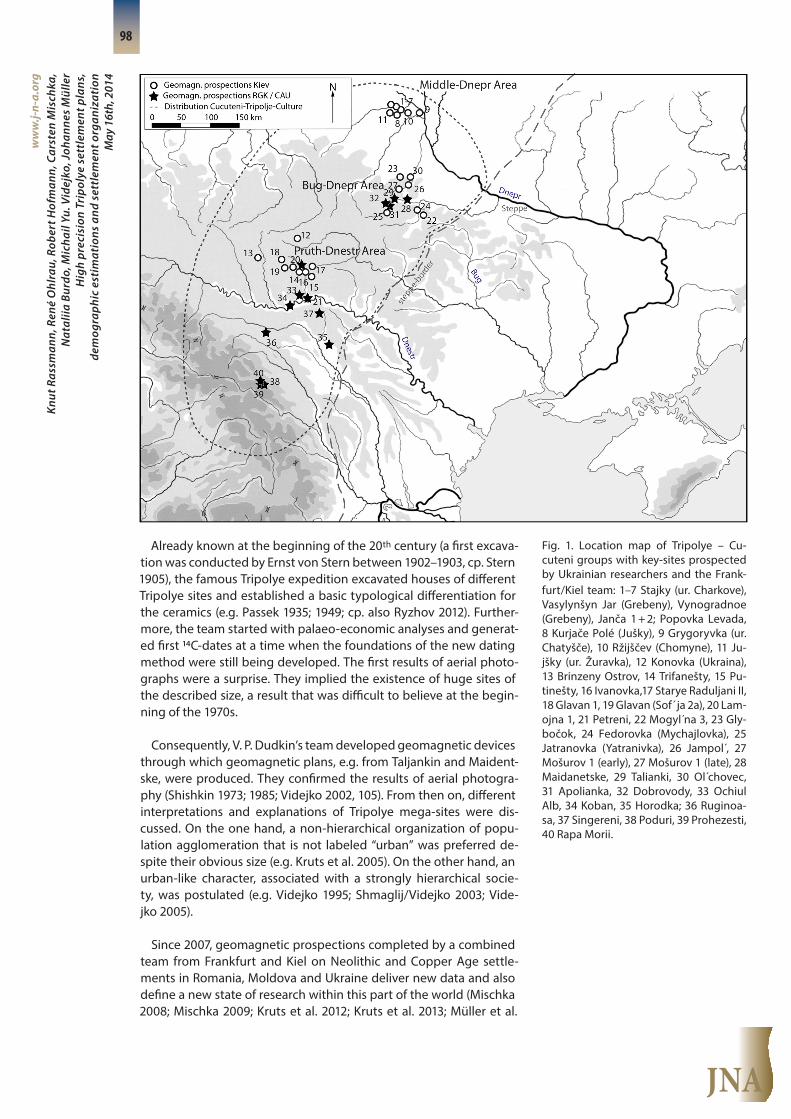
2014; Chapman et al. 2014). Large scale, high-resolution geomagnet-ic prospections, effectuated by the application of 16-channel mag-netometers (SENSYS MAGNETO®-MX ARCH), have been ground-breaking in this regard (fig. 2–4).
Fig. 2. The stationing of the GPS-system for the geomagnetic equipment (from left to right: Arne Windler, René Ohlrau, Carsten Mischka).
Fig. 3. The 4-wheel-drive and the geo-magnetic device ready to go (from left: René Ohlrau, Carsten Mischka, Knut Rass-mann, Arne Windler) at the northern part of the Talianki site.
JNA
Knut
Ras
sman
n, R
ené
Ohl
rau,
Rob
ert H
ofm
ann,
Car
sten
Mis
chka
, N
atal
iia B
urdo
, Mic
hail
Yu. V
idej
ko, J
ohan
nes
Mül
ler
Hig
h pr
ecis
ion
Trip
olye
set
tlem
ent p
lans
,de
mog
raph
ic e
stim
atio
ns a
nd s
ettl
emen
t org
aniz
atio
n M
ay 1
6th,
201
4
ww
w.j-
n-a.
org
100
2. New goals, methods and results
2.1. Research questions
The main goals of the new fieldwork project can be summarized as follows:
1) An estimation of population sizes of the mega-sites. To achieve this aim, a full plan of each site and a dating of each of the house rings or quarters at each analyzed site are necessary. The basic approach consists of the combination of geophysical surveys, target excava-tions with test trenches and proper radiocarbon dating.
2) An estimation of the carrying capacity of the environment mainly in respect to subsistence. For this, a reconstruction of soil developments and the vegetation in combination with the economic and technical potential of Tripolye communities is necessary.
3) A reconstruction of the economic and social organization of the me-ga-sites. For this objective, spatial patterns have to be analyzed in conjunction with special functions and cultural characteristics, e.g., of the households. Analyses of material culture and architectural fea-tures with a socio-chronological methodology are distinctive.
Population size – environmental conditions and economy – social organization: With these three parameters, a disentanglement of the reasons for the development and the termination of the mega-sites might be feasible. In this article, we would like to present first steps related to the reconstruction of settlement plans, thus the results of our first geomagnetic surveys.
Our project concentrates on an area of 150 km² within the Bug- Dnjestr-Interfluvial area in the Uman region (fig. 5). It is characterized by metamorphic schist, chernozem soils and small valleys with rela-tively small watercourses. Four mega-sites lie 10–15 km apart from each other.
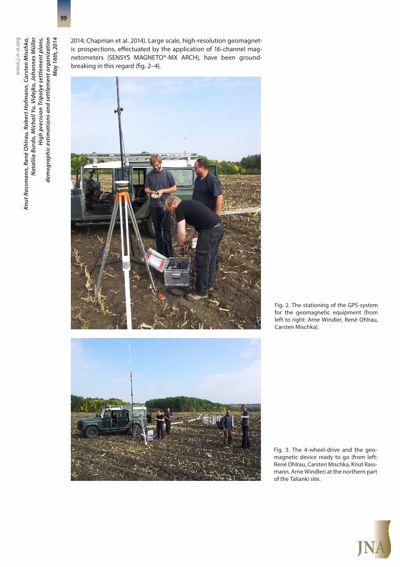
Fig. 4. Geomagnetic plan in progress: 5 km per hour, 90 hectares surveyed in one week. Talianki site.

JNA
Knut
Ras
sman
n, R
ené
Ohl
rau,
Rob
ert H
ofm
ann,
Car
sten
Mis
chka
, N
atal
iia B
urdo
, Mic
hail
Yu. V
idej
ko, J
ohan
nes
Mül
ler
Hig
h pr
ecis
ion
Trip
olye
set
tlem
ent p
lans
,de
mog
raph
ic e
stim
atio
ns a
nd s
ettl
emen
t org
aniz
atio
n M
ay 1
6th,
201
4
ww
w.j-
n-a.
org
101
The concentration of mega-sites in the Uman region might be linked to a concentration of small rivers at the southern fringe of the whole plateau. The sites, for which the geomagnetic surveys are de-scribed below, belong to Tripolye phase C1 (3800–3600 BCE), except for Apolinaka that is associated with Tripolye phase C2 (ca. 3400 BCE).
2.2. Applied Methods
2.2.1. First stage: geomagnetic prospection
Geomagnetic prospection, as a starting point, is the predominant activity of the first research phase accompanied by the study of for-mer excavation results. The new geomagnetic data has enabled us to verify detailed settlement structures (especially burnt and un-burnt houses, settlement pits and numerous other settlement struc-tures such as kilns). The team has even been able to reconstruct the chronology of the settlements with the assistance of more precise radiocarbon dates that were gained by target excavations (based on geomagnetic settlement plans) (Müller et al. in prep.).
In addition to providing information about the precise number of houses for the reconstruction of population size, high resolution geo- magnetic dates revealed complete settlement plans, allowing con-clusions to be drawn about the spatial syntax of early proto-urban settlements. The diversity in spatial ordering (i.e. houses in rows, cir-cles or unevenly distributed clusters) may suggest that specific social groups varied in size and economic, political and ideological (sym-bolic) power. We have to take into account the fact that the diverse settlement plans indicate concepts of spatial organization and their
Fig. 5. Location of the mega-sites on the plateau of the Bug-Dnepr-area. Besides the canyon system of the small rivers, the location of three mega-sites at approxi-mately 15 km distance from each other (Dobrovody, Talianki, Maidanetske) is vis-ible. Apolianka is the one idle range Trip-olye settlement in the area. The features represent the geomagnetic features of the surveys.

JNA
Knut
Ras
sman
n, R
ené
Ohl
rau,
Rob
ert H
ofm
ann,
Car
sten
Mis
chka
, N
atal
iia B
urdo
, Mic
hail
Yu. V
idej
ko, J
ohan
nes
Mül
ler
Hig
h pr
ecis
ion
Trip
olye
set
tlem
ent p
lans
,de
mog
raph
ic e
stim
atio
ns a
nd s
ettl
emen
t org
aniz
atio
n M
ay 1
6th,
201
4
ww
w.j-
n-a.
org
102
realization over a timespan which encompassed several generations. Therefore, in a second stage, target excavations are necessary to prove the contemporaneity of the discovered structures.
2.2.2. Second stage: the complex new research design
In a second research phase following the geomagnetic prospec-tion, we consequently integrate new methodological developments in archaeology. In the combined and ongoing project of the Acade-my of Science Kiev, the Romano-German-Commission and Kiel Uni-versity (cp. Müller 2014), surveys and target excavations have been and are being conducted. The extended palaeo-ecological surveys include studies on soil chemistry, analyses of phytoliths and conven-tional plant remains. They are used to reconstruct the subsistence potential of the area. Integrated in this program are different sam-ples for dating from our target excavation. The reconstruction of depositional processes within the sites and analyses on material cul-ture, especially of house positions, will enable a socio-chronologi-cal identification of internal and external Tripolye developments (cp. fig. 6).
Fig. 6. The workflow of the research pro-ject as a combination of different field ac-tivities.
laserscan
drilling
soil chemistry
plant remains
palynological data
ground-penetratingradar
geomagnetics
electromagnetics
resistivity
aerial photography
surface collection
target excavationarchaeological data
settlement structures
environmental data
pedeologicallandscape data
clari�cation of research goals
speci�cation of excavation areas and investigation and
excavation strategy
high resolution DEM

JNA
Knut
Ras
sman
n, R
ené
Ohl
rau,
Rob
ert H
ofm
ann,
Car
sten
Mis
chka
, N
atal
iia B
urdo
, Mic
hail
Yu. V
idej
ko, J
ohan
nes
Mül
ler
Hig
h pr
ecis
ion
Trip
olye
set
tlem
ent p
lans
,de
mog
raph
ic e
stim
atio
ns a
nd s
ettl
emen
t org
aniz
atio
n M
ay 1
6th,
201
4
ww
w.j-
n-a.
org
103
3. Results
In addition to other geomagnetic surveys (fig. 1), the project con-centrated its activities on four sites, including Talianki, Maidanteske, Dobrovody and Apolianka (fig. 5), which are all located in the Oblast Cherkassy. The results can also be compared with a further survey that was conducted in Moldavia on the Tripolye site of Petreni. Thus, major mega-sites of Tripolye phases C1/C2 are part of our survey.
3.1. Talianki
The mega-site Talianki is positioned at 190–220 m NHN at the southern part of a chernozem plateau that is bordered by the Talian-ki River to the east and a small watercourse in confluence with the site on the southeastern edge of the settlement (fig. 5; fig. 7–8). Dif-ferent surveys and excavations were conducted at Talianki.
Since the early 1970s, early aerial photography and geomagnet-ic prospections (Dudkin 1978; Shmaglij/Videjko1987) as well as ex-cavations revealed the immense size of the site. An excavation pro-gram, under the direction of V.A. Kruts, A.G. Korvin-Piotrovsky, V.V. Chabanyuk and L.A. Shatilo, was carried out from 1981–1999, dur-ing which more than 30 houses were excavated. The program was then continued (Kruts 1989; Kruts 2012; Kruts et al. 2001; Kruts et al. 2005). In 2011 and 2012, new geomagnetic surveys were conducted by the RGK Frankfurt a.M., Kiev Academy and Kiel University (Kruts et al. 2012; Kruts et al. 2013).
Fig. 7. Talianki. Interpretation of the early geophysical plot/aerial photograph and the geomagnetic results from 2011–2013. Georeferenced prospection of V.P. Dud-kin, 1983–1986 (after Kruts et al. 2001, 18 fig. 2a).

JNA
Knut
Ras
sman
n, R
ené
Ohl
rau,
Rob
ert H
ofm
ann,
Car
sten
Mis
chka
, N
atal
iia B
urdo
, Mic
hail
Yu. V
idej
ko, J
ohan
nes
Mül
ler
Hig
h pr
ecis
ion
Trip
olye
set
tlem
ent p
lans
,de
mog
raph
ic e
stim
atio
ns a
nd s
ettl
emen
t org
aniz
atio
n M
ay 1
6th,
201
4
ww
w.j-
n-a.
org
104
Fig. 8. Talianki. The geomagnetic features. Within the new geomagnetic survey, 195 hectares were surveyed, of which 120 hectares show signs of domestic features (fig. 8). In con-nection with older geomagnetic surveys and the results of aerial photography, the whole settlement measures 320 hectares in size (fig. 9). 140 hectares belong to the central part that is, according to current results, free of domestic or other visible structures of the Tripolye period. The settled area includes 170 hectares, so that al-ready about 70 % of the settled part has been surveyed.
While the northeastern area of the settlement is endangered or has even already been destroyed by modern building constructions of the village Talianki or of the main kolkhoz building, the other are-as of the mega-site have not yet been affected by huge erosion pro-cesses or activities of later periods (fig. 8).

JNA
Knut
Ras
sman
n, R
ené
Ohl
rau,
Rob
ert H
ofm
ann,
Car
sten
Mis
chka
, N
atal
iia B
urdo
, Mic
hail
Yu. V
idej
ko, J
ohan
nes
Mül
ler
Hig
h pr
ecis
ion
Trip
olye
set
tlem
ent p
lans
,de
mog
raph
ic e
stim
atio
ns a
nd s
ettl
emen
t org
aniz
atio
n M
ay 1
6th,
201
4
ww
w.j-
n-a.
org
105
Fig. 9a. Talianki. Interpretation of the geo-magnetic features.
Exceptional building
Burnt building
Unburnt/eroded building
Excavated building
Pit
Kiln
Older excavation
Dudkin survey
Pathway
Unknown
Kurgan
Survey area
Talianki 2011/12(Oblast Cherkassy)KBS: UMT 36nRedrawing: René Ohlrau
Legend
JNA
Knut
Ras
sman
n, R
ené
Ohl
rau,
Rob
ert H
ofm
ann,
Car
sten
Mis
chka
, N
atal
iia B
urdo
, Mic
hail
Yu. V
idej
ko, J
ohan
nes
Mül
ler
Hig
h pr
ecis
ion
Trip
olye
set
tlem
ent p
lans
,de
mog
raph
ic e
stim
atio
ns a
nd s
ettl
emen
t org
aniz
atio
n M
ay 1
6th,
201
4
ww
w.j-
n-a.
org
106
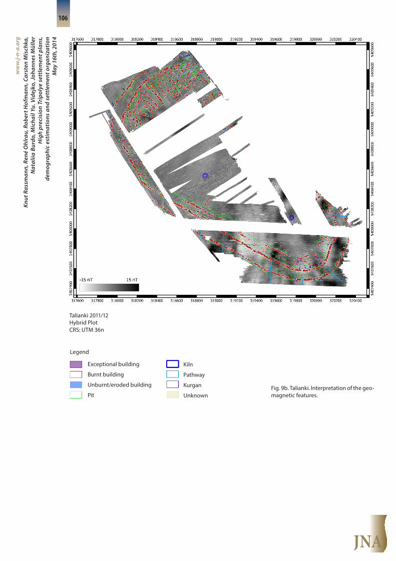
Fig. 9b. Talianki. Interpretation of the geo- magnetic features.
Exceptional building
Burnt building
Unburnt/eroded building
Pit
Kiln
Pathway
Kurgan
Unknown
Talianki 2011/12Hybrid PlotCRS: UTM 36n
Legend

JNA
Knut
Ras
sman
n, R
ené
Ohl
rau,
Rob
ert H
ofm
ann,
Car
sten
Mis
chka
, N
atal
iia B
urdo
, Mic
hail
Yu. V
idej
ko, J
ohan
nes
Mül
ler
Hig
h pr
ecis
ion
Trip
olye
set
tlem
ent p
lans
,de
mog
raph
ic e
stim
atio
ns a
nd s
ettl
emen
t org
aniz
atio
n M
ay 1
6th,
201
4
ww
w.j-
n-a.
org
107
The geomagnetic features of the new survey are described as fol-lows:
(1) 1335 burnt rectangular houses are distributed in three circu-lar-oval concentric rings, lined gable by gable and oriented on a ra-dial axis to the central free space (fig. 8; 10). Furthermore, houses are also lined in a northern quarter, again in rows but in both concentric and radial orientation to the center (fig. 11). Some houses could be identified that are lined in concentric orientation within the space in between the described house-rings. In many cases, houses cluster to smaller groups that are separated by empty spaces (fig. 10). In the geo magnetic survey, house positions that were excavated earlier could also be identified (fig. 12).
Fig. 10. Talianki. Row of heavily burnt hou- ses in the southern part of the Tripolian settlement.
Fig. 11. Talianki. The geomagnetic features in the northern part of the site.

JNA
Knut
Ras
sman
n, R
ené
Ohl
rau,
Rob
ert H
ofm
ann,
Car
sten
Mis
chka
, N
atal
iia B
urdo
, Mic
hail
Yu. V
idej
ko, J
ohan
nes
Mül
ler
Hig
h pr
ecis
ion
Trip
olye
set
tlem
ent p
lans
,de
mog
raph
ic e
stim
atio
ns a
nd s
ettl
emen
t org
aniz
atio
n M
ay 1
6th,
201
4
ww
w.j-
n-a.
org
108
(2) 221 unburnt or eroded remains of houses could be identified ei-ther by geomagnetic features or even by the layout of the pits, along aligned houses (fig. 13–14; fig. 15). In consequence, their specific dis-tribution pattern is similar to that of the burnt houses (fig. 9).
Fig. 12. Talianki. Excavation (2001–2007) area in the northwestern part of the Trip-olian settlement.
Fig. 13. Talianki. Geomagnetic prospec-tions. Overview of the location of detail- ed maps.
JNA
Knut
Ras
sman
n, R
ené
Ohl
rau,
Rob
ert H
ofm
ann,
Car
sten
Mis
chka
, N
atal
iia B
urdo
, Mic
hail
Yu. V
idej
ko, J
ohan
nes
Mül
ler
Hig
h pr
ecis
ion
Trip
olye
set
tlem
ent p
lans
,de
mog
raph
ic e
stim
atio
ns a
nd s
ettl
emen
t org
aniz
atio
n M
ay 1
6th,
201
4
ww
w.j-
n-a.
org
109
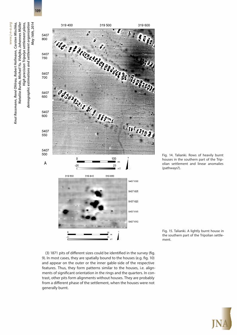
(3) 1871 pits of different sizes could be identified in the survey (fig. 9). In most cases, they are spatially bound to the houses (e.g. fig. 10) and appear on the outer or the inner gable-side of the respective features. Thus, they form patterns similar to the houses, i.e. align-ments of significant orientation in the rings and the quarters. In con-trast, other pits form alignments without houses. They are probably from a different phase of the settlement, when the houses were not generally burnt.
Fig. 14. Talianki. Rows of heavily burnt houses in the southern part of the Trip-olian settlement and linear anomalies (pathways?).
Fig. 15. Talianki. A lightly burnt house in the southern part of the Tripolian settle-ment.

JNA
Knut
Ras
sman
n, R
ené
Ohl
rau,
Rob
ert H
ofm
ann,
Car
sten
Mis
chka
, N
atal
iia B
urdo
, Mic
hail
Yu. V
idej
ko, J
ohan
nes
Mül
ler
Hig
h pr
ecis
ion
Trip
olye
set
tlem
ent p
lans
,de
mog
raph
ic e
stim
atio
ns a
nd s
ettl
emen
t org
aniz
atio
n M
ay 1
6th,
201
4
ww
w.j-
n-a.
org
110
(4) 1 possible rectangular structure might be interpreted as a spe-cial building (southern settlement). The building does not deviate from the orientation of neighboring houses. Only the bigger size and its position at the edge near to a track are special (fig. 16).
(5) 28 circular structures with high nT-values were identified as pos-sible kilns. 2 kilns were excavated in 2013 (fig. 16–17).
(6) 7 elongated geomagnetic features that are radially oriented to the main outer ring and lead away from the site are interpreted as tracks (fig. 14). If we take other empty spaces within the house-rings into consideration, about 8 gateways could be identified in the southern section at a regular distance of about 250 m from each oth-er (fig. 14).
(7) The geomagnetic features of two kurgans in the central area were identified (fig. 9). Even if the kurgans are probably dated later than the latest domestic occupation, their special position seems to indicate a central spot in the southern section of the site and a posi-tion that is perhaps linked to the track system in the center of the site. Together with kurgan-like structures that V.P. Dudkin already discov-ered in areas which his team surveyed, a line is formed by a total of 5 kurgans (fig. 7).
(8) A rectangular enclosure in the north is not in line with the gen-eral layout of houses or other features in that area and might belong to a different period (fig. 9; 11).
The overall settlement plan indicates a main ring of two parallel house rows at a distance of 100–150 m and further rings of lesser dis-tances (ca. 50 m). The huge inner empty space is obviously settled on the northern and southern fringes by clusters of houses that are well structured.
In comparison with the figures known from Maidanetske (cf. be-low), the number of houses might end up with a ratio of 9 : 3 discov-ered houses (1550 : 515), thus about 2100 houses for the entire site (ca. 330 unburnt; 1750 burnt houses).
Fig. 16. Talianki. Outer circles and inner rows of burnt houses in the south-east-ern part of the measured area.
Fig. 17. Talianki. Three circular anomalies of presumably burnt clay, perhaps kilns.

JNA
Knut
Ras
sman
n, R
ené
Ohl
rau,
Rob
ert H
ofm
ann,
Car
sten
Mis
chka
, N
atal
iia B
urdo
, Mic
hail
Yu. V
idej
ko, J
ohan
nes
Mül
ler
Hig
h pr
ecis
ion
Trip
olye
set
tlem
ent p
lans
,de
mog
raph
ic e
stim
atio
ns a
nd s
ettl
emen
t org
aniz
atio
n M
ay 1
6th,
201
4
ww
w.j-
n-a.
org
111
3.2. Maidanetske
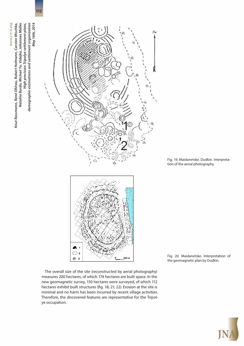
The mega-site of Maidanetske is situated west of the Talianki Riv-er and west of the village Maidanteske on the chernozem high pla-teau. The site itself is located in between the confluence of a small watercourse with the Talianki River, 170–190 m NHN (fig. 18). The site has a long research history. First excavations by G. Bzuvenglinsky (Videjko 2012, 107) took place in the 1920s, but both the documenta-tion and the material are lost. After analyses of aerial photographs by K.V. Shishkin (Shishkin 1973), the first full geomagnetic plan was con-ducted by V.P. Dudkin from 1972–1974 (Dudkin 1978). Dudkin’s plans confirmed the results already obtained by aerial photography (fig. 19–20). In field campaigns that started in 1971, several houses were excavated by Ukrainian teams until 1998 (Shmaglij/ Videjko 2003). In 2012 and 2013, the new geomagnetic survey was conducted and ex-cavations started in 2013 with the publication of preliminary results in 2014 (Müller et al. 2014).
Fig. 18. Maidanetske. Overview and loca-tion of the settlement with the location of the site.
JNA
Knut
Ras
sman
n, R
ené
Ohl
rau,
Rob
ert H
ofm
ann,
Car
sten
Mis
chka
, N
atal
iia B
urdo
, Mic
hail
Yu. V
idej
ko, J
ohan
nes
Mül
ler
Hig
h pr
ecis
ion
Trip
olye
set
tlem
ent p
lans
,de
mog
raph
ic e
stim
atio
ns a
nd s
ettl
emen
t org
aniz
atio
n M
ay 1
6th,
201
4
ww
w.j-
n-a.
org
112
The overall size of the site (reconstructed by aerial photography) measures 200 hectares, of which 174 hectares are built space. In the new geomagnetic survey, 150 hectares were surveyed, of which 112 hectares exhibit built structures (fig. 18; 21; 22). Erosion at the site is minimal and no harm has been incurred by recent village activities. Therefore, the discovered features are representative for the Tripol-ye occupation.
Fig. 19. Maidanetske. Dudkin. Interpreta-tion of the aerial photography.
Fig. 20. Maidanetske. Interpretation of the geomagnetic plan by Dudkin.

JNA
Knut
Ras
sman
n, R
ené
Ohl
rau,
Rob
ert H
ofm
ann,
Car
sten
Mis
chka
, N
atal
iia B
urdo
, Mic
hail
Yu. V
idej
ko, J
ohan
nes
Mül
ler
Hig
h pr
ecis
ion
Trip
olye
set
tlem
ent p
lans
,de
mog
raph
ic e
stim
atio
ns a
nd s
ettl
emen
t org
aniz
atio
n M
ay 1
6th,
201
4
ww
w.j-
n-a.
org
113
Fig. 21. Maidanetske. The geomagnetic features.
JNA
Knut
Ras
sman
n, R
ené
Ohl
rau,
Rob
ert H
ofm
ann,
Car
sten
Mis
chka
, N
atal
iia B
urdo
, Mic
hail
Yu. V
idej
ko, J
ohan
nes
Mül
ler
Hig
h pr
ecis
ion
Trip
olye
set
tlem
ent p
lans
,de
mog
raph
ic e
stim
atio
ns a
nd s
ettl
emen
t org
aniz
atio
n M
ay 1
6th,
201
4
ww
w.j-
n-a.
org
114
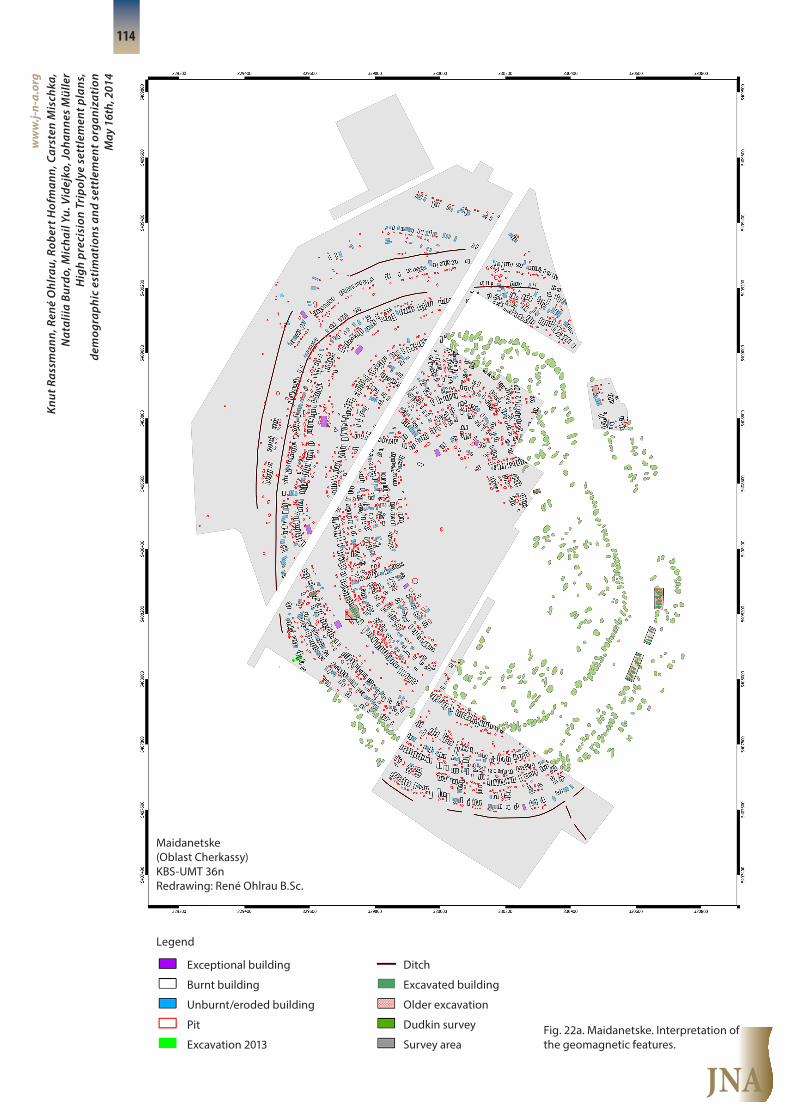
Fig. 22a. Maidanetske. Interpretation of the geomagnetic features.
Legend
Exceptional building
Burnt building
Unburnt/eroded building
Pit
Excavation 2013
Ditch
Excavated building
Older excavation
Dudkin survey
Survey area
Maidanetske(Oblast Cherkassy)KBS-UMT 36nRedrawing: René Ohlrau B.Sc.

JNA
Knut
Ras
sman
n, R
ené
Ohl
rau,
Rob
ert H
ofm
ann,
Car
sten
Mis
chka
, N
atal
iia B
urdo
, Mic
hail
Yu. V
idej
ko, J
ohan
nes
Mül
ler
Hig
h pr
ecis
ion
Trip
olye
set
tlem
ent p
lans
,de
mog
raph
ic e
stim
atio
ns a
nd s
ettl
emen
t org
aniz
atio
n M
ay 1
6th,
201
4
ww
w.j-
n-a.
org
115
Fig. 22b. Maidanetske. Interpretation of the geomagnetic features.
Legend
Exceptional building
Burnt building
Unburnt/eroded building
Pit
Ditch
Maidanetske 2011/12Hybrid PlotCRS: UTM 36n
JNA
Knut
Ras
sman
n, R
ené
Ohl
rau,
Rob
ert H
ofm
ann,
Car
sten
Mis
chka
, N
atal
iia B
urdo
, Mic
hail
Yu. V
idej
ko, J
ohan
nes
Mül
ler
Hig
h pr
ecis
ion
Trip
olye
set
tlem
ent p
lans
,de
mog
raph
ic e
stim
atio
ns a
nd s
ettl
emen
t org
aniz
atio
n M
ay 1
6th,
201
4
ww
w.j-
n-a.
org
116
The geomagnetic features of the new survey could be divided into several categories:
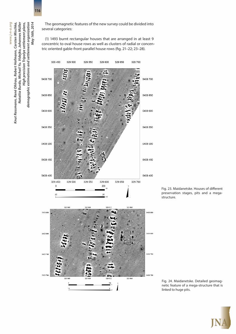
(1) 1493 burnt rectangular houses that are arranged in at least 9 concentric to oval house rows as well as clusters of radial or concen-tric oriented gable-front parallel house rows (fig. 21–22; 23–28).
Fig. 23. Maidanetske. Houses of different preservation stages, pits and a mega- structure.
Fig. 24. Maidanetske. Detailed geomag-netic feature of a mega-structure that is linked to huge pits.

JNA
Knut
Ras
sman
n, R
ené
Ohl
rau,
Rob
ert H
ofm
ann,
Car
sten
Mis
chka
, N
atal
iia B
urdo
, Mic
hail
Yu. V
idej
ko, J
ohan
nes
Mül
ler
Hig
h pr
ecis
ion
Trip
olye
set
tlem
ent p
lans
,de
mog
raph
ic e
stim
atio
ns a
nd s
ettl
emen
t org
aniz
atio
n M
ay 1
6th,
201
4
ww
w.j-
n-a.
org
117
Fig. 26. Maidanetske. Different house siz-es, a possible overlap and a mega-struc-ture.
Fig. 25. Maidanetske. Eroded or not-burn- ed houses in a house-row.

JNA
Knut
Ras
sman
n, R
ené
Ohl
rau,
Rob
ert H
ofm
ann,
Car
sten
Mis
chka
, N
atal
iia B
urdo
, Mic
hail
Yu. V
idej
ko, J
ohan
nes
Mül
ler
Hig
h pr
ecis
ion
Trip
olye
set
tlem
ent p
lans
,de
mog
raph
ic e
stim
atio
ns a
nd s
ettl
emen
t org
aniz
atio
n M
ay 1
6th,
201
4
ww
w.j-
n-a.
org
118
(2) 415 less burnt or even eroded houses that are arranged in a manner similar to the burnt houses (fig. 25–27).
(3) 9 special buildings that are characterized by their extraordinary size and their special spatial position within otherwise mainly empty house rings (fig. 22; 29; 24; 26).
(4) 1537 pits that could be found (a) associated with houses and thus also forming concentric pit alignments in accordance with the width size of the houses (fig. 23–27; 29) (b) in the empty spaces prob-ably demarcating houses that are not visible in the geomagnetic plan (fig. 26; 27) (c) seldom in loose context outside or inside the set-tlement (fig. 23–24). Pits are of quite different sizes and represent dif-ferent functions and depositional processes.
Fig. 27. Maidanetske. House-rows of dif-ferent orientation in the northern part of the site.
Fig. 28. Maidanetske. A reconstruction of the site in the Maidanetske local muse-um from 1998. The houses are placed in a forested environment (photo: Johannes Müller, Kiel).

JNA
Knut
Ras
sman
n, R
ené
Ohl
rau,
Rob
ert H
ofm
ann,
Car
sten
Mis
chka
, N
atal
iia B
urdo
, Mic
hail
Yu. V
idej
ko, J
ohan
nes
Mül
ler
Hig
h pr
ecis
ion
Trip
olye
set
tlem
ent p
lans
,de
mog
raph
ic e
stim
atio
ns a
nd s
ettl
emen
t org
aniz
atio
n M
ay 1
6th,
201
4
ww
w.j-
n-a.
org
119
(5) Some round anomalies with high nT-values that might repre-sent kilns (fig. 29).
(6) 3 possible ditches that surround parts of the settlement (fig. 21–22).
Taking both the geomagnetic features of the new survey and the features of the old geomagnetic survey and the former excavations into account, the overall patterning of the site is quite clear (fig. 28; 30; cp. 22). Centrally located is an oval space of 26 hectares with near-ly no discovered features. Around this central space at least 9 rows of parallel houses with their gables radially oriented towards the center are detected. They form empty rings in between the rows, usual-ly 20–30 m in width. An exception is one main ring with a distance to up to 100 m between the neighboring house rows. To the south and to the north of the site, the mentioned ditches are visible, part-ly overlapping with pits.
Beside the main design of Tripolye Maidanetske (an empty central space, concentric to oval house rows, the main ring, ditch systems), in the inner part of the site the settlement of the empty space obvi-ously also started with the construction of house clusters that do not fit into the general ring-pattern. Here both radial as well as concen-tric oriented houses are visible.
To the north, at least two lines of gable parallel houses with associ-ated pits are displayed in the plan. Their positioning differs from the orientation of the other concentric rows (fig. 27). They obviously rep-resent a different phase of the settlement.
Special buildings are positioned both radially oriented to the center – mostly within the gateways of the settlement – or on a con-centric axis mainly within the main ring of the site. They are charac-
Fig. 29. Maidanetske. Houses, pits and a mega-structure.

JNA
Knut
Ras
sman
n, R
ené
Ohl
rau,
Rob
ert H
ofm
ann,
Car
sten
Mis
chka
, N
atal
iia B
urdo
, Mic
hail
Yu. V
idej
ko, J
ohan
nes
Mül
ler
Hig
h pr
ecis
ion
Trip
olye
set
tlem
ent p
lans
,de
mog
raph
ic e
stim
atio
ns a
nd s
ettl
emen
t org
aniz
atio
n M
ay 1
6th,
201
4
ww
w.j-
n-a.
org
120
terized by wall trenches (Wandgräbchen). At least the spatial position of the 4 western special buildings in the main ring might indicate a distance of about 250 m.
Amoeba-like structures to the south might be interpreted as ge-ological structures, for example, as bog iron at certain depressions and not as the remains of mounds (fig. 21).
The combination of Dudkin’s plan with the new plan permitted us to calibrate the old results with the new results. It became clear that Dudkin identified more or less only half of the geomagnetic structures that were identified in the same areas by the new survey, even only one fourth of the non-burnt houses. In consequence, we end up with 2300 burnt and about 670 unburnt house structures in Maidanteske (tab. 1).
Prospection burnt eroded/unburnt
∑
2011/ 2012 1492 414 1906
Superposition Dudkin 810 103 913
Dudkin 435 64 499
Extrapolation factor 1.85 4.02 ---
Extrapolation 805 257 1062
Total 2297 671 2968
Fig. 30. Maidanetske. The reconstruction of Maidanetske as a mega-site, based on excavation results and geomagnetic sur-veys (reconstruction: René Ohlrau, Kiel).
Tab. 1. The estimated number of houses in Maidanetske based on new and old geomagnetic surveys (after Videjko 1995, 49).

JNA
Knut
Ras
sman
n, R
ené
Ohl
rau,
Rob
ert H
ofm
ann,
Car
sten
Mis
chka
, N
atal
iia B
urdo
, Mic
hail
Yu. V
idej
ko, J
ohan
nes
Mül
ler
Hig
h pr
ecis
ion
Trip
olye
set
tlem
ent p
lans
,de
mog
raph
ic e
stim
atio
ns a
nd s
ettl
emen
t org
aniz
atio
n M
ay 1
6th,
201
4
ww
w.j-
n-a.
org
121
3.3. Dobrovody
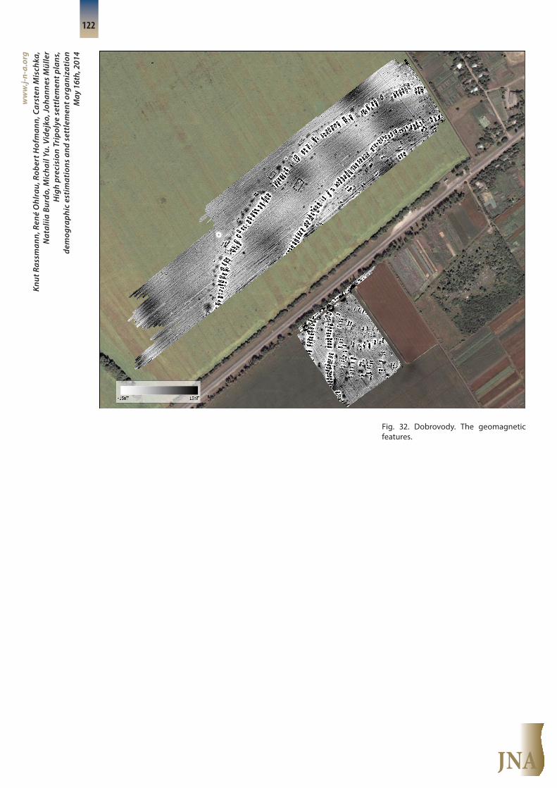
At the western fringe of the recent village of Dobrovodv, the Trip-olye site is situated at an elevation of 180–210 m NHN. The site is po-sitioned west of the small Hnizdechna River at a confluence with a smaller watercourse (fig. 31). The plain triangle in between the can-yons of both rivers at their confluence limits the dimension of the prehistoric site: Tripolyen Dobrovodv is positioned between the mentioned watercourses on chernozems. If the results of aerial pho-tography, geomagnetic surveys, small excavations and field walking are taken into account, the site might measure about 150 ha. Consid-ering K.V. Shishkin’s aerial photo, without the empty central place we are talking about 130 hectares of settled space. As modern parceling of the area into small plots, encroachments, and a modern cemetery enter the site, some damage has already been done and a complete survey of the site is no longer possible (fig. 32).
First geomagnetic prospections and excavations were conducted by N.M. Shmaglij and T. Movsha 1974–1984 (Movsha 1985a; Movsha 1985b). In 2012 and 2013, geomagnetic surveys were carried out at the site in the northern and western central areas. While subterrane-an artificial pipes, masts and heavy dipoles derogate the interpreta-tion of the geomagnetic features in the southern surveyed area, the northern surveyed area is free of modern disturbances.
Within the ca. 24 hectares that were surveyed, 4 concentric rows of houses, associated with pits at the outer and the inner sides of the concentric house chains, possible tracks and special buildings were discovered (fig. 32–33). Based on geomagnetic features within the surveyed area, 244 burnt houses, 50 unburnt or partly eroded hous-es, 231 pits of different sizes and 3 special buildings could be iden-tified.
Only 17,5 hectares of the settled area (probably 14 % of the whole settled area) have been surveyed to date. Despite the small area that was surveyed, principles of the overall layout can already be ob-served:
Fig. 31. Dobrovody. Localization and ex-tension of the site between two water-courses.
JNA
Knut
Ras
sman
n, R
ené
Ohl
rau,
Rob
ert H
ofm
ann,
Car
sten
Mis
chka
, N
atal
iia B
urdo
, Mic
hail
Yu. V
idej
ko, J
ohan
nes
Mül
ler
Hig
h pr
ecis
ion
Trip
olye
set
tlem
ent p
lans
,de
mog
raph
ic e
stim
atio
ns a
nd s
ettl
emen
t org
aniz
atio
n M
ay 1
6th,
201
4
ww
w.j-
n-a.
org
122
Fig. 32. Dobrovody. The geomagnetic features.

JNA
Knut
Ras
sman
n, R
ené
Ohl
rau,
Rob
ert H
ofm
ann,
Car
sten
Mis
chka
, N
atal
iia B
urdo
, Mic
hail
Yu. V
idej
ko, J
ohan
nes
Mül
ler
Hig
h pr
ecis
ion
Trip
olye
set
tlem
ent p
lans
,de
mog
raph
ic e
stim
atio
ns a
nd s
ettl
emen
t org
aniz
atio
n M
ay 1
6th,
201
4
ww
w.j-
n-a.
org
123
Fig. 33a. Dobrovody. Interpretation of the geomagnetic features.
Legend
Dobrovody 2012(Oblast Cherkassy)KBS: UMT 36nRedrawing: René Ohlrau B.Sc.
Exceptional building
Burnt building
Unburnt/eroded building
Pit
Kiln
Pathway
Survey area

JNA
Knut
Ras
sman
n, R
ené
Ohl
rau,
Rob
ert H
ofm
ann,
Car
sten
Mis
chka
, N
atal
iia B
urdo
, Mic
hail
Yu. V
idej
ko, J
ohan
nes
Mül
ler
Hig
h pr
ecis
ion
Trip
olye
set
tlem
ent p
lans
,de
mog
raph
ic e
stim
atio
ns a
nd s
ettl
emen
t org
aniz
atio
n M
ay 1
6th,
201
4
ww
w.j-
n-a.
org
124
Fig. 33b. Dobrovody. Interpretation of the geomagnetic features.
Exceptional building
Burnt building
Unburnt/eroded building
Pit
Kiln
Pathway
Legend
Dobrovody 2012Hybrid PlotCBS: UMT 36n
JNA
Knut
Ras
sman
n, R
ené
Ohl
rau,
Rob
ert H
ofm
ann,
Car
sten
Mis
chka
, N
atal
iia B
urdo
, Mic
hail
Yu. V
idej
ko, J
ohan
nes
Mül
ler
Hig
h pr
ecis
ion
Trip
olye
set
tlem
ent p
lans
,de
mog
raph
ic e
stim
atio
ns a
nd s
ettl
emen
t org
aniz
atio
n M
ay 1
6th,
201
4
ww
w.j-
n-a.
org
125
(1) The distance between the two outer house rows (rows 3–4) amounts to about 100 ± 50 m. Within the free space, only some pits and a special building were detected. Because of the distance be-tween the two house circuits, the inner space represents the main ring of the settlement.
(2) The distance between the two inner house rows (rows 1–2) is smaller (50 ± 20 m). If the circuits 3–4 and 1–2 are contemporaneous, the distance between rows 2–3 would amount to about 100 m. While the space between rows 3 and 4 and 1 and 2 obviously appears to be empty, the space between rows 2–3 and inside 1 seems to be filled with other pits and houses.
(3) While houses within the house-circuits are positioned with par-allel gables on concentric axes, houses within the built space be-tween the rows are positioned with parallel gables either on concen-tric or radial axes.
(4) Radially oriented geophysical structures are interpreted as pathways that lead through the outer circuit into the site. In princi-ple, they start within the main ring and pass settled areas between house rows and gables outside the settlement. Erosion can be ex-cluded. Therefore, the visible pattern seems to indicate a real spatial ordering of Tripolye times.
(5) Pits are positioned at the gable sides of the houses, in outer row 4 primarily to the northern “outward” side, for the other rows mainly positioned at the inner side.
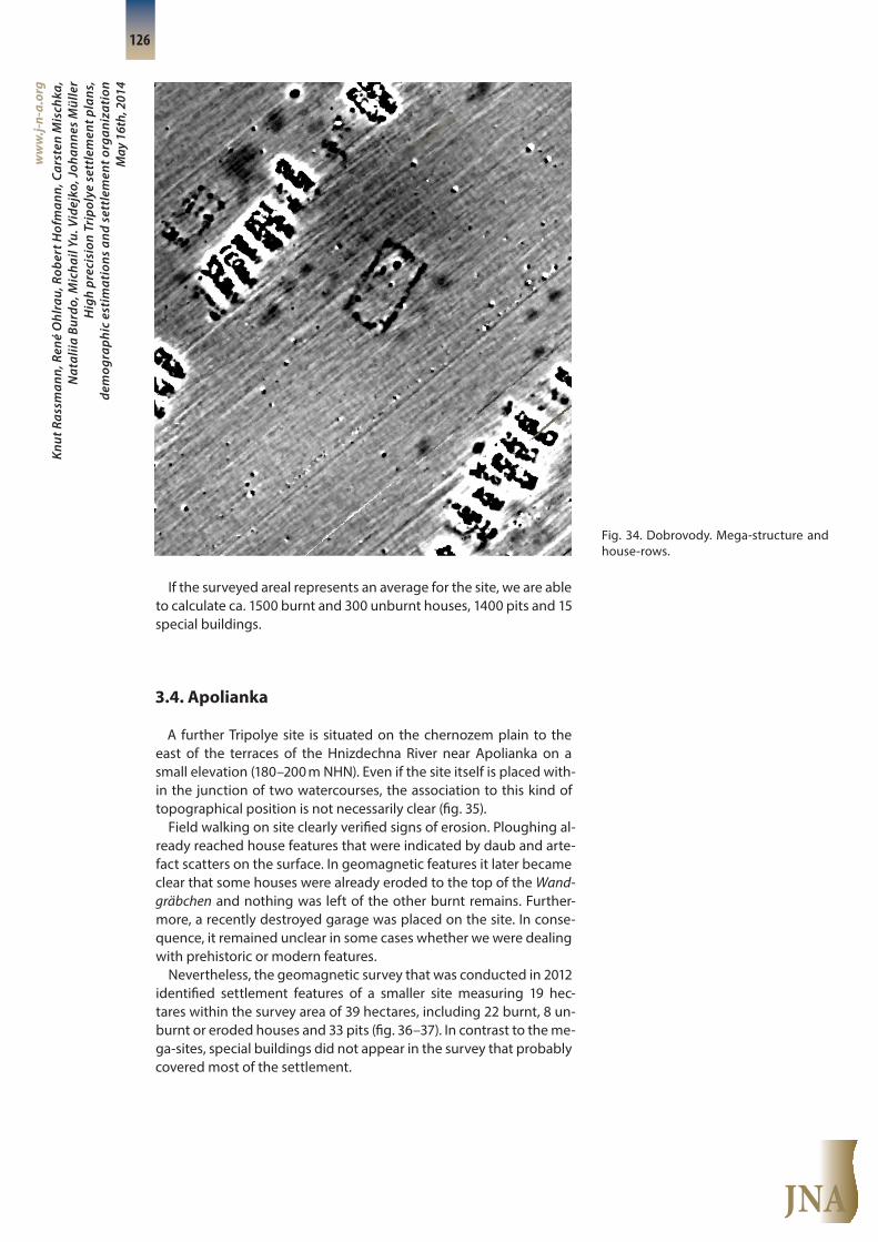
(6) Three houses or rectangular enclosures are labelled “special buildings” and are oriented on concentric axes (fig. 33–34). They all are characterized by prominent Wandgräbchen, which might indi-cate the demarcation of open spaces and not roofed areas.
The biggest building is positioned within the main ring and seems to be spatially linked to a second special building that was built at the outer side of the main ring (fig. 34). The third, only partially doc-umented special building, is found at the outer row of the main ring. The first mentioned building possesses three pits on each longer side, a spatial feature also known from the special buildings in Mai-danetske. At the two other buildings, pits are extraordinary large compared to the other pits of the site.
(7) The central place that is indicated by aerial photography was not yet included in the geomagnetic survey.
(8) At five spots, nT-values might indicate kilns (fig. 32–33).
In general, the geomagnetic plan underlines a unified concept of settlement planning for the whole site. Nevertheless, some overlaps between burnt house features and smaller differences in the house plans indicate different phases of the site (fig. 33). Furthermore, the size of the interspaces between built quarters and house rows within the site describe probable differences in the orderly housing scheme of the settlement.
In summary, the typical structures of a mega-site are visible: the typical main ring of a double row of houses, the clusters of houses and pit complexes, and signs of radial house rows.
JNA
Knut
Ras
sman
n, R
ené
Ohl
rau,
Rob
ert H
ofm
ann,
Car
sten
Mis
chka
, N
atal
iia B
urdo
, Mic
hail
Yu. V
idej
ko, J
ohan
nes
Mül
ler
Hig
h pr
ecis
ion
Trip
olye
set
tlem
ent p
lans
,de
mog
raph
ic e
stim
atio
ns a
nd s
ettl
emen
t org
aniz
atio
n M
ay 1
6th,
201
4
ww
w.j-
n-a.
org
126
If the surveyed areal represents an average for the site, we are able to calculate ca. 1500 burnt and 300 unburnt houses, 1400 pits and 15 special buildings.
3.4. Apolianka
A further Tripolye site is situated on the chernozem plain to the east of the terraces of the Hnizdechna River near Apolianka on a small elevation (180–200 m NHN). Even if the site itself is placed with-in the junction of two watercourses, the association to this kind of topographical position is not necessarily clear (fig. 35).
Field walking on site clearly verified signs of erosion. Ploughing al-ready reached house features that were indicated by daub and arte-fact scatters on the surface. In geomagnetic features it later became clear that some houses were already eroded to the top of the Wand-gräbchen and nothing was left of the other burnt remains. Further-more, a recently destroyed garage was placed on the site. In conse-quence, it remained unclear in some cases whether we were dealing with prehistoric or modern features.
Nevertheless, the geomagnetic survey that was conducted in 2012 identified settlement features of a smaller site measuring 19 hec-tares within the survey area of 39 hectares, including 22 burnt, 8 un-burnt or eroded houses and 33 pits (fig. 36–37). In contrast to the me-ga-sites, special buildings did not appear in the survey that probably covered most of the settlement.
Fig. 34. Dobrovody. Mega-structure and house-rows.

JNA
Knut
Ras
sman
n, R
ené
Ohl
rau,
Rob
ert H
ofm
ann,
Car
sten
Mis
chka
, N
atal
iia B
urdo
, Mic
hail
Yu. V
idej
ko, J
ohan
nes
Mül
ler
Hig
h pr
ecis
ion
Trip
olye
set
tlem
ent p
lans
,de
mog
raph
ic e
stim
atio
ns a
nd s
ettl
emen
t org
aniz
atio
n M
ay 1
6th,
201
4
ww
w.j-
n-a.
org
127
Fig. 35. Apolianka. Localization and ex-tension of the site between two water-courses.
Fig. 36. Apolianka. The geomagnetic fea-tures.

JNA
Knut
Ras
sman
n, R
ené
Ohl
rau,
Rob
ert H
ofm
ann,
Car
sten
Mis
chka
, N
atal
iia B
urdo
, Mic
hail
Yu. V
idej
ko, J
ohan
nes
Mül
ler
Hig
h pr
ecis
ion
Trip
olye
set
tlem
ent p
lans
,de
mog
raph
ic e
stim
atio
ns a
nd s
ettl
emen
t org
aniz
atio
n M
ay 1
6th,
201
4
ww
w.j-
n-a.
org
128
Fig. 37a. Apolianka. Interpretation of the geomagnetic features.
Legend
Apolianka 2012(Oblast Cherkassy)KBS: UMT 36nRedrawing: René Ohlrau B.Sc.
Burnt building
Unburnt/eroded building
Pit
Survey area
JNA
Knut
Ras
sman
n, R
ené
Ohl
rau,
Rob
ert H
ofm
ann,
Car
sten
Mis
chka
, N
atal
iia B
urdo
, Mic
hail
Yu. V
idej
ko, J
ohan
nes
Mül
ler
Hig
h pr
ecis
ion
Trip
olye
set
tlem
ent p
lans
,de
mog
raph
ic e
stim
atio
ns a
nd s
ettl
emen
t org
aniz
atio
n M
ay 1
6th,
201
4
ww
w.j-
n-a.
org
129
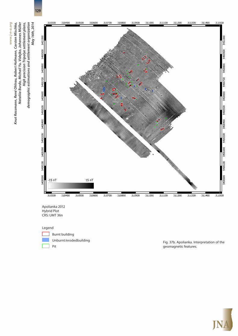
Fig. 37b. Apolianka. Interpretation of the geomagnetic features.
Legend
Apolianka 2012Hybrid PlotCRS: UMT 36n
Burnt building
Unburnt/erodedbuilding
Pit

JNA
Knut
Ras
sman
n, R
ené
Ohl
rau,
Rob
ert H
ofm
ann,
Car
sten
Mis
chka
, N
atal
iia B
urdo
, Mic
hail
Yu. V
idej
ko, J
ohan
nes
Mül
ler
Hig
h pr
ecis
ion
Trip
olye
set
tlem
ent p
lans
,de
mog
raph
ic e
stim
atio
ns a
nd s
ettl
emen
t org
aniz
atio
n M
ay 1
6th,
201
4
ww
w.j-
n-a.
org
130
In the southwest section of the survey, the radial orientation of some of the geomagnetically revealed house features contrasts to the linear orientation of other bigger houses in the north and the southeast. Perhaps different phases are visible. Furthermore, spac-es without geomagnetic phases at the outer spaces of the surveyed area might already show that we are dealing with the boundaries of at least one of the settlements (especially to the southwest). The ter-rain backslides to the west. Signs of erosion are detectable in the geo- magnetic plan.
In spite of these limitations for the interpretation of the detected geomagnetic features, the size of the settlement appears to have been much smaller than that of the other sites. In total, we would es-timate about 30 houses on 30 hectares. In addition, the differences between the houses are much more pronounced than at the other surveyed sites. Moreover, a clear association between pits and hous-es is not present. Thus, Apolianka is a smaller Tripolye site with par-tially different principles for the organization of social space than at the mega-sites.
3.5. Other sites
Apart from the geomagnetic surveys that are presented in this ar-ticle, the surveys of the Nebelivka and Petreni sites are of particu-lar interest. At Nebelivka that lies 15 km south of Apolianka, a Brit-ish-Ukrainian team conducted fieldwork, including excavations (Chapman/Videjko 2011; Chapman et al. 2014). The site itself mea-sures 120 hectares. The general density of houses is lower than at Talianki and Maidanetske. Nebelivka was apparently abandoned at an earlier stage of site history than Maidanetske and Talianki. Never-theless, all types of features described for the other sites here were also visible in Nebelivka. Thus, the general layout of mega-sites is comparable.
A much smaller site, which is the biggest in the western distribu-tion of Tripolye, is Petreni in Moldavia. Here, the geomagnetic survey confirmed the features that V.P. Dudkin had already interpreted (fig. 38–39), but on a more elaborated scale. Petreni is not a mega-site, as it measures less than 100 ha in size, but the clear design of at least four house circles and the built space in between, arranged concen-trically around the center, are striking. Two ditch/palisade-like struc-tures might imply two phases. The site is surrounded by circular ge-omagnetic features. They might signal huge waste pits, but possibly also kilns, originally interpreted as towers. In the center, houses fol-low the layout of a probable track system, and a central structure was excavated in 2012.

JNA
Knut
Ras
sman
n, R
ené
Ohl
rau,
Rob
ert H
ofm
ann,
Car
sten
Mis
chka
, N
atal
iia B
urdo
, Mic
hail
Yu. V
idej
ko, J
ohan
nes
Mül
ler
Hig
h pr
ecis
ion
Trip
olye
set
tlem
ent p
lans
,de
mog
raph
ic e
stim
atio
ns a
nd s
ettl
emen
t org
aniz
atio
n M
ay 1
6th,
201
4
ww
w.j-
n-a.
org
131
Fig. 38. Petreni. The geomagnetic fea-tures.
house phase 1
ditch
N
0 200 m
house phase 2
edge of slope
settlement pits
circular anomalie (interpret. ?=
Fig. 39. Petreni. Interpretation of the geo-magnetic features.

JNA
Knut
Ras
sman
n, R
ené
Ohl
rau,
Rob
ert H
ofm
ann,
Car
sten
Mis
chka
, N
atal
iia B
urdo
, Mic
hail
Yu. V
idej
ko, J
ohan
nes
Mül
ler
Hig
h pr
ecis
ion
Trip
olye
set
tlem
ent p
lans
,de
mog
raph
ic e
stim
atio
ns a
nd s
ettl
emen
t org
aniz
atio
n M
ay 1
6th,
201
4
ww
w.j-
n-a.
org
132
4. Interpretations
The new geomagnetic surveys displayed the huge number of houses and the clear spatial organization of the sites under investi-gation. The principle of concentric rings of houses around an inner space that is left empty at the mega-sites is visible at each site. While the density of houses at Nebelivka remains small in relation to the occupied and enclosed areas, domestic quarters were also created at the inner side of the inner rings at both Talianki and Maidanetske. It is striking at Maidanetske that the community obviously started to settle most parts of the internal area. At medium-sized sites, such as Petreni, and smaller sites, such as Apolianka, a similar occupation principle is still visible.
In contrast to the geomagnetic surveys before 2005, after 2005 geomagnetic devices with high-resolution also detected pits, kilns, track ways and other features besides the known “large” structures. The majority of pits reflect the spatial pattern of the houses, as they are localized at one of the gable ends of the houses. If pits without geomagnetically visible houses appear in such concentric pit align-ments, the existence of unburnt houses is probable. Recent excava-tions (forthcoming) confirm different types of pits. Their different functions are reflected in their different localizations, e.g., non-waste pits are situated in non-house areas.
Tracks and trackways existed at the sites and structured the entire settlements. Their existence is particularly visible in the geomagnet-ic plans of Talianki and Maidanetske. We are also able to reconstruct tracks in empty spaces between the house rows and remaining
“house-free” bridges. In general, it appears that in the southern part of Maidanetske a track entered the site radially through the outer house rings every 200 m.
In Maidanetske, the organization of the site was reconstructed by a spatial analysis of the distribution of normal houses, mega-struc-tures and recently identified and excavated kilns (Ohlrau 2014). In re-sult, the site was divided into quarters. Within them public activities or institutions are displayed by one mega-structure per quarter and a kiln as a kind of centralized production feature, again per quarter. In fact, the average size of these units (ca. 150 houses) and their spa-tial size correlate with the spatial distances of the tracks, where they were visible. Obviously, the internal organization of the mega-sites implies a hierarchical system of political institutions. Whether such a society was stratified or not stratified remains a matter of discussion.
The results of the dating of the settlement structures at Maidanet-ske (Müller et al. in prep.) enable us to calculate the population size of one mega-site on a solid basis for the first time. Whereas prelimi-nary population estimations were either based on a general assump-tion that the contemporaneous existence of structures was visible from the symmetrical ground plan, or on calculations of the carrying capacity, the current radiometric dates make the contemporaneous existence of the houses more reliable. The reflection of house classes in the geomagnetic plan, as were detected in former and recent ex-cavations, displays different types, but in general, standardization is obvious (cp. Chernovol 2012, 200). If we construct a model of popu-lation size on this baseline, at least 2297 houses existed contempora-

JNA
Knut
Ras
sman
n, R
ené
Ohl
rau,
Rob
ert H
ofm
ann,
Car
sten
Mis
chka
, N
atal
iia B
urdo
, Mic
hail
Yu. V
idej
ko, J
ohan
nes
Mül
ler
Hig
h pr
ecis
ion
Trip
olye
set
tlem
ent p
lans
,de
mog
raph
ic e
stim
atio
ns a
nd s
ettl
emen
t org
aniz
atio
n M
ay 1
6th,
201
4
ww
w.j-
n-a.
org
133
neously at Maidanetske, perhaps even 2968. An average house size of 77 m² enables us to calculate the number of inhabitants on the ba-sis of known space requirements for persons in sedentary societies. Ethnographical observations confirm that a person needs 5–15 m² in a house, averaging 6.9 m² (tab. 2).
Area/Person (m2)
Houses2297
Houses2633
Houses2068
176869 m2 202741 m² 228536 m² 77 m² pro Haus
5 35373.8 40548.2 45707.2
6.97 25375.75 29087.66 32788.2
15 11791.22 13516.33 15235.7
The estimated population of Maidanetske thus amounts to about 12,000 inhabitants according to conservative estimations, but with the possibility of about 46,000 inhabitants and a probable average of 29,000 inhabitants.
Thus, the combination of geophysical surveys with ethnographical interpretation and sociological theory introduces a new opportunity for interdisciplinary research. While here a few remarks point to the potential of the new spatial data, further analysis will derive more detailed reconstructions of spatial and social behavior.
5. References
Chapman et al. 2014: J. Chapman/ M. Videjko/ D. Hale/ B. Gaydarska/ N. Bur-do/ K. Rassmann/ C. Mischka/ J. Müller/ A.G. Korvin-Piotrovskiy/ V. Kruts, The Second Phase of the Trypillia Mega-Site Methodological Revolution. A New Research Agenda. European Journal of Archaeology 17/3, 2014, 369–406.
Chapman/Videjko 2011: J. Chapman/ M. Videjko, The Tripillia culture me-ga-site near Nebelivka. Summer 2009 season. Praehistorica XXIX, 2011, 79–94.
Diachenko 2012, A. Diachenko, Settlement System of West Tripolye Culture in the Southern Bug and Dnieper Interfluve. Formation Problems. In: F. Menotti/ A. Korvin-Piotrovskiy (eds.) The Tripolye Culture Giant-Settle-ments in Ukraine. Formation, Development and Decline (Oxford 2012) 116–138.
Diachenko/Menotti 2012: A. Diachenko/ F. Menotti, The gravity model: monitoring the formation and development of the Tripolye culture gi-ant-settlements in Ukraine. Journal of Archaeological Science 39, 2012, 2810–2817.
Dudkin 1978: V.P. Dudkin, Geofizicheskaya razvedka krupnih tripol’skih poselenii. In: V.F. Genining (ed.) Ispol’zovanie metodov estestvennih nauk v arheologii (Kyiv 1978) 35–45.
Kruts 1989: V. Kruts, On the history of the population of Tripolye culture in the South Bug-Dnieper Interfluve. In: Primeval Archaeology. Materials and Studies. Collection of scientific works (Kiev 1989) 117–32.
Tab. 2. Population estimations for Mai-danetske based on estimated maximal and minimal areas per person and esti-mated maximal and minimal numbers of contemporary houses.
JNA
Knut
Ras
sman
n, R
ené
Ohl
rau,
Rob
ert H
ofm
ann,
Car
sten
Mis
chka
, N
atal
iia B
urdo
, Mic
hail
Yu. V
idej
ko, J
ohan
nes
Mül
ler
Hig
h pr
ecis
ion
Trip
olye
set
tlem
ent p
lans
,de
mog
raph
ic e
stim
atio
ns a
nd s
ettl
emen
t org
aniz
atio
n M
ay 1
6th,
201
4
ww
w.j-
n-a.
org
134
Kruts 2012: V. Kruts, Giant-settlements of Tripolye Culture. In: F. Menotti/ A. Korvin-Piotrovskiy (eds.) The Tripolye Culture Giant-Settlements in Ukraine. Formation, Development and Decline (Oxford 2012) 70–78.
Kruts et al. 2001: V.A. Kruts/ A.G. Korvin-Piotrovskiy/ S. Ryzhov, Tripol’skoe poselenie-gigant Taljaniki. Issledovaniya 2001 (Kiev 2001).
Kruts et al. 2005: V. Kruts/ A.G. Korvin-Piotrovskiy/ S. Ryzhov/ G. Buzian/ E. Ovchinnikov/ D. Chernovol/ V. Chabanyuk, Studies of Tripolye Culture Giant-settlements 2002—2004 (Kiev 2005).
Kruts et al. 2012: V.A. Kruts/ A.G. Korvin-Piotrovskiy /D. Peters/ K. Rassmann, Talianki reloaded: Geomagnetic Prospection three decades after V. P. Dudkins work. In: V.A. Kruts/A.G. Korvin-Piotrovskiy (eds.) Settlement gi-ants of the Tripolian Culture. Investigation 2011 (Kiiv 2012) 60–85.
Kruts et al. 2013: V.A. Kruts/ A.G. Korvin-Piotrovskiy/ C. Mischka/ R. Ohlrau/ A. Windler/ K. Rassmann, Talianki 2012: The Geomagnetic Prospection. In: A.G. Korvin-Piotrovskiy/K. Rassmann (eds.) Settlement giants of the Tripolian Culture. Investigation 2012 (Kiiv 2013) 85–103.
Menotti/Korvin-Piotrovskiy 2012: F. Menotti/ A. Korvin-Piotrovskiy (eds.) The Tripolye Culture Giant-Settlements in Ukraine. Formation, Develop-ment and Decline (Oxford 2012).
Mischka 2008: C. Mischka, Geomagnetische Prospektion neolithischer und kupferzeitlicher Siedlungen in Rumänien. Eurasia Antiqua 14, 2008, 101–116.
Movsha 1985a: T.G. Movsha, Srednii i pozdnii etap tripolskoi kultury In: I. I. Artemenko (ed.) Arkheologia Ukrainskoi SSR (Kiev 1985) 206–263.
Movsha 1985b: T.G. Movsha, Vzaemovidnosiny Tripillya-Cucuteni z synkhronnimi kulturami Tsentralnoi Evropy, Arkheologia 51, 1985, 22–31.
Mischka 2009: C. Mischka, Neue Ergebnisse der geomagnetischen Prospek-tionen neolithischer und kupferzeitlicher Siedlungen in Rumänien. Eur-asia Antiqua 15, 2009, 1–14.
Müller et al. 2014: Müller, J./ Hofmann, R./ Rassmann, K./ Mischka, C./ Vid-eyko, M.Y./ Burdo, N., Maydanetskoe: Investigations, Based on Up-dated Plan (Майданецкое: исследования по обновленному плану поселения), Stratum Plus 2, 2014, 285–302.
Müller, J. 2014: Forschung des Institutes zu Tripolye [online] [accessed 9 April 2014]. Available at: <http://www.ufg.uni-kiel.de/index.php/?op-tion=com_content&view=article&id=198/>.
Müller et al. in prep.: J. Müller/ R. Hofmann/ R. Ohlrau/ K. Rassmann/ M. Vide-ko, Prehistoric megasites with an estimated population >20,000 inhab-itants.
Passek 1935: T. Passek, La ceramique tripolienne. Bulletin of the State Acad-emy of Material Culture 122, 1935, 3–165.
Passek 1949: T.S. Passek, Periodizatsiya tripolskikh poselenii. Materialy i ies-ledovaniya po arkheologii SSSR 10 (Moskau 1949).
Ohlrau 2014: R. Ohlrau, Tripolje Großsiedlungen. Geomagnetische Prospek-tion und architektursoziologische Perspektiven (CAU Kiel 2014, unpub-lished MA-Thesis).
Ryzhov 2012: S. Ryzhov, Relative Chronology of the Giant-Settlement Period BII-CI. In: F. Menotti/ A. Korvin-Piotrovskiy (eds.) The Tripolye Culture Gi-ant-Settlements in Ukraine. Formation, Development and Decline (Ox-ford 2012) 79–115.
Shishkin 1973: K. V. Shishkin, Z praktiki deshifruvannya aero-fotoznimkiv u arheologichnih tsiliyah. Arheologiya 10, 1973, 32–41.
Shishkin 1985: K. V. Shishkin, Planuvannya tripilskih poselen za danimi aero-fotoziomki. Arheologiya 52, 1985, 72–77.
Shmaglij/Videjko 1987: N.M. Shmaglij/ M.Videiko, Svyatilishta i kul’tovie mesta na krupnih tripol’skih poseleniyah. Religioznie predstavleniya v pervobitnom obshtestve. Doctoral thesis, Moskva University.
Shmaglij/Videjko 2003: N. Shmaglij und M. Videjko, Maidanetskoe - a Trip-olian proto-city (2001–2002). Stratum. The Tripoliada Land 2, 2003, 44–136.
Shmaglij et al. 1973: N.M. Shmaglij/ V.P. Dudkin/ K.V. Zinakovskyii, Pro kom-pleksne vivchennya tripil’skih poselen. Arheologiya, 10, 1973, 23–31.
Stern 1905: E. v. Stern, Die „prämykenische“ Kultur in Südrußland (Moskau 1905).
Videjko 1995: M. Videjko, Großsiedlungen der Tripol’e-Kultur in der Ukraine. Eurasia Antiqua 1, 1995, 45–80.
Videjko 2002: M. Videjko, Trypillia Culture Proto-Cities. History of Investiga-tions (Kiev 2002).
Videjko 2005: M. Videjko, Looking for Trypillia Culture Proto-Cities (Kiev 2005).
Imprint
ISSN 2197-649X
Layout draft: Janine Cordts, Holger DieterichSection editor: Martin HinzTechnical edition: Janine CordtsProof reading: Eileen KüçükkaracaPublished by the Institute of Prehi-storic and Protohistoric Archaeology,CAU Kiel; All rights reserved.For further information consultwww.jna.uni-kiel.de