Excavation of an iron Age, Early Historic and medieval settlement and metalworking site at Eilean...
78
Proc Soc Antiq Scot 138 (2008), 27–104 Excavation of an Iron Age, Early Historic and medieval settlement and metalworking site at Eilean Olabhat, North Uist Ian Armit*, Ewan Campbell † and Andrew Dunwell ‡ with contributions from Rupert Housley, Fraser Hunter, Adam Jackson, Melanie Johnson, Dawn McLaren, Jennifer Miller, K R Murdoch, Jennifer Thoms, and Graeme Warren and illustrations by Alan Braby, Craig Evenden, Libby Mulqueeny and Leeanne Whitelaw ABSTRACT The promontory site of Eilean Olabhat, North Uist was excavated between 1986 and 1990 as part of the Loch Olabhat Research Project. It was shown to be a complex enclosed settlement and industrial site with several distinct episodes of occupation. The earliest remains comprise a small Iron Age building dating to the middle centuries of the first millennium BC, which was modified on several occasions prior to its abandonment. Much later, the Early Historic remains comprise a small cellular building, latterly used as a small workshop within which fine bronze and silverwork was produced in the fifth to seventh centuries AD. Evidence of this activity is represented by quantities of mould and crucible fragments as well as tuyère and other industrial waste products. The site subsequently fell into decay for a second time prior to its medieval reoccupation probably in the 14th to 16th centuries AD. Eilean Olabhat has produced a well-stratified, though discontinuous, structural and artefactual sequence from the mid-first millennium BC to the later second millennium AD, and has important implications for ceramic development in the Western Isles over that period, as well as providing significant evidence for the nature and social context of Early Historic metalworking. * Division of Archaeological, Geographical and Environmental Sciences, University of Bradford, Bradford, West Yorkshire BD7 1DP † Department of Archaeology, Gregory Building, University of Glasgow, Glasgow G12 8QQ ‡ CFA Archaeology, Old Engine House, Eskmills, Station Road, Musselburgh, East Lothian EH21 7PQ INTRODUCTION The small enclosed promontory of Eilean Olabhat (NGR: NF 7496 7528) projects into the south side of Loch Olabhat, towards its eastern end, in the north-western part of North Uist (illus 1, 2a). It lies some 200m east of the Neolithic islet of Eilean Domhnuill (Armit 1992; 1996) and 300m east of the late medieval shore-side settlement of Druim nan Dearcag (Armit 1997). A stone wall, which surrounds the promontory on three sides, is now mostly high and dry above the loch waters. The vicinity is now marshy peat bog, punctuated by occasional rock outcrops and
Transcript of Excavation of an iron Age, Early Historic and medieval settlement and metalworking site at Eilean...

excavation at eilean olabhat, north uist | 27Proc Soc Antiq Scot 138 (2008), 27–104
excavation of an iron age, early historic and medieval settlement and metalworking site at eilean olabhat, north uist
ian armit*, ewan campbell† and andrew Dunwell‡with contributions from rupert housley, Fraser hunter, adam Jackson, Melanie Johnson, Dawn Mclaren, Jennifer Miller, K r Murdoch, Jennifer thoms, and Graeme Warrenand illustrations by alan braby, craig evenden, libby Mulqueeny and leeanne Whitelaw
abstract
The promontory site of Eilean Olabhat, North Uist was excavated between 1986 and 1990 as part of the Loch Olabhat Research Project. It was shown to be a complex enclosed settlement and industrial site with several distinct episodes of occupation. The earliest remains comprise a small Iron Age building dating to the middle centuries of the first millennium bc, which was modified on several occasions prior to its abandonment. Much later, the Early Historic remains comprise a small cellular building, latterly used as a small workshop within which fine bronze and silverwork was produced in the fifth to seventh centuries ad. Evidence of this activity is represented by quantities of mould and crucible fragments as well as tuyère and other industrial waste products. The site subsequently fell into decay for a second time prior to its medieval reoccupation probably in the 14th to 16th centuries ad. Eilean Olabhat has produced a well-stratified, though discontinuous, structural and artefactual sequence from the mid-first millennium bc to the later second millennium ad, and has important implications for ceramic development in the Western Isles over that period, as well as providing significant evidence for the nature and social context of Early Historic metalworking.
* Division of archaeological, Geographical and environmental sciences, university of bradford, bradford, West Yorkshire bD7 1DP† Department of archaeology, Gregory building, university of Glasgow, Glasgow G12 8QQ‡ cFa archaeology, old engine house, eskmills, station road, Musselburgh, east lothian eh21 7PQ
introDuction
the small enclosed promontory of eilean olabhat (nGr: nF 7496 7528) projects into the south side of loch olabhat, towards its eastern end, in the north-western part of north uist (illus 1, 2a). it lies some 200m east of the neolithic
islet of eilean Domhnuill (armit 1992; 1996) and 300m east of the late medieval shore-side settlement of Druim nan Dearcag (armit 1997). a stone wall, which surrounds the promontory on three sides, is now mostly high and dry above the loch waters. the vicinity is now marshy peat bog, punctuated by occasional rock outcrops and

28 | societY oF antiQuaries oF scotlanD, 2008
Illus 1 location maps
traversed by a 19th-century road which passes close to the south of the promontory (the dating is based on its absence from reid’s map of 1799 but its depiction on the first edition Ordnance survey map surveyed in 1875). the site lies just beyond the range of surviving rig and furrow cultivation remains which cover much of the
area between loch olabhat and the north coast of north uist approximately 1km to the north.
the name eilean olabhat was coined during the excavation to compensate for the lack of any ‘official’ name for the site on past and present maps of the area, and the absence of any known traditional name. the existence

excavation at eilean olabhat, north uist | 29
Illus 2 eilean olabhat, (a) from the south showing the promontory within loch olabhat, and the structures on the western knoll and enclosing wall, and (b) details of the surface features on the western knoll prior to excavation (Phase 4, structure 1 in foreground)
(a)
(b)

30 | societY oF antiQuaries oF scotlanD, 2008
of an archaeological site on the promontory is not recorded on any known maps or other documentary sources, including erskine beveridge’s weighty compendium North Uist (1911). the wall around the promontory is, however, indicated on the first edition Ordnance survey map for the area (1881).
Eilean Olabhat was first identified during field survey by one of the authors, Ian Armit, in 1985 (illus 2b) and was excavated during three short seasons in 1986, 1989 and 1990, as part of the loch olabhat research Project (armit 1986; 1990). initial excavations were intended to assess the nature and date of the site as part of a wider investigation of the origins of the atlantic roundhouses of the hebridean iron
Illus 3
Hornwork Hornwork
40m0
Rocky Shore
Illus 3 topographic plan showing trench locations
age; a study which eventually metamorphosed into that published as armit 1992. on the basis of its morphology and the suggestion that its surrounding enclosure might relate to a period of lower loch level, it was suspected that eilean olabhat might represent a precursor of what was then thought to be an atlantic roundhouse on the adjacent eilean Domhnuill. ironically, although the latter site transpired on excavation to be a waterlogged neolithic islet settlement, millennia earlier than suspected by earlier surveyors and excavators (cf armit 1990; 1992), thus undermining the original reasoning, eilean olabhat did eventually transpire to be (inter alia) exactly the sort of early iron age settlement that had been sought.
excavation at eilean olabhat, north uist | 31
Illus 4
Phase 1a Phase 1b
Phase 2
Phase 1b
Phase 1a
Phase 3
Phase 2 Phase 4
Legend
Phase 4
Phase 3
2m0
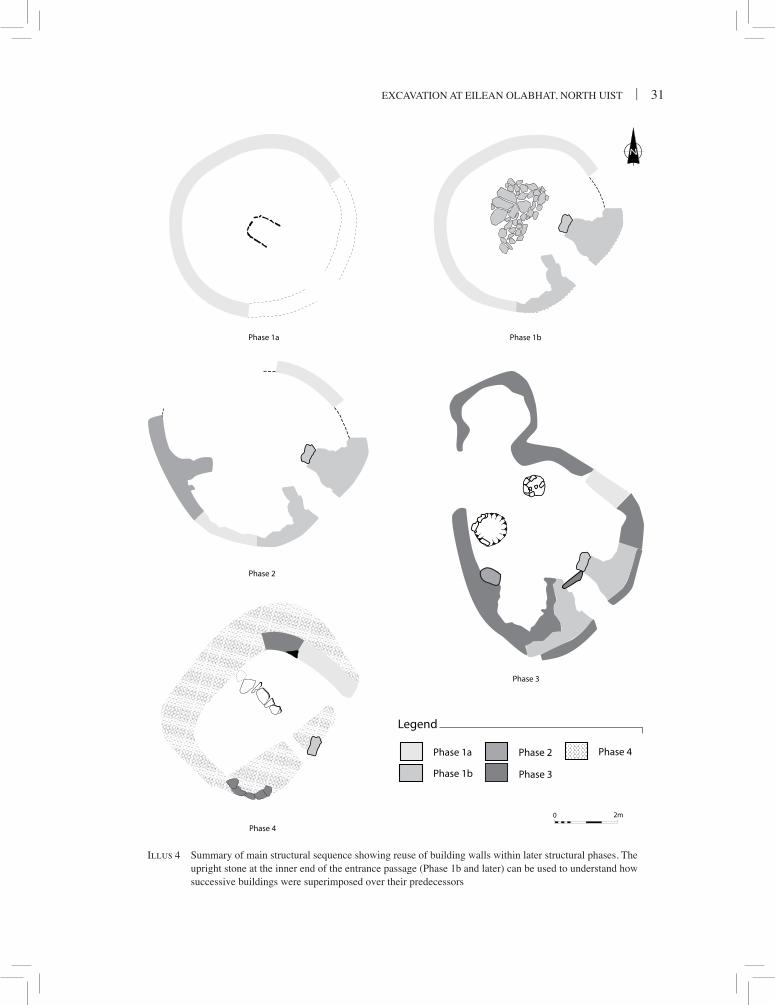
Illus 4 summary of main structural sequence showing reuse of building walls within later structural phases. the upright stone at the inner end of the entrance passage (Phase 1b and later) can be used to understand how successive buildings were superimposed over their predecessors
32 | societY oF antiQuaries oF scotlanD, 2008
Sector Character Later use?
s–sW coursing of tabular and blocky stones; generally surviving to three courses high
reused in Phase 2 structure; sealed behind Phase 3 remains, following partial dismantling
sW–WsW blocky stones, one or two courses high Dismantled before being sealed beneath Phase 2 floor deposits
WsW–WnW no stonework preserved; line of wall face preserved as scarp 0.1m deep cut into natural subsoil to create a level floor
Dismantled before being sealed beneath Phase 2 pier & Phase 3 deposits
WnW–n basal course only Dismantled before being sealed beneath Phase 3 deposits; not part of Phase 2 wall
n–ne coursing of tabular and blocky stones, up to six courses high
reused in Phases 2, 3 and 4 structures; remains quite possibly not wholly original to Phase 1 (ie upper courses may have been modified)
Table 1character of the Phase 1a wall, inner face
the loch olabhat research Project was directed by ian armit, and the excavations at eilean olabhat were supervised after 1986 by andrew Dunwell, who also co-directed much of the post-excavation work. a good deal of the work on the finds and, latterly, dating evidence was carried out by ewan campbell. Full stratigraphic details of the excavations are contained in the site archive deposited with the national Monuments records of scotland.
excavation results
the promontory of eilean olabhat comprises three knolls linked by lower-lying ground (illus 3). surface traces of stone buildings were identified on the western, and most pronounced, of these knolls (illus 2b), and this was where excavation focused (trench 1). the adjacent central knoll was flat-topped and of similar height to the western, but showed no trace of building remains. by contrast, the eastern knoll
lay only a little above the water level of the loch, at the east extremity of the promontory, and was bisected by the perimeter wall. in the discussion that follows, numbers for key contexts are given in parentheses.
Phase 1 – earlY iron aGe structure (illus 4–11)
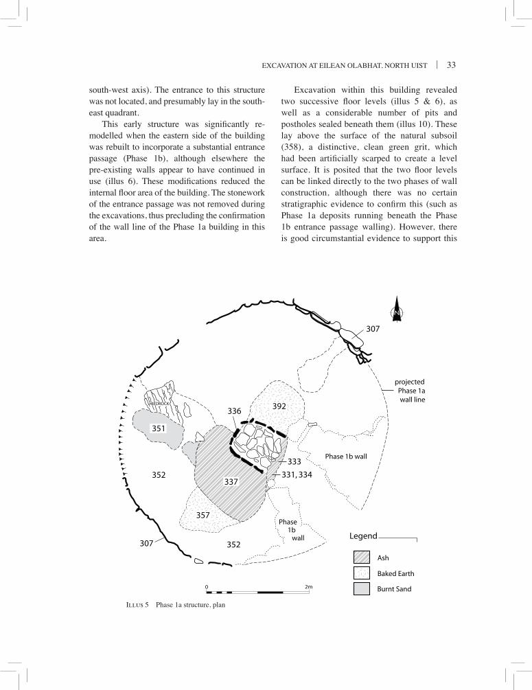
The earliest identified structure on the western knoll was a small drystone building. its walls, although only partly excavated, demonstrated two clear phases of construction. in its primary form (Phase 1a), the structure appears to have been a simple oval or circular stone-walled building measuring approximately 5m north-east/south-west by 4–5m internally (illus 5). uncertainties regarding the precise form and dimensions of this structure are due to the south-east quadrant of its wall line not having been established (the alignment proposed on illus 5 assumes that the form of the building was more or less symmetrical to either side of a north-east/
excavation at eilean olabhat, north uist | 33
BEDROCK
307
336
307
Phase 1b wall
Phase1b
wall
351
352337
357
352
projectedPhase 1awall line
392
333
331, 334
Illus 5
Ash
Baked Earth
Burnt Sand
Legend
2m0
Illus 5 Phase 1a structure, plan
south-west axis). the entrance to this structure was not located, and presumably lay in the south-east quadrant.
This early structure was significantly re-modelled when the eastern side of the building was rebuilt to incorporate a substantial entrance passage (Phase 1b), although elsewhere the pre-existing walls appear to have continued in use (illus 6). These modifications reduced the internal floor area of the building. The stonework of the entrance passage was not removed during the excavations, thus precluding the confirmation of the wall line of the Phase 1a building in this area.
excavation within this building revealed two successive floor levels (illus 5 & 6), as well as a considerable number of pits and postholes sealed beneath them (illus 10). these lay above the surface of the natural subsoil (358), a distinctive, clean green grit, which had been artificially scarped to create a level surface. It is posited that the two floor levels can be linked directly to the two phases of wall construction, although there was no certain stratigraphic evidence to confirm this (such as Phase 1a deposits running beneath the Phase 1b entrance passage walling). however, there is good circumstantial evidence to support this

34 | societY oF antiQuaries oF scotlanD, 2008
Illus 6 Phase 1b structure, plan
sequence, in that the hearth within the primary (Phase 1a) floor level (see further below) and the secondary (Phase 1b) entrance passage seem unlikely to have been contemporary features, as access through the passage would have been near impossible had that hearth been in use (illus 5). We do need to bear in mind, however, that similar arrangements at structures like structure 4 at cnip in lewis (armit 2006) have been suggested as possible ‘oracle-shrines’ which were intended to be impossible to access once
the fire was lit (Ritchie 2003). There was no evidence that the building had been abandoned between the Phase 1a and 1b occupations.
Wallsthe line of the inner wall face of the primary (Phase 1a) structure (illus 5) was identified between the south and north-east points of its circuit (307). the wall appears to have comprised a drystone, coursed inner face reveted into earth and stones (308). no outer wall face was

excavation at eilean olabhat, north uist | 35
detected, although the repeated rebuilding of walls at this location, combined with the lack of excavation through the backing material, warn against assuming that such a feature had never been present.
the inner wall face did not describe a smooth arc, but rather appeared to have been constructed in a series of sub-linear sections. its quality of preservation varied around its circuit (see table 1), probably reflecting varying patterns of dismantling and reuse of lengths of wall in the structures of Phases 2–4 (illus 4).
a layer of greasy black clay (285/340), possibly decayed turf, ran in a band 0.05–0.15m wide around the inside base of the wall (where preserved), and lay directly above the subsoil.
the eastern side of the primary building was rebuilt (Phase 1b) to create a substantial entrance passage, c 1.5m long and 0.8m wide, on the south-east side of the structure (illus 6, 8). the passage projected inwards from the adjacent wall line, and its inner end was close to the centre of the interior floor space. The passage was defined on either side by massive stone walls of unequal length, which were reminiscent of the radial piers characteristic of hebridean wheelhouses. lengths of external wall faces were present to either side of the entrance passage (218, 250).
although only partly examined, it was clear that these were not original features, as deposits were sealed beneath their bases: a Phase 3 origin is suggested for these modifications, but was not proven by excavation (and thus the features are depicted on illus 13 rather than illus 6).
the south-west pier (254) was of simpler form, surviving principally as an alignment of three large stone blocks up to 0.5m wide and c 0.5 high. at the same time a rough boulder wall face was built to connect the pier with the reused Phase 1a wall c 1.1m to the west.
by contrast, the north-east pier (246) was more substantial and of composite construction, c 0.7m wide at its inner end and c 1.0m high, with stone faces retaining an earth and stone core. as this feature was not dismantled during excavation, the indications of structural phases could not be confirmed. The inner 0.8m of the wall face lining the entrance passage was of regular, coursed tabular stones, whereas the outer part was a less regular boulder construction. the inner end of the pier was defined by a large upright tabular stone, measuring 0.6m × 0.3m in cross-section (illus 8), which rested on the subsoil surface. this stone may have been deliberately set upright as a piece of monumental masonry, but alternatively may have originated as a displaced lintel propped
against the entrance pier at some later stage (but still during Phase 1b). the latter is considered to be the more likely explanation, as excluding the upright as an integral part of the entrance passage would mean that the opposing walls had originally been of equal length. the inner face of the north-east pier, within the building, was also of coursed construction, with up to six courses preserved, although this section had been at least partly rebuilt and provided with corbelling Illus 7 Phase 1a hearth, with kerb displaced by Phase 1b socket stone

36 | societY oF antiQuaries oF scotlanD, 2008
with the creation of the Phase 3 structure (see further below). no original walling survived in the 1m wide gap (245) between the north-east pier and the Phase 1a wall to the north, probably as a result of disturbance caused with remodelling of the structure in Phase 3, although it is possible that the gap was original (such as for a recess or a second entrance).
Internal floor features and deposits
the principal feature present within the Phase 1a structure was a substantial and carefully built stone hearth (336), which occupied a roughly central position within the building (illus 5, 7). In its final form the hearth was sub-rectangular, measuring 0.9m north-west/south-east by 0.8m. It was defined on three sides by a well-fitted
Illus 8 Phase 1b floor, showing paving and peripheral features. Various phases of walling are visible, including the Phase 1b entrance passage (to rear), part of the Phase 2 walling overlying the Phase 1 walling (to right), and the Phase 1 wall foundation with Phase 3 addition outside it (foreground)
kerb of small upright slabs no more than 0.1m high, and was open to the south-east. loosely fitted paving stones had been placed in the area defined by the kerb, and marked the final floor of the hearth. the kerbstones and paving were considerably altered by heat and fragmented upon handling. The kerbstone defining the northern corner of the hearth had been broken and displaced by the socketed stone within the Phase 1b paving (305; illus 7; infra). a sequence of at least eight lenses of yellow, red and black peat ash, 0.05m deep, was present above the paving within the hearth (338).
excavation of the hearth revealed that it had been modified during its uselife. The paving was demonstrated to be a secondary feature, as peat ash deposits were found sealed beneath it (379). in addition, the opposed kerbstones on

excavation at eilean olabhat, north uist | 37
the south-east were set into this primary ash, whereas the others had been depressed directly into the underlying subsoil. thus in its primary form, the hearth measured only 0.65m north-west/south-east by 0.8m and was not provided with a laid stone base. Three ash-filled features (376–8) sealed beneath the hearth and cut into the subsoil may be related to its use, but are discussed separately below (illus 10).
Peat ash spilled a little over the kerb of the hearth to the north-east and beyond the paving to the south-east (331, 333, 334). two yellow-orange peat ash deposits separated by a layer of brown loam containing peat ash flecks, each 20mm thick, spread over an area c 1.7m by 1m
Illus 9 Phase 1b, detail of paving
357). to the south-west this surface was partly sealed beneath the peat ash spread associated with the hearth (337). a patch of golden brown sand, in places reddish and possibly heat-altered, lay in the western part of the structure (351). elsewhere in the southern half of the structure, a thin deposit of brown loam was present directly above the unmodified subsoil (352). A patch of bedrock, dipping to the south, projected through the floor deposits in the west part of the interior.
in the majority of the northern interior there were no deposits above the subsoil surface which could be definitely linked to the Phase 1a structure. a patch of brown loam, comparable to that present in the southern interior, was
preserved beneath a cobbled feature present on the Phase 1b floor in the north-east of the building (327, illus 6). elsewhere, it is possible that the occupation deposit ascribed to Phase 1b in this area (304; infra) in fact represented a conflation of deposits relating to both phases.
The floor level of the modified structure (Phase 1b; illus 6, 8–9) directly overlay those of the primary occupation floor, suggesting a direct continuity of activity between the two phases. the internal ground plan of the recast building
was distinctive, with a series of stone features apparently outlining separate activity areas defined by patches of earthen floor.
The central floor space was occupied by a roughly triangular area of paving with ragged edges (305), measuring c 2.3m south-west/north-east by 1.5m (illus 8–9). this feature was composed of tabular slabs forming a roughly level surface, and had not been carefully fitted. Towards its centre was a blocky stone containing a rounded socket c 0.15m in diameter
to the south-west of the hearth (337). although it could not be demonstrated by excavation, it seems likely that these waste deposits relate to the terminal use of the hearth.
Floor deposits survived around the hearth, principally within the southern half of the structure, and were generally 20–50mm thick. to the north-east and south-west of the hearth the floor level was defined by a compact, baked surface mottled yellow and reddish-purple, which appeared to be the modified subsoil surface (392,

38 | societY oF antiQuaries oF scotlanD, 2008
and 0.12m deep. this socketed stone had been heavily compressed into underlying deposits, unlike all other elements of the paving which lay directly on the preceding surface, and had dislodged one of the kerbstones of the Phase 1a hearth (336, illus 7). this compression suggests that the socket had supported a considerable weight. the stone was heavily weathered, and fractured readily into two pieces upon handling. The socket was filled only with a sterile gritty loam (323), its composition indicating that it was primarily material weathered from the stone itself.
From the central area a band of smaller tabular stones extended to the south-west edge of the structure, and a scatter of smaller stones may have marked the remains of a comparable feature running to the north-west edge. a distinctive arrangement of cobbles extended from the north-east edge of the structure towards the central paving (327). Whilst its north-west side formed a continuous single alignment between the wall and central paving, this feature was considerably wider for the most part, increasing in width from 0.2m beside the wall to 0.6m. the cobbles formed a compact level surface, and possibly had been created to provide a firm foundation for a former internal feature of the building. a line of tabular stones ran between the cobble arrangement and the north-east entrance passage wall, and a second alignment ran between the central paving and the same wall (332).
The various paved or cobbled floor features acted, presumably intentionally, to divide the floor space in a broadly radial manner into four sectors of unequal size without stone flooring (illus 6). the radial divisions may have marked the positions of partitions, although there was nothing excavated to suggest what form such features may have taken. the rear (north and west) sectors were larger than those to either side of the entrance passage, reflecting above all the significant amount of internal floor space occupied by this latter feature. Within the south sector a disordered spread of tabular stones (326) and smaller cobbles (313) probably represented
the disturbed remains of a piece of upstanding furniture which stood in the angle between the wall and south-west entrance passage wall. in the north sector, two adjacent tabular blocks (328) stood beside the wall. the smaller, eastern stone was 0.25m across and was 0.1m thick, and the larger measured 0.45m by 0.3m and was 0.25m thick. this stepped effect was presumably important to the function of this enigmatic internal feature.
the other features attributed to Phase 1b were pits located beside the inner ends of each of the entrance passage walls. these pits can be associated with Phase 1b as they had been cut through ash deposits spilling from the Phase 1a hearth. the pit beside the north-east pier (373; illus 11, a) was sub-rectangular, measuring 0.5m by 0.25m and 0.25m deep, with steep sides and an uneven base. it contained disturbed tabular stones, possibly the remains of post packing material (some visible bottom right on illus 7), set within a dark brown loamy matrix. the infilled pit was partly sealed beneath paving associated with the floor of this structure (332). no artefacts were recovered from the pit.
by contrast, the pit beside the south-west pier was c 0.2m in diameter and depth, with vertical sides (342). a pottery vessel of unusual form (no. 20) lined tightly the edges of the pit, although the base of the vessel had been displaced upwards and outwards, in a pattern which suggested that a small post or stake had been driven into the pot base. The pit was otherwise filled by a loose, mid-brown loam, which appeared to have been deposited after the breakage of the pottery vessel. its surface traces had been carefully sealed beneath a neat rectangular arrangement of small stones measuring 0.4m by 0.3m (339, not shown on illus 6). the implication of this evidence is that a pit had been excavated specifically for the insertion of the pottery vessel, which had then been broken, most probably deliberately, before the pit was backfilled and covered over. A sample of charred food residue from this vessel gave a radiocarbon date of 378–61 cal bc (2σ; oxa-6950).
excavation at eilean olabhat, north uist | 39
371356
374
391
370
pitPhase 3
381
376
377
378 343
367384
383
361
380
386
388
387
368
372
358
Illus 10
2m0
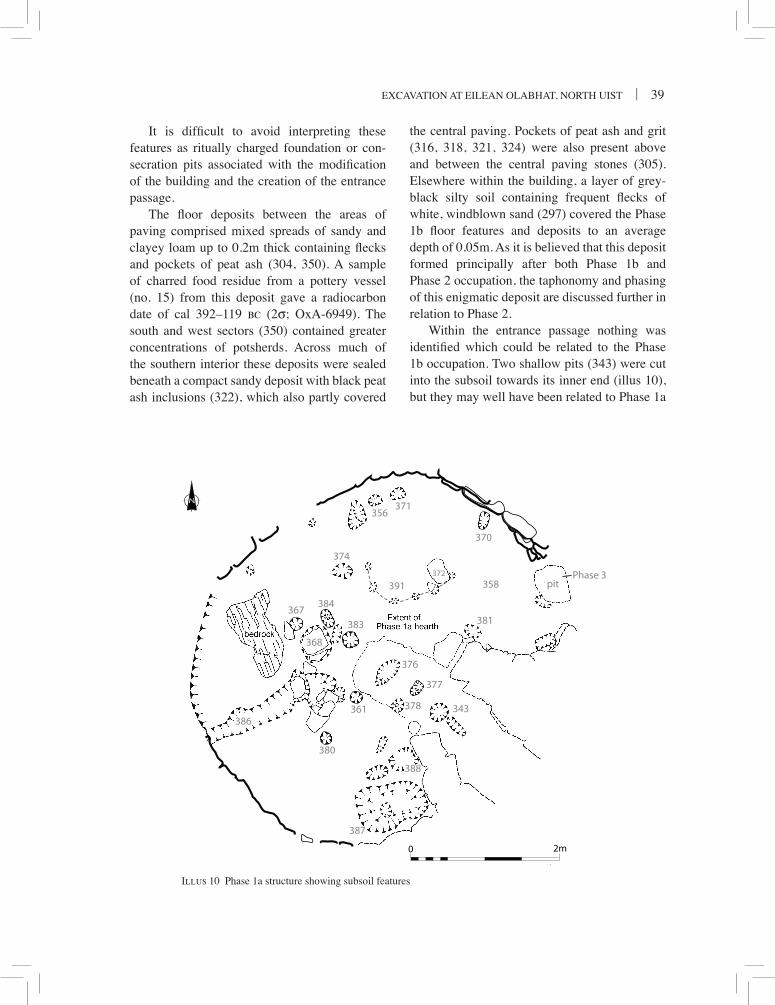
Illus 10 Phase 1a structure showing subsoil features
It is difficult to avoid interpreting these features as ritually charged foundation or con-secration pits associated with the modification of the building and the creation of the entrance passage.
The floor deposits between the areas of paving comprised mixed spreads of sandy and clayey loam up to 0.2m thick containing flecks and pockets of peat ash (304, 350). a sample of charred food residue from a pottery vessel (no. 15) from this deposit gave a radiocarbon date of cal 392–119 bc (2σ; oxa-6949). the south and west sectors (350) contained greater concentrations of potsherds. across much of the southern interior these deposits were sealed beneath a compact sandy deposit with black peat ash inclusions (322), which also partly covered
the central paving. Pockets of peat ash and grit (316, 318, 321, 324) were also present above and between the central paving stones (305). elsewhere within the building, a layer of grey-black silty soil containing frequent flecks of white, windblown sand (297) covered the Phase 1b floor features and deposits to an average depth of 0.05m. as it is believed that this deposit formed principally after both Phase 1b and Phase 2 occupation, the taphonomy and phasing of this enigmatic deposit are discussed further in relation to Phase 2.
Within the entrance passage nothing was identified which could be related to the Phase 1b occupation. two shallow pits (343) were cut into the subsoil towards its inner end (illus 10), but they may well have been related to Phase 1a

40 | societY oF antiQuaries oF scotlanD, 2008
(b)
361SW NE
(c)
367W
E
(d)
370NW SE
(e)
377SW NE
(f )
380SW NE
(g)
383W E
(h)
384W E
(k)
SENW
387
(l)
376
SWNE
(j)
378SW
NE
(m)
381SE NW
1m0
373
NE SW
(a)
(n)
388NW SE
Illus 11Illus 11 Phase 1, sections of selected features
activity prior to the construction of the entrance passage (see below).
Phase 1 pits and postholes (illus 10–11)
Upon the removal of the Phase 1 floor deposits, over 30 negative features were found cut into the subsoil within the floor area of the Phase 1 structure (illus 10). the majority of these features clustered towards the centre of the building, although others were present adjacent to the wall,
particularly to the north and east. Where Phase 1a floor deposits and features were preserved, the negative features were sealed beneath these. the remainder were found sealed beneath Phase 1b features and floor deposits in the northern interior, where Phase 1a deposits either were absent or may have been indistinguishable from those of Phase 1b (304).
Few patterns can be detected from the distribution of these features. six stakeholes, set 0.15–0.2m apart and forming an arc, lay to

excavation at eilean olabhat, north uist | 41
the north of the Phase 1a hearth, and may have defined a light wooden-framed feature (391). Five of the stakeholes were 0.08–0.12m wide, survived only to c 0.05m deep, and were filled by a dark brown, gritty loam fill. In contrast, the sixth feature was somewhat larger, 0.2m wide by 0.15m deep, and was filled with mixed red and black peat ash.
seven pits were encountered which had excavated profiles to suggest that they had been post settings, although none contained any packing material (361, 367, 370, 377, 380, 383, 384; illus 11, b–h). these features were 0.15–0.25m in surface width by 0.1–0.2m deep. three of the features (361, 377, 384) contained fills rich in peat ash, and the others had dark brown gritty loam contents. all but one of these features were at least partly sealed beneath Phase 1a deposits in the centre of the floor space; one of these was sealed beneath the Phase 1a hearth (377; illus 11, e), and this feature appeared also to contain a second pit feature. the postholes did not form any discernible pattern. Flat slabs were present at several locations on the subsoil surface, and may have acted as post pads (eg 368, 372). the combined distribution of postholes and post pads still forms no interpretable pattern.
Most of the remaining excavated features were pits of varying shapes, sizes and profiles (eg illus 11, j–n). Most were small and shallow, measuring less than 0.3m across and 0.15m deep, with oval surface plans and bowled profiles. Those around the periphery of the structure were generally shallower and filled by gritty or clayey loam (eg 356, 371), whereas those towards the centre of the building were deeper and filled with ash or ash-rich loams (eg 374). Two ash-filled pits were sealed beneath the Phase 1a hearth paving. one (376; illus 11, l) was steep-sided and cut down to the level of the bedrock surface. the other (378; illus 11, j) had a profile, vertical on one side and sloping on the others, suggesting that this was the remains of a post setting from which the post had been uprooted. also of particular note was a large pit, c 0.95m by 0.65m in surface extent (387, illus
11, k), which lay beside the south wall of the structure, sealed beneath the Phase 1b collapsed stone feature.
A final negative feature of note was an irregular linear feature (386) which ran for c 2m from the west side of the Phase 1a hearth to the south-west wall of the building, beneath which it continued. it was up to 0.4m wide and no more than 0.1m deep, with a shallow-sided, bowled profile in cross-section, and was filled with greasy black clay identical to the soil running around the inside edge of the Phase 1a wall (interpreted as decayed turf, supra). the feature is best interpreted as related to anthropogenic activity prior to the construction of the Phase 1 house (superseding its erroneous description as an animal burrow in interim accounts).
Finds from the negative features comprised sherds of pottery from the large pit to the south (387), three smaller pits (356, 371, 374), and from the early linear feature (386).
Evaluation
the Phase 1a structure is an interesting addition to the range of recorded settlement structures from the scottish iron age. although its size and oval shape bears some slight resemblance to individual elements of the cladh hallan settlement (Parker Pearson et al 2005), these formed part of a conjoined settlement cluster inconspicuously sited in the south uist machair, while the eilean olabhat structure was an isolated building, perhaps set within an enclosure, sited on the highly visible summit of the promontory. interpretation of its function and consideration of likely parallels are hampered by the incomplete nature of the building plan, caused by subsequent structural modifications from Phase 1b onwards. however, it is clear that this was a small, oval structure, with its floor slightly recessed into the ground at the highest point of the promontory. as far as can be judged there were no internal structural supports and it seems probable that a timber-framed thatched roof would have rested
42 | societY oF antiQuaries oF scotlanD, 2008
on the wall head, the height of which is wholly unknown. Given the maximum roofing span of around 5m, the roof may have risen up to around 2.5m from the wall head. if the latter was set at, say 2m, to give headroom around the periphery of the building, then the roof may have risen a maximum of around 4.5m from the ground surface, although the wall head may of course have been significantly lower. Nonetheless, the combination of construction and, especially, location would have made it a prominent feature in the landscape despite its modest footprint.
the interior of the building was dominated by a horseshoe-shaped hearth similar to those found in later domestic buildings in the islands, as at the Middle iron age wheelhouse at Kilpheder in south uist (lethbridge 1952). other slighter internal features may have belonged to this phase and may represent internal timber furniture, but the number and character of these cannot be disentangled from the available evidence. there is nothing in either its architecture or finds assemblage to suggest that this was a high status building or that it had any specialised function. indeed the nature of the central hearth and the range of finds are suggestive of a domestic structure (although the absence of coarse stone tools is unusual). although the entrance to the building was not identified it seems highly likely that it lay to the south-east, and was reused by the more elaborate entrance of its Phase 1b successor.
The modifications carried out on the original building during Phase 1b changed its character quite dramatically. the most obvious changes comprised the construction of the elongated entrance passage, the wholesale reorganisation of the interior, and the apparent change in roofing method.
the beginning of Phase 1b is marked by the extension (or creation) of the entrance passage to a size that appears somewhat incongruous in relation to the modest dimensions of the building. this could be read as an attempt to monumentalise and formalise the entry into the building. it is interesting that the inturned nature
of this passage had the effect of greatly reducing the usable space inside the structure; an outward extension of the entrance passage would not have had this effect but may have required considerably more effort in the sourcing and manoeuvring of stone required to thicken the south-east wall. the large upright propped at inner end of one of the piers which form the passage wall suggests the former presence of a linteled roof over at least part of the passage, while ‘foundation’ pits at the inner end of each pier further emphasise the formality of the construction. although the provision of stone piers inevitably echoes (or rather prefigures) later wheelhouse architecture, there are no close parallels for their structural disposition at eilean olabhat.
the interior of the building too was wholly altered in Phase 1b. The floor area was now divided in broadly radial manner, comprising a central paved area and four peripheral zones defined by what may be the remains of internal partitions. We know of no parallels for the roughly triangular paved area which occupied the centre of building, which would have been dominated by a near-central roof support post. although, in contrast to Phase 1a, no formal hearth could be identified, some limited evidence of hearth waste was present in the building, though it is less obviously ‘domestic’ than its predecessor.
The roofing mechanism of this highly unusual structure is also worthy of comment. the heavily compressed socket stone close to the centre of the building seems to have supported a central roof support post. this is an apparently unique situation, and no parallels are known from iron age atlantic scotland for such an arrangement. indeed it is not clear why such a central post would be necessary in a structure of this size (it seemingly was not necessary in Phase 1a). it is possible of course that the central post was not integral to the roof structure but was significant in some other way. Nonetheless it would have required the weight of the roof bearing down on it to hold it upright; possible alternative scenarios such as some form of ‘totem pole’ or timber figure would presumably

excavation at eilean olabhat, north uist | 43
have been more easily set in place by simply digging a posthole.
Despite all these marked changes, no evidence was found to suggest that any significant period of abandonment separated Phase 1a & 1b (features of 1b directly overlay those of 1a), although structural changes of this magnitude must have required temporary removal of the roof of the building. the internal organisation and, presumably, function, of the building did however change quite radically, although it may have looked no different from the outside. in particular the Phase 1b structure seems more monumentalised and formal in design and less obviously a domestic habitation. the possible reasons for this change can be no more than speculation in the absence of any detailed comparanda; one might suggest a change in status of the occupants, or a change from a domestic to a communal function.
Given the similarity in the range and character of the pits and postholes encountered, it is posited that the majority are broadly contemporary and can be most likely linked to the Phase 1a structure. some of the features, such as the large pit to the south and the arc of stakeholes, may represent internal features of the building. others may be foundation pits of the type recorded in the wheelhouses at sollas (campbell 1991), cnip (armit 2006) and the radially positioned structure at hornish Point (barber 2003). in the absence of any deliberate or special deposits surviving in the eilean olabhat pits, caution is required in the identification of any particular feature as a reflection of ritual activity. The presence of ash-filled pits is perhaps significant in this regard, suggesting the deliberate deposition of burnt material in pits, although the Phase 1a hearth would appear to have provided the mostly likely source of this material (except in those cases where ash-filled pits were sealed beneath the hearth).
however, caution is also required in accepting the negative features uncritically as relating to Phase 1. the linear feature demonstrably predated the construction of the Phase 1 building,
and there is the inevitable possibility that other excavated pits and postholes belong to such early activity also. in this vein, the shallowness of many of the pits is marked, and might suggest that they have been truncated. the most likely processes to explain the truncation are the scarping of the ground to create the initial floor surface of the Phase 1 building, in which case the feature could have predated the building, or floor cleaning during the occupation of the building. the best way of resolving this issue would be to examine whether the scatter of pits extends beyond the walls of the building; unfortunately time pressures did not allow investigation of this possibility to be undertaken during the excavations.
Phase 2 – reshaPeD earlY iron aGe structure (illus 12)
at a late stage in its occupation, the wall of the Phase 1 structure was rebuilt on a different alignment on its west side. the new construction (306) diverged from the Phase 1 wall to the south-west, running at first in an arc over the earlier alignment before returning to form a pier projecting inwards from it (and sealing Phase 1 floor deposits beneath; on illus 8 the Phase 2 wall is partly visible above the Phase 1a wall on the right, but the pier has been removed). to the north of the pier the wall extended north-west, becoming less coherent before running out, presumably as a result of truncation through the recycling of building stone in later structures. the new wall had a total surviving length of c 3.5m. it survived best to the south of the pier, where it was up to four courses high and comprised a drystone face backed by rubble. a substantial blocky stone formed the surviving foundation of the inner end of the pier.
occupation deposits which could be directly associated with this new wall alignment were preserved in a band up to 1m wide running around the inside of the wall between the pier and entrance passage. in the rest of the bay any contemporary deposits appear to have

44 | societY oF antiQuaries oF scotlanD, 2008
PIER
ENTRANCE PASSAGEBAY
314
306
0 1 2m
N
Phase 1wall line
2m0
Illus 12Illus 12 Phase 2 structure, plan
been removed with the later construction of a freestanding corbelled cell (Phase 3, infra; illus 4). the earliest deposits comprised a series of patches of clay loams and black peat ash (309, 319, 320, 329). Within one of these (320), the intact base of a very large coil formed and finger impressed pottery vessel (no. 42) was found cut through the uppermost Phase 1b floor deposit in this area (322). a sample of charred food residue from a sherd of this vessel gave a radiocarbon date of 791–446 cal bc (2σ; oxa-6948). above the early phase 2 deposits, and abutting the south side of the new pier, was a laminated sequence of four peat ash deposits of varying hues (314).
these deposits covered an area of c 1.35m north-east/south-west by c 0.9m, and together were only 0.08m deep. they appear to represent the remains of an informal hearth occupying the western corner of the bay. the uppermost deposits comprised a sequence of clay loams including flecks of peat ash (303, 256, 302, 298). a distinctive type of mat-impressed pottery was recovered from several contexts within this sequence of Phase 2 deposits. a sample of charred food residue from one such vessel (no. 30) from context 302 gave a radiocarbon date of 509–234 cal bc (2σ; oxa-6972). a further sample from another vessel (no. 21) from

excavation at eilean olabhat, north uist | 45
context 256 gave a radiocarbon date of 479–210 cal bc (2σ; oxa-6973). to the north of the pier, the only deposit abutting the Phase 2 wall (306) was a sterile deposit of sandy loam (293).
it seems likely that the Phase 2 wall and associated deposits reflect the continuing occu-pation of a reshaped Phase 1 structure. there was no stratigraphic evidence to suggest a break in occupation between Phase 1b and 2. the only noticeable difference was in the appearance of mat-impressed pottery in Phase 2 deposits, which at the very least indicates a different manufacturing process but may also reflect the presence of different occupants.
the principal recorded effect of the new construction was to create a distinct bay between the new pier and the south-west entrance passage wall, measuring c 3.2m east–west by 1.6m. however, as a result of truncation by subsequent activity on the site, it is less than clear what the overall form of the Phase 2 structure took. it is assumed that the entrance passage and eastern wall of the Phase 1 structure were retained. however, it is evident from the excavated ground plan (illus 12) that the new Phase 2 wall extended northwards beyond the northern arc of the Phase 1 wall, and thus that the latter is unlikely to have formed part of the Phase 2 building. the northern wall line of the Phase 2 building had not survived later rebuilding on the site, and its alignment could not be established.
It is also uncertain what defined the Phase 2 floor surface in the remainder of the building. It is possible that the Phase 1b floor features for the most part continued in use throughout Phase 2. across much of the northern interior, the only deposit present between the Phase 1b floor below and Phase 3 deposits above was a silty layer containing windblown sand but no hearth waste (297, also see Phase 1b above). stratigraphic evidence alone is not sufficient to allocate this layer to either Phase 1b or Phase 2 activity. it did not occur within the sequence of Phase 1b and Phase 2 deposits in the south-west bay, and any
physical connections between the two areas had been removed with the construction of the Phase 3 corbelled cell. the character of layer 297 suggests that it is perhaps better interpreted as a deposit that formed in an abandoned structure rather than as an accumulation of occupation debris. as such, the layer could be interpreted as having formed after the abandonment of the Phase 2 structure and before the Phase 3 reoccupation. the considerable number of potsherds recovered from layer 297 may have been present on the floor surface at the time the building was abandoned. conversely, however, the absence of mat-impressed pottery from layer 297 may be significant in understanding its phasing.
regrettably, a range of taphonomic processes has combined to preclude any definitive interpretation of the form and function of the Phase 2 occupation, which remains ill-defined.
Phase 3 – earlY historic settleMent anD MetalWorKinG (illus 13–16)
Following a lengthy period of abandonment, the site was reoccupied in the mid-first millennium ad. a cellular building was created reusing parts of the early iron age structure as well as incorporating new constructions (illus 4), with stone no doubt recycled from the earlier and presumably ruinous building.
The cellular building (illus 13)
the reshaped building was of irregular form, with maximal internal dimensions of c 7.5m north/south by up to 5m. its interior comprised a roughly oval central area with cells extending out to the north, south-west and south-east. its walls comprised a complex mixture of reused and new constructions (illus 4, 13). the building was entered from the sse through the entrance passage associated with the preceding iron age structure (although, as noted above, the presence of two types of wall construction within the elevation of the north-east passage wall may

46 | societY oF antiQuaries oF scotlanD, 2008
354246
2m0
Illus 13Illus 13 Phase 3 structure, showing composite plan of internal features
indicate that some rebuilding took place at this time).
the south-west cell was an entirely fresh construction fitted within the former bay of the Phase 2 structure, the inner ends of its walls abutting the entrance passage wall and internal
pier of the Phase 2 building. its inner wall face (252) was composed of coursed boulders and cobbles, and defined a floor space up to 1.6m deep and 1.5m wide. When first discovered this structure survived up to 1m high and retained in situ the lowest two courses of a corbelled

excavation at eilean olabhat, north uist | 47
(a)
(b)
Illus 14 Phase 3 structure, south-west cell; (a) showing the cell fully excavated and (b) prior to the removal of the upper corbelling

48 | societY oF antiQuaries oF scotlanD, 2008
roof (illus 14b). unfortunately, the corbelling became insecure with the removal of Phase 4 deposits which had acted to support it, and it was recorded and removed for safety reasons to allow the excavation of deposits stratified within the cell itself. the wall face was reveted partly into Phase 2 deposits and elsewhere into dumped rubble. the Phase 2 deposits survived to a higher level than the floor of the cell, and it was thus apparent that other iron age deposits must have been removed with the insertion of the cell.
the north cell was less well preserved than that to the south-west, but sufficient survived to indicate that their construction methods were quite different. in particular this cell appears to have been freestanding. its wall was up to 0.6m wide and stood only to 0.4m high, and its south-west end may have been entirely removed by later activity on the site. For the most part the wall comprised an outer face of rough boulders (210), an inner face of upright slabs and boulders (211), and an earth and stone core. at one point on the west side a single upright slab spanned the full thickness of the wall. no trace of corbelling survived. The cell wall defined an internal floor space c 2m deep and 2.2m wide. its axis was somewhat oblique to that of the main part of the cellular building, perhaps to avoid an area of sloping bedrock.
between the south-west and north cells, the wall of the Phase 3 structure was poorly preserved. a foundation of boulders backed by rubble was present to the north of the south-west cell, but elsewhere the wall had been entirely removed.
the south-east cell was formed to con-siderable extent from pre-existing walling associated with the iron age building. as a result this cell was less rounded than the other examples, being 1.6m wide and only 0.8m deep. It was defined by walling associated with the north-east entrance passage wall (246), and part of the wall alignment of the original Phase 1 building (307), which survived up to c 1m high. the basal layer of a corbelled roof survived at
the upper level of alignment 246, around the rear face of the cell. between these two lengths of regular coursed walling, the gap noted in relation to Phase 1b ground plan (illus 6) was filled by an irregular boulder and cobble face (244, visible on illus 8). this feature survived only to 0.5m high; it had no doubt once been higher, but its position coincided with the entrance to the Phase 4 structure. central to this irregular face was a rounded boulder that was set into a shallow pit (354).
the eastern side of the building was formed partly by the Phase 1 alignment (307), the former northern continuation of which must have been removed prior to the Phase 2 rebuilding (supra). connecting this and the north cell was a 1.5m length of newly built wall (277, bottom left on illus 8), composed of boulders and cobbles with coursed stones above, surviving up to 0.9m high. at its junction with the earlier wall a distinctive upright slab with a triangular upper face was present; the misalignment between new and old walls created a slight kink in the wall at this point.
a complex series of internal features and deposits related to the use of the cellular building. two distinct phases of activity could be traced within this sequence, the upper distinguished by the presence of concentrations of artefacts associated with metalworking. although they may well be closely contemporary, the two blocks of material have been termed for purposes of description as Phases 3a and 3b, as their contents suggest that different activities were taking place. remains belonging to Phase 3 identified in the entrance passage are described separately, as they cannot be directly related to the sequence identified within the rest of the building.
Phase 3a deposits
Within the central area of the building, two features were identified which appeared to relate to the earlier use of this building (illus 13). a large sub-circular pit (272) lay in the

excavation at eilean olabhat, north uist | 49
western interior. it measured c 1m in diameter and was 0.35m deep (illus 15, p–p). it had a rough stone base, and its sides had originally been lined with slabs, although only four uprights remained in situ. a series of slabs stacked in the base of the pit (282) may have been the remaining walls slabs, which had been disturbed and placed in the pit following its disuse. above and around the slabs the pit was filled with yellow peat ash (269), which also spilled over its edge to the east. nothing in the pit appeared to relate to its original use, although its character suggests a likely function as a storage pit. in the north-east interior was a cobble-lined bowl hearth, c 0.75m in diameter and 0.15m deep, filled with yellow-orange peat ash (286). thin ash deposits (288, 289) were also sealed beneath the cobble forming the base
Illus 15
q
p p
q
(A)
(B)
269
272271
282
271
019
020 021030 / 251
Ash
1m0
Illus 15 Phase 3, sections through (a) stone-lined pit and (b) metalworking deposits in south-west cell
of the hearth, indicating this stone to have been a replacement feature.
in addition to these new features, the larger of the two blocks adjacent to the east wall of the building, which had formed part of the Phase 1b floor plan (328), projected through the floor surface of the cellular building. it therefore may have been reused as an internal feature of some description.
these internal features were associated with an extensive spread of dark brown clay loam, heavily flecked with peat ash and charcoal, which appeared to be a mixed occupation deposit (271; illus 16). the hearth (286) was cut through this layer, and thus could not have been a primary feature of the cellular building. this layer did not extend into any of the peripheral cells. in the south-west cell no deposits relating to this
(a)
(b)

50 | societY oF antiQuaries oF scotlanD, 2008
phase survived, and in the south-east a peat ash dump (290) and a spread of charcoal rich soil (291) were present. The floor of the north cell was formed by a shallow earthen deposit containing small lenses of ash and charcoal around its opening (279). an irregular patch of stones beside the east wall of the cell may have been the disturbed remains of an internal feature. The floor deposit of the north cell was devoid of artefacts. its character thus contrasted significantly with the deposits rich in ash and artefacts present elsewhere inside the building, suggesting that the floor in the north cell had been kept clean, or that the character of its use differed from the other parts of the building.
Phase 3b deposits (illus 16)
an accumulation of deposits rich in hearth waste, predominantly peat ash, extended across the central area of the building and south-east and south-west cells. these deposits sealed the floor features beneath them, and appear to relate to the terminal use of the cellular building. they were distinguished by the quantities of metalworking artefacts recovered from them. the lowest horizon containing metalworking debris comprised a 0.08m deep layer of ash-rich clay loam occupation debris extending across the northern part of the central area (260); a sequence
of four peat ash deposits (270, 268, 280, 281), in total c 0.1m thick, and other ash dumps (275, 287, 283); and a series of clay and ash lenses within the south-east cell (267, 295). Within the centre of the building an irregular spread of flattish stones (284), laid over some of the Phase 3b deposits containing metalworking debris, may represent the disturbed remains of an area of paving (illus 16). Ash-filled depressions (296, 299) sealed beneath the stones and cut through Phase 3a deposits (illus 16), may represent informal bowl hearths.
above this, excavations in the eastern half of the building defined two heterogeneous layers of occupation debris, the lower (257) a dark brown clay loam up to 0.15m thick and the upper (238) a mottled sandy loam 0.2m thick. each contained many dumps and lenses of peat ash and charcoal, and reflected accumulations rather than single depositional events. a roughly square patch of very compact earth measuring c 0.65m by 0.5m was contained within layer 257 towards the opening of the south-east cell (illus 13), and lay over an arrangement of large flattish stones (258). this feature may have represented the foundation of a removed feature, with the earth compacted due to the weight of whatever had stood above it. an irregular alignment of small cobbles (259) set within layer 257 beside the east wall of the building defied any meaningful
201
242
243207
232
201
238
253
297 267 296 297
305
299
232
226
223201
238
260 271
304
271
224
205203
S N
207
207
284
246
Phase 4: Wall
Phase 1b: Paving
Phase 4 : Secondary floor
Phase 4: Primary floor
Phase 4: Wall
307
234
257
257286
AB
Phase 1a: Wall
Phase 3a: Hearth
Phase 3b: Paving
Phase 3b: Metal working deposits
'Abandonment deposit'
Illus 16
1m0
Illus 16 Phases 3 and 4, section r-r

excavation at eilean olabhat, north uist | 51
interpretation (illus 13). a distinct band of yellow-orange peat ash (253) ran beside the wall face of the south-east cell, between layers 257 and 238.
in the western half of the building a complex sequence of individual spreads, patches and dumps of sandy clay and peat ash deposits was recorded (in stratigraphic order, with lowest first: 027, 031, 026, 016, 024, 013, 017, 022, 023, 028). a comparable complex of dump deposits was excavated to the east, but was recorded as composite layers 238 and 257. a sequence of four hearth waste deposits was present in the south-west cell (251/030, 021, 020, 019; illus 15), and contained notable concentrations of metalworking debris (particularly 019). three radiocarbon dates from sherds of a Plain style vessel recovered from the uppermost fill (019) provided ranges between cal ad 350–584 and cal ad 561–656 (2σ; oxa-6946-7 & 6970).
by contrast, only the terminal Phase 3 metalworking deposit (238) extended into the north cell, suggesting that this area continued to be kept cleaner than the rest of the building until the very end of its occupation. Deposits sealing this within the cell were associated with the construction of the Phase 4 building (240) and the subsequent collapse or demolition of the cell walls (213).
Entrance passage deposits
the earliest deposits surviving within the entrance passage were associated with the occupation of the cellular building. these comprised an area of paving within the central part of the passage (330, not shown on illus 13 but visible on illus 8), around which was an accumulation of mottled sandy-clay loam up to 0.3m thick (312). this deposit was mixed, as if trampled and churned.
subsequently, the entrance passage was refurbished. a threshold stone was placed across the inner end of the entrance passage, on the surface of layer 312, and a posthole (335), 0.35m wide and 0.45m deep, was cut beside it (illus 13).
the posthole may have been the socket for a gate or door post. at the same time a wall appears to have been built to extend outwards the line of the north-east passage wall. this feature survived as a rough basal course, only 0.1m high, of medium sized stones (239). an area of paving stones was laid towards the outside edge of the entrance passage (278; illus 13). a layer of dark brown clay loam (248/241) abutted the threshold stone and external wall (239) and overlay the paving. to the north of the entrance passage, outside the building, a sequence of three stony deposits (236, 225, 222), also related to this phase of activity as quantities of metalworking artefacts were recovered from each. these deposits, both in the entrance passage and outside the building, would appear to represent dumped waste deposits relating to the metalworking activity.
it is possible that all the deposits in the entrance passage relate to the terminal use of the cellular building for metalworking, as mould and crucible fragments were found both in basal layer 312 and in secondary layer 248. however, their occurrence in the latter was extremely dense, and it is feasible that the small number of metalworking items found in layer 312 could have been introduced through trampling. this thus raises the possibility that the basal deposits (layer 312, paving 330) relate to the primary (Phase 3a) use of the cellular building, and that the refurbishment features (threshold stone, posthole 335, wall 239, paving 278) relate to the secondary (Phase 3b) use of the structure for producing metal artefacts. the uppermost deposit (248) contained a single sherd of medieval pottery, which must have been introduced as a contaminant during Phase 4 occupation (see below).
Evaluation
the cellular form of the Phase 3 building echoes that of many other late iron age structures in atlantic scotland. Well-known excavated examples include buckquoy in orkney (ritchie 1976), as well as loch na beirgh (harding and

52 | societY oF antiQuaries oF scotlanD, 2008
Gilmour 2000) and bostadh (neighbour & burgess 1997) in lewis. in the case of eilean olabhat, the three cells which lead off from the central area create a slightly irregular shape, but this may in part relate to the reuse of earlier walls and, in the case of the north cell, to the avoidance of sharply rising outcrop. indeed it may be that the building was conceived as essentially symmetrical with two cells either side of the entrance and an end (n) cell facing the door, even though this was not wholly realised in execution.
The roofing of the structure is unclear. although the cells either side of the entrance were corbelled, and the entrance passage may have continued to be linteled, neither of these forms of roofing could have covered the central area or the north cell. instead it is probable that a timber-framed roof was supported on the wall head and the piers which form the ends of the south-east and south-west cells, but its form is wholly unclear. the entrance passage appears to have been barred by a pivoted wooden door at its inner end, at least during the metalworking phase (3b) and possibly for most of Phase 3.
there is nothing from the Phase 3a deposits to suggest that the original use of the cellular building was other than domestic. excavated features included a hearth and a storage pit, both of which might be expected in a late iron age domestic structure (although the off-centre position and relatively informal character of the hearth are unusual, and may relate to it being a secondary feature of the building). one interesting feature is the apparent distinction maintained between the north cell, which was kept scrupulously clean (even during the metalworking phase) and the rest of the interior where debris was allowed to accumulate rather more freely (at least prior to abandonment). This distinction may be reflected on other sites, notably bostadh (neighbour & burgess 1997; neighbour et al in prep) where the end or ‘head’ cell, furthest from the door, had some special function or status, and it is also potentially
reflected in the variability of use in earlier wheelhouse bays (armit 1996).
at the end of its life as a domestic building, the Phase 3 cellular structure seems to have been used as a workshop for the production of metalwork. there is nothing in the excavated deposits to suggest any intervening gap in occupation (ie abandonment deposits or evidence of structural decay such as rubble) and it seems that the metalworking activity is best seen as a ‘terminal’ activity in the life of the structure; albeit one that produced some of the most important archaeological deposits on the site. The internal stratification of these metalworking deposits suggests that they were not the result of a single episode of activity. however, depth of stratification need not imply lengthy activity; it may simply indicate that the building was not being cleaned out during its use. indeed the character of the deposits suggests that they could have been formed over a few days, weeks or months.
During Phase 3b the building became clogged with hearth waste containing broken moulds, crucibles and other debris from the metalworking process. the distribution of this material was widespread within the building, suggesting that it generally lay in secondary ‘dumped’ contexts, as for example with the trail of mould and crucible fragments through the entrance passage. the only real concentration of note was within the south-west cell, where deposits banked up against the corbelled wall, but even here the material seems to have been cleared from its area of primary usage, and dumped. nonetheless, there is no doubt that the metalworking activity was carried out within the building, most probably in the central area, even though no specialist metalworking furniture was identified. Could the paving and the informal bowl hearths have been related, particularly the latter?
it might be thought unlikely that copper alloy working could have been carried out effectively in this small structure if it had still been completely roofed, but the floor deposits contain large quantities of pottery alongside

excavation at eilean olabhat, north uist | 53
Illus 17
223
217
004
044
secondary access?
234
205
r
r
042
237
203
202
233
226
232
207
011
011
041
040
018
234
203
corbelling of Phase 3 cell
upright at end of Phase 1 entrance passage
242/3
2m0
Illus 17
223
217
004
044
secondary access?
234
205
r
r
042
237
203
202
233
226
232
207
011
011
041
040
018
234
203
corbelling of Phase 3 cell
upright at end of Phase 1 entrance passage
242/3
2m0
Illus 17 Phase 4 structure 1, primary occupation
(upper) and secondary occupation (lower)

54 | societY oF antiQuaries oF scotlanD, 2008
the metalworking debris, suggesting continuing domestic occupation. it is worth noting, however, that the north cell of the building did remain largely clear of debris and may have been used as temporary accommodation or shelter, perhaps for a single person; alternatively the relative cleanliness of this cell may reflect some lingering recognition of its former status.
it is worth noting that while most of the metalworking debris came from Phase 3b deposits, a substantial minority was derived from the later, medieval building fitted into the ruins of the cellular building (Phase 4). This must reflect the substantial disturbance and redeposition of Phase 3 deposits during the insertion of the Phase 4 building into the remains of the cellular building.
Phase 4 – MeDieval anD later structures
after a lengthy period of abandonment, the site was reoccupied during the medieval period, and continued to be used, probably sporadically, for several centuries. a sub-rectangular building (Structure 1) was fitted into the remains of the earlier cellular building (illus 4), and a second rectilinear building (structure 2) was built on open ground nearby.
Structure 1 (illus 16–17)
the latest structure within the superimposed sequence at eilean olabhat was a sub-rectangular drystone construction orientated south-west-north-east. the walls varied greatly in character around their circuit. For the most part this heterogeneity appears to have been dictated by the morphology of the earlier buildings and the decision to fit the floor space of Structure 1 within that of the Phase 3 cellular building (illus 4). the principal entrance to the building was at its east corner, through a simple break in the wall, 0.5m wide. an informal path approached the entrance from the south-east, and comprised a shallow depression (233), over 1m wide, filled
with loose dusty soil (208). structure 1 had maximum floor dimensions of 4.5m south-west/north-east by 2.6m, and excavations revealed two phases of occupation.
the north-east half of the south-east wall (207) was composed of coursed boulders and tabular slabs, 0.6m wide. it partly rested against the end of north-east entrance passage wall of the iron age building, and was partly reveted into earth and rubble (242, 243) forming the uppermost fill of the south-east cell of the Phase 3 cellular building. it is possible that this rubble was the collapsed corbelling of the cell. in contrast, the south-west half of the south-east wall (041) had a distinctive box-like construction, c 1.1m wide. here, upright slabs and coursed boulders defined two boxes, each c 0.8m across, filled with a brown sandy deposit (011), possibly decayed turf. Gritty loam deposits (014, 015) sealed beneath the decayed turf (011) were interpreted in the field as deliberate fills of the boxes, although the quantities of metalworking finds recovered from them indicates that they are perhaps better interpreted as late Phase 3b metalworking deposits within the south-west cell of the Phase 3 cellular building. the purpose of this peculiar wall construction method is not certain, although it seems most likely that it formed the base of a box bed construction.
the south corner of structure 1 was reveted into the south-west cell of the Phase 3 cellular building, and supported its surviving corbelling. Most of the south-west wall (040) comprised a slab face reveted into rubble, and the north-west wall (042) was an irregular construction, c 1m wide, with inner and outer faces of coursed boulders containing an earth and stone core (006). the remaining north-west and north-east walls reused pre-existing walling (Phase 1, 307; Phase 3, 277), but the inner face (203) and earth and stone core (204) were heightened and a rough boulder outer face (202) appears to have been added at this time.
in its primary form, the interior of structure 1 was divided into two unequal chambers by a boulder-built partition (234), with a gap 0.8m

excavation at eilean olabhat, north uist | 55
Illus 18
Modern pit
Entrance
Secondary wall
Primary wall
not excavated
Robbed wall
Structure 2Structure 1
230
214
214 220
220
s
s
s
s
2m0
2m0
Illus 18 Phase 4 structure 2, primary occupation (upper) and secondary occupation (lower)

56 | societY oF antiQuaries oF scotlanD, 2008
wide at its south-east end allowing access between the chambers. the larger south-west chamber measured up to 2.5m by 2.4m, with the north-east chamber extending to only 2.6m by 1.6m. a putative posthole (237) was the only primary feature present in the north-east chamber. no built features were present in the south-west room, apart from the putative box bed (discussed above).
The primary floor surface in both chambers was a compact, charcoal flecked, sandy clay earth (018, 232). this had been regularly swept out, to judge from the patches of beaten earth present around the edges of both rooms. however, at some stage the floor ceased to be kept clean, and deposits were allowed to accumulate. a mound of yellow-orange peat ash (226), up to 0.1m thick, formed against the partition in the north-east chamber, and presumably derived from a fire lit at this location, although there was no trace of a formal hearth structure. this hearth waste, and the floor surface elsewhere in the building, was sealed beneath a layer, up to 0.2m thick, of dark clay loam (005, 224), containing peat ash flecks and lenses rich in artefacts. It is interpreted as mixed occupation debris that accumulated during the terminal use of structure 1 in its original form.
at some stage the internal arrangements of structure 1 were radically altered. the access between the two chambers was blocked off by rubble (217). at the same time, a disordered collection of stones was deposited in the north-west side of each chamber (044, 205), and in the south-west chamber this was retained by a rough boulder face. Whilst these stones may reflect the clearance of collapsed stone, it seems more likely that they represent the foundation for one or more internal features, perhaps a additional bed or bench of some form.
there are hints that a very narrow entrance may have existed into the south-west chamber at a break between two forms of wall construction (illus 17), utilising the entrance passage of the earlier buildings on the site, although this could not be confirmed through excavation (made more
difficult by the fact that, unintentionally, it lay precisely on the boundary between the 1986 and 1989 excavation seasons). if such an entrance did exist it may have been a feature only of the second period of use of the building; certainly, no alternative access point to the south-west chamber can be identified after the blocking of the internal partition.
the effect of the refurbishment was to reduce the open floor space, in the south-west chamber to 2.4m by 1.1m and in the north-east chamber to only 1.6m by 1.2m. a thin layer of sandy soil (004, 223) formed the floor deposit associated with this secondary occupation. there was no trace of an hearth in the building at this stage.
Structure 2 (illus 18–20)
the second rectilinear building lay only 2m east of structure 1, also on a south-west/north-east orientation. it also showed two phases of construction. owing to time constraints, only the secondary building plan was fully exposed; investigation of the primary structure was restricted to its south-west half.
In its primary form, Structure 2 defined a floor space estimated at c 4m by 2.1m. only its north-west and south-west walls (214) survived in a coherent manner. the north-west wall comprised an inner face of four upright slabs (of which two survived in situ) and an outer face of coursed boulders, containing an earth and stone core, in total 0.8m wide. the south-west wall was formed of an inner boulder face with a rubble backing, which lined a slight cut, 0.15m deep, into the pre-existing ground surface (236, Phase 3). the south-east wall had been largely robbed, with only a few stones surviving. however, the former alignment of its inner face was indicated by the abrupt edge to the primary floor surface (230, below). No evidence was identified for an entrance.
no internal features were present within the exposed part of the primary building. The floor surface (230) was defined by a layer of gravel, from the surface of which a considerable number

excavation at eilean olabhat, north uist | 57
of potsherds was recovered. this primary floor was sealed beneath a layer of sandy loam containing white, windblown sand, c 0.1m thick (229). the sand content may indicate that this deposit formed gradually, and thus at a time when the building was not in regular use. shards of 17th century or later wine bottles were recovered from deposit 229. subsequently, a second gravel floor surface (216) was laid down within the original building; again no internal features were present.
This secondary floor level was sealed by a further accumulation of soil (215) very similar in character to layer 229, and lay directly below the topsoil. Significantly, however, this latest deposit ran over the disturbed south-east wall foundations, indicating that by this time the original building had been partly demolished. Moreover, it was during the formation of this layer that the secondary building was constructed. the reshaped building had internal dimensions of c 4m by 1.9 m, and was entered through its north-east wall. it reused the south-
west and north-west walls of the original building, and incorporated a new south-east wall (220), which survived as a discontinuous line of rough boulders up to 0.35m high, with no associated collapsed stonework. there were no floor features or deposits within this structure, apart from a recent pit containing the remains of a polythene bag.
Evaluation
Phase 4 at eilean olabhat seems to have comprised a small, seemingly isolated, rural medieval settlement of a type very rarely encountered in scottish archaeology. as such it has more importance than its modest structural character might initially suggest. One difficulty lies in assessing its place in the land use regime of the period; for example, it is possible that it may represent a year-round domestic focus for a small family group within a wider dispersed settlement system, but the possibility of seasonal use as part of a transhumant settlement pattern
Illus 19 Phase 4, structure 2, from north-east, showing secondary wall

58 | societY oF antiQuaries oF scotlanD, 2008
should not be entirely discounted. conceivably it could have served both uses at different times.
in its primary form, structure 1 seems to have been a domestic building, divided into two small chambers (probably by a timber partition with a stone foundation), and fitted with a well-built box bed. other internal furniture is elusive, probably due to the repeated cleaning of the floors. For the same reason the duration of this primary occupation is also wholly unknown. by the end of its primary use, deposits of ash are present, suggesting that, by this time at least, the hearth was situated in the north-east chamber. the small size of the buildings suggests that it housed a small nuclear family at most. the associated pottery suggests a date of around the 14th–16th century for the primary use of structure 1.
the closest parallel for structure 1 comes from the nearby site of Druim nan Dearcag, situated on the south shore of loch olabhat (armit 1997). structure c at the latter site is little later in date than eilean olabhat, probably occupied in the 15th–17th centuries ad, but has close structural similarities (ibid illus 8 & 9). the two buildings are closely similar in both overall size and internal floor area, and the ‘new-build’ walling of the Druim nan Dearcag structure is similar to those elements of the eilean olabhat building which are not determined by the reuse of underlying structures. both also have narrow entrances, and in fact in both cases
there is a lingering degree of uncertainty as to the exact position and number of the original entrances. When upstanding and roofed they would have looked very similar. the Druim nan Dearcag building, in its second period of use, also has a division of internal space similar to that at eilean olabhat, with a similarly built ‘box bed’ in its rear chamber. the only area in which the sites differ markedly, other than in date, is the larger size of the Druim nan Dearcag settlement, which probably comprised two houses and associated outbuildings. Nonetheless, the similarities are sufficient to suggest that we may be seeing the development of a distinctive rural architecture of the Western isles, which emerged in the medieval period and persisted until the development of blackhouse architecture, which may not have emerged until the 18th century. similar structures have been identified through field survey and trial excavation at the west end of loch olabhat (Armit 1997) and through field survey at Clibhe in west lewis (armit 1994).
Despite the disparate nature of the basal wall construction, which seems to be a pragmatic response to the demands of the site, it seems likely that structure 1 had upper walls of turf which would have supported a timber-framed roof. there is no indication of the height these walls would have reached but it does not seem likely that this would have been a particularly
Secondary wall
Primary wallPrimary wall
NWSE
214
216
230229
215
220
Subsoil
Modern pit
Illus 20
1m0
Illus 20 Phase 4, structure 2 section s-s
excavation at eilean olabhat, north uist | 59
Enclosure Wall
Central Knoll
ohms
400
300
250
200
150
125
100
75
2m0
Illus 21 Geophysical survey results
high building, and the limited roofing spans required mean that the roof need not have risen more than 1.5–2m above the wall head.
in its secondary period of occupation, structure 1 became even more cramped, the possible provision of a second box bed reducing
the already restricted floor area. Perhaps the building was now used primarily as a temporary shelter with bedding space.
the neighbouring structure 2, by contrast, seems unlikely ever to have been an inhabited structure, although it may have provided

60 | societY oF antiQuaries oF scotlanD, 2008
Furrow
Ard marks
Illus 22
1m0
expedient shelter at various times. neither phase of its use demonstrates any internal features or evidence of hearth waste, while the gravel floors suggest that a function associated with the sheltering of stock may be a possibility. it need not have been a roofed building, and there was very little rubble in or around the building to suggest any significant collapse of its walls. Neither should we necessarily relate its two phases of use to those of Structure 1. Stratified shards of 17th-century or later wine bottles, which predate the secondary use of the building, suggest that the construction, use and refurbishment of structure 2 may lie entirely within the post-medieval period. We should not, therefore, fall into the trap of assuming that the suite of Phase 4
Illus 22 cultivation remains in trench 3
features represents a contemporary association, for example, of house and barn.
investiGations elseWhere on the ProMontorY
in order to place the excavated settlement within its immediate context, a programme of geophysical surveys and trial trenching examined the remainder of the promontory and its enclosing work (illus 3). Magnetometry and resistivity surveys were conducted in 1989 by a team led by John Gater. although the site, not unexpectedly, proved unsuitable for magnetometry, the resistivity survey (illus 21) showed some interesting results which

excavation at eilean olabhat, north uist | 61
have been incorporated into the following discussion.
Central and east knolls
resistivity survey recorded the central knoll of eilean olabhat as a distinct low resistance anomaly (illus 21), in contrast to the settlement focus that appeared as a high resistance area. this variation was explained when trench 5 was opened to reveal a peat formation c 3.3m deep lying directly above a glacial outwash sand. the ‘knoll’ was thus identified as a small raised bog (Geraint Coles pers comm). This identification allows the irregular scars visible on the northern slopes of the knoll to be explained as the result of peat-cutting, and it thus appears that this area formed an immediate source of fuel for the occupants of the adjacent settlement. if this was so, however, it remains puzzling that so much peat survives on the promontory; perhaps only limited extraction took place because better quality peat was present nearby. Whilst the peat formation presents excellent opportunities for the calibration of the local environmental and land use record with the settlement record, resources were not available for this level of palaeoenvironmental study within the constraints of the present project.
examination of the eastern knoll (trench 9), outside the perimeter wall, revealed a shallow topsoil layer over a sandy soil, which in turn overlay undisturbed subsoil and fractured bedrock. the only anthropogenic feature identified was a 0.1m deep scoop cut into subsoil, from which around 20 small, undiagnostic, potsherds were recovered. Although insignificant, these results do indicate that some activity had occurred on this part of the promontory.
Elsewhere within the enclosure wall
trenches 2 and 3 were opened to investigate magnetic anomalies revealed by geophysical survey. in both cases the anomaly was revealed
to be an igneous glacial erratic. nothing of archaeological origin was detected in trench 2, apart from a stray sherd of plain, undiagnostic pottery. trench 3, however, revealed a series of parallel cultivation marks, up to 100mm wide and on average 50mm deep, cut into the gritty clay subsoil on the south edge of the western knoll (illus 22). These features had V-shaped profiles, and were seemingly the result of ard cultivation. a more substantial furrow, up to 0.6m wide and of similar depth, may have been the result of spade cultivation. no artefacts were recovered, and it is not possible to relate the cultivation marks to any particular phase of occupation of the adjacent settlement. It is perhaps significant, however, that there were no surface traces of cultivation rigs or lazy beds at this location. Moreover, the shallow topsoil, only 0.1m thick, hardly provided a good opportunity for arable farming.
trench 6 was opened over an alignment of three boulders protruding through the heather on an east-west alignment. excavation revealed that these blocks lay directly on the subsoil without associated features, deposits or artefacts. it seems that the stones represent the denuded remains of a former feature, but nothing more can be made of their presence.
Enclosure wall
the boundary wall which ran across the landward side of the promontory and around the east and west shore was investigated at three points.
trench 10 was opened across the enclosure wall just east of the entrance gap on the landward side of the promontory (illus 3; 23a, b & d). both east and west-facing sections were recorded (illus 23b & a respectively) as, although the trench was fairly narrow, each provided information on a different aspect of construction.
the mode of construction was clearer in the west-facing section (illus 23a & d). the earliest identifiable feature is a collapsed drystone wall overlying a series of apparently natural sandy deposits. the outer, south face of this wall was formed by a substantial upright boulder, with a
62 | societY oF antiQuaries oF scotlanD, 2008
wallprimary
(a)
N
S
loch margin
wall core
reveting of collapsed core
pit?
possiblerebuild
Illus 23
1m0
Peat
Silt Sand
Lake Sediment
Dark Brown Sandy soil
Legend
(b)
(c)
S
N
NE SW
Illus 23sections of the enclosure wall: (a) trench 10 west-facing section; (b) trench 10 east-facing section (shown as mirror image to aid comparison with (a); (c) trench 4; (d) trench 10 west-facing section, photograph
core of medium boulders and possible remnants of an inner face of much smaller stones, forming a wall around 1.5m wide which survived to a maximum of 0.8m high. a peaty deposit which subsequently formed against the north face of this wall, but is not present to the south, may represent the collapsed turf superstructure. a
secondary rebuild is marked by the creation of an informal revetting of the inner, north face.
the soils in the east-facing section were rather more homogenised, perhaps due to their proximity to the entrance gap: the deposits all began to slope downward immediately beyond the western edge of trench 10, bringing them
excavation at eilean olabhat, north uist | 63
closer to the surface than their equivalents in the eastern part of the trench. as a result, the section adds little regarding the constructional history of the perimeter wall and bank, although there is nothing to suggest that it differed from what has already been described (although rather than a single basal orthostat the outer face is represented here by smaller, horizontally-set slabs). this section, however, did clip a negative feature south of the wall and bank, which contained small and medium angular packing stones. this feature was not identified in plan and is probably a small stone-lined pit.
trench 4 revealed the wall at one point on the western side of the promontory to comprise two structural phases (illus 23, c). At first a single alignment of large boulders was constructed. this feature was visible from surface traces along much of the west shoreline. subsequently, and localised to the immediate area of the trench, cobbles piled against and above the boulder created a drystone wall or bank surviving to c 0.7m wide and 0.8m high. Quantities of collapsed stone to either side of the feature indicated that it had originally stood somewhat higher than this. a sherd of modern glazed pottery was recovered from within the collapsed cobbles, but does not date either construction phase.
an attempt was also made (trench 8) to examine the relationship between the east end of the wall crossing the neck of the promontory and a possible ‘hornwork’ extending to the south-east (and now largely submerged). Deep excavation was precluded due to the water level in the loch, and the primary objective could not be fulfilled as a result, although the trench revealed at least two phases of stonework within the perimeter wall.
in summary it appears that a wall founded on massive boulders was initially constructed across the landward side of the promontory, now extending into the water to form two ‘hornworks’. the collapse of this wall resulted in the formation of a mound which was periodically reveted. the original landward wall
was subsequently extended around the east and west sides of the promontory, cutting off the original ‘hornworks’. no absolute dates can be provided for this relative sequence. the various phases of construction and modification could have taken place in association with any of the phases of activity on the promontory or indeed with episodes unrepresented in the settlement evidence.
Causeway
trench 7 was opened across the summit of the raised ridge connecting the promontory to the main shoreline of the loch (illus 2a), to assess whether the ridge was a natural feature or an artificial causeway (and hence whether Eilean olabhat had once been an island within loch olabhat). excavation revealed a sequence of natural sand and clay layers over a cobble base; the ridge is not an artificial feature.
PotterY
introDuction
the pottery assemblage from eilean olabhat falls into the long-lasting tradition of hebridean handmade pottery, and can be broadly dated from the iron age to medieval and post-medieval periods. the assemblage is important as it includes the first well-dated examples of early iron age pottery from the hebrides, and also one of the few published groups of later medieval local wares. a few sherds of residual neolithic pottery were also present (illus 30) and these are discussed below separately (Johnson, below). Only stratified material is included in the analysis, though all unstratified material, which includes pottery from the topsoil, has been catalogued.
although the hebridean pottery tradition is in one sense well-known, with substantial collections in museums and many sites published, many aspects remain unclear. in particular the general typological sequence,

64 | societY oF antiQuaries oF scotlanD, 2008
cultural associations, and more especially the chronology, of the iron age material are controversial (Young 1966; lane 1987; topping 1987; MacKie 1989; armit 1991), while the medieval pottery is almost totally unstudied (lane 1990: 123; 2007). the eilean olabhat pottery is important as until recently few of the published assemblages from the Western isles were excavated using modern techniques, with many resulting from erskine beveridge’s work early in the last century (beveridge 1911). it is also important as it lies in an area which has two other major modern excavation assemblages: one from the wheelhouse at sollas, 5km to the north-east (campbell 1991); and the other at the udal, 8km to the north-east (lane 1983; 1990). these are the two key sites in any discussion of eilean olabhat, as they are the only (relatively) well-dated and securely stratified assemblages available for study. the three sites are so close to each other that they must be considered part of the same communal territory, and differences between contemporary elements must be explained by factors other than regional or sub-regional cultural variations. recent excavations in lewis, at loch na beirgh (harding & armit 1990; harding & Gilmour 2000), an Dunan (Gilmour 2002), and cnip (armit 2006), and in south uist, at Dun vulan, Kildonan (Parker Pearson & sharples 1999) and bornais (sharples 2000), have recovered deposits of a similar chronological range to some phases as at eilean olabhat, but their location on other islands will make it more difficult to be sure that any differences in the pottery sequences are not due to contemporary cultural variations.
the eilean olabhat assemblage comprises about 4500 sherds, making it of the same order of magnitude as that at sollas, but about one-tenth of that of the 40,000 sherds from the udal north hill. the different scales of excavation at the three sites does not allow these figures to be used as an indicator of levels of relative pottery use, but the figures do have a bearing on the weight which can be assigned to the conclusions drawn from the study of the pottery from each site.
Hebridean pottery is difficult to study, due, on the one hand, to long-lasting traditions of manufacture, decoration, or lack of it, and a generally similar fabric throughout the area (topping 1986); and on the other, to wide minor variations in decoration, vessel form and fabric at the local level. at eilean olabhat, despite the large numbers of sherds, a total of less than one hundred vessels can be distinguished in four major phases of occupation, barely enough to make any valid statistical conclusions. less than a quarter of these vessels are decorated. these caveats should be borne in mind in the discussion which follows.
Fabric
the general fabric is the same as that from pottery throughout the Western isles: a fairly coarse fabric containing varying amounts of angular gneissic temper, occasionally with some organic temper. in detail the fabric varies widely, both between and within single vessels. the colour is generally shades of brown, varying from black/grey at one end of the scale and orange/red at the other. these colour differences are due to localised firing conditions within insubstantial clamp or bonfire kilns, and generally have no diagnostic value (lane 1983). however, some of the medieval Phase 4 pottery is blacker and harder than that from preceding phases, suggesting some consistent difference in firing technique. Variations in the tempering material can also mislead the unwary into an over-elaborate subdivision of fabric types. all of the rock temper is derived from the breakdown of local lewisian gneiss, which makes up almost all of the rock outcrops in the Western Isles. Quartz and mafic minerals (usually amphiboles) predominate in this suite, with mica common, and some feldspars do occur. Occasional flakes of shell derived from the machair are found. the variations are the result of extremely localised banding of the lewisian gneiss and glacial mixing of rock fragments, and cannot be used to pinpoint
excavation at eilean olabhat, north uist | 65
sources of production. vessels with smoothed surfaces tend to appear to be of finer fabric with more mica, but this can be a result of the surface treatment rather than a substantial difference in the clay body. some vessels from Phases 1 and 2 are noticeably coarser in their temper than others, and some of these appear to have rock fragments which are less basic than the others (illus 24, no. 16; illus 25, no. 39). there are too few examples to be sure if this is a separate fabric type, but the simple undecorated jars are similar to the Dunagoil ware of south-western scotland (Mackie 1974: 157, illus 20). little of this is reliably dated, but at Dunadd there was some in the earliest (Phase 1a) contexts with a radiocarbon date of fourth/third century bc (lane & campbell 2000: 105). there are therefore some indications that this tradition of very coarse tempering occurs around the eia/Mia transition.
organic temper is also occasionally found as an addition to the mineral temper. in many cases this is a minor and perhaps accidental component, but occasionally a quite high proportion of organics is found (illus 25, no. 46; no. 106). this temper has the appearance of chopped grass, and is also a feature at the udal and sollas, where it has been ascribed to the use of animal dung mixed with the clay body (lane 1983: 140; campbell 1991: 150). the use of organic temper is widespread throughout the hebrides but seems to have no overall chronological meaning (ritchie & lane 1980: 217), though at sollas it is almost entirely restricted to the early phase a structure (campbell 1991: illus 13). this grass tempering must be distinguished from grass-marking on the exterior of vessel bases, which is often associated with norse period pottery (lane 1990: 123; 2007: 10). at eilean olabhat it is found in pottery of all phases, including the LIA flaring-rim pottery.
although the general fabric appears crude or primitive, it is in fact well-suited to a function as cooking containers, as the coarse basic rock temper provides good thermal shock resistance properties (campbell & lane 1988: 208).
construction
all the pottery is handmade using the slab/coil method, though a variety of techniques were used. bases tend to be made using the coil technique, with thumbing of the joins on a hard surface. Alan Lane has identified two major techniques of wall construction in the pre-norse pottery from the udal: the earlier with angled diagonal slab joins, and the later, early historic, with tongue-and-groove joins (lane 1990: illus 7.3). both types are found at eilean olabhat, with diagonal joins exclusively in Phases 1 and 2, with tongue-and-groove joins appearing with flaring-rim pottery in Phase 3. the majority of sherds do not show the joining technique, but there is tendency for walls to break along join lines. in the case of tongue-and-groove joins this can create a number of ‘false rims’ which appear to be simple rounded rims. an unusual feature of some of the diagonal join vessels from Phases 1 and 2 is that the internal surface of the joins is left entirely unsmoothed (illus 24, no. 20; illus 25, no. 46). We know of no parallels for this technique, which presumably lessens the strength of the vessel. it may be the idiosyncrasy of a particular potter or family, or it may be a chronological indicator of a period which is not well represented in other collections. the aMs date for vessel 20 (oxa-6950) show it belongs to the fourth to second centuries bc, a period not well represented elsewhere in the Western isles. it does not appear to have a functional explanation, as the vessels involved are not closed forms which might be difficult to smooth internally.
All the flaring-rim pottery appears to be made in the tongue-and-groove method, and the slabs appear to be much wider than those used in the earlier pottery. in particular the rims appear in most cases to be made from a single slab, up to 70mm wide in one case (illus 27, no. 92). Where these rim slabs are luted to the body there tends to be a projecting ledge in the interior.

66 | societY oF antiQuaries oF scotlanD, 2008
the exterior surfaces of the pottery are smoothed using several different techniques. some appear to have been wiped or scraped with a pad of coarse organic material, with the marks of the direction of scoring being randomly oriented. in other vessels the surface is fairly smooth, indicating the use of water, or a wet pad to self-slip the surface. none of the surfaces are as well finished as some of the best quality decorated Mia vessels from sollas.
another unique constructional feature of the assemblage is the presence of woven mat impressions on the base of a number of vessels, particularly in Phase 2, and directly dated by AMS (illus 25, no. 30; OxA-6972) to the fifth to third centuries bc. close examination of the organic impressions show that they consist of the stems of coarse grasses or sedges. the absence of strong longitudinal mid-veins rules out some sedges (cyperaceae) such as Carex sp, and makes it more likely that the stems were from coarse grasses (Gramineae), though the species is not identifiable (C Schweger pers comm). the mats consist of bundles of stems laid in one direction, then tied at regular well-spaced intervals with much finer stems. The tie spacing can be measured at 20mm intervals in one case (illus 25, no. 30). in another, the main stems appear to be made up of bundles of finer grasses (illus 25, no. 22). the overall effect is similar to that of modern raffia placemats which are tied at intervals with cotton thread. the impressions are formed when the basal coil is pressed down on a hard surface to spread the coil joins. the use of chopped grass as a mat on which to manufacture pottery is well-known in early medieval western britain, in the hebrides (lane 1983), cornwall (thomas 1968; hutchinson 1979), and in ireland (ivens 1984; ryan 1973), though the technique is still often confused with grass-tempering, even by pottery specialists. the distinction between the two techniques would be better emphasised by the use of the term grass-impressed instead of grass-marked. Most of this grass-impressed (as opposed to grass-tempered) pottery has been
assigned to the norse period in the hebrides (lane 1983; 1990: 123), though it may have started as early as the eighth century ad in northern ireland (baillie 1986). the technique of using a basal plate of some kind to enable rotation of a vessel during construction is well-attested ethnographically (Mccarthy & brooks 1988: 30), but we know of no other examples of the use of a woven mat in a british or european prehistoric context. one or two vessels appear to show more random grass-impressing (illus 25, no. 26) but this is possibly a variant of the mat-impressed pottery, rather than being intrusions of norse period material. the stratigraphic position (securely in Phase 2) and flat bases of these sherds support this view.
the presence of such a unique technique of construction is difficult to explain. It may be that it appears in a restricted chronological horizon which is not represented at other sites such as sollas and the udal. the technique is of importance in demonstrating the existence of woven rush or grass matting in the iron age hebrides, which is otherwise unattested in the archaeological record. it also gives a possible pointer to the vexed question of the origin of the grass-marked technique. although the technique is characteristic of norse period pottery in the hebrides, it is not known in native scandinavian wares, suggesting it is a local british tradition. if there was a tradition of using organic basal material in the hebrides in the pre-norse period, it is possible that the grass-marked pottery was adapted from this local tradition. this is not to imply that the mat-impressed pottery dates to the immediate pre-norse period, only that there may have been some continuing tradition of the use of some type of organic basal plate in the hebrides.
one further constructional feature is the use of an added layer of clay around the basal parts of some vessels (no. 17). this layer is not as thick as that found on some vessels from sollas (campbell 1991: illus 15, 16), nor does it have the distinctive added crushed iron ore of these vessels.
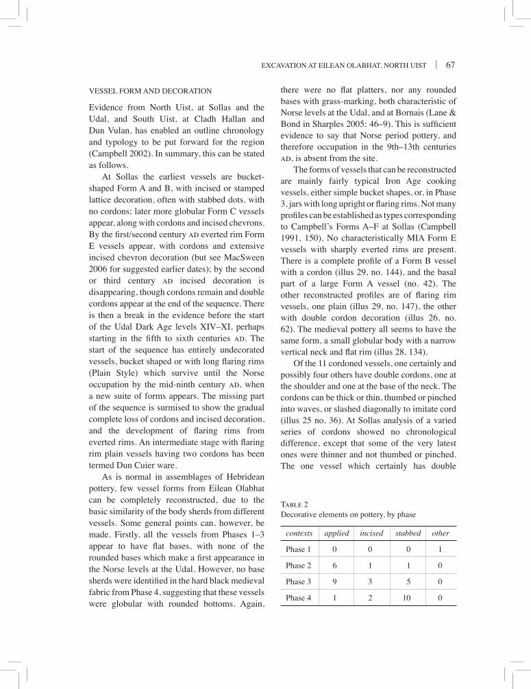
excavation at eilean olabhat, north uist | 67
vessel ForM anD Decoration
evidence from north uist, at sollas and the udal, and south uist, at cladh hallan and Dun vulan, has enabled an outline chronology and typology to be put forward for the region (campbell 2002). in summary, this can be stated as follows.
at sollas the earliest vessels are bucket-shaped Form a and b, with incised or stamped lattice decoration, often with stabbed dots, with no cordons; later more globular Form c vessels appear, along with cordons and incised chevrons. By the first/second century ad everted rim Form e vessels appear, with cordons and extensive incised chevron decoration (but see Macsween 2006 for suggested earlier dates); by the second or third century ad incised decoration is disappearing, though cordons remain and double cordons appear at the end of the sequence. there is then a break in the evidence before the start of the udal Dark age levels xiv–xi, perhaps starting in the fifth to sixth centuries ad. the start of the sequence has entirely undecorated vessels, bucket shaped or with long flaring rims (Plain style) which survive until the norse occupation by the mid-ninth century ad, when a new suite of forms appears. the missing part of the sequence is surmised to show the gradual complete loss of cordons and incised decoration, and the development of flaring rims from everted rims. An intermediate stage with flaring rim plain vessels having two cordons has been termed Dun cuier ware.
as is normal in assemblages of hebridean pottery, few vessel forms from eilean olabhat can be completely reconstructed, due to the basic similarity of the body sherds from different vessels. some general points can, however, be made. Firstly, all the vessels from Phases 1–3 appear to have flat bases, with none of the rounded bases which make a first appearance in the norse levels at the udal. however, no base sherds were identified in the hard black medieval fabric from Phase 4, suggesting that these vessels were globular with rounded bottoms. again,
there were no flat platters, nor any rounded bases with grass-marking, both characteristic of norse levels at the udal, and at bornais (lane & Bond in Sharples 2005: 46–9). This is sufficient evidence to say that norse period pottery, and therefore occupation in the 9th– 13th centuries ad, is absent from the site.
the forms of vessels that can be reconstructed are mainly fairly typical iron age cooking vessels, either simple bucket shapes, or, in Phase 3, jars with long upright or flaring rims. Not many profiles can be established as types corresponding to campbell’s Forms a–F at sollas (campbell 1991, 150). no characteristically Mia Form e vessels with sharply everted rims are present. There is a complete profile of a Form B vessel with a cordon (illus 29, no. 144), and the basal part of a large Form a vessel (no. 42). the other reconstructed profiles are of flaring rim vessels, one plain (illus 29, no. 147), the other with double cordon decoration (illus 26, no. 62). the medieval pottery all seems to have the same form, a small globular body with a narrow vertical neck and flat rim (illus 28, 134).
of the 11 cordoned vessels, one certainly and possibly four others have double cordons, one at the shoulder and one at the base of the neck. the cordons can be thick or thin, thumbed or pinched into waves, or slashed diagonally to imitate cord (illus 25 no. 36). at sollas analysis of a varied series of cordons showed no chronological difference, except that some of the very latest ones were thinner and not thumbed or pinched. the one vessel which certainly has double
contexts applied incised stabbed other
Phase 1 0 0 0 1
Phase 2 6 1 1 0
Phase 3 9 3 5 0
Phase 4 1 2 10 0
Table 2Decorative elements on pottery, by phase

68 | societY oF antiQuaries oF scotlanD, 2008
cordons (illus 26, no. 62), has other unusual decoration. the two cordons are differently styled, one pinched into symmetric and the other asymmetric waves. the lower, shoulder, cordon is modified into an upswept curvilinear motif and is discontinuous. there is a parallel to this elaboration of the cordon on a vessel from Dun cuier, barra (Young 1956, illus 12, 110), but this is a multi-period site and the pottery is basically unstratified (Armit 1988). Flaring rim vessels with double cordons are rare, but at least one, and possibly three, are known from Dun cuier (Young 1956: illus 10, 92, 85, 89), and more recently from bornais, south uist (sharples 1999: 11, illus 6). there is also a single vessel with a double cordon from sollas, but the rim is missing and it is not clear if this is a flaring rim vessel (campbell 1991: illus 18, 242). one vessel is unusual in having a cordon just below the rim (illus 25, no. 36), a feature paralleled at bornais (sharples 1999: 11).
incised or applied decoration other than cordons is very rare. six vessels have incised decoration, 16 have stabbed decoration, and three have applied lugs or strips (table 2). although stabbed decoration is characteristic of the medieval pottery, it also occurs on a few of the iron age vessels, and indeed is common on early (Phase a) vessels at sollas. the incised decoration consists mainly of chevrons, either single (illus 27, no. 103) or more complex (no. 91).
stabbing is the only means of decorating the medieval pottery. the stabbing appears to have been done with a stem, sometimes circular, sometimes figure-of-eight shaped. It can be
Phase 1 Phase 2 Phase 3 Phase 4 Unstratified
decorated 0 8 9 10 3
undecorated 10 11 33 39 6
Table 3Decoration by phase: estimated number of vessels
suggested that the implement was probably a small bone (bird?), or possibly a reed. the stabbing occurs mainly on the flattened top surface of the rim, but sometimes also at the base of the neck (illus 28).
one vessel has an applied thumbed strip forming a circular lug or boss (illus 25, no. 24), another an impressed boss which may be part of a cordon (no. 89), and a third traces of an applied lug (illus 27, no. 102). circular bosses are known on some vessels from wheelhouses such as a’ cheardach Mhor (Young & richardson 1960: illus 5, 17), Dun vulan (Parker Pearson & sharples 1999: illus 5.15, 3), an Dunan (Gilmour 2002: illus 20a), and cnip (armit 2006: illus 3.6b); and an applied grooved lug is found on a vessel from sollas (campbell 1991: illus 15, 340), but there is no real parallel for no. 24.
the stratigraphic distribution of these decorative elements does show some patterning, although the sample is very small (table 2). Phase 2 has mainly incised and cordon decoration, Phase 3 is mainly cordon, and Phase 4 mainly stabbed. it should be remembered that most vessels at all periods are undecorated (table 3), and that there is a quantity of residual pottery from earlier phases, including decorated material, in Phase 4 deposits.
usaGe
Most of the vessels show signs of usage as cooking vessels on the interior and/or exterior. the exterior surface is often worn in patches from the shoulder downwards, with sooting
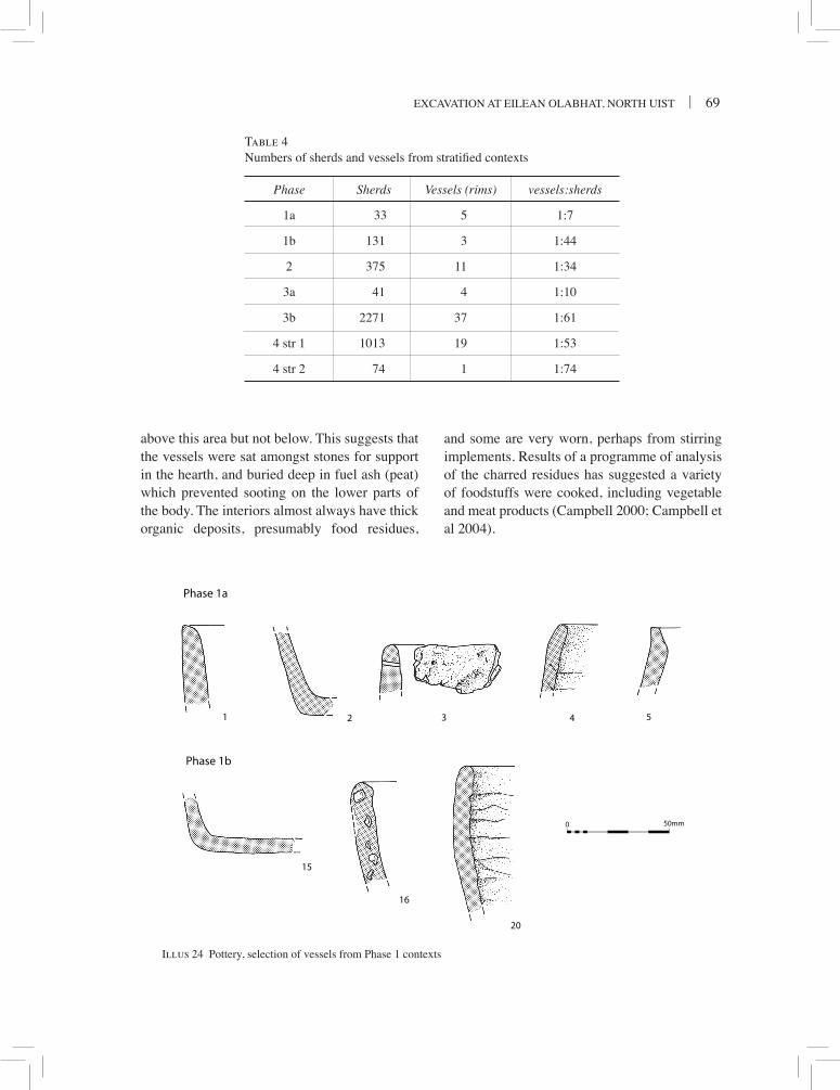
excavation at eilean olabhat, north uist | 69
Illus 24
1 2 3 4 5
15
16
20
Phase 1a
Phase 1b
50mm0
Illus 24 Pottery, selection of vessels from Phase 1 contexts
Phase Sherds Vessels (rims) vessels:sherds
1a 33 5 1:7
1b 131 3 1:44
2 375 11 1:34
3a 41 4 1:10
3b 2271 37 1:61
4 str 1 1013 19 1:53
4 str 2 74 1 1:74
Table 4Numbers of sherds and vessels from stratified contexts
above this area but not below. this suggests that the vessels were sat amongst stones for support in the hearth, and buried deep in fuel ash (peat) which prevented sooting on the lower parts of the body. the interiors almost always have thick organic deposits, presumably food residues,
and some are very worn, perhaps from stirring implements. results of a programme of analysis of the charred residues has suggested a variety of foodstuffs were cooked, including vegetable and meat products (campbell 2000; campbell et al 2004).

70 | societY oF antiQuaries oF scotlanD, 2008
taPhonoMY
Pottery studies have recently become much more concerned with issues of ceramic taphonomy, in other words the processes that affect pottery after it is broken or disused (brown 1985; Moorhouse 1986; campbell 2007). it is now realised that the assumption that pottery can be used to date the context from which it is recovered is too simple, and that account has to be taken of the history of the sherds and possible residuality. there are some simple analytical techniques (used below) which can help to distinguish the degree of residuality of an assemblage, but it is also necessary to integrate this with examination of the nature of the deposit and the other material found within it.
the size of the assemblage has been mentioned, and is illustrated graphically in terms of sherds and vessels in table 4 (measured by number of different rim forms). the pottery from Phases 1 and 2 is relatively sparpse, the bulk coming from Phases 3b and 4. the Phase 3b pottery was found in large quantities in the same contexts as concentrations of metalworking debris. Most of the Phase 4 pottery came from either the uppermost deposit in the south-west cell of the Phase 3 cellular building (029), or from structure 1, with little from structure 2. These differences partly reflect the differing volumes of excavated deposits, but also possibly relate to patterns of rubbish disposal, or the general level of pottery use at different periods. the number of vessels represented by these sherds is difficult to gauge due to the fragmentary nature of the pottery. Minimum numbers can be estimated from the number of different rim sherds, though variations in rim shape in any handmade pottery vessel can cause some problem. it can be seen that the distribution of vessels is more equitable between the phases.
vessel to sherd ratios are important in assess-ing the taphonomic processes, but the figures have to be interpreted with caution. Prehistoric pottery, fired at fairly low temperatures, degrades much more quickly than kiln-fired
pottery. normally a large vessel to sherd ratio should indicate less disturbance to the assemblage, and vice versa. to interpret the data more fully requires these figures to be combined with sherd size data. unfortunately there has not been sufficient time to carry out this type of analysis. however, the high vessel to sherd ratio of the Phase 3b pottery should indicate that this material has not been significantly disturbed, and therefore that the pottery and metalworking debris are broadly contemporary.
stratiGraPhic suMMarY
Phases 1 & 2 (illus 24–5)
these two phases are discussed together as there does not appear to be a great chronological or stratigraphic gap between them, and they contain similar pottery. in general the pottery is of early/Middle iron age type. there is so little pottery from Phase 1 that it is difficult to make any definite statements about the chronology from a typological viewpoint. one sherd has a small hole just below the rim (illus 24, no. 3) which may be accidental as it is too small to be functional. there is one example (illus 24, no. 20) of the unusual technique of unsmoothed interior slab joins. this may be a very local trait as there are no known parallels elsewhere. Most other examples are from Phase 2 contexts, apart from a few residual in Phase 3b. the remainder of the vessels from Phase 1 are all of simple bucket shapes, sollas Forms a and b. these are long-lived types with no great chronological significance.
the aMs dates from the charred residues provide a more reliable indication of the chronology (campbell et al 2004). two vessels, nos 15 and 20, were dated from Phase 1b. these produced calibrated dates which span the fourth to first centuries bc. three vessels (nos 21, 30 and 42) were dated from Phase 2. the dates obtained from nos 21 and 30 produce calibrated ranges in the fifth to third centuries bc which overlap with those from Phase 1b,

excavation at eilean olabhat, north uist | 71
Illus 25
21 46
22
2630
31
28
36
41
23 24 474039
50mm0
Illus 25 Pottery, selection of vessels from Phase 2 contexts

72 | societY oF antiQuaries oF scotlanD, 2008
and suggest a short occupation of both phases around the fourth century bc (campbell et al 2004: 79). the date from no. 42 is rather earlier, with a range from the eighth to fifth centuries
bc, and this may indicate that the vessel was old when buried. this is perhaps not surprising, as this was the base of a large vessel which had been deliberately buried in a pit (320).
Illus 26
62
51 53 56 63 61
57
sootingburnt residue
50mm0
Illus 26 Pottery, selection of vessels from Phase 3 contexts

excavation at eilean olabhat, north uist | 73
as it is not known if the vessel was made on this site or brought from elsewhere, it would be unwise to assume that there was occupation at eilean olabhat itself this early. the reuse of earlier material in foundation deposits is a characteristic feature of iron age houses in the Hebrides. These five dates belong to the Early iron age, and are important both in dating the distinctive ‘unsmoothed’ and mat-impressed vessels, and in providing a rare example of an atlantic roundhouse in this period.
Phase 2 has more pottery, and more decora-tion. it also has almost all the mat-impressed pottery, comprising at least five vessels. As with the unsmoothed vessels from Phase 1, this may be a very local construction tech- nique as there are no obvious parallels. the only profile is a simple bucket form (illus 25, no. 21) with a flattened rim. Decoration appears more abundant in this phase. applied cordons make a first appearance with five examples, two of which are very thick (illus 25, nos 23 & 31), and one of which is applied just below the rim (illus 25, no. 36). only one of these (illus 25, no. 28) has the zigzag form so characteristic of Middle iron age forms. there is also the unique circular applied strip (illus 25, no. 24). incised decoration consists of one example with incised chevrons with stabbed dots (illus 25, no. 31).
as a whole the Phase 2 assemblage shares some typological similarities with vessels from the earlier part of the Middle iron age at sites such as sollas Phase a1, Dun vulan, and an Dunan, lewis (Gilmour 2002: illus 20–22). this includes the use of stabbed decoration on the rim, thick cordons, chevron and dot decoration, thumb marks below the rim, and lack of everted rim vessels. the forms however are simpler and cruder, with thicker walls, and there is not the wealth of decoration seen at these sites, confirming that Phase 2 belongs to a transition from the undecorated late bronze age/early iron age tradition seen at cladh hallan to the later highly decorated Middle iron age ceramics.
Phase 3 (illus 26–7)Most of the pottery in Phase 3 is of typical late iron age (early historic) forms, related to the Plain style forms of the udal (lane 1990) and double-cordoned Dun cuier ware, but there is some residual Middle iron age material as well as a few intrusive medieval sherds in the uppermost contexts. the assemblage is dominated by flaring rim vessels, though only one complete profile can be established (illus 26, no. 62). of the rims, only three belong to simple upright or incurved forms, while 15 are flaring rims. there is one sherd with incised chevron and stabbed decoration (no. 91), but this is worn and clearly residual from Phase 2. otherwise the flaring rim pottery is a very homogeneous group. Of the 18 identifiable vessels, a maximum of four have cordoned decoration, with the others being plain. one of the decorated vessels has a double cordon with elaboration in one place (illus 26, no. 62), another is probably double cordoned (illus 27, no. 71), and the other two have neck cordons (illus 27, nos 74, 90) suggesting they may also have had double cordons. Most of the pottery belongs to Phase 3b, with almost no diagnostic material from Phase 3a. however, there is at least one flaring rim vessel from Phase 3a (illus 26, no. 51), suggesting Phases 3a and 3b are of approximately the same date.
this is a standard Plain style assemblage, differing from the udal type site only in the presence of a proportion of vessels with double cordons. at the udal the late iron age phases produced some 40,000 sherds, only one of which had a cordon, and that was clearly residual (lane 1983). recent work at bornais, south uist, has shown a late iron age phase dominated by double-cordoned wares (sharples 1999), enabling a typological sequence to be suggested developing from double-cordoned to Plain style wares (campbell 2002). this suggests that the Phase 3 deposits lie between the date of the bornais and udal assemblages. the bornais Mound 1 assemblage has radiocarbon dates ranging between the third/fourth and fifth/sixth

74 | societY oF antiQuaries oF scotlanD, 2008
Illus 27 Pottery, selection of vessels from Phase 3 contexts
Illus 27
67
105104103
76
102
96959392
90
878281
807978
7174
69
50mm0

excavation at eilean olabhat, north uist | 75
Illus 29
115
141140135
134133132130
122
126125
123
120119118116
50mm0
Illus 28Illus 28 Pottery, selection of vessels from Phase 4 contexts
centuries ad (sharples 2000: 25). the date of the earliest Dark age levels at the udal is controversial, but can hardly be later than the seventh century ad on the basis of 14c dates and stratigraphic sequence (lane 1990: 117–20, illus 7.4), though the excavator claims much earlier dates. on these grounds, a date for eilean
Olabhat Phase 3 around the fifth/sixth centuries ad would be reasonable.
number 62 (illus 26), a double-cordoned vessel, had three aMs samples taken which gave dates centring on the fifth to sixth centuries cal ad, and ranging from the fourth to seventh centuries cal ad. these dates agree with the

76 | societY oF antiQuaries oF scotlanD, 2008
latest of the series of conventional radiometric dates obtained from charcoal from the Phase 3b metalworking deposits (Gu-3233). the presence of a mould for a hand-pin, and several penannular brooches in the Phase 3 metalworking deposits would date these deposits to the fifth to seventh centuries ad on typological grounds, which is not in conflict with the radiocarbon dates. The dating of Phase 3 is discussed in more detail below. the cordoned vessels all appear in the upper parts of Phase 3 deposits but this may not be significant given the small number of vessels involved.
the other vessel dated which potentially belongs to this phase is no. 147 (illus 29). this appears to be a flaring rim Plain Style vessel, but it produced a date centring on the first century ad. the stratigraphic position of the sherds was not clear, as they underlay Phase 4 walling and overlaid Phase 1a deposits, but the vessel was chosen for dating as it was the only flaring rim vessel which had sufficient carbonised material to date. the date is clearly inexplicable, which is unfortunate, and it is possible that the sample may have been contaminated during conservation (campbell et al 2004: 79).
there is a very considerable stratigraphic gap between Phase 2 and Phase 3, clearly indicated by the major change in pottery styles between the two phases. the later medieval vessels in Phase 3b are mostly from context 238 (nos 78–80; illus 27) and contexts 014/015 (nos 56–60; illus 26 for nos 56–57), and are presumably intrusive from the immediately overlying floor of the Phase 4 structure 1.
Phase 4 (illus 28)
the Phase 4 deposits show yet another major shift in pottery forms indicating a considerable gap in the stratigraphic sequence from Phase 3. a new type of vessel, in a new fabric, appears in Phase 4. the fabric is harder and blacker than previously. the vessels are smaller, globular bodied with rounded bases, and the necks are
upright, narrow and often with a carination at the base of the neck (illus 28, no. 134). Decoration consists entirely of stabbing, almost always on the rim top, and sometimes also at the base of the neck.
this type of pottery cannot be accurately dated as there are no comparable assemblages published from stratified sites. Stabbing on the rim and body of small vessels starts to appear in the latest norse levels at the udal (lane 1983: illus 20), but the vessel form is not the same, and the body stabbing is in bands. these levels date to the 11/12th centuries ad. Pottery from succeeding medieval phases has similarities to the Phase 4 pottery but has not been studied or published (crawford & switsur 1977: 132; lane pers comm). there is similar unpublished material from unstratified collections on Coll (lane pers comm), and one published vessel from tiree (Mann 1908: illus 2) which shares most of the characteristics of the Phase 4 pottery. a few post-medieval assemblages have been published, for example from breachacha castle, coll (turner & Dunbar 1970). the forms in the 15th/16th century ad levels here are rather devolved and coarser examples of the Phase 4 type, with irregular stabbing and everted necks, suggesting that by this period the form was degenerating. however the basic form of upright body and vertical neck survived into the 19th-century craggans (ibid: illus 1). recently published evidence from bornais shows that there was a late version of everted-rim ware present in 14th-century ad deposits (lane & bond in sharples 2005: 133). the lack of everted rims in the Phase 4 assemblage might then be taken as an indication that the olabhat assemblage post-dates this phase but pre-dates the general introduction of craggan wares by the 16th century. taken together the evidence suggests a medieval date for the pottery, perhaps between the 14th and 16th centuries ad for the primary phase of structure 1. the secondary occupation has little decorated material, perhaps indicating an early post-medieval date.

excavation at eilean olabhat, north uist | 77
143
50mm0
146 149
148
144150
147
Illus 29Illus 29 Pottery, selection of vessels from unstratified contexts
the only distinctive vessel from structure 2 has unusual horizontal and vertical scored decoration (illus 28, no. 133). this may be residual from earlier deposits, or an unusual decorated post-medieval form. there is also a considerable amount of flaring rim pottery in the Phase 4 deposits, obviously disturbed from Phase 3 deposits during the building of structure
1. there is one small sherd of incised decoration which may be residual from Phase 2 (no. 132).
Discussion
the pottery falls into three distinct periods: Phases 1 and 2 in the early/Middle iron age; Phase 3 in the early historic period; and Phase

78 | societY oF antiQuaries oF scotlanD, 2008
4 in the medieval and post-medieval periods. all the phases have features which are of significance in a hebridean or wider context. the Phase 1 and 2 deposits contain a unique type of pottery made using a basal woven mat, and are important as a rare dated assemblage of early iron age forms. the Phase 3 vessel forms are well known, but help to elucidate the sequence of late iron age forms. the Phase 4 pottery belongs to a period which has almost no stratified assemblages published in the Western isles (or indeed western scotland) and throws important light on the sequence in the post-norse period. the lack of comparable material makes it difficult to date Phase 4 accurately, but structure 1 is one of the few rural buildings of this period to have been excavated in scotland.
the Phase 3 pottery is the most problematic in its dating. it has been suggested that double-cordoned vessels represent a stage missing from the stratified assemblages at Sollas and the udal, and therefore dating to the third to fourth centuries ad on the published dating for these sites. This dating conflicts with the typological dating of the hand-pin mould from the Phase 3 metalworking deposits, which should be of the fifth to seventh centuries ad (Youngs 1989), and the fifth/sixth century direct radiocarbon dates obtained here for the Phase 3 double-cordoned pottery. recently, doubled-cordoned flaring-rim vessels at Cnip have been dated to the second/third centuries ad (Macsween 2006: 101–2).
there seem to be two alternatives to explain the lack of double-cordoned pottery at the
udal in phases which should be contemporary with eilean olabhat Phase 3 on the basis of radiocarbon dates. The first is that the Udal sequence has a larger gap than has been assumed between the end of the south hill and beginning of the north hill occupation, and that the first deposits on the North Hill are not before the sixth century ad, and thus post-date the period of use of double-cordoned ware. the alternative is that the use of double-cordoned pottery was not uniform throughout the area, perhaps because it had some special function and was restricted to certain sites. it is not possible to decide on present evidence which explanation is certain, but the doubts over the udal radiocarbon dates (lane 1990: 120) suggest re-dating of the north hill start date is the most economical explanation. an alternative hypothesis, which the cnip dates might support, that pottery styles in the Western isles form markedly diachronous horizons within very restricted areas, would require a radical reconsideration of the conventional views of typological analysis and the social production of pottery styles.
a note on the neolithic PotterY
(Melanie Johnson) (illus 30)Four sherds of neolithic pottery were found (nos 151–3), occurring residually in later contexts. number 151 consists of two collared rim sherds decorated with incised diagonal lines along the collar. number 152 is a ridge or carination decorated with diagonal incised lines both above and below the ridge. they are both likely to derive from multiple-ridged jars, which are a type of vessel unique to the hebrides in the neolithic, occurring at the nearby islet settlement site of eilean Domhnuill (armit 1996), and at allt chrisal, barra (Gibson 1995) and northton, harris (Johnson 2006). a further small body sherd (no. 153) is decorated with horizontal incised grooves, and is also likely to be neolithic in date. the deposition of these sherds is likely Illus 30
50mm0
151 152
Illus 30 neolithic pottery

excavation at eilean olabhat, north uist | 79
to have been in contexts associated with the occupation of eilean Domhnuill.
cataloGue oF illustrateD anD/or raDiocarbon DateD ForMs
the pottery is described by phase and sub-phase, in numerical context order within each section. it should be noted that catalogue numbers do not necessarily represent individual vessels. the description is followed by dimensions and context numbers. abbreviations: bD – basal diameter; rD – rim diameter; ht – height. colour and fabric are as specified in the general report, with any differences noted. a full catalogue, including quantities of undiagnostic sherds listed by phase and context, forms part of the site archive.
Phase 1a
context 2851 rim of large vessel with internal bevel.
(c285)
context 3372 two joining base sherds; straight sided vessel
with rounded basal angle. bD 10cm. (c337 & c385)
3 rim of thick straight-sided vessel. rim rounded, with tiny pierced hole below. rD 16–20cm. (c337)
4 rim of bucket-shaped vessel with inturned upper body profile. Diagonal slab joins, not smoothed on interior. rD 14cm. (c337)
5 rim, rounded, slightly out turned. (c337)
Phase 1b
context 304/35015 Two base sherds, flat. Some organic temper.
bD 14cm. (c350) oxa-6949, 2205 ± 50 bp16 20 sherds from large bucket-shaped vessel.
rim simple, upright. Fabric very coarse with large rock fragments. (c350)
context 34220 bucket-shaped vessel, very fragmented. rim
rounded, slightly inturned. Base flat. Slab joins not smoothed in interior, very pronounced. slabs 10–20mm wide, diagonal joins. rD
16cm, bD ?18cm. (c342) oxa-6950 2170 ± 50 bp
Phase 2
context 25621 twenty-two or more joining sherds from
upper part of globular vessel. rim l-shaped. Irregular fingerprint impressions below rim, vertical sooting marks below this. abraded on shoulder. internal slab joins visible, diagonal. rD 140mm. (c256 & c303) oxa-6973, 2310 ± 35 bp
22 seven base sherds. basal angle pinched. Mat impressions. May be base of no. 32. bD 14cm. (c256)
23 two sherds with very large cordon which has a series of finger impressions along its length. (c256)
24 Sherd with circular applied strip with finger impressions. Perhaps a decorated lug. (c256)
context 29826 Two joining sherds of flat base, grass-marked
on exterior. chopped grass stems up to 15mm long arranged randomly. sherds abraded. (c298)
28 two joining body sherds of globular vessel, decorated with thin cordon with symmetric waves. sooting on exterior surface below decoration. smoothing striations on exterior, running diagonally rather than horizontally. (c298)
context 30230 Base with fibre-matting impression on base.
Internally number of fingerprint impressions and organic residues. bD 12cm. (c302) oxa-6972 2325 ± 35
31 Five rim and body sherds of vessel with slightly everted rounded rim. below rim are thumb impressions. shoulder has large cordon with regular finger impressions. Below the rim are incised chevrons with deep stabbed holes in between. rD c 30cm. (c302)
context 30936 rim with cordon just below. cordon slashed
diagonally on upper surface. interior with narrow diagonal joined slabs, not smoothed. sooted exterior. two sherds, one abraded. rD 10–12cm. (c309)

80 | societY oF antiQuaries oF scotlanD, 2008
context 31939 rim of large vessel, upright. exterior covered
in finger impressions. Fabric very coarse, with large igneous rock fragments. (c319)
40 rim, slightly inturned, two sherds not joining. (c319 & c320)
context 32041 base sherd with mat impression, two joining
sherds, both fresh and unworn. Bundles of fine fibres tied every 20mm. Internal fingerprint impressions. organic temper. bD c 10cm. (c320 & c310)
42 (not illustrated) Many body sherds and complete base of very large vessel, pinched, coil formed and finger impressed. BD 20cm. (c320/324) oxa-6948 2500 ± 50 bp
context 32946 rim and upper body of large bucket-shaped
vessel. top of rim with series of impressed broad grooves. internal slab joins not smoothed. organic temper, chopped grass. rim worn on exterior through usage. rD 24cm. (c329)
47 tiny rim sherd, upright slightly everted. (c329)
Phase 3a context 27151 Many sherds from vessel with long flaring
rim. rim attached as one slab 70mm wide. tongue and groove slab joins. organic temper, smoothing striations. rD 20–24cm. (c271)
Phase 3b
context 01353 Long flaring rim, flat top. (C013)
context 01456 Six rim sherds, flat topped, upright. Medieval
rD 26cm. (c014)57 Three rim sherds, flat topped. Medieval.
(c014)
context 01661 basal angle, rounded. bD 12cm. (c016)
context 01962 Most of profile of globular jar with long
flaring rim. Basal angle rounded. Decorated with two applied cordons. the lower, around the shoulder, of asymmetric waves, and with an elaborated motif at one point. the upper at the neck base, not continuous, of symmetric waves. band of sooting around shoulder, internal organic deposits. interior surface very worn. Fabric coarse, with fine organics. rD c 28cm; max diameter 30cm; ht c 24cm. (c019) oxa-6970, 6946, 6947; 1440 ± 35, 1575 ± 45, 1590 ± 50
63 Six sherds of neck of flaring rim vessel. RD 20–22cm. (c019)
context 02267 rim of large vessel, thick, rounded, incurving.
(c022)
context 02569 two large rim sherds from thick walled vessel,
rim rounded. tongue and groove technique. (c025)
context 02871 thirteen sherds from a single vessel.
Shouldered jar with flaring rim. Decorated with cordon of symmetric waves on shoulder, possibly another at neck. (c028)
context 03174 Neck with flaring rim, decorated with applied
cordon with symmetric waves. (c031)
context 23676 tiny globular vessel with everted rim. rD
10cm. (c236)
context 23878 Rim, upright, flat top with slight internal
clubbing. top decorated with pointed stab marks. rD 16cm. Medieval. (c238)
79 Rim, upright, flat. Top decorated with bird bone stab marks. Medieval. (c238)
80 Rim sherd, flat with external lip. Medieval. (c238)
81 Rim, long, flaring, flat top. (C238)82 Rim, long, flaring, flat top. (C238)
excavation at eilean olabhat, north uist | 81
context 25187 basal angle, a few organic marks around edge
of base, probably mat impressions. (c251)
context 25390 Neck of flaring rim vessel with weakly
developed cordon consisting of thin wavy line. (c253)
context 25792 Long flaring rim, flat topped. RD 26cm.
(c257)93 Rim, incurving, flat top. (C257)95 base sherd, pinched angle. (c257)96 Large heavy base sherd, flat and pinched.
(c257)
Phase 3 undifferentiatedcontext 311102 upright or inturning rim with internal bevel.
exterior has irregular shallow vertical grooves and traces of an applied ?lug. (c311)
context 312103 Rim of decorated vessel. Rim flattened with
slight external flange, irregular stabbing on top surface. Decoration below rim of stamped or incised chevrons. rD c 20cm. (c312)
104 two rim sherds from globular vessel with outurned rim. (c312)
105 rim of thick vessel, upright, thinned on exterior. internal slab joins not smoothed. rD c 20cm. (c312)
Phase 4: Structure 1 Primary Occupation
context 018115 Long flaring rim flat top. (C018)116 Neck of flaring rim vessel. Tongue and groove
slabs. (c018)118 Rim, upright, flat topped. (C018)
context 204119 Rim sherd, flat topped. (C204)120 rim sherd, bevelled internally. (c204)
context 224122 six sherds from rim of vessel with upright
neck. Rim flattened, slightly clubbed on exterior. top stabbed regularly with bird
bone?. another line of regular stabbing with same implement at shoulder. Fabric fine with much mica, exterior very well finished, almost burnished. Four body sherds also. rD 16cm. (c224)
123 Rim, flat topped with stabbing. (C224)125 Rim, flat topped, upright neck. (C224)
context 226126 neck sherd with row of bird bone? stabbing at
shoulder. (c226)
Phase 4: Structure 1 Secondary occupation
context 009130 rim sherd, rounded. rD 16cm. (c009)132 Decorated body sherd with chevrons deeply
stamped or incised. (c009)
Phase 4: Structure 2, primary occupation
context 247133 Rim, upright, flat topped. Decorated with
horizontal groove and almost vertical parallel incised grooves cf no. 88. rD 10–12cm. (c247)
Phase 4: mixed deposits outside Structure 1 but within Phase 3 cellular building
context 007134 neck of small jar, with sharply carinated
shoulder, upright neck. Rim flattened. Decoration of stabbing with point on rim top and with bird bone? in row at base of neck. (c007)
135 Long flaring rim, four sherds. (C007)
context 029140 Clubbed rim, flat top with irregular stabbing.
hard black fabric. Medieval. (c029)141 Rim, upright neck, flat top, with row of stabbing
below rim. Fabric hard, black. Medieval. (c029)
Unstratified
143 top part of small shouldered jar with upright neck. Rim flat topped, with stabbed decoration. Fabric hard, black, gritty. Medieval. trial trench.

82 | societY oF antiQuaries oF scotlanD, 2008
144 Complete profile of shouldered jar with pedestal base. rim slightly outurned. Decorated with cordon on shoulder, slashed diagonally. Wear patches below cordon. some sooting on exterior and organic deposits in interior. Well finished surface treatment. bD 8cm; rD 12cm; ht 13cm. (c138; mis-numbered context)
146 Rim, flat top, with row of stabbing below. Fabric black. Medieval. Unstratified A/B baulk.
context 265 (unphased layer external to structures)147 Globular vessel with flaring rim, partially
reconstructed. rim simple, rounded. slab built with the entire rim formed of one slab. exterior well-smoothed, almost burnished, sooted from shoulder up. rD 26cm. (c265) oxa-6971, 1970 ± 35 bp
148 base and body sherds. Flat narrow base with flaring sides. Tongue and groove slabs. Base very worn on inner surface. coarse temper with much organics. bD 8cm. (c265)
149 two rim sherds with inward bevel. (c265)150 body sherd with two incised diagonal lines
flanked by a row of dots. Organic temper. (c265)
Neolithic pottery151 two rim sherds. Flat rim with outer lip; hard
fabric. Decorated with stab and drag marks. early neolithic. (c005)
152 Triangular profiled cordon with slashes on both sides. (c222)
MetalWorKinG Debris
the metalworking debris comprises a wide variety of materials, but much of it is clearly associated with the non-ferrous metalworking workshop of Phase 3b (table 5). this material includes all of the crucibles, artefact and ingot moulds, tuyères and fired clay, an assemblage typical of such workshops. the metal droplet of copper alloy (no. 230) is also characteristic of metalworking deposits, but unfortunately is unstratified. The small amount of this material found in Phase 4 deposits is presumably residual from Phase 3b. the largest other category of material is vitrified fuel ash slag (VFAS), which can be derived from either domestic or industrial hearths. the one item, possibly a crucible sherd, from Phase 2 (no. 175) comes from the uppermost layer and is most likely intrusive from Phase 3. there is a small amount of vFas in Phase 2 associated with iron slag and furnace lining, which could all be derived from iron-working activity. the iron slag all appears to be from hearth bottoms and represents smithing activity.
the size of the assemblage is not large, but is nonetheless comparable to some other metalworking sites of the period such as the brough of birsay, orkney (curle 1982), and the Mote of Mark, Kirkcudbright (laing & longley 2006). there are however, a number of
crucible mould tuyère VFAS iron slag furnace lining
fired clay
Phase 1 0 0 0 0 0 0 0
Phase 2 ?1 0 0 2 2 1 0
Phase 3a 0 0 0 0 0 0 0
Phase 3b 114 69 4 9 3 3 5
Phase 4 7 4 0 3 2 1 0
Table 5Summary of metalworking debris from identifiable phases
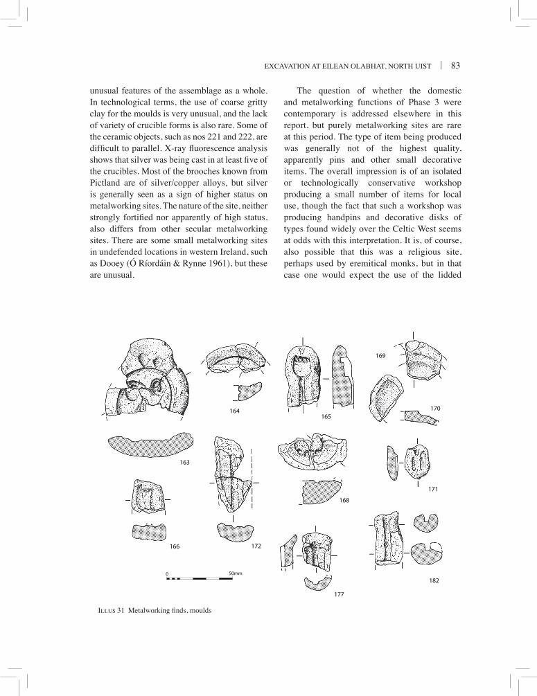
excavation at eilean olabhat, north uist | 83
Illus 31
50mm0
163
166
177
182
171
168
172
170
169
165164
Illus 31 Metalworking finds, moulds
unusual features of the assemblage as a whole. in technological terms, the use of coarse gritty clay for the moulds is very unusual, and the lack of variety of crucible forms is also rare. some of the ceramic objects, such as nos 221 and 222, are difficult to parallel. X-ray fluorescence analysis shows that silver was being cast in at least five of the crucibles. Most of the brooches known from Pictland are of silver/copper alloys, but silver is generally seen as a sign of higher status on metalworking sites. the nature of the site, neither strongly fortified nor apparently of high status, also differs from other secular metalworking sites. there are some small metalworking sites in undefended locations in western ireland, such as Dooey (Ó ríordáin & rynne 1961), but these are unusual.
the question of whether the domestic and metalworking functions of Phase 3 were contemporary is addressed elsewhere in this report, but purely metalworking sites are rare at this period. the type of item being produced was generally not of the highest quality, apparently pins and other small decorative items. the overall impression is of an isolated or technologically conservative workshop producing a small number of items for local use, though the fact that such a workshop was producing handpins and decorative disks of types found widely over the celtic West seems at odds with this interpretation. it is, of course, also possible that this was a religious site, perhaps used by eremitical monks, but in that case one would expect the use of the lidded

84 | societY oF antiQuaries oF scotlanD, 2008
Illus 32
183
224
222223
176
178221180
191190189
188185
187186184
50mm0
Illus 32 Metalworking finds, crucibles, moulds and tuyère

excavation at eilean olabhat, north uist | 85
crucibles which were current in contemporary ireland and Dál riata. there are no other characteristics of a monastic site of this period, such as graves, crosses or a chapel. this leaves the possibility that metalworking was organised on a different basis in the hebrides, perhaps as part of a more egalitarian society (campbell & heald 2007).
MoulDs (illus 31–2)
there are 86 certain mould fragments, with a further four possible fragments. only around 14 of these retain impressions of identifiable objects, with some others showing casting channels, ingates, keying marks and other technological details. although this is a small assemblage, at least two of the objects which were being cast, the handpin and the bossed disc, are decorative items of considerable significance.
Technology
almost all the mould fragments belong to two-piece moulds, a method of casting which was widespread in western britain and ireland at this period. in contrast to the one-piece investment mould method of the earlier iron age period which used the lost wax method of casting, the two-piece method utilised a reusable model of the object to be cast, pressed between two pads of clay. the technique has been discussed in detail in the brough of birsay report (curle 1982), and only details which differ from those will be noted here. comparisons will also be made with the material from the seventh century ad workshop at the Dalriadic site of Dunadd (lane & campbell 2000).
at least two fragments differ from the others in that they are from simple open one-piece moulds for casting small ingots of metal (illus 32, 176 & 180), and another may be from a similar mould (illus 32, no. 178). ingot moulds are usually of stone at this period, but ceramic examples similar to the olabhat ones are known from the recent excavations at Dunadd, where
there are two double moulds and one single (lane & campbell 2000: 149, illus 4.52). the type of metal cast in these ingot moulds is unknown, though it is often assumed to be silver or gold because of the small size, and the fact that silver and gold ingots of this shape are much commoner than copper alloy ones.
the technology revealed by the two-piece moulds shows similarities to practices at Dunadd and the brough of birsay, but some details are different. the object model was pressed into a flat piece of clay which had a plano-convex section (the lower valve), then covered with another piece which then had a concavo-convex section (the upper valve). there are not enough well-preserved valves to be sure which face of the object was pressed into the lower valve. apparently unique to eilean olabhat is the use of very long channels connecting the ingate to some objects, whereas normally these are very short or even non-existent. this results in the presence of a considerable number of sub-cylindrical mould fragments which give the superficial appearance of being moulds for single pins, and are only differentiated when the ingate is still attached (illus 31, no. 177), or by the rectangular channel section, as opposed to the rounded section of pins such as no. 172 (illus 31). none of these moulds with long channels show the object which was being cast. some of the artefacts, such as the disc and the ring, do not have these long channels, so it may be that they are restricted to certain classes of object. at other contemporary sites such as Whithorn Priory, the Mote of Mark (longley 2001: illus 7.6, 1150), Dunadd and birsay, pin moulds are usually multiple, with several pins radiating from the ingate area. long channels would lead to cooling of the molten metal, and it is difficult to see the reason for this practice, unless thin bars and rods were being cast.
the keying method consists of v-shaped knife nicks on the margins of some lower valves, but these are rare and not well preserved. this is the technique used both at Dalriadic Dunadd, and at british Mote of Mark (laing & longley 2006:

86 | societY oF antiQuaries oF scotlanD, 2008
illus 24, 1154), and differs from the stab marks in use in Pictish orkney (lane & campbell 2000: 202). Most of the moulds are very fragmentary, perhaps due to the coarse fabric used. there are a few tiny complete valves (illus 31, no. 171 & no. 179), but unfortunately the impressions of the objects being cast are too faint to be made out clearly.
the fabric of the moulds is identical to that of the pottery and the crucibles, consisting of a gritty gneissic clay, and is generally of the same grey-brown colour as the pottery. occasional patches are fired orange, and the surfaces which have been in contact with the molten metal are reduced grey. a few moulds are of better quality, and the disc mould (illus 31, no. 163) stands out by being very orange, harder, and slightly finer fabric. it looks as if more care has been taken with this particular item, and the valves may have been fired before the metal was poured in. In general though, the coarse fabric is very unusual, as on all other sites of the period a fine, grit-free clay is used for moulds. there may have been a lack of suitable clay available at olabhat.
Objects cast
the range of objects being produced is small, consisting of a decorative disc, pins, hoops and some unidentified objects. No certain brooches are present, though the hoops could belong to either large rings or brooches. the most decorative object is a large disc (illus 31, no. 163) of three joining sherds, which together make one of the largest mould fragments from the site. the surface is damaged but enough remains to show that the flat disc had a border containing three bosses decorated with spiral patterns which flare out across the flat field between the bosses and probably formed a triskele pattern in the centre. snail-like bosses and trumpet spirals are features of early la tène art, but these elements also appear in late iron age celtic metalwork such as hanging bowl escutcheons. At first sight the simplicity of the olabhat disc recalls early iron age examples such as the well-known
Monasterevin discs from ireland (raftery 1987: Pl. ii). however, a similar example, also a mould, was found at Dunadd in an undoubted seventh century ad context (lane & campbell 2000: 130, illus 4.34, 4.35, no. 453), and it can be assumed that discs in this form were being manufactured around this date. the Dunadd example has three snail bosses, separated by crescents, set around a central boss. the olabhat disc was probably decorative and meant to be attached to a flat surface. there are examples of fairly simple discs with raised decoration on the copenhagen house shrine (Youngs 1989: no. 131), though the olabhat disc need not necessarily have been attached to an ecclesiastic item, as most of these mounts seem to have more complex decoration. a disc with raised bosses and trumpets which forms part of a larger mount is known from a viking grave in norway (shetelig 1940: illus 85), but again is more finely decorated than the Dunadd and olabhat examples and not closely related typologically. there is little typological evidence for the date of the olabhat disc, except for the Dunadd parallel of the seventh century ad, and the fact that most flat discs seem to be of sixth to eighth century ad date. the archaic nature of the decoration might suggest an earlier rather than later date within this time bracket.
the mould for the handpin (illus 31, no. 165) is one of only a few known for this important class of pin, the others being from upper scalloway in shetland (campbell in sharples 1998: 171, illus 103, 7), from the broch village of Gurness, orkney (hedges 1987: illus 2.84, 819), and several from the loch na beirgh broch tower, lewis (harding & Gilmour 2000: 63–4). handpins are found widely throughout ireland, scotland and western england, and are believed to derive from romano-british proto-handpins. the dating of handpins is controversial as none have been found in secure stratified archaeological contexts, and most dating has been based on art historical arguments. several are parts of well-known hoards of metalwork, such as the Gaulcross silver Pictish hoard (Youngs 1989: no. 7a). the olabhat pin

excavation at eilean olabhat, north uist | 87
is unusual in that it has an undecorated and unpierced semicircular palm, with four fingers in a straight line above it. the lack of decoration makes it difficult to date within the generally accepted range of sixth–seventh century ad (Youngs 1989: 25–7), though Ó Floinn (2001) has recently proposed an earlier, fourth or fifth century ad date range. the lack of a pierced hole is unusual, though it is paralleled by the pin from urquhart castle (laing 1993: no. 128) and has been taken as an early feature. the steeply-inclined bend in the shaft (rather than a ninety degree angle) is also unusual and reminiscent of some proto-handpins, which might also suggest an early date in the series. the lack of decoration is found on only two other surviving handpins, one unpublished from st albans Priory, the other from Moresby, cumbria (laing 1993: no. 114). A fifth to seventh century ad date can be assigned to the mould, which is important as it is in a stratified context with AMS dates on pottery centering on a fifth to sixth century ad date, but it would be unwise to assign a more specific date on typological grounds. The stratified mould from scalloway is less well preserved, but also may date to the fifth or sixth century ad. those from loch na beirgh are found with door-knob spear-butt moulds which have been dated to the fourth or fifth century ad (heald 2001). these moulds are important in showing that handpins were manufactured in the Western and northern isles. it is strange that the only evidence for manufacture should come from areas far removed from the findspots of most handpins, and is reminiscent of the situation with hanging bowl escutcheons which are common in anglo-saxon contexts, but only known to have been manufactured in Pictland at craig Phadrig near inverness (bruce-Mitford 1987: illus 7; campbell & heald 2007).
there is little that can be said of the other objects. number 168 (illus 31) is too fragmentary to provide parallels, but shows a complex knobbed ring, possibly from a ringed pin, or perhaps a small terret. there are at least two hoops which may be from brooches, but only no.
169 (illus 31) is of similar size to other brooch moulds. no details survive of the head of the stick pin (illus 31, no. 172). number 167 shows what may be a very small handpin impression, but it is too incomplete to be certain.
crucibles (illus 32)
crucibles were the most numerous class of metalworking debris, with over 120 fragments. the typology of the crucibles is simple, as almost all the fragments belong to one form of variable size. this is the simple triangular type of crucible which was common throughout the scottish iron age period (lane 1987). complete examples show that there is usually a slight asymmetry in the plan view of the crucibles, with one side being more convex than the other two, which tend to form a more or less defined spout in their angle (cf curle 1982: illus 24, no. 394). occasionally the spout is slightly accentuated by further pinching. this form seems to have been made by forming a simple deep bowl of clay, then squeezing two of the sides between thumb and forefinger of one hand to form a simple spout, while pushing the bowl into this v shape using the opposite hand. the vertical section is sometimes v-shaped, asymmetric and angular, but can vary to rounded especially in the larger examples. the only exception to this uniform typology is no. 221 (illus 32), which is not certainly a crucible.
the triangular crucibles share a common fabric and appearance. the fabric is very similar to that of the pottery, a coarse clay with abundant gneissic rock fragments and minerals derived from the weathering of gneiss. the exteriors of the crucibles show signs of intense heating under reducing conditions, with bubbly vitrification which often accumulates around the base, highly glazed areas, often with red copper oxide deposits, and occasionally cracking. the interiors, on the other hand, almost never show these features, and are often oxidised to more orange colours, at least in the upper part. internal deposits are rare, but when they do occur consist of drossy

88 | societY oF antiQuaries oF scotlanD, 2008
slag deposits which occasionally show charcoal or green cupriferous deposits. X-ray fluorescence analyses were carried out by andrew heald on 31 crucible fragments, sometimes on multiple locations, inside and outside of the vessels. Four of these, nos 201, 202, 205, and 207, showed silver was a major element in the metal residues, and one other, 194, showed minor amounts, but copper was also present in most samples (a full report is within the site archive). this might suggest that silver debased with copper, a common alloy in Pictish metalwork, was being cast from these crucibles. the only other feature visible is the occasional distortions of the walls, which in a few cases can be made out to be the result of the crucible being grasped with tongs used when pouring out the molten metal (illus 32, no. 188). examples of such tongs are known from the irish sites of Moynagh lough and nendrum (Youngs 1989: nos 225, 226), and similar tongs marks are found on crucibles at Dunadd (lane & campbell 2000: illus 4.43, 1352/1). these features show that the crucibles were heated on a bed of charcoal,
by bellows or blowpipes acting on the exterior of the crucible. the scarcity of internal deposits is unusual compared to other western british sites, and may be due to the very wet acid soil conditions. there is no sign of the ‘relining’ or multiple layers of crucible wall, which has been claimed from some sites. at Dunadd, almost all cases of multiple layers of wall could be shown to come from lidded crucibles in areas where the lid was luted over the wall, and did not represent relining of the crucible. nevertheless, it is likely that each crucible was used a number of times, and a few instances of vitrification covering cracks proves repeated use. each charge of the crucible would normally be used to produce one object in a mould.
as the crucible form is so simple, it is difficult to estimate the minimum number of crucibles represented by the fragments. there are five complete vessels, one of which, no. 185, is unused. in contrast to pottery vessels, it is not possible to use the size of rim fragments to estimate vessel equivalents because the rim plan
Site Sherds Min. no. Complete % metalworking vessels vessels area excavated
eilean olabhat 150 13 5 all?
Dunadd 263 c 60 11 small brough of birsay c 150 c 60 9 large? lagore 263 55 6+ large Garranes 2500 ? c 50 large ribe 255 ? 4 small Dinas Powys 150 11 2 c half
Table 6numbers of crucibles from metal-working sites. Data from curle 1982 for birsay; hencken 1950 for lagore; Ó ríordáin 1942 for Garranes; alcock 1963 for Dinas Powys; and Madsen 1984 for Ribe. Dunadd figures from Lane & Campbell 2000 include 1929 finds, mainly from craw’s site Z adjacent to site 3

excavation at eilean olabhat, north uist | 89
is irregular. however by counting the number of complete bases it is possible to give an estimate of the minimum number of crucibles as at least 13. although this is not a large number, it is in the same range as some other important metalworking sites of the period (table 6).
the size of the eilean olabhat crucibles is variable, but most appear to be mostly 30 to 40mms in height with a capacity of around 15ml. a few sherds show signs of coming from slightly larger examples (nos 188–91). the only very small crucible (no. 185) appears to be unused, perhaps because it was too small.
by comparison with sites farther south such as Dunadd, and contemporary sites in Wales and ireland, where there is a wide variety of crucible types (alcock 1963: 141), the uniform crucible typology at eilean olabhat is unusual. at this period, the lack of lidded and lugged crucibles is also unusual. as lidded crucible types are also found at sites in the northern isles such as the brough of birsay, it might suggest that the Western isles had a distinct cultural tradition of metalworking which remained uninfluenced by technological developments in neighbouring regions.
it has already been mentioned that most of the sherds come from Phase 3. the Phase 4 crucible sherds are of the same character, and seem to be residual material from Phase 3 deposits disturbed in the construction of structure 1, as there are several joins of mould fragments between these phases. the original metalworking activities which the crucibles belong to were, therefore, confined to Phase 3. The largest concentrations of crucible fragments were in contexts 257 and 238 in the central area, and in context 019 in the south-west cell of the Phase 3 building; contexts which also produced the most mould fragments.
Miscellaneous inDustrial ceraMics (illus 32)
number 221 appears to be similar to the crucibles in the degree of firing, though there is no vitrification. The shape is very unusual for a
crucible, but similar elongated or oval ‘crucibles’ were found in Pictish horizons at birsay (curle 1982: illus 25, nos 410, 411). shallow bowl-like industrial ceramic forms are known from Dunadd and other sites, and seem to have been used for a variety of purposes. some have been attributed to parting vessels, for separating precious metals (bayley 1991), others may have been heating trays (Youngs 1989: no. 171). the olabhat form differs from both of these, and may be for some other specialist purpose. Given the otherwise uniform crucible shape at olabhat, the elongated shape must be deliberate, and presumably intended for a specific purpose. However, it is just possible that this is not a crucible, as it is very similar in shape to no. 176, which is unfired and may be a ceramic ingot mould. in that case no. 221 could be seen as an ingot mould which was accidentally over-fired. On balance however, it would appear to be a specialised metalworking crucible of some sort.
number 222 has clearly been reused at high temperatures, and it is difficult to be sure of its original function. the lug, which may have been a handle or even a foot, would suggest that this may have been the lid of a crucible, but the triangular profile would be unique. The object may have been some form of specially made stand or heating tray, or it represent the reuse of a fortuitously shaped sherd for a similar purpose. three other subcircular crucible sherds which are partly vitrified (nos 225–7) look as if they have been used for similar purposes. this strengthens the suggestion that all these items were reused rather than being purpose made, and that they may have functioned as stands for crucibles.
there are fragments of at least two or three tuyères. the two which can be reconstructed are small, and were probably used as blowpipe nozzles for non-ferrous metalworking, rather than as bellows protectors for iron working furnaces (nos 223–4).
The small amounts of vitrified fuel ash slag (vFas) are undiagnostic, and could have come from domestic hearths, ferrous, or non-ferrous metalworking of any period.

90 | societY oF antiQuaries oF scotlanD, 2008
cataloGue oF illustrateD Material
Moulds163 three joining sherds of lower valve for
decorated disc. the mould shows the shallow D-shaped ingate with two short v-shaped channels leading to the disc impression. the lower surface is slightly concave, with traces of luting clay from the join with the upper valve. the clay is oxidised bright orange-red around the ingate, but yellowish to grey elsewhere. Fabric gritty (grits up to 1mm), with some fine organic stems. No visible key marks. about half of the circular disc is preserved, of diameter about 45mm with a border 2mm wide. the surface is partly damaged, but preserves one complete and one partial spiral boss, while a third can be assumed in the missing part by symmetry. both bosses have shallow raised trumpet spirals expanding from them across the flat central field. The complete boss has a central circular depression. 67 × 39mm, th 12mm. (c014 & c296). Phase 3b
164 two joining sherds of the upper valve of a disc. concavo-convex section, with two positive v-shaped key marks at the margin. Fabric as no. 163. the disc is plain, with a diameter similar to no. 163, and almost certainly is the back face of the same object. 45 × 18mm. th 9mm. (c257 & c014). Phase 3b
165 lower valve fragment with impression of handpin. valve cylindrical, with traces of luting along edges. Fabric gritty (up to 1mm) with fine organic stems. Interior grey, with buff outer skin. a transverse groove on the outer surface retains traces of fine twine used to tie the two valves together. the pin impression has a circular section shaft, diameter 4–5mm, angled to about 80 degrees in relation to the head, which is set forwards some 5–6mm. the ‘palm’ of the hand is semi-circular and undecorated, though with a transverse border below the fingers. There are four fingers projecting about 3mm from the palm, one outer one is circular, the two middle ones appear more oval, though this may be due to slippage of the impressed model. 5 × 28mm, th 15mm. (c019) Phase 3b
166 Fragment of valve with impression of possible tiny handpin. valve of sub-rectangular section. Fabric gritty, grey with buff skin. semi-circular impression, only 8mm across, angled
in relation to possible shaft. traces of possible fingers above ‘palm’. 23 × 23mm, Th 10mm. (312) Phase 3a/b
168 two apparently joining valve fragment with impressions. valve plano-convex, fabric gritty, grey to buff. the impression is of a sub-circular ring with a five or six protruding knobs. second fragment from 14, sF24. 55 × 25mm. th 19mm. (c021 & c014) Phase 3b
169 Fragment of lower? valve with impression of ring or brooch hoop. Valve flat, with edge of shallow ingate leading directly to hoop. Fabric with fine grit and organics, highly micaceous, buff to grey-brown. hoop circular section, about 5mm diameter, hoop diameter estimated at about 50mm. 35 × 29mm. th 6mm. (c238) Phase 3b
170 Fragment very similar to no. 169, showing only central part of ring, probably same mould. 35 × 20mm. th 8mm. (c257) Phase 3b
171 almost complete tiny valve, plano-convex, pear-shaped. ingate and impression of two short pins? of length 10mm. 25 × 19mm. th 12mm. (c019) Phase 3b
172 two joining fragments of valve with pin impression. section plano-convex, fabric gritty, grey. Pin shaft impression circular, diameter 4mm, length 41mm. 58 × 27mm. th 12mm. (c019 & c025) Phase 3b
176 ceramic object similar to crucible no. 221 in form, but not highly fired. Fabric gritty, grey-brown. incomplete, sub-rectangular with rounded corners, asymmetrical long walls, and round ended slot. Possibly a bar ingot mould. size 40 × 24mm. th 19mm. (c238) Phase 3b
177 Ingate and runner channel. Fabric finely gritty, hard, oxidised bright red. D-shaped ingate leading to channel of rectangular section 4mm wide. traces of key marks. section curved. 27 × 23mm. th 6mm. (c267) Phase 3b
178 Possible bar ingot mould. Fragment of thick mould with rounded end. upper surface with slot surrounded by smooth flange. Surface blackened and reduced. Fabric gritty, red-brown. size 42 × 24mm. th 21mm. (c016) Phase 3b
180 Part of rounded cylindrical mould for a single bar ingot. Fabric gritty (up to 2mm), grey-brown with buff skin, smoothed. ingot slot tapered with rounded end, reduced grey in

excavation at eilean olabhat, north uist | 91
bottom part. 42 × 25mm. th 22mm. (c014) Phase 3b
182 ingate and runner channel. channel 4mm wide, sub-rectangular section. 37 × 21mm. th 14mm. (C265) Unstratified
Crucibles
183 complete crucible. triangular in plan, rounded base. Fabric very gritty, grey, exterior cracked and glazed, interior buff. 42 × 42mm. height 35mm. (c019) Phase 3b
184 crucible, almost complete. triangular in plan, one wall straight, the others bowed towards pouring lip. Fabric gritty, grey, exterior with extensive bubbly vitrification, interior paler. 41 × 38mm. height 43mm. (c335) Phase 3b
185 unused crucible, triangular in plan, broken. Fabric gritty, orange-brown, not vitrified. 25 × 18mm. height 24mm. (c016) Phase 3b
186 complete crucible. triangular in plan, one wall concave, the other two slightly convex towards pouring lip. Fabric gritty, grey, exterior cracked
and glazed. interior buff with slaggy dross, charcoal and cupriferous deposit. slight tongs mark on concave side. 34 × 35mm. height 28mm. (c248) Phase 3b
187 complete crucible. triangular in plan. Fabric gritty, grey, exterior with extensive bubbly vitrification, interior buff. 45 × 43mm. Height 45mm. (c232) Phase 4
188 Fragment of large crucible. lip of wall deformed and inturned with impression of tongs on upper surface. Fabric very gritty, grey, exterior cracked and glazed. 55 × 50mm. th 10mm. (c225) Phase 3b
189 Fragment of large thin-walled crucible. angle of triangular form. Fabric gritty, grey with exterior heavily vitrified, interior with some bubbly vitrification. 50 × 51mm. Th 5mm. (c019) Phase 3b
190 Fragment of large crucible. angle of triangular form. Fabric gritty, grey with orange core, exterior cracked and glazed. 44 × 43mm. th 15mm. (c238) Phase 3b
Illus 33
248
242
234
50mm0
Illus 33 coarse stone and haematite

92 | societY oF antiQuaries oF scotlanD, 2008
191 two non-joining fragments of large crucible. Pronounced pouring lip in one angle. Fabric grey, very gritty, quartz-rich, exterior cracked and heavily glazed with red deposits, interior with bubbly vitrification in zone near rim. 37 × 36mm & 40 × 32mm. th 10mm. (c030) Phase 3b
Miscellaneous industrial ceramics
221 oblong ceramic object of uncertain function. almost complete, but broken in two pieces. sub-rectangular, with rounded base and corners, and a slot in the upper surface, also with rounded ends. The profile is asymmetrical, with one long wall thicker than the other. Fabric gritty, bluish-grey throughout and highly fired in reducing environment, but with no vitrification or other signs of use. Possibly a bar ingot mould which has been over-fired, or a specialised form of crucible. 49 × 26 × 22mm. (c251) Phase 3b
222 Unidentified object. Sub-rectangular with one rounded end, of triangular section, with a rectangular foot or lug at one end. Fabric very gritty, grey, the upper surface is heavily vitrified. Apparently complete. 52 × 30mm. Th 30mm. (c238) Phase 3b
223 Fragment of tuyère for blowpipe nozzle. truncated cone with central hole about 20mm diameter. estimated complete diameter 40mm. area around nozzle hole with bubbly vitrification. Fabric coarsely gritty, buff to orange. 33 × 30mm. th 14mm. (c248) Phase 3b
224 three fragments, two joining to form most of a tuyère. tapering cone with hole, diameter 15mm. exterior around hole with bubbly vitrification. Fabric gritty, up to 2mm, brown to orange to buff. external diameter c 50mm. (c019) Phase 3b
Other metalworking materials
230 (not illustrated) copper alloy droplet, typical hot metal spillage shape. 22 × 7 × 5mm. (C003) Unstratified (topsoil)
Ferrous metalworking is represented by a small amount of ferrous slag, all of which appears to be from hearth bottoms and comes from Phases 2 to 4.
other FinDs
iron
three fragments of iron nails were recovered from contexts relating to Phases 3b (contexts 013, 225) and 4 (context 029), and further unidentifiable iron fragments were noted in contexts 222 (Phase 3b) and 004 (Phase 4). a catalogue has been deposited in the site archive.
haeMatite
(Dawn Mclaren and Fraser hunter) (illus 33)234 small conical piece of red-brown haematite
with a flat circular base and off-centre blunt pointed dome. the conical surface is covered in distinct regular cross-cutting linear striations and use-polish converging on the point. Patches of striations run diagonally across the surface, suggesting that abrasion occurred in several different directions. the overlapping lines indicate that the material was rubbed back and forth rather than just in one direction. cross-cutting abrasion is also evident in the form of horizontal and vertical linear striations and use-polish on the flat circular surface. It was probably discarded because it became too small to use, with the conical shape a byproduct of preparing the pigment rather than a deliberate form. similar scratches were noted on haematite from Glenluce sands (Wigtownshire) and traprain law (east lothian) which callander (1931: 99) suggests had been filed down for their red pigmentation, while a pebble with an elongated ovoid abrasion facet was found at hurly hawkin (angus) (henshall 1982: 235). a small nodule of egyptian blue pigment with three distinct worn facets from sollas, north uist, has been ground down in a similar fashion (campbell 1991: 163, 165–6). l 17mm, W 15mm, t 8mm. (c001, topsoil).
haematite has a wide distribution and broad date range. its main functions were as polishers and burnishers for pottery and hides (eg traprain law, east lothian; hurly hawkin, angus; Machrihanish, Kintyre; cree 1923: 204; henshall 1982: 239; callander 1931: 99), or as a source of pigment, as with the eilean olabhat example. use

excavation at eilean olabhat, north uist | 93
of haematite pigments has been noted at sollas, where crushed haematite was added to the clay of some large vessels to produce a red colouring (campbell 1991: 150), and at Jarlshof, where curle (1934: 295) suggested it had been used for a decorative coating on the exterior of pottery. a schist palette from Dunadd has red haematite staining on one surface (lane & campbell 2000: 196). in the case of eilean olabhat, given the evidence of non-ferrous metalworking on the site, it is most likely to be connected with this. haematite was used as a burnisher for non-ferrous metal objects, while the powder was used in suspension as a jeweller’s rouge (Maryon 1971: 257, 259; bayley 1992: 791). the evidence of abrasion on this piece suggests it supplied the powder for rouge in finishing items of fine metalwork.
Glass beaDs
(Dawn Mclaren and Fraser hunter)
235 short cylindrical bead of mid-blue translucent glass. a variant of Guido’s Group 7(iv) (Guido 1978: 70), which is a common type with an extended period of use from the iron age up to c ad 1000. similar beads come from Dun beag (callander 1921: 130) and Dun ardtreck on skye (MacKie 2000: 398–9). D 5mm, h 3mm, perforation D 3mm. this bead comes from the upper layer of occupation debris relating to Phase 3b. (c238)
236 colourless translucent glass bead. reminiscent of a narrow elongated melon bead: the segments are slightly irregular in size and shape, with raised linear decoration. a slight raised rim encircling the perforation has been cut off at an angle at one end during manufacture. colourless glass is generally late and suggests a relatively modern date. l 14mm, W 12mm, th 12mm, perforation D 2mm. the bead was found in topsoil. (c003)
bottle Glass
(K r Murdoch)
a small assemblage of shards from wine bottles was recovered, all from Phase 4 contexts. Most
shards were associated with structure 2 and none with structure 1, and all but one (a small fragment of neck from context 215) are so similar in colour that they probably come from a single bottle. Glass wine bottles appeared around 1630 and evolved quite radically through to the advent of complete moulding (except the lip) in the early 19th century, allowing a detailed shape typology to be created. although there are only two or three diagnostic shards in this assemblage, they appear to come from a mallet shaped bottle (or its body-moulded derivative) of the second quarter of the 18th century. a catalogue has been deposited in the site archive.
coarse stone
(adam Jackson)
the site yielded a relatively limited assemblage of 13 coarse stone objects. all were manufactured from raw materials that would have been locally available, mainly granite, gneiss and sandstone, as well as several pieces of pumice. Pumice occurs widely on scottish atlantic sites, from the Mesolithic onwards. only one piece (no. 250, from context 034 relating to Phase 3b metalworking activity) has clear signs of use, having been used as a fine abrasive tool (possibly for smoothing bone or wood). of the others, the majority comprise cobble tools modified only during the course of their use (as hammerstones, pounders and/or grinders). such finds are commonplace on Scottish sites of all periods and no meaningful comparisons can be made with specific sites or periods.
a spindle whorl, no. 242 (illus 33), of mica schist constitutes the sole example of a well made and finely finished object. It derives from the uppermost Phase 3b metalwork deposit within the cellular building. Parallels can be found at a number of sites of similar, earlier and later dates. For example, comparable artefacts are known from iron age occupation at Dun bharabhat, lewis (harding and Dixon 2000) and at howe

94 | societY oF antiQuaries oF scotlanD, 2008
and birsay on orkney (collins 1994: 192, illus 110).
analysis by context reveals that the bulk of finds were recovered from Phases 3 and 4. As well as the spindle whorl, the Phase 3 deposits include a pounder/grinder (no. 245), a hammerstone/grinder (no. 246), and two pieces of pumice (nos 252–3). the Phase 4 deposits include two hammerstones recovered from the fabric, fill and floor of Structure 1 (nos 243–4). A single piece of pumice was also recovered from structure 2 (no. 251). the rest of the assemblage was recovered from topsoil or unknown contexts.
the limited character of the assemblage is in contrast to rich assemblages recovered from occupations of comparable age at other sites in the Western and northern isles. Most notably is the absence of querns and rubbers that are commonly associated with grain processing. such artefacts are not uncommon on later prehistoric, early historic and medieval sites. one explanation for the paucity of the coarse stone assemblage might lie in the specialised and non-domestic character of activity carried out at the site. Equally, the absence of such finds could reflect their limited use in subsistence practices carried out at the site or local strategies for the deposition of defunct artefacts. a full catalogue has been deposited in the site archive.
Illustrated items
242 staurolite mica schist spindle whorl. conical. top is worn and rounded. Flat base has a faint groove and there is modern damage at the edge. slightly tapering central perforation drilled through from base. Well-worked. Diam (base) 38mm; h 18mm; Diam of perforation 13mm, tapering to 8mm at the top. (c238) Phase 3b
248 Fine grained quartzitic sandstone whetstone/polisher. elongated, roughly rectangular cobble with a flat section. Bifacially used as whetstone/polisher. Fine striations are visible running perpendicular to the long axis. one pole shows faint evidence of pounding and grinding use. the opposite pole is damaged possibly through hammerstone use. l 111m; W 48mm; th 1.4mm; Wt 165g. (c102) topsoil
FlaKeD stone
(Graeme Warren)
A total of 93 pieces of flaked stone (seven flint and the remainder quartz) were catalogued, analysed macroscopically and classified according to standard descriptive procedures (Wickham-Jones 1990, 58; Finlayson et al 1996). all information is recorded in a database included with the site archive.
The tiny flint assemblage demonstrates the use of grey and tan rolled pebbles of flint, likely to have been available on local beaches. bipolar techniques, utilising hard direct percussion were important. this is a practical way of exploiting small pebbles and is not chronologically distinctive.
the quartz industry indicates the use of local sources of material of variable quality and type including lightly rolled pebble sources, and some fresher examples that may have come from outcrops. Flakes and chunks are the most numerous aspects of the assemblage with cores, bipolar cores and split pebbles making up the remainder.
Only one quartz artefact has definitely been retouched, a large (47 × 32 × 9mm) leaf-shaped flake of high quality clear quartz with some light retouch altering the distal end into a point. a second item of very similar shape and dimensions may also have been retouched, although this is rather crudely executed and difficult to distinguish from breakage. both artefacts have an identical blunter angle on the left hand side distal and a sharper angle to the right. the artefacts are rather unusual, and might morphologically be expected to be late neolithic or bronze age in date although the dangers of parallels of this type in poorly understood industries are clear. Given the extent of reworking and disturbance on site it is possible that the assemblage is redeposited. in this regard it is interesting to note a small number of abraded sherds of neolithic pottery have also been found in residual contexts (Johnson, above) and that much of the quartz assemblage is lightly abraded.

excavation at eilean olabhat, north uist | 95
the existence of later prehistoric and early historic lithic manufacture is an issue of debate (Young & humphries 1999; for an alternative view see saville 1981). in a scottish context these arguments are difficult to assess, especially given a comparative scarcity of flint. Lithics do turn up on iron age sites, for example a single find from Newmill, Perthshire (Watkins 1980), but it is often difficult to assess whether or not the material is residual. there is also the possibility of early historic stone working, with Healey (2000) arguing that flint working at Dunadd, argyll is of this date, citing parallels at Dunollie and Dundurn (see alcock et al 1989). the assemblages are small, and the arguments difficult to assess.
in the Western isles there is little clear evidence of the use of lithic materials in the iron age or later. Published excavations of wheelhouses on north uist make no reference to lithic materials (eg campbell 1991), and whilst it is possible that – especially in earlier excavations – quartz was not recognised, the general absence of lithics from sites of this period should be noted. later prehistoric or later use of lithics in the Western isles is certainly plausible, but it is not yet established.
environMental eviDence
(Jennifer thoms and Jennifer Miller)
a small quantity of faunal material (24 fragments) was retrieved, mainly from the 1986 excavations. survival was limited to only three contexts in Phases 3b (019, 028) and 4 (007), and one topsoil context (003). Charred cereal grains were identified in a range of contexts from Phases 1b/2, 3a, and 3b. all comprised six-row barley (Hordeum vulgare sl) of which some grains were well enough preserved to be confidently identifiable as the hulled type (Hordeum vulgare var vulgare). Full reports have been placed in the site archive.
raDiocarbon Dates
(ewan campbell, rupert housley and ian armit)During the initial post-excavation programme a number of multiple entity samples of small roundwood charcoal (principally birch and hazel) were taken from Phase 3 contexts associated with the deposition of metalworking debris.
Lab code Con Lab age bp ± 1σ δ13C 1 sigma CAL 2 sigma CAL
Gu2326 024 2010 ± 50 –25.0 86 bc–ad 57 165 bc–ad 81
Gu2327 019 1800 ± 50 –25.6 ad 134–345 ad 85–376
Gu3230 019 2820 ± 70 –28.0 1111–897 bc 1194–822 bc
Gu3231 029a 1860 ± 60 –27.8 ad 84–222 ad 20–326
Gu3232 257 2160 ± 80 –25.9 358–108 bc 392–3 bc
Gu3233 296 1400 ± 90 –26.8 ad 547–764 ad 429–856
Gu3234 291 2490 ± 170 –26.4 788–413 bc 1002–192 bc
Table 7the initial series of radiometric dates from multiple entity samples, all of small roundwood charcoal (principally birch and hazel) from eilean olabhat calibrated using calib version 5.0.2 (stuiver et al 2005). all dates are from deposits relating to Phase 3

96 | societY oF antiQuaries oF scotlanD, 2008
Given that charcoal was otherwise rare on the site (peat appears to have been the standard domestic fuel source) it seems highly probable that this material derives from wood used in the metalworking process. it was hoped, therefore, that these samples would provide dates for the production of metalwork represented by the mould and crucible fragments found in the same contexts.
the resultant, highly erratic series of dates (table 7) corresponded neither to the stratigraphic sequence of the samples, nor to the likely absolute date of the associated metalwork deposits. the wide variation between samples from context 019, for example, is symptomatic of the wider problem. it appears that the wood used in the metalworking process must have included ‘old’ wood from a residual source. in this regard it is worth noting that the neighbouring neolithic site of Eilean Domhnuill produced significant quantities of waterlogged wood which might have been collected, dried out and used by the later
metalworkers. When mixed in various proportions with material from other contemporary sources, wood from eilean Domhnuill might have greatly skewed the resultant radiocarbon dates. alternatively, old wood of various dates may have been deliberately collected from peat deposits to manufacture charcoal for metalworking.
these initial dates, therefore, have no relevance to the chronology of the deposits with which they are associated, other than as a generalised termini post quem. as a result, only the latest date is of any value, suggesting that the metalworking deposits were formed during or after c cal ad 430–860.
the problems raised by the initial series of dates led to a research programme designed to eliminate the taphonomic effects of residual dating material, by dating the pottery vessels directly. charred food residues on the interior of a number of vessels from eilean olabhat, and the wheelhouse at sollas (campbell 1991), were sampled and dated using aMs procedures
Lab code Ph Con Lab age bp ± 1σ
δ13C 1 sigma CAL 2 sigma CAL Ceramic style(Cat no.)
oxa-6949 1b 350 2205 ± 50 –24.9 360–203 bc 392–119 bc undiagnostic (15)
oxa-6950 1b 342 2170 ± 50 –25.6 358–165 bc 378–61 bc Form a (20)
oxa-6948 2 320 2500 ± 50 –26.0 770–541 bc 791–446 bc Form a (42)
oxa-6972 2 302 2325 ± 35 –24.8 409–374 bc 509–234 bc mat-impressed (30)
oxa-6973 2 256 2310 ± 35 –25.2 405–364 bc 479–210 bc undiagnostic (21)
oxa-6946 3b 019 1575 ± 45‡ –25.6 ad 433–536 ad 397–584 double cordon (62)
oxa-6947 3b 019 1590 ± 50‡ –25.0 ad 424–535 ad 350–584 double cordon (62)
oxa-6970 3b 019 1440 ± 35‡ –25.5 ad 597–647 ad 561–656 double cordon (62)
oxa-6971 1b-3 265 1970 ± 35 –25.6 18 bc–ad 71 45 bc–ad 121 Plain style (147)
Table 8aMs radiocarbon dates from charred food residues on pottery from eilean olabhat calibrated using calib version 5.0.2 (stuiver et al 2005) (‡ these three radiocarbon determinations come from different areas of residues from a double-cordoned vessel. There should be no significant statistical difference in that a similar age is to be expected. However there is no agreement (χ2-test: DF = 2 t = 8.618[5% 6.0] – see text for discussion)

excavation at eilean olabhat, north uist | 97
(table 8). the results have been discussed in detail elsewhere (campbell et al 2004), and only a brief summary is given here.
suitable samples could only be recovered from Phases 1b, 2 and 3, and from some of ceramic forms present on the site. in general, the calibrated dates for the two early phases lie in the mid-first millennium bc, and those of Phase 3 in the mid-first millennium ad. this supports the general dating of these phases based on the ceramic typology, and resolves the problematic dating of the charcoal samples from Phase 3. in detail, however, the results present some difficulties. Dealing with the early Iron Age phases first of all, it can be seen that the Phase 2 dates appear slightly older than those from the Phase 1b (ibid: illus 7). in one case (oxa-6948) this is likely be due to the reuse of an older vessel (no. 42), as this was found deliberately buried in a pit in the floor, probably functioning as a foundation deposit. the creation of foundation deposits, sometimes incorporating deliberate reuse of already old material, is well documented in hebridean iron age structures (eg Parker Pearson & sharples 1999: 75; Parker Pearson et al 2004: 75; armit 2006: 32). the other dates from Phases 1b and 2 do overlap for a short period in the fourth and third centuries bc, and it is likely that this indicates there is little chronological difference between the dates of the two phases, and that they date to this general period. the older date could either indicate a vessel reused from Phase 1a, or from another structure altogether.
only one vessel from the Phase 3 deposits produced enough material for dating, but three dates were obtained from different parts of the vessel as a check on the reliability of the method. While there was a general agreement of the dates in the fifth to seventh centuries ad, statistically oxa-6970 is an outlier, suggesting that dates obtained using this method may still have some unresolved problems. an analysis of the dates from the sollas pottery suggested that there might be differential cross-linking by humic acids on parts of the organic molecules that comprise
the charred residues (campbell et al 2004: 83). the dates obtained will, however, still be useful termini post quem, as any such contamination would normally lead to a reduction in age. it is noticeable that the dates obtained correspond to the youngest of the charcoal samples from these deposits (GU-3233). The final date was obtained from a vessel in an unsatisfactory stratigraphic context, but was chosen as the only example of a flaring-rim Plain Style vessel which produced a datable sample (oxa-6971). unfortunately, the date obtained was clearly too old, probably due to contamination by old carbon from glue applied during consolidation (ibid: 83).
Discussion
excavation and analysis of the lengthy but discontinuous sequence of occupation at eilean olabhat has contributed to a number of more or less discrete areas of archaeological research, and these have been discussed individually, by period. it is worth noting, however, that each of the three main periods (iron age, early historic and Medieval) saw the construction of buildings which, while differing architecturally, seem to have served the domestic needs of small groups of similar size. it is tempting to see these episodes as reflecting periodic, and probably short-lived, expansions inland from the coastal fringe which seems to have been the focus of human settlement in the islands from the iron age, if not earlier.
the iron aGe settleMent
although the discovery of a few sherds of neolithic pottery and lithics of potentially neolithic or bronze age date may indicate earlier prehistoric activity at eilean olabhat, the first building to have occupied the western knoll appears to have been built at some stage during the middle centuries of the first millennium bc (Phase 1a). the settlement appears to have comprised a single, oval domestic structure

98 | societY oF antiQuaries oF scotlanD, 2008
on the western knoll, although the possibility of as yet undetected ephemeral outbuildings cannot entirely be discounted. it seems improbable that the building housed more than a single family. subsequently, this structure went through two phases of quite radical reorganisation (Phases 1b & 2), probably all contained within a relatively short period of time. The distinctive floor layout of the Phase 1b building, and its unusual roofing mechanism and inturned entrance passage, suggest that it may have acquired some specialised function, perhaps no longer primarily associated with domestic occupation, although given our lack of knowledge of other settlements of this period in the Western isles, it would be unwise to pursue this suggestion too far. the initial enclosure of the site may also have been carried out during the iron age. it comprised a drystone wall, with stone hornworks, and a centrally placed gateway controlling access.
this iron age settlement provides evidence for occupation in the mid-first millennium bc; a period for which we otherwise have very little information in the Western isles. in particular, the excavations have provided us with a series of structural forms which lack close parallels in the excavated record, particularly the Phase 1a and 1b buildings. chronologically these seem to bridge a gap in our knowledge between the late bronze age and early iron age settlements like those at cladh hallan in south uist (Parker Pearson et al 2005) and ceann nan clachan in north uist (armit & braby 2002), some 3km to the east, and Middle iron age buildings characterised by the much more monumental atlantic roundhouse and wheelhouse traditions (armit 1996).
the eilean olabhat structures share certain features with the earlier buildings mentioned, particularly in terms of their general shape, scale and wall construction, but neither the Phase 1a or 1b structures can be paralleled in detail. in particular the internal arrangement of the Phase 1b building, with its distinctive paving and central post support, seem quite
unlike anything previously excavated in atlantic scotland. the use of drystone piers in Phases 1b and 2 prefigures aspects of wheelhouse architecture, but this is hardly a diagnostic trait and too much should probably not be read into it. certainly none of the iron age buildings at eilean olabhat approaches the scale and monumentality of the later atlantic roundhouses, nor do they embody the intricacy and skill in drystone construction shown by the Middle iron age wheelhouses.
it is worth noting that the later dates for the iron age occupation overlap with the period, in the fourth to second centuries bc, during which atlantic roundhouses may well have been emerging as the dominant building form in the islands (armit 2003). this raises the possibility that we may be seeing, perhaps for the first time on the Western isles, suggestions of a settlement form contemporary with atlantic roundhouses, and perhaps occupying rather more marginal landscape niches than their monumental neighbours. the overall range of dates for the eilean olabhat buildings, however, suggests that occupation may have been at the early end of this date range, and it remains possible that the site represents a settlement pattern predating the widespread adoption of atlantic roundhouses in this region.
hints that this earlier dating may be preferable come from the highly distinctive pottery assemblage, which incorporates at least two traits (mat impressions and unsmoothed internal slab joins) not previously recognised in the iron age. these suggest that, unless they represent very localised behaviours, the eilean olabhat potters may have been working during a period not otherwise represented to any significant extent by excavated ceramic assemblages.
it is likely that the interpretations of the iron age settlement at eilean olabhat will come into clearer focus once further sites of the period have been identified. At present they stand as a salutary reminder of the gaps in our knowledge of the Western isles settlement sequence.
excavation at eilean olabhat, north uist | 99
the MetalWorKinG WorKshoP
Following several centuries of abandonment, the ruined shell of the early buildings was remodelled, with the construction of a multi-celled structure (Phase 3a), probably around the fifth or sixth century ad. this building retained some elements of the iron age architecture, although its construction destroyed and removed nearly all of the Phase 2 structure and deposits. ‘new-build’ elements of the cellular structure, however, included at least one, and probably two, corbelled cells. there is nothing to suggest that this new building was other than a domestic structure, again probably occupied by a single family, and again probably isolated on the promontory. in its final stages of use (Phase 3b) this building seems to have been abandoned as a domestic structure and used instead as a workshop for the production of fine objects of bronze and silver. Although probably largely unroofed, it may still have been occupied as a shelter by the metalworkers for a time. this phase of use resulted in a substantial volume of archaeological deposits, rich in mould and crucible fragments and other industrial debris. nonetheless, it may represent the activity of only a few days, weeks or months at the end of the building’s life.
as a rare example of a well-contexted early historic metalworkers’ workshop eilean olabhat is highly relevant to the study of the social, cultural and economic conditions under which fine metalwork was made in this period. It is particularly interesting that the metalworking debris does not seem to co-exist with any significant settlement activity on the promontory, far less with the sort of high status occupation which is usually thought to be the appropriate context for the production of fine metalwork (eg campbell 1996: 84; campbell & lane 2000) – indeed it seems quite clear that eilean olabhat was never, at any stage in its lengthy history, a high-status site, and it could be more convincingly argued to have been a fairly marginal place which was only episodically drawn within the settlement landscape.
Two models suggest themselves. In the first, we may be seeing evidence for an itinerant smith, moving around the Western isles and perhaps farther afield serving a range of ‘clients’ of varying status and affiliation. This is not a model that has previously seemed applicable to the early historic period, but it might be entertained at least as a possibility in regions where the viability of long-term patronage by a single elite group may have been questionable. another possibility, however, is that rather than being itinerant in the usually understood sense, the eilean olabhat metalworker(s) may have travelled from a home base, or fixed workshop in a different area, perhaps on the mainland or inner hebrides, where more fully-established elites were clearly in a position to support full-time crafts specialists by this period. any such arrangement is unlikely to have been commercial in intent, but would more likely have reflected patterns of alliance and/or kinship between distant elites.
The movement of fine metal objects between individuals seems to have been an important way in which bonds of obligation and relations of dominance were established and maintained during the early historic period (nieke 1993). the evidence from eilean olabhat raises the possibility that the ‘lending out’ of skilled crafts-workers by their patrons to lesser or dependent allies or kin may have been an alternative mechanism by which such relationships were materialised. Whatever the case, the eilean olabhat workshop clearly indicates that the organisational structures of Early Historic fine metalworking were more complex than has sometimes been imagined (campbell & heald 2007).
the MeDieval settleMent
Further centuries of abandonment followed before eilean olabhat was reoccupied during the medieval period (Phase 4), perhaps at some stage between the 14th and 16th centuries ad. a moderately substantial stone-footed turf

100 | societY oF antiQuaries oF scotlanD, 2008
house was built into the ruins of the former structures, again reusing much of the pre-existing architecture, resulting in an eclectic constructional style. as before, this was a small structure, perhaps the home of a small farming family. it was probably also an isolated building, although a second structure adjacent to it may have partly overlapped in time. this last building seems to have been no more than a temporary store or small byre and saw sporadic use into at least the middle of the 18th century. local oral tradition suggests that the promontory may have continued to be used sporadically thereafter as a cattle enclosure, and it may be that the final drystone wall which surrounds the promontory on three sides, relates to this more recent, and largely expedient use of the site.
the medieval reoccupation of eilean Olabhat is the first rural settlement of its date to be published in the Western isles and it contributes, along with the results of survey and excavation in the surrounding area, to an emerging model of hebridean settlement development in the second millennium ad (armit 1996: 211–12). small, dispersed settlements like eilean olabhat and Druim nan Dearcag (armit 1997) appear to represent a tidemark of medieval and later settlement preserved only at the margins of the settled landscape; elsewhere they would have been all but obliterated by the field systems associated with the bailtean which seem to have emerged in the 18th century. this scenario lends broad support to Dodghson’s (1993) belief that nucleated settlement was a much later development in the highlands and islands than has traditionally been thought, replacing a traditional settlement pattern based around dispersed farmsteads.
conclusion
the excavations at eilean olabhat explored a site with unimposing surface remains, of a type which is seldom targeted for invasive fieldwork. The results highlight the value
of refocusing research away from the more obvious field monument types, at the same time demonstrating how much we still have to learn about the prehistory and history of the hebrides. in each of its three main periods of occupation eilean olabhat tells us something quite new, giving us previously unknown forms of building, new ceramic styles and generating new insights into the use of the landscape at various periods. While the iron age and medieval evidence is of importance principally in an atlantic scottish context, the evidence for early historic metalworking organisation has implications far beyond the hebrides.
acKnoWleDGeMents
the excavations at eilean olabhat formed part of the loch olabhat research Project and were funded by grants from the hunter trust, the society of antiquaries of scotland and the russell trust. Permission to excavate was granted by the late Mr norman Macaulay. vehicles and equipment were loaned by the Department of archaeology, university of edinburgh, the calanais archaeological research Project and Professor ian ralston. On-site finds and records processing was co-ordinated by Dr andrea smith. Finds illustra-tions were drawn by alan braby (illus 24–33) and other drawings by libby Mulqueeny, except for illus 1 and 4 by leeanne Whitelaw and craig evenden of cFa archaeology. the authors would also like to thank the following for their help and advice throughout various stages of the project: the late Professor leslie alcock, Patrick ashmore, Dr Geraint coles, Dr Gordon cook, Dr bill Finlayson, elizabeth Fraser, the late lord and the lady Granville, Professor Dennis harding, Dr alan lane, alex Quinn, Professor ian ralston, alan saville, Dr alison sheridan, theo skinner. Dawn Mclaren and Fraser hunter would like to thank Dr suzanne Miller for providing geological identifications.

excavation at eilean olabhat, north uist | 101
reFerences
alcock, l 1963 Dinas Powys, an Iron Age, Dark Age and Early Medieval Settlement in Glamorgan. cardiff: university of Wales Press.
alcock, l, alcock, e a & Driscoll, s t 1989 ‘reconnaissance excavations on early historic fortifications and other Royal sites in Scotland 1974–84: 3, excavations at Dundurn, strathearn, Perthshire, 1976–77’, Proc Soc Antiq Scot 119, 189–226.
armit, i 1986 Excavations at Loch Olabhat, North Uist, 1986, 1st Interim Report. edinburgh: Department of archaeology, university of edinburgh (Project Paper no. 5).
armit, i 1988 ‘broch landscapes in the Western isles’, Scottish Archaeological Review 5, 78–86.
armit, i 1990 The Loch Olabhat Project 1989, Fourth Interim Report. edinburgh: Department of archaeology, university of edinburgh (Project Paper no. 12).
Armit, I 1991 ‘The Atlantic Scottish Iron Age: five levels of chronology’, Proc Soc Antiq Scot 121, 181–214.
armit, i 1992 The Later Prehistory of the Western Isles of Scotland. oxford: bar british series, 221).
Armit, I 1994 ‘Archaeological field survey of the bhaltos (valtos) peninsula, lewis’, Proc Soc Antiq Scot 124, 67–93.
armit, i 1996 The Archaeology of Skye and the Western Isles. edinburgh: edinburgh university Press.
armit, i 1997 ‘excavation of a post-medieval settlement at Druim nan Dearcag, and related sites around loch olabhat, north uist’, Proc Soc Antiq Scot 127, 899–919.
armit, i 2003 Towers in the North: the Brochs of Scotland. stroud: tempus.
armit, i 2006 Anatomy of an Iron Age Roundhouse: the Cnip Wheelhouse Excavations, Lewis. edinburgh: society of antiquaries of scotland.
armit, i & braby, a r 2002 ‘excavation of a burnt mound and associated structures at ceann nan clachan, north uist’, Proc Soc Antiq Scot 132, 229–58.
baillie, M G l 1986 ‘a sherd of souterrain ware from a dated context’, Ulster Journal of Archaeology 49, 104–5.
barber, J W 2003 Bronze Age Farms and Iron Age Farm Mounds of the Outer Hebrides. edinburgh:
society of antiquaries of scotland (scottish archaeological internet reports, www.sair.org.uk/sair3).
bayley, J 1991 ‘archaeological evidence for parting’, in Pernicka, e & Wagner, G a (eds) Archaeometry ’90, 19–28. basel: birkhäuser.
bayley, J 1992 Non-ferrous Metalworking from Coppergate (The Archaeology of York 17/7). York: York archaeological trust/cba.
beveridge, e 1911 North Uist: its Archaeology and Topography, with Notes upon the Early History of the Outer Hebrides. edinburgh: brown.
Brown, D 1985 ‘Looking at cross-fits’, Medieval Ceramics 9, 35–42.
bruce-Mitford, r l s 1987 ‘ireland and the hanging-bowls – a review’, in ryan, M (ed) Ireland and Insular Art ad 500–1200, 30–9. Dublin: royal irish academy.
callander, J G 1921 ‘report on the excavation of Dun beag, a broch near struan, skye’, Proc Soc Antiq Scot 55 (1920–21), 110–31.
callander, J G 1931 ‘notes on (1) certain prehistoric relics from orkney, and (2) skara brae: its culture and its period’, Proc Soc Antiq Scot 65 (1930–31), 78–114.
campbell, e 1991 ‘excavations of a wheelhouse and other iron age structures at sollas, north uist, by r J c atkinson in 1957’, Proc Soc Antiq Scot 121, 117–73.
campbell, e 1996 ‘trade in the Dark age West: a peripheral activity?’, in crawford, b (ed) Scotland in Dark Age Britain, 79–91. aberdeen: scottish cultural Press.
campbell, e 2000 ‘the raw, the cooked and the burnt: interpretations of food and animals in the hebridean iron age’, Archaeological Dialogues 7(2), 184–98.
campbell, e 2002 ‘the Western isles pottery sequence’, in banks, i & ballin smith, b (eds) In the Shadow of the Brochs: the Iron Age in Scotland, 139–44. stroud: tempus.
campbell, e 2007 Continental and Mediterranean Imports to Atlantic Britain and Ireland, ad 400–800. York: cba research report no. 157.
campbell, e & heald, a 2007 ‘a Pictish brooch Mould from north uist: implications for the organisation of non-ferrous metalworking in the later first millennium ad’, Medieval Archaeology 51, 172–8.

102 | societY oF antiQuaries oF scotlanD, 2008
campbell, e & lane, a 1988 ‘the Pottery’, in haggerty, a ‘iona: some results of recent work’, Proc Soc Antiq Scot 118, 208–12.
campbell, e, housley, r & taylor, M 2004 ‘charred food residues from hebridean iron age pottery: analysis and dating’, in housley, r & coles, G (eds) Atlantic Connections and Adaptations: Economies, Environments and Subsistence in Lands Bordering the North Atlantic, 65–85. oxford: oxbow books.
collins, G. 1994 ‘stone artefacts’, in ballin smith, b (ed) Howe: Four Millennia of Orkney Prehistory, 185–213. edinburgh: society of antiquaries of scotland.
crawford, i a & switsur, r 1977 ‘sandscaping and 14c: the udal, n. uist’, Antiquity 51, l24–36.
cree, J e 1923 ‘account of the excavations on traprain law during the summer of 1922’, Proc Soc Antiq Scot 57 (1922–3), 180–226.
curle, a o 1934 ‘an account of further excavation at Jarlshof, shetland, in 1932 and 1933’, Proc Soc Antiq Scot 68 (1933–4), 224–319.
curle, c l 1982 Pictish and Norse Finds from the Brough of Birsay 1934–74. edinburgh: society of antiquaries of scotland.
Dodghson, r a 1993 ‘West highland and hebridean settlement prior to crofting and the clearances: a case study in stability or change’, Proc Soc Antiq Scot 123, 419–38.
Finlayson, b, Finlay, n & Mithen, s 1996 ‘Mesolithic chipped stone assemblages: descriptive and analytical procedures used by the southern hebrides Mesolithic Project’, in Pollard t and Morrison a (eds) The Early Prehistory of Scotland, 252–66. edinburgh: edinburgh university Press.
Gibson, a M 1995 ‘the neolithic pottery from allt chrisal’, in branigan, K & Foster, P (ed) Barra: Archaeological Research on Ben Tangaval, 100–15. Sheffield: Sheffield Academic Press (search, volume 1).
Gilmour, S 2002 ‘Mid-first millennium bc settlement in the atlantic west’, in banks, i & ballin smith, b (eds) In the Shadow of the Brochs: the Iron Age in Scotland, 55–66. stroud: tempus.
Guido, M 1978 The Glass Beads of the Prehistoric and Roman periods in Britain and Ireland. london: society of antiquaries of london (reports of the research committee of the society of antiquaries of london, no. 35).
harding, D W & armit, i 1990 ‘survey and excavation in West lewis’, in armit, i (ed) Beyond the Brochs, 71–109. edinburgh: edinburgh university Press.
harding, D W & Dixon, t n 2000 Dun Bharabhat, Cnip, an Iron Age Settlement in West Lewis. vol 1 The Structures and Material Culture. edinburgh: university of edinburgh (calanais research Monograph 2).
harding, D W & Gilmour, s 2000 The Iron Age settlement at Beirgh, Riof, Isle of Lewis: Excavations 1985–95. vol 1 Structures and Stratigraphy. edinburgh: university of edinburgh (calanais research Monograph 1).
heald, a 2001 ‘Knobbed spearbutts of the british and irish iron age: new examples and new thoughts’, Antiquity 75, 689–96.
healey, e 2000 ‘the struck Flint’, in lane a & campbell, e Excavations at Dunadd: An Early Dalriadic Capital, 197–200. oxford: oxbow books.
hedges, J W 1987 Bu, Gurness and the Brochs of Orkney. oxford: bar british series 165.
hencken, h 1950 ‘lagore crannog: an irish royal residence of the 7th to 10th centuries’, Proceedings of the Royal Irish Academy 53c, 1–247.
Henshall, A S 1982 ‘The finds’, in taylor, D b ‘excavation of a promontory fort, broch and souterrain at hurly hawkin, angus’, Proc Soc Antiq Scot 112, 225–44.
hutchinson, G 1979 ‘the bar-lug pottery of cornwall’, Cornish Archaeology 18, 81–103.
ivens, r J 1984 ‘a note on grass-marked pottery’, Journal of Irish Archaeology 2, 77–9.
Johnson, M 2006 ‘Pottery’, in simpson, D D a, Murphy, e M & Gregory, r a, Excavations at Northton, Isle of Harris, 44–69. oxford: bar british series 408.
laing, l 1993 A Catalogue of Celtic Ornamental Metalwork in the British Isles c AD 400–1200. oxford: bar british series 229.
laing, l, & longley, D 2006 The Mote of Mark: a Dark Age Hillfort in south-west Scotland. oxford: oxbow books.
lane, a 1983 Dark-Age and Viking-Age Pottery in the Hebrides, with Special Reference to the Udal, North Uist. unpublished PhD thesis, university college, london.
lane, a 1987 ‘english migrants in the hebrides: atlantic second b revisited’, Proc Soc Antiq Scot 117, 47–66.

excavation at eilean olabhat, north uist | 103
lane, a 1990 ‘hebridean pottery: problems of definition, chronology, presence and absence’, in armit, i (ed) Beyond the Brochs, 108–30. edinburgh: edinburgh university Press.
lane, a 2007 Ceramic and Cultural Change in the Hebrides ad 500–1300. cardiff: cardiff studies in archaeology specialist report 29.
lane, a & bond, J 2005 ‘Pottery’, in sharples, n A Norse Farmstead in the Outer Hebrides: Excavations at Mound 3, Bornais, South Uist, 131–3. oxford: oxbow books.
lane a & campbell, e 2000 Excavations at Dunadd: An Early Dalriadic Capital. oxford: oxbow books.
lethbridge, t c 1952 ‘excavations at Kilpheder, south uist, and the problem of brochs and wheelhouses’, Proceedings of the Prehistoric Society 18, 176–93.
longley, D 2001 ‘the Mote of Mark: the archaeo-logical context of the decorated metalwork’, in redknap, M, edwards, n, Youngs, s, lane, a & Knight, J (eds) Pattern and Purpose in Insular Art, 75–89. oxford: oxbow books.
MacKie, e 1974 Dun Mor Vaul : An Iron Age Broch on Tiree. Glasgow: Glasgow university Press.
MacKie, e 1989 ‘Dun cuier again: comment’, Scottish Archaeological Review 6, 116–17.
MacKie, e 2000 ‘excavations at Dun ardtreck, skye, in 1964 and 1965’, Proc Soc Antiq Scot 130, 301–411.
Macsween, a 2006 ‘Pottery’ in armit 2006, 88–131.Madsen, h b 1984 ‘Metal-casting’, in bencard, M
(ed) Ribe Excavations 1970–76, vol 2, 15–189. aarhus: aarhus university Press.
Mann, l 1908 ‘report on a pottery churn from the island of coll, and remarks on hebridean pottery’, Proc Soc Antiq Scot 44, 326–8.
Maryon, h 1971 Metalwork and Enamelling (5th edition). new York: Dover Publications.
Mccarthy, M & brooks, c M 1988 Medieval Pottery in Britain ad 900–1600. leicester: leicester university Press.
Moorhouse, s 1986 ‘non-dating uses of Medieval pottery’, Medieval Ceramics 10, 85–124.
neighbour, t & burgess, c 1997 ‘traigh bostadh (uig Parish)’, Discovery and Excavation in Scotland 1997, 113–14.
nieke, M 1993 ‘Pennanular and related brooches: secular ornament or symbol in action?’ in spearman, M & higgitt, J (eds) The Age
of Migrating Ideas: Early Medieval Art in Northern Britain and Ireland, 135–42. edinburgh: national Museums of scotland/sutton.
Ó Floinn, r 2001 ‘artefacts in context: personal ornament in early medieval britain and ireland’, in redknap, M, edwards, n, Youngs, s, lane, a & Knight, J (eds) Pattern and Purpose in Insular Art, 1–14. oxford: oxbow books.
Ó ríordáin, s P 1942 ‘the excavation of a large earthen ring-fort at Garranes, co cork’, Proceedings of the Royal Irish Academy 47c, 77–150.
Ó ríordáin, a b & rynne, e 1961 ‘a settlement in the sandhills at Dooey, co Donegal’, Journal of the Royal Society of Antiquaries of Ireland 91, 58–64.
ordnance survey 1881 inverness-shire, sheet 30 (1875), 1:10,560.
Parker Pearson, M & sharples, n 1999 Between Land and Sea: Excavations at Dun Vulan. Sheffield: Sheffield Academic Press.
Parker Pearson, M, sharples, n & symonds, J 2004 South Uist. stroud: tempus.
Parker Pearson, M, chamberlain, a, craig, o et al 2005 ‘Evidence for mummification in Bronze age britain’, Antiquity 79, 529–46.
raftery, b 1987 ‘la tène art in ireland’, in ryan, M (ed) Ireland and Insular Art ad 500–1200, 12–18. Dublin: royal irish academy.
reid, r 1799 Plan of the Island of North Uist belonging to Alexander Lord MacDonald by Robert Reid, 1799. national archives of scotland: nas rhP 1306.
ritchie, a 1976 ‘excavation of Pictish and viking age farms at buckquoy, orkney’, Proc Soc Antiq Scot 108, 174–227.
ritchie, a 2003 ‘Paganism among the Picts and the conversion of orkney’, in Downes, J & ritchie, a (eds) Sea Change: Orkney and Northern Europe in the Later Iron Age ad 300–800, 303–10. Forfar: Pinkfoot.
ritchie, J n G & lane, a 1980 ‘Dun cul bhuirg, iona, argyll’, Proc Soc Antiq Scot 110 (1978–80), 209–29.
ryan, M 1973 ‘native pottery in early historic ireland’, Proceedings of the Royal Irish Academy 73c, 619–45.
Saville, A 1981 ‘Iron Age flint working – fact or fiction?’, Lithics 2, 6–9.

104 | societY oF antiQuaries oF scotlanD, 2008
sharples, n 1998 Scalloway: A Broch, Late Iron Age Settlement and Medieval Cemetery in Shetland. oxford: oxbow books.
sharples, n 1999 The Iron Age and Norse Settlement at Bornish, South Uist: An Interim Report on the 1999 Excavations. unpublished interim report, university of cardiff.
sharples, n 2000 The Iron Age and Norse Settlement at Bornish, South Uist: An Interim Report on the 2000 Excavations. unpublished interim report, university of cardiff.
sharples, n 2005 A Norse farmstead in the Outer Hebrides: Excavations at Mound 3, Bornais, South Uist. oxford: oxbow books.
shetelig, h (ed) 1940 Viking Antiquities in Great Britain and Ireland (Part v). oslo: aschehoug.
stuiver, M, reimer, P J, and reimer, r W 2005 CALIB 5.0. internet program and documentation: http://calib.qub.ac.uk/calib/.
thomas, c 1968 ‘Grass-marked pottery in cornwall’, in coles, J & simpson, D D a (eds) Studies in Ancient Europe, 311–32. leicester: leicester university Press.
topping, P G 1986 ‘neutron activation analysis of later prehistoric pottery from the Western isles of scotland’, Proceedings of the Prehistoric Society 52, 105–29.
topping, P G 1987 ‘typology and chronology in the later prehistoric pottery assemblages of the Western isles’, Proc Soc Antiq Scot 117, 67–84.
turner, D J & Dunbar, J G 1970 ‘breachacha castle, Coll: excavation and field survey 1965–71’, Proc Soc Antiq Scot 102, 155–87.
Watkins, t 1980 ‘excavation of a settlement and souterrain at newmill, near bankfoot, Perthshire’, Proc Soc Antiq Scot 110, 165–208.
Wickham-Jones, c r 1990 Rhum: Mesolithic and Later Sites at Kinloch. Excavations 1984–86. edinburgh: society of antiquaries of scotland.
Young, a 1956 ‘excavations at Dun cuier, isle of barra, outer hebrides’, Proc Soc Antiq Scot 89, 290–328.
Young, a 1966 ‘the sequence of hebridean Pottery’, in rivet, a l F (ed) The Iron Age in Northern Britain, 45–58. edinburgh: edinburgh university Press.
Young, a & richardson, K M 1960 ‘a’ cheardach Mhor, Drimore, south uist’, Proc Soc Antiq Scot 93, 135–73.
Young, r & humphries, J 1999 ‘Flint use in england after the bronze age: time for a re-evaluation?’, Proceedings of the Prehistoric Society 65, 231–42.
Youngs, s (ed) 1989 The Work of Angels: Masterpieces of Celtic Metalwork, 6th–9th centuries ad. london: british Museum.
This paper is published with the aid of a grant from Historic Scotland.