Integrating Fragments of a Settlement Pattern and Cultural Sequence in Wainiha Valley, Kaua‘i,...
23
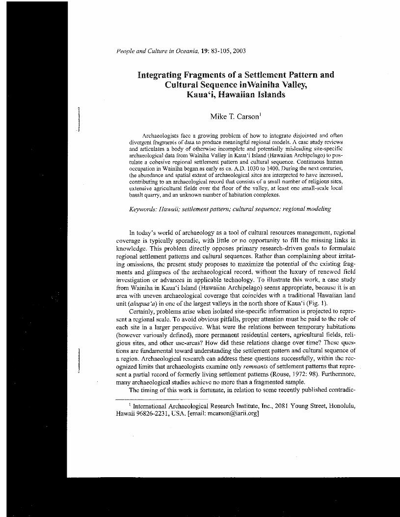
People and Culture in Oceania, 19: 83-105,2003 ntegrating Fragments of a Settle Cultural Sequence inwainiha Valley, Kaua'i, Hawaiian Islands Mike T. Carson' Archaeologists face a growing problem of how to integrate disjointed and often divergent fragments of data to produce meaningful regional models. A case study reviews and articulates a body of otherwise incomplete and potentially misleading site-specific archaeoloeical data from Wainiha Vallev in Kaua'i Island (Hawaiian Archipela!zo) to pas- the abundance and spatialextent of ~rchaeological sites are interpreted to have increased, contributine to an archaeological record that consists of a small number of religious sites, extensive ~gricultural fieldbover the floor of the valley, at least one small-scale local basalt quarry, and an unknown number of habitation complexes. Keywords: Hawaii; settlement pattern; cultural sequence; regional modeling In today's world of archaeology as a tool of cultural resources management, regional coverage is typically sporadic, with little or no opportunity to fill the missing links in knowledge. This problem directly opposes primary research-driven goals to formulate regional settlement pattems and cultural sequences. Rather than complaining about irritat- ing omissions, the present study proposes to maximize the potential of the existing frag- ments and glimpses of the archaeological record, without the luxury of renewed field investigation or advances in applicable technology. To illustrate this work, a case study from Wainiha in Kaua'i Island (Hawaiian Archipelago) seems appropriate, because it is an area with uneven archaeological coverage that coincides with a traditional Hawaiian land unit (ahupua 'a) in one of the largest valleys in the north shore of Kaua'i (Fig. 1). Certainly, problems arise when isolated site-specific information is projected to repre- sent a regional scale. To avoid obvious pitfalls, proper attention must be paid to the role of each site in a larger perspective. What were the relations between temporary habitations (however variously defined), more permanent residential centers, agricultural fields, reli- gious sites, and other use-areas? How did these relations change over time? These ques- tions are fundamental toward understanding the settlement pattern and cultural sequence of a region. Archaeological research can address these questions successfully, within the rec- ognized limits that archaeologists examine only remnants of settlement pattems that repre- sent a partial record of formerly living settlement patterns (Rouse, 1972: 98). Furthermore, many archaeological studies achieve no more than a fragmented sample. The timing of this work is fortunate, in relation to some recently published contradic- ' International Archaeological Research Institute, Inc., 2081 Young Street, Honolulu, Hawaii 96826-2231, USA. [email: [email protected]]
Transcript of Integrating Fragments of a Settlement Pattern and Cultural Sequence in Wainiha Valley, Kaua‘i,...
People and Culture in Oceania, 19: 83-105,2003
ntegrating Fragments of a Settle Cultural Sequence inwainiha Valley,
Kaua'i, Hawaiian Islands
Mike T. Carson'
Archaeologists face a growing problem of how to integrate disjointed and often divergent fragments of data to produce meaningful regional models. A case study reviews and articulates a body of otherwise incomplete and potentially misleading site-specific archaeoloeical data from Wainiha Vallev in Kaua'i Island (Hawaiian Archipela!zo) to pas-
the abundance and spatialextent of ~rchaeological sites are interpreted to have increased, contributine to an archaeological record that consists of a small number of religious sites, extensive ~gricultural fieldbover the floor of the valley, at least one small-scale local basalt quarry, and an unknown number of habitation complexes.
Keywords: Hawaii; settlement pattern; cultural sequence; regional modeling
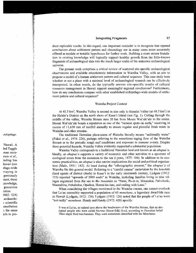
In today's world of archaeology as a tool of cultural resources management, regional coverage is typically sporadic, with little or no opportunity to fill the missing links in knowledge. This problem directly opposes primary research-driven goals to formulate regional settlement pattems and cultural sequences. Rather than complaining about irritat- ing omissions, the present study proposes to maximize the potential of the existing frag- ments and glimpses of the archaeological record, without the luxury of renewed field investigation or advances in applicable technology. To illustrate this work, a case study from Wainiha in Kaua'i Island (Hawaiian Archipelago) seems appropriate, because it is an area with uneven archaeological coverage that coincides with a traditional Hawaiian land unit (ahupua 'a) in one of the largest valleys in the north shore of Kaua'i (Fig. 1).
Certainly, problems arise when isolated site-specific information is projected to repre- sent a regional scale. To avoid obvious pitfalls, proper attention must be paid to the role of each site in a larger perspective. What were the relations between temporary habitations (however variously defined), more permanent residential centers, agricultural fields, reli- gious sites, and other use-areas? How did these relations change over time? These ques- tions are fundamental toward understanding the settlement pattern and cultural sequence of a region. Archaeological research can address these questions successfully, within the rec- ognized limits that archaeologists examine only remnants of settlement pattems that repre- sent a partial record of formerly living settlement patterns (Rouse, 1972: 98). Furthermore, many archaeological studies achieve no more than a fragmented sample.
The timing of this work is fortunate, in relation to some recently published contradic-
' International Archaeological Research Institute, Inc., 2081 Young Street, Honolulu, Hawaii 96826-2231, USA. [email: [email protected]]

M.T. Carson
Hawaiian Archipelago
Figure 1. Location of Wainiha Valley in the Halele'a District of Kaua'i Island, Hawaiian Archipelago.
tions of previously accepted conclusions based on the archaeological record in Hawaii. A re-examination of data from the Bellows Dune Site (Site 0-18) in O'ahu Island led Tuggle and Spriggs (2000) to espouse a date of slightly before A.D. 1000 for initial human occu- pation of the site, approximately 600 years later than was initially claimed (Pearson et al., 1971: 230-231; see also Cordy and Tuggle, 1976; Kirch, 1985: 71). This finding bas enforced the credibility of a "short chronology" for Polynesian colonization in Hawaii (see Masse and Tuggle, 1998), of critical significance for the formulation of archipelago-wide archaeological models. As another publicized example, additional field surveying in Anahulu Valley (also in O'ahu Island) drove Dega and Kirch (2002) to alter a previously published settlement pattern and cultural sequence (Kirch, 1992). To a certain extent, these and other revisions were occasioned by a growing corpus of archaeological knowledge, gradually accumulating new points of known data. This observation stresses the precarious nature of using incomplete site-specific information to suppoa regional generalization.
Regarding their modified conclusions for Anahulu, Dega and Kirch (2002: 124) appeal to Mayr's (1997: 79-106) characterization of science when they describe archaeolo- gy as "both self-correcting and cumulative in its knowledge base." Although scientific inquiry may be a continuing process of knowledge-formation, archaeologists nonetheless must contend with the fact that revision or rejection of conclusions based on the same available techniques and methods indisputably characterizes a discipline that fails to pro-
Id ec no tic W (la 12 1% M;
ths in " ni
Integrating Fragments 85
schipelago.
Hawaii. A led Tuggle man occu- rson et al., inding has Iawaii (see elago-wide rveying in previously rtent, these nowledge, precarious ;ation. !002: 124) archaeolo-
I scientific lonetheless 1 the same ails to pro-
duce replicable results. In this regard, one important reminder is to recognize that reputed conclusions about settlement pattern and chronology are in many cases more accurately offered as models or testable hypotheses for further work. Building a more secure founda- tion in existing knowledge will logically support healthy growth from the little-known fragments of archaeological data into the much larger realm of the unknown archaeological universe.
The present work comprises a critical review of scattered site-specific archaeological observations and available ethnohistoric information in Wainiha Valley, with an aim to propose a model of a human settlement pattern and cultural sequence. This case study tests whether or not a place with a minimal level of archaeological research can he effectively interpreted. In other words, do the typically uneven site-specific results of cultural resources management in Hawaii support meaningful regional conclusions? Furthermore, how do any conclusions compare with other established archipelago-wide models of settle- ment pattern and cultural sequence?
Wainiha Project Context
At 43.5 km2, Wainiha Valley is second in size only to Hanalei Valley (at 68.5 km2) in the Halele'a District on the north shore of Kaua'i Island (see Fig. 1). Cutting through the middle of the valley, Wainiha Stream runs 20 km from Mount Wai'ale'ale to the ocean. Mount Wai'ale'ale boasts a reputation as one of the "rainiest spots on earth," receiving in excess of 11,650 mm of rainfall annually to ensure regular and plentihl fresh water in Wainiha and other streams.
The traditional Hawaiian place-name of Wainiha literally means "unfriendly water" (Pukui et al., 1974: 226), perhaps referring to the sometimes raging flow of the Wainiha Stream or to the periodic rough surf conditions and exposure to tsunami events. Despite these potential hazards, Wainiha Valley evidently supported a substantial population.
Wainiha Valley corresponds to a traditional Hawaiian land unit known as an ahupua 'a. Ideally, an ahupua'a supports a variety of economic and other activities in a spectrum of ecological zones from the mountain to the sea (Lyons, 1875: 104). In addition to its eco- nomic practicalities, an ahupua 'a also carries implications for social and political organiza- tion (Malo, 1951: 142). At least during the "ethnographic present," the ahupua'a of Wainiha fits this general model. Referring to a "careful census" undertaken by the konohiki (land agents of district chiefs) in Kaua'i in the early nineteenth century, Lydgate (1912: 125) reported "upwards of 2000 souls" in Wainiha, including families living in nine vil- lages registered from the sea to the mountain as "Naue, Pa-ie-ie, Maunaloa, Pali-eleele, Maunahina, Pohakuloa, Opaikea, Homai-ka-lani, and ending with Laau."
When considering the villages mentioned in the Wainiha census, one cannot overlook that La'au ostensibly supported a population of 65 menehune, a legendary dwarf-life race in Hawaii (Lydgate, 1912: 126). Lydgate (1912: 126) noted that the people of La'au were "not really" menehune. Handy and Handy (1972: 420) specify:
It was at La'au, an upland area above the headwaters of the Wainiha Stream, that an abo- riginal people who were called Na-wao (forest-folk) lived, according to Hawaiian belief. Their staple food was bananas. They were sometimes identified with the Menehune.
86 M.T. Carson
Handy and Handy (1972: 156-158, 420) propose that the legendary forest-dwellers in upland Wainiha were sometimes called Mu h i mai'a (literally, "hanana-eating Mu"), likely associated with the occurrence of wild-growing Borabora bananas (mai'a Polapola or Musa pehi), a cooking banana that is said to be indigenous to Wainiha. Beyond their anecdotal interest, these references point to the often overlooked role of arhoricultural and other non- agricultural resources in traditional subsistence practices (see DeLanghe and DeMaret, 1999).
In addition to the special occurrence of Borabora bananas, Handy and Handy (1972: 420) provide the following description of Wainiha based on observations in 1931:
... from its seaward end right back into the farthest end, ... there are systems of lo'i [im- gated pondfields for growing taro] in Wainiha, some of them evidencing great ingenuity on the part of planters who built them many centuries ago. ... There were, of course, house sites all through the valley on ground not suitable for irrigation. On such land sweet pota- toes were planted. Bananas flourished ... 'Awa [Piper methysticum, a plant whose root has intoxicating properties] of several varieties was growing there also.
Most of the available land space in Wainiha was at one time dedicated to agricultural use. During a program of land reform in the 1850s known as the "Great Mahele" (for more details, see Moffat and Fitzpatrick, 1995), forty local residents registered kuleana, claims to plots of agricultural land and associated homesteads in the ahupua 'a of Wainiha (Waihona 'Aina, 1998). Thirtytwo of these claims were awarded, including a total of 26 house lots, 155 taro pondfields (lo 'i), and numerous other cultivation areas.
Based on the above information, the area of study appears to hear good potential for archaeological research, relating to a settlement that involved widespread agricultural com- plexes and associated habitations throughout the valley of Wainiha. The spatial distribution of activity areas likely changed over time, as did the types of activities and their intensity. The inhabitants may have operated at different levels of social, political, and economic organization.
Fragments of Archaeological Knowledge in Wainiha
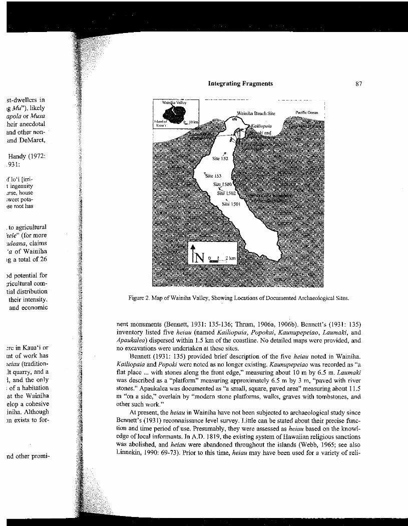
Archaeological coverage in Wainiha compares poorly to areas elsewhere in Kaua'i or other parts of the Hawaiian Islands, but nonetheless an appreciable amount of work has been accomplished. This collective work has identified a small number of heiau (tradition- al Hawaiian religious sites), several agricultural complexes, one small basalt quarry, and a few habitation areas (Fig. 2). Limited excavations have been attempted, and the only chronometrically dated material comes from excavations in sandy deposits of a habitation area at the beach. The intriguing and somewhat controversial findings at the Wainiha Beach Site (Carson, 1998, 1999,2003) prompted the current effort to develop a cohesive model of settlement pattern and cultural sequence for the ahupua'a of Wainiha. Although the existing data set lacks certain desirable elements, sufficient information exists to for- mulate a testable working model.
Religious Sites
The first archaeological studies to touch Wainiha focused on heiau and other promi-
Fig
nent rn, invento Apauka no exca
Be Kailiop' flat plac was des stones." m "on a other s u ~
At I Bennett' tion and edge of 1 was ah01 Linnekin
st-dwellers in !g Mu"), likely apola or Musa heir anecdotal and other non- and DeMaret,
Handy (1972: .931:
s f 103 [im- t ingenuity me, house ;weet pota- Sse root has
to agricultural iele" (for more uleana, claims 'a of Wainiha ~g a total of 26
)d potential for +ultural com- tial distribution their intensity. and economic
:re in Kaua'i or mnt of work has leiau (tradition- .It quarry, and a 1, and the only of a habitation
at the Wainiha elop a cohesive iniha. Although )n exists to for-
nd other promi-
Figure 2. Map of Wainiha Valley, Showing Locations of Documented Archaeological Sites.
nent monuments (Bennett, 193 1: 135-136; Thmm, 1906a, 1906b). Bennett's (193 1: 135) inventory listed five heiau (named Kailiopaia, Popokai, Kaunupepeiao, Laumaki, and Apaukalea) dispersed within 1.5 km of the coastline. No detailed maps were provided, and no excavations were undertaken at these sites.
Bennett (1931: 135) provided brief description of the five heiau noted in Wainiha. Kailiopaia and Popoki were noted as no longer existing. Kaunupepeiao was recorded as "a flat place ... with stones along the front edge," measuring about 10 m by 6.5 m. Laumaki was described as a "platform" measuring approximately 6.5 m by 3 m, "paved with river stones." Apaukalea was documented as ' a small, square, paved area" measuring about 11.5 m "on a side," overlain by "modem stone platforms, walks, graves with tombstones, and other such work."
At present, the heiau in Wainiha have not been subjected to archaeological study since Bennett's (1931) reconnaissance level survey. Little can be stated about their precise func- tion and time period of use. Presumably, they were assessed as heiau based on the knowl- edge of local informants. In A.D. 1819, the existing system of Hawaiian religious sanctions was abolished, and heiau were abandoned throughout the islands (Webb, 1965; see also Linnekin, 1990: 69-73). Prior to this time, heiau may have been used for a variety of reli-
M.T. Carson
gious purposes (Kolb, 1991: 51-60; Valeri, 1985: 172.183). Kolb (1992) documented in Maui Island that many heiau were accretionary in nature,
involving multiple episodes of construction that expanded vertically and horizontally. This evidence suggests that locations of heiau were important points in the cultural landscape that continued to be used for religions purposes over the course of several consecutive gen- erations. Nonetheless, their precise age and function are unknown in the Wainiha case.
The restriction of known heiau to the coastline is perhaps a misrepresentation of what may have occurred in the past. Archaeological interest in Wainiha did not begin until some generations after the disuse of the traditional religious sites and many of the habitation areas in the valley. In addition to the presently non-existent heiau of Kailiopaia and Popoki, a number of others may have been modified, obliterated, or forgotten. At least some of these sites were possibly located further inland than the known examples, in closer proximity to residential complexes and agricultural fields.
Agricultural Sites
Historical references cannot be ignored when considering the agricultural emphasis of the landscape in Wainiha. For example, Lydgate (1912: 126) offered:
All up along the river, wherever the encmaching palis [steep mountain slopes] on either side leave the least available space, the land has been terraced and walled up to make "lois." And so the whole valley is a slowly ascending stainvay of steps, broad in the tread and low in the rise, all the way to Laau, where the last available space was won.
According to this description, Wainiha Valley was at one time literally filled with lo 'i, im- gated terraces for growing taro.
Taro (Colocasia esculenta) requires fertile sediment and at least 2000 mm of annual rainfall (Onwueme, 1978), and both of these conditions are met in Wainiha. Particularly in the valley floor and lower side slopes near Wainiha Stream, sediment conditions and fresh water are more than adequate. Furthermore, the broad and gently sloping nature of these landforms allows the creation of large terraced fields that could be imgated with the local sources of fresh water.
Bennett's (1931: 136) pioneering archaeological foray recorded a complex of imga- tion terraces about 3.5 km inland (Site 152) and the remains of "many old house sites and much irrigated land" on top of a ridge about 7 km inland (Site 153). Site 152 consisted of terraces and water-directing devices (Bennett, 1931: 136). The retaining walls of the ter- races varied from roughly 0.15 m to 0.90 m in height. The water-directing devices included a dam with a possible intake duct, a "ditch which runs between large rocks and dirt walls," and a wall built "along the edge of the stream" to prevent flooding.
As part of a survey of agricultural sites throughout the Halele'a District, Earle (1978: map 1) studied eight irrigation systems in Wainiha located between 0.2 krn and 2.5 km from the shoreline. Earle (1978: 96-99) described pondfields composed of patches of vari- ous sizes, separated by stone walls and irrigated by configurations of darns and ditches. At least one of these sites was apparently "used for taro until fairly recently (1950s)" (Earle, 1978: 99). This study was impomnt for identifying the significance of traditional irrigation practices in the evolution of Hawaiian chiefdoms (Earle, 198O), as well as for bringing
atten Wair
Wair as Si "con1 ally t the V
amol (Ban UPPe S ~ N C
struc visib have Unfo exca.

lary in nature, zontally. This lral landscape lsecutive gen- liha case. tation of what :in until some the habitation ailiopaia and )tten. At least ples, in closer
11 emphasis of
on either I to make I the tread
with lo 'i, irr-
nm of annual Pahcularly in ions and fresh ature of these with the local
dex of irriga- ouse sites and 2 consisted of 111s of the ter- Aces included ~d dirt walls,"
, Earle (1978: n and 2.5 km itches of vari- nd ditches. At 350s)" (Earle, ma1 irrigation i for bringing
Integrating Fragments
Figure 3. Plan View of Site 1500, Modified from Barrera (1984a).
attention to the future promise of archaeological research in the Halele'a District, including Wainiha.
Since Earle's (1978) survey, the only other investigation of an agricultural site in Wainiha to date has been at one complex located approximately 9.5 krn inland, designated as Site 1500 (Barrera, 1984a, 1984b). This site has been described as an agricultural system "containing both pondfield terraces and dry terraces," covering 55 m by 245 m over "virtu- ally the entire alluvial terrace between the bottom of the steep valley slope and the bank of the Wainiha Stream" (Barrera, 1984a: 3) (Fig. 3).
Excavation at Site 1500 documented a stratigraphic sequence, including increasing amounts of wood charcoal, interpreted to reflect "processes of swiddening and slopewash" (Barrera 1984b: 17). The retaining walls of the agricultural terraces were found based in an upper layer. The lower charcoal-bearing layers appear to reflect activities prior to the con- struction of the existing artificial terraces at this location. They may have once related to structures that have since been dismantled and perhaps recycled into the terraces presently visible on the surface. However, a number of human activities other than agriculture may have generated the carbonized wood inside the stratigraphically earlier layers. Unfortunately, no radiocarbon dates are available for the wood charcoal reported in the excavation at Slte 1500.
M.T. Carson
According to the available documentation from Wainiha, the agricultural complexes incorporate numerous terraces and other features that collectively cover extensive natural land forms bounded by the Wainiha Stream, occasional side streams, and the steep moun- tain slopes of the valley. Tbe total count of individual features within each complex may not have been constructed at a single time. This issue may be explored by examining possi- ble superpositioning of terraces or other consmctions, as well as possible buried cultural
In the upland portion of Wainiha Valley, about 11.2 km inland, Barrera (1984a: 6) recorded Site 1501. This site appears to be a small quarry and processing area for basalt stone tools, located "between two sidestreams on a 15-meter ... wide flat area between the slope and Wainiha Stream." A surface scatter of basalt artifacts was described as consisting of mostly "basalt waste flakes, apparently detritus from the manufacture of implements" (Barrera, 1984a: 6). Barrera (1984a: 6) also noted: "The beds of the sidestreams adjacent to the site contain numerous cobbles of the same fine-grained dikestone of which the artifacts were manufactured, and they were undoubtedly the source for the tool materials."
Naturally occurring sources of basalt in Hawaii provided the necessary raw material to manufacture a k e s and other durable tools. Archaeological study of Hawaiian basalt quar- ries has centered at Mauna Kea in Hawai'i Island, the largest quarry in the Hawaiian Archipelago, covering more than 19 km%nd greatly exceeding the size of the activity locus of Site 1501 in Wainiha (Cleghom, 1982; Lass, 1994; McCoy, 1976, 1977). Adze quarries in Polynesia have been described as comprising two main types (Leach, 1993: 36), including: a) "a few major complexes, producing large adzes of characteristic or standard- ized types for exchange or export," and b) "more numerous, but much smaller quarries sup- plying local demand for everyday use." In this context, Site 1501 may be interpreted to reflect localized small-scale activity rather than mass production, export, or complicated labor organization. Other small quarries may be present elsewhere in Wainiha.
Habitation Sites
For convenience of the following presentation, habitation sites are discussed in cate- gories of "inland" and "coastal." Inland sites are situated with more direct access to larger tracts of agricultural land, forest resources, and perhaps small basalt quarries. Coastal sites are situated with more direct access to diverse marine resources, as well as access to the ocean itself as a means of transportation and external communication. One must also note important contrasts between depositional environments. In an inland location with rocky clay loam colluvial and variable alluvial deposits, abandoned house sites may be identified by the presence of slightly elevated stonework foundations visible on the surface. In a coastal setting, the vestiges of human occupation may be completely buried beneath widespread calcareous sands along the coastal flats of the beach. Depending on the purpose of an analysis, the significance of the presumed distinction between inland and coastal habitation may be questioned.
Ininn,
/
Strea and n with I
presm indivi may h relate: report
I compl in a rc 0.10 11 sured but he feature PurpO! sugge! "habit. interp~
T occupz Site 1: Site l i intensi tions n rary sl aggreg longed
Coasta
TI a coast tion of surface ulation investij 1999; 1 1993; ' of fishi iated hr

;ral complexes kensive natural le steep moun- complex may
amining possi- buried cultural
.era (1984a: 6) area for basalt ea between the :d as consisting )f implements" lms adjacent to ich the artifacts ials." raw material to lan basalt quar- I the Hawaiian of the activity
6, 1977). Adze :ach, 1993: 36), ,tic or standard- er quarries sup- e interpreted to or complicated ha.
scussed in cate- access to larger es. Coastal sites as access to the : must also note ition with rocky lay be identified he surface. In a buried beneath g on the purpose and and coastal
Integrating Fragments 9 1
Inland Habitation
About 7 km inland, on a ridgetop above Maunahina Stream (a tributary to the Wainiha Stream), Bennett (1931: 136) described Site 153 as the remains of "many old house sites and much irrigated land." The house sites are specified as "mostly of the terraced type," with retaining edges of the terraces running about 3 m to 4.5 m in length. These features presumably represent the stonework foundations of abandoned dwellings. The sizes of the individual terraces suggest a set of single-family houses. The occupants of these houses may have engaged in agricultural activities on the adjacent "imgated land." This site likely relates to the village of "Maunahina" mentioned in the early nineteenth-century census reported by Lydgate (1912: 125).
Approximately 9.5 km from the shoreline in Wainiha, adjacent to the agricultural complex of Site 1500, Barrera (1984b: 19) reported three basin-shapedpit features exposed in a road cut, designated as Site 1502. The fust pit profile measured 0.65 m in width and 0.10 m in depth. The second measured 1.2 m in width and 0.7 m in depth. The third mea- sured 1.6 m in width and 0.7 m in depth. Concentrations of charcoal fragments were noted, but heating stones and heat-altered sediment were not observed (Barrera, 1984b: 19). These features may have been used for single-use fires, disposal of rubbish, or a variety of other purposes. The concentration of pits appears to reflect different human activities than can be suggested by the agricultural features in the adjacent Site 1500. A general categoly of "habitation" seems appropriate, although this vague characterization may spawn varying interpretations.
The concentration of pits at Site 1502 suggests a very different scale and scope of occupation than what is depicted in the "many old house sites" at Site 153. In this context, Site 1502 may reflect temporary access @erhaps repeated) by a few individuals, whereas Site 153 represents a more long-term occupation by one or more groups of people. If the intensity of agricultural activity in inland areas fluctuated over time, then associated habita- tions may be expected to reflect a similar pattern. For instance, scattered remains of tempo- rary shelters may be associated with periods of less intensive use of the area, whereas aggregated clusters of permanent residences most likely are associated with periods of pro- longed regular use of the inland valley such as for intensive agriculture.
Coastal Habitation
The greatest concentration of archaeological study in Wainiha has been at a portion of a coastal habitation area, measuring at least 300 m by 80 m (2400 m2) in a stabilized por- tion of the sandy beach removed about 25 m from the present shoreline. The site is a sub- surface deposit, and its full spatial extent is wlknown. In compliance with government reg- ulations prior to planned construction projects, no less than ten separate archaeological investigations have occurred here (Carson, 1998; Elmore and Kennedy, 2000; Elmore et al., 1999; Kennedy, 1990, 1991; McGerty and Spear, 1998; Moore et al., 1997; Spear 1992, 1993; Welch, 1999). Excavations have repeatedly revealed basalt tools and flakes, pieces of fishing gear, abundant faunal remains, numerous scattered pits and post molds, and iso- lated human burials. One investigation (Carson, 1998; see also Carson, 1999,2003) identi-

M.T. Carson
Pacific Ocwn
Coral recf
F ~ B Bea
the givl wa7 prel con ces: (La, exci The inar cy i exci artil pres stral else

Integrating Fragments 93
11 stratum of the
ombined area of :a (338 m2) was ~f the site experi- 3f the controlled uous excavation le conservatively
re or less contin- lin lenses of cul- the stratigraphic In block that was
0 I m
Lager I. Modem organic horizon.
Layer 11. To cultunl maicrial.
Layer 111. Cultural material, historic period deposit.
Layer I\!. No cultural material. Layer \I. Culfuial material, prehisroiic deposit.
Layci \'I. Cultural material, prehistoric deposit. Layer Vn. Cbliuriil material, prehistoric deposit. lioiise srmctures
Layer VIli. Xo ccultural material.
Figure 5. Southern Face of the Stratigraphy Exposed in a 4 rn by 4 rn Excavation Block at the Wainiha Beach Site. The location of this excavation is specified in Figure 4.
the largest contiguous controlled excavation at the site as well as the only investigation to give explicit attention to site formation processes (Carson, 1998, 2003). At least one high- wave event swept large-grained sand and marine debris over the site during the period of prehistoric occupation, and at least one other similar event followed in the historic post- contact era (Carson, 1998: 10-20; Welch, 1999: 14-15). Post-depositional events and pro- cesses appear to have destroyed large portions of the earliest human occupation layer (Layer W), leaving only scattered scraps that were fortuitously found in a 4 m by 4 m excavation block (Carson, 1998: 19-20) but not clearly recognized by other investigators. The next cultural layers in the sequence are Layers VI and V, together comprising the dom- inant component of the site. These layers are differentiated by color, texture, and consisten- cy in the 4 m by 4 m excavation block, although they were not regularly identified in other excavations at the site. Last in the cultural sequence is Layer 111, containing both traditional artifacts and historically introduced faunal remains (e.g. hones of cattle, goats, or sheep presumably brought to the Hawaiian Islands some time since A.D. 1778). The details of the stratigraphic sequence and formation processes of the Wainiha Beach Site are published elsewhere, along with a critical review of the failures of other investigators to document the stratigraphic sequence in its entirety (Carson, 2003).
In the only investigation that identified the Layer VII deposit as a distinct stratigraphic unit, a constellation of house features consisted of five post molds, a small hearth, and the remains of a pavement of coral and pebbles, as depicted in Figure 6 (Carson, 1998: 30-3 1). The cluster of features suggests the location of an abandoned residence. The incomplete

at the Wainiha
dential s t ~ ~ c - nay be found 23 1 : 136) fur- Lalawa Valley 66-67).
,st molds that to represent a include expe- sking stakes, cumented not Far excavated.
Integrating Fragments
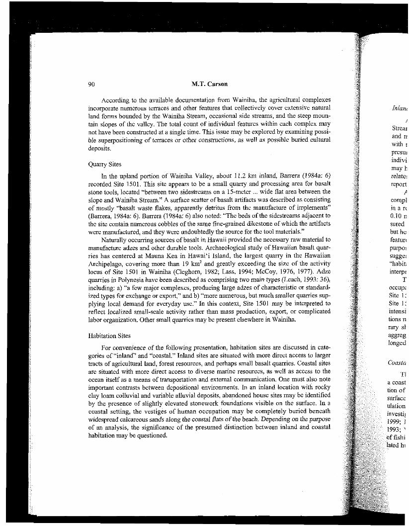
Figure 7 . Summary of Provenienced Radiocarbon Dating Results from the Wainiha Beach Site, Modified from a Graph Generated 'om the OxCal Program (Bronk Ramsey, 1995, 1998).
Isolated pits for human burials were also found in the upper cultural deposit. This arrange- ment of features accords well with the situation recorded at the majority of Bellows Beach (Site 0-18) in O'ahu Island (Pearsonet al., 1971: 208-214).
Radiocarbon dating verifies the Layer VII occupation as the earliest component in the local cultural sequence (Fig. 7). A sample of wood charcoal from the hearth in Layer VII yielded a radiocarbon date (sample Beta-1 19832) calibrated at ca. A.D. 1030 to 1400. From numerous separate excavations of the more recent culhrral layers pertaining to the extended period of temporary recurrent activities, a set of 14 radiocarbon samples provided calibrated dates ranging from the thirteenth to twentieth centuries (Carson, 1998; Elmore et al., 1999; Kennedy 1990; Moore et al., 1997; Spear, 1992, 1993). In addition to the prove- nienced samples noted in Figure 7, a shell artifact (a Cypraea sp. shell modified for use as part of an octopus lure) was retrieved from the spoils of a machine-excavated trench, and it produced a radiocarbon date calibrated (with correction for marine reservoir effect) at ca. A.D. 1038 to 1441 (Kennedy, 1990) that suggests a remarkable consistency with the only securely known date from the Layer VII occupation.
Although at least one residential structure was present in the Layer VII occupation at the beach, the center of the associated residential activity has not yet been discovered archaeologically. Other households may have been present along the beach, but the post- depositional obscuring of the Layer VII stratum creates problems for detection in an archaeological context. The more recent layers of human occupation (Layers VI, V, and 111)
500 I000 150ll 2000 Calibrated Dates in Calaidar 'icar.; A.D.

M.T. Carson
Table 1. Summary of cultural material from a 4 m by 4 m excavation block at the Wainiha Beach Site.
Cultural Material
Basalt adze material Whole or fragment excavi
Flake with polish Basalt f l h g material
Utilized flake 5 (3) 8 (1) 0 (0) 13 (1) Unutilized flake 173 (YO) 505 (70) l l (13) 689 (69)
Basaltic glass 18 (9) 24 (3) 1 (1) 43 (4)
Unworked nodule
Hammerstone 4 (2) 17 (2) Polishing stone Gaming piece ( 'ulu maika) 1 (1) Food-pounder fragment commc
Red ochre
One-piece hook Crescent point Octopus lure piece
Drilled marine shell 3 (2) 13 (2) 0 (0) 16 (2) Worked bone 5 (3) 13 (2) 1 (1) 19 (2) Coral abrader 8 (4) 9 (1) 0 (0) 17 (2)
mm scr
Sea urchin spine abrader 8 (4) 8 (1) 1 (1) 17 (2) mm SCI
Faunal remains 87 (45) 362 (50) 33 (38) 482 (48) 6 (3) 48 (7) 2 (2) 56 (6)
Mammal 29 (15) 45 (6) 7 (8) 81 (8) Med. orsm. vertebrate 4 (2) 22 (3) 0 (0) 26 (3) Marine shell
es not t
Note: Numbers in parentheses indicate concentration measured in NISP per 100 liters of excavated sediment (or grams per 100 liters of excavated sediment for marine shell), rounded to the nearest whole number.
constibte the dominant volume and spatial extent of the site, wherein evidence of domestic household structures is notably absent. Instead, the contents of the later layers suggest repeated temporary access to the beach for a variety of activities. This pattern implies that long-term habitation was elsewhere, perhaps an unknown distance further inland.

Integrating Fragments 97
ha Beach Site.
TOTAL
A review of the cultural material from the Wainiha Beach Site can hopefully yield more precision about the activities that occurred at the site. Table 1 summarizes the materi- als recovered from the coarse fraction (8-mm screening) from the 4 m by 4 m excavation block at the site. Due to occasional occurrences of mixing of strata in some parts of the excavation area, the contents of Layers V and VI are combined in Table 1 to achieve con- sistency in analysis. Table 1 offers counts of each material category in numbers of individ- ual specimens O\rlSP), as well as NISP per 100 liters of excavated sediment shown inside parentheses. The recovered marine shells are reported in grams rather than in NISP.
The artifact assemblage (see Table I) is dominated by flakes of basalt and basaltic glass, hammerstones, and abraders. Also present are pieces of fishing gear, drilled marine shells (perhaps used as personal adornments), polished and artificially shaped pieces of bone (possibly used as picks, needles, or for other uses), and a few other objects in small quantities. The site does not contain direct evidence of fishhook manufacture, although the abrader tools could suggest manufacture and maintenance of fishing gear and a variety of other objects. The fishing tools themselves suggest a diversity of fishing strategies, as reflected by three one-piece bone hooks, one crescent point of a composite hook, and one modified Cypraea sp. shell from a composite octopus lure. Aside from the fishing gear, the artifacts for the most part express general utilities of cutting, slicing, and pounding that are common to most traditional Hawaiian habitation sites. Pieces of red ochre and a gaming stone (an 'ulu maika) indicate that past human activities at the Wainiha Beach Site involved more than a subsistence economy.
The faunal assemblage from the Wainiha Beach Site meets expectations of a coastal setting (see Table 1). Marine shells comprise a substantial part of the deposit, especially in the zone of occupation corresponding to Layers V and VI. Of the vertebrate remains, fish bone is consistently the most abundant in terms of individual specimens. The faunal data should be regarded with some hesitation at this point, because only the coarse fraction (8- mm screen) was analyzed. Observations during excavation noted that the fine fraction (4- mm screen) contains mostly unspecifiable fragments of marine shells, as well as lesser unknown quantities of fish, bird, and rodent bones. Future analysis of the fine fraction may significantly change perceptions of the vertebrate faunal assemblage.
The excavations at the Wainiha Beach Site appear to have encountered only a small portion of a habitation complex. The Layer VII occupation consisted of at least one domes- tic house structure at the beach, dated at some time within the range of ca. A.D. 1030 to 1400. One may infer the existence of a larger residential area with a number of other hous- es not too far away from this location. In the following centuries, activities at the beach included frequently repeated temporary access for a variety of purposes (e.g. subsistence, leisure, and otherwise), implying the close proximity of a permanent village settlement that has yet to be detected archaeologically. The most likely location of the implied village cen- ter is somewhere inland from the area already investigated. The residential occupation glimpsed in Layer VII may have shifted further inland over subsequent generations.
Discussion
Given the incomplete archaeological knowledge in Wainiha, one may be tempted to rely on other regional models as a guide to synthesize the fragmentary data, but such a pro-
M.T. Carson
cedure risks the advancement of false orthodoxies. If a pre-existing regional model is inac- curate or improperly understood, then to apply it to a case study like in Wainiha would serve only to perpetuate an unfortunately improper interpretation. The results from Wainiha are therefore interpreted in their own right as far as possible. These interpretations can be compared with the expectations of larger regional generalizations.
According to the results of the 4 m by 4 m excavation block in the Wainiha Beach Site, the cultural sequence began with a residential occupation dated ca. A.D. 1030 to 1400, followed by repeated temporary activities mostly post-dating ca. A.D. 1400. The implied residential settlement may have shifted further inland after a short-lived occupation at the beach. The most likely location for the heart of the coastal settlement is therefore in an area now greatly disturbed and modified by modem houses, roads, and other develop- ments.
The interpretation of the cultural sequence for the Wainiha Beach Site appears to accord well with the cultural sequence posited for Ha'ena beach in the valley directly to the west of Wainiha. The prehistoric sequence at Ha'ena beach has been interpreted to include an early period prior to ca. A.D. 1200 of visits by "parties of collectors-fisherpeople camped a few days at a time," followed by a later period of "increased dependence on taro production and less on collection of marine fauna" when "the taro pondfields were com- pleted, the heiau built, and the importance of Ha'ena as a social, political, and economic center established" (Griffin, 1984: 14; see also Griffin et al., 1977; Hammatt et al., 1978; and Riley and Clark, 1979).
The proposed early period of itinerant gatherers and fisherfolk at Ha'ena must be interpreted in reference to a permanent settlement somewhere else, very likely in the neigh- boring and much larger Wainiha Valley that contains 43.5 km2 as opposed to only 7.7 km2 in Ha'ena. Thus, the discovery of an early coastal residential component in Layer VII of the Wainiha Beach Site fills an otherwise missing link in the cultural sequence of the north shore of Kaua'i that also has an important place in archipelago-wide models of early coastal adaptation in the Hawaiian Islands.
Aside from the work as the Wainiha Beach Site, the only documented archaeological excavation in Wainiha so far has been at one inland agricultural site called Site 1500 (Barrera, 1984b). The excavation at Site 1500 revealed a sequence of buried cultural layers, followed by an upper layer associated with the extensive agricultural features visible on the present ground surface (Barrera, 1984b: 17).
The results from Site 1500 are consistent overall with the reported investigations in an upland portion of the nearby Hanalei Valley, also in the Halele'a District of Kau'i Island. Site 50-Ka-D10-12 comprises numerous agricultural terraces in the upper reaches of Hanalei (Cleghom, 1979: 5). The initial excavation at this site revealed at least three strati- graphic layers, interpreted (in chronological order) as 1) a buried cultural deposit associat- ed with few basalt artifacts, 2) a fallow period or possible hiatus, and 3) a pondfield layer near the surface (Schilt, 1980: 29-30).
Dating of Site 50-Ka-D10-12 in Hanalei has been the subject of some debate, due to somewhat contradictory results from two separate excavations. From the fust excavation, a charcoal sample from the buried cultural deposit yielded a radiocarbon date calibrated at ca. A.D. 600 to 980, and another sample from the "fallow period or possible hiatus" pro- vided a date of ca. A.D. 1400 to 1670 (Schilt, 1980: 29-30). These results suggested a date
much tural 1 desigr three 1
ninete tering sugge: ty cor which hydrat ly rep have c tures i
h D10-1 sequer lure a! have c eralizi came( a prec mined
E have 1 Lepofi "expa more I
ca. A. trends A.D. simila er, the settlen slight1 needel
I1 dition DeMa (Musu large crops the ar with r ologic text, c

Integrating Fragments 99
del is inac- iiha would sults from tpretations
iiha Beach 1. 1030 to 1400. The Xcupation eref fore in r develop-
lppears to ctly to the to include letpeople :e on taro rere com- sconomic ?I., 1978;
must be he neigh- J 7.7 kn? :r VII of the north of early
:ological ite 1500 11 layers, le on the
Ins in an i Island. ches of !e strati- ssociat- Id layer
, due to ation, a rated at :s" pro- l a date
much earlier than expected for pondfield imgation in Hawaii, assuming that the buried cul- tural layer was associated with a pondfield. A second excavation at the same site was designed to obtain more secure dates (Athens, 1983). The second excavation produced three radiocarbon dates from the buried cultural deposit, clustering in the eighteenth and nineteenth centuries, as well as three hydration-rim dates from basaltic glass artifacts clus- tering in the thirteenth and fourteenth centuries (Athens, 1983: 42-47). Athens (1983: 59) suggested that the basaltic glass dates "refer to an earlier pre-pondfield habitation or activi- ty componeut," whereas the radiocarbon dates "are referable to pondfield cultivation, which is probably temporally restricted to the 18th century." At present, the reliability of hydration-rim dating of Hawaiian basaltic glass artifacts is debatable. The single previous- ly reported radiocarbon date of ca. A.D. 600 to 980 from the buried cultural deposit may have derived from a period of human activity prior to the development of irrigation fea- tures at the site.
Irrespective of chronometric dates, the relative stratigraphic sequence for Site 50-Ka- D10-12 in Hanalei offers a very close match with the case for Site 1500 in Wainiha. The sequence involves a period of human activity that precedes the extensive pondfield agricul- ture associated with the surface finds. The same pattern of inland landscape use appears to have occurred in both Wainiha and Hanalei, suggesting perhaps a large-scale regional gen- eralization. However, as Kirch (1985: 101) cautions, additional investigations "need to be canied out in the Hanalei Valley, as well as in others areas of the Halele'a District, before a precise chronology for the development and expansion of taro irrigation can be deter- mined."
Elsewhere in the Hawaiian archipelago, the expansion of irigated fields appears to have been most prevalent later in the cultural sequence (Kirch, 1990: 332; Kirch and Lepofsky, 1993: 189). Kirch (1985: 303-306) proposes that this activity characterized an "expansion perios' in Hawaiian prehistory, dated ca. A.D. 1100 to 1650. In a somewhat more refined sequence, Spriggs (1987: 60-61) suggests an "early expansion period" during ca. A.D. 1100 to 1400. Perhaps most informatively, a model of prehistoric population trends in the Hawaiian Islands indicates aperiod of intensive population growth from about A.D. 1150 to 1450 (Dye and Komori, 1992; see also Dye, 1994: 1-4). The date range of similar activities and events in Wainiha has yet to be measured directly. Indirectly, howev- er, the cultural sequence from the Wainiha Beach Site indicates a shift toward more inland settlement probably not much earlier than ca. A.D. 1400, thereby hinting at a time period slightly later than has been suggested in the archipelago-wide model. Clearly, more work is needed to test the model.
In addition to taro, a number of other plant foods were significant components in tra- ditional subsistence and land use practices in Wainiha. For example, DeLanghe and DeMaret (1999) suggest that many researchers have ignored the contribution of bananas (Musa spp.) and other tree crops in prehistoric subsistence systems in Oceania. Whereas large fields of root crops typically require intense labor investment year-round, the tree crops impose little if any demand on labor. Tree crops usually leave no material traces in the archaeological record. In contrast, terraced pondfields and other features associated with root crops in Hawaii became durable and in many cases dominant parts of the archae- ological landscape, such as in the case of the extensive taro fields in Wainiha. In this con- text, oral traditions of the "banana-eating Mu people" (Mu hi mai 'a) in Wainiha might

100 M.T. Carson
reflect times when (or places where) bananas and other tree crops were more important in a local diet and landscape that othenvise came to be dominated by taro and other root crops.
Conclusions and Testable Hypotheses
Despite the fragmentary nature of the available archaeological data from Wainiha, a meaningful integration has been possible. The presently known archaeological landscape in Wainiha comprises a small number of religious sites concentrated near the coast, extensive agricultural fields just short of completely filling the valley floor, at least one small-scale local basalt quarry in the inner reaches of the valley, and an unknown number of habitation complexes. Together, these sites reflect a wide spectrum of past behaviors of a self-suffi- cient settlement.
The settlement in Wainiha Valley may have consisted of a number of internally defined groups. Records from the historic era specify nine villages in Wainiha (Lydgate, 1912: 125), but this number cannot be projected confidently into the distant past. Assuming that the different religious sites (heiau) were associated with separate groups of people, then at least five such groups were present at some time or perhaps at different times. Other heiau may have existed in the inland poaion of the valley, although they are not currently known to archaeologists.
The number and distribution of sites almost undoubtedly changed over time, to a large extent as an effect of a growing resident population. Overall in the Hawaiian Islands, popu- lation growth was apparently most intense in the period of ca. A.D. 1150 to 1450 (Dye and Komori, 1992). In a roughly similar fashion, Spriggs (1987: 60-61) proposes an "early expansion perios' ca. A.D. 1100 to 1400. Nonetheless, the paucity of archaeological data from Wainiha can neither replicate nor contradict this general model, and this model will remain a viable hypothesis until relevant data from Wainiha become available. Meanwhile, paleodemographic data continue to accrue from ongoing archaeological investigations, and the general model may yet be refined or revised. With qualified hesitation, the results of the Wainiha Beach Site excavations may he interpreted to suggest a period of population increase and a shift toward inland activities at some time around A.D. 1400.
The existing archaeological data suggest several centuries of human presence in Wainiha, during which the local population grew and the archaeological landscape was created. The earliest dated evidence of human activity in Wainiha is ca. A.D. 1030 to 1400, associated with the hearth of a household structure at the beach. The possibility of finding older material must not be overlooked, especially with the rather poor and uneven survey data for the area. The earliest component of residential settlement may have been of a small scale with a number of outlying temporary camps, but a long-term residence was always present somewhere. This interpretation will remain tenable until evidence is found that unambiguously indicates temporary habitation and a lack of permanent (i.e., long-term) habitation earlier than the remains of the house structure in the Layer VII occupation of the Wainiha Beach Site.
The foregoing exercise has shown how to integrate fragmented primary data toward the formulation of a comprehensive interpretation that could not otherwise be achieved from only site-specific information in isolation. The key to a successful integration is to interpret each site-specific fragment in the controlled context of known data from the rele-
vant surrom pared again Hawaiian A izations can arately, the misleading 1 ed that gene hypotheses I
At the investigatio Consultant : archaeologi( author, the Ogg, who a1 ry assistants the excavati remains. To results. Fro McMahon r well as num sharing som work. The ; Latinis, Jarr Roos provic detailed con for her effo accommoda bility for the
Athens, J. S tions Anth
Barrera, W.. parec offic
Banera, W.: parel Presr
Bennett, W. Honc
Integrating Fragments 101
re important in a ther root crops.
from Wainiha, a ical landscape in coast, extensive one small-scale
her of habitation s of a self-suffi-
er of internally tiniha (Lydgate, past. Assuming oups of people, ent times. Other ire not currently
time, to a large n Islands, popu- I 1450 (Dye and poses an "early iaeological data this model will 11e. Meanwhile, estigations, and 1, the results of d of population
an presence in landscape was
1. 1030 to 1400, )ility of finding uneven survey been of a small ice was always e is found that i.e., long-term) cupation of the
try data toward se be achieved ltegration is to 1 from the rele-
vant surrounding area (in the present case, limited to Wainiha). The results may be com- pared against general models from a larger region (im the present case, encompassing the Hawaiian Archipelago) to point out consistencies and inconsistencies, but regional general- izations cannot be used as convenient substitutes to fill holes in data. When considered sep- arately, the results obtained from any one site would provide an incomplete and partially misleading picture of the archaeology of its associated region. Also, this work has illustrat- ed that generalized models need to be reviewed critically and that they are at best working hypotheses or tentative interpretive contexts.
Acknowledgments
At the request of Hanington's Paradise Properties, the author directed archaeological investigations at one portion of Wainiha Beach in 1998 as an employee of Scientific Consultant Services (SCS). At that time, Robert L. Spear was the principal investigator of archaeological projects at SCS, and he also analyzed all lithic artifacts. In addition to the author, the 1998 field crew included Leina'ala Benson, Amy Buffiun-Cordero, and Randy Ogg, who all should be acknowledged for their work. The author wishes to thank laborato- ry assistants Reyna Kim and Liz Pestana for painstaking tasks of sorting and quantifying the excavated materials. Alan Ziegler performed identifications of the vertebrate faunal remains. Tom Dye is thanked for sharing his knowledge of interpreting radiocarbon dating results. From the Hawaii State Historic Preservation Office, Ross Cordy and Nancy McMahon regulated the cultural resources management asnects of the 1998 field work (as - well as numerous other projects referenced here). Thanks are due to J. Stephen Athens for sharing some of his insights and experiences that have significantly improved this piece of work. The author acknowledges informative discussions with ~ose~hKennedy, D. Kyle Latinis, James Moore, and David J. Welch about the Wainiha Beach Site. Christopher I. Roos provided expert assistance in producing the maps. Two anonymous reviewers gave detailed constructive comments to improve the manuscript. Matori Yamamoto is thanked for her efforts as editor of this journal. The author thanks his wife Helen Moon Yee for accommodating the time and effort demanded by this project. The author retains responsi- bility for the viewpoints and conclusions expressed here.
References
Athens, J. S. (1983) Prehistoric pondfield agriculture in Hawai'i: Archaeological investiga- tions at the Hanalei National Wildlife Refuge, Kaua'i. (Manuscript). Department of Anthropology, Bernice P. Bishop Museum.
Barrera, W., Jr. (1984a) Upper Wainiha Valley, Kauai: Archaeological survey. Report pre- pared for EDAW, Inc. by Chiniago, Inc., (File) Hawaii State Historic Preservation Office, Kapolei.
Barrera, W., Jr. (1984b) Wainiia Valley, Kauai: Archaeological investigations. Report pre- pared for Orion Engineering by Chiniago, Inc., (File), Hawaii State Historic Preservation Office, Kapolei.
Bennett, W.C. (1931) Archaeology ofKauai. Bernice P. Bishop Museum Bulletin No. 80. Honolulu: Bishop Museum Press.

program. Radiocarbon, 37: 425-430. Bronk Ramsey, C. (1998) Probability and dating, Radiocarbon, 40: 461-474. Carson, M. T. (1998) Archaeological data recovery of a portion of State Site Number 50-
30-02-1878 at Lot 44, a residential property, Wainiha, Halele'a District, island of Kaua'i, Hawaii, TMK 5-8-094. Draft report prepared for Harrington's Paradise Properties by Scientific Consultant Services, Inc., (File), Hawaii State Historic Preservation Off~ce, Kapolei.
Carson, M.T. (1999) An ancient Hawaiian house location at Wainiha Beach, Island of Kaua'i. (Manuscript), Presented at the annual meeting of the Society for Hawaiian Archaeology, held in Honolulu, Hawaii.
Carson, M.T. (2003) Resolving the enigma of early coastal settlement in the Hawaiian Islands: The stratigraphic sequence of the Wainiha Beach Site in Kaua'i. Geoarchaeology, an International J. (in press).
Cleghom, P.L. (1979) Archaeological reconnaissance survey within the Hanalei Wildlife Refuge, Hanalei, Kaua'i. (Manuscript), Department of Anthropology, Bernice Pauahi Bishop Museum.
Cleghom, P.L. (1982) The Mauna Kea Adze Quarry: Technological analyses and experi- mental tests. Unpublished Ph.D. dissertation, Department of Anthropology, University of Hawaii.
Cordy, R. arid H.D. Tuggle (1976) Bellows, O'abu, Hawaiian Islands: New work and new interpretations. Archaeology and Physical Anthropology in Oceania, 1 1 : 207-235.
Dega, M.F. and P.V. Kirch (2002) A modified culture history of Anahulu Valley, Oahu, Hawai'i and its significance for Hawaiian prehistory. J. Polynesian Society, 11 1: 107.126.
DeLanghe, E. and P. DeMaret (1999) Tracking the banana: Its significance in early agricul- ture. In C. Gosden and J. Hather (eds.), The Prehistory of Food: Appetites for Change. One World Archaeology. London: Routledge, pp. 377-396.
Dye, T.S. (1994) Population trends in Hawai'i before 1778. Hawaiian J. History, 28: 1-20. Dye, T.S. and E. Komori (1992) A pre-censal population history of Hawaii. New Zealand
J. Archaeology, 14: 113-128. Earle, T.K. (1978) Economic and Social Organization of a Complex Chiefdom: The Halelea
District, Kaua 'i, Hawaii. Anthropological Papers No. 63. Ann Arbor: Museum of Anthropology, University of Michigan.
Earle, T. K. (1980) Prehistoric irrigation in the Hawaiian Islands: An evaluation of evolu- tionary significance. Archaeology and Physical Anthropology in Oceania, 15: 1-28.
Elmore, M. and J. Kennedy (2000) A data recovery report for properties located at TMK: 5-8-09:41-42, 45-51 and 53-55 in Ha'ena, Wainiha Ahupua'a, Hanalei District, Island of Kaua'i. Report prepared for Harrington's Paradise Properties by Archaeological Consultants of the Pacific, Inc., (File), Hawaii State Historic Preservation Office, Kapolei:
Elmore, M., J.R. Moore, and J. Kennedy (1999) An inventory survey with subsurface test- ing report for properties located at TMK: 5-8-09: 41,42,45,46,47, 48, 49, 50, 51, 53, 54, and 55 in Ha'ena, Wainiha Ahupua'a, Hanalei District, Island of Kaua'i. Report prepared for Harrington's Paradise Properties by Archaeological Consultants
Grii
Grif
Ham
Hand
Kenn
Kirch,
Kirch;
Kirch,
Kirch,
Kirch,
K O I ~ , n I 1
Kolb, h
Lass, E 1 I
Leach, I

The Oxcal
umber 50- :, island of 's Paradise te Historic
, Island of r Hawaiian
: Hawaiian in Kaua'i.
lei Wildlife ;y, Bernice
and experi- hropology,
x k and new 207-235. lley, O'ahu, bciety, 11 1:
arly agricul- Ippetites for
y, 28: 1-20. Vew Zealand
7lze Halelea Museum of
ion of evolu- ia, 15: 1-28. ited at TMK: alei District, roperties by tate Historic
hsurface test- 8 , 49, 50, 51, nd of Kaua'i. 1L Consultants
Integrating Fragments 103
of the Pacific, Inc., (File), Hawaii State Historic Preservation Off~ce, Kapolei. Griffin, P.B. (1984) Where Lohi'au ruled: Excavations at Ha'ena, Halele'a, Kaua'i.
Hawaiian Archaeology, 1: 1-18. Griffin, P.B., R. M. Bordner, H. H. Hammatt, M. E. Morgenstein, and C. Stauder (1977)
Preliminary archaeological investigations at Ha'ena, Helele'a, Kaua'i Island. Project No. 14-28 report for the Division of State Parks, Department of Land and Natural Resources, State of Hawaii, (File), Hawaii State Historic Preservation Office, Kapolei.
Hamrnatt, H.H., M.I. Tomonari-Tuggle, and C. Streck (1978) Archaeological investiga- tions at Ha'ena State Park, Halele'a, Kaua'i Island, Phase 11: Excavations of beach localities and visitors facilities area. Project No. 14-28 report for the Division of State Parks, Department of Land and Natural Resources, State of Hawaii, (File), Hawaii State Historic Preservation Office, Kapolei.
Handy, E. S. C. and E.G. Handy (1972) Native Planters in Old Hawaii: Their L i f , Lore, and Environment. Bernice P. Bishop Museum Bulletin No. 233. Honolulu: Bishop Museum Press.
Kennedy, J. (1990) Archaeological inventory survey for TMK: 5-8-09: 25, located at Wainiha, island of Kaua'i. Report prepared by Archaeological Consultants of the Pacific, Inc., (File), Hawaii State Historic Preservation Office, Kapolei.
Kennedy, J. (1991) Report on the treatment of human remains, Site 50-30-02-1 875, located at TMK: 5-8-09:25, Wainiha, Island of Kaua'i. Report prepared by Archaeological Consultants of the Pacific, Inc., (File), Hawaii State Historic Preservation Office, Kapolei.
Kirch, P.V. (1975) Excavations at Sites A1-3 and A1-4: Early settlement and ecology in Halawa Valley. In P. V. Kirch and M. Kelly (eds.), Prehistory and Ecology in a Windward Hawaiian Valley: Halawa Valley, Molokai. Pacific Anthropological Records No. 24. Honolulu: Department of Anthropology, Bernice P. Bishop Museum, pp. 17-70.
Kirch, P.V. (1985) Feathered Gods and Fishhooks: An Introduction to Hawaiian Archaeology and Prehistory. Honolulu: Univ. of Hawaii Press.
Kirch, P.V. (1990) The evolution of sociopolitical complexity in prehistoric Hawaii: An assessment of the archaeological evidence. J. World Prehistory, 4: 31 1-345.
Kirch, P.V. (1992) Anahulu: The Anthropology of History in the Kingdom of Hawaii. Volume Two: The Archaeology ofHistory. Chicago: Univ. of Chicago Press.
Kirch, P.V. and D. Lepofsky (1993) Polynesian irrigation: Archaeological and linguistic evidence for origins and development. Asian Perspectives, 32: 183-204.
Kolb, M.J. (1991) Social power, chiefly authority, and ceremonial architecture in an island polity, Maui, Hawaii. Unpublished Ph.D. dissertation, Department of Anthropology, University of Califomia at Los Angeles.
Kolh, M.J. (1992) Diachronic design changes in Heiau temple architecture from the island of Maui, Hawai'i. Asian Perspectives, 3 1: 9-37.
Lass, B. (1994) Hawaiian Adze Production and Distribution: Implications for the Development of Chiefdoms. UCLA Institute of ArchaeoIogy Monograph No. 37. Los Angeles: University of California.
Leach, H.M. (1993) The role of major quarries in Polynesian prehistory. In M.W. Graves

104 M.T. Carson
and R.C. Green (eds.), The Evolution and Organisation of Prehistoric Society in Polynesia. Monograph No. 19. Auckland: new Zealand Archaeological Association, pp. 33-42.
Linnekin, J. (1990) Sacred Queens and Women of Consequence. Ann Arbor: Univ. of Michigan Press.
Lydgate, J.M. (1912) The affairs of the Wainiha Hui. Hawaiian Almanac and Annual for 1913: 125-137.
Lyons, C. J. (1875) Land Matters in Hawaii. The Islander, 1: 1-33, 103-104, 111, 118-1 19, 126-127, 143, 150-151, 159, 168-169, 174-175, 182-183, 190.191, 206-207, 214- 215,222-223.
Malo, D. (1951) Hawaiian Antiquities. Translated by N.B. Emerson. Bernice Pauahi Bishop Museum Special Publication No. 2. Honolulu: Bishop Museum Press.
Masse, W.B. and H.D. Tuggle (1998) The date of Hawaiian colonization. In C. M. Stevenson, G. Lee, and F. J. Morin (eds.), Easter Island in Pacific Context South Seas Symposium. Proceedings of the Fourth International Conference on Easter Island and East Polynesia. Los Osos: Bearsville and Cloud Mountain Presses, pp. 229-235.
Mayr, E. (1997) Pzis is Biology: The Science of the Living World. Cambridge: Harvard Univ. Press.
McCoy, P.C. (1976) The Mauna Kea Adze Quarry Complex, Hawaii: A first analysis. In National Park Service (ed.) Proceedings of the First Conference in Natural Sciences in Hawaii. Honolulu: National Park Service, pp.135-142.
McCoy, P.C. (1977) The Mama Kea Adze Quany project: A summary of the 1975 field investigations. J. Polynesian Society, 86: 223-244.
McGerty, L. and R.L. Spear (1998) An archaeological inventory survey at a residential property, Lot 44, Wainiha, Halele'a, Kaua'i, Hawaii (TMK 5-8-09: 44). Report pre- pared for Harrington's Paradise Properties by Scientific Consultant Services, Inc., (File), Hawaii State Historic Preservation Office, Kapolei.
Moffat, R.M. and G.L. Fitzpatrick (1995) Surveying the Mahele: Mapping the Hawaiian Land Revolution. Volume 2: Palapala'aina. Honolulu: Editions Limited.
Moore, J.R., D.K. Latinis, and M.T. Carson (1997) An archaeological data recovery report for a property located at TMK: 5-8-09:25 in Ha'ena, Wainiha Ahupua'a, Hanalei District, Island of Kauai. Report prepared for A1 Baroni by Archaeological Consultants of the Pacific, Inc., (File), Hawaii State Historic Preservation Office, Kapolei.
Onwueme, I.C. (1978) The Tropical Tuber Crops: Yams, Cassava, Sweet Potato, and Cocoyams. Indianapolis: John Wiley and Sons.
Pearson, R.J., P.V. Kirch, and M. Piemsewsky (1971) An early site at Bellows Beach, Waimanalo, Oahu, Hawaiian Islands. ~rchaeology and Physical Anthropology in Oceania, 6: 204-234.
Pukui, M.K., S.H. Elbert, and E.T. Mookini (1974) Place Names of Hawaii. Honolulu: Univ. of Hawaii Press.
Riley, T. J. and J. T. Clark (1979) Archaeological testing and excavation at Ha'ena, Kaua'i. Report prepared for Division of State Parks, Department of Land and Natural Resources, State of Hawaii by Departments of Anthropology at University of
Haln K ~ P
Rouse, LB. W. I 107.
Schilt, A.R Refi P. B
Spear, R.1 Wai Rep Inc.:
Spear, R.L Goo for I
Stat1 Spriggs, h
Con Stat Poli
Thrum, T.< A h
Thrum, T.< 49-6
Tuggle, H. Hau 188.
Valeri, V. ( Waihona
corl Webb, M.C
21-2 Welch, D.J
Site Paci Stati
(Received f
vic Society in i1 Association,
rbor: Univ. of
nd Annual for
emice Pauahi n Press. ion. In C. M. Context South nce on Easter in Presses, pp.
idge: Harvard
.st analysis. In !turd Sciences
the 1975 field
t a residential I). Report pre- Services, Inc.,
the Hawaiian 1. ecovery report ma'a, Hanalei :chaeological vation Office,
!t Potato, and
ellows Beach, ~thropologv in
Integrating Fragments 105
Hawaii and University of Illinois, (File), Hawaii State Historic Preservation Office, Kapolei.
Rouse, I.B. (1972) Settlement patterns in archaeology. In P. J. Ucko, R. Trigham, and G. W. Dimbleby (eds.), Man, Settlement and Urbanism. London: Duckworth, pp. 95- 107.
Schilt, A.R. (1980) Archaeological investigations in specified areas of the Hanalei Wildlife Refuge, Hanalei Valley, Kaua'i. Manuscript, Department of Anthropology, Bernice P. Bishop Museum.
Spear, R.L. (1992) An archaeological inventory survey of the Stallone Property at Wainiha, island of Kaua'i (TMK: 5-8-09: 43) State Site Number 50-30-02-1878. Report prepared for Applied Planning Services by Scientific Consultant Services, Inc., (File), Hawaii State Historic Preservation Office, Kapolei.
Spear, R.L. (1993) Archaeological data recovery excavations at Site 50-30-02-1878 (the Goodman Property) Wainiha, island of Kaua'i (TMK: 5-8-09-43). Report prepared for Applied Planning Services by Scientific Consultant Services, Inc., (File), Hawaii State Historic Preservation Office, Kapolei.
Spriggs, M. (1987) The Hawaiian transformation of ancestral Polynesian society: Conceptualizing chiefly states. In J. Gledhill, B. Bender, and M.T. Larsen (eds.), State and Society: The emergence and Development of Social Hierarchy and Political Cenfralization. London: Unwin Hyman, pp. 57-73.
Thrum, T.G. (1906a) Heiaus and heiau sites throughout the Hawaiian islands. Hawaiian Almanac andAnnual for 1907: 36-48.
Thrum, T.G. (1906b) Tales from the Temples. Hawaiian Almanac and Annual for 1907: 49-69.
Tuggle, H.D. and M. Spriggs (2000) The age of the Bellows Dune Site 018, O'ahu, Hawai'i, and the antiquity of Hawaiian colonization. Asian Perspectives, 39: 165- 188.
Valeri, V. (1985) Kingship and Sacrifice. Chicago: Univ. of Chicago Press. Waihona 'Aina Coporation (1998) Mahele Database. Honolulu: Waihoua Aiua
Corporation. Webb, M.C. (1965) The abolition of the taboo system in Hawaii. J Polynesian Socieq, 74:
21-39. Welch, D.J. (1999) Investigations of the stratigraphic sequence on the Stallone Property,
Site 1878, Haena, Kaua'i. Report prepared for Archaeological Consultants of the Pacific, Inc. by International Archaeological Research Institute, Inc., (File), Hawaii State Historic Preservation Office, Kapolei.
(Received forpublication: July 15,2003)
aii. Honolulu:
a'ena, Kaua'i. j and Natural University of