Tectonic framework of Laccadive Ridge in Western Continental Margin of India
12
Tectonic framework of Laccadive Ridge in Western Continental Margin of India Nisha Nair, S.P. Anand, Mita Rajaram ⁎ Indian Institute of Geomagnetism, Navi Mumbai 410210, India abstract article info Article history: Received 28 September 2012 Received in revised form 15 August 2013 Accepted 23 August 2013 Available online 31 August 2013 Communicated by: D.J.W. Piper Keywords: gravity rifting Laccadive ridge tectonics From the analysis of the satellite derived high resolution free air gravity data it is inferred that the evolutionary history of the Western Continental Margin of India to north and south of Goa appears to be totally different . The shelf edge is continuous and not disturbed in the northern part whereas to the south (south of 16°N) it has been affected by the onshore tectonics. It is hotly debated if the Laccadive Ridge (northern part of the Chagos-Laccadive Ridge) is continental or oceanic in nature or just of volcanic origin. From the filtered maps of the free air gravity anomalies, sources at different depths can be deciphered that help build an evolutionary model of the much de- bated Laccadive Ridge. The low pass filtered maps depicting deeper features, show a persistence of NW–SE to NS Dharwarian trends and it appears that the Laccadive Ridge to the north of around 8.5°N is of continental origin being bounded to the south and north by the offshore extension of the Bhavani Shear and Chapporo lineament respectively. It may have separated from India along with Madagascar during Cretaceous. At the Cretaceous Tertiary boundary as Laccadive-India passed over the Reunion hotspot, the pre-existing faults on the Laccadive Ridge were re-activated and the hotspot trace was left behind in the intermediate/shallow wavelength of the anomalies, as intrusives in the Laccadive Ridge. These are reflected in the High Pass filtered maps, depicting shallow to intermediate wavelength anomalies, which show NE–SW structures. The crustal structure derived from the 2D model of the satellite derived free air gravity data and a representative gravity-magnetic profile from ship borne data also depict continental nature of the Laccadive Ridge with emplacement of volcanic intru- sives as it passed over the Reunion hotspot. © 2013 Elsevier B.V. All rights reserved. 1. Introduction The evolution of passive continental margins, including the Western Continental Margin of India (WCMI), has received much attention owing to their economic potential, in particular hydrocarbons. There have been several studies on the tectonic history of Indian margins and detailed seismic reflection investigations of the margin are mostly confined to the shelf region for hydrocarbon exploration by the Indian oil industries. Most of the studies conducted over the WCMI are along profiles and these profiles are widely spaced and mainly cut across iso- lated bathymetric highs. It is now understood that the WCMI has under- gone a lot of tectonic deformations from the time of its origin and this has resulted in complicated structures of its tectonic elements. Fig. 1 de- picts the tectonic elements of the western offshore of India superposed on the bathymetry of the region. To have a better understanding of the evolution of the entire margin, it would require critical assessment of the crustal structure and tectonics of the margin and abyssal plain; a detail study of the shelf, shelf margin basin, Laccadive Ridge and Arabian Basin is essential. To have an unbiased understanding of the tectonic elements of the western offshore region it is essential to utilize uniform high resolution 2D-data e.g. satellite derived Free Air Gravity (FAG) data and aeromagnetic data. In the absence of aeromagnetic data, satellite derived free air gravity data is used for the present study. Continental rifting and breakup involve complex interactions of tectonic, magmatic, geodynamic and sedimentary processes. The gravity anomaly at a continental margin can be regarded as the result of all the processes that have shaped it through time including rifting, drifting, sedimentation, magmatic under-plating, passage over hotspot etc. (Watts and Fairhead, 1999). Each process will leave its signature on the underlying crust and hence will have a component in the ob- served gravity anomaly. Applying the principle of superposition, the older episodes will be relatively deeper compared to intermediate and recent ones that have taken place over the continental margin. Wave- length filtering is a process by which it is possible to separate out the anomalies in terms of their wavelengths; the shorter the wavelength the shallower will be the sources and hence may relate to relatively recent activity while longer wavelength usually represents deeper sources and possibly older activity. In the present paper, wavenumber domain filters have been utilized to separate out the gravity anomalies in terms of their wavelengths and an attempt is made to identify gravity sources and to throw light on the evolution of the Western Continental Margin of India with special emphasis on Laccadive Ridge. The region of study in the present paper has been demarcated by a rectangle on Fig. 1. Marine Geology 346 (2013) 79–90 ⁎ Corresponding author. Tel.: +91 22 27480760; fax: +91 22 27480762. E-mail address: [email protected] (M. Rajaram). 0025-3227/$ – see front matter © 2013 Elsevier B.V. All rights reserved. http://dx.doi.org/10.1016/j.margeo.2013.08.009 Contents lists available at ScienceDirect Marine Geology journal homepage: www.elsevier.com/locate/margeo
Transcript of Tectonic framework of Laccadive Ridge in Western Continental Margin of India

Marine Geology 346 (2013) 79–90
Contents lists available at ScienceDirect
Marine Geology
j ourna l homepage: www.e lsev ie r .com/ locate /margeo
Tectonic framework of Laccadive Ridge in Western Continental Marginof India
Nisha Nair, S.P. Anand, Mita Rajaram ⁎
Indian Institute of Geomagnetism, Navi Mumbai 410210, India
⁎ Corresponding author. Tel.: +91 22 27480760; fax: +E-mail address: [email protected] (M. Rajaram).
0025-3227/$ – see front matter © 2013 Elsevier B.V. All rihttp://dx.doi.org/10.1016/j.margeo.2013.08.009
a b s t r a c t
a r t i c l e i n f oArticle history:Received 28 September 2012Received in revised form 15 August 2013Accepted 23 August 2013Available online 31 August 2013
Communicated by: D.J.W. Piper
Keywords:gravityriftingLaccadiveridgetectonics
From the analysis of the satellite derived high resolution free air gravity data it is inferred that the evolutionaryhistory of theWestern Continental Margin of India to north and south of Goa appears to be totally different . Theshelf edge is continuous and not disturbed in the northern part whereas to the south (south of 16°N) it has beenaffected by the onshore tectonics. It is hotly debated if the Laccadive Ridge (northernpart of theChagos-LaccadiveRidge) is continental or oceanic in nature or just of volcanic origin. From the filtered maps of the free air gravityanomalies, sources at different depths can be deciphered that help build an evolutionary model of the much de-bated Laccadive Ridge. The low pass filteredmaps depicting deeper features, show a persistence of NW–SE to NSDharwarian trends and it appears that the Laccadive Ridge to the north of around 8.5°N is of continental originbeing bounded to the south and north by the offshore extension of the Bhavani Shear and Chapporo lineamentrespectively. It may have separated from India along with Madagascar during Cretaceous. At the CretaceousTertiary boundary as Laccadive-India passed over the Reunion hotspot, the pre-existing faults on the LaccadiveRidge were re-activated and the hotspot trace was left behind in the intermediate/shallow wavelength of theanomalies, as intrusives in the Laccadive Ridge. These are reflected in the High Pass filtered maps, depictingshallow to intermediate wavelength anomalies, which show NE–SW structures. The crustal structure derivedfrom the 2D model of the satellite derived free air gravity data and a representative gravity-magnetic profilefrom ship borne data also depict continental nature of the Laccadive Ridge with emplacement of volcanic intru-sives as it passed over the Reunion hotspot.
© 2013 Elsevier B.V. All rights reserved.
1. Introduction
The evolution of passive continentalmargins, including theWesternContinental Margin of India (WCMI), has received much attentionowing to their economic potential, in particular hydrocarbons. Therehave been several studies on the tectonic history of Indian marginsand detailed seismic reflection investigations of the margin are mostlyconfined to the shelf region for hydrocarbon exploration by the Indianoil industries. Most of the studies conducted over the WCMI are alongprofiles and these profiles are widely spaced and mainly cut across iso-lated bathymetric highs. It is nowunderstood that theWCMI has under-gone a lot of tectonic deformations from the time of its origin and thishas resulted in complicated structures of its tectonic elements. Fig. 1 de-picts the tectonic elements of the western offshore of India superposedon the bathymetry of the region. To have a better understanding of theevolution of the entire margin, it would require critical assessment ofthe crustal structure and tectonics of the margin and abyssal plain; adetail study of the shelf, shelfmargin basin, Laccadive Ridge andArabianBasin is essential. To have an unbiased understanding of the tectonicelements of the western offshore region it is essential to utilize uniform
91 22 27480762.
ghts reserved.
high resolution 2D-data e.g. satellite derived Free Air Gravity (FAG) dataand aeromagnetic data. In the absence of aeromagnetic data, satellitederived free air gravity data is used for the present study.
Continental rifting and breakup involve complex interactions oftectonic, magmatic, geodynamic and sedimentary processes. The gravityanomaly at a continental margin can be regarded as the result of allthe processes that have shaped it through time including rifting,drifting, sedimentation, magmatic under-plating, passage over hotspotetc. (Watts and Fairhead, 1999). Each process will leave its signatureon the underlying crust and hence will have a component in the ob-served gravity anomaly. Applying the principle of superposition, theolder episodes will be relatively deeper compared to intermediate andrecent ones that have taken place over the continental margin. Wave-length filtering is a process by which it is possible to separate out theanomalies in terms of their wavelengths; the shorter the wavelengththe shallower will be the sources and hence may relate to relativelyrecent activity while longer wavelength usually represents deepersources and possibly older activity. In the present paper, wavenumberdomain filters have been utilized to separate out the gravity anomaliesin terms of their wavelengths and an attempt ismade to identify gravitysources and to throw light on the evolution of theWestern ContinentalMargin of India with special emphasis on Laccadive Ridge. The region ofstudy in the present paper has been demarcated by a rectangle on Fig. 1.

Fig. 1. Bathymetry of theWestern offshore region of India. The study area has been demarcated by a rectangle. The Laccadive Ridge as defined in the present study has been superposed inwhite on this map. The location of the ship profile data used in Fig. 2 is superposed in black and the seismic reflection section used in the calculated model is superposed in yellow. Thelocation of seismic refraction L08V34 and 84C17 and DSDP site 219 are also superposed. (For interpretation of the references to color in this figure legend, the reader is referred to thewebversion of this article.)
80 N. Nair et al. / Marine Geology 346 (2013) 79–90
2. Morpho-tectonic elements of the WCMI
The WCMI has evolved due to the break-up of Indian sub-continentfrom Madagascar in mid-Cretaceous and later from Seychelles micro-continent at the end of the Cretaceous (Norton and Sclater, 1979;Courtillot et al., 1988; White and McKenzie, 1989). This has led to theformation of numerous NW–SE and NNW–SSE trending structuralfeatures almost parallel to the western margin of India. Numerousregional structures and sedimentary basins are located along the conti-nental margin of western India and the contiguous Arabian Sea. Mostprominent among these are the Chagos Laccadive Ridge (CLR), LaxmiRidge, Prathap Ridge, Laxmi basin and the chain of seamounts termedLaxmi Basin seamount chain (Bhattacharya and Chaubey, 2001) (locationsuperposed on Fig. 1). The region between the CLR and the Indianmargin south of Goa consists of a complex bathymetry with numeroustopographic highs and lows. The shelf edge limited by the 200 m isobath,results in the width of the shelf varying from 350 km off Bombay to60 km towards south of Cochin (Naini and Kolla, 1982). Between Goaand Cochin, numerous topographic highs complicate the nature ofcontinental rise. The CLR is formed by the Laccadive and Maldive islandgroups and the Chagos Archipelago and extends from about 10°S to
15°N latitudes; it is an asymmetrical ridge with a steeper eastern flank.The ridge on an average is less than 1000 m deep with occasional coralatolls and volcanic islands. Gravity data over CLR indicates that the free-air gravity anomaly is broadly varying and subdued (Bhattacharya andChaubey, 2001; Radha Krishna et al., 2002). Ben Avraham and Bunce(1977)mentioned that north of 8°N the Laccadive Ridge (LR) is associatedwith large negativemagnetic anomalies (which support the idea of volca-nic composition for this region) suggesting that it was formed south ofmagnetic equator or north of equator during period of reversedmagneticpolarity; it appears that there is a fault scarp on the east from 8 to 12°N.Verzhbitsky (2003) believed that the heat flow distribution along theChagos-Laccadive Ridge is in accordance with the theory of the oceaniclithospheric evolution and further from an analysis of the geothermalregime and of the age of the basalts relate the genesis of the CLR tothe hot spot hypothesis. According to Pushcharovsky (1996, 2011) theChagos Laccadive Ridge consists of three extending blocks the Southern,Middle and Northern blocks corresponding to Chagos, Maldives andLaccadive blocks respectively with continental structure in the northand oceanic in the other two blocks. The deep sea holes drilled in theSouthern and Middle blocks penetrated basalts and they are dated at47 Ma and 55–60 Ma respectively.

81N. Nair et al. / Marine Geology 346 (2013) 79–90
Seismic refraction studies (Babenko et al., 1981) indicate that theMoho lies at a depth of about 18–19 km, which suggests that the crustalthickness of the Laccadive Ridge (northern part of CLR) is thicker thanthe normal oceanic crust. Some believe it has originated from a hotspot (Biswas, 2001) and others believe it may be a continental sliverthat resulted from rifting along western margin (Talwani and Reif,1998). Based on admittance analysis of gravity and bathymetry data,Chaubey et al. (2008) suggested that the Laccadive Ridge comprisesthinned continental crust that is locally compensated by the Airymodel of isostasy. From the study of Multi channel seismic reflectiondata, Ajay et al. (2010) identified Seaward Dipping Reflectors (SDR)along the western flank of the Laccadive Ridge and their 2D crustalmodel deduced from free air gravity data suggest that the SDRs aregenetically related to incipient volcanism during rifting and the OceanContinent Boundary (OCB) lies at the western margin of the LaccadiveRidge suggesting continental nature of the Laccadive Ridge. Sinha Roy(2001) believed the rifting failed to produce oceanic crust betweenIndia and Laccadive Ridge and therefore the continental margin lies tothe west of the ridge. In a close fit India–Madagascar configuration,obtained for an 86.5 Ma reconstruction, Yatheesh et al. (2006) foundthat the model appeared to accommodate Seychelles, Laxmi Ridge,Saya de Malha and Laccadive Plateau between the 2000 m isobaths ofIndia and Madagascar as intervening micro-continental slivers.
The Laccadive Basin – a narrow triangular shaped basin – is locatedbetween the Laccadive Ridge in the west and the southwestern con-tinental slope of India in the east. The seismic reflection studies(Bhattacharya and Chaubey, 2001 and references therein) suggestthat the sediment thickness in this basin increases from south tonorth. Along the western margin, several basement highs (arches)trending perpendicular to the coast divide the shelf region into var-ious thick sediment filled basins. From north to south, they includeBombay, Konkan and Kerala basins. The southwesterly plungingVengurla arch (near Goa) separates the Bombay basin and the Kon-kan basin whereas the Tellicherry arch demarcates the Kerala andKonkan basins further south. Although the morphology of the west-ern offshore of India is quite well known, there is much debate on thetectonic evolution of this region.
3. Methodology and data analysis
High-resolution gravity database (Sandwell and Smith, 2009)and bathymetric database (Sandwell and Smith, 1997) generatedfrom re-tracked Seasat, Geosat GM, ERS-1/2 and TOPEX/POSEIDONaltimeters data of the Arabian Sea are used as the primary data inthe present work to investigate the tectonics and continental marginstructure. Satellite altimetry has emerged as an efficient alternativefor ship-borne gravity survey since the data collected on board shipwas along widely spaced profiles. The Free Air Gravity data sets ver-sion 18, ( Sandwell and Smith, 2009) is obtained from a 1′ by 1′ grid(approximately 1.75 km in the study area) and has an improved spa-tial resolution of 24 km compared to the initial version (Sandwelland Smith, 1997). All the gravity values were referenced to theWGS84 horizontal datum with reference to the IGSN-71 system. Cur-rently a new version of the Sandwell and Smith satellite gravity V20.1is available on the ftp site http://topex.ucsd.edu/cgi-bin/get_data.cgi.This is based on about twice as much satellite altimetry data and sohas a nearly factor of 2 reduction in noise level (personal communi-cation, Sandwell). In the present study we have used this improvedversion 20.1 satellite derived FAG data. A comparison of the satellitefree air data was made with the available ship borne gravity datafrom the NOAA/NGDC, Marine Track-line Geophysics data set, ver-sion 5.0.11 and it was found that for the scale of structural featuresin the study region, the satellite gravity data are comparable withthe ship borne measurements. Fig. 2 gives a plot of the comparisonof ship borne data and satellite derived FAG data along four profiles;location of these profiles is superposed on Fig. 1. Though several
National and International agencies have collected ship bornegravity data in the Arabian Sea and WCMI, the satellite derivedgravity data provide better coverage. Seafloor topography (version15.1) derived from satellite altimetry with a resolution of 1′ gridwas used as bathymetric data for the present study. Bansal et al.(2005) used geoid derived Free air gravity data and compared itto the satellite-derived gravity (using slope to gravity method) ofSandwell and Smith (1997), v. 9.2. On comparing the power spectraof the FAG generated from their studies with the one from Sandwelland Smith (1997, v.9.2), it was found that the spectral behavior of theSandwell and Smith (1997, v.9.2) datawas far from ideal. Power spectrawere computed using the version 20.1 data set and also the FAGderivedfrom geoid (Sreejith et al., 2013) for the same region considered byBansal et al. (2005) and the results are presented as an insert in Fig. 2;we found that the spectral behavior of both the data sets is comparable(see inset of Fig. 2) and considerably improved in data quality comparedto Bansal et al. (2005). The free air gravity anomaly map generatedusing the above discussed data set (slope to gravity method) is repre-sented in Fig. 3 as histogram equalized color shaded image in whichthe warm and cool colors represent highs and lows respectively.The tectonic elements of the WCMI are superposed on Fig. 3.
Free air gravity anomalies along the continental margin off westernIndia and the adjoining deeper Arabian Sea form sub-linear belts ofalternate positive and negative anomalies trending in NW–SE direc-tion suggesting the control of the Precambrian Dharwarian tectonics.The region, in general, is characterized by broad to intermediatewavelength anomalies with isolated high wavenumber anomalies.The continental shelf of western offshore is characterized by strongsignature of shelf edge gravity high probably representing sea wardthinning/attenuation of continental crust. The inner continental shelfexhibits gravity anomalies ranged from 0 to 20 mGal while theslope region is characterized by negative anomalies of the order of60 mGal with steep gradients, except for the region west of Goa.The steep gravity gradients associated with the slope region coin-cide with the steep bathymetric variation that can be marked asthe major continental shelf break. North of Goa, the shelf appearsbroader compared to the narrow region to the south. The free airanomaly along the shelf margin basin within the continental shelfranged from −10 to −60 mGal. Some isolated gravity lows areprominent within the shelf margin and the one off Mumbai identi-fied Bombay High (anticline) sedimentary basin. Towards the northernpart of the study area, along the Laxmi Basin, the gravity anomalyranges from +10 to +30 mGal whereas within the Laxmi Ridge,the anomaly varies from −10 to−60 mGal, implying major densityvariations within the crust associated with Laxmi Ridge. This gravityvariation matches well with the rugged topography of the LaxmiRidge region. Within the broad gravity high associated with LaxmiBasin are isolated seamounts (known as Laxmi Basin seamountchain) whose gravity anomaly ranges from 10 to 40 mGal. TheLaccadive basin, towards the southwest of the shelf edge, is charac-terized by long wavelength gravity low in which are seen severalhigh wavenumber high amplitude near circular gravity anomalies.According to Gopala Rao et al. (2010) the Prathap Ridge falls in thisregion but there is no continuous expression of this ridge in the FAGanomaly map (Fig. 3), rather it is represented by isolated highfrequency, high amplitude, and circular anomalies. The LaccadiveRidge appears as a high amplitude broad NNW–SSE trending fea-ture. Further west of the Laxmi and Laccadive Ridges, the anoma-lies along the Arabian Basin appeared flat and subdued varyingfrom −10 to −30 mGal.
By and large the FAG anomaly map shows different wavelengthcomponents suggesting different depth levels for the causativesources. Different spectral components of Free Air Gravity anomaliescorrespond to varied magnitude geological features lying at differentdepth levels (Majumdar et al., 2006). To have an understanding ofthe distribution of shallow level gravity sources, an analytic signal
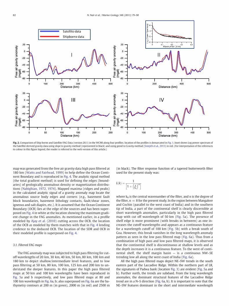
Fig. 2. Comparison of Ship borne and Satellite FAG Data (version 20.1) in theWCMI along four profiles; location of the profiles is demarcated in Fig. 1. Inset shows Log power spectrum ofthe Satellite derived gravity data using slope to gravitymethod (represented in black) and using geoid to Gravitymethod (Sreejith et al., 2013) in red. (For interpretation of the referencesto colour in this figure legend, the reader is referred to the web version of this article.)
82 N. Nair et al. / Marine Geology 346 (2013) 79–90
mapwas generated from the free air gravity data high pass filtered at180 km (Watts and Fairhead, 1999) to help define the Ocean Conti-nent Boundary and is reproduced in Fig. 4. The analytic signal method(the total gradient method) is used for defining the edges (bound-aries) of geologically anomalous density or magnetization distribu-tions (Nabighian, 1972, 1974). Mapped maxima (ridges and peaks)in the calculated analytic signal of a gravity anomaly map locate theanomalous source body edges and corners (e.g., basement faultblock boundaries, basement lithology contacts, fault/shear zones,igneous and salt diapirs, etc.). It is assumed that the Ocean ContinentBoundary (OCB) lies at the edge of the sources and has been super-posed on Fig. 4 in white at the location showing the maximum gradi-ent change in the FAG anomalies. As mentioned earlier, in a profilemodeled by Ajay et al. (2010) cutting across the OCB, the locationof the OCB as modeled by them matches with that in Fig. 4 lendingcredence to the deduced OCB. The location of the SDR and OCB intheir modeled profile is superposed on Fig. 4.
3.1. Filtered FAG maps
The FAG anomaly mapwas subjected to high pass filtering for cut-off wavelengths of 20 km, 30 km, 40 km, 50 km, 80 km, 100 km and180 km to depict shallow/intermediate level features, and to lowpass filtering at 50 km, 80 km, 100 km, 125 km and 200 km to un-derstand the deeper features. In this paper the high pass filteredmaps at 50 km and 100 km wavelengths have been reproduced inFig. 5a and b respectively, and low pass filtered maps at 80 and100 kmwavelength in Fig. 6a, b; also superposed on Fig. 6a are the ba-thymetry contours at 200 m (in green), 2000 m (in red) and 2500 m
(in black). The filter response function of a tapered butterworth filterused for the present study was:
L kð Þ ¼ 1
1þ kk0
� �nh i
where k0 is the central wavenumber of the filter, and n is the degree ofthe filter, n = 8 for the present study. In the region betweenMangaloreand Cochin (parallel to the west coast of India) and in the southerntip of India, a part of the continental shelf is clearly discernible atshort wavelength anomalies, particularly in the high pass filteredmap with cut off wavelength of 50 km (Fig. 5a). The presence ofshelf edge is more prominent (with breaks in between) as one in-creases the cutoff wavelengths and appears as a continuous featurefor a wavelength cutoff of 100 km (Fig. 5b) with a break south ofGoa. However, this break vanishes in the long wavelength anomalypattern as seen in the low pass filtered map (Fig. 6a). Thus from acombination of high pass and low pass filtered maps, it is observedthat the continental shelf is discontinuous at shallow levels and asthe depth increases it is a continuous feature. To the west of conti-nental shelf, the shelf margin basin — is a continuous NW–SEtrending low all along the west coast of India (Fig. 6a).
All the high pass filtered maps depict NE–SW trends in the southeastern part of the Laccadive Ridge. Within the northern part of LR,the signatures of Padwa bank (location Fig. 3) are evident (Fig. 5a andb). Further north, the trends are subdued. From the long wavelengthanomalies, the dominant structural features of the Laccadive Ridgetrend are in a N–S direction (Fig. 6a, b). It is important to note that theNE–SW features dominant in the short and intermediate wavelength

Fig. 3. The free-air gravity anomalymap of theWestern ContinentalMargin of India. The location of the tectonic elements, fromAjay et al. (2010) is superposed on thismap. The location ofthe four profiles A–A′, B–B′, C–C′ andD–D′ used formodeling the crustal structure from FAGdata is superposed on thismap; superposed on thismap are the bathymetry contours at 200 m(in green), 2000 m (in red) and 2500 m (in black). Location of GM profile used for modeling the crustal structure from ship-borne gravity-magnetic data is also superposed. (For inter-pretation of the references to color in this figure legend, the reader is referred to the web version of this article.)
83N. Nair et al. / Marine Geology 346 (2013) 79–90
maps are totally absent in the deep features. Also, it may be notedthat the main structural features of the adjacent Dharwar region onthe land trend NW–SE to N–S direction implying that the deep fea-tures on the Laccadive Ridge perhaps have continental affinity. Tothe west of Laccadive Ridge (in south) the negative gravity anomalycontinues to the north and further extends into the Laxmi Ridge. Thedelineated OCB as evident in Fig. 4 has been superposed on Fig. 6a, b.
3.2. Modeling of the crustal structure over LR
To further support our interpretations from the filtered maps ofthe FAG anomalies, we attempt to derive a crustal structure thatbest reproduces the observed FAG data. In order to understandthe nature of the crust in the study region, forward modeling ofthe satellite derived free air gravity data was carried out alongfour NE–SW profiles (Profile A–A′, B–B′, C–C′, D–D′ starting fromthe south), with profile length varying from 730 to 940 km. Thelocation of the profiles is superposed in Figs. 3, 4, 6b. The profilesstart from the continental shelf and cut across the marginal high,Laccadive basin, Laccadive Ridge and end at the Arabian basin. Tohave an understanding of the nature of the crust along theseprofiles 2-dimensional forward modeling has been undertakenusing the GM-SYS software designed for the same. The computa-tion is based on the methods of Talwani et al. (1959) and Talwaniand Heirtzler (1964) and makes use of the algorithms described
in Won and Bevis (1987). A two-dimensional flat earth model is as-sumed and the USGS SAKI implementation of the Marquardt inver-sion algorithm is used to linearize and invert the data.
Forward modeling involves creating a hypothetical geologic modeland calculating the geophysical response to that earth model. Gravityand magnetic models are not unique and as a consequence the processis non-linear and the final result depends on the initial model: thebetter the starting model, the better the final result. Hence the ini-tial model should be well constrained. In the present modeling theinitial model was constrained using the available bathymetry, iso-pach (Balakrishnan, 1997) and published reflection/refraction seis-mic data (Naini and Talwani, 1982). The densities of differentgeological units were obtained from refraction seismic velocities(Naini and Talwani, 1982) using the Nafe–Drake curve ; the locationof the seismic refractions used, L08V34 for Laccadive Ridge and84C17 for Arabian Ocean, is superposed on Fig. 1 and Table 1 gives thedensity values used in the forward model. Since density–velocity rela-tion is non-linear, it possesses limitations on the direct use of densityobtained from an assumed linear density–velocity relationship. There-fore, we selected mean density within the given range of densities fora particular seismic velocity. The response of the gravity was calculatedfor a four layer model assuming: first layer water column the thicknessof which was constrained from the bathymetry data, second layer:the sediment thickness derived from isopachmap, third layer: the con-tinental/oceanic crust the top of which was taken from the available

Fig. 4.Analytic Signal map of the free-air gravity anomaly (high pass filtered at 180 kmwavelength) of theWestern ContinentalMargin of India. The interpreted Ocean Continent Bound-ary is superposed on this map in white. Location of modeled profiles is as stated in Fig. 3 and the position of the SDR and OCB derived from the seismic section A–A′ (RE23) by Ajay et al.(2010) is also shown.
84 N. Nair et al. / Marine Geology 346 (2013) 79–90
seismic sections and fourth layer: Mantle below the Moho. The gravityanomaly of the crustal model thus generated is calculated and com-pared with the observations; the depth to the top of the crustal layersand Moho was iteratively adjusted to minimize the error. The crustalmodel obtained with minimum RMS error is considered as the finalcrustal model and the crustal model derived from the four gravity pro-files are shown in Fig. 7.
The final crustal structure resulted from the forward modeling ofthe gravity anomaly along these profiles represents a typical passivecontinental margin structure. From the multi channel seismic reflec-tion studies in the region, (Nair et al., 2009; DGH-www.dghindia.org/15.aspx) revealed that the basement in the Laccadive Basin tothe east of Laccadive Ridge is down-faulted corroborated by a lowfree air gravity anomaly in comparison to the ridge crest. To achievea good fit between the observed and calculated values, it was necessaryto include intrusives in the region characterized by high wavenumberanomalies (along NE–SW trends in Fig. 5a and b) in themodel. The pres-ence of these intrusives was modeled by using either densely spacedigneous–intrusive type sources or both flows and intrusions (Chaubeyet al., 2002). The presence of volcanicflows alongwith intrusionswas in-corporated in the profile models A–A′, B–B′ and C–C′ (Fig. 7) for a betterfit. The locations for these intrusions were picked up from the free airgravity anomaly map (Fig. 3) and high pass filtered map (Fig. 5a)which enhanced the short wavelength anomaly sources. Profile D–D′,appeared to be devoid of any significant volcanic intrusive; inclusion ofintrusive caused an increase in the RMS error.
To further support the crustal structure derived from satellite de-rived gravity data and the presence of intrusives, an additional profile(GM profile) was selected from ship-borne gravity and magnetic data(obtained from NOAA/NGDC, Marine Track-line Geophysics data set).The location of the profile is shown in Figs. 3, 4, 6b. At first, formodelinggravity data, the densities used for the layers below the Laccadive Ridgeand Arabian Basin were selected as the same values as those for theother four profiles. The location of intrusives were picked from thehigh pass filtered maps (Fig. 5a and b) and incorporated into themodel. The crustal structure derived appeared similar to the otherfour profiles and the location of OCB derived from the crustalmodel (shown in Fig. 6b) matched well with that delineated fromanalytic signal (Fig. 4). For modeling the magnetic data, we startedwith the 2D crustal structure derived from gravity data and wereguided by the method used by Anand et al. (2009) for modeling the85 E Ridge; magnetic susceptibilities for the continent and oceanwere taken as 0.035SI and 0.04SI respectively (Rajaram et al., 2009)while a value of 0.035SI was introduced for the intrusives. Thelower crust below the Laccadive Ridge was devoid of remanence.The upper crust below the Laccadive Ridgewas given amagnetic sus-ceptibility of 0.03SI andmagnetization of about ~3.2 (A/m)while thevolcanic layer identified from the refraction seismic velocities (Nainiand Talwani, 1982) above the Laccadive crust had a higher magneti-zation (5–6 A/m). For the oceanic crust we assumed a model of Kentet al. (1993) with higher magnetization (~5.8 A/m) in the extrusiveupper layer andmagnetization of ~1.1 A/m below the extrusive layer
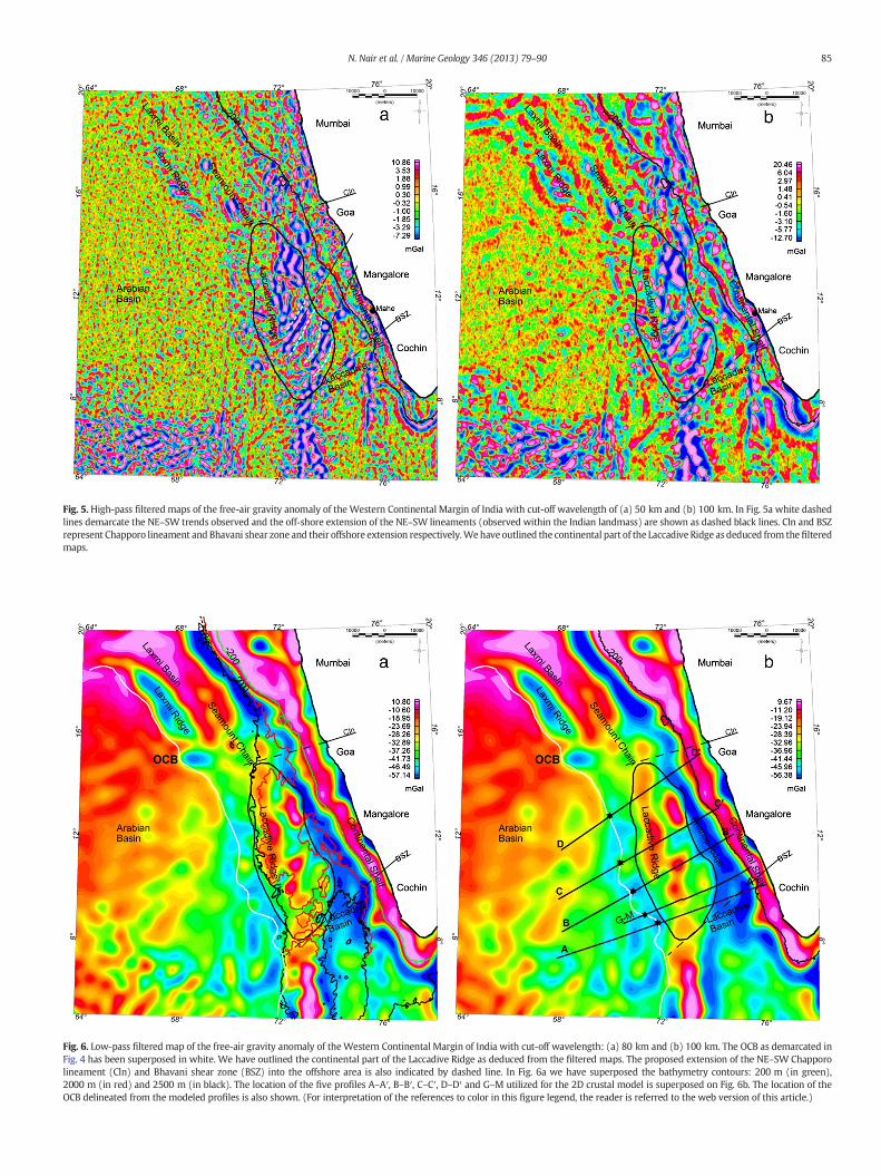
Fig. 5. High-pass filtered maps of the free-air gravity anomaly of the Western Continental Margin of India with cut-off wavelength of (a) 50 km and (b) 100 km. In Fig. 5a white dashedlines demarcate the NE–SW trends observed and the off-shore extension of the NE–SW lineaments (observed within the Indian landmass) are shown as dashed black lines. Cln and BSZrepresent Chapporo lineament and Bhavani shear zone and their offshore extension respectively.Wehave outlined the continental part of the Laccadive Ridge as deduced from the filteredmaps.
Fig. 6. Low-pass filtered map of the free-air gravity anomaly of the Western Continental Margin of India with cut-off wavelength: (a) 80 km and (b) 100 km. The OCB as demarcated inFig. 4 has been superposed in white. We have outlined the continental part of the Laccadive Ridge as deduced from the filtered maps. The proposed extension of the NE–SW Chapporolineament (Cln) and Bhavani shear zone (BSZ) into the offshore area is also indicated by dashed line. In Fig. 6a we have superposed the bathymetry contours: 200 m (in green),2000 m (in red) and 2500 m (in black). The location of the five profiles A–A′, B–B′, C–C′, D–D′ and G–M utilized for the 2D crustal model is superposed on Fig. 6b. The location of theOCB delineated from the modeled profiles is also shown. (For interpretation of the references to color in this figure legend, the reader is referred to the web version of this article.)
85N. Nair et al. / Marine Geology 346 (2013) 79–90
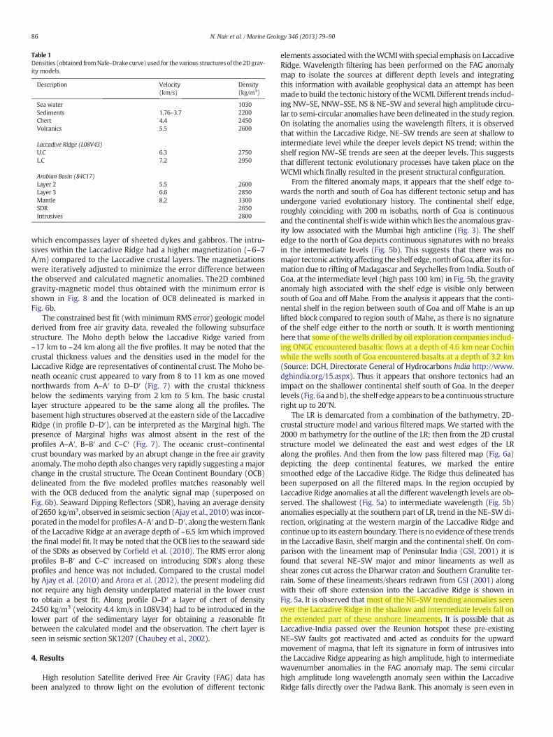
Table 1Densities (obtained fromNafe–Drake curve) used for the various structures of the 2Dgrav-ity models.
Description Velocity(km/s)
Density(kg/m3)
Sea water 1030Sediments 1.76–3.7 2200Chert 4.4 2450Volcanics 5.5 2600
Laccadive Ridge (L08V43)U.C 6.3 2750L.C 7.2 2950
Arabian Basin (84C17)Layer 2 5.5 2600Layer 3 6.6 2850Mantle 8.2 3300SDR 2650Intrusives 2800
86 N. Nair et al. / Marine Geology 346 (2013) 79–90
which encompasses layer of sheeted dykes and gabbros. The intru-sives within the Laccadive Ridge had a higher magnetization (~6–7A/m) compared to the Laccadive crustal layers. The magnetizationswere iteratively adjusted to minimize the error difference betweenthe observed and calculated magnetic anomalies. The2D combinedgravity-magnetic model thus obtained with the minimum error isshown in Fig. 8 and the location of OCB delineated is marked inFig. 6b.
The constrained best fit (with minimum RMS error) geologic modelderived from free air gravity data, revealed the following subsurfacestructure. The Moho depth below the Laccadive Ridge varied from~17 km to ~24 km along all the five profiles. It may be noted that thecrustal thickness values and the densities used in the model for theLaccadive Ridge are representatives of continental crust. The Moho be-neath oceanic crust appeared to vary from 8 to 11 km as one movednorthwards from A–A′ to D–D′ (Fig. 7) with the crustal thicknessbelow the sediments varying from 2 km to 5 km. The basic crustallayer structure appeared to be the same along all the profiles. Thebasement high structures observed at the eastern side of the LaccadiveRidge (in profile D–D′), can be interpreted as the Marginal high. Thepresence of Marginal highs was almost absent in the rest of theprofiles A–A′, B–B′ and C–C′ (Fig. 7). The oceanic crust–continentalcrust boundary was marked by an abrupt change in the free air gravityanomaly. Themoho depth also changes very rapidly suggesting a majorchange in the crustal structure. The Ocean Continent Boundary (OCB)delineated from the five modeled profiles matches reasonably wellwith the OCB deduced from the analytic signal map (superposed onFig. 6b). Seaward Dipping Reflectors (SDR), having an average densityof 2650 kg/m3, observed in seismic section (Ajay et al., 2010)was incor-porated in themodel for profiles A–A′ andD–D′, along thewestern flankof the Laccadive Ridge at an average depth of ~6.5 km which improvedthe final model fit. It may be noted that the OCB lies to the seaward sideof the SDRs as observed by Corfield et al. (2010). The RMS error alongprofiles B–B′ and C–C′ increased on introducing SDR's along theseprofiles and hence was not included. Compared to the crustal modelby Ajay et al. (2010) and Arora et al. (2012), the present modeling didnot require any high density underplated material in the lower crustto obtain a best fit. Along profile D–D′ a layer of chert of density2450 kg/m3 (velocity 4.4 km/s in L08V34) had to be introduced in thelower part of the sedimentary layer for obtaining a reasonable fitbetween the calculated model and the observation. The chert layer isseen in seismic section SK1207 (Chaubey et al., 2002).
4. Results
High resolution Satellite derived Free Air Gravity (FAG) data hasbeen analyzed to throw light on the evolution of different tectonic
elements associatedwith theWCMIwith special emphasis on LaccadiveRidge. Wavelength filtering has been performed on the FAG anomalymap to isolate the sources at different depth levels and integratingthis information with available geophysical data an attempt has beenmade to build the tectonic history of theWCMI. Different trends includ-ing NW–SE, NNW–SSE, NS & NE–SW and several high amplitude circu-lar to semi-circular anomalies have been delineated in the study region.On isolating the anomalies using the wavelength filters, it is observedthat within the Laccadive Ridge, NE–SW trends are seen at shallow tointermediate level while the deeper levels depict NS trend; within theshelf region NW–SE trends are seen at the deeper levels. This suggeststhat different tectonic evolutionary processes have taken place on theWCMI which finally resulted in the present structural configuration.
From the filtered anomaly maps, it appears that the shelf edge to-wards the north and south of Goa has different tectonic setup and hasundergone varied evolutionary history. The continental shelf edge,roughly coinciding with 200 m isobaths, north of Goa is continuousand the continental shelf is wide within which lies the anomalous grav-ity low associated with the Mumbai high anticline (Fig. 3). The shelfedge to the north of Goa depicts continuous signatures with no breaksin the intermediate levels (Fig. 5b). This suggests that there was nomajor tectonic activity affecting the shelf edge, north of Goa, after its for-mation due to rifting of Madagascar and Seychelles from India. South ofGoa, at the intermediate level (high pass 100 km) in Fig. 5b, the gravityanomaly high associated with the shelf edge is visible only betweensouth of Goa and off Mahe. From the analysis it appears that the conti-nental shelf in the region between south of Goa and off Mahe is an uplifted block compared to region south of Mahe, as there is no signatureof the shelf edge either to the north or south. It is worth mentioninghere that some of the wells drilled by oil exploration companies includ-ing ONGC encountered basaltic flows at a depth of 4.6 km near Cochinwhile the wells south of Goa encountered basalts at a depth of 3.2 km(Source: DGH, Directorate General of Hydrocarbons India http://www.dghindia.org/15.aspx). Thus it appears that onshore tectonics had animpact on the shallower continental shelf south of Goa. In the deeperlevels (Fig. 6a and b), the shelf edge appears to be a continuous structureright up to 20°N.
The LR is demarcated from a combination of the bathymetry, 2D-crustal structure model and various filtered maps. We started with the2000 m bathymetry for the outline of the LR; then from the 2D crustalstructure model we delineated the east and west edges of the LRalong the profiles. And then from the low pass filtered map (Fig. 6a)depicting the deep continental features, we marked the entiresmoothed edge of the Laccadive Ridge. The Ridge thus delineated hasbeen superposed on all the filtered maps. In the region occupied byLaccadive Ridge anomalies at all the different wavelength levels are ob-served. The shallowest (Fig. 5a) to intermediate wavelength (Fig. 5b)anomalies especially at the southern part of LR, trend in the NE–SW di-rection, originating at the western margin of the Laccadive Ridge andcontinue up to its eastern boundary. There is no evidence of these trendsin the Laccadive Basin, shelf margin and the continental shelf. On com-parison with the lineament map of Peninsular India (GSI, 2001) it isfound that several NE–SW major and minor lineaments as well asshear zones cut across the Dharwar craton and Southern Granulite ter-rain. Some of these lineaments/shears redrawn from GSI (2001) alongwith their off shore extension into the Laccadive Ridge is shown inFig. 5a. It is observed that most of the NE–SW trending anomalies seenover the Laccadive Ridge in the shallow and intermediate levels fall onthe extended part of these onshore lineaments. It is possible that asLaccadive-India passed over the Reunion hotspot these pre-existingNE–SW faults got reactivated and acted as conduits for the upwardmovement of magma, that left its signature in form of intrusives intothe Laccadive Ridge appearing as high amplitude, high to intermediatewavenumber anomalies in the FAG anomaly map. The semi circularhigh amplitude long wavelength anomaly seen within the LaccadiveRidge falls directly over the Padwa Bank. This anomaly is seen even in
Toshiba
Highlight
Toshiba
Highlight
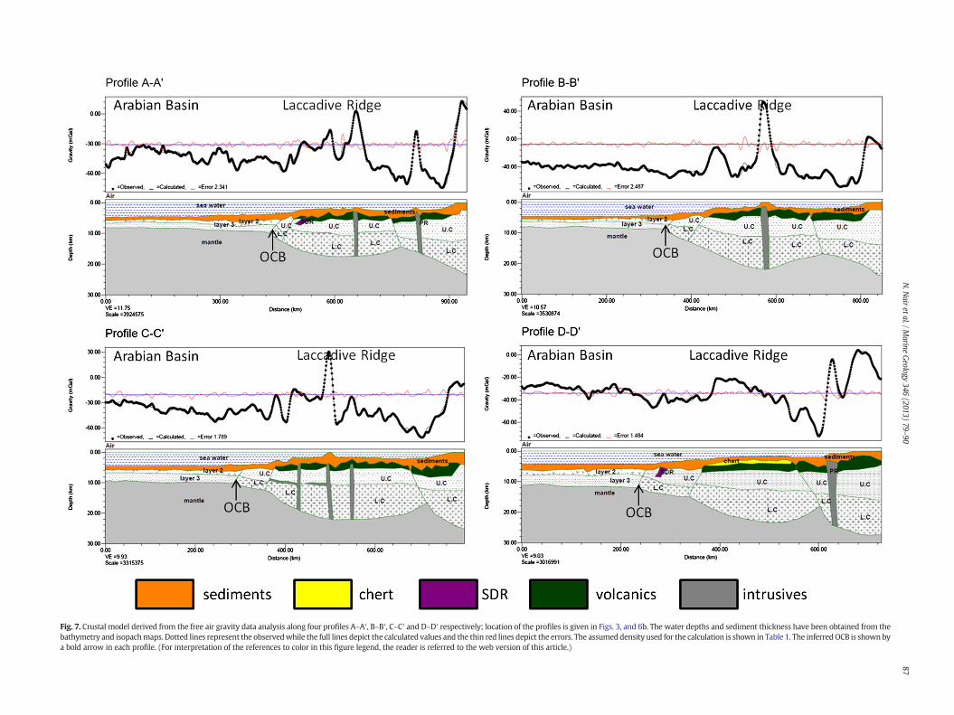
Fig. 7. Crustal model derived from the free air gravity data analysis along four profiles A–A′, B–B′, C–C′ and D–D′ respectively; location of the profiles is given in Figs. 3, and 6b. The water depths and sediment thickness have been obtained from thebathymetry and isopachmaps. Dotted lines represent the observedwhile the full lines depict the calculated values and the thin red lines depict the errors. The assumed density used for the calculation is shown in Table 1. The inferredOCB is shown bya bold arrow in each profile. (For interpretation of the references to color in this figure legend, the reader is referred to the web version of this article.)
87N.N
airetal./M
arineGeology
346(2013)
79–90

Fig. 8. Crustal model derived from the ship-borne gravity andmagnetic data along profile G–M, location of the profile is given in Figs. 3, 4 and 6b. Thewater depths and sediment thicknesshave been obtained from the bathymetry and isopach maps. Dotted lines represent the observed while the full lines depict the calculated values. The assumed density used for the calcu-lation is shown in Table 1. The inferred OCB is shown by a bold arrow in the profile.
88 N. Nair et al. / Marine Geology 346 (2013) 79–90
high pass filtered map and may possibly be associated with intrusives.As the trend and nature of this intrusive is different from the earlierdiscussed intrusives having NE–SW trend, it is inferred that this maybe related to an episode prior to the passage of India over the Reunionplume (possibly related to the Marion hotspot activity).
One of themost conspicuous features in the longwavelengthmapis the NW–SE to NS trending high on the Laccadive Ridge that wasnot evident in the shallow and intermediate depth levels. Also, theseanomalies are not seen north of Goa and south of 8.5°N. From satelliteimageries, GSI (2001) identified NE–SW trending lineament, Chapporolineament (Cln) in the onshore region near Goa, and the Deccan trapsare not found to the south of this lineament on land. The NE–SWtrending Chapporo lineament represents a lithological contact betweenthe trap flows towards to the north and the Archean greenstone andallied supracrustal rocks to the south (GSI, 2001). It appears that theoffshore extension of this lineament is responsible for the termina-tion of Laccadive Ridge south of Goa. Further, towards the south anapparent break of the NS trending high amplitude low wavenumberanomalies (Fig. 6a, b) can be identified. The NW–SE Moyar and theNE–SW trending Bhavani are the two inlandmajor shear zones togetherwith the Palghat-Cauvery Shear defining the boundary between theDharwar craton and the Pandyan Mobile belt (Ramakrishnan andVaidyanathan, 2008). If the NE–SW Bhavani shear is extended offshoreit passes through the region where the long wavelength NS features as-sociated with the Laccadive Ridge are terminated. Hence we believethat the Bhavani Shear forms the southern limit of the LaccadiveRidge. We believe that the LR to the north of this shear is continentalin origin and to the south of this shear may probably be oceanic in na-ture with trace of the hotspots overlying it (Pushcharovsky, 1996,
2011). Thus from the present study we find that the Laccadive Ridgenorth of around 8.5°N is bounded by the offshore extension of theonshore lineaments viz. Chapporo lineament and the Bhavani Shearzone. We believe that the LR was a part of the Dharwar craton (Indianlandmass) and the deeper features reflect these trends. It is worthmen-tioning that the NE–SW (Fig. 5a, b), NS/NW–SE (Fig. 6a, b) trends arenot seen to the east or west of LR i.e. these signatures do not exist inthe Laccadive basin, Shelf Margin basin and the Arabian basin but onlyon the LR.
5. Discussion
The present study attempts at resolving several apparent controver-sies existing in the understanding of the evolution of the LaccadiveRidge. Results obtained from both 2D forward modeling of the crustalstructure and wavelength filtering suggests that the Laccadive Ridgenorth of around 8.5°N is continental in nature. Synthesizing the resultsobtained from thepresent analysis viz a) theNE–SW trending intrusivesfound associated with the Laccadive Ridge are formed as a result ofthe reactivation of the pre-existing faults as the Indian plate movedover the Reunion plume b) the Laccadive Ridge is constrained tolie within the offshore extension of Chapporo lineament and theBhavani shear c) the main anomalies (deeper) associated withLaccadive Ridge are trending NS, it can be inferred that the LaccadiveRidge was a part of the Dharwar craton (NS to NW–SE is the typicalDharwarian trend) before it moved away. According to Mallik(2001) sedimentation history of the Laccadive Ridge suggests thatthe ridge was once close to Indian landmass or perhaps a part ofthe main landmass. We believe the LR was part of India and rifted
Toshiba
Highlight
Toshiba
Highlight
Toshiba
Highlight
89N. Nair et al. / Marine Geology 346 (2013) 79–90
along withMadagascar from India in late Cretaceous (Yatheesh et al.,2006). Several wells drilled in the continental shelf region (DGH,http://www.dghindia.org/15.aspx) in the Kerala-Konkan basin haveshown that basaltic flows of Late Cretaceous age (97.5 to 66 Ma) overliethe basement. The continental nature of the Laccadive Ridge(northernpart of CLR) finds support from Pushcharovsky (1996, 2011); multi-channel seismic reflection studies (Chaubey et al., 2002; Ajay et al.,2010) and Moho depth of around 19 km from seismic refraction data(Naini and Talwani, 1982) in northern part of CLR indicate thatLaccadive Ridge is of continental origin. Itmay be noted that the geolog-ical cross section from 10°S to 20°N constructed using DSDP and ODPwell data (Verzhbitsky, 2003) in support of the oceanic origin of CLR,does not lie on LR but reflects data points that lie on the Maldives andChagos sections of the CLR which are expected to be of oceanic origin(Pushcharovsky, 1996, 2011).
Further, from the 2D crustal structure we find that the shallow tointermediate wavelength NE–SW anomalies are caused by the intru-sives related to the hot spot trace as India passed over the Reunion,during the Cretaceous–Tertiary Boundary. These volcanics are re-sponsible for the observed magnetic signatures (Ben Avraham andBunce, 1977). These volcanic rocks appear as intrusive and sill intothe continental part of the LR as seen in our 2D model derived fromboth gravity and magnetic data; the location of these intrusives ispossibly related to sites of pre-existing faults within the LR that gotreactivated during the passage of India over the Reunion hotspot.
6. Conclusions
Several theories have been propounded for the tectonic evolutionof the Laccadive Ridge based mainly on profile data analysis. In thepresent study, the tectonic evolution of the Laccadive Ridge hasbeen deduced from an analysis of the 2D satellite derived free airgravity data and by utilizing wavelength filtering to resolve differentdepth structures representing different epochs. From such an analy-sis together with 2D modeling of the crustal structure it has beenpossible to identify:
1) the Ocean Continent Boundary for the whole region2) the continental nature of the deeper layers of the Laccadive Ridge to
the north of around 8.5°N constrained by the offshore extension ofthe Chapporo lineament to the north and the Bhavani shear to thesouth.
3) The Laccadive Ridge was part of the Dharwar craton (Indian land-mass) until the Cretaceous when it rifted from India along withMadagascar.
4) Shallow to intermediate wavelength NE–SW anomalies caused byintrusives related to the reactivation of pre-existing faults, as a resultof the trace of the Reunion hotspot near the Cretaceous TertiaryBoundary.
5) The eastern and western boundaries of the Laccadive Ridge arefaulted.
Acknowledgment
This work was carried out under Meteorology and OceanographicProgram — Phase II of Dept. of Space, Govt. of India. Ms. Nisha Nair,Senior Research Fellow under this project wishes to thank Dept. ofSpace for their financial assistance. We gratefully acknowledge re-views by Editor Dr. David J.W. Piper, Dr. David Sandwell and an anon-ymous reviewer on an earlier version of the manuscript that havehelped improve the paper.
References
Ajay, K.K., Chaubey, A.K., Krishna, K.S., Rao, D.G., Sar, D., 2010. Seaward dipping reflectorsalong the SW continental margin of India: evidence for volcanic passive margin. Jour-nal of Earth System Science 119, 803–813.
Anand, S.P., Rajaram, Mita, Majumdar, T.J., Bhattacharyya, R., 2009. Structure and tecton-ics of 85°E ridge from analysis of geopotential data. Tectonophysics 478, 100–110.http://dx.doi.org/10.1016/j.tecto.2008.09.036.
Arora, K., Tiwari, V.M., Singh, B., Mishra, D.C., Grevemeyer, I., 2012. Three dimensionallithospheric structure of the western continental margin of India constrained fromgravity modelling: implication for tectonic evolution. Geophysical Journal Interna-tional 190, 131–150. http://dx.doi.org/10.1111/j.1365-246X.2012.05506.x.
Babenko, K.M., Panaev, V.A., Svistunov, Y.I., Schlezinger, A.E., 1981. Tectonics of the east-ern margin of the Arabian Sea according to seismic data. Bulletin of ONGC 18, 37–62.
Balakrishnan, T.S., 1997. Major tectonic elements of the Indian subcontinent and contigu-ous areas: a geophysical view. Memoirs of the Geological Society of India 38, 155.
Bansal, A.R., Fairhead, T.J.D., Green, C.M., Fletcher, K.M.U., 2005. Revised gravity for offshoreIndia and the isostatic compensation of submarine features. Tectonophysics 404, 1–22.
Ben Avraham, Z., Bunce, E.T., 1977. Geophysical study of the Chagos Laccadive Ridge,Indian Ocean. Journal of Geophysical Research 82, 1295–1305.
Bhattacharya, G.C., Chaubey, A.K., 2001. Western Indian Ocean— a glimpse of the tectonicscenario. In: Sen Gupta, R., Desa, E. (Eds.), The Indian Ocean— A Perspective. Oxford-IBH, New Delhi, pp. 691–729.
Biswas, S.K., 2001. Structure of the Western Continental Margin of India and related igne-ous activity. Geological Society of India Memoir 47, 349–364.
Chaubey, A.K., Gopala Rao, D., Srinivas, K., Ramprasad, T., Ramana, M.V., Subrahmanyam,V., 2002. Analyses of multichannel seismic reflection, gravity and magnetic dataalong a regional profile across the central-western continental margin of India.Marine Geology 182, 303–323.
Chaubey, A.K., Srinivas, K., Ashalatha, B., Gopala Rao, D., 2008. Isostatic response of theLaccadive Ridge from admittance analysis of gravity and bathymetry data. Journalof Geodynamics 46, 10–20.
Corfield, R.I., Carmichael, S., Bennett, J., Akhter, S., Fatimi, M., Craig, T., 2010. Variability inthe crustal structure of the West Indian Continental Margin in the Northern ArabianSea. Petroleum Geoscience 16, 257–265.
Courtillot, V., Feraud, G., Maluski, H., Vandamme, D., Moreau, M.G., Besse, J., 1988. Deccanflood basalts and the Cretaceous/Tertiary boundary. Nature 333, 843–846.
Geological Survey of India, 2001. Seismotectonic atlas of India and its environs.Gopala Rao, D., Paropkari, A.L., Krishna, K.S., Chaubey, A.K., Ajay, K.K., Kodagali, V.N., 2010.
Bathymetric highs in the mid-slope region of the Western Continental Margin ofIndia — structure and mode of origin. Marine Geology 276, 58–70.
Kent, G., Harding, A., Orcutt, J., 1993. Distribution of magma beneath the East Pacific Risebetween the Clipperton Transform and the 9°17′N Deval from forward modeling ofcommon depth point data. Journal of Geophysical Research 98, 13945–13969.
Majumdar, T.J., Krishna, K.S., Chatterjee, S., Bhattacharya, R., Michael, L., 2006. Study ofhigh resolution satellite geoid and gravity anomaly data over the Bay of Bengal. Cur-rent Science 90, 211–219.
Mallik, T.K., 2001. Some geological aspects of the Laccadive Atolls, Arabian Sea. GeologicalSurvey of India, Special Publication 56, 1–8.
Nabighian, M.N., 1972. The analytical signal of two-dimensional magnetic bodieswith po-lygonal cross section: its properties and use for automated anomaly interpretation.Geophysics 37, 507–517.
Nabighian, M.N., 1974. Additional comment on the analytical signal of two dimensionalmagnetic bodies with polygonal cross section. Geophysics 39, 85–92.
Naini, B.R., Kolla, V., 1982. Acoustic character and thickness of sediments of the Indus fanand the continental margin of western India. Marine Geology 47, 181–195.
Naini, B.R., Talwani, M., 1982. Structural framework and the evolutionary history of thecontinental margin of western India. In: Watkins, J.S., Drake, C.L. (Eds.), Studies inContinental Margin Geology. American Association of Petroleum Geology Memoir,34, pp. 167–191.
Nair, G.R., Pandey, D.K., Sivaramakrishnan, R., 2009. Basement structure of the LaccadiveRidge and Basin from multi-channel seismic reflection and gravity data. AmericanGeophysical Union, Fall Meeting Abstract #S53A-1486.
Norton, I.O., Sclater, J.G., 1979. A model for the evolution of the Indian Ocean and thebreakup of Gondwanaland. Journal of Geophysical Research 84, 6803–6830.
Pushcharovsky, Yu.M., 1996. Tectonics of the Indian Ocean. Geotectonics 29, 336–354.Pushcharovsky, Yu.M., 2011. First order linear tectonovolcanic ridges in oceans. Geotec-
tonics 45, 101–112.Radha Krishna, M., Verma, R.K., Purushotham, A.K., 2002. Lithospheric structure below the
eastern Arabian Sea and adjoining west coast of India based on integrated analysis ofgravity and seismic data. Marine Geophysical Research 23, 25–42.
Rajaram,Mita, Anand, S.P., Hemant, K., Purucker, M.E., 2009. Curie isothermmap of Indiansubcontinent from satellite and aeromagnetic data. Earth and Planetary Science Let-ters 281, 147–158. http://dx.doi.org/10.1016/j.epsl.2009.02.013.
Ramakrishnan, M., Vaidyanathan, R., 2008. Geology of India. Geological Society of India,vol. 1.
Sandwell, D.T., Smith, W.H.F., 1997. Marine gravity anomaly from Geosat and ERS 1 satel-lite altimetry. Journal of Geophysical Research 102, 10039–10054.
Sandwell, D.T., Smith, W.H.F., 2009. Global marine gravity from retracked Geosat andERS-1 altimetry: ridge segmentation versus spreading rate. Journal of Geophysical Re-search. http://dx.doi.org/10.1029/2008JB006008.
Sinha Roy, S., 2001. Tectonic and magmatic responses of Indian passive continentalmargin development: example from the Kerala region. Geological Society ofIndia Memoir 47, 503–505.
Sreejith, K.M., Rajesh, S., Majumdar, T.J., Rao, G.S., Radhakrishna, M., Krishna, K.S., Rajawat,A.S., 2013. High-resolution residual geoid and gravity anomaly data of the northernIndian Ocean — an input to geological understanding. Journal of Asian Earth Science62, 616–626.
Talwani, M., Heirtzler, J.R., 1964. Computation of magnetic anomalies caused by two-dimensional bodies of arbitrary shape. In: Parks, G.A. (Ed.), Computers in theMineral In-dustries, Part 1: Stanford University Publication. Geological Sciences, 9, pp. 464–480.
90 N. Nair et al. / Marine Geology 346 (2013) 79–90
Talwani, M., Reif, C., 1998. Laxmi Ridge — a continental sliver in the Arabian Sea. MarineGeophysical Research 20, 259–271.
Talwani, M., Worzel, J.I., Landisman, M., 1959. Rapid gravity computations for two-dimensional bodies with application to the Mendocino submarine fracture zone.Journal of Geophysical Research 64, 49–59.
Verzhbitsky, E.V., 2003. Geothermal regime and genesis of the ninety-east and Chagos-Laccadive ridges. Journal of Geodynamics 35, 289–302.
Watts, A.B., Fairhead, J.D., 1999. A process oriented approach to modeling the gravity sig-nature of continental margins. The Leading Edge 18, 258–263.
White, R.S., McKenzie, D., 1989. Magmatism at rift zones: the generation of volcaniccontinental margins and flood basalts. Journal of Geophysical Research 94,7685–7729.
Won, I.J., Bevis, M.G., 1987. Computing the gravitational and magnetic anomalies due to apolygon: Algorithms and Fortran subroutines. Geophysics 52, 232–238.
Yatheesh, V., Bhattacharya, G.C., Mahender, K., 2006. The terrace like feature in themid-continental slope region off Trivandrum and a plausible model for India–Madagascar juxtaposition in immediate pre-drift scenario. Gondwana Research10, 179–185.