Seabeam and seismic reflection imaging of the tectonic regime of the Andean continental margin off...
16
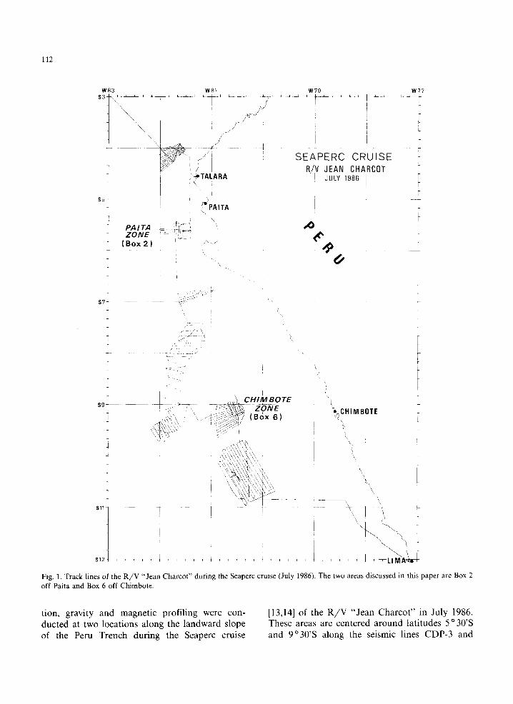
Earth and Planetary Science Letters, 87 (1988) 111-126 111 Elsevier Science Publishers B.V., Amsterdam - Printed in The Netherlands [4] Seabeam and seismic reflection imaging of the tectonic regime of the Andean continental margin off Peru (4°S to 10 ° S) J. Bourgois 1, G. Pautot 2, W. Bandy 3, T. Boinet 1, p. Chotin 1 p. Huchon 4 B. Mercier de Lepinay 1, F. Monge 5, j. Monlau l, B. Pelletier 6, M. Sosson ~' and R. von Huene 7 1 D~partement de Gdotectonique, UA 215 (CNRS-1NSU), Universit~ Pierre et Marie Curie, T26-00, El, 4 Place Jussieu, 75252 Paris C~dex (France) e IFREMER Centre de Brest, B.P. 337, 29273 Brest C~dex (France) 3 Department of Geophysics, Texas A&M University, College Station, TX 77843 (U.S.A.) 4 D~partement de G~ologie, Ecole Normale Sup~rieure, UA 215 (CNRS-INSU), 24 rue Lhomond, 75252 Paris C~dex (France) 5 lnstituto Geofisico del Peru, A 3747, Lima (Peru) 60RSTOM, B.P. A5, Noum~a C~dex (Nouvelle Calddonie) z U.S. Geological Survey, 345 MiddlefieMRoad, Menlo Park, CA 94025 (U.S.A.) Received March 13, 1987; revised version accepted October 23, 1987 Marine geophysical surveys employing Seabeam, multi- and single-channel seismic reflection, gravity and magnetic instruments were conducted at two locations along the continental slope of the Peru Trench during the Seaperc cruise of the R/V "Jean Charcot" in July 1986. These areas are centered around 5 o 30'S and 9 o 30'S off the coastal towns of Paita and Chimbote respectively. These data indicate that (1) the continental slope off Peru consists of three distinct morpho-structural domains (from west to east are the lower, middle and upper slopes) instead of just two as previously reported; (2) the middle slope has the characteristics of a zone of tectonic collapse at the front of a gently flexured upper slope; (3) the upper half of the lower slope appears to represent the product of mass wasting; (4) thrusting at the foot of the margin produces a continuous morphologic feature representing a deformation front where the products of mass-wasting are overprinted by a compressional tectonic fabric; (5) a change in the tectonic regime from tensional to compressional occurs at the mid-slope-lower slope boundary, the accretionary prism being restricted to the very base of the lower slope in the Paita area. The Andean margin off Peru is an "extensional active margin" or a "collapsing active margin" developing a subordinated accretionary complex induced by massive collapse of the middle slope area. 1. Introduction At the front of most convergent margins the basic tectonic elements have been difficult to de- fine with conventional geophysical techniques and the resulting interpretations are often model de- pendent. Recently, many structures at the front of convergent margins have been clarified by the reprocessing of multichannel seismic data. Struc- tures indicative of sediment accretion were imaged clearly in the Nankai Trough [1], Central America [2] and Aleutian Trench [3]. Lower slope struc- tures of active margin off Japan [4,5] and off Guatemala [6-8] as well were also clarified using Seabeam which provides a quasi three-dimen- 0012-821X/88/$03.50 © 1988 Elsevier Science Publishers B.V. sional knowledge if associated with multi-channel seismic records. Structures were also clarified by drilling. The Barbados accretionary complex is a site where imbricated offscraped sequence sep- arated by decollement was drilled during Leg 78A of IPOD [9] and Leg 110 of ODP [10]. The structure of the subduction complex of the Andean margin is best defined along two trans- verse multichannel seismic records ([11,12], and von Huene et al., in preparation), one in an area between latitude 5°S and 6°S (Fig. 1) offshore Paita (CDP-3), and the other between latitudes 8 ° 30'S and 9 ° 30'S offshore Chimbote (CDP-2). Marine geophysical surveys employing Seabeam, multi- and single-channel seismic reflec-
Transcript of Seabeam and seismic reflection imaging of the tectonic regime of the Andean continental margin off...
Earth and Planetary Science Letters, 87 (1988) 111-126 111 Elsevier Science Publishers B.V., Amsterdam - Printed in The Netherlands
[4]
Seabeam and seismic reflection imaging of the tectonic regime of the Andean continental margin off Peru (4°S to 10 ° S)
J. Bourgois 1, G. Pautot 2, W. Bandy 3, T. Boinet 1, p. Chotin 1 p. Huchon 4 B. Mercier de Lepinay 1, F. Monge 5, j. Monlau l, B. Pelletier 6, M. Sosson ~'
and R. von Huene 7
1 D~partement de Gdotectonique, UA 215 (CNRS-1NSU), Universit~ Pierre et Marie Curie, T26-00, El, 4 Place Jussieu, 75252 Paris C~dex (France)
e IFREMER Centre de Brest, B.P. 337, 29273 Brest C~dex (France) 3 Department of Geophysics, Texas A&M University, College Station, TX 77843 (U.S.A.)
4 D~partement de G~ologie, Ecole Normale Sup~rieure, UA 215 (CNRS-INSU), 24 rue Lhomond, 75252 Paris C~dex (France) 5 lnstituto Geofisico del Peru, A 3747, Lima (Peru)
60RSTOM, B.P. A5, Noum~a C~dex (Nouvelle Calddonie) z U.S. Geological Survey, 345 MiddlefieMRoad, Menlo Park, CA 94025 (U.S.A.)
Received March 13, 1987; revised version accepted October 23, 1987
Marine geophysical surveys employing Seabeam, multi- and single-channel seismic reflection, gravity and magnetic instruments were conducted at two locations along the continental slope of the Peru Trench during the Seaperc cruise of the R / V "Jean Charcot" in July 1986. These areas are centered around 5 o 30'S and 9 o 30'S off the coastal towns of Paita and Chimbote respectively.
These data indicate that (1) the continental slope off Peru consists of three distinct morpho-structural domains (from west to east are the lower, middle and upper slopes) instead of just two as previously reported; (2) the middle slope has the characteristics of a zone of tectonic collapse at the front of a gently flexured upper slope; (3) the upper half of the lower slope appears to represent the product of mass wasting; (4) thrusting at the foot of the margin produces a continuous morphologic feature representing a deformation front where the products of mass-wasting are overprinted by a compressional tectonic fabric; (5) a change in the tectonic regime from tensional to compressional occurs at the mid-slope-lower slope boundary, the accretionary prism being restricted to the very base of the lower slope in the Paita area.
The Andean margin off Peru is an "extensional active margin" or a "collapsing active margin" developing a subordinated accretionary complex induced by massive collapse of the middle slope area.
1. Introduction
At the front of most convergent margins the basic tectonic elements have been difficult to de- fine with conventional geophysical techniques and the resulting interpretations are often model de- pendent. Recently, many structures at the front of convergent margins have been clarified by the reprocessing of multichannel seismic data. Struc- tures indicative of sediment accretion were imaged clearly in the Nankai Trough [1], Central America [2] and Aleutian Trench [3]. Lower slope struc- tures of active margin off Japan [4,5] and off Guatemala [6-8] as well were also clarified using Seabeam which provides a quasi three-dimen-
0012-821X/88/$03.50 © 1988 Elsevier Science Publishers B.V.
sional knowledge if associated with multi-channel seismic records. Structures were also clarified by drilling. The Barbados accretionary complex is a site where imbricated offscraped sequence sep- arated by decollement was drilled during Leg 78A of IPOD [9] and Leg 110 of ODP [10].
The structure of the subduction complex of the Andean margin is best defined along two trans- verse multichannel seismic records ([11,12], and von Huene et al., in preparation), one in an area between latitude 5°S and 6°S (Fig. 1) offshore Paita (CDP-3), and the other between latitudes 8 ° 30'S and 9 ° 30'S offshore Chimbote (CDP-2).
Marine geophysical surveys employing Seabeam, multi- and single-channel seismic reflec-
112
W83
,5 i
PAITA ZONE
J ( Box 2 )
W81
f
5. TAI.ARA
• ; I *PAITA
W 7 9
S E A P E R C C R U I S E R/V JEAN CHARCOT
JULY 1986
4>
W77
S7-- J
7 " ,
CHIM BOTE S9 - ~ Z"ONE
~ : ~ ( B o x 6 ) +'_CHIMBOTE
4
S l l I
\ \
s121 ' ~ . . . . LIMi
Fig, 1. Track lines of the R / V "Jean Charcot" during the Seaperc cruise (July 1986). The two areas discussed in this paper are Box 2 off Paita and Box 6 off Chimbote.
tion, gravity and magnetic profiling were con- ducted at two locations along the landward slope of the Peru Trench during the Seaperc cruise
[13,14] of the R/V "Jean Charcot" in July 1986. These areas are centered around latitudes 5 °30'S and 9°30'S along the seismic lines CDP-3 and
CDP-2, respectively. The northern zone is the Paita area (box 2 of the Seaperc cruise) and the southern zone is the Chimbote area (box 6) (Fig. 1).
The objectives of our studies in the Paita and Chimbote areas are (1) to map the main scarps and canyons in the mid-slope area where the contact between continental crust and accretion- ary materials can be observed on the seafloor and sampled, and (2) to make additional CDP seismic records across CDP-3 and CDP-2 at points where sites had been proposed for ODP Leg 112 drilling to show whether there are possible structures that might trap accumulations of gas or other thermo- genic hydrocarbons. A third and overall objective is to acquire a three-dimensional knowledge of the structure in order to image the tectonic regime of the Peruvian margin and clarify the transition zone between the edge of the South American continental crust and the subduction complex ad- jacent to the trench. Such knowledge has im- portant implications for an understanding of marine resources and seismic hazards along the Andean continental margin.
2. Collapse tectonics and accretion in the Paita area
The Paita area includes a zone of the landward slope of the Peru Trench between latitudes 5 °S and 6°S offshore Paita and just south of the coastal town of Talara (Fig. 2). Talara is a center servicing onshore and offshore oil fields of north- ern Peru.
The Paita area was studied by Shepherd and Moberly [11] with single-channel seismic profiling. They recognized a lower slope of chaotic reflec- tions thought to represent accretionary structure and an upper slope where the stratification known from petroleum wells (location, Fig. 2) on the shelf continued down the slope to a sharp break in the mid-slope. Based on the multichannel CDP-3 seismic record [11], the stratified sequence of the upper slope is inferred to be Paleozoic to Quaternary in age. Shepherd and Moberly [11] concluded that the upper slope is deformed by normal faulting and that the lower slope results from tectonic accretion. The zone of transition between tensional and compressional tectonic do- mains should occur within a 15 km mid-slope area
113
of uncertainty. On basis of gravity anomalies, Shepherd and Moberly [11] also contend that con- tinental basement extends to within 30 km of the trench axis.
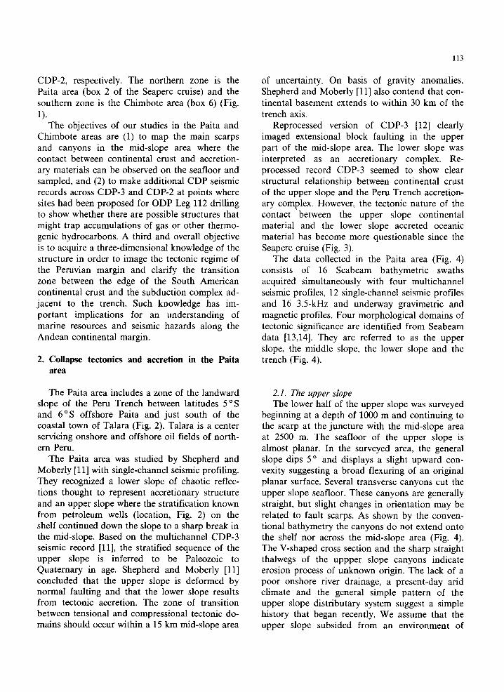
Reprocessed version of CDP-3 [12] clearly imaged extensional block faulting in the upper part of the mid-slope area. The lower slope was interpreted as an accretionary complex. Re- processed record CDP-3 seemed to show clear structural relationship between continental crust of the upper slope and the Peru Trench accretion- ary complex. However, the tectonic nature of the contact between the upper slope continental material and the lower slope accreted oceanic material has become more questionable since the Seaperc cruise (Fig. 3).
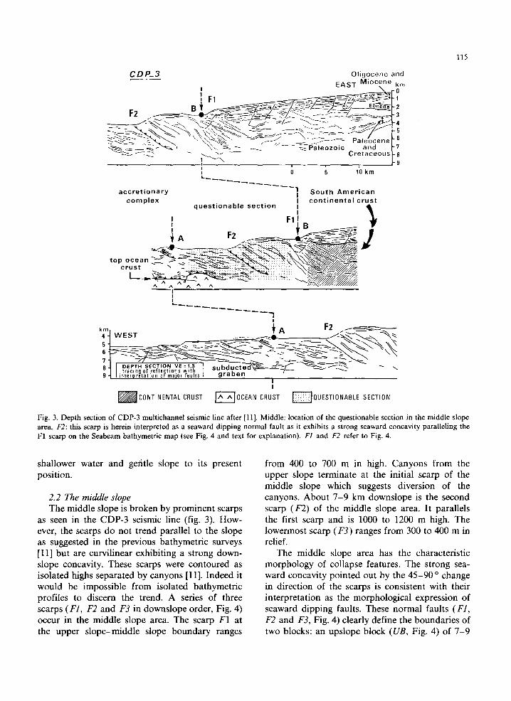
The data collected in the Paita area (Fig. 4) consists of 16 Seabeam bathymetric swaths acquired simultaneously with four multichannel seismic profiles, 12 single-channel seismic profiles and 16 3.5-kHz and underway gravimetric and magnetic profiles. Four morphological domains of tectonic significance are identified from Seabeam data [13,14]. They are referred to as the upper slope, the middle slope, the lower slope and the trench (Fig. 4).
2.1. The upper slope The lower half of the upper slope was surveyed
beginning at a depth of 1000 m and continuing to the scarp at the juncture with the mid-slope area at 2500 m. The seafloor of the upper slope is almost planar. In the surveyed area, the general slope dips 5 o and displays a slight upward con- vexity suggesting a broad flexuring of an original planar surface. Several transverse canyons cut the upper slope seafloor. These canyons are generally straight, but slight changes in orientation may be related to fault scarps. As shown by the conven- tional bathymetry the canyons do not extend onto the shelf nor across the mid-slope area (Fig. 4). The V-shaped cross section and the sharp straight thalwegs of the uppper slope canyons indicate erosion process of unknown origin. The lack of a poor onshore river drainage, a present-day arid climate and the general simple pattern of the upper slope distributary system suggest a simple history that began recently. We assume that the upper slope subsided from an environment of

114
-$3 o I W82 o
- $ 4 o
S5 o
-$6 o
/
/
I IA/~1 o ~, ~ w'8oc
er-
O1.O2,O3,04 MULTICHANN EL
CROSS.LINES
SEABEAM SURVEY
R/V Jean CHARCOT PAITA AREA
BOX 2
/
'---'~PLIOCENE QUATERNARY
~ EOCENE- MIOCENE
~ C R E T A C E O U S
OI O2
~ P A L E O Z O I C
k k SECHURA
DESERT
$6 o . PERU
\ ~ ,J ,- /
\ , o,, r a l a r a \ / ~,
\ Y ~ - - ~Paita
t ' , ISLA LOBOS ~ /C-~-~----CS ~______=~::3~- B . . . . . . DE TIERRA ~ ~ ~._ ~ - - \ . . _
W82° 1 W81° 1,, (~ 2o ~2 81"
Fig. 2. Map showing the location of the Paita area, the Seabeam survey, and the location of CDP-3 multichannel seismic line and other published seismic reflection profiles [10]. The Paleozoic basement of the Amotape massif crops out near Talara. The Viru 4X-1 drill hole is located south of Paita.
115
CDP_3 O l i g o c e n e and E A S T M i o c e n e km
- - ~ ~ - ~ \ ~ - ~ - ~ ~ ~ r a i e o z o l c ano -7 ~ ~-~ C r e t a c e o u s -8
"~-" .I ~ -9
a c c r e t i o n a r y 1 S o u t h A m e r i c a n I c o m p l e x I c o n t i n e n t a l c r u s t
q u e s t i o n a b l e s e c t i o n I Q , I
I F l l ,
p o c e a n ~ .-~ . ~ - ~ 7 " ~
I L_
I
' F 4 W E S .1 - " X
-- ,X~... ~ -.>. ~ - . - ~ ~ R J I DEPTH S E C T I O N V E = 1,3 e , . h r l . . . . ~ ~ . " - ' - - ' . " I I t rac ing 0f r e f l e c t i o n s w i t h , u . , ~ , , - ~ , ~ - w - - - ~ - - - - y . - ~ ~ --~._. "~- 9 " t l i n t e r p r e t a t i 0 n 0 f m a i 0 r f a u l t s ~ . o ~ , ,
I i
~CONTINENTAI_ CRUST F-A--'~OCEAN CRUST ~QUESTIONABLE SECTION
Fig. 3. Depth section of CDP-3 multichannel seismic line after [11]. Middle: location of the questionable section in the middle slope area. F2: this scarp is herein interpreted as a seaward dipping normal fault as it exhibits a strong seaward concavity paralleling the F1 scarp on the Seabeam bathymetric map (see Fig. 4 and text for explanation). F1 and F2 refer to Fig. 4.
shallower water and gefitle slope to its present position.
2.2 The middle slope The middle slope is broken by prominent scarps
as seen in the CDP-3 seismic line (fig. 3). How- ever, the scarps do not trend parallel to the slope as suggested in the previous bathymetric surveys [11] but are curvilinear exhibiting a strong down- slope concavity. These scarps were contoured as isolated highs separated by canyons [11]. Indeed it would be impossible from isolated bathymetric profiles to discern the trend. A series of three scarps (F1, F2 and F3 in downslope order, Fig. 4) occur in the middle slope area. The scarp F1 at the upper slope-middle slope boundary ranges
from 400 to 700 m in high. Canyons from the upper slope terminate at the initial scarp of the middle slope which suggests diversion of the canyons. About 7-9 km downslope is the second scarp (F2) of the middle slope area. It parallels the first scarp and is 1000 to 1200 m high. The lowermost scarp (F3) ranges from 300 to 400 m in relief.
The middle slope area has the characteristic morphology of collapse features. The strong sea- ward concavity pointed out by the 45-90 o change in direction of the scarps is consistent with their interpretation as the morphological expression of seaward dipping faults. These normal faults (F1, F2 and F3, Fig. 4) clearly define the boundaries of two blocks: an upslope block (UB, Fig. 4) of 7-9
116
82 '00
05'_
SEAPERC CRUISE PAITA ZONE
0 5 lO km L 1 I I I I I
# \
i i i i TRENCH S LO~ER
st°oe I 0
82'00
O, 81'30
(( ~,~
/
C D P - 3 ~'ll>~
o o 05 '
"40
'J?,:" / ~ / f \ B/148 // .. / ! /,//
22II//tt j IF2
iDDLE SLOPE F1 uppE ~
81J3[)
Fig. 4. Seabeam bathymetric map of the Paita area (contour interval 100 m). F1, F2 and F3: curvilinear normal fault of the middle slope area, UB: upper slope block, DB: down slope block, FS: flat surface, OO': middle slope-lower slope boundary, S: subduction contact.
km width and a downslope block (DB, Fig. 4) of 5-7 km width. The general trend of the two blocks parallels the strike of the slope. The highest part of the upslope unit is a very flat and smooth surface (FS, Fig. 4) which was protected from erosion once it had been isolated by detachment of the upper block by faulting. It is assumed that this surface is a remnant of the planar seafloor of the upper slope and has been tilted 2 ° landward. Thus the two units of the middle slope area are assumed to be two landward tilted blocks break- ing down the upper slope. Most sections of the middle slope fault scarps appear fresh and unmod- ified which suggests a recent disruption of the slope.
Another interesting point is the size of the blocks. The faults (F1 and F2) that extend across the surveyed area range from 23 to 32 km mini- mum length. The upslope block is 7-9 km wide and the downslope block ranges from 5 to 7 kin.
The multichannel seismic data indicate thick- nesses of 6 km and 4 km for the upslope and the downslope blocks respectively. The relationship between the length, the width and the thickness of the blocks suggests that faults F1 and F2 are deep tectonic features as it is suggested by the fault throw inferred from the height of the scarp, which ranges from 500 to 1200 m.
The throw of the middle slope faults decreases downslope as they become increasingly transverse to the strike of the lower slope. Line OO' (Fig. 4) that bounds the seaward morphologic expression of faults F1, F2 and F3 is defined as the middle slope-lower slope boundary; it is not as sharp and steep as the upslope boundary of the middle slope.
2.3. The lower slope The topography of the lower slope consists of a
complex roughly equidimensional hill-and-depres- sion morphology that has many closed contours
~ O
117
N S
5 P
EDp
UEERNAME: MEMLO PLOT JOBIO: 2 G: I O: I DATE: 22-AUG-S6 83:29 MAFST U - T I E UELS - 100 M/S RMS - 0.12858E+09 GAIN - 1.68688 PROJECT :MENLOPK JOB NO. 13449 L INE LINE02 POLARITY NORMAL - POSITIUE DATA( 90fleM5 O 4. SAMPLES ) SECOND RUERAGE USING 3 WINDOWS FROM 3008 TO 9808 MS EXCLUDING ZERO SAMPLES
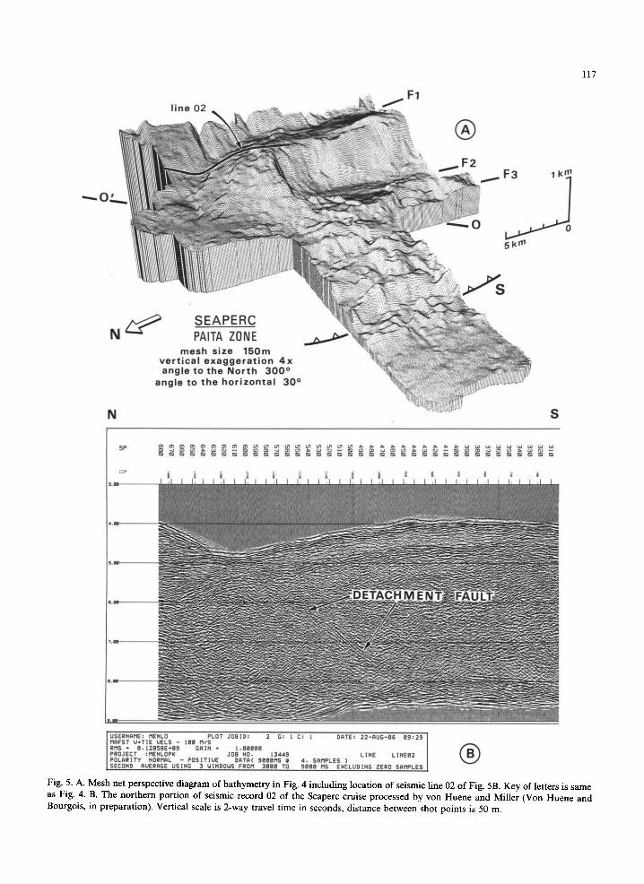
® Fig. 5. A. Mesh net perspective diagram of bathymetry in Fig. 4 including location of seismic line 02 of Fig. 5B. Key of letters is same as Fig. 4. B. The northern portion of seismic record 02 of the Seaperc cruise processed by von Huene and Miller (Von Huene and Bourgois, in preparation). Vertical scale is 2-way travel time in seconds, distance between shot points is 50 m.

118
(Fig. 5A). There are no consistent trends in the lower slope area. The morphology indicates an accumulation from mass wasting, complementary to that of the large failure scars in the adjacent mid-slope area. The base of the lower slope do- main is a frontal scarp (S, Figs. 4 and 5A) which is assumed to be the trace of the subduction zone. It is a 400 m high sinuous escarpment with lateral continuity.
The floor of the trench is generally flat and in just over 5000 m water depth. Small irregular- shaped mounds dot the landward trench floor at the base of the lower slope scarp (S). These mounds correspond to those reported in the trench [11] and interpreted as slump debris.
3. Comparison with the Chimbote area
A 30 × 40 miles Seabeam map has been ob- tained off Chimbote during the Seaperc cruise of the R / V "Jean Charcot" [13,14]. This area, located along the multichannel seismic line CDP-2, in- cludes the axis of the Peru Trench and part of the seaward and landward slope as well (Fig. 6).
The Chimbote area was previously surveyed [15] including the acquisition of the CDP-2 multi- channel seismic record (Nazca Plate Project). The Andean continental margin off Chimbote appears to consist of an accretionary complex beneath the landward slope of the Peru Trench. This accre- tionary complex is stacked against the truncated
sos
SEABEAM SURVEY B/V Jean CHABCOT CRUISE
CHIMBOTE AREA: BOX 6
685 and 683:0DP Leg 112 Sites
co
)0
/
X r u j i l l
~Chimbote I o
0 100 200 km I i i i i . . . . . I i I i i I
TRUJILLO SALAVERRY SUBDUCTIONcoMPLEX YAQUINA- B A S I N . ° BASIN
%'~ ~ . 2 , . ~.~.~.r; BASIN ,~0
l° vBASA[vv v TE','-~72) CRUST T~;,~'?~ 8
vv v v v v V.E. 3.2:1 km
I N D U S T R Y W E L L S
DELFIN BALLENA
Fig. 6. Top left: map showing the location of the Chimbote area, the Seabeam survey, the CDP-2 multichannel seismic line, two other published multichannel records and drill holes to metamorphic basement [20]. Bottom left: diagrammatic section across the Peruvian margin after [14] along the CDP-2 multichannel sesmic line (PERU 2). Right: industry wells (location on the map).
edge of the South American continental crust. The boundary between continental and accreted material is somewhere within the 85 km width of the slope. The structure of the accretionary com- plex [15,16] is largely unknown. The accretionary complex has a 15 km minimum and a 85 km maximum width normal to the trench axis. On the basis of seismic velocity, the 70 km of uncertainty between the accretionary complex and the con- tinental crust was interpreted as older accreted sediments (16,17] or as fractured continental crust [18]. The seaward edge of the continent is prob- ably composed of metamorphic rocks similar to those recovered at two drill sites on the upper slope [19,20] under the Trujillo Basin. The Trujillo Basin, located above the edge of the cohe- r en t - f rom acoustic signature--continental crust, may have experienced superposed compressional and tensional tectonic events at the same time [21].
119
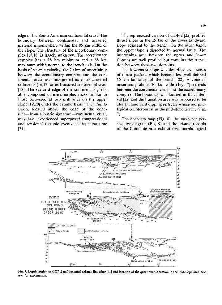
The reprocessed version of CDP-2 [22] profiled thrust slices in the 15 km of the lower landward slope adjacent to the trench. On the other hand, the upper slope is dissected by normal faults. The intervening area between the upper and lower slope is not well profiled but contains the transi- tion between these two domains.
The lowermost slope was described as a series of thrust packets which become less well defined 15 km landward of the trench [22]. A zone of uncertainty about 10 km wide (Fig. 7) extends between the continental crust and the accretionary complex. The boundary was located in that inter- val [22] and the transition area was proposed to be along a landward dipping reflector whose morpho- logical counterpart is in the mid-slope terrace (Fig. 7).
The Seabeam map (Fig. 8), the mesh net per- spective diagram (Fig. 9) and the seismic records of the Chimbote area exhibit five morphological
k m
4~3 k m 3nO 2=0 1'0 - 0 I - I
6 8 3 ~ ~ - ~ ~ ~ - ~ - : ~ ~ _ 2
~- . _ . L . PLIOCENE_QUATERNARY
~ / - - - . MIDDLE EOCENE . 9
I - - . l l L
A c c r e t i o n a r I I S o u t h A m e r i c a n rn ' Y 1 Q u e s t i o n a b l e s e c t i o n ~ A c o n t i n e n t a l c r u s t
co p l e x - - ' - B ~ ~ e - - ~ - ~ . . ~_-~<-<-~
CDP- 2 ~ _ - ~ - - ~ - ~ ~ ~_= - - _ . _ - ~ = _~ ~ ~
DEPTH SECTION ~%.~_-z'~.~,~.-..~>~..~ ~.~.. . .~,,~..~. - - ~ 7 ~ / / _ ~ C / / . / / / / INCLUDING ~ " " " ~ " ~ = = ~ ' ~ " ~ - ~ -~" ~ " " - - . . . . . . . ~ _ ~ Z / 7 / ~ / .
II~U~°ucte°^graben ^ A c r u s t ^ ^ ^ ^ p,
L ~ / ~ CONTINENTAL CRUST - I
I I
j^ IOCEAN CRUST SECTION I
k4m~ T R E N C H - - ~ 5 / t h r u s t f a u l t 685 ~ l l ~ ~ , ~ . . . .
9 J Top o c e a n c r u s t ~ . _ ~ ~-~
S u b d u c t e d g r a b e n Top o c e a n c r u s t
80 kn l 70 610 50 I I I I I I
Fig. 7. Depth section of CDP-2 multichannel seismic line after [21] and location of the questionable section in the mid-slope area. See text for explanation.

120
0 9 ~ 30
SEAPERC CRUISE CHIM.BOTE ZONE
0 5 I I L I I I
lOkm f
80°30 ]
09 o O0
~ MASS WAS]
TRENCH ~ ; /
I i i I 81=00 80030
]0 ° 30
Fig. 8. Seabeam bathymetric map of the Chimbote area (contour interval 50 m). US: upper slope, MS: middle slope, LS: lower slope, T: trench, SS: seaward slope, F: normal fault at the upper slope-middle slope boundary, S: subduction contact, R: ridge. 683, 685: ODP Leg 112 sites (drilled November-December, 1986).
domains of tectonic significance. They are referred to as the upper slope, the middle slope, the lower slope, the trench and the seaward slope from east
to west. The landward slope of the trench displays the same general shape as defined in the Paita area.

SE
AP
ER
C
CH
IMB
OT
E
ZON
E
me
sh
size
2
50
m
ve
rtic
al
ex
ag
ge
rati
on
5
x
an
gle
to
th
e
No
rth
2
00
°
an
gle
to
th
e h
ori
zo
nta
l 3
0 °
R
68
5
%
N
68
3
I I I I I
""\
U S
LS
_M
S
R
SS
Fig.
9.
Mes
h ne
t pe
rspe
ctiv
e di
agra
m o
f ba
thym
etry
in
Fig.
8.
683,
685
: O
DP
Leg
112
site
s (d
rill
ed N
ovem
ber-
Dec
embe
r, 1
986)
. K
ey o
f le
tter
s is
sam
e as
Fig
. 8.
7~

122
3.1. The upper slope The upper slope is poorly represented by a
small area at the northeastern corner of our Seabeam map (Fig. 8). However, the steep flexure of the boundary between the upper slope and the middle slope is well exposed as a straight scarp paralleling the slope. In the area of seismic line CDP-2, the scarp is about 1000 m high and is steep. The adjacent down slope lobate mass below it protrudes onto the middle slope terrace. Reflec- tors along the scarp forming the landward boundary of the middle slope terrace are unclear and obscured by diffractions. Interpretations here are guided by Seabeam morphology.
3.2. The middle slope A terrace almost as flat as the floor of the
trench characterizes the middle slope. Landward are shallow closed depressions, and seaward are a series of highs. On a large scale these features are elongated parallel to the regional trend, but in greater detail, the contours wander somewhat aim- lessly. Uplift of the seaward highs has probably caused the closure of the adjacent lows. The mid- dle slope terrace has recorded the landward tilting of the middle slope as it is recorded by the land- ward tilting of subbottom reflectors beneath the middle slope. Locally the lows show flat reflec- tions from ponded sediment. Active tectonism is evidenced by landward tilting of these flat reflec- tors just south of the CDP line.
3.3. The lower slope The lower slope morphology is the most irregu-
W ® o 5 k m I I I I , ' E
OCEAN CRUST] +__<_/ ~ ' t ' ~ , ~ SEDIMENTARY COVER "~'~----~'~ / TRE!CH TU RBIDITE
- - - 8
~ - ~ , - ~ _ ~,_ - - _ ~ , , ~ - - - - .
Fig. 10. A. Single-channel seismic profile 90 recorded during the Seaperc cruise. Vertical scale is 2-way travel time in seconds. B. Interpretation. The basalt and the sedimentary cover of the ridge (Nazca plate) dips eastward beneath the undeformed ponded axial fill of the Peru Trench. See text for explanation.

lar of the landward slope of the trench. Single- channel seismic records (Fig. 10A) indicate slump debris in a central part. In general, morphological features parallel the trench and no strong trans- verse trend is observed. Small basins or terrraces alternate with sections of steepened slope. The base of the slope is consistently steep marking the deformation front of the subduction zone. Just behind the deformation front is an area of gentle slope consistent with the morphology of a tilted thrust slice.
3. 4. The trench axis and the outer slope The trench axis is marked by a flat floor con-
sistent with the ponding of sediment there. The trench floor becomes constricted where a large ridge is entering the subduction zone [15]. Oppo- site the ridge is a gentle protrusion of the lower landward slope as though the approaching ridge had already begun to affect not only the trench floor but the deformation front as well.
The Seabeam map (Fig. 8) at 50 m contour interval lacks detail to show the many small nor- mal faults accompanying the downward flexure of the seaward slope as the oceanic crust of the Nazca plate bends before entering the trench. These faults are spaced at intervals of about 2.5 km and have an average height of about 100 m.
Superimposed on this morphology is a large ridge standing 700-800 m above the oceanic crust. The ridge is about 40 km long and exhibits an asymmetric profile with a gentle ramp dipping toward the trench and a steep seaward slope fac- ing the ocean basin. In its middle part, the ridge is sharply left-laterally offset about 8 km. The strike of the northern and southern sections of the ridge diverge about 10 ° across the offset. The fault trending along the offset intersects the trench at about 75 °. Seaward of each segment of the ridge are closed depressions. A 200 m high saddle sep- arates the trench from the closed depression located along the southern ridge segment.
Because of its transverse orientation the fault between the two segments of the ridge is more spectacular in the Seabeam bathymetry but not well displayed on the single-channel seismic rec- ords. Only in CDP-2 seismic line [15,22] can the cross-fault be located within narrow limits. In that record the cross-fault has vertically displaced the trench fill down toward the south. Such a dis-
123
placement is not observed elsewhere and thus represents local deformation. The transverse fault cannot be followed seaward into the structure of the Nazca plate. These relations suggest that the flexure of the oceanic crust is younger than the offset of the ridge. Consequently we infer an in- herited origin of the transverse fault and reactiva- tion as the Nazca plate bends during descent beneath the Andean margin.
The ridge is shaped like a tilted block with a steep faulted slope facing seaward and a gentle tilted slope facing landward. Single-channel seismic records (Fig. 10) show a pelagic sediment cover on the ridge crest. The transparent seismic facies of the pelagic sediment sequence dips east- ward beneath the ponded axial fill of the trench to the deformation front. The turbidite infilling of the trench is horizontal and undeformed as far as the subduction front.
The ridge is a feature whose origin was a focus in previous studies [15] which made a case for compressional origin during the past 3000 years. The Seabeam bathymetry and accompanying geo- physical observations add details for re-evaluation of the origin of the ridge which is here thought to be an old tectonic feature of the Nazca plate reactivated during plate flexure. It has obviously not tilted since the sediment filling the trench axis was deposited.
4. The Peruvian margin: new tectonic constraints on the "convergent-extensional margin" model
The addition of Seabeam bathymetry and single-channel seismic data from the Seaperc cruise of the R / V "Jean Charcot" along CDP-3 and CDP-2 seismic lines provides a three-dimensional view of the structure at the contact between the South American continent and the accretionary complex associated with the Peruvian subduction zone.
The main observations we have made on the basis of Seabeam and seismic data can be sum- marized as follows:
(1) The continental slope off Peru consists of three distinct morpho-structural domains instead of just two as previously reported. From east to west are the upper slope, the middle slope and .the lower slope.
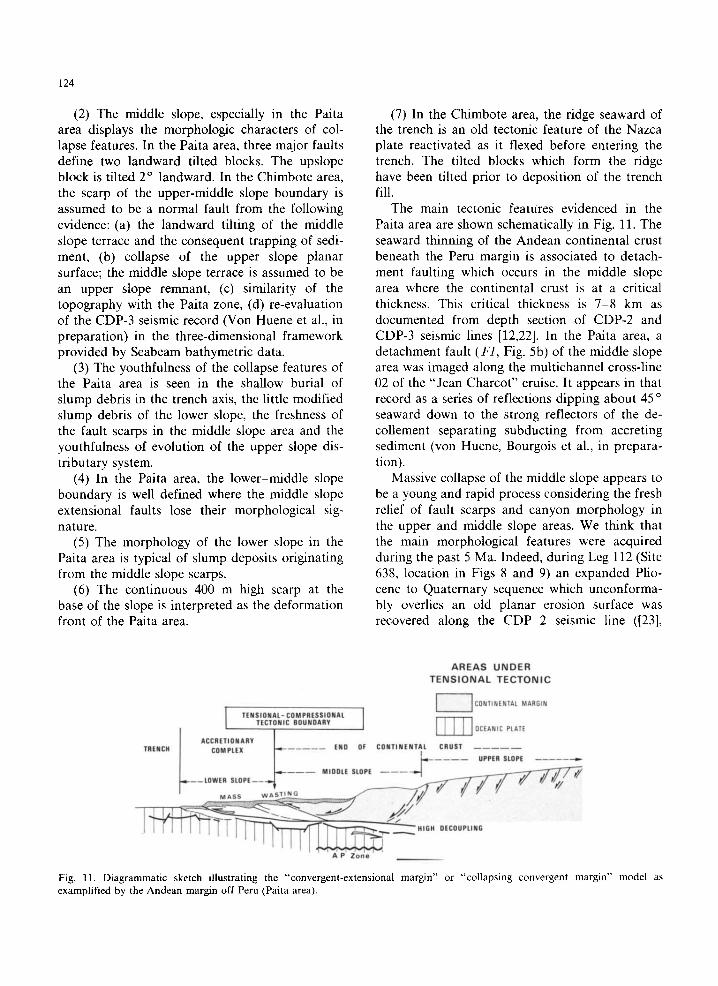
124
(2) The middle slope, especially in the Paita area displays the morphologic characters of col- lapse features. In the Paita area, three major faults define two landward tilted blocks. The upslope block is tilted 2 ° landward. In the Chimbote area, the scarp of the upper-middle slope boundary is assumed to be a normal fault from the following evidence: (a) the landward tilting of the middle slope terrace and the consequent trapping of sedi- ment, (b) collapse of the upper slope planar surface; the middle slope terrace is assumed to be an upper slope remnant, (c) similarity of the topography with the Paita zone, (d) re-evaluation of the CDP-3 seismic record (Von Huene et al., in preparation) in the three-dimensional framework provided by Seabeam bathymetric data.
(3) The youthfulness of the collapse features of the Paita area is seen in the shallow burial of slump debris in the trench axis, the little modified slump debris of the lower slope, the freshness of the fault scarps in the middle slope area and the youthfulness of evolution of the upper slope dis- tributary system.
(4) In the Paita area, the lower-middle slope boundary is well defined where the middle slope extensional faults lose their morphological sig- nature.
(5) The morphology of the lower slope in the Paita area is typical of slump deposits originating from the middle slope scarps.
(6) The continuous 400 m high scarp at the base of the slope is interpreted as the deformation front of the Paita area.
(7) In the Chimbote area, the ridge seaward of the trench is an old tectonic feature of the Nazca plate reactivated as it flexed before entering the trench. The tilted blocks which form the ridge have been tilted prior to deposition of the trench fill.
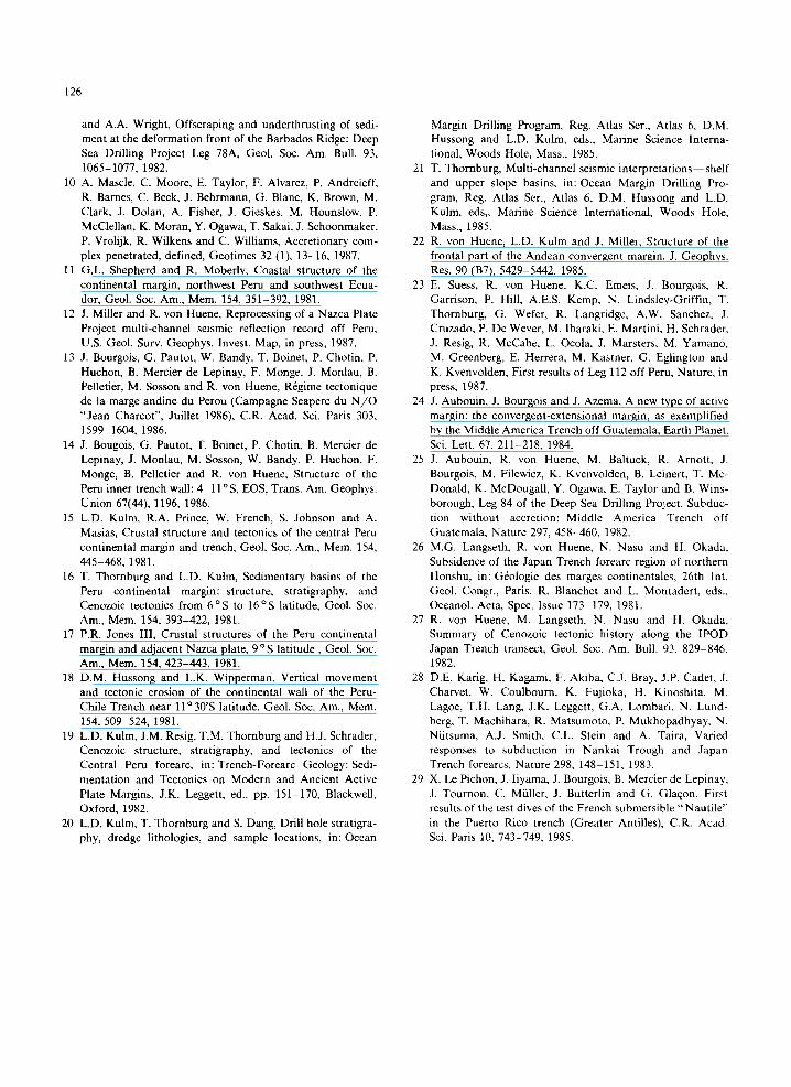
The main tectonic features evidenced in the Paita area are shown schematically in Fig. 11. The seaward thinning of the Andean continental crust beneath the Peru margin is associated to detach- ment faulting which occurs in the middle slope area where the continental crust is at a critical thickness. This critical thickness is 7-8 km as documented from depth section of CDP-2 and CDP-3 seismic lines [12,22]. In the Paita area, a detachment fault (F1, Fig. 5b) of the middle slope area was imaged along the multichannel cross-line 02 of the "Jean Charcot" cruise. It appears in that record as a series of reflections dipping about 45 o seaward down to the strong reflectors of the de- collement separating subducting from accreting sediment (von Huene, Bourgois et al., in prepara- tion).
Massive collapse of the middle slope appears to be a young and rapid process considering the fresh relief of fault scarps and canyon morphology in the upper and middle slope areas. We think that the main morphological features were acquired during the past 5 Ma. Indeed, during Leg 112 (Site 638, location in Figs 8 and 9) an expanded Plio- cene to Quaternary sequence which unconforma- bly overlies an old planar erosion surface was recovered along the CDP 2 seismic line ([23],
AREAS UNDER TENSIONAL TECTONIC
'[ CO NTINENIAL MAR61N
TENSIONAL- COM PRESSIONAL TECTONIC BOUNDARY
OCEANIC PLATE
TRENCH . . . . . END OF CONTINENTAL CRUST
. . . . UPPER SLOPE
----LOWER S L O P E - - - ~
M A S S w A S T I N G - ~ ~
i " " - " ~ HIGH DECOUPLING
I A P Z o n e
Fig. 11. Diagrammatic sketch illustrating the "convergent-extensional margin" or "collapsing convergent margin" model as examplified by the Andean margin off Peru (Paita area).

Bourgois, von Huene et al., in preparation). The old erosion surface is exposed upslope where an older sequence crops out (Fig. 7),
Mass wasting and large-scale slumping obscure the lower slope area. However, overprint of com- pressional tectonics is documented at the toe of the slope in the Paita area and in the lower slope domain of the Chimbote area as well. Multichan- nel seismic lines clearly show that thrust faulting occurs at the base of the continental margin off Peru.
Of particular importance to the understanding of the margin is the location of the tensional-com- pressional tectonic boundary. It occurs at the mid- dle slope-lower slope boundary in the Paita area. Its position is less clear in the Chimbote zone; however, the boundary is seaward of the middle slope terrace, perhaps at the first down- slope bench. These results clarify the questionable zone of Figs. 3 and 7: the continental basement of the South American continent is involved in the collapse structure of the middle slope area. The basement may extend down to the middle slope-lower slope boundary.
The Peruvian margin exhibits a young accre- tionary complex stacked against the front of con- tinental crust (Fig. 11). This model is similar to that [24] based on the results of Leg 84 off Guatemala across the the landward slope of the Middle America Trench where no accretion [25] or little accretion [8] was found. The Peru margin may be considered as a "convergent-extensional margin" [24]. As far as the mechanism of exten- sion is concerned, one might also use the terms of "collapsing convergent margin". First, this model emphasizes a high decoupling along the subduc- tion contact; additional pressure at the base of the tilted blocks during massive collapse of the middle slope area may explain subordinated accretion at the base of the slope. Second, the erosional tectonic process which is mainly located under the middle slope area where additional pressure (Fig. 11) occurs may increase the coupling between the Nazca and South America plates. Third, massive subsidence of the margin occurred, as it was pointed out off Japan [26-28] and off Puerto Rico [291.
125
Acknowledgements
The Seaperc cruise was supported by IFREMER and CNRS-INSU. We thank the Cap- tain and crew of the R/V "Jean Charcot" for their nice work and Lieutenant G. Hasembank, representant of the Peruvian Navy. The help of the French Embassy in Lima was greatly appreci- ated. The authors wish to thank Todd Thornburg, Alan Kemp and Bob Langridge whose discussion and comments on the earlier manuscript greatly helped us to improve this work.
References
1 Y. Aoki, T. Tamano and S. Kato, Detailed structure of the Nankai Trough from migrated seismic sections, Mem. Am. Assoc. Pet. Geol. 34, 309-322, 1982.
2 T.H. Shipley, K.J. McMillen, J.S. Watkins, LC. Moore, H. Sandoval-Ochoa and J.L. Worzel, Continental margin and lower slope structures of the Middle America Trench near Acapulco, Mexico, Mar. Geol. 35, 65-82, 1980.
3 J. McCarthy and D. Scholl, Mechanisms of subduction accretion along the central Aleutian Trench, Geol. Soc. Am. Bull. 96, 691-701, 1985.
4 X. Le Pichon, J.T. Iiyama, H. Chamley, J. Charvet, M. Faure, H. Fujimoto, T. Furuta, Y. Ida¢ H. Kagami, S. Lallemant, J. Leggett, A. Muruta, H. Okada, C. Rangin, V. Renard, A. Taira and H. Tokuyama, Nankai trough and the fossil Shikoku Ridge: results of Box 6 Kaiko survey, Earth Planet. Sci. Lett. 83, 186-198, 1987.
5 K. Nakamura, V. Renard, J. Angelier, J. Azema, J. Bourgois, C. Dephis, K. Fujioka, Y. Hamano, P. Huchon, H. Kinoshita, P. Labaume, Y. Ogawa, T. Seno, A. Takeuchi, M. Tanahashi, A. Uchiyama and J.L. Vigneresse, Oblique and near collision subduction, Sagami and Suruga troughs --preliminary results of French-Japanese 1984 Kaiko cruise, Leg 2, Earth Planet. Sci. Lett. 83, 229-242, 1987.
6 J. Bourgois, J. Azema, P. Beaumgartner, J. Tournon, A. Desmet, and J. Aubouin, The geologic history of the Carib- bean-Cocos plate boundary with special reference to the Nicoya complex (Costa Rica) and DSDP results (Legs 67 and 84 off Guatemala): a synthesis, Tectonophysics 108, 1-32, 1984.
7 R. von Huene, J. Aubouin, R.J. Arnott, M. Baltuck, J. Bourgois, R. Helm, Y. Ogawa, K. Kvenvolden, T. Mc- Donald, E. Taylor, K. McDougall, M. Filewicz, B. Wins- borough, B. Lienert, Leg 84, Init. Rep. Deep Sea Drill. Proj. 84, 967 pp., 1985.
8 G.F. Moore, T.H. Shipley and P.F. Lonsdale, Subduction erosion versus sediment offscrapping at the toe of the Middle America trench off Guatemala, Tectonics 5, 513-523, 1986.
9 J.C. Moore, B. Biju-Duval, J.A. Bergen, G. Blackington, G.E. Claypool, D.S. Cowan, F. Duennebier, R.T. Guerra, C.H.J. Hemleben, D. Hussong, M.S. Marlow, J.H. Natland, C.J. Pudsey, G.W. Renz, M. Tardy, M.E. Willis, D. Wilson
126
and A.A. Wright, Offscraping and underthrusting of sedi- ment at the deformation front of the Barbados Ridge: Deep Sea Drilling Project Leg 78A, Geol. Soc. Am. Bull. 93, 1065-1077, 1982.
10 A. Mascle, C. Moore, E. Taylor, F. Alvarez, P. Andreieff, R. Barnes, C. Beck, J. Behrmann, G. Blanc, K. Brown, M. Clark, J. Dolan, A. Fisher, J. Gieskes, M. Hounslow, P. McClellan, K. Moran, Y. Ogawa, T. Sakai, J. Schoonmaker, P. Vrolijk, R. Wilkens and C. Williams, Accretionary com- plex penetrated, defined, Geotimes 32 (1), 13-16, 1987.
11 G.L. Shepherd and R. Moberly, Coastal structure of the continental margin, northwest Peru and southwest Ecua- dor, Geol. Soc. Am., Mem. 154, 351-392, 1981.
12 J. Miller and R. von Huene, Reprocessing of a Nazca Plate Project multi-channel seismic reflection record off Peru, U.S. Geol. Surv. Geophys. Invest. Map, in press, 1987.
13 J. Bourgois, G. Pautot, W. Bandy, T. Boinet, P. Chotin, P. Huchon, B. Mercier de Lepinay, F. Monge, J. Monlau, B. Pelletier, M. Sosson and R. von Huene, R6gime tectonique de la marge andine du Perou (Campagne Seaperc du N / O "Jean Charcot", Juillet 1986), C.R. Acad. Sci. Paris 303, 1599-1604, 1986.
14 J. Bougois, G. Pautot, T. Boinet, P. Chotin, B. Mercier de Lepinay, J. Monlau, M. Sosson, W. Bandy, P. Huchon, F. Monge, B, Pelletier and R. von Huene, Structure of the Peru inner trench wall: 4-11° S, EOS, Trans. Am. Geophys. Union 67(44), 1196, 1986.
15 L.D. Kulm, R.A. Prince, W. French, S. Johnson and A. Masias, Crustal structure and tectonics of the central Peru continental margin and trench, GeoL Soc. Am., Mem. 15.4, 445-468, 1981.
16 T. Thornburg and L.D. Kulm, Sedimentary basins of the Peru continental margin: structure, stratigraphy, and Cenozoic tectonics from 6°S to 16'~S latitude, Geol. Soc. Am., Mem. 154, 393-422, 1981.
17 P.R. Jones III, Crustal structures of the Peru continental margin and adjacent Nazca plate, 9 °S latitude, Geol. Soc. Am., Mere. 154, 423-443, 1981.
18 D.M. Hussong and L.K. Wipperman, Vertical movement and tectonic erosion of the continental wall of the Peru- Chile Trench near 11 ° 30'S latitude, Geol. Soc. Am., Mem. 154, 509-524, 1981.
19 L.D. Kulm, J.M. Resig, T.M. Thornburg and H.J. Schrader, Cenozoic structure, stratigraphy, and tectonics of the Central Peru forearc, in: Trench-Forearc Geology: Sedi- mentation and Tectonics on Modern and Ancient Active Plate Margins, J.K. Leggett, ed., pp. 151-170, Blackwell, Oxford, 1982.
20 L.D. Kulm, T. Thornburg and S. Dang, Drill hole stratigra- phy, dredge lithologies, and sample locations, in: Ocean
Margin Drilling Program, Reg. Atlas Ser., Atlas 6, D.M. Hussong and L.D. Kulm, eds., Marine Science Interna- tional, Woods Hole, Mass., 1985.
21 T. Thornburg, Multi-channel seismic interpretations--shelf and upper slope basins, in: Ocean Margin Drilling Pro- gram, Reg. Atlas Ser., Atlas 6, D.M. Hussong and L.D. Kulm, eds,. Marine Science International, Woods Hole, Mass., 1985.
22 R. yon Huene, L.D. Kulm and J. Miller, Structure of the frontal part of the Andean convergent margin, J. Geophys. Res. 90 (B7), 5429-5442, 1985.
23 E. Suess, R. von Huene, K.C. Emeis, J. Bourgois, R. Garrison, P. Hill, A.E.S. Kemp, N. Lindsley-Griffin, T. Thornburg, G. Wefer, R. Langridge, A.W. Sanchez, J. Cruzado, P. De Wever, M. Ibaraki, E. Martini, H. Schrader, J. Resig, R. McCabe, L. Ocola, J. Marsters, M. Yamano, M. Greenberg, E. Herrera, M. Kastner, G. Eglington and K. Kvenvolden, First results of Leg 112 off Peru, Nature, in press, 1987.
24 J. Aubouin, J. Bourgois and J. Azema, A new type of active margin: the convergent-extensional margin, as exemplified by the Middle America Trench off Guatemala, Earth Planet. Sci. Lett. 67, 211-218, 1984.
25 J. Aubouin, R. von Huene, M. Baltuck, R. Arnott, J. Bourgois, M. Filewicz, K. Kvenvolden, B. Leinert, T. Mc- Donald, K. McDougall, Y. Ogawa, E. Taylor and B. Wins- borough, Leg 84 of the Deep Sea Drilling Project. Subduc- tion without accretion: Middle America Trench off Guatemala, Nature 297, 458-460, 1982.
26 M,G. Langseth, R. von Huene, N. Nasu and H. Okada, Subsidence of the Japan Trench forearc region of northern Honshu, in: G6ologie des marges continentales, 26th Int. Geol. Congr., Paris, R. Blanchet and L. Montadert, eds., Oceanol. Acta, Spec. Issue 173-179, 1981.
27 R. von Huene, M. Langseth, N. Nasu and H. Okada, Summary of Cenozoic tectonic history along the IPOD Japan Trench transect, Geol. Soc. Am. Bull. 93, 829-846, 1982.
28 D.E. Karig, H. Kagami, F. Akiba, C.J. Bray, J.P. Cadet, J. Charvet, W. Coulhourn, K. Fujioka, H. Kinoshita, M. Lagoe, T.H. Lang, J.K. Leggett, G.A. Lombari, N. Lund- berg, T. Machihara, R. Matsumoto, P. Mukhopadhyay, N. Niitsuma, A.J. Smith, C.L. Stein and A. Taira, Varied responses to subduction in Nankai Trough and Japan Trench forearcs, Nature 298, 148-151, 1983.
29 X. Le Pichon, J. liyama, J. Bourgois, B. Mercier de Lepinay, J. Tournon, C. Miiller, J. Butterlin and G. Gla~on, First results of the test dives of the French submersible "Nautile" in the Puerto Rico trench (Greater Antilles), C.R. Acad. Sci. Paris 10, 743-749, 1985.