Mammalian Neogene biostratigraphy of the Sulaiman Province, Pakistan

Ž .Earth-Science Reviews 57 2002 75–124www.elsevier.comrlocaterearscirev
Neogene stratigraphy and Andean geodynamics ofsouthern Ecuador
Dominik Hungerbuhlera, Michael Steinmannb, Wilfried Winkler c,), Diane Sewardc,¨Arturo Eguezd, Dawn E. Petersone, Urs Helgf, Cliff Hammerg¨
a Nederlandse Aardolie Maatschappij B.V. Business Unit Offshore, P.O. Box 23, 1950 AA Velsen-Noord, The Netherlandsb InÕersiones Republica S.A., Pasaje Los Delfines 159, Piso 8, Urb. Las Gardenias, Santiago de Surco, Lima 33, Peru´
c Geological Institute, ETH-Zurich, Sonneggstrasse 5, CH-8092 Zurich, Switzerland¨ ¨d Instituto Geologico, Escuela Politecnica Nacıonal, Ap. 17-1-2759, Quito, Ecuador´ ´
e California Academy of Sciences, Golden Gate Park, San Francisco, CA, 94114-4599, USAf Institut de Geologie, UniÕersite de Neuchatel, Rue Emile-Argand 11, CH-2007 Neuchatel, Switzerland´ ´ ˆ ˆ
g Ernst BaslerqPartners Ltd., Zollikerstrasse 65, CH-8702 Zollikon, Switzerland
Received 14 July 2000; accepted 11 June 2001
Abstract
The present paper reviews Tertiary volcanic and sedimentary formations in the Inter-Andean region of southern EcuadorŽ X .between 28S and 4820 S in order to develop a geodynamic model of the region. The formations occur in the southernshallow prolongation of the Inter-Andean Valley between the Cordillera Real to the east, and the Cordillera Occidental andAmotape–Tahuın Provinces to the west. One hundred fifty zircon fission-track analyses has established a detailed´chronostratigraphy for the sedimentary and volcanic formations and several small intrusions. The Paleogene to earlyMiocene formations are dominated by intermediate and acidic volcanic and pyroclastic rocks. In addition, relics of Eocenecontinental sedimentary series have been identified.
The Neogene sedimentary series lie unconformably on deformed and eroded metamorphic, sedimentary and volcanicŽ .formations. They were deposited in two stages, which are separated by a major unconformity dated atf10–9 Ma. 1
Ž .During the middle and early late Miocenef15–10 Ma marginal marine deltaic, lagoonal, lacustrine and fluvialenvironments prevailed, which we group under the headingAPacific Coastal sequencesB. They presumably covered a greatersurface area in southern Ecuador than their present occurrence in small topographic depressions. We suggest that they weredeposited in the shallow marine Cuenca and Loja Embayments. Deposition in a marginal marine environment is also
Ž . Ž .supported by the occurrence of brackish water ostracods and other fauna. 2 Above the regional angular unconformity, theŽ .coastal facies are overlain by late Miocenef9–5 Ma continental alluvial fan and fluvial facies which are in turn covered
by mainly airborne volcanic material. They represent theAIntermontane sequencesB of the basins of Cuenca, Giron–Santa´Isabel, Nabon, Loja and Malacatos–Vilcabamba.´
Sedimentologic and stratigraphic results are used to discuss the tectonic setting of Neogene sedimentation in the forearcand arc domain of the Ecuadorian subduction system. During the Pacific Coastal stage, northward displacement of thecoastal forearc block along the Calacali–Pallatanga fault zone has driven crustal collapse in the Inter-Andean region. As a
) Corresponding author. Fax:q41-1-632-1080.Ž .E-mail address: [email protected] W. Winkler .
0012-8252r02r$ - see front matterq 2002 Elsevier Science B.V. All rights reserved.Ž .PII: S0012-8252 01 00071-X

( )D. Hungerbuhler et al.rEarth-Science ReÕiews 57 2002 75–124¨76
result, extensional subsidence drove the eastward ingression of shallow seas into the Cuenca and Loja Embayments from theŽ .Manabı and Progreso Basins to the west. Tectonic inversion in the forearc area during the early late Miocene atf9.5 Ma´
reflects the initiation of W–E oriented compression and uplift in the Inter-Andean region and the establishment of smallerIntermontane stage basins, which host the continental sequences. Coeval topographic rise of the Cordillera Occidental is
Ž .indicated by the onset of clastic input from the west. The small Intermontane Basin of Nabonf8.5–7.9 Ma formed during´the period of maximum compression.
The present data prove that the Neogene Andean forearc and arc area in southern Ecuador was a site of important butvariable tectonic activity, which was presumably driven by the collision and coupling of the Carnegie Ridge with theEcuadorian margin sincef15–9 Ma.q2002 Elsevier Science B.V. All rights reserved.
Keywords: sedimentary facies; volcanics; fission-track chronostratigraphy; Neogene tectonics
1. Introduction
The Ecuadorian Andes are a component of theNorthern Andes segment north of the Huancabamba
Ž .deflection Gansser, 1973 . Repeated accretion ofoceanic and arc elements during Mesozoic andCenozoic times distinguishes them from the CentralAndes south of the Huancabamba deflection, whichdid not experience a history of terrane accretion. Inthe Ecuadorian Andes, early Cretaceous to Recentconvergence between the Pacific oceanic plates andthe South American continental plate has given riseto a series of tectono-stratigraphic units, which were
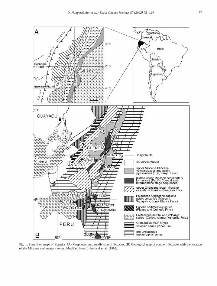
Ž .accreted at successive times Fig. 1A . From east toŽ .west these are: 1 several Palaeozoic to Cretaceous
metamorphic and volcanic terranes of the CordilleraŽReal, which accreted during the early Cretaceous at
f140–120 Ma; Litherland et al., 1994; Spikings et. Ž .al., 2000, 2001 ; 2 the volcanic Pallatanga Terrane,
Žaccreted during Campanian–Maastrichtian Hughes. Ž .and Pilatasig, 1999 ; and 3 the Paleocene–Eocene
volcanic arc Macuchi Terrane and the CretaceousŽ .Pinon Terrane Costa , which accreted during the˜
ŽEocene Eguez et al., 1988; Daly, 1989; Bourgois et¨.al., 1990; Jaillard et al., 1995 . The Macuchi and
Pallatanga Terranes constitute the present CordilleraOccidental and are sutured to the east against olderaccretionary complexes which underlie the Inter-
Ž .Andean Valley Aspden et al. 1995 . The proximalAmazon Foreland Basin to the east of the CordilleraReal is composed of steeply dipping thrust slices and
Žtwo frontal foothill highs Napo and Cutucu an-´.tiforms , which are commonly referred to as the
Ž .Sub-Andean Zone Fig. 1A . Within the Sub-AndeanZone, conspicuous tectonic uplift is evident exposing
Paleozoic to Tertiary basement, cover, and earlyforeland basin formations. A major fault separatesthe Sub-Andean Zone from flat-lying late Creta-ceous–Recent sedimentary rocks of the foreland
Ž .basin, referred to as the Oriente region Fig. 1A .Several middle Miocene to Pliocene clastic sedi-
ment series and volcanic sequences exposed in theŽ .Inter-Andean region Fig. 1B are thought to closely
reflect the younger tectonic history of Neogene arcŽof the southern Ecuadorian Andes e.g. Noblet et al.,
1988; Hungerbuhler et al., 1995; Hungerbuhler, 1997;¨ ¨Marocco et al. 1995; Winkler et al., 1996; Stein-
.mann, 1997; Steinmann et al., 1999; Deniaud, 2000 .These sequences were attributed to the Cuenca,Giron–Santa Isabel, Loja Malacatos–Vilcabamba and´Nabon Basins. The sediment series in the Catamayo´and Gonzanama areas were only recently recognized´
Žto be of Miocene age Hungerbuhler, 1997; Stein-¨.mann et al., 1999 . The middle Miocene sedimentary
formations most likely were laid down over a greatersurface area in southern Ecuador although later stagesŽ .late Miocene–Pliocene of sedimentation were lim-ited to the larger perimeters of the present outcropsof the basins as shown in Fig. 1B. The Miocenebasins occupied an interarc position and formed co-evally with the Progreso, Manabı and Borbon basins´ ´Ž .Baldock, 1982 in the forearc to the west, and theretroarc basin of the present day Sub-Andean zone
Ž .and Oriente to the east Tschopp, 1953 .We present a lithostratigraphic, sedimentologic
and chronostratigraphic compilation spanning fromthe Eocene onward, which has been acquired duringseveral projects since 1991. The presence of numer-ous volcanic formations and pyroclastic intercala-tions in sedimentary formations favoured the dating
( )D. Hungerbuhler et al.rEarth-Science ReÕiews 57 2002 75–124¨ 77
Ž . Ž .Fig. 1. Simplified maps of Ecuador. A Morphotectonic subdivision of Ecuador. B Geological map of southern Ecuador with the locationŽ .of the Miocene sedimentary series. Modified from Litherland et al. 1993 .

( )D. Hungerbuhler et al.rEarth-Science ReÕiews 57 2002 75–124¨78
of sedimentary formations using the zircon fission-Ž .track ZFT method. For methods used in the fission
Ž .track studies, see Hungerbuhler et al. 1995 ,¨Ž . Ž .Hungerbuhler 1997 , Steinmann 1997 and Stein-¨
Ž .mann et al. 1999 . The fission-track ages are com-piled in Appendix A and are shown with their asso-ciated 2s errors in the various figures. We alsopresent data derived from ostracod analyses of mid-
Ž .dle Miocene sediments Peterson et al., 2002 . Fi-nally, the data is integrated into a regional tecto-no-sedimentary model of the southern EcuadorianAndes.
2. Stratigraphy and facies
In this section the characteristics of the volcanicand sedimentary formations are catalogued using acombination of lithology, stratigraphic age and theregion of occurrence. The first time a formation isreferred to, it is underlined, and members are printedin italics, and where lithostratigraphic nomenclaturediffers from previous work, UTM grid references oftype sections and localities are provided. A simpli-fied stratigraphic scheme is presented in Fig. 2 andchronostratigraphic correlations follow Berggren et
Fig. 2. Guide to the stratigraphic terminology applied in the present paper. The hatched box indicates the known chronostratigraphic rangeŽ .of the Saraguro Group Dunkley and Gaibor, 1997a . For other references, see text.

( )D. Hungerbuhler et al.rEarth-Science ReÕiews 57 2002 75–124¨ 79
Ž .al. 1995 . In Appendix A the fission-track ages arecompiled. Note that the samples are listed after theirgeographical occurrence. In case of the presence ofseveral age components in a volcanic sample, theyoungest grain population is taken to represent thetime of formation.
2.1. Volcanic formations and intrusions
The Tertiary Inter-Andean sedimentary series ofsouthern Ecuador are bounded by various volcanic
Ž .formations Fig. 2 , which have been dated in severalŽplaces e.g. Hungerbuhler et al., 1995; Winkler et al.,¨
1996; Steinmann, 1997; Steinmann et al., 1999;.Hungerbuhler, 1997 . ZFT ages from the volcanic¨
rocks partly confirm KrAr ages from various min-Ž .eral phases plagioclase, hornblende, biotite andŽwhole rocks e.g. Kennerley 1973, 1980; Baldock,
1982; Barberi et al., 1988; Lavenu et al. 1992;.Litherland et al., 1993 . The following section pre-
sents the main volcanic formations, although severallocal ones are described in the chapters that discussselected areas.
2.1.1. Paleocene–middle MioceneThe Sacapalca Formation, first described by Ken-
Ž . Ž .nerley 1973 , is up to 2000 m thick Baldock, 1982Žand is exposed in a N–S-trending belt 100 km
.length by 30 km width between the towns of SanŽ .Lucas and Cariamanga Fig. 3 . It is comprised of
andesitic to dacitic tuffs, lava flows and volcanicbreccias, which lie unconformably on Paleozoicmetamorphic rocks of the Cordillera Real and the ElOro Province and on the sedimentary Celica, Alamor,
ŽNaranjo and Casanga Fms. Kennerley, 1973; Jail-. Ž .lard et al., 1996, 1999 Fig. 2 . A dacite yielded a
ŽZFT age of 66.9"5.8 Ma latest Maastrichtian to.earliest Paleocene which suggests a late CampanianŽ .to Maastrichtian ? age for the underlying Casanga
Ž .Fm. Jaillard et al., 1996 and a middle Eocene tolate Oligocene age for the overlying Loma Blanca
Ž .Fm. see below . Several plutons intruding the Saca-palca Fm. have yielded a spread of KrAr agesŽ .hornblende, biotite, whole rock spanning 70"2.0
Žto 21.2"0.6 Ma Kennerley, 1980; Herbert andPichler, 1983; Aspden et al. 1992; Jaillard et al.,
.1996 . We have made additional ZFT ages forŽthe San Lucas Pluton 39.1"3.0 Ma; Steinmann,
. Ž1997 and the El Tingo Pluton 21.2"2.6 Ma;. Ž .Hungerbuhler, 1997 Appendix A . The newly¨
named Rodanejo Pluton yielded a ZFT age of 38.7"Ž . Ž .5.6 Ma Hungerbuhler, 1997 Appendix A . The¨
variations in ages may be partly explained by differ-ent closure temperatures of the mineral phase andvariable post-crystallisation cooling histories.
Ž .The Chinchın Fm. Fig. 2 is exposed over a large´Ž .area between Quingeo and Gualaceo Fig. 4 and
Ž .was named by Steinmann 1997 after the localŽ .village of Chinchın type locality 740000r9681000 .´
It was previously mapped as part of the late MioceneŽ .Tarqui Fm. see below , which unconformably cov-
ers the Chinchın Fm. The Chinchın Fm. is composed´ ´Ž .of a very thick maximum 3500–4000 m succession
Žof basic and intermediate volcanics, lava flows partly.pillowed and minor airfall tuffs. In the upper part of
the formation, aquatic reworking of the volcanics isŽobserved. A single ZFT age of 42.8"3.8 Ma mid-
. Ž . Ždle Eocene was obtained Steinmann, 1997 Ap-.pendix A from an andesite in the upper third of the
Žformation. If the base of the Saraguro Group see.below is of middle Eocene age, the Chinchın Fm.´
may represent an early unit of the Saraguro volcanicevent.
The widespread upper Tertiary volcanic forma-tions were mapped and described by various authorsŽKennerley, 1973, 1980; Baldock, 1982; Litherland
.et al., 1993; Steinmann, 1997; Hungerbuhler, 1997¨without defining a tight stratigraphic termino-logy. Recently, these calc-alkaline volcanics wereredefined in the Cordillera Occidental as the
Ž .Saraguro Group Kennerley, 1973 by Dunkley andŽ . ŽGaibor 1997a,b see also Pratt et al., 1997b; Mc-
. Ž .Court and Duque, 1997 Fig. 2 . According to theseauthors, the group contains a great number of forma-tions and informal units and comprises intermediateand acidic subaeral volcanic rocks of late middleEocene to early Miocene age. The base of the entirevolcanic sequence has not been satisfactory dated
Žand could extend into the middle Eocene J. Aspden,.personal communication, 2001 . These volcanic for-
mations are not the main object of the present paperand we apply a broader stratigraphic nomenclatureby considering the Loma Blanca and Saraguro For-
Ž .mations described below as parts of the SaraguroGroup. The new age data will help in future to refinethe stratigraphy.

( )D. Hungerbuhler et al.rEarth-Science ReÕiews 57 2002 75–124¨80
X X Ž .Fig. 3. Geological map of southern Ecuador between 2854 S to 4825 S. Simplified and modified from Hungerbuhler 1997 .¨

( )D. Hungerbuhler et al.rEarth-Science ReÕiews 57 2002 75–124¨ 81
Ž .Fig. 3 continued .
The up to 2000 m thick Loma Blanca Fm.Ž .Kennerley, 1973, 1980 occurs in two main areas;one between Catamayo and Malacatos, the other N
Ž .and E of Catacocha Fig. 3 . In addition, someŽ .smaller occurrences e.g. south of Loja are at-
tributed to the formation by chronstratigraphic andŽ .lithologic correlations Hungerbuhler, 1997 . The¨
Loma Blanca Fm. consists of intermediate to acidicpyroclastics, i.e. mainly ignimbrites, pumice crystaltuffs and volcanic breccias. Dykes and sills indicat-ing the proximity of the main eruptive center fre-quently intrude them. Several local occurrences ofaquatically reworked intervals are observed; the
Ž . Žthicker 100 m Solanda Mb. type locality.686260r9537030 in the area of the Rıo Solanda´
Ž .was so named by Hungerbuhler 1997 . The Solanda¨Mb. is characterized by metamorphic pebble-bearingconglomerates, red and green sandstones and shalesdeposited by mixed-load rivers, and minor tuff inter-
calations. Quartz porphyries west of the Rıo Solanda´Ž .were described by Kennerley 1973 and are as-
signed to thePurunuma Quartz Porphyry Mb. Theage of the Loma Blanca Fm. was constrained by11 ZFT measurements on ignimbrites and tuffsŽ .Hungerbuhler, 1997; Appendix A . In the area of¨Malacatos–Vilcabamba four samples yielded a large
Ž .spread of ages 40.6"5.4–26.6"4.0 Ma . A smalloutcrop south of Loja yielded an age of 36.2"6.8Ma and two samples collected above the Rıo Playas´Fm. yielded 42.2"3.4 and 31.1"2.8 Ma. A vol-canic plug located NW of the town of CatamayoŽ .Fig. 3 gave a ZFT age of 25.2"3.2 Ma, and anignimbrite NW of Santa Rita yielded a similar age of29.0"2.8 Ma. Finally, a tuff in the Solanda Mb.yielded a ZFT age of 36.5"4.4 Ma, and the Pu-runuma Quartz Porphyry Mb. in the area of theLoma Riodopamba gave an age of 30.3"2.4 Ma.The Loma Blanca Fm. was often confused with the

( )D. Hungerbuhler et al.rEarth-Science ReÕiews 57 2002 75–124¨82
Ž .Fig. 4. Geological map of the Cuenca area between Tambo and Cumbe. From Steinmann 1997 .

( )D. Hungerbuhler et al.rEarth-Science ReÕiews 57 2002 75–124¨ 83
younger Saraguro Fm., but despite of lithologic simi-larities, they were clearly eruptedrdeposited at dif-ferent times and in different geographical regions.
Ž .The Saraguro Fm., as defined by Kennerley 1980Ž .and mapped by Baldock 1982 , is the volcanic
formation of greatest areal extent in southern EcuadorŽ .Fig. 1 . Its exposure spans a distance of 220 kmfrom the town of Riobamba in the north toSaragurorOna in the south, and it crosses from the˜Cordillera Occidental in the west to the CordilleraReal in the east. The 500–2000-m-thick SaraguroFm. unconformably overlies a series of older forma-
Ž .tions: 1 the Yunguilla, Chinchın and Quingeo Fms.´Ž .in the Cuenca area; 2 the metamorphic Jurassic–
early Cretaceous Alao–Paute Terrane and the Trias-sic Tres Lagunas Granite of the Cordillera Real;
Ž .and 3 Cretaceous to Paleogene volcanics of theŽCordillera Occidental Macuchi, Pallatanga, Saca-
. Ž .palca and Celica Fms. Figs. 2–4 . Several ambigui-ties existed concerning stratigraphic and regionalcorrelations. However, mapping and geochrono-logical results show that the distinction betweenAPisayambo volcanicsB and the Chinchillo Fm.Ž .Litherland et al., 1993 is not necessary becauselithologies and ages of these volcanic rocks integratewell into the Saraguro Fm. as defined by KennerleyŽ . Ž .1980 see also Pratt et al., 1997a . Similarly, theinterpretation that the Saraguro Fm. is younger thanthe middle Miocene Burrohuyacu Fm. in the Santa
Ž .Isabel–Giron area see below was misleading and´was based on the assumption that these volcanicsstratigraphically overlie the Miocene sedimentsŽ .Baudino et al., 1994 . However, vertical stacking isnow interpreted to be a result of northwestward-di-rected thrust faulting superposing the older volcanics
Žof the Saraguro Fm. onto the Burrohuyacu Fm. Fig.3, Hungerbuhler, 1997; Pratt et al., 1997b; Hammer,¨
.1998 .Variable deposition of the volcanic material over
the pre-existing topography resulted in the thicknessof the Saraguro Fm. varying between 500 and 2000m. The Saraguro Fm. consists of intermediate toacidic pyroclastics. In the lower part, andesitic todacitic tuffs and lava flows prevail. The upper
Ž .Saraguro Fm. Fig. 3 contains predominantly rhy-olitic ignimbrite horizons of great areal extent, whichshow typical columnar cooling features and occa-sionally pumice fiamme-welding textures. Coarse
co-ignimbrite breccias and sub-volcanic rocks reflectthe near proximity of the eruption centers. Interca-lated fluvial and lacustrine sediments are frequentand record periods of aquatic reworking between
Ž .eruptive stages. Steinmann 1997 proposes that thesevoluminous ignimbrite flows were supplied by fis-sure eruptions and caldera-forming processes, whichformed in an extensional tectonic setting.
Many ZFT ages have been acquired from theSaraguro Fm. From the Nabon area four age determi-´nations range between 26.4"4.5 and 19.0"3.5 MaŽ .Hungerbuhler et al. 1995 . Fourteen samples from¨the Cuenca region range between 29.4"2.6 and
Ž .20.5"2.0 Ma Steinmann, 1997 , and six samplesbetween Santa Isabel and Ona yield ZFT ages be-˜
Žtween 26.4"2.6 and 19.1"1.4 Ma Hungerbuhler,¨.1997 . These ages correlate with a late Oligocene to
early Miocene age for the Saraguro Fm. and corrobo-Žrate with several KrAr ages biotite, plagioclase,
. Ž .and whole rock reported by Kennerley 1980 , Bar-Ž . Ž .beri et al. 1988 and Rivera et al. 1992 . Lavenu et
Ž .al. 1992 reported two KrAr ages in the range off35 Ma. However, there are doubts about theirsample locations and the samples may belong to theHuigra Tandapi unit or the El Descanso Andesite
Ž .intrusion Figs. 11 and 13; Eguez et al., 1988 .¨To resolve the complicated stratigraphic and sedi-
mentary relationships in the Giron–Santa Isabel area,´Ž . Ž .Hungerbuhler 1997 and Helg 1997 introduced the¨
Žnew term Santa Isabel Fm. type locality 689714r.9631727 . The largest continuous outcrops occur
Ž .between the towns of Santa Isabel and Giron Fig. 3´in a north–south-trending belt, parallel to the middleMiocene sedimentary series of the Giron–Santa Is-´abel area to the east. This volcanic succession was
Žpreviously assigned to the Saraguro Fm. Baudino et. Žal., 1994 , the Tarqui Fm. Randel and Lozada,
. Ž1974 and theAPisayambo volcanicsB Litherland et.al., 1993 . However, in our present interpretation, the
Santa Isabel Fm. is identical to the Santa IsabelŽ .Andesite Fm. of Pratt et al. 1997a,b . The formation
unconformably overlies the Saraguro and Jacapa Fms.and is partly unconformably overlain by the Burro-huaycu Fm. and partly contemporaneous with the
Ž .Burrohuaycu Fm. see also below and Fig. 9 . TheSanta Isabel Fm. is composed of intermediate lavaflows, volcanic breccias and minor tuff beds anddisplays highly variable thicknesses of 500–1500 m

( )D. Hungerbuhler et al.rEarth-Science ReÕiews 57 2002 75–124¨84
due to volcanic infilling of pre-existing topography.Six ZFT ages yielded ages between 18.8"2.2 and
Ž . Ž .8.0"2.2 Ma Hungerbuhler, 1997 Appendix A .¨
2.1.2. Late MioceneThe Tarqui Fm. is the most widespread late
Miocene volcanic series in southern Ecuador. In ourŽ .stratigraphic scheme Fig. 2 , it also includes several
local volcanic deposits that, because of similar ageand characteristic lithological features, can be classed
Žas members of the Tarqui Fm. e.g. Tarqui, Llacaoand Tambo Viejo Members of Steinmann, 1997 and
.Hungerbuhler, 1997 . With the exception of the local¨Ž .Salapa Fm. described below , Pliocene volcanics are
generally not observed in southern Ecuador.The intermediate to acidic pyroclastics of the
Ž .Tarqui Fm. Bristow, 1973 cover large areas inŽ .southern Ecuador Figs. 1, 3 and 4 ; its exposed
volcanic ashes are often altered to dark red andpurple kaolinitic clays. The Tarqui Fm. uncon-formably overlies a wide range of Tertiary sedimen-
Žtary and volcanic formations e.g. the SaraguroGroup, the late Miocene Nabon Group, middle to´late Miocene formations in the Cuenca region, see
.below . The formation hosts a large variety oflithologies including rhyolitic to andesitic volcanicbreccias, ashflow tuffs, pyroclastic flows, ign-
Ž .imbrites and many airborne tuffs Baldock, 1982 .Ž .Steinmann 1997 distinguished two members in the
Ž . Ž . ŽCuenca area Fig. 4 : 1 theTarqui Mb. type.locality 718800r9667000 , which consists entirely
of poorly consolidated and deeply weathered redvolcanic airfall deposits off300 m thickness. Eightsamples revealed ZFT ages between 6.8"0.8 and
Ž . Ž .5.5"0.6 Ma Appendix A; Steinmann, 1997 . 2the Llacao Mb. forms the entire plateau of Loma
Ž .Cochamama 730000r9687800, Fig. 4 SW ofAzogues, where it overlies the Mangan Fm. with a´
Ž .pronounced angular unconformity 608 . The LlacaoMb. mainly represents deposits of a volcaniclasticalluvial fan with channel fill and overbank sedi-ments, as well as debris flows derived from a west-ern source. Intercalated airfall deposits are rare. AZFT age of 5.1"0.6 Ma from the young part of the
ŽLlacao Mb. was obtained Steinmann, 1997; Ap-.pendix A . The Tambo Viejo Mb. in the Nabon area´
Ž .Tambo Viejo Fm. in Hungerbuhler et al., 1995 also¨
mainly consists of red airborne volcanics and gave aŽ .ZFT age of 6.3"1.0 Ma Hungerbuhler et al., 1995 .¨
Several late Miocene intrusions are present in theŽ .Cuenca area: 1 The light grey dioritic Cojitambo
intrusion forms the prominent peak of CojitamboŽ .SW of Azogues Fig. 4 . Radial columnar cooling
structures suggest that the intrusion penetrated thesediments at shallow depth. The intrusion cuts thetectonically deformed, middle to late Miocene sedi-
Žmentary series of the Cuenca area Steinmann et al.,.1999 . Two ZFT ages of 5.4"0.6 and 7.8"0.8 Ma
Žhave been obtained from the intrusion Appendix A;.Steinmann, 1997 . The latter age is in good accor-
Ždance with an ArrAr age of 7.5"0.44 Ma singlecrystal plagioclase, Madden, personal communica-
.tion, 1996 . The younger 5.4"0.6 Ma fission-trackage, obtained from a large dacite block displaying
Žflow structures located SW of Cojitambo 737503r.9691772 , may suggest a later extrusive phase. Sev-
Ž .eral KrAr ages plagioclase, whole rock reportedby previous authors range from 7.1"0.3 and 6.3"
Ž0.2 to 5.2"0.2 Ma Olade, 1980; Barberi et al.,. Ž .1988; Lavenu et al., 1992 . 2 Several intrusions
have been observed south of Quingeo, in the regionof the Loma Chimborazo and Loma Gualashi. Theintrusion near the Loma Gualashi yielded a ZFT age
Ž .of 7.6"1.0 Ma Appendix A; Steinmann, 1997 ,suggesting that intrusion was coeval with the Cojita-mbo event.
2.2. Sedimentary formations
2.2.1. Rıo Playas and Quingeo formations´Several earlier workers assigned these formations
Žto the Miocene Kennerley, 1980; Noblet et al.,.1988; Marocco et al., 1995 . However, new chronos-
tratigraphic data suggest that they represent relics ofolder and more widespread sedimentary successions,which may provide clues to the Paleogene history ofthe Ecuadorian Andean chain.
Ž .The Rıo Playas Fm. Kennerley et al., 1973 oc-´curs in a relatively small, 15 km long by 6 km wide,depression between the villages of Casanga and San
Ž .Antonio Hungerbuhler, 1997; Fig. 3 . In the north¨the thickness reaches 500 m and it pinches out to afew tens of meters in the south. The present defini-tion of the formation follows the suggestion of Jail-
Ž .lard et al. 1996 , who restricted the formation to the

( )D. Hungerbuhler et al.rEarth-Science ReÕiews 57 2002 75–124¨ 85
yellow coloured conglomerates, sandstones andshales. It is characterized by coarse, poorly sortedconglomerates and cross-bedded yellow sandstonesand shales, which were deposited in a bed-loaddominated fluvial system. The detritus was derivedfrom local sources such as the underlying and bor-
Ž .dering formations Fig. 3 .The Rıo Playas Fm. overlies the upper Cretaceous´
to Paleocene Casanga, Naranjo and Sacapalca Fms.with an angular unconformity and is partly uncon-formably overlain by the middle Eocene to lower
ŽOligocene Loma Blanca Fm. Fig. 5; Hungerbuhler,¨.1997 . The stratigraphic relationships suggest an early
andror middle Eocene age for the Rio Playas Fm.Ž .Figs. 2 and 5, Appendix A .
The Quingeo Fm. is exposed in two NNE–SSW-trending stripes, one to the east of Cuenca fromQuingeo northwards and the other approximately 20
Ž . Ž .km east of Canar Fig. 4 . Noblet et al. 1988 and˜Ž .Marocco et al. 1995 mistakenly assigned these
outcrops as equivalents of the Biblian Fm., which is´a middle Miocene formation exposed in the Cuenca
Ž .region see below . The Quingeo Fm. is overthrustedŽ .along the Santa Ana–Tahual Fault Fig. 4 by the
Ž .Maastrichtian Hughes et al. 1997 Yunguilla Fm. atits western border, and is also covered by late
Ž .Miocene airborn volcanics Tarqui Fm. . SteinmannŽ .1997 named the new formation after village ofQuingeo and its type locality is at the road along
Žthe Rıo Quingeo 730000r9666800 to 728000r´.9668000 . The outcropping Quingeo Fm. isf1200
m thick and is certainly only a relic of a much largerbasin setting. The formation unconformably overlies
Ž .partly the Yunguilla Fm. Figs. 4 and 6 and thethick volcanic Chinchın Fm. However, the latter can´only be implied from poor quality outcrops. TheQuingeo Fm. displays a succession of 10–30 mthick, repeated fining-upward cycles containingpoorly sorted, channelized conglomerates at the base,and sandstones and red and purple siltstones at the
Ž .top Fig. 6 . Deposition occurred in a low-sinuousity,Ž .mixed-load fluvial system Steinmann, 1997 . Flow
direction measurements imply that the material wasderived from the east, which is also suggested by thepresence of metamorphic and quartz vein pebblesfrom the early Cordillera Real, as well as pebblesfrom the Yunguilla Fm. Nine ZFT ages on tephrarange between 42.2"4.4 and 34.9"4.0 Ma, which
place the Quingeo Fm. in the middle to late EoceneŽ .Fig. 2, Appendix A .
A small outcrop of sediments in the CordilleraOccidental in the lake district west of Cuenca and
Ž .north of Laguna Luspa 696981r9693135 alsoyielded a late Eocene ZFT ash age of 37.1"3.8 MaŽ .Appendix A; Steinmann, 1997 . The lithology andage of the sediments suggested that they are part of
Ž .the Quingeo Fm. Steinmann, 1997 . However, newŽ .mapping Dunkley and Gaibor, 1997b correlates this
Žoutcrop with the volcanic Chulo unit which also.comprises sedimentary intervals of the Saraguro
Group. It appears that the present dating provides another late Eocene age for the lower part of theSaraguro Group.
2.2.2. Catamayo–Gonzanama area´With the exception of regional studies by Sauer
Ž . Ž . Ž .1965 , Sigal 1969 and Kennerley 1973, 1980 ,southern Ecuador has received little geological atten-
Ž .tion. Previous interpretations Kennerley, 1980 as-sumed a Paleocene age for the Gonzanama Fm.,´because it is bounded both at the top and bottom bythe Paleocene Sacapalca Fm. However, regional
Ž .mapping by Hungerbuhler 1997 shows that the¨lower contact with the Gonzanama Fm. is uncon-´formable on the Sacapalca Fm. The Sacapalca Fm.occurs again at the top of the Gonzanama Fm. as a´
Ž .thrust sheet Fig. 3 .The Gonzanama Fm. occurs in discontinuous out-´
crops between the towns of Gonzanama, Nambacola´Ž .and Santa Rita Fig. 3 and overlies the Paleocene to
Oligocene volcanic Sacapalca and Loma Blanca Fms.with an angular unconformity. Dominant lithologiesinclude evenly bedded calcareous sandstones, sandy
Ž .siltstones and minor conglomerates Fig. 5 , and thethickness of the formation varies between 500 and1000 m. Gypsum veins and sulfur impregnations areabundant. The sandstones show regionally varying
Ž .thicknesses 10–50 cm and thick beds in the west-ern outcrops have scoured soles, trough cross-bed-ding and wave ripple laminations. The conglomer-ates are rich in volcanic clasts. Thin beds of oolithiccalcarenites are intercalated in the series close to thetown of Santa Rita. These, and other calcareoussandstones, yielded a rich fauna of ostracods, bi-valves and gastropods, and the following ostracods

( )D. Hungerbuhler et al.rEarth-Science ReÕiews 57 2002 75–124¨86
Fig. 5. Composite stratigraphic sections of the middle Miocene series in the Catamayo–Gonzanama area, and the Eocene Rıo Playas series´ ´Ž . Ž .at Casanga. From Hungerbuhler 1997 . Cretaceous stratigraphy after Jaillard et al. 1996, 1999 . The Tangulla granite intrusion is possibly¨
Ž .of middle Eocene age E. Jaillard, personal communication, 2001 .

( )D. Hungerbuhler et al.rEarth-Science ReÕiews 57 2002 75–124¨ 87
Ž . Ž .Fig. 6. Composite stratigraphic sections with ZFT ages 2s errors of the Quingeo Formation in the Cuenca area. From Steinmann 1997 .
Ž .have been identified Peterson et al., 2002 : thebrackish water speciesCyprideis gonzanamensis andVetustocytheridea splendens, and several freshwaterspecies consisting ofHeterocypris sp., Bradley-strandesia serena, Potamocypris santaritaensis, andother Cypridid species. Three acidic tephra in thelower and middle part of the formation gave ZFTages of 15.7"2.0, 14.4"1.8 and 14.0"3.0 MaŽ .Fig. 5, Appendix A; Hungerbuhler, 1997 correlat-¨ing with the middle Miocene. Sedimentary facies andfaunal data suggest the formation was deposited in amarginal marine setting with brackish lagoonal andlacustrine environments in the NW and distal fluvial
Ž .environments in the SW Hungerbuhler 1997 .¨Ž .Jaillard et al. 1996 provide a detailed description
of the f400-m-thick Catamayo Fm. in the Cata-mayo area. The lower part predominantly consists ofshales, minor sandstones and limestones, with abun-dant gypsum veins. The middle part is rich in coarse
sandstones and conglomerates and the upper part isonce again dominated by shales, with minor sand-stone and limestone intercalations. Volcanic clastsprevail in the lower and middle sequences, while inthe upper, metamorphic rock fragments are wide-spread. South of Catamayo village, the CatamayoFm. rests unconformably on the Sacapalca Fm. andthe sediments are overthrusted by the volcanic Loma
Ž .Blanca Fm. Fig. 3 . We were not able to providechronostratigraphic ages of the formation and poorquality outcrops render it difficult to provide directcorrelation with the Gonzanama Fm. to the south.´However, the facies interpretations of Jaillard et al.Ž .1996 , suggesting coastal flood and sabkha plainŽ . Ž .lower part , fluvial middle part and coastal plain
Ž .environments with marine incursions upper partcompare closely with the depositional environmentsfound in the Gonzanama Fm. and in the other middle´Miocene series of southern Ecuador.

( )D. Hungerbuhler et al.rEarth-Science ReÕiews 57 2002 75–124¨88
2.2.3. Malacatos–Vilcabamba areaThe sedimentary series in this region partly over-
Žlie Paleozoic meta-sedimentary rocks Chiguinda
.unit; Litherland et al., 1994 of the western border ofthe Cordillera Real and the lower Oligocene vol-
Ž .canics of the Loma Blanca Fm. Figs. 3 and 7 . We
Fig. 7. Composite stratigraphic sections of the middle to late Miocene formations in the Malacatos–Vilcabamba area. From Hungerbuhler¨Ž .1997 .
( )D. Hungerbuhler et al.rEarth-Science ReÕiews 57 2002 75–124¨ 89
distinguish three tectono-stratigraphic domains lo-cated in the south, the northwest and center, and the
Ž . Ž .northeast La Granja block Fig. 7 . The latter isseparated from the remainder of the basin by a west
Ž .verging reverse fault Hungerbuhler, 1997 . We have¨applied a modified version of the stratigraphic
Ž .nomenclature of Kennerley 1973 , in which theformation names used here are different from theLoja area.
The Quinara Fm. is mainly exposed in the south-ern domain and was introduced by Hungerbuhler¨Ž . Ž .1997; type locality 694650r9523780 Fig. 7 . It isdominated by white or grey acidic vitric tuffs, ign-
Ž .imbrites and a few lithic metamorphic grain tuffsand volcanic breccias and has a maximum thicknessof 300 m. The Quinara Fm. unconformably lies onPaleozoic metamorphic units and is both uncon-formably and conformably overlain by the CerroMandango Fm. The pyroclastic lithologies of theQuinara Fm. were previously correlated with the
Ž .Loma Blanca Fm. Kennerley and Almeida, 1975a .ŽHowever, three ZFT age measurements Hunger-
.buhler, 1997 of 15.1"1.6, 14.9"1.6 and 14.2"¨Ž .3.4 Ma Appendix A place the formation in the
early middle Miocene. The Quinara Fm. has nocorrelative volcanic formation in the region and it isassumed to represent the remnants of a local vol-canic event.
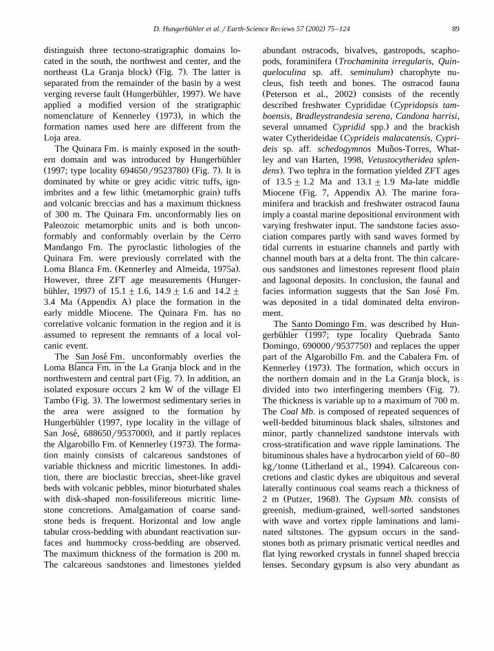
The San Jose Fm. unconformably overlies the´Loma Blanca Fm. in the La Granja block and in the
Ž .northwestern and central part Fig. 7 . In addition, anisolated exposure occurs 2 km W of the village El
Ž .Tambo Fig. 3 . The lowermost sedimentary series inthe area were assigned to the formation by
ŽHungerbuhler 1997, type locality in the village of¨.San Jose, 688650r9537000 , and it partly replaces´
Ž .the Algarobillo Fm. of Kennerley 1973 . The forma-tion mainly consists of calcareous sandstones ofvariable thickness and micritic limestones. In addi-tion, there are bioclastic breccias, sheet-like gravelbeds with volcanic pebbles, minor bioturbated shaleswith disk-shaped non-fossilifereous micritic lime-stone concretions. Amalgamation of coarse sand-stone beds is frequent. Horizontal and low angletabular cross-bedding with abundant reactivation sur-faces and hummocky cross-bedding are observed.The maximum thickness of the formation is 200 m.The calcareous sandstones and limestones yielded
abundant ostracods, bivalves, gastropods, scapho-Žpods, foraminifera Trochaminita irregularis, Quin-
.queloculina sp. aff. seminulum charophyte nu-cleus, fish teeth and bones. The ostracod faunaŽ .Peterson et al., 2002 consists of the recently
Ždescribed freshwater CyprididaeCypridopsis tam-boensis, Bradleystrandesia serena, Candona harrisi,
.several unnamedCypridid spp. and the brackishŽwater CytherideidaeCyprideis malacatensis, Cypri-
deis sp. aff. schedogymnos Munos-Torres, What-˜ley and van Harten, 1998,Vetustocytheridea splen-
.dens . Two tephra in the formation yielded ZFT agesof 13.5"1.2 Ma and 13.1"1.9 Ma-late middle
Ž .Miocene Fig. 7, Appendix A . The marine fora-minifera and brackish and freshwater ostracod faunaimply a coastal marine depositional environment withvarying freshwater input. The sandstone facies asso-ciation compares partly with sand waves formed bytidal currents in estuarine channels and partly withchannel mouth bars at a delta front. The thin calcare-ous sandstones and limestones represent flood plainand lagoonal deposits. In conclusion, the faunal andfacies information suggests that the San Jose Fm.´was deposited in a tidal dominated delta environ-ment.
The Santo Domingo Fm. was described by Hun-Žgerbuhler 1997; type locality Quebrada Santo¨
.Domingo, 690000r9537750 and replaces the upperpart of the Algarobillo Fm. and the Cabalera Fm. of
Ž .Kennerley 1973 . The formation, which occurs inthe northern domain and in the La Granja block, is
Ž .divided into two interfingering members Fig. 7 .The thickness is variable up to a maximum of 700 m.The Coal Mb. is composed of repeated sequences ofwell-bedded bituminous black shales, siltstones andminor, partly channelized sandstone intervals withcross-stratification and wave ripple laminations. Thebituminous shales have a hydrocarbon yield of 60–80
Ž .kgrtonne Litherland et al., 1994 . Calcareous con-cretions and clastic dykes are ubiquitous and severallaterally continuous coal seams reach a thickness of
Ž .2 m Putzer, 1968 . TheGypsum Mb. consists ofgreenish, medium-grained, well-sorted sandstoneswith wave and vortex ripple laminations and lami-nated siltstones. The gypsum occurs in the sand-stones both as primary prismatic vertical needles andflat lying reworked crystals in funnel shaped breccialenses. Secondary gypsum is also very abundant as

( )D. Hungerbuhler et al.rEarth-Science ReÕiews 57 2002 75–124¨90
up to 20 cm thick. The gypsum is concentrated alsoin large-scale fold saddle structures, where it iscurrently mined near La Merced and in the QuebradaSanto Domingo. Moderately and poorly preserved
Žgastropods similar to theDyris species in the Loja. Žarea , shrimps similar toPenaeus maddeni in the
.Loyola Fm. in the Cuenca area , ostracods and fishteeth were found, all of which could not be deter-mined in more detail. Six tephra yielded ZFT ages,ranging between 14.6"1.8 Ma and 12.0"1.2 MaŽ .Fig. 7, Appendix A . The older ages overlap withthe ages obtained in the San Jose Fm. confirming an´interfingering of the two formations, as is also sug-gested from field mapping. The facies and mineral-ogy of the Santo Domingo Fm. imply a coastaldeltaic depositional setting with predominant tidalflat and backswamp environments, similar to the SanJose Fm. This is also corroborated by the occurrence´of primary gypsum and coal seams in N–S trendingexposures parallel to the reconstructed shorelineŽ .Hungerbuhler, 1997 . The high sulfur content of the¨
Ž .coals Putzer, 1968 is suggestive of formation in aŽcoastal environment, such as saline marshes Styan
.and Bustin, 1984 . Furthermore, the alternation ofŽgypsum and coal bearing intervals containing fossil
leaves indicating a low altitude tropical climate; e.g..Berry, 1945 suggests that deposition occurred under
varying dry and humid conditions along the edge ofŽ .a coastal plain Hungerbuhler, 1997 .¨
The main outcrops of the Cerro Mandango Fm.Ž .Kennerley, 1973 occur within a SSE–NNW ori-ented syncline between Vilcabamba and MalacatosŽsouthern and central tectono-stratigraphic domain,
.where it is up to 1000 m thick , and in the La GranjaŽ .block Figs. 3 and 7 . It overlies the Santo Domingo
Fm., and older metamorphic rocks with angular un-conformities and rests partly conformable on theQuinara Fm. The observed succession of a lowerSandstone Mb. and an upper Conglomerate Mb.Ž .Hungerbuhler, 1997 reflects the general coarsen-¨
Ž .ing-upward trend of the formation Fig. 7 . Theupper member is thickest in the southern part of thebasin where spectacular internal progressive uncon-
Ž .formities are present Hungerbuhler, 1997 . The¨Sandstone Mb. consists of cross- and tabular-bedded,medium- and coarse-grained sandstones, sheet-likegravel beds with metamorphic pebbles, and minorsiltstones. The Sandstone Mb. grades up into the
Conglomerate Mb., which is characterized by broadlyŽ .channelized, clast metamorphics supported con-
glomerates, coarse sandstones displaying sheetflowfeatures and a few siltstones. In places, white crystal
Ž .and lithic metamorphic clasts tuffs, tuffaceoussandstones and pumice breccias are intercalated pro-viding suitable zircon bearing marker beds for ZFTanalysis. Eight samples in the formation yielded ages
Žranging between 11.4"1.6 and 7.7"0.8 Ma Fig..7, Appendix A . The transition from the Sandstone
Mb. to the Conglomerate Mb. occurred atf10 Maand the progressive unconformites in the Conglomer-
Ž .ate Mb. are dated atf8 Ma Fig. 7 . The faciessuccession depicts the transition from a bed-loaddominated sandy fluvial system to an alluvial fansystem, which prograded from the south to the north.The source of the reworked material was exclusivelysituated in metamorphic rocks of the Cordillera RealŽ .Hungerbuhler, 1997 .¨
2.2.4. Loja areaA stratigraphic scheme for the Loja area was
Ž .initially established by Kennerley 1973 . Later, anomenclature that was consistent with the Mala-
Žcatos–Vilcabamba area was applied Kennerley and. Ž .Almeida, 1975a,b . However, Hungerbuhler 1997¨
showed that the lithofacies developed differently inthe two areas and different ages are obtained fromsimilar facies. Therefore, we chose to mainly follow
Ž .the stratigraphic nomenclature of Alvarado 1967 ,Ž .and partly that of Kennerley 1973 in the Loja area.
In addition, the sedimentary series in the Loja areaare tectonically divided by a majorfW vergingpost-depositional reverse fault into western and east-ern parts, juxtaposing different sediment sequences
Ž .at their mutual boundary Figs. 3 and 8 . The sedi-ment series lie unconformably on older metamorphic
Žrocks Chiguinda and Agoyan units; Litherland et al.,´.1994 on both sides of the reverse fault. First the
Žwestern, then the eastern part will be described Fig..8 .
The Trigal Fm. consists of coarse sandstones, fineconglomeratic sheet layers and minor siltstones,which were deposited in bed-load dominated fluvialsystems and by sheet floods. In contrast to the otherformations in the Loja area, which contain abundantmetamorphic clasts, the Trigal Fm. mainly carries

( )D. Hungerbuhler et al.rEarth-Science ReÕiews 57 2002 75–124¨ 91
Ž .Fig. 8. Composite stratigraphic sections of the middle to late Miocene formations in the Loja area. From Hungerbuhler 1997 .¨

( )D. Hungerbuhler et al.rEarth-Science ReÕiews 57 2002 75–124¨92
volcanic clasts. The formation reaches a thickness off150 m but could not be directly dated. However,the conformably overlying La Banda Fm. yielded a
Ž .ZFT age of 11.1"1.2 Ma Hungerbuhler, 1997 ,¨suggesting that the Trigal Fm. is most likely a mid-dle Miocene sequence. The La Banda Fm. has amaximum thickness of only 10–20 m, but it is very
Ž .distinct and laterally continuous Fig. 8 . It consistsŽ . Ž .of: 1 thick-bedded white limestones; 2 rhythmic
thin-bedded, finely laminated limestones and marlyŽ . Ž .shales; 3 thin chert beds; 4 intraformational lime-
Ž .stone breccias; and 5 fine-grained yellow sand-stones. Secondary gypsum is ubiquitous in fracturesand seams and the presence of primary gypsum canbe inferred from the occurrence of pseudomorphiccalcite. Sheet-like algal mat laminations, dessicationcracks, wrinkle marks and bioturbations are ob-served. An abundant ostracod fauna was determinedŽ .Peterson et al., 2002 and includes the brackishwater Cyprideis lojaensis and Cyprideis malaca-tensis, the freshwaterLymnocythere sp. and Brad-leystrandesia serena, and an unspecifiedCyprididsp. In addition, the foraminiferaTrochaminita irreg-ularis and Discorbis sp. were found. The sedimen-tary facies association and biogenic content showscharacteristic features of a lagoonal environment withsupra- to intertidal deposits where repeated dryingcycles occurred. The increasing frequency of sand-stone layers marks the upward transition from the La
Ž .Banda Fm. into the Belen Fm. Fig. 8 . The 300-m-´thick Belen Fm. is characterized by coarse channel´sandstones and conglomeratic lag deposits, whichalternate with well-bedded finer, large-scale cross-bedded sandstones and minor shale beds. Metre-scalethick slumps are observed in the lower part of theformation. The observed facies variation is inter-
Žpreted to indicate a transition from a lagoonal La.Banda Fm. to a deltaic and mixed-load fluvial envi-
Ž .ronment Belen Fm. .´The coeval San Cayetano Fm. in the eastern LojaŽ .area Fig. 8 is divided into three members separated
Ž .by transitional boundaries Hungerbuhler, 1997 . Due¨to strong tectonic deformation and transitional sedi-mentary contacts, the thicknesses of the formationand of the members are difficult to assess. The SanCayetano Fm. possibly achieves a total thickness of800 m. TheLower Sandstone Mb. consists of thicksandstones, channelized conglomerates, minor shales
and several coal seams. A fining-upward trend to-wards theSiltstone Mb. is observed, which in turn ischaracterized by laminated brown, grey and white
Ž .shales partly silicified , abundant diatomite layers,and a few pyroclastic horizons. In addition, twodistinct 3–5-m-thick breccia layers were observedŽ .Fig. 8 , indicating that catastrophic debris flowsentered the otherwise rather quiet depositional realm.The Upper Sandstone Mb. displays a similar litho-logic character as the lower one, but is generallyfiner grained and shows a coarsening-upward trend.The Lower Sandstone and the Siltstone Mbs. of theSan Cayetano Fm. are rich in wood and leaf re-mains, fish skeletons, gastropods and diatoms. The
Ž . Ž .macroflora leaves were studied by Berry 1945 ,who suggested that sedimentation occurred in a trop-
Ž .ical climate at low altitude. Hungerbuhler 1997¨combined these earlier paleontologic results with theobserved sedimentary facies and concluded that theSiltstone Mb. was deposited in a clastic dominatedfreshwater lake situated in a tropical environment atlow elevation. The lake formed during the timebetween the retreat of the mixed-load fluvial systemŽ .Lower Sandstone Mb. and the subsequent progra-dation of the Upper Sandstone Mb., which filled the
Žlake. Four ZFT ages from the Sandstone Mb. 13.8. Ž"1.2 Ma and the Siltstone Mb. 10.7"1.6 to
. Ž .10.0"1.4 Ma Fig. 8, Appendix A are available.The Quillollaco Fm. is present in the eastern and
western Loja area and overlies the older formationswith an angular unconformity. The formation reachesmaximum thickness of 600 m east of the town ofLoja and generally consists of tightly stacked meta-morphic clast-supported conglomerates and lens-shaped sandstones. Very coarse alluvial fan faciesand several matrix-supported breccia intercalationsoccur to the west of the town of Loja. The clastimbrications imply that the transport direction was Eto W. A transition to a braided river system has beenidentified in the central part, and a general coarsen-ing-upward trend and progradation from the easttowards the center is observed. Therefore, it is in-ferred that the alluvial fan of the Quillollaco Fm.prograded westwards due to steepening of the sourceterrane in the Cordillera Real. The high-energy depo-sitional environment did not allow any datable pyro-clastic beds to be preserved. However, lithologicsimilarities with the Cerro Mandango Fm. and a

( )D. Hungerbuhler et al.rEarth-Science ReÕiews 57 2002 75–124¨ 93
similar deformation history, suggest the QuillollacoFm. may be a late Miocene sequence.
Volcanic formations are rare in the Loja area andŽ .Kennerley 1973 grouped them under the name
Salapa Fm. Furthermore, he considered them to liebeneath the sediment series. However, field relation-ships and a single ZFT age of pyroclastic strata
Žexposed north of Loja 2.4"0.8 Ma, Fig. 8 and.Appendix A show that the Salapa Fm. is in fact
younger than the sedimentary series. These lithicŽ .clast and glass rich tuffs strongly kaolinitizised are
preserved in small scattered outcrops and representthe youngest pyroclastic rocks ever analyzed in the
Ž .southern Sierra of Ecuador Hungerbuhler, 1997 .¨
2.2.5. Giron–Santa Isabel area´Restricted access to the region around the villages
of Giron and Santa Isabel prevented a detailed study´of the sedimentary series until the 1960s. SauerŽ . Ž .1965 , Bristow 1973 , and Randel and LozadaŽ .1974 correlated the sedimentary rocks with those in
Ž .the Cuenca area. More recently, Hungerbuhler 1997¨Ž .and Steinmann 1997 found that continental sedi-
ments prevail in the Giron–Santa Isabel area whereas´coeval coastal deltaic facies are present in the Cuencaarea.
A small N–S-striking belt off100-m-thick sedi-mentary rocks occurs between the volcanic Saraguroand Santa Isabel Fms in the southern part of
Žthe Santa Isabel area. The Jacapa Fm. Fig. 9,type locality in the Quebrada Cajamarca 683350r
. Ž .9621350 of Hungerbuhler 1997 and Hammer¨Ž .1998 consists of fine to coarse sandstones, massivesiltstones and thin limestone beds, which are inunconformable contact with the bounding volcanicformations. The Jacapa Fm. was deposited during the
Žinitial stages of basin formation proto-Santa Isabel.Basin in Hungerbuhler, 1997 and contains a rich¨
Ž .freshwater ostracod fauna Peterson et al., 2002with several Cyprididae and Limnocytheridae spe-cies, including the new speciesCypridopsis isabel-lensis, Candona harrisi and Cytheridella purpuri.Sedimentary facies and faunal content suggest thatdeposition occurred in lacustrine and fluvial plainenvironments. The Jacapa Fm. is bracketed betweenthe underlying Saraguro Fm. and overlying SantaIsabel Fm. with ZFT ages of 19.1"1.4 and 18.4"
Ž .2.0 Ma, respectively Fig. 9 . Consequently, a gen-eral early Miocene age can be inferred.
The Burrohuayacu Fm. was described by Hun-Ž . Ž .gerbuhler 1997 and Helg 1997 . In the type region¨
Žit occurs between the village of Uchucay 681000r. Ž9630000 and the Quebrada Burrohuaycu 684000r.9632000 . The new formation replaces in the area
the Ayancay Group, which was previously definedŽ .by Kennerley et al. 1973 and Randel and Lozada
Ž .1974 . The Burrohuayacu Fm. displays strong lat-eral and vertical variations. Along the western mar-gin its thickness is in the range of a fewtens of meters and it increases tof800 m in
Ž .the southrsoutheast see also Figs. 14 and 15 .The Burrohuaycu Fm. unconformably overlies theSaraguro Fm. and lower parts of the Santa IsabelFm. and is in turn subdivided into aVolcaniclastic, a
Ž .main Sandstone and in aConglomerate Mb. Fig. 9 .The Volcaniclastic and Conglomerate Mbs. are oflocal importance in the area. The thin VolcaniclasticMb. consists of well bedded volcaniclastic sand-
Ž .stones and conglomerates Saraguro Group clasts ,which were deposited in a low-energy, fluvial envi-ronment. The overlying Sandstone Mb. is a thickseries of red siltstones with laterally and verticallystacked, decametric channelized sandstone bodies,which suggest that deposition occurred in a sand-dominated braided river system. Paleocurrent mea-
Ž .surements channel and foreset orientations revealbimodal NE and SE directions, indicating that trans-port mainly occurred towards the NE and lateral
Ž . Žinput Conglomerate Mb. came from the NW Helg.1997 . The Conglomerate Mb. is composed of coarse,
Žclast-supported, poorly sorted conglomerates clasts.from the Saraguro Gp. , which grade towards the SE
into the Sandstone Mb. Laterally continuous sheet-like sandstone beds are observed in the transitionzone. The Conglomerate Mb. interfingers with theSandstone Mb. and represents a local alluvial fanthat entered the basin from the NW. Ten homoge-neous ZFT ages from the Burrohuayacu Fm. range
Žbetween 14.7"1.2 and 10.5"1.6 Ma Fig. 9, Ap-.pendix A .
According to the facies and age relationships, theGiron Fm. in the Giron area represents a different´ ´and younger formation than the Burrohuayacu Fm.Ž . Ž .Fig. 9 . Hungerbuhler 1997 defined the Giron Fm.¨ ´at the type locality 703900r9646500. The formation

( )D. Hungerbuhler et al.rEarth-Science ReÕiews 57 2002 75–124¨94
Ž .Fig. 9. Composite stratigraphic sections with ZFT ages 2s errors of the middle to late Miocene formations in the Giron–Santa Isabel area.´Ž .From Hungerbuhler 1997 .¨
is up to 800 m thick, unconformably overlying thelower parts of the Santa Isabel Fm. A physicalcontact with the Burrohuaycu Fm. was not observed.The Giron Fm. is dominated by red and grey chan-´nelized, medium to coarse grained sandstones with
intercalations of fine sandstones, silts and laminatedŽ .shales. A mixed-load meandering fluvial system is
Žinferred, which drained from S to N Hungerbuhler,¨.1997 . Two ZFT ages of 10.3"4.0 and 10.1"1.2
Ma have been recorded.

( )D. Hungerbuhler et al.rEarth-Science ReÕiews 57 2002 75–124¨ 95
The Uchucay Fm. overlies the Burrohuayacu Fm.with a marked angular unconformity in the SantaIsabel area. This unit was also recognized by Ken-
Ž . Ž .nerley et al. 1973 Figs. 9 and 15 . The formationhas a maximum thickness of 100 m and mainlyconsists of white, laminated siltstones intercalated
Žwith poorly sorted conglomerates clasts are from the.Saraguro Group and sandstones. The abundance of
laminated siltstones suggests that deposition oc-curred in a lake, which had a high detrital inputŽ .Hungerbuhler, 1997; Hammer, 1998 . According to¨
Ž .heavy mineral analyses Helg, 1997 , increasingamounts of epidote, garnet, muscovite and actinolite
Žin the upper part of the Burrohuayacu Fm. younger.thanf11 Ma and in the Uchucay Fm. indicate that
in the supplying Cordillera Real in the SE erosionalincision involved medium-grade metamorphic rocks.A reworked tephra layer in the Uchucay Fm. yieldeda range of Miocene ZFT grain ages. However, theyoungest population that is assumed to represent theeruption age has an age of 9.4"1.6 Ma.
The Giron Fm. is overlain with an angular uncon-´formity by the 1000-m-thick Turi Fm. in the Giron´
Ž .area Fig. 9 , i.e. it is much thicker here than in theŽ . Ž .Cuenca area see below . Randel and Lozada 1974
already mapped coarse clastic deposits located to theNW of the Giron village as Turi Fm. New roadcuts´and ZFT analyses of rocks exposed over a larger
Ž .area surrounding San Fernando Fig. 3 are clearlycorrelated with the Turi Fm., instead of the previ-ously mapped Tarqui Fm. The Turi Fm. consists oftuffaceous coarse sandstones, channelized, volcanicclast-supported conglomerates, matrix-supported vol-canic breccias and minor tuff layers. A generalcoarsening-upward trend is observed. Deposition isinferred to have occurred in alluvial fan and proxi-mal bed-load dominated fluvial systems. Vertical andlateral grain size trends suggest that the systemsprograded towards the E and SE under an increasingtopographic gradient. Four tephra provided ZFT ages
Žranging between 10.5"2.2 and 7.4"1.2 Ma Ap-.pendix A . The interfingering volcanic Santa Isabel
Ž .Fm. yielded a ZFT age of 8.0"2.2 Ma Fig. 9 .
2.2.6. Cuenca areaThe largest outcrops of Miocene sediments in
Ž .Ecuador are observed in the Cuenca region Fig. 1 .The formations occur in a NNE–SSW extending
exposure, which covers a geographic surface of about2 Ž . Ž .3000 km Fig. 4 . Bristow 1973 , Noblet et al.
Ž . Ž .1988 and Marocco et al. 1995 established a strati-graphic scheme. However, several new members areintroduced in the present study, and the chronostrati-graphic correlations are revised. The sediment serieshas a total thickness of 2400–3500 m and can bedivided into two main sequences, which are sepa-
Ž .rated by a regional unconformity Fig. 11 .The lower sequence consists of fluvial, deltaic
and brackish delta plain deposits in which metamor-phic pebbles from the Cordillera Real are ubiquitous.Traversing from the bottom to the top of the se-quence, it can be divided into the Biblian, Loyola,´Azogues and Mangan Formations. The Biblian Fm.´ ´unconformably overlies the Saraguro Fm. and the
Ž .intervening hiatus amountsf7–10 Ma Fig. 10 .The sediments consist of alternating purple, red andgreen claystones with frequently erosive, decimeterto meter scale fine to medium grained sandstonelayers. Good outcrops are rare, although the forma-tion was well exposed during construction of the
Žhighway from Cuenca to Azogues during 1995r.1996 . Deposition occurred on the flood plains of a
suspension-load dominated fluvial system althoughmeander channels are rarely exposed. Two ash layersprovided ZFT ages of 14.7"2.4 and 12.3"1.6 MaŽ . Ž .Appendix A . The Eocene Quingeo Fm. see abovewas previously correlated with the Biblian Fm.,´which was assumed to have a total thickness of 1500
Ž .m Noblet et al., 1988 . However, the Biblian Fm.´as defined here only has a maximum thickness of300 m.
The ca. 450-m-thick Loyola Fm. generally con-Ž .formably overlies the Biblian Fm. Fig. 10 , although´
low angle unconformities are observed in severalŽplaces e.g. Noblet et al., 1988; Marocco et al.,
.1995 . While it generally weathers to an orangecolour in most outcrops, fresh roadcuts reveal black,
Žfinely laminated, pyrite-rich shales with fine north-. Ž .ern and central part to coarse south sandstone
intercalations. The sandstone layers represent tonguesof the Azogues Mb., which interfinger with the
Ž .Loyola Fm Fig. 11 . The Loyola Fm. is well knownfor its rich fauna of molluscs, gastropods, fish skele-tons, shrimps, marine crab claws and ostracodsŽBristow and Parodiz, 1982; Nuttall, 1990; Feldmann
.et al., 1993; Steinmann, 1997 . In addition, Peterson

()
D.H
ungerbuhleret
al.rE
arth-ScienceR
eÕiew
s57
200275
–124
¨96
Fig. 10. Composite stratigraphic sections of the middle to late Miocene formations in the wider Cuenca area and zircon fission-track ages with 2s errors. From SteinmannŽ .1997 .

( )D. Hungerbuhler et al.rEarth-Science ReÕiews 57 2002 75–124¨ 97
Fig. 11. Time–space diagram of the formations in the Cuenca area in an E–W profile. The Miocene sedimentary series are arranged in twosequences. The lower one is the Pacific Coastal stage sequence, the upper one is the Intermontane stage sequence. Modified from SteinmannŽ .1997 .
Ž .et al. 2002 identified abundant brackish water os-tracods Vetustocytheridea bristowi and the newspeciesCyprideis malacatensis, as well as the ma-rine ostracodMacrocypris sp. The Loyola Fm. has acomplicated regional facies pattern of marine deltaic,distal fluvial and locally lacustrine facies depositedin low energy environments. Prodelta deposits pre-vail in the northern and northwestern parts, andsandy delta front and fluvial deposits in the E andSE. ZFT ages from five tephra range between 13.9
Ž ."1.4 and 11.1"1.0 Ma Fig. 10, Appendix A .The Azogues Fm. is divided into three members
Ž . Ž .Figs. 10, 11 . TheAzogues Mb. Steinmann, 1997is 450–500 m thick and comprises more than thelower two thirds of the formation. The freshest out-crops are exposed along the new road from Cuencato Azogues. The contact with the underlying Loyola
Fm. is gradual although interfingering is observed inseveral locations. The member consists of grey,coarse grained, massive sandstones and siltstonesand minor shales with a regional fining trend fromthe S to NW. Massive, partly conglomeratic channelfill deposits with trough cross-bedding and coarsen-ing-upward trends are observed in the proximal partin the S. They are intercalated with siltstones, thinsandstones, paleosols and thin coal layers. Silicifiedwood fragments and leaf prints are frequent. To-wards the NW, in the distal facies, massive structure-less sandstones dominate over brown, partly lami-nated siltstones and shales. The sandstones weredeposited from mass flows and show some bedding
Žfeatures characteristic of turbidites Noblet et al..1988; Noblet and Marocco, 1989 . High sedimenta-
Ž .tion rates off1 mmryear compacted gave rise to

( )D. Hungerbuhler et al.rEarth-Science ReÕiews 57 2002 75–124¨98
depositional instabilities, which are evident from thepresence of spectacular syn-sedimentary soft sedi-ment deformation features such as slumps and di-
Žapirs exposed on a decametric scale Steinmann,.1997 . The facies of the Azogues Mb. in the SW
records deposition in a bed-load and mixed-loadfluvial and alluvial plain system, which transformed
Žinto a fluvially dominated delta system sensu Gal-.loway and Hobday, 1996 towards the NW. Both
systems prograded towards the NW. Five ZFT agedeterminations from the Azogues Mb. range between
Ž13.0"1.0 and 11.9"1.2 Ma Fig. 10, Appendix.A .The remaining two members of the Azogues Fm.
Ž .are only locally important Figs. 10, 11 . TheGuapan´Ž . Ž .Mb. Steinmann, 1997 f200 m thick , exposed in
the syncline structure around and south of AzoguesŽ .town Fig. 4 , consists of thinly laminated dark
brown and black shales with tuffaceous sandstones,white diatomite and clay layers. Plant remains andentire leaves are abundant although no ostracodswere found. The facies association suggests thatdeposition occurred in a large lake, which was prob-ably dammed for some time by the prograding flu-
Ž .vial dominated delta of the Azogues Mb. Fig. 11 .One tephra yielded an age of 11.5"1.4 Ma. TheCochas Mb. rarely exceeds a thickness of 100 m and
Žis exposed in scattered outcrops E of Cuenca Figs. 4. Žand 10 . Steinmann 1997, type locality 734500r.9684000 noted that the member is mainly composed
of primary volcanic deposits including grey to browntuff layers, pumice and crystal tuffs, lapilli beds andfine conglomerates. Aquatic reworking on an alluvialplain is evident, which produced coarsening-upwardgrading of pumice pebbles in individual beds. Thevolcanic character of the member favoured ZFTanalyses and four ages fall within a narrow range
Žbetween 11.0"1.0 and 10.2"1.2 Ma Fig. 10,.Appendix A .
The Mangan Fm. has a maximum thickness of´1000–1200 m and is exposed in the west of theCuenca–Ingapirca area. Fresh outcrops are observed
Ž .between the villages of Ayancay and Deleg Fig. 4 .The Mangan Fm. overlies the Azogues Fm. with an´angular unconformity in the central part although itoverlies the Loyola Fm in the north due to the
Ž .absence of the Azogues Fm. Fig. 10 . The Mangan´Fm. displays a coarsening-upward trend with abun-
dant volcanic ash layers. The lower part of theformation consists of alternating grey, green and redshales with sandstsone beds depicting climbing rip-ple stratification and thicker beds with planar andtrough cross-bedding. Thicker and coarse, channel-ized sandstone and conglomerate beds arranged infining-upward sub-cycles dominate in the upper part.In addition to many thin coal seams, in the upperformation there are also two 3-m-thick coal horizons
Ž .known named Washington and Canari , which have˜been exploited to the west of Cuenca. The Mangan´Fm. was deposited on a fluvially dominated delta
Žplain containing ponds and backswamps Steinmann,. Ž1997 . The coal contains a high amount of sulfur up
.to 6 wt.%; O’Rourke, 1978 and terrigeneous matter,which is typically found in peats, which developed in
Žsaline marches in coastal plain settings Styan and. Ž .Bustin, 1984 . O’Rourke 1978 suggested that the
delta grew at or near sea level. The rich flora andfauna and in particular the pollen discovered in the
Ž .coals seams led Putzer 1968 to interpret a tropi-cal depositional environment. The presence of theostracod Vetustocytheridea bristowi is significantŽ .Van den Bold, 1976; Peterson et al., 2002 andindicates deposition in brackish water. The gas-
Žtropods belong to the family ofNeritidae Neritinaroxoi, de Greve, 1938, F. Wesselingh, personal com-
.munication, 2000 , which also include few brackishand marine forms. The gastropods were not classi-
Ž .fied to a species level Nutall, 1990 and therefore,their environmental significance is not constrained.However, the remaining observations suggest thatthe lower part of the formation was deposited in a
Ž .coastal delta system Steinmann, 1997 . The mixed-load fluvial character of the facies in the upperformation suggests that the delta system progradedwestward. Concordant ZFT ages from four ash layersŽ .9.9"1.2 to 9.5"1.0 Ma, Appendix A combinedwith the high formation thickness imply that sedi-mentation occurred at a very high rate.
The upper sedimentary sequence in the Cuencaarea is represented by the volcanic clast-bearing
Ž .Turi Fm. Figs. 10 and 11 , which is divided into thecoeval Turi and Santa Rosa Mbs. These membersoverlie the Mangan Fm. with a regional angular´unconformity of up to 608. The f300-m-thick Turi
ŽMb. type locality 721200r9676800 near the village.of Turi; Fig. 4 consists of poorly sorted, coarse

( )D. Hungerbuhler et al.rEarth-Science ReÕiews 57 2002 75–124¨ 99
conglomerates and cross-bedded sandstones that weredeposited in a proximal braided river system. Fivesamples yielded ZFT ages between 9.6"1.8 and
Ž .8.0"1.2 Ma Fig. 10, Appendix A . Thef150-m-Ž .thick Santa Rosa Mb. was defined by Bristow 1973
although some confusion has arised in the past re-Ž .garding type sections. Steinmann 1997 described
the most typical outcrops in the area to the south ofŽ .the village Nazon 733000r9701500 . The Santa´
Rosa Mb. is composed of poorly sorted conglomer-ates and lenticular coarse sandstones, which weredeposited on an alluvial fan that was situated to thewest of the depocenter of the Turi Mb. Lateralinterfingering of the two members, their geographic
Ž .distribution Fig. 4 , flow direction indicators and theabundance of volcanic pebbles suggest that they are
the first sequences at their latitude that were sourcedfrom volcanic material of the incipient Cordillera
Ž .Occidental during the Neogene Steinmann, 1997 .Both members are unconformably overlain by the
Ž .volcanic Tarqui Fm. see above .
2.2.7. Nabon area´A generalized stratigraphic nomenclature for the
Ž .Nabon area was first compiled by Bristow 1976´Ž .and later refined by Winkler et al. 1993 , Baudino et
Ž . Ž .al. 1994 , Hungerbuhler et al. 1995 and Winkler et¨Ž .al. 1996 . The small Nabon Basin formed and filled´
during a relatively short time period betweenf8.5Ž .and 7.9 Ma Fig. 12, Appendix A and the recogni-
Ž .tion of the palaeomagnetic chronA4rB late Miocenein the sediments confirms the ZFT chronostrati-
Ž .Fig. 12. Composite stratigraphic sections in the Nabon Basin and zircon fission-track ages with 2s errors. From Hungerbuhler et al. 1995 .´ ¨

( )D. Hungerbuhler et al.rEarth-Science ReÕiews 57 2002 75–124¨100
Ž .graphic correlation of Hungerbuhler et al. 1995 .¨The total basin sequence is 500–600 m thick uncon-
Žformably overlying the Saraguro Fm. part of the.Saraguro Group for which ages of 26.4"4.5 to
Ž .19.0"3.5 Ma were obtained Fig. 12, Appendix A .More details of the chronostratigraphic correlationsand lithofacies descriptions are presented in
Ž . Ž .Hungerbuhler et al. 1995 and Winkler et al. 1996 .¨Sedimentation in the Nabon area occurred during´
a period of varying volcanic activity along the east-ern and northern margin of the basin and severalsyn-eruptive and inter-eruptive stages can be dif-ferentiated. The Iguincha Fm. is divided into four
Ž .members Fig. 12 . The first period of continuoussedimentation commenced during an eruptive phasegiving rise to mainly ash and pumice beds, which
Ž .covered the basin floorInfiernillo Mb. . However,reworking of this volcanic material by small riversand gravity-driven processes is evident. Small allu-vial fan systems prograded into the basin from the N
˜Ž .and SE Namarin Mb. . The overlying and partlyinterfingering El Salado Mb. represents a bed tomixed-load fluvial system with braided channels,which drained the basin from the NE towards theSW. Swamps and peats prevailed in the latter topo-
Ž .graphic lows Fig. 12 . Pyroclastic flows and fallsthat form the base of theDumapara Mb. document asubsequent, but short-lived syn-eruptive basin-fillepisode. These were overlain by sediments depositedfrom bed-load dominated river systems, which en-tered from the NE and E and converged in the lowerpart of the basin to the south. The overlying clastic
Ž .lake deposits with few diatomite layers of theŽ .Letrero Fm. Fig. 12 probably indicate a period of
decreased tectonic and volcanic activity. However,abundant detrital input drove the rapid fill of the lakeby the meandering fluvial systems of the La Cruz Fm.
Ž .The upper most Picota Fm. Fig. 12 formed a vol-caniclastic mass-flow wedge during a further syn-eruptive stage. Subsequently, the basin-fill was partlyeroded and incised. The volcanic ashes of theTambo
Ž .Viejo Mb. 6.3"1.0 Ma sealed the resulting topog-raphy.
The short lifespan of the Nabon Basin was charac-´terized by syn-sedimentary tectonic deformation,which is documented by progressive unconformitiesalong the western margin of the basin, as well as
Žgrowth folds and faults Hungerbuhler et al., 1995;¨
.Baudino et al. 1994 . Maximum shortening occurredin WNW–ESE direction, i.e. perpendicular to thelonger basin axis.
3. Late Miocene unconformity
The facies, faunal and chronostratigraphic rela-tionships in the Miocene Inter-Andean domain insouthern Ecuador reveal the existence of two distinctsequences, which span the middle to early lateMiocene and the late Miocene. They are separatedby a major unconformity dated at about 10–9 MaŽ .Fig. 13 . The complete stratigraphic range of bothsequences is exposed in the Cuenca, Giron–Santa´Isabel, Loja and Malacatos–Vilcabamba areas. How-ever, only the younger sequence is found in theNabon area. The older sequence is recognized in the´Catamayo–Gonzanama area. With the exception of´the Giron–Santa Isabel area, the lower sequence´
Ž .hosts marginal marine facies elements see Fig. 13 :tidal flat and lagoon in the Catamayo and Gon-zanama Fms.; tidal flat, backswamp and delta plain´in the San Jose and Santo Domingo Fms.; suprati-´dalrintertidal lagoon and delta plain in the La Banda,Trigal and Belen Fms.; prodelta, delta front and delta´plain in the Loyola, Azogues and Mangan Fms. In´the upper part of the lower sequence, increasedsediment supply and generally west-directed deltaprogradation is common in these fluvial deltaic fa-
Žcies e.g. lower part of Cerro Mandango Fm., Mangan´.Fm. . Important freshwater lake deposition that was
most likely driven through damming up by the deltas,is recorded in the Siltstone Mb. of the San CayetanoFm. and in the Guapan Mb. of the Azogues Fm. The´Burrohuaycu and Giron Fms. were continuously de-´posited in continental fluvial depositional environ-ments in the Giron–Santa Isabel area, and they were´unconformably overlain by late Miocene continental
Ž . Ž .formations Uchucay, Turi Fms. Fig. 13 . The min-gling of brackish and freshwater ostracods is ob-served in the various delta and coastal plain deposits,where the percentages of brackish and freshwater
Ž .forms often approach 50% Peterson et al., 2002 .The ostracod assemblages suggest that an euryhalinedepositional setting persisted, which agrees with theinterpreted deltaic and coastal plain depositional en-

()
D.H
ungerbuhleret
al.rE
arth-ScienceR
eÕiew
s57
200275
–124
¨101
Ž .Fig. 13. Chronostratigraphic correlation chart of southern Ecuador. Fission-track key ages and ranges are indicated within the time scale of Berggren et al. 1995 . For furtherdiscussion, see text.

( )D. Hungerbuhler et al.rEarth-Science ReÕiews 57 2002 75–124¨102
vironments. In addition, rare benthic foraminiferaspecies are present. Mollusc faunas reported from theCuenca, Loja, Malacatos–Vilcabamba and Cata-mayo–Gonzanama areas are dominated by freshwa-´ter taxa, but there are also species present that areknown to tolerate changes in salinity that occur in
Žmarginal marine environments Bristow and Parodiz,.1982; Nutall, 1990 . Crab claws and shrimps in these
Ž .sediments Feldmann et al., 1993 provide furtherevidence for a marginal marine environment of de-position. In conclusion, the present combination offacies and faunal data implies that the lower se-quence was deposited in a coastal plain and deltaicenvironment, which had significant freshwater inputfrom various rivers in a tropical climate. The palaeo-geographic position and clast types suggest that de-position of the lower sequence occurred between theCordillera Real and the bordering Pacific ocean.Therefore, deposition of the lower sequence occurredduring a Pacific Coastal stage and the chronostrati-graphic ZFT data indicates that this stage lasted from
Ž .about 15 to 9.5 Ma Fig. 13 .The upper sequence generally comprises continen-
tal, i.e. alluvial fan and proximal fluvial facies ele-ments, which are mainly capped by airborne volcanicformations. The main basal unconformity with the
Žlower sequence is partly angular Cuenca, Giron–´.Santa Isabel, Loja although progressive unconformi-
ties are also observed in the continental formationsŽ .Vilcabamba, Nabon . Using our nomenclature, these´sequences were deposited in theIntermontane stagebasins, which formed in anfESE–WNW orientedcompressional tectonic regime that resulted in uplift
Žof the southern Ecuadorian realm Steinmann, 1997;.Hungerbuhler, 1997; Steinmann et al., 1999 . The¨
compression and surface uplift restricted sedimenta-tion to smaller areas, which approximately coincidewith the perimeters of the outcrops of the Intermon-tane sequences. Continental sedimentation and uplifttook place during the period from 9.5 tof6.0 MaŽ .Fig. 13 , which is constrained by the following
Ž .observations: 1 in the Cuenca area the Cojitambointrusion, dated at 7.8"0.8 Ma, cuts the steeplydipping sedimentary series of the Pacific Coastal
Ž .sequence Steinmann, 1997; Steinmann et al. 1999 ;Ž .2 in the same area, the horizontally bedded vol-
Žcanic Llacao Mb. in its upper part dated at 5.1"0.6.Ma overlies the Mangan Fm. of the Pacific Coastal´
Žsequence with a high angle unconformity Stein-. Ž . Žmann, 1997 ; 3 the flat lying Uchucay Fm. 9.4"
.1.6 Ma overlies the deformed Burrohuaycu Fm.Ž .14.7"1.2–10.5"1.2 Ma with an angular uncon-
Ž .formity reaching 408 in the Santa Isabel area; 4 theŽ .short-lived Intermontane sequence 8.5–7.9 Ma in
the Nabon area is characterized by numerous pro-´gressive unconformities, and the volcanic Tambo
Ž .Viejo Mb. 6.3"1.0 Ma sealed the unconformitiesŽ . Ž .Hungerbuhler et al., 1995 ; 5 a progressive uncon-¨
Žformity developed at ca. 8.0"1.0 Ma see above.and Hungerbuhler, 1997 in the Vilcabamba area in¨
Ž .the Conglomerate Mb. Cerro Mandango Fm. of theŽ .Intermontane sequence; 6 the undated, but younger
than f10 Ma Quillollaco Fm. seals the deformedŽ .Pacific Coastal sequence in the Loja area; and 7
modelling of apatite fission-track data acquired fromthe Pacific Coastal stage sequence of Cuenca sug-gests that exhumation commenced and the presentday surface cooled through 608C at f9.5 MaŽ .Steinmann, 1997; Steinmann et al., 1999 . A calcu-lated mean surface uplift of 0.3 mmryear broughtthe Pacific Coastal stage sequence to the today’s
Žaltitude of approximately 2700 m Steinmann et al.,.1999 sincef9.5 Ma in the Cuenca area. Mixed
continental clastic and pyroclastic sedimentation oc-curred during the early Intermontane stage fromf9.5–8.0 Ma. Later, volcanic deposition prevailedŽ .f8.0–5.0 Ma .
The present interpretation of late Miocene–Plio-cene compression and uplift in the arc area corrob-orates with the thermochronological analyses of
Ž .Spikings et al. 2000, 2001 from three traversesacross the northern Cordillera Real of Ecuador. Ap-atite fission-track modelling in the metamorphic beltreveals that a substantial pulse of increased coolinghas occurred sincef10 Ma, implying compres-sion-related uplift causing exhumation rates of up to1.7 kmrMa. In contrast, during the preceding periodbetween 15 and 10 Ma, which approximateley corre-lates with the extension and Pacific Coastal stageŽ .see discussion below in the Inter-Andean region,no significant exhumation is observed in the
Ž .Cordillera Real Spikings et al., 2000 . In conclu-sion, the late Miocene unconformity in the Inter-Andean region was created by the transition of ex-tension to compression, which involved also thenorthern Andean chain of Ecuador.

()
D.H
ungerbuhleret
al.rE
arth-ScienceR
eÕiew
s57
200275
–124
¨103
Ž . Ž .Fig. 14. Cross-section A and photograph B along the right slope of the Quebrada Burrohuaycu in the area south of Santa Isabel. The location of the section is indicated in Fig.15. The Burrohuaycu Fm. was unconformably deposited on the block faulted volcanic Santa Isabel Fm. in a half-graben with an inferred SW–NE trending normal master fault to
Ž . Ž . Ž .the SE. This synthetic normal fault was reversed during subsequent compression see Fig. 15 . From Hungerbuhler 1997 and Helg 1997 .¨

( )D. Hungerbuhler et al.rEarth-Science ReÕiews 57 2002 75–124¨104
4. Tectono-sedimentary history: basin formationand inversion
Ž .The predominant young-9 Ma deformationstyle in the Miocene basin series of southern Ecuadoris compressional. Only few of the extensional struc-
Žtures were preserved in the middle Miocene Pacific.Coastal stage sediments. However, in several places,
the geometry of sedimentary formations, local bed-ding geometries and the presence of normal faults inthe underlying volcanic formations indicate that ex-tension predated the compression. In the followingsections we shall explore these points in more detail.
4.1. Santa Isabel area
In the Santa Isabel area, and in particular in theŽ .Quebrada Burrohuayacu south of Santa Isabel ,
NW–SE oriented extension during basin formationŽ .can be observed Fig. 14 . Hectametric, SE dipping
normal fault blocks are exposed in the Santa IsabelFm., which underlies the Burrohuaycu Fm. Theirpre- and syn-sedimentary character is indicated bydown and onlapping geometries of Burrohuaycu Fm.beds with the tilted volcanics. A prominent greenmarker sandstone bed in the Burrohuayacu Fm. forms
Ž . Ž .a useful reference horizon Helg, 1997 Fig. 14 .Thickenning of the Burrohuaycu Fm. to the SEcontinues for several kilometers in the same direc-
Ž .tion Hammer, 1998 . This wedge-shaped geometrysuggests the presence of a distantfNW dippingnormal master fault, and the smaller normal faultsdepicted in Fig. 14 form shallower antithetic struc-tures with respect to the inferred crustal scale master
Žfault Hungerbuhler, 1997; Helg, 1997; Hammer,¨.1998 . However, the extensional master fault is no
longer preserved, but was most likely rotated andinverted during subsequent compression that wasparallel to the earlier NW–SE oriented extension.
This arises from regional mapping of the HuayralomaŽand Jubones sections Hungerbuhler, 1997; Pratt et¨
.al., 1997b . Fig. 15 displays the post-compressionalscenario that is sealed unconformably by the upperMiocene Uchucay Fm. The basin flooring SaraguroFm. overthrusts the asymmetric Burrohuaycu Fm.along a large scale thrust fault, creating a largefootwall syncline in the proximal part and low ampli-
Ž .tude folds in the distal part Fig. 15A . Mild defor-mation observed in the latter part may explain whythe pre- and syn-sedimentary normal faults were not
Ž .inverted during general compression Fig. 15B . TheSaraguro Fm. is deformed in a 5-km-wide, N–S
Ž .trending belt of chevron folds Fig. 15B , indicatingthat deformation occurred during shallow burial. Thechronostratigraphic fission-track ages prove that thecompressive deformation occurred atf10 Ma asdocumented by the age of the unconformably overly-
Ž .ing Uchucay Fm. 9.4"1.6 , which belongs to theIntermontane stage of basin development.
4.2. Loja area
A complex pattern of lithologic formations, ge-ometries and detrital supply occurs in the Loja area.In particular, in the western and eastern regions thesedimentary sequences developed differently during
Ž .the Pacific Coastal stage see above , and they haddifferent source areas. This observation requires anearlier, clear geographical separation of these sedi-mentation sites whereas during the later Intermon-tane stage, both the western and eastern sequenceswere tectonically assembled and unconformably
Žoverlain by the Intermontane Quillollaco Fm. see.Fig. 16 . The eastward thickening of the Lower
Ž .Sandstone Mb. San Cayetano Fm. in the easterncompartment implies that a wider half-graben wasforming during initiation of extension during the
Ž .Pacific Coastal stage Fig. 16A . Continued exten-
Fig. 15. Two cross-sections in the Santa Isabel area. Note that the the sections intersect each other and the locations are given in theŽ . Ž .geological map C after Hungerbuhler, 1997; Pratt et al., 1997a,b; Hammer, 1998 . The cross-sections display large scale thrusting of the¨
late Oligocene–early Miocene Saraguro Fm. over the middle Miocene Burrohuaycu Fm. during basin inversion, which occurred atf9 Ma.Ž .Deformation in the Burrohuaycu Fm. is sealed by the horizontally lying Uchucay Fm. In section A a minimum vertical and horizontal
Ž .shortening along the thrust fault of about 2 and 4 km can be estimated. The chevron folding in the Saraguro Fm. in section B indicates anoverall shortening off30% in the belt.

( )D. Hungerbuhler et al.rEarth-Science ReÕiews 57 2002 75–124¨ 105

( )D. Hungerbuhler et al.rEarth-Science ReÕiews 57 2002 75–124¨106
Fig. 16. Tectono-sedimentary evolution of the Loja area during the middle Miocene to the Pliocene. Msmetamorphic clasts, VsvolcanicŽ . Ž .clasts. Figures A to E depict the inferred extensional history during the Coastal Pacific stage, allowing for deposition of different
sequences at about sea level in the eastern and western grabenrhalf-graben, which were most likely separated by a horst block of unknownŽ .dimension. F shows the Intermontane stage situation during subsequent compression. Reverse faulting and basement rotation drove the
Žtectonic assembling of the former half-grabenrgraben fill series, and the unconformable cover by the Intermontane sequence Quillollaco.Fm. . Compressional deformation and erosion prevailed until Pliocene and the youngest volcanic formation known in southern Ecuador
Ž . Ž .Salapa Fm. sealed the erosional relief G .

( )D. Hungerbuhler et al.rEarth-Science ReÕiews 57 2002 75–124¨ 107
sion may have resulted in the formation of anotherhalf-graben to the west, which was perhaps separatedfrom the eastern one by an emergent horst block.The western graben-filling Trigal Fm. was supplied
Ž .with volcanic clasts Fig. 16B and the conformablyoverlying La Banda Fm. marks a marine ingression
Ž .from the west into the western graben Fig. 16C .The ingression is not documented in the easterngraben and it may correlate with the unconformityobserved between the Lower Sandstone and the Silt-
Ž .stone Mbs. of the San Cayetano Fm. Fig. 8 . Eitherthe marine sediments were deposited and later eroded,or the unconformity represents the correlative baselevel in the eastern half-graben segment. Subse-quently, the western and eastern basins were once
Ž .again separated Fig. 16D . Rapid subsidence in theeastern graben is indicated by massive debris flowsand slumps in the otherwise fine-grained lacustrine
Ž .succession Siltstone Mb. of San Cayetano Fm. ,which thickens to the east. In the western graben,
Ž .delta plain and fluvial deposits Belen Fm. succes-´Ž .sively occupied the former lagoon La Banda Fm. .
In the east, the lake was filled by the Upper Sand-stone Mb. of the San Cayetano Fm., which probablyoverstepped the separating ridge as suggested by thecoeval Belen Fm., which contains metamorphic clasts´
Ž .in addition to volcanic material Fig. 16E . Thewestern graben was essentially tilted under the loadwhich developed by the inversion of the former
Ž .antithetic normal fault Fig. 16E,F . The coarse allu-vial fan and braided river sediments of the Quillol-laco Fm. were deposited on the sequences of thePacific Coastal stage with angular unconformitiesŽ .Fig. 16F . The unconformity reflects the inversionof the eastern half-graben structure, which resulted intight and partly isoclinal folding of the Pacific Coastalstage sediments with fold axes parallel to the strikeof the newly formed reverse faults. Unfortunately, nochronostratigraphic control is available from theQuillollaco Fm. However, by comparison with theother sites in southern Ecuador, it is assumed that thecoarse clastics prograded unconformably from theeast over the deformed and partly eroded Pacific
ŽCoastal sequence at about the same timef10–8. Ž .Ma Fig. 16F . The E–W-directed compression con-
tinued and deformed the Intermontane sequence, giv-ing rise to open synclines in this young sequenceŽ .Fig. 16G .
4.3. Cuenca area
The tectonic regime that controlled the depositionof the Pacific Coastal sequence in the Cuenca areacan be derived from several circumstantial argu-ments. The presence of voluminous deltaic faciesimplies that one, or several large river systems en-tered from the east a body of standing water. Thepresence of metamorphic clasts implies that the in-cipient Cordillera Real was the dominant clasticsource. Brackish and marine ostracods and othermarginal marine faunal indicators suggest that amarine-based delta existed. The large thicknessŽ .1500–2500 m of the sequence was deposited overa time span off5 Ma corresponding to high ac-commodation rates of 300–500 mrMa. During de-position of the Coastal Pacific stage, there is noevidence for the existence at this latitude of theCordillera Occidental as a clastic source, or that itmay have sheltered the area from the Pacific ocean.We suggest that the lower sequence of the Cuencaarea was deposited in a dominantly extensional tec-tonic setting situated between the incipient CordilleraReal and the Pacific Ocean. Previously, Noblet et al.Ž . Ž .1988 and Lavenu et al. 1995 assumed a transpres-sive strike–slip regime during formation and fill ofthe Cuenca Basin. This was based on the likelyoccurrence of progressive unconformities in theAzogues and Mangan Formations. According to our´field mapping, this structure represents a footwallsyncline due to post-sedimentary, E–W oriented
Ž .thrusting Steinmann et al., 1999 . However, weagree that on a regional scale, the tectonic develop-ment of the Cuenca area was controlled by majorright-lateral strike slip movement in the forearc area
Ž .as suggested by Noblet et al. 1988 , Noblet andŽ . Ž .Marocco 1989 and Marocco et al. 1995 . In our
opinion, efficient strain partitioning may have workedduring the formation and inversion of the basins ingeneral.
The tectono-sedimentary evolution of the CuencaŽ .and adjacent regions Giron, Nabon is interpreted´ ´Ž .according to Steinmann 1997 , and it is sketched in
Ža series of palinspastic maps in Fig. 17 see also Fig..11 . Following an erosional period during 20–15 Ma
in the region, the deposition of the lower, PacificCoastal sequence started within the meandering river
Ž .system of the Biblian Fm. Fig. 17A , which partly´

()
D.H
ungerbuhleret
al.rE
arth-ScienceR
eÕiew
s57
200275
–124
¨108
Fig. 17. Tectono-sedimentary evolution of the Cuenca area as derived from mapped facies distributions during middle–late Miocene time slices. Notethat the Eocene QuingeoŽ .Fm. from f18 to 9 Ma experienced cooling apatite fission-track modelling; Steinmann, 1997; Steinmann et al., 1999 while subsidence and sedimentation occurred to the west
Ž .of the Quingeo block. This correlates with the Pacific Coastal stage in the Cuenca Embayment with prodelta, delta and generally westward prograding fluvial deposition A–D .Ž .Compression and basin inversion during the late Miocene–early Pliocene E–F is documented by unconformable deposition of the continental Intermontane formations on
Žfolded Pacific Coastal stage formations, the first supply of volcanic material from the rising Cordillera Occidental, and the surface uplift and cooling sincef9 Ma, apatite. Žfission-track modelling; Steinmann, 1997; Steinmann et al., 1999 of the Pacific Coastal sequence. Coeval overthrusting of the Quingeo block deformed in a spectacular
. Žfootwall-syncline by the Yunguilla Fm. and overlying Coastal Pacific stage formations can be interpreted from apatite fission-track modelling Steinmann, 1997; Steinmann et.al., 1999 , which suggests that the Quingeo Fm. remained in an about isothermal position fromf9.5 to 4 Ma, prior to the final surface uplift to the present altitude. Modified
Ž .from Steinmann 1997 .

( )D. Hungerbuhler et al.rEarth-Science ReÕiews 57 2002 75–124¨ 109
onlapped the folded Yunguilla Fm. to the east. Ap-atite fission-track modelling suggests that the Quin-geo Fm., presumably together with the underlyingChinchın and Yunguilla Fms. at the eastern margin´of the basin, cooled during 18–9 Ma through the
Žpartial annealing zonef110–60 8C; Steinmann,.1997; Steinmann et al. 1999 . The depotcenters of
the Biblian Fm. and younger formations of the Pa-´cific Coastal sequence must have subsided with re-spect to the eastern margin. Thus, a main eastern
Ž .basin bounding normal fault is implied Fig. 17A–D ,which separated the cooling footwall block to theeast from the subsiding basin on the hanging wall tothe west. As the detrital material in the Biblian Fm.´was supplied from the Cordillera Real, a normal faultstepped morphology further towards the CordilleraReal can be inferred. Continued general subsidencecaused a marine ingression from the west during
Ž .Loyola time Fig. 17B . The Loyola Fm., along withthe interfingering Azogues Mb., built the initial deltafront and prodelta complex, which prograded to-wards the west. In the larger southern Cuenca areathe main delta, which was partly fed by a riversystem draining the Giron area, developed during´
Ž .Azogues time Fig. 17C . This was followed by ageneral westward shift of the depot center due toincreased subsidence in the west during the time ofdeposition of the Mangan Fm. This may have been´controlled by the activation of a new normal faultstriking from Giron in the south to Biblian in the´ ´
Ž .north Fig. 17D . As a consequence, the formerAzogues delta was overstepped by the delta plainand fluvial deposits of the Mangan Fm. Exposures of´off-shore prodelta sediments of the Mangan Fm. are´
Ž .sparse Fig. 17D . Modelling of apatite fission-trackŽ .data Steinmann, 1997; Steinmann et al, 1999 sug-
gests that sediment burial heating occurred duringdeposition of the thick Pacific Coastal sequence. Amajor tectonic inversion during 9.5 to 8 Ma is mod-elled, coeval with the start of the Intermontane se-
Ž .quence deposition. This is documented by: 1 devel-opment of the angular unconformity between the
ŽPacific Coastal and Intermontane sequences Turi. Ž .and Tarqui Fms. in the Cuenca and Giron areas; 2´
surface uplift and thrusting of the Cordillera Occi-dental started supplying detritus to the Cuenca areaŽ .Santa Rosa Mb. of the Turi Fm., Fig. 17E,F at this
Ž .time, and 3 the establishment and filling of the
Ž .compressive, short-lived Nabon Basin Fig. 17E .´ŽFinally, the Tarqui Fm. mainly Tambo Viejo Mb.
.airborne volcanics capped the morphology of theInter-Andean region and eastern parts of the
Ž .Cordillera Occidental Fig. 17F .
5. Regional tectonic implications
The present paper focuses on the Neogene historyof Ecuador, following the break-up of the FarallonPlate into the Nazca and Cocos plates atf25 MaŽ .Pilger, 1984; Pardo-Casas and Molnar, 1987 . How-ever, we also present age and stratigraphic data fromPaleogene volcanic and sedimentary formations thatpermit preliminary interpretations of the early Ter-tiary history. The interpretations mainly rely on vary-ing convergence rates and vectors between the South
Ž .American margin SOAM and the subductingoceanic plates. From the Eocene to the early Miocene,a continental arc with abundant volcanic activityprevailed in the Inter-Andean region as recorded bythe widespread Chinchın Fm. and Saraguro Group´Ž .Loma Blanca and Saraguro Fms. . Only a few dom-inantly sedimentary series are preserved from this
Ž .time Rıo Playas and Quingeo Fms. . During the late´Paleocene and Eocene periods, repeated deformation
Žoccurred in the Ecuadorian forearc Jaillard et al.,.1995 . The middle to late Eocene was also a period
Ž .of rapid, oblique NE–SW oriented convergence atŽthe SOAM Pardo-Casas and Molnar, 1987; Daly,
.1989 and the formation of the Quingeo Fm. mayhave been the response to this event. Clastic supplyto the Quingeo Basin from the Cordillera RealŽ .Steinmann, 1997 during a period of increased ex-
Žhumation in the Cordillera Realf43–30 Ma; Spik-.ings et al., 2000, 2001 indicates that coeval surface
uplift was occurring in the eastern part of theEcuadorian Andes. The Oligocene to early Mioceneperiod was characterized by generally low andoblique convergence at the Ecuadorian subduction
Ž .system Pilger, 1984; Pardo-Casas and Molnar, 1987Žwith trench-normal extension in the forearc Daly,
.1989 . This extension most likely stepped over intothe Inter-Andean arc and may have driven the volu-minous ignimbritic eruptions of the Loma Blancaand Saraguro Fms.

( )D. Hungerbuhler et al.rEarth-Science ReÕiews 57 2002 75–124¨110
The Neogene history of the Inter-Andean regioncan be integrated with the development of the south-ern Ecuadorian forearc area and in particular withthe tectonic displacement along the Calacali–Palla-
Žtanga Fault zone CPFZ, Aspden et al. 1995; Hughes.and Pilatasig, 1999 . The CPFZ is the main tectonic
divide between the consolidated older Andean arcŽ .Cordillera Real and Interandean Valley , which
Žformed during early Creataceousf140–120 Ma,.Litherland et al., 1994 , and the oceanic and volcanic
Žarc terranes Pallatanga and Pinon–Macuchi Ter-˜ranes, Hughes and Pilatasig 1999; Spikings et al.,
.2001 in the Cordillera Occidental and Costa areas,which were accreted during latest Cretaceous andEocene. The term CPFZ replaces the poorly defined
ŽDolores–Guayaquil–Megashear e.g. Lebrat et al.,.1987 and similarly represents a dextral Inter-Andean
shear zone that joins the Peruvian trench to the southŽ .of the Gulf of Guayaquil Fig. 18A . The CPFZ has
been reactivated since the Miocene and a right lateraldisplacement off100–130 km between the Palla-tanga and Pinon–Macuchi Terranes with respect to˜the South American continent has been estimatedŽ .Shepherd and Moberly, 1981; Hungerbuhler, 1997 .¨This displacement supposedly has affected the entireforearc area by driving subsidence and emergence ofseveral pull-apart basins in the northnortheastward-displacing Pinon–Macuchi block, as well as to the˜south between the Amotape Tahuin block. These arethe middle to late Miocene Manabı, Progreso and´
ŽJambelı–Tumbez Basins Marks, 1951; Baldock,´1982; Daly, 1989; Deniaud et al., 1999; Deniaud,
.2000; Fig. 18 . The Jambelı–Tumbez basin opened´last during the transition from the middle to the late
Ž .Miocene Benıtez, 1986, 1995 . During their early´development, these basins were separated by sub-
Ž .aerial ridges e.g. Chongon–Colonche High and´hosted very thick sequences in the range of 4 kmŽ . Ž .Manabı, Progreso to 12 km Jambelı–Tumbez .´ ´
A restoration of the middle Miocene situation bymoving the coastal block back for 100–130 kmŽkeeping the orientation of the controlling faults
.fixed juxtaposes the Manabı Basin with the´CuencarGiron–Santa Isabel area and the Progreso´Basin with the Loja, Catamayo–Gonzanama and´
Ž .Malacatos–Vilcabamba areas Fig. 18A . TheŽ .Chongon–Colonche High Benıtez, 1995 , located´ ´
between the Manabı and Progreso Basin, was most´likely situated to the west of the Santa Rosa–SaraguroHigh, which in turn separated the corresponding
Ždepositional areas in the Inter-Andean domain Fig..18A . To constrain this palinspastic reconstruction it
is necessary to determine if the facies developmentin these forearc basins fits with the proposed middleto late Miocene Inter-Andean sedimentary history. Inthe following, the chronostratigraphic correlation
Ž .scheme of Berggren et al. 1995 is applied.Within the Progreso Basin, above the middle
Ž .Miocene f15–14 Ma erosional unconformity,subsidence and transgression occurred fromf14–11Ma. The middle to upper Miocene Progreso Fm.transgressed eastward, depositing shallow marine to
Ž .brackish sediments Whittaker, 1988 over older shelfŽand coastal formations lower Miocene Dos Boscas.Fm.; Kennerley, 1980 . The upper Progreso Fm.
Žcontains only a very sparse foraminifera fauna Thal-.mann, 1946 . The basin area became emergent in the
Ž .late Miocene f11–5 Ma; Benıtez, 1995 . In the´
Ž . Ž .Fig. 18. Proposed palinspastic reconstruction of southern Ecuador during middle to late Miocene. In B and C , the present coast lines areŽ . Ž . Ž .shown. Abbreviations: BLAFZ Banos–Las Aradas Fault Zone , ChC Chongon–Colonche High , CE Cuenca Embayment , CPFZ˜ ´
Ž . Ž . Ž . Ž . Ž . ŽCalacali–Pallatanga Fault Zone , JF Jubones Fault , JTB Jambeli–Tumbez Basin , LE Loja Embayment , MB Manabı Basin , Pl Playas´ ´ ´. Ž . Ž . Ž . Ž .High , PB Progreso Basin , SE Santa Elena High , SS Santa Rosa–Saraguro High . A Regional schematic reconstruction of the middle
Miocene tectonic situation. The right-lateral displacement of the Pinon–Macuchi Terrane along the Calacali–Pallatanga Fault Zone drove˜subsidence in the forearc Manabı and Progreso pull-apart basins, which were separated by the Chongon–Colonche High, most likely´ ´juxtaposed to the Santa Rosa–Saraguro High in the arc region. This caused the removal of crustal support and extensional collapse in the
Ž .Inter-Andean arc region. B Consequently, marine ingressions occurred in the Cuenca and Loja Embayments where deltaic and fluvialsystems entered and filled the shallow sea from the east. From the Cuenca Embayment, a connection across the early Cordillera Real with
Ž . Ž .the Pebas depositional system Amazon Basin in Peru and Bresil may have existed. C In late Miocene general E–W compression started,but continued northnortheastward movement of the forearc units caused coeval subsidence of the Jambeli–Tumbez Basin. In the´ ´
Ž .Inter-Andean arc region, surface uplift and continental sedimentation occurred in geographically limited compressive basins. ModifiedŽ .from Hungerbuhler 1997 .¨

( )D. Hungerbuhler et al.rEarth-Science ReÕiews 57 2002 75–124¨ 111
( )D. Hungerbuhler et al.rEarth-Science ReÕiews 57 2002 75–124¨112
neighboring and newly developing Jambelı–Tumbez´Basin, the very thick late Miocene Progreso Fm.Ž .f11–5 Ma was deposited in a deltaic–estuarine
Ž .environment Benıtez, 1986 . In the Manabı Basin to´ ´Ž .the north, early and middle Miocenef23–14 MaŽ .open marine sedimentation prevailed Deniaud, 2000
Žand a shallowing towards the east is observed Whit-.taker, 1988 . Above a late middle Miocene hiatus
Ž .f14–13 Ma , the Manabı Basin sedimentation´shows from the late Miocene to the earliest PlioceneŽ .f11–5 Ma a shallowing-upward sequence from
Župper bathyal to lagoonal facies Portoviejo Fm.,Daule Group, Jama and Canoa Fms.; Whittaker,
.1988; Deniaud et al., 1999 .In the limits of error, the geochronologic correla-
tion of the forearc basins with the Inter-Andeanbasins suggests that the sedimentary facies in theforearc region may have represented deeper andmarginal marine correlatives of the Pacific Coastalstage facies in the Inter-Andean domain. This isconsistent with the general observation that in themiddle Miocene forearc basins, the depot centers
Žmigrated eastward towards the continent Benıtez,´.1995 and may have been linked with the eastward-
directed marine ingressions into the Inter-AndeanŽ .Cuenca and Loja Embayments 15–11 Ma; Fig. 18B .
Subsequently, the middlerlate Miocene transition,coinciding with the change from the Pacific Coastal
Ž .to the Intermontane stagef10–9 Ma in the Inter-Ž .Andean region, is characterized by: 1 a hiatus and
renewed shallowing-upward sequence in the Manabı´Ž .Basin; 2 the cessation of sedimentation and emer-
gence in the Progreso Basin domain in the lateŽ .Miocene; and 3 establishment of a deltaic estuarine
system in the newly subsiding Jambelı–Tumbez´Basin to the south.
There are also tectonic arguments, which suggestthat the sedimentary development in the forearc wasconnected with the Inter-Andean region. The middleMiocene NNE–SSW-oriented extension in the fore-arc domain, driven by the right-lateral displacementof the coastal block along the Calacali–Pallatanga
Ž .Fault zone Aspden et al., 1995 , has thinned theunderlying crust in the forearc area. Consequently,the Inter-Andean region lost lateral crustal support inthe west, and extensional collapse utilising NNE–SSW trending normal faults may have taken placeŽ .Fig. 18A , allowing marine ingressions from the
Pacific side and the deposition of the Pacific Coastalsequences. This occurred in two individual domainsnorth and south of the separating Santa Rosa–Saraguro High, which we refer to as the Cuenca and
Ž .Loja Embayments Hungerbuhler, 1997; Fig. 18B .¨Subsequent late Miocene compression in the forearcŽ .Daly, 1989 most likely stepped over into the Inter-Andean region. The former marine embayment basinswere inverted and several continental Intermontanestage basins established. Coeval displacement of theforearc along the Calacali–Pallatanga Fault zonedrove the subsidence in the Jambelı–Tumbez Basin.´
The full integration of the Neogene sedimentaryevolutionary sequence into a larger plate tectonicscheme for the Northern Andes and Pacific is stilldifficult to compile. It appears that the tectonic andmagmatic evolution of the Andean margin is con-trolled by the complex interplay of changing rates ofsubduction, obliquity and angle of subduction, sub-duction roll-back and the changing spreading rates in
Žthe Equatorial Atlantic see e.g. Aspden et al., 1987;.Daly, 1989; Sebrier and Soler, 1991 . The timing of´
these factors is still poorly understood although sincethe breakup of the Farallon plate atf25 Ma, theobliquity of subduction of the Nazca plate under theSouth American plates has been relatively constantŽ .approximately towards the E and subduction rates
Žhave been highf100 mmryear; ; Pardo-Casas and.Molnar, 1987 . Therefore, middle Miocene extension
in the Inter-Andean area appears to have occurredŽduring high rates of plate convergence 120"35.mmryear; Pardo-Casas and Molnar, 1987 . The pro-
posed effect of removing crustal support in theInter-Andean region via the NNE-directed displace-ment of the coastal block may be an appropriateexplanation for middle Miocene extension in theInter-Andean region. However, there is still no ade-quate explanation for the cause of compression in theInter-Andean region, which started atf10–9 Ma. Itmay be speculated that the subduction of the CarnegieRidge with the Ecuadorian margin has strongly con-trolled the Neogene tectonic development of theforearc and arc areas. The underthrusting of thick-ened buyoant oceanic crust results in plate couplingand compression and uplift in the overriding conti-nental margin.
Traditionally, the collision between the CarnegieRidge and the SOAM was thought to have occurred

( )D. Hungerbuhler et al.rEarth-Science ReÕiews 57 2002 75–124¨ 113
Ž . Ž .at 1–3 Ma e.g. Londsdale, 1987 . Pilger 1984 andŽ .Daly 1989 tentatively suggested that the subduction
of the aseismic Carnegie Ridge may have drivenŽcompression in Ecuador since the late Miocenef10
.Ma . The recent recognition that the Carnegie Ridgeextends 400–500 km inland of the Ecuadorian trenchunder the Ecuadorian Andes implies that it collidedat f8 Ma or earlier with the South American
Ž .continent Gutscher et al., 1999 . Plate convergenceŽcalculations for the lastf22 Ma the minimum
reference starting time for eastward movement of the.Carnegie Ridge were carried out by Spikings et al.
Ž .2001 . By utilising the minimum and maximumconvergence rates, the authors propose that theCarnegie Ridge collided with the Ecuadorian trenchand forearc at some time between 15 and 9 MaŽ .Spikings et al., 2001 . The maximum estimate coin-cides with the start of the dextral NNE-directeddisplacement of the coastal block with respect to theSOAM and the formation of the Manabı and Pro-´greso pull-apart basins over the coastal region.Crustal collapse in the arc region may have firstallowed marine ingressions into the Loja and Cuenca
Ž .Embayments Pacific Coastal stage . Byf9 Ma,continued subduction and coupling of the buyoantplateau may have increased compression as mani-
Ž .fested by 1 emergence and shallowing upward inŽ . Ž .the forearc basins Progreso, Manabı and 2 com-´
pression, surface uplift and continental depositionŽ .Intermontane stage in the newly developed Inter-Andean region. Coupling also should have enhancedthe NNE displacement of the coastal block withrapid subsidence in the Jambelı–Tumbez basin since´f11 Ma. Alternatively, a later collision of the
Ž .Carnegie Ridgef10–9 Ma may have driven gen-eral compression in the forearc and arc. However, inour opinion the start of collision atf15 Ma offers amore appropriate explanation for the succession ofevents in time and space.
6. Conclusions
We have compiled chronostratigraphic ages andsedimentologic and faunal observations from theTertiary sedimentary and volcanic formations, whichhave permitted a detailed model for the Neogenesedimentary and tectonic history of the southern
Ecuadorian Andean domain. The proposed two mainstages of middle Miocene and late Miocene develop-ment are illustrated in Fig. 18. The model integratesregional tectonic aspects but differs in part fromearlier reconstructions. These differences have beenderived by providing a detailed chronostratigraphy ofthe sedimentary sequences, and by presenting argu-ments for middle Miocene marine ingressions fromthe Pacific ocean, which reached at least the Inter-Andean region.
During the middle Miocene Pacific Coastal stageŽ .from f15 to 10 Ma , extensional subsidence in theInter-Andean region caused an ingression of shallowseas into the Cuenca and Loja Embayments from the
Ž .Manabı and Progreso Basins Fig. 18A . The Santa´Rosa–Saraguro High operated as an embayment di-vide, which most likely had its western continuationin the Chongon–Colonche High in the forearc do-´main. In both realms, the delta systems were fed byrivers that mainly sourced in the Cordillera Real, andadjacent, ancient and coeval volcanic series. TheGiron–Santa Isabel area remained in a continental´position and drained towards the Cuenca Embay-ment. Local extension may have stepped back in-land, across the Cordillera Real, opening a connec-tion with the Amazonian region represented by the
Ž . ŽPebas sequence Fig. 18B Hungerbuhler, 1997; F.¨.Wesselingh, personal communication, 2000 . The
deltas rapidly filled the embayments and in laterstages, the fluvially dominated deltas held back sev-eral larger freshwater lakes. Decreasing subsidenceandror strong detrital supply from the embaymentsmay have caused the general shallowing-upward se-quence development in the connected yet distantManabı and Progreso Basins.`
Compression and tectonic inversion started in theforearc area and in the Inter-Andean area from 10 to9 Ma. In the Inter-Andean region, several smallerIntermontane basins developed fromf9.5 to 5.0
ŽMa Cuenca, Giron–Santa Isabel, Loja, Vilcabamba,´.Fig. 18C in which the older Pacific Coastal se-
quences were preserved below the Intermontane se-quences. In adjacent uplifted areas, these oldersequences were most likely eroded and partly tecton-
Žically buried and preserved below thrust sheets e.g..Santa Isabel, Catamayo–Gonzanama . The Nabon´ ´
Basin formed rapidly during the period of strongestŽ .compression in the Inter-Andean regionf9–8 Ma .

()
D.H
ungerbuhleret
al.rE
arth-ScienceR
eÕiew
s57
200275
–124
¨114
Appendix A
ŽZircon fission-track dating results of volcanic and sedimentary formations in southern Ecuador compiled from Hungerbuhler et al., 1995; Steinmann, 1997; Hungerbuhler,¨ ¨.1997 .
4 y2 4 y2 4 y2 2Ž .REGION, Formation, Grid reference No. of r =10 cm r =10 cm r =10 cm U Var. P x Age"2s Depositional aged s iŽ . Ž . Ž . Ž .Sample grains ppm % % Ma if different
analysed from bulk age
CUENCA AREATarqui Fm.
Ž . Ž . Ž . Ž .MS 218 Llacao Mb. 732155r9672200 18 47.72 2913 11.78 289 56.16 1378 47 0 91 23.2"3.2 5.1"0.6Ž . Ž . Ž .DH 213 729094r9687475 20 40.42 5675 62.89 439 228.2 1593 226 0 100 5.5"0.6Ž . Ž . Ž .MS 216 731940r9672631 14 50.09 5675 148.0 326 639.7 1409 511 0 98 5.8"0.8Ž . Ž . Ž .MS 234 728773r9664281 16 40.45 5675 86.80 323 300.7 1119 297 2 51 6.0"1.0Ž . Ž . Ž .MS 414 720818r9672195 8 37.72 3441 80.16 208 253.2 657 262 3 44 32.4"10.2 6.1"1.0Ž . Ž . Ž .MS 235 729453r9664218 19 48.41 5675 91.86 387 353.2 1488 292 5 56 6.3"0.8Ž . Ž . Ž .MS 233 728865r9663789 20 43.95 2913 62.52 280 213.0 954 194 0 100 13.4"5.2 6.6"0.8Ž . Ž . Ž .DH 220 744998r9700442 20 45.42 2913 60.88 454 201.8 1505 178 1 75 6.7"0.8Ž . Ž . Ž .MS 432 723285r9725220 19 34.87 3441 76.78 487 205.3 1302 230 0 92 6.8"0.8
Cojitambo IntrusionŽ . Ž . Ž .MS 320 737503r9691772 14 34.76 3441 109.7 569 372.0 1929 417 0 98 5.4"0.6Ž . Ž . Ž .MS 207 735010r9695790 12 49.61 2913 115.3 514 360.6 1608 291 0 97 7.8"0.8
Gualashi IntrusionŽ . Ž . Ž .MS 491 722784r9651739 11 41.63 2792 99.2 294 282.8 838 265 0 89 7.6"1.0
( )Turi Fm. Turi Mb.Ž . Ž . Ž .MS 433 732196r9721603 20 39.74 4173 62.21 452 162.3 1179 163 0 95 8.0"1.0Ž . Ž . Ž .DH 262 721221r9672528 19 35.21 3441 40.45 283 93.05 651 106 0 100 8.0"1.2Ž . Ž . Ž .DH 219 743417r9697864 20 43.65 6006 823.1 617 20.88 1565 191 1 65 8.6"0.8Ž . Ž . Ž .MS 391 717309r9668285 17 39.33 4137 348.4 182 76.57 400 76 0 100 9.4"1.8Ž . Ž . Ž .MS 283 722317r9671161 5 36.01 3441 203.9 185 402.3 365 447 0 94 9.6"1.8
Mangan Fm.´Ž . Ž . Ž .MS 377 733213r9697750 16 35.78 3441 202.7 699 396.2 1366 443 1 69 9.5"1.0Ž . Ž . Ž .MS 342 732386r9689118 7 38.06 3441 15.49 209 32.31 436 331 0 99 29.4"8.8 9.5"1.6Ž . Ž . Ž .MS 344 733053r9693300 7 37.38 3441 264.1 270 524.2 536 547 0 77 9.9"1.6Ž . Ž . Ž .MS 405 732117r9690104 18 39.50 4173 73.18 445 152.4 927 151 0 100 9.9"1.2
( )Azogues Fm. Cochas Mb.Ž . Ž . Ž .MS 231 729696r9678349 20 44.20 5675 181.4 1210 386.5 2578 350 10 7 10.2"1.2Ž . Ž . Ž .MS 308 734372r9683168 16 36.81 3441 191.0 555 361.7 1051 393 4 77 10.2"1.2Ž . Ž . Ž .MS 280 722391r9676437 14 38.63 3441 228.5 528 438.9 1014 443 1 46 10.6"1.2Ž . Ž . Ž .MS 232 732352r9678437 17 43.36 5675 222.4 806 436.2 1581 402 0 100 11.0"1.0

()
D.H
ungerbuhleret
al.rE
arth-ScienceR
eÕiew
s57
200275
–124
¨115
( )Azogues Fm. Guapan Mb.´Ž . Ž . Ž .MS 319 739163r9696163 20 39.25 4173 90.67 451 162.6 809 162 0 100 11.5"1.4
( )Azogues Fm. Azogues Mb.Ž . Ž . Ž .DH 209 733790r9687405 20 50.51 5675 205.6 1581 436.9 3359 346 0 89 11.9"1.2Ž . Ž . Ž .DH 205 729883r9679424 20 51.77 5675 205.9 1488 425.4 3074 329 5 30 12.4"0.8Ž . Ž . Ž .MS 211 728361r9675003 10 40.16 5603 192.2 569 305.1 903 279 8 29 12.6"1.6Ž . Ž . Ž .DH 206 730935r9680283 23 47.43 5301 239.6 1159 424.1 2051 358 7 50 13.0"1.0
Loyola Fm.Ž . Ž . Ž .MS 290 729893r9679345 20 34.98 3441 208.2 925 344.5 1531 394 0 86 11.1"1.0Ž . Ž . Ž .MS 437 737662r9691463 20 36.69 3441 250.0 1605 429.5 2757 468 2 58 11.2"0.8Ž . Ž . Ž .MS 274 723560r9676488 18 35.10 3441 225.3 1022 343.5 1558 391 0 91 12.1"1.0Ž . Ž . Ž .MS 208 725275r9676852 21 41.68 5675 207.5 1659 356.6 2851 342 3 37 12.1"1.2Ž . Ž . Ž .DH 208 734038r9688019 26 47.15 5675 328.8 2806 558.0 4762 473 4 25 13.9"1.4
Biblian Fm.´Ž . Ž . Ž .MS 261 725779r9675714 20 35.33 3441 118.9 493 179.4 7443 198 7 73 12.3"1.6Ž . Ž . Ž .MS 209 725954r9676206 8 49.67 5675 269.0 242 446.9 402 360 0 72 14.7"2.4
Saraguro Fm.Ž . Ž . Ž .MS 367 735092r9706274 15 38.17 3441 502.4 981 489.6 956 500 2 61 20.5"2.0Ž . Ž . Ž .MS 365 735732r9702400 20 35.67 3441 678.8 1717 599.0 1515 672 0 98 21.2"1.6Ž . Ž . Ž .MS 478 695744r9693134 19 41.27 2792 341.0 1299 321.0 1223 303 0 85 22.8"2.0Ž . Ž . Ž .MS 364 735533r9699850 25 35.89 3441 323.0 1843 258.0 1477 288 0 100 23.2"1.8Ž . Ž . Ž .MS 268 726472r9673198 18 36.92 3441 600.1 1638 449.8 1226 475 0 98 25.8"2.2Ž . Ž . Ž .DH 240 730250r9675252 20 46.31 5675 605.4 1992 534.3 1758 462 0 99 26.0"1.8Ž . Ž . Ž .MS 470 714257r9685269 17 40.68 2792 209.0 1128 167.1 902 160 0 91 26.4"2.6Ž . Ž . Ž .MS 501 698991r9674203 20 41.75 2792 308.9 1065 234.0 807 224 0 99 26.6"2.8Ž . Ž . Ž .MS 214 730307r9675184 6 43.74 2913 340.5 356 267.8 280 244 0 97 27.1"4.4Ž . Ž . Ž .DH 241 730062r9675245 9 42.94 5675 405.4 709 320.8 561 299 0 100 27.2"2.6Ž . Ž . Ž .MS 213 729721r9675308 15 48.35 2913 630.4 819 538.8 700 446 0 92 27.6"3.0Ž . Ž . Ž .MS 390 725302r9693138 18 37.49 3441 318.1 1054 217.3 720 232 0 98 28.5"3.0Ž . Ž . Ž .MS 281 720997r9667853 20 36.24 3441 548.6 1339 366.3 1339 404 0 95 28.4"2.6Ž . Ž . Ž .MS 355 735230r9697240 1 39.58 4173 423.7 114 297.3 80 301 0 100 29.5"4.6
( )continued on next page

()
D.H
ungerbuhleret
al.rE
arth-ScienceR
eÕiew
s57
200275
–124
¨116
Ž .Appendix A continued4 y2 4 y2 4 y2 2Ž .REGION, Formation, Grid reference No. of r =10 cm r =10 cm r =10 cm U Var. P x Age"2s Depositional aged s i
Ž . Ž . Ž . Ž .Sample grains ppm % % Ma if differentanalysed from bulk age
QUINGEO AREAChinchın Fm.´
Ž . Ž . Ž .MS 459 9680826r739467 7 40.92 2792 238.1 400 117.9 198 112 0 84 42.8"3.8Quingeo Fm.
Ž . Ž . Ž .MS 300 736413r9682577 11 37.94 3441 519.7 893 303.2 521 320 0 95 53.5"10.0 34.9"4.0Ž . Ž . Ž .MS 412 728729r9664234 24 38.74 3441 542.7 1719 331.2 1049 333 0 89 35.9"2.8Ž . Ž . Ž .MS 483 696981r9693135 19 41.03 2792 180.6 1187 103.4 680 98 0 98 37.1"3.8Ž . Ž . Ž .MS 291 733101r9675508 16 35.55 3441 550.1 1768 271.3 872 298 0 99 37.4"3.4Ž . Ž . Ž .MS 427 729933r9669540 20 38.92 3441 502.4 1541 264.4 811 272 0 100 38.7"3.6Ž . Ž . Ž .MS 409 733464r9675553 13 37.26 3441 430.8 838 212.3 413 222 0 90 39.6"5.0Ž . Ž . Ž .MS 410 732524r9671430 18 37.15 3441 491.5 2615 234.6 1248 246 6 21 161.1"49.0 39.8"2.8Ž . Ž . Ž .MS 408 731963r9675027 20 37.83 3441 409.7 1301 203.8 647 216 2 53 39.8"4.0Ž . Ž . Ž .MS 305 736675r9680785 20 36.58 3441 607.3 1326 275.7 602 302 0 95 42.2"3.8
´GIRON AREASanta Isabel Fm.
Ž . Ž . Ž .DH 328 698813r9656909 12 30.60 2541 36.77 94 71.20 182 93.1 10 42 8.0"2.2Ž . Ž . Ž .DH 333 699931r9642136 19 36.92 2541 428.1 1295 446.2 1350 484 17 1 17.6"2.0 15.9"1.6
Giron Fm.´Ž . Ž . Ž .DH 330 702040r9644479 16 34.39 2541 107.7 439 184.3 751 214 0 74 10.1"1.2Ž . Ž . Ž .DH 325 703293r9647227 17 41.98 2541 338.6 742 302.6 663 288 36 0 23.1"5.0 10.3"4.0Ž . Ž . Ž .MS 240 703859r9647217 14 50.11 6408 562.9 515 659.1 603 513 6 37 21.6"2.4 all detrital
Turi Fm.Ž . Ž . Ž .UH 142 683800r9633200 19 36.41 2745 31.51 195 79.34 491 87 0 90 7.4"1.2Ž . Ž . Ž .DH 318 709399r9655972 6 35.15 2745 109.4 227 261.1 542 297 0 32 7.6"1.2Ž . Ž . Ž .DH 334 703779r9649895 20 40.08 2541 69.61 441 156.1 989 156 90 9.0"1.0Ž . Ž . Ž .MS 241 707940r9654581 4 54.53 6408 135.3 130 355.9 342 261 0 62 10.5"2.2
´NABON AREASaraguro Fm.
Ž . Ž . Ž .MS 34 09820r25430 20 15.43 1360 295 1322 300 1347 175 37 1 26.7"4.0 19.0"3.5Ž . Ž . Ž .DH 31 12250r29500 6 15.65 1360 295 534 275 499 207 8 26 28.2"4.1 26.4"4.5Ž . Ž . Ž .DH 68 13480r31070 12 15.89 1360 331 1054 386 1231 41 22.9"2.6Ž . Ž . Ž .MS 67 10450r27840 8 15.33 1366 293 529 337 607 9 22.5"3.2 20.4"3.1Ž . Ž . Ž .MS 24 10365r24540 11 15.06 1360 174 986 201 1139 11 22.0"2.6 18.5"6.0

()
D.H
ungerbuhleret
al.rE
arth-ScienceR
eÕiew
s57
200275
–124
¨117
Nabon Group´Ž . Ž . Ž .WS 68 17650r31725 10 15.22 1360 685 201 223 653 198 0 70 7.9"1.4Ž . Ž . Ž .DH 92 16250r30880 12 14.83 1090 717 261 212 771 152 7 39 8.5"1.4Ž . Ž . Ž .DH 94 16220r30170 11 15.04 1090 534 357 144 963 -2 8.2"1.3 7.5"1.2Ž . Ž . Ž .WS 107 16900r34775 11 15.34 1090 609 337 176 974 58 9.0"1.4Ž . Ž . Ž .DH 98 16300r28850 13 15.14 1090 124 589 319 1512 -2 11.0"2.0 8.3"1.1Ž . Ž . Ž .MS 105 11110r27870 9 13.93 1090 156 522 343 1148 8 10.7"1.4 8.9"1.3
( )Tarqui Fm. Tambo Viejo Mb.Ž . Ž . Ž .MS 100 13550r28200 10 15.44 1090 789.0 283 325.0 1164 223 0 73 6.3"1.0
SANTA ISABEL AREASaraguro Fm.
Ž . Ž . Ž .MS 237 681315r9630791 18 45.86 5787 618.8 2086 697.7 2352 609 8 13 20.3"1.6 19.1"1.4Ž . Ž . Ž .CH 61 688400r9629400 3 40.20 2745 241.9 93 236.7 91 236 0 78 21.1" 6.2Ž . Ž . Ž .DH 464 671534r9632381 7 51.56 2745 575.2 398 721.2 499 560 0 81 21.1"3.0Ž . Ž . Ž .DH 486 697035r9625187 28 49.03 2745 349.5 1228 354.9 1247 282 16 3 25.2"2.8 23.0"2.2Ž . Ž . Ž .DH 487 697311r9624303 20 45.88 2745 378.9 1554 381.3 1564 332 0 88 23.4"2.0Ž . Ž . Ž .CH 66 680200r9630300 15 49.96 3020 474.4 972 452.4 927 362 0 92 26.4"2.6
Santa Isabel Fm.Ž . Ž . Ž .MS 239 683296r9633982 24 48.64 6408 142.6 912 189.8 1214 152 1 59 18.4"1.6Ž . Ž . Ž .CH 62 688300r9629400 16 55.73 3020 276.4 780 419.6 1184 301 6 58 18.4"2.0Ž . Ž . Ž .DH 483 689714r9631727 8 43.98 2745 527.6 576 560.6 612 510 14 7 21.1"3.4 18.4"2.8Ž . Ž . Ž .DH 339 698428r9640804 15 39.14 2541 377.9 600 396.8 630 406 0 92 18.8"2.2
Burrohuaycu Fm.Ž . Ž . Ž .UH 61 687200r9634700 17 39.56 2745 55.85 292 108.5 567 110 0 100 10.5"1.6Ž . Ž . Ž .UH 141 685100r9635600 17 37.04 2745 70.44 352 124.5 622 134 0 99 10.8"1.4Ž . Ž . Ž .DH 480 684834r9635468 20 46.51 2745 55.57 370 121.5 809 105 0 93 10.9"1.4Ž . Ž . Ž .DH 398 687750r9630765 19 37.55 2541 86.94 513 142.2 839 152 8 53 11.6"1.4Ž . Ž . Ž .UH 82 685100r9635600 15 53.63 3020 54.40 188 126.2 436 94 0 97 11.7"2.0Ž . Ž . Ž .CH 68 680300r963000 15 51.53 3020 66.11 231 138.5 484 108 2 82 12.4"2.0Ž . Ž . Ž .CH 63 688100r962900 8 50.75 3020 62.10 132 126.1 268 99 0 58 12.6"2.8Ž . Ž . Ž .CH 118 684300r9626900 11 38.93 2745 133.5 354 209.6 556 215 0 100 12.8"1.8Ž . Ž . Ž .DH 337 681205r9630156 9 50.30 2745 62.87 203 114.9 371 91 0 92 14.2"2.6Ž . Ž . Ž .MS 238 683296r9633982 19 52.81 6408 206.4 1087 374.3 1971 284 8 13 14.7"1.2Ž . Ž . Ž .DH 335 685570r9636150 14 35.34 2541 153.0 327 173.1 370 191 1 73 15.8"2.4 all detritalŽ . Ž . Ž .DH 415 681406r9628402 10 32.49 2541 195.7 474 170.5 413 205 0 85 18.8"2.6 all detrital
( )continued on next page
()
D.H
ungerbuhleret
al.rE
arth-ScienceR
eÕiew
s57
200275
–124
¨118
Ž .Appendix A continued4 y2 4 y2 4 y2 2Ž .REGION, Formation, Grid reference No. of r =10 cm r =10 cm r =10 cm U Var. P x Age"2s Depositional aged s i
Ž . Ž . Ž . Ž .Sample grains ppm % % Ma if differentanalysed from bulk age
Uchucay Fm.Ž . Ž . Ž .MS 236 682810r9629759 28 46.07 5787 190.4 1866 221.6 2172 192 47 0 18.9"1.7 9.4"1.6
LOJA AREALoma Blanca Fm.
Ž . Ž . Ž .MS 225 699139r9546868 8 42.41 3172 518.3 522 302.8 305 286 17 6.7 36.2"6.8( )San Cayetano Fm. Lower Sandstone Mb.
Ž . Ž . Ž .DH 246 701249r9559170 23 46.45 5787 226.1 962 285.2 1639 323 0 88 13.8"1.2( )San Cayetano Fm. Siltstone Mb.
Ž . Ž . Ž .MS 226 699052r9547885 13 38.29 3172 130.5 321 253.2 623 265 0 86 10.0"1.4Ž . Ž . Ž .DH 375 698987r9563773 20 44.02 3020 321.0 1240 635.2 2454 575 7 12 11.4"1.0 10.6"0.8Ž . Ž . Ž .DH 247 699147r9548622 12 37.26 3172 98.82 321 173.6 564 186 0 91 10.7"1.6
La Banda Fm.Ž . Ž . Ž .DH 223 696922r9561374 16 40.35 3172 242.7 737 446.2 1355 442 9 22 11.1"1.2
Salapa Fm.Ž . Ž . Ž .DH 225 693545r9569306 23 46.36 5787 431.0 1327 431.6 1329 363 105 0 16.4"7.4 2.3"0.8
MALACATOS – VILCABAMBA AREATres Lagunas Metagranite
Ž . Ž . Ž .MS 254 692092r9538900 26 51.33 5668 665.3 2606 278.5 1091 217 7 35 61.6"5.0Loma Blanca Fm.
Ž . Ž . Ž .DH 344 685992r9538147 12 45.77 2541 237.0 431 205.7 374 175 0 97 26.6"4.0Ž . Ž . Ž .DH 314 685900r9538200 13 52.80 2745 876.0 1219 720.1 1002 532 3 58 33.0"3.2Ž . Ž . Ž .DH 233 687184r9537098 13 45.52 5787 111.1 854 763.5 587 671 0 83 33.4"3.6Ž . Ž . Ž .MS 247 700498r9519437 24 45.73 5787 555.8 1410 244.4 620 208 249 0 50.5"6.4 40.6"5.4
Solanda Mb.Ž . Ž . Ž .DH 343 686261r9537034 20 47.04 2541 294.5 841 191.9 548 163 7 74 36.5"4.4
Purunuma Quartzporphyry Mb.Ž . Ž . Ž .DH 235 683017r9535111 17 48.84 5668 460.8 1107 374.6 900 307 0 64 30.3"2.4
Quinara Fm.Ž . Ž . Ž .DH 291 697477r9526770 8 50.83 2541 85.42 110 154.5 199 119 0 98 14.2"3.4Ž . Ž . Ž .MS 230 694649r9523782 25 53.79 6408 130.6 637 237.6 1159 172 3 54 14.9"1.6Ž . Ž . Ž .MS 228 694649r9523782 17 49.13 6408 156.6 669 255.9 1093 203 7 71 15.1"1.6
San Jose Fm.´Ž . Ž . Ž .MS 250 696247r9534744 20 42.74 5668 184.9 425 272.3 626 249 15 17 14.6"2.2 13.1"1.8Ž . Ž . Ž .DH 232 688664r9536727 16 48.08 5668 194.5 924 351.7 1671 285 5 43 13.5"1.2
Santo Domingo Fm.Ž . Ž . Ž .MS 255 695648r9536185 20 46.17 5668 110.8 666 214.4 1288 181 4 46 12.0"1.2Ž . Ž . Ž .DH 317 696345r9532381 7 42.61 2541 240.0 369 420.1 646 394 0 93 12.3"1.6

()
D.H
ungerbuhleret
al.rE
arth-ScienceR
eÕiew
s57
200275
–124
¨119
Ž . Ž . Ž .MS 245 689883r9541970 12 47.13 5668 320.7 620 551.3 1066 468 61 0 14.8"5.4 12.4"1.0Ž . Ž . Ž .MS 252 694924r9536436 25 54.04 6408 256.3 1121 495.6 2168 358 18 0 14.0"1.6 13.2"1.4Ž . Ž . Ž .DH 228 689836r9536663 24 43.88 5668 149.4 626 227.9 955 202 10 31 14.5"1.6 14.1"1.6Ž . Ž . Ž .DH 229 689804r9536110 10 50.37 5668 204.4 389 356.3 678 283 0 63 14.6"1.8
Cerro Mandango Fm.Ž . Ž . Ž .DH 294 697791r9525385 20 48.30 2541 700.8 586 221.5 1852 179 0 66 7.7"0.8Ž . Ž . Ž .DH 293 697791r9525385 15 49.57 2541 827.5 369 259.7 1158 210 0 91 8.0"1.0Ž . Ž . Ž .DH 292 697250r9526717 20 41.05 3020 120.6 909 212.1 1598 207 12 13 11.8"1.2 10.0"1.0Ž . Ž . Ž .DH 300 695180r9524530 7 44.51 2541 978.6 120 209.6 257 188 0 99 10.5"2.4Ž . Ž . Ž .MS 253 693453r9537784 19 41.97 5668 220.0 553 369.9 930 344 36 0 12.6"2.6 11.0"1.6Ž . Ž . Ž .DH 373 690708r9540396 20 43.88 2541 107.3 564 212.0 1115 193 0 99.0 11.2"1.2Ž . Ž . Ž .MS 248 695240r9531885 19 35.71 3172 449.1 183 721.5 294 81 0 76.8 11.2"2.2Ž . Ž . Ž .MS 227 697217r9527770 21 39.30 5668 728.8 411 117.6 663 117 16 29.3 12.0"1.8 11.4"1.6
´CATAMAYO – GONZANAMA AREARodanejo Pluton
Ž . Ž . Ž .DH 450 672930r9550569 16 48.40 2745 360.5 661 232.9 427 193 12 22 38.7"5.6El Tingo Pluton
Ž . Ž . Ž .DH 451 687422r9558650 10 40.83 2745 272.0 551 269.5 546 264 0 94 21.2"2.6Loma Blanca Fm.
Ž . Ž . Ž .MS 259 678920r9562364 12 383.9 5675 417.9 604 320.3 463 325 0 98 25.2"3.2Ž . Ž . Ž .DH 391 680590r9544440 20 43.15 3020 293.2 1465 218.1 1090 202 9 20 29.0"2.8
Gonzanama Fm.´Ž . Ž . Ž .DH 443 675103r9540573 10 42.09 2745 175.3 190 232.5 252 215 19 15 16.4"3.8 14.0"3.0Ž . Ž . Ž .DH 394 674378r9539250 20 42.10 3020 766.9 523 113.2 772 108 1 80 14.4"1.8Ž . Ž . Ž .DH 439 674378r9539250 17 43.35 2745 155.4 506 221.1 720 204 1 78 15.7"2.0
PLAYAS AREASacapalca Fm.
Ž . Ž . Ž .DH 385 646051r9555116 25 48.39 3020 643.3 2903 233.1 1052 193 6 40 66.9"5.8Loma Blanca Fm.
Ž . Ž . Ž .DH 387 646676r9558934 20 46.82 3020 454.6 1295 344.8 982 295 0 88 31.1"2.8Ž . Ž . Ž .DH 388 647582r9559391 20 45.77 3020 619.1 2380 337.9 1299 295 4 58 42.2"3.4
Ž . Ž . Ž . Ž .For details of methods see Hungerbuhler et al. 1995 , Steinmann 1997 , Hungerbuhler 1997 and Steinmann et al. 1999 .¨ ¨Ž . ŽGrid references are in Universal Transverse Mercator UTM form, except for the Nabon Basin where the co-ordinates are taken from local topographic maps Instituto´
.Geographico Militar, 1970, 1971 .´r , r andr represent track densities in the dosimeter, and the densities of spontaneous and induced tracks in the target mineral, respectively. Numbers in paranthesesd s i
Ž 2. 2represent tracks counted.P x is the probability of obtainingx values fory degrees of freedom whereysnumber of crystalsy1.Ž .Ages are calculated using the zeta approach Hurford and Green, 1983 . Zircon-SRM 216 zeta for Nabon samples was 338"5, for the Cuenca and Quingeo Basins zeta for´
Ž .zircon-CN1 was 105"2, and for the remaining zircons the CN1 was 103"5. All ages are central ages Galbraith and Laslett, 1993 ; errors are calculated according to GreenŽ . Ž1981 and are expressed at the 2s level. Where several age components could be resolved, the youngest population is taken to represent the time of sedimentation see method
.in Steinmann et al., 1999 . These ages are listed in the last column.

( )D. Hungerbuhler et al.rEarth-Science ReÕiews 57 2002 75–124¨120
In addition to the Cordillera Real, the newly risingCordillera Occidental in the west and the Huan-
Žcabamba Andes related to the activity of the Jubones.clockwise rotational fault in the south provided
Ž .clastic material to the Intermontane basins Fig. 18C .However, coeval displacement of the Costa andCordillera Occidental block along the Calacali–Pal-latanga Fault zone resulted in strong subsidence inthe Jambelı–Tumbez pull-apart basin.´
The period of basin inversion at around 10–9 Mais well constrained by facies development and theages of unconformities defined by ZFT analyses.Further evidence is provided by modelling of apatitefission-track data from the thick Cuenca PacificCoastal sequence, which suggests that exhumation
Žhas occurred sincef9.5 Ma until present Stein-.mann, 1997; Steinmann et al., 1999 . Coeval rapid
exhumation was occurring in the northern CordilleraŽ .Real Spikings et al., 2000, 2001 , indicating that
compression also involved the Andean chain ofnorthern Ecuador. Refined plate reconstructionsŽ .Spikings et al., 2001 suggest that the geologichistory of the southern Ecuadorian forearc and arcwas driven by the collision of the Carnegie Ridgewith the Ecuadorian margin some time betweenf15and 9 Ma. The tectonic and sedimentary develop-ment in the forearc and arc, however, points morestrongly to a collision atf15 Ma.
Acknowledgements
This work was funded by Swiss Science Founda-tion Grants no. 21-39134.93 and no. 20-45256.95.Additional support by the Swiss Academy of ScienceTravel Grants for UH and CH is acknowledged.During the early years of project work we profitedfrom support by the Swiss Directorate for Develop-ment Cooperation at Berne and the Barth Foundationat ETH-Zurich. The authors would also like to ex-¨press their thanks to M. Burkhard, A. Pfiffner, M.Ford, D. Bernoulli, W. Pratt and J. Aspden for manyfruitful discussions. R. Spikings is thanked for revis-ing an early version of the manuscript. The paperprofited from thorough reviews and useful sugges-tions by J. Aspden and E. Jaillard.
References
Alvarado, R., 1967. Estudios geologicos de una cuenca sedimenta-´ria de los carbones del Austro, Loja, Ecuador. Masters Thesis,Escuela Politecnica del Litoral, Guayaquil., 96 pp.´
Aspden, J.A., McCourt, W.J., Brook, M., 1987. Geometricalcontrol of subduction-related magmatism: the Mesozoic andCenozoic plutonic history of Western Colombia. Journal of the
Ž .Geological Society London 144, 893–905.Aspden, J.A., Harrison, S.H., Rundle, C.C., 1992. New
geochronological control for the tectono-magmatic evolutionof the metamorphic basement, Cordillera Real and El OroProvince of Ecuador. Journal of South American Earth Sci-ences 6, 77–96.
Aspden, J.A., Bonilla, W., Duque, P., 1995. The El Oro metamor-phic complex, Ecuador: geology and economic mineral de-posits. British Geological Survey Overseas Geology and Min-eral Resources 67, 108 pp.
Baldock, J.W., 1982. Geology of ecuador. Explanatory Bulletin ofthe National Geological Map of the Republic of Ecuador 1:1.000.000 scale. Direccon General de Geologıa y Minas, Quito´ ´and Institute of Geological Sciences, London, 54 pp.
Barberi, F., Coltelli, M., Ferrara, G., Innocenti, F., Navarro, J.M.,Santacroce, R., 1988. Plio-quaternary volcanism in Ecuador.Geological Magazine 125, 1–14.
Baudino, R., Lavenu, A., Delfaud, J., 1994. Un evenement tec-´ ´tonique neogene majeur dans les Andes du Sud de l’Equateur.´ `Deformation synsedimentaire dans le bassin de Nabon.´ ´ ´Comptes Rendus de l’Academie de Sciences Paris 319, 127–´133.
Berggren, W.A., Kent, D.V., Swisher, C.C., Aubry, M.-P., 1995.A revised Cenozoic geochronology and chronostratigraphy.Society of Economic Paleontologists and Mineralogists Spe-cial Publication 54, 129–212.
Benıtez, S., 1986. Sıntesis geologica del graben Jambelı. IV´ ´ ´ ´Congreso Ecuatoriano de Geologıa, Minas y Petroleos in´ ´Quito, pp. 91–110.
Benıtez, S., 1995. Evolution geodynamique de la province cotiere´ ´ ˆ `sud-equatorienne au Cretace superieur et Tertiaire. Geologie´ ´ ´ ´ ´Alpine 71, 3–163.
Berry, E.W., 1945. Fossil floras from southern Ecuador. In:Ž .Singewald, J.T.J. Ed. , The Origin of Land Plants and Four
Other Papers. Studies in Geology, vol. 14. The Johns HopkinsUniv. Press, Baltimore, pp. 93–155.
Bourgois, J., Eguez, A., Butterlin, J., De Wever, P., 1990. Evolu-¨tion geodynamique de la Cordillere occidentale des Andes´d’Equateur: la decouverte de la formation eocene d’Apagua.´ `Comptes Rendus de l’Academie des Sciences 311, 173–180.´
Bristow, C.R., 1973. Guide to the Geology of the Cuenca Basin,southern Ecuador. Ecuadorian Geological and GeophysicalSociety, Quito, 54 pp.
Bristow, C.R., 1976. On the age of the Nabon Formation, Ecuador.´Newsletters in Stratigraphy 5, 104–107.
Bristow, C.R., Parodiz, J.J., 1982. The stratigraphical paleontol-ogy of the Tertiary non-marine sediments of Ecuador. CarnegieMuseum of Natural History Bulletin, vol. 19, 53 pp.

( )D. Hungerbuhler et al.rEarth-Science ReÕiews 57 2002 75–124¨ 121
Daly, M.C., 1989. Correlations between NazcarFarallon platekinematics and forearc basin evolution in Ecuador. Tectonics8, 769–790.
Deniaud, Y., 2000. Enregistrements sedimentaire et structurale de´l’evolution geodynamique des Andes equatoriennes au cours´ ´ ´du Neogene: etude des bassins d’avant-arc et bilans de masse.´ ` ´Geologie Alpine Memoire H.S. 32, 157 pp.´ ´
Deniaud, Y., Baby, P., Basile, C., Ordonez, M., Montenegro, G.,˜Mascle, G., 1999. Neogene evolution of the main Ecuadorianforearc sedimentary basins and sediment mass-balance inter-ferences. Fourth International Symposium on Andean Geody-namics, Gottingen 4–6 October, pp. 201–205.¨
Dunkley, P., Gaibor, A., 1997a. Geology of the Cordillara Occi-dental of Ecuador between 2800X and 3800XS. CODIGEM-British Geological Survey, Quito, Ecuador, 76 pp.
Dunkley, P., Gaibor, A., 1997b. Mapa geologico de la Cordillera´Occidental del Ecuador entre 28–38S, escala 1r200.000.CODIGEM-Ministery of Energy and Mineral Resources-British Geological Survey Publications, Quito.
Eguez, A., Cajas, M., Davila, F., 1988. Distribucion de terrenos¨ ´oceanicos aloctonos y de terrenos continentales en la Cordillera´ ´Occidental del Ecuador: evidencias en las geotraversıas´
Ž .Otavalo-Selva Alegre y Canar-La Troncal. Politecnica Quito˜ ´Monographıa Geologıa 13, 101–136.´ ´
Feldmann, R.M., Chirino-Galvez, G., Mason, G.L., Duncan, P.W.,ŽWard, R.A., Salem, D.R., 1993. Fossil Penaeidae Crustacea:
.Decapoda from the Loyola Fm., Ecuador. Annals of CarnegieMuseum 62, 229–243.
Galbraith, R.F., Laslett, G.M., 1993. Statistical models for mixedfission track ages. Nuclear Tracks and Radiation Measure-ments 21, 459–470.
Galloway, W.E., Hobday, D.K., 1996. Terrigeneous clastic depo-sitional systems. Application to Fossil Fuel and GroundwaterResources, 2nd edn. Springer, New York, 489 pp.
Gansser, A., 1973. Facts and theories on the Andes. GeologicalSociety of London Quarterly Journal 129, 93–131.
Green, P.F., 1981. A new look at statistics in fission track dating.Nuclear Tracks and Radiation Measurements 5, 77–86.
Gutscher, M.-A., Malavieille, J., Lallemand, S., Collot, J.-Y.,1999. Tectonic segmentation of the North Andes margin:impact of the Carnegie Ridge collision. Earth and PlanetaryScience Letters 168, 255–270.
Hammer, C., 1998. Geologie des intermontanen Beckens von Sta.Ž .Isabel Miozan, Sudecuador : Sudteil. Master’s Thesis, Insti-¨ ¨ ¨
tute of Geology ETH-Zurich, 99 pp.¨Helg, U., 1997. Geologie des Intermontanen Beckens von Sta.
Ž .Isabel: Miozan, Sudecuador : Beckennordteil. Master’s The-¨ ¨sis, Institute of Geology ETH-Zurich, 128 pp.¨
Herbert, H.J., Pichler, H., 1983. K–Ar ages of rocks from theEastern Cordillera of Ecuador. Zeitschrift der Deutschen Geol-ogischen Gesellschaft 134, 483–493.
Hughes, R., Pilatasig, L.F., 1999. Cretaceous and Tertiary terraneaccretion in the Cordillera Occidental of the Ecuadorian An-
Ž .des. 4th Intern. Symposium on Andean Geodynamics ISAG ,Goettingen, Germany. IRD, Paris, pp. 340–342.
Hughes, R.A., Bermudez, R., Espinel, G., 1997. Mapa Geologico´ ´de la Cordillera Occidental del Ecuador entre 08–18S, escala
1r200.000. CODIGEM-Ministery of Energy and Mineral Re-sources-British Geological Survey Publications, Quito.
Hungerbuhler, D., 1997. Tertiary basins in the Andes of southern¨Ž X X .Ecuador 3800 –4820 : sedimentary evolution, deformation
and regional tectonic implications. PhD Thesis, Institute ofGeology ETH Zurich, Switzerland, 182 pp.¨
Hungerbuhler, D., Steinmann, M., Winkler, W., Seward, D.,¨Eguez, A., Heller, F., Ford, M., 1995. An integrated study of¨fill and deformation in the Andean intermontane basin of
Ž .Nabon late Miocene , southern Ecuador. Sedimentary Geol-´ogy 96, 257–279.
Hurford, A.J., Green, P.F., 1983. The zeta age calibration offission-track dating. Isotope Geoscience 1, 285–317.
Jaillard, E., Ordonez, M., Benıtez, S., Berrones, G., Jimenez, N.,˜ ´ ´Montenegro, G., Zambrano, I., 1995. Basin development in anaccretionary, oceanic-floored forearc setting: southern coastalEcuador during late Cretaceous to late Eocene times. In:
Ž .Tankhard, A.J., Suarez, R., Welsink, H.J. Eds. , Petroleum´Basins of South America. American Association of PetroleumGeologists Memoir, vol. 62, pp. 615–631.
Jaillard, E., Ordonez, M., Berrones, G., Bengtson, P., Bonhomme,˜M., Jimenez, N., Zambrano, I., 1996. Sedimentary and tec-´tonic evolution of the arc zone of Southwestern Ecuadorduring Late Cretaceous and Early Tertiary times. Journal ofSouth American Earth Sciences 9, 131–140.
Jaillard, E., Laubacher, G., Bengtson, P., Dhont, A.V., Bulot,L.G., 1999. Stratigraphy and evolution of the Cretaceousforearc Celica–Lancones basin of southern Ecuador. Journalof South American Earth Sciences 12, 51–68.
Kennerley, J.B., 1973. Geology of Loja Province, southernŽ .Ecuador. Institute of Geological Sciences Overseas Division ,
London. Unpublished Report 23, 34 pp.Kennerley, J.B., 1980. Outline of the geology of Ecuador. Over-
seas Geology and Mineral Resources 55, 17 pp.Kennerley, J.B., Almeida, L., 1975. Mapa geologico del Ecuador,´
Ž .hoja de Gonzanama 57 , escala 1:100.000. Instituto Geo-´Ž .grafico Militar IGM , Ministerio de Recursos Naturales y´
Ž .Energeticos MRNE , Direccion General de Geologıa y Minas´ ´ ´Ž . Ž .DGGM , Institute of Geological Sciences London IGS .
Kennerley, J.B., Almeida, L., 1975. Mapa geologico del Ecuador,´Ž .hoja de Loja 56 , escala 1:100.000. Instituto Geografico´
Ž .Militar IGM , Ministerio de Recursos Naturales y Energeticos´Ž . Ž .MRNE , Direccion General de Geologıa y Minas DGGM´ ´
Ž .and Institute of Geological Sciences London IGS .Kennerley, J.B., Almeida, L., Calle, J., 1973. Mapa geologico del´
Ž .Ecuador, hoja de Saraguro 55 , escala 1:100.000. InstitutoŽ .Geografico Militar IGM , Ministerio de Recursos Naturales y´
Ž .Energeticos MRNE , Direccion General de Geologıa y Minas´ ´ ´Ž . Ž .DGGM , Institute of Geological Sciences London IGS .
Lavenu, A., Noblet, C., Bonhomme, G., Eguez, A., Dugas, F.,¨Vivier, G., 1992. New K–Ar age dates of Neogene to Quater-nary volcanic rocks from the Ecuadorian Andes: implicationsfor the relationship between sedimentation, volcanism andtectonics. Journal of South American Earth Sciences 5, 309–320.
Lavenu, A., Noblet, C., Winter, T., 1995. Neogene ongoingtectonics in the southern Ecuadorian Andes: analysis of the

( )D. Hungerbuhler et al.rEarth-Science ReÕiews 57 2002 75–124¨122
evolution on the stress field. Journal of Structural Geology 17,47–58.
Lebrat, M., Megard, F., Dupuy, C., Dostal, J., 1987. Geochem-´istry and tectonic setting of pre-collision Cretaceous and Pale-ogene volcanic rocks of Ecuador. Geological Society of Amer-ica Bulletin 99, 569–578.
Litherland, M., Eguez, A., Zamora, A., 1993. Mapa geologico del¨ ´Ecuador, escala 1:1X000X000. Corporacion de Desarollo e In-
Ž .vestigacion Geologico-Minero-Metalurgica CODIGEM andBritish Geological Survey, Quito.
Litherland, M., Aspden, J.A., Jemielita, R.A., 1994. The metamor-phic belts of Ecuador. Overseas Memoir of the British Geolog-ical Survey 11, 147 pp.
Londsdale, P., 1987. Ecuadorian subduction system. AmericanAssociation of Petroleum Geologists Bulletin 62, 2454–2477.
Marks, J.G., 1951. Miocene stratigraphy and paleontology ofsouth-western Ecuador. Bulletin of American Paleontology 33,1–163.
Marocco, R., Lavenu, A., Baudino, R., 1995. Intermontane LatePaleogene–Neogene basins of the Andes of Ecuador and Peru:sedimentologic and tectonic characteristics. In: Tankard, A.J.,
Ž .Suarez, R., Welsink, H.J. Eds. , Petroleum Basins of South´America. American Association of Petroleum GeologistsMemoir, vol. 62, pp. 597–613.
McCourt, W.J., Duque, P., 1997. Mapa geologico de la Cordillera´Occidental del Ecuador entre 18–28S, escala 1r200.000.CODIGEM-Min. Energ. Min.-BGS Publ., Quito.
Noblet, C., Marocco, R., 1989. Lacustrine megaturbidites in anintermontane strike–slip basin: the Miocene Cuenca basin ofSouth Ecuador. International Symposium on IntermontaneBasins: Geology and Resources Chiang Mai, Thailand, 30January–2 February, pp. 282–294.
´Noblet, C., Lavenu, A., Schneider, F., 1988. Etude geodynamique´d’un bassin intramontagneux tertiaire sur decrochements dans´les Andes du sud de l’Equateur: l’example du bassin deCuenca. Geodynamique 3, 117–138.´
Nuttall, C.P., 1990. A review of the Tertiary non-marine mollus-can faunas of the Pebasian and other inland basins of north–western South America. Bulletin of the British Museum ofNatural History 45, 165–371.
Olade, R., 1980. Informe Geo-volcanologico: Proyecto de Investi-´gacion Geotermica de la Republica del Ecuador. Organizacion´ ´ ´ ´Latino-America de Energıa, Quito.´
O’Rourke, J.E., 1978. Coal basins of Ecuador. In: F.E. Kott-Ž .lowski, T. Cross & A.A. Meyerhoff Eds. , Coal Resources of
the Americas. Geological Society of America Special Paper17, 43–47.
Pardo-Casas, F., Molnar, P., 1987. Relative motion of the NazcaŽ .Farallon Plate and South American Plate since late Creta-ceous time. Tectonics 6, 233–248.
Peterson, D.E., Hungerbuhler, D., Winkler, W., Steinmann, M.,¨2002. Brackish and freshwater faunas from Miocene basins inthe Andes of Ecuador. Journal of Paleontology.
Pilger, R.H., 1984. Cenozoic plate kinematics subduction andmagmatism: South American Andes. Geological Society ofLondon Journal 141, 793–802.
Pratt, W.T., Figueroa, J.F., Flores, B.G., 1997. Geology andmineralization of the area between 3 and 48S, WesternCordillera, Ecuador, British Geological Survey. Open FileReport WCr97r28.
Pratt, W.T., Figueroa, J.F., Flores, B.G., 1997b. Mapa Geologico´de la Cordillera Occidental del Ecuador entre 38–4 8S, Escala1r200.000. CODIGEM-Min. Energ. Min.-BGS Publs, Quito.
Putzer, H., 1968. Tertiare Lignite im interandinen Graben von¨Ecuador als Beispiel fur synorogene Kohlenbildung in inter-¨montanen Becken. Geologisches Jahrbuch Hannover 85, 461–488.
Randel, R.P., Lozada, F., 1974. Mapa geologico del Ecuador, hoja´Ž .de Giron 54 , escala 1:100.000. Instituto Geografico Militar´ ´
Ž .IGM , Ministerio de Recursos Naturales y Energeticos´Ž . Ž .MRNE , Direccion General de Geologıa y Minas DGGM ,´ ´
Ž .Institute of Geological Sciences London IGS .Rivera, M., Eguez, A., Beate, B., 1992. El volcanismo neogeno de¨
los Andes australes: sus manifestaciones en la zona entreCuenca y Soldados, Ecuador. Secundas Jornadas en Cienciasde la Tierra in Escuela Politecnica Nacional de Quito, 16–19´Diciembre. EPN, Quito, pp. 56–57.
Sauer, W., 1965. Geologıa del Ecuador. Ministerio de Educacion,´ ´Quito, 383 pp.
Sebrier, M., Soler, P., 1991. Tectonics and magmatism in the´Peruvian Andes from late Oligocene time to present. In:
Ž .Harmon, R.S., Rapela, C.W. Eds. , Andean Magmatism andits Tectonic Setting. Geological Society of America SpecialPaper, vol. 265, pp. 259–278.
Shepherd, G.L., Moberly, R., 1981. Coastal structure of thecontinental margin, northwest Peru and southwest Ecuador. In:Kulm, L.D., Dymond, J., Dasch, E.J., Hussong, D.M., Roder-
Ž .ick, R. Eds. , Nazca Plate: Crustal Formation and AndeanConvergence. Memoir Geological Society of America, vol.154, pp. 351–391.
Sigal, J., 1969. Quelques acquisitions recentes concernant la´´chronostratigraphie des formations sedimentaires de l’Equa-´
teur. Revista Espanola de Micropaleontologıa 1, 205–236.˜ ´Spikings, R.A., Seward, D., Winkler, W., Ruiz, G.M., 2000.
Low-temperature thermochronology of the northern CordilleraReal, Ecuador: tectonic insights from zircon and apatite fissiontrack analysis. Tectonics 19, 649–668.
Spikings, R.A., Winkler, W., Seward, D., Handler, R., 2001.Along-strike variations in the thermal and tectonic response ofthe continental Ecuadorian Andes to the collision with herero-geneous oceanic crust. Earth and Planetary Science Letters186, 57–73.
Steinmann, M., 1997. The Cuenca basin of southern Ecuador:tectono-sedimentary history and the Tertiary Andean evolu-tion. PhD Thesis, Institute of Geology ETH Zurich, Switzer-¨land, 176 pp.
Steinmann, M., Hungerbuhler, D., Seward, D., Winkler, W., 1999.¨Neogene tectonic evolution and exhumation of the southernEcuadorian Andes: a combined stratigraphy and fission-trackapproach. Tectonophysics 307, 255–276.
Styan, W.B., Bustin, R.M., 1984. Sedimentology of Fraser Riverdelta peat deposits: a modern analogue for some deltaic coals.

( )D. Hungerbuhler et al.rEarth-Science ReÕiews 57 2002 75–124¨ 123
Ž .In: Rahmani, R.A., Flores, R.M. Eds. , Sedimentology ofCoal and Coal-Bearing Sequences. Special Publication Interna-tional Association of Sedimentologists, vol. 7, pp. 241–271.
Thalmann, H.E., 1946. Micropaleontology of Miocene ProgresoFormation, southwestern Ecuador. Bulletin Geological Societyof America 57, 1236.
Tschopp, H.J., 1953. Oil exploration in the Oriente of Ecuador,1938–1950. Bulletin American Association of Petroleum Ge-ologists 37, 2303–2347.
Van den Bold, W.A., 1976. Distribution of species of the tribeŽ .Cypreidini Ostracoda, Cytherideidae in the Neogene of the
Caribbean. Micropaleontology 22, 1–43.Whittaker, J.E., 1988. Benthic Cenozoic Foraminifera from
Ž .Ecuador, British Museum Natural History , London, 194 pp.Winkler, W., Eguez, A., Seward, D., Ford, M., Heller, F.,¨
Hungerbuhler, D., Steinmann, D., 1993. A short lived com-¨pression related sediment fill in the Andean intermontane
Ž .basin of Nabon Late Miocene, southern Ecuador . Second´Ž .International Symposium on Andean Geodynamics ISAG ,
Oxford, 21–23 September 1993. ORSTOM, Paris, pp. 321–324.
Winkler, W., Steinmann, M., Hungerbuhler, D., 1996. Commen-¨taire a la note: Un evenement tectonique neogene majeur dans` ´ ´ ´ `les Andes du Sud de l’Equateur. In: Baudino, R., Lavenu, A.,
Ž .Delfaud, J. Eds. , Deformation Synsedimentaire Dans le´ ´Bassin de Nabon. Comptes Rendus Academie de Sciences´ ´
Ž .Paris, vol. 322 serie lla , pp. 515–518.´
Dominik Hungerbuhler graduated in¨geology at the University of Zurich in¨1993. His research in southern Ecuadorearned a PhD in geology in 1997 fromthe ETH Zurich. He has been working¨since 1997 with Shell International Ex-ploration and Production and is cur-rently on assignment in the Netherlandsas a Production Geologist. His currentwork is focussed on the development ofgas and oil fields in the Dutch NorthSea sector. His research interests lie still
in the geodynamic evolution of the Andes, and the static anddynamic reservoir modelling.
Michael Steinmann graduated in 1993at the University of Zurich. In 1997 heobtained a PhD from ETH Zurich in¨geology for his work in basin analysisand tectonic reconstructions in Ecuador.Then he worked as a mining consultantin Chile and Ecuador. He is currentlyChief Geologist for Glencore Operationsin Peru with additional duties in Turkey.His main research interests are the gene-sis and new exploration methods of basemetal ore deposits especially along con-vergent plate margins.
Wilfried Winkler has held since 1988 aposition of research associate and seniorlecturer for sedimentary petrology, basinanalysis and sedimentology at the ETHZurich. He graduated in 1977 at Univer-¨
Ž .sity of Fribourg Switzerland where hesubsequently obtained a PhD in geologyin 1981. From 1981–1988, he was apostdoctoral fellow and lecturer at bothFribourg and Basel Universities. Hismain research interests are the bearingsof tectonics and climate on basin sedi-
mentation and provenance studies in different plate tectonicssettings. Whilst his earlier research was focussed on Alpine,
Ž .Carpathian and Pyrenean turbidite flysch and melange forma-´tions, since 1991 he co-leaded several Master’s, PhD and Postdoc-toral projects in the Andes of Ecuador and Peru.
Diane Seward is a senior scientist at theŽ .ETH Zurich Switzerland . She obtained¨
degrees from UC Wales, AberystwythŽ .BSc Hons , McMaster University,
Ž .Canada MSc and a PhD at Universityof Victoria, Wellington, New Zealand.Later she held a postdoctoral fellowshipin Wellington, and was a visiting scien-tist at the Max Planck Institut fur Kern-¨physik, Heidelberg, Germany. She thenworked for the DSIR, New Zealand.Since 1990 she has been at the ETH
Zurich. Her interests lie in the use of fission track analysis and¨other low temperature techniques to answer the many and variedquestions related to different aspects of geology.
Arturo Eguez Delgado has been since¨1982 professor for geology at the Es-
Ž .cuela Politecnica Nacional EPN in´Quito-Ecuador. In 1986 he obtained a
Ž .PhD from Paris IV University Francefor his work on the structures and metal-logeny of the Western Cordillera ofEcuador. He is a consulting geologistand co-author of several geological,tectono-metallogenic and seismotectonicnational maps of Ecuador. His currentsubjects of research are Andean regionalgeology, tectonics and metallogeny.
( )D. Hungerbuhler et al.rEarth-Science ReÕiews 57 2002 75–124¨124
Dawn Peterson is a curatorial assistantand research associate affiliated with theCalifornia Academy of Sciences in SanFrancisco, California. Due to a medicalcondition, she is self-educated throughpractical application in the field of ostra-codology. She is currently engaged inresearch with the Panama PaleontologyProject, researchers and graduates of theSwiss Federal Institute of TechnologyŽ .ETH-Zurich , and the National Natur-¨historische Museum, Leiden, the Nether-
lands, studying ostracode faunas of mid-Miocene southern Ecuadorand Pebasian Peru. Additionally she is assembling collections ofRecent and paleontological eastern Pacific ostracode faunas forthe California Academy.
Urs Helg graduated in geology in 1997at the ETH Zurich. Currently, he is at¨the Geological Institute of Neuchatelˆ
Ž .University Switzerland finishing hisPhD thesis on the structural geology andtectonics of the Hercynian orogeny inthe Anti-Atlas of southern Morocco. Hisfields of interest are inversion tectonics,basin inversion and low grade metamor-phism.
Cliff Hammer obtained in 1998 a MScdegree in geology from ETH in Zurich.¨After a 9-month travelling experienceand insight to the human resources sec-tor of a telecommunication enterprise,he obtained in 2000 a MSc degree inhydrogeology from the Centre de Hy-
Ž .drogeologie Chyn at the University of´Neuchatel, Switzerland. He is currentlyˆworking as a consulting hydrogeologistin the area of environmental engineer-ing, dealing mainly with remediation ofcontaminated sites and groundwater riskassessment.
Copyright © 2022 FDOKUMEN