The Chota basin and its significance for the inception and tectonic setting of the inter-Andean...
15
The Chota basin and its significance for the inception and tectonic setting of the inter-Andean depression in Ecuador W. Winkler a , D. Villago ´mez b, * , R. Spikings c , P. Abegglen d , St. Tobler e , A. Egu ¨ez b a Geological Institute, ETH-Zentrum, 8092 Zu ¨rich, Switzerland b Departamento de Geologı ´a, Escuela Polite ´cnica Nacional EPN-Quito, Ecuador c De ´partement de Mine ´ralogie, Universite ´ de Gene `ve, 1211 Gene `ve, Switzerland d Gymnasium Liestal, Friedensstrasse 20, 4410 Liestal, Switzerland e Geotest AG, Bahnhofstrasse 42, 6048 Horw, Switzerland Received 1 March 2003; accepted 1 June 2004 Abstract The inter-Andean structure is defined as an approximately north–south-trending, linear, topographic depression in Ecuador located between the Cordillera Real and the Cordillera Occidental. The depression swings westward toward the Gulf of Guayaquil in southern Ecuador, dissecting the topography of the Cordillera Occidental. The structural limits of the depression are reactivated faults, which formed during accretionary events after 140 Ma along the Ecuadorian continental margin. Several distinct basins progressively formed along the depression. A new, radiometric-based, chronostratigraphic framework for the sedimentary series of the Chota basin has been combined with data from other subbasins in the inter-Andean depression to reevaluate the timing and formation of the larger scale tectonic structures. Inception of the Chota basin commenced at w6–5 Ma (latest Miocene), and the progressively younger Quito-San Antonio-Guayllabamba, Ambato-Latacunga, and Riobamba-Alausı ´ basins formed along a southward trend. Each basin was filled with alluvial fan, fluvial, lacustrine, and contemporaneous volcanic deposits. Synsedimentary transpressive deformation was dominant during basin development, though minor, synsedimentary, normal faulting is assumed to have occurred during short periods of weakening compression. The inter-Andean depression of Ecuador formed in the vicinity of a major restraining bend, which accommodates the northward displacement of the north Andean block with respect to the South American plate. A ramp basin model is proposed to explain the tectonosedimentary development of the inter- Andean depression. q 2005 Elsevier Ltd. All rights reserved. Keywords: Chota basin; Ecuador; Inter-Andean depression; Pliocene–Pleistocene; Stratigraphy; Tectonics Resumen La estructura de la Depresio ´ n Interandina esta ´ definida como una depresio ´ n topogra ´fica de direccio ´ n norte-sur entre la Cordillera Real y la Cordillera Occidental de Ecuador. En el sur, la depresio ´ n se desvı ´a hacia el oeste en direccio ´ n del Golfo de Guayaquil, disectando la topografı ´a de la Cordillera Occidental. Los lı ´mites estructurales de la depresio ´ n corresponde a fallas reactivadas, las cuales fueron formadas anteriormente durante eventos acrecionarios a lo largo del margen continental ecuatoriano. Durante el desarrollo de la Depresio ´ n Interandina varias cuencas se formaron progresivamente. Un nuevo marco cronoestratigra ´fico basado en edades radiome ´tricas de las series sedimentarias de la Cuenca de Chota ha sido combinado con datos de otras subcuencas en la Depresio ´ n Interandina con el propo ´ sito de reevaluar la edad y formacio ´ n de la estructura tecto ´ nica a mayor escala. La formacio ´ n individual de las cuencas de menor escala se propago ´ desde 6–5 Ma (Mioceno tardı ´o) desde la Cuenca de Chota ubicada al norte hacia el sur en las cuencas de Quito-Guayllabamba, Ambato-Latacunga y Riobamba-Alausı ´. Las diferentes subcuencas fueron llenadas con sedimentos de abanico aluvial, fluviales, lacustres y depo ´sitos volca ´nicos contempora ´neos. Deformacio ´n transpresiva syn–sedimentaria prevalecio ´ durante gran parte del desarrollo de las cuencas. Se asume que fallas normales syn–sedimentarias menores han ocurrido durante cortos perı ´odos de moderada compresio ´ n. La Depresio ´ n Interandina de Ecuador se formo ´ en la vecindad de una Journal of South American Earth Sciences 19 (2005) 5–19 www.elsevier.com/locate/jsames 0895-9811/$ - see front matter q 2005 Elsevier Ltd. All rights reserved. doi:10.1016/j.jsames.2004.06.006 * Corresponding author. Tel.: C41 1 6323697; fax: C41 1 6321080. E-mail address: [email protected] (W. Winkler).
Transcript of The Chota basin and its significance for the inception and tectonic setting of the inter-Andean...

The Chota basin and its significance for the inception and tectonic setting
of the inter-Andean depression in Ecuador
W. Winklera, D. Villagomezb,*, R. Spikingsc, P. Abegglend, St. Toblere, A. Eguezb
aGeological Institute, ETH-Zentrum, 8092 Zurich, SwitzerlandbDepartamento de Geologıa, Escuela Politecnica Nacional EPN-Quito, EcuadorcDepartement de Mineralogie, Universite de Geneve, 1211 Geneve, Switzerland
dGymnasium Liestal, Friedensstrasse 20, 4410 Liestal, SwitzerlandeGeotest AG, Bahnhofstrasse 42, 6048 Horw, Switzerland
Received 1 March 2003; accepted 1 June 2004
Abstract
The inter-Andean structure is defined as an approximately north–south-trending, linear, topographic depression in Ecuador located
between the Cordillera Real and the Cordillera Occidental. The depression swings westward toward the Gulf of Guayaquil in southern
Ecuador, dissecting the topography of the Cordillera Occidental. The structural limits of the depression are reactivated faults, which formed
during accretionary events after 140 Ma along the Ecuadorian continental margin. Several distinct basins progressively formed along the
depression. A new, radiometric-based, chronostratigraphic framework for the sedimentary series of the Chota basin has been combined with
data from other subbasins in the inter-Andean depression to reevaluate the timing and formation of the larger scale tectonic structures.
Inception of the Chota basin commenced at w6–5 Ma (latest Miocene), and the progressively younger Quito-San Antonio-Guayllabamba,
Ambato-Latacunga, and Riobamba-Alausı basins formed along a southward trend. Each basin was filled with alluvial fan, fluvial, lacustrine,
and contemporaneous volcanic deposits. Synsedimentary transpressive deformation was dominant during basin development, though minor,
synsedimentary, normal faulting is assumed to have occurred during short periods of weakening compression. The inter-Andean depression
of Ecuador formed in the vicinity of a major restraining bend, which accommodates the northward displacement of the north Andean block
with respect to the South American plate. A ramp basin model is proposed to explain the tectonosedimentary development of the inter-
Andean depression.
q 2005 Elsevier Ltd. All rights reserved.
Keywords: Chota basin; Ecuador; Inter-Andean depression; Pliocene–Pleistocene; Stratigraphy; Tectonics
Resumen
La estructura de la Depresion Interandina esta definida como una depresion topografica de direccion norte-sur entre la Cordillera Real y la
Cordillera Occidental de Ecuador. En el sur, la depresion se desvıa hacia el oeste en direccion del Golfo de Guayaquil, disectando la topografıa
de la Cordillera Occidental. Los lımites estructurales de la depresion corresponde a fallas reactivadas, las cuales fueron formadas anteriormente
durante eventos acrecionarios a lo largo del margen continental ecuatoriano. Durante el desarrollo de la Depresion Interandina varias cuencas se
formaron progresivamente. Un nuevo marco cronoestratigrafico basado en edades radiometricas de las series sedimentarias de la Cuenca de
Chota ha sido combinado con datos de otras subcuencas en la Depresion Interandina con el proposito de reevaluar la edad y formacion de la
estructura tectonica a mayor escala. La formacion individual de las cuencas de menor escala se propago desde 6–5 Ma (Mioceno tardıo) desde la
Cuenca de Chota ubicada al norte hacia el sur en las cuencas de Quito-Guayllabamba, Ambato-Latacunga y Riobamba-Alausı. Las diferentes
subcuencas fueron llenadas con sedimentos de abanico aluvial, fluviales, lacustres y depositos volcanicos contemporaneos. Deformacion
transpresiva syn–sedimentaria prevalecio durante gran parte del desarrollo de las cuencas. Se asume que fallas normales syn–sedimentarias
menores han ocurrido durante cortos perıodos de moderada compresion. La Depresion Interandina de Ecuador se formo en la vecindad de una
Journal of South American Earth Sciences 19 (2005) 5–19
www.elsevier.com/locate/jsames
0895-9811/$ - see front matter q 2005 Elsevier Ltd. All rights reserved.
doi:10.1016/j.jsames.2004.06.006
* Corresponding author. Tel.: C41 1 6323697; fax: C41 1 6321080.
E-mail address: [email protected] (W. Winkler).

W. Winkler et al. / Journal of South American Earth Sciences 19 (2005) 5–196
estructura mayor de tipo ‘restraining bend,’ la cual acomoda el desplazamiento hacia el norte del bloque andino con respecto a la placa
Sudamericana. Un modelo de cuenca de rampa es propuesto para explicar el desarrollo tectono-sedimentario de la Depresion Interandina.
q 2005 Elsevier Ltd. All rights reserved.
1. Introduction
The inter-Andean depression (IAD) is an approximately
N–S- to NNE–SSW-oriented topographic depression span-
ning between w2830 0S and w0845 0N in Ecuador. The IAD
is flanked by the Cordillera Real (CR) to the east and the
Cordillera Occidental (CO) to the west (Fig. 1) and hosts a
series of sedimentary basins (hereafter referred to as
subbasins) that formed in response to large-scale, late
Miocene-Recent tectonic rearrangements in the Ecuadorian
Andean forearc and arc. Traversing from north to south, the
following subbasins have been recognized in Ecuador:
(1) the Chota basin, located in the northern IAD between the
towns of Ibarra and Tulcan (Fig. 1); (2) the Quito-San
Antonio-Guayllabamba basin; (3) the Ambato-Latacunga
basin; and (4) the Riobamba–Alausı basin in the extreme
south.
Previous studies have assumed that these basins were
active since the Neogene (e.g. Winter and Lavenu, 1989a,b;
Eguez and Beate, 1992; Lavenu et al., 1995, 1996; Baragan
et al., 1996; Ego and Sebrier, 1996) and used chronostrati-
graphy, sedimentology, structural analysis, and seismicity
to propose several different mechanisms for the formation of
the IAD. Early works invoke a simple graben structure that
formed during E–W-oriented extension (e.g. Baldock,
1982). Later studies recognize compressional pulses,
which resulted in the synsedimentary inversion of the
subbasins (e.g. Winter and Lavenu, 1989b; Lavenu et al.,
1992; Ego and Sebrier, 1996) and which they relate to
transpressional movements driven by the dextral displace-
ment of the CO with respect to the CR. Ego et al. (1996) add
to this transpressional model and propose that the IAD
formed along a restraining bend in a dextral transpressive
system involving the Pallatanga-Pujilı-Calacalı fault in the
south and the Chingual-La Sofia fault in the north (Fig. 1).
However, Tibaldi and Ferrari (1992) propose a kinematic
model based on sinistral wrenching (associated with piggy-
back basin formation), because the CR was displaced
approximately northward at a greater rate than was the CO.
More specifically, Baragan et al. (1996) propose that the
Chota basin initially formed in a W–E to WNW–ESE
extensional regime and then was compressed in a similar
orientation. Winkler et al. (2002) suggest that the IAD
represents a spindle-shaped basin structure that opened and
closed in scissor-like movements between the two
cordilleras.
A useful attempt at reconstructing the processes that have
driven basin formation and deformation in the subbasins of
the IAD and the IAD itself requires the following: (1) a clear
definition of the morphology, extent, and boundaries of the
IAD; (2) a well-constrained sedimentological and
chronostratigraphic framework; and (3) knowledge of the
nature, duration, and driving forces of structural defor-
mation. Many local and regional field observations from the
sedimentary rocks of IAD subbasins have been published.
However, most tectonic interpretations—particularly those
from the Quito, Guayllabamba, and Chota areas—lack an
appropriately constrained chronostratigraphic framework.
For example, no reliable chronostratigraphic framework has
been published for the Chota basin. We present a synthesis
of recent work (Abegglen, 2001; Tobler, 2001; Villagomez
et al., 2002; Villagomez, 2003) that includes detailed
radiometric, heavy mineral, and field data from the Chota,
Guayllabamba, and Quito basins. In particular, we deter-
mine a detailed chronostratigraphic framework for the strata
of the Chota basin using apatite and zircon fission track
(AFT and ZFT, respectively) analyses, which, in combi-
nation with evolutionary models for the bounding cordil-
leras, significantly reinterpret the extent of the IAD, the
timing of its inception, and the geodynamic context. These
data also clarify that the IAD has a different history than the
intermontane basins in southern Ecuador (e.g. Cuenca, Loja;
Hungerbuhler et al., 2002).
2. Definition of the Plio-Pleistocene IAD in Ecuador
In Ecuador, the IAD geographically extends from
w2830 0S to the Colombian border and is characterized by
a row of depressions below 3000 m between the CR and CO
(Fig. 1). The main structural limits of the regional
depression are reactivated crustal scale faults, which formed
during successive Cretaceous and early Tertiary accretion-
ary events along the Ecuadorian continental margin
(Litherland et al., 1994; Spikings et al., 2001; Hughes and
Pilatasig, 2002). These faults can be traced along the
northern Andean chain in Colombia (Toussaint and
Restrepo, 1994), but their origin remains controversial.
The possible continuation of the IAD structure into
Colombia (Cauca-Patia depression) is not discussed here.
The Peltetec fault defines the eastern limit of the IAD and
may represent a late Jurassic structure that formed during the
accretion of the terranes that constitute the CR (Litherland
et al., 1994). Alternatively, the Peltetec fault may have
formed during the Late Cretaceous accretion of the oceanic
Pallatanga terrane (Spikings et al., 2005). The Pallatanga–
Pujilı–Calacalı fault, which formed during the late Cretac-
eous accretion of the Pallatanga terrane, defines the western
border of the IAD (Fig. 1). Parallel with the Pallatanga–
Pujilı–Calacalı fault, the IAD swings westward south of
wS2810 0, toward the Gulf of Guayaquil, and dissects
the topography of the CO (Fig. 1; Lavenu et al., 1996).

Fig. 1. Tectonic sketch of the IAD structure based on Winter and Lavenu (1989a,b), Tibaldi and Ferrari (1992), Litherland et al. (1993, 1994), Lavenu et al.
(1995), Ego and Sebrier (1996), Ego et al. (1996), and our own observations. The IAD structure occurs as a topographic depression between the CR to the east
and the CO to the west. The trend of the structure is depicted by the gray shading. The depression swings westward toward the Gulf of Guayaquil south of 28S,
cross-cutting the topography of the CO.
W. Winkler et al. / Journal of South American Earth Sciences 19 (2005) 5–19 7

W. Winkler et al. / Journal of South American Earth Sciences 19 (2005) 5–198
This area also is characterized by the opening of the
Pallatanga pull-apart basin, which has been forming since
w2.5 Ma (Winter and Lavenu, 1989a) along a short stretch
of releasing bend. General dextral transpressive movement in
the forearc and arc is compensated for by extension in the
Jambeli basin in the Gulf of Guayaquil (e.g. Benıtez, 1995;
Hungerbuhler et al., 2002).
The sedimentary sequences of the Chota, Quito-San
Antonio-Guayllabamba, Ambato-Latacunga, and Riobamba-
Alausı subbasins range between latest Miocene and Pleisto-
cene. As noted by Lavenu et al. (1996), the stratigraphic record
in the IAD implies that the structural evolution of the IAD was
different than that of the middle and late Miocene arc and
forearc basins in southern Ecuador (Cuenca, Giron-Santa
Isabel, Nabon, Loja, Catamayo–Gonzanama, Malacatos–
Vilcabamba; e.g. Hungerbuhler et al., 2002). Volcanic activity
in the Ecuadorian Andes since w5 Ma (Pliocene–Quaternary)
has been restricted to the region north of the town of Pallatanga
and concentrated along the bordering faults of the IAD (e.g.
Barberi et al., 1988). The concentration of volcanic activity
has been temporally and geographically coeval with the
inception and tectonic development of the IAD.
Miocene and younger reactivation and exhumation of the
deformed rocks exposed in and proximal to the main faults
in the cordilleras that bound the IAD has been constrained
by AFT analysis (Fig. 1). Sheared rocks from the Chimbo-
Toachi shear zone (CO) were rapidly cooled and exhumed
at w5 Ma (Spikings et al., 2001, 2005). In addition,
basement Jurassic volcanic rocks (Misahualli Formation),
located between the Chingual-La Sofia and Cosanga
faults in the northernmost CR, have been cooling
rapidly since 6–4 Ma (Spikings et al., 2000). Finally,
tectonically sliced Jurassic volcanoclastic rocks located
at approximately 0845 0S in the sub-Andean zone
(Paradalarga unit; Vallejo and Buitron, 1999) were cooled
Fig. 2. Composite lithologic profiles of the main IAD subbasins. Numbers indicat
ZFT and AFT ages (Fig. 3, Table 1); others are K/Ar and 40Ar/39Ar ages. Compil
Lavenu et al. (1995, 1996), Abegglen (2001), Tobler (2001) and Villagomez (20
and exhumed during w6–2.5 Ma (Ruiz, 2002). We attribute
these exhumation events to Late Miocene and younger,
large-scale fault reactivation during the formation of the
IAD.
3. Geological framework of the subbasins of the IAD
The sedimentary sequences of the IAD overlie either
exposures of basement rocks of the cordilleras (Pallatanga
and Guamote units; Litherland et al., 1994; Hughes and
Pilatasig, 2002; Villagomez et al., 2002) or Oligocene–late
Miocene volcanic successions, which are also exposed to
the south of the present IAD in the sierra of southern
Ecuador (Fig. 2). Chronostratigraphic and lithologic
correlations suggest that the locally defined volcanic Huigra
Formation correlates with parts of the Saraguro group in
southern Ecuador. Similarly, the Alausı and Pisayambo
Formations are equivalent to the Turi and Tarqui
Formations in southern Ecuador (Hungerbuhler et al.,
2002).
3.1. Chota basin
The ZFT and AFT analyses (Table 1, Fig. 3) were
performed on various sedimentary and volcanic rocks from
the Chota basin using the methodology described by
Spikings et al. (2001). Generally, zircons revealed smaller
G1s errors than did apatites. When the single grain
fission track ages for an individual sample yield a p(c2)
value of !5%, more than one age population is assumed to
be present, and individual age populations have been
resolved (Galbraith and Green, 1990). If two or more age
populations occur in the same volcanic rock, the youngest
age is considered the eruption or stratigraphic age.
e chronostratigraphic ages and age ranges in Ma. Chota basin numbers are
ed from Barberi et al. (1988), Eguez et al. (1992), Eguez and Beate (1992),
03).

Table 1
Apatite and zircon fission track data from the Chota basin, northern IAD, Ecuador (sample location in UTM grid reference)
Sample
number
No. of
grains
Standard track
density !106
Spontaneous
track density
!106
Induced
track density
!106
P (c2) % U (ppm) FT age G1 s
(Ma)
Mean track length
(mm)
SD Formation Lithology UTM
Apatite
AT2 30 1.087 (5920) 0.00577 (4) 0.4170 (289) 59 5 2.9G1.5 Chota Ash (30 cm thick) 826975/
51350
AT3 30 1.103 (5920) 0.00726 (13) 0.3782 (677) 83 4 4.1G1.2 Chota Ash (8 cm) 5 m
below main gas-
tropod horizon
826325/
51125
AT5 30 1.119 (5920) 0.05230 (5) 0.3033 (290) 99 3 3.7G1.7 15.54G0.00 (1) 0 Penas Coloradas Andesitic dyke
(4 m thick)
830800/
51725
AT13 30 1.233 (5920) 0.001523 (3) 0.3416 (673) 48 4 1.1G0.6 Chota 10 m
below lahar
Ash (25 cm thick) 828875/
49860
AT15 21 1.249 (5920) 0.01501 (11) 0.3110 (228) 97 3 12G4 Volcanic base-
ment block
Ash (10 cm thick) 828925/
49940
AT17 29 1.265 (5920) 0.01162 (26) 0.2712 (607) 98 3 11G2 14.09G0.2 (16) 1 Volcanic base-
ment
Andesite (5 m)
between Ambu-
qui Gr. and Chota
Fm.w
832150/
49450
AT23 32 1.329 (6103) 0.01027 (37) 0.2526 (910) 100 2 10G2 15.64G0.00 (1) 0 Volcanic base-
ment block
Ash (40 cm thick) 830200/
51675
Zircon
AT7 6 0.4131 (2590) 4.217 (355) 4.098 (345) 73 397 28G2.0 Chota Ash (25 cm thick) 826925/
42475
5 0.4131 (2590) 1.317 (139) 3.828 (404) 45 371 9.6G1.0
17 0.4131 (2590) 0.4996 (135) 3.205 (866) 80 310 4.3G0.4
AT4 24 0.3762 (2590) 5.238 (1623) 3.753 (1163) 0 399 35G2 Penas Coloradas Fine volcaniclas-
tic breccia
830125/
49850
14 0.3762 (2590) 2.333 (609) 10.65 (2781) 0 1133 5.4G0.4
AT3 20 0.3331 (2590) 0.4042 (250) 1.875 (1160) 41 225 4.8G0.4 Chota Ash 5 m below
gastr. horiz.
826325/
51125
AT6 20 0.3454 (2590) 0.04163 (8) 1.905 (366) 9 221 0.5G0.2 Unconformable
cover series
(poss. corr. with
Chiche Fm.)
White unconsoli-
dated ash (50 cm
thick)
827150/
52325
AT10 19 0.3577 (2590) 0.4564 (2590) 3.161 (1697) 70 354 3.5G0.3 Santa Rosa
(above Gavilanes
breccia)
Ash (50 cm) 825625/
52450
AT11 20 0.3638 (2590) 0.7655 (593) 5.219 (4043) 0 574 3.2G0.3 Chota (middle-
upper)
Ash (40 cm) 828175/
51900
Numbers in parentheses are the number of tracks counted; no track lengths are measured in the zircon crystals. When p(c2) is !5%, the fission track age is the central age; otherwise, it is the pooled age. Dating
was carried out by Richard Spikings for Peter Abegglen and Stefan Tobler (all ETH-Zurich). Note that in sample AT3, apatites and zircons are dated.
W.
Win
kleret
al.
/Jo
urn
al
of
So
uth
Am
erican
Ea
rthS
ciences
19
(20
05
)5
–1
99

Fig. 3. Graphical presentation of AFT and ZFT ages (G1s) derived from
the Chota basin. Squares are the Chota Formation; triangles are the Santa
Rosa Formation; filled circles are the Penas Coloradas Formation; filled
polygons are prebasinal volcanics; open polygons are folded dykes; and
open circles are unconformable cover series. See Table 1.
W. Winkler et al. / Journal of South American Earth Sciences 19 (2005) 5–1910
We present heavy mineral data from the Chota basin in
Fig. 4, and the interpretation of each mineral assemblage
follows the general rules presented by Mange and Maurer
(1991).
The sedimentary sequence in the Chota basin is w1200–
1400 m thick and geographically divided into two parts by
an extensive N–S-flowing lahar sheet, across which (W–E)
lithologic correlations are difficult (Fig. 5). Sedimentary
rocks unconformably overlie andesites and volcanic ashes
dated at 12G4, 11G2, and 10G2 Ma (AFT; Table 1,
samples 15, 17, 23; Fig. 3) in the eastern and central region.
The volcanic rocks unconformably overlie low- to medium-
grade metamorphosed and highly deformed rocks (slates
and quartzites) of the Guamote terrane (Ambuquı group),
which is mainly exposed in the CR (Litherland et al., 1994).
No basement-cover contact is observed in the western basin,
though the close proximity of pillow basalts of the
Pallatanga unit of the CO suggests that the sedimentary
rocks may partly overlie this unit. Volcanic rocks also
may lie stratigraphically between the basement and
the sedimentary basin fill in the west. Barberi et al. (1988)
report K/Ar ages of 6.3G0.03 and 6.31G0.1 Ma (Fig. 3) for
andesites in the west, which underlie the sedimentary rocks
of the Chota basin, though they do not provide sample
locations.
A fine matrix of volcanoclastic breccia from the Penas
Coloradas Formation yields a ZFT age of 5.4G0.4 Ma, and
the sequence is cut by a dyke that yields an AFT age of
3.7G1.7 Ma (Table 1, Figs. 2 and 3). The ZFT age is
interpreted as an eruptive age, which, in contrast with
previous studies, indicates that the Penas Coloradas is the
same age or may predate the Chota Formation. Previous K/
Ar ages of w6.3 Ma (Barberi et al., 1988) from the volcanic
basement of the Chota basin corroborate our postulated date
for the inception of the sedimentary basin during the latest
Miocene.
Both the heavy mineral content and paleoflow analysis of
alluvial fans in the Penas Coloradas Formation indicate that
it was derived from the east (Baragan et al., 1996; Abegglen,
2001; Tobler, 2001). The heavy mineral assemblage is
diagnostic of a source terrane composed of medium- to
high-grade, regional metamorphic rocks (Fig. 4; garnet,
epidote, clinozoisite, zoisite, kyanite) and granitoids
(zircon, tourmaline, rutile), such as those that crop out in
the CR. The Penas Coloradas overthrusts the Chota
Formation along a steep, west-verging fault proximal to
the east of the lahar (Eguez and Beate, 1992; Abegglen,
2001; Fig. 5).
There is no mapable evidence of the stratigraphic
relationship between the Chota and Penas Coloradas
Formations in the east, and no exposures of the Penas
Coloradas Formation have been observed west of the lahar
(Abegglen, 2001; Tobler, 2001; Fig. 5). However, the thrust
relationship, radiometrically dated strata, and transition in
the heavy mineral assemblages obtained from the Penas
Coloradas and Chota Formations (Fig. 4; P-45, P-27)
suggest that the Penas Coloradas Formation is older than
or at least coeval with the lower Chota Formation.
The Chota Formation was deposited in a fluvial to
lacustrine environment. The dominance of magnesio-
hastingite hornblende, basaltic brown hornblende, and
clinopyroxene of diopsidic composition in the sandstones
(Fig. 4) suggests a source region composed of andesitic and
basaltic volcanic rocks. The abundance of folded volcanic
sills and dykes in the Chota Formation suggests that part of
the volcanic debris was derived from coeval volcanic
centers. The presence of medium- to high-grade meta-
morphic minerals in the lower strata of the Chota Formation
(P-27; Fig. 4) corroborates the stratigraphic succession on
the basis of the radiometric evidence. A total of five ZFT
and AFT ages from volcanic ash beds in the western sector
of the Chota Formation range in age between 4.8G0.4 and
2.9G1.5 Ma (Table 1, Fig. 3), though the intense defor-
mation renders it difficult to arrange the dated samples in
correct stratigraphic order because of the low precision of
some age data. An AFT age of 1.1G0.6 Ma (AT-13, Fig. 3),
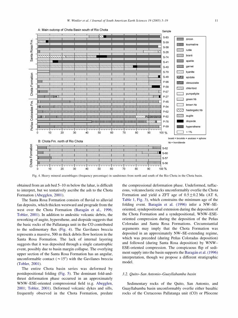
Fig. 4. Heavy mineral assemblages (frequency percentage) in sandstones from north and south of the Rio Chota in the Chota basin.
W. Winkler et al. / Journal of South American Earth Sciences 19 (2005) 5–19 11
obtained from an ash bed 5–10 m below the lahar, is difficult
to interpret, but we tentatively ascribe the ash to the Chota
Formation (Abegglen, 2001).
The Santa Rosa Formation consists of fluvial to alluvial
fan deposits, which thicken westward and prograde from the
west over the Chota Formation (Baragan et al., 1996;
Tobler, 2001). In addition to andesitic volcanic debris, the
reworking of augite, hypersthene, and diopside suggests that
the basic rocks of the Pallatanga unit in the CO contributed
to the sedimentary flux (Fig. 4). The Gavilanes breccia
represents a massive, 500 m thick debris flow horizon in the
Santa Rosa Formation. The lack of internal layering
suggests that it was deposited through a single catastrophic
event, possibly due to basin margin collapse. The overlying
upper section of the Santa Rosa Formation has an angular,
unconformable contact (w158) with the Gavilanes breccia
(Tobler, 2001).
The entire Chota basin series was deformed by
postdepositional folding (Fig. 5). The dominant fold-and-
thrust deformation phase occurred in an approximately
WNW–ESE-oriented compressional field (e.g. Abegglen,
2001; Tobler, 2001). Deformed volcanic dykes and sills,
frequently observed in the Chota Formation, predate
the compressional deformation phase. Undeformed, tuffac-
eous, volcanoclastic rocks unconformably overlie the Chota
Formation and yield a ZFT age of 0.5G0.2 Ma (AT 6,
Table 1, Fig. 3), which constrains the minimum age of the
folding event. Baragan et al. (1996) infer a NW–SE-
oriented, syndepositional extension during the deposition of
the Chota Formation and a syndepositional, WNW–ESE-
oriented compression during the deposition of the Penas
Coloradas and Santa Rosa Formations. Circumstantial
arguments may imply that the Chota Formation was
deposited in an approximately NW–SE-extending regime,
which was preceded (during Penas Coloradas deposition)
and followed (during Santa Rosa deposition) by WNW–
ESE-oriented compression. The conspicuous flip of sedi-
ment supply into the basin supports the Baragan et al. (1996)
interpretation, though we propose a different stratigraphic
model.
3.2. Quito–San Antonio–Guayllabamba basin
Sedimentary rocks of the Quito, San Antonio, and
Guayllabamba basin unconformably overlie either basaltic
rocks of the Cretaceous Pallatanga unit (CO) or Pliocene

Fig. 5. Simplified geological map and cross-sections of the Chota basin (after Abegglen, 2001; Tobler, 2001). Note that the map and cross-sections are
presented at different scales.
W. Winkler et al. / Journal of South American Earth Sciences 19 (2005) 5–1912

W. Winkler et al. / Journal of South American Earth Sciences 19 (2005) 5–19 13
volcanic rocks of the basal Pisque Formation (Villagomez et
al., 2002). The younger sedimentary sequence consists of a
complex stack of volcanic and volcanoclastic deposits
(Alvarado, 1996; Ego and Sebrier, 1996; Lavenu et al.,
1996; Villagomez et al., 2002). Radiometric ages of strata
are rare, though correlations between volcanic edifices and
the strata (e.g. OLADE-INECEL, 1980; Barberi et al., 1988;
Geotermia Italiana, 1989; Fig. 2) suggest the basin sequence
is 6–5 Ma old or younger. 40Ar/39Ar radiometric analyses of
ferromagnesian minerals currently are in progress.
The basal Pisque Formation (Fig. 2), which includes the
basal Lava member, consists of andesitic and basaltic lavas
unconformably overlain by tuffs and lahars of the lower
Pisque Formation (Golden Tuffs and Puente Viejo mem-
bers; Villagomez, 2003). The basal Lava member has been
correlated with the Casitagua, Culbiche, and Chicaloma
volcanoes, which yield K/Ar whole-rock ages of 2.25G0.25, 2.6G0.06, and 3.46G0.1 Ma (OLADE-INECEL,
1980; Barberi et al., 1988), which places the basal Pisque
Formation in the late Pliocene. Fluvial and alluvial fan
facies prevail in the upper Pisque Formation. The San
Miguel Formation is a volcanic, tuff-rich sequence of
eastward prograding deltaic and lacustrine deposits, the
latter of which were strongly deformed during synsedimen-
tary, gravity-driven displacements in response to the loading
exerted by younger lahars deposited during the deposition of
the Guayllabamba Formation (Villagomez, 2003). The
overlying Guayllabamba Formation records a period of
intense volcanism and compressive tectonic activity. To the
west and south, primary volcanic deposition (lavas,
pyroclastic flows, avalanches) prevailed, whereas in the
east, lahar flows filled a former lake that existed during
the San Miguel era. Several volcanic domes also intruded
the lake deposits. Radiometric ages of the volcanic deposits,
which have been correlated with the Guayllabamba
Formation (K/Ar andesite, 1.62G0.16 Ma, OLADE-INE-
CEL, 1980; K/Ar rhyolite, 0.98G0.13 Ma, Barberi et al.,
1988), indicate Pleistocene extrusion ages. Alluvial fan-
related conglomerates cap the Guayllabamba Formation and
can be correlated with the growth of the Calderon–
Catequilla fold structure (Villagomez, 2003). In addition,
the east-verging, reverse Quito fault system became active
during the final stages of the deposition of the Guaylla-
bamba Formation and separated the San Antonio from the
Guayllabamba basin.
The Chiche Formation (Fig. 2) was deposited in calm,
low energy, lacustrine, and fluvial environments in the
Quito and Guayllabamba basins, though several lahars
flowed into the depocenters. The presence of the fossil teeth
Glossotherium (Lavenu et al., 1996) at the top of the Chiche
Formation is commonly interpreted to indicate a middle
Pleistocene age (z0.5 Ma). Compressive deformation was
revived in the area during the waning stages of deposition of
the Chiche Formation, when the southern segments of the
Quito fault system became active (Quito and Botadero
faults). The overlying Machangara Formation in the Quito
area, the lower part of which is composed of primary
volcanic rocks and the upper part of epiclastic deposits,
shows progressive unconformity geometries with the Quito
fault (Villagomez, 2003). The coeval Mojanda Formation to
the north was derived from the middle-late Pleistocene
Mojanda volcanic complex (0.6 Ma, K/Ar whole-rock
andesite, Barberi et al., 1988). This stratigraphic relation-
ship suggests that the Quito fault has been active until
recently. Widespread, unconsolidated, airfall tuffs, with
distinct pedogenetic intervals, constitute the Cangahua
Formation, which disconformably overlies older for-
mations. Radiocarbon, obsidian-hydration, and thermo-
luminescence data suggest that the Cangahua Formation
probably accumulated during the past 100 Ka (Clapperton
and Vera, 1986).
Previous studies in the Quito–San Antonio–Guaylla-
bamba basin have proposed that it formed in either an E–W-
or NNE–SSW-trending extensional regime (e.g. Tibaldi and
Ferrari, 1992; Ego and Sebrier, 1996). However, the timing
of normal fault activity is stratigraphically poorly con-
strained. Recent stratigraphic and structural observations
(Villagomez, 2003) suggest that approximately E–W-
oriented extension occurred during the Pliocene, as
documented by the approximately N–S-striking, mesoscale
(metric), synsedimentary normal faults, which only displace
the Pisque and San Miguel Formations. Limited age
determinations and field mapping (Villagomez, 2003)
suggest that E–W-oriented compression commenced during
the deposition of the Guayllabamba Formation (w1 Ma)
and initiated the formation of the Calderon-Catequilla fold.
The prevailing stress field was presumably similar to that
observed today, as determined from shallow focal earth-
quake solutions in the region (mean orientation N988E;
Ego and Sebrier, 1996). Tectonic compression probably
decreased during the deposition of the Chiche Formation,
though it recommenced from w0.5 Ma to the present and is
responsible for neotectonic activity along the Quito and
Botadero reverse faults (Villagomez, 2003).
3.3. Ambato–Latacunga basin
Lavenu et al. (1992) recognize four Pliocene—Recent
formations stratigraphically above volcanic rocks in the
Ambato–Latacunga basin. The basin strata wedge out
toward the CO in the west (Fig. 2), which documents the
creation of the positive relief along the western margin of
the basin. The local nomenclature of the underlying
volcanic formations is somewhat enigmatic. However,
chronostratigraphic data and lithologic descriptions (Bal-
dock, 1982; Eguez et al., 1992; Lavenu et al., 1992, 1995,
1996; Ego and Sebrier, 1996) imply that these formations
correspond to Oligocene-Miocene volcanic rocks, which are
widely distributed in the southern Ecuadorian arc and
forearc (e.g. British Geological Survey-GODIGEM, 1997;
Hungerbuhler et al., 2002), where they are regionally
referred to as the Saraguro group. The local Pisayambo and

W. Winkler et al. / Journal of South American Earth Sciences 19 (2005) 5–1914
Alausı Formations (Fig. 2) are time equivalents of the Turi
and Tarqui Formations in the Cuenca area to the south
(Steinmann et al., 1999).
Volcanic and volcanoclastic (fluvial and lacustrine)
rocks of the Sicalpa Formation overlie volcanic rocks of
the Turi and Tarqui Formations in the Latacunga area.
Acidic tuffs intercalated within the Sicalpa yield late
Miocene K/Ar radiometric ages of 3.59G0.28 and 2.65G0.21 Ma (Lavenu et al., 1992). The overlying lower
Latacunga Formation mainly has a volcanic origin and is
composed of lahars, lava flows, volcanic breccias, and
fluvial deposits at the top. The upper Latacunga Formation
consists of lacustrine and fluvial deposits (Lavenu et al.,
1995). Andesite whole-rock and plagioclase K/Ar analyses
close to the boundary between the lower and upper
Latacunga Formation (Lavenu et al., 1992, 1995) yield
late Pliocene-early Pleistocene ages (1.85G0.19, 1.73G0.35, 1.4G0.29 Ma, Fig. 2). The unconsolidated pyroclastic
Chalupas Formation unconformably overlies the Latacunga
Formation. An andesitic horizon in the Chalupas Formation
yields a whole-rock K/Ar age of 1.21G0.05 Ma (Barberi
et al., 1988).
The Ambato–Latacunga basin is bound by thrusts in the
east (east-dipping Pisayambo fault) and west (west-dipping
La Victoria fault). Both faults represent a segment or branch
of the Peltetec and Pallatanga–Pujilı–Calacalı fault systems,
respectively. Stratigraphic evidence and synsedimentary
folding revealed by progressive unconformity development
in the Latacunga Formation suggest that a significant phase
of compressive deformation occurred between w1.85 and
w1.2 Ma (Lavenu et al., 1995, 1996).
3.4. Alausı–Riobamba basin
Sedimentary rocks of the Alausı–Riobamba basin
unconformably overlie basement rocks of the Pallatanga
unit and a thick sequence of Oligocene-Miocene volcanic
rocks, which can be distinguished into two formations.
Volcanic facies observations and radiometric age determi-
nations from the lower Huigra Formation (Eguez et al.,
1992; Fig. 2) suggest that it correlates with the Saraguro
group. Similarly, radiometric ages (8.12G0.10, 7.10G0.03 Ma, K/Ar andesite whole-rock; Barberi et al., 1988;
Lavenu et al., 1996) from the Upper Alausı Formation
(Fig. 2) correlate these volcanic rocks with the late Miocene
volcanoclastic and volcanic Turi and Tarqui Formations
(e.g. Hungerbuhler et al., 2002) in the southern Ecuadorian
forearc. Although no physical contact was observed, the
lacustrine Sicalpa Formation is assumed to overlie
the Alausı volcanics unconformably (Lavenu et al., 1992).
The undated, thick, alluvial fan and fluvial conglomerates of
the Palmira Formation overlie the Pliocene Sicalpa
Formation with an angular unconformity (Eguez et al.,
1992; Lavenu et al., 1996; Fig. 2). The presence of these
coarse sediments, which were derived from the east,
indicates a significant tectonic and/or climatic change
during the late Pliocene (Lavenu et al., 1996). These coarse
facies may have been deposited during synsedimentary
deformation in the contiguous Latacunga Formation, and a
compressive tectonic regime may have prevailed during the
deposition of the Palmira Formation.
4. Discussion
The Ecuadorian Andes lie in the southern part of the
northern Andean block (Fig. 6), which is displacing to
the NNE relative to the Guyana shield in response to the
eastward subduction of the Nazca plate and the north-
westward drift of the South American plate. Displacement
of the block is accompanied by approximately E-W-
oriented shortening, overthrusting onto the Caribbean
plate (Pennington, 1981; Kellogg and Bonini, 1982; Ego
et al., 1996), and right-lateral displacement, which is
accommodated in Ecuador and Colombia by regional-
scale, strike-slip faults (Toussaint and Restrepo, 1994). The
inception of and subsequent subsidence in the Gulf of
Guayaquil and neighboring forearc areas to the east
(Benıtez, 1995; Hungerbuhler et al., 2002; Witt, 2002)
was a result of the displacement of the northern Andean
block after 16–15 Ma. Geometric and stratigraphic relation-
ships suggest the southern tip of the northern Andean block
has displaced approximately 100 km northward (Shepherd
and Moberly, 1981; Hungerbuhler, 1997). To link the
Pallatanga fault in the Gulf of Guayaquil kinematically with
the main eastern boundary of the northern Andean block in
Colombia and Venezuela (eastern Andean front fault zone;
Toussaint and Restrepo, 1994; Ego et al., 1996), a
restraining bend across the northern Ecuadorian Andean
chain must be inferred. This tectonic structure has not been
identified, though it probably includes fragments of the
Pallatanga–Pujilı–Calacalı, Peltetec, and Chingual-La Sofıa
faults, as well as parts of the frontal fault zone of the Andes
in southern Colombia (e.g. Ego et al., 1996; Fig. 6).
Late Miocene (6–4 Ma) compressive tectonic activity
drove high exhumation rates in the Andean chain near the
Chingual-La Sofia fault along the Ecuadorian–Colombian
border (Spikings et al., 2000) (Figs. 1 and 6b). Neotectonic
activity of the fault has displaced latest Pleistocene–
Holocene volcanic flows and postglacial river valleys in
the tributaries of the El Dorado (Ferrari and Tibaldi, 1992).
Furthermore, AFT data from a mylonitic shear band in the
Chimbo-Toachi shear zone (Fig. 1) suggest high cooling and
exhumation rates in the Macuchi unit since 5 Ma (Spikings
et al., 2005). Similarly, AFT data from the sub-Andean
thrust belt (Fig. 1), located between the Cosanga and sub-
Andean faults, records rapid cooling and exhumation
between 6 and 2.5 Ma (Ruiz, 2002). These data correlate
with higher cooling rates and increased depths of exhuma-
tion in the northern CR (north of 1830 0S) during the past
6 Ma, relative to the southern CR (Spikings et al., 2001).
Collectively, this information suggests that the restraining
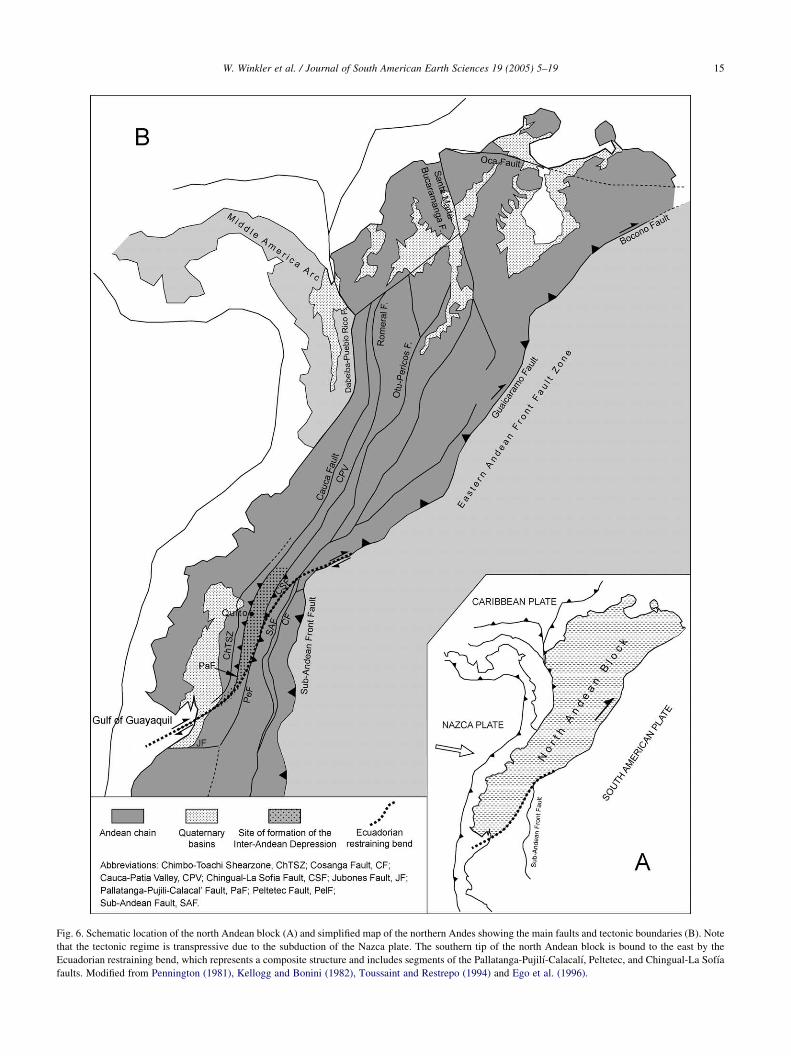
Fig. 6. Schematic location of the north Andean block (A) and simplified map of the northern Andes showing the main faults and tectonic boundaries (B). Note
that the tectonic regime is transpressive due to the subduction of the Nazca plate. The southern tip of the north Andean block is bound to the east by the
Ecuadorian restraining bend, which represents a composite structure and includes segments of the Pallatanga-Pujilı-Calacalı, Peltetec, and Chingual-La Sofıa
faults. Modified from Pennington (1981), Kellogg and Bonini (1982), Toussaint and Restrepo (1994) and Ego et al. (1996).
W. Winkler et al. / Journal of South American Earth Sciences 19 (2005) 5–19 15

Fig. 7. Schematic presentation of the full- and half-ramp basin models.
After Cobbold et al. (1993).
W. Winkler et al. / Journal of South American Earth Sciences 19 (2005) 5–1916
bend has been active since at least 15 Ma and that a
significant pulse of activity commenced at 6 Ma.
According to our results, it is plausible that the IAD
structure formed as a result of displacement along the
restraining bend since 6 Ma (Fig. 6). Several late Miocene–
Pleistocene (?) subbasins are preserved within the elongated
IAD. Sedimentation in the subbasins commenced during the
latest Miocene (6–5 Ma) in the north (Chota basin) and spread
to the southern basins (Fig. 2) during the Pliocene (4–3 Ma).
The E–W-oriented, synsedimentary, compressional
deformation in the Ambato–Latacunga basin is manifested
by low amplitude folding with internal, progressive
unconformities during 1.85–1.2 Ma (Lavenu et al., 1995).
The deformation was driven by opposite-verging reverse
faulting along the basin margins (La Victoria and
Pisayambo faults; Fig. 1), which resulted in horizontal
shortening across the IAD at an estimated rate of
approximately 1.4G0.3 mm/year (Lavenu et al., 1995).
Sedimentary sequences in the Quito–San Antonio–
Guayllabamba basin were deformed by the N–S-trending,
east-verging Calderon–Catequilla and Quito folds and the
Quito and Botatero thrust faults (Ego and Sebrier, 1996;
Villagomez, 2003). Tentative estimates suggest that the
main phase of compressive tectonic activity started during
the deposition of the Guayllabamba Formation at approxi-
mately 1.0 Ma (Ego and Sebrier, 1996; Villagomez, 2003).
However, N–S-trending synsedimentary normal faults in the
Pisque Formation indicate E–W-oriented extension (Villa-
gomez, 2003), which conflicts with Ego and Sebrier’s
(1996) statistical reconstruction of a N–S-trending exten-
sional regime that would have disrupted the Pisque
Formation prior to folding.
The WNW–ESE-oriented compression has generated
NNE–SSW-trending fold axes and thrust planes in the
Chota basin (Fig. 5). The folding is sealed by 0.5 My old,
approximately horizontal, bedded volcanoclastic rocks
(Tobler, 2001; Winkler et al., 2002), which constrain the
minimum age of basinwide deformation in the Chota basin.
Baragan et al. (1996) propose a structural reconstruction of
the Chota basin sequence using the microtectonic data
inversion method and differentiate between synsedimentary
and postsedimentary deformation. In translating their results
to the revised chronostratigraphic framework presented here
(e.g. the Penas Coloradas Formation is considered the oldest
formation in the basin), NW–SE to WNW–ESE compres-
sive stress prevailed throughout the entire basin history.
Synsedimentary, small-heave (cm to m) normal faults were
detected in local parts of the fine-grained, thinly bedded
Chota Formation, which indicates that extension was
oriented between WNW–WSE and WSW–ENE (Abegglen,
2001; Tobler, 2001). These results are similar to those of
Baragan et al. (1996), who observed NW–SE syndeposi-
tional extension in the Chota Formation, and consistent
with the W–E-oriented extensional stress field inferred
for the coeval Pisque Formation in the Quito–San
Antonio–Guayllabamba basin (Villagomez, 2003). In the
Chota series, the distinct change in source material—from a
granitic/metamorphic terrane, which shed into the Penas
Coloradas Formation in the east, to a volcanic and mafic
terrane, which supplied the Santa Rosa Formation in the
west—is consistent with an initial phase of compression-
related rock uplift and exhumation in the bordering CR,
followed by uplift in the CO. The massive Gavilanes breccia
in the Santa Rosa Formation may represent a huge structural
failure driven by tectonic oversteepening of the slopes along
the western basin margin. The Chota Formation occupies a
transitional position with respect to stratigraphy and
probably was deposited between the prominent alluvial
fans, which shed into the basin. The fluvial to lacustrine
deposits may document a period of decreased compressive
tectonic activity or even minor extension, which resulted in
volcanic dyke and sill emplacement.
Various models have defined a single basin type for the
IAD and interpreted the origin of the IAD within that
context. There is general agreement that a transpressive
tectonic regime prevailed during most of the history of the
IAD structure (e.g. Ego et al., 1996; Ego and Sebrier, 1996).
Alternative arguments that it may have formed as an
extensional graben or in a transtensional setting can be
disproven. The IAD formed during a period of high rates of
exhumation throughout the cordilleras of northern Ecuador
(Spikings et al., 2000, 2001, 2005), and it is unlikely that
deep-seated subsidence would occur in the crest of the
exhuming fault blocks. Regardless of the considerable
northward displacement of the north Andean block
(w100 km; Shepherd and Moberly, 1981), this distance is
not sufficient because of the nature of strain partitioning in
transcurrent systems needed to generate pull-apart basin
subsidence on the scale of the IAD. However, the presence
and provenance of the clastic material in the IAD clearly
shows that differential subsidence of the IAD occurred with
respect to both the bordering cordilleras. The IAD may have
developed as a ramp valley (Fig. 7; Willis, 1928; Cobbold

W. Winkler et al. / Journal of South American Earth Sciences 19 (2005) 5–19 17
et al., 1993), in that fault blocks of the bordering cordilleras
may have overthrust the basin floor. Mann et al. (1991)
account for Miocene-Pliocene basin structures in Hispanola
by applying a similar tectonic evolution along the restrain-
ing bend between the North American and Caribbean plates.
Lavenu et al. (1996) propose that a compressional (push
down) setting prevailed in the Ambato-Latacunga area,
which corroborates a full-ramp setting (Cobbold et al.,
1993). These authors assume that both the east-verging
Victoria fault in the west and the west-verging Pisayambo
fault in the east (Fig. 1) overthrust the basin margins. In the
almost flat basin floor, several low amplitude anticlines and
synclines, with approximately basin-parallel trends, devel-
oped in the syntectonic basin fill series and underlying
volcanic rocks. The syndepositional nature of the tectonic
activity is documented by progressive unconformities. A
model calculation estimates that the total shortening
between the basin margins, which are currently 25 km
apart, is 3400G800 m (Lavenu et al., 1995).
No sedimentary rocks have been identified from the
eastern margin (CR) of the Quito–San Antonio–Guaylla-
bamba basin (Villagomez, 2003), which suggests that active
reverse faulting was absent along this margin during the
formation of the basin. However, the accumulation of 1200–
1400 m of sedimentary and volcanic rocks implies that a
topographic barrier existed. The major basin-bounding fault
was the Pallatanga–Pujilı–Calacalı to the west (Fig. 1), and
shortening along the western basin margin, which resulted
in the Quito and Botadero faults and the Calderon–
Catequilla fold, implies that the Pallatanga–Pujilı–Calacalı
fault had a significant reverse component. This sector of the
IAD therefore may be referred to as a half-ramp basin
(Fig. 7; Cobbold et al., 1993), though the paucity of field
observations prevents us from denying the possibility that
an opposing reverse fault in the east may have been active.
The amount of shortening in the Chota basin is probably
the greatest within the entire Ecuadorian IAD (Fig. 4). A
predominantly compressive regime has been confirmed by
structural analyses (Baragan et al., 1996), though no attempt
has been made to quantify the shortening. The presence of
reverse faults on both basin margins (Pallatanga–Pujilı–
Calacalı and Peltetec faults; Fig. 1) can be inferred only
from circumstantial evidence provided by the radiometri-
cally established stratigraphic succession, sedimentary
facies, and the provenance of detrital grains (Figs. 2–4).
Reverse faulting probably commenced in the east and
exposed metamorphic rocks of the CR, which eroded to
produce massive alluvial fan systems (Penas Coloradas
Formation) that drained to the west. At a stratigraphically
poorly defined time, the western basin margin became the
major source of debris, shedding alluvial fans and
catastrophic flows into the basin (Santa Rosa Formation,
including the Gavilanes breccia). The basic detrital grains
observed in the Santa Rosa Formation suggest that the CO
was exhuming, probably via reverse activity along the
Pallatanga-Pujilı-Calacalı fault. The transition of reverse
faulting from the eastern margin to the western margin is
recorded by the fluvial and lacustrine Chota Formation,
which implies a reduction in the regional, net compressive
stress field. Small-scale, synsedimentary, normal faulting in
the lacustrine Chota Formation may be interpreted as
gravity-driven tension during the transition of reverse
faulting from the eastern to the western basin margin.
5. Conclusions
The elongate IAD structure formed in a right-lateral
transpressive tectonic regime during a period of high rates
of exhumation throughout the cordilleras in northern
Ecuador after 6–5 Ma. During its development, several
subbasins formed in which alluvial fan, fluvial, lacustrine
facies, and contemporaneous volcanic products were
deposited. The chronostratigraphic framework for the
sedimentary series of the Chota basin, combined with field
observations and data from the Quito–San Antonio–
Guayllabamba, Ambato–Latacunga, and Alausı–Riobamba
basins, implies that sedimentation spread from the north to
the south after 6–5 Ma. Synsedimentary compressive
deformation is documented by reverse fault movements
along the basin margins and folding and faulting within the
basins. A full-ramp (locally half-ramp) basin model (Fig. 7),
in which opposite verging reverse faults drive differential
uplift of the basin-bordering cordilleras with respect to the
IAD, most appropriately describes the tectonosedimentary
assemblages. Minor synsedimentary normal faulting may be
attributed to gravity-driven extension in the oversteepened
orogenic wedge during periods of waning compression. The
north-to-south progradation of compression and basin
formation possibly correlates with a southward shift of the
subducting, buoyant Carnegie ridge (e.g. Spikings et al.,
2001). The IAD ramp basin formed in the vicinity of a major
restraining bend, which accommodates general northward
displacement of the north Andean block (Fig. 6).
Acknowledgements
This work was supported by the Swiss Academy of
Science (PA and ST) and the Swiss National Science
Foundation (WW and RS, grant #20-56794.99). Bernardo
Beate is thanked for many fruitful discussions. John Aspden
and Alain Lavenu are acknowledged for their constructive
reviews of the manuscript.
References
Abegglen, P., 2001. Geologie des intermontanen Beckens von Chota
(Pliozan, Nordecuador)-Ostteil. Thesis, ETH-Zurich, p. 87.
W. Winkler et al. / Journal of South American Earth Sciences 19 (2005) 5–1918
Alvarado, A., 1996. Evolucion geologica cuarternaria y paleosismicidad
de la Cuenca de Quito (Ecuador). Tesis de grado EPN-Quito,
p. 380.
Baldock, J.W., 1982. Geology of Ecuador. Explanatory Bulletin of the
National Geological Map of the Republic of Ecuador 1:1,000,000 Scale.
Ministerio de Recursos Naturales y Energeticos, Direccion General de
Geologıa y Minas Quito, Ecuador p. 54.
Baragan, R., Baudino, R., Marocco, R., 1996. Geodynamic evolution of the
Neogene intermontane Chota basin, northern Andes of Ecuador. Journal
of South American Earth Sciences 9 (5/6), 309–319.
Barberi, F., Coltelli, M., Ferrara, G., Innocenti, F., Navarro, J.M.,
Santacroce, R., 1988. Plio-Quaternary volcanism in Ecuador. Geologi-
cal Magazine 125, 1–14.
Benıtez, S., 1995. Evolution geodynamique de la province cotiere sud-
equatorienne au Cretace superieur et Tertaire. Geologie Alpine 71,
3–163.
British Geological Survey-GODIGEM, 1997 Mapa geologico de la
Cordillera Occidental del Ecuador entre 28S–38S, Direccion Nacional
de Geologıa, Quito, Ecuador, scale 200 000, 1 sheet
Clapperton, C.M., Vera, R., 1986. The Quaternary glacial sequence in
Ecuador: a reinterpretation of the work of Walter Sauer. Journal of
Quaternary Research 1 (1), 45–56.
Cobbold, P.R., Davy, P., Gapais, D., Rosello, E.A., Sadybakasov, E.,
Thomas, J.C., Tondji, J.C., Biyo, J.J., de Urreiztieta, M., 1993.
Sedimentary basins and crustal thickening. Sedimentary Geology 86,
77–89.
Ego, F., Sebrier, M., 1996. The Ecuadorian inter-Andean valley: a major
and complex restraining bend and compressive graben since late
Miocene time. Annales Tectonicae 10, 31–59.
Ego, F., Sebrier, M., Lavenu, A., Yepes, H., Eguez, A., 1996. Quaternary
state of stress in the northern Andes and the restraining bend model for
the Ecuadorian Andes. Tectonophysics 259, 101–116.
Eguez, A.,. Beate, B. 1992 Estratigraphıa y tectonica de la cuenca
intramontanosa del Chota. Il Jornadas Ciencias de la Tierra,
Resumenes. Escuela Politecnica Nacional (EPN), Quito. pp.
131–144.
Eguez, A., Dugas, F., Bomhomme, M., 1992. Las unidades Huigra y Alausı
en la evolucion geodinamica del valle interandino del Ecuador.
Boletino Geologıco Ecuatoriana 3 (1), 47–55.
Ferrari, L., Tibaldi, A., 1992. Recent and active tectonics of the
northeastern Ecuadorian Andes. Journal of Geodynamics 15 (1/2),
39–58.
Galbraith, R.F., Green, P.F., 1990. Estimating the component ages in a
finite mixture. Nuclear Tracks Radiation Measurements 17, 197–206.
Geotermia Italiana, 1989. Mitigacıon del Risgo Volcanico en el area
Metropolitana de Quito. Informe Final, Pisa, p. 91.
Hughes, R.A., Pilatasig, L.F., 2002. Cretaceous and Tertiary terrane
accretion in the Cordillera Occidental of the Andes of Ecuador.
Tectonophysics 345, 29–48.
Hungerbuhler, D., 1997. Tertiary basins in the Andes of southern Ecuador
(3800 0–4820 0): Sedimentary evolution, deformation and regional
tectonic implications. PhD Thesis, Institute of Geology ETH Zurich,
Switzerland, p. 182.
Hungerbuhler, D., Steinmann, M., Winkler, W., Seward, D., Eguez, A.,
Peterson, D.E., Helg, U., Hammer, C., 2002. Neogene stratigraphy and
Andean geodynamics of southern Ecuador. Earth-Science Reviews 57,
75–124.
Kellogg, J.N., Bonini, W.E., 1982. Subduction of the Caribbean plate and
basement uplifts in the overriding South American plate. Tectonics 1
(3), 251–276.
Lavenu, A., Noblet, C., Bonhomme, M.G., Eguez, A., Dugas, F., Vivier, G.,
1992. New K-Ar age dates of Neogene and Quaternary volcanic rocks
from the Ecuadorian Andes: implications for the relationship between
sedimentation, volcanism and tectonics. Journal of South American
Earth Sciences 5 (3/4), 309–320.
Lavenu, A., Winter, Th., Davila, F., 1995. A Pliocene–Quaternary
compressional basin in the inter-Andean depression, central Ecuador.
Geophysical Journal International 121, 279–300.
Lavenu, A., Baudino, R., Ego, F., 1996. Stratigraphie des depots tertiaires et
quaternaires de la depression interandine d’Equateur (entre 08 et
2815 00S). Bulletin de l’Institut francais des etudes andines 25, 1–15.
Litherland, M., Zamora, A., Eguez, A., 1993. Mapa geologico de la
Republica del Ecuador, scale 1:1.0000000. British Geological Survey-
CODIGEM, Quito.
Litherland, M., Aspden, J., Jemielita, R.A., 1994. The metamorphic belts of
Ecuador. British Geological Survey, Quito, Overseas Memoir (p. 147).
Mange, M.A., Maurer, H.F.W., 1991. Schwerminerale in Farbe. Enke,
Stuttgart p. 148.
Mann, P., McLaughlin, P.P., Cooper, C., 1991. Geology of the Azua and
Enriquillo basins, Dominicanian Republic: 2, Structura and tectonics.
In: Mann, P., Draper, G., Lewis, J.F. (Eds.), Geologic and tectonic
development of the North America-Caribbean plate boundary in
Hispaniola, vol. 262. Geological Society of America Special Paper,
Boulder, CO, pp. 367–389.
OLADE-INECEL, 1980. Informe geo-vulcanologico: proyecto de investi-
gacion geotermica de la Republica del Ecuador. Organizacion
Latinoamericana de Energıa, Quito p. 54.
Pennington, W.D., 1981. Subduction of the eastern Panama basin and
seismotectonics of northwestern South America. Journal of Geophysi-
cal Research 86 (B11), 10753–10770.
Ruiz, G.M.H., 2002. Exhumation of the northern sub-Andean zone of
Ecuador and its source region: A combined thermochronological and
heavy mineral approach. PhD Thesis, Institute of Geology ETH Zurich,
Switzerland, p. 132.
Shepherd, G.L., Moberly, R., 1981. Coastal structure of the continental
margin, northwest Peru and southwest Ecuador. In: Kulm, L.D.,
Dymond, J., Dasch, E.J., Hussong, D.M., Roderick, R. (Eds.), Nazca
plate: Crustal formation and Andean convergence, vol. 154. Memoir
Geological Society of America, pp. 351–391.
Spikings, R., Seward, D., Winkler, W., Ruiz, G., 2000. Low temperature
thermochronology of the northern Cordillera Real, Ecuador: Tectonic
insights from zircon and apatite fission track analysis. Tectonics 19,
649–668.
Spikings, R., Winkler, W., Seward, D., Handler, R., 2001. Along-strike
variations in the thermal and tectonic response of the continental
Ecuadorian Andes to the collision with heterogeneous oceanic crust.
Earth and Planetary Science Letters 186 (1), 57–73.
Spikings, R., Winkler, W., Hughes, R., Handler, R. 2005. Thermochronol-
ogy of the Cordillera Occidental and the Amotape Complex, Ecuador:
Unraveling the accretionary and post-accretionary history of the
northern Andes. Tectonophysics 399, 135–220.
Steinmann, M., Hungerbuhler, D., Seward, D., Winkler, W., 1999. Neogene
tectonic evolution and exhumation of the southern Ecuadorian Andes: a
combined stratigraphy and fission-track approach. Tectonophysics 307,
255–279.
Tibaldi, A., Ferrari, L., 1992. Latest Pleistocene-Holocene tectonics of the
Ecuadorian Andes. Tectonophysics 205, 109–125.
Tobler, St, 2001. Geologie des intermontanen Beckens von Chota (Pliozan,
Nordecuador)-Westteil. Thesis, ETH-Zurich, p. 102.
Toussaint, J.F., Restrepo, J.J., 1994. The Colombian Andes during
Cretaceous times. In: Salfity, J.A. (Ed.), Cretaceous tectonics of the
Andes. Braunschweig, Wiesbaden, Vieweg, pp. 61–100.
Vallejo, C., Buitron, A., 1999. Estudio estratigrafico estructural de la Zona
Subandina norte, entre los paralelos 0825 0S y 0840 0S. Thesis de grado.
Escuela Politecnica Nacional (EPN), Quito, p. 154.
Villagomez, D., 2003. Evolucion Plio-cuaternaria del Valle Interandino
Central en Ecuador (zona Quito-Guayllabamba-San Antonio de
Pichincha). Tesis de grado. EPN-Quito, p. 130.
Villagomez, D., Eguez, A., Winkler, W., Spikings, R., 2002. Plio-
Quaternary sedimentary and tectonic evolution of the central inter-

W. Winkler et al. / Journal of South American Earth Sciences 19 (2005) 5–19 19
Andean valley, Extended Abstracts. International Symposium on
Andean Geodynamics (ISAG), September 16–18, 2002, Toulouse,
France 2002 pp. 689–692.
Willis, B., 1928. Dead sea problem: rift valley or ramp valley?. Geological
Society of America Bulletin 39, 490–542.
Winkler, W., Spikings, R.A., Villagomez, D., Eguez, A., Abegglen, P.,
Tobler, S., 2002. The Chota basin and its significance for the formation
of the inter-Andean valley in Ecuador, Fifth International Symposium
on Andean Geodynamics (ISAG), September 16–18, 2002, Toulouse,
France 2002 pp. 705–708.
Winter, Th., Lavenu, A., 1989a. Morphological and microtectonic evidence
for a major active right-lateral strike-slip fault across central Ecuador
(South America). Annales Tectonicae 3 (2), 123–139.
Winter, Th., Lavenu, A., 1989b. Tectonique active en Equateur: Ebauche
d’une nouvelle interpretation geodynamique. Bulletin de l’Institut
francais des etudes andines 18 (1), 95–115.
Witt, C., 2002. Evolution du bassin du Golf de Guayaquil (Equateur)
depuis le Quartarnaire: analyse de la deformation a partir
des profils de sismique reflexion. Diplome Universite Grenoble,
p. 124.