Namibia volcanic margin
29
Marine Geophysical Researches 20: 313–341, 1998. © 1998 Kluwer Academic Publishers. Printed in the Netherlands. 313 Namibia volcanic margin Tadeusz P. Gladczenko 1 , Jakob Skogseid 2 & Olav Eldhom 3 1 Joint Oceanographic Institutions, Inc. 1755 Massachusetts Avenue, NW, Suite 800 Washington, DC 20036- 2102, USA (E-mail [email protected]); 2 Saga Petroleum, a.s., Sandvika, Norway; 3 Department of Geology, University of Oslo, Norway Received 3 March 1999, accepted 23 June 1999 Key words: Volcanic Margin, Namibia, South Atlantic, passive margin, crustal structure Abstract Two end members of passive margin types are present on the Namibia margin: volcanic and non-volcanic. The central and southern parts of the Namibia margin feature characteristic volcanic margin elements such as thickened initial oceanic crust, seaward dipping reflectors, and high-velocity/density lower crust that extends beneath the rift zone that was formed during initial seafloor spreading in Early Cretaceous. The margin north of the Walvis FZ is non-volcanic in character and probably formed as a result of a ridge jump that occurred after cessation of the initial magmatic activity. The Walvis Ridge forms the boundary between the two margin types and resulted from the persistent magmatism associated with the Tristan plume. MCS data in conjunction with gravity modeling reveal a Paleozoic rift zone beneath the Namibia margin south of the Walvis FZ. The Paleozoic rift zone partly overlaps the Jurassic/Early Cretaceous rift zone which produced the breakup between Africa and South America. We calculate an average stretching value of β = 1.4 for the Paleozoic rift, based on subsidence modeling. The rift is partly bounded by low-angle faults, related to the orogenic collapse of the Pan-African fold belt, which provided a major Paleozoic sediment source. The offshore continuity of onshore ophiolitic complexes is suggested by the coast parallel high-amplitude magnetic anomaly ‘G’, and low-angle detachment faults along the southern part of the margin. The average stretching value for the Jurassic/Early Cretaceous rift is β = 1.7, which implies a syn-rift displacement on this margin of ∼70 km. The minimum igneous volume of the South Atlantic LIP was found to be in excess of 3.62 × 10⁶ km 3 . Introduction Many rifted continental margins experienced mas- sive, transient magmatic activity during final conti- nental breakup and initial sea floor spreading. An example is the margin off Namibia formed during the Early Cretaceous breakup of South America and Africa (Figures 1 and 2). The volcanic character of the southwest African margin was first pointed out by Hinz (1981) and Austin and Uchupi (1982), and we have previously shown (Gladczenko et al., 1997) that prominent seaward dipping reflectors (SDRs) char- acterize the outer margin off Namibia south of the Walvis Ridge. The SDRs continue south along the African margin, and are also present on the conjugate Brazil-Argentine margin (Hinz et al., 1999). Volcanic margin formation is commonly related to continental breakup in the presence of a mantle plume (e.g., White and McKenzie, 1989). In the South Atlantic, the ini- tial manifestation of the Tristan mantle plume led to the emplacement of the Paraná-Etendeka continental flood basalts (CFBs) (Figure 1), as evidenced by the voluminous flood basalts extruded between 133 and 130 Ma (Renne et al., 1992, 1996a, b). This igneous event appears related in time and space to the forma- tion of the South Atlantic volcanic margins. Presently, the hotspot is located beneath Tristan da Cunha Is- land (e.g., O’Connor and Duncan, 1990), ∼400 km east of the Mid-Atlantic Ridge (Figure 1); the Walvis Ridge and Rio Grande Plateau represent the trails of the Tristan plume.
-
Upload
independent -
Category
Documents
-
view
2 -
download
0
Transcript of Namibia volcanic margin

Marine Geophysical Researches20: 313–341, 1998.© 1998Kluwer Academic Publishers. Printed in the Netherlands.
313
Namibia volcanic margin
Tadeusz P. Gladczenko1, Jakob Skogseid2 & Olav Eldhom3
1Joint Oceanographic Institutions, Inc. 1755 Massachusetts Avenue, NW, Suite 800 Washington, DC 20036-2102, USA (E-mail [email protected]);2Saga Petroleum, a.s., Sandvika, Norway;3Department of Geology,University of Oslo, Norway
Received 3 March 1999, accepted 23 June 1999
Key words:Volcanic Margin, Namibia, South Atlantic, passive margin, crustal structure
Abstract
Two end members of passive margin types are present on the Namibia margin: volcanic and non-volcanic. Thecentral and southern parts of the Namibia margin feature characteristic volcanic margin elements such as thickenedinitial oceanic crust, seaward dipping reflectors, and high-velocity/density lower crust that extends beneath therift zone that was formed during initial seafloor spreading in Early Cretaceous. The margin north of the WalvisFZ is non-volcanic in character and probably formed as a result of a ridge jump that occurred after cessation ofthe initial magmatic activity. The Walvis Ridge forms the boundary between the two margin types and resultedfrom the persistent magmatism associated with the Tristan plume. MCS data in conjunction with gravity modelingreveal a Paleozoic rift zone beneath the Namibia margin south of the Walvis FZ. The Paleozoic rift zone partlyoverlaps the Jurassic/Early Cretaceous rift zone which produced the breakup between Africa and South America.We calculate an average stretching value ofβ = 1.4 for the Paleozoic rift, based on subsidence modeling. The riftis partly bounded by low-angle faults, related to the orogenic collapse of the Pan-African fold belt, which provideda major Paleozoic sediment source. The offshore continuity of onshore ophiolitic complexes is suggested by thecoast parallel high-amplitude magnetic anomaly ‘G’, and low-angle detachment faults along the southern part ofthe margin. The average stretching value for the Jurassic/Early Cretaceous rift isβ = 1.7, which implies a syn-riftdisplacement on this margin of∼70 km. The minimum igneous volume of the South Atlantic LIP was found to bein excess of 3.62× 10⁶ km3.
Introduction
Many rifted continental margins experienced mas-sive, transient magmatic activity during final conti-nental breakup and initial sea floor spreading. Anexample is the margin off Namibia formed duringthe Early Cretaceous breakup of South America andAfrica (Figures 1 and 2). The volcanic character ofthe southwest African margin was first pointed out byHinz (1981) and Austin and Uchupi (1982), and wehave previously shown (Gladczenko et al., 1997) thatprominent seaward dipping reflectors (SDRs) char-acterize the outer margin off Namibia south of theWalvis Ridge. The SDRs continue south along theAfrican margin, and are also present on the conjugateBrazil-Argentine margin (Hinz et al., 1999). Volcanic
margin formation is commonly related to continentalbreakup in the presence of a mantle plume (e.g., Whiteand McKenzie, 1989). In the South Atlantic, the ini-tial manifestation of the Tristan mantle plume led tothe emplacement of the Paraná-Etendeka continentalflood basalts (CFBs) (Figure 1), as evidenced by thevoluminous flood basalts extruded between 133 and130 Ma (Renne et al., 1992, 1996a, b). This igneousevent appears related in time and space to the forma-tion of the South Atlantic volcanic margins. Presently,the hotspot is located beneath Tristan da Cunha Is-land (e.g., O’Connor and Duncan, 1990),∼400 kmeast of the Mid-Atlantic Ridge (Figure 1); the WalvisRidge and Rio Grande Plateau represent the trails ofthe Tristan plume.

314
Figure 1. Simplified bathymetry (km) and plate tectonic features in the South Atlantic Ocean. Continental flood basalts and seaward dippingwedges outlined in black (Gladczenko et al., 1997). Box shows study area. SPP, São Paulo Plateau.
Petroleum-related exploration of the Namibia mar-gin has focused on the sedimentary sequences andtectonic setting of the inner part of the margin (Ger-rard and Smith, 1983; Maslanyj et al., 1992; Lightet al., 1992, 1993). In 1993 PGS-Nopec acquired anon-exclusive seismic data set which included four14 s two-way travel time (twt) multi-channel seismic(MCS) lines (Figures 2, 3–6, 13). Three lines extendacross the outer margin onto normal oceanic crust, andone line extends from the shelf to the eastern WalvisRidge. The eastward continuation of the Walvis Ridgeonto the margin is sometimes denoted as the Abut-ment Plateau (e.g., Sibuet et al., 1984; Gladczenkoet al., 1997). However, the term has not achievedwidespread usage and we use the term Walvis Ridgefor the entire feature including its eastern part. Theselines provide key information on crustal structure andtectono-magmatic breakup events. In this study, weuse these seismic lines as primary data to investigatethe breakup history of the Namibia margin, from theOrange River in the south to the area north of theWalvis Ridge. First we develop crustal margin tran-sects. Then, we map the structural, depositional andmagmatic margin framework with an emphasis on thepre-opening sequences on the outer margin based onthe transects and two Intera-HGS MCS surveys (ECL-89 and -91) (Figures 2, 7, 13). The transects arecomplemented by velocity data from ocean-bottomhydrophone (OBH) refraction profiles acquired in
1995 by the GeoForschungsZentrum Potsdam (GFZ)and Bundesanstalt für Geowissenschaft und Rohstoffe(BGR) (Bauer et al., 1996, 1997, submitted), and bygravity modeling. Finally, we quantify the syn-rift ex-tension and vertical motion by traditional subsidencemodeling.
Geological framework
Late Precambrian tectonism, commonly termed thePan African and Brasiliano orogenic events, affectedvast parts of the African and South American conti-nents (e.g., Tankard et al., 1982; Ramos, 1988). TheUpper Proterozoic-Lower Paleozoic Damara, Kaokoand Gariep belts of Namibia and South Africa (Fig-ure 2) are regarded as integral parts of these orogens(Porada, 1979; Tankard et al., 1982; Bernasconi,1987). Following the dominantly compressional set-ting that led to the late Paleozoic configuration ofGondwana, the region became dominated by com-plex rift systems. The history of extension prior tothe Early Cretaceous opening of the Atlantic Oceanis not fully resolved, but Light et al. (1993) suggesteda Late Carboniferous to Early Permian proto-Atlanticrift with a shallow sea along its axis. N-S extensionalfaults, interpreted to be related to a major detachmentalong which the South Atlantic eventually opened,controlled basin development during the Early Per-mian (Grill, 1996; Stollhofen et al., 1998). Middle to
315
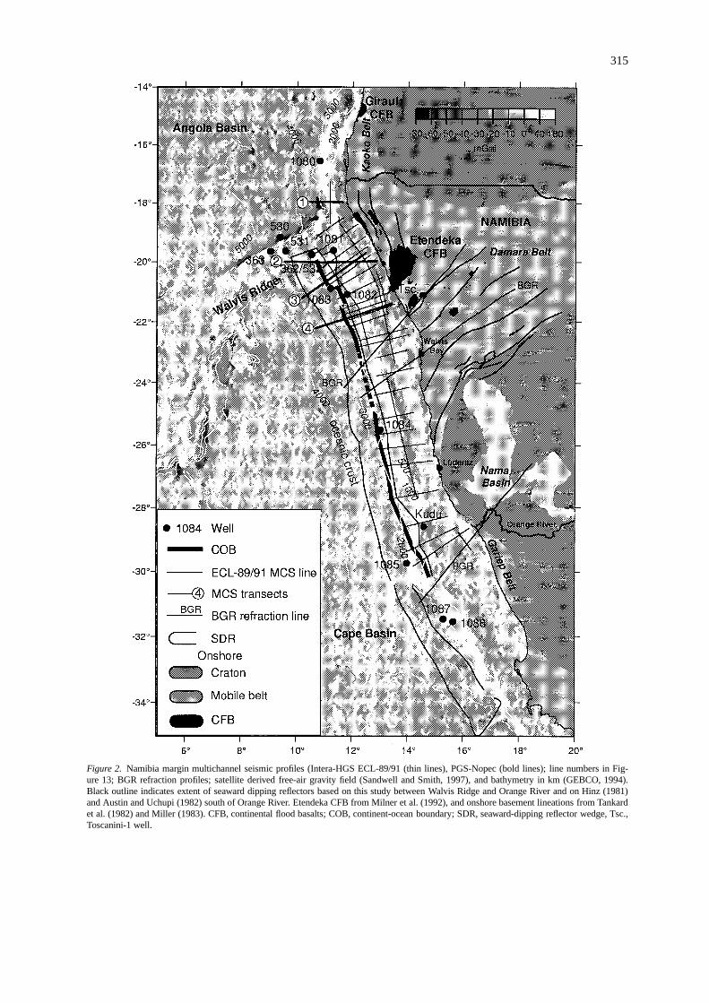
Figure 2. Namibia margin multichannel seismic profiles (Intera-HGS ECL-89/91 (thin lines), PGS-Nopec (bold lines); line numbers in Fig-ure 13; BGR refraction profiles; satellite derived free-air gravity field (Sandwell and Smith, 1997), and bathymetry in km (GEBCO, 1994).Black outline indicates extent of seaward dipping reflectors based on this study between Walvis Ridge and Orange River and on Hinz (1981)and Austin and Uchupi (1982) south of Orange River. Etendeka CFB from Milner et al. (1992), and onshore basement lineations from Tankardet al. (1982) and Miller (1983). CFB, continental flood basalts; COB, continent-ocean boundary; SDR, seaward-dipping reflector wedge, Tsc.,Toscanini-1 well.

316
Late Triassic extensional faulting produced a series ofsubparallel, NNW-trending troughs and deposition offluvial and lacustrine sediments in northern Namibia(Martin, 1975; Uliana et al., 1989).
The oldest sediments drilled offshore southwestAfrica are of Late Jurassic age (Gerrard and Smith,1983). However, the Toscanini-1 well (Figures 2, 13)penetrated thick Permo-Carboniferous Karoo clasticsbelow Cretaceous lavas (Gerrard and Smith, 1983).In early Middle Jurassic time the region was com-prised of separate, but related, rift basins (Gust et al.,1985). In the Early Cretaceous a renewed rift episodewithin the existing rift system culminated with com-plete crustal breakup and onset of sea floor spreading.Whether this was a renewed episode of rifting or acontinuation of Triassic extension is still debated (e.g.,Light et al., 1993; Stollhofen et al., 1998). Nonethe-less, the location and orientation of most early Meso-zoic extensional features suggests continental breakupoccurred through reactivation of Paleozoic structures.
A number of plate tectonic models describe theopening of the South Atlantic (Table 1). The platetectonic history of the region is well constrained fromseafloor spreading anomaly 34 to Present (e.g., Candeet al., 1989; Nürnberg and Müller, 1991). The pre-anomaly 34 history of spreading during the CretaceousNormal Superchron period is more tenuous. Rabi-nowitz and LaBrecque (1979) interpreted the oldestseafloor spreading anomalies off South Africa to beM13 and M11, with progressively younger anomaliesnorthwards, reaching M4 (equivalent of M5 of Grad-stein et al., 1994) off central Namibia. However, theiroldest seafloor spreading magnetic anomaly on theconjugate Argentine margin is M4 (Max et al., 1999).Seismic data have subsequently shown, that the inter-preted M13-M7 series off South Africa are located onpresumed rifted continental crust, and landward of theseaward dipping reflectors (Austin and Uchupi, 1982;Gerrard and Smith, 1983; Gladczenko et al., 1997).
Remnants of the Etendeka CFBs are scattered over78 000 km2 of northwest Namibia and Angola (Gi-raul Basalts) (Figure 2); the main lava field covers∼12 000 km2 and the volcanic rocks reach a maxi-mum thickness of 880 m (Milner et al., 1992). TheEtendeka Formation consists of bi-modal, basic tointermediate tholeiitic lavas interbedded with moreacidic quartz latite units (Milner et al., 1992). Nosignificant air-fall ash horizons have been observed.Numerous basaltic dikes and sills are associated withthe Etendeka Formation. In comparison, the Paranálavas, in Brazil (Figure 1), cover an area in excess
of 1 200 000 km2 (Peate et al., 1992). The thicknessof the Paraná lavas mirrors the overall structure of theunderlying sedimentary basin with the thickest accu-mulation,>1.5 km, preserved in the north (Peate et al.,1992).
The Paraná-Etendeka CFB emplacement was initi-ated with a major magmatic pulse at 132 Ma, followedby multiple minor pulses, including the 125–130 Ma,late-stage dolerite dikes intruding the Etendeka basalts(Erlank et al., 1984; Milner et al., 1995; Renneet al., 1992, 1996a, b). The magmatic activity, there-fore, appears to have commenced just prior to thearrival of the northward propagating South Atlanticrift. Thus, plume-related volcanism and continentalrifting appear to be closely associated. Geochemicalstudies (Hawkesworth et al., 1988, 1992; Peate et al.,1990, 1992) suggest that the majority of the Paraná-Etendeka CFBs were derived from the lithosphericmantle, while the final alkalic magmas, postdatingcontinental breakup, had much greater contributionsfrom the underlying asthenosphere.
Relative to the Gradstein et al. (1994) time scale,used throughout this paper, there is an age differ-ence of 3–4 m.y. between the emplacement of theParaná/Etendeka CFBs and the age of anomaly M5,the oldest seafloor spreading anomaly identified onboth sides of the South Atlantic (Rabinowitz andLaBrecque, 1979). However, as the M-series anom-alies off Nambia and its conjugate margin have notyet been conclusively identified, the question remainswhether the main, short-lived CFB effusion event iscoeval or slightly earlier than presumed breakup vol-canism along the Namibia margin, defined by SDRs.
Sediment and acoustic basement
The Namibia margin can be segmented into threeprovinces reflecting both the width of the continentalshelf and the presence of the Walvis Ridge. Depth-converted transects 1 and 2 show the setting of the‘northern’ and ‘Walvis Ridge’ provinces, respectively(Figures 3 and 4); whereas transects 3 and 4 (Figures 5and 6) and ECL-89/91 lines (Figure 7) illustrate thedevelopment of the ‘southern’ province. Except forthe uppermost sediments, well control in this region issparse. Petroleum exploration wells have been drilledon the Namibia shelf, but well information has onlybeen released from the Kudu wells off the OrangeRiver, where basaltic rocks were recovered. DSDPLegs 40 and 75, and more recently ODP Leg 175,

317
Table 1. South Atlantic plate reconstructions.
Reconstruction Closure definition Inferred openin ages, Ma
S. Africa/Argentina Central Namibia
Bullard et al. (1965) 900 m isobath − −Rabinowitz and LaBrecque (1979) Grav./mag. lineaments 135.5–135.3 (M13) 127.7–126.7 (M5)
Pindell and Dewey (1982) Grav./mag. lineaments1 128.3–128.2 (M6) 121.1–120.3 (M0)
Vink (1982) 3000 m isobath 135.5–135.3 (M13) 127.7–126.7 (M5)
Unternehr et al. (1988) M4 anomaly 127.7–126.7 (M5) 127.7–126.7 (M5)
Nürnberg and Müller (1991) Seismic2 127.7–126.7 (MS) 127.7–126.7 (M5)
Lawver et al. (1998) Grav./mag. lineaments 129.5–129.7 (M9) 127.7–126.7 (M5)
1Gravity and magnetic lineaments of Rabinowitz and LaBrecque (1979).2COB definition of Emery and Uchupi (1984), which places the COB just landward of the onset of oceanic crustcharacterized by diffractive hyperbolic reflections. This COB regionally corresponds to magnetic anomaly M4of Rabinowitz and LaBrecque (1979). The time scale of Gradstein et al. (1994) is used.
Figure 3. Line drawing of MCS transect 1 on northern Namibiamargin. Depth conversion is based on MCS interval velocities de-rived from stacking velocities for the sediments and uppermostcrystalline crust, and on the middle and lower crustal velocities ofBauer et al. (1996, 1997, submitted). Legend in Figure 4. Locationin Figures 2 and 13.
drilled the sedimentary sections on the outer part ofthe Namibia margin (Figure 2). Except for one, Site530, on oceanic crust in the Angola Basin, none of thesites sampled igneous rocks.
We have identified two regional seismic reflectorson the outer margin, OC (oceanic crust) and TB (topbasalt), associated with igneous rocks, the latter issimilar to surface AII of Austin and Uchupi (1982).Two prominent unconformities, D and RUC (LateJurassic/Early Cretaceous rift unconformity), previ-ously identified by Austin and Uchupi (1982), Gerrard
and Smith (1983) and Bagguley (1997), bound thepost-opening sedimentary sequences (Figures 3–7).RUC is an erosional surface defining the top of arifted terrane (Figure 8). North of the Walvis Ridge(Figure 3) the extensional terrane below the RUCis characterized by rotational planar normal faulting,with growth of sedimentary layers on the fault blockstowards their footwalls. The block width varies insize from a few kilometers to>25 km. No evidenceof an intracrustal detachment surface is visible in theseismic data, but individual fault dip decreases sea-ward, suggesting the presence of such a feature. Thehalf-grabens accommodate as much as 1.5-km-thicksediments (Figure 3).
On the Walvis Ridge and farther south on theNamibia margin (Figures 4-7), the character of RUC issimilar, but the erosion appears to have reached deeperlevels, resulting in a smoother unconformity alongwhich the gentle relief reflects geometry of the under-lying inclined fault blocks (Figure 8). The apparent dipof the faults is generally lower than north of the WalvisRidge, suggesting decreasing dip with depth indicativeof listric faults, possibly soling out at a detachmentplane. The syn-rift sedimentary wedges show lessgrowth than north of the Walvis Ridge, presumablybecause of erosion of the uppermost fault blocks andsyn-rift wedges. We concur with Austin and Uchupi(1982) and Bagguley (1997), and interpret RUC to bethe rift unconformity reflecting subaerial erosion at theend of the Late Jurassic/Early Cretaceous rift episodeand ensuing continental breakup. The faulted terraneimmediately below RUC is a 70–115-km-wide zonebetween the lower slope and the shelf edge, defin-ing the extent of the Late Jurassic/Early Cretaceousrifting which led to breakup. We use the term ‘Late

318
Jurassic/Early Cretaceous rift zone’ (Figures 3–7, 13)to denote the highly eroded zone of extension thatrepresents the eastern half of the rift formed at thistime.
The western ends of transects 3 and 4 south ofthe Walvis Ridge (Figures 5 and 6) show acousticbasement below 0.5–2 km of post-opening sediments.Acoustic basement is a rough, discontinuous surfacethat exhibits complex hyperbolic reflections. Moho isimaged on transect 4 below a∼8-km-thick crystallinecrust. The character of the acoustic basement, the ap-parent lack of continuous sub-basement reflectors, andthe crustal thickness suggest oceanic crust (OC).
Farther east, on the lower rise, OC changes later-ally into a smooth continuous reflector, which we callTB, with characteristic landward downlap (Figures8 and 9). TB caps a 4–5-km-thick and 75–175-km-wide zone of SDRs, which may represent one (asin transect 4) or two discrete wedges (as in transect3). The SDRs appear to terminate seaward against asteeply landward dipping reflector (Figures 6 and 9).The SDRs consist of convex, offlaping divergent andlaterally continuous reflectors (Figure 9). No obvi-ous syn-constructional faults are identified within theSDR units. TB continues beyond the apex of the SDRwedge, where it onlaps reflector RUC (Figures 4–7). The thickness of the SDR unit thins progressivelylandward of its interpreted apex. TB lies∼0.2 kmbelow a high amplitude reflector which has been cor-related with a∼5 km s−1 velocity layer, possiblyequivalent to the Aptian limestone penetrated at DSDPSite 363 (Figure 13) (Sibuet et al., 1984).
We interpret the SDRs as voluminous basalticflows emplaced subaerially and/or in a shallow sub-aqueous environment during the latest period of riftingand initial formation of oceanic crust on this mar-gin. These lavas may be interbedded with sediments,similar to those drilled on the Hatton Bank (Robertset al. 1984), Vøring Plateau (Eldholm et al., 1987)and off SE Greenland (Larsen et al., 1994; Duncanet al., 1996). Consequently, reflector TB representsthe sediment-lava transition at the top of the extru-sive complex, i.e. it images multiple flows whichmay have undergone erosion; it thus constitutes atime-transgressive surface.
On the Walvis Ridge, the SDR wedge is narrower,∼50-km-wide, than farther south (Figure 4); the SDRwedge is capped there by a smooth, locally faultedsurface. We interpret this surface as the equivalent ofreflector TB. It continues landward∼75 km beyondthe apex of the SDRs, where it onlaps RUC. West of
the SDRs, the acoustic basement (equivalent of TB)changes character, shallows and eventually outcropsat the seafloor (Figure 4). This surface is characterizedby high relief,>1000 m, and large mound-like struc-tures (Figures 4 and 10). The mounds contain mostlychaotic internal reflectors with some layered reflectorsnear the mound flanks. Several mounds are apparentlybounded by normal faults. Near the western end oftransect 2 (Figure 4) we observe a steep landward dip-ping reflector, offsetting TB by∼1000 m, which canbe traced∼8 km into the crust. We interpret reflectorTB as the top of the extrusive Walvis Ridge base-ment, produced by the Tristan hotspot after breakupand the emplacement of the SDRs farther east. Theseismic character of TB may be related to a change inemplacement environment from subaerial to shallow-marine, favoring more explosive volcanism, reducingflow lengths and increasing wave-base erosion (cf.,Planke et al., 1999). The landward-dipping fault in thewestern end of transect 2 perhaps relates to differentialsubsidence between the Namibia margin proper andthe Walvis Ridge.
In transect 1 (Figure 3), north of the Walvis Ridge,the rough, discontinuous OC reflector abuts RUC.The transition is characterized by short,<1-km-long,downlapping reflectors onto RUC which we interpretas lava flow fronts (cf., Self et al., 1997). The presenceof highly extended, faulted continental crust adjacentto thin,∼6 km thick, presumed oceanic crust proba-bly accounts for the well preserved syn-rift sequences,which were deposited at or below sealevel. The syn-rift sediments rest on crystalline basement. A numberof sub-horizontal, high-amplitude events are presentin the syn-rift sequence, in several instances cuttingacross faults; we interpret them as sills and low-anglefeeder dikes. Some of these reflectors penetrate intothe seismically transparent crystalline ‘basement’, andwe cannot rule out the existence of a deeper crystallinebasement surface.
On the Walvis Ridge and farther south, the baseof the sub-RUC sedimentary sequence is defined bya high-amplitude reflector which we term ORT. ORTrepresents an erosional or ‘old rift’ unconformity, step-ping down westwards over several large, 5–20 kmwide, faulted intervals forming a deep graben featurelocated beneath the present shelf edge (Figures 4–7,11). We observe both planar and listric faults; somefault blocks contain weak sub-horizontal reflectors be-low ORT which may be interpreted as sedimentaryin origin. Nonetheless, we interpret ORT as an ero-sional unconformity atop ‘basement’ based on: (1) its

319
Figure 4. Line drawing of MCS transect 2 on northern Namibia margin and Walvis Ridge. Location in Figures 2 and 13.
Figure 5. Line drawing of MCS transect 3 on southern Namibia margin. Legend in Figure 4. Location in Figures 2 and 13.
Figure 6. Line drawing of MCS transect 4 on southern Namibia margin. G, magnetic anomaly ‘G’ of Rabinowitz and LaBrecque (1979).Legend in Figure 4. Location in Figures 2 and 13.

320
Figure 7. Selected MCS dip lines off southern Namibia. Legend in Figure 4. Location in Figure 13.

321
Figure 8. Stacked seismic example of a rifted zone covered by basaltic flows on the southern Namibia margin. Legend in Figure 4. Location inFigures 7 and 13.
high amplitude seismic signature, separating rocks ofdifferent acoustic properties; (2) its large , 8–16 km,depth; and (3) the absence of well defined, continuousreflectors below ORT.
The ORT-RUC sequence, reaching a maximumthickness of∼12 km, is comprised of mostly paralleldivergent and westward-dipping reflectors (Figures 4–7, 11). Below the shelf, they show poor continuity,but little evidence of faulting. However, a major,steep east-dipping fault cuts across, and apparentlybounds the RUC-ORT sequence towards the west (Fig-ures 5–6). Reflector ORT appears to terminate at thisfault. West of this, a more faulted sub-RUC terraneis observed. Thickening of the interpreted SDR ex-trusive complex beyond the shelf edge causes sub-TBseismic resolution to deteriorate, so the interpreta-tion there becomes more tenuous. Nonetheless, the
presence of high-amplitude sub-horizontal reflectorsincreases westwards. These reflectors, which followlayering within interpreted fault blocks, and in sev-eral instances cut across faults, are interpreted as sillsand low angle dikes presumably related to the EarlyCretaceous breakup event (Figures 3–6).
South of Walvis Bay, the continuation of the deepRUC-ORT basin seen to the north is less easily iden-tified. Observations suggest instead a major basementhigh approximately beneath the location of the G mag-netic anomaly of Rabinowitz and LaBrecque (1979)(Figure 7). Westward, at depths>6 km, this highis bounded by a sequence of west dipping reflectorsthat have been suggested to represent breakup-relatedvolcanics (Karl Hinz, pers. comm.), whereas at a shal-lower stratigraphic level, it is onlapped by the TBreflector, i.e. our interpretation of the top of breakup-

322
Figure 9. Migrated seismic example of seaward-dipping reflectors off central Namibia. Legend in Figure 4. Location in Figures 6 and 13.
related volcanic and sedimentary units. Along thissegment of the Namibian margin, we interpret the bas-inward continuation of RUC-ORT to be best imagedon lines 19 and 23 (Figure 7 and 11). The base-ment high coinciding with magnetic anomaly G inFigure 7 is generally associated with an extensionalterrane which appears eroded prior to emplacementof reflector TB. Landward, a different type of basinterrane exists. Here (Figures 7 and 12), locally deepbasin configurations appear to resemble a compres-sional rather than an extensional mode of formation.The eastern limit of these basins is located 30–60 kmoff the Namibia coast, i.e., landward of our seismicline coverage; however, several lines clearly show thatextensional reactivation has created a series of well-defined low-angle intracrustal faults and intermediateto small, half grabens (e.g., line 12; Figures 7 and12). We tend to interpret the observed variation andcomplexity from north to south to reflect the offshorecontinuation of the Damara Belt in Namibia (Fig-ure 13). In fact, the change between a deep basin tothe north and the more complex setting southwards
correlates with the projected offshore location of theAusteib, Omaruru and Okahandja lineaments. The lowangle faults may either be related to Late Jurassic-Early Cretaceous extension, Karoo basin formation, ormay even more likely be associated with extensionalcollapse of the Precambrian Orogen. High seismicvelocities in the associated sediments (> 6 km s−1)provides an argument for our suggestion of an old ageof formation.
Intra-basement interfaces and crustalconfiguration
The MCS profiles reveal distinct mid- and lower-crustal reflectors. To develop a model of the entirecrust, we mapped the intrabasement interfaces, eval-uated the available seismic velocities, and tested thecrustal geometry by gravity modeling.

323
Figure 10. Migrated seismic example of seaward-dipping reflectors and volcanic mounds on the Walvis Ridge. Legend in Figure 4. Locationin Figures 4 and 13.
Intra-basement interfaces
In 1995, GFZ and BGR carried out a combinedonshore-offshore MCS and wide-angle seismic surveyalong three∼580 km long NE-SW profiles (Figure 2).The seismic arrivals along the northern profile havebeen raytraced to yield a velocity gradient model withlaterally varying velocities across the margin (Baueret al., 1996, 1997, submitted). The profile is located70–220 km south of transect 4 but crosses MCS lineECL-91-365 (Figures 2 and 13). The distance to tran-
sect 4, does not allow a direct tie of deep reflectorsand crustal velocities; however, in a regional sense weare able to correlate the main crustal units by project-ing the velocity model onto transect 4 (Figure 14). Atthe western end of transect 4, a semi-continuous bandof lower crustal reflectors, M (Figure 6), is present∼8 km below oceanic basement, OC. This reflectorband corresponds to the top of a 8.1 km s−1 uppermantle velocity below a crystalline crust of the samethickness as shown in transect 4 (Figures 6 and 14)(Bauer et al., 1996, 1997, submitted). We interpret

324
Figure 11. Stacked seismic example of upper part of RUC-ORT graben. Legend in Figure 4. Location in Figures 7 and 13.
these reflectors to represent the base of the oceaniccrust. Reflectors M becomes less continuous landwardbeneath the SDRs; instead short landward-dippingbands of high reflectivity appear. However, the con-tinuity of lower crustal reflectors improves east of theSDR apex, where they become semi-continuous andmostly horizontal, forming an undulating band belowthe Late Jurassic/Early Cretaceous rift zone. Farthereast, below the inner shelf, the reflector band changesinto a single reflector which dips steeply landwards.These reflectors correspond in general to the Moholevel of Bauer et al. (1996, 1997, submitted).
In transects 2 and 3 (Figures 4 and 5) M reflectorsbeneath the Late Jurassic/Early Cretaceous rift zoneare less continuous than farther south. North of the
Walvis Ridge, similar deep and continuous reflectorscan be traced across the margin shallowing westwardsto 14 km depth beneath oceanic crust (OC) (Figure 3).Based on their depth, geometry and similarity to thelower crustal reflectivity in transect 4, we interpret allof these reflectors to originate at the base of the crust.Thus, Moho is imaged on all transects, even thoughits seismic signature is most distinct beneath oceaniccrust and on the landward side of the SDR complexes.The offshore crust is thickest along Transect 2 (Fig-ure 4) east of the Walvis Ridge, where Moho lies ata depth of 29–30 km beneath the Late Jurassic/EarlyCretaceous rift. According to Trumbull et al. (1997),the offshore-onshore (Figure 2) velocity profile shows

325
Figure 12. Stacked seismic example of pre-Jurassic basin landward of the hinge zone on southern Namibia margin, showing interpretedlow-angle intracrustal detachment faults, with sedimentary infill. Legend in Figure 4. Location in Figure 13.

326
Figure 13. Namibia margin tectono-magmatic zonation. MCS profiles from Intera-HGS ECL89/91 (thick lines) and Nopec surveys (thin lines).Magnetic anomalies from Rabinowitz and LaBrecque (1979). Bathymetry in m (GEBCO, 1994). Etendeka CFB from Milner et al. (1992) andonshore basement lineations from Tankard et al. (1982) and Miller (1983). RUC, Late Jurassic/Early Cretaceous rift unconformity.

32
7
Figure 14. Crustal model along transect 4 (Figure 6), based on depth converted MCS data and 2D gravity modeling (Talwani et al., 1959). Crustal velocities (Baueret al., 1996, 1997, submitted)have been projected from BGR refraction profile (Figure 13). Sediment densities (1900, 2100 and 2300 kg m−3) based on DSDP Site 362 core data (Bolli, et al., 1978). Upper igneous crustaldensities based on Barton (1986), Becker et al. (1989), Alt, Kinoshita et al. (1993) and Planke (1994). Lower igneous crustal and mantle densities based on Sandwell and Renkin (1988),Christensen and Salisbury (1989), Iturino et al. (1991), Genshaft et al. (1992), Maslanyj et al. (1992), Mengel and Kern (1992) and Christensen and Mooney (1995).

32
8
Figure 15. Modeled crustal stretching factors and tectonic subsidence along transect 4. COB, continent-ocean boundary; LCB, high-velocity lower crustal body.

329
Figure 16. Plate reconstruction of Africa and South America to∼125 Ma (top) and∼112 Ma (bottom) using rotation poles of Nürnberg andMüller (1991) and the PLATES software. Free-air gravity data from Sandwell and Smith (1997).

330
Figure 17. Simplified evolutionary model of the Namibia volcanic margin.

331
a gradual deepening of Moho to∼45 km beneath theDamara Belt, about 200 km landward of the coastline.
The band of reflectors at or near the presumedbase of the crust splits into two separate bands, whichwe call M and T, under the central parts of transects2–4 (Figures 4–6). Although their depth decreasessouthwards, the separation of the two reflective bandsremains 4–6 km. On transect 4 (Figure 6), the lowercrustal configuration corresponds to a 8–12 km thick,>7.1 km s−1 velocity layer (Bauer et al. 1996, 1997,submitted), while a part of the lower crust (150–250 km on Transect 4; Figure 6) corresponds to a6 km thick, >7.4 km s−1 velocity layer. Such ve-locities are typical for volcanic margins, where theyhave been interpreted as an indication of the presenceof igneous rocks at lower crustal levels, presumablyemplaced during breakup (e.g., Eldholm et al., 1995).However, the top of this lower crustal body (LCB) hasonly been convincingly imaged in vertical incidenceseismic data on the Vøring margin off Norway (Skog-seid and Eldholm, 1995). We now show that both itstop and base may be imaged in high-quality MCS pro-files on the Namibia margin. On the other hand, thereis no evidence either for a similar body or for signif-icant volcanism along the continent-ocean transitionnorth of the Walvis Ridge (Figure 3). This suggests amajor change in tectono-magmatic development; themargin segment north of the Walvis Ridge resemblesa ‘typical’ non-volcanic margin (Figure 3).
Intra-basement reflectors are sub-parallel to M inTransect 1 (Figure 3) where a band of reflectivity in themiddle crust dips eastwards. On the Walvis Ridge andfarther south, intra-basement reflectors are present be-low the landward flank of the RUC-ORT basin. Southof Walvis Bay, intracrustal reflectors beneath the shelfdip westwards (Figure 12), and appear to separatecrustal levels with different reflectivity characteristics.These reflectors have been interpreted by Light et al.(1993) and Clemson et al. (1997) as Late Precambrianshear zones, or thrusts reactivated as Late Mesozoicextensional faults. Farther west, the seismic resolu-tion decreases, and few continuous intra-basementreflectors are visible (Figure 7).
Continent-ocean boundary
The continent-ocean boundary (COB) is defined us-ing the MCS data. The structural change from oceaniccrust to highly attenuated, faulted continental crustallows relatively unambiguous definition of the COBin Transect 1 north of the Walvis Ridge (Figure 3).
Farther south, we place the COB at the seaward termi-nation of RUC, or where the deepest (oldest) seawarddipping reflector unit disappears at depth. Fartherwest, there are no continuous reflectors beneath theSDRs, which thus appear to lack a base. The COB isthus located in an area where the breakup-related riftzone (continental crust) disappears and the initial volu-minous volcanism associated with seafloor spreadingand emplacement of SDRs may have been located.This definition of COB has been used on other vol-canic margins (e.g., Skogseid and Eldholm, 1987).Using this criterion, we map the COB between WalvisRidge and Walvis Bay, and from∼25◦ S to OrangeRiver. We have indicated a∼20 km offset in the COBbetween transects 3 and 4, based on the interpreta-tion of lines ECL-91-412 and -415 (Figures 2 and13). However, the poorer seismic resolution of thesedata, compared with the transects, does not rule outa continuous COB. The COB on most seismic linescorresponds to the eastern slope of a−5 to−40 mgalgravity low (Figure 2) (cf., Lawver et al., 1998).Hence, we have used this anomaly trend to extrapo-late the COB between Walvis Bay and∼25◦ south.The COB in transect 4 (Figure 6) coincides with thenegative, high amplitude ‘G’ magnetic anomaly of Ra-binowitz and LaBrecque (1979). They interpreted theanomaly as the juxtaposition of magnetized oceaniccrust and non-magnetic continental crust, and locatedthe COB at the peak anomaly.
South of 23◦S, anomaly ‘G’ is, however, offset∼150 km landward (Figure 13); there our COB cor-responds to the continent-ocean transition zone ofAustin and Uchupi (1982). Our data also support theircontention that magnetic anomaly ‘G’ coincides withthe hinge zone, or western flank of the RUC-ORTgraben, between Lüderitz and Walvis Bay.
Crustal model and margin zonation
The dominant feature of the free-air gravity field isa narrow, coast-parallel belt of positive anomalies,25–120 mGal, along the shelf edge (Figure 2). Thisanomaly, here termed the shelf edge anomaly, is es-pecially well developed south of Walvis Bay. It is lesspronounced to the north. The shelf-edge anomaly hasalso been correlated with the pinch-out of the LateJurassic/Early Cretaceous sedimentary sequence (Ger-rard and Smith, 1983; Stewart et al., in press). TheSDRs lie west of this anomaly (Figure 2). A parallelbelt of positive gravity anomalies to the west corre-sponds to the transition from the oldest oceanic crust

332
with SDRs to normal oceanic crust (Figure 2). We usethis belt to define the seaward termination of SDRssouth of transect 4 (Figure 6), where seismic data donot image the outer margin. Thus, the SDRs corre-spond to a belt of gravity lows flanked on either sideby positive anomalies. The seismic interpretation oftransects 3 and 4 (Figures 5 and 6) allows us to dividethe margin into the following main units (from the topdown): post-opening sediments, Late Jurassic syn-riftsediments, RUC-ORT basin infill, SDRs, continentaland oceanic crust, and a LCB. To evaluate this crustalmodel, and specifically the observed Moho relief, thehigh velocity lower crust, and the high,+6.3 km s−1,seismic velocities within the RUC-ORT sequence, wecarried out 2-D gravity modeling along transect 4.The oceanic crust is considered as ‘reference crust’,and a 50 km compensation depth was used to accountfor the thick crust beneath the African craton. A re-gional gravity gradient is present across the margin. Toevaluate its magnitude, we calculated the effect of ho-mogeneous crust extending from normal oceanic crustto the 45-km-thick craton (e.g., Green, 1983; Baueret al., 1996, 1997, submitted). This exercise revealeda 75 mGal regional change across the transect, con-sistent with a NW-dipping geoid slope (e.g., Lemoineet al., 1997). This regional gradient was eliminatedfrom the modeled profile. The densities assigned to thevarious crustal units are shown in Figure 14. Note thatthe deeper part of the RUC-ORT sequence has a den-sity of 2700 kg m−3, consistent with the+6.4 km s−1
velocities of Bauer et al. (1996; 1997, submitted),and implying a meta-sedimentary or crystalline rockcomposition. The presence of intrusives in the seis-mic data, and the general tectono-magmatic setting,suggest increasing mafic content in the continentalcrust flanking the COB. Therefore we use a densityof 2850 kg m−3 in the continental crust between theLate Jurassic/Early Cretaceous syn-rift sediments andthe LCB (Figure 14).
The original gravity model is consistent with theobserved gravity field, except in the eastern part (20–40 km in Figure 14), where the model shows massdeficiency, yielding a 20–40 mGal lower anomaly thanobserved (Figure 14). In this area, Bauer et al. (1996,1997, submitted) interpreted zones of laterally rapidlyincreasing velocities, from 6.5 km s−1 to 6.9 km s−1,forming∼20-km-wide bodies from a depth of 12 kmto the base of the crust. These bodies appear as cir-cular positive gravity anomalies, with amplitudes of50–150 mGal, located east of the shelf edge anom-aly (Figure 2). Trumbull et al. (1997) have interpreted
these bodies as mafic intrusions, related to the EarlyCretaceous igneous activity. Therefore, we have intro-duced a∼20-km-wide intrusive body with a densityof 2950 kg m−3 to account for the 50 mGal positiveanomaly on the inner shelf (Figure 14).
We have documented that the Namibia margin iscomprised of different tectono-magmatic styles northand south of the Walvis Ridge (Figure 13). In thenorth, the margin lacks voluminous volcanic con-structions and consists of 3 zones: normal oceaniccrust, a∼65-km-wide rift, and thick continental crust.South of the Walvis Ridge, a typical volcanic mar-gin, four partly overlapping tectono-magmatic zonesoccur (Figure 13): (I) oceanic crust; (II) thickenedoceanic crust including SDRs; (III) a∼150-km-wideLate Jurassic/Early Cretaceous rift, covered by SDRsin the west and perhaps with lavas and intrusives far-ther east; (IV) thicker continental crust, including anolder, 50–70-km-wide (RUC-ORT) rift basin beneaththe modern shelf. We note that zones III and IV over-lap in the north, but are present as two distinct zonessouth of∼24◦S. On the Walvis Ridge, zones III andIV are similar to those farther south. However theSDRs in zone II are narrower than farther south; thiscrustal unit abuts the thick crust of the Walvis Ridge(Figure 4).
Margin evolution
Pre-Jurassic rift setting
The Atlantic margin of southern Africa largely co-incides with the Late Precambrian-Cambrian Pan-African fold belt (Figure 2). South of Walvis Bay, ourseismic data, show westward-dipping, sub-horizontal,mid-crustal reflectors below ORT resembling imbri-cate stacking of thrust sheets (Figures 7 and 12). Weinterpret these features as a continuation of onshorecollisional tectonic features, such as the predomi-nantly mafic Marmora Terrane (Frimmel et al., 1996a,b). Thus, considerable parts of the fold-belt may un-derlie the shelf and the continental slope (cf., Martin,1975; Frimmel et al., 1996a, b).
The mid-crustal reflectors below ORT south ofWalvis Bay suggest that the RUC-ORT basin may havestarted forming in the Early Paleozoic, as a result oforogenic collapse of the Pan-African fold belt (cf.,Dewey, 1988). The onshore basement metamorphicgrades indicate uplift and denudation during the EarlyPaleozoic (Martin, 1975). The presence of deep basins

333
on the Namibia continental shelf provided the neces-sary repository for the postulated denudation of the 8–15 km thick Damara mountain belt (cf., Martin, 1975).By the late Paleozoic, a westward directed drainagesystem had been established across the metamorphicbackbone of the fold belt. This drainage, which was re-modeled by the Permo-Carboniferous ice-sheet, con-tinued infilling the RUC-ORT basins which have beenlargely exhumed today. The 6.4+ km s−1 velocities(Bauer et al., submitted) within the RUC-ORT se-quence are similar to velocities of>6.0 km s−1 thathave been mapped by refraction experiments in thePre-Cambrian to Cambrian Nama Basin sedimentaryrocks (Figures 2 and 13) and in the underlying graniticbasement (Green 1983; Miller 1983).
North of Walvis Bay, the ‘G’ magnetic lineationcurves into the Austeib Lineament of the Damara Belt(Figure 13). We suggest that the lineation is relatedto late Precambrian and Paleozoic basement featureswhich continue offshore. The high amplitude mag-netic anomaly over these features implies presenceof basaltic rock (Schreckenberger, pers. comm.), orophiolities like the Maramora Terrane in the GariepBelt (Kröner, 1975; Frimmel et al., 1996a,b). Clem-son et al. (1997) proposed that the Austeib lineamentwas related to the offshore structural highs such asthe Cape Cross Segment Boundary and represented abarrier impeding northward rift propagation in EarlyCretaceous. Our data indicate a narrowing and shal-lowing of the Paleozoic basins in this region; however,the Early Jurassic rift zone and the SDRs do not showany offsets. On the other hand, the data coverage isstill too sparse to eliminate this possibility.
The existence of Paleozoic basins along the Pan-African fold belt may have greatly influenced the laterrifting of Gondwanaland (cf., Ryan and Dewey, 1997).From our regional interpretation, we suggest that deepbasins below the present shelf may have been formedduring the Damara Orogeny, whereas post-orogeniccollapse of the Damara, Kaoko and Gariep fold beltsled to extensional reactivation and formation of theseismically observed low angle normal faults in someareas.
Jurassic rifting
In SW Africa, N-S extensional fault systems control-ling basin development were active during the Permian(Grill, 1996) and were reactivated in the Early Juras-sic, producing small onshore basins infilled with floodbasalts interlayered with lacustrine deposits (Stoll-
hofen et al., 1998). The westward-dipping faults thathave been identified in parts of the Nama Basin (Fig-ure 2) are interpreted as conjugates to a large scaledetachment, along which the South Atlantic eventu-ally opened (Stollhofen et al., 1998). In the Kudu wellregion (Figures 2 and 13), the initiation of rifting at∼180 Ma was associated with volcanism, followedmostly by intra-continental sedimentation. This suc-cession is documented by the 690 m thick basic lavasand some alkaline lavas underlying continental redbedsequences drilled in the Kudu wells off the OrangeRiver (Gerrard and Smith, 1983). Onshore northernNamibia, the fluvial and aeolian sands of the EtjoFormation lie beneath, and partly interfinger with,the Etendeka basalts, whereas the deeply-eroded faultblocks (Figures 4–7) below RUC imply subaerial rift-ing during this time. It is uncertain when uplift started,but we suggest that it reflects the arrival of the Tristanplume. The already thinned lithosphere along the mo-bile belts would act as traps for the hot plume material(e.g., Artyushkov et al., 1980; Sleep 1997) therebyleading to dynamic uplift of these areas. We envisagea subaerial rift zone similar to the present East AfricanRift, and that rifting may have lasted for a period of30–40 m.y. before breakup.
The deep Paleozoic basin east of the Early Cre-taceous rift zone documents that the Namibia marginhas experienced at least one major stretching episodeprior to the final breakup and margin formation (e.g.,Lambiase, 1989; Light et al., 1993; Gladczenko et al.,1997). Subsidence analysis of Transect 4, assumingAiry-type isostatic compensation (Steckler and Watts,1978; Sclater and Christie, 1980; Le Pichon andSibuet, 1981), ignoring eustatic sealevel changes, andcorrecting for the reduced subsidence due to magmaticunderplating (Pedersen and Skogseid, 1989; Skog-seid, 1994), shows that the pre-Mesozoic rift episodeseverely thinned the crust, with stretching factors ashigh as 2 (Figure 15). The subsidence curve for theLate Jurassic rift episode shows gradually increasingtectonic subsidence, and stretching factors, towardsthe COB. The averageβ-value over the 165 km widerift zone is 1.7, suggesting a syn-rift displacementof about 68 km. These stretching factors are higherthan the averageβ = 1.39 calculated on the cen-tral Namibia margin by Stewart et al. (in press) basedon total tectonic subsidence, in which the lithospheremaintains long-term strength during rifting.

334
Breakup volcanism and relationship with CFBs
The location of the Tristan plume at∼130 Ma duringthe initial rifting between Africa and South Americais unclear. O’Connor and Duncan (1990) and Turneret al. (1994) have suggested an initial location be-neath the Paraná Basin. This appears plausible, as theParaná CFBs are by far the greatest surface expressionof magmatism in the region. Thompson and Gibson(1991) have argued that the plume was located farthereast, beneath the incipient plate boundary, and thatthe thicker volcanic pile in the Paraná basin is due tomagmatism in an area which had already been thinnedduring a long history of lithospheric extension. Harryand Sawyer (1992) have postulated that a horizontalpressure gradient may have developed in the lowercrust during the early stages of extension; this couldhave provided a mechanism for transporting magmalaterally to the Paraná province, some 100–200 kmwest of the locus of final breakup.
The lavas drilled in the Kudu wells, and the ev-idence for thick basaltic layers in the MCS data,imply that the onshore CFBs continue offshore. Thelocation of the 132–131 Ma Paraná-Etendeka CFBs(e.g., Renne et al., 1997), as well as the AngolanGiraul basalts at 127 Ma (M4), suggest that a con-tiguous CFB province existed just prior to breakup(Figure 16). A possible onshore extent of the EtendekaCFBs is indicated on Figure 13. The entire offshorearea from the Giraul basalts in southern Angola toWalvis Bay may contain basaltic material, slightlypredating the onset of sea floor spreading and em-placement of the SDRs. The extent of the SDRs on theNamibia margin has been debated. All westward dip-ping reflectors on the margin, including those withinthe RUC-ORT sequence have been suggested to imagebasaltic SDRs, (K. Hinz, pers. comm.). Indeed, southof Walvis Bay, the RUC-ORT sequence correlates withthe ‘G’ magnetic anomaly, which in the South Atlantichas been interpreted as representing basaltic SDRs(e.g., Schreckenberger, 1997; pers. comm.). How-ever, we note that the velocities within the RUC-ORTare 6.4–6.6 km s−1 (Bauer et al., submitted), signif-icantly higher than the 3.8–4.7 km s−1 velocities atthe SDRs drilled at ODP Site 642 in the North At-lantic (Planke and Eldholm, 1994), in basaltic flowson Iceland (Planke and Flovenz, 1996), and the 4.2–5.1 km s−1 velocities from the outer Namibian margin(Bauer et al., submitted). Based on these velocities,known sediment infill from both west and east into theRUC-ORT graben south of Walvis Bay, and the planar
character of the reflectors, we interpret this sequenceas either metasedimentary or ophiolitic in nature, andnot as Mesozoic breakup-related basaltic SDRs.
Early seafloor spreading
The northern limit of the Walvis Ridge is marked bya coast perpendicular negative,< −40 mGal, freeair-anomaly lineament, which separates it from theAngola Basin (Figure 2). Sibuet et al. (1983) have sug-gested that it represents a fracture zone with an offsetof up to 150 km. Similarly, we interpret this featureas the easternmost segment of a major fracture zone,Walvis FZ, which can be traced across the AtlanticOcean to the Rio Grande FZ, terminating south of theSão Paulo Plateau on the Brazilian margin (Figure 1)(cf., Gamboa and Rabinowitz, 1981; Cande et al.,1989). North of the Walvis FZ, a semi-rectangulargravity low is present over the ocean basin adjacentto the narrow northern Namibia and southern Angolamargins (Figure 2). This part of the Angola Basin isbounded to the north by the Rio de Janeiro FZ (Fig-ures 1 and 2), which also can be traced across theAtlantic Ocean, terminating north of the São PauloPlateau (Figure 1) (cf., Cande et al., 1989).
We interpret the northern Namibia margin as non-volcanic (Figures 3 and 13). This interpretation is,however, not consistent with the presence of volu-minous extrusive units on the conjugate São PauloPlateau (Mohriak et al. 1990; Goncalves de Souza,1991; Chang et al., 1992), and with the proximityof the northern margin to the Etendeka and GiraulCFBs and the Tristan hotspot trail. On the broad 2000–3000 m deep São Paulo Plateau, the distance betweenthe shelf edge and unequivocal oceanic crust is in ex-cess of 500 km, versus about 80 km on the conjugateNamibia margin (Figure 3) (Leyden 1976; Davison,1997; Gladczenko et al., 1997). Both continental crust(e.g., Guimares et al., 1982) and thickened oceaniccrust (Leyden, 1976) have been proposed for the broadtransition on the São Paulo Plateau.
The contrast in breakup magmatism north andsouth of the Walvis Ridge, and the fact that the Tristanplume created the Paraná-Etendeka CFBs, the WalvisRidge, and probably parts of the São Paulo Plateau,may suggest that formation of the northern Namibiamargin postdates breakup in the south. This also cor-relates well with the interpretation by Sibuet et al.(1984), based on drilling results at ODP Sites 530and 362, who suggested that an eastward mid-oceanridge jump occurred during late Aptian-early Albian

335
times, leaving thickened oceanic crust and overlyingAptian salt deposits on the South American plate. Inthis model we would expect to find two sets of SDRsdipping toward each other – representing both sides ofa spreading axis on the São Paulo Plateau. This impliesthat the core of the São Paulo Plateau may be a micro-continent, in part covered by breakup extrusives. Thelack of voluminous magmatic features on the marginnorth of the Walvis FZ, is preferably interpreted on thebasis of work by Pedersen and Ro (1992), addressingthe relation between melt formation and duration ofrifting. For rift durations of more than 10 Ma, syn-riftcooling may totally inhibit melt formation, even witha thermal anomaly (e.g., a plume anomaly) presentbeneath the lithosphere (Pedersen and Ro, 1992). Amantle plume which collapses beneath already thinnedlithosphere will, on the other hand, resemble an instan-taneous rift development, and result in large volumesof melt released over a short period of time. Thus, wesuggest the following sequence of events during theearly opening of the Namibia margin (Figure 16):− Late Jurassic-Early Cretaceous (160–132 Ma) ini-
tial rifting propagating from south towards north,reaching north to the Campos Basin, off Brazil, atthe time when the Tristan plume impacted the baseof the South American/African lithosphere.
− Emplacement of the most voluminous Paraná-Etendeka-Giraul CFBs at 132 Ma (Renne et al.,1997).
− Breakup accompanied by emplacement of SDRsbetween Africa and South America at∼127 Ma,with seafloor spreading along an axis at least as farnorth as central Angola.
− Ridge jump along Walvis and Rio de JaneiroFZ’s at the transition from Aptian to Albian time,∼112 Ma, shifting the oldest oceanic crust, con-sisting of SDR wedges, and possibly a fragmentof African continental crust to the South Americanplate.
− Normal seafloor spreading from the Albian on-ward along the new plate boundary.The timing of spreading axis reorganization at
∼112 Ma (Figure 16) is based on (1) the M0 (121 Ma;Aptian) anomalies off central Namibia and Uruguay(Rabinowitz and LaBrecque, 1979), (2) Aptian sed-iments (112–121 Ma) overlying basement at DSDPSite 363 on the Walvis Ridge and Site 364 off centralAngola (Bolli, Ryan et al., 1978), and (3) Albian sed-iments (98.9–112 Ma) at DSDP Site 530 (Hay, et al.,1982). Moreover, Duval et al. (1992) suggested an ageof 118-115 Ma for seafloor spreading in the Kwanza
Basin off Angola based on salt deposition, whereasDSDP site 356 on the São Paulo Plateau recoveredAlbian sediments, 98.9–112 Ma.
South Atlantic LIP
The continent-ocean transitions along the margins ofBrazil, Argentina, Namibia, and South Africa are char-acterized by SDRs (Hinz, 1981; Chang et al., 1992;Abreu, 1997, pers comm.). The basalts drilled in thePelotas Basin (Fontana, 1987), Orange Basin (Sibuetet al., 1984), and off Namibia have been linked tothe voluminous outpourings of lavas of the Paraná-Etendeka CFBs. The combination of deep MCS reflec-tion data, published deep crustal refraction data (Baueret al., 1996, 1997, submitted) and gravity modelinghas also verified the presence of high-velocity/densitylower crustal bodies beneath the extrusive cover alongthe continent-ocean transition of Namibia. Thus, theentire, >1600 km long, Namibia margin may beclassified as a volcanic margin.
The voluminous magmatic activity that accom-panied the opening of the southern South Atlanticappears to have continued north of the Walvis/RioGrande FZ, at least to the Rio de Janeiro FZ. OffshoreBrazil, Cretaceous volcanics have been drilled in theCampos Basin (Chang et al., 1992), while SDRs havebeen mapped on new, deep seismic lines off northeast-ern Brazil in the Sergipe and Jacuípe basins (Mohriaket al., 1998). SDRs have also been described on theconjugate African side, off Guinea, by Rosendahl et al.(1991) and Meyers et al. (1996). We further note thatbecause both the African and South American mar-gins, between the Rio de Janeiro FZ and the Gulfof Guinea, contain thick salt deposits (e.g., Meyerset al., 1996; Davison, 1997), seismic imaging of upperand mid-crustal features like SDRs are much ham-pered. The general lack of deep,>10 s twt, seismicdata may thereby have led to a non-volcanic marginclassification of these regions. As more new, deepand high-quality MCS data are acquired, the SouthAtlantic LIP will extend northward.
The increased asthenospheric melt potential inthe Early Cretaceous, documented by the Paraná-Etendeka CFBs, is ascribed to the Tristan mantleplume. The plume location at breakup is unclear; mostsuggestions have, to a certain degree, been dictated bya spherical plume model (e.g., Hill, 1991) which deter-mines the location and extent of surface magmatism.With reference to the size of modeled plume heads

336
after lithospheric impingement (White and McKen-zie, 1989; Hill, 1991), the more than 1600 km longvolcanic margin south of the Rio Grande/Walvis FZraises the question whether one plume is responsiblefor the entire South Atlantic LIP. A plume appearingin the vicinity of the Paraná-Etendeka CFBs shouldhave caused maximum magmatism there, lithosphericthinning by stretching, and presence of mobile belts(roughly as observed), with diminishing magmatic ac-tivity both north and south of that location (partlycontrary to observations).
We suggest instead that it is the combination ofthe Tristan plume and the tectonic stage of the SouthAtlantic rift that defined the asthenospheric melt po-tential along the incipient plate boundary. Thus, theearly stages of formation of the South Atlantic, i.e.,the relief at the base of the lithosphere and the loca-tion of mobile belts, influenced both the location ofthe subsequent spreading axis and the surface and nearsurface expression of magmatism. In such a modelthe most voluminous CFBs would be emplaced andbest preserved in large existing basin provinces, likethe Paraná Basin, and along the major rift zone andincipient plate boundary.
The rift dimensions of the Namibia margin and thestretching history show similarities with other passivemargins, both volcanic (e.g., Vøring Margin, Skogseidet al., 1992; NW Australia, Frey et al, in press), non-volcanic (e.g., Iberia, Whitmarsch et al., 1993), as wellas continental rifts (e.g., Wernicke, 1985). Data fromthe conjugate margins (e.g., Gladczenko et al., 1997)allow evaluation of the South Atlantic Late Juras-sic/Early Cretaceous rift. We infer up to a 300 km wideand 1600 km long rift zone leading to breakup and for-mation of South Atlantic conjugate volcanic margins.In NE North Atlantic volcanic margins, Skogseid et al.(1992) have suggested formation of a>300 km wideand>1500 km long rift zone leading to breakup. TheSouth Atlantic extension is estimated to have started30–40 m.y. before breakup and the most voluminousParaná-Etendeka magmatism. The rifting episode inthe NE Atlantic lasted∼20 m.y., and predated theinitiation of volcanism by∼10 m.y. (Skogseid et al.,submitted). Similar rifting durations, e.g.,∼25 m.y.,have been estimated at non-volcanic margins like theGalicia bank rifted margin (Whitmarsh et al., 1996).Thus, the presence of a plume appears to influence thevolume of magmatism, but does not necessarily alterthe process of rifted margin formation.
The cross-sectional area of the SDRs in Transect 4(175–250 km on Figure 6) is 400 km2. If this thickness
and width for SDRs are assumed to be representativefor the extrusives on the 450 km long central Namibiamargin, the extrusive volume there is 0.18× 10⁶ km3.The cross-sectional area of the LIP igneous crust, ex-cluding the SDRs, is 1300 km2, based on the crustalmodel in Figure 14. The total igneous volume of thecentral Namibia margin is thus 0.77× 10⁶ km3. Thecross-sectional areas and margin lengths are shown inTable 2. Volume evaluation based on the data availablefarther south along the margin is uncertain, thereforethe cross-sectional value used for the remainder of themargin is assumed equal to half of that of the cen-tral margin, 200 km2 and 750 km2, for extrusives andintrusives/LCB, respectively. Thus, the total extrusivevolumes for the Cape Basin volcanic margin is 0.24×10⁶ km3 and the total igneous volume 1.14×10⁶ km3
(Table 2). The total extrusive volume in the South At-lantic Igneous Province is 2.13× 10⁶ km3, and theminimum total igneous volume is 3.62× 10⁶ km3,excluding any intrusives or LCBs on the South Amer-ican margins. Furthermore, the values used for theParaná-Etendeka CFBs reflect present volumes. Ap-plying corrections for surface erosion and subsurfacevolumes, Eldholm and Coffin (submitted) estimatethe total magmatic volume of the South Atlantic LIPat 21× 106 km3. Taking into account that basalticextrusives generally represent roughly a third of themagmatic volume emplaced (e.g., Smallwood et al.,1998), we note that the minimum volumes calculatedhere are similar to other volcanic margin LIPs e.g.,NE North Atlantic and the Deccan Traps/Western In-dia volcanic margin, with volumes of 9.9× 10⁶ km3
and 8.6 × 10⁶ km3, respectively (Eldholm and Cof-fin, submitted). We thus consider the South AtlanticLIP to be one of the major Cretaceous LIPs, consist-ing of CFBs, volcanic margins and oceanic plateaus,which only partly reflect the persistent character of theTristan plume.
Conclusions
Based on the evidence presented here (e.g., presenceof extrusive complexes and a high density/velocitylower crust emplaced during breakup), we classifythe Namibia margin south of the Walvis FZ as a vol-canic margin. From this integrated study of MCSand potential field data, we can draw the followingconclusions.− The Namibia margin is characterized by volumi-
nous volcanic features south of the Walvis Ridge.

337
Table 2. South Atlantic Large Igneous Province dimensions.
Length (km) Cross-sectional area (km2)
Extrusives (SDRs) Intrusives and LCB
Central Namibia margin (Walvis 450 400 1300
Ridge to Walvis Bay)
Southwest African margin 1200 200 750
(South of Walvis Bay)
Length (km) Extrusive volume (km3) Total igneous volume (km3)
Central Namibia margin 450 0.18× 10⁶ 0.77× 10⁶
Southwest Africa margin 1200 0.24× 10⁶ 1.14× 10⁶
Etendeka CFB’ 0.07× 10⁶
Total SW Africa 1650 0.49× 10⁶ 1.98× 10⁶
South America margins 1650 0.33× 10⁶
Sao Paulo Plateau area 550 0.11× 10⁶
Parana CFB2, km3 1.2× 10⁶
Total SW South America 2200 1.64× 10⁶
Minimum total extrusive volume of South Atlantic Igneous Province 2.13× 10⁶
Minimum total igneous volume of South Atlantic Igneous Province 3.62× 10⁶
1Milner et al. (1992).2Peate et al. (1992).
This ridge is located on the hotspot track connect-ing the Paraná and Etendeka CFBs, and is heavilyoverprinted by magmatic activity.
− The central and southern part of the margin ischaracterized by volcanic-margin features: i.e.thickened initial oceanic crust with SDRs, high-velocity/density lower crust extending below therift zone, and intrusives in the sedimentary col-umn.
− The margin north of the Walvis FZ is non-volcanicin character, and is probably related to a ridgejump and the separation of the Sao Paulo Plateau,as a microcontinent, from the African margin inearly Albian time.
− The deep basins below the present shelf may havebeen formed during the Damara Orogeny whereaspost-orogenic collapse of the Damara, Kaoko andGariep fold belts led to extensional reactivationand formation of the observed low angle normalfaults in some areas.
− The average Late Jurassic/Early Cretaceous stretch-ing factor across the Namibian margin isβ = 1.7This implies syn-rift displacement of∼70 km.The half-axis width is∼150 km. This rift zoneis merely the latest of several major plate-edgeepisodes, with earlier orogens and rifts determin-ing its location.
− The minimum total igneous volume of the SouthAtlantic LIP is in excess of 3.62× 10⁶ km3, avalue comparable to other volcanic margins andLIPs worldwide.
Acknowledgements
We would like to thank PGS Nopec, Norsk Hydro andSaga for providing seismic data. We are grateful to V.Abreu, K. Bauer, K. Hinz, L. Lawver, S. Neben, E.-R.Neumann, B. Schreckenberger, J. Stewart, and threeanonymous reviewers for valuable comments and dis-cussions. We thank L. Gahagan for help with PLATES.TPG would like to thank P. Stoffa, J. Madsen and J.Wehmiller for permission to work at the Institute forGeophysics, University of Texas and Department ofGeology, University of Delaware, respectively. Thework has been supported by research grants fromNorsk Hydro, Statoil and the Research Council ofNorway.
References
Abreu, V., 1997, Geologic Evolution of Conjugate Volcanic Pas-sive Margins: Pelotas Basin, ILP Workshop ‘Volcanic Margins’Potsdam, Germany.

338
Alt, J.C., Kinoshita, H. et al., 1993,Proceedings of the OceanDrilling Program, Scientific Results, 148: Ocean Drilling Pro-gram, College Station, Tex.
Artyushkov, E.V., Schlesinger, A.E. and Yansin, A.L., 1980, Theorigin of vertical movements within lithospheric plates, in A.W.Bally, P.L. Bender, T.K. McGetchin and R.I. Walcott (eds)Dynamics of Plate Interiors, Geodynamics Ser. 1, pp. 37–51.
Austin, J.A. Jr. and Uchupi, E., 1982, Continental-oceanic crustaltransition off Southwest Africa,AAPG Bull.66: 1328–1347.
Barton, P.J., 1986, The relationship between seismic velocity anddensity in the continental crust – a useful constraint?Geophys. J.Royal Astron. Soc.87: 195–208.
Bagguley, J.G., 1997, The application of seismic and sequencestratigraphy to the post-rift megasequence offshore Namibia,Ph.D. thesis, Oxford Brookes University, Oxford.
Bauer, K. and Schulze, A., 1996, Seismic investigations of the pas-sive continental margin of Namibia from wide-angle on-shoreoff-shore data,EOS Trans. AGU77: F669.
Bauer, K., Fechner, N. and Schulze, A., 1997, Crustal structure ofthe passive volcanic margin of Namibia from on- and offshoreseismic wide-angle investigations, ILP Workshop ‘Volcanic Mar-gins’ Potsdam.
Bauer, K., Schulze, A., Jokat, W., Fechner, N. and Meyer, H., TheSeismic Velocity Structure of the Volcanic Continental Marginon- and offshore Namibia,Mar. Geophys. Res., submitted.
Becker, K. et al., 1989, Drilling deep into young oceanic crust, Hole504B, Costa Rica Rift,Rev. Geophys.27: 79–102.
Bernasconi, A., 1987, The major Precambrian terranes of east-ern South America: a study of their regional and chronologicalevolution,Precambrian Res.37: 107–124.
Bolli, H.M., Ryan, W.B.F., et al., 1978,Init. Rep. Deep Sea Drill.Proj. 40, Washington, D.C., 1079 p.
Brice, S.E., Cochran, M.D., Pardo, G. and Edwards, E.D., 1983,Tectonics and sedimentation of the South Atlantic rift sequence:Cabinda, Angola, in J.S. Watkins, and C.L. Drake (eds),Studiesin Continental Margin Geology, AAPG Mem. 34, pp. 5–20.
Bullard, E., Everett, J.E. and Gilbert Smith, A., 1965, The fit of thecontinents around the Atlantic, In P.M.S. Blackett, E. Bullard andS.K. Runcorn (eds), A symposium on Continental Drift,Philos.Trans. Roy. Soc. London1008: 41–51.
Cande, S.C., LaBrecque, J.L., Larson, R.L., Pitman, W.C.III,Glovochenko, X. and Haxby, W.F., 1989, Magnetic lineationsof the world’s ocean basins, AAPG Map Series, AAPG, Tulsa.
Chang, H.K., Kowsmann, R.O., Figueiredo, A.M.F. and Bender,A.A., 1992, Tectonics and stratigraphy of the East Brazil Riftsystem: an overview,Tectonophysics213: 97–138.
Christensen, N.I. and Salisbury, M.H., 1989, Velocity structure ofthe Troodos Massif, an arc-derived ophiolite, in I.L. Gibson,et al. (eds),Cyprus Crustal Study Project: Initial Report, HoleCY-4, Pap. Geol. Surv. Can., 88–9, pp. 351–369.
Christensen, N.I. and Mooney, W.D., 1995, Seismic velocity struc-ture and compostion of the continental crust: a global view,J.Geophys. Res.100: 9671–9788.
Clemson, J., Cartwright, J. and Booth, J., 1997, Structural segmen-tation and the influence of basement structure on the Namibianpassive margin,J. Geol. Soc. London154: 477–482.
Davison, I., 1997, Wide and narrow margins of the Brazilian SouthAtlantic, J. Geol. Soc. London154: 471–476.
Dewey, J.F., 1988, Extensional Collapse of Orogens,Tectonics7:1123–1139.
Duncan, R.A., 1984, Age progressive volcanism in the New Eng-land Seamounts and the opening of the Central Atlantic Ocean,J. Geophys. Res.89: 9980–9990.
Duncan, R.A., Larsen, H.C. et al., 1996,Proceedings of the OceanDrilling Program, Initial Reports, 163: Ocean Drilling Program,College Station, Tex., 296 pp.
Duval, B., Cramez, C. and Jackson, M.P.A., 1992, Raft tectonics inthe Kwanza Basin, Angola,Mar. Pet. Geol.9: 389–404.
Eldholm O. and Coffin, M.F., Large Igneous Provinces and PlateTectonics, in M. Richards, R. Gordon and R. Van der Hilst(eds)The History and Dynamics of Global Plate Motions, AGUSpecial Volume, submitted.
Eldholm, O., Theide, J. et al., 1987,Proceedings of the OceanDrilling Program, Initial Reports, 104: Ocean Drilling Program,College Station, Tex., 783 pp.
Eldholm, O., Skogseid, J., Planke, S. and Gladczenko, T.P., 1995,Volcanic margin concepts, in E. Banda, M. Talwani and M. Torné(eds), Rifted Ocean-Continent Boundaries, NATO ASI SeriesVolume, Kluwer Academic Press, Dordrecht.
Emery, K.O. and Uchupi, E., 1984,The Geology of the AtlanticOcean, Springer-Verlag, New York, NY., pp. 925.
Erlank, A.J., Marsh, J.S., Duncan, A.R., Miller, R.McG.,Hawkesworth, C.J., Betton, P.J., and Rex, D.C., 1984, Geo-chemistry and petrogenesis of the Etendeka volcanic rocks fromSWA/Namibia,Geol. Soc. South Africa Spec. Publ.13: 195–245.
Fontana, R.L., 1987, Desenvolvimento termomecânico da Bacia dePelotas e parte sul da plataforma de Florianópolis, M.S. thesis,Univ. Federal de Ouro Preto, 128 pp.
Frey, Ø., Planke, S., Symonds, P.A. and Heermans, M., Deep crustalstructure and rheology of the Gascoyne volcanic margin, westernAustralia,Mar. Geophys. Res., in press.
Frimmel, H.E., Hartnady, C.J.H. and Koller, F., 1996a, Geochem-istry and tectonic setting of magmatic units in the Pan-AfricanGariep Belt, Namibia,Chem. Geol.130: 101–121.
Frimmel, H.E., Klötzli, U.S. and Siegried, P.R., 1996b, New Pb-PbSingle zircon age constraints on the timing of the neoproterozoicglaciation and continental break-up in Namibia,J. Geol.104:459–469.
Gallagher, K. and Brown, R., 1997, The onshore record of passivemargin evolution,J. Geol. Soc. London154: 451–457.
Gamboa, L.A.P. and Rabinowitz, P.D., 1981, The Rio Grandefracture zone in the Western South Atlantic and its tectonicimplications,Earth Planet. Sci. Lett.52: 410–418.
GEBCO, 1994, sheet 5.06, compiled by Iwabuchi, Y., sheet 5.08,compiled by Searle, R.C., Monaham, D. and Johnson, G.L.,sheet 5.12, compiled by Hunter, P., Cherkis, N., Brenner, C.,Udintsev, G.B., Falconer, R. and Handley, J., GEBCO DigitalAtlas: British Oceanographic Data Centre on behalf of the IOCand IHO.
Genshaft, Y.S., Bdoyan, A.A., Sholpo, A.V., Saltykovskiy, A.Y. andYukhanayen, A.K., 1992, Composition of the third crustal layerbeneath Icelnad,Izv. Earth Phys.28: 858–869.
Goncalves de Souza, K., 1991,La marge sud-orientale brésilienneet les domoines oceaniques adjacents: structure et evolution,Ph.D. thesis, Universisté P. et M. Curie, Paris, France.
Gerrard, I. and Smith, G.C., 1983, Post Palaeozoic succession andstructure of the south-western African continental margin, in J.S.Watkins and C.L. Drake (eds), Studies in Continental MarginGeology,AAPG Mem.34: 49–74.
Gladczenko, T.P., Hinz, K., Eldholm, O., Meyer, H., Neben, S. andSkogseid, J., 1997, South Atlantic volcanic margins,J. Geol.Soc. London154: 465–470.
Gradstein, F.M., Agterberg, F.P., Ogg, J.G., Hardenbol, J., van Veen,P., Thierry, J. and Huang, Z., 1994, A mesozoic time scale,J.Geophys. Res.99: 24051–24074.
Green, R.W.E., 1983, Seismic refraction observations in the DamaraOrogen and flanking craton and their bearing on deep seated

339
processes in the orogen, in R. McG Miller (ed),Evolution of theDamara Orogen of South West Africa/Namibia, Geol. Soc. SouthAfrica Spec. Publ. 11, pp. 355–367.
Grill, H., 1996,The Permo-Carboniferous glacial to marine Karoorecord in southern Namibia: sedimentary facies and sequencestratigraphy, Ph.D. Thesis, Univ. Würzburg, 129.
Guimares, P.P.D. et al., 1982, Modelagem Gravimetrica na porçaõsul do Platô de Saõ Paulo e suas implicações geológicas.Anaisdo XXXII Congresso Brasileiro de Geolgia4: 1570–1575.
Gust, D.A., Biddle, K.T., Phelps, D.W. and Uliana, M.A., 1985,Associated middle to late Jurassic volcanism and extension inSouthern South America,Tectonophysics116: 223–253.
Hay, W.W., Sibuet, J-C. et al., Init. Repts. Deep Sea Drill. Proj., 75,Washington, D.C., 1088 p.
Harry, D.L. and Sawyer, D.S., 1992, Basaltic volcanism, man-tle plumes, and the mechanics of rifting: Paraná flood basaltprovince of South America,Geology20: 207–210.
Hawkesworth, C.J., Mantovain, M.S.M. and Peate, D.W., 1988,Lithosphere remobilisation during Paraná CFB magmatism, inK.G. Cox and M.A. Menzies (eds),Oceanic and ContinentalLithosphere: Similarities and Differences: J. Petrology Spec.Vol., pp. 205–223.
Hawkesworth, C.J., Gallagher, K., Kelly, S., Mantovani, M.S.M,Peate, D.W., Regelows, R. and Rogers, N.W., 1992, Paraná mag-matism and the opening of the South Atlantic, in B.C. Storey, T.Alabaster and R.J. Pankhurst (eds),Magmatism and the Causesof Continental Break-up, Geol. Soc. London, Spec. Publ. 68,pp. 221–240.
Hill, R.I., 1991, Starting plumes and continental break-up,EarthPlanet. Sci. Lett.104: 398–416.
Hinz, K., 1981, A Hypotheses on Terrestrial Catastrophes: Wedgesof very thick oceanward dipping layers beneath passive margins– Their origin and paleoenvironment significance,Geol. JarbuchE22: 345–363.
Hinz, K., Neben, S., Schreckenberger, B., Roeser, H.A., Block,M., Goncalves de Souza, K. and Meyer, H., 1999, The Argen-tine continental margin north of 48◦S: sedimentary successions,volcanic activity during breakup,Mar. Pet. Geol.16: 1–25.
Iturrino, G.J., Christensen, N.I., Kirby, S., and Salisbury, M. H.,1991, Seismic velocities and elastic properties of oceanic gab-broic rocks from Hole 735B,Proc. Ocean Drill. Program, Sci.Results: 118: 227–244.
Kröner, A., 1975, Late Precambrian formation in the westernRichterveld, northern Cape Province,Trans. R. Soc. S. Afr.41:375–433.
Larsen, H.C., Saunders, A.D. et al., 1994,Proceedings of the OceanDrilling Program, Initial Reports, 152, Ocean Drilling Program,College Station, Tex., 977 pp.
Lambiase, J.J., 1989, The framework of African rifting during thePhanerozoic, in B.R. Rosendahl, J.J.W. Rogers, and N.M. Rach(eds), African rifting,J. African Earth Sci.8: 183–190.
Lawver, L.A., Gahagan, L.M. and Dalziel, I.W.D., 1998, A tight fit– Early Mesozoic Gondwana, a plate reconstruction perspective,Mem. Natl. Inst. Polar Res., Spec. Issue No.53: 214–229.
Lemoine, F.G., Smith, D.E., Kunz, L., Smith, R., Pavlis, E.C.,Pavlis, N.K., Klosko, S.M., Chinn, D.S., Torrence, M.H.,Wiliamson, R.G., Cox, C.M., Rachlin, K.E., Wang, Y.M.,Kenyon, S.C., Salman, R., Trimmer, R., Rapp., R.H. and Nerem,R.S., 1997, The development of the NASA GSFC and NIMAJoint Geopotential Model, in J. Segawa, H. Fugimoto and S.Okubo (eds), Gravity, Geoid and Marine Geodesy, InternationalAssociation of Geodesy Symposia, 117, pp. 461–469.
Le Pichon, X. and Sibuet, J.-C., 1981, Passive margins: a model offormation,J. Geophys. Res.86: 3708–3720.
Leyden, R., 1976, Salt distribution and crustal models of the easternBrazilian margin,Anais da Academcia Brasiliera de Ciências48: 159–168.
Light, M.P.R., Maslanyj, M.P. and Banks, N.L., 1992, New Geo-physical evidence for extensional tectonics on the divergentmargin offshore Namibia, in B.C. Storey, T. Alabaster and R.J.Pankhurst (eds),Magmatism and the Causes of ContinentalBreak-up, Geol. Soc. London, Special Publ., 68, pp. 257–270.
Light, M.P.R., Maslanyj, M.P., Greenwood, R.J. and Banks, N.L.,1993, Seismic sequence stratigraphy and tectonics offshoreNamibia, in G.D. Williams and A. Dobb (eds),Tectonics andSeismic Sequence Stratigraphy, Geol. Soc. London, Spec. Publ.,71, pp. 163–191.
Martin, H., 1975, Structural and paleogeographical evidence for andupper Paleozoic sea between South Africa and South America,Proc. Pap. IUGS 3rd Gondwana Symp., Canberra, pp. 37–51.
Maslanyj, M.P., Light. M.P.R., Greenwood, R.J. and Banks, N.L.,1992, Extension tectonics offshore Namibia and evidence forpassive rifting in the South Atlantic,Mar. Pet. Geol.9: 590–601.
Max, M.D., Ghidella, M., Kovacs, L., Paterlini, M., and Val-ladres, J.A., 1999, Geology of the Argentine continental shelfand margin from aeromagnetic survey,Mar. Pet. Geol.16: 41–64.
Mengel, K. and Kern, H.M., 1992, Evolution of the petrologicaland seismic Moho – Implications for the continental crust-mantleboundary,Terra Nova4: 109–116.
Meyers, J.B., Rosendahl, B.R., Groschel-Becker, H., Austin Jr. J.A.and Rona, P.A., 1996, Deep penetrating MCS imaging of therift-to-drift transition, offshore Douala and North Gabon basins,West Africa,Mar. Pet. Geol.13: 791–835.
Miller, R. McG., 1983, The Pan-African Damara Orogen of SouthWest Africa/Namibia,Spec. Publ. Geol. Soc. S. Afr.11: 431–515.
Milner, S.C., Duncan, A.R. and Ewart, A., 1992, Quartz latiterheoignimbrite flows of the Etendeka Formation, north-westernNamibia,Bull. Volcanology54: 200–219.
Milner, S.C. le Roex, A.P. and O’Connor, J.M., 1995, Age ofMesozoic igneous rocks in northwestern Namibia, and their re-lationship to continental breakup,J. Geol. Soc., London152:97–104.
Mohriak, W.U., Hobbs, R. and Dewey, J.F., 1990, Basin-formingprocesses and the deep structure of the Campos Basin, offshoreBrasil,Mar. Pet. Geol.7: 94–122.
Mohriak, W.U., Bassetto, M. and Vieira, I.S., 1998, Crustal ar-chitecture and tectonic evolution of the Sergipe-Alagoas andJacuípe basins, offshore northeastern Brasil,Tectonophysics288:199–220.
Nürnberg, D. and Müller, R.D.,1991, The tectonic evolution ofthe South Atlantic from Late Jurassic to present,Tectonophysics191: 27–53.
O’Connor, J.M. and Duncan, R.A., 1990, Evolution of theWalvisRidge-Rio grande rise hot spot system: implications for Africanand South American Plate motions over plumes,J. Geophys. Res.95: 17475–17502.
Peate, D.W., Hawkesworth, C.J., Mantovani, M.S.M. andShukowsky, W., 1990, Mantle plumes and flood-basalt stratig-raphy in the Paraná, South America,Geology18: 223–1226.
Peate, D.W., Hawkesworth, C.J. and Mantovani, M.S.M., 1992,Chemical stratigraphy of the Paraná lavas (South America): clas-sification of magma types and their spatial distribution,Bull.Volcanology55: 119–139.
Pedersen, T. and Skogseid, J., 1989, Vøring Plateau volcanic mar-gin: Extension, melting and uplift, in O. Eldholm, J. Thiedeand E. Taylor et al. (eds),Proceedings Ocean Drilling Program,Scientific Results104: College Station, TX, pp. 985–991.

340
Pedersen, T. and Ro, H.E., 1992, Finite duration extension anddecompression melting,Earth Planet. Sci. Lett.113: 15–22.
Pindell, J. and Dewey, J.F., 1982, Permo-Triassic reconstructionof western Panagea and the evolution of the Gulf of Mex-ico/Carribean region,Tectonics1: 179–211.
Planke, S., 1994, Geophysical response of flood basalts from analy-sis of wireline logs: ODP Site 642, Vøring volcanic margin,J.Geophys. Res.99: 9279–9296.
Planke, S. and Elholm, O., 1994, Seismic response and construc-tion of seaward dipping wedges of flood basalts: Vøring volcanicmargin,J. Geophys. Res.99: 9263–9278.
Planke, S. and Flovenz, O.G., 1996, Seismic properties of floodbasalts, Norw. Petrol. Soc. Meeting, Kristiansand March 11–13,1996.
Planke, S., Symonds, P.A., Alvestad, E. and Skogseid, J., 1999,Seismic volcanostratigraphy of large-volume basaltic extrusiveson rifted margins,Leading Edge., in press.
Porada, H., 1979, The Damara-Ribeira orogen of the Pan-African-Brasiliano Cycle in Namibia (Southwest Africa) and Brazil asinterpreted in terms of continental collision,Tectonophysics57:237–265.
Rabinowitz, P. D. and LaBrecque, J., 1979, The Mesozoic SouthAtlantic Ocean and Evolution of Its Continental Margins,J.Geophys. Res.84: 5973–6002.
Ramos, V.A., 1988, Late Proterozoic-Early Paleozoic of SouthAmerica – a Collisional History:Episodes11: 168–174.
Renne, P.R., Ernesto, M., Pacca, I.G., Coe, R.S., Glen, J.M.,Prévot, M. and Perrin, M., 1992, The Age of Paraná Flood Vol-canism, Rifting of Gondwanaland, and the Jurassic-CretaceousBoundary,Science258: 975–979.
Renne, P.R., Deckart, K., Ernesto, M., Féraud, G. and Piccirillo,E.M., 1996a, Age of the Ponta Grossa dike swarm (Brazil), andimplications to Paraná flood volcanism,Earth Planet. Sci. Lett.144: 199–211.
Renne, P.R., Glen, J.M., Milner, S.C. and Duncan, A.R., 1996b,Age of Etendeka flood volcanism and associated intrusions insouthwestern Africa,Geology24: 659–662.
Renne, P.R., Ernesto, M. and Milner, S.C., 1997, Geochronology ofthe Paraná-Etendeka Magmatic Province,EOS Trans. AGU78:F742.
Roberts, D.G., Schnitker, D. et al., 1984,Proceedings of the OceanDrilling Program, Initial Reports81: Ocean Drilling Program,College Station, Tex., 923 pp.
Rosendahl, B.R., Groschel-Becker, H., Meyers, J. and Kaczmar-ick, K., 1991, Deep seismic reflection study of a passive margin,southeastern Gulf of Guinea,Geology19: 291–295.
Rust, D.J. and Summerfield, M.A., 1990, Isopach and borehole dataas indicators of rifted margin evolution in southwestern Africa,Mar. Pet. Geol.7: 277–287.
Ryan, P.D. and Dewey, J.F., 1997, Continental eclogites and theWilson Cycle,J. Geol. Soc. London154: 437–442.
Sandwell, D.T. and Renkin, M.L., 1988, Compensation of Swellsand Plateaus in the North Pacific: No Direct Evidence for MantleConvection,J. Geophys. Res.93: 2775–2783.
Sandwell, D.T. and Smith, W.H.F., 1997, Marine gravity from satel-lite altimetry, digital file, version 7.2, available at anonymous ftpto baltica.ucsd.edu.
Sclater, J.G. and Christie, P.A.F., 1980, Continental stretching: anexplanation of the post-mid-Cretaceous subsidence in the centralNorth Sea basin,J. Geophys. Res.85: 3711–3739.
Schreckenberger, B., 1997. Magnetische Anomalien ueber seewörtseinfallenden seismischen Reflektorfolgen – eine vergleichendeUntersuchung verschiedener Vorkommen im Atlantik. PhD the-sis, Johann Wolfgang Goethe-Universitat, Frankfurt am Main.
Self, S., Thordarson, T. and Keszthelyi, L., 1997, Emplacementof Continental Flood Basalt Lava Flows, in M.F. Coffin and J.Mahoney (eds) Large Igneous Provinces: Continental, Oceanic,and Planetary Flood Volcanism,AGU Geophys. Mon.100: 381–410.
Sibuet, J-C., Hay, W.W., Prunier, A., Montadert, L., Hinz, K., andFritsch, J., 1984, The Eastern Walvis Ridge and adjacent basins(South Atlantic): morphology, stratigraphy, and structural evolu-tion in light of the results of Legs 40 and 75, in W.W. Hay, J.-C.Sibuet et al. (eds),Initial Rep. Deep Sea Drill. Proj.75: 483–508.
Siesser, W.G., 1980, Late Miocene origin of Benguela upwellingsystem off northern Namibia,Science208: 283–285.
Skogseid, J. and Eldholm, O, 1987, Early Cenozoic Crust at theNorwegian Continental Margin and the Conjugate Jan MayenRidge,J. Geophys. Res.92: 11471–11491.
Skogseid, J., Pedersen, T., Eldholm, O. and Larsen, B.T., 1992, Tec-tonism and magmatism during NE Atlantic continental break-up: the Vøring Margin, in B.C. Storey, T. Alabaster and R.J.Pankhurst (eds),Magmatism and the Causes of ContinetalBreak-up, Geol. Soc. Spec. Publ. 68, pp. 305–320.
Skogseid, J., 1994, Dimensions of the Late Cretaceous – Pale-ocene Northeast Atlantic rift derived from Cenozoic subsidence,Tectonophysics240: 225–247.
Skogseid, J. and Eldholm, O., 1995, Rifted continental marginoff mid-Norway, in E. Banda, M. Talwani and Torné (eds.),Rifted Ocean-Continent boundaries, NATO ASI Series Volume,Kluwer Academic Publishers, Dordrecht.
Skogseid, J., Planke, S., Faleide, J.I., Pedersen, T., Eldholm, O., andNeverdal, F., NE Atlantic continental rifting and volcanic marginformation,Geological Society Spec. Publ.submitted.
Sleep, N., 1997, Lateral flow and ponding of starting plumematerial,J. Geophys. Res.102: 10001–10012.
Smallwood, J.R., White, R.S., and Staples, R.K., 1998, Deep crustalreflectors under Reydarfördur, eastern Iceland: crustal accretionabove the Iceland mantle plume,Geophys. J. Int.134: 277–290.
Steckler, M.S. and Watts, A.B., 1978, Subsidence of the Atlantic-type continental margin off New York,Earth Planet. Sci. Lett.41: 1–13.
Stewart, J., Watts, A.B. and Bagguley, J., 3-D Subsidence Analy-sis and Gravity Modelling of the Continental Margin OffshoreNamibia,Geophys. J. Int., in press.
Stollhofen, H., Gerschütz, S., Stainstreet, I.G. and Lorenz, V., 1998,Tectonic and volcanic controls on Early Jurassic rift-valley lakedeposition during emplacement of Karoo flood basalts, southernNamibia, Paleogeography,Paleoclimatology, Paleoecology140:185–215.
Talwani, M., Worzel, J.L. and Landisman, M., 1959, Rapid gravitycomputations for two-dimensional bodies with application to theMendocino submarine fracture zone,J. Geophy. Res.64: 49–59.
Tankard, A.J., Jackson, M.P.A., Eriksson, K.A., Hobday, D.K.,Hunter, D.R. and Minter, W.E.L., 1982,Crustal Evolution ofSouthern Africa: 3.8 Billion Years of Earth History, Springer-Verlag, New York, 523 p.
Thompson, R.N. and Gibson, S.A., 1991, Subcontinental mantleplumes, hotspots and pre-existing thinspots,J. Geol. Soc. London148: 973–977.
Trumbull, R.B., Emmermann, R., Hinz, K., Bauer, K., Fechner, N.and Schulze, A., 1997, The Geophysical Expression of Magma-tism on the Continental Margin of Namibia: Onshore-OffshroeSeismic Data and Studies of Igneous Complexes on Land,EOSTrans. AGU78: F741
Turner, S., Regelous, M., Kelley, S., Hawkesworth, C. and Man-tovani, M., 1994, Magmatism and continental break-up in the

341
South Atlantic: high precision40Ar-39Ar geochronology,EarthPlanetary Sci. Lett.121: 333–348.
Uliana, M.A., Biddle, K.T. and Cerdan, J., 1989, Mesozoic Exten-sion and the Formation of Argentine Sedimentary Basins,AAPGMem.46: 599–614.
Unternehr, P., Curie, D., Olivet, J.L., Goslin, J. and Beuzart, P.,1988, South Atlantic fits and intraplate boundaries in Africa andSouth America:Tectonophysics155: 169–179.
Vink, G.E., 1982, Continental Rifting and the Implications For PlateTectonic Reconstructions,J. Geophys. Res.87: 10677–10688.
Wernicke, B., 1985, Uniform-sense normal simple-shear of thecontinental lithosphere,Can. J. Earth Sci.22: 108–125.
White, R. S., and D. McKenzie, 1989, Magmatism at rift zones: Thegeneration of volcanic continental margins and flood basalts,J.Geophys. Res.94: 7685–7729.
Whitmarsh, R.B., Pinheiro, L.M., Miles, P.R., Recq, M. and Sibuet,J.-C., 1993, Thin crust at the western Iberia ocean-continenttransition and ophiolites,Tectonics12: 1230–1239.
Whitmarsh, R.B., White, R.S., Horsefield, S.J., Sibuet, J.-C., Recq,M. and Louvel, V., 1996, The ocean-continent boundary off thewestern continental margin of Iberia: Crustal structure west ofGalicia Bank,J. Geophys. Res.101: 28291–28314.