AGENDA - City of Wheat Ridge
122
AGENDA CITY COUNCIL MEETING CITY OF WHEAT RIDGE, COLORADO 7500 WEST 29 TH AVENUE, MUNICIPAL BUILDING December 9, 2019 7:00 p.m. Individuals with disabilities are encouraged to participate in all public meetings sponsored by the City of Wheat Ridge. Call Sara Spaulding, Public Information Officer, at 303-235-2877 at least one week in advance of a meeting if you are interested in participating and need inclusion assistance. CALL TO ORDER PLEDGE OF ALLEGIANCE ROLL CALL OF MEMBERS PROCLAMATIONS AND CEREMONIES Presentation of Patrol vehicle Unit 1 Renovation video APPROVAL OF MINUTES Study Session Notes of November 18, 2019 APPROVAL OF AGENDA CITIZENS’ RIGHT TO SPEAK a. Citizens, who wish, may speak on any matter not on the Agenda for a maximum of 3 minutes and sign the PUBLIC COMMENT ROSTER. b. Citizens who wish to speak on an Agenda Item, please sign the GENERAL AGENDA ROSTER. c. Citizens who wish to speak on a Public Hearing item, please sign the PUBLIC HEARING ROSTER before the item is called to be heard. d. Citizens who wish to speak on Study Session Agenda Items for a maximum of 3 minutes and sign the STUDY SESSION AGENDA ROSTER. 1. CONSENT AGENDA a. Resolution No. 64-2019, a resolution approving a contract with the Colorado Department of Transportation regarding improvements at the intersection of State Highway 72/Ward Road and W 52 nd Avenue in the amount of $600,000
-
Upload
khangminh22 -
Category
Documents
-
view
1 -
download
0
Transcript of AGENDA - City of Wheat Ridge
AGENDA
CITY COUNCIL MEETING CITY OF WHEAT RIDGE, COLORADO
7500 WEST 29TH AVENUE, MUNICIPAL BUILDING
December 9, 2019 7:00 p.m.
Individuals with disabilities are encouraged to participate in all public meetings sponsored by the City of Wheat Ridge. Call Sara Spaulding, Public Information Officer, at 303-235-2877 at least one week in advance of a meeting if you are interested in participating and need inclusion assistance. CALL TO ORDER PLEDGE OF ALLEGIANCE ROLL CALL OF MEMBERS PROCLAMATIONS AND CEREMONIES Presentation of Patrol vehicle Unit 1 Renovation video APPROVAL OF MINUTES Study Session Notes of November 18, 2019 APPROVAL OF AGENDA CITIZENS’ RIGHT TO SPEAK
a. Citizens, who wish, may speak on any matter not on the Agenda for a maximum of 3 minutes and sign the PUBLIC COMMENT ROSTER.
b. Citizens who wish to speak on an Agenda Item, please sign the GENERAL AGENDA ROSTER.
c. Citizens who wish to speak on a Public Hearing item, please sign the PUBLIC HEARING ROSTER before the item is called to be heard.
d. Citizens who wish to speak on Study Session Agenda Items for a maximum of 3 minutes and sign the STUDY SESSION AGENDA ROSTER.
1. CONSENT AGENDA
a. Resolution No. 64-2019, a resolution approving a contract with the Colorado Department of Transportation regarding improvements at the intersection of State Highway 72/Ward Road and W 52nd Avenue in the amount of $600,000
CITY COUNCIL AGENDA: December 9, 2019 Page -2-
b. Resolution No. 65-2019, a resolution approving the restatement of the City of Wheat Ridge Money Purchase Pension Plan for designated police department employees
PUBLIC HEARINGS AND ORDINANCES ON SECOND READING
2. Council Bill No. 20-2019 – an ordinance approving conveyance of real property to the City of Arvada, and in connection therewith approving termination of an easement agreement and conveyance of real property to the City
3. Council Bill No. 21-2019 – an ordinance amending the Wheat Ridge Code of Laws concerning contributions to the Police Pension Fund
ORDINANCES ON FIRST READING
4. Council Bill No. 22-2019 – an ordinance approving the annexation of land located in Section 17, Township 3 South, Range 69 West of the sixth principal meridian, County of Jefferson, State of Colorado (Case No. ANX-19-01)
5. Council bill No. 23-2019 – an ordinance approving the initial zoning of property recently annexed into the city and located in Section 17, Township 3 South, Range 69 West of the sixth principal meridian, County of Jefferson, State of Colorado to Industrial Employment (I-E), Mixed Use – Commercial Transit Oriented Development (MU-C TOD), and Mixed Use – Neighborhood (MU-N) (Case No. WZ-19-08 / 52nd Ave Zoning)
DECISIONS, RESOLUTIONS AND MOTIONS
6. Motion to award a contract and approve subsequent payments to MIG, Denver, CO, in an amount not to exceed $175,000 for professional services for the 44th Avenue subarea plan
7. Motion to approve the at large, elected City official Mayoral appointment of Councilmember Janeece Hoppe to the Wheat Ridge Urban Renewal Authority Board
CITY MANAGER’S MATTERS CITY ATTORNEY’S MATTERS ELECTED OFFICIALS’ MATTERS ADJOURNMENT
STUDY SESSION NOTES CITY OF WHEAT RIDGE, COLORADO
City Council Chambers 7500 W. 29th Avenue November 18, 2019
Mayor Bud Starker called the Study Session to order at 7:01 p.m. Council members present: Amanda Weaver, Judy Hutchinson, Janeece Hoppe, Rachel Hultin, Korey Stites, Zachary Urban, Valerie Nosler Beck, and Leah Dozeman Also present: City Clerk, Steve Kirkpatrick; Community Development Director, Ken Johnstone; Parks & Recreation Director, Karen O’Donnell; City Treasurer, Chris Miller; guests and interested citizens. Citizen Comment on Agenda Items Scheibler,Katie 2200 Commented on the work of the Foothills Animal Shelter, asking that the City maintain a good working relationship with the Shelter. Foothills is the best in the State at their mission. There was at one time a page where citizens could post information about lost animals. That page ceased to operate several months ago. Katie thinks the City should look at reinstating that page, with separate listings/photos for cats and dogs.
1. Foothills Animal Shelter Update from Executive Director
Connie Howard from Foothills presented to the council a PowerPoint presentation that provided an overview of the shelter and the services it provides for the community, especially Wheat Ridge residents. Items included but were not limited to:
• We are a part of the socially conscious sheltering movement and that every pet should have a shelter that will accept them 24 hours per day, 7 days per week, without exception.
• We ensure every unwanted or homeless pet has a safe place to go for shelter and care.
• 1/3 of all owner surrenders are due to financial reasons. • In 2019, 35 animals were brought in by your officers as court holds, 25 animals
were brought in for end of life services, and 130 animals were received for cremation services.
Also spoken about is how Foothills assess the medical and behavioral needs of homeless animals and ensure these needs are thoughtfully addressed, through veterinary services, safe placements and post adoption support.
STUDY SESSION NOTES; November 18, 2019 Page -2-
Through a behavior and enrichment program, animals benefit through additional activities including play groups, walks, toys, and staff and volunteer supported training groups.
Ms.Howard responded to the citizen’s comments earlier about a webpage for lost animals. Foothills budget for the coming year has funding for a new website, which will include a webpage for list and found animals once again.
Councilmembers had comments and questions
Councilmember received consensus to bring forward.
2. Massage Businesses Ordinance
Interim Chief Dave Pickett presented background for the discussion.
Last year, the City of Aurora adopted a new ordinance addressing illicit massage businesses, the result of which has been the substantial eradication of massage businesses involved in illegal activities in Aurora. Illicit massage businesses continue to operate in Wheat Ridge. Revising the City’s Massage Parlor Code can be an effective path through which the City of Wheat Ridge can control such establishments.
Massage businesses have been operating for years in the City of Wheat Ridge and, for that matter, around the country. There is a difference between a legitimate business that offers massage therapy services to clients and an illicit business that uses the cover afforded to a legitimate massage business as a means to engage in criminal activity such as prostitution or human trafficking.
Councilmembers had comments and questions
Councilmember Hoppe received consensus to bring forward action on an ordinance or ordinances related to the regulation and licensing of massage services, including the licensing of massage business managers.
3. Ethics Code
Patrick Goff presented background for the discussion.
Council Bill 10-2019 was drafted to amend Chapter 2 of the Wheat Ridge Code of Laws to implement an ethics code for City officers and employees. The Bill was presented to City Council at a public hearing on August 12, 2019. After significant discussion, a motion to continue this item to a future study session for additional discussion was approved.
STUDY SESSION NOTES; November 18, 2019 Page -2-
City Council reviewed ethics code materials presented by the City Attorney at the July 1, 2019 study session. Consensus was reached by City Council at that meeting to bring forward an ordinance for consideration on 1st reading on July 22, 2019 and public hearing on August 12, 2019. After significant discussion at the public hearing, a motion to continue this item to a future study session for additional discussion was approved.
Councilmembers had comments and questions
Councilmember Hoppe received consensus to bring forward further revisions to the proposed ordinance to a future study session consistent with the discussion this evening.
4. Staff Report(s) There were none.
5. Elected Officials’ Report(s) ADJOURNMENT The Study Session adjourned at 8:52 pm. APPROVED BY CITY COUNCIL ON November 25, 2019 ____ Steve Kirkpatrick, City Clerk ________ Janeece Hoppe, Mayor Pro Tem
ITEM NO: DATE: December 9, 2019
REQUEST FOR CITY COUNCIL ACTION
TITLE: RESOLUTION NO. 64-2019 – A RESOLUTION APPROVING A CONTRACT WITH THE COLORADO DEPARTMENT OF TRANSPORTATION REGARDING IMPROVEMENTS AT THE INTERSECTION OF STATE HIGHWAY 72/WARD ROAD AND W 52ND AVENUE IN THE AMOUNT OF $600,000
PUBLIC HEARING ORDINANCES FOR 1ST READING BIDS/MOTIONS ORDINANCES FOR 2ND READING RESOLUTIONS
QUASI-JUDICIAL: YES NO
_____________________________ Community Development Director City Manager
ISSUE: Improvements at the intersection of 52nd Avenue and Ward Road are planned in cooperation with the Colorado Department of Transportation (CDOT). In order to continue that cooperation through design and construction, including sharing the costs of the improvements, a contract with CDOT, in the amount of $600,000, is necessary.
PRIOR ACTION: For several years, the City has led extensive visioning and planning efforts focused on the Wheat Ridge · Ward Station planning area. Numerous Council updates and actions have occurred at various stages in these processes. Council was most recently updated on April 1, 2019 on the status of the planning area and on private developments in the area.
On January 28, 2019, Council approved an Intergovernmental Agreement (IGA) with the City of Arvada to establish a cost sharing arrangement for the design and construction of 52nd Avenue.
On June 24, 2019, Council approved a task order with Short Elliot Hendrickson, Inc. (SEH) to design and prepare the construction drawings, coordinate the proposed traffic signal upgrade
1a
Council Action Form – 52nd & Ward Intersection CDOT Contract December 9, 2019 Page 2 with the affected utility companies and other agencies, and obtain the necessary approvals to construct the project.
On November 25, 2019, Council approved a task order for right-of-way (ROW) acquisition services with HDR, Inc. to prepare deeds and acquire temporary construction easements for the project.
FINANCIAL IMPACT: Staff originally worked with the City of Arvada and Jefferson County (JeffCo) on an IGA in order to establish a cost sharing arrangement for the design and construction of 52nd Avenue. The proposed cost share was 40% Wheat Ridge, 40% Arvada, and 20% JeffCo with the County’s maximum contribution capped at $600,000.
On January 15, 2019, JeffCo notified both cities that they would no longer be participating in the 52nd Avenue project. Arvada staff expressed interest in continuing to participate in the 52nd Avenue project with a cost share of 50% for each city. An IGA with just the City of Arvada, which also includes cost sharing for Ridge Road, was subsequently approved by Council on January 28, 2019.
The contract proposes that CDOT provide 50% of the cost of the intersection improvements, up to $300,000. The City will be responsible for the local match of $300,000. Because improvements for the intersection of 52nd Avenue/Ward Road were originally included in the IGA with Arvada, the 50% cost share also applies to the local match for the contract with CDOT. So each city will be responsible for 25%, or $150,000, of the anticipated costs.
Funds are available in the Wheat Ridge · Ward Road Station 2E Bond Fund to cover the anticipated costs.
BACKGROUND: The Wheat Ridge · Ward Station planning area is one of four projects in the City’s Investing 4 the Future bond program which is benefitting from $12 million from the voter-approved, temporary ½-cent sales and use tax rate increase.
In early 2018, the City Managers of Arvada and Wheat Ridge along with the County Manager of JeffCo signed a memorandum of understanding (MOU) agreeing to coordinate and cooperate on designing and funding mutually beneficial road improvements in the area surrounding the Wheat Ridge · Ward station area. Discussions between the staffs of the jurisdictions continued through 2018 on this IGA that outlined the cost-sharing and other arrangements for the shared infrastructure improvements.
During the negotiations for the IGA, it was decided to split the costs of 52nd Avenue based on the source of the traffic on the street instead of the amount of ROW that each jurisdiction had. For negotiating purposes, a split of 40% Wheat Ridge, 40% Arvada, and 20% JeffCo was used.
On January 15, 2019, JeffCo notified both cities that they would no longer be participating in the 52nd Avenue project. JeffCo provided the following reasons for withdrawing:
Council Action Form – 52nd & Ward Intersection CDOT Contract December 9, 2019 Page 3
• A broader discussion about development in the area and annexation of developing properties is necessary prior to commitments of Jeffco funds for infrastructure improvements
• Without connecting 52nd Avenue to serve areas to the east, the value of the road improvements is diminished and the project ranks lower against other priority County-wide capital projects
Arvada staff expressed interest in continuing to participate in the 52nd Avenue project with a cost share of 50% for each city. On January 28, 2019, Council approved an IGA with the City of Arvada to equally share the cost for the design and construction of 52nd Avenue.
Earlier this year, CDOT and City staff met to discuss the necessary improvements to the 52nd Avenue and Ward Road intersection. The plans at that time only showed improvements to the east side of the intersection. CDOT expressed a desire to upgrade the entire traffic signal from the existing span wire signal to a modern pole/mast arm signal. At a subsequent meeting with CDOT, both agencies agreed to share the cost of the intersection upgrade equally.
On June 24, 2019, Council authorized Short Elliot Hendrickson, Inc. (SEH) to prepare the construction drawings, coordinate the proposed traffic signal upgrade with the affected utility companies and other agencies, and obtain the necessary approvals to construct the project. SEH discovered that some of the existing traffic signal equipment and much of the planned improvements at the northeast corner of the intersection are outside of the existing ROW.
CDOT is in the process of obtaining a permanent easement at the northeast corner for a separate traffic signal controller/cabinet replacement project, so additional ROW at that corner is not needed. However, temporary easements are still needed at the other three corners to facilitate reconstructing the intersection.
On November 25, 2019, Council approved a task order for right-of-way (ROW) acquisition services with HDR, Inc. to prepare deeds and acquire temporary construction easements for the project.
In November 2019, SEH completed revisions to the preliminary (60%) plans for the intersection. Those plans were shared with the property owners from the four corners on December 4, 2019. The final (90%) plans are expected to be completed by the end of the year and the project should be ready to be advertised for bids in Spring 2020.
The contract proposes that CDOT provide 50% of the cost of the intersection improvements, up to $300,000. The City will be responsible for the local match of $300,000. Staff recently confirmed with Arvada staff that the 50% cost share for 52nd Avenue would also apply to the local match for the contract with CDOT. So each city will be responsible for 25%, or $150,000, of the anticipated costs.
At the 52nd Avenue/Ward intersection, most of the ROW is within JeffCo’s jurisdiction. The City only has jurisdiction over the southeast corner. So, JeffCo will be involved in at least reviewing
Council Action Form – 52nd & Ward Intersection CDOT Contract December 9, 2019 Page 4 the project and possibly conducting inspections during construction. JeffCo may want the City and/or CDOT staff to perform the inspections during construction.
RECOMMENDATIONS: Staff recommends approving the contract with the CDOT. RECOMMENDED MOTION: “I move to approve Resolution No. 64-2019, a resolution approving a contract with the Colorado Department of Transportation regarding improvements at the intersection of State Highway 72/Ward Road and W 52nd Avenue.” Or, “I move to postpone indefinitely Resolution No. 64-2019, a resolution approving a contract with the Colorado Department of Transportation regarding improvements at the intersection of State Highway 72/Ward Road and W 52nd Avenue for the following reason(s) __________________.” REPORT PREPARED/REVIEWED BY: Mark Westberg, Engineering Project Manager Steve Nguyen, Engineering Manager Kenneth Johnstone, Community Development Director Patrick Goff, City Manager ATTACHMENTS:
1. Resolution No. 64-2019 2. 52nd Ward CDOT Contract
CITY OF WHEAT RIDGE, COLORADO RESOLUTION NO. 64
Series of 2019
TITLE: RESOLUTION NO. 64-2019 – A RESOLUTION APPROVING A CONTRACT WITH THE COLORADO DEPARTMENT OF TRANSPORTATION REGARDING IMPROVEMENTS AT THE INTERSECTION OF STATE HIGHWAY 72/WARD ROAD AND W 52ND AVENUE IN THE AMOUNT OF $600,000
WHEREAS, the City of Wheat Ridge (City) and the Colorado Department of
Transportation (CDOT) have facilities at the intersection of SH 72/Ward Road and W 52nd Avenue; and
WHEREAS, the City and CDOT have programmed various improvements to the traffic signal and other facilities at the intersection of State Highway 72/Ward Road and W 52nd Avenue; and
WHEREAS, the City and CDOT have agreed to share the cost of the intersection improvements; and
WHEREAS, the City will oversee the design, right-of-way acquisition, and construction of those intersection improvements; and
WHEREAS, the City will seek reimbursement from CDOT for their share of the intersection improvements.
NOW, THEREFORE, BE IT RESOLVED by the City Council of the City of Wheat Ridge, Colorado, as follows:
Section 1. Contract Approved. The Contract with CDOT regarding intersection improvements at the intersection of State Highway 72/Ward Road and W 52nd Avenue is hereby approved and the Mayor and City Clerk are authorized and directed to execute the same.
DONE AND RESOLVED this 9th day of December 2019.
Bud Starker, Mayor
ATTEST: Steven Kirkpatrick, City Clerk
ATTACHMENT 1
OLA #: 331002015 Routing #: 20-HA1-XC-00028
Document Builder Generated Rev. 12/09/2016
Page 1 of 12
CONTRACT
THIS CONTRACT made this ___ day of ________________ 20___, by and between the State of Colorado for the use and benefit of the Colorado Department of Transportation hereinafter referred to as the State and CITY OF WHEAT RIDGE hereinafter referred to as the “Contractor” or the “Local Agency.”
RECITALS
1. Required approval, clearance and coordination have been accomplished from and with appropriate agencies.2. Pursuant to 43-2-104.5 C.R.S. as amended, the State may contract with Local Agencies to provide maintenance
and construction of highways that are part of the state (or local agency) highway system.3. Local Agency anticipates a project for SH 72 / Ward Rd. & 52nd Ave, -- Upgrade existing span wire signal with
new pole and mast arm traffic signal. Also improvements to the curb ramps, signing, and striping. and by the dateof execution of this contract, the Local Agency and/or the State has completed and submitted a preliminary versionof CDOT form #463 describing the general nature of the Work. The Local Agency understands that before theWork begins, the Local Agency must receive an official written “Notice to Proceed” prior to commencing anypart of the Work. The Local Agency further understands, before the Work begins, the form #463 may be revisedas a result of design changes made by CDOT, in coordination with the Local Agency, in its internal review process.The Local Agency desires to perform the Work described in form #463, as it may be revised.
4. The Local Agency has requested that State funds be made available for project M361-009 (23148), SH 72 / WardRd. & 52nd Ave Signal Upgrade referred to as the “Project” or the “Work.” Such Work will be performed in WheatRidge, Colorado, specifically described in Exhibit A.
5. The State has funds available and desires to provide 100% of the funding for the work.6. The Local Agency desires to comply with all state and other applicable requirements, including the State's general
administration of the project through this contract, in order to obtain state funds for the project.7. The Local Agency has estimated the total cost of the work and is prepared to accept the state funding for the work,
as evidenced by an appropriate ordinance or resolution duly passed and adopted by the authorized representativesof the Local Agency, which expressly authorizes the Local Agency to enter into this contract and to complete thework under the project. A copy of this ordinance or resolution is attached hereto and incorporated herein asExhibit B.
8. This contract is executed under the authority of §§ 29-1-203, 43-1-110; 43-1-116, 43-2-101(4)(c) and 43-2-144,C.R.S. and Exhibit B.
9. The Local Agency is adequately staffed and suitably equipped to undertake and satisfactorily complete some or allof the Work.
10. The Local Agency can more advantageously perform the Work.
THE PARTIES NOW AGREE THAT:
Section 1. Scope of Work The Project or the Work under this contract shall consist of SH 72 / Ward Rd. & 52nd Ave, -- Upgrade existing span wire signal with new pole and mast arm traffic signal. Also improvements to the curb ramps, signing, and striping., in Wheat Ridge, Colorado, as more specifically described in Exhibit A.
Section 2. Order of Precedence In the event of conflicts or inconsistencies between this contract and its exhibits, such conflicts or inconsistencies shall be resolved by reference to the documents in the following order of priority:
1. Special Provisions contained in Section 27 of this contract2. This contract3. Exhibit A (Scope of Work)4. Exhibit B (Local Agency Resolution)5. Exhibit C (Funding Provisions)
State $LAWRK REGION: 1 PROJECT: M361-009 (23148), SH 72 / Ward Rd. & 52nd Ave Signal Upgrade
DZ
ATTACHMENT 2
OLA #: 331002015 Routing #: 20-HA1-XC-00028
Document Builder Generated Rev. 12/09/2016
Page 2 of 12
6. Exhibit D (Option Letter) Section 3. Term This contract shall be effective upon approval of the State Controller or designee, or on the date made, whichever is later. The term of this contract shall continue through the completion and final acceptance of the Project by the State and the Local Agency, or August 26, 2029, whichever occurs sooner. Section 4. Project Funding Provisions A. The Local Agency has estimated the total cost of the work and is prepared to accept the state funding for the work,
as evidenced by an appropriate ordinance or resolution duly passed and adopted by the authorized representatives of the Local Agency, which expressly authorizes the Local Agency to enter into this contract and to complete the work under the project. A copy of this ordinance or resolution is attached hereto and incorporated herein as Exhibit B.
B. The parties hereto agree that this contract is contingent upon all funds designated for the project herein being made available from state sources, as applicable. Should these sources fail to provide necessary funds as agreed upon herein, the contract may be terminated by either party, provided that any party terminating its interest and obligations herein shall not be relieved of any obligations which existed prior to the effective date of such termination or which may occur as a result of such termination.
C. Funding will be detailed in Exhibit C of the funding provisions. Section 5. Project Payment Provisions A. The State will reimburse the Local Agency for incurred costs relative to the project following the State’s review
and approval of such charges, subject to the terms and conditions of this Contract. Provided however, that charges incurred by the Local Agency prior to the date this contract is executed by the State Controller will not be charged by the Local Agency to the project, and will not be reimbursed by the State.
B. The State will reimburse the Local Agency’s reasonable, allocable, allowable costs of Performance of the Work, not exceeding the maximum total amount described in Exhibit C. The applicable principles described in 49 C.F.R. 18 Subpart C and 49 C.F.R. 18.22 shall govern the allowability and allocability of costs under this contract. The Local Agency shall comply with all such principles. To be eligible for reimbursement, costs by the Local Agency shall be: 1. In accordance with the provisions of Section 5 and with the terms and conditions of this contract; 2. Necessary for the accomplishment of the Work; 3. Reasonable in the amount for the goods and services provided; 4. Actual net cost to the Local Agency (i.e. the price paid minus any refunds, rebates, or other items of value
received by the Local Agency that have the effect of reducing the cost actually incurred); 5. Incurred for Work performed after the effective date of this contract; 6. Satisfactorily documented.
C. The Local Agency shall establish and maintain a proper accounting system in accordance with generally accepted accounting standards (a separate set of accounts, or as a separate and integral part of its current accounting scheme) to assure that project funds are expended and costs accounted for in a manner consistent with this contract and project objectives. 1. All allowable costs charged to the project, including any approved services contributed by the Local Agency
or others, shall be supported by properly executed payrolls, time records, invoices, contracts or vouchers evidencing in detail the nature of the charges.
2. Any check or order drawn up by the Local Agency, including any item which is or will be chargeable against the project account shall be drawn up only in accordance with a properly signed voucher then on file in the office of the Local Agency, which will detail the purpose for which said check or order is drawn. All checks, payrolls, invoices, contracts, vouchers, orders or other accounting documents shall be clearly identified, readily accessible, and to the extent feasible, kept separate and apart from all other such documents.
D. If the Local Agency is to be billed for CDOT incurred costs, the billing procedure shall be as follows: 1. Upon receipt of each bill from the State, the Local Agency will remit to the State the amount billed no later
than 60 days after receipt of each bill. Should the Local Agency fail to pay moneys due the State within 60 days of demand or within such other period as may be agreed between the parties hereto, the Local Agency agrees that, at the request of the State, the State Treasurer may withhold an equal amount from future apportionment due the Local Agency from the Highway Users Tax Fund and to pay such funds directly to the State. Interim funds, until the State is reimbursed, shall be payable from the State Highway Supplementary Fund (400).
OLA #: 331002015 Routing #: 20-HA1-XC-00028
Document Builder Generated Rev. 12/09/2016
Page 3 of 12
2. If the Local Agency fails to make timely payment to the State as required by this section (within 60 days after the date of each bill), the Local Agency shall pay interest to the State at a rate of one percent per month on the amount of the payment which was not made in a timely manner, until the billing is paid in full. The interest shall accrue for the period from the required payment date to the date on which payment is made.
E. The Local Agency will prepare and submit to the State, no more than monthly, charges for costs incurred relative to the project. The Local Agency’s invoices shall include a description of the amounts of services performed, the dates of performance and the amounts and description of reimbursable expenses. The invoices will be prepared in accordance with the State’s standard policies, procedures and standardized billing format to be supplied by the State.
F. To be eligible for payment, billings must be received within 60 days after the period for which payment is being requested and final billings on this contract must be received by the State within 60 days after the end of the contract term. 1. Payments pursuant to this contract shall be made as earned, in whole or in part, from available funds,
encumbered for the purchase of the described services. The liability of the State, at any time, for such payments shall be limited to the amount remaining of such encumbered funds.
2. In the event this contract is terminated, final payment to the Local Agency may be withheld at the discretion of the State until completion of final audit.
3. Incorrect payments to the Local Agency due to omission, error, fraud or defalcation shall be recovered from the Local Agency by deduction from subsequent payment under this contract or other contracts between the State and Local Agency, or by the State as a debt due to the State.
4. Any costs incurred by the Local Agency that are not allowable under 49 C.F.R. 18 shall be reimbursed by the Local Agency, or offset against current obligations due by the State to the Local Agency, at the State’s election.
Section 6. Option Letter Modification An option letter may be used to authorize the Local Agency to begin a phase without increasing total budgeted funds, increase or decrease the encumberance amount as shown on Exhibit C, and/or tranfer funds from one phase to another. Option letter modification is limited to the specific scenarios listed below. The option letter shall not be deemed valid until signed by the State Controller or an authorized delegate. A. Option to begin a phase and/or increase or decrease the encumbrance amount
The State may authorize the Local Agency to begin a phase that may include Design, Construction, Environmental, Utilities, ROW Incidentals or Miscellaneous (this does not apply to Acquisition/Relocation or Railroads) as detailed in Exhibit A and at the same terms and conditions stated in the original Agreement, with the total budgeted funds as shown on Exhibit C remaining the same. The State may increase or decrease the encumbrance amount for a particular phase by replacing the original funding exhibit (Exhibit C) in the original Agreement with an updated Exhibit C-1 (subsequent exhibits to Exhibit C-1 shall be labeled C-2, C-3, etc). The State may exercise this option by providing a fully executed option to the Local Agency within thirty (30) days before the initial targeted start date of the phase, in a form substantially equivalent to Exhibit D. If the State exercises this option, the Agreement will be considered to include this option provision.
B. Option to transfer funds from one phase to another phase
The State may permit the Local Agency to transfer funds from one phase (Design, Construction, Environmental, Utilities, ROW Incidentals or Miscellaneous) to another as a result of changes to state, federal, and local match. The original funding exhibit (Exhibit C) in the original Agreement will be replaced with an updated Exhibit C-1 (subsequent exhibits to Exhibit C-1 shall be labled C-2, C-3, etc.) and attached to the option letter. The funds transferred from one phase to another are subject to the same terms and conditions stated in the original Agreement with the total budgeted funds remaining the same. The State may unilaterally exercise this option by providing a fully executed option to the Local Agency within thirty (30) days before the initial targeted start date of the phase, in a form substantially equivalent to Exhibit D.
C. Option to do both Options A and B
The State may authorize the Local Agency to begin a phase as detailed in Exhibit A, and encumber and transfer funds from one phase to another. The original funding exhibit (Exhibit C) in the original Agreement will be replaced with an updated Exhibit C-1 (subsequent exhibits to Exhibit C-1 shall be labeled C-2, C-3, etc.) and attached to the option letter. The addition of a phase and encumbrance and transfer of funds are subject to the

OLA #: 331002015 Routing #: 20-HA1-XC-00028
Document Builder Generated Rev. 12/09/2016
Page 4 of 12
same terms and conditions stated in the original Agreement with the total budgeted funds remaining the same. The State may unilaterally exercise this option by providing a fully executed option to the Local Agency within thirty (30) days before the initial targeted start date of the phase, in a form substantially equivalent to Exhibit D.
Section 7. State and Local Agency Commitments The Scope of Work in Exhibit A describes the Work to be performed and assigns responsibility of that Work to either the Local Agency or the State. The “Responsible Party” referred to in this contract means the Responsible Party as identified in the Scope of Work in Exhibit A. A. Design [if applicable]
1. If the Work includes preliminary design or final design (the “Construction Plans”), or design work sheets, or special provisions and estimates (collectively referred to as the “Plans”), the responsible party shall comply with the following requirements, as applicable: a. perform or provide the Plans, to the extent required by the nature of the Work. b. prepare final design (Construction Plans) in accord with the requirements of the latest edition of the
American Association of State Highway Transportation Officials (AASHTO) manual or other standard, such as the Uniform Building Code, as approved by CDOT.
c. prepare special provisions and estimates in accord with the State’s Roadway and Bridge Design Manuals and Standard Specifications for Road and Bridge Construction or Local Agency specifications if approved by CDOT.
d. include details of any required detours in the Plans, in order to prevent any interference of the construction work and to protect the traveling public.
e. stamp the Plans produced by a Colorado Registered Professional Engineer. f. provide final assembly of Plans and contract documents. g. be responsible for the Plans being accurate and complete.\ h. make no further changes in the Plans following the award of the construction contract except by
agreement in writing between the parties. The Plans shall be considered final when approved and accepted by the parties hereto, and when final they shall be deemed incorporated herein.
2. If the Local Agency is the responsible party: a. The local agency shall comply with the requirements of the Americans With Disabilities Act (ADA),
and applicable federal regulations and standards as contained in the document “ADA Accessibility Requirements in CDOT Transportation Projects”.
b. It shall afford the State ample opportunity to review the Plans and make any changes in the Plans that are directed by the State to comply with State requirements.
c. It may enter into a contract with a consultant to do all or any portion of the Plans and/or of construction administration. Provided, however, that if federal-aid funds are involved in the cost of such work to be done by a consultant, that consultant contract (and the performance/provision of the Plans under the contract) must comply with all applicable requirements of 23 CFR Part 172 and with any procedures implementing those requirements as provided by the State. If the Local Agency does enter into a contract with a consultant for the Work: (1) it shall submit a certification that procurement of any design consultant contract complied with the
requirements of 23 CFR 172.5(1) prior to entering into contract. The State shall either approve or deny such procurement. If denied, the Local Agency may not enter into the contract.
(2) it shall ensure that all changes in the consultant contract have prior approval by the State. Such changes in the contract shall be by written supplement agreement. As soon as the contract with the consultant has been awarded by the Local Agency, one copy of the executed contract shall be submitted to the State. Any amendments to such contract shall also be submitted.
(3) it shall require that all consultant billings under that contract shall comply with the State’s standardized billing format. Examples of the billing formats are available from the CDOT Agreements Office.
(4) it (or its consultant) shall use the CDOT procedures described in Exhibit A to administer that design consultant subcontract, to comply with 23 CFR 172.5(b) .
(5) it may expedite any CDOT approval of its procurement process and/or consultant contract by submitting a letter to CDOT from the certifying Local Agency’s attorney/authorized representative certifying compliance with 23 CFR 172.5(b).
(6) it shall ensure that its consultant contract complies with the requirements of 49 CFR 18.36(i) and contains the following language verbatim:
OLA #: 331002015 Routing #: 20-HA1-XC-00028
Document Builder Generated Rev. 12/09/2016
Page 5 of 12
(a) “The design work under this contract shall be compatible with the requirements of the contract between the Local Agency and the State (which is incorporated herein by this reference) for the design/construction of the project. The State is an intended third party beneficiary of this contract for that purpose.”
(b) “Upon advertisement of the project work for construction, the consultant shall make available services as requested by the State to assist the State in the evaluation of construction and the resolution of construction problems that may arise during the construction of the project.”
(c) “The consultant shall review the construction contractor’s shop drawings for conformance with the contract documents and compliance with the provisions of the State’s publication, Standard Specifications for Road and Bridge Construction, in connection with this work.”
(d) The State, in its discretion, will review construction plans, special provisions and estimates and will cause the Local Agency to make changes therein that the State determines are necessary to assure compliance with State requirements.
B. Construction [if applicable] 1. If the Work includes construction, the responsible party shall perform the construction in accordance with
the approved design plans and/or administer the construction all in accord with the The Scope of Work in Exhibit A. Such administration shall include project inspection and testing; approving sources of materials; performing required plant and shop inspections; documentation of contract payments, testing and inspection activities; preparing and approving pay estimates; preparing, approving and securing the funding for contract modification orders and minor contract revisions; processing contractor claims; construction supervision; and meeting the Quality Control requirements as described in the The Scope of Work in Exhibit A.
2. The State shall have the authority to suspend the Work, wholly or in part, by giving written notice thereof to the Local Agency, due to the failure of the Local Agency or its contractor to correct project conditions which are unsafe for workers or for such periods as the State may deem necessary due to unsuitable weather, or for conditions considered unsuitable for the prosecution of the Work, or for any other condition or reason deemed by the State to be in the public interest.
3. If the Local Agency is the responsible party: a. it shall appoint a qualified professional engineer, licensed in the State of Colorado, as the Local Agency
Project Engineer (LAPE), to perform that administration. The LAPE shall administer the project in accordance with this contract, the requirements of the construction contract and applicable State procedures.
b. if bids are to be let for the construction of the project, it shall advertise the call for bids upon approval by the State and award the construction contract(s) to the low responsible bidder(s) upon approval by the State. (1) The Local Agency has the option to accept or reject the proposal of the apparent low bidder for work
on which competitive bids have been received. The Local Agency must declare the acceptance or rejection within 3 working days after said bids are publicly opened.
(2) By indicating its concurrence in such award, the Local Agency, acting by or through its duly authorized representatives, agrees to provide additional funds, subject to their availability and appropriation for that purpose, if required to complete the Work under this project if no additional federal-aid funds will be made available for the project. This paragraph also applies to projects advertised and awarded by the State.
c. If all or part of the construction work is to be accomplished by Local Agency personnel (i.e. by force account), rather than by a competitive bidding process, the Local Agency will ensure that all such force account work is accomplished in accordance with the pertinent State specifications and requirements with 23 CFR 635, Subpart B, Force Account Construction. (1) Such work will normally be based upon estimated quantities and firm unit prices agreed to between
the Local Agency and the Stat in advance of the Work, as provided for in 23 CFR 635.204(c). Such agreed unit prices shall constitute a commitment as to the value of the Work to be performed.
(2) An alternative to the above is that the Local Agency may agree to participate in the Work based on actual costs of labor, equipment rental, materials supplies and supervision necessary to complete the Work. Where actual costs are used, eligibility of cost items shall be evaluated for compliance with 48 CFR Part 31.
(3) Rental rates for publicly owned equipment will be determined in accordance with the State’s Standard Specifications for Road and Bridge Construction § 109.04.
(4) All force account work shall have prior approval of the State and shall not be initiated until the State has issued a written notice to proceed.
OLA #: 331002015 Routing #: 20-HA1-XC-00028
Document Builder Generated Rev. 12/09/2016
Page 6 of 12
C. State’s obligations 1. The State will perform a final project inspection prior to project acceptance as a Quality Control/Assurance
activity. When all Work has been satisfactorily completed, the State will sign a final acceptance form. 2. Notwithstanding any consents or approvals given by the State for the Plans, the State will not be liable or
responsible in any manner for the structural design, details or construction of any major structures that are designed by or are the responsibility of the Local Agency as identified in the The Scope of Work in Exhibit A, within the Work of this contract.
Section 8. ROW Acquisition and Relocation If the Project includes right of way, prior to this project being advertised for bids, the Responsible Party will certify in writing to the State that all right of way has been acquired in accordance with the applicable state and federal regulations, or that no additional right of way is required. Any acquisition/relocation activities must comply with: all applicable federal and state statutes and regulations, including but not limited to the Uniform Relocation Assistance and Real Property Acquisition Policies Act of 1970 as amended (P.L. 91-646) and the Uniform Relocation Assistance and Real Property Acquisition Policies for Federal and Federally Assisted Programs as amended (49 CFR Part 24); CDOT’s Right of Way Manual; and CDOT’s Policy and Procedural Directives. Allocation of Responsibilities are as follows: • Federal participation in right of way acquisition (3111 charges), relocation (3109 charges) activities, if any, and
right of way incidentals (expenses incidental to acquisition/relocation of right of way – 3114 charges); • Federal participation in right of way acquisition (3111 charges), relocation (3109 charges) but no participation in
incidental expenses (3114 charges); or • No federal participation in right of way acquisition (3111 charges) and relocation activities (3109 expenses). Regardless of the option selected above, the State retains oversight responsibilities. The Local Agency’s and the State’s responsibilities for each option is specifically set forth in CDOT’s Right of Way Manual. The manual is located at http://www.dot.state.co.us/ROW_Manual/. If right of way is purchased for a state highway, including areas of influence of the state highway, the local agency shall immediately convey title to such right of way to CDOT after the local agency obtains title. Section 9. Utilities If necessary, the Responsible Party will be responsible for obtaining the proper clearance or approval from any utility company, which may become involved in this Project. Prior to this Project being advertised for bids, the Responsible Party will certify in writing to the State that all such clearances have been obtained. Section 10. Railroads In the event the Project involves modification of a railroad company’s facilities whereby the Work is to be accomplished by railroad company forces, the Responsible Party shall make timely application to the Public Utilities Commission requesting its order providing for the installation of the proposed improvements and not proceed with that part of the Work without compliance. The Responsible Party shall also establish contact with the railroad company involved for the purpose of complying with applicable provisions of 23 CFR 646, subpart B, concerning federal-aid projects involving railroad facilities, including: A. Executing an agreement setting out what work is to be accomplished and the location(s) thereof, and that the costs
of the improvement shall be eligible for federal participation. B. Obtaining the railroad’s detailed estimate of the cost of the Work. C. Establishing future maintenance responsibilities for the proposed installation. D. Proscribing future use or dispositions of the proposed improvements in the event of abandonment or elimination
of a grade crossing. E. Establishing future repair and/or replacement responsibilities in the event of accidental destruction or damage to
the installation. Section 11. Environmental Obligations The Local Agency shall perform all Work in accordance with the requirements of the current federal and state environmental regulations including the National Environmental Policy Act of 1969 (NEPA) as applicable. Section 12. Maintenance Obligations The Local Agency will maintain and operate the improvements constructed under this contract at its own cost and expense during their useful life, in a manner satisfactory to the State. The Local Agency will make proper provisions

OLA #: 331002015 Routing #: 20-HA1-XC-00028
Document Builder Generated Rev. 12/09/2016
Page 7 of 12
for such maintenance obligations each year. Such maintenance and operations shall be conducted in accordance with all applicable statutes, ordinances and regulations which define the Local Agency’s obligations to maintain such improvements. The State will make periodic inspections of the project to verify that such improvements are being adequately maintained. Section 13. Record Keeping The Local Agency shall maintain a complete file of all records, documents, communications, and other written materials, which pertain to the costs incurred under this contract. The Local Agency shall maintain such records for a period of three (3) years after the date of termination of this contract or final payment hereunder, whichever is later, or for such further period as may be necessary to resolve any matters which may be pending. The Local Agency shall make such materials available for inspection at all reasonable times and shall permit duly authorized agents and employees of the State to inspect the project and to inspect, review and audit the project records. Section 14. Termination Provisions This contract may be terminated as follows: A. Termination for Convenience. The State may terminate this contract at any time the State determines that the
purposes of the distribution of moneys under the contract would no longer be served by completion of the project. The State shall effect such termination by giving written notice of termination to the Local Agency and specifying the effective date thereof, at least twenty (20) days before the effective date of such termination.
B. Termination for Cause. If, through any cause, the Local Agency shall fail to fulfill, in a timely and proper manner,
its obligations under this contract, or if the Local Agency shall violate any of the covenants, agreements, or stipulations of this contract, the State shall thereupon have the right to terminate this contract for cause by giving written notice to the Local Agency of its intent to terminate and at least ten (10) days opportunity to cure the default or show cause why termination is otherwise not appropriate. In the event of termination, all finished or unfinished documents, data, studies, surveys, drawings, maps, models, photographs and reports or other material prepared by the Local Agency under this contract shall, at the option of the State, become its property, and the Local Agency shall be entitled to receive just and equitable compensation for any services and supplies delivered and accepted. The Local Agency shall be obligated to return any payments advanced under the provisions of this contract. Notwithstanding the above, the Local Agency shall not be relieved of liability to the State for any damages sustained by the State by virtue of any breach of the contract by the Local Agency, and the State may withhold payment to the Local Agency for the purposes of mitigating its damages until such time as the exact amount of damages due to the State from the Local Agency is determined. If after such termination it is determined, for any reason, that the Local Agency was not in default or that the Local Agency’s action/inaction was excusable, such termination shall be treated as a termination for convenience, and the rights and obligations of the parties shall be the same as if the contract had been terminated for convenience, as described herein.
C. Termination Due to Loss of Funding. The parties hereto expressly recognize that the Local Agency is to be paid, reimbursed, or otherwise compensated with federal and/or State funds which are available to the State for the purposes of contracting for the Project provided for herein, and therefore, the Local Agency expressly understands and agrees that all its rights, demands and claims to compensation arising under this contract are contingent upon availability of such funds to the State. In the event that such funds or any part thereof are not available to the State, the State may immediately terminate or amend this contract.
Section 15. Legal Authority The Local Agency warrants that it possesses the legal authority to enter into this contract and that it has taken all actions required by its procedures, by-laws, and/or applicable law to exercise that authority, and to lawfully authorize its undersigned signatory to execute this contract and to bind the Local Agency to its terms. The person(s) executing this contract on behalf of the Local Agency warrants that such person(s) has full authorization to execute this contract. Section 16. Representatives and Notice Each individual identified below is the principal representative of the designating Party. All notices required to be given hereunder shall be hand delivered with receipt required or sent by certified or registered mail to such Party’s principal representative at the address set forth below. In addition to but not in lieu of a hard-copy notice, notice also may be sent by e-mail to the e-mail addresses, if any, set forth below. Either Party may from time to time designate
OLA #: 331002015 Routing #: 20-HA1-XC-00028
Document Builder Generated Rev. 12/09/2016
Page 8 of 12
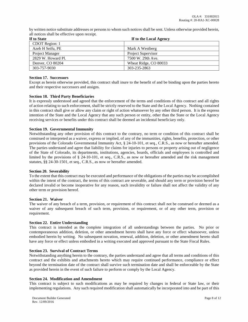
by written notice substitute addresses or persons to whom such notices shall be sent. Unless otherwise provided herein, all notices shall be effective upon receipt. If to State If to the Local Agency
CDOT Region: 1 Azeb H Seifu, PE Mark A Westberg Project Manager Project Supervisor 2829 W. Howard Pl. 7500 W. 29th Ave. Denver, CO 80204 Wheat Ridge, CO 80033 303-757-9030 303-235-2863
Section 17. Successors Except as herein otherwise provided, this contract shall inure to the benefit of and be binding upon the parties hereto and their respective successors and assigns. Section 18. Third Party Beneficiaries It is expressly understood and agreed that the enforcement of the terms and conditions of this contract and all rights of action relating to such enforcement, shall be strictly reserved to the State and the Local Agency. Nothing contained in this contract shall give or allow any claim or right of action whatsoever by any other third person. It is the express intention of the State and the Local Agency that any such person or entity, other than the State or the Local Agency receiving services or benefits under this contract shall be deemed an incidental beneficiary only. Section 19. Governmental Immunity Notwithstanding any other provision of this contract to the contrary, no term or condition of this contract shall be construed or interpreted as a waiver, express or implied, of any of the immunities, rights, benefits, protection, or other provisions of the Colorado Governmental Immunity Act, § 24-10-101, et seq., C.R.S., as now or hereafter amended. The parties understand and agree that liability for claims for injuries to persons or property arising out of negligence of the State of Colorado, its departments, institutions, agencies, boards, officials and employees is controlled and limited by the provisions of § 24-10-101, et seq., C.R.S., as now or hereafter amended and the risk management statutes, §§ 24-30-1501, et seq., C.R.S., as now or hereafter amended. Section 20. Severability To the extent that this contract may be executed and performance of the obligations of the parties may be accomplished within the intent of the contract, the terms of this contract are severable, and should any term or provision hereof be declared invalid or become inoperative for any reason, such invalidity or failure shall not affect the validity of any other term or provision hereof. Section 21. Waiver The waiver of any breach of a term, provision, or requirement of this contract shall not be construed or deemed as a waiver of any subsequent breach of such term, provision, or requirement, or of any other term, provision or requirement. Section 22. Entire Understanding This contract is intended as the complete integration of all understandings between the parties. No prior or contemporaneous addition, deletion, or other amendment hereto shall have any force or effect whatsoever, unless embodied herein by writing. No subsequent novation, renewal, addition, deletion, or other amendment hereto shall have any force or effect unless embodied in a writing executed and approved pursuant to the State Fiscal Rules. Section 23. Survival of Contract Terms Notwithstanding anything herein to the contrary, the parties understand and agree that all terms and conditions of this contract and the exhibits and attachments hereto which may require continued performance, compliance or effect beyond the termination date of the contract shall survive such termination date and shall be enforceable by the State as provided herein in the event of such failure to perform or comply by the Local Agency. Section 24. Modification and Amendment This contract is subject to such modifications as may be required by changes in federal or State law, or their implementing regulations. Any such required modification shall automatically be incorporated into and be part of this
OLA #: 331002015 Routing #: 20-HA1-XC-00028
Document Builder Generated Rev. 12/09/2016
Page 9 of 12
contract on the effective date of such change as if fully set forth herein. Except as provided above, no modification of this contract shall be effective unless agreed to in writing by both parties in an amendment to this contract that is properly executed and approved in accordance with applicable law. Section 25. Disputes Except as otherwise provided in this contract, any dispute concerning a question of fact arising under this contract which is not disposed of by agreement will be decided by the Chief Engineer of the Department of Transportation. The decision of the Chief Engineer will be final and conclusive unless, within 30 calendar days after the date of receipt of a copy of such written decision, the Local Agency mails or otherwise furnishes to the State a written appeal addressed to the Executive Director of the Department of Transportation. In connection with any appeal proceeding under this clause, the Local Agency shall be afforded an opportunity to be heard and to offer evidence in support of its appeal. Pending final decision of a dispute hereunder, the Local Agency shall proceed diligently with the performance of the contract in accordance with the Chief Engineer’s decision. The decision of the Executive Director or his duly authorized representative for the determination of such appeals will be final and conclusive and serve as final agency action. This dispute clause does not preclude consideration of questions of law in connection with decisions provided for herein. Nothing in this contract, however, shall be construed as making final the decision of any administrative official, representative, or board on a question of law. Section 26. Statewide Contract Management System If the maximum amount payable to Contractor under this Contract is $100,000 or greater, either on the Effective Date or at anytime thereafter, this §Statewide Contract Management System applies. Contractor agrees to be governed, and to abide, by the provisions of CRS §24-102-205, §24-102-206, §24-103-601, §24-103.5-101 and §24-105-102 concerning the monitoring of vendor performance on state contracts and inclusion of contract performance information in a statewide contract management system. Contractor’s performance shall be subject to Evaluation and Review in accordance with the terms and conditions of this Contract, State law, including CRS §24-103.5-101, and State Fiscal Rules, Policies and Guidance. Evaluation and Review of Contractor’s performance shall be part of the normal contract administration process and Contractor’s performance will be systematically recorded in the statewide Contract Management System. Areas of Evaluation and Review shall include, but shall not be limited to quality, cost and timeliness. Collection of information relevant to the performance of Contractor’s obligations under this Contract shall be determined by the specific requirements of such obligations and shall include factors tailored to match the requirements of Contractor’s obligations. Such performance information shall be entered into the statewide Contract Management System at intervals established herein and a final Evaluation, Review and Rating shall be rendered within 30 days of the end of the Contract term. Contractor shall be notified following each performance Evaluation and Review, and shall address or correct any identified problem in a timely manner and maintain work progress. Should the final performance Evaluation and Review determine that Contractor demonstrated a gross failure to meet the performance measures established hereunder, the Executive Director of the Colorado Department of Personnel and Administration (Executive Director), upon request by the Department of Transportation and showing of good cause, may debar Contractor and prohibit Contractor from bidding on future contracts. Contractor may contest the final Evaluation, Review and Rating by: (a) filing rebuttal statements, which may result in either removal or correction of the evaluation (CRS §24-105-102(6)), or (b) under CRS §24-105-102(6), exercising the debarment protest and appeal rights provided in CRS §§24-109-106, 107, 201 or 202, which may result in the reversal of the debarment and reinstatement of Contractor, by the Executive Director, upon showing of good cause. Section 27. COLORADO SPECIAL PROVISIONS (COLORADO FISCAL RULE 3-3).
These Special Provisions apply to all contracts except where noted in italics.
A. STATUTORY APPROVAL. §24-30-202(1), C.R.S.
This Contract shall not be valid until it has been approved by the Colorado State Controller or designee. If this Contract is for a Major Information Technology Project, as defined in §24-37.5-102(2.6), then this Contract shall not be valid until it has been approved by the State’s Chief Information Officer or designee.
B. FUND AVAILABILITY. §24-30-202(5.5), C.R.S.
Financial obligations of the State payable after the current State Fiscal Year are contingent upon funds for that purpose being appropriated, budgeted, and otherwise made available.
C. GOVERNMENTAL IMMUNITY.
OLA #: 331002015 Routing #: 20-HA1-XC-00028
Document Builder Generated Rev. 12/09/2016
Page 10 of 12
Liability for claims for injuries to persons or property arising from the negligence of the State, its departments, boards, commissions committees, bureaus, offices, employees and officials shall be controlled and limited by the provisions of the Colorado Governmental Immunity Act, §24-10-101, et seq., C.R.S.; the Federal Tort Claims Act, 28 U.S.C. Pt. VI, Ch. 171 and 28 U.S.C. 1346(b), and the State’s risk management statutes, §§24-30-1501, et seq. C.R.S. No term or condition of this Contract shall be construed or interpreted as a waiver, express or implied, of any of the immunities, rights, benefits, protections, or other provisions, contained in these statutes.
D. INDEPENDENT CONTRACTOR
Contractor shall perform its duties hereunder as an independent contractor and not as an employee. Neither Contractor nor any agent or employee of Contractor shall be deemed to be an agent or employee of the State. Contractor shall not have authorization, express or implied, to bind the State to any agreement, liability or understanding, except as expressly set forth herein. Contractor and its employees and agents are not entitled to unemployment insurance or workers compensation benefits through the State and the State shall not pay for or otherwise provide such coverage for Contractor or any of its agents or employees. Contractor shall pay when due all applicable employment taxes and income taxes and local head taxes incurred pursuant to this Contract. Contractor shall (i) provide and keep in force workers' compensation and unemployment compensation insurance in the amounts required by law, (ii) provide proof thereof when requested by the State, and (iii) be solely responsible for its acts and those of its employees and agents.
E. COMPLIANCE WITH LAW.
Contractor shall comply with all applicable federal and State laws, rules, and regulations in effect or hereafter established, including, without limitation, laws applicable to discrimination and unfair employment practices.
F. CHOICE OF LAW, JURISDICTION, AND VENUE.
Colorado law, and rules and regulations issued pursuant thereto, shall be applied in the interpretation, execution, and enforcement of this Contract. Any provision included or incorporated herein by reference which conflicts with said laws, rules, and regulations shall be null and void. All suits or actions related to this Contract shall be filed and proceedings held in the State of Colorado and exclusive venue shall be in the City and County of Denver.
G. PROHIBITED TERMS.
Any term included in this Contract that requires the State to indemnify or hold Contractor harmless; requires the State to agree to binding arbitration; limits Contractor’s liability for damages resulting from death, bodily injury, or damage to tangible property; or that conflicts with this provision in any way shall be void ab initio. Nothing in this Contract shall be construed as a waiver of any provision of §24-106-109 C.R.S. Any term included in this Contract that limits Contractor’s liability that is not void under this section shall apply only in excess of any insurance to be maintained under this Contract, and no insurance policy shall be interpreted as being subject to any limitations of liability of this Contract.
H. SOFTWARE PIRACY PROHIBITION.
State or other public funds payable under this Contract shall not be used for the acquisition, operation, or maintenance of computer software in violation of federal copyright laws or applicable licensing restrictions. Contractor hereby certifies and warrants that, during the term of this Contract and any extensions, Contractor has and shall maintain in place appropriate systems and controls to prevent such improper use of public funds. If the State determines that Contractor is in violation of this provision, the State may exercise any remedy available at law or in equity or under this Contract, including, without limitation, immediate termination of this Contract and any remedy consistent with federal copyright laws or applicable licensing restrictions.
I. EMPLOYEE FINANCIAL INTEREST/CONFLICT OF INTEREST. §§24-18-201 and 24-50-507, C.R.S.
The signatories aver that to their knowledge, no employee of the State has any personal or beneficial interest whatsoever in the service or property described in this Contract. Contractor has no interest and shall not acquire any interest, direct or indirect, that would conflict in any manner or degree with the performance of Contractor’s services and Contractor shall not employ any person having such known interests.
J. VENDOR OFFSET AND ERRONEOUS PAYMENTS. §§24-30-202(1) and 24-30-202.4, C.R.S.
[Not applicable to intergovernmental agreements] Subject to §24-30-202.4(3.5), C.R.S., the State Controller may withhold payment under the State’s vendor offset intercept system for debts owed to State agencies for: (i)

OLA #: 331002015 Routing #: 20-HA1-XC-00028
Document Builder Generated Rev. 12/09/2016
Page 11 of 12
unpaid child support debts or child support arrearages; (ii) unpaid balances of tax, accrued interest, or other charges specified in §§39-21-101, et seq., C.R.S.; (iii) unpaid loans due to the Student Loan Division of the Department of Higher Education; (iv) amounts required to be paid to the Unemployment Compensation Fund; and (v) other unpaid debts owing to the State as a result of final agency determination or judicial action. The State may also recover, at the State’s discretion, payments made to Contractor in error for any reason, including, but not limited to, overpayments or improper payments, and unexpended or excess funds received by Contractor by deduction from subsequent payments under this Contract, deduction from any payment due under any other contracts, grants or agreements between the State and Contractor, or by any other appropriate method for collecting debts owed to the State.
K. PUBLIC CONTRACTS FOR SERVICES. §§8-17.5-101, et seq., C.R.S.
[Not applicable to agreements relating to the offer, issuance, or sale of securities, investment advisory services or fund management services, sponsored projects, intergovernmental agreements, or information technology services or products and services] Contractor certifies, warrants, and agrees that it does not knowingly employ or contract with an illegal alien who will perform work under this Contract and will confirm the employment eligibility of all employees who are newly hired for employment in the United States to perform work under this Contract, through participation in the E-Verify Program or the State verification program established pursuant to §8-17.5-102(5)(c), C.R.S., Contractor shall not knowingly employ or contract with an illegal alien to perform work under this Contract or enter into a contract with a Subcontractor that fails to certify to Contractor that the Subcontractor shall not knowingly employ or contract with an illegal alien to perform work under this Contract. Contractor (i) shall not use E-Verify Program or the program procedures of the Colorado Department of Labor and Employment (“Department Program”) to undertake pre-employment screening of job applicants while this Contract is being performed, (ii) shall notify the Subcontractor and the contracting State agency or institution of higher education within 3 days if Contractor has actual knowledge that a Subcontractor is employing or contracting with an illegal alien for work under this Contract, (iii) shall terminate the subcontract if a Subcontractor does not stop employing or contracting with the illegal alien within 3 days of receiving the notice, and (iv) shall comply with reasonable requests made in the course of an investigation, undertaken pursuant to §8-17.5-102(5), C.R.S., by the Colorado Department of Labor and Employment. If Contractor participates in the Department program, Contractor shall deliver to the contracting State agency, Institution of Higher Education or political subdivision, a written, notarized affirmation, affirming that Contractor has examined the legal work status of such employee, and shall comply with all of the other requirements of the Department program. If Contractor fails to comply with any requirement of this provision or §§8-17.5-101, et seq., C.R.S., the contracting State agency, institution of higher education or political subdivision may terminate this Contract for breach and, if so terminated, Contractor shall be liable for damages.
L. PUBLIC CONTRACTS WITH NATURAL PERSONS. §§24-76.5-101, et seq., C.R.S.
Contractor, if a natural person eighteen (18) years of age or older, hereby swears and affirms under penalty of perjury that Contractor (i) is a citizen or otherwise lawfully present in the United States pursuant to federal law, (ii) shall comply with the provisions of §§24-76.5-101, et seq., C.R.S., and (iii) has produced one form of identification required by §24-76.5-103, C.R.S. prior to the Effective Date of this Contract.
THE REMAINDER OF THIS PAGE IS INTENTIONALLY LEFT BLANK
OLA #: 331002015 Routing #: 20-HA1-XC-00028
Document Builder Generated Rev. 12/09/2016
Page 12 of 12
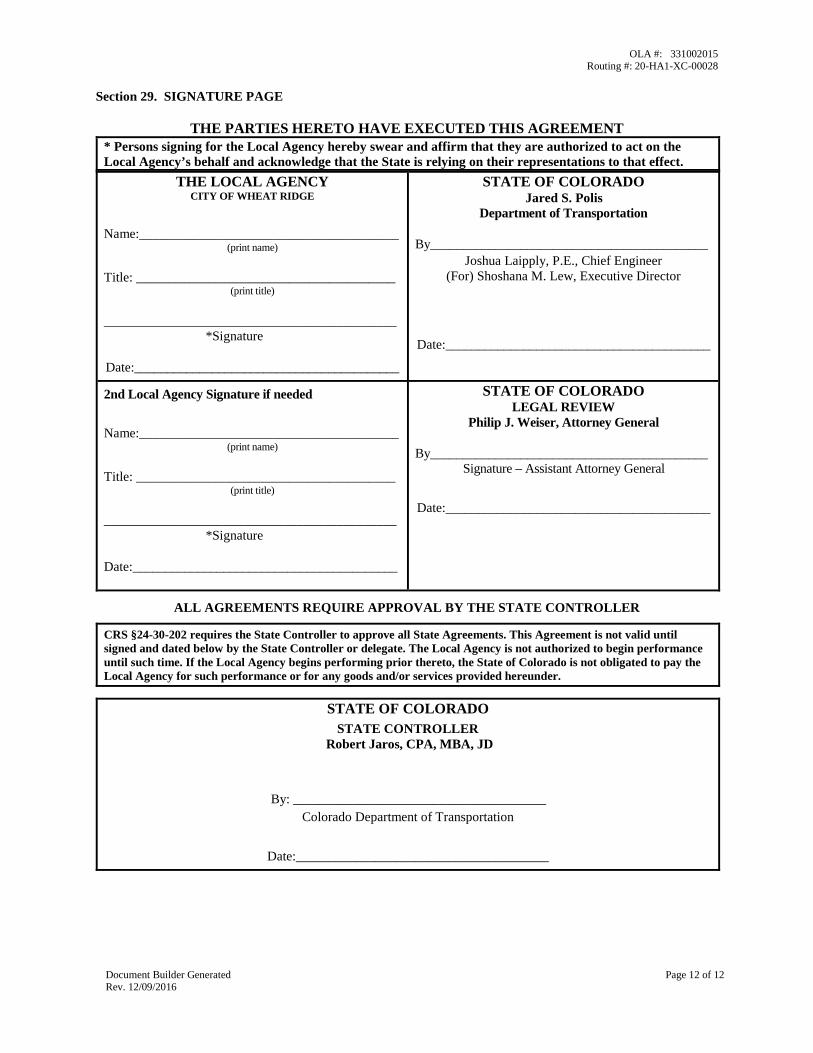
Section 29. SIGNATURE PAGE
THE PARTIES HERETO HAVE EXECUTED THIS AGREEMENT * Persons signing for the Local Agency hereby swear and affirm that they are authorized to act on the Local Agency’s behalf and acknowledge that the State is relying on their representations to that effect.
THE LOCAL AGENCY CITY OF WHEAT RIDGE
Name:_______________________________________ (print name)
Title: _______________________________________ (print title)
____________________________________________ *Signature
Date:_________________________________________
STATE OF COLORADO Jared S. Polis
Department of Transportation
By___________________________________________ Joshua Laipply, P.E., Chief Engineer
(For) Shoshana M. Lew, Executive Director
Date:_________________________________________
2nd Local Agency Signature if needed
Name:_______________________________________ (print name)
Title: _______________________________________ (print title)
____________________________________________ *Signature
Date:_________________________________________
STATE OF COLORADO LEGAL REVIEW
Philip J. Weiser, Attorney General
By___________________________________________ Signature – Assistant Attorney General
Date:_________________________________________
ALL AGREEMENTS REQUIRE APPROVAL BY THE STATE CONTROLLER
CRS §24-30-202 requires the State Controller to approve all State Agreements. This Agreement is not valid until signed and dated below by the State Controller or delegate. The Local Agency is not authorized to begin performance until such time. If the Local Agency begins performing prior thereto, the State of Colorado is not obligated to pay the Local Agency for such performance or for any goods and/or services provided hereunder.
STATE OF COLORADO STATE CONTROLLER
Robert Jaros, CPA, MBA, JD
By: ______________________________________ Colorado Department of Transportation
Date:______________________________________
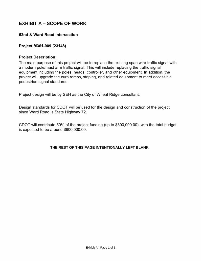
Exhibit A - Page 1 of 1
EXHIBIT A – SCOPE OF WORK
52nd & Ward Road Intersection
Project M361-009 (23148)
Project Description:The main purpose of this project will be to replace the existing span wire traffic signal with a modern pole/mast arm traffic signal. This will include replacing the traffic signal equipment including the poles, heads, controller, and other equipment. In addition, the project will upgrade the curb ramps, striping, and related equipment to meet accessible pedestrian signal standards.
Project design will be by SEH as the City of Wheat Ridge consultant.
Design standards for CDOT will be used for the design and construction of the project since Ward Road is State Highway 72.
CDOT will contribute 50% of the project funding (up to $300,000.00), with the total budget is expected to be around $600,000.00.
THE REST OF THIS PAGE INTENTIONALLY LEFT BLANK
Exhibit B
EXHIBIT B – LOCAL AGENCY RESOLUTION
LOCAL AGENCY ORDINANCE
or RESOLUTION
(if applicable)

Exhibit C - Page 1 of 1
EXHIBIT C - FUNDING PROVISIONS M361-009 (23148)A. Cost of Work Estimate
The Local Agency has estimated the total cost the Work to be $600,000.00, which is to be funded as follows:
1. BUDGETED FUNDS
$300,000.00a. State Funds
(50.00% of Costs)
b. Local Agency Matching Funds
(50.00% of Costs)
$300,000.00
TOTAL BUDGETED FUNDS $600,000.00
2. ESTIMATED PAYMENT TO LOCAL AGENCY
a. State Funds Budgeted $300,000.00
TOTAL ESTIMATED PAYMENT TO LOCAL AGENCY $300,000.00
3. FOR CDOT ENCUMBRANCE PURPOSES
a. Total Encumbrance Amount $600,000.00
b. Less ROW Acquisition 3111 and/or ROW Relocation 3109 $0.00
Net to be encumbered as follows: $600,000.00
WBS Element 23148.20.10
Performance Period End Date
Const. 3300 $0.00
B. The matching ratio for the participating funds for this Work is 50.00% State funds to 50.00% Local Agency funds, it being understood that such ratio applies only to the $600,000.00 total budgeted funds, it being further understood that all additional costs outside of the 50.00%/50.00% split are borne by the Local Agency at 100%. If the total cost of performance of the Work is less than $600,000.00, then the amounts of Local Agency and State funds will be decreased in accordance with the funding ratio described herein.
C. The maximum amount payable to the Local Agency under this Contract shall be $300,000.00 (for CDOT accounting purposes, the State funds of $300,000.00 and the Local Agency matching funds of $300,000.00 will be encumbered for a total encumbrance of $600,000.00), unless such amount is increased by an appropriate written modification to this Contract executed before any increased cost is incurred. It is understood and agreed by the Parties hereto that the total cost of the Work stated hereinbefore is the best estimate available, based on the design data as approved at the time of execution of this Contract, and that such cost is subject to revisions (in accord with the procedure in the previous sentence) agreeable to the Parties prior to bid and award.
The maximum amount payable shall be reduced without amendment when the actual amount of the Local Agency’s awarded contract is less than the budgeted total of the State funds and the Local Agency matching funds. The maximum amount payable shall be reduced through the execution of an Option Letter as described in Section 6. of this Contract.
N/A / N/A
*The Local Agency should not begin work until all three of the following are in place:1) Phase Performance Period Start Date; 2) The execution of the document encumbering funds for the respective phase; and3) Local Agency receipt of the official Notice to Proceed. Any work performed before these three milestones are achieved will not be reimbursable.
NOTE: No funds are currently available. Funds will be added in the future by Option Letter or Amendment.
Exhibit D - Page 1 of 2
EXHIBIT D – OPTION LETTER
SAMPLE OPTION LETTER
State Agency
Department of Transportation Option Letter Number
ZOPTLETNUM
Local Agency
ZVENDORNAME Agreement Routing Number
ZSMARTNO
Agreement Maximum Amount
Initial term
State Fiscal Year ZFYY_1
Extension terms
State Fiscal Year ZFYY_2
State Fiscal Year ZFYY_3
State Fiscal Year ZFYY_4
State Fiscal Year ZFYY_5
Total for all state fiscal years
$ ZFYA_1
$ ZFYA_2
$ ZFYA_3
$ ZFYA_4
$ ZFYA_5
$
ZPERSVC_MAX_
AMOUNT
Agreement Effective Date
The later of the effective date or ZSTARTDATEX
Current Agreement Expiration Date ZTERMDATEX
1. OPTIONS:
A. Option to extend for an Extension Term
B. Option to unilaterally authorize the Local Agency to begin a phase which may include Design, Construction,
Environmental, Utilities, ROW incidentals or Miscellaneous ONLY (does not apply to Acquisition/Relocation or
Railroads) and to update encumbrance amounts (a new Exhibit C must be attached with the option letter and shall be
labeled C-1, future changes for this option shall be labeled as follows: C-2, C-3, C-4, etc.).
C. Option to unilaterally transfer funds from one phase to another phase (a new Exhibit C must be attached with the
option letter and shall be labeled C-1, future changes for this option shall be labeled as follows: C-2, C-3, C-4, etc.).
D. Option to unilaterally do both A and B (a new Exhibit C must be attached with the option letter and shall be labeled
C-1, future changes for this option shall be labeled as follows: C-2, C-3, C-4, etc.).
E. Option to update a Phase Performance Period and/or Modify OMB Uniform Guidance Information.
2. REQUIRED PROVISIONS:
Option A
In accordance with Section 2, C of the Original Agreement referenced above, the State hereby exercises its option for an additional term, beginning on (insert date) and ending on the current contract expiration date shown above, under the same funding provisions stated in the Original Contract Exhibit C, as amended.
Option B
In accordance with Section 7, E of the Original Agreement referenced above, the State hereby excerises its option to authorize the Local Agency to begin a phase that will include (describe which phase will be added and include all that apply – Design, Construction, Environmental, Utilities, ROW incidentals or Miscellaneous) and to encumber previously budgeted funds for the phase based upon changes in funding availability and authorization. The encumbrance for (Design, Construction, Environmental, Utilities, ROW incidentals or Miscellaneous)is (insert dollars here). A new Exhibit C-1 is made part of the original Agreement and replaces Exhibit C. (The following is a NOTE only, please delete when using this option. Future changes for this option for Exhibit C shall be labled as follows: C-2, C-3, C-4, etc.).
Option C
In accordance with Section 7, E of the Original Agreement referenced above, the State hereby excerises its
Exhibit D - Page 2 of 2
option to authorize the Local Agency to transfer funds from (describe phase from which funds will be moved) to (describe phase to which funds will be moved) based on variance in actual phase costs and original phase estimates. A new Exhibit C-1 is made part of the original Agreement and replaces Exhibit C.
Option D
In accordance with Section 7, E of the Original Agreement referenced above, the State hereby excerises its option to authorize the Local Agency to begin a phase that will include (describe which phase will be added and include all that apply – Design, Construction, Environmental, Utilities, ROW incidentals or Miscellaneous); 2) to encumber funds for the phase based upon changes in funding availability and authorization; and 3) to transfer funds from (describe phase from which funds will be moved) to (describe phase to which funds will be moved) based on variance in actual phase costs and original phase estimates. A new Exhibit C-1 is made part of the original Agreement and replaces Exhibit C.
(The following language must be included on ALL options):
The Agreement Maximum Amount table on the Contract’s Signature and Cover Page is hereby deleted and replaced with the Current Agreement Maximum Amount table shown above.
Option E
In accordance with Section 7, E of the Original Agreement referenced above, the State hereby excerises its option to authorize the Local Agency to update a Phase Performance Period and/or Modify OMB Uniform Guidance Information. A new Exhibit C-1 is made part of the original Agreement and replaces Exhibit C.
3. OPTION EFFECTIVE DATE:
The effective date of this option letter is upon approval of the State Controller or delegate.
APPROVALS:
State of Colorado:
Jared S. Polis, Governor
By: _____________________________________________ Date: __________________
Executive Director, Colorado Department of Transportation
ALL CONTRACTS MUST BE APPROVED BY THE STATE CONTROLLER
CRS §24-30-202 requires the State Controller to approve all State Contracts. This Agreement is not valid until signed and dated below by the State Controller or delegate. Contractor is not authorized to begin
performance until such time. If the Local Agency begins performing prior thereto, the State of Colorado is not obligated to pay the Local Agency for such performance or for any goods and/or services provided
hereunder.
State Controller
Robert Jaros, CPA, MBA, JD
By: __________________________________
Date: ________________________________
ITEM NO: DATE: December 9, 2019
REQUEST FOR CITY COUNCIL ACTION
TITLE: RESOLUTION NO. 65-2019 – A RESOLUTION APPROVING THE RESTATEMENT OF THE CITY OF WHEAT RIDGE MONEY PURCHASE PENSION PLAN FOR DESIGNATED POLICE DEPARTMENT EMPLOYEES
PUBLIC HEARING ORDINANCES FOR 1ST READING BIDS/MOTIONS ORDINANCES FOR 2ND READING RESOLUTIONS
QUASI-JUDICIAL: YES NO
_______________________________ ______________________________ Dave Pickett, Interim Chief of Police City Manager
ISSUE: The 2020 budget, authorized by City Council on October 14, 2019, appropriates funds to increase the City’s contribution to sworn employees’ pension by 0.5% for a total contribution of 10.5%. In accordance with the fiduciary responsibilities of the Police Pension Board (the “Board”), the Board has approved a restatement of the City of Wheat Ridge Money Purchase Pension Plan for Designated Police Department Employees (the “Police Pension Plan”) to recognize this increase. In accordance with the City of Wheat Ridge Code of Laws Article III Section 19-52 (e), the plan document is forwarded to City Council which shall, by resolution, approve the plan.
PRIOR ACTION: City Council amended the ICMA Retirement Corporation Governmental Money Purchase Plan and Trust Plan Adoption Agreement on November September 26, 2012.
FINANCIAL IMPACT: The 2020 General Fund Budget has previously been approved to reflect the increase in employer contribution of each participant from 10% of earnings to 10.5%. The 0.5% increase to the City’s contribution is estimated to cost $35,274 in 2020 and an equal amount annually plus a percentage increase equal to total salary increases.
1b
CAF - Resolution for Police Pension Plan Restatement December 9, 2019 Page 2 BACKGROUND: The Police Pension Plan has been updated and amended over time since it’s inception in 1989. Some of the amendments were the result of federal law and tax code changes. Other amendments customized the Plan to meets the needs of the City and plan participants. The Wheat Ridge Code of Laws Article III Section 19-52 (e) states:
“A plan document shall be prepared specifying the operation of the money purchase plan, and detailing handling of contributions, administration of the plan, refunds upon termination, the manner of benefit payments, and other information as required by applicable state law or this article or as is deemed necessary by the police pension board. A summary of the plan document shall be provided to all members of the plan, who shall thereafter be polled regarding their approval of the plan as provided in C.R.S. § 31-30.5-101 et seq. At such time as the plan is approved by the members as required herein, the same shall be forwarded to city council which shall, by resolution, approve the plan.”
RECOMMENDATIONS: City Staff and the Police Pension Board recommend that this resolution be passed. RECOMMENDED MOTION: “I move to approve Resolution No. 65-2019, a resolution approving the restatement of the City of Wheat Ridge Money Purchase Pension Plan for designated police department employees.” Or, “I move to postpone indefinitely Resolution No. 65-2019, a resolution approving the restatement of the City of Wheat Ridge Money Purchase Pension Plan for designated police department employees, for the following reason(s) _________________.” REPORT PREPARED BY: Jim Lorentz, Division Chief Dave Pickett, Interim Chief of Police Patrick Goff, City Manager ATTACHMENTS:
1. Resolution No. 65-2019
CITY OF WHEAT RIDGE, COLORADO RESOLUTION NO. 65
Series of 2019
TITLE: A RESOLUTION APPROVING THE RESTATEMENT OF THE CITY OF WHEAT RIDGE MONEY PURCHASE PENSION PLAN FOR DESIGNATED POLICE DEPARTMENT EMPLOYEES
WHEREAS, the City of Wheat Ridge is a home rule municipality operating under a charter approved by its electors and governed by its City Council; and
WHEREAS, the City Council has previously established a Pension Plan for Designated Police Department Employees (the “Police Pension Plan”); and
WHEREAS, in accordance with CRS § 31-30.5-101 et seq, copies of the Police Pension Plan have regularly been provided to all members for approval and such Plan has been approved; and
WHEREAS, a restatement of the Police Pension Plan has been prepared to recognize an increase in the City’s contribution to the Plan from 10% to 10.5%; and
WHEREAS, said restatement has been approved by Plan members as required by the Code of Laws, Sec. 19-52(3); and
WHEREAS, in accordance with the Code of Laws Section 19-52(3), the City Council wishes to approve the restatement of the Police Pension Plan as presented.
NOW THEREFORE, BE IT RESOLVED by the Wheat Ridge City Council, that:
Section 1. The City directs and approves restatement of the City of Wheat Ridge Police Pension Plan, as amended, a copy of which, dated January 4, 2020 is attached hereto as EXHIBIT A.
Section 2. Effective Date. This Resolution shall take effect upon adoption and signature by the Mayor.
DONE AND RESOLVED this 9th day of December, 2019.
Bud Starker, Mayor
ATTEST:
Stephen Kirkpatrick, City Clerk
ATTACHMENT 1

2
EXHIBIT A Police Pension Plan
Dated January 4, 2020
[Attached]
EXHIBIT A
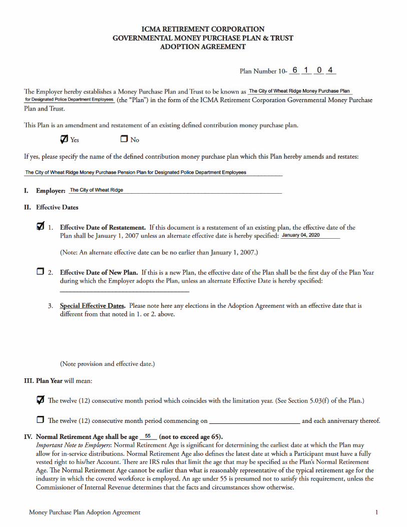

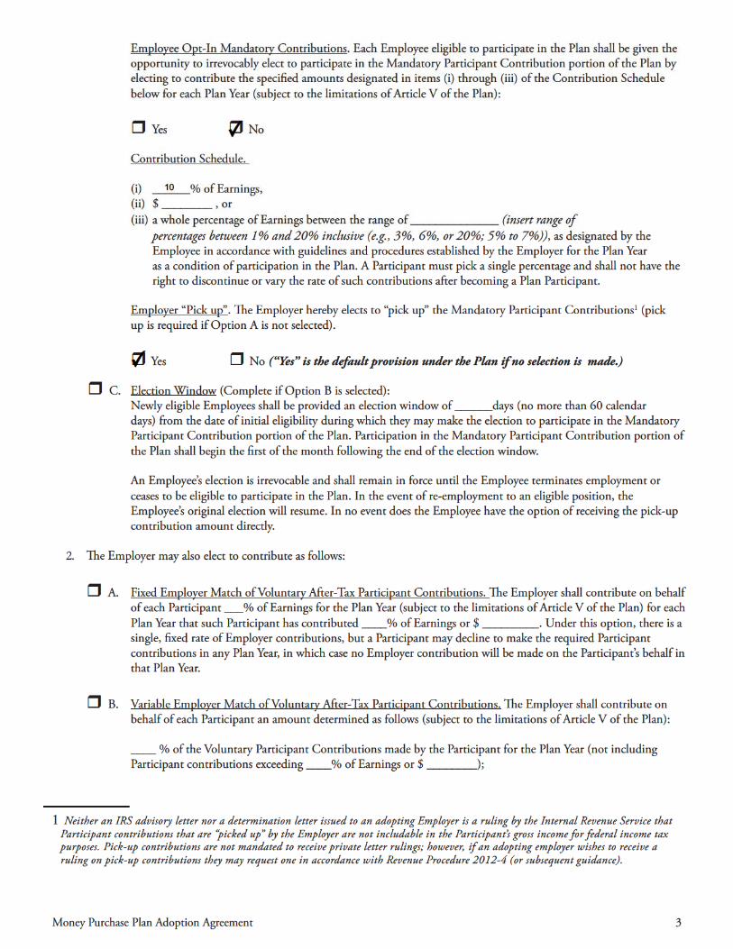
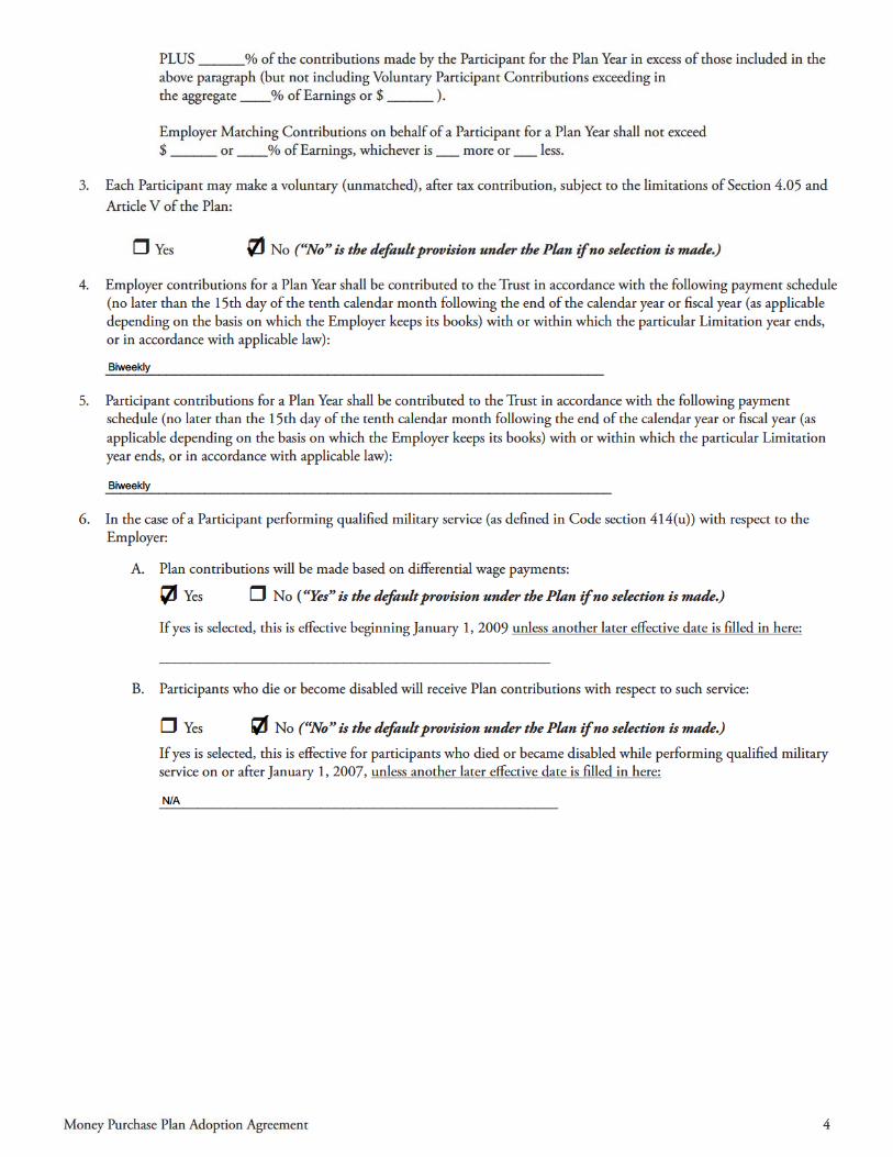
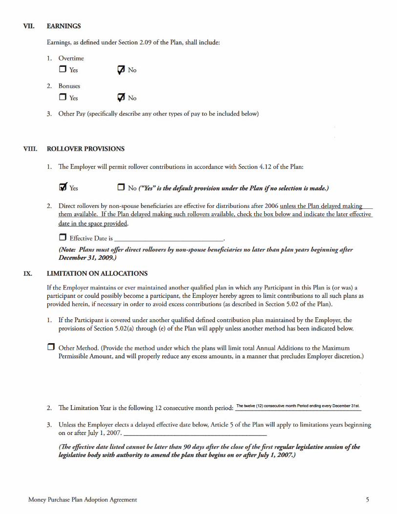
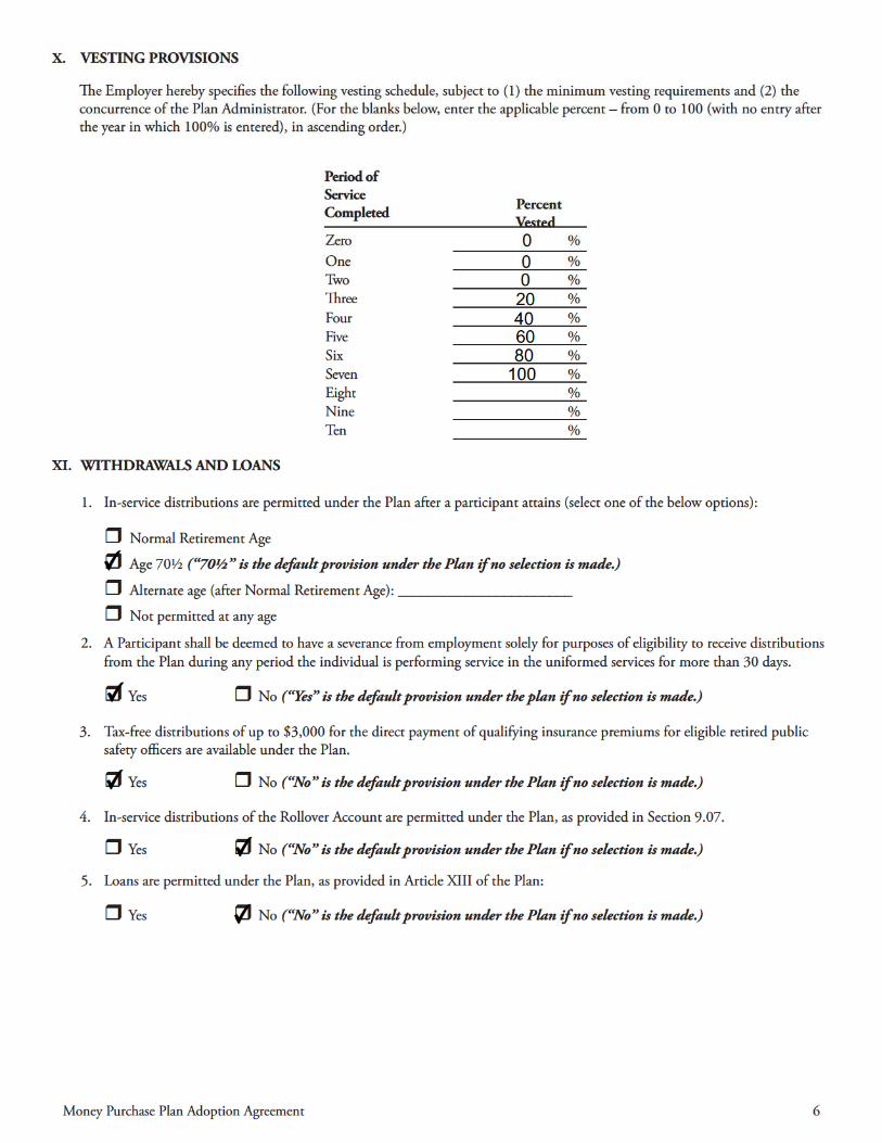
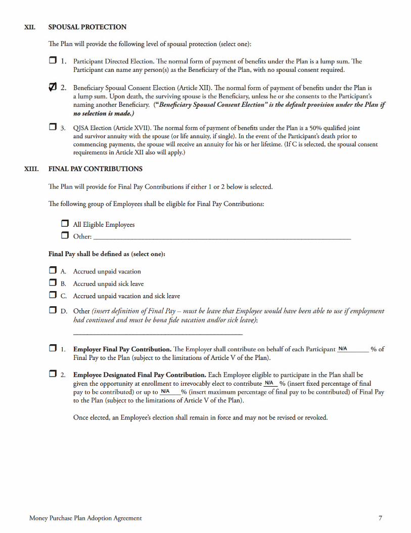
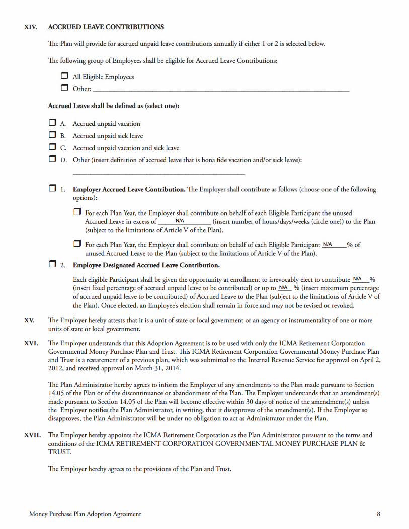
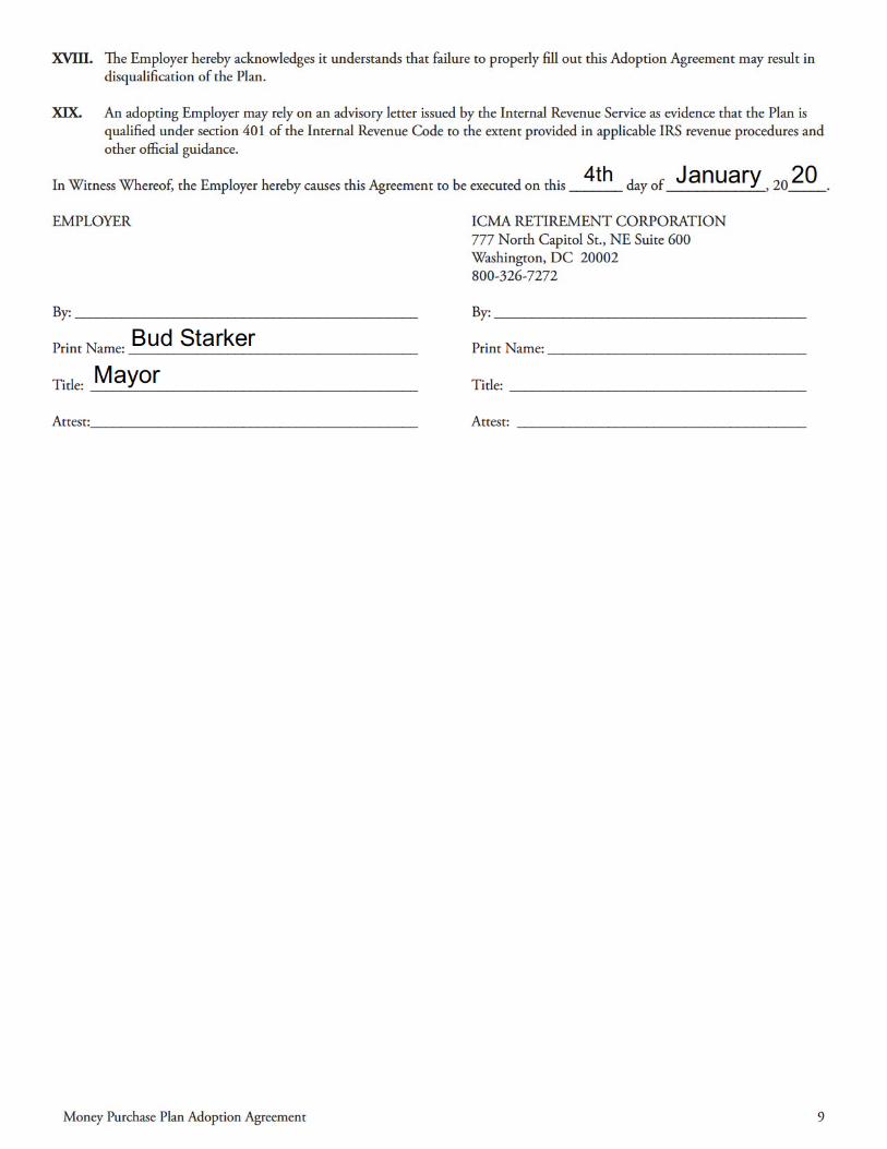

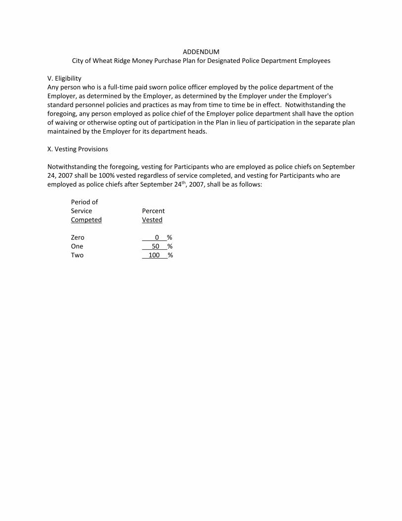
ADDENDUM City of Wheat Ridge Money Purchase Plan for Designated Police Department Employees
V. Eligibility Any person who is a full-time paid sworn police officer employed by the police department of the Employer, as determined by the Employer, as determined by the Employer under the Employer's standard personnel policies and practices as may from time to time be in effect. Notwithstanding the foregoing, any person employed as police chief of the Employer police department shall have the option of waiving or otherwise opting out of participation in the Plan in lieu of participation in the separate plan maintained by the Employer for its department heads. X. Vesting Provisions Notwithstanding the foregoing, vesting for Participants who are employed as police chiefs on September 24, 2007 shall be 100% vested regardless of service completed, and vesting for Participants who are employed as police chiefs after September 24th, 2007, shall be as follows:
Period of Service Percent Competed Vested Zero 0 % One 50 % Two 100 %
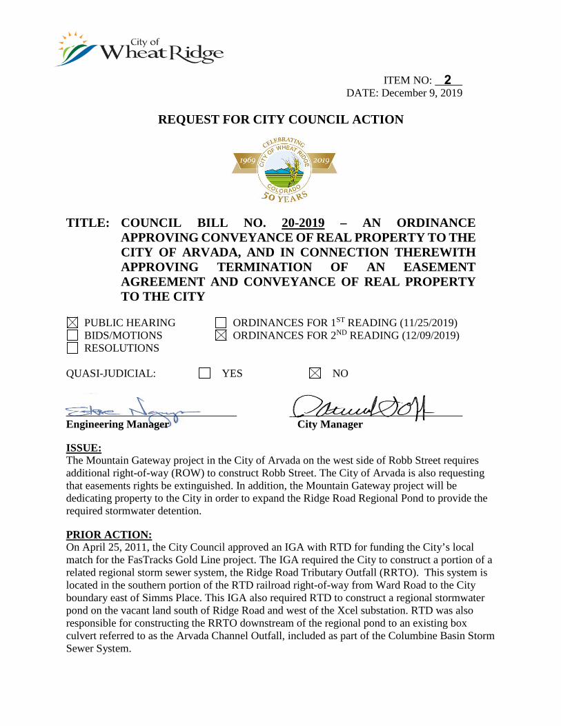
ITEM NO: DATE: December 9, 2019
REQUEST FOR CITY COUNCIL ACTION
TITLE: COUNCIL BILL NO. 20-2019 – AN ORDINANCE APPROVING CONVEYANCE OF REAL PROPERTY TO THE CITY OF ARVADA, AND IN CONNECTION THEREWITH APPROVING TERMINATION OF AN EASEMENT AGREEMENT AND CONVEYANCE OF REAL PROPERTY TO THE CITY
PUBLIC HEARING ORDINANCES FOR 1ST READING (11/25/2019) BIDS/MOTIONS ORDINANCES FOR 2ND READING (12/09/2019) RESOLUTIONS
QUASI-JUDICIAL: YES NO
_______________________________ ______________________________ Engineering Manager City Manager
ISSUE: The Mountain Gateway project in the City of Arvada on the west side of Robb Street requires additional right-of-way (ROW) to construct Robb Street. The City of Arvada is also requesting that easements rights be extinguished. In addition, the Mountain Gateway project will be dedicating property to the City in order to expand the Ridge Road Regional Pond to provide the required stormwater detention.
PRIOR ACTION: On April 25, 2011, the City Council approved an IGA with RTD for funding the City’s local match for the FasTracks Gold Line project. The IGA required the City to construct a portion of a related regional storm sewer system, the Ridge Road Tributary Outfall (RRTO). This system is located in the southern portion of the RTD railroad right-of-way from Ward Road to the City boundary east of Simms Place. This IGA also required RTD to construct a regional stormwater pond on the vacant land south of Ridge Road and west of the Xcel substation. RTD was also responsible for constructing the RRTO downstream of the regional pond to an existing box culvert referred to as the Arvada Channel Outfall, included as part of the Columbine Basin Storm Sewer System.
2
Council Action Form – Mountain Gateway Land Transfer December 9, 2019 Page 2 On May 23, 2011, Council approved an IGA, followed by an amendment on April 12, 2012 with the City of Arvada and the Urban Drainage and Flood Control District (UDFCD), concerning the construction of both Cities’ portions of the RRTO along the Gold Line corridor.
On December 8, 2014, Council approved an IGA with RTD and UDFCD, followed by an amendment on February 9, 2015, to construct the City’s portion of the Arvada Channel Outfall between Miller and Oak Streets.
On August 27, 2018, Council approved a second amendment to the original IGA with RTD to convey the Ridge Road Regional Pond to the City.
FINANCIAL IMPACT: The transfer of property, and related easement vacation, to the City of Arvada has no financial impact to the City. Because the City is responsible for maintenance of the Ridge Road Regional Pond, increasing the pond size and adding additional stormwater could add to the maintenance cost. However, the pond was constructed to meet the Mile High Flood District’s (MHFD), formerly UDFCD, maintenance standards, so that the City can request assistance from MHFD to maintain the pond. MHFD has added this pond to their list of maintenance responsibilities.
BACKGROUND: The 1994 Columbine Basin Outfall Systems Planning Study identified many improvements within the Basin, covering the portion of the City north of Interstate 70. MHFD, in cooperation with the City of Arvada, constructed the Arvada Channel downstream of Miller Street, with the latest addition being a box culvert, completed at the time of the Target development. Since 2011, the City’s and Arvada’s portion of the RRTO have been constructed by MHFD in conjunction with the Gold Line construction between Ward Road and the Ridge Road Regional Pond.
In 2008, MHFD funding became available for completion of the Arvada Channel from Miller Street to Oak Street. In 2008, the Arvada Channel IGA was entered into by the City with MHFD to address funding the project, with MHFD and the City each contributing $325,000.
In 2009, the project’s design engineers determined that the original design proposed for the open channel would not be feasible due to high ground water. Adequate funding was not available to construct the more expensive box culvert that was needed. As a result, construction of the project was postponed indefinitely by Council on September 14, 2009. However, the decision was made to complete the design and finalize acquisition of a needed drainage easement from the State Land Board. MHFD acquired the easement across the state property and assigned its interest to the City, which was accepted on April 23, 2012. The project was then closed and MHFD returned approximately $280,000 to the City from the 2008 Arvada Channel IGA.
All of the local agencies along the Gold Line were required to provide a local match for the cost of construction of the commuter rail line. The City of Wheat Ridge share was $1.5 million. On April 25, 2011, the City Council approved an IGA with RTD in which the City would construct a portion of the RRTO in the southern portion of the RTD railroad right-of-way from Ward Road to the City boundary east of Simms Place to meet its local match.
Council Action Form – Mountain Gateway Land Transfer December 9, 2019 Page 3 In collaboration with MHFD and the City of Arvada, the parties arranged to have MHFD construct the RRTO from Ward Road to the property northwest of the Medved dealership. The total funding in the 2011 RRTO IGA was $3.2 million with MHFD’s and the City of Arvada’s contributions.
As required in the 2011 Gold Line IGA, RTD constructed a large regional stormwater pond, now known as the Ridge Road Regional Pond, on the vacant property south of Ridge Road and west of the Xcel substation in order to mitigate the downstream impacts of the Gold Line project. In addition, RTD constructed the Outfall, a storm sewer/open channel system from the Ridge Road Regional Pond to the west side of Oak Street.
To complete the system between Oak and Miller Streets, RTD had planned to construct a temporary system, consisting of open channels and large culverts. RTD approached the City and MHFD in January 2014 to discuss the possibility of working together to construct the Arvada Channel box culvert instead of the temporary system. City staff worked with MHFD and RTD to finalize the design.
The 2014 Arvada Channel IGA, approved by Council on December 8, 2014, provided most of the funding for the construction of the box culvert. After additional MHFD funds became available, the City Council approved an amendment to the IGA on February 9, 2015 providing for the remaining funding.
With the completion of the City’s portion of the Arvada Channel box culvert, the last link in the critically important segment of the system was completed. In 2011, during negotiations with RTD on costs, City staff estimated that construction of this entire system would be $8 to $9 million. The City’s share of the work completed by MHFD and RTD was $1.15 million, less than 15% of the $8-$9 million estimated in 2011.
With the completion of the Gold Line construction, RTD approached the City to transfer ownership of the Ridge Road Regional Pond to the City. On August 27, 2018, Council approved a second amendment to the original IGA with RTD to convey the Ridge Road Regional Pond to the City.
Also in August 2018, the City was approached by the developer of the vacant property to the west of the Ridge Road Regional Pond to modify the pond to meet the stormwater detention requirements for the proposed Mountain Gateway industrial development.
Mountain Gateway will be dedicating ROW and constructing Robb Street along the west side of the Ridge Road Regional Pond. This requires realignment of the existing private street in order to smoothly connect to Robb Street at the south end and the rail crossing at the north end.
At the north end, a sliver of property that does not affect the capacity of the pond needs to become ROW in order to provide a smooth connection to the existing rail crossing, which cannot be moved. The City and RTD currently have an easement agreement for the sliver of proposed ROW that needs to be extinguished. RTD has agreed to the proposal and is processing the
Council Action Form – Mountain Gateway Land Transfer December 9, 2019 Page 4 easement termination. Exhibit 1 of the ordinance shows the property to be transferred to the City of Arvada as ROW. Exhibit 2 of the ordinance extinguishes the easement agreement.
At the south end, the portion of the Mountain Gateway property that remains on the east side of the new Robb Street ROW is proposed to be transferred to the City and will be used by Mountain Gateway to enlarge the Ridge Road Regional Pond. Exhibit 3 of the ordinance shows the property to be transferred from the Mountain Gateway development to the City.
RECOMMENDATIONS: Staff recommends approval of the attached ordinance conveying the pond property to City of Arvada, vacating the related easement, and accepting conveyance of the Mountain Gateway property to the City. The effective date has been changed to be immediately upon adoption as noted below and in the ordinance.
RECOMMENDED MOTION: “I move to approve Council Bill No. 20-2019, an ordinance approving conveyance of real property to the City of Arvada, and in connection therewith approving termination of an easement agreement and conveyance of real property to the City, on second reading, and that it take effect immediately upon adoption, as permitted by Section 5.11 of the Charter.”
Or,
“I move to postpone indefinitely Council Bill No. 20-2019, an ordinance approving conveyance of real property to the City of Arvada, and in connection therewith approving termination of an easement agreement and conveyance of real property to the City for the following reason(s) .”
REPORT PREPARED/REVIEWED BY: Mark Westberg, Project Supervisor Steve Nguyen, Engineering Manager Patrick Goff, City Manager
ATTACHMENTS: 1. Council Bill No. 20-2019

ATTACHMENT 1
CITY OF WHEAT RIDGE, COLORADO INTRODUCED BY COUNCIL MEMBER NOSLER BECK
COUNCIL BILL NO. 20 ORDINANCE NO. 1678
Series 2019
TITLE: AN ORDINANCE APPROVING CONVEYANCE OF REAL PROPERTY TO THE CITY OF ARVADA, AND IN CONNECTION THEREWITH APPROVING TERMINATION OF AN EASEMENT AGREEMENT AND CONVEYANCE OF REAL PROPERTY TO THE CITY
WHEREAS, the City of Wheat Ridge is a home rule municipality having all powers conferred by Article XX of the Colorado Constitution; and
WHEREAS, pursuant to its home rule authority and C.R.S. § 31-23-101, the City, acting through its City Council (the “Council”), is authorized to adopt ordinances for the protection of the public health, safety or welfare; and
WHEREAS, the home rule charter permits the Council to dispose of real property, other than park property, by ordinance approved by three-fourths of the Council; and
WHEREAS, the Council wishes to convey certain real property to the City of Arvada in furtherance of the Mountain Gateway project, and in connection therewith, to accept conveyance of real property from Roys Mountain Home, LLC, and to relinquish certain easement rights associated therewith.
NOW THEREFORE BE IT ORDAINED BY THE CITY COUNCIL OF THE CITY OF WHEAT RIDGE, COLORADO:
Section 1. Conveyances approved. Pursuant to charter 16.5, the Council hereby approves the conveyance of real property to the City of Arvada by quitclaim deed in the form attached hereto as Exhibit 1; approves the termination, relinquishment and quitclaim of easement agreement in the form attached hereto as Exhibit 2, and accepts conveyance of real property from Roys Mountain Home LLC in the form attached hereto as Exhibit 3. The Mayor and City Clerk are authorized and directed to execute such instruments as necessary to complete these transactions, conditioned upon receipt by the City of evidence of approval of the Mountain Gateway plat by the City of Arvada.
Section 2. Severability, Conflicting Ordinances Repealed. If any section, subsection or clause of this Ordinance shall be deemed to be unconstitutional or otherwise invalid, the validity of the remaining sections, subsections and clauses shall not be affected thereby. All other ordinances or parts of ordinances in conflict with the provisions of this Ordinance are hereby repealed.
Section 3. Effective Date. This Ordinance shall take effect immediately upon adoption, as permitted by Section 5.11 of the Charter.
INTRODUCED, READ, AND ADOPTED on first reading by a vote of 8 to 0 on this 25th day of November, 2019, ordered published in full in a newspaper of general circulation in the City of Wheat Ridge, and Public Hearing and consideration on final passage set for December 9, 2019 at 7:00 p.m., in the Council Chambers, 7500 West 29th Avenue, Wheat Ridge, Colorado.
READ, ADOPTED AND ORDERED PUBLISHED on second and final reading by a vote of ___ to ___, this 9th day of December, 2019.
SIGNED by the Mayor on this 9th day of December, 2019.
_________________________ Bud Starker, Mayor
ATTEST:
_________________________ Steven Kirkpatrick, City Clerk
Approved as to Form
_________________________ Gerald E. Dahl, City Attorney
First Publication: November 27, 2019 Denver Post Second Publication: December 12, 2019 Wheat Ridge Transcript Effective Date: December 9, 2019
Published: Wheat Ridge Transcript and www.ci.wheatridge.co.us

Exhibit 1 Quitclaim deed to the City of Arvada
[attached]
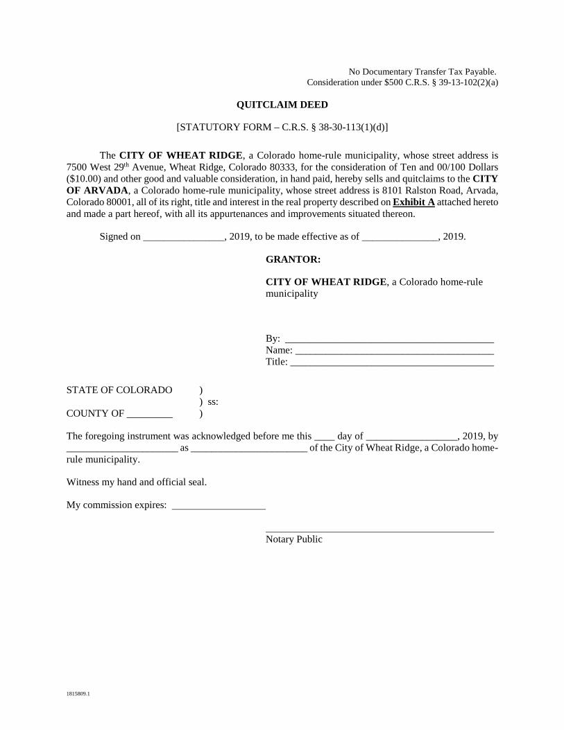
1815809.1
No Documentary Transfer Tax Payable. Consideration under $500 C.R.S. § 39-13-102(2)(a)
QUITCLAIM DEED
[STATUTORY FORM – C.R.S. § 38-30-113(1)(d)]
The CITY OF WHEAT RIDGE, a Colorado home-rule municipality, whose street address is 7500 West 29th Avenue, Wheat Ridge, Colorado 80333, for the consideration of Ten and 00/100 Dollars ($10.00) and other good and valuable consideration, in hand paid, hereby sells and quitclaims to the CITY OF ARVADA, a Colorado home-rule municipality, whose street address is 8101 Ralston Road, Arvada, Colorado 80001, all of its right, title and interest in the real property described on Exhibit A attached hereto and made a part hereof, with all its appurtenances and improvements situated thereon.
Signed on ________________, 2019, to be made effective as of _______________, 2019.
GRANTOR:
CITY OF WHEAT RIDGE, a Colorado home-rule municipality
By: _________________________________________ Name: _______________________________________ Title: ________________________________________
STATE OF COLORADO ) ) ss: COUNTY OF _________ )
The foregoing instrument was acknowledged before me this ____ day of __________________, 2019, by ______________________ as _______________________ of the City of Wheat Ridge, a Colorado home-rule municipality.
Witness my hand and official seal.
My commission expires:
Notary Public
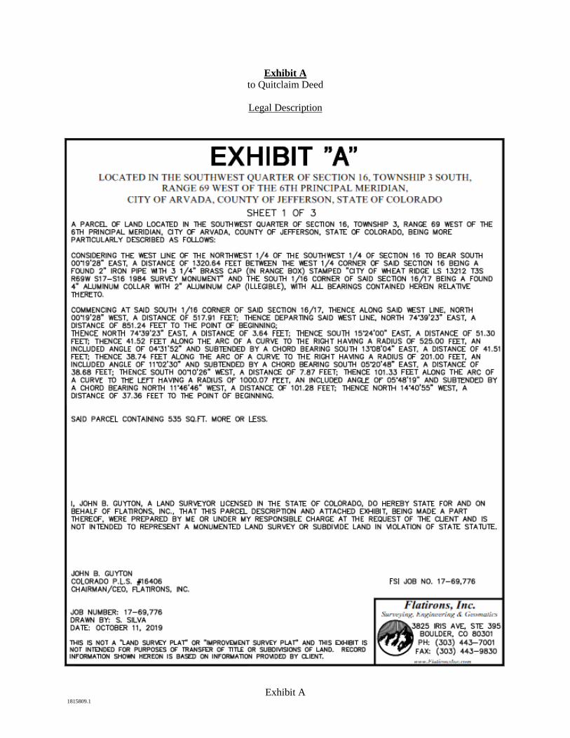
Exhibit A 1815809.1
Exhibit A to Quitclaim Deed
Legal Description
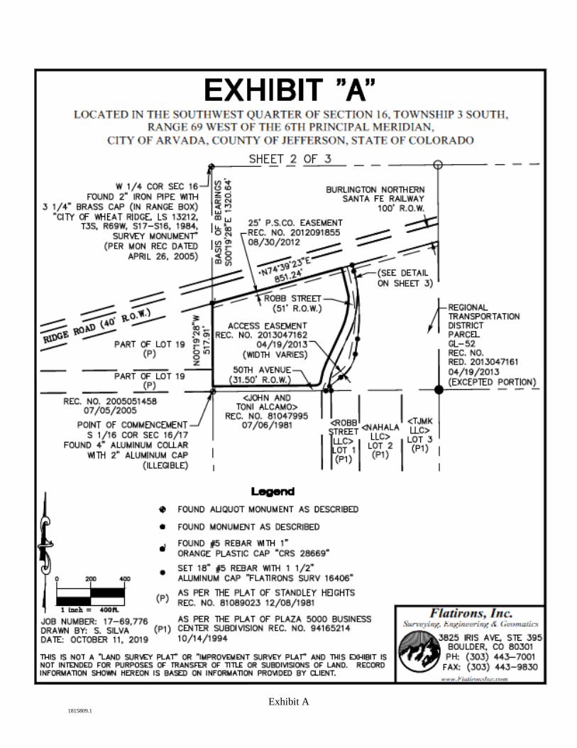
Exhibit A 1815809.1
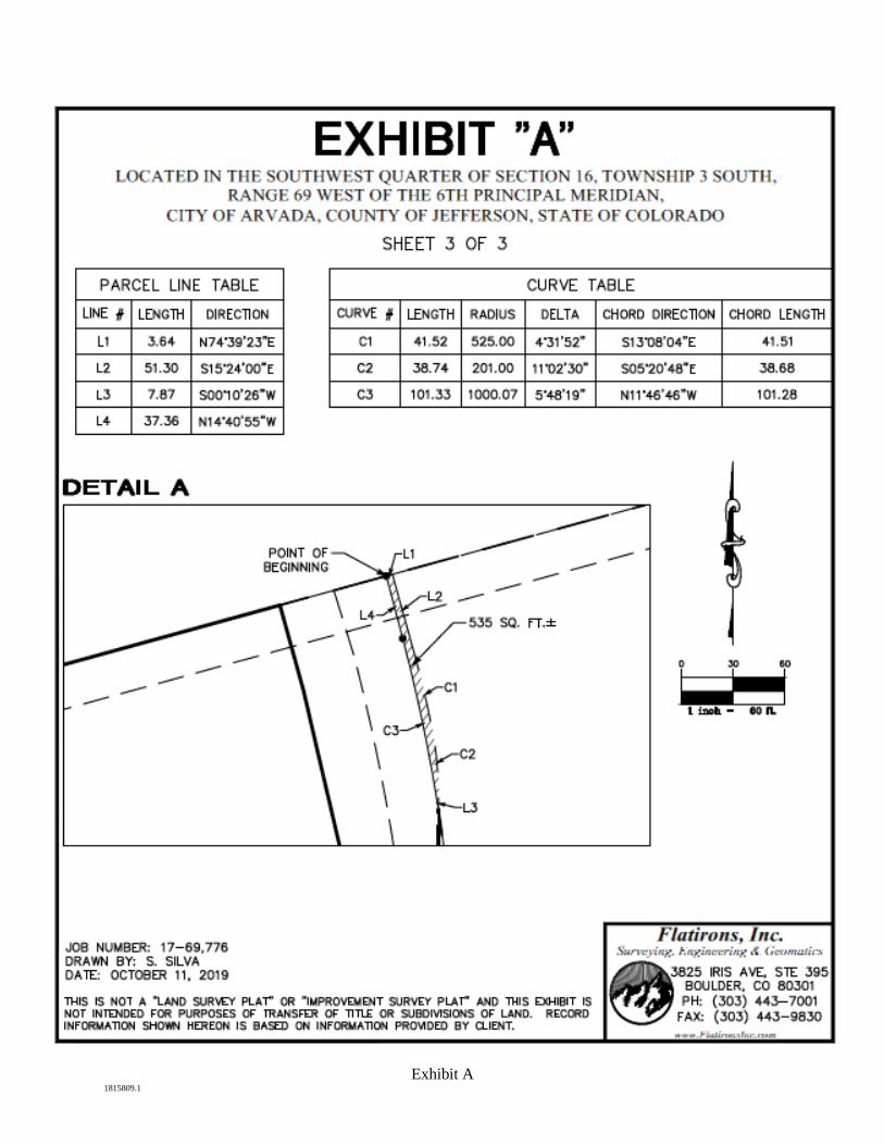
Exhibit A 1815809.1

Exhibit 2 Relinquishment of easement agreement
[attached]
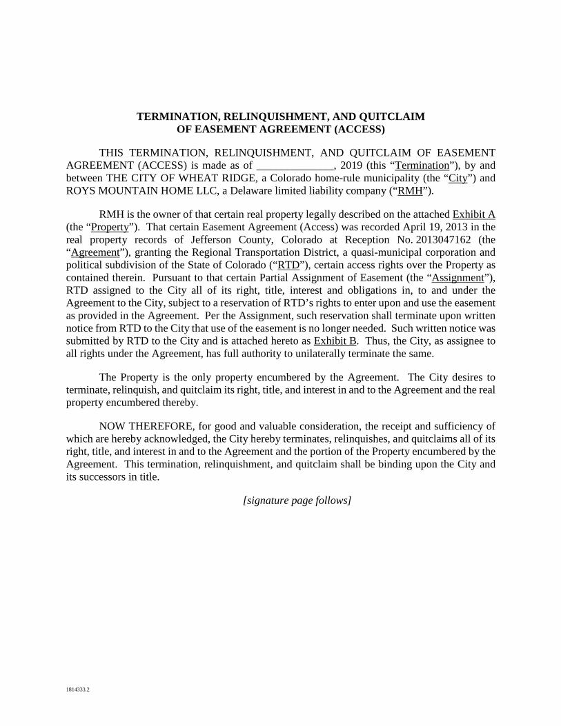
1814333.2
TERMINATION, RELINQUISHMENT, AND QUITCLAIM OF EASEMENT AGREEMENT (ACCESS)
THIS TERMINATION, RELINQUISHMENT, AND QUITCLAIM OF EASEMENT AGREEMENT (ACCESS) is made as of ______________, 2019 (this “Termination”), by and between THE CITY OF WHEAT RIDGE, a Colorado home-rule municipality (the “City”) and ROYS MOUNTAIN HOME LLC, a Delaware limited liability company (“RMH”).
RMH is the owner of that certain real property legally described on the attached Exhibit A (the “Property”). That certain Easement Agreement (Access) was recorded April 19, 2013 in the real property records of Jefferson County, Colorado at Reception No. 2013047162 (the “Agreement”), granting the Regional Transportation District, a quasi-municipal corporation and political subdivision of the State of Colorado (“RTD”), certain access rights over the Property as contained therein. Pursuant to that certain Partial Assignment of Easement (the “Assignment”), RTD assigned to the City all of its right, title, interest and obligations in, to and under the Agreement to the City, subject to a reservation of RTD’s rights to enter upon and use the easement as provided in the Agreement. Per the Assignment, such reservation shall terminate upon written notice from RTD to the City that use of the easement is no longer needed. Such written notice was submitted by RTD to the City and is attached hereto as Exhibit B. Thus, the City, as assignee to all rights under the Agreement, has full authority to unilaterally terminate the same.
The Property is the only property encumbered by the Agreement. The City desires to terminate, relinquish, and quitclaim its right, title, and interest in and to the Agreement and the real property encumbered thereby.
NOW THEREFORE, for good and valuable consideration, the receipt and sufficiency of which are hereby acknowledged, the City hereby terminates, relinquishes, and quitclaims all of its right, title, and interest in and to the Agreement and the portion of the Property encumbered by the Agreement. This termination, relinquishment, and quitclaim shall be binding upon the City and its successors in title.
[signature page follows]
1814333.2
IN WITNESS WHEREOF, the City has executed this Termination as of the day and year first above written.
THE CITY OF WHEAT RIDGE, a Colorado home-rule municipality
By: _______________________________________ Name: ____________________________________ Title: _____________________________________
STATE OF ) ) ss. COUNTY OF )
The foregoing instrument was acknowledged before me this ___ day of _____________, 2019, by ________________________, as __________________ of the City of Wheat Ridge, a Colorado home-rule municipality.
Witness my hand and official seal.
__________________________________________ Notary Public
My commission expires: .
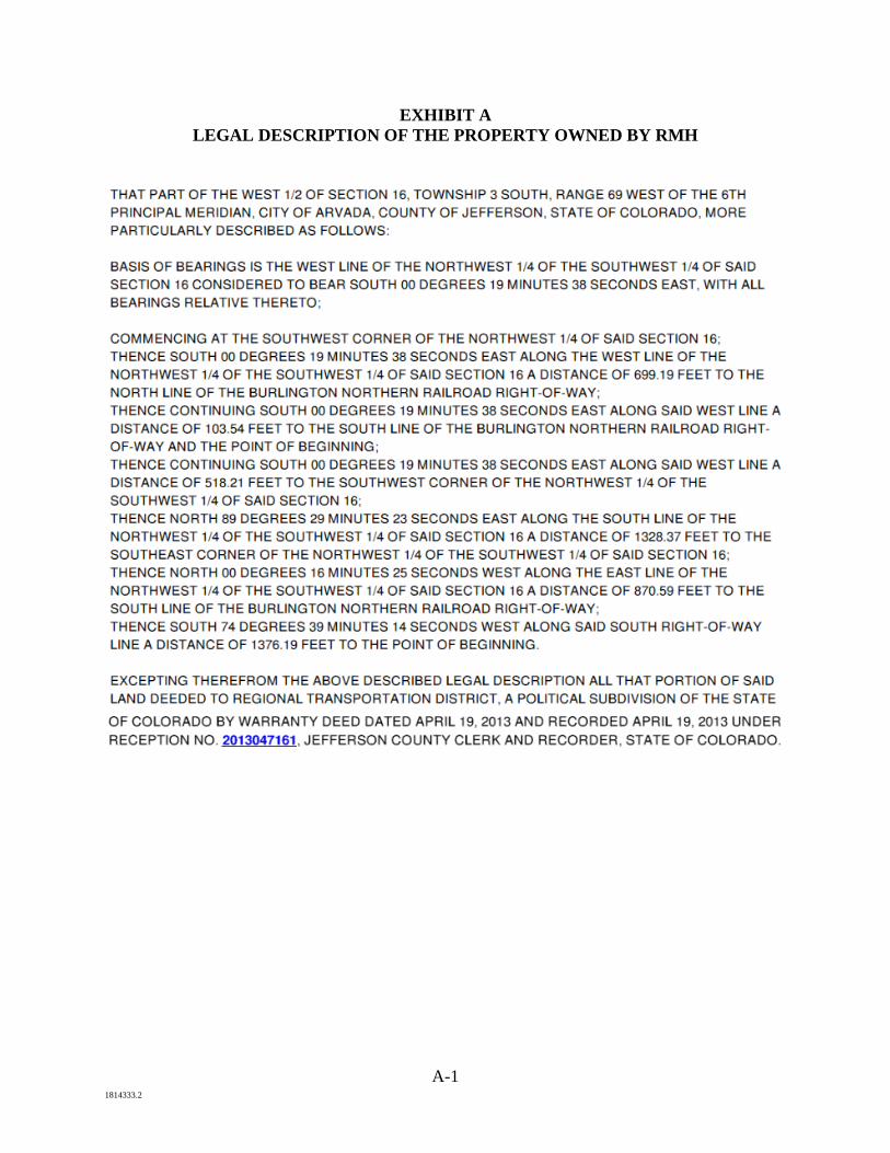
A-1 1814333.2
EXHIBIT A LEGAL DESCRIPTION OF THE PROPERTY OWNED BY RMH
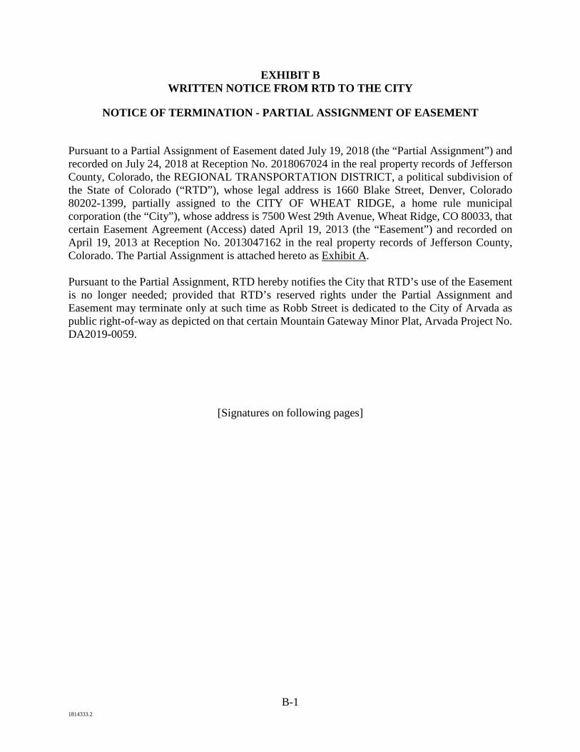
B-1 1814333.2
EXHIBIT B WRITTEN NOTICE FROM RTD TO THE CITY
NOTICE OF TERMINATION - PARTIAL ASSIGNMENT OF EASEMENT
Pursuant to a Partial Assignment of Easement dated July 19, 2018 (the “Partial Assignment”) and recorded on July 24, 2018 at Reception No. 2018067024 in the real property records of Jefferson County, Colorado, the REGIONAL TRANSPORTATION DISTRICT, a political subdivision of the State of Colorado (“RTD”), whose legal address is 1660 Blake Street, Denver, Colorado 80202-1399, partially assigned to the CITY OF WHEAT RIDGE, a home rule municipal corporation (the “City”), whose address is 7500 West 29th Avenue, Wheat Ridge, CO 80033, that certain Easement Agreement (Access) dated April 19, 2013 (the “Easement”) and recorded on April 19, 2013 at Reception No. 2013047162 in the real property records of Jefferson County, Colorado. The Partial Assignment is attached hereto as Exhibit A. Pursuant to the Partial Assignment, RTD hereby notifies the City that RTD’s use of the Easement is no longer needed; provided that RTD’s reserved rights under the Partial Assignment and Easement may terminate only at such time as Robb Street is dedicated to the City of Arvada as public right-of-way as depicted on that certain Mountain Gateway Minor Plat, Arvada Project No. DA2019-0059.
[Signatures on following pages]
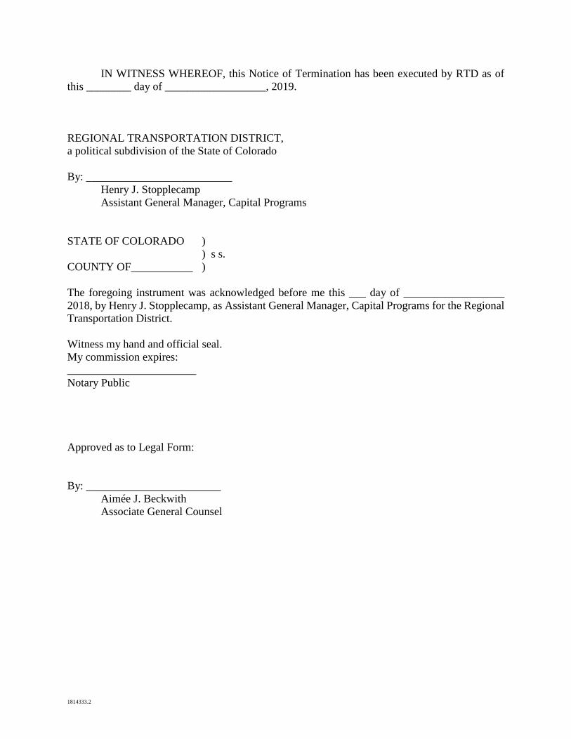
1814333.2
IN WITNESS WHEREOF, this Notice of Termination has been executed by RTD as of this ________ day of __________________, 2019. REGIONAL TRANSPORTATION DISTRICT, a political subdivision of the State of Colorado By: __________________________
Henry J. Stopplecamp Assistant General Manager, Capital Programs
STATE OF COLORADO )
) s s. COUNTY OF___________ ) The foregoing instrument was acknowledged before me this ___ day of __________________ 2018, by Henry J. Stopplecamp, as Assistant General Manager, Capital Programs for the Regional Transportation District. Witness my hand and official seal. My commission expires: _______________________ Notary Public Approved as to Legal Form: By: ________________________
Aimée J. Beckwith Associate General Counsel

1814333.2
Exhibit A

Exhibit 3 Quit claim deed to City of Wheat Ridge
[attached]
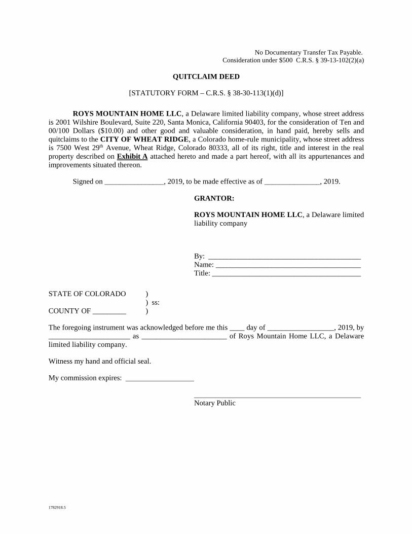
1782918.5
No Documentary Transfer Tax Payable. Consideration under $500 C.R.S. § 39-13-102(2)(a)
QUITCLAIM DEED
[STATUTORY FORM – C.R.S. § 38-30-113(1)(d)]
ROYS MOUNTAIN HOME LLC, a Delaware limited liability company, whose street address is 2001 Wilshire Boulevard, Suite 220, Santa Monica, California 90403, for the consideration of Ten and 00/100 Dollars ($10.00) and other good and valuable consideration, in hand paid, hereby sells and quitclaims to the CITY OF WHEAT RIDGE, a Colorado home-rule municipality, whose street address is 7500 West 29th Avenue, Wheat Ridge, Colorado 80333, all of its right, title and interest in the real property described on Exhibit A attached hereto and made a part hereof, with all its appurtenances and improvements situated thereon.
Signed on ________________, 2019, to be made effective as of _______________, 2019.
GRANTOR:
ROYS MOUNTAIN HOME LLC, a Delaware limited liability company
By: _________________________________________ Name: _______________________________________ Title: ________________________________________
STATE OF COLORADO ) ) ss: COUNTY OF _________ )
The foregoing instrument was acknowledged before me this ____ day of __________________, 2019, by ______________________ as _______________________ of Roys Mountain Home LLC, a Delaware limited liability company.
Witness my hand and official seal.
My commission expires:
Notary Public
Exhibit A 1782918.5
Exhibit A to Quitclaim Deed
Legal Description
Tract A, Mountain Gateway Minor Plat, County of Jefferson, State of Colorado.
(depiction of the property follows)
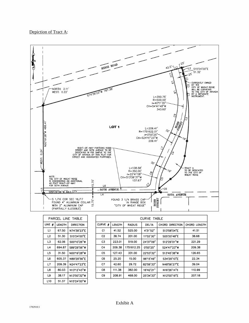
Exhibit A 1782918.5
Depiction of Tract A:

ITEM NO: DATE: December 9, 2019
REQUEST FOR CITY COUNCIL ACTION
TITLE: COUNCIL BILL NO. 21-2019 AN ORDINANCE AMENDING THE WHEAT RIDGE CODE OF LAWS CONCERNING CONTRIBUTIONS TO THE POLICE PENSION FUND
PUBLIC HEARING ORDINANCES FOR 1ST READING (11/25/2019) BIDS/MOTIONS ORDINANCES FOR 2ND READING (12/09/2019) RESOLUTIONS
QUASI-JUDICIAL: YES NO
_______________________________ ______________________________ Administrative Services Director City Manager
ISSUE: The 2020 budget, authorized by City Council on October 14, 2019, appropriates funds to increase the City’s contribution to sworn employees’ pension by 0.5% for a total contribution of 10.5%. As the current contribution (10%) is specified in the City’s code along with an equal match by employees, a code amendment is necessary to operationalize Council’s intent.
PRIOR ACTION: City Council authorized the 2020 budget, containing an increase to sworn employee’s pension contribution, on October 14, 2019.
FINANCIAL IMPACT: The 0.5% increase to the City’s contribution is estimated to cost $35,274 in 2020 and an equal amount annually plus a percentage increase equal to total salary increases.
BACKGROUND: During the 2020 budget process, staff evaluated the Denver-Boulder market to ensure Wheat Ridge remains competitive in its ability to recruit and retain exceptional police officers. Part of that evaluation included a comparison of pension benefits across the market. It was determined that Wheat Ridge is below market in terms of the pension benefit offered to sworn employees.
3
Council Action Form – Police Pension Fund December 9, 2019 Page 2 The 2020 budget includes an increase to the City’s contribution of 0.5% to equal 10.5% while keeping the employees’ contribution the same at 10%. Staff’s intention is to propose similar increases in the next two future budgets for Council’s consideration. Article III of Chapter 19 of the Wheat Ridge Code of Laws provides for the Police Pension Fund. Section 19-53 currently stipulates a cap for the City’s contribution of 10%. The proposed amendment provides Council with the flexibility to set the City’s contribution to the Police Pension Fund. Section 19-54 currently stipulates that the employees’ match cannot be less than the City’s contribution. In order to remain competitive in the market, the City’s contribution should be greater than the employees’ match and the proposed amendment grants Council and staff such ability.
RECOMMENDATIONS: Staff recommends approval of the ordinance. RECOMMENDED MOTION: “I move to approve Council Bill No. 21-2019, an ordinance amending Sections 19-53 and 19-54 of the Wheat Ridge Code of Laws concerning the Police Pension Fund on second reading, and that it take effect 15 days after publication.” Or, “I move to postpone indefinitely Council Bill No. 21-2019, an ordinance amending Sections 19-53 and 19-54 of the Wheat Ridge Code of Laws concerning the Police Pension Fund, for the following reason(s) _________________.” REPORT PREPARED/REVIEWED BY: Gerald Dahl, City Attorney Allison Scheck, Administrative Services Director Patrick Goff, City Manager ATTACHMENTS:
1. Council Bill No. 21-2019
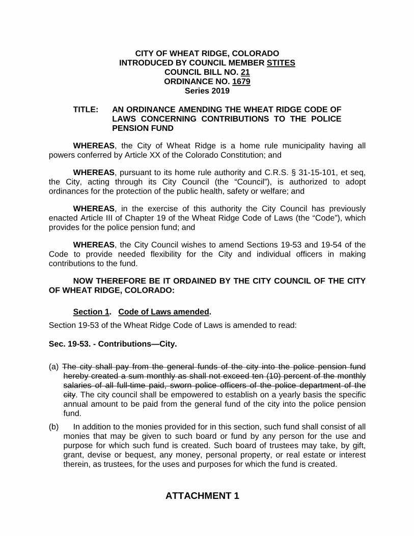
CITY OF WHEAT RIDGE, COLORADO INTRODUCED BY COUNCIL MEMBER STITES
COUNCIL BILL NO. 21 ORDINANCE NO. 1679
Series 2019
TITLE: AN ORDINANCE AMENDING THE WHEAT RIDGE CODE OF LAWS CONCERNING CONTRIBUTIONS TO THE POLICE PENSION FUND
WHEREAS, the City of Wheat Ridge is a home rule municipality having all powers conferred by Article XX of the Colorado Constitution; and
WHEREAS, pursuant to its home rule authority and C.R.S. § 31-15-101, et seq, the City, acting through its City Council (the “Council”), is authorized to adopt ordinances for the protection of the public health, safety or welfare; and
WHEREAS, in the exercise of this authority the City Council has previously enacted Article III of Chapter 19 of the Wheat Ridge Code of Laws (the “Code”), which provides for the police pension fund; and
WHEREAS, the City Council wishes to amend Sections 19-53 and 19-54 of the Code to provide needed flexibility for the City and individual officers in making contributions to the fund.
NOW THEREFORE BE IT ORDAINED BY THE CITY COUNCIL OF THE CITY OF WHEAT RIDGE, COLORADO:
Section 1. Code of Laws amended. Section 19-53 of the Wheat Ridge Code of Laws is amended to read: Sec. 19-53. - Contributions—City. (a) The city shall pay from the general funds of the city into the police pension fund
hereby created a sum monthly as shall not exceed ten (10) percent of the monthly salaries of all full-time paid, sworn police officers of the police department of the city. The city council shall be empowered to establish on a yearly basis the specific annual amount to be paid from the general fund of the city into the police pension fund.
(b) In addition to the monies provided for in this section, such fund shall consist of all monies that may be given to such board or fund by any person for the use and purpose for which such fund is created. Such board of trustees may take, by gift, grant, devise or bequest, any money, personal property, or real estate or interest therein, as trustees, for the uses and purposes for which the fund is created.
ATTACHMENT 1
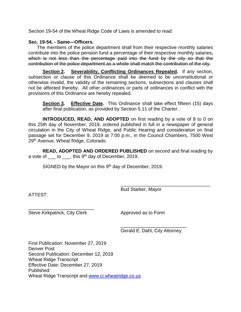
Section 19-54 of the Wheat Ridge Code of Laws is amended to read: Sec. 19-54. - Same—Officers.
The members of the police department shall from their respective monthly salaries contribute into the police pension fund a percentage of their respective monthly salaries, which is not less than the percentage paid into the fund by the city so that the contribution of the police department as a whole shall match the contribution of the city.
Section 2. Severability, Conflicting Ordinances Repealed. If any section, subsection or clause of this Ordinance shall be deemed to be unconstitutional or otherwise invalid, the validity of the remaining sections, subsections and clauses shall not be affected thereby. All other ordinances or parts of ordinances in conflict with the provisions of this Ordinance are hereby repealed.
Section 3. Effective Date. This Ordinance shall take effect fifteen (15) days after final publication, as provided by Section 5.11 of the Charter.
INTRODUCED, READ, AND ADOPTED on first reading by a vote of 8 to 0 on this 25th day of November, 2019, ordered published in full in a newspaper of general circulation in the City of Wheat Ridge, and Public Hearing and consideration on final passage set for December 9, 2019 at 7:00 p.m., in the Council Chambers, 7500 West 29th Avenue, Wheat Ridge, Colorado.
READ, ADOPTED AND ORDERED PUBLISHED on second and final reading by a vote of ___ to ___, this 9th day of December, 2019.
SIGNED by the Mayor on this 9th day of December, 2019.
__________________________________ Bud Starker, Mayor ATTEST:
_________________________ Steve Kirkpatrick, City Clerk Approved as to Form
_________________________ Gerald E. Dahl, City Attorney
First Publication: November 27, 2019 Denver Post Second Publication: December 12, 2019 Wheat Ridge Transcript Effective Date: December 27, 2019 Published: Wheat Ridge Transcript and www.ci.wheatridge.co.us

ITEM NO: DATE: December 9, 2019
REQUEST FOR CITY COUNCIL ACTION
TITLE: COUNCIL BILL NO. 22-2019 – AN ORDINANCE APPROVING THE ANNEXATION OF LAND LOCATED IN SECTION 17, TOWNSHIP 3 SOUTH, RANGE 69 WEST OF THE SIXTH PRINCIPAL MERIDIAN, COUNTY OF JEFFERSON, STATE OF COLORADO (CASE NO. ANX-19-01)
PUBLIC HEARING ORDINANCES FOR 1ST READING (12/09/2019) BIDS/MOTIONS ORDINANCES FOR 2ND READING (01/13/2020) RESOLUTIONS
QUASI-JUDICIAL: YES NO
_______________________________ _____________________________ Community Development Director City Manager
ISSUE: Improvements to 52nd Avenue have been identified and prioritized as an infrastructure project for the Wheat Ridge · Ward Station area and were specifically listed in the ballot language for the 2016 2E sales tax bond measure. Jefferson County owns two segments of the northern portion of 52nd Avenue right-of-way between Ward Road and Tabor Street, consisting of approximately 1.14 acres. Annexation of the Jefferson County right-of-way into the City of Wheat Ridge will simplify the design, construction and future maintenance of this segment of 52nd Avenue. Jefferson County submitted an annexation petition to the City on October 11, 2019. The annexation process is dictated by state statute, and this ordinance is a required step for approval.
PRIOR ACTION: City Council was briefed on the proposed annexation at a study session on September 23, 2019. A resolution finding the annexation in substantial compliance with CRS §31-12-107(1) and eligible for annexation was approved by City Council on November 25, 2019.
FINANCIAL IMPACT: With the annexation of the property, the City will be responsible for the proposed improvements and for long term street maintenance. Fees for annexation were waived with the petition, but
4
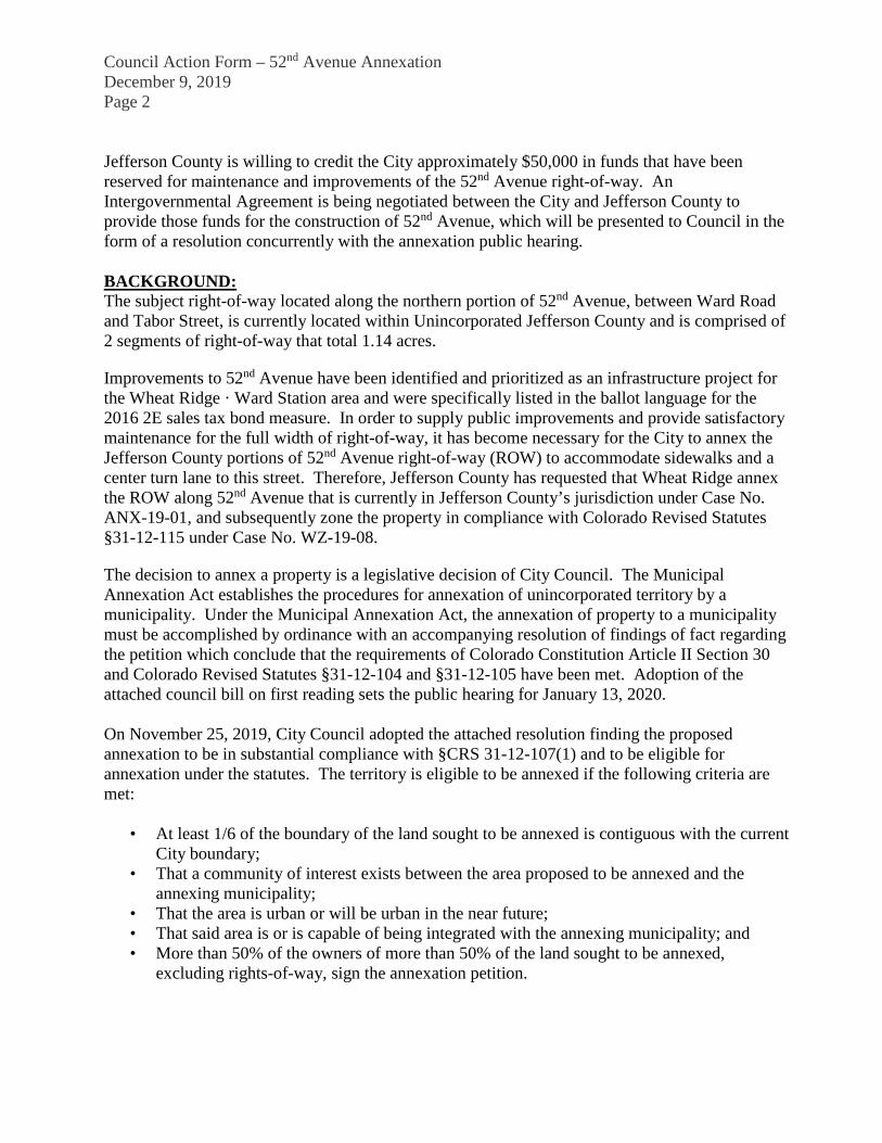
Council Action Form – 52nd Avenue Annexation December 9, 2019 Page 2 Jefferson County is willing to credit the City approximately $50,000 in funds that have been reserved for maintenance and improvements of the 52nd Avenue right-of-way. An Intergovernmental Agreement is being negotiated between the City and Jefferson County to provide those funds for the construction of 52nd Avenue, which will be presented to Council in the form of a resolution concurrently with the annexation public hearing. BACKGROUND: The subject right-of-way located along the northern portion of 52nd Avenue, between Ward Road and Tabor Street, is currently located within Unincorporated Jefferson County and is comprised of 2 segments of right-of-way that total 1.14 acres.
Improvements to 52nd Avenue have been identified and prioritized as an infrastructure project for the Wheat Ridge · Ward Station area and were specifically listed in the ballot language for the 2016 2E sales tax bond measure. In order to supply public improvements and provide satisfactory maintenance for the full width of right-of-way, it has become necessary for the City to annex the Jefferson County portions of 52nd Avenue right-of-way (ROW) to accommodate sidewalks and a center turn lane to this street. Therefore, Jefferson County has requested that Wheat Ridge annex the ROW along 52nd Avenue that is currently in Jefferson County’s jurisdiction under Case No. ANX-19-01, and subsequently zone the property in compliance with Colorado Revised Statutes §31-12-115 under Case No. WZ-19-08.
The decision to annex a property is a legislative decision of City Council. The Municipal Annexation Act establishes the procedures for annexation of unincorporated territory by a municipality. Under the Municipal Annexation Act, the annexation of property to a municipality must be accomplished by ordinance with an accompanying resolution of findings of fact regarding the petition which conclude that the requirements of Colorado Constitution Article II Section 30 and Colorado Revised Statutes §31-12-104 and §31-12-105 have been met. Adoption of the attached council bill on first reading sets the public hearing for January 13, 2020. On November 25, 2019, City Council adopted the attached resolution finding the proposed annexation to be in substantial compliance with §CRS 31-12-107(1) and to be eligible for annexation under the statutes. The territory is eligible to be annexed if the following criteria are met:
• At least 1/6 of the boundary of the land sought to be annexed is contiguous with the current City boundary;
• That a community of interest exists between the area proposed to be annexed and the annexing municipality;
• That the area is urban or will be urban in the near future; • That said area is or is capable of being integrated with the annexing municipality; and • More than 50% of the owners of more than 50% of the land sought to be annexed,
excluding rights-of-way, sign the annexation petition.
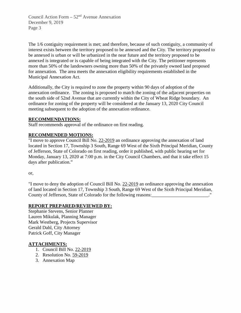
Council Action Form – 52nd Avenue Annexation December 9, 2019 Page 3 The 1/6 contiguity requirement is met; and therefore, because of such contiguity, a community of interest exists between the territory proposed to be annexed and the City. The territory proposed to be annexed is urban or will be urbanized in the near future and the territory proposed to be annexed is integrated or is capable of being integrated with the City. The petitioner represents more than 50% of the landowners owning more than 50% of the privately owned land proposed for annexation. The area meets the annexation eligibility requirements established in the Municipal Annexation Act.
Additionally, the City is required to zone the property within 90 days of adoption of the annexation ordinance. The zoning is proposed to match the zoning of the adjacent properties on the south side of 52nd Avenue that are currently within the City of Wheat Ridge boundary. An ordinance for zoning of the property will be considered at the January 13, 2020 City Council meeting subsequent to the adoption of the annexation ordinance.
RECOMMENDATIONS: Staff recommends approval of the ordinance on first reading.
RECOMMENDED MOTIONS: "I move to approve Council Bill No. 22-2019 an ordinance approving the annexation of land located in Section 17, Township 3 South, Range 69 West of the Sixth Principal Meridian, County of Jefferson, State of Colorado on first reading, order it published, with public hearing set for Monday, January 13, 2020 at 7:00 p.m. in the City Council Chambers, and that it take effect 15 days after publication.” or, "I move to deny the adoption of Council Bill No. 22-2019 an ordinance approving the annexation of land located in Section 17, Township 3 South, Range 69 West of the Sixth Principal Meridian, County of Jefferson, State of Colorado for the following reasons:________________________." REPORT PREPARED/REVIEWED BY: Stephanie Stevens, Senior Planner Lauren Mikulak, Planning Manager Mark Westberg, Projects Supervisor Gerald Dahl, City Attorney Patrick Goff, City Manager ATTACHMENTS:
1. Council Bill No. 22-2019 2. Resolution No. 59-2019 3. Annexation Map
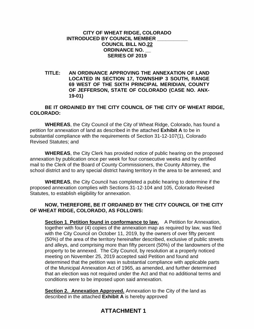
ATTACHMENT 1
CITY OF WHEAT RIDGE, COLORADO INTRODUCED BY COUNCIL MEMBER ___________
COUNCIL BILL NO.22 ORDINANCE NO. __
SERIES OF 2019
TITLE: AN ORDINANCE APPROVING THE ANNEXATION OF LAND
LOCATED IN SECTION 17, TOWNSHIP 3 SOUTH, RANGE 69 WEST OF THE SIXTH PRINCIPAL MERIDIAN, COUNTY OF JEFFERSON, STATE OF COLORADO (CASE NO. ANX-19-01)
BE IT ORDAINED BY THE CITY COUNCIL OF THE CITY OF WHEAT RIDGE, COLORADO:
WHEREAS, the City Council of the City of Wheat Ridge, Colorado, has found a petition for annexation of land as described in the attached Exhibit A to be in substantial compliance with the requirements of Section 31-12-107(1), Colorado Revised Statutes; and
WHEREAS, the City Clerk has provided notice of public hearing on the proposed
annexation by publication once per week for four consecutive weeks and by certified mail to the Clerk of the Board of County Commissioners, the County Attorney, the school district and to any special district having territory in the area to be annexed; and
WHEREAS, the City Council has completed a public hearing to determine if the
proposed annexation complies with Sections 31-12-104 and 105, Colorado Revised Statutes, to establish eligibility for annexation.
NOW, THEREFORE, BE IT ORDAINED BY THE CITY COUNCIL OF THE CITY
OF WHEAT RIDGE, COLORADO, AS FOLLOWS:
Section 1. Petition found in conformance to law. A Petition for Annexation, together with four (4) copies of the annexation map as required by law, was filed with the City Council on October 11, 2019, by the owners of over fifty percent (50%) of the area of the territory hereinafter described, exclusive of public streets and alleys, and comprising more than fifty percent (50%) of the landowners of the property to be annexed. The City Council, by resolution at a properly noticed meeting on November 25, 2019 accepted said Petition and found and determined that the petition was in substantial compliance with applicable parts of the Municipal Annexation Act of 1965, as amended, and further determined that an election was not required under the Act and that no additional terms and conditions were to be imposed upon said annexation. Section 2. Annexation Approved. Annexation to the City of the land as described in the attached Exhibit A is hereby approved
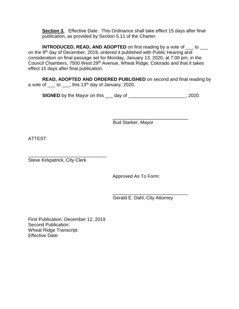
Section 3. Effective Date. This Ordinance shall take effect 15 days after final publication, as provided by Section 5.11 of the Charter. INTRODUCED, READ, AND ADOPTED on first reading by a vote of ___ to ___
on the 9th day of December, 2019, ordered it published with Public Hearing and consideration on final passage set for Monday, January 13, 2020, at 7:00 pm, in the Council Chambers, 7500 West 29th Avenue, Wheat Ridge, Colorado and that it takes effect 15 days after final publication.
READ, ADOPTED AND ORDERED PUBLISHED on second and final reading by
a vote of ___ to ___, this 13th day of January, 2020. SIGNED by the Mayor on this ___ day of ______________________, 2020.
_____________________________ Bud Starker, Mayor ATTEST: ______________________________ Steve Kirkpatrick, City Clerk
Approved As To Form: _____________________________
Gerald E. Dahl, City Attorney First Publication: December 12, 2019 Second Publication: Wheat Ridge Transcript Effective Date:

EXHIBIT ‘A’ CASE NO. ANX-19-01 / 52ND AVENUE ANNEXATION
LEGAL DESCRIPTION
(see attached)
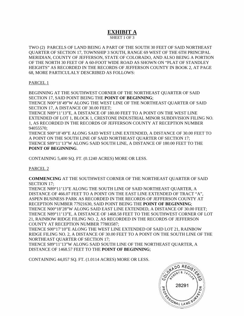
EXHIBIT A SHEET 1 OF 3
TWO (2) PARCELS OF LAND BEING A PART OF THE SOUTH 30 FEET OF SAID NORTHEAST QUARTER OF SECTION 17, TOWNSHIP 3 SOUTH, RANGE 69 WEST OF THE 6TH PRINCIPAL MERIDIAN, COUNTY OF JEFFERSON, STATE OF COLORADO, AND ALSO BEING A PORTION OF THE NORTH 30 FEET OF A 60-FOOT WIDE ROAD AS SHOWN ON “PLAT OF STANDLEY HEIGHTS” AS RECORDED IN THE RECORDS OF JEFFERSON COUNTY IN BOOK 2, AT PAGE 68, MORE PARTICULALY DESCRIBED AS FOLLOWS: PARCEL 1 BEGINNING AT THE SOUTHWEST CORNER OF THE NORTHEAST QUARTER OF SAID SECTION 17, SAID POINT BEING THE POINT OF BEGINNING; THENCE N00°18’49”W ALONG THE WEST LINE OF THE NORTHEAST QUARTER OF SAID SECTION 17, A DISTANCE OF 30.00 FEET; THENCE N89°11’13”E, A DISTANCE OF 180.00 FEET TO A POINT ON THE WEST LINE EXTENDED OF LOT 1, BLOCK 1, CRESTONE INDUSTRIAL MINOR SUBDIVISION FILING NO. 1, AS RECORDED IN THE RECORDS OF JEFFERSON COUNTY AT RECEPTION NUMBER 94055570; THENCE S00°18’49”E ALONG SAID WEST LINE EXTENDED, A DISTANCE OF 30.00 FEET TO A POINT ON THE SOUTH LINE OF SAID NORTHEAST QUARTER OF SECTION 17; THENCE S89°11’13”W ALONG SAID SOUTH LINE, A DISTANCE OF 180.00 FEET TO THE POINT OF BEGINNING. CONTAINING 5,400 SQ. FT. (0.1240 ACRES) MORE OR LESS. PARCEL 2 COMMENCING AT THE SOUTHWEST CORNER OF THE NORTHEAST QUARTER OF SAID SECTION 17; THENCE N89°11’13”E ALONG THE SOUTH LINE OF SAID NORTHEAST QUARTER, A DISTANCE OF 466.07 FEET TO A POINT ON THE EAST LINE EXTENDED OF TRACT “A”, ASPEN BUSINESS PARK AS RECORDED IN THE RECORDS OF JEFFERSON COUNTY AT RECEPTION NUMBER 77921630, SAID POINT BEING THE POINT OF BEGINNING; THENCE N00°18’28”W ALONG SAID EAST LINE EXTENDED, A DISTANCE OF 30.00 FEET; THENCE N89°11’13”E, A DISTANCE OF 1468.58 FEET TO THE SOUTHWEST CORNER OF LOT 21, RAINBOW RIDGE FILING NO. 2, AS RECORDED IN THE RECORDS OF JEFFERSON COUNTY AT RECEPTION NUMBER 77883587; THENCE S00°17’10”E ALONG THE WEST LINE EXTENDED OF SAID LOT 21, RAINBOW RIDGE FILING NO. 2, A DISTANCE OF 30.00 FEET TO A POINT ON THE SOUTH LINE OF THE NORTHEAST QUARTER OF SECTION 17; THENCE S89°11’13”W ALONG SAID SOUTH LINE OF THE NORTHEAST QUARTER, A DISTANCE OF 1468.57 FEET TO THE POINT OF BEGINNING; CONTAINING 44,057 SQ. FT. (1.0114 ACRES) MORE OR LESS.
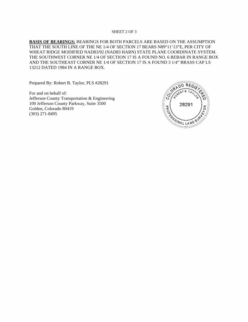
SHEET 2 OF 3 BASIS OF BEARINGS: BEARINGS FOR BOTH PARCELS ARE BASED ON THE ASSUMPTION THAT THE SOUTH LINE OF THE NE 1/4 OF SECTION 17 BEARS N89°11’13”E, PER CITY OF WHEAT RIDGE MODIFIED NAD83/92 (NAD83 HARN) STATE PLANE COORDINATE SYSTEM. THE SOUTHWEST CORNER NE 1/4 OF SECTION 17 IS A FOUND NO. 6 REBAR IN RANGE BOX AND THE SOUTHEAST CORNER NE 1/4 OF SECTION 17 IS A FOUND 3 1/4” BRASS CAP LS 13212 DATED 1984 IN A RANGE BOX. Prepared By: Robert B. Taylor, PLS #28291 For and on behalf of: Jefferson County Transportation & Engineering 100 Jefferson County Parkway, Suite 3500 Golden, Colorado 80419 (303) 271-8495
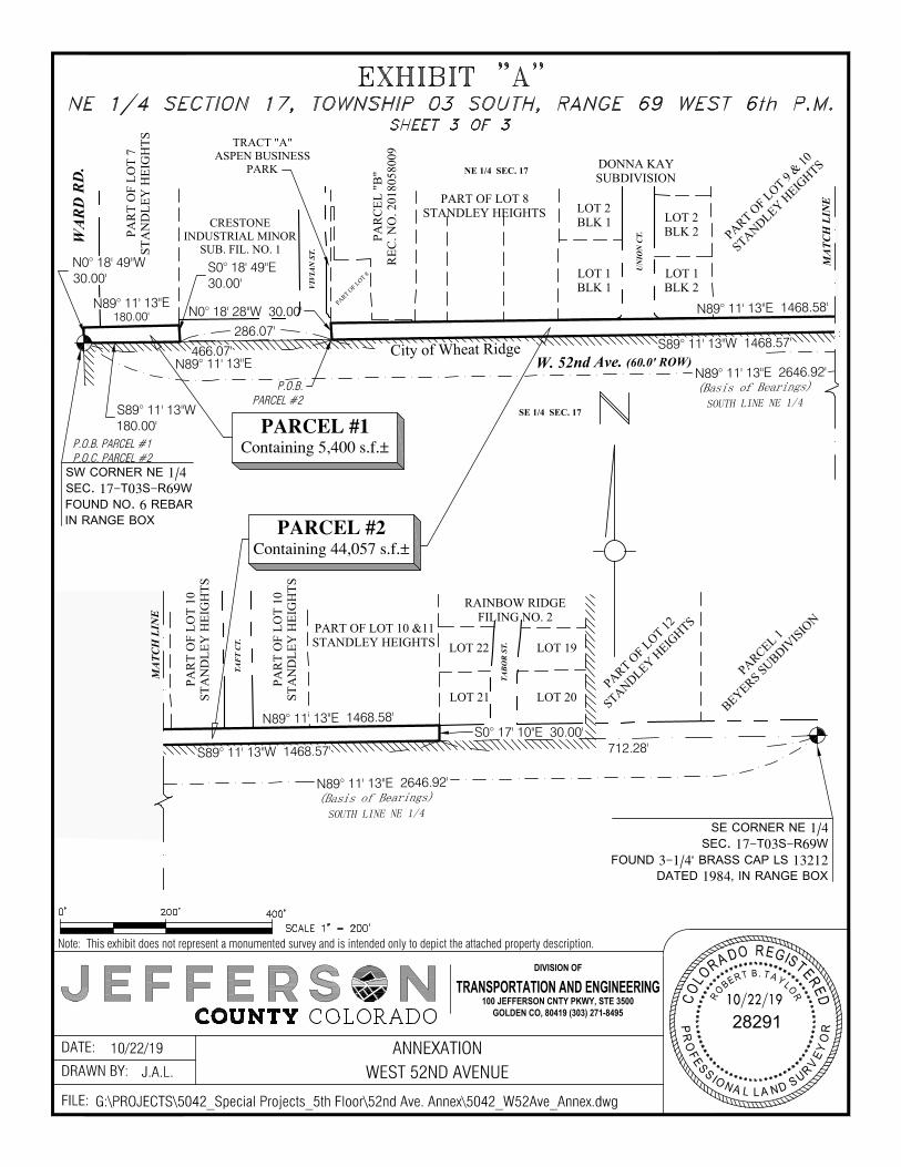
MA
TCH
LIN
E
(Basis of Bearings)
W. 52nd Ave. (60.0' ROW)
P.O.B.PARCEL #2
UN
ION
CT.
VIV
IAN
ST.
PARCEL #1Containing 5,400 s.f.±
N89° 11' 13"E 2646.92'
N0° 18' 49"W30.00'
S0° 18' 49"E30.00'
286.07'
466.07'
N0° 18' 28"W 30.00' N89° 11' 13"E 1468.58'
S89° 11' 13"W 1468.57'City of Wheat Ridge
SOUTH LINE NE 1/4
N89° 11' 13"E180.00'
S89° 11' 13"W180.00'
N89° 11' 13"E
(Basis of Bearings)
SE CORNER NE 1/4SEC. 17-T03S-R69W
FOUND 3-1/4" BRASS CAP LS 13212DATED 1984, IN RANGE BOX
TAB
OR
ST.
TAF
T C
T.
N89° 11' 13"E 2646.92'
N89° 11' 13"E 1468.58'
S89° 11' 13"W 1468.57'
S0° 17' 10"E 30.00'712.28'
SOUTH LINE NE 1/4
MA
TCH
LIN
E
(Basis of Bearings)N89° 11' 13"E 2646.92'
SOUTH LINE NE 1/4
S89° 11' 13"W 1468.57'
N89° 11' 13"E 1468.58'
FILE:
DRAWN BY:DATE:
10/22/19C
O
L
O
R
A
D
O
RE
G
I
S
T
E
R
E
D
PR
O
F
E
S
S
I
O
N
A
L LA
N
D
S
U
R
V
E
Y
O
R
28291
R
O
B
E
R
T
B. T
A
Y
L
O
R
TRANSPORTATION AND ENGINEERING100 JEFFERSON CNTY PKWY, STE 3500
GOLDEN CO, 80419 (303) 271-8495
DIVISION OF
Note: This exhibit does not represent a monumented survey and is intended only to depict the attached property description.
ANNEXATIONWEST 52ND AVENUE
10/22/19J.A.L.
G:\PROJECTS\5042_Special Projects_5th Floor\52nd Ave. Annex\5042_W52Ave_Annex.dwg
PARCEL #2Containing 44,057 s.f.±
WA
RD
RD
.
PARCEL 1
BEYERS SUBDIVISIO
N
PART OF LOT 12
STANDLEY HEIG
HTSRAINBOW RIDGE
FILING NO. 2
LOT 19
LOT 20
LOT 22
LOT 21
PART OF LOT 10 &11STANDLEY HEIGHTS
PAR
T O
F LO
T 10
STA
ND
LEY
HEI
GH
TS
PAR
T O
F LO
T 10
STA
ND
LEY
HEI
GH
TS
PART OF LOT 9
& 10
STANDLEY HEIG
HTSDONNA KAYSUBDIVISION
LOT 2BLK 2
LOT 1BLK 2
LOT 2BLK 1
LOT 1BLK 1
PART OF LOT 8STANDLEY HEIGHTS
PART OF LOT 8
PAR
CEL
"B
"R
EC. N
O. 2
0180
5800
9
CRESTONEINDUSTRIAL MINOR
SUB. FIL. NO. 1
PAR
T O
F LO
T 7
STA
ND
LEY
HEI
GH
TS
SW CORNER NE 1/4SEC. 17-T03S-R69WFOUND NO. 6 REBARIN RANGE BOX
P.O.B. PARCEL #1P.O.C. PARCEL #2
TRACT "A"ASPEN BUSINESS
PARK NE 1/4 SEC. 17
SE 1/4 SEC. 17
AutoCAD SHX Text
0'
AutoCAD SHX Text
200'
AutoCAD SHX Text
400'
AutoCAD SHX Text
NE 1/4 SECTION 17, TOWNSHIP 03 SOUTH, RANGE 69 WEST 6th P.M. SHEET 3 OF 3
AutoCAD SHX Text
SCALE 1" = 200'
AutoCAD SHX Text
EXHIBIT "A"
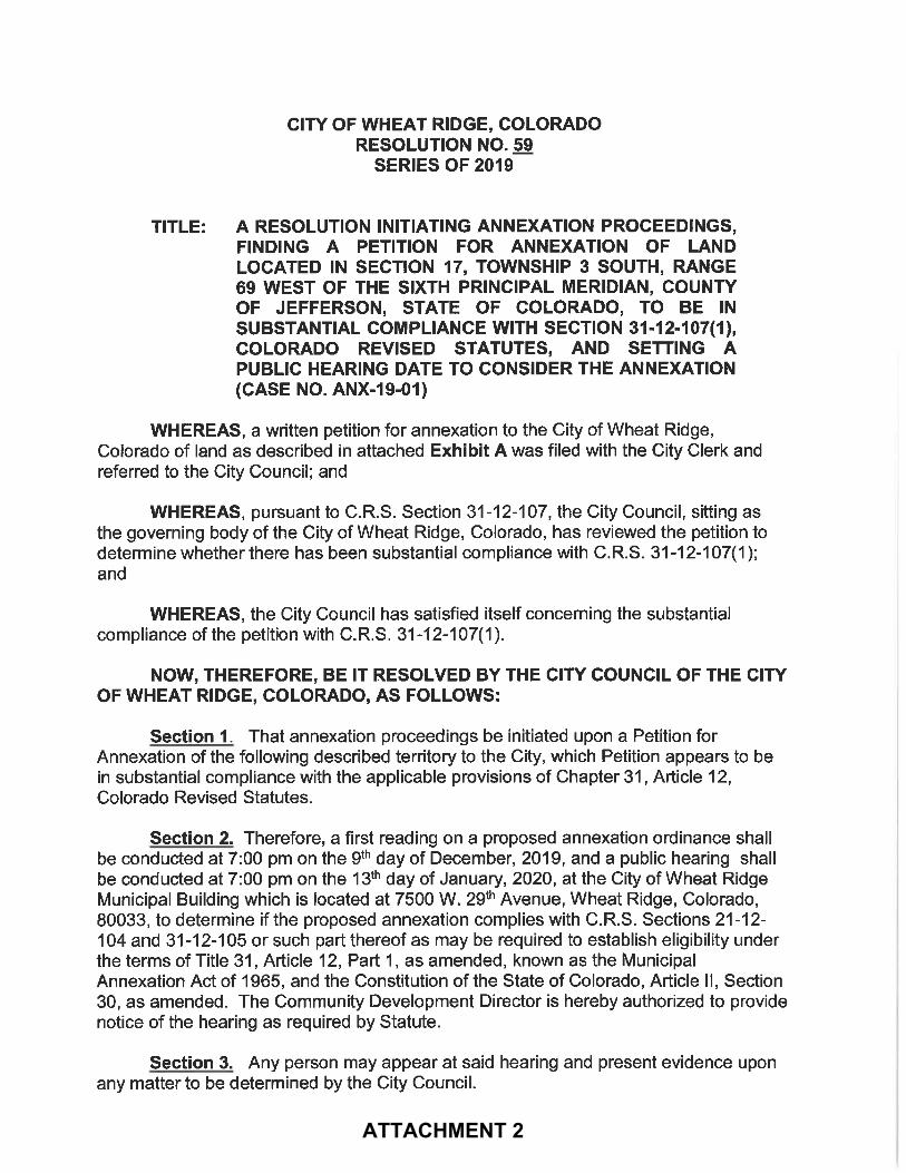
ATTACHMENT 2

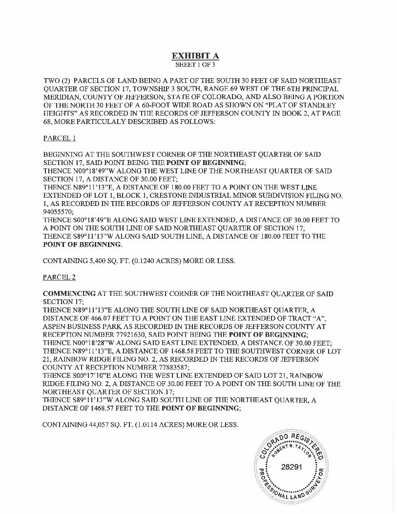
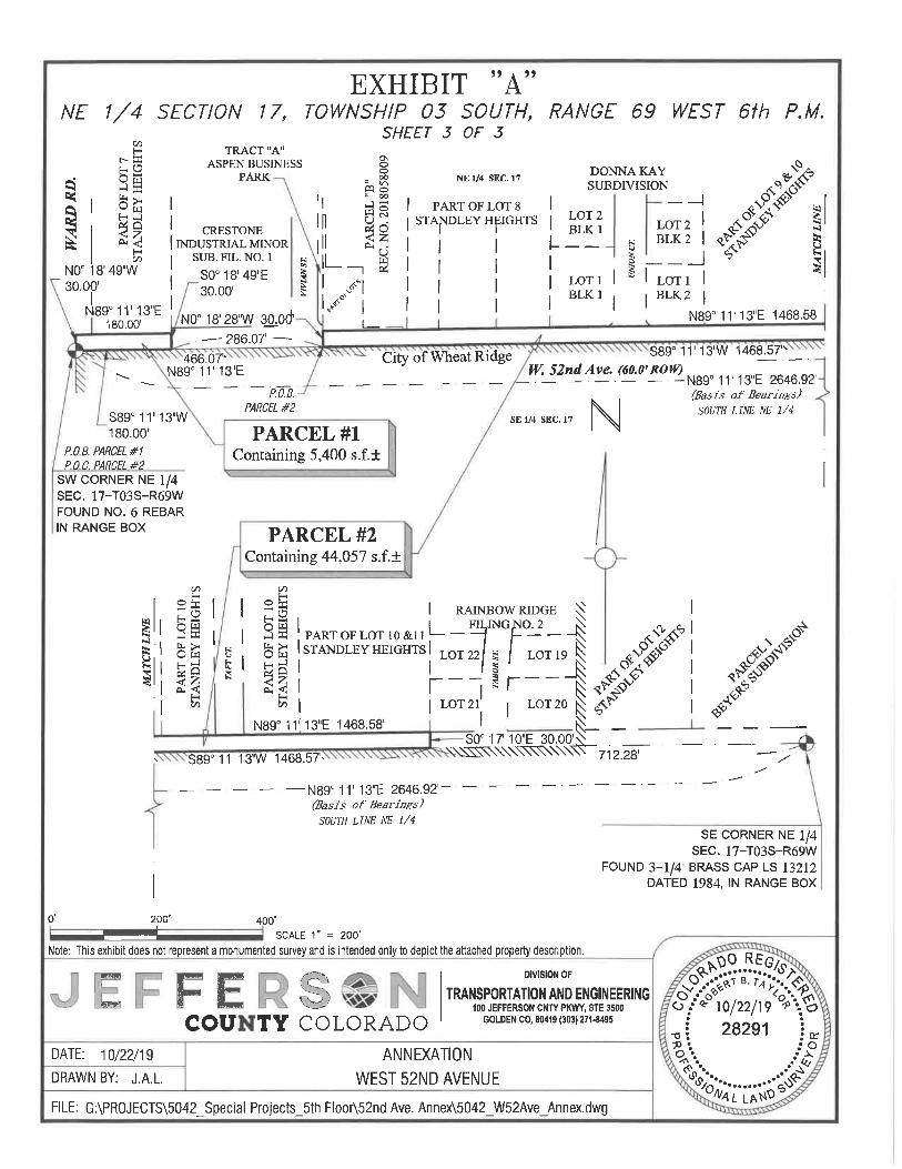
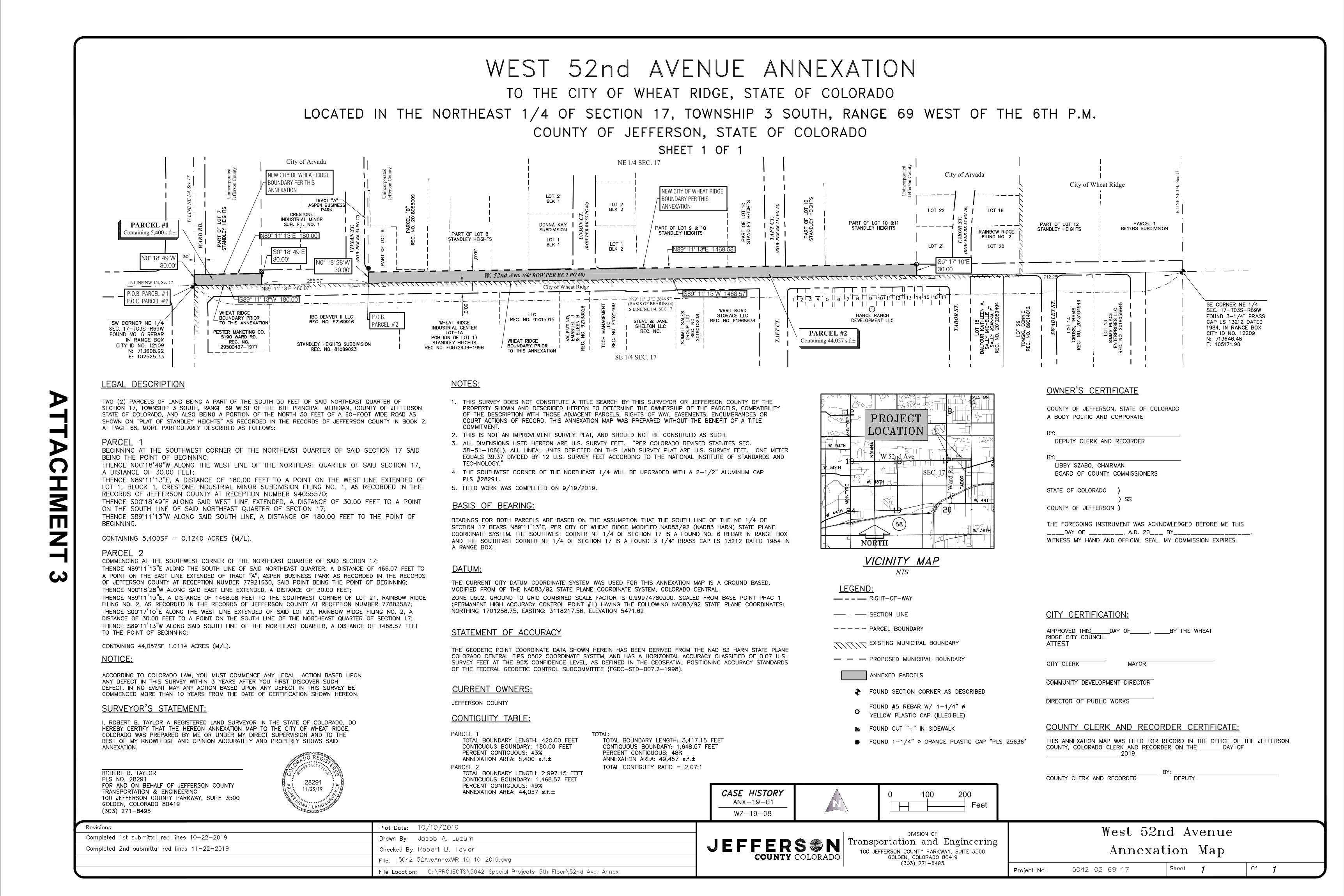
(BASIS OF BEARINGS)
W. 52nd Ave. (60' ROW PER BK 2 PG 68)
TAB
OR
ST.
(RO
W P
ER
BK
52
PG 1
0)
UN
ION
CT.
(RO
W P
ER
BK
53
PG 6
0)
VIV
IAN
ST.
(RO
W P
ER
BK
53
PG 2
7)
TAF
T C
T.(R
OW
PE
R B
K 1
14 P
G 4
3)
PARCEL #2Containing 44,057 s.f.±
WA
RD
RD
.
N89° 11' 13"E 2646.92'
286.07'
N89° 11' 13"E 466.07' City of Wheat Ridge
Uni
ncor
pora
ted
Jeff
erso
n C
ount
y
Uni
ncor
pora
ted
Jeff
erso
n C
ount
yCity of Arvada
S LINE NW 1/4, Sec 17
W L
INE
NE
1/4,
Sec
17
Uni
ncor
pora
ted
Jeff
erso
n C
ount
y
SE 1/4 SEC. 17
NE 1/4 SEC. 17
TAF
T C
T.
City of ArvadaCity of Wheat Ridge
TAB
OR
ST.
E LI
NE
NE
1/4,
Sec
17
PARCEL #1Containing 5,400 s.f.±
SWA
DLE
Y ST
.
S LINE NE 1/4, SEC 17
P.O.B. PARCEL #1P.O.C. PARCEL #2
P.O.B.PARCEL #2
S89° 11' 13"W 1468.57'S89° 11' 13"W 180.00'
N89° 11' 13"E 1468.58'
S0° 17' 10"E30.00'
N0° 18' 28"W30.00'
N0° 18' 49"W30.00'
N89° 11' 13"E 180.00'
NEW CITY OF WHEAT RIDGEBOUNDARY PER THISANNEXATION
NEW CITY OF WHEAT RIDGEBOUNDARY PER THISANNEXATION
712.28'
S0° 18' 49"E30.00'
1 1
Feet
0 100 200
”
11/25/19
SEC. 17
W 52nd Ave
War
d R
d
C
O
L
O
R
A
D
O
RE
G
I
S
T
E
R
E
D
PR
O
F
E
S
S
I
O
N
A
L LA
N
D
S
U
R
V
E
Y
O
R
28291
R
O
B
E
R
T
B. T
A
Y
L
O
R
ATTA
CH
MEN
T 3
AutoCAD SHX Text
SE CORNER NE 1/4 SEC. 17-T03S-R69W FOUND 3-1/4" BRASS CAP LS 13212 DATED 1984, IN RANGE BOX CITY ID NO. 12209 N: 713646.48 E: 105171.98
AutoCAD SHX Text
SW CORNER NE 1/4 SEC. 17-T03S-R69W FOUND NO. 6 REBAR IN RANGE BOX CITY ID NO. 12109 N: 713608.92 E: 102525.33
AutoCAD SHX Text
PARCEL 1 BEYERS SUBDIVISION
AutoCAD SHX Text
PART OF LOT 12 STANDLEY HEIGHTS
AutoCAD SHX Text
RAINBOW RIDGE FILING NO. 2
AutoCAD SHX Text
LOT 19
AutoCAD SHX Text
LOT 20
AutoCAD SHX Text
LOT 22
AutoCAD SHX Text
LOT 21
AutoCAD SHX Text
PART OF LOT 10 &11 STANDLEY HEIGHTS
AutoCAD SHX Text
PART OF LOT 10 STANDLEY HEIGHTS
AutoCAD SHX Text
PART OF LOT 10 STANDLEY HEIGHTS
AutoCAD SHX Text
PART OF LOT 9 & 10 STANDLEY HEIGHTS
AutoCAD SHX Text
DONNA KAY SUBDIVISION
AutoCAD SHX Text
LOT 2 BLK 2
AutoCAD SHX Text
LOT 1 BLK 2
AutoCAD SHX Text
LOT 2 BLK 1
AutoCAD SHX Text
LOT 1 BLK 1
AutoCAD SHX Text
PART OF LOT 8 STANDLEY HEIGHTS
AutoCAD SHX Text
PART OF LOT 8
AutoCAD SHX Text
PARCEL "B" REC. NO. 2018058009
AutoCAD SHX Text
PART OF LOT 7 STANDLEY HEIGHTS
AutoCAD SHX Text
TRACT "A" ASPEN BUSINESS PARK
AutoCAD SHX Text
WHEAT RIDGE INDUSTRIAL CENTER LOT-1A PORTION OF LOT 13 STANDLEY HEIGHTS REC NO. F0672939-1998
AutoCAD SHX Text
WHEAT RIDGE BOUNDARY PRIOR TO THIS ANNEXATION
AutoCAD SHX Text
CRESTONE INDUSTRIAL MINOR SUB. FIL. NO. 1
AutoCAD SHX Text
WHEAT RIDGE BOUNDARY PRIOR TO THIS ANNEXATION
AutoCAD SHX Text
STANDLEY HEIGHTS SUBDIVISION REC. NO. 81089023
AutoCAD SHX Text
LLC REC. NO. 91015315
AutoCAD SHX Text
VALENTIINO, EMANUEL J & EILEEN B REC. NO. 92133526
AutoCAD SHX Text
TCCH MANAGEMENT LLC REC. NO. F1521460
AutoCAD SHX Text
STEVE & JANE SHELTON LLC REC. NO.
AutoCAD SHX Text
SUMMIT SALES GROUP LTD REC. NO. 2018010238
AutoCAD SHX Text
PESTER MAKETING CO. 5190 WARD RD. REC. NO. 29500407-1977
AutoCAD SHX Text
LOT 13 SIMMS PLACE ENTERPRISES LLC REC. NO. 2018056645
AutoCAD SHX Text
LOT 14 GROSS, TRAVIS REC. NO. 2013104949
AutoCAD SHX Text
LOT 29 TOMSIC, CONNIE REC. NO. 89014012
AutoCAD SHX Text
LOT 15 BALFOUR KATHLEEN A, SALLY MICHELLE L, SALLY JOANNA F REC. NO. 2012089494
AutoCAD SHX Text
WARD ROAD STORAGE LLC REC. NO. F1968878
AutoCAD SHX Text
HANCE RANCH DEVELOPMENT LLC
AutoCAD SHX Text
IBC DENVER II LLC REC. NO. F2169916
AutoCAD SHX Text
1
AutoCAD SHX Text
2
AutoCAD SHX Text
3
AutoCAD SHX Text
4
AutoCAD SHX Text
5
AutoCAD SHX Text
6
AutoCAD SHX Text
7
AutoCAD SHX Text
8
AutoCAD SHX Text
9
AutoCAD SHX Text
10
AutoCAD SHX Text
11
AutoCAD SHX Text
12
AutoCAD SHX Text
13
AutoCAD SHX Text
14
AutoCAD SHX Text
15
AutoCAD SHX Text
1
AutoCAD SHX Text
16
AutoCAD SHX Text
17
AutoCAD SHX Text
W. 54TH
AutoCAD SHX Text
W. 50TH
AutoCAD SHX Text
W. 58TH
AutoCAD SHX Text
W. 48TH
AutoCAD SHX Text
TABOR
AutoCAD SHX Text
INDIANA
AutoCAD SHX Text
W. 44TH
AutoCAD SHX Text
RIDGE RD.
AutoCAD SHX Text
RALSTON
AutoCAD SHX Text
RD.
AutoCAD SHX Text
McINTYRE
AutoCAD SHX Text
W. 44TH AVE.
AutoCAD SHX Text
W. 38TH AVE.
AutoCAD SHX Text
58
AutoCAD SHX Text
MCINTYRE
AutoCAD SHX Text
24
AutoCAD SHX Text
13
AutoCAD SHX Text
12
AutoCAD SHX Text
19
AutoCAD SHX Text
18
AutoCAD SHX Text
7
AutoCAD SHX Text
20
AutoCAD SHX Text
17
AutoCAD SHX Text
8
AutoCAD SHX Text
21
AutoCAD SHX Text
16
AutoCAD SHX Text
Plot Date:
AutoCAD SHX Text
Drawn By:
AutoCAD SHX Text
Checked By:
AutoCAD SHX Text
Project No.:
AutoCAD SHX Text
Sheet
AutoCAD SHX Text
Of
AutoCAD SHX Text
File Location:
AutoCAD SHX Text
Revisions:
AutoCAD SHX Text
G:\PROJECTS\5042_Special Projects_5th Floor\52nd Ave. Annex
AutoCAD SHX Text
File:
AutoCAD SHX Text
5042_52AveAnnexWR_10-10-2019.dwg
AutoCAD SHX Text
(303) 271-8495
AutoCAD SHX Text
GOLDEN, COLORADO 80419
AutoCAD SHX Text
100 JEFFERSON COUNTY PARKWAY, SUITE 3500
AutoCAD SHX Text
DIVISION OF
AutoCAD SHX Text
Transportation and Engineering
AutoCAD SHX Text
10/10/2019
AutoCAD SHX Text
Jacob A. Luzum
AutoCAD SHX Text
Robert B. Taylor
AutoCAD SHX Text
West 52nd Avenue
AutoCAD SHX Text
Annexation Map
AutoCAD SHX Text
5042_03_69_17
AutoCAD SHX Text
WEST 52nd AVENUE ANNEXATION TO THE CITY OF WHEAT RIDGE, STATE OF COLORADO LOCATED IN THE NORTHEAST 1/4 OF SECTION 17, TOWNSHIP 3 SOUTH, RANGE 69 WEST OF THE 6TH P.M. COUNTY OF JEFFERSON, STATE OF COLORADO SHEET 1 OF 1
AutoCAD SHX Text
NOTICE: ACCORDING TO COLORADO LAW, YOU MUST COMMENCE ANY LEGAL ACTION BASED UPON ANY DEFECT IN THIS SURVEY WITHIN 3 YEARS AFTER YOU FIRST DISCOVER SUCH DEFECT. IN NO EVENT MAY ANY ACTION BASED UPON ANY DEFECT IN THIS SURVEY BE COMMENCED MORE THAN 10 YEARS FROM THE DATE OF CERTIFICATION SHOWN HEREON. SURVEYOR'S STATEMENT: I, ROBERT B. TAYLOR A REGISTERED LAND SURVEYOR IN THE STATE OF COLORADO, DO HEREBY CERTIFY THAT THE HEREON ANNEXATION MAP TO THE CITY OF WHEAT RIDGE, COLORADO WAS PREPARED BY ME OR UNDER MY DIRECT SUPERVISION AND TO THE BEST OF MY KNOWLEDGE AND OPINION ACCURATELY AND PROPERLY SHOWS SAID ANNEXATION. ROBERT B. TAYLOR PLS NO. 28291 FOR AND ON BEHALF OF JEFFERSON COUNTY TRANSPORTATION & ENGINEERING 100 JEFFERSON COUNTY PARKWAY, SUITE 3500 GOLDEN, COLORADO 80419 (303) 271-8495
AutoCAD SHX Text
LEGAL DESCRIPTION TWO (2) PARCELS OF LAND BEING A PART OF THE SOUTH 30 FEET OF SAID NORTHEAST QUARTER OF SECTION 17, TOWNSHIP 3 SOUTH, RANGE 69 WEST OF THE 6TH PRINCIPAL MERIDIAN, COUNTY OF JEFFERSON, STATE OF COLORADO, AND ALSO BEING A PORTION OF THE NORTH 30 FEET OF A 60-FOOT WIDE ROAD AS SHOWN ON "PLAT OF STANDLEY HEIGHTS" AS RECORDED IN THE RECORDS OF JEFFERSON COUNTY IN BOOK 2, AT PAGE 68, MORE PARTICULARLY DESCRIBED AS FOLLOWS: PARCEL 1 BEGINNING AT THE SOUTHWEST CORNER OF THE NORTHEAST QUARTER OF SAID SECTION 17 SAID BEING THE POINT OF BEGINNING. THENCE N00°18'49"W ALONG THE WEST LINE OF THE NORTHEAST QUARTER OF SAID SECTION 17, A DISTANCE OF 30.00 FEET; THENCE N89°11'13"E, A DISTANCE OF 180.00 FEET TO A POINT ON THE WEST LINE EXTENDED OF LOT 1, BLOCK 1, CRESTONE INDUSTRIAL MINOR SUBDIVISION FILING NO. 1, AS RECORDED IN THE RECORDS OF JEFFERSON COUNTY AT RECEPTION NUMBER 94055570; THENCE S00°18'49"E ALONG SAID WEST LINE EXTENDED, A DISTANCE OF 30.00 FEET TO A POINT ON THE SOUTH LINE OF SAID NORTHEAST QUARTER OF SECTION 17; THENCE S89°11'13"W ALONG SAID SOUTH LINE, A DISTANCE OF 180.00 FEET TO THE POINT OF BEGINNING. CONTAINING 5,400SF = 0.1240 ACRES (M/L). PARCEL 2 COMMENCING AT THE SOUTHWEST CORNER OF THE NORTHEAST QUARTER OF SAID SECTION 17; THENCE N89°11'13"E ALONG THE SOUTH LINE OF SAID NORTHEAST QUARTER, A DISTANCE OF 466.07 FEET TO '13"E ALONG THE SOUTH LINE OF SAID NORTHEAST QUARTER, A DISTANCE OF 466.07 FEET TO 13"E ALONG THE SOUTH LINE OF SAID NORTHEAST QUARTER, A DISTANCE OF 466.07 FEET TO "E ALONG THE SOUTH LINE OF SAID NORTHEAST QUARTER, A DISTANCE OF 466.07 FEET TO E ALONG THE SOUTH LINE OF SAID NORTHEAST QUARTER, A DISTANCE OF 466.07 FEET TO A POINT ON THE EAST LINE EXTENDED OF TRACT "A", ASPEN BUSINESS PARK AS RECORDED IN THE RECORDS OF JEFFERSON COUNTY AT RECEPTION NUMBER 77921630, SAID POINT BEING THE POINT OF BEGINNING; THENCE N00°18'28"W ALONG SAID EAST LINE EXTENDED, A DISTANCE OF 30.00 FEET; '28"W ALONG SAID EAST LINE EXTENDED, A DISTANCE OF 30.00 FEET; 28"W ALONG SAID EAST LINE EXTENDED, A DISTANCE OF 30.00 FEET; "W ALONG SAID EAST LINE EXTENDED, A DISTANCE OF 30.00 FEET; W ALONG SAID EAST LINE EXTENDED, A DISTANCE OF 30.00 FEET; THENCE N89°11'13"E, A DISTANCE OF 1468.58 FEET TO THE SOUTHWEST CORNER OF LOT 21, RAINBOW RIDGE '13"E, A DISTANCE OF 1468.58 FEET TO THE SOUTHWEST CORNER OF LOT 21, RAINBOW RIDGE 13"E, A DISTANCE OF 1468.58 FEET TO THE SOUTHWEST CORNER OF LOT 21, RAINBOW RIDGE "E, A DISTANCE OF 1468.58 FEET TO THE SOUTHWEST CORNER OF LOT 21, RAINBOW RIDGE E, A DISTANCE OF 1468.58 FEET TO THE SOUTHWEST CORNER OF LOT 21, RAINBOW RIDGE FILING NO. 2, AS RECORDED IN THE RECORDS OF JEFFERSON COUNTY AT RECEPTION NUMBER 77883587; THENCE S00°17'10"E ALONG THE WEST LINE EXTENDED OF SAID LOT 21, RAINBOW RIDGE FILING NO. 2, A '10"E ALONG THE WEST LINE EXTENDED OF SAID LOT 21, RAINBOW RIDGE FILING NO. 2, A 10"E ALONG THE WEST LINE EXTENDED OF SAID LOT 21, RAINBOW RIDGE FILING NO. 2, A "E ALONG THE WEST LINE EXTENDED OF SAID LOT 21, RAINBOW RIDGE FILING NO. 2, A E ALONG THE WEST LINE EXTENDED OF SAID LOT 21, RAINBOW RIDGE FILING NO. 2, A DISTANCE OF 30.00 FEET TO A POINT ON THE SOUTH LINE OF THE NORTHEAST QUARTER OF SECTION 17; THENCE S89°11'13"W ALONG SAID SOUTH LINE OF THE NORTHEAST QUARTER, A DISTANCE OF 1468.57 FEET '13"W ALONG SAID SOUTH LINE OF THE NORTHEAST QUARTER, A DISTANCE OF 1468.57 FEET 13"W ALONG SAID SOUTH LINE OF THE NORTHEAST QUARTER, A DISTANCE OF 1468.57 FEET "W ALONG SAID SOUTH LINE OF THE NORTHEAST QUARTER, A DISTANCE OF 1468.57 FEET W ALONG SAID SOUTH LINE OF THE NORTHEAST QUARTER, A DISTANCE OF 1468.57 FEET TO THE POINT OF BEGINNING; CONTAINING 44,057SF 1.0114 ACRES (M/L).
AutoCAD SHX Text
NOTES: 1. THIS SURVEY DOES NOT CONSTITUTE A TITLE SEARCH BY THIS SURVEYOR OR JEFFERSON COUNTY OF THE THIS SURVEY DOES NOT CONSTITUTE A TITLE SEARCH BY THIS SURVEYOR OR JEFFERSON COUNTY OF THE PROPERTY SHOWN AND DESCRIBED HEREON TO DETERMINE THE OWNERSHIP OF THE PARCELS, COMPATIBILITY OF THE DESCRIPTION WITH THOSE ADJACENT PARCELS, RIGHTS OF WAY, EASEMENTS, ENCUMBRANCES OR COURT ACTIONS OF RECORD. THIS ANNEXATION MAP WAS PREPARED WITHOUT THE BENEFIT OF A TITLE COMMITMENT. 2. THIS IS NOT AN IMPROVEMENT SURVEY PLAT, AND SHOULD NOT BE CONSTRUED AS SUCH. THIS IS NOT AN IMPROVEMENT SURVEY PLAT, AND SHOULD NOT BE CONSTRUED AS SUCH. 3. ALL DIMENSIONS USED HEREON ARE U.S. SURVEY FEET. "PER COLORADO REVISED STATUTES SEC. ALL DIMENSIONS USED HEREON ARE U.S. SURVEY FEET. "PER COLORADO REVISED STATUTES SEC. 38-51-106(L), ALL LINEAL UNITS DEPICTED ON THIS LAND SURVEY PLAT ARE U.S. SURVEY FEET. ONE METER EQUALS 39.37 DIVIDED BY 12 U.S. SURVEY FEET ACCORDING TO THE NATIONAL INSTITUTE OF STANDARDS AND TECHNOLOGY." 4. THE SOUTHWEST CORNER OF THE NORTHEAST 1/4 WILL BE UPGRADED WITH A 2-1/2" ALUMINUM CAP THE SOUTHWEST CORNER OF THE NORTHEAST 1/4 WILL BE UPGRADED WITH A 2-1/2" ALUMINUM CAP PLS #28291. 5. FIELD WORK WAS COMPLETED ON 9/19/2019. FIELD WORK WAS COMPLETED ON 9/19/2019. BASIS OF BEARING: BEARINGS FOR BOTH PARCELS ARE BASED ON THE ASSUMPTION THAT THE SOUTH LINE OF THE NE 1/4 OF SECTION 17 BEARS N89°11'13"E, PER CITY OF WHEAT RIDGE MODIFIED NAD83/92 (NAD83 HARN) STATE PLANE COORDINATE SYSTEM. THE SOUTHWEST CORNER NE 1/4 OF SECTION 17 IS A FOUND NO. 6 REBAR IN RANGE BOX AND THE SOUTHEAST CORNER NE 1/4 OF SECTION 17 IS A FOUND 3 1/4” BRASS CAP LS 13212 DATED 1984 IN BRASS CAP LS 13212 DATED 1984 IN A RANGE BOX. DATUM: THE CURRENT CITY DATUM COORDINATE SYSTEM WAS USED FOR THIS ANNEXATION MAP IS A GROUND BASED, MODIFIED FROM OF THE NAD83/92 STATE PLANE COORDINATE SYSTEM, COLORADO CENTRAL ZONE 0502. GROUND TO GRID COMBINED SCALE FACTOR IS 0.99974780300. SCALED FROM BASE POINT PHAC 1 (PERMANENT HIGH ACCURACY CONTROL POINT #1) HAVING THE FOLLOWING NAD83/92 STATE PLANE COORDINATES: NORTHING 1701258.75, EASTING: 3118217.58, ELEVATION 5471.62 STATEMENT OF ACCURACY THE GEODETIC POINT COORDINATE DATA SHOWN HEREIN HAS BEEN DERIVED FROM THE NAD 83 HARN STATE PLANE COLORADO CENTRAL FIPS 0502 COORDINATE SYSTEM, AND HAS A HORIZONTAL ACCURACY CLASSIFIED OF 0.07 U.S. SURVEY FEET AT THE 95% CONFIDENCE LEVEL, AS DEFINED IN THE GEOSPATIAL POSITIONING ACCURACY STANDARDS OF THE FEDERAL GEODETIC CONTROL SUBCOMMITTEE (FGDC-STD-007.2-1998). CURRENT OWNERS: JEFFERSON COUNTY
AutoCAD SHX Text
CASE HISTORY
AutoCAD SHX Text
VICINITY MAP NTS
AutoCAD SHX Text
CITY CERTIFICATION: APPROVED THIS DAY OF , BY THE WHEAT DAY OF , BY THE WHEAT DAY OF , BY THE WHEAT , BY THE WHEAT , BY THE WHEAT BY THE WHEAT BY THE WHEAT RIDGE CITY COUNCIL. ATTEST CITY CLERK MAYOR MAYOR COMMUNITY DEVELOPMENT DIRECTOR DIRECTOR OF PUBLIC WORKS COUNTY CLERK AND RECORDER CERTIFICATE: THIS ANNEXATION MAP WAS FILED FOR RECORD IN THE OFFICE OF THE JEFFERSON COUNTY, COLORADO CLERK AND RECORDER ON THE DAY OF 2019. BY: COUNTY CLERK AND RECORDER DEPUTY
AutoCAD SHX Text
LEGEND: RIGHT-OF-WAY SECTION LINE PARCEL BOUNDARY EXISTING MUNICIPAL BOUNDARY PROPOSED MUNICIPAL BOUNDARY ANNEXED PARCELS FOUND SECTION CORNER AS DESCRIBED FOUND #5 REBAR W/ 1-1/4" YELLOW PLASTIC CAP (ILLEGIBLE) FOUND CUT "+" IN SIDEWALK "+" IN SIDEWALK +" IN SIDEWALK " IN SIDEWALK IN SIDEWALK FOUND 1-1/4" ORANGE PLASTIC CAP "PLS 25636"" ORANGE PLASTIC CAP "PLS 25636" ORANGE PLASTIC CAP "PLS 25636"PLS 25636""
AutoCAD SHX Text
ANX-19-01
AutoCAD SHX Text
PROJECT LOCATION
AutoCAD SHX Text
NORTH
AutoCAD SHX Text
CONTIGUITY TABLE: PARCEL 1 TOTAL BOUNDARY LENGTH: 420.00 FEET CONTIGUOUS BOUNDARY: 180.00 FEET PERCENT CONTIGUOUS: 43% ANNEXATION AREA: 5,400 s.f.± PARCEL 2 TOTAL BOUNDARY LENGTH: 2,997.15 FEET CONTIGUOUS BOUNDARY: 1,468.57 FEET PERCENT CONTIGUOUS: 49% ANNEXATION AREA: 44,057 s.f.±
AutoCAD SHX Text
TOTAL: TOTAL BOUNDARY LENGTH: 3,417.15 FEET CONTIGUOUS BOUNDARY: 1,648.57 FEET PERCENT CONTIGUOUS: 48% ANNEXATION AREA: 49,457 s.f.± TOTAL CONTIGUITY RATIO = 2.07:1
AutoCAD SHX Text
Completed 1st submittal red lines 10-22-2019
AutoCAD SHX Text
OWNER'S CERTIFICATE COUNTY OF JEFFERSON, STATE OF COLORADO A BODY POLITIC AND CORPORATE BY: DEPUTY CLERK AND RECORDER BY: LIBBY SZABO, CHAIRMAN BOARD OF COUNTY COMMISSIONERS STATE OF COLORADO ) ) SS COUNTY OF JEFFERSON ) THE FOREGOING INSTRUMENT WAS ACKNOWLEDGED BEFORE ME THIS ____DAY OF ________, A.D. 20___ BY__________________. WITNESS MY HAND AND OFFICIAL SEAL. MY COMMISSION EXPIRES:
AutoCAD SHX Text
WZ-19-08
AutoCAD SHX Text
Completed 2nd submittal red lines 11-22-2019
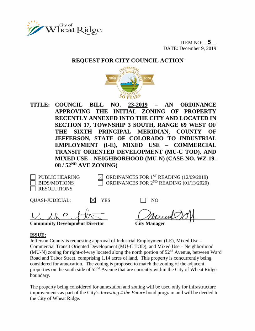
ITEM NO: DATE: December 9, 2019
REQUEST FOR CITY COUNCIL ACTION
TITLE: COUNCIL BILL NO. 23-2019 – AN ORDINANCE APPROVING THE INITIAL ZONING OF PROPERTY RECENTLY ANNEXED INTO THE CITY AND LOCATED IN SECTION 17, TOWNSHIP 3 SOUTH, RANGE 69 WEST OF THE SIXTH PRINCIPAL MERIDIAN, COUNTY OF JEFFERSON, STATE OF COLORADO TO INDUSTRIAL EMPLOYMENT (I-E), MIXED USE – COMMERCIAL TRANSIT ORIENTED DEVELOPMENT (MU-C TOD), AND MIXED USE – NEIGHBORHOOD (MU-N) (CASE NO. WZ-19-08 / 52ND AVE ZONING)
PUBLIC HEARING ORDINANCES FOR 1ST READING (12/09/2019) BIDS/MOTIONS ORDINANCES FOR 2ND READING (01/13/2020) RESOLUTIONS
QUASI-JUDICIAL: YES NO
_______________________________ ________________________________ Community Development Director City Manager
ISSUE: Jefferson County is requesting approval of Industrial Employment (I-E), Mixed Use – Commercial Transit Oriented Development (MU-C TOD), and Mixed Use – Neighborhood (MU-N) zoning for right-of-way located along the north portion of 52nd Avenue, between Ward Road and Tabor Street, comprising 1.14 acres of land. This property is concurrently being considered for annexation. The zoning is proposed to match the zoning of the adjacent properties on the south side of 52nd Avenue that are currently within the City of Wheat Ridge boundary.
The property being considered for annexation and zoning will be used only for infrastructure improvements as part of the City’s Investing 4 the Future bond program and will be deeded to the City of Wheat Ridge.
5
Council Action Form – 52nd Avenue Zoning December 9, 2019 Page 2 PRIOR ACTION: Planning Commission will review this request at a public hearing to be held on December 19, 2019. A copy of the Planning Commission staff report and minutes from that meeting will be available with the report for the January 13, 2020 public hearing. FINANCIAL IMPACT: With the annexation of the property, the City will be responsible for the proposed improvements and for long term street maintenance. Fees for zoning application were waived. BACKGROUND: The subject right-of-way located along the northern portion of 52nd Avenue, between Ward Road and Tabor Street, is currently located within Unincorporated Jefferson County and is comprised of 2 segments of right-of-way that total 1.14 acres.
Jefferson County has requested that Wheat Ridge annex the ROW along 52nd Avenue that is currently in Jefferson County’s jurisdiction under Case No. ANX-19-01, and subsequently zone the property in compliance with Colorado Revised Statutes §31-12-115 under the subject Case No. WZ-19-08, in order for the City to supply public improvements and provide satisfactory maintenance for the full width of right-of-way per the infrastructure project for the Wheat Ridge · Ward Station area.
The City is required to zone the property within 90 days of adoption of the annexation ordinance. The zoning is proposed to match the zoning of the adjacent properties on the south side of 52nd Avenue that are currently within the City of Wheat Ridge boundary, which consists of a combination of Industrial Employment (I-E), Mixed Use – Commercial Transit Oriented Development (MU-C TOD), and Mixed Use – Neighborhood (MU-N) zone districts as illustrated in the legal description provided in the attached council bill. The proposed zoning is consistent with Envision Wheat Ridge which calls for mixed-use employment land uses, and supports the Wheat Ridge • Ward Station Vision. No private development will occur on this property.
The application has been through a standard City and outside agency referral process, and no issues of concern have been raised. This ordinance for zoning of the property will be considered at the January 13, 2020 City Council meeting subsequent to the adoption of the annexation ordinance. Zoning shall be contingent upon annexation.
RECOMMENDATIONS: "I move to approve Council Bill No. 23-2019, an ordinance approving I-E, MU-C TOD, and MU-N zoning on property being considered for annexation to the City of Wheat Ridge on first reading, order it published, with public hearing set for Monday, January 13, 2020 at 7:00 p.m. in the City Council Chambers, and that it take effect 15 days after publication.” or,

Council Action Form – 52nd Avenue Zoning December 9, 2019 Page 3 "I move to continue indefinitely Council Bill No. 23-2019, an ordinance approving I-E, MU-C TOD, and MU-N zoning on property being considered for annexation to the City of Wheat Ridge on first reading, for the following reasons: ." REPORT PREPARED/REVIEWED BY: Stephanie Stevens, Senior Planner Lauren Mikulak, Planning Manager Mark Westberg, Projects Supervisor Gerald Dahl, City Attorney Patrick Goff, City Manager ATTACHMENTS:
1. Council Bill No. 23-2019

ATTACHMENT 1
CITY OF WHEAT RIDGE INTRODUCED BY COUNCIL MEMBER __________
COUNCIL BILL NO. 23 ORDINANCE NO. __
Series of 2019
TITLE: AN ORDINANCE APPROVING THE INITIAL ZONING OF PROPERTY RECENTLY ANNEXED INTO THE CITY AND LOCATED IN SECTION 17, TOWNSHIP 3 SOUTH, RANGE 69 WEST OF THE SIXTH PRINCIPAL MERIDIAN, COUNTY OF JEFFERSON, STATE OF COLORADO TO INDUSTRIAL EMPLOYMENT (I-E), MIXED USE – COMMERCIAL TRANSIT ORIENTED DEVELOPMENT (MU-C TOD), AND MIXED USE – NEIGHBORHOOD (MU-N) (CASE NO. WZ-19-08 / 52ND AVE ZONING)
WHEREAS, Chapter 26 of the Wheat Ridge Code of Laws establishes
procedures for the City’s review and approval of requests for land use cases; and,
WHEREAS, Jefferson County has submitted a land use application for approval of initial zoning of property recently annexed to the Industrial Employment (I-E) zone district as illustrated in the attached Exhibits A and C, Mixed Use – Commercial Transit Oriented Development (MU-C TOD) zone district as illustrated in the attached Exhibit B, and Mixed Use – Neighborhood (MU-N) zone district as illustrated in the attached Exhibit D for right-of-way located along the north portion of 52nd Avenue, between Ward Road and Tabor Street; and,
WHEREAS, the City of Wheat Ridge has adopted a comprehensive plan—Envision Wheat Ridge—which calls for mixed-use employment land uses along 52nd Avenue, supporting the Wheat Ridge • Ward Station Vision; and,
WHEREAS, the City of Wheat Ridge Planning Commission held a public hearing on December 19, 2019 and voted to recommend approval of zoning the property to Industrial Employment (I-E), Mixed Use – Commercial Transit Oriented Development (MU-C TOD), and Mixed Use – Neighborhood (MU-N). NOW THEREFORE BE IT ORDAINED BY THE CITY COUNCIL OF THE CITY OF WHEAT RIDGE, COLORADO:
Section 1. Upon application by Jefferson County, approval of initial zoning of property recently annexed to the Industrial Employment (I-E) zone district as illustrated in the attached Exhibits A and C, Mixed Use – Commercial Transit Oriented Development (MU-C TOD) zone district as illustrated in the attached Exhibit B, and Mixed Use – Neighborhood (MU-N) zone district as illustrated in the attached Exhibit D for right-of-way located along the north portion of 52nd Avenue, between Ward Road and Tabor Street and pursuant to the findings made based on testimony and evidence presented at a public hearing before the
Wheat Ridge City Council, I-E, MU-C TOD, and MU-N zoning is approved for land as described in the attached Exhibits A, B, C, and D.
Section 2. Vested Property Rights. Approval of this zone change does not create a vested property right. Vested property rights may only arise and accrue pursuant to the provisions of Section 26-121 of the Code of Laws of the City of Wheat Ridge. Section 3. Safety Clause. The City of Wheat Ridge hereby finds, determines, and declares that this ordinance is promulgated under the general police power of the City of Wheat Ridge, that it is promulgated for the health, safety, and welfare of the public and that this ordinance is necessary for the preservation of health and safety and for the protection of public convenience and welfare. The City Council further determines that the ordinance bears a rational relation to the proper legislative object sought to be attained. Section 4. Severability; Conflicting Ordinance Repealed. If any section, subsection or clause of the ordinance shall be deemed to be unconstitutional or otherwise invalid, the validity of the remaining sections, subsections and clauses shall not be affected thereby. All other ordinances or parts of ordinances in conflict with the provisions of this Ordinance are hereby repealed. Section 5. Effective Date. This Ordinance shall take effect 15 days after final publication, as provided by Section 5.11 of the Charter. INTRODUCED, READ, AND ADOPTED on first reading by a vote of __ to __ on
this 9th day of December, 2019, ordered it published with Public Hearing and consideration on final passage set for Monday, January 13, 2020 at 7:00 o’clock p.m., in the Council Chambers, 7500 West 29th Avenue, Wheat Ridge, Colorado, and that it takes effect 15 days after final publication.
READ, ADOPTED AND ORDERED PUBLISHED on second and final reading by
a vote of _____ to _____, this _____ day of ___________, 2020. SIGNED by the Mayor on this _______ day of _______________, 2020.
By: _____________________________
Bud Starker, Mayor ATTEST: ______________________________ Steve Kirkpatrick, City Clerk
Approved As To Form: _____________________________
Gerald E. Dahl, City Attorney First Publication: Second Publication: Wheat Ridge Transcript Effective Date:

EXHIBIT ‘A’ CASE WZ-19-08 / 52ND AVENUE ZONING
LEGAL DESCRIPTION OF PARCEL 1 INITIAL ZONING TO I-E
(see attached)
EXHIBIT A
Parcel 1 Initial Zoning to I-E SHEET 1 OF 2
A PARCEL OF LAND BEING A PART OF THE SOUTH 30 FEET OF THE NORTHEAST QUARTER OF SECTION 17, TOWNSHIP 3 SOUTH, RANGE 69 WEST OF THE 6TH PRINCIPAL MERIDIAN, COUNTY OF JEFFERSON, STATE OF COLORADO, AND ALSO BEING A PORTION OF THE NORTH 30 FEET OF A 60-FOOT WIDE ROAD AS SHOWN ON “PLAT OF STANDLEY HEIGHTS” AS RECORDED IN THE RECORDS OF JEFFERSON COUNTY IN BOOK 2, AT PAGE 68, MORE PARTICULALY DESCRIBED AS FOLLOWS: BEGINNING AT THE SOUTHWEST CORNER OF THE NORTHEAST QUARTER OF SAID SECTION 17, SAID POINT BEING THE POINT OF BEGINNING; THENCE N00°18’49”W ALONG THE WEST LINE OF THE NORTHEAST QUARTER OF SAID SECTION 17, A DISTANCE OF 30.00 FEET; THENCE N89°11’13”E, A DISTANCE OF 180.00 FEET TO A POINT ON THE WEST LINE EXTENDED OF LOT 1, BLOCK 1, CRESTONE INDUSTRIAL MINOR SUBDIVISION FILING NO. 1 AS RECORDED IN THE RECORDS OF JEFFERSON COUNTY AT RECEPTION NUMBER 94055570; THENCE S00°18’49”E ALONG SAID WEST LINE EXTENDED, A DISTANCE OF 30.00 FEET TO A POINT ON THE SOUTH LINE OF SAID NORTHEAST QUARTER OF SECTION 17; THENCE S89°11’13”W ALONG SAID SOUTH LINE, A DISTANCE OF 180.00 FEET TO THE POINT OF BEGINNING. CONTAINING 5,400 SQ. FT. (0.1240 ACRES) MORE OR LESS. BASIS OF BEARINGS: BEARINGS FOR BOTH PARCELS ARE BASED ON THE ASSUMPTION THAT THE SOUTH LINE OF THE NE 1/4 OF SECTION 17 BEARS N89°11’13”E, PER CITY OF WHEAT RIDGE MODIFIED NAD83/92 (NAD83 HARN) STATE PLANE COORDINATE SYSTEM. THE SOUTHWEST CORNER NE 1/4 OF SECTION 17 IS A FOUND NO. 6 REBAR IN RANGE BOX AND THE SOUTHEAST CORNER NE 1/4 OF SECTION 17 IS A FOUND 3 1/4” BRASS CAP LS 13212 DATED 1984 IN A RANGE BOX. Prepared By: Robert B. Taylor, PLS #28291 For and on behalf of: Jefferson County Transportation & Engineering 100 Jefferson County Parkway, Suite 3500 Golden, Colorado 80419 (303) 271-8495
MA
TCH
LIN
E
(Basis of Bearings)
W. 52nd Ave. (60.0' ROW)
UN
ION
CT.
VIV
IAN
ST.
N89° 11' 13"E 2646.92'
N0° 18' 49"W30.00'
SOUTH LINE NE 1/4 SEC. 17
N89° 11' 13"E180.00'
S0° 18' 49"E30.00'
S89° 11' 13"W180.00'
N89° 11' 13"E 2466.92'
(Basis of Bearings)
TAB
OR
ST.
TAF
T C
T.
N89° 11' 13"E 2646.92'
S89° 11' 13"W 1468.57'
SOUTH LINE NE 1/4
MA
TCH
LIN
E
(Basis of Bearings)N89° 11' 13"E 2646.92'
SOUTH LINE NE 1/4 SEC 17TAF
T C
T.
TAB
OR
ST.
SWA
DLE
Y ST
.
SIM
MS
PL.
N89° 11' 13"E 2466.92'
FILE:
DRAWN BY:DATE:
11/6/19C
O
L
O
R
A
D
O
RE
G
I
S
T
E
R
E
D
PR
O
F
E
S
S
I
O
N
A
L LA
N
D
S
U
R
V
E
Y
O
R
28291
R
O
B
E
R
T
B. T
A
Y
L
O
R
TRANSPORTATION AND ENGINEERING100 JEFFERSON CNTY PKWY, STE 3500
GOLDEN CO, 80419 (303) 271-8495
DIVISION OF
Note: This exhibit does not represent a monumented survey and is intended only to depict the attached property description.
PARCEL 1 INITIAL ZONING TO I-EWEST 52ND AVENUE
11/5/19J.A.L.
G:\PROJECTS\5042_Special Projects_5th Floor\52nd Ave. Annex\5042_W52Ave_Zoning1.dwg
WA
RD
RD
.
PARCEL 1
BEYERS SUBDIVISIO
N
PART OF LOT 12
STANDLEY HEIG
HTS
RAINBOW RIDGEFILING NO. 2
LOT 19
LOT 20
LOT 22
LOT 21
PART OF LOT 10 &11STANDLEY HEIGHTS
PAR
T O
F LO
T 10
STA
ND
LEY
HEI
GH
TS
PAR
T O
F LO
T 10
STA
ND
LEY
HEI
GH
TS
PART OF LOT 9
& 10
STANDLEY HEIG
HTSDONNA KAYSUBDIVISION
LOT 2BLK 2
LOT 1BLK 2
LOT 2BLK 1
LOT 1BLK 1
PART OF LOT 8STANDLEY HEIGHTS
PART OF LOT 8
PAR
CEL
"B
"R
EC. N
O. 2
0180
5800
9
CRESTONEINDUSTRIAL MINOR
SUB. FIL. NO. 1
PAR
T O
F LO
T 7
STA
ND
LEY
HEI
GH
TS
SW CORNER NE 1/4SEC. 17-T03S-R69WFOUND NO. 6 REBARIN RANGE BOXCITY ID NO. 12109N: 713608.92E: 102525.33
P.O.B. PARCEL
TRACT "A"ASPEN BUSINESS
PARK NE 1/4 SEC. 17
SE 1/4 SEC. 17
SE CORNER NE 1/4SEC. 17-T03S-R69W
FOUND 3-1/4" BRASS CAP LS 13212DATED 1984, IN RANGE BOX
CITY ID NO. 12209N: 713646.48E: 105171.98
City of Wheat RidgeCity of Arvada
Unincorporated Jefferson County
Rec. No.F0677490
PARCELContaining 5,400 s.f.±
AutoCAD SHX Text
30.00'
AutoCAD SHX Text
30.00'
AutoCAD SHX Text
60.00'
AutoCAD SHX Text
0'
AutoCAD SHX Text
200'
AutoCAD SHX Text
400'
AutoCAD SHX Text
NE 1/4 SECTION 17, TOWNSHIP 03 SOUTH, RANGE 69 WEST 6th P.M. SHEET 2 OF 2
AutoCAD SHX Text
SCALE 1" = 200'
AutoCAD SHX Text
PARCEL 1 INITIAL ZONING TO I-E EXHIBIT

EXHIBIT ‘B’ CASE WZ-19-08 / 52ND AVENUE ZONING
LEGAL DESCRIPTION OF PARCEL 2 INITIAL ZONING TO MU-C TOD
(see attached)
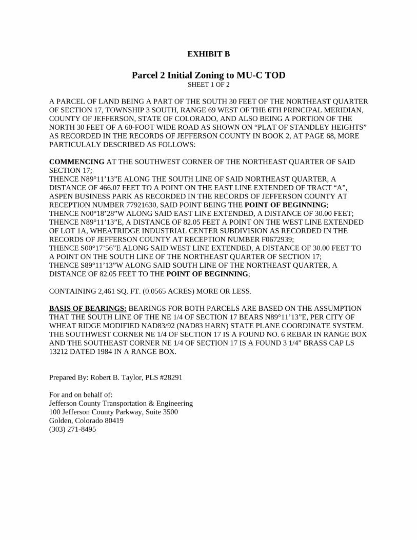
EXHIBIT B
Parcel 2 Initial Zoning to MU-C TOD SHEET 1 OF 2
A PARCEL OF LAND BEING A PART OF THE SOUTH 30 FEET OF THE NORTHEAST QUARTER OF SECTION 17, TOWNSHIP 3 SOUTH, RANGE 69 WEST OF THE 6TH PRINCIPAL MERIDIAN, COUNTY OF JEFFERSON, STATE OF COLORADO, AND ALSO BEING A PORTION OF THE NORTH 30 FEET OF A 60-FOOT WIDE ROAD AS SHOWN ON “PLAT OF STANDLEY HEIGHTS” AS RECORDED IN THE RECORDS OF JEFFERSON COUNTY IN BOOK 2, AT PAGE 68, MORE PARTICULALY DESCRIBED AS FOLLOWS: COMMENCING AT THE SOUTHWEST CORNER OF THE NORTHEAST QUARTER OF SAID SECTION 17; THENCE N89°11’13”E ALONG THE SOUTH LINE OF SAID NORTHEAST QUARTER, A DISTANCE OF 466.07 FEET TO A POINT ON THE EAST LINE EXTENDED OF TRACT “A”, ASPEN BUSINESS PARK AS RECORDED IN THE RECORDS OF JEFFERSON COUNTY AT RECEPTION NUMBER 77921630, SAID POINT BEING THE POINT OF BEGINNING; THENCE N00°18’28”W ALONG SAID EAST LINE EXTENDED, A DISTANCE OF 30.00 FEET; THENCE N89°11’13”E, A DISTANCE OF 82.05 FEET A POINT ON THE WEST LINE EXTENDED OF LOT 1A, WHEATRIDGE INDUSTRIAL CENTER SUBDIVISION AS RECORDED IN THE RECORDS OF JEFFERSON COUNTY AT RECEPTION NUMBER F0672939; THENCE S00°17’56”E ALONG SAID WEST LINE EXTENDED, A DISTANCE OF 30.00 FEET TO A POINT ON THE SOUTH LINE OF THE NORTHEAST QUARTER OF SECTION 17; THENCE S89°11’13”W ALONG SAID SOUTH LINE OF THE NORTHEAST QUARTER, A DISTANCE OF 82.05 FEET TO THE POINT OF BEGINNING; CONTAINING 2,461 SQ. FT. (0.0565 ACRES) MORE OR LESS. BASIS OF BEARINGS: BEARINGS FOR BOTH PARCELS ARE BASED ON THE ASSUMPTION THAT THE SOUTH LINE OF THE NE 1/4 OF SECTION 17 BEARS N89°11’13”E, PER CITY OF WHEAT RIDGE MODIFIED NAD83/92 (NAD83 HARN) STATE PLANE COORDINATE SYSTEM. THE SOUTHWEST CORNER NE 1/4 OF SECTION 17 IS A FOUND NO. 6 REBAR IN RANGE BOX AND THE SOUTHEAST CORNER NE 1/4 OF SECTION 17 IS A FOUND 3 1/4” BRASS CAP LS 13212 DATED 1984 IN A RANGE BOX. Prepared By: Robert B. Taylor, PLS #28291 For and on behalf of: Jefferson County Transportation & Engineering 100 Jefferson County Parkway, Suite 3500 Golden, Colorado 80419 (303) 271-8495
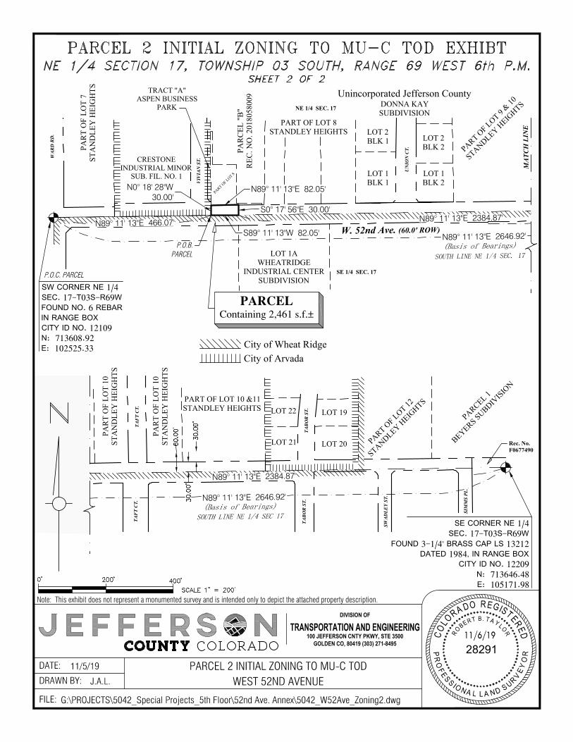
MA
TCH
LIN
E
(Basis of Bearings)
W. 52nd Ave. (60.0' ROW)
UN
ION
CT.
VIV
IAN
ST.
N89° 11' 13"E 2646.92'
SOUTH LINE NE 1/4 SEC. 17
N89° 11' 13"E 466.07'
N0° 18' 28"W30.00'
N89° 11' 13"E 2384.87'
N89° 11' 13"E 82.05'
S0° 17' 56"E 30.00'
S89° 11' 13"W 82.05'
(Basis of Bearings)
TAB
OR
ST.
TAF
T C
T.
N89° 11' 13"E 2646.92'
S89° 11' 13"W 1468.57'
SOUTH LINE NE 1/4
MA
TCH
LIN
E
(Basis of Bearings)N89° 11' 13"E 2646.92'
SOUTH LINE NE 1/4 SEC 17TAF
T C
T.
TAB
OR
ST.
SWA
DLE
Y ST
.
SIM
MS
PL.
N89° 11' 13"E 2384.87'
FILE:
DRAWN BY:DATE:
11/6/19C
O
L
O
R
A
D
O
RE
G
I
S
T
E
R
E
D
PR
O
F
E
S
S
I
O
N
A
L LA
N
D
S
U
R
V
E
Y
O
R
28291
R
O
B
E
R
T
B. T
A
Y
L
O
R
TRANSPORTATION AND ENGINEERING100 JEFFERSON CNTY PKWY, STE 3500
GOLDEN CO, 80419 (303) 271-8495
DIVISION OF
Note: This exhibit does not represent a monumented survey and is intended only to depict the attached property description.
PARCEL 2 INITIAL ZONING TO MU-C TODWEST 52ND AVENUE
11/5/19J.A.L.
G:\PROJECTS\5042_Special Projects_5th Floor\52nd Ave. Annex\5042_W52Ave_Zoning2.dwg
WA
RD
RD
.
PARCEL 1
BEYERS SUBDIVISIO
N
PART OF LOT 12
STANDLEY HEIG
HTS
LOT 1AWHEATRIDGE
INDUSTRIAL CENTERSUBDIVISION
LOT 19
LOT 20
LOT 22
LOT 21
PART OF LOT 10 &11STANDLEY HEIGHTS
PAR
T O
F LO
T 10
STA
ND
LEY
HEI
GH
TS
PAR
T O
F LO
T 10
STA
ND
LEY
HEI
GH
TS
PART OF LOT 9
& 10
STANDLEY HEIG
HTSDONNA KAYSUBDIVISION
LOT 2BLK 2
LOT 1BLK 2
LOT 2BLK 1
LOT 1BLK 1
PART OF LOT 8STANDLEY HEIGHTS
PART OF LOT 8
PAR
CEL
"B
"R
EC. N
O. 2
0180
5800
9
CRESTONEINDUSTRIAL MINOR
SUB. FIL. NO. 1
PAR
T O
F LO
T 7
STA
ND
LEY
HEI
GH
TS
SW CORNER NE 1/4SEC. 17-T03S-R69WFOUND NO. 6 REBARIN RANGE BOXCITY ID NO. 12109N: 713608.92E: 102525.33
P.O.C. PARCEL
TRACT "A"ASPEN BUSINESS
PARK NE 1/4 SEC. 17
SE 1/4 SEC. 17
SE CORNER NE 1/4SEC. 17-T03S-R69W
FOUND 3-1/4" BRASS CAP LS 13212DATED 1984, IN RANGE BOX
CITY ID NO. 12209N: 713646.48E: 105171.98
City of Wheat RidgeCity of Arvada
Unincorporated Jefferson County
Rec. No.F0677490
P.O.B.PARCEL
PARCELContaining 2,461 s.f.±
AutoCAD SHX Text
30.00'
AutoCAD SHX Text
30.00'
AutoCAD SHX Text
60.00'
AutoCAD SHX Text
0'
AutoCAD SHX Text
200'
AutoCAD SHX Text
400'
AutoCAD SHX Text
NE 1/4 SECTION 17, TOWNSHIP 03 SOUTH, RANGE 69 WEST 6th P.M. SHEET 2 OF 2
AutoCAD SHX Text
SCALE 1" = 200'
AutoCAD SHX Text
PARCEL 2 INITIAL ZONING TO MU-C TOD EXHIBT

EXHIBIT ‘C’ CASE WZ-19-08 / 52ND AVENUE ZONING
LEGAL DESCRIPTION OF PARCEL 3 INITIAL ZONING TO I-E
(see attached)
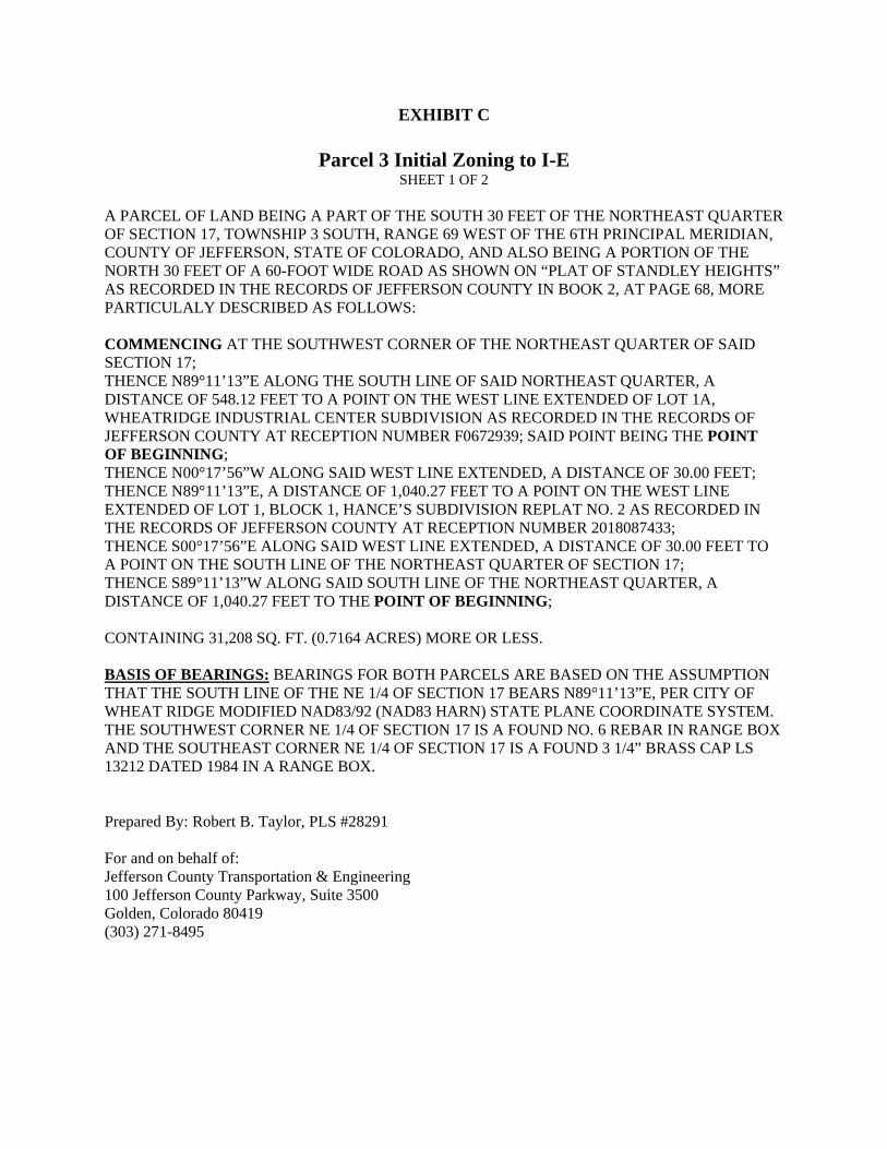
EXHIBIT C
Parcel 3 Initial Zoning to I-E SHEET 1 OF 2
A PARCEL OF LAND BEING A PART OF THE SOUTH 30 FEET OF THE NORTHEAST QUARTER OF SECTION 17, TOWNSHIP 3 SOUTH, RANGE 69 WEST OF THE 6TH PRINCIPAL MERIDIAN, COUNTY OF JEFFERSON, STATE OF COLORADO, AND ALSO BEING A PORTION OF THE NORTH 30 FEET OF A 60-FOOT WIDE ROAD AS SHOWN ON “PLAT OF STANDLEY HEIGHTS” AS RECORDED IN THE RECORDS OF JEFFERSON COUNTY IN BOOK 2, AT PAGE 68, MORE PARTICULALY DESCRIBED AS FOLLOWS: COMMENCING AT THE SOUTHWEST CORNER OF THE NORTHEAST QUARTER OF SAID SECTION 17; THENCE N89°11’13”E ALONG THE SOUTH LINE OF SAID NORTHEAST QUARTER, A DISTANCE OF 548.12 FEET TO A POINT ON THE WEST LINE EXTENDED OF LOT 1A, WHEATRIDGE INDUSTRIAL CENTER SUBDIVISION AS RECORDED IN THE RECORDS OF JEFFERSON COUNTY AT RECEPTION NUMBER F0672939; SAID POINT BEING THE POINT OF BEGINNING; THENCE N00°17’56”W ALONG SAID WEST LINE EXTENDED, A DISTANCE OF 30.00 FEET; THENCE N89°11’13”E, A DISTANCE OF 1,040.27 FEET TO A POINT ON THE WEST LINE EXTENDED OF LOT 1, BLOCK 1, HANCE’S SUBDIVISION REPLAT NO. 2 AS RECORDED IN THE RECORDS OF JEFFERSON COUNTY AT RECEPTION NUMBER 2018087433; THENCE S00°17’56”E ALONG SAID WEST LINE EXTENDED, A DISTANCE OF 30.00 FEET TO A POINT ON THE SOUTH LINE OF THE NORTHEAST QUARTER OF SECTION 17; THENCE S89°11’13”W ALONG SAID SOUTH LINE OF THE NORTHEAST QUARTER, A DISTANCE OF 1,040.27 FEET TO THE POINT OF BEGINNING; CONTAINING 31,208 SQ. FT. (0.7164 ACRES) MORE OR LESS. BASIS OF BEARINGS: BEARINGS FOR BOTH PARCELS ARE BASED ON THE ASSUMPTION THAT THE SOUTH LINE OF THE NE 1/4 OF SECTION 17 BEARS N89°11’13”E, PER CITY OF WHEAT RIDGE MODIFIED NAD83/92 (NAD83 HARN) STATE PLANE COORDINATE SYSTEM. THE SOUTHWEST CORNER NE 1/4 OF SECTION 17 IS A FOUND NO. 6 REBAR IN RANGE BOX AND THE SOUTHEAST CORNER NE 1/4 OF SECTION 17 IS A FOUND 3 1/4” BRASS CAP LS 13212 DATED 1984 IN A RANGE BOX. Prepared By: Robert B. Taylor, PLS #28291 For and on behalf of: Jefferson County Transportation & Engineering 100 Jefferson County Parkway, Suite 3500 Golden, Colorado 80419 (303) 271-8495
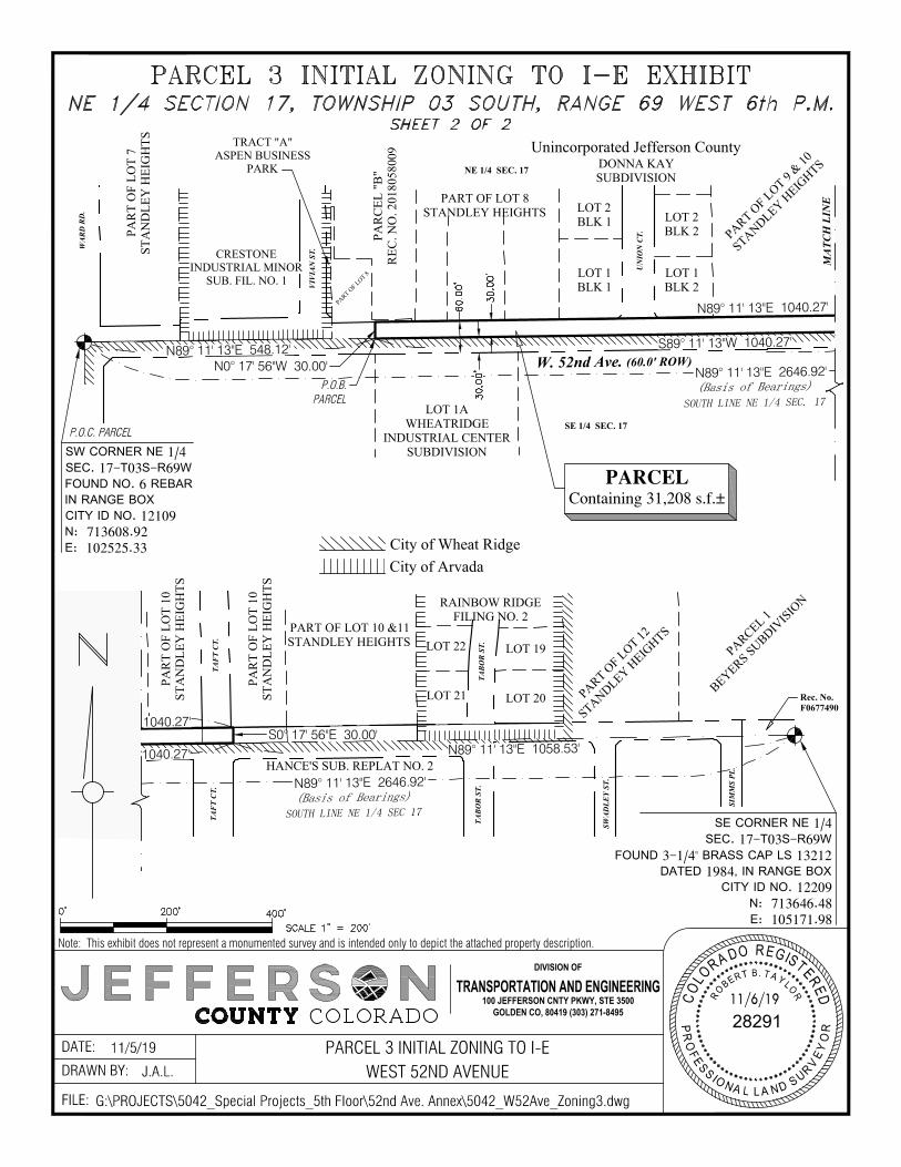
MA
TCH
LIN
E
(Basis of Bearings)
W. 52nd Ave. (60.0' ROW)
UN
ION
CT.
VIV
IAN
ST.
N89° 11' 13"E 2646.92'
SOUTH LINE NE 1/4 SEC. 17
N89° 11' 13"E 548.12'
N89° 11' 13"E 1040.27'
S89° 11' 13"W 1040.27'
N0° 17' 56"W 30.00'
(Basis of Bearings)
TAB
OR
ST.
TAF
T C
T.
N89° 11' 13"E 2646.92'
S89° 11' 13"W 1468.57'
SOUTH LINE NE 1/4
MA
TCH
LIN
E
(Basis of Bearings)N89° 11' 13"E 2646.92'
SOUTH LINE NE 1/4 SEC 17TAF
T C
T.
TAB
OR
ST.
SWA
DLE
Y ST
.
SIM
MS
PL.
N89° 11' 13"E 1058.53'S0° 17' 56"E 30.00'
1040.27'
1040.27'
FILE:
DRAWN BY:DATE:
11/6/19C
O
L
O
R
A
D
O
RE
G
I
S
T
E
R
E
D
PR
O
F
E
S
S
I
O
N
A
L LA
N
D
S
U
R
V
E
Y
O
R
28291
R
O
B
E
R
T
B. T
A
Y
L
O
R
TRANSPORTATION AND ENGINEERING100 JEFFERSON CNTY PKWY, STE 3500
GOLDEN CO, 80419 (303) 271-8495
DIVISION OF
Note: This exhibit does not represent a monumented survey and is intended only to depict the attached property description.
PARCEL 3 INITIAL ZONING TO I-EWEST 52ND AVENUE
11/5/19J.A.L.
G:\PROJECTS\5042_Special Projects_5th Floor\52nd Ave. Annex\5042_W52Ave_Zoning3.dwg
WA
RD
RD
.
PARCEL 1
BEYERS SUBDIVISIO
N
PART OF LOT 12
STANDLEY HEIG
HTS
RAINBOW RIDGEFILING NO. 2
LOT 19
LOT 20
LOT 22
LOT 21
PART OF LOT 10 &11STANDLEY HEIGHTS
PAR
T O
F LO
T 10
STA
ND
LEY
HEI
GH
TS
PAR
T O
F LO
T 10
STA
ND
LEY
HEI
GH
TS
PART OF LOT 9
& 10
STANDLEY HEIG
HTSDONNA KAYSUBDIVISION
LOT 2BLK 2
LOT 1BLK 2
LOT 2BLK 1
LOT 1BLK 1
PART OF LOT 8STANDLEY HEIGHTS
PART OF LOT 8
PAR
CEL
"B
"R
EC. N
O. 2
0180
5800
9
CRESTONEINDUSTRIAL MINOR
SUB. FIL. NO. 1
PAR
T O
F LO
T 7
STA
ND
LEY
HEI
GH
TS
SW CORNER NE 1/4SEC. 17-T03S-R69WFOUND NO. 6 REBARIN RANGE BOXCITY ID NO. 12109N: 713608.92E: 102525.33
P.O.C. PARCEL
TRACT "A"ASPEN BUSINESS
PARK NE 1/4 SEC. 17
SE 1/4 SEC. 17
SE CORNER NE 1/4SEC. 17-T03S-R69W
FOUND 3-1/4" BRASS CAP LS 13212DATED 1984, IN RANGE BOX
CITY ID NO. 12209N: 713646.48E: 105171.98
City of Wheat RidgeCity of Arvada
Unincorporated Jefferson County
Rec. No.F0677490
P.O.B.PARCEL
PARCELContaining 31,208 s.f.±
LOT 1AWHEATRIDGE
INDUSTRIAL CENTERSUBDIVISION
HANCE'S SUB. REPLAT NO. 2
AutoCAD SHX Text
30.00'
AutoCAD SHX Text
30.00'
AutoCAD SHX Text
60.00'
AutoCAD SHX Text
0'
AutoCAD SHX Text
200'
AutoCAD SHX Text
400'
AutoCAD SHX Text
NE 1/4 SECTION 17, TOWNSHIP 03 SOUTH, RANGE 69 WEST 6th P.M. SHEET 2 OF 2
AutoCAD SHX Text
SCALE 1" = 200'
AutoCAD SHX Text
PARCEL 3 INITIAL ZONING TO I-E EXHIBIT

EXHIBIT ‘D’ CASE WZ-19-08 / 52ND AVENUE ZONING
LEGAL DESCRIPTION OF PARCEL 4 INITIAL ZONING TO MU-N
(see attached)

EXHIBIT D
Parcel 4 Initial Zoning to MU-N SHEET 1 OF 2
A PARCEL OF LAND BEING A PART OF THE SOUTH 30 FEET OF THE NORTHEAST QUARTER OF SECTION 17, TOWNSHIP 3 SOUTH, RANGE 69 WEST OF THE 6TH PRINCIPAL MERIDIAN, COUNTY OF JEFFERSON, STATE OF COLORADO, AND ALSO BEING A PORTION OF THE NORTH 30 FEET OF A 60-FOOT WIDE ROAD AS SHOWN ON “PLAT OF STANDLEY HEIGHTS” AS RECORDED IN THE RECORDS OF JEFFERSON COUNTY IN BOOK 2, AT PAGE 68, MORE PARTICULALY DESCRIBED AS FOLLOWS: COMMENCING AT THE SOUTHWEST CORNER OF THE NORTHEAST QUARTER OF SAID SECTION 17; THENCE N89°11’13”E ALONG THE SOUTH LINE OF SAID NORTHEAST QUARTER, A DISTANCE OF 1,588.39 FEET TO A POINT ON THE WEST LINE EXTENDED OF LOT 1, BLOCK 1, HANCE’S SUBDIVISION REPLAT NO. 2 AS RECORDED IN THE RECORDS OF JEFFERSON COUNTY AT RECEPTION NUMBER 2018087433, SAID POINT BEING THE POINT OF BEGINNING; THENCE N00°17’56 ”W ALONG SAID WEST LINE EXTENDED, A DISTANCE OF 30.00 FEET; THENCE N89°11’13”E, A DISTANCE OF 346.26 FEET TO THE SOUTHWEST CORNER OF LOT 21, RAINBOW RIDGE FILING NO. 2, AS RECORDED IN THE RECORDS OF JEFFERSON COUNTY AT RECEPTION NUMBER 77883587; THENCE S00°17’10”E ALONG THE WEST LINE EXTENDED OF SAID LOT 21, RAINBOW RIDGE FILING NO. 2, A DISTANCE OF 30.00 FEET TO A POINT ON THE SOUTH LINE OF THE NORTHEAST QUARTER OF SECTION 17; THENCE S89°11’13”W ALONG SAID SOUTH LINE OF THE NORTHEAST QUARTER, A DISTANCE OF 346.25 FEET TO THE POINT OF BEGINNING; CONTAINING 10,388 SQ. FT. (0.2385 ACRES) MORE OR LESS. BASIS OF BEARINGS: BEARINGS FOR BOTH PARCELS ARE BASED ON THE ASSUMPTION THAT THE SOUTH LINE OF THE NE 1/4 OF SECTION 17 BEARS N89°11’13”E, PER CITY OF WHEAT RIDGE MODIFIED NAD83/92 (NAD83 HARN) STATE PLANE COORDINATE SYSTEM. THE SOUTHWEST CORNER NE 1/4 OF SECTION 17 IS A FOUND NO. 6 REBAR IN RANGE BOX AND THE SOUTHEAST CORNER NE 1/4 OF SECTION 17 IS A FOUND 3 1/4” BRASS CAP LS 13212 DATED 1984 IN A RANGE BOX. Prepared By: Robert B. Taylor, PLS #28291 For and on behalf of: Jefferson County Transportation & Engineering 100 Jefferson County Parkway, Suite 3500 Golden, Colorado 80419 (303) 271-8495
MA
TCH
LIN
E
(Basis of Bearings)
W. 52nd Ave. (60.0' ROW)
UN
ION
CT.
VIV
IAN
ST.
N89° 11' 13"E 2646.92'
SOUTH LINE NE 1/4 SEC. 17
N89° 11' 13"E 1588.39'
(Basis of Bearings)
TAB
OR
ST.
TAF
T C
T.
N89° 11' 13"E 2646.92'
S89° 11' 13"W 1468.57'
SOUTH LINE NE 1/4
MA
TCH
LIN
E
(Basis of Bearings)N89° 11' 13"E 2646.92'
SOUTH LINE NE 1/4 SEC 17
TAF
T C
T.
TAB
OR
ST.
SWA
DLE
Y ST
.
SIM
MS
PL.
712.28'
N89° 11' 13"E 346.26'N0° 17' 56"W 30.00'
S0° 17' 10"E 30.00'
S89° 11' 13"W 346.25'1588.39'
FILE:
DRAWN BY:DATE:
11/6/19C
O
L
O
R
A
D
O
RE
G
I
S
T
E
R
E
D
PR
O
F
E
S
S
I
O
N
A
L LA
N
D
S
U
R
V
E
Y
O
R
28291
R
O
B
E
R
T
B. T
A
Y
L
O
R
TRANSPORTATION AND ENGINEERING100 JEFFERSON CNTY PKWY, STE 3500
GOLDEN CO, 80419 (303) 271-8495
DIVISION OF
Note: This exhibit does not represent a monumented survey and is intended only to depict the attached property description.
PARCEL 4 INITIAL ZONING TO MU-NWEST 52ND AVENUE
11/5/19J.A.L.
G:\PROJECTS\5042_Special Projects_5th Floor\52nd Ave. Annex\5042_W52Ave_Zoning4.dwg
WA
RD
RD
.
PARCEL 1
BEYERS SUBDIVISIO
N
PART OF LOT 12
STANDLEY HEIG
HTS
RAINBOW RIDGEFILING NO. 2
LOT 19
LOT 20
LOT 22
LOT 21
PART OF LOT 10 &11STANDLEY HEIGHTS
PAR
T O
F LO
T 10
STA
ND
LEY
HEI
GH
TS
PAR
T O
F LO
T 10
STA
ND
LEY
HEI
GH
TS
PART OF LOT 9
& 10
STANDLEY HEIG
HTSDONNA KAYSUBDIVISION
LOT 2BLK 2
LOT 1BLK 2
LOT 2BLK 1
LOT 1BLK 1
PART OF LOT 8STANDLEY HEIGHTS
PART OF LOT 8
PAR
CEL
"B
"R
EC. N
O. 2
0180
5800
9
CRESTONEINDUSTRIAL MINOR
SUB. FIL. NO. 1
PAR
T O
F LO
T 7
STA
ND
LEY
HEI
GH
TS
SW CORNER NE 1/4SEC. 17-T03S-R69WFOUND NO. 6 REBARIN RANGE BOXCITY ID NO. 12109N: 713608.92E: 102525.33
P.O.C. PARCEL
TRACT "A"ASPEN BUSINESS
PARK NE 1/4 SEC. 17
SE 1/4 SEC. 17
SE CORNER NE 1/4SEC. 17-T03S-R69W
FOUND 3-1/4" BRASS CAP LS 13212DATED 1984, IN RANGE BOX
CITY ID NO. 12209N: 713646.48E: 105171.98
City of Wheat RidgeCity of Arvada
Unincorporated Jefferson County
Rec. No.F0677490
P.O.B.PARCEL
PARCELContaining 10,388 s.f.±
HANCE'S SUB. REPLAT NO. 2
AutoCAD SHX Text
30.00'
AutoCAD SHX Text
30.00'
AutoCAD SHX Text
60.00'
AutoCAD SHX Text
0'
AutoCAD SHX Text
200'
AutoCAD SHX Text
400'
AutoCAD SHX Text
NE 1/4 SECTION 17, TOWNSHIP 03 SOUTH, RANGE 69 WEST 6th P.M. SHEET 2 OF 2
AutoCAD SHX Text
SCALE 1" = 200'
AutoCAD SHX Text
PARCEL 4 INITIAL ZONING TO MU-N EXHIBIT
ITEM NO: DATE: December 9, 2019
REQUEST FOR CITY COUNCIL ACTION
TITLE: MOTION TO AWARD A CONTRACT AND APPROVE SUBSEQUENT PAYMENTS TO MIG, DENVER, CO, IN AN AMOUNT NOT TO EXCEED $175,000 FOR PROFESSIONAL SERVICES FOR THE 44TH AVE SUBAREA PLAN
PUBLIC HEARING ORDINANCES FOR 1ST READING BIDS/MOTIONS ORDINANCES FOR 2ND READING RESOLUTIONS
QUASI-JUDICIAL: YES NO
_______________________________ ______________________________ Community Development Director City Manager
ISSUE: Funds were previously budgeted to complete a 44th Avenue subarea plan, and this priority was reaffirmed by the updated Neighborhood Revitalization Strategy (NRS) which identifies the corridor as a high priority planning effort. On October 18, 2019 the firm MIG was selected by the City’s established procurement process to perform the required professional services for completion of the subarea plan.
PRIOR ACTION: The scope of work for the 44th Avenue subarea plan was most recently discussed with Council at the study session on August 5, 2019, as part of the NRS implementation.
FINANCIAL IMPACT: Professional service fees in the amount of $150,000 were appropriated by City Council in the 2019 Community Development budget for the 44th Avenue subarea plan. The budget for this work was estimated over 2 years ago, when a scope was not yet defined. To account for market inflation and to accommodate the need for more intensive public involvement, an additional $25,000 will be transferred and encumbered from the City Manager’s budget to cover this contract amount in full.
6
Council Action Form – 44th Avenue Subarea Plan Contract December 9, 2019 Page 2 BACKGROUND: While portions of W. 44th Avenue were included in the Fruitdale Subarea Plan, the plan is outdated and does not take into consideration the market conditions of today. The recently completed Neighborhood Revitalization Strategy identified W. 44th Avenue as a priority for planning efforts. The plan needs to contain strategies to promote revitalization and attract investment to the W. 44th Avenue corridor that would enhance the adjacent neighborhoods and the City as a whole. There are significant opportunities for redevelopment and reinvestment, while maintaining the unique character of W. 44th Avenue and adjacent properties and neighborhoods. On October 18, 2019 the firm MIG was selected by the City’s established procurement process to perform the required professional services for completion of the subarea plan. The procurement process included review by a five person evaluation committee of Request for Proposals (RFPs) and qualifications submitted by six firms, followed by interviews with two top scoring firms. After selection of the firm, staff engaged in a negotiation process with the firm to determine and finalize the scope and fees for the anticipated work expected. The final scope of work from MIG is attached. In short, the planning process puts an emphasis on public engagement and actionable outcomes. Public engagement will include:
• Creation of a Community Engagement Plan • Creation of a steering committee made up of business owners, residents, and other
stakeholders • Facilitation of three large scale public meetings • Project presence at other public events (intercept events) to meet people where they
already are (e.g. Carnation Festival) • Utilization of an online platform, such as Bang the Table, to supplement in person events • Discussion with City Council and Planning Commission
The content of the plan will address a wide range of topics, including community character and design, zoning and land use, transportation and connectivity, neighborhood connections, parks and trails, economic conditions, historic resources, and an analysis of opportunities and challenges. A market study and traffic study will ensure that recommendations are based on reality and a key deliverable in addition to the plan is an “action plan” which will provide workable action plans for top recommendations – a series of strategic projects, programs, and initiatives – that emerge from the planning process. It is expected that the consultant will complete the requested tasks within one year, assuming the City acts on adoption and enactment in a most timely manner. Kickoff is expected in March 2020. RECOMMENDATIONS: Staff recommends awarding the professional services contract to MIG in the amount of $175,000 to carry out the scope of work for the 44th Avenue Subarea Plan.
Council Action Form – 44th Avenue Subarea Plan Contract December 9, 2019 Page 3 RECOMMENDED MOTION: “I move to award a contract and approve subsequent payments to MIG, Denver, CO, in an amount not to exceed $175,000 for professional services for the 44th Avenue subarea plan.” Or, “I move to deny the award of a contract and subsequent payments to MIG, Denver, CO, in an amount not to exceed $175,000 for professional services for the 44th Avenue subarea plan for the following reason(s) _________________________________.” REPORT PREPARED/REVIEWED BY: Stephanie Stevens, Senior Planner Lauren Mikulak, Planning Manager Kenneth Johnstone, Community Development Director Jennifer Nellis, Purchasing Agent Patrick Goff, City Manager ATTACHMENTS:
1. MIG Scope of Work 2. MIG Fee Proposal
44th Avenue Sub Area Plan Scope of Work – Draft 10.23.2019
Task 1: Project Management Subtask 1.1: Project Chartering In order to create an efficient and desired project schedule, MIG will meet with City Staff to confirm the full project scope and major milestones as they relate to the overall budget. Additionally, MIG and City Staff will work to establish a preliminary list of critical stakeholders whose input will be needed at certain points in the process noting that the MIG Team will then proceed with expanding upon and refining that list. As part of the work plan, there are additional services listed that may, depending on the outcome of the process and input, may be determined to be valuable assets to the overall plan. MIG will work to include those elements, as appropriate, within the existing budget, however, it may be that additional services are ultimately needed.
Key Deliverable(s): Project Scope, Project Schedule
Subtask 1.2: Core Project Management Meetings At critical points during the process, ahead of public outreach efforts, and in transition between major phases, the Core Project Management team will convene to expand upon regular communication and to discuss and reaffirm deliverables and near-term actions. These meetings will also be used to redirect the overall trajectory of the project as needed based on unanticipated input or discoveries that may arise throughout the process. It is anticipated that these will occur over phone unless the physical needs of the meeting demand otherwise.
Key Deliverable(s): Meeting Materials (Agendas, Powerpoint Presentations, Summary Notes, etc. as appropriate)
Subtask 1.3: Advisory Committee Meetings This committee will be included throughout the planning process, meeting every at least three times throughout the process, and provide input to the project team as the plan develops. This task accounts for the actual meeting time and preparation once the committee has been chartered. The chartering of this committee is described in greater details in Subtask 2.3.
Key Deliverable(s): Meeting Materials (Agendas, Powerpoint Presentations, Summary Notes, etc. as appropriate)
Subtask 1.4: Ongoing Project Management and Coordination Throughout the project, MIG will provide continued hands-on project management and client service. This will involve regular communication with City Staff to confirm deliverables and keep the project on schedule and budget. This task includes internal coordination and management activities, as well as emails and phone calls with City Staff, consultants, and other partners. The
ATTACHMENT 1
P a g e 2 | 13
task also includes the coordination of in-person meetings to conduct any additional outreach strategies and present to the necessary parties outside of what is assumed in this scope.
Task 2: Public Engagement Subtask 2.1: Community Engagement Plan Early in the planning process, the MIG Team will work with City Staff to create a robust public engagement plan, incorporating elements to create an outreach toolbox. It will include components such as identifying target audiences and key milestones for engagement; determining the level of engagement desired from target audiences at each milestone; developing tools for engaging target audiences at appropriate levels; and creating a stakeholder and community engagement timeline. It is likely that the Community Engagement Plan may be updated or revised throughout the course of the project as issues and policies unfold or to pivot in response to low participation from certain geographies or populations. While there presumed efficiencies gained from a management or budgeting standpoint, the MIG Team anticipates engaging with the anticipated Community Outreach Specialist hire as appropriate to best align outreach efforts during the ‘Listening Tour’ process.
Key Deliverable(s): Draft & Final Community Engagement Plan
Subtask 2.2: Digital Platform MIG will assist City staff in establishing an online presence with which the community will be able to engage in the process regardless of availability during in-person meetings and workshops. It is assumed that this will involve the use of the ‘Bang the Table’ platform. However, if during the project chartering process another method or platform is more appropriate, can provide a number of options as an alternative, including comparable services such MIG’s internally developed product, Townsquare (https://www.migtownsquare.com/), or a more robust website tool. The latter will likely necessitate any additional service/fee.
Key Deliverable(s): Project Website Content
Subtask 2.3: Steering Committee Chartering The MIG Team will work closely with City Staff to identify a robust, constructive and well-representative Steering Committee. We anticipate the Steering Committee to be made up of active and engaged citizens, business owners, property owners, partner organizations, community leaders, and potentially representatives from adjacent municipalities. Shortly after a Steering Committee is formed, MIG and City Staff will meet with the group to discuss the planning process, expectations, roles, and responsibilities. This also includes a review and discussion regarding the approach to the public participation and community engagement process. MIG will lead the group in a brainstorm of initial community priorities including issues and concerns, areas of influence for the planning area and initial research tasks. The plan area boundaries will be finalized prior to any technical analysis or planning begins. The MIG Team will assist City staff by developing expectations and meeting procedures to ensure the Steering Committee participants stay informed and engaged throughout the process.
This committee will be included throughout the planning process, meeting every at least three times throughout the process, and provide input to the project team as the plan develops. We anticipate the Steering Committee to be made up of active and engaged citizens, business
P a g e 3 | 13
owners, property owners, partner organizations, community leaders, and potentially representatives from adjacent municipalities.
Key Deliverable(s): Steering Committee Rules and Expectations Document
Subtask 2.4: Public Meetings Given the level of public engagement that has recently taken place during the Neighborhood Revitalization Strategy and the Wadsworth Boulevard Widening Project, we anticipate the community will be eager to be involved in the planning process. The MIG Team will work with City staff and other local stakeholders to design community open houses that are interactive, participatory and fun. Our aim is to foster a strong sense of community and create relatively informal and relaxed ways to interact directly with project staff, share concerns, and ask questions. Each meeting will be designed specifically to complement the phase of the planning process. The process envisions three, key meetings, which include: a kick-off meeting to build excitement and establish an overall vision, goals and polices, a mid-point meeting to confirm the guiding framework and refine initial recommendations, and a final meeting to summarize the process, review the final recommendations, and take the first steps towards implementation.
In addition to large scale, community meetings, MIG has found that successful community engagement is best augmented by more nimble strategies that allow for input across a variety demographics and sub-geographies. These strategies are be exemplified by intercept events. The MIG Team will organize and participate in intercept events via information tables in high traffic locations and community events throughout the project area to provide information, obtain input, and perform intercept studies. We intercept people in places and at activities they are already attending, attracting a different (and often broader) population than a more traditional planning meeting. MIG frequently designs interactive display boards for project staff and volunteers to use to gather input as well. Relying on one-on-one communications guided by a simple set of intercept questions is very effective.
Key Deliverable(s): Public Meeting Materials (Presentation Boards, Comment/Input Boards, Powerpoint Presentations, etc. as appropriate)
Subtask 2.5 City Council and Planning Commission Meetings The MIG Team will attend and provide power point support for two rounds, consisting of a minimum of three meetings each) of the approval and adoption process (this includes City Council and Planning Commission).
Key Deliverable(s): Presentation Materials (Powerpoint Presentations, Summary Notes, etc. as appropriate)
Task 3: Subarea Plan Subtask 3.1: Existing Conditions Scan The MIG Team undergo a high-level review of the existing conditions to determine the critical, contextual influencers for the project area. This process includes multiple steps. The MIG Team will review existing documents, data and previous plans, including the Envision Wheat Ridge Comprehensive Plan, the Fruitdale Subarea Plan, the Neighborhood Revitalization Strategy, and the Streetscape Design Manual as appropriate.
P a g e 4 | 13
The MIG Team will also develop a graphic base map to serve as a foundation for the strategies and recommendations to be developed during subsequent phases of the project. As appropriate in subsequent tasks, this map can be used to that identify existing strengths and amenities, development constraints, and locations for catalytic development activity or investment anchors. MIG will also compile a Data Request List for any necessary data sources and will work with City Staff to identify the specific maps and data to represent. Preliminary data representation may include:
• Zoning and Land Use • Overlay Districts • Parks and Trails • Waterways and Floor Plain
The MIG Team will ultimately summarize this information in a presentation format in order to provide intelligence for decision making, rather than a rote recitation of data points. This presentation will be a foundational element in establishing a graphic language and working relationship with the community through accessible and approachable information in order to confirm findings. Additionally, this presentation will include preliminary inputs from both the Market Study and Traffic Analysis as it relates to existing conditions, specifically noting:
• Transportation and Connectivity • Economic Conditions (including market-based land use expectations) • Historic Resources (described in greater detail in Subtask 4.1: Market Study – Historic
Resources)
Key Deliverable(s): Corridor Base Map, Existing Conditions Scan Powerpoint, Critical Diagrams, Existing Traffic Assessment, Existing Economic Assessment, Preliminary Historic Resources Assessment
Subtask 3.2: Visioning Building upon the Existing Conditions Scan, as well as the initial input received during the first round of engagement with both the steering committee and the public, MIG will synthesize the commons themes into a draft vision for the corridor. This vision will build upon the priorities established in the Neighborhood Revitalization Strategy. Establishing an authentic vision that is supported by the community and grounded by a viable framework is in important step in the process and may require multiple touchpoints to get it right. It is through the visioning process that we will first engage public in their thoughts regarding community character and design and neighborhood connections as these elements can contribute to the overall vision. The “vision” will be comprised of narrative text and will likely be supported by bullet points and precedent images.
Key Deliverable(s): Vision Statement, Precedent Images, Supporting Bullet Points
Subtask 3.3: Key Trends and Issues In conjunction with the development of an overall project vision, and in an expansion of the Existing Conditions Scan, the MIG team will examine key trends and issues that are impacting the corridor presently or have the capacity alter the corridor in the future. The review of key
P a g e 5 | 13
trends will include a survey of local, regional and national best practices and their applicability to the corridor itself, focusing on corridor revitalization through the intersection of land-use and economic opportunities. The summary of issues will be codified as an input into the Opportunity Analysis and vetted with the community as appropriate. It will be important for the community and steering committee to provide input and guidance in review of these issues to ensure that what matters most is being addressed.
Key Deliverable(s): Key Trends Assessment (Powerpoint, Precedent Images), Issues Assessment (Powerpoint, Existing Site Photographs)
Subtask 3.4: Desired Outcomes, Goals and Policies The MIG Team will work alongside the Steering Committee and the community-at-large, and in review of the analytical opportunities and constraints revealed by the existing conditions scan, the overall vision and the key trends and issues, establish a goal and policy framework. MIG will vet this framework with City Staff and the Steering Committee and then ultimately confirm with the public once more prior to finalizing. These goals and policies will aid decision makers in the conversations to follow, focusing their outputs on attracting investment, maintain character, and increasing connectivity.
Key Deliverable(s): Draft & Final Project Goals, Draft & Final Policy Framework
Subtask 3.5: Preliminary Subarea Plan Recommendations The MIG Team will build upon the information prepared during earlier tasks and create a comprehensive Preliminary Draft Subarea Plan. The Preliminary Draft Plan will include clear and comprehensive narrative, with some supporting graphics, that encompass all of the relevant inputs and outline a compelling vision and implementation path for the 44th Avenue corridor. The Preliminary Draft Plan will be focused on implementation (illustrated further in Task 5: Action Plan), and will include clear steps and strategies necessary to create positive change along the corridor over time. Anticipated chapters include:
• Introduction. This chapter will include the purpose of the Plan, summary of the planning process and organization of the document.
• Corridor Profile This chapter will include a relevant synopsis of inputs during the planning process, summary of the existing conditions scan and key finds from the technical quantitative analysis, and a discussion of the major issues and opportunities being addressed in the Plan.
• Vision and Strategic Direction. This chapter will include a summary of the new vision, key trends and issues, desired outcomes (goals and policies) and a discussion on how they were developed.
• Major Elements. This chapter will provide detailed information on a range of preliminary recommendations, which include:
o Community Character and Design o Zoning and Land Use o Transportation and Connectivity o Neighborhood Connections o Parks and Trails

P a g e 6 | 13
o Economic Conditions o Historic Resources o Key Assets and Challenges o Opportunity Analysis
These major elements will be discussed in manner which focuses on the core needs for the corridors, including improving aesthetics, maintain character, connecting to activity centers, and attracting investments. However, in order to generate creative ideas and workable solutions, additional opportunities that arise through the engagement of the community and building of census may be considered, such as the establishment of a greater identity, thematic reflections of different zones within the corridor, and innovative green-infrastructure solutions as a tool for new development opportunities. These strategies and recommendations will undergo refinement through further engagement with community and steering committee.
Key Deliverable(s): Administrative Draft (word document, supporting photographs/images); Formatted Draft Document (InDesign)
Subtask 3.6: Opportunity Analysis The MIG Team, led by EPS, will synthesize the findings from the Market Study and Potential for Change Analysis in the Technical Quantitative Analysis into a user-friendly summary. The summary will be built, in part, upon the findings from the existing conditions scan, specifically as they relate to zoning and land use, economic conditions, and historic resources. This summary will address the intersection of key assets and challenges in relation to economic and land-use opportunities.
Key Deliverable(s): Preliminary Potential for Change Analysis Summary
Subtask 3.7: Final Subarea Plan Recommendations and Documentation After a robust community engagement process, which will have included the review of the consultant’s initial analysis, the establishment of an overall vision, goals and policies, and the critique and refinement of a set of preliminary recommendations, MIG will produce and submit an Internal Draft Subarea Plan based on Steering Committee guidance, and community support. The Draft Plan will be graphical and formatted in manner to ensure its ease of use as a tool for decision-makers. It will include narrative, photos, photo precedent imagery, and some graphic elements to illustrate the proposed improvements to the campus. The Steering Committee and City Staff will review the Draft Plan and provide MIG with one set of consolidated edits. MIG will then produce a Public Draft plan that reflects initial comments.
Concurrent with the final community meeting, the MIG team, with support from City Staff, will begin to engage City Council and the Planning Commission as part of the adoption process. Based on the outcome of the adoption hearings, these entities may require changes or conditions as part of their approvals. MIG will prepare a final version of the Subarea Plan that reflects this direction. We will provide the City with all appropriate final digital files and will coordinate printing final copies of the Subarea Plan. MIG has full document production capabilities in-house.

P a g e 7 | 13
Key Deliverable(s): Administrative Draft (word document, supporting photographs/images); Formatted Final Document (InDesign)
Task 4: Technical Quantitative Analysis Subtask 4.1: Market Study Economic & Planning Systems will perform a market analysis of the subarea to document the existing demographic and economic conditions and trends, identify demand for new development, provide market-based guidance on land use and zoning, and assess development feasibility. The Market Study will be integrated into the MIG Team process to ensure input from the market study is provided at the appropriate phases of the project and to allow for a more flexible use of budget allocated for assessing market potentials based on community feedback and desire. The following tasks are proposed to complete the Market Study.
• Project Initiation, Subarea Tour, and Outreach - EPS will meet with the City Staff and MIG Team to review the specific conditions and issues affecting the market in the area. EPS will build on its TIF request evaluations completed for the Wheat Ridge URA in the area to assess the market conditions. We will also tour the subarea to assess economic conditions, review recent and planned development sites, and identify opportunity locations. All available planning, economic, and demographic information pertinent to the Study will be collected. Lastly, EPS will conduct interviews with area developers, property owners, and business owners to identify opportunities and challenges.
• Demographic and Economic Framework - EPS will quantify demographic and economic conditions and trends affecting development in Wheat Ridge and the Subarea. EPS will analyze population and household growth trends and characteristics in the City, relevant trade areas, and Subarea. Analyze employment conditions and trends and characteristics by sector will be document. Housing and commercial construction trends will be document based building permit data. Growth forecasts for the region and western Denver Metro Area will be gathered to assess document potential growth in the larger area around the Subarea.
• Housing Demand – An estimate of potential housing demand will be completed for the subarea. This analysis will rely on the above market-wide trends, growth forecasts, and construction trends by product segmentation. Housing potentials will estimated by market segment and product type based on annual absorption and estimate the share of the overall market by product type, supply of housing by type and price range, supportable sales and leasing pricing, and demographic conditions and estimated changes. The analysis will identify product types that are in demand in the subarea and the site conditions needed to accommodate feasible projects.
• Retail Demand - EPS will document existing retail conditions including an inventory of space, retail rental and occupancy rates, estimated sales levels, and market orientation. We will address the opportunity for new retail by comparing retail expenditure potential for a retail trade area and the existing competitive supply of space by location in the trade area. Comparable retail projects and areas will be assessed to identify achievable rental rates and development types that could be supported. EPS will identify the type of retail and restaurant uses supportable including sample tenants by category type.
P a g e 8 | 13
• Office and Employment Demand – The opportunities and demand for office and employment driven new development (beyond retail demand) will be assessed. An inventory of existing employment uses will be developed including businesses, buildings, square feet, occupancy, and lease rates. Opportunities related to expansion and attraction of new employers to the subarea will be assessed based on interviews with existing businesses, the surrounding demographic conditions, location of competing employment areas, and opportunity sites in the subarea. The analysis will identify opportunities for new employment uses that may be attracted to the subarea and the site and building conditions needed to attract them.
• High-Level Financial Feasibility Assessment – EPS will assess the high-level financial feasibility of desired uses within the subarea based on the market findings. To complete this task, EPS will also rely on market research and knowledge developed through our work with the City of Wheat Ridge and Wheat Ridge Urban Renewal Authority. EPS has evaluated multiple requests for TIF funds in the City’s urban renewal areas. Our existing knowledge of construction costs, land prices, and development feasibility will allow us to provide this assessment without in depth proforma analysis and will be able to identify the relative magnitude of feasibility gaps and the impacts of infrastructure costs on feasibility.
• Market Analysis Report - EPS will summarize its analysis and conclusions regarding development conditions and potentials by property classification in a market report with supporting tables and charts. An interim draft report will be provided with a final report to be provided as an appendix to the Subarea Plan. EPS will also present market analysis findings to staff, elected/appointed officials, stakeholders, and the community as needed in the process based on the MIG Team outreach strategy.
• Historic Resources – Historic resources are central to telling the story of a community and in distinguishing one place from another. Wheat Ridge is rich in farming and mining history and showcasing surviving pieces of its story will be a central goal of our project team. Form+Works Design Group will solicit input from the community to determine critical historic resources that should be retained. In addition to known resources, there may be lesser/unknown historic resources in the area. The team will conduct preliminary historic research to determine additional surviving components to evaluate beyond those identified through community engagement. The team will then evaluate each resource and categorize them into those that retain high, medium and low levels of historic integrity, to inform which ones may require more significant investment to restore and/or retain versus those that are in good condition and immediately viable for reuse. These findings will be presented to the steering committee to ensure the community has buy-in not only with the findings but with the priority of those resources that should be integrated into the overall 44th Avenue Subarea Plan. Our team anticipates that stakeholder discussions will work to find the right balance between retaining historic resources to tell Wheat Ridge’s history and the development goals of the community to revitalize the area and enhance Wheat Ridge’s future.
Key Deliverable(s): Market Study Appendix, Historic Resource Assessment and Recommendations
P a g e 9 | 13
Subtask 4.2: Potential for Change Analysis The MIG Team, led by EPS, will perform an analysis of the potential for parcels within the subarea to change. Change will be defined in a variety of ways including; economic value, desired land uses, and building/community character to reflect different change opportunities related to areas within the subarea. A variety of measures will be used to assess the subarea based on the desired change and to identify areas and parcels that are considered to have an opportunity for positive and negative change. The definition of change and the metrics used will be tied to the vision and goals of the plan but will generally fall into three categories.
• Economic Opportunity: To evaluate the economic feasibility for change, the following measures/attributes will be analyzed including; building use and vacancy rates, and land to building/improvement value will be measured. EPS will perform a “soft parcel” analysis to identify potential catalyst and redevelopment sites, both on vacant and underutilized parcels and buildings.
• Land Use Opportunity: To evaluate the feasibility of parcels and areas shifting to land uses that are desired in the subarea but not currently present, the following measures/attributes will be analyzed including; parcel size, parcel utilization (Floor-Area-Ratio), visibility, transportation access, infrastructure availability, and others.
• Community Character: To evaluate the contribution to community character, quantitative and qualitative measures of will be used including; building types and attributes, building age, height, density, price and rental rates, presence of infrastructure and community amenities, and others.
The product of the Potential for Change Analysis will be the development of a graphic oriented plan appendix that includes methodology used in the analysis, maps illustrating the opportunity for change for the subarea based on the different measures, identification and summary of potential catalyst sites for change in the area and associated data points and qualitative assessment of the subarea. This analysis will be used as input into the subarea plan elements including character and design, zoning and land use, connectivity, economic conditions, historic resources, and opportunity areas.
Key Deliverable(s): Potential for Change Analysis Appendix
Subtask 4.3: Traffic Analysis The MIG Team, led by Fehr & Peers, will perform an analysis of the existing conditions of the study area. Fehr & Peers will analyze the travel speeds, intersection level of service, and volume to capacity ratios during peak periods. We will supplement this quantitative assessment with fieldwork of the corridors, where we will observe behaviors such as illegal U-turns, truck traffic, near misses, and intersections being blocked. We will also analyze available data sources to determine how 44th Avenue provides access to the surrounding neighborhoods and serves as the primary east-west connection for Wheat Ridge and its’ activity centers. This analysis will be synthesized and framed to provide information for decision making, rather than rote data recitations.
Based on the existing conditions analysis, Fehr & Peers will propose recommendations that address safety, capacity, connectivity, and efficiency challenges. In close collaboration with the
P a g e 10 | 13
MIG and EPS, Fehr & Peers will apply forecasted land use and growth changes based on anticipated redevelopment scenarios to determine proposed corridors alternatives by performing an analysis of the proposed transportation recommendations. This scenario-based approach will focus on direct impacts to the current network based on the aforementioned land use changes.
The MIG Team will assess existing and forecasted pedestrian patterns and behaviors in the context of the existing pedestrian sidewalk infrastructure and crossing treatments. Based on these existing conditions, national design guidelines, the updated City of Wheat Ridge Streetscape Manual, and best practices, the team will recommend an enhanced pedestrian realm, noting the community’s desire to improve the aesthetic for this corridor, and pedestrian crossing treatments to enhance the safety and comfort of users of all ages and abilities.
Fehr & Peers will prioritize the set of final recommendations that are focused on creative ideas and workable solutions and based on criteria such as the pedestrian environment, safety improvement, cost, ease of implementation, and improvement in efficiency and connectivity.
Key Deliverable(s): Traffic Study Appendix
Task 5: Action Plan Subtask 5.1: Top Recommendations and Documentation
The MIG Team will develop an implementation action plan, as a supplemental chapter to the subarea plan, delineating major actions related to the top priority recommendations. The recommendations will be both physical (such as catalytic projects) and programmatic (such as policies and initiatives) in nature and will be packaged in a graphic format for ease of use by the appropriate decision makers. The Action Plan will be approximately 3 – 5 pages in length, focusing on a range of short-, mid- and long-term actions, and include:
• Specific Action Steps; • Responsible Parties; • Estimated Costs; • Proposed Means of Financing (see Subtask 5.3) • Unique features of the geography;
o Issues and priorities specific to the geography; and o Geographic-specific land-use map
Key Deliverable(s): Administrative Draft of Action Plan (narrative, bullet points); Formatted Action Plan Document
Subtask 5.2: Immediate Action Recommendations The MIG Team will provide a greater degree detail for a small number of recommendations. This is intended to provide short-term, visible results in order to catalyze further implementation of the place. The greater level of detail will be determined in collaboration with the City but could include:
• Formatted promotional materials • Illustrative graphics
P a g e 11 | 13
• Expanded partnership strategies (see Subtask 5.3)
Key Deliverable(s): Key bullet points, Supporting Images, Graphics as appropriate – Integrated into Action Plan
Subtask 5.3: Innovative Funding Strategies and Partnerships EPS will evaluate a range of funding strategies to catalyze the future development and fund identified improvements. This will cover ways the City can form P3’s as well as ways it can remain autonomous yet spur development with incentives. A range of financial resources will be evaluated, including additional URA project areas, improvement districts, sales fees and tax sharing, etc. For each option, EPS will document the nature of the revenue mechanism, how it functions, the approval process for each, and revenue generation potential by project. EPS will provide a pro/con evaluation to enable the City to be informed about which options are best suited and needed within the subarea.
Key Deliverable(s): Strategies and Partnership Recommendation Summary
Task 6: Additional Services The completion of Tasks 1 through 5 will produce a high-quality, graphically-oriented and succinct document from which decision makers and City Staff can employ creative recommendations and workable strategies to achieve much throughout the corridor. However, through the process, it may be determined that essential, out-of-scope tools are needed in order to create a more-robust product. MIG believes that this will most likely occur within the community engagement strategies and in the graphic representation of the opportunities.
As noted in the Work Plan, the community engagement approach, with support from a digital platform, should establish a foundation from which we can assume adequate community consensus. However, there are further strategies which will help to navigate unanticipated issues and challenges and/or solidify the community buy-in and sense of ownership. Additionally, the graphic representation of concepts in the above is limited to critical high level graphics. However, in establishing the vision and visualizing the future, there are a number of other graphic strategies to augment the engagement of private developers. The following additional services paint a larger picture from which more customized strategies can be deployed at critical points, either during or after the process. These strategies can be performed for an additional fee (noted in the attached budget, and assuming one event or graphic per stated fee) and could include:
Optional Subtask 6.1: Stakeholder Interview/Focus Group The MIG Team will facilitate a round-table discussion with an individual or group to gather a better understanding of a specific topic area identified through the process and summarize the input received. These individuals and groups could include the Wheat Ridge Business Association, RNOs, specific business owners, etc.
Optional Subtask 6.2: Additional Community Meeting (with exist. materials) Noting that attendance will be a key factor in large, community meetings, there may be a need to host a duplicative event in order to reach a wider audience. This event, likely hosted at a
P a g e 12 | 13
different time of day and a different time of week, will replicate a previous community event and will not require new materials.
Optional Subtask 6.3: Additional Community Meeting (with new materials) Through the process, a key topic area and group of topics may require a larger degree of input than previously anticipated. The MIG team will help to organize and facilitate a new community meeting covering new content and soliciting different input (outside of three anticipated content areas in the original scope).
Optional Subtask 6.4: Additional Intercept Event (with exist. materials) Given MIG’s project team presence along the corridor, MIG can deploy quickly to attend a variety of existing events (at shorter notice). These events will utilize an input method previously produced for community events and other intercepts events, such as character area designation boards, and trade-off exercises.
Optional Subtask 6.5: Additional Intercept Event (with new materials) The MIG Team will develop new intercept event methods and strategies outside of what is already being produced as part of the original scope. These methods will be deployed in a similar format, engaging people where they’re already gathering, such as the Carnation Festival, Young’s Market christmas tree sale, Compass Montessori school events, etc. Methods could include vision statement photographs, live/work/play mapping, etc.
Optional Subtask 6.6: Project Website/ePlan During the process, it may be determined that a full-digital documentation of the plan (above and beyond Bang the Table!, and CoWR hosting services) will be helpful in moving towards implementation. A project website is a traditional digital method which highlights the process, the major outcomes and the next steps in a linear format. An ePlan will create a highly interactive version of the graphic plan document. Either site can be used as a tool to engage prospective parties moving forward.
Optional Subtask 6.7: Experiential Sketch Perspective Existing condition photographs are a useful tool when documenting the corridor’s character and physical attributes. Using these base photographs gathered during the existing conditions scan of the corridor, MIG will produce illustrative inked sketches to convey some of the conceptual recommendations. These are helpful tools when illustrating the refined character of the corridor.
Optional Subtask 6.8: PhotoSimulation Building upon the experiential sketch perspective, MIG will digitally translate the sketch into a PhotoSimulation. This will create a photo-realistic version of the sketch, while maintaining some it’s artistic character. The visual impact when comparing the PhotoSimulation to the existing condition photograph from which its’ built is helpful when conversing with the community and the development community.
Optional Subtask 6.9: Land-Use Massing Models Land-use massing models, focused on key nodes through the corridor, are part of the original scope. However, it may be beneficial to expand the extents of those nodes to gather a better

P a g e 13 | 13
understanding of the larger land-use fabric and context. This subtask allows for a greater degree of modeling (along with the requisite data processing).
Optional Subtask 6.10: Detailed Digital Models Using the land-use massing models produced as part of the original scope, MIG can digitally model a much higher level of detail to begin to visualize potential architypes, gathering spaces, and public realm improvements. These detailed models are a great method for further examining a key node and augmenting the character implied in PhotoSimulations. Furthermore, their scale and level of detail become strong tools with which to engage the development community.
Optional Subtask 6.11: Digital Diagrammatic Overlays Building upon the digital models produced in prior tasks (this is most effective with larger scale land-use massing models or detailed digital models), MIG will integrate analytical overlays to better visually convey the integration and implications of the proposed built environment. This will provide an intersection between traditional 2D mapping analysis (access and connectivity, uses and districts, etc.) with a digital model.
Optional Subtask 6.12: Drone Photography PhotoMatching Utilizing MIG’s in-house drone pilot, the MIG team will photo-document key catalytic project sites (or if appropriate, key nodes). These aerial drone photographs will then be photo-matched (using integrated perspective modeling) to align precisely with the digital model. This digital, aerial equivalent of a PhotoSimulation places a greater degree of emphasis on a larger context, focusing not solely on character, but the detailed composition of a larger area.
Optional Subtask 6.13: 3D Street Sections In further exploration of the corridor, key segments may benefit from a more detailed visualization that focuses on the sectional relationship between existing and proposed elements. MIG, in collaboration with City Staff, will identify and digital model a key segment(s) as appropriate and model these scenarios.
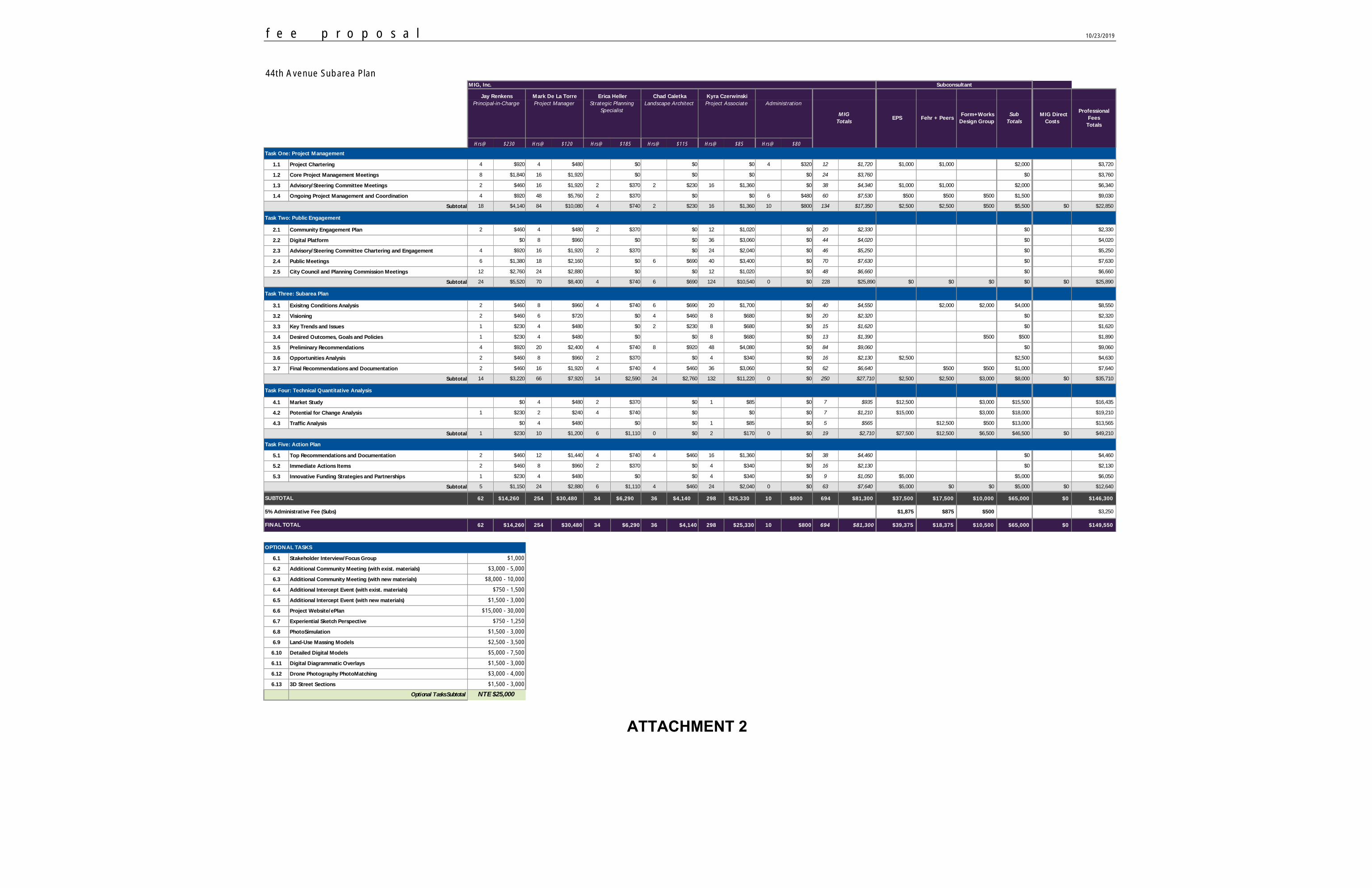
f e e p r o p o s a l
MIG, Inc.
Hrs@ $230 Hrs@ $120 Hrs@ $185 Hrs@ $115 Hrs@ $85 Hrs@ $80
Task One: Project Management
1.1 Project Chartering 4 $920 4 $480 $0 $0 $0 4 $320 12 $1,720 $1,000 $1,000 $2,000 $3,720
1.2 Core Project Management Meetings 8 $1,840 16 $1,920 $0 $0 $0 $0 24 $3,760 $0 $3,760
1.3 Advisory/Steering Committee Meetings 2 $460 16 $1,920 2 $370 2 $230 16 $1,360 $0 38 $4,340 $1,000 $1,000 $2,000 $6,340
1.4 Ongoing Project Management and Coordination 4 $920 48 $5,760 2 $370 $0 $0 6 $480 60 $7,530 $500 $500 $500 $1,500 $9,030
Subtotal 18 $4,140 84 $10,080 4 $740 2 $230 16 $1,360 10 $800 134 $17,350 $2,500 $2,500 $500 $5,500 $0 $22,850
Task Two: Public Engagement
2.1 Community Engagement Plan 2 $460 4 $480 2 $370 $0 12 $1,020 $0 20 $2,330 $0 $2,330
2.2 Digital Platform $0 8 $960 $0 $0 36 $3,060 $0 44 $4,020 $0 $4,020
2.3 Advisory/Steering Committee Chartering and Engagement 4 $920 16 $1,920 2 $370 $0 24 $2,040 $0 46 $5,250 $0 $5,250
2.4 Public Meetings 6 $1,380 18 $2,160 $0 6 $690 40 $3,400 $0 70 $7,630 $0 $7,630
2.5 City Council and Planning Commission Meetings 12 $2,760 24 $2,880 $0 $0 12 $1,020 $0 48 $6,660 $0 $6,660
Subtotal 24 $5,520 70 $8,400 4 $740 6 $690 124 $10,540 0 $0 228 $25,890 $0 $0 $0 $0 $0 $25,890
Task Three: Subarea Plan
3.1 Exisitng Conditions Analysis 2 $460 8 $960 4 $740 6 $690 20 $1,700 $0 40 $4,550 $2,000 $2,000 $4,000 $8,550
3.2 Visioning 2 $460 6 $720 $0 4 $460 8 $680 $0 20 $2,320 $0 $2,320
3.3 Key Trends and Issues 1 $230 4 $480 $0 2 $230 8 $680 $0 15 $1,620 $0 $1,620
3.4 Desired Outcomes, Goals and Policies 1 $230 4 $480 $0 $0 8 $680 $0 13 $1,390 $500 $500 $1,890
3.5 Preliminary Recommendations 4 $920 20 $2,400 4 $740 8 $920 48 $4,080 $0 84 $9,060 $0 $9,060
3.6 Opportunities Analysis 2 $460 8 $960 2 $370 $0 4 $340 $0 16 $2,130 $2,500 $2,500 $4,630
3.7 Final Recommendations and Documentation 2 $460 16 $1,920 4 $740 4 $460 36 $3,060 $0 62 $6,640 $500 $500 $1,000 $7,640
Subtotal 14 $3,220 66 $7,920 14 $2,590 24 $2,760 132 $11,220 0 $0 250 $27,710 $2,500 $2,500 $3,000 $8,000 $0 $35,710
Task Four: Technical Quantitative Analysis
4.1 Market Study $0 4 $480 2 $370 $0 1 $85 $0 7 $935 $12,500 $3,000 $15,500 $16,435
4.2 Potential for Change Analysis 1 $230 2 $240 4 $740 $0 $0 $0 7 $1,210 $15,000 $3,000 $18,000 $19,210
4.3 Traffic Analysis $0 4 $480 $0 $0 1 $85 $0 5 $565 $12,500 $500 $13,000 $13,565
Subtotal 1 $230 10 $1,200 6 $1,110 0 $0 2 $170 0 $0 19 $2,710 $27,500 $12,500 $6,500 $46,500 $0 $49,210
Task Five: Action Plan
5.1 Top Recommendations and Documentation 2 $460 12 $1,440 4 $740 4 $460 16 $1,360 $0 38 $4,460 $0 $4,460
5.2 Immediate Actions Items 2 $460 8 $960 2 $370 $0 4 $340 $0 16 $2,130 $0 $2,130
5.3 Innovative Funding Strategies and Partnerships 1 $230 4 $480 $0 $0 4 $340 $0 9 $1,050 $5,000 $5,000 $6,050
Subtotal 5 $1,150 24 $2,880 6 $1,110 4 $460 24 $2,040 0 $0 63 $7,640 $5,000 $0 $0 $5,000 $0 $12,640
62 $14,260 254 $30,480 34 $6,290 36 $4,140 298 $25,330 10 $800 694 $81,300 $37,500 $17,500 $10,000 $65,000 $0 $146,300
5% Administrative Fee (Subs) $1,875 $875 $500 $3,250
62 $14,260 254 $30,480 34 $6,290 36 $4,140 298 $25,330 10 $800 694 $81,300 $39,375 $18,375 $10,500 $65,000 $0 $149,550
6.1 Stakeholder Interview/Focus Group
6.2 Additional Community Meeting (with exist. materials)
6.3 Additional Community Meeting (with new materials)
6.4 Additional Intercept Event (with exist. materials)
6.5 Additional Intercept Event (with new materials)
6.6 Project Website/ePlan
6.7 Experiential Sketch Perspective
6.8 PhotoSimulation
6.9 Land-Use Massing Models
6.10 Detailed Digital Models
6.11 Digital Diagrammatic Overlays
6.12 Drone Photography PhotoMatching
6.13 3D Street Sections
Optional Tasks Subtotal
44th Avenue Subarea Plan
10/23/2019
Strategic Planning
Specialist
Jay Renkens
Project AssociateProject Manager
EPS
Professional
Fees
Totals
Principal-in-Charge
Mark De La Torre
Sub
Totals
Erica Heller
Fehr + Peers Form+Works
Design Group
Chad Caletka
MIG Direct
Costs
Subconsultant
FINAL TOTAL
MIG
Totals
SUBTOTAL
Kyra Czerwinski
Landscape Architect Administration
$1,500 - 3,000
$1,000
NTE $25,000
OPTIONAL TASKS
$3,000 - 5,000
$8,000 - 10,000
$750 - 1,500
$1,500 - 3,000
$15,000 - 30,000
$750 - 1,250
$1,500 - 3,000
$2,500 - 3,500
$5,000 - 7,500
$1,500 - 3,000
$3,000 - 4,000
ATTACHMENT 2
ITEM NO: DATE: December 9, 2019
REQUEST FOR CITY COUNCIL ACTION
TITLE: MOTION TO APPROVE THE AT LARGE, ELECTED CITY OFFICIAL MAYORAL APPOINTMENT TO THE WHEAT RIDGE URBAN RENEWAL AUTHORITY BOARD
PUBLIC HEARING ORDINANCES FOR 1ST READING BIDS/MOTIONS ORDINANCES FOR 2ND READING RESOLUTIONS
QUASI-JUDICIAL: YES NO
_______________________________ City Manager
ISSUE: The members of Wheat Ridge Urban Renewal Authority (the “Authority”) are appointed by the Mayor subject to approval by a majority vote of the entire City Council. Former Councilmember Kristi Davis served on the Authority representing the at large, elected city official seat. Ms. Davis’ City Council term expired on November 18, 2019. The Mayor is appointing Councilmember Janeece Hoppe to fill the vacant at large, elected City official seat.
PRIOR ACTION: None
FINANCIAL IMPACT: None
BACKGROUND: Section 25-24 of the Wheat Ridge Code of Laws details the process for appointments to the Authority as follows:
The authority shall consist of seven (7) members, one (1) of such members being from each of the existing, or hereafter altered, city council districts, and three (3) members to serve at large. If, after reasonable advertisement, no applications are
7
CAF – At Large Urban Renewal Authority Appointment December 9, 2019 Page 2
received from residents within the relevant city council district for a vacancy on the authority, any otherwise qualified resident of the city may be appointed. The at large members may include one (1) elected city official (excluding the mayor), and/or one (1) non-resident individual who owns an interest in or is a corporate officer of a licensed business in good standing located within the city. Each appointment to the authority shall be made by the mayor subject to approval by majority vote of the entire city council.
RECOMMENDATIONS: Mayor Starker is recommending that Councilmember Janeece Hoppe be reappointed to the Authority Board, representing the at large, elected city official seat. RECOMMENDED MOTION: “I move to approve the at large, elected City official Mayoral appointment of Councilmember Janeece Hoppe to the Wheat Ridge Urban Renewal Authority Board.” Or “I move to deny the appointment of Councilmember Janeece Hoppe to the at large, elected City official Wheat Ridge Urban Renewal Authority Board seat for the following reason(s) ________________________.” REPORT PREPARED BY: Patrick Goff, City Manager