Susceptibility and triggering scenarios at a regional scale for shallow landslides
Deep-seated bedrock landslides and submarine
canyon evolution in an active tectonic margin:
Cook Strait, New Zealand.
Aaron Micallef 1, 2
, Joshu J. Mountjoy 3, Miquel Canals
1 and Galderic Lastras
1
1. GRC Geociències Marines, Universitat de Barcelona, E-08028, Spain. +34 934021369,
2. University of Malta, Msida, MSD 2080, Malta.
3. National Institute of Water and Atmospheric Research, Private Bag 14901, Wellington. New
Zealand.
Abstract
The Cook Strait sector of the Hikurangi subduction margin, off south-east central New
Zealand, is dominated by a multi-branched canyon system where landslides are wide-
spread. The objective of this study is to determine the character, origin, and influence of
these landslides on the evolution of the canyon system. Multibeam bathymetry covering
seven submarine canyons is utilised to characterise landslides’ spatial distribution, mor-
phological attributes and area-frequency characteristics. We demonstrate that mass
movements within the Cook Strait canyons consist of spatially dense, predominantly
retrogressive, small, deep-seated, translational bedrock landslides occurring in Late Ce-
nozoic sequences. These landslides affect up to a quarter of the canyoned area. Concen-
tration of landslides in the shallow canyon reaches (down to 800 m) is attributed to the
influence of oceanographic processes originating on the continental shelf such as tide-
generated currents, dense shelf water cascading and internal waves. Canyon incision
and wall undercutting, locally favoured by underlying lithological control, are proposed
as major landslide drivers in Cook Strait. Ground motion during regional earthquakes is
considered a secondary cause. Retrogressive landslides are responsible for canyon wid-
ening and wall retreat, cross-sectional asymmetry, preconditioning for additional fail-
ure, destabilisation of adjacent slopes and delivery of sediment into canyon floors.
Keywords: Bedrock landslide, submarine canyon, morphometric analysis, Cook Strait.
1. Introduction
The Hikurangi margin is a transpressional subduction arc located off New Zealand’s
North Island. The Cook Strait (CS) sector is located in the southern Hikurangi margin
and is traversed by a series of active thrust and strike-slip faults (Barnes and Audru
1999). The CS sector also hosts the largest canyon system in the whole margin, where
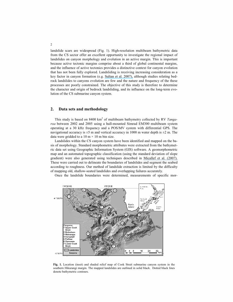
2
landslide scars are widespread (Fig. 1). High-resolution multibeam bathymetric data
from the CS sector offer an excellent opportunity to investigate the regional impact of
landslides on canyon morphology and evolution in an active margin. This is important
because active tectonic margins comprise about a third of global continental margins,
and the influence of active tectonics provides a distinctive context for canyon evolution
that has not been fully explored. Landsliding is receiving increasing consideration as a
key factor in canyon formation (e.g. Sultan et al. 2007), although studies relating bed-
rock landslides to canyons evolution are few and the nature and frequency of the these
processes are poorly constrained. The objective of this study is therefore to determine
the character and origin of bedrock landsliding, and its influence on the long-term evo-
lution of the CS submarine canyon system.
2. Data sets and methodology
This study is based on 8400 km2 of multibeam bathymetry collected by RV Tanga-
roa between 2002 and 2005 using a hull-mounted Simrad EM300 multibeam system
operating at a 30 kHz frequency and a POS/MV system with differential GPS. The
navigational accuracy is ±5 m and vertical accuracy in 1000 m water depth is ±2 m. The
data were gridded to a 10 m × 10 m bin size.
Landslides within the CS canyon system have been identified and mapped on the ba-
sis of morphology. Standard morphometric attributes were extracted from the bathymet-
ric data set using Geographic Information System (GIS) software. A geomorphometric
map and an automated topographic classification (using the standard deviation of slope
gradient) were also generated using techniques described in Micallef et al. (2007).
These were carried out to delineate the boundaries of landslides and segment the seabed
according to roughness. Our method of landslide extraction is limited by the difficulty
of mapping old, shallow-seated landslides and overlapping failures accurately.
Once the landslide boundaries were determined, measurements of specific mor-
Fig. 1. Location (inset) and shaded relief map of Cook Strait submarine canyon system in the
southern Hikurangi margin. The mapped landslides are outlined in solid black. Dotted black lines
denote bathymetric contours.
3
phometric attributes of each individual landslide were made. These included:
i.Bathymetric depth: The depth of the centroid of each landslide; ii. Headwall length:
The terminations of a headwall are defined by the zone where material has moved per-
pendicularly to the escarpment; iii. Headwall height: Difference in elevation between
top and foot of headwall; iv. Landslide direction: Predominant direction of material mo-
bilisation; v. Area: Total area of the headwall, slide scar and deposit; vi. Volume: A
smooth surface was interpolated from the polygon that defines the boundary of each
landslide scar and then subtracted from the original bathymetry. The method and asso-
ciated assumptions are detailed in Chaytor et al. (2009).
For headwall height, several measurements were made from adjacent cross-sections
in order to calculate a mean value. Where features were not prominent, the steepest sec-
tion of the features was considered.
3. Results
3.1 Submarine canyon morphology
Seven canyons dissect the continental slope of the CS sector, from the continental
shelf down to the Hikurangi Channel at a depth of ~2500 m (Fig. 1). Nicholson, Waira-
rapa, Upper Cook Strait and the shallower part of the Lower Cook Strait Canyons are
incised in Late Cenozoic sedimentary sequences of consolidated and gently dipping
mudstone, siltstone or sandstone (Mountjoy et al. 2009). The northern walls of Nichol-
son and Wairarapa canyons comprise Torlesse Greywacke Mesozoic basement, which
consists of well-indurated and slightly metamorphosed mudstones and silty sandstones
(Barnes and Audru 1999). Palliser, Opouawe, Campbell and the deeper part of Lower
Cook Strait Canyons are incised in Neogene turbidite sequences (Uruski 2010). The
morphological characteristics of each canyon are presented in Table 1. The cross-
sectional shape of the canyons is generally V-shaped, with a gently sloping canyon floor
that can be up to 2.5 km wide. The walls can locally reach slope gradients in excess of
30°; they are eroded by linear and dendritic gullies (Micallef and Mountjoy 2011) and
landslides.
3.2 Landslides
3.2.1 Morphological characteristics
There are at least 141 landslides on the walls of the CS canyons. They are character-
ised by well-defined arcuate headwalls, sub-parallel sidewalls and a near-planar, smooth
failure surface (Figs. 1, 2a). The direction of landslide movement is predominantly per-
pendicular or quasi-perpendicular to that of the canyon thalweg (Fig. 3d). Several can-
yon walls display up to three levels of landslide retrogression (Fig. 2a). Numerous land-
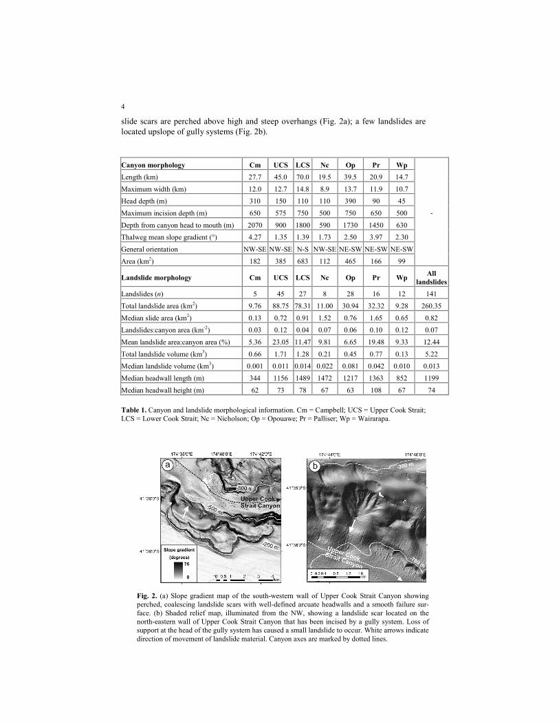
4
slide scars are perched above high and steep overhangs (Fig. 2a); a few landslides are
located upslope of gully systems (Fig. 2b).
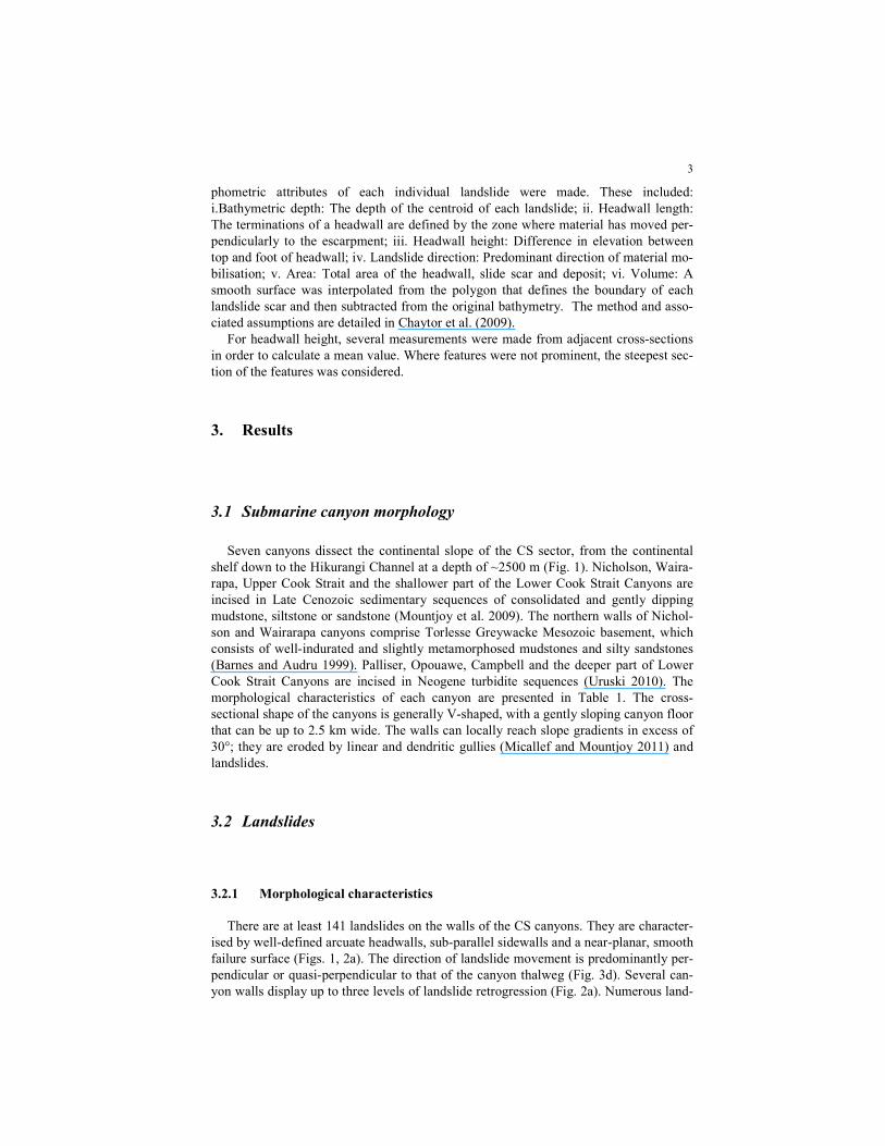
Canyon morphology Cm UCS LCS Nc Op Pr Wp
Length (km) 27.7 45.0 70.0 19.5 39.5 20.9 14.7
Maximum width (km) 12.0 12.7 14.8 8.9 13.7 11.9 10.7
Head depth (m) 310 150 110 110 390 90 45
Maximum incision depth (m) 650 575 750 500 750 650 500
Depth from canyon head to mouth (m) 2070 900 1800 590 1730 1450 630
Thalweg mean slope gradient (°) 4.27 1.35 1.39 1.73 2.50 3.97 2.30
General orientation NW-SE NW-SE N-S NW-SE NE-SW NE-SW NE-SW
Area (km2) 182 385 683 112 465 166 99
-
Landslide morphology Cm UCS LCS Nc Op Pr Wp All
landslides
Landslides (n) 5 45 27 8 28 16 12 141
Total landslide area (km2) 9.76 88.75 78.31 11.00 30.94 32.32 9.28 260.35
Median slide area (km2) 0.13 0.72 0.91 1.52 0.76 1.65 0.65 0.82
Landslides:canyon area (km-2
) 0.03 0.12 0.04 0.07 0.06 0.10 0.12 0.07
Mean landslide area:canyon area (%) 5.36 23.05 11.47 9.81 6.65 19.48 9.33 12.44
Total landslide volume (km3) 0.66 1.71 1.28 0.21 0.45 0.77 0.13 5.22
Median landslide volume (km3) 0.001 0.011 0.014 0.022 0.081 0.042 0.010 0.013
Median headwall length (m) 344 1156 1489 1472 1217 1363 852 1199
Median headwall height (m) 62 73 78 67 63 108 67 74
Table 1. Canyon and landslide morphological information. Cm = Campbell; UCS = Upper Cook Strait;
LCS = Lower Cook Strait; Nc = Nicholson; Op = Opouawe; Pr = Palliser; Wp = Wairarapa.
Fig. 2. (a) Slope gradient map of the south-western wall of Upper Cook Strait Canyon showing
perched, coalescing landslide scars with well-defined arcuate headwalls and a smooth failure sur-
face. (b) Shaded relief map, illuminated from the NW, showing a landslide scar located on the
north-eastern wall of Upper Cook Strait Canyon that has been incised by a gully system. Loss of
support at the head of the gully system has caused a small landslide to occur. White arrows indicate
direction of movement of landslide material. Canyon axes are marked by dotted lines.
5
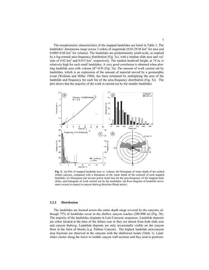
The morphometric characteristics of the mapped landslides are listed in Table 1. The
landslides’ dimensions range across 3 orders of magnitude (0.03-29.56 km2 for area and
0.0005-0.88 km3 for volume). The landslides are predominantly small-scale, as implied
by a log-normal area-frequency distribution (Fig. 3c), with a median slide area and vol-
ume of 0.82 km2 and 0.013 km
3, respectively. The median headwall height, at 74 m, is
relatively high for such small landslides. A very good correlation is obtained when plot-
ting landslide area with volume (R2=0.9) (Fig. 3a). The amount of work carried out by
landslides, which is an expression of the amount of material moved by a geomorphic
event (Wolman and Miller 1960), has been estimated by multiplying the area of the
landslide and frequency for each bin of the area-frequency distribution (Fig. 3c). The
plot shows that the majority of the work is carried out by the smaller landslides.
3.2.2 Distribution
The landslides are located across the entire depth range covered by the canyons, al-
though 75% of landslides occur in the shallow canyon reaches (200-800 m) (Fig. 3b).
The majority of the landslides originate in Late Cenozoic sequences. Landslide deposits
are either located at the base of the failure scar or they are absent from both slide scar
and canyon thalweg. Landslide deposits are only occasionally visible on the canyon
floor in the form of blocks (e.g. Palliser Canyon). The highest landslide area:canyon
area fractions are observed in the canyons with the shallowest heads (Table 1). Land-
slides cluster along the lower to middle canyon wall sections and they tend to preferen-
Fig. 3. (a) Plot of mapped landslide area vs. volume; (b) Histogram of water depth of the seabed
within canyons, compared with a histogram of the water depth of the centroid of each mapped
landslide; (c) Histogram and inverse power trend line for the area-frequency of the mapped land-
slides, and histogram of work carried out by the landslides; (d) Rose diagram of landslide move-
ment vectors in respect to canyon thalweg direction (black arrow).
6
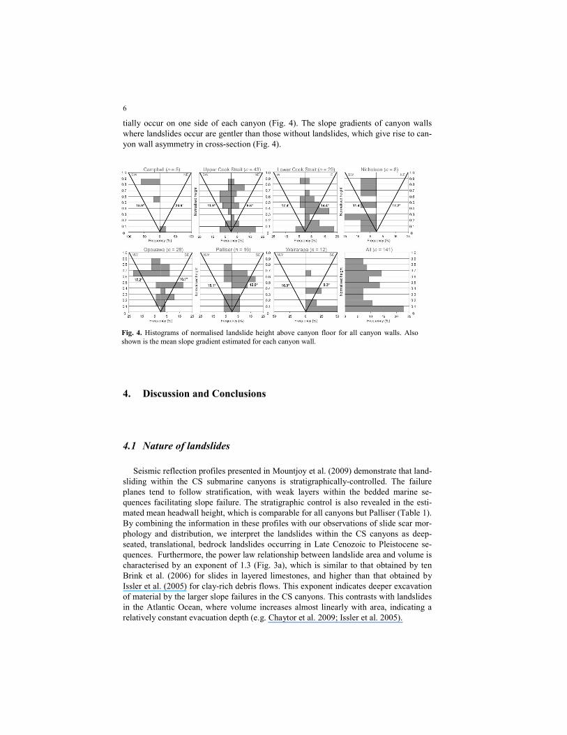
tially occur on one side of each canyon (Fig. 4). The slope gradients of canyon walls
where landslides occur are gentler than those without landslides, which give rise to can-
yon wall asymmetry in cross-section (Fig. 4).
4. Discussion and Conclusions
4.1 Nature of landslides
Seismic reflection profiles presented in Mountjoy et al. (2009) demonstrate that land-
sliding within the CS submarine canyons is stratigraphically-controlled. The failure
planes tend to follow stratification, with weak layers within the bedded marine se-
quences facilitating slope failure. The stratigraphic control is also revealed in the esti-
mated mean headwall height, which is comparable for all canyons but Palliser (Table 1).
By combining the information in these profiles with our observations of slide scar mor-
phology and distribution, we interpret the landslides within the CS canyons as deep-
seated, translational, bedrock landslides occurring in Late Cenozoic to Pleistocene se-
quences. Furthermore, the power law relationship between landslide area and volume is
characterised by an exponent of 1.3 (Fig. 3a), which is similar to that obtained by ten
Brink et al. (2006) for slides in layered limestones, and higher than that obtained by
Issler et al. (2005) for clay-rich debris flows. This exponent indicates deeper excavation
of material by the larger slope failures in the CS canyons. This contrasts with landslides
in the Atlantic Ocean, where volume increases almost linearly with area, indicating a
relatively constant evacuation depth (e.g. Chaytor et al. 2009; Issler et al. 2005).
Fig. 4. Histograms of normalised landslide height above canyon floor for all canyon walls. Also
shown is the mean slope gradient estimated for each canyon wall.
7
4.2 Causes of landslides
We propose two main causes of canyon landslides:
a. Canyon incision and wall undercutting. Landslide scars are generally concen-
trated in the lower half of the canyon walls. The direction of the majority of slides is
quasi-perpendicular to the canyon thalweg (Figure 3d). The presence of perched slides
attests to periods of thalweg excavation. Retrogression is observed at a number of
places in the form of small landslides stepping upslope from larger landslides on the
canyon wall. Canyon incision and wall undercutting are therefore proposed as the first
order driver of landslides in the CS canyons. The larger landslides occur where scouring
of the canyon floor undermines and steepens the base of the canyon wall, whereas the
upper, smaller slides occur due to loss of support; this is comparable to the origin of ter-
restrial bedrock landslides in the physical model of Densmore et al. (1997). In spite of
the numerous canyon wall failures, we notice a general absence of landslide deposits
within the canyon axes. This supports the hypothesis that canyons were active at the
same time as the canyon walls were failing or shortly after, and that material was re-
moved from the canyon bed. Proof that this activity may be recent can be found in cores
from Nicholson and Upper Cook Strait Canyons, which show repeated sandy turbidites
and a lack of any large accumulation of hemipelagic sequences on the canyon floor
(Mountjoy et al. 2009). Few landslides are located in Campbell Canyon (Table 1); this
observation emphasises the importance of canyon downcutting because Campbell Can-
yon is an abandoned, infilled tributary of the Lower Cook Strait Canyon (Mountjoy et
al. 2009). Repeated mass movements across the canyon walls may also account for the
width of the canyon floor, which cannot be explained by canyon incision alone. Canyon
cross-sectional asymmetry (Fig. 4), on the other hand, may be explained by flows
within the canyon thalweg impinging on the north-facing canyon walls due to gravity,
giving rise to landslide clustering across these slopes. Cross-sectional asymmetry in Pal-
liser and Opouwae canyons, on the other hand, may be due to the presence of tectonic
ridges, the forelimbs of which can be up to two times steeper than the backlimbs.
b. Earthquakes. Some landslides are located in the upper half of canyon walls with
no connection to canyon thalwegs (Fig. 4). Landslide scar distribution occasionally cor-
relates with active faults, which act as significant earthquake sources (e.g. Christchurch
February 2011 M6.3 earthquake). Ground motion during regional earthquakes and its
influence on steep, undercut canyon walls is proposed as a second major cause of land-
slides. The role of earthquakes in causing slope failure is believed to be important in the
CS canyons because of a high concentration of active faults and the modelled frequent
occurrence of strong earthquake-generated ground motion (Stirling et al. 2002). We
suggest that failures occur as either co-seismic events, due to deformation of slopes dur-
ing ground shaking, or through generation of excess pore pressures in high permeability
horizons due to cycling loading (Mountjoy et al. 2009).
Uplift and over-steepening of canyon walls due to active anticlinal folding may con-
stitute an additional cause of landslides, but this would only account for landslide occur-
rence in Palliser and Opouawe canyons.
4.3 Spatial distribution of landslides
Bedrock landslides can be found in all the canyons. The concentration of landslides
in the shallow, shelf-incised canyon reaches (Fig. 3b) implies that there is a dominating
influence on the depth zonation of failures. One possible reason for this zonation is that
8
canyon incision is driven by an oceanographic process originating in the shelf area. We
assume that such a process would influence the shallower canyons the most (Nicholson,
Wairarapa, Upper Cook Strait, shallower Lower Cook Strait Canyons), and it could ex-
plain why landslides cluster in the lower half of these canyons’ walls (Fig. 4). A possi-
ble candidate for such an oceanographic process is tide-generated currents and related
sediment input. Tides may play a role in generating a strong, recurring and directionally
stable flow that can transport sediment and deepen the canyon. The signal of such a
flow has been identified at depths down to 1000 m (Law et al. 2010). Other potential
candidates include cascading dense water (Micallef and Mountjoy 2011) and internal
waves, although these oceanographic processes still need to be documented in CS. At
present, large scale ocean currents and fluvial sediment discharge are not considered in-
fluential in the study area (Chiswell 2000; Hicks and Shankar 2003), although the latter
should have been more significant during glacial lowstands. In comparison to the shal-
lower canyons, the deeper canyons (deeper Lower Cook Strait, Campbell, Palliser and
Opouawe Canyons) exhibit a lower number of landslides and a concentration of land-
slides in the upper half of the canyon walls (Fig. 4); this may indicate that canyon
downcutting may be a less important driver of landslides in this region, and that earth-
quakes may be more significant.
A second possible reason for landslide zonation is lithological control, reflecting the
contrast between the deep, Late Cenozoic sedimentary basins located on the shelf, and
the slope cover and Neogene turbidite sequences underlying the continental slope
(Mountjoy et al. 2009; Uruski 1992). Landslide zonation may also be attributed to their
retrogressive nature, with shallower landslides tending to be more numerous than
deeper failures.
4.4 Role of landslides in canyon evolution
Bedrock landslides are numerous in the CS canyon system and they have an impor-
tant influence in canyon evolution, predominantly in the form of wall erosion, lateral
extension and dendritic network evolution. They have the potential to rapidly remove
material from the continental slope and can affect up to a quarter of the canyon. Land-
slides represent a major cross-canyon source of material and an important process intro-
ducing material into canyon floors. As a result, landslide deposits may play an impor-
tant role in the re-hierarchisation of canyon branches by blocking a canyon branch and
favouring up-canyon infill. Area-frequency analyses show that the majority of the mate-
rial is removed by small landslides (Fig. 3c); this contrasts with terrestrial environ-
ments, where most of the work tends to be carried out by moderately-sized landslides
(Guthrie and Evans 2007). Axis-normal slope failures along canyon walls occur once
the canyon floor has been excavated and the walls have been undercut, suggesting that
bedrock landslides may become more important as the canyon matures; otherwise fail-
ure is initially restricted to the canyon head (Pratson and Coakley 1996). Bedrock mass
failures can also affect adjacent slopes by removal of support, potentially leading to fur-
ther destabilisation and retrogression. Landslides may also have an important role in
gully initiation and development by generating the steep topography required for gully
formation (Fig. 2b). The median slope gradients of both the headwalls and scars of the
landslides are higher than the threshold of 5.5° associated with gully initiation in the CS
sector (Micallef and Mountjoy 2011) (Table 1). Gully formation can, in turn, also trig-
ger landslides due to loss of support (Fig. 2b).
9
5. References
Barnes PM, Audru JC (1999) Quaternary faulting in the offshore Flaxbourne and Wairarapa Basins,
southern Cook Strait, New Zealand. New Zeal J Geol Geophys 42: 349-367.
Chaytor JD, Ten Brink US, Solow AR et al. (2009) Size distribution of submarine landslides along the
U.S. Atlantic margin. Mar Geol 264: 16-27.
Chiswell SM (2000) The Wairarapa Coastal Current. New Zeal J Mar Fresh 34: 303-315.
Densmore AL, Anderson RS, McAdoo BG et al. (1997) Hillslope evolution by bedrock landslides.
Science 275: 369-372.
Guthrie RH, Evans SG (2007) Work, persistence, and formative events: The geomorphic impact of
landslides. Geomorphology 88: 266-275.
Hicks DM, Shankar U (2003) Sediment from New Zealand Rivers. NIWA.
Issler D, De Blasio FV, Elverhøi A et al. (2005) Scaling behaviour of clay-rich submarine debris flows.
Mar Petrol Geol 22: 187-194.
Law CS, Nodder SD, Mountjoy JJ et al. (2010) Geological, hydrodynamic and biogeochemical vari-
ability of a New Zealand deep-water methane cold seep during an integrated three-year time-series
study. Mar Geol 272: 189-208.
Micallef A, Berndt C, Masson DG et al. (2007) A technique for the morphological characterization of
submarine landscapes as exemplified by debris flows of the Storegga Slide. J Geophys Res 112:
F02001.
Micallef A, Mountjoy JJ (2011) A topographic signature of a hydrodynamic origin for submarine
gullies. Geology 39: 115-118.
Mountjoy JJ, Barnes PM, Pettinga JR (2009) Morphostructure and evolution of submarine canyons
across an active margin: Cook Strait sector of the Kikurangi Margin, New Zealand. Mar Geol 260:
45-68.
Pratson LF, Coakley BJ (1996) A model for the headward erosion of submarine canyons induced by
downslope-eroding sediment flows. Geol Soc Am Bull 108: 225-234.
Stirling MW, McVerry GH, Berryman KR (2002) A new seismic hazard model for New Zealand. B
Seismol Soc Am 92: 1878-1903.
Sultan N, Gaudin M, Berne S et al. (2007) Analysis of slope failure in submarine canyon heads: An ex-
ample from the Gulf of Lions. J Geophys Res 112: F01009.
ten Brink US, Geist EL, Andrews BD (2006) Size distribution of submarine landslides and its implica-
tion to tsunami hazard in Puerto Rico. Geophys Res Lett 33: L11307-11311.
Uruski CI (1992) Sedimentary Basins and Structure of Cook Strait, 92/3. Inst Geol Nucl Sci, Lower
Hutt, New Zealand.
Uruski CI (2010) New Zealand’s deepwater frontier. Mar Petrol Geol 27: 2005-2026.
Acknowledgments.
This research was supported by Marie Curie Intra-European Fellowship PIEF-GA-2009-252702, Royal
Society of New Zealand ISAT Fund, NIWA capability funding, FRST CEOC contracts, the
HERMIONE EC project and the GRACCIE-CONSOLIDER (ref. CSD2007-00067) Spanish project.
We are indebted to NIWA Ocean Geology technicians and the crew of RV Tangaroa for collecting the
bathymetry data. AM, MC and GL belong to CRG on Marine Geosciences, supported by grant 2009
SGR 1305 of Generalitat de Catalunya).
Copyright © 2022 FDOKUMEN