TECHNICAL REPORT ON THE GATEAU URANIUM ...
52
GM 64221 TECHNICAL REPORT ON THE GATEAU URANIUM PROPERTY
-
Upload
khangminh22 -
Category
Documents
-
view
2 -
download
0
Transcript of TECHNICAL REPORT ON THE GATEAU URANIUM ...

GM 64221TECHNICAL REPORT ON THE GATEAU URANIUM PROPERTY

InnovExplo inc. — Consulting Firm Mines and Exploration 560-B, 3rd Avenue, Val-d'Or, Québec, Canada, J9P 1S4 Telephone: (819) 874-0447 Facsimile: (819) 874-0379 Email: infona.innovexplo.com Web site: www.innovexplo.com
TECHNICAL REPORT ON THE GATEAU URANIUM PROPERTY (according to Regulation 43-101 and Form 43-101F1)
Project Location
Latitude: 51° 46' 30" North ; Longitude: 72° 18' 00" West Otish Mountains Area, Quebec, Canada
Prepared for
GM 64221
Kakanda Resources Corp. 204-700 West Pender Street,
Vancouver, British Columbia, Canada, V6C1G8 Phone: (604) 642-0115
Fax: (604) 642-0116
Prepared by:
Benjamin Allou, Ph.D., P.Geo. (OGQ #947) InnovExplo — Consulting Firm Val-d'Or (Québec) E-Mail : [email protected]
July 27 h, 2007
REVD AU MRPSIF
2 0 FFv: 2Lü3
DIRECTION DES TITRES 9r"'';je`S
Ressources naiureffes et Fauna, Québec
1 61U1N 2
rl~
DIR. INFORM. GÉOI.
MRNFP - SECTEUR DES MINES
ÇULE
20 F EV, 2009
Bureau régional a Montréal
782029 ~~ ;

www.innovexplo.com
TABLE OF CONTENTS
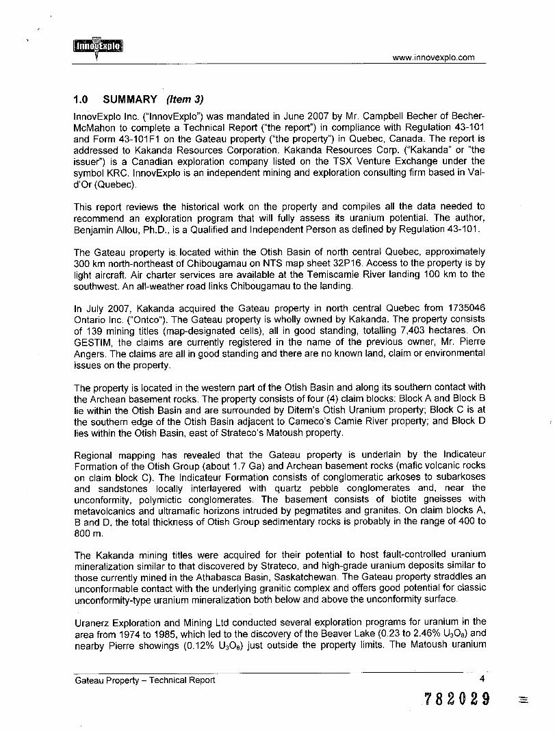
1.0 SUMMARY (Item 3) 4
2.0 INTRODUCTION AND TERMS OF REFERENCE (Item 4) 8
3.0 RELIANCE ON OTHER EXPERTS (Item 5) 9
4.0 PROPERTY DESCRIPTION AND LOCATION (Item 6) 10
5.0 ACCESSIBILITY, CLIMATE, LOCAL RESOURCES, INFRASTRUCTURE AND PHYSIOGRAPHY (Item 7) 13
6.0 HISTORY (Item 8) 14
7.0 GEOLOGICAL SETTING (Item 9) 19
7.1 Regional Geological Setting 19 7.2 Property Geology 22
8.0 DEPOSIT TYPES (Item 10) 24
9.0 MINERALIZATION (Item 11) 29
10.0 EXPLORATION (Item 12) 29
11.0 DRILLING (Item 13) 29
12.0 SAMPLING METHOD AND APPROACH (Item 14) 29
13.0 SAMPLE PREPARATION, ANALYSES AND SECURITY (Item15) 29
14.0 DATA VERIFICATION (Item 16) 29
15.0 ADJACENT PROPERTIES (Item 17) 30
16.0 MINERAL PROCESSING AND METALLURGICAL TESTING (Item 18) 33
17.0 MINERAL RESOURCE AND MINERAL RESERVE ESTIMATES (Item 19) 33
18.0 OTHER RELEVANT DATA AND INFORMATION (Item 20) 33
19.0 INTERPRETATION AND CONCLUSIONS (Item 21) 33
20.0 RECOMMENDATIONS (Item 22) 36
20.1 Phase 1 Exploration Program — Gateau property 36 20.2 Phase 2 Exploration Program — Gateau property 36
21.0 REFERENCES (Item 23) 40
22.0 SIGNATURE PAGE (Item 24) 43
23.0 ADDITIONAL REQUIREMENTS FOR TECHNICAL REPORTS ON DEVELOPMENT PROPERTIES AND PRODUCTION PROPERTIES (Item 25) 44
24.0 CERTIFICATE OF AUTHOR 45
Gateau Property — Technical Report 2
782029
www.innovexplo.com
LIST OF FIGURES
Figure 4.1 — Location map of the Gateau Property, 11 Figure 4.2 — Location map of the Gateau Property mining titles 12 Figure 6.1 — Uranium prices and Otish exploration history (Source of the
diagram: www.uxc.com) 15 Figure 6.2 — Compilation map for the Gateau property 16 Figure 7.1 — Otish area geology map and location of uranium and thorium occurrences. Indice
= showing 20 Figure 7.2 — Simplified cross-section of the Otish Basin (Modified from Genest, 1989) 21 Figure 7.3 — Geology map of the Gateau property 23 Figure 8.1 — General features of the Fay-Ace uranium deposit, Beaverlodge area 25 Figure 8.2 — General features of the Eagle Point deposit at the western limit of the Athabasca
basin 25 Figure 8.3 — Schematic cross-section through the Redtree and Junnagunna uranium deposits,
Westmoreland area 27 Figure 8.4 — Schematic cross-section of uranium systems of the Westmoreland region 27 Figure 8.5 — Generalized geological elements of mono- and poly-metallic unconformity-
associated U deposits in the eastern part of the Paleoproterozoic Athabasca Basin 28
Figure 15.1 — Property map for the Gateau project region 32 Figure 19.1 — Aeromagnetic and radiometric map of the Gateau property. The data were
obtained from assessment files and the Quebec government's SIGEOM database 35
LIST OF TABLES
Table 6.1 — Exploration history of the Gateau Property 17 Table 7.1 — Synthesis of the Precambrian geological formations of the Otish Mountains 21 Table 20.1 — Budget estimate for Phase 1 of the exploration program 38 Table 20.2 — Budget estimate for Phase 2 of the exploration program 38
LIST OF APPENDICES
APPENDIX I : Claims list table 46
Gateau Property — Technical Report 3
782029
www.innovexplo.com
1.0 SUMMARY (Item 3)
InnovExplo Inc. ("InnovExplo") was mandated in June 2007 by Mr. Campbell Becher of Becher-McMahon to complete a Technical Report ("the report") in compliance with Regulation 43-101 and Form 43-101 F1 on the Gateau property ("the property") in Quebec, Canada. The report is addressed to Kakanda Resources Corporation. Kakanda Resources Corp. ("Kakanda" or "the issuer") is a Canadian exploration company listed on the TSX Venture Exchange under the symbol KRC. InnovExplo is an independent mining and exploration consulting firm based in Val-d'Or (Quebec).
This report reviews the historical work on the property and compiles all the data needed to recommend an exploration program that will fully assess its uranium potential. The author, Benjamin Allou, Ph.D., is a Qualified and Independent Person as defined by Regulation 43-101.
The Gateau property is located within the Otish Basin of north central Quebec, approximately 300 km north-northeast of Chibougamau on NTS map sheet 32P16. Access to the property is by light aircraft. Air charter services are available at the Temiscamie River landing 100 km to the southwest. An all-weather road links Chibougamau to the landing.
In July 2007, Kakanda acquired the Gateau property in north central Quebec from 1735046 Ontario Inc. ("Ontco"). The Gateau property is wholly owned by Kakanda. The property consists of 139 mining titles (map-designated cells), all in good standing, totalling 7,403 hectares. On GESTIM, the claims are currently registered in the name of the previous owner, Mr. Pierre Angers. The claims are all in good standing and there are no known land, claim or environmental issues on the property.
The property is located in the western part of the Otish Basin and along its southern contact with the Archean basement rocks. The property consists of four (4) claim blocks: Block A and Block B lie within the Otish Basin and are surrounded by Ditem's Otish Uranium property; Block C is at the southern edge of the Otish Basin adjacent to Cameco's Camie River property; and Block D lies within the Otish Basin, east of Strateco's Matoush property.
Regional mapping has revealed that the Gateau property is underlain by the Indicateur Formation of the Otish Group (about 1.7 Ga) and Archean basement rocks (mafic volcanic rocks on claim block C). The Indicateur Formation consists of conglomeratic arkoses to subarkoses and sandstones locally interlayered with quartz pebble conglomerates and, near the unconformity, polymictic conglomerates. The basement consists of biotite gneisses with metavolcanics and ultramafic horizons intruded by pegmatites and granites. On claim blocks A, B and D, the total thickness of Otish Group sedimentary rocks is probably in the range of 400 to 800 m.
The Kakanda mining titles were acquired for their potential to host fault-controlled uranium mineralization similar to that discovered by Strateco, and high-grade uranium deposits similar to those currently mined in the Athabasca Basin, Saskatchewan. The Gateau property straddles an unconformable contact with the underlying granitic complex and offers good potential for classic unconformity-type uranium mineralization both below and above the unconformity surface.
Uranerz Exploration and Mining Ltd conducted several exploration programs for uranium in the area from 1974 to 1985, which led to the discovery of the Beaver Lake (0.23 to 2.46% U308) and nearby Pierre showings (0.12% U308) just outside the property limits. The Matoush uranium
Gateau Property — Technical Report 4
782029
www.innovexplo.com
occurrence belonging to Strateco Resources Inc. is also located in the area. Drilling at Matoush revealed high uranium values, such as 1.12 % U308 over 10.5 m (including 5.96 % U308 over 0.7 m) in Hole MT-10. Previous drilling by Uranerz in the 1980s graded 0.95% U308 over 16 m, including 20.4% over 0.5 m and 1.59% over 1 m. Also found in this part of the Otish Basin, east-northeast of claim block C, are Cameco's Gordon and Camie River uranium occurrences (0.52% U308 over 7.5m, 15.5% U308 over 0.5m, and 0.7% U308 over 1m at the latter).
Data compilation and a review of assessment reports pertinent to the Gateau property revealed that although no uranium occurrence has been discovered to date, many characteristics of the area indicate a good potential for uranium mineralization.
Blocks A and B are near the northwestern unconformity between the Otish Basin and the Archean basement. The unconformity and its surroundings is characterized by the presence of porous sedimentary rocks (polymictic and quartz pebble conglomerates) and a regolith layer above the basement rocks (gneisses and granites) (Caty, 1976; Chown and Caty, 1983; Shown, 1984; www.stratecoinc.com). These areas correspond to redox boundaries that are favourable for trapping uranium from diagenetic reducing fluids that circulated along the unconformity, as seen in many unconformity-uranium deposits of the Athabasca Basin (Jefferson et al., 2007).
At present, Block C appears to be one of the best areas on the Gateau property in terms of uranium potential. Drilling on this claim block intersected mafic volcanic rocks and graphitic and sulphide-rich structures near the unconformity with the Otish Basin. On Cameco's adjacent property, graphite is known to be spatially associated with uranium at the Camie River occurrence (0.52% U3O8 over 7.5m, 15.5% U3O8 over 0.5m, and 0.7% U308 over 1m). Mafic volcanic rocks are marked by a major E-W magnetic anomaly that transects all of Block C (Figure 19.1). Graphitic units associated with fault zones are an essential component of deposit architectures in the Athabasca Basin. In such environments, graphite is capable of supplying sufficient organic reductants to precipitate uraninite from oxidizing fluids circulating in the basin. Mafic volcanic rocks and associated sulphides can also act like graphite by reacting with circulating fluids and contributing to the deposition of uranium minerals, as documented in the Westmoreland uranium deposits of Australia.
Block D is at the northern limit of a large magnetic anomaly (Figure 19.1), which most certainly represents a deeply penetrating, thick mafic dyke. Many radiometric anomalies are distributed along this major structure, including those in the vicinities of Block D and the Matoush and Little Matoush showings, all of which are on the same side of the presumed dyke. In addition, the compilation map reveals that a significant uranium-bearing Proterozoic boulder field originated from this area (Figure 6.2). From the above observations, and given the characteristics of the aforementioned deposit types, one can suspect significant uranium mineralization in the area, most likely at the contact between the presumed mafic dyke and the basinal sedimentary rocks, and/or at the northeastern limit of the uraniferous boulder field.
Considering the above-mentioned characteristics, the entire Gateau property shares many similarities with Athabasca unconformity-type deposits, as do most uranium occurrences in the Otish. Basin (e.g., the Matoush, L and S showings).
The following characteristics of the Otish Basin are considered favourable for uranium:
• The basin is almost contemporaneous with the Athabasca Basin; • The basin/basement contact is underlain by a regolith layer; • Block C lies along the basal unconformity of the basin;
Gateau Property — Technical Report 5
782029

www.innovexplo.com
• Most uranium occurrences discovered in the area are controlled by fractures; • Graphite is reported in the Block C area. Graphitic horizons or graphite remobilization
along faults very likely represent chemical traps for uranium deposits; • The basement comprises granites and pegmatites with relatively high uranium Clarke
values, and could represent the primary source of uranium in the area; • Some mineralized zones (e.g., the Matoush and L zones) are accompanied by
alteration minerals, including clay, silica and tourmaline; • Two sedimentary unconformities (basement-basin and intrabasin) represent potential
horizons; • Several faults and late gabbros (Matoush-type), particularly in the Block C area, may
represent a plumbing system for uranium deposition; • Several airborne radiometric anomalies are documented in the assessment files.
InnovExplo affirms that the Gateau property is an interesting project that justifies additional work to enhance its economic potential. Therefore, InnovExplo recommends a major exploration program on the Gateau property. InnovExplo states that the character of the property is of sufficient merit to justify the recommended program.
The recommended exploration program is divided into two (2) phases. The second phase of the program is conditional on the success of the first phase. Phase 1 is estimated at $264,500 and Phase 2 at $2,254,000 for a combined total of $2,518,500.
Phase 1 Exploration Program — Gateau property
Modem airborne geophysical surveys (Mag, TEM and Radiometric)
InnovExplo recommends a modern airborne geophysics survey over Block C and Block D, including time-domain electromagnetic (TEM), radiometric (U, Th, and K) and magnetic (Mag) surveys. A line spacing of 150 m is recommended. For the A and B blocks, which are small and isolated, it is recommended that the same type of geophysical data be bought from the owners of the adjacent areas if surveys have already been completed.
Compilation, area selection and target generation
InnovExplo recommends that results from the new geophysical surveys be combined with a detailed geological compilation of the project to select potential areas and generate targets.
Phase 2 Exploration Program — Gateau property
a.) Field validation, geological work and radiometric prospecting
InnovExplo recommends a field validation phase and new data acquisition by direct ground-based prospecting using a scintillometer and related radon detectors. Field-based prospecting should be able locate any radioactive outcrops or boulders. Ground-based geological and radiometric follow-up work can then be prioritized on favourable targets.
b.) induced Polarization (IP) geophysics
Data from airborne geophysics, field validation and prospecting will be interpreted and integrated to identify new potential areas. Ground geophysics, such as induced polarization (IP), may be used to identify resistivity anomalies that often surround alteration haloes associated with uranium deposits.
Gateau Property — Technical Report 6
782029

www.innovexplo.com
c.) Diamond drilling program
In the second phase of the program, InnovExplo recommends a 3,000-m drilling campaign with three main objectives: (i) verify and explain high-priority targets previously validated by ground checks; (ii) acquire data to better understand the behaviour of favourable discontinuities in areas where major structures have been reported; and (iii) update the preliminary database.
Gateau Property — Technical Report 7
782029

www. in novexplo. com
2.0 INTRODUCTION AND TERMS OF REFERENCE (Item 4)
InnovExplo Inc. ("InnovExplo") was mandated in June 2007 by Mr. Campbell Becher from Becher-McMahon to complete a Technical Report ("the report") in compliance with Regulation 43-101 and Form 43-101F1 on the Gateau property ("the property") in Quebec, Canada. The report is addressed to Kakanda Resources Corporation. Kakanda Resources Corp. ("Kakanda" or "the issuer") is a Canadian exploration company listed on the TSX Venture Exchange under the symbol KRC. InnovExplo is an independent mining and exploration consulting firm based in Val-d'Or (Quebec).
This report reviews the historical work on the property and compiles all the data needed to recommend an exploration program that will assess its uranium potential. Some data were provided by agents of Kakanda (e.g., the mining titles list). InnovExplo also reviewed other information sources, such as government databases for assessment file records and the status of the mining titles.
The author, Benjamin Allou, Ph.D., P.Geo. (OGQ #947), is a Qualified and Independent Person according to Regulation 43-101 and has completed this report after reviewing previous surveys, data and all relevant information judged suitable and reliable. The author has prepared the report under the supervision of Alain Carrier, P.Geo. (OGQ #281), also a Qualified and Independent Person according to Regulation 43-101. Donald Trudel, B.Sc., P.Geo. (OGQ #813), was involved in data compilation for the report. InnovExplo's technical support was provided by Léo-Paul Lamontagne, Pierre E. Gauthier and Marcel Naud, and the report was edited by Thérèse Vincent and Venetia Bodycomb (Vee Geoservices).
The author has a good knowledge of the area and its geology by virtue of having already operated field programs on adjacent properties in the Otish Mountains area. InnovExplo is currently completing a diamond drilling program in the vicinities of the property's A and B blocks. The author visited the property and its environs on April 11, 2007. The site visit permitted an overview of the property, its accessibility, and potential campsite locations in the context of an eventual exploration program.
InnovExplo conducted a review and appraisal of the information used for the preparation of this report and believes that its conclusions and recommendations are valid and appropriate considering the project status. The author has fully researched and documented the conclusions and recommendations submitted in this report.
Gateau Property — Technical Report 8
782029 =

www.innovexplo.com
3.0 RELIANCE ON OTHER EXPERTS (Item 5)
The author, a Qualified and Independent Person as defined by Regulation 43-101, was mandated by the issuer to study technical documentation, visit the property, and recommend a work program if warranted. The author has reviewed the mining titles, their status, any agreements and technical data supplied by the issuer (or its agents), and other relevant technical public information sources.
Information relevant to the mining titles was supplied by Mr. Pierre Angers, previous owner of the titles, and by Mr. Campbell Becher and Robert Orviss from Becher-McMahon as agents of Kakanda. InnovExplo is not qualified to express any legal opinion with respect to the property titles or current ownership and possible litigation. Verification using a government database indicates that the claims are still registered to Mr. Pierre Angers.
Many geological and technical reports on the property were prepared before the implementation of National Instrument 43-101 in 2001 and Regulation 43-101 in 2005. The authors of such reports appear to have been qualified and the information prepared according to standards that were acceptable to the exploration community at the time. In some cases, the data are incomplete and do not fully meet the current requirements of Regulation 43-101. The present author is therefore not responsible for information provided from such sources, although there is no known reason to believe that any information used in the preparation of this report is invalid or contains misrepresentations.
The author believes the information included in the preparation of this report and in its conclusions and recommendations is valid and appropriate considering the status of the project and the purpose for which the report is prepared. The technical data are judged to be appropriate for a reasonable progressive economic mineral evaluation of the project.
The author, by virtue of his technical review of the project's exploration potential, affirms that the work program and recommendations that follow are in accordance with Regulation 43-101 and CIM technical standards.
Gateau Property - Technical Report 9
782029

www.innovexplo.com
4.0 PROPERTY DESCRIPTION AND LOCATION (Item 6)
In July 2007, Kakanda acquired the Gateau property from 1735046 Ontario Inc. ("Ontco"). The Gateau property, wholly owned by Kakanda, is located in north central Quebec approximately 300 km north-northeast of Chibougamau as shown in Figure 4.1. The entire property consists of 139 mining titles (map-designated cells), all in good standing, totalling 7,403 hectares. The titles are listed in Appendix I and their locations shown in Figure 4.2.
The Gateau property comprises four claim blocks: A, B, C and D. Blocks A and B lie within the Otish Basin and comprise two isolated single cells in the northwestern part of NTS map sheet 32P16. The claim blocks are surrounded by Ditem's current Otish Uranium property. Blocks A and B fall within an area defined by latitudes 51° 54' 30" N and 51° 57' 00" N, and longitudes 72° 22' 00" W and 72° 25' 30" W. Block C is adjacent to Cameco's property and covers 87 contiguous cells in the southern extremity of the same map sheet, along the southern contact of the Otish Basin. Block C falls within an area defined by latitudes 51° 45' 00" N and 51° 47' 27" N, and longitudes 72° 10' 00" W and 72° 26' 29" W. Block D, located within the Otish Basin east of Strateco's Matoush uranium occurrence, consists of 50 contiguous cells limited by latitudes 51° 55' 29" N and 51° 58' 32" N, and longitudes 71° 51' 00" W and 71° 58' 30" W on NTS map sheet 22M13.
The mining titles (cells) were originally acquired by Mr. Pierre Angers during various periods from January 24 to June 14, 2007, and will lapse between January 23 and June 13, 2009 (Appendix I). Ontco later acquired the claims from Mr. Pierre Angers. Ontco is the owner of 334 mineral claims (approximately 17,872 hectares) in the Otish Basin of Quebec. The claims were subdivided into the Gateau #1, #2, #3 and #4 properties. The Gateau property described in this report corresponds to the Gateau #3 property.
On July 4, 2007 (press release), Kakanda purchased the Gateau group of uranium properties in the Otish Basin of Quebec and announced a financing of $3 million. Kakanda signed an arm's-length letter of intent to purchase all the issued and outstanding shares in the capital of Ontco. The consideration payable by Kakanda for the purchase of the Ontco Shares will be split evenly among Ontco's seven arm's length shareholders of the aggregate 14,000,000 common shares. According to Ontco's agents, no royalties are attached to the property.
According to GESTIM (the Quebec government's mineral title management system available via the internet), the mining titles are currently registered under the name of the previous owner, Pierre Angers (#81960).
No environmental liabilities are recorded for the property.
Gateau Property — Technical Report 10
782029

85°W 80"1
W 75°1
W 70'1
W 65' W 60° W 55° W
75° W 70' W 65' W 60' W
KAKANDA RESOURCES CORP. GATEAU PROJECT
LOCATION MAP
z
~ ^
United States 00
July 10th, 2007 * 0 1
i Km
z
www.innovexplo.com
Figure 4.1 — Location map of the Gateau Property, Otish Mountains region
Gateau Property — Technical Report
11
782029
280000 7.,295000
~~ •
~~
'
a tou•
- ~
~ ~
}• Li 'Aatoushr
// 1 _
b
~
I
•
I
~
t
1:'
~.
1~ • ,c
s
_ BI
•
= ' 're• B 8"
"
r 4
t
e
•
i~ L
• - ,••••\.,
Y.I y
. ~ ~. ~ ,. , 1Y
1,:,;, ,.
3' t
Block-,C € f !/_
.7(~<X~! ~ xXX X X x \
~ X CAX\X XX XXX X .~
11 XX~XYX.X ~RX XÂ4XX XX çxxxxx,.XXX iyxxxa :XXX
XXXx XXX X;C`:X`CXXXX
•. X s•. X x X X
Xx'•:XXX XXXXXX)XX
xxxxxxx xX i
Y,XxX:<NXk.XAX X.XX X 1 ~I1
ifeTm v _ ~
`
c i ~-, /
/~~ ' xxxXXXY.~X x w ..<7....„_.--„,.../ XxXXXXX x:x xX xJV- '~,r~`4 XXX XXXXk X XX ordi,..', 4) n•
xXxx~Xc~(xxx xx. xxXx,
In dice Cogn/ xXxXXXyX XXXXXXXX i ~•~Car'~ lxxxx x xx'<xXXx
x x xx xxXxxJ:X XXX XX:. XxxXXXX Xxx x x
XX,X
xXxx x
, XXxXXX X~XXTxXX~~x X , XX Xk
~yXY~~C~~~
~rXCÎIX~~7%~~Xt
~~~~~(p~JXCC
C ~xXXC
jCxXX'
~ ,!>xc XxXXXXXXXXJcnC-X•X XX X
1, ._;',I.
~,./~ ) x ~ , ,:
~.~-•. ~ . ~ . , u..- R1Xx< ..>. / ~ I..J l ' '_ ; '; ' TKXX%)iX'J.XXX
l+\Ÿj/ J~ •~4 . Xxx:<~C*X X t . >'~X x xxx l ,<.<
~•: i x X x X..x
. 11 •~ ~ . ' . ••~ X X :<'.:X X 'X ~XXXX)i ~ 'tX X7i. XXX /7,,--......!' ' ; ~cac~ X X X i98
X 1
'XXX:. X>.X;cX .- -, L ^ _ ~~cx~x a ~ x
1x~XX S~ç,k xxx x X ~~]]ÇÇ~~cX
•~yv~.~ ) ~t
~ ~ , XXXpxaXXXx XXY.'; ~~(( . .i 1 • .. 7xUC'< x•( x` xx)çka`,
~ ,. ~ ' J X X>(xX XX-< x JJ$$,,XIY 3/ ~ % ~ >_xX xXXX
` / . ,. xx ~ x X X X x
Xxçx x
x x xx x x7c x xxxlFx+X~ x X~
XXxx//xXraJc xxx Xx xx{f
265000
~ r
c
--f- ~ â1 Lac du Ma ~
• •
KK 4p4 Kakanda Resources Corp.
Amass cu.*: n Camel. P. ao..,I.SCIOGO2811 $ • rm.: S Mou. P , o.. Ph.D. ODD 947)
Can pp:
17325E33111111;
Gprratonsaih l Consulting Finn Massa Eaploraebn
soinclanousxplo.canl IE:kEt3
XXXX X X X X X X X X X
XXX.
xXXXxXXXXXXQ9pXX(X1~~ XXXXXX xxS('Rk~~7 X-x-xXxXX xx xXx4
ock A,. ~
J. 7 ( erctYe
1
InnôilÉxplo www.innovexplo.com
Figure 4.2 - Location map of the Gateau Property mining titles
Gateau Property—Technical Report 12

www. innovexplo.com
5.0 ACCESSIBILITY, CLIMATE, LOCAL RESOURCES, INFRASTRUCTURE AND PHYSIOGRAPHY (Item 7)
The property is located in north-central Quebec and lies on the Lac Hippocampe plateau between the Tichegami and Temiscamie rivers. The nearest agglomeration is the village of Mistassini, which is populated by Cree natives. The project area is generally unpopulated except for the seasonal hunting periods when the Cree refurbish their camps.
An all-weather road links Mistassini to the Temiscamie River landing where two float planes belonging to Big River Air Services are stationed and available for charter. The project is located about 100 kilometres north-northeast of the landing.
The property is accessible by air (float planes and helicopters) and it may be necessary to establish a base camp on the property in order to conduct an exploration program. Lodging at the Temiscamie landing or at any of the other outfitter places in the area is also possible if travelling every day by helicopter. The drilling program will require moves by helicopter. A winter road transects Block C as it runs from the Temiscamie float plane base to the old MSV camp site farther north.
A local workforce with experience in camp construction and exploration surveying is available in the village of Mistassini. There is also a grocery store, a gas station and a health centre. Chibougamau, the nearest town, has an airport with daily scheduled flights and many other services, including a hospital, a helicopter base and miscellaneous mining contractors.
Topographic relief in the area is relatively flat with elevations from 690 to 725 m above sea level. Numerous hills and lakes trending north-northeast are present. At this latitude, the climate is very harsh in winter, which extends from October to early April. Snow accumulation is typically several metres. Summer is shorter and fairly cool, with temperatures up to 15° C. Lakes are ice-free from June to October. Annual precipitation averages 800 mm.
Vegetation consists mainly of a sparse subalpine taiga forest. The ground is covered by mosses, lichens and Labrador tea.
Gateau Property — Technical Report 13
782029 - ~
www.innovexplo.com
6.0 HISTORY (Item 8)
Uranium Exploration in the Otish Basin
The Otish Mountains have been the subject of numerous uranium exploration activities carried out in three successive waves (Figure 6.1), including the current period that began in 2005. The first period extended from 1967 to 1979 when many companies investigated the area, including Rodex Minerals, SOQUEM, Atlantic Ritchfields, Uranerz and Phelps Dodge. The main approach was to use lake geochemistry and airborne radiometric and magnetic surveys (Jahn, 1970a; Jahn 1970b), followed by ground prospecting, ground-based radiometric surveys, and soil and rock sampling. The main targets were Elliot Lake-type uranium deposits associated with quartz pebble conglomerates (Black and Tremblay, 1968). This first wave identified some favourable targets in Proterozoic sediments and the underlying Archean basement.
The second wave of uranium exploration (1980-1985) was right after uranium prices hit an all-time high in 1978 (Newton et al., 2006). Activities were more extensive during this period and focused on Cigar Lake unconformity-type deposits. SERU Nucléaire (now COGEMA) conducted its activities in the eastern half of the Otish Basin, while many other companies (including Uranerz, Pancontinental (now Cominco), SOQUEM, Esso Minerals, Eldorado Nucléaire and Inco) focused on the western part. The work led to the discovery of several uranium occurrences, including the Beaver Lake and Matoush showings.
These two phases of exploration were summarized by Genest (1989).
Following the steep decline of uranium prices, which remained below $20/lb from 1983 to 2003 (Newton et al., 2006), uranium exploration activities ceased in the Otish Mountains area and the focus shifted to diamonds.
The third wave of uranium exploration in the Otish Mountains began in 2005 with the latest surge in uranium market prices. Since then, many companies—like Uranor, Cameco, Golden Valley, Strateco, Xemplar Energy, Ditem and Kakanda—have renewed their interest for uranium exploration in the area.
Gateau Property and Adjacent Areas
The major uranium exploration activities undertaken on the Gateau property were done by Uranerz Exploration Mining Ltd in a joint venture with the SDBJ (Société de développement de la Baie James) and the Canadian Nickel Company from 1974 to 1982 (Figure 6.2). Table 6.1 summarizes the activities on the Gateau property during that period.
The first program was conducted in 1974 and consisted mainly of lake and sediment geochemistry and airborne spectrometry surveys over selected areas within the Otish Basin and all along its rim (Starke, 1974a and b). Detailed ground-based follow-up work on regional anomalies led to the discovery of numerous uranium-enriched boulders and outcrops in the Beaver Lake area around blocks A and B (Starke, 1974a and b; Jenkins, 1977a). Many other radiometric anomalies within and in the vicinity of Block C (Figure 6.2) were explained by granite and sandstone boulders with low to high background uranium values. The mineralization at the Gordon's Lake showing was discovered during this program.
Gateau Property - Technical Report 14
782029

$120 $110
5100 590
co $80
~ 570 Jo 560 ia S50
540 $30 520
$10 $0
48 51 EXPLORATION
MODEL:
EXPLORATION RESULTS:
Favourable targets identified in the Otish Basin and Archean basement
SERU Nucléaire (now COGEMA) Uranerz (UEM), Pancontinental (now Cominco), SOQUEM, Esso Minerals, Eldorado Nucléaire and Ince
Several U discoveries, including the Beaver Lake, L and Matoush showings
Cameco Inc., Cons Pacific Bay Minerals, Ditem Exploration, Dios Exploration, Golden Valley Mines, Melkior Resources, Strateco Resources, Uranor, Xemplar Energy, etc.
Renewal of exploration activities, modern geophysics, major drilling on Matoush
EXPLORATION Rodex COMPANIES: Minerals,
SOQUEM, Atlantic Ritchfields, Uranerz (UEM), Phelps Dodge
1st Wave 2nd Wave 1967-79 1980-85
1 U exploration 3rd Wave
ceases, shift is 2005-to diamonds exploration
Constant 20C
Current $
,IIIIIIIIIt1111111rt11111d11111111111111111111111111111111t ~
54 57 60 63 66 69 72 75 78 81 84 87 90 Elliot Athabaska U
Lake-type model U model
93 96 99 02 05
Athabaska U model
and others
innovExnlo www.innovexplo.com
Figure 6.1 — Uranium prices and Otish exploration history (Source of the diagram: www.uxc.com)
Gateau Property — Technical Report
15
782029

www.innovexplo.com
265000 280000 -_2.95000 310000
57
42
50
0
5750
00
0
575
7500
5765000
I I
a - ' .I"i~ : - _J -. _ ,
- (
N
e w e.r
. • . . r +
e -.... • . ~
~ '
x
a ~ .~~ - ,
i=Matoush
. . ~•* ~ ~ ~ - Q Little Mato
1.3
xa
xx
J
~ X>c. •
~ 1
Q . X X ~ xhYxY. ;KX XX xxx XX _ XX
5742
500
5750
00
0 5
757500
4 I xX
XXX .XJtiXY.x x a
~ • • xX X X
/ XX X ~ • XX X
_ XxX X • - _ -
se ' XXX X y
X X X X — xxx• x w
XXx XX 1l .n X X X XX p_e
XXXX X • ..• XXX XX • , ~ '1 Xxx XX
xX. Xx XX b-'0
.,n X ~ x
A • X X _..
xx • XX x x x
• X
. • •• ~i ,A .:. ..- (rR~
~; • . ~; t . V-
.-~.. X XXXX
€1 XXXXXXXX
• ' • • • • ` - 1 ~~. ÿXXXXXXXXXXXX2XC X~ .•~
• ~ • • _ ~ ~- ~ -~ ~ ~~ xXXXXXXXXXXX~XX x A xxxxxxxxxxxxxx•
~, XXxxXxXxXxxXxQteYOx
xxxxxxxxxxx xxx
xxxxxxxxxxxx xxx xx X ~
• , XXXXXxxx~ X~x xxx •
xxx icxXxxXX~}bc~~x~ M13 xxxxxx~`cxxxxxxxxx cxxx xxxXXXX2rxxxxxx ti~t' xxxxxxxxxxxxxx"x.xx
XXXXX XXXXXXXXXXXX ' +SL'G -""-"" XX%XXXXxXXx X
265000 280000 TtlR' 295000 310000
IIIIIIIIIIIIINIIIIIIIIIIIIIIIIIIP ID'
4 s.d.n.resangl. plchean Radiometric Outcrop Otish Group PROTEROZOIC oocuren<esRESTRICT.0Na Boulder Field Kakanda Resources Corp. KÂ NOA
© tD Water Description ..,, iOeter Peribonca Formation Intrusive Gateau Property ck amale Prol>•ytv .. C i~ D~fl NdeCola. Nichcantper snronEbcleder.Reb ~r~aydre.n wlomxsa~stw»"colYm~c corvabmerate ~OUW.e Compilation Map
e ;
•
e~uno,un .~_
. GabOro-Colente ecndstune-tlobniemaQu4loarpee ~ xteobm m t= High card Cw x alamUma.ed ba,ww• • Fobroe oio Red mndy•asp-0 senrl boulders M b oit wom lA mY
Proterozoic Boulder Field Boulders .+m PohmcocunabrnwaN.Sarolb.te Py.cWnr°
Cump moon demo arming 'Y. NM. teen .GCS Date 200
Description "asdetem+ineted Indicator Formation SCpawnlSugnnad'6. Nbu P.9ea..Pn.pr000W)I One:JRh•200'
sNlphcovd pw vxMbplle.rlMb O w r2pebble wrplomer.!-MFose-CenObrtsretceraose-0uwOi•s • htAeen r`pPpe~iPAnwM A.Gnkr Ppeo..Ybc 10W Jr) Oale'Jvy200%
Owytcaswtper.acaWboutaisMq+tAammabuUppnaNaYeddputlws ~Ou.rttpbbl.conglomerate~BasNpdYn~~pon0lomeraMSandYorv • ProMoiùc
Ven EepMSCerafellsaCerouengFirm RN ro ;
~ WWCIWaY ~.~mrovesplosam Pianrb
Figure 6.2 — Compilation map for the Gateau property
Gateau Property — Technical Report 16

Table 6.1 — Exploration history of the Gateau Property
Date Company Work Results/Location References 1974- 1976
Uranerz Exploration and Mining Ltd
*Lake and sediment geochemistry *Airborne spectrometry *Ground-based follow-up
* Regional anomalies in the vicinity of blocks A and B, and within and around Block C * Location of numerous uranium enriched boulders on and around Block C
GM57674 GM57936 GM33210
Uranerz Exploration and Mining Ltd
*Reconnaissance exploration *Ground-based follow- up
GM33210 GM34301 GM34312 GM57730
1978 Uranerz Exploration and Mining Ltd
*Boulder prospecting *Alphameter survey *EM survey *Scintillometer survey *Magnetometer survey and soil sampling
*Location of several boulders with low to high background uranium values near the western limit of Block C
GM33210 GM34301 GM34787 GM34312 GM57730
Uranerz Exploration and Mining Ltd
*Helium flux survey *Alphameter survey *Water and soil sampling *Ground geophysics
*Location of the Gordon's Lake EM conductive and uranium bearing structure
GM36496 GM57733 GM54734 GM57735
Uranerz Exploration and Mining Ltd
*Geological mapping *Soil, helium and stream sediment survey *Detailed prospecting *Ground geophysics
GM57739 GM40357
1981- 1982
Uranerz Exploration and Mining Ltd
*Airborne spectrometry *Ground-based follow-up *Ground geophysics *Geological mapping ' *DDH (6 holes totalling 554.7 m on Block C)
*Location of polygenic uranium- bearing boulders and a uranium-GM40357 bearing sandstone outcrop in theGM40422 vicinity of Block D *Intersection of anomalous Cu values on Block C
GM39281
In 1977, ground-based follow-up work in the Beaver Lake area and additional reconnaissance exploration and preliminary exploration drilling (2,087m; 21 drill holes) were conducted. The reconnaissance exploration located additional mineralization in the Twenty Mile area (the current location of the Lorrenz Gully showing) about 25 km north of the present Block C (Figure 7.1), and drilling delineated approximately 145 metric tons of uranium mineralization grading 0.11% U308 (historical resources non-compliant with Regulation 43-101) at the Beaver Lake occurrence (Jenkins, 1977a and b; Jenkins and Gehrish, 1978a and b). These historical "resources" and/or "reserves" should not be relied upon as it is unlikely they conform to current Regulation 43-101 criteria or to CIM Standards and Definitions, and they have not been verified to determine their relevance or reliability. They are included in this section for illustrative purposes only and should not be disclosed out of context.
The success of the 1977 program led to additional activities during the following year, including additional drilling on the Beaver Lake uranium mineralization (914 m; 14 drill holes), and boulder prospecting, alphameter surveys, horizontal loop electromagnetic surveys (HLEM), scintillometer surveys, soil sampling, and magnetometer surveys in the area (Jenkins, 1977a and b; Jenkins, 1979; Jenkins and Gehrisch, 1978 a and b). These activities led to the discovery of new
Gateau Property — Technical Report
782029
structures favourable for uranium in the Beaver Lake area, including the Pierre showing about 5 km north of the isolated cells north of Block D (Figure 7.1). The Pierre showing consists of an unidentified radioactive uraniferous mineral disseminated in a pink magnetite-bearing pegmatite dyke cross-cutting a metavolcanic amphibolite. A selected sample from this pegmatite yielded 0.12% U308. No alteration is reported. Further regional radiometric surveys in the Gordon's Lake area and subsequent follow-up work on the resulting anomalies succeeded in locating several other granite and sandstone boulders with low to high background uranium values near the western limit of the southern part of Block C (Jenkins and Gehrisch, 1978a and b).
The 1979 program (Jenkins, 1980a and b; Jenkins and Lappin, 1979; Jenkins and Gehrisch, 1979) consisted of a helium flux survey, an alphameter survey, water and sediment sampling, ground geophysics surveys (magnetometer, VLF and SP), and additional diamond drilling (609 m from 8 drill holes in the Beaver Lake area, and 1,508 m from 17 holes in the Twenty Mile area). These activities failed to generate significant results and the area was abandoned during the next field program (1980). At Gordon's Lake, a large EM-conductive east-trending normal fault zone was inferred at the unconformity on the basis of geophysical and geological data. The discovery of additional mineralization in sedimentary rocks (the Monday boulder train), as well as mineralization in the basement metavolcanics (the Coon boulder field), made the area a more favourable geological target.
In 1980, exploration activities included diamond drilling (1445 m in the Gordon Lake area), geological mapping, detailed prospecting, ground geophysics (EM, Mag, VEM, HEM and IP), and soil, helium and stream surveys. The most important development of this program was the discovery of the Camie River showing 3 km west of the Gordon's Lake showing, and the Matoush showing about 9 km from the western limit of Block D (Figure 7.1). The Camie River showing returned 1.95% U308 over 1 m and 0.5% U308 over 7.5 m along Hole 0M-4 in a highly tectonized and extensively altered zone in the vicinity of the unconformity (Madon, 1980). The mineralization consists mainly of brannerite and pitchblende minerals forming stringers (fracture-filling?) or rimming sulphide grains in an area where the EM conductive structure is characterized by a massive pyrite layer overlying a 10- to 15-m thick graphite layer, both inclined subvertically and affected by extensive chloritization, albitization and/or limonitization. In the Matoush area, mineralization is dominated by disseminated pitchblende in highly sheared, tourmalinized and limonitized areas around a N-S fault that cross-cuts coarse-grained sandstones of the Indicator Formation and is partly filled by a mafic dyke (Madon, 1983b). Drilling returned 1.12% U308 over 10.5 m (AM-15).
Many other regional surveys were undertaken in 1981 and 1982, including airborne spectrometer surveys followed by field validation (ground scintillometer surveys, ground-based follow-ups on anomalies, geological mapping, ground magnetometry, VLF and VEM), in order to evaluate the uranium potential of the entire Lac Hippocampe area (Madon, 1982; Madon, 1983a, b and c). A second objective was to evaluate, through diamond drilling, the uranium potential of the various EM conductors previously identified using the results of geophysical work on the Ternis River' and Temiscamie River grids (Madon, 1983c). The regional surveys located many 1St to 3rd order radiometric anomalies down-ice and just south of Block D of the Gateau property. Ground checks of these anomalies revealed the source to be polygenic uraniferous boulders, mostly of sandstone or conglomerate, but some with granitic or pegmatitic compositions (Figure 6.2). A uraniferous sandstone outcrop was also discovered about 1 km south of Block D. The Little Matoush Showing was also discovered during this same period about 15 km from the western limit of Block D. The mineralization at this showing consists of an unidentified radioactive uranium mineral disseminated in an oxidized (limonitized and hematized) fracture
The Ternis River grid covers the northeastern part of Block C.
Gateau Property — Technical Report
782029 =

~hinâv mph)
zone in sandstones of the Indicator Formation. A selected sample yielded 0.06% U308 (597 ppm U; Madan, 1983b). Six of the drill holes (554.7 m) on the Ternis River grid fall within Block C of the present Gateau property. The conductors in the Block C area were explained by massive sulphides (mainly pyrite), brecciated cherty metasediments with sulphide-rich intervals, and narrow graphitic zones. Except for some moderately anomalous copper concentrations in one of the holes (TS-3: 0.23 %Cu over 0.5m and 0.06%Cu over 0.5m), no other significant mineralization was intersected.
7.0 GEOLOGICAL SETTING (Item 9)
7.1 Regional Geological Setting
The main reference sources for the regional geology of the area are Chown and Caty (1973) and Caty (1976). The Gateau property is located in the centre of the Otish sedimentary basin and along its southwestern boundary (Figure 7.1). The Proterozoic Otish and Papaskwasati basins unconformably overlie the Archean Superior Province and are truncated to the south by the Grenville orogenic front (Table 7.1). The Superior Province consists of gneisses and a migmatite complex overlain by metavolcanics and metasedimentary rocks of the Tichegami Group, all of which are intruded by a granitic complex (Caty, 1976).
The two basins consist of the Otish Group (Otish Basin) and the Mistassini Group (Papaskwasati Basin), both considered to be equivalent in age (Chown and Caty, 1973; Chown, 1984). The Otish Group represents a northern fluvial accumulation of sandstone and conglomerate, with minor carbonate intervals, and the Mistassini Group, to the south, marks the transition into a dominantly carbonate (marine) sequence. The Otish Group, the main topic of this study, is divided into lower and upper parts corresponding to the Indicator and Peribonca formations respectively, which are believed to range in age from 2200 to 1800 Ma (Caty, 1976). An unconformity consisting of a well-developed paleoregolith measuring from 0 to 25 m thick separates the Indicator Formation from the underling Archean basement (Caty, 1976; Chown and Caty, 1983; Shown, 1984). The presence of the regolith along the unconformity has recently been confirmed by Strateco Resources on the Matoush property (www.stratecoinc.com).
The Indicator Formation is composed of a greenish quartz pebble conglomerate or polymictic conglomerate grading up to a massive gritty arkose, which in turn grades into well laminated and cross-bedded quartzites, arkoses and minor argillites. This type of sequence suggests a terrestrial origin. The Peribonca Formation consists of dolomites, red shales and reddish sandstones of marginal marine to terrestrial origin conformably overlying the Indicator Formation.
Gateau Property - Technical Report
782029 -_

www.innovexplo.com
CO o
O Gateau Property -Technical Report 20
Marescaut
Marescaut-E Uem 561-1
Marescaut-S err-Addison KpptY -B • •~ E 4A-1 . .___...__._ _... .-.. MareecaûF-N --- - em 3 ~ ~ Bru
~Uem 521-2. . Uem 2
Uem 1 v ' •+~
i SaB '~+ray - ~ 1 .' ~, a
9 \ ' Manet-NO ••• : i m 999 027DBk 2A-76
=
4e ~c3 cca
s
• ~
~
~
;
.~. .y. / yp -','~ ~
•~
~
' 4
c •
..i
>< ~
u ~V
-
•, ._
,
~
~d
'.
-
031437 •~ ~
L_
~
rI"
4Ir ~
2 A-6 fi
a Laparre-N Zone S Li`InL
~"
le" a 6~
,/ Sam's 6 - n
'\ *
f/ ~`~ _ _~
`
1
-
..--- t Hafiry 6 / 023003 A-29 002
'1y
~ i . '
,
~'- 2301 Marc-Antlré1 0331 o ,2A-63
./'''073A02 2A-55 \
. Mills \ . i ♦ — n • nth -
- ~
42 •)1. r 'Bea rZoran '
Pierre Ô
' ~ - __ e ~ .e h A-3 1 "~- . •! .
._ _ --_ _. '- ..c "_ . .. _.
. . .__ . -.__ Matoush c 2A-7 ek17 - ~
hI ~~ \ ~/ ,~r ~ 6 ~ f :;
e ~-3 / S , 'd~
~~\ ~ \ LittleMatouch 022M17 ~ ~ 12 022 Id `.~ Oi , ,{%
t 022M7
\y/ / ~.` ~ \
=Pie ~. .♦ ~ . I / ~, \
\ /032Pt5 . .~ . ~ 1
' A, Indke Coon 1 ~• --74 dUam ~09 2.~~~~~~~^'~ -= I .. . 1.
✓ . ~ ~- .... .r, ~..~, /\ 'v ,~ \
MISF-02-0s ~T ~ ~~'c _ • iA~~ O ^
---
...)\ --21 // ,..,..= ~`~, . __ . . ~ ...1.._ _
• , Gordon TémiscanAe-O
1 -, .. •-- 1; vo.;
~,',,;~n ova ~ „~,.,,, KA ÂNOA Kakanda Resources Corp. ~ ~_.._
~ _ ._~ -------,--- ° ~ ~~. . Otish Basin Area ~ ....., .- . ~ . .. ts ...,. ~. . ....-...-
~.. Geology Map —.,«.-.». ~-.~ ~ .. ,..... .A....-a...,. _ ~ . . L M W . . . ....~... .t•~,...... ...-.
as~ ~•..,..~—~..µ.. ~ Gomp,..anae..P.annnp:m. Mud. ecn.GIS .. Dow Jun MO, ~v....+....s+—..e.............~.—~..... s.7,.r...... i S,pw.Y.Supan,fn:13.FIb..P.G.o.Pn.0I000947, One '.ut/m17
= app,ouvdFpmoxl.A. Game. Pveo..M.Sc.(OGO?!11 Mt, ,uN ;or r..u....~y Ey1HteSOna. I Coneu
E.poratRNe F,m. /1,.~(,'.:1~,1,. et Re( no
.... I
..teann ~ ore.p7o. Plan na'
Figure 7.1 — Otish area geology map and location of uranium and thorium occurrences. Indice = showing.

ilnnf xhlo) www.innovexplo.com
Table 7.1 — Synthesis of the Precambrian geological formations of the Otish Mountains (Modified from Caty, 1976)
PR
OT
ER
OZ
OIC
AP
HE
BIA
N
Mis
tass
ini S
ubp
rovi
nce Gabbro dykes and sills
Otish Group
Peribonca Formation Pink sandstone, clayey sandstones, polymictic conglomerates, stromatolitic dolomites Indicator Formation Sandstone, conglomerates, argillites Paleoregolith Altered gneisses and granites
AR
CH
EA
N
Sup
er io
r P
rovi
nce Granitic Complex
Tichegami Group
Metavolcanics and metasedimentary rocks
Gneissic complex
The basement and overlying formations described above are intruded by so-called uraniferous Conflan olivine gabbro dykes and sills, which are dated to 1465 Ma (Lavoie, 1982) and 1730+/-30 Ma (Bernier and Moorhead, 2000). The Otish Group sedimentary rocks are little deformed and generally subhorizontal (Figure 7.2).
The Grenville Orogeny (1100 to 900 Ma) folded the basin into a broad synclinal form and generated thrust faults, which are evident along the southern edge at the northeast end of the basin. Faults appear as strike-slip features trending N060° (dextral) and NO10° (sinistral) (Chown, 1979; Chown, 1984) that are expressions of major crustal lineaments intersecting the unconformity and extending into overlying sedimentary rocks. The metamorphic grade is low in the general area, from subgreenschist to greenschist grade, except in the southern part of the basin where the rocks were affected by a more intense metamorphism during the Grenville events (up to amphibolite grade) (Chown, 1984).
~~ ■
E ~! U TnlM~ee60I1
Sen01 Ennds Y! 1._ Eosin
. . . .
.. Ilk
IIIMMOM ,~~
nd uncmfamily t}pe pebtitid
NM -
- ■
Figure 7.2 — Simplified cross-section of the Otish Basin (Modified from Genest, 1989)
Gateau Property — Technical Report
21
782029

www.innovexplo.com
7.2 Property Geology
The Gateau property is located in the western half of the Otish Basin, which overlies the Archean basement rocks as shown on figures 7.1 and 7.3. Outcrop exposure in the area, particularly within the Otish Basin, is relatively poor (approximately 5%) due to extensive glacial cover. Where exposed, these sediments predominantly consist of grey to pink intervals of conglomeratic sandstone and sandstone with intercalations of massive quartz pebble conglomerates and, near the unconformity, minor polymictic conglomerates (Madon, 1983a and c).
Block C covers the southern contact between the Otish Basin and the Superior Province. This part of the property is dominated by Archean granites and granitic gneisses of the Epervanche Complex, flanked to the north by an E-W-trending metavolcanic (metabasalt and metagabbro) belt of the Tichegami Group. In the northeastern part of Block C, metavolcanics underlie Proterozoic quartz pebble and polymictic conglomerates and sandstones of the Indicator Formation. All these geological formations are elongated in an easterly direction. The area is crosscut by numerous NNW-trending faults (Madon, 1983a and c). Blocks A, B and D are entirely within the Otish Basin boundaries in areas that are dominated by an east-trending sedimentary sequence in the Indicator Formation consisting of quartz pebble conglomerates, arkoses, conglomeratic arkoses and sandstones.
Gateau Property — Technical Report 22
782029

www.innovexplo.com
03
//
P 16
5
Matoush LS.
Little Matoush 6
022M 13 o
éland
/Gord. INN,,~
~
Y
Esso
• A
l~' . ...<. =-~
\
•
we..wa/".K
— .0..- ie-0 ~
• Allir'I am'~
.,
/ ~
1 ..
wa ous ~n,oaznc ~, ~,~
.4., :CAKANDA Kakanda Resources Corp.
Otish Basin Area ........ 4................, _ ^ = . ,. ..,.. Y... . ne.. ... .....,_.....-~...^..
. . _ .... . y...
~ ~ Geology Map
—...._~`. ...,.... ,...... .......e...•, on.... . ~ © ~
rr• w_..+..> ...
. . ,.r__• ....., , GoeiMtlewEHs.nuex.g : M. Haut aG.. GIS New arymm
MEN o.e.+...s~~ pa w—......... ® .........
...>...w~..
Spnal.5 .pni.e:e. Wu. P. goo ..N.A.H0G09a]1 Dwe:J4Z107 Apprpee /.Gmn.ppro..M.Sa,OCA^_gi, DM: AhAD'
Innnn[vplu MinesEipMfLonsellslG.nuaingFl.m
Mines t Explotalon aM.ns:
wmv.Innovecplo.cvn Pin PO:
Figure 7.3 - Geology map of the Gateau property
tV Gateau Property-Technical Report 23

www.innovexplo.com
8.0 DEPOSIT TYPES (Item 10)
The most important syntheses of the uranium occurrences in the Otish Basin area are by Lavoie (1982) and Chown (1984). These authors distinguished two main types of uranium mineralization: syngenetic and epigenetic. These two types also correspond to the two main uranium exploration models that have driven past programs in the Otish area: (i) the Elliot Lake-type uranium deposit model (syngenetic) during the 1967-1979 exploration phase; and (ii) the Cigar Lake unconformity-type deposit model (epigenetic) during the second wave of exploration activity from 1980-1985. The major uranium occurrences discovered during these successive exploration programs are illustrated in Figure 6.1.
Syngenetic mineralization, of presumed detrital origin, is associated with quartz-pebble conglomerates of the Indicator Formation. The uraniferous conglomerates are generally richer in thorium than uranium and have not yet proven to be economic. According to Caty (1976), this type of mineralization is due to the presence of detrital monazite and zircon grains containing thorium and uranium respectively.
The most common uranium mineralization in the Otish Basin is epigenetic with a dominant structural control (Lavoie, 1982). The best examples are the Matoush showing in the west-central part of the basin (currently owned by Strateco), the Beaver Lake showing (owned by Uranerz, now COGEMA) near blocks A and B of the Gateau property, and the L and S showings in the east-central part of the basin (respectively owned by SOQUEM/Cogema and Peter Bambic) (Figure 7.1). Uranium mineralization is mainly present as pitchblende and is controlled by fractures and favourable lithologies. Chown and Caty (1983) assumed that the circulation of diagenetic fluids leached the regolith and led to extensive dolomitization and the concentration of uranium.
No occurrences of uranium were ever discovered on the Gateau property thus far, but many occurrences are located in its vicinity, including the Beaver Lake, Matoush, Little Matoush, Gordon's Lake, Camie River and Pierre showings.
In the area of the Beaver Lake showing, near the northern limit of Block B, uranium is spatially correlated with biotite gneisses and is concentrated in brecciated and fractured zones associated with east-trending faults. Mineralization consists of veins containing pitchblende, hematite and barite. The Matoush, Gordon's Lake, Camie River, Pierre and Little Matoush showings are also fracture-controlled. From a structural geology point of view, the mineralization in this area shares some of the features that characterize the classic vein-type deposits of the Beaverlodge district, which are considered to be the exhumed roots of unconformity-associated deposits (Jefferson et al., 2007). This type of model may represent a likely setting for some uranium occurrences along the edge of the Otish Basin or under it. Figure 8.1 shows the local geological setting of the Fay-Ace deposit in the Beaverlodge area where it has been determined that uranium mineralization is mainly controlled by the St-Louis Fault. The orebody is associated with fractured and brecciated zones in the Donaldson Lake gneiss.
Block C claims cover the unconformity between the Aphebian sedimentary formations and the Archean granite and granitic gneiss basement, suggesting the possibility of an Eagle Point-type deposit in the area (Figure 8.2).
At the Eagle Point deposit, located at the western contact of the Athabasca Basin and the underlying Archean basement, fracture-controlled ore is concentrated along the high-angle
Gateau Property — Technical Report 24
782023 —

0 250 500
Metres 32nd Level
SE Martin Group
Fay Mine Complex
Donaldson Lake Gneiss with younger Metasomatic Granite
Uranium Orebody
Fay-Ace NW
13th Level
24th Level
9.4..b. 4'4'4*.* 4r
~ +~ Rti ,# ti#yt~
"+ Manitpu Falls ~'. ♦.~ai? ~/~~f~
Formation' ~+w ~ ~y~ ~.4,
~ ~ ~C ~ ~~~~~
~y{
~~ ~q~~
~ ~~~ ~ '\ ~ ÿ '~~ ~
~~~, ~~ ' , ~~~ •
*~, * • O \ \%19%. ~~~ ~ ^ti ~1 ~~~+;+ ~,~
~,~ ~*6\ ' \ f.T
~ ~ ~~ ~ ~ 794.1-
..4
• ::~~ ± rtf
~ \ X Eagle \
~,*. t} 100 m F oint ~~ ~4, *~ ~
' xS )C Ne \ . , '+.
Collins Bay Quaterna ry
['ono xplo; www.innovexplo.com
Eagle Point fault that follows the unconformity between the Archean gneissic basement and the overlying Paleoproterozoic Wollaston Supergroup metasediments (Jefferson et al. 2007).
Figure 8.1 - General features of the Fay-Ace uranium deposit, Beaverlodge area (Trueman, 2005)
Figure 8.2 - General features of the Eagle Point deposit at the western limit of the Athabasca basin (After Thomas et al., 2000 and Andrade, 2002)
Gateau Property - Technical Report 25
78 2029
www.innovexplo.com
The presence of both faults and mafic rocks (metagabbro and metabasalt) on Block C also suggests the possibility of a Westmoreland-type deposit in the area. Faults and mafic dykes played an important role in uranium deposition throughout the Otish Basin. Many uraniferous sites—like the Matoush and L occurrences—are associated with faults that have been filled by mafic intrusives. The spatial association of uranium mineralization with both faults and mafic rocks is widespread in Northern Australia where the best known examples are the Westmoreland and Rockhole uranium deposits (Hochman and Ypma, 1984; Polito et al., 2005; Rajesh, 1997). The association of uranium mineralization along the contacts between dolerite (diabase) dykes and Westmoreland conglomerates is clearly evident on schematic cross-sections through the main uranium deposits of the Westmoreland district (Figs. 8.3 and 8.4; Schindlmayr and Beerbaum, 1984; www.laramide.com). Unconformable uranium deposits of the area generally occur at the intersections between faults and mafic dykes, as presented in Figure 8.4 (Polito et al., 2005).
The Otish Basin shares many similar geological features with the Athabaska Basin. Based on these characteristics, the Otish Basin has the potential for unconformity uranium deposits. Figure 8.5 illustrates the main geological features related to Athabaska-style uranium mineralization.
Unconformity-associated uranium deposits formed during Mid-Proterozoic time. Their genesis may extend over a long period (100 to 200 Ma). For example, in the Athabaska Basin, the age of the sedimentary basin is around 1740-1730 Ma and the age of uranium deposits is around 1650-1700 Ma. This deposit type can be divided into two main subtypes: (i) basement shear zones; and (ii) sandstone-related mineralization in the overlying sandstone of the Athabaska Formation. Unconformity uranium deposits are characterized by strong structural controls, high-grade ores (to +20% U3O8), and As, Co, Ni, Cu, Zn, Pb, Au and Ag element associations. There are currently two main models for their genesis: (i) basinal fluids (descending fluids); and (ii) basement fluids (ascending fluids) that mix with basinal fluids (Geological Survey of Canada website; Jefferson et al., 2007).
The following points summarize the key exploration criteria for unconformity uranium deposits:
• Tectonic Setting: intracratonic (late collisional far-field);
• Basin Architecture: transpressive faulting, local valleys, hills, talus, fluvial systems, 1740-1540 Ma, sources at 150 km;
• Paleoenvironment: warm and humid, intense weathering, red regolith;
• Alteration: regional dickite from detrital kaolinite, low U+K, high Th, unstable minerals mostly destroyed leaving 99% quartz, local early silicification, illite-chlorite associated with quartz dissolution, local boron metasomatism (dravite), local U halos associated with perched mineralization;
• Geophysics: EM-conductive graphitic basement metapelite; requires modern deep TEM systems designed for new deep conductors, resistivity maps for tracking alteration haloes, and seismic maps for unconformities and intersecting structures;
• Geology: drilling, structural models, faults, intersecting structures.
Gateau Property — Technical Report 26
782029 -
NW SE
REDTREE JUNNAGUNNA LONG POCKET HUA RABA000
RMtrro Oyka 7nnr.
Horizontal mineralisation
t ( Vortical mineralisation
Hybrid mineralisation
o m ~
4 .
. . txwi'a•mlY.-~,J i .
c d C 7 t ÿ +++ + + + + -i m + + + + ~
++
++++
.1 t
+++++i
Yi ., f ~•.j ~~~ ~',1
r 4 ~+++ + +
+ + ' + + + + ^- Y
~+++++ +++++++++ + + + + + + ++++++ +++ + + +
++++++ ~++++++# + + t +
4iltl4~;;~ r~il'~'tij';~-4~i: ~• i
LYzrnrani?•
:
Shale and saMetcrre
Ltafic wicarics
Cer. areratn anc saMAate
Fdtie and mac voteanes
Barrit re
Caganerate
Sdut
Gratlhec scNat
Granite gneiss
Mes
oPro
tero
zoic
U, eau, PO4.4 breast
Target
[
xplo
www.innovexplo.com
Figure 8.3 — Schematic cross-section through the Redtree and Junnagunna uranium deposits, Westmoreland area (Source: Schindlmayr and Beerbaum, 1984; www.laramide.com). Pts: Seigal Volcanics; Ptd: dolerite dykes; Ptw4 and Ptw3: Westmoreland conglomerate
Figure 8.4 — Schematic cross-section of uranium systems of the Westmoreland region (Source: www.laramide.com)
Gateau Property — Technical Report 27
78202 9

E Fractures & Dissolution Drumlins & drift Zy .._, ~±T.
Thrust ! Reverse Faults Silicified Paleoproterozoic (<1750 Ma)
Athabasca Group: quartzarenite, mudstone and conglomerate
Unconformity
Pal eo•weatheri ng &for alteration
17-11' L. - 4.
Palen-topog &! or later Structural
High 1
~o
-
Archean to Paleoproterozoic (>1750 ma) metasedimentary, meta-volcani c and meta-granitic gneisses and schists
-1Qom'
Mono- -basement hosted RQ l~- - sandstone hosted • uranium A1'1' - U, Ni, Co, Cu, As
metallic: - lower total REE; HREE.+I_REE ~1 metallic: - hïgh total REE; HREEILREE -1
www.innovexplo.com
Figure 8.5 - Generalized geological elements of mono- and poly-metallic unconformity-associated U deposits in the eastern part of the Paleoproterozoic Athabasca Basin. After Hoeve and Quirt (1984), Hoeve and Sibbald (1978), McGill et al. (1993), Ruzicka (1996a), Sibbald et al. (1976), Thomas et al. (2000) and Tourigny et al. (2005). This is an empirical geological framework model illustrating two end-member styles of ore, between which a complete spectrum of styles are known, even within single deposits and deposit groups. (Source: Geological Survey of Canada website; Jefferson et al., 2007).
Gateau Property — Technical Report
28

www.innovexplo.com
9.0 MINERALIZATION (Item 11)
No mineralization has been discovered to date on the property.
10.0 EXPLORATION (Item 12)
The issuer has never carried out any exploration work on the property. Previous exploration programs are discussed in the history section.
11.0 DRILLING (Item 13)
Kakanda has never undertaken any drilling programs on the property. Historical data reveal that Uranerz drilled six holes totalling 554.7 m on the northwest corner of Block C in 1982.
12.0 SAMPLING METHOD AND APPROACH (Item 14)
Kakanda did not collect any samples on the property. Historical sampling includes stream sediment, lake sediment, soil and rock sampling done by Uranerz (now part of COGEMA). This sampling was done prior to the current standards stipulated in Regulation 43-101. Uranerz's sampling method was not mentioned in the assessment files, however it appears that sampling was supervised by geologists with suitable training, and activities were carried out in accordance with industry standards that prevailed at the time.
13.0 SAMPLE PREPARATION, ANALYSES AND SECURITY (lteml5)
Little information is available about sample preparation, analytical or security procedures related to the historical work.
14.0 DATA VERIFICATION (Item 16)
Data used for this report are mainly taken from Uranerz reports. These reports do not indicate any quality control procedure for the validation of analytical results. However, InnovExplo assumes that the activities of Uranerz, a major uranium exploration player at that time, were in accordance with the prevailing industry standards during the various exploration programs.
Gateau Property — Technical Report 29
782029

www.innovexplo.com
15.0 ADJACENT PROPERTIES (Item 17)
The Otish region is well known for its uranium potential and, given the current high interest for uranium, several companies acquired mining claims in the area and the Otish Basin is almost entirely staked. Properties adjacent to the Gateau property are identified in Figure 15.1.
Blocks A and B consist of isolated single mining cells within the western portion of Ditem's Otish uranium property. They are located near the Beaver Lake and Pierre uranium showings that belong to COGEMA and Mecanex, respectively. Former activities by Uranerz indicated 145 metric tons grading 0.11% U308 (historical resources non-compliant with Regulation 43-101) on the Beaver Lake showing, and selected samples graded between 0.23 to 2.46% U308. These historical "resources" and/or "reserves" should not be relied upon as they very likely do not conform to current Regulation 43-101 criteria or to CIM Standards and Definitions, and they have not been verified to determine their relevance or reliability. They are included in this section for illustrative purposes only and should not be disclosed out of context. Uranium is spatially associated with biotite gneisses and is concentrated in breccia and fracture zones associated with east-trending faults. The mineralization comprises veins containing pitchblende, hematite and barite. The Pierre showing consists of an unidentified radioactive uraniferous mineral disseminated in a pink magnetite pegmatite dyke that crosscuts a metavolcanic amphibolite. A selected sample yielded 0.12% U308. No information about alteration was reported.
Block C, located in the southern part of the property, is bordered to the north and northeast by two small claim blocks owned by Chrystelle Oleinka Bawolak (personal registration) and Golden Valley Mines Ltd, and a large claim block belonging to Cameco Corporation, the world's largest uranium producer. The Gordon and Camie River uranium occurrences are on claims owned by Cameco. At Camie River (0.52% U308 over 7.5m, 15.5% U308 over 0.5m, and 0.7% U308 over 1m), uranium mineralization is always closely associated with conductive material and preferentially with graphite. Cameco carried out recent exploration work in the summer of 2005, including deep-sounding TDEM geophysics, but the winter 2006 drill campaign was postponed due to poor weather conditions (Girard, 2006). Bordering the western and northwestern limits of Block C are two properties owned respectively by Majescor Resources Inc. and Ridgestake Resources Inc. No specific information on the claims is available from the public record except some historical data from drill holes and sediment and water sampling. Staking is currently suspended along a large area to the southeast of Block C. The entire area to the south is open for staking.
Block D is entirely confined. The western and northwestern limits are occupied by a claim block belonging to Michel G Lavoie (personal registration). Lavoie's property lies on a uranium mineralized boulder train that probably originated from Block D. To the south are three properties owned, from west to east, by Nova Uranium Corp., Mecanex and Golden Valley Mines Ltd. To the north, the claims are grouped into two blocks registered to Richard Lacasse (personal registration) and Golden Valley Mines Ltd. Staking is forbidden in the area adjacent to the eastern limit. The nearest uranium occurrence is the Matoush showing about 9 km from the western limit, which belongs to Strateco Resources Inc. Exploration work, including a UTEM-III deep probing electromagnetic survey, diamond drilling, downhole geophysics, and helicopter-borne geophysical surveys (multichannel spectrometry, magnetometry, and frequency domain electromagnetics), were recently carried out on these occurrences. Many drill holes revealed high uranium values, such as Hole MT-10 with 1.12 % U308 over 10.5 m, including 5.96 % U308 over 0.7 m. Previous drill intersections by Uranerz in the 1980s yielded 0.95% U308 over 16 m, including 20.4% over 0.5 m and 1.59% over 1 m. Exploration activities are currently in progress in this area.
Gateau Property — Technical Report 30
78202

(fnnti " Nnlo www.innovexplo.com
Gateau Property — Technical Report 31
782029

Occurences RESTRICTIONS Adjacent Property
S-re Property ~OAOUEN INC EN9 HAN6EN
U ASHTON DIAMONDS (CANA DA) INC ()REM EXPLORATIONS INC •• Naha), eEdoraton Waned
CHR/STELLEOLEINKABAWOLAK EDN.wR A0000AK aa••MEGAIIErt
Tides July 106.1001 CONSOLIDATED PACIFIC BAY MINERALS LTD ATI ON DOS INC MICHEL G LAVOIE GOLDEN VALLEY MINES LTD NOVA URANIUM CORP
RESSOURCES MAlESCOR INC asaa URANOR INC m RESSOURCES STRATECO INC —Walk Road am, RICHARD 1ACA66E Gateau Property
—~^ RAu•WI• Re5Ovps Np. C
6me Caber.
CORPORATIONCAJJECO - JEAN-CLAUDE DENTINGER MN PURE GOLD MINERALS INC UEM INC
265000 280000 2,95000 310000
XsXLx x xXX • XX XXXXX 0< 56
XXWJ2XXXXx~\ X XXxXX~X,
X]~XX•:~exXX , X-7CY`(XJC YX
r Xk1,ÇX'~XX x XXXX:e'xX X'- • XX;,-::<XXX xxXx:.<xxxX xyx, xx A xx
]eXX : ,<XXxXx
x•xrXX;.'. X x x
at x > :>XX
eTéml -•
X X X .,.:,,c %x` X
x ._•x' X
N s'41. YaéaE;.
f
rwe~yc~
310000
K4 ft oe. Kakanda Resources Corp. Gateau Property Adjacent Properties
Comp'etbnde»nd•fwp:M lIaRS ICI,. GIS 5lpams•auEernud pJbu P. iaa Pr, D WOO SA, Aµvaure A}aExJ . A_ Came. P. yea. M Sc. (OGO
~~1~F~~~~~r~~ ExptlsLdnellalConsullNyFrma W41Lh~fYY aMnead EApbrailon
wwAnnoyaplo.cPm
Dala: JW/ :NTT? Darr JMI IMOT Dale' JA 7:4'
ReM m
Plan no •
§
x rK XJIX. . XX XXX X
XX XXXX
XXXXXX
XT _
.. • ti ...rEANlii.>Ÿ¢F-ln :, x X a4~ X
) liS
) e xX x% x
xx?/~x x r:xpxcxx
~.tg(~
~{1
+`'- ' • X '•XX X XXX XX Jr
)
1' - •.t . ,
XX X X 'ro i - 1. _ / .. V
A
~XfiXXX.XXXX W,~ X _ ~ r~~~ ~( •~-1,l f I XX .yyM
1X4•/
,~~<>S/xX X X 7F-X
XX XhCX <IX"XkX X ^t x.c x J~ ~ xxxxxX~t?tX x xx ~ J /
xxxxxx xx~ x x~ ~/ XXXX~XhXX X X ~c 11 ~ XXXX}{•ETC(X
-ry
(XX~XXXX Ji _rj~
xXXXX X•j[~(XXXXXX / XŸXXxIr ~ / x. xxxx. ~ . ;
r .Xx ~Y~ x•x?;ralwd
~ xzx (xht ~~xi~ii'z
x ~~ .../71-1_- .. ~ ~.... XXX
r ~ x%~KX Xx5?'Ac J<TX)~X ..15-•,,,
/
' kr,e XX~XC<X`~XjCX xf ~^~• -
=X XXXXXXXX XXX X ~\ ~• - XX XXXXX . X.
CON64AAim~ YPH+>tbLlC
265000
280000
1"'N 295000
eMr~41.A<w1
S
www.innovexplo.com
Figure 15.1 — Property map for the Gateau project region
41:, Gateau Property—Technical Report 32

www.innovexplo.com
16.0 MINERAL PROCESSING AND METALLURGICAL TESTING (Item 18)
No mineral processing or metallurgical testing has been conducted on the Gateau property.
17.0 MINERAL RESOURCE AND MINERAL RESERVE ESTIMATES (Item 19)
No mineral resource or mineral reserve estimates were evaluated for the property.
18.0 OTHER RELEVANT DATA AND INFORMATION (Item 20)
There is no other relevant information to be included in this report.
19.0 INTERPRETATION AND CONCLUSIONS (Item 21)
Data compilation and review of assessment reports with respect to the Gateau property reveal that although no uranium occurrence was ever found, many characteristics of the area underscore a good potential for uranium mineralization.
Blocks A and B are near the northwestern unconformity between the Otish Basin and the Archean basement. The region of the unconformity is characterized by the presence of porous sedimentary rocks (polymictic and quartz pebble conglomerates) and a regolith layer on top of the basement rocks (gneisses and granites) (Caty, 1976; Chown and Caty, 1983; Shown, 1984; www.stratecoinc.com). These types of areas represent redox boundaries that are favourable for trapping uranium from diagenetic reducing fluids circulating along the unconformity, as seen in many unconformity-uranium deposits of the Athabasca Basin (Jefferson et al., 2007).
At present, Block C appears to be one of the best areas on the Gateau property in terms of uranium potential. In this area, drilling intersected mafic volcanic rocks and graphitic and sulphide-rich structures near the unconformity with the Otish Basin. On Cameco's adjacent property, graphite is known to be spatially, associated with uranium at the Camie River occurrence (0.52% U308 over 7.5 m; 15.5% U308 over 0.5 m, and 0.7% U308 over 1 m). Mafic volcanic rocks are marked by a major E-W magnetic anomaly that transects all of Block C (Figure 19.1). Graphitic units associated with fault zones are an essential component of deposit architectures in the Athabasca Basin. In such environments, graphite is capable of supplying sufficient organic reductants to precipitate uraninite from oxidizing fluids circulating in the basin. Mafic volcanic rocks and associated sulphides can also act like graphite by reacting with circulating fluids and contributing to the deposition of uranium minerals, as documented in the Westmoreland uranium deposits of Australia.
Block D is at the northern limit of a large magnetic anomaly (Figure 19.1), which most certainly represents a deeply penetrating, thick mafic dyke. Numerous radiometric anomalies are distributed along this major structure, including in the vicinities of Block D, the Matoush occurrences, and the Little Matoush showing, all of which lie on the same side of the presumed dyke. In addition, the compilation map reveals that a significant uranium-bearing Proterozoic
Gateau Property - Technical Report 33
782029

www.innovexplo.com
boulder field originated from this area (Figure 6.2). From the above observations, and given the characteristics of the aforementioned deposit types, one can suspect significant uranium mineralization in the area, most likely at the contact between the presumed mafic dyke and the basinal sedimentary rocks, and/or at the northeastern limit of the uraniferous boulder field.
In light of the above-mentioned characteristics, the entire Gateau property shares many similarities with the Athabasca unconformity-type deposits, as do most uranium occurrences in the Otish Basin (e.g., the Matoush L and S showings).
The following characteristics of the Otish Basin are considered favourable for uranium:
• The basin is almost contemporaneous with the Athabasca Basin; • The basin/basement contact is underlain by a regolith layer; • Block C lies along the basal unconformity of the basin; • Most uranium occurrences discovered in the area are controlled by fractures; • Graphite is reported in the Block C area. Graphitic horizons or graphite remobilization
along faults very likely represent chemical traps for uranium deposits; • The basement comprises granites and pegmatites with relatively high uranium Clarke
values, and could represent the primary source of uranium in the area; • Some mineralized zones (e.g., the Matoush and L showings) are accompanied by
alteration minerals, including clay, silica and tourmaline; • Two sedimentary unconformities (basement-basin and intrabasin) represent potential
horizons; • Several faults and late gabbros (Matoush-type), particularly in the Block C area, may
represent a plumbing system for uranium deposition; • Several airborne radiometric anomalies are documented in the assessment files.
On the Gateau property, the basin may reach a maximum thickness of 600 to 800 m. Modern airborne electromagnetic surveys, such as VTEM or MegaTEM, are capable of locating conductive horizons (e.g., graphite, sulphides or mafic dykes) to depths of 700 to 1,000 m in an Archean basement. The recommended program must therefore include this type of modern geophysical survey in its first phase. Magnetic and radiometric (U, Th, K, etc.) surveys must be conducted simultaneously with the TEM survey.
Previous Uranerz activities on the Gateau property focused on the surrounding uranium occurrences and the property thus remains largely unexplored.
It is therefore evident that the property has good potential for uranium mineralization. The main targets are the faults and their intersections, the margin of the Otish Basin covered by the property, and the presence of several radiometric and aeromagnetic anomalies.
InnovExplo affirms that the Gateau property is an interesting project that justifies additional work to enhance its economic potential.
Gateau Property — Technical Report 34
782029

www.innovexplo.com
I 265000 280000 '2'285000 310000
5742
50
05
57
50
000
575
7500
.
57
65000
treave r Lake .. , > .
- .....
.._.
..r,
0,ii,,' .
#
,—,
'i-
e
• I
. OD
..
, 1i
'Mk.
r-: (--'•
0 .,..,,,
....API•
7,11F
0
'
eke
#
All
f-• +:
.. • •
. ;c11, • ''1..J1
_
•
, -•'. -
.•
1.
if?
.-- x xxxxxxx
,_. x x x x x x x - • x xx -,xxxx
. xxxxxxxx,:x x x x , , X , X x 'LI,
C: atoush xXXX,X,,,,. • ,--, TA , _ XXXXXXXXxX,
Vajli. _i1-7, •
,..., t, XXXXXXXZY>• .
i.. Little Matoush iiii — xxxyx,xxxx a
\SI 6 ..1.1. • • XXirt,,,,,,x,,,, • XXXAX:<):Cc.,,,
10 + ,- - N....
N
._ xx -)--,,,,- . •,.,
,.--' ...a... xxX xXX . . x,
•.• -'
NMI g:a. , _ , X X
41 ,-,
I a
X XX 1 X - (.7.', P., xxx • x
• xxx x xxx x El
• 4
X X X X X S
xxx . _ xx.. •- • X X /
MU X ... (t)
. . Pr
.1-‘a
© .e. .44 *'...-:. . . .!'!!-! • ---
...... &.b xxx _.....-.,..- - • m xxx
mo• 'LP'. • xx
• V
0)
i P • ;`,..
_ x..., k .., 54 818
i,;' . xscx>e Ara. ' , l II I.
"
•••••• IV _ XXXXXXXX
tt
XXXXXXXXXXXXXX c Gordon xx,, cxxxxxxxxxx.,
14P16
'. _ - - Coon x - xxxxxxxxx ,;!,,-_.-4.. A•rwieçcxxxxxxxxx • 7,,r
• -.^...4' XXXXXXXXXXXXXXIOK
...t ,' XXXXXXXXXXXXXV.iW • WI xxxxxxxxxxxxigxx,., .
m.
„,,, xxxxxxxxxxxxmex •,.., iWo IC r—.1 XXXXXX X v:a.
57
42
50
0
57
50
00
0
5757500
571
Ayr • XXX XX1r001111MXX XXX • XXXXXXX4110X
PA13 XXXX XXXXXXX XXXX XX XXXXXXXXX
mmrIA.--___ jxxXxxxxxxXxxxxXxxxXXR --, ,_ XXIX II. XXXXXV_E X X X X X XXXXXXXXXXXXXAMX
--- -- X_XXXXXXXXXXXXICKXX
265000 280000 72^A. mow mom
Otish Group PROTEROZOIC prances RESTRICTIONS pedloonetrk Anomalies iirini •-• Gateau ,operty '..1= I-IAdatAtE./ sr •ct Cr.,. a...V...4 Paribonca Formation Intrusive
jo, naheiti,o6 Kakanda Resources Corp.
,.., 1=1 DoIcenoc aandstono-Pelynectc conglomerate mor Oxbow, 0 Pat Ord., Gateau Property
me n,rt amcl,(TIntl u•Tr, K Pad sandy ER:Mc reo•Oolonatic sormIsloop-doIAnvle-rnagnecolv-argilite AA* Gatkro-Do4144 ,-. High likaclAyourAl U .I=A Polfmcbc,ongbonenve-Sanclaton• Pyroaena• Aerornagnatic & Radiomatnc map
Indicator Formation .........,
•.: Rd Ord., dorm oat. corolornrrm-artosr-consiorcrrsoo soronr-ournots con, aoon oranonmry : IN tieuel WA GIS Oalc J 200• Quart petoole corciarnerala-BasPI pplytrictic congeorneroln-SanIrSpe SocAtvAA. +sal la allot, P EPP PAO 000 94? Der Jul, MN
• 4410r0e od.Approrea A Ca,,, P pea ti $C.14:1'.10 211. te- AP: 3,
• IRIT Order Inn 7018 Ex...C.:awls / Cam Illots Fury
llama bolorrhon Re, „,,,
t I rentipposexplo.cono Plan no
Figure 19.1 - Aeromagnetic and radiometric map of the Gateau property. The data were obtained from assessment files and the Quebec governments SIGEOM database.
Gateau Property - Technical Report
35

~ -.•• ~ 3 ~ ~
Fir (.0 Fi o~ o
• m ~
0 ô CS 3 v~ .O-_r fn r. o c C) (D O .~ a)
O c Q fn~ O O S .
,~Ni. ~ CC] C2 N a)
(/) Q (D (D ~n ~ r-1. al
c ,c, (D(0 (D 3
.~ O~ CS C2 N a) n v
O , (D .•r 3 3 0 o. 3C2 O 0 a) ~
O p CS ~•~ N 3
C2 ~(D O N 0- ~ X
* 3 * ~ ~ Q ~ o ~ ~
.vF~ m N~Q O~
.O•F• .~
C D ~ ~ 3 0 S C O a) ^~
ô â v -cm ~ O -v ~
o g • 3 O.Q. P~ O ~ co „.0.
.► S^ (D -1~~c ~ `. 'c 3
Q _
.0.~~ (OD CD - ~ ~ p-
7 ~ N ~' tn O~(D
Cl) cD c
Q a) (3 con ~n
c Q
CD _3 a = ~ n CD
CD (n Cl a) (D CD a)
n â0 =
C2- 0 3 CD m
~ o • 0
(On CD Q- v O fD O
~ . te Cz ,=.: =
a3)ô~ rn~ ô~ .‹ cr 41. a) "d*m
73 0)SO CD Ô O ~ G)
c <„, N O O ~` a)
O O N a) ~► .-i- CD 0°•
O (D C1 CD (D c
a5 cl) —1 -17 -0 —1 (.76 13 N 0 Q- ~ ~
3~ 0 3 3 0: (Q O ~ O
i m m N ~ ~ 5 m <
= = oo N3 0 3~ x , N N~ a1 _ O CD û o . tn 3 O~ p
3 O~(3p N Ô CD p O ~ ~CQ (D O N O O 0_< n
(p ' O CL 01 CL 13 rn 0
Q. 41, ,=):. O X 3 ~ ~ o (Q ~ N_•0~ ~ ~ 00 ~ X 3 p (3D 3~vo o—
O s
Mo
dern
airbo
rne
geo
ph
ysical s
urve
ys (M
ag, T
EM
and R
adi o
metric)
Phase 1 E
xploration Prog
ram —
Gateau
property
N O O
SN
OIlH
dN
31N
WO
032
1
-0
3
sors
i(qd
oa6 (
dl)
uo
gezu
elo
d p
aon
pui (
q C
om
pila
tion, are
a se
lecti o
n an
d t a
rget g
en
era
ti on
*35'C13 al (n â)
C13
c â 0 Ç• .. 3
3 m o _ a) 0_CLQ 0- -0 O O O O Q 3: 3 n
c~'m .
iii ~ a; m. G ~ UOi
a) v CD O • a) 3tnv a)
.4'
CA a) c r. m- 0_ C
O o CD O D ~ Q ( p 3-0
Cn . 3 5
O O .o• C O 0_0O
fl) N
w 5• 0 Q c
� n Q.
7- â~
ô• ô5' cD N 0 ~• N (n II~1 CD ~ n 7 Q
CD = Q.
. f (D N U) m C10û O Ô~ Q o • CO O a) ~ (n O sv (p O O= O O a ~ ~ O ,
5 CD O 33• OD
Q. O
v O
v (n 7 ~ (3 3
~ 3
3 r 72, 5- `.< D n OD
,~ Cl. = 3 5• â O
3a cn ~, 3 0-
~' cf) 5'NO N
(D = a a v~ ~ (7 ~ ~ Or. Co ~• ~ S1 O .O-.
O â ~,~ CD ~ C2
O Q'''•C ~ c
CD
DN +p <
• * 0- -ni CD Q O (D ._. O
O O O O a) y ~ •~, ~ 7~ O
-F2 N O
-c)O -" o el3 z 3
N < ~ O ~ (D v ~
3
n(D c ei
O N 3 ~flgCD)
g,'~ _ ~Q~
Q * � v tn
-, Q C)• c g), CO m ~m m
G) a) -a ~ oo E
r► O O(D p O O~ .-' O O c O~ (q û O ? ~~ (D 5 ~ Q. CZQ ~ O CD N Q O CO „,0- n N ~ o+
CD N
CD _
Ô Q
~
•~~ Ô. n O
._+
C < o y (1) ~
~O rn
G• O a) ( TI ~• N 3O a~
2
fnNCf 0-p CD=
3 co • 15- Ô v m
m ° Z âô
n ~
~ v (n )
O
a ~ Q
'
_
v
3ao= -
* ii3-~~m = 7
pn Q5
Q(D 0- N-. N OS
~
� 3 3
S.O~iCD
CO
Qj N~ vJ
D Q 3 a
co
, (D v
o (7. 0 5. ,..f O c O (p ~
C) (D Q <
CD m co Q~ N(â X
a) ~ ~ ~ N cn 3~ .- fD (D n
. CD 0
00 ~ Q O
~ 3 ~n3i 3 tn 3 O p• (D =e;
=CD (o ~
~ao ~ (Qn
~ j rt 5 ft, O 3 O 3
~ ~ 3 p3) m C N. CQ 7
(D CD (D a) O O (D =1:
CI) o o ~
~ O.-.O ~ (3D 3 3
`C `•C CD O .... CO
(D • (D
N Ô O O a 0- ?
0 CO O 00 g ~ N
3 F,(1).û ~ CrtD w S ~ ~ („T„
(1). (D n N
Q a)D ~ — (D
a) N a7 W - p
(D • O C2cr
fD
C
CO fn ~ O cQ ~v (~
~ ~ ~
--I, ~ 3 n
3f-4) ~ v 3 o c= n
CD N .p~ CO O ~
C) p — ^ C)
7 ~ ~ CD w, 3 Q co p
po
da le
oiuy
oa
l — !p
ado
.id n
ea
leo
u,re
.i6o.
id b
ulll
up p
uoua
erQ
('o
cn -a -h~Û — ~ O O a) O ~ O— CD a) 3 ~ ~ C~D O
C..~~ O C ~ O~ C ~ — Q m ~,.
ni

www.innovexplo.com
checks; (ii) acquire data to better understand the behaviour of favourable discontinuities within areas where major structures have been reported; and (iii) update the preliminary database.
Gateau Property - Technical Report 37
782029 --
Phase 1 - Work Program Gateau property Description Cost
Helicopter-borne geophysics (Mag, TEM, radiometric U-Th)
Survey (650 km) 150-m spacing
$ 150,000
Compilation, area selection, target generation
Survey (650 km) 150-m spacing
$ 80,000
Drilling (m) $ 600,000 3000 m
Diamond drilling
Geology, follow-up drilling, tech support and camp site
$ 500,000
Samples $ 45,000 Sampling
Transportation Return trip by $ 40,000 airplane
Suppliés $ 25,000
Helicopter $ 500,000
Induced polarization surveys Survey (km) $ 250,000 Local grid 300 km
Phase 2 - Work Program Gateau property
Cost
www.innovexplo.com
Table 20.1 — Budget estimate for Phase 1 of the exploration program
Subtotal $ 230,000
Contingencies (15%) $ 34,500
Phase 1 - Total $ 264,500
Table 20.2 — Budget estimate for Phase 2 of the exploration program
Subtotal $1,960,000
Contingencies (15%) $ 294,000
Phase 2 - Total $2,254,000
GRAND TOTAL (Phase 1 & 2)
$ 2,518,500
Gateau Property — Technical Report
38
782029

~ 1nno~Explo' www.innovexplo.corn
Gateau Property — Technical Report 39
782029

www.innovexplo.com
21.0 REFERENCES (Item 23)
Andrade, N., 2002. Geology of the Cigar Lake uranium deposit; in Andrade, N., Breton, G., Jefferson, C.W., Thomas, D.J., Tourigny, G., Wilson, W., and Yeo, G.M. eds., The Eastern Athabasca Basin and its uranium deposits, Field tripe A-1 Guidebook, Geological Association of Canada, Saskatoon, May 24-26, 2002; 102 p.
Black, E.D. and Tremblay, G.A., 1968. A geological and radiometric report on the Otish Mountains claim groups. Technical Service Laboratories Report for Radex Minerals. MRN-Quebec, GM24296, 90 p.
Caty, J.L., 1976. Région du Lac Mistassini, Québec, stratigraphie et sédimentologie de la Formation Papaskwasati. Ministère des Richesses naturelles, Québec, DPV 423, 270 p.
Chown, E.H., 1979. Structure and metamorphism of the Otish Mountains area of the Grenvillian Foreland Zone, Quebec. Geol. Soc. America Bull., 90, 178-196.
Chown, E.H., 1984. Mineralization controls in the Aphebian formation, Chibougamau, Mistassini and Otish areas. In: Chibougamau-stratigraphy and mineralization, CIM Special Paper 34, p. 229-243.
Chown, E.H. and Caty, J.L., 1973. Stratigraphy, petrography and paleocurrent analysis of the Aphebian clastic formations of the Mistassini Otish Basin. Geol. Ass. Can., Spec. pap., 12, p. 51-71
Chown, E.H. and Caty, J.L., 1983. Diagenesis of the Aphebian Mistassini regolith, Quebec, Canada. Precambrian Research, 19, p. 285-299.
Genest, S., 1989. Histoire géologique du Bassin d'Otish, Protérozoïque inférieur, Québec. Doctoral thesis, Université de Montréal, 354 p.
Girard, R., 2006. Matoush Project: uranium exploration in the Lac de l'Hippocampe area. IOS Services Géoscientifiques 2006 Technical Report for Strateco Ressources Inc., 42 p.
Jefferson, C., Ramaekers, P., Thomas, D., Cutts, C., Gandhi, S., Delaney, G. and Olson, R., 2007. Unconformity associated uranium deposits. Website source: http://gsc.nrcan.gc.ca/mindep/synth_dep/uranium/index_e. php
Jenkins, C., 1977a. Beaver Lake claims, township 2133, Province of Quebec. Uranerz Exploration and Mining Limited Assessment Report. MRN-Quebec, GM33210, 8 p.
Jenkins, C., 1977b. Otish Mountains West, Project 71-85. Uranerz Exploration and Mining Limited Final Report. MRN-Quebec, GM34301, 35 p.
Jenkins, C., 1979. Beaver Lake/Otish West, Project 71-85, Beaver-Zoran claims. Uranerz Exploration and Mining Limited Assessment Report 1978. MRN-Quebec, GM34787, 14 p.
Gateau Property — Technical Report
40
782029
www.innovexplo.com
Jenkins C., 1980a. Beaver Lake/Otish West, Project 71-85, Beaver-Zoran area claims. Uranerz Exploration and Mining Limited Assessment Report 1979. MRN-Quebec, GM36496, 21 p.
Jenkins, C., 1980b, Beaver-Zoran/Otish West, Project 71-85. Uranerz Exploration and Mining Limited Yearly Report 1979. MRN-Quebec, GM57735, 9 p.
Jenkins, C. and Gehrisch W., 1978a. Beaver Lake/Otish West, Project 71-85. Uranerz Exploration and Mining Limited Annual Report. MRN-Quebec, GM34312, 21 p.
Jenkins, C. and Gehrisch W., 1978b. Beaver Zoran / Otish West, Project 71-85. Uranerz Exploration and Mining Limited Quarterly Report. MRN-Quebec, GM57730, 48 p.
Jenkins, C. and Gehrisch W., 1979, Beaver Zoran/Otish West, Project 71-85. Uranerz Exploration and Mining Limited Seasonal Report 1979. MRN-Quebec, GM57734, 35 p.
Jenkins, C. and Lappin M., 1979. Beaver Zoran/Otish West. Uranerz Exploration and Mining Limited Seasonal Report, January 1 to June 15, 1979. MRN-Quebec, GM57733, 25 p.
Lavoie, S., 1982. Campagne d'exploration 1980-81, Propriété SOM - Cantons : 2439, 2440, 2337-38-39-40, 2237-38-39-40, 2137, Volume 1 de 7 : Géologie et sédimentologie. SERU Nucléaire Report # 8126-22A. MRN-Quebec, GM39186, 39 p.
Leppin, M., 1979. Otish Mountains West 71-87, Beaver Lake Area, Project 71-85, Appendix F. Uranerz Exploration and Mining Limited Assessment Geophysical Report. MRN-Quebec, GM34302, 6 p.
Madon, Z. 1980. Project 71-85, Beaver-Zoran/Otish West. Uranerz Exploration and Mining Limited Yearly report 1980. MRN-Quebec, GM57739, 15 p.
Madon, Z., 1982. Beaver Lake Area, Project 7185-04. Uranerz Exploration and Mining Limited Assessment Report 1982. MRN-Quebec, GM39281, 7 p.
Madon, Z., 1983a. Project 7185-04, Beaver Lake Area. Uranerz Exploration and Mining Limited Assessment Report. MRN-Quebec, GM40422, 9 p.
Madon, Z., 1983b. Lac Hippocampe area. Uranerz Exploration and Mining Limited Assessment Report. MRN-Quebec, GM40357, 94 p.
Madon, Z., 1983c. Gordon's Lake area. Uranerz Exploration and Mining Limited Assessment Report. MRN-Quebec, GM40358, 22 p.
Newton, F., Collings, S.P. and Little, B.C., 2006. Nuclear power update. SEG Newsletter, October 2006, p. 1-15.
Polito, P.A., Kyser T.K., Rheinberger, G., and Southgate P.N., 2005. A paragenetic and isotopic study of the Proterozoic Westmoreland uranium deposits, Southern McArthur Basin, Northern Territory, Australia. Economic Geology, 100, pp. 1243-1260.
Rajesh H.M., 2007. Mapping Proterozoic unconformity-related uranium deposits in the Rockhole area, Northern Territory, Australia, using Landsat ETM+. Ore Geology Reviews, Accepted manuscript, doi:10.1016/j.oregeorev.2007.02.003.
Gateau Property - Technical Report 41
782029

www.innovexplo.com
Schindlmayer, W.E., and Beerbaum, B., 1984. Structure related uranium mineralization in the Westmoreland district, northern Australia. In: Politho et al. (eds), A paragenetic and isotopic study of the Proterozoic Westmoreland uranium deposits, Southern McArthur Basin, Northern Territory, Australia. Economic Geology, 100, pp. 1243-1260.
Starke, B.V., 1974a. Otish Mountains Project, Quebec. Uranerz Exploration and Mining Limited Quarterly Report. MRN-Quebec, GM57936, 8 p.
Starke, B.V., 1974b. Otish Mountains uranium Joint Venture. Uranerz Exploration and Mining Limited Final Report. MRN-Quebec, GM57674, 23 p.
Thomas, D.J., Matthews, R.B. and Sopuck, V., 2000. Athabasca Basin (Canada) unconformity-type uranium deposits: exploration model, current mine developments and exploration directions. In: Geology and Ore Deposits - The Great Basin and Beyond. Geological Society of Nevada Symposium Proceedings, May 15-18 2000, 1, p. 103-126.
Trueman, T., 2005. Beaverlodge uranium district. Athabasca uranium short course, 2005 presentations. Website of the Department of Industry and Resources of the Government of Saskatchewan
Gateau Property — Technical Report 42
782029

Benjamin Allou, Ph.D., P InnovExplo Inc:
www.innovexplo.com
22.0 SIGNATURE PAGE (Item 24)
TECHNICAL REPORT ON THE GATEAU PROPERTY (According to Regulation 43-101 and Form 43-101F1)
Prepared for
Kakanda Resources Corp. 4 King Street West, Suite 1100,
Toronto, Ontario, M5H 1B6
560-B, 3r" Avenue, Val-d'Or, Québec, Canada, J9P 154
Signed at Val-d'Or, on July 27, 2007
Gateau Property-Technical Report 43
782029

www.innovexplo.com
23.0 ADDITIONAL REQUIREMENTS FOR TECHNICAL REPORTS ON DEVELOPMENT PROPERTIES AND PRODUCTION PROPERTIES (Item 25)
Not applicable.
Gateau Property — Technical Report 44
782029
www:innovexplo.côm
24.0 CERTIFICATE OF AUTHOR
I, Benjamin Allou, Ph.D.; P.Geo. (OGQ #947), do hereby certify that:
1, I am a consulting geologist. of InnovExplo .Inc., located at 560-B 3rd Avenue, Val d'Or Quebec, Canada, J9P 1S4
2, I graduated with a Bachelor's in Geology (BSc.) degree in 1996 from the University of Cocody, Ivory Coast. In addition, I received a Master's in Geology (M.Sc.) degree in 1998 from the University of Cocody, Ivory Coast, and a Ph.D in Economic Geology in 2004 from the Université du Québec à Chicoutimi, Quebec, Canada.
3. I am a member of the Ordre des Géologues du Québec (OGQ #947) and the Society, of Economic Geologists (SEG #16161).
4. I have worked as a geologist for a total of 5years since my graduation from university.
5.. I have read the definition of "Qualified Person" set out in Regulation 43-101 and certify that by reason of my education; affiliation with a professional association (as defined in Regulation 43-101), and past relevant work experience, I fulfill the requirements to be, a "Qualified Person" for the purposes of Regulation 43-101.
6. I am responsible for the preparation of the technical report relating to the Gateau property titled "Technical report on the Gateau Property (according to Regulation 43-101 and Form 43-101F1)" and dated July 27, 2007 (the "Technical Report"). i visited the property on April 11, 2007, In addition, I have operated field activities on adjacent properties during the last few years and I have a good knowledge of the area.
7. 1 have no prior involvement with the property that is the subject of the • Technical Report.
8 I am not aware of any material fact or material change with respect to the subject matter of the Technical Report that is not reflected in the Technical Report and for which. the omission to disclose would make. the Technical Report misleading.
9. 1 am independent of the issuer applying the tests in section 1.4 of Regulation 43-101.
10. I have read Regulation 43-101 and Form 43-101F1, and the Technical Report has been prepared in compliance with that instrument and form.
11. ' I consent to the filing of the Technical Report with any stock exchange and other regulatory authority and any publication by them for regulatory purposes, including electronic publication of the Technical Report in the public company files on their websites accessible by the public.
Dated this 27th day of July, 2007 at VG Quebec).
{o c~
i11N e
' If an issuer is using this certificate to acco report that it will file only with the exchange, then the exchange recommends that this paragraph is included in t
Gateau Property — Technical Report 45
782029
Benjamin Allou, Geo„ h:Q.
www.innovexplo.com
APPENDIX I: List of claims
Gateau Property — Technical Report 46
782029

rBnnovExpto www.innovexplo.com
NTS Block Row Col. Area Type Title No. Status Registration
Date Expiry Date
Required Work
Titleholder (Name, Num. and %)
32P16 A 20 10 53.17 CDC 2057115 Active 2007-02-23 2009-02-22 1200 Pierre Angers (81960) 100 %
32P16 B 24 16 53.13 CDC 2057036 Active 2007-02-23 2009-02-22 1200 Pierre Angers (81960) 100 %
32P16 C 3 8 53.33 CDC 2057012 Active 2007-02-23 2009-02-22 1200 Pierre Angers (81960) 100 % -
32P16 C 3 22 53.34 CDC 2057013 Active 2007-02-23 2009-02-22 1200 Pierre Angers (81960) 100 %
32P16 C 3 23 53.34 CDC 2057014 Active 2007-02-23 2009-02-22 1200 Pierre Angers (81960) 100 %
32P16 C 3 24 53.34 CDC 2057015 Active 2007-02-23 2009-02-22 1200 Pierre Angers (81960) 100 %
32P16 C 3 25 53.34 CDC 2057016 Active 2007-02-23 2009-02-22 1200 Pierre Angers (81960) 100 %
32P16 C 3 26 53.34 CDC 2057017 Active 2007-02-23 2009-02-22 1200 Pierre Angers (81960) 100 %
32P16 C 3 27 53.34 CDC 2057018 Active 2007-02-23 2009-02-22 1200 Pierre Angers (81960) 100 %
32P16 C 3 28 53.34 CDC 2057019 Active 2007-02-23 2009-02-22 1200 Pierre Angers (81960) 100 %
32P16 C 3 29 53.34 CDC 2057020 Active 2007-02-23 2009-02-22 1200 Pierre Angers (81960) 100 %
32P16 C 3 30 53.34 CDC 2057021 Active 2007-02-23 2009-02-22 1200 Pierre Angers (81960) 100 %
32P16 C 3 31 53.34 CDC 2057022 Active 2007-02-23 2009-02-22 1200 Pierre Angers (81960) 100 %
32P16 C 3 32 53.34 CDC 2057023 Active 2007-02-23 2009-02-22 1200 Pierre Angers (81960) 100 %
32P16 C 3 33 53.34 CDC 2057024 Active 2007-02-23 2009-02-22 1200 Pierre Angers (81960) 100 %
32P16 C 3 34 53.34 CDC 2057025 Active 2007-02-23 2009-02-22 1200 Pierre Angers (81960) 100 %
32P16 C 3 35 53.34 CDC 2057026 Active 2007-02-23 2009-02-22 1200 Pierre Angers (81960) 100 %
32P16 C 4 23 53.33 CDC 2057027 Active 2007-02-23 2009-02-22 1200 Pierre Angers (81960) 100 %
32P16 C 4 24 53.33 CDC 2057028 Active 2007-02-23 2009-02-22 1200 Pierre Angers (81960) 100 %
32P16 C 4 25 53.33 CDC 2057029 Active 2007-02-23 2009-02-22 1200 Pierre Angers (81960) 100 %
32P16 C 4 26 53.33 CDC 2057030 Active 2007-02-23 2009-02-22 1200 Pierre Angers (81960) 100 %
32P16 C 4 27 53.33 CDC 2057031 Active 2007-02-23 2009-02-22 1200 Pierre Angers (81960) 100 %
32P16 C 4 28 53.33 CDC 2057032 Active 2007-02-23 2009-02-22 1200 Pierre Angers (81960) 100 %
32P16 C 4 29 53.33 CDC 2057033 Active 2007-02-23 2009-02-22 1200 Pierre Angers (81960) 100 %
32P16 C 4 30 53.33 CDC 2057034 Active 2007-02-23 2009-02-22 1200 Pierre Angers (81960) 100 %
32P16 C 5 33 53.32 CDC 2057035 Active 2007-02-23 2009-02-22 1200 Pierre Angers (81960) 100 %
32P16 C 3 19 53.34 CDC 2057415 Active 2007-02-23 2009-02-22 1200 Pierre Angers (81960) 100 %
32P16 C 2 9 53.34 CDC 2057914 Active 2007-02-26 2009-02-25 1200 Pierre Angers (81960) 100 %
32P16 C 2 10 53.34 CDC 2057915 Active 2007-02-26 2009-02-25 1200 Pierre Angers (81960) 100 %
Gateau Property — Technical Report
47

Expie www.innovexplo.com
NTS Block Row Col. Area Type Title No. Status Registration
Date Expiry Date
Required Work
o Titleholder (Name, Num. and /o)
32P16 C 2 11 53.34 CDC 2057916 Active 2007-02-26 2009-02-25 1200 Pierre Angers (81960) 100 % 32P16 C 2 12 53.34 CDC 2057917 Active 2007-02-26 2009-02-25 1200 Pierre Angers (81960) 100 % 32P16 C 2 13 53.34 CDC 2057918 Active 2007-02-26 2009-02-25 1200 Pierre Angers (81960) 100 % 32P16 C 2 14 53.34 CDC 2057919 Active 2007-02-26 2009-02-25 1200 Pierre Angers (81960) 100 % 32P16 C 2 15 53.35 CDC 2057920 Active 2007-02-26 2009-02-25 1200 Pierre Angers (81960) 100 % 32P16 C 2 16 53.35 CDC 2057921 Active 2007-02-26 2009-02-25 1200 Pierre Angers (81960) 100 % 32P16 C 2 17 53.35 CDC 2057922 Active 2007-02-26 2009-02-25 1200 Pierre Angers (81960) 100 % 32P16 C 2 18 53.35 CDC 2057923 Active 2007-02-26 2009-02-25 1200 Pierre Angers (81960) 100 % 32P16 C 2 19 53.35 CDC 2057924 Active 2007-02-26 2009-02-25 1200 Pierre Angers (81960) 100 % 32P16 C 2 20 53.35 CDC 2057925 Active 2007-02-26 2009-02-25 1200 Pierre Angers (81960) 100 % 32P16 C 2 21 53.35 CDC 2057926 Active 2007-02-26 2009-02-25 1200 Pierre Angers (81960) 100 % 32P16 C 2 22 53.35 CDC 2057927 Active 2007-02-26 2009-02-25 1200 Pierre Angers (81960) 100 % 32P16 C 2 23 53.35 CDC 2057928 Active 2007-02-26 2009-02-25 1200 Pierre Angers (81960) 100 % 32P16 C 2 24 53.35 CDC 2057929 Active 2007-02-26 2009-02-25 1200 Pierre Angers (81960) 100 % 32P16 C 2 25 53.35 CDC 2057930 Active 2007-02-26 2009-02-25 1200 Pierre Angers (81960) 100 % 32P16 C 2 26 53.35 CDC 2057931 Active 2007-02-26 2009-02-25 1200 Pierre Angers (81960) 100 % 32P16 C 2 27 53.35 CDC 2057932 Active 2007-02-26 2009-02-25 1200 Pierre Angers (81960) 100 % 32P16 C 2 28 53.35 CDC 2057933 Active 2007-02-26 2009-02-25 1200 Pierre Angers (81960) 100 % 32P16 C 2 29 53.35 CDC 2057934 Active 2007-02-26 2009-02-25 1200 Pierre Angers (81960) 100 % 32P16 C 2 30 53.35 CDC 2057935 Active 2007-02-26 2009-02-25 1200 Pierre Angers (81960) 100 % 32P16 C 2 31 53.35 CDC 2057936 Active 2007-02-26 2009-02-25 1200 Pierre Angers (81960) 100 % 32P16 C 2 32 53.35 CDC 2057937 Active 2007-02-26 2009-02-25 1200 Pierre Angers (81960) 100 % 32P16 C 2 33 53.35 CDC 2057938 Active 2007-02-26 2009-02-25 1200 Pierre Angers (81960) 100 % 32P16 C 2 34 53.35 CDC 2057939 Active 2007-02-26 2009-02-25 1200 Pierre Angers (81960) 100 % 32P16 C 2 35 53.35 CDC 2057940 Active 2007-02-26 2009-02-25 1200 Pierre Angers (81960) 100 % 32P16 C 2 36 53.35 CDC 2057941 Active 2007-02-26 2009-02-25 1200 Pierre Angers (81960) 100 % 32P16 C 2 37 53.35 CDC 2057942 Active 2007-02-26 2009-02-25 1200 Pierre Angers (81960) 100 % 32P16 C 2 38 53.35 CDC 2057943 Active 2007-02-26 2009-02-25 1200 Pierre Angers (81960) 100 % 32P16 C 2 39 53.35 CDC 2057944 Active 2007-02-26 2009-02-25 1200 Pierre Angers (81960) 100 % 32P16 C 2 40 53.35 CDC 2057945 Active 2007-02-26 2009-02-25 1200 Pierre Angers (81960) 100
Gateau Property — Technical Report
48

www.innovexplo.com
NTS Block Row Col. Area Type Title No. Status Registration Date
Expiry Date
Required Work Titleholder (Name, Num. and %)
32P16 C 3 36 53.34 CDC 2081276 Active 2007-04-27 2009-04-26 1200 Pierre Angers (81960) 100 % 32P16 C 3 37 53.34 CDC 2081277 Active 2007-04-27 2009-04-26 1200 Pierre Angers (81960) 100 % 32P16 C 3 38 53.34 CDC 2081278 Active 2007-04-27 2009-04-26 1200 Pierre Angers (81960) 100 % 32P16 C 3 39 53.34 CDC 2081279 Active 2007-04-27 2009-04-26 1200 Pierre Angers (81960) 100 % 32P16 C 4 31 53.33 CDC 2081280 Active 2007-04-27 2009-04-26 1200 Pierre Angers (81960) 100 % 32P16 C 4 32 53.33 CDC 2081281 Active 2007-04-27 2009-04-26 1200 Pierre Angers (81960) 100 % 32P16 C 4 33 53.33 CDC 2081282 Active 2007-04-27 2009-04-26 1200 Pierre Angers (81960) 100 % 32P16 C 4 34 53.33 CDC 2081283 Active 2007-04-27 2009-04-26 1200 Pierre Angers (81960) 100 % 32P16 C 4 35 53.33 CDC 2081284 Active 2007-04-27 2009-04-26 1200 Pierre Angers (81960) 100 % 32P16 C 4 36 53.33 CDC 2081285 Active 2007-04-27 2009-04-26 1200 Pierre Angers (81960) 100 % 32P16 C 4 37 53.33 CDC 2081286 Active 2007-04-27 2009-04-26 1200 Pierre Angers (81960) 100 % 32P16 C 4 38 53.33 CDC 2081287 Active 2007-04-27 2009-04-26 1200 Pierre Angers (81960) 100 % 32P16 C 4 39 53.33 CDC 2081288 Active 2007-04-27 2009-04-26 1200 Pierre Angers (81960) 100 % 32P16 C 5 23 53.32 CDC 2081289 Active 2007-04-27 2009-04-26 1200 Pierre Angers (81960) 100 % 32P16 C 5 24 53.32 CDC 2081290 Active 2007-04-27 2009-04-26 1200 Pierre Angers (81960) 100 % 32P16 C 5 25 53.32 CDC 2081291 Active 2007-04-27 2009-04-26 1200 Pierre Angers (81960) 100 % 32P16 C 5 26 53.32 CDC 2081292 Active 2007-04-27 2009-04-26 1200 Pierre Angers (81960) 100 % 32P16 C 5 27 53.32 CDC 2081293 Active 2007-04-27 2009-04-26 1200 Pierre Angers (81960) 100 % 32P16 C 1 29 53.36 CDC 2092441 Active 2007-06-14 2009-06-13 1200 Pierre Angers (81960) 100 % 32P16 C 1 30 53.36 CDC 2092442 Active 2007-06-14 2009-06-13 1200 Pierre Angers (81960) 100 % 32P16 C 1 31 53.36 CDC 2092443 Active 2007-06-14 2009-06-13 1200 Pierre Angers (81960) 100 % 32P16 C 1 32 53.36 CDC 2092444 Active 2007-06-14 2009-06-13 1200 Pierre Angers (81960) 100 % 32P16 C 1 33 53.36 CDC 2092445 Active 2007-06-14 2009-06-13 1200 Pierre Angers (81960) 100 % 32P16 C 1 34 53.36 CDC 2092446 Active 2007-06-14 2009-06-13 1200 Pierre Angers (81960) 100 % 32P16 C 1 35 53.36 CDC 2092447 Active 2007-06-14 2009-06-13 1200 Pierre Angers (81960) 100 % 32P16 C 1 36 53.36 CDC 2092448 Active 2007-06-14 2009-06-13 1200 Pierre Angers (81960) 100 % 32P16 C 1 37 53.36 CDC 2092449 Active 2007-06-14 2009-06-13 1200 Pierre Angers (81960) 100 % 32P16 C 1 38 53.36 CDC 2092450 Active 2007-06-14 2009-06-13 1200 Pierre Angers (81960) 100 % 32P16 C 1 39 53.36 CDC 2092451 Active 2007-06-14 2009-06-13 1200 Pierre Angers (81960) 100 % 32P16 C 1 40 53.36 CDC 2092452 Active 2007-06-14 2009-06-13 1200 Pierre Angers (81960) 100 %
Gateau Property — Technical Report
49

[lone Explo www.innovexplo.com
NTS Block Row Col. Area Type Title No. Status Registration
Date Expiry Date
Required Work Titleholder (Name, Num. and %)
22M13 D 25 7 53.13 CDC 2050544 Active 2007-01-24 2009-01-23 1200 Pierre Angers (81960) 100 % 22M13 D 25 8 53.13 CDC 2050545 Active 2007-01-24 2009-01-23 1200 Pierre Angers (81960) 100 % 22M13 D 26 5 53.12 CDC 2050546 Active 2007-01-24 2009-01-23 1200 Pierre Angers (81960) 100 % 22M13 D 26 6 53.12 CDC 2050547 Active 2007-01-24 2009-01-23 1200 Pierre Angers (81960) 100 % 22M13 D 26 7 53.12 CDC 2050548 Active 2007-01-24 2009-01-23 1200 Pierre Angers (81960) 100 % 22M13 D 26 8 53.12 CDC 2050549 Active 2007-01-24 2009-01-23 1200 Pierre Angers (81960) 100 % 22M13 D 27 4 53.11 CDC 2050550 Active 2007-01-24 2009-01-23 1200 Pierre Angers (81960) 100 % 22M13 D 27 5 53.11 CDC 2050551 Active 2007-01-24 2009-01-23 1200 Pierre Angers (81960) 100 % 22M13 D 27 6 53.11 CDC 2050552 Active 2007-01-24 2009-01-23 1200 Pierre Angers (81960) 100 % 22M13 D 27 7 53.11 CDC 2050553 Active 2007-01-24 2009-01-23 1200 Pierre Angers (81960) 100 % 22M13 D 24 7 53.14 CDC 2057003 Active 2007-02-23 2009-02-22 1200 Pierre Angers (81960) 100 % 22M13 D 24 8 53.14 CDC 2057004 Active 2007-02-23 2009-02-22 1200 Pierre Angers (81960) 100 % 22M13 D 24 9 53.14 CDC 2057005 Active 2007-02-23 2009-02-22 1200 Pierre Angers (81960) 100 % 22M13 D 24 10 53.14 CDC 2057006 Active 2007-02-23 2009-02-22 1200 Pierre Angers (81960) 100 % 22M13 D 24 11 53.14 CDC 2057007 Active 2007-02-23 2009-02-22 1200. Pierre Angers (81960) 100 % 22M13 D 25 9 53.13 CDC 2057008 Active 2007-02-23 2009-02-22 1200 Pierre Angers (81960) 100 % 22M13 D 25 10 53.13 CDC 2057009 Active 2007-02-23 2009-02-22 1200 Pierre Angers (81960) 100 % 22M13 D 25 11 53.13 CDC 2057010 Active 2007-02-23 2009-02-22 1200 Pierre Angers (81960) 100 % 22M13 D 26 9 53.12 CDC 2057011 Active 2007-02-23 2009-02-22 1200 Pierre Angers (81960) 100 % 22M13 D 23 12 53.15 CDC 2057189 Active 2007-02-23 2009-02-22 1200 Pierre Angers (81960) 100 % 22M13 D 23 13 53.15 CDC 2057190 Active 2007-02-23 2009-02-22 1200 Pierre Angers (81960) 100 % 22M13 D 23 14 53.15 CDC 2057191 Active 2007-02-23 2009-02-22 1200 Pierre Angers (81960) 100 % 22M13 D 24 12 53.14 CDC 2057192 Active 2007-02-23 2009-02-22 1200 Pierre Angers (81960) 100 % 22M13 D 24 13 53.14 CDC 2057193 Active 2007-02-23 2009-02-22 1200 Pierre Angers (81960) 100 % 22M13 D 24 14 53.14 CDC 2057194 Active 2007-02-23 2009-02-22 1200 Pierre Angers (81960) 100 % 22M13 D 25 12 53.13 CDC 2057195 Active 2007-02-23 2009-02-22 1200 Pierre Angers (81960) 100 % 22M13 D 24 15 53.14 CDC 2065445 Active 2007-03-08 2009-03-07 1200 Pierre Angers (81960) 100 % 22M13 D 24 16 53.14 CDC 2065446 Active 2007-03-08 2009-03-07 1200 Pierre Angers (81960) 100 % 22M13 D 24 17 53.14 'CDC 2065447 Active 2007-03-08 2009-03-07 1200 Pierre Angers (81960) 100 % 22M13 D 25 13 53.13 CDC 2065448 Active 2007-03-08 2009-03-07 1200 Pierre Angers (81960) 100 %
Gateau Property — Technical Report
50

www.innovexplo.com
NTS Block Row Col. Area Type Title No. Status Registration
Date Expiry Date
Required Work
Titleholder (Name, Num. and %)
22M13 D 25 14 53.13 CDC 2065449 Active 2007-03-08 2009-03-07 1200 Pierre Angers (81960) 100 %
22M13 D 25 15 53.13 CDC 2065450 Active 2007-03-08 2009-03-07 1200 Pierre Angers (81960) 100 % 22M13 D 25 16 53.13 CDC 2065451 Active 2007-03-08 2009-03-07 1200 Pierre Angers (81960) 100 %
22M13 D 25 17 53.13 CDC 2065452 Active 2007-03-08 2009-03-07 1200 Pierre Angers (81960) 100 %
22M13 D 25 18 53.13 CDC 2065453 Active 2007-03-08 2009-03-07 1200 Pierre Angers (81960) 100 %
22M13 D 23 15 53.15 CDC 2065510 Active 2007-03-08 2009-03-07 1200 Pierre Angers (81960) 100 %
22M13 D 23 16 53.15 CDC 2065511 Active 2007-03-08 2009-03-07 1200 Pierre Angers (81960) 100 %
22M13 D 23 17 53.15 CDC 2065512 Active 2007-03-08 2009-03-07 1200 Pierre Angers (81960) 100 %
22M13 D 24 18 53.14 CDC 2065513 Active 2007-03-08 2009-03-07 1200 Pierre Angers (81960) 100 %
22M13 D 26 4 53.12 CDC 2072011 Active 2007-03-28 2009-03-27 1200 Pierre Angers (81960) 100 %
22M13 D 22 7 53.16 CDC 2084569 Active 2007-05-17 2009-05-16 1200 Pierre Angers (81960) 100 %
22M13 D 22 8 53.16 CDC 2084570 Active 2007-05-17 2009-05-16 1200 Pierre Angers (81960) 100 %
22M13 D 22 9 53.16 CDC 2084571 Active 2007-05-17 2009-05-16 1200 Pierre Angers (81960) 100 %
22M13 D 22 10 53.16 CDC 2084572 Active 2007-05-17 2009-05-16 1200 Pierre Angers (81960) 100 %
22M13 D 22 11 53.16 CDC 2084573 Active 2007-05-17 2009-05-16 1200 Pierre Angers (81960) 100 %
22M13 D 23 7 53.15 CDC 2084574 Active 2007-05-17 2009-05-16 1200 Pierre Angers (81960) 100 %
22M13 D 23 8 53.15 CDC 2084575 Active 2007-05-17 2009-05-16 1200 Pierre Angers (81960) 100 %
22M13 D 23 9 53.15 CDC 2084576 Active 2007-05-17 2009-05-16 1200 Pierre Angers (81960) 100 %
22M13 D 23 10 53.15 CDC 2084577 Active 2007-05-17 2009-05-16 1200 Pierre Angers (81960) 100
22M13 D 23 11 53.15 CDC 2084578 Active 2007-05-17 2009-05-16 1200 Pierre Angers (81960) 100
Gateau Property — Technical Report 51