APPENDIX M: BIOLOGICAL TECHNICAL REPORT
248
Appendices APPENDIX M: BIOLOGICAL TECHNICAL REPORT
-
Upload
khangminh22 -
Category
Documents
-
view
1 -
download
0
Transcript of APPENDIX M: BIOLOGICAL TECHNICAL REPORT

Appendices
APPENDIX M:
BIOLOGICAL TECHNICAL REPORT

Appendices
THIS PAGE INTENTIONALLY LEFT BLANK

F I N A L
BIOLOGICAL TECHNICAL REPORT for the
Upper Santa Ana River Wash Plan
Prepared for:
San Bernardino Valley Water Conservation District 1630 W. Redlands Boulevard, Suite A
P.O. Box 1839 Redlands, California 92373
Contact: Randy Scott, Project Manager
Prepared by:
605 Third Street
Encinitas, California 92024 Contact: Vipul Joshi, Project Manager
OCTOBER 2008

Printed on 30% post-consumer recycled material.

Biological Technical Report Upper Santa Ana River Wash Plan
3750-01 iii October 2008
TABLE OF CONTENTS
Section Page No.
EXECUTIVE SUMMARY ........................................................................................................ IX
1.0 INTRODUCTION..............................................................................................................1 1.1 Plan Area................................................................................................................. 1 1.2 Project Description.................................................................................................. 1
2.0 REGULATORY CONTEXT ............................................................................................9 2.1 Endangered Species Act ......................................................................................... 9 2.2 Migratory Bird Laws............................................................................................. 11 2.3 Take Authorizations.............................................................................................. 11 2.4 Jurisdictional Areas............................................................................................... 13 2.5 California Environmental Quality Act.................................................................. 15
3.0 METHODS .......................................................................................................................19 3.1 Information Reviewed .......................................................................................... 19 3.2 Field Surveys ........................................................................................................ 19 3.3 Survey Limitations................................................................................................ 23
4.0 ENVIRONMENTAL SETTING ....................................................................................27 4.1 Physical Characteristics ........................................................................................ 27 4.2 Vegetation Communities and Land Cover Types................................................. 31
4.2.1 Riversidean Alluvial Fan Sage Scrub ....................................................... 35 4.2.2 Riversidean Upland Sage Scrub................................................................ 36 4.2.3 Chamise Chaparral.................................................................................... 36 4.2.4 Non-native Grassland................................................................................ 37 4.2.5 Disturbed Habitat ...................................................................................... 37 4.2.6 Recharge Basin ......................................................................................... 37 4.2.7 Developed Land ........................................................................................ 37
4.3 Wildlife ................................................................................................................. 37
5.0 SPECIAL-STATUS SPECIES........................................................................................39 5.1 Listed Species ....................................................................................................... 61
5.1.1 Santa Ana River Woollystar ..................................................................... 61 5.1.2 Slender-horned Spineflower ..................................................................... 64 5.1.3 Coastal California Gnatcatcher ................................................................. 66 5.1.4 San Bernardino Kangaroo Rat .................................................................. 76
5.2 Other Sensitive Species......................................................................................... 87 5.2.1 Parry’s Spineflower .................................................................................. 87

Biological Technical Report Upper Santa Ana River Wash Plan
3750-01 iv October 2008
5.2.2 Plummer’s Mariposa Lily ......................................................................... 88 5.2.3 Robinson’s Pepper-Grass.......................................................................... 90 5.2.4 Coast (San Diego) Horned Lizard............................................................. 92 5.2.5 Western Spadefoot .................................................................................... 96 5.2.6 Western Burrowing Owl ......................................................................... 102 5.2.7 Cactus Wren............................................................................................ 108 5.2.8 Loggerhead Shrike .................................................................................. 112 5.2.9 Southern California Rufous-crowned Sparrow....................................... 119 5.2.10 Los Angeles Pocket Mouse..................................................................... 123 5.2.11 Speckled Dace......................................................................................... 132
6.0 PROPOSED ACTIVITIES ...........................................................................................137 6.1 Water Conservation ............................................................................................ 143 6.2 Flood Control ...................................................................................................... 143 6.3 Habitat Conservation .......................................................................................... 144 6.5 Aggregate Mining and Processing...................................................................... 146 6.6 Arterial Roads/Highways.................................................................................... 148 6.7 Trails ................................................................................................................... 148 6.8 Agricultural ......................................................................................................... 148 6.9 Areas Not a Part .................................................................................................. 149 6.10 Undesignated/Public Ownership......................................................................... 149 6.11 Utility Easements ................................................................................................ 149
7.0 IMPACTS .......................................................................................................................153 7.1 Direct Impacts..................................................................................................... 153 7.2 Net Impacts ......................................................................................................... 173 7.3 Indirect Impacts .................................................................................................. 185
7.3.1 Indirect Impacts Not Affected by the Project ......................................... 185 7.3.2 Vegetation Communities and Special-Status Plants ............................... 189 7.3.3 Special-Status Wildlife ............................................................................. 192 7.3.4 Habitat Enhancement Plan........................................................................ 194
8.0 REFERENCES...............................................................................................................199
Biological Technical Report Upper Santa Ana River Wash Plan
3750-01 v October 2008
Page No.
LIST OF FIGURES
1 Regional Map...................................................................................................................... 3 2 Vicinity Map ....................................................................................................................... 5 3 Existing Ownership............................................................................................................. 7 4 Township, Range and Sections ......................................................................................... 25 5 Existing Conditions – Soils Map ...................................................................................... 29 6 Existing Conditions – Vegetation Communities and Land Cover Types ......................... 33 7 Existing Conditions – Special-Status Wildlife ................................................................. 41 8 Existing Conditions – Special-Status Plants – Santa Ana River Woollystar.................... 43 9 Existing Conditions – Special-Status Plants ..................................................................... 45 10 Existing Land Use Map .................................................................................................. 139 11 Proposed Land Use Map................................................................................................. 141 12 Proposed Impacts – Vegetation Communities and Land Cover Types .......................... 165 13 Proposed Impacts – Special-Status Wildlife................................................................... 167 14 Proposed Impacts – Special-Status Plants – Santa Ana River Woollystar ..................... 169 15 Proposed Impacts – Special-Status Plants ...................................................................... 171 16 Gain/Loss Analysis of Existing and Proposed Land Use ............................................... 175 17 Existing and Proposed Habitat Conservation Comparison............................................. 187

Biological Technical Report Upper Santa Ana River Wash Plan
3750-01 vi October 2008
INTENTIONALLY LEFT BLANK

Biological Technical Report Upper Santa Ana River Wash Plan
3750-01 vii October 2008
Page No.
LIST OF TABLES
1 Survey Schedule................................................................................................................ 20 2 Vegetation Communities and Land Cover Types............................................................. 31 3 Special-Status Plants Observed within the Wash Plan Area ............................................ 47 4 Special-Status Plants Expected to Occur .......................................................................... 49 5 Special-Status Plants Not Expected to Occur ................................................................... 50 6 Special-Status Wildlife Observed within the Wash Plan Area......................................... 53 7 Special-Status Wildlife Expected to Occur....................................................................... 57 8 Special-Status Wildlife Not Expected to Occur................................................................ 58 9 Results of SBKR Trapping Surveys ................................................................................. 85 10 Existing and Proposed Land Uses................................................................................... 137 11 Total Impacts and Habitat Conservation of Vegetation Communities
& Land Cover Types....................................................................................................... 154 12 Impacts to Vegetation Communities and Land Cover Types: Mining, Roads,
Flood Control, Undesignated/Public Ownership, and Water Conservation Facilities.... 157 13 Total Impacts and Habitat Conservation for Special-Status Species.............................. 158 14 Impacts to Special-Status Species: Mining, Roads, Flood Control,
Undesignated/Public Ownership, and Water Conservation Facilities ............................ 161 15 Comprehensive Net Change to Vegetation Communities .............................................. 179 16 Comprehensive Net Change to Special-Status Species .................................................. 180

Biological Technical Report Upper Santa Ana River Wash Plan
3750-01 viii October 2008
INTENTIONALLY LEFT BLANK

Biological Technical Report Upper Santa Ana River Wash Plan
3750-01 ix October 2008
EXECUTIVE SUMMARY
The Upper Santa Ana River Wash Land Management Plan (Wash Plan) has been in development by the stakeholders, which include the San Bernardino Valley Water Conservation District (SBVWCD), Cemex Construction Materials, L.P. (Cemex), Robertson’s Ready Mix (Robertson’s), the City of Highland, the City of Redlands, the San Bernardino County Department of Transportation, Flood Control District (SBCFCD), and in cooperation with the Bureau of Land Management (BLM), U.S. Fish and Wildlife Service (USFWS) and the California Department of Fish and Game (CDFG) for several years. The SBVWCD is the Lead Agency for the stakeholder group. The Upper Santa Ana Wash Plan Area consists of approximately 4,467 acres and includes lands within the jurisdiction of the County of San Bernardino (County), the Cities of Highland and Redlands, and the BLM. The Plan Area is roughly bounded by Greenspot Road to the north and east, the south bank of the Santa Ana River on the south, and Alabama Street to the west.
The Wash Plan is a multi-faceted project with existing land-use activities, including aggregate mining, water conservation, and flood control. The proposed activities will maintain the current activities, but provide expansion of these activities for future use. In addition, this project proposes road expansions and habitat conservation that involve multiple landowners and stake holders. The goal of the project is to balance the ground-disturbing activities of aggregate mining, recreational activities, water conservation, and other public services with quality, natural habitat for endangered, threatened, and sensitive species.
Information regarding biological resources is taken from past biological survey reports provided by the various participating agencies and some minor, recent supplemental field work conducted by Dudek. These surveys include vegetation mapping by URS, small mammal trapping by San Bernardino County Museum, URS, and Dames and Moore, biological resources surveys by Lilburn Corporation, California gnatcatcher surveys by Sweetwater Environmental Biologists, and field work conducted by Dudek. Resources described in this report include physical characteristics of the site (including soils, land use, topography, and hydrology), vegetation communities, and species descriptions for each of the special-status species.
This report describes the existing biological conditions of the Wash Plan study area with particular focus on species which are most critically threatened, including those that are state- and/or federally listed. Impacts to vegetation communities and the habitats of special-status species are quantified and evaluated in conjunction with special-status species occurrence data. This was done by correlating the suitable vegetation communities on site to the plant and wildlife species evaluated in this report; for plants, the suitable soils were also used to determine areas where both the soils and vegetation communities provided appropriate habitat. Once the suitable

Biological Technical Report Upper Santa Ana River Wash Plan
3750-01 x October 2008
habitats were modeled for each species, impacts to those habitats were evaluated to determine the amount of suitable habitat for each species that may be impacted by this project. The impacts will not be analyzed to discuss significance and no mitigation measures are provided in this report.
The proposed project land uses include a reduction in Water Conservation, increases in Habitat Conservation, Aggregate Mining and Processing, Roads and Highways, and none, or very minor, changes in Flood Control, Agriculture, and Undesignated Public Ownership. Undeveloped natural habitat as a land use category would not occur in the Plan Area with implementation of the Wash Plan. The Water Conservation area, under the proposed project, would retain biological resource values through management and limitation on development of facilities to a maximum of 31% of that land use area, not including the existing 240-acre borrow pit.
The direct effect of the proposed project on biological resources is presented in two ways. First, comparing Habitat Conservation and undeveloped portions of Water Conservation with all areas that are subject to impacts of any kind (e.g., Aggregate Mining which results in 100% loss of biological resource value is considered a potential impact area in the same way as Flood Control which would largely retain biological resource value due to generally limited maintenance activities). In this evaluation, the project demonstrates conservation of approximately 52% of land within the Wash Plan Area and an average of 65% of suitable habitat for special-status species.
The second method of direct impact evaluation involves comparing existing land use with proposed land use and accounting for increases in Habitat Conservation (including portions of Water Conservation that will not be impacted) and development (i.e., Aggregate Mining, Roads and Highways, and portions of Water Conservation subject to development) while removing unchanged existing conditions from the analysis. Comparing those numbers, the project provides a net increase of 431 acres of land (i.e., within the area where land uses are changing, 431 more acres are conserved than are impacted with implementation of the project). This amounts to a 1.7:1 mitigation ratio. In looking at suitable habitat and occurrence data for special-status species, the project results in an average 297-acre net benefit to each species, with the majority of known occurrences conserved for most species. In particular, new impacts to known occurrences of federally listed species are limited to 16% of slender-horned spineflower, 12% of Santa Ana River woolly star, 0% of California gnatcatcher, and 7% of San Bernardino kangaroo rat. All special-status species would benefit from the project in terms of increased conservation of suitable habitat.
Despite avoidance and minimization of direct impacts through project design, indirect impacts may occur as a result of the Wash Plan. These indirect impacts are addressed through

Biological Technical Report Upper Santa Ana River Wash Plan
3750-01 xi October 2008
implementation of a Habitat Enhancement Plan that includes both short- and long-term management and monitoring to ensure preservation of biological resources. Indirect impact specifically addressed in the Habitat Enhancement Plan include long-term incremental degradation and/or type conversion of vegetation communities; invasion and/or proliferation of invasive exotic plant and animal species; habitat disturbance from trail use, trash dumping, and off-road activity; disturbance of species behavior associated with activities outside of daylight hours and road collisions; degradation of water quality resulting from maintenance activities; impacts resulting from fugitive dust generated from construction activities; changes in drainage patterns due to grading activities; potential disturbance of breeding behavior due to construction noise; and the overall long-term monitoring of ecosystem health and resilience.

Biological Technical Report Upper Santa Ana River Wash Plan
3750-01 xii October 2008
INTENTIONALLY LEFT BLANK

Biological Technical Report Upper Santa Ana River Wash Plan
3750-01 1 October 2008
1.0 INTRODUCTION
1.1 Plan Area
The Wash Plan Area is located within the alluvial fan of the Santa Ana River, extending approximately six miles between Greenspot Road in the City of Highland on the east, to Alabama Street in the City of Redlands on the west. The Wash Plan Area encompasses approximately 4,467 acres and includes lands within the jurisdiction of the County of San Bernardino (County), the Cities of Highland and Redlands, and the BLM (Figures 1 and 2). The project area is approximately one mile downstream of the recently-completed Seven Oaks Dam. The project area is within Sections 7, 8, 17, and 18 of Township 1 South, Range 2 West and Sections 9, 10, 11, 12, 13, 14, 15, and 16 of Township 1 South, Range 1 West on the San Bernardino South and Yucaipa 7.5 minute United States Geologic Service topographic maps.
1.2 Project Description
The Upper Santa Ana River Wash Plan is a multi-faceted project that includes both ground-disturbing activities and habitat conservation goals to provide natural habitat for endangered, threatened, and other special-status species in the Plan area. There are also multiple landowners and stakeholders within the Plan area, including the BLM, SBVWCD, SBCFCD, Robertson’s Ready Mix, Cemex, Caltrans, and City and County entities (Figure 3).
The proposed project activities are:
1. The exchange of land between the BLM and the SBVWCD. This land exchange is subject of an Environmental Impact Statement (EIS). The SBVWCD portion of the land exchange is covered under an Environmental Impact Report (EIR).
2. A land exchange between the SBCFCD and Robertson’s Ready Mix.
3. The creation of a habitat conservation area which includes water conservation and an existing habitat preservation area.
4. The expansion of two existing sand and gravel mining operations and the approval of reclamation plans for the closure of the facilities following extraction activities.
5. The continuation and expansion of existing water conservation facilities, which also provide for flood management and habitat conservation.
6. The continuation of a flood management program related to the Santa Ana River and its tributaries.

Biological Technical Report Upper Santa Ana River Wash Plan
3750-01 2 October 2008
7. The continuation and, in some cases, the expansion of utilities, roadways, water supply corridors and facilities.
8. The continuation of existing trails and the construction/reservation of new hiking, biking and equestrian trails.

Upper Santa Ana River Wash Plan 1
SOURCE: Name of Company, Date
Regional Map
Inyo CountySan Bernardino County
Riverside County
Orange County
Los A
ngele
s Cou
ntyKe
rn Co
unty
NeedlesBarstow
Hesperia
Apple Valley
Ontario
Adelanto
San Bernardino
Chino
FontanaRedlands Yucaipa
YuccaValley
Hinkley
Rialto Highland Wonder Valley
Victorville
Big BearLake
Twentynine Palms
Nebo
FIGURE
0 25Miles
Project Site

Biological Technical Report Upper Santa Ana River Wash Plan
3750-01 4 October 2008
INTENTIONALLY LEFT BLANK

SOURCE: USGS 7.5 Minute Harrison Mtn., Keller Peak, Redlands and Yucaipa Quadrangles
FIGUREUpper Santa Ana River Wash PlanVicinity Map 2
Project Site
0 1Miles

Biological Technical Report Upper Santa Ana River Wash Plan
3750-01 6 October 2008
INTENTIONALLY LEFT BLANK

City of Highland
City of Redlands County ofSan Bernardino
Existing OwnershipSOURCE: DIGITALGLOBE 2008. SBVWCD 2008.
County ofSan Bernardino
Greenspot Rd
Oran
ge St
Opal Ave
Alaba
ma S
t
Cone CampRd
Greens
pot Rd
Upper Santa Ana River Wash Plan
FEET20000
Project AreaHighway
OwnershipCALTRANSCITY OF HIGHLANDCITY OF REDLANDSCOUNTY OF SAN BERNARDINOEAST VALLEY WATER DISTRICTMITIGATION LAND/ROBERTSON’S HAUL ROAD - (SBVWCD OW
MWD EASEMENT - FLOOD CONTROLMWD EASEMENT - SBVWCDORANGE COUNTY FLOOD CONTROLOTHER GOVERNMENTPRIVATEROBERTSON’S READYMIXSAN BERNARDINO COUNTY FLOOD CONTROL DISTRICT
SAN BERNARDINO VALLEY MUNICIPAL WATER DISTRICTSAN BERNARDINO VALLEY WATER CONSERVATION DISTRICTSBCFCD - WSPA EASEMENTSBVWCD / SBCFCDSBVWCD OWNED - WSPA EASEMENTSTREET RIGHT-OF-WAY - REDLANDS, HIGHLANDUS GOVERNMENT (BLM)
City of Redlands
FIGURE 3
Z:\Pr
ojects
\j375
001\a
rcmap
\USA
RWP\F
ig3_O
wners
hip.m
xd 8
/18/20
08

Biological Technical Report Upper Santa Ana River Wash Plan
3750-01 8 October 2008
INTENTIONALLY LEFT BLANK
Biological Technical Report Upper Santa Ana River Wash Plan
3750-01 9 October 2008
2.0 REGULATORY CONTEXT
This section outlines the federal, state, and local regulations pertinent to the biological resources located in the Wash Plan Area.
2.1 Endangered Species Act
State of California Endangered Species Act
The California Department of Fish and Game (CDFG) administers the California Endangered Species Act (CESA) (Fish and Game Code), which prohibits the “take” of plant and animal species designated by the Fish and Game Commission as endangered or threatened in the state of California. Under CESA Section 86 (Fish and Game Code), take is defined as “hunt, pursue, catch, capture, or kill, or attempt to hunt, pursue, catch, capture, or kill.” CESA Section 2053 (Fish and Game Code) stipulates that state agencies may not approve projects that will “jeopardize the continued existence of any endangered species or threatened species or result in the destruction or adverse modification of habitat essential to the continued existence of those species, if there are reasonable and prudent alternatives available consistent with conserving the species or its habitat which would prevent jeopardy.”
CESA Section 2062 (Fish and Game Code) defines an endangered species as “a native species or subspecies of a bird, mammal, fish, amphibian, reptile, or plant which is in serious danger of becoming extinct throughout all, or a significant portion, of its range due to one or more causes, including loss of habitat, change in habitat, overexploitation, predation, competition, or disease”. CESA (Section 2067) (Fish and Game Code) defines a threatened species as “a native species or subspecies of a bird, mammal, fish, amphibian, reptile, or plant that, although not presently threatened with extinction, is likely to become an endangered species in the foreseeable future in the absence of the special protection and management efforts required by this chapter. Any animal determined by the Commission as rare on or before January 1, 1985, is a threatened species.” Candidate species are defined (CESA, Section 2068; Fish and Game Code) as “a native species or subspecies of a bird, mammal, fish, amphibian, reptile, or plant that the Commission has formally noticed as being under review by the department for addition to either the list of endangered species or the list of threatened species, or a species for which the Commission has published a notice of proposed regulation to add the species to either list.” CESA does not list invertebrate species.
CESA Sections 2080 through 2085 (Fish and Game Code) address the taking of threatened, endangered, or candidate species by stating, “No person shall import into this state, export out of this state, or take, possess, purchase, or sell within this state, any species, or any part or product thereof, that the Commission determines to be an endangered species or a threatened species, or

Biological Technical Report Upper Santa Ana River Wash Plan
3750-01 10 October 2008
attempt any of those acts, except as otherwise provided in this chapter, the Native Plant Protection Act (Fish and Game Code, Sections 1900–1913), or the California Desert Native Plants Act (Food and Agricultural Code, Section 80001).”
Federal Endangered Species Act
The federal Endangered Species Act (fESA) of 1973 (16 U.S.C. 1531 et seq.), as amended, is administered by the United States Fish and Wildlife Service (USFWS) and the National Oceanic and Atmospheric Administration National Marine Fisheries Service. This legislation is intended to provide a means to conserve the ecosystems upon which endangered and threatened species depend and provide programs for the conservation of those species, thus preventing extinction of plants and wildlife. The fESA defines an endangered species as “any species that is in danger of extinction throughout all or a significant portion of its range.” A threatened species is defined as “any species that is likely to become an endangered species within the foreseeable future throughout all or a significant portion of its range.” Under the provisions of Section 9(a)(1)(B) of the fESA (16 U.S.C. 1531 et seq.), it is unlawful to “take” any listed species. Take is defined in Section 3(19) of the fESA as, “harass, harm, pursue, hunt, shoot, wound, kill, trap, capture, or collect, or to attempt to engage in any such conduct.” A Final Rule published in the Federal Register on November 8, 1999 (64 FR 60727–60731), further defines “harm” as any act that kills or injures fish or wildlife, and emphasizes that such acts may include significant habitat modification or degradation that significantly impairs essential behavioral patterns (e.g., nesting or reproduction) of fish or wildlife. Further, the USFWS, through regulation, has interpreted the terms “harm” and “harass” to include certain types of habitat modification that result in injury to or death of species, which therefore are defined as forms of take. These interpretations, however, are generally considered and applied on a case-by-case basis and often vary from species to species.
In a case where a property owner seeks permission from a federal agency for an action that could affect a federally listed plant or wildlife species, the property owner and agency are required to consult with USFWS. Take prohibitions in Section 9 of the fESA (16 U.S.C. 1531 et seq.) do not expressly encompass all plants. Property owners may take listed plant species without violating the take prohibition if:
• The proposed development is private and does not require federal authorization or permit
• There are no special federal regulations under Section 4(d) that prohibit take of the plant species
• There are no state laws prohibiting take of the plant species.

Biological Technical Report Upper Santa Ana River Wash Plan
3750-01 11 October 2008
Section 9(a)(2) of the fESA (16 U.S.C. 1531 et seq.) addresses the protections afforded to listed plants. Unlike the CESA, the fESA provides protection to invertebrate species by listing them as threatened or endangered.
2.2 Migratory Bird Laws
The Migratory Bird Treaty Act (MBTA) was originally passed in 1918 as four bilateral treaties, or conventions, for the protection of a shared migratory bird resource (16 U.S.C. 703–712). The primary motivation for the international negotiations was to stop the “indiscriminate slaughter” of migratory birds by market hunters and others. Each of the treaties protects selected species of birds and provides for closed and open seasons for hunting game birds. The MBTA protects over 800 species of birds, which are listed in the Code of Federal Regulations (50 CFR 10.13).
Migratory Bird Treaty Act
The MBTA prohibits the “take” of any migratory bird or any part, nest, or eggs of any such bird. Under the MBTA, take is defined as pursuing, hunting, shooting, capturing, collecting, or killing, or attempting to do so. Additionally, Executive Order 13186, “Responsibilities of Federal Agencies to Protect Migratory Birds” (Executive Order no. 13186), requires that any project with federal involvement address impacts of federal actions on migratory birds with the purpose of promoting conservation of migratory bird populations. The Executive Order requires federal agencies to work with the USFWS to develop a memorandum of understanding. The USFWS reviews actions that might affect these species.
2.3 Take Authorizations
State Take Authorizations for Listed or Other Regulated Species
State authorizations for impacts to or incidental take of a state-listed endangered, threatened or candidate species by a private individual or other private entity may be granted by CDFG through the permitting process described below.
Fish and Game Code, Sections 2081(b) and 2081(c)
Sections 2081(b) and 2081(c) (Fish and Game Code) authorize take of endangered, threatened or candidate species if take is incidental to otherwise lawful activity and if specific criteria are met. These criteria are reiterated in 14 CCR 783.4(a) and 783.4(b). These provisions also require CDFG to coordinate consultations with the USFWS for actions involving federally listed species that are also state-listed species. In certain circumstances, Section 2080.1 of the CESA (Fish and Game Code) allows CDFG to adopt a federal incidental take statement or a 10(a) permit as its

Biological Technical Report Upper Santa Ana River Wash Plan
3750-01 12 October 2008
own based on its findings that the federal permit adequately protects the species and is consistent with state law.
A Section 2081(b) permit may not authorize the take of fully protected species and “specified birds” (Fish and Game Code, Sections 3505, 3511, 4700, 5050, 5515, and 5517). However, the CDFG may authorize take of those species for necessary scientific research, including efforts to recover fully protected, threatened, or endangered species, and may authorize the live capture and relocation of those species pursuant to a permit for the protection of livestock. If a project is planned in an area where a fully protected species or a specified bird occurs, an applicant must design the project to avoid take.
Federal Take Authorizations for Listed or Other Regulated Species
Federal authorizations for impacts to or incidental take of a federally listed endangered, threatened, or candidate species by a private individual or other private entity may be granted by USFWS through the permitting process described below.
Section 10—Incidental Take Permit
In 1982, the fESA was amended to give landowners in the private sector the ability to develop Habitat Conservation Plans (HCPs) pursuant to Section 10(a) of the fESA, which allows for the “incidental take” of endangered and threatened species of wildlife by non-federal entities. The fESA does not prohibit the incidental take of federally listed plants on private lands unless the take or the action resulting in the take is a violation of state law. Regardless, the USFWS recommends that permit applicants consider listed plants in HCPs in the spirit of the conservation planning process, in the event the legal status of any plant within the region changes within the fESA, or in the event the USFWS needs to analyze whether an action will jeopardize the continued existence of a plant species. An HCP must accompany an application for an ITP and must satisfy specific issuance criteria enumerated in Section 10(a)(2)(B) of the fESA. Upon development of an HCP, the USFWS can issue ITPs for listed species where the HCP specifies, at a minimum, the following:
• The level of impact that will result from the taking
• Steps that will minimize and mitigate the impacts
• Funding necessary to implement the HCP.
Alternative actions to the taking considered by the applicant and the reasons why such alternatives were not chosen.

Biological Technical Report Upper Santa Ana River Wash Plan
3750-01 13 October 2008
Such other measures that the Secretary of the Interior may require as being necessary or appropriate for the HCP.
2.4 Jurisdictional Areas
U.S. Army Corps of Engineers
Pursuant to Section 404 of the CWA, the ACOE regulates the discharge of dredged and/or fill material into “waters of the United States.” The term “waters of the United States” (waters) is defined in the Definition of Waters of the United States in the ACOE regulations (33 CFR 328.3(a)) as:
1. All waters which are currently used, or were used in the past, or may be susceptible to use in interstate or foreign commerce, including all waters which are subject to the ebb and flow of the tide;
2. All interstate waters including interstate wetlands;
3. All other waters such as intrastate lakes, rivers, streams (including intermittent streams), mudflats, sandflats, wetlands, sloughs, prairie potholes, wet meadows, playa lakes, or natural ponds, the use, degradation or destruction of which could affect foreign commerce including any such waters:
i. Which are or could be used by interstate or foreign travelers for recreational or other purposes; or
ii. From which fish or shellfish are or could be taken and sold in interstate or foreign commerce; or
iii. Which are used or could be used for industrial purpose by industries in interstate commerce;
4. All impoundments of waters otherwise defined as waters of the United States under the definition;
5. Tributaries of waters identified in paragraphs (a) (1) through (4) of this section;
6. The territorial seas;
7. Wetlands adjacent to waters (other than waters that are themselves wetlands) identified in paragraphs (a)(1) through (6) of this section.

Biological Technical Report Upper Santa Ana River Wash Plan
3750-01 14 October 2008
The term “wetlands” (a subset of waters) is defined in 33 CFR 328.3(b) as “those areas that are inundated or saturated by surface or ground water at a frequency and duration sufficient to support, and that under normal circumstances do support, a prevalence of vegetation typically adapted for life in saturated soil conditions. Wetlands generally include swamps, marshes, bogs, and similar areas.”
In the absence of wetlands, the limits of ACOE jurisdiction in non-tidal waters, such as intermittent streams, extend to the ordinary high water mark, which is defined in 33 CFR 328.3(e) as “that line on the shore established by the fluctuations of water and indicated by physical characteristics such as clear, natural line impressed on the bank, shelving, changes in the character of soil, destruction of terrestrial vegetation, the presence of litter and debris, or other appropriate means that consider the characteristics of the surrounding areas.”
On June 5, 2007, the ACOE and Environmental Protection Agency (EPA) released guidance (“ACOE/EPA Guidance”) on the geographic extent of jurisdiction under the federal CWA, based on the U.S. Supreme Court’s interpretation of the CWA in Rapanos v. United States and Carabell v. Army Corps of Engineers, 126 S. Ct. 2208 (2006 [EPA 2007]). The ACOE/EPA Guidance states that the ACOE will regulate traditional navigable waters (TNW), adjacent wetlands (directly abutting TNWs), and relatively permanent waters tributary to TNWs and adjacent wetlands. Non-navigable tributaries that are not relatively permanent nor are wetlands adjacent to such tributaries will be assessed on a case-by-case basis to determine whether they have a “significant nexus” to a TNW. A significant nexus occurs when waters, including adjacent wetlands, affect the chemical, physical, or biological integrity of TNWs. Factors considered during the significant nexus evaluation include:
1. Flow characteristics and functions of the tributary itself in combination with the functions performed by any wetlands adjacent to the tributary
2. Hydrologic characteristics, including but not limited to volume, duration, and frequency of flow; proximity to TNW; size of the watershed; average annual rainfall; and average annual winter snow pack
3. Ecological characteristics including but not limited to the ability of tributaries to carry pollutants and flood waters to TNWs, provide aquatic habitat that support TNW, trap and filter pollutants or store flood waters, and maintain water quality.
The discharge of dredge or fill material into waters, including wetlands, requires authorization from the ACOE prior to impacts.

Biological Technical Report Upper Santa Ana River Wash Plan
3750-01 15 October 2008
California Department of Fish and Game
Pursuant to Section 1602 of the Fish and Game Code, the CDFG regulates all diversions, obstructions, or changes to the natural flow or bed, channel, or bank of any river, stream, or lake that supports fish or wildlife.
In 14 CCR 1.72, CDFG defines a “stream” (including creeks and rivers) as “a body of water that flows at least periodically or intermittently through a bed or channel having banks and supports fish or other aquatic life. This includes watercourses having surface or subsurface flow that supports or has supported riparian vegetation.”
In 14 CCR 1.56, CDFG’s definition of “lake” includes “natural lakes or man-made reservoirs.” Diversion, obstruction, or changes to the natural flow or bed, channel, or bank of any river, stream, or lake that supports fish or wildlife requires authorization from CDFG by means of entering into an agreement pursuant to Section 1602 of the Fish and Game Code.
California Regional Water Quality Control Board
Pursuant to Section 401 of the federal CWA, the RWQCB regulates discharging waste, or proposing to discharge waste, within any region that could affect a “water of the State” (Water Code, Section 13260(a)), pursuant to provisions of the Porter-Cologne Water Quality Control Act. Waters of the State are defined as “any surface water or groundwater, including saline waters, within the boundaries of the state” (Water Code, Section 13050(e)). Before the ACOE will issue a CWA Section 404 permit, applicants must receive a CWA Section 401 Water Quality Certification from the RWQCB. If a CWA Section 404 permit is not required for the project, the RWQCB may still require a permit (i.e., Waste Discharge Requirement) under the Porter-Cologne Water Quality Control Act.
2.5 California Environmental Quality Act
CEQA Guidelines 15380
The California Environmental Quality Act (CEQA) requires identification of a project’s potentially significant impacts on biological resources and ways that such impacts can be avoided, minimized, or mitigated. The act also provides guidelines and thresholds for use by lead agencies for evaluating the significance of proposed impacts. Section 6.1 of this report sets forth these thresholds and guidelines.
CEQA Guideline 15380(b)(1) defines endangered animals or plants as species or subspecies whose “survival and reproduction in the wild are in immediate jeopardy from one or more causes, including loss of habitat, change in habitat, overexploitation, predation, competition,

Biological Technical Report Upper Santa Ana River Wash Plan
3750-01 16 October 2008
disease, or other factors” (AEP 2008). A rare animal or plant is defined in Guideline 15380(b)(2) as a species that, although not presently threatened with extinction, exists “in such small numbers throughout all or a significant portion of its range that it may become endangered if its environment worsens; or … [t]he species is likely to become endangered within the foreseeable future throughout all or a significant portion of its range and may be considered ‘threatened’ as that term is used in the federal Endangered Species Act.” Additionally, an animal or plant may be presumed to be endangered, rare, or threatened if it meets the criteria for listing, as defined further in CEQA Guideline 15380(c).
CDFG recognizes that all plants on Lists 1A, 1B, and 2, and some on List 3 of the California Native Plant Society (CNPS) Inventory of Rare and Endangered Plants in California (CNPS 2001, 2008) may meet the criteria for listing as threatened or endangered and should be considered under CEQA (CDFG 2008).
Special-Status Plants and Wildlife Evaluated Under CEQA
Rare plants and animals, as defined in CEQA Guideline 15380(b)(2), are referred to as “special-status species” in this report. Special-status species, in the context of CEQA, are defined and described in this section in terms of local, state, and federal plans, regulations, or policies.
Species that are state-listed as endangered or threatened, are state candidates for listing as endangered or threatened, or are CDFG fully protected are considered special-status species within this report. In addition, CDFG California Special Concern (CSC) species are considered special-status species within this report because they are recognized as vulnerable by CDFG because of declining populations, limited ranges, and/or continuing threats that have made them vulnerable to extinction (CDFG 2008b).
Some mammals and birds are protected by the state as fully protected (FP) species, as described in the Fish and Game Code, Sections 4700 and 3511, respectively. Species considered state candidates for listing as threatened or endangered are subject to the taking prohibitions and provisions under the state Endangered Species Act as if the species were listed. The state also identifies CSC species, which are species designated as vulnerable to extinction due to declining population levels, limited ranges, and/or continuing threats. Species on this list are tracked by the CDFG’s California Natural Diversity Database (CNDDB) project. While not protected under the state or federal ESA, CSC species warrant consideration in the preparation of biotic assessments and CEQA documents (CDFG 2008b). For many bird species, the CNDDB tracks only certain parts of a species range or life history (such as roosts, wintering areas, or nest sites). If applicable, this is indicated for each species. For this report, the following acronyms are used for state special-status species:

Biological Technical Report Upper Santa Ana River Wash Plan
3750-01 17 October 2008
• SE – state listed as endangered
• ST – state listed as threatened
• CFP – state fully protected
• CSC – CDFG California Special Concern species.
In addition, special-status vegetation communities were evaluated using CDFG’s List of California Terrestrial Natural Communities Recognized by the California Natural Diversity Database (CNDDB) (CDFG 2003).
Species that are federally listed as endangered or threatened, are federally proposed for listing as endangered or threatened, or are considered federal candidates for listing are considered special-status species within this report. In addition, USFWS Birds of Conservation Concern (BCC) species are considered special-status species within this report because these species are migratory and non-migratory bird species (beyond those already designated as federally threatened or endangered) that represent the highest conservation priorities and draw attention to species in need of conservation action (USFWS 2002a).
For this report, the following acronyms are used for federal special-status species:
• FE – federally listed as endangered
• FT – federally listed as threatened
• BCC – Birds of Conservation Concern.
As mentioned, CDFG recognizes that plants on Lists 1A, 1B, and 2, and some on List 3 of the Inventory of Rare and Endangered Plants in California (CNPS 2001, 2008) may meet the criteria for listing as threatened or endangered and should be considered under CEQA (CDFG 2008a). Therefore, List 1A, 1B, 2, and 3 plant species are considered special-status in this report.

Biological Technical Report Upper Santa Ana River Wash Plan
3750-01 18 October 2008
INTENTIONALLY LEFT BLANK

Biological Technical Report Upper Santa Ana River Wash Plan
3750-01 19 October 2008
3.0 METHODS
3.1 Information Reviewed
Information regarding biological resources of this wash plan area was obtained through an extensive literature search utilizing public databases, private consultant reports, and scientific journal articles. The first level of review pertained to understanding the existing biological conditions of the wash plan area; the second level of review was focused on the suitable habitat for special-status species that have been observed on site or have the potential to occur on site.
A complete list of references is provided in Section 8.0; summarized here are references related to documenting the existing biological conditions of the site. Public database resources reviewed included Bureau of Land Management South Coast Resources Plan (BLM 1994), California Natural Diversity Database (CNDDB 2003), USFWS species occurrence data (USFWS 2003), and the area soil survey (Knecht 1971). Previous biological survey reports include a management plan related to Santa Ana River woollystar (“woollystar”) commissioned by U.S. Army Corps of Engineers (ACOE) (Chambers Group 1993), a summary of biological surveys contained within the Biological Assessment for Seven Oaks Dam (MEC & Aspen 2000), surveys of the Sunwest Material’s and Robertson’s Ready Mix project areas commission by Lilburn Corporation (Lilburn 1996 and 1997), an Environmental Impact Report for the Metropolitan Water District of Southern California (MWD) Inland Feeder Project (MWD 1998), San Bernardino (Merriam’s) kangaroo rat (“SBKR”) focused trapping surveys (McKernan and Crook 1995), SBKR surveys for SBVWCD (Dames & Moore 1999), SBKR and general biological surveys conducted for ACOE and SBVWCD (URS 2000 through 2003), and Dudek site visits in 2004 and 2006.
3.2 Field Surveys
Several focused surveys and general biological resources surveys have been conducted within the project area. These surveys include vegetation mapping, habitat assessment, and plant and wildlife surveys. Table 1 lists the biological surveys that were conducted within portions of the project area.

Biological Technical Report Upper Santa Ana River Wash Plan
3750-01 20 September 2008
Table 1 Survey Schedule
Date Company Location Survey Focus Reference 1988 (months unknown)
Burk, Jones, Wheeler, and DeSimone to U.S. Army Corps of Engineers
Entire Wash Plan Area Comprehensive focused surveys for Santa Ana River woolly star within entire range of species
Chambers Group 1993
1994 (months unknown)
US Army Corps of Engineers
Unknown portion of Wash Plan Area
SBKR trapping; vegetation transects adjacent to trap lines & surface soil sampling
MEC & Aspen 2000
Spring 1994 Lilburn Corporation
Sunwest Materials Santa Ana Wash project area
General biological survey Lilburn Corporation May 1997
July 1995 San Bernardino County Museum
Sections 11 and 12 of Redlands USGS 7.5 minute topographic quadrangle map
Focused trapping survey for San Bernardino kangaroo rat
McKernan and Crook 1995
June 7, 20, 21, 1995 Lilburn Corporation
Roberton's Ready Mixed Proposed Cone Camp Quarry
Baseline biological surveys
Lilburn Corporation July 1996
March and April, 1996 Sweetwater Environmental Biologists, Inc.
Sunwest Materials Santa Ana Wash project area
California gnatcatcher surveys
Sweetwater Environmental Biologists April, 19 1996
1996 (months unknown)
US Army Corps of Engineers
Entire Wash Plan Area Vegetation mapping and SBKR visual assessment
MEC & Aspen 2000
March 24, April 6, May 1, June 9, August 21, September 4 through 8, 1998
Dames and Moore
Sections 7 and 12, Township 1 South, Range 3 West on the Redlands USGS 7.5 minute topographic quadrangle map
Map habitat for the SBKR on SBVWCD land
Dames and Moore September 1999
April and May 1999 MEC Analytical Systems, Inc.
Unknown location within Wash Plan Area
SBKR trapping, vegetation transects, and sediment sampling
MEC & Aspen 2000
May 1999 US Army Corps of Engineers
Unknown location downstream of Greenspot Road
SBKR trapping, slender-horned spineflower and Santa Ana River woolly star transect surveys
MEC & Aspen 2000
May and July 1999 US Army Corps of Engineers
Entire Wash Plan Area Focused and reconnaissance surveys for slender-horned spineflower using 30’ belt transects
MEC & Aspen 2000

Biological Technical Report Upper Santa Ana River Wash Plan
Table 1 (Continued)
3750-01 21 October 2008
Date Company Location Survey Focus Reference September 1998, November 1999, July 2000
URS Sections 7 and 18, Township 1 South, Range 3 West on the Redlands USGS 7.5 minute topographic quadrangle map
Vegetation mapping; SBKR habitat assessment and trapping
URS 2000b
November 1999 and July 2000
URS Sections 12 and 13, Township 1 South, Range 3 West on the Redlands USGS 7.5 minute topographic quadrangle map; north of north bank of Santa Ana River
Vegetation mapping; SBKR habitat assessment and trapping
URS October 26, 2000
May and June 2000 US Army Corps of Engineers
Entire Wash Plan Area Reconnaissance surveys of habitat suitability for arroyo southwestern toad, California red-legged frog, coastal California gnatcatcher, least Bell’s vireo, southwestern willow flycatcher, Santa Ana sucker, and SBKR
MEC & Aspen 2000
May 2000 and July 2000
URS Sections 11 and 14, Township 1 South, Range 3 West on the Redlands USGS 7.5 minute topographic quadrangle map
Vegetation mapping; SBKR habitat assessment and trapping
URS 2000a
October, 2000 URS Water Recharge Basins SBKR survey URS 2000d
December 26, 27, 2000 URS South of Greenspot Road in northeast portion of site
Vegetation mapping; SBKR habitat assessment
URS March 23, 2001a
January 4 & 5, 2001 URS Seven Oaks Dam Mined Borrow Pit
Biological survey for potential habitat of the SBKR
URS March 23, 2001b
February 7, February 14, March 13, 2002
URS West half of Section 9, Township 1 South, Range 3 West on the Redlands USGS 7.5 minute topographic
Vegetation mapping; SBKR habitat assessment
URS 2003b
February 12, March 13, 2002
URS East half of Section 9, Township 1 South, Range 3 West on the Redlands USGS 7.5 minute topographic
SBKR trapping URS 2003c

Biological Technical Report Upper Santa Ana River Wash Plan
Table 1 (Continued)
3750-01 22 October 2008
Date Company Location Survey Focus Reference August 20-22, September 23-24, September 30- October 4, 7-9, 2002
URS West half of Section 9, Township 1 South, Range 3 West on the Redlands USGS 7.5 minute topographic
SBKR trapping URS 2003b
December 12, 2001, January 15, February 1, 7, 12, 2002
URS Section 10, Township 1 South, Range 3 West on the Redlands USGS 7.5 minute topographic
SBKR habitat assessment and trapping
URS 2003a
November 8 through December 8, 2003
URS Northeast quarter of Section 9, Township 1 South, Range 3 West on the Redlands USGS 7.5 minute topographic
SBKR trapping URS 2003d
Not recorded USFWS Throughout Wash Plan Area Field Reconnaissance and ground-truthing
N/A
The entire Wash Plan Area was considered Subarea 2 of the Santa Ana River Mainstem project, a component of which is the Seven Oaks Dam project. The project proponent, ACOE, initiated studies as early as 1988 to assess the impact of that project on federally listed species. Burk, et al. (1988) completed a comprehensive mapping of the entire range of Santa Ana River woolly star, including its occurrence within the Wash Plan Area. In 1994, the ACOE initiated trapping surveys and assessments of the San Bernardino kangaroo rat, which was listed in 1998, and other federally listed species including slender-horned spineflower. Although currently available reports do not specify mammal trap or vegetation transect locations, MEC & Aspen (2000) does indicate that trapping and reconnaissance survey were conducted within Subarea 2 which extends from Greenspot Road to San Bernardino International Airport, an area mostly occupied by the Wash Plan area.
From 2000 to 2003, URS conducted vegetation mapping within the project area. Vegetation mapping was done in combination with the habitat assessment for the SBKR. The survey areas were mapped by walking transects and recording the general physical characteristics and signs of rodents (e.g., scat, tracks, etc.) on an aerial map.
In addition to the habitat assessments for the SBKR, trapping was also performed in suitable habitat throughout various portions of the project area by URS (2000, 2001, 2003) and Dames and Moore (1999). The trapping surveys were performed in compliance with the USFWS protocol presence/absence survey guidelines. Traplines were set up with Sherman Live Traps set approximately 10 to 20 meters apart within Riversidean alluvial fan sage scrub- pioneer and

Biological Technical Report Upper Santa Ana River Wash Plan
3750-01 23 October 2008
intermediate. The San Bernardino County Museum (McKernan and Crook 1995) also conducted trapping for the SBKR within Sections 11 and 12.
Biological surveys were conducted in 1,030 acres of the project site by the Lilburn Corporation in 1994, 1995, and 1996 (Lilburn Corporation 1996, 1997). These surveys recorded all flora and fauna observed within the survey areas. Sweetwater Environmental Biologists, Inc. performed USFWS protocol surveys for the coastal California gnatcatcher in March and April 1996 for the Sunwest Materials Project site.
3.3 Survey Limitations
Vegetation mapping was performed throughout the entire Wash Plan Area and is considered a comprehensive mapping of the vegetation communities on site.
Small mammal trapping for the SBKR was conducted throughout portions of the Wash Plan Area, as described in Table 1. These surveys followed the USFWS protocol presence/absence survey guidelines (e.g., weather conditions and trap monitoring). All trapped SBKR were documented; other small mammals trapped were also documented as well as incidental observations of additional wildlife species (i.e., birds). Figure 4 shows the Township, Range and Sections for the Redlands USGS 7.5 minute topographic quadrangle map. Combined with the trapping conducted for the Seven Oaks Dam project and assessments conducted by USFWS staff, the resulting SBKR data is considered an accurate assessment of its occurrence within the Wash Plan area for CEQA compliance purposes.
Surveys for biological resources, including special-status wildlife and plant species were conducted throughout the Wash Plan areas as part of studies for the Santa Ana River Mainstem project (including Seven Oaks Dam) and within 400 acres of the Robertson’s Ready Mix Project area, and within 630 acres of the Sunwest Material’s Project area (one area located near Alabama Street and the other near Greenspot Road).
Special-status species occurrence data from the CNDDB, USFWS, and San Bernardino County Museum, all of which are dated no earlier than 1980, provide supplemental information for these portions of the Wash Plan Area. Although no single survey has been conducted over the entire Wash Plan area, the focused trapping surveys for SBKR, focused survey for California gnatcatcher, focused and reconnaissance surveys conducted for the Santa Ana River Mainstem project (including Seven Oaks Dam and Santa Ana River Woollystar Preservation Area), and general biological surveys have cumulatively covered the Wash Plan area and documented wildlife and plant species. The cumulative survey data coupled with comprehensive vegetation mapping is sufficient to develop a species-habitat model which correlates vegetation communities with suitability for special-status species occurrence for the purpose of complying with CEQA.

Biological Technical Report Upper Santa Ana River Wash Plan
3750-01 24 October 2008
INTENTIONALLY LEFT BLANK

Township 01SRange 03WSection 4
Township 01SRange 03WSection 3
Township 01SRange 03WSection 16
Township 01SRange 03WSection 15
Township 01SRange 03WSection 1
Township 01SRange 03WSection 2
Township 01SRange 03WSection 13
Township 01SRange 03WSection 14
Township 01SRange 03WSection 12
Township 01SRange 02WSection 18
Township 01SRange 02WSection 7
Township 01SRange 03WSection 10
Township 01SRange 03WSection 9
Township 01SRange 03WSection 11
Township 01SRange 02WSection 8
Township 01SRange 02WSection 6
Township 01SRange 02WSection 17
Township Range
Section 0
City of Highland
City of Redlands County ofSan Bernardino
Township, Range and SectionsSOURCE: DIGITALGLOBE 2008. PLSS 2007.
County ofSan Bernardino
Greenspot Rd
Oran
ge St
Opal Ave
Alaba
ma S
t
Cone CampRd
Greens
pot Rd
Upper Santa Ana River Wash Plan
FEET20000
Project AreaHighwayTownship, Range and Sections
City of Redlands
FIGURE 4
Z:\Pr
ojects
\j375
001\a
rcmap
\USA
RWP\F
ig6_T
owns
hip_R
ange
.mxd
8/18
/2008

Biological Technical Report Upper Santa Ana River Wash Plan
3750-01 26 October 2008
INTENTIONALLY LEFT BLANK

Biological Technical Report Upper Santa Ana River Wash Plan
3750-01 27 October 2008
4.0 ENVIRONMENTAL SETTING
4.1 Physical Characteristics
The project site is located in the broad fluvial plain formed by the deposition of the Santa Ana River, Mill Creek, and City Creek as they flow southwest from the San Bernardino Mountains. Several fault bounded structural blocks saddle the general site area. The down dropped San Bernardino Valley block underlies the site and represents a buried rift between the San Andreas Fault to the northeast, and the San Jacinto Fault to the southwest. As the block subsided, alluvium derived from the San Bernardino Mountains filled the resulting depression, causing a maximum alluvial thickness of 600 to 1,200 feet east of the San Bernardino International Airport. It is this alluvium that is mined throughout the Wash Plan. The alluvial deposit is of the Quaternary Age and consists of igneous and metamorphic clasts whose rocks are found in the mountains and at Crafton Hills. The clasts’ sizes vary from that of fine size to boulders in size. All materials on the project site are classified in the Soboba Series, specifically Soboba Stony loamy sand.
The site is subject to ground shaking from earthquakes but is not located within an Alquist-Priolo special studies zone. The area is generally level and is not subject to landslide hazards. Depth to ground water fluctuates with season and groundwater recharge activities. The area is subject to liquefaction though this is not considered hazardous for mine or reclamation, recharge, and flood control activities.
Climate
The San Bernardino Valley is characterized by a climate of long dry summers and short wet winters. Annual average daily temperatures range from a low of 49°F. to an average high of 80°F. The average rainfall is about 15.6 inches per year, with approximately 90%falling from November through March.
Ground Water
The project site overlies the Bunker Hill Ground Water Basin. The Bunker Hill Basin is one of the largest ground water basins in the Santa Ana River Basin and is a ground water recharge zone. This basin, whose boundaries are generally defined by earthquake faults, which effectively act as subsurface dams trapping ground water, is bounded on the north and east by the San Bernardino Mountains, on the southeast by the Crafton Hills and the Badlands, and on the west by the San Jacinto fault. Because faults can act as barriers to the movement of ground water, the faults in the vicinity of the SBVWCD Mill Creek recharge facilities may restrict the movement of water into the larger Bunker Hill basin. Three subareas within the Bunker Hill Basin have

Biological Technical Report Upper Santa Ana River Wash Plan
3750-01 28 October 2008
been identified. These are commonly referred to as Bunker Hill I, Bunker Hill II, and the Pressure Zone. The project site overlies the Bunker Hill II subarea. The Pressure Zone to the west is an area where high ground water levels have historically existed.
Many natural and artificial phenomena such as rainfall, natural stream inflow, evaporation, ground water extractions through wells, and spreading operations for replenishment of the water supply influence ground water levels in the Bunker Hill Basin. The Bunker Hill Basin is artificially recharged by several agencies. Included are surface stream diversions made for ground water replenishment by the SBVWCD on the Santa Ana River and Mill Creek, and facilities operated by the SBCFCD on Devil Creek, Twin Creek, Waterman Creek, and Sand Creek, which may also be used for ground water recharge. The SBVWCD and its predecessors have been diverting water from the Santa Ana River and Mill Creek for over 90 years.
Soils
The Santa Ana River extends the length of the project area; two tributaries to the Santa Ana River also occur within the project area, Plunge Creek in the north and Mill Creek in the southeast. Soils within the project area are mapped as Soboba stony loamy sand, 2% to 9% slopes, Psamments and Fluvents, frequently flooded, and Hanford coarse sandy loam, 2% to 9% slopes (Figure 5). Soils in and along the channels of the Mill Creek, the Santa Ana River, Plunge Creek, and an old channel between Plunge Creek and the Santa Ana River (roughly 15% of the project area) are mapped as Fluvents and Psamments. These are recent soils with little or no evidence of horizon development. Fluvents are formed by recent water-deposited sediments in floodplains, fans, and stream or river deltas and consist of layers of various soil textures. Psamments formed on terraces or outwash plains and contain well sorted, freely draining soils that always contain sand, fine sand, loamy sand or coarse sand in subsoils between 10 and 40 inches deep. It should be noted that some areas mapped as “Psamments and Fluvents, frequently flooded” are likely to change to Soboba stony loam over time due to hydrologic changes in the Santa Ana River caused by the construction of Seven Oaks Dam (e.g., the channel extending northeast from the Santa Ana River to Plunge Creek).
Most of the project area consists of Soboba stony loamy sand. This soil forms on alluvial fans in granitic alluvium and typically contains stony loamy sand, very stony loamy sand, and very stony sand to a depth of approximately 60 inches. Included within this soil are areas of Tujunga gravelly loamy sand.
A small area of Hanford coarse sandy loam occurs in the northeastern part of the project area. This is a well-drained soil formed in recent granitic alluvium on valley floors and alluvial fans that contains sandy loam to a depth of about 60 inches.

RmCSpC
W
SpC
SpC
GP
SpC
SpC
HaC
SpC
SoC
SpC
Ps
City of Highland
City of Redlands County ofSan Bernardino
Existing Conditions - Soils MapSOURCE: DIGITALGLOBE 2008. SSURGO 2004.
County ofSan Bernardino
Greenspot Rd
Oran
ge St
Opal Ave
Alaba
ma S
t
Cone CampRd
Greens
pot Rd
Upper Santa Ana River Wash Plan
FEET20000
Project AreaHighway
SoilsGP, QUARRIES AND PITSHaC, HANFORD COARSE SANDY LOAM, 2 TO 9 PERCENT SLOPESHbA, HANFORD SANDY LOAM, 0 TO 2 PERCENT SLOPESPs, PSAMMENTS AND FLUVENTS, FREQUENTLY FLOODED
RmC, RAMONA SANDY LOAM, 2 TO 9 PERCENT SLOPESSoC, SOBOBA GRAVELLY LOAMY SAND, 0 TO 9 PERCENT SLOPESSpC, SOBOBA STONY LOAMY SAND, 2 TO 9 PERCENT SLOPESTuB, TUJUNGA LOAMY SAND, 0 TO 5 PERCENT SLOPESW, WATER
City of Redlands
FIGURE 5
Z:\Pr
ojects
\j375
001\a
rcmap
\USA
RWP\F
ig4_S
oils.m
xd 8
/14/20
08

Biological Technical Report Upper Santa Ana River Wash Plan
3750-01 30 October 2008
INTENTIONALLY LEFT BLANK

Biological Technical Report Upper Santa Ana River Wash Plan
3750-01 31 October 2008
4.2 Vegetation Communities and Land Cover Types
Seven vegetation communities and land cover types were mapped on site: variations of Riversidean alluvial fan sage scrub, Riversidean upland sage scrub, chamise chaparral, non-native grassland, disturbed habitat, open water and developed land (Figure 6).
Table 2 lists the acreage of the vegetation communities and land cover types within the Wash Plan Area.
Table 2 Vegetation Communities and Land Cover Types
Vegetation Community and Land Cover Types Status* Total Acres On
Site Chamise Chaparral G5S5 111 Chamise Chaparral/NNG G5S5 67 Developed/Ruderal N/A 776 Non-native Grassland G5S5 159 Recharge Basin N/A 257 Riversidean Alluvial Fan Sage Scrub – Pioneer G4S4** 398 Riversidean Alluvial Fan Sage Scrub – Intermediate G4S4** 1,121 Riversidean Alluvial Fan Sage Scrub - Intermediate/Mature G4S4** 1,048 Riversidean Alluvial Fan Sage Scrub – Mature G4S4** 418 Riversidean Alluvial Fan Sage Scrub - Mature/Non-Native Grassland G4S4** 40 Riversidean Upland Sage Scrub G5S5 72 Total 4,467 * Status is based on the most closely related alliance listed in List of California Vegetation Alliance (CDFG 2007) G = Global S = State 1 = critically imperiled
2 = imperiled 3 = vulnerable to extirpation or extinction 4 = apparently secure 5 = demonstrably widespread, abundant, and secure.
** High priority vegetation community per List of California Terrestrial Natural Communities Recognized by the California Natural Diversity Database (CNDDB) (CDFG 2003).

Biological Technical Report Upper Santa Ana River Wash Plan
3750-01 32 October 2008
INTENTIONALLY LEFT BLANK

Note: San Bernardino Kangaroo Rat (SBKR) Critical Habitat (USFWS 2002) is within all of project area except where noted within gray lines.
City of Highland
City of Redlands County ofSan Bernardino
Existing Conditions - Vegetation Communities and Land Cover TypesSOURCE: DIGITALGLOBE 2008. URS 2003.
County ofSan Bernardino
Greenspot Rd
Oran
ge St
Opal Ave
Alaba
ma S
t
Cone CampRd
Greens
pot Rd
Upper Santa Ana River Wash Plan
FEET20000
Project AreaHighwayArea not included in SBKR Critical Habitat
Vegetation Communities and Land Cover TypesDEVELOPED/ RUDERALRIVERSIDEAN ALLUVIAL FAN SAGE SCRUB - PIONEERRIVERSIDEAN ALLUVIAL FAN SAGE SCRUB - INTERMEDIATERIVERSIDEAN ALLUVIAL FAN SAGE SCRUB - INTERMEDIATE/ MATURERIVERSIDEAN ALLUVIAL FAN SAGE SCRUB - MATURE
RIVERSIDEAN ALLUVIAL FAN SAGE SCRUB - MATURE/ NNGNON-NATIVE GRASSLAND (NNG)CHAMISE CHAPARRAL/ NNGCHAMISE CHAPARRALRIVERSIDEAN UPLAND SAGE SCRUBRECHARGE BASIN
City of Redlands
FIGURE 6
Z:\Pr
ojects
\j375
001\a
rcmap
\USA
RWP\F
ig5_V
egeta
tion.m
xd 8
/14/20
08

Biological Technical Report Upper Santa Ana River Wash Plan
3750-01 34 October 2008
INTENTIONALLY LEFT BLANK

Biological Technical Report Upper Santa Ana River Wash Plan
3750-01 35 October 2008
4.2.1 Riversidean Alluvial Fan Sage Scrub
Riversidean alluvial fan sage scrub is a Mediterranean shrubland type that occurs in washes and on gently sloping alluvial fans. Alluvial scrub is made up predominantly of drought-deciduous soft-leaved shrubs, but with significant cover of larger perennial species typically found in chaparral (Kirkpatrick and Hutchinson 1977). Scalebroom (Lepidospartum squamatum) generally is regarded as an indicator of Riversidean alluvial scrub (Smith 1980; Hanes et al. 1989). In addition to scalebroom, alluvial scrub typically is composed of white sage (Salvia apiana), spiny redberry (Rhanmus crocea), buckwheat (Eriogonum spp.), our Lord’s candle (Yucca whipplei), California croton (Croton californicus), cholla (Opuntia spp.), tarragon (Artemisia dracunculus), yerba santa (Eriodictyon spp.), mule fat (Baccharis salicifolia) and mountain-mahogany (Cercocarpus betuloides) (Hanes et al. 1989; Smith 1980).
Riversidean alluvial fan sage scrub occurs on alluvial benches throughout the Wash Plan Area, in various stages of succession. During various field studies conducted from 2000 to 2003, URS had mapped pioneer, intermediate and mature Riversidean alluvial fan sage scrub within the project area. The three stages of succession generally represent the differences in species composition, growth forms (i.e., woodiness of plants) and percent cover. More mature areas tend to have woodier vegetation, higher percent cover and greater diversity than younger areas.
Areas mapped as mature Riversidean alluvial fan sage scrub are typically those areas most distant from human disturbances (e.g., recharge basins, roads, mining pits, etc.) and the main flows of the Santa Ana River, Plunge Creek and Mill Creek. The vegetation consists of woody shrubs and fully developed subshrubs and physical characteristics include fine silty soils with few cobbles. Typical species include California juniper (Juniperus californica), chamise (Adenostoma fasciculatum), our Lord’s candle, spiny redberry, holly-leaved redberry (Rhamnus ilicifolia), hoaryleaf ceanothus (Ceanothus crassifolius) and sugarbush (Rhus ovata) (URS October 2003).
Areas mapped as intermediate Riversidean alluvial fan sage scrub typically lie between mature and pioneer Riversidian alluvial fan sage scrub. The vegetation is fairly dense and consists primarily of subshrubs. Physical characteristics include course and fine sands with cobbles. Typical species include California buckwheat (Eriogonum californica), prickly pear cactus (Opuntia phaceantha), deerweed, yerba santa (Eriodictyon trichocalyx var. trichocalyx), and our Lord’s candle (URS October 2000).
Areas mapped as intermediate/mature Riversidean alluvial fan sage scrub exhibit physical and vegetative characteristics found in both intermediate and mature Riversidean alluvial fan sage scrub (URS October 2003).

Biological Technical Report Upper Santa Ana River Wash Plan
3750-01 36 October 2008
Areas mapped as pioneer Riversidean alluvial fan sage scrub are generally located adjacent to human disturbances and along the Santa Ana River, Plunge Creek and Mill Creek where scouring and sediment deposits result in changing substrates. The vegetation is typically sparse, of low stature and low diversity. Physical characteristics consist of boulders and cobbles without top soil. Typical species include deerweed (Lotus scoparius), California buckwheat, scalebroom, and mule fat (URS October 2003).
4.2.2 Riversidean Upland Sage Scrub
Riversidean upland sage scrub is dominated by a characteristic suite of low-statured, aromatic, drought-deciduous shrubs and subshrub species. It is a more xeric expression of coastal sage scrub, occurring further inland in drier areas where moisture and climate are not moderated by proximity to the marine environment. Riversidean upland sage scrub typically occurs on steep slopes, severely drained soils or clays that are slow to release stored soil moisture (Holland 1986). Species composition varies substantially depending on physical circumstances and the successional status of the habitat; however, characteristic species include California sagebrush (Artemisia californica), buckwheat, laurel sumac (Malosma laurina), California encelia (Encelia californica), and several species of sage (e.g., Salvia mellifera, S. apiana) (Holland 1986). Other common species include brittlebush (E. farinosa), lemonadeberry (Rhus integrifolia), sugarbush, yellow bush penstemon (Keckiella antirrhinoides), Mexican elderberry (Sambucus mexicanus), sweetbush (Bebbia juncea), boxthorn (Lycium spp.), coastal prickly-pear (Opuntia littoralis), coastal cholla (O. prolifera), tall prickly-pear (O. oricola), and species of dudleya (Dudleya spp.).
On site, Riversidean upland sage scrub includes brittlebush, deerweed, spiny redberry, California sagebrush, California buckwheat, white sage and laurel sumac. Physical characteristics include gravely, sandy and/or silty soil with few cobbles (URS October 2003).
4.2.3 Chamise Chaparral
Chamise chaparral occurs throughout much of the range of chaparral in California from approximately 30 to 6000 feet in elevation. This vegetation is found on all slope-aspects generally on shallow soils and is dominated by chamise. Vegetation structure is open to dense from approximately 3 to 13 feet in height, with little litter and few understory species in mature stands (URS October 2000). On site, this vegetation type is dominated by chamise but also includes yerba santa, California buckwheat, sugar bush, our Lord’s candle with an understory of non-native brome grasses (Bromus madritensis and B. diandrus) and gracile buckwheat (Eriogonum gracile).

Biological Technical Report Upper Santa Ana River Wash Plan
3750-01 37 October 2008
4.2.4 Non-native Grassland
Disturbance by maintenance (e.g., mowing, scraping, discing, spraying, etc.), grazing, repetitive fire, agriculture, or other mechanical disruption may alter soils and remove native seed sources from areas formerly supporting native habitat. Within the Wash Plan Area, non-native grassland consists of a sparse to dense cover of annual grasses as well as native and non-native annual forb species. Physical characteristics include clay soils or fine-textured loamy soils (URS October 2003).
4.2.5 Disturbed Habitat
Disturbed habitat refers to areas that lack vegetation entirely but do not contain an impermeable surface. These areas are generally the result of severe or repeated mechanical perturbation. On site, these areas are characterized by weedy, introduced annuals, including black mustard (Brassica nigra), telegraph weed (Heterotheca grandiflora), red-stemmed filaree (Erodium cicutarium), and non-native grasses such as bromes and wild oat (Avena barbata) (URS October 2003).
4.2.6 Recharge Basin
The recharge basins were constructed and are maintained and operated by the SBVWCD. These basins contain standing water intermittently during the year. When dry, they can be characterized as similar to disturbed habitat described above.
4.2.7 Developed Land
Developed land refers primarily to mining pits and paved roads throughout the project area. However, developed land also includes previously graded areas, landscaped areas and areas actively maintained or utilized in association with existing developments.
4.3 Wildlife
Based on a review of biological surveys prepared for the 400-acre Robertson’s Ready Mix site (Lilburn Corporation 1996) and the 630-acre Sunwest Materials’ site (Lilburn Corporation 1997), both within the Wash Plan Area, seventy-seven wildlife species were observed or detected. The bird species include a variety of upland birds, such as mourning dove (Zenaida macroura), killdeer (Charadrius vociferus), Say’s phoebe (Sayornis saya), scrub jay (Aphelocoma coerulescens), and house finch (Carpodacus mexicanus). Raptors include American kestrel (Falco sparverius), white-tailed kite (Elanus caeruleus), and red-tailed hawk (Buteo jamaicensis). Amphibians included western toad (Bufo boreas), Pacific treefrog (Pseudacris regilla) and western spadefoot (Spea [Scaphiopus] hammondii). Observed mammals

Biological Technical Report Upper Santa Ana River Wash Plan
3750-01 38 October 2008
include striped skunk (Mephitis mephitis), coyote (Canis latrans), California ground squirrel (Spermophilus beecheyi), Virginia opossum (Didelphis virginiana), and desert cottontail (Sylvilagus audubonii). In addition, the California side-blotched lizard (Uta stansburiana elegans), western fence lizard (Sceloporus occidentalis longipes), and silvery legless lizard (Anniella pulchra pulchra) were observed.

Biological Technical Report Upper Santa Ana River Wash Plan
3750-01 39 October 2008
5.0 SPECIAL-STATUS SPECIES
A total of 18 special-status plant species and 39 special-status wildlife species are evaluated in this report (Figures 7 through 9). The surveys that have been conducted in areas of the Wash Plan, as described in Section 3.0, provide occurrence data for special-status species. This occurrence data, in combination with the variety of vegetation communities mapped on site, is used to support the potential for the special-status species to occur in the Wash Plan area.
The plant and wildlife species are evaluated based on available occurrence data correlated with suitable habitat on the project site; for plants, both suitable vegetation communities and soil types are used. Tables 3 through 8 evaluate these species and are based on their presence or potential to occur on site.
These tables provide an evaluation of all special-status species known from the region and are separated into "observed, expected, and not expected". A detailed evaluation of four listed species and 11 additional high-profile special-status species is provided Sections 5.1 and 5.2, below, to augment the information provided in the tables. These species were selected for more in depth evaluation through an ongoing consultation with state and federal resource agency staff and represent the species of greatest concern within the project study area.
In the tables below, the total suitable habitat on site was determined for each species based on the life history and habitat requirements that correlate with the vegetation communities mapped on site. For plants, the total amount of suitable habitat was determined by both suitable vegetation communities and soil types mapped on site. The total suitable habitat acreages on site represent areas that species may utilize for some or all of their needs (e.g., foraging and nesting); however, some of the species may only use specific microhabitats within those total areas. The potential for each species to occur on site and in their suitable habitat is described in more detail in the “occurrence evaluation” section of the tables. The occurrences of mapped species are described under “occurrence data”, and the number of occurrences is shown in parentheses after the survey source. Each occurrence point may represent multiple individuals for that species.

Biological Technical Report Upper Santa Ana River Wash Plan
3750-01 40 October 2008
INTENTIONALLY LEFT BLANK

Note: San Bernardino Kangaroo Rat (SBKR) Critical Habitat (USFWS 2002) is within all of project area except where noted within gray lines.
City of Highland
City of Redlands County ofSan Bernardino
Existing Conditions - Special-Status WildlifeSOURCE: DIGITALGLOBE 2008. SBVWCD (multiple sources of data) 2008. URS 2003.
County ofSan Bernardino
Greenspot Rd
Oran
ge St
Opal Ave
Alaba
ma S
t
Cone CampRd
Greens
pot Rd
Upper Santa Ana River Wash Plan
FEET20000
Project AreaHighwayArea not included in SBKR Critical HabitatOccurrence data pre-dates authorizedborrow pit construction for Seven OaksDam in this area.
Special-Status WildlifeCalifornia GnatcatcherCoastal Cactus WrenLoggerhead ShrikeWestern Burrowing OwlSouthern California Rufous-Crowned Sparrow
Los Angeles Pocket MouseSan Bernardino Kangaroo RatCoast (San Diego) Horned LizardWestern Spadefoot ToadSanta Ana Speckled Dace
Vegetation CommunitiesDEVELOPED/ RUDERALRIVERSIDEAN ALLUVIAL FAN SAGE SCRUB - PIONEERRIVERSIDEAN ALLUVIAL FAN SAGE SCRUB - INTERMEDIATERIVERSIDEAN ALLUVIAL FAN SAGE SCRUB - INTERMEDIATE/ MATURERIVERSIDEAN ALLUVIAL FAN SAGE SCRUB - MATURE
RIVERSIDEAN ALLUVIAL FAN SAGE SCRUB - MATURE/ NNGNON-NATIVE GRASSLAND (NNG)CHAMISE CHAPARRAL/ NNGCHAMISE CHAPARRALRIVERSIDEAN UPLAND SAGE SCRUBRECHARGE BASIN
City of Redlands
FIGURE 7
Z:\Pr
ojects
\j375
001\a
rcmap
\USA
RWP\F
ig7_S
pecia
l-Stat
us_W
ildlife
.mxd
8/14
/2008

Biological Technical Report Upper Santa Ana River Wash Plan
3750-01 42 October 2008
INTENTIONALLY LEFT BLANK
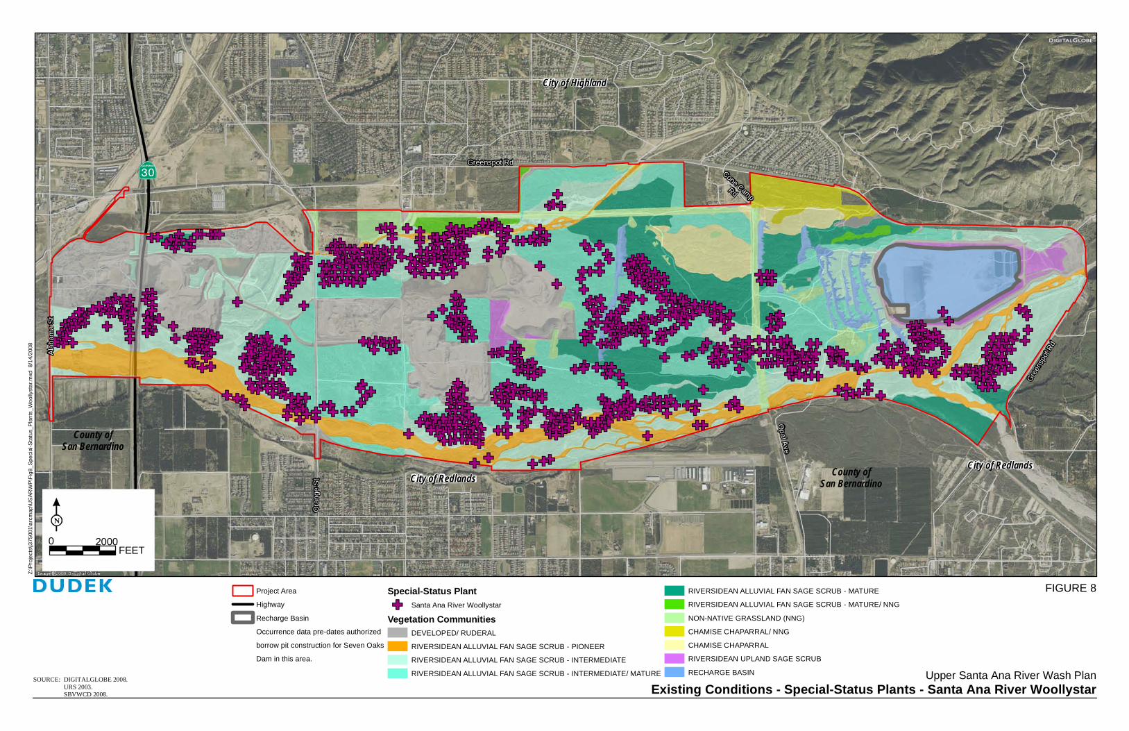
City of Highland
City of Redlands County ofSan Bernardino
Existing Conditions - Special-Status Plants - Santa Ana River WoollystarSOURCE: DIGITALGLOBE 2008. URS 2003. SBVWCD 2008.
County ofSan Bernardino
Greenspot Rd
Oran
ge St
Opal Ave
Alaba
ma S
t
Cone CampRd
Greens
pot Rd
Upper Santa Ana River Wash Plan
FEET20000
Project AreaHighwayRecharge BasinOccurrence data pre-dates authorizedborrow pit construction for Seven OaksDam in this area.
Special-Status PlantSanta Ana River Woollystar
Vegetation CommunitiesDEVELOPED/ RUDERALRIVERSIDEAN ALLUVIAL FAN SAGE SCRUB - PIONEERRIVERSIDEAN ALLUVIAL FAN SAGE SCRUB - INTERMEDIATERIVERSIDEAN ALLUVIAL FAN SAGE SCRUB - INTERMEDIATE/ MATURE
RIVERSIDEAN ALLUVIAL FAN SAGE SCRUB - MATURERIVERSIDEAN ALLUVIAL FAN SAGE SCRUB - MATURE/ NNGNON-NATIVE GRASSLAND (NNG)CHAMISE CHAPARRAL/ NNGCHAMISE CHAPARRALRIVERSIDEAN UPLAND SAGE SCRUBRECHARGE BASIN
City of Redlands
FIGURE 8
Z:\Pr
ojects
\j375
001\a
rcmap
\USA
RWP\F
ig8_S
pecia
l-Stat
us_P
lants_
Wooll
ystar
.mxd
8/14
/2008

Biological Technical Report Upper Santa Ana River Wash Plan
3750-01 44 October 2008
INTENTIONALLY LEFT BLANK

City of Highland
City of Redlands County ofSan Bernardino
Existing Conditions - Special-Status PlantsSOURCE: DIGITALGLOBE 2008. URS 2003. SBVWCD 2008.
County ofSan Bernardino
Greenspot Rd
Oran
ge St
Opal Ave
Alaba
ma S
t
Cone CampRd
Greens
pot Rd
Upper Santa Ana River Wash Plan
FEET20000
Project AreaHighwayRecharge BasinOccurrence data pre-dates authorizedborrow pit construction for Seven OaksDam in this area.
Special-Status PlantsParry’s SpineflowerPlummer’s Mariposa Lily
Robinson’s Pepper-GrassSlender-Horned Spineflower
Vegetation CommunitiesDEVELOPED/ RUDERALRIVERSIDEAN ALLUVIAL FAN SAGE SCRUB - PIONEERRIVERSIDEAN ALLUVIAL FAN SAGE SCRUB - INTERMEDIATERIVERSIDEAN ALLUVIAL FAN SAGE SCRUB - INTERMEDIATE/ MATURERIVERSIDEAN ALLUVIAL FAN SAGE SCRUB - MATURE
RIVERSIDEAN ALLUVIAL FAN SAGE SCRUB - MATURE/ NNGNON-NATIVE GRASSLAND (NNG)CHAMISE CHAPARRAL/ NNGCHAMISE CHAPARRALRIVERSIDEAN UPLAND SAGE SCRUBRECHARGE BASIN
City of Redlands
FIGURE 9
Z:\Pr
ojects
\j375
001\a
rcmap
\USA
RWP\F
ig9_S
pecia
l-Stat
us_P
lants.
mxd
8/18/2
008

Biological Technical Report Upper Santa Ana River Wash Plan
3750-01 46 October 2008
INTENTIONALLY LEFT BLANK

Biological Technical Report Upper Santa Ana River Wash Plan
3750-01 47 October 2008
Table 3 Special-Status Plants Observed within the Wash Plan Area
Status
Species Fed State CNPS Habitat and Distribution
Associated Habitats On Site
Associated Soils
On Site
Total Habitat On Site1 (Acres) Occurrence Data Occurrence Evaluation
Calochortus plummerae Plummer’s mariposa lily
None SP 1B.2 Sandy or rocky sites of (usually) granitic or alluvial material in valley and foothill grassland, coastal scrub, chaparral, cismontane woodland, and lower montane coniferous forest at 100 to 1,700 meters (300 to 5,600 feet) elevation. Known from the Santa Monica Mountains to San Jacinto Mountains in Riverside, San Bernardino, Los Angeles and Ventura Counties.
Chamise chaparral (all); Riversidean Alluvial Fan Sage Scrub (except pioneer); Riversidean Upland Sage Scrub
Soboba (all); Hanford (all)
2,128 This species was documented on site from the CNDDB (1), Robertson's Ready Mix Project (20) (Lilburn Corp. 1996), and Sunwest Material's Project (1) (Lilburn Corp. 1997)
All occurrences are expected to be extant. Additional individuals may occur within suitable habitat, most likely in the central portion of the study area, however overall population size is expected to be small to moderate.
Chorizanthe parryi var. parryi Parry’s spineflower
None SP 3.2 Dry sandy soils in chaparral and coastal sage scrub at 40 to 1,750 meters (100 to 5,700 feet) elevation. Known only from Riverside and San Bernardino Counties and possibly extending into Los Angeles County.
Chamise chaparral (all); Riversidean Alluvial Fan Sage Scrub (except pioneer); Riversidean Upland Sage Scrub
Hanford (all); Ramona (all); Soboba (all); Tujunga (all)
2,130 This species was documented on site from the Robertson's Ready Mix Project (3) (Lilburn Corp. 1996)
Two historic occurrences are expected to be extirpated due to past activities. Additional individuals may occur within suitable habitat, most likely in the central portion of the study area, however overall population size is expected to be small.
Dodecahema leptoceras Slender-horned spineflower
FE SE 1B.1 Gravel soils of Temecula arkose deposits in openings in chamise chaparral in the Vail Lake Area, or on sandy soils in opening in alluvial scrub usually late seral stage) in floodplain terraces and benches that receive overbank deposits every 50
Riversidean Alluvial Fan Sage Scrub (all)
Hanford (all); Psamments and Fluvents; Ramona (all);
2,970 This species was documented on site from the CNDDB (7), Robertson's Ready Mix Project (1) (Lilburn Corp. 1996), and Sunwest
All occurrences are expected to be extant. Distribution of species on site appears well established by previous survey; few additional individuals are

Biological Technical Report Upper Santa Ana River Wash Plan
Table 3 (Continued)
3750-01 48 October 2008
Status
Species Fed State CNPS Habitat and Distribution
Associated Habitats On Site
Associated Soils
On Site
Total Habitat On Site1 (Acres) Occurrence Data Occurrence Evaluation
to 100 years from generally large washes or rivers; 200 to 760 meters (600 to 2,500 feet) elevation. Los Angeles, Riverside, and San Bernardino Counties.
Soboba (all); Tujunga (all)
Material's Project (35) (Lilburn Corp. 1997)
expected.
Eriastrum densifolium ssp. sanctorum Santa Ana River woollystar
FE SE 1B.1 Sandy soils of floodplains and terraced fluvial deposits of the Santa Ana River and larger tributaries (Lytle and Cajon Creeks, lower portions of City and Mill Creeks) at 120 to 625 meters (400 to 2,100 feet) elevation in San Bernardino and Riverside Counties.
Riversidean Alluvial Fan Sage Scrub (all)
Hanford (all); Psamments and Fluvents; Ramona (all); Soboba (all); Tujunga (all)
2,970 This species was documented on site from the CNDDB (1), Robertson's Ready Mix Project (49) (Lilburn Corp. 1996), and Sunwest Material's Project (903) (Lilburn Corp. 1997)
Most occurrences are expected to be extant. Distribution of species on site appears well established by previous survey; few additional individuals are expected.
Lepidium virginicum var. robinsonii Robinson’s pepper-grass
None SP 1B.2 Dry soils in coastal sage scrub and chaparral, typically below 500 meters (1,600 feet) elevation. In California, known only from Los Angeles, range, Riverside, Santa Barbara, San Bernardino, and San Diego Counties. This species is small, inconspicuous, relatively difficult to identify, and often overlooked in biological surveys.
Chamise chaparral (all); Non-native Grassland; Riversidean Alluvial Fan Sage Scrub (all); Riversidean Upland Sage Scrub
Hanford (all); Ramona (all); Soboba (all); Tujunga (all)
2,209 This species was documented on site from the CNDDB (1)
One occurrence on site appears to have been extirpated by previous activities. Additional individuals may occur, however likelihood for a large population on site is low given lack of detection during other focused plant surveys.
Federal: FE : Federal Endangered State: SE California Endangered; ST: California Threatened; SP: CDFG Special Plant CNPS: List 1A : Presumed extinct List 1B: Plants rare and endangered in California and elsewhere List 2: Rare or Endangered in California, More Common Elsewhere List 3: Need More Information-Review List 1 Suitable habitat is listed for individual species within the entire Plan Area. These suitable habitat acres are not additive with other species’ suitable habitat acres since each vegetation community supports multiple species found within the Wash Plan area.

Biological Technical Report Upper Santa Ana River Wash Plan
3750-01 49 October 2008
Table 4 Special-Status Plants Expected to Occur
Status
Species Fed State CNPS Habitat and Distribution Associated
Habitats On Site Associated Soils
On Site
Total Habitat
On Site 1
(Acres) Occurrence Evaluation
Imperata brevifolia California satintail
None None 2.1 Wet areas below 500 meters (1,600 feet) elevation. Widespread in California and the western U. S. Also occurs in Mexico.
Riversidean Alluvial Fan Sage Scrub (pioneer only)
Psamments and Fluvents; Water
319 Suitable habitat on site is marginal.
Symphyotrichum defoliatum (Aster defoliatus) San Bernardino aster
None SP 1B.2 Vernally wet sites (such as ditches, streams, and springs) in many plant communities below 2,040 meters (6,700 feet) elevation. In California, known from Ventura, Kern, San Bernardino, Los Angeles, Orange, Riverside, and San Diego Counties.
Chamise chaparral (all); Non-native grassland (all); Riversidean alluvial fan sage scrub (all); Riversidean upland sage scrub
Hanford (all); Psamments and Fluvents; Ramona; Soboba (all); Tujunga; Water
3,165 No records of recent occurrences in project vicinity. Habitat on site is marginal or absent.
Federal: FE : Federal Endangered State: SE California Endangered; ST: California Threatened; SP: CDFG Special Plant CNPS: List 1A : Presumed extinct List 1B: Plants rare and endangered in California and elsewhere List 2: Rare or Endangered in California, More Common Elsewhere List 3: Need More Information-Review List 1 Suitable habitat is listed for individual species within the entire Plan Area. These suitable habitat acres are not additive with other species’ suitable habitat acres since each vegetation community supports multiple species found within the Wash Plan area.

Biological Technical Report Upper Santa Ana River Wash Plan
3750-01 50 October 2008
Table 5 Special-Status Plants Not Expected to Occur
Status Species Fed State CNPS
Habitat and Distribution Occurrence Evaluation
Berberis nevinii Nevin’s barberry
FE SE 1B.1 Gravelly wash margins in alluvial scrub, or coarse soils in chaparral; typically 275 to 825 meters (900 to 2,700 feet) elevation; Los Angeles, San Bernardino, Riverside, and San Diego Counties.
This species is a conspicuous perennial which has not been observed on site during recent surveys nor has it been recorded on site historically.
Carex comosa Bristly sedge
None SP 2.1 Bogs and fens, freshwater marshes and swamps, and lake margins below 425 meters (1,400 feet). Known from Lake, San Bernardino, Santa Cruz, San Francisco, Shasta, San Joaquin, and Sonoma Counties, and Idaho, Oregon, and Washington. The last known occurrence of this species in San Bernardino County was in 1882 and is believed extirpated.
This species has not been observed on site during recent surveys or is recorded on site historically. No suitable habitat on site.
Centromadia pungens ssp. laevis Smooth tarplant
None SP 1B.1 Alkaline areas in chenopod scrub, meadows, playas, riparian woodland, valley and foothill grassland below 480 meters (1,600 feet) elevation. Known from Riverside and San Bernardino Counties, extirpated from San Diego County.
This species has not been observed on site during recent surveys or is recorded on site historically. No suitable habitat on site.
Helianthus nuttallii ssp. parishii Los Angeles sunflower
None SP 1A Marshes and swamps (coastal salt and freshwater) in elevations from 10 to 500 meters (30 to 1,600 feet). This species is historically known from Los Angeles, Orange and San Bernardino Counties, California. Last seen in 1937. Presumed extinct.
This species has not been observed on site during recent surveys nor has it been recorded on site historically. No suitable habitat on site.

Biological Technical Report Upper Santa Ana River Wash Plan
Table 5 (Continued)
3750-01 51 October 2008
Status Species Fed State CNPS
Habitat and Distribution Occurrence Evaluation
Horkelia cuneata ssp. puberula Mesa horkelia
None SP 1B.1 Sandy or gravelly soils in chaparral, or rarely in cismontane woodland or coastal scrub at 70 to 825 meters (200 to 2,700 feet) elevation. Known from San Luis Obispo, Santa Barbara, Los Angeles, and Orange Counties. Believed extirpated from Ventura, San Bernardino, Riverside, and San Diego Counties.
This species has not been observed on site during recent surveys nor has it been recorded on site historically.
Lycium parishii Parish’s desert-thorn
None SP 2.3 Deciduous shrub of coastal scrub and Sonoran desert scrub at 305 to 1,000 meters (1,000 to 3,300 feet) elevation. In California, known from Imperial and San Diego Counties. Report from Riverside County is based on a misidentification. Known only historically from San Bernardino County (benches and/or foothills north of San Bernardino).
This conspicuous perennial species has not been observed on site during recent surveys nor has it been recorded on site historically.
Malacothanmus parishii Parish’s bush mallow
None SP 1A Known only from one occurrence in 1895, in chaparral and coastal sage scrub at 490 meters (1,600 feet) elevation in vicinity of San Bernardino. Presumed extinct.
This species has not been observed on site during recent surveys nor has it been recorded on site historically.
Monardella pringlei Pringle’s monardella
None SP 1A Sandy hills in coastal sage scrub at 300 to 400 meters (980 to 1,300 feet) elevation. Known only from two occurrences west of Colton. Last seen in 1941. Habitat lost to urbanization. Presumed extinct.
This species has not been observed on site during recent surveys nor has it been recorded on site historically. No suitable habitat on site.

Biological Technical Report Upper Santa Ana River Wash Plan
Table 5 (Continued)
3750-01 52 October 2008
Status Species Fed State CNPS
Habitat and Distribution Occurrence Evaluation
Rorippa gambelii Gambel’s water cress
FE ST 1B.1 Freshwater or brackish marshes and swamps; 5 to 330 meters (20 to 1,100 feet) elevation. Known from Los Angeles, Orange, San Diego, and San Luis Obispo Counties and Baja California.
This species has not been observed on site during recent surveys nor has it been recorded on site historically. No suitable habitat on site.
Sidalcea neomexicana Salt spring checkerbloom
None SP 2.2 Alkaline springs and marshes below 1,530 meters (5,000 feet) elevation. In California, known only from Los Angeles, Orange, Riverside, Santa Barbara, San Bernardino, and Ventura Counties.
This species has not been observed on site during recent surveys nor has it been recorded on site historically. No suitable habitat on site.
Sphenopholis obtusata Prairie wedge grass
None SP 2.2 Cismontane woodland, meadows and seeps/mesic, in elevations ranging from 300 to 2,000 meters (1,000 to 6,600 feet), in Amador, Fresno, Inyo, Mono, Riverside, San Bernardino, and Tulare Counties.
This species has not been observed on site during recent surveys nor has it been recorded on site historically. No suitable habitat on site.
Federal: FE : Federal Endangered State: SE California Endangered; ST: California Threatened; SP: CDFG Special Plant CNPS: List 1A : Presumed extinct List 1B: Plants rare and endangered in California and elsewhere List 2: Rare or Endangered in California, More Common Elsewhere List 3: Need More Information-Review List

Biological Technical Report Upper Santa Ana River Wash Plan
3750-01 53 October 2008
Table 6 Special-Status Wildlife Observed within the Wash Plan Area
Status Species Fed State Habitat and Distribution Associated Habitats On Site
Total Suitable Habitat On Site1 (Acres) Occurrence Data Occurrence Evaluation
Amphibians Spea (=Scaphiopus) hammondii Western spadefoot
None CSC Grasslands and occasionally hardwood woodlands; requires vernal pools (persisting for at least three weeks) for breeding; burrows in loose soils during dry season. Occurs in the Central Valley and adjacent foothills, the non-desert areas of southern California, and in Baja California.
Chamise chaparral/non-native grassland; Non-native grassland; Riversidean alluvial fan sage scrub (all)
3,251 This species was documented on site from the SBCM (1), and Sunwest Material's Project (not mapped) (Lilburn Corp. 1997)
Some occurrences are expected to be extirpated due to previous activities. Suitable habitat represents area where potential required microhabitat conditions may occur. Actual occupied area is expected to be limited to areas near seasonally ponded water such as in water conservation areas.
Fish Rhinichthys osculus ssp. 3 Santa Ana speckled dace
None CSC Found in riffles in small streams and shore areas with abundant gravel and rock within the headwaters of the Santa Ana and San Gabriel River drainages. Currently not found in the project site, but still found in Plunge Creek upstream from Greenspot Road Bridge. Historically found in Santa Ana River, Plunge Creek, City Creek, and Mill Creek, but has been extirpated.
None mapped. There is water in Plunge Creek most of the year which may provide marginal habitat for this species.
None mapped This species was documented on site from the SBCM (1).
The existing mapped locality has been developed as part of previous activities and the population has likely been extirpated. Some potential exists within Plunge Creek, but no suitable habitat (i.e., areas of consistent perennial water) have been identified.
Reptiles Anniella pulchra pulchra Silvery legless lizard
None CSC Inhabits moist loose soil and humus from central California to northern Baja California.
Riversidean alluvial fan sage scrub (all) 3,020 This species was documented on site from the Robertson's Ready Mix Project (not mapped) (Lilburn Corp. 1996)
May occur throughout suitable habitat.
Aspidoscelis tigris stejnegeri Coastal western whiptail
None SA Wide variety of habitats including coastal sage scrub, sparse grassland, and riparian woodland; coastal and inland valleys and foothills; Ventura County to Baja California.
Chamise chaparral/non-native grassland; Non-native grassland; Riversidean alluvial fan sage scrub (all); Riversidean upland sage scrub
3,263 This species was documented on site from the Robertson's Ready Mix Project (not mapped) (Lilburn Corp. 1996) and Sunwest Material's Project (not mapped) (Lilburn Corp. 1997)
May occur throughout suitable habitat.
Phrynosoma coronatum blainvillei Coast (San Diego) horned lizard * Note: CDFG 2008 Special Animals list includes only coast horned lizard and calls out blainvilii population
None CSC Occurs in annual grassland, coastal sage scrub, chaparral, and woodland communities. Prefers open country, especially sandy areas, washes, and floodplains. Requires open areas for sunning, bushes for cover, patches of loose soil for burial, and an abundant supply of ants or other insects. Occurs in non-desert areas from Santa Barbara, Ventura, Kern, and Los Angeles Counties south to Baja California at elevations below 1,830 meters (6,000 feet).
Chamise chaparral/non-native grassland; Non-native grassland; Riversidean alluvial fan sage scrub (all); Riversidean upland sage scrub
3,263 This species was documented on site from CNDDB (2) (2003), SBCM (13), Robertson's Ready Mix Project (not mapped) (Lilburn Corp. 1996) and Sunwest Material's Project (not mapped) (Lilburn Corp. 1997)
Most locations are likely still extant. Species may occur throughout suitable habitat.
Birds Accipiter cooperii (nesting) Cooper’s hawk
None WL (per current
2008 list) Primarily forests and woodlands throughout North America. Increasingly common in urban habitats. Nests in tall trees, especially pines. Occasionally nests in isolated trees in more open areas.
Forage = Riversidean alluvial fan sage scrub (all); Riversidean upland sage scrub
3,097* This species was observed foraging over the site from the Robertson's Ready Mix Project (not mapped) (Lilburn Corp. 1996) and Sunwest Material's Project (not mapped) (Lilburn Corp. 1997). This species is not expected to nest on site.
Species may forage throughout suitable habitat.
Aimophila ruficeps canescens Southern California rufous-crowned sparrow
None CSC Steep, rocky coastal sage scrub and open chaparral habitats, particularly scrubby areas mixed with grasslands. From Santa Barbara County to northwestern Baja California.
Chamise chaparral/non-native grassland; Riversidean alluvial fan sage scrub (all); Riversidean upland sage scrub
3,097* This species was documented on site from SBCM (9), Robertson's Ready Mix Project (not mapped) (Lilburn Corp. 1996) and Sunwest Material's Project (not mapped) (Lilburn Corp. 1997)
Two historic locations are likely extirpated due to previous activities; many locations are likely extant. Species may occur throughout suitable habitat.

Biological Technical Report Upper Santa Ana River Wash Plan
Table 6 (Continued)
3750-01 54 October 2008
Status Species Fed State Habitat and Distribution Associated Habitats On Site
Total Suitable Habitat On Site1 (Acres) Occurrence Data Occurrence Evaluation
Amphispiza belli belli Bell’s sage sparrow
BCC CSC Occupies chaparral and coastal sage scrub from west central California to northwestern Baja California.
Chamise chaparral; Chamise chaparral/non-native grassland; Riversidean alluvial fan sage scrub (all); Riversidean upland sage scrub
3,164 This species was documented on site from the Robertson's Ready Mix Project (not mapped) (Lilburn Corp. 1996) and Sunwest Material's Project (not mapped) (Lilburn Corp. 1997)
Species may occur throughout suitable habitat.
Aquila chrysaetos Golden eagle
BCC WL, CFP Generally open country of the Temperate Zone worldwide. Nesting primarily in rugged mountainous country. Uncommon resident in southern California.
Forage = Chamise chaparral/non-native grassland; Non-native grassland; Riversidean alluvial fan sage scrub (mature/NNG and pioneer)
664* This species was observed flying over the site Robertson's Ready Mix Project (not mapped) (Lilburn Corp. 1996) and Sunwest Material's Project (not mapped) (Lilburn Corp. 1997).
This species is not expected to occur regularly or nest on site.
Athene cunicularia (burrow sites) Western burrowing owl
BCC CSC Open country in much of North and South America. Usually occupies ground squirrel burrows in open, dry grasslands, agricultural and range lands, railroad rights-of-way, and margins of highways, golf courses, and airports. Often utilizes man-made structures, such as earthen berms, cement culverts, cement, asphalt, rock, or wood debris piles.
Chamise chaparral/non-native grassland; Non-native grassland; Riversidean alluvial fan sage scrub (all); Riversidean upland sage scrub
3,323 This species was documented on site from the SBCM (2).
Some occurrences are expected to be extirpated due to previous activities. Suitable habitat represents area of potential required microhabitat conditions. Actual occupied area is expected to be limited to areas that contain key micro-site conditions such as berms, road shoulders, and suitable burrows.
Campylorhynchus brunneicapillus sandiegensis Coastal (San Diego) cactus wren
BCC CSC The cactus wren is a non-migratory resident of the coastal sage scrub plant community. Occupies southern cactus scrub, maritime succulent scrub, cactus thickets in coastal sage scrub.
Riversidean alluvial fan sage scrub (all except pioneer); Riversidean upland sage scrub
2,699 This species was documented on site from SBCM (5), Robertson's Ready Mix Project (not mapped) (Lilburn Corp. 1996) and Sunwest Material's Project (not mapped) (Lilburn Corp. 1997)
Mapped locations are likely extant. Suitable habitat represents area of potential required microhabitat conditions. Actual occupied area is expected to be limited to areas with dense cactus.
Dendroica petechia brewsteri (nesting) California yellow warbler
None CSC Riparian woodland while nesting in the western U.S. and northwestern Baja California; more widespread in brushy areas and woodlands during migration and winter, when occurring from western Mexico to northern South America. Migrants belonging to other subspecies are widespread and common.
None None mapped This species was observed from the Sunwest Material's Project (not mapped) (Lilburn Corp. 1997)
Suitable riparian habitat has not been mapped within the project site. Species may occur in small patches of riparian habitat although the extent of such habitat is expected to be very limited.
Elanus leucurus (nesting) White-tailed kite
None CFP Typically nests in riparian trees such as oaks, willows, and cottonwoods at low elevations. Forages in open country. Found in South America and in southern areas and along the western coast of North America.
Forage = Chamise chaparral/non-native grassland; Riversidean alluvial fan sage scrub (all); Riversidean upland sage scrub
3,323* This species was observed foraging over the site from the Robertson's Ready Mix Project (not mapped) (Lilburn Corp. 1996) and Sunwest Material's Project (not mapped) (Lilburn Corp. 1997). This species is not expected to nest on site.
Species may forage throughout suitable habitat.
Eremophila alpestris actia California horned lark
None CSC Open grasslands and fields, agricultural area, open montane grasslands. This subspecies is resident from northern Baja California northward throughout non-desert areas to Humboldt County, including the San Joaquin Valley and the western foothills of the Sierra Nevada (north to Calaveras County). During the breeding season, this is the only subspecies of horned lark in non-desert southern California; however, from September through April or early May, other subspecies visit the area.
Chamise chaparral/non-native grassland; Non-native grassland; Riversidean alluvial fan sage scrub-pioneer; Riversidean alluvial fan sage scrub-intermediate
1,745 This species was documented on site from the Robertson's Ready Mix Project (not mapped) (Lilburn Corp. 1996) and Sunwest Material's Project (not mapped) (Lilburn Corp. 1997)
Species may occur throughout suitable habitat.

Biological Technical Report Upper Santa Ana River Wash Plan
Table 6 (Continued)
3750-01 55 October 2008
Status Species Fed State Habitat and Distribution Associated Habitats On Site
Total Suitable Habitat On Site1 (Acres) Occurrence Data Occurrence Evaluation
Falco mexicanus (nesting) Prairie falcon
None CSC Open country in much of North America. Nests in cliffs or rocky outcrops; forages in open arid valleys and agricultural fields. Rare in southwestern California.
Forage = Chamise chaparral/non-native grassland; Non-native grassland; Riversidean alluvial fan sage scrub (mature/NNG and pioneer)
664* This species was observed flying over the site Robertson's Ready Mix Project (not mapped) (Lilburn Corp. 1996) and Sunwest Material's Project (not mapped) (Lilburn Corp. 1997). This species is not expected to nest on site.
Species may forage throughout suitable habitat.
Lanius ludovicianus (nesting) Loggerhead shrike
None CSC Open fields with scattered trees or shrubs, open country with short vegetation, pastures, old orchards, cemeteries, golf courses, riparian areas, and open woodlands. Found in open country in much of North America.
Chamise chaparral; Chamise chaparral/non-native grassland; Non-native grassland; Riversidean alluvial fan sage scrub (all); Riversidean upland sage scrub
3,375 This species was documented on site from SBCM (6), Robertson's Ready Mix Project (not mapped) (Lilburn Corp. 1996) and Sunwest Material's Project (not mapped) (Lilburn Corp. 1997)
Mapped locations are likely extant. Species may forage throughout suitable habitat.
Polioptila californica californica Coastal California gnatcatcher
FT CSC Inhabits coastal sage scrub in low-lying foothills and valleys in cismontane southwestern California and Baja California.
Riversidean alluvial fan sage scrub (all); Riversidean upland sage scrub
3,097 This species was documented on site from CNDDB (1) (2003), SBCM (2), USFWS (2) (2003)
One mapped location expected to be extirpated due to previous activities. Species may occur throughout suitable habitat, but is mainly expected in the central portion of the study area near mapped locations.
Mammals Chaetodipus fallax fallax Northwestern San Diego pocket mouse
None CSC Found in sandy herbaceous areas, usually associated with rocks or coarse gravel in coastal scrub, chaparral, grasslands, and sagebrush, from Los Angeles County through southwestern San Bernardino, western Riverside, and San Diego Counties to northern Baja California.
Chamise chaparral/non-native grassland; Non-native grassland; Riversidean alluvial fan sage scrub (all); Riversidean upland sage scrub
3,275 This species was trapped on site from the Robertson's Ready Mix Project (not mapped) (Lilburn Corp. 1996), Sunwest Material's Project (not mapped) (Lilburn Corp. 1997), URS (297, not mapped) (URS October 26, 2000; 2000a, 2000b;2003a-2003d), McKernan and Crook (256, not mapped) (McKernan and Crook 1995)
Species may occur throughout suitable habitat.
Dipodomys merriami parvus San Bernardino kangaroo rat
FE CSC Gravelly and sandy soils of alluvial fans, braided river channels, active channels and sandy terraces; San Bernardino Valley (San Bernardino County) and San Jacinto Valley (Riverside County).
Riversidean alluvial fan sage scrub-pioneer; Riversidean alluvial fan sage scrub-intermediate
1,519 This species was documented on site from SBCM (30 locations), and was trapped from the Robertson's Ready Mix Project (not mapped) (Lilburn Corp. 1996) and Sunwest Material's Project (not mapped) (Lilburn Corp. 1997), URS (170 individuals, not mapped) (October 26, 2000; 2000a, 2000b;2003a-2003d), McKernan and Crook (246 individuals, 7 locations mapped) (1995)
Approximately 7 of 37 mapped locations are expected to have been extirpated due to previous activities. Species is expected to occur throughout suitable habitat.
Dipodomys merriami parvus San Bernardino kangaroo rat- Critical Habitat
FE CSC See above See above 1,517 See above See above
Eumops perotis Western mastiff bat
None CSC Occurs in many open, semi-arid to arid habitats, including conifer and deciduous woodlands, coastal scrub, grasslands, chaparral, etc.; roosts in crevices in vertical cliff faces, high buildings, trees, and tunnels, and travels widely when foraging.
Chamise chaparral; Chamise chaparral/non-native grassland; Non-native grassland; Riversidean alluvial fan sage scrub (all); Riversidean upland sage scrub
3,435 E.p. californicus was observed foraging over the site. Sunwest Material's Project (Lilburn Corp. 1997)
Species may forage throughout suitable habitat; not expected to roost on site.

Biological Technical Report Upper Santa Ana River Wash Plan
Table 6 (Continued)
3750-01 56 October 2008
Status Species Fed State Habitat and Distribution Associated Habitats On Site
Total Suitable Habitat On Site1 (Acres) Occurrence Data Occurrence Evaluation
Lepus californicus bennettii San Diego black-tailed jackrabbit
None CSC Variety of habitats including herbaceous and desert scrub areas, early stages of relatively open habitats. Restricted to the cismontane areas of southern California, extending from the coast to the Santa Monica, San Gabriel, San Bernardino, and Santa Rosa Mountain ranges.
Chamise chaparral/non-native grassland; Non-native grassland; Riversidean alluvial fan sage scrub-pioneer; Riversidean alluvial fan sage scrub-intermediate; Riversidean upland sage scrub
1,769 This species was documented on site from the Robertson's Ready Mix Project (not mapped) (Lilburn Corp. 1996) and Sunwest Material's Project (not mapped) (Lilburn Corp. 1997)
Species may occur throughout suitable habitat.
Neotoma lepida intermedia San Diego desert woodrat
None CSC Frequents poorly vegetated arid lands and is especially associated with cactus patches. Occurs along the Pacific slope from San Luis Obispo County to northwest Baja California.
Chamise chaparral/non-native grassland; Non-native grassland; Riversidean alluvial fan sage scrub-mature/non-native grassland
311 This species was trapped on site from the Robertson's Ready Mix Project (not mapped) (Lilburn Corp. 1996) and Sunwest Material's Project (not mapped) (Lilburn Corp. 1997), URS (86, not mapped) (URS October 26, 2000; 2000a, 2000b;2003a, 2003b, 2003d), McKernan and Crook (155, not mapped) (McKernan and Crook 1995).
Species may occur throughout suitable habitat.
Onychomys torridus ramona Southern grasshopper mouse
None CSC Arid habitats, especially scrub habitats with friable soils. Coastal scrub, mixed chaparral, sagebrush, low sage and bitterbrush habitats. Arid portions of southwestern California and northwestern Baja California.
Chamise chaparral/non-native grassland; Non-native grassland; Riversidean alluvial fan sage scrub (all); Riversidean upland sage scrub
3,323 This species was trapped on site from the Robertson's Ready Mix Project (not mapped) (Lilburn Corp. 1996) and Sunwest Material's Project (not mapped) (Lilburn Corp. 1997)
Species may occur throughout suitable habitat.
Perognathus longimembris brevinasus Los Angeles pocket mouse
None CSC Prefers sandy soil for burrowing, but has been found on gravel washes and stony soils. Found in coastal scrub in Los Angeles, Riverside, and San Bernardino Counties.
Riversidean alluvial fan sage scrub-pioneer; Riversidean alluvial fan sage scrub-intermediate
1,519 This species was documented on site from the SBCM (7).
Mapped locations are expected to be extant. Species may occur throughout suitable habitat.
*Foraging habitat only. No suitable nesting habitat on site. 1 Suitable habitat is listed for individual species within the entire Plan Area. These suitable habitat acres are not additive with other species’ suitable habitat acres since each vegetation community supports multiple species found within the Wash Plan area. Federal: FE: Federal Endangered FT: Federal Threatened FC: Federal Candidate for listing as Threatened or Endangered BCC: Bird of Conservation Concern
State: SE: California Endangered ST: California Threatened CFP: California Fully Protected CSC: California Species of Special Concern WL: CDFG Watch List Species SA: CDFG Special Animal

Biological Technical Report Upper Santa Ana River Wash Plan
3750-01 57 October 2008
Table 7 Special-Status Wildlife Expected to Occur
Status Species Fed State
Habitat and Distribution Total Habitat On Site1 (Acres)
Associated Habitats On Site
Potential to Occur
Occurrence Evaluation
Reptiles Crotalus ruber ruber Northern red-diamond rattlesnake
None CSC Desert scrub, thornscrub, open chaparral and woodland; occasional in grassland and cultivated areas. Prefers rocky areas and dense vegetation. Morongo Valley in San Bernardino and Riverside Counties to the west and south to Baja California.
3,374 Chamise chaparral; Chamise chaparral/non-native grassland; Non-native grassland; Riversidean alluvial fan sage scrub (all); Riversidean upland sage scrub
There is suitable habitat for this species.
Expected to occur throughout suitable habitat.
Mammals Taxidea taxus American badger
None CSC Primary habitat requirements seem to be sufficient food and friable soils in relatively open uncultivated ground in grasslands, woodlands, and desert. Widely distributed in North America.
3,323 Chamise chaparral/non-native grassland; Non-native grassland; Riversidean alluvial fan sage scrub (all); Riversidean upland sage scrub
There is suitable habitat for this species.
Some potential to occur throughout suitable habitat, although on-site population would be expected to be small given surrounding urbanization.
Federal: FE Federal Endangered FT: Federal Threatened FC: Federal Candidate for listing as Threatened or Endangered BCC: Bird of Conservation Concern
State: SE: California Endangered ST: California Threatened CFP: California Fully Protected CSC: California Species of Special Concern WL: CDFG Watch List Species SA: CDFG Special Animal
1 Suitable habitat is listed for individual species within the entire Plan Area. These suitable habitat acres are not additive with other species’ suitable habitat acres since each vegetation community supports multiple species found within the Wash Plan area.

Biological Technical Report Upper Santa Ana River Wash Plan
3750-01 58 October 2008
Table 8 Special-Status Wildlife Not Expected to Occur
Status Species Fed State Habitat and Distribution Occurrence Evaluation
Invertebrates Rhaphiomidas terminatus abdominalis Delhi sands flower loving fly
FE SA Restricted to Delhi series sands in western Riverside and San Bernardino Counties.
No suitable habitat on site.
Carolella busckana Busck’s gallmoth
None SA Habitat requirements unknown. This species has a low probability to occur on site. Only known occurrence from the project vicinity is in Loma Linda and is believed to have been extirpated.
Fish Catostomus santaanae Santa Ana sucker
FT CSC The Santa Ana sucker’s historical range includes the Los Angeles, San Gabriel, and Santa Ana River drainage systems located in southern California. An introduced population also occurs in the Santa Clara River drainage system in southern California. Found in shallow, cool, running water.
No suitable habitat on site.
Gila orcutti Arroyo chub
None CSC Perennial streams or intermittent streams with permanent pools; slow water sections of streams with mud or sand substrates; spawning occurs in pools. Native to Los Angeles, San Gabriel, San Luis Rey, Santa Ana, and Santa Margarita River systems; introduced in Santa Ynez, Santa Maria, Cuyama, and Mojave River systems and smaller coastal streams.
No suitable habitat on site.
Amphibians Rana muscosa Mountain yellow-legged frog
FE CSC Ponds, lakes, and streams at moderate to high elevation; appears to prefer bodies of water with open margins and gently sloping bottom. Sierra Nevada Mountains and Transverse Ranges.
No suitable habitat on site.
Reptiles Diadophis punctatus modestus San Bernardino ringneck snake
None SA Under surface objects along drainage courses, in mesic chaparral and oak and walnut woodland communities. Moist habitats of southwestern California from about Ventura to Orange Counties.
No suitable habitat on site.

Biological Technical Report Upper Santa Ana River Wash Plan
Table 8 (Continued)
3750-01 59 October 2008
Status Species Fed State Habitat and Distribution Occurrence Evaluation
Thamnophis hammondii Two-striped garter snake
None CSC Highly aquatic. Only in or near permanent sources of water. Streams with rocky beds supporting willows or other riparian vegetation. From Monterey County to northwest Baja California.
No suitable habitat on site.
Birds Coccyzus americanus occidentalis (nesting) Western yellow billed cuckoo
FC SE Breeds and nests in extensive stands of dense cottonwood/willow riparian forest along broad, lower flood bottoms of larger river systems at scattered locales in western North America; winters in South America.
No suitable habitat on site.
Empidonax traillii extimus Southwestern willow flycatcher
FE SE Rare and local breeder in extensive riparian areas of dense willows or (rarely) tamarisk, usually with standing water, in the southwestern U.S. and (formerly?) northwestern Mexico. Winters in Central and South America.
No suitable habitat on site.
Icteria virens (nesting) Yellow-breasted chat
None CSC Riparian thickets of willow, brushy tangles near watercourses. Nests in riparian woodland throughout much of western North America. Winters in Central America.
No suitable habitat on site.
Vireo bellii pusillus Least Bell’s vireo
FE SE Riparian forests and willow thickets. Nests from central California to northern Baja California. Winters in southern Baja California.
No suitable habitat on site.
Mammals Lasiurus xanthinus Western yellow bat
None SA Occurs in southern California in palm oases and in residential areas with untrimmed palm trees. Roosts primarily in trees, especially the dead fronds of palm trees. Forages over water and among trees.
No suitable habitat on site.
Federal: FE: Federal Endangered FT: Federal Threatened FC: Federal Candidate for listing as Threatened or Endangered BCC: Bird of Conservation Concern
State: SE: California Endangered ST: California Threatened CFP: California Fully Protected CSC: California Species of Special Concern WL: CDFG Watch List Species SA: CDFG Special Animal

Biological Technical Report Upper Santa Ana River Wash Plan
3750-01 60 October 2008
INTENTIONALLY LEFT BLANK

Biological Technical Report Upper Santa Ana River Wash Plan
3750-01 61 October 2008
5.1 Listed Species
5.1.1 Santa Ana River Woollystar
Status
Santa Ana River woollystar was federally listed as endangered on September 28, 1987 (52 Federal Register 36265), and state-listed as endangered in January 1987. The species is on the California Native Plant Society’s List 1B.1. Critical habitat has not been designated for the Santa Ana River woollystar.
Habitat and Habitat Associations
The Santa Ana River woollystar is found only within open washes and early-successional alluvial fan scrub on open slopes above main watercourses on fluvial deposits where flooding and scouring occur at a frequency that allows the persistence of open shrublands. Suitable habitat is comprised of a patchy distribution of gravelly soils, sandy soils, rock mounds and boulder fields (Zembal and Kramer 1984; Zembal and Kramer 1985; USFWS 1986). Suitable habitat typically contains low amounts of clay, silt and micro-organic materials (Burk et al. 1989). These areas typically maintain a perennial plant cover of less than 50%. Associated perennial plants include California buckwheat, California croton, yerba santa and scalebroom (Burk et al. 1989; Zembal and Kramer 1984; Zembal and Kramer 1985). The Santa Ana River woollystar is an early-successional species and possibly requires flood-mediated habitat rejuvenation (Wheeler and Burk 1990). Sheet flood flows probably occur in this habitat every one hundred to two hundred years (USFWS 1986). A 1989 study of woollystar habitats and surrounding habitats revealed that the% cover of European annuals is lowest in woollystar habitats (Burk et al. 1989).
Biology
Genetics: The Santa Ana River woollystar is one of five subspecies of the perennial sub-shrub Eriastrum densifolium. This species exhibits complex morphological variation and the subspecies are difficult to distinguish (Brunell and Whitkus 1993). Based on a study of nineteen quantitative characters, the single morphological variation within Eriastrum densifolium is corolla tube length: the Santa Ana River woolly star has a significantly longer corolla than the other four subspecies (Brunell and Whitkus 1999a).
The results of an analysis of cross-compatibility confirmed that the species is self-incompatible but indicates that each of the subspecies is compatible with the other subspecies. Viable seeds were produced by 54 pair-wise crosses of individuals from 24 populations, representing all five subspecies (Brunell and Whitkus 1999b).

Biological Technical Report Upper Santa Ana River Wash Plan
3750-01 62 October 2008
A genetic study using Random Amplified Polymorphic DNA (RAPD) markers indicates no major discontinuity between the Santa Ana River woollystar and other subspecies: Santa Ana River woollystar is not a member of a distinct genetic population group. RAPD marker variation within E. densifolium is a continuum and differentiation among populations is related to geographic distance not morphological characteristics. The subspecies appear to be polyphyletic: to have developed from more than one ancestral type (Brunell and Whitkus 1994; Brunell and Whitkus 1997). On the subspecies level, an enzyme electrophoresis study indicated genetic variation within E. densifolium ssp. sanctorum is higher than expected for an endemic taxon. The degree of allozyme diversity indicates the lack of inbreeding or recent population bottlenecks; this subspecies is not as genetically vulnerable as other endemic taxa (Brunell and Rieseberg 1993).
Reproduction: Santa Ana River woollystar blooms from June to August (Munz 1974). This obligate outcrosser has bright lavender-blue flowers that occur in heads of about twenty large (over one and a quarter inches long) blossoms (Burk et al. 1989). Pollen release occurs before the stigma of the same flower becomes receptive so pollen gatherers are unlikely pollinators. According to field observations by Burk et al. (1989), of the eight insect families and a hummingbird observed visiting woollystar, only digger bees, an anise swallowtail butterfly, a hummingbird and the giant flower-loving fly are capable of reaching the woollystar flower. The giant flower-loving fly (Raphiomidas actoni ssp. actoni) was found to be the most abundant pollinator at one Santa Ana River woollystar population (Burk et al. 1989). The peak abundance of the giant flower-loving fly correlates with Santa Ana River woollystar flowering and the flower-loving fly depends on sandy substrate for reproduction. These two species may be mutually dependent at some locations (Burk et al. 1989). At other population sites, the digger bee (Micranthophora flavocincta) or hummingbirds (including the black-chinned hummingbird, Archilochus alexandri) were observed to be the most abundant pollinator (Muñoz 1991 as cited in Jigour and Roberts 1996; Erickson 1993; Chambers 1993).
Scarification of seeds is not necessary and the optimum germination temperature is approximately 60°F. Leaching by one inch of simulated rainfall significantly increases germination as compared to wetted seeds. Seed viability is high: up to 99% (Burk et al. 1989). Germination follows early winter rains; however, many of the seedlings die in the following spring and summer (Chambers 1993).
Dispersal: A study by Burk et al. (1989) during the 1986-87 growing season revealed that 900 to 1000 seeds were produced per plant and 92% fell within one foot of the parent plant. Sixty inches (five feet) was the longest dispersal distance observed. Woollystar outer seed coats form a mucilaginous (sticky) mass that binds the seed to surrounding soil particles. Therefore, longer

Biological Technical Report Upper Santa Ana River Wash Plan
3750-01 63 October 2008
dispersal distances probably are associated with flood events (Burk et al. 1989; Jigour and Roberts 1996).
Demography: Studies have shown that Santa Ana River woollystar seedlings are more successful in recently flooded habitat (Wheeler and Burk 1990; Burk et al. 1989). Average life span for the woolly-star individual is five years and the oldest individual observed was ten years (Burk et al. 1989).
Known Distribution
The Santa Ana River woollystar occurs from about 150 to 580 meters above mean see level (AMSL) along the Santa Ana River and Lytle and Cajon Creek flood plains from the base of the San Bernardino Mountains in San Bernardino County southwest along the Santa Ana River through Riverside County into the Santa Ana Canyon of northeastern Orange County (Munz 1974; Patterson 1993; Roberts 1998; Zembal and Kramer 1985; Patterson and Tanowitz 1989).
Status in Wash Plan Area
Data reviewed includes the CNDDB, the USFWS database, the San Bernardino County Museum, the UCR herbarium and available literature. There are 952 occurrences of Santa Ana River woollystar recorded in the Wash Plan Area; one occurrence was from the CNDDB, four occurrences were from the UCR herbarium, 49 occurrences were from the Robertson's Ready Mix Project reports (Lilburn Corporation 1996) and 903 occurrences were from the Sunwest Materials Project reports (Lilburn Corporation 1997). The species occurs along the floodplain of the Santa Ana River, Plunge Creek and Mill Creek. Of the 952 occurrences, 41 were mapped in developed areas and may no longer be extant. The remaining occurrences were mapped in Riversidean upland sage scrub; pioneer, intermediate and mature Riversidean alluvial fan sage scrub; disturbed habitat and the recharge basins.
Special Biological Considerations
This species is a low shrubby perennial that blooms from June to August. There are three primary pollinators: long-tongued digger bee, giant flower-loving fly and hummingbirds. The importance of a particular pollinator type appears to depend on habitat type within the floodplain. Due to high seedling mortality rates, this life stage is the most critical for survival of the species (Chambers 1993). This species is associated with early- to moderate- successional alluvial scrub, and thus requires periodic flooding and silting for the creation of new habitats and colonization. Sustaining Santa Ana River woollystar will require maintaining a portion of the Santa Ana River alluvial floodplain and possibly artificially reestablishing protected habitats adjacent to aging woollystar populations for future colonization (Burk et al. 1989).

Biological Technical Report Upper Santa Ana River Wash Plan
3750-01 64 October 2008
Threats to Species
This species is threatened by floodplain modification for flood control purposes and development; flood control management (clearing for channel maintenance and construction of flood control structures); off-road vehicle activity; grazing (resulting in heavy weed cover); farming; sand and gravel mining; and loss of habitat and competition with aggressive non-native species such as European grasses and river cane (Arundo donax) (Zembal and Kramer 1985; Burk et al. 1989; USFWS 1986).
5.1.2 Slender-horned Spineflower
Species Description
Status
Slender-horned spineflower was federally listed as endangered on September 28, 1987 (52 Federal Register 36265) and state-listed as endangered in January 1982. The species is on the California Native Plant Society’s List 1B.1. Critical habitat has not been designated for the slender-horned spineflower.
Habitat and Habitat Associations
At the majority of sites, slender-horned spineflower is found in sandy soil in association with mature alluvial scrub (Reveal and Hardham 1989; Rey-Vizgirdes 1994). In the Vail Lake area in Riverside County this species is also associated with gravel soils of Temecula arkose deposits in association with open chamise chaparral (Boyd and Banks 1995; Gordon-Reedy 1997). Prigge et al. (1993) found that the ideal habitat appears to be a terrace or bench that receives overbank deposits every 50 to 100 years.
Cryptogrammic crusts are frequently present in areas occupied by slender-horned spineflower (Boyd and Banks 1995; USFWS 1986). These crusts on the soil surface are composed of associations of bryophytes (mosses), algae, lichens, and some xerophytic liverworts (Harper and Marble 1988 as cited in USFWS 1996). Cryptogrammic crusts enable soils to retain moisture and may help suppress invasion by non-native plant species (Boyd and Banks 1995; USFWS 1996).
Biology
Genetics: Slender-horned spineflower was described as Centrostegia leptotheca by Goodman (1934 as cited in Reveal and Hardham 1989); however, morphological characters and cytological studies indicate that this species is unique. Therefore, slender-horned spineflower has been placed in a monospecific genus (Reveal and Hardham 1989).

Biological Technical Report Upper Santa Ana River Wash Plan
3750-01 65 October 2008
Although this species is protandrous (anthers develop earlier than the stigma), suggesting that slender-horned spineflower is an obligate outcrosser (USFWS 1996), Reveal (1989 as cited in Prigge, et al. 1993) determined that slender-horned spineflower is self-compatible. Because the population sizes are large enough (hundreds to thousands of individuals), it is doubtful that this species is experiencing a genetic bottleneck (Reveal 1989 as cited in Prigge, et al. 1993).
Reproduction: This herbaceous annual blooms from April through June and has white to pink flowers (1.2 to 2 mm in length). The flowers produce small (1.7 to 2 mm long), brown or black achenes (Reveal and Hardham 1989). Because slender-horned spineflower is an annual and a spring-bloomer, it is expected to germinate following winter precipitation (Prigge, et al. 1993).
Dispersal: The involucre of the slender-horned spineflower has six ascending awns and six descending awns, suggesting that this species ideally suited for animal dispersal. Potential dispersal agents include coyotes, rabbits, rodents and deer. Dispersal may also occur via flood water or wind (Prigge, et al. 1993; USFWS 1996).
Demography: Slender-horned spineflower has a spreading habit and is sparsely glandular (Reveal and Hardham 1989). This annual is small and prostrate, with heights of 5 to 15 cm and diameters of 3 to 10 cm (USFWS 1986).
Known Distribution
Slender-horned spineflower is endemic to southwestern cismontane California, ranging from central Los Angeles County east to San Bernardino County, and south to southwestern Riverside County in the foothills of the Transverse and Peninsular Ranges, at 200 to 700 meters elevation (Hickman 1993). Only eight areas are still known to support slender-horned spineflower, including two localities each in Los Angeles County (Bee Canyon and Big Tijunga Wash), and two in San Bernardino County (the Santa Ana River Wash and Cajon Wash) (Reveal and Hardham 1989; Rey-Vizgirdes 1994; CNDDB 2000). There are four areas known to support slender-horned spineflower in western Riverside County: Temescal Wash, upper San Jacinto River, and the north flank of Agua Tibia Mountains (at Arroyo Seco and Kolb Creek) (Prigge et al. 1993; CNDDB 2000, Rey-Vizgardes 1994; Gordon-Reedy 1997; Banks 1999).
Status in Wash Plan Area
Data reviewed includes the CNDDB, the USFWS database, the San Bernardino County Museum, the UCR herbarium and available literature. There are 44 occurrences of slender-horned spineflower recorded in the Wash Plan Area; seven occurrences were from the CNDDB, one occurrence was from the UCR herbarium, one occurrence was from the Robertson's Ready Mix Project reports (Lilburn Corporation 1996) and 35 occurrences were form the Sunwest

Biological Technical Report Upper Santa Ana River Wash Plan
3750-01 66 October 2008
Materials Project reports (Lilburn Corporation 1997). The species occurs along the floodplain of the Santa Ana River and Plunge Creek. Of the 44 occurrences, three were mapped in disturbed areas. The remaining 41 occurrences were mapped in intermediate and mature Riversidean alluvial fan sage scrub.
Special Biological Considerations
This species is generally dependent on mature alluvial scrub that is maintained by periodic flooding and sediment transport. It is important for the survival of this species that adequate alluvial scrub habitat and active fluvial processes be maintained. Individuals are small, and thus may be difficult to locate. This species is only readily detectable in the spring between April and June when in bloom. Population size varies considerably from year to year depending upon rainfall.
Threats to Species
This species is threatened by urbanization, off-road vehicle use, sand and gravel mining, trampling associated with recreation, flood control measures (i.e., constriction of the floodplain, dams, etc.), and competition from non-native plant species (USFWS 1986; Prigge et al. 1993).
5.1.3 Coastal California Gnatcatcher
Status
The coastal California gnatcatcher was federally listed as threatened on March 25, 1993 (50 CFR Part 17 RIN 1018-AB56). The species is not listed as threatened or endangered by the state of California, but is designated a Special Concern species. Critical habitat was proposed for the species on April 24, 2003 (50 CFR Part 17 RIN 1018-AI72). Critical habitat has not yet been made final. The proposed critical habitat area does not include any portion of the Wash Plan Area. The California gnatcatcher is also on the United States Bird Conservation Watch List and the Audubon Watch List.
Habitat and Habitat Associations
The coastal California gnatcatcher (gnatcatcher), a subspecies of the California gnatcatcher, is a small member of the thrush family (Muscicapidae). The gnatcatcher typically occurs in or near sage scrub habitat, which is a broad category of vegetation that includes the following plant communities as classified by Holland (1986): Venturan coastal sage scrub, Diegan coastal sage scrub, maritime succulent scrub, Riversidean upland sage scrub, Riversidean alluvial fan sage scrub, southern coastal bluff scrub, and coastal sage-chaparral scrub. Coastal sage scrub is composed of relatively low-growing, dry-season deciduous and succulent plants. Characteristic

Biological Technical Report Upper Santa Ana River Wash Plan
3750-01 67 October 2008
plants of this community include California sagebrush, various species of sage (Salvia sp.), California buckwheat, lemonadeberry, California encelia, and Opuntia spp. Ninety-nine percent of all gnatcatcher locality records occur at or below an elevation of 984 feet (Atwood 1990).
Coastal sage scrub is patchily distributed throughout the range of the gnatcatcher, and the gnatcatcher is not uniformly distributed within the structurally and floristically variable coastal sage scrub community. Rather, the subspecies tends to occur most frequently within the California sagebrush-dominated stands on mesas, gently sloping areas, and along the lower slopes of the coastal ranges (Atwood 1990). An analysis of the percent gap in shrub canopy supports the general impression that gnatcatchers prefer relatively open stands of coastal sage scrub (Bontrager 1991). The gnatcatcher occurs in high frequencies and densities in scrub with an open or broken canopy, while it is absent from scrub dominated by tall shrubs and occurs in low frequencies and densities in low scrub with a closed canopy (Weaver 1998). The territory size increases as vegetation density decreases and with distance from the coast, probably due to food resource availability. Thus, gnatcatchers will use even sparsely vegetated coastal sage scrub for shelter and to forage for insects as long as perennial shrubs are available (ERCE 1990).
Gnatcatchers also use chaparral, grassland, and riparian or alluvial habitats where they occur adjacent to sage scrub (Bontrager 1991). The use of these habitats appears to be most frequent during late summer, autumn, and winter, with smaller numbers of birds using such areas during the breeding season. These non-sage scrub habitats are used for dispersal, but data on dispersal use are largely anecdotal (Bowler 1995; Campbell et al. 1995). Although existing quantitative data may reveal relatively little about gnatcatcher use of these other habitats, these areas may be critical during certain times of the year for dispersal or as foraging areas during drought conditions (Campbell et al. 1998). Breeding territories have also been documented in non-sage scrub habitat. Campbell et al. (1998) discuss likely hypotheses explaining why non-CSS habitat is used by gnatcatchers including food source availability, dispersal areas for juveniles, temperature extremes, fire avoidance, and lowered predation rate for fledglings.
Environmental, vegetational, and food-abundance characteristics are important aspects of territory quality; however, they are related to the time of year when the evaluation is made (Redak et al. 1997). Based on the studies of Redak et al. (1997) during the breeding season, habitat use was negatively associated with distance to the coast and the elevation of the territory. The habitat use was positively associated with the abundance of adult stages of beetles, flies, spiders and larval stages of all arthropods. Plots with high densities of California sagebrush, flat-topped buckwheat, and white sage were also used by birds. In contrast, during the non-breeding season, the correlation of habitat use with vegetation and location variables remained but the correlation was no longer present with the invertebrate communities.

Biological Technical Report Upper Santa Ana River Wash Plan
3750-01 68 October 2008
Biology
Genetics: The coastal California gnatcatcher was originally described as a distinct species by Brewster (1881) based on specimens, however, Grinnell (1926) concluded that it was a subspecies of the black-tailed gnatcatcher (Polioptila melanura) which is widely distributed throughout the Sonoran and Chihuahuan deserts of the southwestern United States and Mexico. Atwood (1980, 1988) concluded that the species was specifically distinct from P. melanura, based on differences in ecology and behavior, which was adopted by the American Ornithologists’ Union Committee on Classification and Nomenclature (American Ornithologists Union 1957, 1989, 2003). Recent mitochondrial DNA sequencing confirmed the species-level recognition of the Coastal California gnatcatcher, which was calculated to differ from the black-tailed gnatcatcher (P. melanura) by 4.0%, similar to differences calculated in the black-capped gnatcatcher (P. nigriceps) and white-lored gnatcatcher (P. albiloris) (Zink and Blackwell 1998).
Diet and Foraging: The coastal California gnatcatcher is primarily insectivorous, non-migratory, and exhibits strong site tenacity (Atwood 1990). The diet deduced from fecal samples resulted in leaf- and plant hoppers and spiders predominating the samples. True bugs, wasps, bees, and ants were only minor components of the diet (Burger et al. 1999). Gnatcatcher adults selected prey to feed their young that was larger than expected given the distribution of arthropod size available in their environment, and chicks were provisioned with larger prey items and significantly more grasshoppers and crickets and spiders. Both adults and young consumed more sessile than active prey items (Burger et al. 1999).
The richness of the insect community within a habitat area may be a useful tool for describing the quality of the habitat (Burger et al. 1996). This is especially important for strictly insectivorous species such as the coastal California gnatcatcher. Gnatcatcher habitat use has been positively associated with total insect species richness and total individual insect abundance (Redak et al. 1996). Thus overall food abundance and diversity plays an important role in territory selection and use for this species (Redak et al. 1996). Habitat use during the non-breeding season showed no clear relationship to any component of the invertebrate community (Redak et al. 1997).
Daily Activity: Activity budget data indicate that gnatcatchers are most active and vocal during the morning. A lull in activity usually occurs during mid-day and activity increases again late in the day (Mock et al. 1990).
Reproduction: The breeding season of the gnatcatcher extends from mid February through mid-August, with the peak of nesting activity occurring from mid-March through mid-May. The gnatcatcher nest is a small, cup-shaped basket usually found one to three feet above the ground in a small shrub or cactus. Clutch sizes range between three and five eggs, with the average

Biological Technical Report Upper Santa Ana River Wash Plan
3750-01 69 October 2008
being four. Juvenile birds associate with their parents for several weeks (sometimes months) after fledging (Atwood 1990). The coastal California gnatcatcher is a year-round resident. Nest building begins during the mid part of March with the earliest recorded egg date approximately March 20 (Mock et al. 1990). Post-breeding dispersal of fledglings occurs between late May and late November. Predation may be a major source of nest failure (Bontrager 1991; Grishaver et al. 1998).
Nest site attendance by male gnatcatchers was determined to be equal to that of females for the first nest attempt and then decline to almost one-third of that of the female for later nesting attempts (Sockman 1998).
The frequency with which various plant species have been recorded as nesting substrata indicates the overall preference of the sage scrub community as the habitat type (Atwood 1980). California sagebrush was chosen 25% of the time with other species including white sage, black sage, chamise, cholla, buckthorn, orange, lemonadeberry, and others making up the balance of nest shrub selections (Atwood 1980).
Survival: Gnatcatchers are persistent nest builders and often attempt multiple broods typically upon nesting failure, which is suggestive of a high reproductive potential. This is, however, typically offset by high rates of nest predation and brood parasitism (Atwood 1990). High rates of nest failure may account for the high number of nesting attempts of the coastal California gnatcatcher (Grishaver et al. 1998). In western Riverside County, 78.9% of the nesting attempts failed with 52.9% suffering from nest predation (Braden 1999). Gnatcatchers typically live for two to three years, although ages of up to five years have been recorded for some banded birds (Braden et al. 1995). Most of the juvenile birds usually die during the cold winter months, although the percentage was not quantified. Observations indicate that gnatcatchers are highly vulnerable to extreme cold, wet weather (Mock et al. 1990).
Dispersal: Dispersal is a means by which genetic and demographic exchange between subpopulations maintains the viability of the regional metapopulation (Bailey and Mock 1998). Details regarding the dispersal effect on genetic and demographic connectivity of subpopulations and the actual requirements for dispersal are largely unknown (Rotenberry and Scott 1998) but some information can be documented from anecdotal observations. The mean dispersal distance of gnatcatchers banded as nestlings for males was 2.85 km and for females was 3.33 km (Atwood et al. 1996). Mean dispersal of juveniles in Orange County was found to be 1.05 km with one individual dispersing a total of 7.55 km (Galvin 1998). Although the mean dispersal distances that have been documented above are relatively low, dispersal of juveniles is difficult to observe and to document without extensive banding studies. It is likely that the few current studies underestimate the gnatcatcher’s typical dispersal capacity because of the difficulty of

Biological Technical Report Upper Santa Ana River Wash Plan
3750-01 70 October 2008
detecting (Bailey and Mock 1998). Juvenile coastal California gnatcatchers are apparently able to traverse highly man-modified landscapes, including non-native landscaping vegetation, for at least short distances and this underestimation of the species’ dispersal capability can lead to an overestimation of the metapopulation’s vulnerability to extinction (Bailey and Mock 1998). A few observations of gnatcatcher dispersal behavior indicate that a stepping stone linkage, that is, a serious of small patches of suitable habitat interspersed with developed habitat, is deemed acceptable for situations where the habitat is otherwise fragmented and no contiguous linkage is available (Bailey and Mock, 1998). Additionally, natural and restored coastal sage scrub habitat along highway corridors has been documented to be used for foraging and nesting by gnatcatchers and may serve important dispersal functions (Famolaro and Newman 1998). Typically, however, the dispersal of juveniles requires a corridor of native vegetation which provides foraging and cover opportunities to link larger patches of appropriate sage scrub vegetation (Soule 1991). These dispersal corridors may facilitate the exchange of genetic material and provide a path for recolonization of areas from which the species has been extirpated and may provide increased mating opportunities for unpaired birds (Soule 1991; Galvin 1998).
Socio-Spatial Behavior: The coastal California gnatcatcher seems to become highly territorial by late February or early March each year. Males seem to be very vocal during this time period (Mock et al. 1990). In San Diego County the territory size for inland sites was calculated to range between 13 and 39 acres per pair, averaging 24 acres per pair (ERCE 1990). In Riverside County, it was estimated that about 24 acres of sage scrub habitat was required per pair of coastal California gnatcatchers (Braden 1998, pers. comm.). The distribution of the gnatcatcher is thought to be related to elevation with most of the birds located below 250 m elevation within 35 km of the coast and 500 meter elevation for inland regions (Atwood and Bolsinger 1992). During the non-breeding season, gnatcatchers have been observed to wander in adjacent territories and unoccupied habitat increasing their home range size to approximately 78% larger than their breeding territory (Preston et al. 1998). Estimates of the territory size should be examined with caution as the calculation may be influenced by differences in data collection and analysis (Atwood et al. 1998).
Coastal California gnatcatchers are most often observed in pairs even in the non-breeding season. They appear to maintain their territories and are relatively sedentary throughout the year (Dunn and Garrett 1987). In fact vocalization rates, which may provide communication within the pair, were highest from August through March (Preston et al. 1998).
Community Relationships: Predation occurs in greater proportion in the upper and lower one third of the nest shrub. Predation was lower in nests with full clutch sizes which may indicate the parents are more attentive to the nest after the clutch is complete (Sockman 1997). Potential

Biological Technical Report Upper Santa Ana River Wash Plan
3750-01 71 October 2008
predators include scrub jays, greater roadrunners, and cactus wrens which have been observed to be actively mobbed by the gnatcatcher (Bontrager 1991). The coastal California gnatcatcher also is known to be affected by nest parasitism of the brown-headed cowbird. However, the gains in nest success from decreased nest parasitism appear to be negated by increased nest abandonment due to predation before cowbirds have migrated into an area (Braden et al. 1997). Thus, although a cowbird trapping program may reduce parasitism significantly and lower abandonment due to parasitism, nest predation then increases and negates the benefit of the trapping program (Braden et al. 1997). Nest parasitism apparently has resulted in earlier nesting dates of the gnatcatcher which may help compensate for the negative affect of parasitism (Patten and Campbell 1998).
Although the coastal California gnatcatcher may serve as an adequate “umbrella species” for other species that occur in similar habitats and that require a similar territory size or smaller (Fleury et al. 1998), it is not a particularly good indicator of bird-species richness in coastal sage scrub habitat (Chase et al. 1998).
Known Distribution
Historically, the coastal California gnatcatcher occurred from southern Ventura County southward through Los Angeles, Orange, Riverside, San Bernardino, and San Diego counties, and into Baja California, Mexico, to approximately 30° north latitude near El Rosario (Atwood 1990). A detailed analysis of elevational limits associated with gnatcatcher locality records reveals that a significant portion, 65 to 70% of the historic range, may have been located in southern California rather than Baja California (USFWS 2000). The gnatcatcher was considered locally common in the mid-1940s, but by the 1960s this subspecies had declined substantially in the United States owing to widespread destruction of its habitat (Atwood 1990). Currently, the subspecies occurs on coastal slopes of southern California, ranging from southern Ventura southward through Palos Verdes Peninsula in Los Angeles County through Orange, Riverside, San Bernardino and San Diego Counties into Baja California to El Rosario, Mexico, at about 30° north latitude (Atwood 1991). In 1993, the USFWS estimated that approximately 2,562 pairs of gnatcatchers remained in the United States. Of these, 30 pairs occurred in Los Angeles County, 757 pairs occurred in Orange County, 261 pairs occurred in Riverside County, and 1,514 pairs occurred in San Diego County.
Status in Wash Plan Area
Data reviewed includes the CNDDB, the USFWS database, the San Bernardino County Museum and available literature. There are five occurrences of coastal California gnatcatcher in the Wash Plan Area; two occurrences are found in the San Bernardino County Museum database, two in the USFWS database, and one in CNDDB. Occurrences were located within mature Riversidean alluvial fan sage scrub in a land use area currently designated as flood plain, and in pioneer

Biological Technical Report Upper Santa Ana River Wash Plan
3750-01 72 October 2008
Riversidean alluvial fan sage scrub in a land use area currently designated as water ways. The locations are in the central portion of the Wash Plan Area.
Special Biological Considerations
Knowledge of the demography of a population is fundamental to determining long-term trends. For birds, the demographic parameters of primary importance are annual breeding success, defined as number of chicks fledged per pair, and recruitment, defined as percentage of fledglings that enter the breeding population. A preliminary demographic model for a population of coastal California gnatcatchers based on observed data was prepared by Woehler et al. (1995). Based on the results, for the population to be stable, each breeding pair must replace themselves over their lifetime. The data from a population at U.C. Irvine had a 90% mortality (that is, a 10% recruitment) and produced 0.64 fledglings per egg. In western Riverside County, 78.9% of the nesting attempts failed which translates to an approximately 80% mortality (Braden 1999). Thus, for the U.C Irvine example, a pair must produce 30 eggs during their lifetime and must live for five years for the population to remain stable (Woehler et al. 1995).
Gnatcatcher populations appear to be inversely correlated to seasonal total rainfall (Erickson and Miner 1998). Thus increased rainfall during the winter is a mixed blessing in that it is likely that it increases winter mortality but may increase the productivity of the invertebrate prey population base (Erickson and Miner 1998). Other weather-related factors that may influence the distribution of the gnatcatcher include the January mean minimum temperature which, for the coastal California gnatcatcher, has been estimated to be approximately 2.5°C (Mock 1998). This metabolic constraint may preclude gnatcatchers, as a sedentary bird, from occupying otherwise suitable habitat within their range (Mock 1998). This link between a species distribution and physiological adaptations to the climate has been shown previously for other bird species (Hayworth and Weathers 1984).
Gnatcatchers nested earlier, had more successful nests, produced more fledglings, had a longer nesting period, and had lower fledgling costs when their territories were associated with increased grass and forb cover, increased perennial structure, increased horizontal perennial homogeneity, decreased vertical perennial homogeneity, and decreased perennial diversity (Braden et al. 1997). Thus, assessment of habitat quality should take into account these variables for preserve planning.
A habitat-based metapopulation model developed for the coastal California gnatcatcher revealed that the model predicted a fast decline and high risk of population extinction with most combinations of population parameters. The results were most sensitive to density-dependent effects, the probability of weather-related catastrophes, adult survival, and adult fecundity (Akcakaya and Atwood 1997). However, this metapopulation model resulted in the greatest

Biological Technical Report Upper Santa Ana River Wash Plan
3750-01 73 October 2008
difference on a time horizon of only a few decades. This may be appropriate if the model is used to compare alternative management options but not to make assessments with longer time horizons (Akcakaya and Atwood 1997). Studies providing information on long-scale demography and metapopulation variables are still largely unknown (Rotenberry and Scott 1998).
Structure of the perennial vegetation within coastal sage scrub seems to be an important component leading to successful gnatcatcher reproduction (Braden, 1997). Any disturbance that affects perennial structure and homogeneity within gnatcatcher territories, such as fire or grazing, also may affect gnatcatcher fitness (Braden, 1997). In general, recently burned areas are not used by gnatcatchers except on an occasional basis, and five to seven years of recovery may be necessary before gnatcatchers will nest in burned areas (Atwood et al. 1998, Beyers et al. 1994). This slow recovery of coastal sage scrub may be due to invasion of exotic annuals after any disturbance and may also be affected by invasion of exotic annuals, as well as air pollution (O’Leary and Westman 1988; O’Leary (1990). The frequency of fires in wildland areas tends to increase as fragmentation increases due to urbanization and agricultural activity.
Fire may be an important factor to consider in the conservation design for this species and management plans may be necessary to provide a strategic framework for merging the needs for the species with the challenges of fire control (Mackey et al. 1994). Consideration of habitat refugia, burn frequency, and recolonization of recovering burn areas will be necessary for designing reserves for this species (Atwood, et al. 1998). Observations after a major fire of coastal sage scrub reveal that a large proportion of the gnatcatchers within the burned area were displaced to adjacent habitat rather than killed outright and were packed more densely into remaining areas of intact coastal sage scrub (Atwood, et al. 1998). On unburned areas within San Diego and Riverside counties, two pairs per hectare were found, but only 0.02 pair per hectare were found on burned areas (Mayer and Wirtz 1995). However, the gnatcatchers that are able to establish territories on burned areas appear to breed at rates very similar to those on unburned sites (Wirtz and Mayer 1995). The extent and timing of vegetation recovery may determine the habitat suitability for breeding pairs (Wirtz and Mayer 1995).
The presence of gnatcatchers within burned areas may indicate post-fire dispersal or the availability of refugia from the fire (Mayer and Wirtz 1995). Frequent burning of coastal sage scrub may lead to domination of the site by introduced grasses, in addition, burned sage scrub often remains unsuitable for breeding gnatcatchers for a number of years after burning (ERCE 1991, Zedler et al. 1983, O’Leary 1990). At an inland site, burned 12 years earlier, there was less than 10% shrub cover and no gnatcatchers, while annual grasses and mustard species dominated the site (Beyers et al. 1994). Management consideration will need to take into account that large scale fires may damage gnatcatcher populations in both the burned area and the refugia area

Biological Technical Report Upper Santa Ana River Wash Plan
3750-01 74 October 2008
(Atwood et al. 1998). Duplicate linkages also provide for the temporary loss of function of the coastal sage scrub habitat in the event of a fire (Campbell et al. 1998). A duplicity of habitat linkages composed of sage scrub and other undeveloped habitats which may be composed of native as well as non-native habitats may provide for dispersal ability of the species (Campbell et al. 1998).
Other factors that will be relevant for designing a reserve system for the gnatcatcher will be the dispersal distance and average territory size. In western Riverside County, the average dispersal distance for juvenile gnatcatchers has been documented as 1.14 km (Braden et al., 1994a). The distances may be influenced by many factors such as sex, reproductive opportunities, available habitat and other factors. The average territory size for gnatcatchers is 8.42 acres during the breeding season and can expand to 60 acres during the non-breeding season (Braden and Powell, 1994b). A reserve design for this species will need to maintain connections of breeding habitat such that dispersal between areas can be accomplished and that are large enough to accommodate the largest territory sizes.
Linkages of habitat along linear features such as highways and power-line corridors may be of significant value in linking populations of the gnatcatcher (Famolaro and Newman 1998). Stepping stone linkages which are designed to function as habitat linkages are acceptable but should be line of sight as much as possible (Bailey and Mock 1998). The width of a linkage is recommended to be approximately 1,200 feet. This will provide a linkage wide enough to support a gnatcatcher territory. For linkages less than this width, the gnatcatchers currently mapped for occurring within the linkage may not be able to remain within the area. In the case of narrow habitat widths, the linkage will serve the function of connection of habitat areas only. An important linkage of habitat to maintain or encourage is that from the western Riverside County area north into San Bernardino County (Davis et al. 1998). This linkage is within the Jurupa Hills and connects to the Santa Ana River in Riverside County (Davis et al. 1998). Recently, gnatcatchers have been observed within Jurupa Hills although the area is not surveyed regularly (Davis et al. 1998).
The coastal California gnatcatcher may be suitably analyzed on a landscape or habitat basis rather than on a data point basis due to the fact that it responds well to habitat management and will readily occupy revegetated coastal sage scrub (O’Connell and Erickson 1998, Miner et al. 1998). The fact that gnatcatchers will occupy revegetated coastal sage scrub makes this an important component of long-term management for the species (O’Connell and Erickson 1998). In one study, restored habitat was included in 19 of 22 gnatcatcher territories and nests in restored areas were as likely to produce at least one young as nests in naturally generated scrub (Miner et al. 1998). Additionally, in this study, 13% of the nests were placed within 3 meters of actively used roads or trails and their success rate was similar to that of nests placed further from

Biological Technical Report Upper Santa Ana River Wash Plan
3750-01 75 October 2008
these high-use areas, thus breeding success of gnatcatchers appears not to be negatively affected by current management practices and levels of public use within park areas. (Miner et al. 1998). Given that this study was conducted within specific State Park areas, additional studies would be helpful for other situations.
The continued fragmentation of habitat over time has increased exposure of gnatcatcher to threats associated with habitat edge (Atwood 1993). Numerous nest predators thrive on habitat edges, and brood parasitism by the brown-headed cowbird (Molothrus ater) appears to be exacerbated by increased edge effects (Bolger et al. 1997, Atwood 1993). Management of edge effects of future development may also be needed although there is little evidence that coastal California gnatcatchers are negatively affected by having their territory located at the edge of urban development (Atwood, 1998). This may be more associated with the use of the gnatcatcher of sage scrub/grassland ecotone. In support of this observation, studies of “edge/fragmentation reduced” species versus “edge/ fragmentation enhanced” species places the coastal California gnatcatcher in an “edge/fragmentation insensitive” category (Bolger et al. 1997). This is a category occupied by the characteristic species of shrub habitats in the region. They tend to be abundant and widely distributed across the landscape and habitat gradients although their abundance is much lower than the other species in the group (Bolger et al. 1997). Other forms of edge management may still be required. Management may include fencing areas occupied by gnatcatchers to protect birds from human and other intruders. Management may include exotic plant removal along edges of development or planting with native shrubs. Analysis of the current shrub cover to shrub cover and composition in 1934 indicates a drastic reduction in native species and increase in non-native grasses and forbs (Minnich and Dezzani 1998).
Threats to Species
In 1997, the total number of gnatcatchers in the United States was estimated at 2,899 pairs, after subtracting out all gnatcatcher pairs authorized for Take under Habitat Loss Permits, approved natural Community Conservation Plans, Habitat Conservation Plans, and section 7 consultations (“Reinitiation of formal consultation on implementation of the special rule for the Coastal California gnatcatcher [1-6-93-FW-37R1]”). This apparent increase in abundance since 1993 is likely the result of additional surveys occurring within previously unsurveyed areas, as well as increased productivity in response to favorable climatic conditions (USFWS 2000).
Although observed declines in numbers and distribution of the gnatcatcher resulted from numerous factors, habitat destruction, fragmentation and adverse modification are the principal reasons for the gnatcatcher's current threatened status (USFWS 1993). The amount of coastal sage scrub available to gnatcatchers has continued to decrease during the period after the listing of the species. It is estimated that up to 90% of coastal sage scrub vegetation has been lost as a

Biological Technical Report Upper Santa Ana River Wash Plan
3750-01 76 October 2008
result of development and land conversion (Westman 1981a, 1981b; Barbour and Major 1977), and coastal sage scrub is considered to be one of the most depleted habitat types in the United States (Kirkpatrick and Hutchinson 1977; Axelrod 1978; Klopatek et al. 1979, Westman 1987; O'Leary 1990). The fragmentation of habitat may artificially increase populations in adjacent preserved habitat; however, these population surpluses may be lost in subsequent years due to crowding and lack of resources (Scott 1993). In addition, agricultural use, such as grazing and field crops, urbanization, air pollution, increases in fire frequency and the introduction of exotics have all had an adverse impact on extant sage scrub habitat. A consequence of urbanization that is contributing to the loss, degradation, and fragmentation of coastal sage scrub is an increase in wildfires due to anthropogenic ignitions (human caused fires). High fire frequencies and the lag period associated with recovery of the vegetation may significantly reduce the viability of affected subpopulations of the gnatcatcher (USFWS 1991).
5.1.4 San Bernardino Kangaroo Rat
Status
The San Bernardino kangaroo rat was emergency federally listed as endangered on January 27, 1998 (63 Federal Register 3835) and a final rule determining the San Bernardino kangaroo rat to be endangered was published on September 24, 1998 (63 Federal Register 51005). A proposed rule for designation of critical habitat for the San Bernardino kangaroo rat was published on December 8, 2000 (65 Federal Register 77178) and the final rule for critical habitat was published on April 23, 2002 (67 Federal Register 19812). The San Bernardino kangaroo rat is a California Special Concern Species. The entire Wash Plan area, with the exception of the borrow pit area constructed as part of the Seven Oaks Dam project, is within designated Critical Habitat for San Bernardino kangaroo rat.
Habitat and Habitat Associations
The following habitat description draws heavily upon the San Bernardino kangaroo rat habitat assessment conducted by URS (2003a) for the San Bernardino Valley Water Conservation District.
The San Bernardino kangaroo rat, a subspecies of the Merriam’s kangaroo rat (Dipodomys merriami), typically is found in Riversidean alluvial fan sage scrub and sandy loam soils, alluvial fans and flood plains, and along washes with nearby sage scrub (McKernan 1997 as cited in USFWS 1998). Braden and McKernan (2000) suggest that the San Bernardino kangaroo rat also occurs in other habitats in their range, including chaparral and even disturbed areas that are associated with alluvial processes.

Biological Technical Report Upper Santa Ana River Wash Plan
3750-01 77 October 2008
Riversidean alluvial fan sage scrub vegetation within the Santa Ana River floodplain is comprised of three primary seral stages of alluvial fan sage scrub: pioneer, intermediate, and mature phases.
Pioneer phase alluvial fan sage scrub is the initial colonizing stage where recent scouring and flood events have occurred. This phase is characterized by very sparse distributions of subshrubs dominated by bristly goldenaster (Heterotheca sessiflora spp. echiodes) and scalebroom. Because of typically recent scouring and flooding and the lack of a well-developed vegetation community, pioneer phase alluvial fan sage scrub is less suitable for the San Bernardino kangaroo rat compared to intermediate alluvial fan sage scrub. URS (2003) argued that even though San Bernardino kangaroo rats may be captured in pioneer alluvial fan sage scrub during trapping programs, it should be considered “the least likely place” for San Bernardino kangaroo rat because of the lack of habitat requirements suitable for establishing burrow systems. However, these areas are integral to the overall habitat system and life history of the San Bernardino kangaroo rat with regard to temporary use and dispersal and potential succession to more suitable habitat over time.
Intermediate phase alluvial fan sage scrub is comprised mainly of subshrubs such as California buckwheat, brittlebush, yerba santa, our Lord’s candle, deerweed, valley cholla, and coastal prickly-pear. Intermediate phase alluvial fan sage scrub typically occur on terraces above scoured channels. Intermediate phase alluvial fan sage scrub is considered the highest quality habitat for the San Bernardino kangaroo rat because this phase retains open, sandy areas favored by the species. Intermediate phase alluvial fan sage scrub is expected to support the highest densities of the San Bernardino kangaroo rat of the three primary seral stages.
Mature phase alluvial fan sage scrub typically occurs on higher terraces away from the active flood channel that have not been subjected to flooding and scouring for many years. The mature phase is characterized by large woody species such as California juniper, our Lord’s candle, chamise, holly-leaved cherry (Prunus ilicifolia), sugarbush, spiny redberry, hoaryleaf ceanothus. Because the mature phase is characterized by relatively dense vegetation with few sandy openings, it is considered less suitable for the San Bernardino kangaroo rat than the intermediate phase. However, as with the pioneer stage, San Bernardino kangaroo rats may occasionally use mature alluvial fan sage scrub (as well as adjacent upland areas) and it may serve an important refugia function during large flood events (USFWS 2000).
The San Bernardino kangaroo rat typically occupies sandy loam substrates that allow for the digging of simple, shallow burrows (McKernan 1997 as cited by USFWS 1998). D. merriami, and other kangaroo rat species, actively avoid rocky substrates (Brown and Harney 1993). The large majority of the Plan Area supports Soboba stony loam sand, with a substantial component

Biological Technical Report Upper Santa Ana River Wash Plan
3750-01 78 October 2008
of psamments (sands) and fluvents within the historic active channels (NRCS Soil Survey Geographic [SSURGO] Database 2004). There are smaller pockets of Cieneba sandy loam and Hanford coarse sandy loam. All these soils are suitable for the San Bernardino kangaroo rat either as burrowing habitats, where the soils have been consolidated by vegetation as occurs in intermediate alluvial fan sage scrub, or as foraging habitat in pioneer alluvial fan sage scrub.
Biology
There are few specific studies of the subspecies San Bernardino kangaroo rat, but there is a substantial literature for the species D. merriami. The information presented in this section largely is for the species, with specific reference to the San Bernardino kangaroo rat where appropriate.
Genetics: Williams et al. (1993) provides descriptions for 19 subspecies of D. merriami. Patton and Rogers (1993a, 1993b) provide reviews of what is known of the cytogenetics (e.g., chromosomal variation) and biochemical genetics (e.g., isozyme and allozyme analyses, DNA sequencing) of heteromyid rodents, the rodent family to which D. merriami belongs. Patton and Rogers generally conclude that the understanding of heteromyid genetics is still relatively poor, the data are uneven, and that few studies have applied recent technical developments (e.g., DNA fingerprinting and sequencing). As of 1993, the only biochemical technique applied to heteromyids is protein electrophoresis, a relatively crude analytic tool by today’s standards. Of interest to conservation planning would be any information relating genetics to habitat fragmentation and isolation, demography, habitat tolerance, and speciation. Unfortunately, very little information in the literature is available to address these issues.
D. merriami has 52 chromosomes and there is no reported karyotypic variation in the species (Patton and Rogers 1993a). The proportion of gene loci that are polymorphic among individuals ranges from 0.06 to 0.16 and the mean proportion of loci that are heterozygotic within individuals ranges from 0.00 to 0.061. These values, as well as values for other kangaroo rat species, are relatively low compared to other mammals (Patton and Rogers 1993b). (Patton and Rogers [1993b] caution that these summary statistics probably contain large sampling error as well as other important sources of error that limit their interpretation. Also, protein electrophoresis cannot provide the fine-grain genetic analysis possible with DNA fingerprinting and other recent techniques.) Studies of electromorphic distance for D. merriami also indicate high degrees of genetic similarity. Although Lidicker (1960) remarked that the San Bernardino kangaroo rat was noticeably smaller and more differentiated compared to other D. merriami, there is no existing evidence that it is genetically distinct from other subspecies. Furthermore, there are no genetic studies of different populations of the San Bernardino kangaroo rat to

Biological Technical Report Upper Santa Ana River Wash Plan
3750-01 79 October 2008
address the effects of habitat fragmentation and isolation, demography, or other issues relevant to conservation planning.
The only genetic demographic study of D. merriami identified by Patton and Rogers (1993b) was a study of spatial relationships among individual genotypes in a population of D. merriami on a 10-acre study site near Kramer, California by Johnson and Selander (1971). This study concluded, in Patton and Rogers’ words, “that spatial clustering of genotypes was evident at two loci, and suggested that local structure, including the possibility of inbreeding, may characterize local kangaroo rat populations.” page 264. However, their findings did not include statistical corroboration of this finding and these results must be interpreted as very preliminary.
Diet and Foraging: Many studies have reported on the diet of D. merriami (see Reichman and Price 1993 for a comprehensive review), but no specific studies have been conducted on the San Bernardino kangaroo rat. Nonetheless, it is unlikely that the San Bernardino kangaroo rat exhibits meaningfully different feeding patterns compared to other subspecies of D. merriami that would be relevant for conservation planning. D. merriami are primarily granivores (seed eaters), but they ingest herbaceous material and insects when available (Bradley and Mauer 1971; Reichman and Price 1993). They collect seeds from the substrate into fur-lined cheek pouches for transport and then store them in scattered surface caches in the vicinity of their home burrows for later retrieval and consumption (Daly et al. 1992a). Unlike some larger kangaroo rat species (e.g., D. spectabilis), D. merriami do not hoard seeds to a central location (i.e., larder hoarding). Bipedal locomotion in kangaroo rats allows them to travel large distances over open ground very quickly and exploit widely scattered food sources.
Daily Activities: D. merriami, and all other kangaroo rats, are primarily nocturnal animals, but they also exhibit crepuscular behavior around dusk and dawn. They emerge from their day burrows around dusk to engage in foraging and other activities. Animals may be active any hour of the night, but the heaviest concentration of activity tends to occur in the three- to four-hour time span just after dusk. They usually return permanently to their day burrows before dawn (Behrends et al. 1986a). Factors affecting the amount and patterns of surface activity of individuals include: (1) sex and reproductive condition, with reproductive active males traveling farther than female or males with regressed testes (Behrends et al. 1996a); and (2) moonlight, with animals reducing surface activity and shifting activity toward places with relatively dense cover (Lockard and Owings 1974; Price et al. 1984). Daly et al. (1992b) found that D. merriami shifted from nocturnal activity during full moon to more crepuscular activity during dawn and dusk periods, suggesting a more complex and fine-grain compensatory behavioral response to moonlight rather than simply reducing overall surface activity to avoid moonlight.

Biological Technical Report Upper Santa Ana River Wash Plan
3750-01 80 October 2008
Reproduction: The species D. merriami, and heteromyids in general, have relatively low reproductive output for rodents (see Wilson et al. 1985). In the wild, D. merriami and other kangaroo rat species typically breed one or two times per year, with the peak breeding being mid-winter through spring, although they may breed more frequently in good years (Duke 1944; Fitch 1948; Quay 1953; Pfieffer 1956; Holdenreid 1957; Reynolds 1960; Beatley 1969; Bradley and Mauer 1971, 1973; Kenagy 1973; Reichman and Van De Graaf 1973, 1975; Van De Graaff and Balda 1973; Flake 1974). Field observations of reproductive activity by D. merriami include several records of females producing successive litters at intervals of about two months, with a minimum interval of about 45-50 days (Daly et al. 1984). Breeding activities appear to vary in relation to ecological conditions, and individuals may not breed in years when conditions are poor. In good years, females are known to breed in their natal season (Daly et al. 1984). Studies indicate that nearly all adult individuals in a population are capable of breeding, but the proportion of individuals active at non-peak breeding periods (e.g., late summer-early fall) may be smaller (e.g., Kenagy 1973). Fall and winter rains, and the consequent production of herbaceous annuals, appear to be an important factor for breeding activities, but the positive effects do not always occur in the following season; i.e., there may be lag effects in the correlation between rainfall, production of herbaceous annuals, and kangaroo rat reproduction (e.g., Beatley 1969; Chew and Butterworth 1964). Herbaceous vegetation is ingested in greater quantities during the breeding season (Bradley and Mauer 1973; Reichman and Van De Graaff 1975), and there is experimental evidence that herbaceous material or free water is necessary for successful reproduction (Soholt 1977).
A captive breeding study of D. merriami by Daly et al. (1984) found that mean litter size for 129 deliveries of captive bred females was 2.4, with few litters exceeding four pups. Interestingly, 10 litters of wild-conceived litters averaged 3.7 pups. The modal gestation period for D. merriami in this study was 33 days. D. merriami do not have a post-partum estrus (i.e., receptivity in conjunction with parturition), but they may become reproductively active within four days of removal of a nursing litter. Pups appear to stop nursing at about 25 days. The youngest mother in this captive breeding study conceived at 64 days of age and gave birth at 97 days. In the field, a female conceived her first litter between 40 and 50 days (Daly et al. 1984). D. merriami exhibit clear estrous cycles with a median length of 13.4 days and spontaneous ovulation (Wilson et al. 1985).
Based on field and laboratory studies of D. merriami, the maximal annual reproductive output of an individual female, based on a typical litter of two or three pups, is unlikely to exceed ten (Wilson et al. 1985), which is far below many other rodents that exhibit induced ovulation or post-partum estrous (e.g., murids).

Biological Technical Report Upper Santa Ana River Wash Plan
3750-01 81 October 2008
Survival: Individual D. merriami have observed life spans of at least five years in the wild and at least seven years in captivity (Behrends, pers. obs.; Daly et al. 1990). However, the data on expected life span and annual survivorship of D. merriami in the field are equivocal because of the many practical limitations in measuring and interpreting survivorship (e.g., distinguishing between mortality and emigration). Nonetheless, French et al. (1967) estimated a life expectancy for D. merriami of 4.3 months in the Mojave Desert. Chew and Butterworth (1964) observed 12-19% annual survivorship in a trapping study in the Mojave Desert, with most disappearances occurring from October to April and attributable to juvenile disappearances and the harsh winter. Zeng and Brown (1987), on the other hand, concluded that adult survivorship appears to be relatively high and year-to-year survivorship of males and females appears to be very similar. Because D. merriami are long-lived and recruitment of juveniles into populations probably varies from year-to-year, most populations are comprised primarily of adults. After correcting for emigration, annual adult survivorship may be on the order of 75% (Brown and Harney 1993).
In a long-term study of predation of a D. merriami population in Palm Desert, California, Daly et al. (1990) recorded a total of 50 known or presumed predations and found that more mobile individuals were at higher risk of predation; general survivorship was not estimated because of the lack of control for emigration. Important predators in the Daly study were coyotes, snakes, owls, and shrikes. Bobcats and foxes also would be expected to be important predators of the San Bernardino kangaroo rat in western Riverside County.
Dispersal: Jones (1989) determined that D. merriami is philopatric; i.e., individuals tend to establish home ranges in proximity to their natal range. Dispersal in D. merriami is slightly male-biased, but more than 85% of individuals disperse less than 125 meters over their lifetimes (Jones 1989). Although recruitment of juveniles into the population is unknown, it probably varies in relation to breeding activities and ecological conditions (i.e., carrying capacity of the habitat). The data collected by French et al. (1967) and Chew and Butterworth (1964) suggests that juveniles are at high risk of disappearance, either through dispersal or mortality.
Socio-Spatial Behavior: Radio-telemetry studies and live-trapping studies of D. merriami have elucidated the basic patterns of this species’ social and spatial behavior (e.g., Behrends et al. 1986a, b; Jones 1989). A review of heteromyid behavioral adaptations by Randall (1993) summarizes the fundamental aspects of D. merriami social organization. Although day burrows tend to be dispersed, this species exhibits overlapping home ranges. However, female-female overlap is less than male-male and male-female range overlap. Individuals primarily are solitary and asocial, although aggressive and non-aggressive interactions are not rare and individuals tend to tolerate familiar neighbors more than strangers. Core areas around day burrows may be aggressively defended. Although home ranges shift spatially over time, individuals tend to have long-term associations with the same individuals. Average home ranges of males and females are

Biological Technical Report Upper Santa Ana River Wash Plan
3750-01 82 October 2008
similar in size, and range from 0.16 ha (0.4 acre) in Arizona to 2.6 ha (6.4 acres) in Texas, with individual home ranges varying substantially (Behrends et al. 1986b).
That kangaroo rats are relatively long-lived (>7 years in captivity), exhibit conservative reproductive traits, juvenile mortality exceeds adult mortality (French et al. 1967; Zeng and Brown 1987) and individuals disperse little between birth and adulthood (Jones 1989) all suggest that D. merriami has long-term stability in social communities.
Population densities of D. merriami can vary dramatically, probably in association with resource availability, but tempered by the conservative life history traits of the species; i.e., relatively low fecundity and recruitment of juveniles, storage of seeds, and effective predator avoidance. Geographically, typical population densities are variable and range from lows of 1 individual/ha in Texas to about 18 individuals/ha in Arizona (Behrends 1986b; Brown and Harney 1993). Typical densities in the Palm Desert area of California were approximately 6 individuals/ha over a five-year period (Behrends, pers. obs.). Subsequent trapping studies demonstrated an enormous range in abundance; fewer than 10 individuals were trapped on a 1-ha grid in drought years and more than 80 individuals in years following substantial rainfall and high production of food resources (Behrends, pers. obs.) (Note that these are not density estimates for a unit area because the 1-hectare grid draws animals from beyond the grid). Reynolds (1958) conducted a 12-year trapping study in southern Arizona and recorded densities of 3.4 individuals/ha to a high of 17.3 individuals/ha. Zeng and Brown (1987) recorded population densities ranging between about 2 and 18 individuals/ha in the Chihuahuan Desert in southeastern Arizona.
Community Relationships: The community ecology of heteromyid rodents, including kangaroo rats (Dipodomys spp.), pocket mice (Perognathus and Chaetodipus spp.) and kangaroo mice (Microdipodops spp.) is among the most studied aspect of this family’s biology. Brown and Harney (1993) provide a comprehensive overview and attempted synthesis of this complex subject. Presented here are some generalizations that fall from this large body of literature.
Arid grassland and desert environments support a surprising diversity of coexisting rodent granivores. The diversity and number of coexisting species vary depending on local conditions and the requirements of the constituent species. For example, the San Bernardino kangaroo rat potentially overlaps with two other kangaroo rats (D. stephensi and D. simulans), at least two pocket mice (Chaetodipus fallax and Perognathus longimembris), and at least four murids (Peromyscus maniculatus, P. eremicus, Neotoma lepida, and Reithrodontomys megalotis) that would compete for space and food resources. Brown and Harney (1993) conclude that “the composition of these assemblages is not random. Instead it is determined by interactions of the species with the physical environment, with other kinds of organisms, and with other rodent species.” page 646. Generally, species that do coexist tend to occupy and exploit different

Biological Technical Report Upper Santa Ana River Wash Plan
3750-01 83 October 2008
microhabitats or niches or differ in their seasonality of resource exploitation. For example, a trapping program conducted along Wilson Creek east of Sage in Riverside County, California recorded three species of kangaroo rats: D. merriami collinus, D. stephensi and D. simulans. D. merriami was trapped in coarse, sandy soils adjacent to the creek, D. stephensi was trapped in sparse grassland and a dirt road away from the creek, and D. simulans was trapped in coastal sage scrub on the slopes above the creek (Dudek 1995).
D. merriami exhibits somewhat greater habitat tolerance than other heteromyids. A survey of community assemblages by Brown and Harney (1993) found that D. merriami has one of the broadest geographic ranges and tends to be one of the most abundant species of assemblage where found.
Interspecific competition is an important component of the organization of heteromyid community structure. For example, competitive exclusion can result in nonrandom assemblages that partition the resources and habitats in the community. Other potential mechanisms of resource partitioning listed by Brown and Harney (1993) include habitat selection or restriction, independent adaptations, food partitioning and variable foraging efficiency, seed distribution, resource variability, predator-mediated coexistence, aggressive interference, and seasonality.
Kangaroo rats and other heteromyid rodents also modify their environments (Brown and Harney 1993). They dig burrows, which moves the soils and provides habitat and refugia for other species, including other rodents, reptiles, amphibians, birds and invertebrates. Collection, storage and consumption of seeds by kangaroo rats have profound effects on the vegetation structure of the habitats they occupy. For example, experiments by Brown and his colleagues in southeastern Arizona have demonstrated that kangaroo rats are a “keystone guild” where their removal from plots resulted in the habitat converting from desert shrub to grassland (Brown and Heske 1990). In addition, resource use by kangaroo rats substantially overlaps with that of seed-eating birds and harvester ants. Where kangaroo rats have been excluded in experimental plots, ants have increased dramatically (Brown and Harney 1993).
The coevolutionary results of such inter- and intraspecific community relationships and their relationship to plant communities are not understood, but it can be concluded that rodents are an important component of arid ecosystems. In addition to their direct impacts on plant communities, they are important prey for a variety of predators and their presence also affects populations of other prey such as small reptiles, lagomorphs and some birds (Brown and Harney 1993).
Physiological Ecology: Kangaroo rats and most other heteromyid species live in arid environments characterized by hot summers, long, cold winters, unpredictable precipitation, and ephemeral primary productivity of food sources (French 1993). For example, D. merriami has

Biological Technical Report Upper Santa Ana River Wash Plan
3750-01 84 October 2008
been observed on the surface at temperatures of -19°C (Kenagy 1993). Living in such extreme environmental conditions has high metabolic and thermoregulatory costs.
Kangaroo rats are perhaps most famous for their water conservation capabilities. Schmidt-Nielsen (1964) and French (1993) summarized the behavioral and physiological means by which kangaroo rats, and D. merriami, in particular, conserve water: they occupy burrows during daylight hours to avoid high temperatures; their evaporative water loss is much lower than other mammals when corrected for body mass; they have relatively low metabolic rates (about 30% lower than average mammals); they produce low volumes of highly concentrated urine and low-moisture feces; and their water requirements can be satisfied by oxidative or metabolic water in conjunction with the seeds and herbaceous material they consume. D. merriami also produces highly concentrated milk, thus minimizing lactational water loss.
Energy conservation is very important for species living in extreme environments. D. merriami is active on the surface the entire year (e.g., Behrends et al. 1986b, Kenagy 1973). Other than at times of starvation, there is no evidence that D. merriami goes into torpor (a kind of hibernation) to conserve resources, as do pocket mice (Perognathus and Chaetodipus) and kangaroo mice (Microdipodops) (French 1993). However, D. merriami does tend to rest at temperatures at the lower end of thermal neutrality whenever possible to conserve energy (French 1993).
These physiological and behavioral characteristics allow kangaroo rats to inhabit a broad range of arid habitats in western North America, as well as allow individuals to survive during long periods of adverse climatic conditions.
Known Distribution
According to Hall (1981), the species D. merriami occupies a broad range of grasslands and arid habitats in southwestern North America, extending from northwestern Nevada southward through southeastern California, Baja California and in mainland Mexico south to northern Sinaloa. It ranges eastward to southeastern Utah, western and southern Arizona, central and southern New Mexico, and into western Texas.
The historic range of the subspecies San Bernardino kangaroo rat lies west of the desert divide of the San Jacinto and San Bernardino mountains and extends from the San Bernardino Valley in San Bernardino County to the Menifee Valley in Riverside County (Lidicker 1960; Hall 1981). The USFWS estimates that at the time of listing in 1998, the San Bernardino kangaroo rat occupied approximately 6,576 ha (16, 440 acres) of suitable habitat in about seven general locations (USFWS 2000), including the Santa Ana River, Cajon Creek Wash, Lytle Creek Wash, City Creek, and upper Etiwanda Wash in San Bernardino County, and San Jacinto River and Bautista Creek in Riverside County.

Biological Technical Report Upper Santa Ana River Wash Plan
3750-01 85 October 2008
Status in Wash Plan Area
Various habitat assessments and associated trapping studies by URS (1999, 2000a-d, 2003a-d) and the San Bernardino County Museum have consistently found the San Bernardino kangaroo rat in suitable habitat throughout the Wash Plan Area, with 30 discrete mapped locations. Because the discrete occurrences only indicate trap lines where the species has been trapped, they should not be considered the extent of occupied or suitable habitat. This species was also trapped during surveys for the Robertson’s Ready Mix (Lilburn Corporation 1996) and Sunwest Material’s Project (Lilburn Corporation 1997); however, these locations were not mapped. Various studies were conducted by ACOE as part of evaluations of the Santa Ana River Mainstem project; precise data on location of traps and number of individuals observed could not be obtained but general descriptions are consistent with the occurrence data used in this document.
Table 9 Results of SBKR Trapping Surveys
Surveyor Survey Area No. of SBKR Trapped URS Sections 7 and 18 9 URS Sections 12 and 13 17 URS Sections 11 and 14 9 URS East half of Section 9 16 URS West half of Section 9 54 URS Section 10 63 URS Northeast quarter of Section 9 2 Dames & Moore Sections 7 and 12 0 San Bernardino County Museum Sections 11 and 12 246
Because of the mobility of this species and its opportunistic use of habitat and fluctuations in habitat suitability related to environmental conditions and events (e.g., floods, drought), virtually any suitable habitat could be expected to be used by the San Bernardino kangaroo rat at some point.
Based on existing land use patterns, the occurrences are located in the flood plain, waterways, the mining area, the water conservation area, and in the basin. The floodplains and waterways are expected to have the highest habitat suitability due to a large percentage of occurrences in those areas.
With regard to vegetation types, the distribution of occurrences is consistent with the characterization of habitat suitability of the three seral phases of alluvial fan sage scrub; i.e., pioneer, intermediate and mature. Based on the existing vegetation map, they occur in the

Biological Technical Report Upper Santa Ana River Wash Plan
3750-01 86 October 2008
pioneer phase, intermediate, and intermediate-mature phase; and fewer occur in the mature phase (including mature/non-native grassland). Only one occurrence each is located in basin and chaparral/non-native grassland.
Special Biological Considerations
Maintaining an adequate amount of suitable habitat to accommodate stochastic events (flooding, drought, habitat succession) will be important for this species in the Wash Plan Area. San Bernardino kangaroo rats experience fluctuations in habitat quality based on the fluvial processes tied to flooding events and drought. Intermediate alluvial fan sage scrub, which occurs on terraces between pioneer and mature habitats, probably provides the best habitat for the species because it does not flood often, but also is fairly open (7-22% cover) with a low shrub canopy. The density of vegetation is particularly important for kangaroo rats as it affects their burrowing, locomotion and foraging ability. The experimental removal of vegetation can result in an increase in kangaroo rats using the more open habitat (Rosenzweig 1973; Price 1978). Pioneer and mature sage scrub stages, on the other hand, are less suitable; pioneer areas are subject to frequent flooding and mature alluvial scrub may become too dense in cover for this species. Consequently, natural fluvial processes, whereby cycles of flooding and dry periods result in dynamic fluctuations of habitat, probably are crucial for this species.
Threats to Species
Habitat Loss: Identified threats to the San Bernardino kangaroo rat include the loss of habitat, habitat fragmentation, urban and industrial development, highway construction, flood control and water conservation projects, sand and gravel mining, grazing, and vandalism (USFWS 1998). Additional threats to the species likely include farming and discing of habitat for weed abatement, heavy grazing, and off-road vehicles. Although this species is associated with sandy washes and drainages, permanent habitat supporting sparse alluvial fan sage scrub and other occupied habitat (e.g., Riversidean upland sage scrub, chaparral, grasslands and disturbed habitat) often may not be in areas under the jurisdiction of the U.S. Army Corps of Engineers (i.e., within the ordinary high water mark of the drainage) or California Department of Fish and Game (i.e., streams with bed and bank). For example, non-jurisdictional benches above creek channels probably are important for this species.
Genetic Isolation: Although there appears to be little genetic variation in kangaroo rats in general (Patton and Rogers 1993a,b), a study by Johnson and Selander (1971) suggested some degree of local genetic structure and the possibility inbreeding in a population D. merriami in Kramer, California. With such small and currently isolated populations of the San Bernardino kangaroo rat, such effects could have important conservation implications. Genetic studies of the San Bernardino are urgently needed.

Biological Technical Report Upper Santa Ana River Wash Plan
3750-01 87 October 2008
Disease: The relationship of parasites and associates (e.g., viruses, bacteria, spirochetes, fungi, protozoa, etc.) in disease in D. merriami is not well understood, but various studies summarized by Whitaker et al. (1993) indicates that the species supports and/or may be affected by a variety of organisms. While many of these “parasites” may be benign, others may cause disease and mortality that could have severe impacts on small, insular populations. Because of the enormous number of parasites and associates D. merriami, on a brief summary of the general types and number of genera and species are reported here. The reader is directed to Whitaker et al. (1993) for a more detailed description.
D. merriami is known to carry at least two fungi species, eight species of protozoa, four species of tapeworm (cestodes), 10 species of roundworm (nematodes), 10 species of mites, 34 species of chiggers, two species hard ticks, two species of sucking lice, one moth, and 22 species of fleas. The effects of these parasites and their associates on the health of D. merriami generally are unknown. Many may be benign, but some may be pathogenic and have deleterious effects on populations (Whitaker et al. 1993). Such effects in small, isolated populations would be particularly serious. The relationships between host and parasites, such whether they cause harm to the host, the geographic range of the parasites, and whether the number of parasites an individual carries is related to health, are all topics that require further study (Whitaker et al.1993).
5.2 Other Sensitive Species
5.2.1 Parry’s Spineflower
Status
Parry’s spineflower is not state or federally listed. The species is on the California Native Plant Society’s List 3.2.
Habitat and Habitat Associations
Parry’s spineflower occurs within the alluvial chaparral and scrub of the San Gabriel, San Bernardino and San Jacinto Mountains, at elevations of 100 to 1,300 m above msl (Reveal and Hardham 1989).
Biology
Genetics: Parry’s spineflower comprises the Parryanae subsection of Chorizanthe in Polygonaceae (Reveal and Hardham 1989).

Biological Technical Report Upper Santa Ana River Wash Plan
3750-01 88 October 2008
Reproduction: Parry’s spineflower has white flowers and blooms from April through June. The brown achenes are 2.5 to 3 mm long (Reveal and Hardham 1989).
Dispersal: No literature was available regarding dispersal mechanisms.
Demography: This prostrate to spreading plant is an annual species (Reveal and Hardham 1989).
Known Distribution
This species is known from the flats and foothills of the San Gabriel, San Bernardino and San Jacinto Mountains within Los Angeles, San Bernardino and Riverside Counties of southern California (Reveal and Hardham 1989). Parry’s spineflower is possibly extirpated from Los Angeles County (CNPS 2001). Boyd (1999) notes that this species occurs in the Liebre Mountains, Los Angeles County.
Status in Wash Plan Area
Data reviewed includes the CNDDB, the USFWS database, the San Bernardino County Museum, the UCR herbarium and available literature. There are five occurrences of Parry’s spineflower recorded in the Wash Plan Area, two from the UCR herbarium and three from the Robertson's Ready Mix Project reports (Lilburn Corporation 1996). The species occurs along the floodplain of the Santa Ana River. The occurrences were mapped in chamise chaparral, chamise chaparral/non-native grassland, mature Riversidean alluvial fan sage scrub and intermediate/mature Riversidean alluvial fan sage scrub.
Special Biological Considerations
Parry’s spineflower may be confused with other species of spineflowers, particularly Chorizanthe procumbens (CNPS 2001).
Threats to Species
Parry’s spineflower is threatened by habitat loss as a result of urbanization (Reveal and Hardham 1989; CNPS 2001), mining and flood control practices (USFWS, unpublished data).
5.2.2 Plummer’s Mariposa Lily
Status
Plummer’s mariposa lily is not state or federally listed. The species is on the California Native Plant Society’s List 1B.2.

Biological Technical Report Upper Santa Ana River Wash Plan
3750-01 89 October 2008
Habitat and Habitat Associations
This species occurs on rocky and sandy sites, typically of alluvial or granitic material, in coastal scrub, chaparral, cismontane woodland, lower montane coniferous forest and valley and foothill grasslands at elevations from 90 m to 1,610 m (CNDDB 2000; CNPS 2001).
Biology
Genetics: Plummer’s mariposa lily is a member of subsection Weediani, section Cyclobothra, genus Calochortus and belongs to the Liliaceae (Ness 1989). Plummer’s mariposa lily hybridizes with intermediate mariposa lily (C. weedii var. intermedius), also a member of subsection Weediani, where the two are sympatric in the San Jose Hills and Puente Hills (Ness 1989; CNPS 2001).
Reproduction: This species flowers from May through July (CNPS 2001). The inflorescence consists of two to six bell-shaped flowers. The pale pink or rose petals have a wide central band of long yellow hairs and are bearded on the inner face with long yellow hairs. Each petal also has a round gland; the gland is either glabrous or bordered with a ring of dense orange hairs. The erect capsules are 4 to 8 cm long (Munz 1974; Fiedler and Ness 1993). Information regarding pollinators of this species was not reviewed.
Dispersal: Information regarding dispersal of this species was not reviewed.
Demography: This perennial bulb has a fibrous coat (Ness 1989; Fielder and Ness 1993). The leaves are basal and vary in length from 20 to 40 cm and the stems are 30 to 90 cm high (Fiedler and Ness 1993). Information regarding the life span of this species was not reviewed.
Known Distribution
Plummer’s mariposa lily is known from Ventura County, Los Angeles County, San Bernardino County and Riverside County (CNPS 2001).
Status in Wash Plan Area
Data reviewed includes the CNDDB, the USFWS database, the San Bernardino County Museum, the UCR herbarium and available literature. There are 24 occurrences of Plummer’s mariposa lily recorded in the Wash Plan Area; one occurrence was from the CNDDB, two occurrences from the UCR herbarium, 20 occurrences were from the Robertson's Ready Mix Project reports (Lilburn Corporation 1996) and one occurrence were from the Sunwest Materials Project reports (Lilburn Corporation 1997). The species occurs along the floodplain of the Santa Ana River and Plunge Creek. Of the 22 occurrences, three were mapped in disturbed areas, one

Biological Technical Report Upper Santa Ana River Wash Plan
3750-01 90 October 2008
was mapped in chamise chaparral and one was mapped in the recharge basins. The remaining occurrences were mapped in immature and mature Riversidean alluvial fan sage scrub.
Special Biological Considerations
A bulb-bearing perennial, this species may not flower in very dry years and may be difficult to locate during surveys conducted in such a year. Flowering may also be suppressed by heavy infestations of weedy grasses.
Threats to Species
This species is threatened by urban development (CNPS 2001). Like other bulb-bearing perennials, this species is probably susceptible to damage from ground disturbance activities (e.g., discing).
5.2.3 Robinson’s Pepper-Grass
Status
Robinson’s pepper-grass is not state- or federally listed. It is on the California Native Plant Society’s List 1B.2.
Habitat and Habitat Associations
Robinson’s pepper-grass generally occurs in coastal sage scrub and chaparral habitats below 2850 feet (855 meters) AMSL. It is more typically observed in dry, exposed areas rather than beneath the shrub canopy or along creeks (Reiser 1994). Robsinson’s pepper-grass is also reported growing in non-native grassland and coastal sage scrub mixed with non-native grassland. Soil types reported as providing habitat include decomposed granite, gravelly, coarse sandy, sandy loam, and gabbroic clay (CNDDB 2003).
Biology
Genetics: Robinson’s pepper-grass is one of five subspecies of the annual pepper-grass (Lepidium virginicum) that occur in California. Variety robinsonii may be distinguished from the more common varieties of this species by its densely hairy stem and inflorescence and by having lobed leaves along the stem (Hickman 1993). Pepper-grass has 16 pairs of chromosomes, which is double the number of some congeners and equal to others (Smith 1938).

Biological Technical Report Upper Santa Ana River Wash Plan
3750-01 91 October 2008
Reproduction: Robinson’s pepper-grass flowers from January to April (Munz 1974). Pepper-grass (L. virginicum) seed viability of between 25 and 50 years has been demonstrated under laboratory conditions (Beal, 1905; Darlington, 1931).
Dispersal: No information on dispersal of Robinson’s pepper-grass is available in the literature.
Demography: No information on demography of Robinson’s pepper-grass is available in the literature.
Known Distribution
Robinson’s pepper-grass is distributed from Santa Barbara County, California south to Baja California, Mexico at elevations below 2850 feet (855 meters). It generally occurs well inland from the coast, but is reported from Point Loma in San Diego and Santa Cruz Island (CNPS 2004).
Status in Wash Plan Area
Data reviewed includes the CNDDB, the USFWS database, the San Bernardino County Museum, the UC Berkeley herbarium, the UCR herbarium and available literature. There is one 1987 report of Robinson’s pepper-grass from the northeastern portion of the Wash Plan Area, north of the Santa Ana Wash and south of Greenspot Road; the population was reported in sage scrub on coarse, sandy soils. Although this was filed as an undetermined taxon in the UC herbarium (CNDDB 2003), it is currently listed as Robinson’s pepper-grass (UC Berkeley Herbarium 2004). The location of the collection is within the footprint of the Seven Oaks Dam borrow pit; the ACOE began construction in 1995 and thus the locality is considered to have been extirpated. Historically, Robinson’s pepper-grass was reported from dry hillsides in the vicinity of San Bernardino by Parrish in 1884 and 1889 (CNDDB 2003). No collections of Robinson’s pepper-grass from the Wash Plan Area are present in the UCR herbarium (2004).
Special Biological Considerations
Robinson’s pepper-grass is relatively small (up to eight inches tall) and is likely to require openings or sparse vegetation.
Threats To Species
Although CNPS regards Robinson’s pepper-grass as seriously endangered in California, only erosion and feral herbivores on Santa Cruz Island are specifically listed as threats (CNPS 2004). Reiser considers the species likely to be more common than indicated by the number of collections because its’ chamise chaparral habitat has not been extensively searched by botanists;

Biological Technical Report Upper Santa Ana River Wash Plan
3750-01 92 October 2008
he presumes that Robinson’s pepper-grass is stable in southern California (Reiser 1994). Pepper-grass (Lepidium virginicum) is a weedy species with a cosmopolitan distribution, and Robinson’s pepper-grass has been reported from sites that have been largely converted from coastal sage scrub to annual grassland (CNDDB 2003). The primary threat to the species in southern California is likely to be direct loss of habitat through development, with relatively less threat from related impacts such as habitat fragmentation and competition from exotic species.
5.2.4 Coast (San Diego) Horned Lizard
Status
Coast (San Diego) horned lizard is a California Species of Concern. It is not state- or federally listed. CDFG has reclassified this taxon as the blainvillei population, rather than as a separate subspecies, of Phrynosoma coronatum, and has adopted the common name “coast horned lizard” for the entire species. In this discussion, the blainvillei population is referred to as the coast (San Diego) horned lizard, and the species in general is referred to as coast horned lizard.
Habitat and Habitat Associations
Coast (San Diego) horned lizard is found in a wide variety of habitats including coastal sage scrub, annual grassland, chaparral, oak woodland, riparian woodland, and coniferous forest. In the southern California coastal plain it had been most abundant in riparian and coastal sage habitats on old alluvial fans. In foothill and mountain areas with dense bush cover, it is restricted to pockets inland pockets of open microhabitat created by disturbance such as floods, fire, roads, grazed areas, or fire breaks (Jennings and Hayes 1994). Recorded observations of coast (San Diego) horned lizard in San Bernardino and Riverside Counties cite various forms of chaparral, Riversidean alluvial sage scrub, Riversidean upland sage scrub, sparse sycamore riparian woodland, juniper scrub, oak woodland, grassland, remnant grape vineyards, and disturbed vegetation as habitat (CNDDB 2003).
Biology
Genetics: Adaptation of horned lizards (Phrynosoma spp.) for myrmecophagy (ant-eating) appears to have resulted in the reduction or loss of several specialized tissues (the epipterygoid, coronoid process, an area posterior to the coronoid process, and the mandibular ramus), and a concomitant increase in the length of the tooth row. Behavioral information corroborates this specialization for myrmecophagy among horned lizards (Montanucci 1989).
Diet and Foraging: The coast (San Diego) horned lizard diet is dominated by native harvester ants (Pogonomyrmex spp.) (Pianka and Parker 1975). It does not appear to eat non-native

Biological Technical Report Upper Santa Ana River Wash Plan
3750-01 93 October 2008
Argentine ants (Linepithema humile) that have replaced native ants in much of southern California (Jennings and Hayes, 1994; Ward, 1987). Other slow moving insects, such as beetles, flies, and caterpillars are consumed opportunistically (Presch 1969; Pianka and Parker 1975).
Individual coast horned lizards were found to eat from approximately 30 to over 100 harvester ants per day one with a maximum of 72 eaten at a single stop; with up to four different species of harvester ants consumed. The coast horned lizards fed most often on ants that were not associated with nest discs or foraging columns and took only a few ants at any one place. Hatchlings fed on an average of three harvester ants per bout, with 20 to 30 minute pauses between feeding (Whitford and Bryant 1979).
Daily/Seasonal Activity: Coast (San Diego) horned lizard was observed to emerge from burial sites in the substrate just prior to sunrise, as surface temperatures exceed 19oC, and to bask in the first rays of the sun (Heath, 1962, 1965; Hagar, 1992). The lizards may move upward in the sand until just their heads are exposed emerge completely and begin basking (Heath 1962). Whitford and Bryant (1979), however, did not observe activity until approximately two hours after sunrise, with most feeding and other activity confined to the morning hours. Horned lizards paused between feeding bouts for periods of 30 seconds to several minutes. Their feeding corresponded with the peak activity patterns of harvester ants, between the hours of 9 a.m. and 11 a.m. (Whitford and Ettershank, 1975; Whitford, et. al., 1976). Through the middle part of the day, coast (San Diego) horned lizards positioned themselves in a shrub canopy where the ambient temps ranged from 35°C to 40°C (Whitford and Bryant, 1979) or bury themselves in the substrate, reemerging in the later afternoon to resume feeding, territorial, and reproductive activities (Heath 1965).
Olfactory cues may be important in coast (San Diego) horned lizard's activities such as courtship, feeding, sex recognition, and conspecific interactions; they appear to mark sites by partially extruding the cloaca and rubbing it back and forth on the substrate (Tollesturp 1981).
Reproduction and Development: In southern California, the male reproductive cycle begins during mid to late March and ends in June as testes decrease in size (Goldberg 1983). Female coast (San Diego) horned lizards typically lay a single clutch of 6 - 17 (most commonly 11 to 12.5) eggs between May and July each year (Stebbins 1954; Howard 1974; Goldberg 1983). Hatchlings appear in late July to early August, and require two to three years to reach reproductive age (Stebbins, 1954; Howard, 1974; Pianka and Parker, 1975; Goldberg, 1983). coast (San Diego) horned lizard has the potential to produce multiple clutches (1983).
Survival: The coast (San Diego) horned lizard’s most common defense is to lie motionless, depending on their cryptic appearance (Jennings and Hayes 1994). Klauber (1939) documented change in body coloration to match the soil or sand on which they were found. Other defensive

Biological Technical Report Upper Santa Ana River Wash Plan
3750-01 94 October 2008
methods include hissing, inflating lungs to increase apparent size (Pianka and Parker 1975; Munger 1984; Sherbrooke 1981), raising their horns by lowering their snout (Pianka and Parker 1975; Sherbrooke 1981), squirting blood from the corner of the eye (which seems to repel dogs and cats) (Presch 1969; Pianka and Parker 1975), tilting the body when irritated (Milne and Milne 1950; Smith 1946; Tollestrup 1981), presenting a bristling of scales of the back while standing well up on the legs (Bryant 1911), and running a short distance before flattening out or burrowing several centimeters under the ground (Presch 1969). When the coast (San Diego) horned lizard flattens its body, it usually tucks its head down, exposing its horns, and often charges the enemy (Winton 1916). Learned avoidance of horned lizards by predators is suggested by reports of snakes dying while trying to swallow horned lizards (Klauber 1972; Milne and Milne 1950; Van Denburgh 1922; Vorhies 1948; Wright and Wright 1957).
Dispersal: No information on dispersal of coast (San Diego) horned lizard is available.
Socio-Spatial Behavior: Coast (San Diego) horned lizards use several displays for species recognition, courtship, and sex; including head-bobs, push-ups, curling up the tail, and scratching. Displays between males are usually performed from an elevated perch such as a gopher mound or cow dung, and are characterized by a frequency increase in head-bobs and push-ups, and by the use of the rocking display. One male would then run toward the other, each continuing to display, subordinate males curl up the tail and move out of the area. No biting or combat with horns was observed (Tollestrup 1981).
Horned lizards have limited home ranges, occupying smaller areas than they would if they moved randomly. Home range overlap is reduced and contrary to expectation, overlap between sexes tended to be less than overlap between individuals of the same sex (Munger, 1984). The limited home range overlap may be due to a low-level home range defense in the form of head bobbing; or mutual voluntary avoidance may be practiced because the areas occupied by other horned lizards are likely to have been recently harvested (Munger 1984).
Coast horned lizards moved an average of 46.8 meters per day (range = 9 to 91 meters), moving over a zigzag course during a day but rarely crossed its own trail (Whitford and Bryant, 1979)
Community Relationships: Horned lizard (P. cornutum) foraging allows for maximization of prey availability over a period of weeks or a month rather than hours or a day. Horned lizards appear to be limited by the availability of harvester ants, using the harvester ants at or close to the maximum exploitation level, making them unavailable to other potential predators (Whitford and Bryant, 1979). In over six years of studying these ants, Whitford and Bryant have reported only two incidents of harvester ant predation by other species: one by a robber fly (Ascilidae) and one by a sun spider (Solpugidae). The coast (San Diego) horned lizard is presumed to fill the same habitat niche in southern California as P. cornutum does in Texas.

Biological Technical Report Upper Santa Ana River Wash Plan
3750-01 95 October 2008
Harvester ant foraging in the presence of horned lizard varied from no response by P. desertorum, to an avoidance response (twice observed) by a column of P. rugosus foraging, involving ants in the column becoming immobile, assuming a vertical position on the soil surface or while clinging to a grass blade, for 10 to15 minutes (Whitford and Bryant 1979) .
Removal of 50% or more of the foraging harvester ants (P. rugosus) during daytime caused colonies to cease activity for up to ten days; no effect was found at lower levels of simulated predation during the daytime or from any level of removal at night. Simulated predation also slowed the rate of harvester ant foraging. (Whitford and Bryant 1979).
Known Distribution
Historically, coast (San Diego) horned lizard was distributed from the Transverse Ranges in Kern, Los Angeles, Santa Barbara, and Ventura counties southward through the Peninsular Ranges of southern California to Baja California (Jennings, 1988). Coast (San Diego) horned lizard has apparently disappeared from about 45% of its former range in southern California, in particular on the coastal plain where it was once common (Hayes and Guyer, 1981) and in riparian and coastal sage scrub habitats on the old alluvial fans of the southern California coastal plain (Bryant, 1911, Van Denburgh, 1922). Coast (San Diego) horned lizard now ranges from the Transverse Ranges south to the Mexican border and west of the deserts, occurring at scattered sites along the extreme western desert slope of the Peninsular Ranges (Jennings, 1988). The known elevation range of this species is from 30 feet (10 m) at the El Segundo dunes (Los Angeles County) to approximately 7,100 feet (2,130 m) at Tahquitz Meadow, on San Jacinto Mountain, in Riverside County.
The coast (San Diego) horned lizard (i.e., blainvillei population) is thought to intergrade with the frontale population in extreme southern Kern county and northern Santa Barbara, Ventura, and Los Angeles counties (Reeve, 1952; Montanucci, 1968; Jennings, 1988).
Status in Wash Plan Area
Data reviewed includes the CNDDB, the USFWS database, the San Bernardino County Museum, the UCR herbarium and available literature. According to the CNDDB (2004), two records of coast (San Diego) horned lizard were reported within the Wash Plan Area from a 1991 study by S. Hager. Ten individuals, including four adult males and four adult females, were observed in intermediate Riversidean alluvial fan sage scrub in the Santa Ana River wash near the western end of the Wash Plan Area. A second group of four adults, one juvenile, and ten hatchlings was observed in an area mapped as mature Riversidean alluvial fan sage scrub. The San Diego County Natural History Museum database contains 13 occurrences, observed between

Biological Technical Report Upper Santa Ana River Wash Plan
3750-01 96 October 2008
1997 and 2000. These occurrences were located in intermediate and mature Riversidean alluvial fan sage scrub.
Special Biological Considerations
Argentine ants are a highly aggressive species that out-competes native harvester ants, the primary prey item of the coast (San Diego) horned lizard. Argentine ants have flourished in southern California where supplemental water sources are present. The availability of coast (San Diego) horned lizard prey items is likely to be inversely correlated with suitable Argentine ant habitat, particularly artificially moist sites, within and adjacent to the Wash Plan Area.
Threats to Species
The specialized diet and habitat requirements, site fidelity, and cryptic defense behavior make coast (San Diego) horned lizard highly vulnerable. Commercial collecting and habitat loss due to agriculture and urbanization are the main reasons cited for the decline of this taxa. Most surviving populations inhabit upland sites with limited optimal habitat. Many of these sites are on marginally suitable Forest Service land (Jennings and Hayes, 1994). The greatest threat to coast (San Diego) horned lizard is the loss of its predominant food source, the harvester ant, through competition from the exotic Argentine ant. Argentine ants colonize around disturbed soils associated with building foundations, roads and landfills, and expand into adjacent areas, eliminating native ant colonies (Ward, 1987), causing loss and fragmentation of coast (San Diego) horned lizard foraging habitat. Fire, grazing, off-road vehicles, domestic cats, and development are other stressors (Jennings and Hayes, 1994). This taxon is unable to survive habitats altered by development, agriculture, off-road vehicle use, or flood control structures (Goldberg, 1983).
5.2.5 Western Spadefoot
Status
The western spadefoot is a California Species of Concern and is considered sensitive by the Bureau of Land Management. This species is not state or federally listed.
Habitat and Habitat Associations
Western spadefoot may be found in coastal sage scrub, chaparral, and grasslands habitats, but is most common in grasslands with vernal pools or mixed grassland/coastal sage scrub areas (Holland and Goodman 1998). Within these habitats, western spadefoot requires rain pools with water temperatures between 9oC - 30oC in which to reproduce (Brown 1966, 1967), and that persist with more than three weeks of standing water (Feaver 1971) in which to metamorphose

Biological Technical Report Upper Santa Ana River Wash Plan
3750-01 97 October 2008
successfully. Additionally, Holland and Goodman (1998) report that riparian habitats with suitable water resources may also be utilized. Rain pools must lack fish, bullfrogs, and crayfish in order for western spadefoot to successfully reproduce and metamorphose (Jennings and Hayes 1994). Though not observed specifically for this taxon, soil characteristics of burrow refuge sites likely become fairly hard and compact during the period of summer estivation (Jennings and Hayes 1994, Ruibal et al. 1969). S. hammondi estivates in upland habitats adjacent to potential breeding sites in burrows approximating 1 meter in depth (Stebbins 1972).
Biology
Genetics: Genetic variation across the range of western spadefoot has not been studied (Jennings and Hayes 1994). Differentiation of western spadefoot from S. multiplicatus occurred in 1976 and was based on morphological, vocalization, and reproductive differences (Brown 1976).
Diet and Foraging: Western spadefoot tadpoles consume planktonic organisms and algae, but are also carnivorous and will forage on dead vertebrates and invertebrates (Bragg 1964). Also, spadefoot tadpoles are known to pursue and eat fairy shrimp (Bragg 1962). The capability of tadpole cannibalism in the genus Scaphiopus, is one of many adaptations that allows for breeding in temporary pools (Low 1976). Spadefoot toads are more likely to express a carnivorous/ cannibalistic phenotype when reared with multiple broods that include non-siblings/kin. When raised exclusively with kin, the carnivorous phenotype can be suppressed. Studies on S. bombifrons and S. multiplicata showed some differentiation in the trigger for carnivorous behavior. S. multiplicata individuals were more likely to express the carnivore phenotype in mixed sibship groups than in pure sibship groups. S. bombifrons tadpoles were significantly more likely to express the carnivore phenotype when reared alone than in pure sibship groups (Pfennig and Frankino 1997). Regardless, both species exhibited this phenotype independent of food availability or sibship differences in size or growth rate, and waterborne chemical signals were enough to initiate expression of the carnivore phenotype (Pfennig and Frankino 1997). Farrar and Hey (1997) found that carnivorous spadefoot toads developed longer snouts, larger beaks with modified cusps, shorter intestines with fewer loops than omnivores and they feed on fairy shrimp. Studies conducted on S. couchii show that a constant high rate of food availability allows for the largest, and presumably, the most fit metamorphs (Newman 1994).
Adult spadefoot toads in general, are known to consume butterfly and moth larvae, beetles, termites, and ants (Dimmitt and Ruibal 1980, Whitaker et al. 1977). Additional food items include crickets, flies, ants, earthworms and other invertebrates (Stebbins 1972, Morer and Gullin 1992). Anderson et al. (1999) found that two different spadefoot taxa consumed between 12 and 20 different invertebrate taxa during a two years study. Western spadefoot is able to consume approximately 11% of their body mass at a single foraging event (Dimmitt and Ruibal

Biological Technical Report Upper Santa Ana River Wash Plan
3750-01 98 October 2008
1980). A study of the tongue musculature associated with foraging in adult S. multiplicata was completed by O’Reilly and Nishikawa (1995) as part of evolutionary biology research.
Daily/Seasonal Activity: Western spadefoot is almost entirely nocturnal (Holland and Goodman 1998), with most above ground movement and breeding occurring during rainy nights (Ziener et al. 1988). Typically, spadefoot toads are not found above the surface, instead they are found in underground burrows (Stebbins 1972) for most of the year. Spadefoot toads remain underground 8 to 10 months of the year (Jennings and Hayes 1994, Holland and Goodman 1998, Storey et al. 1999) following which adults emerge from underground burrows during relatively warm (>/= 10.0°C–12.8°C) rainfall events to breed, typically from January through March; however, they may also emerge in any month between October and April if rain thresholds are met (Stebbins 1972, Morey and Guinn 1992, Jennings and Hayes 1994, Holland and Goodman 1998).
A few studies focus on the mechanisms of spadefoot toad estivation. Storey et al. (1999) reviewed genes that were induced or upregulated in two-month estivating female spadefoot toads during estivation. The focal protein, riboflavin binding protein, is produced by the liver in birds, mammals, and reptiles in order to bind plasma riboflavin and load the vitamin into eggs or fetus. The liver-specific protein allows the toad to cache vitamin production over the estivation period in preparation of the breeding event after emerging. Transitional mechanisms between dormant and active states in the toad, and resulting metabolism shifts, appear to rely on the reversible phosphorylation control of intermediary metabolism enzymes (Cowan and Storey 1999) for protection of estivating muscle tissue. To further protect the estivating body, enzymatic and metabolite antioxidant defenses may be modulated in accordance with estivation status (Grundy and Storey 1998). Finally, Grundy and Storey (1994) studied the effects of stored urea on estivating spadefoot toad, and found that the high concentrations of urea minimized dessication as a result of increased salt concentrations.
Reproduction and Development: Spadefoot tadpoles exhibit numerous adaptations for breeding in temporary pools: rapid embryonic and larval development, tadpole cannibalism, production of growth inhibitors by tadpoles, and high heat tolerance of tadpoles (Loe 1976). After periods of warm rains, spadefoot toads emerge from burrows and form explosive, and sometimes large (>1000 individuals; Jennings and Hayes 1994) aggregations. This typically occurs in late-winter and early-spring, but may also occur during the fall (Storer 1925, Feaver 1971, Jennings and Hayes 1994). Caching of riboflavin during the nine- to 10-month estivation period, allows spadefoot toads to maintain an endogenous vitamin pool which may be linked with maturation of eggs in preparation for the explosive breeding period after emergence from estivation (Storey et al. 1999). Zeiner et al. (1988) indicates that artificial irrigation may elicit advertisement (reproductive) vocalizations during any month. Holland and Goodman (1998) note that breeding efforts are probably tied to the amount of rainfall. Sullivan and Fernandez (1999)

Biological Technical Report Upper Santa Ana River Wash Plan
3750-01 99 October 2008
found that breeding activity of S. couchii was restricted to significant rainfall events (>25 mm of rainfall within 24 hours). Because the critical thermal minimum is ninerees Celsius (Brown 1966), spadefoot toads wait until water temperature is at least 10°C before egg deposition (Jennings and Hayes 1994). Eggs are deposited in irregular small cluster, about 25-30 centimeters in diameter (Holland and Goodman 1998), attached to vegetation or debris (Storer 1925) in shallow temporary pools or sometimes ephemeral stream courses (Stebbins 1985, Jennings and Hayes 1994). Egg clusters rarely number above 42 (Jennings and Hayes 1994). The rate of egg hatching is water temperature dependant (Brown 1967), however, eggs are usually hatched within six days. Complete development can rapidly occur within three weeks (Holland and Goodman 1998), but may last up to 11 weeks (Burgess 1950, Feaver 1971, Jennings and Hayes 1994).
The rate of development is regulated by water temperature, water evaporation, and food resources (Holland and Goodman 1994, Denver 1998, Denver et al.1998, Newman 1998). Tadpoles subjected to water volume reduction showed significant acceleration of metamorphosis (Denver et al. 1998), but the rate of accelerated development was determined by rate of water reduction and was reversible (decelerated development) by replacement of water. Thermal differences, compound concentration, and chemical or physical interactions to conspecifics did not play a role in the rate of acceleration. An accelerated metamorphosis appears to be a response to reduce swimming volume and proximity to water surface (Denver et al. 1998).
Newman (1998) studied the effects of temperature and food on the development of S. couchii. He found that the age at metamorphosis was primarily determined by the early food regime and size at metamorphosis was determined by food level late in the larval period, but response due to food availability was dependant on environmental factors. The interaction between food availability and temperature gleaned the following results: (1) at high temperature, high initial food availability, and low tadpole density, development was rapid and tadpoles switched from high to low food concentrations metamorphosed at about the same time and size as those at a constant food concentration; (2) under high temperatures, high initial food concentrations, and at high tadpole density, tadpoles switched to low food concentrations metamorphosed somewhat earlier and smaller than tadpoles kept at high food concentrations; (3) at low temperature and low tadpole density, tadpoles metamorphosed much smaller and earlier; (4) at low temperature and high tadpole density, tadpoles metamorphosed smaller and later; and (5) the combination of high tadpole density and constant low food availability prevented metamorphosis at high temperature and few metamorphs at low temperature.
The metamorphic response in spadefoot toads to pond dessication is initiated by the activation of the thyroid and interrenal axis (Denver 1997), and the response is rapid (within 48 hours)

Biological Technical Report Upper Santa Ana River Wash Plan
3750-01 100 October 2008
(Denver 1998). Seasonal expression of secondary sex characteristics in S. couchii is associated with plasma elevations in androgens (Harvey and Propper 1997).
Survival: No data is available for western spadefoot, however Sullivan and Fernandez’s (1999) breeding study of four desert amphibians (including S. couchii) between 1990 and 1995, found that all exhibited rapid growth to maturity but they were not long-lived.
Dispersal: No data are available on the movement ecology or colonization abilities of western spadefoot (Jennings and Hayes 1994). However, Zeiner et al. (1988) states that after transforming in the late spring, juvenile toads disperse after a short period of time.
Socio-Spatial Behavior: Though little is known of the socio-spatial behavior of western spadefoots, they likely do not move far from their breeding pool during the year (Zeiner et al. 1988), and it is likely that their entire post-metamorphic home range is situated around a few pools. Western spadefoot may be aggressive at breeding sites (Whitford 1967) which is likely due to territorial defense of a small breeding zone during the explosive breeding season. Tadpoles may compete for food resources or space with other amphibian larvae such as western toad and Pacific treefrog, however once metamorphosed they are likely to escape predators and competitors (Zeiner et al. 1988).
Community Relationships: There is no information regarding community relationship and western toads, however, S. bombifrons may be cannibalistic when growing with non-siblings (Pfennig et al. 1993; Pfennig 1999) and other spadefoot toads are known to hybridize with S. couchii (Wasserman 1964; Blair 1947). Since these species appear to be quite similar to western spadefoot in habits and ecology, it is possible that these characteristics are also shared.
Known Distribution
Western spadefoot is a California near endemic ranging from Shasta County southward into Baja California (Stebbins 1985). Its known elevation range extends from near sea level to 1,500 m (Zeiner et al. 1988, Ervin et al. 2001). The known range of western spadefoot is restricted to west of the Sierran-desert range axis (Myers 1944). About 80% of the habitat once known to be occupied by western spadefoot in southern California has been developed or converted to uses incompatible with successful reproduction or recruitment (Jennings and Hayes 1994).
Status in Wash Plan Area
Data reviewed includes the CNDDB, the USFWS database, the San Bernardino County Museum and available literature. The San Bernardino County Museum has three known occurrences of western spadefoot recorded in the Wash Plan Area between 1997 and 2000. These occurrences

Biological Technical Report Upper Santa Ana River Wash Plan
3750-01 101 October 2008
were recorded in disturbed habitat and intermediate Riversidean alluvial fan sage scrub near the existing SBVWCD recharge basins. This species was also antecodetally observed during the Sunwest Material’s Project survey (Lilburn Corporation 1997); however, the location was not mapped.
Special Biological Considerations
Western spadefoot enters the water only to breed (Dimmett and Ruibal 1980a). Western spadefoot emerges from burrows of at least one meter depth, following warm rains (10.0oC - 12.8oC) in early spring and fall (Stebbins 1972). The taxon may, however, become surface active any time between October and April if enough rain has fallen (Morey and Guinn 1992). However, by late June and early July, toads have been observed to emerge after light rains, suggesting that by late June some toads may be active in their burrows and come to the surface at night (Ruibal et al. 1969). Spadefoots can absorb water through the skin from soil more effectively than any other amphibian (Ruibal et al. 1969).
Much study has been generated by Pfennig (1990, 1993) regarding the tendency for some tadpoles to become primarily carnivorous and even cannibalistic while most others remain omnivorous detritus eaters. Those tadpoles that leave the natal area are at most risk of cannibalism. In general, tadpoles are algae and detritus feeders, but they will occasionally eat fairy shrimp, mosquitoes, and smaller tadpoles. Adult western spadefoot will eat ants, flies, beetles, moths, snails, grasshoppers, spiders, and just about anything large enough to see and small enough to swallow (Whitaker et al. 1977). Some desert spadefoots are capable of consuming enough food in a single feeding to provide it with energy reserves for more than one year (Dimmitt and Ruibal 1980a), but western spadefoot probably requires several feeding events before it has gathered a year’s fat reserves.
Threats to Species
The continued placement of mosquito fish by mosquito abatement programs in rain pools threatens some populations (Jennings and Hayes 1994). Bullfrogs emigrating into rain pool breeding sites may also pose a threat (Hayes and Warner 1985; Morey and Gullin 1992). By far the largest threat is continued conversion of habitat in southern California. Grazing, off-road vehicles, mining, and projects which impact fluvial processes in burrow areas have a significant impact on local populations. Emergence from dormancy depends on low frequency sound caused by rainfall events, but work completed by Dimmitt and Ruibal (1980b) showed that the vibration caused by an electric motor consistently induced 100% emergence from dormancy under very arid conditions.

Biological Technical Report Upper Santa Ana River Wash Plan
3750-01 102 October 2008
5.2.6 Western Burrowing Owl
Status
The burrowing owl is a California Species of Concern and is designated by USFWS as a Bird of Conservation Concern and by the Bureau of Land Management as a sensitive species. This species is not state or federally listed as threatened or endangered.
Habitat and Habitat Associations
The burrowing owl occurs in shortgrass prairies, grasslands, lowland scrub, agricultural lands (particularly rangelands), prairies, coastal dunes, desert floors, and some artificial, open areas as a year-long resident (Haug, et al. 1993). They may also use golf courses, cemeteries, road allowances within cities, airports, vacant lots in residential areas and university campuses, fairgrounds, abandoned buildings, and irrigation ditches (Haug, et al. 1993; Hayworth 1990 pers. obs.). They may also occur in forb and open shrub stages of pinyon-juniper and ponderosa pine habitats (Zeiner, et al. 1990). They require large open expanses of sparsely vegetated areas on gently rolling or level terrain with an abundance of active small mammal burrows. As a critical habitat feature need, they require the use of rodent or other burrows for roosting and nesting cover. They may also dig their own burrow in soft, friable soil (as found in Florida) and may also use pipes, culverts, and nest boxes where burrows are scarce (Robertson 1929). The mammal burrows are modified and enlarged. One burrow is typically selected for use as the nest, however, satellite burrows are usually found within the immediate vicinity of the nest burrow within the defended territory of the owl.
Biology
Genetics: The burrowing owl has been variously placed in the monotypic genus Speotyto or in Athene, where it has three congeners (Haug, et al. 1993). Comparison with other karyotypes in the literature suggests that the burrowing owl should be in a separate genus, Speotyto, as has been done for a number of years although it is frequently still referred to as Athene (Schmutz and Moker 1991).
Diet and Foraging: The burrowing owl is a crepuscular hunter with a prey base including invertebrates and small vertebrates (Thomsen 1971). They may hunt by using short flights, running along the ground, hovering or by using an elevated perch from where prey is spotted. They typically forage in short-grass, mowed, or overgrazed pasture, golf courses and airports (Thomsen 1971).

Biological Technical Report Upper Santa Ana River Wash Plan
3750-01 103 October 2008
They are a relatively opportunistic forager (Haug, et al. 1993). Their diet is composed of a variety of foods included Peromyscus, Microtus and beetles. Beetles occur within their diet with more frequency; however, based on biomass, Peromyscus is dominant with Microtus appearing second in overall biomass (Marti 1974). Although they eat mostly insects and small mammals, they also may take reptiles, birds, and carrion. During the breeding season, there are significant declines in the percentage of vertebrate prey in the diet and increases in the invertebrate prey (Haug, et al. 1993).
Daily Activity: The burrowing owl is primarily a diurnal species with crepuscular hunting habits (Thomsen 1971). They may move the location of their perch in order to thermoregulate by perching in open sunlight in early morning and then moving to shade or to the burrow, when temperatures are hot (Coulombe 1971).
Reproduction: The burrowing owl usually nests in an old burrow of a ground squirrel, or other small mammal, and may also use the burrow of badgers and marmots. It may dig its own burrow in soft soil. The nest chamber is lined with excrement, pellets, debris, grass, feathers; sometimes it is unlined. Pipes, culverts, and nest boxes are used where burrows are scarce (Robertson 1929). The male gives a courtship display and notes in front of the burrow. Breeding occurs from March through August, with a peak in April and May. The clutch size is 6-11 eggs, with an average of 7-9 eggs; this clutch size may increase to the north (Bent 1938). The young emerge from the burrow at about two weeks, and they fly by about four weeks (Zarn 1974). Martin (1973) reported 95% of the young fledged, and a mean reproductive success of 4.9 young per pair. The species is semi-colonial; it is probably the most gregarious owl in North America.
Nest success was 50 to 57% at a site in Oregon with desertion being the major cause of nest failures and typically was related to the proximity to other nesting pairs. Burrow sites with good horizontal visibility and little grass coverage were preferred. Elevated perches were used in habitat with average vegetation height greater than 5 centimeters and not in habitats with vegetation less than 5 centimeters. The elevated perches presumably improved the burrowing owl’s ability to detect both predators and prey by increasing their horizontal visibility (Green and Anthony 1989). MacCracken et al. (1985) found that nest burrows were in soils with a greater sand content than non-nest burrows, suggesting that selection for soil type may occur. All nest burrows found to be reused in a study in Oregon were in silty loam (Green 1983).
Survival: The minimum annual survival rates in Florida average 68% for adult males, 59% for adult females and 19% for one year old owls (Millsap and Bear 1992). In southern California, the apparent survival rates are 30% for juveniles and 81% for adults (Thomsen 1971). One banded bird survived to 8 years 8 months (Kennard 1975). Collisions with autos may be a significant cause of mortality (Remsen 1978).

Biological Technical Report Upper Santa Ana River Wash Plan
3750-01 104 October 2008
Dispersal: A total of 92% of 555 owls that were banded at a nesting area were never re-encountered after the year in which they were banded. The 8% that returned to the natal area after being banded, returned one or more years after banding and stayed in the natal area for 2 to 4 breeding seasons (Lutz and Plumpton 1999). Returns of one year old owls were located 2.4 to 26.4 kilometers from the natal nest (Haug et al. 1993).
Socio-Spatial Behavior: The home range may vary from 0.1 to 4 acres (mean is 2 acres) with an average distance between burrows of 436 feet (Thomsen 1971, Martin 1973). Territory size is directly proportional to the available habitat and burrow availability (Haug et al. 1993).
Community Relationships: Predators include prairie falcons, red-tailed hawks, Swainson's hawks, ferruginous hawks, northern harriers, golden eagles, foxes, coyotes, and domestic dogs and cats (Martin 1973). Fleas, lice, and feather mites are common ectoparasites (Zeiner et al. 1990).
They require an abundance of active small mammal burrows. The availability of numerous small mammal burrows is a major factor in determining whether an area with apparently suitable habitat will support burrowing owls (Coulombe 1971). Burrowing owls rarely use areas unoccupied by colonies of burrowing mammals (Zarn 1974).
Potential competition with other owl species is avoided by the burrowing owls habit of hunting at a crepuscular time period and using other prey species including insects in their diets (Marti 1974).
Known Distribution
The burrowing owl breeds from southern interior British Columbia (nearly extirpated), southern Alberta, southern Saskatchewan (extirpated from a portion of the province), and southern Manitoba (extirpated from a portion of the province), south through eastern Washington, central Oregon, and California to Baja California, east to western Minnesota, northwestern Iowa, eastern Nebraska, central Kansas, Oklahoma, eastern Texas, and Louisiana, and south to central Mexico. The winter range is much the same as the breeding range, except that most burrowing owls apparently vacate the northern areas of the Great Plains and Great Basin (Haug, et al. 1993). The burrowing owl winters south regularly to El Salvador (e.g., AOU 1998, 2003).
Historical changes in the distribution of the burrowing owl include the recent extirpation from British Columbia for which the last confirmed sighting was in 1979. Elsewhere is Canada and the north-central U.S., the range has contracted slightly southward, westward, and eastward (Haug et al. 1993). In Florida, the range has expanded northward, nearly to Georgia since the 1950s (Courser 1979).

Biological Technical Report Upper Santa Ana River Wash Plan
3750-01 105 October 2008
Zeiner et al. (1990) describe the distribution, abundance, and seasonality of the burrowing owl within California as follows. It is a year-long resident formerly common in appropriate habitats throughout the state, excluding the humid northwest coastal forests and high mountains. It is present on the larger offshore islands and is found as high as 1,600 m (5,300 ft) in Lassen County. In California, burrowing owls are restricted to the central valley extending from Redding south to the Grapevine, east through the Mojave Desert and west to San Jose, the San Francisco Bay area, the outer coastal foothills area which extend from Monterey south to San Diego and the Sonoran desert (Grinnell and Miller 1944). It is a resident in the open areas of the lowlands over much of the southern California region (Garrett and Dunn 1981). It is greatly reduced in number within the lowlands of Riverside County and appears to be resident within the region although there is some movement of more northerly birds into the southern and coastal parts of the region (Garrett and Dunn 1981).
Status in Wash Plan Area
Data reviewed includes the CNDDB, the USFWS database, the San Bernardino County Museum and available literature. The San Bernardino County Museum has two known occurrences of burrowing owl recorded in the Wash Plan Area between 1997 and 2000. These occurrences were recorded in disturbed habitat and intermediate Riversidean alluvial fan sage scrub along the Santa Ana River within the water conservation areas. Focused surveys for burrowing owl have not been systematically conducted throughout the Plan Area. However, many miro-site locations where development activity has occurred in the past offer suitable habitat.
Special Biological Considerations
Physiological ecology studies have shown that the burrowing owl is able to dissipate 135% of their heat production by use of pulmocutaneous evaporation facilitated by gular flutter. This allows the species to use areas that may have air temperatures greater than their body temperature. They also were found to have different emissivities of their feathers depending on the season of year. During the winter, the emissivity of the plumage is greater thus allowing them to augment their metabolic heat production with solar radiative heat gain (Coulombe 1970).
The importance of retaining colonies must be stressed, as this species appears to have evolved as a colonial species in association with burrowing mammal communities (Dyer 1987). Minimum viable colony size is unknown. While these owls appear to adapt fairly well to human presence in some cases, i.e., airport runways and other human modified open spaces, the continued presence of active mammal-created burrows is essential. In Oklahoma, the removal of prairie dogs allowed deterioration of burrows, making them unsuitable for nest burrows after one year (Butts 1973 as cited in Zeiner et al. 1990). Rodent eradication programs may reduce the consistent availability of high and moderate function habitat. The remaining habitat is often

Biological Technical Report Upper Santa Ana River Wash Plan
3750-01 106 October 2008
roadside drainage ditches, increasing potential for significant losses to vehicle collisions (Remsen 1978). The available soil type appears to be a factor in nest burrow selection (see Reproduction section above).
The burrowing owl was shown to choose moderately to heavily grazed grasslands for nesting and roosting and avoided cultivated fields. Where grassland patches were isolated in cultivation areas, the owls dispersed late, for shorter distances and less often. Mortality rate has been shown to be high in these systems. These changes from pasture to cultivation appear to be resulting in a decline of the species (Clayton and Schmutz 1999). It is also important to determine what type and where within the region owls are selecting burrows before the area is disturbed and before it is decided to provision them with artificial burrows. Burrowing owls produced fewer young when occupying a new burrow, and when using burrows in disturbed areas. They produced more young when using artificial burrows but produced fewer fledglings than natural burrows, thus the actual productivity decreased for the artificial burrows (Botelho and Arrowood 1998).
The role of food in limiting the number of offspring fledged from nests has been experimentally investigated in the burrowing owl (Wellicome 1997). Food-supplemented owls laid slightly larger clutches and produced eggs of higher volume but did not show higher hatching success or produce more hatchlings than did the unsupplemented birds. Therefore, although food intake may restrict the number of eggs that burrowing owls lay, the total number of young produced at a nest is constrained by food only during the nestling period. Food intake is thus more limiting during brood rearing than during egg laying (Wellicome 1997).
Urban sites can act as unintentional preserves and support owl populations if habitat features necessary for owls are provided. This is supported by the documented population at Moffett Field in Santa Clara County California. The population has established itself and is using nest burrows under cement or other hard surfaces. The adult density, number of young fledged or pairs with emergent young is not different at Moffett Field compared to other intentional preserve areas (Trulio 1997).
Human activities have had a beneficial effect in Florida where mowing, grazing of cattle and wetland drainage have increased the species’ range. Residential and industrial areas currently support the largest concentrations of the species in Florida (Haug et al. 1993).
Because of the intense pressure for urban development within suitable burrowing owl nesting and foraging habitat in California, conflicts between owls and development projects often occur. Owl survival can be adversely affected by disturbance and foraging habitat loss even when impacts to individual birds and nest/burrows are avoided (CDFG 1995). The Staff Report on Burrowing Owl Mitigation (CDFG 1995) outlined the protocol for determining impact assessment. The project site and a 150-meter buffer should be surveyed according to the survey

Biological Technical Report Upper Santa Ana River Wash Plan
3750-01 107 October 2008
protocol and impacts to the owl should be considered to occur if there is disturbance within 50 meters of a burrow, or there is destruction of natural or artificial burrows, or there is destruction of foraging habitat within 100 meters of a burrow. Mitigation measures should include the provision of 6.5 acres of foraging habitat per pair, provision of two burrows for each burrow impacted, relocation of owls (Trulio 1995), and avoidance of the nesting season.
Given the extraordinary, precipitous decline of this species in cismontane southern California (Grinnell and Miller 1944; Sexton and Hunt 1979; Garrett and Dunn 1981), it cannot be assumed that preferred habitat patches (e.g., dry, level grasslands and open areas with suitable nesting substrates) within the will continue to accommodate the species in numbers similar to those in past years (Grinnell and Miller 1944). For instance, this species, fairly common in the Prado Basin and environs as recently as 1986, is now rare at that locale (Hays 1999 pers. obs.).
The following have been suggested as management strategies (Green 1983): protection of burrowing mammal populations; wood or plastic nest boxes and tunnels; artificial perches which provide hunting and predator observation sites; vegetation management through fire or grazing; and relocation of owls. Other management strategies include: reduce mortality on the breeding grounds, increase productivity, protect and manage the nesting habitat, monitor the populations, manage migration and wintering areas, conduct release programs, and develop public support (Hjertaas 1997).
Threats to Species
The threats to the burrowing owl include conversion of grassland to agriculture, other habitat destruction, predators, collisions with vehicles, and pesticides/poisoning of ground squirrels (Grinnell and Miller 1944, Zarn 1974 cited in Zeiner et al. 1990, Remsen 1978). A ranking by the resource agencies of the most important threats to the species included loss of habitat, reduced burrow availability due to rodent control, and pesticides (James and Espie 1997).
The burrowing owl was formerly common in appropriate habitats throughout the state, excluding the humid northwest coastal forests and high mountains. Population numbers have markedly reduced in recent decades (James and Ethier 1989; Zeiner et al. 1990). The primary threats to the species include the loss of natural habitat due to urban development and agriculture and the expressed effects of insecticides and rodenticides within occupied habitat. The use of insecticides may reduce the availability of their primary prey. Pesticides may have secondary adverse effects through contamination. The pesticide Carbofuran has been demonstrated to have negative impacts; Sevin is likely a safer pesticide (Hjertaas et al. 1995; Blus 1996). The loss of burrowing mammal colonies (due to rodenticides or other means) and the crushing of burrows by heavy equipment and ground maintenance machinery remain problematic. This species is usually associated with flat or shallow slopes on loamy soils; these areas are also attractive to

Biological Technical Report Upper Santa Ana River Wash Plan
3750-01 108 October 2008
agriculture, as well as residential and industrial development. Shooting losses may be significant (Remsen 1978).
The burrowing owl received official status as Endangered in Canada as of 1986. Burrowing owls have gone from locally common to virtually extirpated in Minnesota in 50 years (Johnsgard 1988). The number of burrowing owl breeding pairs in central, western, and southern California have drastically declined in the last 50 years; during the 1980's the decline was probably greater than 70% (DeSante and Ruhlen 1995). The species appears to be seriously threatened with extirpation from central, western, and southern California because of the extent and intensity of development (DeSante and Ruhlen 1995).
5.2.7 Cactus Wren
Status
The cactus is a California Special Concern species and is listed federally by the USFWS as a Bird of Conservation Concern and by the USDA Forest Service as a sensitive species. This species is not state or federally listed as threatened or endangered.
Habitat and Habitat Associations
The cactus wren is an obligate, non-migratory resident of the coastal sage scrub plant community (as defined by Westman 1983 and O’Leary 1990). It frequents deserts and other arid terrain with thickets, patches, or tracts of larger, branching cacti, stiff-twigged, thorny shrubs, and small trees (Grinnell and Miller 1944). In other areas, it is considered an inhabitant of the Chihuahuan, Mojave, and Sonoran deserts and Tamaulpais thorn-shrub communities. It may also be considered a resident of scrubby flats, cactus and mesquite lowland areas, brushy mesas, gulches, hills, and canyons in Texas, desert riparian, creosote bush and large arroyos in Nevada (Proudfoot et al. 2000). It is closely associated with three species of cacti and occurs almost exclusively in thickets of cholla (Opuntia prolifera) and prickly pear (Opuntia littoralis and Opuntia oricola) dominated stands of coastal sage scrub below 457 meters in elevation on mesas and lower slopes of the coastal ranges (Proudfoot et al. 2000). Although it lives over a wide range from Texas to the Pacific Ocean, it is limited to regions with thorny shrubs and trees that offer nesting sites (Terres 1980).
Characteristic shrubs associated with habitat occupied by the cactus wren and within the coastal sage scrub community include California buckwheat (Eriogonum fasiculatum), coastal sagebrush (Artemisia californica), several sages (Salvia spp.) and scattered shrubs approaching tree-size, such as laurel sumac, and lemonadeberry (Garrett and Dunn 1981, Unitt 1984, Rea and Weaver

Biological Technical Report Upper Santa Ana River Wash Plan
3750-01 109 October 2008
1990). Thickets of xeric vegetation may provide cover and thermal relief. The nest is also used as a roost site (Anderson and Anderson 1957).
Biology
Genetics: The variation in plumage patterns and characters are used to distinguish the subspecies of the cactus wren. Eight subspecies are recognized with the subspecies falling into roughly two groups the affinis group (peninsular forms) and brunneicapillus group (continental forms) (Proudfoot et al. 2000). The range of C. b. cousei is now geographically disjunct from interior desert populations as a result of urbanization of the corridor along the San Gorgonio Pass in Riverside County (Rea and Weaver 1990).
Diet and Foraging: The cactus wren forages on the ground and in low vegetation for insects and other small invertebrates, cactus fruits and other fruits, seeds and nectar (Bent 1968; Anderson and Anderson 1973). Fruits make up 15-20% of the annual diet, which is more than most North American wrens (Ehrlich, et al. 1988). Foraging behavior is often regulated by heat stress (Ricklefs and Hainsworth 1968), necessitating retreat from exposed sites into shade of shrubs and trees. The cactus wren generally forages on the ground, turning over fallen leaves and other debris in search of insects. It also searches bushes and probes tree bark housing insects. Foliage-gleaning may increase with insect abundance and habitat complexity (Proudfoot et al. 2000).
Daily Activity: The cactus wren exhibits year-long, diurnal activity. The species is not migratory (Zeiner, et al. 1990).
Reproduction: For the cactus wren, thickets of vegetation provide cover and shelter, and the nest, which is usually located in cactus, is used as a roost site as well as for breeding. The nest is usually built in cholla or other large, branching cactus, in yucca, or in a stiff-twigged, thorny shrub or small tree. The nest is an intricate, woven cylinder, usually placed horizontally 1.2 to 1.5 meters (4-5 feet) above the ground (Anderson and Anderson 1957). The large, globular chamber of the nest is about 18 centimeters in diameter with a tunnel-shaped passageway about 9 centimeters in diameter with as much as 30 centimeters between the back wall of the nest chamber and the entrance opening. The mouth of the entrance is usually about 7 centimeters above the base of the chamber. Because the passageway is too small to admit a flying bird, a doorstep or perch is required near the entranceway (Proudfoot et al. 2000). It breeds from March into June. The clutch size is 4-5 eggs, with a range of 3-7 eggs (Harrison 1978). Two broods per season is common. Incubation is 15-18 days, by the female only (Anderson and Anderson 1960). The altricial nestlings fledge at 17-23 days, with an average of 21 (Hensley 1959, Anderson and Anderson 1960). The young may return to roost in the nest after fledging. The young become independent at about 1 month after leaving the nest and sometimes the young help feed the young of later broods (Harrison 1978).

Biological Technical Report Upper Santa Ana River Wash Plan
3750-01 110 October 2008
Survival: Anderson and Anderson (1973) report an overall adult survival rate of 50.6% during a six year study. One banded adult was retrapped when it was 4 years old (Terres 1980).
Dispersal: The species is generally considered to have low dispersal capabilities but there is little information available (Ogden Environmental and Energy Services 1993). In Arizona, of 55 nestlings banded, 41 dispersed from the natal site by 45 days postfledging. Males remain near the natal site, usually dispersing only as far as parental territorial behavior dictated (Proudfoot et al. 2000).
Socio-Spatial Behavior: The home range may be the same as the territory (Anderson and Anderson 1963). The average territory was 1.9 hectares (4.8 acres), varying from 1.2-2.8 hectares (2.9-6.9 acres), in Arizona (Anderson and Anderson 1973). The cactus wren may maintain its territory year-round (Anderson and Anderson 1963).
Community Relationships: Domestic cats, roadrunners, snakes, and loggerhead shrikes prey on adults and nestlings (Anderson and Anderson 1973). Austin, et al. (1972) observed nestling predation by gopher snakes and whipsnakes. Frequent interactions with curve-billed thrashers have been reported by Anderson and Anderson (1963), including destruction of cactus wren roosting nests by thrashers.
Known Distribution
The cactus wren is a resident species from southern California south to southern Baja California, southern Nevada, southwestern Utah, western and south central Arizona, southern New Mexico, and central Texas south to Mexico (Terres 1980).
Zeiner, et al. (1990) summarize the distribution, abundance, and seasonality of the cactus wren in California as follows. It is a locally common resident in the Mojave and Colorado deserts, north from the Mexican boundary to Inyo and Kern counties. The coastal race is found in arid parts of westward-draining slopes from San Diego County northwest to Ventura County. Historically, cactus wrens within coastal areas were found on the coastal slopes and lowlands of southern California in arid and semiarid regions with abundant cacti (Grinnell 1898, Grinnell and Miller 1944 Unitt 1984). As early as 1944, authorities noted that loss of habitat had greatly reduced the historic range of this species (Grinnell and Miller 1944).
Status in Wash Plan Area
Data reviewed includes the CNDDB, the USFWS database, the San Bernardino County Museum and available literature. There are five occurrences of cactus wren in the Wash Plan Area found in the San Bernardino County Museum database. All of the occurrences occur within either

Biological Technical Report Upper Santa Ana River Wash Plan
3750-01 111 October 2008
intermediate or mature Riversidean alluvial fan sage scrub in the eastern half of the Wash Plan Area. This species was also observed during the survey for Sunwest Material’s Project (Lilburn Corporation 1997); however, the location was not mapped.
Special Biological Considerations
The cactus wren is highly associated with cactus thickets in coastal sage scrub and is reliant on cacti for nesting, breeding and foraging. This species has an affinity for cholla cactus as a nesting and roosting site and this plant species is very important to its survival. (Bailey 1922; Grinnell and Miller 1944; Bent 1968; Anderson and Anderson 1973; Root 1988). The recommendations for protecting the cactus wren includes protection and maintenance of large blocks of coastal sage scrub through fire suppression (Rea and Weaver 1990).
Cactus wrens build four to six nests within their territories and thus enumerating the number of nests within an area is not a representative method for sampling population size (Anderson and Anderson 1973).
The cactus wren has been documented to have significant differences in clutch size, breeding success, and the timing of clutch initiation between years (Marr and Ratt 1983). These differences appear to be related to the annual differences in the abundance and emergence of the major food of the nestlings. Long-term temperature patterns may provide a predictor for high prey populations (Marr and Raitt 1983).
A flowchart was developed for the habitat suitability model for the cactus wren (Short 1985). Suitable habitat is evaluated as including: arid savanna, open thorn forest, or semi-desert cactus and deciduous tree cover types in southwestern United States; a block of appropriate habitat that is at least 0.4 hectare in area; habitat structure that provides potential nest sites 0.9 to 4.3 meters above ground; types of vegetation that vary in utility as nest sites for the cactus wren; and habitat should include a density of mid-story vegetation that may modify the utility of habitats for cactus wrens.
Threats to Species
Continued threats to the cactus wren include habitat loss and fragmentation from urbanization and agricultural development. Domestic cats, roadrunners, snakes, and loggerhead shrikes prey on adults and nestlings (Anderson and Anderson 1973). Cactus wrens that are confined to isolated patches of habitat in urbanizing areas are subject to increased levels of predation pressures as larger predators are replaced by greater population levels of smaller predators and domestic animals. This species is especially vulnerable to stochastic events, especially wildland fires. Because of its narrow habitat requirements, sedentary behavior, and low dispersal

Biological Technical Report Upper Santa Ana River Wash Plan
3750-01 112 October 2008
characteristics, cactus wrens are subject to loss by fires and, if they disperse, may not find suitable habitat to survive. Intense fires may actually kill cactus plants and eliminate habitat for the cactus wren. As a result of competition from invasive plant competition, grazing, weather patterns and other natural and human-influenced disturbances, the reestablishment of cactus patches essential to this species may take many years. An increasing pattern of habitat fragmentation and isolated populations also diminishes the dispersal ability and inter-population connections of the cactus wren and reduces the overall genetic viability of the species (Ogden Environmental and Energy Services 1993).
5.2.8 Loggerhead Shrike
Status
The loggerhead shrike is a California Special Concern species and is listed federally by the USFWS as a Bird of Conservation Concern. This species is not state or federally listed as threatened or endangered.
Habitat and Habitat Associations
The loggerhead shrike is known to forage over open ground within areas of short vegetation, pastures with fence rows, old orchards, mowed roadsides, cemeteries, golf courses, riparian areas, open woodland, agricultural fields, desert washes, desert scrub, grassland, broken chaparral and beach with scattered shrubs (Unitt 1984; Yosef 1996). Individuals like to perch on posts, utility lines and often use the edges of denser habitats (Zeiner, et al. 1990). In some parts of its range, pasture lands have been shown to be a major habitat type for this species, especially during the winter season (Yosef 1996) and breeding pairs appear to settle near isolated trees or large shrubs (Yosef 1994). The highest density occurs in open-canopied valley foothill hardwood, valley foothill hardwood-conifer, valley foothill riparian, pinyon-juniper, juniper, desert riparian, and Joshua tree habitats and it occurs only rarely in heavily urbanized areas, but may be found in open cropland (Zeiner et al. 1990). In many regions, indices of the loggerhead shrike abundance correlate with the percentage of pastureland available (Gawlik and Bildstein 1993). In the Mojave Desert, the loggerhead shrike was observed more often in urban settings than other predatory bird species occurring there (Knight et al. 1999). In the mid-west the habitat use of the shrike is defined as savannah habitat at the landscape scale but at the fine-scale, sites used by shrikes were characterized by tall, sparse, structurally heterogeneous herbaceous vegetation with high standing dead plant cover and low litter cover (Michaels and Cully 1998). The tree and shrub density did not differ between sites used and not used by shrikes (Michaels and Cully 1998).

Biological Technical Report Upper Santa Ana River Wash Plan
3750-01 113 October 2008
Biology
Genetics: The endangered San Clemente shrike, L. L. mearnsi, shows only 60% of the genetic variation of the mainland shrike population even though individuals of the subspecies gambeli visit the island annually; it has been concluded that the island population has evolved sufficient genetic independence to justify ongoing conservation efforts (Mundy et al. 1997a). Strong structure is apparent in the cytochrome b mtDNA (mitochondrial DNA) sequence variations defining four haplotypes corresponding to the four subspecies (Mundy et al. 1997b). The similarity in haplotypes between populations from Saskatchewan and southern California suggests a post-glacial northern range expansion of the species (Mundy et al. 1997b).
Diet and Foraging: The loggerhead shrike foraging habitat includes open landscapes characterized by well-spaced, often spiny, shrubs and low trees, usually interspersed with short grasses, forbs, and bare ground, scrub lands, steppes, deserts, savannas, prairies, agricultural lands and some suburban areas (Yosef 1996). For foraging habitat, they appear to favor areas with fence lines and utility lines and poles for perching (Yosef 1996). In suboptimal foraging habitat areas, where grass is tall and dense, their foraging success is not affected, however their foraging methods are altered and include more hovering, more flights, and frequent changes in perches, generally more energetically expensive behaviors and thus larger prey items are taken (Yosef and Grubb 1993).
Individuals of the loggerhead shrike perch to search for prey which include large insects, small mammals, amphibians, reptiles, fish and invertebrates and they use impaling as a means of handling prey (Zeiner et al. 1990). Shrikes primarily subsist on large ground-dwelling insects and do not seem to require water (Miller and Stebbins 1964). Shrikes have been shown to be able to consume toxic insects by impaling and allowing them to “age” which apparently rids the then dead prey of the toxic chemical (Yosef and Whitman 1992).
Nestling shrikes have been successfully reared in captivity to create a model of feeding for the endangered San Clemente shrike. The artificially incubated, hatched and reared chicks were most successfully fed a varied diet consisting of mouse pups, egg and insects, which more closely resembles a diet provided in the wild than other artificial diets (Kuehler et al. 1993).
Daily Activity: The loggerhead shrike is a yearlong, diurnally active species (Zeiner et al. 1990). It spends approximately 80% of its day perched but will spend more time in flight in suboptimal foraging habitat areas (Yosef and Grubb 1993).
Reproduction: In an Idaho sagebrush (Artemisia tridentata) rangeland community, most loggerhead shrike nests (65%) were constructed in sage brush although bitterbrush and greasewood were also used frequently (Woods and Cade 1996). Nesting occurs in branches up to

Biological Technical Report Upper Santa Ana River Wash Plan
3750-01 114 October 2008
4.5 meters above the ground frequently in a shrub with thorns or with tangled branching habits (Zeiner et al. 1990; Yosef 1996). Nests or nest materials are often reused in subsequent years (Yosef 1996). Height of nest shrubs average 162 centimeters and the mean height of nests was 79 centimeters although success of the nesting attempt did not appear to be related to the location of the nest but was more related to stochastic events such as predation and weather (Woods and Cade 1996). Porter et al. (1975) obtained reproduction data for a pair in shortgrass prairie habitat of Colorado. Mean nesting height was 2.03 meters, mean clutch size was 6.4 eggs, no double broods were observed although re-nesting was common if the nest failed (Porter et al. 1975). Throughout its range, the mean clutch size for the species is 5.4 eggs per nest with a range of 1 to 9 eggs (Yosef 1996). Loggerhead shrikes exhibit a latitudinal and longitudinal cline in clutch size with larger clutches at higher latitudes and farther west (Yosef 1996).
The parent shrikes may induce the young to fledge from the nest earlier than normal in order to avoid predation (Woods 1993). This may be due to the high predation rate on loggerhead shrike nestlings.
Loggerhead shrikes have been successfully hand-reared in captivity, will breed in captivity and can then be successfully released into the wild (Cade 1992).
Survival: The average nesting success of the loggerhead shrike, measured as the% of nests in which at least one young fledges, is 56% (Yosef 1996). The large clutch size and relatively high rate of hatching success, potentially enables the loggerhead shrike to produce large numbers of offspring, although many young are lost through brood reduction and predation (Yosef 1996). Predation has been calculated to account for 52% of all nest failures and adverse weather accounts for 33% (Porter et al. 1975).
Dispersal: Juvenile dispersal of the loggerhead shrike has been measured at around 12 to 14.7 kilometers from the natal site with adults dispersing a mean distance of 2.7 kilometers (Yosef 1996; Collister and De Smet 1997). Movement patterns of the shrike indicate that they disperse preferentially along connecting corridors of vegetation rather than between equally sized isolated patches of habitat (Haas 1995).
Socio-Spatial Behavior: In those geographic locations where the species is a year-round resident, the loggerhead shrike usually lives in pairs on permanent territories (Yosef 1996). For populations that are migratory a territory is defended through the non-breeding season and some pairs spend the entire year in a single territory (Miller 1931; Smith 1973). Outside the breeding season, the mates may defend neighboring territories, which are coalesced at the beginning of the nesting season (Yosef 1996). Miller and Stebbins (1964) observed large territories of 12-16 hectares while Yosef (1996) sites a mean territory size of 8.5 hectares. Territories in California

Biological Technical Report Upper Santa Ana River Wash Plan
3750-01 115 October 2008
are jointly defended by pairs during the breeding season, but during the fall these pairs disband and defend separate, although often adjacent, winter territories (Yosef 1996).
Community Relationships: Loggerhead shrikes interact with many other avian species with which they share habitat; shrikes often dominate these interactions (Yosef 1996). Shrikes may also compete with the fire ant for food sources which may cause declines in the population of shrikes (Grisham 1994).
Known Distribution
Throughout most of the southern portion of its range, the loggerhead shrike is a resident except as described by Terres (1980;Yosef 1996). The northern populations are migratory (Yosef 1996). The species nests from southern Canada through the Great Basin and California, to Baja California, Mexico and the Gulf coast (Terres 1980). Specifically, in western North America, the species breeds from southeastern Alberta, western Montana, northwest Wyoming, southern Idaho, south-central Washington, eastern Oregon, and California south to southern Baja California. In Central North America, it breeds from southern Saskatchewan and southwest Manitoba, North Dakota, and portions of southern Minnesota, eastern Iowa, northwest and southeast Missouri and northern Arkansas, south through Louisiana, Texas, New Mexico, and Arizona and through Mexico to north Sinaloa and Oaxaca. In eastern North America, it breeds in southern Wisconsin, and from southeast Illinois and southwest Ohio south to the Gulf Coast and from eastern West Virginia and all but the eastern portions of both Virginia and North Carolina south to the Gulf Coast and all but the extreme southern part of Florida (Yosef 1996).
Wintering grounds are found in the southern portion of the breeding range and further south into Mexico (Terres 1980). The northern populations are migratory and most winter from northern California, northern Nevada, northern Utah, central Colorado, southern and eastern Kansas, western Missouri, northern Kentucky, and northern Virginia south through the southern United States and in Mexico south throughout the breeding range (Yosef 1996).
It is difficult to document and compare historic and current distributions of the loggerhead shrike because the number of observers and level of survey effort has increased dramatically. Clearing of virgin forests and replacement by open farmlands may have allowed the species to become widely distributed before the beginning of the twentieth century. Many of the habitats in which this species breeds are seral stages of vegetation, although deserts, shrub steppes, and southern savannas may represent the historic Core Areas of its distribution (Yosef 1996).
In California, the species is found throughout the foothills and lowlands of California as a resident (Zeiner et al. 1990). Winter migrants are found coastally, north of Mendocino county

Biological Technical Report Upper Santa Ana River Wash Plan
3750-01 116 October 2008
(Zeiner et al. 1990). The loggerhead shrike seems to have always been most abundant in the southern and western portions of its range (Cade and Woods 1997).
Status in Wash Plan Area
Data reviewed includes the CNDDB, the USFWS database, the San Bernardino County Museum and available literature. There are six occurrences of loggerhead shrike; all occurrences are found in the San Bernardino County Museum database. All of the occurrences occur within either intermediate or mature Riversidean alluvial fan sage scrub with the exception of one location within disturbed habitat. The occurrences are distributed throughout the Wash Plan Area. This species was also observed during the survey for Sunwest Material’s Project (Lilburn Corporation 1997) and Robertson’s Ready Mix Project (Lilburn Corporation 1996); however, the locations were not mapped.
Special Biological Considerations
Smyth and Coulombe (1971) report that the loggerhead shrike does not drink water up to ambient air temperatures of 40°C. The loggerhead shrike has a basal metabolic rate that is lower than predicted for a passerine its size but is more similar to other raptor species (Cunningham 1979). Additionally, it has an extended thermoneutral zone from approximately 24°C to over 36°C (Weathers, et al. 1984). Cunningham (1979) concluded that as an animal that is a sit and wait predator, it benefits from having a reduced basal metabolic rate. The most metabolically expensive behavior of the bird is flight (Weathers, et al. 1984) which it uses rarely: it spends approximately 80% of its day perched but will spend more time in flight in suboptimal foraging habitat areas (Yosef and Grubb 1993). Management implications are that short grass areas are important to include for use by shrikes for hunting (Yosef and Grubb 1993).
In addition to using barbed wire for impaling food items, the loggerhead shrike has been observed using barbed wire to anchor and tear nest-lining materials (Burton 1999). Effects of protective fencing were found to result in higher abundance and species richness of birds, including the loggerhead shrike for which nesting was also found to be more frequent inside the fenced area. This increase in abundance may be related to an increase in abundance of seed and invertebrate food sources, and particularly for the shrike, an increase in reptile prey species (Brooks 1999).
Sites used by loggerhead shrikes did not differ with respect to military training disturbance, hay harvest, or the number of years since a site was last burned (Michaels and Cully 1998). Movement patterns of the shrike concluded that they disperse preferentially along connecting corridors of vegetation than between equally sized isolated patches of habitat (Haas 1995). Management for resident shrikes should include a patchwork of grassy habitats and sparsely
Biological Technical Report Upper Santa Ana River Wash Plan
3750-01 117 October 2008
vegetated bare areas at the scale of individual shrike territories (Gawlik and Bildstein 1993). Similarly, in southern Alberta, comparisons of occupied and unoccupied sites indicate that the availability of suitable habitat for breeding could be increased by management practices that increase the prevalence of grasslands (Prescott and Collister 1993; Telfer 1992). Woods and Cade (1996) found shrublands to be a very important habitat used by the shrike for nesting and that a contraction in both range and numbers of shrikes has occurred as the appropriate habitat has been lost.
Brooks and Temple (1990) used a model to demonstrate that a minimum of 5.5 fledglings per breeding pair per season was required for a stable population in Minnesota if the territory reoccupancy of 47% equals the adult survival and assuming that first year survival of 19% is correct. This appears to be an unrealistic model and the investigators found an actual rate of only 2.07 fledglings per breeding pair per season.
Since reproductive rates are potentially high in this species, it could expand its current numbers and range if the factors responsible for its recent decline can be identified and eliminated. In some studies, the reproductive success of loggerhead shrikes is relatively high and does not explain the recent decline in shrike populations (Gawlik and Bildstein 1990). Although much good habitat has been lost, enough remains unoccupied to accommodate a larger population (Yosef 1996). Management initiatives aimed at benefitting the loggerhead shrike should be directed toward increasing prevalence of medium and perhaps tall grass in favorable areas for populations. This can be achieved by controlling grazing and mowing of grasslands. It is also desirable to maintain brush along fence lines, scattered trees in pastures and fields and hedges as potential nest sites (Yosef 1996). The density of hunting perches affects the nutritional condition of shrikes (Yosef and Grubb 1992). Areas devoid of shrike territories have been noted to contain few fences and sparse trees, thus these areas may have been subthreshold economically because of insufficient foraging features for shrikes. The continuing declines of the loggerhead shrike may be at least partially due to withdrawal from parts of the species range in which man’s activities have reduced the density of hunting perches (Yosef and Grubb 1992).
Key management priorities for the loggerhead shrike include: determine the migration routes, stopover and wintering areas and the susceptibility to human disturbance at these locations; evaluate the dietary needs and how weather, season, land use, and biocides influence food availability; determine the mortality rates of fledged juveniles and adults throughout the annual cycle in different habitats; determine the degree of niche overlap between the loggerhead shrike and potential competitors to see whether shrike productivity is correlated with the presence or absence of these species (Yosef 1996).

Biological Technical Report Upper Santa Ana River Wash Plan
3750-01 118 October 2008
Threats to Species
Despite its wide distribution, the loggerhead shrike is one of the few North American passerines whose populations have declined continent-wide in the recent decades (Yosef 1996). Terres (1980) cites that shrike are often killed by automobiles early in the morning. In one study, the pesticide DDE may have reduced an Illinois population through eggshell thinning (Anderson and Duzan 1978; Morrison 1979). Pesticide use (organochlorines, DDE, etc.) may have potentially reduced eggshell thickness and altered development (Yosef 1996). Displacement of habitat through urban development, the spraying of biocides, and competition with species that are more tolerant of human-induced changes may be resulting in population declines (Yosef 1996). The loggerhead shrike is thought to be generally tolerant to human harassment, although it will abandon nesting attempts if disturbed (Yosef 1996). A study of the effect of spraying the common fertilizer, sodium ammonium nitrate, on cattle pastures concluded that the foraging territories of shrikes increased on average to 138% of a control group and the survivorship of eggs, nestlings and fledglings as well as adults was reduced, and one territory was abandoned (Yosef and Deyrup 1998).
The loggerhead shrike was once widely distributed and common over most of North America, occupying an exclusive breeding range with no other shrikes (Cade and Woods 1997). Although it occurs in a wide variety of plant associations, this shrike is generally found in landscapes characterized by widely spaced shrubs and low trees interspersed with short grasses, forbs, and bare ground, habitat conditions which are currently being developed (Cade and Woods 1997). Recently, Christmas bird count data and Breeding Bird Survey data have revealed an overall downward trend across the continent that appears to be related to alterations in habitat structure and loss of habitat as well as the loss of pasture lands and increase in intensive row-crop agriculture (Cade and Woods 1997; Prescott and Collister 1993; Telfer 1992; Gawlik and Bildstein 1993; Smith and Kruse 1992). Most populations along the coastal plains of southern California have been displaced by urban development, although the subspecies occupying the region (L. l. gambeli) is not yet in danger of extirpation (Morrison 1981).
The loggerhead shrike may suffer population declines due to the presence of the fire ant. Studies have looked at changes in the shrike’s winter habitat and found that, in addition to changes in land use, the shrike’s decline in particular counties in the southern U.S. are directly correlated with an increase in fire ants in the area. The shrike and fire ant are direct competitors for food sources. Both feed on invertebrates, reptiles, and small mammals. It is possible that fire ant control could benefit the loggerhead shrike in those areas where they co-occur (Grisham 1994). Currently there is a known location of the fire ant in Western Riverside County; however, the distribution of the fire ant within San Bernardino County and the Wash Plan Area is unknown.

Biological Technical Report Upper Santa Ana River Wash Plan
3750-01 119 October 2008
The San Clemente loggerhead shrike appears to be threatened by the introduction of exotic species which have altered the ecosystem of San Clemente Island including loss of suitable habitat and increased predation of nests and adults (Scott and Morrison 1990).
5.2.9 Southern California Rufous-crowned Sparrow
Status
The southern California rufous-crowned sparrow is a California Special Concern species. This species is not state- or federally listed as threatened or endangered.
Habitat and Habitat Associations
Southern California rufous-crowned sparrows are found on moderate to steep, dry, grass-covered hillsides, coastal sage scrub, and chaparral and often occur near the edges of the denser scrub and chaparral associations. Preference is shown for tracts of California sagebrush (Collins 1999). It also occurs in grass that grows as a successional stage following brush fires and sparse chaparral recovering from a burn as well as the edges of tall chaparral (Unitt 1984, Collins 1999) and may be found in open shrubland in valley foothill hardwood-conifer savannah and open chaparral (Verner and Boss 1980). Optimal habitat consists of sparse, low brush or grass and hilly slopes preferably interspersed with boulders and outcrops (Willet, 1912, 1933; Grinnell 1915, 1926, Grinnell and Miller 1944; Bent 1968; Pulliam and Mills 1977; Phillips, et al. 1983; Unitt 1984; Ehrlich, et al. 1988; Root 1988). The species may occur on steep grassy slopes without shrubs if rock outcrops are present (Zeiner et al. 1990). Some observers have noted a preference for south-facing or west-facing slopes and an affinity for California sagebrush over other vegetative types (Barlow 1902, Grinnell 1915, Grinnell and Miller 1944, Bent 1968; Root 1988). It is uncommon on the lower slopes of the western Sierra Nevada, and on Santa Cruz Island (Grinnell and Miller 1944). It is most numerous in the western portion of its range in California (Zeiner et al. 1990). It is generally absent from dense, unbroken stands of coastal sage scrub and chaparral. The elevation range in California has been recorded as 60 to 1,400 meters (Collins 1999).
The physical and vegetative characteristics of the Southern California rufous-crowned sparrow have been quantified by Collins (1999). The results have confirmed that this species prefers moderate west, south-, and east-facing slopes vegetated with low, fairly open cover of shrubs and grass. Most of the inhabited sites (89%) were on slopes of 15° to 60°. Almost half of the sites were on moderate slopes (30° to 45°). Rock outcrops were present at 61% of the occupied sites. Shrub and grass were the dominant cover types with shrubs averaging 50% cover and grass averaging 29%. Shrub height was generally low in this study, averaging 0.83 meter. The dominant overstory shrubs associated with the Habitats used by this species include California sagebrush, purple sage (Salvia leucophylla), black sage (S. mellifera), California encelia, coyote

Biological Technical Report Upper Santa Ana River Wash Plan
3750-01 120 October 2008
brush (Baccharis pilularis), mock heather (Ericameria ericoides), deerweed, giant rye (Leymus condensatus), and buckwheat.
Biology
Genetics: The rufous-crowned sparrow has been placed in several different genera depending on the past nomenclatural and taxonomic conventions and decisions: e.g., Ammodramus, Zonotrichia, Peucaea, and Aimophila, where it is currently assigned (Collins 1999). The Southern California rufous-crowned sparrow is similar to the nominate ruficeps, except the wing and tail are longer, the bill is smaller, the underparts brown with a grayish wash, and the upper parts are rufous-brown with a grayish-buff streaking (Collins 1999).
Diet and Foraging: The rufous-crowned sparrow forages on the ground in herbage and in litter beneath shrubs, gleaning from ground and foliage; the species also gleans foliage of live oak, foraging predominantly on insects during the breeding season and including seeds, grasses, and forb shoots at other times of the year (Verner and Boss 1980; Bent 1968). Generally the diet is poorly known - it appears to vary with season, locality, and availability. It may eat more insects during the spring and summer and more seeds during the winter (Collins 1999).
Daily Activity: All Southern California rufous-crowned sparrow activities are focused on and around the ground, usually in the area of dense vegetative cover (Grinnell and Miller 1944; Bent 1968, Pulliam and Mills 1977; Root 1988). The species exhibits year-long, diurnal activity (Zeiner, et al. 1990). Males typically sing at all hours of the day with a peak activity in the early morning and late afternoon (Collins 1999).
Reproduction: The rufous-crowned sparrow breeds and feeds on steep, dry, herbage-covered hillsides with scattered shrubs and rock outcrops. Southern California rufous-crowned sparrows are relatively secretive, seeking cover in shrubs, rocks, grass and forb patches, concealing their nest on the ground at the base of a grass tussock or shrub or about 1 to 3 feet above the ground (Terres 1980; Verner and Boss 1980). The nest is cuplike and made of twigs, bark strips, grasses, and is lined with hair of deer, horses, and grasses (Terres 1980).
The rufous-crowned sparrow breeds from mid-March to mid-June with a peak in May. The egg dates for California are 11 March to 15 June with most occurring in April and May. The species is known to be monogamous however breeding territories may occur in groups (Pemberton 1910). The pairs are maintained throughout the year (Collins 1999). The clutch size is 2-5 eggs, and is usually 3 or 4 eggs. Incubation is by the female only, but the altricial young are tended by both parents (Harrison 1978). Incubation lasts about 11 to 13 days (Collins 1999). The nesting period is estimated to last 8 to 9 days and at nest departure, the young are not completely feathered and their wings and tails are only partially grown. Fledglings are incapable of flight

Biological Technical Report Upper Santa Ana River Wash Plan
3750-01 121 October 2008
upon nest departure and are usually found either moving through low vegetation or hopping or running on the ground under protective cover of the vegetation (Collins 1999). Seasonal fecundity estimates for a population in southern California were 3.98 and 4.86 young/pair/season in 1996 and 1997 respectively (Collins 1999).
Survival: The oldest individual of the rufous-crowned sparrow that has been reported is 3 years, 2 months (Klimkiewicz and Futcher 1987).
Dispersal: The Southern California rufous-crowned sparrow is not migratory. There may be some movement up slope during the postbreeding period to 1220 meters (4000 feet) in the western Sierra Nevada (Gaines 1977). It generally remains on or near the preferred breeding Habitat throughout the fall and winter. In the San Gabriel Mountains, individuals or pairs were observed during the fall in or near most of the territories used for breeding during the breeding season that had just finished. There may be limited postbreeding wandering of the young and adults into nearby Habitats that are not used for breeding (Collins 1999).
Socio-Spatial Behavior: Home range of the Southern California rufous-crowned sparrow, estimated from nesting density, was about 1.5 hectares (3.7 acres) in southern California chaparral (Cody 1974). In Arizona oak woodland, Balda (1969, 1970) reported six pairs and 11 pairs per 40 hectares (100 acres). In southern California coastal sage scrub, the territory size averages 2.0 acres with a range from 1.2 to 3.2 acres (Bent 1968). The species is not gregarious and is generally found in groups composed of no greater than five or six (Bent 1968) and apparently exist in scattered metapopulations across patchy landscapes. In southern California, territorial males are closely spaced in coastal sage scrub and more widely spaced in regrown (3-5 years post-fire) hard chaparral (Collins 1999).
Community Relationships: Eggs and nestlings of the Southern California rufous-crowned sparrow are preyed upon by snakes and small mammals (Bent 1968). Friedmann (1971) reported the first record of cowbird parasitism in this species. The Southern California rufous-crowned sparrow may occur in family groups postbreeding (Ehrlich, et al. 1988).
Known Distribution
The rufous-crowned sparrow, including all subspecies, is largely a resident species and occurs in central California, north-central Arizona, southwestern New Mexico, southeastern Colorado, northwestern and central Oklahoma, south discontinuously to southern Baja California and Mexico. The species occurs throughout much of the southwestern United States and Mexico but the range is often discontinuous with numerous small, isolated populations (Collins 1999). East of the Rocky Mountains, it winters from central and southern Oklahoma to northern Texas and south into Mexico (Terres 1980).

Biological Technical Report Upper Santa Ana River Wash Plan
3750-01 122 October 2008
The current range and distribution of the Southern California rufous-crowned sparrow subspecies is extremely restricted to a narrow belt of semiarid coastal sage scrub and sparse chaparral from Santa Barbara south to the northwestern corner of Baja California. (Todd, 1922, Grinnell, 1926, Grinnell and Miller 1944, Bent 1968, Zeiner, et al. 1990; Unitt 1984). It is generally resident throughout its range, and no true migratory movements have been recorded. Limited movements to lower elevations have been reported during especially severe winters (Collins 1999).
The conversion of large areas of coastal sage scrub for urban and agricultural developments have made this species more locally restricted in various southern California counties (Los Angeles, Orange, Riverside, San Diego, and San Bernardino counties) (Collins 1999).
Status in Wash Plan Area
Data reviewed includes the CNDDB, the USFWS database, the San Bernardino County Museum and available literature. There are nine occurrences of rufous-crowned sparrow in the Wash Plan Area; all occurrences are found in the San Bernardino County Museum database. Most of the occurrences occur within Riversidean alluvial fan sage scrub (three in pioneer, three in intermediate, one in intermediate/mature, and one in mature) with two of the species occurrences in areas mapped as developed and disturbed. The rufous-crowned sparrow occurrences are distributed throughout the Wash Plan Area. This species was also observed during the survey for Sunwest Material’s Project (Lilburn Corporation 1997) and Robertson’s Ready Mix Project (Lilburn Corporation 1996); however, the locations were not mapped.
Special Biological Considerations
Although knowledge of Southern California rufous-crowned sparrows in the Wash Plan Area appears to be limited, the species appears to have relatively broad habitat preferences and a scattered distribution (Garrett and Dunn 1981).
Given the available information, this species apparently would benefit from steep slope preservation and maintenance of open edge conditions of coastal sage scrub that perpetuate herbaceous (grass and forb) elements. The limited use of prescribed fires may provide the disturbance that enhances foraging areas for this species.
Bolger et al. (1997) studied the 20-most common bird species within a 260 km2 area of coastal San Diego County in relation to edge/fragmentation sensitivity. Southern California rufous-crowned sparrow was found to be one of four species whose abundance is most reduced by presence of edges/fragmentation.

Biological Technical Report Upper Santa Ana River Wash Plan
3750-01 123 October 2008
Declines in the populations in southern California suggest that the larger, interconnected blocks of open scrub Habitat suitable for maintaining this species over the long term should be preserved, particularly in areas under intense pressure from urban and irrigated or mechanized agricultural developments. Because this species can apparently tolerate a moderate amount of disturbance from prescribed burning and moderate levels of grazing, and because it usually inhabits moderate to steep slopes, management of its populations elsewhere in California and in other southwestern states may not be needed (Collins 1999). Moderate grazing and trampling by cattle on canyon slopes may benefit the rufous-crowned sparrow by opening up dense shrub Habitats (Collins 1999).
Threats to Species
The loss of coastal sage scrub for agriculture and urban development has reduced the available Habitat for the Southern California rufous-crowned sparrow (Bent 1968; Unitt 1984). Other stressors include a range of avian, mammalian and reptilian predators, both native and domestic, that find the ground-nesting habit of this bird as an easy target (Bent 1968). Long term fire suppression since the turn of the twentieth century may also have contributed to the reduction in numbers in California by allowing the chaparral and coastal sage scrub Habitats to grow into dense, decadent stands. It is only a rare host to brood parasitism of the brown-headed cowbird (Molothrus ater) (Friedmann 1971, Collins 1999).
5.2.10 Los Angeles Pocket Mouse
Status
The Los Angeles pocket mouse is a California Special Concern Species. It is not state- or federally listed as threatened or endangered.
Habitat and Habitat Associations
Because the habitat associations in the project area are similar to the San Bernardino kangaroo rat in the Wash Plan Area as discussed earlier, the following habitat description draws heavily upon the San Bernardino kangaroo rat habitat assessment conducted by URS (2003a) for the San Bernardino Valley Water Conservation District.
Habitat of the Los Angeles pocket mouse has never been specifically defined, although Grinnell (1933) indicated that the subspecies “inhabits open ground of fine sandy composition” (cited in Brylski et al. 1993). This observation is supported by others who also state that the Los Angeles pocket mouse prefers fine, sandy soils and may utilize these soil types for burrowing (e.g.,

Biological Technical Report Upper Santa Ana River Wash Plan
3750-01 124 October 2008
Jameson and Peters 1988). This subspecies may be restricted to lower elevation grassland and coastal sage scrub (Patten et al. 1992).
Within the Wash Plan Area, the Los Angeles pocket mouse is most likely to occupy the Riversidean alluvial fan sage scrub vegetation within the Santa Ana River floodplain, which is comprised of three primary seral stages of alluvial fan sage scrub: pioneer, intermediate, and mature phases.
Pioneer phase alluvial fan sage scrub is the initial colonizing stage where recent scouring and flood events have occurred. This phase is characterized by very sparse distributions of subshrubs dominated by bristly goldenaster (Heterotheca sessiflora spp. echiodes) and Scalebroom (Lepidospartum squamatum). Because of typically recent scouring and flooding and the lack of a well-developed vegetation community, pioneer phase alluvial fan sage scrub is less suitable for the Los Angeles pocket mouse compared to intermediate alluvial fan sage scrub. However, these areas probably are integral to the overall habitat system and life history of the Los Angeles pocket mouse with regard to temporary use and dispersal and potential succession to more suitable habitat over time.
Intermediate phase alluvial fan sage scrub is comprised mainly of subshrubs such as California buckwheat, brittlebush, yerba santa, our Lord’s candle, deerweed, valley cholla, and coastal prickly-pear. Intermediate phase alluvial fan sage scrub typically occurs on terraces above scoured channels. Intermediate phase alluvial fan sage scrub is considered the highest quality habitat for the Los Angeles pocket mouse because this phase retains open, sandy areas favored by the species. Intermediate phase alluvial fan sage scrub is expected to support the highest densities of the Los Angeles pocket mouse of the three primary seral stages.
Mature phase alluvial fan sage scrub typically occurs on higher terraces away from the active flood channel that have not been subjected to flooding and scouring for many years. The mature phase is characterized by large woody species such as California juniper, our Lord’s candle, chamise, holly-leaved cherry (Prunus ilicifolia), sugarbush, redberry, hoaryleaf ceanothus. Because the mature phase is characterized by relatively dense vegetation with few sandy openings, it is considered less suitable for the Los Angeles pocket mouse than the intermediate phase. However, as with the pioneer stage, the Los Angeles pocket mouse may occasionally use mature alluvial fan sage scrub (as well as adjacent upland areas) and it may serve an important refugia function during large flood events.
While other vegetation associations may support the Los Angeles pocket mouse, like other heteromyid species, it probably prefers sparsely vegetated habitats. For another subspecies, the Pacific pocket mouse (P. l. pacificus), evidence indicates that mice avoid dense grass cover because of difficulty locomoting and finding seeds (M. Pavelka 1998-99; cited in Spencer and

Biological Technical Report Upper Santa Ana River Wash Plan
3750-01 125 October 2008
Schaefer 2000). Therefore, as with the San Bernardino kangaroo rat, areas in the Wash Plan Area mapped as chaparral, chaparral/non-native grassland and non-native grassland were not included as habitat.
Soil characteristics also must be appropriate for a site to support the Los Angeles pocket mouse. The large majority of the Wash Plan Area Plan Area supports Soboba stony loam sand, with a substantial component of psamments (sands) and fluvents within the historic active channels (NRCS Soil Survey Geographic [SSURGO] Database 2004). There are smaller pockets of Cieneba sandy loam and Hanford coarse sandy loam. All these soils probably are suitable for the Los Angeles pocket mouse either as burrowing habitats, where the soils have been consolidated by vegetation as occurs in intermediate alluvial fan sage scrub, or as foraging habitat in pioneer alluvial fan sage scrub.
Biology
Very little biological information is available specifically for the Los Angeles pocket mouse (P. l. brevinasus). Therefore, the common name used in this section where appropriate, is the little pocket mouse, which refers to the full species P. longimembris.
Genetics: The Los Angeles pocket mouse (P. l. brevinasus) is one of 16 subspecies of the little pocket mouse (Williams et al. 1993). The diploid number of chromosomes for the little pocket mouse is 56. There are no published data at this time of the genetic structure and diversity of the little pocket mouse. Genetic studies of different subspecies and populations of the little pocket mouse utilizing mitochondrial DNA (mtDNA) and nuclear microsatellites techniques currently are being conducted by Dr. James Patton of UC Berkeley. While the focus of the Patton study is on the recovery of the endangered Pacific pocket mouse (P. l. pacificus), the results of this study should be very relevant and important to this HCP.
Diet and Foraging: Like other heteromyids (pocket mice, kangaroo rats, and kangaroo mice), little pocket mice primarily are granivores (seed eaters). However, the little pocket mouse may specialize more on grass seeds than do other pocket mice and kangaroo rat species. For example, Meserve (1976) offered a variety of seeds to Pacific pocket mice (P. l. pacificus) “cafeteria” style and found that they strongly selected the seeds of ripgut grass (Bromus [rigidus] diandrus), foxtail chess (Bromus madritensis ssp. rubens), and purple needlegrass (Nassella [Stipa] pulchra). Forbs and perennial seeds selected (at least 26-50% consumed) included cudweed aster (Lessingia [Corethrogyne] filaginifolia), cotton-batting plant (Gnaphalium [chilense] stramineum), and rosin-weed (Osmadenia [Calycadenia] tenella). Whether the Los Angeles pocket mouse selects seeds of these species similar to the Pacific pocket mouse is unknown. All these plant species, except perhaps rosin-weed, are common in the range of the Los Angeles pocket mouse.

Biological Technical Report Upper Santa Ana River Wash Plan
3750-01 126 October 2008
Beyond specialization on seeds, little is known of the foraging behavior of the Los Angeles pocket mouse. However, Reichman and Price (1993) provide a comprehensive treatment of heteromyid foraging that can probably be generalized to the Los Angeles pocket mouse. Pocket mice possess external, fur-lined cheek pouches that promote collecting and caching of seeds either in scatter- or larderhoards, but it is not known which pattern the Los Angeles pocket mouse exhibits in the wild. However, laboratory tests by Lawhon and Hafner (1981; cited by Price and Jenkins 1986) found that little pocket mice cached seeds in larderhoards more often than two kangaroo rat species (Dipodomys merriami and D. panamintinus). Price and Jenkins (1986) suggest that larderhoarding by little pocket mice may be related to their dormancy (torpor) in the winter.
Pocket mice (Chaetodipus, Perognathus) tend to forage under shrub and tree canopies, or around rock crevices, in contrast to kangaroo rats (Dipodomys ssp.) and kangaroo mice (Microdipodops spp.) which tend to forage in more open areas (Reichman and Price 1993). Brown and Lieberman (1973) observed the little pocket mouse foraging around clumps of vegetation. Kenagy (1973) also observed that little pocket mice rarely occurred in the open and spent most of their time in or near bushes. The reliable occurrence of different species in different microhabitats is well documented, but reasons for these microhabitat preferences are not well understood (Reichman and Price 1993). Factors such as inter-specific competition, foraging economics, and predation risk probably are important factors in microhabitat selection, but the mechanisms and functions of such selection are not known.
Daily and Seasonal Activities: The daily activities of the Los Angeles pocket mouse have not been studied, but various studies of the little pocket mouse indicate that its daily activity patterns are similar to other heteromyid rodents (e.g., Kenagy 1973; O’Farrell 1974). Little pocket mice primarily are nocturnal, with an initial bout of surface activity within two to four hours after sunset and then declining activity throughout the night. In spring and summer, there may be a smaller bout of surface activity before sunrise (O’Farrell 1974).
Little pocket mice exhibit a distinct seasonal pattern in surface activity (Chew and Butterworth 1964; Kenagy 1973; O’Farrell 1974). During the colder months the little pocket mouse may enter into torpor and not engage in surface activity. For example, in a study of a rodent community in west-central Nevada, O’Farrell (1974) recorded little pocket mice on the surface beginning in April, with peak abundances in June and July. By August, surface activity was in decline and was almost absent in October. No surface activity was recorded from November to March. Likewise, Chew and Butterworth (1964) did not trap the otherwise common little pocket mouse during most of the fall and winter months in Joshua Tree in the Mojave Desert. Kenagy (1973) observed similar patterns in the Great Basin Desert, with peak surface activity occurring from May through August and little activity between October and March. Surprisingly, Kenagy

Biological Technical Report Upper Santa Ana River Wash Plan
3750-01 127 October 2008
recorded surface activity at surface temperatures as low as -10o Celsius. This pattern of seasonal activity is apparent with the Los Angeles pocket mouse in the Wash Plan Area. For example, a total of five individuals were trapped on two different grids at Lake Perris in June 1996, but no individuals were trapped on the same trap lines in October of the same year (Dudek & Associates, Inc. 1997). Kenagy (1973) observed that males emerged on the surface earlier than females after their dormant period.
Kenagy (1973) attributes the little pocket mouse’s decrease in winter activity to an increase in the cost-benefit ratio of foraging. During the winter energy maintenance requirements increase while the availability of food decreases. At some point when surface conditions are very cold and food is scarce, the animal cannot meet its energy needs by foraging and thus must shut down surface activity to survive the winter. During this period of dormancy, pocket mice survive on the food they have cached to their burrows.
Reproduction: As with other heteromyids, P. longimembris are not prolific breeders. In the laboratory Hayden et al. (1966) recorded typical gestation periods of 22-23 days. Females apparently are capable of breeding in their natal season and are reproductively active by as early as 41 days of age. In the wild, little pocket mice may produce one or two litters per year with typical litter sizes of 3-4 pups. Chew and Butterworth (1964) had few observations of reproduction in a population of the little pocket mouse in Joshua Tree, but reported pregnant females, males with testicular development, and very young animals in February through April. Kenagy (1973) found that males showed testicular enlargement within several weeks of emergence following the dormant period. Females showed evidence of vaginal activity (opening, swelling, and bleeding) shortly after emergence in the spring to September or October.
Survival: There are little data on survival in the wild in the little pocket mouse. It may live up to eight years in captivity (Edmonds 1972). In the wild, Chew and Butterworth (1964) recorded about 30% survival from one spring to the next in a population in Joshua Tree. They attributed this relatively high survival rate to the species’ entering torpor during the cold months. Over three winters, Kenagy (1973) reported survival of 82%, 56%, and 36% from autumn to spring. In the year of highest survival, pocket mice were active all winter and the food supply was greater than the following two winters. In the following two winters, rainfall was below normal, presumably food supplies were scarce, and individuals entered dormancy. Kenagy’s data indicate that dormancy is not a strategy to maximize survival, as Chew and Butterworth appear to suggest, but rather a strategy to minimize mortality. That is, when conditions support a low cost-benefit ratio of surface activity, survival is highest. When conditions are poor and the cost-benefit ratio of surface activity increases, dormancy provides the best opportunity to survive the winter.

Biological Technical Report Upper Santa Ana River Wash Plan
3750-01 128 October 2008
Dispersal: A study of movement and dispersal by the Pacific pocket mouse on the Dana Point Headlands site in southern Orange County showed an average maximum distance moved of 19.7 meters, with a range of 4.0 to 87.0 meters (Spencer and Schaefer 2000). For adults the mean maximum distance was 26.4 meters and for young-of-the-year the mean distance was 18.9 meters. However, the Dana Point site is small and may limit the distance pocket mice may move compared to larger habitat areas. There are some data from MCB Camp Pendleton suggesting that juveniles may move up to several hundred meters between habitat patches in an “unconstrained system” (Spencer and Schaefer 2000). Trapping data from Chew and Butterworth at Joshua Tree indicate that the little pocket mouse shows high site fidelity from year to year. Of 19 individuals trapped in a second spring, 16 were trapped within two trap stations (100 feet) of the previous year, and of these 16, eight were trapped one station away (50 feet) from the previous year.
Socio-Spatial Behavior: Heteromyids (pocket mice, kangaroo rats, and kangaroo mice) in general are asocial, solitary animals. Except during reproduction, they do not frequently engage in direct social encounters. Based on a trapping study in west-central Nevada, O’Farrell (1980) determined that little pocket mice home ranges overlapped during the peak breeding season of May through July, with a later peak in the second half of August. No overlap was observed when surface population numbers were low in April and September-November. In contrast to many other heteromyids, little pocket mice in this study showed more female-female range overlap than male-male overlap. O’Farrell (1980) characterizes the little pocket mouse as relatively more social than other heteromyids studied.
Crude estimates of home range size were made by Chew and Butterworth (1964) for the Joshua Tree population based on grid trapping data. They reported home range diameters of 38.7 meters to 85.4 meters, with an average of 64.3 meters. Circular home ranges based on these diameters would be 0.1 ha (0.25 acre) to 0.5 ha (1.2 acres), with an average of 0.3 ha (0.74 acre). In the Nevada desert, Maza et al. (1973) reported home ranges of females to be 0.5 ha (1.2 acres) to 3.1 ha (7.6 acres) and for males 0.3 ha (0.7 acre) to 1.9 ha (4.7 acres). Kenagy (1973) never trapped an individual little pocket mouse in more than one quadrat (each quadrat was 62.5 meters to the nearest quadrat) and he concluded that individuals moved much less than 50 meters during the night.
Population densities in the Chew and Butterworth (1964) study were 0.7 to 1.7 individuals/ha.
Community Relationships: The community ecology of heteromyid rodents, including kangaroo rats (Dipodomys spp.), pocket mice (Perognathus and Chaetodipus spp.) and kangaroo mice (Microdipodops spp.) is among the most studied aspect of this family’s biology. Brown and

Biological Technical Report Upper Santa Ana River Wash Plan
3750-01 129 October 2008
Harney (1993) provide a comprehensive overview and attempted synthesis of this complex subject.
Arid grassland and desert environments support a surprising diversity of coexisting rodent granivores. The diversity and number of coexisting species varies depending on local conditions and the requirements of the constituent species. The Los Angeles pocket mouse in western Riverside County probably overlaps with at least four kangaroo rat species (D. agilis, D. merriami, D. stephensi and D. simulans), two other pocket mice (Chaetodipus californicus and C. fallax), and at least six native murids (Peromyscus maniculatus, P. eremicus, P. californicus, Neotoma lepida, N. fuscipes, and Reithrodontomys megalotis) that potentially compete for space and food resources. Brown and Harney (1993) conclude that “the composition of these assemblages is not random. Instead it is determined by interactions of the species with the physical environment, with other kinds of organisms, and with other rodent species.” page 646. Generally, species that do coexist tend to occupy and exploit different microhabitats or niches or differ in their seasonality of resource exploitation.
Interspecific competition is an important component of the organization of heteromyid community structure. For example, competitive exclusion can result in nonrandom assemblages that partition the resources and habitats in the community. Other potential mechanisms of resource partitioning listed by Brown and Harney (1993) include habitat selection or restriction, independent adaptations, food partitioning and variable foraging efficiency, seed distribution, resource variability, predator-mediated coexistence, aggressive interference, and seasonality. It was noted above that little pocket mice tend to forage under and near shrubs and avoid open spaces that are more likely to be used by kangaroo rats (Brown and Lieberman 1973; Kenagy 1973).
Pocket mice and other heteromyid rodents also modify their environments (Brown and Harney 1993; Price and Jenkins 1986). They dig burrows, which moves the soils and provides habitat and refugia for other species, including other rodents, reptiles, amphibians, birds and invertebrates. Collection, storage and consumption of seeds by kangaroo rats, for example, has profound effects on the vegetation structure of the habitats they occupy (Price and Jenkins 1986). In addition, resource use by pocket mice and kangaroo rats substantially overlaps with that of seed-eating birds and harvester ants. However, in a literature review of effect of granivorous rodents on the plant community, Price and Jenkins (1986) cautioned against drawing broad generalizations because specific effects will be affected by competitor densities, climate and edaphic conditions, rodent densities, seed preferences, and caching behavior.
The coevolutionary results of such inter- and intraspecific community relationships and their relationship to plant communities are not understood, but it can be concluded that rodents are an
Biological Technical Report Upper Santa Ana River Wash Plan
3750-01 130 October 2008
important component of arid ecosystems. In addition to their direct impacts on plant communities, they are important prey for a variety of predators and their presence also affects populations of other prey such as small reptiles, lagomorphs and some birds (Brown and Harney 1993).
Physiological Ecology: The little pocket mouse has demonstrated several physiological adaptations that allow it to survive in extreme and unpredictable environments. Perhaps best known is its ability to enter torpor or hibernate for long periods during the cold winter months. This trait is thought to be a means to conserve hoarded food during their seasonal dormancy and reflects the cost-benefit ratio of foraging on the surface during the winter (Kenagy 1973). Little pocket mice enter torpor through slow-wave sleep, which may itself be a mechanism for energy conservation in many species (French 1993). The timing of torpor and dormancy appears to be at least partly endogenously controlled because little pocket mice show distinct phases of dormancy and activity under constant conditions of temperature, photoperiod and food availability in the laboratory (French 1993). Also, the disappearance of mice from the surface in the wild is asynchronous (O’Farrell 1974) and the cycle of dormancy can be changed by hormonal manipulation and not allowing animals to build up a food hoard (French 1993). Kenagy (1973) reported that little pocket mice can remain torpid for more than 72 hours at 3% of their normal basal metabolic rate (BMR).
Another physiological mechanism that allows little pocket mice to survive in extreme environments is a low BMR. Their BMR is 51%-81% of that expected based on their body mass. Also, this species has been demonstrated to rest at their lower end of thermoneutrality whenever possible (French 1993).
Little pocket mice have relatively low rates of evaporative water loss compared to most mammals that is accomplished through a reduction in respiratory and cutaneous water losses (French 1993). It is not known whether little pocket mice are completely independent of exogenous water, as are at least three other heteromyids (Dipodomys merriami, Chaetodipus fallax, and C. penicillatus). Other potential mechanisms for conserving water include reduced fecal water loss and reduced lactational water loss.
Potential behavioral adaptations for maintaining water balance, energy, and thermoneutrality are remaining in day burrows during periods of climatic extremes, plugging burrow entrances to retain moisture (i.e., humidity) in the burrow (Kenagy 1973), and ingestion of herbaceous and succulents plants (possibly to support lactation). Kenagy also found that little pocket mice in the Great Basin Desert position themselves in their burrow in relation to soil temperatures that vary daily and seasonally. For example, in the early spring, little pocket mice moved from a depth of

Biological Technical Report Upper Santa Ana River Wash Plan
3750-01 131 October 2008
30-40 cm where the temperatures were 12°C to 14°C to within 1 cm of the surface by midmorning, where temperatures reached 29°C by midday.
Known Distribution
The historic range of the Los Angeles pocket mouse was estimated to be from Burbank and San Fernando in Los Angeles County east to the City of San Bernardino, San Bernardino County (the type locality) (Hall 1981). Its range extends eastward to the vicinity of the San Gorgonio Pass in Riverside County, and southeast to Hemet and Aguanga, and possibly to Oak Grove, in north-central San Diego County (Hall 1981; Patten et al. 1992).
Status in Wash Plan Area
There are only seven documented occurrences of the Los Angeles pocket mouse in the Wash Plan Area, all of which are from studies by the San Bernardino County Museum and all concentrated in the eastern half of the Wash Plan Area. Three of the occurrences are in intermediate alluvial fan sage scrub, one in intermediate-mature alluvial fan sage scrub, and two are in pioneer alluvial fan sage scrub. These six occurrences are all associated existing floodplain and waterway uses. One location is mapped in developed habitat within the existing water conservation area. Although there are only seven documented occurrences, it is assumed that the Los Angeles pocket mouse could occur throughout the Wash Plan Area in alluvial fan sage scrub, with the largest populations occurring in intermediate alluvial fan sage scrub.
Special Biological Considerations
One of the most unique aspects of little pocket mouse biology, and one that makes it difficult to study, is its trait of entering long periods of dormancy during the winter. Some have suggested (e.g., Chew and Butterworth 1964) that this dormancy is related to its longevity (although it was noted above that year-to-year survival was positively related to winter surface activity, mild weather conditions and high food production [Kenagy 1973]). Also, this species may not breed during poor conditions (O’Farrell 1974) and, as a result, may limit surface activity some years. These traits make this species difficult to census and monitor population trends.
Threats to Species
Habitat Loss and Fragmentation: Urbanization, agriculture, sand and gravel mining, and flood control projects are serious threats to the Los Angeles pocket mouse. Loss of and disruptions in the continuity of drainages and alluvial fan habitats that support patchy distributions of the species probably results in isolation of local populations and preclude or limit the amount of genetic exchange between populations. Such isolation can result in genetic drift and loss of

Biological Technical Report Upper Santa Ana River Wash Plan
3750-01 132 October 2008
heterogeneity in the populations, leaving small local populations at high risk of extirpation. Furthermore, the loss of large areas of sandy loam habitats in occupied bottom lands may also adversely affect this subspecies (S. Montgomery 1998).
Disease: Whitaker et al. (1993) report a variety endo- and ectoparasites and associates carried by the little pocket mouse. Little pocket mice carry rickettsia, which are small, non-motile or bacterial-like organisms, including Coxiella burnetii that causes Q fever and Rickettsia rickettsii which causes Rocky Mountain spotted fever. Both are carried by tick vectors. One flagellate protozoan, Tritrichomonas muris, is carried by the little pocket mouse. One tapeworm (Cestoda), Mathevotaenia deserti, and one roundworm (Nematoda), Protospirura dipodomis, also have been reported in little pocket mice. Mites (excluding chiggers) found on little pocket mice include Androlaelaps fahrenholzi, Echinonyssus hilli, E. incomptis, E. triacanthus, E. utahensis, Eubrachylaelaps circularis, Hypoaspis leviculus, Ischyropoda armatus, I. furmani, and Sertitympanum sp. Chiggers found on little pocket mice include Dermadelema furmani, D. lynnae, D. mojavense, D. sleeperi, Euschoengastia decipiens, E. heteromyicola, E. obscura, E. stephensi, Euschoengastoides imperfectus, Eutrombicula belkini, Hexidionis deserti, H. doremi, Hyponeocula arenicola, H. fovea, H. imitator, Odontacarus linsdalei, Otorhinophila desertorum, and O. xerophila. Ticks reported from little pocket mice include Dermacentor parumapterus, Ixodes kingi, and I. sculptus. Finally, fleas reported from little pocket mice include Meringis dipodomys, M. hubbardi, M. parkeri, and Rhadinopsylla sectilis. It is not known how harmful these parasites and associates are to little pocket mice, or what level of mutualism has evolved (e.g., benefits that might occur to the host) (Whitaker et al. 1993).
5.2.11 Speckled Dace
Status
The speckled dace is not state- or federally listed, but the Santa Ana subspecies is a California Special Concern species and has been identified only as subspecies 3 due to difficulties in determining where the subspecies is valid. The species is also considered a USDA Forest Service sensitive species. For the purposes of this analysis, the Santa Ana subspecies of the speckled dace is considered to be valid (see discussion below under “Genetics”).
Habitat and Habitat Associations
Santa Ana subspecies of speckled dace occurs in permanent flowing streams with water temperatures between 17°C and 20°C (63°F to 68°F) that flow from cool springs. Typical stream habitat, such as the West Fork of the San Gabriel River, is fairly wide (15 to 25 feet) and shallow (4 to 8 inches), with typical summer flow of four cubic feet per second. Dace are most

Biological Technical Report Upper Santa Ana River Wash Plan
3750-01 133 October 2008
commonly found in the lower reaches of streams consisting primarily of runs and riffles with gravel and cobble substrates. (Deinstadt, et al. 1990).
Biology
Genetics: Speckled dace, one of the most widely distributed freshwater fish in the western United States, is a small (less than 9 mm TL) member of the Cyprinidae (minnow) family. Although not formally described as a subspecies, much data exists warranting this status. In 1996, USFWS determined that there was insufficient information provided to substantiate that the Santa Ana subspecies of speckled dace is a described subspecies (USFWS 1996) and denied a petition to list it. The primary support for subspecific status includes reference to a Master's thesis (Cornelius 1969) which was not included with the petition and reference to unpublished genetic data. Other, anecdotal evidence supporting subspecific status includes a species account written by C.C. Swift that was included as pages 207-212 in a document entitled Fishes, Aquatic Diversity Management Areas, and Endangered Species: A Plan to Protect California's native Aquatic Biota, edited by Moyle and Yoshiyama (1992).
Diet and Foraging: Speckled dace generally feed on small invertebrates in stream bottoms (Moyle 1976). Diet preference of speckled dace in the Trinity River varied seasonally, with chironomid larvae preferred in winter, mayfly and stonefly nymphs in the spring, flying insects in the summer, and filamentous algae in the fall (Jhingran 1948). Other food items of speckled dace are eggs and larvae of suckers and other minnows (Moyle et al. 1995), ephemeropteran nymphs, and ostracods (Angradi et al. 1991).
Daily Activity: Although dace are not typically solitary, they avoid obvious schooling behavior except during breeding season (June and July). Speckled dace in the Trinity River spend the day resting/hiding among rocks or in slightly deeper water, and are most active at night. In general, speckled dace are active year-round (Moyle 1976).
Reproduction: No specific information on reproduction of the Santa Ana subspecies of speckled dace are available but life history characteristics are presumably similar to other stream dwelling speckled dace (Moyle et al. 1995). Speckled dace generally become mature in their second summer, with most spawning occurring in June and July, induced by rising water temperatures. Speckled dace spawn on the gravel edges of riffles, with the males creating a bare patch of rocks and gravel for spawning by removing algae and detritus. A female entering this area is surrounded by a knot of males, who will release sperm simultaneously with the female’s release of a few eggs (John 1963). Eggs hatch in six days and larval fish remain in the substrate for up to eight days.

Biological Technical Report Upper Santa Ana River Wash Plan
3750-01 134 October 2008
Survival: Life history data for the Santa Ana subspecies of speckled dace indicate that it probably lives for three years (Deinstadt et al. 1990). Specific survival characteristics are presumably similar to other stream dwelling speckled dace (Moyle et al. 1995). In a comparison of five fish species in the upper Klamath Basin in Oregon, speckled dace were the second most susceptible to low dissolved oxygen levels, an indication that eutrophication may adversely affect this species (Castleberry and Cech 1992). Extreme thermal variance, competition for food and space with other native and nonnative fishes, and predation by other fishes provide challenges to its survival. Conversely, a highly developed sense of hearing and smell, pharyngeal teeth, and a high fecundity rate aid in its survival.
Dispersal: Although the Santa Ana subspecies of speckled dace was considered to have been extirpated from the Los Angeles River drainage by Moyle et al. 1995), after a thorough search of Big Tujunga Creek in 1990–1992, ten speckled dace of the Santa Ana subspecies were again collected in Big Tujunga Wash and part of Haines Creek in 2002 (CNDDB 2004). Speckled dace in high desert streams in Oregon were exceptionally good at recolonizing stream reaches after flash floods removed fishes from specific reaches (Pearsons et al. 1992).
Community Relationships: The Santa Ana subspecies of speckled dace is most common where other native fishes, such as rainbow trout and Santa Ana sucker are common and low numbers of introduced species are present. Brown trout are believed to prey on the Santa Ana subspecies of speckled dace (Deinstadt et al. 1990).
Known Distribution
The Santa Ana subspecies of speckled dace is considered to be limited to headwaters of the Santa Ana, San Gabriel, and Los Angeles Rivers (CNDDB 2004). In the San Gabriel River system, it has been reported from the East, North, and West forks, Big Mermaids Canyon Creek, and Bear Creek (CNDDB 2004). Although Moyle et al. (1995) concluded that speckled dace had been extirpated from the Los Angeles River system, it was reported from Big Tujunga Creek and part of Haines Creek in 2002 (CNDDB 2004). In the Santa Ana River system, it is reported from the Santa Ana River downstream of Van Buren Street (Riverside County), Santiago Creek (Orange County), Cajon Creek, north fork of Lytle Creek, Strawberry Creek, Shrewsberry Springs in Silverado Canyon, Plunge Creek, and Mill Creek (San Bernardino County) (CNDDB 2004, Moyle et al. 1995). The latter two streams are within the project area.
Status in Wash Plan Area
Data reviewed includes the CNDDB, the USFWS database, the San Bernardino County Museum, the UCR herbarium and available literature. There is one occurrence of speckled dace recorded in the Wash Plan Area; this occurrence is from the San Bernardino County Museum

Biological Technical Report Upper Santa Ana River Wash Plan
3750-01 135 October 2008
database and was observed between 1997 and 2000. The occurrence was mapped along the Santa Ana River, just west of Greenspot Road. The vegetation associated with the speckled dace location is in a location that has been developed.
Special Biological Considerations
Members of the Cyprinidae family are especially sensitive to acoustic disturbances due to an acute sense of hearing. Cyprinids have a set of specialized bones (Weberian ossicles) connecting the air bladder to the inner ear, allowing sound waves to travel easily as vibrations are sensed underwater (Moyle 1976). Therefore the speckled dace may be susceptible to adverse impacts from construction in riparian areas due to the associated noise.
Threats To Species
The Santa Ana subspecies of speckled dace appears to have been extirpated from the San Jacinto River, and undergone marked population reduction in several other streams due to loss of habitat, population isolation due to dam construction, erratic water flows from dams and other diversions, introduction of nonnative species, recreational uses that alter stream habitats and disturb reproduction, degradation of water quality, and low water levels due to drought (Moyle, et al. 1995). Recommended management measures to protect remaining populations include securing adequate water for fish survival and reintroduction into drainages where populations have been extirpated (Moyle, et al. 1995).

Biological Technical Report Upper Santa Ana River Wash Plan
3750-01 136 October 2008
INTENTIONALLY LEFT BLANK

Biological Technical Report Upper Santa Ana River Wash Plan
3750-01 137 October 2008
6.0 PROPOSED ACTIVITIES
This project will maintain the ground-disturbing activities of agriculture, mining, water conservation, and flood control but alter the configuration of these activities. The current land use is shown in Figure 10; the proposed land use is shown in Figure 11. Table 10 lists those proposed changes in land use. The proposed activities are described in detail below. The acreage associated with each activity is:
Table 10 Existing and Proposed Land Uses
Land Use
Existing Land Uses
(acres)
Proposed Project Land Uses
(acres)
Difference in
Acreage Main Reason(s) for Change in Acres
Water Conservation 1,260 749 -511 Water Conservation changes to Habitat Conservation, and Joint Water/Habitat Conservation.
Flood Control 414 408 -6 Portions are utilized as rights-of-way
Habitat Conservation 1,215 1,947 732 Unmanaged Open Space and Water Conservation changes to Habitat Conservation and Aggregate Mining and Processing
Undeveloped Natural Habitat 604 0 -604 Existing open space that is unmanaged; with the proposed project, all open space would be managed and Joint Water/Habitat Conservation.
Aggregate Mining and Processing 832 1,195 363 Aggregate Mining becomes consolidated area where mining haul roads exist, away from Habitat Conservation of better quality.
Arterial Roads/ Highways 66 96 30 Road rights-of-way are designated for future roadway projects (Alabama Street and Orange Street-Boulder Avenue widening, and Greenspot Road widening, realignment and bridge).
Agricultural 6 6 0 No change. Undesignated Public Ownership 70 66 -4 Portions are utilized as rights-of-way Planning Area* 4,467 4,467 0 No change. *There are an additional approximately 52 acres of land encompassed within the boundaries of the Wash Plan that are not a part of the project.

Biological Technical Report Upper Santa Ana River Wash Plan
3750-01 138 October 2008
INTENTIONALLY LEFT BLANK

City of Highland
City of Redlands County ofSan Bernardino
Existing Land Use MapSOURCE: DIGITALGLOBE 2008. SBVWCD 2008.
County ofSan Bernardino
Greenspot Rd
Oran
ge St
Opal Ave
Alaba
ma S
t
Cone CampRd
Greens
pot Rd
Upper Santa Ana River Wash Plan
FEET20000
Project AreaHighway
Existing Land UseAGGREGATE MININGAGRICULTURALAREA NOT A PARTFLOOD CONTROLHABITAT CONSERVATION
UNDEVELOPED NATURAL HABITATROADSSR 30UNDESIGNATED/ PUBLIC OWNERSHIPWATER CONSERVATION
City of Redlands
FIGURE 10
Z:\Pr
ojects
\j375
001\a
rcmap
\USA
RWP\F
ig10_
Exist
ing_L
and_
Use.m
xd 8
/14/20
08

Biological Technical Report Upper Santa Ana River Wash Plan
3750-01 140 October 2008
INTENTIONALLY LEFT BLANK

City of Highland
City of Redlands County ofSan Bernardino
Proposed Land Use MapSOURCE: DIGITALGLOBE 2008. SBVWCD 2008.
County ofSan Bernardino
Greenspot Rd
Oran
ge St
Opal Ave
Alaba
ma S
t
Cone CampRd
Greens
pot Rd
Upper Santa Ana River Wash Plan
FEET20000
Project AreaHighway
Proposed ImpactsWATER CONSERVATIONALABAMA RDGREENSPOT RDORANGE RD
FLOOD CONTROLHABITAT CONSERVATIONAGGREGATE MININGSTATE ROUTE 30AGRICULTURALUNDESIGNATED/PUBLIC OWNERSHIP
City of Redlands
FIGURE 11
Z:\Pr
ojects
\j375
001\a
rcmap
\USA
RWP\F
ig11_
Prop
osed
_Lan
d_Us
e.mxd
10/7
/2008

Biological Technical Report Upper Santa Ana River Wash Plan
3750-01 142 October 2008
INTENTIONALLY LEFT BLANK

Biological Technical Report Upper Santa Ana River Wash Plan
3750-01 143 October 2008
6.1 Water Conservation
Water conservation on the project site is accomplished by recharging the Bunker Hill groundwater Basin through the use of 14 percolation basins. There are 1,260 acres or 28% of the project area currently designated Water Conservation, with a wetted area of 64 acres. The percolation basins are owned by the District and are located in the eastern section of the Wash Plan Area as shown in Figure 10.
The water is conveyed by gravity flow from the Santa Ana River to the percolation basins where it ponds to depths of 3 to 10 feet. The water then percolates into the ground, recharging the Bunker Hill Groundwater Basin that underlies the San Bernardino Valley. The District and its predecessors have been operating these and other water conservation facilities in the Upper Santa Ana River Wash area since 1911.
Proposed water conservation activities would be similar to those current operations but would occupy a reduced area of 749 acres. Within the designated Water Conservation area there exists a 240-acre borrow pit that was constructed as part of the Seven Oaks Dam project. With the exception of the borrow pit, which will be maintained in its current condition, the remainder of the Water Conservation area (509 acres) is subject to potential development of water conservation facilities, such as additional recharge basins. However, the District has determined that potential development would be limited to 31% (approximately 158 acres) of the designated Water Conservation area. The remainder of the area (69% or approximately 351 acres) would retain natural habitat values similar to areas designated as Flood Control and Habitat Conservation.
In addition to potential development with the designated Water Conservation area, additional water conservation facilities may be developed within a portion of the Habitat Conservation, located in Section 12 and known as Phase 3. Similar to areas within Water Conservation, the 165-acre area within proposed Habitat Conservation may be subject to up to 31% (51 acres) development of water conservation facilities.
6.2 Flood Control
The SBCFCD maintains flood control facilities (levees, flood walls, etc.) along several waterways:
• Santa Ana River (along the east and south of the project area)
• Plunge Creek (in the north of the project area)
• Mill Creek (in the southeast of the project area).

Biological Technical Report Upper Santa Ana River Wash Plan
3750-01 144 October 2008
• City Creek (located off the project site to the northwest).
These active flow channels cover approximately 414 acres (9% of the project area) and contain levees to keep the water flows within the confines of the channels. A small portion of this area (5 acres) would be used as right-of-way for proposed road widening resulting in a proposed flood control area of 409 acres.
6.3 Habitat Conservation
The goal of the proposed habitat conservation land use is the effective long-term protection of natural vegetation communities supporting special-status species and ecological processes. Six vegetation communities and land cover types were mapped in the Wash Plan Area:
• Developed/Ruderal (776 acres)
• Riversidean alluvial fan sage scrub (3,025 acres)
• Non-native grassland (159 acres)
• Chamise chaparral (178 acres)
• Riversidean upland sage scrub (72 acres).
• Recharge basins (257 acres).
Two animal species and two plant species known to occur in the Wash Plan area are listed as threatened or endangered under the CESA and/or FESA:
• Federally listed endangered San Bernardino kangaroo rat (Dipodomys merriami parvus)
• Federally threatened coastal California gnatcatcher (Polioptila californica californica)
• State- and federally listed endangered Santa Ana River Woollystar (Eriastrum densifolium ssp. sanctorum).
• State- and federally listed endangered slender-horned spineflower (Dodecahema leptoceras).
Two other plant species considered sensitive (i.e., California Native Plant Society [CNPS] List 1B plants) are known to occur in the Wash Plan area:
• Plummer’s mariposa lily (Calochortus plummerae)
• Robinson’s pepper-grass (Lepidium virginicum var. robinsonii).

Biological Technical Report Upper Santa Ana River Wash Plan
3750-01 145 October 2008
The known occurrences of the listed species, the two List 1B species, and several other special-status species are shown in Figures 7 through 9.
Existing Habitat Conservation Areas
Habitat conservation areas include BLM designated ACEC and Research Natural Areas (RNA); a District conservation easement area (established as mitigation for an aggregate vehicle haul road), the Santa Ana River Woollystar Preservation Area (established as mitigation for the Seven Oaks Dam), and the City of Highland Biological Mitigation Areas. The total acreage of these habitat conservation areas is 1,215 acres or 27% of the Wash Plan Area.
Bureau of Land Management and Area of Critical Environmental Concern and Research Natural Areas. The BLM, a federal bureau in the Department of the Interior, manages approximately 130,000 acres of surface land (referred to as BLM public land) and 167,000 acres of federal mineral ownership where the surface is privately owned (referred to as BLM split estate land) as part of the South Coast Resource Management Plan (SCRMP), completed in 1994. Approximately 1,044 acres of public lands in the vicinity of the Santa Ana River Wash area are included in the SCRMP, with approximately 1,019 acres within the Wash Plan Area. These public lands are managed primarily for protection of sensitive species habitat, open space, and water conservation. Approximately 642 acres (14% of the project area) of BLM administered land within the Wash Plan Area are designated as ACEC and Research Natural Area (RNA).
The BLM ACEC and RNA provide enhanced protection of two federally listed plant species: Santa Ana River Woollystar and slender-horned spineflower, as well as many other sensitive species.
Besides providing enhanced protection for these species, the BLM ACEC and RNA also provide for groundwater recharging. Pursuant to an Act of Congress approved February 20, 1909, 760 acres of public lands were ”withdrawn from settlement and entry and reserved for the purpose of aiding in the conservation of the waters of the San Bernardino Valley.” Section 2 of the Act further provides that: "…any company or corporation may have the right, under such rules and regulations as the Secretary of the Interior may prescribe, to conduct to said lands and to distribute over them … waters not otherwise appropriated … thereby … replenishing the supply of underground waters in the San Bernardino Valley." Pursuant to this Act, the BLM has previously approved groundwater recharge facilities on the public lands. These facilities are operated by the District.
An area of 61 acres, east of Orange Street, that has been disturbed by mining activities would be designated for mining activities after the property is exchanged between the BLM and the District

Biological Technical Report Upper Santa Ana River Wash Plan
3750-01 146 October 2008
Santa Ana River Woollystar Preservation Area. The Santa Ana River Woollystar Preservation Area (WSPA) totals approximately 547 acres or 12.2% of the Wash Plan Area and is made up of three distinct parts that are located near the parcels of the BLM ACEC and RNA. Two parts generally follow the Santa Ana River along the southeastern boundary of the Wash Plan Area, and one area surrounds Plunge Creek around the northern boundary near Greenspot Road. Generated by the construction of the Seven Oaks Dam, which is located upstream from the Wash Plan Area, the Santa Ana River Woollystar Preservation Area was created to provide mitigation for the impacts to the Santa Ana River Woollystar and exists because of a Local Cooperation Agreement with the ACOE and three County Flood Control Districts (Orange, Riverside, and San Bernardino). The Santa Ana River Woollystar Preservation Area is managed by San Bernardino County Flood Control District and encompasses a total of approximately 707 acres, with 160 acres located east of Alabama Street and outside of the Wash Plan Area.
District Conservation Easement. As mitigation for impacts to biological resources that were created with the construction of a mining vehicle haul road in the Wash Plan Area for Robertson’s mining activities, approximately 10 acres of land owned by the District were placed into a conservation easement. This conservation easement ensures that this area would be left in its natural state and that no development or disturbance to biological resources would occur on the site.
City of Highland Biological Mitigation Area. The City of Highland completed a storm drain project that required mitigation for the impacts that the project caused to biological resources. Pursuant to the mitigation measures, 20 acres of land were set aside for the preservation of biological resources. This mitigation land would eventually be managed by the BLM and added to the BLM ACEC and RNA land located in the Wash Plan Area.
Proposed Habitat Conservation
The reduction in Water Conservation allows the expansion of Habitat Conservation by 511 acres. These lands are located north-central portion of the Wash Plan Area. In addition, approximately 272 acres of the 604 acres of land currently designated as Undeveloped Natural Habitat will be brought under the Habitat Conservation designation and receive management towards conservation values. These lands are located along the Santa Ana River in three separate areas in the western, central, and eastern portions of the Wash Plan Area.
6.5 Aggregate Mining and Processing
The Wash Plan Area includes properties that are currently under leases from the Conservation District and the City of Redlands for sand and gravel mining to both Cemex (as successor to C.L. Pharris Sand and Gravel, Inc. dba Sunwest Materials) and Robertson’s Ready Mix, Inc. The

Biological Technical Report Upper Santa Ana River Wash Plan
3750-01 147 October 2008
District’s lease to Cemex dates back to September 10, 1979, and was most recently amended July 10, 1997. The Robertson’s lease from the District was entered into October 5, 1992, and was amended August 11, 2003. Under these leases, the land depicted is leased to the mining operators for the removal of sand, gravel, and rock, at defined royalty rates. Under both leases, it is the responsibility of the mining operator to secure the permits necessary to conduct mining operations. Both leases contain provisions allowing the Conservation District to continue its water conservation activities on the leased property, though such water conservation activities are required to be coordinated with any active mining operations. The Conservation District also has a mining lease, covering approximately 80 acres, to Redlands Aggregate. Redlands Aggregate has in turn entered into an agreement (sublease) with Cemex to conduct all active mining operations on this parcel. Under this series of agreements, Cemex pays a minimum monthly rental to Redlands Aggregate, and a defined royalty per ton for production above certain annual defined tonnage thresholds. Redlands Aggregate then pays the Conservation District a defined royalty, based on a percentage of the sale price of the material excavated from the site. The Redlands Aggregate lease area and a portion of the Cemex lease areas are permitted and are the site of active mining operations. Other parts of the Cemex lease area, including the northerly half of Section 12, are not permitted for active mining operations, and have been held as future reserves.
The Robertson’s lease area similarly contains no present, active mining. Preliminary attempts to permit these areas independently by the respective mining operators ran into complications because of a host of issues, which included whether the City of Redlands or the City of Highland would serve as lead agency, proposed permitting conditions on mining, and the intervening Federal listing of the San Bernardino kangaroo rat as an endangered species. In addition to the above-described leases with the District, Cemex similarly leases property from the City of Redlands for mining and related activities. This lease was entered into by Cemex’s predecessors, on May 5, 1987.
The Cities of Highland and Redlands have approved land use permits for all of the existing mining operations. Cemex and Robertson’s are the current aggregate mining and processing operators within the Wash Plan Area. Cemex is currently conducting excavations in the approved Alabama Street northwest, northeast, and southeast quarries, adjacent to SR-30 and in the approved Redlands Aggregate Pits North and South. Aggregate processing is conducted at the Orange Street Plant, as are silt ponds and aggregate storage facilities ancillary to the processing operation. Aggregate processing occurs at both the Alabama Street and the Orange Street plants, and concrete batching occurs at the Alabama Street plant.
Aggregate Mining and Processing will be expanded under the proposed project by 363 acres, mainly taken from areas that are vacant and do not have any current land use designated (i.e.,

Biological Technical Report Upper Santa Ana River Wash Plan
3750-01 148 October 2008
Undeveloped Natural Habitat). These areas are located adjacent to existing mining areas and along existing haul roads.
6.6 Arterial Roads/Highways
Arterial roads and highways constitute 66 acres (2% of the total land area) within the Wash Plan Area. Orange Street-Boulder Avenue and SR-30 traverse the Wash Plan Area in a north-south direction while Alabama Street and Greenspot Road form the west and east boundaries of the project, respectively. Greenspot Road also forms a portion of the northern boundary. The Wash Plan Area has a network of unpaved internal mining haul roads, access roads, and maintenance service roads. While the most extensive on-site roadway system provides movement for the mining operations, smaller roadway systems serve the on-site needs of utility providers, water service companies, flood control districts, and the District. The existing haul roads that are used and maintained exclusively by the mining companies, Cemex and Robertson’s, are generally located in the western portion of the Wash Plan Area. The other service roads are maintained mostly by the District. The rail bed (fill) and bridge abutments for the old Atchison Topeka and Santa Fe (Burlington Northern Santa Fe) railway remain in some areas. The tracks and ties have been removed from this vacated railroad right-of-way; however, the old alignment can still be traced across the Wash from the southerly entrance at Opal Avenue in the San Bernardino County community of Mentone to the northerly exit in the City of Highland.
Under the proposed project, road right-of-ways will be expanded by 29 acres.
6.7 Trails
There are no existing trails within the Wash Plan area; therefore, no acreage is allocated under the Existing Land Uses for trails. During special events, however, such as the annual City of Highland Trails Day, specific permission has been granted by the District to allow hikers to use certain existing maintenance/service roads on District property. The proposed project would designate certain existing maintenance roads and abandoned rights-of-way for use as recreational trails, to formalize their use under specific limiting conditions. The Cities of Highlands and Redlands would amend the applicable elements of their respective general plans to show trail alignments consistent with these new trail alignments, and show how they relate and interconnect with other, regional trail networks.
6.8 Agricultural
An actively farmed citrus grove of 6 acres (0.1% of the total land area) is located south of Greenspot Road in the northeastern portion of the Wash Plan Area. This orchard is located on land owned by the East Valley Water District and would not be affected by the proposed project.

Biological Technical Report Upper Santa Ana River Wash Plan
3750-01 149 October 2008
6.9 Areas Not a Part
Although encompassed by the outer limits of the Wash Plan Area, several land areas are not a part of this project (52 acres). They are also shown in previously referenced Figure 10 and include the following:
• Matich Batch Plant and a landscaping company facility (2.0 acres) adjacent to Alabama Street in the far northwestern part of the project area
• BLM ACEC land containing the Inland Fish and Game Club (35.5 acres) located at the southeast corner of Boulder Avenue and Greenspot Road
• Three privately owned parcels (9.5 acres) generally located in the northeast section of the project area, adjacent to and south of Greenspot Road
• One privately owned parcel (5 acres) generally located in the center of the eastern portion of the project area.
6.10 Undesignated/Public Ownership
Six parcels of land are designated as vacant account for 70 acres (2% of the total land area). These parcels are owned by public entities and would be used at some future date for a public activity or facility. The specific details regarding the future activity or facility and timing of those uses are unknown. These lands would remain as “vacant” and unaffected by this project.
6.11 Utility Easements
Several utility easements are located in the rights-of-way of public roadways that traverse or border the Wash Plan Area. These utilities include the City of Redlands water supply wells and pipelines; East Valley Water District water supply wells, tanks, and pipelines; Southern California Edison power lines; Metropolitan Water District of Southern California (Metropolitan) Inland Feeder Pipeline; San Bernardino Valley Municipal Water District (Valley District) Foothill Pipeline Pump Station; Southern California Gas Company gas lines; and Adelphia Communications fiber optic cables. Most of these utility easements are located within the roadway rights-of-way as part of the roadway systems. The acreages of each of these facilities are minimal and not significant in relation to the total project with the exception of the Inland Feeder easement. The Inland Feeder easement covers approximately 77 acres within the Wash Plan Area. Easements are not referred to as individual uses in the Wash Plan Area but are recognized as a continued allowable activity.

Biological Technical Report Upper Santa Ana River Wash Plan
3750-01 150 October 2008
City of Redlands Municipal Utilities Department
The City of Redlands maintains two water wells near the entrance to the Cemex Plant off Orange Street-Boulder Avenue. These two wells provide a portion of the water needed to serve the residents and businesses in the City. The pipelines are within the Orange Street-Boulder Avenue right-of-way.
East Valley Water District
Four facilities, water tanks and wells with boosters, operated by the EVWD are within the Wash Plan Area. Three facilities are located off Greenspot Road and one facility is located off Cone Camp Road.
Southern California Edison
Southern California Edison maintains overhead energy transmission lines within the Wash Plan Area. These facilities are located within or adjacent to existing rights-of-way. One alignment runs north to south with southern and northern entrances at Church Street. Another alignment runs east to west from 5th Street to Greenspot Road along Pole Line Road. Southern California Edison alignments also parallel Orange and Alabama Streets. The easement along Pole Line Road would remain; however, the expanded mining area of the proposed project would impact the north to south line that traverses the Wash Plan area. Transmission lines within the Wash servicing mining and water facilities would remain or be relocated as necessary to service the operations.
Metropolitan Water District of Southern California
Metropolitan maintains one segment for the Inland Feeder, an underground water distribution pipeline under a Joint Use Agreement. The easement for the Inland Feeder is the largest within the project area and is approximately 77 acres. The alignment traverses in an east-west direction along the northern edge of the Wash Plan Area, and a north-south direction at the western edge of the District spreading basins, within the right-of-way for Cone Camp Road. Metropolitan maintains a permanent maintenance easement for this pipeline, which begins at Boulder Avenue in the City of Highland, runs east along the Southern California Edison easement to Cone Camp Road in the City of Highland, and turns south across the Wash Plan Area to Opal Avenue in the San Bernardino County community of Mentone.

Biological Technical Report Upper Santa Ana River Wash Plan
3750-01 151 October 2008
The San Bernardino Valley Municipal Water District (Valley District)
The Valley District Foothill Pipeline Pump Station is located adjacent to Cone Camp Road, just south of Greenspot Road. This pump station provides the capability to continue water deliveries in the Foothill Pipeline while also pumping water into the Metropolitan Inland Feeder Pipeline.
Southern California Gas Company
These pipelines are within the street rights-of-way and are not affected by the Wash Plan project.
Adelphia Fiber Optic Cables
These cables are within the street rights-of-way and are not affected by the Wash Plan project.

Biological Technical Report Upper Santa Ana River Wash Plan
3750-01 152 October 2008
INTENTIONALLY LEFT BLANK

Biological Technical Report Upper Santa Ana River Wash Plan
3750-01 153 October 2008
7.0 IMPACTS
7.1 Direct Impacts
This section discusses the impacts to the vegetation communities and land cover types and special-status plants and wildlife on site (both occurrence data and suitable habitat) based on the proposed activities of the Wash Plan described in Section 6.0.
For purposes of this analysis, the following land use categories are considered potential impact areas: Aggregate Mining and Processing, Flood Control, Arterial Roads/Highways, Undesignated Public Ownership, and future facilities development within Water Conservation, limited to the existing 240-acre borrow pit and 31% of the remainder of that land use area. It should be noted that the project does not permit any activities within Undesignated Public Ownership and although areas designated as Flood Control are subject to potential maintenance impacts, these areas will continue to support biological resources. Furthermore, this land use area remains nearly unchanged as a result of the project except for the implementation of habitat management discussed in Section 7.3.4.
Habitat conservation is achieved principally within areas designated as Habitat Conservation. However, 69% of Water Conservation area, not include the including the 240-acre existing borrow pit, will remain undeveloped and managed for biological resources and so that area is counted towards conservation. Agriculture is not part of the Wash Plan and only comprises 6 acres of designated developed/ruderal land cover on site.
It is important to note that the “impacts” shown on the subsequent figures and calculated in the subsequent tables are a representation of proposed land use conditions. However, the proposed land use designation within much of the Wash Plan Area does not differ from existing conditions and as such a portion of the impacts are not “new” impacts resulting from the project. Section 7.2 discusses the net change of the project whereas this section merely discloses how the proposed land use overlays with existing resource data.
This impact analysis is presented in the following tables: Table 11 lists the total impacts and habitat conservation for each vegetation community and land cover type; Table 12 details the acreage of roads, mining, flood control, undesignated public ownership, and water conservation for each vegetation community and land cover type; Tables 13 and 14 provide the same information for suitable habitat and occurrence data of each of the special-status plant and wildlife species with potential to occur in the Wash Plan Area. Occurrence data within the existing borrow pit constructed as part of the Seven Oaks Dam project have been removed from this analysis and are not shown on the figures or included in the tables. These species occurrence

Biological Technical Report Upper Santa Ana River Wash Plan
3750-01 154 October 2008
data were recorded as part of the environmental permitting process for construction of the dam which was initiated in 1995 and impacts to those has been permitted.
The impacts to suitable habitat for special-status plants correspond to the suitable soils and vegetation communities on site described in Tables 3 and 4; and the impacts to suitable habitat for special-status wildlife correspond to the suitable vegetation communities on site, described in Tables 6 and 7. The plants and wildlife in Tables 5 and 8 are not evaluated for impacts because they are not expected to occur on site.
Figures 12 through 15 show the proposed impacts in relation to the vegetation communities, special-status wildlife, and special-status plants on site.
The tables and figures indicate that overall, under the proposed Wash Plan land use designations, slightly more than half of the Wash Plan area will retain biological conservation value. However, when evaluating conservation of suitable habitat for special-status species, the Wash Plan results in conservation of an average of 65% of suitable habitat for all special-status species.
Table 11 Total Impacts and Habitat Conservation of Vegetation Communities & Land Cover Types
Vegetation Community Status
Total On Site
(acres)
Habitat Conservation
(acres)
Additional Undeveloped
Lands1
(acres)
Potential Impacts2 (acres)
Conservation Ratio3
Percent Conserved
Chamise Chaparral - 111 80 21 10 10.5 91%
Chamise Chaparral/NNG
- 67 0 39 28 1.4 58%
Developed/Ruderal - 776 10 39 727 0.1 6%
Non-native Grassland
- 159 86 29 44 2.6 72%
Recharge Basin - 257 10 5 242 0.1 6%
Riversidean Alluvial Fan Sage Scrub - Pioneer
SLHP 398 223 5 170 1.3 57%
Riversidean Alluvial Fan Sage Scrub - Intermediate
SLHP 1,121 596 59 466 1.4 58%
Riversidean Alluvial Fan Sage Scrub - Intermediate/Mature
SLHP 1,048 601 79 368 1.8 65%

Biological Technical Report Upper Santa Ana River Wash Plan
Table 11 (Continued)
3750-01 155 October 2008
Vegetation Community Status
Total On Site
(acres)
Habitat Conservation
(acres)
Additional Undeveloped
Lands1
(acres)
Potential Impacts2 (acres)
Conservation Ratio3
Percent Conserved
Riversidean Alluvial Fan Sage Scrub - Mature
SLHP 418 309 48 61 5.8 85%
Riversidean Alluvial Fan Sage Scrub - Mature/NNG
SLHP 40 32 0 8 4.3 81%
Riversidean Upland Sage Scrub
- 72 0 35 37 0.9 48%
Total 4,467 1,947 358 2,162 1.1 52%
SLHP = High priority vegetation community per List of California Terrestrial Natural Communities Recognized by the California Natural Diversity Database (CNDDB) (CDFG 2003).
1 Additional undeveloped lands consists of 69% of designated Water Conservation lands, not including the existing 240-acre borrow pit. 2 Potential impacts include Flood Control, Aggregate Mining and Processing, Roads/Highways, Undesignated Public Ownership, and 31% of
designated Water Conservation lands including the existing 240-acre borrow pit. 3 A conservation ratio of 1.0 means that habitat conservation and undeveloped lands equals potentially impacted lands. A ratio greater than 1.0
represents greater habitat conservation/undeveloped lands; a ratio less than 1.0 represents greater potentially impacted lands.

Biological Technical Report Upper Santa Ana River Wash Plan
3750-01 156 October 2008
INTENTIONALLY LEFT BLANK

Biological Technical Report Upper Santa Ana River Wash Plan
3750-01 157 October 2008
Table 12 Impacts to Vegetation Communities and Land Cover Types: Mining, Roads, Flood Control,
Undesignated/Public Ownership, and Water Conservation Facilities
Impact Type
Roads
Vegetation Community Status Total Habitat on
site (Acres) Alabama Greenspot Orange SR 30 Mining Flood Control
Undesignated Public
Ownership Water Conservation
Facilities* Total Impacts Percent of Impacts Chamise Chaparral 111 0 0 0 0 0 0 0 10 10 9% Chamise Chaparral/NNG 67 0 4 0 0 0 0 7 17 28 42% Developed/Ruderal 776 4 10 15 31 636 15 1 15 727 94% Non-native Grassland 159 0 0 1 0 13 13 4 13 44 28% Recharge Basin 257 0 0 0 0 0 0 0 242 242 94% Riversidean Alluvial Fan Sage Scrub – Pioneer
SLHP 398 0 0 1 5 0 162 0 2 170 43%
Riversidean Alluvial Fan Sage Scrub – Intermediate
SLHP 1,121 2 4 1 6 224 178 25 26 466 42%
Riversidean Alluvial Fan Sage Scrub - Intermediate/Mature
SLHP 1,048 0 0 9 0 285 30 9 35 368 35%
Riversidean Alluvial Fan Sage Scrub – Mature
SLHP 418 0 2 0 0 15 11 12 21 61 15%
Riversidean Alluvial Fan Sage Scrub - Mature/NNG
SLHP 40 0 0 0 0 0 0 7 1 8 19%
Riversidean Upland Sage Scrub 72 0 0 0 0 22 0 0 15 37 52% Total 4,467 6 20 27 42 1,195 409 66 397 2,162 48% * This represents the maximum development of 31% of the area designated for water conservation in addition to the existing 240-acre borrow pit. SLHP = High priority vegetation community per List of California Terrestrial Natural Communities Recognized by the California Natural Diversity Database (CNDDB) (CDFG 2003).

Biological Technical Report Upper Santa Ana River Wash Plan
3750-01 158 October 2008
Table 13 Total Impacts and Habitat Conservation for Special-Status Species
Status
Species Fed State CNPS
Total Suitable Habitat on site 1
(acres)
Habitat Conservation
(acres)
Additional Undeveloped Lands
(acres) Potential Impact
(acres) Conservation
Ratio Percent Conserved Occurrence Evaluation Plants
Calochortus plummerae Plummer’s mariposa lily
None SP 1B.2 2,878 1,238 963 677 3.3 76% 6 of 24 mapped occurrences are within habitat conservation
Chorizanthe parryi var. parryi Parry’s spineflower
None SP 3.2 2,878 1,240 961 677 3.3 76% 0 of 5 mapped occurrences are within habitat conservation
Dodecahema leptoceras Slender-horned spineflower
FE SE 1B.1 3,025 1,760 243 1,022 2.0 66% 32 of 44 mapped occurrences are within habitat conservation
Eriastrum densifolium ssp. sanctorum Santa Ana River woollystar
FE SE 1B.1 3,025 1,760 243 1,022 2.0 66% 647 of 956 (68%) mapped occurrences are within habitat conservation
Imperata brevifolia California satintail
None None 2.1 398 165 84 149 1.7 63% No mapped occurrences
Lepidium virginicum var. robinsonii Robinson’s pepper-grass
None SP 1B.2 3,275 1,298 1,280 697 3.7 79% No mapped occurrences
Symphyotrichum defoliatum (Aster defoliatus) San Bernardino aster
None SP 2.2 3,275 1,840 355 1,080 2.0 67% No mapped occurrences
Wildlife Amphibians Spea (=Scaphiopus) hammondii Western spadefoot
None CSC N/A 3,251 1,847 258 1,146 1.8 65% 0 of 1 mapped occurrence is within habitat conservation
Reptiles Anniella pulchra pulchra Silvery legless lizard
None CSC N/A 3,025 1,760 192 1,073 1.8 65% No mapped occurrences
Aspidoscelis tigris stejnegeri Coastal western whiptail
None SA N/A 3,323 1,847 315 1,161 1.9 65% No mapped occurrences
Crotalus ruber ruber Northern red-diamond rattlesnake
None CSC N/A 3,435 1,926 338 1,171 1.9 66% No mapped occurrences
Phrynosoma coronatum blainvillei Coast (San Diego) horned lizard
None CSC N/A 3,323 1,847 315 1,161 1.9 65% 9 of 14 mapped occurrences are within habitat conservation
Birds Accipiter cooperii (nesting) Cooper’s hawk
None WL N/A 3,097* 1,760* 224 1,113* 1.8 64% No mapped occurrences
Aquila chrysaetos Golden eagle
None WL, CFP N/A 664* 341* 74 249* 1.7 63% No mapped occurrences
Aimophila ruficeps canescens Southern California rufous-crowned sparrow
None CSC N/A 3,164 1,760 262 1,142 1.8 64% 4 of 8 mapped occurrences are within habitat conservation
Amphispiza belli belli Bell’s sage sparrow
BCC CSC N/A 3,275 1,840 283 1,152 1.8 65% No mapped occurrences

Biological Technical Report Upper Santa Ana River Wash Plan
Table 13 (Continued)
3750-01 159 October 2008
Status
Species Fed State CNPS
Total Suitable Habitat on site 1
(acres)
Habitat Conservation
(acres)
Additional Undeveloped Lands
(acres) Potential Impact
(acres) Conservation
Ratio Percent Conserved Occurrence Evaluation Athene cunicularia (burrow sites) Western burrowing owl
BCC CSC N/A 3,323 1,847 293 1,183 1.8 64% 0 of 1 mapped occurrences are within habitat conservation
Campylorhynchus brunneicapillus sandiegensis Coastal (San Diego) cactus wren
BCC CSC N/A 2,699 1,538 218 943 1.3 57% 2 of 5 mapped occurrences are within habitat conservation
Dendroica petechia brewsteri (nesting) California yellow warbler
None CSC N/A None mapped N/A N/A N/A 1.9 65% No mapped occurrences
Elanus leucurus (nesting) White-tailed kite
None CFP N/A 3,323* 1,847* 293 1,183* N/A N/A No mapped occurrences
Eremophila alpestris actia California horned lark
None CSC N/A 1,745 905 130 710 1.8 64% No mapped occurrences
Falco mexicanus (nesting) Prairie falcon
None CSC N/A 664* 341* 74 249* 1.5 59% No mapped occurrences
Lanius ludovicianus (nesting) Loggerhead shrike
None CSC N/A 3,375 1,926 278 1,171 1.7 63% 3 of 6 mapped occurrences are within habitat conservation
Polioptila californica californica Coastal California gnatcatcher
FT CSC N/A 3,097 1,760 223 1,114 1.9 65% 4 of 5 mapped occurrences are within habitat conservation
Mammals Chaetodipus fallax fallax Northwestern San Diego pocket mouse
None CSC N/A 3,275 1,840 283 1,152 1.8 65% No mapped occurrences
Dipodomys merriami parvus San Bernardino kangaroo rat
FE CSC N/A 1,519 819 62 638 1.4 58% 16 of 29 mapped occurrences are within habitat conservation
Dipodomys merriami parvus San Bernardino kangaroo rat- Critical Habitat
FE CSC N/A 1,517 819 61 637 1.4 58% 16 of 29 mapped occurrences are within habitat conservation
Eumops perotis Western mastiff bat
None CSC N/A 3,435 1,926 315 1,194 1.9 65% No mapped occurrences
Lepus californicus bennettii San Diego black-tailed jackrabbit
None CSC N/A 1,769 899 158 712 1.5 60% No mapped occurrences
Neotoma lepida intermedia San Diego desert woodrat
None CSC N/A 311 196 54 61 4.1 81% No mapped occurrences
Onychomys torridus ramona Southern grasshopper mouse
None CSC N/A 3,323 1,847 294 1,182 1.8 64% No mapped occurrences
Perognathus longimembris brevinasus Los Angeles pocket mouse
None CSC N/A 1,519 91 790 638 1.4 58% 5 of 7 mapped occurrences are within habitat conservation
Taxidea taxus American badger
None CSC N/A 3,323 1,847 293 1,183 1.8 64% No mapped occurrences
* This represents foraging habitat only. No nesting habitat on site. 1 Suitable habitat is listed for individual species within the entire Plan Area. These suitable habitat acres are not additive with other species’ suitable habitat acres since each vegetation community supports multiple species found within the Wash Plan area. Federal: FE: Federal Endangered FT: Federal Threatened
State: CNPS: SE: California Endangered List 1A: Presumed Extinct ST: California Threatened List 1B: Plants rare and endangered in California and elsewhere

Biological Technical Report Upper Santa Ana River Wash Plan
Table 13 (Continued)
3750-01 160 October 2008
Status
Species Fed State CNPS
Total Suitable Habitat on site 1
(acres)
Habitat Conservation
(acres)
Additional Undeveloped Lands
(acres) Potential Impact
(acres) Conservation
Ratio Percent Conserved Occurrence Evaluation FC: Federal Candidate for listing as Threatened or Endangered BCC: Bird of Conservation Concern
CFP: California Fully Protected List 2: Rare or Endangered in California, More Common Elsewhere CSC: California Species of Special Concern List 3: Need More Information-Review List WL: CDFG Watch List Species SA: CDFG Special Animal SP: CDFG Special Plant

Biological Technical Report Upper Santa Ana River Wash Plan
3750-01 161 October 2008
Table 14 Impacts to Special-Status Species: Mining, Roads, Flood Control, Undesignated/Public Ownership, and Water Conservation Facilities
Status Impact Type Roads
Species Fed State CNPS
Total Suitable
Habitat on site1 (Acres) Alabama Greenspot Orange SR 30
Mining Expansion
Flood Control
Undesignated/Public and Semi-Public
Future Water Conservation
Facilities** Total Impacts Percent of
Total Impacts Occurrence Evaluation Plants
Calochortus plummerae Plummer’s mariposa lily
None SP 1B.2 2,128 0 4 10 3 457 50 58 95 677 34% 18 of 24 mapped occurrences are within impacted areas
Chorizanthe parryi var. parryi Parry’s spineflower
None SP 3 2,130 0 4 10 3 457 50 58 95 677 34% 5 of 5 mapped occurrences are within impacted areas
Dodecahema leptoceras Slender-horned spineflower
FE SE 1B.1 2,970 2 4 12 9 476 380 54 85 1,022 36% 12 of 44 mapped occurrences are within impacted areas
Eriastrum densifolium ssp. sanctorum Santa Ana River woollystar
FE SE 1B.1 2,970 2 4 12 9 476 380 54 85 1,022 36% 310 of 956 mapped occurrences are within impacted areas
Imperata brevifolia California satintail
None None 2 319 0 0 1 1 0 145 0 2 149 43% No mapped occurrences
Lepidium virginicum var. robinsonii Robinson’s pepper-grass
None SP 1B.2 2,209 0 4 10 7 457 66 58 95 697 35% No mapped occurrences
Symphyotrichum defoliatum (Aster defoliatus) San Bernardino aster
None SP 2 3,165 2 6 12 9 498 380 61 112 1,080 35% No mapped occurrences
Wildlife Amphibians Spea (=Scaphiopus) hammondii Western spadefoot
None CSC N/A 3,251 2 11 12 11 537 393 64 116 1,146 35% 1 of 1 mapped occurrence is within impacted areas
Reptiles Anniella pulchra pulchra Silvery legless lizard
None CSC N/A 3,020 2 4 12 11 525 380 54 85 1,073 36% No mapped occurrences
Aspidoscelis tigris stejnegeri Coastal western whiptail
None SA N/A 3,263 2 6 12 11 559 393 64 114 1,161 36% No mapped occurrences
Crotalus ruber ruber Northern red-diamond rattlesnake
None CSC N/A 3,374 2 6 12 11 559 393 64 124 1,171 35% No mapped occurrences
Phrynosoma coronatum blainvillei Coast (San Diego) horned lizard
None CSC N/A 3,263 2 6 12 11 559 393 64 114 1,161 36% 6 of 14 mapped occurrences are within impacted areas
Birds Accipiter cooperii (nesting) Cooper’s hawk
None WL N/A 3,097* 2* 7* 12* 11* 546* 381* 54* 100* 1113* 36% No mapped occurrences
Aquila chrysaetos Golden eagle
None WL, CFP N/A 664* 0 4* 2* 5* 13* 175* 17* 33* 249* 38% No mapped occurrences
Aimophila ruficeps canescens Southern California rufous-crowned sparrow
None CSC N/A 3,164 2 11 12 11 546 381 61 118 1,142 36% 5 of 8 mapped occurrences are within

Biological Technical Report Upper Santa Ana River Wash Plan
Table 14 (Continued)
3750-01 162 October 2008
Status Impact Type Roads
Species Fed State CNPS
Total Suitable
Habitat on site1 (Acres) Alabama Greenspot Orange SR 30
Mining Expansion
Flood Control
Undesignated/Public and Semi-Public
Future Water Conservation
Facilities** Total Impacts Percent of
Total Impacts Occurrence Evaluation impacted areas
Amphispiza belli belli Bell’s sage sparrow
BCC CSC N/A 3,275 2 11 12 11 546 381 61 128 1,152 35% No mapped occurrences
Athene cunicularia (burrow sites) Western burrowing owl
BCC CSC N/A 3,323 2 11 12 11 559 393 64 131 1,183 36% 1 of 1 mapped occurrence is within impacted areas
Campylorhynchus brunneicapillus sandiegensis Coastal (San Diego) cactus wren
BCC CSC N/A 2,699 2 6 11 6 546 219 54 99 943 35% 3 of 5 mapped occurrences are within impacted areas
Dendroica petechia brewsteri (nesting) California yellow warbler
None CSC N/A None mapped N/A N/A N/A N/A N/A N/A N/A N/A N/A 0% No mapped occurrences
Elanus leucurus (nesting) White-tailed kite
None CFP N/A 3,323* 2* 11* 12* 11* 559* 393* 64* 131* 1183* 36% No mapped occurrences
Eremophila alpestris actia California horned lark
None CSC N/A 1,745 2 9 3 11 237 353 36 59 710 41% No mapped occurrences
Falco mexicanus (nesting) Prairie falcon
None CSC N/A 664* 0 4* 2* 5* 13* 175* 17* 33* 249* 38% No mapped occurrences
Lanius ludovicianus (nesting) Loggerhead shrike
None CSC N/A 3,375 2 6 12 11 559 393 64 124 1,171 35% 3 of 6 mapped occurrences are within impacted areas
Polioptila californica californica Coastal California gnatcatcher
FT CSC N/A 3,097 2 7 12 11 546 381 54 101 1,114 36% 1 of 5 mapped occurrences are within impacted areas
Mammals Chaetodipus fallax fallax Northwestern San Diego pocket mouse
None CSC N/A 3,275 2 11 12 11 546 381 61 128 1,152 35% No mapped occurrences
Dipodomys merriami parvus San Bernardino kangaroo rat
FE CSC N/A 1,519 2 5 2 11 224 340 26 28 638 42% 15 of 29 mapped occurrences are within impacted areas
Dipodomys merriami parvus San Bernardino kangaroo rat- Critical Habitat
FE CSC N/A 1,517 2 4 2 11 224 340 26 28 637 42% See above
Eumops perotis Western mastiff bat
None CSC N/A 3,435 2 11 12 11 559 393 65 141 1,194 35% No mapped occurrences
Lepus californicus bennettii San Diego black-tailed jackrabbit
None CSC N/A 1,769 2 9 2 11 245 340 33 70 712 40% No mapped occurrences
Neotoma lepida intermedia San Diego desert woodrat
None CSC N/A 311 0 0 1 0 13 13 10 24 61 19% No mapped occurrences
Onychomys torridus ramona Southern grasshopper mouse
None CSC N/A 3,323 1 11 12 11 559 393 64 131 1,182 36% No mapped occurrences
Perognathus longimembris brevinasus Los Angeles pocket mouse
None CSC N/A 1,519 2 5 2 11 224 340 26 28 638 42% 2 of 7 mapped occurrences are within impacted areas

Biological Technical Report Upper Santa Ana River Wash Plan
Table 14 (Continued)
3750-01 163 October 2008
Status Impact Type Roads
Species Fed State CNPS
Total Suitable
Habitat on site1 (Acres) Alabama Greenspot Orange SR 30
Mining Expansion
Flood Control
Undesignated/Public and Semi-Public
Future Water Conservation
Facilities** Total Impacts Percent of
Total Impacts Occurrence Evaluation Taxidea taxus American badger
None CSC N/A 3,323 2 11 12 11 559 393 64 131 1,183 36% No mapped occurrences
* Foraging habitat only. No suitable nesting on site. ** This represents the maximum development of 31% of the area designated for water conservation. 1 Suitable habitat is listed for individual species within the entire Plan Area. These suitable habitat acres are not additive with other species’ suitable habitat acres since each vegetation community supports multiple species found within the Wash Plan area. Federal: FE: Federal Endangered FT: Federal Threatened FC: Federal Candidate for listing as Threatened or Endangered BCC: Bird of Conservation Concern
State: CNPS: SE: California Endangered List 1A: Presumed Extinct ST: California Threatened List 1B: Plants rare and endangered in California and elsewhere CFP: California Fully Protected List 2: Rare or Endangered in California, More Common Elsewhere CSC: California Species of Special Concern List 3: Need More Information-Review List WL: CDFG Watch List Species SA: CDFG Special Animal SP: CDFG Special Plant

Biological Technical Report Upper Santa Ana River Wash Plan
3750-01 164 October 2008
INTENTIONALLY LEFT BLANK

Note: San Bernardino Kangaroo Rat (SBKR) Critical Habitat (USFWS 2002) is within all of project area except where noted within gray lines.
City of Highland
City of Redlands County ofSan Bernardino
Proposed Impacts - Vegetation Communities and Land Cover TypesSOURCE: DIGITALGLOBE 2008. URS 2003. SBVWCD 2008.
County ofSan Bernardino
Greenspot Rd
Oran
ge St
Opal Ave
Alaba
ma S
t
Cone CampRd
Greens
pot Rd
Upper Santa Ana River Wash Plan
FEET20000
Project AreaHighwayArea not included in SBKR Critical Habitat
Proposed ImpactsWATER CONSERVATIONALABAMA RDGREENSPOT RD
ORANGE RDFLOOD CONTROLHABITAT CONSERVATIONAGGREGATE MININGSTATE ROUTE 30AGRICULTURALUNDESIGNATED/PUBLIC OWNERSHIP
Vegetation Communities and Land Cover TypesDEVELOPED/ RUDERALRIVERSIDEAN ALLUVIAL FAN SAGE SCRUB - PIONEERRIVERSIDEAN ALLUVIAL FAN SAGE SCRUB - INTERMEDIATERIVERSIDEAN ALLUVIAL FAN SAGE SCRUB - INTERMEDIATE/ MATURERIVERSIDEAN ALLUVIAL FAN SAGE SCRUB - MATURE
RIVERSIDEAN ALLUVIAL FAN SAGE SCRUB - MATURE/ NNGNON-NATIVE GRASSLAND (NNG)CHAMISE CHAPARRAL/ NNGCHAMISE CHAPARRALRIVERSIDEAN UPLAND SAGE SCRUBRECHARGE BASIN
City of Redlands
FIGURE 12
Z:\Pr
ojects
\j375
001\a
rcmap
\USA
RWP\F
ig12_
Impa
cts_V
egeta
tion.m
xd 8
/18/20
08

Biological Technical Report Upper Santa Ana River Wash Plan
3750-01 166 October 2008
INTENTIONALLY LEFT BLANK

Note: San Bernardino Kangaroo Rat (SBKR) Critical Habitat (USFWS 2002) is within all of project area except where noted within gray lines.
City of Highland
City of Redlands County ofSan Bernardino
Proposed Impacts - Special-Status WildlifeSOURCE: DIGITALGLOBE 2008. SBVWCD 2008.
County ofSan Bernardino
Greenspot Rd
Oran
ge St
Opal Ave
Alaba
ma S
t
Cone CampRd
Greens
pot Rd
Upper Santa Ana River Wash Plan
FEET20000
Project AreaHighwayArea not included in SBKR Critical Habitat
Special-Status WildlifeCalifornia GnatcatcherCoastal Cactus WrenLoggerhead ShrikeWestern Burrowing OwlSouthern California Rufous-Crowned Sparrow
Los Angeles Pocket MouseSan Bernardino Kangaroo RatCoast (San Diego) Horned LizardWestern Spadefoot ToadSanta Ana Speckled Dace
Proposed ImpactsWATER CONSERVATIONALABAMA RDGREENSPOT RDORANGE RDFLOOD CONTROL
HABITAT CONSERVATIONAGGREGATE MININGSTATE ROUTE 30AGRICULTURALUNDESIGNATED/PUBLIC OWNERSHIP
City of Redlands
FIGURE 13
Z:\Pr
ojects
\j375
001\a
rcmap
\USA
RWP\F
ig13_
Impa
cts_S
pecia
l-Stat
us_W
ildlife
.mxd
8/18
/2008

Biological Technical Report Upper Santa Ana River Wash Plan
3750-01 168 October 2008
INTENTIONALLY LEFT BLANK

City of Highland
City of Redlands County ofSan Bernardino
Proposed Impacts - Special-Status Plants - Santa Ana River WoollystarSOURCE: DIGITALGLOBE 2008. SBVWCD 2008.
County ofSan Bernardino
Greenspot Rd
Oran
ge St
Opal Ave
Alaba
ma S
t
Cone CampRd
Greens
pot Rd
Upper Santa Ana River Wash Plan
FEET20000
Project AreaHighway
Special-Status PlantsSanta Ana River Woollystar
Proposed ImpactsWATER CONSERVATIONALABAMA RDGREENSPOT RDORANGE RDFLOOD CONTROL
HABITAT CONSERVATIONAGGREGATE MININGSTATE ROUTE 30AGRICULTURALUNDESIGNATED/PUBLIC OWNERSHIP
City of Redlands
FIGURE 14
Z:\Pr
ojects
\j375
001\a
rcmap
\USA
RWP\F
ig14_
Impa
cts_S
pecia
l-Stat
us_P
lants_
Wooll
ystar
.mxd
8/18
/2008

Biological Technical Report Upper Santa Ana River Wash Plan
3750-01 170 October 2008
INTENTIONALLY LEFT BLANK

City of Highland
City of Redlands County ofSan Bernardino
Proposed Impacts - Special-Status PlantsSOURCE: DIGITALGLOBE 2008. SBVWCD 2008.
County ofSan Bernardino
Greenspot Rd
Oran
ge St
Opal Ave
Alaba
ma S
t
Cone CampRd
Greens
pot Rd
Upper Santa Ana River Wash Plan
FEET20000
Project AreaHighway
Special-Status PlantsParry’s SpineflowerPlummer’s Mariposa Lily
Robinson’s Pepper-GrassSlender-Horned Spineflower
Proposed ImpactsWATER CONSERVATIONALABAMA RDGREENSPOT RDORANGE RDFLOOD CONTROL
HABITAT CONSERVATIONAGGREGATE MININGSTATE ROUTE 30AGRICULTURALUNDESIGNATED/PUBLIC OWNERSHIP
City of Redlands
FIGURE 15
Z:\Pr
ojects
\j375
001\a
rcmap
\USA
RWP\F
ig15_
Impa
cts_S
pecia
l-Stat
us_P
lants.
mxd
8/18/2
008

Biological Technical Report Upper Santa Ana River Wash Plan
3750-01 172 October 2008
INTENTIONALLY LEFT BLANK

Biological Technical Report Upper Santa Ana River Wash Plan
3750-01 173 October 2008
7.2 Net Impacts
Figure 16 illustrates the net outcome of the proposed project in terms of Gain, Loss, and No Change, which are defined as:
Gain • Areas that would be designated as Habitat Conservation under the proposed project that are not currently designated as Habitat Conservation, not including 31% of the newly designated Habitat Conservation area that may be subject to development of water conservation facilities (i.e., Phase 3 water conservation).
• 69% of the total area that would be designated as Water Conservation under the proposed project, not including the 240-acre borrow pit.
Loss • Areas that would be designated as Aggregate Mining and Processing under the proposed project that are not currently designated as Aggregate Mining and Processing.
• Areas that would be designated as Roads and Highways under the proposed project that are not currently designated as Roads and Highways.
• 31% of the total area that would be designated as Water Conservation under the proposed project, not including the 240-acre borrow pit.
• 31% of the total area that would be designated as Habitat Conservation under the proposed project, but subject to potential development of Water Conservation facilities (i.e., Phase 3 water conservation).
No Change
• Areas where existing land use matches proposed land use including those areas designated as Flood Control, Habitat Conservation, Aggregate Mining and Processing, Roads/Highways, Agriculture, Undesignated Public Ownership, and the portion of proposed Water Conservation that consists of the existing 240-acre borrow pit.

Biological Technical Report Upper Santa Ana River Wash Plan
3750-01 174 October 2008
INTENTIONALLY LEFT BLANK

City of Highland
City of Redlands County ofSan Bernardino
Gain/Loss Analysis of Existing and Proposed Land UseSOURCE: DIGITALGLOBE 2008. SBVWCD 2008.
County ofSan Bernardino
Greenspot Rd
Oran
ge St
Opal Ave
Alaba
ma S
t
Cone CampRd
Greens
pot Rd
Upper Santa Ana River Wash Plan
FEET20000
Project AreaHighway
Habitat ConservationGainLossWater Conservation (consist of 69% conserved land and 31% developed land in locations which are to be determined in the future)No Change
City of Redlands
FIGURE 16
Z:\Pr
ojects
\j375
001\a
rcmap
\USA
RWP\F
ig16_
Gain_
Loss
_Ana
lysis.
mxd
10/7/
2008

Biological Technical Report Upper Santa Ana River Wash Plan
3750-01 176 October 2008
INTENTIONALLY LEFT BLANK
Biological Technical Report Upper Santa Ana River Wash Plan
3750-01 177 October 2008
This method of evaluation was developed to understand the net effect of the project. For most land uses that will change as a result of the project (Habitat Conservation, Aggregate Mining and Processing, and Roads and Highways), the calculation is a simple comparison of pre- and post-project acreages. For Water Conservation the calculation is complicated by the fact that under pre-project conditions, none of the Water Conservation area receives designated habitat protection. Under the proposed project, a minimum 69% portion, in a location yet to be determined, will receive habitat protection and the remaining 31% may be developed. These portions are allocated to Gain and Loss respectively. The exception to this is the 240-acre existing borrow pit that represents the majority of developed use within Water Conservation both under pre- and post-project conditions. This area will remain unchanged by the project and therefore is included under No Change. The other exception is in regard to a 165-acre portion of the newly designated Habitat Conservaton area (i.e., Phase 3 Water Conservation) that would be subject to development of water conservation facilities, up to the 31% (or 51-acre) limit).
Two additional tables were created to analyze this net change between the pre- and post-project land use activities. Tables 15 and 16 show the existing land use and the proposed land use in order to determine the net change between pre- and post-project conditions and determine the overall gain or loss of habitat areas and occurrences of special-status species within the Wash Plan area. Land uses listed in these tables include those that would substantially change with implementation of the project (Water Conservation, Habitat Conservation, Aggregate Mining and Processing, and Roads and Highways). Flood Control, Agriculture, and Undesignated Public Ownership are not considered in these tables due to the limited effect of the project on these land use areas (a total 10 acre change within the 4,467-acre plan area).

Biological Technical Report Upper Santa Ana River Wash Plan
3750-01 178 October 2008
INTENTIONALLY LEFT BLANK

Biological Technical Report Upper Santa Ana River Wash Plan
3750-01 179 October 2008
Table 15 Comprehensive Net Change to Vegetation Communities
Developed Land Use Types Conserved Land Use Types Roads Mining Habitat Conservation Overall Gain/Loss1
Vegetation Community
Total Habitat Onsite (Acres) Pre- Post-
Net Change1 Pre- Post- Net Change1
Water Conservation Potential
Development Total Loss2 Pre- Post- Net Change1
Water Conservation-
Undeveloped Land Total Gain3 Net Acreage4 Ratio5
Chamise Chaparral 111 0 0 0 0 0 0 34 34 0 56 56 22 78 44 2.3
Chamise Chaparral/NNG 67
0 4 4 0 0 0 17 21 0 0 0 38 38 17 1.8 Developed/Ruderal 776
51 60 9 628 636 8 15 32 15 10 -5 33 28 -4 0.9 Non-native Grassland 159
1 1 0 5 13 8 15 23 34 84 50 30 80 57 3.5 Recharge Basin 257
0 0 0 0 0 0 2 2 5 10 5 4 9 7 4.8 Riversidean Alluvial Fan Sage Scrub – Pioneer (SLHP)
398 6 7 1 0 0 0 2 3 77 223 146 4 150 147 52.5
Riversidean Alluvial Fan Sage Scrub – Intermediate (SLHP)
1,121 7 13 6 109 224 115 35 156 341 596 255 79 334 177 2.1
Riversidean Alluvial Fan Sage Scrub - Intermediate/Mature (SLHP)
1,048 1 9 8 72 285 213 29 251 577 593 16 48 64 -187 0.3
Riversidean Alluvial Fan Sage Scrub – Mature (SLHP)
418 1 2 1 1 15 14 18 32 164 292 128 1 129 97 4.0
Riversidean Alluvial Fan Sage Scrub - Mature/NNG (SLHP)
40 0 0 0 0 0 0 26 26 3 32 29 59 88 61 3.3
Riversidean Upland Sage Scrub 72
0 0 0 17 22 5 15 20 0 0 0 34 34 14 1.7 Total 4,467 67 96 29 832 1,195 363 209 600 1,216 1,896 680 351 1,031 431 1.7 SLHP - State listed high priority 1 For Roads and Mining, a positive Net Change means an increase in impacts (i.e., Loss); For Habitat Conservation, a positive Net Change means an increase in conservation (i.e., Gain) 2 Total Loss = Net Change in Roads + Net Change in Mining + Water Conservation - Potential Development (a positive Total Loss means an increase in impacts) 3 Total Gain = Net Change in Habitat Conservation + Water Conservation - Undeveloped Land (a positive Total Gain means an increase in conservation) 4 Overall Gain/Loss Net Acreage = Gain subtracted by Loss (a positive acreage means an increase in conservation; a negative acreage means an increase in impacts) 5 Overall Gain/Loss Ratio = Gain divided by Loss (a number greater than 1 means the conservation exceeds impacts)

Biological Technical Report Upper Santa Ana River Wash Plan
3750-01 180 October 2008
Table 16 Comprehensive Net Change to Special-Status Species
Developed Land Use Type Conserved Land Use Types Status Roads Mining Habitat Conservation Overall Gain/Loss1
Species Fed State CNPS
Total Suitable Habitat Onsite1 (Acres) Pre- Post-
Net Change2 Pre- Post-
Net Change2
Post-Project Water
ConservationPotential
Development Total Loss3 Pre- Post- Net Change2
Post-Project Water
ConservationUndeveloped
Lands Total Gain4 Net
Acreage5 Occurrence Evaluation Plants
Calochortus plummerae Plummer’s mariposa lily
None SP 1B.2 2,128 4 18 14 140 457 317 144 475 902 1,189 287 213 500 24 1 occurrence in the "Gain", 6 in the "No Change", and 17 in the Water Conservation areas
The project will result in an increase in protection of suitable habitat; most known occurrences are within Water Conservation where impacts are limited to 31% of that area; the proposed habitat conservation will adequately preserve habitat to maintain this species
Chorizanthe parryi var. parryi Parry’s spineflower
None SP 3 2,130 4 15 11 140 457 317 144 472 902 1,191 289 213 502 29 1 occurrence in the "Loss", 1 in the "No Change", and 3 in the Water Conservation areas
The project will result in an increase in protection of suitable habitat; most known occurrence are within Water Conservation where impacts are limited to 31% of that area; the proposed habitat conservation will offset habitat losses and preserve adequate habitat to maintain this species.
Dodecahema leptoceras Slender-horned spineflower
FE SE 1B.1 2,970 12 27 15 140 476 336 110 461 1,154 1,735 581 188 769 309 1 occurrence in the "Gain", 7 in the "Loss", and 36 in the "No Change" areas
There are 7 mapped occurrences that will be impacted; however 37 will not be impacted and 1,760 acres of suitable habitat will be conserved; the proposed habitat conservation will offset habitat losses and preserve adequate habitat to maintain this species.
Eriastrum densifolium ssp. sanctorum Santa Ana River woollystar
FE SE 1B.1 2,970 12 27 15 140 476 336 110 461 1,154 1,735 581 188 769 309 253 occurrences in the "Gain", 112 in the "Loss", 543 in the "No Change", and 48 in the Water Conservation areas
112 mapped occurrences will be impacted; however, 796 mapped occurrences will not be impacted and the water conservation areas will only impact 31% of the area; the proposed habitat conservation will offset habitat losses and preserve adequate habitat to maintain this species.
Imperata brevifolia California satintail
None None 2 319 2 3 1 0 0 0 2 3 54 165 111 4 115 112 No mapped occurrences There will be a net gain of suitable habitat for this species.
Lepidium virginicum var. robinsonii Robinson’s pepper-grass
None SP 1B.2 2,209 8 22 14 140 457 317 146 477 926 1,247 321 213 534 56 No mapped occurrences Overall the project improves habitat conservation for this species by 158 acres and preserves adequate habitat to maintain this species.
Symphyotrichum defoliatum (Aster defoliatus) San Bernardino aster
None SP 2 3,165 12 28 16 156 498 342 162 520 1,155 1,789 634 246 880 361 No mapped occurrences There will be a net gain of suitable habitat for this species which will adequately conserve this species
Wildlife Amphibians Spea (=Scaphiopus) hammondii Western spadefoot
None CSC N/A 3,251 16 36 20 187 537 350 143 513 1,195 1,820 625 258 883 370 1 occurrence in the Water Conservation areas
Preservation of 69% of the water conservation area offers opportunities to preserve any extant occurrences of this species; overall the project will result in a net gain of suitable habitat species and preserve adequate habitat to maintain this species.

Biological Technical Report Upper Santa Ana River Wash Plan
Table 16 (Continued)
3750-01 181 October 2008
Developed Land Use Type Conserved Land Use Types Status Roads Mining Habitat Conservation Overall Gain/Loss1
Species Fed State CNPS
Total Suitable Habitat Onsite1 (Acres) Pre- Post-
Net Change2 Pre- Post-
Net Change2
Post-Project Water
ConservationPotential
Development Total Loss3 Pre- Post- Net Change2
Post-Project Water
ConservationUndeveloped
Lands Total Gain4 Net
Acreage5 Occurrence Evaluation Reptiles Anniella pulchra pulchra Silvery legless lizard
None CSC N/A 3,020 14 29 15 182 525 343 110 468 1,161 1,736 575 188 763 295 No mapped occurrences There will be a net gain of suitable habitat for this species which will adequately conserve this species
Aspidoscelis tigris stejnegeri Coastal western whiptail
None SA N/A 3,263 14 31 17 203 559 356 158 531 1,195 1,820 625 255 880 349 No mapped occurrences There will be a net gain of suitable habitat for this species which will adequately conserve this species
Crotalus ruber ruber Northern red-diamond rattlesnake
None CSC N/A 3,374 14 31 17 203 559 356 192 565 1,195 1,876 681 277 958 393 No mapped occurrences There will be a net gain of suitable habitat for this species which will adequately conserve this species
Phrynosoma coronatum blainvillei Coast (San Diego) horned lizard
None CSC N/A 3,263 14 31 17 203 559 356 158 531 1,195 1,820 625 255 880 349 6 occurrences in the “Gain”, 1 in the “Loss”, 5 in the “No Change”, and 2 in the Water Conservation areas
Only 1 mapped occurrence is within the habitat loss area; the water conservation area will only impact 31% of the area; the habitat conservation will adequately offset impacts and conserve habitat to maintain this species.
Birds Accipiter cooperii (nesting) Cooper’s hawk*
None WL N/A 3,097 15 32 17 199 546 347 126 490 1,161 1,736 575 224 799 309 No mapped occurrences There will be a net gain of suitable habitat for this species which will adequately conserve this species
Aquila chrysaetos Golden eagle*
None WL, CFP
N/A 664 6 11 5 5 13 8 61 74 114 339 225 73 298 224 No mapped occurrences There will be a net gain of suitable habitat for this species which will adequately conserve this species
Aimophila ruficeps canescens Southern California rufous-crowned sparrow
None CSC N/A 3,164 15 36 21 199 546 347 143 511 1,161 1,736 575 262 837 326 2 occurrences in the "Gain", 1 in the "Loss", and 5 in the "No Change"
Only 1 mapped occurrence is within the habitat loss area; the water conservation area will only impact 31% of the area; the habitat conservation will adequately offset impacts and conserve habitat to maintain this species.
Amphispiza belli belli Bell’s sage sparrow
BCC CSC N/A 3,275 15 36 21 199 546 347 177 545 1,161 1,792 631 284 915 370 No mapped occurrences There will be a net gain of suitable habitat for this species which will adequately conserve this species
Athene cunicularia (burrow sites) Western burrowing owl
BCC CSC N/A 3,323 16 36 20 203 559 356 158 534 1,195 1,820 625 293 918 384 1 occurrence in the Water Conservation areas
Preservation of 69% of the water conservation area offers opportunities to preserve any extant occurrences of this species; overall the project will result in a net gain of suitable habitat species and preserve adequate habitat to maintain this species.
Campylorhynchus brunneicapillus sandiegensis Coastal (San Diego) cactus wren
BCC CSC N/A 2,699 9 25 16 199 546 347 124 487 1,084 1,513 429 220 649 162 3 occurrences in the “No Change” and 2 in the Water Conservation areas
Preservation of 69% of the water conservation area offers opportunities to preserve any extant occurrences of this species; overall the project will result in a net gain of suitable habitat species and preserve adequate habitat to maintain this species.

Biological Technical Report Upper Santa Ana River Wash Plan
Table 16 (Continued)
3750-01 182 October 2008
Developed Land Use Type Conserved Land Use Types Status Roads Mining Habitat Conservation Overall Gain/Loss1
Species Fed State CNPS
Total Suitable Habitat Onsite1 (Acres) Pre- Post-
Net Change2 Pre- Post-
Net Change2
Post-Project Water
ConservationPotential
Development Total Loss3 Pre- Post- Net Change2
Post-Project Water
ConservationUndeveloped
Lands Total Gain4 Net
Acreage5 Occurrence Evaluation Dendroica petechia brewsteri (nesting) California yellow warbler
None CSC N/A None mapped
N/A N/A N/A N/A N/A N/A N/A N/A N/A N/A N/A N/A N/A N/A No mapped occurrences No mapped suitable habitat
Elanus leucurus (nesting) White-tailed kite*
None CFP N/A 3,323 16 36 20 203 559 356 158 534 1,195 1,820 625 293 918 384 No mapped occurrences There will be a net gain of suitable habitat for this species which will adequately conserve this species
Eremophila alpestris actia California horned lark
None CSC N/A 1,745 14 25 11 114 237 123 70 204 452 903 451 130 581 377 No mapped occurrences There will be a net gain of suitable habitat for this species which will adequately conserve this species
Falco mexicanus (nesting) Prairie falcon*
None CSC N/A 664 6 11 5 5 13 8 61 74 114 339 225 73 298 224 No mapped occurrences There will be a net gain of suitable habitat for this species which will adequately conserve this species
Lanius ludovicianus (nesting) Loggerhead shrike
None CSC N/A 3,375 14 36 22 203 559 356 192 570 1,195 1,876 681 314 995 425 2 occurrences in the "Gain", 1 in the "Loss", 2 in the "No Change", and 1 in the Water Conservation areas
Only 1 mapped occurrence is within the habitat loss area; the water conservation area will only impact 31% of the area; the habitat conservation will adequately conserve habitat for this species.
Polioptila californica californica Coastal California gnatcatcher
FT CSC N/A 3,097 15 32 17 199 546 347 126 490 1,161 1,736 575 224 799 309 2 occurrences in the “Gain” area and 3 in “No Change”
The proposed project results in no loss of the mapped occurrences; the habitat conservation adequately conserves habitat for this species.
526 Chaetodipus fallax fallax Northwestern San Diego pocket mouse
None CSC N/A 3,275 15 36 21 199 546 347 158 496 1,161 1,820 659 284 943 417 No mapped occurrences There will be a net gain of suitable habitat for this species which will adequately conserve this species
Dipodomys merriami parvus San Bernardino kangaroo rat
FE CSC N/A 1,519 13 20 7 109 224 115 37 159 418 819 401 63 464 305 9 occurrences in the "Gain", 2 in the "Loss", 16 in the "No Change", and 2 in the Water Conservation areas
Only 2 mapped occurrences are within the habitat loss area; the water conservation area will only impact 31% of the area; the habitat conservation will adequately conserve habitat for this species.
Dipodomys merriami parvus San Bernardino kangaroo rat- Critical Habitat
FE CSC N/A 1,517 13 19 6 109 224 115 37 158 418 819 401 61 462 304 See above See above
Eumops perotis Western mastiff bat
None CSC N/A 3,435 16 36 20 203 559 356 192 568 1,195 1,876 681 314 995 427 No mapped occurrences There will be a net gain of suitable habitat for this species which will adequately conserve this species
Lepus californicus bennettii San Diego black-tailed jackrabbit
None CSC N/A 1,769 13 24 11 126 245 119 85 215 418 903 485 157 642 427 No mapped occurrences There will be a net gain of suitable habitat for this species which will adequately conserve this species
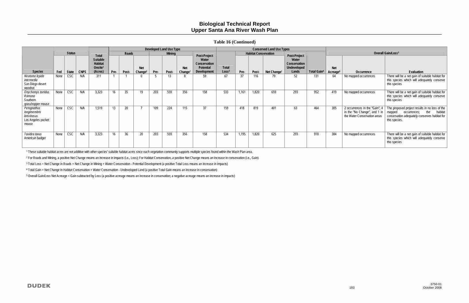
Biological Technical Report Upper Santa Ana River Wash Plan
Table 16 (Continued)
3750-01 183 October 2008
Developed Land Use Type Conserved Land Use Types Status Roads Mining Habitat Conservation Overall Gain/Loss1
Species Fed State CNPS
Total Suitable Habitat Onsite1 (Acres) Pre- Post-
Net Change2 Pre- Post-
Net Change2
Post-Project Water
ConservationPotential
Development Total Loss3 Pre- Post- Net Change2
Post-Project Water
ConservationUndeveloped
Lands Total Gain4 Net
Acreage5 Occurrence Evaluation Neotoma lepida intermedia San Diego desert woodrat
None CSC N/A 311 1 1 0 5 13 8 59 67 37 116 79 52 131 64 No mapped occurrences There will be a net gain of suitable habitat for this species which will adequately conserve this species
Onychomys torridus Ramona Southern grasshopper mouse
None CSC N/A 3,323 16 35 19 203 559 356 158 533 1,161 1,820 659 293 952 419 No mapped occurrences There will be a net gain of suitable habitat for this species which will adequately conserve this species
Perognathus longimembris brevinasus Los Angeles pocket mouse
None CSC N/A 1,519 13 20 7 109 224 115 37 159 418 819 401 63 464 305 2 occurrences in the "Gain", 4 in the "No Change", and 1 in the Water Conservation areas
The proposed project results in no loss of the mapped occurrences; the habitat conservation adequately conserves habitat for this species.
Taxidea taxus American badger
None CSC N/A 3,323 16 36 20 203 559 356 158 534 1,195 1,820 625 293 918 384 No mapped occurrences There will be a net gain of suitable habitat for this species which will adequately conserve this species
1 These suitable habitat acres are not additive with other species’ suitable habitat acres since each vegetation community supports multiple species found within the Wash Plan area. 2 For Roads and Mining, a positive Net Change means an increase in impacts (i.e., Loss); For Habitat Conservation, a positive Net Change means an increase in conservation (i.e., Gain) 3 Total Loss = Net Change in Roads + Net Change in Mining + Water Conservation - Potential Development (a positive Total Loss means an increase in impacts) 4 Total Gain = Net Change in Habitat Conservation + Water Conservation - Undeveloped Land (a positive Total Gain means an increase in conservation) 5 Overall Gain/Loss Net Acreage = Gain subtracted by Loss (a positive acreage means an increase in conservation; a negative acreage means an increase in impacts)

Biological Technical Report Upper Santa Ana River Wash Plan
3750-01 184 October 2008
INTENTIONALLY LEFT BLANK

Biological Technical Report Upper Santa Ana River Wash Plan
3750-01 185 October 2008
7.3 Indirect Impacts
Indirect impacts refer to impacts which may occur as a result of project activities that are separate in time or space from actual ground disturbance. In general, indirect impacts may be categorized as short- or long-term, as described below.
Short-Term (Construction-Related) Indirect Impacts. Short-term (construction-related) indirect impacts are reasonably foreseeable temporary effects that could occur outside of the direct impact footprint but are immediately related to ground disturbance activities. For example, the generation of fugitive dust during initial construction of mining pits or roads would be considered a short-term (construction-related) indirect impact.
Long-Term (Operation-Related) Indirect Impacts. Long-term (operation-related) indirect impacts result from the proximity of potentially disturbing human activities, such as mining or roads, to biological resources after initial construction. Long-term indirect impacts to biological resources as a result of the activities adjacent to open space include various impacts, depending on the biological resource. For example, increased lighting and glare typically affects wildlife species if directed into adjacent open space areas but does not typically affect special-status plant species.
The discussion of indirect impacts is presented in four subsections: 1) indirect impacts potentially present in the area but not affected by the project; 2) short- and long-term indirect impacts potentially affecting vegetation communities and special-status plant species; 3) additional short- and long-term indirect impacts potentially affecting special-status wildlife species; and 4) discussion of the Habitat Enhancement Plan and expected reduction of indirect impacts.
7.3.1 Indirect Impacts Not Affected by the Project
Short- and long-term conditions of the proposed project were analyzed in the context of several types of indirect impacts which are commonly known to affect biological resources in urban areas. For a number of impact types, it was determined that although these indirect impacts may occur in the project study area, implementation of the project would not result in an increase in these affects. These indirect impacts that are not related to the project include introduction of chemical pollutants (pesticides, fertilizers, fungicides, herbicides, and rodenticides); habitat fragmentation and isolation of populations; and intrusion by domestic pets originating from residences. Further discussion on these potential impacts is provided below.
Introduction of Chemical Pollutants (Pesticides, Fertilizers, Fungicides, Herbicides, and Rodenticides). The proposed project does not include new residential or public park land uses

Biological Technical Report Upper Santa Ana River Wash Plan
3750-01 186 October 2008
which are the primary source of chemical pollutants. Although new and expanded roads within the plan area will have landscaping with some use of chemical pollutants, this would not represent a substantial change from existing conditions. Therefore, implementation of the proposed project would not result in substantial introduction of chemical pollutants.
Habitat Fragmentation and Isolation of Populations. The proposed habitat conservation would result in the joining of the two existing Santa Ana River Woollystar conservation areas in the southern portion of the Wash Plan area to make one contiguous habitat conservation area (Figure 17). In the northern portion of the Wash Plan area, the proposed habitat conservation areas will connect with existing and proposed BLM ACEC conservation areas, City of Highland conservation areas, and Santa Ana River Woollystar conservation areas to make a large contiguous area, connecting both the southern and northern habitat conservation areas and extending east toward the San Bernardino Mountain range (Figure 17). The proposed habitat conservation areas will result in three large polygons, interrupted only in the western area by Orange Road and SR-30. This reduces the number of polygons by half compared to existing habitat conservation areas which was made up six polygons split by both roads and other land uses (Figure 12). The proposed habitat conservation will result in a preserve area that is more conducive to wildlife movement based on the connectivity throughout the Wash Plan area and to the San Bernardino Mountains to the northeast.
The edge to area ratio is lower overall in the proposed project than the existing land uses; the proposed edge ratio results in a total of 123 perimeter miles to one square mile compared to 162 perimeter miles to one square mile in the existing land use. Habitat conservation areas are reduced by 30 perimeter miles to one square mile in the proposed project compared to the existing habitat conservation areas. This reduces the overall edge of the land use areas, which subsequently reduces the edge effects in the habitat conservation areas (e.g., trash, introduction of non-native species, and human disturbance).
Intrusion by Domestic Pets Originating From Residences. The proposed project does not introduce new residential land uses which would have the potential of locating domestic pets in proximity to habitat conservation lands. The potential intrusion of pets associated with trail usage is discussed below, however indirect impacts related to domestic pets originating from homes is would not be affected by this project.

City of Highland
City of Redlands County ofSan Bernardino
Existing and Proposed Habitat Conservation ComparisonSOURCE: DIGITALGLOBE 2008. SBVWCD 2008.
County ofSan Bernardino
Greenspot Rd
Oran
ge St
Opal Ave
Alaba
ma S
t
Cone CampRd
Greens
pot Rd
Upper Santa Ana River Wash Plan
FEET20000
Project AreaHighway
Proposed Habitat ConservationBLM, AREA OF CRITICAL ENVIRONMENTAL CONCERNCITY OF HIGHLANDHABITAT CONSERVATIONROBERTSON’S HAUL ROAD CONSERVATION EASEMENTSANTA ANA RIVER WOOLLYSTAR PRESERVATION AREA
Existing Habitat ConservationBLM, AREA OF CRITICAL ENVIRONMENTAL CONCERNCITY OF HIGHLANDCONSERVATION EASEMENT (ROBERTSON’S)SANTA ANA RIVER WOOLLYSTAR PRESERVATION AREA
City of Redlands
FIGURE 17
Z:\Pr
ojects
\j375
001\a
rcmap
\USA
RWP\F
ig17_
Ex_P
rop_H
abita
t_Con
s_Co
mp.m
xd 1
0/7/20
08

Biological Technical Report Upper Santa Ana River Wash Plan
3750-01 188 October 2008
INTENTIONALLY LEFT BLANK

Biological Technical Report Upper Santa Ana River Wash Plan
3750-01 189 October 2008
7.3.2 Vegetation Communities and Special-Status Plants
Indirect impacts to vegetation communities and special-status plant species are similar and will be discussed jointly.
Short-Term (Construction-Related) Impacts
Potential short-term indirect impacts to vegetation communities and special-status plants would primarily result from initial construction activities and would include impacts related to or resulting from the generation of fugitive dust; changes in hydrology resulting from construction, including sedimentation and erosion; the introduction of chemical pollutants and trash and debris. These potential effects are described in detail below.
Generation of Fugitive Dust. Excessive dust can decrease the vigor and productivity of vegetation communities and special-status plant species through effects on light, penetration, photosynthesis, respiration, transpiration, increased penetration of phytotoxic gaseous pollutants, and increased incidence of pests and diseases.
Changes in Hydrology Resulting from Construction. Construction could result in hydrologic and water-quality-related impacts adjacent to and downstream of the impact area. Hydrological alterations include changes in flow rates and patterns in streams and rivers and dewatering, which may affect adjacent and downstream vegetation communities or special-status species occurring in drainage zones. Water-quality impacts include chemical pollution (fuel, oil, lubricants, paints, release agents, and other construction materials), erosion, increased turbidity, and excessive sedimentation. Initial construction for mining operations, water conservation facilities, and/or road construction can also remove native vegetation and increase runoff from roads and other paved surfaces and result in increased erosion and transport of surface matter into naturally vegetated areas. Altered erosion, increased surface flows, and underground seepage can allow for the establishment of non-native plants. Changed hydrologic conditions can also alter seed bank characteristics and modify habitat for ground-dwelling fauna that may disperse seed.
Chemical Pollution. Chemical pollution (fuel, oil, lubricants, paints, release agents, and other construction materials) may affect vegetation communities. The use of chemical pollutants during initial construction can decrease the number of plant pollinators, increase the prevalence of non-native plants, and cause damage and destruction of native plants.
Trash and Other Debris. Trash and other non-toxic debris associated with construction activities can degrade vegetation communities and wildlife habitat and can attract nuisance and pest species. Trash and debris include discarded construction-related materials, such as

Biological Technical Report Upper Santa Ana River Wash Plan
3750-01 190 October 2008
packaging materials and plastic sheeting, that may be dispersed into natural areas by wind or along creeks and streams. Trash generated by construction personnel, such as food packaging and cigarette butts, also can be dispersed by wind and water into natural areas.
Long-Term (Operation-Related) Impacts
Long-term (operation-related) indirect impacts which were found to potentially occur in the proximity of the project activities (i.e., mining, recreation, water conservation, roads) would potentially affect vegetation communities and special-status plant species after construction, include impacts related to the following: airborne chemical pollutants, such as the increase in nitrogen emissions; permanent alterations to hydrology; alteration of natural fire regime; an increase in non-native plant and wildlife species that are adapted to more urban environments and can outcompete native species for available resources, thus potentially reducing the distribution and population of native plant species; increased human activity and domestic animal presence, which can lead to disturbance or trampling of natural vegetation communities; and general effects of vegetation clearing. Each of these potential indirect impacts is discussed below.
Airborne Chemical Pollutants. The increase in air pollutants such as nitrogen and ozone, mainly from operation of mining equipment, may affect the viability of vegetation communities and special-status species , may be toxic to species, can decrease the number of plant pollinators, and can increase the existence of non-native plants.
Altered Hydrology. Increased urban and stormwater runoff due to the increase in post-construction impervious surfaces (i.e., roads) may result in long-term hydrological alterations, including increased runoff volume, increased peak flow rates, increased duration of flows, and altered flow patterns in streams and rivers. Groundwater levels may be affected as a result of interference with groundwater recharge that could cause a deficit in aquifer volumes or lowering of the local groundwater table. These hydrological alterations may affect adjacent and downstream riparian vegetation and other sensitive natural communities.
Alteration of Natural Fire Regime. Overall, the proposed project does not introduce new land uses that would affect existing fire regimes. The project alters the pattern of land use, but does so in a manner which does not substantially affect the likelihood for wildfire or the burn pattern within the plan area. However, with the allowance for recreational uses within the project open space, a potential new ignition source is introduced in the plan area. Managed recreational use is likely to have few ignitions than the current unauthorized recreational use; however the project may result in increased fire frequency due to activities along trails. This increased fire frequency can alter habitat composition and typically provides conditions which are favorable for non-native, invasive species.

Biological Technical Report Upper Santa Ana River Wash Plan
3750-01 191 October 2008
Non-Native, Invasive Plant and Animal Species. Invasive plant species that thrive in edge habitats are a well-documented problem along the open space–urban interface in Southern California and throughout the United States. Bossard et al. (2000) list several adverse effects of non-native species in natural open space areas, including the fact that certain invasive plants can increase fuel loads compared to native plants and facilitate more frequent and intense fires; also, some invasive plants (e.g., giant reed (Arundo donax) and tamarisk (Tamarix spp.)) consume large amounts of groundwater that cannot be accessed by native plants. Exotic plants compete for light, water, and nutrients and can create a thatch that blocks sunlight from reaching smaller native plants. Exotic plant species may alter habitats and displace native species over time, leading to extirpation of native plant species.
Non-native species have been found to invade and become established after repeated burnings, clearing of vegetation for fire protection, or following periods of drought and overgrazing. These are considered to be possible side effects of nearby human habitation. Exotic plants can alter hydrologic and biochemical cycles, disrupt natural fire regimes, and alter soil fertility within and adjacent to urban development. Development could also potentially fragment native plant populations, which may increase the likelihood of invasion by exotic plants due to the increased interface between natural habitats and urban areas.
Invasive plant species, especially upland species, often colonize modified or otherwise disturbed zones between development and natural open space areas. Invasive species can also colonize any upland area that is subject to disturbance, such as road shoulders; cleared zones along railroad lines; clearing along utility easements; and gaps in vegetation caused by excessive fire, fire breaks, and grazing. Many species, like black mustard (Brassica nigra) and non-native annual grasses of Mediterranean origin (e.g., Bromus spp., Hordeum spp., and Avena spp.) have become naturalized in Southern California to the point that they cannot realistically be controlled at a landscape level. Currently, the main risk to upland areas from these invasive species is the high frequency of fires in the region, which could result in the permanent transition of coastal scrub and chaparral to annual grassland.
Riparian and wetland systems are also vulnerable to invasive plants, such as giant reed, tamarisk, and pampas grass (Cortaderia spp.). These species can dominate the biomass of riparian and wetland communities where they become established, virtually choking out the native vegetation, which could affect the sensitive natural communities and habitats that occur in riparian areas.
The introduction of non-native, invasive animal species could negatively affect native species that may be pollinators of or seed dispersal agents for sensitive natural communities and riparian habitats.

Biological Technical Report Upper Santa Ana River Wash Plan
3750-01 192 October 2008
Increased Human Activity and Domestic Animal Presence. Project implementation would result in the recreational use of trails by humans and their pets. This could result in the potential for trespassing, vandalism, motorized and non-motorized off-road vehicles, trampling of vegetation, and soil compaction and could affect the viability of plant communities. Trampling can directly damage vegetation communities and alter their ecosystem, creating gaps in vegetation allowing exotic, non-native plant species to become established and leading to soil erosion. Trampling may also affect the rate of rainfall interception and evapotranspiration, soil moisture, water penetration pathways, surface flows, and erosion.
Vegetation Clearing. When native vegetation is cleared for fire protection or for the creation of roads or trails, non-native plant species may colonize gaps or bare areas. Clearing also causes local changes in wind, solar radiation and light exposure, and water that may have substantial effects on native vegetation (Saunders et al. 1991).
Trash and Other Debris. Trash and other non-toxic debris associated with construction activities can degrade vegetation communities and wildlife habitat and can attract nuisance and pest species. Trash and debris include discarded construction-related materials, such as packaging materials and plastic sheeting, that may be dispersed into natural areas by wind or along creeks and streams. Trash generated by construction personnel, such as food packaging and cigarette butts, also can be dispersed by wind and water into natural areas. Pest and predatory species, such as crows and ravens, seagulls, skunks, and raccoons, may be attracted to discarded food.
7.3.3 Special-Status Wildlife
Any indirect impacts which affect natural communities, represents a potential impact to habitat for special-status wildlife. Therefore, each of the indirect impacts listed in the preceding section are incorporated here by reference. This section will augment the discussion of potential indirect impacts by listing those impacts which may specifically affect wildlife species.
Short-Term (Construction-Related) Impacts
Additional potential short-term indirect impacts to special-status wildlife would include impacts related to or resulting from the generation of construction noise, vibration, and lighting, as well as increase human activity in general. These potential effects are described in detail below.
Construction Noise. Construction noise may affect behavioral activities of wildlife in several ways. Excessive noise may affect birds, for example, in at least four ways: noise may cause birds to abandon nests that are otherwise suitable; noise may raise the level of stress hormones, interfering with sleep and other activities; intense noise can cause permanent injury to the

Biological Technical Report Upper Santa Ana River Wash Plan
3750-01 193 October 2008
auditory system; and noise can interfere with acoustic communication by masking important sounds or sound components (Dooling 2006). Similar effects may occur in other taxa. Noise may interfere with communication in toads and frogs, which use calls to advertise their location and attract mates (e.g., Barrass and Cohn 1984). Loud noise, such as that generated by off-road vehicles, may damage the hearing of some terrestrial species (Berry 1980; Brattstrom and Bondello 1983).
Vibration. Vibration caused by construction equipment may affect behavioral activities and the habitat of wildlife in several ways. Vibration may disturb terrestrial species that occupy burrows, dens, and depressions, such as rodents, coyotes (Canis latrans), badgers (Taxidea taxus), and lagomorphs (rabbits and hares), causing them to abandon these areas. Excessive vibration might cause the collapse of burrow systems and dens in areas with highly friable soils.
Lighting. Lighting may affect behavioral activities, physiology, population ecology, and ecosystems of both diurnal and nocturnal wildlife. Longcore and Rich (2004) refer to these effects as “ecological light pollution” and identify three types of effects: chronic or periodically increased illumination; unexpected changes in lighting; and direct glare. Chronic increased illumination includes skyglow, lighted buildings and towers, streetlights, and security lights. Unexpected changes in lighting may occur from vehicle lights or other discrete events such as flares or spotlighting by law enforcement helicopters. Direct glare may be chronic or unexpected.
Increased Human Activity. Increased human activity in construction areas could affect behavioral activities and physiology of wildlife. Similar to noise and lighting effects, increased human activity could disturb nocturnal animals during their rest or sleep periods, annoying them and causing them to abandon nests or den sites as well as disrupting their normal biological rhythms and raising the level of stress hormones. Abandonment (even temporary) of active nests or dens increases the risk to eggs, nestlings, fledglings, and other dependent young. Flushing animals from nests, dens, and other refuges also increases their risk of injury or mortality from collisions with construction equipment and other vehicles as well as predation. Human presence may also alter the spatial behavior of animals, causing them to avoid certain parts of their home range, which may prevent them from using critical resources, such as water.
Long-Term (Operation-Related) Impacts
Due to the construction-type activity related to mining operations, the short-term indirect impacts listed above may also have long-term effects on special-status wildlife. Also, long-term indirect impacts to vegetation communities have the potential to affect habitat for special-status wildlife and therefore are incorporated here by reference. Additional potential long-term (operation-related) indirect impacts which could result from the proximity of the project activities (i.e.,

Biological Technical Report Upper Santa Ana River Wash Plan
3750-01 194 October 2008
mining, recreation, water conservation, roads) to wildlife habitat after construction, are limited to increased traffic and vehicle collisions. This potential indirect impact is discussed below.
Increased Traffic and Vehicle Collisions. The increased density and capacity of roads associated with the project would result in increased risk of vehicle collisions where wildlife use or attempt to cross roadways, particularly in areas that were frequently used by wildlife before roads and other development were built. Factors related to the number and types of species affected include vehicle speeds, traffic volume, traffic pulses, accessibility of cover, structure of the road (e.g., whether the road is raised or at grade level with the surrounding environment), barrier walls to prevent access to a roadway, and availability of alternative crossings, such as bridges and culverts (Dodd et al. 2004).
7.3.4 Habitat Enhancement Plan
The Habitat Enhancement Plan (HEP) will be implemented within the proposed Habitat Conservation, Flood Control, and Water Conservation areas and include the following measures:
• Maintain adequate habitat for the slender-horned spineflower, Santa Ana River woollystar, coastal California gnatcatcher, San Bernardino kangaroo rat, and Los Angeles pocket mouse.
o Maintain native habitat with a threshold fluctuation of +/- 10 percent (15 percent for Riversidean alluvial fan sage scrub–intermediate and intermediate/mature subtypes) before implementation of adaptive management measures.
• Prevent colonization of exotic plant or animal species within the Planning Area.
o Survey for non-native aquatic species (e.g., bullfrogs, crayfish, mosquitofish, and snapping turtles) known to be detrimental to western spadefoot shall be conducted annually in the spring or summer.
o Survey in the summer of each year for non-native plant species; the frequency of these surveys shall be reduced to every other year if no patches of non-native species are found for four consecutive years.
o Remove non-native, invasive plant species found during the annual surveys using methods that will not harm individual members of the Santa Ana River woollystar, coastal California gnatcatcher, San Bernardino kangaroo rat, and Los Angeles pocket mouse or their habitat, or cause pollutants to enter the Santa Ana River, Mill Creek, City Creek, or Plunge Creek; eradication shall be accomplished

Biological Technical Report Upper Santa Ana River Wash Plan
3750-01 195 October 2008
using hand tools or pulling individual plants by hand; for many annual species, this will likely involve cutting the plants (one or more times) before they set seed.
o Remove non-native aquatic species (e.g., bullfrogs and crayfish) found during the surveys utilizing methods currently approved by the USFWS that minimize the potential for impacts to the western spadefoot; potential methods include traps, seine, dip net, hand, and spear/gig; removal shall be by biologists who can distinguish the non-native species (including egg and tadpole stages) from the native species to be protected; eradication shall not be conducted when western spadefoot eggs are present.
o Control Argentine ants within the Habitat Conservation, Water Conservation, and Flood Control areas and within 300 feet of these areas within the Planning Area; control methods should include elimination of water sources where feasible and treatment of nests; control of queens and larvae in the nest primarily through the use of granular toxic bait (e.g., Talstar); inclusion of an annual inspection to determine presence of colonies, treatment of identified colonies, and site re-inspection after one month to determine efficacy of the treatment; specific pest control recommendations will be made by a State-licensed Category A Pest Control Advisor; the specified areas will be monitored annually in the summer or fall; the frequency of these surveys will be reduced to every other year if no Argentine ants are found for four consecutive years; a report detailing the program shall be prepared annually.
• Avoid degradation of water quality within the Santa Ana River, Plunge Creek, and Mill Creek.
• Remove trash and control access.
o Install fencing (three-strand wire fencing) around entry points and post signage to control unauthorized trail use by off-road vehicles and garbage and trash dumping.
o Ensure that trails, and 100-foot wide buffers on each side of the trails or roads where these buffers fall within the Planning Area, are be monitored on a quarterly basis for the presence of trash which could be washed into the Santa Ana River, Mill Creek, or Plunge Creek during storm events; all trash will be removed by hand during the quarterly surveys.

Biological Technical Report Upper Santa Ana River Wash Plan
3750-01 196 October 2008
• Restrict vehicular traffic associated with routine operation and maintenance activities within the Habitat Conservation area to daylight hours to avoid roadkill of San Bernardino kangaroo rats and Los Angeles pocket mice;.
• Ensure that Best Management Practices (BMPs) are employed during maintenance operations at the recharge basins to avoid impacts to water quality.
The HEP is primarily designed to address indirect impacts related to the project and sustain biological resource values in the long-term. This impact reduction is achieved as follows:
Short-term (Construction-Related) Impact–Vegetation Communities, Special-Status Plants and Wildlife
Generation of Fugitive Dust. Implementation of the HEP ensures the adequate reduction of fugitive dust through the implementation of BMPs for all site construction including watering of disturbed soil surfaces and periodic inspections of work areas and adjacent habitat areas by biological monitors.
Changes in Drainage Resulting from Construction. Implementation of the HEP would ensure that construction does not result in adverse changes in site drainage through implementation of BMPs including typically Storm Water Pollution Prevention Plan (SWPPP) activities as well as review of final drainage plans in relation to adjacent habitat preserve areas by a qualified biologist.
Chemical Pollution. The air quality section of the EIR evaluates the project’s compliance with applicable air quality standards and regulations. Although these standards and regulations are formulated to protect human health, compliance with these standards and regulations confers benefits to biological resources through reductions in emissions. The affects of airborne chemical pollution on biological resources is not well studied or documented. As such, implementation of the HEP, including long-term adaptive management measures to maintain habitat for special-status species, is important in addressing potential affects of pollution.
Trash and Other Debris. The HEP includes access control and trash removal measures which will control the affects of trash and debris during construction and through the life of the project.
Construction Noise. Construction noise levels should be maintained below 60 dBa hourly Leq within suitable nesting habitat for California gnatcatcher during the breeding season for that species (March 15 to August 30, annually). Suitable nesting habitat will be determined by a qualified biologist at the time of construction. Indirect noise effects on other species would not

Biological Technical Report Upper Santa Ana River Wash Plan
3750-01 197 October 2008
cause substantial declines in reproductive activity due to the large amount of available habitat compared with the areas affected by construction noise.
Vibration. Vibration associated with construction would not have substantial affects on wildlife due to the fact that much of the existing study areas is subject to vibrations from existing land uses (mining, roads, etc.). Therefore no additional measures are required unless identified through monitoring conducted as part of the HEP.
Lighting. The HEP includes measures to shield construction and permanent lighting from habitat conservation areas. Shielding lighting fixtures will be adequate to reduce the affects of any permanent lighting on wildlife within the conservation areas.
Increased Human Activity. All construction will be monitored by a qualified biologist to ensure that no activities occur outside the designated limits of work. The monitor will inspect construction fencing and adjacent habitat areas to ensure that encroachments do not occur.
Long-term (Operations-Related) Impacts–Vegetation Communities, Special-Status Plants and Wildlife
As discussed in Sections 7.3.2 and 7.3.3, many of the indirect impacts listed as occurring in the short-term also represent long-term impacts. These impacts will be addressed through the measures listed above. Additional indirect impacts that may have long-term effects on biological resources will be addressed as follows.
Alteration of Natural Fire Regime. The project contribution to fire regime alteration is limited to introduction of potential new ignitions sources through the allowance of recreational trail usage within the project open space. Trail usage will be monitored and managed to reduce the likelihood of ignitions. Also, the HEP include adaptive management measures to maintain the mosaic of native vegetation communities supporting special-status plant and animal species. This includes management for alterations of habitat composition due to changes in the natural fire regime. With implementation of these measures, the affects of the project on natural fire regimes would be effectively reduced.
Non-Native, Invasive Plant and Animal Species. The HEP includes numerous specific measures to address the establishment and proliferation of non-native within the habitat conservation, water conservation, and flood control areas. This expected to be a major component of the HEP and will ensure that special-status species do not decline as a result of non-native species.

Biological Technical Report Upper Santa Ana River Wash Plan
3750-01 198 October 2008
Increased Human Activity and Domestic Animal Presence. The primary location of potential increased human activity and domestic animal presence is along recreational trails. The HEP includes measures to monitor and manage trail usage including installation and maintenance of adequate fencing, signage, and trash controls. Implementation of the HEP ensures that adverse affects of recreational trail usage are reduced to a level where special-status species and vegetation communities are not expected to decline.
Vegetation Clearing. The HEP includes a mandate to maintain vegetation communities at current levels, with an allowance for a 10-15% fluctuation for natural ecological processes. This mandate will require that habitat changes occurring at edge of vegetation clearing are addressed through active management such as restoration.
Increased Traffic and Vehicle Collisions. The HEP includes measures to limit vehicular traffic within Habitat Conservation areas to daytime hours to reduce the incident of vehicle collisions with nocturnal wildlife. Also, as part of the adaptive management program, if vehicle collisions are regularly occurring in the plan area, management measures such as directive fencing or reduced vehicle speed limits will be implemented. Collisions will continue to be monitored to determine if management measures were adequate to control this impact.

Biological Technical Report Upper Santa Ana River Wash Plan
3750-01 199 October 2008
8.0 REFERENCES
Akcakaya, H.R. and J.L. Atwood. 1997. A habitat-based metapopulation model of the California gnatcatcher. Conservation Biology 11: 422-434.
American Ornithologists’ Union. 2003. Forty-fourth supplement to the American Ornithologists’ Union Check-list of North American birds. Auk 120: 923-932.
American Ornithologists’ Union. 1998. Check-List of North American Birds. Seventh Edition. American Ornithologists’ Union, Washington, D.C. 829 pp.
American Ornithologists’ Union. 1989. Thirty-seventh supplement to the American Ornithologists’ Union Check-list of North American birds. Auk 106: 532-538.
American Ornithologists’ Union. 1957. Check-list of North American birds, 5th ed. American Ornithologists’ Union, Washington, D. C.
Anderson, A.H. and A. Anderson. 1973. The Cactus Wren. The University of Arizona Press, Tucson, Arizona.
Anderson, A.H., and A. Anderson. 1963. Life history of the cactus wren. Part IV: Competition and survival. Condor 65:29-43.
Anderson, A.H., and A. Anderson. 1960. Life history of the cactus wren. Part III: The nesting cycle. Condor 62:351-369.
Anderson, A.H., and A. Anderson. 1957. Life history of the cactus wren. Part I: Winter and pre-nesting behavior. Condor 59:274-296.
Anderson, A.M., D.A. Haukos, and J.T. Anderson. 1999. Diet and Composition of three anurans from the playa wetlands of northwest Texas. Copeia 199:515-520.
Anderson, W.L. and R.E. Duzan. 1978. DDE residues and eggshell thinning in loggerhead shrikes. Wilson Bulletin 90:215-220.
Angradi, T.R., J.S. Spaulding, and E.D. Koch. 1991. Diel food utilization by the Virgin River spinedace, Lepidomeda mollispinis mollispinis, and speckled dace, Rhinichthys osculus, in Beaver Dam Wash, Utah [USA]. Abstract. Southwest Naturalist (36: 158). Cited in: Biosis Previews, 1985-1992 [online database].
Atlantic Region Air Quality Services. 2008. Major Pollutants. Accessed September 2. http://www.atl.ec.gc.ca/airquality/index_e.html

Biological Technical Report Upper Santa Ana River Wash Plan
3750-01 200 October 2008
Atwood, J. 1993. Gnatcatchers and coastal sage scrub: The biological basis for endangered species listing. Keeley J. E., editor. Interface Between Ecology and Land Development in California. Southern California Academy of Sciences, Los Angeles. P. 149-169.
Atwood, J. 1991. Subspecies limits and geographic patterns of morphological variation in California gnatcatchers (Polioptila californica). Bulletin Southern California Academy of Sciences 90 (3):118-133.
Atwood, J. 1990. Status review of the California gnatcatcher (Polioptila californica). Manomet Bird Observatory, Manomet, Mass.
Atwood, J.L. 1998. Analysis of edge effects on California gnatcatcher reproductive success. Unpublished manuscript.
Atwood, J.L. 1988. Speciation and geographic variation in black-tailed gnatcatchers. Ornithol. Monogr. 42.
Atwood, J.L. 1980. The United States distribution of the California black-tailed gnatcatcher. Western Birds 11: 65-78.
Atwood, J.L., D. Bontrager and A. Gorospe. 1998. Use of refugia by California Gnatcatchers displaced by habitat loss. Western Birds 29:406-412.
Atwood, J.L. and J.S. Bolsinger. 1992. Elevational distribution of California gnatcatchers in the United States. J. Field Ornithology 63: 159-168.
Atwood, J.L., S.H. Tsai, and A.M.L. Miller. 1996. California gnatcatchers, cactus wrens, and conservation of coastal sage scrub on the Palos Verdes Peninsula. Progress Report No. 4. Unpublished technical report, Manomet Observatory for Conservation Sciences, Manomet, Massachusetts. 15 pp. + appendices.
Atwood, J.L., S.H. Tsai, C.H. Reynolds, J.C. Luttrell, M.R. Fugagli. 1998. Factors affecting estimates of California gnatcatcher territory size. Western Birds 29: 269-279.
Austin, G.T., E. Yensen, and C.S. Tomoff. 1972. Snake predation on cactus wren nestlings. Condor 74:492.
Axelrod, D. 1978. The origin of coastal sage vegetation, Alta and Baja California. American Journal of Botany 65 (10):1117-1131.

Biological Technical Report Upper Santa Ana River Wash Plan
3750-01 201 October 2008
Bailey, E.A. and P.J. Mock. 1998. Dispersal capability of the California gnatcatcher: A landscape analysis of distribution data. Western Birds 29: 351-360.
Bailey, F.M. 1922. Cactus wrens’ nests in southern Arizona. Condor 24:163-168.
Balda, R.P. 1970. Effects of spring leaf-fall on composition and density of breeding birds in two southern Arizona woodlands. Condor 72:325-331.
Balda, R.P. 1969. Foliage use by birds of the oak-juniper woodland and ponderosa pine forest in southeastern Arizona. Condor 71:399-412.
Banks, D.L. 1999. A vascular flora of the Agua Tibia Mountains, Southern California. Rancho Santa Ana Botanic Gardens Special Publications No. 4. 109 pp.
Barrass, A., and L. Cohn. 1984. “Variation of the Spacing of Calling Male Bufo woodhousii and Hyla cinerea near Highway Noise.” American Zoologist 24:15A.
Barbour, M., and J. Major. 1977. Terrestrial vegetation of California. John Wiley and Sons, New York, New York.
Barlow, C. 1902. Some observations of the rufous-crowned sparrow. Condor 4:107-111.
Bartholomew, G.A. and T.J. Cade. 1963. The water economy of land birds. Auk 80:504-539.
Baur, B. 1979. Pfledge und "Zucht" der Reisenkrotenechse, Phrynosoma asio (reptilia: Sauria: Iguanidae). Salamandra 15:1-12.
Beal, W.J. 1905. The vitality of seeds. Botanical Gazette 40(2): 140 - 143.
Beatley, J.C. 1969. Dependence of desert rodents on winter annuals and precipitation. Ecology 50:721-724.
Bent, A.C. 1968. Life histories of North American cardinals, grosbeaks, buntings, towhees, finches, sparrows, and allies. U.S. National Museum Bulletin 237:1889 pp.
Bent, A.C. 1968. Life histories of North American Nuthatches, Wrens, Thrashers, and their allies. U.S. National Museum Bulletin 195. U.S. Government Printing Office. Washington, D.C.
Bent, A.C. 1938. Life histories of North American birds of prey. Part 2. U.S. Natl. Mus. Bull. 170. 482pp.

Biological Technical Report Upper Santa Ana River Wash Plan
3750-01 202 October 2008
Behrends, P., M. Daly, and M.I. Wilson. 1986a. Aboveground activity of Merriam’s kangaroo rats (Dipodomys merriami) in relation to sex and reproduction. Behaviour 96:210-226.
Behrends, P., M. Daly, and M.I Wilson. 1986b. Range use and spatial relationships of Merriam’s kangaroo rats (Dipodomys merriami). Behaviour 96:187-209.
Berry, K.H. 1980. “A Review of the Effects of Off-Road Vehicles on Birds and Other Vertebrates.” In Proceedings: Management of Western Forests and Grasslands for Nongame Birds, ed. R.M DeGraff and N.G. Tilghman, 451–467. Salt Lake City, Utah: U.S. Forest Service. General Technical Report INT-86.
Beyers, J.L., G.C. Pena, and W.O. Wirtz II. 1994. Coastal sage scrub in relation to fire history and use by the California gnatcatcher. Bulletin of the Ecological Society of America 75: 15.
Blair, A.P. 1947. Field observations of spadefoot toads. Copeia 1947:67.
Blus, L.J. 1996. Effects of pesticides on owls in North America. J. Raptor Research 30: 198-206.
Bolger, D.T., T.A. Scott and J.T. Rotenberry. 1997. Breeding bird abundance in an urbanizing landscape in coastal Southern California. Conservation Biology 11:406-421.
Bontrager, D.R., R.A. Erickson, and R.A. Hamilton. 1995. Impacts of the October 1993 Laguna Canyon fire on California Gnatcatchers and Cactus Wrens. Pp. 69-76 In Brushfires in California wildlands: ecology and resource management (J. E. Keeley and T. Scott, eds.). Int. Assoc. Wildland fire, Fairfield, WA.
Bontrager, D.R. 1991. Habitat requirements, home range and breeding biology of the California gnatcatcher (Polioptila californica) in South Orange County, California. Prepared for Santa Margarita Company, Rancho Santa Margarita, California.
Bossard, C.C., J.M. Randall, and M.C. Hoshovsky. 2000. Invasive Plants of California’s Wildlands. Berkeley, California: University of California Press.
Botelho, E.S. and P.C. Arrowood. 1998. The effect of burrow site use on the reproductive success of a partially migratory population of western burrowing owls (Speotyto cunicularia hypugaea). J. Raptor Research 32: 233-240.
Bowler, P. 1995. California gnatcatcher use of mulefat and coastal sage scrub restoration as a wetlands margin dispersal corridor. Paper delivered at the Symposium on the Biology of

Biological Technical Report Upper Santa Ana River Wash Plan
3750-01 203 October 2008
the California Gnatcatcher held 15-16 September 1995, University of California, Riverside.
Boyd, S. 1999. Vascular Flora of the Liebre Mountains region, western Transverse Ranges, California. Aliso 18:93-139.
Boyd, S. and D.L. Banks. 1995. A botanical Assessment of the Agua Tibia Wilderness Area, Cleveland National Forest, California. Rancho Santa Ana Botanic Garden, Claremont California.
Braden, G. 1999. Does nest placement affect the fate or productivity of California gnatcatcher nests? Auk 116: 984-993.
Braden, G.T. 1998. Pers. comm. In USFWS North Peak Development Project Biological Opinion.
Braden, G.T. 1997. Association of within-territory vegetation characteristics and fitness components of California Gnatcatchers. The Auk (4):601-609.
Braden, G.T. and R.L. McKernan. 2000. A databased survey protocol and quantitative description of suitable habitat for the endangered San Bernardino kangaroo rat (Dipodomys merriami parvus). Final Report. Biology Section, San Bernardino County Museum, 35 pp.
Braden, G., S. Love, and R. McKernan. 1994a. Draft Report: Dispersal and Non-breeding Habitat Use by the Coastal California Gnatcatcher (Polioptila californica californica) in Western Riverside County. Prepared for the Southwestern Riverside Multiple Species Reserve Management Committee.
Braden, G. and S. Powell. 1994b. Draft Report: Nesting biology of the Coastal California Gnatcatcher (Polioptila californica californica) in Western Riverside County. Prepared for the Southwestern Riverside Multiple Species Reserve Management Committee.
Braden, G.T., R.L. McKernan, S.M. Powell. 1995. Life History of Polioptila californica californica in western Riverside County, CA. Paper delivered at the Symposium on the Biology of the California Gnatcatcher held 15-16 September 1995, University of California, Riverside.
Braden, G.T, R.L. McKernan, and S.M. Powell. 1997. Effects of nest parasitism by the brown-headed cowbird on nesting success of the California gnatcatcher. Condor 99: 858-865.

Biological Technical Report Upper Santa Ana River Wash Plan
3750-01 204 October 2008
Bradley, W.G. and R.A. Mauer. 1973. Rodents of a creosote bush community in southern Nevada. The Southwestern Naturalist 17:333-344.
Bradley, W.G. and R.A. Mauer. 1971. Reproduction and food habits of Merriam’s kangaroo rat (Dipodomys merriami). Journal of Mammalogy 52:479-507.
Bragg, A.N. 1962. Predation on arthropods by spadefoot tadpoles. Herpetologica 18:144.Burgess, R.C. 1950. Development of spadefoot toad larvae under laboratory conditions. Copeia 1950:49-51.
Brattstrom, B.H., and M.C. Bondello. 1983. “Effects of Off-Road Vehicle Noise on Desert Vertebrates.” In Environmental Effects of Off-Road Vehicles: Impacts and Management in Arid Regions, ed. R.H. Webb and H.G. Wilshire. New York, New York: Springer-Verlag.
_______. 1964. Further study of predation and cannibalism in spadefoot tadpoles. Herpetologica 20:17-24.
Brewster, W. 1881. On the affinities of certain Polioptilae, with a description of a new species. Bull. Nuttall Ornithol. Club 6: 101-107.
Brooks, M. 1999. Effects of protective fencing on birds, lizards, and black-tailed hares in the western Mojave Desert. Environmental Management 23: 387-400.
Brooks, M. and S.A. Temple. 1990. Habitat availability and suitability for loggerhead shrikes in the upper midwest. Am. Midl. Nat. 123: 75-83.
Brown, J.H. and B.A. Harney. 1993. Population and community ecology of heteromyid rodents in temperate habitats. In H.H. Genoways and J.H. Brown (eds.) Biology of the Heteromyidae, Special Publication No. 10 of the American Society of Mammalogists, pages 618-651.
Brown, H.A. 1966. Temperature adaptation and evolutionary divergence in allopatric populations of the spadefoot toad, Scaphiopus hammondii. PhD Dissertation, University of California, Riverside, California.
_______. 1967. Embryonic temperature adaptations and genetic compatibility of two allopatric populations of the spadefoot toad, Scaphiopus hammondii. Evolution 21(4):742-761.
_______. 1976 The status of the California and Arizona populations of the western toads (genus Scaphiopus). Los Angeles County Museum Contributions to Science 286:1-15.

Biological Technical Report Upper Santa Ana River Wash Plan
3750-01 205 October 2008
Brown, J.H. and E.J. Heske. 1990. Mediation
Brown, J.H. and G.A. Lieberman. 1973. Resource utilization and coexistence of seed-eating desert rodents in sand dune habitats. Ecology 54:788-797.
Brunell, M. and R. Whitkus. 1999a. Assessment of Morphological Variation in Eriastrum densifolium (Polemoniaceae): Implications for Subspecific Delimitation and Conservation. Systematic Botany 23(3):351-368.
Brunell, M. and R. Whitkus. 1999b. Analysis of Cross-compatibility in Eriastrum densifolium (Polemoniaceae). Plant Systematics and Evolution 215: 241-254.
Brunell, M. and R. Whitkus. 1997. RAPD Marker Variation in Eriastrum densifolium (Polemoniaceae): Implications for Subspecific Delimitation and Conservation.
Brunell, M. and R. Whitkus. 1994. Subspecific Relationships in Eriastrum densifolium based on RAPD markers. [Abstract]. American Journal of Botany, 81(6): 145.
Brunell, M. and R. Whitkus. 1993. Patterns of Morphological Variation in Eriastrum densifolium,. [Abstract]. American Journal of Botany, 80(6):134.
Brunell, M. and L. Rieseberg. 1993. Genetic Variation in the Endangered Santa Ana River Woollystar, Eriastrum densifolium ssp. sanctorum (Polemoniaceae). Plant Species Biology 8:1-6.
Bruner, H.L. 1907. On the cephalic veins and sinuses of reptiles, with description of a mechanism for raising the venous blood pressure in the head. Amer. Jour. Anat., 7:1-117, 17 figs., 3 pls.
Bryant, H.C. 1911. The horned lizards of California and Nevada of the genera Phrynosoma and Anota. Univer. California Publ. Zool. 9:1-84.
Brylski, P., L. Barkley, B. McKernan, S.J. Montgomery, R. Minnich, and M. Price. 1993. Proceedings of the Biology and Management of Rodents in Southern California Symposium. San Bernardino County Museum, Redlands, California, June 26, 1993. Presented by the Southern California Chapter of the Wildlife Society.
Bureau of Land Management. 1994. South Coast Resource Management Plan.
Burger, J.C., M.A. Patten, J.T. Rotenberry, and R.A. Redak. 1999. Foraging ecology of the California gnatcatcher deduced from fecal samples. Oecologia (Berlin) 120: 304-310.

Biological Technical Report Upper Santa Ana River Wash Plan
3750-01 206 October 2008
Burger, J.C., R.A. Redak, E.E. Porter, J.T. Rotenberry, and T.A. Scott. 1996. Habitat preservation in southern California coastal sage scrub communities. Bulletin of the Ecological Society of America 77: 60.
Burk, J., C. Jones and J. Wheeler. 1989. New Information on the Rare Santa Ana River Woollystar. Fremontia, 17(3):20-21.
Burleson G.L. 1942. The source of blood ejected from the eye by horned toads. Copeia 1942, No. 4. Dec 28. Pp. 246-248. Herpetologica. 1989. 45(2). Pp 208-216.
Burton, K.M. 1999. Use of barbed wire by loggerhead shrikes (Lanius ludovicianus) to manipulate nest materials. American Midland Naturalist 142: 198-199.
Butts, K.O. 1973. Life history and habitat requirements of burrowing owls in western Oklahoma. Unpublished MS thesis, Oklahoma State University, Stillwater. 188 pp.
Cade, T.J. and C.P. Woods. 1997. Changes in distribution and abundance of the loggerhead shrike. Conservation Biology 11: 21-31.
Cade, T.J. 1992. Hand-reared loggerhead shrikes breed in captivity. Condor 94: 1027-1029.
California Department of Fish and Game (CDFG). 1995. Staff Report on Burrowing owl mitigation. State of California.
CDFG. 2003. List of California Terrestrial Natural Communities Recognized by the California Natural Diversity Database (CNDDB). Wildlife and Habitat Data Analysis Branch, Vegetation Classification and Mapping Program. September 2003 edition.
CDFG. 2008a. Special Vascular Plants, Bryophytes, and Lichens List. CNDDB. Quarterly publication. January. http://www.dfg.ca.gov/biogeodata/cnddb/pdfs/SPPlants.pdf
CDFG. 2008b. Special Animals List. CNDDB. February.
California Natural Diversity Database. 2000. Eriastrum densifolium ssp. sanctorum, unpublished report, Natural Heritage Division, California Department of Fish and Game, Sacramento, California.
California Department of Fish and Game, California Natural Diversity Database 1997/1998.
California Natural Diversity Database (CNDDB). 2003. RareFind. Version 3.03. November 3.

Biological Technical Report Upper Santa Ana River Wash Plan
3750-01 207 October 2008
California Natural Diversity Database. 2000. Eriastrum densifolium ssp. sanctorum, unpublished report, Natural Heritage Division, California Department of Fish and Game, Sacramento, California.
California Natural Diversity Database. 2000. Calochortus plummerae. Unpublished Report, Natural Heritage Division, California Department of Fish and Game, Sacramento, California.
California Natural Diversity Database. 1999. Dodecahema leptoceras, unpublished report, Natural Heritage Division, California Department of Fish and Game, Sacramento, California.
California Native Plant Society (CNPS). 2004. Inventory of Rare and Endangered Plants (online edition, v6-04c). Rare Plant Scientific Advisory Committee. California Native Plant Society. Sacramento,
California Native Plant Society. 2001. California Native Plant Society’s Inventory of Rare and Endangered Vascular Plants of California, Special Publication, 6th ed., David Tibor editor.
Campbell, K., R. Erickson, W. Haas and M. Patten. 1998. California gnatcatcher use of habitats other than coastal sage scrub: Conservation and management implications. Western Birds 29:421-433.
Campbell, K., R. Erickson, and M. Patten. 1995. Saving the habitat and losing the birds: adjacent habitats, management, and natural history of the California gnatcatcher. Paper delivered at the Symposium on the Biology of the California Gnatcatcher held 15-16 September 1995, University of California, Riverside.
Carpenter, C. 1967. Aggression and social structure of iguanid lizards. Pp. 87-105. IN:W.W. Milstead (Ed.), Lizard Ecology: A Symposium. Univ. Missouri Press, Columbia.
Carpenter, C. 1962. Aggression and social structure of iguanid lizards. Pp. 87-105 In: W.W. Milstead (Ed.), Lizard Ecology: A symposium. Univ. Missouri Press, Columbia.
Carpenter, C.C. and G.W. Ferguson. 1977. Variation and evolution of stereotyped behavior in reptiles. Pp. 335-554. In: C Gans and D.W. Tinkle (Ed.), Biology of the Reptilia. Vol 7. Academic Press, London.

Biological Technical Report Upper Santa Ana River Wash Plan
3750-01 208 October 2008
Castleberry, D.T. and J.J. Cech Jr. 1992. Critical thermal maxima and oxygen minima of five fishes from the upper Klamath basin. Abstract. California Fish and Game (78::4) p. 145. Cited in: Biosis Previews, 1985-1992 [online database].
Chambers Group. 1993. Final Management Plan for the Santa Ana River Woollystar Eriastrum densifolium ssp. sanctorum. Unpublished Report, U.S. Army Corps of Engineers, Los Angeles District, Los Angeles, California.
Chase, M.K., J.T. Rotenberry, and M.D. Misenhelter. 1998. Is the California gnatcatcher an indicator of bird-species richness in coastal sage scrub? Western Birds 29: 468-474.
Chew, R.M. and B.B. Butterworth. 1964. Ecology of rodents in Indian Cove (Mojave Desert), Joshua Tree National Monument, California. Journal of Mammalogy 45:203-225.
Clayton, K.M and J.K. Schmutz. 1999. Is the decline of burrowing owls, Speotyto cunicularia in prairie Canada linked to changes in the Great Plains ecosystems? Bird Conservation International 9: 163-185.
Collins, P.W. 1999. Rufous-crowned Sparrow Aimophila ruficeps. No. 472. In The Birds of North America, A. Poole and F. Gill, Eds. Cornell Laboratory of Ornithology and the Academy of Natural Sciences.
Collister, D.M and K. De Smet. 1997. Breeding and natal dispersal in the loggerhead shrike. J. Field Ornithology 68: 273-282.
Coulombe, H.N. 1970. Physiological and physical aspects of temperature regulation in the burrowing owl Speotyto cunicularia. Comp. Biochem. Physiol. 35: 307-337.
Coulombe, H.N. 1971. Behavior and population ecology of the burrowing owl, Speotyto cunicularia, in the Imperial Valley of California. Condor 73: 162-176.
Courser, W.D. 1979. Continued breeding range expansion of the burrowing owl in Florida. Amer. Birds 33: 143-144.
Cowan K.J., and K.B. Storey. 1999. Reversible phosphorylation control of skeletal muscle pyruvate kinase and phosphofructokinase during estivation in the spadefoot toad, Scaphiopus couchii. Molecular and Cellular Biochemistry 195:173-181.
Cunningham, K.G. 1979. Bioenergetics of the loggerhead shrike relation between lifestyle and metabolism. Master’s thesis. University of California, Irvine.

Biological Technical Report Upper Santa Ana River Wash Plan
3750-01 209 October 2008
Daly, M., L.F. Jacobs, M.I. Wilson, and P.R. Behrends. 1992a. Scatter-hoarding by kangaroo rats Dipodomys merriami) and pilferage from their caches. Behavioral Ecology 3:102-111.
Daly, M., P.R. Behrends, M.I. Wilson, and L.F. Jacobs. 1992b. Behavioral modulation of predation risk: moonlight avoidance and crepuscular compensation in a nocturnal desert rodent, Dipodomys merriami. Animal Behaviour 44:1-9.
Daly, M., M. Wilson, P.R. Behrends, and L.F. Jacobs. 1990. Characteristics of kangaroo rats, Dipodomys merriami, associated with differential predation risk. Animal Behavior 40:380-389.
Daly, M., M.I. Wilson, and P. Behrends. 1984. Breeding of captive kangaroo rats, Dipodomys merriami and D. microps. Journal of Mammalogy 65:338-341.
Dames & Moore. September 1999. San Bernardino Merriam’s Kangaroo Rat Survey on a Portion of San Bernardino Valley Water Conservation District Lands. San Bernardino County, California.
Darlington, H.T. 1931. The 50-year period for Dr. Beal’s seed viability experiment. American Journal of Botany 18(4): 262- 265.
Davis, D.E. 1982. Calculations used in census methods. In D.E. Davis (ed.) Handbook of Census Methods for Terrestrial Vertebrates. CRC Press, Inc., Boca Raton, Fl., pp 344-369).
Davis, L.H., R.L. McKernan, and J.S. Burns. 1998. History and status of the California gnatcatcher in San Bernardino County, California. Western Birds 29: 361-365.
Deinstadt, J.M., E.J. Pert, F.G. Hoover, and S. Sasaki,. 1990. Survey of fish populations in southern California streams. 1987. California Fish and Game Inland Fish Division Administrative Report 90-1. Cited in: Moyle et al. 1995.
Denver, R.J., N. Mirhadi, and M. Phillips. 1998. Adaptive plasticity in amphibian metamorphosis: response of Scaphiopus hammondii tadpoles to habitat dessication. Ecology 79:1859-1872.
Denver, R.J. 1997. Environmental stress as a developmental cue: Corticotropin-releasing hormone is a proximate mediator of adaptive phenotypic plasticity in amphibian metamorphosis. Hormones and Behavior 31:169.

Biological Technical Report Upper Santa Ana River Wash Plan
3750-01 210 October 2008
_______. 1998. Hormonal correlates of environmentally induced metamorphosis in the western spadefoot, Scaphiopus hammondii. General and Comparative Endocrinology 110:326-336.
DeSante, D.F. and E.D. Ruhlen. 1995. (draft) A census of burrowing owls in California, 1991-1993.
Dimmett, M.A., and R. Ruibal. 1980a. Exploitation of food resources by spadefoot toads (Scaphiopus). Copeia 4:854-862.
Dimmett, M.A., and R. Ruibal. 1980b. Environmental correlates of emergence in spadefoot toads (Scaphiopus). Journal of Herpetology 14(1):21-29.
Dooling, R.J. 2006. “Estimating Effects of Highway Noise on the Avian Auditory System.” In Proceedings of the 2005 International Conference of Ecology and Transportation, ed. C.L. Irwin, P. Garrett, and K.P. McDermott, 30–31. Center for Transportation and the Environment, North Carolina State University, Raleigh.
Dudek & Associates, Inc. (Dudek) 1997. Final Report: Stephens’’ kangaroo rat monitoring program, Lake Perris State Recreation Area. Prepared for the California Department of Parks and Recreation, 22 pp. + Appendix.
Dudek and Associates, Inc. (Dudek). 1995. Stephens’ kangaroo rat assessment for the Stardust Ranch/Mission Foundation Property.
Duke, K.L. 1944. The breeding season in two species of Dipodomys. Journal of Mammalogy 25:155-160.
Dunn, J.L. And K.L. Garrett. 1987. The identification of the North American Gnatcatchers. Birding 19: 17-29.
Dyer, O. 1987. Burrowing owl workshop - Western Raptor Management Symposium: a summary of discussions.
Edmonds, V.W. 1973. Longevity of the pocket mouse. The Southwestern Naturalist 17:300-301.
Ehrlich, P.R., D.S. Dobkin, and O. Wheye. 1988. The Birder’s Handbook: A Field Guide to the Natural History of North American Birds. New York, Simon and Schuster.
ERC Environmental and Energy Services Co. 1991. Focused California gnatcatcher resource study for the City of Poway. Prepared for City of Poway Planning Department.

Biological Technical Report Upper Santa Ana River Wash Plan
3750-01 211 October 2008
ERC Environmental and Energy Services Co. 1990. Phase I Report Amber Ridge California Gnatcatcher Study. Prepared for Weingarten, Siegel, Fletcher Group, Inc.
Erickson, M. 1993. Optimal Outcrossing and Pollinator Foraging Distance in the Santa Ana River woolly star, Eriastrum densifolium ssp. sanctorum. M.A. Thesis, Department of Biological Science, California State University, Fullerton. In Jigour and Roberts (1996).
Erickson, R.A. and K.L. Miner. 1998. Six years of synchronous California gnatcatcher population Fluctuations at two locations in coastal Orange County, California. Western Birds 29: 333-339.
Ervin, L.E., A.E. Anderson, T.L. Cass, and R.E. Murcia. 2001. Spea hammondi (Western spadefoot) elevation record. Herpetological Review 32(1):36.
Famolaro, P. and J. Newman. 1998. Occurrence and management considerations of California gnatcatchers along San Diego County highways. Western Birds 29: 447-452.
Farrar, E.S., and J.D. Hey. 1997. Carnivorous spadefoot (Spea bombifrons) tadpoles and fairy shrimp in western Iowa. Journal of the Iowa Academy of Science 104:4-7.
Feaver, P.E. 1971. Breeding pool selection and larval mortality of three California amphibians: Ambystoma tigrinum californiense Gray, Hyla regilla Baird and Girard, and Scaphiopus hammondii Girard. MA Thesis, Fresno State College, Fresno, California.
Fitch, H.J. 1948. Habits and economic relationships of the Tulare kangaroo rat. Journal of Mammalogy 29:5-35.
Flake, L.D. 1974. Reproduction of four rodent species in a short grass prairie of Colorado. Journal of Mammalogy 55:213-216.
Fleury, S.A., P.J. Mock, and J.F. O’Leary. 1998. Is the California gnatcatcher a good umbrella species? Western Birds 29: 453-467.
French, A.R. 1993. Physiological ecology of the Heteromyidae: economics of energy and energy and water utilization. In H.H. Genoways and J.H. Brown (eds.) Biology of the Heteromyidae, Special Publication No, 10 of the American Society of Mammalogists, pages 509-538.
French, N.R., B.G. Maza, and A.P. Aschwanden. 1967. Life spans of Dipodomys and Perognathus in the Mojave Desert. Journal of Mammalogy 48:537-548.

Biological Technical Report Upper Santa Ana River Wash Plan
3750-01 212 October 2008
Friedmann, H. 1971. Further information on the host relations of the parasitic cowbirds. Auk 88:239-255.
Gaines, D. 1977. Birds of the Yosemite Sierra. California Syllabus, Oakland. 153 pp.
Galvin, J.P. 1998. Breeding and dispersal biology of the California gnatcatcher in Central Orange County. Western Birds 29: 323-332.
Garrett, K. and J. Dunn. 1981. Birds of Southern California: Status and Distribution. Los Angeles Audubon Society. 407 pp.
Gawlik, D.E. and K.L. Bildstein. 1993. Seasonal habitat use and abundance of loggerhead shrikes in South Carolina, USA. J. Wildlife Management 57: 352-357.
Gawlik, D.E. and K.L. Bildstein.. 1990. Reproductive success and nesting habitat of loggerhead shrikes in north-central South Carolina. Wilson Bull. 102: 37-48.
Goldberg, S.R. 1983. The reproduction of the coast horned lizard, Phrynosoma coronatum in Southern California. The Southwestern Naturalist. Vol 28, No. 4 Pp. 478-479.
Gordon-Reedy, P. 1997. Noteworthy Collections: Dodecahema leptoceras. Madroño 44(3): 305-307.
Green, G.A. and R.G. Anthony. 1989. Nesting success and habitat relationships of burrowing owls in the Columbia Basin, Oregon. Condor 91: 347.
Green, G.A. 1983. Ecology of breeding burrowing owls in the Columbia basin, Cody, M. L. 1974. Competition and the structure of bird communities. Princeton Univ. Press, Princeton, NJ. 318pp. As cited in Zeiner 1990.
Grey (1946)- Coast (San Diego) horned lizard Phrynosoma coronatum blainvillei. In: Smith H.M. 1946. Handbook of Lizards. Pp. 293-295. Comstock Publ. Assoc., Ithaca, New York.
Grinnell, J. and A.H. Miller. 1944. The Distribution of the Birds of California. Pacific Coast Avifauna Number 27. Copper Ornithological Club, Berkeley, California. Reprinted by Artemisia Press, Lee Vining, California; April 1986. 617 pp.
Grinnell, J. 1926. A new race of rufous-crowned sparrow from north-central Lower California. Auk: 43:244-245.

Biological Technical Report Upper Santa Ana River Wash Plan
3750-01 213 October 2008
Grinnell, J. 1926. A critical inspection of the gnatcatchers of the Californias. Proc. Calif. Acad. Sci., 4th ser., 15: 493-500.
Grinnell, J. 1915. A distributional list of the birds of California. Pacific Coast Avifauna.
Grinnell, J. 1898. Birds of the Pacific slope of Los Angeles County.
Grisham, J. 1994. Attack of the fire ant. BioScience 44: 587-590.
Grishaver, M.A., P.J. Mock, and K.L. Preston. 1998. Breeding behavior of the California gnatcatcher in southwestern San Diego County, California. Western Birds 29: 299-322.
Grundy, J.E., and K.B. Storey. 1998. Antitoxidant defenses and lipid peroxidation damage in estivating toads, Scaphiopus couchii. Journal of Comparative Physiology, Biochemical Systemic and Environmental Physiology 168:132-142.
Haas, C.M. 1995. Dispersal and use of corridors by birds in wooded patches on an agricultural landscape. Conservation Biology 9: 845-885.
Hagar, S.B. 1992. Surface activity, movement, and home range of the Coast (San Diego) horned lizard, Phrynosoma coronatum blainvillei. Master’’s Thesis, California State University, Fullerton.
Hall, E.R. 1981. The Mammals of North America. John Wiley and Sons, New York. 2 Vol. 1181 pp.
Harrison, C. 1978. A field guide to the nests, eggs and nestlings of North American birds. W. Collins Sons and Co., Cleveland, OH. 416pp.
Harvey, L.A., and C.R. Propper. 1997. Effects of androgens on male sexual behavior and secondary sex characters in explosively breeding spadefoot toad, Scahpiopus couchii. Hormones and Behavior 31:89-96.
Haug, E.A., B.A. Millsap, and M.S. Martell. 1993. Burrowing Owl (Speotyto cunicularia). In The Birds of North America, No. 130 (A. Poole and F. Gill, Eds.) . Philadelphia: The Academy of Natural Sciences; Washington, D.C.: The American Ornithologists’ Union.
Hayden, P., J.J. Gambino, and R.G. Lindberg. 1966. Laboratory breeding of the little pocket mouse, Perognathus longimembris. Journal of Mammalogy 47:412-423.
Hayes, M.P., and C. Guyer. 1981. The herpetofauna of Ballona. Pp. H1 - H80 In: R. W. Schreiber (editor), The biota of the Ballona region, Los Angeles County. Supplement I,
Biological Technical Report Upper Santa Ana River Wash Plan
3750-01 214 October 2008
Marina Del Rey/Ballona Local Coastal Plan, Los Angeles County Natural History Museum Foundation, Los Angeles, California.
Hayes, M.P., and J. Warner. 1985. Life history notes: Rana catesbeiana, food. Herpetological Review 16(4):109.
Hays, L.R. 1999. USFWS, pers. obs.
Hayworth, A.H. 1990 pers. obs.
Hayworth, A.M., and W.W. Weathers. 1984. Temperature regulation and climatic adaptation in black-billed and yellow-billed magpies. Condor 85: 61-65.
Heath, J.E. 1965. Temperature regulation and diurnal activity in horned lizards. Univ. California Publ. Zool. 64:97-136.
Heath, J.E. 1962. Temperature-Independent morning Emergence in Lizards of the Genus Phrynosoma. Science. Vol 138. Pp. 891-892.
Hensley, M.M. 1959. Notes on the nesting of selected species of birds of the Sonoran Desert. Wilson Bull. 71:86-92.
Hickman, J.C. 1993. Chorizanthe, in The Jepson Manual, Higher Plants of California, J.C. Hickman, edit., University of California Press, Berkeley, California.
Hickman, J.C. 1993. The Jepson Manual, Higher Plants of California, J.C. Hickman, edit., University of California Press, Berkeley, California.
Hjertaas, D.G. 1997. Recovery plan for the burrowing owl in Canada. Journal of Raptor Research Report 9:107-111.
Hjertaas, D., S. Brechtel, K. De Smet, O. Dyer, E. Haug, G. Holroyd, P. James, and J. Schmutz. 1995. National Recovery Plan for the Burrowing Owl. Report No. 13. Ottawa: Recovery of the Nationally Endangered Wildlife Committee. 33 pp.
Holdenreid, R. 1957. Natural history of the bannertail kangaroo rat in New Mexico. Journal of Mammalogy 38:330-350.
Holland, R. 1986. A Description of the Terrestrial Natural Communities of California. California Department of Fish and Game, October.

Biological Technical Report Upper Santa Ana River Wash Plan
3750-01 215 October 2008
Holland, D.C., and R.H. Goodman Jr. 1998. A guide to the amphibians and reptiles of MCB Camp Pendleton, San Diego County, California. Final report prepared for AC/S Environmental Security Resources Management Division under Contract M00681-94-0039.
Howard, C.W. 1974. Comparative reproductive ecology of horned lizards (genus Phrynosoma) in southwestern United States and northern Mexico. Journal of the Arizona Academy of Science 9(3):108-116.
James, P.C. and R.H.M. Espie. 1997. Current status of the burrowing owl in North America: an agency survey. Journal of Captor Research Report 9:3-5.
James, P.C., and T.J. Ethier. 1989. Trends in the winter distribution and abundance of burrowing owls in North America. American Birds 43:1224-1225.
Jameson, E.W. Jr. and H.J. Peeters. 1988. California Mammals. University of California Berkeley Press. 403 pp.
Jennings, M.R. and M. P. Hayes. 1994. Amphibian and reptile Species of Special Concern in California. Final report submitted to California Department of Fish and Game, Inland Fisheries Division, Rancho Cordova, California, under Contract 8023.
Jennings, M.R. 1988. Phrynosoma coronatum. Catalogue of American Amphibians and Reptiles 428.1-428.5.
Jhingran, V.G. A contribution to the biology of the Klamath black dace, Rhinichtys osculus klamathensis (Evermann and Meek). Ph.D. thesis, Stanford University. 94 pp. Cited in: Moyle 1976.
Jigour, V. and F. Roberts. 1996. Slender-Horned Spine flower (Dodecahema leptoceras) and Santa Ana River Woollystar (Eriastrum densifolium ssp. sanctorum) Draft Recovery Plan. Prepared for U.S. Fish and Wildlife Service, Region 1.
John, K.R. 1964. The effect of torrential rains on the reproductive cycle of Rhinichthys osculus in the Chiricahua Mountains, Arizona. Copeia (2): 286-291. Cited in: Moyle 1976.
Johnsgard, P.A. 1988. North American owls, biology and natural history. Smithsonian Inst. Press, Washington, D. C.
Johnson, W.E. and R.K. Selander. 1971. Protein variation and systematics in kangaroo rats (genus Dipodomys). Systematic Zoology 20:377-405.

Biological Technical Report Upper Santa Ana River Wash Plan
3750-01 216 October 2008
Jones, W.T. 1989. Dispersal distance and the range of nightly movements in Merriam’s kangaroo rats. Journal of Mammalogy 70:27-34.
Kenagy, G.J. 1973. Daily and seasonal patterns of activity and energetics in a heteromyid community. Ecology 54:1201-1219.
Kennard, J.H. 1975. Longevity records of North American birds. Bird-banding 46: 55-73.
Keuhler, C.M., A. Lieberman, B. McIlraith, W. Everett, T. A. Scott, M.L. Morrison, and C. Winchell. 1993. Artificial incubation and hand-rearing of loggerhead shrikes. Wildlife Society Bulletin 21: 165-171.
Kirkpatrick, J. and C. Hutchinson. 1977. The community composition of California coastal sage scrub. Vegetation 35:21-33.
Klauber, L.M. 1972. Rattlesnakes, Their Habits, Life Histories, and Influence on Mankind. Univ. Calif. Press, Berkeley and Los Angeles, California. Southwestern Naturalist 28(4):478-479.
Klauber, L.M. 1939. Studies of reptiles life in the arid southwest. Part I, Night collecting on the desert with ecological statistics; Part II, Speculations on protective coloration and protective reflectivity; Part III, Notes on some lizards of the southwestern United States. Bulletin of the Zoological Society of San Diego (14):1-100.
Klimkiewicz, M.K., and A.G. Futcher. 1987. Longevity records of North American birds: Coerebinae through Estrilididae. J. Field Ornithology 58: 318-333.
Klopatek, J., R. Oson, C. Emerson, and J. Jones. 1979. Land use conflicts with natural vegetation in the United States. Environmental Conservation: 6:191-199.
Knecht, A.A. 1971. Soil Survey of Western Riverside Area, California. Department of Agriculture, Washington, D.C.
Knight, R.L., R.J. Camp, W.I. Boarman, H.A.L. Knight. 1999. Predatory bird populations in the east Mojave Desert, California. Great Basin naturalist 59: 331-338.
Lidicker, W.Z., Jr. 1960. An analysis of intraspecific variation in the kangaroo rat Dipodomys merriami. University of California Publications in Zoology, 67:125-218.
Lilburn Corporation. 1997. Biological Survey of Sunwest Material’s Santa Ana Wash Project Areas in the city of Highland. San Bernardino, California. Job No. SBW330. May.

Biological Technical Report Upper Santa Ana River Wash Plan
3750-01 217 October 2008
Lilburn Corporation. 1996. Baseline Biological Survey of the Robertson’s Ready Mix Proposed Cone Camp Quarry. San Bernardino County, California. July.
Lincer, J.L., and K. Steenhof . [eds]. 1997. The burrowing owl, its biology and management: including the Proceedings of the First International Symposium. Raptor Research Report Number 9.
Lockard, R.B. and D.H. Owings. 1974. Moon-related surface activity of bannertail (Dipodomys spectabilis) and Fresno (Dipodomys nitratoides) kangaroo rats. Animal Behaviour 22:262-273.
Lovett, G.M., and T.H. Tear. 2008. Threats from Above: Air Pollution Impacts on Ecosystems and Biological Diversity in the Eastern United States. The Nature Conservancy and the Cary Institute of Ecosystem Studies.
Low, B. 1976. The evolution of amphibian life histories in the desert. Pages 149-195 in Evolution of Desert Biota. University of Texas Press, Austin, Texas.
Lutz, R.S., and D.L. Plumpton. 1999. Philopatry and nest site reuse by burrowing owls: implications for productivity. J. Raptor Research 33: 149-153.
Lynn, R.T. 1965. A comparative study of display behaviour in Phrynosoma (Iguanidae). Southwest nat. 10:25-30.
MacCracken, J.G., D.W. Uresk, and R.M. Hansen. 1985. Vegetation and soils of burrowing owl nest sites in Conata Basin, South Dakota. Condor 87:152-154.
Mackey, E.M., R. Green, B. Newby, D. Matis, J. Bradley, D. Karavidas, and M. Campbell. 1994. Integrating fire management plans and conservation of endangered species. Bulletin of the Ecological Society of America 75: 140.
Marr, T.G. and R.J. Raitt. 1983. Annual variations in patterns of reproduction of the cactus wren (Campylorhynchus brunneicapillus). Southwestern naturalist 28:149-156.
Marti, C.D. 1974. Feeding ecology of four sympatric owls. Condor 76: 45-61.
Martin, D.C. 1973. Selected aspects of burrowing owl ecology and behavior. Condor 75: 446-456.
Maza, B.G., N.R. French, and A.P. Aschwanden. 1973. Home range dynamics in a population of heteromyid rodents. Journal of Mammalogy 54:405-425.

Biological Technical Report Upper Santa Ana River Wash Plan
3750-01 218 October 2008
Mayer, A.L., and W.O. Wirtz II. 1995. Effects of fire on the ecology of the California gnatcatcher (Polioptila californica), and associated bird species, in the coastal sage scrub community of Southern California. In: Keeley J.E., editor. Interface Between Ecology and Land Development in California. Southern California Academy of Sciences, Los Angeles. P. 77-79.
McKernan, R.L. and M.S. Crook. 1995. Results of a Focused Trapping Survey for San Bernardino Kangaroo Rat (Dipodyms merriami parvus) in Sections 11 and 12 of the Santa Ana River Wash. Prepared for Lilburn Corporation, San Bernardino, CA. October 1995.
MEC Analytical Systems, Inc. and Aspen Environmental Group. 2000. Final Biological Assessment–Seven Oaks Dam–Santa Ana River Mainstem Project, San Bernardino County, California. Prepared for: U.S. Army Corps of Engineers, Los Angeles District. August 2000.
MWD. 1998. Metropolitan Water District of Southern California Inland Feeder Project Supplemental Environmental Impact Report. Report No. 1142.
Meserve, P.L. 1976. Food relationships of a rodent fauna in a California coastal sage scrub community. Journal of Mammalogy 57:300-319.
Michaels, H.L. and J.F. Cully. 1998. Landscape and fine scale habitat associations of the loggerhead shrike. Wilson Bulletin 110: 474-482.
Miller, A.H. 1931. Systematic revision and natural history of the American shrikes (Lanius). University of California Publications in Zoology 38:11-242.
Miller, A.H. and R.C. Stebbins. 1964. The lives of desert animals in Joshua Tree National Monument. University of California Press, Berkeley. 452pp.
Millsap, B.A. and C. Bear. 1992. Double-brooding by Florida Burrowing Owls. Wilson Bull. 102: 313-317.
Milne, L.J., and M.J. Milne. 1950. Notes on the behaviour of horne toads. Amer. Midl. Nat. 44:720-741.
Milne, L.J. 1938. Mating of Phrynosoma coronatum. Copeia 1938:200-201.
Miner, K.L., A. Wolf, and R. Hirsch. 1998. Use of restored coastal sage scrub habitat by California gnatcatchers in a park setting. Western Birds 29: 439-446.

Biological Technical Report Upper Santa Ana River Wash Plan
3750-01 219 October 2008
Minnich, R. and R. Dezzani. 1998. Historical decline of coastal sage scrub in the Riverside-Perris Plain, California. Western Birds 29:366-391.
Mock, P.J. 1998. Energetic constraints to the distribution and abundance of the California gnatcatcher. Western Birds 29: 413-420.
Mock, P.J., B.L. Jones, and J. Konecny. 1990. California Gnatcatcher Survey Guidelines. ERC Environmental and Energy Services Co.
Montanucci, R.R. 1989. The relationship of morphology to diet in the horned lizard genus Phrynosoma. Herpetologica. 1989. 45(2), pp 208-216.
Montanucci, R.R. 1981. Habitat separation between Phrynosoma douglassi and P. orbiculare (Lacertlia: Iguanidae) in Mexico. Copeia 1981:147-153.
Montanucci, R.R. 1968. Notes on the distribution and ecology of some lizards in the San Joaquin Valley, California. Herpetologica 24(4):316-320.
Montgomery, Steve. 31 Aug 1998/28 Sept. 1998, Personal communication to the U.S. Fish and Wildlife Service.
Morey, S.R., and D.A. Guinn. 1992. Activity patterns, food habits, and changing abundance in a community of vernal pool amphibians. Pp. 149-15. In: D.F. Williams, S. Byrne, and T.A. Rado (editors), Endangered and sensitive species of the San Joaquin Valley, California: Their biology, management, and conservation. The California Energy Commission, Sacramento, California, and the Western Section of the Wildlife Society.
Morrison, M.L. 1979. Loggerhead shrike eggshell thickness in California and Florida. Wilson Bulletin 91:468-469.
Morrison, M.L. 1981. Population trends of the loggerhead shrike in the United States. American birds 35: 754-757.
Moyle, P.B. 1976. Inland fishes of California. University of California, Berkeley. pp. 195 - 198.
Moyle, P.B., R.M. Yoshiyama, J.E. Williams, and E.D. Wikramanayake. 1995. Fish Species of Special Concern in California. Second Edition. Report prepared for the California Department of Fish and Game, Inland Fisheries Division. June.
Mundy, N.I., C.S. Winchell, T. Burr, and D.S. Woodruff. 1997a. Microsatellite variation and microevolution in the critically endangered San Clemente Island loggerhead shrike

Biological Technical Report Upper Santa Ana River Wash Plan
3750-01 220 October 2008
(Lanius ludovicianus mearnsi). Proc. Royal Society of London, Series B, Biological Sciences 264: 869-875.
Mundy, N.I., C.S. Winchell, and D.S. Woodruff. 1997b. Genetic differences between the endangered San Clemente Island loggerhead shrike Lanius ludovicianus mearnsi and two neighboring subspecies demonstrated by mtDNA control region and cytochrome b sequence variation. Molecular Ecology 6: 29-37.
Munger, J.C. 1984. Home Ranges of Horned Lizards (Phrynosoma): circumscribed or exclusive? Oecologica (Berlin) 62:351-360.
Munz, P.A. 1974. A Flora of Southern California. University of California Press, Berkeley, California.
Myers, G.S. 1944. California records of the western spade-foot toad. Copeia 1944(1):58.
Ness, G. 1989. Seed Morphology and Taxonomic Relationships in Calochortus (Liliaceae). Systematic Botany 14(4): 495-505.
Newman, R.A. 1998. Ecological constraints on amphibian metamorphosis: Interactions of temperature and larval density with responses to changing food level. Oecologia 115:9-16.
O’Connell, M.W. and R.A. Erickson. 1998. An example of the California gnatcatcher nesting in restored coastal sage scrub. Western Birds 29(4): 434-438.
Ogden Environmental and Energy Services. 1993. Population viability analysis for the coastal cactus wren within the MSCP Plan Area. Prepared for the Clean Water Program City of San Diego. 16 pp.
O’Farrell, M.J. 1980. Spatial relationships of a rodents in a sagebrush community. Journal of Mammalogy 61:589-605.
O’Farrell, M.J. 1974. Seasonal activity patterns of rodents in a sagebrush community. Journal of Mammalogy 55:809-823.
O'Leary, J. 1990. Californian coastal sage scrub: general characteristics and considerations for biological conservation. In: Endangered Plant Communities of Southern California. A. Schoenherr (Ed.). Southern California Botanists Special Publication Number 3. Pp 24-41.

Biological Technical Report Upper Santa Ana River Wash Plan
3750-01 221 October 2008
O’Leary, J. and W.E. Westman. 1988. Regional disturbance effects on herb succession patterns in coastal sage scrub. J. Biogeogr. 15: 775-786.
O’Reilly, S.R., and K.C. Nishikawa. 1995. Mechanisms of tongue protraction during prey capture in the spadefoot toad (Spea multiplicata). Journal of Experimental Zoology 273:282-296.
Pallium, H.R. and G.S. Mills. 1977. The use of space by wintering sparrows. Ecology 58:1391-1399.
Patton, J.L. and D.S. Rogers. 1993a. Cytogenics. In H.H. Genoways and J.H. Brown (eds.) Biology of the Heteromyidae, Special Publication No, 10 of the American Society of Mammalogists, pages 236-258.
Patton, J.L. and D.S. Rogers. 1993b. Biochemical genetics. In H.H. Genoways and J.H. Brown (eds.) Biology of the Heteromyidae, Special Publication No. 10 of the American Society of Mammalogists, pages 269-269.
Patten, M.A. and K.F. Campbell. 1998. Has brood parasitism selected for earlier nesting in the California gnatcatcher? Western Birds 29:290-298.
Patten, M.A., S.J. Myers, C. McGaugh, and J.R. Easton. ca 1992. Los Angeles pocket mouse (Perognathus longimembris brevinasus). Unpublished report by Tierra Madre Consultants, Riverside, California.
Patterson, W. 1993. Eriastrum, in The Jepson Manual, Higher Plants of California, J.C. Hickman, edit.,University of California Press, Berkeley, California.
Patterson, R. and B. Tanowitz. 1989. Evolutionary and Geographic Trends in Adaptive Anatomy in Eriastrum densifolium. American Journal of Botany, 76(5):706-713.
Pearsons, T.N, H.W. Li, and G.A. Lamberti. 1992. Influence of habitat complexity on resistance to flooding and resilience of stream fish assemblages. Abstract. Transactions of the American Fisheries Society (121:4) 427, Cited in: Biosis Previews, 1985-1992 [online database].
Pemberton, J.R. 1910. Notes on the rufous-crowned sparrow. Condor 12:123-125.
Pfennig, D.W. 1999. Cannibalistic tadpoles that pose the greatest threat to kin are the most likely to discriminate kin. Proceedings of the Royal Society Biological Sciences Series 266:57-61.

Biological Technical Report Upper Santa Ana River Wash Plan
3750-01 222 October 2008
Pfennig, D.W. 1990. “Kin recognition” among spadefoot toad tadpoles: A side effect of habitat selection? Evolution 44(4):785-798.
Pfennig, D.W., and F.W. Anthony. Kin-mediated morphogenesis in facultatively cannibalistic tadpoles. Evolution 51:1993-2019.
Pfennig, D.W., H.K. Reeve, and P.W. Sherman. 1993. Kin recognition and cannibalism in spadefoot toad tadpoles. Animal Behaviour 46:87-94.
Pfeiffer, E.W. 1956. Notes on reproduction in the kangaroo rat (Dipodomys). Journal of Mammaology, 37:449-450.
Phillips, A., J. Marshall, and G. Monson. 1983. The birds of Arizona. University of Arizona Press, Tucson, AZ.
Pianka, E.R. and W.S. Parker. 1975. Ecology of horned lizards: A review with special reference to Phrynosoma platyrhinos. Copeia 1975(1):141-162.
Porter, D.K., M.A. Strong, J.B. Giezentanner, and R.A. Ryder. 1975. Nest ecology, productivity, and growth of the loggerhead shrike on the shrotgrass prairie. Southwestern Naturalist 19:429-436.
Prescott, D.R. and D.M. Collister. 1993. Characteristics of occupied and unoccupied loggerhead shrike territories in southern Alberta. J. Wildlife Management 57: 346-352.
Presh, W. 1969. Evolutionary osteology and relationships of the horned lizard genus Phrynosoma (family Iguanidae). Copeia 1969:250-275.
Preston, K.L., M.A. Grishaver, and P.J. Mock. 1998. California gnatcatcher vocalization behavior. Western Birds 29: 258-268.
Preston, K.L., P.J. Mock, M.A. Grishaver, E.A. Bailey, and D.F. King. 1998. California gnatcatcher territorial behavior. Western Birds 29: 242-257.
Price, M.V. 1978. The role of microhabitat in structuring desert rodent communities. Ecology, 59:910-921.
Price, M.V. and S.H. Jenkins. 1986. Rodents as seed consumers and dispersers. In Seed Dispersal, Academic Press, Australia, pp. 191-235.
Price, M.V., N.M. Waser, and T.A. Bass. 1984. Effect of moonlight on microhabitat use by desert rodents. Journal of Mammalogy, 65:353-356.

Biological Technical Report Upper Santa Ana River Wash Plan
3750-01 223 October 2008
Prigge, B., O. Chadwick, and C. Conel. 1993. Biological Assessment for the Slender-horned Spineflower on the Proposed Gentry Companies Bee Canyon Mobile Home Park. Unpublished Report by Environmental Management Services, La Cañada, California.
Proudfoot, G.A., D.A. Sherry, and S. Johnson. 2000. Cactus wren (Campylorhynchus brunneicapillus) No. 558. In The Birds of North America, A. Poole and F. Gill, Eds. Cornell laboratory of Ornithology, New York, and The Academy of Natural Sciences, Washington D.C.
Quay, D.B. 1953. Seasonal and sexual differences in the dorsal skin gland of the kangaroo rat (Dipodomys). Journal of Mammalogy, 34:1-14.
Randall, J.A. 1993. Behavioural adaptations of desert rodents (Heteromyidae). Animal Behaviour, 45:263-287.
Rea, A.M. and K.L. Weaver, 1990. The taxonomy, distribution, and status of coastal California cactus wrens. Western Birds 21: 81-126.
Redak, R.A., J.A. Burger, J.T. Rotenberry, and T.A. Scott. 1997. Are insect communities important in predicting territory quality by California gnatcatchers? Supplement to the Bulletin of the Ecological Society of America 78 (4): 300.
Reeve, W.L. 1952. Taxonomy and distribution of the horned lizard genus Phrynosoma. University of Kansas Science Bulletin 34(14):817-960.
Reichman, O.J. and M.V. Price. 1993. Ecological aspects of heteromyid foraging. In H.H. Genoways and J.H. Brown (eds.) Biology of the Heteromyidae, Special Publication No. 10 of the American Society of Mammalogists, pages 539-574.
Reichman, O.J. and K.M. Van De Graaf. 1975. Association between ingestion of green vegetation and desert rodent reproduction. Journal of Mammalogy, 56:503-506.
Reichman, O.J. and K.M. Van De Graaf. 1973. Seasonal activity and reproduction patterns of five species of Sonoran Desert rodents. American Midland Naturalist, 90:118-126.
Reiser, C.H. 1994. Rare Plants of San Diego County. Aquafir Press, Imperial Beach, CA. Accessed online at: http://sandiego.sierraclub.org/rareplants/. Accessed August 16, 2004.
Remsen, J.V., Jr. 1978. Bird species of special concern in California. Calif. Dep. Fish and Game, Sacramento. Wildl. Manage. Admin. Rep. No. 78-1. 54pp.

Biological Technical Report Upper Santa Ana River Wash Plan
3750-01 224 October 2008
Reveal, J. and C. Hardham. 1989. A Revision of the Annual Species of Chorizanthe (Polygonaceae: Eriogonoideae). Phytologia 66(2): 98-198.
Reveal, J. and C. Hardham 1989. Three new monospecific genera of Polygonaceae subfamily Eriogonoideae from California. Phytologia 66(2): 83-88.
Rey-Vizgirdas, E. 1994. Status and conservation of the endangered slender-horned spineflower (Dodecahema leptoceras (Gray) Rev. & Hardham) and alluvial scrub habitat in southern California. Masters Thesis, California State University, Fullerton, California.
Reynolds, H.G. 1960. Life history notes on Merriam's kangaroo rat in southern Arizona. Journal of Mammalogy, 41:48-58.
Reynolds, H.G. 1958. The ecology of the Merriam's kangaroo rat (Dipodomys merriami mearns) on grazing lands of southern Arizona. Ecological Monographs, 28:111-127.
Reynolds, T.D. 1979. The impact of loggerhead shrikes on nesting birds in a sagebrush environment. Auk 96:798-800.
Ricklefs, R.E., and F.R. Hainsworth. 1968. Temperature dependent behavior of the cactus wren. Ecology 49:227-233.
Roberts, F. 1998. A Checklist of the Vascular Plants of Orange County, California. Unpublished, F.M. Roberts Publications, Encinitas, California
Roberts, F. 1997. Calochortus plummerae. Orange County Data Base. Unpublished, F.M. Roberts Publications, Encinitas, California.
Roberts, F.M. 1998. A Checklist of the Vascular Plants of Orange County, California. F.M. Roberts Publications, Encinitas, California.
Robertson, J.M. 1929. Some observations on the feeding habits of the burrowing owl. Condor 31: 38-39.
Root, T.L. 1988. Atlas of wintering North American Birds: an analysis of Christmas Bird Count data. University of Chicago Press, Chicago, IL.
Rosenzweig, M.L. 1973. Habitat selection experiments with a pair of coexisting heteromyid rodent species. Ecology, 54:111-117.
Rotenberry, J.T. and T.A. Scott. 1998. Biology of the California Gnatcatcher: Filling in the Gaps. Western Birds 29: 237-241.

Biological Technical Report Upper Santa Ana River Wash Plan
3750-01 225 October 2008
Ruibal, R., L. Tevis, Jr., and V. Roig. 1969. The terrestrial ecology of the spadefoot toad Scaphiopus hammondii. Copeia 3:571-584.
San Bernardino County Museum (SBCM). No date. Database.
Saunders, D.A., R.J. Hobbs, and C.R. Margules. 1991. “Biological Consequences of Ecosystem Fragmentation: A Review.” Conservation Biology 5(1):18–32.
Schmidt-Nielsen, K. 1964. Desert Animals, Oxford University Press, London, 277 pp.
Schmutz, S.M. and J.S. Moker. 1991. A cytogenetic comparison of some North American owl species. Genome 34: 714-717.
Scott, T.A. 1993. Initial effects of housing construction on woodland birds along the wildland urban interface. In Interface between Ecology and Land Development in California. Edited by J. E. Keeley. Southern California Academy of Sciences, Los Angeles.
Scott, T.A. and M.L. Morrison. 1990. Natural history and management of the San Clemente loggerhead shrike. Proc. Western Foundation of Vertebrate Zoology 4: 23-57.
Sexton, C.W. and G.L. Hunt. 1979. An annotated checklist of the birds of Orange County, California. University of California Irvine Museum of Systematic Biology Research Series No. 5.
Sherbrooke, W.C. 1981. Horned Lizards: Unique reptiles of western North America. Southwest Parks and Monuments Assoc. Globe, Arizona.
Short, H.L. 1985. Habitat suitability index models: cactus wren. U.S. Fish and Wildlife Service Biological Report 82(10.96).
Smith, E.L. and K.C. Kruse. 1992. The relationship between land-use and the distribution and abundance of loggerhead shrikes in south-central Illinois. J. Field Ornithology 63: 420-427.
Smith, F.H. 1938. Some chromosome numbers in the Cruciferae. American Journal of Botany 25(3): 220 - 221.
Smith, H.M. 1946. Handbook of lizards. Comstock Publ. Co., Ithaca New York.
Smith, S.M. 1973. Aggressive display and related behavior in the loggerhead shrike. Auk 90:287-298.

Biological Technical Report Upper Santa Ana River Wash Plan
3750-01 226 October 2008
Smyth, M. and H.N. Coulombe. 1971. Notes on the use of desert springs by birds in California. Condor 73:240-243.
Sockman, K.W. 1998. Nest attendance by male California gnatcatchers. J. Field Ornithology 69: 95-102.
Sockman, K.W. 1997. Variation of life-history traits and nest-site selection affects risk of nest predation in the California gnatcatcher. Auk 114: 324-332.
Soholt, L.F. 1973. Consumption of herbaceous vegetation and water during reproduction and development of Merriam's kangaroo rat, Dipodomys merriami. American Midland Naturalist, 98:445-457.
Soule, M.E. 1991. Land use planning and wildlife maintenance: guidelines for conserving wildlife in an urban landscape. Journal of the American Planning Association 57: 313-323.
Spencer, W. and C. Schaefer. 2000. Pacific pocket mouse studies program phase I report: task 1 - translocation feasibility, task 3 - dispersal characteristics. Prepared for Foothill/Eastern Transportation Corridors Agencies and U.S. Fish and Wildlife Service.
Stebbins, R.C. 1985. A field guide to western reptiles and amphibians. McGraw Hill Book Company, New York, New York.
Stebbins, R.C. 1972. Amphibians and reptiles of California. California Natural History Guides (31). University of California Press, Berkeley, Los Angeles, London.
Stebbins, R.C. 1954. Amphibians and reptiles of western North America. McGraw-Hill Book Company, New York, New York.
Stebbins, R.C. 1951. Amphibians of western North America. University of California Press, Berkeley, California.
Storer, T.I. 1925. A synopsis of the Amphibia of California. University of California Publications in Zoology 27:1-342.
Storey, K.B., M.E. Dent, and J.M. Storey. 1999. Gene expression during estivation in spadefoot toads, Scaphiopus couchii: Up egulation of riboflavin binding protien in liver. Journal of Experimental Zoology 284:325-333.

Biological Technical Report Upper Santa Ana River Wash Plan
3750-01 227 October 2008
Sullivan, B.K., and P.J. Fernandez. 1999. Breeding activity, estimated age structure, and growth in Sonoran desert anurans. Herpetologica 55:334-343.
Telfer, E.S. 1992. Habitat change as a factor in the decline of the western Canadian loggerhead shrike Lanius ludovicianus population. Canadian field-Naturalist 106: 321-326.
Termes, J.K. 1980. The Audubon Society Encyclopedia of North American Birds. Alfred A. Knopf, New York, New York. 1109pp.
Terres, J.K. 1980. The Audubon Society Encyclopedia of North American Birds. Alfred A. Knopf, New York, New York. 1109pp.
Thomsen, L. 1971. Behavior and ecology of burrowing owls on the Oakland Municipal airport. Condor 73: 177-192.
Todd, W.E.C. 1922. A new sparrow from southern California. Condor 24:126-127.
Tollestrup, K. 1981. The social behavior and displays of two species of horned lizards, Phrynosoma platyrhinos and Phrynosoma coronatum. Herpetelogica 37(3):130-141.
Trulio, L.A. 1995. Passive relocation: a method to preserve burrowing owls on disturbed sites. J. Field Ornithology 66: 99-106.
Trulio, L. 1997. Burrowing owl demography and habitat use at two urban sites in Santa Clara County, California. Journal of Raptor Research Report 9:84-89.
Unitt, P. 1984. The Birds of San Diego County. San Diego Society of Natural History, San Diego, CA.
University of California Herbarium. 2004. Online database accessed at: http://www.mip.berkeley.edu/www_apps/smasch/. August 10.
University of California, Riverside. 2004. UCR Herbarium Database. Online database accessed at: http://sanders5.ucr.edu/. August 16.
URS. 2003. San Bernardino Kangaroo Rat Habitat Assessment and Trapping Survey in Section 10 and Portions of Section 15. URS Job No. 29864458. July 17.
URS. 2003. San Bernardino Kangaroo Rat Trapping Survey in the Northeast Quarter of Section 9. URS Job No. 29864456. August.

Biological Technical Report Upper Santa Ana River Wash Plan
3750-01 228 October 2008
URS. 2003a. San Bernardino kangaroo rat habitat assessment and trapping survey in Section 10 and portions of Section 15, Township 1 South, Range 3 West on the Redlands USGS 7.5 minute topographic quadrangle map (SBB&M). Prepared for the San Bernardino Valley Water Conservation District.
URS. 2003b. San Bernardino kangaroo rat habitat assessment and trapping survey in the west half of Section 9, Township 1 South, Range 3 West on the Redlands USGS 7.5 minute topographic quadrangle map (SBB&M). Prepared for the San Bernardino Valley Water Conservation District.
URS. 2003c. San Bernardino kangaroo rat habitat assessment and trapping survey in the east half of Section 9, Township 1 South, Range 3 West on the Redlands USGS 7.5 minute topographic quadrangle map (SBB&M). Prepared for the San Bernardino Valley Water Conservation District.
URS. 2003d. San Bernardino kangaroo rat habitat assessment and trapping survey in the northeast portion of Section 9, Township 1 South, Range 3 West on the Redlands USGS 7.5 minute topographic quadrangle map (SBB&M). Prepared for the San Bernardino Valley Water Conservation District.
URS. 2002. San Bernardino Kangaroo Rat Habitat Assessment and Trapping Survey in the West Half of Section 9. URS Job No. 29864457. August.
URS. 2002. San Bernardino Kangaroo Rat Habitat Assessment and Trapping Survey in the East Half of Section 9. URS Job No. 29864456. September.
URS. 2001. Biological Study to determine the presence of SBMKR along the floor of the Seven Oaks Dam Mined Borrow Pit. Redlands, California. February 22.
URS. 2001a. Biological Study for Potential Habitat of the San Bernardino Merriam’s Kangaroo Rat along the Slope of the Seven Oaks Dam Mined Borrow Pit. Highland, California. March 23.
URS. 2001b. Biological Study for Potential San Bernardino Merriam’s Kangaroo Rat and Other Rodents on land adjacent to Greenspot Road, North of the Seven Oaks Dam Mined Borrow Pit. Highland, California. March 23.
URS. 2001c. Biological Study of the Santa Ana River Channel and Adjacent Terraces between Seven Oaks Dam and east of the Seven Oaks Dam Mined Pit for Potential San Bernardino Merriam’s Kangaroo Rat and other Rodents. Highland, California. March 23.

Biological Technical Report Upper Santa Ana River Wash Plan
3750-01 229 October 2008
URS. 2001. Biological Reconnaissance Report (100-Acre Mitigation Parcel) URS Job No. 57-00161011.09. October 31.
URS. 2001. Biological Feasibility Report: Proposed Water Recharge Basis Sites. URS Job No. 57-00161011.10. October 31.
URS. 2000. SBMKR Water Recharge Basin Survey Report Section 7, TS R2W and Section 12, TIS, R3W. URS Job No. 39492-008-128. October.
URS. 2000. San Bernardino Merriam’s Kangaroo Rat Trapping Section 12 and 13. Redlands, California. D&M Job No. 39492-005-128. October 26.
URS, 2000a. San Bernardino Merriams kangaroo rat trapping, Section 11 and 14 (T1S, R3W), Redlands California for the San Bernardino Valley Water Conservation District lands, San Bernardino County, California. Prepared for the San Bernardino Valley Water Conservation District.
URS, 2000b. San Bernardino Merriams kangaroo rat trapping, Section 7 and 18 (T1S, R2W), Redlands California for the San Bernardino Valley Water Conservation District lands, San Bernardino County, California. Prepared for the San Bernardino Valley Water Conservation District.
URS, 2000c. San Bernardino Merriams kangaroo rat trapping, Section 12 and 13 (T1S, R3W), Redlands California for the San Bernardino Valley Water Conservation District lands, San Bernardino County, California. Prepared for the San Bernardino Valley Water Conservation District.
URS, 2000d. SBMKR Water Recharge Basin Survey Report. Prepared for the San Bernardino Valley Water Conservation District.
URS. 1999. San Bernardino Merriams kangaroo rat survey on a portion of the San Bernardino Valley Water Conservation District lands, San Bernardino County, California. Prepared for the San Bernardino Valley Water Conservation District.
U.S. Department of Agriculture Natural Resources Conservation Service (NRCS). 2004. Plants Classification. online database accessed at: http://plants.usda.gov/classification/. August 10.
U.S. Fish and Wildlife Service (USFWS). 2004. Endangered and Threatened Wildlife and Plants; Final Designation of Critical Habitat for the Santa Ana Sucker. Federal Register 69:8839.

Biological Technical Report Upper Santa Ana River Wash Plan
3750-01 230 October 2008
USFWS. 2004. Endangered and Threatened Wildlife and Plants; Proposed Designation of Critical Habitat for the Santa Ana Sucker. Federal Register 69:8911.
USFWS. 2003. Geographic Information System (GIS) Endangered Species Occurrence Data; provided by Carlsbad Field Office.
USFWS. 2002. Endangered and Threatened Wildlife and Plants; Final Designation of Critical Habitat for the San Bernardino kangaroo rat. Federal Register 67:19812.
USFWS. 2000. Endangered and Threatened Wildlife and Plants; Proposed Designation of Critical Habitat for the San Bernardino kangaroo rat. Federal Register 65:77178-77207.
USFWS. 1998a. Endangered and Threatened Wildlife and Plants; Emergency Rule to list the San Bernardino kangaroo rat as Endangered. Federal Register 63:3835-3843.
USFWS. 1998b. Endangered and Threatened Wildlife and Plants; Final Rule to list the San Bernardino kangaroo rat as Endangered. Federal Register 63:51005.
USFWS. 1987. Endangered Status Final Rule for Eriastrum densifolium ssp. sanctorum (Santa Ana River woollystar) and Centrostegia leptoceras (Slender-horned Spine flower). Federal Register 52(187):36265-36270.
USFWS. 1986. Proposed Endangered Status for Eriastrum densifolium ssp. sanctorum (Santa Ana River woollystar) and Centrostegia leptoceras (Slender-horned Spine flower). Federal Register 51(68):12180-12184.
USFWS. 2000. Endangered and threatened wildlife and plants; Proposed determination of critical habitat for the coastal California gnatcatcher; Proposed rule. Federal Register 65: 5946 - 5976. February 7.
USFWS 1999. Notice of determination regarding prudency of designating critical habitat for the coastal California gnatcatcher. FR 64:5957-5963. Washington, D.C., February 8.
USFWS. 1998. Biological Opinion on Issuance of an Incidental Take Permit to the North Peak Development Project, City of Lake Elsinore, Riverside County. 1-6-99-F-44.
USFWS. 1996. Reinitiation of the Biological Opinion on Implementation of the Special Rule for the Coastal California Gnatcatcher. On file, USFWS Carlsbad Field Office, Carlsbad Field Office, Carlsbad, California. October.

Biological Technical Report Upper Santa Ana River Wash Plan
3750-01 231 October 2008
USFWS. 1996. Endangered and threatened wildlife and plants; 90-day finding on a petition to list the Santa Ana speckled dace, Santa Ana sucker, and the Shay Creek threespine stickleback as endangered. Federal Register (61:132) pp. 36021 - 36023. July 9.
USFWS 1995. Notice of determination to retain threatened status for the coastal California gnatcatcher under the endangered species act. FR 58:15693-15699. Washington, D.C., March 27.
USFWS 1993. Threatened coastal California gnatcatcher; final rule and proposed special rule. Federal Register 58, number 59.
USFWS 1991. A status review of the California gnatcatcher.
Van De Graaff, K.M. and R.P. Balda. 1973. Importance of green vegetation for reproduction in the kangaroo rat. Journal of Mammalogy, 54:509-512.
Van Denburgh, J. 1922. The reptiles of Western North America; an account of the species known to inhabit California, Oregon, Washington, Idaho, Utah, Nevada, Arizona, British Columbia, Sonora, and Lower California. Volume I. Lizards. Occasional Papers of the Academy of Sciences (10):1-611.
Verner, J., and A.B. Boss. 1980. California wildlife and their Habitats: western Sierra Nevada. U.S. Dept. Agriculture, Forest Service. Berkeley. General Technical Report PSW-37. 439 pp.
Vorhies, C.T. 1948. Food tems of rattlesnakes. Copeia 1948:302-303.
Ward, P.S. 1987. Distribution of the introduced Argentine ant (Iridomyrmex humulis) in natural habitats of the lower Sacramento Valley and its effects on the indigenous ant fauna. Higardia 55(2):1-16.
Wasserman, A.O. 1970. Scaphiopus couchii. Catalogue of American Amphibians and Reptiles 85.1-85.4
Weathers, W.W., W.A. Buttemer, A.M. Hayworth, and K.A. Nagy. 1984. An evaluation of time-budget estimates of daily energy expenditure in birds. Auk 101: 459-472.
Weaver, K.L. 1998. Coastal sage scrub variations of San Diego County and their influence on the distribution of the California gnatcatcher. Western Birds 29: 392-405.

Biological Technical Report Upper Santa Ana River Wash Plan
3750-01 232 October 2008
Wellicome, T.I. 1997. Reproductive performance of burrowing owls (Speotyto cunicularia): effects of supplemental food. Journal of Raptor Research Report 9: 68-73.
Westman, W. 1987. Implications for ecological theory for rare plant conservation in coastal sage scrub. In: Rare and Endangered Plants: A California Conference on Their Conservation and Management. California Native Plant Society, Sacramento, CA.
Westman, W.E. 1983. Factors influencing the distribution of species of California coastal sage scrub. Ecology 62: 439-455.
Westman, W. 1981a. Diversity relations and succession in California coastal sage scrub. Ecology 62:170-184.
Westman, W. 1981b. Factors influencing the distribution of species of California coastal sage scrub. Ecology 62:439-455.
Wheeler, J. and J. Burk. 1990. [Abstract]. Bulletin of the Ecological Society of America 71(2): 365.
Whitaker, J.O. Jr., W.J. Wrenn, and R.E. Lewis. 1993. Parasites. In H.H. Genoways and J.H. Brown (eds.) Biology of the Heteromyidae, Special Publication No. 10 of the American Society of Mammalogists, pages 386-478.
Whitaker, J.O., D. Rubin, and J.R. Munsee. 1977. Observations on food habits of spadefoot toads, genus Scaphiopus. Herpetologica 33:468-475.
Whitford, W.G. 1967. Observations on territoriality and aggressive behavior in the western spadefoot toad, Scaphiopus hammondii. Herpetologica 23:318.
Whitford, W.G., and M. Bryant. 1979. Behavior of a predator and its prey: the horned lizard (Phrynosoma cornutum) and harvester ants (Pogonomyrmex spp.). Ecology 60(4):686-694.
Whitford, W.G., and G. Ettershank. 1975. Factors affecting foraging activity in Chihuahuan desert harvester ants. Environmental Entomology 4:689-696.
Whitford, W.G., P. Johnson, and J. Ramirez. 1976. Comparative ecology of the harvester ant Pogonomyrmex barbatus (F. Smith) and Pogonomyrmex rugosus (Emery). Insectes Sociaux 23:117-132.

Biological Technical Report Upper Santa Ana River Wash Plan
3750-01 233 October 2008
Willett, G. 1933. A revised list of the birds of southwestern California. Pacific Coast Avifauna 21:1-204.
Willett, G. 1912. Birds of the Pacific slope of southern California. Pacific Coast Avifauna No.7.
Williams, D.F., H.H. Genoways, and J.K. Braun. 1993. Taxonomy. In H.H. Genoways and J.H. Brown (eds.) Biology of the Heteromyidae, Special Publication No. 10 of the American Society of Mammalogists, pages 38-196.
Wilson, M., M. Daly, and P. Behrends. 1985. The estrous cycle of two species of kangaroo rats (Dipodomys microps and D. merriami). Journal of Mammalogy, 66:726-732.
Winton, W.M. 1916. Habits and behaviour of the Texas horned toad, Phrynosoma coronatum. Copeia 1916:81-84.
Wirtz, W.O. II, and A.L. Mayer. 1995. Effects of fire on the breeding of California gnatcatchers, Polioptila californica, in California sage scrub communities. Bulletin of the Ecological society of America 76: 287.
Woehler, E.J., M. Schroeder, T. Stecher, J. Simonsen, and J. Ezovski. 1995. Dynamics of a population of California gnatcatchers, 1991 to 1995. Unpublished abstract.
Woods, C.P. 1993. Parent loggerhead shrikes induce nestling to fledge. Wilson Bulletin 105: 532-433.
Woods, C.P. And T.J. Cade. 1996. Nesting habits of the loggerhead shrike in sagebrush. Condor 98: 75-81.
Wright A.H. and A.A. Wright. 1957. Handbook of snakes. Comstock Publ. Assoc., Ithaca, New York.
Yosef, R.. 1996. Loggerhead shrike (Lanius ludovicianus). In The Birds of North America, No. 231 (A. Poole and F. Gill, eds.). The Academy of Natural Sciences, Philadelphia, and The American Ornithologists’ Union, Washington, D.C.
Yosef, R. 1994. The effects of fence lines on the reproductive success of loggerhead shrikes. Conservation Biology 8: 281-285.
Yosef, R. and M.A. Deyrup. 1998. Effects of fertilizer-induced reduction of invertebrates on reproductive success of loggerhead shrikes (Lanius ludovicianus). J. Fuer Ornithologie 139: 307-312.

Biological Technical Report Upper Santa Ana River Wash Plan
3750-01 234 October 2008
Yosef, R., and T.C. Grubb. 1993. Effect of vegetation height on hunting behavior and diet of loggerhead shrikes. Condor 95: 127-131.
Yosef, R., and T.C. Grubb. 1993. Territory size influences nutritional condition in non-breeding loggerhead shrikes (Lanius ludovicianus): a ptilochronology approach.
Yosef, R. and D.W. Whitman. 1992. Predator adaptations and defensive adaptations in evolutionary balance : no defense is perfect. Evolutionary Ecology 6: 527-536.
Zarn, M. 1974. Burrowing Owl, Report No. 11. Habitat management series for unique or endangered species. Bureau of Land Management, Denver. 25 pp.
Zedler, P.H., C.R. Gautier, and G.S. McMaster. 1983. Vegetation change in response to extreme events: the effect of a short interval between fires in California chaparral and coastal sage scrub. Ecology 64: 809-818.
Zeiner, D.C., W.F. Laudenslayer, Jr., K.E. Mayer, M. White. Editors. 1990. California’s Wildlife. Volume 2. Birds. State of California, Department of Fish and Game. Sacramento, California. 731 pp.
Zeiner, D.C., W.F. Laudenslayer, Jr., and K.E. Mayer (compiling editors). 1988. California’s wildlife. Volume I. Amphibians and reptiles. California Statewide Wildlife Habitat Relationships System, California Department of Fish and Game, Sacramento, California.
Zembal, R. and K. Kramer. 1985. The Status of the Santa Ana River Woollystar. Fremontia, 13(3):19-20.
Zembal, R. and K. Kramer. 1984. The Known Limited Distribution and Unknown Future of Santa Ana River Woolystar (Eriastrum). Crossosoma 10(5):1-8.
Zeng, Z. and J.H. Brown. 1987. Population ecology of a desert rodent: Dipodomys merriami in the Chihuahuan Desert. Ecology, 68:1328-1340.
Zink, R.M., and R.C. Blackwell. 1998. Molecular systematics and biogeography of arid land gnatcatchers (Genus Polioptila) and evidence supporting species status of the California gnatcatcher (Polioptila californica). Molecular Phylogenetics and Evolution 9: 26-32.