APPENDIX D Technical Drawings of ... - Huntley-Wilmarth
39
APPENDIX D Technical Drawings of Proposed Structures
-
Upload
khangminh22 -
Category
Documents
-
view
1 -
download
0
Transcript of APPENDIX D Technical Drawings of ... - Huntley-Wilmarth
APPENDIX D
Technical Drawings of Proposed Structures

X
XX
XXX
SINGLE CIRCUIT MONOPOLE
75'-0" 75'-0"
RIG
HT O
F W
AY
RIG
HT O
F W
AY
90'-0"
TO 1
50'-0"
345
10/1
9/2
017 2:1
4:2
8 P
MS
C D
AVIT M
ON
OP
OLE.D
GN
kV
SCALE REVR
Page 1 of 3
X
XX
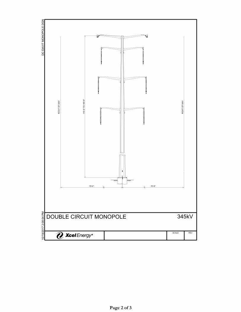
DOUBLE CIRCUIT MONOPOLE
75'-0"
RIG
HT O
F W
AY
75'-0"
RIG
HT O
F W
AY
110'-0"
TO 1
65'-0"
345
10/1
9/2
017 2:0
8:0
4 P
MD
C D
AVIT M
ON
OP
OLE.D
GN
kV
SCALE REVR
Page 2 of 3

X
XX
H-FRAME
XCEL ENERGY
XXX'-XX" LDX
MO-YEAR
XXXXX-X-XXX
LOT XXXX-X
XXXXXX
XP XXXXX
XCEL ENERGY
XXX'-XX" LDX
MO-YEAR
XXXXX-X-XXX
LOT XXXX-X
XXXXXX
XP XXXXX
XCEL ENERGY
XXX'-XX" LDX
MO-YEAR
XXXXX-X-XXX
LOT XXXX-X
XXXXXX
XP XXXXX
XCEL ENERGY
XXX'-XX" LDX
MO-YEAR
XXXXX-X-XXX
LOT XXXX-X
XXXXXX
XP XXXXX
80'-0"
TO 1
50'-0"
25'-0"
75'-0"75'-0"
RIG
HT O
F W
AY
RIG
HT O
F W
AY
345
10/1
9/2
017 2:1
6:5
8 P
MT
AN H-F
RA
ME.D
GN
kV
SCALE REVR
Page 3 of 3

APPENDIX E
Route Development and Selection Process
Page 1
APPENDIX E Route Segment Selection Process Summary
The information in this Appendix is provided to supplement and include more detailed information regarding the route selection process used for the Project. Applicants conducted considerable public and agency outreach and information gathering in Blue Earth, Faribault, Martin, and Nicollet counties. As discussed in Section 3.2 of the Route Permit Application (RPA), the Applicants developed a Geographic Information System (GIS) constraints database that contained information gathered from publicly available data resources and from on-site field review efforts.
In addition, the Applicants conducted four public open houses to introduce the Project and gather feedback on preliminary routes from residents, landowners, local government units (LGUs), and other potentially-affected parties. As part of these open houses, Applicants also collected data regarding resources present in the Project Study Area that may not have been identified during the initial information gathering efforts, to assist in the development and refinement of preliminary route options for the Project. The Applicants developed a network of route options by analyzing the GIS constraints data, considering stakeholder feedback acquired during the route development stages of the Project, and adhering to guidance listed in Minnesota Statutes Section § 216E.03, subdivision 7 and Minnesota Rule 7850.4100.
This process resulted in the identification of four routes and several connector segments between the routes presented in the RPA. A more detailed description of each step in the route selection process is provided below.

Page 2
Figure E-1 Huntley to Wilmarth Project Study Area
Page 3
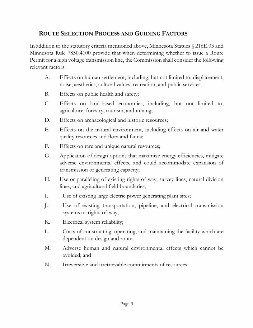
ROUTE SELECTION PROCESS AND GUIDING FACTORS
In addition to the statutory criteria mentioned above, Minnesota Statues § 216E.03 and Minnesota Rule 7850.4100 provide that when determining whether to issue a Route Permit for a high voltage transmission line, the Commission shall consider the following relevant factors:
A. Effects on human settlement, including, but not limited to: displacement, noise, aesthetics, cultural values, recreation, and public services;
B. Effects on public health and safety;
C. Effects on land-based economies, including, but not limited to, agriculture, forestry, tourism, and mining;
D. Effects on archaeological and historic resources;
E. Effects on the natural environment, including effects on air and water quality resources and flora and fauna;
F. Effects on rare and unique natural resources;
G. Application of design options that maximize energy efficiencies, mitigate adverse environmental effects, and could accommodate expansion of transmission or generating capacity;
H. Use or paralleling of existing rights-of-way, survey lines, natural division lines, and agricultural field boundaries;
I. Use of existing large electric power generating plant sites;
J. Use of existing transportation, pipeline, and electrical transmission systems or rights-of-way;
K. Electrical system reliability;
L. Costs of constructing, operating, and maintaining the facility which are dependent on design and route;
M. Adverse human and natural environmental effects which cannot be avoided; and
N. Irreversible and irretrievable commitments of resources.
Page 4
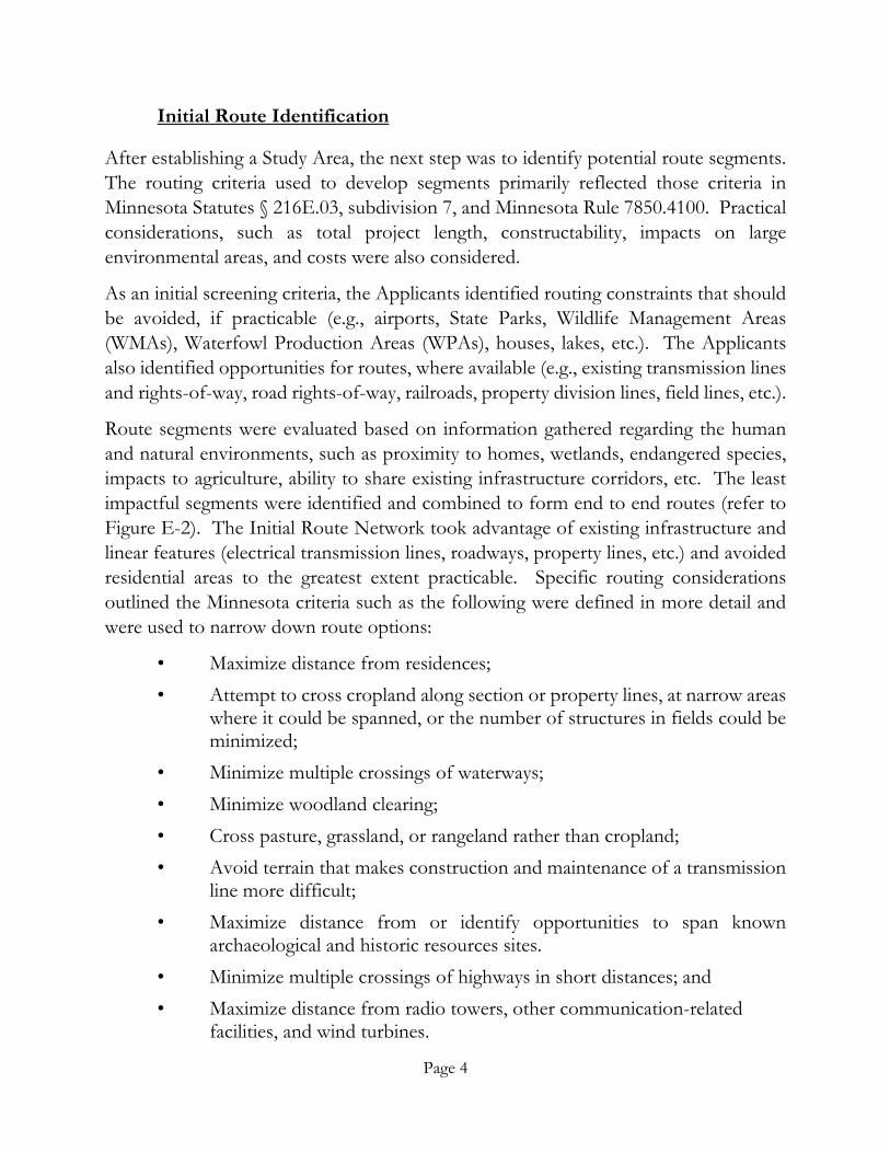
Initial Route Identification
After establishing a Study Area, the next step was to identify potential route segments. The routing criteria used to develop segments primarily reflected those criteria in Minnesota Statutes § 216E.03, subdivision 7, and Minnesota Rule 7850.4100. Practical considerations, such as total project length, constructability, impacts on large environmental areas, and costs were also considered.
As an initial screening criteria, the Applicants identified routing constraints that should be avoided, if practicable (e.g., airports, State Parks, Wildlife Management Areas (WMAs), Waterfowl Production Areas (WPAs), houses, lakes, etc.). The Applicants also identified opportunities for routes, where available (e.g., existing transmission lines and rights-of-way, road rights-of-way, railroads, property division lines, field lines, etc.).
Route segments were evaluated based on information gathered regarding the human and natural environments, such as proximity to homes, wetlands, endangered species, impacts to agriculture, ability to share existing infrastructure corridors, etc. The least impactful segments were identified and combined to form end to end routes (refer to Figure E-2). The Initial Route Network took advantage of existing infrastructure and linear features (electrical transmission lines, roadways, property lines, etc.) and avoided residential areas to the greatest extent practicable. Specific routing considerations outlined the Minnesota criteria such as the following were defined in more detail and were used to narrow down route options:
• Maximize distance from residences; • Attempt to cross cropland along section or property lines, at narrow areas
where it could be spanned, or the number of structures in fields could be minimized;
• Minimize multiple crossings of waterways; • Minimize woodland clearing; • Cross pasture, grassland, or rangeland rather than cropland; • Avoid terrain that makes construction and maintenance of a transmission
line more difficult; • Maximize distance from or identify opportunities to span known
archaeological and historic resources sites. • Minimize multiple crossings of highways in short distances; and • Maximize distance from radio towers, other communication-related
facilities, and wind turbines.

Page 5
Figure E-2 Initial Route Network

Page 6
Initial Outreach within the Study Area
Following development of the Study Area and Initial Route Network, several meetings were held with federal, state, county, and local agencies (e.g., Minnesota Department of Natural Resources (MNDNR), U.S. Fish and Wildlife Service (USFWS), and various county and local administrators). The Applicants provided an overview of the route selection process and provided details on the Project schedule and future public outreach efforts (including open houses). The meetings provided an opportunity to discuss the Project in greater detail and to obtain feedback from agency representatives regarding potential resources and concerns unique to the area, and to residents and landowners of each county. The Applicants also requested information on obtaining additional county-specific data that was publicly available to incorporate into the existing GIS database developed for the Project.
The Applicants received written replies from agencies and received four agency requests for GIS data to assist in their review of the Project (refer to Appendix G). Section 7.1 provides a more detailed description of agency correspondence for the Project. As a follow-up to the inquiries and additional information requests regarding potential routing concerns, the Applicants requested/attended meetings with officials from USFWS, MNDNR, Minnesota Board of Water and Soil Resources (BWSR), City of North Mankato, City of Mankato, Belgrade Township, Nicollet County, and Butternut Township.
Site Review of Initial Route Network
After the desktop identification of the Initial Route Network, the Applicants performed a field site reconnaissance of the Study Area. Using data and information gathered from the formal agency responses, county meetings, and the GIS constraints database developed for the Project, the Applicants investigated numerous route segments. Locations of residences, out-buildings, radio and weather towers, transmission lines, and other features were recorded and added to the Project’s GIS constraints database. The route segments were reviewed in the context of Minnesota’s routing criteria, incorporating those that complied with the Minnesota routing criteria as well as the additional routing constraints considerations, including agency input. Routes that could not avoid major routing constraints, did not take advantage of existing linear features, did not minimize impacts, or created engineering or construction challenges were dropped from further consideration.
The Initial Route Network included numerous route segments that, when combined, created various route combinations (although some routes differed from each other by
Page 7
only one or two segments). In general, route segments are shorter portions of overall routes that, when joined together, create complete routes between the two connection points. Route segments result when a section of a route branches into other segments or results from multiple individual segments joining together. In joining specific segments, different segment combinations and subsequent routes linking the desired connection points, are created. Routes were reviewed for general constructability and engineering feasibility from a design and planning perspective and reviewed for general compliance with Minnesota Statutes and Rules. Minor adjustments to the Initial Route Network were made based on the results of these reviews.
Public Open House Meetings
Following the development of the Initial Route Network, the Applicants conducted four public open houses, two in Mapleton, Minnesota on June 20, 2017 and two in Mankato, Minnesota on June 21, 2017. Notices for these open houses were provided via newspaper and direct mail. Applicants sent approximately 25,000 direct mail open house invitations to residents, landowners, public officials, and other potential stakeholders (Appendix H). The open house invitation provided information such as a general Project description, a map of the Project Study Area and Initial Route Network, the Project’s website address and Applicants’ contact information for submission of questions and comments.
The goal of the open house meetings was to gather input from the public on several different transmission line routing options. The route options displayed were preliminary and Project staff communicated that none of the routes were preferred over another at this point in the process. The Applicants received approximately 200 comments submitted by phone, e-mail, or comment forms.
The open house format had several stations to display and communicate the Project to the attendees. Large-scale poster-sized maps were on display depicting the Study Area and Initial Route Network. Attendees could identify their property and Project staff provided a description of the route option, if requested. Several stations were set up and staffed by the Applicants to give the attendees more detailed information and to answer questions. The stations located around the meeting room included the following:
• Right-of-way – to answer questions about right-of-way and landowner compensation;
• Engineering/construction - discuss the process of developing the Project from an engineering standpoint and construction;

Page 8
• Regulatory permitting - provide overview the permitting process the Project would follow;
• Project need - demonstrate the need for the Project; • GIS mapping station - assist landowners in locating their property and
proximity to Project segments; • Demand side management - provide customers with resources to reduce
energy use; and • Criteria ranking - rank three routing criteria that were most important to
attendees.
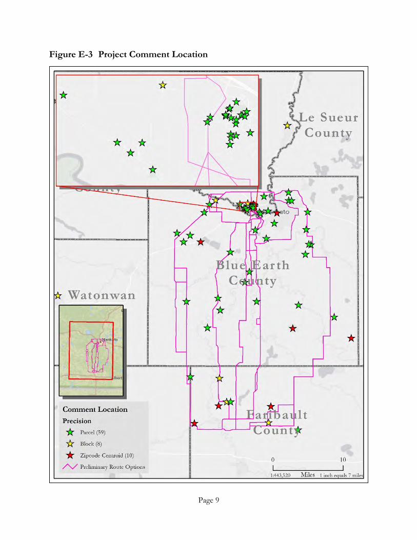
Meeting attendees were encouraged to leave comments either at the meeting or following the meeting. The Applicants received approximately 200 comments submitted by phone, e-mail, or comment forms. Figure ES-3 depicts the locations of each comment, where available. Landowner feedback from these open houses included comments and concerns regarding proximity to local airstrips, land use and agricultural practices, preference to follow existing infrastructure, and other route development considerations. More information on the feedback received is available in Section 7.1 of the RPA.
Page 9
Figure E-3 Project Comment Location

Page 10
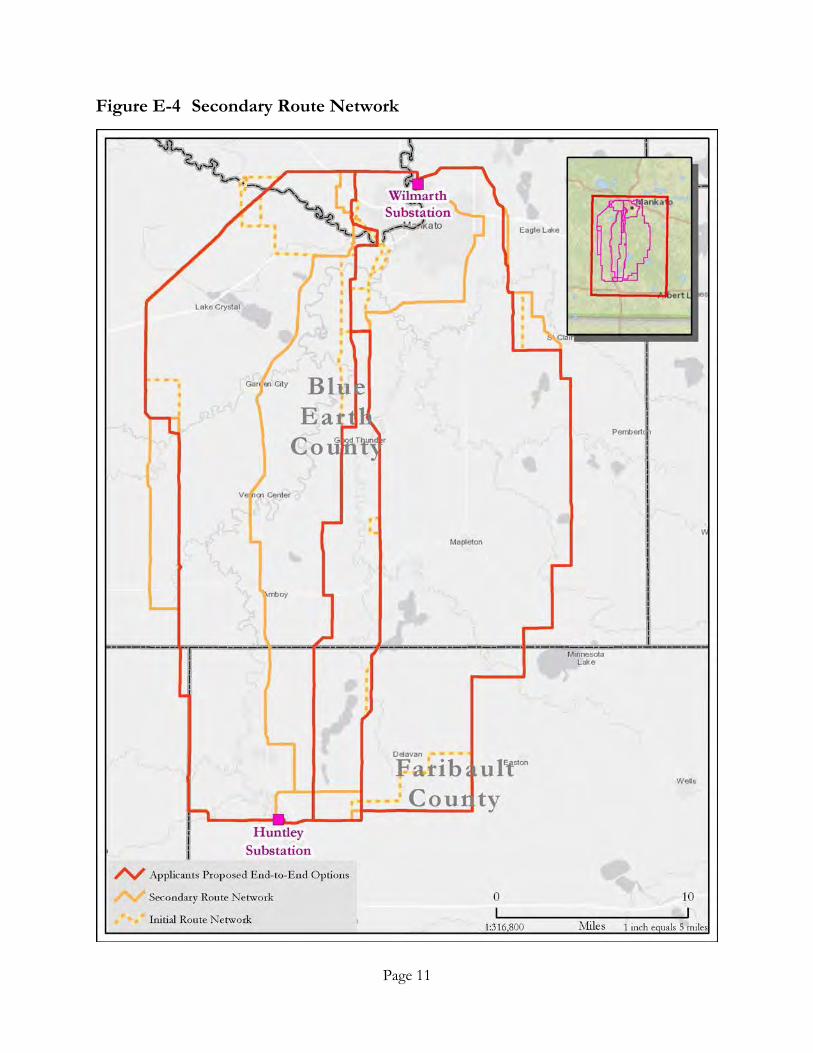
SECONDARY ROUTE NETWORK
Based on the comments received at the open houses, further development of the GIS constraints database, and the Applicants ongoing route review, the Route Network was revised to consider a subset of route segments, including additional connector segments developed in response to landowner requests or comments. The Secondary Route Network is provided in Figure E-4.
As a result of the extensive number of alternative routes, a multi-step process was developed to assist in the identification of geographically diverse routes and to focus the analysis on the routes with the fewest impacts to natural resources and human settlement.
The Secondary Route Network was analyzed using a set of routing criteria selected to characterize the important features of each route and provide an indication of the potential concerns for environmental and human resources associated with each route consistent with Minnesota’s routing criteria. The resulting routes were organized by the nature and extent of their potential impacts, allowing the routes that the Applicants determined were the least compliant with the overall Minnesota Statutory and Rule routing criteria to be removed from further consideration.
In comparing the routes, segments identified to address issues and concerns associated with several municipalities and land features were given additional routing consideration. These included the Cities of North Mankato and Mankato, and their residential developments; Minneopa State Park; the City of St. Clair; Blue Earth River crossings; the WPAs around the Minnesota Lake area; the Center Creek Historic District near Huntley; and the chain of lakes along the Rice Creek and Smith WMAs, and Lura Lake WPA.
Page 11
Figure E-4 Secondary Route Network
Page 12
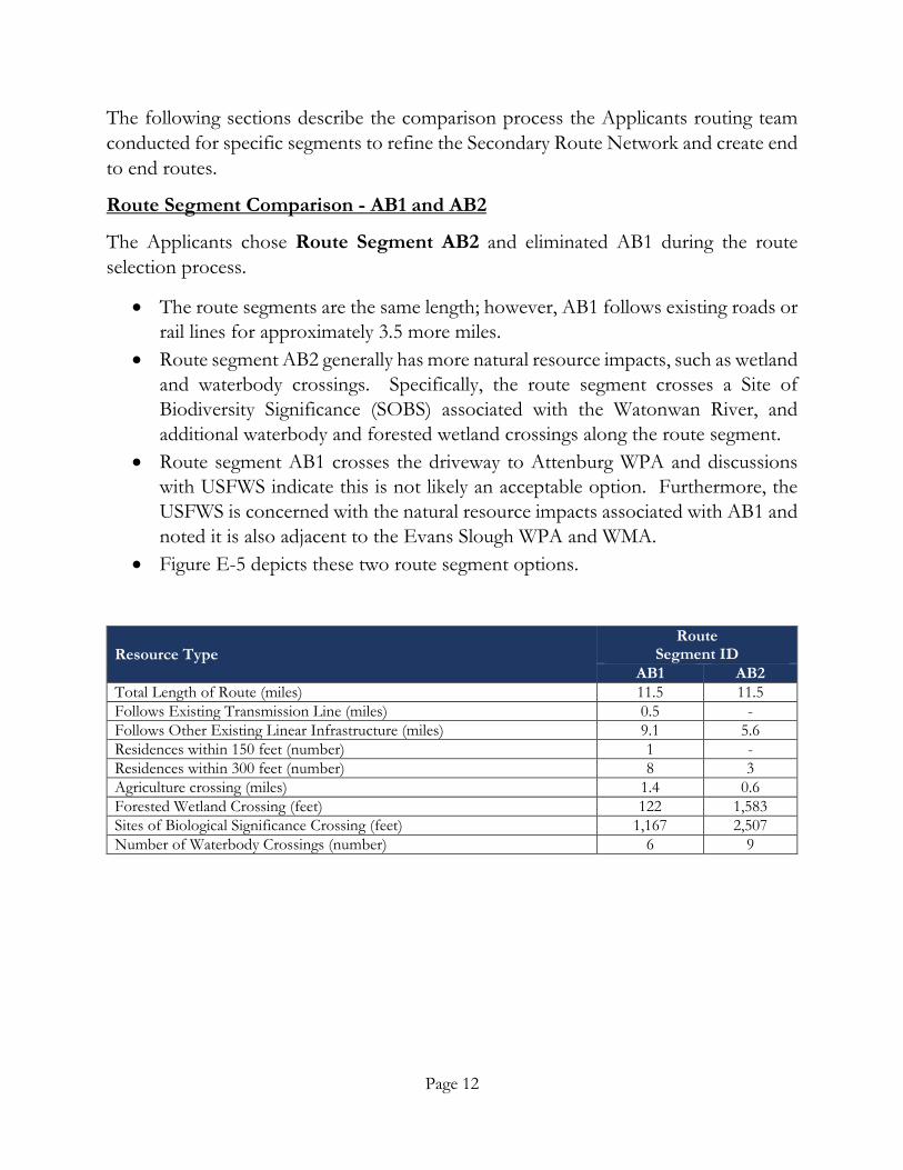
The following sections describe the comparison process the Applicants routing team conducted for specific segments to refine the Secondary Route Network and create end to end routes.
Route Segment Comparison - AB1 and AB2
The Applicants chose Route Segment AB2 and eliminated AB1 during the route selection process.
• The route segments are the same length; however, AB1 follows existing roads or rail lines for approximately 3.5 more miles.
• Route segment AB2 generally has more natural resource impacts, such as wetland and waterbody crossings. Specifically, the route segment crosses a Site of Biodiversity Significance (SOBS) associated with the Watonwan River, and additional waterbody and forested wetland crossings along the route segment.
• Route segment AB1 crosses the driveway to Attenburg WPA and discussions with USFWS indicate this is not likely an acceptable option. Furthermore, the USFWS is concerned with the natural resource impacts associated with AB1 and noted it is also adjacent to the Evans Slough WPA and WMA.
• Figure E-5 depicts these two route segment options.
Resource Type Route
Segment ID AB1 AB2
Total Length of Route (miles) 11.5 11.5 Follows Existing Transmission Line (miles) 0.5 - Follows Other Existing Linear Infrastructure (miles) 9.1 5.6 Residences within 150 feet (number) 1 - Residences within 300 feet (number) 8 3 Agriculture crossing (miles) 1.4 0.6 Forested Wetland Crossing (feet) 122 1,583 Sites of Biological Significance Crossing (feet) 1,167 2,507 Number of Waterbody Crossings (number) 6 9

Page 13
Figure E-5 Route Segment Comparison – AB1-AB2
Page 14
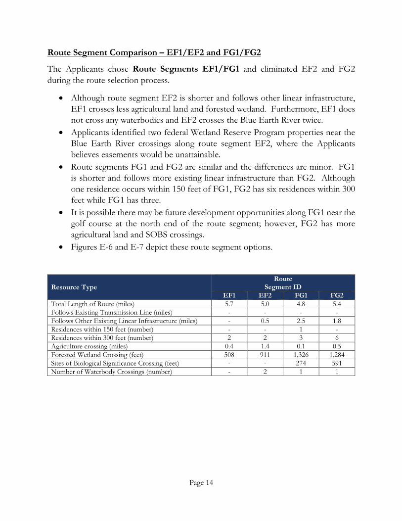
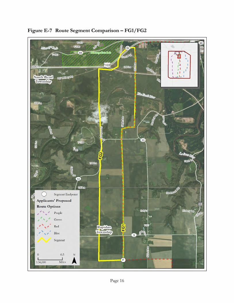
Route Segment Comparison – EF1/EF2 and FG1/FG2
The Applicants chose Route Segments EF1/FG1 and eliminated EF2 and FG2 during the route selection process.
• Although route segment EF2 is shorter and follows other linear infrastructure, EF1 crosses less agricultural land and forested wetland. Furthermore, EF1 does not cross any waterbodies and EF2 crosses the Blue Earth River twice.
• Applicants identified two federal Wetland Reserve Program properties near the Blue Earth River crossings along route segment EF2, where the Applicants believes easements would be unattainable.
• Route segments FG1 and FG2 are similar and the differences are minor. FG1 is shorter and follows more existing linear infrastructure than FG2. Although one residence occurs within 150 feet of FG1, FG2 has six residences within 300 feet while FG1 has three.
• It is possible there may be future development opportunities along FG1 near the golf course at the north end of the route segment; however, FG2 has more agricultural land and SOBS crossings.
• Figures E-6 and E-7 depict these route segment options.
Resource Type Route
Segment ID EF1 EF2 FG1 FG2
Total Length of Route (miles) 5.7 5.0 4.8 5.4 Follows Existing Transmission Line (miles) - - - - Follows Other Existing Linear Infrastructure (miles) - 0.5 2.5 1.8 Residences within 150 feet (number) - - 1 - Residences within 300 feet (number) 2 2 3 6 Agriculture crossing (miles) 0.4 1.4 0.1 0.5 Forested Wetland Crossing (feet) 508 911 1,326 1,284 Sites of Biological Significance Crossing (feet) - - 274 591 Number of Waterbody Crossings (number) - 2 1 1

Page 15
Figure E-6 Route Segment Comparison – EF1/EF2
Page 16
Figure E-7 Route Segment Comparison – FG1/FG2

Page 17
Route Segment Comparison – HI1 and HI2
The Applicants selected Route Segment HI2 and eliminated HI1 during the route selection process.
• Route segment HI1 will likely be difficult to permit, especially with the natural resource agencies (e.g., USACE). There are two crossings of the Blue Earth River in close proximity to one another, and HI1 crosses more wetlands (both forested and non-forested) as well.
• Route segment HI2 follows a more industrial corridor, has more residences within both 150 and 300 feet, and is within 150 feet of a church. However, the expected level of natural resource agency interest and riparian and viewshed impacts that could occur along the Blue Earth River prompted
• Figure E-8 depicts the two route segment options.
Resource Type Route
Segment ID HI1 HI2
Total Length of Route (miles) 4.1 4.2 Follows Existing Transmission Line (miles) - 1.6 Follows Other Existing Linear Infrastructure (miles) 0.8 0.6 Residences within 150 feet (number) 1 7 Residences within 300 feet (number) 14 28 Agriculture crossing (miles) 1.6 0.9 Forested Wetland Crossing (feet) 1,713 162 Sites of Biological Significance Crossing (feet) 783 926 Number of Waterbody Crossings (number) 3 1

Page 18
Figure E-8 Route Segment Comparison – HI1 and HI2
Page 19
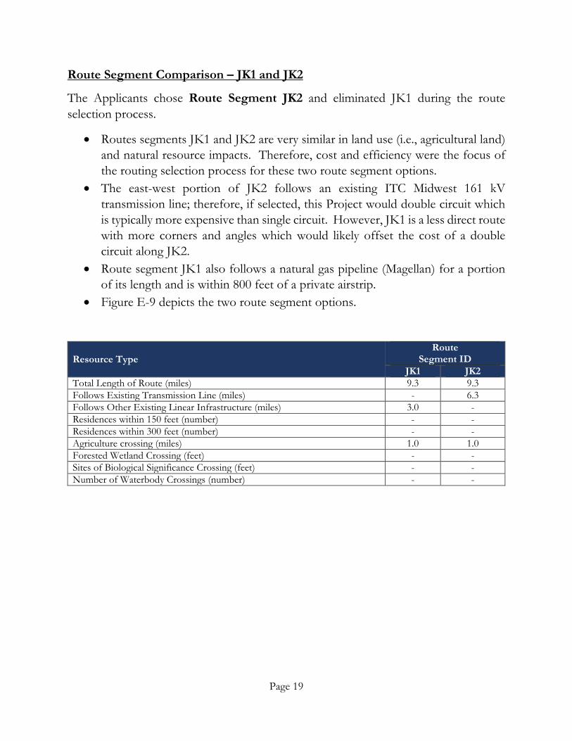
Route Segment Comparison – JK1 and JK2
The Applicants chose Route Segment JK2 and eliminated JK1 during the route selection process.
• Routes segments JK1 and JK2 are very similar in land use (i.e., agricultural land) and natural resource impacts. Therefore, cost and efficiency were the focus of the routing selection process for these two route segment options.
• The east-west portion of JK2 follows an existing ITC Midwest 161 kV transmission line; therefore, if selected, this Project would double circuit which is typically more expensive than single circuit. However, JK1 is a less direct route with more corners and angles which would likely offset the cost of a double circuit along JK2.
• Route segment JK1 also follows a natural gas pipeline (Magellan) for a portion of its length and is within 800 feet of a private airstrip.
• Figure E-9 depicts the two route segment options.
Resource Type Route
Segment ID JK1 JK2
Total Length of Route (miles) 9.3 9.3 Follows Existing Transmission Line (miles) - 6.3 Follows Other Existing Linear Infrastructure (miles) 3.0 - Residences within 150 feet (number) - - Residences within 300 feet (number) - - Agriculture crossing (miles) 1.0 1.0 Forested Wetland Crossing (feet) - - Sites of Biological Significance Crossing (feet) - - Number of Waterbody Crossings (number) - -

Page 20
Figure E-9 Route Segment Comparison – JK1 and JK2
Page 21
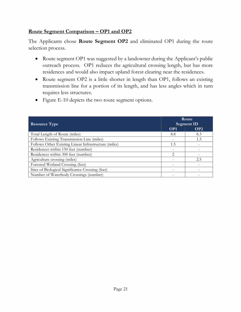
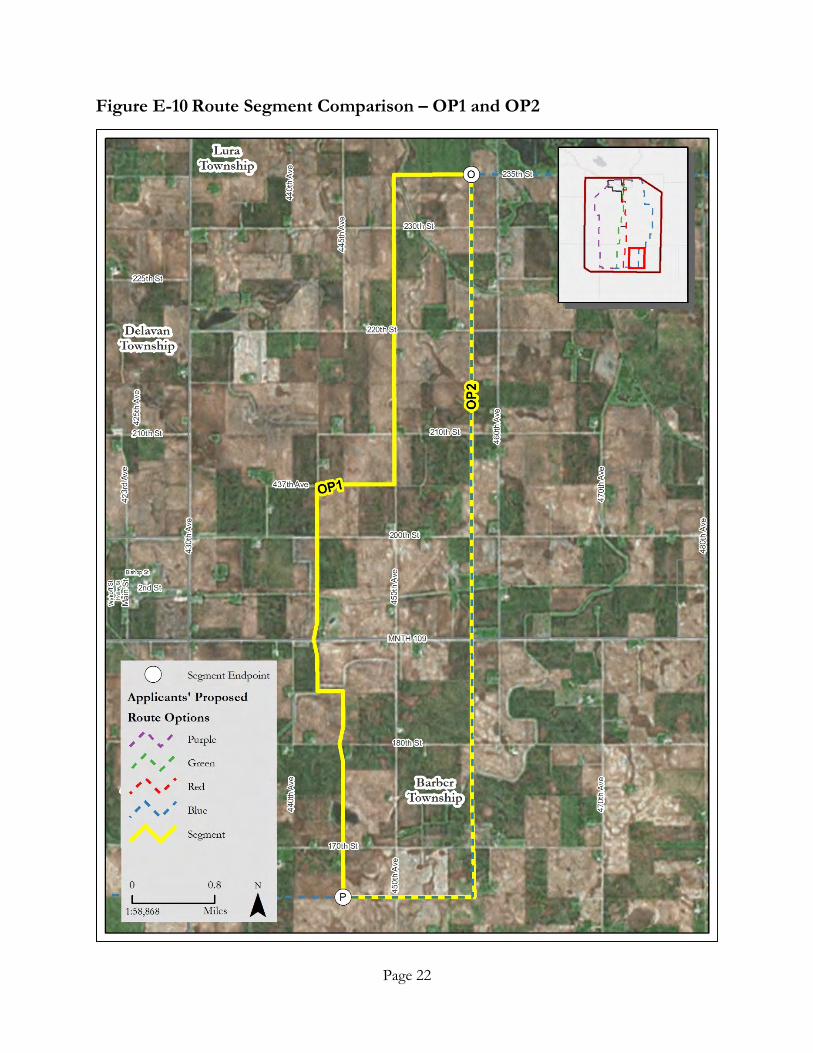
Route Segment Comparison – OP1 and OP2
The Applicants chose Route Segment OP2 and eliminated OP1 during the route selection process.
• Route segment OP1 was suggested by a landowner during the Applicant’s public outreach process. OP1 reduces the agricultural crossing length, but has more residences and would also impact upland forest clearing near the residences.
• Route segment OP2 is a little shorter in length than OP1, follows an existing transmission line for a portion of its length, and has less angles which in turn requires less structures.
• Figure E-10 depicts the two route segment options.
Resource Type Route
Segment ID OP1 OP2
Total Length of Route (miles) 8.8 8.3 Follows Existing Transmission Line (miles) - 1.3 Follows Other Existing Linear Infrastructure (miles) 1.5 - Residences within 150 feet (number) - - Residences within 300 feet (number) 2 - Agriculture crossing (miles) - 2.5 Forested Wetland Crossing (feet) - - Sites of Biological Significance Crossing (feet) - - Number of Waterbody Crossings (number) - -
Page 22
Figure E-10 Route Segment Comparison – OP1 and OP2

Page 23
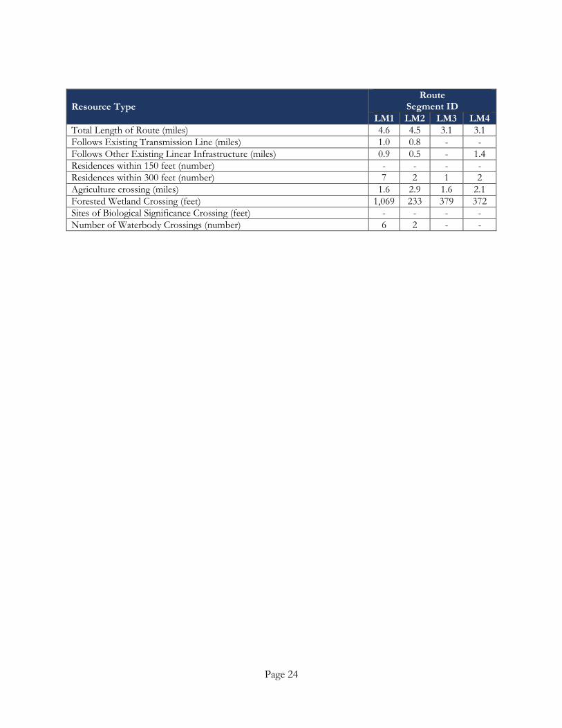
Route Segment Comparison – LM1 through 4
The Applicants selected Route Segment LM3 during the route selection process; however, included LM2 and LM4 as Route Segment Alternatives A and B in the RPA (refer to Sections 4.5 and 6.10 of the RPA).
• The LM route segments represent options in the northernmost part of the Project, near the Wilmarth Substation. LM1-4 are segments that continue south across a small section of the Minneopa State Park or avoid the park and join at the existing 161 kV transmission line within a Board of Water and Soil Resources (BWSR) conservation easement.
• The Applicants routing team initially evaluated these route segments based on proximity to a neighborhood on the east side of Rockford Road as a result of many comments received landowners and the City of North Mankato during Applicants public and agency outreach process.
• The Applicants created additional route segment options to the west of the initial route segment (LM4) presented along Rockford Road.
• LM1 is the longest, and LM3 and LM4 are shorter segments. LM4 follows Rockford Road and LM3 follows a ravine on the western edge of agricultural fields.
• LM4 has been disputed by the landowners in the North Ridge Neighborhood and LM3 is on the edge of potential future development. LM3 also follows a forested ravine which is also a SOBS area.
• The routing team agreed that with some refinement and if Route Segment LM4 was shifted slightly to the east, it would have less natural resource impacts and maintain its limited agricultural impact.
• Based on the presence of Minneminishoma Falls Park, a dense concentration of archaeological artifacts along the Judson Bottom Road (Segment LM1) and the designation of County Highway 41 as part of the Minnesota River Valley Scenic Byway, LM1 was eliminated from further consideration.
• Based on the varied positions of landowners in North Mankato and Belgrade Township, applicants believe that each of the three remaining segments will likely be seen as preferable by some residents and therefore did not eliminate any of these segments.
• Applicants adjusted LM4 approximately 1/4 mile east to avoid proximity to two homes.
• Figure E-11 depicts the four route segment options.
Page 24
Resource Type Route
Segment ID LM1 LM2 LM3 LM4
Total Length of Route (miles) 4.6 4.5 3.1 3.1 Follows Existing Transmission Line (miles) 1.0 0.8 - - Follows Other Existing Linear Infrastructure (miles) 0.9 0.5 - 1.4 Residences within 150 feet (number) - - - - Residences within 300 feet (number) 7 2 1 2 Agriculture crossing (miles) 1.6 2.9 1.6 2.1 Forested Wetland Crossing (feet) 1,069 233 379 372 Sites of Biological Significance Crossing (feet) - - - - Number of Waterbody Crossings (number) 6 2 - -

Page 25
Figure E-11 Route Segment Comparison – LM1 through 4
Page 26
Following the route segment comparison exercise described above, several trends were identified for each of the developing end to end routes. These trends are summarized below:
• The westernmost route option has a significant length of co-location opportunity along existing transmission lines and roads (approximately 68 percent), as well as opportunity for following property line boundaries (approximately 26 percent). Routing along property lines, particularly in a largely agricultural area minimizes agricultural impacts by avoiding crossing open farmland. This route option has fewer residences, but has a greater number of wetland crossings. The western route option avoids the Cities of North Mankato and Mankato and crosses the Minneopa State Park along an existing transmission line easement.
• The route option along U.S. Highway 169, although generally co-located with the highway (approximately 52 percent), has a much higher number of residences within 300 feet than the other route options and a higher number of state park crossings; this option also crosses more open farmland than most of the other routes (approximately 3 miles). However, this route has a lower number of wetland and other natural feature crossings, including SOBS and BWSR easements.
• The route options in the center of the Project’s Study Area have common alignment options coming out of the Wilmarth Substation.
o The western of the two is the shortest of the route options identified, but is the least co-located with existing transmission lines (approximately 12 percent). It is primarily routed along existing road and rail lines (approximately 27 percent) and existing property lines (approximately 49 percent). This route option has moderate residential proximity and crosses a lower amount of open farm land (approximately 1 mile) and forested wetlands (approximately 0.5 mile) than most of the other route options. However, this route option crosses more upland forest and Native Plant Communities (NPC) than the other route options. This route option intersects the western edge of the City of North Mankato and has another further west option through Belgrade Township.
o The eastern of these two route options also intersects the western edge of the City of North Mankato and has an option through Belgrade Township. This route option has the highest number of river and creek crossings of all the options identified, and crosses major rivers at six

Page 27
locations. This route is one of the shortest routes and is co-located along existing transmission lines for approximately 57 percent of its length. This route would cross only approximately 0.4 mile of open farm land, and has fairly high residential proximity compared to the other routes. The route crosses a moderate amount of upland forest (approximately 3 miles), nearly 3 miles of non-forested wetlands, and just over 1 mile of NPCs. This route option also crosses Roberts WPA along an existing easement.
• The most easterly route option avoids the City of North Mankato and Minneopa State Park. This route option is the longest (approximately 57 miles), and is primarily located along property lines (51.7 percent). It has low residential proximity, but crosses areas slated for future development. The east route crosses the highest amount of open farm land of any of the options identified (approximately 6 miles). It also crosses the greatest length of forested wetlands (approximately 1 mile), has the highest number of stream crossings (36), and crosses major rivers at 6 locations. However, this route option does not intersect any parks or WPAs, and has a lower number of natural feature crossings such as SOBS, BWSR easements, or NPCs.
ELIMINATION OF CERTAIN ROUTES
Upon thorough and detailed investigation, evaluation, and consideration, routes were dropped from further consideration for this Project. The routes and reasons for elimination are discussed below.
U.S. Highway 169 Route
Although this is one of the shortest options and generally follows the highway and existing transmission lines, the route option following U.S. Highway 169 has the most instances of residences within 300 feet of the transmission line and generally crosses more populated areas (refer to the following table). This is mainly due to the fact that there are towns and cities which the state highway runs both close to and directly through, making routing difficult (i.e., Garden City, Vernon City, Amboy, and Winnebago). Furthermore, the highway generally follows the Blue Earth River corridor, crossing the Hog Island WMA near Garden City. The elimination of this route reduced the total number of end-to-end route options by two.
Page 28
Resource Type Total Length of Route (miles) 45.3 Follows Existing Transmission Line (miles) 10.4 Follows Other Existing Linear Infrastructure (miles) 23.5 Residences within 150 feet (number) 10 Residences within 300 feet (number) 50 Agriculture crossing (miles) 2.9 Forested Wetland Crossing (feet) 3,231 Sites of Biological Significance Crossing (feet) 5,015 Number of Waterbody Crossings (number) 18
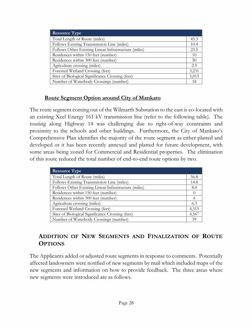
Route Segment Option around City of Mankato
The route segment coming out of the Wilmarth Substation to the east is co-located with an existing Xcel Energy 161 kV transmission line (refer to the following table). The routing along Highway 14 was challenging due to right-of-way constraints and proximity to the schools and other buildings. Furthermore, the City of Mankato’s Comprehensive Plan identifies the majority of the route segment as either platted and developed or it has been recently annexed and platted for future development, with some areas being zoned for Commercial and Residential properties. The elimination of this route reduced the total number of end-to-end route options by two.
Resource Type Total Length of Route (miles) 56.8 Follows Existing Transmission Line (miles) 14.8 Follows Other Existing Linear Infrastructure (miles) 8.4 Residences within 150 feet (number) 0 Residences within 300 feet (number) 6 Agriculture crossing (miles) 6.3 Forested Wetland Crossing (feet) 4,515 Sites of Biological Significance Crossing (feet) 4,567 Number of Waterbody Crossings (number) 39
ADDITION OF NEW SEGMENTS AND FINALIZATION OF ROUTE OPTIONS
The Applicants added or adjusted route segments in response to comments. Potentially affected landowners were notified of new segments by mail which included maps of the new segments and information on how to provide feedback. The three areas where new segments were introduced are as follows.
Page 29
Belgrade Township - Additional segments were added in response to concerns about the potential route segment along Rockford Road. The City of North Mankato and residents of the neighborhood east of Rockford Road objected to the route segment based on impacts to the existing neighborhood and potential impacts on future development in the area (refer to Section 7.1.3 of the RPA for more information on the City of North Mankato’s concerns).
One of the newly added segments in Belgrade Township was adjusted based on public feedback and additional analysis. The adjustment created a shorter route that avoids proximity to two homes, but requires crossing approximately 3,000 feet of agricultural field where there is no current field division.
St. Clair – Additional segments were added because the eastern route near St. Clair was close to the end of a grass strip runway. New segments were added that were more compatible with existing aviation land uses.
Eagle Lake – The eastern route between Mankato and Eagle Lake was adjusted based on feedback from the City of Mankato. The route was seen as incompatible with a solar development and conflicted with future development patterns in the city (refer to Section 7.1.3 of the RPA for more information on the City of Mankato’s comments).
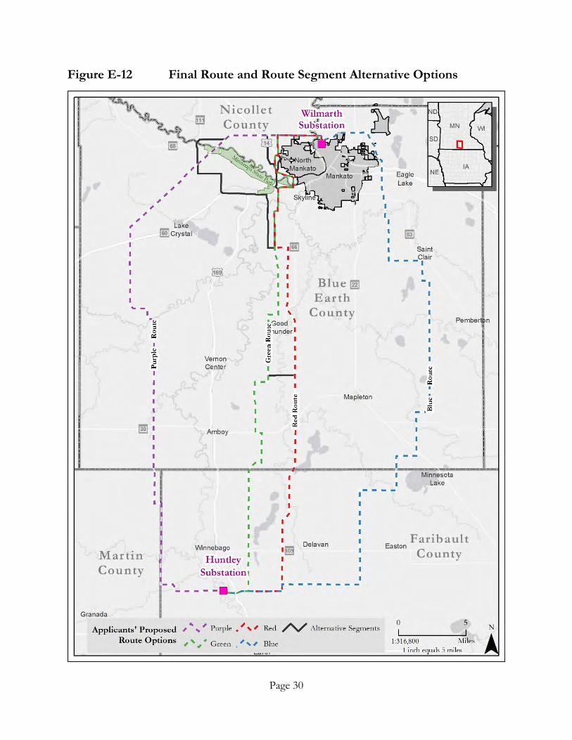
The remaining four end-to-end routes were analyzed according to Minnesota routing criteria and are depicted in Figure E-12. The Applicants also identified four alternatives and two connector segments which are presented and analyzed in Sections 4.5 and 6.10 of the RPA. Refer to Sections 4.5 and 6.10 of the RPA for additional detail on the route segment alternatives.
Page 30
Figure E-12 Final Route and Route Segment Alternative Options
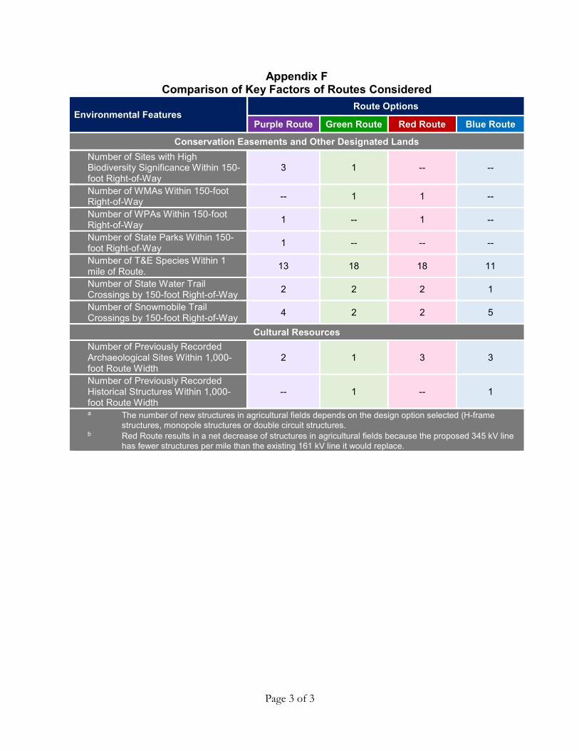
APPENDIX F
Impact Table for Route Options

Page 1 of 3
Appendix F Comparison of Key Factors of Routes Considered
Environmental Features Route Options
Purple Route Green Route Red Route Blue Route
General Length (miles) 51.6 45.4 46.5 57.0 150-foot Right-of-Way (acres) 938 824 845 1,037 Estimated Construction Costs (2016$)
$105.8 to 137.9 million
$109.0 to 121.3 million
$135.2 to 138.0 million
$123.7 to 135.8 million
Corridor Sharing Double-circuit Existing Transmission Line (miles)
23.1 (if double
circuit) 0.8 29.4 9.6
Paralleling Existing Transmission Line (miles)
21.7 (if built
parallel) 4.6 -- --
Roads and Railroads (miles) 11.7 12.4 5.6 9.4 Property and Field Lines (miles) 13.3 21.5 6.8 29.6 No Linear Feature Sharing (miles) 3.7 6.2 4.7 8.5 Total Linear Feature Sharing (miles) 48.1 39.3 41.8 48.6 Total Linear Feature Sharing (percent) 93 87 90 85
Proximity to Residences
Number of Residences 0 to 75 feet from Application Alignments -- -- -- --
Number of Residences 76 to 150 feet from Application Alignments -- 11 11 1
Number of Residences 151 to 300 feet from Application Alignments 7 15 20 4
Number of Residences 301 to 500 feet from Application Alignments 9 44 38 10
Total Number of Residences within 500 feet of Application Alignments 16 70 69 15
Agricultural Impacts
Change in Number of Poles in Cropland a 175 to 215 120 to 195 -5 to -25 b 125 to 240
Prime Farmland
Total All Categories of Prime Farmland Within 150-foot Right-of-Way (acres/percent)
713 / 76 662 / 80 697 / 83 899 / 87
Farmland of State Importance Within the 150-foot Right-of-Way (acres/percent)
118 / 13 72 / 9 55 / 7 83 / 8

Page 2 of 3
Appendix F Comparison of Key Factors of Routes Considered
Environmental Features Route Options
Purple Route Green Route Red Route Blue Route
Land Cover Agricultural Land Within 150-foot Right-of-Way (acres/percent) 607 / 65 522 / 63 510 / 60 754 / 73
Wetlands Within the 150-foot Right-of-Way (acres/percent) 59 / 6 39 / 5 54 / 6 53 / 5
Grasslands Within the 150-foot Right-of-Way (acres/percent) 141 / 15 58 / 7 80 / 10 99 / 9
Forest Lands Within the 150-foot Right-of-Way (acres/percent) 27 / 3 57 / 7 50 / 6 12 / 1
Developed Areas Within the 150-foot Right-of-Way (acres/percent) 98 / 10 142 / 17 144 / 17 113 / 11
Open Water Within the 150-foot Right-of-Way (acres/percent) 6 / 1 6 / 1 7 / 1 6 / 1
Wetlands Total Wetlands Within the 150-foot Right-of-Way (acres/percent) 59.1 / 6 45.0 / 6 60.9 / 7 56.9 / 6
Non-Forested Wetlands Within the 150-foot Right-of-Way (acres/percent)
49.1 / 5 36.8 / 5 46.7 / 5 37.7 / 4
Forested Wetlands Within the 150-foot Right-of-Way (acres/percent) 10.0 / 1 8.2 / 1 14.2 / 2 19.2 / 2
Number of Poles in Wetlands 17 14 18 15
PWI and Shallow Lakes
Number of Stream and River Crossings by Application Alignments 24 18 22 45
Number or PWI Stream Crossings by Application Alignments 14 8 14 17
Number of PWI Basins Within 150-foot Right-of-Way -- 1 2 --
Number of PWI Wetlands Within 150-foot Right-of-Way -- -- -- 1
Number of Shallow Lakes Within 150-foot Right-of-Way -- 1 1 1
Page 3 of 3
Appendix F Comparison of Key Factors of Routes Considered
Environmental Features Route Options
Purple Route Green Route Red Route Blue Route
Conservation Easements and Other Designated Lands Number of Sites with High Biodiversity Significance Within 150-foot Right-of-Way
3 1 -- --
Number of WMAs Within 150-foot Right-of-Way -- 1 1 --
Number of WPAs Within 150-foot Right-of-Way 1 -- 1 --
Number of State Parks Within 150-foot Right-of-Way 1 -- -- --
Number of T&E Species Within 1 mile of Route. 13 18 18 11
Number of State Water Trail Crossings by 150-foot Right-of-Way 2 2 2 1
Number of Snowmobile Trail Crossings by 150-foot Right-of-Way 4 2 2 5
Cultural Resources Number of Previously Recorded Archaeological Sites Within 1,000-foot Route Width
2 1 3 3
Number of Previously Recorded Historical Structures Within 1,000-foot Route Width
-- 1 -- 1
a The number of new structures in agricultural fields depends on the design option selected (H-frame structures, monopole structures or double circuit structures.
b Red Route results in a net decrease of structures in agricultural fields because the proposed 345 kV line has fewer structures per mile than the existing 161 kV line it would replace.