Modelling natural disturbances in forest ecosystems: a review

1133
International Geology Review Vol 48 2006 p 1133ndash1144Copyright copy 2006 by V H Winston amp Son Inc All rights reserved
0020-6814069081133-12 $2500
Strong Metal Anomalies in Stream Sediments fromSemiarid Watersheds in Northern Chile When Geological
and Structural Analyses Contribute to Understanding Environmental Disturbances
ROBERTO OYARZUN1
Departamento de Cristalografiacutea y Mineralogiacutea Facultad de Ciencias Geoloacutegicas Universidad Complutense 28040 Madrid Spain
JAVIER LILLO Escuela Superior de Ciencias Experimentales y Tecnologiacutea Universidad Rey Juan Carlos Tulipaacuten sn 28933 Moacutestoles (Madrid) Spain
JORGE OYARZUacuteNDepartamento de Minas Facultad de Ingenieriacutea and CEAZA Universidad de La Serena Casilla 554 La Serena Chile
PABLO HIGUERASDepartamento de Ingenieriacutea Geoloacutegica y Minera Escuela Universitaria Politeacutecnica de Almadeacuten
Universidad de Castilla-La Mancha Plaza M Meca 1 13400 Almadeacuten Spain
AND HUGO MATURANA
Departamento de Minas Facultad de Ingenieriacutea Universidad de La Serena Casilla 554 La Serena Chile
Abstract
We present data from a reconnaissance geochemical environmental survey (stream sediments) inthe Limariacute watershed (northern Chile) and include information from the neighboring Elqui Basin fora combined analysis Given that the region has a long historical record of mining activities impor-tant environmental disturbances were expected However one of the rivers in the Limariacute watershedthat was chosen to serve as a baseline as no mining activities had ever taken place along the valleyshowed one of the largest geochemical anomalies The sampled stream sediments of the HurtadoRiver are highly enriched in Cu (50ndash1880 microg gndash1) Zn (65ndash6580 microg gndash1) and Cd (130ndash31350 nggndash1) The river system is sourced in the high-altitude domain of the Andes and drains importantMiocene hydrothermal alteration zones The Coipita zone (El Indio gold belt) appears to be the mostlikely candidate to have originated the metal anomaly The study of Landsat images suggests that thebelt of alteration zones is located within a large (400+ km long ~150 km wide) NW-SE dextral faultzone This highly fractured domain may have conditioned the rapid unroofing of epithermal oredeposits in Miocene time contributed to important circulation of meteoric waters and eventually tosubsequent strong oxidation leaching and dispersion of metals thus contributing to major metaldispersion in the Elqui and Limariacute fluvial systems
Introduction
THE LATE 1980Sndash1990S marked a major change inthe emphasis and aims of geochemical surveysWhile previously (1960sndash1970s) the surveys wereaimed at the detection of ore deposits at present thecharacterization of metal environmental distur-bances is becoming the centerpiece of many of thesestudies However the study of metal anomalies is
much more than sampling analyzing sediments orwaters and treating the data with sophisticatedstatistical tools Metal dispersion is above all ageological process and as such it requires a carefulanalysis of the many factors (eg the geologicalstructural and metallogenic settings mineralogylandscape climate) controlling metal mobilityOn top of this we must add (if present) the type ofmining (open pit underground) and metallurgical(smelter heap leaching mineral dumps tailings)operations taking place in the area under study1Corresponding author email oyarzungeoucmes
1134 OYARZUN ET AL
From 2002 to 2004 we carried out two geochemicalsurveys within the so-called little north (NorteChico) of Chile a semiarid transitional region (27ordmndash33ordmS) located between the Mediterranean centralpart of the country and the Atacama Desert (deepnorth) This part of Chile is rich in mineral depositsand mining operations Some of them are importantin terms of historical significance such as theAndacollo (Cu-Au) and Punitaqui (Cu-Au-Hg)mining districts (Fig 1) which started operationsduring the Spanish colonial time (16thndash18thcentury) Thus the Coquimbo region (hosting theLimariacute and Elqui basins) has a long record ofmining-related environmental disturbances result-ing from runoff and downstream dispersion of heavymetals (eg Higueras et al 2004) However metal
dispersion in the region is also the result of long-lasting natural geological processes related to theerosion of high-altitude (4000+ m above sea level)As-Cu-Znndashrich hydrothermal zones of Miocene age(eg Oyarzuacuten et al 2003 Oyarzun et al 2004)
Except for a discontinuous coastal narrow beltthis semiarid realm is dominated by a complex arrayof valleys and rivers (the so-called Valles Transver-sales system) that flow in less than 150 km from thehigh Andean Mountains (gt4000 m above sea level)to the coast The main valleys are flanked by moun-tain belts about 50 km wide with altitudes of 600to 1000 m above sea level The climate is stronglyconditioned by the Pacific anticyclone The annualaverage temperature along the coast is 14ordmC whichincreases towards the interior to 16ordmC The average
FIG 1 The Coquimbo region Limariacute and Elqui watersheds sampling sites and location of mines and hydrothermalalteration zones Hydrothermal zones are after Thomas (1967) Maksaev et al (1984) and Kelm et al (2001)
METAL ANOMALIES IN STREAM SEDIMENTS 1135
precipitation in the interior is 100 mm (eg Ovalleaverage for the last 30 years) whereas that of thehigh-altitude Andean realm (rain + snow) is about180 mm with a minimum of 27 mm in 1981 and amaximum of 740 mm in 1987 However the regionis characterized by strong variations induced bywesterly winds (Veit 1996) that correlate with ElNintildeo years which bring intense rains and subse-quent flash floods A strong El Nintildeo year usually hascatastrophic consequences in this realm such asthose of 1997 when roads and bridges were cut byhuge debris flows moving sediments and bouldersliterally isolating the region from the rest of thecountry We present here data for the Limariacute water-shed and include geochemical information from theElqui Basin (Oyarzun et al 2004) (Fig 1)
Methods
We took 33 samples of stream sediments (LIMsamples) from the main rivers and streams of theLimariacute watershed (Fig 1 Table 2) The sedimentsamples (~2 kg) were collected from the riversfocusing on the silty fraction and stored in plasticbags They were dried at room temperature andsieved to lt 64 microm The samples were digested in hotaqua regia (31 HCl HNO3) followed by dissolutionwith HCl (25) which leaves behind a silica-onlyresidue The elements were analyzed by atomicabsorption at Geoanaliacutetica Ltda (Chile) with thefollowing detection limits As (5 microgg) Cd (20 ngg)Cu (5 microgg) and Zn (5 microgg) Quality control at thelaboratory is done by analyzing duplicate samples tocheck precision whereas accuracy was obtained byusing certified standards Blank samples were alsoanalyzed to check procedures The mineralogy ofthe sediments was studied by XRD (instrumentPhilips model PW304000 XrsquoPert MPDMRD) andSEM-EDX (instrument Philips XL30 25 kV) at theCAT facilities of Universidad Rey Juan Carlos(Madrid) In order to analyze the regional tendenciesof element distribution the results were treated withthe Surfer 8 program to assess the spatial continuityof data For analytical procedures regarding datafrom the Elqui watershed see Oyarzun et al (2004)
Results
Mineralogy of stream sediments
The study of the mineral phase shows thepresence of dominant quartz and plagioclase plussecondary alteration minerals including kaolinite
illite bramallite (Na illite) sericite smectite andvermiculite The study also reveals the presence ofgypsum which is a relatively common mineralphase in the semiarid environment of northernChile The presence of kaolinite and smectitestresses the importance of alteration processes inthe source area of some of the studied samples Forexample kaolinite and smectite are important in thehigher course of the Hurtado River (eg samplesLIM 2 33) whereas near Ovalle (sample LIM 17Fig 1) the argillic mineral assemblage disappearsThe metallic phase was studied by SEM-EDXGiven that the most important geochemical anomalyis located in the higher course of the Hurtado Riverwe concentrated our efforts in this sector We founda complex array of intermediate mineral phasesshowing the effect of partial oxidation processes ofsulfide grains The compositions suggest thepresence of pyrite together with Mn and Fe oxides(Cu-Zn bearing) native copper and ilmenite (egsample LIM 2) Zinc was also detected in grains witha complex composition including Th-U or La-Ce-Pr-Nd-Sm-Gd and P (eg sample LIM 31) Thistogether with the contents in Al and S in the grainssuggests the presence of aluminum-phosphate-sulfate (APS)ndashlike minerals which are relativelycommon in the volcanic-epithermal environment(argillic alteration) and may accommodate REE Thand metals such as Fe Cu or Zn in their crystalstructures (Dill 2003)
The geochemical anomalies
Stream sediments sampling has proved to be anexcellent geochemical tool in the tropical and aridand semiarid domains of the Andean chain todetect the presence of ore deposits (eg Cruzat1984 Williams et al 2000) to define baselinesand to constrain environmental disturbances (egWilliams et al 2000 Higueras et al 2004Oyarzun et al 2004) Compared to world baselinesthe Limariacute watershed sediments are highly enrichedin Cu Zn As and Cd (Tables 1 and 2) and the sameapplies to the Elqui Basin (Table 1) In order to havea better statistical approach to element distributionin the Limariacute watershed we transformed the datainto log values After mathematical treatment mostof the data displayed a normal (Gaussian) distribu-tion of the bimodal type (Cu Zn and Cd) (Fig 2)Arsenic departs from this behavior with a flat distri-bution in the higher concentration range The anom-alous populations of Zn and Cd correspond tosamples that were taken in the high course of the
1136 OYARZUN ET AL
Hurtado River whereas in the case of copper sam-ples from the El Ingenio Stream (near the Panulcillometallurgical plant Ovalle) and Punitaqui (Cu-Au-Hg mining district) accompany the high Cu samplesfrom the Hurtado River (Figs 1 and 2) Given thatno mining activities have ever been recorded alongthe Hurtado River we must conclude that the Cuanomalous population has natural (Hurtado) andanthropogenic (Ingenio and Punitaqui) causes TheHurtado River anomaly is extremely consistent withvery high concentrations of Cu Zn and Cd display-ing an almost perfect linear relationship betweenelement pairs (Fig 3)
In order to have a regional approach to elementdistribution we added information for Cu Zn andAs from earlier surveys in the Coquimbo region(Elqui watershed and mining districts) (Higueras etal 2004 Oyarzun et al 2004) (Fig 1) Point linearinterpolation for the Cu Zn Cd and As data allowsrecognition of a major and consistent NW-SEregional trend (Fig 4) Given that the samplingfollowed the rivers and one of the fluvial trends isoriented NW-SE (Fig 1) one may be tempted tointerpret this direction as due to sampling biasHowever the rivers have a more complex patternand other fluvial directions are also important (Fig
1) Thus if the other directions are not reflectedin the resulting 3D plots then as discussed in thenext section this NW-SE trend may have furtherimplications The 3D plots show four well-definedelement concentration highs (Fig 4) (1) a conspicu-ous plateau-like zone for Cu Zn and As defined bygeochemical data from the high course of the Elquiand Hurtado systems (2) a single high for Cu Znand As at the Ovalle-Panulcillo sector (3) a singleCu high from Punitaqui and (4) a minor high for Cuand As located at the Monte Patria zone We discusshere the highs 2 3 and 4 and offer an explanationfor high 1 (Elqui and Hurtado) in the next section
The Ovalle-Panulcillo and Punitaqui highs (2and 3) (Figs 1 and 4) can be explained in geologicaland industrial terms The geology of the central partof the studied area (Thomas 1967) is dominated byCretaceous (Estratos del Reloj Arqueros QuebradaMarquesa and Vintildeita formations) and Eocene (LosElquinos Formation) volcanic and sedimentaryrocks These units were intruded by granitoids fromMid-Cretaceous to early Tertiary time which gaverise to a series of mineral deposits (eg PunitaquiHg-Cu-Au Tamaya Cu) and hydrothermal alter-ation zones (eg Combarbalaacute) (Fig 1) The Puni-taqui district (Higueras et al 2004) corresponds to
TABLE 1 Mean Values for Cu Zn As and Cd in Stream Sediments from the Limariacuteand Elqui Watersheds (Coquimbo Region) and World Baselines
Location Cu microg gndash1 Zn microg gndash1 As microg gndash1 Cd ng gndash1 Reference
Limariacute watershed
All rivers 157 186 15 378 This work
Hurtado River 582 2117 52 9125 This work
Elqui watershed
Elqui River 2352 470 202 Oyarzun et al 2004
Elqui Holocene lacustrine sediments
697 3593 749 Oyarzun et al 2004
Andacollo streams 417 161 7 Higueras et al 2004
World averages (baselines)
Stream sediments 39 132 1570 Callender 2004
Stream sediments 5 Smedley and Kinniburgh 2002
Pre-industrial baseline lacustrine sediment
34 97 300 Callender 2004
METAL ANOMALIES IN STREAM SEDIMENTS 1137
TABLE 2 Cu Zn Cd and As Concentrations in Stream Sedimentsfrom Different Rivers of the Limariacute Watershed1
Samples Cu microg gndash1 Zn microg gndash1 Cd ng gndash1 As microg gndash1
Hurtado River
LIM-1 864 3399 14893 48
LIM-2 730 2481 9582 14
LIM-3 153 598 2134 6
LIM-4 70 142 338 19
LIM-5 124 133 339 13
LIM-16 124 142 265 19
LIM-30 53 64 130 34
LIM-31 1131 4846 19970 114
LIM-32 686 2779 12250 69
LIM-33 1881 6586 31348 186
Los Molles Grande and Mostazal rivers
LIM-6 76 97 139 12
LIM-7 46 83 180 10
LIM-8 47 134 378 13
LIM-9 59 216 660 13
LIM-10 27 163 280 3
LIM-11 51 92 100 6
LIM-12 76 149 492 20
LIM-13 138 135 297 5
LIM-14 80 97 237 14
LIM-15 103 91 278 16
Limariacute River El Ingenio Stream
LIM-17 3082 308 756 23
LIM-18 202 45 lt20 8
LIM-25 196 144 199 15
LIM-29 94 48 256 7
Guatulame River
LIM-19 170 160 338 9
LIM-20 116 116 160 11
LIM-21 94 106 199 15
LIM-22 96 103 159 17
LIM-23 155 82 99 15
LIM-24 143 104 100 16
Punitaqui River
LIM-26 491 42 219 9
LIM-27 228 51 lt20 5
LIM-28 60 48 50 5
1See Figure 1 for location
1138 OYARZUN ET AL
a complex case of shear-related copper-gold andmercury mineralization The copper-gold ore islocated along the SSW-NNE Punitaqui shear zonewhereas the mercury ore is located within secondary
fractures The Cu-Au ore consists of the main min-erals pyrite tetrahedrite native gold chalcopyriteand native copper whereas the mercury mineraliza-tion consists of cinnabar Only the Cu-Au ores are
FIG 2 Histograms showing log data distribution and anomalous chemical concentrations for the Limariacute watershed
FIG 3 Correlation plots for the Hurtado River data
METAL ANOMALIES IN STREAM SEDIMENTS 1139
FIG
4 3
D s
urfa
ce p
lots
afte
r po
int l
inea
r in
terp
olat
ion
of d
ata
for
Cu
Zn
and
As
from
the
Elq
ui a
nd L
imar
iacute wat
ersh
eds
Dat
a fo
r C
d L
imar
iacute wat
ersh
ed o
nly
Dat
a be
twee
nbr
acke
ts r
ange
(Lim
ariacute w
ater
shed
) or
aver
age
(Elq
ui w
ater
shed
) con
cent
ratio
ns
1140 OYARZUN ET AL
presently mined in the district and the major causeof environmental concerns in the sector is theremoval of mineral dumps during stormy episodes(El Nintildeo years) and the leaching of metals from theold leaching piles (eg Higueras et al 2004) Onthe other hand Tamaya (main ore minerals chal-copyrite bornite) (Fig 1) was a district of majorimportance during the second half of the 19thcentury when it became the worldrsquos largest copperproducer However the Ovalle-Tamaya high is also aconsequence of other environmental hazards in thearea For example the metal recovery plant ofPanulcillo (a heap leaching operation adjacent toOvalle) (Fig 1) induces remarkable pollution alongthe El Ingenio Stream with metal concentrations insediments in the range of Cu 155ndash29500 microg gndash1Zn 70ndash3600 microg gndash1 and Cd 500ndash12700 ng gndash1
(Rojas 2004) The Monte Patria sector (high 4) (Figs 1 and 4)
lacks present or past miningmetallurgical activi-ties therefore the metal anomaly although of lesserimportance may be related to the unique conflu-ence of the rivers Mostazal and Los Molles whichdrain an Andean sector hosting two large hydrother-mal zones Quebrada Larga and Mostazal Howeverunlike the Coipita zone (Fig 1) these appear to beof lesser importance in terms of metal dispersionOther alteration zones in the central sector of theLimariacute watershed include those of the Combarbalaacutesector (Cretaceous volcanic and volcaniclasticrocks) (Fig 1) These Combarbalaacute alteration zones(eg Cogotiacute) are of the advanced argillic type withstrong silicification although no epithermal miner-alization has been recognized (Kelm et al 2001)However the silicified bodies contain copper miner-als and have anomalous As concentrations (Kelm etal 2001) which may explain the relative highs forthese elements detected in the 3D plots (Fig 4)
Geological Interpretation of the Geochemical Anomalies Discussion
Geological settingThe geology of the eastern high-altitude sector
of the region is dominated by Carboniferous grani-toids (Elqui-Limariacute batholith) Upper PaleozoicndashTriassic sedimentary rocks and a Middle to UpperTertiary series of volcanic and intrusive unitsAmong the latter two units are particularly relevantfrom the metallogenic point of view (Maksaev et al1984) the Dontildea Ana Formation (Upper OligocenendashLower Miocene) with rhyolites rhyolitic tuffs
andesites and basaltic andesites and the so-calledInfiernillo Unit (Lower Miocene) The latter unitintrudes the Dontildea Ana Formation and consists ofsmall bodies of granite granodiorite monzodioriteand diorite porphyries These intrusions triggeredwidespread hydrothermal processes leading to for-mation of precious metal epithermal deposits (egEl Indio Siddeley and Araneda 1986) (Fig 1)More than 30 large alteration zones with spectacularcolors (red green yellow) can be defined within aN-S belt of ~200 times 20 km Many of these zones com-prise advanced argillic alteration mineral assem-blages with kaolinite alunite and jasper TheMiocene history of hydrothermal processes in thisrealm is long and complex (Bissig et al 2002b)including barren events spanning from about 20ndash10Ma and a main episode of mineralization at 94ndash62Ma The barren period included both high- and low-sulfidation episodes whereas mineralization wasaccompanied by mostly high sulfidation episodesBissig et al (2002b) indicated that the high-sulfida-tion pre-mineralization episodes in the maindistricts developed before incision of the pedimentwhereas mineralization took place during formationof a major pediplain Although the main hydrother-mal episodes ended up by the Late Miocenemagmatic activity continued until the Late Pliocene(Bissig et al 2002a)
Alteration zones present in the Andean sector ofthe Limariacute watershed are those of Maksaev et al(1984) (Fig 1) (1) Coipita (27 km2) granitoids andrhyolitic lavas intruded by the Infiernillo Unit (zonedrained by the Hurtado River) (2) Quebrada Larga(26 km2) granitoids and rhyolitic lavas intruded bythe Infiernillo Unit (zone drained by the Hurtadoand Los Molles rivers) and (3) Riacuteo Colorado (56km2) granitoids rhyolitic lavas and pelitic schistsintruded by the Infiernillo Unit (zone drained by theMostazal River)
Major lineaments The regional structure
Lineaments may correspond to the superficialexpression of ancient deep crustal or trans-litho-spheric structures (Richards 2000) Salfity (1985)was one of the first to recognize the importance ofmajor NW-SE and NE-SW lineaments in northernChilendashArgentina These major structural trends areoblique to the main Andean direction (N-S) andtheir age is unknown Richards (2000) relates theoccurrence of porphyry copper deposits in northernChile to the intersection of some of these lineamentswith the West fissure zone While inspecting a Land-
METAL ANOMALIES IN STREAM SEDIMENTS 1141
sat image of the region (LANDSAT 7 circa 2000Orthorectified Landsat Enhanced Thematic MapperBands 7 4 2) we found striking evidence for amajor zone of deformation trending NW-SE withassociated NNE-SSW and NE-SW structures verymuch resembling fault development within shearzones (Fig 5A) However to generate a shear zone of
this size and orientation plate interactions must bestrong and geometrically consistent In other wordsa roughly N-S oriented stress field would berequired to generate a major fault zone of such atype and orientation In this case the fault zonewould be dextral and the NNE-SSW and NE-SWstructures would represent R1 and R2 (Riedel 1 and
FIG 5 A LANDSAT 7 image including approximate location of main alteration zones prospects and epithermal oredeposits (red circles) and major structural lineaments (yellow lines) B Structural interpretation of lineaments in termsof a NW-SE brittle fault zone PYR-type structures after (sensu) Passchier and Trouw (1998) Abbreviations COI =Coipita EIN El Indio ELFZ = Elqui-Limariacute fault zone FC = Farallon plate convergence vector at ~28 Ma NC =Present convergence vector for Nazca plate
1142 OYARZUN ET AL
2) type structures (Fig 5B) These together with theinferred P and Y shears constitute common shearsfound within brittle fault zones (Passchier andTrouw 1998) (Fig 5B)
The main objection to this idea comes from thepresent convergence between Nazca and SouthAmerica which is roughly ENE oriented (Fig 5B)However some clues for the understanding of thegeodynamic setting of this realm can be found in thetime span 28ndash20 Ma a major turning point for theevolution of the FarallonndashNazcandashSouth Americasystem Between chrons 10 (2826 Ma) and 8 (2581Ma) the Chile ridge rotated from E-W to N40oW arotation that continued between chron 8 and chron 6(2016 Ma) from N40oW to N-S (Tebbens andCande 1997) It is during this time span that Faral-lon will be broken up into small plates includingNazca (in its southern realm) involving a changefrom extremely oblique (FarallonndashSouth America)to almost perpendicular (NazcandashSouth America)convergence In this respect by Late Oligocene timesubduction was fast and N to NNE directed (Candeand Leslie 1986 Tebbens and Cande 1997) whichwould have provided adequate geodynamic condi-tions to trigger major dextral NW-SE shearing at theregional scale (Fig 5B) Thus the inferred zone ofdeformation in the Coquimbo region could havebeen active by Oligocene time and for the purposesof this work we will name it the Elqui-Limariacute FaultZone (ELFZ) Given the clockwise rotation of theconvergence vector of the Nazca-Farallon plate fromLate Oligocene time onward (from NNE to ENEdirected Fig 5B) movement along the ELFZ musthave gradually stopped
However the sole presence of a structuraldomain at such a scale has enormous implicationsfrom the viewpoint of ore deposit formation and sub-sequent unroofingsecondary metal dispersion Asexplained above epithermal mineralization and for-mation of large zones of hydrothermal alteration tookplace by Middle Miocene time in relation to theintrusion of the Infiernillo Unit (eg formation of ElIndio) We suggest that the highly fractured crustaldomain defined by the ELFZ may have facilitatedthe ascent of intrusive complexes and as such mayhave played at least a passive role in the formationof the gold belt On the other hand a highly frac-tured positive domain would be more easily erodedfacilitating the infiltration of meteoric waters Thuserosion oxidation and metal leaching also mayhave been aided by the presence of the ELFZ
Metal dispersion evaluating secondary dispersion from alteration zones
Before we continue the discussion on the poten-tial contribution of alteration zones to metal disper-sion two questions must be answered (1) did all thealteration zones (regardless of their age and loca-tion) contribute to metal dispersion in equal terms(2) If not which zones (and why) contributed more tothe process Plutonic activity triggered the develop-ment of a N-S belt of alteration zones in the pre-Cordilleran sector (eg Alto Buey Zapallo) (Fig 1)the latter however are of minor importance(Thomas 1967) and have no historical record ofmining activities Thus in principle we may ruleout the role of these Cretaceous () alteration zonesin the development of significant metal dispersionhalos For example the stream sediments from therivers Los Molles (LIM 7-10) and Mostazal (LIM 612-14) (Zapallo alteration zone) show no importantconcentrations of Cu Zn As or Cd (Fig 1 Table 2)The same applies to the lower course of the HurtadoRiver (Alto Buey alteration zone) (samples LIM 3-5)(Fig 1) On the other hand not all the Miocene(Andean ss) alteration zones seem to have equallycontributed to metal dispersion For example theCoipita and Quebrada Larga alteration zones aredrained by tributaries of the Hurtado river but thelatter is also drained by the Los Molles River andno important metallic contents are found in thesesamples (LIM 7-10) (Fig 1 Table 2) The sameapplies to the Mostazal zone Thus we are left withonly one possibilitymdashthe Coipita alteration zonewhich is now being evaluated intensively by a jointventure of mining companies
At a larger scale both the Coipita and El Indioalteration zones are located within the borders of theELSZ where R2 type shears intersect the bordersand conspicuously these are the only two alterationzones that generate strong metal dispersion in theLimariacute and Elqui watersheds (see also Oyarzun etal 2004 for the El Indio anomaly) (Figs 5A and5B) A complete analysis of this structural-geochem-ical setting goes far beyond the scope of this workhowever we believe that this intriguing relationshipshould be put forward and further investigated infuture research on the area
Lessons to be learned from the Elqui watershed Final considerations
The Elqui survey (Oyarzun et al 2004) providedsome useful insights into the problem of evaluatingthe actual risk derived from mining operations
METAL ANOMALIES IN STREAM SEDIMENTS 1143
Given the nature of the mining works in the ElIndio-Tambo district (Fig 1) it was relatively easyat first sight to find a clear culprit regarding the ulti-mate source of As contamination in the basin How-ever a single sample taken away from the main riverchanged many things in our initial approach Theeventually fully sampled unit is a sequence of LowerHolocene lacustrine sediments (9640 plusmn 40 yrs BPAMS radiocarbon date Beta Analytic 175328 sam-ple HLS-17) which occur as perched outcrops onthe mountain slopes flanking the Turbio River forabout 3 km (Fig 1) This +10 m thick As-richsequence (up to 2344 mg gndash1 As) comprises varvedalternating light-colored clay-gypsum beds and darkcarbon- and gypsum-rich horizons representingseasonal drier and wetter episodes This unit repre-sents the remnants of a small Early Holocene lakethat most probably formed in response to extremelyhumid periods associated landslides and subse-quent damming of the paleoriver system a rathercommon process recorded in other sectors of theAndean realm (Trauth et al 2000)
We must take into account that once erosionstarts the unroofing of a mineral deposit (a processenhanced in the high-altitude environment) maylead to the massive and sustained leaching of met-als and therefore to long-lived ldquonatural contamina-tionrdquo of rivers The longer the process the greaterthe effect particulary if we are dealing with a highlyfractured geological substrate (eg as within theELFZ) As shown by the arsenic contents of theLower Holocene sequence we believe that the Elquiwatershed proves this rule to be true Does thismean that the mining operations at El IndiondashTambohave nothing to do with the arsenic contamination inthe Elqui watershed Hardly It would be unreason-able to think that preparation of the mining areas(involving substantial road construction) and thedevelopment of open pit mining and metallurgicaloperations did not contribute with some arsenic tothe river system
All this brings us back to the Hurtado Riverissue If after evaluation the Coipita prospectbecomes an economic ore deposit and mining oper-ations begin the environmental hazards along theHurtado River will most probably increase Giventhat the Hurtado River sediments already haveextremely high concentrations of Cu Zn As andCd well above world baselines (Table 1) the initia-tion of mining works at Coipita could increase theproblem If this has proved to be true in the Elqui
system there are no reasons to discard equivalentenvironmental disturbances along a river that mim-ics in many ways the high-altitude Elqui system
Conclusions
The results of this work show that the region isbeing subjected to both industrial and natural con-tamination of Cu Zn As and Cd (Figs 2ndash4 Tables1ndash2) The industrial hazards in the Limariacute Basin arerestricted to mining and metallurgical activities Inthis respect two contamination hotspots have beendetectedmdashthe Punitaqui district and the Panulcillometallurgical plant (Figs 1 and 4) both inducingstrong contamination The largest geochemicalanomaly is however of natural origin (high courseof Hurtado River) and most probably related to theCoipita Miocene alteration zone in the Andeandomain of the watershed (Figs 2ndash4) On the otherhand as shown by previous studies (Oyarzun et al2004) the El Indio mine (Au-Cu-As) (Fig 1) is theother important contamination hotspot in the regionAt a larger scale the elements show a consistentNW-SE regional trend (Fig 4) which may be con-trolled by a large (inactive) fault zone (ELFZ) (Fig5) We suggest that the ELFZ may have played twokey roles regarding ore deposit formation and subse-quent erosionmetal dispersion On the one hand itmay have facilitated (highly fractured realm) theemplacement of the Infiernillo Unit which in turntriggered widespread hydrothermal activity leadingin specific cases to formation of epithermal preciousand base metals deposits (eg El Indio) On theother hand a highly fractured domain such as theELSZ may have facilitated erosion circulation ofmeteoric waters and oxidationleaching of metalsBoth the Coipita and El Indio are located within theborders of the ELFZ (Figs 5A and 5B) and conspic-uously these are the most important zones in termsof metal dispersion
Acknowledgments
This research was funded by Grant PPQ2003-01902 (Spanish Ministry of Education and Science)The field study was supported by the ResearchOffice (Direccioacuten de Investigacioacuten) of the Universityof La Serena (Chile)
1144 OYARZUN ET AL
REFERENCES
Bissig T Clark A H and Lee J K W 2002a Cerro delVidrio rhyolitic dome Evidence for Late Pliocene vol-canism in the central Andean flat-slab region Lama-Veladero district 29ordm20rsquoS San Juan province Argen-tina Journal of South American Earth Sciences v 15571ndash576
Bissig T Clark A H Lee J K W and Hodgson C J2002b Miocene landscape evolution and geomorpho-logic controls on epithermal processes in the El IndiondashPascua Au-Ag-Cu belt Chile and ArgentinaEconomic Geology v 97 p 971ndash996
Callender E 2004 Heavy metals in the environmentmdashhistorical trends in Lollar B S ed Treatise onGeochemistry 9 Environmental GeochemistryAmsterdam The Netherlands Elsevier-Pergamon p67ndash105
Cruzat A 1984 Prospeccioacuten geoquiacutemica aplicada ayacimientos de oro Revista Geoloacutegica de Chile v 21p 53ndash75
Cande S C and Leslie R B 1986 Late Cenozoictectonics of the southern Chile trench Journal of Geo-physical Research v 91 p 471ndash496
Dill H G 2003 A comparative study of APS minerals ofthe Pacific rim fold belts with special reference toSouth American argillaceous deposits Journal ofSouth American Earth Sciences v 16 p 301ndash320
Higueras P Oyarzun R Oyarzuacuten J Maturana HLillo J and Morata D 2004 Environmental assess-ment of copper-gold-mercury mining in the Andacolloand Punitaqui districts northern Chile AppliedGeochemistry v 19 p 1855ndash1864
Kelm U Pincheira M Oyarzuacuten J and Sucha V 2001Combarbalaacute advanced alteration zone Chile Geologygeochemistry mineralogy and mineralization poten-tial Transactions of the Institution of Mining andMetallurgy v 110 p 91ndash102
Maksaev V Moscoso R Mpodozis C and Nasi C1984 Las unidades volcaacutenicas y plutoacutenicas del Ceno-zoico Superior en la alta cordillera del Norte Chico(29ordmndash31ordmS) Geologiacutea alteracioacuten hidrotermal y miner-alizacioacuten Revista Geoloacutegica de Chile v 21 p 11ndash51
Oyarzun R Lillo J Higueras P Oyarzuacuten J andMaturana H 2004 Strong arsenic enrichment insediments from the Elqui watershed Northern ChileIndustrial (gold mining at El IndiondashTambo district) vsgeologic process Journal of Geochemical Explorationv 84 p 53ndash64
Oyarzuacuten J Maturana H Paulo A and Pasieczna A2003 Heavy metals in stream sediments from theCoquimbo region (Chile) Effects of sustained miningand natural processes in a semi-arid Andean basinMine Water and the Environment v 22 p 155ndash161
Passchier C W and Trouw R A J 1998 Microtecton-ics Berlin Germany Springer 289 p
Richards J P 2000 Lineaments revisited SEG News-letter v 42 p 13ndash20
Rojas A 2004 Contenido en metales pesados en sedi-mentos del estero El Ingenio en un tramo de 6 kmaguas abajo de la planta Ovalle de la compantildeiacutea mineraPanulcillo SA Regioacuten de Coquimbo Unpubl BScthesis Universidad de La Serena Chile 134 p
Salfitty J A 1985 Lineamientos transversales al rumboandino en el noroeste argentino 4th Chilean GeologicCongress Concepcioacuten Chile University of Con-cepcioacuten Press v 2 p 119ndash137
Siddeley G and Araneda R 1986 The El IndiondashTambogold deposits in Macdonald A J ed Gold lsquo86 Inter-national Symposium on the Geology of Gold Amster-dam The Netherlands Balkema p 3ndash22
Smedley P L and Kinniburgh D G 2002 A review ofthe source behaviour and distribution of arsenic innatural waters Applied Geochemistry v 17 p 517ndash568
Tebbens S F and Cande S C 1997 Southeast Pacifictectonic evolution from early Oligocene to presentJournal of Geophysical Research v 102 p 12061ndash12084
Thomas H 1967 Geologiacutea de la Hoja de Ovalle Santi-ago Chile Instituto de Investigaciones Geoloacutegicas 56p
Trauth M H Alonso R A Haselton K R HermannsR L and Strecker M R 2000 Climate change andmass movement in the NW Argentine Andes Earthand Planetary Science Letters v 179 p 243ndash256
Veit H 1996 Southern westerlies during Holocenededuced from geomorphological and pedological stud-ies in Norte Chico northern Chile PalaeogeographyPalaeoclimatology Palaeoecology v 123 p 107ndash119
Williams T M Dunkley P N Cruz E Acitimbay VGaibor A Loacutepez E Baez N and Aspden J A2000 Regional geochemical reconnaissance of theCordillera Occidental of Ecuador Economic and envi-ronmental applications Applied Geochemistry v 15p 531ndash550
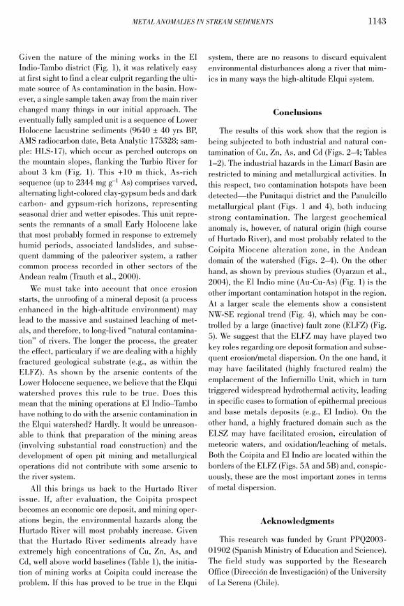
Copyright © 2022 FDOKUMEN