Measuring methods for groundwater – surface water interactions
Upload
khangminh22Category
view
5download
0
HYDROLOGICAL PROCESSESHydrol. Process. 20, 3371–3394 (2006)Published online in Wiley InterScience(www.interscience.wiley.com) DOI: 10.1002/hyp.6336
Surface water–groundwater interactions in semiariddrainages of the American southwest
Brent D. Newman,1* Enrique R. Vivoni2 and Armand R. Groffman3
1 Earth and Environmental Sciences Division, Los Alamos National Laboratory, MS J495, Los Alamos, NM, 87545 USA2 Department of Earth and Environmental Science, New Mexico Institute of Mining and Technology, Socorro, NM 87801 USA
3 Water Stewardship Group, Los Alamos National Laboratory, MS M992, Los Alamos, NM, 87545 USA
Abstract:
Drainages are important features of semiarid landscapes because they are areas where surface water, groundwater, andterrestrial and aquatic ecosystems converge. Management of these critical ecohydrological systems requires a soundunderstanding of surface water–groundwater interactions. At the basin- to landscape-scale, drainage density, location,and channel characteristics are formed upon a geomorphic and geologic template that limit where and how surfacewater–groundwater interactions occur. At smaller scales, semiarid surface water–groundwater interactions exhibit ahigh degree of temporal and spatial variability that links directly to biogeochemical characteristics and ecosystemdynamics. In this paper, we review key features of interactions in semiarid drainages, and supplement the discussionwith new examples from the American southwest. We conclude by presenting a series of alternative conceptualmodels that describe surface water–groundwater interactions within semiarid drainages and highlight areas for futureresearch. Copyright 2006 John Wiley & Sons, Ltd.
KEY WORDS surface water–groundwater interactions; semiarid; recharge; biogeochemistry
Received 18 July 2005; Accepted 8 November 2005
INTRODUCTION
Understanding the exchange of water, material, and energy between surface water and groundwater com-ponents of the hydrologic cycle is critical to effectively address water quality and supply problems as wellas to maintain ecosystem diversity and functioning (Wright, 1980; Winter et al., 1998; Sophocleous, 2002).Semiarid regions cover a large and growing fraction of the Earth’s land surface (Schlesinger, 1990), andcontain some of the fastest-growing population centres in the world (Brown et al., 2005). Thus, there is anecessity to better understand semiarid surface water–groundwater interactions because they strongly controlavailability of key limited resources.
Excellent summaries and reviews of surface water–groundwater interactions are available in the literature(e.g. Wright, 1980; Winter et al., 1998; Jones and Mulholland, 2000; Sophocleous, 2002), so this informationwill not be repeated here. Instead, we focus on interactions in semiarid drainages specifically. Our discussionof interactions is centred on controls on the distribution and characteristics of drainages at the landscapeand basin scales, which dictate where and how interactions occur, how flowpath types and directions impactthe nature of interactions at the patch (subreach) to drainage scale, and the importance of interactions onthe biogeochemistry of both surface water and groundwater. Most of the examples we discuss are from theAmerican southwest (and in particular New Mexico), and thus do not fully represent the full range of semiarid
* Correspondence to: Brent D. Newman, Earth and Environmental Sciences Division, Los Alamos National Laboratory, MS J495,Los Alamos, NM, 87545 USA. E-mail: [email protected]
Copyright 2006 John Wiley & Sons, Ltd.

3372 B. D. NEWMAN, E. R. VIVONI AND A. R. GROFFMAN
characteristics or behaviours (see discussion in Nanson et al., 2002). However, the examples do reflect a broadrange of processes and characteristics that may occur in other semiarid locations.
Interactions in semiarid landscapes typically occur in relatively small and distinct parts of the landscape,and are typically episodic and variable. One of the most important surface water–groundwater connectionsis through groundwater recharge. An emerging, but critical, concept is that recharge occurs only in limitedareas, and is non-existent or negligible over much of the semiarid landscape. A regional scale, chloridemass balance survey by Phillips (1994) was one of the first studies suggesting that little to no rechargehas occurred since the Pleistocene over much of the non-mountainous, inter-drainage area of the Americansouthwest. Since then, additional research using chloride and other methods has supported the idea of littleto no recharge over large areas in the southwest (Walvoord et al., 2002; Scanlon et al., 2003; Duffy, 2004;Seyfried et al., 2005). Simmers (1997), de Vries and Simmers (2002), and Scanlon et al. (2006) providedetailed summaries of semiarid recharge processes. Because there is a lack of recharge within inter-drainageareas, surface water–groundwater interactions are largely limited to mountain blocks and mountain front areas(e.g. Duffy, 2004; Wilson and Guan, 2004), irrigated agricultural fields (e.g. Wright, 1980; Criss and Davisson,1996; Rushton, 1997; Stonestrom et al., 2004), or to topographic lows such as drainages. Thus, if we are tounderstand interactions, for example, in semiarid drainages, we not only need to understand the details ofhow interactions occur, but also what controls the limited distribution of drainages (and thereby interactions)across the landscape.
One reason for the focus of this paper on surface water–groundwater connections in semiarid drainages isthat features such as canyons, valleys, arroyos, and wadis, have long been recognized as having high potentialfor recharge and are zones where surface water and groundwater can converge (e.g. Stephens, 1996; de Vriesand Simmers, 2002; Sophocleous, 2002). Our objective is to review and discuss key concepts and processesthat control surface water–groundwater interactions in semiarid drainages via previously published and newexamples from the American southwest.
CHARACTERISTICS OF SEMIARID DRAINAGE SYSTEMS
Surface water–groundwater interactions in semiarid landscapes of the American southwest occur predomi-nantly in the narrow riparian confines of perennial or ephemeral streams emanating from mountainous terrainonto surrounding alluvial valleys (e.g. Valett, 1993; Wroblicky et al., 1998; Friedman and Lee, 2002; Harveyet al., 2003). The spatial and temporal occurrence of surface water–groundwater interactions, including waterexchanges, solute transfers and reactions, and ecological activity, depends greatly on the template establishedby channel geometry (e.g. streambed area, sinuosity, bank full depth) and the hydrologic regimes in the rivernetwork (e.g. temporal variability in streamflow, losing and gaining reaches). As a result, the quantificationof these processes requires an assessment of the hydrologic regime (e.g. runoff magnitude, duration, andfrequency) as well as the geomorphologic properties of the watershed (e.g. river lengths, widths, and drainagedensity (Dd)). Furthermore, the geologic characteristics of the streambed and underlying aquifer are critical,especially in depositional alluvial environments in the American southwest, which can display high degreesof horizontal and vertical heterogeneities in hydraulic properties (e.g., Elliot et al., 1999). Because channelrunoff is typically low due to modest rainfall amounts and high basin storage capacity, arid and semiaridwatersheds in the American southwest can be quite different in terms of hydrologic regime and geomorphicshape as compared to basins in temperate and humid regions (e.g. Leopold et al., 1964; Abrahams, 1984;Goodrich et al., 1997; Tucker and Bras, 1998). For example, the seasonality and intermittency of river flowis typically more pronounced in arid and semiarid watersheds. Noticeable differences are also observed inthe channel geometry and Dd for arid and semiarid basins owing to low amounts of precipitation deliveredover short periods. The following subsections examine how geomorphologic, hydrologic, and climatic factorsinteract to control the density and distribution of drainages within semiarid basins and the variability withinand between drainages.
Copyright 2006 John Wiley & Sons, Ltd. Hydrol. Process. 20, 3371–3394 (2006)DOI: 10.1002/hyp

SURFACE WATER–GROUNDWATER INTERACTIONS 3373
Drainage basins in semiarid landscapes
Drainage basins in semiarid landscapes can be characterized in several ways. One of the most commonmethods is to describe river reaches according to the proportion of time that the channel experiences runoff(e.g. perennial vs ephemeral). Long-term streamflow records can be used to determine the percentage of timeduring the year over which runoff was present. One useful analysis is based on the flow duration curve (FDC),which expresses a relation between the streamflow magnitude and the probability of exceeding this amountover a period (e.g. Vogel and Fennessey, 1994; Dingman, 2002). For semiarid landscapes in New Mexico(Figure 1), this analysis reveals a large variation in FDCs for a set of unregulated basins with different runoffregimes. Characterization of a basin as perennial (flow during the entire year) or ephemeral (partial flow inresponse to precipitation) can be made quantitatively by using the exceedence probability. Drainage basinswith sustained flow over a high percentage of time are perennial (Rıo Chama, Rıo Ojo Caliente, Jemez River,Tularosa Creek) while those with a decaying FDC, implying a low percentage of time with flow, are consideredephemeral (Rıo Salado, Rıo Puerco at Guadalupe and Bernardo). Flow duration analysis based on streamflowrecords reveals the temporal variations in runoff, and along with information about groundwater table position(e.g. shallow or deep relative to the channel reach) can be used to indicate the temporal frequency of surfacewater–groundwater interactions in the network.
Semiarid basins can also be described according to the final destination of the runoff produced in thewatershed (e.g. tributary flows vs closed basins). Digital elevation models (DEMs) can be used to determine thedrainage directions, upslope contributing area, and stream network structure (e.g. Montgomery and Dietrich,1989; Tarboton et al., 1991). Terrain analysis is used to indicate whether a semiarid reach is connected to adownstream river or ends in a closed basin. In semiarid landscapes, many perennial reaches serve as tributariesto larger rivers, while ephemeral streams terminate in an alluvial fan or closed basin, typically associated with
Figure 1. Flow duration curves from long-term streamflow records in various drainage basins in New Mexico. (a) Location of stream gaugingstations. (b) Flow duration curves (exceedence probability) of daily streamflow over historical records for drainage basins. The drainagebasin numbers and periods of records correspond to: (1) Rıo Chama near La Puente, NM (1955–2002), (2) Jemez River near Jemez, NM(1936–2002), (3) Rıo Ojo Caliente near La Madera, NM (1932–2002), (4) Tularosa Creek near Bent, NM (1948–2002), (5) Rıo Puerconear Guadalupe, NM (1951–2002), (6) Rıo Puerco near Bernardo, NM (1939–2002), (7) Rıo Salado near San Acacia, NM (1947–1984)
Copyright 2006 John Wiley & Sons, Ltd. Hydrol. Process. 20, 3371–3394 (2006)DOI: 10.1002/hyp

3374 B. D. NEWMAN, E. R. VIVONI AND A. R. GROFFMAN
a desert playa or temporary lake. Several drainage basin types occurring in close proximity in New Mexico areshown in Figure 2, including perennial tributaries (Jemez River), ephemeral tributaries (Rıo Puerco and RıoSalado), and ephemeral streams in a closed basin (Estancia Basin). The basin terminus indicates the destinationof the stream runoff in the region and determines its interaction with the alluvial aquifers. For tributaries, therunoff regime influences the occurrence of surface water–groundwater interactions along its internal reachesand in the downstream river (e.g. Dahm et al., 2003; Vivoni et al., 2006). For drainages in closed basins,contributing streams can lead to surface water–groundwater interactions over a broad, flat region that cantemporarily flood. Such interactions can be significant in terms of basin scale recharge through playa lakes(Wood and Sanford, 1995). For all cases, the nature of surface water–groundwater interactions, either alongconfined channels or over broad valleys, can be related to the spatial characterization of the semiarid basin(e.g. geomorphic, topographic and geologic factors) and the coupling of the surface and groundwater systems.
Several other characteristics of semiarid drainage basins can be used to classify a river reach or the channelnetwork. Drainages can vary in their level of flow convergence or divergence determined by channel incisionor aggradation (e.g. Bull, 1997; Elliot et al., 1999). Small tributaries joining to form larger streams concentrateflow into a focused area, while streams over an alluvial fan diverge flow over a large region. Oscillations mayalso be observed in semiarid alluvial channels between incised, convergent reaches and aggraded, divergentfans (Bull, 1997; Pelletier and DeLong, 2004). River reaches also differ in the degree of braidedness, withsome alluvial streams having braided reaches while bedrock streams are typically confined to well-definedchannels (e.g. Leopold et al., 1964; Merritt and Wohl, 2003). At the scale of drainage basin, another importantcharacteristic is the proportion of total area composed by the floodplain or the riparian corridor as these areregions for surface water–groundwater interactions (e.g. McGlynn and Seibert, 2003; Nardi et al., 2006).Highly eroded watersheds will tend to have higher proportions of low-lying floodplains, while less erodedcatchments retain a larger amount of upland area where surface water–groundwater interactions can be aeriallylimited (e.g. Strahler, 1957; Leopold et al., 1964; Moglen and Bras, 1995).
Watershed morphologic controls on surface water–groundwater interactions
The hydrologic and geomorphologic characteristics of semiarid basins, including the spatial and temporalvariability of runoff, and the morphology of hillslopes, channels and floodplains, exert strong controls on
Figure 2. Analysis of topographic data for central New Mexico (1-km HYDRO1K DEM) for derivation of drainage boundaries (black solidlines) and stream networks: perennial network in the Jemez River (solid blue line); ephemeral channels in Rıo Puerco and Rıo Salado servingas tributaries to the Rıo Grande (dashed and dashed-dotted blue lines); and ephemeral channels into the closed Estancia Basin (dashed light
blue lines). Note the location of historical stream gauging stations (white squares)
Copyright 2006 John Wiley & Sons, Ltd. Hydrol. Process. 20, 3371–3394 (2006)DOI: 10.1002/hyp

SURFACE WATER–GROUNDWATER INTERACTIONS 3375
surface water–groundwater interactions. Nevertheless, the role of watershed morphology on setting thetemplate for these exchanges has yet to be widely recognized, in particular, at the catchment scale. Few studieshave attempted to relate basin shape and network geometry on the location, duration, and frequency of surfacewater–groundwater interactions (Mclain et al., 2003; Loik et al., 2004; Belnap et al., 2005). Determining thephysical controls set by channel and floodplain geomorphology on water, solutes, and particulate exchangesbetween streams and alluvial aquifers remains an important research area, in particular, for semiarid regions.Considering the progress in quantifying river basin geomorphology (e.g. Rodrıguez-Iturbe and Rinaldo, 1997),descriptors of channel network and floodplain geometry could be used to explain the physical controls onsurface water–groundwater interactions.
One important descriptor of the channel network structure for determining the degree of surfacewater–groundwater interactions is the drainage density (Dd), defined as the total stream length divided by thebasin area (Horton, 1932; Leopold et al., 1964; Tarboton et al., 1992; Tucker et al., 2001). The Dd indicatesthe dissected nature of the basin and can be related to a mean hillslope length at which diffusive hillslopeprocesses shift to concentrated channel flow. Watersheds with high Dd are dissected thoroughly by streamchannels, increasing the total length over which surface water–groundwater interactions can occur. On thecontrary, catchments with low Dd consist of poorly incised upland areas that limit these exchanges.
Dd can vary dramatically between and within catchments and basins because of differences in climate,vegetation, soils, geology, relief, and landscape evolution (Tucker et al., 2001). The control on Dd exertedby climate and its variability has been explored considerably, with implications on the degree of basindissectedness in semiarid regions (e.g. Gregory and Gardiner, 1975; Abrahams, 1984; Moglen et al., 1998).As reviewed by Abrahams (1984) and Milne et al. (2002), the climate control on Dd is modified by changesin vegetation from arid to humid environments. For more humid climates, higher excess runoff rates lead toan increase in Dd as compared to semiarid basins. To test whether an observed relation exists among climate,vegetation, and semiarid Dd, the variation of Dd in the Rıo Puerco in New Mexico is plotted as a functionof the mean annual rainfall (P) (Figure 3). We utilize P to represent the availability of water, and thereforerunoff potential, in each sub-basin. Note that sub-basins with lower rainfall amounts (250 to 300 mm) have alower Dd (0Ð5 to 0Ð6 km�1) as compared to basins with higher rainfall (>300 mm), where Dd stabilizes to aconstant density (¾1 km�1). Sub-basins with high Dd are dominated by conifer forest and mixed woodland,while those with a low Dd have grassland, desert scrub, and juniper savanna. For the Rıo Puerco, the Dd issensitive to small changes in climate with increases in Dd due to excess runoff (presumably due to higher P)produced in the wetter mountain regions. Variations in basin dissectedness (e.g. number of streams per unitarea) with climate and vegetation have important implications on surface water and groundwater interactionsas drainages are primary locations for interactions to occur.
A second important descriptor of drainage basin morphology is the extent of floodplain or riparian areaalong the channel network (Lindsay, 2003; McGlynn and Seibert, 2003; Nardi et al., 2006). Floodplainsare unique with respect to neighbouring landforms (e.g. hillslopes and terraces) because of differences inhydroperiod, biogeochemical cycling, and ecosystem productivity. The spatial extent of near stream zonesis determined by the basin characteristics, such as drainage area, geology and network structure, as well asthe hydrologic regime through the floodplain reach. Watersheds with wide alluvial floodplains experiencingflooding at a particular return interval have a high propensity for surface water–groundwater interactions(Jung et al., 2004; Vivoni et al., 2006). Water exchanges may occur through transport via the channel bedand banks, and during overbank flooding in the riparian corridor. In contrast, river reaches with geologicconstraints to floodplain development have a limited area for water exchanges, typically confined to the reachcross-section.
A major determinant of floodplain geometry is the contributing area at the river reach, defined as theupslope area draining to the location. Bhowmik (1984) and McGlynn and Seibert (2003) present evidence fora relationship between the floodplain width (w) and the contributing area (A) at a site within a set of humidwatersheds. More recently, Nardi et al. (2006) tested the existence of a basin geometric scaling relation,w D qAm, where q and m are the scaling coefficient and exponent. Floodplain geometry (e.g. flood stage
Copyright 2006 John Wiley & Sons, Ltd. Hydrol. Process. 20, 3371–3394 (2006)DOI: 10.1002/hyp

3376 B. D. NEWMAN, E. R. VIVONI AND A. R. GROFFMAN
Figure 3. Drainage density variation with climate in the Rıo Puerco basin. (a) Location of Rıo Puerco watershed (16 114 km2) in NewMexico. (b) Spatial distribution of mean annual precipitation (mm) from PRISM 4-km product with 1 : 100,000-scale hydrography (USGSDigital Line Graph). Note the variation in drainage density with rainfall values. (c) Computed drainage density (Dd in km�1) from mappedhydrography and basin averaged rainfall amounts (P in mm) for six individual sub-basins in the Rıo Puerco delineated from 30-m USGSDEM data: Upper Rıo Puerco �936 km2�, Middle Rıo Puerco �275 km2�, Arroyo Chico �570 km2�, Arroyo Colorado �316 km2�, UpperRıo San Jose �193 km2�, and Middle Rıo San Jose �589 km2�. The dashed line is a third-order polynomial fit to the data set intended onlyas a visual aid. An increase in Dd is observed with rainfall for basins with 250 to 300 mm, while a nearly constant Dd ¾ 1 km�1 is thedensity for basins with greater than 300 mm of annual rainfall. Vegetation maps from Dick-Peddie (1993) were used to relate the drainagedensity and mean annual basin rainfall to ecosystem distribution. Sub-basins with low P and Dd (Middle Rıo Puerco, Arroyo Chico, MiddleRıo San Jose) are primarily composed of Great Basin desert scrub, desert grassland, and juniper savanna, with lower amounts of montaneconifers and mixed woodland. Sub-basins with high P and Dd (Arroyo Colorado, Upper Rıo Puerco, Upper Rıo San Jose) are dominated
by juniper savanna, montane conifers, and mixed woodland, with small areas of desert grassland and scrub
Copyright 2006 John Wiley & Sons, Ltd. Hydrol. Process. 20, 3371–3394 (2006)DOI: 10.1002/hyp

SURFACE WATER–GROUNDWATER INTERACTIONS 3377
Figure 4. Floodplain delineation and geometric scaling relation in Rıo Salado watershed in central New Mexico. (a) Location of Rıo Saladobasin �3570 km2� in New Mexico. (b) Floodplain boundary extracted using hydrogeomorphic method of Nardi et al. (2006) for 500-yearflood using 30-m USGS DEM data. (c) Relation between channel contributing area (A in m2) and measured floodplain width (w in m) overthe fifth order Rıo Salado. The closed circles represent the 250 cross-section measurements per stream order, while the closed squares arethe order-averaged values. Note that the power law relation, w D 2Ð27 A0Ð23, has an R2 value of 0Ð97 for the Rıo Salado floodplain geometry
and width) was extracted using a DEM-based delineation method accounting for the geomorphic propertiesof the stream network and hydrologic properties of a flood event. Results of the floodplain delineation fora semiarid basin (the Rıo Salado, an ephemeral basin with a wide floodplain near the outlet) are shown inFigure 4. The 500-year flood boundary depicts the control of contributing area and local topography on thefloodplain zone, with a characteristic oscillation in the width observed along the main stem. Measurements ofthe floodplain width, averaged for each stream order, result in a geometric scaling relation, w D 2Ð27A0Ð23, witha regression R2 of 0Ð97. As a result, the floodplain area available for surface water–groundwater interactions
Copyright 2006 John Wiley & Sons, Ltd. Hydrol. Process. 20, 3371–3394 (2006)DOI: 10.1002/hyp
3378 B. D. NEWMAN, E. R. VIVONI AND A. R. GROFFMAN
in the semiarid basin can be predicted with a reasonable accuracy based on the contributing area in the reach,a readily derived geomorphic parameter.
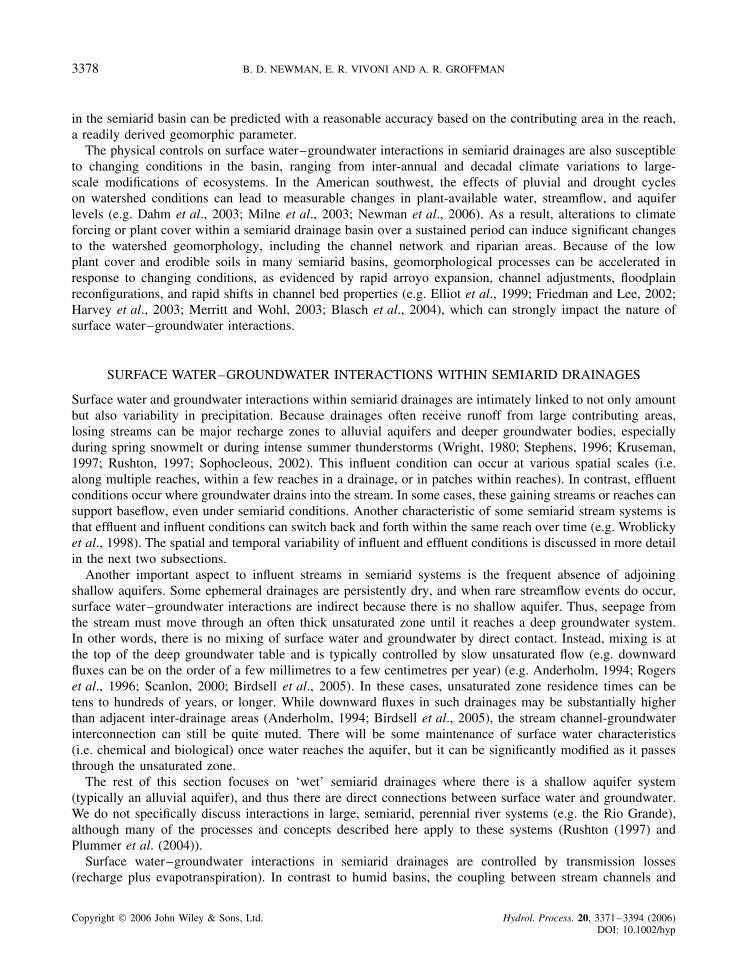
The physical controls on surface water–groundwater interactions in semiarid drainages are also susceptibleto changing conditions in the basin, ranging from inter-annual and decadal climate variations to large-scale modifications of ecosystems. In the American southwest, the effects of pluvial and drought cycleson watershed conditions can lead to measurable changes in plant-available water, streamflow, and aquiferlevels (e.g. Dahm et al., 2003; Milne et al., 2003; Newman et al., 2006). As a result, alterations to climateforcing or plant cover within a semiarid drainage basin over a sustained period can induce significant changesto the watershed geomorphology, including the channel network and riparian areas. Because of the lowplant cover and erodible soils in many semiarid basins, geomorphological processes can be accelerated inresponse to changing conditions, as evidenced by rapid arroyo expansion, channel adjustments, floodplainreconfigurations, and rapid shifts in channel bed properties (e.g. Elliot et al., 1999; Friedman and Lee, 2002;Harvey et al., 2003; Merritt and Wohl, 2003; Blasch et al., 2004), which can strongly impact the nature ofsurface water–groundwater interactions.
SURFACE WATER–GROUNDWATER INTERACTIONS WITHIN SEMIARID DRAINAGES
Surface water and groundwater interactions within semiarid drainages are intimately linked to not only amountbut also variability in precipitation. Because drainages often receive runoff from large contributing areas,losing streams can be major recharge zones to alluvial aquifers and deeper groundwater bodies, especiallyduring spring snowmelt or during intense summer thunderstorms (Wright, 1980; Stephens, 1996; Kruseman,1997; Rushton, 1997; Sophocleous, 2002). This influent condition can occur at various spatial scales (i.e.along multiple reaches, within a few reaches in a drainage, or in patches within reaches). In contrast, effluentconditions occur where groundwater drains into the stream. In some cases, these gaining streams or reaches cansupport baseflow, even under semiarid conditions. Another characteristic of some semiarid stream systems isthat effluent and influent conditions can switch back and forth within the same reach over time (e.g. Wroblickyet al., 1998). The spatial and temporal variability of influent and effluent conditions is discussed in more detailin the next two subsections.
Another important aspect to influent streams in semiarid systems is the frequent absence of adjoiningshallow aquifers. Some ephemeral drainages are persistently dry, and when rare streamflow events do occur,surface water–groundwater interactions are indirect because there is no shallow aquifer. Thus, seepage fromthe stream must move through an often thick unsaturated zone until it reaches a deep groundwater system.In other words, there is no mixing of surface water and groundwater by direct contact. Instead, mixing is atthe top of the deep groundwater table and is typically controlled by slow unsaturated flow (e.g. downwardfluxes can be on the order of a few millimetres to a few centimetres per year) (e.g. Anderholm, 1994; Rogerset al., 1996; Scanlon, 2000; Birdsell et al., 2005). In these cases, unsaturated zone residence times can betens to hundreds of years, or longer. While downward fluxes in such drainages may be substantially higherthan adjacent inter-drainage areas (Anderholm, 1994; Birdsell et al., 2005), the stream channel-groundwaterinterconnection can still be quite muted. There will be some maintenance of surface water characteristics(i.e. chemical and biological) once water reaches the aquifer, but it can be significantly modified as it passesthrough the unsaturated zone.
The rest of this section focuses on ‘wet’ semiarid drainages where there is a shallow aquifer system(typically an alluvial aquifer), and thus there are direct connections between surface water and groundwater.We do not specifically discuss interactions in large, semiarid, perennial river systems (e.g. the Rio Grande),although many of the processes and concepts described here apply to these systems (Rushton (1997) andPlummer et al. (2004)).
Surface water–groundwater interactions in semiarid drainages are controlled by transmission losses(recharge plus evapotranspiration). In contrast to humid basins, the coupling between stream channels and
Copyright 2006 John Wiley & Sons, Ltd. Hydrol. Process. 20, 3371–3394 (2006)DOI: 10.1002/hyp

SURFACE WATER–GROUNDWATER INTERACTIONS 3379
underlying aquifers in semiarid regions often promotes infiltration of water through the channel bed, i.e.channel transmission losses (e.g. Boughton and Stone, 1985; Stephens, 1996; Goodrich et al., 1997). Theproportion of transmission losses accounted for by recharge versus riparian evapotranspiration is still largelyunknown. A recent study by Goodrich et al. (2004) in Arizona suggests that during wet years ¾15–40% ofdeep aquifer recharge was generated along ephemeral channels. On the basis of a comparison of alternativerecharge methods, Goodrich et al. (2004) also concluded that a significant proportion of the runoff generatedby summer rainfall was lost to the underlying aquifer through the channel network. Using temperature profiles,Constantz et al. (2002) estimated that percolation accounted for 30–50% of the total channel loss for threesouth-western ephemeral channels. Transmission losses in semiarid watersheds raise important distinctionsabout the spatial and temporal nature of surface water–groundwater interactions compared to humid basins.For semiarid drainages, stream discharge can decrease with contributing area for particular events becauserunoff can be quickly lost to the aquifer. Goodrich et al. (1997), for example, show how storm size and channeltransmission losses can lead to a more non-linear response to rainfall as basin scale increases, which is in starkcontrast to behaviour in humid basins. Key factors controlling channel losses include geomorphic structurein the channel (e.g. slope and the distribution of riffle and pool sequences), and the hydraulic conductivity ofthe channel bed (which is partially controlled by the geology of the bed materials, but can also change withtime because of sediment clogging or flood redistribution of sediments) (Harvey and Bencala, 1993; Stephens,1996; Wroblicky et al., 1998; Blasch et al., 2004).
Because of transmission losses, the nature of surface water–groundwater interactions can be limited to briefperiods during runoff events and to specific areas associated with the runoff production and downstream routing(e.g. Boughton and Stone, 1985; Crocker, 1996). Controls on the location and timing of runoff/interactionsinclude storm characteristics, physical properties of the stream network, and antecedent wetness prior to theevent (e.g. Syed et al., 2003). Semiarid drainages with well-developed channel networks and riparian areascan focus surface water–groundwater interaction over particular reaches. For example, the effect of channeltransmission losses over an extended losing reach in the Rıo Puerco is shown in Figure 5. Simultaneousdischarge observations from 1952 to 1976 at three gauges illustrate the decrease in specific discharge fromthe mountain headwater basin (Rıo Puerco near Guadalupe, NM) to the basin outlet (Rıo Puerco nearBernardo, NM). Differences between the gauges at Rıo Puerco and near Bernardo (78 km apart) are theresult of sinuous channel interactions with the thick valley alluvium, which is primarily unconsolidated, fine-to medium-grained sand (Heath, 1983). Because of the channel and aquifer properties, an intensive amountof surface water–groundwater interactions occur in this reach during runoff events generated in headwaters.
We can consider surface water–groundwater interactions to occur at particular locations (e.g. a particularreach or patch within a reach) at particular times, which leads to variability in hydrological processes andrates of geomorphic change. Such behaviours can also create hot spots and/or hot moments of acceleratedbiogeochemical cycling by reactivation or mobilization of nutrients and other reactants (Mclain et al., 2003).Hot spot and hot moment reactions are essential features of semiarid riparian and, especially, lotic ecosystems,and are an important link between episodic hydrologic behaviours and dynamic ecosystem behaviours. Hotmoments occur in response to precipitation, infiltration, and runoff events that impose transient hydraulicgradients on the stream and adjacent aquifer. Hot spots are localized areas of accelerated biogeochemicalcycling, sometimes occurring repeatedly in the same place.
A stream-centric view of surface water–groundwater interactions
A great deal of recent research has been focused on the biogeochemistry within stream channels andthe significance of surface water–groundwater interactions occurring in arid and semiarid hyporheic zones.The processes occurring in this zone have profound effects on water chemistry and on the structure andfunctioning of lotic ecosystems (e.g. hot moment/hot spot type behaviours). It can also be important in termsof transformation and degradation of contaminants such as nitrate, organic compounds, and metals (vonGunten et al., 1991; Squillace et al., 1993; Hornberger et al., 1994; Benner et al., 1995). The hyporheic zone
Copyright 2006 John Wiley & Sons, Ltd. Hydrol. Process. 20, 3371–3394 (2006)DOI: 10.1002/hyp

3380 B. D. NEWMAN, E. R. VIVONI AND A. R. GROFFMAN
Figure 5. Channel transmission losses along the main stem of the Rıo Puerco watershed. (a) Location of three USGS streamflow gaugingstations: (1) Rıo Puerco near Guadalupe, NM �1088 km2�, (2) Rıo Puerco at Rıo Puerco, NM �14 141 km2�, and (3) Rıo Puerco atBernardo, NM �16 114 km2�. Note that gauges (1) and (2) are separated by 127 km of river length and gauges (2) and (3) are 78 km apart.(b) Cumulative specific discharge, q D Q/Ab where Ab is basin area in mm, for the period 1952–1976 based on USGS daily streamflowrecords. Note the dramatic decrease in per unit area discharge between Rıo Puerco near Guadalupe and Rıo Puerco at Rıo Puerco. Channellosses over the losing reach between Rıo Puerco and Bernardo gauges are due to the thick, permeable valley alluvium underlying the active
channel and floodplain (Heath, 1983)
has been defined in various ways (Wroblicky et al., 1998). For example, Valett et al. (1997) describe thehyporheic zone as the ecotone between groundwater and surface water. However, Wroblicky et al. (1998)and Harvey and Wagner (2000) describe the hyporheic zone from a hydrological viewpoint where hyporheicexchange occurs along flow paths that originate in the stream, enter the subsurface groundwater zone, andreturn to the stream within a single reach, which is thus a stream-centric view or perspective. Hyporheiczone interactions can be viewed as relatively fine-scale interactions between the channel and groundwaterthat occur within larger-scale patterns of channel-groundwater interactions in drainage basins (Harvey andBencala, 1993; Wroblicky et al., 1998; Harvey and Wagner, 2000). These interactions are considered finescale because although there can be long hyporheic flow paths, the greatest hyporheic interactions occur overshort, cm- to m-long flow paths (Harvey and Wagner, 2000). Thus, hyporheic flow paths can leave and returnto the channel many times within a single reach, which contrasts with ‘groundwater’ flowpaths that enteror leave only once (under either effluent or influent conditions). The hydrological interactions within thehyporheic zone allow surface water to repeatedly contact chemically reactive minerals and coatings, archivedorganic matter, and microbial colonies in the subsurface, thus enhancing biogeochemical cycling (Harvey andWagner, 2000). Hyporheic zone temporal and spatial variability (discussed below) also play a strong role indriving hot spot/hot moment type biogeochemical reactions.
Wroblicky et al. (1998) studied the extent of hyporheic zone development lateral to the stream in twosemiarid drainages and found that discharge strongly controlled temporal variations in hyporheic area.Hyporheic zone size decreased by approximately 50% during high flows and the decreases were apparentlyrelated to the development of positive hydraulic gradients where groundwater flowed into the channel. Harveyand Wagner (2000), citing an example from Harvey et al. (1996), also note that increasing groundwater inflows
Copyright 2006 John Wiley & Sons, Ltd. Hydrol. Process. 20, 3371–3394 (2006)DOI: 10.1002/hyp

SURFACE WATER–GROUNDWATER INTERACTIONS 3381
oppose hyporheic fluxes from the channel, which causes a decrease in hyporheic zone size. However, in theHarvey et al. (1996) and Wroblicky et al. (1998) study sites, there were permanent groundwater inflows alongthe margins of the drainages. In cases where groundwater recharge is solely or dominantly through channellosses, we speculate that the relation between hyporheic zone size and discharge may be different (i.e. atlocations or times when positive gradients do not exist). Wroblicky et al. (1998) also showed that in theirstudy reaches, lateral hyporheic areas are small (<4 m2 over an annual cycle). However, studies of otherriver systems suggest development of larger hyporheic zones (e.g. Stanford and Ward, 1988; Wondzell andSwanson, 1996). Hydrologic modelling results from Wroblicky et al. (1998) indicate that the greatest impactson the magnitude, direction, and spatial distribution of surface water–groundwater exchange were relatedto hydraulic conductivities of the alluvial sediments and to variations in recharge rates. Valett et al. (1997)also demonstrate the importance of hydraulic conductivity and show that this is strongly controlled by parentgeology of the alluvial sediments. They found significant differences in hyporheic behaviours among streamswith different parent geology, and a higher variability in streams in which parent geology changed along thelength of the stream.
A major feature of semiarid climates is frequent drought, and Dahm et al. (2003) examined droughtfrequency and severity effects on semiarid streams and rivers. Using a 105-year record from New Mexico,they found that 20% of the months since 1895 could be classified as moderate to extreme drought. The majoreffects of drought include a lowering of water tables, which fragments the reaches of streams and rivers,and an increase in the proportion of groundwater contributions to the stream channel versus surface watercontributions (for reaches with baseflow). The decrease of water in the stream and alluvial aquifer and increasein the ratio of groundwater input to the stream also have substantial biogeochemical impacts. Inputs of organiccarbon, nitrogen, and phosphorous to the stream decrease, and enhanced autotrophy, changes in benthic algalcommunities, and decrease in live diatom populations can occur. For streams with baseflow, Dahm et al.(2003) present a set of conceptual models that show how surface water interactions are modified by drought.During moderate drought conditions, there is an increase in the proportion of groundwater contribution to thestream; however, there is a reduction in channel discharge because there is less total groundwater reachingthe stream. There is also a decrease in nutrient and organic carbon supplies from shallow groundwater.During extreme drought conditions the stream recharges groundwater in most locations because the aquiferhas dropped below the level of the stream channel. Intermittency of flow increases, and surface nutrientdistribution becomes patchy and, as a result, channel discharge and carbon availability are both low.
An aquifer-centric view of surface water–groundwater interactions
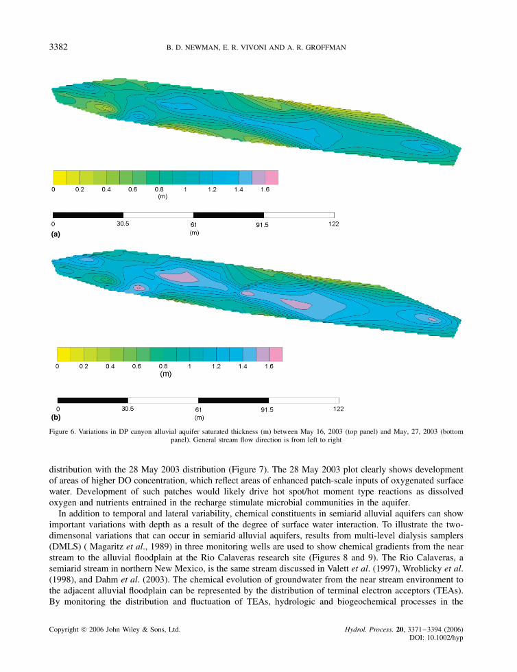
One of the key factors in understanding surface water-alluvial aquifer interactions in semiarid environmentsis the dynamic physical and chemical behaviour of alluvial groundwater with respect to space and time.Because of the episodic behaviour of precipitation and seasonal changes in evapotranspiration, and thereforerecharge, alluvial aquifer volumes can vary greatly in time. Data from DP canyon, an ephemeral drainagein Los Alamos, New Mexico, clearly illustrates the hydrological and chemical variability that can occur inalluvial groundwater. Alluvial aquifer saturated thickness from DP Canyon was plotted for May 16, 2003 andMay 27, 2003 using monitoring well data (Figure 6). Over a less than 2-week span, multiple runoff eventsrecharged the alluvial aquifer, resulting in a fifty-percent increase in saturated thickness in some areas, and alesser response in other parts of the aquifer (Figure 6). This example is far from an extreme case, and changesin saturated thickness may be significantly greater during other time periods in this drainage and within othersemiarid drainages.
Temporal and spatial variability also affect the chemical characteristics of alluvial groundwater, providinginsights on the effects of surface water–groundwater interactions. Dissolved oxygen (DO) distributions weresystematically measured in the same alluvial aquifer in DP canyon from November through July in orderto capture seasonal affects of exchange (Figure 7). The effect on DO from the recharge that resulted in theincrease in saturated thickness on 27 May 2003 (Figure 6) is clearly shown by comparing the 12 May 2003 DO
Copyright 2006 John Wiley & Sons, Ltd. Hydrol. Process. 20, 3371–3394 (2006)DOI: 10.1002/hyp
3382 B. D. NEWMAN, E. R. VIVONI AND A. R. GROFFMAN
(a)
(b)
Figure 6. Variations in DP canyon alluvial aquifer saturated thickness (m) between May 16, 2003 (top panel) and May, 27, 2003 (bottompanel). General stream flow direction is from left to right
distribution with the 28 May 2003 distribution (Figure 7). The 28 May 2003 plot clearly shows developmentof areas of higher DO concentration, which reflect areas of enhanced patch-scale inputs of oxygenated surfacewater. Development of such patches would likely drive hot spot/hot moment type reactions as dissolvedoxygen and nutrients entrained in the recharge stimulate microbial communities in the aquifer.
In addition to temporal and lateral variability, chemical constituents in semiarid alluvial aquifers can showimportant variations with depth as a result of the degree of surface water interaction. To illustrate the two-dimensonal variations that can occur in semiarid alluvial aquifers, results from multi-level dialysis samplers(DMLS) ( Magaritz et al., 1989) in three monitoring wells are used to show chemical gradients from the nearstream to the alluvial floodplain at the Rio Calaveras research site (Figures 8 and 9). The Rio Calaveras, asemiarid stream in northern New Mexico, is the same stream discussed in Valett et al. (1997), Wroblicky et al.(1998), and Dahm et al. (2003). The chemical evolution of groundwater from the near stream environment tothe adjacent alluvial floodplain can be represented by the distribution of terminal electron acceptors (TEAs).By monitoring the distribution and fluctuation of TEAs, hydrologic and biogeochemical processes in the
Copyright 2006 John Wiley & Sons, Ltd. Hydrol. Process. 20, 3371–3394 (2006)DOI: 10.1002/hyp

SURFACE WATER–GROUNDWATER INTERACTIONS 3383
0
1
2
3
4
5
6
7
8
9
10
O2
mg/L
11/08/02n=101, max=5.4, min=0.2 (mg/L)
140 290260230200170
230
245
meters
12/02/02n=92, max=11.5, min=0.6 (mg/L)
01/06/03n=91, max=5.5, min=0.2 (mg/L)
04/03/03n=64, max=7, min=0.3 (mg/L)
05/12/03n=62, max=5.4, min=0.2 (mg/L)
05/28/03n=84, max=10.8, min=0.2 (mg/L)
06/17/03n=79, max=6.6, min=0.2 (mg/L)
07/17/03n=52, max=4.2, min=0.2 (mg/L)
Figure 7. Dissolved oxygen in alluvial groundwater in DP canyon from November 2002 to July 2003. The black line represents the streamchannel, and the channel flow is from left to right. Crosses and dots represent monitoring well locations
subsurface can be inferred. This approach has been successfully used to study redox dynamics in the subsurface(Baedecker and Back, 1979; Champ et al., 1979; Lovley and Goodwin, 1988; Lovley and Chapelle, 1995;Postma and Jakobsen, 1996; Groffman and Crossey, 1999).
Vertical and lateral distribution of DO along defined flow paths through time is shown in Figure 8. Streamwater recharges the alluvial aquifer near MLS-8 (1Ð5 m from the stream), the aquifer then flows to MLS-7 (7 mfrom the stream), and finally to MLS-6 (13 m away from the stream). Each panel represents a vertical slice ofthe aquifer where DO is tracked through time (dates and seasonal events are presented in the upper panels).DO in the upper aquifer adjacent to the stream exhibits a pattern that suggests recharge during periods of high
Copyright 2006 John Wiley & Sons, Ltd. Hydrol. Process. 20, 3371–3394 (2006)DOI: 10.1002/hyp

3384 B. D. NEWMAN, E. R. VIVONI AND A. R. GROFFMAN
(a)
(b)
12
/19
/96
3/3
1/9
7
04
/26
/97
06
/04
/97 07/03
07
/09
-30
08
/15
09
/05
10
/16
/97
06
/12
/98
06
/24
/98
10
5
0
10
5
0
10
5
0
10
5
0
10
5
0
10
5
0
10
5
0
DOmg/L
MLS-8 DOmg/L
MLS-7 DOmg/L
MLS-6
12
/19
/96
03
/03
/9
7
5/1
6-6
/4
07
/03
-09
07
/30
/97
09
/05
/97
10
/15
/97
05
/26
/98
06
/12
-24
07
/06
/98
03
/31
/97
06
/04
/97
06
/18
-25
08
/19
/97
10
/15
/97
05
/27
/98
06
/12
/98
07
/06
-27
sprin
gsn
owm
elt
baseflow sprin
gsn
owm
elt
sum
mer
mon
soon
s
sum
mer
mon
soon
s
base
flow
sprin
gsn
owm
elt
baseflow
sprin
gsn
owm
elt
sum
mer
mon
soon
s
sum
mer
mon
soon
s
base
flow spring
snowmelt
baseflow sprin
gsn
owm
eltsummer
monsoons
sum
mer
mon
soon
s5 cm
15 cm
30 cm
45 cm
60 cm
75 cm
105 cm 105 cm
75 cm
60 cm
45 cm
30 cm
15 cm
5 cm 5 cm
15 cm
30 cm
45 cm
60 cm
105 cm
De
pth
(cm
)
Co
nc
en
tratio
n (m
g/L
)
Near stream to alluvial floodplain
Hill Slope
Hill Slope
SpringSpring
Spring
Spring
Str
eam
MLS-8 Multilevel Sampling Well
GW Flow Paths
Hill Slope Boundary
40 Meters
MLS-3
MLS-6
MLS-7
MLS-8
B. Schematic map showing flow paths from the stream across the alluvial flood plain.Rio Calaveras, New Mexico.
Figure 8. DO (mg/L) concentrations along a ground water flow path from the near stream (MLS-8), to intermediate (MLS-7), to far alluvialfloodpain region (MLS-6) of the Rio Calaveras alluvial aquifer. (a) Seasonal changes in dissolved oxygen along a groundwater flow pathfrom the stream through an adjoining alluvial aquifer. Dotted lines indicate data gaps. (b) Schematic map showing flow paths from the
stream across the alluvial flood plain. Rio Calaveras, New Mexico
stream discharge, e.g. spring runoff (03/31 and 06/04/97) and summer monsoon (07/03 through 07/30/97).At the intermediate location (MLS-7), the DO signal is somewhat suppressed showing only a snow meltsignal (03/30/97) and a slight bulge in response to the onset of the monsoon (07/30/97). Further away fromthe stream (MLS-6), very little DO was observed in groundwater throughout the year. DO rapidly decreaseswith depth in all three wells. Base flow conditions during late summer and fall are times when DO is low
Copyright 2006 John Wiley & Sons, Ltd. Hydrol. Process. 20, 3371–3394 (2006)DOI: 10.1002/hyp

SURFACE WATER–GROUNDWATER INTERACTIONS 3385
(a) (b) (c)
Figure 9. Mean concentrations of (A) DO, (B) Fe and (C) SO4 along a flow path from the near stream (MLS-8), to intermediate (MLS-7),to far alluvial floodplain region (MLS-6) of the Rio Calaveras aquifer (Figure 8(b)). The graph includes sampling dates from 1997 through
1998. MLS-8 is represented by diamonds, MLS-7 is represented by rectangles, and MLS-6 is represented by triangles
throughout the aquifer at all locations. The general conceptual model that results from these data is that oxicconditions prevail in the near stream environment (where the spread of oxic conditions is strongly linked torecharge events) and anoxic conditions are dominant away from the stream.
Statistical analysis of TEA’s DO, iron, and sulfate also supports the observation that groundwater in thevicinity of the stream is more oxidizing throughout the year than distal environments away from the stream(Figure 9). Mean values of DO show greater values at MLS-8 (1Ð5 m) with decreasing mean values at MLS-7(7 m) and MLS-6 (13 meters away from the stream). Mean values of iron also suggest that redox is morestable and reducing in the environment away from the stream, with lower mean values of iron proximal tothe stream and higher values away from the influence of surface water. Iron concentrations increase awayfrom the stream because more of the iron is in the more soluble, reduced phase �FeC2�, whereas iron in theaquifer adjacent to the stream is in the mainly less soluble, oxidized phase �FeC3� where it precipitates asiron oxy-hydroxide minerals. Thus, changes in DO concentrations can affect dissolved iron concentrationsthrough a control on iron mineral precipitation and dissolution reactions. Sulfate concentrations tend to followthe opposite trend with lower mean values away from the stream because of sulfate reduction under anoxicconditions, and higher mean values proximal to the stream. In general, the distribution of TEAs of all kinds(e.g. DO, iron, nitrate, and manganese) are highly variable with respect to time and space as a result ofhyporheic exchange, recharge, and the rate of microbial activity (Valett et al., 1997; Groffman and Crossey,1999; Morrice et al., 2000; Mclain et al., 2003).
Synthesis
Given that the examples discussed above demonstrate the importance of spatial and temporal conditionson semiarid surface water-alluvial aquifer interactions, it would be useful to develop a conceptual model thatdescribes the nature of these interactions within semiarid drainages. Marti et al. (2000) present a conceptual
Copyright 2006 John Wiley & Sons, Ltd. Hydrol. Process. 20, 3371–3394 (2006)DOI: 10.1002/hyp

3386 B. D. NEWMAN, E. R. VIVONI AND A. R. GROFFMAN
model for arid regions where the only input to the alluvial aquifer is through transmission losses from thestream bed (an influent condition). Lateral water inputs are strictly from overland flow directly to the streamchannel. Marti et al. (2000) cite the lack of dense vegetation, and low permeability soils in the uplands asthe reason for the dominance of overland flow over lateral subsurface flow. A similar model is discussedby Wright (1980). In contrast, Marti et al. (2000) also present a mesic model in which lateral subsurfacecontributions from the hillslope to the aquifer are dominant, and flow is largely from the aquifer to the streamchannel (an effluent condition). These models suggest that for semiarid drainages it is critical to understandthe importance and mode of lateral inputs to the stream and aquifer and whether effluent or influent conditionsprevail.
We use the Marti et al. (2000) arid model as a starting point in a discussion of lateral inputs to semiaridstreams and aquifers because it is the simpler of the models. In their model, lateral inputs only occur throughoverland flow into the stream, and the stream recharges the aquifer. It is clear that overland flow is a processof major importance in semiarid hillslopes (e.g. Beven, 2002; Wilcox et al., 2003). Given that overland flowis so common, it is a reasonable assumption that overland flow is a major lateral contributor of water to thestream channel in nearly all semiarid drainages.
However, does overland flow impact semiarid alluvial aquifers in contrast to the arid model of Martiet al. (2000) (other than through recharge from the stream channel)? In some semiarid cases, overland flowrecharges alluvial aquifers away from the channel where it infiltrates within tributary drainages or within thefloodplain. For example, Baker et al. (2000) and Hornberger et al. (1994) discuss how infiltration of snowmeltalong semiarid flood plains contribute dissolved organic carbon (DOC) to the alluvial aquifer system. Thus,the arid model may not be appropriate for all semiarid locations.
An important surface water-alluvial aquifer interaction under the mesic model of Marti et al. (2000)is through subsurface runoff or through flow. What is unclear is the role of this process under semiaridconditions. Newman et al. (1998) and Newman et al. (2004) found that macropore flow along root channelsis a substantial factor in the generation of episodic subsurface runoff events in a semiarid ponderosa pine forestin New Mexico. For years with large amounts of snowfall, subsurface runoff was found to be as importantas overland flow in terms of the ponderosa pine site water budget (Wilcox et al., 1997). Is this behaviourtypical of other semiarid locations? Beven (2002) examined this question and noted other studies that observedextended recession limbs on discharge hydrographs from semiarid catchments that are not easily explainedby overland flow alone. A subsurface runoff contribution could help explain these extended recession limbs.Thus, the impact of subsurface runoff in semiarid drainages may be more important than has been traditionallyassumed. Beven (2002) suggests that perhaps the reason that the role of subsurface runoff has been neglectedin semiarid landscapes is that it has been perceived as unimportant and, therefore, not worth measuring. Thefew studies that do indicate the potential importance of semiarid subsurface runoff suggest that additionalresearch in this area would certainly be worthwhile.
The importance of lateral contributions and their effect on surface water–groundwater interactions insemiarid drainages is not restricted to stream–aquifer flow direction issues. In fact, probably one of the mostdistinguishing characteristics of semiarid systems, compared to their more humid counterparts, is the role ofthe unsaturated zone and its influence on stream and alluvial aquifer chemistry and hydrologic interactions.Marti et al. (2000) note that as overland flow moves along the hillslope and floodplain to the stream channel,the water picks up dissolved and suspended constituents by its interaction with the land surface, providingan important geochemical input to the stream ecosystem. In semiarid drainages where alluvial aquifers arerecharged through a lateral subsurface runoff component or through vertical infiltration in the floodplain,concentrations of chemical inputs as a result of these interactions can be even larger than those occurringvia overland flow to the stream. For example, temporal variability in DOC contributions to semiarid alluvialaquifer systems is strongly controlled by episodic flushing of DOC that has accumulated in the flood plainsoils and sediments during periods when the alluvial aquifer size is small and the unsaturated part of theriparian zone is correspondingly large (Hornberger et al., 1994; Baker et al., 2000). These DOC contributionsoccur when water moves through the unsaturated zone from the surface or along the sides of the drainage, but
Copyright 2006 John Wiley & Sons, Ltd. Hydrol. Process. 20, 3371–3394 (2006)DOI: 10.1002/hyp

SURFACE WATER–GROUNDWATER INTERACTIONS 3387
also as the saturated zone increases during recharge events and rewets the formerly dry soils and sediments.Baker et al. (2000) refer to this zone of transient saturation as the region of seasonal saturation and note thatit plays a key role in riparian zone biogeochemical cycling.
The importance of the unsaturated zone is also demonstrated by another study of a semiarid drainage innorthern New Mexico. Reid et al. (2005) show that RDX concentrations (a high explosive contaminant) inalluvial groundwater in a perennial reach of Canon de Valle are correlated with saturated thickness. Theyproposed a conceptual model analogous to Baker et al. (2000) in which as adjacent unsaturated sedimentsare wetted by a growing alluvial aquifer more contamination is released into groundwater. When the aquifershrinks, less of the high explosive source is accessed and concentrations decrease. The Canon de Valle studyalso points out another important aspect of the role of the unsaturated zone in semiarid drainages. In addition toRDX, barium contamination also occurs in the canyon. Barium concentrations are high enough that the mineralwitherite (barium carbonate) precipitates within the floodplain sediments. Reid et al. (2005) propose that asthe sediments dry out, witherite precipitation occurs creating a barium sink. However, abundant witheritedissolution features suggest that as the sediments rewet, either through flood plain percolation or growth ofthe alluvial aquifer, witherite redissolves and acts as a barium source. This evaporite type precipitation anddissolution process may be another key factor in controlling temporal variability in semiarid, alluvial aquifer,stream, and recharge water chemistry. The importance of the unsaturated zone sink/source dynamic in semiaridlandscapes cannot be over-emphasized. Studies such as Phillips (1994), Newman et al. (1997), Walvoord et al.(2003), Birdsell et al. (2005), and Seyfried et al. (2005) show that tremendous salt accumulation (e.g. chlorideand nitrate) can occur in semiarid vadose zones. If these accumulations are mobilized through unsaturated orespecially saturated flow, they can potentially drive large changes in chemistry and significant hot moment/hotspot type impacts. For example, under the typically nitrogen-limited conditions of natural semiarid ecosystems,releases of nitrate from the unsaturated zone could drive local or episodic increases in microbial activity.
The previously mentioned subsurface runoff example of Newman et al. (1998) provides another illustrationof the substantial chemical changes that can occur as a result of this sink/source phenomenon. Newmanet al. (1998) found that under the most common condition of subsurface runoff generation during their study(i.e. soil zone volumetric water contents that are well below saturation), chloride and DOC concentrationswere low, reflecting macropore flow and little soil matrix interaction. However, on rare occasions whenthe soils approached saturation during the spring melt period (and large volumes of subsurface runoff weregenerated), a threshold type shift in chemistry occurred. Instead of dilution from rain and snowmelt input,chloride concentrations increased by a factor of 6 and DOC concentrations increased by a factor above 10 asa result of flushing from the soil matrix. It is a reasonable assumption that other dissolved species increasedas well, although they were not measured. Although the concentration changes are greater, this subsurfacerunoff response is similar to the DOC response observed in stream riparian zones by Baker et al. (2000) andHornberger et al. (1994), including the observation that peak concentrations occurred prior to peak flow. Ifthis type of solute-rich subsurface runoff reaches the stream or alluvial aquifer, then it could provide keybiogeochemical reactants.
Are semiarid channels gaining (i.e. the Marti et al. (2000) mesic model) or losing (i.e. the Marti et al.(2000) arid model), or both? Most of the studies cited in this paper have either directly or indirectly shownthe importance of losing conditions in the channel and the significance of this condition on alluvial aquiferrecharge. However, studies by Morrice et al. (1997), Wroblicky et al. (1998), and Reid et al. (2005) show thatsemiarid channels can be both gaining and loosing at the reach or even patch scale. Wroblicky et al. (1998)show that losing and gaining conditions can also change over time within the same reach. Gregory et al. (1991)and Stanford and Ward (1993) discuss how geomorphic and geological conditions can affect losing or gainingconditions. They suggest that constrained reaches (areas where the channel is geologically limited) will tendto drive upwelling (i.e. gaining conditions) while unconstrained reaches will tend to drive downwelling (i.e.losing conditions). However, gaining conditions might also be driven by significant lateral inputs of waterto the riparian zone. For example, large inputs from infiltration of overland flow in the riparian zone, orpossibly subsurface runoff, could create gaining conditions. In addition, groundwater inputs via springs and
Copyright 2006 John Wiley & Sons, Ltd. Hydrol. Process. 20, 3371–3394 (2006)DOI: 10.1002/hyp

3388 B. D. NEWMAN, E. R. VIVONI AND A. R. GROFFMAN
seeps can also drive localized gaining conditions. Spring and seep inputs are certainly important within Canonde Valle (Reid et al., 2005), and the Rio Calaveras (Wroblicky et al., 1998). The presence of gaining or losingconditions is a function of the hydrologic gradient. A simplistic view is that gaining conditions require lateralinputs and/or geomorphic constraints in order to reverse the hydraulic gradient toward the channel. On thebasis of the studies mentioned earlier, it appears that directions of hydraulic gradients in semiarid drainagescan be spatially, and temporally, highly variable. However, the study sites that display variable behaviourare at relatively high elevations and are at the wetter end of semiarid conditions. We also know that underdrier conditions the drainages may rarely, if ever, be gaining from groundwater because there is no shallowaquifer, or because the drainage is unconstrained and lateral recharge is negligible.
On the basis of the discussion above, it is difficult to derive a consistent conceptual model for surfacewater–groundwater interactions in semiarid drainages. There needs to be more study of these systems.However, we can discuss these interactions in terms of a series of alternative conceptual models that representthe range of observed behaviours (Figure 10). Note that these alternative models can be viewed as either cross-sections from different locations within a drainage, differences between drainages, or as the same location butat different times. We do not discuss hyporheic exchanges directly, but the various conditions represented bythe models will strongly affect hyporheic behaviour. The cross-sections are based on the DP canyon examplediscussed earlier, although they are intended to have general applicability.
Two common states in ephemeral channels are shown by models A and B (Figure 10). In Model A,episodic overland flow or upstream flood pulses can drive flow in the channel, however, there is no alluvialaquifer. Percolation below the channel is via unsaturated flow, which can potentially recharge a deep aquifer(not shown). Model B represents the state where there is no channel flow (thus, no stream/groundwaterinteraction), but there is alluvial groundwater below the channel. This state can occur before or after thoseshown in models C and D. In Model C, water moves from the channel to the aquifer. This state can occurunder perennial flow conditions, or when episodic flow is initiated in the channel either through a flood pulsecoming from the upstream channel or tributaries, or local overland flow. This model is analogous to the aridmodel of Marti et al. (2000). When direct lateral inputs to the alluvial aquifer become important (either fromoverland flow and riparian zone infiltration, subsurface runoff, or spring and seep contributions), the staterepresented by model D can occur. This model is analogous to the mesic model of Marti et al. (2000), andwe hypothesize that model D is most likely to be found at the wetter end of the semiarid climate spectrum(e.g. higher elevation, higher annual precipitation). Note that as shown by Wroblicky et al. (1998), models Cand D can occur within the same reach and can also switch back and forth with time at the same location.Thus, some reaches can be viewed as combinations of models C and D (and even model B, over longer timescales). The models presented here reflect a continuum of behaviours, and we have hypothesized that themodels are controlled in a major way by the range of semiarid climatic conditions (although this hypothesisremains to be tested). However, as discussed above, geomorphic, hydrologic property, and ecological controlswill certainly play a role. This continuum of behaviours should be expected because semiarid climates are anintermediate regime between arid and humid climates. We admit that the models are simple, and that at thistime it is difficult to determine a priori the applicability of these models to a particular drainage or reach.Nevertheless, these models can form a beneficial foundation for future research. For example, the models leadto the following key questions:
1. Is there a transition between the combined model C and D behaviour to a dominantly model C behaviourwithin a given drainage as aridity increases along the length of a drainage? If so, what combinationof climatic, geomorphic, hydrologic, and vegetation factors control where this transition occurs? Thesequestions suggest that intra-drainage studies at sites along particular drainages would be very valuable.Such studies would also aid in upscaling from the reach to the drainage.
2. Is one model (or set of models) dominant in one class or group of semiarid drainages (e.g. higher ordervs lower order drainages), while another model (or set of models) is dominant in another class or group.
Copyright 2006 John Wiley & Sons, Ltd. Hydrol. Process. 20, 3371–3394 (2006)DOI: 10.1002/hyp

SURFACE WATER–GROUNDWATER INTERACTIONS 3389
TerraceDeposits
2
1
0
?? ?
??
QbtQbt
QalQal
QcQc
C
?
2
1
0
0 3 6 9 12 15 18 21 24Distance (m)
?
??
??
QbtQbt
Qal
QcQc
D
?
2
1
0
??
? ?
??
QbtQbt
Qal Qal
QcQc
B
Monitoring Well
2
1
0
??
? ?
??
QbtQbt
Qal Qal
QcQc
A
Figure 10. Conceptual models of surface water–ground water interactions in semiarid drainages. Stratigraphy and geomorphology are basedon DP Canyon. Qc is Quaternary colluvium, Qal is Quaternary alluvium, Qbt is the Quaternary Tshirege Member of the Bandelier Tuff.
Dashed lines in model D represent subsurface runoff
Semiarid inter-drainage comparison studies would be key to answering this question and for addressing theissue of upscaling from drainage to basin, or to regional scales.
3. What is the role of subsurface runoff in semiarid systems? There is enough evidence to suggest that it maywell be an under appreciated yet important process. When designing field studies, we need to be willing
Copyright 2006 John Wiley & Sons, Ltd. Hydrol. Process. 20, 3371–3394 (2006)DOI: 10.1002/hyp

3390 B. D. NEWMAN, E. R. VIVONI AND A. R. GROFFMAN
to monitor and measure subsurface runoff despite the possibility that we might not observe it. In the caseof semiarid subsurface runoff, negative information could still be very illuminating.
4. How does the combination of semiarid climate, hydrologic, geomorphologic, and ecologic factors controlthe duration that a particular drainage or reach spends in a particular state? Answers to questions such ashow long does a drainage spend in say the model A condition versus the model B condition are requiredif we are to understand behaviours over annual time scales or longer. For example, Constantz et al. (2003)report percolation rates of up to 200 cm day�1 in the ephemeral channel of the Santa Fe River. However,these high fluxes represent flow events lasting only hours. Thus, long-term monitoring of the frequencyand duration of events, and their fluxes would be required to understand Santa Fe River percolation overannual or longer time scales. Impacts of episodic tributary flood pulses are another example of the needfor long-term monitoring. Vivoni et al. (2006) found that water levels in the alluvial aquifer under theRio Grande were substantially affected by an episodic flood pulse in the Rio Puerco tributary. In fact,assessment of many of the processes related to semiarid surface water–groundwater interactions requirelong-term monitoring if only to capture the large effects of spatial and temporal variability in precipitation.Stochastic approaches can be used in hydrological and ecohydrological models to address variability issues(Rodriguez-Iturbe, 2000; Rodriguez-Iturbe et al., 2001; Porporato and Rodriguez-Iturbe, 2002). However,field data is still required to not only test these models but also to build representative probability densityfunctions that drive stochastic behaviours within the models.
There are two key hurdles that must be overcome in order to make significant progress on the questionsdiscussed above. One is that field experiments are expensive. Coordinated comparison studies may be themost effective way to maximize limited funds for field experiments. The second hurdle is the requirement forlong-term monitoring of semiarid study sites as discussed in question 4. Short-term studies do have benefits,but their danger is that they are unlikely to capture the spectrum of behaviours that exist in semiarid systems.Because semiarid systems spend so much time in a water limited state, studies of only a few years durationmay miss key episodic processes when sufficient water does become available.
SUMMARY
The focus of this paper has been on surface water–groundwater interactions in semiarid drainages. At thebasin scale, the geomorphic template plays a major role in controlling where drainages occur and, thus,where surface water–groundwater interactions occur. This template is a function of climate, geology, andecology (i.e. the type and structure of semiarid ecosystems). At the patch to basin scale, geomorphic controlsalso influence the location and type of surface water–groundwater interactions that occur. Within semiariddrainages the presence or absence of a shallow alluvial aquifer is a key control on whether interactions aredirect or indirect. In cases where there is no shallow aquifer, surface water can potentially recharge deepgroundwater systems. However, thick unsaturated zones will alter the effect of surface water on groundwater,making the surface water–groundwater connection indirect. In the direct interaction case, flow directionscan be highly variable in time and space. In some cases, the stream channel is losing and alluvial aquiferrecharge occurs. In other cases, the channel is in a gaining condition and water flows from the aquifer to thestream. A set of alternative conceptual models are proposed that represent the various semiarid conditions.Hyporheic exchange is a critical biogeochemical process in semiarid drainages, but hyporheic flow paths arealso highly variable in time and space. It is therefore difficult to generalize or characterize ‘typical’ surfacewater–groundwater interactions in semiarid drainages. Field and modelling studies are essential to betterdefine the spatial and temporal distribution of interactions within these complex systems and build a morecoherent conceptualization of surface water–groundwater interactions.
Copyright 2006 John Wiley & Sons, Ltd. Hydrol. Process. 20, 3371–3394 (2006)DOI: 10.1002/hyp

SURFACE WATER–GROUNDWATER INTERACTIONS 3391
ACKNOWLEDGEMENTS
Funding for the DP canyon study was provided by the Los Alamos National Laboratory EnvironmentalRestoration Project, and we would like to thank Danny Katzman for his support. We would also like to thankBob Gray for providing the DP canyon saturated thickness maps. Contributions to the work presented hereby Mel Garcia, Gary Langhorst, Fernando Nardi, Johnny Salazar, Leo Martinez, and Tracy Schofield are alsogreatly appreciated. Finally, we wish to thank the three anonymous HP reviewers, and Brad Wilcox and TomThurow for putting this special issue together.
REFERENCES
Abrahams AD. 1984. Channel networks: A geomorphologic perspective. Water Resources Research 20: 161–188.Anderholm SK. 1994. Ground-water recharge near Santa Fe, north-central New Mexico. USGS Water Resources Investigations Report
94-4078. USGS: Albuquerque, New Mexico; 68.Baedecker MJ, Back W. 1979. Hydrogeological processes and chemical reactions at a landfill. Ground Water 17: 429–437.Baker MA, Valett HM, Dahm CN. 2000. Organic carbon supply and metabolism in a shallow groundwater ecosystem. Ecology 81:
3133–3148.Belnap J, Welter JR, Grimm NB, Barger N, Ludwig JA. 2005. Linkages between microbial and hydrological processes in arid and semiarid
watersheds. Ecology 86: 298–307.Benner SG, Smart EW, Moore JN. 1995. Metal behavior during surface-groundwater interaction, Silver Bow Creek, Montana. Environmental
Science and Technology 29: 1789–1795.Beven K. 2002. Runoff generation in semi-arid areas. In Dryland Rivers: Hydrology and Geomorphology of Semi-arid Channels , Bull LJ,
Kirkby MJ (eds). John Wiley and Sons: Chichester; 57–105.Bhowmik NG. 1984. Hydraulic geometry of floodplains. Journal of Hydrology 68: 369–374.Birdsell KH, Newman BD, Broxton DE, Robinson BA. 2005. Conceptual models of vadose-zone flow and transport beneath the Pajarito
Plateau, Los Alamos, New Mexico. Vadose Zone Journal 4: 630–636.Blasch K, Ferre TPA, Hoffman J, Pool D, Bailey M, Cordova J. 2004. Processes controlling recharge beneath ephemeral streams in southern
Arizona. In Groundwater Recharge in a Desert Environment: The Southwestern United States , Hogan JF, Phillips FM, Scanlon BR (eds).American Geophysical Union: Washington, DC; 69–76.
Boughton WC, Stone JJ. 1985. Variation of runoff with watershed area in a semiarid location. Journal of Arid Environments 9: 13–25.Brown DG, Johnson KM, Loveland TR, Theobald DM. 2005. Rural land-use trends in the conterminous United States, 1950–2000.
Ecological Applications 15: 1851–1863.Bull WB. 1997. Discontinuous ephemeral streams. Geomorphology 19: 227–276.Champ DR, Gulens J, Jackson RE. 1979. Oxidation-reduction sequences in ground-water flow systems. Canadian Journal of Earth Sciences
16: 12–23.Constantz J, Tyler SW, Kwicklis EM. 2003. Temperature-profile methods for estimating percolation rates in arid environments. Vadose Zone
Journal 2: 12–24.Constantz J, Stewart AE, Niswonger R, Sarma L. 2002. Analysis of temperature profiles for investigating stream losses beneath ephemeral
channels. Water Resources Research 38: 52-51, 52-13.Criss RE, Davisson ML. 1996. Isotopic imaging of surface water/groundwater interactions, Sacramento Valley, California. Journal of
Hydrology 178: 205–222.Crocker MA. 1996. Climatic and Geomorphic Controls on Semiarid Fluvial Ecosystems . The University of New Mexico: Albuquerque, NM;
108.Dahm CN, Baker MA, Moore DI, Thibault JR. 2003. Coupled biogeochemical and hydrological responses of streams and rivers to drought.
Freshwater Biology 48: 1219–1231.de Vries JJ, Simmers I. 2002. Groundwater recharge: an overview of processes and challenges. Hydrogeology Journal 10: 5–17.Dick-Peddie WA. 1993. New Mexico vegetation: past, present, and future. University of New Mexico Press: Albuquerque, NM; 244pp.Dingman SL. 2002. Physical Hydrology . Prentice Hall: Upper Saddle River, NJ.Duffy CJ. 2004. Semi-discrete dynamical model for mountain-front recharge and water balance estimation, Rio grande of Southern Colorado
and New Mexico. In Groundwater Recharge in a Desert Environment: The Southwestern United States , Hogan JF, Phillips FM, Scanlon BR(eds). American Geophysical Union: Washington, DC; 255–271.
Elliot JG, Gellis AC, Aby SB. 1999. Evolution of arroyos: Incised channels of the southwestern United States. In Incised River Channels:Processes, Forms, Engineering, and Management , Darby SE, Simon A (eds). John Wiley and Sons: New York; 153–185.
Friedman JM, Lee VJ. 2002. Extreme floods, channel change, and riparian forests along ephemeral streams. Ecological Monographs 72:409–425.
Goodrich DC, Lane LJ, Shillito RA, Miller SN, Syed KH, Woolhiser DA. 1997. Linearity of basin response as a function of scale in asemiarid watershed. Water Resources Research 33: 2951–2965.
Goodrich DC, Williams DG, Unkrich CL, Hogan JF, Scott RL, Hultine KR, Pool D, Coes AL, Miller S. 2004. Comparison of methods toestimate ephemeral channel recharge, Walnut Gulch, San Pedro River Basin, Arizona. In Groundwater Recharge in a Desert Environment:The Southwestern United States , Hogan JF, Phillips FM, Scanlon BR (eds). Water Science and Applications Series, vol. 9, AmericanGeophysical Union: Washington, DC; 77–99.
Copyright 2006 John Wiley & Sons, Ltd. Hydrol. Process. 20, 3371–3394 (2006)DOI: 10.1002/hyp

3392 B. D. NEWMAN, E. R. VIVONI AND A. R. GROFFMAN
Gregory KJ, Gardiner V. 1975. Drainage density and climate. Zeitschrift Fur Geomorphologie 19: 287–298.Gregory SV, Swanson FJ, McKee WA, Cummins KW. 1991. An ecosystem perspective of riparian zones. Bioscience 41: 540–541.Groffman AR, Crossey LJ. 1999. Transient redox regimes in a shallow alluvial aquifer. Chemical Geology 161: 415–442.Harvey JW, Bencala KE. 1993. The effect of streambed topography on surface-subsurface water interactions in mountain catchments. Water
Resources Research 29: 89–98.Harvey JW, Wagner BJ. 2000. Quantifying hydrologic interactions between steams and their subsurface hyporheic zones. In Streams and
Groundwaters , Jones JB, Mulholland PJ (eds). Academic Press: San Diego, CA; 3–44.Harvey JW, Wagner BJ, Bencala KE. 1996. Evaluating the reliability of the stream tracer approach to characterize stream-subsurface water
exchange. Water Resources Research 32: 2441–2451.Harvey JW, Conklin MH, Koelsch RS. 2003. Predicting changes in hydrologic retention in an evolving semi-arid alluvial stream. Advances
in Water Resources 26: 939–950.Heath DL. 1983. Flood and recharge relationships of the lower Rıo Puerco. In New Mexico Geological Society Guidebook, 34th Annual
Field Conference, New Mexico.Hornberger GM, Bencala KE, McKnight DM. 1994. Hydrological controls on dissolved organic carbon during snowmelt in the Snake River
near Montezuma, Colorado. Biogeochemistry 25: 147–165.Horton RE. 1932. Drainage basin characteristics. Transactions of the American Geophysical Union 13: 350–361.Jones JB, Mulholland PJ (eds). 2000. Streams and Ground Waters . Academic Press: New York.Jung M, Burt TP, Bates PD. 2004. Toward a conceptual model of floodplain water table response. Water Resources Research 40: W12409.Kruseman GP. 1997. Recharge from intermittent flow. In Recharge of Phreatic Aquifers in (Semi-) Arid Areas , Simmers I (ed.). A. A.
Balkema: Rotterdam; 145–184.Leopold LB, Wolman MG, Miller JP. 1964. Fluvial Processes in Geomorphology . W.H. Freeman and Company: San Francisco, CA.Lindsay J. 2003. A physically based model for calculating contributing area on hillslopes and along valley bottoms. Water Resources Research
39: TNN11–TNN16.Loik M, Breshears D, Lauenroth W, Belnap J. 2004. A multi-scale perspective of water pulses in dryland ecosystems. Climatology and
Ecohydrology of the Western USA. Oecologia 141: 269–281.Lovley DR, Goodwin S. 1988. Hydrogen concentrations as an indicator of the predominant terminal electron-accepting reactions in aquatic
sediments. Geochimica Et Cosmochimica Acta 52: 2993–3003.Lovley DR, Chapelle FH. 1995. Deep subsurface microbial processes. Reviews of Geophysics 33: 365–381.Magaritz M, Wells M, Amiel AJ, Ronen D. 1989. Application of a multi-layer sampler based on the dialysis cell technique for the study of
trace metals in ground water. Applied Geochemistry 4: 617–624.Marti E, Fisher SG, Shade JD, Grimm NA. 2000. Flood frequency and stream-riparian linkages in arid lands. In Streams and Groundwaters ,
Jones JB, Mulholland PJ (eds). Academic Press: San Diego, CA; 111–136.McGlynn B, Seibert J. 2003. Distributed assessment of contributing area and riparian buffering along stream networks. Water Resources
Research 39: TNN21–TNN27.Mclain ME, Boyer EW, Dent L, Gergel SE, Grimm NB, Groffman PM, et al 2003. Biogeochemical hotspots and hot moments at the
interface of terrestrial and aquatic ecosystems. Ecosystems 6: 301–312.Merritt D, Wohl E. 2003. Downstream hydraulic geometry and channel adjustment during a flood along an ephemeral, arid-region drainage.
Geomorphology 52: 165–180.Milne B, Gupta V, Restrepo C. 2002. A scale invariant coupling of plants, water, energy and terrain. Ecoscience 9: 191–199.Milne BT, Moore DI, Betancourt JL, Parks JA, Swetnam TW, Parmenter RR, Pockman WT. 2003. Multidecadal drought cycles in south-
central New Mexico: patterns and consequences. In Climate Variability and Ecosystem Response at Long-Term Ecological Research Sites ,Greenland D, Goodin DG, Smith RC (eds). Oxford University Press: New York, NY; 286–307.
Moglen G, Bras R. 1995. Effects of spatial heterogeneity on geomorphic expression in a model of basin evolution. Water Resources Research31: 2613–2623.
Moglen G, Eltahir E, Bras R. 1998. On the sensitivity of drainage density to climate. Water Resources Research 34: 855–862.Montgomery D, Dietrich W. 1989. Source areas, drainage density, and channel initiation. Water Resources Research 25: 1907–1918.Morrice JA, Valett HM, Dahm CN, Campana ME. 1997. Alluvial characteristics, groundwater-surface water exchange and hydrological
retention in headwater streams. Hydrological Processes 11: 253–267.Morrice JA, Dahm CN, Valett HM, Unnikrishna PV, Campana ME. 2000. Terminal electron accepting processes in the alluvial sediments
of a headwater stream. Journal of the North American Benthological Society 19: 593–608.Nanson GC, Tooth S, Knighton AD. 2002. A global perspective on dryland rivers: perceptions, misconceptions, and distinctions. In Dryland
Rivers: Hydrology and Geomorphology of Semi-arid Channels , Bull LJ, Kirkby MJ (eds). John Wiley and Sons: Chichester; 388.Nardi F, Vivoni ER, Grimaldi S. 2006. Investigating a floodplain scaling relation using a hydrogeomorphic delineation method. Water
Resources Research (in press).Newman BD, Campbell AR, Wilcox BP. 1997. Tracer-based studies of soil water movement in semi-arid forests of New Mexico. Journal
of Hydrology 196: 251–270.Newman BD, Campbell AR, Wilcox BP. 1998. Lateral subsurface flow pathways in a semiarid ponderosa pine hillslope. Water Resources
Research 34: 3485–3496.Newman BD, Wilcox BP, Graham RC. 2004. Snowmelt-driven macropore flow and soil saturation in a semiarid forest. Hydrological
Processes 18: 1035–1042.Newman BD, Wilcox BP, Archer S, Breshears DD, Dahm CN, Duffy CJ, McDowell NG, Phillips FM, Scanlon BR, Vivoni ER. 2006. The
ecohydrology of water-limited environments: a scientific vision. Water Resources Research 42: W06302. DOI: 10.1029/2005WR004141.Pelletier J, DeLong S. 2004. Oscillations in arid alluvial-channel geometry. Geology 32: 713–716.Phillips FM. 1994. Environmental tracers for water movement in desert soils of the American southwest. Soil Science Society of America
Journal 58: 15–24.
Copyright 2006 John Wiley & Sons, Ltd. Hydrol. Process. 20, 3371–3394 (2006)DOI: 10.1002/hyp

SURFACE WATER–GROUNDWATER INTERACTIONS 3393
Plummer LN, Bexfield LM, Anderholm SK, Sanford WE, Busenberg E. 2004. Hydrochemical tracers in the middle Rio Grande Basin, USA:1. Conceptualization of groundwater flow. Hydrogeology Journal 12: 359–388.
Porporato A, Rodriguez-Iturbe I. 2002. Ecohydrology-a challenging mulitidisciplinary research perspective. Hydrological Sciences Journal-Journal Des Sciences Hydrologiques 47: 811–821.
Postma D, Jakobsen R. 1996. Redox zonation: Equilibrium constraints on the Fe (III)/SO4-reduction interface. Geochimica Et CosmochimicaActa 60: 3169–3175.
Reid KD, Reneau SL, Newman BD, Hickmott DD. 2005. Barium and high explosives in a semiarid alluvial system, Canon de Valle, NewMexico. Vadose Zone Journal 4: 744–759.
Rodriguez-Iturbe I. 2000. Ecohydrology: A hydrologic perspective of climate-soil-vegetation dynamics. Water Resources Research 6: 3–9.Rodrıguez-Iturbe I, Rinaldo A. 1997. Fractal River Networks . Cambridge University Press: New York.Rodriguez-Iturbe I, Porporato A, Laio F, Ridolfi L. 2001. Plants in water-controlled ecosystems: active role in hydrologic processes and
response to water stress: I. Scope and general outline. Advances in Water Resources 24: 695–705.Rogers DB, Gallaher BM, Vold EL. 1996. Vadose zone infiltration beneath the Pajarito Plateau at Los Alamos National Laboratory. In New
Mexico Geological Society, Forty-Seventh Annual Field Conference Guidebook, Jemez Mountains Region, Goff F, Kues BS, Rogers MA,McFadden LD, Gardner JN (eds). New Mexico Geological Society: Albuquerque, NM; 413–432.
Rushton K. 1997. Recharge from permanent water bodies. In Recharge of Phreatic Aquifers in (Semi-) Arid Areas , Simmers I (ed.). A. A.Balkema: Rotterdam; 215–255.
Scanlon BR. 2000. Uncertainties in estimating water fluxes and residence times using environmental tracers in an arid unsaturated zone.Water Resources Research 36: 395–409.
Scanlon B, Keese K, Reedy R, Simunek J, Andraski B. 2003. Variations in flow and transport in thick desert vadose zones inresponse to paleoclimatic forcing (0–90 kyr): Field measurements, modeling, and uncertainties. Water Resources Research 39: 1179.DOI: 10.1029/2002WR001604.
Scanlon BR, Keese KK, Flint AL, Flint LE, Gaye CB, Simmers S, Edmunds WM. 2006. Groundwater Recharge in Semiarid and AridRegions. Hydrological Processes 3335–3370.
Schlesinger WH, Reynolds JF, Cunningham GL, Huenneke LF, Jarrell WM, Virginia RA, Whitford WG. 1990. Biological feedbacks inglobal desertification. Science 247: 1043–1048.
Seyfried MS, Schwinning S, Walvoord MA, Pockman WT, Newman BD, Jackson RB, Phillips FM. 2005. Ecohydrological control of deepdrainage in arid and semiarid regions. Ecology 86: 277–287.
Simmers I (ed.). 1997. Recharge of Phreatic Aquifers in (Semi-) Arid Areas . A. A. Balkema: Rotterdam.Sophocleous M. 2002. Interactions between groundwater and surface water: the state of the science. Hydrogeology Journal 10: 52–67.Squillace PJ, Thurman EM, Furlong ET. 1993. Groundwater as a nonpoint source of atrazine and deethylatrazine in a river during base flow
conditions. Water Resources Research 29: 1719–1729.Stanford J, Ward JV. 1993. An ecosystem perspective of alluvial rivers: Connectivity and the hyporheic corridor. Journal of the North
American Benthological Society 12: 48–60.Stanford JA, Ward JV. 1988. The hyporheic habitat of river ecosystems. Nature 335: 64–66.Stephens DB. 1996. Vadose Zone Hydrology . CRC Press: Boca Raton, FL.Stonestrom DA, Prudic DE, Laczniak RJ, Akstin KC. 2004. Tectonic, climatic, and land-use controls on groundwater recharge in an arid
alluvial basin: Amargosa Desert, U.S.A.. In Groundwater Recharge in a Desert Environment: the Southwestern United States , Hogan JF,Phillips FM, Scanlon BR (eds). American Geophysical Union: Washington, DC; 29–47.
Strahler A. 1957. Quantitative analysis of watershed geomorphology. Transactions of the American Geophysical Union 38: 913–920.Syed K, Goodrich D, Myers D, Sorooshian S. 2003. Spatial characteristics of thunderstorm rainfall fields and their relation to runoff. Journal
of Hydrology 271: 1–21.Tarboton D, Bras R, Rodrıguez-Iturbe I. 1991. On the extraction of channel networks from digital elevation data. Hydrological Processes
5: 81–100.Tarboton D, Bras R, Rodrıguez-Iturbe I. 1992. A physical basis for drainage density. Geomorphology 5: 59–76.Tucker G, Bras R. 1998. Hillslope processes, drainage density and landscape morphology. Water Resources Research 34: 2751–2764.Tucker G, Catani F, Rinaldo A, Bras R. 2001. Statistical analysis of drainage density from digital terrain data. Geomorphology 36: 187–202.Valett H. 1993. Surface-hyporheic interactions in a Sonoran Desert stream: Hydrologic exchange and diel periodicity. Hydrobiologia 259:
133–144.Valett HM, Dahm CN, Campana ME, Morrice JA, Baker MA, Fellows CS. 1997. Hydrologic influences on groundwater-surface water
ecotones: Heterogeneity in nutrient composition and retention. Journal of the North American Benthological Society 16: 239–247.Vivoni ER, Bowman RS, Wyckoff RL, Jakubowski RT, Richards KE. 2006. Analysis of a monsoon flood event in an ephemeral tributary
and its downstream hydrologic effects. Water Resources Research 42(3): W03404. DOI: 10.1029/2005WR004036.Vogel RM, Fennessey NM. 1994. Flow-duration curves, I: New interpretations and confidence intervals. Journal of Water Resources Planning
and Management 120: 485–504.von Gunten HR, Karametaxas G, Krahenbuhl U, Kuslys M, Giovanoli R, Hoehn E, Keil R. 1991. Seasonal biogeochemical cycles in
riverborne groundwater. Geochimica Et Cosmochimica Acta 55: 3597–3609.Walvoord M, Plummer M, Phillips F, Wolfsberg A. 2002. Deep arid system hydrodynamics–1. Equilibrium states and response times in
thick desert vadose zones–art. no. 1308. Water Resources Research 38: DOI: 10.1029/2001WR000824.Walvoord MA, Phillips FM, Stonestrom DA, Evans RD, Hartsough PC, Newman BD, Striegl RG. 2003. A reservoir of nitrate beneath desert
soils. Science 302: 1021–1024.Wilcox B, Breshears D, Allen C. 2003. Ecohydrology of a resource-conserving semiarid woodland: Effects of scale and disturbance.
Ecological Monographs 73: 223–239.Wilcox BP, Newman BD, Brandes D, Davenport DW, Reid K. 1997. Runoff from a semiarid ponderosa pine hillslope in New Mexico.
Water Resources Research 33: 2301–2314.
Copyright 2006 John Wiley & Sons, Ltd. Hydrol. Process. 20, 3371–3394 (2006)DOI: 10.1002/hyp

3394 B. D. NEWMAN, E. R. VIVONI AND A. R. GROFFMAN
Wilson JL, Guan H. 2004. Mountain-block hydrology and mountain front recharge. In Groundwater Recharge in a Desert Environment ,Hogan JF, Phillips FM, Scanlon BR (eds). American Geophysical Union: Washington, DC; 113–137.
Winter TC, Harvey JW, Franke OL, Alley WM. 1998. Ground water and surface water: a single resource. U.S. Geological Survey 1139.USGS: Denver, Colorado; 79.
Wondzell SM, Swanson FJ. 1996. Seasonal and storm dynamics of the hyporheic zone of a 4th-order mountain stream, I. Hydrologicprocesses. Journal of the North American Benthological Society 15: 3–19.
Wood WW, Sanford WE. 1995. Chemical and isotopic methods for quantifying groundwater recharge in a regional, semiarid environment.Ground Water 33: 458–468.
Wright CE. 1980. Surface water and groundwater interaction: a contribution to the International Hydrological Programme. In Unesco Studiesand Reports in Hydrology , UNESCO: Paris; 123.
Wroblicky GJ, Campana ME, Valett HM, Dahm CN. 1998. Seasonal variation in surface-subsurface water exchange and lateral hyporheicarea of two stream-aquifer systems. Water Resources Research 34: 317–328.
Copyright 2006 John Wiley & Sons, Ltd. Hydrol. Process. 20, 3371–3394 (2006)DOI: 10.1002/hyp
Copyright © 2022 FDOKUMEN