INTEGRATION OF GROUNDWATER MANAGEMENT
217
INTEGRATION OF GROUNDWATER MANAGEMENT into Transboundary Basin Organizations in Africa TRAINING MANUAL
-
Upload
khangminh22 -
Category
Documents
-
view
0 -
download
0
Transcript of INTEGRATION OF GROUNDWATER MANAGEMENT

INTEGRATION OF GROUNDWATER MANAGEMENT into Transboundary Basin Organizations in Africa
TRAINING MANUAL

3INTEGRATION OF GROUNDWATER MANAGEMENT INTO TRANSBOUNDARY BASIN ORGANIZATIONS IN AFRICA
Imprint
© Copyright 2014, all rights reserved
The use of the manual is FREE of cost. AGW-Net simply requests that users give proper
attribution “Integration of Groundwater Management into Transboundary Basin Organizations in
Africa - a Training Manual by AGW-Net, BGR, IWMI, CapNet, ANBO, & IGRAC” . Modification
is only allowed with permission of AGW-Net.
Photos are copyright to their respective owners.
A4A – aqua for all
AGW-Net – Africa Groundwater Network
ANBO – African Network of Basin Organisations
BGR – Federal institute for geosciences and natural resources
Cap-Net UNDP
BMZ – Federal Ministry for Economic Cooperation and Development
GWP – Global Water Partnership
IGRAC – International Groundwater Resources Assessment Centre
imawesa – Improved Management of Agricultural Water in Eastern and Southern Africa
IWMI - International Water Management Insitute
Editorial Staff:
Vanessa Vaessen, Ramon Brentführer – BGR
Layout:
ff.mediengestaltung GmbH, Hannover, Germany
Picture Credits:
Title: Getty Images, Karen Kasmauski
Page 2: BGR – Bundesanstalt für Geowissenschaften und Rohstoffe

4 INTEGRATION OF GROUNDWATER MANAGEMENT INTO TRANSBOUNDARY BASIN ORGANIZATIONS IN AFRICA
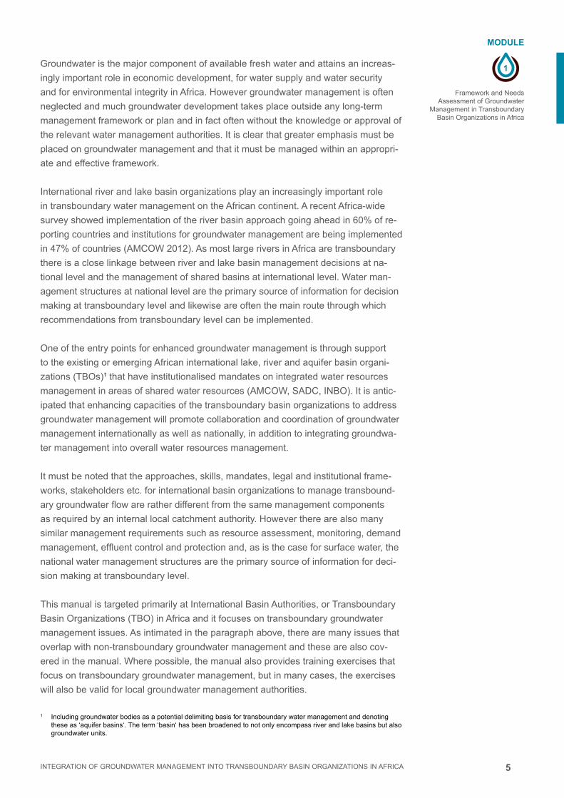
The topic of groundwater management in basin organizations is not completely new,
and it has been discussed at international events such as the Africa Water Week, the
Stockholm World Water Week and other similar meetings. The process that led to the
production of this training manual was the first time that African transboundary basin
organizations were directly involved in a “Groundwater Management Needs Assess-
ment Survey” and in the subsequent development of training materials for transbound-
ary groundwater management. Many international organizations such as AGW-Net,
BGR, IGRAC, UNDP-Cap-Net, IWMI, and the former GW-MATE team of the World
Bank supported this process and have provided valuable inputs to this manual.
Transboundary water management is of great importance to Africa as has been
emphasized in the African Water Vision 2025; almost all Sub-Saharan African coun-
tries share at least one international river basin. In Africa there are about eighty
transboundary lake and river basins and at least forty transboundary aquifer basins.
The African Water Vision 2025 stresses that groundwater is the major, and often only,
source of drinking water for more than 75 % of the African population. Groundwater
constitutes over 95% of the fresh water resources in Africa, and pollution and salini-
zation of this resource is often irreversible on human timescale. As a result, a broad
consensus has developed in AMCOW and in ANBO/INBO, (African (International)
Network of Basin Organizations), that groundwater must be included in integrated river
basin management.
Although worldwide much progress has been made in river basin management,
transboundary groundwater management has often been neglected. Among the many
reasons for this, the most important is that the groundwater resource is highly com-
plex and has not been quantified across Africa. Most African basin organizations lack
the technical skills and capacity to assess and manage transboundary groundwater
resources. This renders the groundwater resource largely “invisible” to the water man-
agers who are required to manage it sustainably.
FOREWORD

5INTEGRATION OF GROUNDWATER MANAGEMENT INTO TRANSBOUNDARY BASIN ORGANIZATIONS IN AFRICA
Given the huge importance of the groundwater resource to Africa, and especially in
light of the growing impacts of climate change, it is imperative that wise management
of groundwater at every scale begins without any further delay. There are already
some promising precedents in Africa that can provide helpful examples and experienc-
es that other African basin organizations can draw on.
The recent 2012 AMCOW status report on “Water Resources Management in Africa”
states that groundwater management systems are working satisfactorily in most North
African countries, whereas in Central and West Africa, groundwater management
systems are less common. The needs assessment survey shows that groundwater
governance mechanisms are prioritized in the more arid parts of the continent, where
the local population is highly dependent on groundwater as their primary drinking wa-
ter source. In regions where people depend on groundwater, management systems
are implemented.
“Conceptualizing Cooperation for Africa’s Transboundary Aquifers Systems” (German
Development Institute - DIE) sums it up by saying: “Africa’s transboundary aquifer
basins contain huge volumes of water which are vital for the future’s economic devel-
opment and social well-being of the riparian countries. Fortunately, negative trans-
boundary effects of national use have been very rare to date. This will almost definitely
change if the potential for Africa’s groundwater resources is exploited, and this with
international support. Then, cooperation between African nations will become almost
imperative in order to prevent the “race to the pump-house”. That’s why we have to
act now!
We wish the students and trainers to be inspired by this manual and to disseminate
it to all stakeholders in regional basin organizations, national and local governments,
civil society and businesses.
Tamiru Abiye (African Groundwater Network, Manager)
Vanessa Vaessen (Policy Advice on Groundwater, Project Management, BGR)

6 INTEGRATION OF GROUNDWATER MANAGEMENT INTO TRANSBOUNDARY BASIN ORGANIZATIONS IN AFRICA
This training manual is the product of two specific policy visions.
The first is derived from one of the pillars of Integrated Water Resources Management
(IWRM): that all water should be managed as a unitary resource within hydrological
basin boundaries.
The second relates to the obvious transboundary nature of water as rivers flow from
one country to the next. International development cooperation in the water sector is
therefore increasingly supporting transboundary cooperation mechanisms.
Although groundwater has not been excluded from these policy visions, its integration
into river basin management organizations and appreciation of the transboundary na-
ture of groundwater flows have lagged behind. This is a product of both the complexity
of the groundwater resource and its ‘invisibility’ to the public eye.
As a result, many African multi-state basin organizations do not even have a mandate
to manage transboundary groundwater or coordinate its management between the ba-
sin states. Even where such a mandate does exist, many of these basin organizations
have limited capacity to do so.
As a result of these conditions, BGR / AGW-Net / IWMI carried out a ‘needs assess-
ment for transboundary groundwater management’ in nine international river basin
organizations in Africa1. This survey revealed the varying needs in the different basin
organizations for effective transboundary groundwater management.
This training manual has been complied in response to the needs expressed and
is designed to help develop capacity within the basin organizations to manage their
transboundary groundwater issues.
The topics covered range from policy and legislation, through bio-physical resource is-
sues to communication and stakeholder relations. Much of the material in this manual
is also relevant for internal national basin organizations.
Editor: Dr. Richard Owen
Africa Groundwater Network.
1 ORASECOM, LIMCOM, OKACOM, OMVS, VBA, LCBC, NSAS, NBI, NBA.
PREFACE

7INTEGRATION OF GROUNDWATER MANAGEMENT INTO TRANSBOUNDARY BASIN ORGANIZATIONS IN AFRICA
This training manual has been made possible thanks to generous financial contribu-
tions from
BMZ – Federal Ministry for Economic
Cooperation and Development
Cap-Net UJNDP
imawesa – Improved Management of Agricultural Water in Eastern and Southern Africa
IWMI - International Water Management Insitute.
We gratefully acknowledge the contributions of various authors:
Albert Tuinhof – who produced the first draft for the manual.
Vanessa Vaessen & Ramon Brentfurher: Modules 1 and 5
Richard Owen: Modules 2 and 7
Moustapha Diene: Module 3
Karen Villholth: Modules 4 and 9
Callist Tindimugaya: Module 6
Daniel Nkhuwa: Module 8
Karen Villholth & Tamiru Abiye: Module 10
Tamiru Abiye: Module 11.
We wish to thank all the River Basin Organizations that participated in the needs as-
sessment surveys that lead to the production of this training manual:
Senegal River (OMVS), Niger River (NBA), Volta River (VBA), Lake Chad (LCBC),
Nubian Sandstone Aquifer (NSAS), Nile River (NBI), Okavango River (OKACOM), Or-
ange-Senqu River (ORASECOM), and Limpopo River (LIMCOM) and African Network
of Basin Organizations (ANBO).
The services of the AGW-Net and BGR teams who conducted the surveys in the
RBOs and produced the individual basin reports: (for AGW-Net: Tamiru Abiye, Richard
Owen, Callist Tindimugaya, Muna Mirghani, Moustapha Diene, and Ben Mapani: for
BGR: Martin Jäger and Sara Vassolo).
Karen Villholth who compiled the combined Groundwater Needs Assessment for
RBOs report.
Significant contributions were also made by Geert van Nijsten, Hector Guarduno and
Stephen Foster.
Additional editorial support was provided by Martin Eduvie and Mohamed Elrawady.
With special thanks to Paul Taylor who reviewed all the modules.
Translated into French by Moustapha Diene
Editor: Richard Owen.
This manual is a production of the Africa Groundwater Network (AGW-Net).
www.agw-net.org
The teacher and the taught together create the teaching.
ACKNOWLEDGEMENTS

8 INTEGRATION OF GROUNDWATER MANAGEMENT INTO TRANSBOUNDARY BASIN ORGANIZATIONS IN AFRICA
MODULE 1Framework and Needs Assessment of Groundwater Management in Transboundary Basin Organizations in Africa
1.1 Introduction 4
1.2 Objectives of the Needs Assessment 6
1.3 Methodology 6
1.4 SWOT Analysis 7
1.5 Overall Results 11
1.6 Recommendations 14
1.7 The Training Manual 15
1.8 References 16
1.9 Exercise 19
MODULE 2Integrated Water Resources Management and the Groundwater Management Framework
2.1 Introduction 4
2.2 Groundwater in the hydrologic cycle 5
2.3 Characteristics of groundwater 7
2.4 Sustainable groundwater use 9
2.5 What is IWRM? 10
2.6 IWRM principles and framework 10
2.7 Groundwater management for river basins 13
2.8 Summary 18
2.9 References 18
2.10 Exercise 19
MODULE 3Aquifer Systems Characterization for Groundwater Management
3.1 Introduction 4
3.2 Groundwater occurrence 4
3.3 Groundwater flow 8
3.4 Groundwater Balance and Recharge 10
3.5 Groundwater and Surface water interaction 13
3.6 Summary: Critical issues in groundwater characterization 20
3.7 References 21
3.8 Exercise 22
CONTENT

9INTEGRATION OF GROUNDWATER MANAGEMENT INTO TRANSBOUNDARY BASIN ORGANIZATIONS IN AFRICA
MODULE 4Management of Transboundary Aquifers
4.1 Introduction 4
4.2 What is a transboundary aquifer (TBA)? 4
4.3 Transboundary aquifers in Africa 6
4.4 Approach and mechanisms for TBA management 10
4.5 Specific challenges and cases of TBA management in Africa 13
4.6 References 15
4.7 Exercise 16
MODULE 5Groundwater Monitoring and Information Management
5.1 Introduction 4
5.2. Monitoring practice 7
5.3 Data storage and information management 12
5.4 Benefits and cost effectiveness of monitoring 15
5.5 Access and exchange of national data to the TBO 16
5.6 Global data 17
5.7 Reference 17
5.8 Exercise 12
MODULE 6Groundwater regulation, licensing, allocation and institutions
6.1 Introduction 4
6.2 Regulation of groundwater within a river basin framework 4
6.3 Groundwater Licensing 7
6.4 Groundwater allocation 9
6.5 Main interactions in groundwater licensing and allocation system 14
6.6 Allocation of non-renewable groundwater resources 15
6.7 Institutional framework for groundwater management 16
6.8 Implementing a groundwater regulatory system 17
6.9 References and further reading 20
6.10 Exercises 21

10 INTEGRATION OF GROUNDWATER MANAGEMENT INTO TRANSBOUNDARY BASIN ORGANIZATIONS IN AFRICA
MODULE 7The role of stakeholder participation and communication in groundwater management
7.1 Why Stakeholder Involvement? 4
7.2 Who does Stakeholder Participation and how is it done? 6
7.3 Identification and Assessment of Key Stakeholders 8
7.4 Institutional Mechanisms for Stakeholder Participation in Groundwater
Management 10
7.5 Stakeholder functions in Groundwater Management 12
7.6 Who are Groundwater Stakeholders for Transboundary Basin
Organizations? 12
7.7 What is Communication and why is it important in Groundwater
Management? 13
7.8 Further reading 16
7.9 EXERCISE 17
MODULE 8Groundwater Hazards
8.1 Introduction 4
8.2 Groundwater Quantity: Over-exploitation 4
8.3 Groundwater Quality: Pollution 7
8.3 Assessment of groundwater pollution, aquifer vulnerability and
over-exploitation 11
8.5 Groundwater protection 13
8.6 Summary 15
8.7 References 17
8.8 Exercise 18
MODULE 9Groundwater for Food Security
9.1 Introduction and background 4
9.2 Why is groundwater use in irrigation so popular? 7
9.3 Livelihood impacts 8
9.4 Too much and too little groundwater development for irrigation is a concern 12
9.5 Solutions to under- and over-use of groundwater for irrigation 13
9.6 The new approach: The nexus between water-, food- and energy security 15
9.7 References and further reading 16
9.8 Exercise 17

11INTEGRATION OF GROUNDWATER MANAGEMENT INTO TRANSBOUNDARY BASIN ORGANIZATIONS IN AFRICA
MODULE 10Groundwater and Environment
10.1 Introduction 4
10.2 Surface and groundwater interaction 4
10.3 Groundwater Contamination 5
10.4 Groundwater-dependent ecosystems (GDEs) 8
10.5 Groundwater over-abstraction 10
10.6 Environmental aspects of groundwater management 11
10.7 The role of basin organizations in environmental management
of groundwater 12
10.8 References & Further reading 13
MODULE 11Groundwater and Climate Change
11.1 Introduction 4
11.2 Groundwater as part of hydrologic cycle 5
11.3 Climate variability and climate change 6
11.4 Climate change scenarios 7
11.5 Impacts of climate change on groundwater 8
11.6 Climate change and population growth 11
11.7 Implications for groundwater dependent sectors 11
11.8 Adaptation to climate change 12
11.9 Summary 16
11.10 References and Web Reading 17

1
MODULE
INTEGRATION OF GROUNDWATER MANAGEMENT INTO TRANSBOUNDARY BASIN ORGANIZATIONS IN AFRICA
FRAMEWORK AND NEEDS ASSESSMENT OF GROUNDWATER MANAGEMENT IN TRANSBOUNDARY
BASIN ORGANIZATIONS IN AFRICA

2 INTEGRATION OF GROUNDWATER MANAGEMENT INTO TRANSBOUNDARY BASIN ORGANIZATIONS IN AFRICA

3
1
MODULE
INTEGRATION OF GROUNDWATER MANAGEMENT INTO TRANSBOUNDARY BASIN ORGANIZATIONS IN AFRICA
Framework and Needs Assessment of Groundwater
Management in Transboundary Basin Organizations in Africa
MODULE 1Framework and Needs Assessment of Groundwater Management in Transboundary Basin Organizations in Africa
1.1 Introduction 4
1.2 Objectives of the Needs Assessment 6
1.3 Methodology 6
1.4 SWOT Analysis 7
1.5 Overall Results 11
1.6 Recommendations 14
1.7 The Training Manual 15
1.8 References 16
1.9 Exercise 19
CONTENT
Imprint
© Copyright 2014, all rights reserved
The use of the manual is FREE of cost. AGW-Net simply requests that users give proper
attribution “Integration of Groundwater Management into Transboundary Basin Organizations in
Africa - a Training Manual by AGW-Net, BGR, IWMI, CapNet, ANBO, & IGRAC” . Modification
is only allowed with permission of AGW-Net.
Photos are copyright to their respective owners.
A4A – aqua for all
AGW-Net – Africa Groundwater Network
ANBO – African Network of Basin Organisations
BGR – Federal institute for geosciences and natural resources
Cap-Net UNDP
BMZ – Federal Ministry for Economic Cooperation and Development
GWP – Global Water Partnership
IGRAC – International Groundwater Resources Assessment Centre
imawesa – Improved Management of Agricultural Water in Eastern and Southern Africa
IWMI - International Water Management Insitute
Editorial Staff: Vanessa Vaessen, Ramon Brentführer – BGR
Layout: ff.mediengestaltung GmbH, Hannover, Germany
Picture: BGR – Bundesanstalt für Geowissenschaften und Rohstoffe

4
1
MODULE
INTEGRATION OF GROUNDWATER MANAGEMENT INTO TRANSBOUNDARY BASIN ORGANIZATIONS IN AFRICA
Framework and Needs Assessment of Groundwater Management in Transboundary Basin Organizations in Africa
1.1 Introduction. This module introduces the rationale and the focus of the training manual. The ma-
terials presented in this manual have been informed by a combination of pre-existing
materials from the GW-Mate series of briefing notes on groundwater management,
from the Cap-Net training manual Groundwater Management in IWRM (2010) and by
a specific detailed needs assessment carried out in nine basin organizations in Africa
with a view to understanding their needs with regards to groundwater management
(BGR / AGW-Net, 2013).
The rationale for a training manual on transboundary groundwater management
is two fold:
1. The first relates to the need to manage all water fluxes within a unitary framework,
which, in context of Integrated Water Resources Management (IWRM), is the river
basin. Hence this manual seeks to not only integrate groundwater management
with surface water management, but it also seeks to do it within the framework of
hydrological basins.
2. Second is that since the widespread adoption of an integrated approach to water
resources management in African countries, many new water management struc-
tures have been formed, often called River Basin Organizations (RBO) or Catch-
ment Management Agencies (CMA). Since many river basins are transboundary in
natures, international development cooperation in the water sector has increasing-
ly focussed on transboundary cooperation mechanisms.
FRAMEWORK AND NEEDS ASSESSMENT OF GROUNDWATER MANAGEMENT IN TRANSBOUNDARY BASIN ORGANIZATIONS IN AFRICA
LEARNING OBJECTIVES: ■ Provide an overview of groundwater management needs in transboundary Af-
rican River and Lake Basin Organizations based on a detailed needs assess-
ment carried out in 2011/12. (BGR / AGW-Net, 2013).
■ Understand the strengths, weaknesses, opportunities and threats of including
transboundary groundwater management into transboundary basin organizations
5
1
MODULE
INTEGRATION OF GROUNDWATER MANAGEMENT INTO TRANSBOUNDARY BASIN ORGANIZATIONS IN AFRICA
Framework and Needs Assessment of Groundwater
Management in Transboundary Basin Organizations in Africa
Groundwater is the major component of available fresh water and attains an increas-
ingly important role in economic development, for water supply and water security
and for environmental integrity in Africa. However groundwater management is often
neglected and much groundwater development takes place outside any long-term
management framework or plan and in fact often without the knowledge or approval of
the relevant water management authorities. It is clear that greater emphasis must be
placed on groundwater management and that it must be managed within an appropri-
ate and effective framework.
International river and lake basin organizations play an increasingly important role
in transboundary water management on the African continent. A recent Africa-wide
survey showed implementation of the river basin approach going ahead in 60% of re-
porting countries and institutions for groundwater management are being implemented
in 47% of countries (AMCOW 2012). As most large rivers in Africa are transboundary
there is a close linkage between river and lake basin management decisions at na-
tional level and the management of shared basins at international level. Water man-
agement structures at national level are the primary source of information for decision
making at transboundary level and likewise are often the main route through which
recommendations from transboundary level can be implemented.
One of the entry points for enhanced groundwater management is through support
to the existing or emerging African international lake, river and aquifer basin organi-
zations (TBOs)1 that have institutionalised mandates on integrated water resources
management in areas of shared water resources (AMCOW, SADC, INBO). It is antic-
ipated that enhancing capacities of the transboundary basin organizations to address
groundwater management will promote collaboration and coordination of groundwater
management internationally as well as nationally, in addition to integrating groundwa-
ter management into overall water resources management.
It must be noted that the approaches, skills, mandates, legal and institutional frame-
works, stakeholders etc. for international basin organizations to manage transbound-
ary groundwater flow are rather different from the same management components
as required by an internal local catchment authority. However there are also many
similar management requirements such as resource assessment, monitoring, demand
management, effluent control and protection and, as is the case for surface water, the
national water management structures are the primary source of information for deci-
sion making at transboundary level.
This manual is targeted primarily at International Basin Authorities, or Transboundary
Basin Organizations (TBO) in Africa and it focuses on transboundary groundwater
management issues. As intimated in the paragraph above, there are many issues that
overlap with non-transboundary groundwater management and these are also cov-
ered in the manual. Where possible, the manual also provides training exercises that
focus on transboundary groundwater management, but in many cases, the exercises
will also be valid for local groundwater management authorities.
1 Including groundwater bodies as a potential delimiting basis for transboundary water management and denoting these as ‘aquifer basins‘. The term ‘basin‘ has been broadened to not only encompass river and lake basins but also groundwater units.

6
1
MODULE
INTEGRATION OF GROUNDWATER MANAGEMENT INTO TRANSBOUNDARY BASIN ORGANIZATIONS IN AFRICA
Framework and Needs Assessment of Groundwater Management in Transboundary Basin Organizations in Africa
1.2 Objectives of the Needs AssessmentThis module addresses the issue of transboundary groundwater management
capacity in international river and lake basin organizations in Africa based on a
recent needs assessment survey carried out in nine international river basins
(BGR / AGW-Net, 2013).
Nine TBOs in Africa were surveyed on the present status, progress, and limitations to
incorporating groundwater management into their mandate and practices (BGR and
IWMI, 2012). The primary focus institutions of the needs assessment were the execu-
tive secretariats of the TBOs and the national (ground)water authorities in the member
states.
The immediate objectives of the needs assessment were to:
1. Assess the present national and international framework (legal, institutional), prac-
tices, experiences, and capacity for groundwater management
2. Identify and assess shortcomings and strengths for integrated groundwater man-
agement as part of integrated national and transboundary water resources man-
agement
3. Based on consultations with the TBOs, recommend immediate and longer term
strategic steps for supporting a capacity-enhancing process through which ground-
water is gradually and permanently included and integrated into the mandate of
existing TBOs
4. Initiate a process and a network of partners (institutions, experts, decision mak-
ers, donors, and NGOs) for developing and sustaining capacity for transboundary
groundwater management in TBOs in Africa
1.3 MethodologyNine selected TBOs (Senegal River (OMVS), Niger River (NBA), Volta River
(VBA), Lake Chad (LCBC), Nubian Sandstone Aquifer (NSAS), Nile River (NBI),
Okavango River (OKACOM), Orange-Senqu River (ORASECOM), and Limpopo
River (LIMCOM)) entered into the survey that comprised personal interviews
with representatives of the transboundary basin organizations as well as of-
ficials from water management institutions in the respective member states
(Table 1.1).
The needs assessment consisted of three parts:
1. Desktop studies to develop short individual basin profiles for each basin;
2. Interviews with key personnel involved in groundwater management in the basins;
and
3. SWOT analyses2 based on the outcomes of the first two parts.
In a consultation process, the results of the survey were reviewed by the respective
TBOs, AGW-Net, ANBO, and AMCOW in Burkina Faso in February 2013. Their rec-
ommendations were used for developing this training manual.
2 A SWOT analysis is a tool that identifies the strengths, weaknesses, opportunities and threats of an organization. The method is used to analyse the information from an organizational analysis and separate it into internal (strengths and weaknesses) and external issues (opportunities and threats).

7
1
MODULE
INTEGRATION OF GROUNDWATER MANAGEMENT INTO TRANSBOUNDARY BASIN ORGANIZATIONS IN AFRICA
Framework and Needs Assessment of Groundwater
Management in Transboundary Basin Organizations in Africa
1.4 SWOT Analysis: Swot analyses were carried out in each TBO and the results from all the SWOT
analyses were combined and summarized below.
TBO STRENGTHS - SUMMARYGovernance:
1. TBOs tend to operate within the framework of a multi-state agreement that provides for the possibility
of a transboundary water management mandate.
2. TBOs generally have a permanent secretariat that can initiate and manage programs and projects
such as transboundary groundwater management and monitoring activities.
3. TBOs can provide a platform for mobilizing basin-wide political support and for bringing groundwater
higher on the political agenda.
4. TBOs have a good platform for raising finance to carry out transboundary groundwater actions such as
monitoring.
Riparian State Collaboration:
1. TBOs can be a focal point for improved political and technical collaboration between riparian states.
Data Management and Sharing:
1. TBOs can provide a suitable platform for hosting transboundary groundwater data and for the manage-
ment and use of the data.
Capacity Development:
1. TBOs can optimize groundwater management capacity development as a focal point for basin wide
training programs in transboundary groundwater management.
2. TBO’s can optimize capacity utilization by providing a platform for the pooling of scarce technical ex-
pertize from the riparian states.
8
1
MODULE
INTEGRATION OF GROUNDWATER MANAGEMENT INTO TRANSBOUNDARY BASIN ORGANIZATIONS IN AFRICA
Framework and Needs Assessment of Groundwater Management in Transboundary Basin Organizations in Africa
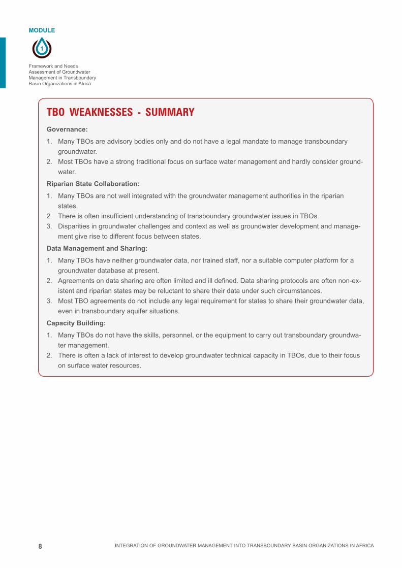
TBO WEAKNESSES - SUMMARYGovernance:
1. Many TBOs are advisory bodies only and do not have a legal mandate to manage transboundary
groundwater.
2. Most TBOs have a strong traditional focus on surface water management and hardly consider ground-
water.
Riparian State Collaboration:
1. Many TBOs are not well integrated with the groundwater management authorities in the riparian
states.
2. There is often insufficient understanding of transboundary groundwater issues in TBOs.
3. Disparities in groundwater challenges and context as well as groundwater development and manage-
ment give rise to different focus between states.
Data Management and Sharing:
1. Many TBOs have neither groundwater data, nor trained staff, nor a suitable computer platform for a
groundwater database at present.
2. Agreements on data sharing are often limited and ill defined. Data sharing protocols are often non-ex-
istent and riparian states may be reluctant to share their data under such circumstances.
3. Most TBO agreements do not include any legal requirement for states to share their groundwater data,
even in transboundary aquifer situations.
Capacity Building:
1. Many TBOs do not have the skills, personnel, or the equipment to carry out transboundary groundwa-
ter management.
2. There is often a lack of interest to develop groundwater technical capacity in TBOs, due to their focus
on surface water resources.
9
1
MODULE
INTEGRATION OF GROUNDWATER MANAGEMENT INTO TRANSBOUNDARY BASIN ORGANIZATIONS IN AFRICA
Framework and Needs Assessment of Groundwater
Management in Transboundary Basin Organizations in Africa
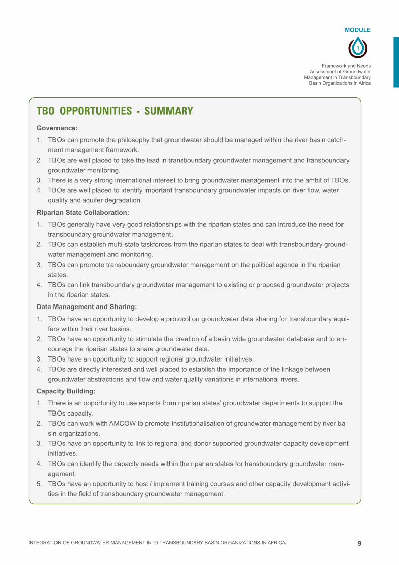
TBO OPPORTUNITIES - SUMMARYGovernance:
1. TBOs can promote the philosophy that groundwater should be managed within the river basin catch-
ment management framework.
2. TBOs are well placed to take the lead in transboundary groundwater management and transboundary
groundwater monitoring.
3. There is a very strong international interest to bring groundwater management into the ambit of TBOs.
4. TBOs are well placed to identify important transboundary groundwater impacts on river flow, water
quality and aquifer degradation.
Riparian State Collaboration:
1. TBOs generally have very good relationships with the riparian states and can introduce the need for
transboundary groundwater management.
2. TBOs can establish multi-state taskforces from the riparian states to deal with transboundary ground-
water management and monitoring.
3. TBOs can promote transboundary groundwater management on the political agenda in the riparian
states.
4. TBOs can link transboundary groundwater management to existing or proposed groundwater projects
in the riparian states.
Data Management and Sharing:
1. TBOs have an opportunity to develop a protocol on groundwater data sharing for transboundary aqui-
fers within their river basins.
2. TBOs have an opportunity to stimulate the creation of a basin wide groundwater database and to en-
courage the riparian states to share groundwater data.
3. TBOs have an opportunity to support regional groundwater initiatives.
4. TBOs are directly interested and well placed to establish the importance of the linkage between
groundwater abstractions and flow and water quality variations in international rivers.
Capacity Building:
1. There is an opportunity to use experts from riparian states’ groundwater departments to support the
TBOs capacity.
2. TBOs can work with AMCOW to promote institutionalisation of groundwater management by river ba-
sin organizations.
3. TBOs have an opportunity to link to regional and donor supported groundwater capacity development
initiatives.
4. TBOs can identify the capacity needs within the riparian states for transboundary groundwater man-
agement.
5. TBOs have an opportunity to host / implement training courses and other capacity development activi-
ties in the field of transboundary groundwater management.

10
1
MODULE
INTEGRATION OF GROUNDWATER MANAGEMENT INTO TRANSBOUNDARY BASIN ORGANIZATIONS IN AFRICA
Framework and Needs Assessment of Groundwater Management in Transboundary Basin Organizations in Africa
TBO THREATS – SUMMARYGovernance:
1. TBOs often lack the finances to carry out transboundary groundwater management and monitoring
programs.
2. Many TBOs are advisory organizations and lack the legal mandate to carry out transboundary ground-
water programs.
3. Many TBOs lack strategies and procedures for the integration of groundwater into river basin water
resources management structures.
4. There are often mismatched resources and political power between the riparian states that can hinder
smooth agreement on transboundary groundwater management.
Riparian State Collaboration:
1. Riparian states may reject the TBOs role in managing transboundary groundwater.
2. Technical complexities may make it difficult to fully understand transboundary groundwater movements
and therefore to get support from the riparian states, especially in conflict situations.
3. Many TBOs do not have a legal mandate to enforce transboundary groundwater decisions.
4. There may be a lack of common interest, or conflicting interests, from member states on groundwater
issues.
Data Management and Sharing:
1. Some riparian states may be unwilling to share groundwater data.
2. Riparian states have different data archive systems that may be incompatible
3. Lack of knowledge of groundwater resources.
4. Lack of credible/ accurate information on the major uses of groundwater within the basin
5. Sustainability of mechanism of data collecting & sharing is not assured.
Capacity Building:
1. Limited capacity in the basin for undertaking groundwater management activities
2. Riparian states may not accept the need for capacity development with regards to transboundary
groundwater management.
3. Funding for capacity development may be unavailable.

11
1
MODULE
INTEGRATION OF GROUNDWATER MANAGEMENT INTO TRANSBOUNDARY BASIN ORGANIZATIONS IN AFRICA
Framework and Needs Assessment of Groundwater
Management in Transboundary Basin Organizations in Africa
1.5 Overall ResultsThe survey showed that despite incipient awareness, adoption of international
legal frameworks and international promotion, transboundary groundwater man-
agement in the TBOs has not yet been fully addressed. Encouraging factors,
such as international advocacy, and financial and technical support, need to be
backed up by an emphasis on political commitment and capacity development
at all levels. Because TBOs are still struggling with their present mandates,
primarily related to surface water management, the added challenges of ground-
water management will need to be incorporated gradually.
It is clear that surface water and groundwater must be managed coherently. There are
some inherent structural challenges to such an approach. The areal extent of surface
water basins and the underlying groundwater systems often differ radically (BGR et
al., 2012, see Fig. 1.1), making groundwater management by river basin organiza-
tions complex. Furthermore, in arid regions, due to the lack of surface water, it is more
rational to use aquifers in discrete groundwater basins as the basis for water manage-
ment organizations in such areas. In addition, there is a lack of adequate information
on the distribution and extent of groundwater resources in many parts of the world and
there is a distinct need for investment to improve capacity for groundwater assess-
ment and monitoring. Despite these factors, the strong global support and progress
towards IWRM in international river basins is such that they are still considered to be
the appropriate organizations to manage transboundary aquifers.

12
1
MODULE
INTEGRATION OF GROUNDWATER MANAGEMENT INTO TRANSBOUNDARY BASIN ORGANIZATIONS IN AFRICA
Framework and Needs Assessment of Groundwater Management in Transboundary Basin Organizations in Africa
Figure 1.1 Transboundary Aquifers and International River Basins in Africa.
All TBOs surveyed are different in terms of their geography, size and mandate (see
Table 1.1).

13
1
MODULE
INTEGRATION OF GROUNDWATER MANAGEMENT INTO TRANSBOUNDARY BASIN ORGANIZATIONS IN AFRICA
Framework and Needs Assessment of Groundwater
Management in Transboundary Basin Organizations in Africa
Individual reports for the nine TBOs have been produced as part of the survey These
are available at: http://www.splash-era.net/search_outputs2.php
Basin Riparian countries Area (km2) Population (mill.)
TBO (created)
Mandatea Associated TBAsb
Ref. to basin profile reportsc
Oange-Senqu
Botswana, Lesotho, Namibia, South Africa
896,000 19 ORASECOM (2000)
Cons, A, Coo, I
4 Abiye, 2012
Limpopo Botswana, Mozambique, Zimbabwe, South Africa
410.000 14 LIMCOM (2003
Cons, A 3 Owen, 2012
Okavango Angola, Botswana, Namibia, (Zimbabwe)d
430,000 0.7 OKACOM (1994)
Cons, A, Coo, R
2-5 Mapani, 2012
Nile Burundi, Congo, Egypt, Eritrea, Ethiopia, Kenya, Rwanda, Sudan, Tanzania, Uganda
3,100,000 160 NBI (1999) Cons, A, Coo, I
7 Mirghani and Tindimugaya, 2012
Nubian Chad, Egypt, Libya, Sudan
2,200,000 0.14 NSAS (1999) Cons, A - Mirghani, 2012
Senegal (Guinea)e, Mali, Mauritania, Senegal
300,000 5 OMVS (1972) Cons, A, Coo, I, R, Conf, P
2 Diene, 2012
Niger (Algeria)f, Benin, Burkina Faso, Cameroon, Chad, Guinea, Ivory Coast, Mali, Niger, Nigeria
2,000,000 109 NBA (1980) Cons, A, Coo, I, R
3 Menge and Jäger, 2012
Volta Benin, Burkina Faso, Mali Ghana, Ivory Coast, Togo
400,000 19 VBA (2006) Cons, A, Coo, I, R
1 Jäger, 2012
Chad (Algeria), Cameroon, Chad, Central African Republic, (Libya)g, Niger, Nigeria, (Sudan)h
2,300,000 30 LCBC (1964) Cons, A, Coo, R
2 Vassolo, 2012
Table 1.1 Key data on the basins and their organizations
a Cons: consultative, A: advisory, Coo: coordinating, P: policy-making, I: implementing, R: regulatory, Conf: conflict arbitration, TBAs: transboundary aquifers
b Acc. to WHYMAP (BGR, UNESCO, 2006). Reservations exist, due to uncertainty of extent of TBAs (e.g. Okavango)c See Annex 1 THESE SHOULD JUST BE LISTED IN THE REFERENCES AND DON’T NEED A SEPARATE ANNEXd Zimbabwe is part of the inactive part of the basin, not member of OKACOMe Guinea is now full member of OMVS, but was not signatory of the treaty creating TBOf Algeria is not a full member of NBA, but does have observer statusg Libya is now full member of the LCBC, but was not signatory of the treaty creating TBOh Nations in parenthesis are not signatories to the LCBC treaty

14
1
MODULE
INTEGRATION OF GROUNDWATER MANAGEMENT INTO TRANSBOUNDARY BASIN ORGANIZATIONS IN AFRICA
Framework and Needs Assessment of Groundwater Management in Transboundary Basin Organizations in Africa
1.6 RecommendationsBased on the needs assessment, the following generic recommendations for im-
proving groundwater management in the international TBOs can be put forward.
With regard to the legal basis:
1. The UN draft articles on the United Nations International Law Commission (UNI-
LC) Law of Transboundary Aquifers and the 1997 Convention on the Non-Naviga-
tional Use of Watercourses can be used as guidance for TBOs for transboundary
groundwater management.
2. The particular properties of groundwater resources need to be specifically ad-
dressed in the legal frameworks, e.g. the relative delay in response, the relative
vulnerability of the aquifers, and the distributed access and use of the resource.
With regard to the institutional framework and decision making:
1. Groundwater committees of the TBOs should be created (with at least one groundwater /
hydrogeological expert) to give emphasis to groundwater issues in the organizations.
2. Centralised databases of transboundary aquifers (TBA) should be maintained at
the TBOs and in the riparian states and clear data sharing protocols that include
groundwater should be put in place.
3. All TBOs should develop strategic groundwater action and investment plans for their basin.
4. Apply inter-disciplinary and cross-sectoral assessment approaches for water
supply, food security, climate change adaptation, environmental integrity involving
groundwater, as well as socio-economic and cost-benefit analysis of groundwater
development to prioritize use and valuation of groundwater resources.
With regard to financial viability:
1. Regional development communities (SADC, ECOWAS, IGAD) should be further
engaged in transboundary groundwater management, enhancing groundwater fo-
cus and facilitating multilateral donor support and support from international water
organizations. (e.g. UNESCO-IHP, UNECE, IAH, IAHS, IAEA)
2. Advocacy should be focussed on political decision makers in order to promote
political interest and commitment for groundwater management, which should
facilitate financial support to the TBOs.
With regard to capacity development (CD) and awareness raising:
1. Use existing CD organizations and programmes in Africa to strengthen the capac-
ity among the TBOs. (GWP, WaterNet, AGW-Net, Cap-Net, WRC, CoE on Water,
NEPAD Water CoE, and IW:LEARN)
2. Increase staff with hydrogeological background in the TBOs. It is also essential to
improve groundwater knowledge and skills of existing personnel.
3. Enhance liaison between TBOs and groundwater expertise existing in the riparian
countries and in academia.
4. Rather than starting from scratch, TBO’s should use, replicate, and expand
existing frameworks for enhancing public participation and awareness raising to
address groundwater issues in the basins. (as done in e.g. NBI and ORASECOM)
5. Increase visibility of benefits (to politicians and public) of managing groundwater in
river basin organizations by packaging information on groundwater issues so that
non groundwater-experts are able to understand it.

15
1
MODULE
INTEGRATION OF GROUNDWATER MANAGEMENT INTO TRANSBOUNDARY BASIN ORGANIZATIONS IN AFRICA
Framework and Needs Assessment of Groundwater
Management in Transboundary Basin Organizations in Africa
1.7 The Training Manual. This training manual has been prepared as a response to the needs expressed
by the TBOs participating in the survey. The manual aims to provide specific
guidance on groundwater management to transboundary basin organizations in
Africa.
During the preparation of this manual, it became clear that much of the available
training material on groundwater management is directed towards general ground-
water management and less towards specific transboundary situations. This manual
attempts to provide some balance to that with insights into transboundary aspects of
groundwater management. Nevertheless, the general principles of groundwater man-
agement are included because they are, in many cases, relevant to transboundary
situations.
Although this manual is directed to groundwater management by TBOs, it must be
appreciated that there are many issues that TBOs face that impact on groundwater
management, but which fall outside the scope and ambit of a training manual on
groundwater management in TBOs. Financial viability is perhaps one such area.
The major purpose of the manual is to provide TBO technical and professional staff with
the requisite understanding and skills to improve their ability to manage transboundary
groundwater. However the manual also highlights the legal and institutional limitations
that TBOs face with regards to their mandate and their professional capacity.
Where possible, the exercises in the manual focus on transboundary situations and
provide an opportunity for TBO staff to work through these with the course facilitators
and compare them to conditions that they face in their own work environment.

16
1
MODULE
INTEGRATION OF GROUNDWATER MANAGEMENT INTO TRANSBOUNDARY BASIN ORGANIZATIONS IN AFRICA
Framework and Needs Assessment of Groundwater Management in Transboundary Basin Organizations in Africa
1.8 References
Altchenko, Y. and K.G. Villholth, 2013.
Transboundary aquifer mapping and management in Africa: a harmonised ap-
proach.
Hydrogeol. J. 21(7), 1497-1517. DOI 10.1007/s10040-013-1002-3.
AMCOW, 2012.
Status report on the application of integrated approaches to water resources
management in Africa.
BGR and IWMI, 2013.
Needs Assessment to Support Groundwater Management in International Basin
Organizations of Africa.
Available at:
http://www.splash-era.net/downloads/groundwater/Needs_asessment_GW_final.pdf
BGR, UNESCO, and WHYMAP, 2012.
River and groundwater basins of the world.
BGR and UNESCO, 2006.
WHYMAP and the World Map of Transboundary Aquifer Systems at the scale of
1 : 50 000 00
(Special Edition for the 4th World Water Forum, Mexico City, Mexico, March 2006).
Braune, E., and Y. Xu, 2011.
Transboundary Aquifer Utilization and Management in Southern Africa.
ISARM-SADC since 2005. A Position Paper for the UNESCO Cluster Office, Harare.
53 pp.
GTZ, 2008.
Strenghtening Cooperation among River Basin Organizations. A Comparative
Study of the Linkages between River/lake Basin Organizations and the Respec-
tive Cooperating National Governments in Seven Major African Basins.
Authors: K. Pietersen and H.E. Beekman. Draft Final Report. 96 pp.
IGRAC, 2012.
Transboundary Aquifers of the World. Map 1 : 50 000 000. Update 2012
(Special Edition for the 6th World Water Forum, Marseille, France, Turkey, March
2012).
Scheumann, W. and E. Herrfahrdt-Pähle (eds.), 2008.
Conceptualizing cooperation on Africa’s transboundary groundwater resources.
DIE, Deutsches Institut für Entwicklungspolitik. German Development Institute. Bonn.
394 pp. ISSN 1860-0468.
UNESCO, 2009.
Transboundary Aquifers: Managing a Vital Resource.
UNILC Draft Articles on the Law of Transboundary Aquifers (Ed. R.M. Stephan). 24 pp.

17
1
MODULE
INTEGRATION OF GROUNDWATER MANAGEMENT INTO TRANSBOUNDARY BASIN ORGANIZATIONS IN AFRICA
Framework and Needs Assessment of Groundwater
Management in Transboundary Basin Organizations in Africa
Additional Reading
Braune, E. and , Y. Xu, 2008.
Groundwater management issues in Southern Africa - An IWRM perspective.
Water SA, 34(6) 699 - 706. ISSN 0378-4738.
Eckstein, Y. and Eckstein, G. E., 2003.
Ground water resources and international law in the Middle East peace process.
Water International, 28 (20), 154-161. DOI:10.1080/02508060308691680.
GW-MATE, 2006.
Groundwater monitoring requirements for managing aquifer response and quali-
ty threats. Briefing Note Series, Note 9.
Authorrs: A. Tuinhof, S. Foster, K. Kemper, H. Garduño, M. Nanni
INBO and GWP, 2012.
The Handbook for Integrated Water Resources Management in Transboundary
Basins of Rivers, Lakes and Aquifers.
March, 2012. 120 pp. ISBN : 978-91-85321-85-8.
SADC, 2005.
Regional Strategic Action Plan on Integrated Water Resources Development and
Management. Annotated Strategic Plan.
2005 to 2010. 75 pp.
UNECE, 2000.
Guidelines on Monitoring and Assessment of Transboundary Groundwaters.
Lelystad, UNECE Task Force on Monitoring and Assessment, under the Conven-
tion on the Protection and Use of Transboundary Watercourses and Internation-
al Lakes (Helsinki 1992).
ISBN 9036953154.
UNESCO, 2010.
Transboundary Aquifers. Challenges and New Directions.
Abstracts, ISARM, 2010 International Conference. Dec. 6 - 8, 2010. Paris, France.
188 pp.
UNESCO-IHP, 2009.
Sharing an Invisible Water Resource for the Common Good: How to Make Use of
the UN General Assembly Resolution on the Law of Transboundary Aquifers.
Seminar convened by UNESCO-IHP, with SIWI, IAH and BGR. Report prepared by
Raya Marina Stephan (UNESCO-IHP). 6 pp

18
1
MODULE
INTEGRATION OF GROUNDWATER MANAGEMENT INTO TRANSBOUNDARY BASIN ORGANIZATIONS IN AFRICA
Framework and Needs Assessment of Groundwater Management in Transboundary Basin Organizations in Africa
Annex 1 Basin Organization reports
(to download: http://www.splash-era.net/search_outputs2.php)
Abiye, T.A., 2012.
Basin Profile for Groundwater Needs Assessment: Orange-Senqu River Basin
Commission (ORASECOM).
AGW-Net.
BGR / AGW-Net. 2013.
Needs Assessment to Support Groundwater Management in International Basin
Organizations of Africa.
http://www.splash-era.net/downloads/groundwater/Needs_asessment_GW_final.pdf
Cap-Net. 2010.
Groundwater Management in IWRM.
Training Manual.
Diene, M., 2012.
Basin Profile for Groundwater Needs Assessment:
Senegal River Basin Commission (OMVS), AGW-Net.
Jäger, M., 2012.
Basin Profile Groundwater Needs Assessment:
Volta River Basin, BGR.
Mapani, M., 2012.
Basin Profile for Groundwater Needs Assessment:
Okavango-Cubango River Basin, Univ. of Namibia and WaterNet.
Menge, S. and M. Jäger, 2012.
Basin Profile for Groundwater Needs Assessment:
Niger River Basin (ABN), BGR.
Mirghani, M., and C. Tindimugaya, 2012.
Basin Profile for Groundwater Needs Assessment:
Nile Basin Initiative (NBI), Nile IWRM-Net and AGW-net.
Mirghani, M., 2012.
Basin Profile for Groundwater Needs Assessment:
Nubian Sandstone Aquifer System (NSAS). Nile IWRM-Net
Owen, R., 2012.
Basin Profile for Groundwater Needs Assessment:
The Limpopo Watercourse Commission (LIMCOM), AGW-Net
Vassolo, S.I., 2012.
Basin Profile for Groundwater Needs Assessment:
Lake Chad Basin Commission (LCBC), BGR.

19
1
EXERCICE
INTEGRATION OF GROUNDWATER MANAGEMENT INTO TRANSBOUNDARY BASIN ORGANIZATIONS IN AFRICA
Framework and Needs Assessment of Groundwater
Management in Transboundary Basin Organizations in Africa
1.9 Exercise
■■ Regarding your TBO, can you identify the Strengths, Weaknesses, Opportunities
and Threats?
■■ What are your key concerns with regards to transboundary groundwater issues?
For example
Title: Needs assessment for groundwater management in transboundary basin organ-
izations.
Purpose: To explore how groundwater is managed in national and transboundary
water management structures.
Activity: 1.5 – 2 hrs
1. Work in groups, either by basin organization or by country.
2. Discuss the following questions:
■■ What are the key water management structures at basin level?
■■ How are surface water and groundwater management integrated in these struc-
tures?
■■ What are the strong points of the management system?
■■ What are the weak points?
■■ What action would you recommend to improve integrated ground and surface
water management?
Report back
Each group to report back on each question 10-15 mins each then 20 mins general
discussion.
Notes to Facilitator: Try to keep the focus on the
operational level of management. Remember that there
are many different kinds of structures in place and
groundwater may have a entirely separate structure. For
transboundary basin organizations, try to find out how
they link down to national level structures of participating
countries.
Finally consider how the points raised by the participants
may be addressed by the course.

2
MODULE
INTEGRATION OF GROUNDWATER MANAGEMENT INTO TRANSBOUNDARY BASIN ORGANIZATIONS IN AFRICA
INTEGRATED WATER RESOURCES MANAGEMENT AND THE GROUNDWATER MANAGEMENT FRAMEWORK

2 INTEGRATION OF GROUNDWATER MANAGEMENT INTO TRANSBOUNDARY BASIN ORGANIZATIONS IN AFRICA
3
2
MODULE
Integrated Water Resources Management and the
Groundwater Management Framework
INTEGRATION OF GROUNDWATER MANAGEMENT INTO TRANSBOUNDARY BASIN ORGANIZATIONS IN AFRICA
MODULE 2Integrated Water Resources Management and the Groundwater Management Framework
2.1 Introduction 4
2.2 Groundwater in the hydrologic cycle 5
2.3 Characteristics of groundwater 7
2.4 Sustainable groundwater use 9
2.5 What is IWRM? 10
2.6 IWRM principles and framework 10
2.7 Groundwater management for river basins 13
2.8 Summary 18
2.9 References 18
2.10 Exercise 19
CONTENT
Imprint
© Copyright 2014, all rights reserved
The use of the manual is FREE of cost. AGW-Net simply requests that users give proper
attribution “Integration of Groundwater Management into Transboundary Basin Organizations in
Africa - a Training Manual by AGW-Net, BGR, IWMI, CapNet, ANBO, & IGRAC” . Modification
is only allowed with permission of AGW-Net.
Photos are copyright to their respective owners.
A4A – aqua for all
AGW-Net – Africa Groundwater Network
ANBO – African Network of Basin Organisations
BGR – Federal institute for geosciences and natural resources
Cap-Net UNDP
BMZ – Federal Ministry for Economic Cooperation and Development
GWP – Global Water Partnership
IGRAC – International Groundwater Resources Assessment Centre
imawesa – Improved Management of Agricultural Water in Eastern and Southern Africa
IWMI - International Water Management Insitute
Editorial Staff: Vanessa Vaessen, Ramon Brentführer – BGR
Layout: ff.mediengestaltung GmbH, Hannover, Germany
Picture: IWMI
4
2
MODULE
Integrated Water Resources Management and the Groundwater Management Framework
INTEGRATION OF GROUNDWATER MANAGEMENT INTO TRANSBOUNDARY BASIN ORGANIZATIONS IN AFRICA
INTEGRATED WATER RESOURCES MANAGEMENT AND THE GROUNDWATER MANAGEMENT FRAMEWORK
2.1 IntroductionOne of the cornerstones of the IWRM philosophy is that the fundamental management
unit for water should be a ‘river basin’ or ‘surface water catchment’. A river basin is
a naturally occurring physical entity that has a contiguous integrated surface water
system with a unique outlet. Water management by river basin is therefore based on
physical ecological reality. Due to this guiding philosophy, many nations now manage
their water by river basin, and many River Basin Organizations (RBOs) and other
catchment water management authorities have been created.
The conjunctive management of groundwater and surface water is also a guiding prin-
ciple of IWRM. However the integrated management of surface and groundwater has
lagged behind in many RBOs for various reasons. These include traditional institution-
al separation of groundwater and surface water management, the different knowledge
and skill systems required for surface and groundwater management, and the fact that
aquifer systems may not coincide with river basin boundaries. Aquifers may be trans-
boundary between adjacent river basins, and / or shared between two or more states.
(See Module 4: Management of transboundary aquifers)
Given their overarching prominence in regional transboundary water management in
Africa, RBOs have a unique opportunity to fully integrate groundwater and surface
water management and thereby manage their catchment water supplies in an optimal
and sustainable manner.
A fundamental purpose of this short course is to promote this objective by providing
an overall understanding of groundwater management within IWRM and by providing
tools for river basin water managers to manage their groundwater resources conjunc-
tively with their surface water resources.
LEARNING OBJECTIVESThis module emphasises the need for managing groundwater in the context of In-
tegrated Water Resources Management. The module will contribute to the follow-
ing learning objectives:
■ Appreciate the characteristics of groundwater in the context of all available
freshwater resources
■ Understand the challenges facing groundwater management and the need for
improved approaches to address the resource management problems
■ Understand key principles and themes in IWRM with respect to joint sur-
face-groundwater management
■ Emphasize key advantages of incorporating groundwater management into
national and river basin water resource planning

5
2
MODULE
Integrated Water Resources Management and the
Groundwater Management Framework
INTEGRATION OF GROUNDWATER MANAGEMENT INTO TRANSBOUNDARY BASIN ORGANIZATIONS IN AFRICA
2.2 Groundwater in the hydrologic cycle■■ The hydrologic cycle is the continuous circular process by which water evaporates from the
oceans, condenses and falls to the Earth as rain or snow, becomes run-off and ground-
water recharge and eventually returns to the oceans through river flow and groundwater
discharge. (Figure 2.1).
■■ The implications of the hydrologic cycle are that surface water and groundwater cannot be
sustainably managed separately since they are inextricably bound together in the water
cycle.
Figure 2.1 Hydrologic cycle: linkages between surface and groundwater.

6
2
MODULE
Integrated Water Resources Management and the Groundwater Management Framework
INTEGRATION OF GROUNDWATER MANAGEMENT INTO TRANSBOUNDARY BASIN ORGANIZATIONS IN AFRICA
Importance of groundwater
■■ Although groundwater is the hidden part of the hydrologic cycle, it represents a
much larger volume than surface water. Groundwater makes up 97% of the availa-
ble unfrozen freshwater on our planet (Figure 2.2)
■■ The surface water / groundwater ratio in Africa is similar (Fig 2.3), with ground-
water at (5,500,000 km3) dominating the available freshwater resources (31,776
km3).
■■ Africa is blessed with abundant groundwater resources, although perversely most
of the largest aquifers are located either in the humid and water rich Congo basin
or in the sparsely populated Sahara / Sahel areas (Fig 2.4)
■■ Groundwater is the main source of water for domestic use for more than 2 billion
people in the world – that is almost 30% of the estimated 7 billion global popula-
tion. It is often the only source of water for all uses for dispersed rural communities
in semi-arid regions
■■ The acccelerated global development over the past few decades has been signif-
icantly supported by groundwater, as a low-cost, drought-resistant and (mainly)
high-quality water supply for urban and rural populations and for irrigation (Module
9: Groundwater for food production.)
■■ It is the major source of water for many mega cities (Mexico City, Dhaka, Dar es
Salaam, etc.)
■■ Groundwater is under-developed in many parts of the continent
■■ Additional and sustainable use of groundwater will be vital for the achievement
of the ‘UN Sustainable Development Goals’ and for adaptation to climate change
(Module 11: Groundwater and Climate Change)
L'eau de la Planète
Eau de Surface Douce
Eau Douce
eau saline (océans)
97%
glaciers et neige68.7%
lacs87%
eau souterraine30.1%
eau douce 3% autre 0.9% rivières 2%
Figure 2.2 Distribution of earth’s freshwater resources

7
2
MODULE
Integrated Water Resources Management and the
Groundwater Management Framework
INTEGRATION OF GROUNDWATER MANAGEMENT INTO TRANSBOUNDARY BASIN ORGANIZATIONS IN AFRICA
2.3 Characteristics of groundwaterBesides its importance in terms of quantity, groundwater has a number of other
natural and physical characteristics that makes it an important resource for eco-
nomic and social development. (Table 2.1)
However although groundwater has many positive characteristics, there are
some critical issues that make groundwater management complex and difficult
■■ Groundwater is invisible and often there is very limited data available on its physi-
cal distribution and aquifer characteristics
■■ Groundwater flow within the aquifer systems is difficult to ascertain and can vary
over time due to pumping, natural discharge and recharge, climate change, etc.
■■ There are usually many independent users pumping groundwater, thus making
monitoring abstraction and managing users complicated
■■ The interaction between surface water and groundwater is often little understood
but can have great implications for management decisions
Figure 2.3 Regional distribution of global groundwater resources.
Source: UNEP, 2008. http://www.unep.org/dewa/vitalwater/article32.html

8
2
MODULE
Integrated Water Resources Management and the Groundwater Management Framework
INTEGRATION OF GROUNDWATER MANAGEMENT INTO TRANSBOUNDARY BASIN ORGANIZATIONS IN AFRICA
Table 2.1 Beneficial characteristics of groundwater resources
Characteristics Explanation
Available where needed
Groundwater can be found almost everywhere (not neccesarily in the quantities desired)
Naturally protected
Groundwater is protected against direct pollution and evaporation, and often provides potable water without treatment
Our largest reservoir
Global groundwater storage is vast, providing a water buffer that can be used to mitigate droughts and water scarcity
Untapped resource
There are many untapped aquifers that can provide water for future needs if managed sustainably. This is particularly true in Africa (e.g. Addis Ababa and Dar es Salaam)
Stable temperature
Groundwater is becoming increasingly used as an important and safe source of renewable energy for heating and cooling, although this use is still minor in Africa.
Environmental function
Dry season river baseflow is maintained by groundwater discharge. Groundwater dependent ecosystems (GDE) such as wetlands provide vital environmental services.
Natural treatment
Soils and aquifers have the capacity to improve water quality by degradation and sorption of biological and some chemical contaminants.
Figure 2.4 Aquifer productivity map of Africa. Source: British Geological Survey, 2011.
http://www.bgs.ac.uk/research/groundwater/international/africangroundwater/mapsDownload.html

9
2
MODULE
Integrated Water Resources Management and the
Groundwater Management Framework
INTEGRATION OF GROUNDWATER MANAGEMENT INTO TRANSBOUNDARY BASIN ORGANIZATIONS IN AFRICA
2.4 Sustainable groundwater useWorldwide, sustainable water resources development and management is rec-
ognized as an ultimate goal of national water strategies. The sustainability of
groundwater is closely linked with a range of micro- and macro-policy issues in-
fluencing water and land use, and represents one of the major global challenges
in natural resource management.
Whilst groundwater storage is vast (more than 97% of freshwater reserves) its replen-
ishment by recharge is finite and mainly limited to shallower aquifers, which can also
be seriously degraded by pollution. Groundwater is the invisible part of the hydrologic
cycle and a clear understanding of its physical environment in space and time (qual-
ity, depth, recharge, productivity) is required to take decisions on cost-effective and
sustainable exploitation (Module 3: Aquifer systems characterization for groundwater
management). However such information about groundwater is not routinely obtained
in most countries.
Investment in the assessment, management and protection of the resource base
has been seriously neglected. Practical advances are urgently needed; there is no
simple blueprint for action, due to the inherent variability of groundwater systems and
related socioeconomic situations. Many developing nations need to appreciate their
socio-economic dependency on groundwater, and invest in strengthening institutional
provisions and building institutional capacity for its improved management before it is
too late.
For example, in Harare (2014), the water distribution network based on surface water
and the water treatment plant, due to aging, lack of investment and lack of mainte-
nance, lacks the capacity to serve the needs of the expanding population. Water sup-
plies are erratic, insufficient and have not reached some parts of the city for several
years. The result has been an explosion of borehole drilling, mushrooming of bulk
water sellers, and uncontrolled private pumping of groundwater, particularly in parts of
the city where people can afford private boreholes. Over the past decade, groundwa-
ter levels have declined by more than 10 m and many boreholes have already dried
up. Water level and compliance monitoring are hampered by lack of investment into
the catchment authorities, and the situation continues to deteriorate. Many other cities
in Africa face similar problems, e.g. Lusaka, Accra, Nairobi.
Traditional institutional separation of surface water from groundwater has created
fundamental communication barriers that now extend from technical experts to policy
developers, operational managers and water users (Module 7: The role of stakeholder
participation and communication in groundwater management). These barriers impede
the understanding of the processes and consequences of groundwater-surface water
interactions.

10
2
MODULE
Integrated Water Resources Management and the Groundwater Management Framework
INTEGRATION OF GROUNDWATER MANAGEMENT INTO TRANSBOUNDARY BASIN ORGANIZATIONS IN AFRICA
Ultimately sustainable groundwater use requires a comprehensive understand-
ing of the multiple factors that impact on the resource. These may include:
■■ The impact of land use / land management which has a direct impact on both
groundwater recharge and on groundwater pollution.
■■ The protection of the groundwater resource though separation of important water
supply wells and groundwater recharge areas from polluting activities such as
waste disposal sites, sewage treatment plants etc.
■■ In water scarce areas, managed aquifer recharge (MAR), from e.g. occasional
flood waters or irrigation excess water, can be introduced to promote sustainability
of the groundwater resource
■■ In all circumstances where possible, conjunctive use of surface and groundwater
can be used to ensure the optimum sustainable use of the total water resource.
2.5 What is IWRM?Integrated Water Resources Management (IWRM) is an approach that promotes the
coordinated development and management of water, land, and related resources, in
order to maximize the resultant economic and social welfare in an equitable manner
without compromising the sustainability of vital ecosystems.
IWRM is not just about managing physical resources, it is also about reforming human
systems to enable people, women as well as men, to benefit from those resources and
to protect and manage them. Integrated water resources management is a compre-
hensive process for the sustainable development, allocation and monitoring of water
resources and their use in the context of social, economic and environmental objec-
tives. The integration of groundwater into the IWRM paradigm can provide important
benefits for both the water managers and the societies that they serve.
2.6 IWRM principles and frameworkThere are three key ‘pillars’ that provide a framework for the implementation of IWRM
(Figure 2.5). These are: economic efficiency; environmental sustainability; and social
equity. All IWRM plans need to operate with these three fundamental objectives in
mind.
Figure 2.5 The IWRM Implementation Triangle
Ecosystem Sustainability
Social EquityEconomic Efficiency
Management Instru
mentsInstitution Roles
EnablingEnvironment
Policy Legislation Regulation
AssessmentInformation
Allocation tools
Aquifer & River Basin Cantral-LocalPublic-private

11
2
MODULE
Integrated Water Resources Management and the
Groundwater Management Framework
INTEGRATION OF GROUNDWATER MANAGEMENT INTO TRANSBOUNDARY BASIN ORGANIZATIONS IN AFRICA
To enhance IWRM, there are three key areas for IWRM reforms:
■■ Enabling Environment – water policy; water laws and regulations; financial and
economic instruments (Module 6: Groundwater regulation, licensing, allocation
and institutions)
■■ Institutional Roles – organizational frameworks; institutional capacity development
■■ Management Instruments – assessment and monitoring of (ground)water re-
sources; water demand information; allocation tools, predictive models (Module 5:
Groundwater Monitoring and Information Management).
These three action areas are known to be essential for implementing IWRM and are
presently driving country level reform at all stages in water planning and manage-
ment in Africa. This usually begins with a new water policy to reflect the principles of
sustainable management. To put the policy into practice requires the reform of water
law and water institutions. This can be a long process and needs to involve extensive
consultations with affected agencies and the public.
Implementation of IWRM is best done in a step-by-step iterative process, with some
changes taking place immediately and others requiring several years of planning and
capacity building.
When beginning the process of change, consider:
■■ What changes must happen to achieve agreed-upon goals?
■■ Where and when is change possible given the current social, political, economic
and institutional situation?
■■ What is the logical sequence for change? What changes need to come first to
make other changes possible?
When considering how water should be managed in the future, the various areas for
change available to the planners are identified in the Tool Box in table 2.2

12
2
MODULE
Integrated Water Resources Management and the Groundwater Management Framework
INTEGRATION OF GROUNDWATER MANAGEMENT INTO TRANSBOUNDARY BASIN ORGANIZATIONS IN AFRICA
Table 2.2: IWRM Tool Box: Change Areas (http://www.gwp.org/en/ToolBox/)
There are many courses and manuals (IWRM for River Basin Organizations; IWRM
Plans, etc. at www.cap-net.org) that expand on the principles and implementation
of IWRM more broadly. This manual focuses on the specific issues associated with
groundwater management for basin organizations.
THE THIRTEEN KEY IWRM CHANGE AREASTHE ENABLING ENVIRONMENT
1. Policies – setting goals for water use, protection and conservation.
2. Legislative framework – the rules to enforce to achieve policies and goals.
3. Financing and incentive structures – allocating financial resources to meet water
needs.
INSTITUTIONAL ROLES
4. Creating an organizational framework – forms and functions.
5. Institutional capacity building – developing human resources.
MANAGEMENT INSTRUMENTS
6. Water resources assessment – understanding resources and needs.
7. Plans for IWRM – combining development options, resource use and human interac-
tion.
8. Demand management – using water more efficiently.
9. Social change instruments – encouraging a water-oriented civil society.
10. Conflict resolution – managing disputes, ensuring sharing of water.
11. Regulatory instruments – allocation and water use limits.
12. Economic instruments – using value and prices for efficiency and equity.
13. Information management and exchange– improving knowledge for better water
management.
13
2
MODULE
Integrated Water Resources Management and the
Groundwater Management Framework
INTEGRATION OF GROUNDWATER MANAGEMENT INTO TRANSBOUNDARY BASIN ORGANIZATIONS IN AFRICA
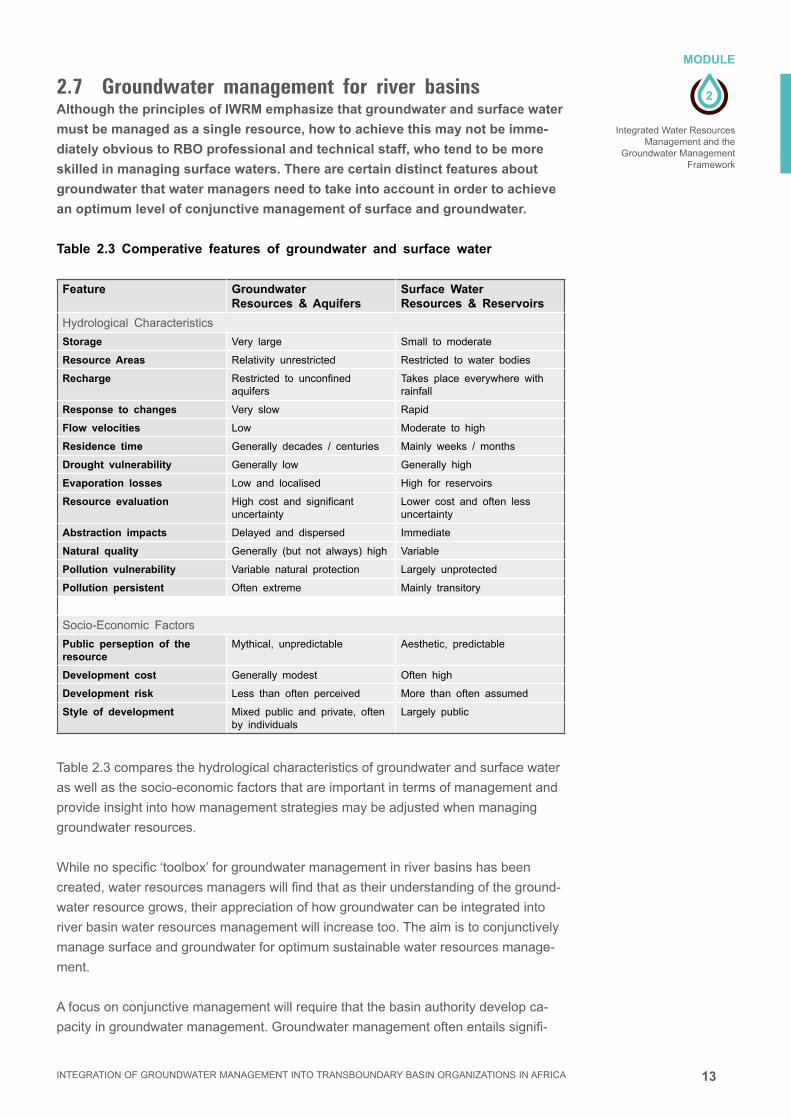
2.7 Groundwater management for river basins Although the principles of IWRM emphasize that groundwater and surface water
must be managed as a single resource, how to achieve this may not be imme-
diately obvious to RBO professional and technical staff, who tend to be more
skilled in managing surface waters. There are certain distinct features about
groundwater that water managers need to take into account in order to achieve
an optimum level of conjunctive management of surface and groundwater.
Table 2.3 Comperative features of groundwater and surface water
Feature Groundwater Resources & Aquifers
Surface Water Resources & Reservoirs
Hydrological Characteristics
Storage Very large Small to moderate
Resource Areas Relativity unrestricted Restricted to water bodies
Recharge Restricted to unconfined aquifers
Takes place everywhere with rainfall
Response to changes Very slow Rapid
Flow velocities Low Moderate to high
Residence time Generally decades / centuries Mainly weeks / months
Drought vulnerability Generally low Generally high
Evaporation losses Low and localised High for reservoirs
Resource evaluation High cost and significant uncertainty
Lower cost and often less uncertainty
Abstraction impacts Delayed and dispersed Immediate
Natural quality Generally (but not always) high Variable
Pollution vulnerability Variable natural protection Largely unprotected
Pollution persistent Often extreme Mainly transitory
Socio-Economic Factors
Public perseption of the resource
Mythical, unpredictable Aesthetic, predictable
Development cost Generally modest Often high
Development risk Less than often perceived More than often assumed
Style of development Mixed public and private, often by individuals
Largely public
Table 2.3 compares the hydrological characteristics of groundwater and surface water
as well as the socio-economic factors that are important in terms of management and
provide insight into how management strategies may be adjusted when managing
groundwater resources.
While no specific ‘toolbox’ for groundwater management in river basins has been
created, water resources managers will find that as their understanding of the ground-
water resource grows, their appreciation of how groundwater can be integrated into
river basin water resources management will increase too. The aim is to conjunctively
manage surface and groundwater for optimum sustainable water resources manage-
ment.
A focus on conjunctive management will require that the basin authority develop ca-
pacity in groundwater management. Groundwater management often entails signifi-

14
2
MODULE
Integrated Water Resources Management and the Groundwater Management Framework
INTEGRATION OF GROUNDWATER MANAGEMENT INTO TRANSBOUNDARY BASIN ORGANIZATIONS IN AFRICA
cant uncertainty, for example in the extent of the resource, the recharge rate and the
discharge and abstraction. These complexities require an adequate level of profes-
sional groundwater skill to be retained in-house by the basin authority.
A key issue for sustainable groundwater management is balancing the increas-
ing demands of water users with the available resources by:
a. balancing groundwater abstraction against long term average annual groundwater
recharge
b. protecting groundwater from all forms of pollution, but especially from pollution by
persistent toxic chemicals
A schematized illustration of sustainable management of the groundwater balance is
shown in Fig 2.6. This supply vs demand illustration captures all sources of supply
from both recharge and from storage as well as considering the range of demand for
groundwater including subsistence, economic and environmental demands.
Although figure 2.6 focuses on groundwater management, the direct interaction
between surface water and groundwater is a critical reason to manage these
resources conjunctively. Some of the direct interactions are given below:
■■ Groundwater recharge is impacted by surface water use. Damming rivers and
abstracting water reduces downstream flow for indirect groundwater recharge
through riverbed infiltration. This is often the major component of groundwater
recharge in arid and semi-arid environments. Irrigation excess and wastewater dis-
charge are also sources of groundwater recharge.
■■ Similarly groundwater use, particularly from shallow unconfined aquifers, delays
the timing and reduces the amount of surface run-off in the rainy season and de-
creases baseflow in the dry season. Such baseflow may be of critical importance
especially during the periods of low flow and in semi-arid climates.
■■ Groundwater may provide perennial water to groundwater dependent ecosystems
and the communities that survive from these resources.
■■ Interaction between surface and groundwater can cause pollution to be transferred
from one to the other. Groundwater pollution can persist for centuries thereby
reducing water resources availability for generations to come.

15
2
MODULE
Integrated Water Resources Management and the
Groundwater Management Framework
INTEGRATION OF GROUNDWATER MANAGEMENT INTO TRANSBOUNDARY BASIN ORGANIZATIONS IN AFRICA
Artificial recharge(irrigation losses,
wastewater returns)
Natural recharge(excess rainfall,
surface water seepage)
Indirect recharge(aquitared leakage, cross
formational flow)
Aquifer storage(groundwater resource)
SUSTAINABLE GROUNDWATER DEVELOPMENT
Economic Benefits Human BenefitsEnvironmental Benefits
Water for development Groundwater abstraction
(Agriculture & industry)
Water for the Environment
Groundwater discharge(Springs, surface water, wetlands, coastal zone)
Water for People Groundwater supply
(Drinking water & sanitation)
Figure 2.6 The elements of sustainable groundwater management:
supply (above) and demand (below)
Once RBO water managers embrace the groundwater resource as a component of
their available water resources and part of their management responsibilities, they
soon begin to appreciate the opportunities and advantages of conjunctive manage-
ment strategies. Examples of opportunities for conjunctive management may include:
■■ Groundwater holds large volumes of water in storage, while surface water storage
is moderate or small and often ephemeral. Conjunctive management strategy
would suggest that surface water be allocated during the rainy season before it
runs off and evaporates, and groundwater use be increased in the dry season to
offset the shortfall from surface water. Groundwater volumes in storage can pro-
vide a buffer in times of drought and water scarcity.
■■ Managed aquifer recharge (MAR) of sandy aquifers may be done with surplus
surface water during the wet season if there is excess flow. Recharging aquifers
in this way will not only provide additional dry season water resources but will also
allow for natural purification of any bacterial contamination in the surface water.
■■ Groundwater may be developed where demand is dispersed and moderate, while
development of surface water may focus on large-scale demand and irrigation
development.
■■ Upstream and downstream interests: by considering the entire suite of water re-
sources, both surface and groundwater, along the length of a catchment, manag-
ers are better able to provide for equitable upstream and downstream demands.
16
2
MODULE
Integrated Water Resources Management and the Groundwater Management Framework
INTEGRATION OF GROUNDWATER MANAGEMENT INTO TRANSBOUNDARY BASIN ORGANIZATIONS IN AFRICA
■■ Financing of groundwater development is a key area for flexibility. In many instanc-
es, private and individual development of the resource takes place, particularly if
the basin authority establishes a positive enabling environment such as, for exam-
ple, subsidies for electricity or borehole drilling.
■■ Public development of groundwater may be incremental as demand rises, thus
avoiding high financing charges and interest payments. The funds saved can
provide the basin authority with financial flexibility to manage its expenditure for
surface water infrastructure and other development in an optimal manner.
■■ Many sectors depend on water:- agriculture, energy, water supply, and environ-
ment. By integrating the entire suite of available water resources, water managers
are better able to balance the different competing needs in the catchment.
Water resources management includes many opportunities and threats. The wise
water manager looks beyond the direct and the obvious and considers distant and
indirect events in order to enhance and protect the catchment water resources. Some
of these issues are listed below:
■■ Land and water. Land management plays a fundamental role in a number of
groundwater related factors such as recharge and non-point source pollution, as
well as being linked to baseflow, overland flow and run-off.
■■ The river basin and its adjacent coastal and marine environment. The salinization
of coastal groundwater resources has become a major issue for many coastal
cities. Overpumping of coastal aquifers is the major cause of this.
■■ Rural water supply. Groundwater may often be used as a potable source of water
without treatment, providing water managers with useful options for dispersed
smaller communities.
■■ Groundwater pollution. Polluted groundwater may take a very long time to reme-
diate, and precautionary protection from pollution is strongly recommended. This
may include oversight of waste management practices in the catchment. (Module
8: Groundwater hazards)
■■ Groundwater often developed privately. Unlike surface water which is usually
developed and managed by an external authority, groundwater may be developed
by users for their own needs. This requires a different management paradigm to
ensure the sustainability and protection of groundwater resources. (Module 7: The
role of stakeholder participation and communication in groundwater management)
■■ Water as a free human right and a chargeable, tradeable commodity or service.
Groundwater resources may be traded just as surface water is, but knowledge
is needed about the impact of groundwater abstraction when engaging in such
transactions.
These examples and other conjunctive use strategies provide the basin authority,
whether transboundary or not, with a variety of diverse challenges but also significant
flexibility for water management under a variety of climatic and socio-economic chal-
lenges.

17
2
MODULE
Integrated Water Resources Management and the
Groundwater Management Framework
INTEGRATION OF GROUNDWATER MANAGEMENT INTO TRANSBOUNDARY BASIN ORGANIZATIONS IN AFRICA
Table 2.4 suggests that the approach taken to groundwater management at any
moment in time will depend on information about, and interaction between, the
following factors:
■■ The depth, size and complexity of the groundwater resource
■■ The climate and the rate of aquifer recharge and resource renewal
■■ The scale of groundwater abstraction and the number and types of groundwater
users
■■ The ecosytems and environmental services dependent upon groundwater (Module
10: Groundwater and environment)
■■ The susceptibility and vulnerability of the aquifer system to degradation (Module 8:
Groundwater hazards)
■■ Natural groundwater quality concerns
■■ Present degradation of the groundwater resource (from depletion or pollution)
■■ Other available water resources
Table 2.4 Typical aquifer types and their appropriate management strategies
Hydrogeological Setting Main Feature Recommendation African Examples
Significant aquifers but with more limited extension than the river basin catchment
Specific aquifer units or groundwater bodies will require independent local management plans
Plans need to take into account that groundwater recharge may be dependent upon upstream river flow and downstream river flow may be dependent upon aquifer discharge
Stampreit aquifer. Orange-Senqu river basin. South Africa, Namibia, Botswana.
River basins extensively underlain by shallow aquifers
Management of surface water-groundwater interactions critical to avoid problems such as salt mobilization on land clearance, water logging, salinization from irrigated agriculture
Fully integrated ground and surface water resource planning and management is essential
The Limpopo River alluvialsLimpopo basin. Botswana, South Africa, Zimbabwe Mozambique
Extensive deep aquifer systems occurring in arid regions
Groundwater flow system dominates, there is little permanent surface water
It may not be helpful to establish a ‘river basin organization’, but more valid to define a groundwater resource management plan and to manage at ‘aquifer level’
Nubian Sandstone Libya, Egypt, Sudan. Nile Basin
Minor aquifers predominant, characterized by shallow depth, patchy distribution and low potential
Such aquifer systems occur in many parts of the Sub-Sahara African continental shield – these will have limited interaction with the overlying river basin
Storage not sufficient to justify comprehensive groundwater resource planning and administration. Social importance in rural water supply makes it appropriate to put effort into design of water-wells to maximize their yield and reliability, and to identify any geogenic groundwater quality problems
Crystalline basement aquifers in eg: Tanzania, Ghana, Zambia etc.
Transboundary aquifers May be of different types; local or extensive. Requires legal and political oversight
Need to assess the degree of transboundary interaction and the strategies required
Kalahari aquifer: Zambezi / Limpopo basins. Zambia, Botswana Zimbabwe

18
2
MODULE
Integrated Water Resources Management and the Groundwater Management Framework
INTEGRATION OF GROUNDWATER MANAGEMENT INTO TRANSBOUNDARY BASIN ORGANIZATIONS IN AFRICA
2.8 SummaryGroundwater management for river basin organizations is essential as part of IWRM
to ensure the long-term sustainability of the overall basin water resources and to
optimize the water use in the basin by conjunctive management of the surface and
groundwater resources and associated land uses. The importance and potential
benefits of such management become clearer as water scarcity and groundwater
quality degradation increases. Transboundary aquifer systems are a special case that
requires a political and legal framework as well as transboundary institutional cooper-
ation.
Important questions that water managers may ask themselves are:
■■ What is the RBO already doing on GW management?
■■ What they see as the most important GW management issues to take up next?
■■ Why (political, technical economic, social reasons) do you consider these to be the
most important next steps?
2.9 References
GWMate, 2004,
Briefing Note 0: Series Overview.
http://water.worldbank.org/node/83769.
GWMate, 2004,
Briefing Note 1: Groundwater Resources Management.
http://water.worldbank.org/node/83769.
GWP ToolBox C2.03,
http://www.gwptoolbox.org/index.php?option=com_tool&id=30
Cap-Net, 2005,
Integrated Water Resources Management Plans.
http://cap-net.org/node/1515
GWMate, 2004,
Briefing Note 15: Groundwater Dependent Ecosystems.
http://water.worldbank.org/node/83769.
Cap-Net, 2008,
Integrated Water Resources Management for River Basin Organzations.
http://cap-net.org/node/1494
GWP, 2004,
Catalysing Change Handbook.
http://www.gwp.org/en/ToolBox/PUBLICATIONS/Catalyzing-Change-Handbook1/
19
2
EXERCICE
Integrated Water Resources Management and the
Groundwater Management Framework
INTEGRATION OF GROUNDWATER MANAGEMENT INTO TRANSBOUNDARY BASIN ORGANIZATIONS IN AFRICA
2.10 Exercise
Limpopo transboundary basinAlluvial aquifers and large-scale irrigation along the banks of the Limpopo River.
The Issues: The Limpopo River is an international river and the Limpopo Basin Com-
mission (LIMCOM), a transboundary basin organization, manages the water flows.
River flows are gauged at a number of gauging stations and weirs along the main
stem of the Limpopo River and also along some of the major tributaries.
Just upstream of the towns of Messina and Beit Bridge (Figure 1 – Map / Satellite
image of area), there is large-scale commercial irrigation development, growing prin-
cipally citrus and cotton, on both the South African and the Zimbabwean sides of the
stream (figure 2).
A total area of 6500 ha are irrigated from alluvial groundwater. Assume an irrigation
demand of 1 litre/sec per ha. continuously for 300 days per year. The 65 days without
irrigation occur between December and February during the rainy season. Assume
that the irrigation water is pumped from the alluvial sands in the active river channel,
and that this water is at the expense of river flow. Table 1 provides a water balance
data and figure 3 is a graphic chart that shows the water balance components; nb.
River flow blue line is the Limpopo flow prior to irrigation development. Assume that
the alluvial aquifer must be fully recharged before the onset of any surface flow.
What is the delay (months) in the onset of surface flow at the start of the annual hydro-
logical year due to the irrigation? 3 months.
Identify the months during which aquifer recharge takes place. Dec, Jan, Feb
In which month does the aquifer first become fully saturated? Jan
In which month does river flow start again? and in which month does river flow end?
Jan and Feb
How many months earlier will surface flow in the Limpopo end at the end of the rainy
season due to the irrigation? 6 months
What is the difference between river flow without groundwater abstraction and river
flow with groundwater abstraction? 63.4 m³/s
■■ Draw a new Limpopo river flow hydrograph taking into account the irrigation ab-
straction.
■■ Discuss the potential impacts of these flow reductions on downstream communi-
ties and downstream countries.
■■ Discuss the possible impacts on the environment, and on water quality.
■■ Propose a monitoring strategy to identify the impacts of the irrigation on the river
flow, the groundwater and the local ecosystems.
■■ Suggest methods for integrating the irrigation abstraction into the surface water
management planning.
* Answers are in red
and must be removed
before providing
exercise to course
participants.

20
2
EXERCICE
Integrated Water Resources Management and the Groundwater Management Framework
INTEGRATION OF GROUNDWATER MANAGEMENT INTO TRANSBOUNDARY BASIN ORGANIZATIONS IN AFRICA
Methodology:
The solution to this problem lies in developing a simple water balance for inflows to
and outflows from the alluvial aquifer linked to the river. For simplicity, it is convenient
to start the water balance at a time when there are no surface river flows ie. in Sep-
tember each year, but also note that we bring forward the deficit in the alluvial aquifer
for the year to date.
1. All abstractions of groundwater from the alluvial aquifer result in a decline in the
water level in the aquifer … part of the aquifer becomes “desaturated”.
2. The degree of desaturation is cumulative if the abstraction is higher than recharge,
so that the aquifer becomes progressively more empty as groundwater abstraction
for irrigation continues. The amount of groundwater in storage becomes progres-
sively less.
3. When the rainy season begins run-off / river flow is generated. When the run-off /
river flow is greater than the groundwater abstraction and there is a positive value
for the water balance*. This first goes to refilling the empty aquifer.
4. The positive balance between run-off (positive) and abstraction (negative) accu-
mulates as groundwater in storage until the aquifer becomes fully saturated again
(i.e. no deficit).
5. Once the aquifer is fully saturated, the positive balance between abstraction and
runoff becomes river flow.
6. Note that river flow is not cumulative – it is not stored anywhere; it flows down-
stream and is no longer available for recharge to the aquifer.
7. Note also that we assume that there is no delay between groundwater abstraction
and impact on the river. This may not be entirely realistic.
8. Once the rains stop, river flow declines and then ceases when run-off becomes
less than aquifer abstraction.
9. As the dry season progresses, groundwater abstraction continues and the aquifer
again become progressively depleted.
10. The cycle continues when the next rains begin.
*It should be noted that the river flow hydrographs from the Limpopo are al-
ready disturbed due to the fact that irrigation and groundwater abstraction are
already taking place. It will be necessary to go back in time and look at Limpopo
hydrographs from times prior to the establishment of the irrigations to be able
to assess the impact of groundwater abstractions on river flows. This can also
be achieved by comparing old pre-irrigation hydrographs with post irrigation
hydrographs. Another simple strategy is to simply calculate the volume of
abstracted groundwater in any year, and equate this to the amount of river flow
that is diverted to irrigation.

21
2
EXERCICE
Integrated Water Resources Management and the
Groundwater Management Framework
INTEGRATION OF GROUNDWATER MANAGEMENT INTO TRANSBOUNDARY BASIN ORGANIZATIONS IN AFRICA
Table 1: LIMPOPO Water Balance:
The impact of alluvial groundwater abstraction on river flow.
Mo
nth
a) R
ainf
all
mm
b) R
iver
flow
: no
G
W a
bstr
actio
n m
³/se
c
c) G
W a
bstr
actio
n m
³/se
cd)
Mon
thly
wat
er
bala
nce
m3 /
sec
e) A
lluvi
al a
quife
r de
ficit
m3/
sec
nb
: m
ax <
0
e (p
revi
ous)
+ d
f) R
iver
flow
with
GW
ab
stra
ctio
n m
3 /s
Pre
vio
us
dry
se
aso
nB
roug
ht F
orw
ard
= -
28
Sep
tem
ber
00
-6.5
-6.5
-28
- 6.
5=
-34
.50
Oct
ober
170.
2-6
.5-6
.3-3
4.5
- 6.
3 =
-40
.80
Nov
embe
r39
5.3
-6.5
-1.2
-40.
8 -
1.2
= -
42.0
0
Dec
embe
r73
27.5
-3.2
+24
.3-4
2 +
24.
3 =
-17
.70
Janu
ary
129
88.7
0+
88.7
-17.
7 +
88.
7 =
71.
0 =
071
.0
Feb
ruar
y10
842
.1-1
.7+
40.4
0 +
40.
4 =
40.
4=
040
.4
Mar
ch19
5.4
-6.5
-1.1
-1.1
0
Apr
il0
1.9
-6.5
-4.6
-5.7
0
May
01.
4-6
.5-5
.1-1
0.8
0
June
01.
1-6
.5-5
.4-1
6.2
0
July
0
0.7
-6.5
-5.8
-22
0
Aug
ust
00.
5-6
.5-6
-28
0
An
nu
al T
ota
ls38
517
4.8
63.4
111.
4M
on
thly
to
tal
is t
he
defi
cit
at t
hat
tim
e.11
1.4
NB – this is the
answer sheet – for the
participants, we will
leave last row & last
three columns blank for
them to complete
Cal
cula
te t
he
mo
nth
ly w
ater
bal
ance
fo
r ea
ch m
on
th.
Cal
cula
te t
he
mo
nth
ly w
ater
defi
cit
in t
he
allu
vial
aq
uif
er.
Cal
cula
te t
he
mo
nth
ly r
iver
flo
w w
ith
gro
un
dw
ater
ab
stra
ctio
n.
Cal
cula
te t
he
ann
ual
to
tals
fo
r al
l co
lum
ns.

22
2
EXERCICE
Integrated Water Resources Management and the Groundwater Management Framework
INTEGRATION OF GROUNDWATER MANAGEMENT INTO TRANSBOUNDARY BASIN ORGANIZATIONS IN AFRICA
Figure 1: Beit Bridge / Musina area with alluvial irrigation development along Limpopo main-
stem river.
Figure 2: Detail showing the irrigated areas with Centre Pivots (2000 ha) and rectangular
field (4500 ha) layouts. Rectangular fields are largely Citrus, and centre pivots are for cotton.
Limpopo river runs west to east through the middle of the image.

23
2
EXERCICE
Integrated Water Resources Management and the
Groundwater Management Framework
INTEGRATION OF GROUNDWATER MANAGEMENT INTO TRANSBOUNDARY BASIN ORGANIZATIONS IN AFRICA
april
sept
embe
r
octo
ber
nove
mbe
r
dece
mbe
r
janua
ry
febr
uary
mar
chm
ayjun
ejul
y
augu
st
100
80
60
40
20
0
-20
-40
river flow
groundwater abstraction
water balance
groundwater deficit
Figure 3: Limpopo chart showing water balance components. Vertical axis is m3/sec. River flow
line is prior to gw abstraction.
Figure 4: Schematic illustration of the Limpopo alluvial aquifer irrigation.
Zimbabwe
Mozambique
South Africa
Limpopo River
Alluvial Sands Aquifer
Centre Pivot Irrigation
2000 ha per centre pivot
Flood Irrigation – 4500 ha

3
MODULE
INTEGRATION OF GROUNDWATER MANAGEMENT INTO TRANSBOUNDARY BASIN ORGANIZATIONS IN AFRICA
AQUIFER SYSTEMS CHARACTERIZATION FOR GROUNDWATER MANAGEMENT

2 INTEGRATION OF GROUNDWATER MANAGEMENT INTO TRANSBOUNDARY BASIN ORGANIZATIONS IN AFRICA

3
3
MODULE
Aquifer Systems Characterization for Groundwater Management
INTEGRATION OF GROUNDWATER MANAGEMENT INTO TRANSBOUNDARY BASIN ORGANIZATIONS IN AFRICA
Imprint
© Copyright 2014, all rights reserved
The use of the manual is FREE of cost. AGW-Net simply requests that users give proper
attribution “Integration of Groundwater Management into Transboundary Basin Organizations in
Africa - a Training Manual by AGW-Net, BGR, IWMI, CapNet, ANBO, & IGRAC” . Modification
is only allowed with permission of AGW-Net.
Photos are copyright to their respective owners.
A4A – aqua for all
AGW-Net – Africa Groundwater Network
ANBO – African Network of Basin Organisations
BGR – Federal institute for geosciences and natural resources
Cap-Net UNDP
BMZ – Federal Ministry for Economic Cooperation and Development
GWP – Global Water Partnership
IGRAC – International Groundwater Resources Assessment Centre
imawesa – Improved Management of Agricultural Water in Eastern and Southern Africa
IWMI - International Water Management Insitute
Editorial Staff: Vanessa Vaessen, Ramon Brentführer – BGR
Layout: ff.mediengestaltung GmbH, Hannover, Germany
Picture: BGR – Bundesanstalt für Geowissenschaften und Rohstoffe
MODULE 3Aquifer Systems Characterization for Groundwater Management
3.1 Introduction 4
3.2 Groundwater occurrence 4
3.3 Groundwaterflow 8
3.4 Groundwater Balance and Recharge 10
3.5 Groundwater and Surface water interaction 13
3.6 Summary: Critical issues in groundwater characterization 20
3.7 References 21
3.8 Exercise 22
CONTENT
4
3
MODULE
Aquifer Systems Characterization for Groundwater Management
INTEGRATION OF GROUNDWATER MANAGEMENT INTO TRANSBOUNDARY BASIN ORGANIZATIONS IN AFRICA
AQUIFER SYSTEMS CHARACTERIZATION FOR GROUNDWATER MANAGEMENT
3.1 IntroductionGroundwater differs from surface water as a result of the different physical and chem-
ical environment in which it is found. Some groundwater occurs in most geological
formations with sediments and rocks in effect forming a subsurface reservoir or aquifer
in which groundwater can be accumulated and transmitted.
The hydrogeological properties, porosity and permeability, of geological layers and
their spatial distribution vary for many reasons, including the tectonic structure, the
position in the depositional basin, the type of sedimentary basin, the depth of burial
and the lithology. The availability of groundwater depends on hydrogeological setting,
which may be very variable, even within a single lithology.
Because groundwater is usually an important source of surface water, particularly
baseflow,thesetwowatersources,surfaceandgroundwater,andtheservicesthey
both provide should be considered in an integrated and holistic way within the plan-
ning framework of RBOs.
Groundwater management in river and lake basins has to be based on a good under-
standing of the characteristics of the groundwater system, including its interaction with
surface water bodies such as rivers, lakes and wetlands.
3.2 Groundwater occurrenceDiversity in groundwater occurrence
Groundwater occurs in openings in rock materials in the form of pores, or voids, or
fractures that constitute the porosity of the material. Nearly all rocks, whatever type,
origin or age, possess some degree of porosity. Therefore groundwater can be found
in all geological environments. If ‘useful’ groundwater occurs a rock material, then this
rock is called an aquifer.Anaquiferisdefinedasageologicalformation(orsome-
times part of a formation or a group of formations) that contains saturated material
ofsufficientpermeabilitytoyield‘useful’quantitiesofwatertowellsand/orsprings.
Aquifer units may be combined into aquifer systems.
LEARNING OBJECTIVESThis course module will provide an introduction to groundwater system charac-
terisation for water resource managers who are not groundwater specialists, with
special emphasis on understanding of:
■■ Importance of aquifer characterization in groundwater resources management
■■ Key properties of aquifers for better groundwater management
■■ The different hydrogeological environments in relation to groundwater
development
■■ Groundwater occurrence, and interactions between groundwater and surface water

5
3
MODULE
Aquifer Systems Characterization for Groundwater Management
INTEGRATION OF GROUNDWATER MANAGEMENT INTO TRANSBOUNDARY BASIN ORGANIZATIONS IN AFRICA
A framework for assessing groundwater occurrence.
Porosity:
Arockmaterialmayexhibit‘primary’orinter-granularporosity.Theseunconsolidated
sediments are made up from individual grains that have been deposited at the surface
of the earth by various sedimentary processes. Porosity in primary porosity materials
is normally high.
Alternately a rock material may be impermeable and have close to zero porosity. Typi-
cally crystalline rocks that have crystallized from a molten magma form such materials.
In these igneous rocks, porosity is related to fractures through the rock mass, rather
than pore spaces in the intact rock material. This type of porosity is known as second-
ary porosity, or fracture porosity, and it usually much lower that primary porosity.
Unconsolidated sediments become sedimentary rocks by burial, compaction and
cementation processes. During these processes, the porosity of sedimentary rocks
decreases, the rock mass decreases in volume and becomes fractured. These frac-
turedsedimentaryrocksnowexhibitdualporosity.
Permeability:
Forarockmasstobeconsideredanaquifer,waterhastobeabletoflowthroughthe
rock mass at an appreciable rate such that useful quantities can be pumped from wa-
terwells.Therateatwhichwaterflowsthrougharockmassisitspermeability.
Forgranularprimaryporosityrocks,waterflowsbyseepageormatrixflowbetween
thegrainsthatconstitutetherockmass.Thistypeofseepageflowisgovernedbythe
size of the pore spaces between the grains, which in turn is governed by the size of
the grains. Coarse materials such as sand and gravel have high permeability, while
fine-grainedmaterialssuchasclayshaveverylowpermeability.
Crystallinerocksthatdonothaveprimaryporosityexhibitfractureflow,withwater
flowingthroughthefractures.Thistypeoffracturepermeability,orfractureflow,is
usuallymorerapidthatseepageflow,butbecauseitonlytakesplacethroughasmall
volumeoftherockmass,itmaybelessproductivetheseepageflowinsomecases.
Unconfined and confined aquifers.
Aquifers may be open to the atmosphere through a permeable soil cover, and in this
conditiontheyareknowasunconfined.Unconfinedaquifercanreceivedirectre-
chargefromrainfallinfiltratingandpercolatingthroughtheunsaturated(orvadose)
zone down to the water table. These aquifers are also known as water table or phreat-
ic aquifers. The water in them is at atmospheric pressure and when these aquifers are
pumped, the water table is lowered. Crystalline rocks tend to weather at and near the
surfacetobecomeunconfinedaquifers,buttheyareimpermeableatdepthwherethey
are un-weathered and the fractures are closed due to overburden pressure.
Alternately aquifers may be buried beneath impermeable materials. This typically
occurs in sedimentary basins where permeable and porous sedimentary strata dip
beneath impermeable strata to become cut off from the land surface. These aquifers
areknownasconfinedaquifers.Confinedaquifersdonotreceivedirectrechargefrom

6
3
MODULE
Aquifer Systems Characterization for Groundwater Management
INTEGRATION OF GROUNDWATER MANAGEMENT INTO TRANSBOUNDARY BASIN ORGANIZATIONS IN AFRICA
rainfall because they are separated from the surface by an impermeable layer. They
may receive recharge from a distant point where the aquifer strata outcrop at the sur-
face,andatthispointtheaquiferislocallyunconfined.Theymaybeentirelyconfined
underimpermeablestrataandreceivenorechargeatall.Sinceconfinedaquifersare
not open to the atmosphere, the water in them is usually held under pressure derived
from the water level in the recharge area. This pressure is known as the piezometric
pressure,orpiezometrichead.Ifawellisdrilledintoaconfinedaquifer,thewater
usually rises up in the well bore to a level above the aquifer top as a result of the
piezometricpressure.Whenwaterispumpedfromaconfinedaquifer,thepiezometric
pressure is reduced, but the aquifer remains fully saturated.
Aquifer productivity.
The ‘productivity’ of an aquifer depends a combination of the porosity and the perme-
abilityoftheaquifermaterialsandthe‘size’oftheaquifer.Themostsignificantele-
ments of natural hydrogeological diversity are:
■■ Majorvariationofaquiferstoragecapacity(porosity/storativity),rangingbetween
unconsolidated granular sediments and highly-consolidated fractured rocks;
■■ Majorvariationintheabilitytotransmitgroundwaterflow(permeability)ranging
between cavernous limestone and dense clays and solid intact crystalline rocks;
■■ Widevariationinaquiferarealextentandsaturatedthicknessbasedongeological
environments ranging from eg. weathered regolith in crystalline rocks, to shal-
low alluvial sediments to deep tectonic basins, resulting in a wide range of both
groundwaterinstorageandaquiferflowpotential(transmissivity).
Unconsolidated sedimentary aquifers are composed mainly of loose materials: sands,
gravels, silts, clayey sand, sandy clays and clays. They constitute a porous and con-
tinuous medium. Groundwater is stored and transmitted through pore spaces.
Sedimentary basins generally contain large resources of groundwater; two types of
hydrogeologicalenvironmentsareparticularlyexcellentaquifers:
■■ Majoralluvialandcoastalbasinsthatareprolificaquifers;
■■ Consolidated sedimentary rocks like sandstone and limestone.
Theyarespatiallyextensiveandpossesslargethicknesses,ensuringgreatvolumes
ofgroundwaterstoragewithregionalflow.Theseconstitutethemajortransboundary
aquifers.
Compact and fractured rocks or consolidated formations have openings that are main-
ly composed of fractures; they usually constitute a discontinuous medium. Generally
one can identify two major types of formations:
■■ Carbonated rocks, like limestone, that are slightly soluble in rainwater and there-
forefracturescanbeenlargedtoformkarsts(channels);
■■ Ancient crystalline and metamorphic rocks can be highly fractured; they can also
decompose in the upper part to form a porous and permeable mantle of weathered
materials(regolith)thatmaybeafewtensofmetersthick.
Aquifer Systems Characterization for Groundwater Management
What type(s)
of aquifer occur
in your catchment
and at what depths
below the land
surface?

7
3
MODULE
Aquifer Systems Characterization for Groundwater Management
INTEGRATION OF GROUNDWATER MANAGEMENT INTO TRANSBOUNDARY BASIN ORGANIZATIONS IN AFRICA
The characterisation of groundwater occurrence may occur at a variety of scales of
investigation, and the characterization is usually related to the type of geology.
■■ Hydrogeological basins that correspond closely to the topographic boundaries
of river basins; these typically occur in crystalline rock terrains and may be com-
prised of several sub-basins.
■■ Groundwater basins that are smaller than and contained entirely within a hydrolog-
ical basin; these are usually local sedimentary basins, or alluvial systems related
to the present day hydrology.
■■ Aquiferorhydrogeologicalunitsthatextendbeyondthebordersofthehydrogeo-
logical basin; typically these are large depositional basins that pre-date the present
day drainage and the present day climate.
This hydrogeological diversity can be summarised into key elements that identify most
aquifertypes(figure3.1).Thegroundwaterstoragecapacityandthescale(lengthand
traveltime)oftheflowpathsarethetwoelementsusedhereforgroundwatercharac-
terization for management purposes.
Figure 3.1: Summary of key properties of the most widely occurring aquifer types. (GW- Mate
Briefing note 2)
In general terms the so-called ‘minor aquifers’ provide smaller and less predictable
water wells yields than those constructed in ‘major aquifers’; they possess much less
drainablestorageandcanberatherpatchyinextension.Inareasunderlainonlyby
minor aquifers, the siting of boreholes providing a reliable supply of acceptable quality
andadequatequantitycanbeasignificanthydrogeologicalchallenge,but‘minor
aquifers’areoftentheonlyfeasibleprospectinthisregardoverextremelylargeland
areas.
LSA
MAF
REGIONAL GROUNDWATER FLOW
GROUNDWATER STORAGE(mm or M/Km2)
km2
200
minor
major
moderate
200 500 1,000 5,000 10,000 20,000
WCB
KCL
IVF
SAF
Karstic Coastal Limestones (KCL)
widely distributed but not generally
very extensive with groundwater flow dominating over
storage
Weathered Crystalline
Basement (WCB)
especially extensive in central and eastern Africa,
Peninsular India
Large Sedimentary
Aquifers (LSA)
includes mega- systems (High Plains of USA, Guarani in Latin America), but
also many more localised formations
Inter-Montane Valley Fill (IVF)
thicker systems with more active groundwater flow
regimes
Small Altuvial Formations (SAF)
very widely distributed local
systems with limited throughflow
Major Alluvial Formations (MAF)
includes mega- systems (Indo- Gangetic Plain,
North China Plain, Amazon Basin)
CONSOLIDATED FRACTURED AQUIFERS UNCONSOLIDATED POROUS AQUIFERS
Aquifer Systems Characterization for Groundwater Management

8
3
MODULE
Aquifer Systems Characterization for Groundwater Management
INTEGRATION OF GROUNDWATER MANAGEMENT INTO TRANSBOUNDARY BASIN ORGANIZATIONS IN AFRICA
What are the key functions of aquifers?
An aquifer as a hydrogeological unit is made up of two main phases that interact: a
reservoir comprising one or many geological formations and the groundwater stored in
the reservoir.
The reservoir has two important functions:
■■ capacityforgroundwaterstorageexpressedthroughstorativity(storagecoeffi-
cient)orspecificyield;
■■ capacitytotransmitgroundwaterflowbygravityorpressure,whichcanbeex-
pressed as transmissivity;
One or more of these functions may dominate, depending on the rock types and
hydrogeological environments. For instance a river side aquifer has a predominantly
transfercapacity,whereasadeepconfinedaquiferpresentsmainlystoragecapacity
butonlylimitedgroundwaterflow,andanunconfinedaquifermayplaybothroles.
Thevaststorageofgroundwatersystems(whosemagnitudevariessignificantlywith
geological setting) is usually their most valuable asset. This storage asset includes
not only groundwater already stored in aquifer systems, but also the potential storage
capacity of their void spaces to receive recharge.
3.3 Groundwater flowHow does groundwater flow?
Groundwaterflowsdowngradientfromareasofhighhydraulicheadtoareasoflower
hydraulichead.Therateofflowisgovernedbythegradientandbytheaquiferprop-
erties.Mostgroundwaterisincontinuousslowmovement(Figure3.2)fromareasof
natural aquifer recharge from rainfall to areas of aquifer discharge as springs, and
seepagestorivers/lakes,wetlandsandcoastalzones.Groundwaterflowisgoverned
byDarcy’sLaw(Box.3.1).
Thenaturalflowofgroundwateroccurs,generallyatlowvelocities,throughthepore
spacesandfracturesinrockmaterials.Forgroundwateraflowvelocityof1meterper
day is high, and it can be as low as 1 meter per year or 1 meter per decade. In con-
trast,velocitiesofriversflowgenerallyaremeasuredinmeterpersecond.
Aquifer Systems Characterization for Groundwater Management

9
3
MODULE
Aquifer Systems Characterization for Groundwater Management
INTEGRATION OF GROUNDWATER MANAGEMENT INTO TRANSBOUNDARY BASIN ORGANIZATIONS IN AFRICA
Figure 3.2: Typical groundwater flow regime and residence times in semiarid regions (after
Foster and Hirata, 1988)
BOX 3.1: THE DARCY LAW AND PERMEABILITYTheprinciplethatgovernshowfluidsmovethroughsedimentsandrocksis
Darcy’sLaw–theflowbeingproportionaltothelengthoftheflowpath,thefluid
pressuredifferenceatthestartandendoftheflowpathandthepermeabilityof
aquifer medium between the two points under consideration.
Darcy’sLawisusuallywrittenas:Q=-KAdh/dl where:
Q = rate of groundwater flow,
K = permeability (or hydraulic conductivity)
A = cross-sectional area of flow
dh/dl = hydraulic pressure gradient.
In the subsurface, sediments are usu ally deposited in horizontal layers. In-
ter-beddedclayandshalelayershaveverymuchlowerpermeability(especial-
ly in the vertical direction) than the main group of aquifer materials, and thus
groundwaterflowtendstobepreferentiallyconfinedwithinaquiferlayersand
predominantly horizontal, with only a small com ponent of vertical leakage across
confiningclayorshalebeds.
Aquifer Systems Characterization for Groundwater Management
Can you
identify the recharge
and discharge
zones, and flow
regime, of an aquifer
in your catchment?

10
3
MODULE
Aquifer Systems Characterization for Groundwater Management
INTEGRATION OF GROUNDWATER MANAGEMENT INTO TRANSBOUNDARY BASIN ORGANIZATIONS IN AFRICA
3.4 Groundwater Balance and Recharge What is involved in the estimation of contemporary recharge rates?
The estimation of contemporary recharge rates to aquifers is of fundamental signif-
icance when considering the sustainability of groundwater resource development.
Furthermore, understanding aquifer recharge mechanisms and their linkages with
land-use is essential for integrated water resources management.
Unfortunatelygroundwaterrechargeisbothhighlycomplexanduncertain.Thereare
numerous methods including: groundwater level measurements; unsaturated zone
fluxmeasurement;isotopictechniquestomeasuregroundwaterage;groundwaterflow
measurement; modelling and many others.
Allthesemethodssufferfromsubstantialscientificuncertainty(Figure3.3)inthe
quantificationofindividualrechargecomponentsdueto:
■■ Thevastheterogeneity,irregularityandinherentcomplexityofnaturalhydrogeo-
logical systems
■■ The wide spatial and temporal variability of hydrologic events such as rainfall and
runoff, including climatic cycles
■■ Thevarietyandcomplexityofdifferentrechargeprocessesthatrangefromdirect
infiltrationandpercolationofprecipitation,seepagethroughstreamandlakebeds,
toreturnflowsfromanthropogenicimpacts.
■■ The inherent uncertainties involved for most of the methodological procedures
used for recharge estimation.
These factors, coupled with limited groundwater level monitoring data in many regions,
mean that available recharge estimates always have to be treated with some caution.
Nevertheless,formostpracticalpurposes,itissufficienttomakeapproximatees-
timates,andrefinethesesubsequentlythroughmonitoringandanalysisofaquifer
response to abstraction over the medium-term. A number of generic observations can
be made on aquifer recharge processes:
■■ Areas of increasing aridity will have a much lower frequency and rate of recharge;
■■ Confinedandsemi-confinedaquifersystemsareusuallyonlyrechargeisspecif-
icrechargeareaswheretheaquiferoutcrops,whileunconfinedaquiferstendto
receive recharge over their entire surface area.
■■ Indirectrechargefromsurfacerunoffandincidentalartificialrechargearisingfrom
humanactivitygenerallyarebecomingprogressivelymoresignificantthandirect
rainfall recharge.
Aquifer Systems Characterization for Groundwater Management
What is
the rainfall on
your aquifer
recharge zone?
Is groundwater
replenished by
annual rainfall?

11
3
MODULE
Aquifer Systems Characterization for Groundwater Management
INTEGRATION OF GROUNDWATER MANAGEMENT INTO TRANSBOUNDARY BASIN ORGANIZATIONS IN AFRICA
Figure 3.3: Field estimates of diffuse recharge in Southern Africa and their relation with annual
rainfall
When attempting to evaluate contemporary groundwater recharge rates it is essen-
tialtoappreciatefullythesignificanceoftheintimatelinkagesbetweenland-useand
groundwater recharge, which is also an essential input for the practice of integrated
water resources management. The commonly used paradigm of ‘constant average
rates of present-day aquifer recharge’ is false. In reality the contemporary rate of aqui-
fer recharge varies considerably with:
■■ Changes in land use and vegetation cover, notably the introduction of irrigated
agriculture, but also vegetation clearance and soil compaction;
■■ Urbanisation processes, and in particular the level of water supply network leak-
age,theproportionofnon-sewer(in-situ)sanitationandthedegreeofland-surface
sealing due to tarmac, concrete etc.;
■■ Widespreadwater-tableloweringbygroundwaterabstractionand/orlanddrain-
age,whichleadstoincreasedareasand/orratesofinfiltrationinsomeaquifer
systems;
■■ Changesinsurfacewaterregime,especiallythediversionofriverflow.
Why is it necessary to undertake a groundwater balance?
For management purposes, what is important is the amount of groundwater that is
available in the aquifer that can be abstracted on a sustainable basis. This will be a
balance between the amount of recharge to the aquifer and the amount of discharge
from the aquifer.
In most natural climatic settings, water is regularly added to an aquifer system by the
‘natural recharge’ processes described above, and continuously leaves the system as
‘naturaldischarge’tosprings,seepagesandphreaticvegetation.Eachaquifersys-
temisuniqueinasmuchastheamountofgroundwaterflowwillbedependentupon
‘external’factorssuchasprecipitationratesintherechargeareaandthelocationand
behaviour of streams and evapotranspiration rates. But putting aside for the moment
climate-change and major land-use change considerations, a ‘healthy groundwater
Gobi desert
range is functionof soil profile and vegetation cover
Botswana elsewhere
1,000
100
10
1
0.1
0 125 500 1,000 1,500
grou
ndw
ater
rech
arge
(mm
/a)
annual rainfall (mm/a)
Aquifer Systems Characterization for Groundwater Management

12
3
MODULE
Aquifer Systems Characterization for Groundwater Management
INTEGRATION OF GROUNDWATER MANAGEMENT INTO TRANSBOUNDARY BASIN ORGANIZATIONS IN AFRICA
system’shouldbeinbalance(oraquasi-equilibriumstate)whenviewedoveratime-
scale of 5-25 years, with the longer time periods required in the more arid climates.
Accountingforallthedifferentinflowsandoutflowsofagroundwatersystem,including
changesinstorage,iscalledundertakingagroundwaterbalance.Evaluationofthe
groundwater balance is an essential tool for groundwater resource management, and
may include the following:
■■ Estimatingrechargetotheaquifersystem,whichisacomplexanduncertainsuite
of processes as described above and
■■ Assessingthenaturaldischargefromtheaquifersystembybaseflow,springdis-
charge,andevapotranspiration,whichisequallycomplexand
■■ Measuring or estimating the amount of groundwater withdrawn from boreholes and
usedconsumptivelyorexportedfromthelocalcatchment
There are numerous analytical tools and GIS systems that can greatly help this pro-
cess.Groundwaterbalancesshouldbeestablishedforawell-definedaquifersystem
or groundwater body, within a river basin or in some cases an entire sub-catchment
of such a river basin. Understanding the groundwater balance and how it changes in
response to human activities is a central and critical aspect of groundwater system
characterisation.
Allgroundwaterflowmustbedischargingsomewhere,andcontinuousabstraction
will sooner-or-later reduce these discharges. But the sources of pumped groundwater
canbecomplex,andmayincludeanincrementofrechargeinducedasaresultof
water-table lowering. The question of continuous long-term depletion of aquifers arises
and the term ‘aquifer overexploitation’ has been introduced in this connection.
Inpractice,whenspeakingofaquiferoverexploitationweareinvariablymuchmore
concerned about the consequences of intensive groundwater abstraction than about
itsabsolutelevel.Thusthemostappropriatedefinitionisprobablythatthe‘overallcost
ofthenegativeimpactsofgroundwaterexploitationexceedthenetbenefitsofground-
wateruse’,butofcoursetheseimpactsarenotalwayseasytopredictand/ortocost.
Therefore, it is crucial for water resource managers to estimate the ‘acceptable
abstraction’(or‘safeyield’)ofagroundwatersystem.Inrealitysuchexpressionscan
also be misleading, because in order to estimate them, it is necessary to make value
judgments about the term ‘acceptable’, which may not be acceptable to some stake-
holders, especially to natural ecosystems that are dependent upon aquifer discharge.
Groundwaterinconfinedaquifersisusuallyolder,lessoxygenated,moremineral-
ized,andnormallyunderpressure.Drawdowninducedbypumpingfromtheconfined
sectionofanaquiferisoftenrapidlypropagatedtotheunconfinedsection.Invarious
hydrogeologicalsettings,shallowunconfinedanddeepconfinedaquiferlayerscan
be superimposed with leakage downwards and upwards between layers according to
local conditions.
Aquifer Systems Characterization for Groundwater Management

13
3
MODULE
Aquifer Systems Characterization for Groundwater Management
INTEGRATION OF GROUNDWATER MANAGEMENT INTO TRANSBOUNDARY BASIN ORGANIZATIONS IN AFRICA
Aquifer storage transforms highly variable natural recharge regimes into more stable
natural discharge regimes. It also results in groundwater residence times that are usu-
allymeasuredindecadesorcenturies(Figure3.2),andofteneveninmillennia,with
large volumes of so-called ‘fossil groundwater’, a relic of past episodes with different
climate,stillbeingheldinstorage(Box3.2).
3.5 Groundwater and Surface water interactionNearly all surface water bodies (rivers, lakes, reservoirs, and wetlands) interact
with groundwater. These interactions take many forms, in some cases surface
water bodies gain water or/and solutes from groundwater systems and in others
they may be a source of groundwater recharge and may affect groundwater
quality.
As concerns for water resources and the environment increase, it is important to
consider groundwater and surface water as a single resource. Therefore understand-
ing their interaction is crucial for water resource management in river and lake basins,
evenifitisdifficulttoobserveortomeasuretheseexchanges.
Thecontributionofgroundwatertototalwatersurfaceflowvarieswidelyamong
streams, but hydrologists estimate the average contribution is somewhere between
40and50%insmallandmedium-sizedstreams(USGS,1999).Correspondingly,
thecontributionofsurfacewaterviastreamandlakebedinfiltrationtogroundwateris
equallysignificant,especiallyinaridandsemi-aridclimates.Someofthesesurface
water – groundwater interactions are described below.
The interaction of surface water and groundwater is frequently a major concern for
RBOs since they are strongly focused on surface water management and such inter-
actionsimpactdirectlyonthesurfacewaterresourcesthattheyhavequantifiedand
allocated.
BOX 3.2: ‘FOSSIL GROUNDWATER AND NON-RENEWABLE RESOURCES’
Isotopictechniquesrevealthatmostgroundwaterstored(andsometimesstill
flowing)inlargesedimentaryformationswasrechargedbylatePleistoceneand
earlyHolocenerainfall(>5,000yrsBP),whentheclimateintheareasconcerned
was cooler and wetter. It is thus commonly referred to as ‘fossil groundwater’.
If hydrochemical evidence suggests that very little contemporary rainfall is
infiltrating(say<10mm/a),currentgroundwaterrechargewillberesponsible
for(atmost)onlyatinyfractionofthegroundwaterstoredinsuchaquifers.This
groundwater storage is thus sensibly treated as a ‘non-renewable resource’,
since it will not be replenished fully in the time-frame of current development.
Aquifer Systems Characterization for Groundwater Management

14
3
MODULE
Aquifer Systems Characterization for Groundwater Management
INTEGRATION OF GROUNDWATER MANAGEMENT INTO TRANSBOUNDARY BASIN ORGANIZATIONS IN AFRICA
Alluvial groundwater occurrence in river valleys.
Groundwater in the river valley environment tends to occur as alluvial deposits as-
sociatedwiththeriverchannel(Figure3.4)andthisgroundwaterisusuallyshallow
and easily accessible in the vicinity of the river. Such aquifers are generally of limited
lateralextentanddepth.
InmanyareasinAfrica(NorthernCameroon,LakeChadbasin,Botswana)thick
sedimentsunderlyingriverschannelcontainsignificantquantitiesofgroundwater.The
favourable permeability and porosity features of alluvial channel sands and the regular
rechargefromriverflowcombinetomaketheseaquifershighlyproductive.
Figure 3.4: Groundwater occurrence in alluvial deposits of river (from MacDonald, 2005)
After the rainy season has ended, these ‘sand rivers’ or ‘wadis’ are usually are dry
onthesurface,butthecoarsesedimentsunderlyingtheriverchannelandfloodplain
are in fact the important sources of domestic and irrigation water for local communi-
ties(Figure3.5).Inmajoralluvialbasins,asintheNilevalley,groundwaterisstored
inmoreextensiveandthickersedimentarysequencesthatformimportantregional
aquifers. They are made of unconsolidated layers of alternating strata of sand, clayey
sand or sandy clay.
Duetotheimmediateproximitybetweenalluvialaquifersandriverchannels,thereis
continuousandrapidinteractionbetweenalluvialgroundwaterandriverflow.Abstrac-
tionofgroundwaterfromsuchalluvialsystemswillimpactonriverflow,andthishas
beencitedasagrowingconcernbymanyriverbasinauthorities(Villholth,2011).
Aquifer Systems Characterization for Groundwater Management

15
3
MODULE
Aquifer Systems Characterization for Groundwater Management
INTEGRATION OF GROUNDWATER MANAGEMENT INTO TRANSBOUNDARY BASIN ORGANIZATIONS IN AFRICA
Figure 3.5: River channel with coarse deposits (Northern Cameroon)
How can groundwater interact with rivers and streams?
The interactions between rivers and groundwater take place in three ways:
■■ Riversgainwaterfrominflowofgroundwaterthroughtheriverbed(Figure3.6),or;
■■ Riverslosewatertogroundwaterbyoutflowthroughtheriverbed(Figure3.7),or;
■■ In some environments, rivers might at times gain water from groundwater, and at
other times, rivers might lose water to groundwater.
■■ Similarly, some river reaches may be gaining, while other reaches of the same
river system may be losing.
Figure 3.6 : Gaining rivers receive water from groundwater (USGS, 1998)
Inthefirstcase,thealtitudeofwatertableneartherivermustbehigherthanthealti-
tudeoftheriver.Incontrastforthesecondcase(losingrivers),thelevelofwatertable
in the vicinity of river must be lower than the level of the river.
Flow direction
unsurated zone
Shallow aquifer
Water table
Aquifer Systems Characterization for Groundwater Management
Do you have sand
rivers in your
catchment? How
is groundwater
developed from
these?

16
3
MODULE
Aquifer Systems Characterization for Groundwater Management
INTEGRATION OF GROUNDWATER MANAGEMENT INTO TRANSBOUNDARY BASIN ORGANIZATIONS IN AFRICA
Figure 3.7: Losing rivers provide water to the groundwater system (USGS, 1998)
Losing streams can be connected to groundwater system by a continuous saturated
zone(Figure3.7)orcanbedisconnectedfromitbyanunsaturatedzone(figure3.8).A
type of interaction between groundwater and rivers that takes place often at one time
or another is a rapid rise in river stage that causes water to move from the riverbed
into the banks. This process, termed bank storage, usually is caused by storm rainfall,
orrapidreleaseofwater(e.g.fromhydroelectricdams).
Developing shallow aquifers that are directly connected to surface-water bodies can
haveasignificanteffectontherelationshipbetweenthesetwowaterbodies.The
effects of pumping a single borehole or a small group of boreholes on the hydrologic
regime are local in scale. However, the effects of many wells withdrawing water from
an aquifer over large areas may be regional in scale.
Figure 3.8: River separated from groundwater by an unsaturated zone (USGS, 1998)
How can groundwater interact with lakes?
Lakes also interact with ground water, although these basic interactions are the same
asfortherivers,theydifferinseveralways.Somelakesreceivegroundwaterinflow
throughout their entire bed; others have seepage loss to groundwater throughout their
entirebed;butperhapsmostlakesreceivegroundwaterinflowthroughpartoftheir
bedandhaveseepagelosstogroundwaterthroughotherparts(Figure3.9).
Generally water levels in natural lakes do not change rapidly compared to rivers; therefore
bank storage is relatively less important in lakes than it is in streams. Furthermore evaporation
has a greater effect on lakes surface than on rivers because the surface area of lakes is gener-
ally larger, and because lake water is not replenished as readily as for rivers. Lake sediments
commonly are thick and have more organic deposits. These poorly permeable organic materi-
als can affect the distribution of seepage more in lakes than in rivers.
Flow direction
Water tableUnsaturated
zone
direction d’écoulement
surface de la nappezone non saturée
Aquifer Systems Characterization for Groundwater Management
Is there major
groundwater
abstraction along
river channels in
your basin?

17
3
MODULE
Aquifer Systems Characterization for Groundwater Management
INTEGRATION OF GROUNDWATER MANAGEMENT INTO TRANSBOUNDARY BASIN ORGANIZATIONS IN AFRICA
Reservoirsthataredesignedprimarilytocontroltheflowanddistributionofsurface
water are constructed in stream valleys; they have some characteristics both of rivers
andlakes;theycanhavewidelyfluctuatinglevels,andsignificantbankstorage.More-
over,likelakes,reservoirscanhavesignificantlossofwaterbyevaporation.
Figure 3.9: Lakes interaction with groundwater (inflow (A), lose water as seepage to
groundwater (B), or both (C))
How can groundwater interact with wetlands and other groundwater related ecosystems?
Similartostreamsandlakes,wetlandscanreceivegroundwaterinflow,recharge
groundwater,ordoboth(Figure3.10).Wetlandsthatoccupydepressionsintheland
surface have interactions with groundwater similar to lakes and rivers. However
wetlands do not always occupy low points and depressions; they also can be present
on slopes or even on drainage divides. Water tables sometimes intersect the land
surface, causing groundwater discharge directly to the land surface, which permits the
growth of wetland plants.
Lake surface
Lake surface
Lake surface
Aquifer Systems Characterization for Groundwater Management
Does your L/RBO
assess interactions
between surface
water and shallow
aquifers?

18
3
MODULE
Aquifer Systems Characterization for Groundwater Management
INTEGRATION OF GROUNDWATER MANAGEMENT INTO TRANSBOUNDARY BASIN ORGANIZATIONS IN AFRICA
Aquifer Systems Characterization for Groundwater Management
Manywetlandsexistalongstreams,especiallyslowflowingones.Althoughthese
riverside wetlands commonly receive groundwater discharge, they are dependent
primarily on these streams for their water need. Wetlands in riverside areas have es-
peciallycomplexhydrologicalinteractionsbecausetheyaresubjecttoperiodicwater
level changes.
Figure 3.10: Examples of groundwater-related ecosystems and their associated groundwater
flow regimes
highest water-table
lowest water-tableAQUIFER
intermittent stream
perennial stream
zone offluctuation
AQUIFER
springs and oasis
AQUIFER
lagoonsea
saline/groundwaterinterface
HUMID STREAM-BED ECOSYSTEMalong upper reaches of river fed by perennial and intermittent groundwater discharge
COASTAL LAGOON ECOSYSTEMdependent upon slightly brackish water generated by mixing of fresh groundwater and limited sea water incursion
ARID WETLAND ECOSYSTEMdependent upon deep groundwaterflow system, sometimes with onlyfossil groundwater

19
3
MODULE
Aquifer Systems Characterization for Groundwater Management
INTEGRATION OF GROUNDWATER MANAGEMENT INTO TRANSBOUNDARY BASIN ORGANIZATIONS IN AFRICA
Aquifer Systems Characterization for Groundwater Management
Groundwater – surface water interactions – anthropogenic impacts.
In addition to the naturally occurring interactions discussed above, there are also
many groundwater – surface water interactions that are either enhanced or created by
avarietyofhumanactivities(Figure3.11).
Figure 3.11. Groundwater – surface water interactions.
Theblockdiagraminfigure3.11showssomeofthemanyfluxesbetweentheground-
water system and surface water. The uneven groundwater surface shown is strongly
linkedtothedirectionofthesefluxes.Inthisdiagram,whichmightbeconsideredto
representasemi-aridclimate,thenaturalfluxesarefromsurfacewatertotheground-
water,whilethefluxesfromgroundwatertothesurfacearebypumping.Inahumid
environment,thereversewouldlikelyholdandtherewouldbemanynaturalfluxes
fromgroundwatertosurfacewaterby,forexample,baseflow,springdischargeor
seepage zones.
RBOmanagersneedtobeawareofthesefluxesandtheirimpacts.Suchflowsnot
only transfer water between the ground and surface water systems, but also impact on
water quality by transferring dissolved chemicals and pollutants. In urban and indus-
trialenvironmentsthefluxofpollutedwaterbetweengroundwaterandsurfacewater
is often a critical management problem that needs to be resolved by improved waste
management practices and control and monitoring of agro-industrial practices and
processes.
Evapotranspiration
Diversion Canal
PhreatophytesRunoff
River
Stream
Reservoir
WaterTreatment
PlantMunicipal/
Industrial Use
TreatmentPlant
Municipal/Industrial
Supply Well
InjectionWell
DeepMonitoring
Well
ShallowMonitoring
Well
Recharge Bassin
GroundwaterTable
IrrigatedAgriculture
AgriculturalSupply Well
Aquitard
ConfinedAquifer
UnconfinedAquifer
Wildlife Refuge

20
3
MODULE
Aquifer Systems Characterization for Groundwater Management
INTEGRATION OF GROUNDWATER MANAGEMENT INTO TRANSBOUNDARY BASIN ORGANIZATIONS IN AFRICA
Aquifer Systems Characterization for Groundwater Management
3.6 Summary: Critical issues in groundwater characterization
Groundwater management in river or lake basins should be based on a good under-
standing of the characteristics of the groundwater system, including its interaction
withsurfacewaterbodies(rivers,lakesandwetlands).Groundwatercharacterization
involves a number of issues namely:
■■ Quantificationoftherateofgroundwaterrecharge.
■■ Identificationofmainareasofgroundwaterrecharge,incontextoflanduseand
pollution load sites.
■■ Understanding the nature and mechanisms of interactions between groundwater
and surface water, and
■■ Assessment of impacts of groundwater pumping on the groundwater system.
Thecharacterizationofthegroundwatersystemmaybeverifiedbyundertakingaqui-
fersystemwaterbalancestocheckourunderstandingoftheinflowsandoutflowsand
groundwater modelling in order to predict the impacts of interactions between ground-
water and surface water and groundwater development.
There is however a need for a mechanism to provide suitable groundwater resourc-
es information for sustainable groundwater development and protection at policy
level. This will involve establishing appropriate policies, strategies and regulatory
frameworks, and will require an adequate understanding the groundwater system by
acquiring information on the distribution of aquifer units and knowledge of the aquifer
properties(Box3.3).Managementofaquifersalsorequirescreatingmechanismsfor
involvement of key stakeholders in water demand and water allocation management.
Although groundwater management, in river or lake basin, needs to be based on a
good understanding of the characteristics of the groundwater system, including its
interactionwithsurfacewaterbodies(rivers,lakesandwetlands),thereareanumber
ofdifficultiesanduncertaintiesthatneedtobeborneinmind.Theseincludeamong
others the fact that groundwater is a hidden resource and cannot be readily observed,
thatgroundwatermayoccurinlargeandcomplexaquifersystemsthataredifficultto
characterize and that aquifers have high spatial variability in their characteristics.
BOX 3.3: SOURCES OF INFORMATION FOR GROUND- WATER SYSTEM CHARACTERISATION
The basic data requirements are as follows:
■ hydrogeological maps for 3D aquifer distribution and aquifer boundaries
■ hydrogeologicalsurveysforsources/zonesofaquiferrechargeandnaturaldischarge
■ land-use data for recharge zones
■ borehole pumping tests for aquifer properties
■ borehole abstraction, use and quality data
■ meteorologicaldata(rainfall,evaporation,etc)
■ groundwater level monitoring.

21
3
MODULE
Aquifer Systems Characterization for Groundwater Management
INTEGRATION OF GROUNDWATER MANAGEMENT INTO TRANSBOUNDARY BASIN ORGANIZATIONS IN AFRICA
Aquifer Systems Characterization for Groundwater Management
3.7 References
BatuVedat,1998:
Aquifer Hydraulics. A comprehensive guide to hydrogeologic data analysis.
John Wiley & Sons, INC.
Castany,G,1982:
Principes et méthodes de l’hydrogéologie. BORDAS, Paris
http://csenv.free.fr/expos%E9s/hydrog%E9ologie/hydrog%E9ologie.htm
Foster,S.S.D.,andHirata,R.A..1988.
Groundwater Pollution Risk Assessment: A Methodology Using Available Data.
Lima,Peru:WHO-PAHO/HPE-CEPISTechnicalManual.Lima,Peru.
GW•MATE,2002-2006,
Briefing Notes 2,13 & 14.
http://web.worldbank.org/WBSITE/EXTERNAL/TOPICS/EXTWAT/0,,-
contentMDK:21760540~menuPK:4965491~pagePK:148956~piP-
K:216618~theSitePK:4602123,00.html
MacDonald, A., Davies, J., Calow, R., and Chilton J., 2005:
Developing Groundwater. A guide for Rural Water Supply.
YIDG Publishing.
Schmoll, O., Howard, G., Chilton, J., Chorus, 2006:
Protecting Groundwater for Health.
Managing the quality of Drinking-water source.
WHO, IWA Publishing.
http://www.who.int/water_sanitation_health/publications/PGWsection1.pdf
Tuinhof A, Foster S, Steenbergen F van, Talbi A & Wishart M 2011
Appropriate groundwater management for Sub-Saharan Africa–in face of demo-
graphic pressure and climatic variability.
GW-MATEStrategicOverviewSeries5.WorldBank(WashingtonDC–USA).
USGS,1998:
Groundwater and Surface water, a single resource.
U.S.GeologicalSurveyCircular1139,byThomasC.Winter,JudsonW.Harvey,O.
Lehn Franke, and William M. Alley
USGS,1999:
Sustainability of groundwater resources.
U.S.GeologicalSurveyCircular1186,byWilliamM.Alley,ThomasE.Reilly,O.Lehn
Franke
VillholthK.2011.
Needs Assessment to Support Groundwater Management in the Lake and River
Basin Organisations of Africa. FinalReport(unpublished).BGR/AGW-Net

22
3
EXERCICE
Aquifer Systems Characterization for Groundwater Management
INTEGRATION OF GROUNDWATER MANAGEMENT INTO TRANSBOUNDARY BASIN ORGANIZATIONS IN AFRICA
3.8 Exercise
Purpose:
To appreciate the linkage between groundwater and surface water management
Duration:
60 Minutes
Activity: In 3 groups:
Discuss the interaction between groundwater and surface water in your catchment:
■■ Do you have knowledge on how it affects the river, lake or wetlands in your basin?
■■ Which natural processes or human activities affect these interactions?
■■ WhatstepsisyourL/RBOtaking(orshouldtake)toassessortoimprovethechar-
acterisation of groundwater and surface water relationship?
■■ Make recommendations on how groundwater and surface water should be man-
agedtogetherwithinyourL/RB.
Report Back:
Eachgrouppresentstheirrecommendationsfollowedbyageneraldiscussion.

4
MODULE
INTEGRATION OF GROUNDWATER MANAGEMENT INTO TRANSBOUNDARY BASIN ORGANIZATIONS IN AFRICA
MANAGEMENT OF TRANSBOUNDARY AQUIFERS

2 INTEGRATION OF GROUNDWATER MANAGEMENT INTO TRANSBOUNDARY BASIN ORGANIZATIONS IN AFRICA

3
4
MODULE
Management of Transboundary Aquifers
INTEGRATION OF GROUNDWATER MANAGEMENT INTO TRANSBOUNDARY BASIN ORGANIZATIONS IN AFRICA
MODULE 4Management of Transboundary Aquifers
4.1 Introduction 4
4.2 What is a transboundary aquifer (TBA)? 4
4.3 Transboundary aquifers in Africa 6
4.4 Approach and mechanisms for TBA management 10
4.5 SpecificchallengesandcasesofTBAmanagementinAfrica 13
4.6 References 15
4.7 Exercise 16
CONTENT
Imprint
© Copyright 2014, all rights reserved
The use of the manual is FREE of cost. AGW-Net simply requests that users give proper
attribution “Integration of Groundwater Management into Transboundary Basin Organizations in
Africa - a Training Manual by AGW-Net, BGR, IWMI, CapNet, ANBO, & IGRAC” . Modification
is only allowed with permission of AGW-Net.
Photos are copyright to their respective owners.
A4A – aqua for all
AGW-Net – Africa Groundwater Network
ANBO – African Network of Basin Organisations
BGR – Federal institute for geosciences and natural resources
Cap-Net UNDP
BMZ – Federal Ministry for Economic Cooperation and Development
GWP – Global Water Partnership
IGRAC – International Groundwater Resources Assessment Centre
imawesa – Improved Management of Agricultural Water in Eastern and Southern Africa
IWMI - International Water Management Insitute
Editorial Staff: Vanessa Vaessen, Ramon Brentführer – BGR
Layout: ff.mediengestaltung GmbH, Hannover, Germany
Picture: BGR – Bundesanstalt für Geowissenschaften und Rohstoffe

4
4
MODULE
Management of Transboundary Aquifers
INTEGRATION OF GROUNDWATER MANAGEMENT INTO TRANSBOUNDARY BASIN ORGANIZATIONS IN AFRICA
MANAGEMENT OF TRANSBOUNDARY AQUIFERS
4.1 IntroductionWatermanagementistypicallyperceivedandpracticallycarriedoutwithinhydrologi-
calbasins(riverbasins,lakebasins).Whensuchbasinstranscendnationalborders,
theissuesathandbecomeamatterofinternationalconcern.Thisisbecausethe
actionsandperturbationstothewaterresourcesinonecountrypotentiallyaffectthe
othercountriessharingthattransboundaryresource.Internationalwatercooperation
isrisingtobecomeaveryimportanttopicinwaterresourcesmanagement,aswater
resourcesbecomeincreasinglystressedfromvariousfactorssuchasclimatechange
andhumandevelopment.Mostofthemajorandmanyofthesmallerriverbasinsin
theworldaresharedbetweentwoormorecountriesandintotal263riverbasinsare
transboundary.Toolsforco-management,internationallaw,andgeneraltheoryofthe
bestoptionsfortransboundarywatermanagement(TWM)arebeingsteadilydevel-
oped,andexperienceacrosstheglobeisincreasing(INBOandGWP,2012).
4.2 What is a transboundary aquifer (TBA)?Groundwater,aswellassurfacewater,inevitablyflowsacrossinternationalborders.
HowevertheattentiontothisandpossibleimplicationsandapproachesforTWMre-
latedtogroundwaterhaveonlyrecentlybeendeveloped.Focushashithertobeenon
surfacewater,forobviousreasonsofvisibilityoftheresource.Howeversincesurface
waterandgroundwaterareusuallylinkedhydrologically,thegroundwatercomponent
cannotbeignoredifproperaccountingfortransboundarywaterinteractionsistobe
achievedandpossibleassociatedconflictsaretobeavoided.
Transboundaryaquifers(TBAs)arethosemajorgroundwatersystemsthatspan
acrossmorethanonecountry.ThedefinitionofaTBAis:‘anaquiferoraquifersys-
tem,partsofwhicharesituatedindifferentStates’(Article2c,Stephan2009)(Fig.
4.1).Sincegroundwaterismoreorlessubiquitous,mostborderswillbeunderlainwith
sharedgroundwater.HoweverthetermTBAseemstobereservedforthoselarger
contiguousandproductiveaquifersoraquifersystemsthatmeritjointmanagement
duetotheirpotentialorcurrentimportanceforwatersupplyorotherreasons,e.g.for
importantconnectedecosystems.Currentlymorethan450TBAshavebeenidenti-
fiedglobally(IGRAC,2012).AsillustratedinFigure4.1,transboundarygroundwater
systemsmaynothaveobviousupstream-downstreamrelations,asopposedtorivers,
andtheymayevenchangeflowdirectionasaresultofchangingabstractionpatterns.
LEARNING OBJECTIVES■■ Tounderstandtheconceptoftransboundarygroundwateranditsmanagement
issues
■■ Tobecomefamiliarwiththelocationandextentoftransboundaryaquifersin
Africa
■■ Tobecomefamiliarwiththelegalframeworksforthemanagementoftrans-
boundary aquifers
■■ To understand some of the current management issues and approaches ap-
pliedtotransboundaryaquifersinAfrica

5
4
MODULE
Management of Transboundary Aquifers
INTEGRATION OF GROUNDWATER MANAGEMENT INTO TRANSBOUNDARY BASIN ORGANIZATIONS IN AFRICA
Evenwithinthesameoverallsystem,heterogeneityinpropertiesandlayeringcangive
risetoopposingflowbetweenlocalshallowaquifersanddeeper,regionalaquifers.
Suchcomplexitiesspecifictogroundwatermakethecharacterisationandco-manage-
mentofTBAsmorecomplex.
TBAsneedtobecharacterizedintermsofextent(horizontalandvertical),recharge
(areas,mechanisms,rates),storagecapacity,aswellasflowpatterns,relationship
withsurfacewatersystems,vulnerability,currentexploitationlevels,potentialforfur-
therdevelopment,andexistingthreats.
Historicallysuchassessmentswouldterminateattheborderofeachcountry,butfor
TWMtheseassessmentsneedtobedonejointly,inaharmonisedway,andwithbal-
ancedfocusonallthesharedpartsoftheaquifersystems.Animportantdistinctionis
betweenrenewablevs.non-renewableaquifers,i.e.aquifersthatreceiveinsignificant
rechargeduringpresentclimateandlanduse,asthesewillbasicallynotbenaturally
replenishedifexploited.
Figure 4.1 Transboundary groundwater
DifferentclassificationmethodsforTBAshavebeendevelopedinanattempttosys-
tematicallygrouptheTBAsandasatooltoprovidecoherentmanagementaccording
todifferentcharacteristicsoftheTBAs.OnesuchexampleisgiveninFigure4.2.
UNESCO’sInternationallySharedAquiferResourcesManagement(ISARM)initiative,
theWorldwideHydrogeologicalMappingandAssessmentProgramme(WHYMAP),
theInternationalGroundwaterResourcesAssessmentCentre(IGRAC),theUNWorld
WaterAssessmentProgramme(WWAP),theFoodandAgricultureOrganisationofthe
UnitedNations(FAO)andmanyotherpartnerorganizationsoverthelastdecade,and
therecentTWAPAssessmentofTransboundaryAquifershavebeencompilingand
complementingtheavailableinformationattheglobalscalerelatedtoTBAs.

6
4
MODULE
Management of Transboundary Aquifers
INTEGRATION OF GROUNDWATER MANAGEMENT INTO TRANSBOUNDARY BASIN ORGANIZATIONS IN AFRICA
4.3 Transboundary aquifers in AfricaAfricaisknownforitslargeproportionofwatersystemsthataresharedbetween
nations.Approximately64%ofthecontinent’slandmassoccursintransboundary
internationalriverbasins.RiverbasinssuchastheNile,Congo,Niger,Volta,Or-
ange-Senqu,andZambeziarethemajorones.AlargenumberofTBAshavealso
beenidentifiedforAfrica,presentlyabout80,butmoreandsmalleronesarelikelyto
beaddedasmoreinformationandknowledgebecomesavailable.Figure4.3showsa
mapofthepresentlyidentifiedTBAsinAfricaoverlainontheinternationalriverbasins,
andTable4.1giveskeydatafortheTBAs.Itisclearfromthisthatgroundwaterand
surfacewaterresourcesdonotnecessarycoincidegeographically.
TheTBAsencompassawidevarietyofcharacteristics,insizeaswellasgeological
setting,rechargeandpopulationdensity.PresentlyidentifiedTBAsrepresentap-
proximately42%ofcontinentallandareaand30%ofthepopulation.Thereisahuge
differencebetweentheaquifersintermsofpopulationlivingwithinindividualTBAs,
reachingapproximately63millioninthecaseoftheNubianSandstoneAquiferSystem
(AFNE12)tolessthanhundredinhabitants(MediumZambeziAquifer,AFS17;and
L’AirCristallineAquifer,AFWC21)(AltchenkoandVillholth,2013).Thesamehetero-
geneityexistsintermsofarealextent,rangingfromsmallerthan1500km2(JbelEl
HamraAquifer,AFNE22andFiguigAquifer,AFNE18)tolargerthan2.6mill.km2(Nu-
bianSandstoneAquiferSystem,AFNE12).Thelatteriscomparabletothesizeofthe
LakeChadRiverBasin(2.4mill.km2).TBAsaresharedbetweentwoanduptoeight
states,thelatterbeingthecasefortheLakeChadAquiferBasin(AFWC14).

7
4
MODULE
Management of Transboundary Aquifers
INTEGRATION OF GROUNDWATER MANAGEMENT INTO TRANSBOUNDARY BASIN ORGANIZATIONS IN AFRICA
Border Rive
r
Ground Water Table
Aquifer
Impermeable Layer
Impermeable Layer
State A State BState A
State BGround Water Table
Aquifer
Impermeable Layer
Impermeable Layer
Tra
ns
-Border River
Type A:
An unconfined aquifer that is linked hydraulically with a
river, both of which flow along an international border
(i.e., the river forms the border between two states)
Type B:
An unconfined aquifer intersected by an international
border and linked hydraulically with a river that is also
intersected by the same international border
Ground Water Table
Aquifer
Impermeable Layer
Impermeable Layer
”Domestic“
RiverState A State B
Ground Water Table
Aquifer
Impermeable Rock Formations
State A
State B
Type C:
An unconfined aquifer that flows across an international
border and that is hydraulically linked to a river that flows
completely within the territory of one state)
Type D:
An unconfined aquifer that is completely within the
territory of one state but that is linked hydraulically to
a river flowing across an international border (in such
cases, the aquifer is always located in the “downstream”
state)
Ground Water
Table
Impermeable Layer
State A
State B
Recharge Zone
Impermeable Layer
Impermeable LayerConfined Aquifer
Confined AquiferImpermeable Layer
Line of Confinement
Impermeable Layer
State A State B
Groundwater Table Aquifer
Type E:
A confined aquifer, unconnected hydraulically with any
surface body of water, with a zone of recharge (possibly
in an unconfined portion of the aquifer) that traverses an
international boundary or that is located completely in
another state
Type F:
A transboundary aquifer unrelated to any surface body of
water and devoid of any recharge
Figure 4.2. Different types of TBA systems, based on flow characteristics and interactions with
surface water. Source: Eckstein and Eckstein (2003)

8
4
MODULE
Management of Transboundary Aquifers
INTEGRATION OF GROUNDWATER MANAGEMENT INTO TRANSBOUNDARY BASIN ORGANIZATIONS IN AFRICA
Figure 4.3. Map of transboundary aquifers in Africa. Source: Altchenko and Villholth (2013)

9
4
MODULE
Management of Transboundary Aquifers
INTEGRATION OF GROUNDWATER MANAGEMENT INTO TRANSBOUNDARY BASIN ORGANIZATIONS IN AFRICA
Inventory of transboundary aquifers in Africa ID Name Countries Population Area Aquifer type Rainfall Annual sharing the aquifer (inhabitants) (km2) (mm/year) recharge (WHYMAP)
AFS1 Karoo sedimentary aquifer Lesotho/South Africa 5,568,000 166,000 Consolidated sedimentary rocks 350 – 1,200 VL to MAFS2 Coastal sedimentary basin 5 Namibia/South Africa 7,900 1,700 Quaternary and consolidated sedimentary rocks 45 – 55 VL to MAFS3 Coastal sedimentary basin 6 Mozambique/South Africa 548,000 11,700 Quaternary and consolidated sedimentary rocks 700 – 1,200 M to H AFS4 Rhyolite-Breccia aquifer Mozambique/South Africa/Swaziland 206,000 5,500 Volcanic/Quaternary 600 – 850 VL to MAFS5 Southwest Kalahari/Karoo basin Botswana/Namibia/South Africa 15,500 85,000 Kalahari groups aquifer and Karoo supergroup aquifers 200 – 350 VL to MAFS6 Ncojane aquifer Botswana/Namibia 2,300 10,300 Consolidated sedimentary rocks 300 – 350 VL to MAFS7 Khakhea/Bray dolomite South Africa/Botswana 57,000 30,000 Dolomite 300 – 450 VL to MAFS8 Ramotswa dolomite basin Botswana/South Africa 135,500 3,200 Malmani subgroup of the Transvaal supergroup 500 – 550 VL to MAFS9 Limpopo basin Mozambique/South Africa/Zimbabwe 313,800 20,000 Volcanic and basement rocks 400 – 700 VL to LAFS10 Tuli Karoo sub-basin Botswana/South Africa/Zimbabwe 70,600 14,330 Volcanic and basement rocks 300 – 450 VL to L AFS11 Northern Kalahari/Karoo basin Angola/Botswana/Namibia/Zambia 35,900 144,400 Consolidated sedimentary rocks 380 – 550 VL to HAFS12 Save alluvial aquifer Mozambique/Zimbabwe 32,600 4,500 Alluvial 400 – 600 VL to MAFS13 Eastern Kalahari/Karoo basin Botswana/Zimbabwe 54,300 39,600 Upper Karoo Sandstone 400 – 600 VL to MAFS14 Cuvelai and Etosha basin Angola/Namibia 1,032,400 202,000 Consolidated sedimentary rocks 300 – 900 L to MAFS15 Nata Karoo sub-basin Botswana/Namibia/Zimbabwe 195,000 91,000 Ecca sequence 500 – 750 VL to MAFS16 Coastal sedimentary basin 4 Angola/Namibia 20 2,200 Quaternary and consolidated sedimentary rocks 100 – 150 VL to MAFS17 Medium Zambezi aquifer Mozambique/Zambia/Zimbabwe 50,800 10,700 Quaternary and consolidated sedimentary rocks 720 – 780 VL to MAFS18 Shire Valley aquifer Malawi/Mozambique 527,000 6,200 Tertiary/Quaternary 780 – 900 M to VHAFS19 Arangua Alluvial Mozambique/Zambia 12,500 21,200 Alluvial 700 – 1,100 VL to MAFS20 Sand and gravel aquifer Malawi/Zambia 2 233,000 25,300 Unconsolidated intergranular aquifer and weathered 800 – 1,200 VL to VH basement complex AFS21 Coastal sedimentary basin 3 Mozambique/Tanzania 794,000 23,000 Quaternary and consolidated sedimentary rocks 930 – 1,200 HAFS22 Karoo-Sandstone aquifer Mozambique/Tanzania 214,500 40,000 Consolidated sedimentary rocks 900 – 1,700 M to VHAFS23 Kalahari/Katangian basin DRC/Zambia 1,006,000 15,600 Katangian and Kalahari sequence 1,200 – 1,300 H to VHAFS24 Congo Intra-cratonic Angola/DRC 1,920,000 317,200 Consolidated sedimentary rocks 1,200 – 1,650 HAFS25 Weathered basement Malawi/Tanzania/Zambia 852,000 25,842 NI 900 – 2,000 M to VHAFS26 Karoo Carbonate CAR/Congo/South Sudan 9,400,000 941,100 Limestone/Sandstone 1,000 – 1,800 H to VHAFS27 Tanganyika aquifer Burundi/DRC/Tanzania/Rwanda 11,940,000 222,300 Fractured basalt and granite 800 – 1,800 VL to VHAFS28 Dolomitic aquifer Angola/DRC 750,600 21,300 Karst weathered dolomite 1,100 – 1,450 H to VHAFS29 Coastal sedimentary basin 2 Angola/DRC 34,000 2,250 Quaternary and consolidated sedimentary rocks 800 – 1,000 VL to HAFS30 Cuvette Centale Congo/DRC 14,000,000 814,800 Alluvial Sandstones 1,400 – 2,100 H to VHAFS31 Coastal sedimentary basin 1 Kenya/Tanzania 2,150,000 16,800 Quaternary and consolidated sedimentary rocks 850 – 1,250 M to HAFS32 Kilimanjero aquifer Kenya/Tanzania 1,396,000 14,600 Volcanic alluvium 600 – 1,600 VL to MAFS33 Kagera aquifer Rwanda/Tanzania/Uganda 493,500 5,800 Alluvial unconsolidated sand and gravels 930 – 1,800 VL to MAFS34 Mgahinga DRC/Rwanda/Uganda 1,451,000 4,400 Volcanic 1,250 – 1,650 VL to MAFS35 Western Rift valley sediment DRC/Uganda 1,151,000 29,500 Volcanic 800 – 1,250 VL to HAFWC1 NN Congo/Gabon 13,300 23,000 NI 1,400 – 1,750 M to VHAFWC2 NN Congo/Gabon 48,500 7,100 NI 1,650 – 1,950 H to VHAFWC3 NN Congo/Gabon 41,000 23,500 NI 1,750 – 1,950 H to VH AFWC4 NN Congo/Gabon 1,700 19,600 NI 1,600 – 1,750 H to VH AFWC5 NN Cameroon/CAR/Gabon 178,000 66,400 NI 1,550 – 1,650 H to VH AFWC6 Rio Delrey Cameroon/Nigeria 3,300,000 24,000 Upper Miocene to Quaternary 2,500 – 3,130 VH AFWC7 Keta basin Benin/Nigeria/Togo 16,896,000 55,400 Quaternary (sand, silt, clay) 950 – 2,450 H to VH AFWC8 Tano basin Côte d'Ivoire/Ghana 4,740,000 43,000 Quaternary Terminal Continental and Maestrichtien Aquifer 1,300 – 1,930 H to VH AFWC9 NN Côte d'Ivoire/Guinea/Liberia 2,370,000 47,300 NI 1,400 – 2,050 H to VH AFWC10 Kandi sedimentary basin Benin/Burkina Faso/Ghana/Togo 1,143,000 47,800 Cambro-Ordovicien and alluvial 850 – 1,100 VL to VH AFWC11 Garoua - Chari Cameroon/Nigeria 1,870,000 38,400 Sandstone - Clay 950 – 1,400 H to VHAFWC12 NN Cameroon/CAR/Chad/Sudan 716,000 155,400 Sedimentary 700 – 1,600 H to VHAFWC13 Disa Chad/Sudan 74,300 1,500 Sandstone 500 – 550 VL to M AFWC14 Lake Chad CAR/Cameroon/Chad/Niger/Nigeria 22,419,100 1,300,500 Sedimentary: the Upper Quaternary, the Lower Pliocene 40 – 1,400 VL to H and the TCAFWC15 Irhazer-Iullemeden Algeria/Mali/Niger/Nigeria 12,888,600 545,400 Sedimentary deposit including IC and TC 80 – 900 VL to VHAFWC16 NN Burkina Faso/Mali/Niger 333,000 3,500 NI 250 – 600 VL to M AFWC17 Liptako-Gourma aquifer Burkina Faso/Niger 7,758,300 159,500 Fractured metamorphic 400 – 900 VL to HAFWC18 NN Guinea/Mali/Senegal 4,250,000 185,500 Birrimien 850 – 1,650 VL to VHAFWC19 Senegalo-Mauritanian basin Gambia/Guinea-Bissau 11,930,000 331,450 Maestrichtien 20 – 1,850 VL to VH Mauritania/Senegal AFWC20 Taoudeeni basin Algeria/Mali/Mauritania 82,400 936,000 Multilayers 10 – 350 VL to LAFWC21 L'air Cristalline aquifer Algeria/Mali 84 28,400 NI 60 – 100 VL to M AFWC22 Tin Seririne Algeria/Nigeria 520 73,700 NI 20 – 50 VL to LAFNE1 Rift aquifer Kenya/Tanzania/Uganda 279,000 21,150 Volcanic 450 – 1,100 VL to M AFNE2 Merti aquifer Kenya/Somalia 129,000 13,500 Semi-consolidated sedimentary 350 – 750 L to MAFNE3 Mount Elgon Kenya/Uganda 806,550 5,400 Volcanic 1,000 – 1,300 VL to MAFNE4 Dawa Ethiopia/Kenya/Somalia 223,150 24,000 Volcanic rocks, alluvials and Precambrian basement 300 – 650 VL to LAFNE5 Juba aquifer Ethiopia/Kenya/Somalia 197,600 34,600 Aquifers in Precambrian and intrusive rocks 270 – 450 VL to LAFNE6 Shabelle aquifer Ethiopia/Somalia 334,000 31,000 Sedimentary and minor volcanic aquifers 280 – 400 VL to LAFNE7 Sudd basin Ethiopia/Kenya 2,926,500 331,600 Precambrian and volcanic rocks with patches of alluvials/ 450 – 1,100 M South Sudan/Sudan sedimentary AFNE8 Baggara basin CAR/South Sudan/Sudan 2,433,500 239,300 Umm Ruwaba (overlain the Nubian Formation) 300 – 900 L to MAFNE9 Awash Valley aquifer Djibouti/Eritrea/Ethiopia 627,400 50,700 Volcanic 110 – 350 VL to LAFNE10 Mareb aquifer Eritrea/Ethiopia 1,827,900 22,800 Precambrian and intrusive rocks 450 – 550 VL to MAFNE11 Gedaref Eritrea/Ethiopia 732,000 38,700 Precambrian and volcanic rocks with patches of 400 – 950 VL to M Sudan alluvials/sedimentary AFNE12 Nubian Sandstone aquifer Chad/Egypt/Libya/Sudan 67,320,000 2,608,000 Nubian and Post-Nubian 1 – 550 Mainly VL system (mainly < 30) (VL to VH)AFNE13 Mourzouk-Djado basin Algeria/Libya/Nigeria 108,000 286,200 Sedimentary < 20 Mainly VL (VL to M)AFNE14 Tindouf aquifer Algeria/Mauritania/Morocco 107,000 160,000 Alternating series of calcareous rocks and sand 30 – 200 VL to MAFNE15 Errachidia basin Algeria/Morocco 156,300 18,500 Sandstone, calcareous, dolomite 80 – 200 VL to LAFNE16 North Western Sahara Aquifer Algeria/Libya/Tunisia 4,000,000 1,190,000 Sand, Sandstone, sandy clay, calcareous, dolomite 10 – 300 VL to L system (mainly < 50) AFNE17 Djaffar Djeffara Libya/Tunisia 262,400 15,800 NI 130 – 250 LAFNE18 Figuig Algeria/Morocco 32,300 1,500 Phreatic Aquifer, Porous 100 – 170 VL to LAFNE19 Chott Tigri-Lahouita Algeria/Morocco 26,800 4,700 Porous, Karst, Dolomite Limestone and Sandstone 180 – 250 VL to LAFNE20 Ain Beni mathar Algeria/Morocco 23,100 20,000 Karstic, Dolomite Limestone and Dolomite 260 – 350 VL to MAFNE21 Angad Algeria/Morocco 25,600 3,500 Porous, Plio-Quaternary 350 – 450 VL to M AFNE22 Jbel El Hamra Algeria/Morocco 40,100 1,250 Karstic 440 – 500 VL to LAFNE23 Triffa Algeria/Morocco 920,000 13,100 PorousVillafranchian and Quaternary 370 – 450 M
Notes: NN = No name referenced; NI = No information; TC = Terminal Continental; IC = Intercalary Continental; VL = Very low (0 - 2 mm/year); L = Low (2 - 20 mm/year); M = Medium (20 - 100 mm/year); H = High (100 - 300 mm/year); VH = Very high (> 300 mm/year)
Table 4.1. Key data for transboundary aquifers in Africa (refer to Fig 4.3 for location of TBAs)

10
4
MODULE
Management of Transboundary Aquifers
INTEGRATION OF GROUNDWATER MANAGEMENT INTO TRANSBOUNDARY BASIN ORGANIZATIONS IN AFRICA
4.4 Approach and mechanisms for TBA managementGroundwatermanagementisacomplexendeavourasitrequirescoordinationacross
manysectorsandusers(e.g.watersupply,agriculture,energy,industry,andenviron-
ment)anditneedstointegratewithsurfacewatermanagement.Tryingtodothisat
theinternationallevelposesanotherdimensionofchallengesintermsofcoordination
andintegration.Groundwatertraditionallyhasbeenconsideredanationalmatter,but
theneedforinternationalcooperationongroundwaterisincreasinglyrecognised.This
isparticularlythecasewhere:
■■ Groundwaterresourcesevidentlyflowacrossborders,asinthecasewhere
groundwaterisprimarilyrechargedinonecountrybutdischargesinanother(like
TypeEinFigure4.2)
■■ Groundwaterdevelopmentinonecountryhas(orcouldhave)significantimplica-
tionsandadverseimpactintheothercountry
■■ Significantecosystemsinonecountrydependongroundwaterinfluxfromanother
country
■■ Significantgroundwaterdevelopmentorland-usechangeswithimplicationsfor
groundwaterresources(quantityorquality)inneighbouringcountriesisplannedin
one country
■■ Groundwaterisasignificantresourceindroughtmanagementandgenerallyfor
humandevelopmentforoneormoreofthesharingcountries
Theprinciplesofinternationallawforcooperationontransboundaryaquifersbuildon
thegeneralprinciplesofcooperationonsurfacewater.Someoftheseprinciplesrelate
to:
■■ Cooperationonthebasisofsovereignequality,territorialintegrity,mutualbenefit
and good faith
■■ Theconceptof‘equitableandreasonableuse’
■■ Theconceptof‘no-harm’,i.e.thatallresourcedevelopmentandmanagementis
donewithnopriorintentionofharmingtheotherpart
■■ Priornotification,i.e.thatstateshaveanobligationtoinformeachotherbeforeim-
plementingmajorinvestmentsandinterventionsthatmayaffecttheresourceina
transboundarysense.Notificationalsoreferstoimmediatelyinformingotherstates
ofemergencyconditionsrelatedtothewatercoursethatmayaffectthem,suchas
flooding

11
4
MODULE
Management of Transboundary Aquifers
INTEGRATION OF GROUNDWATER MANAGEMENT INTO TRANSBOUNDARY BASIN ORGANIZATIONS IN AFRICA
Table 4.2 Particular characteristics of aquifers and implications for management of TBAs
Special considerations/provisions needed in TBA management
Groundwater distinct characteristic
Jointuser/useregistration,regulation,
mon
itorin
g an
d en
forc
emen
t
Priornotificationofdevelopmentplansto
othe
r pa
rty
Precautionaryprinciple
Conflictresolution
Stakeholderengagem
ent
Long
-ter
m m
onito
ring
of r
esou
rce
Flexibilityinconceptualmodelandclear
data
- sh
arin
g ar
rang
emen
ts
Landuseandw
asteregulations
Prioritizedprotection
Open source xx xx
Invisible and heterogeneous
x x x x x x
Vulnerable to land use impacts
x xx x
Slow reacting/delay in response/slowly renewable
x xx x xx
Recharge/discharge is distributed and uneven
x xx
Boundaries uncertain x x xx
Climate change impacts uncertain
xx xx
Blurred up and downstream relations
x x x x xx
■■ Sharingofdata,i.e.institutionalisedmechanismsforregularsharingofnewdata
andknowledgerelatedtotheTBAs
■■ Theprecautionaryprinciple,i.e.thatdevelopmentisnotdoneifinsufficientknowl-
edgeexiststoshowthatenvironmentalandsocio-economicimpactswillbelow.
Theseprotectionscanberelaxedonlyiffurtherscientificfindingsemergethat
providesoundevidencethatnosignificantharmwillresult
■■ Stakeholderinvolvement,i.e.thatstakeholdersareinvolvedandhaveasayin
decisionsrelatedtothedevelopmentoftheresource
■■ Disputesettlement

12
4
MODULE
Management of Transboundary Aquifers
INTEGRATION OF GROUNDWATER MANAGEMENT INTO TRANSBOUNDARY BASIN ORGANIZATIONS IN AFRICA
However,itisimportanttobearinmindthatgroundwaterhassomeparticularinher-
entcharacteristicsthatnecessitatestrongemphasisoncertainoftheseprinciples,
i.e.theprecautionaryprinciple,long-termmonitoringoftheresource,jointmonitoring/
registrationofusers,priornotification,andprioritizedprotection(Table4.2).Because
groundwatergenerallymovesveryslowly,theprecautionaryprinciple,thelong-term
monitoringandtheprioritizedprotection,e.g.ofsignificantrechargezones,arecriti-
cal.Forthepriornotification,developmentmayrelatetosignificantlandusechange
plansorwidespreaddevelopmentofthegroundwaterresource,ratherthanlarge
infrastructuredamsthattypicallyaffectsurfacewatersharing.Priornotificationcould
alsorelatetothespillofchemicalsordetectionofgroundwatercontaminationinthe
borderregion.InordertoachievefullandefficientcooperationonTBAs,statesneed
toformulatejoint(orseparatebutcoordinated)plansandprogrammesforgroundwa-
terdevelopment,useandprotection,toimplementcommon/harmonisedgroundwater
managementpolicies,thejointtrainingoftechnicalpersonnelandthejointundertak-
ingofenvironmentalstudies.
Inprinciple,groundwateraspartoftheunifiedhydrologicalsystemfallsunderthe
provisionsofinternationalwaterlaw1.However,themechanismsformanaginginterna-
tionalwaterstraditionallyhavefocusedonsurfacewater,andgroundwaterwaseither
ignoredorsimplyassumedtobecovered.Duetorecognitionoftheimportanceof
groundwateraswellasitsinherentcharacteristics,therehasbeenanincreaseinwork
dedicatedtodevelopingseparateandintegratedframeworksforinternationallawon
groundwater.
Fourmostimportantpiecesofinternationalwaterlegislation,witheachtheirstrong
andweakaspects,areincludedinTable4.3.Theseconventionsaremeantasguide-
linesandencouragestatestodraftspecificbindingagreements(treaties)between
nationsrelatedtotheirspecificshared(ground)waterresourcesandestablishperma-
nenttransboundaryorganizationalsetupsfortheirmanagement.
Sinceaquifersandriver/lakebasinsseldomcoincide(Fig4.3),themostappropriate
bodytooverseemanagementofTBAsmaynotnecessarilybethebasinorganisation
specifictotheriver/lake(ifexistent).Cooperationamongseveralbasinorganisations
maybenecessary.Similarly,separateaquiferbasinorganisationsmaybearelevant
solutionwherethereisnoeffectivesurfacewater-basedtransboundarybasinorgani-
zation.
1 InternationalwaterlawisasystemofnormsandrulesgoverningrelationsbetweenandamongsovereignStatesandplaysanimportantroleinthepeacefulmanagementoftransboundarywaterresources.
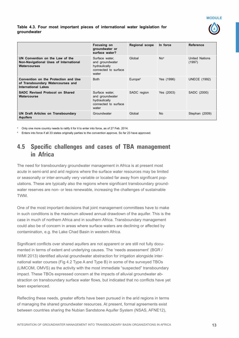
13
4
MODULE
Management of Transboundary Aquifers
INTEGRATION OF GROUNDWATER MANAGEMENT INTO TRANSBOUNDARY BASIN ORGANIZATIONS IN AFRICA
Table 4.3. Four most important pieces of international water legislation for groundwater
Focusing on groundwater or surface water?
Regional scope In force Reference
UN Convention on the Law of the Non-Navigational Uses of International Watercourses
Surface water,and groundwaterhydraulicallyconnected to surface water
Global Noa United Nations(1997)
Convention on the Protection and Use of Transboundary Watercourses and International Lakes
Both Europeb Yes (1996) UNECE (1992)
SADC Revised Protocol on Shared Watercourse
Surface water,and groundwaterhydraulicallyconnected to surface water
SADC region Yes (2003) SADC (2000)
UN Draft Articles on Transboundary Aquifers
Groundwater Global No Stephan (2009)
a Onlyonemorecountryneedstoratifyitforittoenterintoforce,asof27Feb.2014.b Entersintoforceifall33statesoriginallypartiestotheconventionapprove.Sofar23haveapproved.
4.5 Specific challenges and cases of TBA management in Africa
TheneedfortransboundarygroundwatermanagementinAfricaisatpresentmost
acuteinsemi-aridandaridregionswherethesurfacewaterresourcesmaybelimited
orseasonallyorinter-annuallyveryvariableorlocatedfarawayfromsignificantpop-
ulations.Thesearetypicallyalsotheregionswheresignificanttransboundaryground-
waterreservesarenon-orlessrenewable,increasingthechallengesofsustainable
TWM.
Oneofthemostimportantdecisionsthatjointmanagementcommitteeshavetomake
insuchconditionsisthemaximumallowedannualdrawdownoftheaquifer.Thisisthe
case in much of northern Africa and in southern Africa. Transboundary management
couldalsobeofconcerninareaswheresurfacewatersaredecliningoraffectedby
contamination,e.g.theLakeChadBasininwesternAfrica.
Significantconflictsoversharedaquifersarenotapparentorarestillnotfullydocu-
mentedintermsofextentandunderlyingcauses.The‘needsassessment’(BGR/
IWMI2013)identifiedalluvialgroundwaterabstractionforirrigationalongsideinter-
nationalwatercourses(Fig4.2TypeAandTypeB)insomeofthesurveyedTBOs
(LIMCOM,OMVS)astheactivitywiththemostimmediate“suspected”transboundary
impact.TheseTBOsexpressedconcernattheimpactsofalluvialgroundwaterab-
stractionontransboundarysurfacewaterflows,butindicatedthatnoconflictshaveyet
been experienced.
Reflectingtheseneeds,greatereffortshavebeenpursuedinthearidregionsinterms
ofmanagingthesharedgroundwaterresources.Atpresent,formalagreementsexist
betweencountriessharingtheNubianSandstoneAquiferSystem(NSAS,AFNE12),

14
4
MODULE
Management of Transboundary Aquifers
INTEGRATION OF GROUNDWATER MANAGEMENT INTO TRANSBOUNDARY BASIN ORGANIZATIONS IN AFRICA
theNorthwesternSaharaAquiferSystem(AFNE16),whilesignificantworkisongoing
intheLakeChadaquifer(AFWC14)andtheIullemeden/TaudeniAquiferSystems
(AFWC20+15).Sucheffortsaretypicallysupportedbyinternationalorganizations(eg.
UNESCO,FAO)andtechnicalinstitutionswithexpertiseingroundwatercharacteriza-
tion(eg.IAEA,IGRAC,BGR,andBRGM).
Theagreementsrelatemostlytothesettingupofconsultativemechanismstocoor-
dinate,promoteandfacilitatetherationalmanagementoftheaquifersandthecollec-
tion,sharingandinterpretationofdataaspartofso-calledtransboundarydiagnostic
analyses.TheTBAinAfricathatcountsonthemostadvancedlevelofjointmanage-
mentistheNubianSandstoneAquiferSystem(NSAS,AFNE12),whichconstituted
aJointAuthorityin1989forthestudyanddevelopmentoftheaquiferandwithquite
broadresponsibilities.Theaquifer-sharingstates(Egypt,Libya,Sudan,andChad)and
theJointAuthorityalsoagreedonastrategicactionplanin2013forthesharedvision
andfuturecooperativemanagementoftheNSAS.

15
4
MODULE
Management of Transboundary Aquifers
INTEGRATION OF GROUNDWATER MANAGEMENT INTO TRANSBOUNDARY BASIN ORGANIZATIONS IN AFRICA
4.6 References
Altchenko,Y.andK.G.Villholth,2013.
Transboundary aquifer mapping and management in Africa:
a harmonised approach.
Hydrogeol.J.21(7),1497-1517.DOI10.1007/s10040-013-1002-3.
BGRandIWMI,2013.
Needs Assessment to Support Groundwater Management in International Basin
Organizations of Africa. Availableat:
http://www.splash-era.net/downloads/groundwater/Needs_asessment_GW_final.pdf
Eckstein,G.andY.Eckstein,2003.
A hydrogeological approach to transboundary ground water resources and
international law.
Am.Univ.Int.LawReview,19,201-258.
IGRAC(InternationalGroundwaterResourcesAssessmentCentre),2012.
Transboundary aquifers of the world – update 2012. Special Edition for 6th
World Water Forum, Marseille, France, March 2012
(Ed.KukuricN)http://www.un-igrac.org/publications/456#,Accessedon12Nov.2012.
INBOandGWP,2012.
The Handbook of Integrated Water Resources Management in Transboundary
Basins of Rivers, Lakes and Aquifers. International Network of Basin Organiza-
tions and Global Water Partnership.
ISBN:978-91-85321-85-8.
SADC(SouthernAfricanDevelopmentCommunity),2000.
Revised protocol on shared watercourses in the Southern African Development
Community.
http://www.sadc.int/files/
3413/6698/6218/Revised_Protocol_on_Shared_Watercourses_-_2000_-_English.pdf.
StephanR.M.,2009.
Transboundary Aquifers: Managing a Vital Resource, the UNILC Draft Articles on
the Law of Transboundary Aquifers
UNESCO,SC-2008/WS/35.24pp.
UnitedNationsEconomicCommissionforEurope(UNECE),1992.
Convention on the Protection and Use of Transboundary Watercourses and
International Lakes.
http://www.unece.org/fileadmin/DAM/env/water/pdf/watercon.pdf.
UnitedNations,1997.
Convention on the Law of Non-Navigational Uses of International Watercourses.
G.A.Res.51/229,UNGAOR,51stSess.,UNDoc.A/RES/51/229(1997).
http://untreaty.un.org/ilc/texts/instruments/english/conventions/8_3_1997.pdf.

16
4
EXERCICE
Management of Transboundary Aquifers
INTEGRATION OF GROUNDWATER MANAGEMENT INTO TRANSBOUNDARY BASIN ORGANIZATIONS IN AFRICA
4.7 ExerciseThis exercise provides an example guideline of the manner in which TBOs may
approach the management of TBAs in the first instance.
Step 1.
Foryourcountry,listthetransboundaryaquifersorgroundwaterresourceswithpoten-
tialorapparenttransboundaryissuesintermsofdevelopment,use,andmanagement.
Step 2.
Categorizeandranktheresourcesintermsofproblemsorpossiblesolutionstohu-
manandenvironmentalneeds.
Step 3.
Compareyourlistwiththelistsforyourneighboringcountriesandidentifytheareasof
jointpriorityfortransboundaryandcooperativemanagement.
Step 4.
Identifytechnicalandmanagementinterventionsthatcouldbebestdealtwithjointlyto
addresstheissuesidentifiedinStep1-3.
Step 5.
Assesstheinterventionsintermsofthebenefitsandtrade-offsforthecountries,in
termsofaddressingequity,sustainabilityandefficiency.
Step 6.
Indicatewheretheinstitutionalresponsibilityliestocarryouttheproposedmanage-
mentinterventions.Highlightinparticulartherole/interventionsthatcanbebest
carriedoutbytheTBO.

5
MODULE
INTEGRATION OF GROUNDWATER MANAGEMENT INTO TRANSBOUNDARY BASIN ORGANIZATIONS IN AFRICA
GROUNDWATER MONITORING AND INFORMATION MANAGEMENT

2 INTEGRATION OF GROUNDWATER MANAGEMENT INTO TRANSBOUNDARY BASIN ORGANIZATIONS IN AFRICA

3
5
MODULE
INTEGRATION OF GROUNDWATER MANAGEMENT INTO TRANSBOUNDARY BASIN ORGANIZATIONS IN AFRICA
Groundwater Monitoring and Information ManagementMODULE 5
Groundwater Monitoring and Information Management
5.1 Introduction 4
5.2. Monitoring practice 7
5.3 Data storage and information management 12
5.4 Benefitsandcosteffectivenessofmonitoring 15
5.5 Access and exchange of national data to the TBO 16
5.6 Global data 17
5.7 Reference 17
5.8 Exercise 18
CONTENT
Imprint
© Copyright 2014, all rights reserved
The use of the manual is FREE of cost. AGW-Net simply requests that users give proper
attribution “Integration of Groundwater Management into Transboundary Basin Organizations in
Africa - a Training Manual by AGW-Net, BGR, IWMI, CapNet, ANBO, & IGRAC” . Modification
is only allowed with permission of AGW-Net.
Photos are copyright to their respective owners.
A4A – aqua for all
AGW-Net – Africa Groundwater Network
ANBO – African Network of Basin Organisations
BGR – Federal institute for geosciences and natural resources
Cap-Net UNDP
BMZ – Federal Ministry for Economic Cooperation and Development
GWP – Global Water Partnership
IGRAC – International Groundwater Resources Assessment Centre
imawesa – Improved Management of Agricultural Water in Eastern and Southern Africa
IWMI - International Water Management Insitute
Editorial Staff: Vanessa Vaessen, Ramon Brentführer – BGR
Layout: ff.mediengestaltung GmbH, Hannover, Germany
Picture: IWMI
4
5
MODULE
INTEGRATION OF GROUNDWATER MANAGEMENT INTO TRANSBOUNDARY BASIN ORGANIZATIONS IN AFRICA
Groundwater Monitoring and Information Management
GROUNDWATER MONITORING AND INFORMATION MANAGEMENT
List of abbreviations
CBA CostBenefitAnalysis
QA QualityAnalysis
QC QualityControl
BO Basin Organization
IWRM Integrated Water Resources Management
5.1 IntroductionMonitoring groundwater: the entry point to management
Groundwatermonitoringandgroundwaterdataacquisitionarepre-requisitesforany
effectivemanagementofgroundwaterresources,intermsofboththegroundwater
qualityandtheavailabilityofthegroundwaterresourceitself.Becauseofthecomplex-
itiesofgroundwatersystems,thedesignandoperationofaneffectivegroundwater
monitoringisfarfromsimple.Yetwell-designedmonitoringsystemsarecapableof
providingvitalaquiferinformationatareasonablecost.
Thismodulediscussesthedifferentpurposesandobjectivesofmonitoringforman-
agementbasedonwhichamonitoringsystemcanbedesignedandoperatedinan
effectiveway.
Theunderlyingprincipleisthatgroundwatermonitoringshouldalwaysbetargetorient-
ed.Thismeansthatthemanagementquestionshouldbedefinedfirstandmonitoring
shouldbedesignedaccordingly.Inthisway,thepurposeofmonitoringanditsresults
arealsobetteracknowledgedbythewatermanagersandwateruserswhointheend
willpayforthecostofmonitoring.Monitoringshouldneverbecomeapurposeinitself.
Transboundary groundwater monitoring
Transboundarygroundwatermonitoringhasanumberofsignificantdifferencesfrom
internalmonitoringsystemsandstrategies.Thesedifferencesareduetothenatureof
thegroundwaterresourceitself,andthelegalmandateandtheinstitutionalcapacityof
transboundaryorganizations(TBOs).
Anthropogenicimpactsongroundwaterresourcesdonotgenerallyhaveanextend-
edupstream/downstreamreach,buttendtoberatherlocalized.Thisisrelevant
LEARNING OBJECTIVES■■ Whyandhowtomonitorgroundwaterlevels,abstractionandquality
■■ Understandingthedifferentobjectivesofmonitoring
■■ Howtodesignandoperateacosteffectiveandtargetorientedmonitoring
system
■■ How to store and manage data and information
■■ How to use monitoring data and information for management

5
5
MODULE
INTEGRATION OF GROUNDWATER MANAGEMENT INTO TRANSBOUNDARY BASIN ORGANIZATIONS IN AFRICA
Groundwater Monitoring and Information Management
whendealingwithtransboundarygroundwatermonitoring,whichoftenfocusesonthe
monitoringofaheavilyutilizedorthreatenedgroundwaterresourceeithersideofan
internationalborder.Thereareexceptions;forexample,heavyexploitationofalluvial
aquifersalongtransboundaryriverstendstohavesignificantimpactsonriverflow,
thusreducingflowtodownstreamriparianstates.
ThelegalmandateofTBOsdoesnotusuallyextendtotheactofmonitoringitself,or
evenstoringthedata,butmayberestrictedtoviewing,collatingandassessingthe
monitoringdataanddeterminingthetransboundaryimpacts.TBOsmaynothavethe
institutionalcapacitytocarryouttheanalysesofthemonitoringdata.Intheseareas,
theTBOwillgenerallyhavetorelyoninformationprovidedbythenationalwaterman-
agement institutions that share the common groundwater resource.
TheroleoftheTBOmaybemorefocussedonbringingtogethermonitoringdatafor
transboundaryaquifersfromtheaffectedstatesandprovidingaforumandsetof
guidelinesforintegratingthemonitoringsystemsandnegotiatingtheoutcomes.
The groundwater monitoring cycle
Thepurposeorientedapproachtogroundwatermonitoringisalsoreflectedinthe
monitoringcyclewhichcomprisesthecompleteprocessofproblemdefinition,man-
agementobjectives,informationneeds,dataacquisition,datastorage,interpretation
anddissemination,givingrisetorelevantaccurateinformationforaquiferunderstand-
ingandforconsequentmanagementactions(Figure5.1)
Theessenceofmonitoringincludesthedesignofthemonitoringsystem,andthe
collection,processingandinterpretationofdatainordertorespondtoasuiteof
well-definedinformationneedsformanagementpurposes.Allthestepsinthemonitor-
ingprocessshouldbecarefullydefinedanddesignedforthespecificpurposeofthe
monitoring.Groundwaterspecialistsmaytendtoputtheemphasisonthecollectionof
thedataanditsinterpretationandmaygivelessattentiontothedisseminationofthe
resultstootherstakeholders.Yetthemonitoringcycleisonlycompleteifithasprovid-
ed the required information for managers or water users to take action.
Figure 5.1: Monitoring cycle: information > data > information.
Management questions and monitoring objectives
Definition of information needs
Collection of static and dynamic data
Data storage, interpretation and dissemination
Management information and actions
■ Trends and changes
■ Impacts and risks
■ Compliance
■ Groundwater specific
■ Water use
■ Supporting data

6
5
MODULE
INTEGRATION OF GROUNDWATER MANAGEMENT INTO TRANSBOUNDARY BASIN ORGANIZATIONS IN AFRICA
Groundwater Monitoring and Information Management
Monitoring objectives: response to information needs
Therearefourbasicobjectivesforestablishingamonitoringsystem
Resource monitoringtoincreasetheunderstandingofthegroundwatersystemin
abasin(recharge,discharge,interactionwithsurfacewater,changesinqualityand
quantityovertime)
Compliance monitoringtogetinformationontheeffectivenessofmanagement
measures. This has two main dimensions
■■ Measuringgroundwateruseandaquiferresponse:tocollectthenecessaryinfor-
mationformanagementmeasurerelatedtoquantity(sucharestrictionstonumber
ofwells,wellyieldsandwellspacingorregulationtopreventgroundwaterlevelsof
wellsandwellfieldstodropbelowacertainlevel)
■■ Measuringgroundwaterqualityparametersofabstractedgroundwatertocheck
compliancewithprescribedmaximumlevels.
Protection monitoringforpotentialimpactsonspecificgroundwaterinfrastructureor
groundwaterbodies:typicalexamplesaretheprotectionof:-
■■ Wellfieldsorspringsforpublicwatersupplyagainstdepletionandqualityhazards
■■ Urban infrastructure against land subsidence
■■ Archaeological sites against rising water tables
■■ Strategicwaterreservesagainstdepletionorqualityhazards
■■ Groundwaterdependentecosystemsagainstundesirablechangesinwaterquanti-
tyand/orquality
Pollution containment monitoringtoprovideearlywarninginformationonimpacts
of potential pollution hazards from
■■ Intensiveagriculturallanduse
■■ Industrialsitesofspecificindustries
■■ Solidwastelandfills
■■ Land reclamation areas
■■ Quarries and mines
Asharpandclearformulationofthemonitoringobjectivesistheimportantfirststep
asithelpsto(i)definethestakeholdersthatareinvolved(bothupstreamanddown-
stream)and(ii)interactwiththemontherequiredinformationneedsthatshouldbe
providedbythemonitoringsystem
Thesetofrequirementsforthedesignofthemonitoringsystemmaycombinemore
thanoneoftheaboveobjectives.AnexampleisshowninFigure5.2wherethe
comparisonbetweentimeseriesofrainfallandgroundwaterlevelsdemonstratesthe
rainfall-rechargerelationship(resourcemonitoring)andalsotheimpactofanearby
deepproductionwellontheshallowgroundwateratobservationwell6:11.

7
5
MODULE
INTEGRATION OF GROUNDWATER MANAGEMENT INTO TRANSBOUNDARY BASIN ORGANIZATIONS IN AFRICA
Groundwater Monitoring and Information Management
Figure 5.2: Groundwater level (blue and red) and rainfall (light green) time series. Both
observation wells show an impact of the rain event within one day. Sudden variations in water
levels at observation well 6.11 indicate that it is affected by a nearby production well whereas
the observation well 6.15 does not reveal any influence.
5.2. Monitoring practice Collection of static and dynamic data
Anymonitoringnetworkshouldbedesignedtoachievespecificobjectivesasdeter-
minedbyanumberofmanagementquestionswithregardtooneormoreaspectsof
thegroundwaterresource.Thisdeterminesthetypeofdatathathavetobecollected
and the location and distribution of the monitoring network boreholes. Table 5.1 below
summarizesthetypeofdatathatmaybeneededanddistinguishesbetweenstatic
anddynamicdata.
Table 5.1 Types of data required for groundwater management
TYPE OF DATA STATIC DATANo significant variation with time(from archives)
DYNAMIC DATAVariation with time(from field stations)
Groundwater occurrence and aquifer properties
■ Water well records (hydrogeological logs,initial groundwater levels and quality)
■ Well and aquifer pumping tests
■ Groundwater level monitoring
■ Groundwater quality monitoring
Groundwater use ■ Water well pump installations
■ Water use inventories
■ Population registers and forecasts
■ Energy consumption for irrigation
■ Water well abstraction monitoring (direct orindirect)
■ Groundwater level variations at well
Supporting information ■ Climatic data
■ Land use inventories
■ Geological maps/ sections
■ River flow gauging
■ Meteorological observations
■ Satellite land use surveys
Date01.03.2012 01.03.2013
Shallow observation well 6.15
Shallow observation well 6.11
Rainfall
Gro
un
dw
ater
Lev
el (
m b
elo
w s
urf
ace
leve
l)
0
-1
-2
-3
-4
-5
-6
-7
-8
60
50
40
30
10

8
5
MODULE
INTEGRATION OF GROUNDWATER MANAGEMENT INTO TRANSBOUNDARY BASIN ORGANIZATIONS IN AFRICA
Groundwater Monitoring and Information Management
Thefirststepistocollectandreviewavailable(static)datainarchivesandreports
inordertoestablishthereferencesituation.Basedonthat,anetworkofobservation
pointshastobesetuptocollectdynamicdataifpossiblefromdedicatedobservation
ormonitoringwells(figure5.3).
Forgroundwatermonitoring,datasuchasthegroundwaterlevel,piezometricpressure
andwaterqualityhavetobecollectedtodetectpotentialchangesingroundwaterflow
andquality.Aseriesofobservationwellscoupledwithaselectionofabstractionwells
normallycompriseamonitoring network,designedto
■■ Detectchangesingroundwaterstorage,flowandquality
■■ Assessspecificriskstotheaquifer
■■ Assess aquifer recharge and discharge
The use of abandoned wells or existing abstraction wells for monitoring is a cost
effectiveadditiontopiezometers,butinthecaseofusingactiveabstractionwellscare
should be taken that:
■■ Thewaterlevelmeasuredisthestaticwaterlevel
■■ Thewatersampletakenisrepresentativeandreliable
Otherdynamicdatathatmaybeneededarewateruse,rainfall,riverflow,population
change and changes in land use.
Figure 5.3 Example of a
dedicated monitoring well: a 1” or
2” screen pipe with 3 or 4” upper
casing that prevent the wells from
flooding and allows for a proper
screwed cap for protection. 1”
observation wells are for water
level recordings only (with a water
dipper or a diver). 2” observation
wells also allow for water
sampling with a bailer
How to measure aquifer response to groundwater abstraction?
Bymonitoringabstractionandchangestowaterlevels,theeffectofpumpingfromthe
aquifercanbeassessedandthisprovideskeyinformationforgroundwaterresource
management.
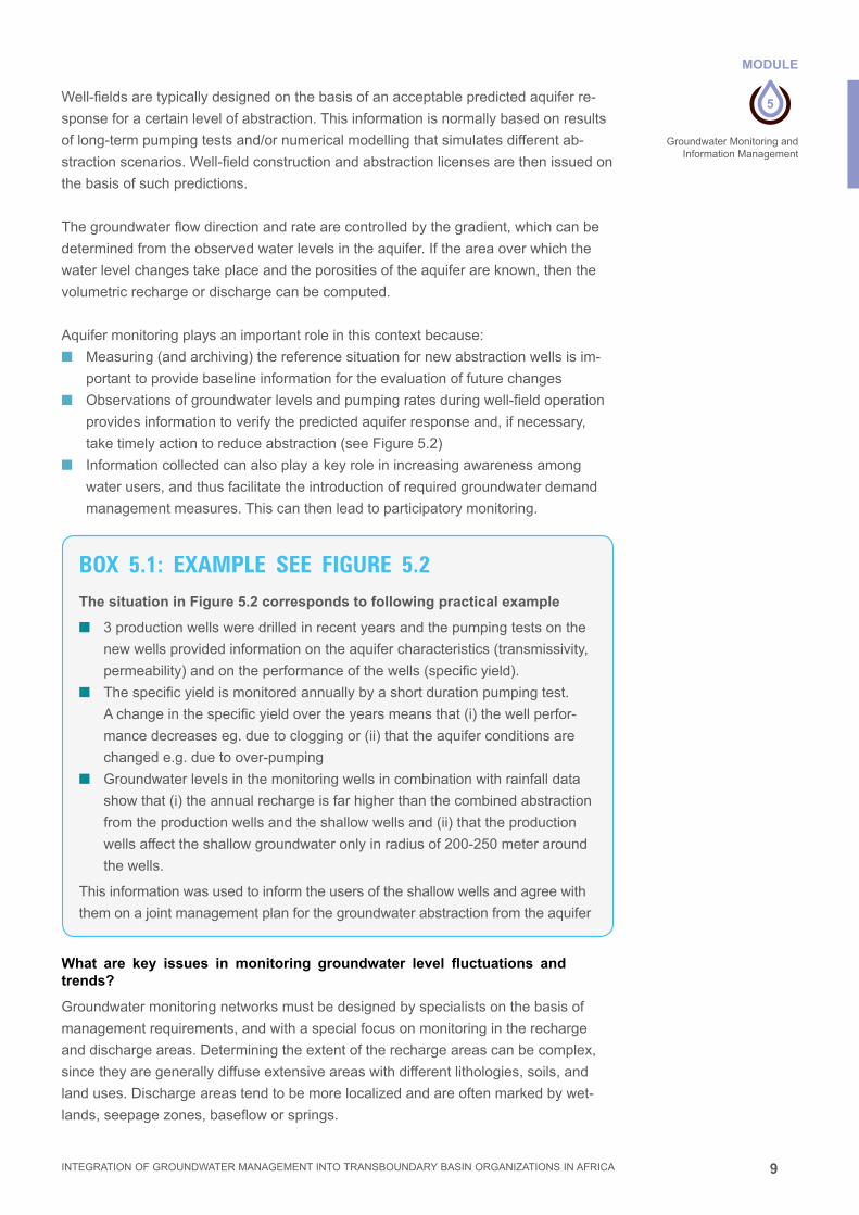
9
5
MODULE
INTEGRATION OF GROUNDWATER MANAGEMENT INTO TRANSBOUNDARY BASIN ORGANIZATIONS IN AFRICA
Groundwater Monitoring and Information Management
Well-fieldsaretypicallydesignedonthebasisofanacceptablepredictedaquiferre-
sponseforacertainlevelofabstraction.Thisinformationisnormallybasedonresults
of long-term pumping tests and/or numerical modelling that simulates different ab-
stractionscenarios.Well-fieldconstructionandabstractionlicensesarethenissuedon
the basis of such predictions.
Thegroundwaterflowdirectionandratearecontrolledbythegradient,whichcanbe
determinedfromtheobservedwaterlevelsintheaquifer.Iftheareaoverwhichthe
waterlevelchangestakeplaceandtheporositiesoftheaquiferareknown,thenthe
volumetricrechargeordischargecanbecomputed.
Aquifermonitoringplaysanimportantroleinthiscontextbecause:
■■ Measuring(andarchiving)thereferencesituationfornewabstractionwellsisim-
portanttoprovidebaselineinformationfortheevaluationoffuturechanges
■■ Observationsofgroundwaterlevelsandpumpingratesduringwell-fieldoperation
providesinformationtoverifythepredictedaquiferresponseand,ifnecessary,
taketimelyactiontoreduceabstraction(seeFigure5.2)
■■ Informationcollectedcanalsoplayakeyroleinincreasingawarenessamong
waterusers,andthusfacilitatetheintroductionofrequiredgroundwaterdemand
managementmeasures.Thiscanthenleadtoparticipatorymonitoring.
What are key issues in monitoring groundwater level fluctuations and trends?
Groundwatermonitoringnetworksmustbedesignedbyspecialistsonthebasisof
managementrequirements,andwithaspecialfocusonmonitoringintherecharge
anddischargeareas.Determiningtheextentoftherechargeareascanbecomplex,
sincetheyaregenerallydiffuseextensiveareaswithdifferentlithologies,soils,and
landuses.Dischargeareastendtobemorelocalizedandareoftenmarkedbywet-
lands,seepagezones,basefloworsprings.
BOX 5.1: EXAMPLE SEE FIGURE 5.2The situation in Figure 5.2 corresponds to following practical example
■ 3productionwellsweredrilledinrecentyearsandthepumpingtestsonthe
newwellsprovidedinformationontheaquifercharacteristics(transmissivity,
permeability)andontheperformanceofthewells(specificyield).
■ Thespecificyieldismonitoredannuallybyashortdurationpumpingtest.
Achangeinthespecificyieldovertheyearsmeansthat(i)thewellperfor-
mancedecreaseseg.duetocloggingor(ii)thattheaquiferconditionsare
changede.g.duetoover-pumping
■ Groundwaterlevelsinthemonitoringwellsincombinationwithrainfalldata
showthat(i)theannualrechargeisfarhigherthanthecombinedabstraction
fromtheproductionwellsandtheshallowwellsand(ii)thattheproduction
wellsaffecttheshallowgroundwateronlyinradiusof200-250meteraround
the wells.
This information was used to inform the users of the shallow wells and agree with
them on a joint management plan for the groundwater abstraction from the aquifer

10
5
MODULE
INTEGRATION OF GROUNDWATER MANAGEMENT INTO TRANSBOUNDARY BASIN ORGANIZATIONS IN AFRICA
Groundwater Monitoring and Information Management
Groundwaterlevelmeasurementscanbemademanuallyorautomaticallyeitherin
observationorabstractionwells,andshouldalwaysbesubjecttoqualitychecks.
Groundwaterlevelchangesobservedthroughmonitoringmayhavewidelydiffering
causesandshouldbecarefullyevaluatedtodeterminethecorrectactionrequired.
How to monitor groundwater use?
Directmonitoringofgroundwaterabstractionbywatermetersisaccuratebutcostly,
sincemetershavetobefittedtoallpumpoutlets,andthisrequiresthefullcooperation
ofwaterusers,whichisnotalwayseasytoachieve.
Indirectmonitoringofgroundwaterabstractionisalwayslessaccurate,butatleastan
estimationisobtained.Indirectmonitoringcanbecarriedoutby:
■■ Collectionofindicativedata—forexampleirrigationgroundwaterusecanbe
estimatedindirectlyusinghoursofpumpoperation(fromenergyconsumption)
multipliedbyaveragepumpingrate
■■ Useofremotesensing:satelliteorairbornesensorscanprovideobjectivemeas-
urementsatpotentiallylargescales,withquasi-continuouscoveratlowcostper
km2.Informationonthearealextentofirrigatedland,orthedailyandcumulative
actualevaporationcanbeassessed.Thesetechniquesareexpandingrapidlywith
different sensors and approaches all the time.
■■ Estimatesofchangeinregionalgroundwaterabstractionfordomesticsupply
can also be obtained through information on demographic changes and random
checks on per capita water use.
Theaboveapproachesrefermainlytogroundwaterabstractioninruralareas,where
theuseforirrigationisthelargestconsumer.Intensivegroundwaterusefordomes-
ticwatersupplyisalsoencounteredinfastgrowingcities,wherethewaterservice
provisionisinadequate.ThisisthecaseinmanyAfricancitiesandhasledtomassive
privategroundwaterabstraction.Monitoringthiswaterusecanbedonebyusingde-
mographic data in combination with satellite images showing the urban expansion and
estimatingthewateruseperhouseholdthroughsamples(e.g.randomsurveys).
How to monitor for groundwater quality?
Aprimaryfocusofgroundwaterqualitymonitoringisusuallythepublicwatersupply
fromwaterwellsandspringsviapipeddistributionsystems.Twokeycomponentsare
thesamplingofthewaterandchemicalanalysisinthelaboratory.Samplingofthewa-
terfromwellsiscriticalasitmaycausemajorsample modificationsuchasairentry,
degassingandvolatilelosses,whichneedappropriatesamplingprocedures(Table
5.2).InsitumeasurementoftheEC,pHandtemperatureareneededtovalidatethe
conditionofthesampleduringtheanalysisinthelaboratory
A“full”waterqualityanalysisisinitiallyrequired(ideally),followedbymorelimited
analysisofcarefullyselectedparameterswithperiodicchecksonotherimportant
parametersthataremorecomplexorexpensivetoanalyse.Howeverthistypeof
monitoringdoesnotnormallycorrespondtotheconditionofgroundwaterinsitu,which
isessentialforaquifermonitoringprogramsthathavetodefinethesubsurfacedis-
tributionofgroundwaterofinferiorquality,itsvariationwithtimeanditsresponseto
management mitigation measures.

11
5
MODULE
INTEGRATION OF GROUNDWATER MANAGEMENT INTO TRANSBOUNDARY BASIN ORGANIZATIONS IN AFRICA
Groundwater Monitoring and Information Management
Theprocessofwellpumpingandsamplehandlingmayprovideamixedsamplewith
groundwaterobtainedfromalltheaquiferstrataintersectedbythewell.Depthspecif-
icsamplingcanbeusedtosamplespecificstrata/depthsandisneededtodetermine
thedifferentwaterquality(andhead)indifferentunitsinlayeredaquifersystems.
Table 5.2 Summary of sampling procedures and precautions for specific groups of quality parameters.
Inmanycasesthecriticalrequirementistoobtainanearlywarningofpotentialquality
problemsthatmaythreatenthegroundwatersourceandtheaquifersystem.InAfrica
mostgroundwaterqualityconcernsarerelatedto:
■■ decliningurbangroundwaterqualitybecauseofinadequatelybuiltpitlatrines/
septictanksanduncontrolledeffluentdischargefromindustry
■■ salinisationofgroundwatercausedbyinappropriateirrigationmethods
■■ seawaterintrusion,duetoloweringofwatertablebywatersupplywellsnear/
along the coast.
Toachievetimelyinformation,abasicunderstandingofthenatureoftheproblemand
aconceptualmodelofthepollutionflow-pathisneeded.Monitoringwellsshouldthan
bedesignedandplacedtogettimelyinformationonchangesinwaterqualityand
provideenoughtimetotakemitigationmeasures.Figure5.4showsatypicalexample
ofdefensivewaterqualitymonitoring,basedonapriorknowledgeofthegroundwater
flowpathandtheoriginofthewaterqualitythreat
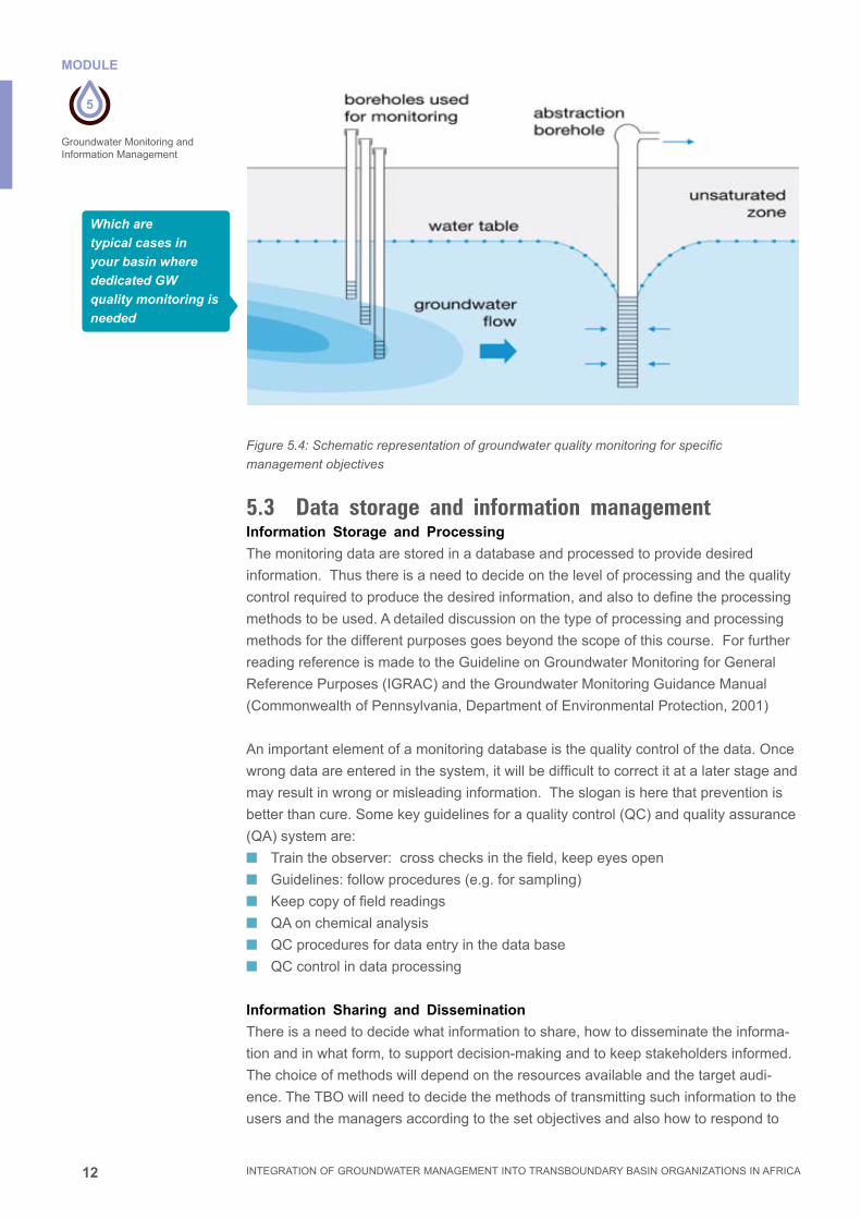
12
5
MODULE
INTEGRATION OF GROUNDWATER MANAGEMENT INTO TRANSBOUNDARY BASIN ORGANIZATIONS IN AFRICA
Groundwater Monitoring and Information Management
Figure 5.4: Schematic representation of groundwater quality monitoring for specific
management objectives
5.3 Data storage and information managementInformation Storage and Processing
Themonitoringdataarestoredinadatabaseandprocessedtoprovidedesired
information.Thusthereisaneedtodecideonthelevelofprocessingandthequality
controlrequiredtoproducethedesiredinformation,andalsotodefinetheprocessing
methodstobeused.Adetaileddiscussiononthetypeofprocessingandprocessing
methodsforthedifferentpurposesgoesbeyondthescopeofthiscourse.Forfurther
reading reference is made to the Guideline on Groundwater Monitoring for General
ReferencePurposes(IGRAC)andtheGroundwaterMonitoringGuidanceManual
(CommonwealthofPennsylvania,DepartmentofEnvironmentalProtection,2001)
Animportantelementofamonitoringdatabaseisthequalitycontrolofthedata.Once
wrongdataareenteredinthesystem,itwillbedifficulttocorrectitatalaterstageand
mayresultinwrongormisleadinginformation.Thesloganisherethatpreventionis
betterthancure.Somekeyguidelinesforaqualitycontrol(QC)andqualityassurance
(QA)systemare:
■■ Traintheobserver:crosschecksinthefield,keepeyesopen
■■ Guidelines:followprocedures(e.g.forsampling)
■■ Keepcopyoffieldreadings
■■ QAonchemicalanalysis
■■ QCproceduresfordataentryinthedatabase
■■ QC control in data processing
Information Sharing and Dissemination
Thereisaneedtodecidewhatinformationtoshare,howtodisseminatetheinforma-
tionandinwhatform,tosupportdecision-makingandtokeepstakeholdersinformed.
Thechoiceofmethodswilldependontheresourcesavailableandthetargetaudi-
ence. The TBO will need to decide the methods of transmitting such information to the
usersandthemanagersaccordingtothesetobjectivesandalsohowtorespondto
Which are
typical cases in
your basin where
dedicated GW
quality monitoring is
needed

13
5
MODULE
INTEGRATION OF GROUNDWATER MANAGEMENT INTO TRANSBOUNDARY BASIN ORGANIZATIONS IN AFRICA
Groundwater Monitoring and Information Management
queriesonthepublishedinformation.Table5.3givesexamplesofdifferentaudiences
and their corresponding information requirements and appropriate disseminations
methods and channels.
All stakeholders should be able to access an annual report of the state of the water
resourcesinthebasin.Theymayalsoneedtohaveaccesstoasystemtomakecom-
plaintsandtomakequeriesonthewatermanagementandwaterallocationintheriver
basin.Thismaytaketheformofcomplaintorqueryforms,inhardcopyorelectronic
forms on the Internet.
ItmustbenotedthatforTBO,thestakeholderstendtobethenationalwaterauthori-
ties of the riparian states and multi-state organisations such as SADC in southern Af-
rica.ThereisseldomsituationwhereTBOsarelegallyresponsibletoendwaterusers
forwaterqualityorwaterleveldeclines.NeverthelessTBOscanplayanimportantrole
indisseminatinginformationtothegeneralpublicandinadvocatingforappropriate
watermanagementstrategiesincaseswheremonitoringrevealssignificanttrans-
boundaryimpacts.
Table 5.3: Examples of information products for different stakeholders
Target Audience Information outputs required Dissemination methods/channels
Water Managers ■ Quantity and quality of groundwateravailable for allocation;
■ List of groundwater users and permit holders
■ List of non-compliance by water permitusers and actions taken
■ List of complaints by groundwater users/actions taken
■ Location and yield of well fields/ boreholes
Shared Database (e.g.intranet or CMS)
Civil society includingthe media and NGOs
■ General trends in water use and quality News features on awebsite
Water users including discharge wastes into the water
■ Water allocation decisions
■ Consumption patterns by all the users
■ Revenue raised from permits and how itis used
Regular status reports such as a leaflet/newsletter
Political stakeholders such as governmentofficials
■ Summarised information on the status of the groundwater water management and allocation
Half-yearly or annualreport

14
5
MODULE
INTEGRATION OF GROUNDWATER MANAGEMENT INTO TRANSBOUNDARY BASIN ORGANIZATIONS IN AFRICA
Groundwater Monitoring and Information Management
Information Types and Characteristics.
Thereisawiderangeofinformationtypesthatcanbeselectedandusedfordifferent
purposes.(seeTable5.4below).
Table 5.4: Information types and their characteristics
Information Type Characteristics
1. Static information Static information does not change with time. They are typicallyinformation used to identify an object and those relatively time-invariantcharacteristics of an object, such as geology, aquifer type, aquiferproperties, etc.
2. Dynamic information Dynamic information varies with time, e.g. abstraction data, waterquality data, water levels, and base flow, recharge rate etc.
3. Raw data Raw data are information recorded by measuring equipment or derivedfrom a survey.
4. Processed information Processed information is information that meets a defined need and isprocessed from raw data.
5. Report-type information Report-type information is a combination of text, figures and tables,organised within a set of narrative text.
6. Spatial-type information Spatial-type information is information stored in the form of maps andis geo-referenced to a map.
Examples of Some Information Management Tools
Rapidadvancesininformationandcommunicationtechnologyhaveenabledanum-
berofnewinformationmanagementtoolstobedevelopedandthusassist(T)BOs
intheirinformationmanagementtasks.Theseenablebetterinformationgeneration,
processing and dissemination than in the past.
■■ Dedicated data processing systems and databases canbedevelopedto
processrawdataforstorageindatabases.Thesystemsarenormallydeveloped
basedonthespecificinformationneedsoftheusersandfollowaveryclearsetof
information processing procedures.
■■ Geographical Information Systems (GIS) use the powers of a computer to
displayandanalysespatialdatathatarelinkedtodatabases.Whenaspecificda-
tabaseisupdated,theassociatedmapwillbeupdatedaswell.Thusbycontinually
updatingdatacapturedfrommonitoring,updatedmapsareavailableforstake-
holderstoview.GISdatabasescanincludeawidevarietyofinformationsuchas
population,infrastructure,boreholesites,pollutionhotspotsetcetera.
■■ “Google Earth” Program combines the power of the Google Search engine with
satelliteimagery,maps,terrain,and3Dbuildingsandmakesavailableabird’seye
viewoftheworld’sgeographicinformationforanyareaofinterest.Mostofthe
satelliteimageryusedisonetothreeyearsold.
■■ Content Management Systems (CMS) use the Internet standard of presenting
linkedweb-pagestoorganiseandpresentreport-typeinformation.Therearesev-
eraltypesofCMSavailable,manyofwhicharefree.Report-typeinformationisthe
mostcommontypeusedbystakeholdersinmakingdecisions.Thereforetheuse
ofaCMStostoreandpublishreport-typeinformationelectronically,eitheronthe
InternetorintheformofaCD/DVD,willenablea(T)BOtodisseminateandshare
informationinaneffectiveway.TheCMSalsohastheadvantagethatitallowsfor
acentralinformationrepositoryfordataandinformationthatispostedbydifferent
people.

15
5
MODULE
INTEGRATION OF GROUNDWATER MANAGEMENT INTO TRANSBOUNDARY BASIN ORGANIZATIONS IN AFRICA
Groundwater Monitoring and Information Management
Information Management Plan
TherealityofhumanresourcesandfinancialconstraintswilllimitaBO’sabilityto
collect,analyse,interpret,useandshareinformation.ThustheBOhastoprioritise
itsinformationcollectionandprocessingtoderivethenecessaryinformationoutputs
toaddressthepressingIWRMissuesinariverbasin.Togetherwithsurfacewater
information,groundwatermanagementinformationrequirementsmustbeprioritised
andincorporatedintoanoverallbasinInformationManagementPlanthatmeetsthe
immediate IWRM needs of the basin and which can be implemented within the re-
sourcelimitationsoftheBO.TheabovesystematicexercisemayalsohelpBOsdefine
theinformationmanagementcapacitydevelopmentneedsandalsothepossibleareas
whereinvestmentsintechnicalimprovementsandsystemscanbemade.
Informationmanagementiscommonlydefinedas“thecollectionandmanagementof
information from one or more sources and the distribution of that information to one or
moreaudiences”.Tofacilitatetheorganizationandclassificationofinformation,itwill
beusefultoknowwhatthegenericinformationtypesandtheircharacteristicsare.Itis
alsousefulfortheInformationManagementUnit(IMU)tobeexposedtotherangeof
possibleinformationmanagementtoolsavailabletothem.TheIMUthenneedtowork
withinformationandcommunication(ICT)specialistsindevelopingandcustomising
such tools to support its operations.
5.4 Benefits and cost effectiveness of monitoringBenefits of monitoring
Monitoringisconsideredexpensivebecausethereturnoninvestmentisgenerallynot
visibleintheshortrun.Yetmonitoringprovidesimportantinformationforasustainable
managementthatpreventsirreversibledamagesandassociatedcosts(seemodule8
GroundwaterHazards)
■■ Monitoringsecurestheeffectivenessofmanagementmeasuresandassuch
avoidsmitigationcosts.Anexampleistheimpactofexcessivegroundwaterab-
stractionfromdeepwellsforirrigationonthewaterlevelofshallowerwellsthatare
usuallyownedbysmallfarmersandwhomaythenbefacedwiththeneedtodrill
new,deeperwells
■■ Monitoringprovidesincometotheregulatorasitprovidestheevidenceforcharg-
esandpenaltiesthatareincludedintheregulationssuchasprogressiveratesfor
groundwaterabstractionandpenaltiesunderthepolluter-paysprinciple
Quantifyingtheseimpactsinmonetarytermsprovidestheopportunitytodoacost
benefitanalysis(CBA)fortheestablishmentofamonitoringsystemandforshowing
thattheinvestmentoftodaywillprovidesignificantreturnsinthemediumandlong
term.
Effectiveness
Thecost-effectivenessofgroundwatermonitoringcanbeimprovedbycarefulattention
tonetworkdesign,systemimplementationanddatainterpretation.Datacollectedby
pastmonitoringactivitiesshouldbeusedandnotdiscardedorlost.Ifpossible,moni-
toringstationsshouldbeeasilyaccessible.Wherepossible,theuseofindicatordeter-
minantscanreduceanalyticalcostssignificantly.Monitoringaccuracyforbothphysical
andchemicalparametersmustbeensuredbyincorporatingqualitycontrolprocedures.

16
5
MODULE
INTEGRATION OF GROUNDWATER MANAGEMENT INTO TRANSBOUNDARY BASIN ORGANIZATIONS IN AFRICA
Groundwater Monitoring and Information Management
Complementaryself-monitoringamongstwaterusershelpsreducecostsandalsohas
thebenefitofincreasingstakeholderawarenessandparticipationingroundwaterman-
agement.
Costeffectivenessmeasuresmayinclude:
■■ Monitoringbyobjectivesanddefiningclearinformationneeds
■■ Includecost-benefitanalysisintheprojectdesign
■■ Useofdataalreadycollectedinotherprograms
■■ Useofexistingwells(abstractionwellsandabandonedwells)asmonitoringwells
■■ Useofindicators:waterlevel/temperature/ElectricConductivity(EC)
■■ Promotingself-monitoringandself-regulationbythewaterusers
■■ EffectiveQCandQAsystemwithafocusonprevention
5.5 Access and exchange of national data to the TBO. Accordingtothe“Guideofgoodpractice–Optimizationofmonitoring”1,mostofthe
dataandinformationontransboundaryaquifersareproducedundernationalandlocal
management policies and practices. The main challenge for the international trans-
boundarybasinorganisationisthatthebasicdataisoften“dispersed,heterogeneous,
incompleteandrarelycomparableoradaptedtotheneeds”.Inaddition,nationalauthor-
itiesmayalsobereluctanttoprovideinformation,consideredtobestrategic,toneigh-
bouringcountries.Thetransboundarybasinorganizationprovidestheproperframework
forbasin-relateddatamanagement,whichisoftenoneofthepillarsofitsmandate.
Waterresourcesmanagementintransboundarybasinsrequiresorganizingdata
productionandinformationsharingforthevariousplanning,monitoring,assessment,
andearlywarningactivities.Inmanycases,theproductionofthedatarequiredfor
resourcemanagementisinsufficient.Furthermore,thesharingofdataandinformation
relatedtoatransboundarybasinisoftendifficultforrelational,structuralandtechnical
reasons.Transboundarybasinorganizationsarefacedwithtwomajorchallenges:
1. Initiatesustainablecapacitydevelopmentformembercountriestoproducethe
datarequiredforwaterresourcesmanagement,takingintoaccounttheproduction
costs that can be high;
2. Developingprocedures,toolsandmethodstoenhancethevalueoftheexisting
data to meet the information expectations of the public and decision-makers.
Thereforetofulfilthetaskofabasin-widedatamanagement,theTBOhastomeet
properlegislativeandinstitutionalconditions.Afirststepisalwaystoassessexisting
datasources,on-goingprojectsandstakeholdersindataproductionandmonitoring.
AfterwardstheTBOhastodevelopcommonrulesondatasharing.
Anysharingofdataandinformationisonlyusefulifthedataarecomparableandhomo-
geneous.Itisthereforerequiredtocheckthecomparabilityofdataandpossiblyclarify
theconcepts,definitions,codingsystems,unitsandcommoncalculationmethodsto
beusedwhenexchanginginformation.Finally,acapacitydevelopmentprogrammeis
requiredtoqualifythehumanresourcesinoperatingabasininformationsystem.
1 IOH (2012):Guideofgoodpractices-Optimizationofmonitoring,Coordinationoftheactivitiesofbasinorganizations

17
5
MODULE
INTEGRATION OF GROUNDWATER MANAGEMENT INTO TRANSBOUNDARY BASIN ORGANIZATIONS IN AFRICA
Groundwater Monitoring and Information Management
5.6 Global dataGlobaldatamightprovidevaluableinformationforwaterresourcesmanagement.In
1999theWorldMeteorologicalOrganization(WMO)adoptedaresolutionforex-
changeofhydrologicaldataandproductstobroadenandenhance,wheneverpossi-
ble,thefreeandunrestrictedinternationalexchangeofdata,inconsonancewiththe
needsoftheglobalhydrologicalcommunityandtherequirementsforWMO’sscientific
andtechnicalprogrammes.Exchangeofdataattheregionallevelisbeingenhanced
throughtheWHYCOSprogrammeandatthegloballevelWMOhasestablisheda
series of data centres:
■■ TheGlobalRunoffDataCentre(GRDC)establishedin1988issupportedby,and
locatedin,theFederalInstituteofHydrologyinKoblenz,Germany.
■■ TheGlobalPrecipitationClimatologyCentre(GPCC)locatedattheGermanMete-
orologicalServiceinOffenbach.
■■ TheInternationalGroundwaterResourcesAssessmentCentre(IGRAC),estab-
lishedjointlywithUNESCOin2003,istheUNESCOGroundwaterCentre,inDelft,
TheNetherlands.
■■ TheInternationalDataCentreonHydrologyofLakesandReservoirsestablished
in2007andhostedbytheStateHydrologicalInstituteunderRoshydrometinSt
Petersburg,RussianFederation.
■■ TheGlobalTerrestrialNetwork-Hydrology(GTN-H)wasestablishedin2001asa
„networkofnetworks“tosupportarangeofclimateandwaterresourceobjectives,
buildingonexistingnetworksanddatacentres,andproducingvalue-addedprod-
uctsthroughenhancedcommunicationsandshareddevelopment.Itsobjectiveis
tomakeavailabledatafromexistingglobalhydrologicalobservationnetworksand
toenhancetheirvaluethroughintegration.
Global Groundwater Monitoring Network
TheGlobalGroundwaterMonitoringNetwork,coordinatedbyIGRAC,facilitatesperi-
odic assessments of changes in groundwater quantity and qualitybyaggregat-
ing data and information from existing groundwater monitoring networks and regional
hydrogeologicalknowledge.TheGGMNisaparticipatoryprocessthatreliesupon
contributions of networks of groundwater experts. The web-based GGMN application
enablesuserstoperiodicallyproduceonlinemapsshowinggroundwaterchangein
timeonaregionalscale.Simplicityoftheapplicationandclearinformationownership
(dataremainswiththesupplier)areguaranteedtoensuretheessentialsupportand
commitmentoftheglobalgroundwatercommunityfortheGGMNprogramme.
5.7 Reference
IOH(2012):
Guide of good practices - Optimization of monitoring, Coordination of the activi-
ties of basin organizations

18
5
EXERCICE
INTEGRATION OF GROUNDWATER MANAGEMENT INTO TRANSBOUNDARY BASIN ORGANIZATIONS IN AFRICA
Groundwater Monitoring and Information Management
5.8 Exercise
Time allocation: 2 hours.
Participants to form 3 groups.
Each group to work with one of the topics below:
1. Monitoringaduneinfiltrationsystemtoprotectadrinkingwaterwellfieldagainst
seawater intrusion
2. Monitoringplanforanindustrialsitetopreventspreadingofpossiblecontaminants
through the groundwater
3. Monitoringsystemfortrendmonitoringinasedimentaryshallowaquiferinriver
basin
Activities:
■■ Definethemonitoringobjectivesandbasicdesignparameters.
■■ Whatarethemainbenefitsandwhoarethemainbeneficiariesofthemonitoring?
■■ Suggestionstomakethemonitoringplancosteffective.
■■ Howtoassuresustainablefinancing?
■■ Who will implement the monitoring and how is the monitoring information handled
toaddressthemanagementobjectives?
Report back of 15 minutes each group after 45 minutes.

6
MODULE
INTEGRATION OF GROUNDWATER MANAGEMENT INTO TRANSBOUNDARY BASIN ORGANIZATIONS IN AFRICA
GROUNDWATER REGULATION, LICENSING, ALLOCATION AND INSTITUTIONS
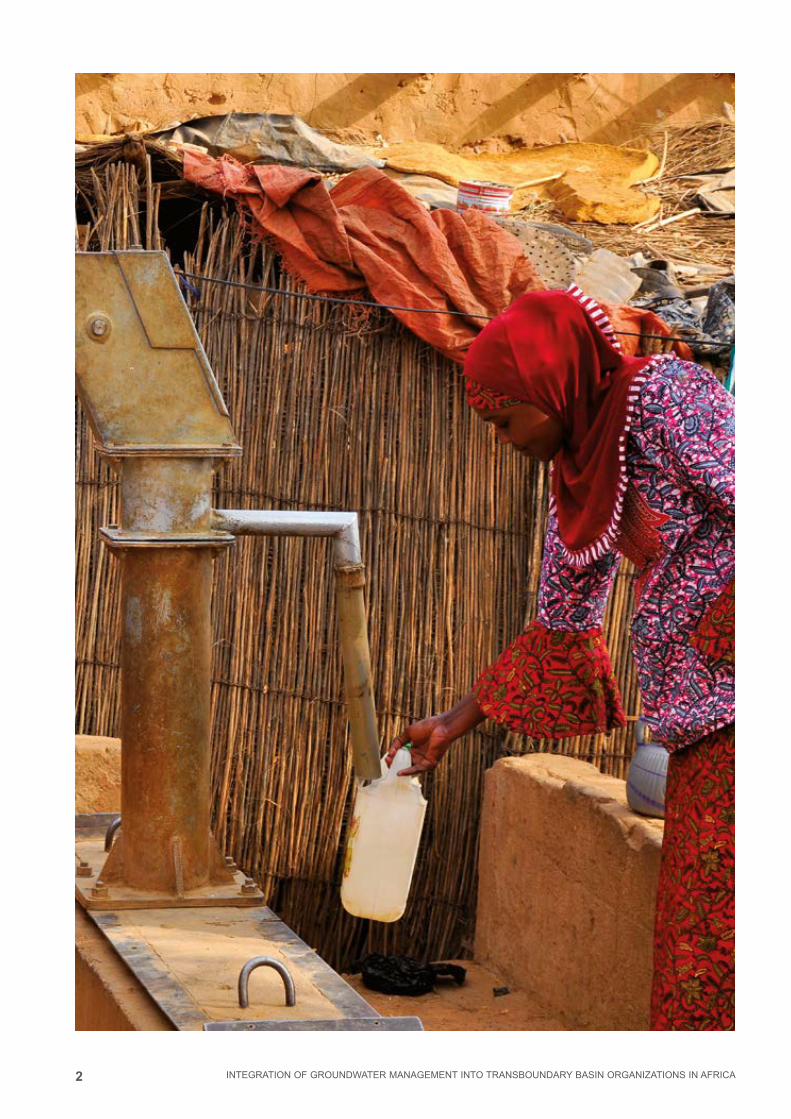
2 INTEGRATION OF GROUNDWATER MANAGEMENT INTO TRANSBOUNDARY BASIN ORGANIZATIONS IN AFRICA

3
6
MODULE
INTEGRATION OF GROUNDWATER MANAGEMENT INTO TRANSBOUNDARY BASIN ORGANIZATIONS IN AFRICA
Groundwater regulation, licensing, allocation and institutionsMODULE 6
Groundwater regulation, licensing, allocation and institutions
6.1 Introduction 4
6.2 Regulation of groundwater within a river basin framework 4
6.3 Groundwater Licensing 7
6.4 Groundwater allocation 9
6.5 Main interactions in groundwater licensing and allocation system 14
6.6 Allocation of non-renewable groundwater resources 15
6.7 Institutional framework for groundwater management 16
6.8 Implementing a groundwater regulatory system 17
6.9 References and further reading 20
6.10 Exercises 21
CONTENT
Imprint
© Copyright 2014, all rights reserved
The use of the manual is FREE of cost. AGW-Net simply requests that users give proper
attribution “Integration of Groundwater Management into Transboundary Basin Organizations in
Africa - a Training Manual by AGW-Net, BGR, IWMI, CapNet, ANBO, & IGRAC” . Modification
is only allowed with permission of AGW-Net.
Photos are copyright to their respective owners.
A4A – aqua for all
AGW-Net – Africa Groundwater Network
ANBO – African Network of Basin Organisations
BGR – Federal institute for geosciences and natural resources
Cap-Net UNDP
BMZ – Federal Ministry for Economic Cooperation and Development
GWP – Global Water Partnership
IGRAC – International Groundwater Resources Assessment Centre
imawesa – Improved Management of Agricultural Water in Eastern and Southern Africa
IWMI - International Water Management Insitute
Editorial Staff: Vanessa Vaessen, Ramon Brentführer – BGR
Layout: ff.mediengestaltung GmbH, Hannover, Germany
Picture: BGR – Bundesanstalt für Geowissenschaften und Rohstoffe, Philip Schuler

4
6
MODULE
INTEGRATION OF GROUNDWATER MANAGEMENT INTO TRANSBOUNDARY BASIN ORGANIZATIONS IN AFRICA
Groundwater regulation, licensing, allocation and institutions
GROUNDWATER REGULATION, LICENSING, ALLOCATION AND INSTITUTIONS
6.1 IntroductionGroundwater regulation is required in order to control groundwater development and ac-
tivities that might compromise groundwater availability and quality; to address increasing
competition and conflict between groundwater users; and to control the increasing threat
of groundwater pollution. Water regulation is an important groundwater management
strategy that is implemented through development and implementation of a licensing
and water allocation system. Groundwater regulation has provisions for issuance of wa-
ter rights or water permits with accompanying conditions to any activity that may affect
the quantity and quality of groundwater. Anybody granted a right or permit has therefore
to ensure that his/her groundwater development or other activities that might compro-
mise groundwater availability conforms to the permit conditions or else he/she is penal-
ized. These standards are set and enforced by the groundwater regulatory agencies.
6.2 Regulation of groundwater within a river basin framework
Overview
It is increasingly recognized that groundwater and surface water impact on each
other and that greater integration of their management is essential. However, al-
though groundwater is recognized as being closely linked to surface water, integrated
management of groundwater and surface water within the framework of river basin
management has not yet been fully realized in Africa. This deficiency can be partially
addressed through groundwater regulations that provide mechanisms for sustainable
management of groundwater and surface water through:
■■ Guidelines for, and limitations to, the exercise of public powers
■■ Provision for the quantification, planning, allocation and conservation of groundwa-
ter resources, including water abstraction and use rights
■■ A system of wastewater discharge licenses, helping to protect groundwater against
pollution
■■ Definition of the rights and duties of groundwater users
■■ Protection of user rights, of the rights of third parties and of the environment
■■ Requirements for the registration of well drillers based on the qualification and
experience of well drillers
LEARNING OBJECTIVES■■ To appreciate the need for regulation of groundwater within the framework of
river basin organizations;
■■ To create awareness about the benefits of a groundwater licensing and alloca-
tion system;
■■ To understand how groundwater licensing and allocation systems may be
implemented and;
■■ To consider the institutional arrangements for groundwater management.

5
6
MODULE
INTEGRATION OF GROUNDWATER MANAGEMENT INTO TRANSBOUNDARY BASIN ORGANIZATIONS IN AFRICA
Groundwater regulation, licensing, allocation and institutions
■■ Possible administrative intervention in critical situations (aquifer depletion, drought
or pollution)
■■ Provision for cooperative interaction between groundwater administrators and
groundwater users.
Groundwater regulation process
Many countries in Africa now require permits or licenses for abstraction of ground-
water, discharge of wastewater and well construction activities. Catchment planning,
aquifer resource planning and land surface zoning are then all subject to their meeting
the requirements stipulated in those permits for groundwater conservation and protec-
tion. Any establishment that is involved in groundwater development and in activities
that might compromise groundwater availability and quality has to obtain a permit or
license in order not to contravene the law. The permit is issued upon application to the
regulatory body that takes into account the conditions of the groundwater system and
the intensity and nature of proposed groundwater abstraction or activity.
Modern groundwater regulation tends to be flexible, enabling and enforceable through
the following actions:
a) Regulation of groundwater abstraction and issuance of water use rights or
permits
Regulation of groundwater abstraction through issuance of groundwater abstrac-
tion/use permits serves as the basis for charging abstraction fees. In many coun-
tries in Africa this is flat rate for any motorized groundwater abstraction while in a
few countries it is based on the volume of water abstracted.
b) Regulation of groundwater pollution and issuance of wastewater discharge
permits
Licensing for the discharge of wastewater into the ground provides for conditions
on the mode of discharge and the level of treatment required, and is designed to
protect groundwater against pollution. The ‘polluter-pays-principle’ is normally em-
bodied in the regulatory framework where charges are related to the pollution load
discharged to the ground.
c) Instituting sanctions for non-compliance
Sanctions in form of penalties are instituted for those who constantly refuse to
comply with the provisions of the laws and permit conditions. These penalties may
range from fines to imprisonment terms, depending upon the severity of impacts
and the persistence of the offence.
d) Controlling well construction activities
Control of water well construction activities by drilling contractors is done to ensure
high standards of well construction, improved reporting on the hydrogeological
conditions encountered, and reduced likelihood of illegal well construction. This is
normally done through issuance of drilling permits.
e) Catchment or aquifer level resource planning
Provision for water resources planning with reference to surface water basins and/

6
6
MODULE
INTEGRATION OF GROUNDWATER MANAGEMENT INTO TRANSBOUNDARY BASIN ORGANIZATIONS IN AFRICA
Groundwater regulation, licensing, allocation and institutions
or aquifer systems is sometimes done based on an inventory of water resources
and of existing uses identified either as part of specific water use assessments or
as part of environmental impact assessments. Such plans provide an integrated
basis for the assessment of individual applications for water rights or permits and
may be legally binding. All decisions on applications must be consistent with their
provisions.
f) Conjunctive use of groundwater and surface water
Recognizing the role of conjunctive water use, it may be advantageous in some
circumstances to have a single permit that covers, for example, both groundwater
abstraction and discharge of effluent of an acceptable quality to a surface water-
course; or a single permit for surface water diversion and use coupled with re-
charge of an effluent of acceptable quality to the ground.
g) Land surface zoning for groundwater conservation and protection
In some countries, legislation provides for the water administrators to declare
‘special control areas’, where exceptional measures (such as restrictions on new
water well drilling and/or groundwater abstraction rates) become possible in the
interest of avoiding further aquifer deterioration. Land surface zoning may also be
targeted to serve the purpose of protecting vulnerable aquifer recharge areas and/
or ground-water supply sources.
In the defined zones, restrictions can be applied in relation to potentially polluting
activities (such as certain types of urbanization, landfill solid waste disposal, haz-
ardous chemical storage and handling facilities, mining and quarrying, etc.). For
the prevention of diffuse pollution from agricultural land use, it is more normal to
introduce bans or import control mechanisms on certain pesticides and to promote
the adoption of codes of good agricultural practices.
h) Facilitating water-user and stakeholder participation
The participation of groundwater users and other stakeholders in groundwater
management has become increasingly acknowledged and appreciated due to the
realization that legal provisions are more likely to be implemented when stakehold-
ers have a say and are actively involved. In addition to local water-user associa-
tions, more widely constituted ‘aquifer management organizations’ may be needed
for large aquifers:
■■ to discuss implementation of measures across user sectors and between wa-
ter-user associations
■■ to agree on priority actions in areas with a critical groundwater situation
■■ to assist the water resource regulator generally in the administration of ground-
water abstraction.
These organizations however need to be given legal status and to be integrated
into broader institutional mechanisms for groundwater resource management and
protection.
i) Provisions for Groundwater Monitoring
Groundwater regulation normally provides for the monitoring of the status of
groundwater in terms of quantity and quality and the use of water by the users

7
6
MODULE
INTEGRATION OF GROUNDWATER MANAGEMENT INTO TRANSBOUNDARY BASIN ORGANIZATIONS IN AFRICA
Groundwater regulation, licensing, allocation and institutions
themselves, but with regular oversight compliance monitoring by the groundwater
regulatory institutions at various levels.
6.3 Groundwater Licensing Water resources have traditionally been allocated on the basis of social criteria, ensur-
ing that water for human consumption, for sanitation, and for the production of food is
given first priority.
Population growth has made water scarcity a major problem in many countries, and
pollution is more widespread today with degrading water quality resulting in less fresh
water available. As a consequence there is greater competition between water for
drinking, irrigation, industry, environment etc.
Most countries in Africa have their water resources in public ownership, with govern-
ment having the overall responsibility for resource management. The right or permit
to abstract (or divert) and use water (including groundwater) can be granted to indi-
viduals, public entities or private corporations, under certain terms or conditions, and
such rights are generally issued by the water resources regulatory authority. A ‘water
right’ or a “water permit” usually constitutes the right to use (but not ownership of) the
water itself. Authorizations to abstract and use groundwater are instrumented through
permits, licenses, concessions or authorizations, generally called here ‘water rights’ or
“water permits”.
Need for a groundwater licensing system
A licensing system for groundwater (through issuance of permits to abstract and to
use groundwater) is aimed at regulating interdependencies among water users. It is
introduced as a means to:
■■ Reduce interference between abstraction wells;
■■ Avoid counterproductive conflicts that may arise, and;
■■ Resolve emerging disputes between neighboring abstractors.
However the development of a comprehensive licensing system has wider benefits,
since it provides a sound foundation for the development and protection of water re-
sources and for the conservation of aquatic ecosystems. Certain other steps towards
more integrated water resources management can only be effectively tackled when a
groundwater licensing system has been effectively established:
■■ Fostering the participation of water users in groundwater management;
■■ Improving economic efficiency;
■■ Implementing demand management programs to reduce groundwater abstraction;
■■ Systematic collection of abstraction charges to raise revenue for resource man-
agement;
■■ Possible subsequent trading of abstraction rights to promote more efficient water
use;
■■ Developing conjunctive use of surface water and groundwater resources.
Although the existence of groundwater licensing systems do not guarantee water supply
of a given quantity and quality, they offer water users greater supply security for invest-
ment purposes and a valuable asset as bank collateral to obtain development credits.

8
6
MODULE
INTEGRATION OF GROUNDWATER MANAGEMENT INTO TRANSBOUNDARY BASIN ORGANIZATIONS IN AFRICA
Groundwater regulation, licensing, allocation and institutions
BOX 6.1 AN EXAMPLE OF A PERMIT (FROM UGANDA)
GROUNDWATER ABSTRACTION PERMIT
(The Water Statute, No. 9 of 1995, and the Water Resources Regulations, 1998)
In exercise of the powers conferred upon the Director by sections 5, 18 and 29
of the Water Statute, 1995; and in accordance with regulation 16 of the Water
Resources Regulations, 1998, this is to grant a Groundwater Abstraction Permit
Number:
To :
To abstract water in accordance with the terms and conditions of this permit
The permit is granted in the terms and conditions set here in the Annex, which
is part of this Permit, and under all other terms and conditions set in the Water
Statute, 1995 and the Water Resources Regulations, 1998
This permit is granted for a period not exceeding 5 year(s), which come into
force on
Monday, November 21, 2005 until Wednesday, November 24, 2010.
Issuance Date: Monday, November 21, 2005
…………………………......................................………….
DIRECTOR OF WATER RESOURCES MANAGEMENT
Setting conditions for water permits
All water permits must be issued with conditions. The set conditions fall into two
categories namely: standard conditions and special conditions. Standard conditions
are derived from the law and apply to all permit holders irrespective of their location
and the nature of activity. Special conditions are specific to the applicant and depend
on the type of activity to be regulated, the amount of groundwater to be abstracted,
the nature and size of the aquifer or area and the special interests to be protected. An
example of a Groundwater Abstraction Permit is indicated in Box 6.1 above.

9
6
MODULE
INTEGRATION OF GROUNDWATER MANAGEMENT INTO TRANSBOUNDARY BASIN ORGANIZATIONS IN AFRICA
Groundwater regulation, licensing, allocation and institutions
Table 6.1: Terms and conditions usually specified in groundwater abstraction and use permits (modified from GW-Mate Briefing note 5)
TERM OR CONDITION COMMENTS
■ duration of right/permit This requires flexibility but ranges between 1 to 5 years
■ points of abstraction and use
These need to be specified as they may vary
■ purpose of use Important to distinguish consumptive and non-consumptive use
■ rate of abstraction This needs to be specified as it is the basis of compliance monitoring and also charging fees
■ specification of works Details of depth, diameter, completion, sanitary protection, etc need to be stated.
■ environmental requirements These deal with any provisions needed to protect the resource or ensure no adverse environmental impacts are caused by groundwater use under the permit
■ permit fees Fee are usually paid for using the water under the permit
■ record of transactions Obligation to declare and submit information on groundwater use and any other information collected as part of the permit
■ loss or reduction of right Forfeiture without compensation for non-use or non-compliance
■ suspension or cancellation of right or permit
Indicates the circumstances under which the permit may be suspended or cancelled as a penalty or in emergency without compensation
■ review of right/permit States the needed periodic adjustment with compensation according to supply/demand
■ renewal of right/permit States requirements and conditions for renewal of the permit
Implications of a groundwater licensing system
Water abstraction and use rights/permit systems should be a comprehensive and
unified system covering groundwater and surface water together. Part of the system
should be made in sufficient detail to minimize conflict between users, and should
specify the condition under which groundwater is abstracted, which may include time,
the rate, the volume and the priority that applies in case of scarcity.
However, water users should be entitled to reasonable security in their continuing right
to abstract and to use groundwater in the interest of stability and to encourage invest-
ments. Appropriate judicial or review mechanisms should be in place to enable ground-
water users and others affected by the impacts to question and to challenge decisions.
The table 6.1 summarizes the main conditions that are usually specified in groundwa-
ter abstraction and use rights/permits.
6.4 Groundwater allocationMain criteria of allocation
Water allocation objectives normally include economic, social and environmental
factors. Appropriate means of resource allocation are necessary to achieve optimal
allocation of the resource. There are several criteria used in water allocation:
■■ Flexibility in the allocation of water, so that the resource can be reallocated from
user to user, place to place, for more social benefits, economic and ecological
uses through periodic review, and avoiding perpetuity in allocation;
■■ Security of tenure for established users, so that they will take necessary measures
to use the resource efficiently; security does not conflict with flexibility as long as
there is a reserve of the resource available to meet unexpected demands.

10
6
MODULE
INTEGRATION OF GROUNDWATER MANAGEMENT INTO TRANSBOUNDARY BASIN ORGANIZATIONS IN AFRICA
Groundwater regulation, licensing, allocation and institutions
■■ Predictability of the outcome of the allocation process, so that the best allocation
can be materialized and uncertainty (especially for transaction costs) is minimized.
■■ Equality in the allocation process is important. Prospective users should perceive
that the allocation process provides equal opportunity gains from utilizing the re-
source to every potential user.
■■ Political and public acceptability, so that the allocation serves publicly approved
values and objectives, and is therefore accepted by all segments in society.
■■ Efficacy, so that the form of allocation changes existing undesirable situations
such as depletion of groundwater and water pollution, and moves towards achiev-
ing desired policy goals.
■■ Administrative feasibility and sustainability, to be able to implement the allocation
mechanism, and to allow a continuing and growing effect of the policy.
Administering a groundwater allocation system
Groundwater allocation should be handled together with surface water allocation
under a single water allocation system. Where administration systems are separate for
various reasons, attempts should be undertaken to integrate them, or if necessary, to
introduce coordinating mechanisms. In this way physical interactions between the two
water bodies are taken into account in water allocation.
River basin organizations need to introduce this ‘conjunctive’ practice of allocating wa-
ter, taking into account both surface and groundwater resources. To be effective, the
responsibilities of the RBO require both understanding and management of groundwa-
ter and aquifer recharge events and linked actions.

11
6
MODULE
INTEGRATION OF GROUNDWATER MANAGEMENT INTO TRANSBOUNDARY BASIN ORGANIZATIONS IN AFRICA
Groundwater regulation, licensing, allocation and institutions
Table 6.2: Special considerations related to groundwater licensing (modified from GW-Mate
CONSIDERATION COMMENTS
Technical
■ groundwater quality concerns
Possible effect of new abstraction and impact of wastewater discharge have to be considered
■ level of surface water connection
Connection between groundwater and surface water varies widely and needs to be considered when evaluating effects on third parties and environment
■ resource replenishment Some aquifers have limited present-day recharge and use of ‘fossil groundwater’ requires special criteria
■ dual purpose of some wells Investigation boreholes may have to be used as production water wells since exploratory drilling is too costly
Managerial
■ well-drilling business Parallel regulation required in view of special skills needed and pollution hazard caused by improperly constructed wells
■ flexibility in water allocation Has to be provided for when dealing with hydrogeological uncertainty and need to prioritize resource reallocation for potable use
■ groundwater conservation areas
May need to be designated to mitigate degradation due to excessive abstraction or pollution threat
■ transboundary aquifers Can lead to disagreements between neighbouring states/nations over resource behaviour and use priorities
Conjunctive use of groundwater and surface water should be encouraged, and admin-
istration systems should ensure that:
■■ The limits to acceptable use of groundwater are clearly specified, usually by speci-
fying a maximum drawdown level in the aquifer; and
■■ The order of priority of use by conjunctive users (i.e. of both sources) is deter-
mined with regard to other users who have only one source.
The table 6.2 summarizes main points to be considered when administering a li-
censing and water allocation system. The level of surface water connection should
be assessed in terms of effects on third parties (users downstream), and to ensure
watercourse baseflow, protection of environmental ecosystems, and sustainability of
springs. This therefore requires consideration of both surface water and groundwater
during groundwater allocation.

12
6
MODULE
INTEGRATION OF GROUNDWATER MANAGEMENT INTO TRANSBOUNDARY BASIN ORGANIZATIONS IN AFRICA
Groundwater regulation, licensing, allocation and institutions
BOX 6.2 CRITICAL CONSIDERATIONS DURING GROUNDWATER ALLOCATION
Complexities and obstacles in implementation:
■ Many historical, social, ecological, economic and political circumstances
influence the exploitation of groundwater resources
■ The complex challenge of monitoring the compliance of groundwater users,
paying attention to existing institutional capacity and the essential role that
users themselves have to play.
‘Enabling environment’ for implementation by:
■ Recognizing that water licensing and allocation must be tailored to the spe-
cific local circumstances
■ Ensuring political support at the highest level, since strong economic inter-
ests are usually affected when allocating/reallocating water resources
■ Thinking twice before calling for legal amendments, to make sure that any
identified shortcomings could not be better overcome without the lengthy pro-
cess of legal reform
■ Starting with definition of water resources policy, which includes the rationale
for amended/new water legislation and an outline of how existing water-use
rights will be handled
■ Admitting that “good” comes before “perfect”, and that a groundwater rights
system does not have to be comprehensive but does have to be workable
■ Being convinced that there will always be room for incremental improvement;
it is not necessary to await the perfect law and ideal institution before starting
action
■ Accepting that the task cannot be achieved overnight; international expe-
rience has shown the design and implementation of water rights systems
always to be a lengthy endeavour
■ Involving all actors from the outset to ensure wide ownership of the system
introduced; both water-user sectors and government personnel administering
the system should participate
■ Stressing that regulatory instruments alone are not enough and that water
rights administration requires a finely-tuned balance of regulatory, economic
and participatory instruments.
Source: Batu, 1998
To ensure better compliance of groundwater users, stakeholder participation should be
enhanced in parallel with information management to give transparency to the alloca-
tion process. Monitoring of water use and water resources is also critical for better
water allocation enforcement.

13
6
MODULE
INTEGRATION OF GROUNDWATER MANAGEMENT INTO TRANSBOUNDARY BASIN ORGANIZATIONS IN AFRICA
Groundwater regulation, licensing, allocation and institutions
A number of implementation tools are required, which should be kept as simple
as possible:
■■ Planning Instruments: spreadsheets of water users and polluter populations, and
aquifer quantity/quality models for prioritization of areas to be controlled;
■■ Managerial Guidelines: procedures for receiving, assessing and monitoring of
applications;
■■ Information System: based on adequate software to manage applications, permit
issuance, monitor user compliance, carry out operational quality control and deliv-
er easily understood information to water users;
■■ Public Education: for raising political and public awareness in general.
Critical aspects that need to be considered in implementing groundwater allocation
(Box 6.2) include the complexity of the implementation process, and the enabling envi-
ronment that may facilitate user compliance.
Figure 6.1: Main interactions on the introduction or consolidation of a groundwater rights system
(adopted from GW Mate Briefing note 5)
original action
response
ACTORS AUTHORITY JUDICIARY
Lawfull Users
■ express appeal
Illegal Users
■ comply ■ express appeal
Affected Stakeholders
■ express appeal ■ file lawsuit
By monitoring may:
■ sanction ■ file lawsuit
From field inspec-tions may:
■ file lawsuit ■ negotiate
Resolve appeal
Resolve lawsuit

14
6
MODULE
INTEGRATION OF GROUNDWATER MANAGEMENT INTO TRANSBOUNDARY BASIN ORGANIZATIONS IN AFRICA
Groundwater regulation, licensing, allocation and institutions
In order to ensure that there is an effective groundwater licensing and allocation sys-
tem, regulatory and enforcement agencies need to pay special attention to key issues
as highlighted in Box 6.3 below.
6.5 Main interactions in groundwater licensing and allocation system
In managing a groundwater licensing and allocation system, the most important actor
is the applicant or holder of a water-use permit (Figure 6.1). But other users in the
same aquifer and its dependent surface water may also be involved. Other stakehold-
ers (not only water users but those whose interests might be affected) may also want
to express an opinion regarding an application for a new water right, to file a complaint
or lawsuit against an existing user, or to appeal against decisions.
The water resource authority can deny the applicant a new water right, or may grant
and register it. Once the application is granted, the applicant becomes a lawful user
who will often have to pay fees and charges according to the terms and conditions
attached to the right. The water resource authority should keep records and monitor
compliance through field inspections and other means. On discovery of non-compli-
ance, the authority can impose a warning, or a sanction, or seek prosecution by the
judiciary if a criminal offence has been committed. In addition, the judiciary may hear
appeals from the water-right holder or from affected third parties. In order to ease the
burden on the judiciary, appeals may be addressed in the first instance to the highest
ranking officer of the water resource authority.
BOX 6.3. KEY PRIORITIES ISSUES FOR REGULATORY AND ENFORCEMENT AGENCIES
■ Sufficient staff of adequate capability to enforce regulations and make appro-
priate assessments;
■ Laws which are practical, enforceable and are based on accurate knowledge
of resource management and environmental impacts
■ Staff who are knowledgeable about good management practices and have
appropriate scientific knowledge
■ A sense of ownership on the part of stakeholders so that they accept the
monitoring, enforcement and regulation procedures; ownership can be built
through use of awareness raising techniques and participatory management
■ Adequate financial resources to support the staff and operations, and trans-
parency in financial management, to minimize regulatory failure;
■ Selecting meaningful indicators for technical, economic and social issues
and appropriate benchmarks;
■ Designing and implementing a program of legal education and awareness
building – for the regulating parties and public at large. This contributes to
putting legal instruments into practice and ensuring that the use of regulatory
instruments is not limited to specialists.

15
6
MODULE
INTEGRATION OF GROUNDWATER MANAGEMENT INTO TRANSBOUNDARY BASIN ORGANIZATIONS IN AFRICA
Groundwater regulation, licensing, allocation and institutions
Management style is as important as management process, because users prefer
a water authority to work with (rather than against) them. This can be achieved by
ensuring that:
■■ Conflict resolution mechanisms are well-accepted, economic and rapid;
■■ Sanctions are balanced to discourage non-compliance but not to cripple water
users;
■■ Monitoring is realistic and commensurate with institutional capacity;
■■ Record-keeping procedures ensure complete copies are available for public scrutiny;
■■ Water authority discretion is limited to discourage corruption but reduce bureau-
cracy;
■■ User bribery and administrator corruption is dealt with decisively.
When water legislation is updated or new laws adopted, difficulties arise because of
pressures from existing users and their political associates to concede exceptions. No
universal rules are applicable, but the following guidelines should be useful.
■■ Existing uses should be effective and beneficial to qualify for automatic recogni-
tion. If it is not possible to compute an accurate groundwater balance, all users
should be given permits of short duration, which can be revised in the light of more
reliable information.
■■ Customary rights should be dealt with comprehensively, either formally recognized
or appropriately compensated.
■■ Not only unlawful users are to blame for the unsatisfactory current status of
groundwater resources; past water administrations may also be responsible be-
cause of lack of capacity or corrupt tendencies.
■■ No exceptions should be tolerated; all existing groundwater users, including public
water-supply utilities, must be brought into the fold of the law.
■■ Specification of abstraction rate thresholds by water use should be a dynamic
process. Certain minor uses may be exempted from water rights bureaucracy, but
simple declaration of existence will prove useful to recognize such lawful users,
should more stringent measures eventually be needed.
6.6 Allocation of non-renewable groundwater resourcesIn the case of non-renewable aquifer systems, implementation of a groundwater ab-
straction rights system is a high priority. It must be consistent with the hydrogeological
reality of continuously declining groundwater levels, potentially decreasing well yields
and possibly deteriorating groundwater quality. Thus the permits (for specified rates
of abstraction at given locations) will need to be time-limited in the long term, but also
subject to an initial review and then modification after 5–10 years. At this time more
will be known about the aquifer response to abstraction through operational monitor-
ing. It is possible that use rules set by appropriately empowered communal organiza-
tions could take the place of more legally formalized abstraction permits.
Many major aquifers containing large reserves of non-renewable groundwater are
transboundary, either in a national sense or between autonomous provinces or states
within a single nation. In such circumstances there will much to be mutually gained
through harmonization of relevant groundwater legislation and regulations, particularly
the groundwater rights systems.

16
6
MODULE
INTEGRATION OF GROUNDWATER MANAGEMENT INTO TRANSBOUNDARY BASIN ORGANIZATIONS IN AFRICA
Groundwater regulation, licensing, allocation and institutions
The water allocation system should take special consideration of:
■■ The impacts of new water allocation on traditional groundwater users (some com-
pensations may be provided);
■■ Ensuring that sufficient reserves of extractable groundwater of acceptable quality
are left in the aquifer system;
■■ The difficulties in estimating the impacts of drawdown on a given ecosystem;
■■ Considering “what happens after?” and then identifying and costing the probable
“exit strategy”, and;
■■ Envisaging re-use of urban, industrial and mining water supplies, and carefully
controlled agricultural irrigation.
6.7 Institutional framework for groundwater management
An enabling environment is required for effective management of water resources,
including groundwater. The institutional arrangements for management of groundwater
resources will bring clarity to the roles and responsibilities of the national and/or pro-
vincial institutions responsible for groundwater resources and define ways of confront-
ing potential constraints to the management process such as inadequate groundwater
management boundaries, weak regulatory enforcement, lack of social consensus,
poor inter-institutional coordination.
Given the problems created by growing water scarcity and pollution, regulatory sys-
tems vest all water resources in the state, or recognize the state’s superior right to the
management of water resources. Thus groundwater has been declared as a ‘public
good’ thereby turning the former owners of groundwater into users, who must apply to
the state for a water abstraction and use rights/permits. Since the state is the guard-
ian or trustee of groundwater resources, it may (in addition to granting water rights)
introduce measures to prevent aquifer depletion and groundwater pollution. Current
legislation tends now to require water resources planning at the level of an entire aqui-
fer or river basin.
An idealized structure and functions for a government agency acting as a groundwater
guardian is suggested in figure 6.2. A separate management organization that devi-
ates for the idealized structure may however be established for management of very
large aquifers. In most cases groundwater management will be fully integrated into
organizations with responsibility for both surface and groundwater. The historical prob-
lem that groundwater management receives inadequate attention under this arrange-
ment needs to be addressed.

17
6
MODULE
INTEGRATION OF GROUNDWATER MANAGEMENT INTO TRANSBOUNDARY BASIN ORGANIZATIONS IN AFRICA
Groundwater regulation, licensing, allocation and institutions
Figure 6.2: Idealised structure and functions for a government agency acting as groundwater
guardian. (Foster & Kemper, 2002-06)
6.8 Implementing a groundwater regulatory system Successful implementation of groundwater regulatory system (table 6.3) depends on a
number of factors including:
■■ The administrative set-up and the level of training of water administrators
■■ A clear understanding of the institutional roles and functions at all relevant levels
■■ An adequate level of public awareness and acceptance of legal provisions
■■ Political willingness to promote and attain sustainable groundwater management.
An administrative set-up suited to national or state conditions should support ground-
water regulation:
■■ At national level: management functions (covering both quantity and quality
aspects) should be vested in a single authority or ministry or (where this is not
considered appropriate) clear institutional mechanisms for coordination between
the competent bodies must be established
■■ At river basin or regional level: the specific situation may warrant the establish-
ment of river basin agencies, especially for the performance of some planning and
coordination functions
■■ At intermediate or local level: it is important to pay careful attention to local insti-
tutional arrangements for water administration; ie. the role of the local authorities
in water resources management (since they represent local interest); the estab-
lishment of intermediate institutions (aquifer management organizations) that have
legal power in relation to specified aquifers and with adequate representation of
different water-user associations, various water-use sectors and a clear-cut rela-
tionship with the local water authority.
Stakeholderspublic supply
sourcespotential pollution sources
Groundwater Resource
Fund
quality assessment
sources
abstraction and use regulation
groundwater data
management
hydrogeological exploration for groundwater development
resource evaluation and strategic planning
groundwater monitoring and impact
mitigation
Stakeholders
existing wells
new wells
StakeholdersInformation
system
MAJOR AQUIFERS MINOR AQUIFERS

18
6
MODULE
INTEGRATION OF GROUNDWATER MANAGEMENT INTO TRANSBOUNDARY BASIN ORGANIZATIONS IN AFRICA
Groundwater regulation, licensing, allocation and institutions
Table 6.3: Key Water Management Function and Institutional roles (modified after GW-Mate, Briefing note 4)
Key Function
Main Activity Institutional Roles
National Water Authority/ RBO
Local Regulatory Agency
Sub-basin/ Aquifer Management Offices
Water Users Associations
POLICY MAKING & STRATEGIC PLANNING
Resource assessment • × ×Use Assessment and Socio-Economic Survey
• × ×
Strategic long-term Planning • × ×International agreements •
RESOURCE MANAGEMENT/ REGULATION
Stakeholder participation
Develop and maintain an active stakeholder participation process through regular consultation activities.Provide specialist advice and technical assistance to local authorities and other stakeholders in IWRM.
• •
•
×
Pollution control
Wastewater Discharge Licenses • • × ×Identify major pollution problems. • • × ×Definition of Protected Areas • • × ×
Water allocation
Water Rights Administration/ License of water uses including enforcement of these.
• • × ×
Licensing of development implementers, e.g. well drillers
• ×
Information management
Define the information outputs required by the water managers and different stakeholder groups in a river basin.
• • × ×
Organise, co-ordinate and manage the information management activities.
• • ×
Setting economic & financial tools
Set fees and charges for water use and pollution
• • ×
19
6
MODULE
INTEGRATION OF GROUNDWATER MANAGEMENT INTO TRANSBOUNDARY BASIN ORGANIZATIONS IN AFRICA
Groundwater regulation, licensing, allocation and institutionsKey
FunctionMain Activity Institutional Roles
National Water Authority/ RBO
Local Regulatory Agency
Sub-basin/ Aquifer Management Offices
Water Users Associations
Basin Action Plans
Conduct situation analysis with stakeholders.
• • ×
Assess future developments in the basin.
•
Emergency Situations
Structural/ non-structural measures for flood/drought mitigation
• × × ×
Disaster preparedness • • ×Monitoring & Enforcement
Water Status survey/ database (quantity/quality/ socio-economic)
• • × ×
Water Use and pollution • • × ×Conflict resolution • • ×
MONITORING AND EVALUATION
data collection activities of multiple agencies
• × × ×
Regular stakeholder communication •Packaging information in a way that is readily understandable to the target group and that addresses their needs or concerns.
•
•, × indicate respectively responsibility for, and participation in, the corresponding management
function, but the situation will vary somewhat from country to country depending upon their
geographical size and political structure.

20
6
MODULE
INTEGRATION OF GROUNDWATER MANAGEMENT INTO TRANSBOUNDARY BASIN ORGANIZATIONS IN AFRICA
Groundwater regulation, licensing, allocation and institutions
6.9 References and further reading
CAPNET, 2010. Groundwater management in IWRM- Training manual, 2010
GW•MATE, 2002-2006,
Briefing Note 4. Groundwater Legislation and Regulatory Provision- from cus-
tomery rules to integrated catchment planning.
Stephen Foster & Karin Kemper, 2002-2006.
Sustainable Groundwater Management: Concepts and Tools Sustainable
Groundwater Management. Concepts & Tools, Series Overview.
Ariel Dinar, Mark W. Rosegrant, and Ruth Meinzen-Dick.
Water Allocation Mechanisms Principles and Examples.
Bird, J., W. Lincklaen Arriens & D. Von Custodio, 2008.
Water Rights and Water Allocation. Issues and Challenges for the Region. Asian
Development Bank
.
GW•MATE, 2002-2006,
Briefing Note 5. Groundwater Abstraction Rights- from theory to practice
Howe, C. W., Schurmeier, D. R. and Shaw, W. D. Jr. 1986.
Innovative Approaches to Water Allocation: The Potential for Water Markets.
Water Resources Research,
22(4):439-445.

21
6
EXERCICE
INTEGRATION OF GROUNDWATER MANAGEMENT INTO TRANSBOUNDARY BASIN ORGANIZATIONS IN AFRICA
Groundwater regulation, licensing, allocation and institutions
6.10 ExercisesTo promote good discussion to consider what elements of the legislation,
regulation and allocation could be undertaken at regional TBO level and what at
national BO level. Is the regional level useful to agree common policies/ frameworks
and the country level BOs where the application will take place?
EXERCISE 1
IMPLEMENTING GROUNDWATER REGULATORY AND ALLOCATION SYSTEMSPurpose
To share experience in implementation of groundwater regulatory and allocation
systems at national and transboundary levels
Activity: break into two groups and discuss:
1. Regulation of groundwater at national and transboundary levels highlighting
differences and similarities
2. Key considerations during development and implementation of an allocation
system for transboundary groundwater resources
Duration: 45 minutes
EXERCISE 2
ENFORCEMENT OF GROUNDWATER REGULATIONS AND PERMIT CONDITIONSPurpose
To share experiences in enforcement of groundwater regulations and permit
conditions
Activity: break into two groups and discuss:
Enforcement of groundwater regulations and permit conditions at national and
transboundary levels highlighting possible enforcement mechanisms to employ,
challenges expected at each of the levels and how can they be addressed.
Duration: 45 minutes

7
MODULE
INTEGRATION OF GROUNDWATER MANAGEMENT INTO TRANSBOUNDARY BASIN ORGANIZATIONS IN AFRICA
THE ROLE OF STAKEHOLDER PARTICIPATION AND COMMUNICATION IN GROUNDWATER MANAGEMENT

2 INTEGRATION OF GROUNDWATER MANAGEMENT INTO TRANSBOUNDARY BASIN ORGANIZATIONS IN AFRICA

3
7
MODULE
INTEGRATION OF GROUNDWATER MANAGEMENT INTO TRANSBOUNDARY BASIN ORGANIZATIONS IN AFRICA
The role of stakeholder participation and communication
in groundwater management MODULE 7The role of stakeholder participation and communication in groundwater management
7.1 Why Stakeholder Involvement? 4
7.2 Who does Stakeholder Participation and how is it done? 6
7.3 IdentificationandAssessmentofKeyStakeholders 8
7.4 InstitutionalMechanismsforStakeholderParticipationinGroundwater
Management 10
7.5 StakeholderfunctionsinGroundwaterManagement 12
7.6 WhoareGroundwaterStakeholdersforTransboundaryBasin
Organizations? 12
7.7 WhatisCommunicationandwhyisitimportantinGroundwater
Management? 13
7.8 Furtherreading 16
7.9 EXERCISE 17
CONTENU
Imprint
© Copyright 2014, all rights reserved
The use of the manual is FREE of cost. AGW-Net simply requests that users give proper
attribution “Integration of Groundwater Management into Transboundary Basin Organizations in
Africa - a Training Manual by AGW-Net, BGR, IWMI, CapNet, ANBO, & IGRAC” . Modification
is only allowed with permission of AGW-Net.
Photos are copyright to their respective owners.
A4A – aqua for all
AGW-Net – Africa Groundwater Network
ANBO – African Network of Basin Organisations
BGR – Federal institute for geosciences and natural resources
Cap-Net UNDP
BMZ – Federal Ministry for Economic Cooperation and Development
GWP – Global Water Partnership
IGRAC – International Groundwater Resources Assessment Centre
imawesa – Improved Management of Agricultural Water in Eastern and Southern Africa
IWMI - International Water Management Insitute
Editorial Staff: Vanessa Vaessen, Ramon Brentführer – BGR
Layout: ff.mediengestaltung GmbH, Hannover, Germany
Picture: Bundesanstalt für Geowissenschaften und Rohstoffe

4
7
MODULE
INTEGRATION OF GROUNDWATER MANAGEMENT INTO TRANSBOUNDARY BASIN ORGANIZATIONS IN AFRICA
The role of stakeholder participation and communication in groundwater management
THE ROLE OF STAKEHOLDER PARTICIPATION AND COMMUNICATION IN GROUNDWATER MANAGEMENT
7.1 Why Stakeholder Involvement?Thenotionthatstakeholdersshouldhaveasayinthemanagementofthewaterre-
sourcesonwhichtheydependisoneofthebuildingblocksoftheconceptofintegrat-
edwaterresourcesmanagement(IWRM).Themainreasonwhystakeholderpartici-
pationisimportantisthatstakeholderinterestin,andacceptanceof,thegroundwater
managementsystemisaprerequisiteforitssuccessfulimplementation.
Thekeydifferencesbetweenmanagementofsurfacewatersystemsandgroundwater
systems are that in groundwater systems:
■■ Theusersareoftenincontrolofthe“on-off”switchandcanpumpwaterfrom
privatelyownedwellswhentheywantwithoutreferencetoacontrollingauthority.
Surfacewaterontheotherhandisoftendistributedviaacentralauthority.
■■ Theremaybemanythousandsofprivateboreholesanduserswithinagroundwa-
termanagementarea,whichmakesmanagementandcontrolbyacentralauthori-
tyimpossible.
■■ Forthisreason,thetaskofmanagingandmonitoringtheaquifermustinvolvethe
users,supportedbythecatchment/aquiferauthority.
Stakeholderstypicallywanttoparticipatebecausetheyhaveaninterestinthere-
sourcesofaparticularaquiferthattheywanttoprotectoradvance.Thismaybebe-
causetheyuse(orwanttouse)groundwater,orbecausetheypractiseactivitiesthat
couldcausegroundwaterpollution,orbecausetheyareconcernedwithgroundwater
availabilityandenvironmentalimpactsduetotheirownorother’sactivities.
LEARNING OBJECTIVES■■ Toappreciatetheessentialroleofstakeholdersforgroundwatermanagement.
■■ Tounderstandwaystocategorisestakeholdersandtoidentifydifferentstake-
holderinterestsandresponsibilities.
■■ Toreceiveguidanceonmaintaininggroundwaterawarenessandstakeholder
participation over time.
■■ Tounderstandtheimportanceofadvocacyandpropercommunicationtosup-
port groundwater management.

5
7
MODULE
INTEGRATION OF GROUNDWATER MANAGEMENT INTO TRANSBOUNDARY BASIN ORGANIZATIONS IN AFRICA
The role of stakeholder participation and communication
in groundwater management
Stakeholdersneedtoparticipatebecausemanagementdecisionstakenunilaterally
bytheregulatoryagencywithoutsocialconsensusareoftenimpossibletoimplement.
Essentialmanagementactivities(suchasmonitoring,inspectionandfeecollection)
canbecarriedoutmoreeffectivelyandeconomicallythroughcooperativeeffortsand
sharedburdens.Benefitsthatarisefromstakeholderparticipationare:
■■ moreinformedandtransparentdecision-making;
■■ conflict preventionbydevelopmentofconsensusandinformationsharing;
■■ social benefits,becauseittendstopromoteequityamongusers;
■■ economic benefits,becauseittendstooptimizepumpingandreduceenergy
costs;
■■ technical benefits,becauseitusuallyinvolvesstakeholdersinmaintenanceand
leadstobetterestimatesofwaterabstraction;
■■ environmental benefits,becausespecificlocalconcernsareaddressedand
incorporated into the management
■■ management benefits,becausetheytriggerlocalstakeholderinitiativestoimple-
mentdemandandsupplymeasuresandreducethecostofregulation.
Additionally,andveryimportantly,participatorymanagementofhighlystressedaqui-
fersshouldhelp in the implementation of otherwise unpopular decisions such
as jointly changing groundwater consumption patterns in the long-term communal
interest.
Other stakeholder decisions may also relate to land use, waste management, and
protectedareas.Byinvolvingstakeholders,thishelpstoimproveoverallgovernance
oftheresourcebygivingcredibilityandaccountabilitytothemanagementprocess.
Stakeholderinvolvementshouldbeseenasanon-going,long-termprocessthat
adapts to the contextual conditions and needs, and changes therein. Stakeholders,
particularly groundwater users, will tend to have a long-term interest in protecting
theaquiferandensuringthatgroundwateruseissustainable.Theirinterestinman-
agementisusuallydeeperthan‘catchmentmanagers’whomayhaveajobdefinition
thatincludesmanagingtheaquifer,butwhoselivelihoodsandnotdependentonthe
groundwater that they manage.
Itisinthiscontextthatthecatchmentoraquifer‘authority’shouldconsiderandvalue
theinputfromandtheneedsofthestakeholders.
What specific
benefits from
stakeholder
participation can
you identify in your
Basin?

6
7
MODULE
INTEGRATION OF GROUNDWATER MANAGEMENT INTO TRANSBOUNDARY BASIN ORGANIZATIONS IN AFRICA
The role of stakeholder participation and communication in groundwater management
7.2 Who does Stakeholder Participation and how is it done?
Theparticipationofstakeholderscantakemanyforms.Atitsmostsuccessfullevel
itcanoccurevenwithoutformalorganization–andthereareseveralexamplesof
groundwaterbeingmanagedatlocallevelbystrongcommunityvaluesandnorms
withoutgroundwateruserassociationsortheinitiativeofawaterresourceregulatory
agency.Thiscouldbecalledautonomousstakeholderparticipation.
Howeverinmostcasessomesortofexternalsupportmaybeneededtoensurestake-
holdermobilisationandparticipationindecision-makingbodiesandprocesses.Inthe
theory,thereisadistinctionbetweendifferentlevelsofparticipation,fromnominal
consultationtogenuineinvolvementofthestakeholders(Table7.1)
Stakeholdermobilisationmaytakeplaceatanytimeforavarietyreasons,anditis
importanttobeclearonthepurposeofstakeholdermobilisation.Itmaybeforinfor-
mation gathering; to assist with compliance and water level monitoring; or to carry out
variousmanagementfunctionsintheirlocalarea.Itisimportanttobehonestwithone-
selfaswellasthestakeholdersastowhattheexpectationsare.Unfortunately,stake-
holderparticipationisoftencarriedoutjusttocomplywithdonorandotherprocedural
requirements.
Despitethelonganddifficultprocessofmobilisingandorganisingthestakeholders,
thelargestchallengeisprobablytomaintainactivestakeholderparticipationover
time.Akeyistoensurethatthestakeholdersseethebenefitoftheirparticipation.For
many stakeholders, water resources management may seem only negative since they
aresuddenlyfacedwithrestrictionofwaterabstractionsandeffluentdischargesor
demandswithregardtoself-monitoring.Inaddition,theymayhavetotaketimefrom
theirownworkactivitiestoparticipate.Inthisregard,itisaresponsibilityofthewater
managementagencytoprovideandpresentconcreteincentivesandbenefitsofbeing
involvedinthewaterresourcesmanagementprocessintheriverbasin.
Long-termeffectiveparticipationwillrequirecommunicationofinformationandacces-
sibilityandtransparencyregardingthegroundwatersituationanddataresultingfrom
monitoringandallotheraspectsofwatermanagementinthearea.Thiswillneedto
bepresentedinformatssuitableforeasyinterpretationandmayembraceavariety
oftargetgroupsasstakeholdersingroundwatermanagementwhoarenotexperts.
Thesemayincludegovernmentdepartments,politicians,localgovernmentaswellas
community representatives.

7
7
MODULE
INTEGRATION OF GROUNDWATER MANAGEMENT INTO TRANSBOUNDARY BASIN ORGANIZATIONS IN AFRICA
The role of stakeholder participation and communication
in groundwater management
Table 7.1: Types of stakeholder participation
Characteristics
Manipulative participation Participation is simply a pretence
Passive participation has been decided or has already happened. Information sharedbelongs only to external professionals
Participation by consultation
People participate by being consulted or by answering questions. Noshare in decision-making is conceded and professionals are under noobligation to take on board people’s views
Participation for material incentives
People participate in return for food, cash or other materialincentives. Local people have no stake in prolonging practices when the incentives end
Functional participation Participation is seen by external agencies as a means to achieveproject goals, especially reduced cost. People may participate byforming groups to meet predetermined project objectives
Interactive participation People participate in joint analysis, which leads to action plans and the formation or strengthening of local groups or institutions thatdetermine how available resources are used. Learning method isused to seek multiple viewpoints
Self-mobilization People participate by taking initiatives independently of externalinstitutions. They develop contacts with external institutions forresources and technical advice but retain control over how resourcesare used
Source:DalalClaytonB,BassS(2002)
Some mechanisms that build commitment are:
■■ Makecomplexgroundwatersituationsunderstandable
through proper communication (see section 6)
■■ Empower stakeholder organizations through having de-
cision power over their own local water resources and
throughinformation
■■ Ensure all stakeholders are properly represented in
higher-levelmanagementbodies
■■ Supporttheimplementationofclear,equitable,and
easilyenforceablelocalgroundwatermanagement
regulations
What experiences have you had in
dealing with stakeholders in groundwater
management?
Has your catchment authority established
any formal stakeholder management groups?
What have you learned about stakeholder
participation from that exercise?
The key lesson from experiences all over the world is that groundwater
management is more about mobilising (enabling and nurturing) users and
other stakeholders to manage their interactions among themselves and
with “their” aquifer than a top-down resource management.
Another lesson is that the stakeholder engagement strategy is an integral
and continuous component of groundwater management and is not a
once-off event.

8
7
MODULE
INTEGRATION OF GROUNDWATER MANAGEMENT INTO TRANSBOUNDARY BASIN ORGANIZATIONS IN AFRICA
The role of stakeholder participation and communication in groundwater management
7.3 Identification and Assessment of Key StakeholdersAkeypurposeofstakeholderanalysisistoensurethatthegroundwatermanagers
andthestakeholdersadequatelyunderstandthestakesofdifferentinterestgroups,
includingtheirexpectationsandskills.Itshouldbelinkedtothedevelopmentofan
institutionalprocessoflong-termengagementwithstakeholdersingroundwaterman-
agement(seesection7.4forexamples).
Step 1: Identification and grouping of key stakeholders in the groundwater man-
agement area1.
■■ Whoarethepotentialbeneficiaries?
■■ Whoareormightbeadverselyimpacted?
■■ Havevulnerablegroups22whomaybeimpactedbeenidentified?
■■ Havesupportersandopponentsofchangestowatermanagementsystemsbeen
identified?
■■ Aregenderinterestsadequatelyidentifiedandrepresented?
■■ What are the relationships among the stakeholders?
■■ Arethereimportantstakeholdersoutsidethearea?
Acommonproblemwhendealingwithstakeholderidentificationistodefinethe
groundwatersystemboundaries.
Wateraffectssocietyinmanywaysandthesocioeconomicdevelopmentofamajoraq-
uiferinacountrymayaffectstakeholdersonthenationalandeveninternationalscale.
Anexampleistheestablishmentofadrinkingwaterbottlingcompanyinthearea.Itwill
have local as well as national and even potentially international stakeholders.
Step 2: Assess stakeholder interests andthepotentialimpactofaprojectora
developmentpathwayontheseinterests.Oncethekeystakeholdershavebeeniden-
tified,thepossibleinterestthatthesegroupsorindividualsmayhaveingroundwater
canbeconsidered(Table7.2).Questionstoanswerinordertoassesstheinterestsof
differentstakeholdersorstakeholdergroupsinclude:
■■ What are the stakeholder expectations?
■■ Whatbenefitsarelikelytoresultforthestakeholder?
■■ Whatresourcesmightthestakeholderbeableandwillingtomobilizeinaprocess
ofdevelopingmanagementandadaptivecapacity?
■■ WhatstakeholderinterestsconflictwithgroundwatermanagementandIWRM
goals?
■■ Which stakeholders may have antagonistic interests?
Itisimportanttorealizewhenassessingtheinterestsofthedifferentstakeholdersthat
some stakeholders may have hidden, multiple, or contradictory aims and interests that
theywillseektopromoteanddefend.
1 Thiscouldbea(sub)riverbasin,anaquiferarea,oranyidentifiedareawithparticularneedforintensifiedgroundwater management.
2 Thesemaybepoorpeopleorpeopleparticularydependentongroundwaterorgroundwaterdependentecosystems.

9
7
MODULE
INTEGRATION OF GROUNDWATER MANAGEMENT INTO TRANSBOUNDARY BASIN ORGANIZATIONS IN AFRICA
The role of stakeholder participation and communication
in groundwater management
Table 7.2. Potential range of interests and activities of groundwater stakeholders. GW-Mate 2010
Sector / Stakeholder
Water-use Classes Polluting Process Other Categories of Stakeholders
Rural / Farmers domestic supply; livestock rearing; subsistence agriculture; commercial irrigation.
household waste disposal, farmyard drainage; intensive cropping (pesticide / herbicidepollution); wastewater irrigation. drilling contractors;
educational establishments;professionalassociations; journalists/mass media;relevant government entities.
Urban / Municipalities / Householder
water utilities; private supply
urban wastewater;disposal/reuse;municipal landfills.
Industry & mining self-suppliedcompanies.
wastewater discharge; solid waste disposal; chemical/oil storagefacilities
Tourism hotels and campsites. wastewater discharge; solid waste disposal.
Environment river/wetlandecosystems; coastal lagoons.
Step 3: Assess stakeholder influence and importance. In the third step, the task
istoassesstheinfluenceandimportanceofthestakeholdersidentifiedinStep1and
categorisethemaccordingly(Table7.3).Influencereferstothepowerthatthestake-
holdershave,suchasformalcontroloverthedecision-makingprocessorinformal
inthesenseofhinderingorfacilitatingimplementationofgroundwatermanagement
processes.
Adifficultproblemistheoneofrepresentation-itisnotpossibletoconsultorinvolve
everyoneandforformalstakeholderstructuresthereisneedforrepresentationtobe
legitimate.
Itisalsoimportanttoidentifyrelevantgovernmententitieswithinfluenceorimpact
on groundwater management such as agriculture (land use), environment (land use,
pollution management, and ecosystem health) as stakeholders so as to engage them
in strategy development and implementation.
Boththeinfluenceandimportanceofthedifferentstakeholderscanberankedalong
simplescalesandmappedagainsteachother.Thisexerciseisanecessarystepin
determiningtheappropriatestrategyfortheinvolvementofthedifferentstakeholders.
Someconsiderationneedstobegiventothepositionofthosethatdonot(yet)use
groundwater.Itwilloftennotbesociallyandpracticallypossibletoexcludecurrent
non-usersfromusinggroundwaterinthefuture,andmanagementarrangementsthat
definetherulesofaccessfornewusersarerequired.

10
7
MODULE
INTEGRATION OF GROUNDWATER MANAGEMENT INTO TRANSBOUNDARY BASIN ORGANIZATIONS IN AFRICA
The role of stakeholder participation and communication in groundwater management
Table 7.3. Categories of Stakeholders
A. High interest/Importance, High Influence
These stakeholders are the basis for aneffective coalition of support.
B. High Interest/Importance, Low influence
These stakeholders will require special attentionif their interests are to be protected.
C. Low Interest/Importance, High influence
These stakeholders can influence the outcomesbut their priorities may not be those ofgroundwater management. They may be arisk to progress, but could also present anopportunity if incentivised.
D. Low Interest/Importance, Low influence
These stakeholders are of least importance tothe project.
Inordertoassesstheimportanceandinfluenceofthestakeholderstrytoassess:
■■ Thepowerandstatus(political,socialandeconomic)ofthestakeholder.
■■ Thedegreeoforganizationofthestakeholder.
■■ Thecontrolthestakeholderhasoverstrategicresources.
■■ Theinformalinfluenceofthestakeholder(personalconnections,etc.).
■■ Theimportanceofthesestakeholderstothesuccessofgroundwatermanage-
ment.
7.4 Institutional Mechanisms for Stakeholder Participation in Groundwater Management
Stakeholder participation in groundwater management can take place at various
territoriallevels,rangingfromindividualwaterwellstoanaquifersystemandevento
theriverbasinornationallevel.Someexamplesofwatermanagementinstitutionsfor
stakeholderinvolvementinAfricaaregiveninthefollowingparagraphs.
Wateruserassociations(WUAs)inlocalcommunitieshelpindistributinggroundwa-
terfromwellsorspringstotheirmembersfordomesticusesandirrigation,collecting
operational charges and settling water disputes in accordance with customary rules. In
principle,theWUAsrepresenttheinterestsoftheusersandensureequitableac-
cess,andreliableandcost-efficientwatersupply.OftentheremitofWUAsislimited
tooperationandmaintenanceofthewatersupplyandanydistributionsystems,and
onlyweaklylinkedwiththemanagementandprotectionoftheresource.Itisimportant
tobroadentheirmandate(ortocreatespecialorganizations)toaddressgroundwater
resourcemanagementandprotectionwithrecognizedlegal(formalorinformal)rights
andduties,andtovestthemwithjudicialpersonality,soastofacilitatetheirworkand
enablecontractualrelationswithlocalwaterandlandregulatoryagencies.Insome
cases,WUAsrelatetobothsurfacewaterandgroundwatersources,andherethe
specificrightsanddutiesofgroundwaterusersmustbeclearlydefined.Also,the
WUAsneedtohavecertainautonomyinrelationtolocalgroundwatermanagement,
whilealsoadheringtopoliciesandregulationsofhigher-levelwatermanagement
organisations,suchastheriverbasinorganisations.
Otherformsoflocalorganisationsofwaterusersaregroundwaterusergroups
(GWUGs)andvillagewater-supplycouncils(VWSCs).Theyoftenplayakeyrolefor
irrigation water provision and drinking water-supply protection (and in some cases
Could you
give examples
of each of these
categories in your
basin area?

11
7
MODULE
INTEGRATION OF GROUNDWATER MANAGEMENT INTO TRANSBOUNDARY BASIN ORGANIZATIONS IN AFRICA
The role of stakeholder participation and communication
in groundwater management
sanitation)inruralareas,andtheirrolescanbeextendedtomanagedemandand
enhancesupply.Inthecaseofsmallaquifersand/orsituationswithweakgovernment
institutionalcapacity,non-governmentalorganizations(NGOs)canbeofgreathelpfor
promotingstakeholderparticipationandgroundwatermanagement,buttheyneedto
besupportedoroverviewedbythelocalorregionalwaterresourcesagency.
Inthecaseoflargerhigh-yieldingaquifers,whichoftenincludemorediverseinterests,
higher-levelstakeholderparticipationthroughanaquifermanagementorganization
(AMOR)isrequiredandshouldincludealllocalWUAs,GWUGsandVWSCs,and
othermaincategoriesofstakeholders.AMORsshouldalsoincluderepresentatives
ofnationaland/orlocal(ground)waterresourceagenciesandofthecorresponding
localgovernmentauthority,andinsomecircumstancescan(andshould)beformed
attheinitiativeofthenationalwateradministration,especiallywhenzoneswithcritical
groundwater status are declared.
Identification and delineation of groundwater management areas (GMA)
Regardlessofthesizeoftheaquifer,stakeholderparticipationneedstobedefined
aroundcoherentgroundwaterbodies.Thedelineationofappropriateboundariesfor
agroundwaterbody(groundwatermanagementarea)foranAMOR,andevenfor
simplerformsoforganizationinsmalleraquifers,iscritical.Thiswillnotalwaysbe
straightforward,especiallyforlargeaquifersystemswithlowhydraulicgradients,and
sub-divisionintogroundwaterbodieswillneedtobedoneaslogicallyaspossible.
Whentheso-definedgroundwaterbodyispartofalargeraquifersystem,itisimpor-
tanttoestablishinstitutionalmechanismstointegrategroundwatermanagementand
stakeholder participation at the system level.
Sincemostshallowaquifersystemsareinterconnectedwithsurfacewatersystems,
AMORs(orequivalentorganisations)shouldberepresentedinriverbasinagencies–
somethingthatatpresenthardlyeveroccurs.Moreover,representativesofthevarious
maincategoriesofgroundwaterstakeholdersshouldbecalledupontocommenton
high-levelpolicydecisionsatnationalriverbasincommissionlevel.InFigure7.1,a
schematicoftheinstitutionalframeworkforZimbabwe,basedonrivercatchments,
showsthevariouslevelsofrepresentationanddegreesofinteraction,whichcanvary
somewhataccordingtothespecificcase.Representationofstakeholdersathigher
levelisgovernedbyofficialproceduresintheWUAsandtheCatchmentCouncils.
Figure 7.1: An example of institutional framework for stakeholder participation
Zimbabwe: institutional framework
Government
ZINWA Board
ZINWA
Stakeholders
Catchmentmanager
4 catchmentchairpersons
Catchmentcouncil
Sub catchmentcouncil
WUAWUA WUA(WUA = Water Users Association)
Which bodies
and (ground)water
management units
are applicable to
your Country /
Basin?
12
7
MODULE
INTEGRATION OF GROUNDWATER MANAGEMENT INTO TRANSBOUNDARY BASIN ORGANIZATIONS IN AFRICA
The role of stakeholder participation and communication in groundwater management
7.5 Stakeholder functions in Groundwater ManagementTherearemanywaysinwhichstakeholdersmayparticipateinthemanagementof
groundwaterresourcesandaquifersystems(Table7.4).Somemeasuresarerelatively
easytoimplementandenforcelocally(maintainingdistancebetweenwaterwellsor
bansoncertaintypesofcrops).Othermeasuresrequiremorecoordination(likemoni-
toring,settingtargets)andwillbeeasiertoimplementifAMORs,GWUGs,WUAs(and
localNGOsactingontheirbehalf)arerecognizedandsupportedbythelocal(ground)
waterresourceagencyandbytheusercommunities.
Table 7.4: Functions commonly performed or supported by stakeholders in participatory schemes of groundwater administration and management
Stakeholder functions inGroundwater Management
Level at which function performed
Water UserAssociation
Water Mgmt Agency
NationalAuthority
Maintain GW supply / distribution
Collect water use charges
Groundwater monitoring
Make rules on water use
Policing of groundwater use
Implement GW protection
Participate in setting targets
Settle groundwater disputes
7.6 Who are Groundwater Stakeholders for Transboundary Basin Organizations?
Thekeystakeholdersforgroundwatermanagementintransboundarybasinorgani-
zationsareusuallyverydifferentfromthekeystakeholdersinaninternalornational
catchment authority. Internal catchment authorities will normally interact with various
groupsofgroundwaterusersandthesethenarethecommunitiesthatwillbecomein-
volved in the various stakeholder participatory management organizations, at various
differentlevelsandscales.
ForTBOs,thereisalmostneveranydirectlinkorinteractionwithactualgroundwa-
terusers.Thestakeholdersintransboundarygroundwatermanagementwillalmost
alwaysbethenationalwaterauthoritiesintheriparianstatesandtherewillmostlikely
bedirectinteractionwithsuchauthoritiesontransboundarygroundwatermanagement
issues.Evenatcatchmentcouncilandsub-catchmentcouncillevel,therewillprobably
beverylittleornodirectinteractionwiththeTBO.
NeverthelessTBOshaveavitalroleintransboundarygroundwatermanagementsince
theycaninthefirstinstanceserveasaformalconduitforreportinganytransboundary
impactsofgroundwaterabstractionorgroundwaterpollutioninriparianstates.The

13
7
MODULE
INTEGRATION OF GROUNDWATER MANAGEMENT INTO TRANSBOUNDARY BASIN ORGANIZATIONS IN AFRICA
The role of stakeholder participation and communication
in groundwater management
TBOcanprovideanofficiallegallyconstitutedforumwherenationalgroundwaterau-
thoritiescanbringsuchissues,andwheretheresolutionofsuchissuescanbeaired.
TheTBOprovidesanappropriateinstitutionaledificewheretransboundarygroundwa-
ter management can take place through such instruments as:
■■ maintenanceofatransboundarydatabasefortheaffectedaquifers,
■■ planninginstrumentsandguidelinesonmonitoringabstraction,waterlevelsand
water quality,
■■ transboundaryinteractivegroundwatermodelsfortheaffectedaquifers
■■ settingabstractionallocationsandeffluentdischargelimitsand
■■ providingaforumforresolvingdisputes.
7.7 What is Communication and why is it important in Groundwater Management?
Communicationgoesbeyondinformationmanagementanddealswithalltheneces-
saryinteractionsbetweenthestakeholdersingroundwaterresourcesmanagement.
Herewearedealingmostlywiththeissueofcommunicatingandconsultingon
groundwater with stakeholders in order to support their participation in local and
broadermanagementoftheresource.
Therearetwokeytypestocommunicationforstakeholderparticipationingroundwater
management:
■■ Thefirstrelatestogeneratingaclearunderstandingofthegroundwaterresource,
howitexists,howitgetsrecharged,howitrespondstoabstraction,howitre-
spondstopollutionetc.Thistypeofcommunicationismostlyeducativesothat
stakeholderbetterunderstandtheresourcethatmaywellunderpintheirliveli-
hoods.
■■ Thesecondisfocusedoninformingthestakeholderwhoareparticipatingin
groundwatermanagement(especiallythoseusingtheresource),ontheresultsof
theirmonitoringofwaterlevels,theircompliancewithabstractionallocations,the
qualityoftheirgroundwaterresource,therecharge.Thisensurestheircontinued
interestinhelpingtomanagetheresourcebecausetheycanseetheeffectsof
theirparticipationinmanagementandinenforcement.
Afundamentalchallengeistoconveyanddiscussthekeyconceptsofgroundwater,
realisingthefrequentmisconceptionsthatexistwithstakeholderswhohavenoback-
ground in groundwater and hydrogeology.
Typical“myths”ongroundwateraredescribedinGWMATEBriefingnoteno.2and
includemisunderstandingssuchas“thegroundwaterresourceisinfinitecompared
toitsabstraction”and“thepumpingofgroundwaterhasnodownstreameffect”.The
groundwaterprofessionalshavetocommunicateaninvisibleresourcetothelocaluser
andthepolicylevelstakeholders(“outofpublicsight,outofpoliticalmind”).
Are groundwater communication materials produced in your basin clear enough for policy makers, decision makers and other stakeholders?

14
7
MODULE
INTEGRATION OF GROUNDWATER MANAGEMENT INTO TRANSBOUNDARY BASIN ORGANIZATIONS IN AFRICA
The role of stakeholder participation and communication in groundwater management
Thekeyconceptsingroundwatercommunicationare:
■■ Thestakeholdersarenotgroundwaterexpertsandhavedifferentbackgrounds
andinterests.Incommunicatingthegroundwatermessage,itshouldberealized
thattherearedifferentperceptions,differentinterestsandviewsamongthestake-
holdersandthisshouldbekeptinmindwhendesigningacommunicationstrategy
andmaterial(figure7.2).
■■ Theimageofgroundwaterchanges.Inearlystagesofdevelopment,theresource
seemstobeinfiniteandthereislittleornoincentiveformanagement.Manage-
mentneedsariseusuallywhenstressontheresourceincreasesandconflicts
arisebetweenusers.Ifmanagementandregulationarenotintroducedeffec-
tively (or only partially) the stress on the resource remains. Since the resource
isinvisibleandthephysicalprocessesnotwellunderstood,thewatermanagers
and users may develop negative perceptions in which groundwater is linked to
problemsandconstraints.Groundwaterexpertsareusuallycalledintoevaluate
theresourcewhenproblemsariseandactivemanagementbecomesessentialto
assessthetechnicalandhydrologicalfeasibilityofmanagementoptions.Thiscan
beaddressedthroughearlyandparticipatorycommunicationanddialoguewith
stakeholdersbyunderstandingspecificissuesandpresentingtargetedinforma-
tionongroundwaterrecharge,flowanddischargefortheareainquestionina
simplewayusinggraphicsand/ormodelsimulations,whichcanbeunderstoodby
non-groundwaterprofessionals.
Figure 7.2 Communication with stakeholders: Different interests and different perceptions

15
7
MODULE
INTEGRATION OF GROUNDWATER MANAGEMENT INTO TRANSBOUNDARY BASIN ORGANIZATIONS IN AFRICA
The role of stakeholder participation and communication
in groundwater management
Thedifferentcommunicationmethodsreflecttheseconditions:
■■ persontoperson-facetoface,readingaletter,makingaphonecall
■■ inasmallgroup-planning,problemsolving,decisionmaking,writtenreports,
memos,noticeboards
■■ inameeting-presenting,bargaining,negotiatingagreements
■■ usingmassmedia-speakinginpublic,onradioortelevision,writingforprintme-
diasuchasnewspapersandjournals,books,advertising
■■ internet communication
■■ exhibitions
■■ others - training, teaching, entertaining
Thereiswiderangeofmaterialsavailableforthedifferentmethodsofcommunica-
tionrangingfrombooks,papers,reportstoflyers,brochures,noticeboards,filmsor
animations and other audio-visual material. Since groundwater experts are generally
nottrainedincommunication,itisstronglyadvisedtoconsultaninformationspecialist
forthedesignofacommunicationplanandtoselectthemostsuitablemethodsand
materials,giventhetypeofcommunicationneeded.Afewgeneralrecommendations
withrespecttotheselectionofcommunicationmaterialsare:
■■ Apicture/simplediagramtellsmorethana1000words
■■ Cartoonsareaneffectivewaytoaddresskeyconceptsandmisconceptions
(Figure7.3)
■■ Animationsandvideos:suchasTheWaterChannel,whichcontainsalargenum-
berofvideosonwatermanagement,includingover20ongroundwater3
Figure 7.3 : Cartoon from website Know With the Flow: http://www.knowwiththeflow.org/
Communication skills are essential in the process and are concerned with how we act
andbehaveinourcommunication.Theyincludeoralpresentation,writtenpresentation
andnon-verbalcommunication.
3 http://www.thewaterchannel.tv/

16
7
MODULE
INTEGRATION OF GROUNDWATER MANAGEMENT INTO TRANSBOUNDARY BASIN ORGANIZATIONS IN AFRICA
The role of stakeholder participation and communication in groundwater management
Thematerialinapresentationshouldbeconcise,tothepointandtellaninteresting
andrelevantstorytothestakeholders.Inadditiontotheobviousthingslikecontent
andvisualaids,thefollowingarejustasimportantastheaudiencewillbesubcon-
sciously taking them in:
■■ Your voice - how you say it is as important as what you say
■■ Bodylanguage-yourbodymovementsexpresswhatyourattitudesandthoughts
are
■■ Appearance-firstimpressionsinfluencetheaudience’sattitudestoyou.Dress
appropriatelyfortheoccasion
Aswithmostpersonalskills,oralcommunicationcannotbetaught.Instructorscan
onlypointtheway.Soasalways,practiceisessential,bothtoimproveyourskillsgen-
erallyandalsotomakethebestofeachindividualpresentationandinteractionyou
are involved in
7.8 Further reading
Cap-Net,2008,
Integrated Water Resources Management for River Basin Organisations
http://www.cap-net.org/node/1494
GW•MATE,2010,
Briefing Note 2, 6 and Briefing Note 7
http://web.worldbank.org/WBSITE/EXTERNAL/TOPICS/EXTWAT/0,,-
contentMDK:21760540~menuPK:4965491~pagePK:148956~piP-
K:216618~theSitePK:4602123,00.html
Meta Meta,
participatory groundwater management
http://www.groundwatermanagement.org
http://www.knowwiththeflow.org/

17
7
EXERCICE
INTEGRATION OF GROUNDWATER MANAGEMENT INTO TRANSBOUNDARY BASIN ORGANIZATIONS IN AFRICA
The role of stakeholder participation and communication
in groundwater management
7.9 EXERCISEStakeholder Participation in Groundwater Management.
■■ TheCityofHhasnotbeenabletosupplymunicipalwatertoalow-densitysuburb
for10yearsduetodegradationofthedistributionnetwork.
■■ Most(75%)residentshaveresorteddrillingboreholesfordomesticwatersupply
andotheruses,sometimeswithoutpermits.Therearenocontrolsonabstraction
andthetotalabstractionisnotknown.
■■ Inthisarea,thereiscommercialgroundwaterusefor1)alandscapenursery/
lawnseller,2)abrickfactoryandasand/gravelwashingplantand3)twobulk
watersellers,whosellgroundwatertolocalresidentsandbeyondfor$10perm3
delivered.
■■ Inaddition,anunlinedmunicipallandfillreceivingunsortedwastelocatedonthe
edgeoftheareaispotentiallypollutingthegroundwater.
■■ Waterlevelshavedeclinedsuchthatmostshallow(<30mdeep)boreholeshave
dried up. Well yields and water quality have declined in most areas.
■■ Manyresidentshavetobuywaterfromthebulkwatersellers.
■■ Thegroundwatersystemisanunconfinedfracturedaquiferincrystallinerocks,
with limited storage and uncertain recharge.
■■ Thescientificcommunityhasindicatedthatgroundwaterusemustbereducedby
50%toachieveastabilizationofaquiferwaterlevels.
■■ Ahydraulicallycoherentaquifermanagementarea(AMA)hasbeendesignatedby
the catchment council.
■■ TheStakeholdersare(Course participants are allocated to play the roles of the
various stakeholder groups)
■■ Thecatchmentcouncilresponsibleforallwatermanagementinthecatchment
■■ Thecommercialusersofgroundwater
■■ Thewatersellers
■■ Theresidentsasdomesticwaterusers
■■ Thescientific/technicalcommunity
■■ Thecityauthorities
■■ Eachstakeholdergroupmustpreparealistoftheirthree(3only)priorityissues
andjustifythese.(5minutesperstakeholdergroup;nodebateatthistime:30
mins total)
■■ Eachstakeholdergroupmustofferone(1only)preferredsolutiontoeachoftheir
keyissuesandexplainhowthiswillhelpachievethedesiredgoalsofbothwa-
tersupplyandaquiferprotection.Issuesofmonitoringandcompliancemustbe
addressedinthesolutionsoffered.(5minutesperstakeholdergroup;nodebate
at this time: 30 mins total)
■■ GeneralDiscussionDebateoftheproblem,issuesraised,solutionsofferedetc.
(30minutesto1hour–dependingonfacilitator.)
■■ Afterthegeneraldiscussion,eachstakeholdergrouptoprepareashortdocument
ontheparticularrolesofthatstakeholdergroupinfuturemanagementofthe
groundwater resource: determining allocation; prioritizing use types; supporting
managementcosts;monitoring(abstractioncomplianceandwaterlevels);plan-
ningmanagementanddevelopment;communicationandinformationdissemi-
nation.(1to3pages)–tobedoneintheeveningandfeedbackthenextday:5
minutes per stakeholder group.

8
MODULE
INTEGRATION OF GROUNDWATER MANAGEMENT INTO TRANSBOUNDARY BASIN ORGANIZATIONS IN AFRICA
GROUNDWATER HAZARDS
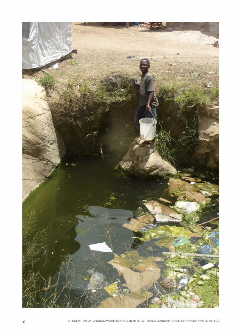
2 INTEGRATION OF GROUNDWATER MANAGEMENT INTO TRANSBOUNDARY BASIN ORGANIZATIONS IN AFRICA

3
8
MODULE
INTEGRATION OF GROUNDWATER MANAGEMENT INTO TRANSBOUNDARY BASIN ORGANIZATIONS IN AFRICA
Groundwater Hazards
MODULE 8Groundwater Hazards
8.1 Introduction 4
8.2 Groundwater Quantity: Over-exploitation 4
8.3 Groundwater Quality: Pollution 7
8.3 Assessment of groundwater pollution, aquifer vulnerability and
over-exploitation 11
8.5 Groundwater protection 13
8.6 Summary 15
8.7 References 17
8.8 Exercise 18
CONTENT
Imprint
© Copyright 2014, all rights reserved
The use of the manual is FREE of cost. AGW-Net simply requests that users give proper
attribution “Integration of Groundwater Management into Transboundary Basin Organizations in
Africa - a Training Manual by AGW-Net, BGR, IWMI, CapNet, ANBO, & IGRAC” . Modification
is only allowed with permission of AGW-Net.
Photos are copyright to their respective owners.
A4A – aqua for all
AGW-Net – Africa Groundwater Network
ANBO – African Network of Basin Organisations
BGR – Federal institute for geosciences and natural resources
Cap-Net UNDP
BMZ – Federal Ministry for Economic Cooperation and Development
GWP – Global Water Partnership
IGRAC – International Groundwater Resources Assessment Centre
imawesa – Improved Management of Agricultural Water in Eastern and Southern Africa
IWMI - International Water Management Insitute
Editorial Staff: Vanessa Vaessen, Ramon Brentführer – BGR
Layout: ff.mediengestaltung GmbH, Hannover, Germany
Picture : BGR – Bundesanstalt für Geowissenschaften und Rohstoffe
4
8
MODULE
INTEGRATION OF GROUNDWATER MANAGEMENT INTO TRANSBOUNDARY BASIN ORGANIZATIONS IN AFRICA
Groundwater Hazards
GROUNDWATER HAZARDS
8.1 Introduction Under natural conditions, groundwater is usually potable and needs almost no treat-
ment before distribution and use. The good water quality is a result of the protection
of the soil and rocks in the unsaturated zone above the water table. They filter out
bacteria and protect groundwater from contaminants on the surface. But the massive
input of pollutants generated by modern agriculture, industry and lack of sanitation
facilities can overburden the ability of the unsaturated zone to filter out contaminants
and protect groundwater. Once a groundwater aquifer is polluted, rehabilitation is a
very expensive and long-lasting task. Because of the very long time lags that might
take place before a pollution impact on the resource is noticeable, good management
of the aquifers, including pollution prevention activities, are of great importance.
In the case of transboundary aquifers, the sustainable use of groundwater is often
hindered by the lack of legal and institutional mechanisms, hence a lack of common
management of these aquifers. To enable cooperation between neighboring countries,
necessary legal and institutional mechanisms as well as capacities at national level
have to be put in place first. The development and implementation of appropriate legal
instruments and management tools for catchment-based resource protection still con-
stitute some of the challenging aspects regarding transboundary aquifer management.
First steps to follow are the identification of these aquifers and formulation of appropri-
ate instruments to enhance cooperation for sustainable and integrated management
and use of these resources for socio-economic benefits.
This module examines groundwater quantity and quality aspects and identifies water
management options to preserve and protect groundwater resources.
8.2 Groundwater Quantity: Over-exploitationHigh population growth results in an increased need for water for agricultural produc-
tion and industrial development, which in terms leads to more groundwater pumping
globally (UNEP, 2003; FAO, 2003; Burke and Moench, 2000). Increased pumping can
leads to extreme lowering of water tables. The impacts of groundwater over-exploita-
tion are numerous and often irreversible (Figure 8.1). Direct impacts are:
1. Lowering of groundwater levels/pressures;
2. Reduction of groundwater discharge to springs, stream base flow and aquatic
ecosystems;
3. Deterioration of groundwater quality (salinization) as a result of sea water intrusion
in coastal aquifers and up-coning of deep saline water;
4. Land-surface subsidence;
LEARNING OBJECTIVESThe objectives of this module are to:
■ Assess the risk of groundwater pollution and quantity impairment
■ Protect groundwater from pollution and over-exploitation
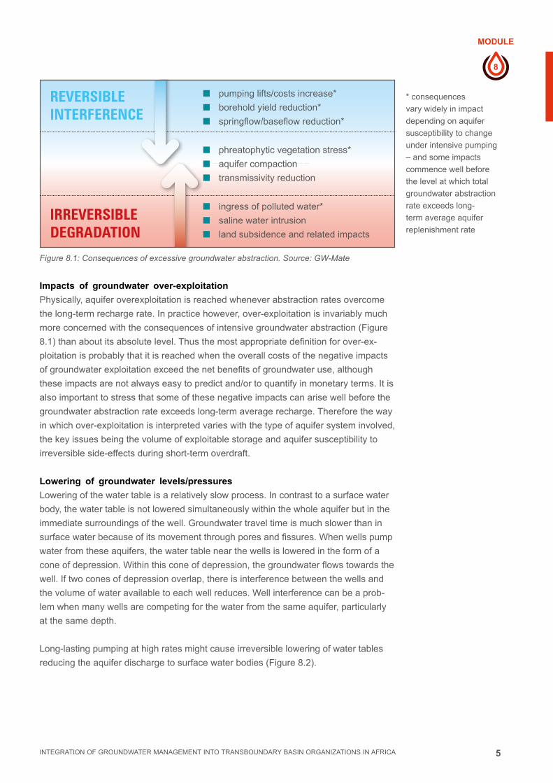
5
8
MODULE
INTEGRATION OF GROUNDWATER MANAGEMENT INTO TRANSBOUNDARY BASIN ORGANIZATIONS IN AFRICA
Groundwater Hazards
Figure 8.1: Consequences of excessive groundwater abstraction. Source: GW-Mate
Impacts of groundwater over-exploitation
Physically, aquifer overexploitation is reached whenever abstraction rates overcome
the long-term recharge rate. In practice however, over-exploitation is invariably much
more concerned with the consequences of intensive groundwater abstraction (Figure
8.1) than about its absolute level. Thus the most appropriate definition for over-ex-
ploitation is probably that it is reached when the overall costs of the negative impacts
of groundwater exploitation exceed the net benefits of groundwater use, although
these impacts are not always easy to predict and/or to quantify in monetary terms. It is
also important to stress that some of these negative impacts can arise well before the
groundwater abstraction rate exceeds long-term average recharge. Therefore the way
in which over-exploitation is interpreted varies with the type of aquifer system involved,
the key issues being the volume of exploitable storage and aquifer susceptibility to
irreversible side-effects during short-term overdraft.
Lowering of groundwater levels/pressures
Lowering of the water table is a relatively slow process. In contrast to a surface water
body, the water table is not lowered simultaneously within the whole aquifer but in the
immediate surroundings of the well. Groundwater travel time is much slower than in
surface water because of its movement through pores and fissures. When wells pump
water from these aquifers, the water table near the wells is lowered in the form of a
cone of depression. Within this cone of depression, the groundwater flows towards the
well. If two cones of depression overlap, there is interference between the wells and
the volume of water available to each well reduces. Well interference can be a prob-
lem when many wells are competing for the water from the same aquifer, particularly
at the same depth.
Long-lasting pumping at high rates might cause irreversible lowering of water tables
reducing the aquifer discharge to surface water bodies (Figure 8.2).
REVERSIBLE INTERFERENCE
IRREVERSIBLE DEGRADATION
■ pumping lifts/costs increase*
■ borehold yield reduction*
■ springflow/baseflow reduction*
■ phreatophytic vegetation stress*
■ aquifer compaction
■ transmissivity reduction
■ ingress of polluted water*
■ saline water intrusion
■ land subsidence and related impacts
* consequences
vary widely in impact
depending on aquifer
susceptibility to change
under intensive pumping
– and some impacts
commence well before
the level at which total
groundwater abstraction
rate exceeds long-
term average aquifer
replenishment rate

6
8
MODULE
INTEGRATION OF GROUNDWATER MANAGEMENT INTO TRANSBOUNDARY BASIN ORGANIZATIONS IN AFRICA
Groundwater Hazards
Figure 8.2 : Continuous
pumping at high rates
lowers the water table
reducing the aquifer
discharge into the river
(middle). It can also lead
to a change of the flow
situation in which the
river water reaches the
well.
Source: modified from
US Geological Survey
Cones of depression only appear in unconfined aquifers, which are aquifers that have
direct hydraulic connection to the atmosphere. In the case of confined aquifers, it is
the pressure in the aquifer that reduces in the surounding of the pumped well.
In the case of transboundary aquifers, the problem of groundwater depletion applies
predominantly to deep aquifer systems, which are mostly confined. This is a major
problem because generally these aquifers receive little or no recharge, e.g. in North
Africa and the Middle East. Large abstraction, as is necessary for irrigation, over long
periods of time leads to ever decreasing groundwater levels. This problem can be
observed quite impressively in the desert of Saudi Arabia. Landsat satellite images
reveal an increase of the agricultural area from 1987 to 2012 (Figure 8.3). Due to the
lack of recharge, the increased irrigation has caused dropping groundwater tables
(FAO, 2009). On the long term, this will also affect the groundwater resources in the
neighbour countries, like Jordan. Recently Jordan also started pumping from the same
aquifer to provide water for the city of Amman, and this is exacerbating the situation.
Figure 8.3: Extent
of agricultural area
in the desert of
Saudi Arabia at the
border to Jordan
from 1987 to 2012.
The green dots are
irrigated areas using
groundwater.
Source: USGS
recharge area
river
river
river
water table
water table
water table
unconfined aquifer
unconfined aquifer
unconfined aquifer
confining layer
confining layer
confining layer
earth surface
earth surface
earth surface
Q1
Q2
water divide

7
8
MODULE
INTEGRATION OF GROUNDWATER MANAGEMENT INTO TRANSBOUNDARY BASIN ORGANIZATIONS IN AFRICA
Groundwater Hazards
Reduction of groundwater discharge to springs, stream base flow and aquatic ecosystems
Ground- and surface water systems often interact closely (see module 3 “Aquifer
characterisation”). Groundwater provides river base flow even in dry periods and sup-
plies freshwater ecosystems (module 3). When groundwater is pumped excessively,
surface discharges as springs, base flows and seepages tend to dry out, sometimes
permanently, damaging groundwater dependent ecosystems and reducing groundwa-
ter to user communities.
Subsidence
Subsidence is yet another particularly widespread impact of excessive over-pumping,
with some notable examples in a number of major cities in China, Japan, Mexico and
the US (Figure 8.4). Land subsidence occurs when excessive amounts of groundwater
have been withdrawn from a porous aquifer. As a result, the porous aquifer materials
compact and settle, resulting in a lowering of the ground surface in the area (www.sjra.
net). Land subsidence can lead to many problems such as: changes in land surface
elevation; damage to structures such as storm drains, sanitary sewers, roads, rail-
roads, canals, levees and bridges; structural damage to public and private buildings;
and damage to wells. Most commonly, though, subsidence is known for causing the
potential for flooding.
Salinisation
Over-pumping fresh water aquifers in coastal areas may cause saline waters to in-
trude into the freshwater zones of aquifers. This occurs by up-coning of saline water
and mixing with fresh water, giving rise to an irreversible aquifer salinization (see sec-
tion 8.3 and Fig 8.7). It is a major problem for a great number of coastal cities around
the world.
8.3 Groundwater Quality: PollutionWhen considering groundwater quality and deterioration, one has to distinguish
between natural and anthropogenic contamination. Under most natural conditions
groundwater is potable without any treatment. There are some exceptions worldwide,
where the natural groundwater has concentrations of various soluble materials at
levels that are harmful to health, human, animal or plant. A very well known case is the
high arsenic concentration of the porous aquifer in Bangladesh. Salinization is also an
example of natural contamination, but is very often intensified by human activities. It
seems that in the African context, most groundwater quality concerns are related to:
■■ Declining urban groundwater quality due to a combination of leaking pit latrines
/ septic tanks and uncontrolled effluent discharge from industry and municipal
wastewater and landfill facilities.
■■ Salinization of groundwater due to over abstraction for irrigation leading to declin-
ing groundwater quality
■■ Saline water intrusion due to lowering of water table by water supply wells near /
along coastal areas.
Naturally-occurring groundwater quality hazards
Groundwater becomes mineralized to varying degrees due to soil/rock-water interac-
tions, which result in the dissolution of certain minerals and chemical elements. Nine
Figure 8.4: Land
Subsidence in the
San Joaquin Valley,
California, USA
Source: www.sjra.net

8
8
MODULE
INTEGRATION OF GROUNDWATER MANAGEMENT INTO TRANSBOUNDARY BASIN ORGANIZATIONS IN AFRICA
Groundwater Hazards
major chemical constituents (Na, Ca, Mg, K, HCO3, Cl, SO4, NO3, Si) make up 99%
of the solute content of natural groundwater.
The degree of dissolution depends on the length along flow path, the travel time, the
solubility of soil/rock minerals and the amount of dilution by fresh recharge water.
Reactions of rainwater in the soil/rock profile during infiltration provide groundwater
with its essential mineral composition. Groundwater in the recharge areas of humid re-
gions is likely to be low in overall mineralization, compared to arid or semi-arid regions
where the combination of evaporative concentration and slower groundwater move-
ment can produce much higher concentrations.
Under certain conditions and in some geo-environments, naturally occurring but haz-
ardous elements are taken into solution at excessive concentrations:
■■ Arsenic (As) is the trace element currently giving greatest concern in groundwater,
being both toxic and carcinogenic at low concentrations
■■ Fluoride (F) is an element that is sometimes deficient, but in excessive concentrations it
can be a problem, especially in arid climates and in volcanic and granitic rocks
■■ Manganese (Mn) and iron (Fe) in soluble form occur widely where anaerobic
groundwater conditions arise. When water is extracted, manganese and iron
oxidize, giving rise to unacceptable groundwater taste and/or color. While Fe is not
a health hazard, consumption of water with high manganese concentrations might
have neurological effects on humans. The WHO has set the upper limit for Mn
concentration in groundwater at 0.4 mg/l
Various other trace elements (including notably Ni, U and Al) can occur under natu-
ral conditions in groundwater and are listed by World Health Organization (WHO) as
potentially hazardous in drinking water.
If excessive toxic trace elements are present in a potential groundwater supply, then
an emergency plan should be implemented and a longer-term strategy identified. The
emergency plan is likely to comprise the following:
■■ Hydro-geochemical evaluation of the aquifer at an appropriate scale
■■ Community guidance on use restrictions and safe locations of water wells
■■ Community health programs to look for symptoms related to drinking water.
Anthropogenic Pollution
Worldwide, aquifers are experiencing an increasing threat of pollution from urbaniza-
tion, industrial development, agricultural activities and mining enterprises (Figure 8.5).
In some cases, it may take many years before the impact of pollution by a persistent
contaminant becomes fully apparent. Groundwater from deep wells, or from springs or
groundwater dependent ecosystems often has a long flow path and may take decades
or longer to move from recharge to discharge area. This can lead to complacency over
the pollution threat. The unfortunate implication is that once people become aware that
a groundwater source has become polluted, large volumes of the aquifer are usually
already contaminated. Mitigation measures then tend to be very costly and remedia-
tion is technically problematic and time consuming. Such contaminated aquifers may
be unsuitable for use for decades or centuries. This is why prevention measures such
as groundwater protection have to be integrated into land-use planning activities.
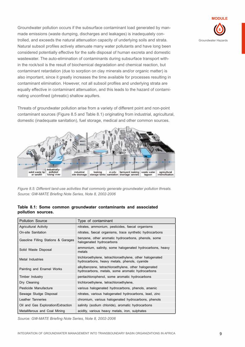
9
8
MODULE
INTEGRATION OF GROUNDWATER MANAGEMENT INTO TRANSBOUNDARY BASIN ORGANIZATIONS IN AFRICA
Groundwater Hazards
Groundwater pollution occurs if the subsurface contaminant load generated by man-
made emissions (waste dumping, discharges and leakages) is inadequately con-
trolled, and exceeds the natural attenuation capacity of underlying soils and strata.
Natural subsoil profiles actively attenuate many water pollutants and have long been
considered potentially effective for the safe disposal of human excreta and domestic
wastewater. The auto-elimination of contaminants during subsurface transport with-
in the rock/soil is the result of biochemical degradation and chemical reaction, but
contaminant retardation (due to sorption on clay minerals and/or organic matter) is
also important, since it greatly increases the time available for processes resulting in
contaminant elimination. However, not all subsoil profiles and underlying strata are
equally effective in contaminant attenuation, and this leads to the hazard of contami-
nating unconfined (phreatic) shallow aquifers.
Threats of groundwater pollution arise from a variety of different point and non-point
contaminant sources (Figure 8.5 and Table 8.1) originating from industrial, agricultural,
domestic (inadequate sanitation), fuel storage, medical and other common sources.
Figure 8.5: Different land-use activities that commonly generate groundwater pollution threats.
Source: GW-MATE Briefing Note Series, Note 8, 2002-2006
Table 8.1: Some common groundwater contaminants and associated pollution sources.
Pollution Source Type of contaminant
Agricultural Activity nitrates, ammonium, pesticides, faecal organisms
On-site Sanitation nitrates, faecal organisms, trace synthetic hydrocarbons
Gasoline Filling Stations & Garagesbenzene, other aromatic hydrocarbons, phenols, some halogenated hydrocarbons
Solid Waste Disposalammonium, salinity, some halogenated hydrocarbons, heavy metals
Metal Industriestrichloroethylene, tetrachloroethylene, other halogenated hydrocarbons, heavy metals, phenols, cyanide
Painting and Enamel Worksalkylbenzene, tetrachloroethylene, other halogenated hydrocarbons, metals, some aromatic hydrocarbons
Timber Industry pentachlorophenol, some aromatic hydrocarbons
Dry Cleaning trichloroethylene, tetrachloroethylene,
Pesticide Manufacture various halogenated hydrocarbons, phenols, arsenic
Sewage Sludge Disposal nitrates, various halogenated hydrocarbons, lead, zinc
Leather Tanneries chromium, various halogenated hydrocarbons, phenols
Oil and Gas Exploration/Extraction salinity (sodium chloride), aromatic hydrocarbons
Metalliferous and Coal Mining acidity, various heavy metals, iron, sulphates
Source: GW-MATE Briefing Note Series, Note 8, 2002-2006

10
8
MODULE
INTEGRATION OF GROUNDWATER MANAGEMENT INTO TRANSBOUNDARY BASIN ORGANIZATIONS IN AFRICA
Groundwater Hazards
Groundwater salinisation
The existence of saline groundwater and the process of groundwater salinisation can
come about by a number of distinctive mechanisms, only some of which are pump-
ing-related and/or associated with the seawater intrusion.
The main mechanisms of groundwater salinization are indicated schematically in Fig-
ure 8.6, and range from the mobilisation of paleo-saline or connate waters1 at depth
to essentially surface processes related to soil water-logging due to rising water-ta-
bles. In-depth investigations are required to diagnose existing occurrences of saline
groundwater, and to assess the potential that such processes might occur during
a major or progressive change of groundwater abstraction. The importance of this
cannot be over-stressed since once a major rise in salinity or intrusion of saline water
has occurred, it may take a very long-time (decades or even millenia) and considera-
ble cost to remediate — and will destroy the groundwater resources for both potable
water-supply and many agricultural irrigation uses.
Figure 8.6: Salinisation as possible effect of groundwater over-abstraction. Source: GW-MATE
1 Groundwater recharged in the past, thousands of years ago, that stagnates in channels or depressions and has thus time to interact with the surrounding rocks. It is generally high saline and as such cannot be used for water supply without treatment
OIL WELL FORMATION WATER
seperation and discharge of brines
HISTORIC ARID ZONESOIL ACCUMULATION
leaching from the vadose zone CURRENT IRRIGATED
SOIL FRACTIONATIONleaching from the
vadose zone
PHREATIC EVAPORATIONSALT FRACTIONATION
rising water table due to excessive irrigation/inadequate drainage
water table
SEA-WATER INTRUSIONlandward hydraulic gradient due to excessive pumping
(sometimes layering occurs)
INFLOW OF SALINE GROUNDWATER
from adjacent formations following heavy pumping
INTRUSION OF PALEO-SALINE GROUNDWATER
up-coming from depth due to excessive pumping brackish and saline water
fresh water
11
8
MODULE
INTEGRATION OF GROUNDWATER MANAGEMENT INTO TRANSBOUNDARY BASIN ORGANIZATIONS IN AFRICA
Groundwater Hazards
8.3 Assessment of groundwater pollution, aquifer vulnerability and over-exploitation
To protect groundwater from pollution and overexploitation, it is essential to assess the
hydrogeological setting and the anthropogenic impact.
Groundwater extraction and recharge rates
In the light of all the above considerations, it will be evident that water resource man-
agers need to have an estimate of the acceptable abstraction2 from a groundwater
system. Although in reality such estimates can also be misleading because to make
them it is necessary to have value judgements about what is ‘acceptable’. In this case
ecosystems also have to be considered as stakeholders that are aquifer dependent.
To assess a safe yield, the quantities of input (recharge) and output (discharge) to
the groundwater system have to be estimated. An important component of the output,
abstraction by pumping, varies according to human demand. However there is often
substantial scientific uncertainty of the quantification of individual recharge and dis-
charge components due to the inherent complexity of natural geo-systems and wide
spatial and temporal variability of rainfall and runoff events (including climatic cycles)
as well as of groundwater abstraction. Therefore groundwater balance calculations in
many regions always should be treated with caution. Nevertheless, for most practical
purposes, it is sufficient to make approximate estimates, and refine these subsequent-
ly through groundwater level monitoring and analysis of aquifer response to abstrac-
tion over the medium-term.
It is always essential when attempting to evaluate contemporary groundwater re-
charge rates to appreciate the significance of the intimate linkages between land-use
and groundwater recharge, which is an essential input for integrated water resourc-
es management. The common paradigm of ‘constant average rates of present-day
aquifer recharge’ is false. In reality the contemporary rate of aquifer recharge varies
considerably with:
■■ Changes in land-use and vegetation cover, notably the introduction of irrigated
agriculture, but also vegetation clearance and soil compaction
■■ Urbanisation processes, and in particular the level of water-mains leakage and the
degree of land-surface impermeabilisation;
■■ Widespread water-table lowering by groundwater abstraction and/or land drain-
age, which leads to increased areas and/or rates of infiltration in some aquifer
systems;
■■ Changes in surface water regime, especially the diversion of riverflow.
Moreover groundwater abstraction data is almost unavailable, since direct monitoring
of groundwater abstraction is costly because meters have to be fitted to all pump out-
lets, and this requires the full cooperation of water users, which is not always easy to
achieve. Intensive groundwater use for domestic water supply is also encountered in
fast growing cities where the water service provision is inadequate. This is the case
2 Acceptable extraction or safe yield is the rate at which a well can be pumped in a long-term without causing harm either to the well construction (water level falls below the screen) or to the aquifer (irreversible lowering of the water table)

12
8
MODULE
INTEGRATION OF GROUNDWATER MANAGEMENT INTO TRANSBOUNDARY BASIN ORGANIZATIONS IN AFRICA
Groundwater Hazards
in many African cities and has led to massive and indiscriminate private groundwater
development. Indirect monitoring of groundwater use can be done using demograph-
ic data in combination with satellite images and urban planning maps that show the
urban expansion and estimating water use per household.
Pollution sources and vulnerability
Groundwater is vulnerable to many different sources of pollution. The location, nature
and amount of pollution sources have to be known to assess the pollution load to land
surface and hence potentially to the groundwater. The pollution loads are relatively
easy to identify, especially point source pollution, but it is the vulnerability of the aqui-
fer system in combination with the pollution load that translates the into groundwater
hazard.
Hydrogeological data such the thickness and hydraulic properties, such as permea-
bility, of the unsaturated zone are necessary to assess the vulnerability of aquifers to
pollution loads. The groundwater hazard can be determined by overlaying pollution
load maps onto aquifer vulnerability maps.
There are a number of aquifer vulnerability assessment methods that consider a
variety of factors that contribute to an aquifer’s vulnerability. Two of the better known
assessment schemes are known by their acronyms: DRASTIC and GOD. To provide
a general insight into aquifer vulnerability characterization it is useful to consider the
elements considered in the eg. Drastic method. Each element in the vulnerability as-
sessment is allocated a relative score, and the final score is rannked against a rank-
ing chart which may characterize the aquifer from: very high vulnerability to very low
vulnerability.
■■ D = depth to the groundwater (the deeper, the less vulnerable)
■■ R = net recharge (the greater the recharge rate, the more vulnerable)
■■ A = aquifer medium (low permeability aquifers are less vulnerable)
■■ S = soil medium (permeability, adsorbtion capacity)
■■ I = impact of the vadose zone (combination of S and D)
■■ C = hydraulic conductivity (similar to A)
Due to the repetition of some of the parameters, hydrogeologists have tended to modi-
fy Drastic and come up with more stream-lined vulnerabilty assessment methods.
Once the aquifer vulnerability has been assessed, then the risk to the groundwater
can also be assessed. The definition of groundwater pollution hazard is the interac-
tion between aquifer pollution vulnerability and the contaminant load applied on the
subsurface environment as a result of human activity at the land-surface. Contaminant
load can be controlled, but aquifer vulnerability is fixed by the natural hydrogeological
setting.
Systematic groundwater pollution hazard assessments should be integrated into
groundwater quality protection measures and should become an essential component
of environmental best practice.

13
8
MODULE
INTEGRATION OF GROUNDWATER MANAGEMENT INTO TRANSBOUNDARY BASIN ORGANIZATIONS IN AFRICA
Groundwater Hazards
Management of groundwater pollution.
As expressed earlier, prevention of pollution is far preferable to trying to cure it. The
key management options for preventing groundwater pollution are:
■■ Seperation: keep waste materials and productive aquifers far apart. This usually
takes place during the planning phase of any development, especially where there
is a high level of waste generated. Environmental impact assessments are de-
signed specifically to ensure that such separation occurs in a timely manner.
■■ Containment: Where waste is generated in proximity of groundwater or surface
water supplies, then containment of the waste in impermeable ponds is a man-
agement option. Solid waste landfills should be designed such that there is an
impermeable base, which may be some form of high density polyethelyne liner or
a compacted clay base.
■■ Waste management: the sorting of waste into different components is highly
successful and allows the reuse / recycling of some wastes (plastic, metal, glass,
paper and cardboard) and composting of organic waste. This reduces the overall
waste load and allow the seperation of toxic waste which can be treated or con-
tained in high level waste facilities. Waste sorting and seperation is often commer-
cially viable.
■■ Remediation: finally there is remediation of polluted aquifers. As expressed earlier,
this is technically complex, long duration and expensive. Methods such as pump,
treat and reinject treated water; aquifer flushing with fresh water etc. have been
used with limited success. Insoluble pollutants, the so-called LNAPL and DNAPL
(Light and dense non-aquueous phase liquids) are particularly difficult to treat.
8.5 Groundwater protectionWhether a given pollution hazard will result in a threat to a groundwater supply-source
depends primarily on its location with respect to the source water-capture area and
secondarily on the mobility of the contaminant(s) concerned. A number of groundwater
protection zones should normally be defined (Figure 8.7) based on hydrogeological
data about the local groundwater flow regime. Various analytical and numerical mod-
els are available for this purpose. The scale and intensity at which the survey, map-
ping and analyses of various components needed to assess groundwater pollution
hazard are undertaken, will vary with the importance and sensitivity of the groundwa-
ter resource: water-supply protection or aquifer resource conservation.
A primary focus of groundwater quality monitoring is usually public water supply
networks from water wells and springs via piped distribution systems. Two key compo-
nents involve (i) regular sampling of the water, and (ii) chemical analysis in the labora-
tory.
Groundwater pollution hazard assessments should prompt municipal authorities or
environmental regulators to take both preventive actions (to avoid future pollution)
and corrective measures (to control the existing threats). To protect aquifers against
pollution it is essential to constrain land-use, effluent discharge and waste disposal
practices.
Simple and robust zones need to be established, based on aquifer pollution vulner-
ability and source protection perimeters. For each zone certain activities have to be

14
8
MODULE
INTEGRATION OF GROUNDWATER MANAGEMENT INTO TRANSBOUNDARY BASIN ORGANIZATIONS IN AFRICA
Groundwater Hazards
defined that give an acceptable risk to groundwater. Groundwater protection zoning
also has a key role in setting priorities for groundwater quality monitoring, environmen-
tal audit of industrial premises, and pollution control within the agricultural advisory
system.
A sensible balance needs to be struck between the protection of groundwater resourc-
es (aquifers as a whole) and specific sources (boreholes, wells and springs). While
both approaches to groundwater pollution control are complementary, the emphasis
placed on one or other (in a given area) will depend on the resource development
situation and on the prevailing hydrogeological conditions.
In dealing with threats to groundwater, communities and stakeholders need informa-
tion about the resource. Groundwater protection can best be accomplished by con-
trolling potential contaminant sources and by managing landuse in prime recharge
areas. Using knowledge of local geology and groundwater flow directions, estimates
can be made of land areas that contribute to recharge a particular aquifer. Controls
can then be established to ensure appropriate land uses and chemical practices within
the recharge areas. In many instances, recharge areas cannot be set-aside in their
natural states.
Within certain basins, domestic, industrial, agricultural and commercial operations
discharge different forms of potential contaminants, which can contaminate groundwa-
ter with bacterial matter, pesticides, chemical spills, toxic wastes, etc. In this regard,
groundwater protection efforts must focus instead on management of the diverse
potential contaminant sources. Some possible management techniques include public
education, inventory and monitoring of potential contaminant sources, and zoning of
local land use activities (Figure 8.7) in order to protect community groundwater sup-
plies.
Figure 8.7: Idealized schematic zones for protection of a well in an unconfined aquifer.
Source: Modified after GW-Mate, 2006
Zone I – Protects well/spring from direct
contamination
Zone II – Protects drinking water source against pathogenic
micro-biological constituents bacteria, viruses, parasites
Zone III – Protects aquifer against contamination affecting drinking
water source over long distances (for chemical substances, which are non- or hardly degradable)
WellGroundwater
Flow DirectionI II III

15
8
MODULE
INTEGRATION OF GROUNDWATER MANAGEMENT INTO TRANSBOUNDARY BASIN ORGANIZATIONS IN AFRICA
Groundwater Hazards
For groundwater protection zones to be effective, they need:
■■ To be embedded in the regulatory framework and enforced
■■ Stakeholders to be aware about them and adhere to them
■■ To be regularly monitored
■■ Land-use restrictions to balance competing user-interests.
8.6 SummaryIn discussing groundwater hazards, it can be helpful to consider them in the context
of generic hazard management. Since we are concerned with the management of
groundwater hazards, the question to ask is: “How does a catchment manager protect
the groundwater resources and the aquifers in his catchment against hazards?”
The measurement of groundwater recharge, groundwater flows and even mapping of
the aquifers and abstraction potential are expensive and complex. Faced with such a
large information lack, how does the manager start to make decisions? Box 8.1 presents
terms that are used in disaster studies and their interactions. Such a framework can be
helpful for a catchment manager tasked with protecting groundwater resources.
The manager first has to identify the important groundwater sources being used in
their catchment / basin, then assess the hazards for each, look at the vulnerability to
each hazard to determine the risk. The hazards (pollution hot spots) are relatively easy
to identify but it is the aquifer vulnerability that translates the hazard into risk.
Once the catchment managers have an assessment of risk, they then have a basis
for action (mitigation) that may include control of specific polluting agents or practices,
adjusting abstraction or other interventions. If managers use a structured approach on
disaster management (Box 8.1), this can provide a framework for identifying risk and
thereby targeting effective response / remediation. Managers, despite the complexity
and unknowns in groundwater, still have a framework for management steps that they
can take to protect the groundwater resource from pollution.

16
8
MODULE
INTEGRATION OF GROUNDWATER MANAGEMENT INTO TRANSBOUNDARY BASIN ORGANIZATIONS IN AFRICA
Groundwater Hazards
BOX 8.1: SOME TERMINOLOGIES USED IN DISASTER STUDIES
i) Hazard - A potentially damaging physical event, human activity or phe-
nomenon that has potential to cause loss of life or injury, property damage,
socio-economic disruption of life and environmental degradation, among
others.
ii) Vulnerability - A set of conditions resulting from physical, social, economic
and environmental factors that increase the susceptibility of a community to
the impact of disasters or the characteristics of a person or group in terms of
their capacity to anticipate, cope with, resist and recover from the impact of a
natural hazard.
Disaster = Hazard + Vulnerability
iii) Risk - The probability of harmful consequences or loss resulting from the
interaction between natural hazards and vulnerable conditions of people and
property.
Risk = (Hazard X Vulnerability)/Capacity
iv) Mitigation - Short and long term actions, programmes or policies in advance
of a natural hazard or in its early stages, to reduce the degree of risk to peo-
ple, property and productive capacity.
v) Impacts - Specific effects, consequences or outcomes of hazards or disasters.
vi) Preparedness - Pre-disaster activities designed to increase the level of readi-
ness or improve operational capabilities for responding to an emergency.
vii) Response - Actions taken immediately before, during or directly after a disas-
ter to reduce the impacts and improve recovery.
viii) Resilience/Capacity – The capability of the community to cope with disasters.
Source: Report on the Status of Disaster Risk Reduction in Sub-Saharan Africa Region,
2008.

17
8
MODULE
INTEGRATION OF GROUNDWATER MANAGEMENT INTO TRANSBOUNDARY BASIN ORGANIZATIONS IN AFRICA
Groundwater Hazards
8.7 References
Burke, J.J. and Moench, M.H. (2000):
Groundwater and Society: Resources, Tensions and Opportunities.
United Nations. Publications, Sales No. E.99.ll.A.1, ISBN 92-1-104485-5.
FAO (2003):
Groundwater Management – The Search for Practical Approaches.
Water Reports 25. FAO (Food and Agricultural Organization), ISBN 92-5-104908-4.
FAO (2009):
Irrigation in the middle east region in figures. Aquastat survey 2008.
FAO Water Report 34, Country
Report Saudi Arabia, Food and Agriculture Organization of the United Nations, Rome.
UNEP (2003):
Groundwater and its Susceptibility to Degradation.
UNEP/DEWA, Nairobi.
Ponce V. M., Lohani A. K. & Huston P. T. (1997):
Surface albedo and water resources: Hydroclimatological impact of human
activities.
Journal of Hydrologic Engineering, ASCE, Vol. 2, No. 4, October, 197-203.
Web Readings
http://www.eea.europa.eu/publications/92-9167-056-1/page007.html
http://www.greenfacts.org/en/water-resources/l-3/4-effect-human-actions.htm
http://www.lenntech.com/images/gw-sewater-intrusion2.gif
http://psep.cce.cornell.edu/facts-slides-self/facts/gr-wh-hw-grw85.aspx
http://ponce.sdsu.edu/albedo197.html
http://www.sjra.net

18
8
EXERCICE
INTEGRATION OF GROUNDWATER MANAGEMENT INTO TRANSBOUNDARY BASIN ORGANIZATIONS IN AFRICA
Groundwater Hazards
8.8 Exercise
Exercise 1
Title: Water Quality Management
Issue:
Mining impact on water quality in the West Rand: Calculation and interpretation
The West Rand area of Johannesburg is one of the largest gold producing regions in
South Africa. The area is underlain by quartzites and dolomites. Some of the mines
were closed in 1980’s and since 2002 acidic mine water is decanting into the environ-
ment. Local farmers depend on the dolomitic aquifer for water supply. The discharge
of toxic-rich effluent from gold mines and the proximity of slimes dams, tailings and
rock dumps can also cause chemical and biological damage to aquatic ecosystems
through flooding, clogging, altering streams and wetlands and deposition of radioac-
tive and toxic metals within the drainage of the karst system. The run-off from slimes
dams enters the drainage network that feeds into the surface water, karst system and
groundwater.
During the mining process, rocks which are situated far below the surface are brought
to the surface, where they are crushed and processed. Gold is extracted through
chemical processing and the barren material is stored in slimes dams. The crushing
and chemical processing expose and mobilize pyrite (FeS2), a natural sulphur-rich
component of the rock that is then exposed to the atmosphere and water. The oxi-
dized sulphates in combination with water and bacterial breakdown produce sulphuric
acid that in turn reacts with the rocks and soils to release and mobilize the metals. The
acids and metals which are released are found in the rivers and groundwater that is
contaminated by the runoff from slimes dams, tailings, rock dumps and mine effluent.
This is known as Acid Mine Drainage (AMD).
Question:
Acid mine decant flows downstream into dolomitic terrain in the West Rand. Discharge
measurement was undertaken at six stations in two different months (February and
August). February is a rainy month, while August is dry. Station P1 exclusively con-
tains acid mine decant and the measured values change downstream. Calculate the
seepage rate/amount of acid mine water into dolomitic aquifer. Give possible reasons
for the loss, the impact and increase at some stations. Recommend mitigation meas-
ures.

19
8
EXERCICE
INTEGRATION OF GROUNDWATER MANAGEMENT INTO TRANSBOUNDARY BASIN ORGANIZATIONS IN AFRICA
Groundwater Hazards
Acid mine decent in the West Rand, Johannesburg
Discharge February August Seepage in Feb Seepage in Aug
Q (m3/s) P1 2.214 1.075
Q (m3/s) P2 1.2177 0.7
Q (m3/s) P3 1.014 0.588
Q (m3/s) P4 0.3 0.28
Q (m3/s) P5 0.9 0.3
Q (m3/s) P6 0.45 0.207
Total m3/s
Total m3/year
Exercise 2
Purpose: To share experience of groundwater quantity problems.
Activity: Break into groups of 4 or 5.
Each group to (in 1 hour):
a) Identify a common groundwater quantity problem in your country.
b) Discuss the nature and scale of the problem – is it anthropogenic or natural?
c) How is the problem being managed, and who is responsible for the management?
d) What have been the aims of the management and how successful has it been?
e) What would you change to improve management of the problem?

9
MODULE
INTEGRATION OF GROUNDWATER MANAGEMENT INTO TRANSBOUNDARY BASIN ORGANIZATIONS IN AFRICA
GROUNDWATER FOR FOOD SECURITY

2 INTEGRATION OF GROUNDWATER MANAGEMENT INTO TRANSBOUNDARY BASIN ORGANIZATIONS IN AFRICA

3
9
MODULE
INTEGRATION OF GROUNDWATER MANAGEMENT INTO TRANSBOUNDARY BASIN ORGANIZATIONS IN AFRICA
Groundwater for Food Security
CONTENT
MODULE 9Groundwater for Food Security
9.1 Introduction and background 4
9.2 Why is groundwater use in irrigation so popular? 7
9.3 Livelihood impacts 8
9.4 Too much and too little groundwater development for irrigation is a concern 12
9.5 Solutions to under- and over-use of groundwater for irrigation 13
9.6 The new approach: The nexus between water-, food- and energy security 15
9.7 References and further reading 16
9.8 Exercise 17
Imprint
© Copyright 2014, all rights reserved
The use of the manual is FREE of cost. AGW-Net simply requests that users give proper
attribution “Integration of Groundwater Management into Transboundary Basin Organizations in
Africa - a Training Manual by AGW-Net, BGR, IWMI, CapNet, ANBO, & IGRAC” . Modification
is only allowed with permission of AGW-Net.
Photos are copyright to their respective owners.
A4A – aqua for all
AGW-Net – Africa Groundwater Network
ANBO – African Network of Basin Organisations
BGR – Federal institute for geosciences and natural resources
Cap-Net UNDP
BMZ – Federal Ministry for Economic Cooperation and Development
GWP – Global Water Partnership
IGRAC – International Groundwater Resources Assessment Centre
imawesa – Improved Management of Agricultural Water in Eastern and Southern Africa
IWMI - International Water Management Insitute
Editorial Staff: Vanessa Vaessen, Ramon Brentführer – BGR
Layout: ff.mediengestaltung GmbH, Hannover, Germany
Picture: IWMI

4
9
MODULE
INTEGRATION OF GROUNDWATER MANAGEMENT INTO TRANSBOUNDARY BASIN ORGANIZATIONS IN AFRICA
Groundwater for Food Security
GROUNDWATER FOR FOOD SECURITY
9.1 Introduction and backgroundGroundwater is widely used in agriculture around the world. About 70 % of all ground-
water used goes to agriculture, mostly irrigation (Fig. 9.1). At a global scale, between
20 and 40 % of irrigation water needs are satisfied by groundwater (Fig. 9.2 and Fos-
ter and Shah, 2012). Agriculture is the largest consumer of water compared to all other
uses, such as domestic and industrial. Most water in irrigation is consumptively used
by evaporation or transpiration as compared to non-consumptive use, such as domes-
tic and industrial use that is returned as wastewater and can be reused.
LEARNING OBJECTIVES■■ To comprehend the scale and significance of groundwater in agriculture globally
■■ To know the regions with over- and under-utilisation of groundwater for irrigation
■■ To appreciate the economic and livelihoods implications of groundwater irrigation
■■ To understand the context and role of groundwater irrigation in Sub-Saharan
Africa
■■ To understand the risks involved with groundwater irrigation
■■ To understand strategies to optimize and manage groundwater irrigation
around the world
■■ To understand the nexus between water-, food-, and energy security.
Agriculture 67%
22%
11%
Domestic
Industry
Figure 9.2. Sources of
water use globally and
for major sectors (FAO-
AQUASTAT, 2000)
Figure 9.1. Global share
of groundwater use for
the three major sectors
(van der Gun, 2012)
Surface water 73.42%
Groundwater 45.69% Groundwater 17.37% Groundwater 12.48%Groundwater 18.25%
Surface water 71.06% Surface water 87.26%Surface water 48.22%
Groundwater (non-renewable) 0.77%
Drainage water returns 4.82%
Wastewater reuse 2.41%Groundwater
(non-renewable) 2.54%
Desalination 0.34% Desalination 0.34%
Groundwater (non-renewable)
0.72%
Drainage water returns 7.42%
Wastewater reuse 3.62%
Groundwater (non-renewable) 0.25%
All uses Drinking water use
Agriculture (irrigation)
Energy and industry

5
9
MODULE
INTEGRATION OF GROUNDWATER MANAGEMENT INTO TRANSBOUNDARY BASIN ORGANIZATIONS IN AFRICA
Groundwater for Food Security
That groundwater use is significant in agriculture can be seen from Figs. 9.3 and 9.4
where the global distribution of groundwater use and groundwater-irrigated areas,
respectively, are shown. There is a good correspondence between those areas with
intensive irrigation and those with high groundwater use.
Figure 9.3. Global map of groundwater use
(Wada et al., 2010. Units in mm/yr in 0.5°* 0.5° grid cells)
Figure 9.4. Global map of groundwater-irrigated areas
(Siebert et al. 2010. Percentage of irrigated area supplied by groundwater)
Most of this irrigation occurs in arid and semi-arid areas where the replenishment of
groundwater is low (Fig. 9.5). This can easily be explained by the larger requirement
to supplement crops with irrigation water in these areas. However, it also implies that
there is a greater risk of over-exploiting the groundwater resources in these areas,
because they are not replenished very rapidly or regularly.

6
9
MODULE
INTEGRATION OF GROUNDWATER MANAGEMENT INTO TRANSBOUNDARY BASIN ORGANIZATIONS IN AFRICA
Groundwater for Food Security
Figure 9.5. Average annual groundwater recharge, 1961 - 1990 (Döll and Fiedler, 2008)
Groundwater use within agriculture was initiated in Asia with the advent of the Green
Revolution in the 1960s. Many countries, but particularly India, Pakistan, and China,
supported more effective and productive agriculture through groundwater irrigation
and use has significantly increased since then (Figure 9.6).
Figure 9.6. Groundwater withdrawal for selected countries (Shah, Burke, and Villholth, 2007)
This growth has been unprecedented in the human history and has implications for
the available water resources and the environment in those areas where groundwater
exploitation is particularly intense, as we shall see later.
300
250
200
150
100
50
0
1940 1950 1960 1970 1980 1990 2000 2010
Groundwater withdrawal (cubic kilometers per year)India
United States
China
Mexico
Bangladesh
South Africa
SpainGhana
Tunisia
Western Europe

7
9
MODULE
INTEGRATION OF GROUNDWATER MANAGEMENT INTO TRANSBOUNDARY BASIN ORGANIZATIONS IN AFRICA
Groundwater for Food Security
9.2 Why is groundwater use in irrigation so popular?Some of the inherent properties of groundwater are particularly favourable for irrigation
(Box 9.1). These relate primarily to its ubiquitous and perennial presence compared to
e.g. rivers. Such factors partly explain the preference of farmers to use groundwater
rather than other water sources, most notably surface water.
In addition to these ‘built-in’ factors favouring groundwater, there have been a number
of external factors that have helped promote groundwater use for irrigation. These
include the development of drilling and pumping technologies needed to access and
abstract the water. In early phases of development and in poor communities, ground-
water use from shallow aquifers tends to dominate, but as the resource is exploited,
the need to drill deeper arises with concurrent need for mechanical pumping, rather
than human-powered lifting.
Cost-effective pumps are increasingly available, with makes from Asia being supplied
and traded in many countries today. Drilling technologies, adapted to the various set-
tings, are also generally available in most countries, though cost and efficiency varies
BOX 9.1. FAVOURABLE PROPERTIES OF GROUNDWATER FOR IRRIGATION
■ Ubiquity: Groundwater is available almost everywhere and thus allows for
decentralized and incremental development and management where needed
■ Drought resistance: Groundwater is typically less vulnerable to drought
than surface water sources since groundwater has a lagged response to
changes in rainfall and faces fewer losses of water to evaporation. Hence,
crop cultivation is also possible during dry spells and in drought periods, to a
certain extent
■ Reliability: Groundwater provides on-demand irrigation, which provides
farmers freedom to apply water when their crops need it most. Improved reli-
ability furthermore encourages farmers to invest in intensification through use
of improved seeds, fertilizers, cultivation practices like water saving irrigation,
and crop diversification. All these factors lead to increased land and water
productivity
■ Immediacy: Groundwater irrigation can be developed quickly by individu-
al farmers or small groups, unlike large surface irrigation structures, which
might require government participation or a large cooperative effort
■ Low-cost: Capital costs of groundwater structures are much lower per area
of irrigation than those of surface structures since reservoir construction is
not required and water sources can usually be developed close to the de-
mand. However operating costs tend to be higher for groundwater irrigation
schemes
■ Versatility: Groundwater may be strategically developed for multiple uses in
rural remote areas, ensuring water for domestic as well as productive uses
and hence addressing several development goals
■ Flexibility: Groundwater may be developed in conjunction with other sourc-
es of irrigation to optimize overall water use and storage options
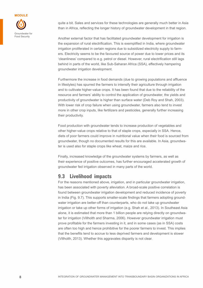
8
9
MODULE
INTEGRATION OF GROUNDWATER MANAGEMENT INTO TRANSBOUNDARY BASIN ORGANIZATIONS IN AFRICA
Groundwater for Food Security
quite a bit. Sales and services for these technologies are generally much better in Asia
than in Africa, reflecting the longer history of groundwater development in that region.
Another external factor that has facilitated groundwater development for irrigation is
the expansion of rural electrification. This is exemplified in India, where groundwater
irrigation proliferated in certain regions due to subsidized electricity supply to farm-
ers. Electricity seems to be the favoured source of power due to lower prices and its
‘cleanliness’ compared to e.g. petrol or diesel. However, rural electrification still lags
behind in parts of the world, like Sub-Saharan Africa (SSA), effectively hampering
groundwater irrigation development.
Furthermore the increase in food demands (due to growing populations and affluence
in lifestyles) has spurred the farmers to intensify their agriculture through irrigation
and to cultivate higher-value crops. It has been found that due to the reliability of the
resource and farmers’ ability to control the application of groundwater, the yields and
productivity of groundwater is higher than surface water (Deb Roy and Shah, 2003).
With lower risk of crop failure when using groundwater, farmers also tend to invest
more in other crop inputs, like fertilizers and pesticides, generally further increasing
their productivity.
Food production with groundwater tends to increase production of vegetables and
other higher-value crops relative to that of staple crops, especially in SSA. Hence,
diets of poor farmers could improve in nutritional value when their food is sourced from
groundwater, though no documented results for this are available. In Asia, groundwa-
ter is used also for staple crops like wheat, maize and rice.
Finally, increased knowledge of the groundwater systems by farmers, as well as
their experience of positive outcomes, has further encouraged accelerated growth of
groundwater fed irrigation observed in many parts of the world.
9.3 Livelihood impactsFor the reasons mentioned above, irrigation, and in particular groundwater irrigation,
has been associated with poverty alleviation. A broad-scale positive correlation is
found between groundwater irrigation development and reduced incidence of poverty
in India (Fig. 9.7). This supports smaller-scale findings that farmers adopting ground-
water irrigation are better-off than counterparts, who do not take up groundwater
irrigation or take up other forms of irrigation (e.g. Shah et al., 2013). In Southeast Asia
alone, it is estimated that more than 1 billion people are relying directly on groundwa-
ter for irrigation (Villholth and Sharma, 2006). However groundwater irrigation must
prove profitable for the farmers investing in it, and in some cases (as in SSA) costs
are often too high and hence prohibitive for the poorer farmers to invest. This implies
that the benefits tend to accrue to less deprived farmers and development is slower
(Villholth, 2013). Whether this aggravates disparity is not clear.
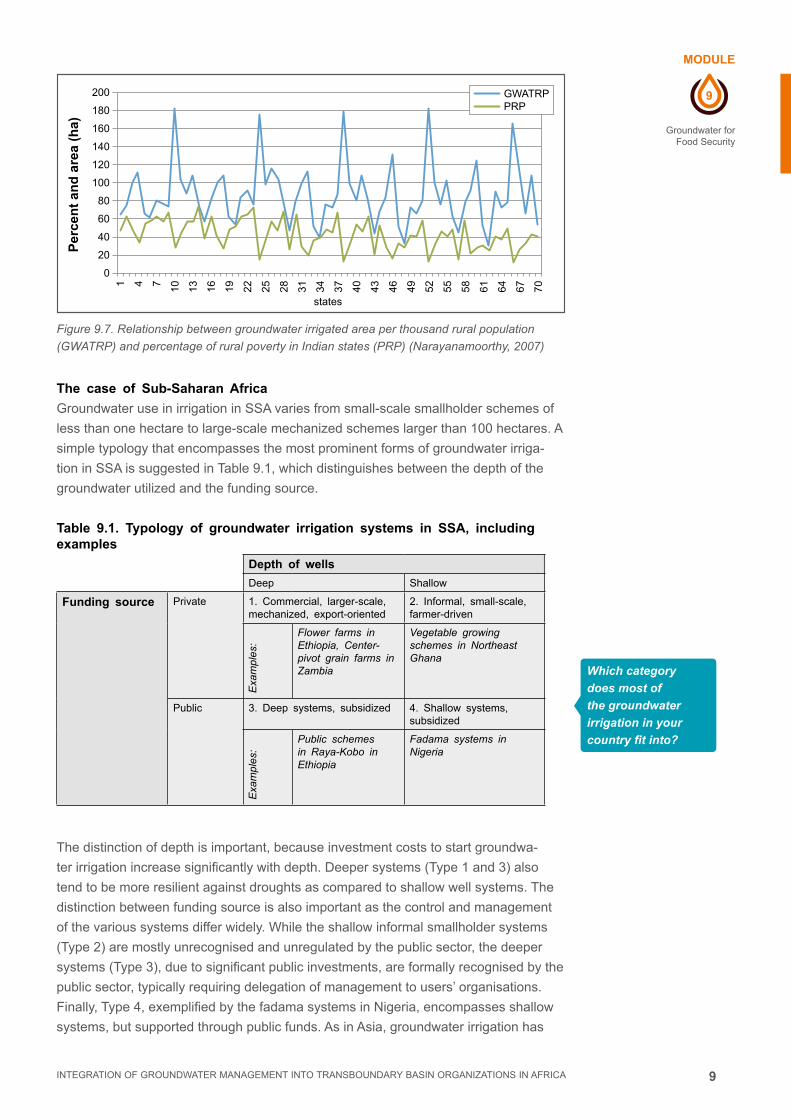
9
9
MODULE
INTEGRATION OF GROUNDWATER MANAGEMENT INTO TRANSBOUNDARY BASIN ORGANIZATIONS IN AFRICA
Groundwater for Food Security
Figure 9.7. Relationship between groundwater irrigated area per thousand rural population
(GWATRP) and percentage of rural poverty in Indian states (PRP) (Narayanamoorthy, 2007)
The case of Sub-Saharan Africa
Groundwater use in irrigation in SSA varies from small-scale smallholder schemes of
less than one hectare to large-scale mechanized schemes larger than 100 hectares. A
simple typology that encompasses the most prominent forms of groundwater irriga-
tion in SSA is suggested in Table 9.1, which distinguishes between the depth of the
groundwater utilized and the funding source.
Table 9.1. Typology of groundwater irrigation systems in SSA, including examples
Depth of wells
Deep Shallow
Funding source Private 1. Commercial, larger-scale, mechanized, export-oriented
2. Informal, small-scale, farmer-driven
Exa
mpl
es:
Flower farms in Ethiopia, Center-pivot grain farms in Zambia
Vegetable growing schemes in Northeast Ghana
Public 3. Deep systems, subsidized 4. Shallow systems, subsidized
Exa
mpl
es:
Public schemes in Raya-Kobo in Ethiopia
Fadama systems in Nigeria
The distinction of depth is important, because investment costs to start groundwa-
ter irrigation increase significantly with depth. Deeper systems (Type 1 and 3) also
tend to be more resilient against droughts as compared to shallow well systems. The
distinction between funding source is also important as the control and management
of the various systems differ widely. While the shallow informal smallholder systems
(Type 2) are mostly unrecognised and unregulated by the public sector, the deeper
systems (Type 3), due to significant public investments, are formally recognised by the
public sector, typically requiring delegation of management to users’ organisations.
Finally, Type 4, exemplified by the fadama systems in Nigeria, encompasses shallow
systems, but supported through public funds. As in Asia, groundwater irrigation has
200
180
160
140
120
100
80
60
40
20
0
1 4 7 10 13 16 19 22 25 28 31 34 37 40 43 46 49 52 55 58 61 64 67 70
states
Per
cen
t an
d a
rea
(ha)
GWATRP PRP
Which category
does most of
the groundwater
irrigation in your
country fit into?

10
9
MODULE
INTEGRATION OF GROUNDWATER MANAGEMENT INTO TRANSBOUNDARY BASIN ORGANIZATIONS IN AFRICA
Groundwater for Food Security
proven instrumental in poverty alleviation in SSA, when the poorest population groups
simultaneously get access to groundwater through cheap wells and pumps as well as
the necessary enabling factors associated with farming, e.g. access to energy, credit,
agricultural inputs, and training (Villholth, 2013). Data from particular cases are given
in Table 9.2.
Pictures illustrating the various systems are shown in Fig. 9.8.
Figure 9.8. Illustrations of the various groundwater irrigation types
The hydrogeology, in combination with the socio-economic and political factors,
governs which types of groundwater irrigation are developed. Since the potential
for groundwater irrigation development in SSA in general is large, various methods
have been proposed to estimate the potential in terms of size of area and distributed
locations. It is estimated that another 26 million households could benefit and about 13
million hectares of farmland could be sustainably irrigated with groundwater in thirteen
selected countries of SSA (Pavelic et al., 2013). A simple compilation and analysis
of groundwater irrigation-related indicators revealed a certain ranking in potential of
fourteen different SSA countries (Box 9.2).
BOX 9.2. GROUP RANKING OF SELECTED COUNTRIES IN SSA WITH RESPECT
1. Low or localised potential:
Kenya, Mali, Niger, South Africa, Tanzania
2. Still appreciable potential:
Burkina Faso, Ethiopia, Ghana, Malawi, Mozambique, Nigeria, and Zambia
3. Great potential, but demand for irrigation limited at present:
Rwanda, Uganda
If not on the
list, which group
do you think your
country falls into?

11
9
MODULE
INTEGRATION OF GROUNDWATER MANAGEMENT INTO TRANSBOUNDARY BASIN ORGANIZATIONS IN AFRICA
Groundwater for Food Security
Table 9.2. Data from irrigation cases, including groundwater irrigation, in SSA, with focus on smallholder systems
Cou
ntry
,re
gion
Irrig
atio
n st
arte
dP
lot
size
pe
r H
Ha
(ha)
GW
dep
th,
wel
l ty
peC
ombi
ned
w.
rain
fed?
Lifti
ng
devi
ce,
irrig
atio
n de
vice
Cro
ps,
GW
I se
ason
GW
I pr
actit
ione
rsLa
nd
tenu
reG
WI
type
(c
f. Ta
ble
3)
GW
I de
v.
stag
eb
Far
min
g w
. hi
ghes
t pr
oduc
tivity
c
Ext
erna
l fin
anci
al
supp
ort
Ref
eren
ce
Eth
iopi
aR
aya-
Kob
o V
alle
y
>19
95~
0.2
5D
eep,
w
ells
(60
-17
0 m
)
Yes
Ele
c.
pum
ps,
furr
ow/
buck
ets/
sp
rinkl
er
Oni
on/
tom
ato/
pepp
erD
ry
seas
on
Sm
allh
olde
r fa
rmer
sLe
ase/
shar
e cr
oppi
ng/
own
32
Mot
or p
ump
irrig
atio
n fr
om G
W
Par
tly
gov’
t/ N
GO
s
Geb
regz
iabh
er
et a
l. (2
013)
; A
yene
w e
t al
. (2
013)
; A
bate
(20
06)
Gha
naU
pper
E
ast
Reg
ion
1890
’s0.
01-0
.21
Sha
llow
,du
gout
s/H
DW
sd
Yes
Rop
e an
d bu
cket
s
Tom
ato/
onio
n/pe
pper
Dry
se
ason
Mos
tly
wom
en a
nd
yout
h
Leas
e2
1B
ucke
t irr
igat
ors
from
GW
Lim
ited
Obu
obie
et
al.
(201
3);
Nam
ara
et a
l. (2
013)
;D
ittoh
et
al.
(201
3)
Nig
erN
iam
ay
Cap
ital
Dis
tric
t
>19
900.
13D
eep
+
shal
low
, va
rious
Yes
Han
d/fo
ot
pum
ps,
buck
ets
Oni
on/
tom
ato/
cabb
age
Dry
se
ason
2/3
wom
enIn
divi
dual
/co
llect
ive
21
GW
irr
igat
ion
Par
tly
gov’
t/ N
GO
s
Toro
u et
al.,
20
13
Nig
eria
Nor
ther
n N
iger
ia
>19
930.
5 -
1.0
Sha
llow
,bo
reho
les
Yes
Mot
or
pum
ps,
flood
ing
Oni
on,
cabb
age,
pe
pper
, to
mat
oes
All
year
Sm
allh
olde
r fa
rmer
sIn
divi
dual
/le
ase
42-
3G
W
irrig
atio
nW
orld
B
ank/
Gov
’t
Abr
ic e
t al
. (2
011)
; N
kony
a et
al.
(201
0);
Dab
i (n
o ye
ar)
a H
H: H
ouse
hold
; b G
WI d
evel
opm
ent s
tage
acc
. to
Deb
Roy
and
Sha
h (2
003)
.
1 si
gnifi
es e
arly
sta
ges
of g
roun
dwat
er d
evel
opm
ent w
hile
4 in
dica
tes
mat
ure
and
over
-dev
elop
men
t of g
roun
dwat
er; c
Gro
ss r
even
ue p
er h
a; d
HD
W: H
and-
dug
wel
l

12
9
MODULE
INTEGRATION OF GROUNDWATER MANAGEMENT INTO TRANSBOUNDARY BASIN ORGANIZATIONS IN AFRICA
Groundwater for Food Security
9.4 Too much and too little groundwater development for irrigation is a concern
Regions like SSA and Southeast Asia differ widely in the scale and significance of
their groundwater irrigation (Fig. 9.4 and 9.6). In India, as an example, groundwater
contributes to more than 60 % of the irrigated areas, whereas the same figure for SSA
is between 10 and 20 % (Villholth, 2013). While irrigation in general is much lower
in SSA than in Asia, demonstrating some overall impediments, these data show the
quite different contexts and trajectories of groundwater development across the globe.
It is generally surmised that Southeast Asia presents a case of overdevelopment of
groundwater, while SSA is one of under-exploitation. In the first case, while groundwa-
ter has proven instrumental in alleviating poverty on a large scale in India, the condi-
tions in some parts of the country are presently considered unsustainable, contribut-
ing to environmental degradation, diminishing profits from irrigation, and increasing
conflicts between water users, etc. In SSA, it is considered that groundwater holds
a large potential for further supporting small- and large-scale irrigation development,
food production and poverty alleviation. In Table 9.3, the countries in the world with
over-exploitation of groundwater are listed according to their depletion rates. It is seen
that both developed as well as developing countries are struggling with depletion of
groundwater resources.
Some of the reasons for the disparity in groundwater development between Asia and
SSA are:
■■ Larger population density in Southeast Asia, necessitating intensified agriculture
■■ Cheaper and easier access to pumps and drilling technologies in Southeast Asia
■■ More profound embedding of the Green Revolution in Asia
■■ Lack of community tradition in irrigated cultivation, compared to rain-fed arable
cropping and extensive livestock rearing in SSA
■■ Poor rural infrastructure, roads, storage facilities etc.
■■ Limited commercial ventures in SSA.
■■ Very low levels of rural electrification in SSA, coupled with the elevated cost and
distribution difficulty associated with use of diesel fuel for pumping
■■ Inadequate access to financial credit for irrigation hardware acquisition and purchas-
ing essential production inputs in SSA (such as quality seeds and agrochemicals)
■■ Better and more productive aquifers in Asia
Which of
these reasons do
you think are most
critical?

13
9
MODULE
INTEGRATION OF GROUNDWATER MANAGEMENT INTO TRANSBOUNDARY BASIN ORGANIZATIONS IN AFRICA
Groundwater for Food Security
Table 9.3. Reported groundwater abstraction rate (A) and model-estimated groundwater depletion rate (D) for selected countries in subhumid to arid regions, with ranges of uncertainty given in parenthesis, for the year 2000. Depletion is the rate of abstraction exceeding long term average recharge (Wada et al., 2012)
9.5 Solutions to under- and over-use of groundwater for irrigation
Modifying current approaches to use and management of groundwater for irrigation
may not be straightforward, neither in the over- nor the under-exploitation cases. How-
ever, optimising use in both cases is imperative for long-term sustainable environmen-
tal and socio-economic outcomes. For SSA, the situation is more a case of under use
of the groundwater resource for irrigation. The role of groundwater managers will then
be more aligned to finding ways to stimulate development of this sector.
CountryAbstraction (A)
(km3 / yr-1
Depletion (D)(km3 / yr-1 D/A (%)
India 190 (±37) 71 (±21) 37 (±19)United States 115 (±14) 32 (±7) 28 (±9)China 97 (±14) 22 (±5) 22 (±9)Pakistan 55 (±17) 37 (±12) 69 (±48)Iran 53 (±10) 27 (±8) 52 (±24)Mexico 38 (±4) 11 (±3) 30 (±11)Saudi Arabia 21 (±3) 15 (±4) 72 (±30)Russia 12 (±2) 1.5 (±0.5) 14 (±7)Italy 11 (±3) 2.3 (±0.6) 21 (±13)Turkey 8 (±2) 2.4 (±0.8) 31 (±18)Uzbekistan 6.5 (±1.8) 4.0 (±1.4) 63 (±43)Egypt 5 (1.3) 3.0 (±1.2) 61 (±43)Bulgaria 4.8 (±1.4) 2.0 (±0.8) 42 (±32)Spain 4.6 (±1.1) 1.7 (±0.6) 37 (±23)Argentina 4.5 (±0.9) 0.9 (±0.3) 20 (±11)Libya 4.4 (±1.2) 3.1 (±0.9) 70 (±43)Ukraine 4.2 (±0.9) 0.3 (±0.08) 7 (±3.5)Romania 3.5 (±1) 1.3 (±0.6) 38 (±30)Kazakhstan 3.4 (±1) 2.0 (±0.5) 59 (±35)South Africa 3.0 (±0.7) 1.5 (±0.5) 50 (±30)Algeria 2.5 (±0.7) 1.7 (±0.6) 69 (±48)Greece 2.4 (±0.6) 0.34 (±0.1) 14 (±8)Morocco 2.4 (±0.4) 1.6 (±0.5) 67 (±34)Australia 2.1 (±0.4) 1.0 (±0.3) 48 (±24)Tajikistan 1.9 (±0.5) 1.2 (±0.4) 61 (±40)Yemen 1.9 (±0.5) 0.9 (±0.3) 49 (±31)Turkmenistan 1.85 (±0.5) 1.25 (±0.5) 70 (±50)Syria 1.59 (0.4) 1.23 (±0.3) 78 (±41)UAE 1.55 (0.3) 1.18 (±0.4) 76 (±42)Tunisia 1.55 (±0.5) 0.65 (±0.2) 42 (±30)Peru 1.23 (±0.4) 0.32 (±0.08) 26 (±17)Bolivia 0.68 (±0.2) 0.25 (±0.08) 37 (±25)Israel 0.61 (±0.2) 0.38 (±0.1) 62 (±41)Kyrgyzstan 0.61 (±0.2) 0.31 (±0.1) 51 (±37)Jordan 0.52 (±0.2) 0.22 (±0.08) 42 (±38)Mauritania 0.51 (±0.1) 0.36 (±0.1) 71 (±35)Oman 0.50 (±0.2) 0.2 (±0.06) 39 (±33)Kuwait 0.29 (±0.1) 0.25 (±0.09) 87 (±70)Qatar 0.18 (±0.05) 0.15 (±0.06) 83 (±60)Globe 734 (±82) 256 (±0.38) 34 (±9)

14
9
MODULE
INTEGRATION OF GROUNDWATER MANAGEMENT INTO TRANSBOUNDARY BASIN ORGANIZATIONS IN AFRICA
Groundwater for Food Security
Some questions that may arise for water managers are:
■■ How do RBOs in Africa manage the development of groundwater fed irrigation in
SSA?
■■ How can RBOs avoid the overexploitation of groundwater that has been witnessed
in south-east Asia?
■■ What role can RBOs play in stimulating groundwater use for irrigation?
■■ What may be effective management systems for groundwater irrigation at different
scales of development and use?
■■ What can be the role of TBOs in management of groundwater irrigation?
■■ Why should RBOs in Africa invest in groundwater management for irrigation when
groundwater use is so limited and conflicts hardly exist and are very localized?
In Table 9.4, some overall options for improving use and management for groundwater
irrigation are provided.
Table 9.4. Approaches to enhance sustainable use of groundwater for irrigation in Southeast Asia and Sub-Saharan Africa
Sub-Saharan Africa South-East Asia
Develop national and regional policy for groundwater irrigation development
Diversify livelihoods away from groundwater irrigation
Develop maps and knowledge of the aquifers at various scales
Encourage groundwater development in less developed regions
Promote and support aquifer development by appropriate gw irrigation systems (table 9.1)
Ration electricity supply to irrigation while making it reliable
Expand reliable rural electrification Increase irrigation efficiency
Improve rural roads Encourage rainfed and drought-resistant crops
Provide incentive subsidies for eg. pumps, electricity, drilling etc.
Encourage local management of groundwater among the farmers
Improve market chains for equipment & crops Encourage artificial groundwater recharge
Promote user based gw allocation and management systems.
Conjunctive use of groundwater and surface water
Improve land tenure security
Incentivize rural food processing industries
Expand curriculum of extension workers to include groundwater irrigation aspects
Develop micro-credits targeted to smallholders to access groundwater irrigation
Empower farmers to organise themselves to request policy changes
Such social changes tend to take time to gain a strong foot-hold but where real eco-
nomic and financial gains are to be made, communities around the world have shown
rapid adaptability to take advantage of favorable conditions. RBOs can be the cata-
lysts for such positive changes in SSA.
Which of these
approaches are
top-down or bottom-
up? How to facilitate
each?

15
9
MODULE
INTEGRATION OF GROUNDWATER MANAGEMENT INTO TRANSBOUNDARY BASIN ORGANIZATIONS IN AFRICA
Groundwater for Food Security
9.6 The new approach: The nexus between water-, energy-, and food security
As there is limited access to water, sanitation, food and energy (often due to poor man-
agement and governance structures), a rapidly growing population will put even more
stress on the availability and the sustainability of the planet’s resources. The systems
that help produce and bring fresh food and energy as well as clean, abundant water
to all of us, are intertwined. It takes water to create food and energy, it takes energy to
move and treat water and to produce food, and sometimes we use food as a source of
energy. These systems have become increasingly complex and dependent upon one
another as the resources come under increasing pressure. As a result, a disturbance in
one system can wreak havoc in the others, so it is important to achieve a sustainable
balance between the three. Therefore, it is important to realise the interdependency in
these sectors to avoid the growing trade-offs between these development-goals.
When groundwater resources are accessed to provide for irrigation demand, the
nexus between water-, energy and food security is evident. There will be an energy
demand to lift the water to the surface and to distribute it to the crop. Energy access
and price are strong drivers for groundwater abstraction. Several countries around the
world have subsidised diesel or electricity for the agricultural sector to secure farmer’s
incomes and national food sovereignty. Such subsidy incentives tend to lead to an ex-
pansion of the area on which water intensive crops are cultivated with water inefficient
technologies that finally result in the depletion of groundwater. Especially in many
arid countries where groundwater resources are non-renewable this is a particular
problem. Such depletion also has vast implications for the energy sector which looses
income and becomes bankrupt.
Agricultural output remains fundamental to national well-being and to economic out-
put. However, integrating the interdependencies between energy-, food- and water
security in national policies and programmes have the potential to improve the econo-
my, conserve natural resources, and increase food security.
In many places in Africa, electricity is not developed in rural areas and causes a
constraint for the development of groundwater, beyond simple manual lifting for small-
scale irrigation. Conversely, electricity development often is associated with greater
dependence on groundwater for irrigation
No system is perfectly elastic and there will be many complex trade-offs, spatially and
materially, in the nexus between water-, food-, and energy security. Export of food
is a virtual export of energy and water; and vice versa for food imports. In summary,
when advocating for the development of groundwater-based irrigation, basin organ-
izations and other decision makers should address the interdependencies between
water-, food-, and energy security. Increasing groundwater irrigation through subsidies
to energy for farmers may be tricky, as it may strain the energy systems, may benefit
certain population groups, and encourage unsustainable groundwater use. Decision
makers need to ensure that the development of groundwater for irrigation is a sustain-
able endeavour and a positive development for all components of the society, and not
just for one class against the interests of another.

16
9
MODULE
INTEGRATION OF GROUNDWATER MANAGEMENT INTO TRANSBOUNDARY BASIN ORGANIZATIONS IN AFRICA
Groundwater for Food Security
9.7 References and further reading
Giordano, M. and K.G. Villholth (Eds.), 2007.
The Agricultural Groundwater Revolution: opportunities and Threats to Devel-
opment.
CABI, in ass. w. IWMI. 419 pp. ISBN-13: 978 1 84593 172 8.
Nkonya, E., Phillip, D., Mogues, T., Pender, J., and Kato, E. (2010).
From the ground up. Impacts of a Pro-Poor Community-Driven Development
Project in Nigeria.
IFPRI, 77pp. doi:10.2499/978089629179.
Shah, T., J.J. Burke, and K.G. Villholth, 2007.
Groundwater: a global assessment of scale and significance.
Chapter 10, 395-423. In: D. Molden (Ed.): Water for Food, Water for Life. Comprehen-
sive Assessment of Water Management in Agriculture Synthesis Report.
Earthscan. ISBN: 978-1-84407-396-2.
Villholth, K.G., 2013.
Groundwater irrigation for smallholders in Sub-Saharan Africa - a synthesis of
current knowledge to guide sustainable outcomes.
Wat. Int. http://dx.doi.org/10.1080/02508060.2013.821644
Wada,Y., L.P.H. van Beek, and M.F.P. Bierkens, 2012.
Nonsustainable groundwater sustaining irrigation: A global assessment.
Wat. Res. Resear., 48, W00L06, doi:10.1029/2011WR010562.
http://gracelinks.org/468/nexus-food-water-and-energy
http://www.water-energy-food.org/

17
9
EXERCICE
INTEGRATION OF GROUNDWATER MANAGEMENT INTO TRANSBOUNDARY BASIN ORGANIZATIONS IN AFRICA
Groundwater for Food Security
9.8 ExerciseTragedy of the Groundwater Commons
Rules of the Game
Version: 19 Sep. 2013
Frank van Weert (IGRAC) and Karen G. Villholth (IWMI)
General rules
There are nine farming households and one fishing household (there are nine teams
in total playing the game).
The farming households each have a farmland of 100 hectares and each have their
own groundwater well (needed for groundwater irrigation). Only one type of crop is
grown.
Only the fishing household is allowed and able to fish in the community lake and the
lake water level is dependent on the groundwater level. The layout of the wells and the
lake are shown in Figure 1. When groundwater is pumped, some wells may interfere
with each other. This means that one well will be drawn down not only by that well but
also by the surrounding wells (Figure 2).
The game consists of a series of simulation runs, each representing one growing
season.
Each farming household can produce one harvest per simulation run and the fisher-
men household can produce one fish catch per simulation run.
After each simulation run, the groundwater and lake level go back to ‘normal’ (no
physical memory effect in the hydrogeological system).
Performing livelihood activities have associated costs and benefits (see below) and
these costs and benefits accumulate over multiple simulation runs. The team that
accumulates most net benefits over the series of simulation runs has won. However,
note that maximizing production (cropping area) may not optimize net incomes! Vari-
ous mechanisms may limit the net outcome:
1. The drawdown of the groundwater level, which implies a larger cost of abstracting
groundwater
2. The drying of the lake, which implies an environmental (health) cost
3. Climate shocks that limit the crop yields
4. Penalty costs for drafting groundwater above an upper cap that has been decided
by a majority of well owners
4. All households start with an equal capital of 0€.
6. If a household reaches a debt of 250€ the household is out of business for the rest
of the game.
7. Players are able to set the rules if a majority agrees: however transaction costs
are involved.

18
9
EXERCICE
INTEGRATION OF GROUNDWATER MANAGEMENT INTO TRANSBOUNDARY BASIN ORGANIZATIONS IN AFRICA
Groundwater for Food Security
Benefits (per simulation run, per household)
■■ 2 €/ha in case of farming
■■ 150 € for fish catch
Costs (per simulation run, per household)
Type Amount Explanation
Living cost 25 € Note: Not playing (no livelihood activity) will cost you money anyhow!
Cost of fishing: 100 €
Abstraction cost Variable is a function of volume of pumped groundwater, groundwater level and unit price per unit volume (0.002 €/m3)
Cap rule transaction cost 100 € divided by the number of players that join the rule for that simulation run
Advice: Convince others to join: it will make your transaction costs smaller; but be aware of free-riders!
Environmental (health) cost 35 € When the lake runs dry fishing household is temporarily out of business, all households pay costs for getting sick because of protein deficit!
Social cost or benefit 20% of averaged cumulative net benefit from all the households
Paid by or accrued to all households in the subsequent run
Water saving equipment cost
150 € Like drip irrigation kits. Implies 20% water saving and smaller farming costs. Investment is only done once during a game
Penalty cost for no compliance with cap rule
Is set by those who pay cap rule transaction costs and given to non- compliers

19
9
EXERCICE
INTEGRATION OF GROUNDWATER MANAGEMENT INTO TRANSBOUNDARY BASIN ORGANIZATIONS IN AFRICA
Groundwater for Food Security
Figure 1. Location of wells and the lake
Figure 2. Illustration of interference between pumping wells

10
MODULE
INTEGRATION OF GROUNDWATER MANAGEMENT INTO TRANSBOUNDARY BASIN ORGANIZATIONS IN AFRICA
GROUNDWATER AND ENVIRONMENT

2 INTEGRATION OF GROUNDWATER MANAGEMENT INTO TRANSBOUNDARY BASIN ORGANIZATIONS IN AFRICA

3
10
MODULE
INTEGRATION OF GROUNDWATER MANAGEMENT INTO TRANSBOUNDARY BASIN ORGANIZATIONS IN AFRICA
Groundwater and Environment
CONTENT
MODULE 10Groundwater and Environment
10.1 Introduction 4
10.2 Surface and groundwater interaction 4
10.3 Groundwater Contamination 5
10.4 Groundwater-dependent ecosystems (GDEs) 8
10.5 Groundwater over-abstraction 10
10.6 Environmental aspects of groundwater management 11
10.7 The role of basin organizations in environmental management
of groundwater 12
10.8 References & Further reading 13
Imprint
© Copyright 2014, all rights reserved
The use of the manual is FREE of cost. AGW-Net simply requests that users give proper
attribution “Integration of Groundwater Management into Transboundary Basin Organizations in
Africa - a Training Manual by AGW-Net, BGR, IWMI, CapNet, ANBO, & IGRAC” . Modification
is only allowed with permission of AGW-Net.
Photos are copyright to their respective owners.
A4A – aqua for all
AGW-Net – Africa Groundwater Network
ANBO – African Network of Basin Organisations
BGR – Federal institute for geosciences and natural resources
Cap-Net UNDP
BMZ – Federal Ministry for Economic Cooperation and Development
GWP – Global Water Partnership
IGRAC – International Groundwater Resources Assessment Centre
imawesa – Improved Management of Agricultural Water in Eastern and Southern Africa
IWMI - International Water Management Insitute
Editorial Staff: Vanessa Vaessen, Ramon Brentführer – BGR
Layout: ff.mediengestaltung GmbH, Hannover, Germany
Picture: IGRAC

4
10
MODULE
INTEGRATION OF GROUNDWATER MANAGEMENT INTO TRANSBOUNDARY BASIN ORGANIZATIONS IN AFRICA
Groundwater and Environment
GROUNDWATER AND ENVIRONMENT
10.1 IntroductionGroundwater is that part of the hydrologic cycle that lies below the surface of the
Earth. Development of groundwater for various human uses has an impact on the en-
vironment. Similarly changes in the surface environment, whether of natural or anthro-
pogenic origin, have the potential to affect the groundwater resource.
■■ There are two main interactions between the environment and groundwater: one
is predicated on flows from the environment into the groundwater system and the
other on flows from the groundwater system to the environment.
■■ The environment interfaces with groundwater by impacting on the recharge
quantity and quality. Some of these interactions are entirely natural and others are
modified by human activities. For example, various forms of land use and hu-
man waste management may result in groundwater contamination. Groundwater
recharge may be increased or decreased by natural or human induced changes to
the environment.
■■ Groundwater discharge to the environment occurs at Groundwater Dependent
Ecosystems (GDE). A groundwater dependent ecosystem may be defined as a
place where the groundwater surface intersects the land surface, giving rise to
some form of usually perennial wetland environment. GDEs tend to host an entire-
ly distinct suite of biota, and are generally highly bio-diverse and productive com-
pared to the surrounding dry land. GDEs may arise from a number of different sets
of groundwater conditions, giving rise to the differences between different types
of GDEs and to their individual signatures. The varieties of GDEs are described in
section 4 of this module.
10.2 Surface and groundwater interactionSurface water and groundwater are linked as components in the hydrologic system. In
humid climates, groundwater and surface water are frequently in direct contact, while
in arid and semi-arid climates, the link is indirect since they are usually seperated by
a thick unsaturated vadose zone. Excessive abstraction from and contamination of
either one will in time most likely affect the other. Understanding the basic principles
of interactions between surface water and groundwater is important for an effective
management of the all water resources.
Water, whether surface or groundwater, flows in the direction of the hydaulic gradient.
LEARNING OBJECTIVES■■ To understand the link between groundwater and the environment
■■ To appreciate the main environmental threats that affect groundwater
■■ To appreciate the impacts that use or abuse of the groundwater resource can
have on the environment.
■■ To understand the interactions between contaminants and aquifers
■■ To characterize groundwater-dependent ecosystems

5
10
MODULE
INTEGRATION OF GROUNDWATER MANAGEMENT INTO TRANSBOUNDARY BASIN ORGANIZATIONS IN AFRICA
Groundwater and Environment
Water flows from a high hydraulic head to a low hydraulic head. This fundamental
principle governs all water flows. In order to determine the direction of flow, it is neces-
sary to know the head at the either end of the flow path. Once the head dsitribution is
know, it is straightforward to determine if flow is from the surface environment into the
groundwater or vice versa.
Surface water and groundwater interact at many locations in all watersheds. Ground-
water that is recharged from rainfall on upland interfluve areas could be discharged
months or years later to streams, lakes, springs and wetlands. On the other hand,
surface water that is derived from rainfall/runoff may be lost by seepage through the
streambed, soil layer and fractures to mix with groundwater.
Surface water and groundwater interact on different physical scales and over long
periods of time. The interactions of significant interest include (1) groundwater dis-
charging as a baseflow to perennial streams throughout the year; (2) groundwater
discharge as a source for springs, seeps, and cave systems; (3) streamflow supply of
recharge to the groundwater system; (4) groundwater flow into and out of reservoirs,
lakes, ponds and lagoons.
The larger-scale hydrologic exchange of groundwater and surface water in any
landscape is controlled by: 1) the distribution and magnitude of hydraulic properties
(hydraulic conductivity, transmissivity and storativity) 2) the relation of stream stage to
the adjacent groundwater level, modified by the aquifer permeability; 3) the geometry
and position of the stream channel within the alluvial plain (Woessner 2000); 4) the
relative elevation of the water level in stream and groundwater table; and 5) climatic
setting: high rainfall region favours abundant recharge into aquifers and rapid ground-
water level fluctuation.
10.3 Groundwater Contamination Any developmental activity (urbanization, industrial activity, mining and agriculture) by
humans has an impact on both surface water and groundwater.
Surface water and groundwater both originate as precipitation. However, from the
moment that precipitation reaches the soil and begins to infiltrate en route to becom-
ing groundwater, its composition begins to change. Water that infiltrates into soils and
rocks attain different water quality characteristics than the original preciptation water,
?What type of surface and groundwater
interaction processes are you aware of in
any of the catchments in your area? List the
types and identify the links?

6
10
MODULE
INTEGRATION OF GROUNDWATER MANAGEMENT INTO TRANSBOUNDARY BASIN ORGANIZATIONS IN AFRICA
Groundwater and Environment
and from the surface water component that does not infiltrate into the ground. On the
other hand, surface water is open to contamination at the surface by waste mateirals
and bacteria. Thus surface and groundwater tend to have different bio-chemical com-
positions. When they interact, the biochemistry of the resulting water is a product of
the biochemistry of the two water sources.
Urbanization: Urbanization with large population concentrations in localized areas
significantly increases the pollution load due to sewage discharge and solid waste
disposal and hence risk of groundwater pollution. Urban populations generate huge
volumes of sewage and discard vast volumes of solid and liquid waste every day
containing plastics, chemicals, grease and oil, metals, glass, paper, organic wastes
etc. Lack of water borne sewerage systems in most urban centres in Africa also forc-
es people to use pit latrines and/or dispose untreated sewage into water bodies. This
then creates a huge diffuse pollution of the groundwater system. Sewage contains
salts, bacteria, phosphorus and many other chemicals. Overland flow from streets and
buildings also carries pollutants such as bacteria, oil, and chemicals that can enter into
the groundwater.
Urbanization also brings with it waste treatment and disposal sites such as solid waste
landfill sites and sewage treatment plants. These point sources of pollution are sites
where potentially there are concentrations of pollution entering the groundwater.
Industrial activity: Uncontrolled disposal of industrial effluent has a tremendous
impact on groundwater especially from chemical and nuclear wastes. Industrial wastes
are generated during manufacturing processes. Industrial wastes may be toxic, cor-
rosive or reactive. Some examples are: oils, solvents, chemicals, radio active wastes,
scrap metals and many others. If improperly managed, these wastes can pose dan-
gerous consequences through pollution of groundwater upon which people depend.
Waste water from manufacturing or chemical processes in industries contributes a lot
to the groundwater pollution. Most large scale industries have treatment facilities but
many small scale industries do not.
Mining: Prospecting and developing mineral and energy resources in Africa involve
activities with the potential to significantly affect both the quantity and quality of
groundwater resource associated with those areas.
Chemical pollution is often associated with mining. The main pollutant in both active
and abandoned mining areas is acid mine drainage which is rich in heavy metals. Ox-
idation of sulphide minerals, such as pyrite, produces highly acidic water which then
dissolves heavy metals and carries them into the aquatic environment, including the
groundwater.
Dewatering of underground workings is a normal component of all mining. Dewatering
around mine areas will significantly lower the water table, affecting surface water flows
and drying out shallow aquifers. At a local scale, there may be water shortages for
communities due to drying up of surface water bodies (streams, rivers, ponds, wet-
lands, lakes) and springs.

7
10
MODULE
INTEGRATION OF GROUNDWATER MANAGEMENT INTO TRANSBOUNDARY BASIN ORGANIZATIONS IN AFRICA
Groundwater and Environment
The impacts from mining can last for many decades. As a result, environmental impact
assessment, environmental monitoring, contingency planning and financial assurance
have to be in place for management. Geochemical conditions within the ore body,
waste rock, and tailings can change over time and must be tracked. Flexibility, there-
fore, is needed to make necessary changes in water control and water treatment after
mine closure.
Active management of the mine site and water management may be necessary for
years or even decades after closure, depending on the type of mine, the size and
nature of the area of disturbance, and the type of ore processing used. Permanent
closure routinely includes some or all of the following: removal/disposal of chemicals;
structure demolition; removal of unnecessary roadways and ditches; waste detoxifica-
tion; capping of tailings and waste rock; backfilling pits; and active water management,
including assuring that all applicable water-quality standards are met. In numerous
cases, this has meant operating and maintaining a water-treatment facility in order to
remove toxic chemicals. At sites where acid mine drainage is a problem, post-closure
water treatment is necessary for several years, and in some cases, permanently.
Agriculture: Farming has direct and indirect impacts on groundwater quality. Direct
impacts include dissolution and transport of excess quantities of fertilizers, pesticides,
herbicides, antibiotics, hormones and associated materials and hydrologic alterations
related to irrigation and drainage. Indirect impacts include changes in water–rock
interactions in soils and aquifers caused by increased concentration of major ions
and metals. Many studies indicate that agricultural practices have resulted in nitrate
(NO3–) and pesticide contamination of groundwater with localized concentrations in
shallow aquifers.
Sustainable agriculture is one of the greatest challenges to attain in the fast develop-
ing economies in Africa. According to FAO, sustainability implies that agriculture not
only secures a food supply, but that its environmental, socio-economic and human
health impacts are recognized and accounted for within national development plans.
However, this is not priority in poor areas due to the attention to attain food security.
The potential groundwater contaminants due to agricultural activity are:
Nutrients: The risk of nutrients such as nitrogen and phosphorus reaching ground-
water depends on the nutrient application method and extent, type of plantation and
the type of soil. Phosphorus is not very soluble in water and rarely reaches groundwa-
ter except in highly permeable soil. In contrast, nitrogen is water soluble and rapidly
converts to nitrate, which can contaminate groundwater unless it is used up by plants.
High nitrate levels can lead to euthrophication of water bodies.
Pesticides are most likely to leach through sandy soils that contain little organic
matter. Pesticide absorption and breakdown is inefficient in sandy soils with little
organic matter because there are fewer microbes, and leaching can be rapid through
the large soil pores. Since pesticides are designed to kill pests, excessive use will
have far-reaching impact on people who consume groundwater underlying agricultural
areas.
8
10
MODULE
INTEGRATION OF GROUNDWATER MANAGEMENT INTO TRANSBOUNDARY BASIN ORGANIZATIONS IN AFRICA
Groundwater and Environment
Microorganisms live in animal and human intestinal tracts and are excreted in fae-
ces and manure. When they reach surface water, they can cause disease in humans
and livestock. Groundwater is largely protected from such contamination because of
the physical (filtration), chemical (adsorption) and biological (natural die-off) process-
es.
10.4 Groundwater-dependent ecosystems (GDEs)Groundwater-dependent ecosystems (GDEs) vary from being marginally or only occa-
sionally dependent on groundwater to being entirely groundwater dependent.
GDEs are communities of plants, animals and other organisms whose extent and life
processes depend on groundwater. The following are some ecosystems that may
depend on groundwater:
■■ Riverine environements where baseflow discharge maintains perennial stream-
flow.
■■ Wetlands in areas of groundwater discharge or shallow water table
■■ Terrestrial vegetation and fauna, in areas with a shallow water table or in riparian
zones along streams/ rivers
■■ Aquatic ecosystems in groundwater-fed streams and lakes
■■ Karst systems
■■ Springs
■■ Estuarine and near-shore marine ecosystems
Threatening activities to GDEs:
The major threatening activities are:
■■ extensive groundwater resource development
■■ changes in land use – particularly change from indigenous vegetation to agricultur-
al land
■■ agricultural development and expansion
■■ dewatering and acid mine decant associated with mining
■■ river diversion and daming
■■ commercial, urban or recreational developments.
These activities have potential to alter the groundwater levels and the water quality
enjoyed by GDEs. GDEs are, to a significant extent, reliant on groundwater and those
that occupy a very narrow ecological range and those in arid and semi arid areas
could be completely eliminated by even relatively small changes in water regime or
water quality. In dry seasons, especially in less humid and semi-arid areas in Africa,
?What are some of the threatening activities
on GDEs in your watershed?

9
10
MODULE
INTEGRATION OF GROUNDWATER MANAGEMENT INTO TRANSBOUNDARY BASIN ORGANIZATIONS IN AFRICA
Groundwater and Environment
the base flow of rivers is maintained entirely from groundwater. This makes man-
agement of this groundwater very important for both human and environment where
wildlife, flora and people depend on surface water availability.
Many GDEs exist in environments that have been modified by human activity. Some
have come into existence due to human activities, such as wetlands that may occur
downstream of sewage treatment plants or mine decant sites. Others have dried up
as a result of one or more threatening activities indicated above.
Some GDEs are vulnerable to slight groundwater declines due to excessive use and /
or a decrease in recharge. Groundwater extraction by humans can lower groundwater
levels in unconfined aquifers and the piezometric head in confined aquifers. The result
can be alteration of the timing, availability, and volume of groundwater flow to GDEs.
Some of the planning and coordinated implementation methodologies that are appro-
priate to minimize adverse impacts on GDEs ecosystems are (1) maintaining natural
patterns of recharge and discharge; (2) minimizing disruption to groundwater levels
that are critical for ecosystems; (3) protecting groundwater quality by preventing the
addition of toxic contaminants; and (4) rehabilitating degraded groundwater systems
where possible.
Environmental flows
Environmental flows are the quantity and timing of surface and ground water flows
required to maintain the components, functions, processes and resilience of aquatic
ecosystems and the services they provide to people. Environmental flows are intend-
ed to mimic the patterns and ecological outcomes of the natural flow regime. In order
to maintain a healthy environmental flow, coordinated management of surface water
and groundwater is essential. There are flexible and iterative frameworks that can help
in the environmental flow assessment in a given river basin. The following framework
includes three levels of assessment: 1) Comprehensive hydrologic assessment: desk
top and field (identifying hydrologic indicators, ecological limits of hydrological alter-
ations); 2) Scientific interpretation of the processes and impacts: focus group discus-
sion; and 3) examining trade-offs and prediction of impacts and recommendations.
Even though environmental flow assessment focuses on river water, the management
solution will surely address sustainable use of groundwater in order to maintain base
flow to streams.
Some goals for the management of GDE’s are suggested below:
■■ Manage GDEs to satisfy various legal mandates, including, but not limited to,
those associated with floodplains, wetlands, water quality and quantity, acid mine
drainage and decant, endangered species, and cultural areas.
■■ Manage GDEs under the principles of IWRM, while emphasizing protection and
improvement of groundwater.
■■ Delineate and evaluate both groundwater and GDEs before implementing any
project potentially adversely affecting the resources. Determine geographic bound-
aries of GDEs based on site-specific characteristics of water, geology, flora, and
fauna.

10
10
MODULE
INTEGRATION OF GROUNDWATER MANAGEMENT INTO TRANSBOUNDARY BASIN ORGANIZATIONS IN AFRICA
Groundwater and Environment
■■ Establish maximum limits to which water levels can be drawn down at a specified
distance from a GDE in order to protect the character and function of that ecosys-
tem.
■■ During borehole development, establish a minimum distance from a connected
river, stream, wetland
10.5 Groundwater over-abstractionGroundwater depletion is the inevitable and natural consequence of withdrawing water
from an aquifer. Groundwater over-abstraction has a potential to affect the water bal-
ance in catchments of rivers and wetlands in hydraulic connection with groundwater and
may lead to reductions in baseflow. However, ‘over abstraction’ is a value judgement.
How much is ‘over abstraction’? Over abstraction may be considered to occur if there
are any irreversible impacts on the aquifer. Of course by this stage, it is already too late
because permanent environmental damage has already taken place. Over abstraction
might be considered to occur when the benefits of groundwater abstractions are over-
shadowed by the negative impacts arising from reduction to baseflow and spring flow.
Granting licenses for groundwater abstraction in sensitive areas requires comprehen-
sive understanding of the interrelationship of the surface water and groundwater bod-
ies. Such information will not be readily achieved without a suitably designed monitor-
ing system and a good time series of data to assist in assessing this interrelationship,
which may then be used as a basis for adjusting abstraction limits.
The response of the aquifers to over-pumping depends on characteristics of the
aquifer, such as aquifer transmissivity and specific yield (if unconfined) or storativity (if
confined) and the rate of recharge. Confined or leaky aquifers will show the most rapid
and most significant head response to pumping and this can induce the most signifi-
cant head differences and fluxes at a river. Land subsidence adjacent to developed
aquifers can result from fluid pressure declines because of groundwater withdrawals.
It is important to be flexible when developing management solutions to such envi-
ronmental challenges. Conserving groundwater by reducing pumping can be accom-
plished through administrative, legislative, or management controls, including econom-
ic incentives to reduce demand. It is important to target reductions that actually save
water. In agricultural areas, for example, improved efficiency is sometimes sought
through lining irrigation canals to reduce seepage. While this saves irrigation water,
it also reduces return flows to the groundwater. A more effective strategy might be to
plant a different crop that uses less water.
?What measures would you recommend?

11
10
MODULE
INTEGRATION OF GROUNDWATER MANAGEMENT INTO TRANSBOUNDARY BASIN ORGANIZATIONS IN AFRICA
Groundwater and Environment
Conjunctive management of surface water and groundwater could help to reduce the
pressure on both resources. Conjunctive management of surface and groundwater
may be predicated on the feature that surface water abstraction, daming, diversion
etc. have very significant upstream / downstream impacts. With groundwater abstrac-
tion, the impacts are centred around the abstraction points with much less significant
upstream / downstream effects. Optimization methods may be used to position pump-
ing centers to maximize withdrawals while minimizing upstream / downstream detri-
mental effects such as stream baseflow depletion. This may lead future water man-
agers to implement appropriation zoning or to require well permits in which allowable
pumping rates vary with location because of hydrogeological properties, distance from
boundaries, and unit responses of surface water.
Reallocation between also economic sectors provides opportunities to optimize
conjunctive use. For example potable groundwater resources may be substitued for
untreated surface water, which may then be directed to irrigation demand.
10.6 Environmental aspects of groundwater management
Groundwater management is an important part of water resources management in
order to sustain the livelihood of vast rural populations, rapidly growing urbanization,
irrigation and industrial activity. The three main considerations for environmentally
sound groundwater management are the following:
(i) Groundwater development must be sustainable on a long-term basis. This means
that the rate of abstraction should be equal to or less than the rate of recharge. If
the rate of abstraction is higher than the rate of recharge, it will result in groundwa-
ter mining, which may be carefully considered for some specific cases. If mining
occurs, groundwater levels will continue to decline, which will steadily increase
pumping costs, and then at a certain level it would no longer be economic to pump
it for many uses such as agricultural production.
(ii) Human activities which could impair the quality of groundwater for potential future
use should be controlled. This would include leaching of chemicals like nitrates
and phosphates from extensive and intensive agricultural activities, contamination
by toxic and other undesirable chemicals from landfills and other environmentally
unsound waste disposal practices, bacterial and viral contamination due to in-
adequate sewage treatment and wastewater disposal practices, and increasing
salinity content due to inefficient or improper irrigation practices, and salinization
due to overpumping in coastal areas.
(iii) Improper groundwater management often contributes to other adverse environ-
mental impacts such as dessication of wetlands, decrease in baseflow etc.
Environmental impact assessments may be considered to be as a planning tool to
assist planners in anticipating potential future impacts of alternative groundwater de-
velopment activities, both beneficial and adverse, with a view to selecting the ‘optimal’
alternative which maximizes beneficial effects and mitigates adverse impacts on the
environment. It can be used not only for groundwater development projects but also
for plans, programmes and policies (Biswas, 1992).
12
10
MODULE
INTEGRATION OF GROUNDWATER MANAGEMENT INTO TRANSBOUNDARY BASIN ORGANIZATIONS IN AFRICA
Groundwater and Environment
10.7 The role of basin organizations in environmental management of groundwater.
What are the roles that basin organizations can assume to make sure that the ground-
water management carried out is sensitive to environmental needs?
Water availability:
This module has discussed the impact of groundwater abstraction on baseflow and on
groundwater dependent ecosystems. BO’s may carry out river hydrograph analyses to
determine how much of total river flow in the catchment may be attributed to baseflow.
Comparisons between river flow in areas with heavy groundwater use and similar
rivers in areas without groundwater abstraction can provide some answers. However
monitoring of both groundwater pumping, time series of groundwater levels and river
stage levels will be essential to manage these interactions. Without data, such man-
agement becomes just guess work, and can have a negative economic impact without
providing any benefits to river flow.
BO’s may carry out an inventory of groundwater dependent ecosystems and quantify
their economic and environmental value. If such ecosystems are potentially threat-
ened by groundwater resource development or changes in land use, then the BO may
institute monitoring and issue groundwater abstraction permits of short duration with
regular review. A priority ranking system can be helpful to ensure the most vulnerable
and the most valuable GDEs are protected. GDE’s may start to change in unaccept-
able ways long before complete dessication, and thresholds for such changes need to
be understood and defended.
BOs should also assess the economic and environmental value of maintaining base-
flow. Groundwater that discharges as baseflow has significant downstream impacts, a
factor that needs to be considered when allocating permits to abstract groundwater.

13
10
MODULE
INTEGRATION OF GROUNDWATER MANAGEMENT INTO TRANSBOUNDARY BASIN ORGANIZATIONS IN AFRICA
Groundwater and Environment
10.8 References & Further reading
Biswas A.k (1992)
Environmental impact assessment for groundwater management.
Journal of Water Resources Development, 8: 2, 113 — 117
Böhlke J. K(2002)
Groundwater recharge and agricultural contamination.
Hydrogeology Journal 10:153–179
Konikow, L.F., · Kendy, E. (2005).
Groundwater depletion: A global problem.
Hydrogeol Journal 13:317–320
Woessner WW (2000)
Stream and fluvial plain groundwater interactions:
rescaling hydrogeologic thought.
Ground Water 38(3): 423–429
Web resources:
http://www.un-igrac.org/dynamics/modules/SFIL0100/view.php?fil_Id=176
http://www.deh.gov.au/water/rivers/nrhpgroundwater/chapter2.html

11
MODULE
INTEGRATION OF GROUNDWATER MANAGEMENT INTO TRANSBOUNDARY BASIN ORGANIZATIONS IN AFRICA
GROUNDWATER AND CLIMATE CHANGE

2 INTEGRATION OF GROUNDWATER MANAGEMENT INTO TRANSBOUNDARY BASIN ORGANIZATIONS IN AFRICA
3
11
MODULE
INTEGRATION OF GROUNDWATER MANAGEMENT INTO TRANSBOUNDARY BASIN ORGANIZATIONS IN AFRICA
Groundwater and Climate Change
CONTENT
MODULE 11Groundwater and Climate Change
11.1 Introduction 4
11.2 Groundwater as part of hydrologic cycle 5
11.3 Climate variability and climate change 6
11.4 Climate change scenarios 7
11.5 Impacts of climate change on groundwater 8
11.6 Climate change and population growth 11
11.7 Implications for groundwater dependent sectors 11
11.8 Adaptation to climate change 12
11.9 Summary 16
11.10 References and Web Reading 17
Imprint
© Copyright 2014, all rights reserved
The use of the manual is FREE of cost. AGW-Net simply requests that users give proper
attribution “Integration of Groundwater Management into Transboundary Basin Organizations in
Africa - a Training Manual by AGW-Net, BGR, IWMI, CapNet, ANBO, & IGRAC” . Modification
is only allowed with permission of AGW-Net.
Photos are copyright to their respective owners.
A4A – aqua for all
AGW-Net – Africa Groundwater Network
ANBO – African Network of Basin Organisations
BGR – Federal institute for geosciences and natural resources
Cap-Net UNDP
BMZ – Federal Ministry for Economic Cooperation and Development
GWP – Global Water Partnership
IGRAC – International Groundwater Resources Assessment Centre
imawesa – Improved Management of Agricultural Water in Eastern and Southern Africa
IWMI - International Water Management Insitute
Editorial Staff: Vanessa Vaessen, Ramon Brentführer – BGR
Layout: ff.mediengestaltung GmbH, Hannover, Germany
Picture: IWMI

4
11
MODULE
INTEGRATION OF GROUNDWATER MANAGEMENT INTO TRANSBOUNDARY BASIN ORGANIZATIONS IN AFRICA
Groundwater and Climate Change
GROUNDWATER AND CLIMATE CHANGE
11.1 IntroductionGroundwater is the major source of drinking water in Africa and has a rapidly expand-
ing role in irrigation to combat growing food insecurity. This module deals with both the
impact of climate change on groundwater resources and the role that groundwater can
play in adapting to the impacts of climate change. Although the focus is on Africa, it is
important to recall the global extent of climate change, and to consider the impacts on
the scale of the global hydrologic cycle.
Of Africa’s population of 1 billion, roughly 60% live in rural areas and most – perhaps
80% – rely on groundwater-based community or household supplies for domestic
and other water needs (JMP, 2008). Currently there are more than 300 million peo-
ple in Africa without access to safe drinking water, many of whom are amongst the
poorest and most vulnerable in the world (MacDonald et al. 2012). Climate variability
and change influences groundwater systems both directly through replenishment by
recharge and indirectly through changes in groundwater use. These impacts can be
modified by human activity such as land-use change (Taylor et al. 2013).
Climate change will manifests itself by modifying rainfall and evaporation patterns in
the river basins thus altering the hydrological balance. Changes in mean annual rain-
fall, as well as in its temporal and spatial distribution, would be expected to influence
the water balance as a whole, including groundwater recharge.
River basins incorporate the interaction of environmental changes and human activ-
ities at different spatial and temporal scales. Regional temperature trends presented
in IPCC (2001) show trends for grid boxes located in Sudan and Ethiopia in the order
of +0.2-0.3 ºC/decade from 1946 to 1975. Hulme et al. (2001) found an African mean
trend of about 0.5 ºC/century. According to Conway (2005), there is high confidence
that temperatures will rise in the Nile basin, leading to greater losses to evaporation.
Higher evaporation rates will increase aridity and hence desertification due to the loss
of soil moisture.
Even though much attention is given to the negative effects, it should not be forgotten
that some areas will benefit from lower temperatures and increase in the mean rainfall
amount that facilitates an increase in groundwater recharge and hence storage.
LEARNING OBJECTIVES■■ To become familiar with the basic concepts of the impacts of climate change
on groundwater
■■ To explore the link between climate change impacts and groundwater resources
■■ To understand the potential for climate adaptation through groundwater man-
agement

5
11
MODULE
INTEGRATION OF GROUNDWATER MANAGEMENT INTO TRANSBOUNDARY BASIN ORGANIZATIONS IN AFRICA
Groundwater and Climate Change
11.2 Groundwater as part of hydrologic cycleThe hydrologic cycle represents the continuous movement of water within the atmos-
phere, the earth’s surface (glaciers, snowpack, streams, wetlands and oceans) and soils
and rocks. The term groundwater refers to water in soils and geologic formations that
are fully saturated. Groundwater is part of hydrologic cycle, which is recharged from
precipitation. The hydrologic cycle primarily governed by the balance between input
(Precipitation/rain) and output (Evapotranspiration, runoff and discharge) (Fig. 11.1).
The components of the groundwater balance are displayed in the figure and consist
of recharge (direct recharge and inter-aquifer flows) and discharge (groundwater flow
to streams, springs, lakes, wetlands, oceans; groundwater abstraction; evapotranspi-
ration). The difference between recharge and discharge determines the change in the
volume of groundwater.
Figure 11.1: Hydrological components
[Precipitation (Rain)- ET- Runoff - Recharge= change in storage]
Any variation in climate has the potential to affect input into the groundwater (re-
charge) and output into surface water bodies as baseflow and springs (discharge),
either directly or indirectly as vapour return into atmosphere.
An example of a direct impact would be reduced recharge due to a decrease in precip-
itation. An indirect impact would be salt-water intrusion into coastal aquifers due to sea
level rise, which represents a major threat to coastal groundwater quality.
However probable impacts of land use change and groundwater abstraction on
groundwater quantity and quality are expected to be the most significant indirect
impacts of climate change on groundwater. These changes may include increased
irrigation from groundwater to offset declines in rain-fed crop production.
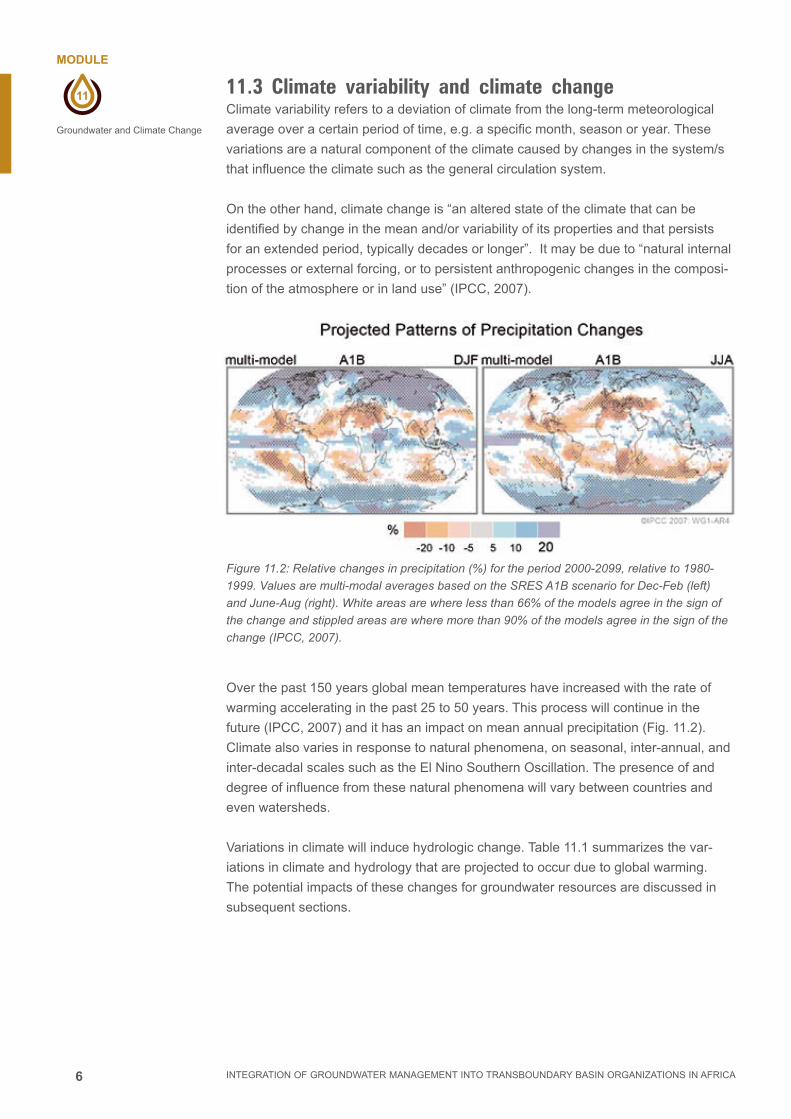
6
11
MODULE
INTEGRATION OF GROUNDWATER MANAGEMENT INTO TRANSBOUNDARY BASIN ORGANIZATIONS IN AFRICA
Groundwater and Climate Change
11.3 Climate variability and climate change Climate variability refers to a deviation of climate from the long-term meteorological
average over a certain period of time, e.g. a specific month, season or year. These
variations are a natural component of the climate caused by changes in the system/s
that influence the climate such as the general circulation system.
On the other hand, climate change is “an altered state of the climate that can be
identified by change in the mean and/or variability of its properties and that persists
for an extended period, typically decades or longer”. It may be due to “natural internal
processes or external forcing, or to persistent anthropogenic changes in the composi-
tion of the atmosphere or in land use” (IPCC, 2007).
Figure 11.2: Relative changes in precipitation (%) for the period 2000-2099, relative to 1980-
1999. Values are multi-modal averages based on the SRES A1B scenario for Dec-Feb (left)
and June-Aug (right). White areas are where less than 66% of the models agree in the sign of
the change and stippled areas are where more than 90% of the models agree in the sign of the
change (IPCC, 2007).
Over the past 150 years global mean temperatures have increased with the rate of
warming accelerating in the past 25 to 50 years. This process will continue in the
future (IPCC, 2007) and it has an impact on mean annual precipitation (Fig. 11.2).
Climate also varies in response to natural phenomena, on seasonal, inter-annual, and
inter-decadal scales such as the El Nino Southern Oscillation. The presence of and
degree of influence from these natural phenomena will vary between countries and
even watersheds.
Variations in climate will induce hydrologic change. Table 11.1 summarizes the var-
iations in climate and hydrology that are projected to occur due to global warming.
The potential impacts of these changes for groundwater resources are discussed in
subsequent sections.

7
11
MODULE
INTEGRATION OF GROUNDWATER MANAGEMENT INTO TRANSBOUNDARY BASIN ORGANIZATIONS IN AFRICA
Groundwater and Climate Change
Table 11.1 Projected impact of global warming for primary climate and hydrologic indicators
Variable Projected future change*
Temperature Temperatures are projected to increase in the 21st century, with geographical patterns similar to those observed over the last few decades. Warming is expected to be greatest over land and at the highest northern latitudes, and least over the Southern Oceans and parts of the North Atlantic ocean.It is very likely that hot extremes and heat waves will continue to become more frequent.
Precipitation On a global scale precipitation is projected to increase, but this is expected to vary geographically - some areas are likely to experience an increase and others a decline in annual average precipitation. Increases in the amount of precipitation are likely at high latitudes. At low latitudes, both regional increases and decreases in precipitation over land areas are likely. Many (not all) areas of currently high precipitation are expected to experience precipitation increases, whereas many areas of low precipitation and high evaporation are projected to have precipitation decreases.Drought-affected areas will probably increase and extreme precipitation events are likely to increase in frequency and intensity.
Sea level rise Global mean sea level is expected to rise due to warming of the oceans and melting of glaciers.The more optimistic projections of global average sea level rise at the end of the 21st century are between 0.18-0.38 m, but an extreme scenario gives a rise up to 0.59 m.In coastal regions, sea levels are likely to also be affected by larger extreme wave events and storm surges.
Evapo-transpiration
Evaporative demand, or potential evaporation, is influenced by atmospheric humidity, net radiation, wind speed and temperature. It is projected generally to increase, as a result of higher temperatures. Transpiration may increase or decrease.
Runoff Runoff is likely to increase at higher latitudes and in some wet tropics, including populous areas in East and South-East Asia, and decrease over much of the mid-latitudes and dry tropics, which are presently water stressed. Water volumes stored in glaciers and snow cover are likely to decline, resulting in decreases in summer and autumn flows in affected areas. Changes in seasonality of runoff may also be observed due to rapid melting of glaciers and less precipitation falling as snow in alpine areas.
Soil moisture Annual mean soil moisture content is projected to decrease in many parts of the sub-tropics and generally across the Mediterranean region, and at high latitudes where snow cover diminishes. Soil moisture is likely to increase in East Africa, central Asia, the cone of South America, and other regions with substantial increases in precipitation.
*Relative to 1990 baseline. Source: IPCC (2007), SKM (2009)
11.4 Climate change scenariosThere is considerable uncertainty surrounding the future of Africa’s climate as reported
in the Fourth Assessment Report of the Intergovernmental Panel on Climate Change
(IPCC) (Christensen et al., 2007).
First, average temperatures are likely to increase. Hulme et al. (2000) show that for Af-
rica as a whole, warming in the 20th Century occurred at a rate of about 0.5 ºC across
the century, and that the rate of warming increased in its last three decades. In future,
based on predictions under the medium-high greenhouse gas emissions scenario,
annual mean air temperature between 2080 and 2099 is expected to be 3-4ºC higher
than it was between 1980 and 1999.
Second, annual rainfall is likely to fall in the northern Sahara and in southern Africa,
and is likely to increase in the Ethiopian Highlands. Wider predictions are difficult to
make as changes in precipitation are much less certain than those for temperature,
particularly for the Sahel and the West African coast. Downscaling to the level of large
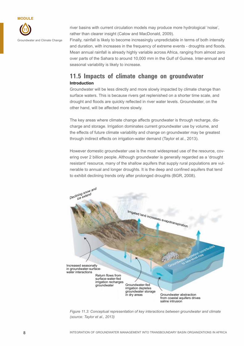
8
11
MODULE
INTEGRATION OF GROUNDWATER MANAGEMENT INTO TRANSBOUNDARY BASIN ORGANIZATIONS IN AFRICA
Groundwater and Climate Change
river basins with current circulation models may produce more hydrological ‘noise’,
rather than clearer insight (Calow and MacDonald, 2009).
Finally, rainfall is likely to become increasingly unpredictable in terms of both intensity
and duration, with increases in the frequency of extreme events - droughts and floods.
Mean annual rainfall is already highly variable across Africa, ranging from almost zero
over parts of the Sahara to around 10,000 mm in the Gulf of Guinea. Inter-annual and
seasonal variability is likely to increase.
11.5 Impacts of climate change on groundwaterIntroduction
Groundwater will be less directly and more slowly impacted by climate change than
surface waters. This is because rivers get replenished on a shorter time scale, and
drought and floods are quickly reflected in river water levels. Groundwater, on the
other hand, will be affected more slowly.
The key areas where climate change affects groundwater is through recharge, dis-
charge and storage. Irrigation dominates current groundwater use by volume, and
the effects of future climate variability and change on groundwater may be greatest
through indirect effects on irrigation-water demand (Taylor et al., 2013).
However domestic groundwater use is the most widespread use of the resource, cov-
ering over 2 billion people. Although groundwater is generally regarded as a ‘drought
resistant’ resource, many of the shallow aquifers that supply rural populations are vul-
nerable to annual and longer droughts. It is the deep and confined aquifers that tend
to exhibit declining trends only after prolonged droughts (BGR, 2008).
Figure 11.3: Conceptual representation of key interactions between groundwater and climate
(source: Taylor et al., 2013)
Declining snow and
ice extend
Irrigated land increases evapotranspiration
Groundwater depletion contributes
to sea-level-rise
Groundwater abstractionfrom coastal aquifers drivessaline intrusion
Groundwater-fedirrigation depletesgroundwater storagein dry areas
Return flows fromsurface-water-fedirrigation rechargesgroundwater
Increased seasonally in groundwater-surface-water interactions

9
11
MODULE
INTEGRATION OF GROUNDWATER MANAGEMENT INTO TRANSBOUNDARY BASIN ORGANIZATIONS IN AFRICA
Groundwater and Climate Change
Recharging of groundwater from precipitation, increase in irrigation to meet food secu-
rity and groundwater pumping are interlinked through the impact from climate change
(Fig. 11.3).
Groundwater recharge
Groundwater is the major source of water across Africa both in rural and urban areas.
In major metropolitan areas in Africa, surface water plays a leading role. Groundwater
recharge can occur locally from surface water bodies or in diffuse form from precipita-
tion via the unsaturated soil zone. Recharge is not only influenced by the magnitude of
precipitation, but also by its intensity, seasonality, frequency and changes in land use.
Natural replenishment of groundwater occurs from both diffuse rain-fed recharge and
focused recharge via leakage from surface waters (that is: streams, wetlands or lakes)
and is highly dependent on prevailing climate as well as on land cover and underlying
geology. Climate and land cover largely determine precipitation and evapotranspira-
tion, whereas the underlying soil and geology dictate whether a water surplus (pre-
cipitation minus evapotranspiration) can be transmitted and stored in the subsurface
(Taylor et al., 2013).
This water may reach the aquifer rapidly, through fractures, or more slowly by infiltrat-
ing through micro-pores in the soils overlying the aquifer. A change in the amount of
effective rainfall will change the recharge into the groundwater.
Global warming due to temperature increase is important in directly controlling evapo-
transpiration and thus the portion of precipitation that may drain through the soil profile
into aquifers. Other factors affecting groundwater recharge include land cover, soil,
geology, slope and aquifer type.
Increased variability in rainfall may decrease groundwater recharge in humid areas
because more frequent heavy rains result in the infiltration capacity of the soil being
exceeded, thereby increasing surface runoff and hence flooding. In semi-arid and arid
areas, however, increased rainfall variability may increase groundwater recharge, be-
cause only high-intensity rainfalls are able to infiltrate fast enough before evaporating,
and alluvial aquifers are recharged mainly by inundations during floods (BGR, 2008).
Recharge is very important in regulating the volume of groundwater. Reduction in
recharge will reduce the volume of renewable groundwater.
Output
Extreme climatic variation has a control over the hydrologic balance through reduction
or increase in input and output components. Output components include evapotran-
spiration, runoff, groundwater discharge into streams and springs, and groundwater
pumped from boreholes.
The impact of climate change on groundwater discharge is related to lowering of the
groundwater table, which is linked to baseflow to rivers and springs. The impact can
be most readily observed through changes to groundwater dependent ecosystems.
Another cause for decrease in discharge is the over-pumping of renewable ground-

10
11
MODULE
INTEGRATION OF GROUNDWATER MANAGEMENT INTO TRANSBOUNDARY BASIN ORGANIZATIONS IN AFRICA
Groundwater and Climate Change
water in order to cope with the water stress as a result of climate change. Increased
pumping lowers the water table, and thus reduces discharge to baseflow.
The impact of climate change on output parameters may not be the same. Due to the
increase in temperature, evapotranspiration will increase, but there is no guarantee of
an increase in precipitation. If precipitation decreases, runoff will decrease, and in ad-
dition groundwater recharge will decrease, thus leading to a decrease in groundwater
baseflow into streams and springs.
For evapotranspiration, direct climate change impacts include:
■■ Changes in groundwater use by vegetation due to increased temperature and
CO2 concentrations, and
■■ Changes in the availability of water to be evaporated or transpired, primarily due to
changes in the precipitation regime. Increased duration and frequency of droughts
is likely to result in greater soil moisture deficits. Where soil water becomes de-
pleted, vegetation may increasingly depend on groundwater for survival (if ground-
water occurs in proximity to the root zone). During dry periods this may lead to
increased evapotranspiration from groundwater. Indirect impacts associated with
land use change may also affect groundwater evapotranspiration.
Groundwater flow to surface water bodies will be driven by the relative head levels be-
tween groundwater and surface water. If groundwater falls below surface water levels,
groundwater discharge as baseflow or spring discharge may no longer occur. Similar-
ly, if surface water has been flowing to the groundwater system, for example from a
losing stream, this recharge may cease if surface water levels decline below the local
groundwater levels. In semi-arid and arid regions, the dependence on groundwater
to maintain baseflow in permanent streams is likely to be greater during periods of
extended drought.
Groundwater over-pumping is an indirect climate change impact and also forms a
mechanism for groundwater discharge. Projected increases in precipitation variabil-
ity are likely to result in more intense droughts and floods, affecting the reliability of
surface water supplies. Human demand for groundwater is therefore likely to increase
to offset this declining surface water availability and, where available, groundwater will
become a critical facet for communities to adapt to climate change.
Groundwater storage
Groundwater storage is the balance between input and output over a given period of
time. Aquifers provide water that was recharged over centuries and millennia. Stor-
age is controlled by the intrinsic aquifer properties such as storativity, transmissivity
and aquifer geometry. Regionally extensive aquifers receive recharge from extensive
catchment areas and hence do not react to short term climatic variability while shallow
unconfined aquifers are more responsive to smaller scale climate variability. The im-
pact of climate change on storage depends on whether or not groundwater is renewa-
ble or non-renewable (fossil) resource. Even though there is no direct climate change
impact on fossil groundwater, the impact would encourage over-abstraction of fossil
water during the stress period. Shortage of recharge due to climate change results in
reducing the renewable storage.
11
11
MODULE
INTEGRATION OF GROUNDWATER MANAGEMENT INTO TRANSBOUNDARY BASIN ORGANIZATIONS IN AFRICA
Groundwater and Climate Change
Water quality
In many areas, aquifers provide an important source of freshwater supply. Maintaining
water quality in these aquifers is essential for the communities. In shallow aquifers,
groundwater temperatures may increase due to increasing air temperatures. In arid
and semi-arid areas increased evapotranspiration may lead to soil salinization, which
will affect the quality of soil moisture and associated groundwater system. In coastal
aquifers, sea level rise and storm surges are likely to lead to sea-water intrusion and
salinization of groundwater resources especially in areas with over-abstraction of
groundwater resources.
In areas where rainfall intensity is expected to increase, pollutants (pesticides, organic
matter, heavy metals, and pit latrines) will be increasingly washed into water bodies,
including the groundwater. In addition, recharge from polluted surface water bodies
will further compromise groundwater quality.
11.6 Climate change and population growthPopulation growth has intimate relation with climate change. Increased population
leads to increased water demand both for domestic use, and for production for food
and industry. The associated land use changes and socio-economic factors are likely
to influence the capacity to appropriately manage the groundwater resource.
Especially in Africa, groundwater has been poorly managed. Low investment in
groundwater investigations and management has placed groundwater under stress
either through pollution or over abstraction. Increased groundwater use associated
with population growth has also been a factor, particularly in arid and semi-arid areas
where water is scarce.
African population will grow by about 154% between 2000 and 2050 under the UN
medium variant and by 119% to 193% under low and high variants according to UN-
FPA (2000, 2008 cited in Carter and Parker, 2008). It is well-established that demand
for water grows over time as a consequence of both increasing population and chang-
ing water use patterns (Carter and Parker, 2008).
Land use change also affects groundwater resources. The degree and magnitude of
impact will depend on local conditions. In a small Sahelian catchment in Niger, Seguis
et al. (2004) found that the transition from a wet period under a ‘natural’ land cover
(1950) to a dry period under cultivated land cover (1992) resulted in a 30 to 70%
increase in runoff. Recharge in this catchment occurred preferentially through ponds,
and thus the increased runoff caused a significant and continuous groundwater table
rise over the same period.
11.7 Implications for groundwater dependent sectorsAs a result of climate change and scarcity of surface water, dependence on groundwa-
ter especially in Africa is expected to be high. Climate change and population increase
may compromise the availability and quality of groundwater resources with significant
implications for human and environmental health, livelihoods, food security and social
and economic stability.

12
11
MODULE
INTEGRATION OF GROUNDWATER MANAGEMENT INTO TRANSBOUNDARY BASIN ORGANIZATIONS IN AFRICA
Groundwater and Climate Change
Shallow wells often provide an important source of drinking water for dispersed rural
populations in Africa. The predicted increase in demand and increased severity of
droughts may cause many of these shallow wells to dry up. The drying up of shallow
groundwater has a tremendous negative impact on the rural livelihood. With limited
alternatives for safe drinking water supplies and long distances between such water
points, the loss through drying out of these well would force people to use unsafe wa-
ter resources (Fig. 11.4). Small-scale irrigation, usually reliant on shallow groundwater,
would also be affected.
Where increases in heavy rainfall events are projected, floods can wash away san-
itation facilities, spreading wastewater and potentially contaminating groundwater
resources. Flooding is linked to increased risk of diarrhoeal disease. The risk is likely
to be greater in urban areas due to higher population density and concentration of
source pollutants. In coastal regions, sea-water intrusion may limit the capacity of
groundwater to serve already large and rapidly expanding populations.
Figure 11.4: Water stress challenges
11.8 Adaptation to climate change
What is adaptation?
In order to cope with climate change, an integrated approach is needed. Such an ap-
proach embraces both mitigation, which addresses the drivers of climate change, and
adaptation, which considers the measures necessary to accommodate such changes.
Adaptation is adjustments made to natural and human systems in response to expe-
rienced or projected changes in climatic conditions and their beneficial and adverse
impacts (Fig 11.5). In the context of groundwater they are concerned with reducing the
vulnerability of groundwater dependent systems to climate change and hydrological
variability. However adaptation to climate change is also likely to increase the use of
and dependence on groundwater in response to declines in surface water resources.
How can basin organizations adapt to climate change?
Adaptations are essentially management responses to risks associated with climate
variability and climate change. With regards to water resources, it is the basin organ-
izations that will have to implement strategies and policies to mitigate the risks asso-
ciated with water stress and to adopt water management suited to the changing water
resources conditions.

13
11
MODULE
INTEGRATION OF GROUNDWATER MANAGEMENT INTO TRANSBOUNDARY BASIN ORGANIZATIONS IN AFRICA
Groundwater and Climate Change
Every basin will be different due to differences in the water storage in the basin,
whether surface or groundwater, and due to the changes bought about by climate
change. In addition, demand for water in each basin differs due to a variety of so-
cio-economic issues. Basin organizations can be proactive towards climate change by
carrying out risk assessments for their own basins and then building their adaptation
strategies accordingly. This can be an important exercise for basin organizations to
carry out before crises surface.
Figure 11.5: Adapt to the changing condition
Importance of groundwater in a changing climate
Groundwater plays a critical role in adapting to hydrologic variability and climate
change (Clifton et al. 2010). Groundwater provides options for enhancing the reliability
of water supply for domestic, industrial, livestock watering and irrigation. Some adap-
tations that can be accessed using groundwater include:
■■ Integrating the management of surface water and groundwater resources –
including conjunctive use of both groundwater and surface water to meet water
demand. Integrated management aims to ensure that the use of one water re-
source does not adversely impact on the other. It involves making decisions based
on impacts for the whole hydrologic cycle, and on the spatial distribution of surface
and groundwater resources and the demand distribution for water.
■■ Managing aquifer recharge (MAR) – including building infrastructure and/or
modifying the landscape to intentionally enhance groundwater recharge. MAR is
among the most promising adaptation opportunities for developing countries. It
has several potential benefits, including storing water for future use, stabilizing or
recovering groundwater levels in over-exploited aquifers, reducing evaporative
losses, managing saline intrusion or land subsidence, and enabling reuse of waste
or storm water.
■■ Land use change – changing land use may provide an opportunity to enhance
recharge, to protect groundwater quality and to reduce groundwater losses from
evapotranspiration. Changes in land use should not result in adverse impacts to
other parts of the environment. Lower water demand crops and salt tolerant crops
are potentially useful land use changes to adapt to different water stresses.
Building adaptive capacity for groundwater management
Building adaptive capacity is a crucial cross-cutting theme and applies, at least partial-
ly, to multiple themes. Adaptive capacity building options are generally concerned with
providing the necessary conditions for other forms of adaptation to be implemented
successfully, rather than managing or avoiding climate or hydrological risks directly.
Some adaptation options from Clifton et al. (2010) are given in Table 11.2.

14
11
MODULE
INTEGRATION OF GROUNDWATER MANAGEMENT INTO TRANSBOUNDARY BASIN ORGANIZATIONS IN AFRICA
Groundwater and Climate Change
Table 11.2. Adaptation options: building adaptive capacity
Adaptation option Adaptations
Social capital These options are concerned with enabling communities to understand climate and hydrological risks and actively participate in management responses.
■ Education and training – to improve community and stakeholder understanding of climate risks and their capacity to participate in management responses and/or generate, modify or apply adaptations.
■ Governance – devolve some level of responsibility for planning and management of groundwater to local communities to increase local ‘ownership’ of problems and responses
■ Sharing information – instigate processes for sharing of information regarding climate risks and responses within and between vulnerable communities.
Resource informationGathering and providing information on climate risks and the groundwater system being managed.
■ Understanding climate – analysis of historical and paleo-climate information to understand the natural drivers of climate variability.
■ Climate change projections – developing downscaled climate change projections for the area of interest.
■ Quantify the groundwater system – understand the scale and characteristics of the aquifer(s); recharge, transmission and discharge processes; water balance (including use); water quality, etc.
■ Monitoring, evaluation and reporting – of the state of the groundwater resource.
Research & developmentResearch and development activities to improve the effectiveness of adaptive responses to climate change and hydrological variability.
■ Climate impact assessments – studies to better define the nature of projected climate change impacts on the groundwater system and the associated climate and hydrological risks.
■ Management of groundwater recharge – methods.
■ Management of groundwater storage – technologies, water management and other practices to maximize groundwater storage capacity and resource availability.
■ Protection of water quality – technologies and management systems to enable treatment and reuse of contaminated water and avoid contamination of higher quality water by water of lesser quality. Protection of island and coastal aquifers from effects of sea level rise.
■ Managing demand for groundwater – technologies and management practices that: improve the efficiency of urban and agricultural uses of water; reduce water quality requirements of non-potable uses; or reduce the need for water.
Governance & institutions Improving governance and institutional arrangements for groundwater resource management. Improved planning regimes for groundwater and associated human and natural systems.
■ Conjunctive management of surface water and groundwater in rural areas. Integrated water cycle management (including various potable and non-potable sources in urban areas).
■ Multi-jurisdictional planning and resource management arrangements for large scale aquifer systems that cross jurisdictional boundaries.
■ Defining water allocations based on resource share rather than volume.
■ Set and regulate standards for (eg.) groundwater resource and land use planning, water governance, environmental management.
■ Drought response planning.
MarketsEstablishment and operation of markets for water and associated environmental services.
■ Markets – establishment and operation of markets for trading of water within a groundwater system. Market to determine the price for water.
■ Property rights – establish clear title and property rights to groundwater.

15
11
MODULE
INTEGRATION OF GROUNDWATER MANAGEMENT INTO TRANSBOUNDARY BASIN ORGANIZATIONS IN AFRICA
Groundwater and Climate Change
Managing groundwater recharge
Groundwater recharge areas may be managed to protect or enhance water resourc-
es and to maintain or improve water quality. One method would be through managed
aquifer recharge. Managed aquifer recharge (MAR) involves building infrastructure
and/or modifying the landscape to intentionally enhance groundwater recharge (Fig.
11.6). It forms one of the ‘managing aquifer recharge’ adaptation responses and is
increasingly being considered as an option for improving the security of water supplies
in areas where they are scarce (Gale, 2005). MAR is among the most significant ad-
aptation opportunities for countries seeking to reduce vulnerability to climate change
and hydrological variability. It has several potential benefits, including: storing water
for future use; stabilising or recovering groundwater levels in over-exploited aquifers;
reducing evaporative losses; managing saline intrusion or land subsidence; and ena-
bling reuse of waste or storm water. Implementation of MAR requires suitable ground-
water storage opportunities. Aquifer conditions must be appropriate and suitable water
sources (e.g. excess wet season surface water flows or treated waste water) are also
required. MAR potential should be determined in any particular country or region be-
fore activities commence.
Figure 11.6: Examples of managed aquifer recharge (MAR) approaches.
ASR: aquifer storage and recovery; ASTR: aquifer storage, treatment and recovery, STP:
sewage treatment plant. Source: Peter Dillon cited in Clifton et al., 2010
ASR ASTR Bank filtration
Dune filtration Infiltration pond
Percolation tank
STP le cycle humide
cycle de séchage
Soil aquifer treatment Underground dam
Sand dam Recharge releases
Rainwater harvesting

16
11
MODULE
INTEGRATION OF GROUNDWATER MANAGEMENT INTO TRANSBOUNDARY BASIN ORGANIZATIONS IN AFRICA
Groundwater and Climate Change
Protecting groundwater quality
Climate change and hydrological variability may affect the quality of groundwater avail-
able for use in a groundwater dependent system. This is particularly true of ground-
water resources on small islands and coastal areas that are projected to be subject
to sea level rise. It is also true where reduced security of supply leads water resource
managers to include lower quality water in the supply stream (e.g. through MAR using
storm water or treated waste water) or where increased pressure on groundwater
resources leads to increased use and greater risk of contamination of a high quality
aquifer by any overlying or underlying poorer quality aquifers.
Managing groundwater storages
While aquifers are recognized as underground water storages, they are rarely oper-
ated with the same level of precision and control as major surface water storages.
Opportunities exist to manage groundwater storages more effectively, and reduce
the vulnerability of systems that depend on them to climate change and hydrological
variability.
Managing demand for groundwater
Climate change adaptations for water resources most frequently operate on demand
management. In many cases, the adaptations for groundwater dependent and surface
water dependent systems will be identical. In areas where climate change reduces
supply security for surface water resources, it is likely that there will be increased
focus on utilization of groundwater resources as an adaptation to climate change. This
will require greater attention to management of demand for groundwater and for con-
junctive management with surface water. It may also be possible to use groundwater
reservoirs as storage space for surplus surface water flows during periods of abundant
supply for use during periods of surface water scarcity.
Management of groundwater discharge
Aquifer systems discharge water to the land surface, rivers, lakes, wetlands or to near
or off-shore marine environments. Discharge, recharge and utilization are in a state of
dynamic equilibrium, such that changes in recharge or utilization ultimately result in a
change in discharge. In some settings, it is possible to increase resource availability
(for use by human systems) by reducing groundwater discharge.
11.9 Summary:Climate change results in further straining already stressed water resources, eco-sys-
tems, and derived systems, which are used to service society. Groundwater needs to
be protected, and its use and maintenance adapted to climate change. Groundwater
can enhance the resilience of domestic, agricultural and industrial uses of fresh water
in the face of climate variability and change. As the only perennial source of fresh wa-
ter in many regions, ground water is of vital importance to the water security of many
communities, including, most critically, rural dwellers in low-income countries. Ground-
water-fed irrigation provides a buffer against climate extremes and is consequently
essential to global food security (Taylor et al., 2013).

17
11
MODULE
INTEGRATION OF GROUNDWATER MANAGEMENT INTO TRANSBOUNDARY BASIN ORGANIZATIONS IN AFRICA
Groundwater and Climate Change
11.10 References and Web Reading
BGR, (2008).
Groundwater and Climate Change: Challenges and Possibilities.
Hanover, Germany
Calow, R., MacDonald A (2009).
What will climate change mean for groundwater supply in Africa?
Odi, background Note.
Carter R., Parker A (2008).
Climate change, population trends and groundwater in Africa.
Hydrological Sciences Journal, 676-689
Christensen, J. H., Hewitson, B., Busuioc, A., Chen, A., Gao, X., Held, I., Jones, R.,
Kolli, R. K., Kwon, W. T., Laprise, R., Magaña Rueda, V., Mearns, L., Menéndez, C.
G., Räisänen, J., Rinke, A., Sarr A., and Whetton, P. (2007).
Regional Climate Projections’ in S. Solomon, D. Qin, M. Manning, Z. Chen, M.
Marquis, K. B. Averyt, M. Tignor & H. L. Miller (eds),
Climate Change 2007: The Physical Science Basis. Contribution of Working Group I
to the Fourth Assessment Report of the Intergovernmental Panel on Climate Change.
Cambridge: Cambridge University Press.
Clifton C., Evans, R, Hayes, S., Hirji, R., Puz G., Pizarro C. (2010)
Water and Climate Change:Impacts on groundwater resources and adaptation
options.
Water working notes. Note No. 25. Water partnership program, bnwpp.
Conway D (2005).
From headwater tributaries to international river: Observing and adapting to
climate variability and change in the Nile basin.
Global Environmental Change 15: 99–114
Döll, P and Floerke, M. (2005).
Global-scale estimation of diffuse groundwater recharge: model tuning to local
data for semi-arid and arid regions and assessment of climate change impact.
Frankurt Hydrology Paper. August 2005.
Hulme, M., Doherty, R., Ngara, T., New, M., Lister, D. (2001).
African climate change: 1900–2100.
Climate Research 17, 145–168.
IPCC, (2001).
Climate change 2001: the scientific basis. Contribution of Working Group I to
The Third Assessment Report of the IPCC.
Cambridge University Press, Cambridge, UK.

18
11
MODULE
INTEGRATION OF GROUNDWATER MANAGEMENT INTO TRANSBOUNDARY BASIN ORGANIZATIONS IN AFRICA
Groundwater and Climate Change
JMP (2008) Global water supply and sanitation 2008 report.
Joint Monitoring Programme WHO/UNICEF.
Geneva: World Health Organization.
Gale, I. (ed). (2005).
Strategies for Managed Aquifer Recharge (MAR) in semi-arid areas.
UNESCO publication. 34 pp. Available online: http://www.iah.org/recharge/
MacDonald, A., Bonsor, HC., Dochartaigh, BEO., Taylor R (2012).
Quantitative maps of groundwater resources in Africa.
Environ. Res. Lett. 7 (2012) 024009 (7pp)
SKM (2009).
Adaptation options for climate change impacts on groundwater resources.
Taylor et al. (2013)
Ground water and climate change.
Review article. Nature Climate change. 3: 322-329
www.bebuffered.com

Implemented by