SPECIAL ISSUE GROUNDWATER
32
Hosted by NUMBER 3 / 2019 SPECIAL ISSUE GROUNDWATER Supported by HYPORHEIC FLOWS SEE PAGE 68 NAPL REMEDIATION STRATEGIES SEE PAGE 74 PARTICIPATIVE WATER MANAGEMENT CONTRACTS IN MOROCCO SEE PAGE 78
-
Upload
khangminh22 -
Category
Documents
-
view
3 -
download
0
Transcript of SPECIAL ISSUE GROUNDWATER

Hosted by
NUMBER3/2019
SPECIAL ISSUE GROUNDWATER
Supported by
HYPORHEIC FLOWS SEE PAGE 68
NAPL REMEDIATION STRATEGIES SEE PAGE 74
PARTICIPATIVE WATER MANAGEMENT CONTRACTS IN MOROCCO SEE PAGE 78
66 hydrolink number 3/2019
Groundwater has been a major water resourcefor humans throughout history. Excluding polarice and glaciers, groundwater stocks constituteabout 97% of the useable freshwater, more than100 times the total volume of surface waterresources in lakes and rivers. Groundwater has been traditionally considered a relativelyreliable water resource that is less affected byseasonal or annual variations in precipitation.As a result, the amount of groundwater extrac-tions has increased dramatically in recentdecades from about 312 Gm3/year in the1960s[1] to 982 Gm3/year in 2010[2]. This sharpincrease in groundwater use has led to signif-icant economic development worldwide. Thesebenefits however have been accompanied, in many instants, by high environ-mental and social costs. Adverse impacts of excessive groundwater extractioninclude rapid drop in groundwater levels, groundwater depletion, reduction inwater levels in nearby streams and lakes, land subsidence, and high salinitylevels in coastal aquifers.
Groundwater has been used for domestic use and irrigation since ancienttimes. Early evidence of human-dug wells going back thousands of years havebeen uncovered in various regions of the world including China, Egypt andIndia and Europe[3]. On the island of Cyprus in the Mediterranean, archaeolo-gists have unearthed the remains of constructed wells dating back to the StoneAge almost 10,000 years ago[4]. These wells relied on various constructiontechniques to raise the water to the ground surface. Early examples of wood-lined and ceramic wells can be found in China. Step wells lined with blocks ofstone can be found in India. The shadoof, which consist of a well pole forraising water, was used in Egypt, China and other parts of the world. The qanat,which likely originated in ancient Iran or in the southeast of the ArabianPeninsula, is comprised of a series of vertical access shafts and a slopingunderground channel that allowed for the water to drain out due to gravity.
Many of these same water extraction systems remain in use to this very day.Yet, recent advances in drilling technology and the introduction of motorizedpumps made possible the intensive use of groundwater, especially with theexpansion of irrigation since the middle of the twentieth century. Today about40 percent of all irrigated lands are equipped for groundwater use, and 70percent of all groundwater is used in agriculture[5]. As a result, groundwaterdepletion hotspots have cropped in various regions of the world most notablythe Middle East and North Africa, China, South Asia, southern Europe and theUnited States. There is an urgent need to develop and implement measuresand policies that ensure the sustainable use of this vital resource.
This special Groundwater issue of Hydrolink includes articles that exemplifythe wide range of issues and ongoing research activities relating to the field ofGroundwater. Daniele Tonina describes the presence of hyporheic flowsbetween stream waters and the sediments underneath. This hyporheicexchange of water brings solutes and suspended matter from stream watersinto the underlying sediments where important geochemical reactions occur.These transformations can have significant impacts on microorganisms andwater quality. The article by Nahed Ben-Salem et al examines the water qualityof one of the main Wadis flowing into the Gulf of Tunis in the MediterraneanBasin. It investigates the main sources of the pollution and the potentialcontamination of underlying groundwater resources. These two articleshighlight the interaction between surface and subsurface waters which in thepast has often been ignored.
One of the most challenging groundwater contamination problems is theremediation of the groundwater and soil contaminated by hydrocarbons in theform of non-aqueous phase liquids (NAPLs).
Because of their low solubility and low biodegra-dation potential, many of these compounds oncereleased can persist in the subsurface environ-ment for decades or even centuries, contami-nating large volumes of the aquifer. The article ofGeoffrey Tick provides a comprehensive review ofpromising technologies for the remediation ofNAPL source zones.
Aquifer systems involve numerous stakeholdersoften with competing interests and goals. Thesediverging goals can lead to conflicts, particularlyin water scarce regions of the world. The articleby Dalila Loudyi et al discusses the water stressesthat Morocco faces. It proposes the implemen-
tation of a “participative water management contract” to help alleviate someof the conflicts between different stakeholders that have arisen in the past. As noted earlier, extensive use of groundwater resources has contributedsignificantly to the economic development of numerous regions of the world.This however has led to sharp depletion of the water resource in many partsof the world. The article by Eduardo Cassiraga et al describes the extensiveexploitation of the East Mancha Aquifer System in Spain and how stakeholdershave successfully come together to better manage this system and reversesome of the adverse trends of the past years.
In recent decades significant progress has been made in the field of ground-water flow and contaminant transport modelling. In real life problems, a majorchallenge remains, the lack of data to fully describe the heterogeneoussubsurface system and the complex biochemical processes occurring within.The article by Alberto Guadagnini et al. discusses the uncertainties involved inthe characterization of subsurface systems and the need for the quantificationof these uncertainties across various scales and for assessing the implicationsof these uncertainties. Christina Stylianoudaki et al present an application ofartificial neural networks (ANN) for predicting nitrate concentrations in thegroundwater. ANN are a class of data-driven easy to use models that attemptto quantify correlations between different variables without the need to solvecomplex physics-based models that are not fully characterized.
Human-induced climate change has emerged in recent years as a major threatto the well-being of our planet. As an integral component of the global watercycle, groundwater resources in many regions of the world will unequivocallybe adversely impacted through diminished precipitation, extended droughts,frequent flooding and seawater rise. The article by Glen Walker et al discussesthe potential adverse effects that climate change is predicted to have ongroundwater resources in southern Australia. It highlights some of the adaptivemeasures that are being considered and that can serve as a guide for theprotection of this vital resource in other water-stressed regions of the world.
The articles published in this issue provide a sample of the broad range ofongoing research in understanding the behaviour of groundwater systems anddeveloping methods for safeguarding and managing sustainably this valuableresource. n
References[1] Wada Y, van Beek LPH, van Kempen CM, Reckman JWTM, Vasak S, Bierkens MFP (2010) Global
depletion of groundwater resources. Geophys Res Lett 37(20), L20402.[2] Margat, J., and J. van der Gun. 2013. Groundwater around the World. CRC Press/Balkema[3] Tegel W, Elburg R, Hakelberg D, Stäuble H, Büntgen U (2012), “Early Neolithic Water Wells Reveal the
World’s Oldest Wood Architecture”. PLoS ONE. 7(12): e51374.[4] BBC News (2009), “Stone Age wells found in Cyprus”,
http://news.bbc.co.uk/2/hi/europe/8118318.stm[5] Hoogesteger J, and Wester P (2015), Intensive groundwater use and (in)equity: Processes and
governance challenges, Environmental Science & Policy, 51, 117-124.
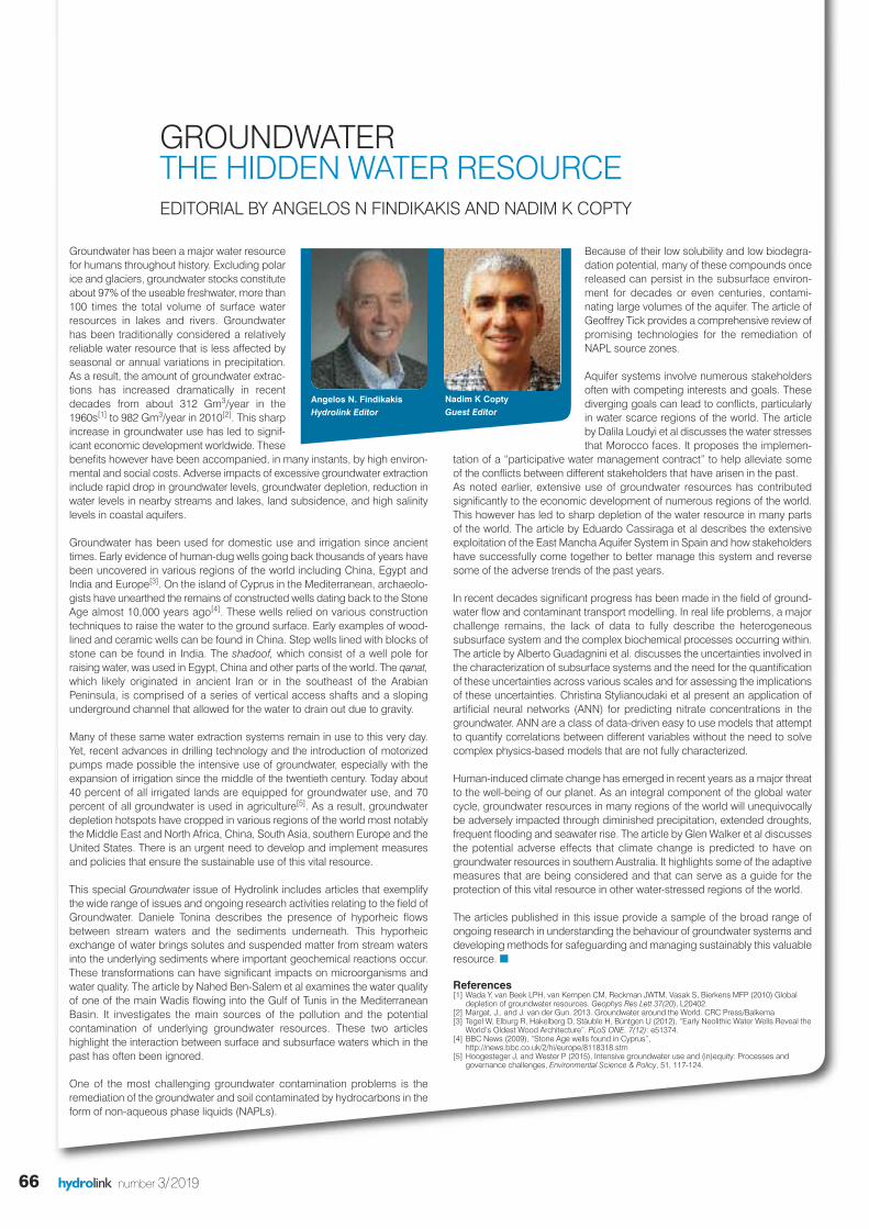
GROUNDWATER THE HIDDEN WATER RESOURCEEDITORIAL BY ANGELOS N FINDIKAKIS AND NADIM K COPTY
Angelos N. FindikakisHydrolink Editor
Nadim K Copty Guest Editor

IAHR
67
IN THIS ISSUENUMBER 3/2019
IAHR
90
68
81
84
IAHRInternational Associationfor Hydro-EnvironmentEngineering and Research
IAHR Secretariat
Madrid OfficeIAHR SecretariatPaseo Bajo Virgen del Puerto 328005 Madrid SPAINtel +34 91 335 79 08fax + 34 91 335 79 35
Beijing OfficeIAHR SecretariatA-1 Fuxing Road, Haidian District100038 Beijing CHINAtel +86 10 6878 1808fax +86 10 6878 1890
Editor:Angelos FindikakisBechtel, [email protected]
Editorial Assistant:Elsa IncioIAHR [email protected]
Guest Editor:Prof. Nadim Copty, Bogazici University, Turkey
Hydrolink Advisory Board
Luis Balairon • CEDEX –Ministry Public Works, Spain
Jean Paul Chabard • EDF Research & Development,France
Yoshiaki Kuriyama • The Port and Airport Research Institute, PARI, Japan
Jaap C.J. Kwadijk • Deltares, The Netherlands
Ole Mark • DHI, Denmark
Rafaela Matos • Laboratório Nacional de Engenharia Civil, Portugal
Jing Peng •China Institute of Water Resources and Hydropower Research, China
Patrick Sauvaget • Artelia Eau & Environnement, France
James Sutherland • HR Wallingford, UK
Karla González Novion • Instituto Nacional de Hidráulica,Chile
ISSN 1388-3445
Cover picture:Water well in Oman Desert (gettyimages)
Editorial .....................................................................................66
Hyporheic flows: The stream water flowing underneath ...........................................................68
impact of anthropogenic activities on physiochemical properties of Wadi El Bey ..............................................................................70
Remediation strategies for nonaqueous phase liquid (NAPL) contaminant sources in groundwater: Innovations and challenges ................................................................................74
Participative water management contracts in Morocco for scarcity alleviation: The groundwater contract model ..........................78
Groundwater management in Spain: The case of the Eastern Mancha aquifersystem .........................................................................................81
Uncertainty quantification across scales in the subsurface world .................................................84
Artificial neural networks for the prediction of groundwater nitratecontamination .......................................................................87
Climate change and groundwater: An Australian perspective .........90
Obituary Erich J. Plate ..................................................93
New IAHR president’s message ..............................94
New IAHR council for 2020-2021 ............................95
hydrolink number 3/2019
Hosted by
Supported by
Technical Editors:Joe ShuttleworthCardiff University
Sean MulliganNational Universtityof Ireland Galway
GROUNDWATER SPECIAL

68 hydrolink number 3/2019
There is a stream of surface water, called hy-porheic zone[1], that flows underneath and be-sides rivers and streams (Figure 1). This“hidden stream” is formed by stream water en-tering streambed sediments in so called down-welling areas and emerges back into thestream in so called upwelling areas. Thesedownwelling and upwelling fluxes form the hy-porheic exchange and delineate a stream-water saturated volume of sediment that is thehyporheic zone. This exchange is ubiquitous instreams and rivers because of permeable sedi-ments and stems from near-bed pressure gra-dients (induced by flow andstreambed-features interaction), that are
dependent on alluvium depth, alluvium lateralconfinement, and streambed sediment hy-draulic conductivity, and from flow turbulence,which causes pressure and velocity fluctua-tions at the channel bottom[2]. These mecha-nisms depend on stream geometry anddischarge such that their relative importanceon hyporheic exchange may depend on chan-nel type and may vary along the stream net-work[3] (Figure 2). Thus, both the vertical andthe horizontal extent of the hyporheic zone varyspatially, due to changes in stream size, mor-phology, alluvial bed and aquifer conditions,and temporally, due to physicochemical fluctuations, e.g., stream discharge, ground-
water table, water temperature and streamsolute loads.
Hyporheic exchange brings solute and sus-pended particles laden surface water into thesediment, where reactive solutes undergo bio-geochemical reactions due to biofilms attachedto streambed particles or are uptaken by organ-isms dwelling within particle interstices. Prod-ucts of such transformations are then carriedaway by hyporheic flows and brought to thesurface water by upwelling fluxes. In streams(riverine systems with widths less than about 30 m), micro-organism population densities arehigher in the hyporheic zone than in the watercolumn, such that most microbially mediatedtransformations occur in the hyporheic zonerather than in the water column[4]. These trans-formations depend on reaction time, water tem-perature, solute concentrations, flow velocity,and length of the flow path. Consequently, thisexchange affects both surface and pore waterquality and the transport and fate of nutrients.For instance, field investigations and recentflume experiments on the nitrogen cycle haveshown the importance of the hyporheic zone asa biogeochemical reaction zone, where both ni-trification, which is an aerobic process, anddenitrification, a primarily anaerobic process,occur[5]. Nitrification transforms reduced formsof nitrogen, mainly ammonium, into nitrate,whereas denitrification transforms mostly NO3-
to dinitrogen gas (N2) and nitrous oxide (N2O).The latter is a major destructor of stratosphericozone and is 300 times more potent as green-house gas than carbon dioxide (CO2) with acentury long life span in the atmosphere. Thus, the hyporheic zone may have far reach-ing global impacts as a source or sink of green-house gases, which may include besides N2O also carbon dioxide and methane. The
HYPORHEIC FLOWS: THE STREAM WATER FLOWINGUNDERNEATH BY DANIELE TONINA
Stream water flows above but also within the interstitial spaces of the sediment underneath and besidesstreambeds. Water enters and exits streambed sediments ubiquitously in streams and rivers and forms the socalled hyporheic exchange, which defines the hyporheic zone, the band of sediment mostly saturated with streamwater. This zone is characterized by strong physical gradients, a unique ecotone and is responsible for most ofthe biogeochemical processes in streams.
Figure 1. Hyporheic zone classification, as fluvial within the active channel, parafluvial below emergedbedforms, like bars and floodplain with its pathlines depicted in red lines, from Tonina and Buffington[1]
GROUNDWATER SPECIAL

69hydrolink number 3/2019
an entire stage of their life in this ecotone,which is an important part of the river corridorand which includes in-stream water, banks,floodplain and hyporheic zone, and its ecosystem.
Because of these three main characteristics: (i)hyporheic exchange, which can be envelopedand separated by the groundwater system, (ii)waters with different chemical signature thanthe groundwater, and (iii) unique macro-inverte-brate populations, the hyporheic zone hasbeen studied separately in biology, hydrologyand bio-geochemistry. This resulted in threeoperational approaches to define it: hydraulicbased on flow paths, geochemical based onsolute concentrations and biological based on
hyporheic zone production of N2O in smallstreams, defined with widths less than 10 m, isabout one order of magnitude larger than thatin benthic zone and the water column[4]. It is the dominant source of N2O in small streamsregardless of land use based on data collectedin streams draining urban areas, agriculturalfields and natural and pristine areas (defined asreference in Figure 3).
The physical gradients, which include soluteconcentration, water temperature and velocity,developed within the hyporheic zone, identify aunique ecotone formed by the presence ofmacro invertebrates, called hyporheos, that areneither benthos nor groundwater fauna. Largeorganisms like fish may reside for part of, or for
IAHR
Daniele Tonina is an AssociateProfessor at the Center forEcohydraulics Research. Heheld post-doctoral researchpositions at the University ofCalifornia at Berkeley (USA) andat the University of Trento(Italy). He received engineering
degrees from the University of Trento (BS, MS, 2000)and the University of Idaho (PhD, 2005). His researchfocuses on the interaction between surface andsubsurface waters, riverine aquatic habitat and use ofremote sensing in monitoring stream hydraulics. He isan IAHR, ASCE and AGU member. He serves asAssociate Editor for the scientific journals of WaterResources Research, Hydrological Processes andHydraulic Engineering.
Figure 2. Major mechanisms inducing hyporheic exchange: spatial variations of (a) energy heads, (b)alluvial area, which depends on (b1) alluvial depth and (b2) valley constrain variations, (c) of hydraulicconductivity of the sediment and (d) sediment transport (turn-over) and (e) near-bed turbulence (modifiedfrom Tonina and Buffington, 2009).
presence or absence of hyporheos.
Research in these fields suggests that the hyporheic zone is important for modeling andpredicting biogeochemical reactions instreams, microbial and macro-invertebrate dis-tributions and ecosystem functioninge.g., [5][6].Theoretical frameworks, which account for bothhyporheic and surface hydraulics and for bio-geochemical reactions are necessary to studyriverine systems and the impact of anthro-pogenic activities on riverine corridors. Whereashyporheic models are available for dune andpool-riffle morphology, little is known aboutsteeper systems like step-pool, cascade orplane bed systems. Advances in understandingfeedback among hyporheic fluxes, biogeo-chemical processes and organisms’ use ofriverine corridors are key to better manage sur-face and also subsurface water in a sustainable
way. n
References[1] Tonina, D. & Buffington, J. M. Hyporheic exchange in mountain
rivers I: Mechanics and environmental effects. GeographyCompass 3, 1063–1086 (2009).
[2] Boano, F. et al. Hyporheic flow and transport processes:Mechanisms, models, and biogeochemical implications. Rev.Geophys. 52, 603–679 (2014).
[3] Buffington, J. M. & Tonina, D. Hyporheic exchange in mountainrivers II: Effects of channel morphology on mechanics, scales,and rates of exchange. Geogr. Compass 3, 1038–1062 (2009).
[4] Marzadri, A., Dee, M. M., Tonina, D., Bellin, A. & Tank, J. L. Roleof surface and subsurface processes in scaling N2O emissionsalong riverine networks. Proc. Natl. Acad. Sci. 114, 4330–4335(2017).
[5] Quick, A. M. et al. Controls on Nitrous Oxide Emissions from theHyporheic Zones of Streams. Environ. Sci. Technol. 50, 11491–11500 (2016).
[6] Tonina, D., Marzadri, A. & Bellin, A. Benthic uptake rate due tohyporheic exchange: The effects of streambed morphology forconstant and sinusoidally varying nutrient loads. Water(Switzerland) 7, 398–419 (2015).
Figure 3. Dimensional flux,defined as the ratio of N2O fluxper unit area of stream surfacenormalized by dissolvedinorganic nitrogen mass flux(concentration of dissolvedinorganic nitrogen multipliedby mean flow velocity), versusthe hyporheic Damkhölernumber defined as the ratiobetween the median residencetime of surface water within thehyporheic zone and the denitri-fication time scale. The redpoints and line show thedimensionless N2O emissionfrom the benthic zone and thegray from the combinedhyporheic and benthic zone.Modified from Marzadri et al.[4].
GROUNDWATER SPECIAL
70 hydrolink number 3/2019
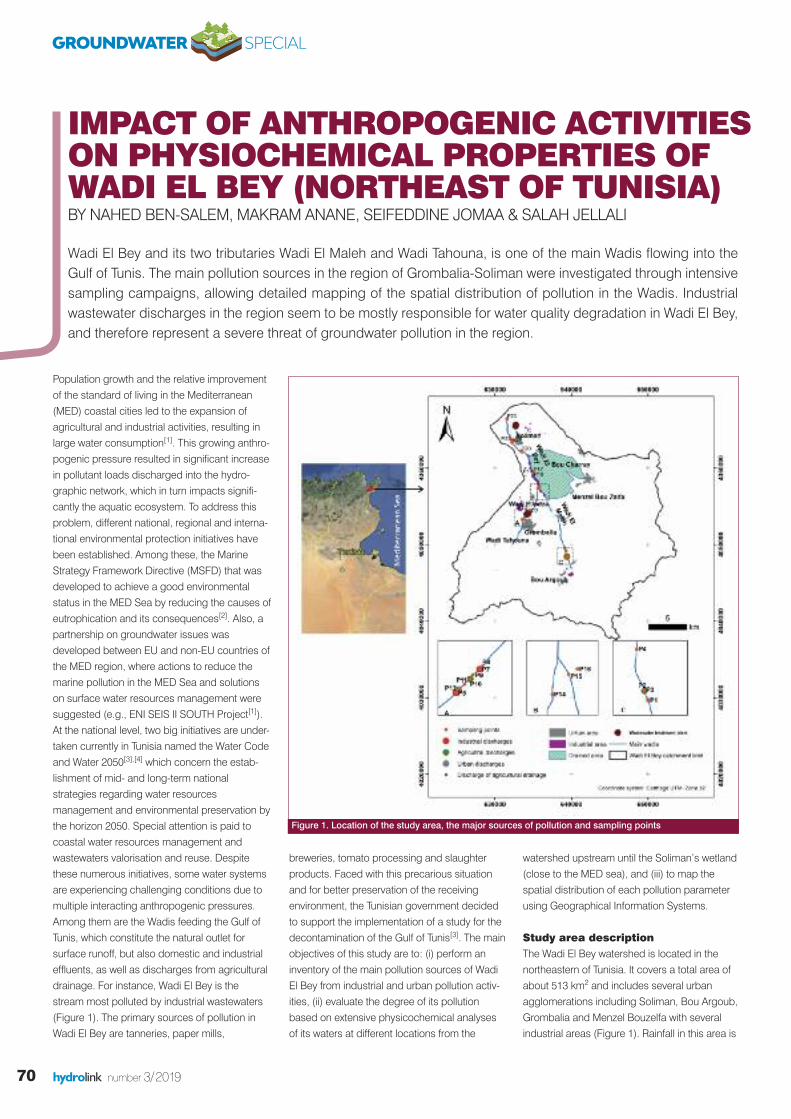
Population growth and the relative improvementof the standard of living in the Mediterranean(MED) coastal cities led to the expansion ofagricultural and industrial activities, resulting inlarge water consumption[1]. This growing anthro-pogenic pressure resulted in significant increasein pollutant loads discharged into the hydro-graphic network, which in turn impacts signifi-cantly the aquatic ecosystem. To address thisproblem, different national, regional and interna-tional environmental protection initiatives havebeen established. Among these, the MarineStrategy Framework Directive (MSFD) that wasdeveloped to achieve a good environmentalstatus in the MED Sea by reducing the causes ofeutrophication and its consequences[2]. Also, apartnership on groundwater issues wasdeveloped between EU and non-EU countries ofthe MED region, where actions to reduce themarine pollution in the MED Sea and solutionson surface water resources management weresuggested (e.g., ENI SEIS II SOUTH Project[1]).At the national level, two big initiatives are under-taken currently in Tunisia named the Water Codeand Water 2050[3],[4] which concern the estab-lishment of mid- and long-term nationalstrategies regarding water resourcesmanagement and environmental preservation bythe horizon 2050. Special attention is paid tocoastal water resources management andwastewaters valorisation and reuse. Despitethese numerous initiatives, some water systemsare experiencing challenging conditions due tomultiple interacting anthropogenic pressures.Among them are the Wadis feeding the Gulf ofTunis, which constitute the natural outlet forsurface runoff, but also domestic and industrialeffluents, as well as discharges from agriculturaldrainage. For instance, Wadi El Bey is thestream most polluted by industrial wastewaters(Figure 1). The primary sources of pollution inWadi El Bey are tanneries, paper mills,
breweries, tomato processing and slaughterproducts. Faced with this precarious situationand for better preservation of the receivingenvironment, the Tunisian government decidedto support the implementation of a study for thedecontamination of the Gulf of Tunis[3]. The mainobjectives of this study are to: (i) perform aninventory of the main pollution sources of WadiEl Bey from industrial and urban pollution activ-ities, (ii) evaluate the degree of its pollutionbased on extensive physicochemical analysesof its waters at different locations from the
watershed upstream until the Soliman’s wetland(close to the MED sea), and (iii) to map thespatial distribution of each pollution parameterusing Geographical Information Systems.
Study area description The Wadi El Bey watershed is located in thenortheastern of Tunisia. It covers a total area ofabout 513 km2 and includes several urbanagglomerations including Soliman, Bou Argoub,Grombalia and Menzel Bouzelfa with severalindustrial areas (Figure 1). Rainfall in this area is
IMPACT OF ANTHROPOGENIC ACTIVITIESON PHYSIOCHEMICAL PROPERTIES OFWADI EL BEY (NORTHEAST OF TUNISIA) BY NAHED BEN-SALEM, MAKRAM ANANE, SEIFEDDINE JOMAA & SALAH JELLALI
Wadi El Bey and its two tributaries Wadi El Maleh and Wadi Tahouna, is one of the main Wadis flowing into theGulf of Tunis. The main pollution sources in the region of Grombalia-Soliman were investigated through intensivesampling campaigns, allowing detailed mapping of the spatial distribution of pollution in the Wadis. Industrialwastewater discharges in the region seem to be mostly responsible for water quality degradation in Wadi El Bey,and therefore represent a severe threat of groundwater pollution in the region.
Figure 1. Location of the study area, the major sources of pollution and sampling points
GROUNDWATER SPECIAL

71hydrolink number 3/2019
Results and discussionPhysicochemical elementsThe mean pH was about 7.4, varying between6.86 and 7.86. With the exception of thedischarge of the industrial area of Grombalia, allmeasured pH values fall within the range ofvalues allowed by discharge standard NT-106.02 (i.e., between 6.5 and 8.5). The mean ECand salinity are relatively high (3.23 mS/cm and4 g/L), indicating that the discharges operatedin Wadi El Bey are highly mineralized. Thehighest values were measured at the dischargeof the tannery. This can be explained by the useof several types of salts in their industrialprocesses such as chromium salts.The concentration of DO in the samples rangesfrom 0.43 to 3.96 mg/L with an average value of2.53 mg/L and a Coefficient of Variation (CV) of0.49.These low values reflect a fairly steadystate of microbiological activity. All measuredvalues of DO are below the thresholdacceptable for proper development of aquaticlife (4 mg/L). The minimum DO contents wererecorded at the sampling points downstream ofthe Grombalia industrial area and after thetannery discharge. At these two locations, the
characterized by temporal irregularity with arainy season spread over a period fromSeptember to May and a dry season in summer.The lowest temperatures are observed inJanuary with an average of 12.3 ˚C. Thegeological layers present a stratigraphicsuccession from the lower Eocene to theQuaternary. The study area consists of a vastplain with gentle slopes (0-3%), directed towardsthe MED Sea. The hydrographic networkextends downstream to the wetland of Solimanand is subject to many sources of pollutionmainly the Grombalia, Bou Argoub and SolimanWaste Water Treatment Plants (WWTPs), theGrombalia and Soliman industrial areas and theBou Charray agricultural drainage network(Figure 1). This lagoon covers approximately2.25 km2 and has a depth of less than 5 m. It communicates with the sea through asmall canal. The study area is mainly agriculturalwith the presence of some agri-food and textileindustries.
A total of 17 surface water sampling points(Figure 1) distributed along the hydrographicnetwork have been used, located upstream anddownstream of the point sources of pollutionfrom industrial, domestic and agriculturaldischarges. Six additional samples were takenfrom the sources themselves; three from urbanWWTPs output, two from industrial WWTPs andone from the agricultural drainage main stream.The main physicochemical parameters (pH,Electrical Conductivity (EC), Dissolved Oxygen(DO), Turbidity, the Suspended Matter (SM), theTotal Dissolved Salts (TDS), Chemical OxygenDemand (COD), Biochemical Oxygen Demand(BOD5)) were analyzed in the laboratory,according to AFNOR (French Association ofNORmalization) standards[4], along with themain major elements (chlorides, sulphate,orthophosphate, nitrate, ammonium andsodium)obtained by ion chromatography. Foreach analyzed parameter, the descriptivestatistics were performed and compared to theTunisian standards of surface water discharge inorder to assess the contamination level of WadiEl Bey surface water. Then the analyzed physic-ochemical parameters were interpolated fromthe sampled points to the entire hydrographicnetwork using the diffusion kernel, a method ofinterpolation with barriers. The obtained mapsdepict the spatial distribution of each analyzedparameter over the entire hydrographic networkfrom the first sampling point to the outlet inSoliman lagoon.
IAHR
Nahed Ben-Salem received herMaster of Science in 2018 inIntegrated Planning for RuralDevelopment and EnvironmentalManagement at the MediterraneanAgronomic Institute of Zaragoza(IAMZ) - University of Lérida, inSpain. In 2016, she obtained her
Engineering degree in Hydraulics from the NationalSchool of Hydraulic Engineering of Medjez El Bab(ESIER), Tunisia. She is currently a PhD student at theHelmholtz Centre for Environmental Research (UFZ),Germany. Her areas of expertise include waterresources management, soil erosion monitoring andmodeling, hydrology and hydrogeology.
Seifeddine Jomaa is a seniorscientist at the Helmholtz Centrefor Environmental Research (UFZ),Germany. In early 2012, hereceived his PhD degree inEnvironmental Engineering fromthe Swiss Federal Institute ofTechnology Lausanne (EPFL), in
Switzerland. In 2007, he received his Master of Sciencein Hydrology from the National Polytechnic Institute ofToulouse (INPT), France. He started his academic careerinvestigating fundamental gaps in understandingphysical processes that govern the soil erosion at thelocal scale. Currently, he leads a research effort onhydrological water quality monitoring and modelling atthe watershed scale, with a particular interest in waterquality assessment at the regional and global scale.
Makram Anane received his PhDfrom Lérida University, Spain, in2004, on remote sensingapplications for agriculture. Hiscurrent research interest includesassessment and mapping of theimpact of irrigation on soil andgroundwater, conception and
building geodatabases on water and wastewater,application of GIS, multi-criteria decision analysis andremote sensing for agriculture and water management.
Salah Jellali served as a fullprofessor in sciences andengineering for water at theWastewaters and EnvironmentLaboratory of the Water Researchand Technologies Centre (CERTE),Tunisia. He is actually a member ofthe Chair for the development of
industrial estates and free zones at the Centre forEnvironmental Studies & Research, Sultan QaboosUniversity, Oman. He obtained a dual Engineering diplomafrom the high school of rural equipment of Medjez El Bab(Tunisia) and from the National School for Water andEnvironmental Engineering, Strasbourg, France and MSc(1996) and PhD (2000) degrees in Water and Engineeringfor water from the University of Strasbourg, followed by apostdoctoral position and a brief experience in BURGEAP,Strasbourg. His research interests include wastewaterstreatment by low cost materials, nutrients recovery fromwastewaters and reuse in agriculture, local watermanagement, and groundwater flow and pollutantstransport modeling for a sustainablemanagement.
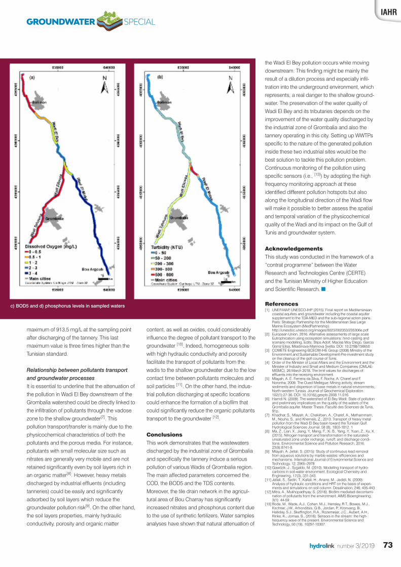
DO contents were less than 1 mg/L indicating avery critical state in this portion of the river. Thisoxygen deficiency is mainly caused by highorganic matter concentrations in the dischargesources and also by low water-flow velocities.The spatial distribution of DO illustrates astriking heterogeneity between the differentsections of the Wadi. At the confluence of Wadi El Maleh with Wadi Ellouza, the quality ofthe water, in terms of DO, improves slightly(Figure 2).
Almost all sampling points in Wadi El Bey waterhave turbidity values that exceed the tolerablethreshold. Except for waters at some locationslike Wadi El Maleh and before the outlet oflagoon El Maleh, these values do not exceedthe acceptable limit specified in the Tunisianstandards.
The average value of SM was 121.86 mg/L,which exceeds the Tunisian standards (i.e., 50 mg/L) and highlights the high pollutant loaddischarged into this river and also the fairly slowflow rate. The SM represents all the mineral andorganic particles contained in the water in a
GROUNDWATER SPECIAL

72 hydrolink number 3/2019
suspension state. The levels of SM in Wadi ElBey waters vary from 9 to 463 mg/L, which canbe rather harmful to the biological diversity ofthis watercourse, since these levels can causethe decrease of DO and light penetration, thusaffecting the photosynthesis process. TDSvalues vary between 1558 and 5538 mg/L, withan average value of 2934 mg/L. This can beexplained by the use of mineral salts in industrialprocesses, and by the contribution of drainagewater, which is quite rich in salts. The surfacewaters of Wadi El Bey have high concentrationsof TDS.
Various measured COD values were muchhigher than the Tunisian standards (i.e., 125mg/L) and are indicative of very high pollutantloads discharged in Wadi El Bey. The maximumconcentration of COD was measured at thedisposal level of the Grombalia industrial area,which is about 16 times higher than thestandard. Apart from the samples collected inWadi El Maleh and downstream of thedischarge of agricultural drainage, all otherpoints are characterized by COD values thatexceed the acceptable threshold. Similarly, thehighest BOD5 values were measured at theGrombalia industrial area. This shows that thepollution contained therein is not subject tobiological degradation. The measured values ofBOD5 vary between 15 and 400 mg/L. Thewaters of Wadi El Maleh are the least loaded interms of BOD5. Concerning Wadi El Bey, itswaters are less loaded with BOD5 compared tothe other streams, which is attributed to theeffect of dilution.
Major elements Wastewater discharges have high levels ofchlorides ranging from 624 to 4005 mg/L. Thislatter value exceeds eight times the Tunisianstandards and corresponds to the dischargedwastewater by the Grombalia tannery. Thesehigh levels are mainly due to the use of NaCl inthe tanning process. The industrial zone ofGrombalia also discharges water with chloridecontent about three times higher than the corre-sponding standard. Wadi El Bey is charac-terized by an average sulphate concentration of518.9 mg/L. The surface water of the Wadi ElBey watershed shows, also, chlorides contentsthat vary from 622.6 mg/L at Wadi El Maleh to2038.6 mg/L at the discharged wastewatersfrom the tannery.
Orthophosphate concentrations, however, werenegligible in all sampling points. Except at theoutlet of Wedi El Bey Watershed, this value,
even if it is relatively low in absolute, exceeds bysixteen times the Tunisian standard (i.e., 2mg/L). With the exception of sites substantiallyrich in phosphates, the rest of the watersamples have low or negligible concentrations.Similarly, when approaching the lagoon ofSoliman, phosphate concentrations continue toincrease to reach relatively high values. Thiscould lead to eutrophication and the intenseproliferation of algae in this lagoon. The highphosphate concentrations are attributed to thepresence of agricultural activity on both sides ofthis river, where the use of nitrogen fertilizers ispredominant [5].
The concentrations of nitrate ions are relativelylow, varying between 1.16 mg/L and 49.74mg/L, with an average value of 8.10 mg/L,complying with the Tunisian standard (i.e. 90mg/L). The corresponding CV exceeds 1.0,indicating that there is a disparity in concentra-tions between sampled points. This disparity isreflected in the sensitivity of nitrates to thephysical and chemical conditions of theenvironment. Virtually, all discharge waters have
low nitrate concentrations. With the exception ofagricultural tile drain, the measured nitratecontent is about 179 mg/L. It can be explainedby the agricultural activities based on theexcessive use of nitrogen fertilizers in the BouCharray agriculture area. The spatial distributionof nitrate levels shows characteristic surfacewater values but is also low compared to levelsfound in other studies [6]. The spatial distributionof nitrates along Wadi El Bey and its tributariesshows that the water sampled in the variousstreams has acceptable levels of nitrates.
Conversely, the ammonium ion contents arerelatively high compared to the correspondingdischarge standard. Several sampling points donot comply with the Tunisian Norm (i.e. 10mg/L). All water discharged in Wadi El Bey hasmagnesium levels that exceed the dischargestandard. As for nitrates, the highestmagnesium values are recorded in the drainagenetwork of the agricultural area of Bou Charray.Sodium levels in Wadi El Bey waters vary in aheterogeneous way, from a minimum of 300.79 mg/L at Wadi El Bey downstream to a
Figure 2. Spatial distribution of a) Dissolved oxygen, b) Turbidity.
GROUNDWATER SPECIAL
73hydrolink number 3/2019
content, as well as oxides, could considerablyinfluence the degree of pollutant transport to thegroundwater [10]. Indeed, homogeneous soilswith high hydraulic conductivity and porosityfacilitate the transport of pollutants from thewadis to the shallow groundwater due to the lowcontact time between pollutants molecules andsoil particles [11]. On the other hand, the indus-trial pollution discharging at specific locationscould enhance the formation of a biofilm thatcould significantly reduce the organic pollutantstransport to the groundwater [12].
ConclusionsThis work demonstrates that the wastewatersdischarged by the industrial zone of Grombaliaand specifically the tannery induce a seriouspollution of various Wadis of Grombalia region.The main affected parameters concerned theCOD, the BOD5 and the TDS contents.Moreover, the tile drain network in the agricul-tural area of Bou Charray has significantlyincreased nitrates and phosphorus content dueto the use of synthetic fertilizers. Water samplesanalyses have shown that natural attenuation of
the Wadi El Bey pollution occurs while movingdownstream. This finding might be mainly theresult of a dilution process and especially infil-tration into the underground environment, whichrepresents, a real danger to the shallow ground-water. The preservation of the water quality ofWadi El Bey and its tributaries depends on theimprovement of the water quality discharged bythe industrial zone of Grombalia and also thetannery operating in this city. Setting up WWTPsspecific to the nature of the generated pollutioninside these two industrial sites would be thebest solution to tackle this pollution problem.Continuous monitoring of the pollution usingspecific sensors (i.e., [13]) by adopting the highfrequency monitoring approach at theseidentified different pollution hotspots but alsoalong the longitudinal direction of the Wadi flowwill make it possible to better assess the spatialand temporal variation of the physicochemicalquality of the Wadi and its impact on the Gulf ofTunis and groundwater system.
AcknowledgementsThis study was conducted in the framework of a“contrat programme” between the WaterResearch and Technologies Centre (CERTE)and the Tunisian Ministry of Higher Educationand Scientific Research. n
References[1] UNEP-MAP, UNESCO-IHP (2015). Final report on Mediterranean
coastal aquifers and groundwater including the coastal aquifersupplement to the TDA-MED and the sub-regional action plans.Paris: Strategic Partnership for the Mediterranean Sea LargeMarine Ecosystem (MedPartnership).http://unesdoc.unesco.org/images/0023/002353/235306e.pdf
[2] European Union, 2016. Alternative assessments of large scaleEutrophication using ecosystem simulations: hind-casting andscenario modelling, Edits: Stips Adolf, Macias Moy Diego, GarciaGorriz Elisa, Miladinova-Marinova Svetla. DOI: 10.2788/156650
[3] COMETE Engineering-BCEOM-IHE Group (2008) Ministry of theEnvironment and Sustainable Development-Pre-investment studyon the cleanup of the golf course of Tunis.
[4] Order of the Minister of Local Affairs and the Environment and theMinister of Industry and Small and Medium Companies (OMLAE-MISMC), 26 March 2018. The limit values for discharges ofeffluents into the receiving environment.
[5] Mlayah, A. E. Ferreira da Silva, F. Rocha, A. Charef and F.Noronha, 2009. The Oued Mellegue: Mining activity, streamsediments and dispersion of base metals in natural environments,North-western Tunisia. Journal of Geochemical Exploration102(1):27-36. DOI: 10.1016/j.gexplo.2008.11.016.
[6] Hamdi N. (2009). The watershed of El Bey Wadi: State of pollutionand preliminary implications on the quality of the waters of theGrombalia aquifer. Master Thesis, Faculté des Sciences de Tunis,91p.
[7] Khadhar, S., Mlayah, A., Chekirben, A., Charef, A., Methammam,M., Nouha, S., and Khemais, Z., 2013. Transport of heavy metalpollution from the Wadi El Bey basin toward the Tunisian Gulf.Hydrological Sciences Journal, 58 (8), 1803-1812. 1
[8] Ma, Z., Lian, X., Jiang, Y., Meng, F., Xi, B., Yang, Y., Yuan, Z., Xu, X.(2015). Nitrogen transport and transformation in the saturated-unsaturated zone under recharge, runoff, and discharge condi-tions. Environmental Science and Pollution Research, 2016,23(9):8741-8.
[9] Mlayah, A. Jellali, S. (2015): Study of continuous lead removalfrom aqueous solutions by marble wastes: efficiencies andmechanisms. International Journal of Environmental Science andTechnology. 12, 2965–2978
[10] Gawdzik, J., Sygaldo, M. (2010). Modelling transport of hydro-carbons in soil-water environment. Ecological Chemistry andEngineering, 17(3), 331-343.
[11] Jellali, S., Sediri, T., Kallali, H., Anane, M., Jedidi, N. (2009):Analysis of hydraulic conditions and HRT on the basis of experi-ments and simulations on soil column. Desalination, 246, 435-443
[12] Mitra, A., Mukhopadhyay, S. (2016). Biofilm mediated decontami-nation of pollutants from the environment. AIMS Bioengineering,3(1): 44-59
[13] Rode, M., Wade, A,J., Cohen, M.J., Hensley, R.T., Bowes, M.J.,Kirchner, J.W., Arhonditsis, G.B., Jordan, P., Kronvang, B.,Halliday, S.J., Skeffington, R.A., Rozemeijer, J.C., Aubert, A.H.,Rinke, K., Jomaa, S., (2016). Sensors in the stream: the high-frequency wave of the present. Environmental Science andTechnology, 50 (19), 10297-10307.
maximum of 913.5 mg/L at the sampling pointafter discharging of the tannery. This lastmaximum value is three times higher than theTunisian standard.
Relationship between pollutants transportand groundwater processes It is essential to underline that the attenuation ofthe pollution in Wadi El Bey downstream of theGrombalia watershed could be directly linked tothe infiltration of pollutants through the vadosezone to the shallow groundwater[7]. Thispollution transport/transfer is mainly due to thephysicochemical characteristics of both thepollutants and the porous media. For instance,pollutants with small molecular size such asnitrates are generally very mobile and are notretained significantly even by soil layers rich inan organic matter[8]. However, heavy metalsdischarged by industrial effluents (includingtanneries) could be easily and significantlyadsorbed by soil layers which reduce thegroundwater pollution risk[9]. On the other hand,the soil layers properties, mainly hydraulicconductivity, porosity and organic matter
IAHR
c) BOD5 and d) phosphorus levels in sampled waters
GROUNDWATER SPECIAL
GROUNDWATER SPECIAL
74 hydrolink number 3/2019
IntroductionNAPL, such as chlorinated solvents, fuels, andcoal tars, are a major cause of groundwater andsoil contamination. In fact, their presence is themost important factor inhibiting suitable riskassessment, characterization, and cleanup ofmost hazardous waste sites. Due to lowaqueous solubilities, trapped residual NAPLmass can persist in the subsurface as a long-term contamination source, producing aqueousconcentrations several orders of magnitudegreater than maximum contaminant levels (MCL)for drinking water. Traditional groundwaterextraction (i.e. pump-and-treat) methods aregenerally inefficient at removing contaminantsource mass, and therefore remediation typicallyrequires extremely long times to reduce ground-water concentrations to acceptable and/orregulatory levels (i.e. reach MCLs) [1,2,3,4, 5,6].Under such scenarios, the risk to human healthfrom toxic levels of contaminants will persist andsite closure may not be feasible.
In order to deal with such challenges for effectiveaquifer remediation, several strategies have beendeveloped to either enhance the removal ofNAPL contaminant sources, transform or destroythe source in situ, and/or stabilize/contain ormodify the source, all of which act to decrease(minimize or eliminate) contaminant mass flux togroundwater. Hence, such contaminant sourcereductions can further aid in allowing naturalattenuation processes to occur more effectively(e.g., dilution, dispersion, microbial/biologicaldegradation or uptake, etc.) by reducing contam-inant concentrations in the environment and thusminimizing human health risks through exposureto contaminated groundwater.
Remediation Technologies whenNAPL Sources are PresentEnhanced FlushingGenerally, enhanced flushing technologies rely onincreasing NAPL mass removal over traditionalflushing approaches via enhanced-solubilization,enhanced-mobilization, or facilitated transportprocesses. Enhanced-solubilization works byinjecting and flushing an aqueous reagent intothe NAPL contaminant source area to increasemass-transfer (dissolution) of the NAPL phaseinto the water phase via molecule complexationor micellar partitioning (e.g., complexing sugars,surfactants) or polarity modification of the flushingsolution (e.g., cosolvents) to yield higher massremoval from the aquifer while simultaneouslyreducing (eliminating) source mass. Such masstransfer processes may be rate-limited (kineticallycontrolled) thereby decreasing removal efficiencyon a per-time basis but pose less risk for NAPL(especially dense NAPL, DNAPL) mobilizationand escape from remediation control. Enhanced-mobilization works by injecting and flushing areagent (e.g., cosolvent or surfactant) that acts toreduce the interfacial tension between the NAPL,water, and solid phases within the aquifer,increasing displace-ment and capture (extraction)of the NAPL phase directly. This process reducessource mass transfer to the water phase byessentially extracting the pure NAPL source fromthe aquifer. Although this is generally a fasterremoval process with less mass-transferconstraints, greater risk of losing control of theNAPL (especially DNAPL that sinks in water) mayoccur. More details on enhanced solubilizationand enhanced-mobilization can be found in[7,8,9,10,11,12,13,14,15].
Facilitated transport works by injecting andflushing a reagent solution with nanoparticles,colloids, and/or macromolecules that aresurface reactive (e.g., minerals, zeolites, humicand fulvic acids, etc.) with the targetedchemicals of concern (COC source or plume) ingroundwater. Ideally, the targeted COC willpreferentially partition, react, or complex with theremedial reagent, increasing NAPL dissolutionand desorption from aquifer materials in thewater phase, yielding higher contaminant massremoval from the aquifer via extraction whilesimultaneously reducing (eliminating) sourcemass.
In Situ Destruction/Degradation/Transformation and StabilizationGenerally, in-situ destruction/degradation/trans-formation based remediation technologies relyon destroying or altering the contaminantsource (i.e. NAPL in this case) in place withoutthe need to extract contaminant mass from thesubsurface. These in-situ destructiontechniques typically involve injecting anamendment or reagent into or near the sourcezone (contaminated NAPL region) wherebyoxidation, reduction, and/or biomineralizationreactions occur to destroy or degrade the NAPLor dissolved phase plume emanating from theNAPL source itself. Strong oxidants such aspotassium permanganate, hydrogen peroxide,or persulfate can react with NAPL or dissolvedphase contaminant to break contaminant bondsyielding transformation products that are ideallybenign or present much lower toxicity hazards inthe environment [16,17,18,19,20,21]. Suchtechnologies can generate unfavorablebyproducts or precipitates that can clog or
REMEDIATION STRATEGIES FOR NONAQUEOUS PHASE LIQUID (NAPL) CONTAMINANT SOURCES IN GROUNDWATER:INNOVATIONS AND CHALLENGESBY GEOFFREY R. TICK
Over the last several decades, a wide variety of groundwater remediation technologies have been developed toremove or reduce sources of aquifer contamination such as nonaqueous phase liquids (NAPL). This article providesan overall review of some groundwater remediation strategies that have proven to show promise for NAPL sourceremoval and reduction including enhanced solubilization and mobilization (i.e. surfactants, complexing sugars,and cosolvents) and in-situ destruction and stabilization (i.e. oxidation, reduction, and composition modification).Although numerous studies have shown these technologies to be quite successful for contaminant source reductionand groundwater remediation, most have been shown to be ineffective at complete source-mass removal andreducing aqueous-phase contaminants of concern (COC) concentrations to levels suitable for site closure.
75hydrolink number 3/2019
groundwater with the source itself. Thiscondition acts to reduce the contaminant massdischarge to groundwater, ideally allowingconcentrations to be low enough by whichnatural attenuation processes can reduce thecontaminant below regulatory action levels (i.e.MCL) and pose negligible risk to human health.The effectiveness of such techniques relies ontargeted and uniform mixing of the amendmentinto and with the contaminant source (i.e. NAPL)[24,25,26]. It should be noted that most studieshave only been tested at small-scale laboratoryor pilot-scale field scenarios.
Challenges and Limitations of SourceRemediation TechniquesAlthough such NAPL source removal/reductiontechniques have demonstrated great promise inreducing source mass and contaminantconcentration/exposure in groundwater, studieshave shown that complete NAPL sourceremoval from the subsurface (groundwater orvadose zone) is extremely difficult and notgenerally possible. An overview study demon-strated that such NAPL source removaltechnologies were only effective for removing afraction of the total NAPL source mass, rangingfrom ~40-90% mass removal for most flushingbased methods [15]. In general, the NAPLmobilization (i.e. surfactant and cosolventmobilization) techniques showed the mosteffective percent mass removal achieving up to98% recovery under the particular conditions ofthe pilot-scale field demonstrations. Overall, thepartial mass removal/reduction associated withthese source remediation techniques may stillleave significant mass in the subsurface formass-flux and release to groundwater (and/or
vadose zone), presenting potential health risksto humans via drinking water, groundwater orvapor exposure.
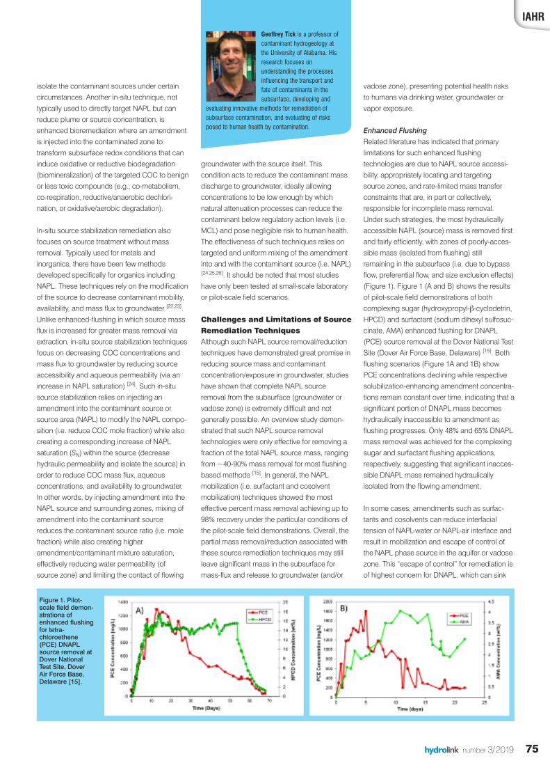
Enhanced FlushingRelated literature has indicated that primarylimitations for such enhanced flushingtechnologies are due to NAPL source accessi-bility, appropriately locating and targetingsource zones, and rate-limited mass transferconstraints that are, in part or collectively,responsible for incomplete mass removal.Under such strategies, the most hydraulicallyaccessible NAPL (source) mass is removed firstand fairly efficiently, with zones of poorly-acces-sible mass (isolated from flushing) stillremaining in the subsurface (i.e. due to bypassflow, preferential flow, and size exclusion effects)(Figure 1). Figure 1 (A and B) shows the resultsof pilot-scale field demonstrations of bothcomplexing sugar (hydroxypropyl-β-cyclodetrin,HPCD) and surfactant (sodium dihexyl sulfosuc-cinate, AMA) enhanced flushing for DNAPL(PCE) source removal at the Dover National TestSite (Dover Air Force Base, Delaware) [15]. Bothflushing scenarios (Figure 1A and 1B) showPCE concentrations declining while respectivesolubilization-enhancing amendment concentra-tions remain constant over time, indicating that asignificant portion of DNAPL mass becomeshydraulically inaccessible to amendment asflushing progresses. Only 48% and 65% DNAPLmass removal was achieved for the complexingsugar and surfactant flushing applications,respectively, suggesting that significant inacces-sible DNAPL mass remained hydraulicallyisolated from the flowing amendment.
In some cases, amendments such as surfac-tants and cosolvents can reduce interfacialtension of NAPL-water or NAPL-air interface andresult in mobilization and escape of control ofthe NAPL phase source in the aquifer or vadosezone. This “escape of control” for remediation isof highest concern for DNAPL, which can sink
isolate the contaminant sources under certaincircumstances. Another in-situ technique, nottypically used to directly target NAPL but canreduce plume or source concentration, isenhanced bioremediation where an amendmentis injected into the contaminated zone totransform subsurface redox conditions that caninduce oxidative or reductive biodegradation(biomineralization) of the targeted COC to benignor less toxic compounds (e.g., co-metabolism,co-respiration, reductive/anaerobic dechlori-nation, or oxidative/aerobic degradation).
In-situ source stabilization remediation alsofocuses on source treatment without massremoval. Typically used for metals andinorganics, there have been few methodsdeveloped specifically for organics includingNAPL. These techniques rely on the modificationof the source to decrease contaminant mobility,availability, and mass flux to groundwater [22,23].Unlike enhanced-flushing in which source massflux is increased for greater mass removal viaextraction, in-situ source stabilization techniquesfocus on decreasing COC concentrations andmass flux to groundwater by reducing sourceaccessibility and aqueous permeability (via anincrease in NAPL saturation) [24]. Such in-situsource stabilization relies on injecting anamendment into the contaminant source orsource area (NAPL) to modify the NAPL compo-sition (i.e. reduce COC mole fraction) while alsocreating a corresponding increase of NAPLsaturation (SN) within the source (decreasehydraulic permeability and isolate the source) inorder to reduce COC mass flux, aqueousconcentrations, and availability to groundwater.In other words, by injecting amendment into theNAPL source and surrounding zones, mixing ofamendment into the contaminant sourcereduces the contaminant source ratio (i.e. molefraction) while also creating higheramendment/contaminant mixture saturation,effectively reducing water permeability (ofsource zone) and limiting the contact of flowing
IAHRGeoffrey Tick is a professor ofcontaminant hydrogeology atthe University of Alabama. Hisresearch focuses onunderstanding the processesinfluencing the transport andfate of contaminants in thesubsurface, developing and
evaluating innovative methods for remediation ofsubsurface contamination, and evaluating of risksposed to human health by contamination.
Figure 1. Pilot-scale field demon-strations ofenhanced flushingfor tetra-chloroethene(PCE) DNAPLsource removal atDover NationalTest Site, DoverAir Force Base,Delaware [15].
76 hydrolink number 3/2019
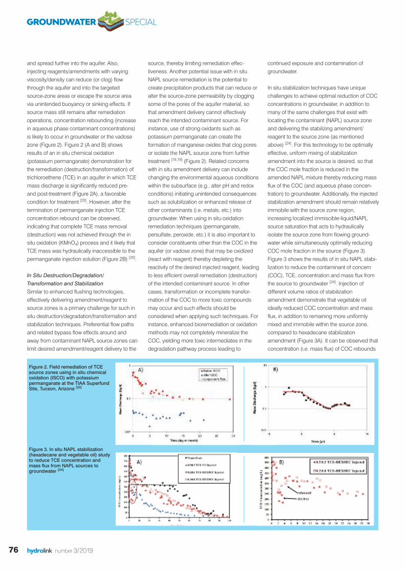
and spread further into the aquifer. Also,injecting reagents/amendments with varyingviscosity/density can reduce (or clog) flowthrough the aquifer and into the targetedsource-zone areas or escape the source areavia unintended buoyancy or sinking effects. Ifsource mass still remains after remediationoperations, concentration rebounding (increasein aqueous phase contaminant concentrations)is likely to occur in groundwater or the vadosezone (Figure 2). Figure 2 (A and B) showsresults of an in situ chemical oxidation(potassium permanganate) demonstration forthe remediation (destruction/transformation) oftrichloroethene (TCE) in an aquifer in which TCEmass discharge is significantly reduced pre-and post-treatment (Figure 2A), a favorablecondition for treatment [20]. However, after thetermination of permanganate injection TCEconcentration rebound can be observed,indicating that complete TCE mass removal(destruction) was not achieved through the insitu oxidation (KMnO4) process and it likely thatTCE mass was hydraulically inaccessible to thepermanganate injection solution (Figure 2B) [20].
In Situ Destruction/Degradation/Transformation and StabilizationSimilar to enhanced flushing technologies,effectively delivering amendment/reagent tosource zones is a primary challenge for such insitu destruction/degradation/transformation andstabilization techniques. Preferential flow pathsand related bypass flow effects around andaway from contaminant NAPL source zones canlimit desired amendment/reagent delivery to the
source, thereby limiting remediation effec-tiveness. Another potential issue with in situNAPL source remediation is the potential tocreate precipitation products that can reduce oralter the source-zone permeability by cloggingsome of the pores of the aquifer material, sothat amendment delivery cannot effectivelyreach the intended contaminant source. Forinstance, use of strong oxidants such aspotassium permanganate can create theformation of manganese oxides that clog poresor isolate the NAPL source zone from furthertreatment [16,19] (Figure 2). Related concernswith in situ amendment delivery can includechanging the environmental aqueous conditionswithin the subsurface (e.g., alter pH and redoxconditions) initiating unintended consequencessuch as solubilization or enhanced release ofother contaminants (i.e. metals, etc.) intogroundwater. When using in situ oxidationremediation techniques (permanganate,persulfate, peroxide, etc.) it is also important toconsider constituents other than the COC in theaquifer (or vadose zone) that may be oxidized(react with reagent) thereby depleting thereactivity of the desired injected reagent, leadingto less efficient overall remediation (destruction)of the intended contaminant source. In othercases, transformation or incomplete transfor-mation of the COC to more toxic compoundsmay occur and such effects should beconsidered when applying such techniques. Forinstance, enhanced bioremediation or oxidationmethods may not completely mineralize theCOC, yielding more toxic intermediates in thedegradation pathway process leading to
continued exposure and contamination ofgroundwater.
In situ stabilization techniques have uniquechallenges to achieve optimal reduction of COCconcentrations in groundwater, in addition tomany of the same challenges that exist withlocating the contaminant (NAPL) source zoneand delivering the stabilizing amendment/reagent to the source zone (as mentionedabove) [24]. For this technology to be optimallyeffective, uniform mixing of stabilizationamendment into the source is desired, so thatthe COC mole fraction is reduced in theamended NAPL mixture thereby reducing massflux of the COC (and aqueous phase concen-tration) to groundwater. Additionally, the injectedstabilization amendment should remain relativelyimmobile with the source zone region,increasing localized immiscible-liquid/NAPLsource saturation that acts to hydraulicallyisolate the source zone from flowing ground-water while simultaneously optimally reducingCOC mole fraction in the source (Figure 3).Figure 3 shows the results of in situ NAPL stabi-lization to reduce the contaminant of concern(COC), TCE, concentration and mass flux fromthe source to groundwater [24]. Injection ofdifferent volume ratios of stabilizationamendment demonstrate that vegetable oilideally reduced COC concentration and massflux, in addition to remaining more uniformlymixed and immobile within the source zone,compared to hexadecane stabilizationamendment (Figure 3A). It can be observed thatconcentration (i.e. mass flux) of COC rebounds
Figure 3. In situ NAPL stabilization(hexadecane and vegetable oil) studyto reduce TCE concentration andmass flux from NAPL sources togroundwater [24]
Figure 2. Field remediation of TCEsource zones using in situ chemicaloxidation (ISCO) with potassiumpermanganate at the TIAA SuperfundSite, Tucson, Arizona [20]
GROUNDWATER SPECIAL
77hydrolink number 3/2019
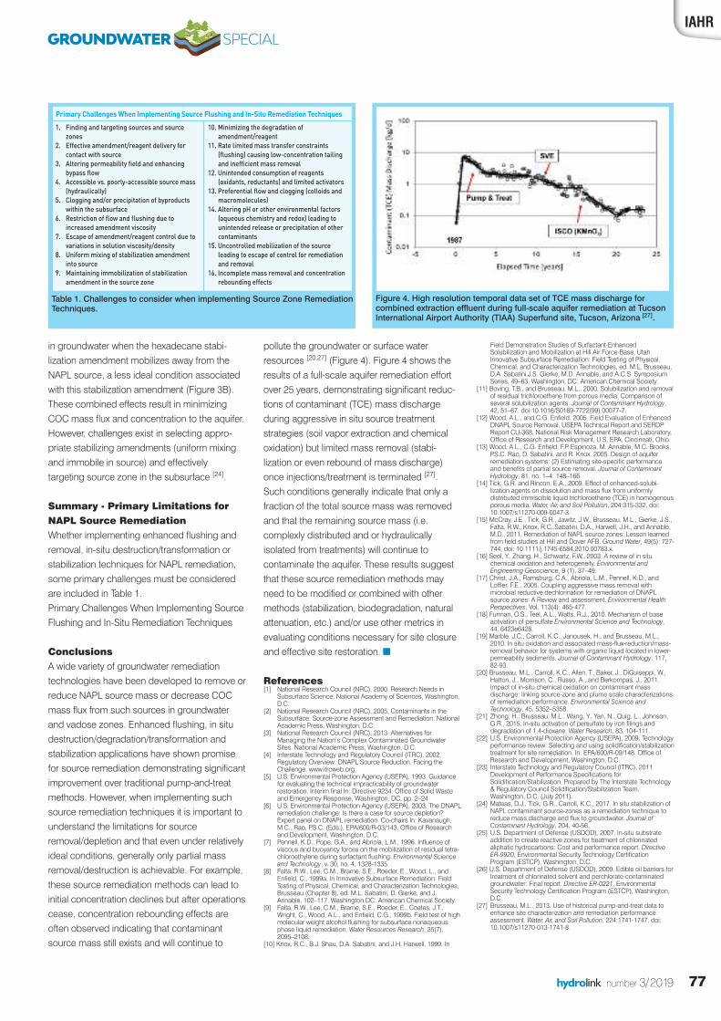
pollute the groundwater or surface waterresources [20,27] (Figure 4). Figure 4 shows theresults of a full-scale aquifer remediation effortover 25 years, demonstrating significant reduc-tions of contaminant (TCE) mass dischargeduring aggressive in situ source treatmentstrategies (soil vapor extraction and chemicaloxidation) but limited mass removal (stabi-lization or even rebound of mass discharge)once injections/treatment is terminated [27].Such conditions generally indicate that only afraction of the total source mass was removedand that the remaining source mass (i.e.complexly distributed and or hydraulicallyisolated from treatments) will continue tocontaminate the aquifer. These results suggestthat these source remediation methods mayneed to be modified or combined with othermethods (stabilization, biodegradation, naturalattenuation, etc.) and/or use other metrics inevaluating conditions necessary for site closureand effective site restoration. n
References[1] National Research Council (NRC), 2000. Research Needs in
Subsurface Science. National Academy of Sciences, Washington,D.C.
[2] National Research Council (NRC), 2005. Contaminants in theSubsurface: Source-zone Assessment and Remediation. NationalAcademic Press, Washington, D.C.
[3] National Research Council (NRC), 2013. Alternatives forManaging the Nation’s Complex Contaminated GroundwaterSites. National Academic Press, Washington, D.C.
[4] Interstate Technology and Regulatory Council (ITRC), 2002.Regulatory Overview: DNAPL Source Reduction. Facing theChallenge. www.itrcweb.org.
[5] U.S. Environmental Protection Agency (USEPA), 1993. Guidancefor evaluating the technical impracticability of groundwaterrestoration. Interim final In: Directive 9234. Office of Solid Wasteand Emergency Response, Washington, DC, pp. 2–24
[6] U.S. Environmental Protection Agency (USEPA), 2003. The DNAPLremediation challenge: Is there a case for source depletion?Expert panel on DNAPL remediation. Co-chairs In: Kavanaugh,M.C., Rao, P.S.C. (Eds.), EPA/600/R-03/143. Office of Researchand Development, Washington, D.C.
[7] Pennell, K.D., Pope, G.A., and Abriola, L.M., 1996. Influence ofviscous and buoyancy forces on the mobilization of residual tetra-chloroethylene during surfactant flushing. Environmental Scienceand Technology, v. 30, no. 4, 1328-1335.
[8] Falta, R.W., Lee, C.M., Brame, S.E., Roeder, E., Wood, L., andEnfield, C., 1999a. In Innovative Subsurface Remediation: FieldTesting of Physical, Chemical, and Characterization Technologies,Brusseau (Chapter 8), ed. M.L. Sabatini, D. Gierke, and J.Annable, 102–117. Washington DC: American Chemical Society.
[9] Falta, R.W., Lee, C.M., Brame, S.E., Roeder, E., Coates, J.T.,Wright, C., Wood, A.L., and Enfield, C.G., 1999b. Field test of highmolecular weight alcohol flushing for subsurface nonaqueousphase liquid remediation. Water Resources Research, 35(7),2095–2108.
[10] Knox, R.C., B.J. Shau, D.A. Sabatini, and J.H. Harwell. 1999. In
Field Demonstration Studies of Surfactant-EnhancedSolubilization and Mobilization at Hill Air Force Base, Utah.Innovative Subsurface Remediation: Field Testing of Physical,Chemical, and Characterization Technologies, ed. M.L. Brusseau,D.A. Sabatini J.S. Gierke, M.D. Annable, and A.C.S. SymposiumSeries, 49–63. Washington, DC: American Chemical Society.
[11] Boving, T.B., and Brusseau, M.L., 2000. Solubilization and removalof residual trichloroethene from porous media: Comparison ofseveral solubilization agents. Journal of Contaminant Hydrology,42, 51–67. doi:10.1016/S0169-7722(99) 00077-7.
[12] Wood, A.L., and C.G. Enfield. 2005. Field Evaluation of EnhancedDNAPL Source Removal, USEPA Technical Report and SERDPReport CU-368, National Risk Management Research Laboratory,Office of Research and Development, U.S. EPA, Cincinnati, Ohio.
[13] Wood, A.L., C.G. Enfield, F.P. Espinoza, M. Annable, M.C. Brooks,P.S.C. Rao, D. Sabatini, and R. Knox. 2005. Design of aquiferremediation systems: (2) Estimating site-specific performanceand benefits of partial source removal. Journal of ContaminantHydrology, 81, no. 1–4: 148–166.
[14] Tick, G.R. and Rincon, E.A., 2009. Effect of enhanced-solubi-lization agents on dissolution and mass flux from uniformlydistributed immiscible liquid trichloroethene (TCE) in homogenousporous media. Water, Air, and Soil Pollution, 204:315-332, doi:10.1007/s11270-009-0047-3.
[15] McCray, J.E., Tick, G.R., Jawitz, J.W., Brusseau, M.L., Gierke, J.S.,Falta, R.W., Knox, R.C.,Sabatini, D.A., Harwell, J.H., and Annable,M.D., 2011. Remediation of NAPL source zones: Lesson learnedfrom field studies at Hill and Dover AFB. Ground Water, 49(5): 727-744, doi: 10.1111/j.1745-6584.2010.00783.x.
[16] Seol, Y., Zhang, H., Schwartz, F.W., 2003. A review of in situchemical oxidation and heterogeneity. Environmental andEngineering Geoscience, 9 (1), 37–49.
[17] Christ, J.A., Ramsburg, C.A., Abriola, L.M., Pennell, K.D., andLoffler, F.E., 2005. Coupling aggressive mass removal withmicrobial reductive dechlorination for remediation of DNAPLsource zones: A Review and assessment. Environmental HealthPerspectives, Vol. 113(4): 465-477.
[18] Furman, O.S., Teel, A.L., Watts, R.J., 2010. Mechanism of baseactivation of persulfate Environmental Science and Technology,44, 6423e6428.
[19] Marble, J.C., Carroll, K.C., Janousek, H., and Brusseau, M.L.,2010. In situ oxidation and associated mass-flux-reduction/mass-removal behavior for systems with organic liquid located in lower-permeability sediments. Journal of Contaminant Hydrology, 117,82-93.
[20] Brusseau, M.L., Carroll, K.C., Allen, T., Baker, J., DiGuiseppi, W.,Hatton, J., Morrison, C., Russo, A., and Berkompas, J., 2011.Impact of in-situ chemical oxidation on contaminant massdischarge: linking source-zone and plume scale characterizationsof remediation performance. Environmental Science andTechnology, 45, 5352–5358.
[21] Zhong, H., Brusseau, M.L., Wang, Y., Yan, N., Quig, L., Johnson,G.R., 2015. In-situ activation of persulfate by iron filings anddegradation of 1,4-dioxane. Water Research, 83, 104-111.
[22] U.S. Environmental Protection Agency (USEPA), 2009. Technologyperformance review: Selecting and using solidification/stabilizationtreatment for site remediation. In: EPA/600/R-09/148. Office ofResearch and Development, Washington, D.C.
[23] Interstate Technology and Regulatory Council (ITRC), 2011.Development of Performance Specifications forSolidification/Stabilization. Prepared by The Interstate Technology& Regulatory Council Solidification/Stabilization Team,Washington, D.C. (July 2011).
[24] Mateas, D.J., Tick, G.R., Carroll, K.C., 2017. In situ stabilization ofNAPL contaminant source-zones as a remediation technique toreduce mass discharge and flux to groundwater. Journal ofContaminant Hydrology, 204, 40-56.
[25] U.S. Department of Defense (USDOD), 2007. In-situ substrateaddition to create reactive zones for treatment of chlorinatedaliphatic hydrocarbons: Cost and performance report. DirectiveER-9920, Environmental Security Technology CertificationProgram (ESTCP), Washington, D.C.
[26] U.S. Department of Defense (USDOD), 2009. Edible oil barriers fortreatment of chlorinated solvent and perchlorate-contaminatedgroundwater: Final report. Directive ER-0221, EnvironmentalSecurity Technology Certification Program (ESTCP), Washington,D.C.
[27] Brusseau, M.L., 2013. Use of historical pump-and-treat data toenhance site characterization and remediation performanceassessment. Water, Air, and Soil Pollution, 224:1741-1747, doi:10.1007/s11270-013-1741-8.
in groundwater when the hexadecane stabi-lization amendment mobilizes away from theNAPL source, a less ideal condition associatedwith this stabilization amendment (Figure 3B).These combined effects result in minimizingCOC mass flux and concentration to the aquifer.However, challenges exist in selecting appro-priate stabilizing amendments (uniform mixingand immobile in source) and effectivelytargeting source zone in the subsurface [24].
Summary - Primary Limitations forNAPL Source RemediationWhether implementing enhanced flushing andremoval, in-situ destruction/transformation orstabilization techniques for NAPL remediation,some primary challenges must be consideredare included in Table 1.Primary Challenges When Implementing SourceFlushing and In-Situ Remediation Techniques
ConclusionsA wide variety of groundwater remediationtechnologies have been developed to remove orreduce NAPL source mass or decrease COCmass flux from such sources in groundwaterand vadose zones. Enhanced flushing, in situdestruction/degradation/transformation andstabilization applications have shown promisefor source remediation demonstrating significantimprovement over traditional pump-and-treatmethods. However, when implementing suchsource remediation techniques it is important tounderstand the limitations for sourceremoval/depletion and that even under relativelyideal conditions, generally only partial massremoval/destruction is achievable. For example,these source remediation methods can lead toinitial concentration declines but after operationscease, concentration rebounding effects areoften observed indicating that contaminantsource mass still exists and will continue to
IAHR
Figure 4. High resolution temporal data set of TCE mass discharge forcombined extraction effluent during full-scale aquifer remediation at TucsonInternational Airport Authority (TIAA) Superfund site, Tucson, Arizona [27].
GROUNDWATER SPECIAL
1. Finding and targeting sources and sourcezones
2. Effective amendment/reagent delivery forcontact with source
3. Altering permeability field and enhancingbypass flow
4. Accessible vs. poorly-accessible source mass(hydraulically)
5. Clogging and/or precipitation of byproductswithin the subsurface
6. Restriction of flow and flushing due toincreased amendment viscosity
7. Escape of amendment/reagent control due tovariations in solution viscosity/density
8. Uniform mixing of stabilization amendmentinto source
9. Maintaining immobilization of stabilizationamendment in the source zone
10. Minimizing the degradation ofamendment/reagent
11. Rate limited mass transfer constraints(flushing) causing low-concentration tailingand inefficient mass removal
12. Unintended consumption of reagents(oxidants, reductants) and limited activators
13. Preferential flow and clogging (colloids andmacromolecules)
14. Altering pH or other environmental factors(aqueous chemistry and redox) leading tounintended release or precipitation of othercontaminants
15. Uncontrolled mobilization of the sourceleading to escape of control for remediationand removal
16. Incomplete mass removal and concentrationrebounding effects
Primary Challenges When Implementing Source Flushing and In-Situ Remediation Techniques
Table 1. Challenges to consider when implementing Source Zone RemediationTechniques.
78 hydrolink number 3/2019
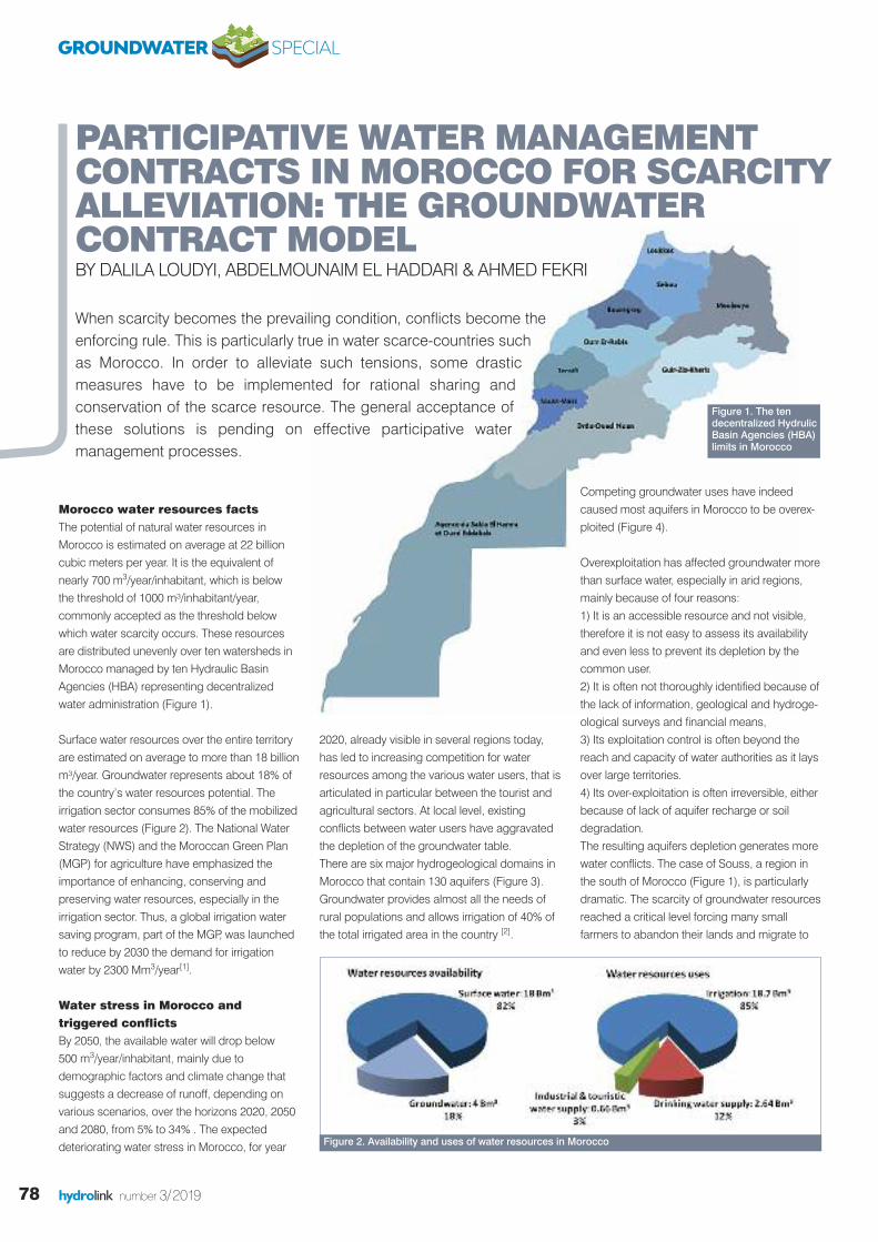
Morocco water resources factsThe potential of natural water resources inMorocco is estimated on average at 22 billioncubic meters per year. It is the equivalent ofnearly 700 m3/year/inhabitant, which is belowthe threshold of 1000 m³/inhabitant/year,commonly accepted as the threshold belowwhich water scarcity occurs. These resourcesare distributed unevenly over ten watersheds inMorocco managed by ten Hydraulic BasinAgencies (HBA) representing decentralizedwater administration (Figure 1).
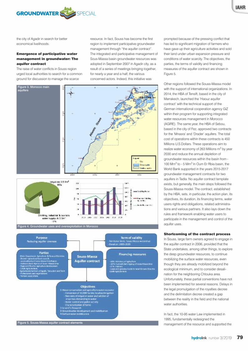
Surface water resources over the entire territoryare estimated on average to more than 18 billionm³/year. Groundwater represents about 18% ofthe country’s water resources potential. Theirrigation sector consumes 85% of the mobilizedwater resources (Figure 2). The National WaterStrategy (NWS) and the Moroccan Green Plan(MGP) for agriculture have emphasized theimportance of enhancing, conserving andpreserving water resources, especially in theirrigation sector. Thus, a global irrigation watersaving program, part of the MGP, was launchedto reduce by 2030 the demand for irrigationwater by 2300 Mm3/year[1].
Water stress in Morocco andtriggered conflicts By 2050, the available water will drop below 500 m3/year/inhabitant, mainly due todemographic factors and climate change thatsuggests a decrease of runoff, depending onvarious scenarios, over the horizons 2020, 2050and 2080, from 5% to 34% . The expecteddeteriorating water stress in Morocco, for year
2020, already visible in several regions today,has led to increasing competition for waterresources among the various water users, that isarticulated in particular between the tourist andagricultural sectors. At local level, existingconflicts between water users have aggravatedthe depletion of the groundwater table. There are six major hydrogeological domains inMorocco that contain 130 aquifers (Figure 3).Groundwater provides almost all the needs ofrural populations and allows irrigation of 40% ofthe total irrigated area in the country [2].
Competing groundwater uses have indeedcaused most aquifers in Morocco to be overex-ploited (Figure 4).
Overexploitation has affected groundwater morethan surface water, especially in arid regions,mainly because of four reasons:1) It is an accessible resource and not visible,therefore it is not easy to assess its availabilityand even less to prevent its depletion by thecommon user. 2) It is often not thoroughly identified because ofthe lack of information, geological and hydroge-ological surveys and financial means,3) Its exploitation control is often beyond thereach and capacity of water authorities as it laysover large territories.4) Its over-exploitation is often irreversible, eitherbecause of lack of aquifer recharge or soildegradation.The resulting aquifers depletion generates morewater conflicts. The case of Souss, a region inthe south of Morocco (Figure 1), is particularlydramatic. The scarcity of groundwater resourcesreached a critical level forcing many smallfarmers to abandon their lands and migrate to
PARTICIPATIVE WATER MANAGEMENT CONTRACTS IN MOROCCO FOR SCARCITY ALLEVIATION: THE GROUNDWATER CONTRACT MODELBY DALILA LOUDYI, ABDELMOUNAIM EL HADDARI & AHMED FEKRI
When scarcity becomes the prevailing condition, conflicts become theenforcing rule. This is particularly true in water scarce-countries suchas Morocco. In order to alleviate such tensions, some drasticmeasures have to be implemented for rational sharing andconservation of the scarce resource. The general acceptance ofthese solutions is pending on effective participative watermanagement processes.
Figure 2. Availability and uses of water resources in Morocco
Figure 1. The tendecentralized HydrulicBasin Agencies (HBA)limits in Morocco
GROUNDWATER SPECIAL
79hydrolink number 3/2019
prompted because of the pressing conflict thathas led to significant migration of farmers whohave gave up their agriculture activities and soldtheir land under urban expansion pressure andconditions of water scarcity. The objectives, theparties, the terms of validity and financingmeasures of the aquifer contract are shown inFigure 5.
Other regions followed the Souss-Massa modelwith the support of international organizations. In2014, the HBA of Tensift, based in the city ofMarrakech, launched the ‘Haouz aquifercontract’ with the technical support of theGerman international cooperation agency GiZwithin their program for supporting integratedwater resources management in Morocco(AGIRE). The same year, the HBA of Sebou,based in the city of Fez, approved two contractsfor the ‘Mnasra’ and ‘Drader’ aquifers. The totalcost of operations within these contracts is 450Millions U.S.Dollars. These operations aim torealize water economy of 263 Millions m3 by year2030 and reduce the annual depletion ofgroundwater resources within the basin from -100 Mm3 to - 5 Mm3 In Oum Er Rbia basin, theWorld Bank supported in the years 2015-2017groundwater management contracts for twoaquifers in Tadla. No aquifer contract templateexists, but generally, the main steps followed theSouss-Massa model. The contract, establishedby the HBA, sets, in particular, the action plan, itsobjectives, its duration, its financing terms, waterusers rights and obligations, related administra-tions and various partners. It also lays down therules and framework enabling water users toparticipate in the management and control of theaquifer uses.
Shortcoming of the contract processIn Souss, large farm owners agreed to engage inthe aquifer contract in 2006, provided that theState undertakes, among other things, to explorethe deep groundwater resources, to continuemobilizing the surface water resources, eventhough they are already mobilized beyond theecological minimum, and to consider desali-nation for the neighboring Chtouka area.Unfortunately, these partial conventions have notbeen implemented for several reasons. Delays inthe legal promulgation of the royalties decreeand the delimitation decree created a gapbetween the reality in the field and the nationalwater authorities.
In fact, the 10-95 water Law implemented in1995, fundamentally redesigned themanagement of the resource and supported the
IAHR
Figure 3. Morocco mainaquifers
Figure 4. Groundwater uses and overexploitation in Morocco
Figure 5. Souss-Massa aquifer contract elements
the city of Agadir in search for bettereconomical livelihoods.
Emergence of participative watermanagement in groundwater: Theaquifer contractThe raise of water conflicts in Souss regionurged local authorities to search for a commonground for discussion to manage the scarce
resource. In fact, Souss has become the firstregion to implement participative groundwatermanagement through “the aquifer contract”. The integrated and participative management ofSous-Massa basin groundwater resources wasadopted in September 2007 in Agadir city, as aresult of a series of meetings bringing together,for nearly a year and a half, the variousconcerned actors. Indeed, this initiative was
GROUNDWATER SPECIAL
80 hydrolink number 3/2019
decentralization of water management throughthe creation of seven HBAs initially and theinvolvement of Agricultural Water UserAssociations (AWUA) in water management atlocal levels and maintenance of irrigationsystems infrastructure.
Twenty years after the promulgation of 10-95Law, the practice of water on the ground hasshown that certain aspects of water use andmanagement have not been sufficiently treatedor are simply absent in this law. Provisionsregarding groundwater conservation, particularlythrough groundwater contracts, seawater desali-nation and sewage discharge into the sea werenot clearly cited in this law. In fact, groundwatercontracts were established as an institutionalinitiative from the HBAs to ensure the collectiveengagement of all users despite the absence ofa specifically related regulatory framework.
Moreover, experience has shown that theexclusive objective of preserving resources,often based on restrictive measures, does littleto promote collective work to bring actorstogether and ensure their commitment. In short,the aquifer contract failed to create a realdynamic of change at the local level. It did notentice water end-users to fully play their role,participating in the diagnosis of the situation,and in the identification of solutions. As a result,their commitment to actions achievementremains marginal. To make the aquifer contractan effective management tool, it is necessary tostrengthen local and regional authorities in watermanagement, but also expand the involvementof users.
New participative watermanagement contractTo meet the challenges faced by the implemen-tation of aquifer contracts, the new water Law36-15 introduced in 2016 a new approach towater management through the ParticipativeWater Management Contract (PWMC). Thisapproach focuses on water users and allows fora better consideration of the local scale ratherthan extending over large hydraulic areas.Instead of considering the issues related to theoverexploitation of groundwater resources only,the PWMC governs all water bodies, whetherthey are surface or ground waters in the publichydraulic domain, taking into account bothquantitative and qualitative issues. Waterresources users - farmers, households, industrialunits, touristic developers, etc - are organizedwithin entities that have their own concerns,policies and approaches. For these users, theinterest to participate in water management ismainly to be heard in order to influence thepublic authorities’ decisions, to benefit fromtechnical and financial support and to direct thehelp of the public authorities to the real needs ofusers.
The parties’ obligations within this contract relateto: 1) rules of access and use of the waterresource, 2) control of these rules, 3) measuresin case of water crisis, 4) changes of practicesand uses, 5) establishment of equipmentmaintenance 6) application of new pricing, 7)royalties collection and 8) creation of new formsof collective organization.
Dalila Loudyi is a Professor ofhydrology and hydraulics at theDepartment of Water andEnvironmental Engineering of theFaculty of Sciences and Technicsat Hassan II University ofCasablanca. She is leading aresearch team working on water
resources management, numerical modelling, urbanwater and climate change. She is the IAHR councilmember for the MENA/India Sub-continent region.
Abdel Mounaim El Haddari, is ajunior executive at the Depart-ment of Water Research andPlanning of the MoroccanDepartment in charge of Watersince 2016. He holds a Masterdegree in Water Engineering andEnvironment.
Ahmed Fekri is a Professor ofhydrogeology at the GeologyDepartment of the Faculty ofSciences Ben Msik, at Hassan IIUniversity of Casablanca. Since2016, he is the head of the“Applied Geology, Geomatic andEnvironment” Laboratory. He is
an active member of the IAH Moroccan chapter. He isa board member in IAH association. Prof. Fekri hasbeen involved in many projects such as “MENARegional Water Governance Benchmarking Project”(USAID 2008-09) and “BOOST” (US State Department 2011-13).
The contract may be initiated by the HBA or bythe users organizations. The PWMC is requiredto be submitted to the Hydraulic Basin Councilfor approval. The HBA provides secretariatresources throughout the process of devel-oping and implementing the contract. It ensuresthat the PWMC complies with the requirementsof the local Master Plan for Integrated WaterResources Management (MPIWRM) and theregulations in force (Figure 6). The subsequentregulatory order of this Law is still beingdeveloped by legislators to specify detailsabout the PWMC elements (contents, parties,implementation process, duties and rights ofeach party, financing options, etc.). This new governance model relies on the goodwill of all parties for an efficient implementationbased on voluntary engagement. The state ishoping that this type of mechanism willenhance water users’ engagement along withlocal and water authorities for a more equitablesharing and use of water resources, fostersocial change and make public decisions moredemocratic. It is guided by the search for a win-win partnership between users and the admin-istration. n
References[1] Moroccan water department, 2015, ‘National Plan for Water (PNE)’[2] Minister in charge of water declaration, National workshop on
groundwater management, 26-27 March 2014, Skhirat, Morocco.
Figure 6. The planning scales of water resources management
GROUNDWATER SPECIAL
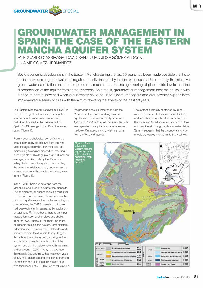
81hydrolink number 3/2019
the previous ones; iii) limestones from theMiocene, in the center, working as a freeaquifer layer; their transmissivity is between1,200 and 7,200 m2/day. All these aquifer unitsare separated by aquitards or aquifuges fromthe lower Cretaceous and by detritus rocksfrom the Tertiary (Figure 2).
The system is laterally contained by imper-meable borders with the exception of: i) thenortheast border, which is the water divide ofthe Júcar and Guadiana rivers and which doesnot coincide with the groundwater water divide;Sanz [3] suggests that the groundwater divideshould be located 8 to 10 km to the west with
The Eastern Mancha aquifer system (EMAS) isone of the largest carbonate aquifers in thesouthwest of Europe, with a surface of 7260 km2. Located at the Eastern part ofSpain, EMAS belongs to the Júcar river waterbasin (Figure 1).
From a geomorphological point of view, thearea is formed by big hollows from the intra-Miocene age, filled with later materials, stillmaintaining its original disposition, resulting ina flat high plain. This high plain, at 700 masl onaverage, is broken only by the Júcar rivervalley, that crosses the system. Surroundingthe plain, the relief is smooth, becoming moreabrupt, together with complex tectonics, awayfrom it (Figure 1).
In the EMAS, there are outcrops from theMesozoic, and large Plio-Quaternary deposits.The sedimentary sequence makes a multilayeraquifer with complex interactions between thedifferent aquifer layers. From a hydrogeologicalpoint of view, the EMAS is made up of threehydrogeological units separated by aquitardsor aquifuges [2]. At the base, there is an imper-meable formation of silts, clays and chalksfrom the lower Jurassic. The most importantpermeable facies in the system, for their lateralextension and thickness are: i) dolomites andlimestones from the Jurassic (partly Dogger)throughout the entire system, working as freeaquifer layer towards the outer limits of thesystem and confined elsewhere, with transmis-sivities around 10,000 m2/day; the averagethickness is 250-350 m, with a maximum valueof 400 m; ii) dolomites and limestones from theupper Cretaceous, in the northeastern side,with thicknesses of 50-150 m, as conductive as
IAHR
GROUNDWATER MANAGEMENT INSPAIN: THE CASE OF THE EASTERNMANCHA AQUIFER SYSTEMBY EDUARDO CASSIRAGA, DAVID SANZ, JUAN JOSÉ GÓMEZ-ALDAY & J. JAIME GÓMEZ-HERNÁNDEZ
Figure 1. Planview of theEastern Manchaaquifer systemwith a simplifiedgeological map(modified from [1])
GROUNDWATER SPECIAL
Socio-economic development in the Eastern Mancha during the last 50 years has been made possible thanks tothe intensive use of groundwater for irrigation, mostly financed by the end water users. Unfortunately, this intensivegroundwater exploitation has created problems, such as the continuing lowering of piezometric levels, and thedisconnection of the aquifer from some riverbeds. As a result, groundwater management became an issue witha need to control how and when groundwater could be used. Users, managers and groundwater experts haveimplemented a series of rules with the aim of reverting the effects of the past 50 years.
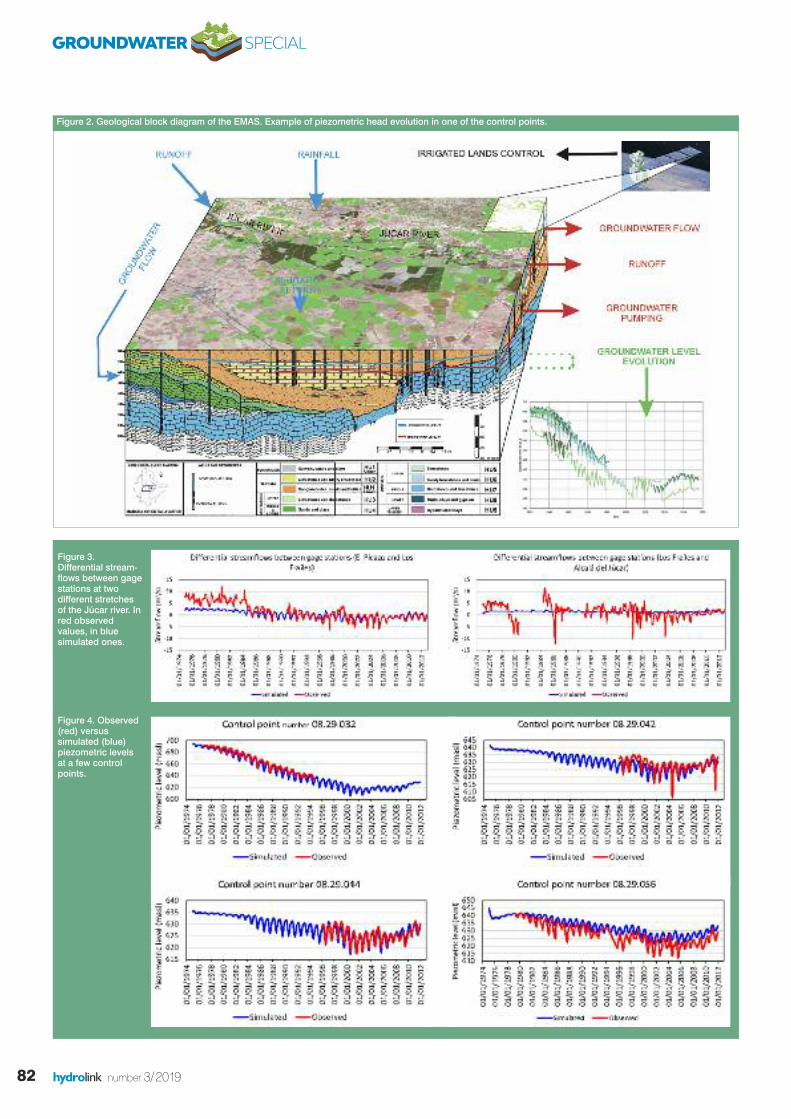
82 hydrolink number 3/2019
Figure 3.Differential stream-flows between gagestations at twodifferent stretchesof the Júcar river. Inred observedvalues, in bluesimulated ones.
Figure 4. Observed(red) versussimulated (blue)piezometric levelsat a few controlpoints.
Figure 2. Geological block diagram of the EMAS. Example of piezometric head evolution in one of the control points.
GROUNDWATER SPECIAL
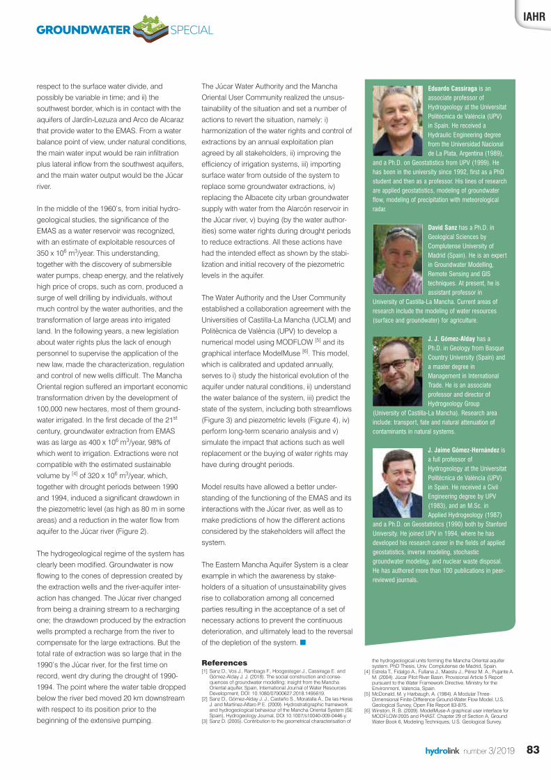
83hydrolink number 3/2019
The Júcar Water Authority and the ManchaOriental User Community realized the unsus-tainability of the situation and set a number ofactions to revert the situation, namely: i)harmonization of the water rights and control ofextractions by an annual exploitation planagreed by all stakeholders, ii) improving theefficiency of irrigation systems, iii) importingsurface water from outside of the system toreplace some groundwater extractions, iv)replacing the Albacete city urban groundwatersupply with water from the Alarcón reservoir inthe Júcar river, v) buying (by the water author-ities) some water rights during drought periodsto reduce extractions. All these actions havehad the intended effect as shown by the stabi-lization and initial recovery of the piezometriclevels in the aquifer.
The Water Authority and the User Communityestablished a collaboration agreement with theUniversities of Castilla-La Mancha (UCLM) andPolitècnica de València (UPV) to develop anumerical model using MODFLOW [5] and itsgraphical interface ModelMuse [6]. This model,which is calibrated and updated annually,serves to i) study the historical evolution of theaquifer under natural conditions, ii) understandthe water balance of the system, iii) predict thestate of the system, including both streamflows(Figure 3) and piezometric levels (Figure 4), iv)perform long-term scenario analysis and v)simulate the impact that actions such as wellreplacement or the buying of water rights mayhave during drought periods.
Model results have allowed a better under-standing of the functioning of the EMAS and itsinteractions with the Júcar river, as well as tomake predictions of how the different actionsconsidered by the stakeholders will affect thesystem.
The Eastern Mancha Aquifer System is a clearexample in which the awareness by stake-holders of a situation of unsustainability givesrise to collaboration among all concernedparties resulting in the acceptance of a set ofnecessary actions to prevent the continuousdeterioration, and ultimately lead to the reversalof the depletion of the system. n
References[1] Sanz D., Vos J., Rambags F., Hoogesteger J., Cassiraga E. and
Gómez-Alday J. J. (2018). The social construction and conse-quences of groundwater modelling: insight from the ManchaOriental aquifer, Spain, International Journal of Water ResourcesDevelopment, DOI: 10.1080/07900627.2018.1495619.
[2] Sanz D., Gómez-Alday J. J., Castaño S., Moratalla Á., De las HerasJ. and Martínez-Alfaro P. E. (2009). Hydrostratigraphic frameworkand hydrogeological behaviour of the Mancha Oriental System (SESpain), Hydrogeology Journal, DOI 10.1007/s10040-009-0446-y.
[3] Sanz D. (2005). Contribution to the geometrical characterisation of
respect to the surface water divide, andpossibly be variable in time; and ii) thesouthwest border, which is in contact with theaquifers of Jardín-Lezuza and Arco de Alcarazthat provide water to the EMAS. From a waterbalance point of view, under natural conditions,the main water input would be rain infiltrationplus lateral inflow from the southwest aquifers,and the main water output would be the Júcarriver.
In the middle of the 1960’s, from initial hydro-geological studies, the significance of theEMAS as a water reservoir was recognized,with an estimate of exploitable resources of350 x 106 m3/year. This understanding,together with the discovery of submersiblewater pumps, cheap energy, and the relativelyhigh price of crops, such as corn, produced asurge of well drilling by individuals, withoutmuch control by the water authorities, and thetransformation of large areas into irrigatedland. In the following years, a new legislationabout water rights plus the lack of enoughpersonnel to supervise the application of thenew law, made the characterization, regulationand control of new wells difficult. The ManchaOriental region suffered an important economictransformation driven by the development of100,000 new hectares, most of them ground-water irrigated. In the first decade of the 21st
century, groundwater extraction from EMASwas as large as 400 x 106 m3/year, 98% ofwhich went to irrigation. Extractions were notcompatible with the estimated sustainablevolume by [4] of 320 x 106 m3/year, which,together with drought periods between 1990and 1994, induced a significant drawdown inthe piezometric level (as high as 80 m in someareas) and a reduction in the water flow fromaquifer to the Júcar river (Figure 2).
The hydrogeological regime of the system hasclearly been modified. Groundwater is nowflowing to the cones of depression created bythe extraction wells and the river-aquifer inter-action has changed. The Júcar river changedfrom being a draining stream to a rechargingone; the drawdown produced by the extractionwells prompted a recharge from the river tocompensate for the large extractions. But thetotal rate of extraction was so large that in the1990’s the Júcar river, for the first time onrecord, went dry during the drought of 1990-1994. The point where the water table droppedbelow the river bed moved 20 km downstreamwith respect to its position prior to thebeginning of the extensive pumping.
IAHR
Eduardo Cassiraga is anassociate professor ofHydrogeology at the UniversitatPolitècnica de València (UPV)in Spain. He received aHydraulic Engineering degreefrom the Universidad Nacionalde La Plata, Argentina (1989),
and a Ph.D. on Geostatistics from UPV (1999). Hehas been in the university since 1992, first as a PhDstudent and then as a professor. His lines of researchare applied geostatistics, modeling of groundwaterflow, modeling of precipitation with meteorologicalradar.
David Sanz has a Ph.D. inGeological Sciences byComplutense University ofMadrid (Spain). He is an expertin Groundwater Modelling,Remote Sensing and GIStechniques. At present, he isassistant professor in
University of Castilla-La Mancha. Current areas ofresearch include the modeling of water resources(surface and groundwater) for agriculture.
J. J. Gómez-Alday has a Ph.D. in Geology from BasqueCountry University (Spain) anda master degree inManagement in InternationalTrade. He is an associateprofessor and director ofHydrogeology Group
(University of Castilla-La Mancha). Research areainclude: transport, fate and natural attenuation ofcontaminants in natural systems.
J. Jaime Gómez-Hernández isa full professor ofHydrogeology at the UniversitatPolitècnica de València (UPV)in Spain. He received a CivilEngineering degree by UPV(1983), and an M.Sc. inApplied Hydrogeology (1987)
and a Ph.D. on Geostatistics (1990) both by StanfordUniversity. He joined UPV in 1994, where he hasdeveloped his research career in the fields of appliedgeostatistics, inverse modeling, stochasticgroundwater modeling, and nuclear waste disposal.He has authored more than 100 publications in peer-reviewed journals.
GROUNDWATER SPECIAL
the hydrogeological units forming the Mancha Oriental aquifersystem. PhD Thesis, Univ. Complutense de Madrid, Spain.
[4] Estrela T., Fidalgo A., Fullana J., Maestu J., Pérez M. A., Pujante A.M. (2004). Júcar Pilot River Basin. Provisional Article 5 Reportpursuant to the Water Framework Directive. Ministry for theEnvironment, Valencia, Spain.
[5] McDonald, M. y Harbaugh, A. (1984). A Modular Three-Dimensional Finite-Difference Ground-Water Flow Model. U.S.Geological Survey, Open File Report 83-875.
[6] Winston, R. B. (2009). ModelMuse-A graphical user interface forMODFLOW-2005 and PHAST. Chapter 29 of Section A, GroundWater Book 6, Modeling Techniques, U.S. Geological Survey.
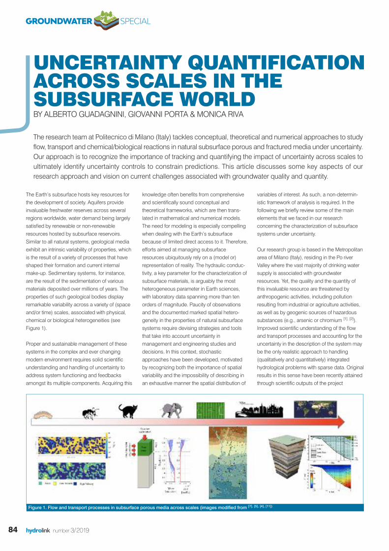
84 hydrolink number 3/2019
The Earth’s subsurface hosts key resources forthe development of society. Aquifers provideinvaluable freshwater reserves across severalregions worldwide, water demand being largelysatisfied by renewable or non-renewableresources hosted by subsurface reservoirs.Similar to all natural systems, geological mediaexhibit an intrinsic variability of properties, whichis the result of a variety of processes that haveshaped their formation and current internalmake-up. Sedimentary systems, for instance,are the result of the sedimentation of variousmaterials deposited over millions of years. Theproperties of such geological bodies displayremarkable variability across a variety of (spaceand/or time) scales, associated with physical,chemical or biological heterogeneities (seeFigure 1).
Proper and sustainable management of thesesystems in the complex and ever changingmodern environment requires solid scientificunderstanding and handling of uncertainty toaddress system functioning and feedbacksamongst its multiple components. Acquiring this
knowledge often benefits from comprehensiveand scientifically sound conceptual andtheoretical frameworks, which are then trans-lated in mathematical and numerical models.The need for modeling is especially compellingwhen dealing with the Earth’s subsurfacebecause of limited direct access to it. Therefore,efforts aimed at managing subsurfaceresources ubiquitously rely on a (model or)representation of reality. The hydraulic conduc-tivity, a key parameter for the characterization ofsubsurface materials, is arguably the mostheterogeneous parameter in Earth sciences,with laboratory data spanning more than tenorders of magnitude. Paucity of observationsand the documented marked spatial hetero-geneity in the properties of natural subsurfacesystems require devising strategies and toolsthat take into account uncertainty inmanagement and engineering studies anddecisions. In this context, stochasticapproaches have been developed, motivatedby recognizing both the importance of spatialvariability and the impossibility of describing inan exhaustive manner the spatial distribution of
variables of interest. As such, a non-determin-istic framework of analysis is required. In thefollowing we briefly review some of the mainelements that we faced in our researchconcerning the characterization of subsurfacesystems under uncertainty.
Our research group is based in the Metropolitanarea of Milano (Italy), residing in the Po riverValley where the vast majority of drinking watersupply is associated with groundwaterresources. Yet, the quality and the quantity ofthis invaluable resource are threatened byanthropogenic activities, including pollutionresulting from industrial or agriculture activities,as well as by geogenic sources of hazardoussubstances (e.g., arsenic or chromium [1], [2]).Improved scientific understanding of the flowand transport processes and accounting for theuncertainty in the description of the system maybe the only realistic approach to handling (qualitatively and quantitatively) integratedhydrological problems with sparse data. Originalresults in this sense have been recently attainedthrough scientific outputs of the project
UNCERTAINTY QUANTIFICATIONACROSS SCALES IN THE SUBSURFACE WORLDBY ALBERTO GUADAGNINI, GIOVANNI PORTA & MONICA RIVA
The research team at Politecnico di Milano (Italy) tackles conceptual, theoretical and numerical approaches to studyflow, transport and chemical/biological reactions in natural subsurface porous and fractured media under uncertainty.Our approach is to recognize the importance of tracking and quantifying the impact of uncertainty across scales toultimately identify uncertainty controls to constrain predictions. This article discusses some key aspects of ourresearch approach and vision on current challenges associated with groundwater quality and quantity.
Figure 1. Flow and transport processes in subsurface porous media across scales (images modified from [7], [5], [4], [11])
GROUNDWATER SPECIAL
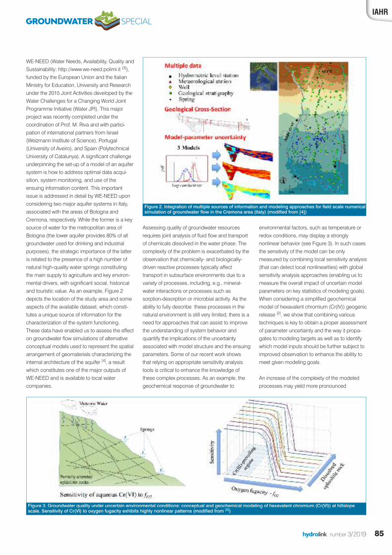
85hydrolink number 3/2019
WE-NEED (Water Needs, Availability, Quality andSustainability; http://www.we-need.polimi.it [3]),funded by the European Union and the ItalianMinistry for Education, University and Researchunder the 2015 Joint Activities developed by theWater Challenges for a Changing World JointProgramme Initiative (Water JPI). This majorproject was recently completed under thecoordination of Prof. M. Riva and with partici-pation of international partners from Israel(Weizmann Institute of Science), Portugal(University of Aveiro), and Spain (PolytechnicalUniversity of Catalunya). A significant challengeunderpinning the set-up of a model of an aquifersystem is how to address optimal data acqui-sition, system monitoring, and use of theensuing information content. This importantissue is addressed in detail by WE-NEED uponconsidering two major aquifer systems in Italy,associated with the areas of Bologna andCremona, respectively. While the former is a keysource of water for the metropolitan area ofBologna (the lower aquifer provides 80% of allgroundwater used for drinking and industrialpurposes), the strategic importance of the latteris related to the presence of a high number ofnatural high-quality water springs constitutingthe main supply to agriculture and key environ-mental drivers, with significant social, historicaland touristic value. As an example, Figure 2depicts the location of the study area and someaspects of the available dataset, which consti-tutes a unique source of information for thecharacterization of the system functioning.These data have enabled us to assess the effecton groundwater flow simulations of alternativeconceptual models used to represent the spatialarrangement of geomaterials characterizing theinternal architecture of the aquifer [4], a resultwhich constitutes one of the major outputs ofWE-NEED and is available to local watercompanies.
IAHR
Figure 3. Groundwater quality under uncertain environmental conditions: conceptual and geochemical modeling of hexavalent chromium (Cr(VI)) at hillslopescale. Sensitivity of Cr(VI) to oxygen fugacity exhibits highly nonlinear patterns (modified from [2])
Assessing quality of groundwater resourcesrequires joint analysis of fluid flow and transportof chemicals dissolved in the water phase. Thecomplexity of the problem is exacerbated by theobservation that chemically- and biologically-driven reactive processes typically affecttransport in subsurface environments due to avariety of processes, including, e.g., mineral-water interactions or processes such assorption-desorption or microbial activity. As theability to fully describe these processes in thenatural environment is still very limited, there is aneed for approaches that can assist to improvethe understanding of system behavior andquantify the implications of the uncertaintyassociated with model structure and the ensuingparameters. Some of our recent work showsthat relying on appropriate sensitivity analysistools is critical to enhance the knowledge ofthese complex processes. As an example, thegeochemical response of groundwater to
environmental factors, such as temperature orredox conditions, may display a stronglynonlinear behavior (see Figure 3). In such casesthe sensitivity of the model can be onlymeasured by combining local sensitivity analysis(that can detect local nonlinearities) with globalsensitivity analysis approaches (enabling us tomeasure the overall impact of uncertain modelparameters on key statistics of modeling goals).When considering a simplified geochemicalmodel of hexavalent chromium (Cr(IV)) geogenicrelease [2], we show that combining varioustechniques is key to obtain a proper assessmentof parameter uncertainty and the way it propa-gates to modeling targets as well as to identifywhich model inputs should be further subject toimproved observation to enhance the ability tomeet given modeling goals.
An increase of the complexity of the modeledprocesses may yield more pronounced
Figure 2. Integration of multiple sources of information and modeling approaches for field scale numericalsimulation of groundwater flow in the Cremona area (Italy) (modified from [4])
GROUNDWATER SPECIAL
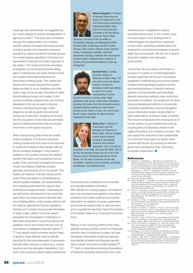
86 hydrolink number 3/2019
couplings and nonlinearities, as suggested byour recent analysis of atrazine biodegradation inagricultural soils [5]. This issue was consideredthrough the implementation of a coupledreaction network of biogeochemical processes,including aerobic and anaerobic processesactivated by various functional microbial groups.The model requires specifying 74 biochemicalparameters to describe the kinetic response ofthe system. The results show that uncertaintypropagation across these processes takingplace in natural soils and under transient condi-tions yields multimodal distributions forprescribed modeling goals. This implies thatdiverse and mutually exclusive final systemstates are likely to occur. Available prior infor-mation may not be strongly informative to allowdiscriminating amongst such states. In thiscontext, sensitivity analysis tools such as thosedeveloped in [6] can be used to improveprocess understanding through modeldiagnosis, as well as guide environmentalmonitoring investments, enabling one to prior-itize the acquisition of data that can potentiallyassist to identify parameters that are actuallyinformative on the system response.
While characterizing state-of-the-art modelsunder uncertainty is of utmost importance,existing models and tools need to be improvedto resolve the limitations that hamper state-of-the-art modeling strategies. A key researchquestion in this context concerns the ability totransfer information and uncertainties acrossscales. Even seemingly homogeneous porousmedia may display a relatively complexgeometry and structure at the microscale. Thisimplies, for instance, that fluid velocity at thescale of the pore space is characterized byrelevant spatial variability, with spatial distribu-tions entailing preferential flow regions (fastchannels) and stagnant areas. These featuresare well known and explored in the recent liter-ature which documents pore-scale data setsand modeling efforts. In this context, there is stillthe need for approaches that are capable totransfer such richness of pore-scale informationto larger scales, where it could be used tostrengthen the interpretation of laboratory orfield scale observations. Local fluctuations andgradients, due to pore-scale features such aschanneling or segregated stagnant regions [7],[8], may heavily impact nonlinear reaction rates.In general, these features may be criticallyimportant for the parameterization of processesthat take place unevenly in space (e.g., surfacereactions such as adsorption-desorption). Ourwork in this context provides original operational
frameworks and quantitative tools to transferand upscale available information.With reference to scaling aspects, our researchteam has developed and applied a theoreticalframework and model enabling us to transferinformation on statistics of system parametersacross diverse spatial scales in real scenarios,and to quantify the way they impact the statisticsof the system states (e.g., fluxes and concentra-tions).
Relying on the mounting evidence that manyspatially varying quantities exhibit non-Gaussianbehavior over a multiplicity of scales, we havedeveloped a theoretical model that capturesdocumented scalable non-Gaussian geosta-tistics of Earth and environmental variables [9],[10]. Such a model allows blending observationsof hydraulic parameter distributions into a new
framework and is adaptable to diversespatial/temporal scales. In this context, a keyinnovative aspect is the development ofmethodologies and algorithms to generaterandom fields, exploiting available data to beemployed in computational analyses of ground-water flow and transport, with the aim of quanti-fying risk in realistic (non-Gaussian)environments.
In summary, the core activity of the team isfocused on a variety of scientific/application-oriented objectives with the aim of providingquantitative understanding and process-basedmodels of hydrogeological systems and thegeochemical behavior of reactive chemicalspecies in environmentally and industriallyrelevant subsurface settings under model andparametric uncertainty. Our studies aim at identi-fying and developing methods to incorporateuncertainty quantification and its propagationacross observation scales, as grounded ondirect observations at diverse scales of interest.The research emphasizes the consequences ofhuman actions on groundwater resources bycoupling field and laboratory evidence withoriginal theoretical and modeling concepts. Thiscan support the evaluation of the sustainabilityof current and future plans for aquifer devel-opment with the aim of providing an effectivegovernance perspective while maximizingecosystem preservation. n
References[1] Molinari, A., Guadagnini, L., Marcaccio, M., Guadagnini, A.
(2019) Geostatistical multimodel approach for the assessmentof the spatial distribution of natural background concentrationsin large-scale groundwater bodies Water Research, 149, 522-532. doi: 10.1016/j.watres.2018.09.049 [2] Ceriotti, G.,Guadagnini, L., Porta, G., Guadagnini, A. (2018) Local andGlobal Sensitivity Analysis of Cr (VI) Geogenic Leakage UnderUncertain Environmental Conditions Water Resources Re-search, 54 (8), 5785-5802.
[3] http://www.we-need.polimi.it[4] Bianchi Janetti E., L. Guadagnini, M. Riva, A. Guadagnini (2019)
Global sensitivity analyses of multiple conceptual models withuncertain parameters driving groundwater flow in a regional-scale sedimentary aquifer, J. of Hydrology, 574, 544-556, doi:10.1016/j.jhydrol.2019.04.035
[5] Porta, G., la Cecilia, D., Guadagnini, A., Maggi, F. (2018) Impli-cations of uncertain bioreactive parameters on a complex reac-tion network of atrazine biodegradation in soil Advances inWater Resources, 121, 263-276, doi: 10.1016/j.advwa-tres.2018.08.002.
[6] Dell’Oca A., M. Riva, A. Guadagnini (2017) Moment-based Met-rics for Global Sensitivity Analysis of Hydrological Systems, Hy-drol. Earth Syst. Sci., 21, 6219–6234,doi:10.5194/hess-21-6219-2017.
[7] Ceriotti, G., Russian, A., Bolster, D., Porta, G. (2019) A double-continuum transport model for segregated porous media: Deri-vation and sensitivity analysis-driven calibration Advances inWater Resources, 128, 206-217, doi: 10.1016/j.advwa-tres.2019.04.003
[8] Siena M., O. Iliev, T. Prill, M. Riva, A. Guadagnini (2019) Identifi-cation of Channeling in Pore-Scale Flows, Geophysical Re-search Letters, 46(6), 3270-3278, doi: 10.1029/2018GL081697.
[9] Riva M., M. Panzeri, A. Guadagnini, S. P. Neuman (2015), Simu-lation and analysis of scalable non-Gaussian statisticallyanisotropic random functions, J. Hydrol., 531 Part 1, 88-95,doi:10.1016/j.jhydrol.2015.06.066.
[10] Guadagnini A., M. Riva, S.P. Neuman (2018) Recent Advancesin Scalable Non-Gaussian Geostatistics: The Generalized Sub-Gaussian Model, J. of Hydrology, 562, 685-691.
[11] Cerotti G., G.M. Porta, C. Geloni, M. Dalla Rosa, A. Guadagnini(2017) Quantification of CO2 generation in sedimentary basinsthrough Carbonate/Clays Reactions with uncertain thermody-namic parameters, Geochimica et Cosmochimica Acta, 213,198-215.
Alberto Guadagnini is Professorof Hydraulic Engineering andHead of the Department of Civiland Environmental Engineering atPolitecnico di Milano (Italy).Chair of the CommunicationCommittee of the InternationalSociety for Porous Media
(Interpore). Vice Chair of the Committee onGroundwater Hydraulics and Management (IAHR).Executive Editor of Hydrology and Earth SystemSciences. Main research interests include statisticalscaling of hydrological quantities, stochasticgroundwater hydrology, multiscale flow and transportin porous media, multiphase flows, enhanced oilrecovery and environmental footprint of shale gasdevelopment.
Giovanni Porta is currentlyassociate professor atPolitecnico di Milano (Italy). Thecore of his recent and ongoingresearch is focused ondeveloping models and methodsto improve the currentunderstanding of reactive
transport processes in porous media. Targetapplications span across a wide range of disciplines,processes and scales from micron/seconds scales togeological settings involving km-scale domainsevolving across millions of years. He is 2019 JuniorMarchi Lecturer (award by the Italian HydraulicEngineering Society (GII)).
Monica Riva is Professor ofGroundwater and FluidMechanics at Politecnico diMilano (Italy). She has managedseveral research projectsfocusing on groundwaterresources and stochasticapproaches. She is currently the
coordinator of the Water JPI project WE-NEED. Chair ofthe EGU Groundwater Division and Vice-chair of theInterpore Council (International Society for PorousMedia). Her key areas of expertise include dataassimilation, stochastic inverse modeling, uncertaintyquantification, and multiphase flows.

GROUNDWATER SPECIAL
87hydrolink number 3/2019
time demand [11], while the portable devicesused for this purpose are not of sufficientaccuracy. Furthermore, in the various methodsused for chemical analysis of water, thedetection of nitrates is affected by the presenceof other ions, especially Cl- [12]. Physics-basedmodels for the analysis of groundwater contam-ination problems have developed significantlyin recent years. However, these models requireextensive data that are often not available. Inmany applications, there is a need to developsurrogate, easy to use models that can rapidlyanalyze groundwater contamination, without thelimitations of more complex models. The scopeof this study is to describe a model for the easyestimation of nitrate groundwater contaminationbased on easily measurable and cost effectiveinput parameters.Artificial neural networks are data driven modelsthat treat the system being studied as a ‘blackbox’ [13]. ANNs have the ability to correlatevariables whose relationship is not known or isvery complex [14], [15], without the use of physical data, such as porosity or hydraulicconductivity [16].
IAHR
ARTIFICIAL NEURAL NETWORKS FORTHE PREDICTION OF GROUNDWATERNITRATE CONTAMINATIONBY CHRISTINA STYLIANOUDAKI, IOANNIS TRICHAKIS & GEORGE P. KARATZAS
An artificial neural network (ANN) model is proposed for the determination of groundwater nitrate contamination,based on an approach of easily measurable and cost-effective water quality parameters (pH, electrical conduc-tivity, HCO3
-, Cl-, Ca2+, Mg2+, Na+, K+, SO42-). The data used, derived from the chemical analyses of groundwater
samples, from wells located in the Kopaidian Plain, Greece. The results of the model described in this articleindicate that ANNs could be used as an alternative method for the estimation of groundwater contaminationproblems.
The rapid increase in population, as well asindustrialization and intensification of agricul-tural activities, have led to significant quanti-tative and qualitative degradation ofgroundwater resources worldwide [1]. Thesituation is expected to be burdened by climatechange, which will cause changes in rainfallpatterns and an increase in average surfacetemperature, especially in drought-prone areas [2]. Surface and groundwater contami-nation due to the presence of nitrates (NO3
-) is considered as one of the most commonenvironmental problems [3], [4]. The majoranthropogenic source of nitrogen in theenvironment is the application of nitrogenfertilizer [5]. Other anthropogenic sourcesinclude industrial wastes, deforestation(leading to conversion to agricultural land)domestic wastewater and septic tanks [6].According to Greek and EU legislation, nitrateconcentration shall not exceed 50 mg /l fornitrates (NO3
-), or 11 mg /l for nitrate-nitrogen(NO3
-N) [7]. On a global scale, concentrationsof nitrate in groundwater exceed the limits thathave been set, and it is estimated that in thelast three decades nitrate pollution hasincreased by 36%. In the easternMediterranean and Africa, the situation is evenmore worrying, as nitrate levels seem to havemore than doubled [6].Nitrate ions have a toxic effect with proveneffects on human health and have been statisti-cally associated with various forms of cancer[8], [9], [10]. In addition, increased indices ofthyroid diseases have been recorded in areaswith high nitrate levels in water supplies [5]. Inorder to protect public health, sustainablemanagement of groundwater resources isrequired. However, techniques for detectingand measuring nitrate concentrations in watercan be characterized by high cost and high
ANNs have widely found applications inhydrology and have been successfully used ingroundwater quality modeling [16],[17]. Severalstudies have presented ANNs for the estimationof the water level by using water budgetvariables as input parameters [15], [18], [19], [20], [21].Regarding nitrate contamination, ANN modelsusing water quality parameters or/and waterbudget variables as input parameters, havebeen proposed [22], [23], [24]. Comprehensivereviews over the applications of ANNs inhydrology can be found in [17], [25] and [26].
An ANN consists of a number of fully connectedprocessors called neurons, which accept,analyze, and exchange information over anetwork of weighted connections [26]. The feed-forward neural network was the first type ofANN, where information moves in a forwarddirection. The information is processed atdifferent layers, divided in three categories:input, output and hidden layers. Each input xipresented in a neuron, is weighted by asynaptic weight wi and the results are summed.The sum is introduced in an activation function;in the case it exceeds a certain threshold value,.The basic function of an ANN is the trainingprocess, which is performed by a learning rulethat modifies the weights of the connections inorder to minimize the difference between thecalculated output of the network and thedesired output (real value) [25]. The efficiency ofthe model is evaluated by its generalizationability, i.e. its ability to give the correct outputeven for examples not included in the trainingset. More information regarding ANNs and theiroperation is presented by [16] and [27].In this study, a feed-forward neural networkconsisting of three layers was developed, usingMATLAB R2010 software. A Levenberg-Marquardt regularization algorithm was
“It is estimated that in the last three decadesnitrate pollution has increased by 36%”
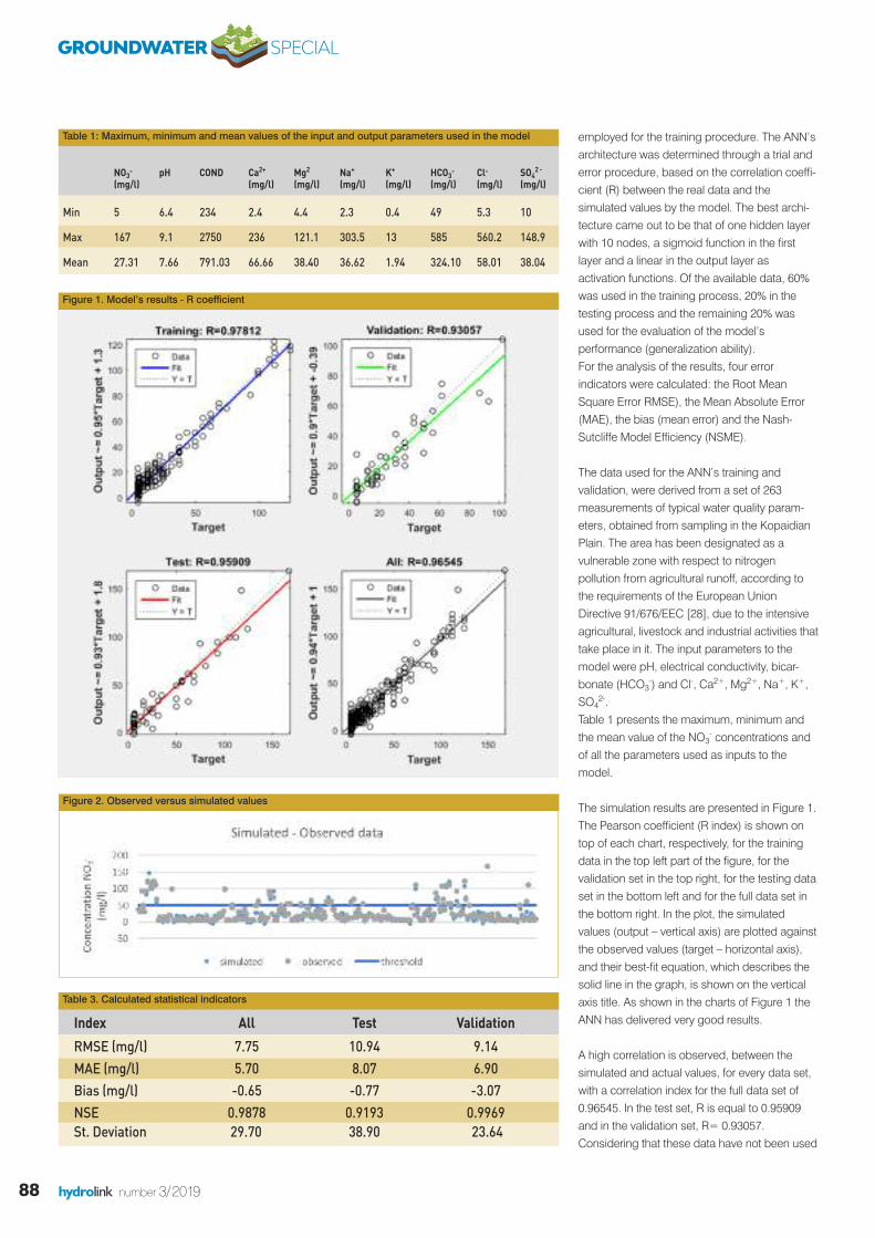
88 hydrolink number 3/2019
employed for the training procedure. The ANN’sarchitecture was determined through a trial anderror procedure, based on the correlation coeffi-cient (R) between the real data and thesimulated values by the model. The best archi-tecture came out to be that of one hidden layerwith 10 nodes, a sigmoid function in the firstlayer and a linear in the output layer asactivation functions. Of the available data, 60%was used in the training process, 20% in thetesting process and the remaining 20% wasused for the evaluation of the model’sperformance (generalization ability).For the analysis of the results, four errorindicators were calculated: the Root MeanSquare Error RMSE), the Mean Absolute Error(MAE), the bias (mean error) and the Nash-Sutcliffe Model Efficiency (NSME).
The data used for the ANN’s training andvalidation, were derived from a set of 263measurements of typical water quality param-eters, obtained from sampling in the KopaidianPlain. The area has been designated as avulnerable zone with respect to nitrogenpollution from agricultural runoff, according tothe requirements of the European UnionDirective 91/676/EEC [28], due to the intensiveagricultural, livestock and industrial activities thattake place in it. The input parameters to themodel were pH, electrical conductivity, bicar-bonate (HCO3
-) and Cl-, Ca2+, Mg2+, Na+, K+,SO4
2-.Table 1 presents the maximum, minimum andthe mean value of the NO3
- concentrations andof all the parameters used as inputs to themodel.
The simulation results are presented in Figure 1.The Pearson coefficient (R index) is shown ontop of each chart, respectively, for the trainingdata in the top left part of the figure, for thevalidation set in the top right, for the testing dataset in the bottom left and for the full data set inthe bottom right. In the plot, the simulatedvalues (output – vertical axis) are plotted againstthe observed values (target – horizontal axis),and their best-fit equation, which describes thesolid line in the graph, is shown on the verticalaxis title. As shown in the charts of Figure 1 theANN has delivered very good results.
A high correlation is observed, between thesimulated and actual values, for every data set,with a correlation index for the full data set of0.96545. In the test set, R is equal to 0.95909and in the validation set, R= 0.93057.Considering that these data have not been used
NO3- pH COND Ca2+ Mg2 Na+ K+ HCO3
- Cl- SO42 -
(mg/l) (mg/l) (mg/l) (mg/l) (mg/l) (mg/l) (mg/l) (mg/l)
Min 5 6.4 234 2.4 4.4 2.3 0.4 49 5.3 10
Max 167 9.1 2750 236 121.1 303.5 13 585 560.2 148.9
Mean 27.31 7.66 791.03 66.66 38.40 36.62 1.94 324.10 58.01 38.04
Table 1: Maximum, minimum and mean values of the input and output parameters used in the model
Figure 1. Model’s results - R coefficient
Index All Test Validation
RMSE (mg/l) 7.75 10.94 9.14MAE (mg/l) 5.70 8.07 6.90Bias (mg/l) -0.65 -0.77 -3.07NSE 0.9878 0.9193 0.9969St. Deviation 29.70 38.90 23.64
Figure 2. Observed versus simulated values
Table 3. Calculated statistical indicators
GROUNDWATER SPECIAL
89hydrolink number 3/2019
References[1] Kazakis, Nerantzis & Voudouris, K. (2015). Groundwater
vulnerability and pollution risk assessment of porous aquifersto nitrate: Modifying the DRASTIC method using quantitativeparameters. Journal of Hydrology. 525. 13-25.
[2] IPCC, 2014: Climate Change 2014: Synthesis Report.Contribution of Working Groups I, II and III to the FifthAssessment Report of the Intergovernmental Panel onClimate Change [Core Writing Team, R.K. Pachauri and L.A.Meyer (eds.)]. IPCC, Geneva, Switzerland, 151 pp.
[3] Spalding R.F., Exner M.E. (1993) Occurrence of nitrate ingroundwater—a review. Journal of Environmental Quality 22.392–402.
[4] Rivett, Michael & R Buss, Stephen & Morgan, Philip & Smith,Jonathan & D Bemment, Chrystina. (2008). Nitrate Attenuationin Groundwater: A Review of Biogeochemical ControllingProcesses. Water research. 42. 4215-32.
[5] Ward, Mary & Jones, Rena & Brender, Jean & de Kok, Theo &J Weyer, Peter & T Nolan, Bernard & M Villanueva, Cristina &Breda, Simone. (2018). Drinking Water Nitrate and HumanHealth: An Updated Review. International Journal ofEnvironmental Research and Public Health. 15. 1557.
[6] Shukla, Saurabh & Saxena, Abhishek. (2018). Global Statusof Nitrate Contamination in Groundwater: Its Occurrence,Health Impacts, and Mitigation Measures. Handbook ofEnvironmental Materials Management. Springer, Cham.
[7] WHO (World Health Organization) (2011) Guidelines fordrinking-water quality, 4th edn. World Health Organization,Geneva. Available: Accessed 10 Apr 201.
[8] Hunder.H. Comly. (1945). Cyanosis in infants caused bynitrates in well water. JAMA. 129. 112-116
[9] Morales-Suárez-Varela, Maria & Llopis-Gonzalez, Augustin &L. Tejerizo-Perez, María. (1995). Impact of nitrates in drinkingwater on cancer mortality in Valencia, Spain. EuropeanJournal of Epidemiology. 11. 15-21.
[10] Palli, Domenico & Saieva, Calogero & Coppi, Claudio & DelGiudice, Giuseppe & Magagnotti, Cinzia & Nesi, Gabriella &Orsi, Federica & Airoldi, Luisa. (2001). O 6 -Alkylguanines,Dietary N-Nitroso Compounds, and Their Precursors inGastric Cancer. Nutrition and cancer. 39. 42-9.
[11] Azmi, Aizat & Amsyar Azman, Ahmad & Ibrahim, Sallehuddin& Md Yunus, Mohd Amri. (2017). Techniques in advancing thecapabilities of various nitrate detection methods: A review.International Journal on Smart Sensing and IntelligentSystems. 10. 223-261.
[12] Alahi, Md & Mukhopadhyay, S.C. (2018). Detection methodsof Nitrate in water: A Review. Sensors and Actuators A:Physical. 280. 210-221.https://doi.org/10.1016/j.sna.2018.07.026
[13] Tapoglou, Evdokia & Karatzas, George & Trichakis, Ioannis &Varouchakis, Emmanouil. (2014b). A spatio-temporal hybridneural network-Kriging model for groundwater levelsimulation. Journal of Hydrology. 519. 3193-3203.
[14] Almahallawi, Khamis & Jacky, Mania & HANI, Azzedine &Shahrour, Isam. (2011). Using of neural networks for theprediction of nitrate groundwater contamination in rural andagricultural areas. Environmental Earth Sciences. 65. 917-928.
[15] Ghose, Dillip & Das, Umesh & Roy, Parthajit. (2018). Modelingresponse of runoff and evapotranspiration for predicting watertable depth in arid region using dynamic recurrent neuralnetwork. Groundwater for Sustainable Development. 6. 263-269, https://doi.org/10.1016/j.gsd.2018.01.007
[16] ASCE, 2000a. Artificial neural networks in hydrology. I:Preliminary concepts. Journal of Hydrologic Engineering. 5.115-123.
[17] ASCE, 2000b. Artificial Neural Networks in hydrology. II:Hydrologic applications. Journal of Hydrologic Engineering. 5.124-137.
[18] Nayak, P., Rao, Y. & Sudheer, K. (2006) Groundwater levelforecasting in a shallow aquifer using artificial neural networkapproach. Water Resources. Management. 20. 77–90.
[19] Trichakis, I., Nikolos, I., & Karatzas, G. (2009). Optimalselection of artificial neural network parameters for theprediction of a karstic aquifer’s response. HydrologicalProcesses. 23. 2956-2969. https://doi.org/10.1002/hyp.7410
[20] Trichakis, I.C., Nikolos, I.K. & Karatzas, G.P. (2011). ArtificialNeural Network (ANN) Based Modeling for KarsticGroundwater Level Simulation. Water resources management.25. 1143-1152. https://doi.org/10.1007/s11269-010-9628-6
[21] Tapoglou, Evdokia & Trichakis, Ioannis & Dokou, Zoi &Nikolos, Ioannis & Karatzas, George. (2014a). Groundwater-level forecasting under climate change scenarios using anartificial neural network trained with particle swarmoptimization. Hydrological Sciences Journal. 59. 1225-1239.https://doi.org/10.1080/02626667.2013.838005
[22] Yesilnacar M.I., Sahinkaya E., Naz M. and. Ozkaya B. (2008).Neural network prediction of nitrate in groundwater of HarranPlain, Turkey. Environmental Geology. 56. 19–25. DOI:10.1007/s00254-007-1136-5
[23] Ehteshami, M., Farahani, N.D. & Tavassoli, S. (2016).Simulation of nitrate contamination in groundwater usingartificial neural networks. Modeling Earth Systems andEnvironment. 2: 28. https://doi.org/10.1007/s40808-016-0080-3
[24] Wagh, Vasant & Panaskar, Dipak & Muley, Aniket & Mukate,Shrikant & Gaikwad, Satyajit. (2018). Neural NetworkModelling for Nitrate Concentration in groundwater of KadavaRiver basin, Nashik, Maharashtra, India. Groundwater forSustainable Development. DOI: 10.1016/j.gsd.2017.12.012
[25] Tanty, Rakesh & S. Desmukh, Tanweer. (2015). Application ofArtificial Neural Network in Hydrology- A Review. InternationalJournal of Engineering Research. 4. DOI:10.17577/IJERTV4IS060247
[26] Oyebode, O, Stretch, D. (2019). Neural network modeling ofhydrological systems: A review of implementation techniques.Natural Resource Modeling. 32:e12189.https://doi.org/10.1111/nrm.12189
[27] Haykin, S.S., (1999). Neural networks: a comprehensivefoundation. Prentice Hall
[28] Ministry of Environment and Energy, Nitrate Pollution,http://www.ypeka.gr/Default.aspx?tabid=250&locale=en-US&language=el-GR
[29] Moriasi, Daniel & Gitau, Margaret & Pai, Naresh & Daggupati,Prasad. (2015). Hydrologic and Water Quality Models:Performance Measures and Evaluation Criteria. Transactions ofthe ASABE (American Society of Agricultural and BiologicalEngineers). 58. 1763-1785. DOI: 10.13031/trans.58.10715
[30] Singh, J., H. V. Knapp, and M. Demissie. 2004. Hydrologicmodeling of the Iroquois River watershed using HSPF andSWAT. ISWS CR 2004-08. Champaign, Ill.: Illinois State WaterSurvey. DOI:10.1111/j.1752-1688.2005.tb03740.x
in the training process, R values signify a verygood generalization ability of the model.In Figure 2, the simulated values by the model,together with the real data are presented, alongwith the threshold value of 50 mg/l for nitrateconcentration. As already expected from the Rvalue, Figure 2 confirms that the simulatedvalues are very close to their observed counter-parts.
The calculated indicators for an additional evalu-ation of the model’s performance are shown inTable 3.
For the full data set, the NSE is equal to 0.9878,for the test set, NSEtest = 0.9193 and for thevalidation set, NSEvald=0.9969. As shown by theindicators, the model has produced remarkablysatisfactory results. NSE values in the range(0.75 < NSE < 1), indicate very goodperformance of the model being assessed [29].Therefore, taking into account the NSE index,the simulation can be characterized successful.Moreover, according to [30], RMSE and MAEvalues less than half of the standard deviation ofthe observed data are considered low. Inaddition, the small difference between RMSEand MAE (7.754874 mg/l - 5.702638 mg/l)indicates the absence of extreme errors. Lastly,it is worth pointing out that according to the Biasindex, the model tends to underestimate theobserved values but not by much. The calcu-lated indices suggest that the model is highlyaccurate.
ConclusionsIn hydrological applications, there is a need todevelop simple models that can capture themain relationships between parameters withoutthe need to develop complex physics-basedmodels that are difficult to solve. ANNs have theessential advantage that they can track thehidden relationship between variables – withoutthe need to assume linearity- and so, availabledata that are not usually used in conventionaltechniques can be exploited. The results of thestudy described in this article demonstrate thatANNs are a potentially powerful modellingmethod, more economical and less timeconsuming. n
IAHR
Christina Stylianoudaki is anEnvironmental Engineer, MScand Ph.D. student in the Schoolof Environmental Engineering atthe Technical University ofCrete, in the field of waterresources management andclimate change. Currently she
works in the Geoenvironmental EngineeringLaboratory, as a researcher on the development of aflood risk management system. Her research interestsinclude hydrological processes modelling,environmental systems optimization, simulation offlood events and assessment of climate change’simpact on water resources.
Professor George P. Karatzasreceived his Ph.D. in 1992 fromthe Department of CivilEngineering of RutgersUniversity, USA in a combinedPh.D. with Princeton University,USA. He is a Professor in theSchool of Environmental
Engineering at the Technical University of Crete,Greece since 2006. His area of research includesnumerical simulation in porous media, groundwatermanagement, subsurface remediation techniques,global optimization techniques, surface watermodeling and floods. He has been principleinvestigator and co-investigator in several nationaland international research projects related togroundwater flow and contaminant transport,groundwater management, surface hydrology andfloods.
Ioannis Trichakis studiedEnvironmental Engineering at theTechnical University of Crete(1999-2004) and didpostgraduate studies at theNational Technical University ofAthens (2004-06). He receivedhis PhD from the University of
Crete (2006-2011) where he worked on researchprojects on water resources and flood management.He has worked as a researcher at the EuropeanCommission's Joint Research Center on waterresources management programs in European anddeveloping countries and on simulating groundwaterand surface water systems. He has extensiveexperience in technical support for researchprograms, writing progress reports and coordinatinga large number of partners from different countries.
GROUNDWATER SPECIAL
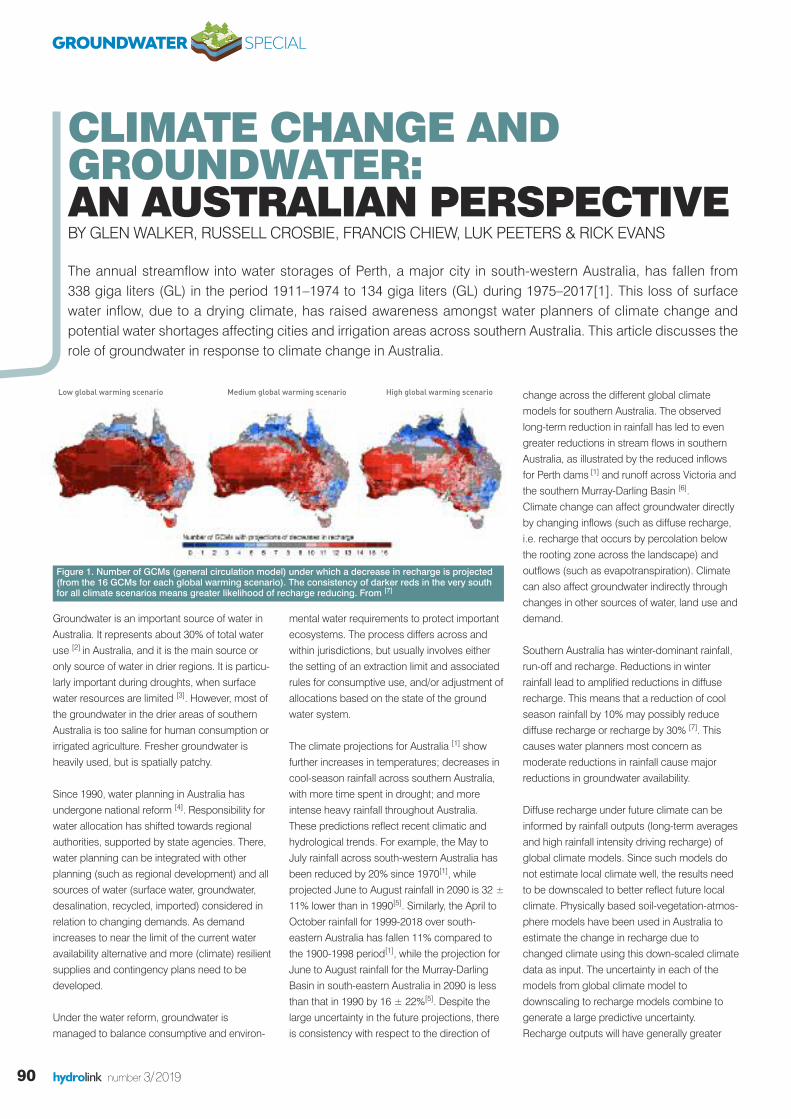
90 hydrolink number 3/2019
Groundwater is an important source of water inAustralia. It represents about 30% of total wateruse [2] in Australia, and it is the main source oronly source of water in drier regions. It is particu-larly important during droughts, when surfacewater resources are limited [3]. However, most ofthe groundwater in the drier areas of southernAustralia is too saline for human consumption orirrigated agriculture. Fresher groundwater isheavily used, but is spatially patchy.
Since 1990, water planning in Australia hasundergone national reform [4]. Responsibility forwater allocation has shifted towards regionalauthorities, supported by state agencies. There,water planning can be integrated with otherplanning (such as regional development) and allsources of water (surface water, groundwater,desalination, recycled, imported) considered inrelation to changing demands. As demandincreases to near the limit of the current wateravailability alternative and more (climate) resilientsupplies and contingency plans need to bedeveloped.
Under the water reform, groundwater ismanaged to balance consumptive and environ-
mental water requirements to protect importantecosystems. The process differs across andwithin jurisdictions, but usually involves eitherthe setting of an extraction limit and associatedrules for consumptive use, and/or adjustment ofallocations based on the state of the groundwater system.
The climate projections for Australia [1] showfurther increases in temperatures; decreases incool-season rainfall across southern Australia,with more time spent in drought; and moreintense heavy rainfall throughout Australia.These predictions reflect recent climatic andhydrological trends. For example, the May toJuly rainfall across south-western Australia hasbeen reduced by 20% since 1970[1], whileprojected June to August rainfall in 2090 is 32 ±11% lower than in 1990[5]. Similarly, the April toOctober rainfall for 1999-2018 over south-eastern Australia has fallen 11% compared tothe 1900-1998 period[1], while the projection forJune to August rainfall for the Murray-DarlingBasin in south-eastern Australia in 2090 is lessthan that in 1990 by 16 ± 22%[5]. Despite thelarge uncertainty in the future projections, thereis consistency with respect to the direction of
change across the different global climatemodels for southern Australia. The observedlong-term reduction in rainfall has led to evengreater reductions in stream flows in southernAustralia, as illustrated by the reduced inflowsfor Perth dams [1] and runoff across Victoria andthe southern Murray-Darling Basin [6]. Climate change can affect groundwater directlyby changing inflows (such as diffuse recharge,i.e. recharge that occurs by percolation belowthe rooting zone across the landscape) andoutflows (such as evapotranspiration). Climatecan also affect groundwater indirectly throughchanges in other sources of water, land use anddemand.
Southern Australia has winter-dominant rainfall,run-off and recharge. Reductions in winterrainfall lead to amplified reductions in diffuserecharge. This means that a reduction of coolseason rainfall by 10% may possibly reducediffuse recharge or recharge by 30% [7]. Thiscauses water planners most concern asmoderate reductions in rainfall cause majorreductions in groundwater availability.
Diffuse recharge under future climate can beinformed by rainfall outputs (long-term averagesand high rainfall intensity driving recharge) ofglobal climate models. Since such models donot estimate local climate well, the results needto be downscaled to better reflect future localclimate. Physically based soil-vegetation-atmos-phere models have been used in Australia toestimate the change in recharge due tochanged climate using this down-scaled climatedata as input. The uncertainty in each of themodels from global climate model todownscaling to recharge models combine togenerate a large predictive uncertainty.Recharge outputs will have generally greater
CLIMATE CHANGE AND GROUNDWATER: AN AUSTRALIAN PERSPECTIVEBY GLEN WALKER, RUSSELL CROSBIE, FRANCIS CHIEW, LUK PEETERS & RICK EVANS
The annual streamflow into water storages of Perth, a major city in south-western Australia, has fallen from 338 giga liters (GL) in the period 1911–1974 to 134 giga liters (GL) during 1975–2017[1]. This loss of surfacewater inflow, due to a drying climate, has raised awareness amongst water planners of climate change andpotential water shortages affecting cities and irrigation areas across southern Australia. This article discusses therole of groundwater in response to climate change in Australia.
Figure 1. Number of GCMs (general circulation model) under which a decrease in recharge is projected(from the 16 GCMs for each global warming scenario). The consistency of darker reds in the very southfor all climate scenarios means greater likelihood of recharge reducing. From [7]
Low global warming scenario Medium global warming scenario High global warming scenario
GROUNDWATER SPECIAL
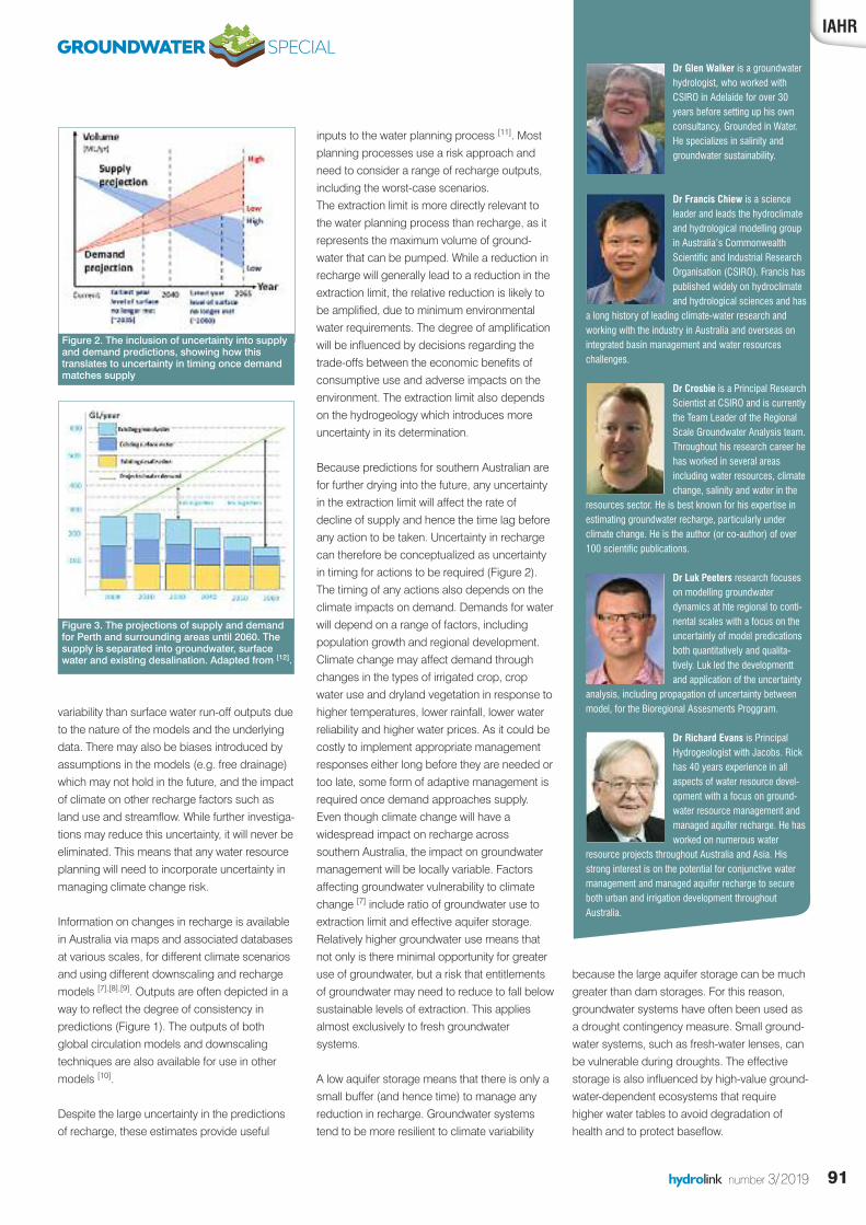
91hydrolink number 3/2019
inputs to the water planning process [11]. Mostplanning processes use a risk approach andneed to consider a range of recharge outputs,including the worst-case scenarios. The extraction limit is more directly relevant tothe water planning process than recharge, as itrepresents the maximum volume of ground-water that can be pumped. While a reduction inrecharge will generally lead to a reduction in theextraction limit, the relative reduction is likely tobe amplified, due to minimum environmentalwater requirements. The degree of amplificationwill be influenced by decisions regarding thetrade-offs between the economic benefits ofconsumptive use and adverse impacts on theenvironment. The extraction limit also dependson the hydrogeology which introduces moreuncertainty in its determination.
Because predictions for southern Australian arefor further drying into the future, any uncertaintyin the extraction limit will affect the rate ofdecline of supply and hence the time lag beforeany action to be taken. Uncertainty in rechargecan therefore be conceptualized as uncertaintyin timing for actions to be required (Figure 2).The timing of any actions also depends on theclimate impacts on demand. Demands for waterwill depend on a range of factors, includingpopulation growth and regional development.Climate change may affect demand throughchanges in the types of irrigated crop, cropwater use and dryland vegetation in response tohigher temperatures, lower rainfall, lower waterreliability and higher water prices. As it could becostly to implement appropriate managementresponses either long before they are needed ortoo late, some form of adaptive management isrequired once demand approaches supply.Even though climate change will have awidespread impact on recharge acrosssouthern Australia, the impact on groundwatermanagement will be locally variable. Factorsaffecting groundwater vulnerability to climatechange [7] include ratio of groundwater use toextraction limit and effective aquifer storage.Relatively higher groundwater use means thatnot only is there minimal opportunity for greateruse of groundwater, but a risk that entitlementsof groundwater may need to reduce to fall belowsustainable levels of extraction. This appliesalmost exclusively to fresh groundwatersystems.
A low aquifer storage means that there is only asmall buffer (and hence time) to manage anyreduction in recharge. Groundwater systemstend to be more resilient to climate variability
variability than surface water run-off outputs dueto the nature of the models and the underlyingdata. There may also be biases introduced byassumptions in the models (e.g. free drainage)which may not hold in the future, and the impactof climate on other recharge factors such asland use and streamflow. While further investiga-tions may reduce this uncertainty, it will never beeliminated. This means that any water resourceplanning will need to incorporate uncertainty inmanaging climate change risk.
Information on changes in recharge is availablein Australia via maps and associated databasesat various scales, for different climate scenariosand using different downscaling and rechargemodels [7],[8],[9]. Outputs are often depicted in away to reflect the degree of consistency inpredictions (Figure 1). The outputs of bothglobal circulation models and downscalingtechniques are also available for use in othermodels [10].
Despite the large uncertainty in the predictionsof recharge, these estimates provide useful
IAHR
Figure 2. The inclusion of uncertainty into supplyand demand predictions, showing how this translates to uncertainty in timing once demandmatches supply
Figure 3. The projections of supply and demandfor Perth and surrounding areas until 2060. Thesupply is separated into groundwater, surfacewater and existing desalination. Adapted from [12].
GROUNDWATER SPECIALDr Glen Walker is a groundwaterhydrologist, who worked withCSIRO in Adelaide for over 30years before setting up his ownconsultancy, Grounded in Water.He specializes in salinity andgroundwater sustainability.
Dr Francis Chiew is a scienceleader and leads the hydroclimateand hydrological modelling groupin Australia’s CommonwealthScientific and Industrial ResearchOrganisation (CSIRO). Francis haspublished widely on hydroclimateand hydrological sciences and has
a long history of leading climate-water research andworking with the industry in Australia and overseas onintegrated basin management and water resourceschallenges.
Dr Crosbie is a Principal ResearchScientist at CSIRO and is currentlythe Team Leader of the RegionalScale Groundwater Analysis team.Throughout his research career hehas worked in several areasincluding water resources, climatechange, salinity and water in the
resources sector. He is best known for his expertise inestimating groundwater recharge, particularly underclimate change. He is the author (or co-author) of over100 scientific publications.
Dr Luk Peeters research focuseson modelling groundwaterdynamics at hte regional to conti-nental scales with a focus on theuncertainly of model predicationsboth quantitatively and qualita-tively. Luk led the developmenttand application of the uncertainty
analysis, including propagation of uncertainty betweenmodel, for the Bioregional Assesments Proggram.
Dr Richard Evans is PrincipalHydrogeologist with Jacobs. Rickhas 40 years experience in allaspects of water resource devel-opment with a focus on ground-water resource management andmanaged aquifer recharge. He hasworked on numerous water
resource projects throughout Australia and Asia. Hisstrong interest is on the potential for conjunctive watermanagement and managed aquifer recharge to secureboth urban and irrigation development throughoutAustralia.
because the large aquifer storage can be muchgreater than dam storages. For this reason,groundwater systems have often been used asa drought contingency measure. Small ground-water systems, such as fresh-water lenses, canbe vulnerable during droughts. The effectivestorage is also influenced by high-value ground-water-dependent ecosystems that requirehigher water tables to avoid degradation ofhealth and to protect baseflow.

Should groundwater extraction approach theextraction limit, management responses aresimilar to those for any stressed system, namelysome combination of redistributing extractionthrough trade; reducing demand; augmentingrecharge (through managed aquifer recharge,water sensitive urban design and changing landuse) and seeking alternative sources. All ofthese are used or planned in Australia. The aimof these management responses is to develop awater supply that is more resilient to climatechange.
Perth has advanced most with their planningprocess for climate change impacts. While Perthhas declining rainfall, surface water and ground-water, its demand is increasing. A gap has beenidentified between supply and demand of 120GL/yr by 2030 and 365 GL/yr by 2060 (Figure3)[12]. As part of the Water Forever Plan, the gapis to be met by reduction in water use (74 GL/yrby 2030 and another 102 GL/yr by 2060),increased water recycling (39, 48 respectively)and new sources 218, 335 respectively). Thenew sources of water include managed aquiferrecharge, further desalination and deepergroundwater systems [10]. Since its initial release,the plan has continued to change.
ConclusionsWhile there are potentially other impacts ofclimate change on Australian groundwater, thedrying climate and longer droughts in southernAustralia is the most immediate threat. Theamplification of reductions in rainfall into reduc-tions in recharge, and then further amplificationto reductions in extraction limit mean thatgroundwater supplies can diminish quickly.
The large uncertainties in climate prediction,together with those of hydrogeology, means thatpredictive uncertainty is high. An adaptivemanagement strategy is required both for thegroundwater supply as part of an integratedwater supply, but also the management of thegroundwater supply itself. Adaptivemanagement will, in turn, require monitoring ofextraction, piezometric responses and land useand more attention to forecasting demand. There needs to be a general shift to moreclimate-resilient sources of water such as desali-nation, managed aquifer recharge and wateruse efficiency measures.
The experience in Perth provides a guide forother regional water authorities in planning forclimate change. n
References[1] Bureau of Meteorology and CSIRO (2018). State of the Climate
(2018). Commonwealth of Australia, 24pp.[2] Harrington N and Cook P, 2014, Groundwater in Australia,
National Centre for Groundwater Research and Training, Australia.[3] CSIRO (2008). Water availability in the Murray-Darling Basin. A
report to the Australian Government from the CSIRO Murray-Darling Basin Sustainable Yields Project. CSIRO, Australia. 67pp.
[4] Australian governments (2004). Intergovernmental Agreement ona National Water Initiative.http://agriculture.gov.au/water/policy/nwi
[5] Reisinger, A., R.L. Kitching, F. Chiew, L. Hughes, P.C.D. Newton,S.S. Schuster, A. Tait, and P. Whetton, 2014: Australasia. In:Climate Change 2014: Impacts, Adaptation, and Vulnerability. PartB: Regional Aspects. Contribution of Working Group II to the FifthAssessment Report of the Intergovernmental Panel on ClimateChange [Barros, V.R., C.B. Field, D.J. Dokken, M.D. Mastrandrea,K.J. Mach, T.E. Bilir, M. Chatterjee, K.L. Ebi,Y.O. Estrada, R.C.Genova, B. Girma, E.S. Kissel, A.N. Levy, S. MacCracken, P.R.Mastrandrea, and L.L. White.(eds.)]. Cambridge University Press,Cambridge, United Kingdom and New York, NY, USA, pp. 1371-1438.
[6] Chiew FHS, Potter NJ, Vaze J, Petheram C, Zhang L, Teng J, PostDA (2014) Observed hydrologic non-stationarity in far south-eastern Australia: implications and future modelling predictions.Stochastic Environmental Research and Risk Assessment, 28, 3–15.
[7] Barron OV, Crosbie RS, Charles SP, Dawes WR, Ali R, Evans WR,Cresswell R, Pollock D, Hodgson G, Currie D, Mpelasoka F,Pickett T, Aryal S, Donn M and Wurcker B (2011) Climate changeimpact on groundwater resources in Australia: summary report.CSIRO Water for a Healthy Country Flagship, Australia.
[8] Crosbie RS, Pickett T, Mpelasoka FS, Hodgson GA, Charles SP,Barron O 2011. Diffuse recharge across Australia under a 2050climate: Modelling results. CSIRO: Water for a Healthy CountryNational Research Flagship. 64 pp
[9] Littleboy M, Young J and Rahman J (2015) Climate changeimpacts on surface runoff and recharge to groundwater. NSWOffice of Heritage, NSW government, 75pp. https://climate-change.environment.nsw.gov.au/Impacts-of-climate-change/Water-resources/Groundwater-recharge-and-surface-runoff
[10] CSIRO and Bureau of Meteorology 2015, Climate Change inAustralia Information for Australia’s Natural ResourceManagement Regions: Technical Report, CSIRO and Bureau ofMeteorology, Australiahttps://www.climatechangeinaustralia.gov.au/en
[11] DEWLP (2016). Guidelines for Assessing the Impact of ClimateChange on Water Supplies in Victoria. Department ofEnvironment, Land, Water and Planning, Victorian government,75pp.
[12] Water Corporation (2009). Water Forever: Towards ClimateResilience. 109pp. https://www.watercorporation.com.au/-/media/files/residential/about-us/planning-for-the-future/water-forever-50-year-plan.pdf
GROUNDWATER SPECIAL
IAHR White Papers is our new publicationseries launched to inspire debate andbetter apply scientific knowledge to globalwater problems. IAHR White Papers arewritten for researchers, engineers, policy-makers and all those who are interested inthe latest for a better water future.
The next White Paper will be on ClimateChange (to be released in early 2020)Members are welcomed to submitsuggestions for topics to be covered in the White Paper series. For this purposeplease contact Estibaliz Serrano.
New publication series - IAHR White Papers
12019
I A H R W H I T E P A P E R S
ARTIFICIAL INTELLIGENCE HOW CAN WATER PLANNING AND MANAGEMENT BENEFIT FROM IT?
By Dragan Savic
Supported by
To catalyse thinking, inspire debate and better apply scientific knowledge to global waterproblems, the IAHR White Papers seek to reveal complex and emerging issues in Hydro-Environment and Engineering Research. They are written for researchers, engineers, policy-makers and all those who are interested in the latest for a better water future.
F R E E
A C C E S S
The first issue written by
Prof. Dragan Savic, Former
Chair of the IAHR/IWA
Joint Committee on Hydro-
informatics, provides a
simple explanation of what
Artificial Intelligence is and
how it can be used for
water management.
Editors:
Silke Wieprecht, Universi-
tät Stuttgart, Germany
and Angelos N. Findikakis,
Bechtel Corp. and
Stanford University, USA
ACCESS - READ - SHARE from www.iahr.org
92 hydrolink number 3/2019

93hydrolink number 3/2019
IAHR
Erich J. Plate, past president and honorary member of IAHR,passed away on Monday, July 22, 2019, shortly after his 90.birthday. Erich Plate was a creative researcher and promoter ofhydrology and water resources development, aninterdisciplinary and internationally active networker andintegrator, a motivating teacher and an always openminded andreliable colleague with a strong impact, and also a good friend.
Erich Plate was born 1929 in Hamburg, Germany. From 1950, he studiedCivil Engineering at Universität Stuttgart, Germany where he earned his Dipl.Ing – degree in 1958 and his Dr.-Ing. degree in 1966. In 1954, he received aFulbright scholarship for studies in USA at Colorado State University (CSU),where he received an MS in Irrigation Engineering. Consecutively, he wasemployed at CSU until 1969 as research engineer and professor. After a yearas Visiting Scientist at the Argonne National Laboratory (USA), he returned toGermany in 1970, where he was appointed full professor at the UniversitätKarlsruhe (by now KIT: Karlsruhe Institute of Technology), which remained hisprofessional base for several decades until retirement.
In Colorado, he got engaged in basic hydraulic research and in experimentalinvestigations using wind tunnel studies exploring wind forces as a basis forbuilding aerodynamics. From the beginning, his interests were farsightedand oriented towards a good balance of basic research investigations,applied research and model studies and engineering application.
In Karlsruhe, he started forming a new institute with focus on addressing thefuture needs of the profession. His chair was named „Institute for Hydrologyand Water Resources Management“, which soon took up a leading positionin these fields both in Germany and also internationally. With a broad rangeof basic research projects (60 doctoral dissertations) and a large number ofapplication oriented projects and consulting, Erich Plate and his team had agrowing impact on German water research and management practice.
The teaching obligations were demanding, and Erich Plate was an engagedand inspiring teacher. He understood to motivate his students, involve themin model studies and research projects and thus to recruit the top studentsas assistants and doctoral candidates. He managed to communicate withstudents on a very personal level and thus to generate a good team. And heloved to play tennis. So during busy times often lunch was skipped andreplaced by a tennis match – much to the liking of his assistants (and alsomyself), who got the chance for a double at the center court of the university,which was reserved for professors, thus avoiding long waiting times.
From the beginning, Erich Plate was engaged in national and internationalorganizations. Soon he was elected as a member of the DFG KOWA (DFG:German Research Foundation: main sponsor of basic research in Germany.KOWA: Commission on Water Research).He acted as chairman of the DFGKOWA from 1975 until 1989. The goal of KOWA was to overcome traditionalbarriers between the various diciplines in natural sciences and engineeringinvolved in water research and to initiate new programs for future-orientedbasic research. And Erich Plate was the ideal candidate for this task.
Under his chairmanship, the DFG KOWA has also considered internationalprograms and has actively promoted them. In particular, this concerned theUNESCO – IHP (International Hydrological Program) and the IDNDR(International Decade of Natural Disaster Reduction). In addition to his IAHR
activities, Erich Plate acted in several international functions,e.g. as director of the IWRA (International Water ResearchAssociation), as president of COWAR (Committe on WaterResearch) of the ICSU (International Council of ScientificUnions) and as Advisory Council member for the InternationalResearch and Training Center on Erosion and Sedimentation(IRTCES).
For six decades, Erich Plate has been actively engaged in IAHR – originallythe International Association for Hydraulic Research, in the meantimerenamed into International Association for Hydro-Environment Engineeringand Research. This redefinition reflects the developments in the associationin the course of time, which to some extent have been foreseen andsupported by Erich Plate and others. He served as council member and vicepresident from 1973 to 1979 and as president from 1985 until 1989. In 1993,he was awarded honorary membership of IAHR. Finally, he served 1998 until2000 as “Acting Secretary General“ to help manage the personal changes inthe IAHR secretariat
The IAHR Congress 1977 in Baden-Baden, Germany was a highlight for bothIAHR and for German water research. Erich Plate and Eduard Naudaschersucceeded with their application, and Erich Plate became chairman of theLocal Organizing Committee. The 3 Karlsruhe water institutes provided theorganisation – and faced a very high financial risk with worst case deficitexpectations far beyond their possibilities. But Erich Plate found a goodsolution: he organized a meeting of all German water institutes at which the25 partners agreed to bear a possible deficit in equal parts – a good optionof risk management in the preparatory phase, which finally was not neededsince the highly successful Congress did not produce any deficit. But ErichPlates initiative was the start of a series of annual meetings among theGerman water institutes for cooperation and networking over decades.
Erich Plates contributions in research , international and interdisciplinarycooperation and networking were recognized by numerous honors andprizes. To mention just one example: In 2000 he was awarded the HenryDarcy MedaL of the EGS (European Geophysical Society) in recognition ofhis fundamental contributions in water resources research and appliedhydrology. In these fields, he was the leading scientist in Germany for severaldecades. He opened the eyes of many water scientists and engineers on theneed for a sustainable development and use of water resources. And he wasone of the first to urge the scientific community for a multi-disciplinaryapproach in order to cope with the future challenges in water resourcesmanagement After his retirement in 1997, he remained still very active as „ProfessorEmeritus“ for another two decades. And the inspiring and forward lookingprogram of Erich Plates institute was the source for many of his doctoralstudents for a good start into careers in leading functions in research,environmental administration and as consulting engineers.
Erich Plate will be remembered as a highly valued and admired colleague,mentor and good friend. He is survived by his wife Gabriele and their 3children with families.
By Helmut Kobus,Institute of Water and Environmental Systems Modelling, Universität Stuttgart,Germany
Erich J. Plate (1929 – 2019)
94 hydrolink number 3/2019
I am very honoured and humbled by the outpouring of trust in me by IAHRcolleagues – my sincere thanks to all those who have supported me. Iwould also like to congratulate the success of the other elected membersof the Council. I would like to express my deep appreciation to theoutgoing Executive Committee and Council led by Professor PeterGoodwin who have built an excellent foundation for the new Council towork from.
IAHR has always been a community of top scholars and researchers indifferent fields of water science and engineering, a truly internationalorganization that produces high quality knowledge products that lead theindustry; and it has a unique family spirit that ties young members to moreexperienced mentors. It is an excellent platform for hydraulics researchers.We are a prestigious organization with a proud history.
However, to stay successful as an organization we have to align ourselveswith the needs of the users of water engineering needs of the users ofwater engineering research. We cannot afford to stand still and becomplacent while the world changes. We have to race for relevance. Wehave to work more coherently as a team to capture global R&D andknowledge transfer opportunities and to contribute more visibly to solvingthe grand challenges of our times.
Water and environment rank high on the policy agenda of many govern-ments in the coming decade. Population growth, urbanization and climatechange give rise to many water, energy and food security issues – andmany infrastructure needs. During the recent Panama Congress IAHRhosted a global forum on “Adaptive management in the face of climatechange” – just three weeks ahead of the looming threats profuselypropounded by many political leaders in the United Nations Climate ActionSummit on September 23, 2019. The “Second Machine Age” (MIT press2014) is also bringing many opportunities for the next generation of waterenvironment research and practice: e.g. smart water managementsystems for climate resilient cities. Nature-based solutions to manyenvironmental problems will offer a continuing stimulus to exciting devel-opments at the interface of ecology, hydraulics and hydrology, and systemscience – besides job opportunities for young engineers and profes-sionals.
In the past few months IAHR leadership has deliberated extensively on anew Strategic Plan which will be refined and announced at the beginningof the 2020. I will work with our new Executive Director, Tom Soo, andExecutive Committee colleagues to implement the vision. Some of themessages in my election statement echo the Strategic Plan:
(i) Increase global presence – enhance connection with major regionsof the world that are under-represented – including Africa - and withother global forums. This requires the development of new internationalcollaborative initiatives and business models to create and market thevalue of the collective synergy of our members. Mount dedicatedefforts to work with institute members to create more impact.
(ii) Inspire, disseminate and catalyze state of the art knowledge -IAHR can provide a platform for us to redefine the field and in so doingcreate stimulus to our thinking, foster innovations and create new waterindustries. We will actively engage IAHR scholars and practitioners inhigh level agenda setting inter-disciplinary forums and publications. Aninter-disciplinary task force will be created to enhance oversight,efficient direction and impact of the high quality monographs andknowledge products produced by our technical committees. In an erawhere subjects like molecular neuroscience, Big data and robotics,and climate change command the attention of policy makers, we needto re-invent ourselves to utilize the powerful research of ourCommittees to address grand challenges like climate change andwater sustainability. We can do this if we share this new vision, and lookbeyond our own narrow interests.
(iii) Promote diversity and enhance international collaboration. Inachieving the above goals, we will maintain our policy of activelypromoting diversity and international collaboration. We welcome ideasand suggestions from young members and will build a sustainablestrategy to increase IAHR membership.
New beginnings: With the support of our host institutes in Beijing and Madrid, I believe allthe above is possible. IAHR is about “water connecting the world”. In thisage where we see many conflicts due to globalisation and the “Clash ofCivilisations” (as expounded by the Harvard scholar Samuel Huntington),IAHR can do a lot to help the world achieve sustainability throughproviding a connection and network, a flow of global expertise, andcapacity building. Perhaps what I can offer most is to take the good ideasfrom colleagues and make them work. I always remember this saying: “Ideas don’t work unless we do.” I lookforward to working with all of you to move this great organization forward.
Joseph Hun-wei Lee, IAHR President
NEW IAHR PRESIDENT’S MESSAGE
95hydrolink number 3/2019
IAHR
Members
Prof. Vladan BabovicNational University SingaporeSINGAPORE
(elected until 2021)
Prof. Pengzhi LinSichuan UniversityCHINA
(elected until 2021)
Prof. Amparo López JiménezUniversidad Politécnica de ValenciaSPAIN
(elected until 2023)
Prof. Dalila LouydiUniversity Hassan II - CasablancaMOROCCO
(elected until 2023)
Dr. Veronica MinayaEscuela Politécnica NacionalECUADOR
(elected until 2023)
Prof. Vladimir NikoraUniversity of AberdeenUK
(elected until 2021)
Prof. Ioan NistorUniversity of OttawaCANADA
(elected until 2023)
Dr. Ioana PopescuIHE DelftTHE NETHERLANDS
(elected until 2021)
Regional Division ChairsDr. Gregory Shahane de Costa Chair of the Asia & Pacific DivisionOpen Polytechnic of New ZealandNEW ZEALAND
Prof. Pablo D. SpallettiChair of the Latin American Division,Instituto Nacional del AguaARGENTINA
Prof. Corrado GisonniChair of the Europe Division2nd University of NaplesITALY
Prof. David StephensonChair of the Africa DivisionBOTSWANA
President
Prof. Joseph Hun-wei LeeHong Kong University of Science andTechnologyHONG KONG, CHINA
(elected until 2021 R*)
Vice President Americas
Prof. Robert EttemaColorado State UniversityUSA
(elected until 2021 R*)
Vice President Europe
Prof. Silke WieprechtUniversität StuttgartGERMANY
(elected until 2021)
Vice President Asia Pacific
Prof. Hyoseop WooGwangju Institute of Science andTechnologyKOREA
(elected until 2021 R*)
Secretary Generals
Dr. Ramón Gutiérrez SerretHead of the Maritime ExperimentationLaboratory Harbour and Coast CentreCEPYC-CEDEX-Ministry of EcologicalTransitionSPAIN
Dr. Jing PengVice PresidentChina Institute of Water Resources andHydropower ResearchCHINA
(NB R* means eligible for re-election for a second term)
Hosted by
S
NEW IAHR COUNCILFOR 2020-2021