GROUNDWATER PROBLEMS RESULTING FROM HEAVY
16
Twelfth International Water Technology Conference, IWTC12 2008, Alexandria, Egypt GROUNDWATER PROBLEMS RESULTING FROM HEAVY PUMPING IN NORTH GOVERNORATES OF GAZA STRIP, PALESTINE (1994-2004) Zeyad Abu Heen 1 , Khalil Tubail 2 and Medhat Farouk Abu El-Naeem 3 1. Dept. of Environment & Earth Sciences, Islamic University – Gaza, Palestine E-mail: [email protected] 2. College of Agriculture, Al Azhar University – Gaza, Palestine 3. Dept. of Geology, Al Azhar University – Gaza, Palestine E-mail: [email protected] ABSTRACT The northern part of the coastal area of Gaza Strip, Palestine, is considered as one of the most densely populated areas in the world with population density 5778 capita/km 2 . Groundwater is the only source of fresh water in this area while its inhabitants and water consumption increased rapidly. This study aims to study the effect of heavy pumping on water level declination and seawater intrusion. Maps for water level and rate of abstraction have been drawn, while a lithological cross section for the western side parallel to the sea shoreline has been drawn. Also, chlorographs (1994-2004) for the municipal and agriculture wells along the seashore line have been drawn to identify the areas of seawater intrusion. It is found that in (1994/1995) there were no data for rate of abstraction from municipal wells while a small cone of depression with average water level more than (1 m) below MSL and its area below zero level was about (2 km 2 ) has been formed. In the second stage (1999/2000), about 64.5 % of the municipal production wells exceeded the recommended production rate (100 m 3 /hr) and reached to about 250 m 3 /hr. Most of the wells with high rate of production (> 200 m 3 /hr) were at the western part of Jabalia Town/Gaza City. This heavy pumping accelerated the formation of a big cone of depression with average water level more than (2 m) below MSL and its area below zero level was about (35 km 2 ). So, the hydraulic gradients have been significantly reversed (from the sea). So, the chlorographs in this area showed a sudden change and fluctuation in chloride concentration with a value reached above 2000 mg/L. In the third stage (2003/2004), the percentage of wells that exceeded the recommended production rate (100 m 3 /hr) decreased to 47%, while the number of abstraction wells and their duration of production have increased to cover the population demand. Some of the wells with high rate of production (> 150 to < 250 m 3 /hr) were still next to chlorographs with sudden change and fluctuation in chloride concentration at western part of Jabalia Town/Gaza City. So, water level still declines rapidly and reached to more than 4 m below MSL and its area below zero level was about (44 km 2 ). This situation has induced saline water from the sea to move into the aquifer. The average chloride concentrations was above 2500 mg/L and reached
Transcript of GROUNDWATER PROBLEMS RESULTING FROM HEAVY

Twelfth International Water Technology Conference, IWTC12 2008, Alexandria, Egypt
���
GROUNDWATER PROBLEMS RESULTING FROM HEAVY PUMPING IN NORTH GOVERNORATES OF GAZA STRIP,
PALESTINE (1994-2004)
Zeyad Abu Heen1, Khalil Tubail2 and Medhat Farouk Abu El-Naeem3
1. Dept. of Environment & Earth Sciences, Islamic University – Gaza, Palestine E-mail: [email protected]
2. College of Agriculture, Al Azhar University – Gaza, Palestine 3. Dept. of Geology, Al Azhar University – Gaza, Palestine
E-mail: [email protected] ABSTRACT The northern part of the coastal area of Gaza Strip, Palestine, is considered as one of the most densely populated areas in the world with population density 5778 capita/km2. Groundwater is the only source of fresh water in this area while its inhabitants and water consumption increased rapidly. This study aims to study the effect of heavy pumping on water level declination and seawater intrusion. Maps for water level and rate of abstraction have been drawn, while a lithological cross section for the western side parallel to the sea shoreline has been drawn. Also, chlorographs (1994-2004) for the municipal and agriculture wells along the seashore line have been drawn to identify the areas of seawater intrusion. It is found that in (1994/1995) there were no data for rate of abstraction from municipal wells while a small cone of depression with average water level more than (1 m) below MSL and its area below zero level was about (2 km2) has been formed. In the second stage (1999/2000), about 64.5 % of the municipal production wells exceeded the recommended production rate (100 m3/hr) and reached to about 250 m3/hr. Most of the wells with high rate of production (> 200 m3/hr) were at the western part of Jabalia Town/Gaza City. This heavy pumping accelerated the formation of a big cone of depression with average water level more than (2 m) below MSL and its area below zero level was about (35 km2). So, the hydraulic gradients have been significantly reversed (from the sea). So, the chlorographs in this area showed a sudden change and fluctuation in chloride concentration with a value reached above 2000 mg/L. In the third stage (2003/2004), the percentage of wells that exceeded the recommended production rate (100 m3/hr) decreased to 47%, while the number of abstraction wells and their duration of production have increased to cover the population demand. Some of the wells with high rate of production (> 150 to < 250 m3/hr) were still next to chlorographs with sudden change and fluctuation in chloride concentration at western part of Jabalia Town/Gaza City. So, water level still declines rapidly and reached to more than 4 m below MSL and its area below zero level was about (44 km2). This situation has induced saline water from the sea to move into the aquifer. The average chloride concentrations was above 2500 mg/L and reached

Twelfth International Water Technology Conference, IWTC12 2008, Alexandria, Egypt
���
3346 mg/L at the western part of Jabalia Town far from the seashore by about 1.5 km. At the western part of Gaza city (next to seashore) was above 1000 mg/L and reached to 1459 mg/L at well R/162D far from the seashore by about 2 km. So, it can be concluded that this immensely important resource has been salinized rapidly in areas of heavy pumping by seawater intrusion. Consequently, a spatial and vertical re-distribution of the municipal wells and reduction the abstracted amount of water especially for the wells of high chloride concentration and those near to chlorographs of high chloride concentration is a must now for stopping this crisis. INTRODUCTION Groundwater is the most important component of the freshwater resources. It is the only source for many communities owing to its relatively low susceptibility to pollution and its relatively large storage.��In many coastal regions, severe groundwater deterioration as quantity and quality has been occurred mainly due to heavy pumping. The study area (Fig. 1) is the northern part of Gaza Strip. Its boundaries are Mediterranean Sea from the west, the Palestinian occupied areas to the east and north and Wadi Gaza to the south. It covers an area of about 135 km2. It consists of two Governorates (North and Gaza Governorates). At year 2004 more than 780,000 inhabitants are crowded into this area (5778 capita/km2). So, it is considered as one of the most densely populated areas all over the world. It has a characteristically semi-arid Mediterranean Sea climate, limited rainfall and negligible surface water resources while the groundwater is the only reliable resource for all uses. This tremendous increase in population accompanied with increasing in their demands. The density of wells is high with high abstraction rates and long pumping duration with low efficiency network system. This is beside highly intensive irrigated areas. These conditions lead to: 1) Groundwater level declination and formation of large drawdown cone. 2) Seawater intrusion. The objectives of this study are: (a) to obtain a comprehensive picture about the spatial distribution of rate of abstraction (of municipal wells); water level based on the hydrological year data, (b) to define the role of rate of abstraction on water level declination and seawater intrusion and its relation with the lithological distribution, (c) to provide considerable information that can be used in groundwater quality management and salinization control measures.

Twelfth International Water Technology Conference, IWTC12 2008, Alexandria, Egypt
���
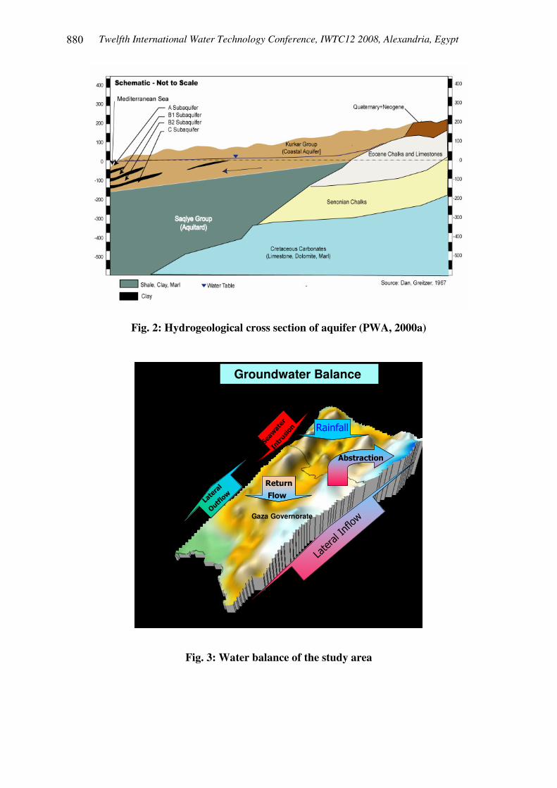
Fig. 1: Location map of the study area HYDROLOGY BACKGROUND Israel has retained and changed the course of the two Wadis and they became dry (fresh surface water resources are negligible). The aquifer runs parallel to the Sea. It is basically phreatic, of sand, sandstone, and silt interbedded with clays that divide it vertically into several subaquifers. Rainfall is the major recharge component. The existing groundwater abstraction wells in the northern part are about 1556 agriculture wells (year 2000 well survey) and 57 municipal wells (year 2004 well survey) (PWA, 2005). It is believed that more water is pumped or discharged from the aquifer than naturally replenishes it (Fig. 3). The pumping rate is much higher due to illegal connections, illegal wells, and leakage in distribution system and eastern border Israeli wells (Mogheir, 1997).
Twelfth International Water Technology Conference, IWTC12 2008, Alexandria, Egypt
���
Fig. 2: Hydrogeological cross section of aquifer (PWA, 2000a)
Northern Governorate
Gaza Governorate
Medite
rranea
n Sea
Wadi Gaza
Groundwater Balance
����������������
���������
�����
���������
�����
��������
���� �
��������
���� �
����
�� �
����
�� �
��������� ���������
���������� �
���������� �
Inflow <���� ��= Water deficit
Fig. 3: Water balance of the study area

Twelfth International Water Technology Conference, IWTC12 2008, Alexandria, Egypt
���
APPROACH, METHODOLOGY AND TOOLS In this study a principle of using data for a hydrological year (October to September) has been applied for 3 stages 1994/1995, 1999/2000 and 2003/2004 through the study period (1994-2004). Rainfall data used in this study are collected from eight rainfall stations. The production rate data of each municipal well in the North Governorate and Gaza Municipality were collected from LEKA and from the Coastal Municipal Water Utility (CMWU) for the hydrological years (1999/2000) and (2003/2004) respectively. Unfortunately, there were no data for their rates of abstraction consequently; we were concerned here with the municipal wells only. For the hydrological years 1994/1995, 1999/2000, and 2003/2004, there were 45, 49 and 64 agricultural monitoring wells respectively throughout the study area. It can be observed from the maps (Fig. 4 a, b and c) that there was not a uniform distribution for water level monitoring wells in the study area.
A/95
A/53A/53A/53A/53A/53A/53A/53A/53A/53A/53
F/75F/75F/75F/75F/75F/75F/75F/75F/75F/75F/75
A/31
24
F/21
24
2C
F/21
24
2C
A/112
2C
2424
A/95A/95
2C
24
A/95
2C2C
24
2C
D/34
D/6
24
2CQ/2
24
A/95
24
A/95
D/6
24
E/3225A25A
E/3225A
E/32E/3225B25B25B
A/21
25A
A/95
25BE/32
A/21
25A
Q/31
Q/15
Q/31
E/32
Q/31
A/21
25B
Q/31
A/95
Q/31
E/32
A/115
25A
Q/31
A/21
25A
Q/31
G/24B
Q/31
Q/20
Q/31
A/112
Q/20
25B
Q/31
D/3425B
Q/31
Q/20
25A
Q/20
Q/31
D/6
A/115
A/47
Q/2
3B
Q/20
A/115
Q/20
25B
C/79
Q/20
C/79C/79
Q/20
C/79C/79
A/64
D/34
C/79
25B
A/115
Q/20
A/115
C/79 C/12A
A/64
3B
25A
G/24B
Q/20
C/79
F/21
G/24BG/24B
3B3B
Q/20
C/12A
G/24B
F/43
G/24B
F/21F/21
A/107
A/115
A/64
G/10
A/115
G/24BG/24B
F/21F/21G/10
C/3C
F/21
G/24B
3B
C/12A
A/31
G/13 F/21
G/24B
G/10
C/12A
Q/15
A/115
F/43
F/21
G/24B
G/13
C/12AC/12AC/12AC/12A
G/10
C/104
C/78
F/21
A/64
G/10G/10
A/64A/64
G/10
A/64
G/10F/26
C/78
A/31
C/104
G/10
C/12A
F/43
C/104
F/141
Q/2
G/103B
C/104
C/78C/78
F/141
A/107
3BG/10
F/26
Q/15Q/56
F/85
F/43
C/78
3B
C/78C/78
Q/56
C/104
Q/56
A/115
G/26
F/26 3BF/26F/26 3B
F/85
Q/56
C/104
G/13
C/78
F/26
Q/56
C/104
F/26
C/78
A/64
F/85
A/107
A/64
G/13F/26
F/85
C/78
A/115
C/78
3B
F/85
G/26
F/85
F/26F/26 3B
A/107
G/13
F/43
C/12A
F/26
F/85
A/64
Q/56
F/85
C/104
G/13
Q/56
S/11
F/85
G/13
A/107
B/4
G/13
Q/56
C/104B/4
A/64
C/3C
Q/56
B/4
A/107
G/13
29
C/49
29
Q/56
C/49
F/134
C/3CC/3C
G/13
C/49C/3C
8B
29
G/13
C/3CC/3C
8B
F/141F/134
S/11
F/68A
8A
C/79C/3C
29
F/68A
8A
C/91
B/4
F/134
29
8B
C/3CC/3C
B/4
A/21 C/3CC/3C
S/15
F/43
26B
F/134
8A
F/134
26B
F/43
B/4
C/79
8B
29
S/11
S/15
C/12A
F/848B
B/4
26B
S/11
8A8B
27
C/79A/21
F/134F/134
29
B/4
26B
S/15
F/68A
8A
S/11
A/21
S/11
26B
8A
F/43
A/21
B/4
F/134F/85
A/112
S/15
8B
F/68AF/68A
F/84
S/11S/11
27
F/134
27
A/21
S/15
B/4
F/134F/43
8B
S/15
8A
B/4
S/11
F/134
26B
F/85
A/21
8B
S/11
S/15S/15
26B
F/43
F/68A
8B8A
C/49
S/15
F/84
A/21
F/68A
F/84
F/68A
F/848A
S/11
8B
S/15
A/21
S/15
27
S/11
8A
27
F/84
26B
C/49
F/84
F/68A
27
F/68A
8A8B
C/49
F/84
F/68A
F/84
C/49
8A
C/49
F/84
27
C/24
C/49
F/84
C/49C/49
F/84
2727
F/96F/96F/84
27
F/96F/96F/96F/96F/96F/96F/96F/96F/96
B/5
C/3CC/3C
91000 93000 95000 97000 99000 101000 103000 105000 107000
94000
95000
96000
97000
98000
99000
100000
101000
102000
103000
104000
105000
106000
107000
108000
109000
110000
111000
Med
itera
nean
Sea
wells Location
1994/1995
F/68B
F/213B
G/10
G/21
G/13
F/68A
B/4
F/106
F/121
C/12A
S/15
S/11
6A6D6B6C
G/24B
6A6D6B
F/43
6C
G/24B
E/4536B36A
E/32
A/107
E/12
25A25B
2C
24
A/95
29
2D
26B
A/21
D/34
A/115
A/64
Q/31
C/78
Q/20
C/61
D/30
Q/12
A/53 B/4
Q/56
C/49 C/12A
F/96
C/48
F/121
F/138
F/134
C/104
S/15
S/11
C/3C
F/106
F/68B
6A
F/43
F/21
F/68A
G/24B
6D6B
8B8A
3B
6C
G/21
F/26G/10G/13
F/84
F/68B
6A
F/43
F/21
F/68AG/21
G/10
G/24B
6D
G/13
6B
F/84
8B8A
3B
6C
F/138F/68BF/68BF/68A
D/34
6A
F/68B
6D6B
3B
F/68A
6C
8B
F/84
8A F/96
C/48
S/11
F/121
S/15
E/45
A/53
A/107
A/21
A/64
A/115
E/32
A/95
D/30
6A
G/10
6D
3B
6B
G/21
6C
G/24B8B
F/43F/84
F/26
F/85
G/13
F/121
S/11
S/15
F/213B
F/43
8B
F/84
8A
F/121
S/15
F/138
S/11
E/4536B36A A/21
25B25A
2C
24
E/12
E/32
A/95
29
D/30
26B
G/21
G/10G/13F/26
D/34
Q/31
F/134
C/78
B/4
F/106
C/49C/48
F/96
C/12A
F/121
F/138
Q/12
C/3C
C/104
F/68B
Q/31
3B
F/68A
S/11
S/15
F/138F/68A
A/53
D/34
A/64
A/107
A/115
C/78
Q/56
C/61
C/49C/48 C/3C
C/104
F/68B
G/10
G/24B
G/21F/68A
Q/20
F/84F/85
F/26G/13
S/11
S/15
G/10 F/21
F/43F/134
F/26G/13
C/48
F/134
F/138
E/4536B36A
25B25A
2CE/12
24
A/95
29
26B
Q/31
F/43
Q/20
F/84
8B8AF/85
F/134
F/96
Q/12
F/138
E/4536B36A A/21
25A25B
A/115
E/32
2C
A/95
24
29
26B
2D
E/4536B36A A/21
A/115
25B25A
E/12
E/32
2C
29
24
26B
D/30
2D
A/53
D/34
A/64
D/30
E/12
A/107
B/4
C/49
C/61
C/104
E/45
A/107
36B36A
A/95
2C
29
24
2D
25B25A D/30
26B
A/53
A/64
Q/31
A/107
B/5
C/49
C/104
Q/12
E/4536B36A A/21
27
25A25BE/32
2C
29
A/95
24
26B
2D
E/4536B36A
25A25BE/32
2C
6A
24
G/24B
6D
2D
6B
26B
6C
C/78
Q/56
C/12A
C/48
F/121
C/3C
F/138
A/53
A/21
A/115
E/12
B/4
C/61
C/49
C/104
C/78C/12A
Q/20
C/61
F/96
C/48 C/3C
F/134
A/53
A/64
A/115
A/107
C/12AC/49
C/104
C/48 C/3CE/4536B36A
A/115
D/34
E/12
A/64
25A25B
A/107
E/32
2C
D/30
24
29
A/95
2D
26B
A/53
A/21
A/64
E/12
A/107
D/30
A/11529
C/78
A/95
C/49
C/61
C/12A
C/104
C/3CE/45
A/53
36B36A
D/34
A/21
A/64
25A25B D/30
A/115
2C
24
A/95
29
26B
2D
Q/31
F/21
Q/20
F/43
F/96
3B
Q/12
F/68A
F/84
8B
S/15
8A
S/11
F/85
A/64
Q/31
C/78
E/32
C/12A
F/96
C/3CC/48
Q/12
F/21
F/68B
F/43
3B F/121
F/68A
S/15
F/84
8B
S/11
8A
F/106
E/4536B36A
27
25A25B
E/12
E/32
2C
29
A/95
24
26B
2D
Q/31
C/78
C/61
Q/20
Q/12
A/21
Q/31
B/4
C/78
Q/20
Q/56
C/49C/48
C/61
C/12A
Q/12
C/104
A/107
E/12
E/32
C/49
C/104
Q/12
F/68BG/21
G/10G/13
F/134F/106
E/45
27
36B36A
A/115
A/107
25A25B
E/12
E/32
2C
A/95
29
24
D/30
26B
2D
F/21
F/68B
Q/56
Q/20
F/43
G/24B
3B F/121
F/68A
S/15
F/84
8B
S/11
8AF/85
6A
G/24B
6D6B6C
A/53
A/21
A/64
A/115
A/107
C/78C/12AC/49
C/61
C/48
E/12
F/121
F/138
S/15
S/11
C/3CE/45
A/53
36B A/2136A
A/64
E/12
25A25B D/30
A/115
E/32
2C
24
A/95
29
26B
2D
Q/31
C/78
B/4
Q/20
C/12A
C/61
C/48
F/134
F/138F/106
A/53
A/64
A/21
C/78C/49
F/134F/106
Q/31
Q/20
C/104
C/3C
Q/12
F/106
F/68B
F/21G/13
F/43
F/1213B
F/68A
S/15
F/84
8B
S/11
8A
E/4536B A/2136A
D/34
A/115
E/12
25A25B
2C
24
D/30
29
A/95
2D
26B
F/68B
6A
F/43
F/21
F/68A
G/24B
G/10
6D6B
F/106
G/13
F/96F/84 F/134
8B8A
3B
6C
B/4D/34
A/107
Q/56
C/49
C/61
C/104
F/68B
Q/56
F/96
3B F/121
F/84
8B8A
S/15
C/3C
Q/56
B/4C/104
F/96
Q/12
C/48
G/21
6B
G/10
6D
G/13
6A6C
G/10
G/21
G/13
F/68B
F/21
F/43
F/121
F/134
3B
F/68A
F/84
8B
S/11
8A
G/21
6A
G/10
G/24B
6D6B6C
G/21
Q/31
F/21
Q/20
C/78
F/43
F/96
C/48
3B
F/84
F/121
F/106
C/12A
Q/12
8B8A
F/138
C/3C
6A
G/24B
6D6B6C
Q/31
D/34
Q/20
F/43
C/12A
C/61
F/134
C/3C
F/84
8B8AF/85
F/106
S/15
A/53
Q/31
A/64
A/107
E/32
C/78
Q/20
B/4
C/61
C/49 C/12A
C/48
Q/12
C/104
C/3C
D/34
Q/31
B/4
Q/20
Q/56
C/48
Q/12
6A6D
G/24B
6B
F/134
S/15
6C
S/11
F/68B
F/121
S/11
6A
G/24B
6D6B6C
91000 93000 95000 97000 99000 101000 103000 105000 107000
94000
95000
96000
97000
98000
99000
100000
101000
102000
103000
104000
105000
106000
107000
108000
109000
110000
111000
1999/2000
Medite
rane
an S
ea
wells Location
24
27272727
25A25B
26B
2C2D
2E
2F
36A36A36A
36A36B36B36B36B
3A3B3B3B
8A
8A
8A8B8B8B
A/107A/107
A/107
A/107A/107
A/21
A/21
A/21A/21
A/31A/31A/31
A/47A/47A/47A/53 A/53A/53A/53
A/64
C/104C/104
C/104
C/104C/104
C/126C/126C/126
C/12AC/12AC/12A
C/12A
C/12AC/12AC/12A
C/27C/27C/27C/27C/30C/30C/30
C/3CC/3C
C/3C
C/3CC/3CC/3CC/48C/48C/48C/48C/48
C/49C/49C/49C/49C/49C/49
C/61C/61
C/61
C/61
C/78
C/78
C/78
D/34D/34
D/34
D/34
D/6D/6D/6
E/116E/116
E/12E/12E/12
E/12
E/32E/32
E/32
E/32
E/45E/45
E/45E/45
F/121F/121F/121
F/121
F/121F/121
F/21F/21F/21F/21F/21F/21F/21F/21F/21
F/43F/43F/43
F/43
F/43F/43F/43F/43
F/68BF/68BF/68BF/68BF/68B
F/68BF/68BF/68B
F/84
F/84
F/84F/84F/84F/84
G/10G/10G/10
G/10
G/10G/10G/10G/10G/10G/13G/13G/13
G/24BG/24BG/24B
G/24B
G/24BG/24BG/24BG/24B
G/26G/26G/26G/26G/26
Q/2Q/2
Q/20Q/20
Q/20
Q/20Q/20
S/11S/11S/11S/11S/11
S/11
S/11S/11
S/15S/15S/15S/15
S/15S/15
91000 93000 95000 97000 99000 101000 103000 105000 107000
94000
95000
96000
97000
98000
99000
100000
101000
102000
103000
104000
105000
106000
107000
108000
109000
110000
111000
Med
itera
nean
Sea
Wells Location 2003/2004
Figure4 a, b and c: Location map of water level wells in the study area in 1994/1995

Twelfth International Water Technology Conference, IWTC12 2008, Alexandria, Egypt
���
In this study, 14 lithological wells had been used to draw a cross section close to the shoreline in the western side (Fig. 5) using WinLog and WinFence software. Chloride concentration (1994-2004) for agriculture and municipal wells were chosen for drawing chlorographs along the seashore.
Fig. 5: Lithological wells used in drawing a cross section
Data analysis had been done using softwares programs involving the use of Excel for drawing graphs, tables and making statistics for data, Surfer (Version 8) for drawing maps, WinLog 4 and WinFence to graphically create detailed, full-color, cross-sections and fence diagrams to interpret and map soil and rock layers. RESULTS AND DISCUSSION 1. Rainfall Conditions The major renewable resource of groundwater recharge in the study area changed from year to year and from place to another. Average amount of rainfall in all rain stations decreased from (1994/1995) till it reached to lowest value in 1998/1999 as shown in (Fig. 6). Then, it began to increase till it reached to the highest value in 2002/2003 and then decreased again in (2003/2004).

Twelfth International Water Technology Conference, IWTC12 2008, Alexandria, Egypt
���
Av erage amount of rainf all f or the eight stations
0
100
200
300
400
500
600
700
94/9
5
95/9
6
96/9
7
97/9
8
98/9
9
99--
00
00--
01
01--
02
02--
03
03--
04
Year
mm
/yea
r
Fig. 6: Average rainfall amount (1994-2004) 2. Rate of Abstraction Conditions The rate of production for most of wells in (1999/2000) was higher than the recommended by PWA (100 m3/hr) and some wells above the doubled of this value to cover the rapid increasing in population (Fig. 7) and (Table 1). No doubt that the high density of agriculture wells especially in the north, add to illegal ones had played a sharing role in water level declination and groundwater quality deterioration.
Production Rate of Northern Governorates 1999/2000
0
50
100
150
200
250
A18
0A
185
C12
7C
128
C76
C79
D 7
4 D
20D
60D
67D
68D
69D
70D
71D
72D
73E
142
E
1E
154
E15
6E
157
E4
E6
E61
E90
Q40
BQ
68R
112
R16
2BA
R16
2CA
R16
2DR
162E
aR
162G
R16
2HR
162H
AR
162L
R16
2LA
R25
4R
25A
R25
BR
25C
R25
DR
265
R74
R75
(m
3/h
r)
Beit Lahia
Beit Hanoun
JabaliaGaza
Fig. 7: A graph for rate of production (1999/2000)

Twelfth International Water Technology Conference, IWTC12 2008, Alexandria, Egypt
���
Table 1. Rate of production in study area (1999/2000)
Location No. of wells Production rate > 100 Production rate < 100 North 27 70% 30%
Gaza Municipality 18 56% 44% North and Gaza 45 64.50% 35.50%
It can be seen also from the map (Fig. 8) that the production wells mostly concentrated within a limited part of the study area. Most of the wells with high rate of production were found in the western side of the North Governorate and Gaza City and especially in the North Governorate. The highest rate of production in the North in well (Q68) was toward the eastern part while highest rate of production in Gaza in well (R162L) was toward the western part. Most of the production wells with rate above (200 m3/hr) were toward the western part of the study area. The total amount of water abstracted from the study area for the hydrological year (1999/2000) was about (41) Mm3. The wells distribution and their rates of abstraction had been affected by the urban area and their rapid growth in limited areas.
Med
iterra
nean
Sea
9200
0
9300
0
9400
0
9500
0
9600
0
9700
0
9800
0
9900
0
1000
00
1010
00
1020
00
1030
00
1040
00
1050
00
1060
00
1070
00
1080
00
94000
95000
96000
97000
98000
99000
100000
101000
102000
103000
104000
105000
106000
107000
108000
109000
110000
Q68R162L
200
150100
Cubic meter/hr
Rate of production
250
1999/2000Average Annual Production in Cubic Meter per Hour
300
Fig. 8: A map for rate of production (1999/2000)

Twelfth International Water Technology Conference, IWTC12 2008, Alexandria, Egypt
��
In (2003/2004) the pumping rate was reduced but the number of wells and their pumping duration increased to cover the population demand (Fig. 9) and (Table 2).
Production Rate of Northern Governorates 2003/2004
0
50
100
150
200
250A18
0A18
5
C12
7C
128
C13
7C
20C
76C
79
D 7
4D
20D
60D
67D
68D
69D
70D
71D
72D
73E 1
42 E1
E15
4E15
6E15
7E4
E6
E90
Q40
BQ
68R
112
R11
3R
162B
AR
162C
AR
162D
R16
2Ea
R16
2GR
162H
R16
2HA
R16
2LR
162L
AR
254
R25
AR
25B
R/2
5CR
25D
R26
5R
277
R28
0R
74R
75
m3/
hr
GazaJabalia
Beit Hanoun
Beit Lahia
Fig. 9: A graph for rate of production (2003/2004)
Table 2. Rate of production in study area (2003/2004)
Location No. of wells Production rate > 100 Production rate < 100 North 28 50% 50%
Gaza Municipality 21 43% 57% North and Gaza 49 47.00% 53.00%
Figure (10) shows that most of the wells with rate above 200 m3/hr were found toward the western part of the study area and especially in the North Governorate. The production wells mostly concentrated in a limited part of the study area. The highest rate of production in the North in wells (Q68) which was toward the eastern part and (D74) which was toward the western part, while highest rate of production in Gaza in well (R25D) was toward the eastern part. The total production of the wells for this year was about (44.5 Mm3) (PWA, 2005). The high rate of production exceeds the recommended production rate from PWA (100 m3/hr) of course will affect extremely the produced water quality with time. It will accelerate the water salinity problem with time especially in the western areas which are near to the seashore.

Twelfth International Water Technology Conference, IWTC12 2008, Alexandria, Egypt
��
Med
iterra
nean
Sea
9200
0
9300
0
9400
0
9500
0
9600
0
9700
0
9800
0
9900
0
1000
00
1010
00
1020
00
1030
00
1040
00
1050
00
1060
00
1070
00
1080
00
94000
95000
96000
97000
98000
99000
100000
101000
102000
103000
104000
105000
106000
107000
108000
109000
110000
R25D
D 74
Q68
200
150100
Cubic meter/hr
Rate of production
250
2003/2004Average Annual Production in Cubic Meter per Hour
Fig. 10: A map for rate of production (2003/2004) 3 Groundwater Level and Flow Regime Conditions Changes in water levels in wells reflect changes in recharge to and discharge from an aquifer. Groundwater level can be influenced by many factors, including precipitation and abstraction. Water-level changes leads to changes in groundwater flow direction. The maps in Figure (11 a, b and c) shows a cone of depression in the northern part of the study area that has expanded through three stages. It began in (19994/1995) with a water level less than 1m below MSL, and its area below zero level was about (2 km2). In (1999/2000), this cone had expanded and depressed where water level became less than 2 m below MSL and its area below zero level became about (35 km2) and in (2003/2004), it became less than 4 m below MSL and its area below zero level became about (44 km2). This hydrological depression which formed as a result of the overexploitation of the aquifer, have diverted the natural flow direction.

Twelfth International Water Technology Conference, IWTC12 2008, Alexandria, Egypt
���
94000
95000
96000
97000
98000
99000
100000
101000
102000
103000
104000
105000
106000
107000
108000
109000
110000
111000
9100
0
9200
0
9300
0
9400
0
9500
0
9600
0
9700
0
9800
0
9900
0
1000
00
1010
00
1020
00
1030
00
1040
00
1050
00
1060
00
1070
00
1080
00
Water level Map
Km0 1 2 3
-1
0
1
2
3
Well Location
Med
itera
nean
Sea
1994/1995
(m)
94000
95000
96000
97000
98000
99000
100000
101000
102000
103000
104000
105000
106000
107000
108000
109000
110000
111000
9100
0
9200
0
9300
0
9400
0
9500
0
9600
0
9700
0
9800
0
9900
0
1000
00
1010
00
1020
00
1030
00
1040
00
1050
00
1060
00
1070
00
1080
00
Water level Map
Km-4-3-2-1012
Well Location
0 1 2 3
Med
itera
nean
Sea
2003/2004
(m)
94000
95000
96000
97000
98000
99000
100000
101000
102000
103000
104000
105000
106000
107000
108000
109000
110000
111000
9100
0
9200
0
9300
0
9400
0
9500
0
9600
0
9700
0
9800
0
9900
0
1000
00
1010
00
1020
00
1030
00
1040
00
1050
00
1060
00
1070
00
1080
00
Water level Map
Km0 1 2 3
-2
-1
0
1
2
Well Location
Medite
rane
an S
ea
1999/2000
(m)
Fig. 11 a, b and c: Maps of average groundwater levels and direction of movement
The dry period from (1994/1995) till it reached to lowest value in (1998/1999) accelerated the lowering and expanding of this cone. After that, in spite of the increasing trend in rainfall amount from (1999/2000) to (2002/2003) there was a continuity in increasing of over-exploitation of groundwater especially under paved urban areas (Gaza City and Jabalia Town). These areas decreased the area of recharge with rainfall and included high density of wells and high rate of abstraction that led to the continuity in lowering and expanding of this cone. The municipal wells have been operate almost 24 hours a day with an abstraction rate exceeds a 100 m3/hr, noting that these wells are very close to each others which led to a low pressure zone that leads to seawater intrusion to invade this low pressure zones.

Twelfth International Water Technology Conference, IWTC12 2008, Alexandria, Egypt
���
In (2003/2004) the water level in the southeastern part is increased to some extent as a result of presence of wide scorched lands in this area. The abstracted water from agriculture wells nearly stopped by destroying from Israel military while the received rainfall percolates without interception on the surface by plants. An overlay for correlation has been made between water level map and rate of abstraction map for the hydrological years (1999/2000) and (2003/2004) as shown in (Fig. 12 a and b). In (1999/2000) the deepest part of the cone of depression coincided with four wells D/68, D/69, E/154 and E/157. The rate of abstraction of these wells was above 200 m3/hr. This means that there was a direct effect of the rate of abstraction on the water level in the aquifer. Pumping is the other main factor affecting the water level beside rainfall. The effect of rainfall is regional in scale while the effect of pumping is local. In (2003/2004), it is well observed that the lowest parts of the big cone of depression with average level (-4) meters (below M.S.L.) are located in Jabalia Town.
Med
iterra
nean
Sea
9200
0
9300
0
9400
0
9500
0
9600
0
9700
0
9800
0
9900
0
1000
00
1010
00
1020
00
1030
00
1040
00
1050
00
1060
00
1070
00
1080
00
94000
95000
96000
97000
98000
99000
100000
101000
102000
103000
104000
105000
106000
107000
108000
109000
110000
200
150100
Cubic meter/hr
250
1999/2000Rate of Production and Water Level Map
300
-2
-1
0
1
2
(m)
Med
iterra
nean
Sea
9200
0
9300
0
9400
0
9500
0
9600
0
9700
0
9800
0
9900
0
1000
00
1010
00
1020
00
1030
00
1040
00
1050
00
1060
00
1070
00
1080
00
94000
95000
96000
97000
98000
99000
100000
101000
102000
103000
104000
105000
106000
107000
108000
109000
110000
200
150100
250-4
-3
-2
-1
0
1
2
(m)
Cubic meter/hr
Rate of Production and Water Level Map2003/2004
Fig. 12 a, b: Overlay between water level maps and rate of abstraction maps This area was conceding with the area of high rate of abstraction of well D/74 (above 200 m3/hr) and high density of wells most of them above 150 m3/hr such as D/68, D/69, D/71, E/157, A/185 and D/72. 4. Lithological Cross Section For studying the role of lithology in seawater intrusion in the study area, data of (14) lithological wells are used in drawing a cross section (NE–SW) as shown in (Fig. 13). The importance of the western side cross section is to show the role of the aquifer's

Twelfth International Water Technology Conference, IWTC12 2008, Alexandria, Egypt
���
lithological characteristics on limiting seawater intrusion where seawater can intrude into the aquifer at different rates, depending on the hydraulic regime inland and lithological characteristics. The western section extends along NE - SW parallel to the shoreline and far by about (1-1.5 km). It can be observed from this cross section that the lithological log of wells (A/196, 25A-B and R/162E) does not contain clay within their lithological record. The high permeability of the sand and calcareous sandstone in the upper vadose zone and absence of clay layers or lenses in these wells enables rapid seawater intrusion in it.
Fig. 13: Cross section along the western border in the direction of NE-SW
5. Chlorographs along the Seashore Line In the study area where continuous heavy pumping causes a reduction of the water levels and forming a big cone of depression reached to 4 m below MSL, seawater intrusion or a vertical up-coning in summer season due to the increase of the abstraction rate of the pumping wells results in a salinity breakthrough. Thus a time-series of chloride concentrations can record the early evolution of relatively rapid salinization (Bear et al. 1999). Some of the municipal (Fig. 14) and agricultural wells (Fig. 15) that are close to the seashore line show a sudden and/or fluctuating increase in the concentration of chloride with time from 1994 until 2004.

Twelfth International Water Technology Conference, IWTC12 2008, Alexandria, Egypt
���
Municipal Wells 2003 / 2004
92000 94000 96000 98000 100000 102000 104000 106000 108000
94000
96000
98000
100000
102000
104000
106000
108000
110000
A/180
A/185
A/6
C/127
C/128
C/137
C/20
C/76
C/79D/60/1
D/67
D/68D/69
D/70D/71
D/72D/73
E/1
E/11A
E/142/1E/154
E/156E/157
E/6
E/90
G/50
Q/40C
Q/68
R/112
R/162BA
R/162D
R/162HR/162LA
R/254
R/25B
R/265
R/270
R/277
R/280R/75
R/162G
Fig. 14: Municipal wells show sudden and fluctuating increase in salinity
9100
0
9200
0
9300
0
9400
0
9500
0
9600
0
9700
0
9800
0
9900
0
1000
00
1010
00
1020
00
1030
00
1040
00
1050
00
1060
00
1070
00
1080
00
1090
00
94000
95000
96000
97000
98000
99000
100000
101000
102000
103000
104000
105000
106000
107000
108000
109000
110000
111000
A/1A/1A/1A/1A/1A/1
A/10A/10A/10A/10A/10
A/103
A/106A/106A/106A/106A/106A/106A/106A/106A/106A/106A/106A/106A/106A/106A/106A/106A/106
A/107A/107A/107A/107A/107A/107A/107A/107A/107A/107A/107A/107A/107A/107A/107A/107A/107A/107
A/111A/111
A/112A/112A/112A/112A/112A/112A/112A/112A/112A/112A/112A/112A/114A/114A/114A/114A/114A/114A/114A/114A/114A/114
A/115A/115A/115A/115A/115A/115A/115A/115A/115A/115A/115A/115
A/12
A/123
A/124A/124
A/125A/125A/125A/125A/125A/125
A/131A/131A/131A/131A/131
A/14A/14
A/143
A/151A/151A/151A/151A/151
A/159A/159A/159A/159
A/165
A/169
A/17A/17A/17A/17A/17A/17A/17A/17A/17A/17A/17A/17A/17A/17
A/181A/181A/181
A/192
A/21A/21A/21A/21A/21A/21A/21A/21A/21A/21A/21A/21A/21
A/24A/24A/24A/24A/24A/24A/24A/24A/24A/24A/24A/25A/25A/25A/25A/25A/25A/25A/25A/25A/25A/25A/25A/25A/25A/25A/25A/25A/26A/26A/26A/26A/26A/26A/26A/26A/26A/27A/27A/27A/27A/27A/27A/27A/27A/27A/27A/27A/27A/27A/27A/27A/27A/27A/27
A/28A/28A/28A/28A/28A/28A/28A/28A/28A/28A/28A/28A/28A/28A/28A/28A/28A/28A/28A/28A/28A/31A/31A/31A/31A/31A/31A/31A/31A/31A/31A/31A/31A/31A/31A/31A/31
A/32
A/36A/36A/36A/36A/36A/36A/36A/36A/36A/36A/36A/36A/36A/36A/36A/36A/36A/36A/36A/36A/36
A/37
A/4
A/43
A/46A/46A/46A/46A/46A/46A/46A/46A/46A/46A/46A/46A/46A/46A/46A/46A/46
A/47A/47A/47A/47A/47A/47A/47A/47A/47A/47A/47A/47A/47A/47A/47A/47A/48A/48A/48A/48A/48A/48A/48A/48A/48
A/5
A/52A/52A/52A/52A/52A/52A/52A/53A/53A/53A/53A/53A/53A/53A/53A/53A/53A/53A/53A/53A/53A/53A/53A/53A/53A/53
A/57A/57A/57A/58A/58A/58A/58A/58A/58A/58A/58A/58A/58A/58A/58A/58A/58A/58A/58A/58A/58A/58A/58
A/59A/59A/59A/59
A/64A/64A/64A/64A/64A/64A/64A/64A/64A/64A/64A/64A/64A/64A/64A/64A/64A/64
A/65A/65A/65
A/66A/66
A/68A/68A/68A/68A/68A/68A/68A/68A/68A/68A/68
A/7A/7A/7A/7A/7A/7A/7A/7A/7A/7A/7A/7A/7A/7
A/70A/70A/70A/70A/70A/70A/70A/70A/72A/72A/72A/72A/72A/72A/72A/72
A/74A/74A/74A/74A/74A/74A/74A/74A/74A/74A/74
A/76A/76A/76A/76
A/79A/79A/79A/79A/79
A/81A/81
A/85A/85A/85A/85A/85A/85A/85A/85
A/86A/86A/86A/86A/86A/86A/86A/86A/86A/86A/86A/86A/86A/86A/86A/86A/86A/86A/86A/86A/86A/86A/86A/87A/87
A/89A/89A/89A/89A/89A/89A/89A/89
A/90A/90A/90A/90A/90A/90A/90A/90
A/92A/92A/92A/92A/92A/92A/92A/92A/92A/92A/92A/92A/92A/92A/92A/92A/92A/93A/93A/93A/93A/93A/93A/93A/93A/93A/93A/93A/93A/93A/95A/95A/95A/95A/95A/95A/95A/95A/95A/95A/95
B/1B/1B/1B/1B/1B/1B/1B/1B/1B/1B/1B/1B/1
B/10B/10B/10B/10B/10B/10B/10
B/11B/11B/11B/11B/11B/11B/11B/11B/11B/11B/11B/11B/11B/11B/11B/11B/11B/12B/12B/12B/12B/12B/12B/12B/12B/12B/12B/12B/12B/12B/12B/12
B/15B/15B/15B/15B/15B/15B/15B/15B/15B/15B/15B/15B/15
B/16B/16B/16B/16B/16B/16B/16B/16B/16B/16B/16B/16B/16B/16B/16B/16B/16B/17B/17B/17B/17B/17B/17B/17B/17B/17B/17
B/18B/18
B/19B/19B/19B/19B/19B/19B/19B/19B/19B/19B/19
B/2B/2B/2B/2B/2B/2B/2B/2B/2B/2B/2B/2B/2B/2B/2B/2B/2
B/20B/20B/20B/20B/20B/20B/20B/20B/20B/20B/20
B/21B/21B/21B/21B/21 B/3B/3B/3B/3B/3B/3B/3B/3B/3B/3B/4B/4B/4B/4B/4B/4B/4B/4B/4B/4B/4B/4B/4B/4B/4B/4
B/5B/5B/5B/5B/5B/5B/5B/5B/5B/5B/5B/5
B/6B/6
B/7B/7B/7B/7B/7B/7B/7B/7B/7B/7B/7B/7 B/8B/8B/8B/8B/8B/8B/8B/8B/8B/8B/8B/8B/8B/8B/8B/8B/9
C/1C/1C/1C/1C/1C/1C/1C/1C/1C/1C/1C/1C/1C/1C/1C/1C/1C/1C/1
C/104C/104C/104C/104C/104C/104C/104C/104C/104C/104C/104C/104
C/106C/106C/106C/106C/106C/106C/106C/106C/106
C/111C/111C/111C/111C/111C/111C/111C/111C/111C/111C/113C/113C/113C/113C/113C/113C/113C/113C/113C/113C/113C/113C/113C/113
C/114C/114
C/121 C/122C/122
C/125C/125C/125C/125C/125C/125
C/12AC/12AC/12AC/12AC/12AC/12AC/12AC/12AC/12AC/12AC/12AC/12AC/12AC/12AC/12AC/12A
C/12BC/12BC/12BC/12BC/12BC/12BC/12BC/12BC/12BC/12BC/12BC/12BC/12CC/12CC/12CC/12CC/12CC/12C
C/13C/13
C/14C/14C/14C/14C/14C/14C/14C/14C/14C/14C/14C/14C/14
C/15AC/15AC/15AC/15AC/15AC/15AC/15AC/15A
C/15BC/15BC/15BC/15BC/15BC/15B
C/16AC/16AC/16AC/16AC/16AC/16AC/16A
C/16BC/16BC/16BC/16BC/16BC/16BC/16BC/16BC/16BC/16BC/16BC/16B
C/17AC/17AC/17AC/17AC/17AC/17A C/17BC/17B
C/2C/2C/2C/2C/2C/2C/2C/2C/2C/2C/2
C/20C/20C/20C/20C/20C/20C/20C/20
C/21C/21C/21C/21C/21C/21C/21C/21C/21C/23C/23C/23C/23
C/33C/33C/33C/33C/33C/33C/33C/33C/33C/33C/33C/33C/33C/33C/33C/33C/33C/33
C/34C/34C/34C/34C/34C/34C/34C/34C/34
C/35C/35C/35C/35C/35C/35C/35C/35C/35
C/36C/36C/36C/36C/36C/36C/36
C/38C/38C/38C/38C/38
C/3AC/3AC/3AC/3AC/3AC/3AC/3AC/3AC/3AC/3AC/3AC/3AC/3AC/3AC/3AC/3AC/3A C/3BC/3BC/3BC/3BC/3BC/3B
C/3CC/3CC/3CC/3CC/3CC/3CC/3CC/3CC/3CC/3CC/3CC/3CC/3CC/3CC/3CC/3CC/3CC/3CC/3C
C/43C/43C/43C/43C/43C/43C/43C/43
C/47C/47C/47C/47
C/47AC/47AC/47AC/47AC/47AC/47AC/47AC/47AC/47AC/47AC/47AC/47AC/47AC/47AC/47AC/47A
C/48C/48C/48C/48C/48C/48C/48C/48C/48C/48C/48C/48C/48C/48C/48C/48
C/49C/49C/49C/49C/49C/49C/49
C/4AC/4A
C/50C/50C/50C/50C/50C/50C/50C/50
C/51C/51C/51C/51C/51C/51C/51C/51C/51C/51C/51C/51C/51C/51C/51C/51
C/52C/52C/52C/52C/52C/52C/52C/52C/52C/52C/52C/52C/52C/52C/52C/52C/52C/53
C/54C/54
C/55AC/55AC/55AC/55AC/55AC/56AC/56A
C/56BC/56BC/56BC/56BC/56BC/56BC/56BC/56BC/56BC/56BC/56BC/56B
C/6
C/61C/61C/61C/61C/61C/61C/61C/61C/61C/61C/61C/61C/61C/61
C/67
C/69C/69C/69C/69C/69C/69
C/7C/7C/7C/7C/7C/7C/7
C/70C/70C/70C/70C/70C/70
C/76C/76
C/77C/77C/77C/77C/77C/77
C/78C/78C/78C/78C/78C/78C/78C/78C/78C/78C/78C/78C/78C/78C/78C/78C/78C/78C/78
C/79C/79C/79C/79C/79C/79C/79C/79C/79C/79C/79C/79C/79C/79C/79C/79
C/9C/9C/9C/9C/9C/9
C/91C/91C/91C/91C/91C/91C/91C/91C/91C/91C/91C/91C/91 C/92C/92C/92C/92C/92C/92C/92C/92C/92
C/93
C/95
D/11D/11D/11D/11D/11D/11D/11
D/14D/14D/15D/15D/15D/15D/15D/15D/15D/15
D/20D/20D/20D/20D/20D/20D/20D/20
D/30D/30D/30D/30D/30D/30D/30D/30D/30D/30D/30D/30
D/32D/32D/32
D/34D/34D/34D/34D/34D/34D/34D/34D/34D/34D/34D/34
D/4D/4D/4D/4D/4D/4D/4D/4
D/43D/43D/43D/43D/43D/43D/43D/43D/43D/43D/43D/43D/43D/43D/43D/43D/43
D/5
D/55D/55D/55D/55D/55D/55
D/58D/58D/58D/58D/58D/58D/58D/58D/58D/58D/58D/58D/58D/58D/58D/58D/58
D/6D/6D/6D/6D/6D/6D/6D/6D/6D/6D/6D/6D/6D/6
D/60
D/65
D/9D/9D/9D/9D/9D/9D/9D/9D/9D/9D/9
E/1E/1E/1E/1
E/10E/10E/10E/10E/10E/10E/10E/10E/10E/10E/10
E/102E/102E/102E/102E/102E/102E/102E/102E/102E/102E/102E/102
E/104
E/107E/107E/107
E/109E/109E/109E/109E/109E/109E/109E/109E/109E/109E/109
E/110E/110E/111E/111E/113E/113E/113E/113E/113E/113E/113E/113E/113E/113E/113E/113E/113E/113
E/114AE/114AE/114AE/114AE/114AE/114AE/114AE/114BE/114BE/114BE/114BE/114BE/114BE/114B
E/115E/115E/115E/115
E/11AE/11A
E/11CE/11C
E/12E/12E/12E/12E/12E/12E/12E/12E/12E/12E/12E/12E/12E/12E/12
E/125E/127E/127E/127E/127E/127E/127E/127E/127E/127E/127E/127
E/128E/128E/128E/128E/128E/128E/128E/128E/128E/128E/128E/128
E/138E/138E/138E/138E/138E/138E/138E/138E/138
E/144E/144E/144E/144E/144
E/149E/149
E/158E/158E/158E/158
E/17
E/23E/23E/23E/24BE/24BE/24BE/24BE/24BE/24BE/24BE/24BE/24B
E/25
E/26E/26E/26E/26E/26E/26E/26E/26E/26E/26E/26E/26E/26E/26E/26E/26E/26E/26E/26
E/28E/28E/28E/28E/28E/28E/28E/28E/28E/28E/28E/28E/28E/28E/28E/28E/28E/28E/28E/28
E/30E/30E/30E/30E/30E/30E/30E/30E/30E/30E/30E/30E/30E/30E/31
E/32E/32E/32E/32E/32E/32E/32E/32E/32E/32E/32E/32E/32
E/33E/33
E/35E/35E/35E/35E/35E/35E/35E/35E/35E/35E/35E/35E/35E/35E/35E/35
E/37E/37E/37E/37E/37E/37E/37E/37E/37
E/4
E/40E/41E/41E/41E/41 E/42E/42E/42E/42E/42E/42E/42E/42E/42
E/43E/43E/43E/43E/43E/43E/43E/43E/43
E/45E/45E/45E/45E/45E/45E/45E/45E/45E/45E/45E/45E/45E/45E/45E/45E/45
E/47 E/5E/50
E/53E/53E/53E/53E/53E/53E/53E/53E/53E/53E/53E/53E/54E/56E/56E/56E/56E/56
E/58E/58E/58E/58E/58E/58E/58
E/6E/6E/6
E/60E/60E/60E/60
E/61E/61E/61E/61E/61E/61E/61E/61E/61E/61E/61E/61E/61E/61E/61E/62E/62E/62E/62E/62E/62E/62E/62E/62
E/63E/63E/63E/63E/63E/63E/63E/63E/63E/63E/63E/63E/63E/63E/63 E/64E/65E/65E/65E/65E/65E/65E/65
E/66
E/67E/67E/67E/67E/67E/67E/67E/67E/67E/67E/67E/67E/67E/67E/67E/67E/67E/67
E/73E/73E/73 E/74E/74E/74
E/75
E/78E/78E/78E/78E/78E/78E/78E/78E/78E/78E/78E/78E/78E/79E/79E/79E/79E/79E/79E/79E/79E/79E/79E/80
E/81
E/85E/85E/85E/85E/85E/85E/85E/85E/85E/85E/85E/85E/85E/85E/85E/85E/88E/88E/88E/88E/88E/88
E/89E/89
E/9E/9E/9
E/93E/94E/94E/94E/94E/94E/94E/94E/94E/94E/94
F/103
F/105F/105F/105F/105F/106F/106F/106F/106F/106F/106F/106F/106
F/108F/108F/108F/108F/108F/108F/108F/108F/108
F/109F/109F/109F/109F/109F/109F/109F/109F/109F/109F/109F/109F/109F/109F/109
F/111F/111F/111F/111F/111F/111F/111F/111F/111F/111F/111F/111F/111F/111
F/112F/113
F/114F/114F/114F/114F/114F/114F/114F/114F/114F/114F/114F/114F/114
F/117F/117F/117F/117F/120F/120F/120F/120
F/120A
F/121F/121F/121F/121F/121F/121F/121F/121F/121F/121F/121F/121F/121F/121F/121
F/124F/124F/124 F/125
F/127F/127F/127F/127F/127F/127F/127F/127F/127F/127
F/128F/128F/128F/128F/128F/128F/128F/128F/128
F/131F/131F/131
F/134F/134F/134F/134F/134F/134F/134F/134
F/136F/136F/136F/136F/136F/136F/136F/136F/136
F/137F/137
F/138F/138F/138F/138F/138F/138F/138F/138F/138
F/141F/141F/141F/141F/141
F/143F/143F/143F/143F/143
F/146
F/152
F/156F/156F/156 F/157F/157F/157
F/16F/16F/16F/16F/16F/16F/16F/16F/16
F/163
F/171
F/182F/182
F/198
F/24F/24F/24F/24
F/35F/35F/35F/35F/35F/35F/35F/35F/35F/35F/35F/35F/35F/35F/35F/35F/35F/35
F/36F/36F/36F/36F/36F/36F/36F/36F/36F/36
F/37F/37F/37F/37F/37F/37F/37F/37F/37F/37
F/43F/43F/43F/43F/43F/43F/43F/43F/43F/43F/43F/43F/43F/46
F/47F/47F/47F/47F/47
F/52F/52F/52F/52F/52F/52F/53F/53F/53F/53
F/62F/62F/62F/62F/62F/62F/62F/62F/62F/62F/62F/62F/62F/62F/62F/62F/64 F/67
F/68AF/68AF/68AF/68AF/68AF/68AF/68AF/68AF/68AF/68AF/68AF/68AF/68AF/68AF/68AF/68AF/68BF/68BF/68BF/68BF/68BF/68BF/68BF/68BF/68BF/68BF/68BF/68BF/68BF/68BF/68BF/68BF/68BF/68B
F/70F/70F/70F/70F/70F/70F/70F/70F/70F/70F/70
F/71F/71F/71F/71F/71F/71F/71F/71F/71F/71
F/73
F/75F/75F/75
F/76F/76F/76F/76F/76F/76F/76F/76F/76F/76F/76F/76
F/76AF/76AF/76AF/76AF/76AF/76AF/76AF/76AF/76AF/76AF/76AF/76AF/76A
F/77F/77F/77F/77F/77F/77F/77F/77F/77F/77F/78F/78F/78F/78F/78F/78F/78F/78F/78F/78F/78F/78F/78F/78
F/82F/83F/83F/83F/83F/83F/83F/83F/83F/83F/83F/83F/83F/84F/84F/84F/84F/84F/84F/84F/84F/84F/84F/84F/84F/84F/84F/84
F/85F/85
F/88F/88F/88F/88F/88F/88F/88F/88F/88F/88F/88F/88F/88F/88F/88
F/92
F/96F/96F/96F/96F/96F/96F/96F/96
F/97F/97F/97
F/98F/99F/99
F-I-14
F-I-22
F-I-29F-I-30
G/24AG/24AG/24AG/24AG/24A
G/24BG/24BG/24BG/24BG/24BG/24BG/24BG/24BG/24B
G/24CG/24CG/24CG/24CG/24CG/24C
G/42G/42G/42G/42G/42G/42G/42G/42G/42
G/43G/43G/43G/43G/43G/43
Q/1Q/1Q/1Q/1Q/1Q/1Q/1Q/1Q/1Q/1
Q/10Q/10Q/10Q/10Q/10Q/10Q/10Q/10Q/10Q/10Q/10Q/10Q/10
Q/11Q/11Q/11
Q/12Q/12Q/12Q/12Q/12Q/12Q/12Q/12Q/12Q/12Q/12Q/12Q/12Q/12Q/14Q/14Q/14Q/14Q/14Q/15Q/15Q/15Q/15Q/15Q/15Q/15Q/15Q/15Q/15Q/15Q/15Q/15
Q/16Q/16
Q/17Q/17Q/17Q/17Q/17Q/17Q/17Q/18Q/18Q/18Q/18Q/18Q/18Q/18Q/18
Q/19Q/19
Q/2Q/2Q/2Q/2Q/2Q/2Q/2Q/2Q/2Q/2Q/2
Q/20Q/20Q/20Q/20Q/20Q/20Q/20Q/20Q/20Q/20Q/20Q/20Q/20Q/20Q/20Q/20Q/21Q/21Q/21Q/21Q/21Q/21Q/21Q/21
Q/22Q/24Q/24
Q/26Q/26Q/26Q/26Q/27Q/27Q/27
Q/28Q/28Q/28
Q/29Q/29
Q/3Q/3Q/3Q/3Q/3Q/3Q/3Q/3
Q/30Q/30
Q/31Q/31Q/31Q/31Q/31Q/31Q/31Q/31Q/32
Q/33Q/33Q/33Q/33Q/33Q/33Q/33Q/33Q/33
Q/35Q/37Q/37
Q/38Q/39Q/39
Q/4Q/4Q/4Q/4Q/4Q/4Q/4Q/4Q/4Q/4Q/4Q/4Q/4Q/4Q/4Q/4Q/40AQ/40AQ/40AQ/40AQ/40A
Q/41Q/41Q/41Q/41Q/41Q/41Q/41Q/41Q/41Q/41Q/41Q/41Q/41
Q/45
Q/46Q/46
Q/48Q/48Q/48Q/48Q/48Q/48Q/48Q/48Q/48Q/48Q/48Q/48Q/48Q/48
Q/5Q/5Q/5Q/5Q/5
Q/50Q/50
Q/51
Q/53Q/53Q/54AQ/54AQ/54AQ/54AQ/54AQ/54AQ/54AQ/54AQ/54AQ/54A
Q/54B
Q/54DQ/54DQ/54DQ/54DQ/54DQ/54DQ/55Q/55Q/55Q/55Q/56Q/56Q/56Q/56Q/56Q/56Q/56Q/56Q/56Q/56Q/56Q/56Q/56Q/56
Q/57Q/57Q/57Q/57Q/57
Q/58Q/58Q/58Q/58Q/58Q/58Q/58Q/58Q/58Q/58Q/58Q/58Q/58
Q/6Q/6
Q/7Q/7
Q/8Q/8Q/8Q/8Q/8Q/8Q/8Q/8Q/8Q/8
R/10R/10
R/101R/101R/101R/101R/102
R/106
R/107
R/108R/108R/108R/108R/108R/108R/108R/108
R/109 R/110
R/112R/112R/112R/112R/112R/112R/112
R/116
R/12R/12R/12
R/120R/121
R/122
R/125R/125R/125R/125R/125R/125R/125R/125R/125R/125R/126
R/127
R/128R/128R/128R/129R/129R/129R/129R/129
R/13R/13R/13R/13R/13R/13R/13R/13R/13R/13R/13R/13R/13R/13
R/130R/130R/130R/130R/130R/130R/130R/131R/131R/131R/133R/133R/133R/133R/133R/133R/133R/133R/133R/133R/133R/133
R/134R/134
R/135R/135
R/136
R/137
R/141R/141R/141
R/142R/142R/142R/143
R/146R/146R/146R/146R/146R/146R/146R/146
R/147R/147R/147R/147R/147R/147R/147
R/160R/160R/160R/160R/160R/160R/160R/160R/160
R/162B
R/162C
R/162LR/162LR/162LR/162LR/162LR/162LR/162L
R/16AR/16AR/16AR/16AR/16AR/16BR/16BR/16BR/16BR/16BR/16BR/16BR/16BR/16BR/16BR/16BR/16BR/170R/170R/170R/170R/170R/170R/170R/170R/170R/170R/170R/170R/170R/170R/170R/170R/170
R/171
R/174
R/179
R/183
R/184R/184
R/185R/185R/185R/185R/185R/185R/185R/185R/185R/185R/185R/185R/185R/185
R/189R/189R/189R/189
R/194
R/197R/197R/197R/197R/197R/197R/197R/197R/199R/199R/199R/199R/199R/199R/199R/199
R/2
R/20R/20R/20R/20R/201/1R/201/2 R/207
R/210R/210R/210R/210R/210R/210R/210R/210R/210R/210R/210
R/211
R/212R/212R/212R/212R/212R/212R/212R/212
R/216R/216R/216R/216R/216R/216R/216R/216R/216R/216R/216
R/218R/218
R/219R/219
R/22
R/222R/222
R/225
R/23R/23R/23R/23
R/236R/236R/236R/236R/236R/236R/236R/236R/236R/236R/236R/236
R/240R/240R/240
R/243
R/247R/247R/247
R/249R/249R/253R/253R/253R/253
R/255R/255R/255R/255R/255R/255R/255R/255R/255R/255R/255R/255
R/256
R/257
R/259R/259R/259R/259
R/25AR/25AR/25AR/25AR/25AR/25AR/25AR/25AR/25AR/25AR/25AR/25AR/25BR/25CR/25CR/25D
R/26AR/26AR/26A R/27
R/28R/28R/28R/28
R/3R/3R/3R/3R/3R/3R/3R/3R/3R/3R/3R/3R/3R/3R/3R/3R/3
R/30R/30R/30R/30R/30R/30R/30R/30R/30R/30R/30R/30R/30
R/32R/33R/33
R/34
R/38R/38R/38R/42R/42R/42R/42R/42R/42R/42R/42R/42R/42R/42R/42R/42R/42R/42R/42R/42R/42
R/43R/43R/43
R/46R/46R/46R/46R/46R/46R/46R/46R/46R/46R/46R/46R/46
R/5R/5R/5R/5R/5R/5R/5R/5R/5R/5R/5R/5R/5R/5R/5R/5
R/52R/52R/52R/52R/52R/52R/52R/52R/52R/52R/52R/52R/52R/52R/52R/52R/52
R/54R/54
R/6R/6
R/60R/60R/60R/60R/60R/60R/60R/60R/60R/60
R/62R/62R/62R/62R/62R/62R/62R/62R/62 R/67R/67
R/75
R/84R/84R/84
R/87R/87R/87R/87R/87R/87R/87R/87R/87R/87R/87R/87R/87R/87R/87R/87
R/88R/88
R/8AR/8AR/8AR/8AR/8AR/8AR/8AR/8AR/8AR/8AR/8AR/8AR/8A
R/8BR/8BR/8BR/8B
R/90R/90
R/93
R/94R/94R/94R/94R/94R/94R/94R/94R/94R/94R/94R/94R/94R/94R/94R/94R/94
S/1
S/10S/10S/10S/10S/10S/11S/11S/11S/11S/11S/11S/11S/11S/11S/11S/11S/11S/11S/11S/11S/11
S/55S/55S/55S/55S/55S/55S/55
S/6S/6S/6S/6
S/7S/7S/7S/7S/7S/7S/7S/7S/7S/7S/7S/7S/7S/8
S/9S/9S/9S/9S/9S/9S/9S/9S/9S/9S/9
Registered Agriculture Wells
Medite
rrane
an S
ea
fluctuating increase in salinity
Circled wells with sudden and
E/28
R/112
Fig. 15: Agriculture wells show sudden and fluctuating increase in salinity Wells such as E/85, E/154, R/162D, R/112, E/144, E/60 E/61 E/62 E/85 E/37 E/65, E/35, E/65 and A/159 have been impacted by localized shallow seawater intrusion, as demonstrated by the chloride breakthrough curves. In well E/85, chloride values reached 3498 mg/l during the summer season of 2002. Reduced pumping as a result of the wet year 2002/2003 helped in recovering of the salinity in this well to about 2357 mg/l, but in 2004, chloride levels started increasing sharply once again to about 3346

Twelfth International Water Technology Conference, IWTC12 2008, Alexandria, Egypt
���
mg/l. Well No. (E/80) is located about one km from the shoreline with chloride concentration is 12124 mg/l at 2003, and is presently shut down. Similarly, by well No. E/65 that located at about 750 m far from the shoreline has chloride concentration increased from 558 mg/l in (1994/1995) to 595 mg/l in 1999, then sharply to more than 2,260 mg/l in 2001. Some of these wells are far from the sea shoreline by about 1.5 km. CONCLUSIONS Groundwater, which is immensely important resource, is facing a huge and accelerated depletion and seawater intrusion due to heavy pumping. The Poor hydrological management accelerated water level declination (< 4 m) and increasing in area of the cone of depression from 2 to 35 to 44 km2 induced seawater intrusion to about 1.5 Km. Rapid salinization along the seashore (West of Jabalia/Gaza City) (Cl > 2500 mg/l) was a result of the high density and rate of abstraction wells. The lithological characters of little clay lenses interbeded among sands and calcareous sandstones at the western side of Jabalia Town and Gaza City played an important role in accelerating landward penetrating of seawater intrusion. West of Gaza City, there are five production municipal wells which affected the water level and leads to seawater intrusion. This is recorded from a fluctuation in chloride concentration for the municipal well R/112. On the other hand, the declining in water level in this area in the water level map was obscured due to the absence of monitoring water level in this area. There was an improvement in the southeastern part of the study area that attributed to the presence of wide scorched lands where the recharge by rainfall became higher while the abstracted water from agriculture wells nearly stopped by destroying from Israel Military. REFERENCES - Abu-Zahra, B. A. (2001). Water Crisis in Palestine. Journal of Desalination 136:
93-99. - Appleyard, S. (1995). The Impact of Urban Development on Recharge and
Groundwater Quality in a Coastal Aquifer near Perth, Western Australia. Hydrogeology Journal, 3/2.
- Aroglu, F. and Gultekin, G. (1997). Impacts of Human Activities on Groundwater Quality of an Alluvial Aquifer. A Case Study of the Eskiehir Plain, Turkey. Hydrogeology Journal, 5/3.
- Bear, J. and Cheng, A. (1999). Seawater Intrusion in Coastal Aquifer, Concepts, Methods and Practices. Kluwer Academic Publisher, 51-69, Dordrecht -Boston-London.
- Ghassemi, F., T. H. Chen, A. J. Jakeman, and G. Jacobson, (1993). Two and Three Dimensional Simulation of Seawater Intrusion. Performances of the SUTRA and HST3D models, AGSO J. Australian. Geology. & Geophysics, 14/2-3: 219-226.

Twelfth International Water Technology Conference, IWTC12 2008, Alexandria, Egypt
���
- Kamra, S. K., Khajanchi Lal, Singh O. P. and Boonstra J. (2002). Effect of Pumping on Temporal changes in groundwater quality. Agricultural Water Management 56/2:169-178.
- Kumar, C. P. (2001). Management of Groundwater in Salt Water Ingress Coastal Aquifers. National Institute of Hydrology Roorkee – 247667.
- Melloul, A. J. and. Azmon, J. (1997). A Graphic Expression of Salinization and Pollution of Groundwater The case of Israel’s groundwater. Environmental Geology 30 (1/2) March.
- Melloul, A. J. and Goldenberg, L. C. (1997). Monitoring of Seawater Intrusion in Coastal Aquifers. Basics and Local Concerns Environmental Management Journal 51: 73–86.
- Mogheir, Y. (1997). Seawater Intrusion Modeling and Monitoring in the Gaza Strip Aquifer Palestine. M.Sc. Thesis. IHE Delft, Holland.
- Palestinian Central Bureau of Statistics (PCBS), (2004). - Palestinian Water Authority PWA, (2001a). Cl and NO3 Concentration Maps
Evaluation and Assessments 2000. Water Resources and Planning Department, Hydrology Section, Gaza, Palestine.
- Palestinian Water Authority PWA, (2001b). Municipal wells in the Gaza Governorates Evaluation and Assessment. Water Resources and Planning Department, Hydrology Section Gaza, Palestine.
- Palestinian Water Authority PWA, (2001c). Wells Lithology in Gaza Governorates. Second edition Unpublished report, Gaza, Palestine.
- Palestinian Water Authority PWA, (2004). Data Base Division, municipal and agricultural water quality data, Gaza, Palestine.
- Palestinian Water Authority PWA, (2005). Agricultural and Municipal Water Demand in Gaza Governorates for 2004. Strategic Planning Department, Water Resource and Planning Directorate, Gaza, Palestine.
- PWA / USAID, (2000a). Coastal Aquifer Management Program (CAMP), Integrated Aquifer Management Plan (Task-3) Appendix A, Palestinian Water Authority, Gaza, Palestine.
- PWA / USAID, (2000b). Coastal Aquifer Management Program (CAMP), Integrated Aquifer Management Plan (Task-7), Palestinian Water Authority, Gaza, Palestine.
- Qahman, K. (2005). Identification of Saltwater Intrusion in Gaza Aquifer. Session III, Lecture notes in Agriculture Ministry, Gaza, Palestine.
- Qahman, K. and Larabi, A. (2003). Identification and Modelling of Seawater Intrusion of the Gaza Strip Aquifer, Palestine. Tecnologia De La Intrusion De Agua De Mar En Acuiferos Costeros. Paises Mediterraneos.
- Qahman, K. A. and Zhou, Y. (2001). Monitoring of Seawater Intrusion in the Gaza Strip, Palestine. First International Conference on Saltwater Intrusion and Coastal Aquifers Monitoring, Modeling, and Management. Essaouira, Morocco.