Seismogenic sources potentially responsible for earthquakes with M ≥ 6 in the eastern Southern...
24
Geophys. J. Int. (2005) 161, 739–762 doi: 10.1111/j.1365-246X.2005.02571.x GJI Seismology Seismogenic sources potentially responsible for earthquakes with M ≥ 6 in the eastern Southern Alps (Thiene–Udine sector, NE Italy) F. Galadini, 1,2 M. E. Poli 3 and A. Zanferrari 3 1 Istituto Nazionale di Geofisica e Vulcanologia, via di Vigna Murata 605, I-00143, Roma, Italy. E-mail: [email protected] 2 CNR - IGAG, Istituto di Geologia Ambientale e Geoingegneria, Roma, Italy 3 Dipartimento di Georisorse e Territorio, University of Udine, Italy Accepted 2004 December 23. Received 2004 October 15; in original form 2004 January 29 SUMMARY New geomorphological and structural data permitted to define the active faulting framework of the eastern Southern Alps (NE Italy). All the active faults detected in the investigated area are thrust segments of the complex thrust system, which has been responsible for the latest building of the Eastern Southalpine chain (ESC). Geomorphological investigations were performed to identify the surficial traces of recent fault activity, generally represented by gentle scarps connecting uplifted palaeolandscapes of Quaternary age with the flat and lower areas of the Venetian and Friulian plains. Surficial and subsurficial data (the latter from reflection seismic profiles) available for the investigated faults indicate that the thrusts have been responsible for the displacement of the entire wedge of Quaternary deposits. In the western sector of the investigated area, the six recognized fault segments represent portions of a 100-km-long thrust system, at the boundary between the Alpine relief and the plain areas. In the eastern sector, active tectonics is the result of parallel thrust segments, located both in the Alpine mountainous area and in the Friulian plain. The 3-D geometry of the active thrust segments has been derived from new structural surficial surveys and the interpretation of reflection seismic profiles for a total length of 1700 km. On this basis, we defined the geometry of 10 seismogenic sources whose dimensions are consistent with the occurrence of earthquakes with M ≥ 6. The comparison between the source geometry and the highest intensity data point distribution of large historical earthquakes has permitted to make hypotheses on the association of past seismic events to specific seismogenic sources. This procedure indicated that no large historical events can be attributed to three sources (Montello-Conegliano, Arba-Ragogna, Medea). This may indicate an elapsed time since the last activation of more than eight centuries, based on the completeness of the historical catalogues. The available data define, therefore, sources (and related areas) for which a high level of seismic hazard may be invoked. Key words: active fault, eastern southern Alps, NE Italy, seismic hazard, seismogenic source, thrust tectonics. 1 INTRODUCTION Historical seismic catalogues indicate that the eastern Southern Alps (NE Italy, Veneto and Friuli regions) were struck by at least eight earthquakes with M ≥ 6.0 during the second millennium (e.g. Work- ing Group CPTI 1999). Considering (i) the frequency of earthquake occurrence and (ii) that this area has a high population density and the highest density of industrial settlements among the most seis- mic regions of Italy, a high level of seismic risk can be invoked (e.g. GNDT-ING-SSN 1996). For this reason, the definition of the regional neotectonic and seismotectonic characteristics has been the object of numerous studies (e.g. Carulli et al. 1981; Zanferrari et al. 1982; Slejko et al. 1989; Del Ben et al. 1991; Peruzza et al. 2002) particularly after the 1976 May 6 earthquake (M 6.5), which caused damage up to I 9.5 of the Mercalli-Cancani-Sieberg (MCS) scale in the Friuli region. Although modern investigations on the regional seismotectonics started more than 25 yr ago, knowledge on the seismogenic sources of the eastern Southern Alps is still sparse. This is mainly the re- sult of the fact that the recent/present tectonic activity is related to the motion of systems of blind thrusts, whose characteristics (e.g. length of the single segments, slip rates) cannot be defined through traditional geomorphic analyses only. For this reason, most of the data on the seismogenic sources of the eastern Southern Alps derive from the application of algorithms that permit to define the geo- metry of a source from the intensity distribution data points of his- torical earthquakes (e.g. Sirovich et al. 2000; Valensise & Pantosti 2001). During recent years, however, knowledge on the subsurficial C 2005 RAS 739
Transcript of Seismogenic sources potentially responsible for earthquakes with M ≥ 6 in the eastern Southern...

Geophys. J. Int. (2005) 161, 739–762 doi: 10.1111/j.1365-246X.2005.02571.x
GJI
Sei
smol
ogy
Seismogenic sources potentially responsible for earthquakes withM ≥ 6 in the eastern Southern Alps (Thiene–Udine sector, NE Italy)
F. Galadini,1,2 M. E. Poli3 and A. Zanferrari31Istituto Nazionale di Geofisica e Vulcanologia, via di Vigna Murata 605, I-00143, Roma, Italy. E-mail: [email protected] - IGAG, Istituto di Geologia Ambientale e Geoingegneria, Roma, Italy3Dipartimento di Georisorse e Territorio, University of Udine, Italy
Accepted 2004 December 23. Received 2004 October 15; in original form 2004 January 29
S U M M A R YNew geomorphological and structural data permitted to define the active faulting framework ofthe eastern Southern Alps (NE Italy). All the active faults detected in the investigated area arethrust segments of the complex thrust system, which has been responsible for the latest buildingof the Eastern Southalpine chain (ESC). Geomorphological investigations were performed toidentify the surficial traces of recent fault activity, generally represented by gentle scarpsconnecting uplifted palaeolandscapes of Quaternary age with the flat and lower areas of theVenetian and Friulian plains. Surficial and subsurficial data (the latter from reflection seismicprofiles) available for the investigated faults indicate that the thrusts have been responsiblefor the displacement of the entire wedge of Quaternary deposits. In the western sector ofthe investigated area, the six recognized fault segments represent portions of a 100-km-longthrust system, at the boundary between the Alpine relief and the plain areas. In the easternsector, active tectonics is the result of parallel thrust segments, located both in the Alpinemountainous area and in the Friulian plain. The 3-D geometry of the active thrust segments hasbeen derived from new structural surficial surveys and the interpretation of reflection seismicprofiles for a total length of 1700 km. On this basis, we defined the geometry of 10 seismogenicsources whose dimensions are consistent with the occurrence of earthquakes with M ≥ 6. Thecomparison between the source geometry and the highest intensity data point distribution oflarge historical earthquakes has permitted to make hypotheses on the association of past seismicevents to specific seismogenic sources. This procedure indicated that no large historical eventscan be attributed to three sources (Montello-Conegliano, Arba-Ragogna, Medea). This mayindicate an elapsed time since the last activation of more than eight centuries, based on thecompleteness of the historical catalogues. The available data define, therefore, sources (andrelated areas) for which a high level of seismic hazard may be invoked.
Key words: active fault, eastern southern Alps, NE Italy, seismic hazard, seismogenic source,thrust tectonics.
1 I N T RO D U C T I O N
Historical seismic catalogues indicate that the eastern Southern Alps(NE Italy, Veneto and Friuli regions) were struck by at least eightearthquakes with M ≥ 6.0 during the second millennium (e.g. Work-ing Group CPTI 1999). Considering (i) the frequency of earthquakeoccurrence and (ii) that this area has a high population density andthe highest density of industrial settlements among the most seis-mic regions of Italy, a high level of seismic risk can be invoked(e.g. GNDT-ING-SSN 1996). For this reason, the definition of theregional neotectonic and seismotectonic characteristics has been theobject of numerous studies (e.g. Carulli et al. 1981; Zanferrari et al.1982; Slejko et al. 1989; Del Ben et al. 1991; Peruzza et al. 2002)particularly after the 1976 May 6 earthquake (M 6.5), which caused
damage up to I 9.5 of the Mercalli-Cancani-Sieberg (MCS) scale inthe Friuli region.
Although modern investigations on the regional seismotectonicsstarted more than 25 yr ago, knowledge on the seismogenic sourcesof the eastern Southern Alps is still sparse. This is mainly the re-sult of the fact that the recent/present tectonic activity is related tothe motion of systems of blind thrusts, whose characteristics (e.g.length of the single segments, slip rates) cannot be defined throughtraditional geomorphic analyses only. For this reason, most of thedata on the seismogenic sources of the eastern Southern Alps derivefrom the application of algorithms that permit to define the geo-metry of a source from the intensity distribution data points of his-torical earthquakes (e.g. Sirovich et al. 2000; Valensise & Pantosti2001). During recent years, however, knowledge on the subsurficial
C© 2005 RAS 739

740 F. Galadini, M. E. Poli and A. Zanferrari
structural characteristics of the eastern Southern Alps has stronglyimproved as a result of the increasing amount of data from reflectionseismic surveys (e.g. Nicolich et al. 2002). Moreover, recent workshave shown that detailed geomorphologic investigations can definethe areas affected by the continuous deformation, which typicallyrepresents the surficial expression of the blind thrusts (e.g. Ferrareseet al. 1998; Benedetti et al. 2000).
In this paper, we try to define the geometric and kinematic charac-teristics of the seismogenic sources that affect the eastern SouthernAlps (between the towns of Thiene and Udine), on the basis of theavailable geomorphologic data related to the surficial expressions ofthe active faults, of new geological and structural mapping and of theresults of reflection seismic surveying. Before presenting our dataand hypotheses, a review of the previous studies on neotectonicsand seismotectonics will be proposed. The available data (literatureand original authors’ data) will define the geometry of seismogenicboxes and the characteristics of the expected earthquakes in terms ofmagnitude M w (derived from the source dimension) and kinematicsof the movement (rake). Once the sources are defined, hypotheseson the association with the historical earthquakes (based on thecomparison of the highest intensity data point distribution with thegeometry of the sources) will be discussed. This procedure will per-mit to identify sources to which active deformation is related and forwhich historical earthquakes are lacking. The identification of suchsources, that can be concisely defined as silent, permits to defineareas affected by a high level of seismic hazard.
Figure 1. Structural model of NE Italy and W Slovenia. The letters a, b, c and d define the traces of the geological sections reported in Figs 11, 14, 4 and 6,respectively. Legend (towns): TH, Thiene; GE, Gemona; GO, Gorizia. Legend (structures): TC, Trento-Cles fault; SV, Schio-Vicenza fault; TB, Thiene-Bassanofault; BC, Bassano-Cornuda fault; BV, Bassano-Valdobbiadene fault; BL, Belluno fault; VS, Valsugana fault; FU, Funes fault; AN, Antelao fault; MT, Montellofault; CA, Cansiglio fault; PM, Polcenigo-Maniago fault; AR, Arba-Ragogna fault; PE, Periadriatic thrust; PU, Pinedo-Uccea fault; DA, Dof-Auda fault; SA,Sauris fault; BC, But-Chiarso fault; FS, Fella-Sava fault; VR, Val Resia fault; VV, Val Venzonassa fault; BE, Bernadia fault; BU, Buia fault; ST, Susans-Tricesimofault; UD, Udine-Buttrio fault; PZ, Pozzuolo fault; MD, Medea fault; PA, Palmanova fault; ID, Idrija fault; PR, Predjama fault.
2 T E C T O N I C F R A M E W O R K
The investigated area comprehends the Veneto-Friuli pre-Alpineregion between the Lessini Mountains to the west and the Italian–Slovenian border to the east (Fig. 1). This zone corresponds to the(Plio-)Quaternary front of the Eastern Southalpine chain (ESC), anembricate fan of low-angle thrusts, approximately WSW–ENE toWNW–ESE trending (Doglioni & Bosellini 1987; Castellarin et al.1992). The ESC is a SSE verging thrust belt showing fault propaga-tion folding and fault bend folding as typical mechanisms of imbri-cation and shortening. The chain formation, persistent since the LateOligocene, strongly involved the crystalline basement that crops outalong the inner thrust, known as the Valsugana line (Doglioni 1990).During the Mesozoic, the region was part of the passive margin ofthe Adria Plate, and normal faults related to the Mesozoic exten-sion were frequently reactivated and inverted during the Neogenecontractional events (e.g. Doglioni 1992a). The region east of theTagliamento river (Fig. 1), is structurally more complicated than thewestern one. It is characterized not only by N–S and E–W trendingMesozoic inherited structures, but also by the Palaeogene NW–SEfaults related to the W propagation of the external Dinarides thrustbelt (Fig. 1; e.g. CNR-PFG 1983). In the eastern (i.e. Julian) sector,the front of the ESC extends as far as the lower Friulian plain (Poliet al. 2002). As visible in the Udine-Gorizia sector, it corresponds toa set of S verging, WNW–ESE trending low-angle thrusts geomet-rically influenced by the inherited structures of the NW–SE Dinaric
C© 2005 RAS, GJI, 161, 739–762

Seismogenic sources in the eastern Southern Alps 741
Palaeogene front. The latter have sometimes been completely re-utilized during the formation of the ESC.
West of the Tagliamento river, the most recent compressive frontaffects the base of the Venetian and Carnic Prealps and correspondsto the WSW–ENE striking Polcenigo-Maniago and Arba-Ragognathrusts (Poli et al. 2002).
The Venetian sector is dominated by the SE-verging Bassano-Valdobbiadene thrust (Doglioni 1992a,b), a major structure thatproduced a morphological relief of approximately 1200 m abovethe plain (Fig. 1). In the westernmost sector, the thrust is crossed bythe NW–SE trending Schio-Vicenza strike-slip fault system. Thelatter is interpreted as the Late Miocene—Quaternary kinematicjunction between the ESC and the central western Southern Alps(Castellarin & Cantelli 2000; Zampieri et al. 2003).
In this sector of the Venetian Prealps, the southernmost front ofthe ESC consists of (Fig. 1):
(i) the Montello thrust, NNW dipping and WSW–ENE striking(e.g. Benedetti et al. 2000; Fantoni et al. 2001);
(ii) two minor WSW–ENE trending, NNW dipping thrusts, herereported as Bassano-Cornuda and Thiene-Bassano thrusts.
3 S E I S M I C I T Y
The eastern Southern Alps have been struck by numerous earth-quakes with magnitude up to 7 during historical times, as indicatedin the catalogue by Working Group CPTI (1999). The eight earth-quakes with magnitude between 6 and 7 damaged areas located in aroughly NE–SW trending narrow belt between the Alpine domainand the Venetian and Friulian plains (Fig. 2a).
The 1695 (Febrary 25) earthquake occurred in the Asolo area(Fig. 2a). A detailed study of this event is reported in Boschi et al.(1995) who classified with I 10 (MCS) the maximum damage andattributed this damage level to three localities. A high level of dam-age has been in villages along the border of the Venetian plain, inthe area between Bassano del Grappa and the Piave river.
The Mount Cansiglio-Alpago area was affected by two earth-quakes in 1873 (June 29) and 1936 (October 18; Fig. 2a). Thestrongest effects of the 1873 quake have been detected betweenBelluno to the west and the Alpago area to the east. An intensityI 9/10 (MCS) was attributed to seven localities by Boschi et al.(1997), while an intensity I 10 (MCS) at six localities was reportedin Monachesi & Stucchi (1998).
The highest intensity data points related to the 1936 event (I 9and 8/9 MCS, reported in Barbano et al. 1986) are located both inthe Alpago area and, to the south, at the limit between the Cansigliorelief relief and the Venetian plain.
The 1348 (January 25) earthquake caused significant damage inFriuli, Carinthia (Austria) and western Slovenia (Hammerl 1994).Points with intensity I 9.5 (MCS) are reported for three Friulianlocalities in Monachesi & Stucchi (1998).
The 1511 (March 26) earthquake damaged Friuli and Slovenia.Intensity I 9 (MCS) is reported for five localities (including Udine)in Monachesi & Stucchi (1998), while I 10 (MCS) was attributed toIdrija (Slovenia) and I 9 to three Italian and one Slovenian localitiesby Boschi et al. (1995).
The 1976 May 6 event (M s 6.5 in Working Group CPTI 1999) wasresponsible for significant damage (I 9.5 MCS) at 16 localities inthe Tagliamento river area (Monachesi & Stucchi 1998). The 1976September 15 (09:21 h GMT) event struck the same region alreadydamaged by the May 6 event, contributing to increase the damageat several localities (intensity up to 8/9–9 MCS at three localities,according to Monachesi & Stucchi 1998). A detailed description of
the seismotectonic characteristics of these two earthquakes will beproposed in the first section dedicated to the seismogenic sourceseast of the Tagliamento river.
The 1117 (January 3) earthquake, which damaged the western-most sector of the investigated area, is the most problematic eventamong those discussed above. The historical information about thedamage distribution is sparse and only defines significant damagein the Verona and Padova areas (Boschi et al. 1995). A possibleepicentral area east of Verona has been recently proposed on thebasis of integrated geological, archaeoseismological and historicaldata (Galadini et al. 2001a).
Numerous other damaging earthquakes characterized by magni-tude between 5 and 6 affected the Alpine southern border in thewestern sector of the investigated area (Fig. 2b; e.g. Barbano 1993).The strongest events occurred in 1776 (Tramonti earthquake, M a
5.8), 1794 (Tramonti earthquake, M a 5.3), 1812 (Sequals earth-quake, M a 5.6) and 1836 (Bassano earthquake, M a 5.3).
The distribution of the moderate seismicity in the eastern sectorof the investigated area, roughly corresponding to the Friuli region,is different from that of the western sector (e.g. Barbano 1993).Fig. 2(b) shows that earthquakes with magnitude between 5 and 6struck a zone larger than that affected by similar events in the Venetoregion and that many earthquake epicentres are located within theAlpine domain. The strongest events occurred in 1700 (Raveo earth-quake, M a 5.7), 1788 (Tolmezzo earthquake, M a 5.6), 1928 (Carniaearthquake, M e 5.7) and 1977 (Trasaghis earthquake, M a 5.3).
In contrast, the earthquakes that affected the Venetian and Friu-lian plains were generally characterized by magnitude lower than 5,with exceptions represented by the 778 Treviso, 1268 Trevigiano and1279 Friuli earthquakes (M a 5.8, 5.1 and 5.1, respectively; Fig. 2b).In such cases, however, the information about the damage distribu-tion is sparse. The real epicentral location and the magnitude maybe significantly different from those reported above. For example, inthe case of the AD 778 earthquake, the information only derives froma German source, indicating the destruction of edifices in Trevisoand in other (undefined) towns, with casualties.
4 A C T I V E FAU LT S I N T H E N E A L P S :P R E V I O U S W O R K S
A large amount of data on the Plio-Quaternary fault activity in NEItaly was collected during the 1970s and 1980s. These data weresummarized in the ‘Neotectonic Map of Italy’ (CNR-PFG 1987).Evidence of the huge amount of fieldwork can be found in numer-ous publications (Zanferrari et al. 1982; Carton & Castaldini 1987;Forcella & Sauro 1988; Slejko et al. 1989; Castaldini & Panizza1991) and reports (e.g. Cavallin et al. 1988a,b,c).
Faults characterized by Plio-Quaternary activity have beenmapped in Zanferrari et al. (1982), CNR-PFG (1987) and Castaldini& Panizza (1991). The first paper reports information on the Plio-Quaternary activity of 66 faults and fault systems located betweenLake Garda and the Friuli region. This information was transferredto the ‘Neotectonic Map of Italy’ (CNR-PFG 1987), where the ma-jor south-verging thrust systems bordering the Venetian and Friulianplains and affecting the pre-Alpine domain were mapped as unseg-mented structures active during the Pliocene and the Quaternary.
The recent activity of the thrusts bordering the Venetian and Friu-lian plains was also remarked in the ‘Map of active faults betweenthe Po and Piave Rivers and Lake Como’ (Castaldini & Panizza1991), reporting 112 active faults in the area between Lake Gardaand the Friuli region. The authors mapped four main ENE–WSWtrending compressive structures, i.e. the Bassano-Valdobbiadene,
C© 2005 RAS, GJI, 161, 739–762
742 F. Galadini, M. E. Poli and A. Zanferrari
Figure 2. (a) Seismicity map of NE Italy, showing the distribution of earthquakes with M e > 6. Epicentral location of the pre-1976 earthquakes has beenderived from Monachesi & Stucchi (1998). The epicentres of the 1976 shocks have been derived from Slejko et al. (1999). (b) Seismicity map of NE Italy,showing the distribution of earthquakes with M e or M a values between 5 and 6. The table included in the (a) reports the different parameters describing theearthquakes (i.e. epicentral intensity and different magnitude values) as derived from the catalogue by Working Group CPTI (1999). Note that the 1936 and1976 (September 15, 09:21 h GMT) earthquakes are reported with some M values lower than 6 in Working Group CPTI (1999); the presence of at least one Mvalue higher than 6 has been considered, however, as a condition to include the earthquake in the list of the M > 6 earthquakes. The M e defines the equivalentmacroseismic magnitude, following the procedure defined by Gasperini & Ferrari (1995, 1997). The M m is a macroseismic magnitude estimated from thevalues of I o, while the M a is the weighted mean of the other M values whose calculations follow procedures described in Working Group CPTI (1999). TheM s values have been estimated by Margottini et al. (1993) fo Italian earthquakes of the 20th century. The used map is a shaded relief image obtained fromthe processing of digital elevation data by the Istituto Geografico Militare at the 1:250 000 scale.
C© 2005 RAS, GJI, 161, 739–762

Seismogenic sources in the eastern Southern Alps 743
Aviano, Sacile and Valsugana South lines, together with a largenumber of minor faults. Information on the segmentation was notincluded in this paper. Further recent regional works (e.g. Telliniet al. 2001) did not update significantly the described framework.
A summary at the regional scale of the active faults affecting theeastern Southern Alps has been recently proposed by Galadini et al.(2001b). In this work, the authors critically reviewed the availableliterature and reported data from new fieldwork in the western sectorof the investigated area. The produced map included the main faults(surficial traces) whose length may be consistent with the occurrenceof earthquakes with M ≥ 6.2 (based on the rupture length/magnituderelationship by Wells & Coppersmith 1994). The mapped faults arecharacterized by conclusive evidence of activity or by indication ofprobable activity during the Late Pleistocene—Holocene (after thelast glacial maximum, LGM). The result of this operation was aninventory of eight faults (major structures unsegmented) affectingthe area between Thiene and the eastern Friulian border. There-fore, the critical review of the published material led Galadini et al.(2001b) to drastically reduce the number of active faults affectingthe investigated region.
Available geologic data show that recent activity is the result ofblind thrusting responsible for differential vertical movements andcontinuous deformation of Late Quaternary deposits and landformslocated over the buried fault tip lines (Benedetti et al. 2000; Merliniet al. 2002; Peruzza et al. 2002). This deformative style prevents thepossibility to understand the fault behaviour through the extendeduse of palaeoseismological investigations.
Moreover, the re-utilization of NW–SE trending Dinaric thrustsby the Neo-Alpine tectonics (e.g. Poli et al. 2002) limits the ef-fectiveness of the geomorphological approach to define surficialexpressions of active structures in the easternmost sector of the in-vestigated area. The landscape of the eastern Friuli area has, indeed,experienced a strong imprinting from the activity of the presentlyinactive Dinaric thrusts. The Alpine re-utilization of these structuresresults in fainter geomorphic features, whose analysis and interpre-tation may be very difficult.
5 F RO M U N S E G M E N T E D FAU LT ST O S E I S M O G E N I C S O U RC E S :A D O P T E D P RO C E D U R E
The identification of active fault segments is the first step towardsthe definition of the seismogenic behaviour of an area (Schwartz &Coppersmith 1984). Active fault segments may represent, indeed,the surficial expression of single seismogenic sources.
Fault activity in the investigated area is defined by the evidence ofLate Quaternary deformation, similarly to other world cases of ac-tive blind thrust systems (e.g. Berberian 1995; Shaw & Suppe 1996;Burrato et al. 2003). Where the tectonic activity is expressed by themotion of blind thrusts (as in the investigated area), the evidence ofHolocene displacement events cannot be obtained by means of thepalaeoseismological investigations, which are commonly performedin the analysis of the fault activity. The information can only be de-rived by the geomorphologic study of the interaction between thethrust growth and the landscape (e.g. the evidence of continuousdeformation affecting landforms and deposits), and by surficial andsubsurficial structural data, which define the fault geometry and thelate Quaternary activity. In such cases, linking the surficial evidenceof recent activity with the subsurficial structural data defining thedeep fault geometry is a common procedure in the seismotectonicinvestigations (e.g. Burrato et al. 2003).
The geomorphologic and structural surficial investigations areused to define the segmentation of the active thrust systems (e.g.de Polo et al. 1991; Mirzaei et al. 1999). Thrust segments in theinvestigated area have been defined on the basis of a new structuralframework (Fig. 1; Poli et al. 2002) and new geomorphological in-vestigations. Following the traditional criteria (e.g. de Polo et al.1991; Mirzaei et al. 1999), the termination of a single segment islocated where the fault is crossed by a transverse structure (e.g.a transfer fault) or where the deformation decreases as a result ofthe presence of another thrust segment with an en echelon relation-ship. A strong consistency has been observed between structuraland geomorphologic data. Typically, the geomorphic evidence ofa thrust (a prominent scarp emerging from a plain) decreases inthe areas where the structural data permit to locate the fault tips.In some cases, transverse structures conditioned the drainage fromthe Alpine chain to the plain areas. Therefore, the main rivers flowalong valleys superimposed on transverse faults delimiting singlesegments, as already observed in other cases of thrust tectonics (e.g.Lawton et al. 1994). Parallel and very close thrusts affecting an areahave been considered as the manifestation of a single main faultsplaying at the surface.
Apart from the geomorphologic features at the surface, the evi-dence of recent blind fault activity is usually derived from reflectionseismic profiles across the faults. Geophysical data (constrained byborehole information) define the deep geometry of a fault, thuspermitting to link the fault surficial expression to a fault surfaceat depth. The image of the fault at depth is commonly defined forseveral kilometres (generally more than 5 km) and this visibility per-mits to make hypotheses about the 3-D geometry of the seismogenicsource. If the geophysical information is not exhaustive, the faultdeep geometry has to be defined on the basis of surficial structuralconstraints. Indeed, the reconstructed thrust geometry at the surfaceand the geometry of the displaced stratigraphic units usually permitto make structural extrapolations at depth in order to hypothesizethe 3-D thrust geometry.
If the fault (i.e. a seismogenic source) was responsible for a largeearthquake in recent times (i.e. in the last few decades), constraintson the deep fault geometry can also be derived from the epicentrallocations of the main shock and the aftershocks. This informationhelped in the definition of the seismogenic sources related to the1976 Friuli earthquakes (see below).
The damage distribution of a historical earthquake also representsa tool to define the geometry of the causative source. Two differentprocedures to infer the source from the damage have been adoptedin previous works (Gasperini et al. 1999, adopted in Valensise &Pantosti 2001; Sirovich et al. 2000). We consider these proceduresof source definition as necessary when geological and geophysicaldata are lacking. This is not the case for the investigated area. How-ever, the source inferred from the damage distribution of the 1936earthquake in the Cansiglio area by Valensise & Pantosti (2001)and Sirovich et al. (2000) is definitely consistent with the availablestructural data. For this reason, the geometry of the Cansiglio sourcehas been derived in the present paper by merging the structural geo-logical data with the information reported in the mentioned works.
Because the purpose of this paper is the definition of seismogenicsources potentially responsible for earthquakes with M ≥ 6 and con-sidering that the energy release depends on the source dimension, wefocused our attention on faults characterized by dimensions (faultarea and fault length at the surface) large enough to produce earth-quakes with such a magnitude.
After having reconstructed the surficial and deep geometry of afault, we defined seismogenic sources (Fig. 3) following the criteria
C© 2005 RAS, GJI, 161, 739–762
744 F. Galadini, M. E. Poli and A. Zanferrari
Figure 3. Map of the seismogenic sources in the Thiene–Udine sector of the eastern Southern Alps: (1) Thiene Bassano; (2) Bassano-Cornuda; (3) Montello-Conegliano; (4) Cansiglio; (5) Polcenigo-Maniago; (6) Arba-Ragogna; (7) Gemona-Kobarid; (8) Susans-Tricesimo; (9) Trasaghis; (10) Medea. The sourcesdefined by black rectangles have been mostly defined through geological (both surficial and subsurficial) data; the white sources have been derived from mixedgeological–seismological data (see text for further explanations).
already used by Valensise & Pantosti (2001). These authors repre-sented sources from geological and geophysical data as the projec-tion at the surface of the rectangular rupture plane. In our cases, therupture plane is defined by the ramp portions of the thrusts. Indeed,the high dip of these fault sectors seems to favour the triggeringof the large earthquakes more than the low-dip portions, as indi-cated by historical cases (e.g. Philip et al. 1992; Mori et al. 1995).The reader has to take into account, however, that the reportedsource geometries represent simplifications of the actual 3-D shapeof the sources, particularly in the cases of the easternmost sectorof the investigated area where the active faults re-use pre-existingstructures.
Lines are also reported beside each rectangle, defining the sourcesurficial expression as it has been inferred from surficial geologicaland geomorphological data. Because we are generally dealing withblind thrusts, the lines approximate the limit between areas affectedby different vertical movements, i.e. the location of gentle scarpsrelated to continuous deformation. If the line is absent, no evidenceof the source at surface can be detected with the traditional geo-logical and geomorphological methods. This usually means that thedeformation rate at the surface is significantly lower than the rate ofgeomorphic modification as a result of exogenic factors.
Available reflection seismic data indicate, however, that almostall the reported sources are characterized by a tip line close to thesurface, and are responsible for the deformation of landforms and de-posits. For this reason, we conventionally fixed the minimum depthof the source at 1 km. The only exception is represented by theTrasaghis source, which affects the deep subsurface and which hasno surficial evidence.
Different colours have been used in Fig. 3 for the sources thathave been defined prevalently on the basis of geologically inferredactive tectonic data (black line) and for the sources whose definitionalso takes into account seismological constraints (white line). In thelatter case, the same colour (white) has been used both for the sourcesdefined through the contribution of seismological instrumental data(Susans-Tricesimo, Trasaghis) and for the source (Cansiglio) whosedefinition also took into account the damage distribution data of
a historical earthquake (see sections dedicated to the seismogenicsources for further explanations).
6 T H E S E I S M O G E N I C S O U RC E S ( M ≥ 6 )O F T H E E A S T E R N S O U T H E R N A L P S :AVA I L A B L E S T RU C T U R A L A N DG E O M O R P H O L O G I C A L DATA
Some seismogenic sources in the investigated area have alreadybeen defined in the ‘Database of potential sources for earthquakeslarger than M 5.5 in Italy’ (Valensise & Pantosti 2001), by merg-ing regional/local geological and seismological information. In theESC, the authors reported eight geologically inferred sources andsix derived from seismological data (damage distribution, methodby Gasperini et al. 1999).
Considering that (i) new structural data are available for the in-vestigated sector (e.g. Fantoni et al. 2002; Merlini et al. 2002),(ii) new surficial data (geological and geomorphological) are cur-rently being collected (projects of the National Geological Surveyand of the National Group for the Defense against Earthquakes),and (iii) recent structural and kinematic analyses strongly reducethe role of the inherited Dinaric thrusts with NW–SE trend in theactive tectonics affecting NE Italy (see section dedicated to thetectonic framework), we defined a framework of active fault seg-ments and seismogenic sources by merging the information alreadyavailable from the literature with new geomorphological, geologi-cal and geophysical data. The result of this work has been summa-rized in Fig. 3 and Table 1, while the review of the available dataand the description of the new data will be the object of the nextsubsections.
The slip rate inferred from modern geomorphological inves-tigations is available only for few of the investigated structures(Montello-Conegliano and Arba-Ragogna). For this reason, we gen-erally reported the slip rate as derived from Castaldini & Panizza(1991). Unfortunately, the rate interval is quite large (generally 0.1–1 mm yr−1). Estimates of the minimum vertical slip rate based on
C© 2005 RAS, GJI, 161, 739–762

Seismogenic sources in the eastern Southern Alps 745
Tab
le1.
Mai
nge
omet
ric–
kine
mat
icch
arac
teri
stic
sof
the
seis
mog
enic
sour
ces
affe
ctin
gN
EIt
aly.
Num
beri
ngas
inFi
g.3.
Sei
smog
enic
Rup
ture
Dow
ndip
Rup
ture
area
Min
imum
Max
imum
Rak
eV
erti
cal
Min
.ver
tica
lM
agni
tude
Ass
ocia
ted
hist
oric
also
urce
leng
thru
ptur
ew
idth
(km
2)
dept
hde
pth
slip
rate
slip
rate
eart
hqua
ke(k
m)
(km
)(k
m)
(km
)(m
myr
−1)
(mm
yr−1
)
Thi
ene-
Bas
sano
(1)
209.
519
0≈1
5.75
100◦
<1�
—6.
4311
17(J
anua
ry3)
Bas
sano
-Cor
nuda
(2)
2211
242
≈16.
210
0◦<
1�0.
42–0
.56.
4916
95(F
ebru
ary
25)
Mon
tell
o-C
oneg
lian
o(3
)30
1648
0≈1
1210
0◦1+
0.32
–0.4
6.72
—C
ansi
glio
(4)
1510
150
07
120◦
<1�
0.4–
0.47
6.24
1936
(Oct
ober
18)
Polc
enig
o-M
ania
go(5
)21
1429
4≈1
910
0◦<
1�0.
17–0
.25
6.55
1873
(Jun
e29
)A
rba-
Rag
ogna
(6)
2711
297
≈16.
290
◦0.
17∧
—6.
62—
Gem
ona
-K
obar
id(7
)35
1552
5≈1
995
◦—
—6.
7713
48(J
anua
ry25
)S
usan
s-T
rice
sim
o(8
)25
1332
5≈1
675
◦—
—6.
5719
76(M
ay6)
Tra
sagh
is(9
)14
912
68.
514
70◦
——
6.20
1976
(Sep
tem
ber
15)
Med
ea(1
0)21
1021
0≈1
5–8
60◦
—0.
15–0
.22
6.45
—
�Fr
omC
asta
ldin
i&Pa
nizz
a(1
991)
.+ F
rom
Ben
edet
tiet
al.(
2000
).∧ B
ased
onda
taby
Zan
ferr
arie
tal.
(200
5b).
the displacement of the base of the Quaternary deposits are alsoreported in Table 1 (see Discussion for details).
The slip vector has been defined by considering kinematicdata derived from works of structural geology and geodesy (e.g.Castellarin et al. 1992; Caporali & Martin 2000; Castellarin &Cantelli 2000) or the data on the regional stress field obtainedthrough seismological analyses (Bressan et al. 1998; Slejko et al.1999). In the latter case, we hypothesized the present fault kinemat-ics by comparing fault attitude and stress field.
In the following, the seismogenic sources will be describedby distinguishing two sectors in the investigated area: sector 1,the region east of the Tagliamento river and, sector 2, the muchwider sector between this river and Thiene. Structural-geologicalreasons conditioned this choice, because sector 1 is much morecomplicated than sector 2 from the structural viewpoint, forexample:
(i) at least three, almost parallel, primary active faults can bedefined in sector 1 (while only one fault set has been defined insector 2);
(ii) geometrically conditioning re-utilization of pre-existing Di-naric thrusts by the Alpine tectonics has been documented in sector1 (Poli et al. 2002); and
(iii) the strike of the active faults in sector 2 is different from thatof sector 1.
6.1 The seismogenic sources east of the Tagliamento river
6.1.1 Susans-Tricesimo and Trasaghis (nos 8 and 9in Fig. 3 and Table 1)
A large amount of data is available for this sector as a result of thenumerous seismological, geological and geophysical works madeduring and after the 1976 earthquake sequence. The main shockoccurred on 1976 May 6 (M s 6.5; Working Group CPTI 1999) wasattributed to the compressive structure affecting the Buia-Tricesimoarea, characterized by a Dinaric (NW–SE) trend, while the 1976September 15, 09:21 h GMT shock (M s 5.9; Working Group CPTI1999) was related to the activation of the Periadriatic thrust, charac-terized by an Alpine (E−W) trend (Amato et al. 1976; Finetti et al.1976; Wittlinger & Haessler 1978; Carulli et al. 1980; Barbano et al.1985; Del Ben et al. 1991).
Geological investigations in the days following the main shockpermitted to identify surface breaks along the Periadriatic thrust.These features were, however, differently interpreted as the possibleevidence of surface faulting (Bosi et al. 1976) or the effect of slopeinstability phenomena (Cavallin et al. 1977).
During 1977 and 1978, geodetic investigations were performedthroughout the entire region struck by the 1976 sequence. In par-ticular, triangulation data were collected (19 benchmarks) and 88points related to four levelling routes were analysed. Previous tri-angulation data were collected in 1949, while the measurementsof the levelling routes were previously made in 1952–1953 (threeroutes) and in 1929 (one route; Arca et al. 1985 and referencestherein). Levelling indicated the uplift of the sector between Udineand Venzone (approximately 6 km north of Gemona, see Fig. 4 forlocation) with a maximum of approximately 18 cm in this locality(Talamo et al. 1978). The triangulation results gave a peak of max-imum shear strain between Venzone and Gemona (Bencini et al.1982). Measurement errors may be, however, so flagrant to renderthe triangulation data unreliable.
The levelling data have been processed by Arca et al. (1985) andBriole et al. (1986) in order to define the geometry of the sources
C© 2005 RAS, GJI, 161, 739–762

746 F. Galadini, M. E. Poli and A. Zanferrari
Figure 4. (a) Epicentral locations and focal mechanisms of the 1976 May 6 (white symbols) and 1976 September 15 (09:21 h GMT; black and white symbols)earthquakes according to the most recent works: the stars define the solutions proposed by Slejko et al. (1999; also adopted by Peruzza et al. 2002; Poli et al.2002), the polygons define the solutions proposed by Aoudia et al. (2000), the circles define the solutions by Pondrelli et al. (2001); the sources are numberedas in Fig. 3 and Table 1 (7, Gemona-Kobarid; 8, Susans-Tricesimo; 9, Trasaghis); the hypothesis by Pondrelli et al. (2001) on the May 6 epicentre locationis consistent with the activation of the Gemona-Kobarid thrust, while those proposed by Slejko et al. (1999) and Aoudia et al. (2000) are consistent with theactivation of the Susans-Tricesimo thrust; the shaded relief image has been obtained from altimetric data available on the map of the Istituto Geografico Militareat the 1:25 000 scale. (b) Geological section across the eastern Southern Alps in the Friuli region (c of Fig. 1, trace also reported in the inset a). The hypocentrallocations of the 1976 earthquakes (projected on the section) have been reported, according to the hypotheses by Peruzza et al. (2002) and Poli et al. (2002).Legend: PU TH, Pinedo-Uccea thrust; VV TH, Val Venzonassa thrust; Q, Quaternary; N, Neogene; P, Palaeogene; K, Cretaceous; J, Jurassic; TS, Upper Trias;PT, Permo-Trias; MB, Magnetic basement. The traces of the Palaeogene W-verging Dinaric thrusts are indicated by black triangles.
responsible for the 1976 sequence. The authors used a linear inver-sion technique constraining the initial geometry of the sources onthe basis of the available seismological data. Based on this analy-sis, the observed deformation can be modelled by means of threedifferent sources (that responsible for the shock of May 6 and thoseresponsible for the strongest events of September 15, one occur-ring at 03:15 h GMT and the other at 09:21 h GMT). The largestsource (associated with the May 6 event) is defined by a rectan-gle having ENE–WSW trending projection at the surface locatedapproximately 5 km south of of Gemona.
The seismological data related to the 1976 sequence have beenprocessed again in more recent works (Aoudia et al. 2000; Pondrelli
et al. 2001; Peruzza et al. 2002). These authors attributed both earth-quakes to Alpine structures. In particular, Aoudia et al. (2000) re-located 34 earthquakes of the Friuli sequence that occurred in 1976and 1977. The main shock epicentre was located approximately9 km east of the Gemona village (Fig. 4). According to the authors,the area covered by the relocated aftershocks (a surface 25 km long,15 km wide) is consistent with that of the source responsible for the1976 main shock. The focal mechanism of the May 6 shock permitsto hypothesize the activation of a N-dipping thrust plane (Fig. 4).Aoudia et al. (2000) also constrained the source geometry by meansof geological data. The authors identified some possible surficial ex-pressions of the seismogenic source along ridges (defined as Susans,
C© 2005 RAS, GJI, 161, 739–762
Seismogenic sources in the eastern Southern Alps 747
Buia and La Bernadia mountains segments) resulting from the de-formation caused by the blind thrust activity. The source surficialexpression is located approximately 10 km south of the proposedearthquake epicentre, close to the projection at surface of the sourcehypothesized by Arca et al. (1985). As for the shock of September15 (09:21 h GMT), Aoudia et al. (2000) proposed a focal mecha-nism consistent with the activation of a NE–SW thrust with a minorstrike-slip component (Fig. 4).
In contrast, Pondrelli et al. (2001) defined an epicentral locationof the two largest shocks of the sequence (May 6 and September15, 09:21 h GMT) approximately 8 km north of that proposed byAoudia et al. (2000; Fig. 4). This epicentral location and the pro-posed focal mechanisms (N-dipping thrust planes) are consistentwith the activation of the Periadriatic thrust (north of the structuresmapped by Aoudia et al. 2000, i.e. the source no. 7 in Fig. 3, de-fined as Gemona-Kobarid in this paper; Pondrelli et al. 2001). Theseauthors also remarked the consistency of the proposed epicentral lo-cation with the surface breaks reported in Bosi et al. (1976) and thegeodetic data from levelling (Talamo et al. 1978). The proposed epi-central location appears, however, less consistent with the damagedistribution. In the case of Periadriatic thrust activation the mostsevere damage should, indeed, be centred some kilometres northof the thrust surficial expression. This is not the case of the 1976sequence (e.g. Monachesi & Stucchi 1998).
More recently, Peruzza et al. (2002) and Poli et al. (2002) inte-grated structural and seismological data and plotted hypocentres ofthe 1976 sequence over structural sections reporting the main thrust
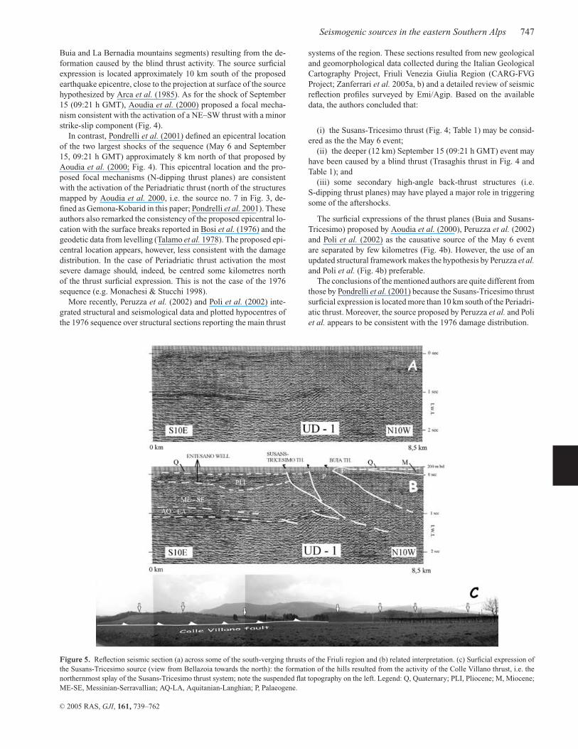
Figure 5. Reflection seismic section (a) across some of the south-verging thrusts of the Friuli region and (b) related interpretation. (c) Surficial expression ofthe Susans-Tricesimo source (view from Bellazoia towards the north): the formation of the hills resulted from the activity of the Colle Villano thrust, i.e. thenorthernmost splay of the Susans-Tricesimo thrust system; note the suspended flat topography on the left. Legend: Q, Quaternary; PLI, Pliocene; M, Miocene;ME-SE, Messinian-Serravallian; AQ-LA, Aquitanian-Langhian; P, Palaeogene.
systems of the region. These sections resulted from new geologicaland geomorphological data collected during the Italian GeologicalCartography Project, Friuli Venezia Giulia Region (CARG-FVGProject; Zanferrari et al. 2005a, b) and a detailed review of seismicreflection profiles surveyed by Emi/Agip. Based on the availabledata, the authors concluded that:
(i) the Susans-Tricesimo thrust (Fig. 4; Table 1) may be consid-ered as the the May 6 event;
(ii) the deeper (12 km) September 15 (09:21 h GMT) event mayhave been caused by a blind thrust (Trasaghis thrust in Fig. 4 andTable 1); and
(iii) some secondary high-angle back-thrust structures (i.e.S-dipping thrust planes) may have played a major role in triggeringsome of the aftershocks.
The surficial expressions of the thrust planes (Buia and Susans-Tricesimo) proposed by Aoudia et al. (2000), Peruzza et al. (2002)and Poli et al. (2002) as the causative source of the May 6 eventare separated by few kilometres (Fig. 4b). However, the use of anupdated structural framework makes the hypothesis by Peruzza et al.and Poli et al. (Fig. 4b) preferable.
The conclusions of the mentioned authors are quite different fromthose by Pondrelli et al. (2001) because the Susans-Tricesimo thrustsurficial expression is located more than 10 km south of the Periadri-atic thrust. Moreover, the source proposed by Peruzza et al. and Poliet al. appears to be consistent with the 1976 damage distribution.
C© 2005 RAS, GJI, 161, 739–762

748 F. Galadini, M. E. Poli and A. Zanferrari
Both hypotheses (Susans-Tricesimo and Periadriatic thrusts) arenot consistent with the geodetic solution, because Arca et al. (1985)and Briole et al. (1986) defined a source whose surficial expres-sion is located halfway between the two mentioned thrusts. In thiscase, however, some large aftershocks may have contributed so sig-nificantly to the continuous surficial deformation to condition thegeodetic source solution. In conclusion, the available data seemsto be more consistent with the activation of the Susans-Tricesimothrust during the May 6 event than with the activation of other re-verse faults of the investigated region.
The geometry of the source (Fig. 3) was obtained by means ofthe available reflection seismic profiles (Fig. 5). The seismic profileof Fig. 5 shows the deformation of the Quaternary deposits in thehangingwall of the fault. Secondary faults related to the Susans-Tricesimo thrust have been responsible for the discontinuous crop-ping out of Eocene turbiditic sequences in the Friulian plain andfor the formation of scarps with a WNW–ESE trend (Fig. 5c). As aresult of the fault activity, terraces of probable Pleistocene age aresuspended over the Friulian plain (Fig. 5c).
As for the September 15 (09:21 h GMT) event, the hypocentrelocation proposed by Poli et al. (2002) and Peruzza et al. (2002)after the revision of the entire seismic sequence and the more re-cent focal mechanisms (e.g. Aoudia et al. 2000; Pondrelli et al.2001) are consistent with the activation of a blind thrust (Fig. 4).This thrust defines the Trasaghis source in Fig. 3 and Table 1. Thesource geometry has been obtained by merging the structural datarepresented in the geological section of Fig. 4 and the knowledgeabout the regional trend of the Alpine structures with the seismolog-ical information (energy release, constraining the source geometry)related to the above mentioned event.
Because the 1976 earthquakes are the only instrumentally well-constrained strong events in the investigated area, the Susans-Tricesimo and Trasaghis sources are the only cases of earthquake–structure association that can be based on the comparison ofgeological and instrumental data.
6.1.2 Medea (no. 10 in Fig. 3 and Table 1)
South of the Susans-Tricesimo thrust system, the following struc-tures with evidence of Late Quaternary activity can be identified:the Udine-Buttrio, Pozzuolo and Medea thrusts (Figs 1, 4 and 6).The available reflection seismic profiles by Emi/Agip (e.g. Venturini1987; Merlini et al. 2002; Peruzza et al. 2002) and the borehole data
Figure 6. Geological section across the eastern Southern Alps in the Friuli region (d of Fig. 1). Legend: Q, Quaternary; N, Neogene; Pt, Palaeogene turbidites;Pp, Palaeocene carbonate platform; K, Cretaceous; J, Jurassic; TS, Upper Trias; CU, Carnic unconformity. The traces of the Palaeogene W-verging Dinaricthrusts are indicated by black triangles.
(Venturini 2002) show that the Pleistocene deposits are involved inthe deformation.
Surficial evidence of recent activity along the three mentionedthrusts derives from the slight tilting of the surface, which formedat the top of alluvial deposits related to the LGM (approximately19 000 BP) south of Udine (Zanferrari et al. 2005a). Prominentscarps affect the Friulian plain over the tip line of the buried thrusts(Fig. 7). For example, in the area Buttrio-Dolegna del Collio (easternsector of the Udine-Buttrio thrust), the significant uplift is demon-strated by the presence of Pleistocene erosional palaeolandsurfaces(of pedimentary origin) topographically suspended over the presentplain (Fig. 7c; Carobene 1984). Moreover, in the same sector, theactivity of the Udine-Buttrio thrust was responsible for the tiltingof Pleistocene conglomerates cropping out in the northern sector ofthe Buttrio hill (Feruglio 1929; Zanferrari et al. 2005a). The geolog-ical section obtained from the reflection seismic data (Figs 4 and 6)shows, however, that the western segment of the Udine-Buttrio thrustdevelops at the boundary between the Friulian carbonate platformand the Palaeogene turbiditic sequences. The displacement occurredalong the original contact between the two mentioned stratigraphicunits, as a result of the activity of the Udine-Buttrio thrust, whichramps in the Udine area, forming the scarp of Fig. 7(b). However,the scarce depth of the fault ramp (an almost horizontal attitudeis supposed at a maximum of 4 km below the surface; see Fig. 4)suggests that the fault is not the source of large magnitude earth-quakes. For these reasons, although the Udine-Buttrio thrust hasclear evidence of Late Quaternary activity, we do not consider it asan independent seismogenic source responsible for earthquakes withM ≥ 6.
Similar geomorphic and structural characteristics can be relatedto the Pozzuolo thrust (Figs 1 and 4). It is, indeed, characterizedby a prominent scarp with a trend similar to that of the Udine-Buttrio fault. The fault activity was responsible for the uplift of thePozzuolo, Variano and Orgnano hills (Comel 1946; Desio 1952;Zanferrari et al. 2005a), but the fault plane displays a low dip ata depth of few kilometres (Fig. 4). For this reason, also this thrustcannot be presently considered as the surficial expression of a sig-nificant seismogenic source.
In the case of the Udine-Buttrio and Pozzuolo thrusts, however,the presence of prominent scarps affecting Late Pleistocene land-forms (Fig. 7) suggests caution in excluding a seismogenic rolerelated to earthquakes with M ≥ 6. We cannot exclude, for ex-ample, a very recent phase of activation of the thrusts, responsible
C© 2005 RAS, GJI, 161, 739–762
Seismogenic sources in the eastern Southern Alps 749
Figure 7. (a) Structural model and digital elevation model (DEM) of the Udine area; the elevation model has been obtained from data of the Friuli-VeneziaGiulia Region (Regional Technical Numerical Map) at the 1:5000 scale (with precision comparable to the 1:2000 scale and uncertainty of ±40 cm in the flatareas); the average density of points for which the elevation is available is 2 per square of 100 × 100 m; the DEM has been calculated with steps of 50 m; linesdefine elevation differences of 1 m; numbers define elevation in metres above sea level; (b) panoramic view (from south) of the Pasian di Prato scarp related tothe Udine-Buttrio fault; (c) view from the uplifted terraces of the Buttrio area; (d) panoramic view (from south) of the Medea hill, uplifted by the activity ofthe Medea thrust.
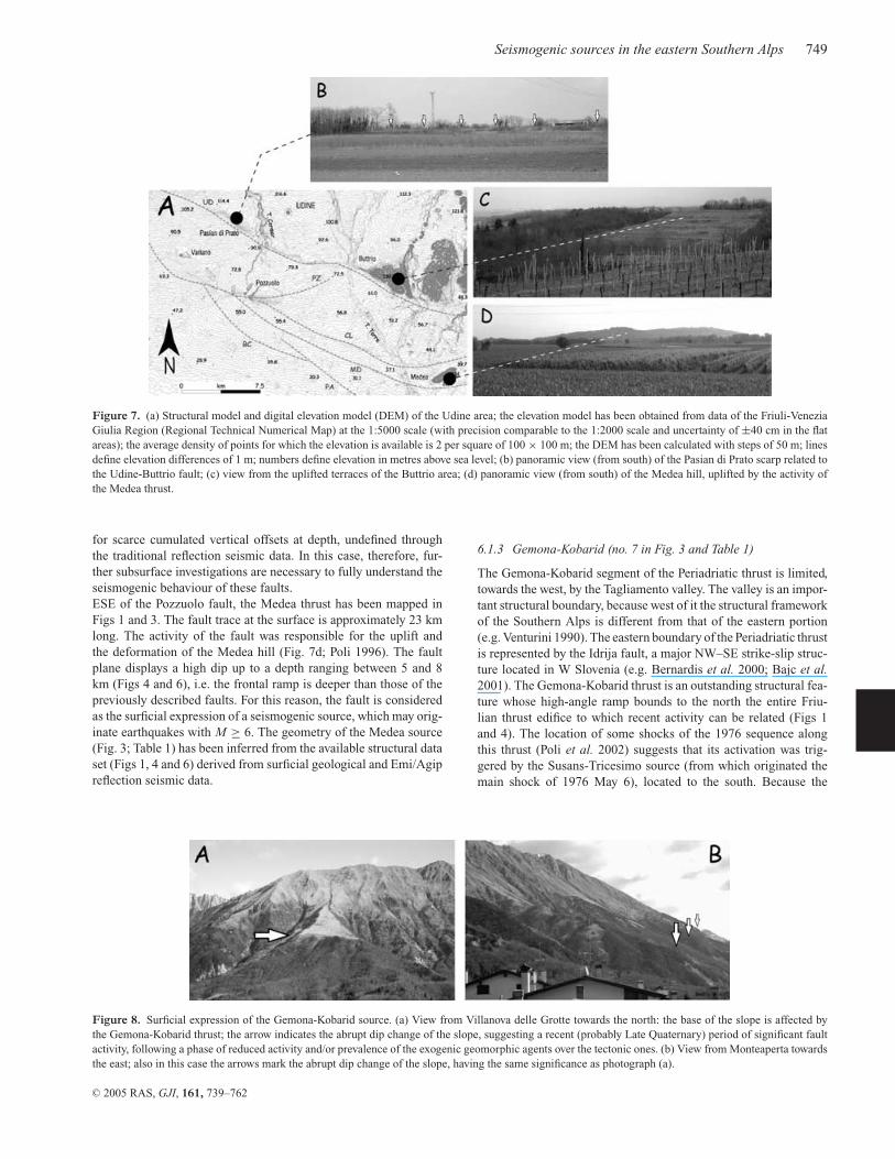
for scarce cumulated vertical offsets at depth, undefined throughthe traditional reflection seismic data. In this case, therefore, fur-ther subsurface investigations are necessary to fully understand theseismogenic behaviour of these faults.ESE of the Pozzuolo fault, the Medea thrust has been mapped inFigs 1 and 3. The fault trace at the surface is approximately 23 kmlong. The activity of the fault was responsible for the uplift andthe deformation of the Medea hill (Fig. 7d; Poli 1996). The faultplane displays a high dip up to a depth ranging between 5 and 8km (Figs 4 and 6), i.e. the frontal ramp is deeper than those of thepreviously described faults. For this reason, the fault is consideredas the surficial expression of a seismogenic source, which may orig-inate earthquakes with M ≥ 6. The geometry of the Medea source(Fig. 3; Table 1) has been inferred from the available structural dataset (Figs 1, 4 and 6) derived from surficial geological and Emi/Agipreflection seismic data.
Figure 8. Surficial expression of the Gemona-Kobarid source. (a) View from Villanova delle Grotte towards the north: the base of the slope is affected bythe Gemona-Kobarid thrust; the arrow indicates the abrupt dip change of the slope, suggesting a recent (probably Late Quaternary) period of significant faultactivity, following a phase of reduced activity and/or prevalence of the exogenic geomorphic agents over the tectonic ones. (b) View from Monteaperta towardsthe east; also in this case the arrows mark the abrupt dip change of the slope, having the same significance as photograph (a).
6.1.3 Gemona-Kobarid (no. 7 in Fig. 3 and Table 1)
The Gemona-Kobarid segment of the Periadriatic thrust is limited,towards the west, by the Tagliamento valley. The valley is an impor-tant structural boundary, because west of it the structural frameworkof the Southern Alps is different from that of the eastern portion(e.g. Venturini 1990). The eastern boundary of the Periadriatic thrustis represented by the Idrija fault, a major NW–SE strike-slip struc-ture located in W Slovenia (e.g. Bernardis et al. 2000; Bajc et al.2001). The Gemona-Kobarid thrust is an outstanding structural fea-ture whose high-angle ramp bounds to the north the entire Friu-lian thrust edifice to which recent activity can be related (Figs 1and 4). The location of some shocks of the 1976 sequence alongthis thrust (Poli et al. 2002) suggests that its activation was trig-gered by the Susans-Tricesimo source (from which originated themain shock of 1976 May 6), located to the south. Because the
C© 2005 RAS, GJI, 161, 739–762

750 F. Galadini, M. E. Poli and A. Zanferrari
Gemona-Kobarid thrust affects a mountainous environmentpresently experiencing strong erosion, the surficial evidence of re-cent activity cannot be comparable to that of the thrusts affecting theFriulian plain. Actually, only some geomorphic indication of recentactivity is available. Most of the carbonate slope forming the emer-gent thrust hangingwall displays triangular facets and suspendedlandscapes, which suggest hangingwall uplift (Fig. 8a). Moreover,the slope shows a general convex-upwards profile, with a promi-nent scarp in the piedmont area (Fig. 8b), whose formation maybe the result of the interaction between linear differential erosionalong the thrust surficial expression and hangingwall uplift. Surfacebreaks have been detected after the 1976 May 6 shock along a sec-ondary thrust (Mount Cuarnan). However, as previously reported,these coseismic ruptures have been differently interpreted both astectonic (Bosi et al. 1976) and as gravitational (Cavallin et al. 1977).Finally, the displacement of speleothems observed in some caves ofthe Tagliamento river area (Mocchiutti & D’Andrea 2002) may rep-resent the effect of movements along secondary faults related tothe Gemona-Kobarid thrust. The mentioned authors reported thetilt of stalactite axes and the displacement of active karstic con-duits. The displacements range between a few millimetres and somecentimetres.
The Gemona-Kobarid source has been defined on the basis of thedeep fault geometry reported in Fig. 4, reconstructed by means ofstructural surficial data and the knowledge on the regional structuralstyle at depth.
On the whole, the structural framework of Fig. 3 for the area eastof the Tagliamento river is quite different from that summarized inCNR-PFG (1987). Recent NW–SE (Dinaric) trending thrusts arereported in the latter throughout most of the region. These faultsare completely substituted, in Fig. 3, by Alpine thrusts and relatedseismogenic sources. This option is consistent with the already men-tioned Neogene–Quaternary strong structural influence of the inher-ited Palaeogene NW–SE thrusts (Peruzza et al. 2002).
6.2 The seismogenic sources of the Tagliamento river—Thiene sector
Although the previous inventories (e.g. Castaldini & Panizza 1991)presented numerous active faults affecting also the Alpine area,our structural and geomorphologic investigations indicate that con-clusive evidence for active faulting can only be related to the socalled Aviano line (Castaldini & Panizza 1991), i.e. the approx-imately 100-km-long thrust fault system bordering the E Vene-
Figure 9. Geomorphologic scheme of the Asolo-Conegliano area (shaded relief image from altimetric data available on the map of the Istituto GeograficoMilitare at the 1:25 000 scale). Uplifted palaeolandscapes can be observed NW of the Bassano-Cornuda and Montello-Conegliano thrusts. The uplift of theMontello relief conditioned the drainage of the Piave river (see text for further details).
tian and W Friulian plain (made of the Thiene-Bassano fault, TB,Bassano-Cornuda fault, BC, Montello fault, MT, Cansiglio fault,CA, Polcenigo-Maniago fault, PM, and Arba-Ragogna fault, AR,thrusts of Fig. 1). Observed geomorphic features testify to signifi-cant vertical movements along this structure, as indicated by upliftedterraces, abandoned river valleys, subsiding sectors close to thrustsurficial expressions and gentle scarps affecting recent depositionalsurfaces. For this reason, we focused our attention on this structureand tried to define fault segments and related sources.
The Aviano line has been segmented by mapping the differentfault branches on the basis of their geomorphic expressions and sub-surficial structural data. The segments of this compressive structureusually mark the borders of mature landscapes carved on Neogene–Quaternary sediments, suspended over the present plain.
6.2.1 Montello-Conegliano (no. 3 in Fig. 3 and Table 1)
The Montello plateau is probably the most evident case of upliftedlandscape (Fig. 9). It is carved on conglomerates and sands of LatePliocene—Early Pleistocene age, according to Fantoni et al. (2002)and data from works in progress by authors of the present paper.The plateau is affected by intense karstic erosion indicated by theabundance of dolines and it is suspended up to 150 m above thepresent Venetian plain; an abandoned valley (palaeo-Piave river) af-fects its SW termination, while the present Piave river flows to theN of the Montello hill (Ferrarese et al. 1998; Benedetti et al. 2000).According to the two mentioned works, the terrace formation isthe consequence of the Montello uplift resulting from the activityof the underlying blind thrust. Each terrace marks a phase of riverdeepening as a result of the increase of the relief. The surficial karstmorphology clearly indicates the diachroneity of the landforms be-ing much more mature in the older than in the younger terraces(Ferrarese et al. 1998). Moreover, NW–SE topographic profilesindicate that the different terraces are characterized by a convexmorphology, resulting from the tectonic warping. The convexity ismore evident in the older than in the younger terraces, thus indi-cating a continuity of the tectonic activity during time. Accordingto Benedetti et al. (2000), the terrace formation occurred in a timeinterval covering the last 0.35 Myr, while the abandonment of thepalaeo-Piave valley occurred between 14 000 and 8000 BP.
The SW end of the Montello structure is defined by a clear peri-clinal attitude of the anticline. The NE prolongation of the structureis represented by the SE border of the Conegliano palaeolandscape(Fig. 9), a dissected and incised terrace with probable remnants of the
C© 2005 RAS, GJI, 161, 739–762

Seismogenic sources in the eastern Southern Alps 751
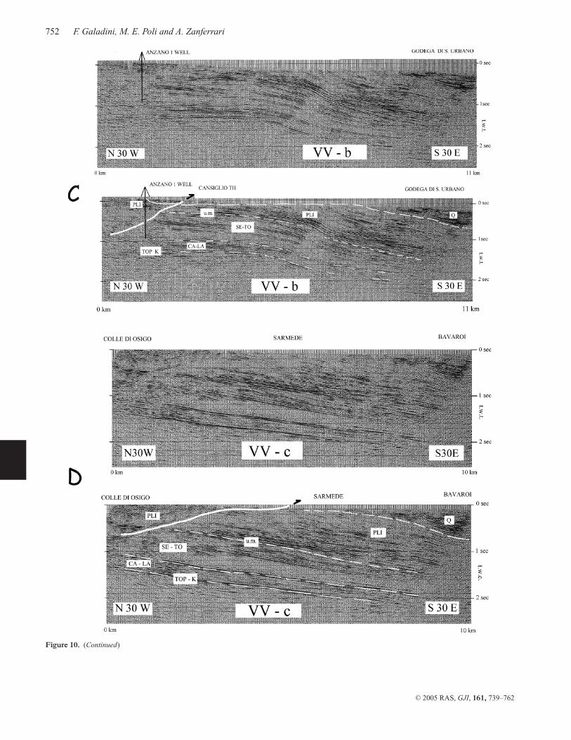
Figure 10. (a) Geological framework of the area between Conegliano and Polcenigo (Montello-Conegliano, Cansiglio and Polcenigo-Maniago thrusts).Legend: 1, Quaternary deposits; 1a, moraine of the Vittorio Veneto LGM glacial tongue; 2, Conegliano succession (clays, sands, conglomerates; Pliocene–?Pleistocene, pp); 3, terrigenous-carbonate succession (Oligocene–Miocene); 4, carbonate successions (Jurassic–Cretaceous), Scaglia Rossa Formation (lowerEocene—upper Cretaceous), marly–arenaceous flysch (Eocene); 5, thrust; 6, strike-slip fault; 7, transpressional fault. (b, c, d) reflection seismic sections(see inset a for location) across the Montello-Conegliano and Cansiglio thrusts and related interpretations. Legend: Q, Quaternary; PLI, Pliocene; SE-TO,Serravallian-Tortonian; CA-LA, Chattian-Langhian; TOP K, top of the Cretaceous carbonate platform; um, Messinian unconformity.
C© 2005 RAS, GJI, 161, 739–762
752 F. Galadini, M. E. Poli and A. Zanferrari
Figure 10. (Continued)
C© 2005 RAS, GJI, 161, 739–762
Seismogenic sources in the eastern Southern Alps 753
Figure 11. Geological section across the southern margin of the eastern Southern Alps in the Montello area as derived from the data published by Fantoni et al.(2001) and structural surficial data (see Fig. 1 for location). Legend: PsQ, Upper Pliocene-Quaternary; PLI, Oligo-Miocene; P, Palaeogene; Kb, Cretaceous(basin); Kp, Cretaceous (platform); J, Jurassic; TS, Upper Trias; PT, Permo-Trias; BAS, magnetic basement.
depositional top surface, carved on a pelitic–conglomeratic complexof Late Pliocene—Early (Middle?) Pleistocene age (Fantoni et al.2002, for the age).
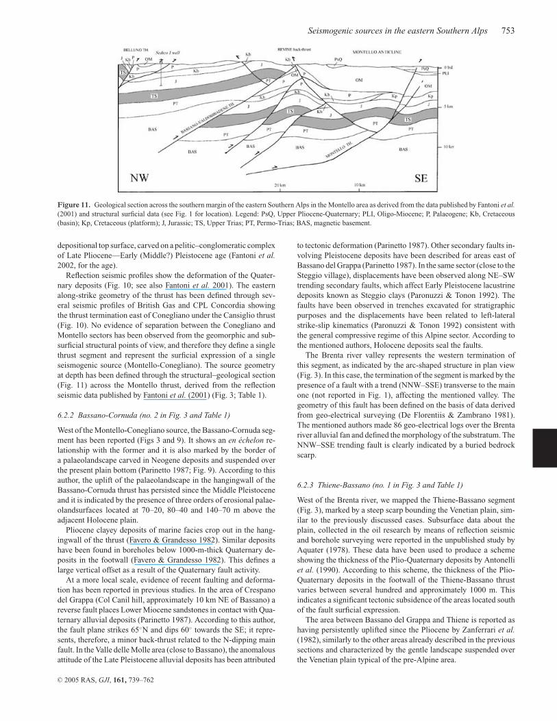
Reflection seismic profiles show the deformation of the Quater-nary deposits (Fig. 10; see also Fantoni et al. 2001). The easternalong-strike geometry of the thrust has been defined through sev-eral seismic profiles of British Gas and CPL Concordia showingthe thrust termination east of Conegliano under the Cansiglio thrust(Fig. 10). No evidence of separation between the Conegliano andMontello sectors has been observed from the geomorphic and sub-surficial structural points of view, and therefore they define a singlethrust segment and represent the surficial expression of a singleseismogenic source (Montello-Conegliano). The source geometryat depth has been defined through the structural–geological section(Fig. 11) across the Montello thrust, derived from the reflectionseismic data published by Fantoni et al. (2001) (Fig. 3; Table 1).
6.2.2 Bassano-Cornuda (no. 2 in Fig. 3 and Table 1)
West of the Montello-Conegliano source, the Bassano-Cornuda seg-ment has been reported (Figs 3 and 9). It shows an en echelon re-lationship with the former and it is also marked by the border ofa palaeolandscape carved in Neogene deposits and suspended overthe present plain bottom (Parinetto 1987; Fig. 9). According to thisauthor, the uplift of the palaeolandscape in the hangingwall of theBassano-Cornuda thrust has persisted since the Middle Pleistoceneand it is indicated by the presence of three orders of erosional palae-olandsurfaces located at 70–20, 80–40 and 140–70 m above theadjacent Holocene plain.
Pliocene clayey deposits of marine facies crop out in the hang-ingwall of the thrust (Favero & Grandesso 1982). Similar depositshave been found in boreholes below 1000-m-thick Quaternary de-posits in the footwall (Favero & Grandesso 1982). This defines alarge vertical offset as a result of the Quaternary fault activity.
At a more local scale, evidence of recent faulting and deforma-tion has been reported in previous studies. In the area of Crespanodel Grappa (Col Canil hill, approximately 10 km NE of Bassano) areverse fault places Lower Miocene sandstones in contact with Qua-ternary alluvial deposits (Parinetto 1987). According to this author,the fault plane strikes 65◦N and dips 60◦ towards the SE; it repre-sents, therefore, a minor back-thrust related to the N-dipping mainfault. In the Valle delle Molle area (close to Bassano), the anomalousattitude of the Late Pleistocene alluvial deposits has been attributed
to tectonic deformation (Parinetto 1987). Other secondary faults in-volving Pleistocene deposits have been described for areas east ofBassano del Grappa (Parinetto 1987). In the same sector (close to theSteggio village), displacements have been observed along NE–SWtrending secondary faults, which affect Early Pleistocene lacustrinedeposits known as Steggio clays (Paronuzzi & Tonon 1992). Thefaults have been observed in trenches excavated for stratigraphicpurposes and the displacements have been related to left-lateralstrike-slip kinematics (Paronuzzi & Tonon 1992) consistent withthe general compressive regime of this Alpine sector. According tothe mentioned authors, Holocene deposits seal the faults.
The Brenta river valley represents the western termination ofthis segment, as indicated by the arc-shaped structure in plan view(Fig. 3). In this case, the termination of the segment is marked by thepresence of a fault with a trend (NNW–SSE) transverse to the mainone (not reported in Fig. 1), affecting the mentioned valley. Thegeometry of this fault has been defined on the basis of data derivedfrom geo-electrical surveying (De Florentiis & Zambrano 1981).The mentioned authors made 86 geo-electrical logs over the Brentariver alluvial fan and defined the morphology of the substratum. TheNNW–SSE trending fault is clearly indicated by a buried bedrockscarp.
6.2.3 Thiene-Bassano (no. 1 in Fig. 3 and Table 1)
West of the Brenta river, we mapped the Thiene-Bassano segment(Fig. 3), marked by a steep scarp bounding the Venetian plain, sim-ilar to the previously discussed cases. Subsurface data about theplain, collected in the oil research by means of reflection seismicand borehole surveying were reported in the unpublished study byAquater (1978). These data have been used to produce a schemeshowing the thickness of the Plio-Quaternary deposits by Antonelliet al. (1990). According to this scheme, the thickness of the Plio-Quaternary deposits in the footwall of the Thiene-Bassano thrustvaries between several hundred and approximately 1000 m. Thisindicates a significant tectonic subsidence of the areas located southof the fault surficial expression.
The area between Bassano del Grappa and Thiene is reported ashaving persistently uplifted since the Pliocene by Zanferrari et al.(1982), similarly to the other areas already described in the previoussections and characterized by the gentle landscape suspended overthe Venetian plain typical of the pre-Alpine area.
C© 2005 RAS, GJI, 161, 739–762

754 F. Galadini, M. E. Poli and A. Zanferrari
Figure 12. Photomosaic of aerial photographs (survey 1954, Istituto Geografico Militare) of the Cansiglio-Aviano area. The traces (projected at surface) ofthe Cansiglio and Polcenigo-Maniago thrusts have been reported, together with the main geomorphic features related to the thrust activity.
The vertical movements in the area east of Thiene are also evidentin the continuous erosion of the pre-Quaternary basement alongsectors of the Astico river valley (approximately 4 km north andeast of Thiene) south of the Alpine front (Bartolomei 1976). Basedon borehole data, the pre-LGM valley was even deeper than thepresent one. Indeed, a 56-m-thick alluvial succession has been foundin the area close to the scarp representing the surficial expression ofthe thrust (Bartolomei 1976). Moreover, also the anomalous Asticoriver course may have been conditioned by the uplift of this sector.The Astico valley was probably characterized by a palaeodrainagetowards the south, i.e. towards Thiene, until the Middle Pleistocene(Bartolomei 1976). In contrast, it is presently characterized by a rivercourse having an E–W direction in the pre-Alpine sector and onlyafter a 4-km-long anomalous course direction it displays a NNW–SSE drainage. According to Bartolomei (1976), the present valleyresults from the shift of the palaeo-Astico course as a result of aMiddle Pleistocene glacial tongue, and from the capture by a formerminor river having a direction approximately N–S and experiencingregressive erosion. River regressive erosion is the typical effect ofthe areal uplift.
The western termination of the Thiene-Bassano segment is repre-sented by a NW–SE transverse fault in CNR-PFG (1987). Hydroge-ological data reported by Antonelli et al. (1990) are consistent withthe presence of this fault. Piezometric isolines are, indeed, trendingNW–SE in this sector and very close to one another, thus showinga very steep gradient of the aquifer piezometric surface.
6.2.4 Cansiglio (no. 4 in Fig. 3 and Table 1)
In the portion of the Venetian-Friulian plain south of the Cansigliomassif (Figs 3 and 12), the base of the Quaternary deposits hasbeen identified at approximately 900 m below the sea level on thebasis of unpublished reflection seismic surveys by Eni/Agip. Thisthick wedge of Quaternary deposits defines a continuous recentsubsidence of the plain area at the front of the Cansiglio thrust andrepresents the most striking evidence of the recent fault activity.
Late Quaternary activity of the Cansiglio thrust is also demon-strated by the displacement of post-LGM stratified slope depositsalong the fault surficial expression (Fig. 13). A colluviated palaeosolunderlying these deposits has been radiocarbon dated at 26 640 ±240 BP. This indicates that the deposition of the slope deposits hasprobably to be related to the LGM. This hypothesis is also cor-roborated by the facies of the sediments, which is similar to that ofother deposits found along the Alpine slopes and generally attributedto Late Pleistocene periglacial deposition (e.g. Bartolomei 1974;Castiglioni et al. 1979; Galadini et al. 2001c). Segmentation andthe source geometry have been inferred from the surficial structuraland reflection seismic data (Figs 3 and 14; Table 1).
Finally, the Cansiglio segment is generally considered as thesource of the 1936 earthquake (Sirovich et al. 2000; Valensise& Pantosti 2001), on the basis of the processing of the intensitydata point distribution (methods by Gasperini et al. 1999; Pettenatiet al. 1999). According to Sirovich et al. (2000), the source strikes232◦ (52◦NE) if the intensity distribution reported in Monachesi &Stucchi (1998) is used and 212◦ (32◦NE) if the used intensity dis-tribution is that by Boschi et al. (1995). The strike proposed inValensise & Pantosti (2001)) is 230◦ (50◦NE), quite similar to thesolutions proposed by Sirovich et al. (2000).
NNE–SSW trending surface breaks formed some hours before theearthquake, transverse to the road between the villages of Fiaschettiand Sarone in the SE frontal sector of the Cansiglio massif (Andreotti1937). Although the strike of these breaks is consistent with that ofthe thrust, their origin is unclear.
6.2.5 Polcenigo-Maniago (no. 5 in Fig. 3 and Table 1)
The terrace levels suspended over the Friulian plain and parallelto the Polcenigo-Maniago thrust segment represent the most directeffect of the recent hangingwall uplift along the mentioned fault(Fig. 12). Gentle scarps on the top of depositional surfaces of al-luvial fans can be detected along the entire segment together withevident drainage anomalies. For example, the uplift of the Col Pizzochill in the Polcenigo area has caused the abandonment of a fluvial
C© 2005 RAS, GJI, 161, 739–762

Seismogenic sources in the eastern Southern Alps 755
Figure 13. Displaced slope deposits in the Caneva area, at the front of the Cansiglio thrust (see Fig. 12 for location): (a) panoramic view; (b, c, d) details ofthe displacement; (e) schematic log of the outcrop. Based on the radiocarbon dating of the colluviated palaeosol (26 640 ± 240 BP), the displacement is notolder than the uppermost Late Pleistocene, as slope deposits more recent than the reported date are displaced and dragged along the main fault plane (on theright of the photograph, placing the carbonate bedrock in contact with the slope deposits) and displaced along secondary shear planes in the central part of theoutcrop.
incision cutting through the hill (Fig. 12). The river that formedthis valley flowed towards the south, but the uplift of Col Pizzoctriggered the capture by the Livenza river (flowing around the up-lifting area) and the abandonment of the valley crossing the hill,with a process similar to that observed in the Montello area. Theeastern portion of the Polcenigo-Maniago thrust probably affects thealluvial fan fed by the Artugna river, between Budoia and Castellod’Aviano. The dip of the top depositional surface of the fan evidentlyincreases in the area where the maximum surficial deformation as aresult of the thrust activity is expected (Fig. 12). Terracing resultingfrom uplift affects the eastern sector, between Castello d’Aviano
and Montereale Valcellina, east of the area of Fig. 12 (Aviglianoet al. 2002a). According to these authors, remnants of Pleistocenealluvial sediments (and the related mature soils) deposited by theCellina river are suspended by 10–30 m over the surface of the LatePleistocene alluvial fan, as a result of the uplift of this sector. Thesoils that developed over these alluvial remnants are definitely moreevolved than those that developed over the recent fan (Aviglianoet al. 2002a).
The huge vertical displacement related to the Polcenigo-Maniagothrust is indicated by the depth of the base of the Quaternary deposits(in front of Aviano: at approximately 450 m below sea level), derived
C© 2005 RAS, GJI, 161, 739–762

756 F. Galadini, M. E. Poli and A. Zanferrari
Figure 14. Geological section across the southern margin of the eastern Southern Alps in the Cansiglio area as derived from surficial geological and structuraldata and subsurficial information (see text for further explanation and Fig. 1 for location). Legend: Q, Quaternary; OM, Oligo-Miocene; KP, Cretaceous(platform); TS, Upper Trias; PT, Permo-Trias; BM, magnetic basement; KB, Cretaceous (basin); JK-B, Jurassic–Cretaceous (basin).
Figure 15. (a) Photomosaic of aerial photographs (survey 1954, Istituto Geografico Militare) of the Maniago-Valeriano area. The trace (projected at surface)of the Arba-Ragogna thrust has been reported, together with the main geomorphic features related to the thrust activity. (b) Displaced lacustrine deposits inthe Mount Iouf area (see b for location); the displacement is probably a result of the activity of a secondary thrust related to the Arba-Ragogna source. (c)Panoramic view of the Sequals area from east: the low hills representing the surficial expression of the thrusts are visible.
from unpublished Eni/Agip reflection seismic surveys. Segmenta-tion and the source geometry (Fig. 3; Table 1) have been inferredfrom the surficial structural data and the related extrapolation atdepth (Fig. 14).
6.2.6 Arba-Ragogna (no. 6 in Fig. 3 and Table 1)
Recent geomorphologic investigations showed that, similarly to thepreviously discussed cases, also in the case of the Arba-Ragognathrust the evidence of recent activity mainly consists of subsidingareas and uplifted terraces along the fault surficial expression anddisplacement of Late Quaternary deposits (Fig. 15).
In the area of Mount Iouf, approximately 3 km north of Maniago,lacustrine deposits dated at 10 360–10 190 BP (1 sigma radiocarboncal. age) have been mapped in the ‘Maniago’ sheet (1:50 000) ofthe new geological map of Italy (Zanferrari et al. 2005b). The de-posits are displaced by small-scale faults (Fig. 15b) tilted and gentlyfolded by the thrust activity. Close to Sequals, an actively subsid-ing area has conditioned the deposition of alluvial fan deposits atleast since the LGM and the formation of a Holocene marshy area(Avigliano et al. 2002b; Fig. 15a). Towards the east, Late Quaternaryalluvial deposits in the area of Pinzano (close to the eastern segmenttermination) are tilted by the thrust activity. As a consequence ofthe deformation, the deposits are dipping towards the SE instead of
C© 2005 RAS, GJI, 161, 739–762
Seismogenic sources in the eastern Southern Alps 757
the SW (representing the primary attitude related to the local allu-vial fan deposition; Zanferrari et al. 2005b). The NE termination ofthe Arba-Ragogna thrust is represented by the Ragogna anticline.Recent investigations showed that the top surface of fluvioglacialdeposits related to the LGM (dated at 23 040–22 240 BP, 1 sigmaradiocarbon cal. age) is displaced by approximately 4 m in the areaof the Ponte creek (southern limb of the Ragogna anticline; Zan-ferrari et al. 2005b). The creek is superimposed on the fault, whichdisplaces the surface, as fluvial and fluvioglacial deposits cannot becorrelated across the two banks.
7 D I S C U S S I O N
7.1 The identification of the Alpine active faults
In the previous sections, we tried to define the seismogenic sourcespotentially responsible for earthquakes with M ≥ 6 in the easternSouthern Alps. It is evident from Fig. 3 that these sources affect thearea between the Alpine relief, and the Venetian and Friulian plains.No other significant evidence of recent fault activity has been ob-served north and south of the sector affected by the reported thrusts.It needs to be mentioned, however, that the lack of evidence of recentactivity in the mountainous region may have been conditioned bythe erosional–depositional geological evolution of the Alps since theLGM. Intense erosion by the glacial tongues and subsequent rapiddeposition of thick successions of alluvial deposits may have hiddenthe evidence of recent fault activity. On this basis, the presence ofsignificant seismogenic sources within the Alpine domain, thoughimprobable, cannot be completely excluded. Moreover, the lack ofsurficial evidence (both geomorphic and structural) of the Trasaghisthrust suggests the possibility that other unknown sources, presentlyundetectable but potentially responsible for M ≥ 6 earthquakes, mayaffect the investigated territory, particularly in the structurally morecomplicated Friulian sector.
7.2 Kinematic aspects
Both the surficial structural and geodetic investigations (e.g.Castellarin et al. 1992; Caporali & Martin 2000) and the directionsof the regional stresses obtained through inversion of seismologicaldata (Bressan et al. 1998; Slejko et al. 1999) contributed to defineslip vectors on the reported thrust planes (Table 1). Structural sur-ficial data gave direct information on the kinematics of the faultplanes, generally in the hangingwall sectors, where deformed rocksare exposed. Moreover, all the available geological and geophysicaldata indicate that the investigated region is experiencing deforma-tion conditioned by a subhorizontal NNW–SSE (western sector) toN–S (central-eastern sector) trending σ 1. The comparison betweenthe 3-D thrust geometry with the σ 1 directions and the surficial datahave permitted to infer the slip vectors reported in Table 1.
Another fundamental kinematic aspect, i.e. the slip rate, is stillpoorly defined. The data reported in Table 1 indicate slip rates≤ 1 mm yr−1, but in almost all the described cases the evaluationsare from geomorphologic investigations of more than one decadeago (Castaldini & Panizza 1991). Minimum slip rates could be ob-tained, for some thrusts, from the depth of the base of the Quaternarydeposits in the footwall of the faults. This evaluation needs, how-ever, the definition of the original depositional altitude of the EarlyQuaternary sediments. The Quaternary deposition in the Venetianand Friulian plains has been conditioned by the different standingsof the sea level. In fact, during low-standing periods, the Adriatic
sea shoreline was many kilometres south of the present shoreline.This may have conditioned the formation of troughs in the pre-Alpine area subsequently filled by Quaternary deposits during themarine ingressions and the high-standing phases (Castiglioni et al.2001). Therefore, the present depth of Quaternary deposits belowthe plains in the pre-Alpine areas may not be solely a result of thethrust vertical movements.
Assuming that the sea level during low-standing periods reachednegative elevations comparable with that of the LGM (see Haq et al.1987 on this point), i.e. 100–150 m below the present sea level (e.g.Bosi et al. 1996), we can obtain information about the minimumvertical offset related to some thrusts reported in Fig. 3. Indeed,the minimum offset can be evaluated by considering the presentdepth of the base of the Quaternary deposits as a direct result ofthe footwall lowering. Or, alternatively, we can correctly estimatethe minimum offset from this depth once the possibility that thesediments originally deposited at an elevation lower than the presentsea level (i.e. during a low-standing period or during an ingressionphase) is considered. In this case, taking into account the magnitudeof the negative oscillations of the sea level, we have to subtract 100–150 m from the present depth of the deposits to obtain the minimumvertical offset.
In both cases [i.e. (i), considering the present depth as a directresult of the vertical offset or, (ii), considering the depth as theeffect of the vertical slip once 100–150 m has been subtracted], weare dealing with minimum offsets, because no deposits that can beclearly attributed to the Quaternary in the hangingwall of the thrustshave been found so far (note that the attribution of some depositsof the Montello hill to the Early Quaternary by Fantoni et al. 2002must still be considered as preliminary).
Taking into account these problems, we hypothesize a Quaternaryminimum vertical slip rate of 0.42–0.5 mm yr−1 for the Bassano-Cornuda thrust, based on the present depth of the deepest Quaternarydeposits at approximately 1000 m below the surface in the footwallof the thrust (see the section dedicated to the seismogenic sources).This value has been obtained by dividing the two extreme minimumoffsets (i.e. 1000 and 850 m, the latter considering an original de-position at an elevation 150 m below the present sea level) by thetime span of the entire Quaternary period.
Following the same procedure, a similar value (0.4–0.47 mm yr−1)can be estimated for the Cansiglio thrust, considering the base ofthe Quaternary deposits located at approximately 950 m below thesurface.
A Quaternary minimum vertical slip rate of 0.17–0.25 mm yr−1
can be estimated for the Polcenigo-Maniago thrust, because the baseof the Quaternary deposits is located at approximately 500 m belowthe surface (see the section dedicated to the seismogenic sources).
The seismic section VV–a reported in Fig. 10b, permits to hy-pothesize the minimum vertical offset of the Montello-Coneglianothrust in the area of San Fior (Fig. 10a). The base of the Quaternarydeposits is defined at approximately 0.8 s two travel time. The inver-sion of (velocity 2 000 m s−1) defines a depth of approximately 800m. This permits to evaluate a minimum vertical slip rate of 0.32–0.4 mm yr−1. Benedetti et al. (2000) suggested an uplift rate of1 mm yr−1 in the last 121 Kyr (Table 1), on the basis of geomorpho-logical investigations along deformed river terraces.
As for the Arba-Ragogna thrust, the total vertical offset (4 m)affecting fluvioglacial deposits dated at 23 040–22 240 BP (see thesection dedicated to the seismogenic sources) permits to evaluate avertical slip rate of 0.17 mm yr−1. We consider it as a minimum sliprate, because it has been derived from the offset estimated in an area
C© 2005 RAS, GJI, 161, 739–762

758 F. Galadini, M. E. Poli and A. Zanferrari
close to the eastern fault termination (i.e. in the sector of the thrustoblique ramp).
In the area close to the Pozzuolo and Medea thrusts (footwall sec-tor), the base of the Quaternary deposits has been found at approxi-mately 450 m below the surface on the basis of unpublished reflec-tion surveys by Emi/Agip. Following the same procedure adoptedin the previous cases, this value permits to estimate a minimumvertical slip rate of 0.15–0.22 mm yr−1.
As for the Thiene-Bassano and Susans-Tricesimo thrusts, data onthe base depth of the Quaternary deposits are too sparse to definevertical offsets. For example, in the case of the Thiene-Bassanothrust, only the base depth of undefined Plio-Quaternary depositscan be recognized. As for the Gemona-Kobarid thrust, a Quaternaryslip rate cannot be hypothesized because of the lack of Quaternarydeposits or dated Quaternary landforms displaced by the fault.
7.3 Historical earthquakes and sources:hypotheses and implications
Based on the rupture length, downdip rupture width and rupturearea, the sources reported in Fig. 3 and Table 1 may be responsiblefor earthquakes with M ≥ 6.
Three of these sources have been defined by taking into ac-count also the available seismological data related to the 1936, 1976(May 6), 1976 (September 15) events (see the sections dedicatedto the description of the seismogenic sources). For this reason,these earthquakes have been associated with the Cansiglio, Susans-Tricesimo and Trasaghis sources, respectively.
West of the Cansiglio source, hypotheses about the correla-tion between the Montello source and some historical earthquakes(778, 1268 and 1859) have been made by Benedetti et al. (2000).This correlation is, however, based on faint evidence because his-torical knowledge about the 778 and 1268 events is sparse (see thesection dedicated to the seismicity). As for the 1859 earthquake, itis in fact a small earthquake, reported with M m 4 in Working GroupCPTI (1999). Earthquakes like that of 1859 are quite frequent in theinvestigated area but, as a result of the small size of the rupture atdepth, the correlation with a larger source cannot be reliable withoutinstrumental data.
The available catalogues (e.g. Working Group CPTI 1999) donot report significant earthquakes that may be reliably linked to theMontello-Conegliano thrust (Fig. 2). Considering that historical dataprobably give comprehensive information about the occurrence ofstrong earthquakes (no large magnitude earthquakes are missing inthe catalogue) in this Italian sector since AD 1200 (Stucchi & Albini2000), it is probable that the Montello-Conegliano source has beensilent at least during the last eight centuries. Our conclusions areconsistent with those by Valensise & Pantosti (2001) who defined asource not affected by historical earthquakes in the Montello area.
A similar conclusion, i.e. a silent condition for the last eightcenturies, may be drawn for the Arba-Ragogna and Medea sources.Available historical information, indeed, does not permit to identifyM ≥ 6 earthquakes occurred in the sector affected by these sources(Working Group CPTI 1999) (Fig. 2).
The definition of possible historical activity is definitely morecomplicated for the Thiene-Bassano thrust. Also, in this case, noearthquakes are reported in the catalogues that may be related tothis source. Catalogues report the 1117 earthquake in the Veronaarea (e.g. Working Group CPTI 1999), but recent investigationsinto this earthquake indicated that it may have originated east ofVerona (Galadini et al. 2001a). If this is true, the Thiene-Bassanosource may be the cause of this event. In this case too, this is a sourcethat has been silent for the last eight centuries.
Seven other earthquakes with M ≥ 6 occurred in the areas af-fected by the sources defined in the previous sections. We tried,therefore, to associate the earthquakes with the sources reportedin Fig. 3. This has been made by following already published pro-cedures (Galadini et al. 1999; Meletti et al. 2000): a comparisonis drawn between the damage distribution of the earthquake and ageologically inferred source geometry. The highest intensity datapoints should be mainly located in the thrust hangingwall (with amore limited distribution around the source) and no other sourcethat may be consistent with a certain damage distribution shouldaffect the earthquake area. Following this procedure, it can be seenthat most of the 1695 earthquake damage distribution occurred in thehangingwall of the Bassano-Cornuda thrust (Fig. 16). Moreover, theearthquake magnitude (M e 6.67 according to Working Group CPTI1999) is consistent with the dimensions of the source (e.g. Wells& Coppersmith 1994). On this basis, we hypothesize that the 1695earthquake was caused by the activation of the Bassano-Cornudasource.
The definition of the 1348, 1511 and 1873 earthquake sources ismore difficult. The former event affected a very large area, as it wasresponsible for damage in the Gail Valley (Austria), in Slovenia andin the Gemona area (Hammerl 1994). We tentatively hypothesizethat the earthquake originated from the activation of the Gemona-Kobarid portion of the Periadriatic thrust, because it seems to be theonly active fault segment that may justify the damage distributionrelated to this earthquake (Fig. 16). Indeed, the sparse informationon the damage distribution permits to define (MCS scale) data points(e.g. Monachesi & Stucchi 1998) north of of the Gemona-Kobaridfault (consistently with the thrust kinematics) and in the Friuliansector around the thrust surficial expression (Gemona area).
As for the 1511 earthquake, the fundamental work by Ribaric(1979) defines the occurrence of two main shocks, one in Sloveniaand the other in the Friuli area, based on historical data. This mayjustify the wide damage area affecting both regions. More recently,Boschi et al. (1995) concluded that the available historical data donot permit to define the occurrence of two different shocks.
Considering the 1511 earthquake damage as the effect of a sin-gle event, different hypotheses are presently available for its origin.Benedetti (1999) hypothesized that this event is related to the ac-tivation of the NW–SE dextral Cividale fault (at the easternmostboundary of the investigated area). However, we did not recognizethe evidence of recent activity (mainly the dextral offset affectingriver valleys transverse to the Cividale fault) reported by this author.Moreover, alluvial terraces related to the LGM and post-LGM depo-sition are undeformed across the fault. For these reasons, a presentactivity of the Cividale fault and its role as the causative source ofthe 1511 earthquake do not seem to be convincing.
The 1998 Bovec (Slovenia) earthquake (M s 5.7) has focused theattention of the researchers on the Slovenian NW–SE dextral faults.Several authors indicate that the earthquake was originated by thecez Potoce fault segment (Bernardis et al. 2000; Bovec-Krn segmentin Bajc et al. 2001), belonging to the Idrija fault system. A widerstudy of the entire fault system has permitted to hypothesize that the1511 earthquake originated from the activation of a 40/50-km-longfault, comprising the cez Potoce segment (Bajc et al. 2001; Fitzko2002). Presently, we believe that this solution is more reliable thanthat proposed by Benedetti (1999), as a result of the geomorpho-logic evidence of recent fault activity (e.g. Vrabec 1994; Bajc et al.2001) and the main role played by the Idrija fault within the presentkinematic framework (e.g. Poljak et al. 2000).
On this basis, we assume that the 1511 earthquake was caused bythe activation of the Idrija fault and its source is not among those
C© 2005 RAS, GJI, 161, 739–762

Seismogenic sources in the eastern Southern Alps 759
Figure 16. Intensity data point distribution of the 1348, 1695 and 1873 earthquakes (as derived from Monachesi & Stucchi 1998) and seismogenic sources ofNE Italy. Thicker lines define the sources that may have been responsible for the mentioned earthquakes, i.e. Bassano-Cornuda (1695 earthquake), Polcenigo-Maniago (1873 earthquake), Gemona-Kobarid (1348 earthquake). The used map is a shaded relief image obtained from the processing of digital elevation databy the Istituto Geografico Militare at the 1:250 000 scale.
defined in the Friuli region. The 1873 event mostly damaged the in-termontane area north of the Cansiglio massif (Alpago area). Valen-sise & Pantosti (2001) named Fadalto a source derived from geo-logical data (e.g. Doglioni 1990), which may be consistent with theoccurrence of the 1873 event. This structure represents the east-ern termination of the Bassano-Valdobbiadene line of Castaldini& Panizza (1991), i.e. the lateral ramp of a 80-km-long thrust.The lack of evidence of recent activity along the entire Bassano-Valdobbiadene thrust does not seem consistent, however, with thehypothesis of the Fadalto source as the cause of the 1873 earth-quake. The geometric–kinematic characteristics of the 1873 sourcehave also been derived from macroseismic data modelling (strike314◦, dip 35◦, rake 98◦; strike 125◦, dip 49◦, rake 83◦; Pettenati &Sirovich, private communication, 2004). The proposed hypothesisdoes not seem consistent, however, with the present state of stressaffecting the investigated region (e.g. Bressan et al. 1998; Slejkoet al. 1999).
Alternatively, we propose that this earthquake was caused by thePolcenigo-Maniago source. The geometry of the source and thedistribution of the highest intensity data points could be consistent(Fig. 16), admitting that the damage distribution has been stronglyconditioned by orographic factors (i.e. the lack of intensity datapoints above the source, as a result of the presence of the uninhabitedCansiglio massif).
In conclusion, the Thiene-Bassano, Montello-Conegliano, Arba-Ragogna and Medea sources may have been silent during the lasteight centuries. These sources may define seismic gaps in NE Italy.The seismic hazard in the areas where these sources are located is
obviously higher than that related to the areas affected by the sourcesthat have been responsible for historical earthquakes.
7.4 Recurrence intervals
In the previous subsection, we showed that not more than one stronghistorical earthquake can be attributed to each defined source. Tak-ing into account that the catalogues can be considered as completefor large magnitude earthquakes in the last eight centuries, thismeans that the seismogenic sources are characterized by long re-currence intervals, i.e. many centuries or, possibly, 1000 yr.
Slip rates lower than 1 mm yr−1 seem to confirm this conclu-sion about the recurrence intervals per source. Indeed, surficial dis-placements per event related to thrust earthquakes with magnitudebetween 6.0 and 6.7 (those expected from the investigated thrusts)are generally of several tens of centimetres (0.1–0.7 m in Wells& Coppersmith 1994). Considering, as an example, the Montello-Conegliano thrust (to which a magnitude M w 6.7 and a slip rateof 1 mm yr−1 can be associated), the estimated offset per event(0.7 m; Wells & Coppersmith 1994) permits to evaluate a recur-rence interval of 700 yr. This time length obviously increases if the1 mm yr−1 rate incorporated a part of aseismic slip or slip related tolow-magnitude events. Indeed, the existence of a significant aseis-mic component of motion is highly probable for the investigatedfaults. For example, the geodetic network in the area of the Can-siglio thrust defined evident movements of the fault in recent timesthat cannot be related to large magnitude earthquakes (Beinat et al.1988; Achilli et al. 1989).
C© 2005 RAS, GJI, 161, 739–762

760 F. Galadini, M. E. Poli and A. Zanferrari
8 C O N C L U S I O N S
The merge of new geomorphological and structural (both surficialand subsurficial) data with those available from the critically re-viewed literature has permitted to define the major active thrustsegments that affect the eastern Southern Alps (NE Italy). The de-fined segments ranges between 14 and 30 km. Subsurficial structuraldata, derived from more than 1700 km of reflection seismic profiles,have defined the deep geometry of the fault segments. Fault slip vec-tors have been derived from surficial structural data and the presentknowledge on the direction of the stresses affecting the investigatedregion. Long-term slip rates have been derived from the displace-ment of Quaternary deposits.
The definition of the 3-D fault geometry has permitted to drawseismogenic sources, which (based on the equations linking fault di-mensions with M w) may be responsible for earthquakes with M ≥6. Nine seismogenic sources have been defined through this pro-cedure. A further source (Trasaghis) has been derived from thecomparison of seismological data related to the 1976 September15 earthquake with the available structural sections, because thissource has no surficial evidence. A comparison of the source geom-etry with the highest intensity distribution data points of historicalearthquakes with M ≥ 6 permitted to make hypotheses on the as-sociation of these earthquakes with specific seismogenic sources.Three sources (Montello-Conegliano, Arba-Ragogna and Medea)cannot be related to historical earthquakes. This defines a minimumelapsed time since the last source activation in the order of eightcenturies (based on considerations about the completeness of thehistorical catalogues). A long elapsed time can also be attributed tothe Thiene-Bassano source, because only the 1117 earthquake hasbeen tentatively related to this structure.The identification of thesesilent sources permits to define areas characterized by a high levelof seismic hazard, to which more urgent preventive interventions forthe defense against earthquakes should be addressed.
A C K N O W L E D G M E N T S
The work is part of the projects ‘Damage scenarios in the Veneto-Friuli area’, sponsored by the National Group for the Defenseagainst Earthquakes and ‘Cenozoic tectonic evolution of the con-tinental margins of the Tethys in the Mediterranean area’ (PRIN2000 project of the Ministero dell’Istruzione, dell’Universita e dellaRicerca). The seismogenic definition of the investigated area hasbenefited from discussions with C. Doglioni (University of RomeLa Sapienza), M. Stucchi (Istituto Nazionale di Geofisica e Vul-canologia, Milano), L. Valensise (Istituto Nazionale di Geofisicae Vulcanologia, Roma). Fieldwork by R. Avigliano, G. Monegato,G. Paiero, G. Toffolon (University of Udine) during the CARG-FVG project (Udine and Maniago geological sheets) has stronglyincreased the data set on the active tectonics of the investigatedarea. The authors are greatly indebted to Emi Agip Division, BritishGas and CPL Concordia Society Cooperation for the permissionto study and publish the reflection seismic data. The work has alsobenefited from the constructive suggestions and corrections by twoanonymous reviewers.
R E F E R E N C E S
Achilli, V. et al., 1989. Misure geodetiche integrate per il controllo geo-dinamico dell’area friulana. In:, Proc. 8th Annual Congress of theGruppo Nazionale di Geofisica della Terra Solida, November 7 – 9 1989,Esagrafica, Rome, Italy, pp 1029–1037.
Amato, A., Barnaba, P.F., Finetti, I., Groppi, G., Martinis, B. & Muzzin, A.,1976. Geodynamic outline and seismicity of Friuli Venetia Julia region,Boll. Geof. Teor. Appl., 18, 217–256.
Andreotti, G., 1937. Il terremoto del 18 Ottobre 1936, Mem. Reale IstitutoVeneto di Scienze, Lettere ed Arti, 30, 3–24.
Antonelli, R. et al., 1990. Carta geologica del Veneto 1:250.000. RegioneVeneto, Segreteria Regionale per il Territorio, University of Padova,p. 31.
Aoudia, A., Sarao, A., Bukchin, B. & Suhadolc, P., 2000. The 1976 Friuli(NE Italy) thrust faulting earthquake: a reappraisal 23 years later, Geoph.Res. Lett., 27, 573–576.
AQUATER, 1978. Interpretazione dei dati geofisici delle struttureplioceniche e quaternarie delle pianure padana e veneta, unpublishedreport GEOS/A A0153, San Lorenzo in Campo, Italy, p. 45.
Arca, S., Bonasia, V., De Natale, G., Pingue, F. & Scarpa, R., 1985. Amultiple fault system as the fracture mechanism for the 1976–1977 Friuliearthquakes from inversion of geodetic data, Boll. Geod. Sc. Aff., 44,101–124.
Avigliano, R., Monegato, G., Zanolla, S., Michelutti, G. & Mozzi, P., 2002a.Confronto fra informazioni geologiche e pedologiche sul conoide del Cel-lina (Friuli, Italia), Il Quaternario, 15, 67–72.
Avigliano, R., Calderoni, G., Monegato, G. & Mozzi, P., 2002b. The latePleistocene-Holocene evolution of the Cellina and Meduna alluvial fans(Friuli, NE Italy), Mem. Soc. Geol. It., 57, 133–139.
Bajc, J., Aoudia, A., Sarao A. & Suhadolc P., 2001. The 1998 Bovec-Krnmountaivenia) earthquake sequence, Geophys. Res. Lett., 28, 1839–1842.
Barbano, M.S., 1993. Reassessing intensity of some Friuli earthquakes atthe turn of the eighteenth century, TerraNova, 5, 467–474.
Barbano, M.S., Kind, R. & Zonno, G., 1985. Focal parameters of someFriuli earthquakes (1976–1979) using complete theoretical seismograms,J. Geophys., 58, 175–182.
Barbano, M.S., Gentile, G.F. & Riggio, A.M., 1986. Il terremotodell’Alpago-Cansiglio del 18.10.1936: metodologia e problematichelegate allo studio di eventi recenti. In: Proc. 5th Annual Congress of theGruppo Nazionale di Geofisica della Terra Solida, November 17–19 1986,Esagrafica, Rome, Italy, pp 47–60.
Bartolomei, G., 1974. I talus detritici e la stabilizzazione del versante de-stro della valle dell’Adige nella zona di Trento, Studi Trentini di ScienzeNaturali, 51, 213–228.
Bartolomei, G., 1976. Cause dello spostamento del corso del Torrente Asticoall’uscita dalle Prealpi, Quaderni del Gruppo di Studio del QuaternarioPadano, 3, 151–159.
Beinat, A., Crosilla, F., Furlan-Radivo, R., Marchesini, C., Mozzi, G., Ren-ner, G., Zambon, G. & Zanferrari, A., 1988. Studio multidisciplinaredell’attivita neotettonica dell’area di Caneva (Friuli). In: Proc. 7th An-nual Congress of the Gruppo Nazionale di Geofisica della Terra Solida,November 30–December 2 1988, Esagrafica, Rome, Italy, pp 935–947.
Bencini, P., Dermanis, A., Livieratos, E. & Rossikopoulos, D., 1982. Crustaldeformation at the Friuli area from discrete and continuous geodetic pre-diction techniques, Boll. Geod. Sc. Aff., 41, 137–148.
Benedetti, L., 1999. Sismotectonique de l’Italie et des regions adjacentes:fragmentation du promontoire adriatique, PhD thesis, University of ParisVII, Paris.
Benedetti, L., Tapponnier, P., King, G.C.P., Meyer, B. & Manighetti, I.,2000. Growth folding and active thrusting in the Montello region, Veneto,northern Italy, J. geophys. Res., 105, 739–766.
Berberian, M., 1995. Master ‘blind’ thrust faults hidden under the Zagrosfolds: active basement tectonics and surface morphotectonics, Tectono-physics, 241, 193–224.
Bernardis, G., Poli, M.E., Snidarcig, A. & Zanferrari, A., 2000. Seismotec-tonic and macroseismic characteristics of the earthquake of Bovec (NWSlovenia: April 12, 1998), Boll. Geof. Teor. Appl., 41, 133–148.
Boschi, E., Ferrari, G., Gasperini, P., Guidoboni, E., Smriglio, G. &Valensise, G. (eds.), 1995. Catalogo dei forti terremoti in Italia dal 461a.C. al 1980, ING-SGA, Bologna, p. 973.
Boschi, E., Guidoboni, E., Ferrari, G., Valensise, G. & Gasperini, P. (eds.),1997. Catalogo dei forti terremoti in Italia dal 461 a.C. al 1990, 2,ING-SGA, Bologna, p. 644.
C© 2005 RAS, GJI, 161, 739–762

Seismogenic sources in the eastern Southern Alps 761
Bosi, C., Camponeschi, B. & Giglio, G., 1976. Indizi di possibili movimentilungo faglie in occasione del terremoto del Friuli del 6 maggio 1976, Boll.Soc. Geol. It., 95, 803–830.
Bosi, C., Carobene, L. & Sposato, A., 1996. Il ruolo dell’eustatismo nellaevoluzione geologica nell’area mediterranea, Mem. Soc. Geol. It., 51,363–382.
Bressan, G., Snidarcig, A. & Venturini, C., 1998. Present state of tectonicstress of the Friuli area (eastern Southern Alps), Tectonophysics, 292,211–227.
Briole, P., De Natale, G., Gaulon, R., Pingue, F. & Scarpa, R., 1986. Inversionof geodetic data and seismicity associated wwith the Friuli earthquakesequence (1976–1977), Ann. Geophys., 4, 481–492.
Burrato, P., Ciucci, F. & Valensise G., 2003. An inventory of river anomaliesin the Po Plain, Northern Italy: evidence for active blind thrust faulting,Annali di Geofisica, 46, 865–882.
Caporali, A. & Martin, S., 2000. First results from GPS measurements onpresent day alpine kinematics, J. Geodyn., 30, 275–283.
Carobene, L., 1984. Morfologia, geologia ed evoluzione neotettonica deirilievi collinari di Buttrio-Dolegna del Collio (Friuli orientale), Geogr.Fis. Din. Quat., 7, 17–35.
Carton, A. & Castaldini, D., 1987. Nuovi indizi di neotettonica tra il lagodi Garda e Verona, in Contributi di preminente interesse scientifico aglistudi di localizzazione di impianti nucleari in Piemonte e Lombardia,pp. 41–69, ed. ENEL, unpublished manuscript.
Carulli, G.B., Carobene, L., Cavallin, A., Martinis, B., Onofri, R., Cucchi, F.& Vaia, F., 1980. Evoluzione strutturale plio-quaternaria del Friuli e dellaVenezia Giulia, in Contributi alla realizzazione della Carta Neotettonicad’Italia, publ. no. 356, Giannini & Napoli, Italy, pp. 489–545, CNR-PFG.
Carulli, G.B., Giorgetti, F., Nicolich, R. & Slejko, D., 1981. Considerazioniper un modello sismotettonico del Friuli, Rend. Soc. Geol. It., 4, 605–611.
Castaldini, D. & Panizza, M., 1991. Inventario delle faglie attive tra i fiumiPo e Piave e il Lago di Como (Italia settentrionale), Il Quaternario, 4,333–410.
Castellarin, A. & Cantelli, L., 2000. Neo-Alpine evolution of the SouthernEastern Alps, J. Geodyn., 30, 251–274.
Castellarin, A., Cantelli, L., Fesce, A.M., Mercier, J.L., Picotti, V., Pini,G.A., Prosser, G. & Selli, L., 1992. Alpine compressinal tectonics in theSouthern Alps. Relationships with the N-Apennines, Annales Tectonicae,6, 62–94.
Castiglioni, G.B., Girardi, A., Sauro, U., Tessari, F., 1979. Grezes litees efalde detritiche stratificate di origine crionivale, Geogr. Fis. Din. Quat., 2,64–82.
Castiglioni, G.B., Bondesan, M., Elmi, C., Marchetti, G. & Pellegrini,L., 2001. Le risposte del sistema fluviale alle variazioni ambientali—Response of the fluvial system to environmental variations, Geogr. Fis.Din. Quat., 4, 165–187, supplement.
Cavallin, A., Martinis, B. & Sfondrini, G., 1977. Effetti geologici del ter-remoto: fenditure nel terreno e ‘vulcanelli’ di sabbia, Riv. It. Paleont. eStrat., 83, 369–393.
Cavallin, A., Forcella, F., Orombelli, G. & Sauro, U., 1988a. Le ‘scarpate-pareti di faglia’ del settore centro-meridionale del ‘fascio giudicariense’,in Contributi di preminente interesse scientifico agli studi di localizzazionedi impianti nucleari in Piemonte e Lombardia, pp. 24–37, ed. ENEL,unpublished manuscript.
Cavallin, A., Orombelli, G. & Sauro, U., 1988b. Studio neotettonico del set-tore centro-meridionale del ‘fascio giudicariense’. in Contributi di pre-minente interesse scientifico agli studi di localizzazione di impianti nu-cleari in Piemonte e Lombardia, pp. 210–231, ed. ENEL, unpublishedmanuscript.
Cavallin, A., Forcella, F., Orombelli, G. & Sauro, U., 1988. Le grandi franedette ‘marocche’, nel Trentino meridionale. in Contributi di preminenteinteresse scientifico agli studi di localizzazione di impianti nucleari inPiemonte e Lombardia, p. 14, ed. ENEL, unpublished manuscript.
CNR-PFG, 1983. Structural Model of Italy and Gravity Map, Quaderni deLa Ricerca Scientifica, 114.
CNR-PFG, 1987. Neotectonic Map of Italy, Quaderni de La Ricerca Scien-tifica, 114.
Comel, A., 1946. Una nuova concezione sull’origine dei terrazziprewurmiani friulani, In Alto, Series 2, 44, 1–9.
De Florentiis, N. & Zambrano, R., 1981. Studio geoelettrico della zona diBassano del Grappa, Mem. Sc. Geol., 34, 441–451.
Del Ben, A., Finetti, I., Rebez, A. & Slejko, D., 1991. Seismicity and seis-motectonics at the Alps-Dinarides contact, Boll. Geof. Teor. Appl., 33,155–176.
Desio, A., 1952. Movimenti orogenici quaternari nella Pianura Padana, Rend.dell’Accademia Nazionale dei Lincei,Series 8, 12, 658–660.
Doglioni, C., 1990. Thrust tectonics examples from the Venetian Alps, Stud.Geol. Cam., spec. vol. 1990, 117–129.
Doglioni, C., 1992a. Relationships between Mesozoic extention tectonics,stratigraphy and Alpine inversion in the Southern Alps, Eclogae Geol.Helv., 85, 105–126.
Doglioni, C., 1992b. The Venetian Alps thrust belt, in Thrust Tectonics,pp. 319–324, ed. McKlay, K.R., Chapman and Hall, London.
Doglioni, C. & Bosellini, A., 1987. Eoalpine and mesoalpine tectonics inthe Southern Alps, Geol. Rund., 76, 735–754.
Fantoni, R., Barbieri, C., Catellani, D., Castellarin, D., Di Giulio, A. &Pessina, C., 2001. The record of south-Alpine events in the Venetian fore-land and foredeep, Geol. Palaont. Mitt. Innsbruck, 25, 79–81.
Fantoni, R., Catellani, D., Merlini, S., Rogledi, S. & Venturini, S., 2002. Laregistrazione degli eventi deformativi cenozoici nell’avampaese Veneto-Friulano, Mem. Soc. Geol. It., 57, 301–313.
Favero, V. & Grandesso, P., 1982. Nuovi affioramenti di Pliocene marino neidintorni di Bassano del Grappa (Vicenza), Mem. Soc. Geol. It., 24, 71–77.
Ferrarese, F., Sauro, U. & Tonello, C., 1998. The Montello Plateau. Karstevolution of an alpine neotectonic morphostructure, Z. Geomorph., N.F.Suppl.-Bd., 109, 41–62.
Feruglio, E., 1929. Note illustrative della Carta geologica delle Tre Venezie:Foglio ‘Udine’, Ufficio Idrografico del Regio Magistrato alle Acque,Venezia, Italy, p. 77.
Finetti, I., Giorgetti, F., Haessler, H., Hoang, T.P., Slejko, D. & Wittlinger,C., 1976. Time space epicenter and hypocenter distribution and fo-cal mechanism of 1976 Friuli earthquakes, Boll. Geof. Teor. Appl., 18,637–655.
Fitzko, F., 2002. Seismic hazard at the Alps-Dinarides junction. The 1511earthquake, PhD thesis, University of Trieste, Italy, p. 203.
Forcella, F. & Sauro, U., 1988. Evoluzione morfotettonica del settore merid-ionale della dorsale del Monte Baldo (Prealpi Venete), Geogr. Fis. Din.Quat., 1, 83–87, supplement.
Galadini, F., Galli, P., Leschiutta, I., Monachesi, G. & Stucchi, M., 1999.Active tectonics and seismicity in the area of the 1997 earthquake sequencein central Italy: a short review, J. Seism., 3, 167–175.
Galadini, F., Galli, P., Molin, D. & Ciurletti G., 2001a. Searching for theseismogenic source of the 1117 earthquake in northern Italy: a multidis-ciplinary approach, in The Use of Historical Data in Natural HazardsAssessment, pp. 3–27, eds Glade, T., Albini, P. & Frances, F., KluwerAcademic publishers, Dordrecht, the Netherlands.
Galadini, F., Meletti, C. & Vittori, E., 2001b. Major active faults in Italy:available surficial data, Geol. en Mijn. (Netherlands Journal of Geo-sciences), 80, 273–296.
Galadini, F., Galli, P., Cittadini, A. & Giaccio, B., 2001. Late Quaternary faultmovements in the Mt. Baldo-Lessini Mts. sector of the Southalpine area(northern Italy), Geol. en Mijn. (Netherlands Journal of Geosciences), 80,119–140.
Gasperini, P. & Ferrari, G., 1995. Stima dei parametri sintetici, in Catalogodei forti terremoti in Italia dal 461 a.C. al 1980, pp. 96–111, eds Boschi,E., Ferrari, G., Gasperini, P., Guidoboni, E., Smriglio, G. & Valensise, G.,ING-SGA, Bologna, Italia.
Gasperini, P. & Ferrari, G., 1997. Stima dei parametri sintetici: nuove elab-orazioni, in Catalogo dei forti terremoti in Italia dal 461 a.C. al 1990,pp. 56–64, eds Boschi, E., Guidoboni, E., Ferrari, G., Valensise, G. &Gasperini, P., ING-SGA, Bologna, Italia.
Gasperini, P., Bernardini, F., Valensise, G. & Boschi, E., 1999. Definingseismogenic sources from historical earthquake felt reports, Bull. seism.Soc. Am., 89, 94–110.
C© 2005 RAS, GJI, 161, 739–762

762 F. Galadini, M. E. Poli and A. Zanferrari
GNDT-ING-SSN, 1996. Risultati dell’analisi di rischio sismico pertutta la nazione riferita al patrimonio abitativo, http://www.
serviziosismico.it/PROG/G RISCHI/premessa f.html
Hammerl, C. 1994. The earthquake of January 25th, 1348: discussion ofsources, in Materials of the CEC project Review of historical seismicityin Europe,Vol 2, pp. 225–240, eds Albini, P. & Moroni, A., CNR Istitutodi Ricerca sul Rischio Sismico, Milano, Italy.
Haq, B.U., Hardenbol, J. & Vail, P.R., 1987. Chronolgy of fluctuating sealevels since the Triassic, Science, 235, 1156–1167.
Lawton, T.F., Boyer, S.E. & Schmitt, J.G., 1994. Influence of inherited taperon structural variability and conglomerate distribution, Cordilleran foldand thrust belt, western United States, Geology, 22, 339–342.
Margottini, C., Ambraseys, N.N. & Screpanti, A., 1993. La magnitudo deiterremoti italiani del XX secolo, ENEA, Roma, p. 57.
Meletti, C., Stucchi, M., Galadini, F., Leschiutta, I. & Scandone, P., 2000.Criteri e procedure per la compilazione di un inventario speditivo dellesorgenti potenziali di terremoti distruttivi finalizzato alla compilazionedi una nuova mappa delle zone sismogenetiche per l’area italiana, in Lericerche del GNDT nel campo della pericolosita sismica (1996–1999),pp. 379–397, eds Galadini, F., Meletti, C. & Rebez, A., CNR—GruppoNazionale per la Difesa dai Terremoti, Roma, Italy.
Merlini, S., Doglioni, C., Fantoni, R. & Ponton, M., 2002. Analisi strutturalelungo un profilo geologico tra la linea Fella-Sava e l’avampaese adriatico(Friuli Venezia Giulia-Italia), Mem. Soc. Geol. It., 57, 293–300.
Mirzaei, N., Gao, M. & Chen, Y., 1999. Delineation of potential seismicsources for seismic zoning of Iran, J. Seism., 32, 17–39.
Mocchiutti, A. & D’Andrea, A., 2002. Evidenze morfologiche di movimentitettonici recenti ed attuali, stazioni di monitoraggio in alcune grotte dellePrealpi friulane (Nord-Est Italia), Mem. Soc. Geol. It., 57, 487–491.
Monachesi, G. & Stucchi, M., 1998. DOM 4.1 an intensity database ofdamaging earthquakes in the Italian area, http://emidius.mi.ingv.it/DOM/home.html
Mori, J., Wald, D.J. & Wesson, R.L., 1995. Overlapping fault planes ofthe 1971 San Fernando and 1994 Northridge, California earthquakes,Geophys. Res. Lett., 22, 1033–1036.
Nicolich, R., Polizzi, D. & Furlani, S., eds 2002. TRANSALP Conference,Extended Abstracts of oral and poster presentations, Mem. Sc. Geol., 54,p. 268.
Parinetto, A., 1987. Aspetti morfotettonici del versante meridionale delGrappa e delle colline antistanti, unpublished degree thesis, Universityof Padova, Italy, p. 160.
Paronuzzi, P. & Tonon, M., 1992. Il bacino lacustre villafranchiano di Steg-gio (Prealpi Venete, Treviso): primi dati stratigrafici ed evidenze neotet-toniche), Il Quaternario, 5, 251–268.
Peruzza, L., Poli, M.E., Rebez, A., Renner, G., Rogledi, S., Slejko, D. &Zanferrari, A., 2002. The 1976–1977 seismic sequence in Friuli: newseismotectonic aspects, Mem. Soc. Geol. It., 57, 391–400.
Pettenati, F., Cavallini, F. & Sirovich, L., 1999. Objective treatment andsynthesis of macroseismic intensity fields using tessellation, Bull. seism.Soc. Am., 89, 1203–1213.
Philip, H., Rogozhin, E., Cisternas, A., Bousquet J.C., Borisov, B. &Karakhanian A., 1992. The Armenian earthquake of 1988 December 7:faulting and folding, neotectonics and palaeoseismicity, Geophys. J. Int.,110, 141–158.
Poli, M.E., 1996. Analisi strutturale del Monte di Medea (Friuli): tettonicapolifasica nell’avampaese sudalpino orientale, Atti Ticinensi di Scienzedella Terra, 4, special series,103–113.
Poli, M.E., Peruzza, L, Rebez, A, Renner, G., Slejko, D. & Zanferrari, A.,2002. New seismotectonic evidence from the analysis of the 1976–1977and 1977–1999 seismicity in Friuli (NE Italy), Boll. Geof. Teor. Appl., 43,53–78.
Poljak, M., Zivcic, M. & Zupancic, P., 2000. The seismotectonic character-istics of Slovenia, Pure appl. Geophys., 157, 37–55.
de Polo, C.M., Clark, D.G., Slemmons, D.B. & Ramelli, A.R., 1991. His-torical surface faulting in the Basin and Range province, western NorthAmerica: implications for fault segmentation, J. Struct. Geol., 13, 123–136.
Pondrelli, S., Ekstrom, G. & Morelli, A., 2001. Seismotectonic re-evaluationof the 1976 Friuli, Italy, seismic sequence, J. Seism., 5, 73–83.
Ribaric, V., 1979. The Idrija earthquake of March 26, 1511, Tectonophysics,53, 315–324.
Schwartz, D.P. & Coppersmith, K.J., 1984. Fault behaviour and characteristicearthquakes: examples from the Wasatch and San Andreas fault zones, J.geophys. Res., 89, 5681–5698.
Shaw, J.H. & Suppe, J., 1996. Earthquake hazards of active blind-thrustfaults under the central Los Angeles basin, California, J. geophys. Res.,101, 8623–8642.
Sirovich, L., Pettenati, F. & Bobbio, M., 2000. Inversione di intensita macro-sismiche per le faglie di terremoti storici, in Le ricerche del GNDT nelcampo della pericolosita sismica (1996–1999), pp. 237–245, eds Gala-dini, F., Meletti, C. & Rebez, A., CNR—Gruppo Nazionale per la Difesadai Terremoti, Roma, Italy.
Slejko, D. et al., 1989. Seismotectonics of the eastern Southern-Alps: areview, Boll. di Geof. Teor. Appl., 31, 109–136.
Slejko, D., Neri, G., Orozova, I., Renner G. & Wyss, M., 1999. Stress field inFriuli (NE Italy) from fault plane solutions of activity following the 1976main shock, Bull. seism. Soc. Am., 89, 1037–1052.
Stucchi, M. & Albini, P., 2000. Quanti terremoti distruttivi abbiamo personell’ultimo millennio? Spunti per la definizione di un approccio storicoalla valutazione della completezza, in Le ricerche del GNDT nel campodella pericolosita sismica (1996–1999), pp. 333–343, eds Galadini, F.,Meletti, C. & Rebez, A., CNR—Gruppo Nazionale per la Difesa daiTerremoti, Roma, Italy.
Talamo, R., Pampaloni, M. & Grassi, S., 1978. Risultati delle misure dilivellazione di alta precisione eseguite dall’Istituto Geografico Militarenelle zone del Friuli interessate dalle recenti attivita sismiche, Boll. Geod.Sc. Aff., 37, 61–75.
Tellini, C., Pellegrini, L., Castiglioni, G.B., Elmi, C. & Pellegrini, G.B., 2001.Forme di origine tettonica—Tectonic landforms, Geogr. Fis. Din. Quat.,4, 55–68, supplement.
Valensise, G. & Pantosti, D., 2001. Database of potential sources for earth-quakes larger than M 5.5 in Italy, version 2.0, Annali di Geofisica, 44,797–964, supplement.
Venturini, C., 1990. Cinematica neogenico-quaternaria del Sudalpino ori-entale (settore friulano), Stud. Geol. Cam., 1990, special volume, 109–116.
Venturini, S., 1987. Nuovi dati sul Tortoniano del sottosuolo della PianuraFriulana, Gortania—Atti del Museo Friulano di Storia Naturale, 9, 5–16.
Venturini, S., 2002. Il pozzo Cargnacco 1: un punto di taratura stratigraficanella pianura friulana, Mem. Sc. Geol. It., 57, 11–18.
Vrabec, M., 1994. Some thoughts on the pull-apart origin of karst poljesalong the Idrija strike-slip fault zone in Slovenia, Acta Carsologica, 23,155–167.
Wells, D.L. & Coppersmith, K.J., 1994. New empirical relatioships amongmagnitude, rupture length, rupture width, rupture area, and surface dis-placement, Bull. seism. Soc. Am., 84, 974–1002.
Wittlinger, G. & Haessler, H., 1978. Aftershocks of the Friuli 1976 earth-quakes and tectonic implication., in Alps, Apennines, Hellenides, scien-tific report no. 38, pp. 178–180, eds Closs, H., Roeder, D. & Schmidt, K.,Inter-Union Commission on Geodynamics, Stuttgart, Germany.
Working Group CPTI, 1999. Catalogo parametrico dei terremoti italiani,ING, GNDT, SGA, SSN, Bologna, p. 92.
Zampieri, D., Massironi, M., Sedea, R. & Sparacino, V., 2003. Strike-slipcontractional stepovers in the Southern Alps (northeastern Italy), EclogaeGeol. Helv., 96, 115–123.
Zanferrari, A. et al., 1982. Evoluzione neotettonica dell’Italia nord-orientale,Mem. Sc. Geol., 35, 355–376.
Zanferrari, A. et al., 2005a. Note illustrative della Carta Geologica d’Italiaalla scala 1:50 000: Foglio 066 ‘Udine’, Arti Grafiche friulane, Udine,Italy, in press.
Zanferrari, A. et al., 2005b. Note illustrative della Carta Geologica d’Italiaalla scala 1:50 000: Foglio 065 ‘Maniago’, Arti Grafiche friulane, Udine,Italy, in press.
C© 2005 RAS, GJI, 161, 739–762