An integrated approach to the seismic activity and structure of the central Lesser Antilles...
20
Review Article Seismic structure and activity of the north-central Lesser Antilles subduction zone from an integrated approach: Similarities with the Tohoku forearc M. Laigle a,b, ⁎, A. Hirn a , M. Sapin a , A. Bécel a , P. Charvis b , E. Flueh c , J. Diaz d , J.-F. Lebrun e , A. Gesret f , R. Raffaele g , A. Galvé b , M. Evain b , M. Ruiz b,d , H. Kopp c , G. Bayrakci a , W. Weinzierl c , Y. Hello b , J.-C. Lépine a , J.-P. Viodé h , M. Sachpazi i , J. Gallart d , E. Kissling j , R. Nicolich k a Seismology, Institut de Physique du Globe de Paris-Sorbonne Paris Cité, Université Paris Diderot, UMR CNRS 7154, 1 rue Jussieu, 75238 Paris cedex 05, France b Géoazur, Université de Nice Sophia-Antipolis, CNRS, Observatoire de la Côte d'Azur, 250 rue Albert Einstein, Sophia Antipolis 06560 Valbonne, France c GEOMAR Helmholtz Centre for Ocean Research Kiel, Wischhofstr. 1-3, 24148, Kiel, Germany d Instituto de Ciencias de la Tierra Jaume Almera, CSIC, 08028, Barcelona, Spain e EA4098 Labo. de Rech. en Géosciences et Energie, Université des Antilles et de la Guyane, Campus de Fouillole - 97159 Pointe à Pitre Cedex f Centre de Geosciences, Mines ParisTech, Fontainebleau, France g Università di Catania, Italy h Observatoire Volcanologique et Sismologique de Martinique, Institut de Physique du Globe de Paris, PRES Sorbonne Paris Cité, UMR CNRS 7154, Morne des Cadets, Fonds St Denis, 97250, Saint Pierre, Martinique, French West Indies i Geodynamical Institute, National Observatory of Athens, Greece j Institute of Geophysics, ETH Zurich, Sonneggstrasse 5, CH 8092 Zurich, Switzerland k DICA, University of Trieste, Italy abstract article info Article history: Received 16 September 2011 Received in revised form 17 May 2013 Accepted 21 May 2013 Available online 10 June 2013 Keywords: Lesser Antilles subduction zone Reflection and refraction seismics Local earthquakes study by land- and OBS-networks 2011 Mw 9 Tohoku-Oki earthquake Caribbean Oceanic Plateau Chemical heterogeneity within the mantle wedge The 300-km-long north-central segment of the Lesser Antilles subduction zone, including Martinique and Guadeloupe islands has been the target of a specific approach to the seismic structure and activity by a cluster of active and passive offshore–onshore seismic experiments. The top of the subducting plate can be followed under the wide accretionary wedge by multichannel reflection seismics. This reveals the hidden updip limit of the contact of the upper plate crustal backstop onto the slab. Two OBS refraction seismic profiles from the vol- canic arc throughout the forearc domain constrain a 26-km-large crustal thickness all along. In the common as- sumption that the upper plate Moho contact on the slab is a proxy of its downdip limit these new observations imply a three times larger width of the potential interplate seismogenic zone under the marine domain of the Caribbean plate with respect to a regular intra-oceanic subduction zone. Towards larger depth under the mantle corner, the top of the slab imaged from the conversions of teleseismic body-waves and the locations of earthquakes appears with kinks which increase the dip to 10–20° under the forearc domain, and then to 60° from 70 km depth. At 145 km depth under the volcanic arc just north of Martinique, the 2007 M 7.4 earthquake, largest for half a century in the region, allows to document a deep slab deformation consistent with segmentation into slab panels. In relation with this occurrence, an increased seismic activity over the whole depth range provides a new focussed image thanks to the OBS and land deployments. A double-planed dipping slab seismicity is thus now resolved, as originally discovered in Tohoku (NE Japan) and since in other subduction zones. Two other types of seismic activity uniquely observed in Tohoku, are now resolved here: “supraslab” earth- quakes with normal-faulting focal mechanisms reliably located in the mantle corner and “deep flat-thrust” earthquakes at 45 km depth on the interplate fault under the Caribbean plate forearc mantle. None such types of seismicity should occur under the paradigm of a regular peridotitic mantle of the upper plate which is expected to be serpentinized by the fluids provided from the dehydrating slab beneath. This process is commonly considered as limiting the downward extent of the interplate coupling. Interpretations are not readily available either for the large crustal thickness of this shallow water marine upper plate, except when remarking its likeness to oceanic plateaus formed above hotspots. The Caribbean Oceanic Plateau of the upper plate has been formed earlier by the material advection from a mantle plume. It could then be underlain by a correspondingly modified, heterogeneous mantle, which may include pyroxenitic material among peridotites. Such heterogeneity in the mantle corner of the present Tectonophysics 603 (2013) 1–20 ⁎ Corresponding author at: Géoazur, Université de Nice Sophia-Antipolis, CNRS, Observatoire de la Côte d'Azur, 250 rue Albert Einstein, Sophia Antipolis 06560 Valbonne, France. Tel.: +33 4 83 61 85 26. E-mail address: [email protected] (M. Laigle). 0040-1951/$ – see front matter © 2013 Elsevier B.V. All rights reserved. http://dx.doi.org/10.1016/j.tecto.2013.05.043 Contents lists available at ScienceDirect Tectonophysics journal homepage: www.elsevier.com/locate/tecto
-
Upload
independent -
Category
Documents
-
view
1 -
download
0
Transcript of An integrated approach to the seismic activity and structure of the central Lesser Antilles...

Tectonophysics 603 (2013) 1–20
Contents lists available at ScienceDirect
Tectonophysics
j ourna l homepage: www.e lsev ie r .com/ locate / tecto
Review Article
Seismic structure and activity of the north-central Lesser Antillessubduction zone from an integrated approach: Similarities with the Tohoku forearc
M. Laigle a,b,⁎, A. Hirn a, M. Sapin a, A. Bécel a, P. Charvis b, E. Flueh c, J. Diaz d, J.-F. Lebrun e, A. Gesret f,R. Raffaele g, A. Galvé b, M. Evain b, M. Ruiz b,d, H. Kopp c, G. Bayrakci a, W. Weinzierl c, Y. Hello b, J.-C. Lépine a,J.-P. Viodé h, M. Sachpazi i, J. Gallart d, E. Kissling j, R. Nicolich k
a Seismology, Institut de Physique du Globe de Paris-Sorbonne Paris Cité, Université Paris Diderot, UMR CNRS 7154, 1 rue Jussieu, 75238 Paris cedex 05, Franceb Géoazur, Université de Nice Sophia-Antipolis, CNRS, Observatoire de la Côte d'Azur, 250 rue Albert Einstein, Sophia Antipolis 06560 Valbonne, Francec GEOMAR Helmholtz Centre for Ocean Research Kiel, Wischhofstr. 1-3, 24148, Kiel, Germanyd Instituto de Ciencias de la Tierra Jaume Almera, CSIC, 08028, Barcelona, Spaine EA4098 Labo. de Rech. en Géosciences et Energie, Université des Antilles et de la Guyane, Campus de Fouillole - 97159 Pointe à Pitre Cedexf Centre de Geosciences, Mines ParisTech, Fontainebleau, Franceg Università di Catania, Italyh Observatoire Volcanologique et Sismologique de Martinique, Institut de Physique du Globe de Paris, PRES Sorbonne Paris Cité, UMR CNRS 7154, Morne des Cadets, Fonds St Denis, 97250,Saint Pierre, Martinique, French West Indiesi Geodynamical Institute, National Observatory of Athens, Greecej Institute of Geophysics, ETH Zurich, Sonneggstrasse 5, CH 8092 Zurich, Switzerlandk DICA, University of Trieste, Italy
⁎ Corresponding author at: Géoazur, Université de NicTel.: +33 4 83 61 85 26.
E-mail address: [email protected] (M. Laigle).
0040-1951/$ – see front matter © 2013 Elsevier B.V. Allhttp://dx.doi.org/10.1016/j.tecto.2013.05.043
a b s t r a c t
a r t i c l e i n f oArticle history:Received 16 September 2011Received in revised form 17 May 2013Accepted 21 May 2013Available online 10 June 2013
Keywords:Lesser Antilles subduction zoneReflection and refraction seismicsLocal earthquakes study by land- andOBS-networks2011 Mw 9 Tohoku-Oki earthquakeCaribbean Oceanic PlateauChemical heterogeneity within themantle wedge
The 300-km-long north-central segment of the Lesser Antilles subduction zone, including Martinique andGuadeloupe islands has been the target of a specific approach to the seismic structure and activity by a clusterof active and passive offshore–onshore seismic experiments. The top of the subducting plate can be followedunder the wide accretionary wedge by multichannel reflection seismics. This reveals the hidden updip limitof the contact of the upper plate crustal backstop onto the slab. Two OBS refraction seismic profiles from the vol-canic arc throughout the forearc domain constrain a 26-km-large crustal thickness all along. In the common as-sumption that the upper plate Moho contact on the slab is a proxy of its downdip limit these new observationsimply a three times larger width of the potential interplate seismogenic zone under the marine domain of theCaribbean plate with respect to a regular intra-oceanic subduction zone. Towards larger depth under the mantlecorner, the top of the slab imaged from the conversions of teleseismic body-waves and the locations of earthquakesappearswith kinkswhich increase the dip to 10–20° under the forearc domain, and then to 60° from70 kmdepth.At 145 km depth under the volcanic arc just north of Martinique, the 2007 M 7.4 earthquake, largest for half acentury in the region, allows to document a deep slab deformation consistent with segmentation into slabpanels. In relation with this occurrence, an increased seismic activity over the whole depth range providesa new focussed image thanks to the OBS and land deployments. A double-planed dipping slab seismicity isthus now resolved, as originally discovered in Tohoku (NE Japan) and since in other subduction zones.Two other types of seismic activity uniquely observed in Tohoku, are now resolved here: “supraslab” earth-quakes with normal-faulting focal mechanisms reliably located in the mantle corner and “deep flat-thrust”earthquakes at 45 km depth on the interplate fault under the Caribbean plate forearc mantle.None such types of seismicity should occur under the paradigm of a regular peridotitic mantle of the upperplate which is expected to be serpentinized by the fluids provided from the dehydrating slab beneath. Thisprocess is commonly considered as limiting the downward extent of the interplate coupling. Interpretationsare not readily available either for the large crustal thickness of this shallow water marine upper plate, exceptwhen remarking its likeness to oceanic plateaus formed above hotspots.The Caribbean Oceanic Plateau of the upper plate has been formed earlier by the material advection from amantle plume. It could then be underlain by a correspondingly modified, heterogeneous mantle, whichmay include pyroxenitic material among peridotites. Such heterogeneity in the mantle corner of the present
e Sophia-Antipolis, CNRS, Observatoire de la Côte d'Azur, 250 rue Albert Einstein, Sophia Antipolis 06560 Valbonne, France.
rights reserved.

2 M. Laigle et al. / Tectonophysics 603 (2013) 1–20
subduction zone may account for the notable peculiarities in seismic structure and activity and imposeregions of stick-slip behavior on the interplate among stable-gliding areas.
© 2013 Elsevier B.V. All rights reserved.
Contents
1. Introduction . . . . . . . . . . . . . . . . . . . . . . . . . . . . . . . . . . . . . . . . . . . . . . . . . . . . . . . . . . . . . . . 21.1. Rationale . . . . . . . . . . . . . . . . . . . . . . . . . . . . . . . . . . . . . . . . . . . . . . . . . . . . . . . . . . . . . 21.2. Objectives and surveys . . . . . . . . . . . . . . . . . . . . . . . . . . . . . . . . . . . . . . . . . . . . . . . . . . . . . . 4
2. Deep structure of the central Lesser Antilles plate convergence zone, new elements . . . . . . . . . . . . . . . . . . . . . . . . . . . . . 42.1. Refraction-seismic transects across the volcanic island arc and forearc domains . . . . . . . . . . . . . . . . . . . . . . . . . . . . 4
2.1.1. A 24–26 km thick crust under the forearc domain . . . . . . . . . . . . . . . . . . . . . . . . . . . . . . . . . . . . . . 42.1.2. A thick forearc crust beneath the southern transect across Martinique Island . . . . . . . . . . . . . . . . . . . . . . . . . . 5
2.2. Structure of the deep outer forearc and plate boundary under sediments . . . . . . . . . . . . . . . . . . . . . . . . . . . . . . . . 52.2.1. Updip limit of the interplate crustal contact, the basement backstop . . . . . . . . . . . . . . . . . . . . . . . . . . . . . 52.2.2. Downdip limit of the crustal interplate thrust and seismogenic zone . . . . . . . . . . . . . . . . . . . . . . . . . . . . . 5
2.3. Shape and nature of the slab top beneath the forearc mantle corner by a multi-scale and multi-angle analysis of receiver function onGuadeloupe Island . . . . . . . . . . . . . . . . . . . . . . . . . . . . . . . . . . . . . . . . . . . . . . . . . . . . . . . . 72.3.1. Conditions of observation and dataset . . . . . . . . . . . . . . . . . . . . . . . . . . . . . . . . . . . . . . . . . . . 72.3.2. Imaging an arcward-dipping LVL at the top of the slab: with oceanic crust thickness and hints at fluids under the mantle corner . . 82.3.3. Slab top depth and shape . . . . . . . . . . . . . . . . . . . . . . . . . . . . . . . . . . . . . . . . . . . . . . . . . 9
3. Seismic activity: resolution of earthquake locations and mechanisms, and comparison with Tohoku . . . . . . . . . . . . . . . . . . . . . . 93.1. New observations . . . . . . . . . . . . . . . . . . . . . . . . . . . . . . . . . . . . . . . . . . . . . . . . . . . . . . . . . 93.2. The 2007 M 7.4 and deep slab earthquakes offshore Martinique . . . . . . . . . . . . . . . . . . . . . . . . . . . . . . . . . . . 9
3.2.1. Intermediate-depth earthquakes under the volcanic arc . . . . . . . . . . . . . . . . . . . . . . . . . . . . . . . . . . . 93.2.2. The M 7.4 precise location and relation with focal mechanism and structural frame . . . . . . . . . . . . . . . . . . . . . . 11
3.3. Resolving the distribution of seismicity within the upper 50 km of the subduction zone offshore Martinique . . . . . . . . . . . . . . 113.3.1. Detection of earthquakes at depth within the slab: the lower plane of a double-planed dipping seismicity . . . . . . . . . . . 113.3.2. The dipping upper-plane of seismicity at the slab top: the “deep flat-thrust” earthquakes under the mantle corner . . . . . . . 123.3.3. “Supraslab” seismicity as seen in both Martinique and Guadeloupe . . . . . . . . . . . . . . . . . . . . . . . . . . . . . 14
4. Possible origin for the specific characters of seismic activity and structure in the Lesser Antilles . . . . . . . . . . . . . . . . . . . . . . . . 144.1. Specific characters of seismic activity in the Antilles subduction forearc . . . . . . . . . . . . . . . . . . . . . . . . . . . . . . . . 144.2. A possible compositional-structural origin for “supraslab” and “deep flat-thrust” earthquakes in the Lesser Antilles: a bi-material
rheology of plume-modified lithosphere . . . . . . . . . . . . . . . . . . . . . . . . . . . . . . . . . . . . . . . . . . . . . . 144.2.1. Analysis of existing hypothesis . . . . . . . . . . . . . . . . . . . . . . . . . . . . . . . . . . . . . . . . . . . . . . 154.2.2. Pyroxenite . . . . . . . . . . . . . . . . . . . . . . . . . . . . . . . . . . . . . . . . . . . . . . . . . . . . . . . . 154.2.3. “Deep flat-thrust” earthquakes on the interplate under the mantle corner . . . . . . . . . . . . . . . . . . . . . . . . . . . 154.2.4. “Supraslab” earthquakes . . . . . . . . . . . . . . . . . . . . . . . . . . . . . . . . . . . . . . . . . . . . . . . . . 15
5. Comparison with Tohoku . . . . . . . . . . . . . . . . . . . . . . . . . . . . . . . . . . . . . . . . . . . . . . . . . . . . . . . . . 155.1. Tohoku giga-earthquake: some specific aspects of seismic structure and activity . . . . . . . . . . . . . . . . . . . . . . . . . . . . 165.2. Possible inferences from the diverse types of the downdip transient activity . . . . . . . . . . . . . . . . . . . . . . . . . . . . . 165.3. Revision of views imposed by the occurrence of the 2011 Tohoku mega-earthquake . . . . . . . . . . . . . . . . . . . . . . . . . . 175.4. Heterogeneity of the forearc mantle of the Japan Trench . . . . . . . . . . . . . . . . . . . . . . . . . . . . . . . . . . . . . . . 17
6. Conclusions . . . . . . . . . . . . . . . . . . . . . . . . . . . . . . . . . . . . . . . . . . . . . . . . . . . . . . . . . . . . . . . 18Acknowledgments . . . . . . . . . . . . . . . . . . . . . . . . . . . . . . . . . . . . . . . . . . . . . . . . . . . . . . . . . . . . . . 18Appendix A. Supplementary data . . . . . . . . . . . . . . . . . . . . . . . . . . . . . . . . . . . . . . . . . . . . . . . . . . . . . . 18References . . . . . . . . . . . . . . . . . . . . . . . . . . . . . . . . . . . . . . . . . . . . . . . . . . . . . . . . . . . . . . . . . . 18
78
9
1112
14
17
16
15
1. Introduction
1.1. Rationale
Subduction zones are commonly considered in terms of the seismiccoupling coefficient. This is defined as the proportion of the slip ratealong the subduction zone interface occurring by earthquakes to thetotal slip rate as derived fromplatemotion reconstructions ormeasuredby space geodesy.
Scholz and Campos (1995) analyzed the force balance of the con-verging plates at major subduction zones with respect to their veloc-ities and the age of the subducting plate. They derived the resultingnormal force across the potentially seismogenic interplate anddiscussed its variation. For the major subduction zones known for theirlarge interplate thrust earthquakes, they found a relation between theseismic coupling coefficient and the normal force on the interplate thrust
resulting from plate tectonics forces. They note also that upper plateswhich have their absolutemotion towards the subduction show full seis-mic coupling. However, the seismic potential of subduction zones thatcould meet this condition but lack historic great earthquakes, such asthe Hellenic and the Antilles subduction zones, has been hitherto rarelyconsidered.
The estimates of the convergence rate at the Lesser Antilles sub-duction zone (Fig. 1) have settled over the last two decades withthe progress of both the plate motion reconstruction models (DeMets et al., 2010) and the development of space geodesy (Argus etal., 2010) to the current low value around 2 cm/yr, with a significanttrenchward component of the upper plate absolute motion. TheAtlantic oceanic lithosphere overridden by the Caribbean plate hasan age at the subduction front ranging from 83 Myr in the north toover 110 Myr in the south (Carpentier et al., 2008). It belongs to theNorth and South American plates which have locally a modest

Fig. 1. Location map of north-central Lesser Antilles subduction surveys. The two long transects across the whole arc in gray bold lines, south of Guadeloupe Island and north ofMartinique Island, were shot into the linear array of OBS deployed along them (numbered white dots). The multichannel reflection seismic, MCS profiles are as thin black lines,and dashed black lines are the shooting lines without the streamer. OBS and temporary land seismometers (squares and circles) recorded continuously the shots, and also the nat-ural earthquakes for a longer duration. The OBSs are at the MCS grid nodes (square for broadband OBSs, circles for short-period OBSs, small circle between M4 and H4 for OBH(hydrophones) and triangles for vertical-component OBSs); in the northern part, orange = INSU-IPGP pool, green = IFM-GEOMAR pool, light-blue = AWI; in the southernpart, pink = Geoazur-IRD pool in a first deployment and blue in a second-deployment; black = OBSISMER project pool. Numbered Land-stations are for those used in RF analysismentioned in the text or in Fig. 4: 1 = DEE; 2 = DEW; 3 = CHA; 4 = AERO; 5 = CHR; 6 = NERO; 7 = TASS; 8 = BARB; 9 = VERN; 10 = NTRD.White triangles on islands areactive volcanoes. LD = La Désirade Island; MG = Marie-Galante Island; LS = Les Saintes Islands; KS = Karukera Spur; GT = Grande Terre. White arrow: GPS-derived conver-gence vector of the Caribbean plate with North America plateaus measured on Aves Island located 200 km of Guadeloupe Island. The thick bold line across the dip-lines indicatesthe trenchward limit of the backstop. The black square brackets on the two refraction transects indicate the approximate positions of the upper plate Moho contact on the slab.
3M. Laigle et al. / Tectonophysics 603 (2013) 1–20
amount of relative motion and plate boundary expression recentlyrevisited by Patriat et al. (2011). With the development of GPS mea-surements, Manaker et al. (2008) reviewed and modeled observa-tions from the Greater Antilles through the northern half of the LesserAntilles arc, and suggest a significant present interseismic locking ofthe interplate fault for the subduction zone offshore Guadeloupe andMartinique islands.
There were a number of outliers with respect to the rule Scholz andCampos (1995) derived on the seismic coupling as a function of slabnormal force. Interestingly, most of the corresponding subduction seg-ments experienced since then a major subduction event (Sumatra2004, North Tonga 2009, Central Chile 2010, and Tohoku 2011). Indeedthe estimated seismic coupling coefficient which made them appear asoutliers was small, but this appears now to be only because the histor-ical records were too short and were lacking the major earthquakes.With the recent occurrence of their unexpected mega-earthquakes,these subduction zones now conform to the model prediction.
The most recent case is that of the March 11, 2011, M 9.3 Tohokuearthquake, that occurred in Honshu where the estimated seismic cou-pling coefficient was of only 20% from the moderate magnitude of the
known historical events (e.g. Kanamori, 1977; Pacheco et al., 1993;Peterson and Seno, 1984). There, full coupling of the interplate hadhowever been interpreted from the early space geodesy measurementsby Le Pichon et al. (1998) and Mazzotti et al. (2000), and shown to ex-tend down under the mantle wedge. This has not been widely consid-ered in the common view of aseismic, stable-gliding, conditions whichare broadly believed to result from the serpentinized mantle materialabove the interplate (e.g. Hirauchi et al., 2010; Peacock and Hyndman,1999). Indeed NE Japanwas an end-member case of this type of controlof the downdip seismogenic limit at the upper plate Moho for cold sub-ductions, with respect to the other end-member case for young hotsubducting slabs like in Cascadia. There the 350–450 °C isotherm, ofonset of ductile flow of crustal material is reached at the interplateshallower than the depth of the upper plate Moho and marks thedowndip seismogenic limit (e.g. Hyndman et al., 1997). The unexpectedgiga-event of Tohoku ruptured the interplate far down under the man-tle wedge and thus confirmed in retrospect the early interpretations ofseismic coupling beyond the upper plate Moho.
Pre-seismic mechanical coupling (Simoes et al., 2004) or mainshockrupture or even nucleation (Dessa et al., 2009) had similarly been

4 M. Laigle et al. / Tectonophysics 603 (2013) 1–20
recently indicated for the Sumatra 2004 mega-earthquake furtherdowndip than the contact of the upper plate Moho on the interplate,under the mantle wedge.
Extension of the seismogenic interplate towards greater depthunder the mantle corner may be now more generally considered fromcompilations of seismicity catalogs over most subduction zone seg-ments (e.g. Heuret et al., 2011).
However, identification of the size of the slip region of subductionthrust earthquakes in order to define the seismogenic downdip limitis not straightforward. This is illustrated for instance by the 1993, M7.8, Guam earthquake example, used by Scholz and Campos (1995)who considered it as an interplate event which validated the predic-tion of the model they derived. This event has instead been recentlyrevised as an intraslab event by Harada and Ishibashi (2008). With re-spect to the case of such most active, largest and best documented re-gions and events, which illustrated shortcomings of commonthinking, the statistics and syntheses over many subduction zone seg-ments will rely on even smaller and less well-documented events. Inaddition, there is commonly no knowledge on the structure whichwould define the location of the mantle corner on the interplate. Forthese two reasons, we choose in the Lesser Antilles case to improveobservations by carrying out an integrated approach dedicated tothe high-resolution of both the seismic activity and structure tolearn what can be constrained about the subduction seismogenesis.
1.2. Objectives and surveys
The Lesser Antilles earthquake catalog is very short, beginning withthe colonial settlement only few centuries ago. The current seismic ac-tivity is also too low to be studiedwithout a special effort, and the struc-ture had not been investigated with the objective of establishing its 3Darchitecture. These aspects have been addressed in the frame of ourEU-Thales Was Right project. The source region of potential interplateevents has been the target of a cluster of large seismic offshore–onshorefield experiments using both artificial and natural sources along thesegment from northern Guadeloupe to southern Martinique islands.Dense and long-duration array deployments resolve for thefirst time el-ements of seismicity which reveal a striking similarity with those thathad been found earlier for Tohoku, prior to the unexpected M 9 megaearthquake, in what now thus appears to be the pre-seismic period.
For many subduction zones, both the seismic activity and structureof the shallow seismogenic part of the slab can bemonitored and inves-tigated by regular seismometers (and GPS) deployed on land, since theupper plate forearc is sub-aerial there. This is the favorable case for theCascadia, Nankai–Tokai and Hikurangi subduction zones, where re-search hence could develop. For the Tohoku segment in NorthernHonshu the case is still of a sub-aerial part of the forearc domain thatreaches out to 100 km from the volcanic arc axis. The slab top is at45 km depth beneath the coastline. In the 80s, land seismometerbased locations of earthquakes under the offshore portion of the forearcand the interplate megathrust seismogenic zone have been demon-strated to be grossly in error, from results of the first Ocean Bottom Sen-sors (OBS) deployment for long-term earthquake observation started in1987 with a line of 3 cabled OBS reaching out 100 km offshore(Hasegawa et al., 1987, 1991).
In contrast, in the Lesser Antilles, the sub-aerial part of the forearcis narrow and observation of earthquakes with seismometers on landis thus limited to a distance of 25 km from the volcanic arc, where theslab already reaches 90–100 km depth. There is an exception forGuadeloupe Archipelago with its eastern half, the “Grande Terre” re-gion, prolonged by “La Désirade” Islet. This spur-like domain offers a70-km-wide domain from the volcanic arc, but regular seismometerscannot be deployed over the further 200-km-wide underwater por-tion up to the subduction front.
After several years of 3-component OBS developments and testingsurveys for seismicity with integrated reflection and refraction
approaches in both the western Hellenic subduction zone (Clémentet al., 2000; Sachpazi et al., 2000) and in the Lesser Antilles (Laigleet al., 2005; Roux et al., 2007), we succeeded in demonstrating thefeasibility of accurate relocation of offshore seismicity with respectto the main structural interfaces, such as the interplate reflector.
In the meantime, new kinds of transient activity were discoveredabove the shallow slab in the easily instrumented forearcs of Cascadiaand Nankai. These are the NVT, non-volcanic tremors (e.g. Ito et al.,2007; Katsumata and Kamaya, 2003; Obara, 2002), then also small am-plitude Long-Period earthquakes (e.g. Ide et al., 2008; Shelly et al., 2006)considered to occur on the subduction interplate, downdip theseismogenic part. On the other hand, silent-earthquakes, i.e. episodesof slow-slip (Rogers and Dragert, 2003) were detected by the adventof continuous GPS monitoring which could be easily deployed onthese emerged forearcs. We also address the question of the existenceof such transient processes in the Lesser Antilles Arc by developing ananalysis of the continuous recording of the OBS network.
The results are presented and discussed in the present review andits companion papers. We also include here preliminary results ofstudies in progress. When cast in the frame of the discussion ofthe implications of the Tohoku earthquake occurrence, these prelim-inary results add significant hints to our current understanding of themechanisms and parameters which control the interplate rupture.
2. Deep structure of the central Lesser Antilles plate convergencezone, new elements
The main artificial seismic source techniques in the integrated ap-proach of this project are described in several companion papers, withspecific descriptions on objectives, observations, modeling and inter-pretation. In the present section, we present a synthesis of the resultsobtained and also of studies in progress with additional data and obser-vations. Laigle et al. (2013) present the overall view from MCS,multichannel reflection profiles and Evain et al. (2013) report resultsof a first-arrival shot-tomography on the southern half of the OBSgrid. Kopp et al. (2011) present the deep structure from a completeOBS refraction transect.
2.1. Refraction-seismic transects across the volcanic island arc andforearc domains
The refraction transect reported in Kopp et al. (2011) is the north-ern one of the two transects of the whole arc. They have been carriedout in the frame of the joint research program by the conjunction ofthe German cruise TRAIL on R/V Maria S. Merian vessel and the OBSdeployment from the main experiment. With respect to this northern,“Guadeloupe-transect”, we summarize hereafter the observations ofthe southern, “Martinique-transect” which crosses the arc 80 km fur-ther south, just north of that island.
A basic reason for shooting two transects was to avoid pitfalls ininterpretation that could be due to local complexities. The quality ofrecords is often site-related and depends also on the shallow structur-al complexity of the shooting and recording sites. Another reasonthough was to check for an along-arc variation.
2.1.1. A 24–26 km thick crust under the forearc domainThe detailed structure derived for our northern transect across
southern Guadeloupe (Kopp et al., 2011) can be summarized as follows.Under the uppermost crustwith variable velocity and thickness of a fewkilometers, the forearcmiddle crust is on the order of 10 km thick, withan average velocity of 6.4 ± 0.2 km/s, increasing from 5.5–6.0 km/s to6.8 km/s over its thickness. Beneath, the plutonic lower crust is asmuch as 12 km thick, with velocities increasing from 7.1 km/s to7.3 km/s. This upper plate crust has a notable overall 24–26 km thick-ness throughout the 150–200 km wide upper plate domain sampled,from the forearc up to the volcanic arc. This large crustal thickness has

5M. Laigle et al. / Tectonophysics 603 (2013) 1–20
only a long-wavelength moderate variation of 20%, which is insignifi-cant when compared to the large variation in crustal thickness docu-mented across the best-studied subduction systems with an oceanicupper plate, e.g. Alaska–Aleutian and Izu–Bonin (Ogasawara)–Marianatrench systems (e.g. Holbrook et al., 1999; Suyehiro et al., 1996;Takahashi et al., 2007).
Another peculiar aspect of the imaged structure of the upper plate isa considerable volume of the 7-km/s-material, since the 10-km-thicklower half of the crust is imaged not only under the volcanic arc butalso from the backarc to the forearc regions. With respect to theseother subduction zones, it is not focused beneath the volcanic arc, andthe lower crustal part is much larger. The north-central Lesser Antillesarc may rest upon a portion of the Caribbean Oceanic Plateau(Mauffret and Leroy, 1997). Its original oceanic crust of Pacific originwouldhave been thickenedbyfloodbasalts on top,magmatic intrusions,and also crustal underplating, in its drift over the Galapagos hotspotmantle plume 90 Myr ago as commonly discussed (e.g. Hastie andKerr, 2010),much prior to the building of the Lesser Antilles volcanic arc.
The thick upper-plate crust imaged, together with themore reducedwater depth of the Caribbean sea restricted to this north-central part ofthe arc could consistentlymark the buoyancy of a piece of the CaribbeanLarge Igneous Province sampled further west (e.g. Diebold, 2009; Edgaret al., 1971).
2.1.2. A thick forearc crust beneath the southern transect acrossMartinique Island
On the southern transect (Evain, 2011), the OBS record-sectionsshown in Fig. 2 show similar features to those observed on the northerntransect (see Fig. 9 in Kopp et al., 2011). Beneath a disturbed basementfirst arrival (Pg) associated to the rough topography of both the seafloorand basement, a first clear reflected phase is observed on the arcwardside of the record sections and is followed by a second clear reflectedphase at larger offsets. These two late reflections share the same charac-teristics (critical distances and intercept times) with those recordedalong the northern profile. They are therefore interpreted as anintracrustal reflected phase (PicP) and an upper plate Moho reflectedphase (PmP), respectively.
Similar time intercepts with respect to the sea-bottom of thesetwo reflected phases on the record-sections for the two profiles indi-cate a similar crustal velocity and thickness. Like for the northern pro-file, direct and reverse recordings of the forearc Moho reflections areobserved almost up to the region where the subducting oceanic crustunderthrusts the forearc Moho. However, these observations stop at adistance from the expected position of the intersecting subductingoceanic crust which is here larger on the southern than on the northerntransect, and we have no constraints yet on the Moho depth on thecorresponding last 40 km trenchward.
2.2. Structure of the deep outer forearc and plate boundary undersediments
2.2.1. Updip limit of the interplate crustal contact, the basement backstopThe Lesser Antilles are characterized by a very wide accretionary
sedimentary wedge with respect to subduction zones worldwide.The boundary between the two plates is hence not identifiable atsea-bottom, being hidden at depth beneath the sediments of the ac-cretionary wedge.
Multichannel reflection seismics, MCS allows to penetrate into thesedimentary cover and beneath, as extensively presented anddiscussed in Laigle et al. (2013). The portion of the mega-thrust be-tween the crusts of the upper and the lower plates is not always clear-ly imaged. However, different sedimentation facies and stratificationsare resolved: a layered sediment cover is specifically imaged abovethe trenchward dipping acoustic forearc basement of the upperplate. This contrasts with the accretionary wedge, which materialdoes not appear similarly layered (Fig. 3). This along-dip change in
sediment reflectivity allows the identification of the updip limit ofthe crustal contact between the two plates at the interplate. The gridof MCS profiles on the Atlantic side, hence allows to define and mapthe trenchward limit of the backstop at about 110 km from the defor-mation front (Fig. 1). This dataset allows to extend to the whole areathe type of observations previously available only in a restrictedwidth survey (Bangs et al., 2003; Christeson et al., 2003) and providesfor the first time amap view of the along-strike variable position of thebackstop edge from northern Guadeloupe and Martinique islands20 km trenchward on average of the gravity minimum.
The internal structure of the accretionary wedge we constrainedhere is very different from that inferred for the case of the Sumatrasubduction zone ruptured by the 2004 mega-earthquake. There, thecontact zone of the upper-plate crystalline backstop onto the lowerplate is found at 120 km from the trench (Dessa et al., 2009;Klingelhoefer et al., 2010), which is at first sight similar to the LesserAntilles arc. However, the large width of the updip domain above theinterplate interpreted there as corresponding to a 20-km-thick sedi-mentary accretionary wedge appears indeed characterized by seismicvelocities over 4.5 km/s up to the deformation front and is insteadinterpreted by Dessa et al. (2009) as acting as a mechanical backstop.
This contrasts with the Lesser Antilles, where values of only3.5 km/s are reached for the material at the base of the accretionarywedge. This material is thus probably mechanically very differentfrom the Sumatra case, where this whole sedimentary portion partic-ipated to the seismic rupture of the 2004 mega-earthquake up to thedeformation front and to the associated tsunami.
Here, the grid of MCS profiles documents also the extreme variationin basement topography of the deep outer forearc crust (at shorterwave-length than the profile grid spacing) both along-dip and along-strike(Laigle et al., 2013). Backstop basement ridges like the one imaged off-shore Guadeloupe by Christeson et al. (2003) and Bangs et al. (2003),are observed all along the surveyed area, at different distances from thearc. Their mapping clearly indicates two principal areas of active defor-mation in the prolongation of the major Barracuda and Tiburon ridgesand also other forearc basement highs which locate in the prolongationof smaller oceanic basement highs recently mapped on the Atlantic sea-floor (Patriat et al., 2011). The imaged deformation of the sedimentarystratification reveals a time- and space-dependent faulting by successivewarping and unwarping including its basement, which deformation canbe readily attributed to the forearc backstop sweeping over theobliquely-oriented elongated and localized topographical ridges. The in-duced faulting producing vertical scarps in this transport does not requirefor this outer forearc domain a regional arc-parallel extensional regime asproposed for the inner forearc domain, and may support a partitionedtectonic deformation such as in the case of an outer forearc sliver.
The tomographic inversion of the shot recordings by the OBS arrayof the southern part provides also for the first time in this region areal 3-dimensional view of the topography of the forearc basement(Evain et al., 2013). This approach documents a lateral change in ve-locity between the inner and the outer forearc basements and alsoconfirms the other lateral velocity change between the outer forearcand the accretionary wedge. The 4.2 km/s iso-velocity contour de-rived from the tomographic inversion has been checked to fit theinterpreted reflective acoustic basement on MCS profiles (Fig. 3).Short-wavelength variations which are only well resolved by theMCS profiles induce only insignificant misfits with respect to thelarge scale variations which are overall well retrieved.
2.2.2. Downdip limit of the crustal interplate thrust and seismogenic zoneThe well constrained portion for the forearc Moho at 24–26 km
depth (Kopp et al., 2011) reaches beneath OBS 86 east of Guadeloupe(Fig. 1), under the steep sea-bottom slope marking the transition be-tween the shallow inner forearc domain and the deeper outer forearcdomain (Fig. 1). A similar location is indicated on the southern transectof Martinique near the western edge of the Arawak deep forearc basin.

Fig. 2. Main elements of the constrained upper plate crustal part along the Southern transect just north of Martinique. a) Topmost frame shows the location of the shooting profile(thick gray line) on bathymetric map strip, with OBS identification (white dots and numbers); b) vertical cross-section of seismic interfaces : the top of forearc crust is the basementtopography extracted from the tomographic inversion of Evain et al. (2013) (in thick black line) along the collinear MCS profile. The dipping top and bottom of the subducting oce-anic crust are projected from the northern refraction transect for comparison (gray lines). Gray dashed lines extrapolate the top of the oceanic crust down to the constrained depthof 40 km by RFs at receivers on La Désirade Island. Thick dashed black line is for the 26–28 km constant depth of the upper plate Moho used for earthquakes location. c, d, e) Ex-amples of wide-angle-reflection and refraction record-sections by three different OBSs with reduction velocity of 8 km/s (from top to bottom and west to east: OBS 7, OBS 29, OBS34) along the profiles, which position are indicated by vertical black arrows. The recorded phases Pg, PicP and PmP constrain a similarly thick upper plate crust as along the northernprofile (Kopp et al., 2011, Fig. 9). The domain of sampled upper plate Moho by direct and reverse observation is indicated by the thick horizontal black arrow in b).
6 M. Laigle et al. / Tectonophysics 603 (2013) 1–20
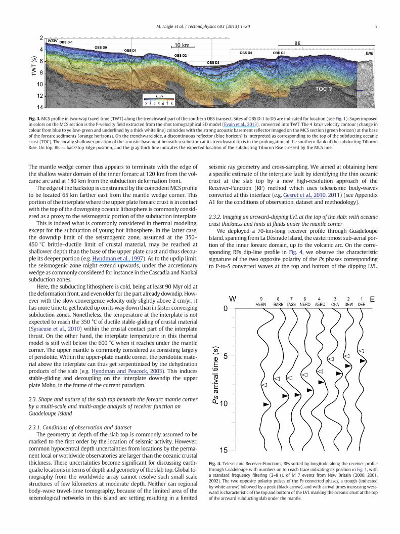
Fig. 3.MCS profile in two-way travel time (TWT) along the trenchward part of the southern OBS transect. Sites of OBS D-1 to D5 are indicated for location (see Fig. 1). Superimposedin colors on the MCS section is the P-velocity field extracted from the shot tomographical 3D model (Evain et al., 2013), converted into TWT. The 4 km/s velocity contour (change incolour from blue to yellow-green and underlined by a thick white line) coincides with the strong acoustic basement reflector imaged on the MCS section (green horizon) at the baseof the forearc sediments (orange horizons). On the trenchward side, a discontinuous reflector (blue horizon) is interpreted as corresponding to the top of the subducting oceaniccrust (TOC). The locally shallower position of the acoustic basement beneath sea-bottom at its trenchward tip is in the prolongation of the southern flank of the subducting TiburonRise. On top, BE = backstop Edge position, and the gray thick line indicates the expected location of the subducting Tiburon Rise crossed by the MCS line.
Fig. 4. Teleseismic Receiver-Functions, RFs sorted by longitude along the receiver profilethrough Guadeloupe with numbers on top each trace indicating its position in Fig. 1, witha standard frequency filtering (2–8 s), of M 7 events from New Britain (2000, 2001,2002). The two opposite polarity pulses of the Ps converted phases, a trough (indicatedby white arrow) followed by a peak (black arrow), and with arrival times increasing west-ward is characteristic of the top and bottom of the LVL marking the oceanic crust at the topof the arcward subducting slab under the mantle.
7M. Laigle et al. / Tectonophysics 603 (2013) 1–20
The mantle wedge corner thus appears to terminate with the edge ofthe shallow water domain of the inner forearc at 120 km from the vol-canic arc and at 180 km from the subduction deformation front.
The edge of the backstop is constrained by the coincidentMCSprofileto be located 65 km farther east from the mantle wedge corner. Thisportion of the interplatewhere the upper plate forearc crust is in contactwith the top of the downgoing oceanic lithosphere is commonly consid-ered as a proxy to the seismogenic portion of the subduction interplate.
This is indeed what is commonly considered in thermal modeling,except for the subduction of young hot lithosphere. In the latter case,the downdip limit of the seismogenic zone, assumed at the 350–450 °C brittle–ductile limit of crustal material, may be reached atshallower depth than the base of the upper plate crust and thus decou-ple its deeper portion (e.g. Hyndman et al., 1997). As to the updip limit,the seismogenic zone might extend upwards, under the accretionarywedge as commonly considered for instance in the Cascadia and Nankaisubduction zones.
Here, the subducting lithosphere is cold, being at least 90 Myr old atthe deformation front, and evenolder for the part already downdip. How-ever with the slow convergence velocity only slightly above 2 cm/yr, ithasmore time to get heatedup on itsway down than in faster convergingsubduction zones. Nonetheless, the temperature at the interplate is notexpected to reach the 350 °C of ductile stable-gliding of crustal material(Syracuse et al., 2010) within the crustal contact part of the interplatethrust. On the other hand, the interplate temperature in this thermalmodel is still well below the 600 °C when it reaches under the mantlecorner. The upper mantle is commonly considered as consisting largelyof peridotite.Within the upper-platemantle corner, the peridotiticmate-rial above the interplate can thus get serpentinized by the dehydrationproducts of the slab (e.g. Hyndman and Peacock, 2003). This inducesstable-gliding and decoupling on the interplate downdip the upperplate Moho, in the frame of the current paradigm.
2.3. Shape and nature of the slab top beneath the forearc mantle cornerby a multi-scale and multi-angle analysis of receiver function onGuadeloupe Island
2.3.1. Conditions of observation and datasetThe geometry at depth of the slab top is commonly assumed to be
marked to the first order by the location of seismic activity. However,common hypocentral depth uncertainties from locations by the perma-nent local or worldwide observatories are larger than the oceanic crustalthickness. These uncertainties become significant for discussing earth-quake locations in terms of depth and geometry of the slab top. Global to-mography from the worldwide array cannot resolve such small scalestructures of few kilometers at moderate depth. Neither can regionalbody-wave travel-time tomography, because of the limited area of theseismological networks in this island arc setting resulting in a limited
seismic ray geometry and cross-sampling. We aimed at obtaining herea specific estimate of the interplate fault by identifying the thin oceaniccrust at the slab top by a new high-resolution approach of theReceiver-Function (RF) method which uses teleseismic body-wavesconverted at this interface (e.g. Gesret et al., 2010, 2011) (see AppendixA1 for the conditions of observation, dataset and methodology).
2.3.2. Imaging an arcward-dipping LVL at the top of the slab: with oceaniccrust thickness and hints at fluids under the mantle corner
We deployed a 70-km-long receiver profile through GuadeloupeIsland, spanning from LaDésirade Island, the easternmost sub-aerial por-tion of the inner forearc domain, up to the volcanic arc. On the corre-sponding RFs dip-line profile in Fig. 4, we observe the characteristicsignature of the two opposite polarity of the Ps phases correspondingto P-to-S converted waves at the top and bottom of the dipping LVL,

8 M. Laigle et al. / Tectonophysics 603 (2013) 1–20
the LowVelocity Layer between themantle peridotites of the upper plateand of the slab interpreted as including the oceanic crust at the slab top.This RF profile also reveals an overall westward increasing arrival timeconsistently showing the slab deepening towards the volcanic arc. Onthe two easternmost receivers DEW and DEE located on La Désirade Is-land, the negative polarity Ps arrive around 5 s later than the first arrivalP, that is a conversion from about 45 km depth. The interplate thusdefined is in continuity with the deepest constrained portion of theinterplate imaged at shallower depths from MCS and modeled bywide-angle reflections on the northern transect in Kopp et al. (2011),with a deepening from 26 to 45 km over a 30-km-long-distance, that isa slope of 30% or local dip of 20–30° (Fig. 2).
We performed a multi-scale analysis on each RF to reach thehigh-frequency response of the LVL sampled by converted teleseismicwaves (see Gesret et al., 2010 for methodology). The RF scalogramsobtained at the receivers TASS (Fig. 5b) and DEW (Fig. 5d) are com-pared to RF obtained for this range of slab depth and well studiedfor the Hellenic subduction zone at receivers XAR (Fig. 5a) and VLI(Fig. 5c) (see Appendix A2 for details).
We note first that these negative-to-positive spacings decrease toalmost 1 s when going towards high frequency, as we established alsopreviously for the Hellenic subduction (Gesret et al., 2010), indicatingthus here a similar small 7–10 km LVL thickness. This is typical ofmerelythe oceanic crust at the top of the subducting slab. Without such amultiscale analysis, one would have instead taken as real the ~2 sbreadth of the negative–positive Ps signals obtained at the standardfrequency-band filtering. We would have reached the same conclusionof a 15–20 km thick LVL here, as inferred by Suckale et al. (2009) forthe Hellenic case. Pearce et al. (2012) confirmed since the lower valuewe had constrained there (Gesret et al., 2010). There is hence no needto consider their interpretation of a layer of serpentinizedmaterial eitherat the base of the subducting oceanic crust, or of a serpentinized layerwithin the upper plate mantle on top the interplate.
On the scalogram for DEW station (Fig. 5d), the response of theLVL towards high-frequencies is different from other ones, with adominant strong short and single negative Ps signal. The amplitudeof the negative pulse is so large that the corresponding Vs under theinterplate has then to be locally very low, with Vp/Vs of 3 or more.The amplitude of the negative pulse appears here to increase alongwith frequency, suggesting that the velocity–depth function wouldcomprise a self-similar function like a Dirac distribution: a localizedinclusion of low Vs under the interplate.
Underplating of sediments has been suggested in Cascadia (Calvertet al., 2011) to be included to a LVL at the slab top at themantle-wedge corner, but here we are much deeper than the mantlecorner. Such low Vs, and high Vp/Vs are not found in material at suchdepth, unless pore pressure is significant with respect to the confining
Fig. 5. Scalograms of RF as a function of central period of bandpass, or wavelet response in cevent, which have similar arrival times and breadth as the scalograms obtained in the Hellethe LVL have been constrained (Gesret et al., 2010). The amplitude extrema of the negativetowards the shortest periods of 0.5–1 s. The segment below each frame gives the amplitud
pressure, and the porosity is high (e.g. Christensen, 1984, 1989;Peacock et al., 2011).
In theNankai–Tokai subduction zone (Japan), a thin layer of fluid in-clusions at the interplate has been reported from a refraction–reflectionprofile (Kodaira et al., 2002), but at a much shallower depth, updip themantle corner and thus within reach of this other method. This fluid in-clusion has been inferred to correspond to a possibly trapped waterlayer along the crustal contact of the two plates between 15 to 30 kmdepth that would induce a weak coupling area, which would be inagreement with the locally estimated absence of co-seismic slip duringthe M 8.2 Nankaido 1946 rupture in the eastern part of Shikoku Island.At 250 km farther east, a high pore-fluid pressure zone imaged withinthe upper part of the subducting oceanic crust is proposed to unclampthis 15 to 30 km depth portion of the interplate by maintaining aconditionally-stable slip regime there (Kodaira et al., 2004).
Here the peculiar observations obtained in the converted waves,would suggest over-pressured fluids in a thin layer, or rather inclu-sion of very small dimension with respect to the scale of the 7 kmoceanic crust of the slab. However, this is found at 45 km depth, amuch larger depth than in Nankai, which places it far downdip,under the upper plate mantle material. This would imply that thesefluids are trapped under the interplate fault, since if free to migrate,they would have been used instead by the mantle above for itsserpentinization. This observation could indicate that the interplatefault is presently sealed and hence could be partially or fully lockeddown to 45 km under La Désirade Island, depending on the value ofthe pore-pressure vs. the normal stress. The downdip limit of the pos-sible seismic rupture would thus reach deeper than in the case of thecrust-on-crust proxy to the seismogenic zone.
2.3.3. Slab top depth and shapeOnce properly resolved by the multi-scale analysis, the delay-
times of the negative Ps signal at other receivers along the profile canbe used in a simple analytical approach to construct an along-dipcross-section of the slab top geometry which is sketched in Fig. 8 (seeAppendix A3 for methodology). Here, the slab top geometry is repre-sented by a minimum and maximum solution for the possible depthat 40 km from the volcanic arc in order to take into account picking res-olution in arrival time readings and a range of reasonable velocity–depth functions.
Beginningwith LaDésirade Island receivers DEWandDEE (Fig. 8), at70–80 km from the volcanic arc axis, a depth of 40 km is constrained fora 30° arcward dipping converter at the slab top, which prolongation fitswith the piercing point depth of 57–60 km defined 29 km furtherarcwards from data at the receiver CHR and for the same dip. Instead,with a 25° or 35° dip value from DEW, the converter would be 3 kmshallower or 3 km deeper than the corresponding points obtained
onversion, of the LVL beneath stations TASS (b) and DEW (d) from Salomon M 8.1 2007nic subduction zone of XAR (a), and VLI stations (c), where the depth and thickness of- and positive-polarity can be followed along ridges (dashed lines) across periods ande of the corresponding P wavelet.
9M. Laigle et al. / Tectonophysics 603 (2013) 1–20
from CHR. The time delay increases faster, from receivers CHR to BARB(located 25 km from the volcanic arc), suggesting a kink towards asteeper slab at about a distance of 40 km from the volcanic arc. Thesteeper slab segment reaches a slope of 140%, or a dip of 60° to thelast point sampled by the receiver NTRD on the volcanic arc, but forwhich the conversion point is located 30 km trenchward, at a depth of90 km. Extrapolated from there with this dip, the slab top wouldreach 135 km depth under the volcanic arc. This is consistent with thedepth range of earthquakes hypocenters there.
3. Seismic activity: resolution of earthquake locations andmechanisms, and comparison with Tohoku
3.1. New observations
In contrast to many subduction zones like the Japan arc, the LesserAntilles have a very moderate level of magnitude and rate of currentearthquakes. They also lack a wide sub-aerial forearc to install seis-mological stations for properly monitoring the shallow to intermedi-ate depth earthquakes of the subduction zone. Current seismicity hasbeen monitored locally by the permanent arrays with principallyvertical-component short-period seismometers of the Martiniqueand Guadeloupe Observatories which were mainly focused on theactive volcano monitoring, with few sites on the forearc domain. Ver-tical cross sections of hypocenters compiled from local or worldwidearrays (e.g. Bengoubou-Valerius et al., 2008; Feuillet et al., 2002) donot resolve any particular features in the earthquake distribution.
Aiming at improving the resolution and understanding of the seis-micity distribution, we carried out in a multi-approach experiment acombined deployment of OBS and land seismometers along the wholecentral part of the arc. From January to April 2007, a total of 84 OBShave been brought together from several pools (Geoazur, INSU/IPGP,IFM-GEOMAR, and AWI). They have been partially redeployed for thesouthern half offshore Martinique until August 2007 (Ruiz et al., 2013).Onshore, 30 land stations (CSIC Barcelona, IPG Paris, INSU-RLBM and-LITHOSCOPE) mainly deployed along the Atlantic side completed thewestern part of the network. This composite and dense networkrecorded seismic activity at the reduced level and rate which is typicalover the recent years. This extended geometry togetherwith the capacityof reliable P and S arrival-time readings provided an unprecedented con-trol on hypocenter locations and focalmechanisms of the offshore events(see Appendix B for details).
In addition, in the frameof a 4-year effortwith theOBSISMERprojectwe deployed and maintained up to 10 OBS offshore NE Martinique to-gether with temporary land stations in Martinique, Dominica andGuadeloupe islands, all equipped with 3-component seismometers.This longer-term deployment allowed to constrain the locations of sev-eral exceptional events recorded by chance and which are presented inthe following sections:
i) One is the exceptional event of 2007.11.29, a M 7.4 deep earth-quake at 150 km depth under the volcanic arc just north ofMartinique. This has been the largest event in the region forover 50 years since the 1953.03.19, M 7.5 earthquake whichwas also a deep earthquake, at 135 km depth south ofMartinique(Dorel, 1981; Feuillard, 1984) (see Appendix C for details).
ii) This 2007 deep earthquake was followed by a general increase inseismicity of the slab mantle, the slab top and the forearc regionstowards shallower depth.
iii) a second exceptional event in the region, the M 5.2, 2008.02.06flat-thrust earthquake which we could locate at 40 km depthjust beneath the OBS array was recorded two months later.
iv) This event has been preceded by a significant, M 4.6 event on2006.05.11 at about the same position.
This OBS array had beendeployed on purpose above this domain off-shore on the Atlantic side of the central Lesser Antilles arc, which is
where the largest earthquakes for decades had occurred in 1999.06.08with magnitude M 5.8. The M 5.2 2008.02.06 event recorded by thisOBS array is only second to it in magnitude.
As further discussed hereafter, we succeeded to resolve here for thefirst time the seismicity of the Lesser Antilles subduction into a numberof different types of earthquake, which share similarities with thoseonly or most clearly documented for the Tohoku region of Honshu.
3.2. The 2007 M 7.4 and deep slab earthquakes offshore Martinique
3.2.1. Intermediate-depth earthquakes under the volcanic arcThe first report of earthquakes as occurring at significant depth
under the Earth's surface has been derived by Wadati (1928) from thesmall difference in arrival times of their waves among seismological ob-servatories in Japan. The arrangement of their locations along so-calledWadati–Benioff zones, i.e. dipping-planes of seismicity from the off-shore trench down to under the volcanic arc and beyond, has thenbeen found as a general characteristic of subduction zones.
In the Lesser Antilles subduction zone, the dipping slab seismicitycan be followed slightly further than beneath the volcanic arc, downto 230 km depth, whereas slab material is known from tomographicimages to penetrate much deeper (Van der Hilst et al., 1991). The slabdip here has been estimated early on from the seismicity located withthe regional array as showing variations along the arc, such as differentdepths under the volcanic arc (Bengoubou-Valerius et al., 2008; Dorel,1981; Girardin and Gaulon, 1983). A segmentation of the slab has alsobeen suggested by Wadge and Shepherd (1984), between Guadeloupeand Martinique. The 2007 earthquake recorded here is the largest for50 years and provides new insight on deep slab deformation andfaulting.
For an easier discussion, we imported over the seismicitycross-section of Martinique presented in Fig. 6 such structural ele-ments as the 26 km Moho depth of the upper plate documented bythe two long refraction transects (Evain, 2011; Kopp et al., 2011)which has been used for the earthquake location. We also added theposition of the slab top as constrained by Receiver-Functions acrossGuadeloupe, discussed in the previous section.
3.2.2. The M 7.4 precise location and relation with focal mechanism andstructural frame
The display of the locations of the 9 largest deep earthquakes inthis sequence includes the M 7.4 mainshock of 2007.11.29 at 19:00(labeled 0 in Fig. 6c and d), a foreshock detected on 2007.11.28 at14:54 (labeled 1 in Fig. 6c and d) and the largest aftershocks withina month. These locations define a well resolved and robust relativespatial distribution over 20 km in both depth and horizontal coordi-nates, which is on the order of the size of the rupture expected forthis magnitude (see Appendix C for details).
When projecting the mainshock hypocenter onto a plane having theslab dip and strike, the standard USGS focal mechanism appears basicallyas a normal-faulting rupture through the slab thickness in a directionindicating along-arc extension. This is a contrasted solution with respectto the described downdip extension or downdip compression of theintermediate-depth seismicity related to penetration of the slab throughthemantle transition zone, as described in the early reviewof focalmech-anisms in slabs (Isacks and Molnar, 1969; Oliver and Isacks, 1967). Thedistribution of the locations of the main aftershocks resolved from ourarray (Fig. 6d) is consistent with the geometry of one of the two nodalplanes which we hence consider as corresponding to the focal plane ofthe rupture. It appears then that it is the southern segment of the slabthat is downthrown as indicated by the deeper aftershocks being locatedto the south along the normal-fault rupture through the slab thickness.
The approximately along-dip direction of this normal-fault ruptureplane makes it appear as a tear in the slab between these northernand southern segments or panels. The style of earthquake rupture ge-ometry indicates that cumulative action of such events would lead to

10 M. Laigle et al. / Tectonophysics 603 (2013) 1–20
steepen and deepen the southern panels. This mechanism may henceaccount for the noted deeper location of seismicity under the volcanicarc in Martinique than Guadeloupe that has been repeatedly noted(Dorel, 1981; Syracuse and Abers, 2006; Wadge and Shepherd, 1984).
It is tempting to consider possible relations of the rupture alongthe slab dip evidenced by the M 7.4 earthquake with the possible het-erogeneous structure of the corresponding slab. Atlantic oceanictransform-faults which are well expressed in the abyssal plain nearby

11M. Laigle et al. / Tectonophysics 603 (2013) 1–20
the mid-Atlantic ridge are lithospheric scale structures which enterinto the subduction and one of those might be the structurereactivated as a tear in the slab.
3.3. Resolving the distribution of seismicity within the upper 50 km of thesubduction zone offshore Martinique
In the strongly expressed seismicity of very active and wellinstrumented subduction zones, the arcward dipping zone of earth-quake activity could be resolved as several distinct dipping planes. Adouble-planed slab seismicity was first resolved in the Tohoku regionof the Japan Trench, with the upper plane considered to be at thetop part of the slab and earthquakes of the lower plane being 20 kmdeeper inside the slab mantle (e.g. Hasegawa et al., 1978; Umino andHasegawa, 1975). More recently, sixteen most active subductionzones that could be studied from the global seismicity catalog havebeen shown to have a dipping, double-planed distribution of hypocen-ters (Brudzinski et al., 2007).
3.3.1. Detection of earthquakes at depth within the slab: the lower planeof a double-planed dipping seismicity
The views of seismicity in the Lesser Antilles arc from the local per-manent seismograph stations and from international agencies, such asin the USGS catalog, give a scattered distribution. When located by ourdense local array including OBS, the individual hypocenters get shiftedby tens of kilometers, with respect to their locations by the permanentarrays (Figs. 7b and 8c). Among the eight largest, M > 3.6 magnitudeearthquakes that occurred in the year after the deep earthquake, fourcan be reliably located deep inside the slab at intermediate depthsand are aligned on an arcward-dipping plane (correlated by dashedline in Fig. 6a). Among the whole set of earthquakes shallower than50 km depth during the year, the largest one of M 4.8, is one of theselower plane, intraslab earthquakes. Notably, it would appear correlatedin time to the M 7.4 deep earthquake of 2007.11.29 at 19:00 (labeled 0in Fig. 6c and d), since it occurred on 2007.11.28 at 14:18 (labeled inFig. 6a), the day prior to this large event and half an hour before itsfaint deep foreshock.
The alignment of the locations of these earthquakes reveals here thelower plane of a double-planed Wadati–Benioff zone, dipping from 45to 75 km depth. This plane is way deeper than the interplate and theupper plane (Fig. 7a). The current hypothesis for explaining suchlower plane earthquakes is the embrittlement front above the fluidsproduced by the dehydration of previously serpentinized material ofthemantle of the slab that is heated from bottom and top as it descends(e.g. Kirby et al., 1996; Peacock, 2001; Yamasaki and Seno, 2003). Thedistance between the upper and lower planes is on the order of18 km under the outer forearc. This separation decreases over thenext 50 km downdip and they cannot be resolved anymore from oneanother at 80 km depth, where a steepening of the slab top occurs, asdefined from Receiver-Functions and earthquake locations.
In the concept of dehydration embrittlement, this could be consis-tent with a strong heating rate of the slab as it descends here very
Fig. 6. Across Martinique Island, one year of seismicity from Oct 2007 to Sept 2008 recordeda 100 km wide strip from the volcanic arc through the forearc and (b) corresponding verticand OBS 8 at 40–45 km depth. The recorded deep major M 7.4 earthquake together with forethe slab mantle (dashed light gray) was activated in relation to the M 7.4 earthquake. The swith a gap of azimuthal observations smaller than 180°, and in white, comprised between 1Moho position (horizontal dashed black line at 26 km depth) as well as basement depth bengeometry is constrained from the RF analysis (in black) along an array across Guadeloupe.quakes beneath the volcanic arc on Martinique Island (here marked MP, Montagne Pelée)fore- and after-shocks (numbered in time-sequence, with the mainshock as 0) compare~15 km more arcwards and deeper. They are also compared to local observatory hypocend) close-up view in the coordinates system of the slab, of focal mechanisms of Harvard anhypocenters of fore-, main-, and after-shocks of the present study reveals that the shalloweof the mainshock, suggesting that the fault plane through the slab is the one which deepen
slowly with respect to Tohoku, where the lower dipping plane ofintraslab seismicity remains distinct much farther downdip, even be-yond the volcanic arc. In the updip part, Tohoku shows a separation ofthe planes on the order of 30 km (Hasegawa et al., 1978). The smallerdistance between the two planes in the Antilles is then also consistentwith a less cold incoming Atlantic lithosphere which is 90 Myr old atsubduction, with respect to the 140 Myr old Pacific lithosphere forTohoku.
Diverse thermal, mechanical and more complex modeling tech-niques, and possible assumptions on rheologies, boundary conditions,and slab geometries can give contrasted results, such as thoseobtained for SW Japan (Peacock, 2009; Peacock and Wang, 1999;Yoshioka et al., 2008). In the region here, new heat flow data areneeded to improve and better constrain the thermal models. The res-olution of the depth and geometry of the lower one of the Wadati–Benioff dipping planes inside the slab mantle we obtained now maycontribute new constraints for further realistic thermal modeling.
3.3.2. The dipping upper-plane of seismicity at the slab top: the “deepflat-thrust” earthquakes under the mantle corner
In the very active and well studied northern part of Tohoku, re-peating M ~ 5 flat-thrust events have been identified to occur at theinferred top of the slab at about 40 km depth, well downdip theupper-plate Moho, hence beneath the mantle wedge material. Theyoccur at several distinct locations like those of Kamaishi where suchM 5 events repeat at a rate on the order of 5 years, as documentedfor a period of 50 years (Igarashi et al., 2001; Matsuzawa et al.,2002; Uchida et al., 2003, 2005). These events are located in theupdip part of the uppermost plane of the earlier discovered dippingdouble-planed seismicity of Umino and Hasegawa (1975) or furtherresolved triple-planed seismicity distribution (Igarashi et al., 2003;Kawakatsu and Seno, 1983; Seno and Pongsawat, 1981).
During the 4-years OBS array offshore NE Martinique and on-landarrays, we had the opportunity to record such flat-thrust eventsunder the mantle wedge in the forearc domain, and among them asignificantly large one: the 2008.02.08, M 5.2 earthquake (Fig. 7).This event is the largest subduction-related earthquake over almosta decade under the central Lesser Antilles forearc and for which afocal mechanism from worldwide data is available. The Harvardmechanism is a flat thrust in the plate convergence direction, at27 km depth. Such a shallow depth would place this flat-thrustevent oddly with respect to the structural elements we constrained:far above the slab top and at the upper plate Moho.
Our dense temporary array confirms this flat-thrust focal mecha-nism, but not the 27-km focal depth. The 3-component seismometersnetwork recording both P and S waves, including OBS above the focus,lead to constrain the hypocenter reliably at 44 km depth, and at adistance of 85 km of the volcanic arc axis. The focal depth from ourstudy is 17 km deeper than the Harvard CMT but is consistent withthe interplate geometry constrained along the RF profile in GuadeloupeIsland, and establishes that flat-thrust mechanisms occur on theinterplate, under the mantle wedge.
by the OBSISMER OBS-land seismometers network (black squares). (a) map view alongal cross-section. During the shown period, note the higher activity region east of OBS 3- and after-shocks are identified in bold circles. A lower dipping plane of earthquakes inhown events have a number of P- and S-readings greater than 20. In gray, hypocenters80° and 270°. Several structural elements have been imported on (b): the upper plateeath the OBSs (black crosses) used for the earthquakes location. The slab top depth andIt has been shifted 5 km trenchwards to fit the correspondingly larger depth of earth-. c) close-up view of hypocenters of the deep major M 7.4 earthquake together withd with USGS-PDE locations (open triangles) from worldwide array, that are locatedters (black triangles) that are located ~15 km more trenchwards and slightly deeper.d USGS-PDE which show normal-faulting of the slab. The distribution of the projectedr ones are to the north, and the deeper ones, to the south. They encompass the ruptures the southern segment.

Fig. 7. Seismicity offshore Martinique. a) Forearc part of section Fig. 6b, enlarged and with the several years dataset. The beach-ball is the Harvard focal mechanism at the location ofthe major magnitude M 5.3 earthquake over a decade in the forearc region of the central Lesser Antilles subduction zone. This flat-thrust along-dip convergence earthquake is lo-cated by our joint OBS and land-array 17 km deeper, at the top of the slab. In gray circles, hypocenters with a gap of azimuthal observations smaller than 180°, and in white, greaterthan 180°. The size of the circle is versus the total number of the P- and S-readings: large means above 40, medium means above 30 and small, above 15. Several focal mechanismshave been constrained and are displayed as color-coded: in blue normal-faulting and in red reverse faulting. In order to fit the resolved flat-trust earthquakes plane, the slab topdepth and geometry imported from the RF analysis through Guadeloupe (in black) has been shifted trenchwards by an additional 7 km with respect to Fig. 6b. b) Triangles arelocations of earthquakes reported in the USGS-PDE database with corresponding magnitudes (above M 3). They are linked to our obtained locations (circles) by vectors.
12 M. Laigle et al. / Tectonophysics 603 (2013) 1–20
We had detected in nearly the same position the M 4.6 eventon 2006.05.11. Smaller ones occur more commonly with similarreverse-faulting source mechanisms (red dots in Fig. 7), as alsorecorded during the dense deployment in the first half of 2007(Ruiz et al., 2013). It is also in this region that occurred the1999.06.08 M 5.8 event, largest for several decades under the forearcof the whole central Lesser Antilles. With respect to the events justdescribed, its hypocenter would be 7 to 15 km shallower as respec-tively obtained by Harvard and USGS, with a compressional mecha-nism exhibiting a much larger strike–slip component. Taking intoconsideration the mislocations of earthquakes by the worldwide ar-rays as documented for instance with the 2008.02.08 event, one
should not exclude that all these events could participate in a repeat-ing earthquakes sequence.
3.3.3. “Supraslab” seismicity as seen in both Martinique and GuadeloupeOn the Martinique transect, we constrain the depth of a significant
number of earthquakes to be shallower than theflat-thrust earthquakesdistribution at the slab top (Fig. 7). P and S readings from 3-componentOBS and land seismometers constrain the location of most of theseshallower events to be within the upper plate mantle. However, withthewell-constrained upper plateMohodepthwe can see that the distri-bution of these earthquakes also reaches upward and into the upperplate crust. For those events with enough observations of first arrival

Fig. 8. Seismicity offshore Guadeloupe recorded during the four months of the 2007 large OBS and land-seismometers network (black squares) in (a) map view along a 100 kmwide strip from the volcanic arc through the forearc and (b) corresponding vertical cross-section across southern Guadeloupe archipelago. Several structural elements havebeen imported on (b): the upper plate structural model obtained along the northern OBS transect (Kopp et al., 2011). Deeper than 35 km, the slab top depth and geometry isconstrained from the RF analysis (in gray) along the receiver profile across Guadeloupe. Color and size of the hypocenters (circles) are the same than in Fig. 7. Note that duringthis monitored period, most of them are mainly normal-faulting type. c) Triangles are locations of earthquakes by the local permanent observatory (black triangles) with corre-sponding magnitudes (above M 2). They are linked to our obtained locations (circles) by vectors.
13M. Laigle et al. / Tectonophysics 603 (2013) 1–20
polarities, they exhibit normal-faulting source mechanisms (blue dotsin Fig. 7). Earthquake activity in this domain is also constrained fromthe shorter term but more extensive array deployed in the southernhalf of the central Antilles survey (Ruiz et al., 2013).
In the Guadeloupe region, the hypocenters of the shorter term re-cording during this survey are displayed in Fig. 8. Here the upperplate Moho is superimposed as it has been defined from the densewide-angle reflection–refraction data of the whole transect located

14 M. Laigle et al. / Tectonophysics 603 (2013) 1–20
just south of Guadeloupe Island (Kopp et al., 2011). Although herethere has been no flat-thrust earthquake at the interplate recordedduring the shorter time deployment, which could indicate the slabtop, the Receiver-Functions profile allows to locate it. These deeperstructural constraints concerning slab depths and varying dips arealso displayed in Fig. 8. The earthquake activity is thus seen to locatelike offshore Martinique: above the slab top and not only mostlywithin the mantle wedge of the upper plate but also within thelower crust of the arc.
Tohoku is the only other case where such earthquakes have beenreported before within the mantle corner, above the slab top andunder the upper plate Moho and they have been named “supraslabearthquakes” (Uchida et al., 2010). Their occurrencewithin an expectedserpentinized peridotite mantle corner is contradictory with the para-digm of aseismic behavior of this material. In their preferred interpreta-tion of these earthquakes, Uchida et al. (2010) relate them to thepossible existence of a graveyard of seamounts tectonically detachedfrom the subducting plate and underplated to the forearc lithosphere.We discuss the Antilles case in the following section.
4. Possible origin for the specific characters of seismic activity andstructure in the Lesser Antilles
4.1. Specific characters of seismic activity in the Antilles subductionforearc
Offshore Martinique Island, a sustained effort in seismological ob-servations over more than 4 years by a dense OBS network deployedlocally together with land seismometers above the mega-thrust faultof the Lesser Antilles subduction zone reveals:
i) “supraslab” earthquakes with normal-faulting seismic activityabove 50 km depth, pervading the upper plate mantle corner, asthey are reliably located above the interplate boundary, andreaching into the crust above.
ii) “deep flat-thrust”, possibly “repeating” earthquakes at the slab topunder the mantle corner at 40–50 km depth.
From a shorter duration OBS deployment “supraslab” earthquakesoccurring within the mantle corner, are also documented offshore theGuadeloupe Island, 150 km further north. Deeper, flat-thrust earth-quakes were observed in Martinique but not in Guadeloupe duringthat shorter time span.
Such kind of earthquake activity has not been commonlyconstrained and reported elsewhere, but is a characteristic of thewell-instrumented Japan Trench as well (e.g. Uchida et al., 2010).There,first-arrival times of shallow- to intermediate-depth earthquakesbeneath the island, and sea-bottom reflection/conversion phases ofsub-oceanic offshore earthquakes, were used in several seismic tomog-raphy studies. These studies repeatedly reported spatial anomalieswithin the forearc mantle with reduced velocities and high Vp/Vsratio which could be interpreted as serpentinized mantle peridotite(Mishra et al., 2003; Zhao et al., 2009). These interpretations conformedwith the consensus on the extent of the downdip depth of theseismogenic zone as being limited to theMoho depth under the forearcin NE Japan.
In the common view of hydration of the forearc mantle by fluids ex-pelled from the subducting slab, such occurrence of “supraslab” earth-quakes within the mantle corner remains unexplained in the frame ofthe paradigm of peridotite mantle serpentinization, since this is anaseismic process (e.g. Kirby et al., 1996, recalled by Uchida et al.,2010). This paradigm is here further contradicted by the occurrence of“deep flat-thrust”, possibly “repeating”, earthquakes at 40 km depthon the interplate megathrust fault. They indeed occur beneath whatshould be a serpentinized peridotite mantle lying on top the slab andthus with a rheology considered to induce stable frictional sliding,aseismic slip, on the interplate. In the case of subduction of old oceanic
lithosphere that is cold, the forearcMoho has thus commonly been con-sidered as marking the maximum downdip limit of the stick-slipthrust-faulting and of the seismogenic part of the interplate (e.g.Hyndman et al., 1997).
Onemay however consider the possibility that in case of a heteroge-neous hydration of the mantle wedge, serpentinization occurring alongpaths of migrating fluids may induce volume changes and causesupraslab earthquakes in the unhydrated peridodites around. However,“deep flat-thrust” earthquakes on the interplate at 40 km depth arethen even less readily explained. The unexpected occurrence of the re-cent Tohoku Mw 9 subduction mega-earthquake brings the evidencethat the simple peridotitic mantle serpentinization paradigm no longerholds, since the rupture involved a large downdip portion of theinterplate under the mantle wedge beyond the upper-plate Moho.This might apply to the Lesser Antilles subduction zone.
We suggest that an explanation to these new and apparently con-tradictory observations can be sought in the details of the structurethat have been resolved by the active sources imaging we carriedout jointly in the Lesser Antilles subduction zone.
4.2. A possible compositional-structural origin for “supraslab” and “deepflat-thrust” earthquakes in the Lesser Antilles: a bi-material rheology ofplume-modified lithosphere
4.2.1. Analysis of existing hypothesisThe recent occurrence of large interplate earthquakes such as
Sumatra and Tohoku reaching or even nucleating under the mantlewedge and/or “deep flat-thrust” earthquakes of small magnitude oc-curring repeatedly there, exclude a mere control of the downdipwidth of seismic rupture by a uniformly serpentinized mantle wedge.
Diverse reasons could be considered in order to try to account forthese recent observations:
i) A compressional state in the upper plate would prevent its man-tle serpentinization by slab dehydration fluids as discussed bySeno (2005) and Dessa et al. (2009). Such a compressionalstate would however not explain the observation here of“supraslab” earthquakes with normal-faulting mechanisms;
ii) Spatial heterogeneity as a result of the metasomatism, whichwould introduce materials with contrasted rheology above theinterplate, as attested by the evidence of HP–LT jadeite later ex-humed at shear plate boundaries such as of the Caribbean plateand in Myanmar (Harlow et al., 2011; Tsujimori et al., 2006).But this heterogeneity would be restricted to the vicinity of theinterplate and would not explain either the “supraslab” earth-quakes in the whole mantle corner and above;
iii) Spatial heterogeneity in the fluid production from the slab alongthe interplate, from its successive and compositionally differentlayers. This would introduce correspondingly possible gapsalong the interplate in the capacity of peridotite serpentinizationabove, as considered for Sumatra by Dessa et al. (2009). This isunlikely here, because the slower subduction and the muchthicker upper plate crust result in a strong gradient of the tem-perature increase along the interplate, that would not favor thepossible gaps in fluid production from the slab to the mantlewedge above;
iv) A chemical, compositional, heterogeneity of the mantle cornerunder the forearc could induce spatial contrasts in both therheology throughout the mantle wedge, and in frictional behav-ior at its base on the interplate contact. Thiswould both reconcilethe diverse types of seismic activity observed and be consistentwith the peculiar structure of the upper plate lithosphere.
For this latter possibility, we explore hereafter an interpretation ofthe evolution of the upper plate lithosphere and which would also ac-count for all these characters. Our seismic imaging highlights in

15M. Laigle et al. / Tectonophysics 603 (2013) 1–20
particular for the Caribbean plate a thick forearc crust with high veloc-ities in its lower half on the two complete transects of the subduction.We hence propose that it may correspond to a remaining portion ofthe Caribbean Oceanic Plateau, a basaltic Large Igneous Province (LIP)that resulted from the modification of the standard oceanic lithosphereby the interaction with a mantle plume when it drifted over theGalapagos hotspot more than 90 Myr ago (e.g. Hastie and Kerr, 2010).We discuss hereafter how this plume-modified upper-plate lithospherecould provide the frame allowing these peculiar earthquakeswithin themantle corner, and maybe contribute to a downward extension of theseismogenic interplate.
4.2.2. PyroxeniteThe presence of another material in addition to peridotite is required
in the mantle corner for allowing a brittle behavior under hydration bythe fluids released from the slab, since peridotite serpentinization in itselfis regarded as aseismic. Earthquakes in themantle are not a common oc-currence worldwide. Notable exceptions are under Hawaii (Wolfe et al.,2004) and La Réunion oceanic volcano islands, which are both presentsites of mantle plume induced hotspot volcanism. There, under thepresently active volcanoes and the concentrated distribution of earth-quakes at shallower depths, deeper earthquakes occur below the crustin a large volume, e.g. 250 km wide and down to 50 km depth underHawaii.
In the marble-cake mantle model of Allègre and Turcotte (1984),plume upwelling initiates by the melting of stringers of eclogitized oce-anic crust – at greater depth than peridotite – that had been fed earlierto depth by the subduction process. This plume upwelling process thentransports also heterogeneousmaterial towards the surface to form oce-anic plateaus, both by its advection above and below the original Moho.
Plume-induced changes upon the original oceanic lithosphere havenow been reasonably documented for the crustal part thanks to reflec-tion–refraction seismic experiments that reached the Moho (e.g. Ridleyand Richards, 2010). Sub-Moho heterogeneity has not been similarlyreported, but this may be because seismic approaches have muchmore difficulty reaching beneath Moho. However, plume-induced het-erogeneity in the mantle may likely occur, as shown by petrologicalmodeling of the evolution of plume mantle melts through their up-wardsmigration through the lithosphere. These melts may erupt, or in-trude inside the crust, or evolve into fractionatedmafic cumulates in theupper mantle just below the Moho (e.g. Farnetani et al., 1996).
In the case of Hawaii, Sobolev et al (2005) propose that while theplume is rising, the olivine of the mantle peridotite is consumed by re-action with Si-rich melts derived from recycled oceanic crust, to form asecondary pyroxenitic source. They suggest that, when traversing theoceanic lithosphere, these parental melts create pyroxenitic reactionchannels for sub-lithospheric melt transport. These parental meltsmay be expected to generate pyroxenite-rich cumulates as picritic pa-rental melts do (Farnetani et al., 1996), as well as pyroxenite dykes.This possible presence of less ultramafic, pyroxenitic material withinthe upper plate mantle lithosphere, would be an interesting candidatefor explaining the observations of both “supraslab” and deep“flat-thrust” seismicity, because it would introduce a heterogeneous be-havior under hydration as described hereafter.
4.2.3. “Deep flat-thrust” earthquakes on the interplate under the mantlecorner
Pyroxenites contrast in viscosity with peridotites by over an order ofmagnitude at a same temperature (e.g. Bürgmann and Dresen, 2008;Tikoff et al., 2010). In the case of a plume-modified upper plate as sug-gested for the Lesser Antilles subduction zone, higher viscosity parts ofthe mantle corner in contact with the interplate may change locally itsfrictional slip properties and hence locking regime and domains, with re-spect tomere peridotite. This can be suggested then as a structural causefor inducing stick-slip on the interplate downdip its intersectionwith theforearcMoho instead of easing aseismic slip. These pyroxenite inclusions
could thus bringmuchdeeper the downdip limit of the seismogenic zonecomprising the locked and a possible conditionally-stable part under themantle wedge.
Serpentinite has been considered and inferred in the mantle wedgefrom the anomalous low seismic velocities widely reported in this me-dium for several subduction zones (e.g. Hyndman and Peacock, 2003;Peacock and Hyndman, 1999). However, Christensen (2004) recalledthat the type of serpentinite that would prevail at these P and T condi-tions is indeed antigorite, which does not present such large low-velocity anomalies and excluded such widely proposed interpretations(e. g. Bostock et al., 2002) of serpentinized peridotite mantle as beingtheir cause.
Pyroxenites have a significantly lower P-velocity than peridotitesand thus the contribution of this other component of the bi-materialmantle may account for the observations of anomalously low meanVp, even when its peridotite fraction is serpentinized into antigoritewith its revised value of velocity being not so low.
Such a bi-materialmantle cornermay thus explain high coupling, lo-calized occurrence of flat-thrust stick-slip on asperities or barriers, largereturn-time and large coseismic slip of megathrust earthquakes downto 45 km depth, as well as measured lower P-velocity than peridotites.
4.2.4. “Supraslab” earthquakesAs inferred from evidence in natural samples at outcrop, hydration
of peridotite with intervening pyroxenites occurs later and results in amuch larger volume change for its peridotite fraction than for its pyrox-enites fraction. Peridotite serpentinization can then cause extensionalfracturation of the intervening layers of pyroxenites (Lambert, 2010),hence seismic ruptures (Iyer et al., 2008).
In the case of such heterogeneous non-standard peridotite mantle,the observed normal-fault earthquakes in the mantle corner couldthus result from its hydration driven by the fluids provided by the effectof slab dehydration. Faulting in the upper plate mantle above theinterplate at several tens of kilometers depth and upwards throughthe upper-plate crust may thus provide a frame to the understandingof the occurrence of the widespread surface normal-faulting of theCaribbean arc and forearc domain. This may contribute an explanationof the significant long known seismicity with normal faults across thearc, located at 30 km depth within the mantle corner east ofMarie-Galante Island (Girardin et al., 1991) and under correspondingmajor normal-faults outcropping at the sea-bottom.
The mainshock of the major normal-faulting 1974 earthquake of M7.2 nearby Antigua–Barbuda islands ruptured from about 40 km depth,immediately above the thrust interface up to shallow crustal depths(McCann et al., 1982). Such earthquake ruptures in mantle material areunknown in the regionswith continental crustwhere co-seismic ruptureappears limited to the upper half of the crust. This 1974 M 7.2 eventmight be a larger one of such normal-faulting events which could havethus nucleated within the mantle corner because of its bi-material na-ture, by differential activation by fluids from the slab dehydration.
Although serpentinization is considered as an aseismic process,we may not exclude that hydratation of the mantle wedge mayoccur heterogeneously in space at any time and thus generate differ-ential stresses. However there is no reported evidence yet of mantlewedge seismicity apart those we cite so that the provisional inferencecould be that in the long term, seismic activity will only be retained ifchemical heterogeneities are present.
5. Comparison with Tohoku
5.1. Tohoku giga-earthquake: some specific aspects of seismic structureand activity
A large downdip portion of the interplate beyond the upper plateMoho, under the mantle corner has been involved in the Tohokuearthquake rupture. The latter would even have nucleated there at

16 M. Laigle et al. / Tectonophysics 603 (2013) 1–20
29 km depth and 80 km offshore, as indicated by the USGS-PDE hy-pocenter based on high-frequency first arrivals. Also, according tothe early analysis of seismic records by Ide et al. (2011), the energeticdeep rupture occurred even further downdip, down to 45 km depthalmost under the coastline (at 141.7° E longitude).
The earlymodeling of data from theGPS network on land (Simons etal., 2011) showed that themaximum co-seismicmotion occurred in theupdip region at 110 km offshore Miyagi. Nevertheless other solutionssince (T. Ito et al., 2011) show that the slip region reaches farther off-shore. Indeed, large ground displacement reaching the trench axiscould be interpreted since, from the record by an ocean-bottom pres-sure gauge (Y. Ito et al., 2011) and from the structural changes at thesea-bottom evidenced by the repetition of multibeam bathymetry andreflection seismic surveys (Fujiwara et al., 2011; Kodaira et al., 2012).
The hypocenter is just trenchward of the rupture zone of the 1978Miyagi-oki, a M 7.5 event which occurred at 45 km depth. TheMiyagi-oki type events have until recently commonly been consideredas belonging to a narrow belt of M 7.5 earthquakes with a 45 years re-currence time, clearly separated from a belt of thrust earthquakes inthe very shallow part of the subduction interplate in the northeasternpart (1896 far off Sanriku M ~ 8). Instead, both seismic belts as well asthe silent region in-between have now indeed just ruptured togetherduring the 2011 Tohoku event.
This kind of M 7–8 earthquakes of the previous decades, displayedfor instance in Simons et al (2011) now turn out not to have hencebeen “characteristic” earthquakes of the subduction as considered inthe decades prior to the Tohoku event. This had been already pointedout early on byMogi (1979) after the 1978Miyagi-oki event. The latterwas indeed confined nearby the coastline andway too small to fill whathe identified as the only seismic gap of the Japan Trench with Utsu(1979) and Seno (1978). Mogi (1979) concluded that this seismic gapwas still a potential region for a future very large earthquake. Togetherwith the belt of shallow thrust earthquakes, their spatial distributionmight be regarded as completing the doughnut-shaped seismicity pat-tern, which Mogi (1969) proposed for describing the seismic activityaround a seismic gap prior to a much larger mainshock.
We may further remark that the unexpected Tohoku giant M 9earthquake had a rupture zone, as inferred from the coseismic GPS ob-servation (Iinuma et al., 2011), that reached downdip and not only to-wards the coast to the regions characterized by deep repeaters: theMiyagi-oki 45-year recurrence M 7.5 repeater as mentioned above,but also the region of the flat-thrust repeaters deep and close to Sanrikucoast, such as the Kamaishi M 4.8 events with a 5-year recurrence time(Igarashi et al., 2003; Matsuzawa et al., 2002; Uchida et al., 2005). Thelatter gave a larger event of M 5.7 two years in advance (Uchida andMatsuzawa, 2011), among the early aftershocks that are commonlyconsidered as lining the limit of the mainshock rupture.
5.2. Possible inferences from the diverse types of the downdip transientactivity
Episodic small NVT and SSE could be considered as being the “silentheralds of megathrust earthquakes” in Nankai and Cascadia (Hirn andLaigle, 2004), in the sense that they could mark their downdip extentof rupture. In Tohoku it appears that it is the “deep flat-thrust”interplate “repeating earthquakes” which, instead of marking tinyisolated asperities in a domain commonly considered before themega-earthquake as stable-sliding, marked in advance the downwardextent of the 2011 M 9.0 Tohoku rupture.
Development of observations on the emerged forearcs of Cascadia,Nankai and Costa Rica has shown that repeating LFE swarms duringtremor localize to the interplate at depths of 30 to 45 km for thesesubduction zones, despite their significant differences in both thermalstructure and degree of seismic coupling (Brown et al., 2009). Thiscorresponds to the inferred contact with the upper plate Moho. Theorigin of these specific signals of NVT and LFE might be associated
to the increased pore-pressure by fluids trapped under the forearccrust at the tip of the mantle wedge as they migrate upwards fromthe dehydrating slab (Brown et al., 2009).
We have not found non-volcanic tremor, NVT, episodes in our sever-al months' deployment in the Lesser Antilles despite our deployment ofthe OBS array that allowed to sample over the forearc which is heremostly under water (Bécel et al., 2013). As for Tohoku, the Japan arc issimilarly devoid of tremor and deep LFEs, and has been considered asdecoupled, except for two patches that produce the frequent (~30 yrrecurrence) M 7.6–7.8 Miyagi-oki and Fukushima-oki earthquakes(Hashimoto et al., 2009; Scholz and Ando, 2010). The tentative conclu-sion, opposing the Nankai and Cascadia cases to the Japan arc, “that sub-duction zones that have SSE and NVT are coupled and that those thathave not, are not” (Scholz and Ando, 2010) could have grown as anew paradigm. But this may be amended now for regions like Tohoku,or the Lesser Antilles, which have instead “deep flat-thrust” repeatingearthquakes far downdip the upper plate Moho and no NVT or SSE aselsewhere, as they should be considered as being potentially coupledso far down, as recently demonstrated by the Tohoku giga-earthquakeoccurrence.
A tentative interpretationmay be that there, the several tens of kilo-meters wide portion of the seismogenic interplate fault under theman-tle wedge being locked in the interseismic period, may prevent asustained fluid flowout of the dehydrating slab to reach themantle cor-ner tip under the upper plate Moho, and thus prevent such peculiarseismic activity.
5.3. Revision of views imposed by the occurrence of the 2011 Tohokumega-earthquake
NE Japan has been the type example in the widely usedthermo-mechanical modeling of subductions where seismogeniczones are uncoupled by a serpentinized peridotitic mantle wedge (e.g.Peacock and Wang, 1999). The unexpected occurrence of the Tohokugiga-earthquake reaching farther downdip has however been merelyregarded as an “unsurprising surprise” (Wang, 2012). As well, in retro-spect, previous aspects of plate motions from GPS, seismic activity andseismic structure that had been originally interpreted in the currentframe of an aseismic subduction zone have now been reinterpreted inthe different view imposed by the 2011 event.
This is the case for example for:
i) the current mechanical coupling from GPS, considered to be in-complete in a series of studies up to the recent one of Lovelessand Meade (2010), although full coupling had been interpretedas early as 1998 by Le Pichon et al. (1998) and Mazzotti et al.(2000). Such full coupling demonstrated by the 2011 occurrenceis now a posteriori accommodated in Loveless andMeade (2011).
ii) the long-term seismic coupling inferred from the record of pastearthquakes, from a very partial 20% (e.g. Kanamori, 1977;Pacheco et al., 1993), to evidently full coupling demonstratedby the 2011 event (e.g. Lay and Kanamori, 2011).
iii) the interpretation of stable-gliding on the aseismic interplate asfavored from the mantle wedge serpentinization inferred fromthe seismic velocity structure derived by regional (e.g. Hirauchiet al., 2010; Zhao et al., 2009) or local tomography (Yamamotoet al., 2008), to interpretations accounting now for the seismiccoupling evidenced by the occurrence of the 2011 rupture(Yamamoto et al., 2011; Zhao et al., 2011).
iv) the “characteristic earthquake” concept, related to the asperitymodel (Lay and Kanamori, 1981) which limitation is pointedout by the occurrence of the 2011 Tohoku event (e.g. Lay andKanamori, 2011).
v) the interpretation of the “deep flat-thrust repeating earth-quakes”, from indicating stable-sliding on the interplate around

17M. Laigle et al. / Tectonophysics 603 (2013) 1–20
them (Uchida et al., 2003), to being instead coupled (Uchida andMatsuzawa, 2011).
Nonetheless, this unsurprising surprise has not been yet analyzedwith respect to the structure of the mantle wedge.
5.4. Heterogeneity of the forearc mantle of the Japan Trench
Our tentative interpretation of both the “supraslab” and the “deepflat-thrust” earthquakes by the same compositional heterogeneity inthe upper plate mantle in the Caribbean forearc, suggests that the ques-tion of the Tohoku forearc mantle corner material should also beaddressed to discuss the similar occurrence there. Heterogeneity mayhere be provided by the geological evolution of the Japanese islands,which is complex and multiphase.
Before the opening of the Japan Sea, Japan was part of thesouth-eastern continental margin of South China and this large accre-tionary margin faced directly the Pacific Ocean, or Panthalassa (Kimura,1994; Smith, 2007). The present outer arc basement resulted from thepast subduction-accretion of a series of seamount chains, oceanic pla-teaus, intra-oceanic arcs andmicro-continent blocks, while the Farrallonand the Izanagi plates were subducting in a northward migration be-neath Japan (e.g. Isozaki et al., 2010). The outer forearc mantle maythus be heterogeneous, comprising accreted modified OIB mantle andmay have therefore indeed a bi-material composition which wouldalso explain the “deep-flat thrust” earthquakes and correspondingdownward extent of the seismogenic portion beneath themantle corner.
Onshore and offshore refraction seismics provided measures of aconsiderably large crustal thickness, ranging from 40 km near thecoast (Iwasaki et al., 1994) to 30–20 km beneath the outer forearc(Takahashi et al., 2000), thus similar to that of the Antilles forearc. In ad-dition, similarly a 6.9 km/s velocity lower crustal layer is seen to makeup for over half this thickness (e.g. Miura et al., 2005). Refraction veloc-ities in themantle corner have been reported to be lower than for stan-dardmantle. Although they have been attributed to its serpentinization,one may consider that peridotite partial replacement by pyroxeniteswould also similarly reduce the P velocity. The hypothesis of the succes-sive accretion of oceanic plateau lithospheric remnants into the mantlewedge would explain the low P-velocities of the uppermost mantle ofthe Tohoku forearc as well as the peculiar aspects of seismic activity.
6. Conclusions
The geometry of the interplate boundary zone could be constrainedfrom the subduction deformation front down to ~90 km depth by ourseismic study over the north-central Lesser Antilles subduction zone.A larger crustal thickness than expected for an oceanic upper-platehas also been revealed and interpreted as being a remnant of theCaribbeanOceanic Plateau formed earlier bymantle plumematerial ad-vection to the oceanic lithosphere. An extensive and tight grid withdeep-penetration MCS reflection and OBS refraction profiles over theouter forearc domain allowed to identify the trenchward limit of thebackstop and map its along arc variation at about 110 km from the de-formation front and at 10 km depth under the thick accretionarywedge. The estimate of the potential width of the seismogenic zone isthree times larger than expected for an intra-oceanic cold subductionzone, because of the two-to-three times thicker crust of the Caribbeanupper-plate.
The frontal domain of the subduction zone is found to contrast by itsseismic structure with those of Tohoku and Sumatra which both partic-ipated to the tsunamogenic slip of the giga-earthquakes up to the defor-mation front. In the Antilles case, the low-P-velocity material of theaccretionary sedimentary wedge is 50 km broader in the downdip di-rection than the similarly low-P-velocity material in Tohoku. On theother hand its material competence is much lower than for the wedgeof Northern Sumatra of similar width but which is devoid of low-Vp
sedimentary material on top the interplate. The ~110-km-wide and5-km-thick sedimentary accretionary wedge of the Lesser Antilles sub-duction zone thus provides very different conditions for rupture propa-gation up to the deformation front and large tsunami generation.
Farther arcward, we document that even the upper plate basementitself has been tectonized and damaged above the interplate, due toits oblique sweeping over lower plate ridges. This may contribute tothe fact that the reduced material competence character above theinterplate may extend further arcward than the accretionary wedge.The updip limit of the seismogenic part would similarly be also deeper.
Unsuspected features of seismicity could be detected and resolved,in a 100 kmbroad along-dip section. A deep slab tearing can be inferredfrom the precise location of the recordedM 7.4 just north of Martiniquewhich occurred at 145 km depth, and from its aftershocks and focalmechanism distribution. In the corresponding increased activity,close-by monitoring documented a lowerWadati–Benioff plane of dip-ping seismicity at depth in the slab mantle. This provides an additionalend-member case of plate age and velocity and a renewed frame to dis-cuss diverse approaches of its thermo-mechanical evolution.
In the potentially seismogenic domain of the interplate, the twoother peculiar types of seismic activity we detected can be comparedto those uniquely reported earlier in the Japan arc. Results here mayhave a bearing on the understanding of the recent unexpectedTohoku giga-earthquake. One is the “deep flat-thrust” earthquakeswhich are precisely located at the top of the slab under the mantlewedge corner. They are observed offshore Martinique down to45 km depth, at 180 km arcward of the subduction frontal thrustand 70 km arcward of the forearc backstop edge. Several M 5 to 6significant events occurred successively in 1999, 2006 and 2008 atnearly the same location and may form a family of repeatingflat-thrust earthquakes. Another peculiar type of seismic activity,which consists in “supraslab” earthquakes with extensional mecha-nisms, occurs throughout the mantle wedge above the interplateand into the upper plate crust.
The comparison of these results, with those uniquely reported onthe most active and best studied subduction zone of Tohoku, Japanallows to discuss them in a common perspective. The necessaryreappraisal of the Tohoku seismic structure and activity in the light ofthe unexpected occurrence there of the major 2011 mega-thrust earth-quake provides a renewed frame to the appraisal of the newly obtainedresults on the Antilles. The Tohoku mega-earthquake rupture demon-strated that the common traditional view of the downward extent ofthe seismogenic zone being limited in cold subduction zones by theserpentinized mantle corner was wrong. The 2004 Sumatra event hadprovided a first example of giga-earthquake rupture that may have ex-tended over few tens of kilometers under the mantle wedge and evennucleated there in accordance with estimates of the preseismic lockingdepth range.
The interpretation which reconciles the different peculiar observa-tions on the seismic structure and activity is of a compositional–chemicalheterogeneitywithin the upper platemantle. Here, in the Lesser Antilles amafic contribution could coexist within the initial, peridotitic, mantlecomposition. The corresponding heterogeneity in rheology in themantlecorner, could account for both the “supraslab” and the “deep flat-thrust”seismic ruptures. This bi-material medium with the ultramafic mantlecontaining also mafic parts could have readily originated in relation tothe processes responsible of the peculiar crustal structure of the upperplate. A former episode of lithospheric evolution such as recognized ingeneral for the Caribbean plate lithospheremay correspond to the forma-tion of an oceanic plateau by plume material advection. Consequently,the seismogenic portion of the interplate could possibly extend underthe mantle wedge down to the region of the “deep flat-thrust” earth-quakes at 40–45 km. This adds another several tens of kilometers to thepotential downdip width of the seismogenic zone. The high-resolutionapproach with Receiver-Functions detected a low S-velocity inclusion at40–45 km depth, possibly hinting at trapped fluids under the interplate,

18 M. Laigle et al. / Tectonophysics 603 (2013) 1–20
and which could thus be a further indication of a sealed portion of theinterplate being locked down to those depths of 45 km.
We have not found non-volcanic tremor, NVT episodes in ourseveral-months-long and dense monitoring in the Lesser Antilles de-spite our deployment of OBSs over the whole mostly underwaterforearc. Neither have they been found in Tohoku on a much longertime-scale, nor slow-slip events, SSE. The tentative conclusion, whichwas opposing the Tohoku case to the Nankai and Cascadia cases, thatsubduction zones that have SSE and NVT are coupled and that thosethat have not, are not, could have grown as a new paradigm. However,the 2011 Tohoku event occurrence shed a new light, demonstrating thatthe largest megathrust earthquakes may indeed occur in subductionzones without such activity to draw on them an unprecedented studyeffort such as in Cascadia and Nankai. We suggest that the lack of occur-rence of the specific signals of NVT, LFE in the Lesser Antilles and also inTohoku or Sumatra may have to be re-assessed with respect to adowndip extent of the seismogenic zone under the mantle wedge.
Acknowledgments
We thank the captains and crews of the R/V Maria S. Merian, R/VL'Atalante, R/V L'Antea, and of the fishing ship Oceana for their effortsduring the cruises MSM 04/2 TRAIL, SISMANTILLES 2, OBSANTILLES,and OBSISMER project.
This work has been funded by the European Union FP6 NEST (Newand Emerging Science and Technology) — INSIGHT programme, underproject “THALES WAS RIGHT” no. 029080, by French National ResearchAgency (ANR) CATTELL programme, German National Science Founda-tion DFG and TMR of IFM-GEOMAR as well as INSU-CNRS (missionsembarquants), and by CPER Martinique for OBSISMER.
We would also thank the OBS teams from Geoazur (Y. Hello, A.Anglade, O. Desprez and B. Yates), from IFM-GEOMAR and AlfredWegener Institute (C. Papenberg) and from INSU-IPGP (L. Beguery andR. Daniel).
The MCS data were processed with CGG-Veritas Geovecteur® andGeocluster® softwares onboard L'Atalante, the PSDM lines have beenprocessed at GEOMAR with the Seismos® and Sirius® software in theframework of a EU-TMR grant of IFM GEOMAR, bathymetric MNTwith Caraibes software onboard L'Atalante.
Appendix A. Supplementary data
Supplementary data to this article can be found online at http://dx.doi.org/10.1016/j.tecto.2013.05.043.
References
Allègre, C.J., Turcotte, D.L., 1984. Implications of a two-component marble-cake mantle.Nature 323, 123–127.
Argus, D.F., DeMets, C., Gordon, R.C., Heflin, M.B., Ma, C., Eanes, R.J., Willis, P., Peltier,W.R.,Owen, S.E., 2010. The angular velocities of the plates and the velocity of Earth's centrefrom space geodesy. Geophysical Journal International 180, 913–960.
Bangs, N., Christeson, G., Shipley, T., 2003. Structure of the Lesser Antilles subductionzone backstop and its role in a large accretionary system. Journal of GeophysicalResearch 108 (B7), 2358. http://dx.doi.org/10.1029/2002JB002040.
Bécel, A., Diaz, J., Laigle, M., Hirn, A., 2013. Searching for unconventional seismic signalson a subduction zone with a submerged forearc: OBS offshore the Lesser Antilles.Tectonophysics 603, 21–31.
Bengoubou-Valerius, M., Bazin, S., Bertil, D., Beauducel, F., Bosson, A., 2008. CDSA: anew seismological data center for the French Lesser Antilles. Seismological Re-search Letters 79, 90–102.
Bostock, M.G., Hyndman, R.D., Rondenay, S., Peacock, S.M., 2002. An inverted continen-tal Moho and serpentinization of the forearc mantle. Nature 417, 536–539.
Brown, J.R., Beroza, G.C., Ide, S., Ohta, K., Shelly, D.R., Schwartz, S.Y., Rabbel, W.,Thorwart, M., Kao, H., 2009. Deep low-frequency earthquakes in tremor localizeto the plate interface in multiple subduction zones. Geophysical Research Letters36, L19306. http://dx.doi.org/10.1029/2009GL040027.
Brudzinski, M.R., Thurber, C.H., Hacker, Engdahl, E.R., 2007. Global prevalence of doubleBenioff zones. Science 316, 1472–1474.
Bürgmann, R., Dresen, G., 2008. Rheology of the lower crust and upper mantle: evi-dence from rock mechanics, geodesy, and field observations. Annual Review ofEarth and Planetary Sciences 36, 531–567.
Calvert, A.J., Preston, L.A., Farahbod, A.M., 2011. Sedimentary underplating at theCascadia mantle-wedge corner revealed by seismic imaging. Nature Geoscience4, 545–548.
Carpentier, M., Chauvel, C., Mattielli, N., 2008. Pb–Nd isotopic constraints on sedimen-tary input into the Lesser Antilles arc system. Earth and Planetary Science Letters272, 199–211.
Christensen, N.I., 1984. Pore pressure and oceanic crustal seismic structure. GeophysicalJournal of the Royal Astronomical Society 79, 411–424.
Christensen, N.I., 1989. Pore pressure, seismic velocities, and crustal structure. In: Pakiser,L.C., Mooney, W.D. (Eds.), Geophysical Framework of the Continental United States:Geological Society of America Memoir, 172, pp. 783–798.
Christensen, N., 2004. Serpentinites, peridotites, and seismology. International GeologyReview 46, 9,795–9,816.
Christeson, G.L., Bangs, N.L., Shipley, T.H., 2003. Deep structure of an island arc back-stop, Lesser Antilles subduction zone. Journal of Geophysical Research 108,2,327–2,342.
Clément, Ch., Hirn, A., Charvis, P., Sachpazi, M., Marnelis, F., 2000. Seismic structureand the active Hellenic subduction in the Ionian islands. Tectonophysics 329,141–156.
De Mets, C., Gordon, R.G., Argus, D.F., 2010. Geologically current plate motions. Geo-physical Journal International 181, 1–80.
Dessa, J.-X., et al., 2009. Megathrust earthquakes can nucleate in the forearc mantle:evidence from the 2004 Sumatra event. Geology 37, 659–662. http://dx.doi.org/10.1130/G25653A.
Diebold, J., 2009. Submarine volcanic stratigraphy and the Caribbean LIP's formationalenvironment. In: James, K.H., Lorente, M.A., Pindell, J.L. (Eds.), The Origin and Evo-lution of the Caribbean Plate: Geol. Soc., London, Special Publications, 328, pp.799–808. http://dx.doi.org/10.1144/SP328.30 0305-8719/09/$15.00#.
Dorel, J., 1981. Seismicity and seismic gap in the Lesser Antilles arc and earthquakehazard in Guadeloupe. Geophysical Journal of the Royal Astronomical Society 67,679–695.
Edgar, N.T., Ewing, J.I., Hennion, J., 1971. Seismic refraction and reflection in the CaribbeanSea. American Association of Petroleum Geologists Bulletin 55, 833–870.
Evain, M., 2011. Structure sismique de la zone de subduction des Petites Antilles:implications sur les dimensions de la zone sismogène interplaque. PhD ThesisNice Sophia-Antipolis University, France.
Evain, M., Galvé, A., Charvis, P., Laigle, M., Ruiz, M., Kopp, H., Weinzierl, W., Hirn, A., Flueh,E., the Thales scientific party, 2013. Structure of the Lesser Antilles subduction forearcand backstop from 3D seismic tomography. Tectonophysics 603, 55–67.
Farnetani, C.J., Richards, M.A., Ghiorso, M.S., 1996. Petrological models of magma evo-lution and deep crustal structure beneath hotspots and flood basalt provinces.Earth and Planetary Science Letters 143, 81–94.
Feuillard, M., 1984. Macrosismicite de la Guadeloupe et de la Martinique. ObservatoireVolcanologique et sismologique de la Guadeloupe (349 pp.).
Feuillet, N., Manighetti, I., Tapponnier, P., Jacques, E., 2002. Arc parallel extension andlocalization of volcanic complexes in Guadeloupe, Lesser Antilles. Journal of Geo-physical Research 107, 2331. http://dx.doi.org/10.1029/2001JB000308.
Fujiwara, T., Kodaira, S., No, T., Kaiho, Y., Takahashi, N., Kaneda, Y., 2011. The 2011Tohoku-oki earthquake: displacement reaching the trench axis. Science 334(6060), 1240 (12/2/2011).
Gesret, A., Laigle, M., Diaz, J., Sachpazi, M., Hirn, A., 2010. The oceanic nature of the Af-rican slab subducted under Peloponnesus: thin‐layer resolution from multiscaleanalysis of teleseismic P‐to‐S converted waves. Geophysical Journal International183, 833–849. http://dx.doi.org/10.1111/j.1365-246X.2010.04738.x.
Gesret, A., Laigle, M., Diaz, J., Sachpazi, M., Charalampakis, M., Hirn, A., 2011. Slab top dipsresolved by teleseismic converted waves in the Hellenic subduction zone. Geophysi-cal Research Letters 38, L20304. http://dx.doi.org/10.1029/2011GL048996.
Girardin, N., Gaulon, R., 1983. Microseismicity and stresses in the Lesser Antilles dip-ping seismic zone. Earth and Planetary Science Letters 62, 340–348.
Girardin, N., Feuillard, M., Viodé, J.P., 1991. Regional seismic network in the LesserAntilles arc — shallow seismicity (1981–1988). Bulletin de la Société Géologiquede France 162, 1003–1015.
Harada, T., Ishibashi, K., 2008. Interpretation of the 1993, 2001, and 2002 Guam earth-quakes as intraslab events by a simultaneous relocation of the mainshocks, after-shocks, and background earthquakes. Bulletin of the Seismological Society ofAmerica 98, 1581–1587. http://dx.doi.org/10.1785/0120060227.
Harlow, G.E., Sisson, V.B., Sorensen, S.S., 2011. Jadeitite from Guatemala: new observa-tions and distinctions among multiple occurrences. Geologica Acta 9, 363–387.http://dx.doi.org/10.1344/105 000001694.
Hasegawa, A., Umino, N., Takagi, A., 1978. Double-planed structure of the deep seismiczone in the northeastern Japan Arc. Tectonophysics 47, 43–58.
Hasegawa, A., Yamamoto, N., Umino, A., Takagi, A., Sato, T., 1987. Continuous seismicobservation by hydrophones at a point 40 km off Iwaki, Fukushima Prefecture.Journal of the Seismological Society of Japan 40, 533–540.
Hasegawa, A., Zhao, D., Hori, S., Yamamoto, A., Horiuchi, S., 1991. Deep structure of thenortheastern Japan arc and its relationship to seismic and volcanic activity. Nature352, 683–689.
Hashimoto, C., Noda, A., Sagiya, T., Matsu'ura, M., 2009. Interplate seismogenic zonesalong the Kuril-Japan trench inferred from GPS data inversion. Nature Geoscience2, 141–144.
Hastie, A.R., Kerr, A.C., 2010. Mantle plume or slab window?: Physical and geochemicalconstraints on the origin of the Caribbean Oceanic Plateau. Earth-Science Reviews98, 283–293.

19M. Laigle et al. / Tectonophysics 603 (2013) 1–20
Heuret, A., Lallemand, S., Funiciello, F., Piromallo, C., Faccenna, C., 2011. Physical char-acteristics of subduction interface type seismogenic zones revisited. Geochemistry,Geophysics, Geosystems 12, Q01004. http://dx.doi.org/10.1029/2010GC003230.
Hirauchi, K.-I., Katayama, I., Uehara, S., Miyahara, M., Takai, S., 2010. Inhibition of sub-duction thrust earthquakes by low-temperature plastic flow in serpentine. Earthand Planetary Science Letters 295 (2010), 349–357.
Hirn, A., Laigle, M., 2004. Silent heralds of megathrust earthquakes? Science 305,1917–1918.
Holbrook, W.S., Lizarralde, D., McGeary, S., Bangs, N.L., Diebold, J., 1999. Structure andcomposition of the Aleutian Island arc and implications for continental crustalgrowth. Geology 27, 31–34.
Hyndman, R.D., Peacock, S.M., 2003. Serpentinization of the forearc mantle. Earth andPlanetary Science Letters 212, 417–432. http://dx.doi.org/10.1016/S0012-821X(03)00263-2.
Hyndman, R.D., Yamano, M., Oleskevich, D.A., 1997. The seismogenic zone of subduc-tion thrust faults. The Island Arc 6, 244–260.
Ide, S., Imanishi, K., Yoshida, Y., Beroza, G.C., Shelly, D.R., 2008. Bridging the gap be-tween seismically and geodetically detected slow earthquakes. Geophysical Re-search Letters 35, L10305.
Ide, S., Baltay, A., Beroza, G., 2011. Shallow dynamic overshoot and energetic deep rup-ture in the 2011 Mw 9.0 Tohoku-oki earthquake. Science 332, 1426–1429. http://dx.doi.org/10.1126/science.1207020.
Igarashi, T., Matsuzawa, T., Umino, N., Hasegawa, A., 2001. Spatial distribution of focalmechanisms for interplate and intraplate earthquake associated with thesubducting Pacific plate beneath the northeastern Japan arc: a triple-planed deepseismic zone. Journal of Geophysical Research 106, 2177–2191.
Igarashi, T., Matsuzawa, T., Hasegawa, A., 2003. Repeating earthquakes and interplateaseismic slip in the northeastern Japan subduction zone. Journal of Geophysical Re-search 108 (B5), 2249. http://dx.doi.org/10.1029/2002JB001920.
Iinuma, T., Ohzono, M., Ohta, Y., Miura, S., 2011. Coseismic slip distribution of the 2011off the Pacific coast of Tohoku earthquake (M9.0) estimated based on GPS data —was the asperity in Miyagi-oki ruptured? Earth, Planets and Space 63 (7),643–648. http://dx.doi.org/10.5047/eps.2011.06.013.
Isacks, B., Molnar, P., 1969. Mantle earthquake mechanisms and the sinking of the lith-osphere. Nature 233, 1121–1124.
Isozaki, Y., Aoki, K., Nakama, T., Yanai, S., 2010. New insight into a subduction-relatedorogen: a reappraisal of the geotectonic framework and evolution of the Japaneseislands. Gondwana Research 18, 82–105.
Ito, Y., Obara, K., Shiomi, K., Sekine, S., Hirose, H., 2007. Slow earthquakes coincidentwith episodic tremors and slow slip events. Science 315, 503–506.
Ito, Y., Tsuji, T., Osada, Y., Kido, M., Inazu, D., Hayashi, Y., Tsushima, H., Hino, R.,Fujimoto, H., 2011a. Frontal wedge deformation near the source region of the2011 Tohoku-oki earthquake. Geophysical Research Letters 38, L00G05. http://dx.doi.org/10.1029/2011GL048355.
Ito, T., Ozawa, K., Watanabe, T., Sagiya, T., 2011b. Slip distribution of the 2011 off thePacific coast of Tohoku earthquake inferred from geodetic data. Earth, Planetsand Space 63, 627–630.
Iwasaki, T., Yoshii, T., Moriya, T., Kobayashi, A., Nishiwaki, M., Tsutsui, T., Iidaka, T., Ikami,A., Masuda, T., 1994. Precise P and S wave velocity structures in the Kitakami Massif,Northern Honshu, Japan, from a seismic refraction experiment. Journal of geophysicalResearch 99, (B11), 22187–22204. http://dx.doi.org/10.1029/94JB00732.
Iyer, K., Jamtveit, B., Mathiesen, J., Malthe-Sørenssen, A., Feder, J., 2008. Reaction-assisted hierarchical fracturing during serpentinization. Earth and Planetary Sci-ence Letters 267, 503–516.
Kanamori, H., 1977. Seismic and aseismic slip along subduction zones and their tectonicimplications. In: Talwani, M., Pitman III, W.C. (Eds.), Island Arcs, Deep Sea Trenchesand Back-Arc Basins. : Maurice Ewing Ser., vol.1. AGU,Washington, D.C., pp. 163–174.
Katsumata, A., Kamaya, N., 2003. Low-frequency continuous tremor around the Mohodiscontinuity away from volcanoes in the southwest Japan. Geophysical ResearchLetters 30 (1). http://dx.doi.org/10.1029/2002GL015981.
Kawakatsu, H., Seno, T., 1983. Triple seismic zone and the regional variation of seismic-ity along the northern Honshu arc. Journal of Geophysical Research 88, 4215–4230.
Kimura, G., 1994. The latest Cretaceous–early Paleogene rapid growth of accretionarycomplex and exhumation of high pressure seriesmetamorphic rocks in northwesternPacific margin. Journal of Geophysical Research 99, 22,147–22,164.
Kirby, S.H., Engdahl, E.R., Denlinger, R., 1996. Intermediate-depth intraslab earthquakesand arc volcanism as physical expressions of crustal and uppermostmantlemetamor-phism in subducting slabs. In: Bebout, G.E., et al. (Ed.), Subduction from Top to Bot-tom. : Geophys. Monogr. Ser., 96. AGU, Washington, D.C., pp. 347–355.
Klingelhoefer, et al., 2010. Limits of the seismogenic zone in the epicentral region of the26 December 2004 great Sumatra–Andaman earthquake: results from seismic re-fraction and wide-angle reflection surveys and thermal modelling. Journal of Geo-physical Research 115, B01304. http://dx.doi.org/10.1029/2009JB006569.
Kodaira, S., Kurashimo, E., Park, J.-O., Takahashi, N., Nakanishi, A., Miura, S., Iwasaki, T.,Hirata, N., Ito, K., Kaneda, Y., 2002. Structural factors controlling the rupture pro-cess of a megathrust earthquake at the Nankai Trough seismogenic zone. Geophys-ical Journal International 149, 815–835.
Kodaira, S., Idaka, T., Kato, A., Park, J.-O., Iwasaki, T., Kaneda, Y., 2004. High pore-pressure may cause silent slip in the Nankai Trough. Science 304, 1295–1298.
Kodaira, S., No, T., Nakamura, Y., Fujiwara, T., Kaiho, Y., Miura, S., Takahashi, N., Kaneda,Y., Taira, A., 2012. Coseismic fault rupture at the trench axis during the 2011Tohoku-oki earthquake. Nature Geoscience 5, 646–650. http://dx.doi.org/10.1038/NGEO1547.
Kopp, H., Weinzierl, W., Bécel, A., Charvis, P., Evain, M., Flueh, E.R., Gailler, A., Galvé, A.,Hirn, A., Kandilarov, A., Klaeschen, D., Laigle, M., Papenberg, C., Planert, L., Roux, E.,Trail and Thales teams, 2011. Deep structure of the central Lesser Antilles island
arc: relevance for the formation of continental crust. Earth and Planetary ScienceLetters 304, 121–134.
Laigle, M., Roux, E., Sapin, M., Hirn, A., De Voogd, B., Charvis, P., Hello, Y., Murai, Y.,Nishimura, Y., Shimamura, H., Galvé, A., Lépine, J., Lebrun, J., Diaz, J., Gallart, J.,Beauducel, F., Viodé, J., 2005. Elements of the seismic structure and activity ofthe Lesser Antilles subduction zone (Guadeloupe and Martinique islands) fromthe SISMANTILLES seismic survey. Eos, Transactions of the American GeophysicalUnion 86 (52) (Fall Meet. Suppl., T33C-0580).
Laigle, M., Bécel, A., de Voogd, B., Bayrakci, G., Lebrun, J.-F., Evain, M., and the “ThalesWas Right” Seismic Reflection working group (M. Daignières, A. Gailler, A.Gesret, D. Klaeschen, H. Kopf, J.-M. Marthelot, Y. Mazabraux, E. Roux, W.Weinzierl), 2013. Along-arc segmentation and interaction of subducting ridgeswith the Lesser Antilles Subduction forearc crust revealed by MCS imaging.Tectonophysics 603, 32–54.
Lambert, R., 2010. Two Case Studies of Fractured Upper Mantle Peridotite from theWestern Gneiss Region (Norway) and Lherz (French Pyrenees): Did Reaction-induced Fracturing Play a Role?. M.Sc., Faculty of Geosciences Department ofEarth Sciences, Utrecht (80 pp.).
Lay, T., Kanamori, H., 1981. An asperity model of large earthquake sequences. In:Simpson, D., Richard, P. (Eds.), Earthquake Prediction, An International Review. :Maurice Ewing Series, 4. AGU, Washington, D.C., pp. 579–592.
Lay, T., Kanamori, H., 2011. Insights from the great 2011 Japan earthquake. PhysicsToday 2011, 33–39 (Dec 2011).
Le Pichon, X., Mazzotti, S., Henry, P., Hashimoto, M., 1998. Deformation of the Japaneseislands and seismic coupling: an interpretation based on GSI permanent GPS ob-servations. Geophysical Journal International 134, 501–504.
Loveless, J.P., Meade, B.J., 2010. Geodetic imaging of plate motions, slip rates, andpartitioning of deformation in Japan. Journal of Geophysical Research 115,B02410. http://dx.doi.org/10.1029/2008JB006248.
Loveless, J.P., Meade, B.J., 2011. Spatial correlation of interseismic coupling andcoseismic rupture extent of the 2011 MW = 9.0 Tohoku‐oki earthquake. Geophys-ical Research Letters 38, L17306. http://dx.doi.org/10.1029/2011GL048561.
Manaker, D.M., Calais, E., Freed, A.M., Ali, S.T., Przybylski, P., Mattioli, G., Jansma, P.,Prépetit, C., de Chabalier, J.B., 2008. Interseismic plate coupling and strain partitioningin the northeastern Caribbean. Geophysical Journal International 174, 889–903.
Matsuzawa, T., Igarashi, T., Hasegawa, A., 2002. Characteristic small earthquake se-quence off Sanriku, northeastern Honshu, Japan. Geophysical Research Letters 29(11), 1543. http://dx.doi.org/10.1029/2001GL014632.
Mauffret, A., Leroy, S., 1997. Seismic stratigraphy and structure of the CaribbeanIgneous Province. Tectonophysics 283, 61–104.
Mazzotti, S., Le Pichon, X., Henry, P., Miyazaki, S.-I., 2000. Full interseismic locking ofthe Nankai and Japan–west Kurile subduction zones: an analysis of uniform elasticstrain accumulation in Japan constrained by permanent GPS. Journal of GeophysicalResearch 105, 1315913177.
McCann, W.R., Dewey, J.W., Murphy, A.J., Harding, S.T., 1982. A large normal-faultearthquake in the overriding wedge of the Lesser Antilles subduction zone: theearthquake of 8 October 1974. Bulletin of the Seismological Society of America72, 2267–2283.
Mishra, O.P., Zhao, D., Umino, N., Hasegawa, A., 2003. Tomography of northeast Japanforearc and its implications for interplate seismic coupling. Geophysical ResearchLetters 30, 1850. http://dx.doi.org/10.1029/2003GL017736.
Miura, S., Takahashi, N., Nakanishi, A., Tsuro, T., Kodaira, S., Kaneda, Y., 2005. Structuralcharacteristics off Miyagi forearc region, the Japan Trench seismogenic zone, de-duced from a wide-angle reflection and refraction study. Tectonophysics 407,165–188.
Mogi, K., 1969. Some features of recent seismic activity in and near Japan (2), ac-tivity before and after great earthquakes. Bulletin of the Earthquake ResearchInstitute — University of Tokyo 47, 396–417.
Mogi, K., 1979. Two kinds of seismic gaps. Pageoph 117, 1172–1186.Obara, K., 2002. Nonvolcanic deep tremor associated with subduction in southwest
Japan. Science 296, 1679–1681. http://dx.doi.org/10.1126/science.1070378.Oliver, J., Isacks, B., 1967. Deep earthquake zones, anomalous structures in the upper
mantle, and the lithosphere. Journal of Geophysical Research 72, 4259–4275.Pacheco, J.F., Sykes, L.R., Scholz, C.H., 1993. Nature of seismic coupling along simple
plate boundaries of the subduction type. Journal of Geophysical Research 98,14,133–14,159.
Patriat, M., Pichot, T., Westbrook, G.K., Umber, M., Deville, E., Bénard, F., Roest, W.R.,Loubrieu, B., the ANTIPLAC Cruise Party, 2011. Evidence for Quaternary conver-gence across the North America–South America plate boundary zone, east of theLesser Antilles. Geology 39, 979–982. http://dx.doi.org/10.1130/G32474.1.
Peacock, S.M., 2001. Are the lower planes of double seismic zones caused by serpentinedehydration in subducting oceanic mantle? Geology 29, 299–302.
Peacock, S.M., 2009. Thermal and metamorphic environment of subduction zone epi-sodic tremor and slip. Journal of Geophysical Research 114, B00A07. http://dx.doi.org/10.1029/2008JB005978.
Peacock, S.M., Hyndman, R.D., 1999. Hydrous minerals in the mantle wedge and themaximum depth of subduction thrust earthquakes. Geophysical Research Letters26, 2517–2520. http://dx.doi.org/10.1029/1999GL900558.
Peacock, S.M., Wang, K., 1999. Seismic consequences of warm versus cool subductionzone metamorphism: examples from northeast and southwest Japan. Science286, 937–939. http://dx.doi.org/10.1126/science. 286.5441.937.
Peacock, S.M., Christensen, N.I., Bostock, M.G., Audet, P., 2011. High pore pressures andporosity at 35 km depth in the Cascadia subduction zone. Geology 39, 471–474.http://dx.doi.org/10.1130/G31649.1.
Pearce, F.D., Rondenay, S., Sachpazi, M., Charalampakis, M., Royden, L.H., 2012. Seismicinvestigation of the transition from continental to oceanic subduction along the

20 M. Laigle et al. / Tectonophysics 603 (2013) 1–20
western Hellenic subduction. Journal of Geophysical Research 117. http://dx.doi.org/10.1029/2011JB009023.
Peterson, E.T., Seno, T., 1984. Factors affecting seismic moment release rates in subduc-tion zones. Journal of Geophysical Research 89, 10,233–10,248.
Ridley, V.A., Richards, M., 2010. Deep crustal structure beneath Large Igneous Provincesand the petrologic evolution of flood basalts. Geochemistry, Geophysics,Geosystems 11, Q09006. http://dx.doi.org/10.1029/2009GC002935.
Rogers, G., Dragert, H., 2003. Episodic tremor and slip on the Cascadia subduction zone:the chatter of silent slip. Science 300, 1942–1943. http://dx.doi.org/10.1126/Science.1084783.
Roux, E., Laigle, M., Sapin, M., Hirn, A., 2007. Seismic structure reconnaissance of theLesser Antilles subduction zone. Eos, Transactions of the American GeophysicalUnion 88 (52) (Fall Meet. Suppl., Abstract T53A-1124).
Ruiz, M., Galve, A., Monfret, T., Sapin, M., Charvis, P., Laigle, M., Evain, M., Hirn, A., Flueh,E., Gallart, J., Diaz, J., Lebrun, J.F., 2013. Seismic activity offshore Martinique andDominica islands (Central Lesser Antilles subduction zone) from temporary on-shore and offshore seismic networks. Tectonophysics 603, 68–78.
Sachpazi, M., Hirn, A., Clément, Ch., Laigle, M., Haslinger, F., Kissling, E., Charvis, Ph.,Hello, Y., Lépine, J.C., Sapin, M., Ansorge, J., 2000. Western Hellenic subductionand Cephalonia transform: local earthquakes and plate transport and strain.Tectonophysics 319, 301–319.
Scholz, C.H., Ando, R., 2010. The mechanism of slow slip events and tremor beneath theseismogenic layer. Report on Presentation at EarthScope Institute on Fault SlipBehaviors — October 2010, Portland, Oregon. Version: January 26, 2011, pp. 1–9.
Scholz, C.H., Campos, C., 1995. On the mechanism of seismic decoupling and backarc spreadingat subduction zones. Journal of Geophysical Research 100, 22103–22115.
Seno, T., 1978. Intraplate seismicity in Tohoku and Hokkaido, northern Japan, and apossibility of a large interplate earthquake off the southern Sanriku coast. Journalof Physics of the Earth 27, 21–51.
Seno, T., 2005. Variation of downdip limit of the seismogenic zone near the Japaneseislands: implications for the serpentinization mechanism of the forearc mantlewedge. Earth and Planetary Science Letters 231, 249–262. http://dx.doi.org/10.1016/j.epsl.2004.12.027.
Seno, T., Pongsawat, B., 1981. A triple-planed structure of seismicity and earthquakemechanisms at the subduction zone off Miyagi Prefecture, northern Honshu,Japan. Earth and Planetary Science Letters 55, 25–36.
Shelly, D.R., Beroza, G.C., Ide, S., Nakamula, S., 2006. Low-frequency earthquakes inShikoku, Japan, and their relationship to episodic tremor and slip. Nature 442,188–191.
Simoes, M., Avouac, J.P., Cattin, R., Henry, P., 2004. The Sumatra subduction zone: a casefor a locked fault zone extending into the mantle. Journal of Geophysical Research109, B10402. http://dx.doi.org/10.1029/2003JB002958.
Simons, M., Minson, S.E., Sladen, A., Ortega, F., Jiang, J., Owen, S.E., Meng, L., Ampuero, J.-P.,Wei, S., Chu, R., Helmberger, D.V., Kanamori, H., Hetland, E., Moore, A.W., Webb, F.H.,2011. The 2011 magnitude 9.0 Tohoku-oki earthquake: mosaicking the megathrustfrom seconds to centuries. Science. http://dx.doi.org/10.1126/science.1206731(19 May 2011/).
Smith, A.D., 2007. A plate model for Jurassic to Recent intraplate volcanism in thePacific Ocean basin. In: Foulger, G.R., Jurdy, D.M. (Eds.), Plates, Plumes and Plane-tary Processes: GSA Special Papers, 430, pp. 471–495. http://dx.doi.org/10.1130/2007.2430(23).
Sobolev, A.V., Hofmann, A.W., Sobolev, S.V., Nikogosian, I.K., 2005. An olivine-free mantlesource of Hawaiian shield basalts. Nature 434, 590–597.
Suckale, J., Rondenay, S., Sachpazi, M., Charalampakis, M., Hosa, A., Royden, L.H., 2009.High-resolution seismic imaging of the western Hellenic subduction zone usingteleseismic scattered waves. Geophysical Journal International. http://dx.doi.org/10.1111/j.1365-246X.2009.04170x.
Suyehiro, K., Takahashi, N., Ariie, Y., Yokoi, Y., Hino, R., Shinohara, M., Kanazawa, T.,Hirata, N., Tokuyama, H., Taira, A., 1996. Continental crust, crustal underplating,and low-q upper mantle beneath an oceanic island arc. Science 272, 5260. http://dx.doi.org/10.1126/science.272.5260.390.
Syracuse, E.M., Abers, G.A., 2006. Global compilation of variations in slab depth beneatharc volcanoes and implications. Geochemistry, Geophysics, Geosystems 7, Q05017.http://dx.doi.org/10.1029/2005GC001045.
Syracuse, E.M., van Keken, P.E., Abers, G.A., 2010. The global range of subduction zonethermal models. Physics of the Earth and Planetary Interiors 51 (8), 1761–1782.http://dx.doi.org/10.1016/j.pepi.2010.02.004.
Takahashi, N., Kodaira, S., Klemperer, S.L., Tatsumi, Y., Kaneda, Y., Suyehiro, K., 2007.Crustal structure and evolution of the Mariana intra-oceanic island arc. Geology35. http://dx.doi.org/10.1130/G23212A.1.
Takahashi, N., Kodaira, S., Tsuru, T., Park, J., Kaneda, Y., Kinoshita, H., Abe, S., Nishino, M.,Hino, R., 2000. Detailed plate boundary structure off northeast Japan coast. Geophys-ical Research Letters 27 (13), 1977–1980. http://dx.doi.org/10.1029/2000GL008501.
Tikoff, B., Larson, C.E., Newman, J., Little, T., 2010. Field-based constraints on finitestrain and rheology of the lithospheric mantle, Twin Sisters, Washington. Litho-sphere 2, 418–422.
Tsujimori, T., Sisson, V.B., Liou, J.G., Harlow, G.E., Sorensen, S.S., 2006. Very-low-temperaturerecord of the subduction process: a review of worldwide lawsonite eclogites. Lithos 92(3–4), 609–624.
Uchida, N., Matsuzawa, T., 2011. Coupling coefficient, hierarchical structure, and earth-quake cycle for the source area of the 2011 Tohoku earthquake inferred from smallrepeating earthquake data. Earth, Planets and Space 63, 675–679.
Uchida, N., Matsuzawa, T., Igarashi, T., Hasegawa, A., 2003. Interplate quasi-static slipoff Sanriku, NE Japan, estimated from repeating earthquakes. Geophysical ResearchLetters 30 (15), 1801. http://dx.doi.org/10.1029/2003GL017452.
Uchida, N., Matsuzawa, T., Hasegawa, A., Igarashi, T., 2005. Recurrence intervals ofcharacteristic M4.8 ± 0.1 earthquakes off-Kamaishi, NE Japan — comparisonwith creep rate estimated from small repeating earthquake data. Earth and Plane-tary Science Letters 233, 155–165.
Uchida, N., Kirby, S.H., Okada, T., Hino, R., Hasegawa, A., 2010. Supraslab earthquakeclusters above the subduction plate boundary offshore Sanriku, northeasternJapan: seismogenesis in a graveyard of detached seamounts? Journal of Geophysi-cal Research 115, B09308. http://dx.doi.org/10.1029/2009JB006797.
Umino, N., Hasegawa, A., 1975. On the two-layered structure of deep seismic plane innortheastern Japan Arc. Journal of the Seismological Society of Japan, Series 2 28,125–139 (in Japanese).
Utsu, T., 1979. Seismicity of Japan from 1885 through 1925 — a new catalog of earth-quakes of M ≥ 6 felt in Japan and smaller earthquakes which caused damage inJapan. Bulletin of the Earthquake Research Institute — University of Tokyo 54,253–308 (in Japanese).
Van der Hilst, R., Engdahl, R., Spakman, W., Nolet, G., 1991. Tomographic imaging ofsubducted lithosphere below northwest Pacific island arcs. Nature 353, 37–43.http://dx.doi.org/10.1038/353037a0.
Wadati, K., 1928. Shallow and deep earthquakes. Geophysical Magazine 1, 162–202.Wadge, G., Shepherd, J.B., 1984. Segmentation of the Lesser Antilles subduction zone.
Earth and Planetary Science Letters 71, 297–304.Wang, K., 2012. An unsurprising surprise. Convention of the Amer. Ass. for the Adv. of
Science, Vancouver, 16–20 Feb., 2012 (Abstract).Wolfe, C.J., Okubo, P.G., Ekstrom, G., Nettles, M., Shearer, P.M., 2004. Characteristics of
deep (>13 km) Hawaiian earthquakes and Hawaiian earthquakes west of155.55°W. Geochemistry, Geophysics, Geosystems 5, Q04006. http://dx.doi.org/10.1029/2003GC000618.
Yamamoto, Y., et al., 2008. Spatial heterogeneity of the mantle wedge structure andinterplate coupling in the NE Japan forearc region. Geophysical Research Letters35, L23304. http://dx.doi.org/10.1029/2008GL036100.
Yamamoto, Y., Hino, R., Shinohara, M., 2011. Mantle wedge structure in the Miyagi Pre-fecture forearc region, central northeastern Japan arc, and its relation to corner‐flow pattern and interplate coupling. Journal of Geophysical Research 116,B10310. http://dx.doi.org/10.1029/2011JB008470.
Yamasaki, T., Seno, T., 2003. Double seismic zone and dehydration embrittlement of thesubducting slab. Journal of Geophysical Research 108 (B4), 2212. http://dx.doi.org/10.1029/2002JB001918.
Yoshioka, S., Toda, M., Nakajima, J., 2008. Regionality of deep low frequency earth-quakes associated with subduction of the Philippine Sea plate along the NankaiTrough, southwest Japan. Earth and Planetary Science Letters 272, 189–198.http://dx.doi.org/10.1016/j.epsl.2008.04.039.
Zhao, D., Wang, Z., Umino, N., Hasegawa, A., 2009. Mapping the mantle wedge andinterplate thrust zone of the northeast Japan arc. Tectonophysics 467, 89–106.http://dx.doi.org/10.1016/j.tecto.2008.12.017.
Zhao, D., Huang, Z., Umino, N., Hasegawa, A., Kanamori, H., 2011. Structural heteroge-neity in the megathrust zone and mechanism of the 2011 Tohoku‐oki earthquake(Mw 9.0). Geophysical Research Letters 38.