Volcano flank instability in the Lesser Antilles Arc: Diversity of scale, processes, and temporal...
82
1 Volcano flank instability in the Lesser Antilles Arc: diversity of scale, processes, and temporal recurrence Georges Boudon, Anne Le Friant, Jean-Christophe Komorowski, Christine Deplus, Michel P. Semet Institut de Physique du Globe de Paris, UMR-CNRS 7154, Equipe de Volcanologie, Case 89, 4 Place Jussieu, 75252 Paris Cedex 05, France Corresponding author: Georges Boudon Institut de Physique du Globe de Paris, Equipe de volcanologie, Case 89, 4 Place Jussieu 75252 Paris Cedex 05 [email protected] Phone : 00 33 1 44 27 84 83 Fax : 00 33 1 44 27 24 01
Transcript of Volcano flank instability in the Lesser Antilles Arc: Diversity of scale, processes, and temporal...
1
Volcano flank instability in the Lesser Antilles Arc:
diversity of scale, processes, and temporal recurrence
Georges Boudon, Anne Le Friant, Jean-Christophe Komorowski, Christine
Deplus, Michel P. Semet
Institut de Physique du Globe de Paris, UMR-CNRS 7154, Equipe de Volcanologie, Case
89, 4 Place Jussieu, 75252 Paris Cedex 05, France
Corresponding author:
Georges Boudon
Institut de Physique du Globe de Paris,
Equipe de volcanologie,
Case 89, 4 Place Jussieu
75252 Paris Cedex 05
Phone : 00 33 1 44 27 84 83
Fax : 00 33 1 44 27 24 01
2
Abstract
The 1997 Boxing Day collapse, a remarkable feature of the ongoing eruption of Soufrière
Hills on Montserrat, has prompted new interest in the study of volcano stability in the Lesser
Antilles. Building on a few cases documented in the literature, we have now identified at least
47 flank collapse events on volcanoes of the Caribbean arc where this type of behaviour is
characteristic and repetitive. About 15 events occurred on active volcanoes within the last
12,000 years. In the northern part of the arc, flank collapses are repetitive, do not exceed 1
km3 in volume, occur in all directions, and are promoted by intense hydrothermal alteration
and well-developed fracturing of the summit part of the edifices. In contrast, infrequent but
large sector collapses, with volumes up to tens of km3, are typical of the southern volcanoes.
They are always directed to the west as a result of the high overall slopes of the islands
towards the deep back-arc Grenada Basin. Because Caribbean islands are small, a large part of
the resulting debris avalanches have flowed into the sea thus contributing voluminous and
sudden inputs of volcaniclastic sediments to the Grenada Basin. Deposits from such
submarine flows have been identified during the recent AGUADOMAR and CARAVAL
oceanographic cruises and traced to their source structures on-land. Edifice collapses have a
major influence on subsequent volcanic activity but also are of high concern because of their
tsunamigenic potential.

3
1. Introduction
Catastrophic volcano flank collapses are increasingly recognized as a “normal” process in
the construction and destruction of volcanic edifices [Mc Guire, 1996]. They play a
significant role in the evolution of volcanic edifices, on the dynamics of subsequent eruptions
and are a most significant component of volcanic hazards. Since the 1980 eruption of Mount
St. Helens [Lipman and Mullineaux, 1981], collapse events have been recognized on a large
number of volcanoes in different geodynamic settings [Siebert, 1984; Mc Guire, 1996]. Most
studies were carried out on-land only. The recognition of flank collapse events is ideally
based on mapping debris avalanche deposits (DADs) with a characteristic morphology and
structure that can be traced to a generally horseshoe-shaped collapse depression. Often,
however, only one of these two components is recognized because subaerial DADs have been
eroded or because the depression has been filled subsequently by erupted products. This is
frequently the case for older events or for volcanoes with high magma production rates. On
island volcanoes, debris avalanches have often partly or almost entirely entered the sea so that
their characteristics and extent can only be determined from marine geophysical data (swath
bathymetry, backscatter data, 3.5 kHz echo sounder and seismic reflection profiles).
Underwater deposits may cover hundreds to thousands of km2. As a matter of fact, the most
voluminous events were recognized on oceanic islands: Hawaii, [Lipman et al., 1988; Moore
et al., 1989], La Réunion [Lénat et al., 1989; Labazuy, 1996, Oehler et al., 2004], and on the
Canary Archipelago, [Holcomb and Searle, 1991; Watts and Masson, 1995; Urgeles et al.,
1997; Krastel et al., 2001]. Flank collapses can involve very different volumes of material,
from tenths to hundreds or even thousands of km3. They can occur several times on the same
volcano and may repeat at small time intervals (100’s of years) mainly when they mobilize
4
small volumes of material as is the case for Augustine volcano in the Aleutian archipelago
[Béget and Kienle, 1992] or for Sheveluch in Kamchatka [Belousov et al., 1999]. When flank
collapses occur on volcanic islands, part or most of the debris avalanches can enter the sea
and produce catastrophic tsunamis.
In the Lesser Antilles, Roobol et al. [1983], Wadge [1985], Wadge and Isaacs [1988],
Vincent et al. [1989], and Mattioli et al. [1995] have proposed that horseshoe-shaped
depressions observed on the active volcanoes of Montserrat, Dominica, St. Lucia, St. Vincent
and Martinique, originated by sector-collapse. These authors did not provide field evidence
for associated debris avalanche deposits. Boudon and coworkers [1984, 1987] identified two
events, dated at 11,500 and 3100 y. BP, on the active the Grande Découverte - La Soufrière
volcano in Guadeloupe and showed that their associated DADs can be traced back to their
source horseshoe-shaped collapse structures. More recently, a partial collapse of the southern
part of the summit crater and of the active lava dome of Soufrière Hills, Montserrat, was
witnessed and closely studied during the eruption in Dec. 1997 [Sparks et al., 2002; Voight et
al., 2002; Young et al., 2002].
A geophysical survey of the submarine flanks of the Lesser Antilles islands from
Montserrat to St. Lucia was obtained during the AGUADOMAR oceanographic cruise in
1999 (R/V l'Atalante). Several chaotic mass-flow deposits were recognized that we
interpreted as debris avalanche deposits [Deplus et al., 2001]. A series of on-land surveys
were subsequently performed in order to complement older observations and verify the on-
land extent of the debris avalanche deposits and link them to collapse depressions. The
correlation of the marine and the on-land data has allowed us to identify and characterize
flank collapse events on most of the active volcanoes of the arc [Le Friant, 2001; Le Friant et
al., 2002, 2003, 2004] and show that, on some of the volcanoes, collapses have been
repetitive. During the CARAVAL oceanographic cruise also on R/V l'Atalante in 2002 we

5
extended the geophysical survey to the western part of St. Vincent and the Grenadines,
acquired high-resolution seismic reflection profiles perpendicular to the emplacement axis of
the debris avalanche deposits and performed a series of piston cores for the study of the
tephrochronology and the submarine sedimentological aspects West of the islands and into the
Grenada Basin from St. Vincent to Montserrat.
In this paper we present an overview of the studies we have undertaken on-land and
offshore on flank collapses in the Lesser Antilles arc. We have now identified 47 flank
collapse events on the active volcanoes but also on older edifices of which about 15 occurred
in the last 12,000 years. We describe these events and discuss their origin, their effects on the
evolution of the edifices and on the sedimentation in the back of the arc. We also discuss the
hazards produced by repetitive collapses or when they mobilize large volumes of material that
suddenly enter the sea.
2. Geological setting
The Lesser Antilles arc results from the subduction of the Atlantic Ocean lithosphere
beneath the Caribbean plate. It has a curved shape and extends from 12° to 18° N. Arc
volcanism has been active since 40 Ma [Martin-Kaye, 1969; Bouysse et al., 1990]. North of
Dominica, the arc is divided into two groups of islands. In the eastern and older group,
volcanoes are extinct and, on several islands, covered by a thick carbonate platform. Active
volcanoes are located in the western group of islands and have been active since 20 Ma. South
of Dominica, the two branches of the arc merge and deposits of the older arc underlie the
recent one. This southern part of the arc is bordered to the west by the 3000 m deep back-arc
Grenada Basin (Figure 1).

6
Twelve volcanoes, active in Holocene times, are located in the ten major islands of the
younger arc. In the largest islands, active volcanoes generally belong to N-S elongated chains
of successively active edifices. We present here a geological overview of the islands we have
surveyed.
The island of Montserrat is composed of three main volcanic centres. From North to South:
Silver Hills (~2.6 to ~1.2 Ma), Centre Hill (at least ~950 to ~550 ka) and South Soufrière
Hills - Soufrière Hills (at least ~170 ka to the present) [Harford et al., 2002]. Soufrière Hills
started to erupt in 1995 after 320 years of dormancy. Over a decade, this remarkable eruption
(one of the largest and longuest historical eruptions in the Lesser Antilles) has erupted about
0.5 km3 of andesite magma during three main periods of dome growth (November 1995-
March 1998, November 1999-July 2003 and August 2005-present) [Robertson et al., 2000;
Sparks and Young, 2002; Hincks et al., 2005]. The eruption has been dominated by the
generation of pyroclastic block-and-ash flows and associated tephra fall resulting from
gravitational collapse of the dome during growth periods as well as during pauses in dome
growth that have lasted from days to months. Pumiceous pyroclastic flows were also
generated from column collapse during periods of explosive vulcanian activity in 1997. A
large dome collapse occurred on July 12, 2003 when about 90 % (210 x 106 m3) of the
remaining dome produced since 1995 collapsed during a major explosion [Herd et al., 2005].
A small dome formed after this eruption in the collapse scar. Cessation of dome growth
started early August 2003 and has continued until August 2005, when a new phase of dome
growth began. A new dome collapse occurred on May 20, 2006 and was immediately
followed by another phase of on-going dome growth.
In the Guadeloupe archipelago, the volcanically active western island of Basse-Terre is
composed of seven volcanic complexes that form a continuous 55 km-long volcanic chain

7
trending NNW, up to 25 km in width, and reaching a maximum elevation of 1467 m on the
active Soufrière lava dome, the highest peak of the Lesser Antilles. The oldest Basal Complex
in the northern part was active from about 3 to 1 Ma [Samper et al., 2004, in press]. The
Chaîne Axiale and the Bouillante Complex were active from 1 to 0.25 Ma. The most recently
active composite volcano of the Grande Découverte – La Soufrière (ca. 0.3 Ma to the present)
is located in the southern part of this chain and north of the 0.5 Ma-old Monts Caraïbes
complex at the extreme south of the island. The Soufrière lava dome was formed during the
last magmatic eruption dated at 1530 AD (G. Boudon, preprint, 2006). Historical eruptive
activity since the arrival of the settlers in 1635 AD has consisted exclusively of 6 phreatic
explosive eruptions [Boudon et al., 1988; Komorowski et al., 2005], with minor events in
1690, 1812, 1836-37, 1956 [Barrabé and Jolivé, 1958] and major events in 1797-98 and
recently in 1976-77 [Feuillard et al., 1983].
Dominica is the only island in the Lesser Antilles where several recently active volcanoes
are present. The entire island is constituted by a continuous chain of volcanic edifices
[Lindsay et al., 2005b]. From North to South, Morne au Diable volcano has an active
"Soufriere", Morne Diablotin has also active fumaroles on the north western flank of the
edifice; Morne Trois Pitons and Morne Micotrin have had recent explosive activity with two
phreatic explosions in the Valley of Desolation (1863 and 1997). The Plat Pays volcanic
complex occupies the extreme south of the island. It is the youngest complex with two
prominent recent lava domes, Morne Crabier and Morne Patate (~490 y. old), and a very
active fumarolic field [Roobol et al., 1983; Wadge, 1985; Lindsay et al., 2003].
Montagne Pelée, the active volcano of Martinique, is located in the northern part of the
island. It is one of the most active of the arc and is sadly remembered for the devastating
1902-1905 and the 1929-1932 dome-forming eruptions [Lacroix, 1904; Perret, 1937]. The
destruction of the capital city of St. Pierre and the village of Morne Rouge, in the early phases

8
of the 1902 eruption, caused about 30,000 deaths and stirred widespread international concern
over the disasters caused by explosive volcanoes. Prior to these magmatic eruptions, only two
phreatic eruptions occurred in 1792 and 1851 for the historic period since 1635 AD.
Montagne Pelée is located between two older and extinct edifices: Mont Conil to the North
and Morne Jacob - Pitons du Carbet to the South. The southern part of Martinique only shows
Tertiary and older eroded volcanic edifices [Westercamp et al., 1989].
On St. Lucia the recent activity is located in the south-western part of the island on the
Soufriere Volcanic Centre inside the Qualibou structure. Several lava domes were emplaced
in the structure, as recently as about 39,000 years ago. A very active fumarolic field is present
in the central part of the structure. The last historical explosive event was phreatic and
occurred in 1760 AD [Tomblin, 1965; Wright et al., 1984, Lindsay, 2005].
The active Soufriere volcano on St. Vincent is located in the northern part of the island.
Like Montagne Pelée it is one of the most active of the arc with three eruptions during the last
century. In 1902-1903, pyroclastic flows from an open-vent explosive eruption caused the
death of 1500 inhabitants [Anderson and Flett, 1903]. In 1971, a lava dome was emplaced
through the water lake inside the summit caldera [Aspinall et al., 1973]. This most recent
phase of activity culminated in 1979-1980 by a new small open-vent explosive event followed
by the growth of a new lava dome inside the caldera [Shepherd et al., 1979]. Mostly very
dissected old volcanoes occur in the southern part of the island.
On Grenada, the last activity of Mt. St. Catherine Centre could be of Holocene age
[Robertson, 2005]. But, 9 km north of Grenada, the submarine Kick'em Jenny volcano is the
most active of the Lesser Antilles arc as a whole with 12 reported eruptions since 1939
[Robson and Tomblin, 1966; Smith and Shepherd, 1993]. The last submarine eruption
occurred in December 2001 [Lindsay et al., 2002; Lindsay and Shepherd, 2005].
9
3. Methodology
We base our work on morphological, geological and marine geophysical data. The marine
data were gathered during two French oceanographic cruises on the R/V L'Atalante. During
the AGUADOMAR cruise (December 1998 - January 1999) we collected Simrad EM12D
swath bathymetry and backscatter data, 3.5 kHz echosounder profiles, gravity, magnetic and
6-channel seismic reflection data from Antigua to St. Lucia and up to 75 km from the
coastlines [Deplus et al., 2001]. During the CARAVAL cruise (February 2002), which
extended from Montserrat to St. Vincent, we collected similar data as well as seismic profiles
with a higher resolution using a 24-channel streamer and towing streamer and guns at lower
immersion depth [Deplus et al., 2002]. We also obtained some 40 sediment piston cores and a
dredge sample. Navigation was achieved using Starfix differential GPS during
AGUADOMAR and GPS with no degradation during CARAVAL thus allowing a ship
position accuracy of a few meters for both cruises. Swath bathymetry and backscatter data
were processed using the CARAIBES software developed by IFREMER. We constructed
digital elevation models (DEM) with resolution of 50, 100 and 200 m depending on the depth
of the seafloor and mosaics of acoustic imagery. For both cruises, the multi-channel seismic
reflection data were filtered, stacked and migrated using seawater velocity and the “Seismic
Unix” software [Cohen and Stockwell, 1996].
Morphological analysis of the islands was performed using available digital topography
and air photos. On Montserrat we used a 10 m resolution planimetric DEM, derived from air
photos taken prior to the ongoing eruption and provided by G. Wadge. We used the 50 m
resolution planimetric DEM from the French National Geographic Institute (IGN) for
Martinique and Guadeloupe. A 50 m and 100 m resolution planimetric DEM combining

10
swath-bathymetry and subaerial data has been prepared for Montserrat and Martinique
respectively [Harford, 2000, Le Friant et al., 2003, 2004]. In the last several years, on-land
geological investigations of horseshoe-shaped structures and DADs were carried out by some
of the authors.
The analysis of combined geological and geophysical data sets on-land and offshore forms
the basis of our identification of flank collapse events (Figure 2). Criteria for the identification
of offshore DADs from marine data have been developed by several authors in different
contexts [e.g. Moore et al., 1989; Watts and Masson, 1995]. We used these criteria in the
analysis of data obtained during the AGUADOMAR and CARAVAL cruises. Deplus et al.
[2001] report on the preliminary identification of offshore deposits from several volcanoes of
the lesser Antilles arc. On bathymetric data, DADs display a typical hummocky morphology
with numerous megablocks. Offshore from Dominica, for example, megablocks reach 2.8 km
in length and 240 m high near shore (Figure 2). Backscatter values depend on the absorption
efficiency of the seafloor but also on the incidence of the beam relative to the local slope. On
backscatter profiles, megablocks display patches of high reflectivity [Moore et al., 1989;
Deplus et al., 2001]. They are the result of both contrasting acoustic responses of the lava
blocks and the fine products surrounding them, and of the angular shapes of the blocks which
provide facing slopes relative to the beam geometry. On 3.5 kHz acoustic profiles, the DADs
display a typical signature of rough topography with hyperbolic reflections [Lipman et al.,
1988; Watts and Masson, 1995; Urgeles et al., 1997] which contrasts with that of parallel
reflectors obtained from sea-bottom sediments. Finally, on the seismic reflection profiles,
DADs display chaotic reflectors with large energy diffraction, which contrast with sub-
horizontal reflectors corresponding to the parallel-bedded sediments. Older DADs are
recognized by their layered sedimentary cover.

11
In addition, we use on-land geological and morphological information, digital topography
and aerial photographs to identify flank collapse structures and terrestrial DADs. The rims of
flank collapse structures usually show conspicuous topographic discontinuities. Patterns of the
drainage systems can also be characteristic as on Montserrat, Martinique and St. Vincent.
Figure 2 clearly shows hanging valleys on the south-western flank of Soufrière Hills volcano,
which indicate that their upper part has been cut by a discontinuity. Age relationships are
determined by stratigraphic constraints from U-Th disequilibrium dating of lava domes, lava
flows, as well as 14C dating of paleosoils horizons and pyroclastic deposits that are intersected
by the flank collapse structures or constitute infilling post collapse sequences. They provide
significant constraints on the chronology of the events [Komorowski et al., 2002; Le Friant et
al., 2003].
4. Islands of the northern part of the arc
4.1. Montserrat
• Soufrière Hills and South Soufrière Hills volcanic complexes
Soufrière Hills volcano has experienced several edifice collapse events in its past history.
The most recent edifice collapse occurred on December 26, 1997 and is known as the Boxing
Day event (Figure 3). It produced a debris avalanche (~ 40-50 x 106 m3) which flowed down
the White River Valley and stopped within 20 m of the coast. Flank failure was attributed to
hydrothermal alteration of the southwestern flank above the fumarolic field of Galway’s
Soufrière as well as internal deformation and over-loading associated with the actively
growing lava dome [Voight et al., 2002; Young et al., 2002]. Following emplacement of the
debris avalanche, sudden depressurization of the growing lava dome and the hydrothermal

12
system resulted in a destructive laterally-spreading pyroclastic density current which covered
10 km2 on the south-western flank of the edifice. It was immediately followed by pyroclastic
block-and-ash flows from the lava dome which also entered the sea and produced a tsunami 2
m high on the western coast of the island [Sparks et al., 2002]. Despite its small volume, this
collapse caused the most widespread devastation on the small island (110 km2) since the onset
of the eruption in 1995.
Dome growth from the current decade-long eruption has essentially taken place within
English’s crater with a horseshoe-shaped morphology typical of a flank collapse structure
(Figure 3) and interpreted as such by Wadge and Isaacs [1988]. Roobol and Smith [1998]
proposed an age of 3950 ± 70 years B.P. for the English’s Crater flank collapse based on 14C
dating of charcoal from a dense andesite ash flow deposit (Marker G) that forms a thin veneer
extending along the east coast north of Tar River valley. We observed before and at the
beginning of the on-going eruption relict outcrops of a subaerial DAD in the middle and lower
part of the Tar River valley and in the cliffs of the eastern coastline [Boudon et al. 1996;
Boudon et al. 1998]. They have become more apparent as a result of the ongoing eruption.
The voluminous block-and-ash flows resulting from the 12 July 2003 collapse of the active
lava dome deeply eroded and further exhumed this DAD in the middle and lower part of the
Tar River valley. The two charcoal 14C dates of 1940 ± 35 years B.P. and 1990 ± 30 years
B.P. that we obtained from this recently exhumed DAD clearly indicate that a much younger
edifice collapse event occurred and was channelized in the Tar River valley. It is probably at
the origin of the formation of English’s Crater. No evidence of magmatic component was
recognized at present in the deposits. In addition, the AGUADOMAR oceanographic survey
revealed that most of the DAD material entered the sea to travel down a submarine channel
extending the terrestrial amphitheatre structure [Deplus et al., 2001; Le Friant et al., 2004].
The submarine extent of the deposit has the characteristic hummocky morphology (Figure 4).

13
It covers an area of 25 km2 and its maximum volume is estimated at ~0.5 km3 which is
consistent with the total estimated missing volume on-land in English’s Crater. These recent
ages are more compatible with the juvenile rough morphology of the correlative submarine
DAD deposit and the absence of any sedimentary cover.
Following the erosive July 12 2003 dome collapse we have identified new outcrops of
another older DAD in the upper part of the Tar River valley’s northern wall as well as in the
coastal cliffs from Hot River to Irish Ghaut which are capped by a thick sequence of block-
and-ash flow deposits. The DAD occurs directly below a prominent reddish marker bed
(“marker C” of Roobol and Smith [1998]) dated by these authors at 18,040 ± 70 y. B.P. This
DAD is underlained by a thick sequence of block-and-ash flow deposits themselves underlain
by the conspicuous yellow marker “O” of Roobol and Smith [1998] dated at 28,620 ± 1050
y. B.P. Thus this DAD probably corresponds to deposits seen along the coastal cliffs and
interpreted by Roobol and Smith [1998] as “lithified dense-andesite block-and-ash flow
deposits, which locally contain yellow and orange areas of hydrothermal alteration”. These
deposits were attributed to subunit II and, although undated, have an age between 28,620 and
18,040 y. B.P. based on the reconstructed stratigraphy of Roobol and Smith [1998].
The ongoing eruption has denuded and scoured yet an older debris avalanche deposit
several tens of meters thick which we identified on the south-western flank of Soufrière Hills
volcano down to the coast. Reddish orange outcrops of this DAD occur on the coastal cliffs
between German’s Ghaut and White River and in the main valleys of this area (Figure 3). In
the upper White River they are present on each part of the paleovalley. They are overlain by a
paleosoil horizon and an upper thick sequence of reworked stratified units containing
alternating layers of pumice-rich material with denser andesitic blocks. These fluvially-
reworked and colluvium deposits are overlain by a 40-60 m thick series of block-and-ash flow
deposits topped by another younger paleosoil horizon. We assume that the upper block-and-
14
ash flow deposits correspond to those dated by Roobol and Smith [1998] from about 22,000 to
31,000 y. B.P. of age. Although it is not well defined, we propose that the collapse
amphitheatre might be identified as a horseshoe-shaped structure open to the SW, truncating
Galway’s Mountain, the north-western part of South Soufrière Hill complex and the Southern
part of Chance’s Peak where a vertical steep straight wall might correspond to the NW portion
of this structure. A sample of charcoal obtained at the base of this DAD deposit in German’s
Ghaut gave a 14C age > 34,000 years B.P.
An older debris avalanche deposit with a larger extent (>200 km2) and a volume on the
order of a few km3 has been recognized offshore underneath the younger submarine DAD
[Deplus et al., 2001; Le Friant et al., 2004]. It extends to 30 km from the coastline and has a
lesser hummocky morphology than the younger deposit (Figure 4). This debris avalanche
probably formed as a result of a submarine and aerial flank collapse of the eastern flank of
South Soufrière Hills volcano related to the large horseshoe-shaped structure open to the East
(Sc of Le Friant et al. [2004]). The age of this event is estimated to be between the age for
the onset of eruptive activity from South Soufrière Hills volcano at 130 ka and the
emplacement of Galway’s Mountain dome dated at 112 ka [Harford et al., 2002] inside the
horseshoe-shaped depression. We discovered on-land near the mouth of Irish Ghaut at sea
level (Figure 3) and at the base of the sea cliff very limited outcrops of a DAD. It is overlain
by a series of block-and-ash flow deposits from Subunit II of Roobol and Smith [1998] whose
base is dated by these authors between 31,560 ± 230 years B.P. and 28,620 ± 1050 years B.P.
(marker “O”). This DAD likely corresponds to the subaerial part of the submarine DAD
described before.
Three submarine DADs were identified offshore to the South-West and South of
Montserrat (Deposit 3, Deposit 4, and Deposit 5 of Le Friant et al. [2004], Figure 4) although
they cannot be clearly associated with an amphitheatre source structure on-land. Some of

15
them could have been caused by massive failure of the submarine flank of the island and
others might in part be associated with the South Soufrière Hills volcano.
Finally, although east-facing horseshoe-shaped structures have been recognized on the
South Soufrière Hills volcano [Harford et al., 2002 ; Le Friant et al., 2004], they have not
been clearly associated with subaerial or offshore DADs (Figure 3).
The Soufrière Hills and South Soufrière Hills volcanic complexes have thus experienced at
least 9 flank collapse events from their subaerial and/or submarine flanks, most of them
occurring on Soufrière Hills volcano including two of them in the last 2000 years (Table).
They are mainly directed to the eastern and south-western flank of the volcanoes. For
Soufrière Hills volcano, these two directions represents the directions of weakness on the
edifice, the northern and southern flanks being respectively buttressed by the Centre Hills in
the north and the lava domes of South Soufrière Hills in the south. The abundance of
hydrothermalized material inside the DADs is in agreement with the extensive hydrothermal
alteration of the entire volcano and the numerous active fumarolic areas that were present on
the volcano before the present eruption.
• The old volcanoes of Montserrat
As f or Soufrière Hills volcano, the older volcanoes of Montserrat have experienced several
flank collapses in the eastern, northern and western direction (Figure 4).
On Centre Hills (~950 - 550 ka) three DADs were identified. On the western flank, a part
of the sea cliff near Woodlands Bay is formed by DADs. To the north, other DADs outcrop
on the left side of the Soldier Ghaut and also around the new Gerald’s airport. Finally on the
west side of Centre Hills volcano, DADs form the sea cliff, several tens of metres high, near
Statue Rock. These deposits can be associated with the discontinuity Sa of Le Friant et al.
[2004] with a SE-facing scarp on the NW bank of Bottomless Ghaut that extended from the

16
summit of Centre Hills to the coastline. This discontinuity which modifies the hydrographic
system is interpreted as the remnant of a horseshoe-shaped structure.
On Silver Hills, the northern and older volcano of Montserrat, Harford et al. [2002] have
recognized, on the western coast, DAD outcrops that form the sea-cliff around Little Bay. No
horseshoe-shaped structure can be associated with these deposits more than 1.2 Ma old.
In summary, on Montserrat, at least 12 flank collapse events have been recognized for the
different volcanic complexes (Table). For the most recent events, a horseshoe-shaped
structure can be correlated to DADs on-land and/or offshore. Older events can only be
recognized either by relict DADs on-land or offshore, or by on-land isolated horseshoe-
shaped structures. At least, six of them occurred on the active Soufrière Hills volcano, two of
which occurred in the last 2000 years.
4.2. Guadeloupe
La Soufrière of Guadeloupe
The composite volcano of the Grande Découverte - La Soufrière (thereafter named La
Soufrière of Guadeloupe), in southern Basse-Terre, offers a remarkable record of repetitive
collapses. At least 13 events have been identified over its life span in the last 140,000 years,
10 of which occurred in the last 15,000 years (table) [Komorowski et al., 2002, 2005].
The three oldest DADs were identified on the south-western flank of the volcano, in the
Rivière des Pères valley (Figure 5). They belong to the early phase of construction of the
Grande Découverte edifice. These deposits all outcrop in the same type locality, the Danois
quarry near Baillif, on the northern shore of the Rivière des Pères. They are separated by
rather thick intercalated paleosoil horizons and erosive conglomeratic channel deposits which
indicate that a significant temporal hyatus separated them. Plinian pumice fall deposits are

17
interstratified in between the DADs. Other outcrops in Trois-Rivières indicate that the oldest
DAD from La Soufrière of Guadeloupe was preceded by the Anse des Pères quartz dacite
pumiceous pyroclastic deposit dated at 140 ± 14 ka [Blanc, 1983]. The entire lower Danois
quarry sequence is stratigraphically overlain by a thin pumice plinian fall unit followed by a
30-40 meter thick co-eruptive sequence of younger pumiceous pyroclastic flows belonging to
the “Pintade pumice”. It corresponds to a voluminous plinian caldera eruption that marked the
end of the “Grande Découverte” phase of construction of La Soufrière of Guadeloupe
[Boudon et al., 1989]. It is dated by 14C at 42,350+1975/-1585 y. BP on charcoal and at
46,000 ± 6000 years by U-Th disequilibrium on juvenile scoriaceous blocks (B. Villemant,
personal communication). Scattered DAD outcrops were also mapped and dated at 45,910
+5330/-3180 y. BP to the East of the volcano summit, in the Rivière du Carbet valley (Figure
5). They are likely the stratigraphic equivalents of the deposit preceding the Pintade eruption
mapped to the Southwest.
During the last 15 ka, the summit part of the volcano was destroyed by a series of 10 flank
collapses that have dissected the volcano into a complex edifice [Komorowski et al., 2002;
2005]. Collapses mostly affected the SW flank of the volcano and sometimes reached the sea
up to 9 km from the summit, covering an area of at least 34 km2. A few events affected the
southern and eastern flanks of the massif, reaching the Atlantic coast 10 km from the source.
DADs are separated in time by fluvial erosion levels, paleosoils, or pyroclastic units including
dilute pyroclastic-flow deposits. Volumes of DADs are variable but less than 0.5 km3.
The 11,500 years old event affected the western flank of the volcano, producing a debris
avalanche of about 0.3 km3 that stopped at the coastline (Figure 5). The resulting horseshoe-
shaped structure, the Carmichaël crater, 1.5 x 1.2 km in size, is open to the West. This was a
Bandaï-san-type event which did not involve any magma input [Boudon et al., 1987].
18
At least 8 flank collapse events (of volumes between 0.02 and 0.5 km3) occurred
afterwards, during the last 7 700 years. At least 2 and perhaps up to 5 of these events are
associated with explosive magmatic eruptions and devastating laterally-directed blasts. The
most complete stratigraphic section with a total thickness of about 100 m that starts with the
basal voluminous 7 700 years B.P. event can be seen in the Rivière du Galion on the SW
flank of the volcano (Figure 5). Within about 5 km from the vent, small volume avalanches
(0.02-0.05 km3) have been mostly channelled in the main river drainages (e.g. Galion River)
to reach up to 50-60 m in thickness for individual ponded units. Larger volume avalanches
(0.05-0.5 km3) have overflowed the paleo-river drainages and impacted a much wider area.
These non-channelled debris avalanches deposits can reach a thickness of 5-10 m. Deposits
are almost entirely composed of very hydrothermally altered products. The capital city of
Guadeloupe, Basse-Terre, and the St. Claude residential area were built on a sequence of
several DADs, tens to a hundred meters thick.
One of the most significant collapses of this series occurred some 3100 years ago [Boudon
et al., 1984]. Avalanching of the south-western flank of the volcano was immediately
followed by a violent laterally directed-blast which, from the extent of its deposits,
presumably devastated about 100 km2 South of the summit. The Amic amphitheatre crater,
1.7 x 1.3 km in size, was thereby formed. The event was comparable to the May, 1980
eruption of Mount St. Helens and probably resulted from the injection of a lava cryptodome
within the southern flank of the volcano [Boudon et al., 1984]. The presently active part of the
volcano, La Soufrière, developed inside the Amic crater.
The last documented magmatic activity of La Soufrière of Guadeloupe led to the
emplacement of La Soufrière lava dome (Figure 5) in ca. 1530 AD (G. Boudon, preprint,
2006). The 1530 AD eruption was preceded by a small flank collapse which led to
emplacement of a debris avalanche that reached the Caribbean Sea in the Basse-Terre area
19
south of the volcano. The eruption was followed with subplinian explosive activity [J.C.
Komorowski, preprint, 2006). and ended with extrusion of the lava dome within the avalanche
crater. It is suggested that the flank collapse event was triggered by the magmatic eruption in
its early phase.
Although a part of most of the debris avalanches flowed into the sea, no deposits were
recognized offshore during the AGUADOMAR and the CARAVAL cruises. Several factors
have likely contributed to this absence of a submarine record. Firstly, the bathymetry west of
Basse-Terre island is characterized by very steep submarine flanks and a very large funnel
shape system of pronounced submarine canyons (Figure 2). Several deep and major valleys
on-land feed into this submarine system and thus likely contributed to the transport of debris
avalanche material, primary or reworked, to great depths and distances in the back-arc
Grenada Basin. Second, all DADs of the last 100 000 years are of small volume (< 0.5 km3)
and have travelled 8-10 km on-land leading to deposits up to tens of meters in thickness
which likely reduced the volume of material reaching the sea. Thirdly, La Soufrière of
Guadeloupe is characterized by extensively hydrothermally altered material which form less
cohesive debris avalanche blocks that will produce over distances > 10 km an essentially
matrix-rich deposit easily eroded, removed, and redeposited by marine processes far from the
coast into the deep basin.
• Volcanoes of the “Chaîne Axiale", the Northern Chain, and the Basal Complex
Several volcanoes of the Chaîne Axiale, of the Northern Chain, and of northernmost Basal
Complex of Basse-Terre island have also experienced flank collapses (Figure 6).
The Sans-Toucher volcano partially fills a large horseshoe-shaped structure, 9 x 7 km in
size, open to the South and the Caribbean Sea and named the Vieux-Habitants structure.
DADs crop out at the mouth of the structure and in coastal cliffs to the W-SW. They are
20
covered by thick and extensive pumiceous pyroclastic flow deposits. The age of this event is
now well-constrained between 659 ± 11 and 629 ± 13 ka on the basis of new K-Ar dates
obtained on lava flows outside and inside the structure [Samper et al., in press]. We interpret
the Beaugendre horseshoe-shaped depression, located North of the Vieux-Habitants structure,
as an older (> 750 Ma) flank collapse structure (5 x 3 km in size) also open to the Caribbean
Sea. DADs have been identified at the mouth of the structure.
We have roughly estimated a collapse volume of ~30 km3 for the Vieux-Habitants event
and of ~8 km3 for the Beaugendre event. It is likely that the main part of the debris avalanches
flowed into the Caribbean Sea. However, the presence west of the island of very steep
submarine flanks and of a very large funnel shape system of pronounced submarine canyons
(Figure 2) contributed to rework the primary deposits of all recent DADs and to transport
them into the deep Grenada Basin.
Relicts of several DADs have been mapped along the western coast of the northern part of
Basse-Terre. They originated from the oldest volcanoes of the island, > 1 Ma old, and thus
cannot be related to horseshoe-shaped structures. However these deposits attest that these old
volcanoes have also experienced flank collapses. At least two groups of outcrops have been
recognized. The first group, north of the village of Bouillante, can be linked to two distinct
events with two DADs being separated by a sequence of ash-and-pumice fall deposits, several
meters thick. The second group is located north of the village of Pointe Noire, with outcrops
along the coastline for about 3 km. The deposits are chaotic breccias mixed with highly
hydrothermally altered material. Similar highly hydrothermally altered chaotic clastic deposits
have been found in the area of Morne Mazeau, East of Deshaies. They belong to the Northern
Chain volcanic complex.
The eastern coastal road (Atlantic Ocean side) between Capesterre and Goyave cuts
repeatedly through a thick distal volcaniclastic sequence corresponding to erosion and mass

21
wasting of the older volcanic (1,25-0,45 Ma) complexes of the Chaîne Axiale (eg. Matéliane,
Morne Moustique, Pitons de Bouillante). These deposits constitute a thick detrital clastic
apron dissected by erosion to form a series of SE-NW oriented elongated hills and valleys. A
thick (10-15 m) unit consisting either of subrounded to sub-angular blocks of lava and/or
brecciated hydrothermally altered material might correspond in part to very distal relict
outcrops of DADs related to the edifice collapses of the Chaine Axiale volcanoes towards the
E and NE.
5. Islands of the southern part of the arc
In the southern part of the arc (Dominica to Grenada), flank collapse events are less
numerous on each volcano but involve significant volumes of material (several km3 to tens of
km3).
5.1. Dominica
• Plat Pays volcanic complex
Marine and terrestrial data from Le Friant et al. [2002] support a scenario for the
evolution of the Plat Pays volcanic complex, located in the southern part of Dominica that
was significantly controlled by a succession of constructional phases with dominant lava
domes and associated block-and-ash flow deposits, and at least three flank collapse events. On
the basis of marine geophysical data gathered during the AGUADOMAR cruise, Le Friant et
al. [2002] have shown that voluminous DADs extend offshore off the south-western part of
Dominica. Extensive field work on-land was undertaken to understand the relationship

22
between submarine DADs and the evolution of the Plat Pays volcanic complex. Lindsay et al.
[2003] do not agree with this interpretation and presented an alternative model for the
geological evolution of the Plat Pays volcanic complex, on the basis of geological, petrologic
and geochronological data. They proposed that the volcano experienced a major caldera
collapse triggered by a voluminous pyroclastic eruption dated at about 39 000 years B.P. and
that this event was followed by the extrusion of 12 lava domes within and outside the caldera.
Several lines of evidence favour the first hypothesis with successive flank collapse events
occurring during the evolution of the volcanic complex. They are:
1/ the presence of offshore DAD covering an area of 3500 km2 on the south-western
submarine flank of Dominica off Plat Pays volcanic complex. A characteristic hummocky
morphology is typical of the proximal areas (1100 km2) between the isobaths 1400 and 2700
m (Figure 7). It consists of very numerous megablocks (up to 2.8 km in length and 240 m in
height), some of which are aligned in the NE-SW direction in agreement with the most
plausible volcanic source being located in southern Dominica.
2/ the presence of at least two well-identified horseshoe-shaped structures (Figure 7). They
are open to the west to the Caribbean Sea. The largest one, the Soufriere depression, is 4.2 x
2.5 km in size, with rims up to 900 m high. The second one, smaller and more recent, is
located inside the preceding structure.
3/ the presence of abundant on-land DADs on the coastal area. Some of these deposits are
located on the southern coast at the mouth of the Soufriere depression. They are constituted of
fractured lava megablocks with characteristic jigsaw fit structures (Figure 2). Scotts Head hill
is a megablock (500 x 300 m, 60 m high) made of massive lava with a characteristic clastic
fabric. It is consistent with the size of the abundant submarine megablocks identified offshore.
Abundant DADs are also present along the western coast, north of Soufrière structure. They
are made of a series of megablocks constituted of fractured massive lavas, hydrothermal

23
products and scarce pyroclastic deposits. They are located in the continuity of the northern
part of the offshore DAD (Figure 7). Le Friant et al. [2002] associated this DAD to the
remnant of an old structure (Morne Eloi), covered by the pyroclastic products of a new edifice
that infilled the structure and flowed over its rims.
We can consider that three flank collapse events occurred on the Plat Pays volcanic
complex. The first (Morne Eloi event) is the largest and occurred after the construction of the
first cone. On the basis of the extent of the DAD, their thickness and the sedimentary cover,
Le Friant et al. [2002] proposed a collapse volume of 18-20 km3 and a minimum age of 100
ka. The second one (Soufriere event) is produced at the end of the building of the second cone
inside the first structure. Concerning the submarine extent of the structure’s rims, the concave
shape of the coast suggests that part of the submarine flank (100 to 200 m high) was probably
associated with the collapse. The missing volume is estimated to 6-7 km3. Based on 14C
radiocarbon dates for subaerial deposits on top of DAD hummocks, we propose that the
youngest edifice collapse event occurred between 6600 ± 50 and 2380 ± 75 y. BP. A new
volcanic edifice constructed inside the structure was partly destroyed by a third flank collapse
event whose horseshoe-shaped structure is well-preserved. Its volume is estimated to be < 1
km3. The main part of the debris avalanche flowed probably offshore, but these deposits
cannot be clearly distinguished from the preceding ones in the absence of intercalated or
overlying sediments. The lava dome of Morne Crabier and the recent lava dome of Morne
Patates (with 14C dates obtained on the associated block-and-ash flow deposits of 685 ± 55
[Lindsay et al., 2003] and 450 ± 90 y. BP [Roobol et al., 1983]) are located inside this last
structure.
• The old volcanoes of Dominica

24
In the northern part of Dominica, we have also identified old (> 1 Ma) DADs (Figure 7).
They cover a large area between Coulibristi and Pointe Ronde and can be clearly observed
along the western coast and in outcrops of the main western road. They are characterized by
the abundance of blocks, meters to tens of meters in size, of hydrothermally altered rocks
suggesting that an active hydrothermal system had developed before the presumed collapses.
No DADs were identified offshore. As a result of the extensive hydrothermal alteration of the
products and their old age, it is probable that potential submarine DADs did not survive
erosion and/or were covered by a thick sediment blanket that prevented its detection by the
usual marine geophysical profiling techniques.
5.2. Martinique
• Montagne Pelée
As for volcanoes of southern Dominica, the evolution of Montagne Pelée volcano has been
marked by three major flank collapses (Figures 8, 9) which destroyed systematically the
western flank of the volcano [Le Friant et al., 2003]. Their occurrence significantly modified
the structure and the magmatic activity of the volcano and is, therefore, used to subdivide the
geological evolution of the volcano into three main stages.
The first event marks the end of the constructional first stage (~ 0.1 Ma). Only the northern
rim of the resulting horseshoe-shaped structure is preserved (Figure 9). It extends from the
coastline to the summit area and forms a cliff up to 500 m high on the right banks of Le
Prêcheur and Samperre valleys. The southern rim is masked or destroyed by more recent flank
collapses. Morne Julien, a 386 m high hill south of Le Prêcheur, composed of massive lavas
dislocated by a pervasive jigsaw crack system, is interpreted as a series of juxtaposed
megablocks transported by the debris avalanche. It is the only evidence of a subaerial deposit.

25
The main part of the debris avalanche flowed into the Grenada Basin and its deposit extends
up to 60 km from the coastline and covers an area of 1100 km2 (Figure 8). The size of the
structure is estimated to be 8 x 6 km with a collapse volume of 25 km3.
The second event occurred following the construction of a new and volumetric edifice
inside the first horseshoe-shaped structure. The debris avalanche flowed into the Caribbean
Sea and its deposit covers a part of the first debris avalanche deposit (Figure 8). It extends up
to 50 km from the coastline and covers an area of 700 km2 displaying a distinctive
topographic front, 10 to 35 m high. It is located at the mouth of a trough, 13 km long and 4
km wide, on the submarine flank of the volcano, well-defined in the topography and
interpreted as resulting from erosion by emplacement of the debris avalanche. The rims of the
horseshoe-shaped structure on-land are in perfect alignment with the rims of the trough. The
structure (6.5 x 4 km) cuts the western flank of the cone. Its northern and southern rims are
well-defined in the topography, but its upper part disappears under the more recent volcanic
deposits. No subaerial DADs are recognized. The concave shape of the coast at the mouth of
the structure attests that a small part of the submarine flank (less than 200 m) is associated
with the flank collapse. The collapse volume is estimated to be 13 km3. On the basis of 14C
dates on charcoal included inside pyroclastic deposits filling the structure and U-Th
disequilibrium dates obtained on lava domes cut by the rim of the structure, the flank collapse
event occurred about 25,000 y. ago. Magmas erupted before this flank collapse were acid
andesites to dacites. Magmas erupted after the collapses are of basaltic andesite composition.
This change in composition is compatible with tapping of more basic magma enhanced by a
decrease of the load on the magma chamber consequent to the flank collapse as modelled by
Pinel and Jaupart [2000]. Ascent of denser more basic magmas was thus promoted for
several thousand years. After the new cone reached a critical volume, more superficial acidic
magmas were erupted.

26
The new cone was destroyed again by a third flank collapse event with a smaller volume
than the preceding ones (Figure 9). It forms a horseshoe-shaped structure, 4 x 1.5 km with
cliffs several hundred meters high, inside the second structure. Associated DADs were
identified on-land and offshore. The deposit covers an area of 60 km² on the submarine flank
of the volcano, has a lobate shape and presents a characteristic hummocky morphology with
megablocks 100-500 m in size (Figure 8). On-land, a series of megablocks inside and at the
mouth of the structure clearly stand out in the topography. The total collapse volume is
estimated at 2 km3. The age proposed by Le Friant et al. [2003] from U-Th disequilibrium
dating of lava domes emplaced before and after the collapse is around 9 000 years. A more
recent tephrochronologic study (Duchoiselle, unpublished data, 2003) of a piston core from
the CARAVAL cruise northwest of Montagne Pelée, has identified a tephra layer associated
with this flank collapse event which yields a more precise δ18O age about 12,000 years.
Continuous magmatic activity has produced a new cone that almost entirely fills the last
horseshoe-shaped structure.
• Pitons du Carbet
Pitons du Carbet volcano, south of Montagne Pelée, has also experienced a major sector
collapse, probably the largest of all Lesser Antilles volcanoes [Boudon et al., 1992]. The
paleo-edifice was built on the western flank of Morne Jacob, a 3-5 Ma-old volcano. In the
collapse, a large fraction of this edifice was destroyed. The horseshoe-shaped structure, 11 x 9
km in size, is again open to the west (Figure 10). Only the northern and parts of the north-
eastern rims are well preserved, the south-eastern rim being partly covered by more recent
products. The main part of the debris avalanche flowed to the west in the Caribbean Sea
towards the Grenada Basin but spectacular outcrops occur in sea-cliffs between Le Carbet and
Fort-de-France (Figure 10), in some cases more than a hundred meters high. These deposits
27
are primarily composed of a mixture of avalanche blocks that consist of dominantly matrix
facies and hydrothermally products. Very few lava blocs were identified in the deposits As it
is often the case for older events, its age is not well constrained. The K-Ar ages cited by
Westercamp et al. [1989] for magmatic activity that pre- and post-dates the collapse indicate
an age older than 1 Ma. But new K-Ar dates obtained recently (A. Samper, preprint, 2006)
bracket the age of the flank collapse between 770 ± 11 and 341 ± 5 ka. Offshore deposits
were not identified in the AGUADOMAR or CARAVAL cruise profiles.
5.3. St. Lucia
The origin of the Qualibou caldera has been the subject of discussion. For some authors
[Tomblin, 1965; Wohletz et al., 1986], it was interpreted as a collapse caldera associated with
eruption of volumetric ash-and-pumice flows. Others considered it as a collapse structure.
Roobol et al. [1983] proposed that the caldera could be identified morphologically by a
horseshoe shape open to the Caribbean Sea. Wright et al. [1984] considered, on the basis of
the extent of the ash-and-pumice flows that they cannot come from this caldera. More recently
Mattioli et al. [1995] showed, on the basis of bathymetric data, that the Qualibou caldera is a
horseshoe-shaped structure prolonged offshore by a trough several hundred meters deep
between 0 and 1500 m b.s.l. No DADs were identified on-land or offshore.
A detailed geological study of the structure and marine data of the AGUADOMAR cruise
support a reinterpretation of the origin of the Qualibou structure [Le Friant, 2001]. On the
basis of criteria for identification of the DADs offshore (bathymetry and backscatter data, 3.5
acoustic and seismic reflection profiles - see section 3 and Figure 2), we have identified three
areas of DADs (Figure 11). The first one is a hummocky area with an extent of 350 km2. Most

28
of the megablocks, 20 to 110 m high, are deposited on the flat area of the Grenada Basin. The
second and the third areas, respectively 750 and 800 km², have a geophysical signature
(hyperbolic reflections and chaotic reflectors) characteristic of DADs. The second deposit has
a very well-defined morphological front, 20 to 30 m high. The sedimentary layers (~10 m
thick for the hummocky deposit, and several tens of meters for the other deposits) which
partly covered all of these DADs provide evidence of their old age. These deposits are located
at the mouth of a trough which extends from the coastline to the isobath 2770 m. This trough,
6 km long and 4.5 to 6 km width, is similar to the trough observed on the submarine flank of
Montagne Pelée.
On-land, the Qualibou caldera (Figure 12) has a horseshoe shape, 5 x 6 km in size, is open
to the Caribbean Sea, and forms regular northern and southern rims, several hundred meters
high. The eastern rim is more complex, because of the presence of several post-structure
gravity slides. We have identified several deposits that we interpret as DADs inside the
structure. Some of them form hills a hundred meters or more high, considered to be
megablocks associated with the debris avalanches. Most consist of lavas with characteristic
jigsaw crack structures and were previously interpreted as old lava dome and lava flows. All
of these lavas are of basaltic or andesitic composition similar to the composition of the lavas
that form the rims of the structure. They contrast with the more recent lava domes and their
associated pyroclastic flows, of dacitic composition, located inside the Qualibou structure.
On the basis of 1/ the presence of the large extent of offshore DADs at the mouth of a
trough on the submarine flank of the island; 2/ the alignment of the rims of the trough with the
rims of the Qualibou structure open to the sea; and 3/ the identification of subaerial DADs
inside the structure, we propose that the Qualibou structure partially originated by at least one
flank collapse. The hummocky deposit is the result of the last flank collapse. It is covered by
sedimentary layers whose thickness suggests that this event occurred several tens of thousand

29
years ago. The other older deposits, could be associated with older flank collapses of the
volcano or more probably, as proposed by Le Friant [2001], to failure of the submarine flank
of the island.
5.4. St. Vincent
No debris avalanche deposits were identified on the island of St.Vincent. However, on the
active volcano of Soufriere, two horseshoe-shaped structures that we interpret as resulting of
flank collapse events can be identified (Figure 13). The first and older one is the Baleine
structure which cuts a preexisting primitive volcanic edifice. Open to the West towards the
Caribbean Sea, only its northern and eastern rims are well-preserved. They extend from the
coastline to the summit area, forming a cliff up to 300 m, on the right bank of the Baleine
River. The northern rim is clearly defined by the hydrographic system (Figure 13). The
valleys north of the rim generally display a northern direction whereas south of the rim, inside
the structure, they are mainly directed to the west. The construction of a new cone named
“Somma” inside the structure, but offset to the southwest, has masked its southern rim. In
regard to the geometry of the preserved rims of the structure, the southern rim may be located
in the direction of the Larikai Bay. Its size can be estimated to 5 x 3.5 km and the missing
volume is > 10 km3. The age of this structure is unknown, but in relation to the voluminous
“Somma” cone located in the structure as well as the extent of the deposits (mainly lava
flows) on-land beyond the presumed old coastline, we suggest that the structure is several
hundred thousand years old. The deposits of this voluminous cone cover the older debris
avalanche deposits. The “Somma” cone located in the Baleine structure is cut by a second
horseshoe-shaped structure, 2.5 x 3.5 km in size, open to the Southwest which cuts in its
northwest part the older structure of Baleine. Its northwest rim is well preserved with cliffs up

30
to 250 m whereas its south-eastern rim disappears under the products of the more recent cone
of Soufrière located inside the structure. The young age of Soufriere’s new cone means that
this horseshoe-shaped structure is probably not older than several thousand years. The
collapse volume is on the order of 3-5 km3.
5.5. Kick ‘em Jenny, Grenada
On the basis of the first bathymetric coverage in the vicinity of the submarine Kick ‘em-
Jenny volcano obtained during the SEACARIB cruise [Bouysse et al., 1988], Boudon et al.
[1999] and Le Friant [2001] proposed that the small Kick ‘em-Jenny cone is located inside a
well-defined horseshoe-shaped structure, 6 x 3.5 km in size, open to the northwest (Figure
14). It could be interpreted as the result of the collapse of the steep western sector towards the
Grenada Basin. The northern and southern rims of the structure show well-defined cliffs up to
100 m in their upper parts. The eastern rim of the structure is seemingly obliterated by
products of the recent Kick ‘em Jenny cone. The horseshoe-shaped structure cuts an older
volcanic cone, 7 x 12 km in size, elongated in the N-NW direction. The smooth morphology
of the flanks of this cone contrasts with that of the flanks of the platform north and south
which are dissected by numerous submarine canyons. More recently Lindsay et al. [2005]
confirmed this interpretation, on the basis of a new SeaBeam bathymetric survey aboard the
NOAA ship Ronald H. Brown. They identified a hummocky mound of material at the opening
of the horseshoe-shaped structure that they interpreted as a debris avalanche deposit. Located
between 6 and 16.5 km from the present active volcano, this deposit covers an area of 67 km²
with a mean thickness of 151 m and a total volume of 10 ± 0.5 km3. Lindsay et al. [2005]
suggest that this voluminous debris avalanche deposit is the result of the collapse of a much
larger (probably emergent) volcano (“proto” Kick ‘em Jenny) than the present edifice. The
summit of the present active cone of Kick ‘em Jenny is only at 180 m b.s.l.

31
6. Discussion
6.1. Abundance of flank collapse events in the lesser Antilles arc
More than 47 flank collapse events have now been documented or inferred in the Lesser
Antilles arc. All the events are reported in the Table and the large offshore debris avalanche
are also reported on the figure 15. Although 13 events were identified on old inactive edifices,
the majority was recognized as having occurred in the last 100 ka on active volcanoes.
However, this difference is not the result of a greater instability of the active volcanoes in the
recent period. Indeed, erosion processes will degrade and redistribute the main parts of the old
DADs whereas continued volcanic activity will build new cones infilling the horseshoe-
shaped structures and often obliterate the structures of the older events. For volcanoes several
hundred thousand years old, only the largest events can be recognized. An example is the
large flank collapse event preceding the construction of Pitons du Carbet lava domes on
Martinique which is probably one of the most voluminous events of the Lesser Antilles arc
(~40 km3). While the deposits and structures of such events can easily be recognized on-land
(Figure 9), it is more difficult to identify old DADs offshore. In the case of most of these
events, this can be explained by the textural characteristic of these DADs, rich in mixed
matrix facies material with abundant hydrothermally altered products that will loose their
cohesiveness with increased subaqueous travel distance. A significant part of these offshore
deposits will thus be remobilized into voluminous and extensive debris flows which cannot be
clearly identified in the seismic reflection profiles because they are covered by a thick marine
sedimentary sequence. For smaller events it is likely that subaerial deposits were totally

32
eroded or covered by more recent deposits and that the structures were destroyed or
completely filled by more recent edifices.
Le Friant et al. [2004] has shown that not only the subaerial part of the edifices are
destroyed by flank instability but that the submarine flanks of the islands can also be affected
by significant slope instability. This is true for the island of Montserrat where a lot of slope
failure events have been identified. It is also the case for most of the islands and mainly the
islands bordered by the Grenada Basin characterized by steep western submarine flanks.
Large flank collapses can destroy not only the aerial part of the edifice but also a part of the
submarine flank (e.g. Montagne Pelée, Martinique: 25,000 y. old event; Plat Pays volcanic
complex, Dominica: second event). Slope failures of the submarine flanks can occur unrelated
to aerial instability.
On most of the active volcanoes, the oldest events are in the order of a hundred thousand
years old. They are large events mobilizing several tens of km3 of material. On several
volcanoes such as Montagne Pelée or Plat Pays volcanic complex, we observe a decrease of
the collapse volume and of the size of the resulting structure. Two hypotheses can be
proposed. The first hypothesis would suggest that the decrease of the collapse volume with
time is related to structural factors. The floor of the horseshoe-shaped structure resulting from
the first flank collapse represents a discontinuity between old indurated deposits and non-
consolidated deposits of the new cone built inside the structure. It favours the circulation of
hydrothermal fluids and meteoric waters and becomes progressively an area where infiltration
of meteoric waters will be focussed and retained. The circulation of superficial waters along
this discontinuity but also along discontinuities inside the more recent cone will create areas
of mechanical weakness that will promote recurrent sliding. The load necessary for the
successive flank collapse events will likely diminish because of continuous development of
hydrothermally altered zones and will thus promote a reduced collapse volume. In the second

33
hypothesis, the low-volume events are more under-represented in older sequences because
their deposits have been covered and the structures eroded or masked by more recent events.
This is probably the case on several volcanoes as suggested by the abundance of flank
collapse events in the recent period. In this case we have probably underestimated the number
of flank collapse events which occur on these volcanoes.
6.2. Origin of the flank collapses
Active volcanoes in the northern part of the arc evolve distinctly from those in the South.
On the active volcanoes of the northern islands (Soufrière Hills, Montserrat, and La Soufrière,
Guadeloupe), flank collapses are repetitive, limited to the summit part of the edifices, and thus
involve low volumes (Mm3 to km3). They may occur along different directions (Soufrière
Hills, Figures 3, 4) or may repetitively affect the same flank of the volcano (La Soufrière of
Guadeloupe, Figure 5). In the southern islands (Dominica to Grenada), however, flank
collapses are less frequent, systematically directed towards the West, and lead to debris
avalanches that propagate underwater well into the Grenada Basin (Figures 7-15). Here, the
avalanches and the recognized collapse structures are voluminous (several km3 to tens of
km3).
In the northern islands, the 1997 Boxing Day collapse event of Soufrière Hills, Montserrat,
[Sparks et al., 2002, Voight et al., 2002] provides an excellent scenario for a potential future
collapse of La Soufrière, Guadeloupe. Since its onset in 1995, the growth of the Soufrière
Hills lava dome occurred mostly within the East-facing English’s amphitheater crater. As
Lopez and Williams [1993] suggested for other sites, the base and walls of this crater had
suffered extensive alteration from protracted active hydrothermal circulation. Loading from

34
significant dome growth in December 1997 exceeded the mechanical strength of the old crater
and its south-western wall to culminate on December 26 with the collapse of a part of the
edifice and the active lava dome. Evidence from the geological record indicates that in the last
15,000 years the frequency of partial edifice collapse at La Soufrière of Guadeloupe has
increased although the volume of the collapses has decreased [Komorowski et al., 2002]. The
active volcano has been affected by intense hydrothermal alteration for an extended period of
time as evidenced by the high proportion of hydrothermal alteration products in DADs.
Prolonged and extensive hydrothermal activity and associated frequent phreatic eruptions, as
well as the structural characteristics of the volcanic complex constitute the main geological
factors that have controlled recurrent sector collapse of the volcano over the last 15,000 years.
As in the past, well-developed active fracturing in the summit area [Boudon et al., 1989;
Komorowski et al., 2002] has led to the formation of interlocked potentially unstable blocks.
Collapse structures provide for recurring unstable situations. This is because aquifer water and
potentially corrosive hydrothermal fluids preferentially circulate along the discontinuity
between the old, generally indurated material of the detachment surface and unconsolidated
products of the new cone thus promoting weakening by alteration. Concurrently, progressive
loading from reconstruction of volcanic edifices on the steep weakened slopes leads to the
next collapse. Judging from the Montserrat Boxing Day event, this loading need not to be
substantial. In the North of the arc, edifice collapse is not restricted to a particular direction
except towards buttressing older and inactive volcanic structures.
The magmatic origin of some flank collapses is clear for some events as for example the
Boxing Day event on Montserrat [Sparks et al., 2002] or the 3100 year BP eruption of La
Soufrière of Guadeloupe [Boudon et al., 1984] where blast deposits rich in juvenile vitric
andesite fragments and 14C dated charcoal fragments were recognized and studied. But in
most other cases, the magmatic component is difficult to establish because of the difficulty to

35
preserve from erosion or to recognize widespread but relatively thin magmatic blast deposits.
Current studies on La Soufrière of Guadeloupe are in progress to identify new blast deposits
and their magmatic component.
Because of the low collapse rate of southern volcanoes, the compounded load of successive
eruptions grows to greater volumes before each event providing for voluminous DADs.
Moreover, the contrasting geodynamic setting of southern islands is such that they are
bordered to the West by the deep Grenada Basin, and do not have an older island-arc crust to
the East (Figure 1 and Bouysse et al., 1990). This results in a significant asymmetry of their
on-land and underwater slopes which averages 20 % to the West, and only 5 % to the East
(Figure 16). This asymmetry is increased by the location of the volcanic edifices, which is
shifted for most of them to the West. The load created by the volcanic cone associated with
the significant slopes of the subaerial and submarine western flank is one of the more
important factors in generating the instability of these volcanoes. After a flank collapse, a new
cone will grow inside the large resulting horseshoe-shaped structure. The floor of the structure
is a discontinuity between more indurated products of the old volcanic edifice and the less
consolidated products of the recent cone. This discontinuity favours the circulation of the
fluids along its surface and in the upper part of the new cone (hydrothermal fluids and
meteoric waters infiltrated in the new and more permeable products of the new cone). Thus
increased pore-fluid pressure will promote a reduction of basal friction along the zones of
circulation and at geological interfaces and create weakness areas that can favour new flank
collapses. Hence the new cone located in the structure can become unstable before reaching a
volume similar to the precedent cone. This will favour subsequent flank collapses of smaller
volumes but at a greater temporal frequency (e.g. Montagne Pelée and Plat Pays volcanic
complex).

36
Rapid and significant sea-level variations can also have an influence on the stability of the
volcanic edifices. A rapid lowering of the sea level, similar to the one produced during the last
glacial period, modifies the pore pressure at the base of the volcanic edifice and increases the
pressure difference with the external environment. It may thus constitute a destabilizing factor
[Mc Guire, 1996; McGuire et al., 1997; Keating and McGuire, 2004]. The second flank
collapse of Montagne Pelée, dated 25,000 years BP occurred during a significant decrease in
sea level. Moreover a rapid rise of sea level is likely to have an even more significant effect
on the stability of the volcanoes.
6.3. Morphology and texture of the DADs in the Lesser Antilles arc
Different morphologies and textures are observed in the DADs related to the 47 flank
collapse events identified in the Lesser Antilles arc. They depend on two main factors: 1/ the
nature of the products which constitute the flanks of the volcano; 2/ the volume of the flank
collapse. For the volcanoes of the northern part of the arc (Montserrat and Guadeloupe), the
debris avalanches result essentially from the collapse of the highly fracturated and
hydrothermally altered summit parts of the volcano. No massive lava megablocks are
observed. Megablocks are composed predominantly of soft hydrothermal products originating
from specific different areas of the hydrothermal system. The abundance of closely-spaced
megablocks with a decametric maximum size forms a characteristic hummocky morphology
as exemplified by the 1997 debris avalanche of Soufrière Hills on Montserrat [Voight et al.,
2002]. However, this hummocky morphology will be progressively smoothed as a result of
erosion of non-consolidated products of avalanche megablocks and also of deposition of post-
collapse volcaniclastic materials such as lahars and block-and-ash flows. Therefore
37
hummocky morphology is not preserved for older deposits such as the 2000 y. old English's
event of Montserrat or for the last DADs of La Soufrière of Guadeloupe. Post-collapse
secondary remobilization of avalanche material when saturated by water can partially
obliterate primary hummocky morphology. Deposition of intra-hummock detritical sediments
from reworking of the deposit will also contribute to a smoother upper surface.
Extensive fracturing and hydrothermal alteration will contribute to the weathering of lava
flows and domes and to a decrease of their mechanical integrity on the source edifice. Flank
collapse will promote additional fragmentation and emplacement of material as an avalanche
block facies or a generally dominant mixed block-and-matrix facies. Avalanche blocks are
pieces of the volcanic edifice with a size that can vary from centimetres to metres or even
kilometres which have been transported from their source position on the edifice over a
distance sometimes of tens of kilometres in a more or less coherent manner and without full
disaggregation. Avalanche blocks are constituted of individual fragments or clasts which are
consolidated coherent solid particles of millimetric to metric size. Avalanche blocks display
variable degrees of fracturing and are often characterized by fractured clasts displaying a
jigsaw-fit of individual broken but continuous or weakly dispersed angular fragments. The
mixed facies or matrix facies of the avalanche consists of a mixture of smaller deformed
avalanche blocks. These blocks are set in a finer-grained heterogeneous non-sorted and non-
stratified matrix of avalanche material often dominated by hydrothermally altered debris.
Reaction of hydrothermal minerals (eg; sulfates, sulfur, clays, sulfides, silica) with the
atmosphere and surface water will lead to rapid induration and cementation of parts of the
avalanche deposit (block as well as mixed facies). DAD’s are dominated by transported
hydrothermal material sourced in the pre-collapse burried hydrothermal system and from
fumarollic and altered zones on the flanks of the edifice. Thus on many volcanoes, DADs
have been for a long time interpreted as lahar deposits in spite of their large extent and

38
volume, their distribution also as non-channelled overspill units, their significant thickness
and the presence of megablocks made of hydrothermal products.
In the case of large flank collapse events characteristic of volcanoes of the southern part of
the Lesser Antilles arc, two types of morphology and texture are observed. The first type can
be illustrated by the mostly submarine DADs of the Plat Pays volcanic complex in Dominica.
The deposits have a characteristic hummocky morphology with megablocks several km long
and several hundreds of meters high (Figures 7, 15). This morphology is well-preserved
offshore and in spite of a diminution of size with distance, megablocks are present 50 km
from their source. On-land, where we can observe their texture, the megablocks are made of
massive lava displaying the characteristic jigsaw-fit of fractured areas (Figure 2). These debris
avalanches resulted from collapse of a volcano constituted essentially of lava domes and lava
flows. This is in agreement with the nature of the cone located inside the horseshoe-shaped
structures. The second type corresponds to the debris avalanche of Montagne Pelée, whose
offshore morphology is smoother with fewer megablocks. This is also in agreement with the
nature of Montagne Pelée volcano, constituted principally of pyroclastic deposits (ash-and-
pumice falls and flows, block-and-ash flows), lava domes being present only in the summit
part of the edifice.
6.4. Implications of flank collapse on the evolution of the volcanoes and the islands
As proposed by several authors, flank collapse events have a significant influence on the
evolution of volcanic edifices. In the case of the Lesser Antilles they also control the
morphology of the islands.
- effect on the magma composition and magmatic production rate
39
Voluminous flank collapse events, such as those that have affected volcanoes of the
southern part of the arc, produce a decrease in the load on the magmatic reservoir and feeding
conduits. The threshold effect on the density contrast necessary for magma ascent produced
by the edifice is thus reduced. This leads to an increase in the magma production rate and in
the ascent of denser and more basic magmas as proposed by Pinel and Jaupart [2000]. This
effect can be clearly illustrated on Montagne Pelée by the relationships between the second
flank collapse dated at 25,000 years B.P., and the successive magmatic activity [Boudon et
al., 2002]. Indeed, acidic andesites were erupted before the flank collapse event that
mobilized 13 km3 of material. After the collapse, basaltic andesites were emitted for several
thousand years. Volcanic activity stopped when the new cone was sufficiently voluminous to
increase the threshold effect on the magma chamber which stopped the ascent of dense and
basic magma. Following an eruptive pause of 2000-3000 years, more differentiated magmas
were emitted.
The observation that magma production increases markedly following flank collapse
events must also be taken into account in the calculation of magma production rate over a
certain time period. Offshore DADs are generally not integrated in the calculation of the
volume of the emitted products which is typically based on the volume of the subaerial cone,
the volume of the pyroclastic products deposited into the sea and of the volume of eroded
material. In the case of repetitive and small flank collapses as on Soufrière Hills on
Montserrat or on La Soufrière of Guadeloupe, the volume of the debris avalanche that flows
offshore is not important. For Soufrière Hills volcano on Montserrat, Le Friant et al. [2004]
estimated that the volume of offshore debris avalanche is around 1 km3 and represents 3% of
the total volume of the emitted products since the beginning of construction of the volcano
(174 ka). On La Soufrière of Guadeloupe, this volume is also small, because the debris
avalanches were predominantly deposited on-land. In contrast, for the volcanoes of the south
40
part of the arc, the volume of debris avalanches that flowed into the Caribbean Sea is
significant. On Montagne Pelée, for example, the volume of volcanic products lost as a result
of the three flank collapse events is estimated at 40 km3 [Le Friant et al., 2003]. It represents
about 70 % of the present subaerial cone. Taking this into account, we can estimate for
Montagne Pelée the total subaerial erupted volume (V) since the beginning of the construction
of the cone (~0.3 Ma) and the magma production rate on the basis of the calculation proposed
by Le Friant et al. [2004] for Montserrat.
We can thus define the total subaerial erupted volume V as:
V = Vp + Vm + Ve + Vc (1)
Vp is the volume of the present subaerial cone (~60 km3); Vm is the volume of the erupted
products transported into the sea (pyroclastic flows, tephra fallout and erosion excluding
DADs) during the eruptive activity; it is estimated on the basis of the present eruption of
Soufrière Hills of Montserrat at 50% of the total erupted volume. Ve is the volume of the
long-term eroded material and was also estimated for Montserrat to 0.0125 km3 ka-1 [Le
Friant et al., 2004] (~4 km3 for the 0.3 Ma of activity of Montagne Pelée). Vc is the collapse
volume (40 km3). Thus we can write that Vm = (Vp + Ve + Vc) x 0.5. For Montagne Pelée Vm
= 52 km3 and we obtain a total erupted volume V = 156 km3 for the 0.3 Ma of activity of
Montagne Pelée. We can deduce a minimum magma production rate of 0.52 km3 ka-1 (0.016
m3 s-1). This rate is only 0.30 km3 ka-1 (0.0095 m3.s-1) and thus underestimated by 43% if the
volume of the debris avalanche is not included. If we apply this rate to the Lesser Antilles arc,
the mean magma production rate of 0.1 m3/s proposed by Sigurdsson et al. [1980] for the last
100,000 years of activity of the arc will thus be largely underestimated.

41
- effect on the geometry of the volcano
Following a large flank collapse event, eruptive activity will preferentially develop inside
the resulting horseshoe-shaped structure. Ascending magmas will take advantage of the
weakness area created by the collapse structure to erupt within it thus forming a new cone
displaced with respect to the first cone preferentially in the direction of the collapse.
Pyroclastic flows and lava flows will be predominantly channelled inside the structure and
towards its opening. The central portion of the volcano will be progressively displaced and the
edifice will become more asymmetric and thus more unstable in the same direction. We
believe that these processes contribute significantly to instability of the western flanks of the
volcanoes of the southern part of the arc.
- effect on the sedimentation in the basins
Flank collapse events in the Lesser Antilles arc deliver voluminous amounts of
volcanoclastic material from the islands to the back-arc Grenada Basin and thus modify
considerably the sedimentation processes and sedimentation rates. Different processes and
types of volcaniclastic material can be considered:
1) Emplacement of debris avalanches associated with large events from the southern part
of the arc involves a great input of volcanoclastic material (km3 to tens of km3) in the
Caribbean Sea. In the last 100 000 years, about 110 km3 of debris avalanches were generated
through the whole arc, predominantly in the southern part and deposited into the Grenada
Basin. Most of this material is deposited as primary debris avalanches, but a part of it is
remobilized as secondary debris flows and turbidites.
2) Debris avalanches have a significant erosional potential. They produce large and deep
troughs on the submarine flanks of the volcanoes as can be clearly observed on the flanks of

42
Montagne Pelée (Martinique) and of Soufrière Hills volcano (Montserrat) (Figures 4, 8) [Le
Friant et al., 2003, 2004]. Similar troughs are also observed on the submarine flanks of St.
Lucia, west of the Qualibou structure (Figure 11). These sediments are incorporated into the
debris avalanche and remobilized from the submarine flank of the islands to the Grenada
Basin. On Montagne Pelée, the volume of the missing sediments inside the trough associated
with the second 25,000 y. old debris avalanche deposits is estimated to 1.5 km3. Therefore the
dynamics of sedimentary processes will be strongly affected by submarine emplacement of
debris avalanches. On the basis of their interpretation of seismic reflection data, Deplus et al.
[2001] proposed that debris avalanches erode the upper sedimentary layers of the basin thus
likely incorporating a large mount of sediment during transport, and disturb the lower layers.
3) In the northern part of the arc, as on La Soufrière of Guadeloupe, debris avalanches
predominantly deposit material on-land. This is essentially due to the smaller volume of the
edifice collapse events and the position of the source volcano further away from the coastline.
Post-depositional erosion of the debris avalanche deposits will contribute a significant volume
of detrital material into the sea. Most of this material is delivered to the Grenada Basin via
two deep and extensive submarine canyons which drain the western flank of the northern
islands (Figures 2, 15).
4) After a flank collapse event, the equilibrium profiles of the terrestrial drainage system
will be drastically modified. Rates of erosion and detritic sedimentation in the Grenada Basin
will be increased. Offshore from Montagne Pelée volcano, sedimentary layers, several tens of
meters thick cover the central part of the second debris avalanche deposit [Le Friant et al.,
2003]. They are likely result from this enhanced sedimentation. These deposits, located at the
opening of the trough, will preferentially channel into the deeper Grenada Basin most of the
detrital material eroded from the western flank of the volcano where pyroclastic activity is
dominant.

43
Reid et al. [1996], on the basis of piston core studies on both sides of the arc have
determined that sedimentation rates display spatial variations. They are higher to the west of
the arc and they increase from north to south with a maximum in the southern part of the
Grenada Basin. Some temporal variations are detected. Enhanced erosion characteristic of
sea-level low stands will promote an increase in sedimentation rates compared to conditions
prevailing during sea-level high stands. Rates vary from 4 to 23 cm/ka during the Holocene
(0-12 ka) sea level high stand and reach larger values (from 9 to > 25 cm/ka) during the
second period of the Wisconsin glaciation (35,000-12,000 y.). We show that flank collapse
events played a significant role in this distribution. In addition to generating debris avalanches
and associated debris-flows and turbidites in the Grenada Basin, these events have
significantly contributed to volcanogenic and detrital sedimentation by multiple processes,
including an increase in the erosion after flank collapse, and an increase in sediment
production rate (due to direct fallout by atmospherically dispersed plumes, entrance of
pyroclastic flows into the sea, rapid remobilization of subaerial tephra by fluvial and eolian
processes). Most of these sediments are transported into the back-arc Grenada Basin, directly,
by the two main submarine valleys which drain the western flank of the northern islands but
also by surface currents which transport volcaniclastic material through the inter-island
channels from the east to the west into the back-arc basin.
6.5. Hazard produced by flank collapses in the lesser Antilles
As of today, at least 47 volcano collapse events have been identified in the Lesser Antilles
arc of which about 15 occurred in the last 12,000 years on active volcanoes. Eyewitness
accounts and studies of the Mount St. Helens event in 1980 [Lipman and Mullineaux, 1981]
and the much smaller Boxing Day event on Montserrat in 1997 [Sparks et al., 2002, Voight et
al., 2002] underscore their highly devastating effect on-land, particularly on a small island.
44
In the northern Caribbean arc, the potential for future volcano collapses is high. The DADs
from the most recent eight events on La Soufrière of Guadeloupe in the last 7700 years cover
the same south-western flank of the volcano (Figure 5). The heavily populated cities of Saint-
Claude and Basse-Terre (30,000 inhabitants) are located on top of this sequence of deposits
which are locally a hundred meters thick. In addition, outcrops of the laterally directed blast
deposit associated with the 3100 y BP event cover more than 60 km2 in the same area
suggesting that the initial blast must have devastated most of the southern part of Basse-Terre
island [Boudon et al., 1984]. Blast deposits associated with some of the other events have
been discovered recently [Komorowski et al., 2002; 2005]. The formation of La Soufrière lava
dome, around 1530 AD (G. Boudon, preprint, 2006), during the last magmatic eruption of the
volcano, was preceded by a small flank collapse event with emplacement of a debris
avalanche that reached the sea 9 km away.
Several lines of evidence indicate that presently La Soufrière of Guadeloupe lava dome is
potentially unstable: 1/ the lava dome which is built on a S-SW sloping older collapse surface
(G. Boudon, preprint, 2006) and is cut by a series of radial fractures open by the successive
phreatic eruptions that occurred during historical time one of which is linked to a local active
normal fault; 2/ most of the lava dome, its basement and its surroundings are weathered by
prolonged and intense hydrothermal activity; 3/ hydrothermal fluid circulation occurs
preferentially along S-SW oriented older collapse structure surfaces; and 4/ we have observed
a sustained and significant fumarolic reactivation, associated with low-energy shallow-depth
seismic swarms since 1992 [Komorowski et al., 2005]. Initial results of the simulation of a
flank collapse of the present lava dome (0.05 km3) show that the debris avalanche will cover
an area similar to the preceding events, including the cities of St. Claude and Basse-Terre [Le
Friant et al., 2006]. There is a high probability that edifice collapse will trigger laterally-
directed explosions that have the potential of covering an area of 30 to 80 km2 in southern

45
Basse-Terre. This is particularly true if they are associated with a magmatic eruption and thus
involve high-temperature gases and rock debris as was the case in the largest of these events
about 3100 years ago [Boudon et al., 1984]. The entry of a debris avalanche into the sea will
generate a hazardous tsunami that could have direct effects on the population concentrated
near the Caribbean coast (most likely) or the Atlantic coast (least likely) of southern Basse-
Terre, as well as the rest of coastal Guadeloupe and elsewhere in the Caribbean. Material from
debris avalanches ponded in one or several river drainages will likely form temporary dams
that could burst triggering devastating flooding. Ponded DADs will be remobilised by debris
flows for a long time following the eruption.
The Boxing Day event on Dec. 26 1997 of the Soufrière Hills volcano on Montserrat
[Sparks et al., 2002; Voight et al., 2002; Young et al., 2002] is a very good analogue for the
small-volume debris avalanches that represent the most hazardous of the high-probability
future events for La Soufrière of Guadeloupe. Moreover the eruptive record of La Soufrière of
Guadeloupe clearly indicates that they have occurred as part of all other eruptive scenarios (ie.
phreatic eruptions, dome-forming eruptions, or large open-crater explosive eruptions)
[Komorowski et al., 2005].
Since the Boxing Day event in 1997, the eruption of Soufrière Hills volcano (Montserrat)
has consisted of a succession of lava dome growth phases interrupted by short periods of
destruction by gravitational collapse. In July 2003, the lava dome had reached a maximum
elevation and was destroyed by a succession of collapse directed to the east. A significant
volume of the products (estimated to be 210 Mm3) flowed into the sea [Herd et al., 2005] and
triggered a small tsunami on the north-western coast of Guadeloupe 50 km away that
destroyed small boats in the harbour of Deshaies (F. Beauducel and S. Bazin, unpublished
data, 2003). A similar event occurred on May 20, 2006 triggering another small tsunami on
the north-western coast of Guadeloupe.
46
In the southern Caribbean arc, voluminous collapses have involved the entire southwestern
flank of the volcanoes down to sea level and probably below. The catastrophic effects on-land
are compounded with the sudden entry into the sea of several km3 or tens of km3 of debris
likely to have generated tsunamis several tens of meters high. In addition to the source island,
they would most probably have affected all coastal areas of the arc and threatened densely
populated shorelines of the Greater Antilles and Central America as was discussed for the first
time for Kick'em Jenny volcano by Smith and Shepherd [1993].
An assessment of the stability conditions of volcanoes of the arc is thus necessary in
conjunction with careful monitoring of slope instability for edifices that are particularly prone
to future collapse based on factors such as size, degree and efficiency of hydrothermal
alteration, fracturing and faulting, ongoing volcanic activity. As discussed above, volcanoes
with a horseshoe-shaped collapse structure filled with a new voluminous cone will be
particularly liable to future collapse. Thus, the triggering of future collapses may not require a
loading in excess of that involved in past events. At Montagne Pelée (Figure 9), for instance,
the floor of the 25 ka horseshoe-shaped structure forms a prominent interface along which hot
and cold water circulation has developed [Zlotnicki et al., 1998]. A new edifice was built but
collapsed much long before it reached the size of the older structure. Today, partial collapse
of the new voluminous active cone (several km3) that partly fills the upper part of the two
recent collapse structures constitutes, as in Guadeloupe, a highly plausible geological scenario
whose risks must be taken into consideration. With its past record of collapse, the highly
active submarine Kick'em Jenny volcano (Figure 9) NW of Grenada is particularly prone to
future collapse with a clear tsunamigenic threat.
Monitoring of the edifice slope stability by GPS and EDM techniques is now operational in
the two volcanological and seismological observatories of Guadeloupe and Martinique. On
Soufrière Hills, the Montserrat Volcano Observatory has maintained since the beginning of

47
the crisis in 1995 a significant multi-technique deformation monitoring network (GPS, EDM,
photogrametry, ground radar) combined with visual observations. The growth of successive
lava domes has been documented and analyzed in detail. Thus thresholds for excessive size
and the increased likelihood of instability were established and monitored as for example
before the Boxing Day collapse [Young et al., 2002; Voight et al., 2002] and the collapse of
July 2003. New techniques for mapping and monitoring the evolution of hydrothermal
alteration and physico-chemical processes that promote mechanical instability of volcanoes
must be developed for all active volcanoes of the Lesser Antilles as they have been developed
at Mount Rainier, Mount Hood and Citlatépetl [Crowley and Zimbelman, 1997; Waters et al.,
2000; Finn et al., 2001; Reid et al., 2001; Zimbelman et al., 2004].
Monitoring of slope stability is particularly necessary for volcanoes such as La Soufrière
of Guadeloupe, Montagne Pelée (Martinique), Plat Pays volcanic complex on Dominica or
Soufrière of St. Vincent, where a large new cone is located in the horseshoe-shaped structure.
This is necessary not only for the population of each island concerned but also to a variable
degree for populations of the Lesser Antilles arc and probably of the Greater Antilles. Indeed,
most of these populations live primarily on the coastline and are thus exposed to the impact of
potential volcanogenic tsunamis which deserve further detailed analysis and modelling.
Acknowledgments
We thank R.S.J. Sparks and B. Villemant for fruitful discussions. We are grateful for the
detailed review of the paper by B. McGuire and L. Siebert and their constructive comments
which improved the manuscript. We thank also the staff of the two Volcanological and
Seismological Observatories of Guadeloupe and Martinique for logistical help. We are also
grateful to the staff of the Montserrat Volcano Observatory for their scientific input, and

48
welcome during difficult times. The AGUADOMAR and CARAVAL cruises would not have
been so successful without the experience of the captains and crew of R.V. l'Atalante, and the
animated discussions with the participating scientists. Cruises were funded by IFREMER,
France. CNRS/INSU, France, provided financial assistance through several programs (PNRN,
Océan, ACI). Digital elevation models for Guadeloupe and Martinique were provided by IGN
(France) and for Montserrat by G. Wadge. Partial fieldwork for Montserrat and Guadeloupe
was funded by the EXPLORIS European Community research project (EVR1-CT-2002-
40026). We thank M. Paterne at LSCE (Gif sur Yvette, France) for radiocarbon dates funded
by EXPLORIS.
References cited
Anderson, T., and J.S. Flett (1903), Report on the eruption of the Soufrière of Saint-Vincent
in 1902 and on a visit to montagne Pelée in Martinique, Philos. Trans. R. Soc. London, 200,
353-553.
Aspinall, W.P., H. Sigursson, and J.B. Shepherd (1973), Eruption of Soufrière Volcano on
St. Vincent Island, 1971-1973, Science, 181, 4095, 117-124.
Barrabé, L., J. Jolivet (1958), Les récentes manifestations d'activité de la Guadeloupe
(Petites Antilles), Bull. Volcanol., 19, 143-158.
Béget, J.E., and J. Kienle (1992), Cyclic formation of debris avalanches at Mount St.
Augustine volcano, Nature, 356, 701-704.

49
Belousov, A., M. Belousova, and B. Voight (1999), Multiple edifice failures, debris
avalanches and associated eruptions in the Holocene history of Shiveluch volcano,
Kamchatka, Russia, Bull. Volcanol., 61, 324-342.
Blanc, F. (1983), Corrélations chronologiques et géochimiques des formations volcaniques
du sud de la Basse Terre de Guadeloupe (Petites Antilles), University thesis, 171 pp., Univ.
of Grenoble, France.
Boudon, G., J. Dagain, M.P. Semet, and D. Westercamp (1988), Notice explicative de la
carte géologique au 1/20.000 ème du massif volcanique de la Soufrière (Département de la
Guadeloupe, Petites Antilles), 43 pp., Edition BRGM, CNRS, DRM, IPGP.
Boudon, G., J.C. Komorowski, M.P. Semet, A. Le Friant, and C. Deplus (1999), Frequent
volcanic flank collapses in the lesser Antilles Arc : Origin and hazards. (abstract), Eos Trans.
AGU, 80(46) Fall Meet. Suppl., F 1142.
Boudon, G., M.P. Semet, J-C. Komorowski, B. Villemant and A. Michel (2003), Was the last
magmatic eruption of la Soufriére, Guadeloupe, in 1440 AD, triggered by partial collapse of
the volcano? EGS-AGU-EUG Joint Assembly, Nice, France, 06-11 April 2003, Vol. 5
Geophysical Research Abstracts, p. 10398.
Boudon, G., M.P. Semet, and P.M. Vincent (1984), Flank failure-directed blast eruption at
Soufrière, Guadeloupe, French West Indies : A 3,000-yr-old Mt St Helens?, Geology, 12,
350-35.
Boudon, G., M.P. Semet, and P.M. Vincent (1987), Magma and hydrothermally driven sector
collapses: the 3100 and 11,500 y.B.P. eruptions of la Grande découverte (La Soufrière)
volcano, Guadeloupe, french West Indies, J. Volcanol. Geotherm Res., 33, 317-323.

50
Boudon, G., M.P. Semet, and P.M. Vincent (1989), The evolution of la Grande Découverte
(La Soufrière) volcano, Guadeloupe, F.W.I., in Volcano Hazards: Assessment and
Monitoring, IAVCEI Proceedings in Volcanology, Vol. 1, edited by J. Latter, pp. 86-109,
Springer-Verlag.
Boudon, G., M.P. Semet, and P.M. Vincent (1992), Major flank collapse at Pitons du Carbet
volcano, Martinique: one of the largest similar structures in the Lesser Antilles arc.
International Geological Congress, Kyoto, Japan, August 24 - September 3.
Boudon, G., B. Villemant, J.-C. Komorowski, P. Ildefonse, G. Hammouya, and M.P. Semet
(1996), The hydrothermal system of Soufrière Hills volcano, Montserrat (West Indies):
Chemical, mineralogical, and microtextural signatures in fluids, altered rocks, and 1995-96
tephra., in Wadge, G., ed., The Soufrière Hills Eruption, Montserrat, Montserrat
Volcanological Observatory and Geological Society of London publishers, extended abstract,
31-34.
Boudon, G., B. Villemant, J.-C. Komorowski, P. Ildefonse, and M.P. Semet (1998), The
hydrothermal system at Soufrière Hills volcano, Montserrat (West Indies): Characterization
and role in the on-going eruption, Geophys. Res. Lett., 25, 19, 3693-3696.
Bouysse, P., A. Mascle, A. Mauffret, B. Mercier de Lépinay, I. Jany, A. Leclère-Vanhoeve,
and M.C. Montjaret (1988), Reconnaissance de structures tectoniques et volcaniques sous-
marines de l'arc récent des Petites Antilles : Kick'em Jenny, Qualibou, Montagne Pelée, N-W
de la Guadeloupe), Mar. Geol., 81, 261-287.
Bouysse, P., D. Westercamp, and P. Andreieff (1990), The Lesser Antilles Island Arc, Proc.
Ocean Drill. Program, Sci. Results, 110, 29-44.

51
Carlut, J., X. Quidelleur, V. Courtillot, and G. Boudon (2000), Paleomagnetic directions and
K/Ar dating of 0-1Ma lava flows from La Guadeloupe Island (French West Indies):
Implications for time average field models, J. Geophys. Res., 105, B1, 835-849.
Cohen, J.K., and J.J.W. Stockwell (1996), CWP/SU: Seismic Unix release 28: a free package
for seismic research and processing, Center for Wave Phenomena, Colorado School of Mines,
Golden.
Crowley, J.K., and D.R. Zimbelman (1997), Mapping hydrothermally altered rocks on Mount
Rainier, Washington, with airborne visible/infrared imaging spectrometer (AVIRIS) data.
Geology, 2, 559-562.
Deplus, C., A. Le Friant, G. Boudon, J.-C. Komorowski, B. Villemant, C. Harford, J.
Ségoufin, and J.-L. Cheminée (2001), Submarine evidence for large-scale debris avalanches
in the Lesser Antilles Arc, Earth Planet. Sci. Lett., 192(2), 145-157.
Deplus, C., A. Le Friant, G. Boudon, J.-C. Komorowski, S. Sparks, and C. Harford (2002),
Numerous DADs off the southern part of Monserrat revealed by recent oceanographic cruises,
International Congress, Montagne Pelée 1902-2002, Martinique island, May 12-16.
Feuillard, M., C.J. Allègre, G. Brandeis, R. Gaulon, J.L. Le Mouel, J.C. Mercier, J.P. Pozzi
and M.P. Semet (1983), The 1975-1977 crisis of La Soufrière de Guadeloupe (F.W.I.) : A
still-born magmatic eruption, J. Volcanol. Geortherm. Res., 16(3-4), 317-334.
Finn, C.A., T.W. Sisson, and M. Deszcz-Pan (2001), Aerogeophysical measurements of
collapse-prone hydrothermally altered zones at Mount Rainier. Nature, 409, 600-603.
Harford, C. (2000), The Volcanic Evolution of Montserrat. Ph.D. thesis, 195 pp., Univ. of
Bristol, England.
52
Harford, C.L., M.S. Pringle, R.S.J. Sparks, and S.R. Young (2002), The volcanic evolution of
Montserrat using 40Ar/39Ar geochronology, in The eruption of Soufrière Hills Volcano,
Montserrat, from 1995 to 1999, Geol. Soc. London, Memoirs, vol. 21, edited by T.H. Druitt
and B.P. Kokelaar, pp. 93-113.
Herd, R.A., M. Edmonds, V.A. Bass (2005), Catastrophic lava dome failure at Soufrière Hills
Volcano, Montserrat, 12-13 July 2003, J. Volcanol. Geotherm. Res.,
doi:10.1016/j.jvolgeores.2005.05.003.
Hincks, T., R.S.J. Sparks, P. Dunkley, and P. Cole (2005), Montserrat, in Volcanic Atlas of
the Lesser Antilles, edited by J.M. Lindsay et al., pp.146-167, University of the West Indies,
Seismic Research Unit, Trinidad.
Holcomb, R., and R. Searle (1991), Large landslides from oceanic volcanoes, Mar.
Geotechnol., 10, 19-32.
Keating, B.H. and W.J. McGuire (2004), Instability and Structural Failure at Volcanic Ocean
Islands and the Climate Change Dimension, Advances in Geophysics, 47, 95-147.
Komorowski, J.-C., G. Boudon, M. Semet, B. Villemant, and G. Hammouya (2002),
Recurrent flank collapses at Soufrière of Guadeloupe volcano : implications of acid
hydrothermal fluids on edifice stability, International Congress, Montagne Pelée 1902-2002,
Martinique island, May 12-16, 69.
Komorowski, J.-C, G. Boudon, , M. Semet, F. Beauducel, C. Anténor-Habazac, S. Bazin, and
G. Hammouya (2005), Guadeloupe, in Volcanic Atlas of the Lesser Antilles, edited by J.M.
Lindsay et al., pp. 65-102, University of the West Indies, Seismic Research Unit, Trinidad.

53
Krastel, S., H.U. Schmincke, C.L. Jacobs, R. Rihm, T.M. Le Bas, and B. Alibés (2001),
Submarine landslides around the Canary Islands, J. Geophys. Res., 106 (B3), 3977-3997.
Lacroix, A. (1904), La Montagne Pelée et ses Eruptions, 662 pp. Masson et Cie, Paris,
France.
Labazuy, P. (1996), Recurrent landslides events on the submarine flank of Piton de la
Fournaise volcano (Reunion Island), in Volcano Instability on the Earth and Other Planets,
Geol. Soc. Spec. Publ., vol. 110, edited by W.J. McGuire et al., pp. 295-306.
Le Friant, A. (2001), Les déstabilisations de flanc des volcans de l’arc des Petites Antilles :
origines et conséquences. University thesis, 378 pp., Univ. of Paris 7, Paris, France,.
Le Friant, A., G. Boudon, J.-C. Komorowski, and C. Deplus (2002), L'île de la Dominique, à
l'origine des avalanches de débris les plus volumineuses de l'arc des Petites Antilles. C. R.
Géosciences, 334, 235-243.
Le Friant, A., G. Boudon, J.-C. Komorowski, Ph Heinrich, and M.P. Semet (2006), Potential
flank-collapse of Soufrière volcano, Guadeloupe, Lesser Antilles ? Numerical simulation and
Hazards. Natural Hazards, 39, 381-393.
Le Friant, A., G. Boudon, C. Deplus, and B. Villemant (2003), Large scale flank collapse
events during the activity of Montagne Pelée, Martinique, Lesser Antilles. J. Geophys. Res.,
108, NO.B1, 2055, doi:10.1029/2001JB001624.
Le Friant, A., C.L. Harford, C. Deplus, G. Boudon, R.S.J. Sparks, R.A. Herd, and J.-C.
Komorowski (2004), Geomorphological evolution of Montserrat (West Indies): importance of
flank collapse and erosional processes. London Geol. Soc., 161, 147-160.

54
Lénat, J.F., P. Vincent, and P. Bachèlery (1989), The off-shore continuation of an active
basaltic volcano : Piton de la Fournaise (Reunion Island, Indian Ocean) : structural and
geomorphological interpretation from Seabeam mapping, J. Volcanol. Geotherm. Res., 36, 1-
36.
Lindsay, J.M. (2005), St. Lucia, in Volcanic Atlas of the Lesser Antilles, edited by J.M.
Lindsay et al., pp. 219-238, University of the West Indies, Seismic Research Unit, Trinidad.
Lindsay, J.M., J.L. Latchman, R.E.A. Robertson, L. Lynch, J. David, and J.B. Shepherd
(2002), The December 2001 eruption of Kick ‘em Jenny, International Congress, Montagne
Pelée 1902-2002, Martinique island, May 12-16.
Lindsay J.M., M.V. Stasiuk, and J.B. Shepherd (2003), Geological history and potential
hazards of the late-Pleistocene to recent Plat Pays volcanic complex, Dominica, Lesser
Antilles. Bull. Volcanol., 65, 201-220.
Lindsay, J.M., and J.B. Shepherd (2005), Kick’em Jenny and Ile de Caille, in Volcanic Atlas
of the Lesser Antilles, edited by J.M. Lindsay et al., pp. 105-125, University of the West
Indies, Seismic Research Unit, Trinidad.
Lindsay, J.M., J.B. Shepherd, and D. Wilson (2005a), Volcanic and scientific activity at Kick
‘em Jenny submarine volcano 2001-2002: implications for volcanic hazard in the southern
Grenadines, Lesser Antilles. Natural Hazards, 34, 1-24.
Lindsay, J.M, A.L. Smith, J.M. Roobol, and M.V Stasiuk (2005b), Dominica, in Volcanic
Atlas of the Lesser Antilles, edited by J.M. Lindsay et al., pp. 1-47, University of the West
Indies, Seismic Research Unit, Trinidad.
Lipman, P.W., and D.R. Mullineaux (Eds.) (1981), The 1980 eruptions of Mount St. Helens,
55
844 pp., U.S. Geol. Surv. Prof. Paper, Washington D.C.
Lipman, P.W., W.R. Normark, J.G. Moore, J.B. Wilson, and E. Gutmacher (1988), The giant
submarine Alika debris slide, Mauna Loa, Hawaii, J. Geophys. Res., 93, 4279-4299.
Lopez, D.L, and S.N. Williams (1993), Catastrophic volcanic collapse: relation to
hydrothermal processes, Science, 260, 1794-1796.
Martin-Kaye, P.H.A. (1969), A summary of the geology of the Lesser Antilles, Overseas
Geol. Miner. Res., 10 (2), 172-206.
Mattioli, G.S., P.E. Jansma, L. Jaramillo, and A.L. Smith (1995), Sector Collapse in Island
Arc Volcanoes : a digital topographic and bathymetric investigation of the Qualibou
Depression, St Lucia, Lesser Antilles, Caribbean Journal of Science, 31(3-4), 163-173.
McGuire, W.J. (1996), Volcano instability: a review of contemporary themes, in Volcano
Instability on the Earth and Other Planets, Geol. Soc. Spec. Publ., vol. 110, edited by W.J.
McGuire et al., pp. 1-23.
McGuire, W.J., R.J. Howarth, C.R. Firth, A.R. Solow, A.D. Pullen, S.J. Saunders, I.S.
Stewart, and C. Vita-Finzi (1997), Correlation between rate of sea-level change and frequency
of explosive volcanism in the Mediterranean, Nature, 389, 473-476.
Moore, J.G., D.A. Clague, R.T. Holcomb, P.W. Lipman, W.R. Normark, and M.E. Torresan
(1989), Prodigious submarine landslides on the Hawaiian ridge, J. Geophys. Res., 94(B12),
17465-17484.
Oehler, J.F., P. Labazuy, and J.F. Lenat (2004), Recurrence of major flanklandslides during
thje last 2 Ma-history of Reunion Island, Bull. Volcanol., 66, 585-598.

56
Pinel, V., and C. Jaupart (2000), The effect of edifice load on magma ascent beneath a
volcano. Phil. Trans. R. Soc. London, A 358, 1515-1532.
Perret, F. (1937), The Eruption of Mt. Pelée 1929-1932, Publ. 458, 126 pp., Carnegie Inst.,
Washington.
Reid, R.P., S.N. Carey, and D.R. Ross (1996), Late Quaternary sedimentation in the Lesser
Antilles island arc, Geol. Soc. Am. Bull., 108 (1), 78-100.
Reid, M.E., T.W. Sisson, and D.L. Brien (2001), Volcano collapse promoted by hydrothermal
alteration and edifice shape, Mount Rainier, Washington, Geology, 29(9), 779-782.
Robsertson, R.E.A. (2005), Grenada, in Volcanic Atlas of the Lesser Antilles, edited by J.M.
Lindsay et al., pp. 49-66, University of the West Indies, Seismic Research Unit, Trinidad.
Robertson, R.E.A., W.P. Aspinall, R.A. Herd, G.E. Norton, R.S.J. Sparks, and S.R. Young
(2000), The 1995-98 eruption of Soufrière Hills volcano, Montserrat. Phil. Trans. R. Soc.
London, 358 (A), 1619-1637.
Robson, G. R., and J. F. Tomblin (1966), Catalogue of the Active Volcanoes and Solfatara
fields of the West Indies, in Catalogue of the Active Volcanoes of the World including
Solfatara Fields, part XX, pp.1-56, International Association of Volcanology, Rome.
Roobol, M.J., J.V. Wright, and A.L. Smith (1983), Calderas or gravity-slide structures in the
Lesser Antilles Island Arc?, J. Volcanol. Geotherm. Res., 19, 121-134.
Roobol, M. J., and A.L. Smith (1998), Pyroclastic stratigraphy of the Soufrière Hills volcano,
Montserrat: Implications for the present eruption. Geophys. Res. Lett., 25, 3393-3396.

57
Samper, A, X. Quidelleur, J.-C. Komorowski, and G. Boudon (2004), Timing of effusive
volcanism within the whole Basse Terre Island (Guadeloupe, French West Indies) from new
K-Ar Cassignol-Gillot Ages. European Geosciences Union, 1st General Assembly, Nice,
France, 25-30 April 2004. Geophysical Research Abstracts, Volume 6.
Samper, A., X. Quidelleur, D. Mollex, P. Lahitte (2007), Timing of effusive volcanism and
collapse events within an oceanic arc island: Basse-Terre, Guadeloupe archipelago (Lesser
Antilles Arc). Earth Planet. Sci. Lett. (in press).
Siebert, L. (1984), Large volcanic debris avalanches: characteristics of source areas, deposits,
and associated eruptions, J. Volcanol. Geotherm. Res., 22, 163-197.
Sigurdsson, H., R.S.J. Sparks, S.N. Carey, and T.C. Huang (1980), Volcanogenic
sedimentation in the Lesser Antilles Arc, J. Geology, 88, 523-540.
Shepherd, J.B., W. Aspinall, K. Rowley, J. Pereira, H. Sigurdsson, R. Fiske, and J. Tomblin
(1979), The eruption of the Soufrière volcano, St. Vincent, April-June 1979, Nature, 282, 24-
28.
Smith, M.S., and J.B. Shepherd (1993), Preliminary investigations of the tsunami hazard of
Kick ‘em Jenny Submarine volcano. Natural Hazards, 7, 257-277.
Sparks, R.S.J., and S.R. Young (2002), The eruption of Soufrière Hills Volcano, Montserrat:
overview of scientific results, in The eruption of Soufrière Hills Volcano, Montserrat, from
1995 to 1999, London Geol. Soc., Memoirs, vol. 21, edited by T.H. Druitt and B.P. Kokelaar,
pp. 45-69.
Sparks, R.S.J., J. Barclay, E.S. Calder, R.A. Herd, J-C. Komorowski, R. Luckett, Norton,
G.E., L. Ritchie, B. Voight, and A.W. Woods (2002), Generation of a debris avalanche and

58
violent pyroclastic density current: the Boxing Day eruption of 26 december 1997 at the
Soufrière Hills Volcano, Montserrat, in The eruption of Soufrière Hills Volcano, Montserrat,
from 1995 to 1999, London Geol. Soc., Memoirs, vol. 21, edited by T.H. Druitt and B.P.
Kokelaar, pp. 409-434.
Tomblin, J.F. (1965), The geology of the Soufrière volcanic centre, St Lucia, Fourth
Caribbean Geological Conference, Trinidad, 367-376.
Urgeles, R., M. Canals, J. Baraza, B. Alonso, and D. Masson (1997), The most recent
megalandslides of the Canary Islands : El Golfo debris avalanche and Canary debris flow,
west El Hierro Island, J. Geophys. Res., 102 (B9), 20305-20323.
Vincent, P.M., J.L. Bourdier, and G. Boudon (1989), The primitive volcano of Mount Pelée :
its construction and partial destruction by flank collapse, J. Volcanol. Geotherm. Res., 38, 1-
15.
Voight, B., J.-C. Komorowski, G.E. Norton, A.B. Belousov, M. Belousova, G. Boudon, P.W.
Francis, W. Franz, P. Heinrich, R.S.J. Sparks, and S.R. Young (2002), The 26 December
(Boxing Day) 1997 sector collapse and debris avalanche at Soufrière Hills Volcano,
Montserrat in The eruption of Soufrière Hills Volcano, Montserrat, from 1995 to 1999,
London Geol. Soc., Memoirs, vol. 21, edited by T.H. Druitt and B.P. Kokelaar, pp. 363-407.
Wadge, G. (1985), Morne Patates volcano, southern Dominica, Lesser Antilles, Geol. Mag.,
122 (3), 253-260.
Wadge, G., and M.C. Isaacs (1988), Mapping the volcanic hazards from Soufrière Hills
volcano, Montserrat, West Indies using an image processor, J. Geol. Soc., 145, 541-551.

59
Watters, R.J., D.R. Zimbelman, S.D. Bowman, and J.K. Crowley (2000), Rock mass strength
assessment and significance to edifice stability, Mount Rainier and Mount Hood, Cascade
range volcanoes. Pure Appl. Geophys., 157, 957-976.
Watts, A.B., and D.G. Masson (1995), A giant landslide on the north flank of Tenerife,
Canary Islands, J. Geophys. Res., 100 (B12), 24487-24498.
Westercamp, D., P. Andreieff, P. Bouysse, S. Cottez, and R. Ballistini (1989), Notice
explicative, carte géol. France (1/50 000), feuille Martinique, 246 pp. Bureau de recherches
géologiques et minières, Orléans, France.
Wohletz, K., G. Heiken, M. Ander, F. Goff, F.-D. Vuataz, and G. Wadge (1986), The
Qualibou Caldera, St. Lucia, West Indies, J. Volcanol. Geotherm. Res., 27, 77-115.
Wright, J.V., M.J. Roobol, A.L. Smith, R.S.J. Sparks, S.A. Brazier, W.I. Rose, and H.
Sigurdsson (1984), Late quaternary explosive silicic volcanism on St. Lucia, West Indies,
Geol. Mag., 121(1), 1-15.
Young, S., B. Voight, J. Barclay , R.A. Herd, J-C. Komorowski, A.D. Miller, R.S.J. Sparks,
and R.C. Stewart (2002), Hazard implications of small-scale edifice instability and sector
collapse : a case history from Soufrière Hills volcano, Montserrat, in The eruption of
Soufrière Hills Volcano, Montserrat, from 1995 to 1999, London Geol. Soc., Memoirs, vol.
21, edited by T.H. Druitt and B.P. Kokelaar, pp. 349-361.
Zimbelman, D.R., R.J. Watters, I.R. Firth, G.N. Breit, and G. Carasco-Nunez (2004),
Stratovolcano stability assessment methods and results from Citlaltépetl, Mexico, Bull.
Volcanol., 66, 66-79.
60
Zlotnicki, J., G. Boudon, J.-P. Viodé, J-F. Delarue, A. Mille, and F. Bruère (1998),
Hydrothermal circulations beneath Montagne Pelée inferred by self potential surveying.
Structural and tectonic implications, J. Volcanol. Geotherm. Res., 84, 73-91.
Legends of the figures
Figure 1 . The Lesser Antilles arc. Predicted bathymetry from Smith and Sandwell (1997).
Contour interval is 500 m, and 2000 m isolines are in bold. Volcanic islands are
black and subaerial coral reef platforms dark grey. The 100 m depth submarine
shelf is light grey. Continuous lines 1 and 2 indicate the location of two profiles
through the arc shown on figure 16.
Figure 2. Criteria for the identification of flank collapse events. A. Geological data. Top
left: rims of horseshoe-shaped structures are identified on the basis of topographic
discontinuities and direction of the drainage system (ex. Montserrat: English’s
crater and South Soufrière structures. Top right: debris avalanche deposits
(DADs) are characterized by megablocks of massive lavas with jigsaw cracks
structures (ex. Plat Pays volcanic complex, Dominica) or hydrothermalized
products (ex. Montagne Pelée, Martinique). B. Geophysical marine data: The
typical hummocky morphology with numerous megablocks and the
morphological fronts of DADs are recognized by bathymetric data. On backscatter
profiles, megablocks display patches of high reflectivity (ex. Plat Pays volcanic

61
complex, Dominica). On 3.5 kHz acoustic profiles, the DADs display a typical
signature of rough topography with hyperbolic reflections (ex. Plat Pays volcanic
complex, Dominica – profile 49, St. Lucia – profile 61a). On seismic reflection
profiles, DADs display chaotic reflectors with large energy diffraction, which
contrast with sub-horizontal reflectors corresponding to the parallel-bedded
sediments (ex. Montagne Pelée, Martinique - profiles 61b, 62)
Figure 3. Shaded image of topography of the southern part of Montserrat (illumination from
N 320°, Montserrat 10 m DEM) showing identified horseshoe-shaped structures
and debris avalanche deposits (DAD).
Figure 4. Shaded image of topography and bathymetry of Montserrat (illuminated from N
320°) showing debris avalanche deposits on-land and offshore, main submarine
troughs and flank collapse structures.
Figure 5. Map showing the debris avalanche deposits and the recent horseshoe-shaped
structures of the Grande Découverte - la Soufrière volcano (Guadeloupe). 1. old
debris avalanche deposits from the first stage of construction of the volcano (>
42,350 y. BP).; 2. debris avalanche deposit resulting from the 11,500 y. BP flank
collapse event; 3. sequence of debris avalanche deposits younger than 7,700 y.
BP; 4. Recent lava domes and scoria cones; 5. horseshoe-shaped structures.
Figure 6. Shaded image of topography of the island of Basse-Terre in Guadeloupe,
illuminated from N 320°, showing the main debris avalanches deposits (black
62
solid fill) and associated horseshoe-shaped structures from the different periods of
activity.
Figure 7. Shaded image of bathymetry west of Dominica illuminated from N 320° showing
the different debris avalanche deposits (areas with and without megablocks).
Debris avalanche deposits on-land are also reported. Inset: Simplified geological
map of Plat Pays volcanic complex, Dominica resulting from this study. 1: Plat
Pays volcanic deposits; 2: Morne Rouge volcanic products; 3: recent volcanism;
4: debris avalanche deposits; 5: flank collapse structures, 6: lava domes, 7:
fumarolic fields.
Figure 8. Shaded image of topography and bathymetry of Martinique illuminated from N
320°. Are reported: offshore, the three debris avalanches; on-land, the horseshoe-
shaped structures and the debris avalanche deposits from Montagne Pelée and
Pitons du Carbet volcanoes.
Figure 9. Shaded image of topography of the southwestern part of Montagne Pelée volcano
(Martinique), illuminated from N 320°, showing the three horseshoe-shaped
structures and the on-land debris avalanche deposits.
Figure 10. Simplified geological map of the flank collapse structure of Pitons du Carbet,
Martinique. Flank collapse event : 1. horseshoe-shaped structure; 2. debris
avalanche deposits generated by the flank collapse. Volcanism post flank collapse:
3. lava domes ; 4. block-and-ash flow deposits associated with the lava domes ; 5.
ash-and-pumice flow deposits.

63
Figure 11. Shaded image of bathymetry west of St. Lucia illuminated from N 320° showing
the different debris avalanche deposits. The margins of the Qualibou structure and
on-land debris avalanche deposits are shown.
Figure 12. Simplified geological map of the Qualibou structure (St. Lucia). 1. Dacitic lava
domes; 2. megaslides post flank collapse; 3. Debris avalanche deposits (large
hummocks) ; 4. scarps of the flank collapse structure and of the post collapse
slides.
Figure 13. Interpretative map showing the hydrographic system of Soufrière of St. Vincent
and the horseshoe-shaped structures of Baleine and Somma. Note the different
orientations of the hydrographic system inside and outside the two structures.
Figure 14. The submarine volcano of Kick ‘em Jenny, north of Grenada (Seacarib, 1995),
located inside a horseshoe-shaped structure transecting an older cone (”proto”
Kick ‘em Jenny).
Figure 15. Extent of debris avalanche deposits on the sea floor surrounding the Lesser
Antilles Arc (modified from Deplus et al., 2001). The main active volcanoes are
shown by stars. Limits of the deposits are superimposed on the swath bathymetry
illuminated from N 320°. Thick black lines indicate the extent of the main debris
avalanche deposits and dotted black lines the deposits with a characteristic
hummocky morphology.

64
Figure 16. Topographic profiles through the arc from West to East. Profile 1: Montserrat,
Profile 2: Martinique. The location of the two profiles is given in the figure 1.
Table. List of the 47 flank collapse events identified in the Lesser Antilles. * indicates
that the minimum total volume is estimated on the basis of the size of the flank
collapse structure. For Kick`em Jenny the volume and the extend of the deposits is
from Lindsay et al., 2005

Figure 1
-600
0
-400
0
-4000
-400
0-2000
-2000
-2000
-2000
-200
0
-2000
-2000-2
000
0
0
Outer Arc
Inner Arc
CARIBBEAN SEA
63˚W 61˚W 59˚W
12˚N
14˚N
16˚N
18˚N
Grenada
St. Vincent
St. Lucia
Martinique
Dominica
Guadeloupe
Antigua
Barbuda
Anguilla
Montserrat
Redonda
St. Kitts
ATLANTIC OCEAN
Grenada Basin
Barbados
Nevis
St. Eustatius
Grenadines
St. BarthelemySt. Martin
1
2
Submarine Shelf (between 0 and -100m)
volcanic islands
Montagne Pelée
Older volcanic arc mostly covered by coral reef platforms
Active volcanoes
Soufrière
Soufrière
�
Soufrière
Soufrière Hills
Kick'em Jenny
Morne au DiableMorne Diablotin3 Pitons/ MicotrinPlat Pays
25 km

Figure 2
4.0
se
c (tw
t)
2.5 km
Chaotic Unit
4.2
N S
P61b
P 61a1.5 km
75 m
Hyperbolic reflectors
overlain by bedded
N S
4.0
se
c (tw
t)
2.5 kmSedimentary Unit
S N
4.2
P62
62°10'W16°40'N
61°30'W 61°00'W
14°00'N
15°00'N
16°00'N
17°00'N
Ste Lucia
Martinique
Dominica
Guadeloupe
Montserrat
Active volcanoes
GRENADA
BASIN
Morphological
fronts
P49
P61b
P62
P61a
Mégablocks
A. Flank-collapse:Geological Data
-Structures(Horseshoe-shaped
structures +
hydrographic system)
- Debris avalanchedeposits (DAD)
B. Flank-collapse:Geophysical marine Data
- Shaded bathymetric data and reflectivity
data (Zoom on Megablocks off Dominica):
Hummocky morphology and morphological
fronts of DAD
DAD with hydrothermalized avalanche blocks - Martinique
DAD with jigsaw craks structures - Dominica
English's and South Soufrière Structures - Montserrat
- 3.5 kHz echosounder data: DAD
- Seismic reflection data : DAD
S N
1.5 km
75 m
Hyperbolic reflectors
P 49
Reflectivity Data
Sedimentary Unit
Chaotic Unit
16°45'N
A
B
20 km

Figure 3
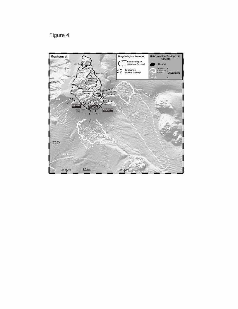
Figure 4
-1000
-1000
-1000
-500
-500
62˚15'W 62˚05'W
16˚35'N
16˚45'N
cc
c
c
0
Montserrat
-100
0
Little Bay
Boxing Day Event, 1997
White River delta
Tar River delta
Woodlands
South-Soufrière Structures
Morphological features
Submarine erosive channel
Flank-collapse structure (on-land)
Debris avalanche deposits (Extent)
DAD with hummocky terrain
On-land�
Submarine�
c�
DAD > 34 000 y old
Soufrière Hills Volcano
Statue Rock
2.5 km
Bottomless Ghaut
SaSoldier Ghaut
�Gerald's
Figure 5


Figure 8
-2500-2000
-2000
-1500
-1000 -500
61˚40'W 61˚20'W
14˚20'N
14˚40'N
1
23
Morphological features
Submarine erosive channel
Flank-collapse structure (on-land)
Debris avalanche deposits (Extent)
DAD with hummocky terrain
On-land
Submarine
Martinique
Lava domes�(Pitons du Carbet)
1- 1st flank-collapse
2- 2nd flank-collapse
3- 3rd flank-collapse
1
23
Carbet Flank-collapse
Montagne Pelée
5 km
61˚ 14'W 61˚ 10'W
14˚ 45'N
14˚ 50'N
0 1 km
Aileron
1st flank-collapse structure
Le Prêcheur
1902 and 1929 lava domes
...
... .. . .
Morne Julien
...
~100-200 ka
~ 4-9 Ka
2nd flank-collapse structure
3 rd flank-collapse structure
.
...
..
St. Pierre
Rivière
du Prêcheur
Rivière Samperre
Caribbean SeaN
Hummocky morphology.. ...Lava domes
~ 25 Ka
Figure 9

Figure 10

Figure 11
-2500-2500
-2000
-1500
-1500
-1000-1000
-500
61˚20'W 61˚00'W
13˚40'N
Mount Gimie
Mount Tabac
Qualibou Structure
Morphological features
Submarine erosive channel
Flank-collapse structure (on-land)
Debris avalanche deposits (Extent)
DAD with hummocky terrain
On-land
Submarine
St-Lucia
Central Rainforest
14˚00'N
5 km

SoufrièreMount Gimie (948 m)
Caribbean Sea
13˚50' N
2 km
Anse l'Ivrogne
Qualibou structure
Mount Tabac (676 m)N
Victoria Junction
Malgré Toute
Choiseul
Jalousie
61˚00'W
578 m
Terre Blanche
Belfond480 m Morne
Bonin
Gros Piton
Petit Piton
Zenon
Chateau Belair
506 m
Courbaril
Rabot
Plaisance
1��
3 42
Figure 12

Figure 13

Figure 14
61˚40'W12˚15'N
12˚20'N
Kick'em Jenny Volcano
Flank-collapse Structure
-1500
-1000
-500
Kick'em Jenny
1.5 km
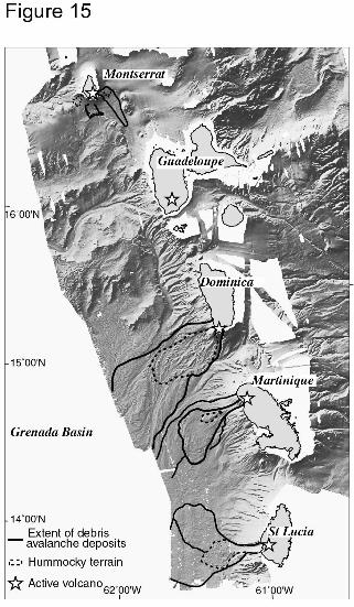
Figure 16
-6000
-4000
0
dept
h (m
)
Longitude
-6000
-4000
-2000
0
dept
h (m
)
-63 ˚W -62 ˚W -61 ˚W -60 ˚W
Grenada Basinride d’Aves
MontserratAntigua
Profile 2
Profile 1
Martinique
-63 ˚W -62 ˚W -61 ˚W
Longitude
W E
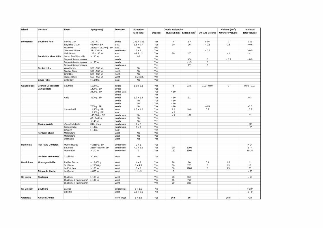
Island Volcano Event Age (years) Direction Structure Debris avalanche Volume (km3) minimumSize (km) Deposit Run out (km) Extend (km2) On land volume Offshore volume total volume
Montserrat Soufriere Hills Boxing Day 1997 AD south 0.55 x 0.53 Yes 4 2.7 0.05 0 0.05English's Crater ~2000 y. BP east 1.5 x 0.7 Yes 10 25 > 0.1 0.5 > 0.6Hot River 28,620 - 18,040 y. BP east No yesGermans Ghaut 34 - 130 ka south-west 3 x 2 Yes > 0.5 > 0.5Irish Ghaut 112 - 130 ka east ~3.5 x 3 Yes 30 200 > 1 > 1
South-Soufriere Hills South Soufrière Hills > 130 ka east 1-2 NoDeposit 3 (submarine) south Yes 45 0 ~ 0.9 ~ 0.9Deposit 4 (submarine) > 130 ka south Yes > 45 0Deposit 5 (submarine) south-west Yes 27 0
Centre Hills Woodlands 550 - 950 ka east No YesSoldier Ghaut 550 - 950 ka north No YesGerald's 550 - 950 ka north No yesStatue Rock 550 - 950 ka west ~3.5 x 3.5 Yes
Silver Hills Little Bay > 1.2 Ma east No Yes
Guadeloupe Grande Découverte- Soufrière 1530 AD south 1.1 x 1.1 Yes 9 13.5 0.03 - 0.07 0 0.03 - 0.07La Soufrière 1400 y. BP south Yes
2400 y. BP south, east Yes > 10south Yes
Amic 3100 y. BP south 1.7 x 1.3 Yes > 10 31 0.3south No Yes > 10south No Yes > 10
7700 y. BP south No Yes > 10 ~0.5 ~0.5Carmichaël 11,500 y. BP west 1.5 x 1.2 Yes 9.2 10.8 0.3 0.3
13,500 y. BP east Yes > 5~45,000 y. BP south, east No Yes > 9 ~37 ?45 - 140 ka south-west No Yes< 140 ka south No Yes
Chaîne Axiale Vieux Habitants 0.8 - 1 Ma south-west 9 x 7 Yes ~30*Beaugendre > 1 Ma south-west 5 x 3 Yes ~ 8*Goyave > 1 Ma east yes
northern chain Malendure west No YesMalendure west No YesDeshaies west No Yes
Dominica Plat Pays Complex Morne Rouge < 2380 y. BP south-west 2 x 1 Yes <1*Soufrière 2380 - 6600 y. BP south-west 4.2 x 2.5 Yes 70 1000 6 -7Morne Eloi > 100 ka south-west ? Yes 120 3500 18-20
northern volcanoes Coulibristi > 1 Ma west No Yes
Martinique Montagne Pelée Rivière Sèche ~ 12,000 y. west 4 x 2 Yes 26 60 0.4 1.6 2St. Pierre ~ 25000 y. west 6 x 4.5 Yes 50 700 0 13 13Le Prêcheur > 100 ka west 8 x 6 Yes 60 1100 0 25 25
Pitons du Carbet Le Carbet > 800 ka west 11 x 9 Yes ? > 30
St. Lucia Qualibou Qualibou > 100 ka west Yes 40 350 > 10Qualibou 2 (submarine) > 100 ka west Yes 65 750Qualibou 3 (submarine) west Yes 70 800
St. Vincent Soufrière Larikai southwest 5 x 3.5 No > 10*Baleine west 3.5 x 2.5 No ~3 - 5*
Grenada Kick'em Jenny north-west 6 x 3.5 Yes 16.5 65 16.5 ~10