Ground and marine magnetic surveys of the lower eastern flank of Etna volcano (Italy
16
Ground and marine magnetic surveys of the lower eastern £ank of Etna volcano (Italy) Ciro Del Negro a , Rosalba Napoli b; a Istituto Nazionale di Geo¢sica e Vulcanologia, Sezione di Catania, 2 Piazza Roma, 95123 Catania, Italy b Dipartimento Scienze della Terra, Universita ' della Calabria, 87036 Arcavacata di Rende (CS), Italy Received 9 November 2000; accepted 17 July 2001 Abstract In 1996 and 1997, two high-resolution magnetic surveys, one on land and the other at sea, were carried out on the lower eastern flank of Mount Etna. The magnetic surveys, covering an area of about 400 km 2 , aimed to elucidate the relationships between the main tectonic and morphologic features of this flank of Mount Etna. Major features include widespread NNW- and NNE-trending active faults and the Valle del Bove, a depression considered to be the source area of the Chiancone deposit, the largest Etnean volcaniclastic sequence. Magnetic surveys show anomalies that roughly follow the trend of active main structures. Although few magnetization measurements are available for the most representative outcrops of the lower eastern side of Mount Etna, interpretation of the anomalies defines the underground geometry of the Chiancone deposit and its relationship with volcano stratigraphic units and the underlying sedimentary rocks. In particular, a volume of about 14 km 3 was ascribed to the Chiancone deposit. Such a large amount of material was likely produced by a catastrophic event, and deposited at different periods at the exit of the Valle del Bove in an area produced by the interaction, on a regional scale, of the main tectonic structures affecting this flank of the volcano. ȣ 2002 Elsevier Science B.V. All rights reserved. Keywords: magnetic survey; volcaniclastic deposit; magnetic modeling; Etna 1. Introduction The lower eastern £ank of Mount Etna (Fig. 1) has been the site of several geological and strati- graphic investigations because of the presence of the major tectonic and volcanic features of the volcano. These are represented by two major structural lineaments at a regional scale, partially responsible for the volcanic evolution of this area, and by the depression of the Valle del Bove, which is considered the source area of the Chian- cone deposit, the largest Etnean volcaniclastic se- quence. The relationships between these structures have not been entirely elucidated because most of the contacts in the basement sedimentary rocks are buried by accumulations of lava £ows and volcaniclastic deposits. To date there is no set of geophysical data (magnetic, geoelectrical, seismic and geodetic) gathered uniformly and extensively that ad- equately complements the geological and strati- 0377-0273 / 02 / $ ^ see front matter ȣ 2002 Elsevier Science B.V. All rights reserved. PII:S0377-0273(01)00295-5 * Corresponding author. Fax: +39-95-435801. E-mail addresses: [email protected] (C. Del Negro), [email protected] (R. Napoli). VOLGEO 2404 24-5-02 Cyaan Magenta Geel Zwart Journal of Volcanology and Geothermal Research 114 (2002) 357^372 www.elsevier.com/locate/jvolgeores
-
Upload
independent -
Category
Documents
-
view
0 -
download
0
Transcript of Ground and marine magnetic surveys of the lower eastern flank of Etna volcano (Italy

Ground and marine magnetic surveys of the lower eastern£ank of Etna volcano (Italy)
Ciro Del Negro a, Rosalba Napoli b;�
a Istituto Nazionale di Geo¢sica e Vulcanologia, Sezione di Catania, 2 Piazza Roma, 95123 Catania, Italyb Dipartimento Scienze della Terra, Universita' della Calabria, 87036 Arcavacata di Rende (CS), Italy
Received 9 November 2000; accepted 17 July 2001
Abstract
In 1996 and 1997, two high-resolution magnetic surveys, one on land and the other at sea, were carried out onthe lower eastern flank of Mount Etna. The magnetic surveys, covering an area of about 400 km2, aimed to elucidatethe relationships between the main tectonic and morphologic features of this flank of Mount Etna. Major featuresinclude widespread NNW- and NNE-trending active faults and the Valle del Bove, a depression considered to be thesource area of the Chiancone deposit, the largest Etnean volcaniclastic sequence. Magnetic surveys show anomaliesthat roughly follow the trend of active main structures. Although few magnetization measurements are available forthe most representative outcrops of the lower eastern side of Mount Etna, interpretation of the anomalies defines theunderground geometry of the Chiancone deposit and its relationship with volcano stratigraphic units and theunderlying sedimentary rocks. In particular, a volume of about 14 km3 was ascribed to the Chiancone deposit. Such alarge amount of material was likely produced by a catastrophic event, and deposited at different periods at the exit ofthe Valle del Bove in an area produced by the interaction, on a regional scale, of the main tectonic structures affectingthis flank of the volcano. 9 2002 Elsevier Science B.V. All rights reserved.
Keywords: magnetic survey; volcaniclastic deposit; magnetic modeling; Etna
1. Introduction
The lower eastern £ank of Mount Etna (Fig. 1)has been the site of several geological and strati-graphic investigations because of the presence ofthe major tectonic and volcanic features of thevolcano. These are represented by two majorstructural lineaments at a regional scale, partially
responsible for the volcanic evolution of this area,and by the depression of the Valle del Bove,which is considered the source area of the Chian-cone deposit, the largest Etnean volcaniclastic se-quence. The relationships between these structureshave not been entirely elucidated because most ofthe contacts in the basement sedimentary rocksare buried by accumulations of lava £ows andvolcaniclastic deposits.To date there is no set of geophysical data
(magnetic, geoelectrical, seismic and geodetic)gathered uniformly and extensively that ad-equately complements the geological and strati-
0377-0273 / 02 / $ ^ see front matter 9 2002 Elsevier Science B.V. All rights reserved.PII: S 0 3 7 7 - 0 2 7 3 ( 0 1 ) 0 0 2 9 5 - 5
* Corresponding author. Fax: +39-95-435801.E-mail addresses: [email protected] (C. Del Negro),
[email protected] (R. Napoli).
VOLGEO 2404 24-5-02 Cyaan Magenta Geel Zwart
Journal of Volcanology and Geothermal Research 114 (2002) 357^372
www.elsevier.com/locate/jvolgeores

graphic investigations of this £ank of Etna. Toacquire better information on structures at a re-gional scale, a wide and detailed magnetic surveywas carried out in 1996 and 1997 both inland ando¡shore along the eastern coastal side of MountEtna.High-resolution magnetic surveys were carried
out to address the subsurface geology of the entire£ank. Special care was paid to the Chiancone de-posit, which has a fan morphology and coversabout 40 km2 from the outlet of the Valle delBove to the coast. This was done because preciseknowledge of the origin and volume of the Chian-cone deposit and the characteristics of its substra-tum could provide useful volcanological and mor-phostructural information for hazard analyses.The availability of detailed volcanological and
geological data sets provided all the constraintsneeded for magnetic modeling. Though the sour-ces of some anomalies are not completely under-stood because of the complicated distribution ofmagnetization, observed patterns contribute to abetter understanding of the relationships betweenvolcanic and volcaniclastic units with sedimentarybasement, as well as providing new insight intothe volcanological history of the lower eastern£ank of Mount Etna.
2. Geology and tectonic setting
A contact between the sedimentary basementand the pre-Etnean and Etnean volcanic units oc-curs on the lower eastern £ank of Mount Etna(Fig. 1). This area is a¡ected by regional tectonicsystems involving compressive tectonics with anN^S orientation related to the migration of theAppenninic^Maghrebian chain, over which aprevalently extensional regime is superimposed(Bousquet et al., 1987; Lanzafame et al., 1997).The main tectonic and morphologic features ofMount Etna, represented by the widespreadNNW- and NNE-trending active faults and bythe depression of the Valle del Bove, dominatethe eastern £ank of the volcano.The series of NNW^SSE active faults, referred
to as the Timpe fault system, prevail along thesouthern coastal strip. These faults, which are
considered to be the inland extension of theIbleo-Maltese Escarpment (Cristofolini et al.,1979; Lentini, 1982), change direction to anNNE^SSW strike farther north where they con-stitute the Piedimonte system (Monaco et al.,1995), which is connected to the normal faultscharacterizing the Strait of Messina (Cristofoliniet al., 1979).The Valle del Bove is a horseshoe-shaped de-
pression about 8 km long and 5 km wide, open tothe east and delimited in all other directions bysteep side walls. Whatever the mechanism respon-sible for the formation of the Valle del Bove ^phreatic and phreatomagmatic explosions, gravi-tational slides or glacial erosion (Kie¡er, 1970;McGuire, 1982; Guest et al., 1984; Borgia etal., 1992; Vagliasindi, 1949) ^ this depression isthought to be the source area of the Chianconedeposit, the largest Etnean volcaniclastic se-quence. The Chiancone deposit covers a surfaceof about 40 km2 with a maximum exposed thick-ness of 30 m and a 3^4‡ inclination eastwards.The bottom of this formation does not crop out,therefore its total volume is unknown. However,geoelectrical and hydrogeological data estimatethe thickness of the whole deposit between 300and 400 m (Cassinis et al., 1970; Ferrara, 1975).Considering a mean thickness of about 300 m asrepresentative, Calvari and Groppelli (1996) as-cribed to the Chiancone deposit a volume ofabout 12 km3, which is comparable to that ofthe Valle del Bove.The formation mechanism of the Chiancone
deposit is controversial. Generally the Chianconeis described as an alluvial deposit Kie¡er, 1969,1970; Romano and Sturiale, 1981; Di Grandeand Di Maggio, 1988) more or less welded andirregularly strati¢ed. McGuire (1982), Romano(1982) and Rittman (1973), instead, interpret theChiancone as a deposit formed by mud £ows pro-duced by phreatic or phreatomagmatic explosiveactivity. On the contrary, Borgia et al. (1992) con-sider this deposit as the result of erosion andlandslides, both controlled by tectonics whichcaused the collapse of the area. In particular,dike intrusions (Guest et al., 1984; Borgia et al.,1992), lava overload and the lack of a blockagefor this side of the volcano could be the main
VOLGEO 2404 24-5-02 Cyaan Magenta Geel Zwart
C. Del Negro, R. Napoli / Journal of Volcanology and Geothermal Research 114 (2002) 357^372358

causes of its instability. As regards its age, radio-metric, stratigraphic and petrographic data (Guestet al., 1984; Duncan et al., 1984) consider theValle del Bove and the Chiancone almost coevaland younger than 6000 years. Recently, Calvari etal. (1998) distinguished within the exposed part ofthe Chiancone deposit a basal sequence of lahars(mud-£ow and debris-£ow beds) overlain by vol-caniclastic £uvial beds and water-reworked pyro-
clastics. The basal lahars contain lava blocks ofdi¡ering size, whose compositions (at the bound-ary between the hawaiite and mugearite ¢elds)partially overlap that of the Milo Lahars, an ava-lanche deposit cropping out just at the exit of theValle del Bove. Radiocarbon dating (Calvari andGroppelli, 1996) indicates that the upper portionof the Chiancone formed after 7590M 130 BP,2000 years older than previously hypothesized
Fig. 1. Simpli¢ed geologic map of the eastern £ank of Mount Etna. The map shows the relative position of the Milo Lahars andChiancone deposit, modi¢ed after Calvari et al. (1998) and the main fault systems (TFS: Timpe fault system; MF: Moscarellofault; MCF: Macchia fault; FF: Fiumefreddo fault ; PF: Piedimonte fault; PPS: Pernicana^Provenzana system). The inset showsthe investigated area during the time span 1996^97. Black and red lines represent measurement tracks; red lines represent mod-eled pro¢les.
VOLGEO 2404 24-5-02 Cyaan Magenta Geel Zwart
C. Del Negro, R. Napoli / Journal of Volcanology and Geothermal Research 114 (2002) 357^372 359
by Kie¡er (1970,1977,1979), and that it is corre-lative with the Milo Lahars (8400 and 5300 yearsBP).
3. Magnetic survey
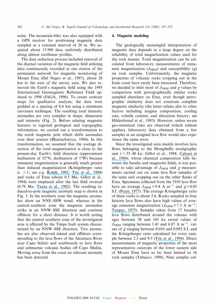
Digital magnetic data, covering about 440 km2,were collected in a time span of 2 years on thecoastal side of Mount Etna both inland and o¡-shore (Fig. 1). Magnetic measurements were gath-ered in two di¡erent periods using similar instru-
ments and techniques, although operatingconditions were totally di¡erent.During summer 1996 we performed the marine
magnetic survey in the Ionian Sea o¡ the easterncoast of Sicily between Capo Mulini and CapoSchiso' , (Fig. 1) covering an area of about175 km2 between 37‡34P30QN^37‡49P20QN and15‡10P55QE^15‡20P10QE. The survey tracks wereoriented NNE^SSW and ENE^WSW, approxi-mately parallel and perpendicular to the coast,and were spaced respectively by about 1 and 4km. We obtained about 280 line kilometers of
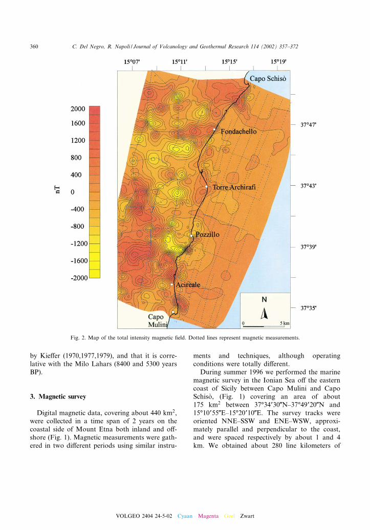
Fig. 2. Map of the total intensity magnetic ¢eld. Dotted lines represent magnetic measurements.
VOLGEO 2404 24-5-02 Cyaan Magenta Geel Zwart
C. Del Negro, R. Napoli / Journal of Volcanology and Geothermal Research 114 (2002) 357^372360
data collected by an Overhauser e¡ect magneto-meter GSM19 with 0.01 nT sensitivity. The sen-sor, located in a rubber dinghy, was draggedabout 10 m away from a motorboat, in order toreduce noise produced by the driving boat. Wecollected a total of about 7000 magnetic measure-ments, along all tracks at 10-s intervals, corre-sponding to a sample spacing of approximately50 m at the survey speed used (18 km/h). Thedata were located better than 10 m using a globalpositioning system (GPS) receiver, a Trimble GeoExplorer II, installed on board.
The ground magnetic survey was executed in1997 in a quadrangular area of about 250 km2
bounded by Capo Mulini, Capo Schiso' , Lin-guaglossa and S.G. La Punta (37‡35P00QN^37‡50P40QN and 15‡06P00QE^15‡15P00QE). In orderto obtain long enough pro¢les to include the in-vestigated structures at a regional scale, the mag-netic data were gathered using an aluminummountain-bike equipped with a proton precessionmagnetometer Geometrics G-856 (typical resolu-tion: 0.1 nT). The sensor was set vertically on analuminum pole, 2 m above the ground to reduce
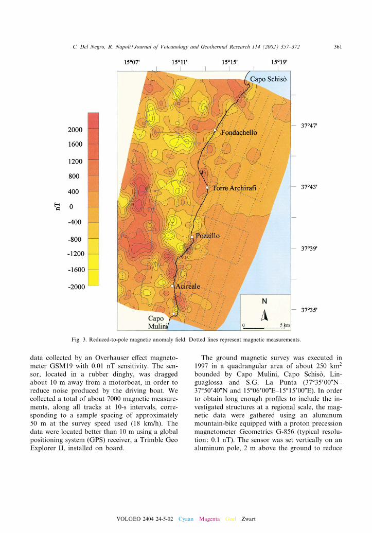
Fig. 3. Reduced-to-pole magnetic anomaly ¢eld. Dotted lines represent magnetic measurements.
VOLGEO 2404 24-5-02 Cyaan Magenta Geel Zwart
C. Del Negro, R. Napoli / Journal of Volcanology and Geothermal Research 114 (2002) 357^372 361
noise. The mountain-bike was also equipped witha GPS receiver for positioning magnetic datasampled at a constant interval of 20 m. We ac-quired about 13 500 data uniformly distributedalong almost rectilinear pro¢les.The data reduction process included removal of
the diurnal variation of the magnetic ¢eld utilizingdata continuously recorded at one station of thepermanent network for magnetic monitoring ofMount Etna (Del Negro et al., 1997), about 20km to the west of the survey area. We also re-moved the Earth’s magnetic ¢eld using the 1995International Geomagnetic Reference Field up-dated to 1998 (IAGA, 1996). To create contourmaps for qualitative analysis, the data weregridded at a spacing of 0.6 km using a minimumcurvature technique. The resulting total intensityanomalies are very complex in shape, dimensionand intensity (Fig. 2). Before relating magneticfeatures to regional geological and topographicinformation, we carried out a transformation tothe north magnetic pole which shifts anomaliesover their sources (Bhattacharyya, 1964). In thistransformation, we assumed that the average di-rection of the total magnetization is close to thepresent-day Earth’s ¢eld direction (approximateinclination of 52‡N, declination of 1‡W) becauseremanent magnetization is generally much greaterthan induced magnetization (Ko«nigsberger ratiois s 1; see e.g. Rolph, 1992; Tric et al., 1994)and rocks of Etna (about 0.5 Ma; Gillot et al.,1994) were emplaced after the last ¢eld reversal(0.78 Ma; Tauxe et al., 1992). The resulting re-duced-to-pole magnetic anomaly map is shown inFig. 3. In the northern zone the magnetic anoma-lies show an NNE^SSW trend, whereas in thecentral^southern zone the magnetic anomaliesstrike in an NNW^SSE direction and continueo¡shore for a short distance. It is worth notingthat the central^southern zone of the investigatedarea is a¡ected by the Timpe fault system charac-terized by an NNW^SSE direction. Two anoma-lies are also observed inland and o¡shore corre-sponding to the lava £ows of the Alcantara Rivernear Capo Schiso' and southwards to lava £owsand submarine volcanic bodies o¡ Capo Mulini.Moving away from the coast no relevant anomalyhas been detected.
4. Magnetic modeling
The geologically meaningful interpretation ofmagnetic data depends to a large degree on thereliability of total magnetization values used forthe rock masses. Total magnetization can be cal-culated from laboratory measurements of rema-nent magnetization (JNRM) and susceptibility (M)on rock samples. Unfortunately, the magneticproperties of volcanic rocks cropping out in theIonic coast have rarely been measured. Therefore,we decided to infer most of JNRM and M values bycomparison with petrographically similar rockssampled elsewhere on Etna, even though petro-graphic similarity does not constrain completemagnetic similarity (the latter relates also to otherfactors including magma composition, coolingrate, volatile content, and alteration history; seeHildenbrand et al., 1993). However, unless severegeo-statistical rules are observed (which seldomapplies), laboratory data obtained from a fewsamples in an assigned lava £ow would also expe-rience the same error.Since the investigated area mainly involves lava
£ows belonging to the Mongibello stratigraphicunit (6 35^40 ka; Gillot et al., 1994; Calvari etal., 1994), whose chemical composition falls be-tween the basalts and mugearite ¢elds, it was pos-sible to take advantage of JNRM and M measure-ments carried out on some lava £ow samples ofthe same unit cropping out on the other £anks ofEtna. Specimens collected from the 1910 lava £owhave an average JNRM =9.4 A m31 and M=0.05S.I. (Pozzi, 1977). The average Ko«nigsberger ratioof these rocks is about 5.6. Rocks sampled in fourhistoric lava £ows also have high values of aver-age remanent magnetization (JNRM =7.3 A m31 ;Tanguy, 1975). Samples taken from 17 basalticlava £ows distributed around the volcano withages between 50 and 165 ka reveal values ofJNRM ranging between 1.41 and 6.87 A m31, val-ues of M ranging between 0.016 and 0.092 S.I. andthe Ko«nigsberger ratio calculated for every sam-ple between 2.3 and 9.5 (Tric et al., 1994). Directmeasurements of magnetic properties of the mostrepresentative outcrops of the lower eastern sideof Mount Etna have so far been limited to 16rock samples (Tabacco, 1998). Nine samples col-
VOLGEO 2404 24-5-02 Cyaan Magenta Geel Zwart
C. Del Negro, R. Napoli / Journal of Volcanology and Geothermal Research 114 (2002) 357^372362
lected from lava £ows and dikes display values ofJNRM ranging between 5.13 and 7.21 A m31, andvalues of M ranging between 0.023 and 0.031 S.I.,whereas four samples of the volcaniclastic deposit(JNRM =2.88 A m31 and M=0.01 S.I.) and threesamples of alluvium (JNRM =1.82 A m31andM=0.01 S.I.) reveal lower average values.In the magnetic modeling, we assigned average
values of JNRM and M to the model units (see Figs.4^6) obtained from the above cited values. Specif-ically, the values of remanent magnetization forthe volcaniclastic deposits seem too high. In vol-caniclastic deposits, individual clasts may have
high remanence values but, if the deposits wereemplaced at low temperature, the remanence vec-tors will be randomly oriented and tend to cancel.Therefore, we would expect the remanence valuesfor volcaniclastic deposits to be near zero. But thevalues indicated for the Chiancone deposit con-cern the basal lahars that may have formed owingto a debris avalanche. Most avalanches are com-posed primarily of large homogeneous blocks ofthe original landscape that have been transportedintact preserving the original stratigraphy of thecollapsed mountain, and making the remanencevalues adopted reasonable. No magnetization
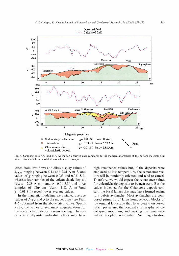
Fig. 4. Sampling lines AAP and BBP. At the top observed data compared to the modeled anomalies; at the bottom the geologicalmodels from which the modeled anomalies were computed.
VOLGEO 2404 24-5-02 Cyaan Magenta Geel Zwart
C. Del Negro, R. Napoli / Journal of Volcanology and Geothermal Research 114 (2002) 357^372 363
was ascribed to the sedimentary basement whichmainly consists of Pleistocenic clays. Since theserepresent the mean values of magnetization, wehave determined the global geometry of theEtna lava cover and contacts between lithologieswith di¡erent magnetic properties such as lavas,incoherent volcanic deposits and sedimentarybasement but we could not de¢ne the overlapping
and lateral relationships between di¡erent lavaunits with similar magnetic properties.To obtain a picture of the subsurface structures
we have calculated models for seven pro¢les par-allel to the coast (approximate strike NNE^SSW)about 30^50 km long (Fig. 1). The modeling pro-cedure was carried out by a 3D program (Potentv3.06 by PC Potentials) which adjusts the model
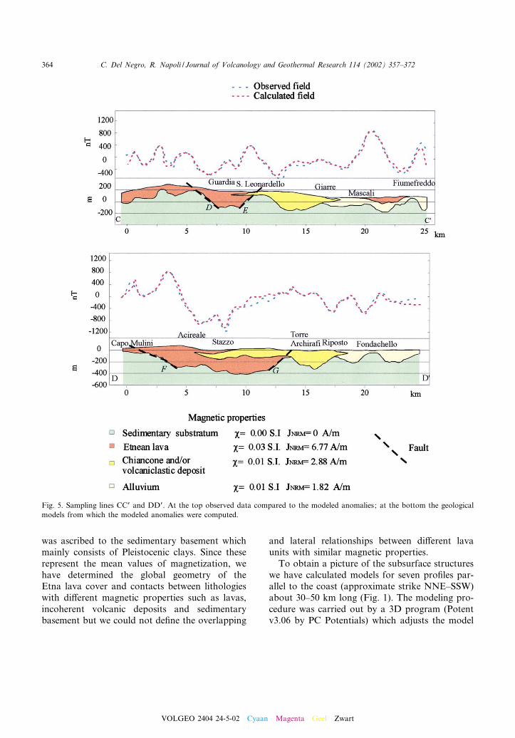
Fig. 5. Sampling lines CCP and DDP. At the top observed data compared to the modeled anomalies; at the bottom the geologicalmodels from which the modeled anomalies were computed.
VOLGEO 2404 24-5-02 Cyaan Magenta Geel Zwart
C. Del Negro, R. Napoli / Journal of Volcanology and Geothermal Research 114 (2002) 357^372364

using a combination of manual (forward model-ing) or automatic (inversion modeling) commandsuntil it provides a satisfactory representation ofthe observations. In particular, we varied theboundaries between bodies and their magneticproperties until the RMS error between the ob-served and calculated data was below a predeter-mined threshold (less than 20 nT). Modelled geo-logical cross-pro¢les were mutually constrained tothe surface geologic and tectonic framework andto the basement top values obtained from drillingdata carried out for water supply in the Etna area(Ferrara, 1975).At the highest altitudes of the investigated area,
lava cover stretches with a mean thickness ofabout 250^300 m over the whole area (pro¢lesAAP and BBP in Fig. 4). It shows minimum thick-ness at Fornazzo and Vena (pro¢le AAP) wherethe sedimentary substratum crops out in places(AA. VV., 1979), and where geological investiga-tions hypothesize the existence of a morphologicalhigh of the basement (Coltelli, personal commu-nication). Pro¢le AAP reveals a thin (20^30 m)and isolated volcaniclastic deposit between Za¡e-rana and Fornazzo. This can be related to theoutcrops of the Milo Lahars (AA. VV., 1979),an avalanche deposit covered by a debris-£ow se-quence (Calvari et al., 1998).Eastwards between Linera and S. Venerina
(pro¢le BBP), where lava £ows of the RecentMongibello unit (6 15 ka; Gillot et al., 1994)thin out, a deposit was observed whose magneticproprieties (JNRM =2.88 A m31 and M=0.01 S.I.)are intermediate between lava products and sedi-mentary basement, and therefore referable to theChiancone deposit. It extends from south of Li-nera to Macchia, where it is probably replaced bymaterial with similar magnetic proprieties but re-lated to the Lower Tu¡s (AA. VV., 1979), whichrecent studies (Coltelli, personal communication)date older than 15 ka and up to about 80^100 ka.Between S. Venerina and Macchia a buried de-pression is revealed. It is bounded by the Mosca-rello fault to the south (dashed line A) and by asteep scarp which could be related to the Macchiafaults to the north (dashed line B). At about 2 kmfrom Piedimonte the presence of the Fiumefreddofaults (dashed line C) is also observed (Fig. 1)
which shows the uplift of the sedimentary base-ment in the north.Approaching the coast (pro¢le CCP in Fig. 5),
our model shows another buried depression atGuardia. Here, the sharp contacts between lavacover and sedimentary basement could be as-cribed to the intersection with the Timpe faultsystem (dashed lines D and E). The thickness oflavas ¢lling this trough reaches values of 300 m.Northwards along the same section, the Chian-cone cropping out between S. Leonardello andGiarre replaces the lava cover, and increasesboth in extension and thickness. According todrilling data (Cassinis et al., 1970), this shows agreater than 200 m thickness in the middle of theoutcrop, which thins out northwards, where it isreplaced by an alluvium arising from dismantlingof surrounding lava and pyroclastic outcrops(Guest et al., 1984) with weaker remanent mag-netization (JNRM =1.82 A m31) and same mag-netic susceptibility (M=0.01 S.I.). At Mascalithis is overlain by a thin (50 m) lava cover as-cribed to the Ancient Mongibello (AA. VV.,1979).Along the coast, the Chiancone deposit repre-
sents the prevalent lithology cropping out for 8 kmfrom north to south. This reaches its maximumthickness of about 350 m between Torre Archira¢and Riposto (pro¢le DDP). Northwards, it is re-placed by 200 m thick alluvium while southwardsthe Chiancone stretches below the lava cover be-longing to the Recent Mongibello unit (AA. VV.,1979). Along the DDP pro¢le, these lava £owsshow a thickness of about 400 m for about 4 kmdistance between Acireale and Torre Archira¢.This remarkable thickness of lavas, the maximumin the whole investigated area, seems to be relatedto the presence of the Timpe fault system, whichin this area tilts (Rasa' et al., 1996) the faulted lavablocks towards the NW, so that the local thick-ness of lavas is greater than normal. BetweenAcireale and Torre Archira¢ a large buried de-pression was detected (Fig. 5). It seems to be pro-duced by interaction between the NNW-strikingfaults which could be related to the Timpe faultsystem (dashed line F), and the NE-striking faultsparallel to theMessina fault system (dashed line G),previously described by Lanzafame et al. (1996).
VOLGEO 2404 24-5-02 Cyaan Magenta Geel Zwart
C. Del Negro, R. Napoli / Journal of Volcanology and Geothermal Research 114 (2002) 357^372 365
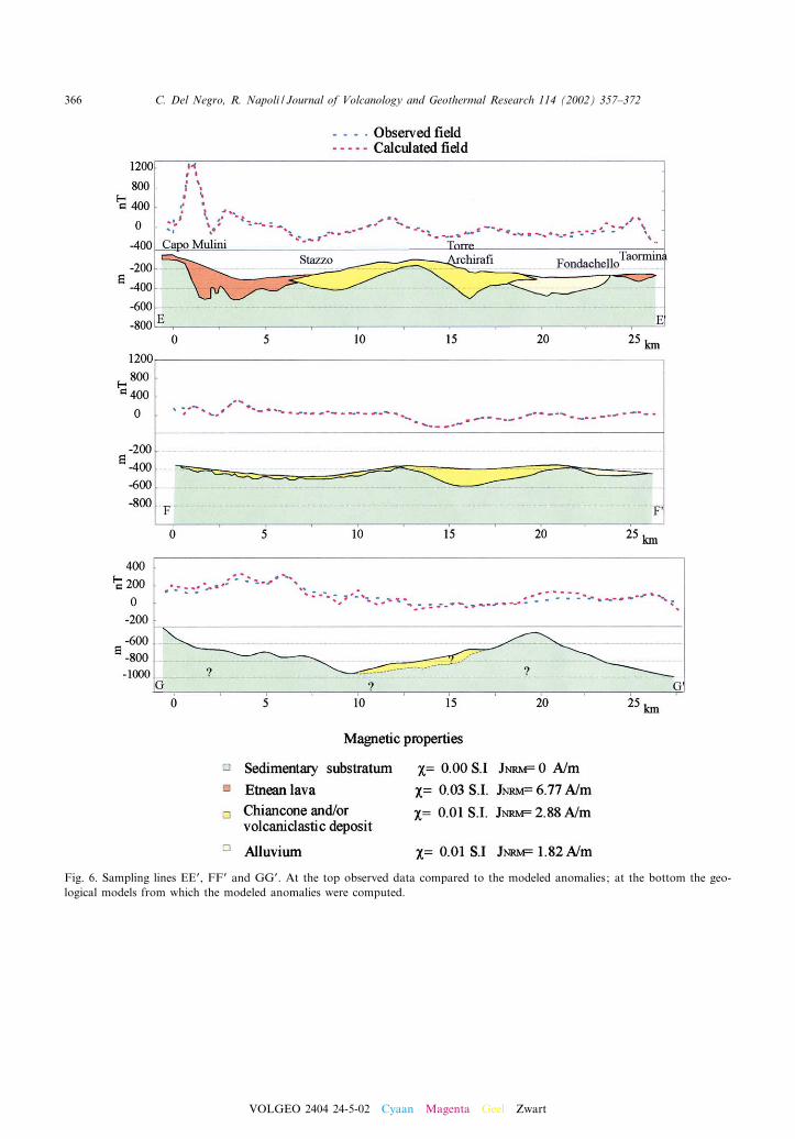
Fig. 6. Sampling lines EEP, FFP and GGP. At the top observed data compared to the modeled anomalies; at the bottom the geo-logical models from which the modeled anomalies were computed.
VOLGEO 2404 24-5-02 Cyaan Magenta Geel Zwart
C. Del Negro, R. Napoli / Journal of Volcanology and Geothermal Research 114 (2002) 357^372366
This pile of lava £ows is also recognized o¡shore,some kilometers o¡ the coast (pro¢le. EEP) be-tween Capo Mulini and Stazzo, where it has alesser thickness (Fig. 6). Pro¢les DDP and EEPare consistent with the presence of Etnean vol-canic products along the coast between Pozzilloand Catania (AA. VV., 1979) and of volcanicbodies related to the submarine or pre-Etnean hy-poabyssal activity which are found either o¡shoreor inland between the Pleistocene clays forming
the Etnean basement (Gabbianelli et al., 1995).In this area the Chiancone deposit shows a small-er thickness (50^200 m) probably due to the greatdistance from the source area. Northwards it isreplaced by alluvium probably arising from dis-mantling of outcrops present inland and succes-sively carried away and settled at sea. At Taormi-na alluvial deposits are substituted by a thin (50^100 m) lava unit interpreted as the Alcantara lava£ows.
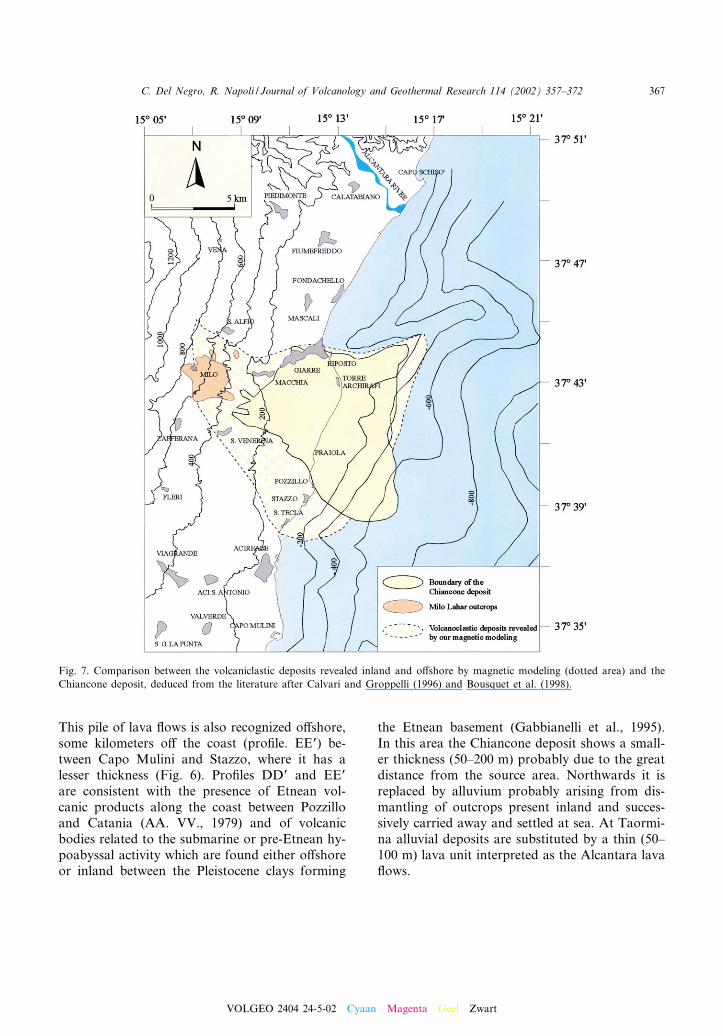
Fig. 7. Comparison between the volcaniclastic deposits revealed inland and o¡shore by magnetic modeling (dotted area) and theChiancone deposit, deduced from the literature after Calvari and Groppelli (1996) and Bousquet et al. (1998).
VOLGEO 2404 24-5-02 Cyaan Magenta Geel Zwart
C. Del Negro, R. Napoli / Journal of Volcanology and Geothermal Research 114 (2002) 357^372 367

Further away from the coast (pro¢le FFP), thelava £ows characterizing areas close to the coastdisappear, and are substituted by volcaniclasticdeposits. In the middle of pro¢le FFP a 200 mthick deposit whose magnetic proprieties make it
comparable with the Chiancone deposit is ob-served (Fig. 6).It is worth noting that at a greater distance
from the coast (5^6 km) the absence of lavas,and consequently of sharp magnetization contrast
Fig. 8. Map of the sedimentary substratum obtained using the altitudes of the clayey top of magnetic models. Arrows indicatepreferential directions for the Chiancone deposit settling.
VOLGEO 2404 24-5-02 Cyaan Magenta Geel Zwart
C. Del Negro, R. Napoli / Journal of Volcanology and Geothermal Research 114 (2002) 357^372368
(pro¢les GGP in Fig. 6), makes the identi¢cationof the Chiancone and/or other incoherent volca-niclastic deposits very di⁄cult, thus strongly af-fecting the modeling reliability.
5. Discussion
The reconstruction (on the basis of magneticmodeling) of the geometry of the Chiancone de-posit and the morphology of the depression hold-ing it both inland and o¡shore can provide newinsight into the geologic structure and conse-quently into the volcanological history of this£ank of the volcano. However, it is worth stress-ing that our magnetic model pertains to units thatcan be recognized on the basis of their magnet-ization contrast. In this respect, the volcaniclasticdeposits of the Milo Lahars, the Chiancone de-posit and Lower Tu¡s comprise a single unit, andcan be distinguished only on the basis of geolog-ical data and previously published geologicalmaps.In Fig. 7 we have compared the extent of the
volcaniclastic deposits, deduced from the litera-ture (e.g. Calvari and Groppelli, 1996; Bousquetet al., 1998) with that obtained from our magneticmodeling. Both inland and o¡shore their northernedges overlap near Giarre, Riposto and Macchia,where the Chiancone is replaced in our model byalluvial material and Lower Tu¡s (26 000 ka;Guest et al., 1984). Westwards, it appears thatthe edge of our volcaniclastic deposit continuesunderground well over the maximum altitude(about 300 m) of the Chiancone outcrop. Herethis unit may comprise the Milo Lahars (10 000ka; Calvari et al., 1998). According to drillingdata (Cassinis et al., 1970), the southern edgeof the Chiancone deposit inferred by magneticmodeling extends below the lava cover up toS. Venerina and S. Tecla, then well over the out-crops of Pozzillo and Praiola. At sea the Chian-cone stretches as a de¢nable single body up to adepth of about 400^500 m under the sea levelaccording to data obtained by Bousquet et al.(1998) through drags, electroacoustic and high-resolution seismic pro¢ling.The Chiancone deposit thickness increases
down from the highest altitude to the coast reach-ing the maximum value, about 300^350 m, in thecentral part of the formation and then thinningout o¡shore. Considering the extension and thick-ness obtained by magnetic models it is possible toascribe a volume of about 14 km3 to the Chian-cone deposit. This value is comparable to thathypothesized by Calvari and Groppelli (1996)for the outcropping part (12 km3) and is compa-rable to the volume of the Valle del Bove. Mag-netic modeling has also revealed that no lava£ows, except close to the coast, exist below theChiancone deposit and its bottom is formed bythe sedimentary substratum. The huge volume ob-tained for the Chiancone deposit and the absenceof lava £ows below it suggest that whatever themechanism which can be invoked for the forma-tion of the Valle del Bove and consequently forthe Chiancone deposit, it took place with suchdestructive power as to produce the decollementof the preexisting lava cover, in turn a¡ecting alsothe upper surface of the sedimentary substratum.Such a process, according to Calvari et al. (1998),could be related to a volcanic £ank collapse fol-lowed by catastrophic landslides.Using the altitudes of the clayey top resulting
from our magnetic models, we have built up amap of the sedimentary substratum morphology(Fig. 8). A general and gradual decrease of thealtitude, from 800 m a.s.l. to 600 m b.s.l., is ob-served from west to east. We have obtained twosharp changes in acclivity, both striking NNW^SSE and NNE^SSW, of the main structures af-fecting the investigated area, in the southern andin the northern areas respectively. The interactionof these structures at a regional scale, as describedby Lanzafame et al. (1996) along the coast ofPraiola Bay, could have produced a large subsi-ding sector where the settling of the Chianconedeposit took place. These structures may alsohave controlled the formation of the Valle delBove (Lanzafame et al., 1996). It is worth notingthat the magnetic anomaly ¢eld also con¢rms thepresence of these structures, which are highlightedby the alignments of the magnetic anomaly (Figs.2 and 3).The basement is also characterized by di¡erent
morphological highs with a general W^E trend.
VOLGEO 2404 24-5-02 Cyaan Magenta Geel Zwart
C. Del Negro, R. Napoli / Journal of Volcanology and Geothermal Research 114 (2002) 357^372 369
The most evident high is observed along the Zaf-ferana^S. Venerina alignment which is likely tohave played a key role during the emplacementof the Chiancone deposit. This acted locally as amorphologic obstacle creating two troughs, southand north, where the volcaniclastic deposit settledeasily. Considering that to the south the Chian-cone deposit stretches below lava £ows of theMongibello unit while to the north it is overlaidonly by alluvium, it is possible that the settling ofthis volcaniclastic deposit took place at di¡erentperiods. In particular, it is possible that a formervolcaniclastic deposit ¢lled the southern trough,delimited by thick lava £ows and tectonically con-trolled by the Timpe fault system. Successively, itwas covered by lava £ows whose oldest terms be-long to Recent Mongibello (Monaco et al., 1995).Later, when this trough was ¢lled, the Chianconedeposit settled in the northern one where itreached its maximum thickness. Northwards, itsextension seems to be bounded by another W^Estriking morphologic high (Fig. 7) at Riposto atthe same latitude and with the same direction asthe well-known Ridge of Riposto (Bousquet et al.,1998), which could be its o¡shore prolongation.Another morphologic high of the basement can beobserved at the latitude of Porto Salvo^Fonda-chello but it does not show any continuity. TheW^E striking morphologic highs revealed in themap of the sedimentary substratum could be in-terpreted as the result of southwardly tectonicthrusts which gave rise to the Appenninic^Magh-rebian chain from the middle Miocene to date inSicily (Catalano and D’Argenio, 1982; Lentini,1982; Argnani, 1987).
6. Conclusions
We have constructed a series of magnetic mod-els using constraints provided by the surface geo-logic and tectonic framework. This has allowed usto obtain both a general picture of the distribu-tion of volcaniclastic deposits on the lower eastern£ank of Mount Etna and their relationships withsurrounding lava £ows and the sedimentary sub-stratum. In particular, the underground geometryof the Chiancone deposit has been de¢ned. It
thickens from the highest altitude to the sea level,reaching the maximum value of 300^350 m be-tween Torre Archira¢ and Riposto, in the middleof the outcrop. It then thins out o¡shore at 4^5km from the coast and at 400^500 m depth.Northwards, near Giarre and Riposto, its exten-sion follows that deduced from the literature,while southwards and westwards the Chianconedeposit extends, below the lava cover, over themaximum altitudes of the outcrop. The volcani-clastic deposit revealed between Za¡erana andFornazzo may correspond to the Milo Lahars.The huge volume of about 14 km3 ascribed to
the volcaniclastic deposit of the eastern £ank ofEtna on the basis of our magnetic modeling andthe absence of lava £ows at the bottom suggest acatastrophic event, as the ¢rst and major mecha-nism responsible for the formation of this deposit.This could have been caused by a £ank collapsefollowed by landslides. The large amount of ma-terial, produced and probably reworked by £uvialerosion, settled at di¡erent periods at the exit ofthe Valle del Bove. The area of greater accumu-lation is de¢ned by the interaction, on a regionalscale, of the main tectonic structures a¡ecting theinvestigated area. During the emplacement of thevolcaniclastic sequence, a key role was also playedby the W^E striking morphologic highs which,produced by the N^S compressive regime a¡ect-ing the volcanic edi¢ce and its sedimentary sub-stratum, worked locally as a morphologic ob-stacle.
Acknowledgements
The authors are grateful to Domenico Conda-relli and Vincenzo Giandinoto for help in fieldwork. Thanks are due to Sofia Tabacco forpreliminary data processing and analysis. AlbertoIncoronato provided us with clues on the magneticproperties of some Etnean lava flows, whichproved essential for the construction of the model.This study benefited from discussions with SoniaCalvari and Mauro Coltelli. The manuscriptimproved greatly from the excellent reviews byJim Kauahikaua and Joseph Rosenbaum. Thisresearch was carried out in the framework of the
VOLGEO 2404 24-5-02 Cyaan Magenta Geel Zwart
C. Del Negro, R. Napoli / Journal of Volcanology and Geothermal Research 114 (2002) 357^372370
project TEKVOLC (EC contract No. ENV4-CT95-0251) and was partially supported by projectEPOT of the Gruppo Nazionale per la Vulcano-logia of the INGV.
References
AA. VV., 1979. Carta geologica dell’Etna. Prog. Fin. Geodin.,C.N.R., Roma.
Argnani, A., 1987. The Gela nappe: evidence of accretionarymelange in the Maghrebian foredeep of Sicily. Mem. Soc.Geol. It. 38, 419^428.
Bhattacharyya, B.K., 1964. Magnetic anomalies due to prism-shaped bodies with arbitrary polarization. Geophysics 29(4), 517^533.
Borgia, A., Ferrari, R., Pasquare', G., 1992. Inportance ofgravitational spreading in the tectonic and volcanic evolu-tion of Mount Etna. Nature 357, 231^235.
Bousquet, J.C., Gresta, S., Lanzafame, G., Paquin, H., 1987. Ilcampo degli sforzi attuali e quaternari nella regione dell’Et-na. Mem. Soc. Geol. It. 38, 483^506.
Bousquet, J.C., Gabbianelli, G., Lanzafame, G., Sartoiri, R.,1998. EŁ volution volcanotectonique de l’Etna (Sicilie): nou-velles donne'es de ge¤ologie marine et terrestre. Rapp. Com-miss. Int. pour l’Explor. Sci. de la Mer Me¤diterr. 35, 56^57.
Calvari, S., Groppelli, G., 1996. Relevance of the Chianconevolcaniclastic deposit in the recent history of Etna Volcano(Italy). J. Volcanol. Geotherm. Res. 72, 239^258.
Calvari, S., Groppelli, G., Pasquare', G., 1994. Preliminarlygeological data on the south-western wall of the Valle delBove, Mt. Etna, Sicily. Acta Volcanol. 5, 15^30.
Calvari, S., Tanner, L.H., Groppelli, G., 1998. Debris-ava-lanche deposits of the Milo Lahar sequence and the opeingof the Vale del Bove on Etna volcano (Italy). J. Volcanol.Geotherm. Res. 87, 193^209.
Cassinis, R., Cosentino, P., Ponzini, G.S, Riuscetti, M., 1970.Contributo all’esplorazione geo¢sica lungo la costa etnea.Atti I Conv. Int.. Acque Sott. 6-8 Dic. Palermo, pp. 144^154.
Catalano, R., D’Argenio, B., 1982. Schema geologico dellaSicilia. In: Catalano, R., D’Argenio, B. (Eds.), Guida allaGeologia della Sicilia Occidentale. Palermo, pp. 9^41.
Cristofolini, R., Lentini, F., Patane', G., Rasa', R., 1979. Inte-grazione di dati geologici, geo¢sici e petrologici per la ste-sura di un pro¢lo crostale in corrispondenza dell’Etna. Boll.Soc. Geol. It. 98, 239^247.
Del Negro, C., Ferrucci, F., Napoli, R., 1997. The permanentnetwork for magnetic surveillance of Mt. Etna changes inthe geomagnetic total intensity observed in 1995. Acta Vul-canol. 9 (1), 67^72.
Di Grande, A., Di Maggio, F., 1988. Lineamenti Geologicidell’area del ‘Chiancone’ (Etna). Boll. Acc. Gioenia Sci.Nat. 21 (334), 399^416.
Duncan, A.M., Chester, D.K., Guest, J.E., 1984. The quater-
nary stratigraphy of Mount Etna, Sicily. The e¡ect of di¡er-ent paleoenvironments on styles of volcanism. Bull. Volca-nol. 47, 498^516.
Ferrara, V., 1975. Idrogeologia del versante orientale dell’Et-na. III Convegno Internazionale sulle Acque Sotterranee,pp. 91^144.
Gabbianelli, G., Lanzafame, G., Lucchini, F., Pompilio, M.,Rossi, L.P., Sartori, R., 1995. Indagini di geologia marinaalla base orientale dell’Etna. In: Ferrucci, F., Innocenti,F.(Eds.), Progetto Etna 1993^95. Giardini, Pisa, 79^84.
Gillot, P.Y., Kie¡er, G., Romano, R., 1994. The evolution ofMount Etna in the light of potassium-argon dating. ActaVulcanol. 5, 81^87.
Guest, J.E., Chester, D.K., Duncan, A.M., 1984. The Valle delBove, Mount Etna: its origin and relation to the stratigra-phy and structure of the Volcano. J. Volcanol. Geotherm.Res. 21, 1^23.
Hildenbrand, T.G., Rosenbaum, J.G., Kauahikaua, J.P., 1993.Aeromagnetic study of the Island of Hawaii. J. Geophys.Res. 98, 4099^4119.
IAGA Working Group V-8, 1996. International GeomagneticReference Field, 1995 revision. Geophys. J. Int. 125, 318^321.
Kie¡er, G., 1969. Origine explosive de la Valle del Bove (Etna,Sicilie). C. R. Acad. Sci. Paris 269, 1938^1941.
Kie¡er, G., 1970. Les depots detritiques et pyroclastiques duversant oriental de l’Etna. Atti Acc. Gioenia Sci. Nat. Ser.VIII 2, 131^160.
Kie¡er, G., 1977. Donne¤es nouvelles sur l’origine de la Valledel Bove et sa place dans l’historie volcanologique de l’Etna.C. R. Acad. Sci. Paris 285, 1339^1394.
Kie¡er, G., 1979. L’activite¤ de L’Etna pendant les dernier20 000 ans. C. R. Acad. Sci. Paris 288, 1023^1026.
Lanzafame, G., Neri, M., Rust, D., 1996. Active tectonicsa¡ecting the eastern £ank of Mount Etna: structural inter-actions at a regional and local scale. In: Gravestock, P.,McGuire, W. (Eds), Etna Fifteen Years On. Proceedingsof the Conference held at Cheltenham and Gloucester Col-lege of Higher Education, 12 Feb. 1996.
Lanzafame, G., Neri, M., Coltelli, M., Lodato, L., Rust, D.,1997. North-South compression in the Mt. Etna region (Si-cily) spatial and temporal contribution. Acta Volcanol. 9,121^133.
Lentini, F., 1982. The geology of the Mt. Etna basement.Mem. Soc. Geol. It. 23, 7^25.
McGuire, W.J., 1982. Evolution of the Etna volcano: informa-tion from the southern wall of the Valle del Bove. J. Volca-nol. Geotherm. Res. 13, 241^271.
Monaco, C., Petronio, L., Romanelli, M., 1995. Tettonica es-tensionale nel settore orientale del Monte Etna (Sicilia): datimorfotettonici e sismici. Stud. Geol. Camerti Vol. Spec. 2,363^374.
Pozzi, J.P., 1977. E¡ects of stresses on magnetic properties ofvolcanic rocks. Phys. Earth Planet. Inter. 14, 77^85.
Rasa', R., Azzaro, R., Leonardi, O., 1996. A seismic creep onfaults and £ank instability at Mt. Etna volcano, Sicily. In:McGuire, W.C., Iones, A.P., Neuberg, J. (Eds.), Volcano
VOLGEO 2404 24-5-02 Cyaan Magenta Geel Zwart
C. Del Negro, R. Napoli / Journal of Volcanology and Geothermal Research 114 (2002) 357^372 371

Instability on the Earths in the Other Planets, Geol. Soc.Spec. Publ. 110, pp. 179^192.
Rittman, A., 1973. Structure and evolution of Mount Etna.Philos. Trans. R. Soc. Lond. 274, 5^16.
Rolph, T.C., 1992. High ¢eld intensity results from recent andhistoric lavas. Phys. Earth Planet. Inter. 70, 224^230.
Romano, R., 1982. Succession of the volcanic activity in theEtnean area. Mem. Soc. Geol. It. 23, 27^48.
Romano, R., Sturiale, C., 1981. Geologia del versante sud-orientale etneo ^ F. 270 IV (NO, NE, SO, SE). Boll. Soc.Geol. It. 100, 15^40.
Tabacco, S., 1998. De¢nizione del basamento etneo sottostanteil deposito vulcanoclastico del Chiancone (settore orientaledell’Etna) attraverso metodiche geologico-strutturali e geo-
¢siche. Ph.D. thesis, Universita' degli Studi di Catania, 105pp.
Tanguy, J.C., 1975. Intensity of the geomagnetic ¢eld fromrecent Italian lavas using a new palaeointensity method.Earth Planet. Sci. Lett. 27, 314^320.
Tauxe, L., Deino, A.D., Behrensmeyer, A.K., Potts, R., 1992.Pinning down the Brunhes/Matuyama and upper Jaramilloboundaries: As reconciliation of orbital and isotopic timescales. Earth Planet. Sci. Lett. 109, 561^572.
Tric, E., Valet, J.P., Gillot, P.Y., Lemeur, I., 1994. Absolutepaleointensities between 60 and 160 kyear BP from MountEtna (Sicily). Phys. Earth Planet. Inter. 85, 113^129.
Vagliasindi, C., 1949. A rewiew of three papers in Italian byEmiliani. Can. J. Geol. 58, 284^285.
VOLGEO 2404 24-5-02 Cyaan Magenta Geel Zwart
C. Del Negro, R. Napoli / Journal of Volcanology and Geothermal Research 114 (2002) 357^372372