Geological map of Etna volcano, 1:50,000 scale.
27
ABSTRACT The new geological map of Etna volcano at 1:50,000 scale repre- sents a significant progress in the geological studies of this volcano over the last 30 years, coming after Waltershausen’s map published around the mid of 19 th century, the first geological map of a large active volcano, and the ROMANO et alii (1979) map published about a century later, both at 1:50,000 scale. Lithostratigraphy was used for mapping volcanic units and then Unconformity Bounded Units were applied to group lithostratigraphic units into synthems. In addition, lithosomes were exploited to better represent the spatial localization of different eruptive centres according to their morphology. On the whole, we identified 27 lithostratigraphic units, grouped into 8 syn- thems, and 9 volcanoes. In detail, effusive and explosive deposits generated by each eruption of Mongibello and, partially, Ellittico volcanoes were mapped as flow rank. This stratigraphic framework represents the best synthesis of the geological evolution of Etna vol- cano using the main unconformities recognized within its complex volcanic succession. In addition, we constrain the Etna volcanic suc- cession and its lithostratigraphic units chronologically by radioiso- tope age determinations. On the basis of the outlined synthemic units, it was possible to divide Etna’s volcanic succession into 4 supersynthems, which correspond to 4 well-defined and spatially localized phases. The detailed reconstruction of the past eruptive activity allowed compiling the most accurate dataset in particular of the Holocene eruptions of Etna volcano, which will enable signifi- cantly improving the volcanic hazard assessment, together with petrological interpretation of erupted magmas and geophysical mod- elling of the volcano plumbing system. KEY WORDS: Mount Etna, geological map, basaltic composite volcano, stratigraphy, UBU. INTRODUCTION Mount Etna is one of the most active volcanoes in the world, located on the densely inhabited eastern coast of Sicily (Italy). It is a large basaltic composite volcano cov- ering a broad sub-rounded surface of 1178 km 2 , with a maximum diameter of about 45 km, from sea level along the Ionian coast up to a height of 3328 m. Etna volcano is characterized by an almost continuous eruptive activity from its summit craters and fairly frequent lava flow eruptions from fissures opened on its flanks, as histori- cally reported during the past 2,700 years ever since the Hellenistic age (TANGUY, 1981; BRANCA & DEL CARLO, 2004 and 2005). An active volcano, such as Etna, poses a variety of potential hazards whose assessment is largely based on the record of the past eruptions. Field data and evolution- ary interpretations provide information on the frequency, magnitude, distribution and style of these volcanic events. The geological map is a storehouse of the past eruption data and can be used for practical purposes such as land management planning and emergency preparedness. In the last decade, Etna has become one of the best- monitored and studied volcanoes in the world and it is considered a volcano laboratory for volcanologists and geophysicists. Until today, the geologic reference for the scientific community has been provided by the geological map published at 1:50,000 scale by Consiglio Nazionale delle Ricerche, Istituto Internazionale di Vulcanologia of Catania (CNR-IIV) in 1979 (ROMANO et alii, 1979). In this paper, we present the new geological map of Etna volcano at 1:50,000 scale as well as the stratigraphic and geological data of the volcanic succession collected during the field survey, which represent significant scientific progress in geological studies of this volcano over the last 30 years. The previous mapping of volcanic products was largely performed using lithologic and petrochemical, rather than stratigraphic, criteria for the identification of the volcanic units and, therefore, rocks with similar com- position have been grouped and mapped. Considering that basaltic volcanoes like Etna show a limited variation in erupted magma composition a stratigraphic approach is required to realise a modern geological map that allows reconstructing Etna’s eruptive history. The geological field survey was carried out by a team of volcanologists from the Istituto Nazionale di Geofisica e Vulcanologia (INGV), Osservatorio Etneo, sezione di Catania (formerly CNR-IIV), Università di Milano – Dipartimento di Scienze della Terra, and CNR – Istituto per la Dinamica dei Processi Ambientali, sezione di Milano. In particular, the final geological map was com- piled (see field survey scheme in the geological map) on the basis of new field surveys performed during PhD the- ses of DE BENI (2004), GARFÌ (2004), BELLOTTI (2009; see also BELLOTTI et alii, 2010), as well as on revised and updated 1:10,000 scale original field surveys previously used for publishing the 1:50,000 scale sheets: Acireale, Catania, Taormina and Paternò, under the agreement of the SERVIZIO GEOLOGICO D’ITALIA (2009a and b, 2010a and b). The field surveys were completed in September 2007. Concerning the sedimentary basement, we have used data from published geological maps (CARBONE et alii, 1990 and 1994, LENTINI et alii, 2000; SERVIZIO GEO- LOGICO D’ITALIA 2009b, 2010a and b and in press). This paper is focused on the explanatory notes of the new geological map of Etna volcano, exploring in depth (*) Istituto Nazionale di Geofisica e Vulcanologia, Osserva- torio Etneo, sezione Catania, Piazza Roma, 2 - 95125 Catania (Italy). Corresponding authors: phone: +390957165800; e_mail: [email protected] (**) C.N.R - Istituto per la Dinamica dei Processi Ambientali, sezione di Milano, Via Mangiagalli, 34 - 20133 Milano (Italy). (***) Dipartimento di Scienze Geologiche, Università di Cata- nia, Corso Italia, 55 - 95129 Catania (Italy). 34-R2 – BRANCA Queste bozze, cor rette deb bo no es sere re sti tuite im med iat amente alla Se gre te ria del la Società Geo log ica Ital iana c/o Di par ti men to di Scienze del la Ter ra Pi az zale Aldo Moro, 5 – 00185 ROMA Geological map of Etna volcano, 1:50,000 scale STEFANO BRANCA (*), MAURO COLTELLI (*), GIANLUCA GROPPELLI (**) & FABIO LENTINI (***) Ital.J.Geosci. (Boll.Soc.Geol.It.), Vol. 130, No. 3 (2011), pp. 265-291, 16 figs., 3 tabs., 1 extra pl. (DOI: 10.3301/IJG.2011.15) © Società Geologica Italiana, Roma 2011
Transcript of Geological map of Etna volcano, 1:50,000 scale.

ABSTRACT
The new geological map of Etna volcano at 1:50,000 scale repre-sents a significant progress in the geological studies of this volcanoover the last 30 years, coming after Waltershausen’s map publishedaround the mid of 19th century, the first geological map of a largeactive volcano, and the ROMANO et alii (1979) map published about acentury later, both at 1:50,000 scale. Lithostratigraphy was used formapping volcanic units and then Unconformity Bounded Units wereapplied to group lithostratigraphic units into synthems. In addition,lithosomes were exploited to better represent the spatial localizationof different eruptive centres according to their morphology. On thewhole, we identified 27 lithostratigraphic units, grouped into 8 syn-thems, and 9 volcanoes. In detail, effusive and explosive depositsgenerated by each eruption of Mongibello and, partially, Ellitticovolcanoes were mapped as flow rank. This stratigraphic frameworkrepresents the best synthesis of the geological evolution of Etna vol-cano using the main unconformities recognized within its complexvolcanic succession. In addition, we constrain the Etna volcanic suc-cession and its lithostratigraphic units chronologically by radioiso-tope age determinations. On the basis of the outlined synthemicunits, it was possible to divide Etna’s volcanic succession into 4supersynthems, which correspond to 4 well-defined and spatiallylocalized phases. The detailed reconstruction of the past eruptiveactivity allowed compiling the most accurate dataset in particular ofthe Holocene eruptions of Etna volcano, which will enable signifi-cantly improving the volcanic hazard assessment, together withpetrological interpretation of erupted magmas and geophysical mod-elling of the volcano plumbing system.
KEY WORDS: Mount Etna, geological map, basaltic compositevolcano, stratigraphy, UBU.
INTRODUCTION
Mount Etna is one of the most active volcanoes in theworld, located on the densely inhabited eastern coast ofSicily (Italy). It is a large basaltic composite volcano cov-ering a broad sub-rounded surface of 1178 km2, with amaximum diameter of about 45 km, from sea level alongthe Ionian coast up to a height of 3328 m. Etna volcano ischaracterized by an almost continuous eruptive activityfrom its summit craters and fairly frequent lava floweruptions from fissures opened on its flanks, as histori-cally reported during the past 2,700 years ever since theHellenistic age (TANGUY, 1981; BRANCA & DEL CARLO,2004 and 2005).
An active volcano, such as Etna, poses a variety ofpotential hazards whose assessment is largely based onthe record of the past eruptions. Field data and evolution-ary interpretations provide information on the frequency,magnitude, distribution and style of these volcanic events.The geological map is a storehouse of the past eruptiondata and can be used for practical purposes such as landmanagement planning and emergency preparedness.
In the last decade, Etna has become one of the best-monitored and studied volcanoes in the world and it isconsidered a volcano laboratory for volcanologists andgeophysicists. Until today, the geologic reference for thescientific community has been provided by the geologicalmap published at 1:50,000 scale by Consiglio Nazionaledelle Ricerche, Istituto Internazionale di Vulcanologia ofCatania (CNR-IIV) in 1979 (ROMANO et alii, 1979). In thispaper, we present the new geological map of Etna volcanoat 1:50,000 scale as well as the stratigraphic and geologicaldata of the volcanic succession collected during the fieldsurvey, which represent significant scientific progress ingeological studies of this volcano over the last 30 years.
The previous mapping of volcanic products waslargely performed using lithologic and petrochemical,rather than stratigraphic, criteria for the identification ofthe volcanic units and, therefore, rocks with similar com-position have been grouped and mapped. Consideringthat basaltic volcanoes like Etna show a limited variationin erupted magma composition a stratigraphic approachis required to realise a modern geological map that allowsreconstructing Etna’s eruptive history.
The geological field survey was carried out by a teamof volcanologists from the Istituto Nazionale di Geofisicae Vulcanologia (INGV), Osservatorio Etneo, sezione di Catania (formerly CNR-IIV), Università di Milano – Dipartimento di Scienze della Terra, and CNR – Istitutoper la Dinamica dei Processi Ambientali, sezione diMilano. In particular, the final geological map was com-piled (see field survey scheme in the geological map) onthe basis of new field surveys performed during PhD the-ses of DE BENI (2004), GARFÌ (2004), BELLOTTI (2009; seealso BELLOTTI et alii, 2010), as well as on revised andupdated 1:10,000 scale original field surveys previouslyused for publishing the 1:50,000 scale sheets: Acireale,Catania, Taormina and Paternò, under the agreement ofthe SERVIZIO GEOLOGICO D’ITALIA (2009a and b, 2010aand b). The field surveys were completed in September2007. Concerning the sedimentary basement, we haveused data from published geological maps (CARBONE etalii, 1990 and 1994, LENTINI et alii, 2000; SERVIZIO GEO-LOGICO D’ITALIA 2009b, 2010a and b and in press).
This paper is focused on the explanatory notes of thenew geological map of Etna volcano, exploring in depth
(*) Istituto Nazionale di Geofisica e Vulcanologia, Osserva-torio Etneo, sezione Catania, Piazza Roma, 2 - 95125 Catania(Italy). Corresponding authors: phone: +390957165800; e_mail: [email protected]
(**) C.N.R - Istituto per la Dinamica dei Processi Ambientali,sezione di Milano, Via Mangiagalli, 34 - 20133 Milano (Italy).
(***) Dipartimento di Scienze Geologiche, Università di Cata-nia, Corso Italia, 55 - 95129 Catania (Italy).
34-R2 – BRANCAQueste bozze, cor rette deb bo no es serere sti tuite im med i at a mente alla Se g re te riadel la Società Geo log i ca Ital i a nac/o Di par ti men to di Scienze del la Ter raPi az zale Aldo Moro, 5 – 00185 ROMA
Geological map of Etna volcano, 1:50,000 scale
STEFANO BRANCA (*), MAURO COLTELLI (*), GIANLUCA GROPPELLI (**) & FABIO LENTINI (***)
Ital.J.Geosci. (Boll.Soc.Geol.It.), Vol. 130, No. 3 (2011), pp. 265-291, 16 figs., 3 tabs., 1 extra pl. (DOI: 10.3301/IJG.2011.15)© Società Geologica Italiana, Roma 2011
34-BRANCA 265-291_GEOLOGIA 28/11/11 12.43 Pagina 265
the methodological approach and stratigraphic dataachieved that are related only to the volcanic and volcani-clastic succession. We also highlight the main advancesand novelties present in this geological map with respectto the previously published maps. In addition, two shortchapters are devoted to describe the geodynamic back-ground and history of the geological mapping of Etna volcano.
The present paper is accompanied by two compan-ion papers: DE BENI et alii (2011) and BRANCA et alii(2011) issued in this volume. DE BENI et alii (2011) discuss 40Ar/39Ar age determinations performed since2002 in collaboration with the Vrije Universiteit of Am -sterdam and BRANCA et alii (2011) present the Etna vol-cano geological evolution, as reconstructed on the basisof the new chronologically constrained stratigraphicframework.
GEOLOGIC AND TECTONIC SETTING OF EASTERN SICILY
Etna volcano is located between the Gela-Cataniaforedeep and the front of the orogenic belt overlappingthe African continental plate margin named HybleanForeland (fig. 1), an undeformed sequence of the Pela-gian Block (LENTINI et alii, 2006). A schematic N-S orien -ted crustal cross-section has been compiled in order toevidence the complex structural setting of eastern Sicilybelow Etna volcano (fig. 2), originating during the Neo-gene convergence between the African and Europeanplates. The mountain range is a multilayer allochtho-nous orogenic belt forming a duplex structure. TheKabilo-Ca labride Chain (KCC) tectonically overlies theso-called Apenninic-Maghrebian Chain (AMC) which, inturn, overthrusts onto the Upper Miocene and Pliocenetop-levels of a deep-seated thrust system named theExternal Thrust System (ETS), originating from thedeformation of the innermost carbonates of the PelagianBlock (fig. 1).
On the northern side of the crustal cross-section (fig. 2), the Pelagian Block is affected by a deep-seatedthrust system (ETS) which is mainly buried below theunrooted nappes of the AMC (LENTINI et alii, 1996). TheAMC units are composed of Meso-Cenozoic shallow-watercarbonate successions detached from a continental typecrust, the Panormide Block. The Meso-Cenozoic basinalunits, that compose the AMC, can be distinguished intotwo main groups of sequences, originally located onoceanic crust, separated by the Panormide Block. Theexternal units (Ionides) deposited in a basin, belongingthe Ionian paleobasin, involved in the orogenesis (Ime -rese, Sicanian and Mt Judica Units), whereas the internalunits are attributed to the Alpine Tethys (Sicilide Units)(LENTINI et alii, 2006). The Ionides represent the lower-most structural unit of the AMC and are composed ofMesozoic-Eocene basinal sequences, grading upwardsinto Oligocene-Middle Miocene terrigenous successions.The terrigenous deposits of the Ionides are represented by Tertiary foreland/foredeep deposits, which generaterepeated slices apparently increasing the original thick-ness. The Oligo-Miocene deposits of the “Paleo-IonianBasin” are mostly constituted by the Numidian Flysch orby glauconite-bearing cover, grading up into Middle-LateMiocene silicoclastic rocks (fig. 2). The Alpine Tethys
units are represented by allochthonous tectonic units,resting on both the Panormide Units and the Ionides.Because of their “tectonic mobility”, they compose mostof the frontal wedge (Gela Nappe) in the Gela-Cataniaforedeep. The sedimentary succession of the Sicilide Unitsis characterized by Upper Jurassic-Cretaceous marls andquartzarenites (Mt Soro Flysch) and by Late Cretaceous-Early Oligocene varicoloured shales, known as “ArgilleScagliose” or “Argille Varicolori”. These evolve into UpperOligocene-Lower Miocene terrigenous turbiditic succes-sions. The Numidian Flysch belonging to the Nicosia/Mt Salici Subunit represents the external terrigenous cover.The geometric relationships of the Sicilide Units are prob-ably the result of a progressive accretionary processaccompanied by a detachment of the Tertiary terrigenouscovers and by a breaching of the Mesozoic Mt Soro Flysch(LENTINI et alii, 2006). Finally, the KCC includes nappesof Hercynian basement and its Meso-Cenozoic cover,deformed during the Paleogene and then sutured by theLate Oligocene-Early Burdigalian Capo d’Orlando Flysch(LENTINI et alii, 1994 and 2000). KCC units form the bulkof the Peloritani Mountains northward of Etna.
The southern side of the crustal cross-section (fig. 2)is dominated by the Hyblean foreland units. They arebent beneath the tectonic units of the AMC by a system ofNE-SW oriented normal faults (BEN AVRAHAM & GRASSO,1990). The northward extent of the Hyblean forelandbelow the main thrust wedge in Sicily is confirmed bygeophysical data and large-scale geological reconstruc-tions. In particular, carbonate bodies connected to the successions of the Hyblean Plateau, but stronglydeformed, have been recognized below the allochthon asfar as the northern flank of Etna (CRISTOFOLINI et alii,1979; LENTINI, 1982; BIANCHI et alii, 1987). The southernmargin of Etna volcano rests on the Gela-Catania fore-deep (fig. 2), which is filled by the allochthonous units ofthe frontal wedge of the chain, the Gela Nappe (BIANCHI
et alii, 1987). The Gela-Catania foredeep is formed byNeogene-Quaternary sequences mostly represented byforedeep and thrust top basin deposits that were progres-sively involved in the orogenesis.
Finally, the neo-tectonic setting of Etna region derivesfrom the post-Tortonian deformational events. They havemodified the pre-existing thrust geometry of the orogenicbelt in NE Sicily through the activation of a NW-SE ori-ented dextral transcurrent fault system (fig. 1) linked withthe geodynamic evolution of the Tyrrhenian margins(LENTINI et alii, 2006). Conversely, a major lithosphericdiscontinuity affected the offshore of the SE Sicily, the socalled Malta Escarpment, which separates the continentalcrust of the Hyblean Foreland from the oceanic crust ofthe Ionian Basin (fig. 1).
HISTORY OF THE GEOLOGICAL MAPPING OF ETNA VOLCANO
The earliest scientific text describing the volcanicphenomena of Mt Etna was published by BORELLI
(1670), a physicist who wrote a detailed account of themajor 1669 lava flow eruption that dramatically involvedthe densely populated lower southern flank. During the18th century, several scholars investigated Etna volcanoand its eruptions, setting out the first geological conside -rations (for details, see paragraph 1.4 of CHESTER et alii,
266 S. BRANCA ET ALII
34-BRANCA 265-291_GEOLOGIA 28/11/11 12.43 Pagina 266

1985). Starting from the 19th century, the first studies onthe geology of the volcano were carried out on Etna. Inparticular, DE BEAUMONT (1836) published the earliestattempt at a geological reconstruction of the volcano edi-fice. During the first half of this century, systematic geo-logical investigations were performed on Etna by a num-ber of eminent European scientists, in particular LYELL
(1859) and WALTERSHUASEN (1880), as well as the Sici -lian naturalist and geologist GEMMELLARO (1858). In col-laboration, the three scientists made the first studies onthe stratigraphy of the volcanic succession exposed alongthe imposing inner walls of the broad depression knownas the Valle del Bove. From their initial geological obser-vations, they deduced that Etna volcano was the end
result of a complex evolutionary history created by thesuperimposition of at least two main eruptive centres intime and space (fig. 3). On the basis of the geometricalreconstruction of the volcanic layers cropping out alongthe south-western wall of the Valle del Bove, Lyell, Wal-tershausen and Gemmellaro separately recognized thepresence of an ancient volcanic centre in this side of thevalley. The feeder system of this ancient volcano wasinferred to be on the Trifoglietto plain from which it tookits name: Trifoglietto. The present volcanic centre, calledMongibello, was recognized as overlying it (fig. 3).Between 1836 and 1843, Waltershausen surveyed the vol-cano to draw up the first geological map of Etna; this isalso the first geological map of a large active volcano in
GEOLOGICAL MAP OF ETNA VOLCANO, 1:50,000 SCALE 267
Fig. 1 - Structural setting of central Mediter-ranean Sea (modified from LENTINI et alii,2006) and location of Mt Etna: 1) Regionaloverthrust of the Sardinia-Corsica block uponCalabride units; 2) Regional overthrust of theKabilo-Calabride units upon the Apenninic-Maghrebian chain; 3) External front of theApenninic-Maghrebian chain upon the Fore-land units and the External Thrust System;4) Thrust front of the External Thrust System;5) Main normal and strike-slip faults; 6) Loca-tion of the cross section of fig. 2.
Fig. 2 - Schematic crustal N-S cross section of eastern Sicily through Etna volcano (modified from LO CASTRO, 2008). The Etnean feedingsystem is not depicted due to the scale.
34-BRANCA 265-291_GEOLOGIA 28/11/11 12.43 Pagina 267

the world (fig. 4a). This geological map consists of thir-teen sheets at 1:50,000 scale published between 1844 and1857, and brought together with topographic maps andseveral paintings of Etna’s geological views in the collec-tion of tables “Atlas des Aetna” (WALTERSHAUSEN, 1844-1859). In the geological map, the author represents fivemain volcanic units: the oldest one, named “Basalti”,groups submarine volcanics and subvolcanic bodiescropping out between the towns of Aci Trezza and AciCastello. The upper unit, named “Formazione Centrale”comprises the products of the Trifoglietto volcano.Finally, the youngest three units include the volcanicserupted from the Mongibello volcano mapped as lavaflows of unknown age, Medieval age and modern age.The geological map of Etna allowed Waltershausen toreconstruct the geological evolution of the volcano thatwas published posthumously in the volume Der Aetna(WALTERSHAUSEN, 1880). A few years later, in 1884, ageological map of Etna at 1:100,000 scale was publishedon four sheets within the set of the geological maps of Italy. The field mapping was undertaken between1877 and 1882 by mining engineers under the scientificdirection of Gemmellaro (MAZZETTI, 1884; CORTESE &MAZZETTI, 1884; TRAVAGLIA, 1885; MAZZETTI & TRA -VAGLIA, 1885). In these geological maps the stratigraphicframework of the old volcanic units is simplified withrespect to that proposed by Waltershuasen and the his-torical lava flows are grouped by century starting from1300 AD. In the same period, SCIUTO PATTI (1872) drewup a detailed geological map of Catania and environs, atan unusual 1:21,276 scale, also presenting the firstexhaustive geological evolution of this peripheral part ofEtna volcano.
Nearly a century was to pass before a new andupdated geological reconstruction of Etna was to bepublished in 1973 by Alfred Rittmann, considered one ofthe fathers of modern volcanology, who founded theCNR-IIV in Catania in 1969. The reconstruction of thevolcano’s evolution set out by RITTMANN (1973) pro-vided the stimulus for a group of Italian and English sci-entists who, under the supervision of Romolo Romano,a researcher at the CNR-IIV, began a new field mappingof Etna at 1:25,000 scale in 1972. More than a centuryafter Waltershausen’s geological map, a new map at1:50,000 scale was finally published in 1979 (fig. 4b)(ROMANO et alli, 1979). In this map, the volcanic prod-ucts are distinguished, according to their petrographic
and geochemical characteristics, into 14 units groupedinto six main units named Basal subalkaline lavas,Ancient alkaline centres, Trifoglietto, Chiancone, AncientMongibello and Recent Mongibello that delineate adetailed stratigraphic framework of Etna’s volcanics forthe first time (for details see Branca et alii, 2011). In par-ticular, concerning the volcanics of the past 3-5 ka(Recent Mongibello), the prehistoric lava flows weremapped in two units mainly according to their morpho-logical state of preservation: i) lavas and scoria coneswith degraded surface morphology and poorly definedflow boundaries (lpn); ii) lavas and scoria cones with wellpreserved surface morphology (lpd). Conversely, histori-cal lava flows were mapped in four units: i) undated (lpr);ii) lava flows from 12th to 17th centuries; iii) lava flowsfrom 18th to 19th centuries; iiii) lava flows of 20th centuryup to the 1974 eruption (the youngest lava flow reportedon the map).
Since the end of the 1980s, researchers from CNR-IIVand Università di Milano started to map the volcanicscropping out along the steep walls of the Valle del Bove indetail (CALVARI et alii, 1994; COLTELLI et alii, 1994). Theseworks have been used as a reference for the official guide-lines of the Italian Geological Survey (PASQUARÈ et alii,1992) for the National Geological Map Project at1:50,000-scale (CARG: Italian acronym of the project). Inparticular, these geological investigations, performed inValle del Bove were realized for the first time by means ofa stratigraphic approach using lithostratigraphic and syn-themic units (UBU of SALVADOR, 1987 and 1994). Lateron in the 1990s and 2000s, the mapping was extended tothe east, northeast, southeast and southwest flanks ofEtna volcano to draw up the Foglio 625 Acireale(SERVIZIO GEOLOGICO D’ITALIA, 2009a), and then Foglio634 Catania (SERVIZIO GEOLOGICO D’ITALIA, 2009b),Foglio 613 Taormina (SERVIZIO GEOLOGICO D’ITALIA,2010a) and Foglio 633 Paternò (SERVIZIO GEOLOGICO
D’ITALIA, 2010b) as part of the official geological map ofItaly at 1:50,000 scale (CARG Project). The Italian Geolo -gical Survey maps are the last geological investigationrealized before the geological map presented in thispaper. Even if the new map described here draws on theprevious studies, in particular using largely the strati-graphic approach of Foglio 625 Acireale (BRANCA et alii,2009), it represents a new and updated geological map-ping of the entire Etna volcano (fig. 4c) issued roughly150 years after Waltershausen’s pioneering work.
268 S. BRANCA ET ALII
Fig. 3 - Geological cross-section of Waltershausen that evidences the polygenetic structure of Etna edifice characterized by the superimposi-tion between Trifoglietto and Mongibello volcanoes (modified from WALTERSHAUSEN, 1880).
34-BRANCA 265-291_GEOLOGIA 28/11/11 12.43 Pagina 268
MAPPING METHODOLOGY
Mt Etna volcanic district is built up from the super-imposition of mainly effusive and subordinate explosivevolcanic products. The succession, that includes minorvolcaniclastic deposits, records the constructive anddestructive phases of the geological history of this largecomposite volcano.
The geological field survey was carried out at 1:5,000scale on the Valle del Bove walls and at 1:10,000 scale onMt Etna’s slopes. For field mapping, we used printedtopographic maps at 1:10,000 scale of the Regione Sici -liana and Provincia Regionale di Catania, and color aerialphotos taken in 1987 by Regione Siciliana, Assessoratodel Territorio e dell’Ambiente. In addition, mapping ofthe historical lava flows was also achieved using the highresolution (25 cm) RGB orthoimages and 1 m spacingDEM performed by the German Aerospace Centre (DLR),Institute of Planetary Research of Berlin for INGV, Osser-vatorio Etneo, sezione di Catania (GWINNER et alii, 2006),from digital stereo data collected in July 2005 andupdated for the summit area in August 2007. Further-more, we have also done a comparison of several aerialphotos of: i) I.G.M. in 1954, 1967, 1983 and 1989; ii) IIVin 1979; iii) Regione Sicilia in 1987; and several orthoim-ages of Provincia Regionale di Catania in 1999 and ofDLR in 2005 and 2007; in order to enhance the lava flowfields reconstruction on the summit area and within theValle del Bove depression.
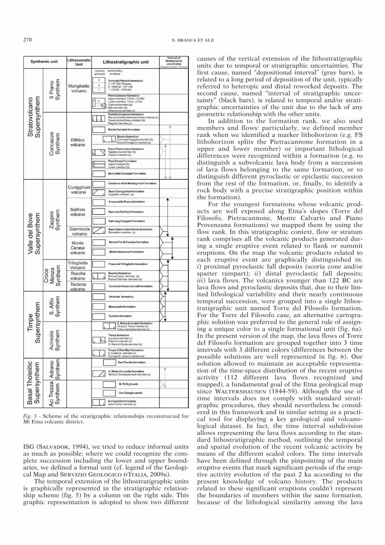
The stratigraphic framework proposed for the Mt Etnavolcanic district (fig. 5) results from the combination ofthree different categories of stratigraphic units: lithostrati-graphic, synthemic and lithosomatic. Each type of strati-graphic unit is based on the proper definition following theguidelines of the International Stratigraphic Guide (ISG)(SALVADOR, 1994). The aim of this combination of strati-graphic units is to unveil the complex spatial and temporalrelationships among the mapped volcanic products.
Lithostratigraphy represents the main stratigraphiccriterion used to identify the volcanic units during geo-logical mapping. Furthermore, we adopted the Unconfor-mity Bounded Units (UBU) through the recognition ofunconformity surfaces within the volcanic succession.This enables grouping several lithostratigraphic units indifferent synthems. Moreover, we use the lithosomaticunits, named volcanoes, to better represent the spatiallocalization of the eruptive centres recognized on thebasis of their morphostructural features. In the followingsections we present and discuss each type of stratigraphicunit used in the geological map of Etna volcano.
LITHOSTRATIGRAPHIC UNITS
We applied the lithostratigraphic units following theprocedures and standards suggested by SALVADOR (1994),also concerning the naming of formal and informalunits. Etna volcanic succession was organized in litho -stratigraphic units of different ranks, from formations tomembers, and in some cases also flows (see Geologicalmap). During the fieldwork, numerous detailed strati-graphic sections were logged to define the position in the succession and the relationships among lithostrati-graphic units.
The identification of lithostratigraphic units is funda-mental during the field mapping since the lithologic prop-
erties and stratigraphic relationships of rock bodies arethe only ones immediately recognizable in the field,whereas the laboratory data (petrographic, geochemical,radiometric analyses, etc.) allow improving the lithostra -tigraphic unit information. Following the indication of
GEOLOGICAL MAP OF ETNA VOLCANO, 1:50,000 SCALE 269
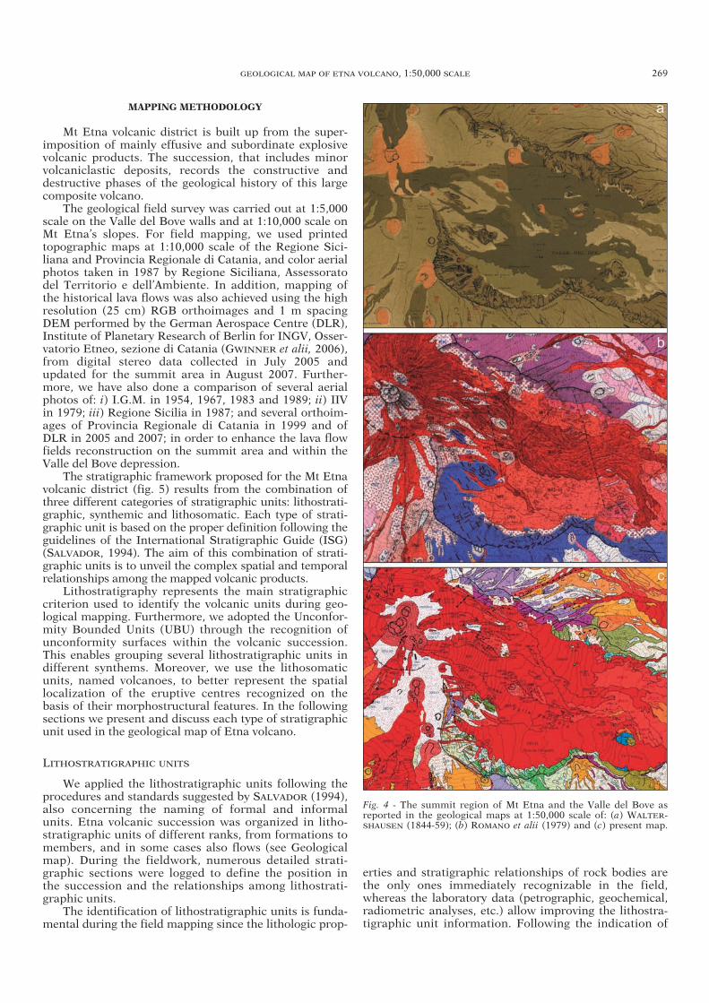
Fig. 4 - The summit region of Mt Etna and the Valle del Bove as reported in the geological maps at 1:50,000 scale of: (a) WALTER-SHAUSEN (1844-59); (b) ROMANO et alii (1979) and (c) present map.
34-BRANCA 265-291_GEOLOGIA 28/11/11 12.43 Pagina 269
ISG (SALVADOR, 1994), we tried to reduce informal unitsas much as possible; where we could recognize the com-plete succession including the lower and upper bound-aries, we defined a formal unit (cf. legend of the Geologi-cal Map and SERVIZIO GEOLOGICO D’ITALIA, 2009a).
The temporal extension of the lithostratigraphic unitsis graphically represented in the stratigraphic relation-ship scheme (fig. 5) by a column on the right side. Thisgraphic representation is adopted to show two different
causes of the vertical extension of the lithostratigraphicunits due to temporal or stratigraphic uncertainties. Thefirst cause, named “depositional interval” (gray bars), isrelated to a long period of deposition of the unit, typicallyreferred to heteropic and distal reworked deposits. Thesecond cause, named “interval of stratigraphic uncer-tainty” (black bars), is related to temporal and/or strati-graphic uncertainties of the unit due to the lack of anygeometric relationship with the other units.
In addition to the formation rank, we also usedmembers and flows: particularly, we defined memberrank when we identified a marker lithohorizon (e.g. FSlithohorizon splits the Pietracannone formation in aupper and lower member) or important lithological differences were recognized within a formation (e.g. todistinguish a subvolcanic lava body from a successionof lava flows belonging to the same formation, or to distinguish different pyroclastic or epiclastic successionfrom the rest of the formation, or, finally, to identify arock body with a precise stratigraphic position withinthe formation).
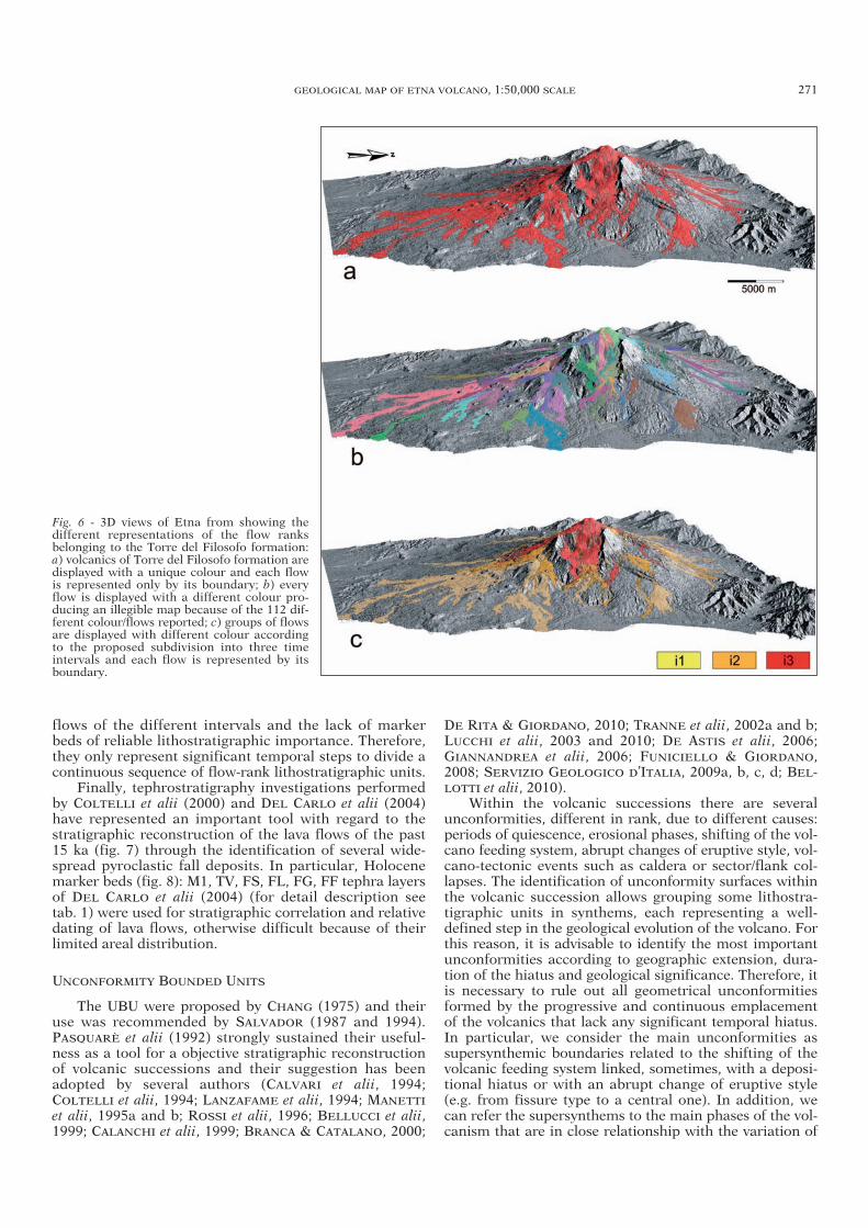
For the youngest formations whose volcanic prod-ucts are well exposed along Etna’s slopes (Torre delFilosofo, Pietracannone, Monte Calvario and PianoProvenzana formations) we mapped them by using theflow rank. In this stratigraphic context, flow or stratumrank comprises all the volcanic products generated dur-ing a single eruptive event related to flank or summiteruptions. On the map the volcanic products related toeach eruptive event are graphically distinguished in: i) proximal pyroclastic fall deposits (scoria cone and/orspatter rampart); ii) distal pyroclastic fall deposits; iii) lava flows. The volcanics younger than 122 BC arelava flows and pyroclastic deposits that, due to their lim-ited lithological variability and their nearly continuoustemporal succession, were grouped into a single lithos-tratigraphic unit named Torre del Filosofo formation.For the Torre del Filosofo case, an alternative cartogra -phic solution was preferred to the general rule of assign-ing a unique color to a single formational unit (fig. 6a).In the present version of the map, the lava flows of Torredel Filosofo formation are grouped together into 3 timeintervals with 3 different colors (differences between thepossible solutions are well represented in fig. 6). Oursolution allowed to maintain an acceptable representa-tion of the time-space distribution of the recent eruptiveactivity (112 different lava flows recognized andmapped), a fundamental goal of the Etna geological mapsince WALTERSHAUSEN (1844-59). Although the use oftime intervals does not comply with standard strati-graphic procedures, they should nevertheless be consid-ered in this framework and in similar setting as a practi-cal tool for displaying a key geological and volcano-logical dataset. In fact, the time interval subdivisionallows representing the lava flows according to the stan-dard lithostratigraphic method, outlining the temporaland spatial evolution of the recent volcanic activity bymeans of the different scaled colors. The time intervalshave been defined through the pinpointing of the maineruptive events that mark significant periods of the erup-tive activity evolution of the past 2 ka according to thepresent knowledge of volcano history. The productsrelated to these significant eruptions couldn’t representthe boundaries of members within the same formation,because of the lithological similarity among the lava
270 S. BRANCA ET ALII
Fig. 5 - Scheme of the stratigraphic relationships reconstructed forMt Etna volcanic district.
34-BRANCA 265-291_GEOLOGIA 28/11/11 12.43 Pagina 270
flows of the different intervals and the lack of markerbeds of reliable lithostratigraphic importance. Therefore,they only represent significant temporal steps to divide acontinuous sequence of flow-rank lithostratigraphic units.
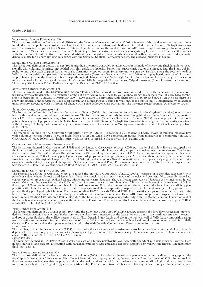
Finally, tephrostratigraphy investigations performedby COLTELLI et alii (2000) and DEL CARLO et alii (2004)have represented an important tool with regard to thestratigraphic reconstruction of the lava flows of the past15 ka (fig. 7) through the identification of several wide-spread pyroclastic fall deposits. In particular, Holocenemarker beds (fig. 8): M1, TV, FS, FL, FG, FF tephra layersof DEL CARLO et alii (2004) (for detail description see tab. 1) were used for stratigraphic correlation and relativedating of lava flows, otherwise difficult because of theirlimited areal distribution.
UNCONFORMITY BOUNDED UNITS
The UBU were proposed by CHANG (1975) and theiruse was recommended by SALVADOR (1987 and 1994).PASQUARÈ et alii (1992) strongly sustained their useful-ness as a tool for a objective stratigraphic reconstructionof volcanic successions and their suggestion has beenadopted by several authors (CALVARI et alii, 1994;COLTELLI et alii, 1994; LANZAFAME et alii, 1994; MANETTI
et alii, 1995a and b; ROSSI et alii, 1996; BELLUCCI et alii,1999; CALANCHI et alii, 1999; BRANCA & CATALANO, 2000;
DE RITA & GIORDANO, 2010; TRANNE et alii, 2002a and b;LUCCHI et alii, 2003 and 2010; DE ASTIS et alii, 2006;GIANNANDREA et alii, 2006; FUNICIELLO & GIORDANO,2008; SERVIZIO GEOLOGICO D’ITALIA, 2009a, b, c, d; BEL-LOTTI et alii, 2010).
Within the volcanic successions there are severalunconformities, different in rank, due to different causes:periods of quiescence, erosional phases, shifting of the vol-cano feeding system, abrupt changes of eruptive style, vol-cano-tectonic events such as caldera or sector/flank col-lapses. The identification of unconformity surfaces withinthe volcanic succession allows grouping some lithostra -tigraphic units in synthems, each representing a well-defined step in the geological evolution of the volcano. Forthis reason, it is advisable to identify the most importantunconformities according to geographic extension, dura-tion of the hiatus and geological significance. Therefore, itis necessary to rule out all geometrical unconformitiesformed by the progressive and continuous emplacementof the volcanics that lack any significant temporal hiatus.In particular, we consider the main unconformities assupersynthemic boundaries related to the shifting of thevolcanic feeding system linked, sometimes, with a deposi-tional hiatus or with an abrupt change of eruptive style(e.g. from fissure type to a central one). In addition, wecan refer the supersynthems to the main phases of the vol-canism that are in close relationship with the variation of
GEOLOGICAL MAP OF ETNA VOLCANO, 1:50,000 SCALE 271
Fig. 6 - 3D views of Etna from showing the different representations of the flow ranks belonging to the Torre del Filosofo formation:a) volcanics of Torre del Filosofo formation aredisplayed with a unique colour and each flowis represented only by its boundary; b) everyflow is displayed with a different colour pro-ducing an illegible map because of the 112 dif-ferent colour/flows reported; c) groups of flowsare displayed with different colour accordingto the proposed subdivision into three time intervals and each flow is represented by itsboundary.
34-BRANCA 265-291_GEOLOGIA 28/11/11 12.43 Pagina 271
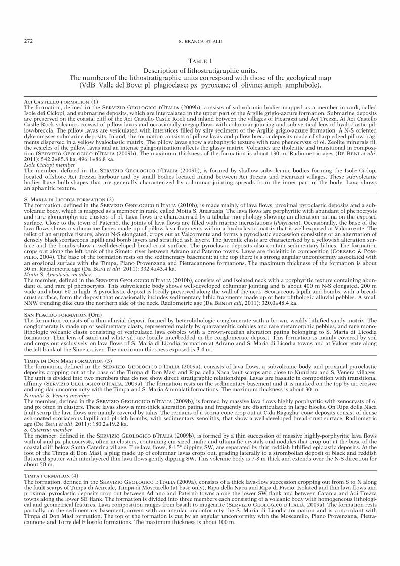
TABLE 1
Description of lithostratigraphic units. The numbers of the lithostratigraphic units correspond with those of the geological map
(VdB=Valle del Bove; pl=plagioclase; px=pyroxene; ol=olivine; amph=amphibole).
ACI CASTELLO FORMATION (1)The formation, defined in the SERVIZIO GEOLOGICO D’ITALIA (2009b), consists of subvolcanic bodies mapped as a member in rank, calledIsole dei Ciclopi, and submarine deposits, which are intercalated in the upper part of the Argille grigio-azzure formation. Submarine depositsare preserved on the coastal cliff of the Aci Castello Castle Rock and inland between the villages of Ficarazzi and Aci Trezza. At Aci CastelloCastle Rock volcanics consist of pillow lavas and occasionally megapillows with columnar jointing and sub-vertical lens of hyaloclastic pil-low-breccia. The pillow lavas are vesiculated with interstices filled by silty sediment of the Argille grigio-azzure formation. A N-S orienteddyke crosses submarine deposits. Inland, the formation consists of pillow lavas and pillow breccia deposits made of sharp-edged pillow frag-ments dispersed in a yellow hyaloclastic matrix. The pillow lavas show a subaphyric texture with rare phenocrysts of ol. Zeolite minerals fillthe vesicles of the pillow lavas and an intense palagonitization affects the glassy matrix. Volcanics are tholeiitic and transitional in composi-tion (SERVIZIO GEOLOGICO D’ITALIA (2009b). The maximum thickness of the formation is about 130 m. Radiometric ages (DE BENI et alii,2011): 542.2±85.8 ka, 496.1±86.8 ka.Isole Ciclopi memberThe member, defined in the SERVIZIO GEOLOGICO D’ITALIA (2009b), is formed by shallow subvolcanic bodies forming the Isole Ciclopilocated offshore Aci Trezza harbour and by small bodies located inland between Aci Trezza and Ficarazzi villages. These subvolcanic bodies have bulb-shapes that are generally characterized by columnar jointing spreads from the inner part of the body. Lava shows an aphanitic texture.
S. MARIA DI LICODIA FORMATION (2) The formation, defined in the SERVIZIO GEOLOGICO D’ITALIA (2010b), is made mainly of lava flows, proximal pyroclastic deposits and a sub-volcanic body, which is mapped as a member in rank, called Motta S. Anastasia. The lava flows are porphyritic with abundant ol phenocrystsand rare glomerophyritic clusters of pl. Lava flows are characterised by a tabular morphology showing an alteration patina on the exposedsurface. Close to the town of Paternò, the joints of lava flows are filled with marine incrustations (Polycaeta). Occasionally, the base of thelava flows shows a submarine facies made up of pillow lava fragments within a hyaloclastic matrix that is well exposed at Valcorrente. Therelict of an eruptive fissure, about N-S elongated, crops out at Valcorrente and forms a pyroclastic succession consisting of an alternation ofdensely black scoriaceous lapilli and bomb layers and stratified ash layers. The juvenile clasts are characterised by a yellowish alteration sur-face and the bombs show a well-developed bread-crust surface. The pyroclastic deposits also contain sedimentary lithics. The formationcrops out along the left bank of the Simeto river between Adrano and Paternò towns. Lavas are tholeiitic in composition (CORSARO & POM-PILIO, 2004). The base of the formation rests on the sedimentary basement; at the top there is a strong angular unconformity associated withan erosional surface with the Timpa, Piano Provenzana and Pietracannone formations. The maximum thickness of the formation is about 30 m. Radiometric age (DE BENI et alii, 2011): 332.4±43.4 ka.Motta S. Anastasia member. The member, defined in the SERVIZIO GEOLOGICO D’ITALIA (2010b), consists of and isolated neck with a porphyritic texture containing abun-dant ol and rare pl phenocrysts. This subvolcanic body shows well-developed columnar jointing and is about 400 m N-S elongated, 200 mwide and about 60 m high. A pyroclastic deposit is locally preserved along the wall of the neck. Scoriaceous lapilli and bombs, with a bread-crust surface, form the deposit that occasionally includes sedimentary lithic fragments made up of heterolithologic alluvial pebbles. A smallNNW trending dike cuts the northern side of the neck. Radiometric age (DE BENI et alii, 2011): 320.0±48.4 ka.
SAN PLACIDO FORMATION (Qm)The formation consists of a thin alluvial deposit formed by heterolithologic conglomerate with a brown, weakly lithified sandy matrix. Theconglomerate is made up of sedimentary clasts, represented mainly by quarzarenitic cobbles and rare metamorphic pebbles, and rare mono-lithologic volcanic clasts consisting of vesiculated lava cobbles with a brown-reddish alteration patina belonging to S. Maria di Licodia formation. Thin lens of sand and white silt are locally interbedded in the conglomerate deposit. This formation is mainly covered by soil and crops out exclusively on lava flows of S. Maria di Licodia formation at Adrano and S. Maria di Licodia towns and at Valcorrente alongthe left bank of the Simeto river. The maximum thickness exposed is 3-4 m.
TIMPA DI DON MASI FORMATION (3)The formation, defined in the SERVIZIO GEOLOGICO D’ITALIA (2009a), consists of lava flows, a subvolcanic body and proximal pyroclasticdeposits cropping out at the base of the Timpa di Don Masi and Ripa della Naca fault scarps and close to Nunziata and S. Venera villages.The unit is divided into two members that do not show direct stratigraphic relationships. Lavas are basaltic in composition with transitionalaffinity (SERVIZIO GEOLOGICO D’ITALIA, 2009a). The formation rests on the sedimentary basement and it is marked on the top by an erosiveand angular unconformity with the Timpa and S. Maria Ammalati formations. The maximum thickness is about 30 m.Fermata S. Venera memberThe member, defined in the SERVIZIO GEOLOGICO D’ITALIA (2009b), is formed by massive lava flows highly porphyritic with xenocrysts of oland px often in clusters. These lavas show a mm-thick alteration patina and frequently are disarticulated in large blocks. On Ripa della Nacafault scarp the lava flows are mainly covered by talus. The remains of a scoria cone crop out at C.da Ragaglia; cone deposits consist of denseash-coated scoriaceous lapilli and pl-rich bombs, with sedimentary xenoliths, that show a well-developed bread-crust surface. Radiometricage (DE BENI et alii, 2011): 180.2±19.2 ka.S. Caterina memberThe member, defined in the SERVIZIO GEOLOGICO D’ITALIA (2009b), is formed by a thin succession of massive highly-porphyritic lava flowswith ol and px phenocrysts, often in clusters, containing cm-sized mafic and ultamafic crystals and nodules that crop out at the base of thecoastal cliff below Santa Caterina village. The lava flows, 8-15° dipping SW, are separated by thin reddish lithified epiclastic deposits. At thefoot of the Timpa di Don Masi, a plug made up of columnar lavas crops out, grading laterally to a strombolian deposit of black and reddishflattened spatter with interlayered thin lava flows gently dipping SW. This volcanic body is 7-8 m thick and extends over the N-S direction forabout 50 m.
TIMPA FORMATION (4)The formation, defined in the SERVIZIO GEOLOGICO D’ITALIA (2009a), consists of a thick lava-flow succession cropping out from S to N alongthe fault scarps of Timpa di Acireale, Timpa di Moscarello (at base only), Ripa della Naca and Ripa di Piscio. Isolated and thin lava flows andproximal pyroclastic deposits crop out between Adrano and Paternò towns along the lower SW flank and between Catania and Aci Trezzatowns along the lower SE flank. The formation is divided into three members each consisting of a volcanic body with homogeneous lithologi-cal and geometrical features. Lava composition ranges from basalt to mugearite (SERVIZIO GEOLOGICO D’ITALIA, 2009a). The formation restspartially on the sedimentary basement, covers with an angular unconformity the S. Maria di Licodia formation and is concordant withTimpa di Don Masi formation. The top of the formation is cut by an angular unconformity with the Moscarello, Piano Provenzana, Pietra-cannone and Torre del Filosofo formations. The maximum thickness is about 100 m.
272 S. BRANCA ET ALII
34-BRANCA 265-291_GEOLOGIA 28/11/11 12.43 Pagina 272

Continued: Table 1
S. Maria La Scala memberThe member, defined in the SERVIZIO GEOLOGICO D’ITALIA (2009a), consists of a lava flow succession that thickens from S to N (from 10 mto 100 m) made of the superimposition of several massive lava flows, 10-30° dipping SSW and SW, separated by brown-yellowish epiclasticdeposits, a few meters thick. The lavas are porphyritic, with variable amounts of phenocrysts. At the base of the succession lava flows arecharacterized by cm-sized px, subordinate ol and abundant mm-sized pl. Toward the top the size of px decrease and the amount of plincrease. At Grotta delle Palombe, a plug made of columnar lavas grading upward to a brownish lava breccia deposit. This volcanic body isabout 10 m thick on the sea level extending in N-S direction. At the base of Moscarello Timpa fault scarp several superimposed massive lavaflows, 20-30° dipping NNW, crop out. These lavas are highly porphyritic with px and ol, 5-9 mm in size, and abundant mm-sized pl. A thicklava flow succession, gently dipping NW, crops out discontinuously on the NE flank along Ripe scarp; it consists of porphyritic lavas withmm-sized phenocrysts of px, pl and ol. The lava flows are generally disarticulated in large blocks. Radiometric ages (DE BENI et alii, 2011):154.9±17.0, 147.7±18.0, 145.8±14.0 ka, 132.6±4.8 ka, 129.9±4.8 ka.Paternò memberThe member, defined in the SERVIZIO GEOLOGICO D’ITALIA (2010b), is formed by a limited and isolated outcrop of massive lava flows, 5-10 mthick, that are deeply weathered and eroded. These lavas are porphyritic with abundant phenocrysts of px and ol, sometimes in cm-sizedclusters, and mm-sized pl. Lava exposed surfaces show a mm-thick alteration patina and sometimes alveolar structures. Locally, the massiveportion of the lava flows has well-developed columnar jointing. A 500 m-wide and 100 m-high scoria cone deposit crops out over 800 m in N-S direction at Paternò town. This partially welded proximal deposit is made of scoriaceous lapilli, bombs and lithic fragments mainly ofalluvial pebbles. Small lava flows originated from the Paternò scoria cone are exposed only along its slopes; they are weathered and highly-porphyritic lavas with abundant phenocrysts of ol and px often in cm-sized clusters. Radiometric age (DE BENI et alii, 2011): 134.2±6.6 ka.Leucatia memberThe member, defined in the SERVIZIO GEOLOGICO D’ITALIA (2009b), consists of a volcanoclastic succession cropping out exclusively at thebase of a morphological scarp on the northern outskirts of Catania at Barriera del Bosco-Leucatia. The basal portion of the succession isgiven by a conglomerate composed of sedimentary and lava pebble grading to sand, with marine fauna (KIEFFER, 1971), and then to an alter-nation of thick layers of clay and silt, containing terrestrial gastropods, and thin layers of volcanic sand with a cross-stratification. Theupper-middle portion of the succession is given by a thick layer of hardened volcanic sand, containing fingerprints of canes and occasionallava blocks, topped by an alternation of volcanic sand layers with cross-stratification and massive and lithified ash layers containing lavasblocks and rare sedimentary clasts.
S. MARIA AMMALATI FORMATION (5)The formation, defined in the SERVIZIO GEOLOGICO D’ITALIA (2009a), consists of volcanoclastic deposits of both debris and alluvial origincropping out on three distinct geographical areas: along the S. Tecla Timpa near the Ionian coast, along the left bank of Simeto river on thesouth periphery of the volcano, and on the lower north-eastern flank. The unit was divided into two members that do not show direct strati-graphic relations. They have been grouped together in the same formation because of their same stratigraphic position, although in differentgeographic areas, and represent an important phase of erosional processes in the periphery of Etna. The maximum thickness is about 80 m.Timpa S. Tecla memberThe member, defined in the SERVIZIO GEOLOGICO D’ITALIA (2009a), consists of coarse clastic deposits made of heterolythologic lava pebblesand blocks, and occasionally sedimentary pebbles that are embedded in a yellow-brown sandy-clayey matrix. The deposit is generally mas-sive and clasts are chaotically distributed. Thin discontinuous layers of fluvial reworking are interbedded. The thickness of the member andthe amount of lava blocks with respect to the pebbles increase northward. The base of the member is formed by fossiliferous sand-clay, 2-4 mthick, at Acque Grandi. This deposit is poorly lithified and weakly coarse-bedded, 20° dipping SW. The macrofauna is given mainly bySpisula subtruncata (DA COSTA) and Turritella communis (RISSO), conversely the scarce microfauna is made of benthonic foraminifera (FERRARA, 1976).Piano Carrubba memberAlluvial deposits terraced at varying elevations. Along the left bank of the Simeto river they consist of heterolithologic conglomerate withirregularly sized clasts, formed mainly by sedimentary pebbles and cobbles, and minor lava pebbles and cobbles largely supported by aclayey-sandy yellow-brown matrix. Occasionally metamorphic clasts are present. The prevalent litho-type of the sedimentary clasts isquartzarenite. Between Paternò and Motta S. Anastasia towns the deposit is mainly made of fine to coarse sands, sometimes hardened, andcoarse gravel or conglomerates poorly lithified formed by polygenic sedimentary and lava clasts with irregular size. On the lower NE flankalong the right bank of Vallone S. Venera and at Serra S. Biagio hill, the deposit is composed of a heterolithologic conglomerate withstrongly irregularly sized clasts of volcanic and sedimentary origins supported by a sandy-clayey matrix, which becomes mud-supportedwhere the clasts are metric in size.
CALANNA FORMATION (6)The formation, defined in the SERVIZIO GEOLOGICO D’ITALIA (2009a), is made of cataclastic lavas in a highly hydrothermally altered yellowclay matrix associated with a complex of dikes deeply weathered. Lava blocks and most of the dikes are affected by a strong hydrothermalalteration and cataclastic deformation. The formation crops out along Val Calanna and Mt Calanna. Lava composition ranges from basalt tomugearite (SERVIZIO GEOLOGICO D’ITALIA, 2009a). The lavas are usually strongly altered, but in a small portion it is possible to recogniseporphyritic texture with large phenocrysts of px and pl. The base of the formation is not visible, at the top there is a strong angular unconfor-mity associated with an erosional surface with the Monte Fior di Cosimo formation (visible along the southern wall of Calanna valley). Themaximum thickness is over 200 m. Radiometric age (DE BENI et alii, 2011): 128.7±7.6 ka.
MOSCARELLO FORMATION (7)The formation, defined in the SERVIZIO GEOLOGICO D’ITALIA (2009a), consists of a thick lava succession composed of several highlyeroded superimposed massive lava flows. Lavas present a high variability of lithology showing texture ranging from sub-aphyric to por-phyritic with variable amounts of pl, px and ol phenocrysts. At Cava Grande, near the succession top, crops out the remnant of a proximalpyroclastic deposit, WNW-ESE elongated, made of reddish scoriaceous bombs and spatters characterized by sub-cm-sized px and mm-sized pl phenocrysts, and loose crystals of px. On the whole, the lava succession dips from 5° up to 10° toward ESE. The formation cropsout along the Moscarello Timpa fault scarp and between Macchia and Giarre towns where a narrow outcrop is also exposed, and close toNunziata village. Lava composition is mugearite (SERVIZIO GEOLOGICO D’ITALIA, 2009a). The base of the formation rests with an angularunconformity on Timpa formation; at the top there is an angular unconformity and an erosional surface with the Serracozzo, PortellaGiumenta, Pietracannone and Torre del Filosofo formations. The maximum thickness is about 150 m. Radiometric age (DE BENI et alii,2011): 126.4±4.8 ka.
VALVERDE FORMATION (8)The formation includes a lava succession and a proximal pyroclastic deposit. The succession consists of superimposed massive lava flows,well exposed at the morphological scarp of Mt D’Oro, interbedded with thin epiclastic deposits. The lavas are porphyritic with phenocrysts invariable amount and size. Two main lithotypes are present: lavas with abundant sub-cm-sized mafic phenocrysts and subordinate mm-sizedpl; and lavas with prevalent mm-sized pl and lesser mm-sized mafic phenocrysts. The lava flows generally show a mm-thick alteration patinaand are mainly covered by soil and recent alluvial deposits. At Acicatena fault scarp a proximal pyroclastic deposit crops out. It is made of
GEOLOGICAL MAP OF ETNA VOLCANO, 1:50,000 SCALE 273
34-BRANCA 265-291_GEOLOGIA 28/11/11 12.43 Pagina 273

Continued: Table 1
dense lapilli and bread-crust bombs with clay xenolithics inside, alternating with ash layers containing lava lithic and, occasionally, clay frag-ments. The formation crops out between San Gregorio, Valverde and Aci S. Filippo towns down to the coast and at the base of Acicatenafault scarp. Lava composition ranges from hawaiite to mugearite (SERVIZIO GEOLOGICO D’ITALIA, 2009b). The formation rests on the sedi-mentary basement and, with an angular unconformity and an erosional surface, on Aci Castello and Timpa formations. The top presents anangular unconformity and an erosional surface with the Piano Provenzana, Portella Giumenta and Pietracannone formations. The maximumthickness is about 100 m. Radiometric ages (DE BENI et alii, 2011): 121.2±15.0 ka, 111.9±9.2.
CONTRADA PASSO CANNELLI FORMATION (9)The formation, defined in the SERVIZIO GEOLOGICO D’ITALIA (2009a), consists of a lava succession made of several superimposed massivelava flows with porphyritic texture of pl, subordinate mm-sized px and ol phenocrysts. These lavas are characterised by a mm-thick alter-ation patina and sometimes show alveolar structures on the exposed surface. The top of the lava succession is highly eroded and locally iscovered by a paleo-debris flow made of lava blocks immersed in a yellow-brown sandy matrix. The formation crops out in limited areas at Mt Pò, C.da Passo Cannelli and Mt Cicirello. Lava composition ranges from hawaiite to benmoreite (SERVIZIO GEOLOGICO D’ITALIA, 2009a).The base of the formation is not exposed and the top is marked by an angular unconformity and an erosional surface with the Pietracannone formation. The maximum thickness is about 30 m. Radiometric age (DE BENI et alii, 2011): 105.8±9.0 ka.
ROCCHE FORMATION (10)The formation, defined in the SERVIZIO GEOLOGICO D’ITALIA (2009a), consists of a complex succession formed by thin lava flows, autoclasticlavas and volcaniclastic deposits. The unit was subdivided into two members that do not show direct stratigraphic relationships. The forma-tion crops out along the base of the VdB northern wall from Rocca Palombe to Mt Cagliato. Lava composition ranges from hawaiite tomugearite (SERVIZIO GEOLOGICO D’ITALIA, 2009a). The base of the formation is buried, while the top is marked by an erosive and angularunconformity with the products of the Mt Scorsone formation (Monte Cerasa volcano). The maximum outcropping thickness is 120 m.Rocca Capra memberThe member, defined in the SERVIZIO GEOLOGICO D’ITALIA (2009a), crops out at Rocca Capra locality between 1320 m and 1440 m elevationand it is formed, at the base, by thin lava flows and autoclastic lavas, with pl and px phenocrysts, showing a slight angular unconformitybetween them, that grades upward to an alternation of autoclastic lavas with interlayered yellowish epiclastic and grey pyroclastic flowdeposits. The top is made of lava flows with pl, px and ol phenocrysts. On the whole, the sequence dipping 20-30° towards NE and it iscrossed by a dense network of dikes. Radiometric age (DE BENI et alii, 2011): 101.9±7.6 ka.Rocca Palombe memberThe member, defined in the SERVIZIO GEOLOGICO D’ITALIA (2009a), is exposed at about 600 m W of Rocca Capra. The base of the member isformed by lava flows from aphyric to weakly porphyritic with px, ol and subordinate pl phenocrysts grading upward to a pyroclastic flowdeposit, 30 m thick, consisting of reddish ash layers with scoriaceous lava blocks with irregular size. The top is made of lava flows with mm-sized phenocrysts of pl, px, ol and amph. The sequence dipping 10-30° from NNE to NNO.
PIANO DEL TRIFOGLIETTO FORMATION (11)The formation, defined in the SERVIZIO GEOLOGICO D’ITALIA (2009a), comprises a complex succession of autoclastic breccia and epiclasticdeposits interbedded with a few pyroclastic flow deposits and discontinuous lava flows. The lower part of the succession shows mainlymonogenetic massive breccia layers associated with discontinuous and thin lava flows; in the middle part massive and stratified epiclasticdeposits crop out interbedded with rare lava flows and pyroclastic deposits; in the upper succession lava flows prevail, associated with someepisclastic and pyroclastic layers. At the top a pumice fall and flow deposits (Cava Grande lithohorizon, not mappable) crops out discontinuouslyat Rocca Capra and on the lower eastern flank near Giarre (fig. 7). This formation crops out continuously from Serra Giannicola Grande toPoggio Canfareddi along the western and southern inner walls of VdB. Lava composition is benmoreite (SERVIZIO GEOLOGICO D’ITALIA,2009a). Lavas show porphyritic texture including pl, px and ol phenocrysts. The base of the formation is not exposed; conversely at the topthe contact with the Valle degli Zappini Formation is marked by an angular unconformity associated with an erosional surface and epiclasticdeposits. The maximum thickness is over 300 m. Radiometric ages (DE BENI et alii, 2011): 107.2±11.4 ka, 99.1±10.6 ka.
MONTE SCORSONE FORMATION (12)The formation, defined in the SERVIZIO GEOLOGICO D’ITALIA (2009a), is made of a complex succession of pyroclastic flow and fall deposits, epi-clastic deposits and lava flows. The basal portion of the formation is made up of yellow-brown pyroclastic flow layers interbedded with well-graded lapilli fall deposit and a massive lava flow grading upward to thin lava flows with interlayered fine-grain pyroclastic and epiclastic deposits.The texture of these lavas ranges from subaphyric to porphyritic with variable amount and size of pl, px, ol and occasionally amph phenocrysts. Inthe upper part of the formation the lava flows are prevalent with respect to the volcaniclastic layers that generally are less than 1 m thick. Lavastextures range from subaphyric to porphyritic with phenocrystals of pl, px and ol in variable amount and size. The volcaniclastic deposits consistof lava breccia with yellowish coarse matrix, pyroclastic fall and flow deposits locally reworked, and minor debris flows. This succession dips 20-35° towards NE and NNE. A succession of massive lava flows crops out at Cava Grande, about 10° dipping ESE. The formation crops out fromthe base of Serracozzo to Mt Fontane and at Cava Grande between Fornazzo and S. Alfio villages. Lava composition is most commonly mugearite(SERVIZIO GEOLOGICO D’ITALIA, 2009a). At the base of the formation there is an angular unconformity and an erosional surface with the Roccheand Moscarello formations; at the top an angular unconformity with Serra delle Concazze, Pietracannone and Torre del Filosofo formationsoccurs. The maximum thickness is about 250 m. Radiometric ages (DE BENI et alii, 2011): 101.8±14.6 ka, 100.4±11.6 ka, 99.9±8.6 ka.
MONTE FIOR DI COSIMO FORMATION (13)The formation is made of lava flows and scoria deposits interbedded with epiclastic deposits, 20 m thick. A dike feeds the lava flow succession top-ping the Mt Calanna. This formation crops out in Val Calanna and Vallone S. Giacomo and at the top of Mt Calanna. Lava flows are 1 to 5 m thick,hawaiitic in composition (CORSARO & POMPILIO, 2004); they show porphyritic texture of pl, px and ol phenocrysts in variable in quantity andsize. At the base the contact with the Calanna formation is marked by a strong angular unconformity associated with an erosional surface and epi-clastic deposits, at the top a sharp lithological change with Acqua della Rocca and Serra delle Concazze formations occurs; the contact with Serradelle Concazze is associated with an angular unconformity. The maximum thickness is 200 m. Radiometric age (DE BENI et alii, 2011): 93.0±6.0 ka.
SERRA GIANNICOLA GRANDE FORMATION (14)The formation, defined in the SERVIZIO GEOLOGICO D’ITALIA (2009a), is formed by a large neck, associated with other minor subvolcanicbodies (Belvedere member), feeding the overlying lava flow succession that is covered by light brown pyroclastic deposits and autoclasticbreccias. Its exposition is limited, cropping out only in Serra Giannicola Grande and surroundings. Lava composition ranges from hawaiiteto mugearite (SERVIZIO GEOLOGICO D’ITALIA, 2009a); rocks show porphyritic texture with pl, px and ol phenocrysts. The base of the forma-tion is not exposed; at the top there is a strong angular unconformity with the Canalone della Montagnola Formation. The lava flow succes-sion thickness is 220 m. Radiometric age (DE BENI et alii, 2011): 85.3±7.0 ka.Belvedere memberThe member, defined in the SERVIZIO GEOLOGICO D’ITALIA (2009a), consists of subvolcanic bodies made of pinkish massive lava with columnar jointing. Lava composition is mugearite (SERVIZIO GEOLOGICO D’ITALIA, 2009a) with a highly porphyritic texture characterized byoriented phenocrysts of pl, px, amph and rare ol. The maximum thickness is over 300 m.
274 S. BRANCA ET ALII
34-BRANCA 265-291_GEOLOGIA 28/11/11 12.43 Pagina 274
Continued: Table 1
VALLE DEGLI ZAPPINI FORMATION (15)The formation, defined in CALVARI et alii (1994) and the SERVIZIO GEOLOGICO D’ITALIA (2009a), is made of thin and extensive dark lava flowsinterbedded with epiclastic deposits, tens of meters thick. Some small subvolcanic bodies are intruded into the Piano del Trifoglietto forma-tion. The formation crops out from Serra Pirciata to Croce Menza along the southern wall of VdB. Lava composition ranges from mugeariteto benmoreite (SERVIZIO GEOLOGICO D’ITALIA, 2009a), its porphyritic texture comprises phenocrysts of pl, px and ol. At the base the contactwith the Piano del Trifoglietto formation is identified by an angular unconformity associated with an erosional surface and epiclasticdeposits; at the top a sharp lithological change with the Serra del Salifizio Formation occurs. The average thickness is 150 m.
SERRA DEL SALIFIZIO FORMATION (16)The formation, defined in CALVARI et alii (1994) and the SERVIZIO GEOLOGICO D’ITALIA (2009a), is made of leucocratic thick lava flows, occa-sionally with columnar jointing, interbedded with thin epiclastic deposits. Some small subvolcanic bodies are intruded into the Piano del Tri-foglietto and Valle degli Zappini formations. The formation crops out from Serra Pirciata to Serra del Salifizio along the southern wall ofVdB. Lava composition ranges from mugearite to benmoreite (SERVIZIO GEOLOGICO D’ITALIA, 2009a), with porphyritic texture of pl, px andamph phenocrysts. At the base there is a sharp lithological change with the Valle degli Zappini Formation, at the top an angular unconfor-mity associated with a lithological change with Canalone della Montagnola Formation and Tripodo member (Piano Provenzana formation).The average thickness is 150 m. Radiometric age (DE BENI et alii, 2011): 85.6±6.8 ka.
ACQUA DELLA ROCCA FORMATION (17)The formation, defined in the SERVIZIO GEOLOGICO D’ITALIA (2009a), is made of lava flows interbedded with thin epiclastic layers and rareproximal pyroclastic deposits. The formation crops out from Acqua della Rocca to Val Calanna along the southern wall of VdB. Lava compo-sition is benmoreitic (CORSARO & POMPILIO, 2004). Lava texture is porphyritic with phenocrysts of pl, px and rare ol. At the base there is asharp lithological change with the Valle degli Zappini and Monte Fior di Cosimo formations, at the top its limit is highlighted by an angularunconformity associated with a lithological change with Serra delle Concazze Formation. The thickness ranges from a few meters to 100 m.
SERRA CUVIGGHIUNI FORMATION (18)The formation, defined in the SERVIZIO GEOLOGICO D’ITALIA (2009a), is composed of subvolcanic bodies (Laghetto member) one of thosefeeds a thin and rather limited lava flow succession. The formation crops out only in Serra Cuvigghiuni and Serra Vavalaci, in the westernwall of VdB. Lava composition ranges from mugearite to benmoreite (SERVIZIO GEOLOGICO D’ITALIA, 2009a); lava porphyritic texture com-prises phenocrysts of pl, px, and amph. At the base the contact with Piano del Trifoglietto formation is an angular unconformity associatedwith a lithological change; at the top an angular unconformity with Canalone della Montagnola Formation occurs. The thickness ranges from20 to 100 m.Laghetto memberThe member, defined in the SERVIZIO GEOLOGICO D’ITALIA (2009a), is formed by subvolcanic bodies made of pinkish massive lava with columnar jointing from 3 to 90 m high, from 5 to 250 m wide. Lava composition ranges from mugearite to benmoreite (SERVIZIOGEOLOGICO D’ITALIA, 2009a), with highly porphyritic textures comprising phenocrysts of pl, px, and amph.
CANALONE DELLA MONTAGNOLA FORMATION (19)The formation, defined in CALVARI et alii (1994) and the SERVIZIO GEOLOGICO D’ITALIA (2009a), is made of thin lava flows overlapped by athick pyroclastic and epiclastic deposits succession, variable in colour, thickness and dip, topped by another lava flow succession. The forma-tion crops out from Serra Giannicola Grande to Serra dell’Acqua along the western wall of VdB. Lava composition is mugearitic (SERVIZIOGEOLOGICO D’ITALIA, 2009a), having porphyritic texture of pl, px, ol and amph phenocrysts. At the base there is an angular unconformityassociated with a lithological change with Serra del Salifizio and Giannicola Grande formations; at the top a strong angular unconformityassociated with a sharp lithological change with Serra delle Concazze and Piano Provenzana formations occurs. The thickness ranges from afew meters to 300 m. Radiometric ages (DE BENI et alii, 2011): 70.2±3.0 ka, 79.6±4.2 ka, 79.0±6.0 ka.
SERRA DELLE CONCAZZE FORMATION (20)The formation, defined in COLTELLI et alii (1994) and the SERVIZIO GEOLOGICO D’ITALIA (2009a), consists of a complex succession withprevalent volcaniclastic deposits and lesser lava flows. Volcaniclastics are mostly made of pyroclastic flows and falls, partially reworked,coarse explosion breccia with oxidised clasts, lahars and epiclastic deposits. These different typologies of deposits sometimes show lateralrelationships and, between Rocca della Valle and the 1928 eruptive vents, are channelled filling a paleo-depression. Some very thick lavaflows, up to 100 m, are interbedded in this volcaniclastic succession. From the base to the top, the textures of the lava flows are: slightly por-phyritic with pl and large mafic phenocrysts; from sub-aphyric to slightly porphyritic; porphyritic with large phenocrysts of ol, px and smallpl; and finally porphyritic pl-rich lavas. The formation dips 15-35° towards NE and ENE. The formation crops out from Serracozzo to thebase of Pizzi Deneri in Valle del Leone, along the northern, western and southern walls of VdB. Lava composition ranges from hawaiite tobenmoreite (SERVIZIO GEOLOGICO D’ITALIA, 2009a). At the base there is an angular unconformity with the Monte Scorsone Formation and atthe top only a local angular unconformity with Pizzi Deneri Formation. The maximum thickness is about 250 m. Radiometric ages (DE BENIet alii, 2011): 41.3±6.2 ka, 56.6±15.4 ka.
PIZZI DENERI FORMATION (21)The formation, defined in COLTELLI et alii (1994) and the SERVIZIO GEOLOGICO D’ITALIA (2009a), consists of a lava flow succession interbed-ded with volcaniclastic deposits, subdivided into two members. Both members of the formation crop out on the north-eastern, north-westernand south upper flanks of the edifice, respectively at Pizzi Deneri, Punta Lucia and along the western wall of VdB. Lava composition rangefrom hawaiite to mugearite (SERVIZIO GEOLOGICO D’ITALIA, 2009a). At the base there is only a local angular unconformity with Serra delleConcazze Formation and at the top an angular unconformity with Portella Giumenta and Pietracannone formations.Lower memberThe member, defined in COLTELLI et alii (1994), consists of a thick succession of massive and autoclastic lava layers interbedded with brecciadeposits. Lavas show porphyritic texture with phenocrysts of pl, px and ol. The thickness ranges from a few tens to about 100 m. Radiometricages (DE BENI et alii, 2011): 32.5±17.8 ka, 29.1±10.6 ka.Upper memberThe member, defined in COLTELLI et alii (1994), consists of a highly porphyritic lava flow with abundant pl phenocrysts as large as 1 cm in size, minor ol and rare px, alternating with hardened mud-flow type epiclastic deposits supported by yellow fine matrix. The maximumthickness is 25 m.
PIANO PROVENZANA FORMATION (22)The formation, defined in the SERVIZIO GEOLOGICO D’ITALIA (2009a), includes all the volcanic products without any direct stratigraphic rela-tionship with Serra delle Concazze and Pizzi Deneri Formations cropping out along the northern and southern wall of VdB. Numerous lavaflows and some scoria cones that crop out mainly on the peripheral sectors of Etna constitute the formation (lithologic and morphologic fea-tures are described in the Digital Supplementary Materials). Furthermore, two members with homogeneous lithologic characteristics have
GEOLOGICAL MAP OF ETNA VOLCANO, 1:50,000 SCALE 275
34-BRANCA 265-291_GEOLOGIA 28/11/11 12.43 Pagina 275

Continued: Table 1
been recognised even though they do not show any stratigraphic relationship between them. The formation crops out mainly along lowerEtna flanks. Lava composition ranges from hawaiite to benmoreite (SERVIZIO GEOLOGICO D’ITALIA, 2009a). The base of the formation restson the sedimentary basement and, with an angular unconformity and an erosional surface, on S. Maria Ammalati and Valverde formations.The top surface is characterised by conformity with Calvario, Portella Giumenta formations. The maximum thickness is about 50 m. Radio-metric ages (DE BENI et alii, 2011): 42.1±10.4 ka, 40.9±14.4 ka, 32.9±10.6 ka, 30.8±21.2 ka, 28.7±12.6 ka.Tripodo memberThe member, defined in the SERVIZIO GEOLOGICO D’ITALIA (2009a), is made of lava flow succession exposed between Serra dell’Acqua andVallone del Tripodo. Lava is hawaiitic in composition, porphyritic with abundant phenocrysts of pl and px at the base, and subaphyric withflow banding at the top. Discontinuous ash layers are interbedded. At the base there is an angular unconformity associated with an erosionalsurface and epiclastic deposits with the Serra del Salifizio Formation. The thickness ranges from 10 to 50 m. The member is produced by alateral vent activity during the Ellittico volcano activity.Tagliaborsa memberThe member, defined in the SERVIZIO GEOLOGICO D’ITALIA (2009a), is formed by a succession of pyroclastic fall deposits composed of ashand scoriaceous lapilli interbedded with yellow eolian silty deposits and black sandy beds. At least 30 tephra layers from strombolian andsubplinian eruption form the succession that crops out north of Giarre in the lower east flank. Tephra composition ranges from basalt tohawaiite (COLTELLI et alii, 2000). Clasts are scoriaceous, rarely pomiceous, and often porphyritic with px, ol and amph phenocrysts variablein quantity and size. The maximum thickness is 10 m. The age is older than 15 ka (Unit C in COLTELLI et alii, 2000).
SIMETO FORMATION (23)The formation consists mainly of alluvial and subordinate debris deposits. It was divided into two members that do not show any directstratigraphic relationships. The two members have been grouped together in the same formation since they have the same stratigraphic posi-tion and represent an important phase of erosional processes on the periphery of Etna. The formation crops out mainly along the left bank ofthe Simeto river and on limited areas close to Randazzo towns and on the lower NE flank. The formation thickness ranges from a few metersup to 40 m.Piano D’Aragona memberTerraced alluvial deposit, at varying elevations, consisting of heterolithologic conglomerate with clasts widely varying in size, formed bysedimentary and volcanic pebbles and cobbles in a yellow-brown, fine to coarse grained, sandy and locally silty matrix sometimes lithified.The prevalent litho-type of the sedimentary clasts is quartzarenite. South of Paternò town, the member consists of an alternation of yellow-ish sandy layers containing silty lens, silty-clay layers and conglomerate layers. These conglomerates comprise sedimentary and volcanicclasts in a yellow-brown and/or dark-grey sandy matrix poorly lithified. On the whole, the amount of sedimentary and volcanic clasts ishighly variable both in the different layers and from the source area towards the mouth of the Simeto river. The member is largely coveredby soil.Contrada Ragaglia memberThe member, defined in the SERVIZIO GEOLOGICO D’ITALIA (2009a), consists of a complex debris succession made of a polygenetic brecciawith heterolithologic lava clasts varying in size and occasionally clay fragments. Lava clasts are matrix supported. Matrix is sandy to clayvarying in colour from reddish-brown to grey. At Contrada Ragaglia the upper portion of the debris deposit consists of an epiclastic deposit,varying in colour from yellow-brown to red-brown, which contains highly weathered pomiceous and scoriaceous lapilli, loose crystals of pxand lava clasts. Close to Randazzo town the member is formed by an alternation of fine to coarse-grained volcanic sands, sometimes withcross-stratification, and massive debris flow layers.
MONTE CALVARIO FORMATION (24)The formation consists of autoclastic lava breccia deposits, often hydrothermally altered, and lava flows erupted by a lateral feeding systemNE-SW oriented. The formation crops out mainly along the lower south-western flank of Etna, from Adrano to Ragalna, as well as near to MtMaletto (NW flank). Lava composition is benmoreite (CORSARO & POMPILIO, 2004); porphyritic texture shows phenocrysts of pl, px, ol andclusters of pl and px. The base is marked by a sharp lithological change with the Piano Provenzana formation; at the top an angular uncon-formity associated with a lithological change highlights the contact with Biancavilla-Montalto Ignimbrite member (Portella Giumenta forma-tion) and Pietracannone and Torre del Filosofo formations. The thickness ranges from 20 to 100 m. Lava flows are described in the DigitalSupplementary Materials.
PORTELLA GIUMENTA FORMATION (25)The formation, defined in COLTELLI et alii (1994) and the SERVIZIO GEOLOGICO D’ITALIA (2009a), consists of complex pyroclastic successionand reomorphic lava flows generated by four plinian eruptions that formed the Ellittico caldera (COLTELLI et alii, 2000). The formation issubdivided into three members. Radiocarbon ages: 15,420±60 a, 15,050±70 a (Unit D in COLTELLI et alii, 2000).Osservatorio Etneo memberThe member, defined in the SERVIZIO GEOLOGICO D’ITALIA (2009a), consists of proximal pyroclastic fall deposits made of black scoriaceousspatters that become reddish and partially welded at the top forming agglutinated to rheomorphic spatter deposits cropping out on therelicts of Ellittico volcano caldera rims and upper flanks at Punta Lucia and Pizzi Deneri, and as vertical section exposed on the upper west-ern wall of VdB at Belvedere. Locally, spatters form massive red and grey beds, including black aphyric portions. At the base, a yellowishpumice bed crops out. Distal deposits formed by four light grey pumice fall layers interbedded with thin grey ash beds, including oxidizedlithics, and yellowish paleosols, crop out on the lower eastern flank. Pumice clasts are oligophyric with phenocrysts of pl, px, amph and ol.Composition ranges from benmoreite to trachyte (SERVIZIO GEOLOGICO D’ITALIA, 2009a).Ragabo memberThe member, defined in the SERVIZIO GEOLOGICO D’ITALIA (2009a), consists of rheomorphic lava flows light grey to reddish brown in colour,often banded cropping out discontinuously from Piano Provenzana to Piano Pernicana. Lava composition is benmoreite (SERVIZIO GEO-LOGICO D’ITALIA, 2009a) having subaphyric texture with rare phenocrysts of pl, px and amph. Rheomorphic lavas were generated by a post-depositional flow of agglutinated spatter deposit (Osservatorio Etneo member), still very hot, along the Ellittico upper northeast flank. Themaximum thickness is 10 m.Biancavilla-Montalto ignimbrite memberThe member original name Biancavilla-Montalto ignimbrite was reported in DE RITA (1991). It is constituted of pyroclastic flow depositswith at least four flow units, cropping out along the lower south-western flank from 1100 m of altitude to Biancavilla town. Pyroclastic flowsare scoria and ash flows including agglutinate to reomorphic spatters and lithic lava blocks in abundant yellow fine matrix; locally they arehardened and show columnar jointing. Composition ranges from benmoreite to trachyte (CORSARO & POMPILIO, 2004), juvenile clasts contain rare phenocrysts of pl, px and amph. The maximum thickness is 16 m.
PIETRACANNONE FORMATION (26)The formation is constituted of a complex volcanic succession subdivided into five members. A lava flow succession that includes scoriacones, spatter ramparts and pyroclastic fall deposits related to flank and summit eruptions, took place between Ellittico caldera (about 15 ka)and Il Piano caldera (122 BC plinian eruption), is divided by FS lithohorizon (radiocarbon age 3960±60 a, from COLTELLI et alii, 2000) inUpper and Lower members. A complex pyroclastic succession interbedded with eolian deposits and paleosols, named Cubania member.
276 S. BRANCA ET ALII
34-BRANCA 265-291_GEOLOGIA 28/11/11 12.43 Pagina 276
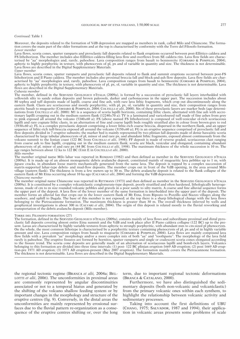
the regional tectonic regime (BRANCA et alii, 2004a; BEL-LOTTI et alii, 2006). The unconformities in proximal areasare commonly represented by angular discontinuitiesassociated or not to a temporal hiatus and generated bythe shifting of the volcano shallow feeding system or byimportant changes in the morphology and structure of theeruptive centres (fig. 9). Conversely, in the distal areas theunconformities are mainly represented by erosional sur-faces due to the fluvial pattern re-organization as a conse-quence of the eruptive centres shifting or, over the long
term, due to important regional tectonic deformations(BRANCA & CATALANO, 2000).
Furthermore, we have also distinguished the sedi-mentary deposits (both non-volcanic and volcaniclastic)from the primary volcanic ones within each synthem, tohighlight the relationship between volcanic activity andsedimentary processes.
Taking into account the first definitions of UBU(CHANG, 1975; SALVADOR, 1987 and 1994), their applica-tion in volcanic areas presents some problems of scale
GEOLOGICAL MAP OF ETNA VOLCANO, 1:50,000 SCALE 277
Continued: Table 1
Moreover, the deposits related to the formation of VdB depression are mapped as members in rank, called Milo and Chiancone. The forma-tion covers the main part of the older formations and at the top is characterised by conformity with the Torre del Filosofo formation.Lower memberLava flows, scoria cones, spatter ramparts and pyroclastic fall deposits related to flank eruptions occurred between post-Ellittico caldera andFS lithohorizon. The member includes also Elllittico caldera-filling lava flow and overflows from SE caldera rim. Lava flow fields are charac-terised by “aa” morphologies and, rarely, pahoehoe. Lava composition ranges from basalt to benmoreite (CORSARO & POMPILIO, 2004),aphyric to highly porphyritic in texture, with phenocrysts of pl, px and ol variable in quantity and size. The thickness is not determinable.Lava flows are described in the Digital Supplementary Materials.Upper memberLava flows, scoria cones, spatter ramparts and pyroclastic fall deposits related to flank and summit eruptions occurred between post-FSlithohorizon and Il Piano caldera. The member includes also proximal breccia fall and block-and-ash flow deposits. Lava flow fields are char-acterised by “aa” morphologies and, rarely, pahoehoe. Lava composition ranges from basalt to benmoreite (CORSARO & POMPILIO, 2004),aphyric to highly porphyritic in texture, with phenocrysts of pl, px, ol, variable in quantity and size. The thickness is not determinable. Lavaflows are described in the Digital Supplementary Materials.Cubania memberThe member, defined in the SERVIZIO GEOLOGICO D’ITALIA (2009a), is formed by a succession of pyroclastic fall layers interbedded with yellowish silty to sandy eolian deposits and brown paleosols, darker and carbonaceous in the upper part. The succession includes about 80 tephra and tuff deposits made of lapilli, coarse and fine ash, with rare lava lithic fragments, which crop out discontinuously along theeastern flank. Clasts are scoriaceous and mostly porphyritic, with pl, px, ol, variable in quantity and size, their composition ranges frompicritic basalt to mugearite (CORSARO & POMPILIO, 2004; COLTELLI et alii, 2000). Six of these pyroclastic layers are marker beds (age determi-nations from COLTELLI et alii, 2000): M1 is a sequence of scoria lapilli horizons, containing lithic clasts, alternated with fine ash with accre-tionary lapilli cropping out in the medium eastern flank (12240±70 a); TV is a laminated and varicoloured tuff made of fine ashes from greyto pink exposed all around the volcano (5340±60 a); FS (above named FS lithohorizon) is composed of well-vesicular ol-rich scoriaceouslapilli and rare cognate lithic clasts, in an alternation of fine and coarse lapilli beds roughly stratified also in colour from brown-grey to red(3930±60 a); FL is a complex pyroclastic deposit comprising a lower lithic-rich coarse breccia, dispersed in the northern flank, and an uppersequence of lithic-rich tuff-breccia exposed all around the volcano (3150±60 a); FG is an eruptive sequence comprised of pyroclastic fall andflow deposits divided in 7 eruptive subunits; the marker bed is mainly represented by two plinian fall deposits made of dense hawaiitic scoriacharacterized by large tabular phenocrysts of pl, minor ol and rare px, and abundant lithic fragments, exposed almost continuously from thevolcano summit to the Ionian coast (122 BC from COLTELLI et alii, 1998); FF deposit is made of reverse graded, scoriaceous clast rangingfrom coarse ash to fine lapilli, cropping out in the medium eastern flank; scoria are black, vesicular and elongated, containing abundant phenocrysts of pl, minor ol and rare px (44 BC from COLTELLI et alii, 1998). The maximum thickness of the whole succession is 10 m. Theage ranges between about 12 ka to 122 BC (Unit E in COLTELLI et alii, 2000).Milo memberThe member original name Milo lahar was reported in ROMANO (1982) and then defined as member in the SERVIZIO GEOLOGICO D’ITALIA(2009a). It is made up of an almost monogenetic debris avalanche deposit, constituted mainly of mugearitic lava pebbles up to 1 m, with jigsaw cracks, in abundant loose matrix mechanically generated from the same lava. The deposit is topped by a complex succession ofmatrix-supported lahar-type debris- and mud-flow deposits. The member crops out in front of the VdB opening, in the area around Milo village (eastern flank). The thickness is from a few meters up to 30 m. The debris avalanche deposit is related to the flank collapse of the eastern flank of Mt Etna occurring about 10 ka ago (CALVARI et alii, 2004) and forming the VdB depression.Chiancone memberThe member original name Chiancone was reported in RITTMANN (1973) and then defined as member in the SERVIZIO GEOLOGICO D’ITALIA(2009a). It is constituted by a complex volcaniclastic conglomerate-type deposit, poorly stratified and often hardened, lithologically heteroge-neous, made of cm to m size rounded volcanic pebbles and gravels in a poor sandy to silty matrix. A coarse and fine alluvial sequence formsthe upper part of the deposit. A lava flow of the lower member of the same formation is interbedded into the upper part of the deposit. Themember forms an alluvial fan that crops out in the lower eastern flank of Mt Etna, from Riposto to Pozzillo and Stazzo villages along theseashore, and uphill to Dagala. The base of this member is not exposed; at the top there is a sharp lithological change with the lava flowsbelonging to the Pietracannone formation. The maximum thickness is greater than 30 m. The overall thickness inferred by wells and geophysical investigations is about 300 m (CALVARI et alii, 2004). The origin of this deposit is related mostly to the fluvial reworking andtransportation of the debris avalanche deposit (Milo member).
TORRE DEL FILOSOFO FORMATION (27)The formation, defined in the SERVIZIO GEOLOGICO D’ITALIA (2009a), consists mainly of lava flows and subordinate proximal and distal pyro-clastic fall deposits covering almost entire Etna summit and the VdB and took place after Il Piano caldera collapse (122 BC) up to the pre-sent. Lavas are characterized by highly variable textures from aphyric to strongly porphyritic, with abundant mm to cm-sized pl phenocrysts.On the whole, the most common lithotype is characterised by a porphyritic texture containing phenocrysts of pl, px and ol in highly variableamount and size. Lava composition ranges from basalt to mugearite (CORSARO & POMPILIO, 2004). Lava flows are mainly compound lavaflow fields with a prevalent “aa” morphology and/or a more complex mix of both “aa” and “toothpaste”. The morphology of the lava fieldrarely is pahoehoe. The eruptive fissures are formed by hornitos, spatter ramparts and single or coalescent scoria cones elongated accordingto the fissure trend. The scoria cone deposits are generally made of an alternation of scoriaceous lapilli and bomb-rich layers. Volcanicsbelonging to this formation are divided into three time intervals: (1) post- 122 BC plinian eruption-1669 AD eruption; (2) post 1669 AD erup-tion-pre 1971 AD eruption; (3) 1971 AD eruption-present (May 2007 eruption). The formation mainly covers the Pietracannone formation.The thickness is not determinable. Lava flows are described in the Digital Supplementary Materials.
34-BRANCA 265-291_GEOLOGIA 28/11/11 12.43 Pagina 277
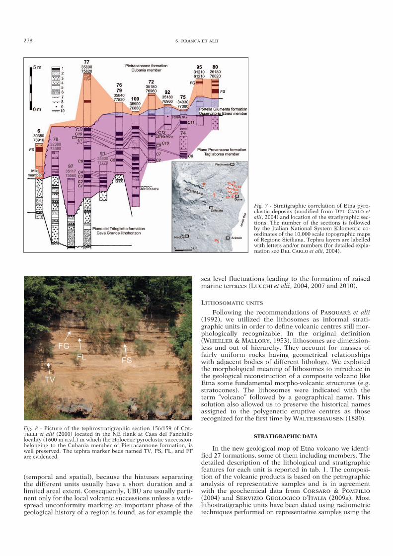
(temporal and spatial), because the hiatuses separatingthe different units usually have a short duration and alimited areal extent. Consequently, UBU are usually perti-nent only for the local volcanic successions unless a wide-spread unconformity marking an important phase of thegeological history of a region is found, as for example the
sea level fluctuations leading to the formation of raisedmarine terraces (LUCCHI et alii, 2004, 2007 and 2010).
LITHOSOMATIC UNITS
Following the recommendations of PASQUARÈ et alii(1992), we utilized the lithosomes as informal strati-graphic units in order to define volcanic centres still mor-phologically recognizable. In the original definition(WHEELER & MALLORY, 1953), lithosomes are dimension-less and out of hierarchy. They account for masses offairly uniform rocks having geometrical relationshipswith adjacent bodies of different lithology. We exploitedthe morphological meaning of lithosomes to introduce inthe geological reconstruction of a composite volcano likeEtna some fundamental morpho-volcanic structures (e.g.stratocones). The lithosomes were indicated with theterm “volcano” followed by a geographical name. Thissolution also allowed us to preserve the historical namesassigned to the polygenetic eruptive centres as those recognized for the first time by WALTERSHAUSEN (1880).
STRATIGRAPHIC DATA
In the new geological map of Etna volcano we identi-fied 27 formations, some of them including members. Thedetailed description of the lithological and stratigraphicfeatures for each unit is reported in tab. 1. The composi-tion of the volcanic products is based on the petrographicanalysis of representative samples and is in agreementwith the geochemical data from CORSARO & POMPILIO
(2004) and SERVIZIO GEOLOGICO D’ITALIA (2009a). Mostlithostratigraphic units have been dated using radiometrictechniques performed on representative samples using the
278 S. BRANCA ET ALII
Fig. 7 - Stratigraphic correlation of Etna pyro-clastic deposits (modified from DEL CARLO etalii, 2004) and location of the stratigraphic sec-tions. The number of the sections is followedby the Italian National System Kilometric co-ordinates of the 10,000 scale topographic mapsof Regione Siciliana. Tephra layers are labelledwith letters and/or numbers (for detailed expla-nation see DEL CARLO et alii, 2004).
Fig. 8 - Picture of the tephrostratigraphic section 156/159 of COL -TELLI et alii (2000) located in the NE flank at Casa del Fanciullo locality (1600 m a.s.l.) in which the Holocene pyroclastic succession,belonging to the Cubania member of Pietracannone formation, iswell preserved. The tephra marker beds named TV, FS, FL, and FFare evidenced.
34-BRANCA 265-291_GEOLOGIA 28/11/11 12.43 Pagina 278
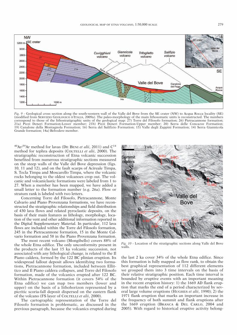
40Ar/39Ar method for lavas (DE BENI et alii, 2011) and C14
method for tephra deposits (COLTELLI et alii, 2000). Thestratigraphic reconstruction of Etna volcanic successionbenefited from numerous stratigraphic sections measuredon the steep walls of the Valle del Bove depression (figs.10, 11 and 12), and on the fault scarps of Acireale Timpa,S. Tecla Timpa and Moscarello Timpa, where the volcanicrocks belonging to the oldest volcanoes crop out. The vol-canic and volcaniclastic formations were labeled from 1 to27. When a member has been mapped, we have added asmall letter to the formation number (e.g. 26a). Flow orstratum rank is labeled with two letters.
Concerning Torre del Filosofo, Pietracannone, MonteCalvario and Piano Provenzana formations, we have recon-structed the stratigraphic relationships and field distributionof 430 lava flows and related pyroclastic deposits, on thebasis of their main features as lithology, morphology, loca-tion of the vent and other additional information reported inthe Digital Supplementary Material. In particular, 112 lavaflows are included within the Torre del Filosofo formation,245 in the Pietracannone formation, 15 in the Monte Cal-vario formation and 58 in the Piano Provenzana formation.
The most recent volcano (Mongibello) covers 88% ofthe whole Etna edifice. The only unconformity present inthe products of the last 15 ka volcanic succession, notassociated with any lithological change, is related to the IlPiano caldera, formed by the 122 BC plinian eruption. Itswidespread fallout deposit allows identifying two forma-tions, Pietracannone formation, included between Ellit-tico and Il Piano caldera collapses, and Torre del Filosofoformation, made of the volcanics erupted after 122 BC.Within Pietracannone formation (it covers 54% of theEtna edifice) we can map two members (lower andupper) on the basis of a lithohorizon represented by apicritic scoria-fall deposit dispersed on the eastern flankof the volcano (FS layer of COLTELLI et alii, 2000).
The cartographic representation of the Torre delFilosofo formation is problematic, as discussed in theprevious paragraph, because the volcanics erupted during
the last 2 ka cover 34% of the whole Etna edifice. Sincethis formation is fully mapped as flow rank, to obtain thebest graphical representation of 112 different elementswe grouped them into 3 time intervals on the basis oftheir relative stratigraphic position. Each time interval isbounded by eruptive events with an important meaningin the recent eruption history: 1) the 1669 AD flank erup-tion that marks the end of a period characterized by sev-eral large volume eruptions (HUGHES et alii, 1990); 2) the1971 flank eruption that marks an important increase inthe frequency of both summit and flank eruptions afterthe 1669 eruption (BRANCA & DEL CARLO, 2004 and2005). With regard to historical eruptive activity belong-
GEOLOGICAL MAP OF ETNA VOLCANO, 1:50,000 SCALE 279
Fig. 9 - Geological cross section along the south-western wall of the Valle del Bove from the SE crater (NW) to Acqua Rocca locality (SE)(modified from SERVIZIO GEOLOGICO D’ITALIA, 2009a). The paleo-morphology of the main lithosomatic units is reconstructed. The numberscorrespond to those of the lithostratigraphic units of the geological map: 27) Torre del Filosofo formation; 26) Pietracannone formation; 21a) Pizzi Deneri Formation-Lower member; 21b) Pizzi Deneri Formation-Upper member; 20) Serra delle Concazze Formation; 19) Canalone della Montagnola Formation; 16) Serra del Salifizio Formation; 15) Valle degli Zappini Formation; 14) Serra GiannicolaGrande formation; 14a) Belvedere member.
Fig. 10 - Location of the stratigraphic sections along Valle del Bovewalls.
34-BRANCA 265-291_GEOLOGIA 28/11/11 12.43 Pagina 279
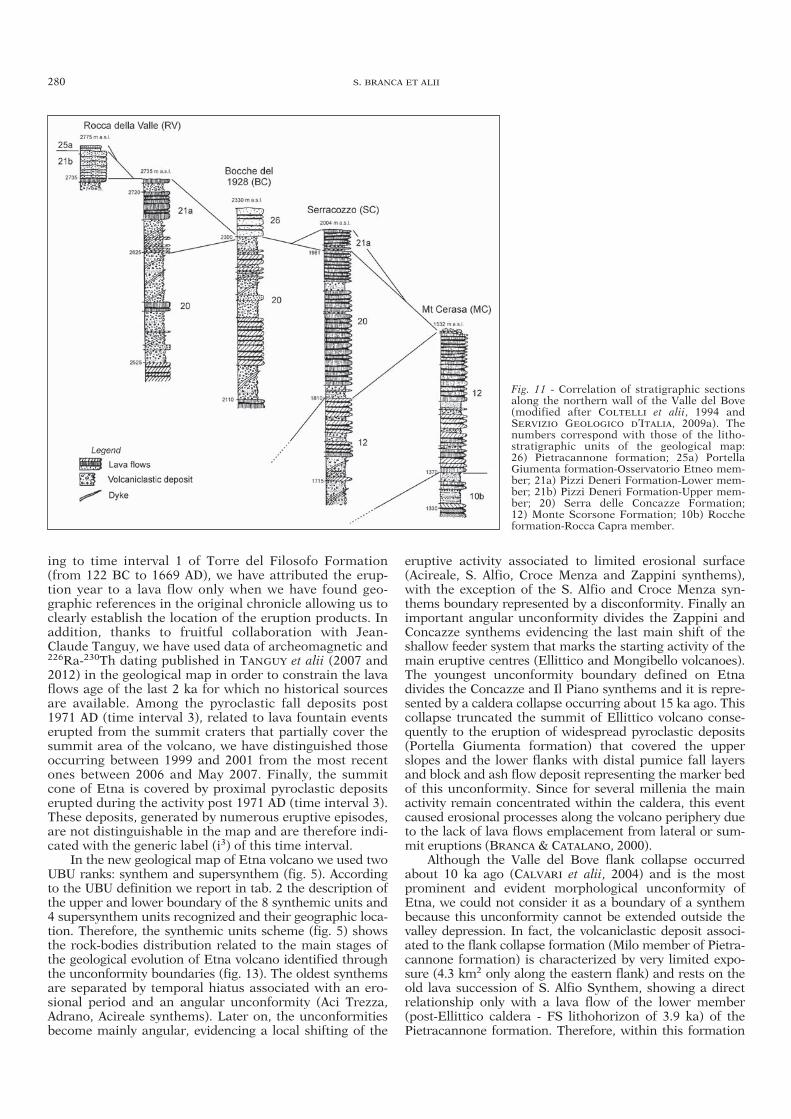
ing to time interval 1 of Torre del Filosofo Formation(from 122 BC to 1669 AD), we have attributed the erup-tion year to a lava flow only when we have found geo-graphic references in the original chronicle allowing us toclearly establish the location of the eruption products. Inaddition, thanks to fruitful collaboration with Jean-Claude Tanguy, we have used data of archeomagnetic and226Ra-230Th dating published in TANGUY et alii (2007 and2012) in the geological map in order to constrain the lavaflows age of the last 2 ka for which no historical sourcesare available. Among the pyroclastic fall deposits post1971 AD (time interval 3), related to lava fountain eventserupted from the summit craters that partially cover thesummit area of the volcano, we have distinguished thoseoccurring between 1999 and 2001 from the most recentones between 2006 and May 2007. Finally, the summitcone of Etna is covered by proximal pyroclastic depositserupted during the activity post 1971 AD (time interval 3).These deposits, generated by numerous eruptive episodes,are not distinguishable in the map and are therefore indi-cated with the generic label (i3) of this time interval.
In the new geological map of Etna volcano we used twoUBU ranks: synthem and supersynthem (fig. 5). Accordingto the UBU definition we report in tab. 2 the description ofthe upper and lower boundary of the 8 synthemic units and4 supersynthem units recognized and their geographic loca-tion. Therefore, the synthemic units scheme (fig. 5) showsthe rock-bodies distribution related to the main stages ofthe geological evolution of Etna volcano identified throughthe unconformity boundaries (fig. 13). The oldest synthemsare separated by temporal hiatus associated with an ero-sional period and an angular unconformity (Aci Trezza,Adrano, Acireale synthems). Later on, the unconformitiesbecome mainly angular, evidencing a local shifting of the
eruptive activity associated to limited erosional surface(Acireale, S. Alfio, Croce Menza and Zappini synthems),with the exception of the S. Alfio and Croce Menza syn-thems boundary represented by a disconformity. Finally animportant angular unconformity divides the Zappini andConcazze synthems evidencing the last main shift of theshallow feeder system that marks the starting activity of themain eruptive centres (Ellittico and Mongibello volcanoes).The youngest unconformity boundary defined on Etnadivides the Concazze and Il Piano synthems and it is repre-sented by a caldera collapse occurring about 15 ka ago. Thiscollapse truncated the summit of Ellittico volcano conse-quently to the eruption of widespread pyroclastic deposits(Portella Giumenta formation) that covered the upperslopes and the lower flanks with distal pumice fall layersand block and ash flow deposit representing the marker bedof this unconformity. Since for several millenia the mainactivity remain concentrated within the caldera, this eventcaused erosional processes along the volcano periphery dueto the lack of lava flows emplacement from lateral or sum-mit eruptions (BRANCA & CATALANO, 2000).
Although the Valle del Bove flank collapse occurredabout 10 ka ago (CALVARI et alii, 2004) and is the mostprominent and evident morphological unconformity ofEtna, we could not consider it as a boundary of a synthembecause this unconformity cannot be extended outside thevalley depression. In fact, the volcaniclastic deposit associ-ated to the flank collapse formation (Milo member of Pietra-cannone formation) is characterized by very limited expo-sure (4.3 km2 only along the eastern flank) and rests on theold lava succession of S. Alfio Synthem, showing a directrelationship only with a lava flow of the lower member(post-Ellittico caldera - FS lithohorizon of 3.9 ka) of thePietracannone formation. Therefore, within this formation
280 S. BRANCA ET ALII
Fig. 11 - Correlation of stratigraphic sectionsalong the northern wall of the Valle del Bove(modified after COLTELLI et alii, 1994 andSERVIZIO GEOLOGICO D’ITALIA, 2009a). Thenumbers correspond with those of the litho -stratigraphic units of the geological map: 26) Pietracannone formation; 25a) PortellaGiumenta formation-Osservatorio Etneo mem-ber; 21a) Pizzi Deneri Formation-Lower mem-ber; 21b) Pizzi Deneri Formation-Upper mem-ber; 20) Serra delle Concazze Formation; 12) Monte Scorsone Formation; 10b) Roccheformation-Rocca Capra member.
34-BRANCA 265-291_GEOLOGIA 28/11/11 12.43 Pagina 280
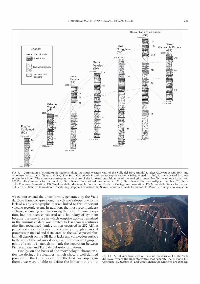
we cannot extend the unconformity generated by the Valledel Bove flank collapse along the volcano’s slopes due to thelack of a any stratigraphic marker linked to this importantvolcano-tectonic event. In addition, the most recent calderacollapse, occurring on Etna during the 122 BC plinian erup-tion, has not been considered as a boundary of synthembecause the time lapse in which eruptive activity remainedin the summit caldera was limited to less than 4 centuries(the first recognised flank eruption occurred in 252 AD), aperiod too short to form an uncoformity through erosionalprocesses in medial and distal area, so the well-exposed plin-ian fall deposit on the SE flank lacks any connection surfaceto the rest of the volcano slopes, even if from a stratigraphicpoint of view it is enough to mark the separation betweenPietracannone and Torre del Filosofo formations.
Finally, on the basis of the morphologic characteris-tics we defined 9 volcanoes, which show a well-definedposition in the Etna region. For the first two supersyn-thems, we were unable to define the lithosomatic units
GEOLOGICAL MAP OF ETNA VOLCANO, 1:50,000 SCALE 281
Fig. 13 - Aerial view from east of the south-western wall of the Valledel Bove, where the unconformities that separate the Il Piano (d),Concazze (c), Zappini (b) and Croce Menza (a) synthems are exposed.
Fig. 12 - Correlation of stratigraphic sections along the south-western wall of the Valle del Bove (modified after CALVARI et alii, 1994 andSERVIZIO GEOLOGICO D’ITALIA, 2009a). The Serra Giannicola Piccola stratigraphic section (SGP), logged in 1990, is now covered by morerecent lava flows. The numbers correspond with those of the lithostratigraphic units of the geological map: 26) Pietracannone formation;25) Portella Giumenta formation; 21a) Pizzi Deneri Formation-Lower member; 21b) Pizzi Deneri Formation-Upper member; 20) Serradelle Concazze Formation; 19) Canalone della Montagnola Formation; 18) Serra Cuvigghiuni formation; 17) Acqua della Rocca formation;16) Serra del Salifizio Formation; 15) Valle degli Zappini Formation; 14) Serra Giannicola Grande formation; 11) Piano del Trifoglietto formation.
34-BRANCA 265-291_GEOLOGIA 28/11/11 12.43 Pagina 281
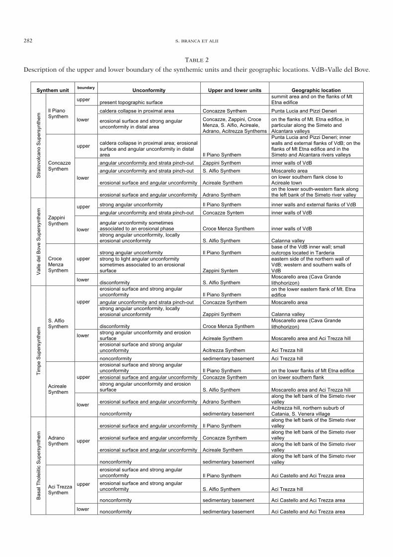
282 S. BRANCA ET ALII
TABLE 2
Description of the upper and lower boundary of the synthemic units and their geographic locations. VdB=Valle del Bove.
Synthem unit boundary Unconformity Upper and lower units Geographic location
upper present topographic surface summit area and on the flanks of Mt Etna edifice
caldera collapse in proximal area Concazze Synthem Punta Lucia and Pizzi Deneri Il Piano Synthem lower erosional surface and strong angular
unconformity in distal area Concazze, Zappini, Croce Menza, S. Alfio, Acireale, Adrano, Acitrezza Synthems
on the flanks of Mt. Etna edifice, in particular along the Simeto and Alcantara valleys
upper caldera collapse in proximal area; erosional surface and angular unconformity in distal area Il Piano Synthem
Punta Lucia and Pizzi Deneri; inner walls and external flanks of VdB; on the flanks of Mt Etna edifice and in the Simeto and Alcantara rivers valleys
angular unconformity and strata pinch-out Zappini Synthem inner walls of VdB angular unconformity and strata pinch-out S. Alfio Synthem Moscarello area
erosional surface and angular unconformity Acireale Synthem on lower southern flank close to Acireale town
Stra
tovo
lcan
o S
uper
synt
hem
Concazze Synthem
lower
erosional surface and angular unconformity Adrano Synthem on the lower south-western flank along the left bank of the Simeto river valley
strong angular unconformity Il Piano Synthem inner walls and external flanks of VdB upper angular unconformity and strata pinch-out Concazze Syntem inner walls of VdB
angular unconformity sometimes associated to an erosional phase Croce Menza Synthem inner walls of VdB
Zappini Synthem
lower strong angular unconformity, locally erosional unconformity S. Alfio Synthem Calanna valley
strong angular unconformity Il Piano Synthem base of the VdB inner wall; small outcrops located in Tarderia
upper strong to light angular unconformity sometimes associated to an erosional surface Zappini Syntem
eastern side of the northern wall of VdB; western and southern walls of VdB V
alle
del
Bov
e S
uper
synt
hem
Croce Menza Synthem
lower disconformity S. Alfio Synthem Moscarello area (Cava Grande lithohorizon)
erosional surface and strong angular unconformity Il Piano Synthem
on the lower eastern flank of Mt. Etna edifice
upper angular unconformity and strata pinch-out Concazze Synthem Moscarello area
strong angular unconformity, locally erosional unconformity Zappini Synthem Calanna valley
disconformity Croce Menza Synthem Moscarello area (Cava Grande lithohorizon)
lower strong angular unconformity and erosion surface Acireale Synthem Moscarello area and Aci Trezza hill erosional surface and strong angular unconformity Acitrezza Synthem Aci Trezza hill
S. Alfio Synthem
nonconformity sedimentary basement Aci Trezza hill
erosional surface and strong angular unconformity Il Piano Synthem on the lower flanks of Mt Etna edifice
upper erosional surface and angular unconformity Concazze Synthem on lower southern flank
strong angular unconformity and erosion surface S. Alfio Synthem Moscarello area and Aci Trezza hill
erosional surface and angular unconformity Adrano Synthem along the left bank of the Simeto river valley
Tim
pe S
uper
synt
hem
Acireale Synthem
lower
nonconformity sedimentary basement Acitrezza hill, northern suburb of Catania, S. Venera village
erosional surface and angular unconformity Il Piano Synthem along the left bank of the Simeto river valley
erosional surface and angular unconformity Concazze Synthem along the left bank of the Simeto river valley
erosional surface and angular unconformity Acireale Synthem along the left bank of the Simeto river valley
Adrano Synthem upper
nonconformity sedimentary basement along the left bank of the Simeto river valley
erosional surface and strong angular unconformity Il Piano Synthem Aci Castello and Aci Trezza area erosional surface and strong angular unconformity S. Alfio Synthem Aci Trezza hill
upper
nonconformity sedimentary basement Aci Castello and Aci Trezza area Bas
al T
hole
iitic
Sup
ersy
nthe
m
Aci Trezza Synthem
lower nonconformity sedimentary basement Aci Castello and Aci Trezza area
34-BRANCA 265-291_GEOLOGIA 28/11/11 12.43 Pagina 282
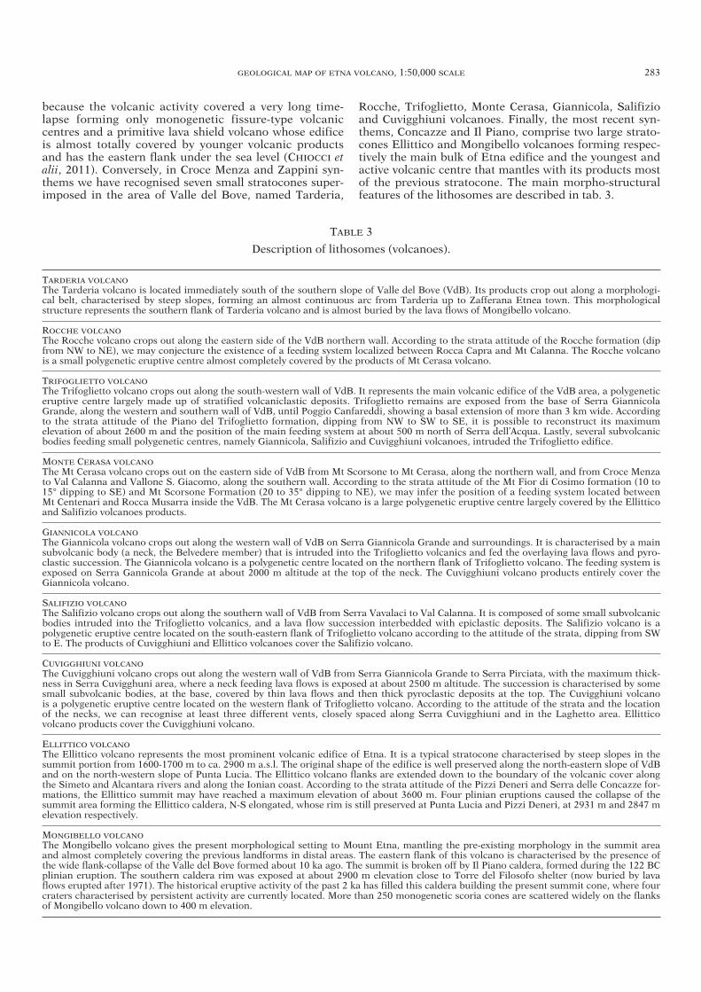
because the volcanic activity covered a very long time-lapse forming only monogenetic fissure-type volcaniccentres and a primitive lava shield volcano whose edificeis almost totally covered by younger volcanic productsand has the eastern flank under the sea level (CHIOCCI etalii, 2011). Conversely, in Croce Menza and Zappini syn-thems we have recognised seven small stratocones super-imposed in the area of Valle del Bove, named Tarderia,
Rocche, Trifoglietto, Monte Cerasa, Giannicola, Salifizioand Cuvigghiuni volcanoes. Finally, the most recent syn-thems, Concazze and Il Piano, comprise two large strato-cones Ellittico and Mongibello volcanoes forming respec-tively the main bulk of Etna edifice and the youngest andactive volcanic centre that mantles with its products mostof the previous stratocone. The main morpho-structuralfeatures of the lithosomes are described in tab. 3.
GEOLOGICAL MAP OF ETNA VOLCANO, 1:50,000 SCALE 283
TABLE 3
Description of lithosomes (volcanoes).
TARDERIA VOLCANOThe Tarderia volcano is located immediately south of the southern slope of Valle del Bove (VdB). Its products crop out along a morphologi-cal belt, characterised by steep slopes, forming an almost continuous arc from Tarderia up to Zafferana Etnea town. This morphologicalstructure represents the southern flank of Tarderia volcano and is almost buried by the lava flows of Mongibello volcano.
ROCCHE VOLCANOThe Rocche volcano crops out along the eastern side of the VdB northern wall. According to the strata attitude of the Rocche formation (dipfrom NW to NE), we may conjecture the existence of a feeding system localized between Rocca Capra and Mt Calanna. The Rocche volcanois a small polygenetic eruptive centre almost completely covered by the products of Mt Cerasa volcano.
TRIFOGLIETTO VOLCANOThe Trifoglietto volcano crops out along the south-western wall of VdB. It represents the main volcanic edifice of the VdB area, a polygeneticeruptive centre largely made up of stratified volcaniclastic deposits. Trifoglietto remains are exposed from the base of Serra GiannicolaGrande, along the western and southern wall of VdB, until Poggio Canfareddi, showing a basal extension of more than 3 km wide. Accordingto the strata attitude of the Piano del Trifoglietto formation, dipping from NW to SW to SE, it is possible to reconstruct its maximum elevation of about 2600 m and the position of the main feeding system at about 500 m north of Serra dell’Acqua. Lastly, several subvolcanicbodies feeding small polygenetic centres, namely Giannicola, Salifizio and Cuvigghiuni volcanoes, intruded the Trifoglietto edifice.
MONTE CERASA VOLCANOThe Mt Cerasa volcano crops out on the eastern side of VdB from Mt Scorsone to Mt Cerasa, along the northern wall, and from Croce Menzato Val Calanna and Vallone S. Giacomo, along the southern wall. According to the strata attitude of the Mt Fior di Cosimo formation (10 to15° dipping to SE) and Mt Scorsone Formation (20 to 35° dipping to NE), we may infer the position of a feeding system located betweenMt Centenari and Rocca Musarra inside the VdB. The Mt Cerasa volcano is a large polygenetic eruptive centre largely covered by the Ellitticoand Salifizio volcanoes products.
GIANNICOLA VOLCANOThe Giannicola volcano crops out along the western wall of VdB on Serra Giannicola Grande and surroundings. It is characterised by a mainsubvolcanic body (a neck, the Belvedere member) that is intruded into the Trifoglietto volcanics and fed the overlaying lava flows and pyro-clastic succession. The Giannicola volcano is a polygenetic centre located on the northern flank of Trifoglietto volcano. The feeding system isexposed on Serra Gannicola Grande at about 2000 m altitude at the top of the neck. The Cuvigghiuni volcano products entirely cover theGiannicola volcano.
SALIFIZIO VOLCANOThe Salifizio volcano crops out along the southern wall of VdB from Serra Vavalaci to Val Calanna. It is composed of some small subvolcanicbodies intruded into the Trifoglietto volcanics, and a lava flow succession interbedded with epiclastic deposits. The Salifizio volcano is apolygenetic eruptive centre located on the south-eastern flank of Trifoglietto volcano according to the attitude of the strata, dipping from SWto E. The products of Cuvigghiuni and Ellittico volcanoes cover the Salifizio volcano.
CUVIGGHIUNI VOLCANOThe Cuvigghiuni volcano crops out along the western wall of VdB from Serra Giannicola Grande to Serra Pirciata, with the maximum thick-ness in Serra Cuvigghuni area, where a neck feeding lava flows is exposed at about 2500 m altitude. The succession is characterised by somesmall subvolcanic bodies, at the base, covered by thin lava flows and then thick pyroclastic deposits at the top. The Cuvigghiuni volcano is a polygenetic eruptive centre located on the western flank of Trifoglietto volcano. According to the attitude of the strata and the location of the necks, we can recognise at least three different vents, closely spaced along Serra Cuvigghiuni and in the Laghetto area. Ellittico volcano products cover the Cuvigghiuni volcano.
ELLITTICO VOLCANOThe Ellittico volcano represents the most prominent volcanic edifice of Etna. It is a typical stratocone characterised by steep slopes in thesummit portion from 1600-1700 m to ca. 2900 m a.s.l. The original shape of the edifice is well preserved along the north-eastern slope of VdBand on the north-western slope of Punta Lucia. The Ellittico volcano flanks are extended down to the boundary of the volcanic cover alongthe Simeto and Alcantara rivers and along the Ionian coast. According to the strata attitude of the Pizzi Deneri and Serra delle Concazze for-mations, the Ellittico summit may have reached a maximum elevation of about 3600 m. Four plinian eruptions caused the collapse of thesummit area forming the Ellittico caldera, N-S elongated, whose rim is still preserved at Punta Lucia and Pizzi Deneri, at 2931 m and 2847 melevation respectively.
MONGIBELLO VOLCANOThe Mongibello volcano gives the present morphological setting to Mount Etna, mantling the pre-existing morphology in the summit areaand almost completely covering the previous landforms in distal areas. The eastern flank of this volcano is characterised by the presence ofthe wide flank-collapse of the Valle del Bove formed about 10 ka ago. The summit is broken off by Il Piano caldera, formed during the 122 BCplinian eruption. The southern caldera rim was exposed at about 2900 m elevation close to Torre del Filosofo shelter (now buried by lavaflows erupted after 1971). The historical eruptive activity of the past 2 ka has filled this caldera building the present summit cone, where fourcraters characterised by persistent activity are currently located. More than 250 monogenetic scoria cones are scattered widely on the flanksof Mongibello volcano down to 400 m elevation.
34-BRANCA 265-291_GEOLOGIA 28/11/11 12.43 Pagina 283
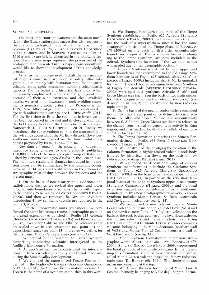
STRATIGRAPHIC NOVELTIES
The most important innovations and the main novel-ties in the Etna stratigraphic succession with respect tothe previous geological maps of a limited part of the volcano (BRANCA et alii, 2004b; SERVIZIO GEOLOGICO
D’ITALIA, 2009a and b; SERVIZIO GEOLOGICO D’ITALIA,2010 a and b) are briefly discussed in the following sec-tion. The previous maps represent the precursors of thegeological map presented in this paper, consequently wewould like to show the development of this knowledgeprocess.
As far as methodology used to draft the new geologi-cal map is concerned, we adopted solely lithostrati-graphic units, mainly with formation rank, for the entirevolcanic stratigraphic succession including volcaniclasticdeposits. For the recent and historical lava flows, whichare usually emphasized in the volcano geological mapbecause of their wide extension and clear availabledetails, we used only flow/stratum rank avoiding resort-ing to non-stratigraphic criteria (cf. ROMANO et alii,1979). Most lithostratigraphic units were constrained inage with radioisotopic datings (see DE BENI et alii, 2011).For the first time at Etna the radiometric investigationhas been performed in parallel and in close relation withthe field survey to obtain the finest chronostratigraphicframework (DE BENI & GROPPELLI, 2010). Finally, weintroduced the supersynthem rank in the stratigraphy ofthe volcanic succession of the Mt Etna district. The super-synthemic units are named as the four evolutionaryphases proposed by BRANCA et alii (2004a).
New data collected for the present map suggest tointroduce some changes to the previously published1:50,000 sheets of the new geological map of Italy pub-lished by Servizio Geologico d’Italia in the Etnean area.The main new results and changes introduced in the pre-sent paper can be summarized by the following points,while in fig. 14 we show the difference in the schemes ofstratigraphic relationship between the previous and thepresent maps.
1. On the basis of new stratigraphic evidences andradioisotopic datings we revised the upper and lowerunconformity boundaries of some synthems with respectto the Foglio 625 Acireale (SERVIZIO GEOLOGICO D’ITALIA,2009a), and then we removed the Girolamo Synthemintroducing 4 new synthems (details are reported in thepoints 3, 6 to 8).
2. For the lithosomatic units (volcanoes), we con-firmed the same lithosomes (name, stratigraphic positionand areal extension) established in Foglio 625 Acireale(SERVIZIO GEOLOGICO D’ITALIA, 2009a) and BRANCA et alii(2004b), except for Salifizio and Ellittico volcanoes thatare scaled down in areal extension (see point 14) anddepositional range (see point 13); moreover we define, forthe first time, Monte Cerasa volcano (see point 12).
3. We defined for the first time Aci Trezza Synthemcomprising submarine volcanics interlayered in theArgille grigio-azzurre Formation.
4. Adrano Synthem: we reconstructed the interrela-tionship between volcanic activity and fluvial processesduring the Simeto valley development.
5. We changed the name of Aci Trezza Formation,defined in the Foglio 634 Catania (SERVIZIO GEOLOGICO
D’ITALIA, 2009b), to Aci Castello Formation because AciTrezza is the name of a synthem established in this work.
6. We changed boundaries and rank of the TimpeSynthem established in Foglio 625 Acireale (SERVIZIO
GEOLOGICO D’ITALIA, 2009a). In the new map this unithas the rank of a supersynthem since it has the samestratigraphic position of the Timpe phase of BRANCA etalii (2004a) on the basis of first-order unconformityboundaries recognized. The rock bodies formerly belong-ing to the Timpe Synthem, are now included in theAcireale Synthem (the inversion of the two units nameswas needed due to their geographic position).
7. Acireale Synthem is defined by new upper andlower boundaries that correspond to the old Timpe Syn-them boundaries of Foglio 625 Acireale (SERVIZIO GEO-LOGICO D’ITALIA, 2009a) including also S. Maria Ammalatiformation. The rock bodies belonging to Acireale Synthemof Foglio 625 Acireale (SERVIZIO GEOLOGICO D’ITALIA,2009a) were split in 3 synthems, Acireale, S. Alfio andCroce Menza (see fig. 14) on the basis of two main uncon-formities recognised within the volcanic succession (seedescription in tab. 2) and constrained by new radioiso-topic datings.
8. On the basis of the new unconformities recognisedin the field (tab. 2 and point 6) we defined two new syn-thems: S. Alfio and Croce Menza. The unconformitybetween S. Alfio and Croce Menza synthems is related tothe change from fissural- to central-type activity in Etnaregion, and it is marked locally by a well-developed ero-sional surface (see fig. 14).
9. The Timpa formation comprises the Simeto For-mation defined in Foglio 633 Paternò (SERVIZIO GEO-LOGICO D’ITALIA, 2010b).
10. We constrained the stratigraphic position of theCalanna formation, a highly altered volcanic rock bodyisolated by historical lava flows, on the basis of newradioisotopic datings (DE BENI et alii, 2011).
11. We expanded the depositional range of ZappiniSynthem unconformities to include the Girolamo Syn-them of Foglio 625 Acireale (SERVIZIO GEOLOGICO
D’ITALIA, 2009a) on the basis of new radioisotopic datings(DE BENI et alii, 2011). In particular, the very short tem-poral hiatus of the Zappini Synthem upper discontinuity(SERVIZIO GEOLOGICO D’ITALIA, 2009a) and its localextension suggest not considering it as a synthemicboundary. In this new stratigraphic framework, ZappiniSynthem includes Monte Cerasa, Salifizio, Giannicolaand Cuvigghiuni volcanoes (see fig. 14).
12. We recognized a new volcanic centre, MonteCerasa volcano, built inside the Valle del Bove (VdB) andon the north-eastern flank of Trifoglietto volcano, on thebasis of the rock bodies geometry, the lava flows attitude,the top unconformity and the new radioisotopic dating(DE BENI et alii, 2011). Monte Cerasa volcano comprisesvolcanics belonging to the Monte Scorsone (northern wallof VdB) and Monte Fior di Cosimo (southern wall ofVdB) Formations (see fig. 14).
13. Monte Scorsone Formation in the previous strati-graphic works (COLTELLI et alii, 1994; BRANCA et alii,2004b; SERVIZIO GEOLOGICO D’ITALIA, 2009a) representedthe basal products of the Ellittico volcano. In the presentmap this formation is related to a new volcanic edifice,called Monte Cerasa volcano, based on: i) new radio-iso-topic data (DE BENI et alii, 2011); ii) attitude of strata; iii) an unconformity at the top.
14. We defined the new formation of Monte Fior diCosimo, formerly belonging to Valle degli Zappini Forma-
284 S. BRANCA ET ALII
34-BRANCA 265-291_GEOLOGIA 28/11/11 12.43 Pagina 284
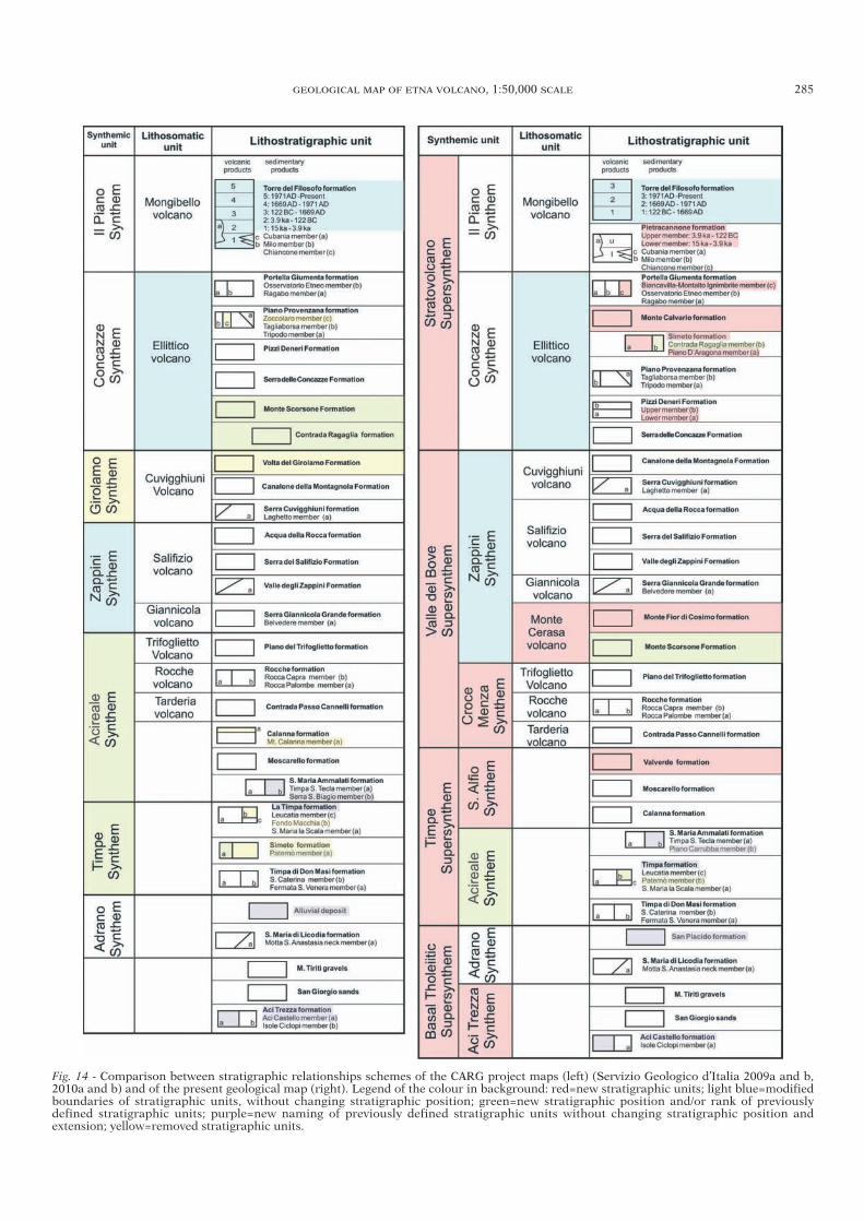
GEOLOGICAL MAP OF ETNA VOLCANO, 1:50,000 SCALE 285
Fig. 14 - Comparison between stratigraphic relationships schemes of the CARG project maps (left) (Servizio Geologico d’Italia 2009a and b,2010a and b) and of the present geological map (right). Legend of the colour in background: red=new stratigraphic units; light blue=modifiedboundaries of stratigraphic units, without changing stratigraphic position; green=new stratigraphic position and/or rank of previously defined stratigraphic units; purple=new naming of previously defined stratigraphic units without changing stratigraphic position and extension; yellow=removed stratigraphic units.
34-BRANCA 265-291_GEOLOGIA 28/11/11 12.43 Pagina 285
286 S. BRANCA ET ALII
tion of Foglio 625 Acireale (SERVIZIO GEOLOGICO D’ITALIA,2009a) on the basis of a new radioisotopic dating (DE
BENI et alii, 2011) and its lithological features and strati-graphic relationships.
15. The volcanics of Volta del Girolamo formation(SERVIZIO GEOLOGICO D’ITALIA, 2009a) are now attrib-uted to the Canalone della Montagnola Formationbecause of their limited extension.
16. As a consequence of point 13, we shifted the baseof the Ellittico volcano from the Monte Scorsone Forma-tion (SERVIZIO GEOLOGICO D’ITALIA, 2009a) to the Serradelle Concazze Formation, constraining the beginning ofits activity at about 57 ka (DE BENI et alii, 2011).
17. Pizzi Deneri Formation is made of two members(lower and upper members) as defined on the northernwall of VdB for the first time by COLTELLI et alii (1994)mapped on the summit areas, at Punta Lucia and on thewestern wall of VdB.
18. We introduced the Simeto formation in the Ellit-tico volcano succession. It includes both the PianoD’Aragona member made of alluvial deposits and theContrada Ragaglia member made of debris deposits (withreference to SERVIZIO GEOLOGICO D’ITALIA 2009a, wechanged the rank of the latter unit from formation tomember). Simeto formation marks the erosional processesoccurring on the slopes and at the periphery of the Ellit-tico volcano.
19. We mapped each lava flow and associated pyro-clastic deposits belonging to the Piano Provenzana for-mation.
20. We defined for the first time Monte Calvario for-mation, made of autoclastic lava flows erupted during thefinal stage of Ellittico volcano.
21. Within Portella della Giumenta formation weintroduced a new member, called Biancavilla-MontaltoIgnimbrite, to preserve the former name of ROMANO
(1982) and DE RITA et alii (1991), originated from theEllittico caldera-forming eruptions.
22. We mapped each exposed lava flow of Mongibellovolcano (last 15 ka, covering 88% of the entire surface ofMt Etna) on the entire edifice (see Digital Supplementarydata) that in Foglio 625 Acireale were grouped in theTorre del Filosofo Formation (SERVIZIO GEOLOGICO
D’ITALIA, 2009a) and now are split into two formations:Pietracannone and Torre del Filosofo.
23. We defined for the first time Pietracannone for-mation that groups the volcanic and volcaniclasticdeposits erupted after the Ellittico (15 ka) up to Il Pianocaldera collapses (122 BC). This formation has been splitin two members based on a marker lithohorizon (FS fall-out layer of COLTELLI et alii, 2000).
24. The volcanic products Torre del Filosofo forma-tion have been restricted to the last 2 ka, previously theyextended to the entire Mongibello volcano (SERVIZIO
GEOLOGICO D’ITALIA, 2009a). They have been displacedinto 3 time intervals allowing us to show evidence of thetemporal and spatial evolution of the historical eruptiveactivity.
2D AND 3D RECONSTRUCTION OF ETNA VOLCANIC EDIFICE
The main geological results obtained from thedetailed stratigraphic reconstruction of Etna volcanicsuccession are clearly evidenced through the UBU distrib-
ution (fig. 15). In fact, the recognition of several firstorder unconformities within the volcanic successionallow defining 8 synthems that mark the main stages ofEtna’s geological evolution described in this volume byBRANCA et alii (2011). In particular, the 2D representationof rock distribution based on synthems (fig. 15) shows themain changes of the volcanic activity occurring in theEtna region during the past 500 ka. The early volcanicphase (Basal Tholeiitic Supersynthem) was characterizedby discontinuous and scattered fissure-type volcanismoccurring about 500 ka in the Pleistocene Gela-CataniaForedeep basin (Aci Trezza Synthem) now exposed nearthe Ionian coast, and subsequentely, about 330 ka, erupt-ing in a subaerial environmental (Adrano Synthem) pre-sentely cropping out on the south-western perifery of thevolcano. Starting from about 220 ka (Timpe Supersyn-them) eruptive activity concentrated mainly on the Ioniancoast, transforming a scattered volcanism into shield vol-cano-forming activity (Acireale synthem). During S. AlfioSynthem the eruptive activity shifted from the Ioniancoastal belt to the central portion of Etna region. In thisarea during the Valle del Bove Supersynthem a stabiliza-tion of the volcano feeding system occurred from at least110 ka, as indicated by the growth of three earliest poly-genic volcanic centres (Tarderia, Rocche and Trifoglietto)during the Croce Menza Synthem and other four volca-noes (Monte Cerasa, Giannicola, Salifizio, Cuvigghiuni)during the Zappini Synthem. Finally, during the Con-cazze and Il Piano synthems (Stratovolcano Supersyn-them) the most recent north-westward shifting of theshallow feeder system of Etna volcano occurred from atleast 57 ka ago, when the bulk of the present edificeformed. Therefore, from 15 ka ago, the younger volcanicsmantled most of the previous edifice (88%) with a wide-spread cover of lava flow fields and pyroclastc depositsconcentrated on the summit area and close to the numer-ous lateral vents.
On the basis of the 2D distribution of the synthemicunits, we present a schematic geological cross section, at1:100,000 scale in the map, in order to show the 3D struc-ture of the volcano edifice (fig. 16). The cross-section isN-S oriented from the Alcantara River through Etna’ssummit craters (cutting La Voragine and Bocca Nuovacraters and the west base of NE crater) down to about500 m elevation near the town of Belpasso where it shiftstoward SSW. On the south side of the cross section, theisolated volcanic neck of Motta S. Anastasia belonging tothe Basal Tholeiitic Supersynthem (Adrano Synthem) isintruded into the Foredeep Quaternary sediments. Ups-lope, the thin volcanics of Acireale Synthem, belonging tothe Timpe Supersynthem, rest on the basement along thesouthern border of the volcano. In the central portion ofthe cross section, the polygenetic structure of Etna edificeis clearly shown by the Valle del Bove Supersynthem,with the superposition of Croce Menza and Zappini Syn-thems, which are completely covered by the products ofthe Stratovolcano Supersynthem (Concazze and Il PianoSynthems) extending up to Alcantara and Simeto rivervalleys. At the Etna summit, Concazze Synthem is dis-sected by the ring-faults generated during the plinianeruptions that formed the Ellittico caldera about 15 ka(KIEFFER, 1979; ROMANO, 1982; COLTELLI et alii, 2000).This caldera depression is filled by the volcanics of IlPiano Synthem, which form a rather thin drape on thevolcano flanks outside the caldera rim. Il Piano Synthem
34-BRANCA 265-291_GEOLOGIA 28/11/11 12.43 Pagina 286
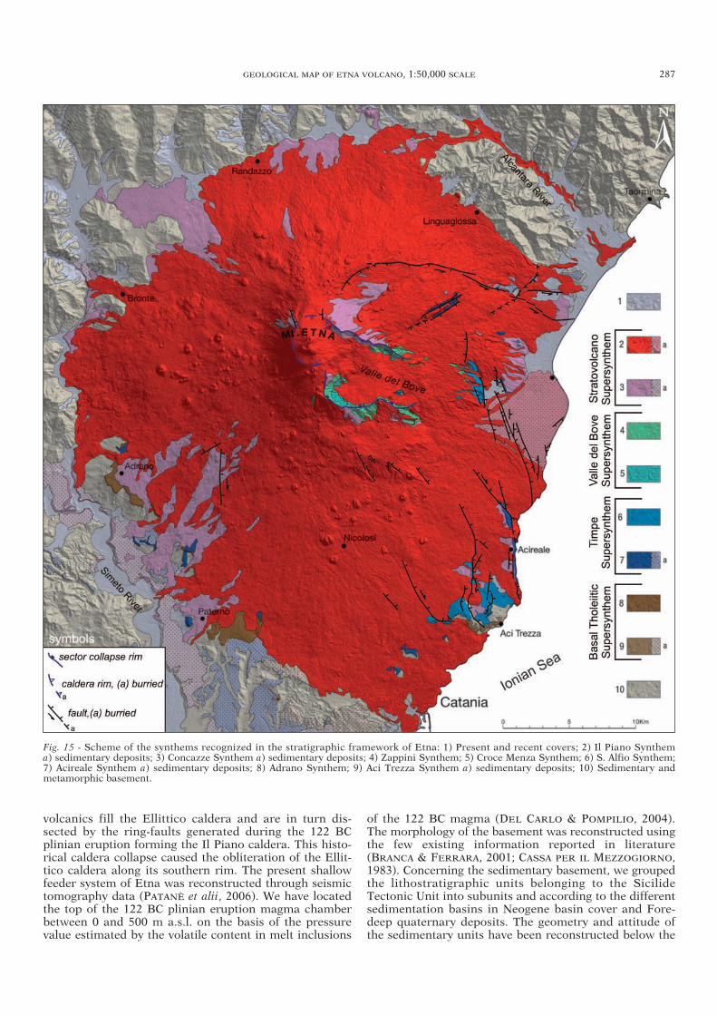
GEOLOGICAL MAP OF ETNA VOLCANO, 1:50,000 SCALE 287
volcanics fill the Ellittico caldera and are in turn dis-sected by the ring-faults generated during the 122 BCplinian eruption forming the Il Piano caldera. This histo -rical caldera collapse caused the obliteration of the Ellit-tico caldera along its southern rim. The present shallowfeeder system of Etna was reconstructed through seismictomography data (PATANÈ et alii, 2006). We have locatedthe top of the 122 BC plinian eruption magma chamberbetween 0 and 500 m a.s.l. on the basis of the pressurevalue estimated by the volatile content in melt inclusions
of the 122 BC magma (DEL CARLO & POMPILIO, 2004).The morphology of the basement was reconstructed usingthe few existing information reported in literature(BRANCA & FERRARA, 2001; CASSA PER IL MEZZOGIORNO,1983). Concerning the sedimentary basement, we groupedthe lithostratigraphic units belonging to the SicilideTectonic Unit into subunits and according to the differentsedimentation basins in Neogene basin cover and Fore-deep quaternary deposits. The geometry and attitude ofthe sedimentary units have been reconstructed below the
Fig. 15 - Scheme of the synthems recognized in the stratigraphic framework of Etna: 1) Present and recent covers; 2) Il Piano Synthema) sedimentary deposits; 3) Concazze Synthem a) sedimentary deposits; 4) Zappini Synthem; 5) Croce Menza Synthem; 6) S. Alfio Synthem;7) Acireale Synthem a) sedimentary deposits; 8) Adrano Synthem; 9) Aci Trezza Synthem a) sedimentary deposits; 10) Sedimentary andmetamorphic basement.
34-BRANCA 265-291_GEOLOGIA 28/11/11 12.43 Pagina 287
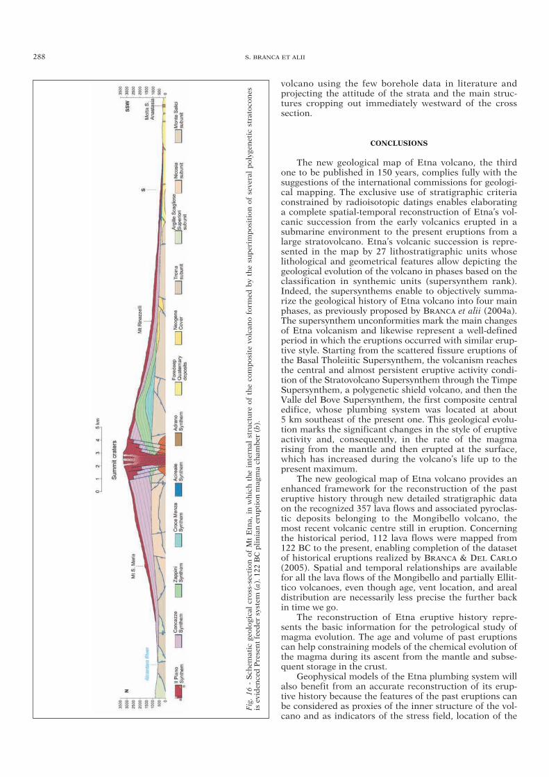
288 S. BRANCA ET ALII
volcano using the few borehole data in literature andprojecting the attitude of the strata and the main struc-tures cropping out immediately westward of the crosssection.
CONCLUSIONS
The new geological map of Etna volcano, the thirdone to be published in 150 years, complies fully with thesuggestions of the international commissions for geologi-cal mapping. The exclusive use of stratigraphic criteriaconstrained by radioisotopic datings enables elaboratinga complete spatial-temporal reconstruction of Etna’s vol-canic succession from the early volcanics erupted in asubmarine environment to the present eruptions from alarge stratovolcano. Etna’s volcanic succession is repre-sented in the map by 27 lithostratigraphic units whoselithological and geometrical features allow depicting thegeological evolution of the volcano in phases based on theclassification in synthemic units (supersynthem rank).Indeed, the supersynthems enable to objectively summa-rize the geological history of Etna volcano into four mainphases, as previously proposed by BRANCA et alii (2004a).The supersynthem unconformities mark the main changesof Etna volcanism and likewise represent a well-definedperiod in which the eruptions occurred with similar erup-tive style. Starting from the scattered fissure eruptions ofthe Basal Tholeiitic Supersynthem, the volcanism reachesthe central and almost persistent eruptive activity condi-tion of the Stratovolcano Supersynthem through the TimpeSupersynthem, a polygenetic shield volcano, and then theValle del Bove Supersynthem, the first composite centraledifice, whose plumbing system was located at about 5 km southeast of the present one. This geological evolu-tion marks the significant changes in the style of eruptiveactivity and, consequently, in the rate of the magma rising from the mantle and then erupted at the surface,which has increased during the volcano’s life up to thepresent maximum.
The new geological map of Etna volcano provides anenhanced framework for the reconstruction of the pasteruptive history through new detailed stratigraphic dataon the recognized 357 lava flows and associated pyroclas-tic deposits belonging to the Mongibello volcano, themost recent volcanic centre still in eruption. Concerningthe historical period, 112 lava flows were mapped from122 BC to the present, enabling completion of the datasetof historical eruptions realized by BRANCA & DEL CARLO
(2005). Spatial and temporal relationships are availablefor all the lava flows of the Mongibello and partially Ellit-tico volcanoes, even though age, vent location, and arealdistribution are necessarily less precise the further backin time we go.
The reconstruction of Etna eruptive history repre-sents the basic information for the petrological study ofmagma evolution. The age and volume of past eruptionscan help constraining models of the chemical evolution ofthe magma during its ascent from the mantle and subse-quent storage in the crust.
Geophysical models of the Etna plumbing system willalso benefit from an accurate reconstruction of its erup-tive history because the features of the past eruptions canbe considered as proxies of the inner structure of the vol-cano and as indicators of the stress field, location of the
Fig. 16
- Sch
ematic geo
logica
l cros
s-section of Mt Etna, in w
hich the intern
al structure of the co
mpos
ite vo
lcan
o form
ed by the su
perim
pos
ition of several polyg
enetic stratoc
ones
is eviden
ced Present feed
er system (a). 1
22 BC plinian eru
ption
mag
ma ch
amber (b).
34-BRANCA 265-291_GEOLOGIA 28/11/11 12.43 Pagina 288
magma reservoir and timing of its inflow and outflow.Also in this case, the age and volume of the past eruptionsconstrain the geophysical models and may help researchersto compute robust simulations that can be used, on thebasis of the observed geophysical signals, in the proba-bilistic forecasting of eruptions.
Modern volcanology lends most of its effort to appliedscience, focusing on the mitigation of destructive effectsof the volcanic eruptions mainly through monitoring,eruption forecasting and assessment of volcanic hazard.The issuing of a new geological map of Etna, associatedwith an updated eruptive history, can be considered thebasic information for all these applications. Reconstruc-tion of the past eruptions for magnitude, recurrence-time,vent location and eruption style, provide information thatcan be used in future to adapt the geophysical sensor net-work to best observe possible precursors and eruptionsensitive parameters. For the Etna hazard assessment, thereconstruction of past eruptions is a critical element forstudying the past volcanic eruptions statistically in a rep-resentative time-span, and for furnishing input data tothe eruption simulations by means of numerical model-ing; on the other hand, it enables using the previous eruptions as a key to interpreting short- and long-termforecasting scenarios produced by a large number of simulations needed to compile the volcano hazard map.
The previous goals may be fully achieved using thelarge amount of data contained in the new geologicalmap of Etna volcano. We hope it will prove to be a key-stone for new generation of volcanic studies at Etna inthe spirit of the forerunner Sartorius von Waltershausen,who began the scientific investigation of this great volcano using geological tools.
ELECTRONIC SUPPLEMENTARY MATERIAL
This article contains supplementary material, which is availableonline to authorized users (DOI: 10.3301/IJG.2011.15).
ACKNOWLEDGMENTS
The new geological map of Etna was supported by IstitutoNazionale di Geofisica e Vulcanologia, Osservatorio Etneo, sezionedi Catania. We are grateful to A. Bonaccorso former director of INGV, Osservatorio Etneo, for promoting this work and to D. Patanè, present director, and E. Boschi, president of INGV, forencouraging the realization of the map. We also thank the formerdirector of CNR- Istituto per la Dinamica dei Processi Ambientali,P.M. Rossi for supporting this research.
The work was funded by the INGV Osservatorio Etneo, CNR-IDPA, Dipartimento per la Protezione Civile-INGV, project V3_6 -Etna (2004-2006), FIRB Sviluppo Nuove Tecnologie per la Pro-tezione e Difesa del Territorio dai Rischi Naturali, APQ Estensione ePotenziamento dei Sistemi di Monitoraggio Vulcanico e Sismicodella Sicilia, and PRIN 2004 Controllo tettonico e vulcanico sulla circolazione idrotermale nella litosfera oceanica e in complessi ofiolitici (GG).
The authors would particularly like to express their gratitude toG. Pasquarè for promoting the project of geological mapping of Etnathrough the realization of the Foglio 625 Acireale of Italian Geologi-cal Survey. We are also grateful to the team of volcanologists R. Azzaro, F. Bellotti, S. Calvari, E. De Beni, D. Lo Castro, L. Lodato,G. Garfì, V.H. Garduño, M. Neri, G. Norini and G. Pasquarè whohave performed the field surveys. A special acknowledgement is dueto Istituto per la Protezione e la Ricerca Ambientale - Servizio Geo-logico d’Italia for providing us the mapping data of the CARG project.
We also thank S. Caffo of Parco Regionale dell’Etna and Di -partimento Regionale Azienda Foreste Demaniali - Ufficio Provin-ciale di Catania for permitting our work in the protected areas of Mt. Etna.
We thank G. Barreca for realizing the digital cartographic lay-out of the map; F. Bellotti, E. De Beni and C. Proietti for supportingus during the preparation of this work; F. Privitera and M. Turco ofSoprintendenza per i Beni Culturali e Ambientali - Catania, ServizioBeni Archeologici for the location and information of the prehistoriccaves of Etna. We are grateful to J.C. Tanguy and M. Condominesfor dating the historical lava flows; to P. Del Carlo and L. Vezzoli forthe discusion on the teprostratigrapy and R.A. Corsaro and M. Pom-pilio for the discusion on the volcanics petrology. We also thank thePhD school of University of Catania and Milano.
Finally, we wish to thank R. Cioni, G. Giordano, F. Lucchi andJ. Donnelly-Nolan for for their helpful reviews that greatly improvedthe manuscript and R.I. Tilling for the accurate review of the maplegend, and S. Conticelli and for precious help on the manuscriptpublishing.
REFERENCES
BELLOTTI F., CAPRA L., GROPPELLI G. & NORINI G. (2006) - Tecton-ic evolution of the central-eastern sector of Trans Mexican Vol-canic Belt and its influence on the eruptive history of the Nevadode Toluca Volcano (Mexico). J. Volcanol. Geotherm. Res., 158,21-36.
BELLOTTI F. (2009) - Evoluzione geologica del versante occidentale delMonte Etna e studio strutturale del Rift associato. PhD ThesisXXI-Ciclo, University of Milano, 123 pp.
BELLOTTI F., BRANCA S. & GROPPELLI G. (2010) - Geological map ofMount Etna West Rift (Italy). J. of Maps, 2010, 96-122. Doi:10.4113/jom.2010.1115.
BELLUCCI F., LIRER L. & MUNNO R. (1999) - Geology of Ponza, Ven-totene and Santo Stefano islands (with a 1:15,000 scalegeologicalmap). Acta Vulcanol., 11 (2), 197-222.
BEN AVRAHAM Z. & GRASSO M. (1990) - Collisional zone segmenta-tion in Sicily and surrounding areas in the central Mediterranean.Ann. Tectonicae, 4, 131-139.
BIANCHI F., CARBONE S., GRASSO M., INVERNIZZI G., LENTINI F.,LONGARETTI G., MERLINI S. & MOSTARDINI F. (1987) - Siciliaorientale: profilo geologico Nebrodi-Iblei. Mem. Soc. Geol. It., 38,429-458.
BORELLI G.A. (1670) - Historia et Meteorologia Incendii Aetnai Anno1669. Reggio Calabria.
BRANCA S. & CATALANO S. (2000) - Stratigraphical and morphologicalcriteria for the reconstruction of UBSU in the peripheral area ofMt. Etna (Italy). Mem. Soc. Geol. It., 55, 181-187.
BRANCA S. & FERRARA V. (2001) - An example of river pattern evolu-tion produced during the lateral growth of a central polygenic vol-cano: the case of the Alcantara river system, Mt. Etna (Italy).Catena, 45 (2), 85-102.
BRANCA S., COLTELLI M. & GROPPELLI G. (2004a) - Geological evolu-tion of Etna volcano. In: “Etna Volcano Laboratory”, Bonaccor-so, Calvari, Coltelli, Del Negro, Falsaperla (Eds), AGU (Geophy -sical monograph series), 143, 49-63.
BRANCA S., COLTELLI M., DEL CARLO P., GROPPELLI G., NORINI G. &PASQUARÈ G. (2004b) - Stratigraphical approaches and tools inthe geological mapping of Mt. Etna Volcano. In: “Mapping geo -logy in Italy”, G. Pasquarè & C. Venturini Eds. APAT-SELCA,Roma, 145-156.
BRANCA S. & DEL CARLO P. (2004) - Eruptions of Mt Etna during thepast 3.200 years: a revised compilation integrating the Historicaland stratigraphic records. In: “Etna Volcano Laboratory”, Bonac-corso, Calvari, Coltelli, Del Negro, Falsaperla (Eds), AGU (Geo-physical monograph), 143, 1-27.
BRANCA S. & DEL CARLO P. (2005) - Types of eruptions of Etna Vol-cano AD 1670-2003: Implications for short-term eruptive behav-iour. Bull. Volcanol., 67, 732-742.
BRANCA S., COLTELLI M., GROPPELLI G. & PASQUARÈ G. (2009) -Note Illustrative della Carta Geologica d’Italia alla scala 1:50.000.Foglio 625 Acireale. CNR-ISPRA Dipartimento Difesa del Suolo,Roma, 236 pp.
BRANCA S., COLTELLI M. & GROPPELLI G. (2011) - Geological evolu-tion of a complex basaltic stratovolcano: Mount Etna, Italy. It. J.Geosci. (Boll. Soc. Geol. It.), 130 (3), doi: 10.3301/IJG.2011.13.
GEOLOGICAL MAP OF ETNA VOLCANO, 1:50,000 SCALE 289
34-BRANCA 265-291_GEOLOGIA 28/11/11 12.43 Pagina 289

CALANCHI N., TRANNE C.A., LUCCHI F. & ROSSI P.L. (1999) - Geologi-cal map (scale 1:10,000) of Panarea and Basiluzzo Islands, Aeolian Arc, Italy. University of Bologna, printed by Laboratoriodi Cartografia Digitale e GIS, Università di Siena.
CALVARI S., GROPPELLI G. & PASQUARÈ G. (1994) - Preliminary geo-logical data on the south-western wall of the Valle del Bove, MtEtna, Sicily. Acta Vulcanol., 5, 15-30.
CALVARI S., TANNER L.H. & GROPPELLI G. (1998) - Debris-avalanchedeposits of the Milo-Lahar sequence and the opening of the Valledel Bove on Etna volcano (Italy). J. Volcanol. Geother. Res., 87,193-209.
CALVARI S., TANNER L.H., GROPPELLI G. & NORINI G. (2004) - Acomprehensive model for the opening of the Valle del Bove depres-sion and hazard evaluation for the eastern flank of Etna volcano.In: “Etna Volcano Laboratory”, Bonaccorso, Calvari, Coltelli,Del Negro, Falsaperla (Eds), AGU (Geophysical monograph),143, 65-75.
CARBONE S., CATALANO S., GRASSO M., LENTINI F. & MONACO C.(1990) - Carta Geologica della Sicilia centro-orientale, scala1:50.000. S.EL.CA., Firenze.
CARBONE S., CATALANO S., LENTINI F. & VINCI G. (1994) - Carta Geo-logica dei Monti di Taormina, scala 1:25:000. S.EL.CA., Firenze.
CASSA PER IL MEZZOGIORNO (1983) - Indagini idrogeologiche e geo -fisiche per il reperimento di acque sotterranee per l’approvvigio -namento idrico del sistema V, zona centro orientale della Sicilia(Catanese). Prog. Spec. N° 30, unpublished technical report.
CHANG K.H. (1975) - Unconformity bounded stratigraphic units. Geo-logical Society of America Bulletin, 86 (11), 1544-1552.
CHESTER D.K., DUNCAN A.M., GUEST J.E. & KILBURN C.R.J. (1985) -Mount Etna The anatomy of a volcano. London Chapman andHall, 404 pp.
CHIOCCI L.F., COLTELLI M., BOSMAN A. & CAVALLARO D. (2011) -Continental Margin Large-Scale Instability Controlling the FlankSliding of Etna Volcano. Earth Planet. Sci. Lett., 305, 57-64, doi:10.1016/j.epsl.2011.02.040.
COLTELLI M., GARDUNO V.H., NERI M., PASQUARÈ G. & POMPILIO M.(1994) - Geology of the northern wall of the Valle del Bove, MtEtna (Sicily). Acta Vulcanol., 5, 55-68.
COLTELLI M., DEL CARLO P. & VEZZOLI L. (2000) - Stratigraphic con-strains for explosive activity in the last 100 ka at Etna volcano.Italy. Inter. J. Earth Sciences, 89, 665-677.
CORSARO R.A. & POMPILIO M. (2004) - Dynamics of magmas atMount Etna. In: “Etna Volcano Laboratory”, Bonaccorso A.,Calvari S., Coltelli M., Del Negro C., Falsaperla S. (Eds.), AGU(Geophysical monograph series), 143, 91-110.
CORTESE E. & MAZZETTI L. (1884) - F° 262 Monte Etna, scala1:100.000. Carta Geologica d’Italia. R. Stab. Lit. e Cartogr. C. Vi-rano Roma.
CRISTOFOLINI R., LENTINI F., PATANÈ G. & RASÀ R. (1979) - Inte-grazione di dati geologici, geofisici e petrologici per la stesura diun profilo crostale in corrispondenza dell’Etna. Boll. Soc. Geol.It., 98, 239-247.
DE ASTIS G., DELLINO P., LA VOLPE L., LUCCHI F. & TRANNE C.A.(2006) - Geological map of the island of Vulcano (Aeolian Islands). Università di Bari, Università di Bologna, INGV, L.A.C.Firenze.
DE BEAUMONT E. (1836) - Recherches sur la structure et sur l’ori -gine du Mount Etna. A. Mines Carbur. Paris, ser. 3, 9, 175-216, 575-630.
DE BENI E. (2004) - Indagine stratigrafico-strutturale del basso ver-sante sud-orientale del Monte Etna ed applicazione del metodo didatazione 40Ar/39Ar per la definizione delle principali fasi evolu-tive del vulcano. PhD Thesis XVII-Ciclo, University of Catania,103 pp.
DE BENI E. & GROPPELLI G. (2010) - 40Ar/39Ar radiometric dating toconstrain the volcanic stratigraphy: The Mt. Etna methodologicalcase. In: Groppelli G. & Viereck-Goette L. (eds.), Stratigraphyand Geology of Volcanic Areas: Geological Society of AmericaSpecial Paper, 464, 1-8, doi: 10.1130/2010.2464(11).
DE BENI E., BRANCA S., COLTELLI M., GROPPELLI G. & WIJBRANS J.(2011) - 40Ar/39Ar isotopic dating of Etna volcanic succession. It.J. Geosci. (Boll. Soc. Geol. It.), 130 (3), 292-305, doi: 10.3301/IJG.2011.14.
DEL CARLO P. & POMPILIO M. (2004) - The relationship betweenvolatile content and the eruptive style of basaltic magma: the Etnacase. Ann. Geoph., 47 (4), 1423-1432.
DEL CARLO P., VEZZOLI L. & COLTELLI M. (2004) - Last 100 kaTephrostratigraphic record of Mount Etna. In: “Etna VolcanoLaboratory”, Bonaccorso, Calvari, Coltelli, Del Negro, Falsaper-la (Eds.), AGU (Geophysical monograph), 143, 77-89.
DE RITA D., FRAZZETTA G. & ROMANO R. (1991) - The Biancavilla-Montalto ingnimbrite (Etna, Sicily). Bull. Volcanol., 53, 121-131.
DE RITA D. & GIORDANO G. (2010) - Note Illustrative della Carta Geo-logica d’Italia alla scala 1:50.000. Foglio 387 Albano Laziale. ISPRA-Dipartimento Difesa del Suolo, Roma.
FERRARA V. (1976) - Lineamenti geologici della “Timpa di Acireale”.Rend. Mem. R. Acc. Sci. Lett. Arti Zelanti, 2 (6), 138 pp.
FUNICIELLO R. & GIORDANO G. (2008) - Carta Geologica di Romaalla scala 1:10000 (16 sheets, 3 cross sections), vol. 1, version1.1, Dipartimento Scienze Geologiche Università Roma TRE -Comune di Roma - APAT. DVD insert to Mem. Descr. CartaGeol. d’It., 80.
GIANNANDREA P., LA VOLPE L., PRINCIPE C. & SCHIATTARELLA M.(2006) - Carta geologica del Monte Vulture. In: Principe C. (Ed.),La geologia del Monte Vulture, Regione Basilicata-CNR.
GARFÌ G. (2004) - Rapporti tra sedimentazione e vulcanismo lungo laperiferia occidentale del Monte Etna. PhD Thesis XVI-Ciclo, Uni-versity of Catania, 139 pp.
GEMMELLARO C. (1958) - La vulcanologia dell’Etna. Tipografiadell’Accademia Gioenia, Catania, 266 pp.
GWINNER K., COLTELLI M., FLOHRER J., JAUMANN R., MATZ K.D.,MARSELLA M., ROATSCH T., SCHOLTEN F. & TRAUTHAN F.(2006) - The HRSC-AX Mt. Etna project: High-resolution orthoim-ages and 1 m DEM at regional scale. ISPRS Com. I Symposium,Paris, France, 3-6 July 2006.
HUGHES J.W., GUEST J.E. & DUNCAN A.M. (1990) - Changing styles ofeffusive eruption on Mount Etna since AD 1600. In: Magmatransport and storage. M.P. Ryan (Ed.). John Wiley and Sons,New York, 385-406.
KIEFFER G. (1971) - Depot et niveaux marins et fluviatiles de la règionde Catane (Sicile). Mediterranèe, 5-6, 591-627.
KIEFFER G. (1979) - L’activitè de L’Etna pedant les dernies 20000 ans.C.R. Acad. Sc. Paris, 288D, 1023-1026.
LANZAFAME G., ROSSI P.L., TRANNE C.A. & LANTI E. (1994) - Cartageologica dell’isola di Linosa (Scala 1:5,000). University ofBologna and INGV, S.E.L.C.A., Firenze.
LENTINI F. (1982) - The geology of the Mt. Etna basement. Mem. Soc.Geol. It., 23, 7-25.
LENTINI F., CARBONE S. & CATALANO S. (1994) - Main structural domains of the central Mediterranean region and their Neogenetectonic evolution. Boll. Geof. Teor. e Applicata, 36, 103-125.
LENTINI F., CATALANO S. & CARBONE S. (1996) - The External ThrustSystem in Southern Italy: a target for petroleum exploration. Petroleum Geoscience, 2, 333-342.
LENTINI F., CATALANO S. & CARBONE S. (2000) - Carta Geologica del-la Provincia di Messina, scala 1:50.000. S.EL.CA, Firenze.
LENTINI F., CARBONE S. & GUARNIERI P. (2006) - Collisional andpostcollisional tectonics of the Apenninic-Maghrebian orogen(southern Italy). In: Dilek Y. & Pavlides S. (Eds.), Postcollisionaltectonics and magmatism in the Mediterranean region and Asia.GSA Special Paper, 409, 57-81.
LO CASTRO M.D. (2008) - Studio delle eruzioni esplosive degli ultimi2.000 anni di attività del Monte Etna e relazioni con la struttura delbasamento. PhD Thesis XXI-Ciclo, University of Catania, 160 pp.
LUCCHI F., TRANNE C.A., CALANCHI N., KELLER J. & ROSSI P.L.(2003) - Geological map of Panarea and minor islets (Aeolian Islands). Università di Bologna and INGV, L.A.C. Firenze.
LUCCHI F., TRANNE C.A., CALANCHI N. & ROSSI P.L. (2004) - Geologi-cal cartography in volcanic areas: the case of Lipari (Aeolian Islands). In: Pasquarè G., Venturini C., Groppelli G. (eds.), Map-ping Geology in Italy. APAT-Agenzia per la Protezione dell’Am-biente e per i servizi Tecnici, Dipartimento difesa del suolo,Servizio Geologico d’Italia, SELCA, 138-146.
LUCCHI F., TRANNE C.A., CALANCHI N., ROSSI P.L. & KELLER J.(2007) - The stratigraphic role of marine deposits in the geological
290 S. BRANCA ET ALII
34-BRANCA 265-291_GEOLOGIA 28/11/11 12.43 Pagina 290

evolution of the Panarea volcano (Aeolian Islands, Italy). Journalof the Geological Society of London, 164, 1-13.
LUCCHI F., TRANNE C.A., CALANCHI N. & ROSSI P.L. (2010) - Strati-graphic approach to geological mapping of the late-Quaternaryvolcanic island of Lipari (Aeolian archipelago, Southern Italy). In:Groppelli G. & Viereck-Goette L. (Eds.), Stratigraphy and Geo -logy of Volcanic Areas. Geological Society of America SpecialPapers, 464, 1-32, doi: 10.1130/2010.2464(01).
LYELL C. (1859) - On the structure of lavas which have consolidate onsteep slopes; with remarks on the mode of origin of Mt. Etna, andon the theory of “Center of Elevation”. Phill. Trans. Roy Soc.,703-785.
MANETTI P., PASQUARÈ G. & TSEGAYE A. (1995a) - A new Geo-Vol-canological Map of Filicudi Island (Aeolian Arc, Italy). Acta Vul-canologica, 7 (1), 1-5.
MANETTI P., PASQUARÈ G., TIBALDI A. & TSEGAYE A. (1995b) - Geolo-gy; structure and evolution of the island of Alicudi; Aeolian Vol-canic Arc, Italy. Acta Vulcanologica, 7 (1), 7-12.
MAZZETTI L. (1884) - F° 261 Bronte, scala 1:100.000. Carta Geologicad’Italia. R. Stab. Lit. e Cartogr. C. Virano Roma.
MAZZETTI L. & TRAVAGLIA R. (1885) - F° 269 Paternò, scala 1:100.000.Carta Geologica d’Italia. R. Stab. Lit. e Cartogr. C. Virano Roma.
PASQUARÈ G., ABATE E., CASTIGLIONI G.B., MERENDA M., MUTTI E.,ORTOLANI F., PAROTTO M., PIGNONE R., POLINO R. & SASSI F.P.(1992) - Carta geologica d’Italia 1:50.000. Guida al Rilevamento.Quaderni serie III, 1, 203 pp.
PATANÈ D., BARBERI G., COCINA O., DE GORI P. & CHIARABBA C.(2006) - Time-Resolved Seismic Tomography Detects Magma In-trusions at Mount Etna. Science, 313, 821-823.
ROMANO R., LENTINI F. & STURIALE C. et alii (1979) - Carta geologicadel Monte Etna, scala 1:50.000. Progetto Finalizzato Geodinami-ca, Istituto Internazionale di Vulcanologia-C.N.R (Catania). In:Mem. Soc. Geol. It., 23 (1982).
ROMANO R. (1982) - Succession of the volcanic activity in the etneanarea. Mem. Soc. Geol. It., 23, 27-48.
ROSSI P.L., TRANNE C.A., CALANCHI N. & LANTI E. (1996) - Geology,stratigraphy and volcanological evolution of the island of Linosa(Sicilian Channel). Acta Vulcanologica, 8, 73-90.
RITTMANN A. (1973) - Structure and evolution of Mount Etna. Philos.Trans. R. Soc. London, 274, 5-16.
SALVADOR A. (1987) - Uncorformity-bounded stratigraphic units.Geol. Soc. Am. Bull., 98, 232-237.
SALVADOR A. (1994) - International Stratigraphic Guide. GSA Sal-vador A. (Ed.), Boulder, 1-214.
SERVIZIO GEOLOGICO D’ITALIA (2009a) - F° 625 Acireale, scala1:50.000. CNR-ISPRA.
SERVIZIO GEOLOGICO D’ITALIA (2009b) - F° 634 Catania, scala1:50.000. Università di Catania-ISPRA.
SERVIZIO GEOLOGICO D’ITALIA (2010a) - F° 613 Taormina, scala1:50.000. Università di Catania-ISPRA.
SERVIZIO GEOLOGICO D’ITALIA (2010b) - F° 633 Paternò, scala1:50.000. Regione Siciliana-ISPRA.
SERVIZIO GEOLOGICO D’ITALIA (in press) - F° 612 Randazzo, scala1:50.000. CNR-ISPRA.
SCIUTO PATTI C. (1872) - Carta geologica della città di Catania e din-torni di essa. Atti Acc. Gioenia Sc. Nat. Catania, 3 (7), 141-190.
TANGUY J.C. (1981) - Les éruptions historiques de l’Etna: chronologieet localisation. Bull. Volcanol., 44, 585-640.
TANGUY J.C., CONDOMINES M., LE GOFF M., CHILLEMI V., LA DELFA S.& PATANÈ G. (2007) - Mount Etna eruptions of the last 2,750years: revised chronology and location through archeomagneticand 226Ra-230Th dating. Bull. Volcanol., 70, 55-83.
TANGUY J.C., CONDOMINES M., BRANCA S., LA DELFA S. & COLTELLI M.(2012) - New archeomagnetic and 226Ra-230Th dating of recentlavas for the Geological map of Etna volcano. It. J. Gesci. (Boll.Soc. Geol. It.), in press.
TRANNE C.A., LUCCHI F., CALANCHI N., LANZAFAME G. & ROSSI P.L.(2002a) - Geological map of the island of Lipari (Aeolian Islands).Università di Bologna & INGV, L.A.C. Firenze.
TRANNE C.A., LUCCHI F., CALANCHI N., ROSSI P.L., CAMPANELLA T.& SARDELLA A. (2002b) - Geological map of the island of Filicudi(Aeolian Islands). Università di Bologna & INGV, L.A.C. Firenze.
TRAVAGLIA R. (1885) - F° 270 Catania, scala 1:100.000. Carta Geologi-ca d’Italia. R. Stab. Lit. e Cartogr. C. Virano Roma.
WALTERSHAUSEN W.S. (1844-59) - Atlas des Aetna. Berlin, Göttingen,Weimar.
WALTERSHAUSEN W.S. (1880) - Der Aetna. Vol. 1 and 2, Engelman,Leipzig.
WHEELER H.E. & MALLORY V.S. (1953) - Designation of stratigraphicunits. AAPG Bulletin, 37, 2407-2421.
GEOLOGICAL MAP OF ETNA VOLCANO, 1:50,000 SCALE 291
Manuscript received 20 December 2010; accepted 1 July 2011; editorial responsability and handling by R. Cioni.
34-BRANCA 265-291_GEOLOGIA 28/11/11 12.43 Pagina 291