Cultural Landscape: Stone Towers on Mount Etna
25
This article was downloaded by: [University of Catania], [lara riguccio] On: 13 November 2013, At: 01:03 Publisher: Routledge Informa Ltd Registered in England and Wales Registered Number: 1072954 Registered office: Mortimer House, 37-41 Mortimer Street, London W1T 3JH, UK Landscape Research Publication details, including instructions for authors and subscription information: http://www.tandfonline.com/loi/clar20 Cultural Landscape: Stone Towers on Mount Etna Lara Riguccio a , Patrizia Russo a , Giuseppe Scandurra b & Giovanna Tomaselli a a DiGeSA—Department of Agri-food and Environmental Systems Management, University of Catania, Italy. b Technical Department, Division of Urban Planning, City of Belpasso, Belpasso, Italy. Published online: 09 Nov 2013. To cite this article: Lara Riguccio, Patrizia Russo, Giuseppe Scandurra & Giovanna Tomaselli , Landscape Research (2013): Cultural Landscape: Stone Towers on Mount Etna, Landscape Research, DOI: 10.1080/01426397.2013.829809 To link to this article: http://dx.doi.org/10.1080/01426397.2013.829809 PLEASE SCROLL DOWN FOR ARTICLE Taylor & Francis makes every effort to ensure the accuracy of all the information (the “Content”) contained in the publications on our platform. However, Taylor & Francis, our agents, and our licensors make no representations or warranties whatsoever as to the accuracy, completeness, or suitability for any purpose of the Content. Any opinions and views expressed in this publication are the opinions and views of the authors, and are not the views of or endorsed by Taylor & Francis. The accuracy of the Content should not be relied upon and should be independently verified with primary sources of information. Taylor and Francis shall not be liable for any losses, actions, claims, proceedings, demands, costs, expenses, damages, and other liabilities whatsoever or howsoever caused arising directly or indirectly in connection with, in relation to or arising out of the use of the Content. This article may be used for research, teaching, and private study purposes. Any substantial or systematic reproduction, redistribution, reselling, loan, sub-licensing, systematic supply, or distribution in any form to anyone is expressly forbidden. Terms & Conditions of access and use can be found at http://www.tandfonline.com/page/terms- and-conditions
Transcript of Cultural Landscape: Stone Towers on Mount Etna

This article was downloaded by: [University of Catania], [lara riguccio]On: 13 November 2013, At: 01:03Publisher: RoutledgeInforma Ltd Registered in England and Wales Registered Number: 1072954 Registeredoffice: Mortimer House, 37-41 Mortimer Street, London W1T 3JH, UK
Landscape ResearchPublication details, including instructions for authors andsubscription information:http://www.tandfonline.com/loi/clar20
Cultural Landscape: Stone Towers onMount EtnaLara Riguccioa, Patrizia Russoa, Giuseppe Scandurrab & GiovannaTomaselliaa DiGeSA—Department of Agri-food and Environmental SystemsManagement, University of Catania, Italy.b Technical Department, Division of Urban Planning, City ofBelpasso, Belpasso, Italy.Published online: 09 Nov 2013.
To cite this article: Lara Riguccio, Patrizia Russo, Giuseppe Scandurra & Giovanna Tomaselli ,Landscape Research (2013): Cultural Landscape: Stone Towers on Mount Etna, Landscape Research,DOI: 10.1080/01426397.2013.829809
To link to this article: http://dx.doi.org/10.1080/01426397.2013.829809
PLEASE SCROLL DOWN FOR ARTICLE
Taylor & Francis makes every effort to ensure the accuracy of all the information (the“Content”) contained in the publications on our platform. However, Taylor & Francis,our agents, and our licensors make no representations or warranties whatsoever as tothe accuracy, completeness, or suitability for any purpose of the Content. Any opinionsand views expressed in this publication are the opinions and views of the authors,and are not the views of or endorsed by Taylor & Francis. The accuracy of the Contentshould not be relied upon and should be independently verified with primary sourcesof information. Taylor and Francis shall not be liable for any losses, actions, claims,proceedings, demands, costs, expenses, damages, and other liabilities whatsoever orhowsoever caused arising directly or indirectly in connection with, in relation to or arisingout of the use of the Content.
This article may be used for research, teaching, and private study purposes. Anysubstantial or systematic reproduction, redistribution, reselling, loan, sub-licensing,systematic supply, or distribution in any form to anyone is expressly forbidden. Terms &Conditions of access and use can be found at http://www.tandfonline.com/page/terms-and-conditions

Cultural Landscape: Stone Towers onMount Etna
LARA RIGUCCIO*, PATRIZIA RUSSO*, GIUSEPPE SCANDURRA** &GIOVANNA TOMASELLI**DiGeSA—Department of Agri-food and Environmental Systems Management, University of Catania, Italy**Technical Department, Division of Urban Planning, City of Belpasso, Belpasso, Italy
ABSTRACT This work reports the findings of an investigation by Etna’s local councils whosepublicly owned land has high concentrations of particularly significant towers. The towers areoriginal stone constructions, presumed to have been built between the end of the 1700s and thebeginning of the 1900s and so are unrelated to medieval towers, emblems of ancient yet sophisti-cated building techniques and located in numerous agricultural areas on the slopes of MountEtna, Europe’s most active volcano. They are built out of the stones removed from the agricul-tural land of the soils regenerated from the lava flows wedged in between basalt outcrops.Together with other stone artefacts, they form part of a renewable heritage of great value bothfor their recognised role in maintaining biodiversity as well as for their cultural, landscape andhistorical significance. These constructions are in a state of extreme abandonment or are gradu-ally disappearing due to the loss of agriculture or the changeover of agricultural land into build-ing sites. The enquiry used historical documents, censuses of tower characteristics and field data.Four council zones were identified and in each only clearly identifiable towers were considered(total: 19). The field data highlighted considerable architectural complexity in their proportionsand construction techniques. Their historico-cultural-landscape validity was confirmed as was thenecessity of appropriate and urgent state intervention.
KEY WORDS: Peri-urban sites, environment planning, rural landscape, rural heritage, dry-stonewall building
1. Introduction
The Sicilian towers, built as a practical adjunct to agricultural fields, are found where theground is stony: smooth river pebbles, roundish and compact, are stacked randomly assmall mounds whereas the calcareous or basalt stones, which are pointed and porous,have been built up into interesting tiered stacks or truncated pyramids, qualifying themas ‘‘architecture without architects’’ (May & Reid, 2010). Occasionally, small ‘lookout’huts with one or two rooms are perched on top (Failla & Di Fazio, 1998).
On Mount Etna’s slopes, the lava stone towers are numerous, wedged in betweenlava stone terraces making the whole:
Correspondence Address: Giovanna Tomaselli, DiGeSA—Department of Agri-food and EnvironmentalSystems Management, University of Catania, Via S. Sofia, 100, Catania 95123, Italy. Email: [email protected]
Landscape Research, 2013http://dx.doi.org/10.1080/01426397.2013.829809
� 2013 Landscape Research Group Ltd
Dow
nloa
ded
by [
Uni
vers
ity o
f C
atan
ia],
[la
ra r
iguc
cio]
at 0
1:03
13
Nov
embe
r 20
13

... an immense undertaking carried out in past centuries or in the early 1900s by the strongsettlers of Etna. As justifiably asserted by the eminent agronomist, Attilio Mezzasalma fromCatania, Etna’s terraces (and towers) are such an artistic treasure as to astonish Italians andforeigners alike when they first see them. (Zappalà, 2000, p. 22)
Dating the towers is difficult: most are thought to originate from between the late1700s and early 1900s, but older ones cannot be ruled out particularly on the northernslopes of the volcano where some medieval wineries have been found (Russo, Nucifora,& Tomaselli, 2000). This would tend to suggest that vines were already being cultivatedwhich would have required some transformation of the land into terraces and towers.
Foti (2005, p. 74) reported:
On every slope of Etna, the thousands upon thousands of lava stone terraces can still beadmired, often without vines, which man built to conquer the most arduous terrain butwhich nevertheless the vines favour. Where there are vines, it is not unusual to find thosestrange towers: great dry-stone lava containers born of the de-stoning of farmland.
In the first century AD, in The art of agriculture, Columella (1977, Vol. II, 2.11, p. 69)wrote: “Stony ground can be cleared easily by collecting the stones; when there are a lot,they can be stacked somewhere in the field ...”. This is how many generations of farmersall over the world worked, using the stacked stones to make field walls, terraces, roads,rural houses and many other artefacts (Kizos & Koulouri, 2006). In Italy, there are thenoteworthy white dry-stone field walls of Ragusa (incidentally also an area of towers ormuragghi) in Sicily (Tirangolo, 2006), the terraces of Cinque Terre (Five Earths) inToscana, the Trulli in Puglia, the terraces of the Retico side of the Valtellina, to name but afew under protection today and including some listed as UNESCO World Heritage siteswhich recognise them as constituents of unique landscapes whose characteristics derivefrom a cultural substrate deeply rooted in local populations (Council of Europe, 2000).
When the stones were not used in construction, they were stacked in particular areasof the fields: the muragghi (walls) and torrette (towers) in Sicily are ‘accumulatedstones’ of considerable importance not only as landscape markers of ancient country-folkwisdoms, but also because they have specific environmental functions. One of these is toact as water reserves and microclimate regulators. When the sun beats down, the windpenetrates colder levels in the stacks releasing humidity to the air from condensation.During the night, the process inverts so the condensation is external but has similarresults. On the colder exteriors of the stones, humidity in the air condenses whichdampens the soil (Laureano, 1995).
They also have a decisive role in conserving biodiversity: dry-stone walls are thehabitats of many animals and plants on agricultural land even where farming isintensive (D’Urso, Siracusa, Licciardello, & Tomaselli, 2001; Farina, 2001; McKenzie,Cooper, McCann, & Rogers, 2011).
The majority of today’s towers are in a grave state of abandonment as are manywineries which have been re-converted to citrus orchards or olive groves. This change-over has been happening above all on the southern slopes of Etna where wine-makinghas long since been abandoned. However, the towers and terraces are still visible andconnote a strong symbol of Etna’s rural landscape, and certainly fall within the category‘cultural landscapes’ representing “the expression of utmost integration between humanactivity and environmental dynamics” (Bjørkhaug & Richards, 2008; Farina, 2001;
2 L. Riguccio et al.
Dow
nloa
ded
by [
Uni
vers
ity o
f C
atan
ia],
[la
ra r
iguc
cio]
at 0
1:03
13
Nov
embe
r 20
13
Marsden & Sonnino, 2008; Taylor, 2002; Wrbka et al., 2004). A cultural landscape isessentially an agricultural one, its footprint based on the use and transformation ofagricultural resources. Therefore, these landscapes need improving and protecting. TheEuropean Landscape Convention (ELC) (Council of Europe, 2000) cites the need tosafeguard and maintain those significant aspects which derive from those natural factorsor human interventions intrinsic to the value of the landscape. The ELC highlights theneed for knowledge before appropriate intervention is made.
This research falls into the ‘knowledge’ category recommended by the ELC. Inparticular, it concerns a survey of towers within the municipality of Belpasso whichextends over southern Etna from the summit (3343 m a.s.l.) to the Catania plain (20 ma.s.l.). The testimonial value of the towers should be highlighted so that their survivalmay be guaranteed alongside planning and management to make the ‘culturallandscape’ vital and productive (Vecco, 2010). This means finding sustainable assetswhich combine specific protection requirements with economic development(Amit-Cohen, 2005; Saleh, 2000). Those assets should suit the multifunctional role oftoday’s rural space and ensure, especially where traditional agricultural resources coexistwith environmental and cultural ones, that other law-abiding human activities(Daugstad, Rønningen, & Skar, 2006; Fichera, 2007; Zasada, 2011) can develop inaddition and in support of agriculture.
2. The Study Area
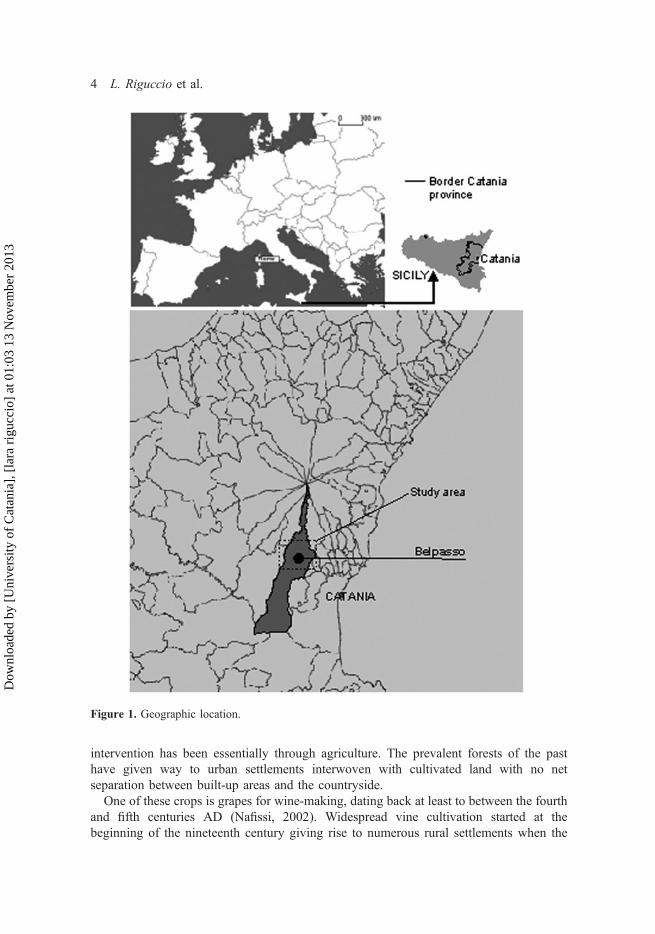
The study area is the municipality of Belpasso on the southern slope of Etna (Figure 1).Belpasso, like most of the 42 municipalities on Etna (section 13 of the Regional TerritorialLandscape Plan) is in Etna’s foothills extending for 15 084 ha from the Catania plain atjust a few metres above sea level to the volcano’s summit (3343 m).
From an agricultural point of view, the area is typical of the polychromaticagricultural landscape of southern Etna which includes substantial conservation ofbiodiversity, wonderful rural engineering projects and handmade structures forpreserving the uneven ground, the fragile and vulnerable layout of the land (vernacularbuilding for agricultural production, towers and dry-stone terrace walls in lava, tracksconnecting the terracing, etc.) which during the 1990s underwent severe impoverishmentdue to abandonment or crop changeover.
Due to soil variations and very particular climatic conditions, land usage is veryclearly differentiated: more low-lying areas have sandy, loose soil and highertemperatures (summer 40°C, winter rarely below 10°C) and are prevalently used forsummer crops and citrus orchards.
The band of Etna between 300 and 500 m a.s.l. consists of fertile soils intermixedwith volcanic rock, and includes urban Belpasso with its seventeenth-century centre,disorganised residential and commercial sprawl closely interwoven with agriculturalland where the original vineyards changed over to cactus fruit and citrus crops in thesecond half of the last century.
The 800+ m band is totally natural with forests and lava fields.A Regional Park since 1987, today’s landscape of the Etna area is the result of
centuries of transformation due to natural and human phenomena (Cullotta & Barbera,2010). Repeated lava flows have modified the landscape into its current form. Human
Cultural Landscape: Stone Towers on Mount Etna 3
Dow
nloa
ded
by [
Uni
vers
ity o
f C
atan
ia],
[la
ra r
iguc
cio]
at 0
1:03
13
Nov
embe
r 20
13
intervention has been essentially through agriculture. The prevalent forests of the pasthave given way to urban settlements interwoven with cultivated land with no netseparation between built-up areas and the countryside.
One of these crops is grapes for wine-making, dating back at least to between the fourthand fifth centuries AD (Nafissi, 2002). Widespread vine cultivation started at thebeginning of the nineteenth century giving rise to numerous rural settlements when the
Figure 1. Geographic location.
4 L. Riguccio et al.
Dow
nloa
ded
by [
Uni
vers
ity o
f C
atan
ia],
[la
ra r
iguc
cio]
at 0
1:03
13
Nov
embe
r 20
13
‘grand estates’ broke up in favour of small land-owners providing them with properties of2–5 ha (Russo et al., 2000).
After 1940, grape cultivation dropped substantially both in terms of demand forblending wines (to reinforce weaker wines) and the difficulty of mechanising servicingfor terraced crops which led not only to a decline (Etna Park: 8000 ha in the nineteenthcentury to 3000 ha today) but also to the abandonment of an immense architecturalheritage of which the widespread towers are part. This has taken place above all on thesouth-western and southern slopes of Etna, whereas to the north and north-east grapecultivation has risen in esteem following its recognition among Etna’s DOC wines.
3. Method
The towers are generally located in farming areas which are fenced in and difficult toaccess as well as camouflaged by spontaneous vegetation, lava spurs or terrace wallsagainst which they abut. As a result, identifying them in the field and from the air isrelatively difficult. Therefore, a detailed survey (the ‘census’) was carried out over aband 3000 m from the suburb perimeter. This area was chosen because of thesignificant urban pressure which is putting the towers’ survival at risk.
At the same time, so as to describe their relationship to the landscape, certainthematic and topographic maps were consulted: the Lithological Map, the IGM(Military Geographical Institute) Historical Map and the Land Use Map drawn up forthe Landscape Plan, section 13, which refers to Mount Etna (Regional Landscape Plan)whose re-drawing has highlighted the current state of vine and tree cultivation.
The Lithological Map (1: 100 000), extracted from the web GIS of the LandscapePlan, was useful for finding above all those areas with basalt sub-strata in which thesoil evolution has facilitated certain tree crops (vineyards, olives, prickly pear,specialised or associated) as a result of land de-stoning which generated the terracesand various types of dry-stone architecture and the towers.
The IGM Historical map (1: 50 000) from 1895 revealed the vineyards and treecultivations of that era. The Belpasso municipality is on Sheet 269 (quadrants I & II)and on Sheet 270 (quadrants III & IV). The vineyards are denoted by ‘L’ on the mapsand the tree crops are small circles with appropriate tree pictograms.
The Land Use Map (1: 50 000) drawn up in 2008, was used to extrapolate thevineyards, mixed tree crops and olive orchards.
The towers were pinpointed by Google satellite images and correlated to thematicinformation (basalt areas, 1896 and 2008 crops). This phase helped identify the fourrural areas where the towers are located.
The towers included in the census have at least one of the following characteristics:a state of conservation which provides architectural and construction evidence, signifi-cant size, and a specific shape which is different to that of the classic ‘pyramid’tower.
The census was carried out using a chart of the following information:
- farm area name for naming the ‘tower’;- topographic localisation on the Technical Map (1: 10 000);- Land Register references (sheet no. and parcel);
Cultural Landscape: Stone Towers on Mount Etna 5
Dow
nloa
ded
by [
Uni
vers
ity o
f C
atan
ia],
[la
ra r
iguc
cio]
at 0
1:03
13
Nov
embe
r 20
13

- presumed construction date (according to owners’ recollections and oraltestimony);
- farm area use in which the construction is found;- other rural structures;- road/track network;- distance from public highway;- distance from Belpasso centre;- homogenous area type of the General Regulatory Plan (planning instrument forgoverning the territory);
- conservation state of the ‘tower’.
The survey mapped 19 towers which were graphically reproduced. They were measuredmanually (± 5 cm) with measuring tapes and rulers. AutoCad and Corel Draw wereused for the graphics (± 1 cm).
The purpose of the survey was to highlight relationships with the landscape andcategorise the structures by construction technique and dimensions.
4. Results and Discussion
By processing information from maps, charts and survey data it was possible tohighlight how the towers characterise the study area and understand how they werebuilt by identifying the compositional and constructional variables. Subsequently, themain results are reported as two separate themes: landscape and construction.
4.1. The Landscape of the Towers
The dry-stone constructions in the Belpasso area are closely linked to the land’s geolog-ical make-up, being the only resource for its inhabitants who have tried to exploit it inevery possible way. To do that, all the volcanic rocks and stones had to be removedfrom the land and were accumulated within fields in stacks sometimes in large volumesas towers and sometimes smaller versions (‘towerettes’), both punctuating theagricultural landscape regularly.
To look at them in situ, the visitor might question what possible justification therecould be for some of the towers, for example those located in the middle of a flatterrace and entirely surrounded by fertile land. However, it is likely (and confirmed insome instances by local farmers) that the ground under the tower could not have beenput to good agricultural use because of rocks or other reasons connected with the natureof the terrain.
It is also notable that it is difficult to perceive how large the towers are when viewedfrom the perspective of the surrounding landscape. From a distance, especially in opencountryside, the towers seem bigger than they really are. It is as if their composition orlocation in the natural landscape distorts their real dimensions and makes them seemenormous.
These rock stacks are also important in the natural cycle of the area because theyoffer a ‘refuge’ for spontaneous vegetation and wild fauna whether in intensivelycultivated fields or even better on abandoned agricultural land which is regularly subjectto fires, especially during the summer.
6 L. Riguccio et al.
Dow
nloa
ded
by [
Uni
vers
ity o
f C
atan
ia],
[la
ra r
iguc
cio]
at 0
1:03
13
Nov
embe
r 20
13

The area in the municipality of Belpasso with most towers is at 500–800 m a.s.l. Itincludes the urban centre but also the area with the best towers which were producedalongside past agricultural development but today are generally dilapidated. There arealso numerous rural nuclei which are both residential and productive, like olive oilmills, small dry-stone cottages, terraces, stone tracks and dry-stone field walls.
At this same altitude band, which has a lava substrate, a comparison was madebetween the vineyards and tree crops of 1895 and 2008 (Figure 2).
In the buffer zone of the study area, four sub-zones were identified: North-East,North-West, South-East and South-West. A total of 19 towers are located here(Figure 3).
In 1895, the area north of the urban centre had the greatest number of vineyards andtoday has the greatest municipal surface area of terraces (0.4%) (Barbera, Cullotta,Rossi-Doria, Rühl, & Rossi-Doria, 2010). The North-East and North-West zonesoverlap this area.
The North-East zone is made up of a grid of wide terraces with low dry-stone walls.There is no arboreal vegetation apart from some spontaneous shrubs where the wallsand towers offer shelter. The vineyards have totally disappeared. In this area, there isone of the most historic sites in the municipality: ‘the queen cistern’ is a huge tank builtin the Middle Ages to supply drinking water to the town. This zone has two towers.
The North-West zone has wide terracing—most are uncultivated, often withirregularly spaced sparse olive trees interspersed with patches of spontaneous vegetationand rocky outcrops—with low dry-stone walls which segment the landscapegeometrically and is softened by vegetation clinging to the towers and dry-stone walls.Vineyards have practically disappeared. There are 12 towers in this area being amongthe oldest.
Figure 2. Vineyards and woody crops, in 1895 and 2008, in the basalt area of Belpasso (colourfigure online).
Cultural Landscape: Stone Towers on Mount Etna 7
Dow
nloa
ded
by [
Uni
vers
ity o
f C
atan
ia],
[la
ra r
iguc
cio]
at 0
1:03
13
Nov
embe
r 20
13

The South-East zone where spontaneous vegetation prevails over scarce cultivation iswedged in between the western suburb and a considerable rocky area to the east. Of thefour zones, this one is most subject to anthropic pressure: the current urban plans(General Regulatory Plan) provides for a change of land use from agricultural toresidential, radically changing the original landscape which very close by wascharacterised by a network of dry-stone walls with nodes of towers and ‘towerettes’.
One informant described how ‘tower’ no. 3 ‘Gattaino’ should have been: the two bigtowers were connected by an archway through which you entered the farm. At the topof one ‘tower’, which extended laterally like a long sloping wall, a track led down tothe old town centre. What remains today are the two towers which are still 8 m highand a trace of its original surface area (about 730 m2, the largest of all the towers). It isused today as a stone quarry for new building. In the same area, there is still one‘tower’, although part abandoned, protected by a landscape provision as part of theRegional Territorial Landscape Plan (1999). The agricultural landscape, compressedbetween urban settlements, consists of olive trees and patches of natural vegetation.There are also four towers.
The South-West zone is also very close to the built-up area. The terraces, wherepresent, are not a significant component of the landscape. They mark off ample areascultivated with citrus and olive. Any remaining vineyards lie on level areas where itwas easier to mechanise part of the harvesting work. A block of commercial buildings
Figure 3. Tower and survey zone location (colour figure online).
8 L. Riguccio et al.
Dow
nloa
ded
by [
Uni
vers
ity o
f C
atan
ia],
[la
ra r
iguc
cio]
at 0
1:03
13
Nov
embe
r 20
13

denotes the pressing urbanisation. There is only one ‘tower’ in the area, one of thelargest in the census.
4.2. Tower Analysis
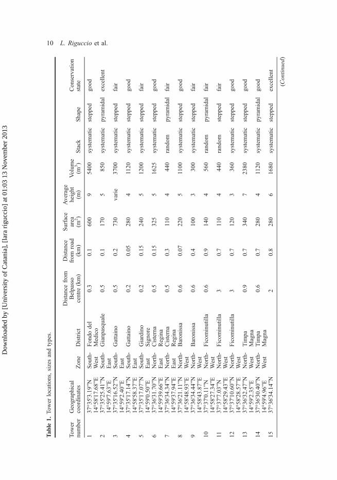
The towers in the study are presumed to have been built around 1850. They are all pri-vate property and most are located close to the suburbs. Six towers in the North-Westzone are the only ones 2–3 km away. They are all fairly easily reached by public roadsbeing situated 100–700 m from them. They are all on the IGM map (1: 25 000), Sheet270, IV quadrant, North-West (Table 1). Most are on agricultural land except for threein the South-East zone which are on potential building development sites.
On this agricultural land there are also other constructions: dry-stone terrace walls,stone tracks and secondary towers whose surface areas mostly vary between 60 m2 and340 m2, and their heights between 3 and 7 m. Only two are different: 600 m2 and 730m2 both with heights of 9 m.
Construction type and techniqueIn practical terms the towers were an exercise in dry-stone wall building which servedto use the stones from the land. The lava stones removed from the land were primarilyused to build dry-stone field walls as well as the terracing which is still visible all overEtna today. Any extra stones were stacked into towers; both field walls and towers arebuilt stone by stone without adhesives and directly on the ground with or without arocky foundation. The towers were constructed so as not to take up too muchagricultural land and had steps built in to them so their tops could be accessed andwhere one or two rooms were sometimes incorporated into the structure. Someexamples include small rooms built without doors to head height, their ceilingsfashioned into vaults or arches.
‘Stone masters’ built the towers alongside stone cutters (Ambrosi, Degano, & Zaccaria,1990; Di Fazio & Modica, 2008; Failla & Di Fazio, 1998; Tirangolo, 2007). It is thoughtthat these artisans were responsible for the tower’s shape, and that their complexity andvariety depended above all on site characteristics, agricultural requirements and the stonecutters’ abilities. This work was improvised without a design plan. Research could notfind a single document relating even to a preliminary design. There were only generaldescriptions post-completion, some of which have already been cited in the introduction.Given current knowledge, it is not possible to say whether there has been any typologicalevolution over time.
Referring to the census towers, and considering they were the result of de-stoning theland, they can be classified by construction style:
(a) Randomly stacked towers(b) Systematically stacked towers
The first category is for all those towers which are just stone stacks. They are oftenmore or less square with low carefully built external containment walls freely piled upwith smaller stones to form a ‘cupola’ (Figure 4). There were three of this type of‘tower’ (one in the North-East zone, the other two in the North-West zone).
Cultural Landscape: Stone Towers on Mount Etna 9
Dow
nloa
ded
by [
Uni
vers
ity o
f C
atan
ia],
[la
ra r
iguc
cio]
at 0
1:03
13
Nov
embe
r 20
13
Tab
le1.
Tow
erlocatio
ns,sizesandtypes.
Tower
number
Geographical
coordinates
Zon
eDistrict
Distancefrom
Belpasso
centre
(km)
Distance
from
road
(km)
Surface
area
(m2)
Average
height
(m)
Volum
e(m
3)
Stack
Shape
Con
servation
state
137
°35'3.19
”NSou
th-
West
Fon
dodel
Medico
0.3
0.1
600
95400
system
atic
stepped
good
14°58'17
.68”E
237
°35'25
.41”N
Sou
th-
East
Gianpasquale
0.5
0.1
170
5850
system
atic
pyramidal
excellent
14°59'7.63
”E3
37°35'16
.52”N
Sou
th-
East
Gattaino
0.5
0.2
730
varie
3700
system
atic
stepped
fair
14°59'2.40
”E4
37°35'17
.14”N
Sou
th-
East
Gattaino
0.2
0.05
280
41120
system
atic
stepped
good
14°58'58
.37”E
537
°35'17
.07”N
Sou
th-
East
Giardino
Signo
re0.2
0.15
240
51200
system
atic
stepped
fair
14°59'0.50
”E6
37°36'31
.70”N
North-
East
Cisterna
Regina
0.5
0.15
325
51625
system
atic
stepped
good
14°59'39
.66”E
737
°36'34
.34”N
North-
East
Cisterna
Regina
0.5
0.3
110
444
0rand
ompy
ramidal
fair
14°59'37
.94”E
837
°36'21
.11”N
North-
West
Baronissa
0.6
0.07
220
51100
system
atic
stepped
good
14°58'48
.93”E
937
°36'34
.44”N
North-
West
Baronissa
0.6
0.4
100
3300
system
atic
stepped
fair
14°58'43
.87”E
1037
°37'0.11”N
North-
West
Ficom
inutilla
0.6
0.9
140
456
0rand
ompy
ramidal
fair
14°58'27
.34”E
1137
°37'7.03
”NNorth-
West
Ficom
inutilla
30.7
110
444
0rand
omstepped
fair
14°58'29
.43”E
1237
°37'10
.60”N
North-
West
Ficom
inutilla
30.7
120
3360
system
atic
stepped
good
14°58'28
.57”E
1337
°36'32
.47”N
North-
West
Tim
paMagna
0.9
0.7
340
72380
system
atic
stepped
good
14°59'2.35
”E14
37°36'30
.40”N
North-
West
Tim
paMagna
0.6
0.7
280
41120
system
atic
pyramidal
good
14°59'4.96
”E15
37°36'34
.14”N
20.8
280
61680
system
atic
stepped
excellent
(Con
tinued)
10 L. Riguccio et al.
Dow
nloa
ded
by [
Uni
vers
ity o
f C
atan
ia],
[la
ra r
iguc
cio]
at 0
1:03
13
Nov
embe
r 20
13

Table1.
(Con
tinued).
Tower
number
Geographical
coordinates
Zon
eDistrict
Distancefrom
Belpasso
centre
(km)
Distance
from
road
(km)
Surface
area
(m2)
Average
height
(m)
Volum
e(m
3)
Stack
Shape
Con
servation
state
North-
West
14°58'33
.69”E
1637
°36'58
.56”N
North-
West
Edere
30.7
604
240
system
atic
stepped
good
14°58'17
.95”E
1737
°36'58
.73”N
North-
West
Edere
30.7
603
180
system
atic
stepped
excellent
14°58'19
.46”E
1837
°36'59
.79”N
North-
West
Edere
30.7
603
180
system
atic
stepped
good
14°58'20
.67”E
1937
°36'53
.58”N
North-
West
Edere
30.7
603
180
system
atic
stepped
good
Cultural Landscape: Stone Towers on Mount Etna 11
Dow
nloa
ded
by [
Uni
vers
ity o
f C
atan
ia],
[la
ra r
iguc
cio]
at 0
1:03
13
Nov
embe
r 20
13

The second category is for those towers built more carefully, beyond just placing theperimeter stones just so, with particular attention paid to placing the filler material.Often, these towers have external components which stick out with longer stones atregular intervals and at different heights to serve as vine supports, or they have sheltersbuilt into their tops or adjacently. There are 15 towers in this group.
The second classification refers to form:
- Pyramidal- Stepped
Pyramidal towers are often built at the divide between two terraces of different heightsto serve as a buttress (Figure 5). Six towers belong to this group, two of which aresystematic and the remainder random. Locations: one South-West, one North-East, oneNorth-West.
The stepped towers usually have a very ample base upon which stone layers or stepsare built up (Figure 6). The level thicknesses are almost constant and rarely above twometres. The levels are connected by flights of steps built into the walls making themreal architectural motifs in the tower walls. Sometimes, the steps penetrate the tower atright angles to the perimeter walls. There are 13 systematically stacked stepped towersspread over all the zones.
Figure 7 shows the most significant tower images with their characteristicshighlighted. While every tower can be catalogued as a definable type, each one issingular architecturally concerning size, shape and landscape location. For example,some towers are stepped between two terraces at different heights (towers 1, 6 and 18)
Figure 4. Randomly stacked towers.
12 L. Riguccio et al.
Dow
nloa
ded
by [
Uni
vers
ity o
f C
atan
ia],
[la
ra r
iguc
cio]
at 0
1:03
13
Nov
embe
r 20
13

with their axes mostly parallel to them, but some are stepped in a quadrangle orpolygonal shape on terraces (towers 4, 5, 9, 12, 13, 15, 16, 17 and 19) and others arein the centre of fields (towers 3 and 8). Even the pyramidal ones have different shapesdepending on the site. Occasionally, they seem like an expansion of the terrace but whatmakes them a tower is the curvature of the walls and at their tops filler stones (towers2, 7 and 10). When they are isolated within a field, their function is indubitable (towers11 and 14).
There are however some forms which they hold in common as regards theirconstruction: the containment walls, flights of steps, ramps and interlocking corners.The containment walls are made up of medium-sized stones arranged ‘head up’ andrarely visibly symmetrical. Wall widths vary according to height. In pyramidal towers,the walls can reach about 4–6 m, so they have a lazy A cross-section typical ofreinforcement walls: tapering upwards with an inclined face. For the stepped towers,the height of each step is 1–2 m.
The step gradient contributes to improving the structure’s stability with lesser wallthickness compared to the towers. In both cases, it is difficult to measure the base giventheir structural soundness. From observations of the stepped walls, their thickness isprobably equal to or a little more than the façade stones. This may be deduced fromwhat is visible on the offset surfaces which are greater in width than the façade stones:it is evident that the filler stones are arranged to support the heavier stones of thefaçade.
The offset surface widths vary according to tower height, purpose (sometimes theyare raised paths) and their formal composition (Figure 8). The façades have the heaviestand most symmetrical stones and given the great variation between towers it is difficultto establish average size. The close attention paid to interlocking the stones should behighlighted which are rarely visibly rounded off. Sometimes, to improve adhesion and
Figure 5. Pyramidal towers.
Cultural Landscape: Stone Towers on Mount Etna 13
Dow
nloa
ded
by [
Uni
vers
ity o
f C
atan
ia],
[la
ra r
iguc
cio]
at 0
1:03
13
Nov
embe
r 20
13

stability, much smaller stones are used to fill up the gaps. As a result, the façades areregular and quite stable.
The steps carved into the terrace walls are 40–60 cm wide, each tread being a singleslab 20–30 cm above the next so they are as regular as possible. They are a significantcharacteristic since the flight of step angles have a strong visual impact on the wallfaçades and reflect the complexity of the craftsman’s trade.
Figure 9 shows some variations in the towers of the census. Those with flights ofsteps incorporated are rarer (only three). They start from either an offset or from theground up and rise to the top of the tower in just one flight. At the base the steps are
Figure 6. Stepped towers (Tower 1). A) General view; B) Levels and flights of steps from above;C) From the centre of the tower.
14 L. Riguccio et al.
Dow
nloa
ded
by [
Uni
vers
ity o
f C
atan
ia],
[la
ra r
iguc
cio]
at 0
1:03
13
Nov
embe
r 20
13

about 60 cm wide (where the terrace walls are almost human height and so their sizeshould be close to the anthropometric measurement) shortening to 40 cm at the top(Figure 10). Generally, the flights are adjacent to the towers, one side supported by
Figure 7. Surveyed tower.
Cultural Landscape: Stone Towers on Mount Etna 15
Dow
nloa
ded
by [
Uni
vers
ity o
f C
atan
ia],
[la
ra r
iguc
cio]
at 0
1:03
13
Nov
embe
r 20
13

them, the other on their own support walls, and rising at a slope of 30%. The steps areloosely placed combinations of rough slabs, the gaps between them having been filledover time with earth and pebbles. The same construction technique is found for the
Figure 8. Stepped towers: examples of offset.
16 L. Riguccio et al.
Dow
nloa
ded
by [
Uni
vers
ity o
f C
atan
ia],
[la
ra r
iguc
cio]
at 0
1:03
13
Nov
embe
r 20
13

tracks which run at right angles to the terraces (connecting tracks). They facilitate thetransport of materials (grapes from the terraces and stones to the towers) by packanimals (Figure 11).
The interlocking corners are always accurately made even in the towers whichaccumulate stones randomly. Rarely are the stones hewn, being placed side by side andinterlocking (Figure 12).
At the top of the tower the stack of stones which were removed from the fields istopped off by wide flat stones.
Compositional particularsEach ‘tower’ has an architectural character of its own. Apart from their craftsmanshipand design abilities, the builders must have had great aesthetic sense given theharmonious and proportional setting in the landscape. Although meriting further study,this subject will be illustrated by three particular towers described in the antithesis ofarchitectural language.
Figure 9. Some flights of steps on tower facades.
Cultural Landscape: Stone Towers on Mount Etna 17
Dow
nloa
ded
by [
Uni
vers
ity o
f C
atan
ia],
[la
ra r
iguc
cio]
at 0
1:03
13
Nov
embe
r 20
13

The first of these three is tower 4 in the South-East zone in a gently slopingagricultural plot surrounded by terraces. The tower is square-shaped with stepsemerging directly from ground level.
Figure 14 highlights the compositional regularity of its plan, which from arectangular base rises to an almost perfect quadrangle with flights of steps on threesides symmetrical to the two axes. The top carries two cylindrical parts which
Figure 10. Anthropometric ratios on the flights of steps at right angles to the tower facades.Position A: at the base of the flight there is space enough to extend one’s arms between theinclined walls. Position B: as one climbs the flight, its width reduces until at the top it is shoulderwidth (40 cm).
18 L. Riguccio et al.
Dow
nloa
ded
by [
Uni
vers
ity o
f C
atan
ia],
[la
ra r
iguc
cio]
at 0
1:03
13
Nov
embe
r 20
13

overlapping almost create a cap with two flights of steps crossing each other to the top.The whole building is simple—it is easy to read its shape but the compositional andconstructional exactness bear witness to a grand undertaking and probably the existenceof a preliminary project. The seating of the two cylinders is particularly interesting as isthe movement of the three flights of steps. The two flights which cross each other tothe top are unique (Figure 13).
Figure 11. Examples of tower access flights.
Cultural Landscape: Stone Towers on Mount Etna 19
Dow
nloa
ded
by [
Uni
vers
ity o
f C
atan
ia],
[la
ra r
iguc
cio]
at 0
1:03
13
Nov
embe
r 20
13

Figure 12. Examples of edge nodes.
Figure 13. Relief of a quadrangular systematically stacked stepped tower.
20 L. Riguccio et al.
Dow
nloa
ded
by [
Uni
vers
ity o
f C
atan
ia],
[la
ra r
iguc
cio]
at 0
1:03
13
Nov
embe
r 20
13

The second tower (no. 2) is also in the South-East zone. It is a systematically stackedtype, located at quite some height with a circular shape and a rectangular habitationperched above. Two flights of stairs rise from ground level and encircle the structure,one going right to the top, the other on the opposite side serves an intermediate terracewith stone buttresses at regular intervals once used to support vines. Higher up, there aresteps and terraces which form part of the tower’s architecture and allow one to glimpsethe lava stone filling. The habitation has two rooms and once must have been self-suffi-cient for water.
Figure 14. Relief of a curved truncated conical tower.
Cultural Landscape: Stone Towers on Mount Etna 21
Dow
nloa
ded
by [
Uni
vers
ity o
f C
atan
ia],
[la
ra r
iguc
cio]
at 0
1:03
13
Nov
embe
r 20
13

There is a rain-water collection system consisting of brick conduits which collect roofrain-water to an outside tank embedded in the tower which in turn is connected to abasin inside the house and regulated by a wooden sluice gate. This system is commonin the rural architecture on Etna. In this case too, despite its simplicity, the structure hassome original features and is undoubtedly of aesthetic and historical value (Figure 14).
The third tower, leaning against a terrace abutment, is no. 19. Although partly inruins, what remains is significant. It has an irregular shape and the stepped levels havecurved walls with numerous flights of steps which define its façade. There are threeflights of stairs which penetrate the tower. At the top, among the stones, there are threeenormous round holes whose purpose is uncertain (they may have been to keep terra-cotta drinking water tanks cool) and in front lower down, a curved recess may havebeen an altar (Figure 15).
5. Conclusions
Over many centuries, the meticulous, almost obsessive, de-stoning of the fields by localcommunities generated the towers and the other stone architecture (shelters, terracewalls, etc.). Thus, the stones changed from waste into an expression of rural culture, aprocess of human evolution, which in the rare case of building culture, uses anunworked raw material. The primitive simplicity of these constructions creates a beautyand monumentality which today is difficult to reproduce. Over time, the meticulous useof natural resources created a landscape adapted to the needs of the farmer, and notdesigned to build monuments in the countryside (Burgers, 2000).
Figure 15. Relief of an irregular stepped tower.
22 L. Riguccio et al.
Dow
nloa
ded
by [
Uni
vers
ity o
f C
atan
ia],
[la
ra r
iguc
cio]
at 0
1:03
13
Nov
embe
r 20
13

These research results above all highlight the following aspects:
- the landscape, typological and constructional value of the towers emerge strongly;- the necessary information is presented upon which to base any conservation orappropriate improvements aimed at highlighting the intrinsic potential of eachsingle construction and the landscape of which they are part;
- currently, the multifunctionality of the countryside is being emphasised: thetowers could form part of a more complex economic network which could justifycostly maintenance or restoration.
Furthermore, like other stone structures, the towers currently play a fundamental role inconserving biodiversity (Jim, 1998), providing another reason to safeguard them(Norton, Inwood, Crowe, & Baker, 2012).
Declining agricultural use of the area means associated features like the towers havebeen abandoned, and have subsequently become targets for vandalism (Fuentes, 2010;Tassinari, Torreggiani, Benni, Dall’Ara, & Pollicino, 2011). Inexorably, a great culturalheritage is being lost.
The extent of the area on Etna where the towers are located makes widespreadintervention unsustainable. Nevertheless, the towers need to be surveyed and classifiedin order to help guide public interventions designed to safeguard towers of particularvalue. Such structures might be important for a number of reasons, including theirarchitectural qualities, their role in sustaining natural and cultural landscape character,and perhaps because they could play a role in promoting ‘the cultural landscape of thetowers’ with a view to developing rural tourism (Lane, Wills, Vanclay, & Lucas, 2008;Magnani & Struffi, 2009; van Hal, 2007).
References
Ambrosi, A., Degano, E., & Zaccaria, C. A. (1990). Architettura in pietra a secco [Dry-stone architecture].Fasano (BR): SCHENAEDITORE [in Italian].
Amit-Cohen, I. (2005). Synergy between urban planning, conservation of the cultural built heritage andfunctional changes in the old urban center: The case of Tel Aviv. Land Use Policy, 22, 291–300.
Barbera, G., Cullotta, S., Rossi-Doria, I., Rühl, J., & Rossi-Doria, B. (2010). I paesaggi a terrazze in Sicilia.Metodologie per l’analisi, la tutela e la valorizzazione [Sicilian terraced landscapes: Methods of analysis,protection and improvement]. Palermo: ARPA Studi e ricerche [in Italian].
Bjørkhaug, H., & Richards, C. A. (2008). Multifunctional agriculture in policy and practice? A comparativeanalysis of Norway and Australia. Journal of Rural Studies, 24, 98–111.
Burgers, J. (2000). Urban landscapes: On public space in the post-industrial city. Journal of Housing and theBuilt Environment, 15, 145–164.
Columella, L. G. M. (1977 [60–65 A.D.]). L’arte dell’agricoltura [The art of agriculture]. Torino: EinaudiEditore [in Italian].
Council of Europe. (2000, 20 October). European Landscape Convention, Florence.Cullotta, S., & Barbera, G. (2010). Mapping traditional cultural landscapes in the Mediterranean area using acombined multidisciplinary approach: Method and application to Mount Etna (Sicily; Italy). Landscape andUrban Planning, 100, 98–108.
Daugstad, K., Rønningen, K., & Skar, B. (2006). Agriculture as an upholder of cultural heritage?Conceptualizations and value judgements—A Norwegian perspective in international context. Journal ofRural Studies, 22, 67–81.
Di Fazio, S., & Modica, G. (2008). Le pietre sono parole. Letture del paesaggio dei terrazzamenti agraridella Costa Viola [Stones are words. Reading the landscape of agricultural terraces]. Reggio Calabria: Iiritieditore [in Italian].
Cultural Landscape: Stone Towers on Mount Etna 23
Dow
nloa
ded
by [
Uni
vers
ity o
f C
atan
ia],
[la
ra r
iguc
cio]
at 0
1:03
13
Nov
embe
r 20
13

D’Urso, V., Siracusa, G., Licciardello, G., & Tomaselli, G. (2001). Il ruolo degli agrumeti etnei e deimanufatti edilizi connessi nella costruzione di reti ecologiche periurbane [The role of Etna’s citrus orchardsand their related constructions in the creation of peri-urban ecological networks], Proceedings of IAED(International Association for Environmental Design. Palermo: Collana Sicilia Foreste [in Italian].
Failla, A., & Di Fazio, S. (1998). Caratteristiche tipologiche e costruttive dell’architettura rurale tradizionale[The construction characteristics of traditional rural architecture]. Tecnica Agricola, 1–2, 63–89 [in Italian].
Farina, A. (2001). Ecologia del paesaggio. Principi, metodi e applicazioni [Landscape ecology. Principles,methods and applications]. Torino: UTET [in Italian].
Fichera, C. R. (2007). Multifunzionalità e sviluppo sostenibile del territorio rurale [Multifunctionality andsustainable rural development]. Reggio Calabria: Iiriti Editore [in Italian].
Foti, S. (2005). Etna. I vini del vulcano [Etna. Volcano wines]. Catania: Giuseppe Maimone [in Italian].Fuentes, J. M. (2010). Methodological bases for documenting and reusing vernacular farm architecture.Journal of Cultural Heritage, 11, 119–129.
Jim, C. Y. (1998). Old stone walls as an ecological habitat for urban trees in Hong Kong. Landscape andUrban Planning, 42, 29–43.
Kizos, T., & Koulouri, M. (2006). Agricultural landscape dynamics in the Mediterranean: Lesvos (Greece)case study using evidence from the last three centuries. Environment Science Policy, 9, 330–342.
Lane, R., Wills, J., Vanclay, F., & Lucas, D. (2008). Vernacular heritage and evolving environmental policy inAustralia: Lessons from the Murray–Darling Outreach Project. Geoforum, 39, 1305–1317.
Laureano, P. (1995). La piramide rovesciata [The upside down pyramid]. Torino: Bollati Boringhieri [inItalian].
Magnani, N., & Struffi, L. (2009). Translation sociology and social capital in rural development initiatives. Acase study from the Italian Alps. Journal of Rural Studies, 25, 231–238.
Marsden, T., & Sonnino, R. (2008). Rural development and the regional state: Denying multifunctionalagriculture in the UK. Journal of Rural Studies, 24, 422–431.
May, J., & Reid, A. (2010). Architettura senza architetti [Architecture without architects]. Milano: Rizzoli [inItalian].
McKenzie, P., Cooper, A., McCann, T., & Rogers, D. (2011). The ecological impact of rural building onhabitats in an agricultural landscape. Landscape and Urban Planning, 101, 262–268.
Nafissi, M. (2002). Magna Grecia. In Storia dell’agricoltura italiana [The history of Italian agriculture](pp. 405–413). Firenze: Ed. Polistampa [in Italian].
Norton, L.R., Inwood, H., Crowe, A., & Baker, A. (2012). Trialling a method to quantify the ‘culturalservices’ of the English landscape using Countryside Survey data. Land Use Policy, 29, 449–455.
Russo, P., Nucifora, S., & Tomaselli, G. (2000). Il rilievo e la classificazione tipologica dei manufatti per laproduzione vitivinicola come strumento di conoscenza per lo sviluppo dell’ambiente rurale [A survey andtype classification of winery artefacts as symbols of rural development]. Proceedings of the Italian Societyof Agricultural Engineering II Section, Matera, Italia [in Italian].
Saleh, M. A. E. (2000). The architectural form and landscape as a harmonic entity in the vernacularsettlements of southwestern Saudi Arabia. Habitat International, 24, 455–473.
Tassinari, P., Torreggiani, D., Benni, S., Dall’Ara, E., & Pollicino, G. (2011). The FarmBuiLD model (farmbuilding landscape design): First definition of parametric tools. Journal of Cultural Heritage, 12, 485–493.
Taylor, P. D. (2002). Fragmentation and cultural landscapes: Tightening the relationship between humanbeings and the environment. Landscape and Urban Planning, 58, 93–99.
Tirangolo, P. (2006). Architettura in pietra a secco degli Iblei [Stone upon stone. Ibleian dry-stonearchitecture]. Ragusa: EdiArgo [in Italian].
Tirangolo, P. (2007). Le mani e la pietra [Hands and stone]. Noto (SR): Modulo Press [in Italian].van Hal, M. J. D. (2007). A labeling system as stepping stone for incentives related to the profitability ofsustainable housing. Journal of Housing and the Built Environment, 22, 393–408.
Vecco, M. (2010). A definition of cultural heritage: From the tangible to the intangible. Journal of CulturalHeritage, 11, 321–324.
Wrbka, T., Erb, K. H., Schulz, N. B., Peterseil, J., Hahn, C., & Haberl, H. (2004). Linking pattern and process incultural landscapes. An empirical study based on spatially explicit indicators. Land Use Policy, 21, 289–306.
Zappalà, A. (2000). La vite ed il vino sull’Etna nel tempo [The vines and the wine of Etna over time]. Siena:Edizioni Cantagalli [in Italian].
Zasada, I. (2011). Multifunctional peri-urban agriculture—A review of societal demands and the provision ofgoods and services by farming. Land Use Policy, 28, 639–648.
24 L. Riguccio et al.
Dow
nloa
ded
by [
Uni
vers
ity o
f C
atan
ia],
[la
ra r
iguc
cio]
at 0
1:03
13
Nov
embe
r 20
13