Tūtū's Hawaiian and the Emergence of a Neo Hawaiian Language
Upload
khangminh22Category
view
3download
0
Hawaiian Volcano Observatory1962 Quarterly Administrative reports
Introductory Note By Thomas L. Wright and Jennifer S. Nakata
Compiled By Jennifer S. Nakata
Summary 25January, February, and March 1962
By Robert Y. Koyanagi, Harold L. Krivoy, and Arnold T. Okamurawith an introduction By Chester K. Wentworth
Summary 26April, May, and June 1962
By Arnold T. Okamura, Robert Y. Koyanagi, and Harold L. Krivoyand
Report on the International Symposium on Volcanology, Tokyo, 1962, By Howard. A. Powers
Summary 27July, August, and September 1962
By Arnold T. Okamura, George Kojima, and Akira Yamamotoand
Direction of First Motion from Four Earthquakes from a Single Focus By Harold L. Krivoy
Summary 28October, November, and December 1962
By Harold L. Krivoy, Robert Y. Koyanagi, Arnold T. Okamura, and George Kojima
andThe 1962 Flank Eruption of Kïlauea By James G. Moore
Open-File Report 2007-1322U.S. Department of the Interior
U.S. Geological Survey
U.S. Department of the InteriorDIRK KEMPTHORNE, Secretary
U.S. Geological SurveyMark D. Myers, Director
U.S. Geological Survey, Reston, Virginia 2007
For product and ordering information:
World Wide Web: http://www.usgs.gov/pubprod
Telephone: 1-888-ASK-USGS
For more information on the USGS—the Federal source for science about the Earth,
its natural and living resources, natural hazards, and the environment:
World Wide Web: http://www.usgs.gov
Telephone: 1-888-ASK-USGS
Any use of trade, product, or firm names is for descriptive purposes only and does not imply
endorsement by the U.S. Government.
Although this report is in the public domain, permission must be secured from the individual
copyright owners to reproduce any copyrighted material contained within this report.

INTRODUCTORY NOTE
The Hawaiian Volcano Observatory Summaries have been published in the current format since 1956. The Quarterly
Summaries (1956 through 1973) and the Annual Summaries (1974 through 1985) were originally published as Ad-
ministrative Reports. These reports have been compiled and published as U.S. Geological Survey Open-File Reports.
The quarterly reports have been combined and published as one annual summary. All the summaries from 1956 to
the present are now available as .pdf files at http://www.usgs.gov/pubprod.
The earthquake summary data are presented as a listing of origin time, depth, magnitude, and other location param-
eters. Network instrumentation, field station sites, and location algorithms are described. Tilt and other deformation
data are included until Summary 77, January to December 1977. From 1978, the seismic and deformation data are
published separately, due to differing schedules of data reduction.
There are eight quarters—from the fourth quarter of 1959 to the third quarter of 1961—that were never published.
Two of these (4th quarter 1959, 1st quarter 1960) have now been published, using handwritten notes of Jerry Eaton
(HVO seismologist at the time) and his colleagues. The seismic records for the remaining six summaries went back to
California in 1961 with Jerry Eaton. Other responsibilities intervened, and the seismic summaries were never pre-
pared.
Chronology
The following Kïlauea eruption chronology covers the two recent reports and the six missing quarters:
Location Beginning Date Ending Date Comment
Kïlauea Iki crater (Kïlauea’s summit) 11/14/1959 12/20/1959 19 eruptive episodes
Kapoho (lower east rift zone) 1/13/1960 2/18/1960 4 eruption stages
Halemaumau (Kïlauea’s summit) 2/24/1961 2/24/1961 Intermittent activity during
uninterrupted inflation fol-
lowing the 1960 eruption
Halemaumau (Kïlauea’s summit) 3/22/1961 3/25/1961 Same as above.
Halemaumau (Kïlauea’s summit) 7/10/1961 7/17/1961 Same as above.
Heiheiahulu (middle east rift zone) 9/22/1961 9/25/1961 First historical east rift erup-
tion at this location
The 1959-1960 eruptions were among two of the most spectacular Kïlauea eruptions. The HVO staff was kept busy
with acquisition of unusually high quantities of instrumental data and observations of the two sequences, which
were separated by less than one month. Even with a year’s interval before the beginning of the summit-east rift se-
quence in 1961, the staff never caught up, and the seismic records were set aside for later study.
A total of 1,672 earthquakes—1,106 for 1960 and 566 for 1961—are part of HVO’s cataloged database. The annual
listings have been appended to the 1st Quarter Report of 1960 and to the 4th Quarter Report for 1961. The number of
earthquakes is probably low, biased toward the larger magnitudes. The entire HVO catalog, including 1960 and 1961,
is accessible from the ANSS CATALOG SEARCH site at http://www.ncedc.org/anss/catalog-search.
Thomas L. Wright and Jennifer S. Nakata

UNITED STATES
DEPARTMENT OF THE INTERIOR
GEOLOGICAL SURVEY
HAWAIIAN VOLCANO OBSERVATORY
SUMMARY 25
January. February. and March. 1962
By
R. Y. Koyan~gi. H. L. Krivoy. and A. T. Okamura
with an introduction" by C.. 'K. Wentworth
Observatory Staff
Geol,ogy:
J. G. MooreD. H. Richter (Scientist-in-Charge)C. K. Wentworth '
Geophysics:
R. Y. KoyanagiH. L. KrivoyA. T. OkamuraD. R. Mabey (Gravity Survey)W. T. Kinoshita (Gravity Survey)
October 1963
Geochemistry:
W. U. Ault"G. KojimaR. T. Okamura
Support:
'J. C~ ForbesW. H. FrancisB '~ J. LoucksA. Yamamoto

Contents
Page
Introduction------------------~----~~--------------------------- 1
History of the Hawaiian Volcano Observatory, by ChesterK. Wentworth--------------~-~-~------~---------~------~-- 1
Tilting of the ground around Kilauea caldera~~~~~~~~---~~-~~~-~- 3
Seismic sumrnary----·------~~-~--~-~-~~~~---~~--~--~~-----~=~~-~~ 7
Illustrations-~short list
Figure 1. Tilting of the ground around Kilauea caldera-~~-~=~~~ 4
2. Tilting of the ground around Kilauea caldera~u.-~--~- 5
3. Map of the island of Hawaii showing'seismographstations operated by the Geological 'Survey andlocalities mentioned in the text--------------~·~-- 10
Tables--short list
Table 1. Tilt coordinates at Uwekahuna vault----------~---~---- 6
2. Tilt coordinates and changes at bases around'Kilaueacaldera---------~---~---~-------~-~------------~---- 8
3. Numbers of earthquakes and minutes of tremor recordedon seismographs around Kilauea caldera--------~----- 11
4. Local earthquakes recorded by seismographs'of the U~So
Geological Survey--~----~------~~-~----~------~-~--- 12
6. UoS o Geological Survey seismograph stations in Hawaii- 34

HAWAIIAN VOLCANO OBSERVATORY SUMMARY 25
By R. Y. Koyanagi, Ho L~ Krivoy, and A. To Okamura
Introduction
Of interest to students of Hawaiian volcanism are the variousapproaches to the natural history of this regiono Dr. Chester K.Wentworth of the HVO staff very kindly prepared "the -following shortsummary of his more detailed work on the subject of the history ofthe Hawaiian Volcano Observatory. We are very pleased to presentthis abstract. therefore. as a guide to historical re"s"earches inHawaiian volcanism. Scientists, as well as the agencies'which supportthem. are quite incidental to the ageless volcanic process. Dr.Wentworth describes the painful--often penurious--circumstances underwhich workers in Hawaii .have labored to examine a minuscule sampleof the countless events that have built the volcanoes.
History of the Hawaiian Volcano Observatory
By Chester K. Wentworth
The earliest recording of events and history atKilauea Volcano was the work of certain individuals amongthe Protestant missionaries, who first arrived in Hawaiiin 1820. There were legends among the Polynesians for thepreceding centuries, which were recorded by the missionaries, and also a few notes from the voyages of Cook andVancouver.
The condition and history of Kilauea first became-knownto the world through the journals and diaries of certainmembers of the missionary company who speculated aboutvolcanic behavior at the time when valid accounts were justbeginning to be formulated in the rest of the world. Therewere also the visits of naval expeditions coming to Hawaiiwith various missions in the first half of the 19th century;these usually visited Kilauea as a favored "world \ionder."Several of these expeditions left printed accounts or maps.Later there were specific scientific missions that issuedreports.
From the arrival of the missionaries, there wereindividuals among them who made repeated"visits to thevolcanoes and developed a comparative narrative. There wasa growing facility and permanence of communication 0 Amongthe recurrent visitors were those who emphasized the needfor a permanent agency and station for observation andanalysis of Kilauea e Such suggestions'were made for 50
1
years before the first effective steps were taken by ThomasA. Jaggar to organize local interest 'by means of the HawaiianVolc'a'no Research' Association and to gain the support of theMassachusetts Institute of Technologyo The first continuedobservations were made by Fo Ao Perret, in 1911. from temporarybuildings on the floor of Kilauea caldera. near the edge ofthe Halemaumau pit~ In early 1912. a permanent observatorybuilding was built. largely with la~or and materials donated bythe citizens of Hilo, and TG Ao Jaggar arrived to take residentcharge. with the continued cooperation of HoVoRoA~ and MoloT o
Publication of the Bulletins of the Hawaiian VolcanoObservatory was commenced 0 During the first decade of theObservatory, Perret, and H. 0 0 Wood were observers o Later.in 1919. the sponsorship of the Observatory, with the samestaff and facilities. was transferred to the U.S. WeatherBureau. At that time R. Ho Finch, who had been with thelatter bureau, carne out as assistant to Jaggaro
In 1924 came the spectacular steam-blast eruption bywhich Halemaumau was enlarged to 3,000 feet in diameter andmore than 1.300 feet deep. In July 1924 the Observatorycontrol was assumed'by the'UaSo' Geological Survey 0 Afterthe 1924 explosion. Halemaurnau was filled slowly'. mostly bysmall flows coming into the bottom of the shallowing pitoDifferent techniques continued to be devised for studyingthe ungerground activitYo In 1935 the Volcano Observatorybecame a part of the Hawaii National Park with the sameobjectives as before but with a closer participation in thework of the Park Service.
Dr. Jaggar retired in 1940 0 During the ensuing severalyears of the war. Finch. who had succeeded Jaggar as volcanologist. managed to keep active a minimum program'of observations.He also preserved intact ,essential property of the Observatorywhich otherwise might h'ave been lost in the course of movesmade necessary by the burning of the Volcano House hotel andby growth of Park Service activities o Late in 1947, thestation was transferred back to the U~S~ Geological Survey 0
Since that time there has been a continued growth of the staffin numbers and skills~ The facilities and support have beengreatly increased,
The 1950's and early 1960's were marked by several,typesof activity, adding greatly to the experience of observersof this generation 0 However.- Kilauea being a prodigiousuncontrolled phenomenon of irregular habits, it is increasinglyevident that only observing and recording events over manyhuman generations, or thousands of years, can build a pictureof total activity that will support any presumption togeneralize or predicto
2

Chronological summary
The summit of Kilauea Volcano continued to'swell throughout thelast quarter of 1961 and the first quarter of 1962 0 Outward tiltingof the ground at the inner ring of tilt-bases (U. TM, Kea, and Kam)averaged about 12 microradians per month from October 8, 1961 toJanuary 5, 1962 (figo 1) and about 6 microradians per month fromJanuary 5, 1962 to March 29, 1962 (fig o 2)a The most distanttilt-base, HP, tilted gently toward the caldera dur~ng both quarters,while gentle tilting at Kal and KN showed"no consistent tiltingpattern.
The frequency of feeble shallow earthquakes from the vicinityof Kilauea caldera increased steadily throughout the quarter 0 Fromabout 20 per day during the last 3 months of 1961. the average dailycount of these earthquakes increased to 46. 53, and 83 during January,February, and March, respectively. Earthquakes from the source about30 km beneath Halemaumau were prominent again during this quarter i
averaging nearly 10 per day; the largest number--113-~occurredon March23. In late February another persistent source of earthquakes developedalong the southeastern flank of Kilaueao - -The seismograms of theseearthquakes are very difficult to interpret~ normal phases, such as S.are very poorly developed.· and recorded amplitudes diminish rapidlybetween the nearest stations (A. N, and U) and the next closest ones(Pa, D, ML, Hi).
Five earthquakes were reported felt during January; all of themwere associated with Kilauea Volcano 0 The l~rgestt of magnitude 400,originated 14 km southwest of Pahoa on January 7 and was feltth-roughout the island e The three earthquakes felt during Februaryall originated about 30 km be·neath Kilauea caldera on February 7 0
The largest earthquake of the month was- not felto It occurred beneaththe sea about 35 krn southeast of Cape Kumukahi on February 100
Eight earthquakes were reported felt during Marchi and all butone of them originated beneath Kilaueao The one exception occurredat a depth of about 15 km beneath Puu Waawaa on March 9 0 It has amagnitude of about 400 and was felt over half of the islando The twolargest earthquakes of the month both originated about 30 km beneathHalemaurnau and were felt over the 'entire island o The first, with a~agnitude of 4 0 4. occurred on March 23; the second. with a magnitudeof 4.5. occurred on March 300
Tilting of the ground around Kilauea caldera
Tilting of the ground around the summit of Kilauea is monitoreddaily by a short-base water-tube tiltrneter in Uwekahuna vault (table I),and at irregular intervals it is measured on a regional scale by meansof a network of field tilt-bases and a portable water-tube tiltmeter
3

5 KM
.....-...RATE 5 X 10-
6RADIANS / MONTH
Figure l.--Tilting of the ground around Kilauea caldera. October 8, 1961,to January 5. 1962. The vector depicting tilting at a given tiltbase points in the direction of maximum relative subsidence and hasa length proportional to the rate of tilting during the measurementinterval. Closed circles represent field tilt ba$es; open circles,short-base water-tube tiltmeters.
4

~ KM
~
TILTING RATE 2.5 X 10⁶RADIANS I MONTH
2000
0° °0f>.Q cr0
" Q 0
0°~Q
QKap
•eKN
Figure 2.--Tilting of the ground around Kilauea caldera. January 5. 1962.to March 29. 1962. The vector depicting tilting at a given tilt basepoints in the direction of maximum relative subsidence and has alength proportional to the rate of tilting during the measurementinterval. The area covered by this diagram has been increased toinclude the new tilt base at Kapapala (Kap).
5

Table l.--Tilt coordinates at Uwekahuna vault, January, February, anp,~r.ch, 1962
Date N-S E-W Date N-S E-W.'
-..
..~ . '. I'
Jan. 7 411 553 Feb~ 18 423 543
14 418 551 25 426 537
21 418 552 Mar. 4 427 536
28 419 550 11 \~.~ 438 537
Feb. 4 419 546 18 429 535
11 421 546 25 429 536
6

(table 2). The attitude of the ground surface at each tilt base isreported in terms of north-south and'east-west-tilt coordinates. Bothcoordinates at each station were arbitrarily set equal to 500 whenmeasurements at that station were begun. Increasing tilt coordinatescorrespond to northward and eastward tilting of the earth's surface.that is. to a relative subsidence toward the 'north and east. A I-unitchange in coordinate corresponds to a tilting of 1 microradian (1 mmper km) in the direction indicated.
Seismic summary
Events recorded by the U.S. Geological 'Survey seismograph networkin Hawaii fall into two categories: local earthquakes and tremororiginating in the region of the Hawaiian Islands, usually within 100km of at least one seismograph, and distant earthquakes originatingfarther than 3,000 km from Hawaii. As an index of seismic activityat Hawaiian volcanoes. daily counts of earthquakes and minutes oftremor recorded by seismographs in Hawaii are listed in table 3. Theearthquakes are separated into groups on the basis of region of originas determined by analysis of records obtained daily at the Observatory(U. M. A. D, N). Earthquakes of magnitude 2.5 or greater aregenerally sufficiently well recorded to be located with greaterprecision; they are listed individually in table 4. Data on identifiable phases from distant earthquakes are listed in table 5.
Locations of the seismograph stations are shown on'figure 3. andessential data on the stations are given in table 6.
7

Table 26--Ti1t coordinates and changes at bases around Kilauea caldera (see figs. 1 and 2)
Tilt base Date Tilt coordinates Rate (10-6 rad/mo) Date of(location) (1962) and direction of last
tilting since readingN-S E-W last reading (1961)
Uwekahuna(19°25.5' N. t 155°17 .4' W.) Jan. 2 394.1 531.1 17.3 No 44° W" Oct. 6
Tree Molds(19°26.3' N., 155°17.3' W.) 4 412.9 519.4 8.7 N. 22° Wo 7
Sand Spit(19°24.1' N., 155°16.8' W.) 9 844.1 693.4 2.0 N. 29° W~ 11
Kalihipaa(19°21.4' N., 155°15 0 3' Wit) 5 583.4 42203 1.1 S .. 18° E~ 8
Keamoku(19 0 25.1' No, 155°19.0' W.) 5 447.0 651!tO 9.0 N. 82° W" 8
Kamokukolau(19°22.7 1 N•• 155016~6' W. ) 3 733.6 489 0 0 14.4- s. 29° E. 7
Kipuka Nene(19° 19.4' No, 155°16.7' W. ) 4 516.7 494t!4 0.4 Nt' 66° Wb 9
Hilina Pali(19°18.2' N~ • 155°18(>6' Wo) 8 513.7 499~2 100 N~ 28° Ee 9
Mehana(19°2602' N<", 155°14 0 3' W~ ) 2 525c7 536~6 3~3 N~ 83° E¢ 10
Kapapala Ranch501.4.1(19°20.5' Nt\ I 155°23.8' We) 9 501~O 01'8 N.. 55° Efl 10

cD
Table 2.--Tilt coordinates and changes at bases around~Ki1auea.caldera.(see figs 0 1 and 2)
Tilt base Date Tilt coordinates Rate_(10-6 rad/mo) Date of(location) (1962) and direction of last
tilting since readingN-S E-W last reading (1962)
Uwekahuna(19°25.5' N· t 155°17.4' W. ) Mar. 27 409.2 521.3 6.4 N~ 33° W~ . Jan & 2
Tree Molds(19°26.3' N. t 155°17.3' W. ) 27 420.5 517.5 2.8 N. 14° We: 4
Sand Spit(19°24.1' N•• 155°16.8' W. ) 29 849.2 701.9 3.7 Ne 59° Ec 9
Kalihipaa(19°21 .. 4' N.. t 155°15.3' W0) 28 583.2 422.1 Oel SQ 56° We 5
Keamoku(19°25.1' N. t 155°1900' W. ) 29 453.8 637.6 5_4 Ne 63° We> 5
Kamokukolau(19°22.7' N. t 155°16~6' vi. ) 28 717.6 499 0 6 6.8 5&\ 34° Ee 3
Kipuka Nene(19°19.4' N· t 155°16.7' W. ) Apr. 5 516.4 494 e 6 Oel So 34° E{l 4
Hilina Pali(19°18.2' N~ t 155018~6' WCt) 4 515.0 498e2 Dco6 N. 50° Wf) 8
Mehana(lg026~2t No, 155°14 0 3' W0 ) ... -- ...-.-- ....... ---- -._~CllRf2M,.~
_ ..at _ _=a._lSIaaD~.c:::a.~c:=::.c..czc:a..~..,
__ ._____ ~_e-.
Kapapala Ranch(19°20 0 5' No, 155°23 0 8' Wo ) Mal'o 30 500 0 0 501~4 0~4 Due south 9

10 1& 20 25 1<1I0"'lllr.
20'
Cap.,Kumullahl
Contour interval 1,000 feetDotum i. mlon ItO l.v.1
Topoorophy by US G,oloOlcol Survly
EXPLANATION
• Selsmo9raph Station
• Town or locality
10 1& Mil..
."O""tai~
Pahoa •"'-...
1.0t4E.
Laupahoehoe -+- _
r-----------------------t---------_ .,.
Figure 3.--Map of the island of Hawaii showing seismograph stationsoperated by the Geological Survey and localities mentioned in thetext. Epicenters of local earthquakes are given in terms ofgeographic coordinates, which are indicated at the edges of themap.
10

Table 3.--Numbersof earth uakes and minutes of tremor recorded oncaldera U, M, A, D, and N
Table 3, summary 25, p:
ra hs around Kilauea
-~
[Tremor is separated into three categories--(l) deep, (2) intermediate, and (3) shallow--on thebasis of relative amplitudes on seismographs in the summit region. Unless otherwise stated,tremor is presumed to be associated with movement of magma within the central complex of Kilauea.
Halemaumau rock slides (4) are detected by the characteristic record they produce on the North Pitseismograph.
Earthquake categories are: 5. shallow earthquakes in the Kilauea caldera region;6, shallow earthquakes along the SW. rift zone of Kilauea and the
adjacent portion of the Kaoiki fault system;7, earthquakes along the eastern half of Kilauea's east rift zone;8, earthquakes from a source about 30 km beneath Halemaumau;9, shallow earthquakes along the Kalapana Trail (SE. flank of Kilauea
10 to 15 km W. of Kalapana);10, earthquakes from other regions: Kona, Mauna Kea, etc. ]
Date Tremor (in minutes) Halemaumau Kilauea SW. E. 30 Kalapana Others(1962) slides caldera rift rift km Trail
Deep Intermediate Shallow
1 2 3 4 5 6 7 8 9 10
Jan. 1 _.. ..,....~ ...._-..--...... -.-_........ 1 82 10 ~~-- 9 ..--~-- ..- ...._----_ .._-----
2 -~..- 5 ..~.._---- - ........_---- 88 5 ---- 18 -~ ..---..- 13 --~-
...._-_..--......- ..----~~ 8 76 20 3 9 --~-~----_.._~......_.. .,._.._.....
4 ---.. 3 --......~- 8 118 5 4 2 - ..-_ ....-- --.. - ....._---_ ...----5 ~~~.. ------ ...._--_.. .-, ------- ~--_.._--..... 27 10 13 7 -._-------- --_....~_.._-.-_-~..,6 ---- ...-....--~- ..--- ....__..~~ - ....__ ......._- 30 6 8 10 - ..--..- .... 27 ---- ------------.. ---.--_ ..-. ......-.. --..~_ .. 53 6 3 2 -------- ---------------8 - ..- .. ------------- ..~----~ 1 41 3 ---- .. 5 ..----- .. -- _.._-----_ ... --,-.- ..9 ---- ....._~-_-. .._-~- --..~ ..-.. _....__ ........~ 33 6 1 7 ----...... .- ~- .....---~-~ .....-....
10 ---- ...._------_.... _..........- ..-......._~--- 40 4 1 6 _... - ......-- 111 .._.... _.._-~----_ ..- 5 3 41 5 3 7 -----_-... ~-------_ .._....-...12 .. - .... ----_...---~--
-~ .._-.. -. 2 61 15 ------ 2 -------- --,...._..~_ ..---_-.-

13 4 ....__....-..~_..- _..__-._- -....~- ..~~-- 51 5 1 3 - ....- ........ 1 (Kona)14 3 9 1 95 7 6 ........~- ..- 315 ~ ......._~ ....---- 6 ---------- 81 7 3 .-_~_..__ .. 316 ....._---~ ..._-~ .. --------- ---._-..---..- 35 10 3 ------.. -. ..--- .... --_ ...._---17 --------~_..- ~--- ...... .._----~--~ 70 8 6 --~--. ..~- 118 3 ........__.. ..-_....-_...... 4 3 2 ............ ..,.. 3 (15 km)19 ..-~_ ..----_..- 8 ........--_....- 44 4 2 2 ------.._- 1 (Kona)20 .._--_...._---- 2 ........------ 31 8 2 ---.......... -----~~--~--~-~~
21 .._--------- ..-- ------- 1 22 8 8 _... ------- ---_ .._---_...._--~22 7 ..-~-_ .... ...~-_ ..._........ ·36 4 2 --_..~-- .. 1 (Kona)23 ..._-~~_ .......-_..
-~- ...._- -.- .......--.,- .... 23 10 1 4 -------- 1 (Mauna Loa)24 5 ------- 2 30 8 1 17 ..............-
---------~~~--~~
25 5 -...._-..~ ......--_..- .... 45 5 2 3 ......_---- -_....-.-..~......._--_..26 12 ------- ----_.._--- 22 14 16 .........-..-- ~--------~---~--
27 2 ----- ...- -- ......------- 27 11 4 -------- -- ......_----_....._--28 .- ....----..-_ .... .. ..----- -..~-..~.- ....- 33 8 2 6 -------- 1 (Kona)29 --- ..-- ....-_-. .. 7 ---------- 31 5 1 5 ~.._--~-- -.~_ ...~--- ..~------30 ---~--_....-...-- -..-~..~.. ---------- 29 6 1 3 .... _-_..~ .. ..~------_ ..--....~-31 -----..--------- ------_ .. ----~_ ..--- 33 22 3 ~_ .._~--- 1
Feb. 1 15 ------------ ~ .._...~-- 2 25 5 4 2 ...._-~ ..~.. 1 (Kona)
- 2---~------ ------- - ....._-..---_ .. 60 8 4 4 -------- 1 (s. Point)
~ 3 ------------ ----~ ..- 1 47 9 7 -------- 1 (Kona)4 -----.-----..- .. ------- ---------- 51 10 12 _....---_....
--~--~- ..---~~---5 4 ------ .. ---------- 60 13 1 5 --------.... -----_ .._---------6 2 ------- .._----......- 74 18 1 13 -------- 6
7 ---~--~....-.... ...._.....-------~-_..~ 40 8 1 70 ...._----- _.._.._..~ ..----..-~ ..
8 ------------ _....,..--- ---------- 35 14 3 3 _...-._---~ 1 (Kona)9 _..~.._------~ 3 ---------_.. 30 7 3 -------- -. ... .--.._-_ ..-..-.....~-
10 2 ..-._---- 1 58 3 2 4 -------- 311 ....__ ...--....~~.. ------- 2 59 7 7 -------- 1 (Kona)12 3 ........-. ..- 3 40 10 1 3 -------- --~ .._-_ ....-~_ .._..-13 6 ...._-- ..- 7 45 6 1 3 --.......... ..,
----~-~--~~--~--
14 ....._--------- ..-~- ..-.. 5 44 16 1 3 --------- --------------_..--15 -., ....-----..--- ...~ ....--- .._.._....._--- 40 14 3 2 -- ..~---- 3 (Kohala, Kana)16 ------------ ..---_..~ 1 25 8 5 -_ ..._------ 217 ~...._..--._-....- _-._----- ..--~------ 52 10 1 _-._------ 218 ----~-..----- _...~--_ ..
~--- ..--.- .... 27 13 3 ..~ ..-....-- .._--_.._--_.._....-~19 ..~-~ ....--_..-.. --------- ..-.~- ...._-_.. 33 17 1 3 -~ ......--- 1 (Kana)20 ------~----- -~----- -.._------~ 52 7 1 3 -- ..-..--.. 1 (Mauna Loa)21 _.._-..-_..~-.... ~ .._...._.. 3 70 8 1 4 ...._~ ..-~ .. ------------.. ---_..22 .. .-.....~~_ ........- -------- .._--------- 38 11 2 ~-~~-~---~-----~

23 --.._-~ ..--..~-- .......-~ .... --- .. _----.--_ .. 55 11 2 9 1 1 (Maui)24 -~-~..------- -------.. --_-. ..-...,--~ 70 12 3 -~~_ ..--_-.
-~----~~~~--~---
25 ----~-..----- ~_ ..~-.,-- ---..--_-.-. .. 65 8 2 15 1 226 ..~ .._..__ ..._....... ------- ......_---..-- 66 5 1 5 3 ~-~~~~----~~-~--
27 ..~.._.._--_.._~ ------- 1 66 13 4 3 ..-_....--~~-- ..----28 _.._-_..~...._~- 20 ..~---~ ....-.. 70 8 1 6 1 1 (Kona)
Mar. 1 ..~-----~~ ..~.. ------- 2 73 15 5 4 ....._-- ...... .._..-.--_...._--~-_ ..2 ..------------ ...... ----.. _..-~_.._.. --. 100 9 2 7 1 2 (Pahala)3 -- .._-- ........ _- ------- 3 67 13 3 23 5 -~---_ ..~-~-----~4 --_.---_-... - .... _............ 1 82 20 2 4 4 _... -----........._-- .....5 --_ ....__ ..__.... ----- ..-- ---------- 81 16 3 3 2 1 (Kona)6 ---- .._---.-, ..--_ .. --..-.._~ ..- ..._~ ..--~~ 150 9 2 7 ....._...._..-
-----------~~-_ ..7 ~-_ .._..------ 5 ---~ .._---.. 155 13 1 6 2 --~--~-~---~~~--
8 ~ 35 ------------- ....----- -._-_.......~..- 96 21 6 4 1 (Naalehu)9 ......--......- .._- ..-..~ .._- ..-.._--- ...... 95 35 3 7 6 2 (Mauna Loa)
10 ..__..-..-"--_..~ ...._..~- .. -_.....~..-._-- 103 33 1 1 3 1 (01aa)11 ----.--------.. --~---~
.... - ........-_.. 96 26 1 12 ..--~---- ---~-----~--~--~
12 ------~--_-.~ 6 1 70 11 2 1 1 -~--~-------~-~-
13 _.- .._-~ ....---.. ...~ .. -. .....- ---~--_-.-. ... 70 5 3 1 514 -..~-_ ....----- -..-..~-- 3 57 8 5 1 -~~-~--------~--
15 -----.. .-, ..----- -~-.--_.. 1 64 10 1 1 ~--~---~-------~
16 ....__.... -.- .._-- ---_..~- --- ..----- ..-..-- 60 7 2 2 -------- ..~-~ ..-..-------..-17 .._------ .._.... ....... -~-. .. 1 50 14 5 1 ~-----_ ..-------~18 39 --....-..--- ..-- -- ..-.._..~ ..- .......--- ...- 55 9 5 3 ..-...~---~ ------_ .._-------19 ----_....- ........ -~_ ...._~ .... __ .......~-- 51 6 9 _.._~---~ ~~~~--~~~-~-----
I-' 20 8 65 9 2 8 5 _....._-~_ .......-_..-_ ........, ~-~ .._.- .....-.._-~---~-- .._-
~ 21 - .........._..-_.... -_ ..- ...... .._--~--_ ..- 62 11 2 25 2 --~..,--~_ ....---_.._--22 ----_ ....----- ------- 1 58 12 2 5 2 ~~----~~-------~
23 ....~--~ ..-..._..- -.._~_ ..-~_ ..--_ ..~-- 50 5 2 113 ...------- 1 (s. Point)
24 ------------- _.._.._..~ ---------- 72 27 1 24 --_..---.-. 2 (s. Point)25 ..------...._--- .. - ..---.... .........__ ...- ..- 74 30 6 17 3 326 ------------ ---_.. -- ..
----~ ..~--- 59 7 2 5 3 -----------------27 ---_...._----- ..........-- ...._-~ ..._--- 61 30 2 14 1 -----~-~---~----
28 .... ~--. ....----~ ----_.... -.- .............-- 120 17 8 8 ----_..--- 129 ....._------~-- ...._.. _- ..
~--.- ...._- ..- 146 24 3 4 ----....._-- ...._.... -_.._....._~ ....~30 --.._-~ ....~....~ --_ ..-. ...- -_-.~ ....-...~- 85 14 3 20 -....__ ....-
-----~----------31 ... - .. -. ......- .._..- 3 ----..-.. ..,..~ 160 19 4 10 -----..--- ~~ ....-.._-~---_ ....-

Table 4.--Local earth uakes recorded bJanuarx, Fe
hs of the U.S. Geolo ical SurveMarch. 1962
[Except for smaller earthquakes of special interest, only earthquakes with magnitudes of 2 0 S orgreater are listed. Origin time is Hawaiian standard.
In the following list some origin times are followed only by "KM 30" and a statement of magnitudeoThese are all members of a 'continuing family of quakes noted. in other summaries $ They wereprominent in this quarter and so are listed in this abbreviated fashion. The best mean focusfor this group is beneath Halemaumau at a depth of 30 km.(19024 3 1' No. ISSol701' W.)o
In the Chronological summary another recurrent earthquake type was described 0 The table of dailyevents in this quarter has been expanded to include earthquakes of this type t which are listedin column 9 (table 3). In the following list, origin times_of these .. quakes are followed by"KT" (Ka1apana Trail) 0 The tentative epicenter for these.quakes.is 19°20' Nei lSS00S' Wo Thislocation is remote from habitation and traffic.. and these quakes, aregeneral1y not felt 0
Because they originate at very shallow depths and far from our. seismometer concentrations~
~ these quakes are poorly recorded, and the epicenter given above is only approximate]I\)
Date Time Magnitude Epicenter Remarks(1962)
h m s Lato No Long. W. Description- - -Jan. 3 11 51 41 0 8 301 19°27 0 0' 15S011 0 7' 12 km ENEo of Uwekahuna 2S km deepo
. "
seismograph. Felt atVolcano~
3 18 16 4106 3 0 1 19°26 0 6' lSS012.S' 10 km ENE. of Uwekahuna DOe
seismograph. Felt atVolcano 0
4 06 39 S501 2 0 8 190560S' ISS,oOSt'S' 12 km NNE 0 of Pepeekeo- ca 121)S km deepo
S 01 23 3S04 2 0 8 19°18 0 8' 1SS007.0' 11 krn NE o of Apua Point~ 3 krn deepo

Table 4. --Local earthquakes recorded._ by seismographs. of the U0 s. Geologi cal. Survey.January' February a-and' March, ·1962~-Contlnued- --
Date Time Magnitude Epicenter Remarks(1962)
h m s Lat. N. Long • .W. Des'cription- - _..-'
~
Jan. 5 11 57 04.6 : 3.0 19°23.5' ,155°23".2' 7 km N. of Desert 3 km deeposeismograph.
6 05 36 46.3 2.7 KM 30.
1 01 40 55 0 1 2.3 19°12 0 1' 155°13 0 8' 7 km SW. of Apua Point- ....... :_ 15 km deepo
7 02 57 53 0 4 4 0 0 19°24.5' 155°03 0 1' 14 km SW. of Pahoao Felt 5 km deepothroughout the is1ando;
7 09 17 27 0 6 2,,7 19°31.1' 155°3600' 5 kmNNW o of Mokuaweoweo 3 km deep.ocaldera 0
7 12 29 29 0 4 21»9 KM ~OO
8 15 18 17 0 7 2 0 5 KM 30a
9 17 44 22 0 4 3 0 0 19°13.2' 155°32.8' 8 -km WNW o of Paha1a--c. ...--= 12 0 5 km deep.
10 02 57 50 0 8 3 0 0 KM 30 4~
10 16 59 52 0 1 2 0 9 21° 1600' 155°25 0 0' 125 km NE of Upolu Point- .----do-..-- .....---~
14 08 10 49 0 9 2 0 9 19°30 0 0' 155°42 0 2' 22 km ESE o of Kea1akekua~ 3 km deepo
17 18 58 45 0 5 2 0 3 19°20 0 2' ·155°13C)3' 7 kmSE o of Ahua 8 km deeposeismographo

Table 4.--Local earth uakes recorded bJanuarr,
ra hs. of the U. S. Geolo ical._ SurveMarch, 1962--Cont~nued
Date Time Magnitude Epicenter Remark"s'
(1962) --b -m s Lat. N•. Long. W,. .Description- - -
--
Jan. 18 17 07 06.5 2.4 KM 30...
20 03 01 20.3 2.6 19°31.8~ 155°42 0 9' 23 km E. of Kealakekua--- 3 km deep.
21 04 05 36.5 3.1 19°23.0' 155°02.0' 7 km NW, of Kalapana-~--- 50 km deep.
21 16 31 08.9 2.8 KM 30. Felt at Volcano..-
25 07 55 4509 2.3 19°06.2' 155°45.5' 20 km WNW. of Naa1ehu---- 8 km deepe
26 14 04 23 e 2 3.3 i9015.8' 155°12.8' 2 km We .of Apua Pointe 15 km deep,Felt from Hilo toVolcano.
28 08 21 51 0 5 3.0 19°35.8' 155°49.8' 13 km NEe of Kealakekua-- 3 km deepe
Feb. 1 19 30 08.3 2.5 19°3100' 154°3.5.0' 25 km Eo of Cape 12 0 5 km deepoKumukahi.
3 23 41 25.7 2.0 19°22.8' 155°26.2' 8 km NW. of Desert 8 km deep.seismograph 0
4 07 33 26 0 2 300 19°42 0 2' 155°56 0 0' 21 km NNW:) of Kea1akekua- 8 km"'deepo
6 19 27 2601 202 19°20 0 7' 155°04 0 3' 22 krn SWo of Pahoa-lD~-"-- 5 km deepo
6 20 49 42 0 1 208 190 22 0 1 v 154°51 0 7' 17 km SEo of PahoacolO"''''---
8 km deepo

hs of. the U. S. Geolo i_cal_ s.urve1962~-Cont~nued-_......._-_........_--~..'-_...
Table 4.--Loca1_____~~__~~----......._.......~~~-.i__- ....--..----...
"\
Date Time Magnitude Epicenter Remarks(1962)
h m s Lat. N. Lo.ng. W. Description- - ._- " ..
..
19° 50.4-' 155°34.4'- .
:3 km deep.Feb. 6 22 49 0000 2.8 30 km SSW. of Honokaa----
7 01 30 25.2 2.9 KM 30.
7 06 09 20.3 2.9 KM 30.
7 10 06 . 35.2 3.5 KM 30. Felt at Volcano.
7 10 10 43.0 3.5 KM 30. Felt at Volcano.
7 10 49 18.3 2.7 KM 30.
7 11 13 40.9 2.4 KM 30.
7 11 57 07.4 3.1 KM 30.
7 15 26 39.3 2.9 KM 30. Felt at Volcano.
7 15 29 45 0 0 2.5 KM 30.
7 20 39 46 0 5 2.7 KM 30 0
8 16 15 51.8 2 0 5 19°40 0 0' 156°32 0 0' 50 km WSW o of Keahole 8 km deepoPoint 0
8 16 34 44 0 6 2 0 5' 19°10 0 1' 155°22 0 2' 13 km ESEc of Paha1aCD----- 3 km deep.
10 16 00 46 0 6 4 0 0 19°18.2' 154°33 0 0' 35 km SEo of Cape Kumukahi Doo

ical._ .Surv
.-Date Time Magnitude Epicenter Remarks
(1962):h Lat. N. Long. W. Des~ription
- .
m s- - -Feb 0 11 0.6 04 32 0 0 300 19°42.7' 156°05.0' 12 km NW o of Kailua------ 8 km deepo
11 l4 21 52 0 a 2.8 19°31.3' 155°51.4' 7 km ENEo of Kea1akekuacoo- 3 km deepo
14 OQ 58 25 0 2 2 0 5 19°35.2' 155°49.0' 13 km NE.of Kealakekua--~ Do o
14 06 31 5500 2.3 19°24.5' 155°2706~ 12 km SW e of Mauna Loa 5 km deeposeismograph.
15 09 0'1 21 0 7 2 0 9 19°3106:' 155°501)5' 8 km ENEo of Kealakekua-- 3 km deep 0
-15 20 3.3 44 0 2 2 0 6 20°0501' 155°50.1' 5 km N~ of Kawaihae~~-~-- 1205 km deepo
15 22 40 44 0 3 2.7 20°01 0 5' 155°5000' 2 km So of Kawaihae------ 8 km deep.
16 07 52 27 0 5 2e7 19°52 0 2' 156°00.0' 17 km NE o of Keahole 1205 km deepoPoint 0
17 02 47 34.9 208 KM 30 0
23 05 01 54.8 207 KM 300
23 05 51 18 0 6 2 0 9 19°12 0 7' 1550 40 0 7 Y 19 km NW o of Naa1ehu-c::. ... c:.- 8 km deepo
23 16 44 4801 200 19°25 0 7' 1550 2901 v 13 km SW o of Mauna Loa DOGseismograph 0

Table 4.--Local earth uakes recorded bJ-an·uary·, Fe ruary,
ical.Surve
Date Time Magnitude Epicenter Remarks
h rn s Lat. N. Long. W. Description- - -Feb 0 23 19 03 5903 2.8 21°09.0' 155°38.0' 102 km NNE. of Upolu Point 1205 km deep&
25 12 54 33.0 3.2 19°06.9' 155°37.8' 7 km NW o of Naa1ehu------- Do~
25 18 55 10 0 4 2.7 KTo
26 22 24 38.7 3.,0 KT.
Mar o 3 02 29 28.0 2.0 19°06.5' 155°21.4' 17 km SEe of Pahala------- 15 km deepo
4 01 32 13 0 7 2 0 5 KT.
4 03 37 58.3 2 0 7 19°39.2' 154°5601' 18 km NNE o of Pahoa----- .... - 'Do 0
6 02 50 33.0 2 0 7 19°3200' 155°5100' 7 km ENEo of Kealakekua--- 3 km deepo
8 21 14 43.1 2 0 6 19°09 0 6' 155°3707' 11 km NW o of Naalehu------ 1205 km deepc
9 21 39 02 0 2 3 0 3 KT o Felt at Volcano.
9 23 46 19 0 0 4 0 0 19°47.8' 155°50 0 3' 2 km NNE o of Puu Waawaao 15 km deepoFelt in half the islando
10 00 24 38 0 0 2 0 7 KT o
10 00 34 56 0 9 2 Q 3 KT o
10 21 37 04 0 4 2 0 3 19°32 0 7' 1.55°07 0 9' 3 km SW o of Mountain View- 3 km deep&

Table 4.--Loca1 earth uakes recorded bJanuapY. Fe ruary,
ical .. Surv
tho
Date Time Magnitude Epicenter Remarks(1962)
h m 5 Lat. N. Lo.ng. W. Description- - -Mar. 12 05 17 06.0 2.7 KM 30.
15 05 23 45.1 2.7 KT.
16 23 28 09.9 2.7 19°14.1' 155°37.2' 19 km NNW. of Naalehu--- ... 3 km deepe
18 00 33 45.0 2.4 19°46.0' 156°09.0' 11 km WNW, of Keaho1e At shallow depPoint.
18 04 13 13.7 2.7 KT o
20 05 55 10 0 0 2.5 KM 30 0
21 10 04 28.2 2.9 KT.
21 12 26 52.0 2.7 18°55.2' 155°27 0 2' 22 km SEt of Naa1ehu------ 8 km deepo
22 09 30 12.3 2.8 KT o
22 16. 35 42.1 3 0 4 19°14 0 3' 154°57.8' 13 km SSE. of Kalapanao 45 km deepeFelt at Vo·lcanoo
23 14 56 46.6 4~4 KM 30 0 Felt throughoutthe island &
23 18 47 03 0 8 3 0 0 KM 30 0 Felt at Vo1canoo
24 04 16 34 0 8 2 0 0 18°57 0 2 v 155°15 0 6' 38 km ESE1 of Naalehu---- 12 0 5 km deepo

Table 4.--Local earth uakes recorded.b. " January! Fe ruary I 196 2--·Cont~nued
ical .. Surve
!
Date Time Magnitude Epicenter Remarks(1962
h m s Lat. N. Lo.ng. w. Des·cripti·on. ..... - - . . ..
):~ . ~
Mar. 24 11 13 27.4 2.5 KM 30 0
24 19 47 53 0 3 2.9 KM 30. Felt at Volcano 0-
27 15 36 10.2 2.5 KT,
28 15 52 40 0 0 3 G 4 19°16 e 9' 155°13 0 4' 5 km NW. of Apua Pointo 5 km deepoFelt at Volcano 0
30 06: 42 16 0 6 2.3 19°21.7' 155°25 0 7' 5 km NWo of Desert Do o
seisrnographo
30 18 15 55 0 1 4 0 5 KM 30. Felt throughoutthe islando

Table 5.--Distant'ea~thsuakes
[Times are reported in Greenwich Civil Time which is 10 hours fasterthan Hawaiian Standard Time. A "e" following the time of P indicates compressional first motion; a "d" indicates dilatationalfirst motion. Station symbols, locations. and instrumentation arepresented in Summary 25. Magnitudes calculated from the Hawaiiseismograms are followed by (HVO). Location of epicenter, origintimes, and focal depths. and magnitudes reported by other institutions are taken from "Preliminary Determination of Epicenters"published by the U.S. Coast and Geodetic Survey]
Jan. 1 ' 'Jan. 4--Continued
M Z eP 02:48:44.3 c U Z eP 04:46:05.2 d
A Z eP 02:48:44.0 d Pa Z eP 04:46:06.3 c
D Z eP 02:48:45.2 d Hi Z iP 04:46:05.2 d
U Z eP 02:48:45.7 d Na Z eP 04:46:03.8 d
Magnitude 5.7 (HVO) • Ka Z eP 04:46:01.5 d
C&GS card 1-62: Ha Z eP 04:45:56.2 c52.3° N., 177.9° E.02:41:06.0 U PEE eS 04:55:00Rat Islands, Aleutian Islands.h about 26 km. U PEN eG 05:01:24
Jan. 1 U PEZ iR 05:04:00
M Z eP 23:47:48.0 c Magnitude 6.5 (HVO) •
N Z eP 23:47:48.3 c C&GS card 1-62:33.9° N., 135.2° Eo
U Z eP 23:47:50.3 c 04:35:42.6.Near Shikoku, Japan.
U PEZ eR 23:58:02 h about 56 km.Magnitude 6.0 (Berk).
C&GS card 1-62:52.4° N., 177.7° E. Jan. 523:40:20.3.Rat Islands, A1eutain Islands. U PEZ eP 00:31:18h about 27 km.
U PEZ eS 00:37:38Jan. 4
U PEN eL 00:40:33A Z eP 04:46:05.2 c
Magnitude 6.7 (HVO) •N Z eP 04:46:03.8 c
D Z eP 04:46:05.2 c20

Table 5.--Distant"ea~thsuakes--Continued
, 'Jan~ 9
M Z eP 12:52:17.1 d
A Z eP 12:52:17.7 d
D Z eP 12:52:17.4 d
U PEZ eScS 13:01:47
U PEZ eR 13:04:53
Off coast of O~egon.
No preliminary C&GS listing.
C&GS card 3-62:44.3° N., 128.8° W.06:27:45.2.Off coast of Oregon.h about 25 km.
Tmax 07 : 08 : 00
Tmax 07:08:24
Tmax 07:08:28
Tmax 06:46:31
Tmax 06:46:21
~agnitude 6.2 (HVO).
C&GS card 2-62:42,9 0 N., 144.8° E.12:40:49.3.Near coast of Hokkaido, Japan.h about 78 krn.
N Z
Hi Z
N Z
Pa Z
Pa Z
Jan ~ 10
"Jan~"lO
C&GS card 4-62:15.5° S., 177.7° W,00:23:32.1.Fiji Islands.h about 24 km.Magnitude 6.25 (Pas), 6,25 t6"
6.5 (Berk).
C&GS card 1-62:18.50 N., 70.5° W.01:00:24.2.Near south coast of Dominican
Republic.h about 63 km.Magnitude 7.0 to 7.5 (Pas),
6.25 to 6.5 (Berk). 6.5 (Pal),
I21
Jan. 5
U PEZ eL 08:24:10.
C&GS card 3-62:15.5° S., 172.5° W.08:08:07.5.Tonga Islands region.h about 60 km.
Jan. 8
M Z eP 01:12:27.5 c
A Z eP 01:12:26.2 c
D Z eP 01:12:29.0 c
Pa Z eP 01:12:26.6 d
Hi Z eP 01:12:27.9 c
Ka Z eP 01:12:27.8 c
U PEN e 01:34:06
U PEZ eR 01:36:54
Magnitude 6.5 (,HVO) •
Jan. 5--Continued

Table 5. --Dis tant·. ~~~~~$~~~~s~~Continued
Jan. 10 Jan~ 10
N Z Tmax 07:09:40 N Z Tmax 07:48:45
Pa Z Tmax 07:09:13 Pa Z Tmax 07:48:40
Ha Z Tmax 07:09:19 Ha Z Tmax 07:48:14
C&GS card 5-62: Off coast of O~egon.
44.3° N•• 128.7° W.06:28:40.5. No preliminary C&GS listing.Off coast of Oregon.h about 61 km. Jan~ 11Magnitude 4.75 (Pal).
U PEN ePP 06:57:49Jan. 10
U PEZ eR 07:05:53N Z Tmax 07:14:28
Ha Z Tmax 07:33:11Pa Z Tmax 07:14:31
C&GS card 9-62:Hi Z Tmax 07:14:20 51.9° N•• 179.3° W.
06:49:07.6.Ha Z Tmax 07:14:07 Andreanof Islands. Aleutian
Islands.C&GS card 3-62: h about 60 km.
44.3° N,. 128.8° W.06:33:56.5. Jan. 16Off coast of O~egon.
h about 25 km. M Z eP 11:45:07,5 c
Jan. 10 A Z eP 11:45:07.0 c
N Z Tmax 07:16:47 D Z eP 11:45:05.5 c
Pa Z Tmax 07:16:25 Pa Z eP 11:45:10.7 d
Hi Z Tmax 07:16:01 Hi Z eP 11:45:11.9 d
Ha Z Tmax 07:16:07 Ka Z eP 11:45:10.7 d
Off coast of Oregon. Ha Z eP 11:45:29.9 c
No preliminary C&GS listing. U PEZ iP 11 :45 :08 c
U PEZ is 11:52:52
U PEN eG 11:59:1022

Table S.--Distant earthquakes--Continued
Jan. 16--Continued
Magnitude 6.0 (HVO).
C&GS card 6-62:30.5° S., 177.9° W.11:35:41.3.Kermadec Islands.h about 39 km.Magnitude 6.5 (Pas).
, .Jart ~ .30--Continued
C&GS card 9-62:12.7° N. 87.7° W.08:34:26.8.Near coast of Nicaragua.h about 101 km.
, .Jan •. 30
M Z eP 15:32:12.5 d
A Z eP 15:32:13.6 d
D Z eP 15:32:12.5 d
Hi Z eP 15:32:15.5 d
C&GS card 8-62:20 •7° N.. 144. 5° E.15:22:49.4.Mariana Islands region.h about 187 km.
. 'reb. 2
Single 'acoustic pulse - 70 sec·period.
eGGS card 9-62:49.9° N., 78.2° E.07:59:58.5.l<azakh. U.S.S.R.h about 0 km.
Feb. 3
M Z eP 00:49:02.3 c
A Z eP 00:49:02.8 c
D Z eP 00:49:02.9 c
N Z eP 00:49:03.2 c
U Z eP 00:49:06.4 c
23
Jan. 28
M Z eP 05:47:43.1 d
A Z eP 05:47:43.0 d
D Z eP 05:41:41.6 d
N Z eP 05:47:43.1 d
Hi Z eP 05:47:44.4 d
Ka Z eP 05:47:46.5 c
U PEZ eR 05:58:17
C&GS card 11-62:17.2° S., 172.00 W.05:40:08.2.Tonga Islands.h about 25 km.Magnitude 6.25 (Pas) •
Jan. 30
M Z eP 08:45:01.8 d
A Z iP 08:45:00.6 d
D Z eP 08:45:00.8 d
Pa Z eP 08:44:59.4 d
Hi Z eP 08:44:59.1 d
u PEN e 21:26:00

Table 5.--Distant"earthsuakes--Continued
Feb. 3--Continued Feb. 5--Continued
Hi Z eP 00:49:07.3 c C&GS card 9-62:35.9° N•• 138.8° E.
Na Z eP 00:49:02.6 c 22:55:49.6.Central Honshu.
U PEZ is 00:58:04 h about 151 km.
U PEZ iR 01:09:43 Feb~ 8
U PEN iSSS 01:05:47 M Z iP 12:00:01.0 d
Magnitude 6.5 (HVO). A Z eP 12:00:00.1 d
C&GS card 10-62: U Z eP 12:00:00.3 d1.20 S., 137.80 E.00:37:53.6. Pa Z eP 12:00:03 0 5 dNorth of New Guinea.h about 17 km. Hi Z eP 12:00:03.6 d
Feb. 4 Na Z eP 11:59:58.8 d
M Z eP 03:07:28.8 d Ka Z iP 12:00:07.0 d
A Z eP 03:07:28.4 d Ha Z eP 12:00:07.1 d
D Z eP 03:07:28.4 d U PEZ eR 12:19:10
N Z eP 03:07:29.1 d U PEN iG 12:16:18
C&GS card 11-62: ~agnitude 6.1 (HVO) •4.6 0 S., 119.0 0 E.02:54:42.1. eGGS card 14-62:Celebes. 3.2 0 S., 141.30 E.h about 89 km. 11:49:13.9.
New Guinea.Feb, 5 h about 87 km.
M Z eP 23:05:42.3 d . ·reb~ 9F
A Z eP 23:05:43.1 d M Z iF 22:03:29.8 c
D Z eP 23:05:42.6 d A Z iP 22:03:29.8 c
Pa Z eP 23:0-5:43.9 c D Z eP 22:03:28.4 c
N Z iP 22:03:29.6 c
24

Table 5.--Distant 'ea:rths"uakes--Continuedl , .. , ...•....•.
Feb. 9--Continued Feb. 'll--Continued
U Z iP 22:03:29.3 c Hi Z ePcP 19:05:34.2
C&GS card 11-62: Na Z iP 19:04:58.5 c0.60 N" 123.9° E.21:51:13.2. Ha Z iF 19:05:08.4 cCelebes.h about 50 'km. Ha Z iPcP 19:05:35.1
Feb. 11 U PEZ eP 19:05:00.9 c
M Z iP 02:52:03.5 c U PEZ iG 19:18:46
A Z iP 02:52:05.0 c U PEN is 19:12:52
D Z eP 02:52:03.5 c M.agnitude 6 • L~ (HVO) 0
Pa Z iP 02:52:05.3 c C&GS card 11-62:4.50 S •• 153.5° E.
Ha Z iP 02:51:55.7 c 18:55:32.0.New Ireland ~egion.
Na Z iP 02:52:03.5 c h about 100 km.Magnitude 6 (Berk).
C&GS card 11-62:29.6 0 N., 139.00 E. Feb. 1402:42:36.1.South of Honshu, Japan. U PEZ iP 06:49:35 dh about 400 km.Magnitude 6.25 (Pas) • U PEZ iPP 06:53:33
Feb. 11 U PEZ iPPP 06:55:38
M Z iP 19:05:00.7 d U PEZ iPS 07:02:09
M Z ePcP 19:05:29.7 U PEZ iSS 07:07:22
A Z iP 19:05:00.7 d U FEZ iR 07:20:03
A Z ePcP 19:05:33.4 U PEE is 07:00:05
D Z eP 19:05:00.0 d U PEE iSSS 07:11:23
D Z ePcP 19:05:30.9 U PEN iL 07:15:09
Pa Z eP 19:05:03.1 c U PEN iG 07:16:03
Hi Z iP 19:05:03.8 c M Z Tmax 08:36:13
25

Table 5o--Distant earth~uakes--Continued
Feb. 14--Continued
A Z Tmax 08:35:58
D Z Tmax 08:36:02
N Z Tmax 08:36:04
U Z Tmax 08:36:06
Pa Z Tmax 08:35:42
Na Z Tmax 08:35:56
Magnitude 7.5 (HVO)o
C&GS card 11-62:38.1° S•• 73.1° W.06:36:01 0 3.Near coast of Chile.h about 44 km.Magnitude 7.25 (Pas), 7.5
(Berk) •
Feb. 18
M Z iP 17:37:14.1 c
A Z iP 17:37:14.7 c
N Z iP 17:37:14.5 c
Pa Z eP 17:37:10.1 c
Ka Z eP 17:37:15.6 c
U PEZ eR 18:01:44
Magnitude 6.1 (HVO).
C&GS card 14-62:8.1° N., 74.6° W.17:25:17.3.Northern Colombiah about 70 krn.
Feb. 19
M Z iP 11,:12:46.8 c
A Z iP 11:12:45.9 c
D Z eP 11:12:45.5 c
Pa Z eP 11:12:48 e O d
Hi Z iP 11:12:49.3 c
C&GS card 14-62:20.2° S., 175.1° W.11:04:46.6.
26
Feb 0 19--Continued
C&GS card 14-62--ContinuedTonga Islands.h about 95 krno
Feb o 20
M Z iP 10:15:40 6 0 c
A Z iP 10:15:39.0 c
D Z eP 10:15:38 04 c
N Z iP 10:15:38.6 d
·U Z iP 10:15:38 0 9 d
Pa Z iP 10:15:4002 c
Hi Z iP lO:15~41&3 c
Ka Z iP 10:15:41 0 4 c
C&GS card 14-62:25.9° S., 178 0 4° Eo10:07:26.6.South of Fiji Islands region 0
h about 655 krn.
Feb. 20
M Z iP 16:15:26.5 c
A Z iP 16:15:27 0 4 c
D Z eP 16:15:27.0 c
U Z iP 16~15:26.1 c
Pa Z iP 16:15:28.6 c
Hi Z iP 16:15:26.9 c
Na Z iP 16:15:31,,4 c
Ha Z iP 16:15:16 0 5 c
U PEZ iR 16:30:36
Magnitude 602 (HVO)o
CGGS card 14-62:43 0 0° Not 144.9° E.16:05:44.6Near coast of Hokkaido, Japan.h about 55 krne

Table 5.-~Distant earthquakes--Continued
U PEZ iPKS 13:12:15
U PEZ iSKS 13:16:47
U PEZ iPSPS 13:24:43
C&GS card 15-62:6.3° S., 147.00 :E.11:40:52.8.North coast of New Guinea G
h about' 80 krn.
eGGS c~rd 15-62:O,l°S., 122.3° E.08:4:4:48.8.Northern Celebes.h about 25 km. I
Feb. 27
Magnitude 6.3 (HVO).
C&GS card 15-62:37.4° S., 73.2° W.12:40:48.9.Near coast of central Chile.h about 40 km.Magnitude 6.25 to 6.5 (Pas),
6 (Berk).
Mar. 1
Pa Z eP 23:49:35 0 6 d
Hi Z iP 23:49:37.2 c
U PEZ iP 23:49:34 d
U PEZ iSS 23:56:30
U PEZ eP 00:01:42
U PEN eScS 23:59:42
M,agnitude 5 0 7 (HVO) 0
C&GS card 16-62:14.0° Se, 172.5° Eo23:41:14.5.Samoa.h about 73 km.Magnitude 6 (Pas).
Mar. 2
M Z iP 13:14:54.0 d
A Z eP 13:14:55.4 d
D Z eP 13:14:53.6 d
N Z eP 13:14:54.5 d
U Z iP 13:14:55.0 d
Ha Z eP 13:15:05 0 4 d
C&GS card 16-62:5.4 No, 126.5° Eo13:02:59.0.Off south coast of Mindanao,
P.l o
h about 30 km.
11:51:07.6 c
13:06:51 c
eP
PEZ eP
Hi Z.
u
Feb. 23
M Z eP 20 ,: 31 :15 •4 c
A Z eP 20:31:16.7 c
U PEZ eR 20:47:24
C&GS ca~d 17-62:3.8° S., 152.0° E.,20:21:28.6.New Britain.h about 25 km.
Feb. 26
M Z iP 08:57:14~8 c
N Z eP 0,8:57:18.2 c
Feb. 23
27

Table' S.--Distant earthquakes--Continued
Mar. 3 'Matt~ 5--Continued
M Z iP 12:26:39.0 c "N Z Tmax 21:39:12
A Z iP 12:26:39.4 c U Z Tmax 21:39:12
D Z iP 12:26:38.5 c Pa Z Tmax 21:39:07
N Z iP 12:26:39.0 c Ha Z Tmax 21:38:52
U Z iP 12:26:39.7 c C&GS card 20-62:40.3° N•• 125.1° W.
Pa Z eP 12:26:41.2 c 20:57:52.1.Off coast of California.
U PEZ eR 12:49:42.2 h about 25 km.
C&GS card 16-62: Mar. 77 .4° N. t 126. 5° E.12:14:52.1. M Z iP 11:09:44.0 cNear east coa$t of Mindanao,
P.I. M Z iPcP 11:10:29 0 3h about 90 km.
M Z isPP 11:14:53.6Mar. 4
A Z iP 11:09:44.8 cHa Z Tmax 12:21:35
A Z iPcP 11:10:30 0 4Pa Z Trnax 12:21:40
A Z iPP 11:12:06.8No preliminary C&GS listi.ng.
A Z isPP 11:14:49.1Mar. 5
D Z iP 11:09:43.9 cHa Z Trnax 08:26:03
D Z iPcP 11:10:29.1C&GS card 19-62:
34.6° N•• 121.6° W. D Z iPP 11:12:05.307:44:00.0.Off coast of California. N Z iP 11:09:44.4 ch about 25 km.Magnitude 4.25 (Pas). 4.25 N Z iPcP 11:10:3109
(Berk).N Z ePP 11:12:06.0
Mar. SPa Z iP 11:09:47.8 d
M Z Tmax 21:39:11Pa Z iPcP 11:10:34.1
A Z Tmax 21:39:12Hi Z iP 11:09:46.7 d
D Z Tmax 21:39:11
28

Table 5.--Distant ea~~~$~a~es--Continued
Mar. 7--Continued . 'Ma~~ '11
Na Z iP 11:09:43.6 d M Z eP 15:30:56.3 d
Ka Z eP 11:09:41.1 d A Z eP 15:30:58.9 d
Ha Z iP 11:09:38.1 c D Z eP 15:30:58.5 d
U PEZ isP 11:12:41 N Z eP 15:30:58.3 d
U PEZ isPP 11:14:49 Pa Z eP 15:30:58 0 4 d
U PEZ is 11:16:41 Hi Z iP 15:30:56.8 c
U PEZ iG 11:23:46 Ka Z eP 15:30:52.2 c
U PEE eScS 11:18:01 C&GS card 18-62:52.3 0 Nt. 178.00 E.
U PEN eSS 11:20:25 15:23:40.7.Rat Islands. Aleutian Islands.
Magnitude 6.6 (HVO). h about 135 km.
C&GS card 20-62: . 'Ma:t'~ 1119.3° N•• 145.30 E.11:01:00.4. M Z iP 19:30:54.4Mariana Islands.h about 680 km. A Z iP 19:30:56.1Magnitude 6 (Berk). 7 (Pas).
A Z iPcP 19:31:13.5Mar. a
D Z eP 19:30:53.8M Z eP 10:43:41.7 d
N Z iP 19:30:54.5A Z eP 10:43:42.9 d
Pa Z eP 19:31:01.7N Z eP 10:43:42.8 d
U PEZ is 19:40:50Ka Z eP 10:43:46.4 d
U PEZ eSS 19:45:40C&GS card 21-62::
35.1° S•• 179.7° W. U PEZ eSSS 19:48:4610:33:41.9.Off northeast coast of North U PEZ iR 19:53:40
Island, N.Z.h about 25 km. Magnitude 6.3 (HVO) •
29

Table 5.--Distant eart~$Uakes~-Continued
Mar. 11--Continued .. Mar~ '12--Continued
C&GS card 19-62: Ka Z eP 11:51:37.4 c9.00 N•• 126.7° E.19:19:05.6. Ha Z iP 11:51:45.1 cNear east coast of Mindanao,
P.I. U PEZ is 12:01:24h about 25 km.
U PEZ eG 12:11:20Mar. 12
U PEZ eR 12:14:24M Z iP 09:52:55.1 c
M.agnitude 6.7 (HVO) •A Z iP 09:52:52.3 c
C&GS card 19-62:D Z eP 09:52:52.8 c 8.10 N•• 83.0° W.
11:40:12.8Pa Z eP 09:52:49,5 c Near south coasts of Panama
and Costa Rica.Hi Z eP 09:52:55.0 d h about 58 km.
~agnitude 6.75 (Pas). 6.25C&GS card 18-62: to 6.5 (Pal) •
9.00 N•• 83.0° W.09:41:45.7. Mar~ 16Costa Rica.h about 113 krn. M Z iP 19:51:25.8 d
Mar. 12 A Z iF 19:51:25.9 d
M Z iP 11:51:36.1 d D Z iP 19:51:24.9 d
A Z eP 11:51:33,1 d N Z iP 19:51:25.9 d
A Z ePcP 11:52:26.6 U Z iP 19:51:25.9 d
D Z iP 11:51:36.1 d Pa Z iP 19:51:26.4 d
D Z ePcP 11:52:30,4 Na Z iP 19:51:22.0 c
N Z eP 11:51:33.6 d Ha Z iP 19:51:26.8 d
N Z ePcP 11:52:31.7 U PEZ eS 19:58:36
Pa Z iP 11:51:35.5 d U· PEZ iR 20:05:00
Hi Z eP 11:51:34.1 d Magnitude 5.8 (HVO).
Na Z eP 11:51:37.2 d30

Table 5.--Distant ea~~h1uakes--Continued' ,., .
Mar. 16--Continued
C&GS card 22-62:10.8° S., 165.7° E.19:42:39.2.Santa Cruz Islands ~egion.
h about 25 km.
Mar. 17
"Ma~~ 19--Continued
C&GS card 23-62:0.3° Nt, 123.5° E.05:54:24.4.Near south coast of Minahossa
Peninsula, Celebes Islands.h about 53 krn.
Magnitude 6.8 (HVO).
C&GS card 24-62:10.6° N., 43.7° W.20:47:31.7.North Atlantic Ocean.h about 25 km.
Mar. 18
u
u
u
u
u
PEZ iPP
PEZ iPS
PEZ iSS
PEE iG
PEZ eR
21:06:19
21:15:40
21:21:27
21:32:12
03:28:39
Mar~ 20
M Z Tmax 17:17:34
A Z Tmax 17:17:44
N Z Trnax 17:17:50
U Z Trnax 17:17:37
Pa Z Tmax 17:17:42
Ha Z Tmax 17:17:00
C&GS card 23-62:50 •8° N., 129. 7° W.16:31:48.3.Queen Charlotte Sound area.h about 25 km.
, 'Ma~~ '22C&GS card 23-62:
16 .1° S. I 167. 2° E. U PEZ iP 15:23:56 c03:06:39.4.New Hebrides Islands region. U PEZ iG 15:40:07h about 200 km.
U PEZ iR 15:43:02Mar. 19
U PEE is 15:32:33M Z iP 06:06:42.0 c
Magnitude 6.7 (HVO)oA z iP 06:06:42.4 c
C&GS card 23-62:D Z eP 06:06:41.7 c 3.20 S. t 142.3° E.
15:13:03.9.U Z iP 06:06:42.2 c Near north coast of New Guinea.
h about 25 km.Pa Z iP 06:06:44.2 c Magnitude 5.75 (Berk).
Hi Z iP 06:06:43.3 c
31

Mar. 23
Ha Z eP u FEZ eR 17:17:04
No preliminary C&GS 1ist~ng.
Mar. 24
A Z eP 01:59:31 0 3 d
C&GS card 24-62:40 0 6° So, 73.3° W.16:32:43.60Near coast of Southern Chile.h about 32 km.
No preliminary C&GS listing.
U Z eP
M Z iP
D Z iP
'Mat', 29
M Z iP 02:00:57,9 c
D Z eP 02:00:58 0 6 c
N Z eP 02:00:58 0 7 c
U Z eP 02:00:58.1 c
C&GS card· 25-62:51.8 0 Nt. 157.2° Eo01:52:25.4.Near south coast of Kamchatka.h about 155 krn.13:09:56.1 c
13:09:56.7 c
13:09:56.1 c
13:09:56.7 c
01:59:31.5 dePzD
A Z eP
Deep.
Mar. 24
Pa Z eP
Hi Z eP
Ka Z ePI
U PEE isU PEZ eSS
U FEZ iR
13:09:58.6 d
13:09:58.8 c
13:09:59.0 c
13:18:26
13:22:47
13:28:55
.Mar ~ .29
M Z iP 20:21:02.3 c
A Z eP 20:21:02.8 c
N Z eP 20:21:02.6 c
U Z iF 20:21:02,7 c
Hi Z iP 20:21:03.5 c
Magnitude 6.1 (HVO).
C&GS card 24-62:5.70 S., 145.00 E.12:59:30.9.Near north coast of New Guinea.h about 111 km.
u PEN iQ 13:25:45 C&GS card 28-62:0.5 0 S., 127.4° Eo20:09:01 .. 9.Ha1mahera region.h about 25 km.
32
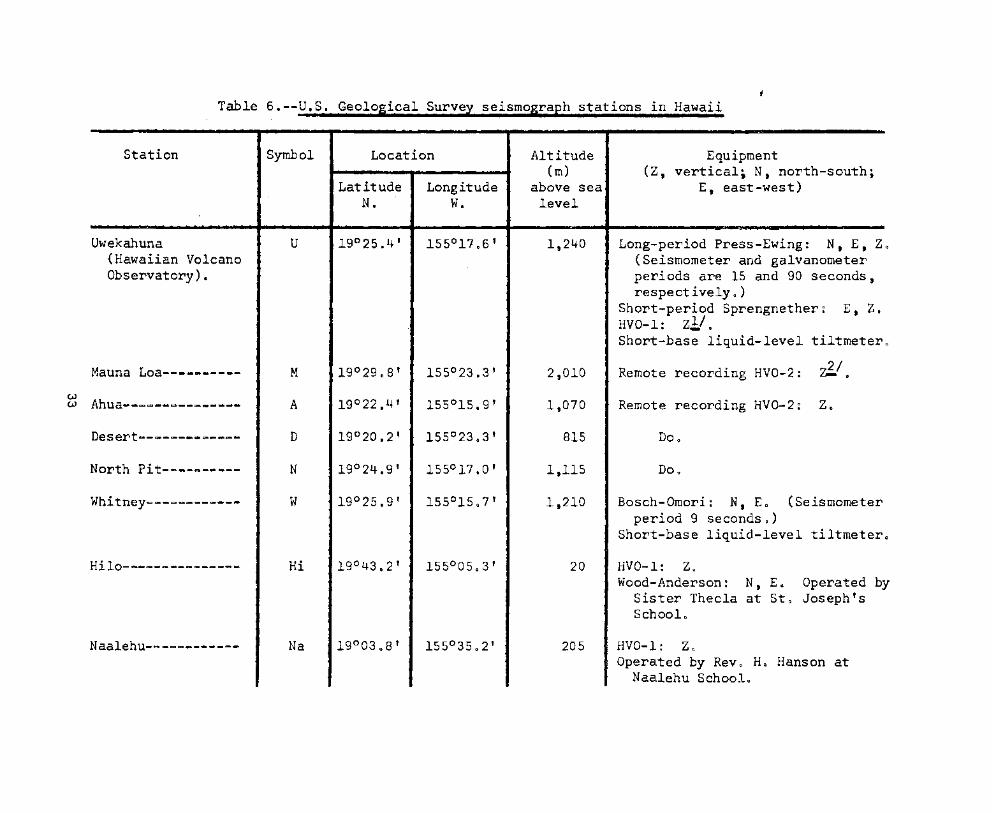
Table 6.--U.S. Geological Suryey seismograph stations in Hawaii
LocationStation
Uwekahuna(Hawaiian VolcanoObservatory) •
Mauna Loa----------
~ Ahua--~~--~--~-----
Desert------~------
North Pit-~-~------
Whitney-~-~~-------
Hilo---------------
Naalehu----~-------
Symbol
U
M
A
D
N
w
Hi
Na
LatitudeN.
Longitudew.
Altitude(m)
above sealevel
2,010
815
1,115
1,210
20
205
Equipment(Z, vertical; N, north-south;
E, east-west)
Long-period Press-Ewing: N, E, Z(Seismometer and galvanometerperiods are 15 and 90 seconds,respect ively 0 )
Short-period Sprengnether: E, Z.HVO-l: z1/oShort-base liquid-level tiltmeter
Remote recording HVO-2: ~/~
Remote recording HVO-2: Zo
Do o
Bosch-Omori: N, Eo (Seismometerperiod 9 secondso)
Short-base liquid-level tiltmeter
HVO-l: ZoWood-Anderson~ N, Eo Operated by
Sister Thecla at St~ Joseph'sSchoolo
HVO-l: ZoOperated by Rev 0 Ho Hanson at
Naalehu Schoolo

Table 6.--U.S. Geological Survey seismograph stations in Hawaii--Continued
Station"-- . ..Symbol Location'
'0 •
Altitude Equipment(m)
" .,
(Z. vertical; N. north-south.Latitude LO,ngitude above sea E, east-west)
N. w. level·t c
Pahoa------·------- Pa 19°29.7' 154°56,8'-0
205 HVO-1: z.Operated by Mr. KO,ngo Kimura at
Pahoa School.
Kamuela------------ Ka 20°01.9' 155°42.0' 740 HVO-l: ZoOperated by Mr. Edward Van Gorder,
Preparatory Academy, Kamuela.
Konawaena---------- Ko 19°30.8' 155°55.1' 495 Not operated in 1962.
Haleakala, Maui---- Ha 20°46.0' 156°15~0' 2,090 HVO-l: ZoWood-Anderson: N. Eo Operated
by the staff of Hawaii NationalPark at Haleaka1a. Maui.
1/ HVO-l is a moving-coil, hinged, vertical-component seismograph with seismometer andgalvanometer'periods of 'DoS secondo Over-damping of both seismometer and galvanometer is used tocontrol the strong galvanometer reaction 0 This seismograph has a peak magnification of about 20,000at a period of 0 0 25 secondo' Recording is optical, on photographic pape~o
2! HVO-2 is a moving-coil, 'vertical=cornponent seismograph with a seismometer-period of 0 0 8secondo Its signal is transmitted over telephone wires to the Hawaiian Volcano Observatory, whereit is recorded on smoked paper~ The response of this seismograph is similar to that of HVO-loRecords from these seismographs at the M, O~ and D stations are recorded on a 3~cornpon~nt drum topermit an accurate comparison of arrival times at these stations 0

Vis~tors to the Hawaiian'" Volcano""Observatory' during the firstquarter, 11962, included·the follow~ng: .
E. J. Walter, John Carroll University.Robert E. Houtz, Lamont~Observatory.
T. A. Eastland, Bendix Radio Corp.A. F. Ellman. Bendix Radio Corp.Tokuji Utsu, Japan Meteorological" Agency.Warren Hastings. Howard Leak,' Stan-Lord, Swede Miller, Dan
Davis--U.S. Geological Survey.·~round Water Division.Masatusugi Suzuki t' Nihon University.Ryutaro Takahasi. University of Tokyo.Senator and Mrs. Hubert Humphrey' and son Robert.A. Furumoto, Institute of Geophysics, University of Hawaii o
H. Vitousek, Institute of Geophysics', University of Hawaii o
Richard Sykes, Magabor Co., Kansas.Tom Bastien, University of Minnesota.John Aaron, U.S. Geological Survey, Washington D.C.Masashi Honma, University of-Tokyo. '
During the quarter "felt·reports"~wereeither phoned or mailedin by the following people to whom' we' wish to'express'our gratitudefor these and other instances of" cooperation.
From North Hawaii: Mrs. Christensen, Mr. Paiva', Honokaa Policestation.
From Kau: Mrs. Walters.From Central Hawaii:' Mr. Walker. Mr. Hansen. Mrs. Lindsey.From the Hilo area': Mr. Cha,ng t' Mr'. Pierce t Mrs t Shaeffer.
Mr. Blackwood, Mr. Baldwin", Mr.'Kumukahi. Mrs. Elalauli,Mr. Ho, U.S. Weather Bureau.
From the Kilauea Volcano summit district., Mr. 'Mist, Mrs. Francis,Mrs. Hansen. Mrs. Duncan. Miss'Cruz, Miss'English, Mrs. Moore,Mrs. Correa. Mrs." Sumner. Mrs.' Wentworth i M'r • Hamilton. andDr. D'Avanzo.
35

UNITED STATES
DEPARTMENT OF THE INTERIOR
GEOLOGICAL SURVEY
HAWAIIAN VOLCANO OBSERVATORY
SUMMARY 26
April, May, and June. 1962
·By
Ae T. Okamura. R. Y e Koyan,agi. and'H. L.· Krivoy
and
Report on the International Symposium onVolcanology. Tokyo.·1962. by H. A. ·Powers
Observatory Staff
Geology:
J o Go MooreDe Ho Richter (Scientist-in-Charge)Ce KG Wentworth
Geophysics:
G. KojimaRo Yo KoyanagiHo Lo KrivoyA. To Okamura
October 1963
Geochemistry:
W. U. AultR. To Okamura
Support:
'J. C. ForbesW. H. FrancisB o J. LoucksA. Yamamoto

Contents
Introduction---~----~-~----~-~-----~-·_------------------------ 1
Report on the International Symposium on' Volcano~ogy,Tokyo, 1962. by Howard Ao Powers------------------------ 1
Chrono~ogical summary------------------------------------------ 2
Tilt~ng of th~ ground around Kilauea caldera--------~~--------- 4
Seismic summary------------~----------------------------------- 9
Illustrations--short list
Figure 10 Hourly count of aftershocks 'following the Kaoikifault earthquake--------CIIlio
--------'-----------------
Tilt~ng of th~ ground around Kilauea~caldera~·------
Map of the island of Hawaii showing' seismographstations operated by the Geological Survey andlocalities mentioned in the iext--~--~---~-~~~----
Tables--short list
5
8
10
Table 1 0 Tilt coordinates at'Uwekahuna·vault*--------·--..----- 6
2 0 Tilt coordinates and ch~nges at bases around Kilaueacaldera-------------------------------------------- 7
3 0 Numbers of earthquakes and minutes of tremor recordedon seis~ographs around Kilauea caldera------·------ 11
4 0 Local earthquakes recorded by seis~ographs of theU~So Geological Survey----------------------------- 12
5. Distant earthquakes---------------------------------- 27

HAWAIIAN VOLCANO- OBSERVATORY SUMMARY 26
By Ao To Okamura. Ro'Y o Koya~agit and' Ho Lo Krivoy
Introduction
Dro Powers. who has written the following' report', 'has worked onor with volcanoes for a large part of his professional career. Hewas first employed at the 'Volcano Observatory from 1929 through 1930.From 1932 through 1941 he worked on' ground-water problems in Mauiand also served the Hawaii National Park at Haleakala o Dr e Powersworked at the Hawaiian Volcano Observatory 'again-from 1946 through1948 0 Since 1949 he has been stationed at 'Denver 'and ,. concernedwith geological problems in northern California, -the 'Aleutian Islands,and in Hawaii o
Report on the~ International Symposium on' Volcanol,o,gy.
Tokyo', 1962
By Howard Ao Powers
Scientists"' frorn"22"countries' attended"the"Internationa1Symposium on Volcanology that was convened"on" May 9 -. ' 1962.in the Nihon Toshi Ce'nter. Tokyo 0 ' "Included were 140""representatives from 40 centers of learning in Japan, and about80 representatives from 23 other countries located on everycontinent of the globe 0 Fourteen'wives and'daughters wereamong the foreign delegation 0 The' entire ~, grou'p'rnet "sociallyat two delightful evening receptions. hos'ted by" the ScienceCouncil of Japan and by the Ministry of Education o Theladies of ~he group were entertained at many varied 'functionsduring the course of the conference o
The 2-week scientific program was ingeniously arrangedto intersperse auditorium' ses'slons "with 'field observati'ontrips 0 Altogether, 4 days were allotted to auditoriummeetings and a total of 50 papers were presentedo Sixpapers were directed toward problems of prediction of volcaniceruptions and of minimizing their hazards to the localpopulace 0 Twenty papers dealt with the 'characteristics,either general or specific, of a nu~~p of vOlcanic'regions.ignimbrites or pyroclastic flows and calde:ras are'the',prominent features of 11 of the areas discussed. The ubiquitoussubject of terminology of the process and products ofpyroclastic eruption was discussed informally in a specialhalf~day sessiono Seven reports were concerned with someaspect of igneous volatile constituents or volcanic sublimatedeposits 0 Results of current expanded research at the HawaiianVolcano Observatory were discussed in three papers, andcertain aspects of continuing laboratory experimental

investigations of silic'ate liquids with~the composition of,or approaching, natural basalts" were 'summarized in threereports 0 Three papers appraised "geophysical knowledge ofthe crust and upper mantle in'te'rms <'of" hypotheses o'f originand behavior of magmaso Several papers discussed specialized subjects, for example~ 'geomagnetic changes at VolcanoMihara t potassiumcmargon dati'ng of rocks. mechanics ofvolcanic earthquakes. and special conditions of possiblelunar volcanismo
Field sessions 'of,the'conference'were'held'at theactive volcano' Asama' and' in" the" ina'ctiv'e H'akone 'calderacomplex 0 At 'the 'Asama 'Volcano' Observ'atory" we' were briefedon the instrumentation 'and the'types' of geophysicalobservations now being rna'de as a result' of 30 years ofoperational experien'ceo We examined" in detail the productsand results of different phases of activity during theeruption of 17830 At Hakone the emphasis was centered'on themajor changes in eruptive activity"and~in"rock'compositionduring th'e lo.ng evolution of the Hakone center 0
Three post--conference field "trips" were' run concurrently,one nortgward to Hokkaido, one southward~to·Kyushu. and toIto and 0 shima in central Japano Both,the'Hokkaido andKyushu trips featured explosive activity and caldera formation involving ~agma of intermediate to silicic composition;the Ito and b shima trip featured basaltic to andesiticlavas and their pertinent type of' eruption o The' trips hadbeen planned 'with meticulous care; each stop was at amagnificent "textbook" example'''of volcanism. and togetherthey presented a clear picture of the'~array""of-volcanismfor which Japan is famouso
Chronological sumrnarx
Inflation of the summit region of Kilauea Volcano continued atnearly the same rate during the second quarter of 1962 as during thefirst quarter 0 The average rate of'tilting. outward from the,·'caldera.at the inner ring of tilt bases (U. TM. Kam and 'Kea) was about 5microradians pe'r month (fig o 2) 0
Very small shallow earthquakes at·, Kilauea' caldera continuedunabated throughout the second quarter o Average daily"counts duringApril. May t and June were 56. 38. and 56. res'pectively 0 Twenty-oneearthquakes. 6 of which were larger than magnitude 2Q5, originatedalong the Kalapana Trail beneath the south'east flank of Ki'lauea "betweenApril 5 and April 8 0 This source was responsible for occasionalearthquakes throughout the rest of the second quartero An earthquakefrom this region at 4g04 aom o on June 7 was reported felt in Hilo o
2

During most of April the number' of earthquakes emanating fromthe eastern half of the east rift zone of 'Kilauea averaged 'less than2 per dayo Earthquakes from this region' 'increased' moderately infrequency on April 29. and during May the "average 'daily count was 50The east rift zone was relative'ly quiet during June t when the averagedaily count was again less than 2 per dayo One earthquake from thisregion was felt at Pahoa on May 26 ,at 1:14 porn.; two others were feltat Kapoho on June 11 at 9g05 porno and 9~41 porno
The zone about 30 km beneath Halemaumau was again a source offrequent earthquakes during the second quartero 'Average daily earthquake counts from this source were 6. 7. and 4 during' April, May,and June, respectively 0 Intervals of relative inactivity (less than5 earthquakes per day) were interrupted every few weeks by flurriesof heightened activity lasting several dayso A 'magnitude 4 0 3earthquake from this 30 km deep source was felt throughout the islandof Hawaii at 5~56 aomo on May 10 0 Another. with 'a magnitude of 3 0 7,was felt over the eastern half of the island at 6:37 aom o on May 11.A second magnitude 4 0 3 earthquake from this zone. at 4:35 pOm& onJune 14, was felt over the entire island o A magnitude 207'earthquakefrom the same source was felt near Kilauea caldera at 8:31 porno onJune 14 0
The southwest rift zone of Kilauea and the adjacent portion ofthe Kaoiki fault system near the Desert seismometer yielded an averageof about 15 earthquakes per -day during April. May. 'and most of June 0
At 3~05 aom o on April 24 a magnitude 4 Q O earthquake from this regionwas felt over the entire island of Hawaiio A magnitude 3 0 5 earthquakefrom the same region was felt in Pahala and Hile at 9:43 porno onJune 8 0
On June 27 a magnitude 6 0 1 earthquake from an epicenter alongthe Kaoiki fault system (19°24° No. 155°25' Wat focal depth 3 to 8 krn,origin time 6~27~1403 HST) was felt over the entire' island of Hawaiiand on the islands of Maui and Oahu o It was the largest earthquakein the Hawaiian Islands since March 30, 1954, when two earthquakes ofcomparable size originated near the south shore of Hawaii west ofKalapanao As the epicenter lay in the very thinly popUlated KauDistrict of Hawaii, no serious damage was done,' although there waswidespread minor damage to loose objects which were overturned ordislodgedo
Aftershocks of this earthquake were very numerous o Hourlyaftershock counts for the first 60 hours following the main earthquakeare shown on figure 1 0 More than 500 were recorded during the first6 hours o The largest aftershock (magnitude 3 0 7) occurred at 3:37 aomeon June 28; it was felt in Hilo o
In addition to earthquakes belonging to the groups discussedabove, seven others were felt in Hawaii during the second quarter o
The first of these originated about 7 krn northwest of Hilo at a depth
3

of about 20 krn at 11:19 porno on April 11 0 Its magnitude was 3 0 0 andit was reported felt in Hilo o An 'earthquake felt in Pahoa at 9~26 porn.on May 16 had a magnitude of only 2 04 and 'emanated -from a shallowfocus about 9 km southeast of the Ahua seismometer o
A magnitude 3 0 5 earthquake from "a focus 'about l2'km deep and3 km north of Kealakekua was felt near its epicenter at 11~17 aorn o
on May 23 0
The earthquake felt over the entire'island of-Hawaii at 10:58 p.mcon May 23 had a magnitude of 3 0 7 and originated about 10 km south ofthe Desert seismometer at a depth of about 45 km G A magnitude 3 0 6earthquake from a focus about 8 km deep and 14 km northwest of theDesert seismometer was felt in Mountain View at 9:11 porno on May 29 0
An earthquake felt in Honokaa at 11:02 p~mo on May 31 originated about22 km east of Honokaa at a depth of about 12 kmo Its magnitude was2 0 9 0
On June 4 at 11~58 porno a magnitude 3 0 9 earthquake from a focusabout 5 km deep and 20 km south-southeast of the Ahua seismometer wasfelt over the southern half of the island of Hawaiio The earthquakefelt at Pahala at lO~03 aorn o on June 7 originated about 5 km south ofthe Desert seismometer at a depth of about 45 km. Its magnitudewas 3 0 4 0
The field tilt-base network was reoccupied'immediately after thelarge Kaoiki fault earthquake of June 27 to 'ascertain whether thesummit region of Kilauea had been deformed at the time of the earthquakeo The pattern of tilt changes spanning the occurrence of theearthquake (figo 2) is very similar to that during the previousseveral months (Summary 25)0 However, it does appear that tilt changesat Keamoku (Kea) and Kapapola Ranch (Kap) were abnormally largeduring the second quarter o Both stations are'on the downthrown sideof the Kaoiki fault.systemo Keamoku tilted toward the fault. andKapapala tilted away from ito
Tilting of the ground around Kilauea caldera
Tilting of the ground around the summit of Kilauea is monitoreddaily by a short~base water-tube tiltmeter in Uwekahuna vault (table 1).and at irregular intervals it is measured on a regional scale by meansof a network of field tilt~bases and a portable water-tube tiltrneter(table 3)0 The attitude of the ground surface at each tilt base isreported in terms of' north-south and east-west tilt, coordinates 0 Bothcoordinates at each station were arbitrarily set 'equal to 500 whenmeasurements at that station were begun o Increasing tilt coordinatescorrespond to northward and eastward.tilting of the earth's surface.that iSi to a relative subsidence toward the north and easto C A I-unit~hange in coordinate corresponds to a tilting of 1 rnicroradian (1 mmper km) in the direction indicated o
4

200
"1.....OQ~
180tjCD (1)SlJtj ~
rt •::r"1..01 I"~ ::r:g, 0~~en tj~
AFTERSHOCK FREQUENCYO~140til
0OlO•• t:=
FOLLOWING THE KAOIKI FAULTr-0::S~rt
to 0 120• t-h QUAKE OF ISh 27 m JUNE 27. 1962s (/)
• PJ lU.. t-h ~
r+~IOOC-t(1)
~ tj a=' en(}l en ::T
LL.01\.>0 0---.Ji"\' 80.. en
~~~ LrJU>O CDO'f-' :Il\)~
• 0 ::::) 60~ Z.....='OQ
r+ 40:r(b
~PI0..... 20~.....t-hPJ~.... 0 4 8 12 16 20 24 28 32 36 40r+
TIME IN HOURS

Table 1.~-Ti1t coordinates at Uwekahuna vault, April, May, and June,1961
Date N-S E-W Date N-S E-W
".i':"
Apr. 1 430 535 May 13 433 531
8 431 536 20 433 531
15· 432 535 June 3 434 533
22 433 535 10 435 534
29 435 535 17 436 532
May 6 436 532 24 435 529
6

Tilt coordinatesTilt base(location)
Date(1962)
N-S E-W
Rate (10- 6 rad/rno)and direction of
tilting sincelast reading
Date oflast
reading(1962)
Uwekahuna(19025~5' N•• 155°17 0 4' W.,) 'June 29 Maro 27
Tree Molds(19°26.3' Net 155017~3' WQ) 29 427.1 51407 27
Sand Spit(19°24 0 1' N•• 155°16.8' WI) Not occupied this'epocho 29
Kalihipaa(19 0 21 e 4' N., 155°15.3' W.) July 5 583~2 422.3
Change negligibl.e.direction randome
28
Keamoku(190 25.1' N.~ 155°1900' W.), June 30
Ahua Karnokuko1au(19°22.7" Ne, 155°1606' W.) July 1
466.1
704.7
623.2 6.3
5.2
N~ 50° W. 29
28
Kipuka Nene(19°19.4' N., 155°16 0 7' W. )
Hi1ina Pali(19°18.2' N Q t 155°18 0 6' W. )
r~ehana
(19°26., 2 f N. , 155°14.3' W. )
Kapapala Ranch(19°2005' N~ t 155°23.,8' W. )
Not occupied this epocho
Not occupied this epoch.
Not occupied this epocho
Apr. 5
4
Mar. 26

S KM
1---1TILTING RATE 2.5 )( 1()6 RADIANS I MONTH
CO °0'\)40 crKO~
0tV
Q 0
CO Kal",,0
QKap
\eKN
2000
Figure 2.--Tilting of the ground around Kilauea caldera, March 29, 1962,to June 30, 1962. The vector depicting tilting at a given tiltbase points in the direction of maximum relative subsidence andhas a length proportional to the rate of tilting during themeasurement interval. Closed circles represent field tilt bases;open circles. short-base water-tube tiltmeters.
8

Seismic summary
Events recorded by the"UoSo Geological Survey seismograph networkin Hawaii fall into two'categories: local earthquakes and tremororiginating in the region of the Hawaiian Islands, usually within 100km of at least one seismograph, and distant earthquakes originatingmore than 3,000 km from Hawaiio As an index of seismic activity atHawaiian volcanoes, daily counts of earthquakes and minutes of tremorrecorded by seismographs in Hawali are listed in table 3 0 The earthquakes are separated into groups on the basis of region of origin asdetermined by analysis of records obtained daily'at the Observatory(U, M, A, D, N)o Earthquakes of magnitude 2.5 or greater aregenerally sufficiently well recorded to be located with greaterprecision; they are listed individually in table 4. Data on identifiable phases from distant earthquakes are listed in table 50
Locations of the seismograph stations are shown on'figure 3,and essential data ori "the stations were given in Summary 25 8
9

Upolu Point
I,e --+-------~,
EXPLANATION
• SeismoQraph Station
• Town or locality
10 I~ MU..
Contour int.rval 1,000 f••t
Datum i, mlan lIa 'I'"
Topa,raph, b, US Glolo,lcol Sur.l,
Laupahoehoe -+- _
Captl(u",""ahi
Apua Point
Point
,-----------------------+--------- I,e
Figure· 3.--Map of.the island of Hawaii showing seismograph stationsoperated by the Geological Survey and localities mentioned inthe text, Epicenters of local earthquakes are given in termsof geographic coordinates. which are indicated at the edges ofthe map.
10

...
Table 3, summary 26, p:
Table 3.--Numbers of earth uakes and minutes of tremor recorded onU, H, A, D, and N
ra hs around Kilauea caldera
[Tremor is separated into three categories--(l) deep, (2) intermediate, and (3) shallow--on the basisof. relative amplitudes on seismographs in the summit region. Unless otherwise stated, tremor ispresumed to be associated with movement of magma within the central complex of Kilauea.
Halemaumau rock slides (4) are detected by the characteristic record they produce on the North Pitseismograph.
Earthquake categories are: 5, shallow earthquakes in the Kilauea caldera region;6, shallow earthquakes along the SW. rift zone of Kilauea and the
adjacent portion of the Kaoiki fault system;7, earthquakes along the eastern half of Kilauea's east rift zone;8, earthquakes from a source about 30 krn beneath Halemaumau;9, shallow earthquakes along the Kalapana Trail (SE~ flank of Kilauea
10 to 15 km W. of Kalapana);10, earthquakes from other regions: Kona. Mauna Kea, etc. ]
Date Tremor (in minutes) Halemaumau Kilauea sw. rift E. 30 Kalapana Others(1962) slides caldera and rift km Trail
Deep Intermediate Shallow Kaoiki
1 2 3 4 5 6 7 8 9 10
Apr. 1 _-._ ..-._-------~~- -------- ---------- 245 14 ..~-- 6 -------- .............._-_...._.._-. ..-
2 ..- .... ------------ ..-....--_ ... ....~------- 71 9 ..- .... 11 ------_..- 1 (Kawaihae)3 ---- 18 --~_..--. .. ---------- 42 12 1 10 .._............ 1 (Puu ou)4 _..~.. 2 -_.-_...._.. ...._-_..~--- 71 15 2 6 .. ...~_ ......... 1 (Kana)5 ......- ~_...._--.._-~ ...
~------- ---------- 30 3 ~ .._.. 7 5 1 (Kona)6 --_.. ..~..~ ..--~_ ....- ~~..---_ ... ......-._---_ ... 40 11 ---- --- 13 ~--~- ..._----~-~---7 ---- -_..--..---....- -------- ---------- 40 8 1 5 2 1 (Kona)8 33 ....--------_.. -------- ---------- 45 11 1 5 1 2 (offshore)9 ....-- .._--_-._----- ....-..---- ---...._-- .... 63 9 1 14 ~- ...----- 1 (Kana)
10 6 ..-_.._--~---- -------- ---------- 37 12 1 11 -~-_....~.. 1 (Kona)11 ---- .._-.._-..-._---
--~~--_ .. --~-_ .._--- 55 12 1 12 ----_-._--- 1 (Hilo)12 --- .. .... ---------- -------- ---------- 47 7 2 11 -------- --_.....__..~....--..-..

13 --..........__ ..--- ----_-._-- ---------- 40 13 5 9 ---------- 8 (Scripps tests)14 .....--..------ .. -------- ---------- 44 25 4 -.--_-.----- 3 (Mt. View)15 --_..--....~ ..._... .._--.......~ ---------- 52 10 3 -.._~~--- 1 (Mt. View)16 ...._~ .._-........- -------- ---------- 60 16 1 2 -. .....- .. .-.... 2 (Mt. View)17 3 -------- ---------- 37 19 1 5 -~...,---~- 1 (Kona)18 ~ ..._..-_.._~_ ..- ......, ..- ..- .. .... .- __........- 44 10 5 --....-~-~ 1 (Mauna Kea)19 ------------ -------- ---------- 57 11 2 8 -------- ..~_ ...~~ ................._~20 5 -------- ---------- 60 10 3 2 -------- -...._-----...............-21 24 ------------ -------- ---------- 45 7 3 -- ..._-- .... -. ~--~-~-_.._~---~~22 ------------ -------- ---------- 70 14 2 3 .. -.__......... ......_.........-... __ ..__..23 ------------ -------- ---------- 63 33 2 11 -------- -~-~~----~--~---
24 ------------ -------- ---------- 39 57 3 -------- ~-~~-------~~~ ..-25 ------------ -------- ---------- 56 14 3 --.._--~ .. 226 3 -------- ---------- 44 36 1 3 -------- 2 (offshore)27 22 62 ---------- 37 22 3 2 .... __ ...-_.. ......-_ ...._....- ....-_..28 ------------ 7 ---------- 60 5 1 8 .......-_....- ~--_ ..........--.-...._---29 ------------ 2 ---------- 45 11 13 4 ..........-_..- ----.---..---_-.._--30 5 -------- ---------- 37 9 4 8 1 ----------------
May 1 9 -------- ---------- 37 7 1 14 --._-~..~- 1 (offshore)::t 2 2 -------- ---------- 38 24 2 1 --------_..-..-....~\T"'
3 12 2 ---------- 41 7 7 ..-.._~- ..- 2
4 ------------ -------- ---------- 26 4 1 3 -------- ---.---~-~ .._...-__..5 3 3 -------- ---------- 30 9 8 3 --------.. ~~~----~---~~---
6 ------------ -------- ---------- 25 7 9 3 1 1 (5. Point)7 ------------ -------- ..~ .._...~---_ .. 38 10 8 3 ..----~~-- 28 _.._....- .. _-.-,_ .. -------- ---------- 50 11 9 20 --~.-..--- -.,- ..---~-_ ...._~-~-9 ~-_ ..._.._-..-_-. _-. ....--_ ... ---------- 40 8 1 26 -~_-.-_.... _.. __..__-..-------~
10 ------------ .._-_....._- ---------- 34 28 1 46 -------- -~_ .....---_.._-_.._-11 15 ------------ 7 ---------- 50 15 2 20 ..-,-,_.. _--- 1 (5. Pali)12 14 -------- ---------- 45 20 5 6 .-,------- 1 (S. Pali)13 ------------ 80 ---------- 33 10 3 4 1 .._-_..-_..........__....-14 ........---....- .... -------- ---------- 26 33 23 4 5 ---..-_-._-------~15 ..--~~ ..--_.._- 6 ---------- 25 27 9 5 --~_ ..--- -----..-------------16 4 3 ---------- 35 9 3 4 --. ...-,-. ...--- ..--~--_ .._........-_..17 ..._-~-_ ..._--- .. .... -.__ ....- ...._--_......- 30 5 4 3 .s ...._.._----_ .._----18 ------------ ..-..-_....- .. ~.-.-_ ..-....- 30 9 4 3 -------- 1 (Ainapo)19 ------------ -------- ~-_ ..-~---- 30 12 4 7 1 1 (Mauna Loa)
20 25 -------- ---------- 38 14 11 5 -------- 1 (Mauna Kea)
21 ------------ 3 ---------- 60 21 4 -------- 1 (Honokaa)22 2 -------- _.._-~- .._-- 36 4 5 1 ..--..~---- .-._~-- ..._---- .._-..-23 _..-~..,_ ....._--~ -------..-.- ~ ....._--_ ..-- 39 26 3 ..-~-_-._~ 2

24---~-------.. 25 ---------- 52 19 2 2
------~-.._---- ...--._---_..~
25 4 -~-..-~-- _..--~---~~ 35 14 ~_ ....-_..- ------_..-.~_ .._....-.
26 ..------------ ~- ....._-~-., _....._~ ...._.... 33 5 8 1 .- ......- ..- ..-. --._----~-~..-..---27 -----------._-- --_ ....-.... .......----~~- 39 5 2 1 --_..~ ........ 1 (Kaena Point)28 -~----..-..... ~.., ~~ .._~---- -. ..........---- 21 8 2 3 ~ .._-~-~ .. -._--~~_ ...._.._..__-.
29 2 .._..~ .._------ .-,-----.... -~...._----- 32 18 1 .._..,~--_ .. 1 (offshore)30 ...-..---- ..~....- ....._--..-..
..._--~----- 32 10 4 1 ...-~--_..- ..-_.-_-------------.31 ~...._.._-~---- -- ..-.-._--- ...._........_-- 49 29 6 -~---_ ..-. 2 (Pahala, Honokaa)
June 1 ---------------- 6 ---------- 39 6 3 1 2 (Kau)2 ---~..--~- .._- -------- ---------- 35 22 2 2 -....-~--- ---~ ....-..----_.. _..,~3 -.._--.............. --------- ----------- 31 16 2 --- ...----- ----..---_..~..-.......4 ......~--- .._..-.. ..~-_-. __.. -..-._------- 43 10 1 3 .._--_..~- ----_..~----~-~ ..5 --..,.._-_ ..._--- .._..._.......- ---------- 34 11 1 2 -------- _.. __..----...._.._......
6 3 ........._~---- ..- 7 ........-.._.-,-- 57 20 1 2 1 (Kana)7 2 _........~..-
~-..-_.... -_.. 35 14 2 -- ..-~~.- .. _.._-_-.-._~_ .._~_ ..-8 4 ......-~~-- ..-..- _..........._..
..~- ....-~ ..~ .. 31 30 1 8 1 (Hilo)9 ------------ 3 ---------- 50 14 -~------
----~-..__ ...-.._-..-10 ......_---.......-- -~ ..-_.._- ---------- 51 12 3 -----_ .... -~--~---_ ..-_ .._..-11 ------------- .._-_..--~ 1 64 25 6 --------- 5 (Pahala, Kohala)12 -~_...--_...._.... -------- ---------- 78 22 10 -----~_.. ---_ ..------ .. .., ... _-13 6 ..........-----....... -------- ...._--_ ..-~- 44 25 30 ---_...~.... ---~ ..--_.._---~--14 ..~ ..__.._-..-_.. ----.. -- ..._.. ---------- 40 15 7 -------- -~_ ........-------~ ..-15 4 ---_..~..~ ---------- 39 10 3' 1 ----------------16 ..-......_.._....-- -------- ---------.. 42 25 5 5 ..----~_ .... 2 (Mauna Kea. Kana)17 ....~------~--- _....-........ ---------- 93 27 2 4 -..~----- 1 (Kona)18 2 5 ....._~_ .._-..,- 95 15 2 7 -~-_ ..~ ..~ 2..-19 4 102 16 10 2...... .. .._--------- ----------
_____ .... -r-.
~ 20 6 ..- ..-...._.., ..~_ ..-.._-_.. 95 9 1 -------- -_-. ...--_..-..-~ ...-~~
21 ~ .._~--~_ .._...- 5 ---------- 95 24 1 1 _..__........- 1 (Mauna Kea)22 -....-~----~ .. .., ....~----~ --_..-..~--.., 71 10 7 2 -------- 123 2 10 ----_..~..-.. 69 18 2 1 2 (Kona)24 2 .._----_.. ------------ 54 13 5 7 --------... 1 (Kohala)25 ~--------_..~ ~....-..-..- ~_ ..-..---.... 57 16 9 ... ..__ ..-~~ 426 ......~_ .._--..-... ~~---~_ ..~ -._...._--- .... 69 19 1 5 ..........- .. - 1 (Kona)27 ------------ -------- 7 29 500 2 ~-_ .._~-- _......__ .._-----.....-28 .._~........_-- ..- -------- 8 37 410 ..--..~--- ~--- ..... ---_.._-~--29 ..--~ .._----_ .. ..----~-- ....--~-~--- 42 III 3 4 ---~..--.. 2 (Maui)30 -. .._---.. _-_-.- ~_ ..-...-.... --_.._-_..-.~ 65 126 3 6 ---------- ..-------- ....- ...._--

Table 4o~-Loca1 earth uakes recordedApr~
U.So-Geolo ical.Surve
[Except for smaller "earthquakes'of special interest, only earthquakes with magnitudes of_2 0 5 orgreater are listed o Origin time is Hawaiian standardo
In the following list some origin times are followed only by "KM 30" and a.statement of magnitudeoThese are all members of a 'continuing family of quakes noted also in other Summariese. The bestmean focus for this group is beneath Halemaumau at a depth of 30 km (19°24 0 1' Not 155~l701t Wo)o
Origin times of members of a second persistent sequence of earthquakes are.followedby "KT"(Kalapana Trail) 0 These earthquakes originate at very shallow depths in a remote regi.on alongthe Kalapana Trail west of Kalapana, and they generally are not fe1to Seismograms 'of "theseearthquakes are poorly recorded and difficult to interpret. so only an approximate epicenter a19°20' No, 155°05' Wo , can be assigned to theme
The mean focus of the magnitude 6 0 1 Kaoiki fault system earthquake of June 27 and its aftershocksis 19°24' No. 155°25' Wo, at a depth of 3 to 8 kmo This focus has been abbreviated. "KaoikiftJ
Date Time Magnitude Epicenter Remarks(1962)
h m s Late Ne Longo Wo Descripti"on.. - -Apr o :2 12 21_ 5100 2 0 1 19°24 0 9' 155°04 0 1' 13 km NW~ pf Ka1apa:na~-- 8 km deepo
2 23 22 24 0 5 2 0 9 19°59 0 0¥ 155°4908' 12 km So of Kawaihae~"'-" 5 krn deepo
4 07 32 04 0 0 2 0 0 19°3065' 155°43.5' 21 km Eo of Kealakekua=- - 3 km deepo
5 01 35 01 0 9 2.4 19°15.9' 155°1202' 2 km NW o of Apua Point-- 12 0 5 km deepo
5 08 33 57.0 2112 190 24()0' 155°42 0 8' 15 km NNEo Of Puu 0 5 km deepoKeokeo ..
5 10 33 25.9 2 0 3 19°24.9' 155°16.2' Kilauea caldera--------- 50 km deep.
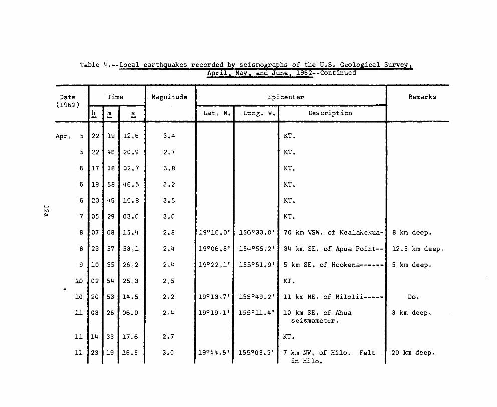
ical. Surv
Date Time Magnitude Epicenter ·Remarks(1962)
h m s Lat& Nit L'ongo Wo Description- .. -Apro 5 22 19 12 0 6 3.4 KT o
5 22 46 20.9 2 0 7 KT o
6 17 38 02 0 7 3eS KT.
6 19 58 46.5 3.2 KT G
6 23 46 10.8 3 0 5 KT.
7 05 29 03 e O 3GO KT o
8 07 08 15 0 4 2.8 19°16.0' 156°33.0' 70 km WSWo of Kealakekua- 8 km deepo
8 23 57 53 0 1 2.4 19°06.8' 154°55.2' 34 km SEe of Apua Point-- 12b5 km deepo
9 10 55 26 0 2 2 0 4 19022~l' 155°51 0 9' 5 km SEt of Hookena---~-'" 5 km deepo
10 02 54 25 0 3 2 0 5 KT •.-
10 20 53 14.5 202 19°13 0 7' 155°4902' 11 km NEo of Milolii~---- Do.
11 03 26 06 0 0 2 0 4 19°19 0 1' 155°11.4' 10 km SEe of Ahua 3 km deeposeismometer.
11 14 33 17 0 6 2.7 KTo
11 23 19 16 0 5 3 0 0 190 44 e5' 155°08.5' 7 km NW o of Hilo. Felt 20 km deepoin Hiloo

Table 4 o --Local earth uakes recorded bApr11, May,
ieal,. Surve
!
Date Time Magnitude Epicenter .. ·Remarks(1962')
h Lat6 No Longo W. Description.- - ..
m s- - -Ap~c 13 15 30 34 D7 2.5 19°29.2' 155°46 0 4' 15 km ESE. of 'Kealakekua 3 km deepo
14 05 42 0503 2.9 19°38' 156°19' 53 km WSW. of Keaho1e 8 km deepoPoint.
14 07 46 58 0 8 2.7 KT.
16 16 38 40 0 1 2.1 19°38.8' 155°10.8' 13 km SW. of Hi1o------- 45 km deepo
16 17 50 48 0 3 201 19°26 0 7' 155°09.7' 32 km SSW. of Hi1o------ 25 km deepo
17 19 40 55 0 6 203 19°28.6' 155°16.8' 6 km NNE. of Uwekahuna 12 0 5 km deeposeismometer.
18 23 24 18.2 2 0 0 19°4409' 155°29 0 6' 3 km ESE o of Pohakuloa~- 5 km deep.
20 17 32 24~1 203 Kaoiki..
23 18 23 16 0 9 2.4- KM 300
24 03 04 50cl 4~0 Kaoiki. Felt island-wide.
26 04 54 20.5, 2.5 19°07.3' 155°04.0' 66 km S. of Hilo-------- 8 km deepo~ .
26 09 21 58.8 3.4 20°05' 156°08' 50 km WNW. of Kamue1a--- 12 0 5 ~m deepo
27 12 47 07.3 2.7 KT.

Table 40--Local earthquakes recorded by seismographs" of the" U& So Geological Survey" ,
April, Max, and June, 1962--Continued
Date Time Magnitude Epicenter Re·marks
(1962)h rn s Lat~ N. Longe. W. Descriptio~ "0- - -
Apr 0 27 22 08 27.2 2$6 Kaoiki.
28 20 03 0208 2.4 19°26.5' 155°21 0 4' 6 km SEo of Mauna Loa 8 km deeposeism"ometer.
29 17 51 39.0 2 0 5 19°20.0' 155°07 0 7' 16 km SEo of Ahua 12 0 5 km deeposeismometer.
30 16 38 36.5 3.0 KT.
May 1 18 58 13.4 3.7 18°40' 156°40' 117 km SW. of Kealakekua 12 0 5 ~m deep.
2 01 25 29.7 2.5 19°13.0' 155°17.5' 16 km SEo of Desert 40 km deep.seismometer.
2 13 31 47.7 201 19°25.1' 155°04 0 0' 34 km SSEo of Hi1o------ 3 km deep.
3 13 11 45.5 2.3 19°09.8' 155°38.6' 13 km NW. of Naalehu~--- Doo
3 16 22 57 0 0 2.1 19°37 0 8-' 155°06.8' 9 km N. of Mt. View----- Doc
6 03 38 57.7 2 0 3 KT.
6 05 20 23.1 2.1 Kaoiki. .-
6 15 18 31.5 2.3 19°03.1' 155°17.8' 34 km SSE. of Desert 12 0 5 km deep.seismometer.

Table 4 o --Loca1 earth uakes recorded bApr1l, .
ic.al· .. Surv
.....0'1
Date Time MagnitudeI
Epicenter Remarks(1962 )..
h m s Lato No LO,ngo Wo Descrip.tion- - - -
-.
May 7 00 58 38 0 4 3.1 19°14 0 3' l55°05~7' 53 km So of Hi1o-e»<:=c:I:>..C=-.- 45.- k.m deep 0
8 03 24 28 0 0 2 0 2 19°02.8' 155°31 0 7' 6 km ESE e of Naa1ehuCD~"- 12 0 5 km deepo..
8 14 49 01 a 5 2.5 KM 30 0
8 21 04 14 0 0 2 0 5 19°13.0' 155°17 0 5' 16 km SEc of Desert 40 km deeposeismometer o
8 12 04 46 0 0 2.,3 19° 18 ~ 8' 155°23 0 9' 4 km SSW o of Desert Do o
seismometer 0
9 22 19 19.0 2.6 KM 30.
10 00 37 01 0 6 2.6 KM 30 e
10 05 56 04 0 9 4.3 KM 30 0 Felt is1and-wideo
10 06 15 46 e 6 2.5 KM 30.
10 07 43 26 0 4 3()4 KM 30.
10 07 44 47.1 2.5 KM 30.
10 15 02 28e6 2.7 KM 30.
10 16 28 23.5 2.5 KM 30.
10 20 19 30.8 2.4 KM 30.

.i·cal',Sl.trVe.Table 4 o --Local--------............1111!1!!111--.........--.-.....~~-.....-............- .....~-~---- ...
i
Date Time Magnitude Epicenter . Remarks(1962)"
h m s . - .Lato No Lo~g. W. .Description- - -May 11 00 47 34 0 3 2,,4
....
19°16 0 7' 1550 08e5' 18 km SE~ of Ahua 8 'km deepo..
seismometer o
11 01 55 4703 2.3 KM 30.
11 02 51 39.8 2.3 KM 30.
11 05 00 23.0 2.3 19°0805' 155°00.4' 13 km SW. of Pahoa------ 3km deepe
11 06 37 23 0 4 3.7 KM 30 0 Felt in easternhalf of island'.
11 06 40 50$2 2.7 KM 30,
11 10 38 02.5 2 0 6 19°18.8' 155°13.9' 9 km SSE .. of Ahua 3:,km- deeposeismometer.
11 15 04 20$2 2,'3 KM 30.
12 16 16 56.3 2.4 19°18.4' 155°0502' 45 km S. of Hilo-------- 3 km deepo
12 22 27 23.5 2.5 19°15.1' 155°12.9' 14 km SSE. of Ahua 45 km deep.seismometer.
13 06 36 55.9 2.3 KM 30.

Table 4~--Local earth uakes recorded bAprl.l! -May,
Date Time lMagnitude Epicenter Remarks(1962) -
h NG W, ,Description" '.
m s Late Longo- - _.May 13 07 57 l4~7 3&3 Kaaiki.
14 04 00 54 0 0 2.5 KT o
14 16 59 52 0 0 3 0 1 19°14.0' 154°59.8' 34 km SEt of Ahua At shallow: depseismometero
16 21 25 44c.l 2 0 4 19°27 0 9' 154°52.7' 9 km SEt of Ahua Do o
seismometer. Felt atPahoao
17 14 24 45.7 2.7 KTo
17 17 13' 12.2 2.9 KT.
18 09 24- 37~2 2.6 19°22.0' 155°30.0' 19 km SW. of Mauna Loa 3 km deep.. - seismometer•
18 23 21 38 0 1 2.4 KT.
20 13 43 18 0 6 2 8 1 ~9°52.9' 155°26.1' 11 km SW o of Keanako1u-- 8 km deepo
20 19 05 15 0 3 2 0 5 19°23 0 2' 155°30.0' 18 km SW o of Mauna Loa 3 km deep 0
seismometer.
21 02 11 41 0 4 2 0 4 19°16.0' 155°1201' 14 km SE. of Ahua 8 km deeposeismometer.' -

Geolo ic:al."Surve1·9&2--Con-t1.nued...._..._......--_...--..
Table 4 o --Local_-.._-_...._-........__....~111111161-~.........~!!111!!111~~~~~~-_...__.....----
Date(1962r
Time
h m- - s-Magnitude Epicenter
Lat ~ -N. Lo.ngo W0 Description
Remarks
May 21 15 19 29 0 6 190 24 d 8' 155°18 0 4' 2 km SW. of Uwekahunaseismometer o
8 km deep.
21 15 43 23 0 0 2.4 19°27.5' 155°11 0 4' 11 km ENE~ of Uwekahuna 12 0 5 km deep.seismometer 0
21 23 16 30 0 2 20°11.7' 155°23 0 6' 15 km NEt of Honokaa--~~ 3 km deepo
22 02 41 45.0......CD 23 11 17 05.5 19°32 0 5' 155°55.5' 3 km No of Kea1akekua&
Felt at Kona.12c5 km deep.
23 22 58 09 0 9 19°15.1' 155°23.1' 10 km S. of Dese~t
seismometer 0 Feltisland-wide.
45 km deep.
26 13 13 45 0 8 2.9 19°26.0' 154°55.3' 8 km SSE. of PahoaoFelt at Pahoa$
5 km deep&
29 21 11 08.3 3.6 19°23.3' 155°30.0' 14 km NW. of Desertseismometer. Felt atMto View.
8 km deepo
29 21 27 27 0 5 19°04 6 8' 155°19.6' 30 km SSE. of Desertseismometere
Do~

Table 4 0 --Local earthquakes recorded by seismographs. of the U·. S 0 Geo~o'gical Survey.-·April, May, and June, 1962--Continued
; i
Date Time Magnitude Epicenter Remarks(1962)
h m s Lat. N$ Long~ Wa De:scrip;~iC?n- - -May 31 13 44 29~1 2.7 19°1301' 155°30.9' 5 km NW. of Pcihala-~r=---t:D 8 k.m deepo
31 23 02 03.8 2.9 20003~3t 155°17 0 5' 22 km Ee of Honokaao 1205 km deepoFelt at Honokaa c
June 1 18 59 01.8 202 18°50.1 ' 155°30.5' 20 km SE o of Kalae Pto-- 8 km deepo
1 23 37 40,4 2.0 19°12 0 3' .155°23.9' 8 km E. of Paha1a------- 45 km deepo
2 07 33 . 05.8 2.3 KM 30,
2 12 20 46.3 2.4 19°22.4' 155°03.2' 18 km SW. of 'Pahoa------ 5 km deep.
3 11 30 11.5 2.5 19°19.0' 155°02.5' 22 km SW ca of Pahoa------- 45· km deepo
4 23 35 2103 3.9 19°13' 155°13' 20 krn SSE Q of Ahua 5 km deeposeismometer. Felt inHil0. Pohakulo~. Puna.Pahala. and Volcano •
..
7 01 33 19 0 2 2 e 4 19°25 0 0' 155°42.9' 25 km SEo of Kealakekua- 3km deepo
7 04 03 37 0 0 2 0 7 KT o Felt at Hiloo
7 10 02 58 0 8 3.4 19°17.7' 155°23.1' 5 krn S. of Desert 45 km deep.seismometer, Felt at
I Pahala.

Table 4.--Local earth uakes recorded bApr~l. May,
!
Date Time Magnitude Epicenter Remarks(1962)
h m s Lat. N. Long. W. "Description- - -June 8 10 10 54.1 2.4 Kaoiki o
8 11 21 55.9 2.5 19°39.2' 155°12 0 6' 15 km SW o of Desert 45 km deep~
seismometer.
8 11 24 58.9 205 KT~
8 17 38 31.0 2.6 KT.
a 21 43 16 0 5 3.5 Kaoikio Felt at Pahalaand Hiloc
9 00 47 52.0 2.9 KT.
9 04 32 38.8 3.2 KT.
10 00 15 04.4 2.7 19°09.4' 154°59.7' 11 km SW o of Pahoa-----~ 8 km deep.
10 01 09 45~4 300 KM 30.
10 02 24 15 0 4 2.5 19°14.0' 155°03.7' 53 km S. of Hilo-------- 8 km deepo
10 05 28 46 0 0 2 0 7 Kaoiki.
10 17 09 17 0 0 2 0 5 19°21.5' 155°03.4' 40 km SSE. of Hi1o------ 8 km deep.-
11 02 55 57.0 2 0 7 20°06.1' 155°42 0 3' 10 km NW. of Kamuela---- 3 km deep.

2--Cont~nue..._...._........._-....-_.-.-.......
Date Time Magnitude ; Epicenter ~'-"Remarks
(1962)h m .s Lat. No Longo Wo '" .D·es.cription- - ....
.-
June Ii 08 11 29.2 2 0 5 200 06 e l' 155°42.3' 10 km NW o of Kamuela----<::D 3 km deepo
11 09 41 58 0 0 2 0 6 19°20.5' 155°3006' 17 km NNW o of Pahala--czoa= 8 km deep 0
11 10 53 28(J7 2 0 8 20°06.1' 155°4213' 10 km NW o of Kamuela=--ca- 3 km deepo
11 19 46 35 0 5 2.6 19°17.3' 155°30.1' 10 km NNW. of Pahala---- Do o
11 21 04 54.1 2.8 19°25 0 5' 155°00.4' 10 km SW o of Pahoa$ 8 km deepoFelt at Kapoho.
11 21 41 18.3 1.9 ---do--- ---do---- -------do--------------- Do.
12 06 15 35 0 4 2.5 19°12.5' 155°10.2' 21 km SE~ of Ahua Do~
seismometer o
13 16 34 55.3 4.3 KM 300 Felt island-wideo
13 19 16 18.9 3.2 KM 30 0
13 19 27 52 0 7 2.4 KM 30.
14 20 31 18.9 2.7 KM 30 0 Felt at Volcanoregion.
15 01 10 00.5 2.6 190 18e7' 155°16.8' 13 km S. of Uwekahuna 8 km deepsseismograph~

Table 4~--Loca1:earth ical ...Surv .
Date Time Magnitude Epicenter _.: Remarks
(1962)h m s Lata No Longo W. Des~ription.- - --
June 16 13 41 00e5 2 0 5 KM 30 t.'
16 13 50 05 0 6 2 0 1 19° 45.2' 155°28 0 7' 5 km Eo of Pohaku1oa---- 12 0 5 km deepo
16 20 11 23.8 2 0 5 19°13 0 7' 155°36 0 6' 18 km NNW o of Naa1ehu..... c::a- 3 km deepo
17 07 02 49 0 9 205 19°20 0 5' 155°49 0 4' 20 km SE~ of Kealakekua~ Doc>
18 04 38 11.1 2.5 Kaoiki e
18 05 40 47 0 2 2 0 5 19°21 0 9' 155°0502' 40 km So of Hilo-------- 8 km deep.
18 15 21 38 0 3 2 0 5 19°56 0 2' 155°31.5' 20 km SE~ of Kamue1a---- 3 km deepo
19 04 09 22 0 7 2.7 Kaoikio
19 21 37 02 0 3 2 0 8 20°06 ' 156°19' 67 km WNW. of Kamue1a--- 12 0 5 km deepo
21 11 13 25.5 2 0 3 19°55.0' 155°31.5' 20 km SW. of Kamuela--~- 3 km deepo
21 12 57 45.4 2.9 19°16.5' 155°07 0 1' 20 km SEt of Abua 8 krn deeposeismometero
22 00 11 45.3 3 Gl 2 KT.
22 00 21 59 0 1 2.9 20°58' 155°01' 128 km NE& of Kamuela--- 12 0 5 km deep.

Table 4.--Local earth Geo10 ical Surve
th~
Date Time Magnitude Epicenter Remarks
(1962)h m s Lat& N. Long. Wo De-s-cription- .- - . .:..
June 22 00 57 40 0 1 2.5 :KTo
22 01 05 43 t 7 2.5 19°21.8' 1550 03 e 4' 19 km SW. of Pahoa------ 12 0 5 km deep 0
22 02 15 28.2 2 •.8 ---do--- ---do---- ------~---do------~~--~- Do~
23 00 08 49.3 2.3 190 21 e 5' 155°05&6' 40 km S. of Hilo...---,,~"'-- 8 km deepo
23 17 00 34.2 2.8 KT.
21+ 02 33 17 0 1 2.5 KM 30.
24 04 22 27.0 2.5 19°32.2' 155°53.1' 3 km NE. of Kea1akekua-- 3 km deep.
24 09 53 37.0 2.5 ---do--- -- ---do---- -----~----do----~------- Do.
25 10 00 46.4 3.0 18°33' 154°40-' 115 km SEo of Ahua 12 0 5 km deep.seismometer.
25 22 06 36 0 0 2.7 19°52.2' 155°33.7' 20 km SE. of -K-amuela---- 8 km deep.
26 1-8 48 18.3 2.3 19°24 0 1' 155°47.9' 18 km SEe of Kealakekua- At shallow dep-.
27 04 31 33 0 5 2 0 5 KM 300
27 18 27 14.3 6.1 19°24' 155°25' Kaoiki. Felt on Hawaii. 3 to 8 km deepMaui. and Oahu.

Table 4 o --Local earthquakes recorded by; seismographs. of tbeUoS. Geological Survq.April, Max. and June, 1962--Continued
;
RemarksDate Time Magnitude Epicenter(1962 )
h m s Lato N. LO?g. W~ ne-scripti,?n- - -June 27 19 15 30.4 3.2 Kaoikio
27 19 40 27.0 2.3 Kaoikio
27 19 48 03.7 2.5 Kaoiki.
27 20 14 10.7 2 0 9 Koaiki.
27 21 30 38.5 2.8 Kaoiki.•
27 21 50 52.4 2.5 Kaoiki.
27 22 42 05.8 2.5 Kaoiki.
27 22 47 49.0 2.5 Kaoiki.
27 23 09 27.0 2.5 Kaoiki.
27 23 S1 27.9 2.5 Kaoiki.
28 00 05 4200 2.4 Kaoiki.
28 00 46 29.4 2.4 Kaoikio
28 01 -57 09.4 2.8 Kaoiki.
28 02 22 02.4 2.7 Kaoiki.

Table 4 o --Local earth recorded bprJ-I, May.
Geolo i.ca·l. Surve
Date Time Magnitude Epicenter Remarks(1962)
h Lat. N. Long • w. Des'cription. -
m .S- - _.June 28 02 25 21.2 2.4 Kaoiki o'
28 02 46 47.0 3.0 Kaoiki.
28 02 58 06.2 2.9 Kaoiki~
28 03 35 18 0 9 2.8 Kaoiki.
28 03 36 56.7 3.7 Kaoiki. Felt at Hilo.
28 04 17 11.1 2.3 Kaoikio
28 04 55 16 0 0 2.4 Kaoikio
28 07 28 03~3 2.7 Kaoiki.
28 08 00 11.4 2.6 Kaoikio
28 08 44 08.8 2.6 Kaoiki.
28 10 30 19.4 2.3 Kaoiki.
28 10 37 06.0 2.3 Kaoiki.
28 12 55 12.5 2.6 Kaoiki.
28 14 59 12 0 8 2 0 3 Kaoiki o

Table 4 o --Local earth2--Cont.lnue....---_....-------
Time Magnitude'!
Epicenter . Remark'sDate(1962 J"
h m s Lat, N. LongtWo De·sc~ipt·-i-on- - -June 28 15 17 38 0 9 2.3 Kaoiki.
28 15 20 14 0 3 2 e 3 Kaoiki.
28 15 23 02.5 2.3 Kaoiki.
28 15 29 25.7 2 0 6 Kaoikio
28 17 13 00 0 3 2 0 5 Kaoikio
29 01 19 30.3 2 0 3 Kaoiki.
29 03 23 09.8 2 0 4 Kaoiki.
29 08 30 37 0 6 3 0 2 Kaoikio
29 08 39 52.8 2.6 Kaoiki.
29 14 41 53.0 3.0 20°52' 155°22' 95 km NEo of Ha1eaka1a-- 12,5 km deep.
29 16 59 00 0 0 3.5 Kaoikio
29 17 41 56 0 2 3.1 Kaoikio
29 17 47 53 0 3 2.4 KM 300
29 21 13 33.0 2 0 7 20°06' 156°39' 87 km SW. of Haleaka1a-- .12 6 5 Jcm -de-ep.
29 23 43 16 0 2 2.5 Kaoikio
30 07 10 56 0 5 2 0 3 19°23 0 1' 155°03 0 6' 17 km SW. of Pahoa------ 3 km deepo
30 20 39 15.1 2.5 Kaoikio

Table 5.--Distant'earthquakes
[Times are reported in Greenwich Civil Time which is 10 hours fasterthan Hawaiian Standard Time. A "c" following the time of P indicates compressional first motion; a "d" indicates dilatationalfirst motion. Station symbols, locations, and instrumentation arepresented in Summary 25. Magnitudes calcul.ated from the Hawaiiseismograms are followed by (HVO). Location of epicenter, origintimes, and focal depths, and magnitudes reported by other institutions are taken from "Preliminary Determination' of Epicenters"published by the U.S. Coast and Geodetic Survey.
It is unusual to record clear. identifiable phases from the Atlanticor the Caribbean on seis~ographs' in'Hawaii. Such a quake is listedon April 20.
Although many seismic phenomena' from distant· sources are recorded,few such events are felt in Hawaii. Such an uncommon event wasrecorded on May 11th in the form'of-T-phase arrivals from anunderwater nuclear test (these~data'are being prepared for specialpublication). In this case the T-phase was' reported felt byresidents of the coastal towns and cities of the ~ig Island]
Apr. 1
M Z eP 12:22:05.4 c
Hi Z eP 12:22:07.9 d
U PEN eG 12:37:36
U PEE eR 12:40:44
C&GS card 25-62:4.2° S., 143.6° E.12:11:09.2.Near north coast of New Guinea.h about 80 krn.
Apr. 2
M Z iP 00:24:08.3 c
A Z iP 00:24:09.0 c
D Z eP 00:24:07.9 c
U Z iP 00:24:08.8 c
Pa Z iP 00:24:10.9 c
Hi Z eP 00:24:09.8 c
Apr. 2--Continued
C&GS card 25-62:18.6° N., 145.5° E.00:14:50.4.Mariana Islands.h about 205 km.
Apr. 3
M Z eP 16:33:59.1 d
Pa Z eP 16:34:00.5 d
Hi Z eP 16:33:59.7 d
Ha Z iP 16:33:58.0 c
U PEN iG 16:45:12
U PEZ eR 16:46:56
Magnitude 5.9 (HVO).
C&GS card 26-62:10.6° S., 164.9° E.16:24:55.6.Santa Cruz Islands region.h about 36 km.Magnitude 5.5 (Pal).
27

Table 5,--Distant~arthSUakes--Continued
Apr. 6 "'Apr~ 0 12--Continued
M Z eP 17:00:29.4 d U PEZ is 01:10:19
D Z eP 17:00:27.5 d U PEZ iSS 01:14:18
N Z eP 17:00:32.1 d U PEZ iR 01:18:15
U Z eP 17:00:32.4 d U PEE iL 01:15:32
C&GS card 26-~2: U PEN iG 01:16:0426.7° S•• 113.2° W.16:50:14.2. ~agnitude 7.4 (HVO) ..Easter Island ~egion.
h about 33 km. C&GS card 28-62:'38.2° N•• 142.3° E.
Apr. 7 00:52:47.0Near east' coast of Honshu.
D Z eP 06:31:34.1 c Japan.h about 68 km.
N Z eP 06:31:33.1 d ~agnitude 7 to 7.25 (Pas).6.75 to 7.0 (Pal).
U PEZ eR 06:40:35,Apr-~ '16
C&GS card 28-62:10.0° N., 144.4° E. M Z iP 13:29:55.0 d06:21:38.4.Caroline Islands r.egion. A Z i.P 13:29:56.0 dh about 50 krn.Magnitude 6 (Pas). D Z eP 13:29:55.2 d
Apr. 12 N Z iP 13:29:55.4 d
M Z iP 01:02:24.2 c Ha Z iP 13:29:47.0 d
A Z eP 01:02:25.5 c Na Z iP 13:29:54.6 d
D Z eP 01:02:25.1 c Hi Z eP 13:29:56.2 d
N Z eP 01:02:25.2 c Pa Z eP 13:29:57.8 d
Ha Z iP 01:02':15.3 c U PEE eS 13:37:38
Na Z eP 01:02:24.4 d U PEZ iR 13:46:22
Hi Z eP 01:02:25.6 c ~agnitude 6.0 (HVO) •
Pa Z eP 01:02:26.1 d
28


Table 5.--Distant earthquakes--Continued" \.,
Apr. 20--Continued 'Apr~ 22--Continued
Magnitude 6.6 (HVO). Pa Z iP 04:55:14.4 c
C&GS card 31-62:18.9° S., 169.5° E.02:10:12.1.New Hebrides Islands ~egion.
h about 288 km.
C&GS card 31-62:20.6° N., 72.2° W.05:47:55.3.Near north coast of Haiti,
minor damage at Port-au-PrinceFelt at San Juan, Puerto Rico.
h about 25 km.Magnitude 6.5 to 6.75 (Pas),
6.75 to 7.0 (Berk), 6.0 (Pal).
Hi Z
Pa Z
06:07:40 0 7 d
06:07:52 c
06:07:45.3 d
06:07:48.9 d
06:07:45.8 d
06:07:47.1 c
06:20:55
06:07:51.3 c
06:07:45.3 d
06:15:36
06:07:45.6 d
06:08:14
06:19:20
06:23:55
06:07:4902 c
04:55:14.9 c
06:09:52
eP
eP
eP
eP
eP
iP
iF
eP
iP
iP
z
z
z
z
z
z
PEZ iPP
PEZ iR
PEN is
FEZ eSS
PEN iL
PEZ ipP
PEZ iP
u
D
A
u
M
u
U PEZ eG 05:10:50
u
U PEN eSKS 05:03:58
U
Na Z
u
u
Pa Z
N
U
Ha Z
Hi
Hi Z
C&GS card 30-62:15.50 N., 93.1° W.04:45:20.3.Near coast of Chiapas, Mexico.h about 69 km.Magnitude 5.25 to 5.5 (Pal)o
Apr. 2302:18:51.8 c
04:55:16.6 d
04:55:16.6 d
02:18:52.3 d
02:18:52.4 c
02:18:54.2 c
04:55:17.1 d
02:18:56.11. c
02:18:55.9 d
02:18:51.8 c
02:18:51.5 c
04:55:17.2 d
04:55:16.8 d
eP
eP
eP
eP
eP
eP
eP
iP
iP
iP
iP
iP
iP
z
z
z
z
z
z
z
z
z
z
M
u
D
A
D
u
A
M
N
N
Ha Z
Apr. 22
Apr. 22
30

Table 5."-Distan~:~~~~~$t1~)(~~~~Continued
Apr. 23--Continued : .Apt"~ "26--Continued
U PEN iG 06:21:19 Ha Z iP 07:33:4603 c
Magnitude 6.8 (HVO). C&GS card 32-62:17.8° S•• 179.1° W.
C&GS card 30-62: 07:26:31.3.42.9° N•• 143.4° E. Fiji Islands.05:58:04«19. h about 689 km.Hokkaido, Japan.h about 25 km. . ·Apr. 30Magnitude 7 to 7.25 (Pas) •
7 (Pal). M Z iP 02:36:16.6 c
Apr. 25 A Z eP 02:36:17.5 c
U PEE is 16:05:00 D Z eP 02:36:16.9 c
U PEZ eSS 16:08:27 N Z eP 02:36:16.5 c
U PEZ iR 16:13:06 U Z eP 02:36:16,2 c
U PEN eL 16:10:16 Hi Z eP 02:36:16.5 c
C&GS card 32-62: U PEE iP 02:36:18 c38.4° N., 142.5° E.15:47:29.2. U PEE iPF 02:38:29Honshu, Japan.h about 56 km. U PEE eSS 02:48:16
ARr. 26 U PEE iR 02:52:33
M Z iP 07:33:41.1 d U PEE is 02:44:13
A Z iP 0'7:33:40.6 d U PEE iG 02:50:42
D Z eP 07:33:40.1 d C&GS card 33-62:38.8° N•• 140,9 0 E.
N Z iP 07:33:40.6 d 02:26:30.0.Honshu, Japan.
U Z eP 07:33:40.9 d h about 104 km.
Na Z iP 07:33:38.4 c Apr. 30
Pa Z iP 07:33:43.7 d M Z eP 16:24:41.8 c
Hi Z iP 07:33:44,8 c N Z eP 16:24:40.3 c31

C&GS card 34-62:17.9° S•• 176.1° W.16:16:47.8.Tonga Islands region.h about 26 km.
Apr. 30
Air. 30--Continued
u
u
u
u
u
PEE is
PEE iG
PEE eS
PEE eG
PEZ eR
16:31:12
16:33:58
18:45:19
18:48:25
18:49:48
"May 2--Continued
N Z Tmax 03:28:52
U Z Tmax 03:28:58
Pa Z Tmax 03:28:44
Na Z Tmax 03:28:29
Hi Z Tmax 03:28:27
Ha Z Tmax 03:28:51
C&GS card 33-62:55.9 0 N., 156.1° W.02:43:25.9.Kodiak Island. Alaska region.h about 25 km.
Start of pressure wave fromChristmas 'Island nuclearblast; 5 mm max. seismogramamplitude, 75 eecond period-lasts till 20:04:00.
May 6
U PEZ ePP 19:20:42
U PEZ ePS 19:30:38
U PEZ eR 19:56:10
U PEN eSS 19:37:34
U PEN eSSS 19:41:54
U PEN eG 19:50:49
~agnitude 6.8 (HVO) •
C&GS card 34-62:18.0° S., 176.4° W.18:31:06.6Fiji Islands region.h about 135 km.
Apr. 30
M Z iP 20:51:52.9 d
A Z eP 20:51:53 0 4 d
N Z iP 20:51:52.8 d
C&GS card 34-62:6.4° N., 124.0° E.20:39:45.1.Banda Sea.h about 28 km.
May 2
M Z Tmax 03:28:53
A Z Tmax 03:28:50
D Z Tmax 03:29:00
32
. 'May '2
U PEN 19:49:00

Table 5.--Distant ~l eattth9t,uakes--Continued• - •• I .... ,. , I I I ,I ••
May 6--Continued
C&GS card 35-62:60.0° 5., 32.8° W.19:00:10,2.Sandwich Islands region~
h about 25 km.Magnitude 7.0 (Pas), 6,75 to
7 (Berk), 7.0 (Pal).
May 7
M Z
A Z
D Z
N Z
Ha Z
Ka Z
Hi Z
Pa Z
Na Z
iF
iP
iP
iP
iP
eP
eP
eP
eP
17:49:15.1 c
17:49:15.9 c
17:49:15.0 c
17:49:15.5 c
17:49:04.0 c
17:49:09.5 c
17:49:12.6 d
17:49:16.7 c
17:49:17.4 c
. 'Ma~'lO
M Z iP 00:11:30.9 d
M Z epP' 00:11:50.0
A Z iP 00:11:31,9 d
A Z epP 00:11:50.3
D Z iP 00:11:31.9 d
D Z epP 00:11:50.1
Ha Z eP 00:11:21.5 d
l<a Z eP 00:11:27.5 d
Hi Z iP 00:11:29.5 c
Pa Z eP 00:11:29.5 d
C&GS card 35-62:62.0 0 N., 150.10 W.00:03:40.2.Alaska_h about 72 km.Magnitude 6.0 (Berk). 4.75 to
5.0 (Pal).
u
u
PEZ iP
PEZ eS
17:49:14 c
17:57:02
May 10
U FEZ eR 01:00:46
C&GS card 38-62:45.3° N., 146.7° E.17:39:50.3.Kurile Islandsh about 25 km.Magnitude 6.75 (Pas). 7.0
(Berk). 6.0 to 6.25 (Pal).
u
u
PEZ eSS
PEZ iR
18:00:46
18:03:34
eGGS card 38-62:41.8° St. 171.6° E.00:27:17.5.South Island. N.Z.h about 54 ~m.
May 10
M Z iP 05:19:07.5 c
M Z ePP 05:20:20.6
A Z iP 05:19:13.7 c
33

Table S.--Distant·ea~th1uakes--~ontinued•• # •••••••• '. '" •••
May 10--Continued :. Max 'll--Continued
A Z ePP 05 : 20 : 2'4 •.2 N Z iP 12:14:25.6 c
N Z iP 05:19:07.7 c U Z eP 12:14:25.6 c
N Z ePP 05:20:22.7 Na Z eP 12:14:22.1 d
Ha Z eP 05:19:02.6 c Pa Z iP 12:14:27.9 c
Hi Z ePP 05:20:23.7 Hi Z iP 12:14:28.5 c
U PEZ is 05:24:42 Ka Z iP 12:14:27.1 c
U PEZ iR 05:28:10 Ha Z eP 12:14:28.0 c
U PEE iL 05:26:50 C&GS card 39-62:14.3° S•• 170.40 E.
M Z Tmax 05:56:20 12:06:42.1.New Hebrides Islands region.
A Z Tmax 05:56:49 h about 623 km.
D Z Trnax 05:56:52 May 11
N Z Tmax 05:56:45 M Z eP 14:21:05.7 c
U Z Tmax 05:56:43 A Z eP 14:21:05.1 c
Ha Z Tmax 05:54:20 D Z iP 14:21:05.9 d
Hi Z Tmax 05:56:08 N Z eP 14:21:03.6 c
Pa Z Tmax 05:56:28 U Z eP 14:21:05.0 c
C&GS card 36-62: Pa Z eP 14:21:07.5 c52.4° N•• 170.9 0 W.05:12:15.9. Hi Z iP 14:21:08.7 cFox Islands, Aleutians.h about 43 km. l<a Z eP 14:21:08.6 cMagnitude 6.0 (Berk). 5.5
(Pal). Na Z eP 14:21:12.4 d
May 11 U PEZ as 14:28:38
M Z iF 12:14:25.9 c U PEZ eSS 14:32:22
A Z eP 12:14:25 0 4 d U PEZ eG 14:34:04
D Z eP 12:14,:24.6 c U PEZ iR 14:36:04
34

Table 5 o --Distantoearthquakes--Continued
May 15--ContinuedMay ll--Continued
Magnitude 6 0 6 (HVO). Ha Z eP
C&GS card 35-62:17 0 00 No, 99 0 7° Wo14:11:5109 e
Near coast of Mexico o
h about 25 krn.Magnitude 7 0 0 (Pas), 7 4 0 to7°.25 (Berk).
u
u
u
u
PEZ iP'
PEZ ipP
PEZ ipP
PEZ eR
05:35:54 c
'05:36:45
05:39:19
06:01:10
PEN iSS '05:50:43
May 11
M z Tmax 20:39:56
u
u
PEN is 05:46:08
A
D
z
z
Trnax 20:39:53
Tmax 20:39:54
u
u
PEN iSSS 05:54:26
PEN iG 05:56:49
N Z
u Z
Pa Z
Hi Z
Ha Z
Tmax 20:39:54
Tmax 20:39:54
Trnax 20:39:45
Tmax 20:39:43
Tmax 20:49:17
C&GS card °38-62:7 0 30 So, 128.3 0 Eo05:23:45 0 9.Banda Sea.h about 34 kmeMagnitude 7.0 to 7.25 (Pas),
o 7. 5 (Berk).
May 16
C&GS card 40-62:13.4° So, 167.30 Eo17:33:05.50New Hebrides'Is1ands o
h about 35 km o
Artificial T-phase--probab1ycaused by nuclear explosion;felt on northeast coast ofHawaii Island, Hawaii o
No preliminary C&GS 1isting o
May 15
u FEZ eR 17:55:48
Hi Z
M
A
D
N
z
z
z
z
iP
eP
eP
eP
iP
05:35:54 0 4 c
05:35:5500 c
05:35~5507 c
05:36:01 0 2 c
35
. May 19
M
A
D
N
u
z
z
z
z
z
iP
iF
iF
iP
iP
15:07:31 0 2 d
15:07:29.9 d
15:07:31 0 1 d
15:07:30.1 d
15:07:32.5 d

T ,
May 19--Continued . 'May21--Continued
Pa Z iP 15:07:31.3 c Hi Z eP 12:16:02.5 c
Hi Z eP 15:07:31.4 c Pa Z iP 12:16:09.0 d
Ka Z eP 15:07:29.9""0 u PEZ iP 12:16:10 d
Ha Z iP 15 : 07 : 40 •2 d "" u PEZ iPP 12:19:46
u PEZ iF 15:07:34 d u PEZ eS 12:26:52
u FEZ is 15:15:01 u PEZ ePS 12:28:34
tJ PEZ iR 15:22:42 u PEZ eSS 12:33:34
u PEN iScS 15:17:20 u PEZ eG 12:40:50
u PEN iSS 15:18:34 u PEZ eR 12:45:22
Magnitude 6.8 (HVO).
C&GS card 38-62:17.2° N., 99.5° W.14:58:13.3.Near coast of Mexico.h about 20 km.Magnitude 7.0 to 7.2S"(Pas).
Ha Z
PEN eG
21:23:12.5 c
21:23:12.5 c
21:23:12.1 c
21:23:12.5 c
21:23:12.4
21:23:14.3 d
eP
eP
iP
eP
iP
iF
z
z
z
z
z
M
A
D
N
u
Pa Z
~agnitude 6.6 (HVO).
C&GS card 39-62:37.3° N•• 96.0° E.12:02:50.6.Chinghai Province, China.h a"bout 25 km.Magnitude 7.0 to 7.25 (Pas),. 6.5 to 6.75 (Pal).
. 'May' 21- .
15~19:45
12:16:06.4 d
12:16:09.7 d
12:16:04.7 d
12:16:01.9 d
12:16:09.2 d
12:15:59.4 c
eP
iP
eP
iP
eP
eP
z
z
z
z
z
u
M
A
D
N
u
May 21
Ka Z eP 12:15:58.7 dHi Z
Ka Z
iP
eP
21:23:15.3 c
21:23:15.5 c
36

Table 5.--Distant ear~h$u~~es--Continued
Mal 21--Continued . 'May'22--Continued
Ha Z iP 21:23:18.5 d U Z ipP 08:15:44.3
U PEZ iP 21:23:14 c Pa Z iP 08:15:15.7 d
U PEZ ipP 21:24:43 Pa Z ipP 08:15:46.3
U PEZ isP 21:25:24 Hi Z eP 08:15:17.3 c
U PEE is 21:29:24 Hi Z ipP 08:15:45.5
U PEE isS 21:31:38 Ka Z eP 08:15:16.4 d
U PEE iSS 21:32:42 Ha Z iP 08:15:15.8 d
U PEN iG 21:34:2~ Ha Z ipP 08:15:34.3
Magnitude 7.1 (HVO) • u PEZ iF 08:15:14 c
eGGS card 39-62: U PEZ ipP 08:15:4520.0 0 S., 177.50 W.21:15:31.0. U PEZ isS 08:23:06Fiji Island region.h about 379 km. U PEZ iSSS 08:27:43Magnitude 6.75 to 7.0 (Pas) •
U PEZ eR 08:28:48May 22
U PEE is 08:22:13M Z iP 08:15:13.2 d
U PEN isSS 08:·26:42M Z ipP 08:15:44.1
C&GS card 39-62:A Z eP 08:15:13.2 c 12.3° S., 166.6° E.
08:06:38.7.A Z ipP 08:15:44.0 Santa Cruz Islands.
h about 151 km.D Z eP 08:15:13.3 c Magnitude 6.5 to 6.75 (Pas) •
5.75 to 6.0 (Pal).D Z ipP 08:15:42.8
N Z eP 08:15:13.4 c May 22
N Z ipP 08:15:43.8 U PEZ eS 22:22:56
U Z eP 08:15:13.7 c U PEZ eSSS 22:29:29
37

Table 5.--Distant ··e~~~~Q.~~~~~~.~.~ontinued
C&GS card 44-62:26.3° S., 113.7° W.21:52:50.0.Easter Island region.h about 25 km.
C&GS card 42.62:44.6° N•• 129.5° W.04:57:46.2.Off northern co~st of
California,h about 25 km.
C&GS card 42-62:51.8° N., 177.1° W.21:00:16.4.Andreanof Islands, Aleutian
Islands.h about 25 km.
22:22:52
Tmax 21:43:54
Tmax 05:40:03
PEZ iR
May 29
Ha Z
.. May' 25
U PEZ eP 04:27:56 c
U PEZ eS 04:34:11
U PEE eScS 04:37:26
U PEE ePKS 04·:42 :21
C&GS card 42-62:20.7° S., 174.3° W.04:19:57.0.Tonga Islands.h 'about 281 km.
. 'May' 30
Ha Z
May 22--Continued
U PEN eG 22:29:00
C&GS card 43-62:5.5° S., 152.0° E.22:03:36.0.New Britain.h about 100 km.
May 24
U PEZ eP 04:31:08 d
U PEZ ePP 04:32:43
U PEN eS 04:36:52
U PEN eL 04:39:29
U PEN iR 04:41:08
M Z Tmax 05:09:49
A Z Tmax 05:09:45
D Z Tmax 05:09:53
N Z Tmax 05:09:41
U Z Tmax 05:09:59
Ha Z Tmax 05:09:06
Hi Z Tmax 05:09:28
Pa Z Tmax 05:09:38
C&GS card 41-62:49.1° N., 129.4° W.04:24:49.8.Vancouver Island .
~eg~on.
h about 25 km.
38

Table 5.--Distant 'aarth$uakes--ContinuedI • ~. ••
May 31 'Mal'31--Continued
M Z iP 06:37:52.4- d N Z iP 0'6: 42 :18.6 d
M Z isP 06:38:56.4 ' U Z iP 06:42:18.7 d
A Z iP 06:37:52.9 d Pa Z iP 06:42:19.8 d
D Z iP 06:37:52.4 d Hi Z iP 06:42:19.4 d
D Z isP 06:38:56.7 Ka Z iP 06:42:17.2 c
N Z iP 06:37:52.6 d Deep. northwest source.
U Z iP 06:37:52.8 d ' 'June 2,..
Ha Z iF 06:37:44.7 c U PE~ eL 12:41:05
Ka Z iP 06:37:49.5 d M Z Tmax 13:11:17
Hi Z iP 06:37:53.9 d A Z Tmax 13:11:29
Pa' Z iP 06:37:54.3 d D Z Tmax 13:11:28
Na Z eP 06:37:52.8 d N Z Tmax 13:11:40
U PEZ iP 06:37:52 c U Z Tmax 13:11:34
U PEZ iPP 06:40:07 Ha Z Tmax 13:10:52
U PEE is 06:45:33 Hi Z Tmax 13:11:06
U PEN iG 06:52:07 Pa Z Tmax 13:11:30
C&GS card 41-62: C&GS card 45-62:22.1° N., 142.6° E. 49.9° N., 129.8° W.06:28:26.2. 12:26:09.6.Volcano Islands region. Vancouver Island region.h about 257 km. h about 25 km.Magnitude 6.5 .(Pas). Magnitude 5.75 (Pal).
May 31 June 2
M Z iP 06:42:18.4 d U PEZ eR 17:45:49
A Z iP 06:42:18.6 d C&GS card 44-62:29 •8° N•• 130.6° E.
D Z iP 06:42:18.0 c 17:15:08.7.Kyushu t Japan.h about 15 km.
39

Table 5. --Distan~ :~~~~~$~~~~,~,~~.Continued
June 6 . 'June '11
U PEN eL 18:04:13 M Z eP 04':42:43.0 c
Ha Z Tmax 18:32:02 A Z eP 04:42:43.5 c
Pa Z Tmax 18:32:03 N Z iP 04:42:43.6 c
eGGS card 44-62: Pa Z eP 04:42:41~5 c39.1° N•• 123.1° W.17:50:08.6. Hi, Z iP 04:42:41.3 cCalifornia.h about 23 km. Ha Z iP 04:42:44.9 cMagnitude 5.25 (Pas) •
C&GS· card 46-62:June 8 19.6° S •• 177.7° W.
04:35:00.6.M Z iP 01:39:13.7 d Fiji Islands.
h about 370km.N Z eP Ol:39:13.~ d
, 'June '14U Z iP 01:39:13.3 d
M Z iP 08:00:01.2 dHi Z iP 01:39:16.3 d
A Z eP 08:00:02.0 dHa Z iP 01:39:18.6 d
D Z eP 08:00:01.8 deGGS card 45-62:
18.1° S•• 178.4° W. N Z iP 08:00:01.6 d01:31:59.9.Fiji ~s1ands. U Z eP 08:00:01.4 ch about 603 km.
Ha Z iP 07:59:49.5 cJune 11
Hi Z iP 07:59:55.0 cU PEN eL 01:08:17
Pa Z eP 08:00:01.7 dPa Z Tmax' 01:37:53
U PEZ iP 08:00:01 dC&GS card 47-62:
49.7° N•• 129.30 W. U PEZ is 08:06:4300:52:47.3.Vancouver Island region. U PEZ iR 08:12:05h about 25 km.
U PEE iG 08:09:57
40

-June l4--Continued
C&GS card 45-62:54.3° N•• 169.1° E.07:51:51.0.Aleutian Is •• Near Islands.h about 34 km.Magnitude 6.0 to 6.25 (Pas").
5.75 (Berk).
June 14
M Z iP 08:03:55.9 c
A Z iP 08:03:56.4 c
D Z eP 08:03:56.6 d
N Z eP 08:03:56.3 c
U Z iP 08:03:56.0 d
Ha Z iP 08:03:43.5 c
Hi Z iP 08:03:54.9 c
Pa Z eP 08:03:56.0 c
U PEZ iP 08:03:56 c
U PEZ is 08:10:36
U PEE iG 08:14:11
C&GS card 45-62:54.2° N•• 169.3° E.07:55:48.9.Aleutain Is •• Near Islands.h about 56 krn.Magnitude 6.0 (Pas).
June 16
M Z it> 06:39:39.8 d
egGS card 46-62:0.2° S•• 122.8° E.06:27:29.8.Celebes region.h about 177 km.
June 17
M Z eP 22:35:44.3 d
A Z eP 22:35:45.0 d
D Z eP 22:35:44.7 d
U Z eP 22:35:45.7 d
Hi Z iP 22:35:35.6 c
Ka Z eP 22:35:31.0 c
C&GS card 46-62:51.7° N•• 177.0° E.22:28:04.1.Andreanof Islands, Aleutian
Islands.h about 22 km.
. 'June "18
M Z iP 23:52:17,6 d
Hi Z eP 23:52:20.5 d
Ha Z iP 23:52:15.7 d
U PEE is 00:00:09
U PEN eG 00:07:01
U PEZ eR 00:08:33
C&GS card 48-62:4.80 S., 151.8° E.23:42:31.3.New Britain region.h about 47 km.Magnitude 6.75 (Pas).
June 23
M Z iP 09:55:50.6 d
A Z iP 09:55:51.0 d
D Z eP 09:55:50.9 d
41

Table S.--Distant ea~~~$~~~~s--Continued
"," June 23--Continued
C&GS card 49-62:24.30 N•• 122.60 E.11:10:23.3.Off coast of Formosa.h about 33 km.Magnitude 5.75 (Pas). 5.5. (Berk).
C&GS card 49-62:19.10 N•• 121.40 E.09:58:26.0.Near coast of Luzon. Philippine
Islands.h about 40 km.
Magnitude 5.9 (HVO).
C&GS card 50-62:16.50 N•• 122.00 E.19:29:51.0.Coast of Luzon. Philippine
Islands.h about 40 km.
20:06:15
19:41:51.3 c
19:41:51.1 c
19:41:51.4 c
Z eP
Z eP
Z eP
PEZ eR
D
u
M
N
June 30
'June 25
M Z eP 11:22:12.9 c
A Z eP 11:22:11.9 c
N Z eP 11:22:10.9 c
Pa Z eP 11:22:13.3 d
U PEZ iP 11:22:09 c
U PEZ eR 11:44:33
U PEN is 11:31:55
June 23--.Continued
N Z eP 09:55:50.5 d
U Z iP 09:55:50.8 d
Ha Z iP 09:55:43.2 d
Ka Z iP 09:55:47.0 d
Hi Z iP 09:55:52.1 d
Fa Z iP 09:55:52.9 d
U PEZ iP 09:55:51 d
U PEZ iR 10:16:33
U PEE ePP 09:57:36
U PEE eS 10:05:05
C&GS card 48-62:25.70 N., 128.5 0 E.09:44:37.7.Ryukyu Islands.h about 36 km.Magnitude 5.75 (Berk).
June 23
M Z eP 10:10:25.8 d
A Z eP 10:10:25.4 d
D Z eP 10:10:24.9 d
N Z eP 10:10:24.8 d
U Z eP 10:10:24.8 c
U PEZ eP 10:10:25.3 d
Hi Z eP 10:10:23.8 c
42

The following persons or ,agencies .reported "'felt'" earthquakesduring the second quarter, 1962. Their" assistance is, gratefullyacknowledged.
North Hawaii
Mr. PawaMrs. LindseyMrs. WalkerMiss TullyDr. TabrahHonokaa PoliceMrs. C. HansenMrs. EklundMrs. StewartMro FergusonMrs. Christianson
Hilo region
Miss YamaguchiMr. MacDonaldMr. DonohoeMr. WilliamsonMrs. WongMrs. KuntzMr. Sadamot·oMiss BergstenMr. KumuhakiMr. VaughnMiss PhiriteMrs. KaneshiroMiss Ah SingMr. MartinMrs. BreytonMrs. Pierce
Kau region
Mr. SchattauerMrs. WaltersMrs. SchattauerMrs. StreetMrs. BillingsMiss CatalunaMr. CoramMrs. ElarianoffMr. AraujoMrs. Isbell
43
Kilauea summit region, -Mrs. HongoMiss CruzMrs. HagnauerMrs. FraserMrs. HansenMiss EnglishMrs. W'entworthMrs. YongMr. AyresMr. MistMrs. MistMrs. DuncanDr. EatonMr. YamamotoMrs. Ault.
Kona coast
Mr. LaddMr. SutherlandMr. GlassMiss GreenwellMr. TanakaMiss. WallaceMr. YeamanMr. Paris
Puna----Mr. EdwardsMr. R. HeMr. VaughnMr. WarnerMrs. Green
Central Hawaii
Mr. HaaMr. KowaharaMr. MachadoMrs. LindseyMr. HansenMr. Walker

An unusually large number of"persons .visited the Observatoryduring the second quarter. 1962 0 ' Many "of them were, goi,ng to orreturning from the International Symposium"on Volcanol,ogy in Tokyo.These visitors were:
\
)
Dan Ao Davis. Milton Hackett. G~ Fo Worts, Jack Rosenau, U.S.Geological Survey, Ground Water Division.
Thomas E. Chase. UoS. Bureau 'of' Commercial Fisheries~
Stuart M. Smith, Depto' of Earth Science, Scripps Institution.Donald Wise, Dept Q of Geology', Franklin and' Marshall College.Victor Vacquier. Scripps tnstitution~
George Short Jro. Scripps Institution.Lo Radley Squier, Shannon and Wilson. Inc., Seattle.Robert Eppley, U0 S Q Coast and" Geodetic" Survey, Honolulu
Observatory 0
Kelchi Kasahara. Earth Research Institute, University of Tokyo.Robert Ao Stonely. UoSo' Coast· and Geodetic Survey. Washington, D.CoAo S. Furumoto. Institute of Geophysics, University of Hawaii.M. Bordner, Hawaii State Economic Research and Development
Commission.Hatten Yoder, Jr o • Geophysical Laboratory 0
C. E. Tilley, Cambridge, England G
J. Fo Schairer. Geophysical Laboratory&Ao R~ McBirney, Scripps InstitutioncCo Ro Robson. Seismic Research Unit. U.CoW.I., Trinidad.Jerry McLaughlin, Donald J. Murray, Eugene E.' Moe', Harry Carles,
Mell Baker. U. So Geological Survey.' Topographic Division.EG F41 Osborn, Penn-. State University. .Ann Palm, University of California, Berkeley.Wo T. Cronenwett. Electro-Mechanics·Co~.Austin, Texas.Bernard Geze, Institut National Agronomique. Paris.J. Noetzlin, CNRS de France,-Geneva, Switzerland 0
J o Lo Kulp, Lamont'ObservatoryoRobert Decker, Dartmouth College. N.H.Pierre Evrard, Universite de 'LiegeoJerry Po Eaton, UoS Q Geological'Survey, Crustal Studies Branch.Howard Ao Powers, UoS o Geological Survey, Denver. Colorado 0
Allan Wilson, University of Queensland. Brisbane.Ko J o Murata. UoS e Geological'Survey, Menlo Park.Irving Friedman, UGS o Geological Survey, Washington and Denver e
Roland VonHuene, Naval Ordnance. China Lake. .Kumizi Iida, Institute of Earth Sciences, Nagoya University.Allen Loomis, Jet PropUlsion Lab., Pasadena.Harry Smedes, Robert Fournier. UoS G Geological'Survey, Washington.Willard Ho Parsons, Wayne State University.Robert L. Smith, Branch Qf Field Geochemisty and Petrology. U.S.
Geological Survey, WashingtonoRoy Ao Bailey, UGS o Geological Survey, Washington.George Mo Brownell, University of Manitoba, Winnipeg.Hans Ao Bomke, USASRDA, Fort Monmouth. N. J.I~ Ao Balton, USASRDA, Fort Monmouth. No J.Charles FQ Sebastian. Western Geophysical CO~~ Los Angeles.Thomas LQ Slaven. Western Geophysical Co''. Los Angeles.Michael N~ West. Alfred University, Alfred, N.Y.Heinz Ho Grote. USASRDA. Fort Monmouth, N.Jo
44

Geology:
UNITED STATES
DEPARTMENT OF THE INTERIOR
,- GEOLOGICAL SURVEY
HAWAIIAN VOLCANO OBSERVATORY
SUMMARY Z7July, August, and September, 1962
ByArnold T. Okamura, George Kojima
and Akira Yamamoto
and
Direction of First Motion from Four Earthquakes
from a Single Focus
By Harold La Krivoy
Issued August 1964
Observatory staff
',\'., :~.'". Geochemistry~
J. G. Moore (Scientist-in-Charge)D. H. Richter (transferred to Denver in July)C. K. wentworth
Geophysics:
G. KojimaR. Y. KoyanagiH. L. KrivoyA 0 T. Okamura
w() U0 Ault (transferred toWashington in July)
RoT 0 Okamura
Support~
Joe 0 ForbesW0 H 0 FrancisBo J f) LoucksAo Yamamoto

Contents
Page
Direction of First Motion from Four Earthquakes from a SingleFocus by Harold L. Krivoy--------------------------~---~----------1
Chronological summary-----------------~-~---------------------------3
Tilting of the ground around Kilauea caldera------------~-----------4
Seismic summary----------------------------------------------~------6
Persons or agencies reporting "felt" earthquakes duringthe quarter-------------------------------------------------------49
Illustration
Figure 1. Map of the island of Hawaii showing seismograph stationsoperated by the Geological Survey and localitiesmentioned in the text---------------------------------- 7
Tables
Table A. Data on four 1962 Hawaiian earthquakes-------------------- 2
1. Tilt coordinates at Uwekahuna Vault----------------------- 5
2. (Long-base tilt data not collected this quarter)----------
3 · Numbers of earthquakes and minutes of tremor recordedon seismographs around Kilauea caldera-----------------.· 8
4. Local earthquakes recorded by seismographs of theu.s. Geological Survey----------------------------------13
5. Distant earthquakes---------------------------------------34

HAWAIIAN VOLCANO OBSERVATORY SlJMl'.1ARY 27
By A. T. Okamura, George Kotiima, and Akira Yamamoto
Direction of First Motion from Four Earthquakes from a Single Focus
By Harold L. Krivoy
Table A presents data on four earthquakes: epicenter, focal depth,origin times, compressional wave travel times, first-motiondirections, and magnitudes. The first two quakes were felt weakly onlyin the community of 1tVolcano." The second two were felt island-wide.This size difference is also reflected in the questionable timing ofthe first arrival at such distant stations as Maui. In quakes I and II,the Maui instruments evidently failed to record the earliest compressionalarrival.
Thanks are due to the following Hawaii residents who reported feelingthe four quakes:
1st ,quake--Miss English (Volcano)2nd quake--Miss English, Mrs. Duncan (Volcano)3rd and 4th quakes--Miss English, Mrs. Duncan, Mrs. Fraser, Mrs. Hansen,
Mr. Mist, Mr. Francis, Mr. Ayers, Mrs. Wehrsig, Dr. Wentworth,Mr. Koyanagi, Mr. Yamamoto, Dro Moore, Mr. Krivoy (Volcano orNational Park); Mr. and Mrs. Baldwin, Mr. Zuprick, Mr. Wilson,Mr. Elliot, Mrs. Ingledue, Miss Nitta, Mr. Ho (Hilo area);Mr. Hansen (Central Havlaii); Kulani Honor Camp personnel; Mrs.Linsey (North Kana); Mrs. Walters, Mrs. Kiva (Kau region) j HonokaaPolice, Mrs. Christensen (North Hawaii).
With only one exception, residents who reported the third-quake alsoreported the smaller fourth quake. These quakes originated about 25 kInbeneath the community of Volcano, which probably accounts for thenumerous reports from volcano, Hilo, National Park and Kulani Honor Camp.Of special interest is the report from Mrs. Lindsey of Puu Anahula--a smallcommunity near Puu Waawaa where deep Kilauea quakes are surprisinglywell-felt. In this case (as in others) Mrs. Lindsey reported quakes notfelt by equally perceptive observers in parts of Kona and Kau much closerto the epicenter.
The pattern of first-motion direction is identical for the firstthree quakes, and is reversed for the last quake of the group. Thethird and fourth quakes come within 3 minutes of each other from essentiallythe same focus; they suggest complex strains in the focal region becauseevery discernible first-motion of IV is opposite to its counterpart in I,II, and III.

°l:u.OJ.e f\..
. .
Magnitudes - -, First motion of P p-O, compressional wave (? magnitude = motion too
- travel time great for recording system)
I II III IT I II III ·N I II III rv
Mauna Loa _. - - + 4.8 4.8 ·4.8 4·.8 2·9 2·9 ? ?
Ahua - - - + 4.4 4.1- 4.2 4·3 ? 2·9 " ?~
.-
Desert . _. - - + 5·2 5.1 5·1 4.9 ? '? ? r;
North Pit - - - + 4.0 4.0 4.1 3·9 ? ? ? ?
Uwekahuna - - - + 4.1 3·9 4.1 3·9 3·1 3·1 3·7 3·5
Hila + + 7 -7 6.2 6.2 6.1 6·3 3·0 3·0 3·9 3.8
Pahoa +? + ?! ? 6.1 5·9 6.0 5.9 3·0 3·0 7 ?+. t •
---INaalehu - ? -7 i +7 9.4 -- 9·1 9.6 9.4 2.8 2·7 7 ?
II
Kamuela 7 ? ? I ? 11.67 13·1? 11·9 11.6 2.8 3·1 ? ?t
Maui ? ?I 28.07 28.77 24.0 24.0 3·1 2·9 3·6 3·4-1 I _.IiI
:
I = 11:51:41_9 HST, Jan. 3, 1962II = 18: 16: 41.8 HST, Jan · 3, 1962 .
III = 07:22:49.7 EST, Sept. 11, 1962IV = 97:25:27.7 HST, Sept. 11, 1962
Epicenter: 19~28.6' N., 155°14.0' w.Depth: 25 kIn

First-motions plotted on the station location map do not fall intothe quadrant pattern typical of strike-slip faults; the region ofcompression can be separated from that of rarefaction by a single linethrough the epicenter with an azimuth between about No 35° W" and No 80 0 w.The uncertainty could be materially reduced by additional stations atsuch sites as Puu Waawaa, Makaopuhi or Kalapanaa Apparently the' faultmovement was predominantly dip-slip in .all four quakes, the southwestside being downthrown during the first three and upthrown during thefourth 0
Because of its small size, this group af four similar quakes hasproven convenient as an illu,stratian of the needs and possibilities inanalysis of first~motion data prOVided by the Volcano Observatoryseismic net" In 6 years of modern recording we have observed aboutsix distinctive earthquake families 0 Some of these appear to beendemic and are still being recorded; others, once prolific, seem nowto have ceased 0 Some of these families consist of swarms of thousandsof quakes; some come by the hundreds 0 We hope to be able to' reviewand to analyze each such group in an effort to learn more about thedynamics of Hawaiian volcanism 0
Chronological summary
Inflation of the summit region of Kilauea appears to have beensomewhat more rapid during the third quarter of 1962 than during theprevious 6 months. Tilting at Uwekahuna Vault (table 2) averaged12 urad/month toward N(> 50° W0 during the third quarter as comparedwith 7 urad/month and 3 urad/month in the same direction, during thefirst and second quarters, respectively 0
Small shallow earthquakes at Kilauea caldera (table 3) continuedthrough the third quarterj the average daily counts were 52, 64" and62 for July', August, and September, respecti.vely.
Average daily cOtmts of earthquakes from the source about 30 kInbeneath Halemaumau were 6 far July, 3 for August, and 2 for September.Earthquakes of this group were felt in the region of Kilauea calderaand elsewhere on Hawaii on July 6, July 14, July' 27, and September 27.
The frequency of aftershocks of the magnitude 6,,1 Kaoiki earthquakeof June 27 and of small earthquakes from the adjacent part of Kilauea'ssouthwest rift zone decreased. steadily during July from 112 on the 1stto 1.5 on the 31st 0 The average daily count of these earthquakes decreasedfrom 31 for July to 12 for August and to 8 for September 0 Earthquakesfrom this source were felt in Hila on July 15 and in Hila, Pahoa, andNaalehu on July 270)
An unusual variety of large local quakes from scattered sourceswas recorded during July, and many of them were felt (table 4) 0 Thelargest, from a shallow focus 14 kIn west~northwest of Kealakekua,had a magnitude of 409 and was felt over the entire island at 23h53mon July 23 () Loose objects were overturned and there was alarm inKona; but no serious damage was reported. 0 A magnitude 4 c> 5 shock from
3_

a shallow focus 8 kIn west ... southwest, of Kealakekua was felt in Kana at23h 53m on July 230 The earthquake felt over the entire islarld at7n3BD1 on July 14 had a magnitude of 400 and originated 18 kInsouth-southwest of Waikii at a depth of about 10 kmo
The largest eart,hquak.e du.ring A'ugust occurred about 8 kIn deepand 11 kIn southeast of the Ahua seismometer at 16h59Dl on the l8thoIt had a magnitude of 406 and was felt over the entire island () Amagnitude 400 earthquake from a focus 14 kIn northeast of Naalehu andabout 8 km deep was felt from Hila to Kona at 23h3(jIl on August 170
The largest earthquake du,ring September (magnitude 401) originated25 km south-southeast of Apua Point and was felt in Hila and theKilauea caldera region at 3h 59ID on September 8. Two earthquakes froma focus 9 km northeast of Uwekahuna and 25 kIn deep were felt over theentire island on September 11. The first, at 7h23m, had a magnitudeof 307; the second, at 07h25ID
, had a magnitude of 3.60
Minutes of deep tremor recorded during September greatly exceededthat recorded during any other month since October 19610
Tilting of the ground around Kilauea caldera
Tilting of the ground around the summit of Kilauea is monitoreddaily by a short-base water-tube tiltmeter in Uwekahuna Va~lt (table2
0
), and at irregular intervals it is measured on a regional scale bymeans of a network o;f' field tilta:>bases and a portable water-tubetiltmeter~ The attitude of the ground surface at each tilt-base isreported in terms of north"losOl;4tb~ and east-west tilt coordinates. Bothcoordinates at each station were aroitrari1y set equal to 500 whenmeasurements at that station were beguno Increasing tilt coordinatescorrespond to northward and eastward t.ilting of the earth t 5 surface,that is, to a relative subsidenoce t'oward the north and east (I A I-unitchange in coordinate corresponds to a tilting of 1 microradian (1 mmper kIn) in the direction indicatedn
The field tilt~bases were not occupied during this third quarter,1962u
4

Table 1.--Ti1t coordinates at Uwekahuna Vault, July, August, and September,
1962
Date N-S EQDW Date N-S E-W
July 1 440 ~ 529 Sept 0 2 449 516
8 440 527 9 452 513
15 442 530 16 454 511
22 444 526 23 456 505
29 444 525 30 4'57 505
Aug 0 5 446 523
12 446 520
19 446 522
26 447 520I)
5

Seismic summary
Events recorded by the U.S. Geological Survey seismograph networkin Hawaii fall into two categories: local earthquakes and tremororiginating in the region of the Hawaiian Islands, ~sually within 100kIn of at least one seismograph, and distant earthquakes originatingmore than 3,000 kIn from Hawaii. As an index of seismic activity atHavlaiian volcanoes, daily counts of earthquakes and minutes of tremorrecorded by seismographs in Hawaii are listed in table 3. Theearthquakes are separated into groups on the basis of region of originas determined by analysis of records obtained daily at the Observatory(U, M, A, D, N). Earthquakes of magnitude 2.5 or greater aregenerally sufficiently well recorded to be located with greaterprecisionj they are listed indiVidually in table 4. Data onidentifiable phases from distant earthquakes are listed in table 5.
Locations of the seismograph stations are shown on figure 1,and essential data on the stations were given in Summary 25.
6

I'.·10· --+-0----
EXPLANATION
A S",mooraph Stotlo"
• Town or locollt,
10 I.....
Co"'our I"'.rvol 1,000 f••tOe'v,", i, .'.11 _ "'"
-------t------ ,•..,,-
Figure l.--Map of the island of Hawaii showing seismograph stationsoperated by the Geological Survey and localities mentioned inthe text. Epicenters of local earthquakes are given in termsof geographic coordinates, which are indicated at the edges ofthe map-
7

Table 3. ~"'C3Numbers of earthquakes and minutes of tremor recorded on
seismographs. U, M, A, DI and N around Kilauea caldera
Tremor is separated into three categories~ deep, intermediate, and shallow, on the basis of relativeamplitudes on seismographs in the summit region~ Unless otherwise stated, tremor is presumed tobe associated with movement of magna within the central complex of Kilaueao
Earthquake categories are~ Halemaumau rock slides, which are detected by the characteristic recordthey produce on the North Pit seismograph; shallow earthquakes in the Kilauea caldera region; shallowearthquakes along the SWo rift zone of Kilauea and the adjacent portion of the Kaoiki fault system;earthquakes along the eastern half of Kilauea t s east rift zone; earthquakes from a source about30 km beneath Halemaumau; shallow earthquakes along the Kalapana Trail (SE., flank of Kilauea 10 to15 km Wo of Kalapana); and earthquakes from other regions: Kana, Mauna Kea, etc.
a
oa
Tremor(in minutes). " Earthquakes
Date(1962 )
Hale- SW. rift Eastern Hale- Kala...Inter- maumau Kilauea and East maumau pana Others
Deep mediate Shallow slides caldera Kaoiki rift 30 km Trail
July 1 eatlSls='l~~" &::IC:SC»c::I_~c:a CWe3«ee:::Jcaca_ 1 83 112 2 9 1 1 Offshore Kalaparl2 &-.r:=-t=-~~~ ClClIE:liQl3c::::D~rJC2lIl 4 9 105 86 2 4 1-'-=«=>_"""" ~~~~~~--~~~~~~~~~~
3 C2e:te:::.c::.CDc:. 2 eac:::a~c::=a«= .. ew 2 36 53 ~_o:::t ____ e:::t 4 1 1 Mto View1 SW .. rift Mauna L
4 «='_e::::tr':'~~ CSJ~mate:a., .. C"::tc:=J-=-e':'I.-::J~c:I .. e:::tcz,;,c::o-=-c:::!c:8 89 90 22 7 __ c:::II",=C::>_
~~~~~~-~~~---~-~-~
5 CJlc:::ta»~"'CI'::J _eno-=:::csc:»_ e::::tc=:ac:as.aW:t~-=- 2 86 77 1 6 .OE'=C::O_=~ ~~~~~~~~~~~~~~~~~~
6 c::::.. ....:..a~-="'C2~ 2 ~eD~~c=::ra::3c;a
c::>""''''''t= ___ 48 37 4 12 I-_c::>e::te::tc:::= ~~~~~~~~~~~~-~~~-~
7 e:;,e;,,_e;::::,-.a.03 ... .,~e":"':)~ .. e:.::t tl:Je=t c:.:ac::::Deac::-2 .. .,,-=tc= ... -=tc:a~ 37 33 3 17 """ ..... e>.,.. .... t:t ...... 2 Apua Ptc8 Clc:ac:.c:a_C8 c.:a&:l-=ae:::=--=--=:a c;J~C.}~e:-r .. _ ..... c::::::3'~~ .. c:;::l 42 29 3 5 !=' __ ~c=."c::::> 1 Offshore Apua Pt9 37 ca .... Il.':'S) .. .,_ c=taoe.«:?"~4=:1 1 31 33 .~_ezo __ ... _ 9 __ .... =c:::>"'"'CC> 1 Offshore Naalehu
10 ~.,~c::aC'.. iEltCt~.,..... .. ~ca .. ae.,_ CC'~ ... _ .. __ 33 26 3 5__ """'t:> ___
-~~~-~-~~-~~~-~~~~
11 3~ .. _-=t_ ..
_e;;e_."."ClO_ ------- 58 26 2 7 2 ~---~-~~~----~----
12 .,...,..,,--- 8 c:. ___ .. ca_ ------- 51 38 1 3 1------- -----~~~~~-------~
13 c::a_ ... _ .... ..-........ __ c:a"-=:I' __ t=- __ ea _____ 41 26 4 4 ~------= ----~-~-~--------~
14 ------ 3 ----- ..- -..,---- .. 41 31 12 2 ------- 1 MaWla Kea

Table 3.--Numbers of earthquakes and minutes of tremor recorded on
seismographs U, MJ A, D, and N around Kilauea caldera--Continued
Tremor. Earthquakes(in minutes)
Date(1962) Hale- sw. rift Eastern Hale- Ka1a-
Inter- maumau Kilauea and East maumau pana OthersDeep mediate Shallow slides caldera KaoilU rift 30-km Trail . '
July 15 _.._-- ------- --_.._~-- 1 69 37 2 13 - ------ 1 Offsh.ore Naalehu16 ----- -_ .. --_ .. --_ ...._-- ----.- .. 68 34 3 3 ~ ------ 1 Offshore Apua Pt.17 3 ----- .. - -- ...._---- .-_-_.. ~ 30 11: 3 5 -------- 1 Kona~
18 ----- _.._~--- -----_ .. - ------ 36 26 1 8 ------- 1 Offshore Naalehu19 ----- ---- ..-- --------- ---- .. _- 38 20 1 1 .. ----_ ..
--~~--------------20 .... ---- 3 --------- _.._....- 22 22 3 1 - ------- 1 Hilina Pal'i21 ----- -~----- ---_ ..---- ---_ .... 38 23 2 3 ~---_ .. - 1 Offshore Kawaihae22 ----- - .. ----- --_.-_--- -_ .. --- 66 17 --_ .. 6 2 1 Offshore Apua Pt.23 ..~--- _....-- ..~ --------- 1 83 39 ..--- I ~-- ..--- 1 Kona
-24 ---- .. ---- ...... _.._~- ..~~--~--- 56 23 --_ .. 4 ------- 1 Kona
25 --- .... _.... - ....- -------- -_ ..--- 37 32 1 1 1 1 Mauna Kea26 .. ---- -----~.. -------- ----- .. 60 46 .-_-- 1 ---~--- ~-----------~------27 ----- .. _- ..-_ .. -_......~_ .. --_ ..~ .. 43 33 16 22 1 -----~-----~---~~~~
28 .... - ..- ------- ----_.. -- 1 38, 22 5 4 ------- -~-~~~--~~---~---~-
29 ----- -~----- -------- .. ------ 49 28 2 3 ...._~_ ..- 1 N. Kana3° ---- ..- 6 ~ .._...._-- ..-- ...... 24 20 10 3 1 1 Mauna Kea31 2 3 ------_..- 1 68 15 2 1 1
------~----------~~Aug. 1 ------ ------ -_ ..~- .. -- ---_ .... 53 22 1 ------ ---- .... - 1 Offshore Hamakua
2 3 ...... _-- 2 _..-~- .. 34 18 5 5 --_ .. __ ..------------------~
3 --_ ... - 5 2 ..- .._.... 50 15 1 .. -_ .... - ----_ ..- 1 Offshore Naalehu4 ----- 2 ..~-_ ..-..- 1 45 19 4 6 2
--------~---~----~-
5 ------ - ..---- ...._-_ ....- .._.._-~ 38 15 3 4 _... __ ..~----~-~----~-----~~~
6 ----- ------ _.. - ....--- 1 50 8 -... --- 9 ------..------------------~
7 ----- ------ 2 1 63 9 ....__ ... 4 -_ ..........---------------~-~~
8 ----- ------ ------- .. - .._----- 75 16 _......- 5 ---- ... - ..--------~--~---~~-~

Table 3 .... -Numbers of earthquakes and minutes of tremor recorded on
seismographs U, M, Az D, and N around Kilauea caldera... -Continued
a
Tremor Earthquakes(in minutes)
Date(1962) Hale co SW. rift Eastern Hale co Kala=
Intero:=> maumau Kilauea and East maumau pana OthersDeep mediate ShaJ.low .slides caldera Kaoiki rift 30 kIn Trail
Aug. 9 C::»CII __ c:::a_-=acoc::a ........ &:1«:313_.:1_ .... .. ~e:seo-=a 94 22 --~QIIIt"~ 1 ~..,.ca __ ..
-~----------------~10 -~~ .._~ .... -.ct_ .. _ ------- .. -- ..~-~ 56 18 1 2 -- ..--- 1 Kona
2 Hi1ina Pa1i11 C2.:1_.a~_ ------ .... __ ea_ 1 95 18
____ 'S.4_1 -- .. _.. .., 1 Kona
12 37 4 ClOC:JCOC)c;:::D-.:2 _=-=c=a~~... 62 14 __ ca_-=-«;:) 2 _c..-=- .. _~ 1 No Kona13 c:::tc:ae:::3"«::JCiD K:)c::JcmCZ2SAC2 C:::Sc:;le:taoe"~ ~c:aQC')cm"'<:l 60 9 .,~cm~~-=- 3 1 1 No of' Naalehu
'V 1 Cape Kumukahi14 c."c:::el)"e:::I~ 4 C::»~fCt8IC~-=- "c:'It~c::::a-=::e::;;t 83 14 5 1 ..,-_..-- 1 Offshore Kona15 ce_&.:Je:::tC;8_ .... c:=-c::ac::::rG:)&:JI
__ C' ... c::>_e::tc=:t"C::::=C8e;;:t 65 11 ---~~~ 2 ......_-- 1 Hilina Pali
2 Kana16 14 .. c:. .. _"c::20 e:- c::II-=:t tC3J ca 8:1 -=re:;a.,-=:r_-=:t 50 8 3 _c=:t .... 2
----------------~~-17 .. _-----=- II:IaCD __ e:t_ .,1eIl .. e::- ....
t:a __ ICIC3C11 43 9• _____ .-»C':)
~ .._~ ------ 1 NE of Naalehu18 ... _- ....- 9
__ &:2-=- ____
4 61 7 - -_..--~ 1 ------ 1 Hilina Pali19 ~-_...... ~ .._--~ _ "'-=-~C3'"
caC::).., .. ___ 52 10 3 8 ------ 1 Laupahoehoe1 Kamuela
20 ~----~-_~_M:l«::)C£t _-=-IC)C"»c:.--=a .. .,. ... e=_c=o 55 6 6 "'~_-=::li 9 1 Offshore Kona
1 Offshore Hila21 ____ coc:a"
.a~e:t~C=C8 ~c:::JE:S.,..,.., 1 70 11 1 1 -.,---- 2 Of:fshore Kona2 SW. rift Mauna Lo
22___ -.._.:t _.......~- ____ £ai~
1 66 7 1 1 3 1 Offshore Kona23 3 _e- .. ~_..,
~_&:J_.c ..-~--- .. 69 10 _..~~~- 8 -' ____ .m_
-----~---~~~---~~~-~
24 ---~.,.. -.:J"_~"-=a_.. _~ ...- .._..~ ..- 79 3 3 2 -..---~ 1 No Kana
25 ." .. ca_~_~C;:Io"' __ " .-&;;l_..,ea_ 3 80 4 6 3
CIO __ ~~_ 1 Offshore Kana26 CDeti __ -=-_
aJ-=:t~~c:._
e:-~~ __ ~
-=-~r.., ....... _ 74 -11 4 2 am_ ... ___~~----------~---~~-~
~o

Table 3.--Numbers of earthquakes and minutes o~ tremor recorded on
seismographs U, M, A, D, and N around K11auea.·~Caldera..~Continued
t.
Tremor
Date(in minutes) Earthquakes
(1962)
Hale- SWIt rtf't Eastern Hale- Kala-Inter- maumau Kilauea and East maumau pana Others
Deep mediate Shallow slides caldera Kaoiki' rift 30 kIn Trail
Aug. 27 "'~"c::;IICl:I'"__ -"WOICO-=t-=t
_"C":IIcra_a=-tca c:ac::a~co_c::o 80 5 2 3 1ICa~ .. ~aa"8I> 1 Central Kana1 Offshore Kana
28 =-a_~c:::»-=a .. 3 c=::ac:J .. -=--.:ac::J~ 1 76 6 1 1 --_... _-- 1 rl ~ Kana29 _C3c:ac:aICl<:::t &:JCQ., .... -=--= c::o...,..,c:;;:>c;:aWl= 1 47 30 1 e:te::t-'_" .... ~--~-.., 1 Offshore Kana30 c:.1Clc:;:)lCIc::;IIe:> ~~c:::;a==»C::C.2~ .... c=I~CID_C3C2 _=-~_e:tC;:;J= 86 17 2 3 1- "_"-=t .. _~_-=r-=,____ .. ..,
31 e::te3C2c::1CC1 ... c:I -=rc=c;:J =:t =» =- C:Ca=::J~c::a~-=t.-:D -.:.rrra~c:mC'i:'~o:::J 65 6 CDc::D~s::te:a CD e:-D c;r -=-., _.a =:aC:::JCDI.-:a eo .,~--..,~--_~___ ... ..,.'dJJtIo
Sept~ 1 I ~e=c-aC:lc::;lt:::lc:::a c:a':=c:QI=---.c.oe::t c.t:::I2g:Ji ... .a-~ .. 73 7 4 ~_~c::;)E;) 1 .._- .... ~ .. ,-. .... _~~-- ....i
2 _CDt~~ .... ~cz:::::J.,-=s_ClD-='c:::I~ .. _ .. ~-= c::a .... aac:::»ca~ 57 11 1ZIQ~c.r.;;&:J1ID c:» co D::lI c...., .._c::a_-=:I_~ 1 Kula.'1i
1 Offshore Kana3 ,,~"'~&:IiI~
_~c:wc::::sc:g,.,.-=t
C2~ __ "eD~ __ ... _Cla .. e:;:,t:=a 40 4 =-~"'-.JI" -~~--M:I ... ..,.,._ .. _ -=t ____ -=:2 __ -:s~_ ... -=-_ ... __
4 eKI"-=-"'CC_ .... _-=:ae:;:,_Ci) .. ~.a".. c:;::::I" -.oc::a_~e-Jc._ 37 5 __ .. -=ae::t 1 C8c..-.:J_-=-_" .,---...,.. -.---------..,5 ...... _-=::1- ____ -=- .. *' -. ______ c::a .. .- ..-........ 90 ? 1 6 ~---_ .. - -' -----~ ... --- .- ..- -- -
6 -.:. .. _ .. -=:1 .. _a::Ite::-_""" ..........-... ______ c=t_-=a
73 6 .... _tcJ~ 2 -------- 1 OffshoreKawaihae ..
7 ..-.._~- ___ .... _ca .. ... _....-.... .. ..--_..~ 110 6 1 6 _-=ac:::a __ -=-_-~-------~---~~~~
8 ___ tE:J .. _'"..... am"'aa"'4ICI ..-... ~,.. ..... - _ ..... ~.aCCt.. 60 9 1 3
__ .-.-.s ____
1 Offshore Apua P9 _ ... C:I_ .... ~_-=:I__ e:t~
.. _IIID~-=t_CII 2- 80 8 5 _-=-_."c-._ .. ~ ... _e._ .. 1 s. Kona10 --..,-_ ... ClCI.;,III_"«a_~ GO -=t .... .,.-a.,-=- 1 52 13 _",,..sg~CD 2 _.. ~---- 1 Offshore Kana11 25 QOCD~eat~c=o" ~aD"'CIa"-=>C) ... c= J,;'";lCI:I «:II e-.:a IIS"I 53 8 ..,.,tKlt==lo:t':lC!IiCI 2 CIA-='CIO_~-=t_ 2 Kulani
1 Offshore Kana12 21 CQc:;:)C:»CO~C:>~ ~-=-~c::JC=c:oa_ Cle::tGQ,CI:):Ae;:,=:= 60 8 ~.-:t~~CESc:::::. 2 ~.,.,_ .. _I.:t 1 Central Kona13 _..,. __ cw>co
~c;:t .. ~c::::w-=a- ==t e.;,. eoc:=:., c::;J' c:.J ~c.-c:::IIl::)~OP~ 64 12 .oc-.e:o .. .."ClO 2 3 ~~~~~~--~----~~-~~
14 _.,., ... .,e- c:::Dcocr::»_z:ccca:t ..,.,CC)~..,t=:'~ «»"a:.J""C':.J~~ 62 7 <.Wt~QOGI)e:t_ 2 2 2 Kana15 -=:a __ .-.cKIle:-ll
K:)C)c::;:lIc:ac::l co c-. ..,,~a:::tt=D.. c.-ac:o C:OCDegc=~t;a:::K) 82 6 -=t"''''_'''''' 2 ......... .,~.,t:'a~~------~-~~~~~~-~

Table 3 .....Numbers of earthquakes and minutes of tremor recorded on_
seismographs UI M, A, D, and N around Kilauea Caldera--Continued
Tremor Earthquakes
Date(in minutes)
(1962)I'
Hale aoo SWo rift Eastern Hale<=> Kala-Inter.... maumau K1lau..ea and East .L1laumau pana Others
Deep mediate Shallow slides caldera Kaoiki rift 30 kIn Trail
Sept. 16 3 CK3 Clac:::;:)-=:J c=;J QD c::::l c::aClCtCE)C£)c:::Jcoe::." c:=IC=:S -=tee Cl CIID 72 15 1 ~ODCQCi:Jic::.J(:;) c:::I:)a:tcaill~~ 1 Offshore Kona17 3 CIID c::» aID c;z:) c::::DCICI ClClI C::::»<:I:''''aIIIC~e-oc:;::l G:)CIIO..,~~e:::t 51 21 1 Ql)t:=)t:=)Ci:)l;:IICJQ:J 2 ~~~-~~~~~~~~~~~~~~~
18 ~c;;Jc:;:;JC:::> t= Cll:Jc::OI c:::::::J QDC:::»C"J c=lC:::Oc:)cz::J~=-c:z::t C!Dc::Jc:.:.aa::-~c::;J 50 7 CZ:Ic;gc::>a:> .... CID~ 3 ~mEac::::a8E>e:::t 1 Mauna Kea2 Kona
19 e::>e::tc::::>CD c=tC;;JC&Oe.:::tagaD~ ~CK'c;:)t::::)c::oCIIII:JCI:) ~C2 ~C":.:lOO~ 36 5 1 1 c;:I~C=QI)e:::t 1 Offshore Maui2 Mauna Kea.
20 C:lc::JC%Jc:I OIQ c:I:3 c::oc:.>CICt c:;) ==- =~c:::>a:..>c::>c::>c= c;::::)c:::ICD<=lc:s:t Q::) 45 14 1 1 2 1 Offshore Maui21 QCIQ1Da;>e::t CElI<aaCOC::>=== C')c:::JC]~~e:::::tc:::a 1 54 7 c::>c::>=== 3 e::::taoe.,;,E:::J.::D 1 Offshore Naalehu
-22 c;:)C:c:.JC:t caC=ClDc;:ac=:>~CC C1D.,c:;>= .... ~c::::> ..,c=:>c.-.c::a..,c:a 38 7 3 1 ~<=tGG~aa 1 Offshore Naalehu2 Offshore Kona
23 D:)-=a~CO ClDGlCCQClI:J=_C:> ccc:o~co==c:o 1 73 9 1 C:=CCt~e;m.c::Jc:;r::t a::Je:;;:t~QDe- 1 Kohala24 _=c::>.c _C:::>c::JC:>C1ll>C:OIC> I;;;)ClDC::>=C:>C::>C:> 2 64 4 1 1 CE)"c.D~C'Zt
~~---~~~-~~~~~-~~~~~
25 ~t:Ctcg __ em c=:J c::::> e::::::t C=-=' c:::s c::JC=C:=c::Jc:D~c::r CJCJc::>ClZ>ClI:Jte:J 50 12 3 ;::::)~c=t:Dc:::)c:J cm.,c::c:J.,.., 1 s. Flank Mauna Loa1 Mto View
26 ~c:::;aaDC:::::) c:=;Jcac::ac:::l"~<:::) _=c:>c:::>cc ..... c::o ..,I;lI:)CDc::a~c:> 75 10 c= ClK)CEJ c::,gec c.J 1 C1Cc::JC=:II.,c:a~--~~~-~~~~~~~~--~~~
27 21 C1CC)~DDc::;J«::)CJD e::tC:OClEllcz:)c::::)c::Je:::t ~~c.c,:]~C:::; 78 7 2 8 t::I:)C8)CE) ex::tc:;:l 1 OffshoreLaupahoehoe co
28 55 C) co CIO C::;S C...:J ~ C) C:)c:..:.a~c:::2c;;;,~c;::::I c:::J~c.;,:)&:S3c::uc::::a 55 12 1 3 CX)c::;)=::ICID~ 1 Offshore Naalehu1 Offshore Molokai
29 =c::>C:;:)CG c;:) e:te::;:, C"'.,j c::;::)e::::tQC C"':)c....,c..~e:::::tc.;:J,~C'.::I c:::Jc::?C.2C."":)C.:JC:J sr.; 4 5 2 CIa -=- C=:O-."CID 2 Kona.~
30 ~c::>c;:)c:;> c::JaoCl:lc:::J~e;;:,c::J c:>c:..,c.;;)CX)~~C::I 1 75 8 29 IClE)CKJIc:::I:)iX)t::)QD ~(ZIICSJClDCIU 1 Kona1 Offshore N{~.tlehu

Table 4.--Local earthquakes recorded by seismo aphs'of the u.s. Geological Survey,July, August, and. September, 19 2
[Except tor smaller earthquakes of special interest, only earthquakes with magnitudes of 2.5 orgreater are listed 0 Origin time is Hawaiian standard 0
In the following list some origin times are followed only by "KM 30" ~d a statement of magnitude"These are all members of a continuing family of quakes noted also in other Summaries. The- bestmean focus for this group is beneath Halemaumau at a depth of 30 kIn (19°24o-i r N., 155°11Ql' W'o)o (~,
Origin times of members of a second persistent sequence of earthquakes are followed by "KT It
(Kalapana Trail) e> These earthquakes originate at very shallow depths in a remote region alongthe Kalapana Trail west of Kalapana, and they generally are not felt. Seismograms of theseearthquakes ar~ poorly recorded and difficult to interpret; so only an approximate epicenter,19°20' No, 155°05' Wo, can be assigned to theme
The mean focus of the magnitude 601 Kaoiki fault system earthquake of June zr and itsaftershocks is 19°24'No, 155°25' We' at a depth of 3 to 8 kIno This focus has been abbreviated"Kaoiki H
]
in
i'~_ ...
-
Date Time Magni= Depth Epicenter Felt(1962) tude (kIn) Report
h .2!!.... s Lato No Longo Wo Description~
July 1 09 18 5305 301 13 19°1002' 1540 5802' 20 kIn south of Ka1apana .. ..,_-ClI:)_~~WllI__ .,_C8)
1 10 17 3801 201 ;} 19°1709' 155°3808' 27 kIn north~northwest of _".-:lI",1X)_.-a ___ C*)~C-=tae
Naalehu.
3 02 CJ7 13?2 207 13 19°3408' 155°1106' 8 kIn west=northwest of' Felt in Mounta
Mountain Viewo View.
3 18 40 4103 305 5 19°1500' 155°37f)7 t 21 kIn north~northwest of Felt in' Pahala
Naalehu 0
--
t--.~-;..w·

Table 4o--Loca1 earthquakes recorded by seismo aphs of the UoS. Geological Survey,July, August, and September, 19 2-~Continue
Date Time Magnic:> Depth Epicenter Felt(1962) tude (kIn) Report
h l!l s Lato No Longo Wo DescriptionI
July 4 00 08 3706 2g7 t:=Jc::>c:r:> CIICI Cll::2cz:JCID C:O., C=>CII:)aDCDClI:>COor::>C=:> KT-~~----~--_ClI:>=~=~~-~=~G::)CXle.-~W,)c:mIt:::lCC)c::::a,*,a:o~cz:)CK)'"
4 01 17 2105 200 8 11 2002 t 155°23c2' Near Desert seismometer CllPtZt.-»CII:t_a-J_QE)c-.CElCKlICI;::)o]IB_c::.,
4 06 21 4500 207 35 19°2201' 155°1608' Near Ahua seismometer...... C!OCID ... e-_ ... _..,.,~CI::I.."CIE:Ii... ~
5 01 05 1206 203 CICI CD=> Q:CI" Cll':lCO c::3ICIO e::::tClOC::O~QD~Cl:)e.t Kaoik1aD~~-..._~-~-_ClI:>_-~- C'::JCIO..,c.-QIl:;)'-*~ ... _ .. '*='~c.:JIamCID
6 00 58 4203 300 ..,c:::)""'" =c;.>c:nc:;)=c:o c=:JCIO&)~cz:a.a:::»CXJCD Kaoiki-~=--~CICI_~~_CICI~_... - Qli)ClDIlXIe-tQICCID-.,czalX»c:::JcalS3WiJt=)Qa
6 06 41 5209 205 OI:Jc::>C:o:>CIOt::L:JGO occ::oe::;, _= <=>c:o-=>c::> ao""", KM 30~~~",=~ClClaoCICICICI_~_CICI"''''CICI Felt in Kilauea
caldera regio
6 16 41 2500 2·3 .,.CZOCIOClO ___ C::>G::I
CX)QDGO-O-=-l:CalaC::C Ka..o·ik.i .... ." eo:> ClIO ... .., 18>'" _ ... - - _ ......_~c=-.-;a_a::a.. ____ ~ ... _.a
7 05 53 5005 2.1 3 19°14.9' 155°0701' 8 kIn east.,..,southeast of ~'-»-~--~"-"'---OEI"
Apua Point.
7 05 55 12·5 207 5 19°1300' 155°0608' 10 km southeast .of ... ..,ea::t ____ ... tw:JI-=-mDCD_~..
.. Apua Pointo
7 17 28 1006 2~7 _.,..,c:> CK:I~C;:)c::Ic.tCD"'~CIO ... a:>QD __ KM 30 CKI"~"_ClD,*,'-:'_"",,,,-,:>.aa_
8 22 24 1.207 209 8 18048 1 155°08 V 50km south-southeast ""'-"_Cll:J"'~_"__ QD~"
of Apua Point.J
~

Table 4.--Local earthquakes recorded by seismographs of the UoS. Geological Survey,July, August, and September, 1962--Continued
Date Time Magni~ Depth Epicenter(1962) tude (kID)
h m .§. Lato No Long. Wo Description
July 9 21 52 0800 2·5 Ge:l'.. -=, -=-~C2~&:I.:a .. E2"c:::J"lIC:I~~ KM 30-~-~-~~~=~~~-~~--
9 01 45 28.4 2.6 8 18°58.1.1 155°21·5' 21 km east~s.utheast of
Naalehu.
12 04 18 4702 207 cu ...... c=:t"c=1~CDC= _C::»_Cla"'~_= KT-~~~--~~_.._~-~ ...._----
12 15 35 4204 206 c::JC:S~ ~C::::Sc::z::J-=tc=:)CK3i c:a .. _e"c:::JCJCDC2 KM 30~--"~~-~~~-_",,,,_-~-
13 03 06 28·5 203 c::J" c::>e;:, C;.:I c=a e::tCz:laac::s ....... &.:J KM 30oc .. _c::>_C:::O&::lc:>c:g ...... c=or.:o .. """.ClDCIl ....
14 05 48 3306 209 =a:3G:) CK).--a~CS)c::) CIOan_~-=t8D_~ KM 30~------_ ..~~~~-=-~-
.' ...
14 err 37 5301 4.0 10 19°4404 1 155°3802" 18 km south-southeast
0'£ Waikii.
15 02 35 220'6 302 --- .... __ ...... c:a cu_e:;,_ .. ___Kaoiki---~7-~-~----~--
15 17 11 1205 301 3 19°0103' 155°27.5' 15 kIn easte=>sQutheast
of Naalehuo
16 04 28 4702 207 e:._., C>_c:>_~
.... _., .......~_c:o KM 30...----~ .. ~~CIl~--~--
16 04 30 4507 200_.0_
e.t_~eaC':l_...... 10:3_'"'_ .. KM 30~-",,-~--_,,~------
FeltReport
~ ~ - _0.. __ .. _ ..~ ~.c:t CD
Felt in Kilauea
caldera region .
Felt island-wide
Felt in Hilo

Table 4.-taLocal earth s recorded bJuly, August,
cal Surve ,
D~Jte Ti:me Magaics Depth Epicente:c Fjelt .. '
(1962) tl1.k.1.e (kIn) --. Reportli m a LatQ I\fc . Long. Wo De~c:ciption
-
Ju.ly 16 13 03 53e6 2 .. 8 13 18°14 ' 155°01.t 62 km southe.tsQutheast_c-. _______ .a_
of Apua Point.
16 19 12 5900 205 45 19°39()8 r 155~2100' 19 km north~northea.st_.,;t __ ~"'___ «::I«::I
(~ '. of Mauna Loa, seismo~eter.
17 23 26 18~4 203 C:3c::3 c:3e:::tC:3~c:::JC"'~ C"3C"".,c::a~_c;:at:=l Kaoiki~~~c:::J~~-~~~~c::a_~- c:aC3C'2c::a"II3IC:OC2~C»c::a
18 04 44 23·0 2~O 3 ~9°03Q4~ 1.550 25.3' 17 kIn east of Naalehu c:>t1Cl1PJA;;:)c...,I:"' .... ~_~c:a
19 11 39 4000 205 C2c:::J ~e:::t~c::o_"'_~_c=-C2__ e:::tCl Kaoikic::ac:::Je:::t~e:::tc::a~~_ICI_c::a~e:::t~ c=-c:a_C2~~e:-c::a_c:a4:::a
19 12 45 04Gf7 205 c::ae:::t '=''''~c:>I'''''~''''~ ... _~c=-e:::tC"c:::a Kaoiki-c::a~---~~------- C3C:J_C3IQc::a ___ c:::ac::a
19 19 14 52.2 2.4 C5C1 Clc:J~c:::JClc:::Jc:::J -------- :KM 30---------------- -----------21 16 50 36.5 305 3 1ge 58 '. 156°16 ' 45 km west-southwest -----------
of Kawaihae.
22 11 55 20,,6 2·7 3 18°54c2' 1554>0802 40 km Bouthc:>lsoutheast ___ ~C2c::J~."C;;)It3e:::t
-of Apua Point 0
22 14 08 55~5 3el c.tC=- e":'~~L2~~c=J ~c:tC<).,~c-:sc-,c:t KT~~~a~~~~~~c:::J~~~~~~~~ ~-CXIc:,.et~~CI"'C':'C='
22 . 22 16 37~3 2s5 C='~ c:3c:::J~c=tC"J~c:-a ~C'!'r::"2C":"C='~C'C:JI KM 30~~~~~~~c:t~~c:::a_~~~c::a c:2C1c:::Jtr:::I~ClltC2C::>~~c:lI
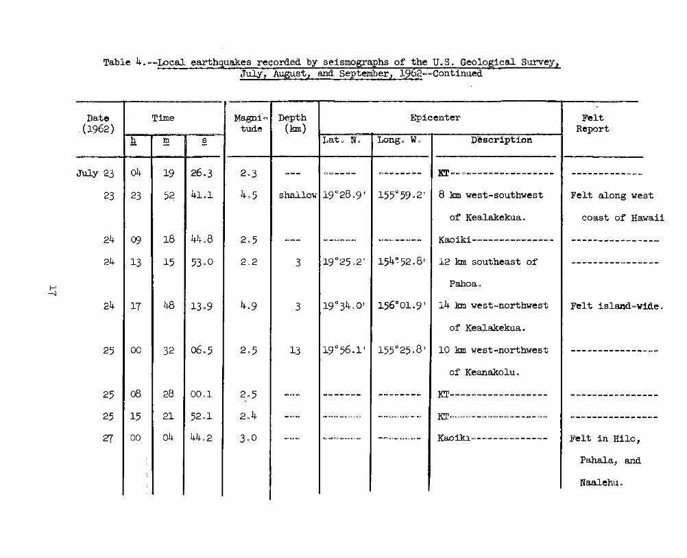
Table 4 0 -~Local earthquakes recorded by seismogra hs of the U. S. Geological SurveyJuly, August, and September, 19 2~~Cont1nued'
st
;waii
wide.
Date Time Magm.i~ Depth Epicenter Felt.(1962) tude (km) Report
h m ·s Lat" No .Longo'W 0 Desc~ipt·iel'l
July 23 04 19 2603 203ao __
a::;),...,,,~~GCIc::3-.:J8D_ .... __
KT-~=~--~------------.. _CCt_ ..... c:la-~-=t __ ~
23 23 5~ 4101 405 shallow 19°2809' 155°5902' 8 km west-southwest Felt along we
of Kealakekua. coast of He;
24 09 18 4408 205 &::>cac= c;)CXlc.;3~e:::tE:::2 c::)c:.c..:;)c.~e.."c:sa... Kaoiki-~~~~~~~~~-~~~- -"~_"'~"~_"-=-GD~_
24 13 15 5300 2,,2 3 19°2502' 154~5208r 12 km southeast of CDc.ll-=- ..... ___ .. c::J.-,~a;J
Pahoa 0
24 17 48 1309 4~9 3 19°3400' 156°01.9' 14 km west~northwest Felt island...
of Kealakekua.
25 00 32 0605 205 13 19°56.1' 155°25.8' 10 km west-northwest -----------_ .._-of Keanakolu.
25 08 28 0001 205 e=t." ...
___ -.:J ___ .._--_ ......KT---------~--------
__ .. ____ ~ ___ .. _=t__
....
25 15 21 5201 204 -~..,. CP~c-:::=Jc;c:::)~<.-;JiC':) 8!Oc::ac:Ac-.....,~c::IK:Jc::J KT~~==--~~~-~~-~--~-___ .. ~ .. _.,_.» ..am~~
zr 00 04 4402 300 llC~~ «::)Qt)c.":)~c,:)e;,t::J ~«::tC'~Ga~r..;"c.=a'" Kaoiki~-~~~~~~~---~- Felt in Hilo,
Pahala, and
Naalehu 0

Table 4"..,c:>Local earth uakes recorded by seismogra hs of the UGSO Geological Survey,July, August, and, September, 19 2~~Continued
c::.-c
Date Time M.agni= Deptrl Epicenter Felt(1962) tude (km,) Repor't,
h -- Latv Nc Longe. We Descriptionm sa-.> c-.., =olD
-- 'e
July 27 20 57 4805 205 e:;,<::..>c:2 ~ <:::l >= = ,':.:J C:l CJ e:;:..:, c_:;· c:::a '.:. ) :.-'~ C;.... .:::a;l c::;;2 Kooiki~ au = (".;> c:> ow = .= C~~ = = .... c-::l ex> ... == CIC C)C'IOC::;:)-=*~_QOlraQC>e;:,c::::lGOc:a;>.....-::;:Ie:.:;..t
21 22 06 4107 304 C::>c=:1~ ~C::>C:::>C:;OC:3c::lC::>'" e;)C>e:::tc.:»CKJc;:)C%:)t3t KM 30~~~~=~~-~~=~~=~~-~~ Felt in Paha,la,
and Kilauea
caldera
regionc
zr 22 16 4901 2.8 crJe...""")c:.) ~c::.>c:::;)=c::>co~ t':'c:::Jc;;,,;.)~C"""l~t::2 KM 30==~=~=~~~~=~~~~~=~= c:.:;)CD""~cmaDtZ)o.~_~':::::>c.Jc::::2CIQ
28 05 44 36Q8 2.1 c=Jc::-'.J,~ C;j~CD~c.=>o::><IIO "~c:::JC3c::l_= KT~=--~---~--~=~-~-=~~~~Felt in Kapoho
(Cape
Kumukahi)
29 06 51 16.0 209 13 19°4602' 155°5409 10 kIn west of Puu Waawaa ClQc.,J 4IIE) c:..-~..:t_QO., _____ GD(:JQD
30 22 58 5603 207 8 19°5205' 155°1903 5 kIn southe>sQutheast Felt in Paauilo
of Keanakoluo (northern
coast of
Hawaii) c

Table 4.......Local earthquakes recorded by seismographs· of the U080 Geological Survey,July, August, and September, 1962~-Continued
Date Time Magni= Depth Epi,center .Felt(1962) tude (km) -Report
h m s Lat(~ N'o Longe Wl' Description- ~ """"'"
-
July 31. 02 46 4800 . 3 c5 shallow 19°2505 t 155° "OOl'O' 8km southwest of Pahoa Felt in Kapoho
31 03 24 1508 3v7 ~Cl::>,:::>c:o CJc.:.3==c:;Jc::)= c;::::llcoc::;:.e:::tJc:=;tC:::J~·~ :Icr:',-"..., c;Q c:."" e:;:,~j c=o = == -_ e:;;, c= ~e:::>c:.:>c::oOllDc::::l Felt in Hilo
Aug 0 1 09 57 3902 3~O 13 20057 f 155°08~ 105 km north~northeast c::::II ___ e:::t_a:::t_e;:t.."woc='ct1
of Laupahoehoe.
1 16 06 2804 30.0 &::;:)c::::l0'0cx> c:;;:JQ:)~e;:)c::;)~e:::a ~~c::;:::Jo-=:ae-~C';";:)~ Kaoiki-=~=~~~~~=-~~~~~ CI!l',I; __ G)~cmflK)CD_e:::te::tUOl
1 16 28 3106 203 c::a~,*,C:=- c;::>==c.~c.>e:::tc;:) c:ne:t:;)«::)C:J~CDCEJ~ KT=-=-~~_Cl:>OIlDCl:>QClOIlDOIlD~=~"'~== cc c::::::a CID c=- gg _ ~ CIit' ~ CIQ ~,:) c::::J
1 21· 58 5102 204 ~CID""'C= c::::)&.JC=~c:,;)c:;:a~ ~~::eCll)"c:aC';1~ KT=~~-~~CX>~=~~=~~e:::t~-=-~ C;)C=c=::t~a:_-eCO~~CD8)
2 04 38 1301 1$9 8 19 0 28.8' 155°01·7' 8 km west-southwest of Felt in Pahoa
Pahoa 0
3 05 50 41.7 205 8 19°24eO' 154°5707' 13 km south-southwest c::J_--'-'-'.:1cm-'COCElC21
of Pahoa 0
3 05 57 4400 205 3 19°2401 t 155°0101' 13 km southwest of e-cg_~GIC:)~~~_CX:Gac:::a
Pahoa 0
3 08 31 5900 203 8 19°0409' 155°3108' 7 km east~northeast _C>c::IC::::>C:>..,C::>C::>C:::>=ClDClKl
of Naalehuo

f\)o
Table 4 ~ - ==Local earthquakes recorded by seismographs of the U. S Q Geolo ical Survey,July? August, and September, 19-2-~Continued
-.-- a::.;:::au::;.:Atr ....:...;~~~c:;~
Date Time Ma.gnic:> Depth Epicenter Felt(1962) tude (kID) Report
PQ' .-
h m s Lato 1fo Longo We Descri.pt.ion-- .=- -
Aug. 5 02 18 0603 201 ~~~~ c::::Ir;Q;4IO_t=:2;.-C=' .-:.J t,;-, ., .-0 «::) ~ :aa IE' KM 30~=~~~==~~~~~-~~~~~-~ ..,.-;r.~_c.~.aC"CJI....-::JMI
5 02 58 29QO 204 3 19°27' 154°54' 8 kIn SE of Pahoa--------- e.tC2oec.t~.a~__ ..,
8 11 46 2900 2~3 -=-aI:i1c::'.=:I~ ~e:-oa-=>-=-.~ Q;l.l_ .. :o::::t_ .... CIl:*_ KM 30---~------~=~~--~-~~CID"'CI:I"_" __ ~_
9 00 27 1102 203 c:QtC:)C» «z:Ii ~~==:>:;;:;;:;aQl';)~_~e::. __ ~ ... ~ KM 30~----~-~~~=~==-----~ CII:)~CII:::)QOm:»..,._~=::»..,
9 06 44 5309 207 C::>_~c=I c:::IC;;;SIllIO~~e:2C.;,j1 cr=:t:;zt-=a~CDc::J_~ KT-=~~~-=~~=~~-=~-~~-~~-~c;:;::aE;)c=\f8)~ __ ~""~
9 15 50 (J{ 00 2:)7 e-~~C"..::i &;'::)C:::ac:)..,c;;JCi:lc=:;J ~~~~C:04;::,;)-=-C=; Kaoiki=~--~-~~----~---~~- .... ___ aa===-to=~..,~c:;.;)
9 21 16 5402 205 C:J~CiDCit) ..,.c=aCDCD~-=»=- ~e::tc::Js-.G::)C:;:S_ew Kaoiki-~~-~~~~~~~~-~~~---eRc..::Je-t _____ C..l_
9 23 12 1900 200.-e> __
c:::>CJ«:IIIDe;,_c* _~":lI:I-=aGI:I_~
KT~~--~----~-~-----~~----~ ... ----_ ..--
10 02 17 55·0 200 ~ .. _.,__ C>c=-=~~
~...,,_....-..-- KT~----~-------------~--~ee:t_.,-=-_~__ ... _
10 15 37 2001 2.2 _ .. e;:,.:a C:>_C::OC:>CJlE>C:> _-=~CD&:t_-=:J-': KM 30------------------~-~_~ .. C":»_ .... _C8 ...
11 01 39 2602 2.6 50 19°1006' 1.55°20e2 t 20 kIn SSE of Desert ~e:-f __ ~..,-=-__ C::t
seismometer 0
11 22 46 57 02 205 G:l •.~ tL;J c..-;, ""'=C":Ic::::><=3=<:::I COc::2t.QQtIR3'->c:I=:I_ KM 30~~---~----~-~~-----~OIO- ____ c.._e-::t
12 02 CJ7 18~2 205 13 19°4500' 155°46·5' 7 kIn ESE of Puu Waawaa ~CI:Ilc:.:IiQIlGD"-'"cc",

Table 4o~~Local earth uakes recorded b seismo a hs of the UoSQ Geolo ical Survey,July, August, and September, 19 2~~Continued
ho
ho
""'"
Date T:ime MagniC2 tDepth \ Epicenter Felt(1962) tll.,1le (lml) Report-..
h m s Lat~c ~:r 0 Longo Wo Description- ~ ="""
~..-
Aug 0 13 16 28 0105 202 8 19°1304 1 1~55°3500f 18 km north of Naalehu QD~cao~c::::D"'CSI~06C~"~
13 22 32 0600 204 5 19°14' 154°34~ 40 km southeast of Cape CI:D~ ___ CKtc:::J_c:::;a~e=ClDC-=
Kumukahi.
14 19 28 2504 2:>6 3 19°22~ 156°16' 40 km southwest of c:J~-=-QQ_ca_~"_=-
Kealakekua 0
14 21 11 3900 205 shallow 19°2802' 154°5807' 5 km southwest of' -=:a_ ... ...,_~c::::J;-.aa_c=tc::;)
Pahoa 0
14 23 37 5000 207 c::) e::t c= C;;I ~.:a-=:t..,e-,e-c= _"~C'CQ"'",,",C::O KT=~----~-~-~~-~~-~~-~- ~ .. aa ....._~ .. .c .. ~c;;.;»
16 17 15 07 Q5 206 1 1/2 19°2302' 154°5306' 14 km south~southeast Felt in Kapo
of Pahoa 0- (Cape
Kumakahi)
16 18 31 3905 207 1 1/2 19°2302' 154°5306' 14 km sQuth<=southeast Felt in Kapo
of Pahoa 0 (Cape
Kumakahi)

Table 40 -~Local earthquakes recorded by seismographs of the U0 S 0 Geological Survey,July, August, and September, 1962- IOContinued
Date Time Magni.", Depth Epicen.ter Felt(1962) tude (kIn) Report
h m s Lato No Longe> Wo Description~ - .-
Aug 0 17 23 30 06g5 400 8 19°1008' 155°32QO' 14 kIn northeast of Felt in the
Naalehue southern
half of
Hawaii 0
18 16 58 41G8 406 8 J.9°1802' J.55°1107' 11 kIn southeast of Felt island=
Ahua seismometerc video
18 18 21 4908 207 8 19°17 07' 155°2404' 13 km northeast of ... ~ ____ ... _ ..... -=:ac.a_.,
Pahala.
18 18 47 2100 200 3 19°2208 'I 155°09·7 11 kIn east of Ahua-=-~ ______ -=t __ .. ClD
seismometer.
19 00 19 0204 202 8 19°5207' 155°1608' 15 kIn south.... sQutheast c::'II~CI:I-=-~~a::J.,Cii:lc=tc=tC:O_g;Q
of Laupahoehoeo
19 00 53 1100 300 8 19°2200' 155°2900' 18 kIn north of Pahala ~e:;, __ 8:)_"C'C)~c:::l"(;W~c::':)

1\).lJJ
Table 4o-.."Local earthquakes reco~d~d by seismographs· of the U.So Geological Survey,~July, AUgQst, and" September, 1962--Continued
, ..
Date Time Magni Depth Epicenter Felt(1962) tude (kIn) Report
~ !!! .§. Lato No Longo Wo n"escription
Aug 0 19 20 23 5000 205 8 19°50~5f 155°31Q4' 28 kIn southeast of t:::t _____ e::t ______ c::a
Kamuela.
20 01 39 (J(,3 300 8 19°10' 156°13' 50 kIn southwest of e::::te- __ ~~e-~_ .. ocC&t
Kealakekua.
20 03 44 2509 2e2 8 19°48.9' 155°15·9' 23 kIn northwest of e:tc;Je-_ ... .,~__ tr'Ct-=c::::::I
Hil0.
20 05 31 39.1 300 ---- .-,es-=-C:D.ae-c:. ....~----- KT~--~---~--~-~--~-____ ... _ .. ~e- .. _=:tc:=
20 06 24 37el 2·7 _...-~t::)c::.c:::2_c:a-==» e::::t~~"IiiD"''''' KT~~-------=-~--~-- ",,,~_,,,,,~CI:)=-..,e;:,~
20 13 40 2309 209 ......- ~ODoc::aeac:ac=-C':) ODc:;:)C;Jc;)ca-.., .. KT~=~~~~~=~-~~----- C'2::)_~~"c::2~~"'IKIc;::::)

Table 4o~-Local earthquakes recorded b seismographs of the U.S. Geological Survey,July, August, and September, 19 2~~Continued
.' .:....- ~
Date Time Magni~ Depth Epicenter Felt(1962) tude (kIn) Report
h m s Lato N~ Longo Wo Description- = ..-
Aug 0 20 14 41 5109 206 C'c:>c::> ~~c:::a~CID&;:)CE:J _c::ac;>-=O_CDC::SC:> KT~~--~=-~--~~~~-~~~m-c:ac.> .. __ ~_..,l-=tag
20 14 58 29·2 208c:o __
c;D~ca.. cac:ec::J _"'_-=:Jeu~-=,CD KT~~~----~~---_c::s_~~-E:2c:a ____-.oa...~~_~_
21 04 26 3405 2 .. 8 8 19°10 ' 156°13~ 50 kIn southwest of _"_c::I_ca~a:tc:r_c::Jl
Kealakekua 0
21 13 29 3108 2·9 8 19°10~ 156°13 ~ . 50 kIn southwest of .., ...... CD .. c::;:)_Cl:Je=-=
Kealakekua.
21 13 39 58.8 2.6 3 19°29·2' 155°42.6' 13 kIn west-northwestc:=- .. _____ .. ca __ ~
of 'IvIokuawe0weo 0 ------------ca1derae
21 13 52 2205 2.4 3 190 27.9' 155°42.1' 12 kIn west of . ' ., ----~._-......-Mokuaweoweo
caldera 0
-
_..

Table 4. --Local earthquakes recorded by seismographs of the UoS. Geological Survey,July, August, and September, 1962.. -Cont1nued
ea
Date Time Magni- Depth Epicenter Felt(1962) tude (km) Report
h !!!. .§. Late No Long .. w. Description
...... .-- - -,
Aug. 22 14 24 41c7 2<>8 8 19°10 1 156°13' 50 km southwest of c:&:38Ea'_~"'-.:J_-=---':>___~"
Kealakekua 0
22 22 52 4409 2·7 --- c::::Jao __ -c:::I-~ ~~_K:l.ac.a__ KM 30----------- .... -- _.. - ...--------~
22 23 22 3409 303 __ c::>CID -=tCll:tCKI ___ .-a _ ____ ~~.,.:1 KT----------------- Felt in Kilau
ca1d~r.a reg
23 18 39 2008 2·5 ...-- ~1S:J_=s._aC2 ... .,aDa:::t~_"____ ~ KM 30-------------- -------------
23 18 3.9 3809 209 ~~- ..,~ ..~~-~~ C*I __ CZl~CKI_-=:» KM 30----------.. ---_______ -a ___ ~_
25 13 "20 4405 202 -.. """ c;:::IIC=IZ:::=ICKI~CI;2""
C1~CIm' ___ "':' KM 30-------........... --- a:t_c:at=)_-' __ ~~_ ... ~
25 17 54 0005 204 .....- -. .. -=aGD"4ID_.aa CJe.D~_ca::Jc;ac::sCI:I Kaoiki~------~--.... -- ..~- .._.._-----~25 21 41 14.3 201 8 19°20·5' 155°0105' 19 km southwest of ~--..---------
Pahoa.
25 22 22 19·0 3.4 13 19°09' 156°10' 50 km southwest of --------------Keala.kekua.
'Z7 03 23 19·9 2.8 13 19°CJ7' 156°10' 53 kIn southwest of ..~----------- ..Kealakekua.
21 12 31 53Q7 2.5 8 19°3202' 155°55·5' 3 km north-northwest-------------~
of Kealakekua..
29 20 30 4002 2.6 13 ~8°571 156°15 I 70 kIn southwest of.. ____ ~~__ c_. ___ ~
Kealakekua.
30 03 'Z{ 1304 2·5 8 19°21.1' 155°2302' 1 1/2 km north of__________ -.;1 _____
Desert seismometer.-------------
30 15 53 43e1 2·3 ~--fataDa;lr;m, ____ ....
~.,_.,cae:;J__ KM 30--~-----------1--------------

Table 4.--Local earth uakes recorded by seismo a hs of the. U.S." Geological Survey,~Ju...ly, August, and September, 19 2.a-Continued ~;" -.,
Date Time Magni~ Depth Epicenter Felt(1962) tude (lml) Report
h m s Lat~ N~ Long. w. Description~~ - -
Aug. 30 16 16 33~2 3~1 --.,;::) _-=:t .. _ .. __ _c=a_ ... _~ ....KT--~--------------- ----------------
30 16 44 28.9 2·5 3 19°2201' 155°29.3' 17 lml south''1est of -------------- ..
Mauna Loa
seismometer 0
,
31 09 42 3lQO 3·0 8 19°28~ot 155°25.5' 5 kIn southwest of -.--------..-----
Mauna Loa
seismometer.
sept. 2 13 16 00.4 2.6 30 19°25·7' 155°18.1' 1 kIn northwest of .._ ... _.. _- ..--- ..~-
Uwekahuna
seismometer.
2 14 II CJ7~3 2.2 30 19°25Q7' 155°18.1' 1 kIn northwest of ~-.t______ ...... -.:t ....
~-~
Uwekahuna
seismometer 0

Table 4o--Local earthquakes recorded by seismographs of the U.S~ Geological survey,July, August, and September, 1962-~Continued
n
--- ..
Date Time Magn1&"J Depth Epicenter Felt(1962) tude (ron) Report
h m s Lato No Longo WO Description- - --- -
Sept 0 2 15 34 40.0 205 ~c::a'" C.o;)~c:ac:ac:aQ;,)1QD c:ac::=tlX>e:::tC:2~"" Kaoiki~~-~------~~-~--- -=--=-----_...... -.:11 __
__ 2 17 17 0502 3c;l 30 19°28.5' 155°15·0' 7 kIn northeast of' Felt in Kilauea
UwekahWla caldera regio
seismometer 0
2 21 49 20QO 305 13 lc~°08 ' 156°11~ 50 kIn southwest of " __ ..ca~«:J""~""'~_"_;/ .
Kealakekua 0
3 07 28 02.8 2.4 --- ---=----- ..____a_-Kaoiki~---~----~-~-
_____ 00 _____ .. ___
3 13 34 50·3 2·5 --- _....-..-- -------- Kaoiki----~-------- - .. ---- .._-_-._---I l
4 04 27 54.0 204 10 19°1806' 155°15.8' 7 kni south of Ahua ..-....._.,~ .._... .,., .._..
seismometer 0
~

Table 4o--Local earthquak~s recorded by seismographs o~ the U.S. Geological Survey;July, August, and September, 1962--Continued
ahaa
JIi-le1aueaa
eastern
.~
Date Time Magni- Depth Epicenter Felt··(1962) ; tude (kIn) Report
h m s Lat. No Longo w. Description-- ~
Sept. 4 04 36 4800 2Q4 10 19°18.6' 155°15.8' 7 km south, of Ahua aD~_"'.:a_me_.-..-:t
seismometer.
6 02 47 2309 3·3 13 19°59.8' 156°00.0' 19 km west-southwest --~------.."
of Kawa~hae.
8 01 42 1208 208 3 19°2703' 154°50.1' 13 km southeast o~ Felt in P/'
Pahoa.
8 03 58 5800 401 8 19°02·3' 155°08·5' 25 kID. south-southeast Fe~t~:iB.:
and Kiof Apua Point. calder-
region.9 07 17 3207 2.6 3 19°20·7' 155°06.6' 17 km east-southeast ----------
of Ahua seismometer.
9 10 05 26.1 2·5 3 19°23·8' 155°00.6' 13 km southwest of ---- .... ----~ "-~
Pahoa.
9 17 57 5700 2·7 8 19°18.0'. 155°50·3' 12 kIn southeast of _tlD ______ aac-.
-.,4.
Hookena.
10 19 11 1500 306 3 19°20.0' 155°06.3' 18 km east-southeast Felt·-in -.- .......
of Ahua seismometer. Hawaii.I

I\)\0
Table 4.-caLocal ea.rthquakes recorded by seismographs" of the- U.S. Geological Survey,July, August, and September, 1962--Continued
Date Time Magni~ Deptb Epicenter Felt(1962) tude (km) Report
h m s Lat. N«> . Longo W. Description- -I - -.- - - o. - .- __- ... ·-.4
Sept-. 10 "22 36 4456 2·9 13 19°05.5 156°10«>0' 55 km southwest of Ciii:II .... .,., .. _e:t_ca.:ac:z:;tc::clc::l
Kealakekua .
11 (J{ 22 49.8 3·7 25 19°28.6' 155°14.0 1 9 km northeast of Felt island-
Uwekab:una seismomr~er. Wide •
11 err 25 27·5 306 25 19°28.6' 155°14.0' 9 km northeast ,!"f F~lt island..
Uwekahuna seiSll;DD1eter. wide.- .
~ 17 39 51·7 2.9 13 19°05·5' 156°10.0 1 55 km southwest of I_~C3________.. -=-_
Kealakekua •..
12 17 46 05·7 :2.8 8 19°34.5' 155°55.4' 7 kIn north of .._---_..__...._-~
Kealakekua•. . -- - ...
54.9 8 19°16.0' 155°12.1' 14 kIn southeast12 00 3() 2.2 ---------____ -.-=:1'
of Ahua seismometer.."~
12 16 08 26.6 2.0 3 19°18.1' 155°21.6' 9 kIn southwest of I ~---.-.-.--------..
Desert seismometer.
KT---------~----~--I..
13 12 41 59·9 2.2 --- -------- ..~--~--- ------_.. _____ .-:a

lJJo
Table 4.--LocaJ. earthquakes recorded by seismographs' of the U.S. GeologicaJ. Survey,July, August, and September, 1962-cgContinued
--
Date Time Magni- Deptb Epicenter Felt(1962) tude (kIn) Report
h m s Lat. :N' • Long. We Description- ~ -
. ,. . _.
Septet 13 13 09 38.3 2·5_ ClI __
__ ..."c::::otn ...,C'll e."''''''C::OO'''''IC_«_ KT~~~~~~~~~~_~~~~d~- C:::>CO"""-~c=>to=lC=:>C"_C:=c::I
14 16 32 1107 3~6 C::Oc::lC')c;:a C3_-.»e::t-=»t::»t::» ClI~C2=c:ac::::lC=-c:l KT~~~~_e::o~-~-~e::o~~~c::a~- e::::tat)«:::=I~CI;Ic:::Ic.:ac:::ac."c::»c.::t
15 02 22 1403 301 coc:a.,. C3
c-::lI ______
C:$co_aac::lc::::l£:>c» KT--~~~_c::::I_--~-~--"""C:::>- C3_caa::JcaC-:lCR:)_"c.~c:::J
16 11 Z7 2600 2·7 3 19°16.2' 155°0209' Z7 kIn southwest of' C3_".,,_~a...~_ .. ~
Pahoa.
17 1.1 17 55c3 3·1 ClIe:tc::oc::l
C' .. ____ ._CJ1 ______ ca~
KaoikiCll~~~-~------~ _ -=- ... c:s co..,., ., ..., _ ~ _ ....
18 03 30 0301 2.8 _.....~~ c:ae-;,_C31 ___ __r.llC"ID""'.,.e::o Kaoiki-c::o--C31~---~~~- e;"a:JE:)c:::;)e::tcc-=~-=aC'=:t-=-tKD
18 03 46 3202 3~O 8 19°5004' 155°4308' 21 kIn south-southwest ---=-------of Kamuela.
18 06 55 08.1 206 5 19°22.6' 155°05.1' 37 kIn south of Hila -- ..-_ .._-----19 03 29 45.1 2.8 13 20°46' 155°49' 40 kIn east of ------------
HaJ.eakaJ.a, ...__ c:a _________
Maui seismograp~o
19 04 Z7 08e7 205 8 20°00.8' 155°2008' 11 kIn west~northwest-=> __ .cc::;) __ c::::a"e::t.,~
of' Laupahoehoe 0

Table 4.-caLocal earth es recorded b seisjnogr8;---~'_of 'the U.S. Geolo cal SurveJuly, August, and Septem er,' 19 2~-Continued
•
DeJt:e Time ~.gn1~ Depth Epicenter Felt(1962) t'tld~e (kin) RepoTt
~C~
~ m B L~-,to No Long. Wo Description- - -~.;:l l:.c'.~-~ . . ..
Sept 0 19 ~6 o~ 3703 ";) f"{ 13 19@118~5~ 155~04$71r 45 kin south of Felt in Hile{, .dO
Hil.Oo
19 17 54 1800 208 8 190 531115 11 155°37tJ7' 16 kin southeast of C2c;acgc=-c:.CII~C:SC:=-"C::SCJ
Kamuela., .
20 22 46 0509 3·;7 13 2o()46!,. " ~55@O,·_,~:·tJ 109 kin northeast 1iOJC"_e:;ae::-.,eaCllc:l~c:lc:J.... >.: '.~
--
of Kamuelao
21 ~5 28 0800 2,,7 1.3 19°02.8 v 155°2503 9 18 k:m eMtc=southeast ..,C:=-elCJC::ScaSiact_c:lc:lc:I
of Naalehu... - . ~ . - .
2l 18 52 1006 201 c::;Ie:I e::sCllOco:te-et~ c:=-cc:JeaCJC::SCJc:it KM 30~c:lC:SC:=-ClIC:=-_~CI~CI~~" CSe:::t_Cle:::t_CII~CI_C_
22 13 ZT 2902 3.0 13 19~46# ~-' 156032~, f' 70 k:m northwest of _e:::t___e:l_ ...cseac:.c:I
Kealakekua.
22 13 33 4200 206 8 19°22o~1 155°5609 i 16 k:m southc:Jsouthwest e:::t_caC8c:::1_c;ac:Jc:I~
~ of Keala.kekuaG I22 1.9 34 llca2 202 8 19~06.6· 155~22.8t 23 k:m east-northeast
________O_CIIC)
of Naalehuo
23 10 38 4704 2.9 13 20°1302' 1550 4900' 25 kIn northwest of ------------Kamuela..

Table 4. ~-Local earth es recorded· b se16inO~ hs' of the U 0 So Geolo ieal Survey,July, August, and-September, 19 2c;3C3Continued
a .
and
rth
=,
Date Time ~i~ Deptffl R'pi~ente:r F~lt
(1962) t~l1de (kIn) Reportc:::- -
h m 0 L~;~o No Longo W~ r)es(~:£;):1D-t:t:Jn '".- -
..
SeptQ 23 14 50 26&0 2~4 30 19~2603~ 155°0709 i 16 ktn northeast of C3c;;o"c:DCOCDC::8e:Jc:;:I~~
Ahua seismometer 0
24 13 34 47~4 2e3 10 19°1806 w 155°1205' 6 kin southeast of ~C=-"c:2l::!tC:;)~e::II"c::ICC
Ahua seismometer 0
. -
24 19 05 2103 208 C::Jc:2 c::Ie"'~C'c:-,c::a~C3 c::aC2C3e::11~e::t(::3c:::1e::t K80ikic:2~e::II~~e::II~c:2~c::I~e::II~ C2CCC:>C:::>E3lC2=CJle::tC3c::1
25 09 03 4805 2.6 3 19@2508 t 155°02.5 R 25 km eMt C2northeast C2C3"'~COe::ll~~c::Ie::IIC3
of Ahua seismometer.
25 13 22 50~4 3-5 8 19°15.1' 155°3002' 8 kIn northwest of Felt in·H1·1
pahaJ..a,Q and Pahal.-
26 13 C$ 5109 204 C:8a=1 C81OC3_c:::ae:lC"c:acaCClc:.. __ etc:2 Kaoiki~~c:::ae::lle::te::ll~_e::II"_e::II_~ e::II~e::llc::J_C=O_CK)C::t_c:::I
Z7 00 52 0206 - ~2 15 20°0303' 155°0502' 38 km north of Hilo. ~e;::,ICI_e:te::llC3IC11C2~CJI
'Z{ 1.8 04 17.7 3·2 -- __ e::II~C":I~c::lI
~e-ctc=oe::-e:::ae::llC2 KM 30~~~~c::lI~~e::-~~~~~e::-c=o FeJ.t in no
Hawaii~
Kilauea
calderareg1ono

es recorded by seislno a; he -of the' U0 S 0 Geological Survey,July, August, and September, 19 2~-='Continued
Date Time ~i~ DeI,th Epicenter :F~lt
(1962) t'ulle (km) Repc,rt..
h m §~ l~~;G c Ns Longo w~ Degc:ription
Sept 0 Z7 20 11 42.'7 206 c::2~ ClIC3C:::>C:::>C:::>c::.C3 C':)c:::>c:::>ClI~C:::>C:::>C:::> KM 30~ClI~~~~C:::>C:::>C:::>~ClI~C:::>~C:::>C:::> c:::>c:nc:::>c:::>C3c:::JC:;:)~=~
28 09 44 4900 205 8 [email protected] v 155~1.8C11' 35 kIn southeast of C:::>c::Ic;::)e::tCllC;::)C:::>~C:::>C:::>
NaalehuG _..
28 12 44 43&7 34·3 13 21@27' . 1560 47', .. 96 kIn norlhwest of e;, ___ c:oe»t::I_-='~C3
Haleakala seismometero
28 22 50 050(1 205 30 190 21.2' 155°19.6' 7 km. east-northeast ofcs __ -.____..... _
Desert seismometerG
29 09 50 53e9 203 8 19~3307i 1550 41,,5' 25 km east-northeast C:::>C:::> __ Cll)c:::I_e:o.,c:::>c:::>
of Kea.la.kekuao;
29 10 13 5Q.O 302 8 19°2lo0' 155°54.9' 5 km southC3southwest ce ___ C3IC2C11-=- ___
of Hookena.
30 12 45 1005 2.5 ICICl1 _-=-e;,e:::tC":ltC:lC:::>
_______ ca
Kaoiki-------------______ cs~."e::::t_
30 13 05 4200 2.5 3 19(.)2507' ].54°56.8' 8 km south of Pahoa _Cll ____ CItC)c:ac:J~
30 20 22 1200 209 3 19°02$81155~25.2' 18 km e~c;t of Naalehu ._---------

Table 5o~~Distant earthquakes
[Times are reported in Greenwich Civi.l Time which is 10 hours fasterthan Hawaiian Standard Time 0 A ne " following the time of P indicatescompressional first motion; a "d lt indicates dilatational first motionoStation symbols, locations, and instrumentation are presented inSummary 25 0 Magnitudes calculated from the Hawaii seismograms arefollowed by (HVO) 0 Location of epicenter, origin times, and focaldepths, and magnit~des reported by other instituti~ns are taken from"Preliminary Deterinination of Epicenters~' published by the U0 S 0 Coastand Geodetic Survey 0
A major disaster recorded this quarter was the Iranian quake ofSeptember 1, 1962. By comparison, the Agadir earthquake ofFebruary 29, 1960, caused roughly equivalent casualties and damage,but it failed to record any recogni~able phases on the HVO network]
July 3
iF 08~41:1607 c U PEN eS 18:44:17
iP o8:41:16~7 u PEZ iR 18~56~53
eP 08:41:1602 d C&GS card 59aD62~
18:22~o6~3
iP o8:41~16<>5 c 54,,60 So, 132<.3 0Wo
south Pacific OceaniP 08:41:1806 c h about 25 kIn 0
iP 08: 41 ~ 13 ~ 7 P: July 5
iP 08:4l:19~4 c U PEZ eR, 18~o6~30
iP 08:41:18.2 d C&GS card 52~62:
17:4o~5503iP 08:41:17 c 3009° No~, 14.1040 E<.
South of Hor.1shuiR 08:54:57 h about 23 kIn r.
eS o8:48~18
eL 08: 52: 29
U PEN
U PEE
C&GS card 54-62:08:32:310910.3° S., 165.9° E.Santa Cruz Islandh about 50 kInMagnitude 603 (Berk)0
July 2, 1962
M Z
A Z
D Z
U Z
Pa Z
Na Z
Hi 'Z
Ha Z
U PEZ

Table 5.--Distantearthquakes-~Continued
C&GS card 53<",,62~:
03~32:0005
1004° N~, 122~6° E~
Panay, Phi.lippine Islandsh about 66 kIno
C&GS card 53C'_·62~
12~4o~3007
Iln9° N , 12201° EePan~, Phi.li,ppine Islandsh about 25 me',
C&GS card 54~92~
03=22:03·8.5105°, Nt), 17805° EoAleuti~ Islands,- Rat Islandsh about 60 kala
JulY 8
M Z eP 03~29~15Q2 d
A Z eP 03:29~16()2 d
N Z eP 03:29:16.7 d
U FEZ ,eR 03: 3'9: 1102
O.3~ 44~ 02 c
o4:o8~22
Z eP
FEZ eRu
M
July 11
M Z eP 12~52:4705 c
A Z eP 12~52~48.o c
D Z eP 12~52~4704 c
N Z eP 12~52:47 .. 8 c
U PEN eo 13~13~41
U FEZ eR 13~17~O5
July 13
July 6, 1962
M Z eP 23:23:50.1 c
A Z eP 23:23:50.1 c
N Z eP 23:23=49.1 c
U PEZ iP 23:24:10 c
U PEN eSKS 23:33:52I
23:58:30U FEZ eG
C&GS card 54-62:'23: 05: 32023606° N., 70.4° EoHindu Klishh about 203 km~
July 7
M Z iP 06~20:1103 c
A Z eP 06~20~13<)0 ~
D Z eP 06:20:1204 c
N Z eP 06~20~1203 c
U FEZ iP 06~20~13 c
u PEN eS 06~25:55
U PEN iR 06~29~35
Ha Z Tmax 06~58:0506
C&GS card 54-62~"06:12:48.951.3° No, 178.6° E.Rat Is1~ds, Aleutian Islandsh about 60 kIn a
35
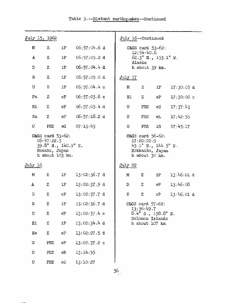
Table 5o--Distant earthquakes--Continued
July 15, 1962 July 16~-Continued
M Z iP 66~57:04~6 d COOS card 53.,.,62:12:54~4006
A Z iP 06~57:0502 d 6203° No, 15301° WOAlaska
D Z iF o6~ 57.: 0404 d h about 39 km.
N Z iP 06:51:0500 d J'u1y 17
U z iP 06:57:0404 c M Z iP 17:30:05 d
Pa Z eP 06:57:05n8 c Hi Z eP 17~30:06 c
Hi Z eP 06:57:05,,4 d U PEN eS 17:37:43
Ha Z eP 06:57:1802 d U PEE eL 17: 42~ 55
U PEZ eG 07:13~43 U PEZ iR 17:45:17
C&GS card 53-62: C&GS card 56--62 ~
06:47:22.5 17:20:22·93908° N., 140.9° E. 43<>1° No, 144c5° E~
Honshu, J"apan Hokkaido, Japanh about 103 km. h about 30 kIn.
July 16 July 22
M Z iP l3:02:36~7 d M Z iP 13~4,6:01 d
A Z iP 13:02:3709 d D Z eP 1.3:46:08
D Z eP 13:02:3707 d N Z eP 13~46~01 d
N Z iP 13:02:3607 d C&GS card 57-62:13:36:49-7
U Z eP 13: 02:3704 c 8.4° So, 158.8° EGSolomon Islands
Hi Z iP 13:02:3404 d h about 107 km~,
Ha Z eP 13:02:27->5 d
U PEZ eP 13:02:3702 c
U PEZ eR 13:14:55
U PEE eS 13:10:27
36):. 'j

Table 5.--Distant earthquakes--Continued
July 24, 1962 July 25--Continued
M Z iP 21:18:15G3 d C&GS card 60-62:04:37:50.7
A Z ip 21:18:15.0 d 18.9° N., 81.1° WoWest of Jamaica
D Z eP 21:18:15 h about 64 kIn
21:18:14.3 dMagnitude 6 (Pas), 6.2 (HVO),
N Z eP 505 (Berk)6 (Pal). '
Pa Z iP 21:18:12.1 c July 26
Hi z iP 21:18:1308 c M Z iP 08:26:05.4 c
Ka Z iP 21:18:15.8 d A Z iP 08:26:04.8 c
U PEZ eP 21:18:18 d D Z iP 08:26:05.0 c
M Z ipP 21:18:42.5 N Z iP 08:26:04.6 c
A Z ipP 21:18:41 U PEZ iF 08:26:05 c
N Z epP 21:18:41.4 Pa Z iP 08:26:0301 c
U FEZ epP 21:18:41 Na Z eP 08:26:07.5 c
U Z eS 21:26:43 Hi Z iP 08:26:03.8 c
C&GS card 57-62: Ka Z iP 08:26:0604 c21:08:22.615.5°N., 92.5° W. Ha Z iP 08:26:09.8 cMexicoh about 129 kIn A Z ePP 08:28:53Magnitude 5.6 (Berk)
5.5 (Pal) U FEZ is 08:35:23
July 25 U FEZ iSS 08:40~07
U· FEZ eP 04:48:19 c U PEN iL 08:43~55
Hi Z eP 04:48:58 d U FEZ iR 08:47:25
Ka Z eP 04:48:57 c C&GS card 58-62:08:14:4108
U PEZ eS 04:58:21 7.5° N., 82.7° w.South of Panama
U FEZ eSS 05:02:27 h about 21 kInMagnitude 6.8 (Pas)
U FEZ eR 05:09:59 7 (Berk)37 7 ·5 (HVO)

Table 5.--Distant earthquakes--Continued
July 28, 1962 July 30--Continued
C&GS card 61-62:00:05:10.816.2° S., 173.2° w.Samoa Islandsh about 40 kIn.Felt: Apia
PEZ eS
FEZ eG
FEZ iP20:30:44.6 d
20:30:4108 d
20:30: 4409
20:30:4403 d
i.P
eP
eP
iP
Z eP 20~30:53.2 c
Z eP 20:30:47.0 c
Z
PEE iL 20:51:10
PEE iG 20:51:41
z
z
PEZ iP 20~31:19 c
FEZ ePP 20:34:11
PEE is 20:41:05
FEE iSS 20:45:21
z
u
u
u
u
u
N
A
Ha
Hi
u
D
M
C&GS card 60-62:17:16:44043.3 0
~o, 143.9° E~North Coast of New Guineah about 25 kInMagnitude 6.8 - 7 (Pas)
7 (Berk)7 (Pal)
July 30
17:27:2103 c
17:27:21.7 c
17:27:21.4 c
17:27:21.9 c
00:22:11
00:12:44.0 c
00:12:43.8 c
00:12:42.7
00:12:44.0 c
00:12:4407 c
00:12:49.3 c
00:12:55
00:18:47
eP
eP
eP
iP
eP
eP
iP
iP
iP
iP
z
z
Z
z
z
Z
Z
z
Z
z
A
D
u
M
A
N
u
M
u
Hi
Ha
u
D
July 30
U FEZ iR -17:45:56
u
Hi
u
u
u
u
FEZ iP 17:27:2101 c
Z iP 17:27:22.8 d
FEZ ePP 17:29:51
PEE is 17:36:11
PEE iSS 17:40:25
PEN iG 17:43:21
C&GS card 58~62:
20:18:49035.0 0 N., 76".3 0 w.Western Colombiah about 45 kInMagnitude 100 (HVO)
6.8 (PaA)6.8 (Ber~)
6 (Pal) 0
47 killed in Caldas Province;property damage over 400,000sqG miles.

Table 5.--Distant earthquakes--Continued
July 31, 1962 August 1--Continued
M Z iP 05:25:05.8 d C&GS card 62-62:04:36:57.6
A Z iP .~,~ .. :' ::'.06.5 d 3.2 0 s., 14307 0 Eo,'J,'''-"..•
North coast of New GuineaD Z iP 05:25:05.6 d h about 33 k'.M
Magnitude 6 .. 5-.6 .8 . (Pas 0)N Z iP 05:25:06.1 d 7 (Berk)
6.5 (Pal)U FEZ eR 05:50:13

Table 5.--Distant earthquakes--Continued
Aug. 3, 1962--Continued Aug. 11--Continued
A Z Tmax 10:53:45 N Z eP 01:55~o405 d
D Z Tmax 10:53:47 Pa Z iP Ol:~55~o603 d
U Z Tmax 10:53:45 Hi Z iP Ol~;55~0105 d
C&GS card 62-62': Ka Z iP 01: 55: 01 02 d08:56:12.123.2° S., 67.5° w. Ha Z iP Ol~55:10~O dNorthern Chile-Argentina border U PEN eS 02~01:o6
h about 11 kInMagnitude 7-7.3 (Pas) C&GS card 64...62:
6.8· (Berk) 01:41:390620.0° So, 178(,80 wo
Aug. 6 Fiji Islandsh about 638 kIne
M Z iP 21:00:53.3 dAug 0 11
A Z iP 21:00:53.0 dM Z iP 08~zr~09lo7 c
N Z eP 21:00:54.3 dA Z iP o8~21~lO.5 c
u FEZ eP 21:00:53D Z iP 08:27:0901 c
Hi Z iP 21:00:56.3 dN Z eP 08~27~0909 c
U PEZ is 21:08:09U FEZ iP o8~21~lO c
U FEZ iSS 21:11:39Pa Z iP o8~27~1104 c
u FEZ eL 21:12:21Hi Z iP o8~21:1006 c
U FEE iR 21:14:49Ka Z iP o8~27~0701 d
C&GS card 66-62-:20:51:56.8 Ha Z iP 08:27:0208 c26.9° S., 117.1° w.h about 50 kIn U FEZ isP 08~27~44
Kermadec Island regionMagnitude 6 (Berk) U PEE is 08~36~38
5.5 (Pal)o8:47~22u PEE eG
Aug. 11C&GS card 69~62:
M Z eP 01:55:04.8 d 08:15:430725.2° No, 123~3° Eo
A Z eP 01:55:05.6 d Off NE'coast of FO~osao
h about 140 kIn
D Z eP 01:55:04.8 d Magnitude 6 (Pas)40 5-505 (Pal)

Table 5.--Distant earthquakes--Continued
Aug. 13, 1962
A Z eP 06:47:25.1 c
N Z eP 06:47:24.8 c
U PEZ eS 06:56:46
U PEZ eL 07:06:16
August 17,--Continued
C&GS card 67-62:05:04:31.510.6° N., 121.6° EoPanay region, Philippine Islandsh about 33 kIn.
C&GS card 65-62:06:35:56.02.1°N., 83.5° w.About 300 miles ffil of Ecuadorh about 33 kmMagnitude 6.5-6.8 (Pas)
5.4 (Berk)5.5 -5.8 (Pal)
C&GS card 63-62:08:19:37.854.6° N., 161.5° E.East coast of Kamchatkah about 52 kIn.
Aug. 17
M z iP 05:16:1~lo6 c
A Z iP 05:16:42.8 c
D Z eP 05:16:42.3 c
N Z eP 05:16:42.6 c
U FEZ iP 05:16:44 c
Hi Z eP 05:16: 1l-4.7 c
U PEZ eSKS 05:27:40
U PEZ ePPS 05:29:42
U PEZ eG 05:41:2241
Aug. 15
M
u
Z eP
PEZ eR
08:28:12.4 c
08:42:04
Aug. 18
M z iP 16:51:50.1 d
A Z iP 16:51:51.1 d
D Z iP 16:51:51.0 d
N Z eP 16:51:50.2 d
Pa Z iP 16:51:50.0 d
Hi Z iP 16:51:48.8 d
U FEZ eR 17:04:49
C&GS card 67-62:16:43:54·362.3° N., 152.5° w.Central Alaska. Fe1t~
h about 32 kInMagnitude 6-6.3 (Pas)
·5 0 3- 5·5 (Pal)
185·3 (lIVO)
Aug.
M Z iP 17:54:10.4 d
A Z eP 17:54:11.0 d
D Z eP 17:54:11.2 d
N Z eP 17:54:10.4 d
Pa Z iP 17:54:08.2 c
Hi Z iP 17:54:09.0 d
U FEZ eS 18:00:53
U PEZ eR 18:06:25

Table 5.--Distant earthquakes--Continued
Aug. 1B--continued Aug. 23--Continued
C&GS card 65-62: Ka Z Tmax 20:12:1717:46:14·962.3° N., 152.50 w. Ha Z Tmax 20:11:59Central Alaska. Felt.Magnitude 6-6.3 (Pas) C&GS card 69-62:
5.3-5.5 (Pal) 19:17:26.65.3 (HVO) 15.6° S., 172.2° W..
Samoa Islands RegionAug. 22 h about 3·3 k.m •
M Z iP 21:20:28.6 cAug .. 24
D Z eP 21:20:28.8 cM Z eP 09:11:49.1 c
N Z eP 21:20:28.6 cA Z eP 09:11:41.9 c
Hi Z iP 21:20:25-3 cD Z eP 09:11:49.7 c
U PEN ePP 21:22:41Hi Z eP 09:11:50.4 d
U PEE is 21:29:05U PEE eS 09:17:47
U PEZ eSS 21:33:17U PEE eG 09:19:49
U PEE iG 21:36:21C&GS card 69-62:
C&GS card 67-62: 09:04:22.921:08:22.9 15.0° s., 173.3° w.8.3 0 N., 123~8° E. Samoa Islands regionMindanao, Philippine Islands h about 33 k.mh about 125 k.m. Magnitude 5.3-5.5 (Pal)
Aug. 23 Aug. 25
u PEZ eR 19:43:06 M Z iP 08: 39:22'04 d
M Z Tmax 20:12:33 A Z iP 08:39:21.8 d
A Z Tmax 20:'12:36 D Z eP 08:39:21.2 d
D Z Tmax 20:12:29 U Z iP 08: 39·: 21.3 c
U Z Tmax 20:12:30 Pa Z iP 08:39:23.3 c
Pa Z rnnax: 20:12:07 Hi Z iP 08:39:24.6 c
Hi Z Tmax 20:12:02 Ka Z iP 08:39:24·3, .Ha Z :lP 08: 39: Zl·. u·U PEZ esP 08:42:07
42

Table 5.--Distant earthquakes--Continued
Aug. 28
C&GS card 67-62:02:18:58.840.2 0 N., 137.8° E.Sea of Japanh about 274 kIn.
C&GS card 68-62:16: 20-,:, 04 -138.3° N., 142.4°E.Off east coast of Honshu,Japanh about 40 kIn.
C&GS card 68-62:lO:59:58.538.0° N., 23.1° EoGreeceh about 120 kInMagnitude 6.8 {Pas) one deathFelt: Italy, Sicily, Crete,Malta, and Yugoslvia.
16:29:44.3 cePz
M Z iP 11:18:44.0 d
A Z iP 11:18:44.3 d
D Z iP 11:18:45.1 d
U Z iP 11:18:43.8 d
Hi Z iP 11:18:43.1 d
Ka Z iP 11:18:58.1 d
Aug. 27
M z iP 02:28:39.7 c
A Z iP 02:28:45-9 c
D Z eP 02:28:36.0 c
Hi Z iP 02:28:40.4 d
Aug. 27
M
COOS card 68-62:23:30:38.03 .7° S t, , 140 .1 0 E.New Guineah about 50 kIn.
C&GS card 67-62:08:31:48.720.5° S., 178.5° w.Fiji Islandsh about561 100.
U FEZ is 08:45:29
U PEE eScS 08:48:23
M Z eP 06:58:51.2 d
A Z eP 06:58:49-3 d
D Z eP 06:58:50.8 d
U PEN eG 07:13:04
U PEZ eR 07:16:44
M Z eP 23:41:31.7 d
A Z eP 23:41:31.4 d
D Z eP 23:41:26.8
N Z eP 23:41:31.4 d
Hi Z eP 23:41:33.4 d
U FEZ eR 00:01:24
COOS card 67-62:06:48:57.134.0° N., 139.2° E.East coast of Honshu, JapanFelt: Tokyoh about 38 kIn.
Aug. 25--Continued
Aug. 26
Aug. 26

Table 5.--D1stant earthquakes--Continued
C&GS card 71-62:17:17: 51.921.2° S!, 114.4° w.Tonga Islandsh about 33 kInMagnitude 5.5 (Berk)
Aug. 31
M Z iP 17:09:53.9 c
A Z eP 17:09:55.4 c
D Z iP 17:09:54.7 c
N Z eP 17:09:53.9 c
U PEZ iP 17:09:55 d
Pa Z eP 17:09:54.1 c
Na Z eP 17:09:55-9 c
Hi Z eP 17:09:53.2 c
Ka Z eP 17:09:48.9 c
U FEZ is 17: 15: 40
U PEZ iR 17:19:40
C&GS card 72-62:17:02:43·451.3° N., 179.7° w.Rat Islands, Aleutian Islandsh about 26 kInMagnitude 6.8 (Pas)
6-6.3 (Pal)sept. 1
Aug. 30--ContinuedAug. 29,. 1962
M Z eP 22:46:49-5 c
A Z eP 22:46:48.7 c
N Z eP 22:46:49.2
U PEN eG 23:01:08
U PEZ eR 23:03:40
C&GS c&rd 70-62:22:36:53·934'.10 N., 139.10 E.Near yast coast of Honshu, Japanh about 33 kInMagnitude 5-7 (HVO)
Aug. 30
M Z eP 13:43:28.6 d
A Z eP 13:43:29.8 d
D Z iP 13:43:31.4 d
U Z eP 13:43:29.3 c
U PEN eG 13:53:40
U PEZ eR 13:55:48
C&GS card 66-62:, 13 :35 :28 ·9
41.90 N., 111.4° w.utah-Idaho borderh about 33 kInMagnitude 5.8 (Pas)
5.8 (Pal)
Minor damage in Logan, utahFelt in four states.
Hi z eP 17:26:06.1 c
Aug. 30 M Z iP 03:53:31.9 c
M Z eP 17:25:59.0 c A Z eP 03:53:31.0 c
A Z eP 17:26:02.3 c N Z eP 03:53:31.1 c
D Z eP 17:26:01.5 c U FEZ is 03:59:041 ~t·t .,.... ~

Table 5.--Distant earthquakes--Continued
sept. 1, 1962--Continued sept. 1
U PEE eG 04: 01: 26 . 'M Z eP 07~58:16.2 c
U PEZ iR 04:03:16 A Z eP 01:58:17.3 c
Ha Z '!'max 04: 30: 38, D Z eP 07:58:18.7 c
C&GS card 70-62: N Z eP 07:58:18.0 c03:46:05.051.3 0 N., 179.7 0 w. Hi Z eP 07:58:14.6 dRat Islands, Aleutian Islandsh about 25 kIn U PEN is 0,8:04:08Magnitude 6.5 (Pas)
6 (Pal) U PEE eG 08:06:20
sept. 1 U PEZ iR -08:07: 56
M Z iP 05:00:47.9 c .Ha Z '!'max 08:35:34
A Z iP 05:00:47.6 c C&GS card 70-62:07:51:08.2
D Z iP 05:00:46.6 c 51.3° N,•., 179.9° W.Rat Islands, Aleutian Islands
N Z iP 05:00:47.·6 c h about 42 kInMagnitude 6.5 (Pas)
Pa Z iP 05:00:49.9 c 6. (Pal)
Na Z iP 05:00:44.5 c sept. 1
Hi Z iP 05:00:50.4 c M Z eP 19:39:47.4 c
Ka Z iP 05:00:48.4 c· A Z eP 19:39:47.4 c
Ha Z iP 05:00:49.5 c Hi Z eP 19:39:28.6 c
U PEE eScS 05:10:10 U PEZ iPP 19:41:00
U PEZ eSSS 05:13:40 U PEN iPS 19:50:56
C&GS card 70-62: U PEN iSS 19: 57: 5104:52:14.515.9° S., 168.2° E. U PEN eSBS 20: 02::36h about 244 kIn ~
New Hebrides Islands. U PEN iR 20:11:48
C&GS card 70-62:19:20:38.535.6° N.
L~)50.0° E.

Table 5.--Distant earthquakes--Continued
Sept __ l, 1962--Continued
C&GS card 70-62--ContinuedNorthwest Iran'h about 21 kInMagnitude 7-3 (Pas), 7.8 (Berk)
7 (Pal)OVer 10,000 killed, many injured,extensive property damage.
Sept'. 7
Sept. 14--continued
A Z iP 18:2~':33.5 c
D Z eP 18:25:33.5 c
U Z iP 18:25:34.0 c
Na Z eP 1~:25:31.0 d
Hi Z iP 18:25:36.6 d
Ha Z iP 18:25:39.2 c
C&GS card 75-62~18:17:52.119 .9°S.;- 177 .6° w.Fiji Islandsh about 350 kIn.
Sept., 15
M Z eP 22:59:25.2 c
A Z eP 22:59:25.7 c
D Z ~P 22~ 59':25.7 c
UU Z eP 22:59:26.6 c
Pa Z eP 22;: 59: 27.8 c
Hi Z eP 22:59:26.0 c
Ka Z eP 22:59:25.~ d
Ha Z eP 22,: 59: 18.1 c
U PEN is 23:06:30
U PEE eG 23:10:38
U PEZ eR F3: 12:59
6.0 (HVO).
23:46:42.8 d
23:46:42.1 d
23:46:42.1 d
15:51:34_3 c
15:51:33.8 c
15:51:32.6 c
15:51:33.8 c
15:51:35 d
15:51:34.5 d
15:51:30.7 d
15: 51.: 30.7 d
15:51:36.5 c
15:~1:38.9 d
15:54:25
15:57:3916:Ql:11
eP
iF
iP
eP
iP
iP
iP
iP
iP
zzzz
U FEZ ePPP
U PEN isU FEZ iSS
C&GS card 73-62:15:43:59.421.1° B., 179.2° w.Fiji Islandsh about 640 kInMagnitude 6,. 5 (Pa~),
Na
Hi
Ka
Ha
M Z iP
A Z iP
U Z iP
C&GS card 75-62:23·:37:27 ·526.3° S., 178.0° w.Kermadec Islands regionh about 50 kIn.
Sept., 10
M Z
A Z
D Z
N Z
U PEZ iP
Pa Z
Sept. 14
M Z iP ;1.8:25:34.0 c
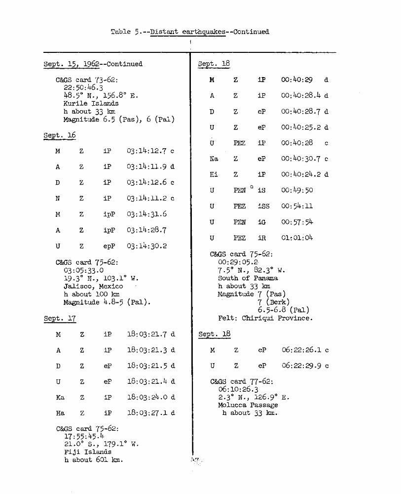
Table 5.--Distant earth~uakes--Continued
I :
sept. 15, 1962--Continued
C&GS card 73-62:22:50:46.348.5° N., 156.8° E.Kuri1e Islandsh about 33 kInMagnitude 6.5 (Pas), 6 (Pal)
Sept. 16
M Z iP 03:14:12.7 c
A Z iP 03:14:11.9 d
D Z iP 03:14:12.6 c
N Z iP 03:14:11.2 c
M Z 1pP 03:14:31.6
A Z ipP 03:14:28.7
U Z epP 03:14:30.2
C&GS card 75-62:03:05:33·019.30 N., 103.1° w.Jalisco, Mexicoh about 100 kInMagnitude 4.8-5 (Pal).
sept. 17
sept. 18
M Z iF 00:40:29 . d
A Z iF 00:40:28.4 d
D Z eP 00:40:28.7 d
U Z eP 00: ItO: 25.2 d
U FEZ iP 00:40:28 c
Na Z eP 00:40:30.7 c
Hi Z iP 00:40:24.2 d
U PEN Q is 00:49:50
U FEZ iSS 00:54:11
U PEN iG 00:57:54
U FEZ iR 01:01:"04
C&GS card 75-62:00: 29: 05.2-7.50 N., 82.3° w.South of Panamah about 33 kmMagnitude 7 (Pas)
7 (Berk)6.5-6.8 (Pal)
Felt: Chiriqui Province.
C&GS card 77-62:06:10:26·32.3° N., 126.9° E.Molucca Passage
h about 33 kIn.
M Z iF 18:03:21.7 d
A Z iP 18:03:21.3 d
D Z eP 18:03:21.5 d
U Z eP 18:03:21.4 d
Ka Z iP 18:03:24.0 d
Ha Z iP 18:03:27.1 d
C&GS card 75-62:17:55:45.421.00 S., 179.10 w.Fiji Islandsh about 601 kIn.
sept. 18
M
u
z
z
eP
eP
06:22:26.1 c
06:22:29.9 c

Table 5.--Distant eaxthquakes--Continued
Sept. 30, 1962
M Z eP 22:09:22.1 d
A Z iP 22:09:23.9 d
D Z iP 22:09:23.3 d
U Z iP 22:09:23.3 d
Pa Z iP 22:09:25.1 d
Na Z eP 22:09:22.6 d
Hi Z eP 22:09:24.7 d
','C&GS card 78-62:21: 57 :24 .8 '18.6° N., 120.9° E.Near north coast of Luzon, Philippine Islandsh about 51 km.
48;',1 ~

The following persons or agencies reported "felt'f earthquakesduring the third quarter, 1962. Their assistance is gratefully acknowledged.
North Hawaii
Mr. McKayMrs. EklWldHonokaa PoliceMrs. Christianson
Kilauea Summit region
Mr. and Mrs. :FrancisMrs. HansenDr. WentworthMr. RichterMr. YamamotoMr. YangMr. ForbesMrs. :FraserMiss EnglishMr. KoyanagiMrs. DuncanDr. MooreMr. WehrsigMr. and Mrs. MistMrs. FerryMr. Ayres
Kona coast
Miss WallaceMr. SutherlandMiss GreenwellMr. MitchellMr. ParisMr. AckermanMr. GreenwellMrs. HigashiharaMr. TanakaMr. GlassMr. Hayashi,Mr. Chong'Mr. BaldwinMr. VredenbergKealakekua PoliceMr. VanderbraokMr. Johnston.
Kona coast--Continued
Mr. AppleMr. LindMr. MitchellMrs. HigashiMr. ToyMr. YoshinaMr. HaraiMrs. HahnMr. S. GreenwellMr. Schattauer
Central Hawaii
Kulani Honor CampMrs. Lindsey
H~lo region.~
Mrs. ElliottMrs. ZsupnikMiss NittaMrs. DuncanMrs. HansenMr. WilliamsonMrs. IngledueMrs. SchaefferDr. HindsMrs. WeightMr. HoMr • and Mrs. Bal~win
Mr. WilsonMr. ChongMr. NorthwoodMr. Donahoe
Kau region
Mrs. ElarionoffMr. BillingsMrs • WaltersMr. CoramMrs. Akana
Kau region--Cont.
Mrs. KivaMr. MeineckeMr. G~dfrey
Puna
Mr. WarnerMr. EdwardsMr. Ho
NOTE: The Kona coast is· Hawaii's western coast, Kau is the districtsouth of Mauna Loa summit, southwest of Kilauea and on the flanks of bothvolcanoes. Puna is the cultural/political district which lies on theEast Rift of Kilauea.

Geologf:
UNITED STATES
DEPARTr-1ENT OF THE n~TERIOR
GEOLOGICAL StJR'VEY
HAWAIIAN VOLCANO OBSERVATORY
Sill.1MARY 28
October, November, and December, 1962By
Harold L. Krivoy, Robert Y. Koyanagi;
Arnold Okamura, and George Kojliaa
and
The 1962 Flank Eruption of ICilauea
by J'ames G. Moore
Issued August 1961t
Observatory Staff
Geochenlistry:
J'. G. Moore (Scientist-in-Charge)C. K. vlent'\forth
Geophysics:
G. KojimaH. L. KrivoyR. Y. KoyanagiA. T~ OkamuraA. S. Ryall
R. T. Okamura
General Support:
J. C. ForbesW. II. FrancisB. J. LoucksA. Yarnamoto

6
•
Contents
Page
The 1962 Flank Eruption of Kilauea, by.JamesG. Moore---------------- 1
Chronological summary------------------------------------------------Tilting of the ground around Kilauea caldera------------------------- 10
Seismic summary------------------------------------------------------ 16
Persons or agencies reporting felt earthquakes during the quarter---- 50
Publications of special interest and H.V.O. numbered contributions,1962--------------------------------------------------------------- 51
. Illustrations
Figure A. Map of the upper east rift zone of Kilauea showingvents and flows of the 1962 eruption------------------- 4
1. Map of the island of Hawaii showing seismograph stationsand localities mentioned in the text---------------··--- 9
2a. Tilting of the groWld around Kilauea caldera betweenJune 30 and October 30.. ---·----------------------------- 13
2b. Tilting of the ground around Kilauea caldera betweenOctober 30 and December 12----------------------------- 15
Tables
Table A. Area and volume of lava erupted in December 1962---------- 5
1. Tilt coordinates at Uwekahuna Vault, October, November,and December, 1962-------------------------------------- 11
2a. Tilt coordinates and cl'langes at bases around Kilauea
caldera------------------------------------------------- 122b. Tilt cooI'dinates and changes at bases around Kilauea
caldera------------------------------------------------- 14
3 · Numbers of earthquakes and minutes of tremor recorded onseismographs U, M, A, D, and N around Kilauea caldera--- 17
4. Local earthquakes recorded by seismographs of theU.S. Geological Survey, October, November, and December,1962---------------------------------------------------- 22
5. Dista~t earthquakes--------------------------------------- 37

•
I
HAWAIIAN VOLCANO OBSERVATORY SUMMARY 28
By Harold L. Krivoy, Robert Y. Koyanagi, Arnold Okamura, and
George Kojima
The 1962 Flank Eruption of Kilauea, by ,James G. Moore
On December 7-9, 1962, a small flank ~ruption occurred on theupper part of the east rift zone of Kilauea Volcano in and east ofAloi Crater. 'l'his outbreak occurred 15 months after the last previouseruption of the volcano which occurred on the lower (eastern) partof the same rift.
The first indication of the possibility of an imminent eruptionwas the onset of sporadic tremor &1d local Sllallow eartl1.quakes at1.9h3an December 6. The harmonic tremor rapid1.y be·came continuous andwas accompanied by small shallow eartllquakes averaging about one perminute. A few of tllese earthquakes were laltge erlough to be felt,particularly in the community of Volcano, 3 miles northeast of thecenter of the caldera.
At Olhl<f' December 7, a glow, described as white at first,changing to red, was observed from both the south side of the calderaand from the Volcano Observatory, toward the direction of the upperpart of the east rift zone. From each observation point, the glowwas seen to grow from virtually nothing to a prominent light visiblefor many miles. Hence it is believed that the first actual outbreakoccurred only slightly before it was first sighted. At Olh2om anObservatory party arrived at Aloi Crater on the upper east rift zoneof Kilauea Volcano and found a nearly continuous line of fountainsextending in a line completely across the wooded floor of the pitcrater (fig 0 2) 0 The fissure was about 500 feet long and wasslightly modified by right,..offset en echelon arrangement. The lavafountains wel"e playing to heights of about 30 feet with spurts upto 60 or 80 feet. Almost the entire floor of the crater was coveredby approximately 10 feet of new lava, but trees were still standingin many places on the crater f"loor even within a few feet of the lavafountains themselves.

•
&..
The fountai..l1s continued at about the same height until 02h20m
andgradually filled up the bottom of the pit crater. By 03rJ.Qam the fountainshad become thicker and increased in volume, and. occasional bursts t~xew
spatter above the opposite rim, or more trlatl 250 f'eet high" These largebursts were accompanied by loud booming soun·ds.
By o3ho5m the lava lake 'tvas apprl)ximately 40 feet d.eep and the lineof fountains had. consoli.iated to three a.reas of fottntaining" one neareach end of the original fissure and a la!Jge :four~tain in the middle of thepit crater. The rim of the pit crater was perceptibly shaking in rhythmwith the activity of the fountains. Shortly aftel' 03D.o5m the lava lakebegan to drown the fountain on the west.
By 03hOffl the :fountains died. down and rapid drainback into the ventscommencled. By 03h lom the fountains were a1.most qUiet, drainback (especiallyinto the west vent) having lowered the entire lava lake approximately 10feet. The crust of the lake was, in general, rJ.o longer incandescent,being perhaps 6 inches or a foot thick. Ho\\rever, cracks through the crustshowed the bright red of the molten lav'a below. Se\reral groups of cracksconcentric to the small bubbling west fountain indicated the process ofdrainback operating thereo
By 03h33m all tr.te fountains had stopped and drainback into theeruptive vents continued to lower the lake surf'ace. At 03h4~ a largepart of the south rim of the crater broke off and crashed down intothe lava lake which by then was entirely black on i.ts surface except fora few incandescent crackso The landslide broke through the lake crustand splashed incandescent lava 20 or 30 feet into the air 0) The appearanceof the boulders as they plunged into the lava l.ake suggested that itsdepth was 10 to 20 feet.
At 04h20m two new lava fountains broke out northwest of MakaDpu..'1iCrater on the west slope of Kane Nui 0 Ramo (no. 2, fig. A). Whilel~a was still pl~ing from these fissures a third outbreak occurred at04 45m one-quarter mile to the southwest hno. 3, fig. A). These fountainsplayed only for about one hour, and b~r 07 oam they were not active exceptfor strong degassing, though booming and roaring noises were heard fromtheir direction for several hours mareo
At IlhOzn a new vent (no. 4, fig. A) on the north side o:f Alae Crater(called Alea Lea Crater on some maps) began liberating fume. At 11h25mthis vent de,,-eloped a small lava 1'ountaLV). ~ Inc·an.descent spatter waserupted from this vent urltil llh33m, at wInch time the faint roaringsOWld died and erupting spatter was no longer visi.ble from the road nearAlae Crater.
At Cf7h03ID, Deeember 8, a ball o:f brown-yellow smoke was seen, from theObservatory, rising about 100 feet above th.e eruptive m-ea east of AloiCrater. The smoking which lasted about 20 minutes is believed to
2

•
have been caused by outbreak number 5 less than one-~arter mile northeastof Aloi Crater (fig. A). This vent was visited at 11 oom and the smalllava flow was still hot and incandescent in cracks at that time.
A sixth and final outbreak occurred between 08h3am and 09hl~December 9, about midway between Aloi and Alae Craters (no. 6, fig. A).The active vent was observed from the air at oSh4om. At that time athin line of fountains 300 to 400 feet long played to heights of 60feet, but averaged less than 30 feet. A rumbling noise was heardduring this period for about 20 minutes in the community of Volcano,5 miles north of the eruptive area. The lava flow from this fissurestarted a small forest fire which swept to the summit of the cindercone, Puu Huluhulu.
Minor falls of Pele's hair were reported on the road near AloiCrater at llh49Il and about 14hoom on December 9. Presumably thisoriginated from vent number 6 and was blown south at that time by winds.
Total volume of lava conducted to the surface during the entireeruption was 436,000 cubic yards (table A). However, 280,000 cubicyards drained back down the eruptive fissure in Aloi Crater leaVinga total of 156,000 cubic yards on the surface.
3

Kilauea19°25'
/954
•
EXPLANATION
Eruptive vents and lava flows of December 1%2eruption. Number indicates sequence of eruption.
Historic eruptive vent showinq year of activity.
S indicates only fume liberated. Lava flows not
shown.
Prehistoric eruptive vents. Lava flows not shown.
Normal fault, chiefly. prehistoric. Ball denotes
~ downthrown side. Circular faults around pit craters
not snown.
Contour interval 100 feet
SCALE
Figure A. --Map of the upper east rift zone of Kilauea showing vents and flowsof the 1962 eruption.

•
"
Table A·--Area and volume of lava erupted in December 1962
Lava flow Area Thickness VolumeSq. yds. yds. cu . yds. x 103
. x 103
1 (remaining on surface) 27 3 82
1 (drained back) (27 ) 10 (280)
2 (east flow) 23 1 23
2 (double west 'flow) 12 1 12
3· 16 1 16
4 1 1 1
5 4 1 4
6 18 1 18
Total remaining on surface 101 ----- 156
Total erupted --- ----- 436
5

"
! ..
Chronological summary
The most interesting event of the fourth quarter was the brieferuption of Kilauea in and near Alei Crater in December 0 Thissummary reviews the geophysical DUU~ife6tations that preceded andaccompanied the eruption for comparison with Moore's just-presenteddescription of the eruption.
After the sharp collapse d.uring ttJ.e September 1961, eastrift zone eruption (Summary 24), swelling of Kilauea volcano resumedand continued at a moderate, but dimin:tshing, rate until the endof June 1962. At the inner ring of tilt bases (Uwe, T M, Kea,Kam) the average rate of outward tilting declined from 12 }.Lrad/month(Oct. 8, 1961, to Jan 5, 1962, SUlmna..~y 25) to 51JXad/month .(March 29,1962, to June 30,1962, Slnnmary 26). ,Between June 30,1962,and October 30, 1962, (fig. 2-a and table 2-a) the average rate ofoutward tilting at these stations increased again to 8llTad/month.From the record of the short-base tiltmeter in Uwekahuna Vault(table 1), it appears that this increased ra/ce of swelling continueduntil the December eruption.
Subsidence of the caldera region in response to withdrawal ofmagDls,from the central reservoir d~ing the eruption is revealed in thepattern of tilting between October 30 and December 12 (fig. 2-b andtable 2-b) 0 The amount of subsidence is best indicated by thechange at Uwekahuna Vault (table 1), where a tilting of about 16
1J.radians toward the caldera occurred during the er1.1ption.Comparison of this figure with that which accompanied thecollapse of the Kilauea summit follo~ng the 1960 east rift zoneeruption suggests that 5-10 million cubic yards of magma escapedfrom the reservoir during the December erup~ion.
By the end of December swelling of tJ:le Kilauea- summit "r..rasagain in progress.
The daily count of small' shaJ..l~)w eaJ.--thquakes at ~ilauea calderaaveraged 63 du.ring the fir'st two weeks of October. On October 16this number jumped to 90, and by October 31 it had reached 155. Thecount climbed to 460 on November 7, then decreased slowly to 208on November 18. These earthquakes averaged only 54 per day duringthe rest of November. From an eleven month low of 20 on December1, the daily count rose to 110 on December 5, just before theeruption. Following the eruption, the average daily number ofearthquakes from the caldera was 38 for December 10-18, but roseto 133 for the r~st of tIle month.
Possibly indicative of 8" rapid :flow of m.agma at depth, episodesof continuous tremor originating beneexh the Kilauea summit totaled177 minutes during October and 101 minutes during November.
6
Harmonic tremor beginning at 19h30
mon December 6 (Introduction)
testified to the escape of magma from the summit reservoir, and theconcurrent swarm of' small shallow earthquakes from the vicinity of AloiCrater heralded the opening of fissures along the rift zone for about5 hours before lava appeared at the surface early on December 7. Theseearthquakes were all smaller than magnitude 207, and only the largestwere felt in the nearby community of Volcano.
Earthquakes from the source about 30 km beneath Halemaumau averagedabout 2 per day during October and November and 5 per day duringDecember. Only one was felt : it had a magnitude of 3 0 7 and was felt overthe entire island at 21h36ID on December 130
The largest earthquake during October originated at l3h3lm
on the31st about 15 km north--northeast of Naalehu alld 3 km deep 0 It had amagnitude of 3.7 and was felt in Naalehu. The largest earthquakeduring November had a magnitude of 401 and originated at 05hl8M onNovember 22 at about 19°20' N., 155°05' W. (Kalapana Trail). It wasfelt from Volcano to Hilo.
An earthquake from a focus 13 km east--northeast of ~ua Point and8 km deep was felt over half of the island at Olho6m on December 28.It had a magnitude of 4.1 and was the largest earthquake of the month.A magnitude 4.0 earthquake from a focus 18 km north of Naalehu andabout 3 km deep was felt over half the island at l7h47m on December 30.
other earthquakes felt in Hawaii during the fourth quarter (23 inaddition to those associatec. with the outbreak of the December eruption)are included in Table 4.
starting with the eruption, small shallow quakes have become frequentall along the Koae fault system just south of Kilauea caldera~ Suchearthquakes have not been frequent in recent yea:rs, except at times ofmajor collapse such as the spring of 1960.
During this quarter, George Keller, U0 S 0 Geological Survey, visitedHawaii Island and carried out assorted electromagnetic and electricalexperiments~ He found, among other things, that the electrical resistivityof Hawaiian rocks was very uniform and that three classifications werepossible:
1). very recent flows had resistivities between 5,000 and 10,000ohm-meters,
2)., the bulk. of' Hawaii Island above sea-level had resistivitiesbetween 500 and 1,000 ohm-meters,
3). at or below the water table, resistivity was less than5 ohm-meters.
Electromagnetic studies by Frank Frischknecht and Leonard Anderson inApril 1962 revealed a resistivity of 102 ohm-meters for the still-moltenportions of the 1959 Kilauea-Iki lava la.'ke.
7

\
During the quarter a Scripps Institution experiment in noiseanalysis was completed and equipment removed from lIVO. Thisgear included a short-period installation and a three-componentlong-period set established in the old West Pit tilt cellar. At thetime of their departure there were extra tele-recording channelsavailable at HVO, and so the abandoned data-lines were put to use andrecordings made from West Pit. These have proven to be very usefulin clarification of small seismic events near Halemaumau. Thenew instrument (West Pit = wp) is located between the western edgeof Halemaumau and the western rim of Kilauea, caldera. It isnot convenient to plot this new installation at the scale of Figure1.
8

EXPLANATION
• 'ettIM.,. Ste"• TOWfl Of loeellty
L....I\e..... ----l..- 10.
, , ...IO_====, !O '1 .......
(Oft'.'" ."tef~ 1.000 f... I
D.'•• It _ ...
' ....,.,... ., UI ..,..,
\. .J
" 0
-----1------- I ••
I
~--"-I~............................~.........................................~-""-Io.!...........:""'--................~.l.~.l~ .................................................-.........~"""""""_...&....L..""_L..,ju...J...J...J.._...J
Figure 1. --Map of.' the island of Hawaii showing seismograph stationsoperated by the Geologic~ Survey and localities mentionedin the text. Epicenters of local earthquakes are given interrns of geographic coordinates, which arte indicated at theedges of the map.
9

Tilting of the ground around Kilauea caldera
Tilting of the ground around the summit of Kilauea is monitoreddaily by a short-base water-tube tiltmeter in Uwekahuna Vault (table 1)and at irregular intervals it is measured on a regional scale by meansof a network of field tilt-bases and a portable water-tube tiltmeter(table 2). The attitude of the ground surface at each tilt base isreported in terms of north-south and east-west tilt coordinates. Bothcoordinates at each station were arbitrarily set equal to 500 whenmeasurements at that station were begun. Increasing tilt coordinatescorrespond to northward and eastward tilting of the earth's surface,that is, to a relative subsidence toward the north and east. A l-unitchange in coordinate corresponds to a tilting of 1 microradian (1 nun perkm) in the direction indicated.
10

Table l.--Tilt coordinates at Uwekahuna Vault, October, November,
and December, 1962
Date N-S E-W Date N-S E-W
sept. 30 457 505 Dec. 2 472 487
Oct. ·7 459 5014- 9 462 499
14 461 503 16 467 502
21 463 500 23 467 497
28 465 491 30 462 496
Nov. 4 467 497
11 468 496
18 469· 495
25 470 1~90
11

t-'I\)
fl"
Table 2a. - -Tilt coordinates and changes at bases around Kilauea 'caldera (see :rig. 2a)
-Tilt coordinates
. 6Tilt base Date Rate (10- rad/me ) Date of(location) (1962) and direction of last
tilting since readingN-S E-W last reading (1962)
.~.
Uwekahuna(19°25.5' N. , 155°17.4' w.) Oct. 30 447.0 496·3 7·1 N. 29° w. June 29
Tree Molds(19026.3 ' N. , 155°17 .3' w.) 31 438.. 5 512.8 2·9 N. 9.3 0 w. 29
Sand Spit895.1(19°24.1 tN., 155°16.8' w.) Nov. 1 7CJ7·7 6.7 N. 7.3 0 E. Mar. 29
Kalihipaa574.4(19 0 21.4 1 N., 155°15.3 1 w.) Oct. 30 4Z7.1 2.6 s. 28.5° E. July 5
Keamoku(19°25.1' N., 155°19.0' W.) 31 481.3 598_3 7·4 N. 58.5 0 w. June 30
Ahua Kamokukolau(19°22.7' N., 155°16.6' w.) 26 652.6 522.0 14.0 s. 13.5° E. July 1
Kipuka Nene514·7' 495.2(19 0 19 ~ 4' N., 155°16.7' W.) 25 .26 s .. 18° E . Apr. 5
Hilina Pali(19°18.2' N., 155°18.6' w.) 24 512.0 496.1 ·5 s. 35° w. 4
Kapapala Ranch155°23.8- w.) 497.6 504.4(19°20.5' N., 23 .6 s. 51.3° E. Mar. 30

---.2.5 X 106 RADIANS I MONT'.'
-~2000
I5 KM
30, 1962
I
Figure 2a.--Tilting of the ground around Kilauea caldera between
June 30 and October 30.
13

Table 2b.--Tilt coordinates and changes at bases around Kilauea caldera (see fig. 2b)
Date> Tilt coordinates ( -6Tilt base Rate 10 rad/rna) Date of(location) (1962) and direction of- last
tilting since readingN-S E-W last reading ,( 1962)
Uwekahuna(19°25.5' N., 155°17.4' w.) Dec. 10 437·3 499.6 7·7 S. 18.7° E. Oct. 3C)
~
Tree }JIolds(19°26.3' N. , 155°17.3' W.) 12 435.8 512·5 2.0 s. 9.5° w. 31
Sand Spit155°16.8' w.) 891.4 4.7 54.8° w.(19°24.1' N. , 12 702·5 - s. Nov. --,
Kalihipaa155°15.3' w.) 575.4 423.8 72.~o w.(19°21.4' N. , 11 2.5 N. OCt. 30
Keamoku(19°25.1' N., 155°19.0' W.) '11 474.4 605.4 7·3 s. 46.,2° E,. 31
Ahua Kamokukolau(19 0 22.7' N~, 155°1~.61 W;') 10 658.1 521·7 3·7 N. 2.5° w. 26
Kipuka Nene510.4 496.1~ 2.8(19°19.4' w., 155°16.7' W.) 13 ,.,
15° E. 25e>.
HilinaPali(19 0 18 .2' N ~ , 155°18.6' w.) Not occupied this epoch. 24
Kapapala Ranch155°23·8' w. ) 497.6 504.9(19°20.5' N., Dec. 19 ·3 due East 23.
.. ,

..
2000
1---1RATE 2~~ X 10· RADIANS/MONTH
30, 1962 - DEC' 12, 1962.. I
t\ KM
Figure 2b. --Tilting of the ground around Kilauea caldera betweenOctober 30 and December 12.
15

Seismic summary
Events recorded by the U.S. Geological Survey seismograph networkin Hawaii fall into two categories: local earthquakes and tremororiginating in the region of the Hawaiian Islands, usually within 100km of at least one seismograph, and distant earthquakes originatingmore than 3,000 km from Hawaii. As an index of seismic activity atHawaiian volcanoes, daily counts of earthquakes and minutes oftremor recorded by seismographs in Hawaii are listed in table 3. Theearthquakes are separated irito groups on the basis of region of origin'as determined by analysis of records obtained daily at the Observatory(U, M, A, D, N). Earthquakes of magnitude 2.5 or greater aregenerally sufficiently well recorded to be located with greaterprecision; they are list~d individually in table 4. Data on indentifiablephases from distant earthquakes are listed in table 5.
Locations of the seismograph stations are shown on figure 1) andessential data on the stations were given in Summary 25.
16

•
Table 3o~~Numbers of earthquakes and minutes of tremor recorded on
seismographs U? M? Aj Dp and N around Kilauea caldera
Tremor is separated into three categories~ deep, intermediate, .and shallow, on the basis of relativeamp11~udes on seismographs in the smmnit region. Unless otherwise st~tei, tremor is presummed tobe associated with movanent of_magma within the central complex of Kilaueao
Earthquake categories are: Halemaumau rock slides, which are detected by the characteristic recordthey produce on the Nnrth Pit seismograph; shallow earthquakes in the Kilauea caldera region; shallowearthquake:~ alon.g the":SWo rift zone of Kilaue~ and the adjacent portion of the Kaoiki faultsystem; earthqUaKes along the eastern half or Kilauea's east rift zone; earthquakes from asource about 30 kIn beneath Halema.umau; shallow earthquakes 'along" the Kalapana Trail (SE ~ flankof K11aue~ 10 to 15 km Woof Kalapana); and earthquakes from other regions: Kana, Mauna Kea,etc 0
..Tremor
(in minutes) EarthquakesDate
(1962}Hale.., SWo rift Eas"tern Hale.,., Kalaca
Inter~ maumau. Kilauea and East maumau pana OthersDeep mediate ShalloW' f?lides Caldera Kaoik1 rift 30 km Trail
Octo 1\ =cooOCJ 3 ... c:>c::aCJc::lC:>eo CJc=t~c;:)C2c:g 81 7 . - 7 <::tCD c:::s ClCJQII C:::Sc.:Jc:> CDCOIQaI 1 Kona2 cpoO~CJO e;,eo .. c:>e::tCJc:D c::lIaoCl:)CJ~CJc:::D CDoCJc:>e::t=CID 68 13 C2CJc:::.c::>c::>C3 1 11 C::>~c=tC::>_c::>_CJ~~CJ_~=C::>~C::>C:::S
3 C:>CJOe:::tO~ c:::Jc;::)c;:)CJc::.3C:)c::> e::tCJCJ=CJCJc::II C:>CJC:::JC:>~CJ 42 11 ~~C:::SC::>C::»CJ 5 9 1 Kona4 21 CJCJCJClCJC::;)e;::, C:::>CJc::a=CJC:::>c::I C3c::1c::1C::;)C::>C::» ? 7 ~~e::tC)~c:> i Cltc::JC::»C::>CDCIO 1 Kana5 e::tO~c::JCJC:> C)c:JC::>c::Ic::::J=c::J c::>C31CJc::JCJc::JCJ ClDc::>c::>C:>c:>c::;) 81 7 1 =CJC)C)e::t~ _=CJc:::>CJCCt 1 Kona6 c;:)C:SCDCJ~CD ~UDC:::>C::>C:>C:::>c=t = CJC:=C:::>CJCJc::I 1 ? 3 6 2 4 1 Kana7 ~C;:)CJC:::>ClIC::> ~CJC:>CJ<Sl~CD =CJQD~ClDc::I~ (:DICDC)C")=C) 90 3 4 1 3
CJC)_e::t ____ ~ ____ e::t_~_~
8 c::Je::tC)c;:)e::tC2 5 e::tC2e::te::tc::.3e::tc:> ~CZlC::>OC::>ClD 7 1 2 6 CJ==c::IC::::>_~~____ C::>~_~CZI___ c::lIc:::se::tc::ll
9 45 c~_e::tc:o __ c::> ~C2e::t_=c=-aaCD ~ClDCQC:>C:>CD .75 10 CC)C2c;:)CJc:D 5 C.:JC)C::>c..-:>C3~ 1 Honokaa
10 c::::::c:>c::>c::aC)c:D c::>c::ae;,c::aCJc;:)C) c:::::1CJcaCJ~C::>CJ COc::> C)C" CD_ 59 8 C:>c::lICDC><3_ 1 ("=>~~~~CD
~---~~--~~~~--~~~~~
11 cD"'C:lc;::)C)QD ~C:lc::IC=-C=-C:lCD C)e:::tc::.e:::tc» CD CD Cb~C)C)c:::oaa 65 1 C»CJCZ:>C=>CD_ 3 cDc)CJC::»C'c::I 1 Mauna Kea

Table 3.--Numbers of earthquakes and minutes of tremor recorded on
seismographs U, M, A, D, and N around Kilauea caldera--Continued
Tremor
Date (in minutes) Earthquakes
(1962)
\ Hale- SWo rift Eastern Hale .... Kala-Inter- maumau Kilauea and East maumau pana Others
Deep mediate Shallow slides Caldera Kaoiki rift 30 km Trail
-
Oct~ 12_ ca ___
.. _c-. .. ____ e- .. _ .. _ClD _ -------- 60 8 -- ..--- 4 ~c:::Jc.c:J_
~~-~~----~---~-~--~
13 ----- -.... ---- e. .. _ .. c::. .. ____ c.- __
63 13 3_____ IID
.. e::te::tc;a-=s~-~-~--~---~--~--~~
14 __ ~CI:iI"
e-.:I_ ....a._ --_ ..-_.. ..-.._.... 63 18 1 3 _ ... caca~ - 2 Kona15 ------ -_.....--- ------- _ .. _ ... _e- 65 7 ... 5 1 c:. .. a::aL3_ 2 Kawaihae16 10 __ c=- .. --c._ _ca~ .. _.,_ ------- .. 90 3 ------- 6 c:::Ilca" __ 1 Kana17 ----- 28
___ .. C;J __ --_..-- 111 12 1 9 CD c:'2e::::t et-. 1 Mauna Kea18 -_ ..-- --~_ ..-.. -------- ..__ c:.-_e-I 96 6 1 2 c::.c»_c:a .. 1 Kona19
___ ca .. _ -----..- 7 ---.e::-a._ 98 9 1 ..-_ ..-.-- .. c:.e- ___ 1 Mauna Loa1 Kana
20 .,--~-
_____ aac._ -------- 1 120 7 1 2 1 -~~~~~~-~--~-~~--~-
21 .... 5$_ .. .._......-.. ____ e:--_ ..; ..._-- .... 135 7 1 5 c:.-=- ..~ .. 1 Kana
22 "C!:II_~"_~ ..... _~c:. ------- ...... CIIIiIl __ 116 9 1 3 «:IOI::tc=-C'2I_
~-~~-----~-------~~
23 c:::D_-=ca._ .. .....-..~~ .. - -..---_ .. _e:- ____96 15 1 2 ~CZ!I-'C»"
-~------~~-~~-~~~--
24 _.~a.e:w _ .. _ .. o. ..~"
C::ID ____ e- ___
~----- 106 7 3 2 5 1 Kona25 c._ ...... ~ ..-_.._- 10 ---~-.. 95 7 1 2
____ -coo
1 Ku1ani26- 35 5
___ cw ____
-- ... --- 126 6 a.u. .... __ .. 2 ~e:-.-=»c:a ..~~--~~~---~--~~~~-~
27 _.. .." ..- t:8~_ .. _ .... ..... a::I __ ~_ .._---- 137 9 1 2 _ .. c::a.-:t_ 1 Kona28 .. a::I __ .. 1 -_.._~-- _.. _.- .... 130 11 19 2 .... C"K:)«:::Il ..
~---~--~---~-~~--~-
29 _.. --- .. 4 -------- --_ ...... 135 8 10 2 ~_-=a_ .. 1 Pahala30 2 1 -_ .._~ ..- , 140 15 1 5 -=--=--_1-'
--~-~--~---~--~~--..1-
31 .......-- -- .._---- .. ~--' ...... _ ........ c-. .. 155 8 1 ------- ...c:::. ___ c..
1 Mauna LoaNov. 1 -..,~--~ ------- -- .._--- -.._--- 178 4 1 6 1 ~--~~~-----~---~_ ...
2 ----- 1------- ~----- .. -..---- 160 4 2 3 ~_c=-e._ 1 Mauna Loa2 Kona

Table 3o--Numbers of earthquakes and minutes of tremor recorded on
seismographs U, M, Al D, and N around Kilauea ca1dera--Continued
Tremor(In minutes) Earthquakes
Date(1962)
Hale- SW. rift Eastern Hale- Ka1a-Inter- maumau Kilauea and East maumau pana Others.
Deep mediate Shallow slides Caldera Kaoiki rift 30 kIn Trail
Novo 3 20__ CD:~__ c::I ------ ..~ .._-- 157 5 _"_c:l __ ___ e:t .. .,
-~_ .. _- 1 Mauna Kea4 __ -=-_IIID 3 14 - ... ---- .. 187 8 1 --_.... ~ .... c:»lIII:Ca_CIaI
~~~~-~--~~--~-~~-~
5 C3J ___ aos --_ ...._.. .. c::a _____ .. __ .... - 250 7 3 1 2 ~~--~-~~-~-~~~~~~~
6 CD .. ca .. _ -------- 8 2 180 3 2 2 1 1 Pahala7 2 ~ .._~ ....- 11:8 ___ "_ -------- 460 10 2
__ ... _c=-~1 ~~~~~---~-~-~~--~~
8 .. __ .... ..--=--_ ..... _..~ .._-~--_ .. -=- 300 8 12 4 ·6 1 Offshore Naalehu
9 ..-..~., QD_-=t ..~ .. _ _ .... c._~ _.._-~- 226 11 1 1 "_c::I~_" 1 Ma1.Ula Loa10 --- .... ------- .._..~-- 1 288 4 .. .. _--.. 1 "~c:a __ -=a 2 Kana11
__ e- ___ ------- ------ ------ 87 26 1 3 .. ~e:t .... _ 1 Kona12 __ .-_c. .. -_ .. -=- .... --_ .. _- ------ 145 6 e:-_ .. ___ 4 cw_c:ac:. ....
~---~-~~~~---~~-~~
13 -._--- -- .. - ..-- _.. _--_ ..--~ ..-- 235 9 ~_ .._-- 3 2 --~--~~~-------_ ..~
14 -_ .._- -- ..---- - .... --- __ e- .. _ .. 256 6 1 -.._-~ .. -- .. ~.., ..-------~--~~----~--
15 --_ .... -_ ... _--- -- .. ---- ------ 228 10 9___ -=t __
_~ca~e-_ 1 Kona16 .. --- ..~ -....._--- .._--~- -..---~ 220 8 2 1 ~ .. c:a .. __ 2 Kana
1 Mt. View17 _......- ------- --- ...... _- ~_ .._-- 220 11 4 c._c. ..... ~ c::. ...... _ ... 2 Mauna Kea18 .._.. ..,- ...------- .. --=---- .., .._~_ .. 208 3 3 2 c:::. ..... __ .. 1 Ma1llla Kea
1 Kana19 -- .. --- 6 -..-~-- -_ ....-- 143 8 3 1 -- ..~ ..... 1 Kona20 coa_ ...... .._-_...... _.._...... -=--- .... -- 86 5 2 3 7 1 Kawaihae21
___ e:II~ .._------ _cm_ ...... --_ ..-- 52 6 ..,_-=:I_ca ___ e.- _______ ------ ~----~---~---~~~---
22 --- ..-- 6 --_ .. - .. ----.:I_- 53 2 4 3 CZI_~"' __
--------------~----23 _..._-- _.. __ ....- ------ 1 48 4
__ ct .... ___ ---_ .. .., 4-----------~-------
24 ----- ------- ... ----- ---_ .... 65 11 3 1 ----=----- -~~-~-~--~~--------
25 42 ------- ------ ----- ..- 45 3 1 ------ ..._---- 1 Offshore Naalehu

I'\)o
Table 3e-~Numbers of earthquakes and minutes of tremor recorded on
seismographs U, M, A, D, and N around Kilauea caldera --Continued
Tremor(in minutes) Earthquakes
Date(3.-962)
-.., "'
Ha1e- SW. rift Eastern Hale- Kala-Inter- maumau Kilauea and East maumau pana Others
Deep mediate Shallow slides Caldera Kaoiki rift 30 km Trail
-
Nov. 26 c:::aCD ___ c:D_ "C8_"c::D __ _c::II_~~CIIII_
___ aa_ca 37 7 6 c::aC:»~a::llJGD c::::I c::.e::::ta::-c:at:::2e:::::t~~---~--~~~-~~~~~
zr CDJ-=-CD'.:w ___ ...... ___ -=-ce --- ......- ----=».... 25 2 2 _C:»C:;::)ClIliD't::::ac::JIc:;)c;::» __ c:a
~~~-~~~~~-~~~~--~
28 ___ C2C1l"
_c:::aaa.-cmt_ .. -_ .. .., ... --- _caca __ -. 24 2 2 _C::IcatlD_e::a c::Jc:=c:::J .. ~CIII
-~--~-~-~--~~-~-~
29 .. ~.,_ .... _~ .. c.GCI'~_
__ .. CI:I ___c.. ____ ~ 32 5
.:3 _____ ca
1 C2lC::tG:Jl_ ....~~~---~--~-~~~~-~
30 e:- ..... ___ -------- ___ e-a- .. ~ .. e- ____ 41 4 3 -8 c::::~c:aGD"'.a
~~~~---~-~-~-~-~~
Dec. 1 -=a~a. ..~_e- ....... __ .. -=-c::;a_.:t_ .... _"'c::D_aa~ 20 2 4 30 e::;;,co c. .. .., CI:8
~~~~-~-----~~~~--
2 c:D .. _ .. ea;,,~ -- ....-_ ... ___ ~ .. c:II_ ___ .. _a:- 45 5 2 5 1 1 Koha1a3 ca_ .... CD ..
_CIJilt-. __ tct_ _.._----- 6 48 12 1 1 e;:::,c::.ca..-_-=a 1 Mauna Loa1 Kona
4 ca:ac.-a.eDca ...
.. _ca _____ .. ~_e:. .. _ 2 97 10 _.._.._-~ 2
e:tc::a~ ___
~~~~-~-~~~-~-~---
5 e-_e-_-=-'" _ .... e»CD_ca _t:D_-.:a .. ~_ _______ c=I
110 16 3 5 c::ae:::tCI::ICDCD _ I-Kana6 ~oi eruption ------- ? 13 1 4 c;::)c::3e:::::-e::::t_e. 1 Hilina-Pali1 lA,loi eruption
______ -.D
? 11 2 15 c::ac:::ae:;, .... ~ 1 Laupahoehoe2 Apua Pt.
a Aloi eruption 1 ? 10 C2"~__ "_ 15 c=~e:::t .. __
---~--~----------
9 Uoi eruption 2 ? 23 cmc=- ___ .-"' __ 2 c::aCOC::II_c:::._ 1 Mauna Kea10 ~., .. __ ..
~~"_~C18_ c.-_CIIIe:t .. a- ... ~- ....... _- 24 15 110 g;a; e- CD C2l =-- c;::a 4 c:;:)t:.3Ie:::t ___ ., 1 Mauna Kea11 cae- cz::a~ca CD ~ .... "'_a:a4D _.._.._-- 1 19 10 tr:Jc.-c:::-c=:tc:a_c:a 4 e=c:ac::;;aa-t=l_ 1 Apua Pt.12 .-:rCl8 .... ca ..
____ -.:Ja::a .... -=ac:a.,. .... _ ...-_a-ca_ .. 40 13 .:;a~"»a::t"'''~ _ 1 3 1 Mauna Kea
1 Mauna Loa13 ------ --=~ .. _-=- ....
C31 ___ ~ __ ..... c.._ .. __ 45 22 Q:._CD .. ____ 12 1 2 Mauna Loa

I\)....,
Table 3.--Numbers of earthquakes and minutes of tremor recorded on
seismographs U, M, A D, and N around Kilauea caldera--Continued
Tremor(in minutes) Earthquakes
Date(1962)
\/
Hale- SW. rift Eastern Hale- Kala....Inter- maumau Kilauea and East maumau pana Others
Deep mediate Shallow slides Caldera Kaoiki rift 30 kIn Trail
Dec $ 14· ,j---- 2 ---=----- ------ 30 15 1 __ .. e-_'-'c.c.-C7caca 1 Hi1ina Pali
15 ---- ....__ .. -.- ---_..-- ------ 70 16 1 9· .. c:a~~c:::D~~-~~-~-~-~-~-~~-~~-~~
16- ---- ---- ....- ........__ ....-~..,_ .. 47 22 2 2 .. c:."~c=tl" 1 Hilina Pali
2 Offshore Naalehu17 ---- ------- -_ ...._-- ------ 39 5 ----- 4 c::a.~~"ca ..
~---~~~~-~~~~-------~
18 ---- 2 ----- ..- ------- 30 14 -~ ....- 4 -.c. .. CC2 .... 1 Hakalau1 Pohakuloa
19 10 ------ -=---_ ....- -_ .._-- 76 21 ~---- 3 _-=--=a .. c:aCII 1 Keahole Pt.20 ---- ........ca_ -- ... ----- ------ 69 8 --_ .._- 1 _ .. e.-_c:a .. 1 MatUla Loa21 ---- ..........- _-=t_ .... .:._ ------ 85 15 .. _ .... e:- 3 _-=tc=-C:llcac., 1 Maui
2 Kona22 --_ .. .. ______ -e. -......_-- ------ 82 14 ----- .. 2 ~ .. c::.c:;J"_
~-~~~~-~-~~~~-~-~---~
23 -26 ------ ..-......_- "_ClIe ____90 19 _.-:a_ .. -=r 4 c:::a C8 C8 c:a-=t Cit
---~~--------~-~--~~-
24 ---- 3° --_ ...._- 1 74 17 ca .... .,._
e:- ____
CDC8-=aC8C=:JCIl 1 Kana25 23 ..-.._.... ..-----_.. _... _--- 116 9 2 2 ........ ca .. 1 Kana26 ~_ .. c.- -..-....- __ ca_aD __ _.....-..- 94 20 3 10
_-=-c=t ____1 Kona
Z7at ___
.. __ .. aa~.... c. ____ _...----- 124 14 .. c.c:a .. _ 2 c:I ___ .... 1 Kana
28 ---- ------ ...... ..,.~- .. ------ 97 8 2 3 .......... ~c:::J,_ 1 Kona1 Apua Pt.
29 ---- ------- -~- ...._- 2 89 9 ..~ .... c:a., 5 caac:a-.z:t ..... _ 1 Mauna Loa30 19 -=---_ .... .,. ...._---- ..------ 96 11 --.....- 1 .. .,c::a-=- c._ 1 Kona
1 Mauna Loa31 6 ..---_ .. _.._---- .._---- 103 10 ----- 2 _~..,C8.:J .. 1 Mauna Loa
1 Kana
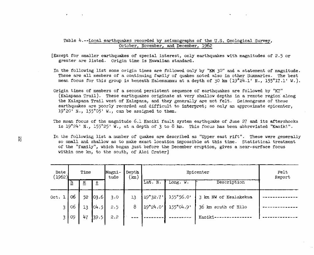
f\)f\)
Table 4. --Local earthquakes recorded by seismographs of the U.S. Geological Survey,October, November, and December, 1962
[Except for smaller earthquakes of special interest, only earthquakes with magnitudes of 2.5 orgreater are listed. Origin time is Hawaiian standard.
In the following list some origin times are followed only by "KM 30" and a statement 6f magnitudeoThese are all members of' a continuing family of quakes noted also in other Summaries. The bestmean focus for this group is "beneath Halemaumau at a depth of 30 kIn (19 0 2401" N., 155°17.1' We).
Origin times of members of a second persistent sequence of earthquakes are followed by "KT"(Kalapana Trail). These earthquakes originate at very shallow depths in a remote region- alongthe Kalapana Trail west of Kalapana, and they generally are not felt e Seismograms of theseearthquakes are poorly recorded and difficult to interpret; so only an approximate epicenter,19°20' No, 155°05' W., can be assigned to them.
The mean focus of the magnitude 6.1 Kaoiki fault system earthquake of June 27 and its aftershocksis 19°24 tN., 155°25' w., at a depth of 3 to 8 kIn. This focus has been abbreviated nKaoiki tt.
In the following list a number of quakes are described as "Upper east rift".. These were generallyso small and shallow as to make exact location impossible at this time 0 Statistical treatmentof the "family", which began just before the December eruption, gives a near-surface focuswithin one kIn, to the south, of Alai crater]
Date Time Magni- Depth Epicenter Felt(1962) tude (kIn) Report
h m s Lat. N. Long. W.. t'>- Description- -
Oct. 1 06 52 03.6 3·0 13 19°32.7 ' 155°56.0' 3 kIn NW of Kealakekua --------------
3 06 13 04.5 2·5 8 19°24.0' 155°04.9' 36 kIn south of Hila -------------~
3 09 47 39·5 2.2 --- -------- --------- Kaoiki-------~------- ---------------

f\)w
Table 4. --Local earthquakes recorded by seismographs of the"·U. S. Geological Survey,October, November, and December, 1962--Continued
Date Time Magni- Depth Epicenter Felt(1962) tude (kIn) Report
h m s Lat. N. Long. w. Description- - -
Oct. 3 12 55 34.5 2.1 3 190 23.5' 155°05.4' 36 kIn south of Hilo .... _____ .. e- ____
3 13 19 32·3 2.2 3 19°21.4' 155°04.6' 40 kIn south of Hilo -------------3 15 46 02.5 2.2 3 19~19.8f 155°04.0' 43 kIn south of Hilo .. ----_.. -.... - ....
3 22 31 26.8 2.8 --- ------- -_ .._-~-- KT----------------- ------.-------
4 03 07 29·5 2·7 3 19°26.8' 155°44.2' 21 kIn ESE of _. _.._--_ .. __ ....--Kealakekua.
4 03 11 20·5 2.4 5 19°19.1' 155°04.0' 44 kIn south of Hilo ---_ ..-.-_-----
5 14 56 23·3 2.·8 13 19°34.2' 155°53.4' 7 kIn WE of ----.-_--------Kealakekua.
6 14 02 41.2 2·5 --- ...._----- _.... __ .._- KT---------------- --~-_ .. _- .._---6 15 15 01.2 3-5 8 19°22.8' 155°03.0' 17 kIn SW of: Pahoa -.. ----- .._----
6 15 21 38.0 3·0 8 19°21.2' 155°03·4' 20 kIn SW of Pahoa -------- .._~--
6 21 57 -19.6 2.2 3 190 22.7' 155°08.5' 14 kIn east of -..--- ..~------Ahua seismometer. !-':"::"",: , . . ~;;;"".:.~',~ ......
6 22 16 08.9 2.2 8 19°21.0' 155°08.5' 14 kIn ESE of ..~--- .... _-_ ..--Ahua seismometer.

Table 4.--Local earthquakes recorded by seismographs of the U.S. Geological Survey,October, November, and December, 1962--Continued
'.
Date Time Magni- Depth Epicenter Felt(1962) tude (kIn) Report
h m s Lat. N. Long. w. Description- - -_.. -
Oct. 7 02 11 37·7 2·9 8 19°28.6' 155°50·5' 10 kIn SE of Kealakekua_______ ~ .. c. ______
7 13 32 29.6 2.2 10 19°18.9' 155°11.5' 10 kIn SE of Ahua .. _----------------seismometer.
7 13 33 25·0 2·3 10 19°18.9' 155°11.5' 10 kIn SE of Ahua ----_ ... _-- .._--~--seismometer.
7 18 47 46·3 3·1 8 19°18.8' 155°03·0' 24 Ian SW of Pahoa -------------- ... -
7 21 54 35·1 2.2 --- ~-- ..~-_ .. _.._------- KT--------------------- -------- .... _----- ..
8 03 32 27·5 2·3 --- --~ .._--- --------- KM 30------------------ ----------_ .._---8 07 40 44.9 2·5 13 19°19.5' 155°05·9' 20 kIn SE of Ahua
---~-------------seismometer.
8 21 12 28.6 2·3 --- ------- --------- KM 30---------------~-- .._-----------_ ....
9 09 21 38.6 3·3 13 20°13.6' 155°31.0' 16 kIn NNW of Honokaa ----------------10 21 35 34.7 2.4 --- --~----- --------- KM 30------------------ .._-~~_ .. _-- ..--~--
11 11 03 16.0 2.4 8 19°52.2' 155°29·1' 28 kIn SE of Kamuela -------------- ..
13 04 12 47.7 2·3 50 19°29.0' 1550 21.0' 5 kIn ESE of Mauna Loa ----- .._----- .... -seismometer.

f\)\J1
Table 4.--Loca1 earthquakes recorded by seismographs of the U.S. Geological Survey,October, November, and December, 1962--Continued
Date Time Magni- Depth' Epicenter Felt(1962) tude (kIn) F.eport
h m s Lat. N. Long. w. Description- - -..
Oct. 14 16 48 43·0 2.2 8 19°13·8' 155°09.8' 20 kIn SE of Ahua seismometer -------------
14 18 56 28.2 2.1 13 19°22.6' 155°08.1' 15 kIn east of Ahua -------- ... _----seismometer.
15 00 35 26.0 3·3 8 19°37 ' 156°09 ' 28 kIn WNW of Kealakekua----- -----_ .. ~--- ... -
15 02 08 48.3 3·2 --- -------- ------_ .... Km 30----------------------- --------------
15 04 23 15·7 3·3 13 19°40' _156°20' 46 kIn NW of Kealakekua------ -------------
15 15 37 28.7 2·7 8 20°01.2' 155°53·1' 20 kIn west of Kwmuela------- --------------
15 16 47. OO'~7 2.6 8 20001~2' 155°53.1'- 20 kIn west of Kamue1a------- -------_ .. _----
15 22 23 43·5 . 2·3 8 19°(){·7' 154°57.0' 41 kIn SSW of Pahoa---------- -------~-----
16 03 15 26·1 2·3 5 19°3C':"J. ' 155°40.6' 25 kIn east of Kea1akekua---- --------------
17 03 12 56.8 2.8 13 1904d.o' 155°42·7' 26 kIn south of Kamue1a------ .. _----~-------
17 21 59 01.0 3·0 12 1/2 20°05' 156°59' 112 km SW of Haleakala -- ... ----------seismometer.
18 03 07 37·5 2.6 3 19°23·5' -154°54.4' 12 kIn SSE of Pahoa---------- -------------
18 03 19 32.4 2.6 --- ------- ..------~ KM 30----------------------- -----_.-_-----

Table 4.--Local earthquakes recorded by seismographs of the U.S. Geological Survey,October, November, and December, 1962--Continued
ala
a.
Date Time Magni- Depth Epicenter Felt(1962) tude (kIn) Report
h m s Lat. N. Long. W. " Description- - - "'
Oct. 18 05 10 16.6 2.6 --- ------- ------~- ~ 30-------------------- C=-C8 .. c::a .. -=- .._~ .. _
18 08 48 49.1 2.5 35 19°19.1' 154°59.5' 20 kIn SW of Pahoa--------_a. __ .. ___ ~_ ..
18 16 29 08·7 2.0 --- --- .._--- ___ .. __ -._e:- KM 30---------------~~--- -----------19 06 43 29.0 3.6 13 19°40.1' 156°06.0' 25 kIn NW of Kealakeku_a- -- Felt at
Kealakeku20 02 30 25·7 2·5 --- -------- --------- Kaoiki---------------~---
.. c. .. c. ________
21 06 52 05.4 2.5 8 19°21·9' 155°03.1' 18 kIn SW of Pahoa-------- ..------~---
21 10 04 53.4 2·9 3 19°24.2' 155°57.5' 15 kIn SW of Kealakekua--- -- ..... ,.. .. - .... --
21 16 09 17·1 2.1 3 19°16.1' 155°34' 23 kIn north of Naa1ehu--- ------------24 02 00 26.6 3·0 10 19°17·6' 155°27·3' 10 kIn SWof Desert Felt in Pah
seismometer. and Hila.
24 05 43 37.6 2.1 --- --------- ------- ...- Kaoiki------------------- .. __ .. _.. ___ e.:_
I
24 07 02 47 ·5 2·3 --- -------- --- ..-_ .... - KM 30-------------------- -------~---
25 02 49 12·3 2·3 --- .._.._--..----~----- KT----------------------- ---_ .. -_ ...._-
·25 03 32 01·9 3-5 --- ------_ .. ------_.. - KT----------------------- ..----~ .._---26 03 36 04.4 2·3 --- -_ .._~_ .... ---------- Kaoiki------------------- -----------
f\)0\

Table 4. - -Local earth uakes recorded by seismo a hs of the U. S. Geological Survey,October, November, and December,
\
Date Time Magni- Depth Epicenter Felt(1962~ tude (kIn) Report
h· m s Lat<t N. Long., w. Description- - -
Oct. 'Z7 10 zr 53·0 ·2,,7 3 19°22.8' 1550 30.5' 15 kIn WNW of Desert seismometer --------_ ..28 06 37 28.0 2.2 10 19°12.0' 155°15.7' 14 kIn SE of Ahua seismometer ----------28 15 13 59.0 2.7 --- -------- --------- KM 30-------------------------
_______ a- __
28 23 02 33·1 2·3 --- -------- --------- Kaoiki---------------------~~~ .... -=-c:=a~.. C8 .. c=__
29 00 34 40.8 2.1 5 19-25.8' 1540 51.6 ' 7 kIn SSW of Pahoa------------- ----------29 04 27 11.0 2.2 35 19°13·3' 155-29.1' 4 km NNW of Pahala------------ ... _-_ ... --_ .....
30 11 55 40.9 2.1 --- -------- --------- KM 30--------------~---------- ----------31 13 30 50.0 3·7 3 190 11.8' 155-33.2' 15 kIn NNE of Naalehu---------- Felt in
Naalehu.
ov. 2 04 51 40.6 2·1 --- ------- --------- KT---------------------------- ----------2 09 02 37-7 2.4 10 19°18.7' 155°13.3' 9 kIn SE of Ahua seismometer ----------2 22 30 39·3 208 8 19°32.2 1 155°53.0' 5 kIn NW of Kealakekua~------- ----------2 22 50 28.9 2.6 8 19°09.8' 155°34.6' 1.1 kIn north of Naalehu------- Felt in
Naalehu.
3 03 55 31.2 2.5 13 19°46.3' 155°34.8 1 13 kIn SE of Waikii----------- ----------.3 06 32 20.9 2.4 8 19°19.1 1 155·01.1' _20 kIn SW of Pahoa------------ ----------.
N

Table 4.--Local earthquakes recorded by seismographs of the U.S. Geological Survey,October, November, and December, 1962--Continued
a
a
a
a
la
Date Time 14agni- Depth Epicenter Felt(1962) ~ude (kIn) Report
h- m s Lat. N. Longo W. Description- - -I
No"r. 6 - 00 16 26.4 2·7 13 19°18.6' 155°05.5' 45 kIn south of Hilo---- Felt· in·Hilo
6 05 56 13·5 2.8 3 19°11.8' 155°28.7' 1 kIn south of Pahala--- Felt in Paha
6 07 15 54·3 3·1 --- ------..- _.... -_ .. __ ..KT-------------~-------
_-=-ca" ___ " ___ ~
6 21 55 31·9 3·0 3 19°24.1' 155°00.6' 12 kIn SW of Pahoa------ Felt in Paho
7 08 CJ7 38.6 3·0 3 19°09.9' 154°59.1' 37 kIn SSW of Pahoa-----... e-_ .. ______ ..~
8 00 06 52·3 2·7 3 19°27.9' 154°56.1' 4 km south of Pahoa---- Felt in Paha
8 00 08 21·0 2·7 3 19°21·9' 154°56.1' 4 km south of Pahoa---- Felt in Paho
8 00 09 21·5 -2·5 3 19°2:7.9' 154°56.7' 4 km south of Pahoa---- Felt in Paho
8 06 43 36.2 2.8 --- -------- --------- KT--------------------- -_ ... .................... ,.......... ' ... -8 10 zr 3900 2.6 3 19°21.8' 155°04.5' 40 km south of Hilo---- ..-----------
'.
8 14 24 55·0 3·0 13 19°01·3' 155°15.8' 35 k:m ESE of Naalehu--'- ~---.. - ..-----10 05 CJ7 12.9 2.1 --- -------- --------- KM 30------------------ ....--~-------11 06 26 30.0 2.6 8 19°24.4' 155°30.5' 15 kIn NW o:r Desert ---------- ..-
seismometer.

Table 4.-~Local earthquakes recorded.by seismographs of the U.S. Geological S~vey,
October, November, and December, 1962--continued
amuela,
Date Time Magni- Depth Epicenter Felt(1962) tude (kIn) Report
h m s Lat. No Long. w. Description- - -
Nov. 14 03 10 36.3 204 3 19°24.1' 155°01.5' 14 kIn SW of Pahoa---------- ~ .._..------14 20 28 27·9 2·3 20 19°26.5' 155°18.6' 2 kIn NW of Uwekahuna -=a ... ___ .. ___ ~
seismometer.
15 13 15 42.8 2.4 3 19°23.4' 155°05.6' 36 kIn south of Hilo--------c=I _____ ~~ .. _
16 22 19 16.0 2·7 8 19°49.7 1 156°01.8' 37 kIn NNW of Kealakekua- ... -- ca __ ... __ .. ____
17 00 31 16.0 2·5 15 19°52.8' 155°14.8' 25 kIn NW of Hi1o---~-------.. ca __ .. _ .. ___
17 10 06 28.0 2.4 13 19°47.8' 155°40.2' 7 kIn SSW of Waikii--------- --------- .. -
17 10 07 34.0 2·3 --- ---- .. --- --------- Kaoiki--------------------- --~- ..._.._--18 13 49 18·5 2·5 8 19°28.0' 155°51.9' 8 kIn SE of Kealakekua------ -=-_ .. _----_ ..
18 17 53 45.0 2·3 12 1/2 19°4703' 155°43.5' 10 kIn SW of Waikii---------_e-~_______
19 03 23 04.6 2·3 13 19°21.5' 155°56.4' 18 kIn SSW of Kealakekua---- ... -----_ .._-
19 21 01 28.0 2.2 --- ...._.._..-- ..~- .._--_ .. Kaoiki----------~--~------- _..~----_-. ..
20 01 56 55·2 3·7 13 20°00.1' 155°53·4' 8 kIn SW of Kawaihae~------- Felt in KKohala.
I\)\D

10
wa
Table 4.--Local earthquakes recorded by sei'smographs of the U.S. Geological Survey,October, November, and December, 1962--Contlnued
Date Time Magni- Depth Epicenter Felt(1962) tude (kIn)
"'-Report
h m s Lato N. Long~ w. Descr~pt~on- - -
Nov. 20 04 33 34·5 2.0 --- ---_ .._.... ----_....... Kaoiki---------------------- ----------------20 16 54 30·5 2·7 --- --_ .._.._- ... _--_ .. _- KT-------------------------- ---_-.-_ ... _---_.--
20 20 38 11.4 2·9 --- _-._----- .._~----- KT-------------------------- -----_ ... _--------
21 06 45 31.1 2·9 --- -~----_ .. ..- ..__ .. _--KT-----------------~-------~ ~-- ...._-~-~-_ .. -.
22 03 05 55.6 2.6 --- -----~-- -------- KT-------------------------- -------~ .._----22 04 26 10.0 3·9 --- -------- ----_ ... _.. KT-------------------------- ..---------_ .. _-22 05 18 21·7 4.1 --- -------- ________ .0
KT-------------------------- Felt fromKilaueasurmnit to Hi
22 19 32 26.5 2.0 --- -------- _.._--_ ..- KM 30----------------------- -.-----~_ .... __ ..
23 09 51 50.0 2·5 --- _____ -ca-_ .. -------- KT-~------------------------ -------_ .._---
23 11 52 54.5 2·7 --- _.... - .._-- -_ ..--.--- KT-------------------------- -_ ....- .. -------
23 12 04 57·3 2.2 --- ---_ .._-- --- .._.....- KT-------------------------- ---------~--_ ..
23 16 47 ,37 ·5 2.0 3 19°19.7' 155°03.5' 10 kIn WSW of Kalapana------- --------------....

Table 4.--Loca1 earthquakes recorded by seismographs of the U.S. Geological Survey,October, November, and December, 1962--Continued
t
ummit
Date Time Magni- Depth Epicenter Felt(1962) tude (kIn) Report
h m s '·Lat. N. Long. w. Description- - -
Nov. 24 17 54 57·0 2.4 3 19°23·0' 154°57.7 ' 14 kIn SSW of Pahoa------------ -~-----------
25 09 45 31.5 2.2 3 19°04.1' 155°26.1' 17 kIn east of Naa1ehu--------- -------------
26 06 56 04·3 3·2 3 19°27·0' 154°58.0' 6 km SSW of Pahoa------------- Felt in Pahoaarid alongthe SE coasof Hawaii.
30 02 02 56.0 2·5 ---- -------- --------- Kaoiki------------------------ -------------Dec. 1 03 22 14.5 2.4 ----- -------- - ..----- ... - KM 30------------------------- .... ----- ... ----~-
1 09 41 54.4- 2.2 ---- --------- --------- KM 30------------------------- -------------
2 02 13 15.6 2.1 ---- -------- -~-----~- KM 30------------------------- -------------
2 02 21 45.5 .2.8 13 20°17.2' 155°38.9' 28 kIn NNE of Kamuela --_ ... ---------seismograph station.
2 11 50 03·2 2.5 ---- --------- --------- KT---------------------------- --------------
3 03 28 17·0 2·9 8 19°17.0' 155°47.0' 17 kmNE of Milolii----------- -------- ... -----
-3 03 34 50.0 2·5 8 19°11~0' 155°36.9' 14 kIn NNE of Naalehu---------- --------------
3 07 . 30 55·0 2·3 13 19°23·5' 155°18.5' 6 km WNW of Ahua seismometer Felt in. the sregion ofKilauea.

Table 4.--Local earthquakes recorded by seismographs of the U.S. Geological Survey,October, November, and December, 1962--Continued
NEea Iki.
enandhoe.
-.
Date Time -Magni- Depth Epicenter Felt(1962) tude (kIn) Report
h m 5 Lat. N. -Longo w. Description- - -, ..
Dec. 4 10 52 20.0 2.0 25 19°18.0' 155°17.2' 9 kIn SSW of Ahua ----------seismometer.
5 06 28 05·2 2.8 8 19°36.5' 156°10.1' 28 kIn WNW of Kealakekua ------ .. ----
5 12 32 42.5 2.1 --- ------ ... - -_ .... _--~-- Kaoiki----------------------- ----------
6 19 01 36_0 2.2 13 19°03.4' 155°16.5' 37 kIn SSE of Desert ----------seismometer.
6 19 59 53·0 2.6 --- -------- ---------- Upper east rift-------------- Felt justof Kilau
6 20 31 39.1 2.4 --- ------ ..... - ... ------- Upper east rift-------------- Do.
6 20 40 25·0 204 --- -------- ---------_ .. Upper east rift-------------- Do.
6 21 26 26.9 2·7 --- ------- .. --------- Upper east rift-------------- Do.
7 08 05 43·0 2.4 ---. _____ c... __ -- .. ------ Upper east rift-------------- ----------
7 13 42 57.8 2.0 --- - .. _------- ---------- Upper east rift-------------- ----------
7 23 37 38.5 . 2.6 13 19°59·3' 155°19.8' 10 kIn west of Laupahoehoe. Felt betweHonakaaLaupahoe
7 23 57 28.0 2.0 13 19°16·9' 155°13·1' 4 kIn NW of Apua Point. ----------

Table 4.--Local earthquakes recorded by seismo raphs of the U.S. Geological Survey,October, November, and December, 19 2--Continued
kaa
ana
ahala
Date Time Magni- Depth Epicenter Felt(1962) tude (km) Report
h m s ~ Lat. N. Long. w. Description- - -
Dec. 8 22 42 15.6 203 10 19°25.9' 155°17.8' NW rim of Kilauea caldera -------------I
8 23 59 00·5 2.4 10 19°23·2' 155°19.6' 6 km SW of Uwekahuna -------------seismograph station.
9 00 08 00·5 3·0 45 19°51.2' 155°23~0' 20 km SW of Laupahoehoe------- Felt nearPuu Waawaa
9 03 05 42·3 2.1 8 19°25.1' 155°16.5' Kilauea ca1dera-~-------~-----__ e- ___ c-. _____
10 20 15 39·0 2·3 3 19°58.5' 155°20.5' 12 km WSW of Laupahoehoe------ Felt in Heno
11 00 16 34.8 2.8 3 18°50' 155°07' 47 km SSE of Apua Po~nt___ ~c=- ___ ... ___
11 08 49 55·2 2.6 8 19°17 · 5' 154°41·8' 30 km SE of Pahoa------------- --- ..... _- ... _- .. -
12 00 08 23.4 1·5 8 19°12.2' 155°21.1' 17 km SSE of Desert seismometer ------------
12 02 36 10.0 2.8 3 19°12·9' 155°21.5' 12 km ENE of Pahala----------- Felt at Volc
12 16 30 00·5 2.4 3 19°54.2' 155°28.5' 26 kIn SE of Kamuela seismograph ------------station.
12 23 18 34.5 2.2 --- -------- ----- .... _-- KT----------------------------- -- .. _---------
13 00 20 11.1 2·7 --- -------- --------- Kaoiki------------------------- ------------
13 02 02 32.0 2.2 5 19°11.8' 155°39.1' 16 km NW of Naalehu------------ -------------
13 20 21 31·7 3·5 3 19°13.3' 155°21.2' 13 km ENE of Paha1a------------ Felt near P

•
Table 4.--Local earthquakes recorded by seismographs of the U.S. Geological Survey,October, November, and December, 1962--Continued
...
Date Time M~gni~ Depth Epicenter Felt(1962) tude (km) Report
h m s Lat. N. Long. w. Description~ - -
- .
Dec. 13 20 24 5803 200 3 19°12.2' 155°21·3' 16 km SSE of Desert seismometer _e- ___ .. ___ -.
13 21 36 18.7 3·7 --- --------- --------- KM 30--------------~----~------ Felt is1and-wide.
14 13 04 51·5 2.8 --- --._----- --_.. _- ....- Kaoiki------------------------- ------------14 13 47 27·6 2·5 --- --------- .. - ... .- ... - ..-- KT----------------------------- ~ ____ .. __ ca_=:lt_ ...
14 23 49 47.5 2.0 8 19°07·5' 155°1800' 27 km SSE of Desert seismometer _c='e- ____ c:=-ca .. aaCZl
15 11 05 54.0 3·0 --- c. ___ ...... _ __ ~e-_ .. _ .. a:a
Kaoiki------~--~-~~~------------.cw-=tc::a ... ____ e:::tc:a __
16 04 39 33·0 2·3 25 19°08.1' 155°2501' 21 kIn ENE of Naalehu-----------,...ea _____ .. __ ~_
16 06 23 44.8 2.2 8 19°0303' 155°19.6' 28 km east of Naalehu~------~--a.~,..____ .. _ ... _e-
16 06 47 35·9 1.8 8 19°15.5' 155°22 .. 0' 10 kIn SSE of Desert seismometer ... -.._~-------
16 08 38 37·7 2·5 <3 19°11.8' 155°19.8' 17 kIn SSE of Desert seismometer ~- ...._--- ....-..-17 19 39 23·7 2.1 -...- ....... _- .. _- __ ~~_CII ... __
KM 30------~-------~~---------- -- .. ---- ...._..--
18 23 28 28·5 2.4 8 19°54.1' 155°10.1' 5 kIn west of Hakalau~---------- -...--~-- .._---18 23 30 09.4 2·3 13 19°47·3' 155°33.8" 7 kIn NW of Pohakuloa~~---------
________ e- __ ..
19 04 52 57 ·5 2·3 3 19°09.5' . 155~25·7' 7 kIn SE of Pahala~~------~----- - ..... -_ .. _--- ..--
19 20 08 11.5 2.2 --- --------- ---- .. ---- Kaoiki--------------~------~-~-c:a __ ~ __ .. ca ___ ..

W\J1
Table 4o--Local earthquakes recorded by seismographs of the U080 Geological Survey,October, November, and December, 1962--Continued
Date Time Magni- DeptLJ Epicenter Felt(1962) tude (kIn)
/,
Reporth m s Lato N. Long. w. Description- - -
Deco 20 05 15 50·5 2.8 8 190 47 ' 156°12' 45 km NE of Kealakekua-~--~ e:- __ a-_a.~__ eae:t ..
I
155°41.0'21 05 08 0303 2·3 3 19°12.0' 18 km NW of Naalehu----~-~~ -=-ca_e. ___ "_~CD"~
21 07 00 56.5 3·3 8 19°06.4' 155°21.8' 16 km SW of Pahala--~~-~---~-=:Ii> __ -' __ "'_" __
21 16 20 08.0 2$8 8 20°40' 154°38' 140 km ENE of Upo1u Point-- c::D_~___ .a_ ....... e-
21 17 21 44.5 ~.6 3 19°24.1' 155°43·1' 25 km SE of Kealakekua----- .. c.~~__ .. __ ~CI ..
21 21 47 10~3 208 13 20°48' 155°25' 75 km NE of Upo1u Point----ca ____ ~ ____ .. _
23 15 21 19.9 2.0 8 19°1908' 155°25.8' 5 km WSW of Desert ~_"-=-C8,,__ "c::D"'-=-
seismometer.
24 08 12 3°·5 200 --- ___ .. _ca_~ ....-...._- Kaoiki-------------~~~------
_ .. _CQca .. _ ....~_ .. _
25 12 19 35·3 2·7 8 19°4008' 156°0108' 29 km NW of' Kealakekua------ ------- ... _----
26 20 24 38.5 2.6 3 19°25.2' 155°58.2' 13 kIn SW of Kealakekua------ GII .._~ .. _______ ..
27 04 59 06.4 2.8 --- _.a __ ~ ___ -.._~ ..-.... KM 30--------~--~~--~~------ .. _--_ .._--~ ... _-
'Zl 05 20 23·0 2·3 --- 1-------- --------- KM 30-----------~~---------- -..~-----~- ..---
27 12 14 18.0 2·1 --- --~ ..--_ .. .. _----_ ..- Kaoiki------------~--------- .. .. _------_ ..- ..

Table 4.-c:>Local earthquakes recorded by seismographs of the U.S. Geological Survey,October, November, and December, 1962--Continued '
ne
Date Time Magni- Depth Epicenter Felt(1962) tude (km) Report
h m s Lat. No Long. W. Description- - - \
Deco 28 01 06 10&1 401 8 19°18e5' 155°05.0' 13 km ENE of Apua Point------ Felt overthe easterhalf of' thisland 0
28 03 49 36.0 3.4 8 19°14.2' 155°48.8' 33 km SSE of Kealakekua - - - - - ------------29 14 09 38.1 3·0 8 19°08.8' 155°41.5' 14 km NW of Naalehu-------- .... -.. .-._----------
29 18 41 zr ·5 3·0 --- .. - .._..-_.. .._----- .... KM 30-------------~--------- --=--- ........ -=- .. - ..
29 18 48 25·5 2.4 --- -------- ~_ ..-.._...... KM 30---------~------------- ---- .._---_ ....
30 17 47 19·0 4.0 3 19°14.0' 155°35.8' 18 km north of Naalehu------ Felt overhalf theisland.
31 06 02 03·5 3·0 <3 19°24.1 155°45.5' 21 km BE of Kealakekua-----_ Felt on thewesternhalf of'the island.
31 CJ7 11 10.1 2.9 <3 19°12.0' 155°38.0' 16 km NNW of Naalehu:-------- --_ .._--~----
~

Table 5.--Distant earthquakes
[Times are reported in Greenwich Civil Time which is 10 hours fasterthan Hawaiian Standard Time. A "c" following the time of P indicatescompressional first motion; a lid" indicates dilatational first motion.Station symbols, locations, and instrumentation are presented inSwnmary 25. Magnitudes calculated from the Hawaii seismograms arefollowed by (HVO). Location of epicenter, origin times, and focaldepths, and magnitudes reported by other institutions are taken from"Preliminary Determination of Epicenters" published by the U.S.Coast and Geodetic Survey.
During the quarter, no exceptionally large or disastrous quakes wererecorded from distant sources. The period was notable, however, for thenumber of deeper quakes which took place. Also, both long-period andshort-period energy was recorded from U.S. atmospheric tests about800 miles from Hawaii. Some of these were even felt or sensed in theState; the largest (Which took place during the day and so was notvisible) alarmed manY people in Honolulu. During this quarter largeRussian nuclear tests recorded at HVO as long period barometricpulsations on the PreSS-Ewing set at Uwekahuna]
Oct. 1, 1962
M Z iP 04:04:08.1 dA Z iP 04:04:07.7 dD Z eP 04:04:08.0 dU Z iP 04:04:07.8 dPa Z iP 04:04:09.3 cNa Z iP 04:04:04.4 cKa Z eP 04:04:11.0 dHa Z iP 04:04:12.9 cHi Z iP 04:04:10.7 c
C&GS card 78-62:03:56:52.017.5° S., 178.9° w.Fiji Islandsh about 550 km.
Oct. 1
M Z iP 10:02:24.7 cA Z eP 10:02:25.8 dD Z eP 10:02:25.4 dU Z eP 10:02:25·2·dPa Z iP 10:02:26.3 c
. Hi Z eP 10:02:24.5 c
C&GS card 78-62:09:53:32·947 .3 0 N., 151.5° E.Kurile Islandsh about 127 kIn.
37
Oct. 6
M Z eP 04:32:37.6 cA Z eP 04:32:37.4 cPa Z eP 04:32:39.0 cHi Z eP 04:32:42.2 dHa Z eP 04:32:43.4 dU PEZ is 04:40:00
iSS 04:43:31iR 04:46:57
U PEN eG 04:44:29
C&GS card 81-6 2:04:23:24.117.4° S., 167.7° E.New Hebrides Islandsh about 33 kmFelt: Port VilaMagnitude 6.6 (HVO).

Oct. 6, 1962
Table 5.--Distant earthquakes--Continued
Oct. 9
C&GS card 81-62:01:56:20.4 '11.4° S., 167.9° E.New Hebrides Islandsh about 33 kmFe1t~
COOS card 84-62:20:14:38.33.20 S., 148.2° E.Bismarck Seah about 33 kInMagnitude 6.3 (Pas)
6.6 (liVO).
u
Oct. 6
u
PEZ eSiR
FEZ eSiR
08:12:4108:20:16
23:48:1123:54:51
uu
Oct. 13
u
PEE isPEZ iR
PEZ el~
20:32:5720:41:33
19:10:23
C&GS card 87-62:23:31:21·717.5° S., 167.6° E.New IIebrides Islandsh about 11-2 km.
Oct. 8
COOS card 84-62:18:47:44'.512.6° S., 166.6° E.Santa Cruz Islands regionh about 33 km.
Oct. 14
C&GS card 82-62:21:56:22.224.3° N., 121.7° E.Near east coast of Formosah about 29 kmMagnitude 6.0 (Pas)
6.3 (Pal).
C&GS card 84-62:00:'29: 56.033.4° S., 179.3° W.Kermadec Islands regionh about 33 km.
Oct. 14
MU
u
Z ePPEZ iP
eRPEN is
22:08:08.9 c22:08:09 c22:31:2122:18:03
MAN
ePePeP
00:39:41.5 c00:39:40.6 c00:39:41.2 c
M Z Troax 10:22:41.3A Z Tmax 10:22:49.3D Z Tmax 10:23:04.0U Z Tmax 10:22:48.8,Pa Z TInax 10:22:30.1Ha Z rlmax 10:22:30.1Ka Z Tmax 10:22:40.1Hi Z Tmax 10:22:36.1

Table 5.--Distant earthquakes--Continued
C&GS card 86-62:12:39:12.033.3° Nv, 137.70 E.South of Honsu, J'apanh about 335 km.
C&GS card 84-62:18:02:32.951.6· N., 175.80 w.Near Islands, Aleutian Islandsh about 21 kmMagnitude 5.3 (Pal).
Oct. 16
M z iP 18:09:33.5 dA Z iP 18:09:35.1 cD Z eP 18:09:34.3 dU Z eP 18:09:34.4 dKa Z eP 18:09:21.3 c
Oct. 14, 1962--Continued
C&GS card 84-62:09:41:09.638.8° N., 123.5° w.orr coast of northern Calif.h about 33 km.
Oct. 14
M Z Tmax 10:56:01.3A Z Tmax 10:56:05.1D Z Tmax 10:56:01.4U Z Tmax 10': 55: 58.8Pa Z Trnax 10:56:51.6Ha Z Tmax 10:55:54.6Ka Z Tmax 10:56:01.4Hi Z Trnax 10:55:54.2
C&GS card 83-62:10:14:32.,438.1° N., 124.00 w.orr coast of northern Calif.h about 33 km.
Oct. 14
Oct. 17
MDNa
zzz
iPiPiP
12:48:51.2 d12:48:51.5 d12:48:50.9 d
No C&GS preliminary listing.
MAUPaHaKaHi
zzzzzzz
Trnax 11:52:00.5Tmax 11:52:03~O
Tmax 11:51:59.6Trnax 11:52:46.2Tmax 11:51:45.4Tmax 11:51:42.7Tmax 11:51:53.8
Oct. 18
M z iP 08:49:53.1 cA Z eP 08:49:53.7 c
Z ePcP 08: 50: 5'6"~1D Z iP 08:49:53.5 c
Z ePcP 08:50:53.9U Z eP 08:49:53.8 dPa Z iP 08:49:55.1 dHi Z iP 08:49:53.6 dKa Z eP 08:49:48.3 d
39

Table 5.--Distant earthquakes--Continued
Oct. 18, 1962--Continued
COOS card 85-62:08:40:55.546.5° N., 149.6° E.Kuri1e Islandsh about 140 kIn.·
Oct. 18
uu
PEZ eRPEN
16:07:5317:22:37
Oct. 21
M Z eP 02:13:18.2 cZ ipP 02:13:34.9
A Z iP 02:13:18.7 cZ ipP 02:13:35.2
U Z eP 02:13:18.2 cPa Z eP 02:13:24.0 cNa Z eP 02:13:27.5 dHi Z eP 02:13:17.2 dKa Z iP 02:13:15.3 c
C&GS card 84-62:19:49:59.216.20 N., 93.5° w.Chiapas, Mexicoh about 179 kIn.
Probably due to U.S. nucleartesting in Pacific--pressurewaves start about 17:22:37with 64 sec. period andamp1itude of 17 rmn.Pressure waves "sensed" onisland of Hawaii.
C&GS card 84..62:04:34:381093~4° s., l45~3° E.Bismarck Seah about 36 kIn ..
C&GS card 85-62:02:05:22.7 .61.1° N., 149.7° W.Vicinity Anchorage, Alaska. Felt.h about 80 kIn.
15:45:37
05:03:29
PEZ eR
PEZ eR
u
u
Oct. 22
Oct.22
19:59:42.2 c19:59:41.3 c19: 59:42.2 c19:59:41.5 c
ePiPePeP
zzzz
lvlADU
Oct. 18
Oct. 19
M ZA ZU Z
iPiPeP
23:54:12.6 d23: 54: 12 .• 4 d23:54:12.4 d
COOS card 85-62:15:23:32.949.80 N., 155.80 E.Northern Kurile Islandsh about 19 kIn.
C&GS card 86-62:23:42:34.95.7 0 s., 130.3~ E.Banda Seah about 111 kIn.
40

Table 5.--Distant earthquakes--Continued
Oct. 22, 1962 Oct. 27
u PEN 17:36: 57 u FEZ 17:09: 57
C&GS card 84-62:09:06:10.173.4 0 N., 54.9° E.Novuya Zemlyah=OMagnitude 5.3 (Pal)
Pressure waves from nuclear blaststart about 17:36:57 with periodof 80 sec. and amplitude of 2 mm.
Oct. 25
Pressure waves from nuclear blaststart about 17:09:57 with a periodof 1~0 sec. and an amplitude of8 rnm.
Oct. 28---M Z i1) 15:12:31.9 cA Z iP 15:12:31.9 cD Z eP 15:12:31.4 cU Z iP 15:12:31.8 cHi Z eP 15:12:33.3 d
C&GS card 89-62:08:31:51.812.5° N., 88.0° w.
C&GS card 86-62:15: 00: 17 .00.1° N., 123.6° E.Northern Celebesh about 61 kIn.
C&GS card 86-62:22:53:01·316.0° N., 93.6° w.Chiapas, Mexicoh about 110 kIn.
Oct. 30
A Z eP 08:42:24.0 dD Z eP 08:42:25.0 dU Z eP 08:42:25.0 dHi Z eP 08:42:26.1 dKa Z eP 08:42:27.6 c
23:02:46.8 d23:02:46.1 d23:02:46.7 d23 :02: 45 ·7 d23:02:44.0 c
ePiPePePiP
zz
zzz
MADUPa
Oct. 28
M Z eP 08:20:35.4 dZ ipP 08:20:50.1
A Z iP 08:20:34.8 dZ epP 08:20:48.4
D Z iP 08: 20: 35 · 5 dZ ipP 08:20:49.8
Hi Z eP 08:20:34.0 d
M Z iP 09:46:08.9 cA Z iP 09:46:09.0 cD Z iP 09:46:08.2 cU Z iP 09:46:09.0 cPa Z iP 09:46:10.3 cNa Z iP 09:46:07.2 cKa Z iP 09:46:11.7 cHi Z iP 09:46:10.5 c
C&GS card 86-62:08:10:24.514.0° N., 90.4° w.Guatemala--El Salvador borderFelt: western El Salvadorh about lCf7 kIn.
C&GS card 85-62:09:34:14.63.00 N., 126.7° E.Molucca Passageh about 33 kIn.
Oct. 27
41

Table 5.--Distant earthquakes--Continued
Oct. 30--Continued Nov. l--Continued
C&GS card--Continuedorr west coast of Nicaraguah about 80 km.
Oct. 30
C&GS card 88-62:15:33:22.61.9° N., 133.0° E.orr coast of Western New Guineah about 56 km.
u PEN 17:45: 58 Nov. 2
C&GS card 90-62:14:46:39.210.0° S., 111.8° E.South of Sumbawah about 33 kIn.
C&GS card 90-62:22:53:34.243.2° S., 15.6° w.Ofr coast of southern Chileh about 33 kmMagnitude 5.8-6 (Pas)
5· 5 (Pal).
PEZ eR
PEZ eR 00:43:02
23:38:20
14:59:42.9 d14: 59: 42. 7 d14:59:42.1 d14:59:43-2 d
ePePePeP
zzzz
u
u
MADKa
Nov. 8
Nov. 4
C&GS card 86-62:11:32:29.05.6° N., 82.6° W.South of Panamah about 33 kmMagnitude 6.5 (Pas)
5. 5 (Pal) ·
M Z eP 11:43:51.3 dA Z eP 11:43:50.8 dD Z eP 11:43:51.1 dU Z eP 11:43:50.8 dPa Z eP 11:43:51.0 dM Z Tmax 13:02:10A Z Tmax 13:01:59D Z Tmax 13:02:00U Z Tmax 13:02:09Pa Z Tmax 13:01:56Na Z Tmax 13:01:48Hi Z Tmax 13:02:06
Pressure waves from' nuclear blaststart at 17:45:58 with a period of120 sec. and amplitude of 11 mm.
Oct. 31
Nov. 1
M ZU Z
ePeP
15:41~:50.2 d15:44:50.0 d
C&GS card 90-62:00:02:08.615.1° S., 75.6° w.near coast of southern Peruh about 33 kIn.
42

Table 5.--Distant earthquakes--Continued
M Z iF 22:11:31.1 dZ ipP 22:11:52.8
A Z ipP 22:11:53·1N Z eP 22:11:29.0 d
Z epP 22:11:53·3
C&GS card 91-62:22:14:18.743.2° S., 76.0° w.orr coast of southern Chileh about 33 kInMagnitude 6.5-6.8 (Pas).
Nov. 14
Nov. 10, 1962
M Z iF 01:42:34.1 dA Z iP 01:42:35.3 dD Z iP 01:42:34.7 dU Z iP 01:42:34.9 dPa Z iP 01:42:37.0 dHi Z eP 01:42:34.7 dU PEZ eR 01:57:25
C&GS card 92-62:01:33:15·043.7° N., 147.1° E.Kurile Islands regionh about 24 kInMagnitude 6.0 (HVO).
Nov. 11
Nov. 11
u PEZ eR 22:58:29
M Z eP 16:19:03.7 cD Z eP 16:19:01.2 cPa Z iP 16:19:04.0 cHa Z eP 16:19:06.0 cHi Z eP 06:19:03.9 dU PEZ is 06:26:32
eR 06:33:37
COOS card 92-62:16:09:51.612.9° S., 166.5° E.Santa Cruz Islandsh about 77 kInFelt: Port VilaMagnitude 6-6.3 (Pas)
6.1 (HVO).
COOS card 96-62:21:59:16.10.3 0 S., 123.00 E.northern Celebesh about 92 kIn.
Nov. 15
M Z eP 23:37:17.9 cA Z eP 23:37:18.8 cD Z iP 23:37:19.3 dPa Z iP 23:37:17.6 cHi Z iP 23:37:18.6 cKa Z eP 23:37:21.3 cHa Z iP 23:37:25.9 cU PEZ eR 00:01:53
C&GS card 92-62:21:45:20.548.9° N., 128.8° w.Vancouver Island regionh about 33 km.
Nov. 11
HaPa
zz
TmaxTmax
22:30:0222:30:18
COOS card 93-62:23:25:15·18.7 0 S., 79.8° w.near coast of northern Peruh about 45 kInMagnitude 6 (Pas).

Table 5.--Distant earthq~akes--Continued
C&GS card 95-62:06:52:57.825.1° N., 122.9° E.Ryukyu Islandsh about 148 km.
Nov. 27--Continued
Z ePPEZ isPEZ iR
NoV. 16, 1962
D Z eP 07:29:28.1 cPa Z eP 07:29:28.2 cU PEE is 07:38:25U PEN iG 07:45: 57
PEN iR 07:48:13
C&GS card 93-62:07:18:37.332.3° 8.;111.1° W.Easter Island regionh about 43 kmMagnitude 6.5-6.8 (Pas)
6 (Pal)6.6 (HVO).
PaHi
Nov. 29
HiU
zz
iPiP
07:04:26.5 d07:04:25.6 c
19:15:45.4 c19:23:0319:29:31
C&GS card 94-62:14:21:30.62.80 N., 121.7° E.Celebes Sea
. h about 609 km.
C&GS card 96-62:23:05:!~7 .421.5° S., 119.3° W.Fiji Islandsh about 609 km.
Nov. 23
M Z ePA Z ePN Z ePPa Z ePHi Z iPHa Z iP
Nov. 17
MAD
Nov. 27
MAD
zzz
zzz
iPePeP
iPiPiP
14:32:53.9 d14:32:54.1 d14:32:53.4 d
23:13:27.7 c23:13:26.9 c23:13:26.9 c23:13:28.2 d23:13-29.8 c23:13:32.1 d
07:04:24.8 d0'7:04:25.5 d01:04:24.9 d
44
C&GS card 96-62:19:06:37.611.3° S., 168.5° E.New Hebrides IslandsFelt: Port Vila and Tongoah about 33 kmMagnitude 6.1 (HVO).
Dec. 1
M Z iP 01:57:10.0 dZ iPP 01:58:23.6
A Z .. iP 01:51:11.1 dZ iPP 01:58:27.8
D Z eP 01:57:11.1 dZ iPP 01:58:28.7
U Z eP 01:51:10.6 dZ iPP 01:58:24.9
U PEZ eR 02:06:25
C&GS card 96-62:01:50:20.452.4° N., Y70.10 W.Fox Islands, Aleutian Islandsh about 38 kmMagnitude 5.5 (HVO).

Table 5·*, --Distant earthquakes--Continued
Dec. 1, 1962
M Z iP 04:26:15-9 dA Z iP 04:26:15fl2 dU Z iP 04:26:15~4 dPa Z iP 04: 26 :16 •5 d.Hi Z eP 04:26:18,,4 c
Dec '. 4--Continued
C&GS ca:rd--Cont'inuedMagnitude 5-5.3 (Pal).
Dec. 7
Dec. 1
C&GS card 98-62:21:02:51.817.7° s., 178.7° W'.Fiji Islands regionh about 620 kIn.
C&GS card 100-62:04:16:59.629 .r( 0 S., 177.70 'W'.Kermadec Islandsh about 52 kIn.
C&GS ca.rd 99-62:18:18:29.115.2'"' B., 173.7 '" w~
Tonga Island regionh about 33 kInMagnitude 6.1 (HVO).
M Z eP 14:13:03*8 dD Z eP 14:13:03.6 dU Z eP 14:13:04.4 cPa Z iP 14:13:o6 .. l cNa Z iP 14:13:04~1 cHi Z i'P 14:13:05~1 c
Z ipP 14:14:37Ka Z iP 14:13:02 .. 3 cU PEZ iP 14:13:03 c
FEZ ipP 14:14:38PEZ iPP 14:15:18
U PEN is 14:20:46PEN iG 14:28:02
C&GS card 96-62:14:03:37.029.2u
N~, 139~2Q E.Bonin Islands regionh about 411 kInMagllitude 6.8-7 (Brk).
Dec. 8
Na Z eP 18:25:49.5 d,Hi Z iP 18:25:54.5 dKa Z eP 18:25:55.4 dHa Z iP 18:26:00.8 cU FEZ iP 18:25:52 d
PEZ iPP 18:27:28PEZ eS 18:J2:14FEZ iL 18:35:50
03:52:16
PEE eL
PEZ eR
C&GS card 101-62:03:29:40.810.1° N., 103.6° w.Ofr coast of Guerrero, Mexicoh about 33 kIne
u
M Z iP 21:10:03.9 dA Z~ iP 21:10:03-5 dD Z eP 21:10:02.8 dU Z iP 21:10:03.4 dPa Z iP 21:10:05.2 dHi Z iP 21:10:06.2 cKa Z iP 21:10:06.0 cHa Zt iP 21:10:08.7 c
u
Dec. 4
Dec. 4
'~
C&GS card 99-62:16:40:06.016.5° S., 172.8° w.Samoa T~l.A.nd regionh about 33 kIn

Table 5.--Distant earthquakes--Continued
No C&GS preliminary listing.
C&GS card 99-62:04:21:21.263.3° N., 149.7° W.South ceptral Alaska.h about 47 kIn.
C&GS card 103-62:10:08:48·54.80 S., 153.8° E.New Britainh about 94 km.
Dec. 8, 1962
Hi Z eP 21:40:05.2 cZ epP 21:42:14·3
Pa Z eP 21:40:06.0 cU PEZ iP 21:40:10 c
PEZ epP 21:42:23PEZ iPP 21:44:22FEZ iSKS 21:49:50FEZ j-8P 21:52:30FEZ eSS 21:58:16FEZ eSSS 22:01:50FEZ iG 22:08:30
U PEN eS 21:50:51U PEE iPS 21:53:52
PEE isSPPEE isPS 21: 56:-18
C&GS card 99-62:21:27:22.225.8° S., 63.4° w.Salta-SantiagoDel Estero Provincesborder, Argentinah about 620 km.
Dec. 8
M Z iP 23:01:56.1 dD Z eP 23:01:56.7 dU Z iP 23:01:56.6 dPa Z iP 23:01:57.1 dHi Z iP 23:01:33.2 cKa Z eP 23:01:49.6 dHa Z iP 23:01:43.2 cU PEZ eR 13:11:06
C&GS card 99-62:22:55:01.250.5° N., 176.8° w.Andreano:f Islands,Aleutian Islandsh about 33 km.
Dec. 10
MDUHi
Dec. 12
MMMAD
PaNaHiHaUU
Dec. 13
MDHi
zzzz
z
zzzzzzzZPEEPEZ
zzz
iPiPiPeP
ePepPePcPePePepPePcPePePePePiseG
ePePeP
05:15:53.4 c05:15:52.9 c05:15:53.4 c05:15:53.9 c
10:18:20.5 c10:18:4110:19:0310:18:20.5 c10:18:19.8 c10:18:4010:19:0210:18:22.3 d10:18:16.9 d10:18:22.2 c10:18:37.3 c10:26:0910:32:55
04:29:25.0 d04:29:26.0 d04:29:25.6 c

Table 5.--Distant earthquakes--Continued
Dec. 17, 1962
M Z eP 11:11:54.1 cA Z eP 11:11:54.3 cD Z eP 11:11:53.6 cU Z eP 11:11:54.0 cHi Z eP 11:11:55.4 c
C&GS card 102-62:11:00:16.02.1° N., 122.9° E.Celebes Seah about 393 kIn.
Dec. 18
Decc 21
M Z eP 08:49:33 dA Z eP 08:49:35 dD Z eP 08:49:34 dN Z eP 08:49:34 d
ePP 08:50:45ePP 08:50:45
Pa Z eP 08: 1.~9: 35 dHi Z eP 08:49:34 cU PEZ iP 08:49:30 d
PEZ iPP 08:50.54PEZ is 08:55:06PE'Z eG 08: 57: 54PEZ eR 09: 00: 51~
C&GS card 104-62:10:33:58.428.3° S., 178.2° w.Kermadec Islandsh about 214 kIn.
MAPa
zzz
ePePiP
10:42:50.3 d10:42:49.,8 d10:42:51.5 d
C&GS card 102-62:08:42:48.152.4° N., 168.5° w.Fox Islands, Aleutian Islandsh about 33 ¥JD.Magnitude 6.3 (Brk)
6. 5 (Pas)6.8 (Pal)6.8 (HVO).
Dec. 21
,~
Dec. 20----M Z iP 08:55:27.2 dA Z eP 08:55:26,.7 dD Z eP 08:55:26.2 dU Z eP 08: 55: 27.0 dPa Z eP 08:55:28.4 cHi Z eP 08:55:30.1 dHa Z iP 08: 55:31.8 d
C&GS card 105-62:08:47:23.323.4° B., 179.3° E.Fiji Islands regionh about 512 kIn.
M Z iP 09:07:26.3 cA Z iP C~9:07:27 ·3 c
Z ePP 09:08:41D Z eP 09:07:28 cI~ Z iP 09:07:26.4 c
C&GS card 102-62:09: 00: 41. t~
52.4 0 N., 168.5° w.Fox Islands, Aleutian Islandsh about 33 km.
Dec. 21
M Z eP 09:16:46 cA Z eP 09:16:49 c
Z ePP 09: 17: 58D ~. eP 09:16:49 c
Z ePP 09: 17: 58N Z eP 09:16:48 c
47

Table 5.--Distant earthquakes--Continued
Dec. 21, 1962--Continued
C&GS card 102-62:09:10:01.652.5° N., 168.5° w.Fox Islands, Aleutian Islandsh about 33 kIn.
Dec. 21
M Z iP 09:42:58.7 dA Z iP 09:42:59.9 cD Z iP 09:42:59.1 dN Z iP 09:42:59.5 cPa Z iP 09:43:00.2 dNa Z eP 09:43:00.5 dHi Z . iP 09:43:00.0 d
C&GS card ]04-62:09:33:15.542.4° N., 142.3° E.Near south coast ofHokkaido, Japanh about 27 knl.
Dec. 22
M Z iP 01:01:40.4 cD Z iP 01:01:40.5 cU Z iP 01:01:40.6 cHi Z iP 01:01:44.5 cU PEZ is 01: 09: 19
iSS 01:13:07iR 01:17:09
C&GS card 106-62:00:52:23.422.0° S., 170.1° E.Loyalty Island regionh about 33 kInMagnitude 6.5-6.8 (Pas)
6.2 (liVO)
Dec. 26
Dec. 26
Dec. 22--Continued
C&GS card 102-62:15:20:31.052.5° N., 168.8° w.Fox Islands, Aleutian Islandsh about 47 kInMagnitude 6.3 (Pas)
6.4 (liVO).
23:54:21.0 c23:54:22.2 c23:54:21.7 c23:54:21.5 d23:54:13.9 c23:54:15.2 c23:54:21.5 c23:54:22.7 c
22:33:22.3 c22:33:23.6 c22:33:23.5 c22:33:23.0 c22:33:23.1 c22:33:24.3 c22:33:22.1 c22:33:17.9 c22:33:11.5 c22:33:2222:45:1822:40:0622:43:22
Z ePZ ePZ ePZ iPZ ePZ ePZ ePZ ePZ iPPEZ iPPEZ iR
U PEN isU PEE iG
C&GS card 104-62:22:25:15·553.9° N., 168.7° E.Komandorskie Islandsh about 33 kInMagnitude 6.5 (Pas)
6.4 (liVO)
M Z iPA Z ePD Z iPU Z ePHa Z iPKa Z iPHi Z iPNa Z eP
C&GS card 104-62:23:46:14.754.0° N., 168.8° E.Kormandorskie Islandsh about 33 kIn.
MADUPaNaHiKaHaU
iP 15:27:16.8 ciP 15:27:17.6 ciP 15:27:18.1 ceP 15:27:16.9 ciP 15:27:17.3 ciPP 15:28:28.5eP 15:27:19.0 deP 15:27:13.6 cis 15:32;52eR ' 15:35:40
Na ZHi ZU PEZ
Dec. 22
M ZA ZD ZU ZPa Z
48

Dec. 29, 1962
Table 5.--Distant earthquakes--Continued
Dec. 29--Continued
C&GS card 104-62:04:12:09.02.4° N., 127.1° E.Halmahera regionh about 33 kIn.
MADUH~
Dec. 29
zzzzz
iPePePiPiP
04:24:04.7 d04:24:04.6 c04:24:04.1 c04:24:04.6 c04:24:06.0 d
C&GS card 106-62:14:47:41.431.2° S., 177.9° w.Kermadec Island regionh ~bout 43 kInMagnitude 6-6.3 (Pas) ·
u
MADUPaNaHiHa
PEZ eSPEZ eRZ TInaxZ TInaxZ TInaxZ TmaxZ TInaxZ TInaxZ TroaxZ TInax
11:06:2511:23:1312:36:3812:36:2512:36:2812:36:3912:36:0312:36:4112:36:2212:38:02
C&GS card 104-62:10:41:04.120.0° B., 69.9° w.northern ChileFelt: Arequipa, Peruh about 46 kInMagnitude 6.8 (Pas)
6.5 (Brk)6 (Pal).
Dec. 29
, l~ Z eP 14:57:11_5 cA Z eP 14:57:11.7 cN Z eP 14:57:11.7 cU PEN eS 15:04:57U PEZ eR 15:14:57

During this last quarter of 1962 ttfelt" reports were received fromthe following people to whom we express our continued mahalo:
,.
North Hawaii
Dr. TabrahMr. Godfrey
Kilauea Summit Region
Miss EnglishMr. CruzMrs. HansenMrs. MistMrs. FraserMr. FerryMr. SorianoMr. EnglishMr. MoriwakiMr. WalterMr. YamamotoMr. AyresMr. LakeMrs. YongMr. MooreMr. Loucks
Central Hawaii
Mr. GreenwellMrs. LindseyMr. EklundHawaii Prep. Academy studentsKulani Honor Camp
Kau District
Mrs. BillingsMrs. SchattauerNaalehu PoliceMr. Thompson
Hilo Region
Mrs. BryanMr. PaivaMr. HoMrs. BaldwinMrs. BraytonMrs. SchafferMrs. PachecoMr. OkamuraMrs·. Ingledue
Puna
Mr. IsbellMr. WarnerMr. WilliamsonMrs. KimuraMr. R. HoMr. ThompsonMr. GreenMrs.~ HoopaiMr. SchattauerMr. EdwardsMr. Albright
Kona Coast
Miss GreenwellMrs. ConleyMiss WalJaceMr~ McKinkleMr. JohnsonMrs. HahnMr. Glass
Northwest Coast
Mr. McKay
50

Publications of special interest and
HVO numbered contributions, 1962
Decker, R. W., 1962, Magnetic studies o~ Kilauea Iki lava lake, Hawaii[absQ]: Internat. Symposium on Volcanology, May 1962, ScienceCouncil of Japan.
:1963, Volcanoes and geophysical lineaments [abs.]: Am. Geophys.---U-n-i-on Trans., v. 44, no. 1, p. 114.
Doell, R. R., and Cox, A., 1963, The accura~y of the Paleomagnetic methodas evaluated from historic Hawaiian lava flows~ Jo~o Geophys.Research, v. 68, no. 7, p. 1997-2009.
Eaton, J. P., 1962, Crustal structure and volcanism in Hawaii, in Crustof the Pacific Basin: Geophys. Mon. 6, p. 13-290 (HVO Contr~ 179.)
Eaton, J. P., and Wentworth, C. K., 1962, The Hawaiian Volcano Observatory,in Thrum's Annual l'All about Hawaii" (196~ ed.): p. 35-44.
Moore, J. G., and Richter, D. H., 1962, Lava tree molds of September1961 eruption, Kilauea Volcano, Hawaii~ Geol. Soc. America Bull.,v. 73, no. 9, p. 1153-1158. (HVO Contr. 178.)
1962, The 1961 flank eruption of Kilauea Volcano, Hawaii [abs.]:---Am-.-Geophys. Union Trans., v. 43, no.. 4, p. 446 0
Pollard, D. D., and Eaton, J. P., 1963, Crustal structure of the Islandof Hawaii [abs.]: Seismol. SOCo America 59th Ann. Mtg., Berkeley,April 8-10, 1963, program.
Richter, D. H., Moore, J. G., and Haugen, R. T., 1962, Recent growthof Halemaumau, Kilaue~ Volcano, Hawaii, in Short papers in geology,hydrology', and topography: U«;S v Geol Survey Prof. Paper 450-B,po B53-B5f.). (H\?{} Cantr. 17~·.) :
u.S. Coast and Geodeti.c Survey, 1962, Hawaiian Islands, in United Statesearthquakes, 1960: Washington, p. 32-34.
51
Copyright © 2022 FDOKUMEN