Stromboli – the best place to actively learn and understand the ...
Upload
geo-socialCategory
view
3download
0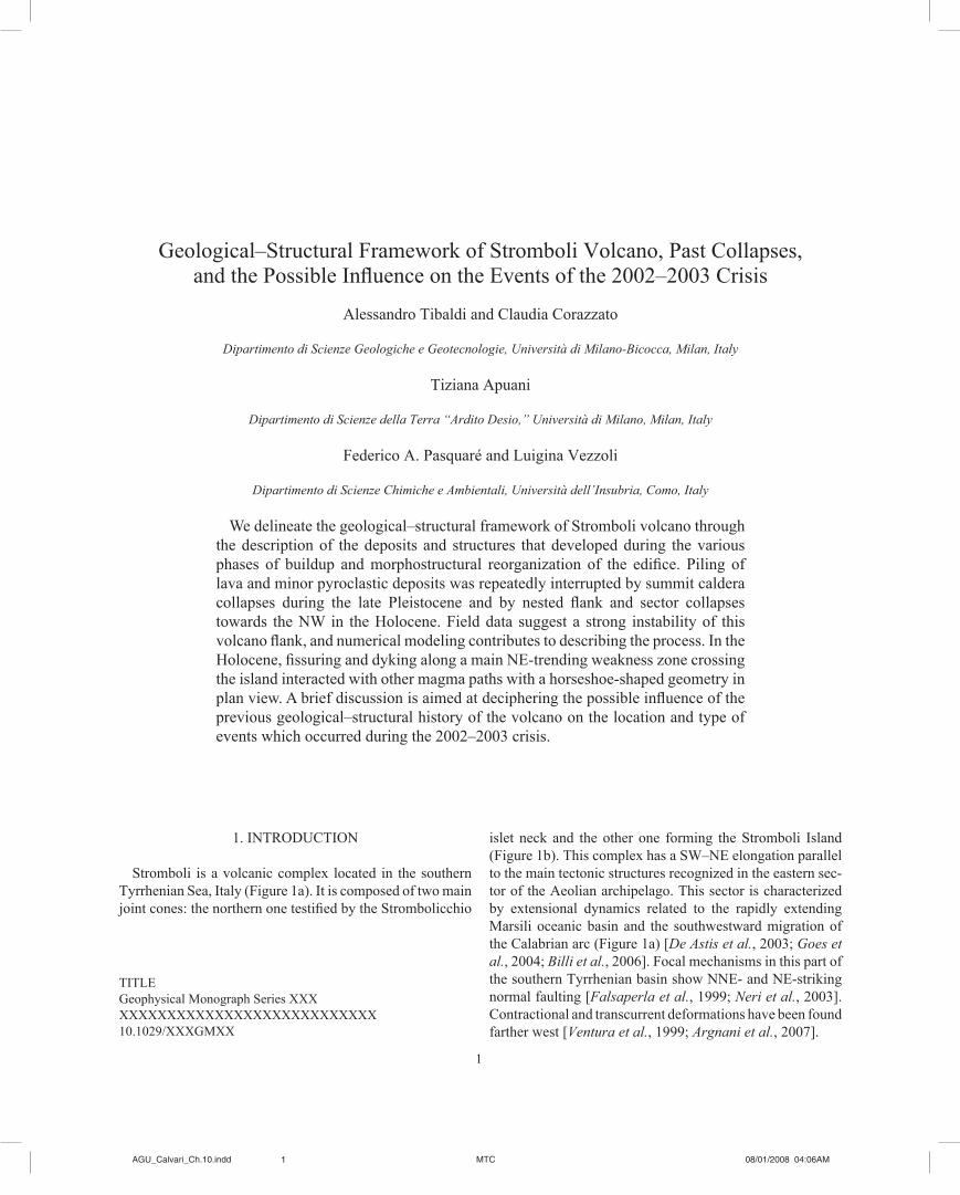
�
TITLEGeophysical Monograph Series XXXXXXXXXXXXXXXXXXXXXXXXXXXXXX�0.�029/XXXGMXX
Geological–Structural Framework of Stromboli Volcano, Past Collapses, and the Possible Influence on the Events of the 2002–2003 Crisis
Alessandro Tibaldi and Claudia Corazzato
Dipartimento di Scienze Geologiche e Geotecnologie, Università di Milano-Bicocca, Milan, Italy
Tiziana Apuani
Dipartimento di Scienze della Terra “Ardito Desio,” Università di Milano, Milan, Italy
Federico A. Pasquaré and Luigina Vezzoli
Dipartimento di Scienze Chimiche e Ambientali, Università dell’Insubria, Como, Italy
We delineate the geological–structural framework of Stromboli volcano through the description of the deposits and structures that developed during the various phases of buildup and morphostructural reorganization of the edifice. Piling of lava and minor pyroclastic deposits was repeatedly interrupted by summit caldera collapses during the late Pleistocene and by nested flank and sector collapses towards the NW in the Holocene. Field data suggest a strong instability of this volcano flank, and numerical modeling contributes to describing the process. In the Holocene, fissuring and dyking along a main NE-trending weakness zone crossing the island interacted with other magma paths with a horseshoe-shaped geometry in plan view. A brief discussion is aimed at deciphering the possible influence of the previous geological–structural history of the volcano on the location and type of events which occurred during the 2002–2003 crisis.
�. INTroduCTIoN
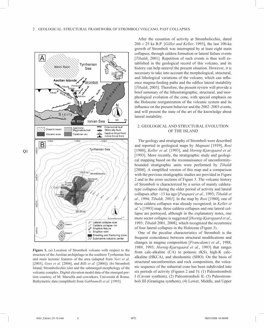
Stromboli is a volcanic complex located in the southern Tyrrhenian Sea, Italy (Figure �a). It is composed of two main joint cones: the northern one testified by the Strombolicchio
islet neck and the other one forming the Stromboli Island (Figure 1b). This complex has a SW–NE elongation parallel to the main tectonic structures recognized in the eastern sec-tor of the Aeolian archipelago. This sector is characterized by extensional dynamics related to the rapidly extending Marsili oceanic basin and the southwestward migration of the Calabrian arc (Figure �a) [De Astis et al., 2003; Goes et al., 2004; Billi et al., 2006]. Focal mechanisms in this part of the southern Tyrrhenian basin show NNE- and NE-striking normal faulting [Falsaperla et al., 1999; Neri et al., 2003]. Contractional and transcurrent deformations have been found farther west [Ventura et al., 1999; Argnani et al., 2007].
�AGU_Calvari_Ch.�0.indd MTC 08/0�/2008 04:06AM
2 GEoLoGICAL–STruCTurAL FrAMEWork oF STroMboLI VoLCANo, PAST CoLLAPSES
After the cessation of activity at Strombolicchio, dated 204 ± 25 ka b.P. [Gillot and Keller, 1993], the last 100-ka growth of Stromboli was interrupted by at least eight main collapses, through caldera formation or lateral failure events [Tibaldi, 2001]. Repetition of such events is thus well es-tablished in the geological record of this volcano, and its history can help unravel the present situation. However, it is necessary to take into account the morphological, structural, and lithological variations of the volcano, which can influ-ence magma-feeding paths and the edifice lateral instability [Tibaldi, 2003]. Therefore, the present review will provide a brief summary of the lithostratigraphic, structural, and mor-phological evolution of the cone, with special emphasis on the Holocene reorganization of the volcanic system and its influence on the present behavior and the 2002–2003 events, and will present the state of the art of the knowledge about lateral instability.
2. GEoLoGICAL ANd STruCTurAL EVoLuTIoN oF THE ISLANd
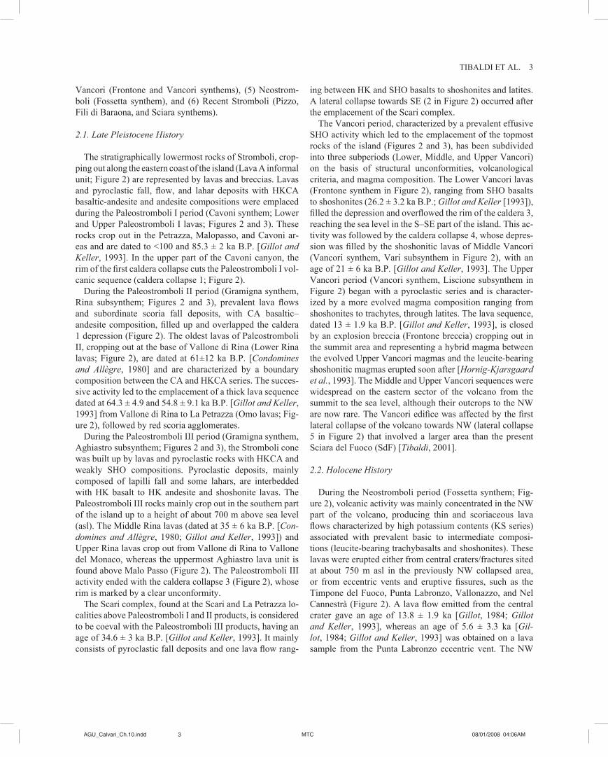
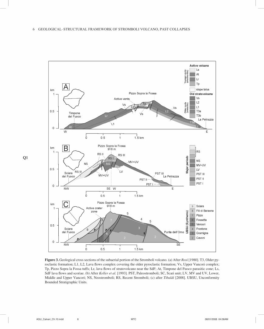
The geology and stratigraphy of Stromboli were described and reported in geological maps by Magnani [1939], Rosi [�980], Keller et al. [1993], and Hornig-Kjarsgaard et al. [1993]. More recently, the stratigraphic study and geologi-cal mapping based on the reconnaissance of unconformity-bounded stratigraphic units were performed by Tibaldi [2008]. A simplified version of this map and a comparison with the previous stratigraphic studies are provided in Figure 2 and in the cross sections of Figure 3. The volcanic history of Stromboli is characterized by a series of mainly caldera-type collapses during the older period of activity and lateral collapses after ~13 ka ago [Pasquarè et al., 1993; Tibaldi et al., 1994; Tibaldi, 2001]. In the map by Rosi [�980], one of these caldera collapses was already recognized; in Keller et al.’s [1993] map, three caldera collapses and one lateral col-lapse are portrayed, although in the explanatory notes, one more sector collapse is suggested [Hornig-Kjarsgaard et al., 1993; Tibaldi 200�, 2008], which recognized the occurrence of four lateral collapses in the Holocene (Figure 3).
one of the peculiar characteristics of Stromboli is the frequent coincidence between structural modifications and changes in magma composition [Francalanci et al., �988, 1989, 1993; Hornig-Kjarsgaard et al., 1993] that ranges from calc-alkaline (CA) to potassic (KS), high-K calc- alkaline (HkCA), and shoshonitic (SHo). on the basis of structural unconformities and rock composition, the volca-nic sequence of the subaerial cone has been subdivided into six periods of activity (Figures 2 and 3): (1) Paleostromboli I (Cavoni synthem), (2) Paleostromboli II, (3) Paleostrom-boli III (Gramigna synthem), (4) Lower, Middle, and upper
Figure 1. (a) Location of Stromboli volcano with respect to the structure of the Aeolian archipelago in the southern Tyrrhenian Sea and main tectonic features of the area (adapted from Neri et al. [2003], Goes et al. [2004], and Billi et al. [2006]). (b) Stromboli Island, Strombolicchio islet and the submerged morphology of the volcanic complex. Digital elevation model data of the emerged por-tion courtesy of M. Marsella and coworkers, Università di Roma. Bathymetric data (simplified) from Gabbianelli et al. [1993].
Q�Q�
2AGU_Calvari_Ch.�0.indd MTC 08/0�/2008 04:06AM AGU_Calvari_Ch.�0.indd MTC 08/0�/2008 04:06AM
TIBALDI ET AL. 3
Vancori (Frontone and Vancori synthems), (5) Neostrom-boli (Fossetta synthem), and (6) recent Stromboli (Pizzo, Fili di baraona, and Sciara synthems).
2.1. Late Pleistocene History
The stratigraphically lowermost rocks of Stromboli, crop-ping out along the eastern coast of the island (Lava A informal unit; Figure 2) are represented by lavas and breccias. Lavas and pyroclastic fall, flow, and lahar deposits with HKCA basaltic-andesite and andesite compositions were emplaced during the Paleostromboli I period (Cavoni synthem; Lower and Upper Paleostromboli I lavas; Figures 2 and 3). These rocks crop out in the Petrazza, Malopasso, and Cavoni ar-eas and are dated to <100 and 85.3 ± 2 ka B.P. [Gillot and Keller, 1993]. In the upper part of the Cavoni canyon, the rim of the first caldera collapse cuts the Paleostromboli I vol-canic sequence (caldera collapse 1; Figure 2).
during the Paleostromboli II period (Gramigna synthem, Rina subsynthem; Figures 2 and 3), prevalent lava flows and subordinate scoria fall deposits, with CA basaltic– andesite composition, filled up and overlapped the caldera 1 depression (Figure 2). The oldest lavas of Paleostromboli II, cropping out at the base of Vallone di rina (Lower rina lavas; Figure 2), are dated at 61±12 ka B.P. [Condomines and Allègre, �980] and are characterized by a boundary composition between the CA and HkCA series. The succes-sive activity led to the emplacement of a thick lava sequence dated at 64.3 ± 4.9 and 54.8 ± 9.1 ka B.P. [Gillot and Keller, 1993] from Vallone di Rina to La Petrazza (Omo lavas; Fig-ure 2), followed by red scoria agglomerates.
during the Paleostromboli III period (Gramigna synthem, Aghiastro subsynthem; Figures 2 and 3), the Stromboli cone was built up by lavas and pyroclastic rocks with HKCA and weakly SHo compositions. Pyroclastic deposits, mainly composed of lapilli fall and some lahars, are interbedded with HK basalt to HK andesite and shoshonite lavas. The Paleostromboli III rocks mainly crop out in the southern part of the island up to a height of about 700 m above sea level (asl). The Middle Rina lavas (dated at 35 ± 6 ka B.P. [Con-domines and Allègre, 1980; Gillot and Keller, 1993]) and Upper Rina lavas crop out from Vallone di Rina to Vallone del Monaco, whereas the uppermost Aghiastro lava unit is found above Malo Passo (Figure 2). The Paleostromboli III activity ended with the caldera collapse 3 (Figure 2), whose rim is marked by a clear unconformity.
The Scari complex, found at the Scari and La Petrazza lo-calities above Paleostromboli I and II products, is considered to be coeval with the Paleostromboli III products, having an age of 34.6 ± 3 ka B.P. [Gillot and Keller, 1993]. It mainly consists of pyroclastic fall deposits and one lava flow rang-
ing between Hk and SHo basalts to shoshonites and latites. A lateral collapse towards SE (2 in Figure 2) occurred after the emplacement of the Scari complex.
The Vancori period, characterized by a prevalent effusive SHO activity which led to the emplacement of the topmost rocks of the island (Figures 2 and 3), has been subdivided into three subperiods (Lower, Middle, and upper Vancori) on the basis of structural unconformities, volcanological criteria, and magma composition. The Lower Vancori lavas (Frontone synthem in Figure 2), ranging from SHo basalts to shoshonites (26.2 ± 3.2 ka B.P.; Gillot and Keller [1993]), filled the depression and overflowed the rim of the caldera 3, reaching the sea level in the S–SE part of the island. This ac-tivity was followed by the caldera collapse 4, whose depres-sion was filled by the shoshonitic lavas of Middle Vancori (Vancori synthem, Vari subsynthem in Figure 2), with an age of 2� ± 6 ka b.P. [Gillot and Keller, 1993]. The Upper Vancori period (Vancori synthem, Liscione subsynthem in Figure 2) began with a pyroclastic series and is character-ized by a more evolved magma composition ranging from shoshonites to trachytes, through latites. The lava sequence, dated 13 ± 1.9 ka B.P. [Gillot and Keller, 1993], is closed by an explosion breccia (Frontone breccia) cropping out in the summit area and representing a hybrid magma between the evolved Upper Vancori magmas and the leucite-bearing shoshonitic magmas erupted soon after [Hornig-Kjarsgaard et al., 1993]. The Middle and Upper Vancori sequences were widespread on the eastern sector of the volcano from the summit to the sea level, although their outcrops to the NW are now rare. The Vancori edifice was affected by the first lateral collapse of the volcano towards NW (lateral collapse 5 in Figure 2) that involved a larger area than the present Sciara del Fuoco (SdF) [Tibaldi, 200�].
2.2. Holocene History
During the Neostromboli period (Fossetta synthem; Fig-ure 2), volcanic activity was mainly concentrated in the NW part of the volcano, producing thin and scoriaceous lava flows characterized by high potassium contents (KS series) associated with prevalent basic to intermediate composi-tions (leucite-bearing trachybasalts and shoshonites). These lavas were erupted either from central craters/fractures sited at about 750 m asl in the previously NW collapsed area, or from eccentric vents and eruptive fissures, such as the Timpone del Fuoco, Punta Labronzo, Vallonazzo, and Nel Cannestrà (Figure 2). A lava flow emitted from the central crater gave an age of 13.8 ± 1.9 ka [Gillot, 1984; Gillot and Keller, 1993], whereas an age of 5.6 ± 3.3 ka [Gil-lot, 1984; Gillot and Keller, 1993] was obtained on a lava sample from the Punta Labronzo eccentric vent. The NW
2AGU_Calvari_Ch.�0.indd MTC 08/0�/2008 04:06AM �AGU_Calvari_Ch.�0.indd MTC 08/0�/2008 04:06AM
4 GEoLoGICAL–STruCTurAL FrAMEWork oF STroMboLI VoLCANo, PAST CoLLAPSES
4AGU_Calvari_Ch.�0.indd MTC 08/0�/2008 04:06AM AGU_Calvari_Ch.�0.indd MTC 08/0�/2008 04:06AM
TIbALdI ET AL. 5
Figure 2. (Opposite) Simplified geological map of Stromboli Island showing the main stratigraphic units (unconformity-bounded strati-graphic units, based on the study of Tibaldi [2008]), with indication of caldera and sector collapse traces (modified after Tibaldi [200�]), sheet intrusions (partially from Tibaldi [2003], Corazzato et al. [2008], and unpublished data), eruptive fissures and vents. The map is draped over a shaded view of the island (digital elevation model data courtesy of M. Marsella and coworkers, Rome University) (universal time meridian coordinates in meters). UBSU, unconformity bounded stratigraphic units; PSTI, Paleostromboli I; MU, main unconformi-ties with number as referred in the text; LC, lateral collapse; CC, caldera collapse; AU, angular unconformity. 1, After Tibaldi [2008]; 2, major periods and informal lithostratigraphic units, after Keller et al. [1993] if not differently indicated; 3 after Hornig-Kjarsgaard et al. [1993]; 4, after Petrone et al. [2006]; 5, ages from Condomines and Allegre [�980] and Gillot and Keller [1993]. a–b is the subaerial trace for model cross section of Figure 4.
sector of the Neostromboli edifice failed during the lateral collapse 6. This collapse surface was nested in the collapse 5 depression [Tibaldi et al., 2003; Apuani et al., 2005a]. The phreatomagmatic explosive event of the Lazzaro pyroclastic deposits [Bertagnini and Landi, 1996], found all over the is-land in small outcrops above the Neostromboli lavas, seems to be the last eruptive event of this period and was prob-ably triggered by the decompression of the shallow subvol-canic system during lateral collapse 6 [Renzulli and Santi, �997].
The recent Stromboli period (Pizzo, Fili di baraona, and Sciara synthems; Figure 2) refers to the volcanic activity fol-lowing the Neostromboli period, including the present-day Strombolian activity. The products are lavas and pyroclastic deposits with Hk and SHo basaltic compositions, and some ages were recently obtained with archeomagnetic dating in the work of Arrighi et al. [2004] and Speranza et al. [2004] to better constrain this period of activity. The Pizzo Sopra la Fossa pyroclastic cone [Pizzo synthem; Figure 2] was built up to an elevation of 918 m asl from a central crater inside the depression of the lateral collapse 6. It was cut by the northwestward lateral collapse 7 and was followed by explo-sive activity which emplaced alternating ash tuff layers and scoriaceous spatters (Post-Pizzo Sequence, Petrone et al. [2006]). The sub-Recent Sciara lavas (Fili di Baraona syn-them; Figure 2) dated 1350 ± 60 A.D. [Arrighi et al., 2004)] lateral collapse 7. These lavas were in turn involved in the final lateral collapse 8, which led to the formation of the SdF depression in its present shape. The Hk basalts of San Bartolo lavas (Fili di Baraona synthem; Figure 2), with an age of 2 ka b.P. [Arrighi et al., 2004], were erupted outside the central crater area from an eccentric vent sited at 600 m asl in the NE part of the island [Laiolo and Cigolini, 2006]. They formed a quite large lava delta at sea level where the Stromboli village was partially built up. The Recent Sciara deposits (Sciara synthem; Figure 2) have been erupted by the present-day Strombolian activity which occurs inside the SdF depression from vents sited in a crater terrace at 750 m asl (usually three active craters). Blocks, scoriaceous bombs, lapilli, and ash are the products of the moderately explosive,
normal Strombolian activity, whereas light pumice and lava flows are erupted during paroxysms and effusive activity, respectively (e.g., eruptive crisis of 2002–2003 and 2007 [Landi et al., 2006, and reference therein]).
Three magma feeding zones, testified by the alignment of the active summit vents, eruptive fissures, and sheet swarms, were recognized at Stromboli [Tibaldi, 1996; Tibaldi, 2003; Tibaldi et al., 2003; Corazzato et al., 2008]: (1) the NE-trending zone passing through the volcano summit, characterized by a gradual migration of dyking from SW to NE throughout the history of the volcano and geometrically controlled by the active NW-trending regional tectonic extension; (2) the north-trending zone affecting the southern part of the island; and (3) the zone located parallel and close to the shoulders of the northwestward collapse zone; it developed from 13 ka B.P. interacting with fissuring and dyking along the main NE-trending weakness zone (Figure 2).
3. LATERAL INSTABILITy
The first paper dedicated to the numerical modeling of the mechanical stability of Stromboli is the one by Russo et al. [�996], dealing with an elastic model and considering the influence of the regional stresses and magma reservoir. The geological history of lateral collapses alternated to build-ing phases has been simulated by finite difference numeri-cal modeling by Apuani et al. [2005a] with FLAC 4.0 code (Itasca), in terms of stress–strain evolution. This simulation revealed that (1) the gravitational forces alone are not suf-ficient to generate the hypothesized past collapses as single mechanisms, while magma pressure in dykes can represent a destabilizing factor; (2) deformations and superficial land-slides mark the beginning of, and contribute to, the retro-gressive plasticization and perhaps to the deepening of the failure surface; (3) shallow submarine landslides represent a possible triggering mechanism. The landslide events of 30 December 2002 fit the simulated evolution.
The numerical code has proved to be a useful tool for mod-eling such a complex system and investigating the cause– effect relationships in deep-seated instability phenomena,
4AGU_Calvari_Ch.�0.indd MTC 08/0�/2008 04:06AM �AGU_Calvari_Ch.�0.indd MTC 08/0�/2008 04:06AM
6 GEoLoGICAL–STruCTurAL FrAMEWork oF STroMboLI VoLCANo, PAST CoLLAPSES
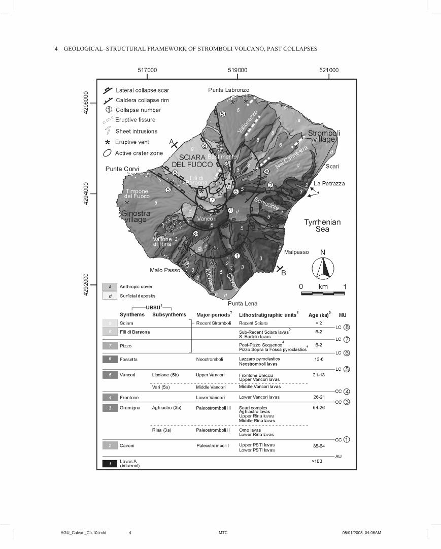
Figure 3. Geological cross sections of the subaerial portion of the Stromboli volcano. (a) After Rosi [1980]. T3, Older py-roclastic formation; L1, L2, Lava flows complex covering the older pyroclastic formation; Vs, Upper Vancori complex; Tp, Pizzo Sopra la Fossa tuffs; Lr, lava flows of stratovolcano near the SdF; At, Timpone del Fuoco parasitic cone; Ls, SdF lava flows and scoriae. (b) After Keller et al. [1993]. PST, Paleostromboli; SC, Scari unit; LV, MV and UV, Lower, Middle and Upper Vancori; NS, Neostromboli; RS, Recent Stromboli; (c) after Tibaldi [2008]. UBSU, Unconformity Bounded Stratigraphic Units.
Q1Q1
6AGU_Calvari_Ch.�0.indd MTC 08/0�/2008 04:06AM AGU_Calvari_Ch.�0.indd MTC 08/0�/2008 04:06AM

TIbALdI ET AL. 7
allowing calibrating the response of the geotechnical model and testing the validity of the assumptions.
Actually, to support the stability analyses, it is necessary to define a geological–technical model of the volcano, based on an adequate knowledge of the geotechnical properties of the involved materials, as well as on stratigraphical, litholog-ical, and structural data. Only recently have studies begun to quantify volcanic material properties [Watters et al., 2000; Thomas et al., 2004; Apuani et al., 2005b; Moon et al., 2005; Tommasi et al., 2005; Malheiro and Nunes, 2007]. Apuani et al. [2005b] provided a dataset of the physical–mechanical properties of the Stromboli volcanic rock masses by inte-grating: (�) laboratory geotechnical and geomechanical tests on intact rocks; (2) rock-mass structural and geomechanical characterization [ISRM, 1981]; (3) evaluation of rock-mass strength and elastic parameters according to Hoek–brown nonlinear strength law [Hoek et al., 2002], for property scaling to rock-mass scale. These authors then defined four lithotechnical units, considering the relative percentage of the breccia fraction vs. lava deposits. Tommasi et al. [2005] focused on characterizing the volcaniclastic material of the SdF slope.
Slope instability phenomena are represented not only by (1) giant deep-seated gravitational slope deformations as those recognized in the past history of Stromboli, with mobi-lized volumes >10 Mm3, but also by (2) shallower, large, and more frequent landslides, such as the one which occurred in December 2002–January 2003, involving loose deposits and rock masses and mobilizing volumes <10 Mm3, and (3) very surficial landslides, involving loose or weakly consolidated deposits, that also represent a natural hazard and threaten residents and tourists, with mobilized volumes in the order of �00,000 m3.
The researches published up to now were focused on sta-bility analyses and numerical modeling concerning these different typologies of slope instability, and the effect of dif-ferent instability factors and external forces, such as magma pressure and seismicity, initially explored by limit equilib-rium analyses [Apuani et al., 2005a].
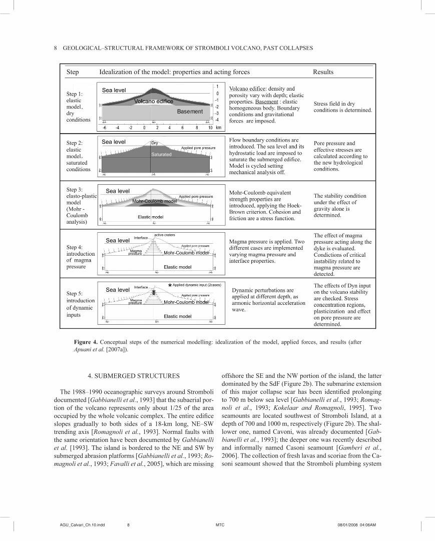
Considering deep-seated gravitational slope deformations (�) and large landslides (2), Apuani and Corazzato [2008] dealt with the Stromboli NW flank instability, focusing on the effects of magma pressure in the feeding system. A two-dimensional numerical model was developed by the finite difference FLAC code, considering a cross section of the entire volcano, orthogonal to the SdF, and including both subaerial and submerged slopes (Figure 4, steps 1–3). The stability of the volcano was analyzed under gravity alone and by introducing the magma pressure effect, including magma-static and overpressure components (Figure 4, step 4). The results indicate that gravity alone is not sufficient to affect
the stability of the volcano slopes, nor is the magmastatic pressure component. If a magma overpressure is introduced, instability is produced in accordance with field evidence and recent slope dynamics.
Another crucial issue to be analyzed in evaluating the stability of a volcanic edifice is represented by the effect of seismicity, related to tectonic activity or due to magma migration mechanisms. Apuani et al. [2007a] analyzed, by the FLAC code, the effects of seismic events associated to magma migration mechanisms on the stability of the vol-cano flanks, coupling the dynamic analysis with the ef-fects of the magma pressure in the feeding conduits. The dynamic input was applied on both sides of the conduit, extended vertically below the active crater zone. Based on geophysical data [Chouet et al., 2003], the dynamic source was located between 300 and 700 m deep (Figure 4, step 5). The effects of the dynamic perturbation were analyzed in terms of displacements vectors, strain increments, and pore pressure variations. The model showed that seismic activ-ity alone is not a sufficient cause of deep-seated instability, but when coupled with magma overpressure during feeding processes, critical deep surfaces can develop. Their geom-etry and continuity is controlled by the entity and distribu-tion of magma pressure and depth of the dynamic source. Consequently, the modality of a possible instability pro-cess and the involved volumes are strongly dependent on the stress concentration resulting from the applied triggering factors.
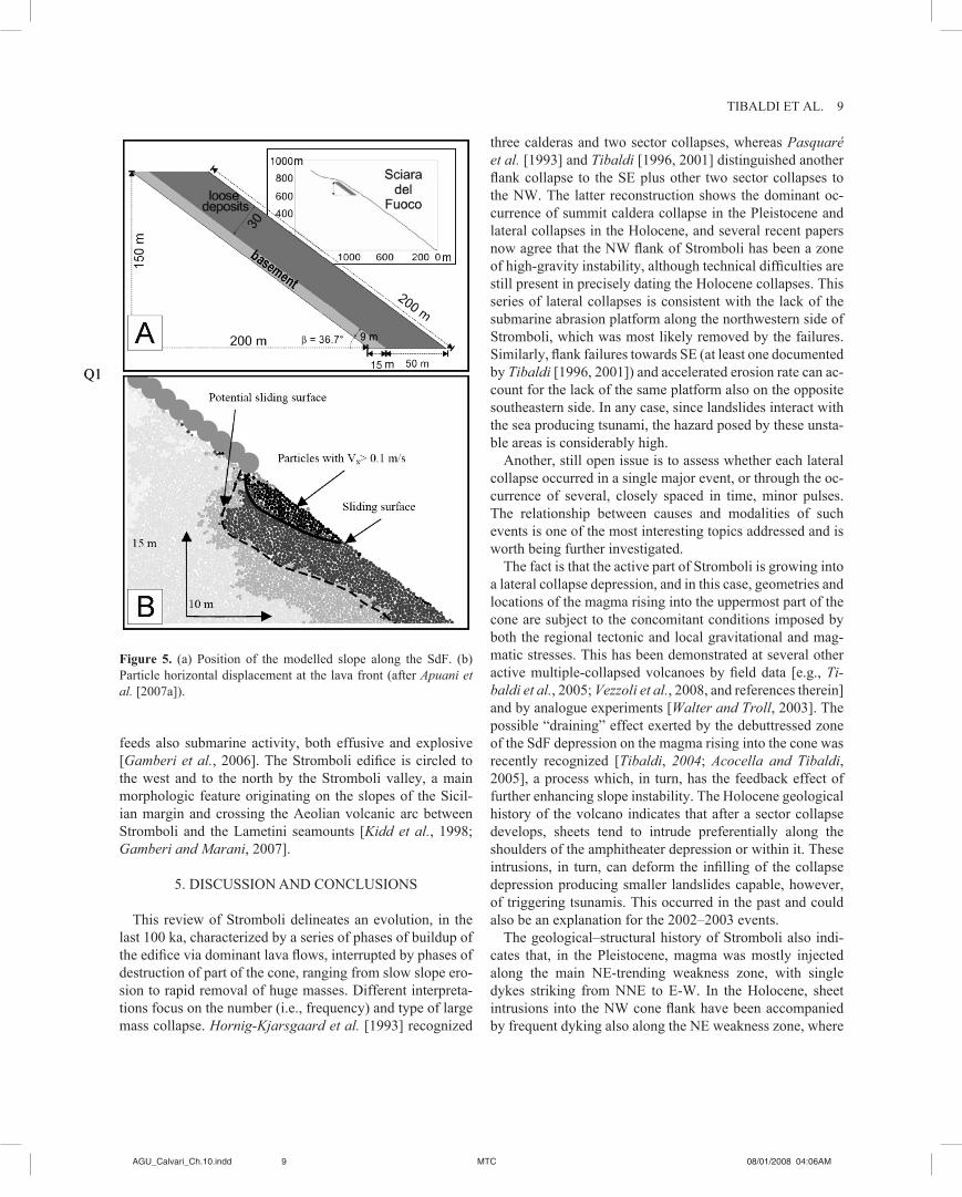
Concerning the development of minor very surface land-slides (3), these can involve potentially unstable masses of loose or weakly cemented deposits that can be mobi-lized evolving in granular flow moving down the SdF into the sea, eventually forming small tsunami waves. Apuani et al. [2005c, 2007b] analyzed the surface local stability of the SdF recent volcanic debris, using the particle-based code PFC2d (Itasca) and building up a conceptual model (Figure 5a) made of a close-packed assembly of bonded or unbonded particles, interacting according to their specific particle contact properties. After the necessary calibration of the numerical model [Apuani et al., 2005c], based on the comparison with experimental geotechnical data and aimed at finding particle micromechanical parameters that better represent the rheology of the volcanic debris, the analysis performed by Apuani et al. [2007b] could investigate the ef-fect on local slope stability of some possible triggering fac-tors such as the impact of large ejected boulders, like the ones emitted during major eruptions or paroxysmal events, which in any case affect only small areas, or the accumulation of lava (Figure 5b), which instead can be responsible for the development of superficial landslides at the front of the lava flow.
6AGU_Calvari_Ch.�0.indd MTC 08/0�/2008 04:06AM �AGU_Calvari_Ch.�0.indd MTC 08/0�/2008 04:06AM
8 GEoLoGICAL–STruCTurAL FrAMEWork oF STroMboLI VoLCANo, PAST CoLLAPSES
4. SubMErGEd STruCTurES
The 1988–1990 oceanographic surveys around Stromboli documented [Gabbianelli et al., 1993] that the subaerial por-tion of the volcano represents only about 1/25 of the area occupied by the whole volcanic complex. The entire edifice slopes gradually to both sides of a 18-km long, NE–SW trending axis [Romagnoli et al., 1993]. Normal faults with the same orientation have been documented by Gabbianelli et al. [1993]. The island is bordered to the NE and SW by submerged abrasion platforms [Gabbianelli et al., 1993; Ro-magnoli et al., 1993; Favalli et al., 2005], which are missing
offshore the SE and the NW portion of the island, the latter dominated by the SdF (Figure 2b). The submarine extension of this major collapse scar has been identified prolonging to 700 m below sea level [Gabbianelli et al., 1993; Romag-noli et al., 1993; Kokelaar and Romagnoli, �995]. Two seamounts are located southwest of Stromboli Island, at a depth of 700 and 1000 m, respectively (Figure 2b). The shal-lower one, named Cavoni, was already documented [Gab-bianelli et al., 1993]; the deeper one was recently described and informally named Casoni seamount [Gamberi et al., 2006]. The collection of fresh lavas and scoriae from the Ca-soni seamount showed that the Stromboli plumbing system
Figure 4. Conceptual steps of the numerical modelling: idealization of the model, applied forces, and results (after Apuani et al. [2007a]).
8AGU_Calvari_Ch.�0.indd MTC 08/0�/2008 04:06AM AGU_Calvari_Ch.�0.indd MTC 08/0�/2008 04:06AM
TIbALdI ET AL. 9
feeds also submarine activity, both effusive and explosive [Gamberi et al., 2006]. The Stromboli edifice is circled to the west and to the north by the Stromboli valley, a main morphologic feature originating on the slopes of the Sicil-ian margin and crossing the Aeolian volcanic arc between Stromboli and the Lametini seamounts [Kidd et al., 1998; Gamberi and Marani, 2007].
5. dISCuSSIoN ANd CoNCLuSIoNS
This review of Stromboli delineates an evolution, in the last �00 ka, characterized by a series of phases of buildup of the edifice via dominant lava flows, interrupted by phases of destruction of part of the cone, ranging from slow slope ero-sion to rapid removal of huge masses. Different interpreta-tions focus on the number (i.e., frequency) and type of large mass collapse. Hornig-Kjarsgaard et al. [1993] recognized
three calderas and two sector collapses, whereas Pasquaré et al. [1993] and Tibaldi [�996, 200�] distinguished another flank collapse to the SE plus other two sector collapses to the NW. The latter reconstruction shows the dominant oc-currence of summit caldera collapse in the Pleistocene and lateral collapses in the Holocene, and several recent papers now agree that the NW flank of Stromboli has been a zone of high-gravity instability, although technical difficulties are still present in precisely dating the Holocene collapses. This series of lateral collapses is consistent with the lack of the submarine abrasion platform along the northwestern side of Stromboli, which was most likely removed by the failures. Similarly, flank failures towards SE (at least one documented by Tibaldi [�996, 200�]) and accelerated erosion rate can ac-count for the lack of the same platform also on the opposite southeastern side. In any case, since landslides interact with the sea producing tsunami, the hazard posed by these unsta-ble areas is considerably high.
Another, still open issue is to assess whether each lateral collapse occurred in a single major event, or through the oc-currence of several, closely spaced in time, minor pulses. The relationship between causes and modalities of such events is one of the most interesting topics addressed and is worth being further investigated.
The fact is that the active part of Stromboli is growing into a lateral collapse depression, and in this case, geometries and locations of the magma rising into the uppermost part of the cone are subject to the concomitant conditions imposed by both the regional tectonic and local gravitational and mag-matic stresses. This has been demonstrated at several other active multiple-collapsed volcanoes by field data [e.g., Ti-baldi et al., 2005; Vezzoli et al., 2008, and references therein] and by analogue experiments [Walter and Troll, 2003]. The possible “draining” effect exerted by the debuttressed zone of the SdF depression on the magma rising into the cone was recently recognized [Tibaldi, 2004; Acocella and Tibaldi, 2005], a process which, in turn, has the feedback effect of further enhancing slope instability. The Holocene geological history of the volcano indicates that after a sector collapse develops, sheets tend to intrude preferentially along the shoulders of the amphitheater depression or within it. These intrusions, in turn, can deform the infilling of the collapse depression producing smaller landslides capable, however, of triggering tsunamis. This occurred in the past and could also be an explanation for the 2002–2003 events.
The geological–structural history of Stromboli also indi-cates that, in the Pleistocene, magma was mostly injected along the main NE-trending weakness zone, with single dykes striking from NNE to E-W. In the Holocene, sheet intrusions into the NW cone flank have been accompanied by frequent dyking also along the NE weakness zone, where
Figure 5. (a) Position of the modelled slope along the SdF. (b) Particle horizontal displacement at the lava front (after Apuani et al. [2007a]).
Q�Q�
8AGU_Calvari_Ch.�0.indd MTC 08/0�/2008 04:06AM �AGU_Calvari_Ch.�0.indd MTC 08/0�/2008 04:06AM
�0 GEoLoGICAL–STruCTurAL FrAMEWork oF STroMboLI VoLCANo, PAST CoLLAPSES
single dykes and fissure eruptions had a dominant NE strike and concentrated in the zone between the summit crater and the present location of the Stromboli village. This suggests a shift of the magma paths towards NE along the main weak-ness zone.
Volcanoes are prone to undergo phases of lateral insta-bility mostly when magma intrudes the cone [Voight and Elsworth, 1997; Donnadieu et al., 200�] and when the pil-ing of lava and pyroclastic deposits reach a critical height [Borgia et al., �992]. The numerical modeling performed for Stromboli shows that magma overpressure during feeding processes is the dominant cause in generating deep-seated lateral collapses and/or large landslides, in agreement with the evidence of historical collapses. Even minor instability phenomena, which certainly represent the most frequent hazard scenario, can be controlled by dyke propagation and effusive events as those which occurred in 2002–2003, in agreement with the cited stability analyses. Concerning the mobilization of loose deposits, it has been demonstrated that the accumulation of lava on the slope can be responsible for the development of superficial landslides which develop at the front of the lava layer.
Pyroclastic rocks and loose deposits infilling the SdF are characterized by very poor physical properties, and this can account for the higher propensity of the present northwest volcano flank to lateral instability. We believe that this sec-tor is prone to gravity instability also without intervening magma intrusions at a high level in the cone, as testified also by the acceleration of seaward displacement of a portion of the SdF during 2000–2001, with the development of a series of dry fissures [Tibaldi et al., 2003] in a time interval with-out major volcanic events. This lateral instability can pro-mote intrusions into the northwestern volcano flank, which, in turn, are capable of further destabilizing this sector with the possible development of landslides.
With special reference to the structural dynamics of the 2002–2003 event, different views have been suggested. Ac-cording to Bonaccorso et al. [2003], the two vents which opened in the SDF at 500 and 600 m of altitude on 29–30 December were not located along a new eruptive fissure, but they formed at the intersection between the steps caused by the initial detachment of the SdF wall and the shallow feeding system of the volcano. Calvari et al. [2005] sug-gested that the three vents, opened on 28, 29, and 30 Decem-ber, were due to lava tubes protruded by the main magma conduit at different levels. Acocella and Tibaldi [2005] and Acocella et al. [2006] claimed that these vents might be the expression of a NW–SE dyke protruded from the main con-duit zone. Based on the available geophysical data [Chouet et al., 2003] that indicate the presence, below the crater, of an active dyke dipping 60° to the NW, and considering
that the SdF slope dips 40° to the NW, the removal of the SdF deposit with a maximum thickness of 70 m [Baldi et al., 2005], due to the 2002 landslides, might not have been large enough to intercept that dyke. Hence, we conclude that during this event, some intrusive sheets propagated from the main magma conduit to reach the surface at the new vents; however, to fully understand the local detailed geometry of these intrusions, further analyses are needed. We believe the important matter is that the entire geological and structural history of Stromboli indicates that subsurface intrusions did occur in the form of sheets. In the Holocene, at morphologi-cal stages of the volcano evolution when a lateral collapse depression was present, the propagation of the sheets was concentrated along the uppermost sides of the depression, within it or across the summit active crater zone along a NE–SW axis [Corazzato et al., 2008]; therefore, there is no reason to rule out the possibility that these geometries and locations could occur again in the future.
Acknowledgments. The work was financed by Italian Diparti-mento della Protezione Civile (DPC)–Istituto Nazionale di Geofisica e Vulcanologia Project V2 (02 A. Tibaldi, �7 T. Apuani) and dPC Stromboli Emergency Project V�. Maria Marsella is acknowledged for supplying subaerial topographic data for Figure 2 and barbara Aldighieri for dEM processing. This study was performed in the framework of ILP-Task Force II, Project “New Tectonic Causes of Volcano Failure and Possible Premonitory Signals” (leader, A. Tibaldi) and of uNESCo-IuGS-IGCP Project 508 “Volcano Col-lapse and Fault Activity” (coleader, C. Corazzato).
rEFErENCES
Acocella, V., and A. Tibaldi (2005), Dike propagation driven by volcano collapse: A general model tested at Stromboli, Italy. Geophys. Res. Lett., 32, L08308, doi:10.1029/2004GL022248.
Acocella, V., M. Neri, and P. Scarlato (2006), Shallow magma emplacement during the 2002–2003 Stromboli (Italy) eruption, Geophys. Res. Lett., 33, L17310, doi:10.1029/2006GL026862.
Apuani, T., and C. Corazzato (2008), Numerical model of the Stromboli volcano (Italy) including the effect of magma pres-sure in the dyke system, Rock Mech. Rock Eng., doi:�0.�007/s0060300801631.
Apuani, T., C. Corazzato, A. Cancelli, and A. Tibaldi (2005a), Stability of a collapsing volcano (Stromboli-Italy): Limit equi-librium analysis and numerical modelling, in The Tectonics and Physics of Volcanoes, edited by A. Gudmundsson and V. Acocella, J. Volcanol. Geotherm. Res. Spec. Publ., 144(�–4), �9�–2�0.
Apuani, T., C. Corazzato, A. Cancelli, and A. Tibaldi (2005b), Physical and mechanical properties of rock masses at Stromboli: A dataset for flank instability evaluation, Bull. Eng. Geol. Envi-ron., 64(4), 419–432.
Apuani, T., A. Merri, and M. Masetti (2007a), Effects of volcanic seismic events on the Stromboli stability by finite difference
�0AGU_Calvari_Ch.�0.indd MTC 08/0�/2008 04:06AM AGU_Calvari_Ch.�0.indd MTC 08/0�/2008 04:06AM
TIbALdI ET AL. ��
numerical modelling, in Volcanic Rocks. Proceedings of the In-ternational Workshop on Volcanic Rocks, Workshop W2-11th Congress ISrM, Ponta delgada, Azores, Portugal, �4–�5 July 2007, edited by A.M. Malheiro and J.C. Nunes, pp. �0�–�09 Taylor and Francis, Philadelphia, Pa.
Apuani, T., M. Masetti, and A. uttini (2007b), debris slope sta-bility analysis in an active volcano area, in Volcanic Rocks. Proceedings of the International workshop on volcanic rocks, Workshop W2-11th Congress ISRM, Ponta Delgada, Azores, Portugal, �4–�5 July 2007, edited by A.M. Malheiro and J.C. Nunes, pp. �4�–�46, Taylor and Francis, Philadelphia, Pa.
Apuani, T., M. Masetti, A. uttini, L. Vezzoli, and C. Corazzato (2005c), Caratterizzazione geotecnica e modellazione numerica ad elementi distinti dei depositi della Sciara del Fuoco (Strom-boli, Italia), G. Geol. Appl., 2, 265–270.
Argnani, A., E. Serpelloni, and C. bonazzi (2007), Pattern of defor-mation around the central Aeolian Islands: Evidence from mul-tichannel seismics and GPS data, Terra Nova, 19, 317–323.
Arrighi, S., M. rosi, J. C. Tanguy, and V. Courtillott (2004), recent eruptive history of Stromboli (Aeolian Island, Italy) determined from high accuracy archeomagnetic dating, Geophys. Res. Lett., 32, L23306, doi:10.1029/2005GL022590.
baldi P., M. Fabris, M. Marsella, and T. r. Monticelli (2005), Monitoring the morphological evolution of the Sciara del Fuoco during the 2002–2003 Stromboli eruption using multi-temporal photogrammetry, ISPRS J. Photogramm. Remote Sens., 59, �99–2��.
bertagnini, A., and P. Landi (�996), The Secche di Lazzaro py-roclastics of Stromboli volcano: A phreatomagmatic eruption related to Sciara del Fuoco Sector collapse, Bull. Volcanol., 58, 239–245.
billi, A., G. barberi, C. Faccenna, G. Neri, F. Pepe, and A. Sulli (2006), Tectonics and seismicity of the Tindari Fault System, southern Italy: Crustal deformations at the transition between ongoing contractional and extensional domains located above the edge of a subducting slab. Tectonics, 25, doi:�0.�029/2004TC001763.
Bonaccorso A., S. Calvari, G. Garfì, L. Lodato, and D. Patanè (2003), Dynamics of the December 2002 flank failure and tsunami at Stromboli volcano inferred by volcanological and geophysical observations, Geophys. Res. Lett., 30(�8), �94�, doi:10.1029/2003GL017702.
Borgia, A., L. Ferrari, G. and Pasquarè (1992), Importance of gravitational spreading in the tectonic and volcanic evolution of Mount Etna, Nature, 357, 231–235.
Calvari, S., L. Spampinato, L. Lodato, A. J. L. Harris, M. R. Patrick, J. dehn, M. r. burton, and d. Andronico (2005), Chro-nology and complex volcanic processes during the 2002–2003 flank eruption at Stromboli volcano (Italy) reconstructed from direct observations and surveys with a handheld thermal camera, J. Geophys. Res., 110, B02201, doi:10.1029/2004JB003129.
Chouet, b., P. dawson, T. ohminato, M. Martini, G. Saccorotti, F. Giudicepietro, G. De Luca, G. Milana, and R. Scarpa (2003), Source mechanism of explosions at Stromboli volcano, Italy, determined from moment tensor inversions of very-long-period data, J. Geophys. Res., 108(b�).
Condomines, M., and C. J. Allègre (1980), Age and magmatic evo-lution of Stromboli volcano from 230Th/238u disequilibrium data, Nature, 288, 354–357.
Corazzato, C., L. Francalanci, M. Menna, C. Petrone, A. renzulli, A. Tibaldi, and L.Vezzoli (2008), What controls sheet intru-sion in volcanoes? Petrological and structural characters of the Stromboli sheet complex, Italy, J. Volcanol. Geotherm. Res., doi:10.1016/j.jvolgeores.2008.01.006.
De Astis, G., G. Ventura, and G. Vilardo (2003), Geodynamic sig-nificance of the Aeolian volcanism (Southern Tyrrhenian Sea, Italy) in light of structural, seismological, and geochemical data, Tectonics, 22, doi:10.1029/2003TC001506.
Donnadieu, F., O. Merle, and J.-C. Besson (2001), Volcanic edi-fice stability during cryptodome intrusion, Bull. Volcanol., 63, 6�–72.
Falsaperla, S., G. Lanzafame, V. Longo, and S. Spampanato (�999), Regional stress field data in the area of Stromboli (Italy): Insight into structural data and crustal tectonic earthquakes, J. Volcanol. Geotherm. Res., 88, �47–�66.
Favalli, M., D. Karàtson, R. Mazzuoli, M. T. Pareschi, and G. Ven-tura (2005), Volcanic geomorphology and tectonics of the Aeo-lian archipelago (southern Italy) based on integrated dEM data, Bull. Volcanol., 68, �57–�70.
Francalanci, L., M. barbieri, P. Manetti, A. Peccerillo, and L. Tolomeo (1988), Sr-isotopic systematics in volcanic rocks from the island of Stromboli (Aeolian arc), Chem. Geol., 73, �64–�80.
Francalanci, L., P. Manetti, and A. Peccerillo (�989), Volcanologi-cal and magmatological evolution of Stromboli volcano (Aeolian islands): The roles of fractional crystallization, magma mixing, crustal contamination and source heterogeneity, Bull. Volcanol., 51, 355–378.
Francalanci, L., P. Manetti, A. Peccerillo, and J. Keller (1993), Magmatological evolution of the Stromboli volcano (Aeolian Arc, Italy): Inferences from major and trace element and Sr-iso-topic composition of lavas and pyroclastic rocks, Acta Vulcanol., 3, �27–�5�.
Gabbianelli, G., C. Romagnoli, P. L. Rossi, and N. Calanchi (1993), Marine geology of the Panarea–Stromboli area (Aeolian archi-pelago, southeastern Tyrrhenian sea), Acta Vulcanol., 3, ��–20.
Gamberi, F., and M. Marani (2007), Downstream evolution of the Stromboli slope valley (southeastern Tyrrhenian Sea), Mar. Geol., 243, �80–�99.
Gamberi, F., M. Marani, V. Landuzzi, A. Magagnoli, d. Penitenti, M. rosi, A. bertagnini, and A. di roberto (2006), Sedimento-logic and volcanologic investigation of the deep Tyrrhenian Sea: Preliminary results of cruise VST02, Ann. Geophys., 49(2–3), 767–78�.
Gillot, P. y. (1984), Datation por la methode K/Ar des roches vol-caniques recentes (pleistocenes et holocenes), thesis, 225 pp., Paris XI-Orsay.
Gillot, P. y., and J. Keller (1993), Radiochronological dating of Stromboli, Acta Vulcanol., 3, ��–20.
Goes, S., D. Giardini, S. Jenny, C. Hollenstein, H.-G. Kahle, and A. Geiger (2004), A recent tectonic reorganization in the south-central Mediterranean, Earth Planet. Sci. Lett., 226, 335– 345.
�0AGU_Calvari_Ch.�0.indd MTC 08/0�/2008 04:06AM ��AGU_Calvari_Ch.�0.indd MTC 08/0�/2008 04:06AM

�2 GEoLoGICAL–STruCTurAL FrAMEWork oF STroMboLI VoLCANo, PAST CoLLAPSES
Hoek, E., C. T. Carranza-Torres, and B. Corkum (2002), Hoek–brown failure criterion—2002 edition, Proc. North American Rock Mechanics Society-TAC Conference, Toronto, Canada, July 2002, vol. 1, 267–273.
Hornig-Kjarsgaard, I., J. Keller, U. Koberski, E. Stadlbauer, L. Francalanci, and R. Lenhart (1993), Geology, stratigraphy and volcanological evolution of the island of Stromboli, Aeolian arc, Italy, Acta Vulcanol., 3, 2�–68.
ISrM (�98�), Rock Characterization, Testing and Monitoring—International Society for Rock Mechanics Suggested Methods, Elsevier, London.
Keller, J., I. Hornig-Kjarsgaard, U. Koberski, E. Stadlbauer, and R. Lenhart (1993), Geological map of the island of Stromboli—scale �:�0,000, Acta Vulcanol., 3, appendix.
kidd, r. b., r. G. Lucchi, M. Gee, and J. M. Woodside (�998), Sedimentary processes in the Stromboli Canyon and Marsili ba-sin, SE Tyrrhenian Sea: Results from side-scan sonar surveys, Geo Mar. Lett., 18, �46–�54.
kokelaar, P., and C. romagnoli (�995), Sector collapse, sedimen-tation and clast population evolution at an active island-arc vol-cano: Stromboli, Italy, Bull. Volcanol., 57, 240–262.
Laiolo, M., and C. Cigolini (2006), Mafic and ultramafic xenoliths in San Bartolo lava field: New insights on the ascent and storage of Stromboli magmas, Bull. Volcanol., 68, 653–670.
Landi, P., L. Francalanci, M. Pompilio, M. rosi, M. A. Corsaro, C. M. Petrone, I. Cardini, and L. Miraglia (2006), The december 2002–July 2003 effusive event at Stromboli volcano, Italy: In-sights into the shallow plumbing system by petrochemical stud-ies, J. Volcanol. Geotherm. Res., 155, 263–284, doi:10.1016/j.jvolgeores.2006.03.032.
Magnani, M. 1939, Osservazioni geologiche e morfologiche sull’isola di Stromboli, L’Universo, 18, 1–63.
Malheiro, A. M., and J. C. Nunes (Eds.) (2007), Volcanic rocks. Proceedings of the International Workshop on Volcanic Rocks, Workshop W2-11th Congress ISRM, Ponta Delgada, Azores, Portugal, �4–�5 July 2007, edited by A.M. Malheiro and J.C. Nunes, pp. �4�–�46, Taylor and Francis, Philadelphia, Pa.
Moon, V., J. bradshaw, r. Smith, and W. de Lange (2005), Geo-technical characterisation of stratocone crater wall sequences, White Island Volcano, New Zealand, Eng. Geol., 81, �46– �78.
Neri, G., G. Barberi, B. Orecchio, and A. Mostaccio (2003), Seismic strain and seismogenic stress regimes in the crust of the southern Tyrrhenian region, Earth Planet. Sci. Lett., 213, 97–��2.
Pasquarè, G., L. Francalanci, V. H. Garduno, and A. Tibaldi (1993), Structure and geological evolution of the Stromboli volcano, Ae-olian islands, Italy, Acta Vulcanol., 3, 79–89.
Petrone, C. M., F. olmi, E. braschi, and L. Francalanci (2006), Min-eral chemistry profile: A valuable approach to unravel magma mixing processes in the recent volcanic activity of Stromboli, Italy, Per. Mineral., 75, 277–292.
Renzulli, A., and P. Santi (1997), Subvolcanic crystallization at Stromboli (Aeolian Islands, southern Italy) preceding the Sciara
del Fuoco sector collapse: Evidence from monzonite lithic suite, Bull. Volcanol., 59, �0–20.
Romagnoli, C., P. Kokelaar, P. L. Rossi, and A. Sodi (1993), The submarine extension of Sciara del Fuoco feature (Stromboli Isl.): Morphologic characterization, Acta Vulcanol., 3, 9�–98.
rosi, M. (�980), The Island of Stromboli. Rend. Soc. Ital. Mineral. Petrol., 36, 345–368.
Russo, G., G. Giberti, and G. Sartoris (1996), The influence of re-gional stresses on the mechanical stability of volcanoes: Strom-boli (Italy), in Volcano Instability on the Earth and Other Plan-ets, edited by W. McGuire, A.P. Jones, and J. Neuberg, Geol. Soc. Spec. Publ., 110, 65–75.
Speranza, F., M. Pompilio, L. and D. Sagnotti (2004), Paleomagnet-ism of spatter lavas from Stromboli volcano (Aeolian Islands, Italy): Implications for the age of paroxysmal eruptions, Geo-phys. Res. Lett., 31, L02607, doi:10.1029/2003GL018944.
Thomas, M. E., N. Petford, and E. N. bromhead (2004), Volcanic rock-mass properties from Snowdonia and Tenerife: Implication for volcano edifice strength, J. Geol. Soc., 161, 939–946.
Tibaldi, A. (1996), Mutual influence of diking and collapses at Stromboli volcano, Aeolian Arc, Italy, in Volcano Instability on the Earth and Other Planets, edited by W. McGuire, A.P. Jones, and J. Neuberg, Geol. Soc. Spec. Publ., 110, 55–63.
Tibaldi, A. (2001), Multiple sector collapses at Stromboli volcano, Italy: How they work, Bull. Volcanol., 63(2–3), 112–125.
Tibaldi, A. (2003), Influence of volcanic cone morphology on dikes, Stromboli, Italy, J. Volcanol. Geotherm. Res., 126, 79–95.
Tibaldi, A. (2004), Major changes in volcano behaviour after a sector collapse: Insights from Stromboli, Italy, Terra Nova, 16, 2–8.
Tibaldi, A. (2008), A new geological map of Stromboli volcano (Tyrrhenian Sea, Italy) based on application of lithostratigraphic and ubS units, in Stratigraphy and Geology in Volcanic Areas, edited by G. Groppelli and L. Viereck-Goette, Geol. Soc. of Am. Spec. Publ., in press.
Tibaldi, A., A. M. F. Lagmay, and V. Ponomareva (2005), Effects of basement structural and stratigraphic heritages on volcano be-haviour and implications for human activities. Episodes, 28(3), �58–�70.
Tibaldi, A., C. Corazzato, T. Apuani, and A. Cancelli (2003), De-formation at Stromboli volcano (Italy) revealed by rock mechan-ics and structural geology, Tectonophysics, 361, �87–204.
Tibaldi, A., G. Pasquaré, L. Francalanci, and H. Garduño (�994), Collapse type and recurrence at Stromboli volcano, associated volcanic activity, and sea level changes, Accademia dei Lincei, Atti Conv. Lincei, 112, 143–151.
Tommasi, P., d. boldini, and T. rotonda (2005), Preliminary characterization of the volcanoclastic material involved in the 2002 landslides at Stromboli, in Proceedings of the International Conference on Problematic Soils GEOPROB 2005, Famagusta, Northern Cyprus, edited by H. Bilsel and Z. Nalbantoglu, vol. 3, pp. 1093–1101.
Ventura, G., G. Vilardo, G. Milano, and N. A. Pino (�999), re-lationships among crustal structure, volcanism and strike–slip
�2AGU_Calvari_Ch.�0.indd MTC 08/0�/2008 04:06AM AGU_Calvari_Ch.�0.indd MTC 08/0�/2008 04:06AM
TIBALDI ET AL. 13
tectonics in the Lipari–Vulcano Volcanic Complex, Aeolian Is-lands, Southern Tyrrhenian Sea, Italy, Phys. Earth Planet. Int., 116, 31–52.
Vezzoli, L., A. Tibaldi, A. renzulli, M. Menna, and S. Flude (2008), Faulting-assisted lateral collapses and influence on shal-low magma feeding system at Ollagüe volcano (Central Volcanic Zone, Chile-Bolivia Andes). J. Volcanol. Geotherm. Res., in press.
Voight, B., and D. Elsworth (1997), Failure of volcano slopes, Ge-otéchnique, 47(1), 1–31.
Walter, T. R., and V. R. Troll (2003), Experiments on rift zone evolution in unstable volcanic edifices, J. Volcanol. Geotherm. Res., 127, �07–�20.
Watters, r. J., d. r. Zimbelman, S. d. bowman, and J. k. Crowley (2000), Rock mass strength assessment and significance to edi-
T. Apuani, dipartimento di Scienze della Terra “Ardito desio,” Università di Milano, Via Mangiagalli 34, 20133 Milan, Italy. ([email protected])
C. Corazzato and A. Tibaldi, dipartimento di Scienze Geolog-iche e Geotecnologie, Università di Milano-Bicocca, Piazza della Scienza 4, 20�26 Milan, Italy.
F. A. Pasquaré and L. Vezzoli, dipartimento di Scienze Chim-iche e Ambientali, Università dell’Insubria, Via Valleggio 11, 22�00 Como, Italy.
fice stability, Mount Rainier and Mount Hood, Cascade Range volcanoes, Pure Appl. Geophys., 157, 957–976.
�2AGU_Calvari_Ch.�0.indd MTC 08/0�/2008 04:06AM ��AGU_Calvari_Ch.�0.indd MTC 08/0�/2008 04:06AM

�4AGU_Calvari_Ch.�0.indd MTC 08/0�/2008 04:06AM
Author Query Form
(Queries are to be answered by the Author)
Chapter 10 – AGU Calvari
The following queries have arisen during the typesetting of your manuscript. Please answer these queries.
Query Marker Query Reply
Q1
Please provide figure replacement with labels written in lower case to match the figure with its caption and text citation.
Thank you very much.
AQF v1.0 MTC
Copyright © 2022 FDOKUMEN