Observations of physical effects from tsunamis of December 30, 2002 at Stromboli volcano, southern...
12
Bull Volcanol (2006) 68: 450–461 DOI 10.1007/s00445-005-0021-x RESEARCH ARTICLE Stefano Tinti · Alessandra Maramai · Alberto Armigliato · Laura Graziani · Anna Manucci · Gianluca Pagnoni · Filippo Zaniboni Observations of physical effects from tsunamis of December 30, 2002 at Stromboli volcano, southern Italy Received: 3 May 2004 / Accepted: 22 August 2005 / Published online: 10 December 2005 C Springer-Verlag 2005 Abstract On December 30, 2002, following an intense period of activity of Stromboli volcano (south Tyrrhenian Sea, Italy), complex mass failures occurred on the north- west slope of the mountain which also involved the under- water portion of the volcanic edifice for a total volume of about 2–3×10 7 m 3 . Two main landslides occurred within a time separation of 7 min, and both set tsunami waves in motion that hit the coasts of Stromboli causing injuries to three people and severe damage to buildings and structures. The tsunamis also caused damage on the island of Panarea, some 20 km to the SSE from the source. They were ob- served all over the Aeolian archipelago, at the island of Ustica to the west, along the northern Sicily coasts to the south as well as along the Tyrrhenian coasts of Calabria to the east and in Campania to the north. This paper presents field observations that were made in the days and weeks immediately following the events. The results of the quanti- tative investigations undertaken in the most affected places, namely along the coasts of Stromboli and on the island of Panarea, are reported in order to highlight the dynamics of the attacking waves and their impact on the physical environment, on the coastal structures and on the coastal residential zone. In Stromboli, the tsunami waves were most violent along the northern and northeastern coastal belt between Punta Frontone and the village of Scari, with maximum runup heights of about 11 m measured on the beach of Spiaggia Longa. Measured runups were observed Editorial responsibility: J. Gilbert S. Tinti () · A. Armigliato · A. Manucci · G. Pagnoni · F. Zaniboni Dipartimento di Fisica, Settore di Geofisica, Universit` a di Bologna, Viale C. Berti Pichat, 8-40127 Bologna, Italy e-mail: [email protected] Tel.: +39-051-2095025 Fax: +39-051-2095058 A. Maramai · L. Graziani Istituto Nazionale di Geofisica e Vulcanologia, Via di Vigna Murata, 605-00143 Roma, Italy to decay rapidly with distance from the source, typical of tsunami waves generated by limited-area sources such as landslides. Keywords Stromboli . Tsunami . Post-tsunami field-survey . Runup heights . Tsunami effects Introduction Stromboli is the northernmost island of the Aeolian archipelago in the southern Tyrrhenian Sea, Italy (Fig. 1). The volcano appears to have been in a state of contin- uous activity for the past 1,000–1,500 years (e.g. Rosi et al. 2000). In ancient times, it was given the name of “Lighthouse of the Mediterranean” because it emit- ted intermittent red flashes visible from great distances at night time. Presently, Stromboli is characterized by persistent activity with mild explosions and occasional explosive crises that usually last from minutes to days and which are characterized by ejection of old material, lava fountains and pyroclastic flows, etc. (Barberi et al. 1993; Rosi et al. 2000). Lava emissions also occur ev- ery 5–15 years producing flows which usually reach the sea. The volcanic edifice extends steeply below the sea level to a depth of 1,200–1,500 m on the east and south flanks, and 1,700–2,200 m on the north and west flanks. The sum- mit of the volcano reaches an elevation of 924 m. Its most characteristic feature is a deep scar located in the northwest sector of the cone called the Sciara del Fuoco (Fig. 2). This steep depression is the result of the most recent sector col- lapse, which occurred less than 5,000 years ago (Pasquar` e et al. 1993) and was likely to be responsible for a tsunami whose effects, modelled through numerical techniques (Tinti et al. 2000, 2003), are speculated to have been disas- trous in the entire southern Tyrrhenian basin. Stromboli’s craters are located in the middle-upper part of the Sciara del Fuoco at a height of around 700 m. Most of the erupted material, including lava flows and pyroclastics, have been
Transcript of Observations of physical effects from tsunamis of December 30, 2002 at Stromboli volcano, southern...
Bull Volcanol (2006) 68: 450–461DOI 10.1007/s00445-005-0021-x
RESEARCH ARTICLE
Stefano Tinti · Alessandra Maramai ·Alberto Armigliato · Laura Graziani ·Anna Manucci · Gianluca Pagnoni · Filippo Zaniboni
Observations of physical effects from tsunamis of December 30,2002 at Stromboli volcano, southern Italy
Received: 3 May 2004 / Accepted: 22 August 2005 / Published online: 10 December 2005C© Springer-Verlag 2005
Abstract On December 30, 2002, following an intenseperiod of activity of Stromboli volcano (south TyrrhenianSea, Italy), complex mass failures occurred on the north-west slope of the mountain which also involved the under-water portion of the volcanic edifice for a total volume ofabout 2–3×10⁷ m3. Two main landslides occurred withina time separation of 7 min, and both set tsunami waves inmotion that hit the coasts of Stromboli causing injuries tothree people and severe damage to buildings and structures.The tsunamis also caused damage on the island of Panarea,some 20 km to the SSE from the source. They were ob-served all over the Aeolian archipelago, at the island ofUstica to the west, along the northern Sicily coasts to thesouth as well as along the Tyrrhenian coasts of Calabria tothe east and in Campania to the north. This paper presentsfield observations that were made in the days and weeksimmediately following the events. The results of the quanti-tative investigations undertaken in the most affected places,namely along the coasts of Stromboli and on the island ofPanarea, are reported in order to highlight the dynamicsof the attacking waves and their impact on the physicalenvironment, on the coastal structures and on the coastalresidential zone. In Stromboli, the tsunami waves weremost violent along the northern and northeastern coastalbelt between Punta Frontone and the village of Scari, withmaximum runup heights of about 11 m measured on thebeach of Spiaggia Longa. Measured runups were observed
Editorial responsibility: J. Gilbert
S. Tinti (�) · A. Armigliato · A. Manucci · G. Pagnoni ·F. ZaniboniDipartimento di Fisica, Settore di Geofisica, Universita diBologna,Viale C. Berti Pichat,8-40127 Bologna, Italye-mail: [email protected].: +39-051-2095025Fax: +39-051-2095058
A. Maramai · L. GrazianiIstituto Nazionale di Geofisica e Vulcanologia,Via di Vigna Murata,605-00143 Roma, Italy
to decay rapidly with distance from the source, typical oftsunami waves generated by limited-area sources such aslandslides.
Keywords Stromboli . Tsunami . Post-tsunamifield-survey . Runup heights . Tsunami effects
Introduction
Stromboli is the northernmost island of the Aeolianarchipelago in the southern Tyrrhenian Sea, Italy (Fig. 1).The volcano appears to have been in a state of contin-uous activity for the past 1,000–1,500 years (e.g. Rosiet al. 2000). In ancient times, it was given the nameof “Lighthouse of the Mediterranean” because it emit-ted intermittent red flashes visible from great distancesat night time. Presently, Stromboli is characterized bypersistent activity with mild explosions and occasionalexplosive crises that usually last from minutes to daysand which are characterized by ejection of old material,lava fountains and pyroclastic flows, etc. (Barberi et al.1993; Rosi et al. 2000). Lava emissions also occur ev-ery 5–15 years producing flows which usually reach thesea.
The volcanic edifice extends steeply below the sea levelto a depth of 1,200–1,500 m on the east and south flanks,and 1,700–2,200 m on the north and west flanks. The sum-mit of the volcano reaches an elevation of 924 m. Its mostcharacteristic feature is a deep scar located in the northwestsector of the cone called the Sciara del Fuoco (Fig. 2). Thissteep depression is the result of the most recent sector col-lapse, which occurred less than 5,000 years ago (Pasquareet al. 1993) and was likely to be responsible for a tsunamiwhose effects, modelled through numerical techniques(Tinti et al. 2000, 2003), are speculated to have been disas-trous in the entire southern Tyrrhenian basin. Stromboli’scraters are located in the middle-upper part of the Sciaradel Fuoco at a height of around 700 m. Most of the eruptedmaterial, including lava flows and pyroclastics, have been
451
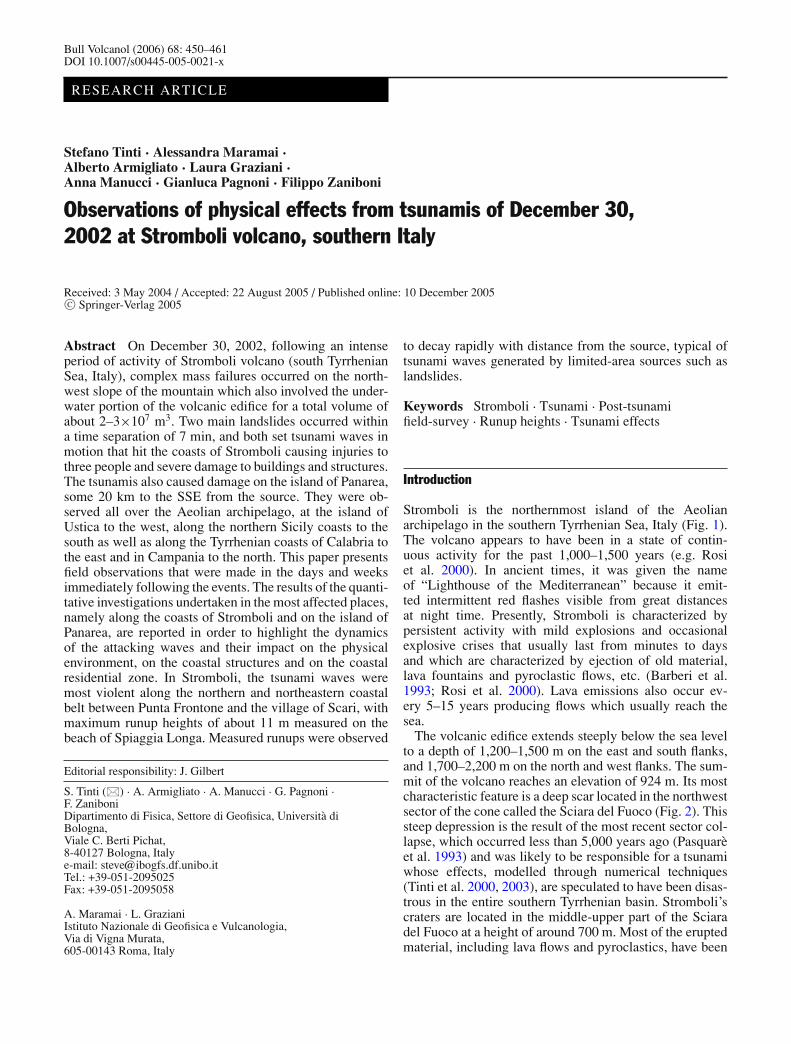
Fig. 1 Geographical sketch of the southern Tyrrhenian Sea, showingthe position of Stromboli in the Aeolian archipelago and other coastswhere the tsunami arrival was observed
accumulating onto the Sciara del Fuoco, progressivelyproducing the present-day steep 40◦ slope (Barberi et al.1993).
During the last part of 2002, Stromboli was dominatedby intense explosive activity that lasted until December28. On that day Stromboli started a new effusive phasethat destabilized the flank of the Sciara del Fuoco, leadingto the landslides of December 30. It has been ascertainedthat two major landslides occurred on that day (Bonac-corso et al. 2003; Pino et al. 2004). The first one at 13:15(local time = GMT+1) was mainly submarine, whereasthe second occurred 7–8 min later, creating a subaerialscar on the Sciara del Fuoco at a height of 500 m with avolume of about 7–8×10⁶ m3. The mass involved in thefirst landslide exceeded that of the second. Bathymetricand aerophotogrammetric surveys revealed that the totalvolume of the material transported by the two slides wasabout 2–3×10⁷ m3 (Baldi et al. 2003; Bosman et al. 2003;Chiocci et al. 2003).
According to a reconstruction based on eyewitness ac-counts (Tinti et al. 2005a), both landslides produced atsunami. The first event was triggered by the submarinelandslide and was characterized first by a negative seamovement, while the subaerial landslide was responsiblefor the second tsunami whose first polarity cannot be de-duced from the available accounts. At the foot of the Sciara,the submarine slide caused a sea-level depression of about10–15 m, immediately propagating in both directions north-ward towards the village of Piscita and southward towardsGinostra. A destructive tsunami, starting with an initial slowwithdrawal, hit the northern coasts of the island with threeto four big waves. After 3 min the water invaded the beachof Ficogrande, and 1 min later the tsunami attacked theareas of Punta Lena and Scari, producing severe damage.At about 13:20 local time, the waves arrived at the islandof Panarea (Figs. 1 and 3) with an initial sea withdrawal
followed by two to three strong sea swellings causing dam-age to the harbour of San Pietro. The second tsunami wasgenerated around 13:22 local time by a subaerial mass fail-ure. Only a few people were able to distinguish the arrivalof the second tsunami, while most considered it as the con-tinuation of the first.
The tsunami waves reached all the other Aeolian Islandsin about 20 minutes. According to Maramai et al. (2005a),abnormal sea perturbations were noticed at Milazzo on thenorthern Sicilian coast, some 60 km south of Stromboli(Fig. 1). The sea waves propagated also in the directionof the island of Ustica, about 170 km west of Stromboli,where they are reported to have impacted around 14:00local time. Finally, tsunami effects were observed alongthe southern coasts of the Campanian region at about 13:55local time (Fig. 1) (Nappi et al. 2003). Available far-fieldobservations are summarized in section “Tsunami effectsin the other Aeolian Islands and in the far field” of thepresent study.
In this paper, we present measurements of the maximumtsunami runup and inundation collected during threepost-event field surveys that were carried out at Stromboliand at Panarea in the weeks following the December30, 2002 events. These data are useful to draw a generalpicture of the tsunami characteristics, and further toserve as a basis both for the reconstruction of the eventsthrough numerical simulations (Tinti et al. 2005b) and forthe validation of the numerical model itself. It must bestressed that these experimental data can only describethe cumulative effects of the two distinct tsunamis thatoccurred on December 30, 2002. It is not possible tonumerically distinguish the effects of the two phenomena.
Tsunami field survey at Stromboli
Surveys and methods
Measurements and observations were collected duringthree different surveys conducted in cooperation betweentwo Italian groups, one from the University of Bologna andthe other from INGV in Rome. The first two surveys wereperformed in January 2003 (namely from the 11–13th andfrom the 21st–23rd of January), while the third was under-taken in mid March 2003. The primary goal of the surveyswas to identify the coastal areas affected by the tsunamisand to assess the main characteristics of the tsunami waveeffects from a physical point of view. Eyewitness accountswere important and enabled us not only to obtain informa-tion for various sites, in particular for those where no partic-ular signs of the tsunami could be recognized, but also to un-derstand the dynamics and the timing of the wave phenom-ena, and hence to reconstruct the sequence of the events.
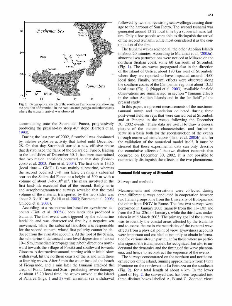
The surveys concentrated on the northern and northeast-ern sectors of the island, running approximately from PuntaFrontone on the northwest to La Petrazza on the southeast(Fig. 2), for a total length of about 4 km. In the lowerpanel of Fig. 2, the surveyed area has been separated intothree distinct boxes labelled A, B and C. Zoomed views
452
Fig. 2 Upper panel: basic toponymy and topographic map of Strom-boli, kindly provided by Professor P. Baldi, University of Bologna(GNV Project no. 13: Sviluppo e Applicazione di Tecniche di Tele-rilevamento per il Monitoraggio dei Vulcani Attivi Italiani). See also
Baldi et al. (2003). Lower panel: zoomed view of the portion ofthe island surveyed during the post-event campaigns described inthis paper. The three boxes A, B and C are detailed in Figs. 4–6,respectively
453
of the boxes are provided in Figs. 4–6, respectively. A cir-cumnavigation by boat allowed us to inspect the remainingcoastline from the sea. During the circumnavigation, it waspossible to land on the Punta Lena beach on the south-eastern end of the island. To avoid misunderstandings, wenote that there are two localities in Stromboli sharing thesame name “Punta Lena”: the northeastern and southeast-ern corners of the island (see Fig. 2). In this work wewill use the name Punta Lena to indicate “northern PuntaLena”.
The field procedures we adopted reflect those employedby the international tsunami community in several post-tsunami field surveys around the world (see for instanceBaptista et al. 1993; Synolakis et al. 1995) and codifiedby IOC/UNESCO (1998). At each site, after the identifica-tion of the maximum runup marks, the typical measuringoperations for each observation consisted of recording thetime and geographic position and in measuring the verticaland horizontal distances between the mark and the localsea level. Depending on the position of the runup mark,we often had to establish one or more intermediate po-sitions between the local sea level and the mark itself. Insome cases, these allowed us to build a topographic transectalong the selected profile.
All the runup values reported here are relative to the in-stantaneous sea level and are not corrected for the tide atthe time of the tsunami arrival. As can be deduced from the
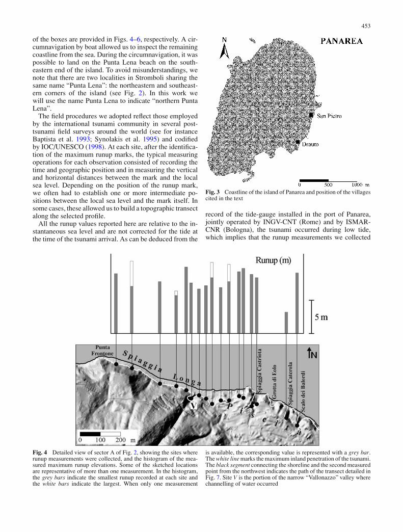
Fig. 3 Coastline of the island of Panarea and position of the villagescited in the text
record of the tide-gauge installed in the port of Panarea,jointly operated by INGV-CNT (Rome) and by ISMAR-CNR (Bologna), the tsunami occurred during low tide,which implies that the runup measurements we collected
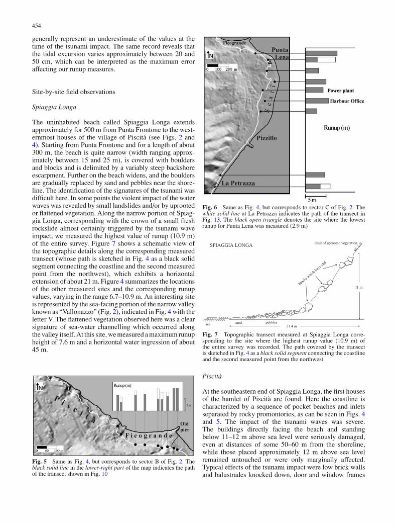
Fig. 4 Detailed view of sector A of Fig. 2, showing the sites whererunup measurements were collected, and the histogram of the mea-sured maximum runup elevations. Some of the sketched locationsare representative of more than one measurement. In the histogram,the grey bars indicate the smallest runup recorded at each site andthe white bars indicate the largest. When only one measurement
is available, the corresponding value is represented with a grey bar.The white line marks the maximum inland penetration of the tsunami.The black segment connecting the shoreline and the second measuredpoint from the northwest indicates the path of the transect detailed inFig. 7. Site V is the portion of the narrow “Vallonazzo” valley wherechannelling of water occurred
454
generally represent an underestimate of the values at thetime of the tsunami impact. The same record reveals thatthe tidal excursion varies approximately between 20 and50 cm, which can be interpreted as the maximum erroraffecting our runup measures.
Site-by-site field observations
Spiaggia Longa
The uninhabited beach called Spiaggia Longa extendsapproximately for 500 m from Punta Frontone to the west-ernmost houses of the village of Piscita (see Figs. 2 and4). Starting from Punta Frontone and for a length of about300 m, the beach is quite narrow (width ranging approx-imately between 15 and 25 m), is covered with bouldersand blocks and is delimited by a variably steep backshoreescarpment. Further on the beach widens, and the bouldersare gradually replaced by sand and pebbles near the shore-line. The identification of the signatures of the tsunami wasdifficult here. In some points the violent impact of the waterwaves was revealed by small landslides and/or by uprootedor flattened vegetation. Along the narrow portion of Spiag-gia Longa, corresponding with the crown of a small freshrockslide almost certainly triggered by the tsunami waveimpact, we measured the highest value of runup (10.9 m)of the entire survey. Figure 7 shows a schematic view ofthe topographic details along the corresponding measuredtransect (whose path is sketched in Fig. 4 as a black solidsegment connecting the coastline and the second measuredpoint from the northwest), which exhibits a horizontalextension of about 21 m. Figure 4 summarizes the locationsof the other measured sites and the corresponding runupvalues, varying in the range 6.7–10.9 m. An interesting siteis represented by the sea-facing portion of the narrow valleyknown as “Vallonazzo” (Fig. 2), indicated in Fig. 4 with theletter V. The flattened vegetation observed here was a clearsignature of sea-water channelling which occurred alongthe valley itself. At this site, we measured a maximum runupheight of 7.6 m and a horizontal water ingression of about45 m.
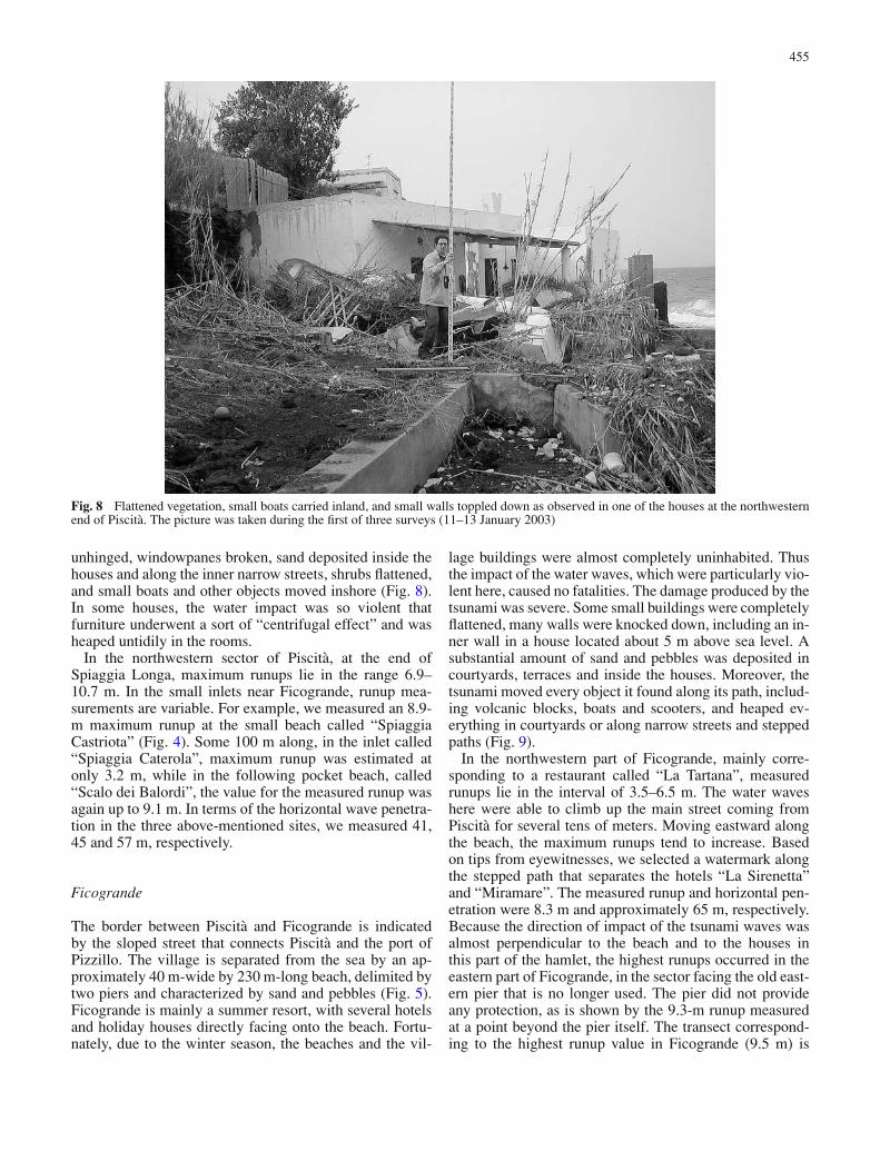
Fig. 5 Same as Fig. 4, but corresponds to sector B of Fig. 2. Theblack solid line in the lower-right part of the map indicates the pathof the transect shown in Fig. 10
Fig. 6 Same as Fig. 4, but corresponds to sector C of Fig. 2. Thewhite solid line at La Petrazza indicates the path of the transect inFig. 13. The black open triangle denotes the site where the lowestrunup for Punta Lena was measured (2.9 m)
sea pebbles
11 m
limit of uprooted vegetation
21.4 m
SPIAGGIA LONGA
blocks which
have sli
d
sand
Fig. 7 Topographic transect measured at Spiaggia Longa corre-sponding to the site where the highest runup value (10.9 m) ofthe entire survey was recorded. The path covered by the transectis sketched in Fig. 4 as a black solid segment connecting the coastlineand the second measured point from the northwest
Piscita
At the southeastern end of Spiaggia Longa, the first housesof the hamlet of Piscita are found. Here the coastline ischaracterized by a sequence of pocket beaches and inletsseparated by rocky promontories, as can be seen in Figs. 4and 5. The impact of the tsunami waves was severe.The buildings directly facing the beach and standingbelow 11–12 m above sea level were seriously damaged,even at distances of some 50–60 m from the shoreline,while those placed approximately 12 m above sea levelremained untouched or were only marginally affected.Typical effects of the tsunami impact were low brick wallsand balustrades knocked down, door and window frames
455
Fig. 8 Flattened vegetation, small boats carried inland, and small walls toppled down as observed in one of the houses at the northwesternend of Piscita. The picture was taken during the first of three surveys (11–13 January 2003)
unhinged, windowpanes broken, sand deposited inside thehouses and along the inner narrow streets, shrubs flattened,and small boats and other objects moved inshore (Fig. 8).In some houses, the water impact was so violent thatfurniture underwent a sort of “centrifugal effect” and washeaped untidily in the rooms.
In the northwestern sector of Piscita, at the end ofSpiaggia Longa, maximum runups lie in the range 6.9–10.7 m. In the small inlets near Ficogrande, runup mea-surements are variable. For example, we measured an 8.9-m maximum runup at the small beach called “SpiaggiaCastriota” (Fig. 4). Some 100 m along, in the inlet called“Spiaggia Caterola”, maximum runup was estimated atonly 3.2 m, while in the following pocket beach, called“Scalo dei Balordi”, the value for the measured runup wasagain up to 9.1 m. In terms of the horizontal wave penetra-tion in the three above-mentioned sites, we measured 41,45 and 57 m, respectively.
Ficogrande
The border between Piscita and Ficogrande is indicatedby the sloped street that connects Piscita and the port ofPizzillo. The village is separated from the sea by an ap-proximately 40 m-wide by 230 m-long beach, delimited bytwo piers and characterized by sand and pebbles (Fig. 5).Ficogrande is mainly a summer resort, with several hotelsand holiday houses directly facing onto the beach. Fortu-nately, due to the winter season, the beaches and the vil-
lage buildings were almost completely uninhabited. Thusthe impact of the water waves, which were particularly vio-lent here, caused no fatalities. The damage produced by thetsunami was severe. Some small buildings were completelyflattened, many walls were knocked down, including an in-ner wall in a house located about 5 m above sea level. Asubstantial amount of sand and pebbles was deposited incourtyards, terraces and inside the houses. Moreover, thetsunami moved every object it found along its path, includ-ing volcanic blocks, boats and scooters, and heaped ev-erything in courtyards or along narrow streets and steppedpaths (Fig. 9).
In the northwestern part of Ficogrande, mainly corre-sponding to a restaurant called “La Tartana”, measuredrunups lie in the interval of 3.5–6.5 m. The water waveshere were able to climb up the main street coming fromPiscita for several tens of meters. Moving eastward alongthe beach, the maximum runups tend to increase. Basedon tips from eyewitnesses, we selected a watermark alongthe stepped path that separates the hotels “La Sirenetta”and “Miramare”. The measured runup and horizontal pen-etration were 8.3 m and approximately 65 m, respectively.Because the direction of impact of the tsunami waves wasalmost perpendicular to the beach and to the houses inthis part of the hamlet, the highest runups occurred in theeastern part of Ficogrande, in the sector facing the old east-ern pier that is no longer used. The pier did not provideany protection, as is shown by the 9.3-m runup measuredat a point beyond the pier itself. The transect correspond-ing to the highest runup value in Ficogrande (9.5 m) is
456
Fig. 9 Photo showing small boats, broken walls and debris carried by the tsunami waves and channelled along one of the narrow streets ofFicogrande. The picture was taken during the second of the three surveys (21–23 January 2003)
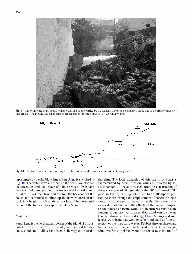
Fig. 10 Detailed transect corresponding to the last houses at the eastern termination of Ficogrande
represented by a solid black line in Fig. 5 and is sketched inFig. 10. The water waves climbed up the beach, overtoppedthe street, entered the terrace of a house where fresh sanddeposits and damaged doors were observed (local runupequal to 7.8 m), then travelled through the backdoor of thehouse and continued to climb up the narrow street in theback to a height of 9.5 m above sea level. The horizontalextent of the transect was approximately 60 m.
Punta Lena
Punta Lena is the northeastern corner of the island of Strom-boli (see Figs. 2 and 6). In recent years, several holidayhouses and small villas have been built very close to the
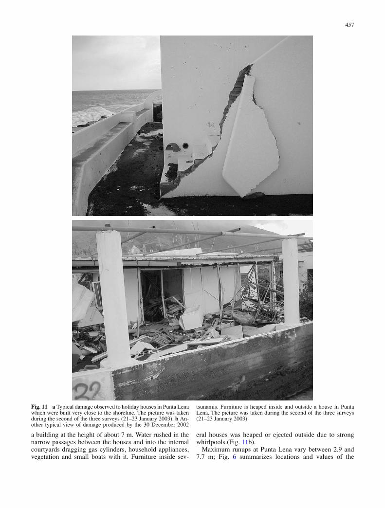
shoreline. The local dynamics of this stretch of coast ischaracterized by beach erosion, which is reported by lo-cal inhabitants to have increased after the construction ofthe eastern pier of Ficogrande in the 1970s (named “Oldpier” in Fig. 5). This problem led to an attempt to pro-tect the shore through the emplacement of concrete blocksalong the shore itself in the early 1980s. These reinforce-ments did not attenuate the effects of the tsunami impacton the houses of Punta Lena, which suffered very severedamage. Boundary walls, gates, doors and windows wereknocked down or destroyed (Fig. 11a). Railings and ironfences were bent, and were excellent indicators of the di-rection of the impacting waves. Pebbles thrown shorewardby the waves remained stuck inside the slots of severalwindows. Small pebbles were also found over the roof of
457
Fig. 11 a Typical damage observed to holiday houses in Punta Lenawhich were built very close to the shoreline. The picture was takenduring the second of the three surveys (21–23 January 2003). b An-other typical view of damage produced by the 30 December 2002
tsunamis. Furniture is heaped inside and outside a house in PuntaLena. The picture was taken during the second of the three surveys(21–23 January 2003)
a building at the height of about 7 m. Water rushed in thenarrow passages between the houses and into the internalcourtyards dragging gas cylinders, household appliances,vegetation and small boats with it. Furniture inside sev-
eral houses was heaped or ejected outside due to strongwhirlpools (Fig. 11b).
Maximum runups at Punta Lena vary between 2.9 and7.7 m; Fig. 6 summarizes locations and values of the
458
measurements. The highest value (7.7 m) was found atthe western end of the hamlet, close to the restaurant called“Punta Lena”. Here the watermark was a lava block broughtinshore as far as the main street. The corresponding hor-izontal penetration of the tsunami was estimated here at40 m. The lowest runup (2.9 m) was measured inside acourtyard corresponding to a collapsed small wall. At thissite, indicated as an open black triangle in Fig. 6, the in-gression was about 60 m.
Scari
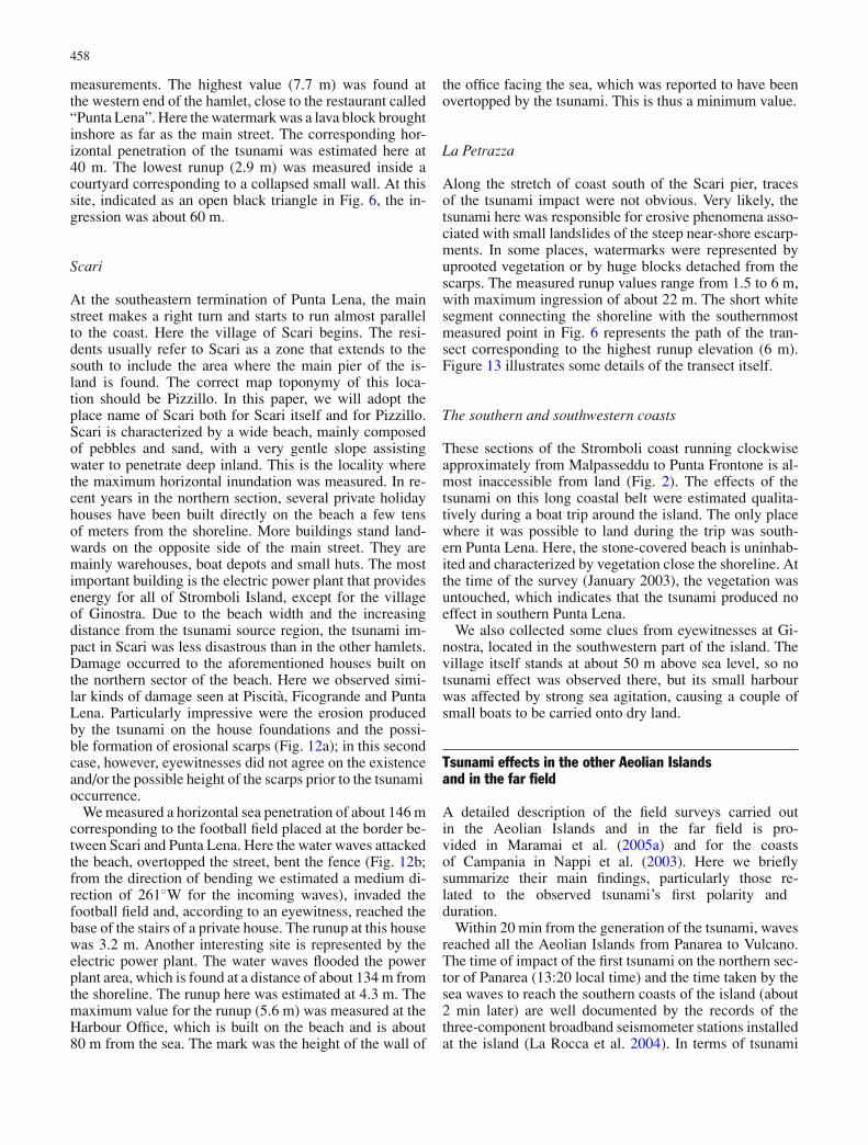
At the southeastern termination of Punta Lena, the mainstreet makes a right turn and starts to run almost parallelto the coast. Here the village of Scari begins. The resi-dents usually refer to Scari as a zone that extends to thesouth to include the area where the main pier of the is-land is found. The correct map toponymy of this loca-tion should be Pizzillo. In this paper, we will adopt theplace name of Scari both for Scari itself and for Pizzillo.Scari is characterized by a wide beach, mainly composedof pebbles and sand, with a very gentle slope assistingwater to penetrate deep inland. This is the locality wherethe maximum horizontal inundation was measured. In re-cent years in the northern section, several private holidayhouses have been built directly on the beach a few tensof meters from the shoreline. More buildings stand land-wards on the opposite side of the main street. They aremainly warehouses, boat depots and small huts. The mostimportant building is the electric power plant that providesenergy for all of Stromboli Island, except for the villageof Ginostra. Due to the beach width and the increasingdistance from the tsunami source region, the tsunami im-pact in Scari was less disastrous than in the other hamlets.Damage occurred to the aforementioned houses built onthe northern sector of the beach. Here we observed simi-lar kinds of damage seen at Piscita, Ficogrande and PuntaLena. Particularly impressive were the erosion producedby the tsunami on the house foundations and the possi-ble formation of erosional scarps (Fig. 12a); in this secondcase, however, eyewitnesses did not agree on the existenceand/or the possible height of the scarps prior to the tsunamioccurrence.
We measured a horizontal sea penetration of about 146 mcorresponding to the football field placed at the border be-tween Scari and Punta Lena. Here the water waves attackedthe beach, overtopped the street, bent the fence (Fig. 12b;from the direction of bending we estimated a medium di-rection of 261◦W for the incoming waves), invaded thefootball field and, according to an eyewitness, reached thebase of the stairs of a private house. The runup at this housewas 3.2 m. Another interesting site is represented by theelectric power plant. The water waves flooded the powerplant area, which is found at a distance of about 134 m fromthe shoreline. The runup here was estimated at 4.3 m. Themaximum value for the runup (5.6 m) was measured at theHarbour Office, which is built on the beach and is about80 m from the sea. The mark was the height of the wall of
the office facing the sea, which was reported to have beenovertopped by the tsunami. This is thus a minimum value.
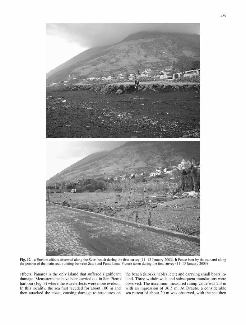
La Petrazza
Along the stretch of coast south of the Scari pier, tracesof the tsunami impact were not obvious. Very likely, thetsunami here was responsible for erosive phenomena asso-ciated with small landslides of the steep near-shore escarp-ments. In some places, watermarks were represented byuprooted vegetation or by huge blocks detached from thescarps. The measured runup values range from 1.5 to 6 m,with maximum ingression of about 22 m. The short whitesegment connecting the shoreline with the southernmostmeasured point in Fig. 6 represents the path of the tran-sect corresponding to the highest runup elevation (6 m).Figure 13 illustrates some details of the transect itself.
The southern and southwestern coasts
These sections of the Stromboli coast running clockwiseapproximately from Malpasseddu to Punta Frontone is al-most inaccessible from land (Fig. 2). The effects of thetsunami on this long coastal belt were estimated qualita-tively during a boat trip around the island. The only placewhere it was possible to land during the trip was south-ern Punta Lena. Here, the stone-covered beach is uninhab-ited and characterized by vegetation close the shoreline. Atthe time of the survey (January 2003), the vegetation wasuntouched, which indicates that the tsunami produced noeffect in southern Punta Lena.
We also collected some clues from eyewitnesses at Gi-nostra, located in the southwestern part of the island. Thevillage itself stands at about 50 m above sea level, so notsunami effect was observed there, but its small harbourwas affected by strong sea agitation, causing a couple ofsmall boats to be carried onto dry land.
Tsunami effects in the other Aeolian Islandsand in the far field
A detailed description of the field surveys carried outin the Aeolian Islands and in the far field is pro-vided in Maramai et al. (2005a) and for the coastsof Campania in Nappi et al. (2003). Here we brieflysummarize their main findings, particularly those re-lated to the observed tsunami’s first polarity andduration.
Within 20 min from the generation of the tsunami, wavesreached all the Aeolian Islands from Panarea to Vulcano.The time of impact of the first tsunami on the northern sec-tor of Panarea (13:20 local time) and the time taken by thesea waves to reach the southern coasts of the island (about2 min later) are well documented by the records of thethree-component broadband seismometer stations installedat the island (La Rocca et al. 2004). In terms of tsunami
459
Fig. 12 a Erosion effects observed along the Scari beach during the first survey (11–13 January 2003). b Fence bent by the tsunami alongthe portion of the main road running between Scari and Punta Lena. Picture taken during the first survey (11–13 January 2003)
effects, Panarea is the only island that suffered significantdamage. Measurements have been carried out in San Pietroharbour (Fig. 3) where the wave effects were more evident.In this locality, the sea first receded for about 100 m andthen attacked the coast, causing damage to structures on
the beach (kiosks, tables, etc.) and carrying small boats in-land. Three withdrawals and subsequent inundations wereobserved. The maximum measured runup value was 2.3 mwith an ingression of 36.5 m. At Drauto, a considerablesea retreat of about 20 m was observed, with the sea then
460
seapebbles
6 m
water mark
10 m
LA PETRAZZA
blocks which have slid
Fig. 13 Details of the transect surveyed at La Petrazza corresponding to the largest local runup measurement (6 m)
flooding the beach slightly further than the usual limit,without any damage.
In all the other islands of the archipelago (Fig. 1), tsunamieffects were observed, but without causing any damage.Eyewitnesses report anomalous sea behaviour typicallymanifested as extraordinary tides or whirlpools. At Salina,the tsunami arrival time, from eyewitness accounts, rangesbetween 13:20–13:40 local time, depending on the loca-tion of the observers. Along the northern and southwesterncoasts of the island, available accounts report an initialwithdrawal of the sea, while a rise was the first movementobserved along the eastern sector of the coastline wherethe tsunami was manifested as a sequence of 3–4 waves.At Lipari, the first tsunami wave was observed between13:25–13:35 local time. On the northern side of the is-land a withdrawal was seen first; two waves were reported,and the entire phenomenon lasted 15–20 min. The firsttsunami polarity and the number of waves along the east-ern coasts are more controversial. A sea retreat between13:30–13:40 was the first tsunami manifestation reportedalong the coasts of Vulcano; the sea movement consistedof 2–3 waves. Similar observations are attributed to Fil-icudi, where the tsunami was seen around 14:00 localtime.
The tsunami propagated into the entire southern Tyrrhe-nian Sea, with energy very likely focussing especially to-wards the south and southwest in the direction of north-ern Sicily, west towards the island of Ustica and northeasttowards northern Calabria to southern Campania. In Mi-lazzo (northern Sicily), a single powerful wave attackedthe oil refinery where a tanker involved in discharge op-erations made leeway for about 10 m. The tsunami wasalso observed at Mondello, ca. 10 km north of Palermo,as a series of sea swells starting around 14:00 and lastingfor about 20 min. Regarding Ustica, located 170 km westof Stromboli, the tsunami started around 13:45 with a lowwithdrawal along the eastern coasts of the island, followedby an inundation. The sea agitation lasted for about 2 h.Finally, the tsunami waves attacked the southern Campaniacoasts at about 13:55. In particular, in the village calledMarina di Camerota eyewitnesses saw the sea first recedeand then attack the little harbour like a fast tidal movement.
Conclusions
This paper is a short report of the observations made in anumber of surveys carried out in the weeks following theStromboli tsunamis. The zone most affected was found tobe the northern and the northeastern coasts of Stromboli,where most of the houses built along low beaches weredestroyed or severely damaged. The toll of the tsunamis didnot involve human fatalities because of two main reasons.Firstly, there were no people living in most of the affectedhouses at the time of the tsunamis, since private houses andhotels are used as holiday facilities during most of the year,except in late autumn and winter when they are vacant.Secondly, local residents and the very few tourists presentwere alerted by the noise produced by the arriving tsunamisand had time to run to safer places.
The zone of the highest damage was only a few kilome-tres long, and therefore it was possible to perform a verydetailed survey. In the field, we were not able to find anymeans to discriminate between the two tsunamis since theirarrivals were separated by a very short time interval. Onlyinterviews with some eyewitnesses allowed us to partlyclarify the different characteristics of the two episodes; weconcluded that probably both were violent enough to bedestructive (Tinti et al. 2005a). Runup heights were seen todecay as one moved from the source area in the Sciara delFuoco towards the hamlet of Scari. No measurements couldbe taken near the source, since it was believed to be too dan-gerous to work there immediately after the tsunami events.Also, the traces of tsunami impact were very likely oblit-erated by the subsequent episodes of lava flows and slopefailure. The surveyed coastal segment next to the sourcewas Spiaggia Longa (Fig. 1) where the highest runup valueof 10.9 m was found. Here the waves impacted a steep cliffbeyond a narrow stony beach and produced a clear markon the vegetation at the head of a fresh rockfall, probablycaused by the tsunami itself. The observed rapid decay istypical of limited-area tsunami sources such as landslides,and is much larger than the tsunami decay usually associ-ated with seismic sources (Okal and Synolakis 2003). Thisprovides evidence that the tsunamis could not have beencaused by a tectonic dislocation.
461
The tsunamis were also violent at the beach of Scari onthe eastern coast of Stromboli almost opposite to the sourceregion, demonstrating that tsunami waves are able to travelaround islands and affect areas that are in the shadow oftypical short-wavelength wind waves. This is well knownand is both experimentally and theoretically verified (seeTinti and Vannini 1995).
These events were the first damaging tsunamis to hit thecoasts of Italy in the last 50 years (see the Italian tsunamicatalogue by Tinti et al. 2004). The impact on the localpopulation and on public opinion in general in Italy wasthus quite strong. The occurrence of these tsunamis causedby complex mass failures on the flank of Stromboli helpsexplain the cause of other tsunamis known to have takenplace during previous eruptive crises of the volcano. Arecent re-analysis of historical tsunamis which have oc-curred in the Aeolian Islands since the beginning of thelast century reveals that (1) at least two more cases of adouble tsunami occurred at Stromboli (1930 and 1944),(2) the second tsunami in 1930 was characterized by cer-tain features (violent attack of Punta Lena, negative firstarrival followed by flooding, etc.) which resemble the firsttsunami of 2002, pointing to a submarine failure in theSciara del Fuoco area as the cause of the waves (Maramaiet al. 2005b). Mass failures along the slopes of Stromboliduring eruptive paroxysms of the volcano can be the gene-sis of local tsunami episodes, which may have occurred sixtimes since 1916 (Maramai et al. 2005b). This frequency ofoccurrence outlines the importance of carefully describingthe features of the recent 2002 tsunamis, since this informa-tion can contribute to prevent and protect from the effectsof future events.
Acknowledgements The research was funded by INGV-GNV. Theauthors wish to acknowledge the support received from the ItalianCivil Protection authorities who provided authorization to access thesites during the emergency period and indispensable logistics.
References
Baldi P, Belloli F, Fabris M, Marsella M, Ponticelli R, SignorottoV (2003) La fotogrammetria digitale differenziale del versantedella Sciara del Fuoco (isola di Stromboli) dopo l’evento del30 Dicembre 2002 (in Italian). 7a Conferenza Nazionale ASITA“L’informazione territoriale e la dimensione del tempo”, Verona28–31 Ottobre 2003
Baptista AM, Priest GR, Murty TS (1993) Field survey of the 1992Nicaragua tsunami. Mar Geod 16:169–203
Barberi F, Rosi M, Sodi A (1993) Volcanic hazard assessment atStromboli based on review of historical data. Acta Vulcanol3:173–187
Bonaccorso A, Calvari S, Garfı G, Lodato L, Patane D(2003) Dynamics of the December 2002 flank failure andtsunami at Stromboli volcano inferred by volcanologicaland geophysical observations. Geophys Res Lett 30(18):1941DOI:10.1029/2003GL017702
Bosman A, Chiocci FL, Romagnoli C, Tommasi P, Abballe P, BellinoM, De Alteris G, D’Isanto C, Macelloni L, Tondelli R (2003)Evoluzione morfologica e deposizionale del settore sommersoantistante la Sciara del Fuoco a partire dall’evento di maremotodel 30/12/2002: implicazioni per la comprensione dei fenomenidi instabilita gravitativi (in Italian). GNV General Assembly,June 9–11, Rome
Chiocci FL, Bosman A, Romagnoli C, Tommasi P, De Alteris G(2003) The December 2002 Sciara del Fuoco (Stromboli Is-land) submarine landslide: a first characterisation. EGS-AGU-EUG Joint Assembly, Nice, France, April 2003, GeophysicalResearch Abstracts, vol. 5, CDROM Version
IOC/UNESCO (1998) Post-tsunami survey field guide. Manualsand Guide No. 30 (1st edn.). PDF version available onlineat: http:/www.prh.noaa.gov/itic/library/pubs/glossary/tsunamifield guide eng.pdf
La Rocca M, Galluzzo D, Saccorotti G, Tinti S, Cimini G, Del PezzoE (2004) Seismic signals associated with landslides and with atsunami at Stromboli volcano, Italy. Bull Seis Soc Am 94:1850–1867
Maramai A, Graziani L, Alessio G, Burrato P, Colini L, Cucci L,Nappi R, Nardi A, Vilardo G (2005a) Near- and far-field sur-vey report of the 30 December 2002 Stromboli (southern Italy)tsunami. Mar Geol 215:93–106
Maramai A, Graziani L, Tinti S (2005b) Tsunamis in the AeolianIslands (southern Italy): a review. Mar Geol 215:11–21
Nappi R, Alessio G, Nave R, Sepe V, Siniscalchi V, Vilardo G(2003) Rilievo degli effetti del maremoto di Stromboli del30.12.2002 (Costa Salernitana). INGV-Osservatorio Vesuviano,Open File Report N.2 2003 (in Italian). Available online at:http://www.ov.ingv.it/italiano/pubblicazioni/openfile/ofr 02 03.htm
Okal EA, Synolakis CE (2003) A theoretical comparison of tsunamisfrom dislocations and landslides. Pure Appl Geophys 160:2177–2188
Pasquare G, Francalanci L, Garduno VH, Tibaldi A (1993) Struc-ture and geologic evolution of the Stromboli volcano, AeolianIslands, Italy. Acta Vulcanol 3:79–89
Pino NA, Ripepe M, Cimini GB (2004) The Stromboli volcano land-slides of December 2002: a seismological description. GeophysRes Lett 31:L02605 DOI: 10.1029/2003GL0118385
Rosi M, Bertagnini A, Landi P (2000) Onset of persistent activity atStromboli Volcano (Italy). Bull Volcanol 62:294–300
Synolakis C, Imamura F, Tsuji Y, Matsutomi H, Tinti S, Cook B,Chandra YP, Usman M (1995) Damage, conditions of EastJava tsunami of 1994 analyzed. EOS Trans Am Geophys Union76:257, 261–262
Tinti S, Vannini C (1995) Tsunami trapping near circular islands.Pure Appl Geophys 144:595–619
Tinti S, Bortolucci E, Romagnoli C (2000) Computer simulations oftsunamis due to sector collapse at Stromboli, Italy. J VolcanolGeotherm Res 96:103–128
Tinti S, Pagnoni G, Zaniboni F, Bortolucci E (2003) Tsunami genera-tion on Stromboli Island and impact on the south-east Tyrrheniancoasts. Nat Haz Earth Sys Sci 3:299–309
Tinti S, Maramai A, Graziani L (2004) The new catalogue of Italiantsunamis. Nat Haz 33:439–465
Tinti S, Manucci A, Pagnoni G, Armigliato A, Zaniboni F (2005a)The 30th December 2002 landslide-induced tsunamis in Strom-boli: sequence of the events reconstructed from the eyewitnessaccounts. Nat Haz Earth Sys Sci 5:763–775
Tinti S, Pagnoni G, Zaniboni F (2005b) The landslides and tsunamisof 30th December 2002 in Stromboli analysed through numeri-cal simulations. Bull Volcanol (in press)