Extreme wave deposits on the Pacific coast of Mexico: tsunamis or storms? – A multi-proxy approach
12
Extreme wave deposits on the Pacific coast of Mexico: Tsunamis or storms? — A multi-proxy approach María-Teresa Ramírez-Herrera a, ⁎, Marcelo Lagos b , Ian Hutchinson c , Vladimir Kostoglodov d , Maria Luisa Machain e , Margarita Caballero d , Avto Goguitchaichvili f, a , Bertha Aguilar f, a , Catherine Chagué-Goff g, h , James Goff g , Ana-Carolina Ruiz-Fernández i , Modesto Ortiz j , Hector Nava a , Francisco Bautista a , Gloria I. Lopez k , Patricia Quintana l a Laboratorio Universitario de Geofísica Ambiental (LUGA), Centro de Investigaciones en Geografía Ambiental, Universidad Nacional Autónoma de México, Campus Morelia, Morelia, Mexico b Instituto de Geografía, Laboratorio de Tsunamis, Pontificia Universidad Católica de Chile, Santiago, Chile c Department of Geography, Simon Fraser University, Vancouver, Canada d Instituto de Geofísica, Universidad Nacional Autónoma de México, Ciudad de México, Mexico e Instituto de Ciencias del Mar y Limnología, Universidad Nacional Autónoma de México, Ciudad Universitaria, Ciudad de México, Mexico f LIMNA, Instituto de Geofisica, Unidad Michoacan, UNAM, Campus Morelia, Morelia, Mexico g Australia-Pacific Tsunami Research Centre, University of New South Wales, Sydney 2052, NSW, Australia h Institute for Environmental Research, Australian Nuclear Science and Technology Organisation (ANSTO), Locked Bag 2001, Kirrawee DC, NSW 2232, Australia i Instituto de Ciencias del Mar y Limnología, Universidad Nacional Autónoma de México, Unidad Académica Mazatlán, Mazatlán, Mexico j Dpto. de Oceanografía Física, Centro de Investigación Científica y Educacion Superior de Ensenada, Km 107, Cta. Tijuana, Ensenada, Ensenada, BC 22860, Mexico k Geological Survey of Israel and University of Haifa, Department of Marine Geosciences, Leon H. Charney School of Marine Sciences, University of Haifa, Mt. Carmel, Haifa, 31905, Israel l Centro de Investigaciones y Estudios Avanzados, Unidad Mérida, Yucatán, Mexico abstract article info Article history: Received 21 May 2011 Received in revised form 31 October 2011 Accepted 1 November 2011 Available online 6 November 2011 Keywords: Tsunami Storm 1985 Mexico earthquake Multi-proxy approach Sediment record Tsunami hazard Historical and instrumental data show that the Pacific coast of Mexico has been exposed to destructive tsu- namis over at least the past 500 years. This coast is also affected by hurricanes generated in the eastern Pa- cific. The great 1985 Mexico earthquake and its aftershock generated tsunamis that affected the Ixtapa– Zihuatanejo and Michoacán coast. The purpose of our study was two-fold — a) to determine whether storm and tsunami deposits could be distinguished, and b) whether tsunami deposits from historical events are preserved in the tropical environments of the Ixtapa–Zihuatanejo coast. Two anomalous sand units in the Ixtapa estuary are interpreted to be the result of high-energy marine inun- dation events that occurred in the last century. Several lines of evidence using a multi-proxy approach (his- torical studies, interviews with local witnesses, geomorphological and geological surveys, coring and trenching, laboratory analyses including grain size, micropaleontology, geochemistry, magnetic susceptibility and radiometric dating, and numerical modeling) indicate the occurrence of two tsunamis that we link to local events: the 21st September 1985 Mexico and possibly the 14th March 1979 Petatlan earthquakes. We thereby provide the first onshore geological evidence of historical tsunamis on the Pacific coast of Mexico. © 2011 Elsevier B.V. All rights reserved. 1. Introduction Research on the geological evidence for past tsunamis is an impor- tant tool for determining the recurrence interval for such events. These studies are also the only way of determining the prehistoric oc- currence and comprehensive tsunami hazard in areas of infrequent seismic activity. Since the 2004 Indian Ocean Tsunami, the ability to identify the geological evidence of past events has greatly improved. Detailed studies of deposits related to that event have been numerous (e.g. Liu et al., 2005; Moore et al., 2005; Hawkes et al., 2007). Recently, there have been more opportunities to further improve our ability to identify past events through geological studies of the 2006 Java, 2007 Solomon Islands and Chile, 2009 South Pacific, 2010 Haiti, Chile, and Mentawai and 2011 Tohoku tsunamis (e.g. Chagué- Goff et al., 2011; Horton et al., 2011; Moore et al., in press). While it is still difficult to distinguish between tsunami deposits and those laid down by other high-energy events, such as storm surges or hurricanes (Lario et al., 2010), prior studies show that not one but a series of proxies must be used to achieve such goals (Goff et al., 2004a, 2010a; Kortekaas and Dawson, 2007; Morton et al., 2007; Ramírez-Herrera et al., 2007; Chagué-Goff et al., 2011; Richmond et al., 2011). These proxies include variables such as the geomorphological setting, deposit thickness, grain size variations, sediment structure, microfossils, geochemistry, archeology and Geomorphology 139–140 (2012) 360–371 ⁎ Corresponding author. Tel.: + 52 443 322 3846; fax: + 52 443 322 3865. E-mail address: [email protected] (M.-T. Ramírez-Herrera). 0169-555X/$ – see front matter © 2011 Elsevier B.V. All rights reserved. doi:10.1016/j.geomorph.2011.11.002 Contents lists available at SciVerse ScienceDirect Geomorphology journal homepage: www.elsevier.com/locate/geomorph
Transcript of Extreme wave deposits on the Pacific coast of Mexico: tsunamis or storms? – A multi-proxy approach
Geomorphology 139–140 (2012) 360–371
Contents lists available at SciVerse ScienceDirect
Geomorphology
j ourna l homepage: www.e lsev ie r .com/ locate /geomorph
Extreme wave deposits on the Pacific coast of Mexico: Tsunamis or storms? — Amulti-proxy approach
María-Teresa Ramírez-Herrera a,⁎, Marcelo Lagos b, Ian Hutchinson c, Vladimir Kostoglodov d,Maria Luisa Machain e, Margarita Caballero d, Avto Goguitchaichvili f,a, Bertha Aguilar f,a,Catherine Chagué-Goff g,h, James Goff g, Ana-Carolina Ruiz-Fernández i, Modesto Ortiz j, Hector Nava a,Francisco Bautista a, Gloria I. Lopez k, Patricia Quintana l
a Laboratorio Universitario de Geofísica Ambiental (LUGA), Centro de Investigaciones en Geografía Ambiental, Universidad Nacional Autónoma de México, Campus Morelia, Morelia, Mexicob Instituto de Geografía, Laboratorio de Tsunamis, Pontificia Universidad Católica de Chile, Santiago, Chilec Department of Geography, Simon Fraser University, Vancouver, Canadad Instituto de Geofísica, Universidad Nacional Autónoma de México, Ciudad de México, Mexicoe Instituto de Ciencias del Mar y Limnología, Universidad Nacional Autónoma de México, Ciudad Universitaria, Ciudad de México, Mexicof LIMNA, Instituto de Geofisica, Unidad Michoacan, UNAM, Campus Morelia, Morelia, Mexicog Australia-Pacific Tsunami Research Centre, University of New South Wales, Sydney 2052, NSW, Australiah Institute for Environmental Research, Australian Nuclear Science and Technology Organisation (ANSTO), Locked Bag 2001, Kirrawee DC, NSW 2232, Australiai Instituto de Ciencias del Mar y Limnología, Universidad Nacional Autónoma de México, Unidad Académica Mazatlán, Mazatlán, Mexicoj Dpto. de Oceanografía Física, Centro de Investigación Científica y Educacion Superior de Ensenada, Km 107, Cta. Tijuana, Ensenada, Ensenada, BC 22860, Mexicok Geological Survey of Israel and University of Haifa, Department of Marine Geosciences, Leon H. Charney School of Marine Sciences, University of Haifa, Mt. Carmel, Haifa, 31905, Israell Centro de Investigaciones y Estudios Avanzados, Unidad Mérida, Yucatán, Mexico
⁎ Corresponding author. Tel.: +52 443 322 3846; faxE-mail address: [email protected] (M.-T. Ra
0169-555X/$ – see front matter © 2011 Elsevier B.V. Aldoi:10.1016/j.geomorph.2011.11.002
a b s t r a c t
a r t i c l e i n f oArticle history:Received 21 May 2011Received in revised form 31 October 2011Accepted 1 November 2011Available online 6 November 2011
Keywords:TsunamiStorm1985 Mexico earthquakeMulti-proxy approachSediment recordTsunami hazard
Historical and instrumental data show that the Pacific coast of Mexico has been exposed to destructive tsu-namis over at least the past 500 years. This coast is also affected by hurricanes generated in the eastern Pa-cific. The great 1985 Mexico earthquake and its aftershock generated tsunamis that affected the Ixtapa–Zihuatanejo and Michoacán coast. The purpose of our study was two-fold — a) to determine whetherstorm and tsunami deposits could be distinguished, and b) whether tsunami deposits from historicalevents are preserved in the tropical environments of the Ixtapa–Zihuatanejo coast.Two anomalous sand units in the Ixtapa estuary are interpreted to be the result of high-energy marine inun-dation events that occurred in the last century. Several lines of evidence using a multi-proxy approach (his-torical studies, interviews with local witnesses, geomorphological and geological surveys, coring andtrenching, laboratory analyses including grain size, micropaleontology, geochemistry, magnetic susceptibilityand radiometric dating, and numerical modeling) indicate the occurrence of two tsunamis that we link tolocal events: the 21st September 1985 Mexico and possibly the 14th March 1979 Petatlan earthquakes. Wethereby provide the first onshore geological evidence of historical tsunamis on the Pacific coast of Mexico.
© 2011 Elsevier B.V. All rights reserved.
1. Introduction
Research on the geological evidence for past tsunamis is an impor-tant tool for determining the recurrence interval for such events.These studies are also the only way of determining the prehistoric oc-currence and comprehensive tsunami hazard in areas of infrequentseismic activity. Since the 2004 Indian Ocean Tsunami, the ability toidentify the geological evidence of past events has greatly improved.Detailed studies of deposits related to that event have been numerous(e.g. Liu et al., 2005; Moore et al., 2005; Hawkes et al., 2007).
: +52 443 322 3865.mírez-Herrera).
l rights reserved.
Recently, there have been more opportunities to further improveour ability to identify past events through geological studies of the2006 Java, 2007 Solomon Islands and Chile, 2009 South Pacific, 2010Haiti, Chile, and Mentawai and 2011 Tohoku tsunamis (e.g. Chagué-Goff et al., 2011; Horton et al., 2011; Moore et al., in press).
While it is still difficult to distinguish between tsunami depositsand those laid down by other high-energy events, such as stormsurges or hurricanes (Lario et al., 2010), prior studies show that notone but a series of proxies must be used to achieve such goals (Goffet al., 2004a, 2010a; Kortekaas and Dawson, 2007; Morton et al.,2007; Ramírez-Herrera et al., 2007; Chagué-Goff et al., 2011;Richmond et al., 2011). These proxies include variables such as thegeomorphological setting, deposit thickness, grain size variations,sediment structure, microfossils, geochemistry, archeology and
361M.-T. Ramírez-Herrera et al. / Geomorphology 139–140 (2012) 360–371
palaeoecology (Morton et al., 2007; Ramírez-Herrera et al., 2007; Goffet al., 2010a; Chagué-Goff et al., 2011; Goff and Dominey-Howes, inpress). However, only a few studies have used a large number ofthese proxies to not only identify tsunami deposits (Goff et al.,2004a, 2004b, 2010b; Ramírez-Herrera et al., 2007; Chagué-Goff etal., 2011) but to distinguish between tsunamis and other high-energy events, i.e. storms (Goff et al., 2001, 2004a; Morton et al.,2007).
This problem is accentuated in tropical coastal areas where rapidtaphonomic processes (e.g. chemical dissolution, diagenesis) reducethe number of proxies available, making it harder to distinguish be-tween tsunamis and storms, although careful consideration of thefull range of potential proxies available can still prove successful(e.g. Goff et al., 2011a, 2011b). The problem is also exacerbated inareas where little or no scientific survey work was undertaken inthe immediate aftermath of a tsunami. Even for reasonably recentevents, the extent and depth of inundation can only be estimatedfrom anecdotal evidence (e.g. Goff, 2011). Therefore, the resultant po-tential inaccuracies in the average recurrence intervals for tsunamisand storms have long-term consequences for risk assessment andmitigation in such areas. One such area is the Pacific coast of Mexicosouth of the Gulf of California, where past seismic, tsunami andstorm activity has been reported (Abe et al., 1986; Sanchez andFarreras, 1993; NGDC, 2010) and a small number of paleotsunami de-posits have been studied (Ramírez-Herrera et al., 2005, 2007, 2009).Seismic activity along the Pacific coast of Mexico is mostly related tosubduction of the Rivera-Cocos plates under the North Americaplate. This megathrust faulting caused the 19th September 1985Mw 8.1 earthquake and tsunami and its Mw 7.6 aftershock on 21stSeptember (Mendoza, 1993) that also triggered a tsunami. Beforethis event, on March 14th, 1979 a tsunami was triggered by a Mw7.6 earthquake that occurred near Ixtapa–Zihuatanejo. The 1979earthquakes and its respective tsunami occurred a few years afterthe Hurricane Madeline occurred in 1976 near Ixtapa–Zihuatanejo.However, to date no scientific research has been carried out on anyof these deposits.
A survey of low-lying areas along the central western coast ofMexico revealed several sites with anomalous sand beds withinfine-grained coastal deposits. In this study we present the geologicalevidence of deposits found in the Ixtapa estuary, based on the analy-sis of cores, pits and a trench, in an attempt to determine whetherthese anomalous sand beds were laid down by recent historicalevents. We also discuss the importance of using a multi-proxy ap-proach to distinguish tsunami deposits from other high-energyevents, such as storms.
2. Study area
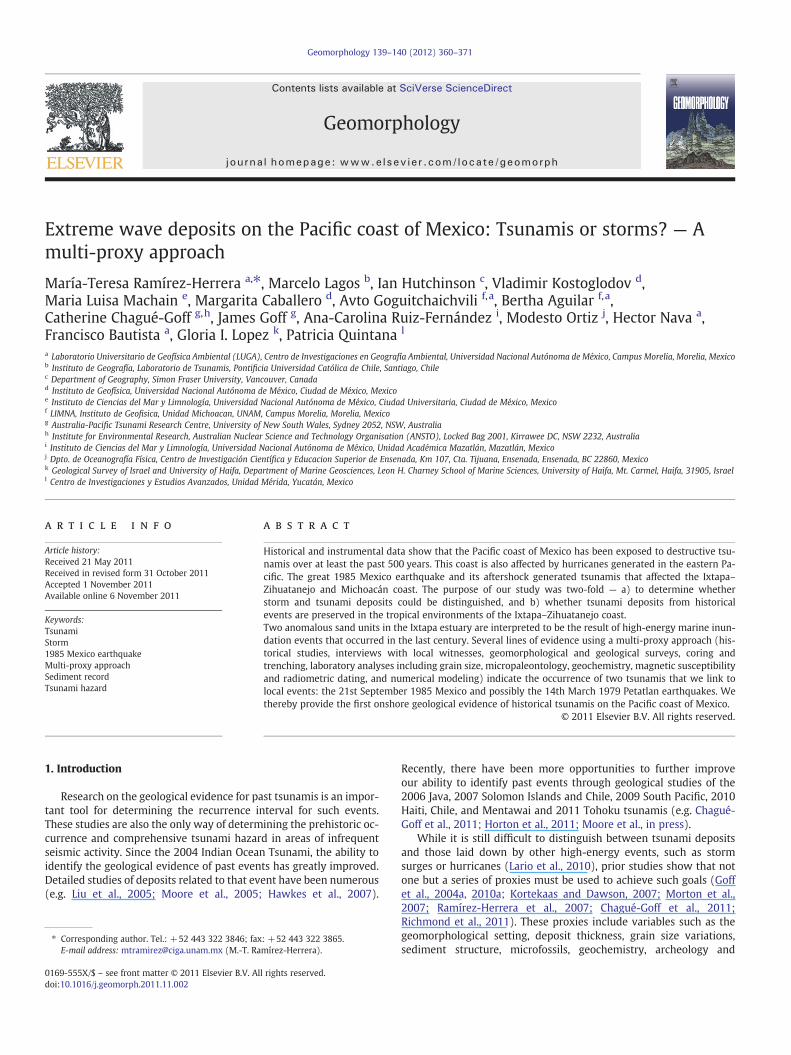
The Ixtapa–Zihuatanejo area has been affected by large historicalearthquakes and their subsequent tsunamis (Sanchez and Farreras,1993; NGDC, 2010). We therefore selected this region to search forthe geological evidence of historical tsunami deposits, by using amulti-disciplinary approach. The Ixtapa estuary was identified as akey area because historic written reports and a post-tsunami surveywere completed after the 1985 earthquake, identifying sites of inun-dation and runup (Abe et al., 1986). Furthermore, the local geomor-phology appeared favorable (a low sandy beach, narrow and lowspit-barrier, marshes and an estuary — the latter characterized byhigh sedimentation rates) for the study of the geological signaturesof past tsunamis.
Ixtapa estuary is located on the Pacific coast of Mexico (Fig. 1). It ismicrotidal with moderate wave action and predominantly southeastwinds in the summer and northwest winds in the winter (Yáñez-Arancibia, 1978). A spit-barrier approximately 370 m long, 30 mwide and ranging in height from 1.5 to 1.8 m separates the estuaryfrom the sea. The local geology consists of alluvial sediments with
sandstone, conglomerate and limestone comprising the landwardhills. Sedimentary environments within the Ixtapa estuary area in-clude the beach, spit-barrier and narrow mangrove marshes alongthe coastal margin.
3. Methods
This research involved historical studies, interviews with localwitnesses, geomorphological and geological surveys, coring and tren-ching, and a suite of laboratory analyses (grain size, micropaleontolo-gy, geochemistry, magnetic susceptibility, radiometric dating). Whereavailable, we used satellite images from Google Earth and aerial pho-tographs (1:75,000 scales) to identify relatively undisturbed sites forfield investigations. Geomorphic environments of wetlands, marshesand estuaries were mapped and sites selected for sediment coring,pits and trenching.
We used a hand-held Garmin GPS to determine the coordinates ofindividual sites, with orthometric heights of the test pits and trenchdetermined by differential GPS using double frequency Leica SR520receivers and AT504 antennas. Nearby GPS stations of the permanentGPS network “Sismologia-UNAM” were used as reference points. TheZihuatanejo (ZIHP) reference station has present-day orthometricheight estimates linked to the vertical datum at the Zihuatanejo Baytide gage. Differential GPS surveys were carried out from the coastand Ixtapa River bank to the pit and trench sites in order to identifythe nature and extent of potential terrestrial “barriers” to inundation.
A series of test pits were dug and cores recovered (1 m in length)using a hand corer to determine the wetland and estuary stratigraphyof the Ixtapa–Zihuatanejo area. We focused on the sedimentary re-cord of the Ixtapa estuary because it appeared relatively undisturbedas opposed to that of Zihuatanejo Bay, which has experienced consid-erable human disturbance in recent times. Equally, based on our ini-tial assessment of cores and test pits, those from the banks of theIxtapa estuary showed the greatest potential for preserving the strat-igraphic evidence of past catastrophic events including storms, tsu-namis and earthquakes (land-level changes).
We collected sediment samples at open pit and trench sites to adepth of 60 cm. Further sampling included cores taken from eachsite (Ixt-045 and Ixt-048) (Fig. 1d) using 100 cm-long PVC pipesand also 60 cm-long sections of guttering (4 cm height by 10 cmwide) driven into the sediment by sledge hammer, and two 40 cmlong “monoliths”. Sediment core lengths were adjusted for compac-tion. In the laboratory, monoliths were logged, and sampled forgrain size, foraminifera, diatoms, geochemistry analysis, and radiocar-bon dating. Sediment samples were analyzed for magnetic suscepti-bility and 210Pb dating.
Low-frequency magnetic susceptibility measurements were car-ried out using AGICO Kappabridge MFK1-B equipment. To obtainthe susceptibility (k) measurements at high and low-frequency (khfat 4700 Hz, klf at 470 Hz) we used the Bartington MS2B apparatus.Mass-specific susceptibility (κ) was calculated using these k values.Equally, frequency-dependent susceptibility kFD[%]=(klf−khf)∗100/klf was used to determine the possible presence of superparamagnetic(SP) grains in the magnetic fraction (Evans and Heller, 2003).
Grain size analysis was performed with a Laser diffraction Beck-man Coulter LS 230. To determine the organic content, loss on igni-tion (LOI) analysis adopted the technique described by Houba et al.(1988). Elemental concentrations of core sediments were determinedby energy dispersive-X ray fluorescence (ED-XRF), using a Jordan Val-ley EX-6600 spectrometer, equipped with a Si (Li) detector with a20 mm2 active area and 140 eV resolution at 5.9 keV and operatedat a maximum of 54 kV and 4800 μA. Major elements were analyzedin a vacuumwith direct excitation (Beckhoff et al., 2006) and trace el-ements determined following the technique described by Fitton(1997).

N
50
-101 36’36”17 42’36”
17 37’48”
km
auatanejo
Ixatapa
Ixatapa estuar y
c
m100
Ixt-045
Ixt-048
0
N
Fig. 1b
a
d
N
-107 -95OO
18
21
Tamayo Fz North America Plate
TMVB
Playa
Acapulco
CocosPlate
MAT
O’GORMAN Fz
OROZCOFz
RIVERA Fz
PacificPlate
RiveraPlate
TEHUANTEPEC
RIDGE 7.5
6.8
5.9
5.2
2.0-3.3
EGG
EP
R
b
Zihuatanejo
Fig. 1c
Fig. 1d
Ixt-040Ixt-041
Ixt-044
OO
O
OO
O
Fig. 1. a) The Pacific context of Mexico's west coast; b) Mexico's tectonic setting and location in the eastern Pacific with major plate boundaries and morphotectonic features (EGG:El Gordo Graben, EPR: East Pacific Rise, Fz: fault zone, MAT: Middle American Trench, TMVB: Trans-Mexican Volcanic Belt; numbers indicate convergence rate in cm yr−1: (ratesaccording with DeMets and Stein, 1990); c) the Ixtapa–Zihuatanejo coast showing the regional coastal morphology of Ixtapa estuary and Zihuatanejo Bay; d) detail of Ixtapa estuaryand core, pit and trench site locations.
362 M.-T. Ramírez-Herrera et al. / Geomorphology 139–140 (2012) 360–371
Foraminiferal analysis was performed on samples taken at 1 cmintervals. Foraminifera samples were washed through a 63 μm sieveto remove the mud size fraction and allowed to dry in an oven at50 °C. Foraminifera tests in the residue were picked, identified andcounted using a binocular microscope, with reference to specializedliterature (d'Orbigny, 1826; Cushman, 1925; Cushman, 1927; followsKennett and Srinivasan, 1983). Diatom sample preparation followedthe method described by Caballero et al. (2006). Diatom identificationwas based on standard diatom floras (Gasse, 1986; Krammer andLange–Bertalot, 1986, 1988) with species grouped according to salin-ity preference.
For chronological control, four samples of organicmaterialwere takenfrom trench Ixt-045 (Ixtapa) and submitted to Beta Analytic RadiocarbonLaboratory. To obtain dates on younger sediments we used 210Pb datingfollowing the procedure of Ruiz-Fernández and Hillaire-Marcel (2009).We collected one sample in situ for Optical Stimulated Luminescence(OSL) dating (Huntley et al., 1985) and sent to the AGE Laboratory, McMaster University, Hamilton, Canada.
4. Results and interpretation
4.1. Stratigraphy (Fig. 2)
Multiple sites were dug and cores recovered on the Ixtapa–Zihuatanejo area to determine the presence, continuity and extension
of sand units IXT-01 and IXT-02 described below. We focus on the de-tailed analysis at two sites, Ixt-045 and Ixt-048, where sand unitswere better preserved (Fig. 2).
The trench, pit, and core at sites Ixt-045 and Ixt-048 yield a similarstratigraphy. The lowest facies in each exposure or core comprises amassive clayey silt. At 43–45 cm depth, in pit Ixt-045, the lower oftwo sand beds “IXT-01” is a thin (1–2 cm) unit, overlying the clayeysilt. This sand unit has a sharp lower contact and is poorly sorted, in-dicative of a brief period of rapid high-energy deposition (Goff et al.,2004a; Kortekaas and Dawson, 2007; Morton et al., 2007). The unitcontains small rip-up clasts (5–8 mm) of the underlying clayey siltnear its base, together with plant debris, charcoal and benthic forami-nifera. Examination under binocular microscope reveals abundance ofquartz, agglutinated clay with iron oxides, few micas, fragments ofplants, and an agglutinated foraminifera. The depositional environ-ment above the sand unit is representative of that beneath it and isrepresented by clayey silt.
A second sand unit, “IXT-02”, between 25 and 33 cm below theground surface, in pit Ixt-045, consists of a medium to fine sand. Itforms the uppermost sand facies in all core, pit and trench sites exam-ined at the Ixtapa estuary. This deposit has a sharp basal contact andcontains gravel to pebble-sized rip-up clasts of the underlying clayeysilt bed in the lower part of the unit. The unit is normally graded andalso contains fragments of plant debris and charcoal. Examinationunder binocular microscope reveals abundance of quartz, some
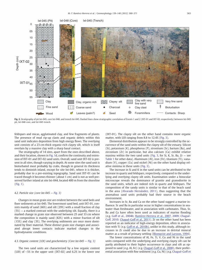
Clay
Contacts: SharpForaminifera
Clay with veryfine sand
Coarse sand
Wood
Clay, organic-rich Very fine sandClayey silt
Fine sand BioturbationCharcoal
Leaves (palm?)
Clay clast
Seed
Ixt-045 (Pit) Ixt-048 (Core) Ixt-045 (Trench)( htpe
Dcm
)
IXT-01
IXT-0230
40
35
25
20
15
05
10
45
50
55
Fig. 2. Stratigraphy of pit Ixt-045, core Ixt-048, and trench Ixt-045. Dashed lines show stratigraphic correlation of Events 1 and 2 (IXT-01 and IXT-02, respectively) between Ixt-045pit, Ixt-048 core, and Ixt-045 trench.
363M.-T. Ramírez-Herrera et al. / Geomorphology 139–140 (2012) 360–371
feldspars and micas, agglutinated clay, and few fragments of plants.The presence of mud rip-up clasts and organic debris within thissand unit indicates deposition from high energy flows. The overlyingunit consists of a 23 cm-thick organic-rich clayey silt, which is itselfoverlain by a massive clay with a sharp basal contact.
The stratigraphy of 14 sites, apart from the ones described above,and their location, shown in Fig. 1d, confirm the continuity and exten-sion of IXT-01 and IXT-02 sand units. Overall, sand unit IXT-02 is pre-sent in all sites, though varying in depth. At some sites the sand unit isbioturbated most probably by crabs, though in general its thicknesstends to diminish inland, except for site Ixt-041, where it is thicker,probably due to a pre-existing topography. Sand unit IXT-01 can betraced though it becomes thinner (about 1 cm) and is not as well pre-served further inland at site Ixt-044, located 400 m from the shoreline(Fig. 1).
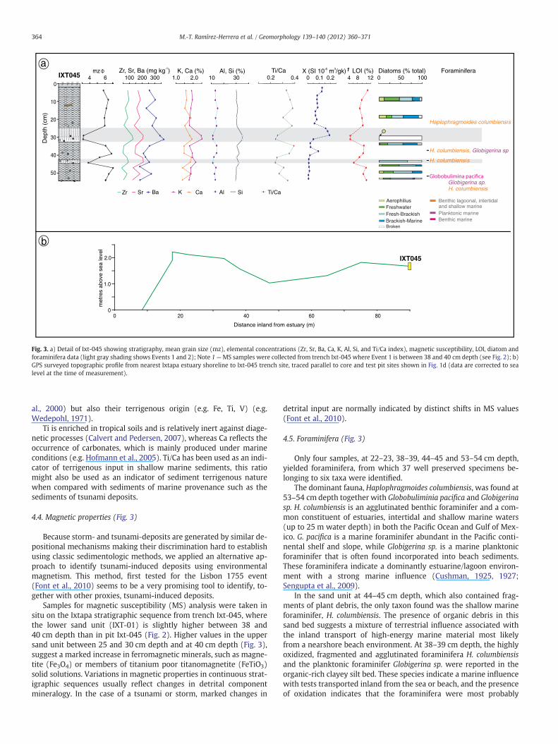
4.2. Particle size (core Ixt-045 — Fig. 3)
Changes in mean grain size are evident between the sand beds andfiner sediments at Ixt-045. The lowermost sand bed, unit IXT-01, con-sists mainly of sand (66%) and silt (29%) with a small fraction of clay(5%) — a marked contrast with the underlying silt. Equally, there is amarked change in grain size observed between 25 and 33 cm wherethe composition is mainly sand (82%) with a minor fraction of silt(15%) and clay (3%). The overlying sediments are once more domi-nated by finer material. These distinct grain size changes and associ-ated abrupt lower contacts indicate marked changes in thehydrodynamic conditions.
4.3. Organic content (LOI) and geochemistry (Core Ixt-045 — Fig. 3)
The two sand units are characterized by a low organic content(LOI) of b5% in the upper unit (IXT-02) and 6.2% in the lower one
(IXT-01). The clayey silt on the other hand contains more organicmatter, with LOI ranging from 8.8 to 12.4% (Fig. 3).
Elemental distribution appears to be strongly controlled by the oc-currence of the sand units within the clayey silt of the estuary. Silicon(Si), potassium (K), phosphorus (P), strontium (Sr), barium (Ba), andzirconium (Zr) in particular, but also calcium (Ca) exhibit relativemaxima within the two sand units (Fig. 3, for Si, K, Sr, Ba, Zr — seeTable 1 for other data). Aluminum (Al), iron (Fe), titanium (Ti), vana-dium (V), copper (Cu) and nickel (Ni) on the other hand display rel-ative minima in these units (Fig. 3).
The increase in Si and K in the sand units can be attributed to theincrease in quartz and feldspars, respectively, compared to the under-lying and overlying clayey silt units. Examination under a binocularmicroscope reveals the dominance of granite and granodiorite inthe sand units, which are indeed rich in quartz and feldspars. Thecomposition of the sandy units is similar to that of the beach sandin the area (Alvarado Hernández, 2011), thus suggesting that theanomalous sand units probably had their source in the beachenvironment.
Increases in Sr, Ba and Ca on the other hand suggest a marine in-fluence. Sr and Ba in particular occur in higher concentrations in sea-water than freshwater, and in association with carbonates. Thus, Sr,Ba and Ca have often been used as indicators of marine flooding(e.g. Goff et al., 2004b; Ramírez-Herrera et al., 2007, 2009; Chagué-Goff, 2010; Chagué-Goff et al., 2011). Zr on the other hand has beenreported as an indicator of high-energy deposition, often in associa-tion with Ti (e.g. Goff et al., 2010b), unlike in this study, although in-creases in Zr could also be due to an increase in detrital mineralmatter as a result of primary settling (Blomqvist and Larsson, 1994).
The lower concentrations of Al, Fe, Ti, V, Cu and Ni in the sandunits compared with the underlying and overlying clayey silt can bepartly attributed to their higher occurrence in clays and silt as op-posed to sand (e.g. Al, Fe) (e.g. Chagué-Goff et al., 2000), their prefer-ential association with fine sediment (e.g. Cu, Ni) (e.g. Chagué-Goff et
Broken
mz
0
10
20
30
40
50
peD
)mc( ht
IXT045
a
Al SiK Ca
Haplophragmoides columbiensis
H. columbiensis, Globigerina sp.
Planktonic marine
H. columbiensis
Globigerina sp.H. columbiensis
Benthic marine
Benthic lagoonal, intertidaland shallow marine
0.102.0K, Ca (%) Al, Si (%) Ti/Ca X (SI 10 m /gk)-6 3 LOI (%) ForaminiferaDiatoms (% total)
AerophiliusFreshwaterFresh-BrackishBrackish-Marine
Zr Sr Ba
0.2 0.4 0.2 4 0 50 1008 121.0 10 304 6 100 200 300Zr, Sr, Ba (mg kg )-1
1.0
2.0
00 08060402
IXT045
met
res
abov
e se
a l
leve
Distance inland from estuary (m)
b
Ti/Ca
1
Fig. 3. a) Detail of Ixt-045 showing stratigraphy, mean grain size (mz), elemental concentrations (Zr, Sr, Ba, Ca, K, Al, Si, and Ti/Ca index), magnetic susceptibility, LOI, diatom andforaminifera data (light gray shading shows Events 1 and 2); Note 1—MS samples were collected from trench Ixt-045 where Event 1 is between 38 and 40 cm depth (see Fig. 2); b)GPS surveyed topographic profile from nearest Ixtapa estuary shoreline to Ixt-045 trench site, traced parallel to core and test pit sites shown in Fig. 1d (data are corrected to sealevel at the time of measurement).
364 M.-T. Ramírez-Herrera et al. / Geomorphology 139–140 (2012) 360–371
al., 2000) but also their terrigenous origin (e.g. Fe, Ti, V) (e.g.Wedepohl, 1971).
Ti is enriched in tropical soils and is relatively inert against diage-netic processes (Calvert and Pedersen, 2007), whereas Ca reflects theoccurrence of carbonates, which is mainly produced under marineconditions (e.g. Hofmann et al., 2005). Ti/Ca has been used as an indi-cator of terrigenous input in shallow marine sediments, this ratiomight also be used as an indicator of sediment terrigenous naturewhen compared with sediments of marine provenance such as thesediments of tsunami deposits.
4.4. Magnetic properties (Fig. 3)
Because storm- and tsunami-deposits are generated by similar de-positional mechanisms making their discrimination hard to establishusing classic sedimentologic methods, we applied an alternative ap-proach to identify tsunami-induced deposits using environmentalmagnetism. This method, first tested for the Lisbon 1755 event(Font et al., 2010) seems to be a very promising tool to identify, to-gether with other proxies, tsunami-induced deposits.
Samples for magnetic susceptibility (MS) analysis were taken insitu on the Ixtapa stratigraphic sequence from trench Ixt-045, wherethe lower sand unit (IXT-01) is slightly higher between 38 and40 cm depth than in pit Ixt-045 (Fig. 2). Higher values in the uppersand unit between 25 and 30 cm depth and at 40 cm depth (Fig. 3),suggest a marked increase in ferromagnetic minerals, such as magne-tite (Fe3O4) or members of titanium poor titanomagnetite (FeTiO3)solid solutions. Variations in magnetic properties in continuous strat-igraphic sequences usually reflect changes in detrital componentmineralogy. In the case of a tsunami or storm, marked changes in
detrital input are normally indicated by distinct shifts in MS values(Font et al., 2010).
4.5. Foraminifera (Fig. 3)
Only four samples, at 22–23, 38–39, 44–45 and 53–54 cm depth,yielded foraminifera, from which 37 well preserved specimens be-longing to six taxa were identified.
The dominant fauna, Haplophragmoides columbiensis, was found at53–54 cm depth together with Globobuliminia pacifica and Globigerinasp. H. columbiensis is an agglutinated benthic foraminifer and a com-mon constituent of estuaries, intertidal and shallow marine waters(up to 25 m water depth) in both the Pacific Ocean and Gulf of Mex-ico. G. pacifica is a marine foraminifer abundant in the Pacific conti-nental shelf and slope, while Globigerina sp. is a marine planktonicforaminifer that is often found incorporated into beach sediments.These foraminifera indicate a dominantly estuarine/lagoon environ-ment with a strong marine influence (Cushman, 1925, 1927;Sengupta et al., 2009).
In the sand unit at 44–45 cm depth, which also contained frag-ments of plant debris, the only taxon found was the shallow marineforaminifer, H. columbiensis. The presence of organic debris in thissand bed suggests a mixture of terrestrial influence associated withthe inland transport of high-energy marine material most likelyfrom a nearshore beach environment. At 38–39 cm depth, the highlyoxidized, fragmented and agglutinated foraminifera H. columbiensisand the planktonic foraminifer Globigerina sp. were reported in theorganic-rich clayey silt bed. These species indicate a marine influencewith tests transported inland from the sea or beach, and the presenceof oxidation indicates that the foraminifera were most probably
Table 1
a. Major element concentrations (%)
Depth (cm) Mg K Ca P Al Si Fe Mn Ti
0–5 1.40 1.94 1.58 0.24 13.1 30.0 5.23 0.09 0.525–10 1.54 1.95 1.62 0.24 13.5 30.2 5.95 0.10 0.5810–15 1.52 1.88 1.53 0.23 15.1 31.1 6.15 0.13 0.5815–20 1.84 1.81 1.89 0.25 13.6 30.3 6.02 0.11 0.5720–25 1.52 1.78 1.53 0.24 14.8 30.2 6.35 0.11 0.5825–30 1.36 2.47 1.80 0.29 11.2 35.3 4.43 0.07 0.4730–34 1.47 2.51 1.93 0.30 11.2 35.1 4.70 0.07 0.4634–35 1.52 1.79 1.48 0.24 14.4 30.7 6.32 0.09 0.5835–40 1.47 1.94 1.48 0.23 14.6 32.1 5.23 0.06 0.5340–44 1.68 1.96 1.91 0.23 12.1 30.1 5.71 0.10 0.4944–46.5 1.52 2.15 1.83 0.27 11.0 32.0 5.13 0.06 0.4346.5–50 1.44 1.86 1.39 0.23 14.1 30.1 5.61 0.09 0.4350–54 1.75 1.85 1.89 0.23 12.7 30.0 5.73 0.07 0.5154–55 1.17 1.75 1.36 0.24 13.0 29.1 5.69 0.07 0.47
b. Trace element concentrations (mg kg−1)
Depth (cm) Cu Zn Ni Co Cr V Zr Pb Sr Ba
0–5 60 2127 20 27 58 44 89 32 168 2575–10 62 195 22 36 68 53 99 35 188 30810–15 62 330 22 29 72 53 73 36 158 23715–20 58 913 23 34 58 51 90 35 186 31320–25 74 826 25 29 62 51 60 38 146 28225–30 43 1068 14 24 64 36 125 30 217 33930–34 42 1786 18 23 50 36 134 30 211 37234–35 71 2355 26 38 66 52 60 37 152 26035–40 74 691 18 24 52 45 53 38 150 21240–44 57 452 22 33 55 40 86 34 210 23244–46.5 43 1224 18 31 60 34 99 32 214 26046.5–50 61 2088 22 30 53 34 44 40 131 18450–54 53 4345 23 36 66 44 85 20 186 27554–55 44 7103 22 48 69 38 58 19 128 187
365M.-T. Ramírez-Herrera et al. / Geomorphology 139–140 (2012) 360–371
exposed on the ground surface prior to burial. H. columbiensiswas theonly foraminifer found in the uppermost sample (22–23 cm depth),taken from an organic-rich, clayey-silt. The foraminiferal assemblageindicates a marine influence.
4.6. Diatoms (Fig. 3)
Most diatom samples are dominated by freshwater (but brackish-tolerant) to brackish species, with the exception of those at 18–20,34–35, 50–55 cm depth that contain a more marine assemblage. Ma-rine tolerant species include the common brackish-marine diatomsAmphora coffaeaformis, Diploneis finnica and Nitzchia scalpelliphormis.Total diatom abundance and species richness are higher in samplesfrom 46 cm downcore. Both sand beds IXT-01 (43–45 cm depth)and IXT-02 (25–33 cm depth) contained mainly broken diatomfrustules.
4.7. 210Pb, radiocarbon and OSL ages
For 210Pb analysis six samples were taken from the surface to21 cm depth. The 210Pbtot activities in sediments from trench Ixt-045 ranged from 67 to 96 Bq kg−1. The 210Pbexc were estimated tovary from 46.5±1.5 to 75.0±2.3 Bq kg−1, which is indicative thatsediments in trench Ixt-045 are relatively recent. The 210Pbexc valuesshowed an irregular pattern with depth (Table 2) indicative of mixedsediments — that might be the result of (a) all the layers analyzedwere deposited in a single event (a segment of 21 cm thick) or (b)the entire segment is mixed, probably as a result of resuspension. Ineither case, it proved not to be feasible to obtain a 210Pb-derived geo-chronology, hence three AMS14C dates were obtained for chronolog-ical purposes.
We obtained AMS radiocarbon ages on plant material (wood andleaves) from below and within the sand beds IXT-01 and IXT-02(Table 2). The calibrated age for material (leaves) sampled at 55 cm
(base of core Ixt-045) ranges from 0 to 280 cal yr BP. Age estimatesrange upcore from 280 to 0 cal yr BP at 55 cm to 131.2+/−0.5 pMC(pMC=percent modern carbon) at 44 cm, and 121.0+/−0.4 pMCat 33 cm depth. The reported results indicate a post-0 BP age forboth sand layers with a % of the modern reference standard indicatingthat the material was living within the last 60 years or so. These datesare clearly an estimate, as the attempted 210Pb dating indicates thatthe upper 21 cm of core Ixt-045 has been removed or that these sed-iments are young, and the lack of preserved seeds or plants in grow-ing position in the clayey silt immediately below and in the sandlayers means that an exact date cannot be established. However, ra-diocarbon dates provide a minimum age i.e. the maximum estimatefor the period of burial of the plant material in the two observedsand layers.
Dating of the upper sand layer was attempted with OSL, howeverit returned ‘unconclusive’ results, which are tentatively attributed toeither: (1) a poor “bleaching” process of the existing and remnant lu-minescence signal in the material that was deposited at the time ofthe tsunami, in other words, the tsunami was too turbid and did notallow all grains to be equally exposed to the sunlight before deposi-tion and burial (Huntley et al., 1985); and/or (2) that the event hav-ing occurred at night would not be datable with OSL since the pre-existing luminescence signal would remain in the deposited sediment.
5. Discussion
The multi-proxy approach based upon historical documentation,geomorphological–geological surveys and laboratory analyses onsampled sediments allowed us to detect two high energy depositsof marine origin laid down in a low energy depositional environmentof this tropical coast. Below, both the positive and negative evidencefor their tsunami origin and their association with historically-documented events in the region are discussed.
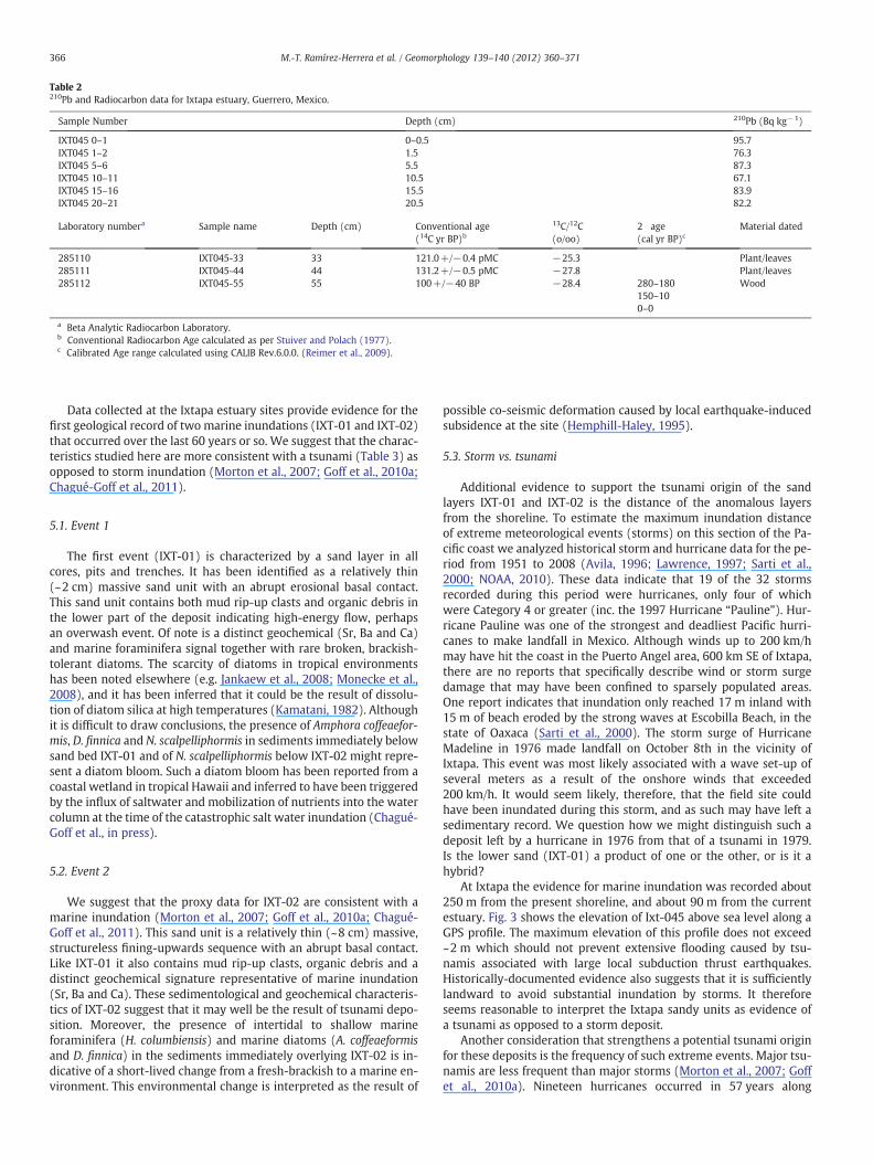
Table 2210Pb and Radiocarbon data for Ixtapa estuary, Guerrero, Mexico.
Sample Number Depth (cm) 210Pb (Bq kg−1)
IXT045 0–1 0–0.5 95.7IXT045 1–2 1.5 76.3IXT045 5–6 5.5 87.3IXT045 10–11 10.5 67.1IXT045 15–16 15.5 83.9IXT045 20–21 20.5 82.2
Laboratory numbera Sample name Depth (cm) Conventional age(14C yr BP)b
13C/12C(o/oo)
2 age(cal yr BP)c
Material dated
285110 IXT045-33 33 121.0+/−0.4 pMC −25.3 Plant/leaves285111 IXT045-44 44 131.2+/−0.5 pMC −27.8 Plant/leaves285112 IXT045-55 55 100+/−40 BP −28.4 280–180
150–100–0
Wood
a Beta Analytic Radiocarbon Laboratory.b Conventional Radiocarbon Age calculated as per Stuiver and Polach (1977).c Calibrated Age range calculated using CALIB Rev.6.0.0. (Reimer et al., 2009).
366 M.-T. Ramírez-Herrera et al. / Geomorphology 139–140 (2012) 360–371
Data collected at the Ixtapa estuary sites provide evidence for thefirst geological record of two marine inundations (IXT-01 and IXT-02)that occurred over the last 60 years or so. We suggest that the charac-teristics studied here are more consistent with a tsunami (Table 3) asopposed to storm inundation (Morton et al., 2007; Goff et al., 2010a;Chagué-Goff et al., 2011).
5.1. Event 1
The first event (IXT-01) is characterized by a sand layer in allcores, pits and trenches. It has been identified as a relatively thin(~2 cm) massive sand unit with an abrupt erosional basal contact.This sand unit contains both mud rip-up clasts and organic debris inthe lower part of the deposit indicating high-energy flow, perhapsan overwash event. Of note is a distinct geochemical (Sr, Ba and Ca)and marine foraminifera signal together with rare broken, brackish-tolerant diatoms. The scarcity of diatoms in tropical environmentshas been noted elsewhere (e.g. Jankaew et al., 2008; Monecke et al.,2008), and it has been inferred that it could be the result of dissolu-tion of diatom silica at high temperatures (Kamatani, 1982). Althoughit is difficult to draw conclusions, the presence of Amphora coffeaefor-mis, D. finnica and N. scalpelliphormis in sediments immediately belowsand bed IXT-01 and of N. scalpelliphormis below IXT-02 might repre-sent a diatom bloom. Such a diatom bloom has been reported from acoastal wetland in tropical Hawaii and inferred to have been triggeredby the influx of saltwater and mobilization of nutrients into the watercolumn at the time of the catastrophic salt water inundation (Chagué-Goff et al., in press).
5.2. Event 2
We suggest that the proxy data for IXT-02 are consistent with amarine inundation (Morton et al., 2007; Goff et al., 2010a; Chagué-Goff et al., 2011). This sand unit is a relatively thin (~8 cm) massive,structureless fining-upwards sequence with an abrupt basal contact.Like IXT-01 it also contains mud rip-up clasts, organic debris and adistinct geochemical signature representative of marine inundation(Sr, Ba and Ca). These sedimentological and geochemical characteris-tics of IXT-02 suggest that it may well be the result of tsunami depo-sition. Moreover, the presence of intertidal to shallow marineforaminifera (H. columbiensis) and marine diatoms (A. coffeaeformisand D. finnica) in the sediments immediately overlying IXT-02 is in-dicative of a short-lived change from a fresh-brackish to a marine en-vironment. This environmental change is interpreted as the result of
possible co-seismic deformation caused by local earthquake-inducedsubsidence at the site (Hemphill-Haley, 1995).
5.3. Storm vs. tsunami
Additional evidence to support the tsunami origin of the sandlayers IXT-01 and IXT-02 is the distance of the anomalous layersfrom the shoreline. To estimate the maximum inundation distanceof extreme meteorological events (storms) on this section of the Pa-cific coast we analyzed historical storm and hurricane data for the pe-riod from 1951 to 2008 (Avila, 1996; Lawrence, 1997; Sarti et al.,2000; NOAA, 2010). These data indicate that 19 of the 32 stormsrecorded during this period were hurricanes, only four of whichwere Category 4 or greater (inc. the 1997 Hurricane “Pauline”). Hur-ricane Pauline was one of the strongest and deadliest Pacific hurri-canes to make landfall in Mexico. Although winds up to 200 km/hmay have hit the coast in the Puerto Angel area, 600 km SE of Ixtapa,there are no reports that specifically describe wind or storm surgedamage that may have been confined to sparsely populated areas.One report indicates that inundation only reached 17 m inland with15 m of beach eroded by the strong waves at Escobilla Beach, in thestate of Oaxaca (Sarti et al., 2000). The storm surge of HurricaneMadeline in 1976 made landfall on October 8th in the vicinity ofIxtapa. This event was most likely associated with a wave set-up ofseveral meters as a result of the onshore winds that exceeded200 km/h. It would seem likely, therefore, that the field site couldhave been inundated during this storm, and as such may have left asedimentary record. We question how we might distinguish such adeposit left by a hurricane in 1976 from that of a tsunami in 1979.Is the lower sand (IXT-01) a product of one or the other, or is it ahybrid?
At Ixtapa the evidence for marine inundation was recorded about250 m from the present shoreline, and about 90 m from the currentestuary. Fig. 3 shows the elevation of Ixt-045 above sea level along aGPS profile. The maximum elevation of this profile does not exceed~2 m which should not prevent extensive flooding caused by tsu-namis associated with large local subduction thrust earthquakes.Historically-documented evidence also suggests that it is sufficientlylandward to avoid substantial inundation by storms. It thereforeseems reasonable to interpret the Ixtapa sandy units as evidence ofa tsunami as opposed to a storm deposit.
Another consideration that strengthens a potential tsunami originfor these deposits is the frequency of such extreme events. Major tsu-namis are less frequent than major storms (Morton et al., 2007; Goffet al., 2010a). Nineteen hurricanes occurred in 57 years along
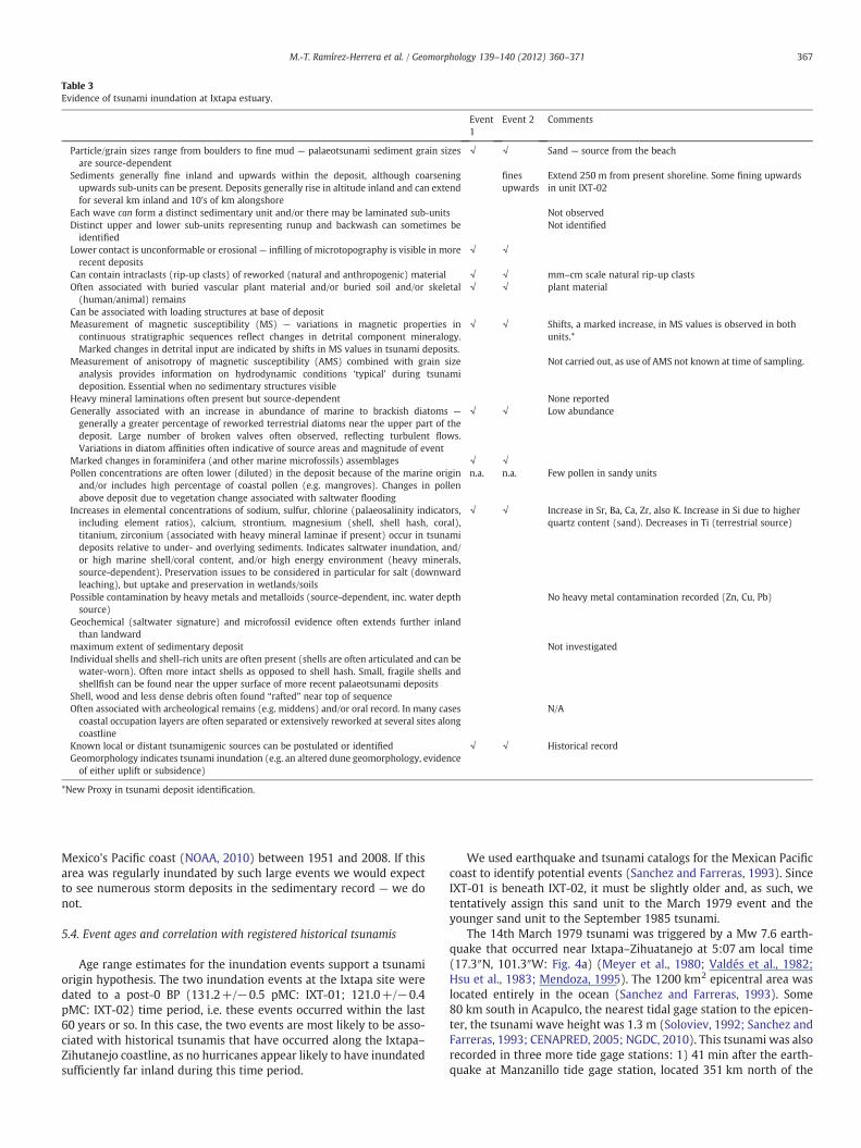
Table 3Evidence of tsunami inundation at Ixtapa estuary.
Event1
Event 2 Comments
Particle/grain sizes range from boulders to fine mud — palaeotsunami sediment grain sizesare source-dependent
√ √ Sand — source from the beach
Sediments generally fine inland and upwards within the deposit, although coarseningupwards sub-units can be present. Deposits generally rise in altitude inland and can extendfor several km inland and 10's of km alongshore
finesupwards
Extend 250 m from present shoreline. Some fining upwardsin unit IXT-02
Each wave can form a distinct sedimentary unit and/or there may be laminated sub-units Not observedDistinct upper and lower sub-units representing runup and backwash can sometimes beidentified
Not identified
Lower contact is unconformable or erosional — infilling of microtopography is visible in morerecent deposits
√ √
Can contain intraclasts (rip-up clasts) of reworked (natural and anthropogenic) material √ √ mm–cm scale natural rip-up clastsOften associated with buried vascular plant material and/or buried soil and/or skeletal(human/animal) remains
√ √ plant material
Can be associated with loading structures at base of depositMeasurement of magnetic susceptibility (MS) — variations in magnetic properties incontinuous stratigraphic sequences reflect changes in detrital component mineralogy.Marked changes in detrital input are indicated by shifts in MS values in tsunami deposits.
√ √ Shifts, a marked increase, in MS values is observed in bothunits.*
Measurement of anisotropy of magnetic susceptibility (AMS) combined with grain sizeanalysis provides information on hydrodynamic conditions ‘typical’ during tsunamideposition. Essential when no sedimentary structures visible
Not carried out, as use of AMS not known at time of sampling.
Heavy mineral laminations often present but source-dependent None reportedGenerally associated with an increase in abundance of marine to brackish diatoms —
generally a greater percentage of reworked terrestrial diatoms near the upper part of thedeposit. Large number of broken valves often observed, reflecting turbulent flows.Variations in diatom affinities often indicative of source areas and magnitude of event
√ √ Low abundance
Marked changes in foraminifera (and other marine microfossils) assemblages √ √Pollen concentrations are often lower (diluted) in the deposit because of the marine originand/or includes high percentage of coastal pollen (e.g. mangroves). Changes in pollenabove deposit due to vegetation change associated with saltwater flooding
n.a. n.a. Few pollen in sandy units
Increases in elemental concentrations of sodium, sulfur, chlorine (palaeosalinity indicators,including element ratios), calcium, strontium, magnesium (shell, shell hash, coral),titanium, zirconium (associated with heavy mineral laminae if present) occur in tsunamideposits relative to under- and overlying sediments. Indicates saltwater inundation, and/or high marine shell/coral content, and/or high energy environment (heavy minerals,source-dependent). Preservation issues to be considered in particular for salt (downwardleaching), but uptake and preservation in wetlands/soils
√ √ Increase in Sr, Ba, Ca, Zr, also K. Increase in Si due to higherquartz content (sand). Decreases in Ti (terrestrial source)
Possible contamination by heavy metals and metalloids (source-dependent, inc. water depthsource)
No heavy metal contamination recorded (Zn, Cu, Pb)
Geochemical (saltwater signature) and microfossil evidence often extends further inlandthan landward
maximum extent of sedimentary deposit Not investigatedIndividual shells and shell-rich units are often present (shells are often articulated and can bewater-worn). Often more intact shells as opposed to shell hash. Small, fragile shells andshellfish can be found near the upper surface of more recent palaeotsunami deposits
Shell, wood and less dense debris often found “rafted” near top of sequenceOften associated with archeological remains (e.g. middens) and/or oral record. In many casescoastal occupation layers are often separated or extensively reworked at several sites alongcoastline
N/A
Known local or distant tsunamigenic sources can be postulated or identified √ √ Historical recordGeomorphology indicates tsunami inundation (e.g. an altered dune geomorphology, evidenceof either uplift or subsidence)
*New Proxy in tsunami deposit identification.
367M.-T. Ramírez-Herrera et al. / Geomorphology 139–140 (2012) 360–371
Mexico's Pacific coast (NOAA, 2010) between 1951 and 2008. If thisarea was regularly inundated by such large events we would expectto see numerous storm deposits in the sedimentary record — we donot.
5.4. Event ages and correlation with registered historical tsunamis
Age range estimates for the inundation events support a tsunamiorigin hypothesis. The two inundation events at the Ixtapa site weredated to a post-0 BP (131.2+/−0.5 pMC: IXT-01; 121.0+/−0.4pMC: IXT-02) time period, i.e. these events occurred within the last60 years or so. In this case, the two events are most likely to be asso-ciated with historical tsunamis that have occurred along the Ixtapa–Zihutanejo coastline, as no hurricanes appear likely to have inundatedsufficiently far inland during this time period.
We used earthquake and tsunami catalogs for the Mexican Pacificcoast to identify potential events (Sanchez and Farreras, 1993). SinceIXT-01 is beneath IXT-02, it must be slightly older and, as such, wetentatively assign this sand unit to the March 1979 event and theyounger sand unit to the September 1985 tsunami.
The 14th March 1979 tsunami was triggered by a Mw 7.6 earth-quake that occurred near Ixtapa–Zihuatanejo at 5:07 am local time(17.3″N, 101.3″W: Fig. 4a) (Meyer et al., 1980; Valdés et al., 1982;Hsu et al., 1983; Mendoza, 1995). The 1200 km2 epicentral area waslocated entirely in the ocean (Sanchez and Farreras, 1993). Some80 km south in Acapulco, the nearest tidal gage station to the epicen-ter, the tsunami wave height was 1.3 m (Soloviev, 1992; Sanchez andFarreras, 1993; CENAPRED, 2005; NGDC, 2010). This tsunami was alsorecorded in three more tide gage stations: 1) 41 min after the earth-quake at Manzanillo tide gage station, located 351 km north of the

Fig. 4. a) Map shows the most important subduction thrust events of the 20th and 21st centuries along the Middle America Trench (see Fig. 1 caption for acronyms). Shaded circlesshow rupture zones and numbers indicate the year of the event. September 19 and 21, 1985, and March 14, 1979 rupture areas are marked in bold; b) The model of tectonic sub-sidence (dislocation in a homogeneous elastic half-space: Savage, 1983).
368 M.-T. Ramírez-Herrera et al. / Geomorphology 139–140 (2012) 360–371
epicenter; 2) also by the underwater (ocean bottom) tide gage locat-ed 980 km northwest of the epicenter at the exit from the Gulf ofCalifornia to the Pacific Ocean that sits at a depth of 3210 m; and 3)by the Pago Pago, American Samoa, tide gage station some 8406 kmaway (Sanchez and Farreras, 1993; NGDC, 2010). The synthetic tsuna-mi resulting from the numerical model of the 14th March 1979 Peta-tlan tsunami at the mouth of Ixtapa estuary (Fig. 5) indicates that thetsunami could raise the tide level by 0.67 m 2 h before the high tide.Tide range in Ixtapa is only 0.60 m (+/−0.30). Perhaps the 1979 tsu-nami, despite its low amplitude, could enter inside the estuary by its
mouth, which according to our field observations is open even in Jan-uary, i.e. in the dry season. Also, the Ixtapa estuary has a canal nextand southwest of the study site, where the 1979 tsunami could easilyenter and flood the study area. Tsunamis can increase in amplitudewhen entering estuaries and overflow their banks, as has been ob-served during the most recent tsunami events in Chile, 2010 and inJapan, 2011.
The surrounding areas of the Ixtapa estuary are scarcely populat-ed. There is now one trailer park mostly used in the winter months,November to February, and most of the land is used for seasonal

Fig. 5.Maximum synthetic tsunami height along the coast of Mexico resulting from thenumerical model of the 14 March 1979 Petatlan tsunami. The rupture area of the earth-quake is represented by the buried fault plane (60 km×60 km). Note that we are usingvertical scale in feet because recorded tsunamis are in feet in the tsunami catalog ofMexico.
369M.-T. Ramírez-Herrera et al. / Geomorphology 139–140 (2012) 360–371
agriculture. However, we can rely on one testimony given by thelandowner of our study site that described that the area was floodedafter 1985 and 1979 events. The 1979 event occurred at 05:07 amlocal time when tourist or locals are not expected to be at thebeach. The 1979 event occurred in the dark hours, which also mightexplain why the OSL date obtained provided inconclusive results,i.e. the depositional process occurred during the night hours and/orin light-deprived hours. In the absence of sunlight, the sedimentwould not be zeroed effectively and would still carry the previousremnant dose from the previous depositional process/time (Huntleyet al., 1985). In the case of tsunami deposits, this would imply thatif the tsunami event occurs at night, the sediment being depositedwould have the dose values of all the previous sediments that wereeroded, re-worked, transported and deposited by the tsunami. Thismixture of previous remnant doses would be seen as a histogramwith a wide range of distribution of De values, none of them yieldingthe true age of the tsunami deposit itself but rather an over-estimatedage.
On September 19th, 1985 a Mw 8.1 earthquake occurred at 18.14″N, 102.71″W, at 7:17 am local time (Fig. 4a). This was the second larg-est 20th century earthquake along the Mexican subduction zone (thelargest occurred on June 3rd, 1932: Fig. 4a). The size of the estimatedrupture zone was 180 km long and 60 km wide with a vertical seafloor displacement of 0.93 m (UNAM, 1986). The tsunami generatedby this earthquake was observed in Lazaro Cardenas and Playa Azul,in Michoacan province; Ixtapa, Zihuatanejo and Acapulco, in Guerreroprovince; and Manzanillo, Colima province. The Acapulco tide gagewas the only one that registered the tsunami along the Mexican Pacif-ic coast, but it was registered by numerous other gages around the Pa-cific (Abe et al., 1986). A detailed post-tsunami survey reportindicates that the Ixtapa–Zihuatanejo area was inundated by thisevent, with a tsunami height of 3–4 m recorded at Ixtapa (Abe et al.,1986). The tsunami inundated 300 m inland, overflowing the Ixtapaestuary banks, causing severe erosion of the foreshore and depositingsand up to 1.0 m thick in the backbeach area (Abe et al., 1986;Sanchez and Farreras, 1993).
Another possible tsunami to correlate Event 2 with is the largeMw 7.6 tsunamigenic earthquake that occurred two days later onSeptember 21st, 1985 immediately to the SE of Zihuatanejo(Mendoza, 1993) (Fig. 4). This aftershock ruptured over a 30-km radi-us, with a peak slip of 2 m and at depth 10 km. According to accountsgiven to us by local witnesses, this earthquake also produced a
tsunami that inundated the coast of Ixtapa–Zihuatanejo and the en-tire village of Barra de Potosi. Although it is not possible to determinegeologically which of these two 1985 earthquakes laid down the sandunit, we hypothesize that the 21st-September event, which was lo-cated closer to the Ixtapa–Zihuatanejo area, was the most likelysource of this deposit. Despite the fact that the 19th-September1985 earthquake had a larger magnitude (Mw 8.1) than its after-shock, most of the rupture area of this event was located inland,while the 21st-September 1985 earthquake had its entire rupturearea in the sea, i.e. an earthquake potentially capable of producing alarger tsunami. Moreover, the observed land-level change interpretedfrom environmental indicators distinguished in the stratigraphic andmicrofossil record agrees with our co-seismic deformation modeledusing Mendoza's (1993) co-seismic slip data for the September 21st,1985 earthquake and our model for vertical co-seismic displacement(Fig. 4b).
Geological evidence for modern, historical and paleotsunamis hasbeen widely described in the literature (e.g. Hutchinson andMcMillan, 1997; Goff et al., 2001, 2010b; Pinegina and Bourgeois,2001; Chagué-Goff et al., 2002, 2011; Gelfenbaum and Jaffe, 2003;Moore et al., 2005, in press; Kortekaas and Dawson, 2007; Mortonet al., 2007; Jankaew et al., 2008; Monecke et al., 2008). Similar geo-logical evidence for the entire Mexican Pacific coast however is limit-ed (Ramírez-Herrera et al., 2007, 2009), but historical data on theoccurrence of earthquakes and tsunamis extend back to the 1700s.
The results of this study complement previous geological workand help to create a more comprehensive record of past events forMexico. Multi-proxy data have proven to be an invaluable tool in de-termining the origin of the two sand deposits in this tropical environ-ment. By considering a wider range of proxies (Ramírez-Herrera et al.,2007; Chagué-Goff et al., 2011) than the conventional suite of sedi-ment grain size and microfossils (diatoms and/or foraminifera),most often used in temperate environments where these basic indica-tors tend to be well preserved, we have been able to demonstrate thelikely tsunamigenic nature of the deposits. The correlation of proxydata with historical, interview, numerical modeling, and a post-tsunami survey (Abe et al., 1986) information has further enhancedour interpretations.
Our data represent the first time that onshore geological evidencehas been correlated with known historical tsunamis on Mexico's Pa-cific coast. Moreover, this work recognizes the considerable value ofa diverse multi-proxy approach to identifying tsunami deposits intropical coastal environments where conventional approaches haveproven more difficult.
6. Conclusions
A wide range of multi-proxy data were collected from sedimentsin the Zihuatanejo–Ixtapa area, from which depositional evidencefor two 20th century tsunamis in Ixtapa estuary was inferred. Thetwo tsunami deposits found at the Ixtapa site are associated withlocal tsunamigenic earthquakes: sand unit IXT-01 is probably associ-ated with the 1979 event and IXT-02 with a 1985 tsunami. Co-seismicdeformation associated with the 1985 event is also inferred from thesedimentary record.
The study of tsunami deposits in Mexico is a recent development(Ramírez-Herrera et al., 2007, 2009) but a multi-proxy approach hasbeen adopted and tested. Like in other areas of the World, there arestill difficulties with the preservation of tsunami deposits and inestablishing a chronology of events, but this work confirms that amulti-proxy approach can be successfully applied to tropical coastalenvironments.
In summary, we consider that the identification and characteriza-tion of tsunami deposits in a given area may provide a unique oppor-tunity to obtain realistic average tsunami recurrence intervals,minimum inundation distances and the elapsed time since the last
370 M.-T. Ramírez-Herrera et al. / Geomorphology 139–140 (2012) 360–371
event. This information is extremely important for testing and con-straining the tsunami hazard and for numerical modeling. The abilityto distinguish the geological evidence of tsunamis from those ofstorms will therefore greatly enhance our knowledge of the magni-tude and frequency of events for countries such as Mexico. This, inturn, will greatly enhance our understanding of regional tsunami risk.
Acknowledgments
The PAPPIIT-UNAM gave financial support to Ramirez-Herrera(grants IN123609 and CONACYT-129456). Thanks to J.A. Real-Pérezfor help with field geodetic measurements. We acknowledge field as-sistance by graduate and undergraduate students N. Corona and O.Perez-Ruiz. We also thank A. Plater and anonymous reviewers fortheir valuable suggestions.
References
Abe, K., Hakuno, M., Takeuchi, M., Katada, T., 1986. Survey report on the tsunami of theMichoacan, México earthquake of September 19, 1985. Bulletin of the EarthquakeResearch Institute, University of Tokyo 61, 475–481.
Alvarado Hernández, L.A., 2011. Estudio sedimentológico de arenas de playa del estadode Guerrero, México. Tesis, Maestría, Ciencias del mar y Limnologia, UniversidadNacional Autónoma De México, 74 pp.
Avila, L.A., 1996. Preliminary Report Hurricane Alma 20–27 June 1996. National Hurri-cane Center, 24 July 1996. National Oceanic Atmospheric Administration, USA.http://www.nhc.noaa.gov/1996alma.html. [Accessed 5 February 2011].
Beckhoff, B., Kanngießer, B., Langhoff, N., Wedell, R., Wolff, H., 2006. Handbook of Prac-tical X-ray Fluorescence Analysis. Springer, Berlin.
Blomqvist, S., Larsson, U., 1994. Detrital bedrock elements as tracers of settling resus-pended particulate matter in a coastal area of the Baltic Sea. Limnology and Ocean-ography 39, 880–896.
Caballero, M., Vazquez, G., Lozano-Garcıa, S., Rodrıguez, A., Sosa-Najera, S., Ruiz-Fer-nandez, A.C., Ortega, B., 2006. Present limnological conditions and recent (ca. 340yr) palaeolimnology of a tropical lake in the Sierra de Los Tuxtlas, eastern Mexico.Journal of Paleolimnology 35, 83–97. doi:10.1007/s10933-005-7427-5.
Calvert, S.E., Pedersen, T.F., 2007. Elemental proxies for paleoclimatic and paleoceano-graphic variability in marine sediments: interpretation and application. In: deHillaire-Marcel, C., Vernal, A. (Eds.), Proxies in Late Cenozoic Paleoceanography. :Developments in Marine Geology. Elsevier Science Ltd., Oxford, U.K., pp. 567–644.
CENAPRED, 2005. Tsunamis. Centro Nacional De Prevenecion De Desatres, SecretariaDe Gobernacion, Mexico, Serie Fasciculos, p. 44.
Chagué-Goff, C., 2010. Chemical signatures of palaeotsunamis: a forgotten proxy? Ma-rine Geology 271, 67–71.
Chagué-Goff, C., Dawson, S., Goff, J.R., Zachariasen, J., Berryman, K.R., Garnett, D.L., Wal-dron, H.M., Mildenhall, D.C., 2002. A tsunami (c. 6300 years BP) and other environ-mental changes, northern Hawke's Bay, New Zealand. Sedimentary Geology 150,89–102.
Chagué-Goff, C., Goff, J., Nichol, S.L, Dudley, W., Zawadzki, A., Bennett, J.W., Mooney,S.D., Heijnis, H., Dominey-Howes, D., Courtney, C., in press. Multi-proxy evidencefor trans-Pacific tsunamis in the Hawaiian Islands. Marine Geology.
Chagué-Goff, C., Nichol, S.L., Jenkinson, A.V., Heijnis, H., 2000. Signatures of natural cat-astrophic events and anthropogenic impact in an estuarine environment, NewZealand. Marine Geology 167, 285–301.
Chagué-Goff, C., Schneider, J.L., Goff, J.R., Dominey-Howes, D., Strotz, L., 2011. Expand-ing the proxy toolkit to help identify past events — lessons from the 2004 IndianOcean Tsunami and the 2009 South Pacific Tsunami. Earth-Science Reviews 107,107–122.
Cushman, J.A., 1925. Recent foraminifera from British Columbia. Cushman Laboratoryfor Foraminiferal Research Contributions 1 (Part 2), 38–47.
Cushman, J.A., 1927. Recent foraminifera from off the west coast of America. Bulletin ofthe Scripps Institution of Oceanography Technical Series 1, 119–188.
DeMets, C., Stein, S., 1990. Present-day kinematics of the Rivera Plate and implicationsfor the tectonics in southwestern Mexico. Journal of Geophysical Research 95,21931–21948.
d'Orbigny, A.D., 1826. Tableau méthodique de la classe des Céphalopodes. Annales DesSciences Naturelles, Paris, France, Series 1 (7), 96–314.
Evans, M.E., Heller, F., 2003. Environmental magnetism— principles and applications ofenviromagnetics. International Geophysics Series. Academic Press, Amsterdam.
Fitton, G., 1997. X-ray fluorescence spectrometry. In: Gill, R. (Ed.), Modern AnalyticalGeochemistry: An Introduction to Quantitative Chemical Analysis for Earth. : Envi-ronmental and Materials Scientists. Addison Wesley Longman Ltd., Harlow, En-gland, pp. 87–115.
Font, E., Nascimento, C., Omira, R., Baptista, M.A., Silva, P.F., 2010. Identification oftsunami-induced deposits using numerical modeling and rock magnetism tech-niques: a study case of the 1755 Lisbon tsunami in Algarve, Portugal. Physics ofthe Earth and Planetary Interiors 182, 187–198.
Gasse, F., 1986. East African diatoms: taxonomy and ecological distribution. BibliothecaDiatomologica, 11. J. Cramer, Berlin. 201 pp.
Gelfenbaum, G., Jaffe, B., 2003. Erosion and sedimentation from the 17 July, 1998 PapuaNew Guinea Tsunami. Pure and Applied Geophysics 160, 1969–1999.
Goff, J., 2011. Evidence of a previously unrecorded local tsunami, 13 April 2010, CookIslands: implications for Pacific Island countries. Natural Hazards and Earth SystemSciences 11, 1371–1379.
Goff, J., Chagué-Goff, C., Nichol, S., 2001. Palaeotsunami deposits: a New Zealand per-spective. Sedimentary Geology 143, 1–6.
Goff, J., McFadgen, B.G., Chagué-Goff, C., 2004a. Sedimentary differences between the2002 Easter storm and the 15th Century Okoropunga tsunami, southeasternNorth Island, New Zealand. Marine Geology 204, 235–250.
Goff, J., Wells, A., Chagué-Goff, C., Nichol, S., Devoy, R., 2004b. The elusive AD 1826 tsu-nami, South Westland, New Zealand. New Zealand Geographer 60, 28–39.
Goff, J., Nichol, S.L., Kennedy, D., 2010a. Development of a palaeotsunami database forNew Zealand. Natural Hazards 54, 193–208.
Goff, J., Pearce, S., Nichol, S.L., Chagué-Goff, C., Horrocks, M., Strotz, L., 2010b. Multi-proxy records of regionally-sourced tsunamis, New Zealand. Geomorphology118, 369–382.
Goff, J., Chagué-Goff, C., Dominey-Howes, D., McAdoo, B., Cronin, S., Bonté-Grapetin, M.,Nichol, S., Horrocks, M., Cisternas, M., Lamarche, G., Pelletier, B., Jaffe, B., Dudley,W., 2011a. Palaeotsunamis in the Pacific. Earth-Science Reviews 107, 141–146.
Goff, J., Lamarche, G., Pelletier, B., Chagué-Goff, C., Strotz, L., 2011b. Palaeotsunami pre-cursors to the 2009 South Pacific tsunami in the Wallis and Futuna archipelago.Earth-Science Reviews 107, 91–106.
Goff, J., Dominey-Howes, D., in press. Tsunami. In: Shroder, J., Jr., James, L.A., Harden, C.,Clague, J., (Eds.), Treatise on Geomorphology. Academic Press, San Diego, CA, vol.13.
Hawkes, A.D., Bird, M., Cowie, S., Grundy-Warr, C., Horton, B.P., Shau Hwai, A.T., Law, L.,Macgregor, C., Nott, J., Ong, J.E., Rigg, J., Robinson, R., Tan-Mullins, M., Sa, T.T., Yasin,Z., Aik, L.W., 2007. Sediments deposited by the 2004 Indian Ocean Tsunami alongthe Malaysia-Thailand Peninsula. Marine Geology 242, 169–190.
Hemphill-Haley, E., 1995. Diatom evidence for earthquake-induced subsidence andtsunami 300 years ago in southern coastal Washington. Geological Society ofAmerica Bulletin 107 (3), 367–378.
Hofmann, D.I., Fabian, K., Schneider, F., Donner, B., Bleil, U., 2005. A stratigraphic net-work across the Subtropical Front in the central South Atlantic: multi-parametercorrelation of magnetic susceptibility, density, X-ray fluorescence and d 18O re-cords. Earth and Planetary Science Letters 240, 694–709.
Horton, B.P., Sawai, Y., Hawkes, A.D., Witter, R.C., 2011. Sedimentology and paleontol-ogy of a tsunami deposit accompanying the great Chilean earthquake of February2010. Marine Micropaleontology 79, 132–138.
Houba, J., Van Der Lee, J., Novozamsky, I., Walinga, I., 1988. Soil and Plants Analysis, Part5, Soil Analysis Procedures. Wageningen University, Wageningen, TheNetherlands.
Hsu, V., Gettrust, J.F., Helsley, C.E., Berg, E., 1983. Local seismicity preceding the March14, 1979, Petatlan, Mexico Earthquake (Ms=7.6). Journal of Geophysical Research88 (B5), 4247–4262.
Huntley, D.J., Godfrey-Smith, D.I., Thewalt, M.L.W., 1985. Optical dating of sediments.Nature 313, 105–107.
Hutchinson, I., McMillan, A.D., 1997. Archaeological evidence for village abandonmentassociated with late Holocene earthquakes at the northern Cascadia SubductionZone. Quaternary Research 48, 79–87.
Jankaew, K., Atwater, B.F., Sawai, Y., Choowong, M., Charoentitirat, T., Martin, M.E., Pre-ndergast, A., 2008. Medieval forewarning of the 2004 Indian Ocean tsunami inThailand. Nature 455, 1228–1231.
Kamatani, A., 1982. Dissolution rates of silica from diatoms decomposing at varioustemperatures. Marine Biology 68, 91–96.
Kennett, J.P., Srinivasan, M.S., 1983. Neogene Planktonic Foraminifera: a PhylogeneticAtlas. University of Rhode Island. Hutchinson Ross Publishing Company, Strouds-burg, Pennsylvania. 265 pp.
Kortekaas, S., Dawson, A.G., 2007. Distinguishing tsunami and storm deposits: an ex-ample from Martinhal, SW Portugal. Sedimentary Geology 200, 208–221.
Krammer, K., Lange–Bertalot, H., 1986. Süβwasserflora von Mitteleuropa, Band 2/1,Bacillariophyceae. 1. Teil: Naviculaceae. Gustav Fischer Verlag, Stuttgart.876 pp.
Krammer, K., Lange–Bertalot, H., 1988. Süβwasserflora von Mitteleuropa, Band 2/2,Bacillariophyceae. 2. Teil: Bacillariaceae, Epithemiaceae, Surirellaceae. Gustav Fi-scher Verlag, Stuttgart. 596 pp.
Lario, J., Luque, L., Zazo, C., Goy, J.L., Spencer, C., Cabero, A., Bardají, T., Borja, F., Dabrio,C.J., Civis, J., González-Delgado, J.A., Borja, C., Alonso-Azcárate, J., 2010. Tsunami vs.storm surge deposits: a review of the sedimentological and geomorphological re-cords of extreme wave events (EWE) during the Holocene in the Gulf of Cadiz,Spain. Zeitschrift fur Geomorphologie 54, 301–316.
Lawrence,M.B., 1997. Preliminary Report, Hurricane Pauline 5–10 October 1997. NationalHurricane Center, 7 November 1997. National Oceanic Atmospheric Administration,USA. http://www.nhc.noaa.gov/1997pauline.html. [Accessed 5 February 2011].
Liu, P.L.F., Lynett, P., Fernando, P., Jaffe, H., Fritz, B., Higman, H., Morton, B., Goff, J., Syno-lakis, C., 2005. Observation by the international tsunami survey team in Sri Lanka.Science 308, 1595.
Mendoza, C., 1993. Coseismic slip of two large Mexican earthquakes from teleseismicbody waveforms: implications for asperity interaction in the Michoacan plateboundary segment. Journal of Geophysical Research 98 (B5), 8197–8210.
Mendoza, C., 1995. Finite fault analysis of the 1979March 14, Petatlan,Mexico earthquakeusing teleseismic P waveforms. Geophysics Journal International 121, 675–683.
Meyer, R.P., Pennington, W.D., Powell, L.A., Unger, W.L., Guzman, M., Havskov, J., Singh,S.K., Valdes, C., Yamamoto, J., 1980. A first report on the Petatlan, Guerrero, MexicoEarthquake of 14 March 1979. Geophysics Journal International 7, 97–100.

371M.-T. Ramírez-Herrera et al. / Geomorphology 139–140 (2012) 360–371
Monecke, K., Finger, W., Klarer, D., Kongko, W., McAdoo, B.G., Moore, A.L., Sudrajat, S.U.,2008. A 1000-year sediment record of tsunami recurrence in northern Sumatra.Nature 455, 1232–1234.
Moore, A., Gelfenbaum, G., Triyono, R., 2005. Sedimentary deposits of the 26 December2004 tsunami on the northwest coast of Aceh, Indonesia. Earth Planets Space 58,253–258.
Moore, A., Goff, J., McAdoo, B., Fritz, H., Gusman, A., Kalligeris, N., Kalsum, K., Susanto,A., Suteja, D., Synolakis, C., in press. Sedimentary deposits from the 17 July 2006Western Java tsunami, Indonesia – use of grain size analyses to assess tsunamiflow depth, speed, and traction carpet characteristics. Pure and Applied Geophys-ics. doi 10.1007/s00024-011-0280-8.
Morton, R.A., Gelfenbaum, G., Jaffe, B.E., 2007. Physical criteria for distinguishing sandytsunami and storm deposits using modern examples. Sedimentary Geology 200,184–207.
National Geophysical Data Center (NGDC), 2010. Historical Tsunami Database at NGDC.http://www.ngdc.noaa.gov/hazard/tsu_db.shtml. [Accessed 2 July 2011].
National Oceanic Atmospheric Administration (NOAA), 2010. Historical Hurricanestracks. http://www.csc.noaa.gov/hurricanes/#. [Accessed 2 July 2011].
Pinegina, T.K., Bourgeois, J., 2001. Historical and paleo-tsunami deposits on Kamchatka,Russia: long-term chronologies and long-distance correlations. Natural Hazardsand Earth System Sciences 1, 177–185.
Ramírez-Herrera, M.T., Cundy, A., Kostoglodov, V., 2005. Evidence of Prehistoric Earth-quakes and Tsunamis during the last 5000 years along the Guerrero Seismic Gap, Mex-ico. Proceedings of the XV CNIS Mexican Society of Seismic Engineering I-07, pp. 1–17.
Ramírez-Herrera, M.T., Cundy, A., Kostoglodov, V., Carranza-Edwards, A., Morales, E.,Metcalfe, S., 2007. Sedimentary record of late Holocene relative sea-level changeand tectonic deformation from the Guerrero Seismic Gap, Mexican Pacific Coast.The Holocene 17, 1211–1220.
Ramírez-Herrera, M.T., Cundy, A., Kostoglodov, V., Ortiz, M., 2009. Late Holocene tec-tonic land-level changes and tsunamis at Mitla lagoon, Guerrero, México. GeofísicaInternacional 48, 195–209.
Reimer, P.J., Baillie, M.G.L., Bard, E., Bayliss, A., Beck, J.W., Bertrand, C.J.H., Blackwell, P.G.,Buck, C.E., Burr, G.S., Cutler, K.B., Damon, P.E., Edwards, R.L., Fairbanks, R.G., Friedrich,M., Guilderson, T.P., Hogg, A.G., Hughen, K.A., Kromer, B., McCormac, G., Manning, S.,Ramsey, C.B., Reimer, R.W., Remmele, S., Southon, J.R., Stuiver, M., Talamo, S., Taylor,F.W., van der Plicht, J., Weyhenmeyer, C.E., 2009. Intcal09 and Marine09 radiocarbonage calibration curves, 0–50,000 years cal BP. Radiocarbon 51, 1111–1150.
Richmond, B.M., Watt, S., Buckley, M., Jaffe, B.E., Gelfenbaum, G., Morton, R.A., 2011. Re-cent storm and tsunami coarse-clast deposit characteristics, southeast Hawaii. Ma-rine Geology 283, 79–89.
Ruiz-Fernández, A.C., Hillaire-Marcel, C., 2009. 210Pb-derived ages for the reconstruc-tion of terrestrial contaminant history into the Mexican Pacific coast: potential andlimitations. Marine Pollution Bulletin 59, 134–145.
Sanchez, A.J., Farreras, S.F., 1993. Catalogo de tsunamis (maremotos) en la costa occi-dental de Mexico (catalog of tsunamis on the western coast of Mexico). WorldData Center for Solid Earth Geophysics Publication SE-50. National GeophysicalData Center. 94 pp.
Sarti, L., Díaz, J., Garduño, M., Vasconcelos, J., Albavera, E., Peñaflores, C., Márquez, M.R.,2000. Effect of hurricane Pauline on the nesting of olive ridley turtle in EscobillaBeach, Oaxaca, Mexico. In: Abreu-Grobois, F.A., Briseño-Dueñas, R., Márquez, R.,Sarti, L. (Eds.), Proceedings of the Eighteenth International Sea Turtle Symposium,U.S. Department of Commerce, NOAA Technical Memorandum NMFS-SEFSC-436,pp. 211–213.
Savage, J.C., 1983. A dislocation model of strain accumulation and release at a subduc-tion zone. Journal of Geophysical Research 88 (B6), 4984–4996.
Sengupta, B.K., Smith, L.E., Machain-Castillo, M.L., 2009. Chapter 6: foraminifera ofthe Gulf of Mexico. In: Felder, D.L., Camp, D.K. (Eds.), Gulf of Mexico, Its Origins,Waters and Biota, vol. III. Texas A&M University Press, College Station, pp.238–324.
Soloviev, S.L., Go, Ch. N., Kim, Kh. S., 1992. A Catalog of Tsunamis in the Pacific,1969–1982, (translated from Russian to English by Amerind Publishing Co. Pvt.Ltd., New Delhi, 1988), Academy of Sciences of the USSR, Soviet Geophysical Com-mittee, Moscow, 207, 80 pp.
Stuiver, M., Polach, H.A., 1977. Discussion: reporting of 14C Data. Radiocarbon 19,355–363.
UNAM Seismology Group (UNAM), 1986. The September 1985 Michoacan earth-quakes: aftershock distribution and history of rupture. Geophysical Research Let-ters 13, 573–576.
Valdés, C., Meyer, R.P., Zdfiiga, R., Havskov, J., Singh, S.K., 1982. Analysis of the Petatlanaftershocks: number, energy release and asperities. Journal of Geophysical Re-search 87, 8519–8527.
Wedepohl, K.H., 1971. Environmental influences on the chemical composition of shalesand clays. Physics and Chemistry of The Earth 8, 305–333.
Yáñez- Arancibia, A., 1978. Taxonomía, Ecología y Estructura de las Comunidades depeces en lagunas costeras con bocas efímeras del Pacifico de México. Centro deCiencias del Mar y Limnología, Universidad Nacional Autónoma de México. Publi-cación Especial 2, 1–306 pp.