Sedimentological record of tsunamis on shallow-shelf areas: The case of the 1969 AD and 1755 AD...
11
Sedimentological record of tsunamis on shallow-shelf areas: The case of the 1969 AD and 1755 AD tsunamis on the Portuguese Shelf off Lisbon F. Abrantes a, ⁎ , U. Alt-Epping b,1 , S. Lebreiro a , A. Voelker a , R. Schneider c,2 a Instituto Nacional de Engenharia, Tecnologia e Inovação, Departamento de Geologia Marinha, Aptdo 7586, 2721-866 Amadora, Portugal b DFG Research Center Ocean Margins, University of Bremen, Postfach 330440, 28334 Bremen, Germany c Marine Palaeoklimaforschung, Institut fuer Geowissenschaften, Christian-Albrechts Universitaet zu Kiel, Ludewig-Meyn-Str. 10, 24118 Kiel, Germany Received 5 May 2007; received in revised form 7 December 2007; accepted 18 December 2007 Abstract One of the aims of the SEDPORT project (ESF Euromargins EUROCORES program) was to investigate the depositional features on the shelf and upper slope of the Portuguese Margin — Tagus System, during the Holocene. To fulfill the objectives, two shallow box-cores and two sedimentary sequences were studied: PO287-26B and the spliced sequence of sites D13902, PO287-26G recovered on the Portuguese Continental Shelf SSW off the Tagus River mouth, and the box PO287-28B and gravity-core GeoB8903 collected towards the W of the river mouth. Magnetic susceptibility, grain-size and XRF-Fe data as well as 210 Pb and AMS 14 C dating of these sedimentary sequences have allowed the identification of an “instantaneous deposit” at about 20 cm in the box-cores. Downcore we could establish: a hiatus corresponding to 355 yr of sedimentation at both sites; a 39 cm “instantaneous deposit” of coarse material including carbonate broken shells on the SSW site; and a 1.5 m “instantaneous deposit” of fine material on the W site. Both hiatus and instantaneous deposits are considered to be of tsunamigenic origin. The box-cores' deposit has an estimated age of 1969 AD and it is attributed to the 1969 earthquake caused tsunami. The hiatus and deposits found downcore are, due to the age limits encountered, believed to represent the tsunami related to the 1755 Lisbon major earthquake. These data further indicate a sediment deposit similar in type and thickness on both SSW and W sites in 1969, while the 1755 AD record indicates a higher energy backwash along the SSW and a preferential deposition of fine suspended matter towards the W. © 2007 Elsevier B.V. All rights reserved. Keywords: tsunami; Lisbon; shallow-shelf areas; historical earthquakes; 1969; 1755 1. Introduction In recent years, much research on modern and paleotsunami deposits, in particular the ones found on land, has been published. To reconstruct past and pre-historic tsunamis, including a determination of tsunami size, extent and recurrence interval, is the fundamental goal of such work whose final objective is to contribute directly to tsunami-mitigation and risk-assessment programs. As shown by the December 2004 Indian Ocean tsunami and other historic tsunamis, erosion is widespread as well as deposition both at sea, shallow and abyssal basins, and inland along the world's coastal areas. “Fine to coarse debris, at times including boulders, peat masses, trees, uprooted vegetation, and man-made materials, can be moved by the force and run-up of a tsunami” (Teller et al., 2005). Whereas research focusing on geologic evidences of tsunami has shown a broad variety of tsunami depositional traces inland along the coastlines of the world, very little (van der Bergh et al., 2003; Pareschi et al., 2006) has been done on tsunami transport and deposition in the offshore zones or in shallow-shelf areas as recognized by Dawson and Stewart (2007). Such studies are particularly important in regions prone to earthquakes and with an historical record of tsunamis. Portugal and the Lisbon area have suffered from several historical earthquakes, Marine Geology 249 (2008) 283 – 293 www.elsevier.com/locate/margeo ⁎ Corresponding author. Tel.: +351 21 4705535; fax: +351 21 471 9018. E-mail addresses: [email protected] (F. Abrantes), [email protected] (U. Alt-Epping), [email protected] (S. Lebreiro), [email protected] (A. Voelker), [email protected] (R. Schneider). 1 Tel.: +49 421 21865671. 2 Tel.: +49 431 880 1457; fax: +49 431 880 4376. 0025-3227/$ - see front matter © 2007 Elsevier B.V. All rights reserved. doi:10.1016/j.margeo.2007.12.004
Transcript of Sedimentological record of tsunamis on shallow-shelf areas: The case of the 1969 AD and 1755 AD...
2008) 283–293www.elsevier.com/locate/margeo
Marine Geology 249 (
Sedimentological record of tsunamis on shallow-shelf areas: The case of the1969 AD and 1755 AD tsunamis on the Portuguese Shelf off Lisbon
F. Abrantes a,⁎, U. Alt-Epping b,1, S. Lebreiro a, A. Voelker a, R. Schneider c,2
a Instituto Nacional de Engenharia, Tecnologia e Inovação, Departamento de Geologia Marinha, Aptdo 7586, 2721-866 Amadora, Portugalb DFG Research Center Ocean Margins, University of Bremen, Postfach 330440, 28334 Bremen, Germany
c Marine Palaeoklimaforschung, Institut fuer Geowissenschaften, Christian-Albrechts Universitaet zu Kiel, Ludewig-Meyn-Str. 10, 24118 Kiel, Germany
Received 5 May 2007; received in revised form 7 December 2007; accepted 18 December 2007
Abstract
One of the aims of the SEDPORT project (ESF Euromargins EUROCORES program) was to investigate the depositional features on the shelfand upper slope of the Portuguese Margin — Tagus System, during the Holocene. To fulfill the objectives, two shallow box-cores and twosedimentary sequences were studied: PO287-26B and the spliced sequence of sites D13902, PO287-26G recovered on the Portuguese ContinentalShelf SSW off the Tagus River mouth, and the box PO287-28B and gravity-core GeoB8903 collected towards the W of the river mouth.
Magnetic susceptibility, grain-size and XRF-Fe data as well as 210Pb and AMS 14C dating of these sedimentary sequences have allowed theidentification of an “instantaneous deposit” at about 20 cm in the box-cores. Downcore we could establish: a hiatus corresponding to 355 yr ofsedimentation at both sites; a 39 cm “instantaneous deposit” of coarse material including carbonate broken shells on the SSW site; and a 1.5 m“instantaneous deposit” of fine material on the W site. Both hiatus and instantaneous deposits are considered to be of tsunamigenic origin. Thebox-cores' deposit has an estimated age of 1969 AD and it is attributed to the 1969 earthquake caused tsunami. The hiatus and deposits founddowncore are, due to the age limits encountered, believed to represent the tsunami related to the 1755 Lisbon major earthquake. These data furtherindicate a sediment deposit similar in type and thickness on both SSW and W sites in 1969, while the 1755 AD record indicates a higher energybackwash along the SSW and a preferential deposition of fine suspended matter towards the W.© 2007 Elsevier B.V. All rights reserved.
Keywords: tsunami; Lisbon; shallow-shelf areas; historical earthquakes; 1969; 1755
1. Introduction
In recent years, much research on modern and paleotsunamideposits, in particular the ones found on land, has been published.To reconstruct past and pre-historic tsunamis, including adetermination of tsunami size, extent and recurrence interval, isthe fundamental goal of such work whose final objective is tocontribute directly to tsunami-mitigation and risk-assessmentprograms.
⁎ Corresponding author. Tel.: +351 21 4705535; fax: +351 21 471 9018.E-mail addresses: [email protected] (F. Abrantes),
[email protected] (U. Alt-Epping), [email protected](S. Lebreiro), [email protected] (A. Voelker), [email protected](R. Schneider).1 Tel.: +49 421 21865671.2 Tel.: +49 431 880 1457; fax: +49 431 880 4376.
0025-3227/$ - see front matter © 2007 Elsevier B.V. All rights reserved.doi:10.1016/j.margeo.2007.12.004
As shown by the December 2004 Indian Ocean tsunami andother historic tsunamis, erosion is widespread as well asdeposition both at sea, shallow and abyssal basins, and inlandalong the world's coastal areas. “Fine to coarse debris, at timesincluding boulders, peat masses, trees, uprooted vegetation, andman-made materials, can be moved by the force and run-up of atsunami” (Teller et al., 2005).
Whereas research focusing on geologic evidences of tsunamihas shown a broad variety of tsunami depositional traces inlandalong the coastlines of the world, very little (van der Bergh et al.,2003; Pareschi et al., 2006) has been done on tsunami transportand deposition in the offshore zones or in shallow-shelf areas asrecognized by Dawson and Stewart (2007).
Such studies are particularly important in regions prone toearthquakes andwith an historical record of tsunamis. Portugal andthe Lisbon area have suffered from several historical earthquakes,
284 F. Abrantes et al. / Marine Geology 249 (2008) 283–293
of which 1531, 1755, 1761 and 1969were associatedwith tsunamievents (NOAA National Geophysical Data Center; Portuguese/European GITEC database; Baptista et al., 1988a).
On the basis of historical records, the most destructivetsunamis listed are the 1531 AD as a local tsunami in Lisbonand 1755 AD and 1761 AD transatlantic events. Some authorsconsider the 1531 event even more catastrophic for the city ofLisbon than the 1755 one (Mendonça, 1758). However, the 1755ADearthquake, ranked 8.75 to 9.0 on the Richter scale,was one ofthe strongest in human history (Campos, 1991;Mader, 2001), andthe effects of the earthquake related tsunami, not only over the cityof Lisbon but also over 52 other locations on both Atlantic coasts,turned it into the most catastrophic of the historical tsunamis.
The sources of these historical events are uncertain. The1531 AD earthquake inferred source has been placed bothoffshore Iberia and north of Lisbon, up the Tagus estuary (Justoand Salwa, 1998). The similarities between the isoseismals forthe 1969 and 1755 earthquakes have led to the construction ofseveral models, using as a source for the 1755 AD the 1969 ADinstrumentally defined Gorringe Bank source. However, manyother models have been suggested and except for a SSW locatedepicenter no consensus has yet been reached (Machado, 1966;Zitelini et al., 2001; Terrinha et al., 2003). An epicenter SSWofLisbon agrees with historical eyewitness reports that indicate aNNE/SSW direction for the tsunami water transport in/out theTagus Estuary mouth area (Charles Davy in Tappan 1914;Sousa, 1928).
Without doubt, the tsunamis triggered by these earthquakesand the 1755 AD in particular, must have had substantial run-ups. The 1761 AD tsunami influence has propagated all the wayup to Ireland and to Barbados, and 2.4 m is its estimatedmaximum run-up in Lisbon (NOAA National Geophysical DataCenter). For the 1969 AD event, maximum run-up in the area ofLisbon only reached ±0.50 m (Batista et al., 1992). As for the1755 AD event, historical accounts indicate maximum run-upsof 30 m in the Algarve and 12–15 m in Lisbon, heightsconfirmed by Baptista (1988b). Off Oeiras, on the northern bankof the Tagus estuary, southwest of Lisbon Baptista et al., (2003)modeled a 5 m wave, and Whelan and Kelletat (2005) proposethat tsunami waves responsible for the transport of the bouldersencountered at Cabo de Trafalgar, southern Spanish Atlanticcoast, had to have run-up heights in the order of 19 m or more.
Historical sources mention tsunami waves and the inundationof Lisbon both in 1531 AD and 1755 AD (Viana-Baptista et al.,
Table 1List of cores used in this work
Core no. Type Latitude(°W)
Longitude(°N)
D13902 Long piston 38° 33.24′ 9° 20.13′D13882 Long piston 38° 38.07′ 9° 27.25′PO287-26G Gravity 38° 33.49′ 9° 21.84′GeoB8903 Gravity 38° 37.86′ 9° 30.84′MD99-2333 Calypso 38° 33.51′ 9° 21.85′PO287-26B Box-core 38° 33.49′ 9° 21.84′PO287-28B Box-core 38° 37.47′ 9° 30.87′
Numbers in bold refer to the best-dated sedimentary sequences used as the basis of
2006). Inland field evidence that has been interpreted as tsunamideposits generated by the 1755 AD event includes large littoraldebris and geomorphic features found at the Algarve coast(south Portugal — Hindson et al., 1996; Dawson et al., 1991;Dawson et al., 1995; Andrade, 1992), northwest of Lisbon(Scheffers and Kelletat, 2005) and at Cabo de Trafalgar (Whelanand Kelletat, 2005).
Major problems in studies of inland paleotsunamis arerelated to the positive identification of a tsunami deposit, due totheir variable character, and the dating difficulties. Two aspectsthat are possibly easier to deal with in marine sediments, wheredistinctive deposits may be left by such events, and the dating ofmarine carbonate microorganisms by AMS 14C is possible. TheTagus upper shelf offers a natural laboratory to scrutinize indetail deposits associated with the Lisbon historical tsunamis.
In this paper, we revisit the published characteristics of therecord found in a core located SSW of the Tagus River mouthand that has been attributed to the 1755 tsunami (Abrantes et al.,2005), and present new data from a core located on the Wextreme of the shelf mud deposit often labeled as Tagus prodelta,as well as box-core records from both locations.
2. Material and methods
The material used in this study is a suite of 6 cores recoveredfrom the upper shelf off the Tagus river mouth (Table 1, Fig. 1);however, we concentrate mostly on the two best-dated andstudied sedimentary sequences. That is, a spliced sequence ofcores D13902 and box- and gravity cores PO287-26B, Gpositioned SSWof the Tagus River mouth, and cores GeoB8903and PO287-28B collected to the W, offshore of the river mouth.
Magnetic susceptibility was measured on a multi-parameterlogging system at the Southampton Oceanography Center forcore D13902 and D13882, while all other cores were measuredat the Bremen Core Repository. Iron (Fe) content as counts persecond (cps) was determined, at 1 cm intervals for all cores byX-ray fluorescence core scanning for non-destructive semi-quantitative analysis of major elements (from K to Sr)developed at the Netherlands Institute for Sea Research (Jansenet al., 1998) and was carried out at the Bremen Core Repositoryof the University of Bremen.
For grain-size determination, sediments were sliced at 1 cmintervals and 5–8 cm3 of sediment prepared through organicmatter removal with basic H2O2 (130 vol) and dispersed with
W. Depth(m)
Length(m)
Ship Cruise
90 6.00 Discovery D24988 13.61 Discovery D24997 3.05 Poseidon PO287102 5.40 Poseidon PO30491 3.47 Marion DuFresne IMAGES V96 0.52 Poseidon PO287105 0.52 Poseidon PO287
this paper.
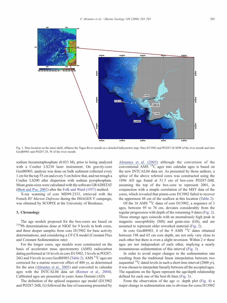
Fig. 1. Sites location on the inner shelf, offshore the Tagus River mouth on a detailed bathymetric map. Sites D13902 and PO287-26 SSWof the river mouth and sitesGeoB8903 and PO287-28, W of the river mouth.
285F. Abrantes et al. / Marine Geology 249 (2008) 283–293
sodium hexametaphosphate (0.033 M), prior to being analyzedwith a Coulter LS230 laser instrument. On gravity-coreGeoB8903, analysis was done on bulk sediment collected every1 cm for the top 55 cm and every 5 cmbelow that, and run trough aCoulter LS200 after dispersion with sodium pyrophosphate.Mean grain-sizes were calculated with the software GRADISTAT(Blott and Pye, 2001) after the Folk and Ward (1957) method.
X-ray scanning of core MD99-2333, retrieved with theFrench RV Marion Dufresne during the IMAGES V campaign,was obtained by SCOPIX at the University of Bordeaux.
3. Chronology
The age models proposed for the box-cores are based on210Pb determinations done at NIOZ for 9 levels in both cores,and three deeper samples from core D13902 for base activitydeterminations, and considering a CF:CS model (Constant Fluxand Constant Sedimentation rate).
For the longer cores, age models were constructed on thebasis of accelerator mass spectrometry (AMS) radiocarbondating performed at 16 levels in core D13902, 3 levels in PO287-26G and 9 levels in core GeoB8903 (Table 2). AMS 14C ages arecorrected for a marine reservoir effect of 400 yr, as determinedfor the area (Abrantes et al., 2005) and converted to calendarages with the INTCAL04 data set (Reimer et al., 2004).Calibrated ages are presented in years Anno Domini (AD).
The definition of the spliced sequence age model (D13902and PO287-26B, G) followed the line of reasoning presented by
Abrantes et al. (2005) although the conversion of theconventional AMS 14C ages into calendar ages is based onthe new INTCAL04 data set. As presented by those authors, asplice of the above referred cores was constructed using the1896 AD age found at 51.5 cm of box-core PO287-26B,assuming the top of the box-core to represent 2001, inconjunction with a simple correlation of the MST data of thecores, which revealed that piston-core D13902 failed to recoverthe uppermost 48 cm of the seafloor at this location (Table 2).
Of the 16 AMS 14C dates of core D13902, a sequence of 3ages, between 95 to 76 cm, deviates considerably from theregular progression with depth of the remaining 9 dates (Fig. 2).Those strange ages coincide with an anomalously high peak inmagnetic susceptibility (MS) and grain-size (GS), and areassumed to represent older reworked material (Fig. 2).
In core GeoB8903, 4 of the 9 AMS 14C dates obtainedbetween 198 and 65 cm core depth, are not only very close toeach other but there is even a slight inversion. Within 2 σ theseages are not independent of each other, implying a nearlyinstantaneous sedimentation of this interval (Fig. 3).
In order to avoid major changes in the sedimentation rateresulting from the traditional linear interpolation between twosequential 14C dated levels in such a short time interval (2000 yr),it was chosen to interpolate linearly between all the accepted ages.The equations on the figure represent the age/depth relationshipdefined for each one of the best-fit lines (Fig. 3).
From the observation of the age vs. depth plot (Fig. 4) amajor change in sedimentation rate is obvious for cores D13902
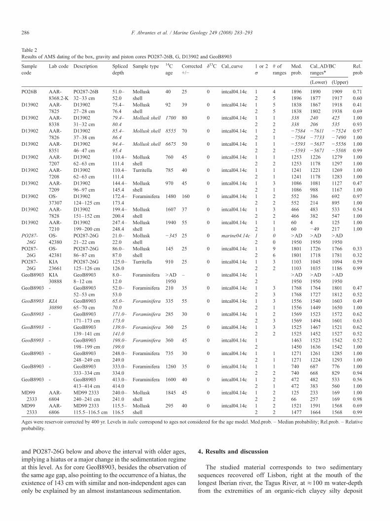
Table 2Results of AMS dating of the box, gravity and piston cores PO287-26B, G, D13902 and GeoB8903
Samplecode
Lab code Description Spliceddepth
Sample type 14Cage
Corrected+/−
δ13C Cal_curve 1 or 2σ
# ofranges
Med.prob.
Cal_AD/BCranges⁎
Rel.prob
(Lower) (Upper)
PO26B AAR-8368.2-K
PO287-26B32–33 cm
51.0–52.0
Molluskshell
40 25 0 intcal04.14c 1 4 1896 1890 1909 0.712 5 1896 1877 1917 0.60
D13902 AAR-7825
D1390227–28 cm
75.4–76.4
Molluskshell
92 39 0 intcal04.14c 1 5 1838 1867 1918 0.412 5 1838 1802 1938 0.69
D13902 AAR-8338
D1390231–32 cm
79.4–80.4
Mollusk shell 1700 80 0 intcal04.14c 1 1 338 240 425 1.002 2 338 206 535 0.93
D13902 AAR-7826
D1390237–38 cm
85.4–86.4
Mollusk shell 8555 70 0 intcal04.14c 1 2 −7584 −7611 −7524 0.972 1 −7584 −7733 −7490 1.00
D13902 AAR-8351
D1390246–47 cm
94.4–95.4
Mollusk shell 6675 50 0 intcal04.14c 1 1 −5593 −5637 −5556 1.002 2 −5593 −5671 −5508 0.99
D13902 AAR-7207
D1390262–63 cm
110.4–111.4
Molluskshell
760 45 0 intcal04.14c 1 1 1253 1226 1279 1.002 2 1253 1178 1297 1.00
D13902 AAR-7208
D1390262–63 cm
110.4–111.4
Turritella 785 40 0 intcal04.14c 1 1 1241 1221 1269 1.002 1 1241 1178 1283 1.00
D13902 AAR-7209
D1390296–97 cm
144.4–145.4
Molluskshell
970 45 0 intcal04.14c 1 3 1086 1081 1127 0.472 1 1086 988 1167 1.00
D13902 OS-37307
D13902124–125 cm
172.4–173.4
Foraminifera 1480 160 0 intcal04.14c 1 2 552 386 692 0.972 2 552 214 895 1.00
D13902 AAR-7828
D13902151–152 cm
199.4–200.4
Molluskshell
1607 37 0 intcal04.14c 1 3 466 483 533 0.542 2 466 382 547 1.00
D13902 AAR-7210
D13902199–200 cm
247.4–248.4
Molluskshell
1940 55 0 intcal04.14c 1 1 60 4 125 1.002 1 60 −49 217 1.00
PO287-26G
OS-42380
PO287-26G21–22 cm
21.0–22.0
Molluskshell
−345 25 0 marine04.14c 1 0 NAD1950
NAD1950
NAD19502 0
PO287-26G
OS-42381
PO287-26G86–87 cm
86.0–87.0
Molluskshell
145 25 0 intcal04.14c 1 9 1801 1726 1766 0.332 6 1801 1718 1781 0.32
PO287-26G
KIA23661
PO287-26G125–126 cm
125.0–126.0
Turritella 910 25 0 intcal04.14c 1 3 1103 1045 1094 0.592 2 1103 1035 1186 0.99
GeoB8903 KIA30888
GeoB89038–12 cm
8.0–12.0
Foraminifera NAD1950
– 0 intcal04.14c 1 NAD1950
NAD1950
NAD19502
GeoB8903 - GeoB890352–53 cm
52.0–53.0
Foraminifera 210 35 0 intcal04.14c 1 3 1768 1764 1801 0.472 3 1768 1727 1812 0.52
GeoB8903 KIA30890
GeoB890365–70 cm
65.0–70.0
Foraminifera 335 55 0 intcal04.14c 1 3 1556 1540 1603 0.492 1 1556 1449 1650 1.00
GeoB8903 - GeoB8903171–173 cm
171.0–173.0
Foraminifera 285 30 0 intcal04.14c 1 2 1569 1523 1572 0.622 3 1569 1494 1601 0.63
GeoB8903 - GeoB8903139–141 cm
139.0–141.0
Foraminifera 360 25 0 intcal04.14c 1 3 1525 1467 1521 0.622 2 1525 1452 1527 0.52
GeoB8903 - GeoB8903198–199 cm
198.0–199.0
Foraminifera 360 45 0 intcal04.14c 1 1463 1523 1542 0.522 1450 1636 1542 1.00
GeoB8903 - GeoB8903248–249 cm
248.0–249.0
Foraminifera 735 30 0 intcal04.14c 1 1 1271 1261 1285 1.002 1 1271 1224 1293 1.00
GeoB8903 - GeoB8903333–334 cm
333.0–334.0
Foraminifera 1260 35 0 intcal04.14c 1 1 740 687 776 1.002 2 740 668 829 0.94
GeoB8903 - GeoB8903413–414 cm
413.0–414.0
Foraminifera 1600 40 0 intcal04.14c 1 2 472 482 533 0.562 1 472 383 560 1.00
MD992333
AAR-6804
MD99 2333240–241 cm
240.0–241.0
Molluskshell
1845 45 0 intcal04.14c 1 2 125 233 169 1.002 2 66 257 169 0.98
MD992333
AAR-6806
MD99 2333115.5–116.5 cm
115.5–116.5
Molluskshell
295 40 0 intcal04.14c 1 2 1521 1591 1568 0.692 2 1477 1664 1568 0.99
Ages were reservoir corrected by 400 yr. Levels in italic correspond to ages not considered for the age model. Med.prob. – Median probability; Rel.prob. – Relativeprobability.
286 F. Abrantes et al. / Marine Geology 249 (2008) 283–293
and PO287-26G below and above the interval with older ages,implying a hiatus or a major change in the sedimentation regimeat this level. As for core GeoB8903, besides the observation ofthe same age gap, also pointing to the occurrence of a hiatus, theexistence of 143 cm with similar and non-independent ages canonly be explained by an almost instantaneous sedimentation.
4. Results and discussion
The studied material corresponds to two sedimentarysequences recovered off Lisbon, right at the mouth of thelongest Iberian river, the Tagus River, at ≈100 m water-depthfrom the extremities of an organic-rich clayey silty deposit

Fig. 2. Magnetic susceptibility, grain-size mean, and radiocarbon chronology along PO287-26B and D13902 composite depth. Ages as calendar yr BP; magneticsusceptibility (106 SI — full dots) and mean grain-size (µm — open diamonds).
287F. Abrantes et al. / Marine Geology 249 (2008) 283–293
located on the inner shelf. This area of the shelf represents thepreferred depositional site of continental material transported insuspension by the river (Monteiro and Moita, 1971; Gaspar andMonteiro, 1977; Cabeçadas and Borgueira, 1997).
4.1. Last century record
210Pb is widely used in the study of sedimentary environ-ments on a temporal scale up to 150 yr, and its total concentration
Fig. 3. Magnetic susceptibility, XRF-Fe, grain-size mean, XRF-Ca and radiocarbon chrFe and Ca (cps).
profile along an undisturbed sediment sequence is characterizedby an exponential decrease with depth. Deviations from theexpected exponential profile can be due to bioturbation, whenvalues are higher than expected, but when the observed valuesare lower than expected, it is more likely due to the presence ofolder reworked material.
The analysis of the total 210Pb record of both box-cores (26B—SSWand28B—W) reveals aminimumat about 20 cm.However,no specific mark can be seen on either the core description or the
onology along GeoB8903. Magnetic susceptibility (106 SI), mean grain-size (µm),
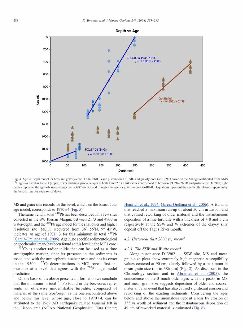
Fig. 4. Age vs. depth model for box- and gravity-core PO287-26B, G and piston-core D 13902 and gravity-core GeoB8903 based on the AD ages calibrated from AMS14C ages as listed in Table 1 (upper, lower and most probable ages at both 1 and 2 σ). Dark circles correspond to box-core PO287-26 1B and piston-core D13902; lightcircles represent the ages obtained along core PO287-26 3G, and triangles the age for gravity-core GeoB8903. Equations represent the age/depth relationship given bythe best-fit line for each set of dates.
288 F. Abrantes et al. / Marine Geology 249 (2008) 283–293
MS and grain-size records for this level, which, on the basis of ourage model, corresponds to 1970±4 (Fig. 5).
The same trend in total 210Pb has been described for a few sitescollected in the SW Iberian Margin, between 2173 and 4900 mwater-depth, and the 210Pb age model for the shallower and higherresolution site (MC1), recovered from 36° 56′N, 9° 45′W,indicates an age of 1971±3 for this minimum in total 210Pb(Garcia-Orellana et al., 2006).Again, no specific sedimentologicalor geochemical mark has been found at this level in theMC1 core.
137Cs is another radionuclide that can be used as a timestratigraphic marker, since its presence in the sediments isassociated with the atmospheric nuclear tests and has its onsetin the 1950's. 137Cs determinations in MC1 reveal first ap-pearance at a level that agrees with the 210Pb age modelprediction.
On the basis of the above presented information we concludethat the minimum in total 210Pb found in the box-cores repre-sents an otherwise unidentifiable turbidite, composed ofmaterial of the same type/origin as the one encountered aboveand below this level whose age, close to 1970±4, can beattributed to the 1969 AD earthquake related tsunami felt inthe Lisbon area (NOAA National Geophysical Data Center;
Heinrich et al., 1994; Garcia-Orellana et al., 2006). A tsunamithat reached a maximum run-up of about 50 cm in Lisbon andthat caused reworking of older material and the instantaneousdeposition of a fine turbidite with a thickness of ≈8 and 5 cmrespectively at the SSW and W extremes of the clayey siltydeposit off the Tagus River mouth.
4.2. Historical (last 2000 yr) record
4.2.1. The SSW and W site recordAlong piston-core D13902 — SSW site, MS and mean
grain-size plots show extremely high magnetic susceptibilityvalues centered at 90 cm, closely followed by a maximum inmean grain-size (up to 386 µm) (Fig. 2). As discussed in theChronology section and in Abrantes et al. (2005), thecoincidence of the 3 much older ages with the peaks in MSand mean grain-size suggests deposition of older and coarsermaterial by an event that has also caused significant erosion andreworking of the existing sediments. Considering the agesbelow and above the anomalous deposit a loss by erosion of355 yr worth of sediment and the instantaneous deposition of49 cm of reworked material is estimated (Fig. 6).
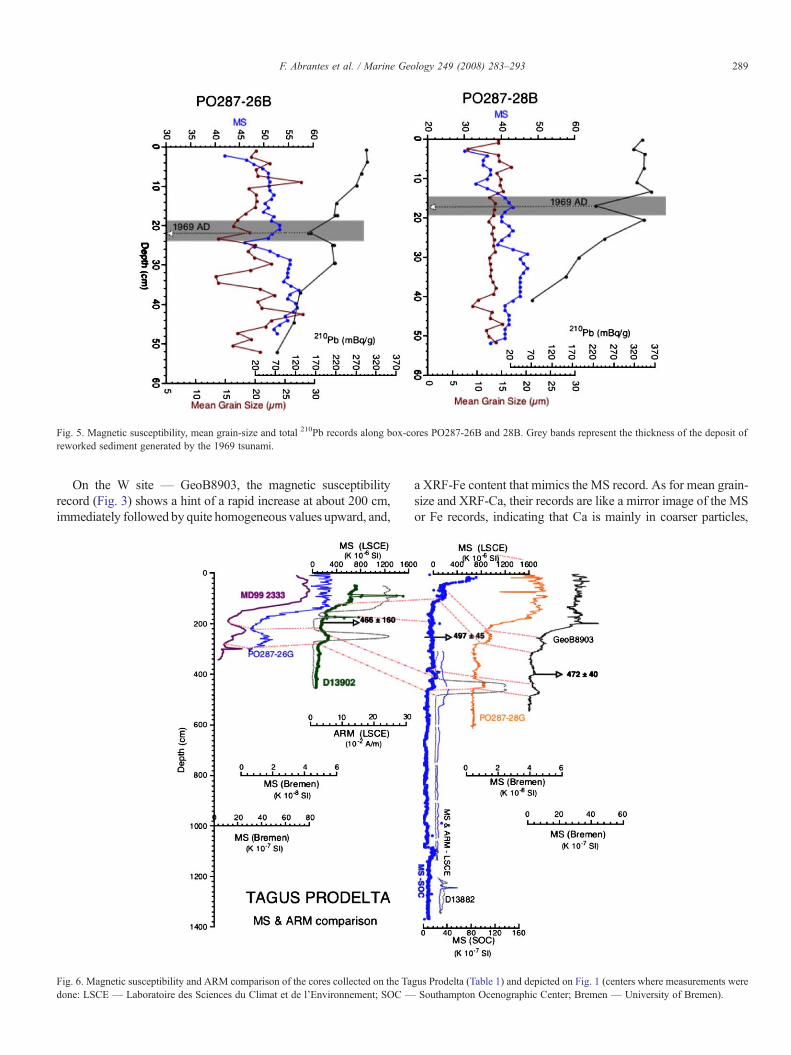
Fig. 5. Magnetic susceptibility, mean grain-size and total 210Pb records along box-cores PO287-26B and 28B. Grey bands represent the thickness of the deposit oreworked sediment generated by the 1969 tsunami.
289F. Abrantes et al. / Marine Geology 249 (2008) 283–293
On the W site — GeoB8903, the magnetic susceptibilityrecord (Fig. 3) shows a hint of a rapid increase at about 200 cm,immediately followed by quite homogeneous values upward, and,
Fig. 6. Magnetic susceptibility and ARM comparison of the cores collected on the Tagus Prodelta (Table 1) and depicted on Fig. 1 (centers where measurements werdone: LSCE — Laboratoire des Sciences du Climat et de l'Environnement; SOC — Southampton Ocenographic Center; Bremen — University of Bremen).
f
a XRF-Fe content that mimics the MS record. As for mean grain-size and XRF-Ca, their records are like a mirror image of the MSor Fe records, indicating that Ca is mainly in coarser particles,
e
290 F. Abrantes et al. / Marine Geology 249 (2008) 283–293
while Fe is in the finer sediment fractions. Furthermore, all recordsshow quite homogeneous sediments between 198 and 65 cm, thedepth interval in which the AMS 14C ages become undiffer-entiated at 2 σ (Figs. 4, 6).
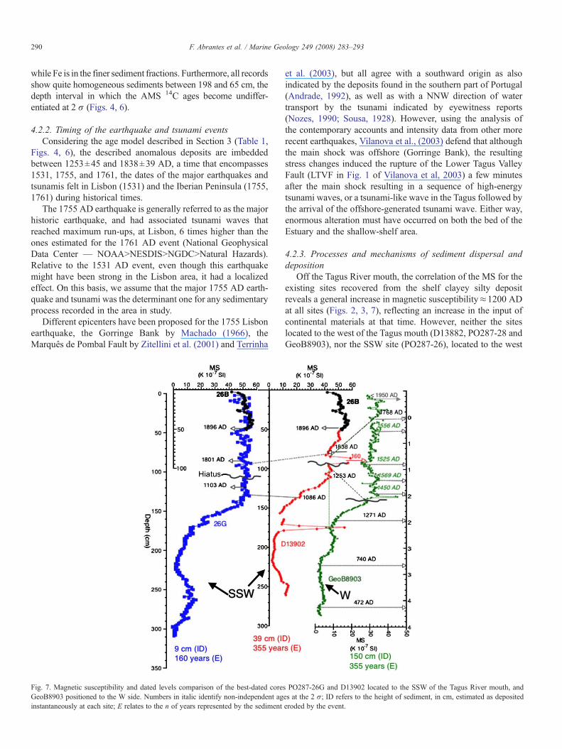
4.2.2. Timing of the earthquake and tsunami eventsConsidering the age model described in Section 3 (Table 1,
Figs. 4, 6), the described anomalous deposits are imbeddedbetween 1253±45 and 1838±39 AD, a time that encompasses1531, 1755, and 1761, the dates of the major earthquakes andtsunamis felt in Lisbon (1531) and the Iberian Peninsula (1755,1761) during historical times.
The 1755 AD earthquake is generally referred to as the majorhistoric earthquake, and had associated tsunami waves thatreached maximum run-ups, at Lisbon, 6 times higher than theones estimated for the 1761 AD event (National GeophysicalData Center — NOAANNESDISNNGDCNNatural Hazards).Relative to the 1531 AD event, even though this earthquakemight have been strong in the Lisbon area, it had a localizedeffect. On this basis, we assume that the major 1755 AD earth-quake and tsunami was the determinant one for any sedimentaryprocess recorded in the area in study.
Different epicenters have been proposed for the 1755 Lisbonearthquake, the Gorringe Bank by Machado (1966), theMarquês de Pombal Fault by Zitellini et al. (2001) and Terrinha
Fig. 7. Magnetic susceptibility and dated levels comparison of the best-dated coreGeoB8903 positioned to the W side. Numbers in italic identify non-independent aginstantaneously at each site; E relates to the n of years represented by the sediment
et al. (2003), but all agree with a southward origin as alsoindicated by the deposits found in the southern part of Portugal(Andrade, 1992), as well as with a NNW direction of watertransport by the tsunami indicated by eyewitness reports(Nozes, 1990; Sousa, 1928). However, using the analysis ofthe contemporary accounts and intensity data from other morerecent earthquakes, Vilanova et al., (2003) defend that althoughthe main shock was offshore (Gorringe Bank), the resultingstress changes induced the rupture of the Lower Tagus ValleyFault (LTVF in Fig. 1 of Vilanova et al, 2003) a few minutesafter the main shock resulting in a sequence of high-energytsunami waves, or a tsunami-like wave in the Tagus followed bythe arrival of the offshore-generated tsunami wave. Either way,enormous alteration must have occurred on both the bed of theEstuary and the shallow-shelf area.
4.2.3. Processes and mechanisms of sediment dispersal anddeposition
Off the Tagus River mouth, the correlation of the MS for theexisting sites recovered from the shelf clayey silty depositreveals a general increase in magnetic susceptibility≈1200 ADat all sites (Figs. 2, 3, 7), reflecting an increase in the input ofcontinental materials at that time. However, neither the siteslocated to the west of the Tagus mouth (D13882, PO287-28 andGeoB8903), nor the SSW site (PO287-26), located to the west
s PO287-26G and D13902 located to the SSW of the Tagus River mouth, andes at the 2 σ; ID refers to the height of sediment, in cm, estimated as depositederoded by the event.
291F. Abrantes et al. / Marine Geology 249 (2008) 283–293
of site D13902, shows the strong magnetic susceptibility peakfound in the easternmost core (D13902) (Fig. 7).
Visual examination of the D13902 archive half did not revealmajor perturbations and magnetic susceptibility measurementsdone on u-channels (1.5 m length liners made of transparent stiffplastic, with a 2×2 cm square cross section and an air tight clip-on cover constituting one of the sides), sampled from the centralpart of the archive core, confirmed the occurrence of a majormagnetic susceptibility peak (Abrantes et al., 2005), while theAnhysteretic Remanent Magnetization (ARM⁎) data validatesthe existence of an exceptionally high concentration of magneticminerals in the fine-grained sediment (Kissel et al., 1999).
The occurrence at the SSW site of this highly magneticsediment over a larger medium grain and Ca rich sediment,reflecting the presence of large shell fragments, and the asso-ciated much older ages than found for the rest of the sequence,are clear indications of a deposit of reworked material. Besides,the ages below and above the anomalous deposit indicate a lossby erosion of 355 yr worth of sediment.
Although little is known about the effect of strong tsunamison shallow-shelf regions, such events are expected to causeimportant erosion from the depth at which the wave(s) startsfeeling the seabed, resuspending and transporting sand andother fine materials more than 1 km inland or even singleboulders or boulder assemblages several meters above sea leveland 100–400 m inland (Scheffers and Kelletat, 2003; andliterature cited therein). As to the backflow, Dawson (1994) andNanayama et al. (2000) consider that although its carryingcapacity is unknown, it is certainly erosive enough to rework theonshore deposits, which, becoming part of the outflow, will inturn lead to an increase of the rip currents erosional capacity.
According to the above referred information, and the eye-witness reports (Nozes, 1990; Sousa, 1928) a stronger impact bythe tsunami backflow is likely to have occurred southwestwardsof the Tagus mouth causing erosion of the whole area and thehiatus found at site D13902 and PO287-26B, G.
Concerning the deposition of 49 cm of eroded material, LeRoux and Vargas (2005) pictured the sediment seawardtransport as gravity flows increasing in sediment concentrationin near shore channels, while Coleman (1968) proposed the
Fig. 8. Comparison of the magnetic susceptibility records along cores MD99 2333 andlayered sediments depicted in the X-ray image.
deposition of poorly sorted sediments close to the shore due tothe rapid loss of energy in the outflow. As a result, the coarseshell and heavy fine material ended up as a lag deposit formedas the water receded seaward through a SSW direction.
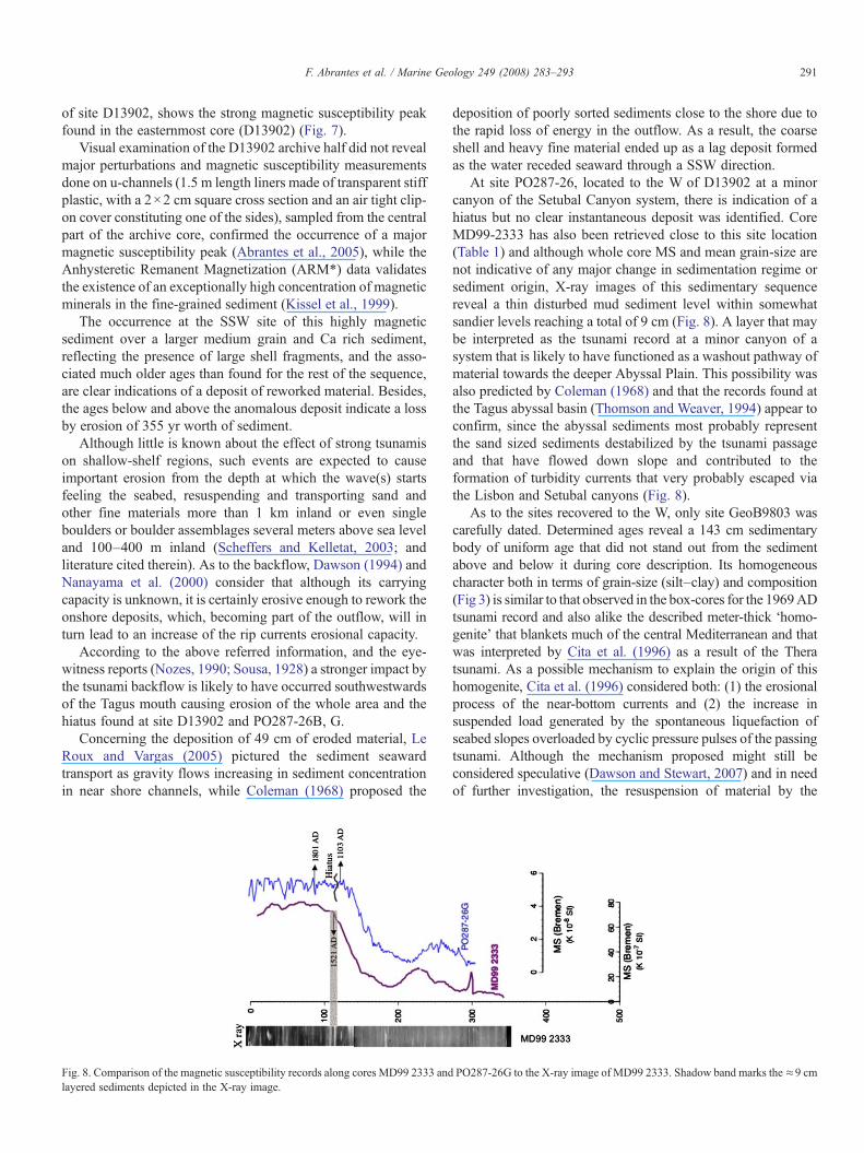
At site PO287-26, located to the W of D13902 at a minorcanyon of the Setubal Canyon system, there is indication of ahiatus but no clear instantaneous deposit was identified. CoreMD99-2333 has also been retrieved close to this site location(Table 1) and although whole core MS and mean grain-size arenot indicative of any major change in sedimentation regime orsediment origin, X-ray images of this sedimentary sequencereveal a thin disturbed mud sediment level within somewhatsandier levels reaching a total of 9 cm (Fig. 8). A layer that maybe interpreted as the tsunami record at a minor canyon of asystem that is likely to have functioned as a washout pathway ofmaterial towards the deeper Abyssal Plain. This possibility wasalso predicted by Coleman (1968) and that the records found atthe Tagus abyssal basin (Thomson and Weaver, 1994) appear toconfirm, since the abyssal sediments most probably representthe sand sized sediments destabilized by the tsunami passageand that have flowed down slope and contributed to theformation of turbidity currents that very probably escaped viathe Lisbon and Setubal canyons (Fig. 8).
As to the sites recovered to the W, only site GeoB9803 wascarefully dated. Determined ages reveal a 143 cm sedimentarybody of uniform age that did not stand out from the sedimentabove and below it during core description. Its homogeneouscharacter both in terms of grain-size (silt–clay) and composition(Fig 3) is similar to that observed in the box-cores for the 1969ADtsunami record and also alike the described meter-thick ‘homo-genite’ that blankets much of the central Mediterranean and thatwas interpreted by Cita et al. (1996) as a result of the Theratsunami. As a possible mechanism to explain the origin of thishomogenite, Cita et al. (1996) considered both: (1) the erosionalprocess of the near-bottom currents and (2) the increase insuspended load generated by the spontaneous liquefaction ofseabed slopes overloaded by cyclic pressure pulses of the passingtsunami. Although the mechanism proposed might still beconsidered speculative (Dawson and Stewart, 2007) and in needof further investigation, the resuspension of material by the
PO287-26G to the X-ray image of MD99 2333. Shadow band marks the≈9 cm
292 F. Abrantes et al. / Marine Geology 249 (2008) 283–293
backwash has been proved by the great plumes of turbid watermoving offshore observed in the video footage of the 26December 2004 Indian Ocean tsunami.
The deposition of the fine resuspended material reworkedfromwithin the same sedimentary environment and that ended upon the W site (GeoB8903 and PO287-28B), might be attributedto more inland/estuarine and shallow-shelf fine materials that arelikely to have been transported out in suspension, by the tsunami-like wave generated in the Estuary as proposed in the Vilanovaet al., (2003) model, or, to a somewhat slower sedimentationdetermined by the water column and circulation conditions afterthe event.
Spatial comprehensive studies of shallow marine tsunamideposits are scarce, however, data from a shallow marineembayment NW of Java, that suffered a tsunami caused by theKrakatau eruption, also reveal major variability both inthe composition and thickness of the tsunamite with lack of arecord on the north open sea facing part of the bay (van derBergh et al., 2003).
Themajor difference between the 1969AD record, constitutedby a sediment level similar in composition and thickness on boththe SSW and W sites, and the quite heterogeneous record as-sociated to the 1755 AD event, might be attributed to the majordifferences in wave run-up. Yet, changes in the estuary mouth andcoastal morphology and bathymetry caused by human actionthrough the centuries, and possibly also by the 1755 AD tsunamiitself, could have resulted in heavy changes in the propagation ofwaves and resulting effects.
5. Conclusions
The most important conclusion is that both the 1969 AD andthe 1755 AD earthquake-originated tsunami left a sedimentaryimprint in the shallow-shelf environment off Lisbon. However,while the 1969 record appears as an almost uniform layer of equal210Pb decrease, the record attributed to the 1755 tsunami reveals aquite heterogeneous record. At the SSW site, the tsunamite isidentifiable as a stratigraphically localized sedimentary sequencethat stands out by grain-size and MS records that cannot be easilyinterpreted in terms of gradual sedimentary processes. On the Wsite the tsunamite levels correspond mainly to fine sediments nodifferent either chemically or texturally from the rest of thesequence, and so, most likely to be overlooked in an environmentwhere the occurrence of fine sediments is normal. Consequently,identification of deposits of historical paleotsunamis will requirespecial attention and detailed dating, given that, such as in theLisbon area, sediments attributed to a tsunamic cause canoriginate and redeposit within a sedimentary environment thatis maintained unchanged before and after the event.
The variability found for different tsunamis (1755 and 1969)in such a small area is significant. A difference certainly relatedto the different wave run-ups but that can also derivate fromchanges in coastal morphology, shelf bathymetry, relativeimportance of the bottom currents effect, the backwash sus-pended load and circulation characteristics.
Paleotsunami studies in shallow-shelf areas beyond histor-ical times in sites such as our W site, will be difficult due to
the lack of diagnostic sedimentary criteria for the passage ofa tsunami.
Acknowledgements
We thank the captain and crew of RV Discovery and RVPoseidon for their help in collecting the samples and the EU-ARIPALEOSTUDIES project for supporting the XRF measure-ments. Acknowledgements are also due to two anonymousreviewers' constructive recommendations that enabled us toimprove the original manuscript. Financial support was providedby the EU project HOLSMEER (EVK2-CT-2000-00060) andthe ESF EUROCORES EUROMARGINS project SEDPORT(PDCTM/40017/2003).
References
Abrantes, F., Lebreiro, S., Gil, I., Rodrigues, T., Bartels-Jónsdóttir, H., Oliveira,P., Kissel, C., Grimalt, J.O., 2005. Shallow marine sediment cores recordclimate variability and earthquake activity off Lisbon (Portugal) for the last2000 years. Quat. Sci. Rev. 24, 2477–2494.
Andrade, C., 1992. Tsunami generated forms in the Algarve barrier islands. Sci.Tsunami Hazards 10, 21–34.
Baptista, M., Miranda, P., Mendes Victor, L., 1988a. Constraints on the source ofthe 1755 Lisbon tsunami inferred from numerical modeling of historicaldata. J. Geodyn. 25, 159–174.
Baptista, M.A., Heitor, S., Miranda, J.M., Miranda, P., Victor, L.M., 1988b. The1755 Lisbon tsunami; evaluation of the tsunami parameters. J. Geodyn. 25,143–157.
Baptista, M.A., Miranda, P.M., Mendes Victor, L., 1992. Maximum entropyanalysis of Portuguese tsunami: the tsunamis of 28/02/1969 and 26/04/1975.Sci. Tsunami Hazards 10 (1), 9–20.
Baptista, M.A., Miranda, J.M., Chierici, F., Zitellini, N., 2003. New study of the1755 earthquake source based on multi-channel seismic survey data andtsunami modelling. Nat. Hazards Earth Syst. Sci. 3, 333–340.
Baptista, M.A., Soares, P.M., Miranda, J.M., Luis, J.F., 2006. Tsunamipropagation along Tagus Estuary (Lisbon, Portugal) preliminary results.Sci. Tsunami Hazards 24, 329–338.
Blott, S.J., Pye, K., 2001. Gradistat: a grain-size distribution and statisticspackage for the analysis of unconsolidated sediments. Earth Surf. ProcessesLandf. 26, 1237–1248.
Cabeçadas, G., Brogueira, M.J., 1997. Sediments in a Portuguese coastal area—pool sizes of mobile and immobile forms of nitrogen and phosphorus. Mar.Freshw. Res. 48, 559–563.
Campos, M.L., 1991. Tsunami hazard on the Spanish coast of the IberianPeninsula. Sci. Tsunami Hazards 9 (1), 83–90.
Cita, M.B., Camerlenghi, A., Rimoldi, B., 1996. Deep-sea tsunami deposits inthe eastern Mediterranean, new evidence and depositional models.Sediment. Geol. 104, 155–173.
Coleman, P.J., 1968. Tsunamis as geological agents. J. Geol. Soc. Australia 15,267–273.
Dawson, A.G., 1994. Geomorphological processes associated with tsunamirunup and backwash. Geomorphology 10, 83–94.
Dawson, A.G., Stewart, I., 2007. Tsunami deposits in the geological record.Sediment. Geol. 220 (3–4), 166–183. doi:10.1016/j.sedgeo.2007.01.002.
Dawson, A.G., Foster, I.D.L., Shi, S., Smith, D.E., Long, D., 1991. Theidentification of tsunami deposits in coastal sediment sequences. Sci.Tsunami Hazards 9, 73–82.
Dawson, A.G., Hindson, R.A., Andrade, C., Freitas, C., Parish, R., Bateman, M.,1995. Tsunami sedimentation associated with the Lisbon earthquake of 1NovemberAD1755:Boca doRio,Algarve, Portugal. Holocene 5 (2), 209–215.
Folk, R.L., Ward, W.C., 1957. Brazos River bar: a study in the significance ofgrain-size parameters. J. Sediment. Petrol. 27, 3–26.
Garcia-Orellana, J., Gràcia, E., Vizcaino, A., Masqué, P., Olid, C., Martinez-Ruiz, F., Piñero, H., Sanchez-Cabeza, J.-A., Dañobeitia, J., 2006. Identifying
293F. Abrantes et al. / Marine Geology 249 (2008) 283–293
instrumental and historical earthquake records in the SW Iberian marginusing 210Pb turbidite chronology. Geophys. Res. Lett. 33, L24601.doi:10.1029/2006GL028417.
Gaspar, L., Monteiro, H., 1977. Matéria Orgânica nos sedimentos da plataformacontinental portuguesa entre os cabos Espichel e Raso. Comun. Serv. Geol.Port. LXII, 69–83.
Heinrich, P., Baptista, M.A., Miranda, P.M., 1994. Numerical simulation of1969 Tsunami along the Portuguese coasts. Preliminary results. Sci.Tsunami Hazards 12 (1), 13–23.
Hindson, R.A., Andrade, C., Dawson, A.G., 1996. Sedimentary processesassociated with the tsunami generated by the 1755 Lisbon earthquake on theAlgarve coast, Portugal. Phys. Chem. Earth 21, 57–63.
Jansen, J.H.F., Van der Gaast, S.J., Koster, B., Vaars, A.J., 1998. CORTEX, ashipboard XRF-scanner for element analyses in split sediment cores. Mar.Geol. 151 (1–4), 143–153.
Justo, J.L., Saiwa, C., 1998. The 1531 Lisbon earthquake. Bull. Seismol. Soc.Am. 88 (2), 319–328.
Kissel, C., Laj, C., Labeyrie, L., Dokken, T., Voelker, A., Blamart, D., 1999.Magnetic signature of rapid climatic variations in North Atlantic sediments.In: Abrantes, F., Mix, A. (Eds.), “Reconstructing Ocean History: AWindowinto the Future.”. Plenum Publishing, London, pp. 419–437.
Le Roux, J.P., Vargas, G., 2005. Hydraulic behavior of tsunami back-flows: insights from their modern and ancient deposits. Environ. Geol.doi:10.1007/s00254-005-0059-2.
Machado, F., 1966. Contribuição para o Estudo do Terramoto de 1 de Novembrode 1755. Rev. Fac. Ciênc. Lisb. Ser. C 14, 19–31.
Mader, C.L., 2001. Modelling the 1755 Lisbon tsunami. Sci. Tsunami Hazards19 (2), 93–98.
Mendonça, M., 1758. Historia Universal dos Terramotos que tem havido nomundo de que ha noticia desde a sua creção até ao século presente.Biblioteca Nacional de Lisboa, Portugal.
Monteiro, H., Moita, I., 1971. Morfologia e sedimentos da plataformacontinental e vertente continental superior ao largo da Peninsula de Setúbal.“Congresso de Geologia.”, pp. 301–330.
Nanayama, F., Shigeno, K., Satake, K., Shimokawa, K., Koitabashi, S.,Miyasaka, S., Ishii, M., 2000. Sedimentary differences between the 1993Hokkaido-nansei-oki tsunami and the 1959 Miyakojima typhoon at Taisea,southwestern Hokkaido, northern Japan. Sediment. Geol. 135, 255–264.
Nozes, J., 1990. O Terramoto de 1755: Testemunhos Britânicos; BritishAccounts of the Lisbon Earthquake of 1755. The British Historical Societyof Portugal, Lisbon.
Pareschi, M.T., Boschi, E., Favalli, M., 2006. Lost tsunami. Geophys. Res. Lett.33, L22608. doi:10.1029/2006GL027790.
Reimer, P.J., Baillie, M.G.L., Bard, E., Bayliss, A., Beck, J.W., Bertrand, C.,Blackwell, P.G., Buck, C.E., Burr, G., Cutler, K.B., Damon, P.E., Edwards,R.L., Fairbanks, R.G., Friedrich, M., Guilderson, T.P., Hughen, K.A.,Kromer, B., McCormac, F.G., Manning, C. Bronk Ramsey, Reimer, R.W.,Remmele, S., Southon, J.R., Stuiver, M., Talamo, S., Taylor, F.W., van derPlicht, J., Weyhenmeyer, C.E., 2004. Radiocarbon 46, 1029–1058.
Scheffers, A., Kelletat, D., 2003. Sedimentologic and Geomorphologic TsunamiImprints Worldwide—A Review.
Scheffers, A., Kelletat, D., 2005. Tsunami relics on the coastal landscape west ofLisbon, Portugal. Sci. Tsunami Hazards 23 (1), 3–16.
Sousa, F.P.D., 1928. Distritos de Lisboa. Serviços Geológicos de Portugal, Lisboa.Tappan, E.M. (Editor), 1914. The World's Story: A History of the World in
Story, Song and Art, 14 Vols. (Boston: Houghton Mifflin, 1914), Vol. V:Italy, France, Spain, and Portugal, Source: Modern History Sourcebook:Historical Depictions of the 1755 Lisbon Earthquake Rev. Charles Davy:The Earthquake at Lisbon, vol. 1755, pp. 618–628.
Teller, J.T., Murty, T., Nirupama, N., Chittibabu, P., 2005. A possible tsunami inthe Labrador Sea related to the drainage of Glacial Lake Agassiz~8400 years B.P. Sci. Tsunami Hazards 23 (3), 3–16.
Terrinha, P., Pinheiro, L.M., Henriet, J.-P., Matias, L., Ivanov, M.K., Monteiro,J.H., Akhmetzhanov, A., Volkonskaya, A., Cunha, T., Shaskin, P., Rovere,M., 2003. Tsunamigenic–seismogenic structures, neotectonics, sedimentaryprocesses and slope instability on the southwest Portuguese Margin. Mar.Geol. 195, 55–73.
Thomson, J., Weaver, P.P.E., 1994. An AMS radiocarbon method to determinethe emplacement time of recent deep-sea turbidites. Sediment. Geol. 89,1–7.
Van der Bergh, G.D., Boer, W., Haas, H., van Weering, T., van Wijhe, R., 2003.Shallow marine tsunami deposits in Telik Banten (NW Java, Indonesia),generated by the 1883 Krakatau eruption. Mar. Geol. 197, 13–34.
Vilanova, S., Nunes, C., Fonseca, J., 2003. Lisbon 1755: a case of triggeredonshore rupture? Bull. Seismol. Soc. Am. 93, 2056–2068.
Whelan, F., Kelletat, D., 2005. Boulder deposits on the southern SpanishAtlantic coast: possible evidence for the 1755 AD Lisbon tsunami. Sci.Tsunami Hazards 23 (3), 25–38.
Zitellini, N., Mendes, L., Córdoba, D., Dañobeitia, J.J., Nicolich, R., Pellis, G.,Ribeiro, A., Sartori, R., Torelli, L., BIGSETSTeam, 2001. Source of the 1755Lisbon earthquake and tsunami investigated. EOS, Trans. AGU 82 (26),285–291.