
Rates of carbon dioxide plume degassing from Mount Etna volcano

Volcano-tectonic activity along structures of the unstableNE £ank of Mt. Etna (Italy) and their possible origin
Alessandro Tibaldi a;b;�, Gianluca Groppelli b
a Dipartimento di Scienze Geologiche e Geotecnologie, Universita' di Milano-Bicocca, P. della Scienza 4, 20126 Milan, Italyb CNR-Istituto per la Dinamica dei Processi Ambientali, Milan, Italy
Received 14 March 2001; accepted 30 August 2001
Abstract
We describe the prehistoric^historic activity of the main and minor volcano-tectonic structures of thenortheastern flank of Mt. Etna, giving new data which provide a clearer view of how destabilized volcanoes react tomagma pressure and gravity forces. Data are mostly based on new lithostratigraphic surveys and on offsetmeasurements of late Pleistocene^Holocene deposits and historic man-made features. The North-East Rift (NE Rift)is a volcanic rift that has guided mostly explosive, but also secondary effusive, activity since the end of the Pleistocene.Monogenetic cones and explosive craters are strongly elongated and aligned along 66 main surface fractures andseveral others, hidden, but inferred, from sinkhole alignments. The opening direction is locally oblique, with a left-lateral component in the north-eastern segment of the rift. At the NE tip of the rift, the movements are relieved by thenormal left-lateral Pernicana Fault (PF), an 11-km-long structure comprising E^W fault segments connected by right-stepping en e¤chelon faults. Our study demonstrates that the very high slip rates at a centennial scale of these structuresare well constrained and similar (NE Rift = 0.6^1.8 cm/a, PF=0.5^2.2 cm/a) and have been also recognized in theLatest Pleistocene^Holocene (2.7 cm/a). The E^W Fiumefreddo Fault (FF) has normal left-lateral kinematics and ahistoric slip rate of 0.1 cm/a. Ripa della Naca Faults strike NE and are covered by unfaulted 6 15-ka-old lavas.Relative sinking to the SE gives a late Pleistocene slip rate of 0.2 cm/a. Newly recognized NNE- to NE-striking activenormal faults interfere at the PF^FF junction zone. The active East-North-East Rift, which is described in detail forthe first time, is another volcanic rift affecting the eastern flank of Mt. Etna. This rift shows left-lateral normalmotions and has guided the location of several pyroclastic cones since at least the end of the Pleistocene. Stratigraphicand structural data prove the presence of a North^South Rift which has existed across the Mt. Etna summit zoneduring at least the last 14 ka. Our data coupled with published seismological data indicate that these structures are thesurface expressions of the seaward sliding of the eastern flank of Etna along two slip surfaces in a two-componentprincipal stress field, produced by gravity loading and magma intrusion. A shallower slide surface can be activatedfollowing dominance of gravity instability triggered by the mass of the volcano flank, or movements can occur along adeeper surface triggered by injection phases, or the two surfaces can move at the same time by a combination ofeffects. The existence of this double system of deformation can explain several apparently contradictory phenomena,such as discontinuous correlation of deformation, earthquakes and eruptions, and different earthquake foci, focalmechanisms and fault slip rates. @ 2002 Elsevier Science B.V. All rights reserved.
Keywords: Mount Etna; volcano collapse; active fault; volcanic rift
0377-0273 / 02 / $ ^ see front matter @ 2002 Elsevier Science B.V. All rights reserved.PII: S 0 3 7 7 - 0 2 7 3 ( 0 1 ) 0 0 3 0 5 - 5
* Corresponding author. Fax: +39-2-6448-4273. E-mail address: [email protected] (A. Tibaldi).
VOLGEO 2414 10-6-02
Journal of Volcanology and Geothermal Research 115 (2002) 277^302
www.elsevier.com/locate/jvolgeores

1. Introduction
In this paper, we provide new quantitative ¢elddata on the geometry, kinematics, age, and asso-ciated volcanic deposits of all the recent (latestPleistocene^Holocene) and active deformationsystems of the NE £ank of Mt. Etna: particularlythe North-East Rift (NE Rift, Gardun‹o et al.,1997), Pernicana Fault (PF, Kie¡er, 1975; Rasa'et al., 1982), Fiumefreddo Fault (FF, Groppelliand Tibaldi, 1996, 1999; Azzaro et al., 1998), Pie-dimonte Fault (Monaco et al., 1997), and Ripadella Naca Faults (RNF, Rasa' et al., 1982)(Figs. 1 and 2). Moreover, for the ¢rst time, we
describe in detail other main volcanic^tectonicfeatures of Mt. Etna which are directly associatedwith volcanic activity and which have been justaddressed in previous studies (McGuire et al.,1997; Favalli et al., 1999): the East-North-EastRift (ENE Rift) and the summit North^SouthRift (N^S Rift). Some other active new faultsand tilting of late Pleistocene lavas are also pre-sented for the ¢rst time. The ¢nal purpose is todiscuss the possible relationships between thesestructures in terms of the volcanic activity andof the gravitational spreading of the cone, takinginto account also the possible role of the subvol-canic basement structures.
Fig. 1. Map of the main structural features of Mt. Etna and surrounding region. Note the main clusters of pyroclastic conestrending N^S, NE and ENE^WSW. Box indicates the studied area and Fig. 2. Line is section trace of Fig. 17.
VOLGEO 2414 10-6-02
A. Tibaldi, G. Groppelli / Journal of Volcanology and Geothermal Research 115 (2002) 277^302278

The NE Rift, located near the northeastern sideof the volcano summit, coincides with one of thefour main elongated clusters of pyroclastic coneswhich characterize Mt. Etna (Fig. 1) (Villari et al.,1988; Ferrari and Tibaldi, 1991; Mazzarini andArmienti, 2001). The other clusters depict a N^Szone on the southern volcano £ank, and two lessdeveloped WSW^ENE-trending zones on thewestern and eastern £anks. Only one main com-prehensive geological study on the NE Rift hasbeen published (Gardun‹o et al., 1997), more con-cerned with stratigraphy, but not quantifying thedeformation rate and vectors.The PF (Fig. 2) strikes E^W to the east of the
NE Rift and was initially considered una¡ectedby volcanic centers (Romano, 1979). Several pa-pers have been published on the PF (Azzaro et al.,1988, 1998; Obrizzo et al., 1994; Rasa' and Az-zaro, 1995; Rasa' et al., 1996; Azzaro, 1997;Giammanco et al., 1997), mainly dealing withmorphological, geodetic, macroseismic, and geo-physical data, but no one focused on long-termlatest Pleistocene^Holocene and short-term quan-titative kinematic data, such as those here pre-sented. Many earthquakes are concentrated alongthe PF (Azzaro, 1997) resulting in loss of life and
signi¢cant economic damage due to the presenceof tourist resorts and villages. Large creep move-ments are also present. Moreover, from the pointof view of volcanic hazard, detailed geologicalmapping along the fault has made it possible toestablish whether this fault also acted in the pastas a magma feeding path. The eastern terminationof the PF and its possible prolongation with theFF has been studied by Groppelli and Tibaldi(1996, 1999) who give quantitative ¢eld kinematicdata, and by Azzaro et al. (1998) who use geo-chemical and structural data.About the Piedimonte Fault (Fig. 1), Monaco
et al. (1997) and Groppelli and Tibaldi (1999)furnish quantitative kinematic data, introducingHolocene slip rates of 0.17 and 0.3 O 0.1 cm/a,respectively. About the RNF (Fig. 2), only Rasa'et al. (1982) describe these structures, withoutquantitative kinematic data.The NE Rift and the PF have been encom-
passed in a single weakness zone limiting to thenorth the unstable eastern £ank of Mt. Etnawhich tends to slide towards the sea (Kie¡er,1985; Neri et al., 1991; Borgia et al., 1992;McGuire and Saunders, 1993). Understandingthe location and geometry of the sliding surface
Fig. 2. Major and minor structures of the studied area. Note that the NE Rift prolongs southward across the Mt. Etna summitzone reaching the N^S rift of the southern £ank of the volcano. The PF^FF system reaches 2 km from the sea. ‘S’ is the uphill-facing scarp described in the text, which can be linked with the toe bulging zone of the more super¢cial slide plane. Location inFig. 1. Boxes locate Figs. 3 and 13^15.
VOLGEO 2414 10-6-02
A. Tibaldi, G. Groppelli / Journal of Volcanology and Geothermal Research 115 (2002) 277^302 279
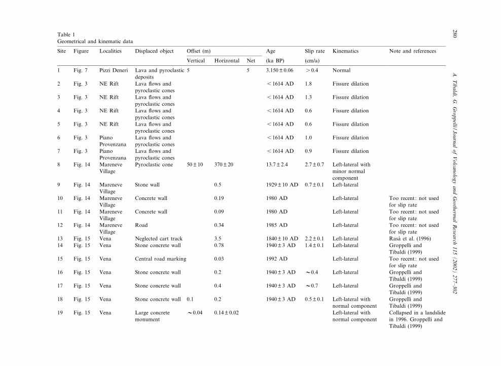
Table 1Geometrical and kinematic data
Site Figure Localities Displaced object O¡set (m) Age Slip rate Kinematics Note and references
Vertical Horizontal Net (ka BP) (cm/a)
1 Fig. 7 Pizzi Deneri Lava and pyroclasticdeposits
5 5 3.150O 0.06 s 0.4 Normal
2 Fig. 3 NE Rift Lava £ows andpyroclastic cones
6 1614 AD 1.8 Fissure dilation
3 Fig. 3 NE Rift Lava £ows andpyroclastic cones
6 1614 AD 1.3 Fissure dilation
4 Fig. 3 NE Rift Lava £ows andpyroclastic cones
6 1614 AD 0.6 Fissure dilation
5 Fig. 3 NE Rift Lava £ows andpyroclastic cones
6 1614 AD 0.6 Fissure dilation
6 Fig. 3 PianoProvenzana
Lava £ows andpyroclastic cones
6 1614 AD 1.0 Fissure dilation
7 Fig. 3 PianoProvenzana
Lava £ows andpyroclastic cones
6 1614 AD 0.9 Fissure dilation
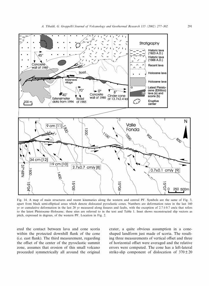
8 Fig. 14 MareneveVillage
Pyroclastic cone 50O 10 370O 20 13.7O 2.4 2.7O 0.7 Left-lateral withminor normalcomponent
9 Fig. 14 MareneveVillage
Stone wall 0.5 1929O 10 AD 0.7O 0.1 Left-lateral
10 Fig. 14 MareneveVillage
Concrete wall 0.19 1980 AD Left-lateral Too recent: not usedfor slip rate
11 Fig. 14 MareneveVillage
Concrete wall 0.09 1980 AD Left-lateral Too recent: not usedfor slip rate
12 Fig. 14 MareneveVillage
Road 0.34 1985 AD Left-lateral Too recent: not usedfor slip rate
13 Fig. 15 Vena Neglected cart track 3.5 1840O 10 AD 2.2O 0.1 Left-lateral Rasa' et al. (1996)14 Fig. 15 Vena Stone concrete wall 0.78 1940O 3 AD 1.4O 0.1 Left-lateral Groppelli and
Tibaldi (1999)15 Fig. 15 Vena Central road marking 0.03 1992 AD Left-lateral Too recent: not used
for slip rate16 Fig. 15 Vena Stone concrete wall 0.2 1940O 3 AD V0.4 Left-lateral Groppelli and
Tibaldi (1999)17 Fig. 15 Vena Stone concrete wall 0.4 1940O 3 AD V0.7 Left-lateral Groppelli and
Tibaldi (1999)18 Fig. 15 Vena Stone concrete wall 0.1 0.2 1940O 3 AD 0.5O 0.1 Left-lateral with
normal componentGroppelli andTibaldi (1999)
19 Fig. 15 Vena Large concretemonument
V0.04 0.14O 0.02 Left-lateral withnormal component
Collapsed in a landslidein 1996. Groppelli andTibaldi (1999)
VOLGEO2414
10-6-02
A.Tibaldi,
G.Groppelli/Journal
ofVolcanology
andGeotherm
alResearch
115(2002)
277^302280
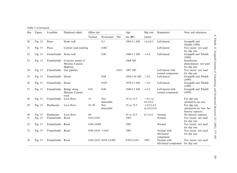
Table 1 (Continued).
Site Figure Localities Displaced object O¡set (m) Age Slip rate Kinematics Note and references
Vertical Horizontal Net (ka BP) (cm/a)
20 Fig. 15 Presa Stone wall 0.5 1965O 5 AD 1.6O 0.3 Left-lateral Groppelli andTibaldi (1999)
21 Fig. 15 Presa Central road marking 0.061 Left-lateral Too recent: not usedfor slip rate
22 Fig. 15 Fiumefreddo Stone wall 0.08 1940O 3 AD V0.1 Left-lateral Groppelli and Tibaldi(1999)
23 Fig. 15 Fiumefreddo Concrete tunnel ofMessina^CataniaHighway
1964 AD Interferencephenomenon: not usedfor slip rate
24 Fig. 15 Fiumefreddo Gas pipeline 0.011 1987 AD Left-lateral withnormal component
Too recent: not usedfor slip rate
25 Fig. 15 Fiumefreddo House 0.04 1920O 10 AD 6 0.1 Left-lateral Groppelli and Tibaldi(1999)
26 Fig. 15 Fiumefreddo House 0.025 1970O 5 AD 6 0.1 Left-lateral Groppelli and Tibaldi(1999)
27 Fig. 15 Fiumefreddo Bridge alongMessina^Cataniaroad
0.01 0.08 1940O 3 AD V0.1 Left-lateral withnormal component
Groppelli and Tibaldi(1999)
28 Fig. 15 Fiumefreddo Lava £ows 15 Notdetectable
35 to 15.5 6 0.1 to0.6O 0.2
For slip ratecalculation see text
29 Fig. 15 Piedimonte Lava £ows 10^50 Notdetectable
35 to 15.5 9 0.2O 0.1to 0.8O 0.4
For slip ratecalculation see text. Nohistoric ruptures
30 Fig. 15 Piedimonte Lava £ows 60 35 to 15.5 0.3O 0.1 Normal No historic ruptures31 Fig. 15 Fiumefreddo Road 0.03O 0.01 1983 Normal Too recent: not used
for slip rate32 Fig. 15 Fiumefreddo Road 0.04O 0.005 1983 Normal Too recent: not used
for slip rate33 Fig. 15 Fiumefreddo Road 0.04O 0.01 V0.01 1983 Normal with
left-lateralcomponent
Too recent: not usedfor slip rate
34 Fig. 15 Fiumefreddo Road 0.04O 0.01 0.035O 0.005 0.053O 0.01 1983 Normal withleft-lateral component
Too recent: not usedfor slip rate
VOLGEO2414
10-6-02
A.Tibaldi,
G.Groppelli/Journal
ofVolcanology
andGeotherm
alResearch
115(2002)
277^302281
plays a fundamental role in the reconstruction ofthe whole dynamics of the volcano and in theassessment of volcanic, seismic, and hydrologichazards. Lo Giudice and Rasa' (1992) postulatea shallow slip surface beneath the volcanic se-quence of Etna, consistent with the very shallowseismicity (depth 6 1.5 km) determined macro-seismically on the eastern £ank. Borgia et al.(1992) and Rust and Neri (1996) suggest a detach-ment as deep as about 5 km occurring chie£ywithin weak sediments of Gela^Catania Foredeepthat lie below Mt. Etna. This detachment is sub-horizontal, whereas Lo Giudice and Rasa' (1992)and Rasa' et al. (1996) suggest a listric geometryfor the slip surface. Moreover, some authorsideally connect the PF with an escarpment bor-dering the southeastern margin of the NE Rift(e.g. in Rasa' et al., 1982; Azzaro et al., 1988).This escarpment has been interpreted as the ex-pression of a normal fault (Romano and Guest,1979) or the remnant of a caldera margin (LoGiudice et al., 1982), whereas the PF has alsobeen considered a tectonic structure with a geom-etry and activity related to the regional tectonicstate of stress by Ferrucci (1994) and Monaco etal. (1997).Besides contributing to the understanding of
the characteristics and genesis of these structuresand their possible linking with basal detachmentsurfaces, the present work is one of the few exam-ples of detailed ¢eld study of active faults on avolcano. In order to provide accurate geometricaland kinematic data (Table 1), the width, throwand opening direction of fractures were measuredin the ¢eld at intervals of 100 m along each struc-ture. Width was measured with a tape, throw witha tape or by hand levelling with a clinometer, andopening direction by recognition of dislocatedmorphological or lithostratigraphic markers. De-tailed structural and geological ¢eld surveys (at ascale from 1:5000 to 1:10 000) were performedfrom the volcano summit zone to the sea(Fig. 1). The stratigraphic data are published ina 1:50 000 geological map (Pasquare' et al., 2002).Only this rigorous stratigraphic knowledge en-abled measurements and age determination ofthe o¡sets of geologic deposits. Besides geologicalindicators of o¡set, several man-made features
have been repeatedly dislocated by ¢ssures andfaults. The absolute ages of these features havebeen obtained from the local municipalities allow-ing the calculation of slip rates for the last 160years. These historic slip rates are just an approx-imation because in the short time intervals, sliprates sensibly decrease with increase of the presentyear taken as reference upper time boundary. Wegive these rates in order to compare the behaviorof the various fault segments in the same historictime interval, or to compare sites where man-made features of di¡erent age present di¡erentcumulative o¡sets. When o¡set features areyounger than 20 years, only the net o¡set is given.Slip rates are given in such a way that they showboth the degree of uncertainty in o¡set measure-ments and in age determination; for each site thepossible error of measurement of dislocation andage is given, and the resulting slip rate contains anerror range resulting from the sum of the two.Among the results of this paper, we provide
data and a new dynamic model of the edi¢ce £ankas an example of a volcanic rift^transform faultsystem on a large stratovolcano linked with £ankinstability. Rift zones on volcanoes are widelycited in the literature (e.g. in Moore and Krivoy,1964; Fiske and Jackson, 1972; Borgia andTreves, 1992), but only rare examples refer topossible relationships with transform systems(e.g. Borgia, 1994).
2. NE Rift
2.1. Lava geometry
A succession of lavas and subordinate pyroclas-tic deposits of latest Pleistocene^Holocene agecrops out along the NE Rift creating a NE-elon-gated ridge which stands about 200 m above thesoutheastern zone (Piano Provenzana, Fig. 3) andabout 60 m with respect to the northwestern zone.The oldest stratigraphic units crop out along thesoutheastern escarpment of the ridge, whereas theyounger products crop out along the ridge axis(Gardun‹o et al., 1997). Flow layering dips at alow angle (a few degrees) towards the NE Riftalong the ridge axis, and gradually rotates north-
VOLGEO 2414 10-6-02
A. Tibaldi, G. Groppelli / Journal of Volcanology and Geothermal Research 115 (2002) 277^302282
wards along the northwestern escarpment withinclination up to 15^20‡. Along the southeasternescarpment, the oldest lavas dip southeastwardsat angles of 40^45‡ revealing post-deposition tilt-ing, although well-developed £ow stretching line-ations imply £ow over a pre-existing escarpment.
2.2. Geometry of exposed fractures
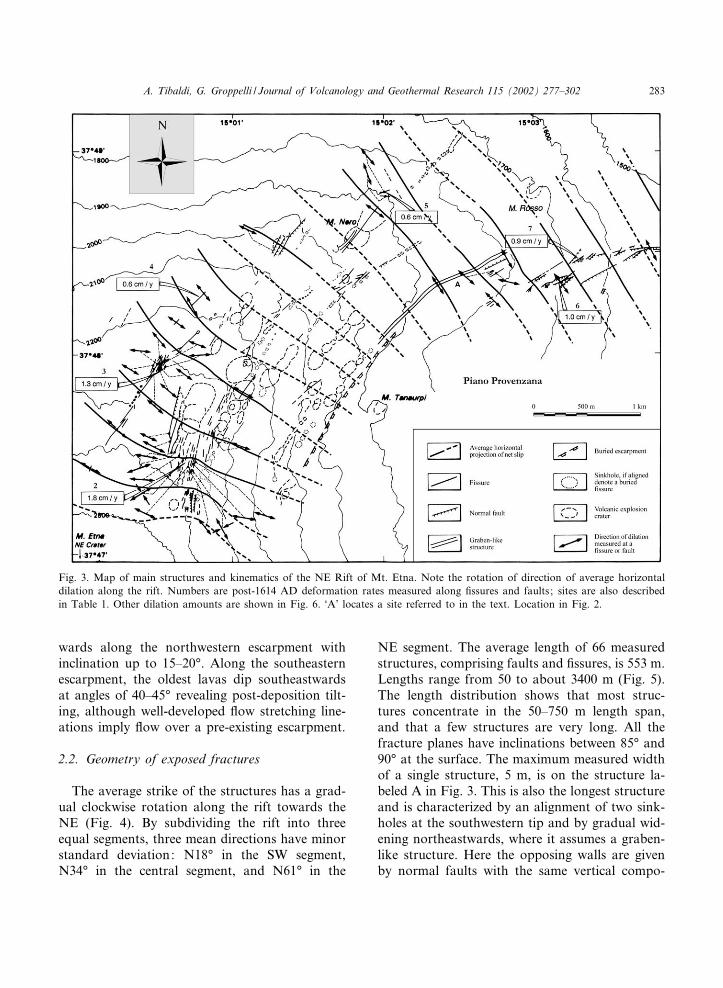
The average strike of the structures has a grad-ual clockwise rotation along the rift towards theNE (Fig. 4). By subdividing the rift into threeequal segments, three mean directions have minorstandard deviation: N18‡ in the SW segment,N34‡ in the central segment, and N61‡ in the
NE segment. The average length of 66 measuredstructures, comprising faults and ¢ssures, is 553 m.Lengths range from 50 to about 3400 m (Fig. 5).The length distribution shows that most struc-tures concentrate in the 50^750 m length span,and that a few structures are very long. All thefracture planes have inclinations between 85‡ and90‡ at the surface. The maximum measured widthof a single structure, 5 m, is on the structure la-beled A in Fig. 3. This is also the longest structureand is characterized by an alignment of two sink-holes at the southwestern tip and by gradual wid-ening northeastwards, where it assumes a graben-like structure. Here the opposing walls are givenby normal faults with the same vertical compo-
Fig. 3. Map of main structures and kinematics of the NE Rift of Mt. Etna. Note the rotation of direction of average horizontaldilation along the rift. Numbers are post-1614 AD deformation rates measured along ¢ssures and faults; sites are also describedin Table 1. Other dilation amounts are shown in Fig. 6. ‘A’ locates a site referred to in the text. Location in Fig. 2.
VOLGEO 2414 10-6-02
A. Tibaldi, G. Groppelli / Journal of Volcanology and Geothermal Research 115 (2002) 277^302 283
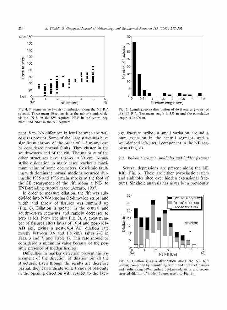
nent, 8 m. No di¡erence in level between the walledges is present. Some of the large structures havesigni¢cant throws of the order of 1^3 m and canbe considered normal faults. They cluster in thesouthwestern end of the rift. The majority of theother structures have throws 6 30 cm. Along-strike dislocation in many cases reaches a maxi-mum value of some decimeters. Coseismic fault-ing with dominant normal motions occurred dur-ing the 1985 and 1986 main shocks at the foot ofthe SE escarpment of the rift along a NE- toENE-trending rupture trace (Azzaro, 1997).In order to measure dilation, the rift was sub-
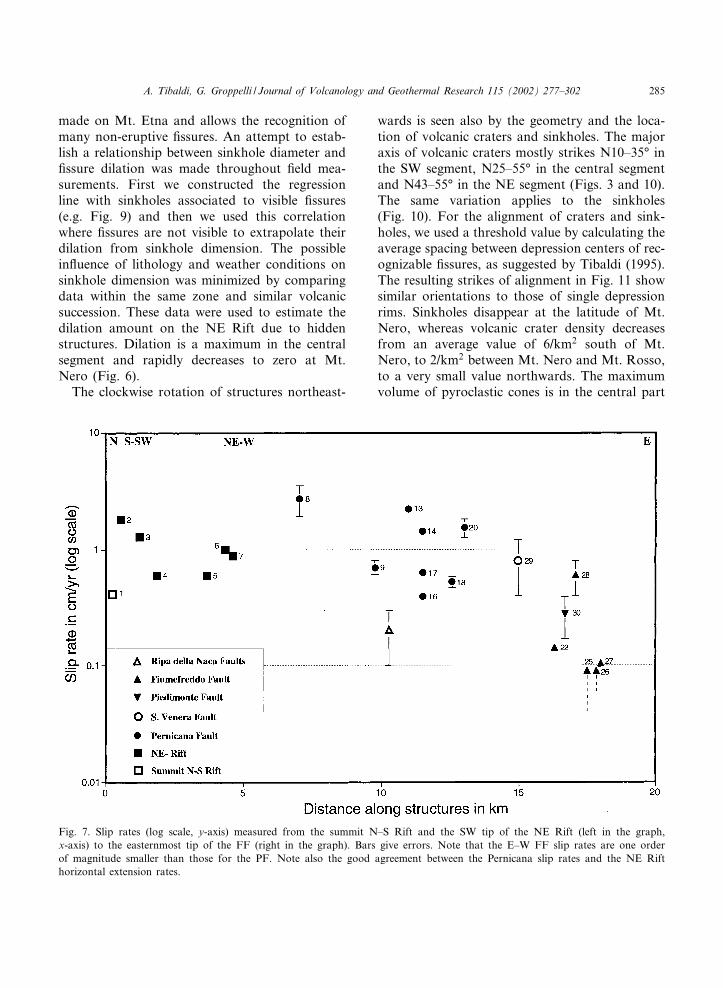
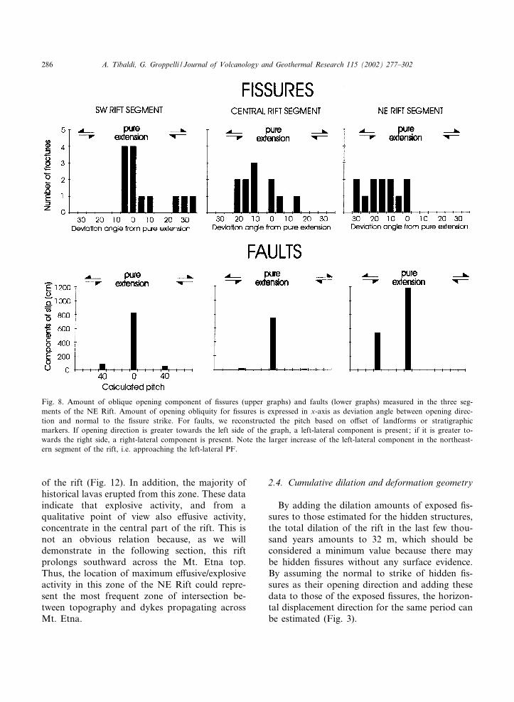
divided into NW-trending 0.5-km-wide strips, andwidth and throw of ¢ssures was summed up(Fig. 6). Dilation is greater in the central andsouthwestern segments and rapidly decreases tozero at Mt. Nero (see also Fig. 3). A great num-ber of ¢ssures a¡ect lavas of 1614 and post-1614AD age, giving a post-1614 AD dilation ratemostly between 0.6 and 1.8 cm/a (sites 2^7 inFigs. 3 and 7, and Table 1). This rate should beconsidered a minimum value because of the pos-sible presence of hidden ¢ssures.Di⁄culties in marker detection prevent the as-
sessment of the direction of dilation on all thestructures. Even though the results are thereforepartial, they can indicate some trends of obliquityin the opening direction with respect to the aver-
age fracture strike; a small variation around apure extension in the central segment, and awell-de¢ned left-lateral component in the NE seg-ment (Fig. 8).
2.3. Volcanic craters, sinkholes and hidden ¢ssures
Several depressions are present along the NERift (Fig. 3). These are either pyroclastic cratersand sinkholes sited over hidden extensional frac-tures. Sinkhole analysis has never been previously
Fig. 4. Fracture strike (y-axis) distribution along the NE Rift(x-axis). Three mean directions have the minor standard de-viation: N18‡ in the SW segment, N34‡ in the central seg-ment, and N61‡ in the NE segment.
Fig. 5. Length (x-axis) distribution of 66 fractures (y-axis) ofthe NE Rift. The mean length is 553 m and the cumulativelength is 36 500 m.
Fig. 6. Dilation (y-axis) distribution along the NE Rift(x-axis) computed by cumulating width and throw of ¢ssuresand faults along NW-trending 0.5-km-wide strips and recon-structed dilation of hidden ¢ssures (see also Fig. 9).
VOLGEO 2414 10-6-02
A. Tibaldi, G. Groppelli / Journal of Volcanology and Geothermal Research 115 (2002) 277^302284
made on Mt. Etna and allows the recognition ofmany non-eruptive ¢ssures. An attempt to estab-lish a relationship between sinkhole diameter and¢ssure dilation was made throughout ¢eld mea-surements. First we constructed the regressionline with sinkholes associated to visible ¢ssures(e.g. Fig. 9) and then we used this correlationwhere ¢ssures are not visible to extrapolate theirdilation from sinkhole dimension. The possiblein£uence of lithology and weather conditions onsinkhole dimension was minimized by comparingdata within the same zone and similar volcanicsuccession. These data were used to estimate thedilation amount on the NE Rift due to hiddenstructures. Dilation is a maximum in the centralsegment and rapidly decreases to zero at Mt.Nero (Fig. 6).The clockwise rotation of structures northeast-
wards is seen also by the geometry and the loca-tion of volcanic craters and sinkholes. The majoraxis of volcanic craters mostly strikes N10^35‡ inthe SW segment, N25^55‡ in the central segmentand N43^55‡ in the NE segment (Figs. 3 and 10).The same variation applies to the sinkholes(Fig. 10). For the alignment of craters and sink-holes, we used a threshold value by calculating theaverage spacing between depression centers of rec-ognizable ¢ssures, as suggested by Tibaldi (1995).The resulting strikes of alignment in Fig. 11 showsimilar orientations to those of single depressionrims. Sinkholes disappear at the latitude of Mt.Nero, whereas volcanic crater density decreasesfrom an average value of 6/km2 south of Mt.Nero, to 2/km2 between Mt. Nero and Mt. Rosso,to a very small value northwards. The maximumvolume of pyroclastic cones is in the central part
Fig. 7. Slip rates (log scale, y-axis) measured from the summit N^S Rift and the SW tip of the NE Rift (left in the graph,x-axis) to the easternmost tip of the FF (right in the graph). Bars give errors. Note that the E^W FF slip rates are one orderof magnitude smaller than those for the PF. Note also the good agreement between the Pernicana slip rates and the NE Rifthorizontal extension rates.
VOLGEO 2414 10-6-02
A. Tibaldi, G. Groppelli / Journal of Volcanology and Geothermal Research 115 (2002) 277^302 285
of the rift (Fig. 12). In addition, the majority ofhistorical lavas erupted from this zone. These dataindicate that explosive activity, and from aqualitative point of view also e¡usive activity,concentrate in the central part of the rift. This isnot an obvious relation because, as we willdemonstrate in the following section, this riftprolongs southward across the Mt. Etna top.Thus, the location of maximum e¡usive/explosiveactivity in this zone of the NE Rift could repre-sent the most frequent zone of intersection be-tween topography and dykes propagating acrossMt. Etna.
2.4. Cumulative dilation and deformation geometry
By adding the dilation amounts of exposed ¢s-sures to those estimated for the hidden structures,the total dilation of the rift in the last few thou-sand years amounts to 32 m, which should beconsidered a minimum value because there maybe hidden ¢ssures without any surface evidence.By assuming the normal to strike of hidden ¢s-sures as their opening direction and adding thesedata to those of the exposed ¢ssures, the horizon-tal displacement direction for the same period canbe estimated (Fig. 3).
Fig. 8. Amount of oblique opening component of ¢ssures (upper graphs) and faults (lower graphs) measured in the three seg-ments of the NE Rift. Amount of opening obliquity for ¢ssures is expressed in x-axis as deviation angle between opening direc-tion and normal to the ¢ssure strike. For faults, we reconstructed the pitch based on o¡set of landforms or stratigraphicmarkers. If opening direction is greater towards the left side of the graph, a left-lateral component is present; if it is greater to-wards the right side, a right-lateral component is present. Note the larger increase of the left-lateral component in the northeast-ern segment of the rift, i.e. approaching the left-lateral PF.
VOLGEO 2414 10-6-02
A. Tibaldi, G. Groppelli / Journal of Volcanology and Geothermal Research 115 (2002) 277^302286

3. Summit N^S Rift
3.1. General structure
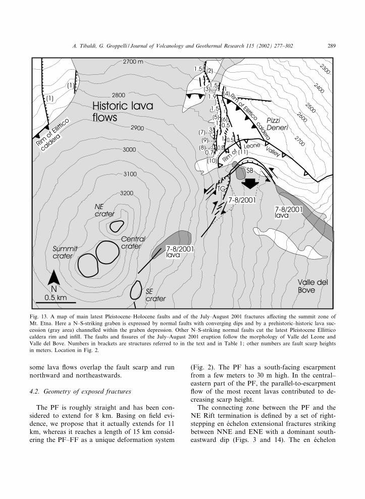
Between the southern tip of the NE Rift andthe Mt. Etna summit there is a recent, N^S-strik-ing graben (Fig. 13). This graben is expressed byinward facing fault scarps (sites 1 and 2 inFig. 13), bounding a depressed zone now mostly¢lled with historic lavas. The footwalls of thesefaults are made of lava and pyroclastic depositsbelonging to the Ellittico succession of late Pleis-tocene age (Romano and Guest, 1979). The Ellit-tico volcanic activity ended with a summit calderacollapse dated at 14.5 O 1 to 15.5 O 0.1 ka BP (Th-230/U-238, Condomines et al., 1982; C-14, Col-telli et al., 1995). The Ellittico caldera rim is cutby N^S faults of the summit rift (sites 3 and 4,Fig. 13). N^S-striking normal faults are presentalso inside the caldera in¢ll. They are expressedby several parallel fault scarps from 0.5 to 3 mhigh (sites 5^10, Fig. 13). Cumulative scarp heighthere is 5 m. The youngest o¡set lithi¢ed deposit isa proximal fall breccia dated 3150O 60 ka BP byColtelli et al. (1995). Above, there are non-lithi-¢ed historic scoria deposits which are not suitable
to record deformation. These data give a mini-mum slip rate of 0.4 cm/a (1 in Fig. 7 andTable 1). More to the SE, a sub-vertical, N^S-striking fault with downthrow to the west is ex-posed on a 50-m-high rock wall (site 11). Thisfault cuts a volcanic succession given by massive,thick, horizontal lava £ows which can be inter-preted as the in¢ll of the Ellittico caldera. Thus,this fault also is 6 14.5 O 1 ka old. This structuraland chronostratigraphic ¢eld evidence proves theexistence of a Holocene N^S-striking rift zone ex-
Fig. 9. Relationships between sinkhole diameter and ¢ssuredilation in a homogeneous lithological and climate zone ofthe lower NE Rift and the upper Pernicana. Measurementswere made in the ¢eld on aligned sinkholes where the under-neath ¢ssure is still visible. These data were used to calculatethe dilation amount on the NE Rift due to hidden struc-tures.
Fig. 10. Strike of maximum-axis of single volcanic cratersand sinkholes (y-axis) in the NE Rift (x-axis). They mostlystrike N10^35‡ in the SW segment, N25^55‡ in the centralsegment and N43^55‡ in the NE segment.
Fig. 11. Strike of alignment of volcanic craters and sinkholes(y-axis) in the NE Rift (x-axis). Their distribution is remark-ably similar to single crater and sinkhole maximum axes.
VOLGEO 2414 10-6-02
A. Tibaldi, G. Groppelli / Journal of Volcanology and Geothermal Research 115 (2002) 277^302 287

tending to the Mt. Etna summit and representingthe southward extension of the NE Rift. The N^SRift has already been suggested on a morpholog-ical basis by Kie¡er (1975) and Favalli et al.(1999), whereas south of the summit zone, theN^S Rift can be prolonged to the already knownvolcanic rift of the southern £ank of Mt. Etna(Romano and Sturiale, 1975; Van Ngoc et al.,1979).
3.2. The July^August 2001 eruption fractureswarm
The large eruption of July^August 2001 oc-curred in the upper southern £ank of Etna alongthe N^S Rift and was accompanied by the forma-tion of a complex ¢ssure and fault swarm. It rep-resents an excellent example of gravity control onmagma path. The southern and central segmentsof the ¢ssure-fault swarm trend N^S and guidedthe formation of three main pyroclastic coneswith a strong N^S elongation. Long lava £owswere outpoured from the main N^S ¢ssures andfrom some secondary ¢ssures striking SSE andSSW. The northern segment of the ¢ssure-faultswarm instead has a horse-shoe shape in plan-view and follows the local orientation of Valledel Leone and of the western £ank of Valle delBove. To the west, a main fault strikes NE andshows dominant right-lateral strike-slip motions
and local dilation (Fig. 13). More to the east theswarm attains an E^W orientation and is made of¢ssures with pure dilation and a component ofupthrow and tilting to the south of the southernblock (SB in Fig. 13). Here lavas were eruptedcontemporaneously to an increase of ¢ssure dila-tion. Further east, the swarm trends SE and ismade of ¢ssures with dilation and left-lateralstrike-slip components. A triangular graben (TGin Fig. 13) formed at the junction between theNE-striking and E-striking ¢ssures. Along partof the southern side of this graben the ¢ssuresare arranged en e¤chelon and strike ENE. Down-throw to the north increases towards the triangleapex (i.e. to the east). The opposite, northern, sideof the graben trends ENE and is made of N^S-striking en e¤chelon ¢ssures and ENE-striking left-lateral faults. A component of downthrow to thesouth is present.Resuming, kinematics of the various structures
indicate local bulging of the Valle del Leone bot-tom accompanied by southward o¡set of thiszone of the volcano £ank (arrow in Fig. 13). Adyke intruded along the NE-striking fault, as wit-nessed by a small lava outpouring, and along theE^W-striking dilation ¢ssures. The triangular gra-ben formed as a response to magma de£ationafter lava emplacement. All these data indicatethat the main source of magma followed theN^S Rift feeding path, but also that at a shal-lower level the magma path was diverted accord-ing to the morphology of the volcano. The resultis that dyking was allowed by displacement of thewestern £ank of Valle del Bove.
4. PF
4.1. Lava geometry
Along the PF, late Pleistocene^Holocene lavasoutcrop. Lava channels of the oldest units aretruncated by the fault and generally cannot befound on the opposite fault wall. Younger andhistoric lava £ows are clearly controlled by thefault escarpment and tend to run eastwards eventhough locally this is not the downslope direction.Where the fault escarpment is particularly low,
Fig. 12. The total volume of pyroclastic cones (y-axis) mea-sured along the NE Rift (x-axis) can give a qualitative evalu-ation of the spatial explosive magma discharge rate.
VOLGEO 2414 10-6-02
A. Tibaldi, G. Groppelli / Journal of Volcanology and Geothermal Research 115 (2002) 277^302288
some lava £ows overlap the fault scarp and runnorthward and northeastwards.
4.2. Geometry of exposed fractures
The PF is roughly straight and has been con-sidered to extend for 8 km. Basing on ¢eld evi-dence, we propose that it actually extends for 11km, whereas it reaches a length of 15 km consid-ering the PF^FF as a unique deformation system
(Fig. 2). The PF has a south-facing escarpmentfrom a few meters to 30 m high. In the central^eastern part of the PF, the parallel-to-escarpment£ow of the most recent lavas contributed to de-creasing scarp height.The connecting zone between the PF and the
NE Rift termination is de¢ned by a set of right-stepping en e¤chelon extensional fractures strikingbetween NNE and ENE with a dominant south-eastward dip (Figs. 3 and 14). The en e¤chelon
Fig. 13. A map of main latest Pleistocene^Holocene faults and of the July^August 2001 fractures a¡ecting the summit zone ofMt. Etna. Here a N^S-striking graben is expressed by normal faults with converging dips and by a prehistoric^historic lava suc-cession (gray area) channelled within the graben depression. Other N^S-striking normal faults cut the latest Pleistocene Ellitticocaldera rim and in¢ll. The faults and ¢ssures of the July^August 2001 eruption follow the morphology of Valle del Leone andValle del Bove. Numbers in brackets are structures referred to in the text and in Table 1; other numbers are fault scarp heightsin meters. Location in Fig. 2.
VOLGEO 2414 10-6-02
A. Tibaldi, G. Groppelli / Journal of Volcanology and Geothermal Research 115 (2002) 277^302 289
pattern is replaced eastwards by a releasing splaywith three main terminations diverging west-wards. Each fault branch dips southwards andlimits blocks which are tilted northwards. To theeast of the splay origin, the PF is a single faultplane with a vertical dip for 3 km. Three hundredmeters southwest of Valle Fonda, the master faultis replaced by a series of shorter right-stepping ene¤chelon fault segments striking from ENE to ESE(Fig. 14). As a whole, this deformation zonetrends ESE for about 0.5 km. After this point, aunique main fault plane crops out with an ESEstrike for about 2 km.About 1.5 km NW of the village of Vena, the
ESE-striking PF continues into a set of discretefault segments (Fig. 15). They have an E^W toESE strike, and a right-stepping en e¤chelon ar-rangement. As a whole in the study area nearPresa and Vena, deformation is distributed in anasymmetric splay opening towards ESE.
4.3. Volcanoes and sinkholes
Some pyroclastic cones have been discoveredalong the PF (Tibaldi et al., 1995; Azzaro et al.,1997). Two E^W elongated cones are exactly onthe main fault trace. Lavas of 1566 AD eruptedfrom two vents located on two ENE-striking ¢s-sures near the western end of the PF (Fig. 14).Several sinkholes, mostly ENE^WSW aligned,are present in the western part of the PF, in thelinking area with the NE Rift.
4.4. Kinematics and cumulative deformation
Geological features, such as cinder cones, lava£ow channels, and stratigraphic limits, show netdislocations from 2 m to about 370 m, dependingon the age of the deposits involved. The geolog-ical and man-made features show a left-lateralstrike-slip component of motion which is alwaysgreater than the vertical component. The horizon-tal left-lateral component is about 8^10 times thevertical component in the central^eastern part ofthe fault, whereas the vertical component in-creases westwards. In the western part (inset inFig. 14), pitches of 40^70‡ dipping to the easthave been reconstructed by combining the hori-
zontal and vertical cumulative motions on a ver-tical plane, that in the best way depicts the faultattitude near the surface. In the central and east-ern parts of the PF, the reconstructed pitches are0^10‡ to the east. Main left-lateral strike-slip mo-tions, with a minor normal component, were alsoobserved on the PF after the 1981, 1982 and 1984earthquakes (Azzaro, 1997), while essentially left-lateral strike slip occurred during the 1988 earth-quake (Azzaro et al., 1988). Some directions ofdilation on ¢ssures have also been measured(Fig. 14). The direction of dilation has a progres-sive clockwise rotation (i.e. from WNW^ESE toNNW^SSE) from the eastern part of the PF tothe western segment.The correlation of dated geological units on
both sides of the fault is very di⁄cult, apartfrom the case of one pyroclastic cone (site 8,Fig. 14 and Table 1). The products of the lowercone £anks are partially covered by lavas of post-Ellittico activity; the cone base does not outcrop,but lavas of late Pleistocene Ellittico activity cropout in the vicinity. As a consequence, the em-placement of this cone should correspond to theend of the Ellittico period (14.5 O 1 to 15.5 O 0.1ka BP) or to the beginning of the post-Ellitticoactivity (¢rst dated deposit = 12.2 O 0.07 ka BP,C-14, L. Vezzoli, written communication). Takinginto account age errors, we can assign to the conean average age of 13.7 O 2.4 ka BP.The quanti¢cation of dislocation of this cone is
particularly important because it is one of the fewsites of NE Mt. Etna showing long-term (latestPleistocene^Holocene) cumulative deformation.For this reason, an explanation of the measure-ment procedure follows. The cone o¡set has beenreconstructed by measuring the dislocation alongfault strike of: (1) the stratigraphic contact be-tween the western £ank of the cone and the sur-rounding lava; (2) the similar stratigraphic con-tact of the eastern £ank; and (3) the center of thesummit zone of the cone (Fig. 16). The assump-tion is that lava reached the western £ank of thecone at the same altitude at the northern andsouthern fault blocks. This is a realistic assump-tion because lava £owed from west to east andvery limited erosion on lava is present. In thesame way, as a second piercing point we consid-
VOLGEO 2414 10-6-02
A. Tibaldi, G. Groppelli / Journal of Volcanology and Geothermal Research 115 (2002) 277^302290
ered the contact between lava and cone scoriawithin the protected downhill £ank of the cone(i.e. east £ank). The third measurement, regardingthe o¡set of the center of the pyroclastic summitzone, assumes that erosion of this small volcanoproceeded symmetrically all around the original
crater, a quite obvious assumption in a cone-shaped landform just made of scoria. The result-ing three measurements of vertical o¡set and threeof horizontal o¡set were averaged and the relativeerrors were computed. The cone has a left-lateralstrike-slip component of dislocation of 370O 20
Fig. 14. A map of main structures and recent kinematics along the western and central PF. Symbols are the same of Fig. 3,apart from black semi-elliptical areas which denote dislocated pyroclastic cones. Numbers are deformation rates in the last 160yr or cumulative deformation in the last 20 yr measured along ¢ssures and faults, with the exception of 2.7 O 0.7 cm/a that refersto the latest Pleistocene^Holocene; these sites are referred to in the text and Table 1. Inset shows reconstructed slip vectors aspitch, expressed in degrees, of the western PF. Location in Fig. 2.
VOLGEO 2414 10-6-02
A. Tibaldi, G. Groppelli / Journal of Volcanology and Geothermal Research 115 (2002) 277^302 291

and 50O 10 m of vertical component, which givean average net dislocation rate of 2.7 O 0.7 cm/a(site 8 in Fig. 14).In the western part of the PF, a stone wall
dating to 1929O 10 AD has a left-lateral o¡setof 50 cm giving a slip rate of 0.7 O 0.1 cm/a (site9, Fig. 14). Further east, deformation is distrib-uted in an asymmetric splay opening towardsESE. Here, several other man-made featuresfrom 1840 AD onwards, show net o¡sets rangingfrom 3.5 m to a few cm. They have been listed inTable 1 and shown in Figs. 14 and 15.
5. FF
5.1. Lava geometry
Along both sides of the FF, lavas of the Ellitti-co volcano crop out, whereas on the southern sidealso some Holocene lava £ows abut the fault es-carpment. Lavas are £at-lying, with the exceptionof the Ellittico lava succession located on thesouthern side of the FF near the sea (Fig. 15)which dips 10‡ to the west (i.e. uphill).
5.2. Geometry, kinematics and slip rate
E^W historic brittle ruptures disappear east of
the PF splay, but are found again 3 km furthereast on the FF (site 22, Fig. 15) that has a south-facing scarp. Here, along E^W-striking fracturesstone or concrete walls, dating from 1940O 3, areo¡set left-laterally with an opening component,giving an average net slip of 8 cm and an averageslip rate of V0.1 cm/a (site 22, Figs. 7 and 15).The concrete base of the 1964 Catania^Messinahighway is ruptured by a few centimeters alongvariously oriented fractures, probably due to aninterference phenomenon between the fault andthe structure of a tunnel under the highway (site23, no measurements). Several other measure-ments of o¡set man-made features which are notlinked to local causes have been taken further eastand are listed in Table 1 as well in Fig. 15.The o¡set of some stratigraphic markers gives
longer-term, latest Pleistocene^Holocene sliprates. The FF at site 28 in Fig. 15 o¡sets lavaswhich can be classi¢ed, on a stratigraphic basis, aspart of the Ellittico volcano. Lavas belonging tothis unit, but sampled in the summit of the volca-no, have been suggested to be 35 ka old by Mon-aco et al. (1997). Near the area studied, a 15.5-ka-old pyroclastic deposit (C-14, Coltelli et al., 1995)overlies these lavas. Thus we can estimate an agebetween 35 and 15.5 ka BP for the o¡set deposits.The scarp gives an apparent vertical displacementof 15 m, giving a long-term vertical slip rate 6 0.1
Fig. 15. A map of main structures and recent kinematics along the eastern PF^FF. Note the fault splay around the villages ofVena and Presa, and the geometric and kinematic compatibility of the FF and PF. Numbers are deformation rates in the lastcentury or in the latest Pleistocene^Holocene or cumulative deformation in the last 20 yr measured along ¢ssures and faults.These sites are referred to in the text and Table 1. Location in Fig. 2.
VOLGEO 2414 10-6-02
A. Tibaldi, G. Groppelli / Journal of Volcanology and Geothermal Research 115 (2002) 277^302292

cm/a, whereas the long-term strike-slip compo-nent is not directly detectable because lava £owsare parallel to the fault strike. But if we assume aconstant slip vector during Holocene times, thehistoric average vertical component being here1/8 of the horizontal one, 15 m of vertical o¡setshould correspond to about 120 m of horizontalmotions, resulting in a latest Pleistocene^Holo-cene net slip rate of 0.6 O 0.2 cm/a.The above data indicate that recent surface de-
formation has occurred along the FF. This con-¢rms the suggestion of Groppelli and Tibaldi(1999) that the FF is a continuation of the PF,and that the deformation extends 8 km furtherthan previously thought (Bousquet et al., 1988;Azzaro et al., 1992; Lo Giudice and Rasa',1992; Rasa' et al., 1996) to the coastal plain.
6. PF^FF^Piedimonte Fault interference zone
Other faults in the area studied show Holocenemotions. Two kilometers east of Vena (site 29,Fig. 15) some ESE-striking parallel faults, herenamed S. Venera faults, have 10^50-m-high es-carpments cut into volcanic deposits dated at35^15.5 ka BP (25.25O 9.75 ka BP), which in-
dicate cumulative long-term vertical slip rates9 0.2 O 0.1 cm/a. Assuming constant Holocenekinematics and using the nearest visible slip vec-tors (sites 18^19, sites 20^21 not included becauseof a landslide), the horizontal component is 2^3.5times the vertical one. Thus, during Holocenetimes, 50 m of cumulative vertical o¡set shouldcorrespond to 100^175 m of horizontal motionsgiving a net slip of 147O 35 m. With 25.2 O 9.7 kaBP we obtain a net slip rate of 0.8 O 0.4 cm/a. Nohistoric ruptures are detectable because thesefaults do not cross man-made features.One kilometer NW of Fiumefreddo (site 30),
the NNE-striking Piedimonte Fault has a 60-m-high scarp in the same volcanic deposits of25.2 O 9.7 ka BP. With this age, we have a cumu-lative long-term vertical slip rate of 0.3O 0.1 cm/a.No strike-slip component is present on this faultor on other parallel faults.About 1.7 km west of the Fiumefreddo village,
we found four active faults (sites 31^34 of Fig. 15,corresponding to Civ|' village and Contrada Tavo-la ^ Fermata S. Venera road). The ¢rst fault,striking N60‡ (site 31), cuts the road asphalt of1983 at Civ|' with a pure downthrown of 3O 1 cmto the SE. Other measurements, listed in Table 1,relate to faults which lie along a morphological
Fig. 16. Not-to-scale sketch in plan-view of fault o¡set measurements at the 13.7O 2.4-ka-old pyroclastic cone along the PF.Three measures of vertical and horizontal components of slip have been taken at the stratigraphic contact between the western£ank of the cone and the surrounding lava, at the stratigraphic analogue contact of the eastern £ank, and at the center of thesummit zone of the cone. Lava £owed from west to east reaching the western £ank of the cone at the same altitude at the north-ern and southern fault blocks. The same assumption can be made for the cone’s eastern £ank. O¡set of the center of the pyro-clastic summit zone is also signi¢cant because erosion of this cone-shaped landform made of monolithologic scoria deposits pro-ceeded symmetrically all around the original crater. The resulting measurements were averaged and the relative error wascomputed.
VOLGEO 2414 10-6-02
A. Tibaldi, G. Groppelli / Journal of Volcanology and Geothermal Research 115 (2002) 277^302 293

step which could indicate a long history of defor-mation.
7. ENE Rift
7.1. Volcanic deposits
This area is characterized by several Holocenepyroclastic cones and some associated lava £ows.The pyroclastic cones are within an elongatedarea with an ENE trend. Since dated pyroclasticfall deposits are interposed among the pyroclasticcones and lava £ows, we have been able to assignsome absolute dates to the stratigraphic succes-sion. The oldest stratigraphic unit of this area isformed by the youngest lava £ows of EllitticoVolcano of about 15.5 ka (Vezzoli, written com-munication). Above this unit, there is the succes-sion of the ENE Rift. Scoria cones show di¡erentdegrees of crater erosion and di¡erent density oferosion gullies along the £anks, testifying to dif-ferent ages. Dated fall deposits show that somescoria cones and associated lava £ows developedbetween 15.5 and 6 ka, and others in the post-6 katime span. The most recent ¢ssure-type eruptionsoccurred in 1865 and 1928 AD.
7.2. Geometry of structures
Structures within the rift comprise faults and¢ssures, with an average strike N70‡, going fromN50‡ to N80‡. All these planes dip between 85‡and 90‡ at the surface. Generally, the edges offracture walls are at the same height, apart fromthe longest rupture zone at the southern side ofthe rift (1928 ¢ssure, Fig. 2). This rupture zone iscomposed of a series of discrete segments partly inline and partly in parallel. The clearest in the ¢eldis a 4.5-km-long ¢ssure that formed in 1928 AD.This ¢ssure opened from an area close to thenorthern wall of the wide depression in the east-ern Etna £ank known as Valle del Bove (Fig. 1),and propagated eastward up to the NE-strikingRNF. Detailed ¢eld analyses show that this1928 event in reality re-opened a pre-existingweakness, made of ENE-striking ¢ssures andfaults with local downthrow to the south. Total
throw is in the order of a few meters. This systemalso shows a left-lateral strike-slip subordinatecomponent.The ENE Rift is also characterized by tens of
elongated and strongly aligned pyroclastic cones.The aforementioned dating of the ENE Rift vol-canic succession enabled us to recognize cones ofthe same age in order to assess with a high degreeof con¢dence the real alignment of volcanic cen-ters. Both elongation of maximum base axis ofcones and craters, as well as alignment of threeor more eruptive centers, show a clear N65^70‡trend. This trend is present also in recent (post-6ka) and historic eruptive fractures. The persis-tence of the ENE Rift since at least pre-Valledel Bove times is indicated by ENE-striking dykesoutcropping along the western and eastern wallsof the valley.
8. RNF
8.1. Lava geometry
Along the escarpments of the RNF (Fig. 2), theoldest lava £ows of the Ellittico succession (Pas-quare' et al., 2002) or of a previous volcano (‘Cen-tri Alcalini Antichi’, Romano, 1979) outcrop.Basing on stratigraphic correlation and radiomet-ric data we attribute an age between 67 ka (Mt.Scorsone Unit, Pasquare' et al., 2002) and 115O 5ka (‘Ancient Alkalic Centers’, Romano, 1979;K^Ar date of Gillot et al., 1994). The lava £owsdip 20‡ to the northwest (N300‡), i.e. toward theuphill side. At the top of the succession thereare unfaulted lava £ows related to the RecentMongibello activity dated 6 15 ka.
8.2. Geometry of fractures and slip rate
The two scarps of the RNF strike N55‡ andN65‡, and are 80 m high and 4 km long, respec-tively. The horizontal separation between the twofaults is 300^600 m. The straight strike indicates avery steep dip. Notwithstanding that their faultactivity ended about 15 ka BP, they have chan-nelled magma during more recent eruptions, like1928 and two other pre-1928 eruptions, forming
VOLGEO 2414 10-6-02
A. Tibaldi, G. Groppelli / Journal of Volcanology and Geothermal Research 115 (2002) 277^302294
scoria cones and spatter ramparts. With fault ac-tivity between 115O 57 and 15 ka, and a cumula-tive vertical slip of 160 m, we calculate a net latePleistocene slip rate of 0.2 O 0.1 cm/a.
9. The model
First of all we will discuss the two most impor-tant structures of the NE Mt. Etna £ank: the NERift and the PF, which have the highest slip rateand cumulative deformation amount, and the lon-gest surface trace. The FF will be discussed laterin the framework of its very smaller slip rate.
9.1. Structure compatibility
the NE Rift is a volcanic ridge where the com-parison of fracture strikes and alignment andelongation of eruptive centers of di¡erent agesshows a geometric stability with time during atleast from latest Pleistocene to Present. Our geo-metric data taken with a regular spacing along¢ssures and those referring to sinkhole and crateralignment and elongation, show that in reality theNE Rift has a curved shape in plan-view. TheN^S-striking faults of the summit N^S Rift grad-ually pass to the NNE-striking structures of thesouthern part of the NE Rift, and then attain anENE strike at the northeastern termination of theNE Rift. Younger volcanic products are graduallyerupted along the axial zone with a spreading ratein the order of 0.6^1.8 cm/a, while earlier prod-ucts are gradually con¢ned to the external partsand tilted in that direction. Some SE-dipping nor-mal faults are formed along the SE ridge margin,whereas ¢ssuring is concentrated along the ridgeaxis. Tilting is greater along the SE ridge marginwhere also the escarpment is higher. These datacould re£ect an asymmetric spreading with a larg-er component southeastwards and vertical move-ments between the ridge and the external block.Absolute downsagging could occur SE of theridge as a response to the general sliding of theeastern portion of Mt. Etna (Neri et al., 1991;Borgia et al., 1992; Azzaro et al., 1997). Maxi-mum ¢ssuring dilation and explosive output ratebelong to the central segment of the NE Rift,
which should represent the more frequent zoneof intersection between topography and dykespropagating from the main conduit. Here pureextension occurs, while a left-lateral componentcharacterizes the NE segment. This transcurrentcomponent re£ects a kinematic readjustment fol-lowing the curved shape of the rift and the re-placement of the rift extension by the Pernicanatranstensional movements. E^W pure extension ispresent also at the Mt. Etna summit, where therift can be prolonged southward across the activevent zone.The abrupt disappearance of eruptive centers
and NE-oriented ¢ssures and faults at the latitudeof the PF indicates the termination of the NERift. Here, geometry, kinematics and deformationrate are transferred to the PF by a complex zoneof readjustment. The ENE-trending lineaments ofthe northeastern termination of the NE Rift grad-ually pass eastwards to the E^W strike of the PF.The NW^SE dilation vectors of the rift are alsogradually replaced eastwards by a NNW^SSE toWNW^ESE dilation component along the west-ern part of the PF (Figs. 3 and 14) and then byleft-lateral dominant motions further east. Theopening rate of the NE Rift in the last centuriesis between 0.6 and 1.8 cm/a and is comparable tothe historic 0.5^2.2 cm/a slip rate along the PF.Also the latest Pleistocene^Holocene longer-termslip rates are of large magnitude (0.6^2.7 cm/a).All these consistencies indicate that the main
structures of the NE £ank of Mt. Etna behaveas a volcanic ridge-transform fault system. Themutual o¡set of the two structures indicates thereis no important brittle deformation north of thePF and that the latter accommodates eastwardshift of the eastern cone £ank.
9.2. Internal dynamics
We have to explain three main facts: (1) thenecessity of providing space for planar intrusionswithin the Mt. Etna cone, as in the majority ofbasaltic volcanoes (Walker, 1992); (2) the veryhigh ¢ssure and fault strain rates; and (3) theoccurrence of coseismic or creeping deformationalong the PF that do not correlate in time witheruptions or in£ation phases. Regarding magma
VOLGEO 2414 10-6-02
A. Tibaldi, G. Groppelli / Journal of Volcanology and Geothermal Research 115 (2002) 277^302 295

injection, the subsurface bulging of intrudingmagma generates ground ¢ssuring above volcanicrift zones. The length of ¢ssures should usually beequal to or greater than their depth (Nur, 1982).Along the NE Rift, the length distribution andthe average length (Fig. 5) indicate that the depthof the fractures should most commonly be 9 0.5^0.7 km, a value very close to the local thickness ofthe volcanic pile estimated by geophysical meth-ods (0.35^1 km, Azzaro et al., 1997). At least partof this deformation can be related to shallow re-peated intrusions under the rift.In a few cases, magma escaped from the rift
zone following the PF for a maximum distanceof about 2 km. The remaining 13-km-long portionof the PF^FF do not present any evidence of localmagma emplacement and thus cannot be directlycorrelated with magma intrusions underneath.Neither can historic movements along these faultsbe explained by regional tectonics because: (1)their repeated normal left-lateral motions alongE^W-striking planes are incompatible with thesurrounding compressional state of stress givenby a N^S horizontal greatest principal stress(Gasparini et al., 1982; Bousquet et al., 1988;Patane' et al., 1994; Cocina et al., 1997); and (2)also because the PF centennial slip rate, 0.5^2.2cm/a, is at least one order of magnitude greaterthan the slip rates of the regional tectonic defor-mations around Mt. Etna, 0.9^1.4 mm/a (e.g. inValensise and Pantosti, 1992; Monaco et al.,1997). Basing on points 1 and 2, this reasoningcould be extended also to the latest Pleistocene^Holocene motions of PF^FF (long-term slip rate0.6^2.7 cm/a), even if it must be stressed that lat-est Pleistocene^Holocene slip rate measurementsare few. Moreover, (3) PF motions are con¢nedto the volcanic edi¢ce and the shallowest part ofthe basement because most earthquake foci arevery shallow, 6 1.5 km (Lo Giudice and Rasa',1986; Azzaro et al., 1988). Aseismic creep atdeeper levels should be a rare event because thebasement in this region typically behaves in a brit-tle manner, whereas plastic clays resting below theeastern £ank of Etna are 100^1000 m thick atmaximum.As already noted, grouping the NE Rift and the
PF in the same slip system is justi¢ed by their
consistent kinematics, geometry, age of motions,and slip rate. Particularly, the curved shape inplan-view of the rift zone from the Etna summitto the PF and the persistence of this geometrywith time, do not agree with a present or inheritedregional tectonic stress control. A curved shape ismore consistent with the surface trace of a listricslide plane with an U-shaped cross-section.In our opinion, the most reasonable explana-
tion for the historic movements of the NE Riftand PF^FF is that they are subject to two stresscomponents. Two sources of stress for Mt. Etnahave already been proposed by McGuire et al.(1997) who explained the feeder-dyke dispositionwith a prevailing gravitational stress ¢eld above1750 m and with a regional tectonic stress regime.In our opinion, stresses here are dominated: (1)by the mass of the eastern Etna £ank which tendsto slide with respect to the more stable northern£ank; and (2) by magma intrusions under andalong the weakness zone from the Mt. Etna sum-mit N^S Rift to the NE Rift. In case 1, magmacan passively rise under the rift when rifting isgoverned by the collapse of the eastern Etna£ank. If magma pressure is large enough, the bal-ance between stress produced by magma-¢lledcracks and stress produced by the Etna £ank slid-ing is maintained. In this case, the local compres-sional stress due to magma intrusion does notincrease with time. Alternatively, the £ank col-lapse can induce extensional dry fractures in therift without magma intrusion. In fact, many co-seismic surface ruptures with shallow earthquakesdo not correlate in time and space with eruptions,as for the earthquakes of January^February 1986(Gresta et al., 1986) or April 1981^September1982 (Cristofolini et al., 1987). In addition, aseis-mic creep usually does not correlate in time witheruptions (Rasa' et al., 1996). This fact reinforcesthe hypothesis that high-rate slippage along thePF can be dominantly attributed to the releaseof stress induced by the mass of the sliding £ank,favored by a clay substratum dipping to the east.The cone is also less buttressed on the seawardside. Because gravity is the triggering mechanismfor this eastward slippage of Mt. Etna £ank, alistric geometry with a U-shaped cross-section isthe most plausible for the slip surface (Fig. 17).
VOLGEO 2414 10-6-02
A. Tibaldi, G. Groppelli / Journal of Volcanology and Geothermal Research 115 (2002) 277^302296

The upper rim of this surface emerges as the rift,the northern lateral ramp being expressed at thesurface by the PF. Creeping or shallow earth-quakes (foci 6 1.5 km, Lo Giudice and Rasa',1986; Azzaro et al., 1988) along the NE Rift-PF, and termination of the high slip rate wheresub-Etnean clays crop out (i.e. at the Pernicana^Fiumefreddo junction zone) suggest a shallowbottom of the slide plane that could be locatedin the clay substratum. The toe of the slide planecan be tentatively localized in correspondence to abulge zone that extends from the Pernicana^Fiu-mefreddo junction towards the SSW (Fig. 17).This bulge zone has local outcrops of the sub-Etnean clays, and a characteristic morphologygiven by an anomalous decrease of average slopeinclination of the volcano £ank (down to 0^4‡) onthe inner side (i.e. to the WNW) and by an in-crease of average slope inclination (up to s 13‡)
on the opposite side (i.e. to the ESE) (Fig. 5 inFavalli et al., 1999). This bulging is also expressedby a very anomalous structure consisting of a 3-km-long uphill-facing scarp, striking N^S andslightly arcuate in plan-view (concave side to thewest, labeled ‘S’ in Fig. 2). Alternatively, the toezone of the slide plane could splay and dissipatemotions in a wide zone instead of producing awell-de¢ned bulging zone. Dyke emplacement inthe rift zones favored by gravity slip of the easternEtna £ank has been already proposed byMcGuire et al. (1997). This hypothesis is consis-tent with our case 1, but does not apply to intru-sions at deeper levels which usually have a cumu-lative volume several times larger than shallowdykes.In case 2, in an intrusive complex passing up-
wards to an intrusive-dyke complex sensu Walker(1992), the stress induced by magma supply rate
Fig. 17. Interpretative WNW^ESE sketch section of the structures a¡ecting the NE £ank of Mt. Etna. We propose the presenceof two main surfaces which enable the seaward shift of the Mt. Etna eastern £ank. The upper surface has a listric shape with anU-shaped cross-section and guides mainly mass-induced sliding of the cone £ank. The deeper sub-horizontal surface allows east-ward shift of the volcano £ank in order to provide space for the intrusive complex (Borgia et al., 1992; Rust and Neri, 1996).Our new detailed data on slip rates of all the structures of the NE volcano £ank suggest the contemporary presence of both sur-faces which can move alternatively or can move at the same time by a combination of e¡ects. Our interpretation also considersthe PF as the surface expression of the lateral ramp of the upper slip surface and the Pernicana^Fiumefreddo system as the later-al ramp of the deeper sliding surface, in accordance with slip rates. Tectonic faults of the Timpe^Ibleo^Maltese system and ofPiedimonte have been projected on the section from the nearest outcrops. Other minor structures can represent the surface e¡ectof slippage of the volcano £ank above fault steps of the basement. Section trace in Fig. 1.
VOLGEO 2414 10-6-02
A. Tibaldi, G. Groppelli / Journal of Volcanology and Geothermal Research 115 (2002) 277^302 297

can overcome the stress due to gravitational load-ing of the volcanic edi¢ce. Compressional stressincreases around the intrusive system to in£uencethe rock wedge comprising the subvolcanic andvolcanic £ank zone (Fig. 17). Shifting eastwardsof this rock wedge relieves the compressionalstress and is necessary in order to provide spacefor magma injection. As suggested by Borgia etal. (1992) sub-horizontal slip surface linked withthe expansion of an intrusive complex could beinside the subvolcanic basement. Several datafrom other volcanoes show instead that paralleldyking at a high-level within the cone caused amagmatic driving force and lateral displacementof the cone £ank (Voight, 1972, 2000; Swanson etal., 1976; Tibaldi, 1996, 2001; Voight and Els-worth, 1997). We suggest that at Mt. Etna,high-level dykes can passively rise as shown incase 1, due to the already destabilized, fast-slip-ping cone £ank. Passive magma rise has beendemonstrated for example by measurements ofgravity and ground deformation during the years1989^1990 preceding the eruption of 1991^1993(Rymer et al., 1993). Locally, south and east ofthe Mt. Etna summit, high-level magma canforcefully intrude along the unbuttressed wallsof Valle del Bove (McGuire et al., 1990, 1991).Regarding the July^August 2001 eruption, pres-ently available data do not allow to establish ifit can be ascribed to type 1 or 2. We can onlyindicate that the geometry of surface fracturing ofthe northern segment of the fault-¢ssure swarmhas been strongly in£uenced by the morphologyof the volcano, i.e. unbuttressing of the Valle delBove^Valle del Leone depressions. We believethat forceful intrusions at Mt. Etna should espe-cially exert a lateral magma force around the in-trusive complex recognized 2^6 km below the Mt.Etna summit and Valle del Bove by gravimetricand seismological methods (Neumann et al.,1985; Loddo et al., 1989; Hirn et al., 1991).Under Valle del Bove, there is the oldest part ofthe intrusive complex which reacts by eastwardshift to new magma emplacement in the western-most part, under the Etna summit zone. We alsosuggest that the related deep slip surface laterally(i.e. to the north) emerges along the PF^FF sys-tem and its toe zone localizes further east under
the sea. Also in case 2, coseismic surface rupturesoccur, but earthquake foci can be deeper and as-sociated in time with deep intrusions or with vol-canic activity that represents the surface e¡ect ofmagma injection along the rift zone. For example,earthquakes of December 25, 1985 and October29, 1986 produced surface motions along the PFand at the SE side of the NE Rift, were associatedwith summit eruptions, and their foci were at 1.5and 4 km, respectively (Azzaro, 1997). This sub-horizontal slip surface is thus deeper than the lis-tric surface of case 1. The two surfaces can movealternatively following dominance of gravity in-stability triggered by the mass of the volcano£ank, or dominance of magma pressure triggeredby injection phases, or the two surfaces can moveat the same time by a combination of e¡ects. Theexistence of this double system of deformationcan explain the fact that many earthquake swarmsat Mt. Etna involve areas that are too large to bedirectly linked to possible magma transport (Cris-tofolini et al., 1987), as well as the existence ofdi¡erent earthquake foci and focal mechanisms inthe uppermost crust of the Etnean area, the di¡er-ence of slip rate between the PF and FF, and thecorrelation or non-correlation of deformations(and earthquakes) of the eastern £ank with erup-tions along the rift. It should also be mentionedthat the existence of the deeper slide surface isfurther sustained by the intrusive complex spread-ing model of Borgia et al. (2000).E^W expansion of the intrusive complex and
rising magma or dry fracturing along the N^Ssummit rift zone, that we consider the mainzone of ascending magma, are favored by the re-gional tectonic E^W-trending horizontal leastprincipal stress (cHmin). cHmin could be the inter-mediate principal stress (c2) if a compressionalregional state of stress prevails with contractionaldeformation (Patane' et al., 1994; Cocina et al.,1997), or it could be the least principal stress(c3) if a tensional state of stress locally dominatesdue to the in£uence of the close regional tectonicnormal faults of the Timpe^Ibleo^Maltese system(Monaco et al., 1997). In this last case, the inter-pretation of Pernicana as a tectonic transfer faultbetween the Mt. Etna summit rift zone and theTimpe^Ibleo^Maltese fault system proposed by
VOLGEO 2414 10-6-02
A. Tibaldi, G. Groppelli / Journal of Volcanology and Geothermal Research 115 (2002) 277^302298

Monaco et al. (1997) is consistent with N^ScHmax =c2. Our interpretation is more concernedwith the explanation of the very high slip ratesand the other characteristics of the structureshere presented, which are well constrained, atleast at a centennial scale, and should not beundervalued in view also of natural hazard impli-cations.Regarding the surface expression of the other
lateral ramps of the sliding planes, these can befound in the southern £ank of the volcano. Here,Lo Giudice and Rasa' (1992), Rasa' et al. (1996),and Rust and Neri (1996) document the presenceof spaced N^S to NNW-striking right-lateral ac-tive faults (Fig. 1), which in our interpretation canrepresent the surface expression of distinct lateralramps of the two sliding planes, whereas Borgia etal. (2000) locate the front ramp zone at the Cata-nia southern anticline. In contrast, the PF is sowell expressed in the ¢eld because it represents thesurface expression of the northern lateral ramp ofboth sliding planes.
9.3. Minor structures
The RNF and the other faults found south ofthe Pernicana^Fiumefreddo junction zone showvertical to left-lateral vertical motions, and aNNE to NE strike. Moreover, the faults southof the Pernicana^Fiumefreddo junction and thePiedimonte Fault to the north seem to belong tothe same NNE fault swarm. Instead, an impor-tant di¡erence is that historic faulting is presentonly south of the Pernicana^Fiumefreddo junc-tion, suggesting once again that recently activedeformation is limited to this sector of the easternvolcano £ank (i.e. south of PF^FF). A local ori-gin for all these structures is also suggested fromthe fact that they are too short, 0.5^4 km, to bethe expression of coseismic surface fracturing oftectonic origin; in order to have surface tectonicfaulting, existing data indicate that earthquakeswith moment magnitude Mw (Hanks and Kana-mori, 1979) s 5.5 should occur, corresponding tosurface rupture lengths s 15 km (e.g. Anderson etal., 1996 and references therein). Bearing theseobservations in mind, we can interpret these mi-nor structures as the surface expression of local
deformations in the rock pile sliding above a com-plex faulted subvolcanic basement (Fig. 17). TheRNF could represent the surface e¡ect of a majorstep in the sole slide surface that can be linked tothe westernmost fault scarp of the regional tecton-ics, as already noted in extensional deformationsystems (Gibbs, 1984; Tankard and Welsink,1987). The RNF are no longer active becausethey moved, piggy-back translated by the slidingvolcano £ank, outside (i.e. to the east of) the zoneof in£uence of the basement tectonic fault scarp,or because this basement scarp has been erased.Further east, the other minor structures can belinked with the slippage of the volcano £ankabove the Piedimonte basement faults, and withlocal readjustments in the slide plane toe zone.
10. Conclusions
With this study we demonstrate that:^ a N^S Rift crosses the Mt. Etna summit
zone;^ the NE Rift resulted from repetitive planar
intrusions and fracturing with a NW^SE directionof dilation;^ the NE Rift and the left-lateral PF have a
consistent age, kinematics and geometry givingrise to a volcanic ridge-transform fault system;their very high slip rates at a centennial scaleare well constrained and similar (NE Rift = 0.6^1.8 cm/a, PF=0.5^2.2 cm/a) and have been alsorecognized in the Latest Pleistocene^Holocene(2.7 cm/a);^ the distribution of these main structures and
their very high slip rates can be justi¢ed by sea-ward sliding of the Mt. Etna eastern £ank;^ several other very recent/active short faults,
whose surface extension is incompatible with atectonic origin, are concentrated in the eastern£ank and are explained as the surface expressionof local deformations in the rock pile slidingabove a complex faulted subvolcanic basement;^ a shallower slide surface can be activated fol-
lowing dominance of gravity instability triggeredby the mass of the volcano £ank, or movementscan occur along a deeper surface triggered by in-
VOLGEO 2414 10-6-02
A. Tibaldi, G. Groppelli / Journal of Volcanology and Geothermal Research 115 (2002) 277^302 299

jection phases, or the two surfaces can move atthe same time by a combination of e¡ects ;^ movements along the rift system and the PF
can occur during slippage of the shallower ordeeper slide surface, whereas motions along theFF should represent slippage of the deeper slidesurface;^ the existence of this double system of defor-
mation can explain several apparently contradic-tion phenomena, such as discontinuous correla-tion of deformation, earthquakes and eruptions,and di¡erent earthquake foci, focal mechanismsand fault slip rates.In conclusion, the tectonic regional stress
should have more in£uence on the geometry ofthe sub-Etnean dykes and consequent E^W direc-tion of expansion of the intrusive complex, where-as gravity and magma pressure exert a highercontrol on the Mt. Etna structures here described.
Acknowledgements
Field co-operation with Andrea Borgia andGiorgio Pasquare' along the NE Rift, with MarcoNeri along the PF, and with Francesco Mazzariniand Luigina Vezzoli along the ENE Rift areacknowledged. Surveying of A.T. with EvamariaGraziotto the active fractures during the July^August 2001 eruption is greatly appreciated. Weare grateful to B. McGuire and B. Van Wyk deVries for detailed reviews that led to improvementsof this paper. This work was partly funded by agrant of Gruppo Nazionale per la Vulcanologia ofConsiglio Nazionale delle Ricerche of Italy. Thisstudy has been done in the framework ofUNESCO-IUGS-IGCP Project 455 ‘Effects ofbasement structural and stratigraphic heritageson volcano behavior and implications for humanactivities’.
References
Anderson, J.G., Wesnousky, S.G., Stirling, M.W., 1996.Earthquake size as a function of fault slip rate. Bull. Seis-mol. Soc. Am. 86, 683^690.
Azzaro, R., 1997. Seismicity and active tectonics along thePernicana fault, Mt. Etna (Italy). Acta Vulcanol. 9, 7^14.
Azzaro, R., Lo Giudice, E., Rasa', R., 1988. Il terremoto diPiano Pernicana (Etna Nord) del 28-10-1988. Campo mac-rosismico e quadro deformativo fragile associato all’evento.Bollettino Gruppo Nazionale per la Vulcanologia, IV, pp.22^40.
Azzaro, R., Lo Giudice, E., Rasa', R., 1992. Attivita' macro-sismica nell’area etnea durante il 1988: bollettino degli even-ti e considerazioni sismotettoniche. Boll. Acc. Gioenia Sci.Nat. 25, 211^229.
Azzaro, R., Del Negro, C., Rasa', R., 1997. Magnetic evidenceof a buried graben-like structure in the Pernicana^Proven-zana area (Mt. Etna, Sicily) and hydrogeological implica-tions. Acta Vulcanol. 9, 23^30.
Azzaro, R., Ferreli, L., Michetti, A.M., Serva, L., Vittori, E.,1998. Environmental hazard of capable faults: the case ofthe Pernicana fault (Mt. Etna, Sicily). Nat. Hazards 17, 147^162.
Borgia, A., 1994. Dynamic basis of volcanic spreading. J. Geo-phys. Res. 99, 17791^17804.
Borgia, A., Treves, B., 1992. Volcanic plates overriding theocean crust: structure and dynamics of Hawaiian volcanoes.In: Parson, L.M., Murton, J.B., Browing, P. (Eds.), Ophio-lites and their Modern Analogues, Geological Society Spe-cial Publication, 60, pp. 277^299.
Borgia, A., Ferrari, L., Pasquare', G., 1992. Importance ofgravitational spreading in the tectonic and volcanic evolu-tion of Mount Etna. Nature 357, 231^235.
Borgia, A., Lanari, R., Sansosti, E., Tesauro, M., Berardino,P., Fornaro, G., Neri, M., Murray, J.B., 2000. Activelygrowing anticlines beneath Catania from the distal motionof Mount Etna’s decollement measurement by SAR inter-ferometry and GPS. Geophys. Res. Lett. 27, 3409^3412.
Bousquet, J.-C., Lanzafame, G., Paquin, C., 1988. Tectonicstresses and volcanism: in-situ stress measurements and neo-tectonic investigations in the Etna area (Italy). Tectonophy-sics 149, 219^231.
Cocina, O., Neri, G., Privitera, E., Spampinato, S., 1997.Stress tensor computations in the Mount Etna area (South-ern Italy) and tectonic implications. J. Geodyn. 23, 109^127.
Coltelli, M., Del Carlo, P., Vezzoli, L., 1995. Tephro-stratig-raphy and tephro-chronology of the last 50 ka Mt. Etnaexplosive activity. SeaVolc Project EV5V-CT92-0170, FinalReport, Commission of the European Communities, Brus-sels.
Condomines, M., Tanguy, J.C., Kie¡er, G., Allegre, C.J.,1982. Magmatic evolution of a volcano studied by Th-230/U-238 disequilibrium and trace elements: the Etna case.Geochim. Cosmol. Acta 46, 1397^1416.
Cristofolini, R., Gresta, S., Imposa, S., Menza, S., Patane', G.,1987. An approach to problems on energy sources at MountEtna based on seismological and volcanological data. Bull.Volcanol. 49, 729^736.
Favalli, M., Innocenti, F., Pareschi, M.T., Pasquare', G., Maz-zarini, F., Branca, S., Cavarra, L., Tibaldi, A., 1999. The
VOLGEO 2414 10-6-02
A. Tibaldi, G. Groppelli / Journal of Volcanology and Geothermal Research 115 (2002) 277^302300

DEM of Mt. Etna: geomorphological and structural impli-cations. Geodin. Acta 12, 279^290.
Ferrari, L., Tibaldi, A., 1991. I coni avventizi dell’Etna: in£u-enza della geometria delle discontinuita' sulla crescita degliapparati vulcanici. Proceedings Convegno Societa' GeologicaItaliana, Giornate in Memoria di Leo Ogniben, Naxos, Ita-lia, 6^8 giugno 1991, pp. 212^213.
Ferrucci, F., 1994. An assessment of recent and past earth-quakes on eastern Mt. Etna. SeaVolc Project EV5V-CT92-0170, Interim Report, European Community, Brussels.
Fiske, R.S., Jackson, E.D., 1972. Orientation and growth ofHawaiian volcanic rift zones: the e¡ect of regional structureand gravitational stresses. Proc. R. Soc. London A329, 299^326.
Gardun‹o, V.H., Neri, M., Pasquare', G., Borgia, A., Tibaldi,A., 1997. Geology of the NE-Rift of Mount Etna (SicilyItaly). Acta Vulcanol. 9, 91^100.
Gasparini, C., Iannacone, I., Scandone, P., Scarpa, R., 1982.Seismotectonics of the Calabrian Arc. Tectonophysics 84,267^286.
Giammanco, S., Gurrieri, S., Valenza, M., 1997. Soil CO2degassing along tectonic structures of Mt. Etna (Sicily):the Pernicana Fault. Appl. Geochem. 12, 429^436.
Gibbs, A.D., 1984. Structural evolution of extensional basinmargins. J. Geol. Soc. London 141, 609^620.
Gillot, P.Y., Kie¡er, G., Romano, R., 1994. The evolution ofMt. Etna in the light of potassium^argon dating. Acta Vul-canol. 5, 81^87.
Gresta, S., Caltabiano, T., Cristofolini, R., Imposa, S., LoGiudice, E., Nunnari, G., Patane', D., Patane', G., Puglisi,G., Rasa', R., Romano, R., 1986. L’eruzione dell’Etna deldicembre 1985. Integrazione di dati sismologici, titltmetri evulcanologici. Bollettino Gruppo Nazionale per la Vulcan-ologia 1986, pp. 647^659.
Groppelli, G., Tibaldi, A., 1996. Nuovi dati per un modellosullo sviluppo della porzione orientale della faglia della Per-nicana, Monte Etna. Proceedings 1996 Congress of GruppoNazionale per la Vulcanologia, CNR, 3^5 March 1996,Rome, pp. 180^181.
Groppelli, G., Tibaldi, A., 1999. Control of rock rheology ondeformation style and slip-rate along the active PernicanaFault, Mt. Etna, Italy. Tectonophysics 305, 521^537.
Hanks, T.C., Kanamori, H., 1979. A moment magnitude scale.J. Geophys. Res. 84, 2348^2350.
Hirn, A., Nercessian, A., Sapin, M., Ferrucci, F., Wittinger,G., 1991. Seismic heterogeneity of Mt Etna: structure andactivity. Geophys. J. Int. 105, 139^153.
Kie¡er, G., 1975. Sur l’existence d’une ‘rift zone’ a l’Etna(Sicile). C.R. Acad. Sci. Paris 280, 263^266.
Kie¡er, G., 1985. Evolution Structurale et Dynamique d’unGrand Vulcan Polygenique: stades d’Edi¢cation et ActiviteActuelle de l’Etna (Sicile). Thesis, Universite' Clermont^Fer-rand, 497 pp.
Loddo, M., Patella, D., Quarto, R., Ruina, G., Tramacere, A.,Zito, G., 1989. Application of gravity and deep dipole geo-electrics in the volcanic area of Mt. Etna (Sicily). J. Volca-nol. Geotherm. Res. 39, 17^39.
Lo Giudice, E., Rasa', R., 1986. Relazione preliminare sullacrisi sismica etnea del Dicembre 1985^Febbraio 1986.CNR-IIV, Open File Report 3/86, 7 pp.
Lo Giudice, E., Rasa', R., 1992. Very shallow earthquakes andbrittle deformation in active volcanic areas: the Etnean re-gion as an example. Tectonophysics 202, 257^268.
Lo Giudice, E., Patane', G., Rasa', R., Romano, R., 1982. Thestructural framework of Mt. Etna. Mem. Soc. Geol. Ital. 23,125^158.
Mazzarini, F., Armienti, P., 2001. Flank cones at Mount Etnavolcano: do they have a power-law distribution? Bull. Vol-canol. 62, 420^430.
Monaco, C., Tapponnier, P., Tortorici, L., Gillot, P.Y., 1997.Late Quaternary slip rates on the Acireale^Piedimonte nor-mal faults and tectonic origin of Mt. Etna (Sicily). EarthPlanet. Sci. Lett. 147, 125^139.
McGuire, W.J., Saunders, S.J., 1993. Recent earth movementsat active volcanoes: a review. Quat. Proc. 3, 33^46.
McGuire, W.J., Pullen, A.D., Saunders, S.J., 1990. Recentdyke-induced large-scale block movement at Mount Etnaand potential slope failure. Nature 343, 357^359.
McGuire, W.J., Murray, J.B., Pullen, A.D., Saunders, S.J.,1991. Ground deformation monitoring at Mt Etna; evidencefor dyke emplacement and slope instability. J. Geol. Soc.London 148, 577^583.
McGuire, W.J., Howarth, R.J., Firth, C.R., Solow, A.R., Pul-len, A.D., Saunders, S.J., Stewart, I.S., Vita-Finzi, C., 1997.Correlation between rate of sea-level change and frequencyof explosive volcanism in the Mediterranean. Nature 389,473^476.
Moore, J.G., Krivoy, H.L., 1964. The 1962 £ank eruption ofKilauea volcano and structure of the east rift zone. J. Geo-phys. Res. 69, 2033^2045.
Neri, M., Garduno, V.H., Pasquare', G., Rasa', R., 1991. Stu-dio strutturale e modello cinematico della valle del Bove edel settore nord-orientale etneo. Acta Vulcanol. 1, 17^24.
Neumann, R., Everaud, P., Coron, S., 1985. Interpretation destravaux magnetiques et gravimetriquues a' l’Etna. Boll. Geo-¢s. Teor. Appl. 106, 125^152.
Nur, A., 1982. The origin of tensile fracture lineaments.J. Struct. Geol. 4, 31^40.
Obrizzo, F., Del Gaudio, C., Ricco, C., 1994. Precise levelling.Acta Vulcanol. 6, 17^20.
Pasquare', G., Coltelli, M., Pompilio, M., Branca, S., Calvari,S., Gardun‹o, V.H., Groppelli, G., Lodato, L., Neri, M.,2002. Carta Geologica Acireale, Foglio 625 (Catania, Sici-lia). Servizio Geologico Nazionale, 1:50,000 scale, in press.
Patane', G., Montalto, S., Imposa, S., Menza, S., 1994. Therole of regional tectonics, magma pressure and gravitationalspreading in earthquakes of the eastern sector of Mt. Etnavolcano (Italy). J. Volcanol. Geotherm. Res. 61, 253^266.
Rasa', R., Azzaro, R., 1995. Creep su faglia e sue implicazionisulla statica del versante orientale dell’Etna. In: Ferrucci, F.,Innocenti, F. (Eds.), Progetto Etna 1993^1995. Giardini,Pisa, pp. 137^143.
Rasa', R., Romano, R., Lo Giudice, E., 1982. A structuralsurvey of M. Etna on a morphologic basis, with a morpho-
VOLGEO 2414 10-6-02
A. Tibaldi, G. Groppelli / Journal of Volcanology and Geothermal Research 115 (2002) 277^302 301
tectonic map at 1:100,000 scale. Mem. Soc. Geol. Ital. 23,117^124.
Rasa', R., Azzaro, R., Leonardi, O., 1996. Aseismic creep onfaults and £ank instability at Mt. Etna volcano, Sicily. In:McGuire, W.C., Jones, A.P., Neuberg, J. (Eds.), VolcanoInstability on the Earth and Other Planets, Geological Soci-ety Special Publication, 110, pp. 179^192.
Romano, R., 1979. Carta Geologica del Monte Etna. C.N.R.^I.I.V., Catania, Italy, 1:50,000 scale.
Romano, R., Guest, J.E., 1979. Volcanic geology of the sum-mit and northern £ank of Mt. Etna, Sicily. Boll. Soc. Geol.Ital. 98, 189^215.
Romano, R., Sturiale, C., 1975. Geologia della tavolettaMonte Etna Sud (F. 262, III SW). Boll. Soc. Geol. Ital.94, 1109^1148.
Rust, D., Neri, M., 1996. The boundaries of large-scale col-lapse on the £anks of Mount Etna, Sicily. In: McGuire,W.J., Jones, A.P., Neuberg, J. (Eds.), Volcano Instabilityon the Earth and Other Planets, Geological Society SpecialPublication, 110, pp. 193^208.
Rymer, H., Murray, J.B., Brown, G.C., Ferrucci, F., McGuire,W.J., 1993. Mechanisms of magma eruption and emplace-ment at Mt Etna between 1989 and 1992. Nature 361, 439^441.
Swanson, D.A., Du⁄eld, W.A., Fiske, R.S., 1976. Displace-ment of the south £ank of Kilauea volcano: the result offorceful intrusion of magma into the rift zones. ProfessionalPaper of the United States Geological Survey, 963, pp. 1^30.
Tankard, A.J., Welsink, H.J., 1987. Extensional tectonics andstratigraphy of Hibernia Oil Field, Grand Banks, New-foundland. Am. Assoc. Pet. Geol. Bull. 71, 1210^1232.
Tibaldi, A., 1995. Morphology of pyroclastic cones and tec-tonics. J. Geophys. Res. 100, 24521^24535.
Tibaldi, A., 1996. Mutual in£uence of diking and collapses atStromboli volcano, Aeolian Arc, Italy. In: McGuire, W.J.,
Jones, A.P., Neuberg, J. (Eds.), Volcano Instability on theEarth and Other Planets, Geological Society Special Publi-cation, 110, pp. 55^63.
Tibaldi, A., 2001. Multiple sector collapses at Stromboli vol-cano, Italy: how they work.. Bull. Volcanol. 63, 112^125.
Tibaldi, A., Borgia, A., Neri, M., Pasquare' G., 1995. Volcan-ism, geometry, style, and rate of Holocene deformationalong the northern boundary of the unstable eastern £ankof Mt. Etna, Italy. Project SEAVOLC Final Report, Euro-pean Community, Brussels.
Valensise, G., Pantosti, D., 1992. A 125 Kyr-long geologicalrecord of seismic source repeatability: the Messina Straits(Southern Italy) and the 1908 earthquake (Ms 7.5). TerraNova 4, 472^483.
Van Ngoc, P., Boyer, D., Kie¡er, G., 1979. Localisation pre-cise d’une fessure profonde sous les Monts Silvestri (Etna,Sicile) par les methodes electromagnetiques et su relationavec la 6 rift zones du vulcan. C.R. Acad. Sci. Paris289, 69^72.
Villari, L., Rasa', R., Caccamo, A., 1988. Considerazionisull’hazard vulcanico e sul campo di sforzi nella regioneetnea attraverso l’analisi morfometrica e la distrubuzioneplano-altimetrica dei coni avventizi. Bollettino Gruppo Na-zionale per la Vulcanologia 1988, pp. 600^619.
Voight, B., 1972. Fluid-wedge hypothesis and the HeartMountain and Reef Creek decollements, NW Wyoming,USA. Geol. Soc. Am. Abstr. Prog. 4, 698.
Voight, B., 2000. Structural stability of andesite volcanoes andlava domes. Philos. Trans. R. Soc. London A 358, 1663^1703.
Voight, B., Elsworth, D., 1997. Failure of volcano slopes. Geo-technique 47, 1^31.
Walker, G.P.L., 1992. ‘Coherent intrusion complexes’ in largebasaltic volcanoes-a new structural model. J. Volcanol. Geo-therm. Res. 50, 41^54.
VOLGEO 2414 10-6-02
A. Tibaldi, G. Groppelli / Journal of Volcanology and Geothermal Research 115 (2002) 277^302302
Copyright © 2022 FDOKUMEN