Geography Knowledge Organiser 8.1.1: The Unstable Earth ...
15
The earth’s structure: The Earth has four main layers : the inner core, the outer core, the mantle and the crust. Geography Knowledge Organiser 8.1.1: The Unstable Earth (The Earth’s Structure) KPI Name: To know the structure of the earth and to know why its unstable The earth’s crust: - The earth’s crust is broken up into plates, called tectonic plates. - There are two types of tectonic plate oceanic and continental. - Oceanic plates carry the oceans. They are thinner but more dense than continental plates. - Continental plates carry the land. They are thicker but less dense than oceanic plates. The inner core is extremely hot (5,500°C ). It is a very dense solid made from iron and nickel. The outer core is 2,000 km thick and is a liquid. The mantle is semi-molten and about 3,000 km thick. The closer the mantle is to the core, the more liquid it is. The crust is the rocky outer layer. It is thin compared to the other sections, approximately 5 to 70 km thick. If the Earth was scaled down to the size of an apple, the crust would be about the thickness of the apple skin. - Heat from the core causes convection currents in the mantle. These cause the mantle to move as it heats and cools. - These currents slowly move the crust around. - In some places the crust is destroyed. In other places new crust is formed. Key words and terms: Crust: The rocky outer layer of the earth, made up of oceanic and continental crust. Mantle: Semi-molten rock, moving beneath the earth’s crust. It is the movement (convection currents) in the mantle which cause tectonic plates to move Outer core: A 2000km thick liquid made up largely of iron and nickel. Inner Core: A dense solid of extreme temperature (5,500°C) made up of iron and nickel. Tectonic plates: Huge plates (oceanic and continental) that make up the earth’s crust, and which move because of convection currents. Convection currents: Currents in the mantle which cause the tectonic plates to move, caused by extreme heat from the earth’s core. Dense: When something is closely packed together. Molten: Something which is melted and has become a liquid.
-
Upload
khangminh22 -
Category
Documents
-
view
1 -
download
0
Transcript of Geography Knowledge Organiser 8.1.1: The Unstable Earth ...

The earth’s structure: The Earth has four main layers : the inner core, the outer core, the mantle and the crust.
Geography Knowledge Organiser 8.1.1: The Unstable Earth (The Earth’s Structure)
KPI Name: To know the structure of the earth and to know why its unstable
The earth’s crust: - The earth’s crust is broken up into plates, called tectonic plates. - There are two types of tectonic plate oceanic and continental. - Oceanic plates carry the oceans. They are thinner but more dense than
continental plates. - Continental plates carry the land. They are thicker but less dense than
oceanic plates.
The inner core is extremely hot (5,500°C ). It is a very dense solid made from iron and nickel.
The outer core is 2,000 km thick and is a liquid.
The mantle is semi-molten and about 3,000 km thick. The closer the mantle is to the core, the more liquid it is.
The crust is the rocky outer layer. It is thin compared to the other sections, approximately 5 to 70 km thick. If the Earth was scaled down to the size of an apple, the crust would be about the thickness of the apple skin.
- Heat from the core causes convection currents in the mantle. These cause the mantle to move as it heats and cools.
- These currents slowly move the crust around. - In some places the crust is destroyed. In other places new crust is
formed.
Key words and terms: Crust: The rocky outer layer of the earth, made up of oceanic and continental crust. Mantle: Semi-molten rock, moving beneath the earth’s crust. It is the movement (convection currents) in the mantle which cause tectonic plates to move Outer core: A 2000km thick liquid made up largely of iron and nickel. Inner Core: A dense solid of extreme temperature (5,500°C) made up of iron and nickel. Tectonic plates: Huge plates (oceanic and continental) that make up the earth’s crust, and which move because of convection currents. Convection currents: Currents in the mantle which cause the tectonic plates to move, caused by extreme heat from the earth’s core. Dense: When something is closely packed together. Molten: Something which is melted and has become a liquid.

Boundary Movement Diagram Example Landforms
Destructive The plates either collide or the oceanic plate subducts under the continential plate.
The Nazca plate being forced under the South American plate.
Volcanoes Fold mountains Earthquakes
Constructive The plates move apart.
The African plate and the South American plate.
Volcanoes
Conservative The plates move alongside each other.
The Pacific plate and the North American plate.
Earthquakes
Plate boundaries: - The Earth’s crust is broken into different plates,
which sit on the Earth’s mantle. - These plates move because of convection
currents. - The plates move in different directions and meet
at plate boundaries. - As the plates move, parts of the crust are
destroyed and in other areas new crust is created.
Geography Knowledge Organiser 8.1.2: The Unstable Earth (Plate boundaries)
KPI Name: To describe conservative, constructive and destructive plate boundaries.
Different types of plate boundary: - There are three different types of plate boundary: destructive, constructive and conservative. Which type they
are depends on how the plates move at this boundary. - Different plates boundaries have different landforms, such as volcanoes and fold mountains.
Key words and terms: Plate boundaries: Where two or more tectonic plates meet. Conservative: A plate boundary where two plates slide past one another. Constructive: A plate boundary where two plates are moving apart. Destructive: A plate boundary where two plates are colliding. Magma: Molten rock from the mantle before it reaches the surface of the earth. Lava: Molten rock released from the earth’s core by a volcano. Fold Mountains: Mountains formed at collision zones, where two continental plates move towards each other. Volcano: A vent in the earth’s crust from which lava, ash and gas is released. Earthquake: A sudden shaking of the ground, caused by movement in the earth’s crust.
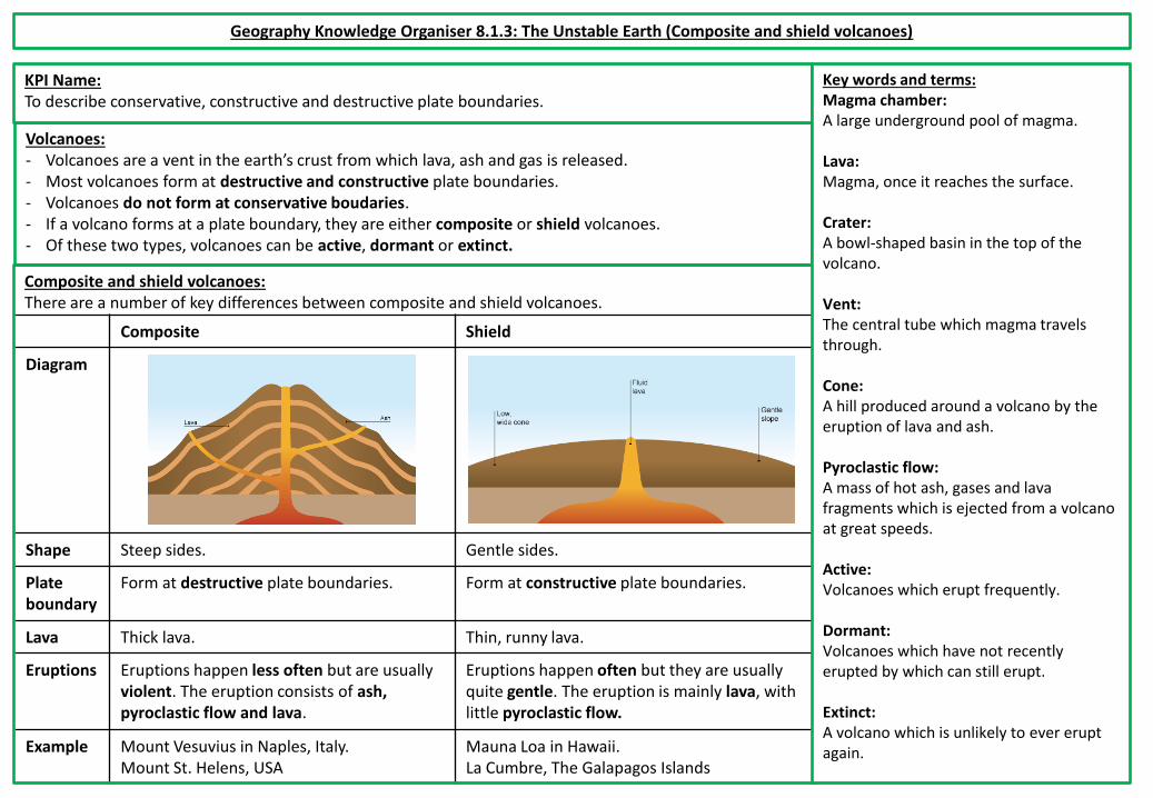
Composite Shield
Diagram
Shape Steep sides. Gentle sides.
Plate boundary
Form at destructive plate boundaries. Form at constructive plate boundaries.
Lava Thick lava. Thin, runny lava.
Eruptions Eruptions happen less often but are usually violent. The eruption consists of ash, pyroclastic flow and lava.
Eruptions happen often but they are usually quite gentle. The eruption is mainly lava, with little pyroclastic flow.
Example Mount Vesuvius in Naples, Italy. Mount St. Helens, USA
Mauna Loa in Hawaii. La Cumbre, The Galapagos Islands
Volcanoes: - Volcanoes are a vent in the earth’s crust from which lava, ash and gas is released. - Most volcanoes form at destructive and constructive plate boundaries. - Volcanoes do not form at conservative boudaries. - If a volcano forms at a plate boundary, they are either composite or shield volcanoes. - Of these two types, volcanoes can be active, dormant or extinct.
Geography Knowledge Organiser 8.1.3: The Unstable Earth (Composite and shield volcanoes)
KPI Name: To describe conservative, constructive and destructive plate boundaries.
Composite and shield volcanoes: There are a number of key differences between composite and shield volcanoes.
Key words and terms: Magma chamber: A large underground pool of magma. Lava: Magma, once it reaches the surface. Crater: A bowl-shaped basin in the top of the volcano. Vent: The central tube which magma travels through. Cone: A hill produced around a volcano by the eruption of lava and ash. Pyroclastic flow: A mass of hot ash, gases and lava fragments which is ejected from a volcano at great speeds. Active: Volcanoes which erupt frequently. Dormant: Volcanoes which have not recently erupted by which can still erupt. Extinct: A volcano which is unlikely to ever erupt again.

Mount St. Helens, USA, 1980: (MDC) In 1980, Mount St. Helens, a composite volcano in a rural area in the Northeast of the USA, erupted. Effects: - More then 200 homes were destroyed. - 57 died as a result of the eruption. - 185 miles of roads and 15 miles of railways were
damaged. - Damage to to property was estimated at $1.1 billion. Responses and PPP: - Seismographs began closely monitoring the volcano
roughly 3 months before the eruption. - Hundreds of tourists and scientists flocked to the area.
However, the government imposed an exclusion zone around the volcano to prevent loss of life.
- The US government issued $950 million in emergency funds to help recovery efforts.
Geography Knowledge Organiser 8.1.4: The Unstable Earth (The effects of a volcanic eruption and PPP)
KPI Name: To explain the effects of a volcanic eruption. To be able to describe a case study of a volcanic eruption.
Key words and terms: Economic: Anything to do with money or which affects the ability of people or a country to make money. Social: Anything which affects people and families. Envrionmental: Anything which affects animals, plants or ecosystems in the area. Prediction: Attempting to know when a volcanic eruption will happen. This can be done by measuring earthquakes, gas levels around the volcano and the temperatures around the volcano. Preparation: Creating and communicating a plan to deal with a possible eruption. This could include creating an exclusion zone, or making sure people have access to supplies. Protection: Trying to reduce the damage people suffer during a volcanic eruption. This could include building houses in safe areas.
Nyiragongo, Democratic Republic of Congo, 2002: (LDC) In 2002, Nyiragongo, a composite volcano near the of Goma in the DRC, erupted, causing lava to flow into its city centre. Effects: - Roughly 130,000 people were made homeless. - 300,000 people were evacuated from the area. - Approximately 100 people died as a result of the eruption. - The lava destroyed roughly 80% of the city’s infrastructure
(roads, electricity services, sewage pipes). - Cholera and other diseases spread as people did not have
access to clean water.
Responses and PPP: - Due to unrest in the country, the volcano was not
properly monitored and the eruption was unexpected. - There was no clear plan in place in case of an eruption. - A huge amount of foreign aid was sent to the DRC to help
people cope. - It took years for Goma’s economy to recover, even with
the support of aid agencies.
The effects of a volcanic eruption: - It is important to note that volcanic eruptions can have both positive and negative effects. - These effects can also be grouped into economic, social and environmental effects. - The extent of the negative effects on a country often depends on the ability of the country to predict, prepare for and
protect people from the eruption (PPP).
Positive: Negative: The dramatic scenery created by volcanic eruptions attracts tourists. This brings income to an area.
Lives can be lost.
The lava and ash deposited during an eruption breaks down to provide valuable nutrients for the soil. This creates very fertile soil which is good for agriculture
If the ash and mud from a volcanic eruption mix with rain water or melting snow, fast moving mudflows are created. These flows are called lahars.
The high level of heat and activity close to a volcano can provide opportunities for generating geothermal energy.
Lava flows and lahars can destroy settlements and areas of woodland or agriculture.

Geography Knowledge Organiser 8.2.1: The Unstable Earth (Tectonic plate boundaries and earthquakes)
KPI Name: I understand the three kinds of tectonic movement and how they link to earthquake activity, using key terminology.
Key words and terms: Earthquake: The shaking or vibration of the earth’s crust due to pressure at a plate boundary. Mantle: The semi-molten layer below the earth’s crust. Crust: The thin, rocky outer layer of the earth. It is broken into many different plates. Plate boundary: The point where two tectonic plates meet. Destructive plate boundary: Where two plates meet and they are moving towards each other. Constructive plate boundary: Where two plates meet and they are moving away from each other. Conservative plate boundary: Where two plates meet and they are moving alongside each other (either in the same or opposite directions).
Plate boundaries and earthquakes: - The Earth’s crust is broken into different plates, which sit on the Earth’s mantle. - The plates move in different directions and meet at plate boundaries. These three boundaries are called
destructive, constructive or conservative plate boundaries (see knowledge organsier 8.1.2 for further detail).
- Earthquakes can happen at any plate boundary. - Plates do not always move smoothly alongside, under or beside each other. They sometimes get stuck.
When this happens pressure builds up and, when this pressure is released, an earthquake occurs. - Every earthquakes has an epicentre and a focus. - The focus is the point in the earth’s crust where the pressure between the two plates is released. It is
underground. - The epicentre is the point on the surface of the crust, above the focus.
Earthquakes on conservative plate boundaries: - Earthquakes can occur at all plate boundaries. However,
conservative plate boundaries clearly show how earthquakes happen.
- The San Andreas Fault is part of the plate boundary between the Pacific plate and the North American plate.
- The Pacific plate moves slightly faster than the North American plate. This means that, even though the plates are moving in the same direction, they can get stuck, causing a build up of pressure.
- This build up and release of pressure caused two major earthquakes during the last century, in 1906 and in 1989.
- However, this area experiences constant small earthquakes, with Los Angeles experiencing 10 earthquakes per day on average!
- Because of this movement, Los Angeles should be in line with San Francisco in roughly 20 million years.
Geography Knowledge Organiser 8.2.2: The Unstable Earth (Measuring and predicting earthquakes)
KPI Name: I can explain how earthquakes are predicted and measured.
Key words and terms: Seismometer: A machine which detects and records vibrations in the earth’s crust. Richter Scale: A scale which is used to measure the strength of earthquakes. It uses the strength of vibrations to class earthquakes between 1 and 10. Mercalli Scale: A scale which is used to measure the damage of earthquakes. It uses the damage caused to class earthquakes between 1 and 12. Subjective: Something which changes according to people’s perceptions or opinions.
Predicting earthquakes: - Scientists can currently forcast the likelihood of an earthquake in the long term (over years and decades). However, it is almost
impossible to predict earthquakes in the short term. - However, there are ways that scientists can monitor tectonic activity to help them forcast earthquakes:
- Scientists can look at the history of earthquakes in the area and try to identify patterns about them. - Some scientists argue that a higher level of radon gas being released into the atmosphere is a sign of an impending
earthquake. - An increase in minor earthquakes, measured using a seismometer, often suggests an impending, larger earthquake.
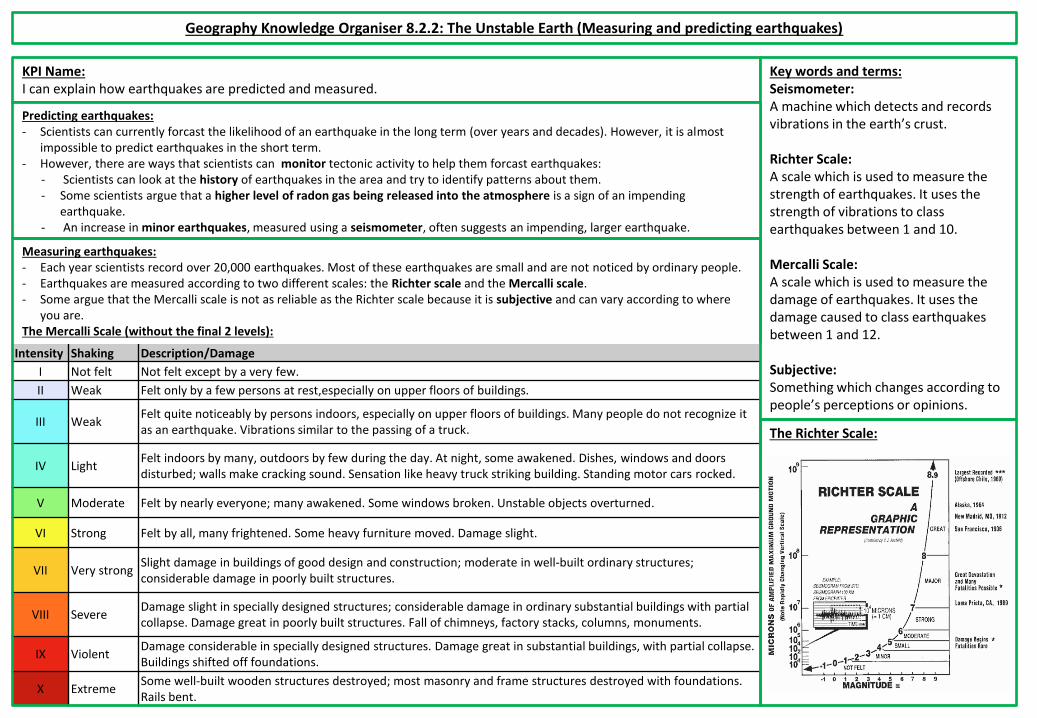
Intensity Shaking Description/Damage
I Not felt Not felt except by a very few.
II Weak Felt only by a few persons at rest,especially on upper floors of buildings.
III Weak Felt quite noticeably by persons indoors, especially on upper floors of buildings. Many people do not recognize it as an earthquake. Vibrations similar to the passing of a truck.
IV Light Felt indoors by many, outdoors by few during the day. At night, some awakened. Dishes, windows and doors disturbed; walls make cracking sound. Sensation like heavy truck striking building. Standing motor cars rocked.
V Moderate Felt by nearly everyone; many awakened. Some windows broken. Unstable objects overturned.
VI Strong Felt by all, many frightened. Some heavy furniture moved. Damage slight.
VII Very strong Slight damage in buildings of good design and construction; moderate in well-built ordinary structures; considerable damage in poorly built structures.
VIII Severe Damage slight in specially designed structures; considerable damage in ordinary substantial buildings with partial collapse. Damage great in poorly built structures. Fall of chimneys, factory stacks, columns, monuments.
IX Violent Damage considerable in specially designed structures. Damage great in substantial buildings, with partial collapse. Buildings shifted off foundations.
X Extreme Some well-built wooden structures destroyed; most masonry and frame structures destroyed with foundations. Rails bent.
Measuring earthquakes: - Each year scientists record over 20,000 earthquakes. Most of these earthquakes are small and are not noticed by ordinary people. - Earthquakes are measured according to two different scales: the Richter scale and the Mercalli scale. - Some argue that the Mercalli scale is not as reliable as the Richter scale because it is subjective and can vary according to where
you are. The Mercalli Scale (without the final 2 levels):
The Richter Scale:

Geography Knowledge Organiser 8.2.3: The Unstable Earth (The effects of an earthquakes and PPP)
KPI Name: I can demonstrate how the impact of an earthquake in an MDC or LDC is influenced by the extent of prediction, preparation and response.
Chile, 2010: (MDC) In 2010, Chile experienced an earthquake measuring 8.8 on the richter scale originating from the boundary between the South American and Nazca plates. Effects: - 500 people died. - 500,000 buildings were destroyed, including minor damage
to a major airport. - Communication networks and power went down after the
earthquake. Responses and PPP: - Chile has a history of earthquakes, meaning that most
buildings were ‘earthquake proof’ and people were trained in how to survive earthquakes.
- Within 10 days power was restored to affected areas. - Roads were repaired very quickly. - Chile put in place a house rebuilding scheme which was paid
for by the Chilean government.
Haiti, 2010: (LDC) In 2010, Haiti experienced an earthquake measuring 7.0 on the richter scale originating from the boundary between the Caribbean and North American plates. Effects: - 220,000 people died. - 1 million people were made homeless and the main port,
airport and roads were severely damaged. - 2 million people had no food or clean water. - Many homes and businesses were looted because of a
lack of government presence. Responses and PPP: - Haiti has no history of earthquakes. As a result, their
buildings were not prepared and people were not drilled. - Other countries, such as the USA, sent aid to help.
However, the damaged airport found it difficult to cope. - Due to a weak and poor government people are still
living in camps almost 10 years after the earthquake.
Key words and terms: Infrastructure: The basic physical facilities in an area, such as electricity, running water, roads and buildings such as hospitals. Aid: Money or resources which is given to a country by another country or an organisation. Prediction: Attempting to know when an earthquake will happen. This can be done by measuring vibrations in the crust and by studying previous major earthquakes. Preparation: Creating and communicating a plan to deal with a possible earthquake. This could include creating an exclusion zone, or making sure people have access to supplies. Protection: Trying to reduce the damage people suffer during an earthquake. This could include building houses in safe areas.
Social Impacts Economic Impacts Environmental impacts
Short Term:
People may be killed or injured. Homes may be destroyed. Infrstructure may be disrupted. Water supplies may be contaminated.
Shops and business may be destroyed. Looting may take place.
The landscape may be destroyed because of fires or landslides Tsunamis may cause flooding in coastal areas.
Long Term:
Disease may spread. People may have to be re-housed, sometimes in refugee camps.
Rebuilding can be expensive. Income could be lost.
Important natural and human landmarks may be lost.
The effects of an earthquake: The damage of an earthquakedepends on the ability of the country to predict, prepare for and protect people from the effects of the earthquake (PPP).

Geography Knowledge Organiser 8.2.4: The Unstable Earth (Tsunamis)
KPI Name: I understand the three kinds of tectonic movement and how they link to earthquake activity, using key terminology and I can demonstrate how the impact of an earthquake in an MDC or LDC is influenced by the extent of prediction, preparation and response.
The Boxing Day Tsunami, 2004: - In 2004 an earthquake measuring magnitude 9.1 on the Richter scale happened as a result of the Indo Australian
Plate subducting beneath the Eurasian plate. - This caused a tsunami originating in the Indian Ocean. - This tsunami affected Indonesia, Thailand, Sri Lanka, India, Somalia and Kenya.
Effects: - 220,000 died in total and 2million people were made homeless. - In Indonesia the island of Sumatra was closest to the epicentre and was devastated. Up to 70% of
coastal population were killed or missing. The city of Banda Aceh was totally destroyed. - In Sri Lanka homes, crops and fishing boats were destroyed. Many people worked in the fishing
industry. Most of them lost their boats and so their jobs. - In Thailand many people died as they were on holiday in the area. Many holiday resorts were
destroyed, causing an economic downturn. Responses and PPP: - Clean water, food, tent and plastic sheeting arrived as aid. $7 billion was donated worldwide for
the affected countries. - A tsunami warning system in the Indian Ocean was set up. Formal warnings are now sent to
countries throughout the Indian Ocean. These warnings are given via text, radio, tv and email. - Mangroves around the coast were replanted, as mangroves act as a natural barrier, absorbing
wave power and helping to protect coastlines and inland area from tsunamis.
Tsunamis: - Tsunamis are a series of ocean waves which are caused when earthquakes or other disturbances displace a
large amount of water. (Other disturbances can include volcanic eruptions, underwater explosions and metiorite impacts!)
- Tsunamis are not caused by tides, and so it is technically incorrect to refer to them as “tidal waves”. - Tsunamis are usually barely noticeable in water, but get larger and more powerful as they approach land. - As a result, tsunamis can have a huge effect on countries which are hit by them.
Key words and terms: Displacement: Moveing something from its original position. Richter scale: A scale which is used to measure the strength of earthquakes. It uses the strength of vibrations to class earthquakes between 1 and 10. Subduction: The movement of one tectonic plate underneath another.

Geography Knowledge Organiser 8.3.1: Coasts (Coastal Processes and Landforms)
KPI Name: To know how coastal erosion occurs and how the land changes as a result.
Key words and terms: Weathering: The weakening of rock before it is eroded. Erosion: The wearing away and removal of material by a moving force, like a wave. Deposition: When material being transported by the sea is dropped. Abrasion: See the first table. Hydraulic power: See the first table. Solution: See the first table. Freeze-thaw weathering: See the first table. Landform: A feature of the landscape which has been formed by erosion, transportation and deposition. Fault: A crack in a rock.
Coastal landforms: - Landforms which occur on coasts include headlands, bays, caves, arches,
stacks and stumps. - A is a cave. These form when a fault is eroded. - B is an arch. These form when two back to back caves break through a
headland. - C is a stack. These forms when an arch grows bigger and the roof of the
arch eventually collapses. - D is a stump. These form when stacks erode over time and eventually
collapse. - E is a bay. These form when weak rock, such as clay, is eroded, creating a
sheltered area. - F is a headland. These form when harder rock erodes slowly, causing it to
stick out into the sea as the weaker rock around it is eroded.
Name Description
Abrasion As waves smash rocks against cliff surfaces, they are worn away and become smoother. This is known as the “sandpaper effect”.
Hydraulic power
Air becomes trapped in faults in cliffs. When waves break against the cliffs, the air is compressed and forces the fault to become bigger. This eventually causes a piece of the cliff to break away.
Solution Acids in sea water dissolve certain types of rock, such as limestone or chalk, causing them to gradually erode over time.
Freeze-thaw weathering
Water collects in faults during the day. At night, this water freezes and expands. This makes faults bigger over time and is similar to hydraulic power.
Coastal erosion and weathering: - Coasts are constantly changing due to waves (see 8.2.2), erosion, transportation and deposition. - How coasts change depend on the types of rocks that are in different areas. Harder rock, like limestone and sandstone,
erodes slowly. Softer rock, like clay, erodes more quickly.
E
F
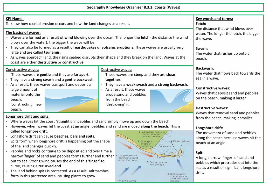
Constructive waves: - These waves are gentle and they are far apart. - They have a strong swash and a gentle backwash. - As a result, these waves transport and deposit a
large amount of material onto the beach, ‘constructing’ new beach.
Destructive waves: - These waves are steep and they are close
together. - They have a weak swash and a strong backwash. - As a result, these waves
erode sand and pebbles from the beach, ‘destroying’ it.
Geography Knowledge Organiser 8.3.2: Coasts (Waves)
Key words and terms: Fetch: The distance that wind blows over water. The longer the fetch, the bigger the wave. Swash: The water that rushes up onto a beach. Backwash: The water that flows back towards the sea in a wave. Constructive waves: Waves that deposit sand and pebbles on the beach, making it larger. Destructive waves: Waves that removal sand and pebbles from the beach, making it smaller. Longshore drift: The movement of sand and pebbles along the beach because waves hit the beach at an angle. Spit: A long, narrow ‘finger’ of sand and pebbles which protrudes out into the sea as a result of significant longshore drift.
The basics of waves: - Waves are formed as a result of wind blowing over the ocean. The longer the fetch (the distance the wind
blows over the water), the bigger the wave will be. - They can also be formed as a result of earthquakes or volcanic eruptions. These waves are usually very
large and are called tsunamis. - As waves approach land, the rising seabed disrupts their shape and they break on the land. Waves at the
coast are either destructive or constructive.
Longshore drift and spits: - Where waves hit the coast ‘straight on’, pebbles and sand simply move up and down the beach. - However, when waves hit the coast at an angle, pebbles and sand are moved along the beach. This is
called longshore drift. - Longshore drift can cause beaches, bars and spits. - Spits form when longshore drift is happening but the shape
of the land changes quickly. - Pebbles and rocks continue to be depositied and over time a
narrow ‘finger’ of sand and pebbles forms further and further out to sea. Strong wind causes the end of this ‘finger’ to curve, causing a recurved end.
- The land behind spits is protected. As a result, saltmarshes form in this protected area, causing plants to grow.
KPI Name: To know how coastal erosion occurs and how the land changes as a result.

Hard Engineering: Soft Engineering:
Method: Description: Method: Description:
Sea walls
These a high, concrete walls absorb the energy from waves. They also provide a walkway for tourists above the beach. They are expensive but last many years.
Beach nourishment
This is when beaches are built up by adding more sand to existing beaches. The beach absorbs the wave energy, but the sand has to come from somewhere.
Groynes These are long wooden fences which are built out to sea to prevent longshore drift. As they stop the transport of sand and sediment, they can increase erosion further along the coast.
Sand dune regeneration
This is when sand dunes are built around wooden structures. Sand dunes absorb energy from waves and can become habitats for animals and plants.
Rock armour
These are large rocks which are placed at the base of cliffs to absorb the force of waves and stop cliffs from eroding. These are more natural looking than other methods.
Salt marsh creation
This is when an area is allowed to flood, creating a salt marsh. This reduces the risk of flooding and creates habitats for animals and plants.
Gabions These are rocks or boulders which are kept in mesh cages by the coast. They protect areas from destructive waves. They are relatively cheap but they are quite weak.
Managed retreat
This is when existing defences are abandoned and new defences are built further inland. Some people lose land, but the risk of flooding is reduced.
Geography Knowledge Organiser 8.3.3: Coasts (Managing Coasts)
KPI Name: To know how coastal erosion and flooding can be managed.
Key words and terms: Hard engineering: The control of natural processes, such as erosion or flooding, by building man-made structures. Soft engineering: Projects which work with the environment to control natural processes, such as erosion or flooding.
Changes in sea level: - Sea levels change on a daily basis due to tides. - However, earth’s sea levels are also generally rising due to global warming. The increase in the earth’s
average temperature is causing the polar ice caps to melt, causing sea levels to rise. - This rise in sea levels can increase erosion and can cause area to permenantly flood. - This affects coastal areas but can also affect low lying countries, such as the Maldives and cities such as
New York, Shanghai and London, which will be forced to spend billions on flood defences.
Hard and soft engineering: - Coasts can be protected using either hard or soft engineering. Until recently, the emphasis has been on hard engineering. This method is effective
but is also very expensive. - Today, many people are starting to prefer soft engineering methods of managing the coast. They argue that it is less expensive, lasts longer and is
more environmentally friendly.
How Ecosystems work: - There are four components to any ecosystem: animals,
plants, rocks and soil and the climate. - All of the different components of ecosystems work
together and interact with each other. - Plants decompose to add nutrients to rocks and soil.
These nutrients then feed the plants which also grow because they are adapted to the climate. They plants are then eaten by animals.
Geography Knowledge Organiser 8.4.1: Ecosystems (Biomes and Climate Graphs)
KPI Name: To understand the features of different biomes around the world.
Key words and terms: Ecosystem: An environment in which a community of plants and animals interact with each other and the climate on rocks and soil. Biome: A large ecosystem. Temperate: A climate or region which has mild temperatures. Deciduous: A type of tree or shrub which sheds its leaves every year. Coniferous: A type of tree or shrub which has needle or scale-like leaves and which does not shed its leaves during the winter. Climate: The weather over a long period of time. Precipitation: Rain, snow, sleet or hail which falls to or condenses on the ground.
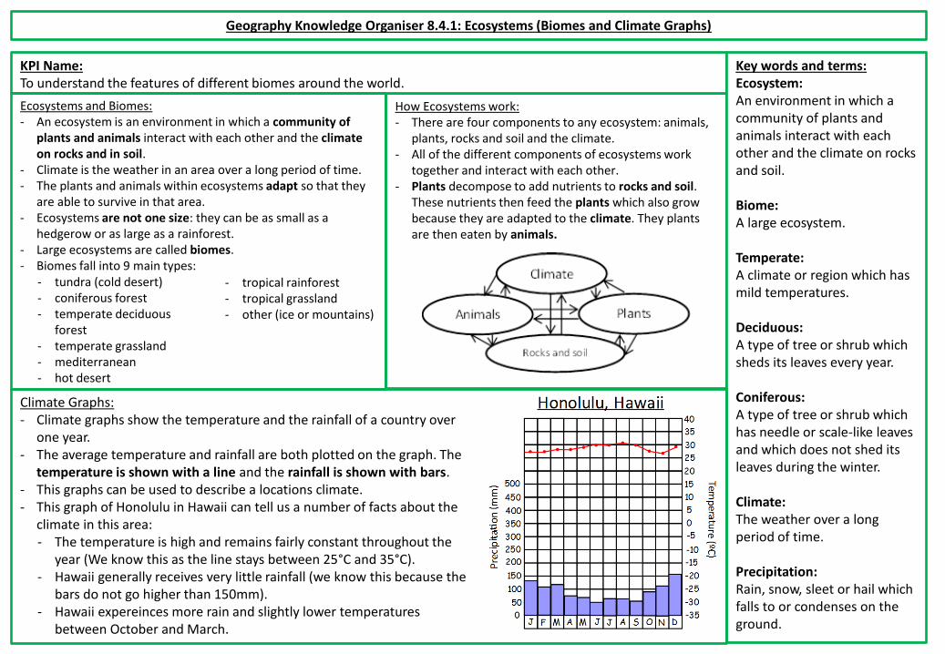
Climate Graphs: - Climate graphs show the temperature and the rainfall of a country over
one year. - The average temperature and rainfall are both plotted on the graph. The
temperature is shown with a line and the rainfall is shown with bars. - This graphs can be used to describe a locations climate. - This graph of Honolulu in Hawaii can tell us a number of facts about the
climate in this area: - The temperature is high and remains fairly constant throughout the
year (We know this as the line stays between 25°C and 35°C). - Hawaii generally receives very little rainfall (we know this because the
bars do not go higher than 150mm). - Hawaii expereinces more rain and slightly lower temperatures
between October and March.
Ecosystems and Biomes: - An ecosystem is an environment in which a community of
plants and animals interact with each other and the climate on rocks and in soil.
- Climate is the weather in an area over a long period of time. - The plants and animals within ecosystems adapt so that they
are able to survive in that area. - Ecosystems are not one size: they can be as small as a
hedgerow or as large as a rainforest. - Large ecosystems are called biomes. - Biomes fall into 9 main types:
- tundra (cold desert) - coniferous forest - temperate deciduous
forest - temperate grassland - mediterranean - hot desert
- tropical rainforest - tropical grassland - other (ice or mountains)

Geography Knowledge Organiser 8.4.2: Ecosystems (Rainforests)
KPI Name: To understand the features of different biomes around the world.
Key words and terms: Humid: A warm environment with a high level of water in the atmosphere. Diverse: A lot of variety. Ecosystem service: Benefits and services which ecosystems provide. Emergent layer: The highest level in the rainforest. Upper canopy: The second highest level in the rainforest. Lower canopy: The second lowest level in the rainforest. Forest floor: The lowest level in the rainforest. Equator: A horizontal line which splits the earth into two hemispheres.
Rainforests: - Tropical rainforests are usually found within 10 degrees north
and south of the equator. They can be found in Africa, South America, Asia and Australasia
- As a result, rainforests have hot and humid climates, where it rains almost every day.
- Temperatures in the rainforest only vary slightly over the course of the year. However, they also have rainy and dry seasons (don’t let the names fool you: on average rainforests get more rain than the UK all year round!)
- Rainforests are incredibly diverse: they only cover roughly 6% of the world’s surface but are home to over half the plant and animal species in the world!
The structure of the rainforest: - The rainforest has four layers: the emergent layer, the upper canopy,
the lower canopy and the forest floor. - The soil quality in rainforests is usually very poor: there is only a very
shallow layer of good soil on the forest floor. - There is a huge amount of competition for nutrients and sunlight in
the rainforest. The huge number of plants and animals mean that any nutrients in the soil are quickly absorbed.
- Most plants depend on rotting trees and other plants. The hot and humid climate causes dead plants to rot quickly and these nutrients are quickly absorbed.
- Rainforests are very fragile ecosystems. If you remove plants or dead trees from the system, other plants and animals quickly die due to the lack of nutrients.
- Ecosystems provide many ecosystem services (benefits and services which ecosystems provide): They help to regulate climate change, they produce huge amounts of oxygen and there is evidence to suggest that they increase precipitation (rainfall) in areas around them. Plants and animals in rainforests have also been used to create medicines and products which we use in our everyday lives.

Geography Knowledge Organiser 8.4.3: Ecosystems (Adapting to the rainforest)
KPI Name: To understand how organisms have adapted to different biomes.
Key words and terms: Organism: An individual animal, plant or life form. Predator: An animal which hunts and eats other animals. Nutrients: A substance which is essential for growth and the maintenance of life. Debris: Pieces of waste and remains which fall onto the forest floor. Camouflage: Disguising something to make it blend in with its surroundings. Micro-ecosystem: Ecosystems which exist within a very small space. Adaptation: The process by which an animal or plant becomes better suited to its environment.
Animal adaptations to the rainforest: Most animals in the rainforest have adapted to deal with competition for food, predators and the shape and nature of the rainforest.
Plant adaptations to the rainforest: Most plants in the rainforest have adapted to deal with low light levels, poor soil quality and lack of food and high rainfall.
Example 1: The Anaconda - Anacondas are designed to be effective long term
predators. - These snakes are camouflaged to allow them to sneak up
on prey. - They move very quickly in water. - Anacondas digest food slowly and can go months without
eating after a big meal, allowing them to survive despite competition.
Example 2: The Two Toed Sloth The sloth is designed to deal with competition for food. It moves very little and extremely slowly so that it doesn’t need much energy to survive. Its clawed feet allow it to live in the canopy.
Example 1: The Strangler Fig - The strangler fig is mainly designed to deal with low light
levels and competition. - It starts growing on other trees. Over time it strangles its
host tree and starves it of nutrients, using its dead shell to grow up to the emergent layer
- Example 2: The Pitcher Plant - The pitcher plant is mainly designed to deal with poor soil
quality. - It’s shape is designed to catch falling leaves, debris and
dead animals which it uses for food. - It also collects water and is a micro-ecosystem!

Geography Knowledge Organiser 8.4.4: Ecosystems (Hot deserts)
KPI Name: To understand how organisms have adapted to different biomes.
Key words and terms: Desert: Areas which receive less than 25cm of rain over a year. They can be either hot or cold. Arid: Areas which are extremely dry. Nutrients: A substance which is essential for growth and the maintenance of life. Organic: A natural substance. Desertification: When normal land becomes desert as a result of farming or raising animals on land near desert. Nocturnal: Animals which are active at night. Adaptation: The process by which an animal or plant becomes better suited to its environment.
Adapting to hot deserts: Most animals and plants in deserts have adapted to deal with competition for food, extreme temperatures and lack of water.
Rainforests: - Deserts are areas which receive less than 25cm of rain over a
year. - Deserts are arid regions, which means “extremely dry”. - They can be hot, such as the Sahara desert in Africa, or cold,
such as the deserts in Antarctica. - Deserts can be found throughout the world. - Hot deserts are usually found between 15 and 30° north and
south of the equator. - Deserts, particularly hot deserts, have extreme temperatures
and extreme temperature changes: during the day in hot deserts the temperature can reach up to 50°C, but at night it can drop to below 0°C.
- The soil in deserts can range from sand to rough, rocky terrain. - Desert soil has a lot of nutrients but it also tends to be very salty or acidic and contains few organic nutrients. This means
that plants have to specially adapted to deal with the soil and the lack of water. - Many deserts are getting bigger. This is called desertification. Often this caused by humans farming and raising animals on
land near deserts.
Animal example: The Fennec Fox - The fennec fox is designed to
hunt and to survive extreme heat.
- This fox is nocturnal, meaning it avoids extreme heat.
- Its ears serve two purposes: they allow the fox to easily hear prey and their blood cools as it circulates around the fox’s ears, regulating its body temperature and keeping it cool.
Plant example: The Prickly Pear - The prickly pear is designed
to conserve water and to protect itself from predators.
- It stores water in its spongy tissues so it can survive long periods without rain.
- Its spines stop predators from attacking it for water.