The COST project in Italy: analysis and monitoring of seismogenic faults in the Gargano and Norcia...
16
The COST project in Italy: analysis and monitoring of seismogenic faults in the Gargano and Norcia areas (central-southern Apennines, Italy) K. Borre a , S. Cacon b , G. Cello c , B. Kontny b , B. Kostak d , H. Likke Andersen e , G. Moratti f , L. Piccardi f, *, J. Stemberk d , E. Tondi c , V. Vilimek g a University of Aalborg, Aalborg, Denmark b Department of Geodesy and Photogrammetry, Agricultural University of Wroclaw, Wroclaw, Poland c Dipartimento di Scienze della Terra, Universita ` di Camerino, Camerino, Italy d Dept. Eng. Geol., The Institute of Rock Structures and Mechanics, Praha, Czech Republic e Geologisk Institut, University of Aarhus, Aarhus, Denmark f CNR, Istituto di Geoscienze e Georisorse, Sezione di Firenze, Italy g Charles University, Faculty of Science, Prahaa, Czech Republic Abstract In this paper we illustrate the state of the art of the European Co-operation in the Field of Scientific and Technical Research, COST Action 625 ‘‘3-D Monitoring of Active Tectonic Structures’’ in Italy. The project is mainly focused on detecting strain variations and/or any phenomena that may precede future seismic events, in order to evaluate the time evolution and modes of deformation of seismogenic structures during the inter-coseismic cycles. We selected two note seismic areas, (i) the Gargano promontory (south- ern Italy) and (ii) the Norcia basin (central Italy), for the installation of a monitoring equipment consisting of: (a) local networks of geodetic stations (benchmark for GPS and total station measurements with micrometric sensitivity) and (b) 3D monitoring devices (TM71; capable of recording micrometric dis- placements). In this paper we show the geo-structural analysis and detailed morphostructural studies, including high-resolution seismic reflection profiles and paleoseismological investigations, carried out across the main active faults of selected areas, which allowed us to assess the main spatial and dimensional properties of faults. As concerns the monitoring experiment, available data are not yet adequate to be used for convincing tectonic interpretations because the installation of local GPS stations and that of TM71 extensometers has been carried out only very recently. Accordingly, we only show a few examples of microdisplacement measurements carried out in both areas. # 2003 Elsevier Ltd. All rights reserved. 0264-3707/03/$ - see front matter # 2003 Elsevier Ltd. All rights reserved. doi:10.1016/S0264-3707(03)00035-8 Journal of Geodynamics 36 (2003) 3–18 www.elsevier.com/locate/jog * Corresponding author. Fax: +39-0552-302302. E-mail address: [email protected]fi.it (L. Piccardi).
-
Upload
independent -
Category
Documents
-
view
0 -
download
0
Transcript of The COST project in Italy: analysis and monitoring of seismogenic faults in the Gargano and Norcia...

www.elsevier.com/locate/jog
The COST project in Italy: analysis and monitoring ofseismogenic faults in the Gargano and Norcia areas
(central-southern Apennines, Italy)
K. Borrea, S. Caconb, G. Celloc, B. Kontnyb, B. Kostakd, H. Likke Andersene,G. Morattif, L. Piccardif,*, J. Stemberkd, E. Tondic, V. Vilimekg
aUniversity of Aalborg, Aalborg, DenmarkbDepartment of Geodesy and Photogrammetry, Agricultural University of Wroclaw, Wroclaw, Poland
cDipartimento di Scienze della Terra, Universita di Camerino, Camerino, ItalydDept. Eng. Geol., The Institute of Rock Structures and Mechanics, Praha, Czech Republic
eGeologisk Institut, University of Aarhus, Aarhus, DenmarkfCNR, Istituto di Geoscienze e Georisorse, Sezione di Firenze, Italy
gCharles University, Faculty of Science, Prahaa, Czech Republic
Abstract
In this paper we illustrate the state of the art of the European Co-operation in the Field of Scientific andTechnical Research, COST Action 625 ‘‘3-D Monitoring of Active Tectonic Structures’’ in Italy. Theproject is mainly focused on detecting strain variations and/or any phenomena that may precede futureseismic events, in order to evaluate the time evolution and modes of deformation of seismogenic structuresduring the inter-coseismic cycles. We selected two note seismic areas, (i) the Gargano promontory (south-ern Italy) and (ii) the Norcia basin (central Italy), for the installation of a monitoring equipment consistingof: (a) local networks of geodetic stations (benchmark for GPS and total station measurements withmicrometric sensitivity) and (b) 3D monitoring devices (TM71; capable of recording micrometric dis-placements). In this paper we show the geo-structural analysis and detailed morphostructural studies,including high-resolution seismic reflection profiles and paleoseismological investigations, carried outacross the main active faults of selected areas, which allowed us to assess the main spatial and dimensionalproperties of faults. As concerns the monitoring experiment, available data are not yet adequate to be usedfor convincing tectonic interpretations because the installation of local GPS stations and that of TM71extensometers has been carried out only very recently. Accordingly, we only show a few examples ofmicrodisplacement measurements carried out in both areas.# 2003 Elsevier Ltd. All rights reserved.
0264-3707/03/$ - see front matter # 2003 Elsevier Ltd. All rights reserved.
doi:10.1016/S0264-3707(03)00035-8
Journal of Geodynamics 36 (2003) 3–18
* Corresponding author. Fax: +39-0552-302302.
E-mail address: [email protected] (L. Piccardi).

1. Introduction
Understanding active tectonic processes and related seismic energy release has become funda-mental for several human activities such as the siting of high-risk industrial plants and/or fordefending society against earthquakes. For this reason, some of the most hazardous active faultsworldwide, in particular in California and Japan, are currently monitored by using local networksand satellite technology.
In Italy, neither the national seismic network nor the currently operative satellite stations(GPS) have been set up with the aim of monitoring micro-displacements on individual seismo-genic structures. Rather, these networks are used to control vast areas of the national territory inorder to locate medium- to high-energy seismic events, and for detecting crustal movements inthe order of a few centimetres. Filling the gap on data acquisition at different scales is one of themain objective of the European Co-operation in the Field of Scientific and Technical Research,COST Action 625 ‘‘3-D Monitoring of Active Tectonic Structures’’. The Action was in fact set upwith the aim of stimulating integrated studies, among European parteners, for monitoring localactive tectonic structures selected in two test areas in Italy and Greece. The test area in Greece isthat of the Gulf of Corinth (see Maniatis et al., this volume), whereas, in Italy, we selected two sites:(i) the Gargano area, in southern Italy, and (ii) the Norcia area, in the central Apennines.
The Italian project is mainly focused at detecting strain variations and/or any phenomena thatmay precede future seismic events, in order to evaluate the time evolution and modes of defor-mation of seismogenic structures during the inter-coseismic cycles.
In this paper we illustrate the state of the art of the EC-COST Action 625 in Italy, andemphasize the value of this project as an international multidisciplinary-based research coopera-tion among Italian partners of the CNR-Institute of Geosciences and Earth Resources (Florence)and of the University of Camerino (Macerata), with researchers from the Institute for RockMechanics (Prague), the Universities of Aalborg and Aarhus (Denmark) and the University ofWroclaw (Poland).
2. Selected areas
Our approach for selecting the seismogenic structures to be monitored in Italy was based on thefollowing procedure. We first performed a regional geo-structural analysis which allowed us toassess the main spatial and dimensional properties of the active faults exposed in the Garganoarea and in Central Italy (Cello et al., 1997; Piccardi, 1998, in press, Piccardi et al., 1999; Tondi,2000); then we carried out detailed morphostructural studies aimed at characterizing their activ-ity, in Holocene times, by recording specific indicators relating surface faulting phenomena to thegeomorphic signature in the local landscape. Based on this information we selected a few sites, inthe Gargano and Norcia areas, for the execution of high-resolution seismic reflection profiles(Andersen et al., 2001). These were designed with the aim of relating observed surface faults todeep structures, and to evaluate slip and displacement rates across imaged seismogenic faults.Once known the main properties of the seismogenic faults, paleoseismological investigations,including exploratory trenching and dating of distinctive geologic markers, were carried out
4 K. Borre et al. / Journal of Geodynamics 36 (2003) 3–18

(Cello et al., 1998; Piccardi et al., 2002) in order to extend back in time the available informationon earthquake history.
Finally, in July 2001 and May 2002 we installed 3D monitoring devices (TM71; Stemberk et al.,present volume) capable of recording micrometric displacements across the active faults selectedin the Norcia area and the Gargano promontory. Following the installation of this monitoringequipment, local networks of geodetic stations (benchmark for GPS and total station measure-ments with micrometric sensitivity) were also put in operation, in both areas, since 2001.
The TM71 devices installed in the field by the Czech partners, work on the principle ofmechanical interference (Kostak, 1991). Displacement vectors supplemented with angular devia-tions in two perpendicular planes are recorded. The system sensitivity is 0.05–0.0125 mm in all thethree space co-ordinates, and 3.2�10�4 rad in angular deviations. Long-term micro-displace-ments can be evaluated, as a rule, with an accuracy of 0.03 mm.
The Gargano local GPS network installed by the Polish group forms a second order segment ofthe deformation monitoring system, as indicated in Cacon and Kontny (1994). The first mea-surements in the Gargano peninsula were performed in July 2002, in two 12-h sessions usingAshtech Z-12 and Z-Xtreme receivers and geodetic antennas ASH 700718B and ASH701975.01Agp. The more sophisticated and precise Leica total station TCR2003 was used forterrestrial geodetic measurements (distances and angles).
GPS monitoring, in Norcia, was carried out by the Danish group of the University of Aalborg;measurements were performed in May 2001 and May 2002. The GPS-instrumentation consists offive Z-Xtreme receivers that were put at disposal by EIVA a/s and Aalborg University. Fivepertinent antennas were established close to a line crossing three known faults.
The data from the five GPS receivers were transmitted via modem to a processing station atNorcia. We used the DEMON software (BOVA ApS firm) that was especially developed for thiskind of experiment.
The experience gained during the Norcia project led us to reset the DEMON software in theautumn 2002; it now provides phase-only solutions and improved atmospheric models for longerbaselines with larger height differences.
2.1. Geological framework of study areas
The areas selected for the study have suffered some of the strongest historical earthquakesrecorded in Italy (Boschi et al., 1997; CPTI Gruppo di Lavoro, 1999): i.e. that known as theNorcia earthquake, which occurred on 14 January 1703 (Imax=XI), and the S. Severo (Gargano)event of 30 July 1627 (Imax=X).
From a structural point of view, the selected areas are part of two ‘‘homogeneous’’ domains inpeninsular Italy: (i) the Norcia area is located in the axial zones of the Apenninic chain, and (ii)the Gargano promontory is part of the Apenninic (i.e. Afro Adriatic) foreland which includes theAdria microplate. The progressive deformation of the Afro-Adriatic continental margin, inNeogene times, was responsible for the development of the fold and thrust belt structure of theApennines. This was mostly accomplished through the sequential accretion of pre-Miocenepaleogeographic domains of the margin from which different structural units were originated andsuperposed on the sedimentary (mostly platform carbonate) successions of the foreland (Cello
K. Borre et al. / Journal of Geodynamics 36 (2003) 3–18 5

and Nur, 1988; Cello and Deiana, 1995; Calamita et al., 1994; Cello and Mazzoli, 1999 andreferences therein).
2.2. The Gargano promontory (southern Italy)
The Gargano promontory, a carbonate massif belonging to the Adria microplate, is a well-known seismogenic area (Fig. 1). It is bordered to the south by an E–W trending active fault
Fig. 1. (a) Structural setting of the Gargano region. (b) Seismotectonic map of the Gargano area. Focal mechanisms
from: (1) Gasparini et al. (1985); (2) Catalogue of Harvard University Seismology Group (2001); (3) Catalogue of SwissSeismological Service (2001); (4) INGV.
6 K. Borre et al. / Journal of Geodynamics 36 (2003) 3–18

system, the Mattinata fault system (MFS) (Funiciello et al., 1988), which is the surface expressionof a crustal structure, the so called South Gargano Line (SGL) (Borsellini et al., 1993, Piccardi,1998, Doglio et al., 1994, and references therein). The Mattinata fault system includes severalright lateral fault segments; some of them are known as: (i) the San Marco in Lamis fault, (ii) theSan Giovanni Rotondo fault, and (iii) the Monte Sant’Angelo fault. To the west, the SGLextends as far as the Apennines thrust front (refer to Fig. 1a); however, the relations between thisstructure and the main thrust front are not clear.
The recent activity of the faults exposed to the south of the Gargano Promontory is docu-mented by clear geologic and geomorphic evidence, as well as by the epicentral location of somedestructive earthquakes, notably that of 30 July 1627 (I=X, Mk=6.7), which affected a largearea around San Severo (Fig. 2), and that of 10 August 1893 (I=VIII, Mk=5.4) which struck thearea around Mattinata (Fig. 3). The first one, which completely destroyed the town of SanSevero, is the strongest event historically documented in the Gargano region. The seismogenicstructure responsible for this earthquake is, however, still poorly defined. The 1893 earthquake isthe strongest historical event reported by the seismic catalogue in the Monte Sant’Angelo area.The source of this earthquake is likely to have been the Monte Sant’Angelo fault (MSA), ascoseismic ground breaks were recorded at the eastern on-land termination of the fault, at Matti-nata, over a length of more than 1 km (Baratta, 1893, Fig. 3b, c). Furthermore, on 31 Octoberand 1 November 2002, an Ml=5.4 earthquake located along the western extension of the SGL,struck the Campobasso area (Figs. 1b and 4). This event is characterized by a focal mechanismsolution indicating dextral shear along roughly E–W oriented seismogenic faults, hence suggest-ing that the whole SGL may be considered active in response to the current stress field operatingin the area.
Within the frame of the EC-COST Action 625, the Mattinata fault system was selected as oneof the Italian test sites for a monitoring experiment on active tectonic deformation. To this aim, anetwork of benchmarks was established at key locations along the faults of the system(Figs. 1b and 3b). As may be seen, our investigations, and the installation of the monitoringequipments, have been initially focused on the Monte Sant’Angelo fault segment, because, here,we found the most suitable conditions (geological, morphological, logistic, etc.) for initiating ourexperiment.
In Fig. 2a, we show the location of the high resolution seismic profile performed in the Can-delaro plain, where the fault trace was previously located on the basis of geological and remotesensing analysis. In Fig. 2b, the seismic image of the fault at depth is shown; it can be seen thatthe vertical offset of the base of the Quaternary deposits is in the order of 150 m.
In Fig. 3 are illustrated the results of the paleoseismological analysis performed at two selectedtrench sites located at the base of the MSA fault scarp. At the first site, near Mattinata, the up to5 m deep trench exposed faulted hangingwall slope deposits, C14-dated from at least 42,000 yearsBP to the present. Due to local topography and lithology, the excavation could not carve into thecarbonatic bedrock footwall. The second trench, up to 4 m deep, exposed colluvial and volcano-clastic deposits, C14-dated from 27,000 years BP to the present. Here we could excavate acrossboth the hangingwall and footwall units, and the related slip-rate exceedes 0.2 – 0.3 mm/year. Wecould also assess that the MSA fault moves with incremental slip episodes characterized byvertical offsets of up to several decimetres. Based on these data, as well as on the evidence ofcoseismic surface faulting, and assuming that the total length of the MSA fault is about 20 km,
K. Borre et al. / Journal of Geodynamics 36 (2003) 3–18 7

Fig. 2. (a) Epicentral area of the July 30, 1627 San Severo earthquake (I=X MCS, Me=6.7). The shallow high reso-lution seismic line in (b) was located at Brancia because of the local indication of activity on this fault. Here, in fact,
historical reports (Lucchino, 1630) describe a relevant ignition of gases, most likely released through the fault, duringthe earthquake. (b) Seismic profile clearly shows the offset of a well defined reflector which was interpreted to be thetop of bedrock units underlying the continental deposits.
8 K. Borre et al. / Journal of Geodynamics 36 (2003) 3–18
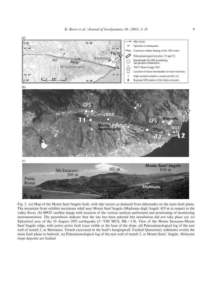
Fig. 3. (a) Map of the Monte Sant’Angelo fault, with slip vectors as deduced from slikensides on the main fault plane.
The mountain front exhibits maximum relief near Monte Sant’Angelo (Madonna degli Angeli: 435 m in respect to thevalley floor). (b) SPOT satellite image with location of the various analysis performed and positioning of monitoringinstrumentation. The parenthesis indicate that the site has been selected but installation did not take place yet. (c)
Epicentral area of the 10 August 1893 earthquake (I=VIII MCS, Mk=5.4). View of the Monte Saraceno-MonteSant’Angelo ridge, with active active fault trace visible at the base of the slope. (d) Paleoseismological log of the eastwall of trench 2, at Mattinata. Trench excavated in the fault’s hangingwall. Faulted Quaternary sediments overlie themain fault plane in bedrock. (e) Paleoseismological log of the east wall of trench 2, at Monte Saint’ Angelo. Holocene
slope deposits are faulted.
K. Borre et al. / Journal of Geodynamics 36 (2003) 3–18 9

Fig. 3 (continued).
10 K. Borre et al. / Journal of Geodynamics 36 (2003) 3–18

it may be inferred that the maximum magnitude expected in this area must be similar to thatreleased during the 1627 event.
2.3. The Norcia area (central Italy)
The Norcia area, located in the axial zones of the central Apennines (Fig. 5), is affected byseveral faults of Late-Quaternary age (post 700 kyear) which cut through, or reactivate, previousthrust-related features (Cello et al., 1997). Among them, two major NNW-SSE trending faultsborder the Norcia basin, a tectonic depression filled with Pleistocene-Holocene fluvio-lacustrinesediments. Evidence of recent activity along these faults is mainly due to the existence of faultscarps in slope deposits and facet spurs in carbonate bedrock units (Blumetti, 1995). The long-term cumulative vertical offset across these faults is of several hundreds metres, in the Norciaarea, and decreases to the south, where the faults merge in a roughly north-south oriented struc-ture that displays a large horizontal offset (about 1 km across the Velino valley). Using offset datafrom both geological and morphological markers, we evaluated the slip rates associated to thesurface active faults exposed in the Norcia area (i.e. Cello et al., 1997); these are mostly in therange of 0.5 mm/year.
Fig. 4. Epicentral area of the 31 October 2002 earthquake in Molise.
K. Borre et al. / Journal of Geodynamics 36 (2003) 3–18 11
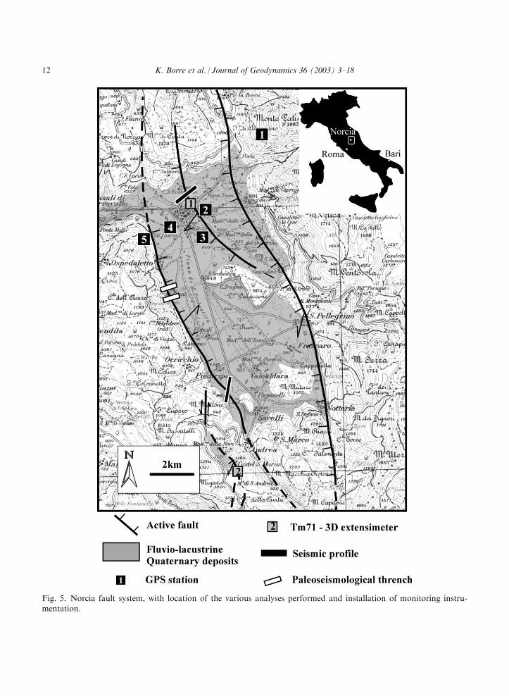
Fig. 5. Norcia fault system, with location of the various analyses performed and installation of monitoring instru-mentation.
12 K. Borre et al. / Journal of Geodynamics 36 (2003) 3–18
Fig. 6. (a) Air view of Norcia town. The trace of the seismic profile performed across the Norcia fault is also shown;
(b) Seismic image (from the profile located in (a) showing the offset of a well defined reflector which was interpreted tobe the top of bedrock units underlying the Late-Pleistocene alluvial fan deposits of Monte Patino. The displacement isin the order of 30 m.
K. Borre et al. / Journal of Geodynamics 36 (2003) 3–18 13
Seismic activity, in this sector of the Apennines, is characterized by the occurrence of mostlymoderate events (M <6) and by some strong earthquake with maximum intensities of X–XIdegrees MCS and equivalent magnitude around 6.5–7.0 (Boschi et al., 1997). The latter includethe 1703 earthquake sequence, which is known for its destructive effects recorded over a largearea in response to southward propagating multiple shocks that occurred from 14 January to 2February. The former includes the 19 September 1979 earthquake, with a magnitude Ms=5.9 andfocal depth of 6 km, which struck a much smaller area around the village of Castel Santa Maria(south of Norcia). According to Stucchi (1985), the 14 January 1703 earthquake affected a
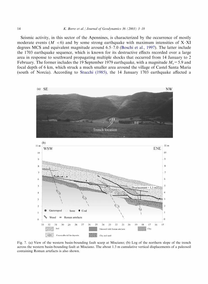
Fig. 7. (a) View of the western basin-bounding fault scarp at Misciano; (b) Log of the northern slope of the trench
across the western basin-bounding fault at Misciano. The about 1.3 m cumulative vertical displacements of a paleosoilcontaining Roman artefacts is also shown.
14 K. Borre et al. / Journal of Geodynamics 36 (2003) 3–18

Fig. 8. Fault displacements in Cartesian co-ordinates x,y,z registered by TM71 crack gauging at (a) Mattinata, (b) Norcia, and (c) Castel S. Maria.(d) Vector component (east, north, up) differences for consecutive days registered by GPS station no. 2 at Norcia.
K.Borre
etal./JournalofGeodynamics
36(2003)3–18
15

roughly 10 km wide and about 40 km long area, causing about 6000 casualties. Tentative corre-lations between the seismogenic structure at depth and the surface fault pattern in the epicentralarea, have been carried out by several workers with the aim of assessing the dimensional para-meters of the seismogenic faults by using geostructural data (Cello et al., 1997; Tondi, 2000;Barchi et al., 2000 among others). As a result, it has been estimated that the Norcia seismogenicstructure is 35–40 km long and capable of causing strong earthquakes (with inferred magnitudebetween 6.5 and 7.0, like the 1703 earthquake) when the whole fault volume ruptures, and M<6.0 earthquakes (similar to the 19 September 1979 shock) when only smaller volumes of theseismogenic structure undergo rupture.
In Fig. 6 we show the results of the high-resolution seismic reflection profile carried out acrossthe fault segment that runs trough the town of Norcia (Fig. 6a); as can be seen from the seismicimage of the fault (Fig. 6b), the bedrock units underlying the Late-Pleistocene alluvial fandeposits of Monte Patino are displaced by ca. 30 m. This offset is of the same order of magnitudeof that measured on the fault scarp at the surface, hence corroborating that the Norcia fault is anewly formed structure (post 700 kyear) characterized by slip rates of about 0.5 mm/year.
Additional information regarding slip rates and surface faulting phenomena were obtainedfrom exploratory trenching and dating of distinctive geologic markers exposed along the westernbasin-bounding fault (Fig. 7a) cutting through Holocene colluvial deposits (Cello et al., 1998).Paleoseismological data emphasize the presence of earthquake-related liquefaction phenomenaand the occurrence of two faulting episodes generating the vertical displacement of about 1.3 m ofa paleosoil containing Roman artefacts (Fig. 7b). This latter point suggests that surface faultingassociated to M > 6.5 earthquakes is capable of generating coseismic displacements in the orderof 0.5 m (Cello et al., 1998).
On the fault that runs trough the town, we installed, on May 2002, a high precision local GPSnetwork including five observation points, and a TM71 3D extensimeter; another TM71 instru-ment also installed at Castel Santa Maria, on the 8 m high scarp in carbonate bedrock thought tohave reactivated during the 9 September 1979 Norcia earthquake (Calamita et al., 1994).
3. Conclusions
In this paper we discuss the state of the art of the EC-COST Action 625 in Italy, and constrainsome basic information on the seismogenic structures selected for the study. As concerns thislatter point, we have shown that destructive earthquakes, in the selected areas, are associated withthe South Gargano (in southern Italy) on one hand, and the Norcia seismogenic structure (incentral Italy) on the other.
In the Norcia area, seismic energy is mostly released by the roughly N–S trending faultextending from Visso to Cittereale for a total length of about 40 km; the strongest historicalearthquakes in the area have magnitudes comprised between 6.5 and 7, and coseismic surfacedisplacements are in the range of 1–3 m.
In the Gargano promontory, the 1627 San Severo event is considered to be the maximumexpected earthquake in the area. This event, as well as the 1893 Mattinata and the 2002 Campo-basso earthquakes, are all related to the roughly E–W trending South Gargano line. Each earth-quake, however, may be associated to a specific fault: i.e. the San Severo event was generated by
16 K. Borre et al. / Journal of Geodynamics 36 (2003) 3–18
slip on the San Marco in Lamis structure (Piccardi et al., 2002), whereas the Mattinata earth-quake has been related to the Monte Sant Angelo fault (Piccardi, 1998). In both cases, surfacebreaks were either directly observed or inferred from paleosismological investigations. On theother hand, the Campobasso event (Mw=5.8) associated with the western extension of the SouthGargano Line did not rupture the ground surface, but was responsible for activating gravity-induced land deformation.
As concerns the monitoring experiment, available data are not yet adequate to be used forconvincing tectonic interpretations because the installation of local GPS stations and that ofTM71 extensometers has been carried out only very recently. Accordingly, we only show a fewexamples of microdisplacement measurements carried out in both areas (Fig. 8). The above datahave not been used by now for assessing/constraining the long-term displacement rates across theinvestigated structures; it is our belief, however, that the direct monitoring of the selected seis-mogenic structures will allow us, in 3–5 years time, to acquire enough information on surfacedeformation and fault behaviour in both the Norcia and Gargano areas.
Acknowledgements
The work has been partially supported by funding from the Italian MIUR Cofin 2001 (Resp. A.Santo, prot. 2001044583_004) and MIUR Cofin 2002 (Resp. G. Cello, prot. 2002043912_001).
References
Andersen, H.L., Borre, K., Cello, G., Moratti, G., Piccardi, L., Tondi, E., Kostak, B. 2001. Analisi integrata di strut-ture sismogenetiche in Italia peninsulare: primi risultati della EC-COST ACTION 625. Abstracts of the Meeting
FIST-Geoitalia 2001. Chieti, 5–7 September 2001.Barchi, M., Galadini, F., Lavecchia, G., Messina, P., Michetti, A.M., Peruzza, L., Pizzi, A., Tondi, E., Vittori, E.,
2000. Sintesi delle conoscenze sulle faglie attive in Italia Centrale: parametrizzazione ai fini della caratterizzazione
della pericolosita sismica. CNR-Gruppo Nazionale per la Difesa dai Terremoti, Rome.Baratta, M., 1893. Intorno ai fenomeni sismici avvenuti nella penisola Garganica durante il 1893. Annali dell’Ufficio
Centrale di Meteorologia XV (I), 297–315.Blumetti, A.M. 1995. Neotectonic investigation and evidence of paleosesmicity in the epicentral area of the January–
February 1703, central Italy, earthquake. In: L. Serva, D. B. Slemmons (Eds.), Perspectives in Paleoseismology,Peanut Butter Publishing, Seattle, Washington, USA, 6, pp. 83–100.
Boschi, E., Guidoboni, E., Ferrari, G., Valensise, G., Gasperini, P., 1997. Catalogo dei forti terremoti in Italia dal 461
a.C. al 1990. ING-SGA (Eds), Bologna, 1997.Bosellini, A., Neri, C., Lucani, V., 1993. Guida ai carbonati Cretaceo-Eocenici di scarpata e bacino del Gargano (Italia
meridionale). Annali dell’Universita di Ferrara (nuova serie), Sez. Scienze della Terra, suppl. to vol. 4, Bologna,
1993.Cacon, S., Kontny, B., 1994. Measurement and monitoring system for deformation investigation of lithosphere at
natural and engineering objects in Sudety Mts., Proceed. 1st Turkish Int. Symp. on Deformations, Istanbul, 5–9September 1994, pp. 97–104.
Calamita, F., Cello, G., Deiana, G., Paltrinieri, W., 1994. Structural styles, chronology rates of deformation, and time-space relationships in the Umbria-Marche thrust system (central Apennines, Italy). Tectonics 13, 873–881.
K. Borre et al. / Journal of Geodynamics 36 (2003) 3–18 17
Cello, G., Nur, A., 1988. Emplacement of foreland thrust systems. Tectonics 7, 261–271.
Cello, G., Deiana, G., 1995. Role and effects of pore fluid pressure in thrusting: the case-history of the Umbria-MarcheApennines (Central Italy). Tectonics 14 (4), 848–854.
Cello, G., Mazzoli, S., Tondi, E., Turco, E., 1997. Active tectonics in the Central Apennines and possible implications
for seismic hazard analysis in peninsular Italy. Tectonophysics 272, 43–68.Cello, G., Mazzoli, S., Tondi, E., 1998. The 1703 seismic sequence of central Italy: A major evidence of a crustal seis-
mogenic zone in the Umbria-Marche-Abruzzi Apennines. Journal of Geodynamics 26, 443–460.
Cello, G., Mazzoli, S., 1999. Apennine tectonics in southern Italy: a review. Journal of Geodynamics 27, 191–211.CPTI Gruppo di Lavoro, 1999. Catalogo Parametrico dei Terremoti Italiani. ING, GNDT, SGA, SSN, Bologna.Doglioni, C., Monelli, F., Pieri, P., 1994. The Puglia uplift (SE Italy): an anomaly in the foreland of the Apenninic
subduction due to buckling of a thick continental lithosphere. Tectonics 13 (5), 1309–1321.
Funiciello, R., Montone, P., Salvini, F., Tozzi, M., 1988. Caratteri strutturali del Promontorio del Gargano. Mem.Soc. Geol. It 41, 1235–1243.
Gasparini, C., Iannaccone, G., Scarpa, R., 1985. Fault plane solutions and seismicity of the Italian Peninsula. Tecto-
nophysics 117, 59–78.Harvard University Seismology Group 2001. Catalogue of CMT solutions of large events (M>5.0) of the period 1977–
1996. Available: http://www.seismology.harvard.edu/data.
Kostak, B (1991): Combined indicator using Moire technique.- Proc. 3rd Int. Symp. on Field Measurements in Geo-mechanics, 9–11 September 1991 Oslo, l, pp. 53–60, Balkema, Rotterdam, Brookfield.
Lucchino, A. 1630. Del Terremoto che addı 30 luglio 1627 ruino la citta di Sansevero e terre contigue. Foggia, 1930.
Piccardi, L., 1998. Cinematica attuale, comportamento sismico e sismologia storica della faglia attiva di Monte San-t’Angelo (Gargano): la possibile rottura superficiale del ‘leggendario’ terremoto del 493 d.C. Geografia Fisica eDinamica Quaternaria 21, 155–166.
Piccardi, L., Gaudemer, Y., Tapponnier, P., Boccaletti, M., 1999. Active oblique extension in the central Apennines
(Italy): evidence from the Fucino basin. Geophisical Journal International 139, 2. 499-530.Piccardi, L., Ferreli, L., Michetti, A.M., Tondi, E., Vittori, E., 2002. First trench investigation along the Gargano
Fault, Apulia foreland, Southern Italy. Abstracts of the International Conference ‘‘Environmental Catastrophes and
Recovery in the Holocene’’, London, 29 August–2 September, p. 65–66.Piccardi, L. Geologic evidence of legendary earthquakes at Monte Sant’Angelo (Gargano, Italy). Tectonophysics,
accepted for publication.
Stemberk, J., Kostak, B., Vilimek, V. 3D monitoring of active tectonic structures. Journal of Geodynamics (in press).Stucchi, M., 1985. The earthquakes in central Italy, January-Febraury 1703. Some questions, some preliminary
answers. In: Postpischl, D. (Ed.), Atlas of Isoseismal Maps of Italian Earthquake. Quaderni de La Ricerca Scienti-
fica, b, CNR, Roma, pp. 56–57.Swiss Seismological Service, 2001. Catalogue of Moment Tensor Solutions in the European-Mediterranean region,
years 2000–2001.Tondi, E., 2000. Geological analysis and seismic hazard in the Central Apennines. In: Cello, G., Tondi, E. (Eds.), The
resolution of geological analysis and models for earthquake faulting studies. Journal of Geodynamics, 29(3–5), 517–534.
18 K. Borre et al. / Journal of Geodynamics 36 (2003) 3–18