FORAGING DEPTHS OF SEA OTTERS AND IMPLICATIONS TO COASTAL MARINE COMMUNITIES
Upload
manchesterCategory
view
4download
0
Fault Roughness at Seismogenic Depths from LIDAR and Photogrammetric Analysis
ANDREA BISTACCHI,1 W. ASHLEY GRIFFITH,2 STEVEN A. F. SMITH,3 GIULIO DI TORO,4 RICHARD JONES,5
and STEFAN NIELSEN3
Abstract—Fault surface roughness is a principal factor influ-
encing earthquake mechanics, and particularly rupture initiation,
propagation, and arrest. However, little data currently exist on fault
surfaces at seismogenic depths. Here, we investigate the roughness
of slip surfaces from the seismogenic strike-slip Gole Larghe Fault
Zone, exhumed from ca. 10 km depth. The fault zone exploited
pre-existing joints and is hosted in granitoid rocks of the Adamello
batholith (Italian Alps). Individual seismogenic slip surfaces gen-
erally show a first phase of cataclasite production, and a second
phase with beautifully preserved pseudotachylytes of variable
thickness. We determined the geometry of fault traces over almost
five orders of magnitude using terrestrial laser-scanning (LIDAR,
ca. 500 to \1 m scale), and 3D mosaics of high-resolution rectified
digital photographs (10 m to ca. 1 mm scale). LIDAR scans and
photomosaics were georeferenced in 3D using a Differential Global
Positioning System, allowing detailed multiscale reconstruction of
fault traces in Gocad�. The combination of LIDAR and high-res-
olution photos has the advantage, compared with classical LIDAR-
only surveys, that the spatial resolution of rectified photographs can
be very high (up to 0.2 mm/pixel in this study), allowing for
detailed outcrop characterization. Fourier power spectrum analysis
of the fault traces revealed a self-affine behaviour over 3–5 orders
of magnitude, with Hurst exponents ranging between 0.6 and 0.8.
Parameters from Fourier analysis have been used to reconstruct
synthetic 3D fault surfaces with an equivalent roughness by means
of 2D Fourier synthesis. Roughness of pre-existing joints is in a
typical range for this kind of structure. Roughness of faults at small
scale (1 m to 1 mm) shows a clear genetic relationship with the
roughness of precursor joints, and some anisotropy in the self-
affine Hurst exponent. Roughness of faults at scales larger than net
slip ([1–10 m) is not anisotropic and less evolved than at smaller
scales. These observations are consistent with an evolution of
roughness, due to fault surface processes, that takes place only at
scales smaller or comparable to the observed net slip. Differences
in roughness evolution between shallow and deeper faults, the latter
showing evidences of seismic activity, are interpreted as the result
of different weakening versus induration processes, which also
result in localization versus delocalization of deformation in the
fault zone. From a methodological point of view, the technique
used here is advantageous over direct measurements of exposed
fault surfaces in that it preserves, in cross-section, all of the
structures which contribute to fault roughness, and removes any
subjectivity introduced by the need to distinguish roughness of
original slip surfaces from roughness induced by secondary
weathering processes. Moreover, offsets can be measured by means
of suitable markers and fault rocks are preserved, hence their
thickness, composition and structural features can be characterised,
providing an integrated dataset which sheds new light on mecha-
nisms of roughness evolution with slip and concomitant fault rock
production.
Key words: Fault surface roughness, Gole Larghe Fault Zone,
pseudotachylyte, paleoseismic fault, Southern Alps.
1. Introduction
Fault surface roughness is a principal factor con-
trolling earthquake rupture nucleation, propagation
and arrest, and possibly dynamic friction during
seismic slip (SCHOLZ, 2002). However, the character-
ization of fault roughness is limited to a few examples
of fault zones exhumed from \5 km depth and gen-
erally hosted in sedimentary and volcanic lithologies
(e.g., POWER et al., 1987; LEE and BRUHN, 1996;
SAGY et al., 2007; CANDELA et al., 2009).
Following POWER et al. (1988), roughness is
defined as the offset with respect to a mean reference
line (1D profiles) or plane (2D surfaces), which sta-
tistically represent the mean fault surface. Previous
studies of fault roughness were based on direct mea-
surement of exposed fault surfaces, either with some
kind of mechanical profilometer (POWER et al., 1987;
LEE and BRUHN, 1996), or with LIDAR (laser imaging
detection and ranging) terrestrial laser-scanning
1 Dipartimento di Scienze Geologiche e Geotecnologie,
Universita di Milano Bicocca, Milan, Italy. E-mail: andrea.
[email protected] Department of Geology and Environmental Science, Uni-
versity of Akron, Akron, USA.3 Istituto Nazionale di Geofisica e Vulcanologia, Rome, Italy.4 Dipartimento di Geoscienze, Universita di Padova, Padova,
Italy.5 Geospatial Research Ltd., Department of Earth Sciences,
University of Durham, Durham, UK.
Pure Appl. Geophys.
� 2011 Springer Basel AG
DOI 10.1007/s00024-011-0301-7 Pure and Applied Geophysics

(RENARD et al., 2006; SAGY et al., 2007). The first
approach yields profiles where topography of the fault
surface is expressed as a function of distance along the
profile (1D profile), whilst the second methodology
provides a point cloud which represents a discrete
sampling of the fault surface (2D surface), from which
1D profiles are extracted for analysis along different
orientations.
Since the pioneering works by BROWN and SCHOLZ
(1985) and POWER et al. (1987, 1988), who recognized
that natural fault and fracture surfaces show a ‘‘fractal’’
(later better defined as self-affine) topography, fault
surface roughness has been studied by means of
mathematical techniques which allow the assessment
and characterization of this behaviour, integrating
measurements at different length scales (wavelengths).
Different mathematical methodologies are critically
reviewed in POWER et al. (1988), SCHMITTBUHL
et al. (1995a), LEE and BRUHN (1996) and CANDELA
et al. (2009), whilst SCHMITTBUHL et al. (1995b) dis-
cuss the reliability of such measurements. The general
conclusion of these reviews is that Fourier power
spectrum methods are amongst the most well-suited
and robust to recognize and characterize self-affine
fault roughness, and these methods have become a
current best practice in this kind of study (e.g.,
SAGY et al., 2007; CANDELA et al., 2009).
Here, we investigate the roughness of slip sur-
faces from the seismogenic dextral-reverse Gole
Larghe Fault Zone (GLFZ), exhumed from ca. 10 km
depth and hosted in granitoid rocks of the Adamello
batholith (Italian Alps, DI TORO and PENNACCHION-
I, 2005). Different sets of joints, related to the cooling
of the batholith under a tectonic stress field, were
exploited by slip surfaces within the GLFZ
(DI TORO et al. 2009; PENNACCHIONI et al., 2006). The
fault zone dips to the South at about 55�, is 550 m
thick, accommodates a total displacement 1–1.5 km,
and is composed of numerous sub-parallel major fault
strands interconnected by secondary fractures and
minor faults. Structural markers (dykes, xenoliths,
etc.) are cut by the faults and allow the displacement
accommodated by each fault to be determined: main
faults accommodate displacements up to 20 m (but
usually ranging from 5 to 10 m), while secondary
faults accommodate displacements of typically less
than 1 m (DI TORO et al. 2009). The fault rock
assemblage consists of green in colour indurated ca-
taclasites (cohesive fault rocks cemented by the
precipitation of epidote and K-feldspar from hydro-
thermal fluids) and black pseudotachylytes (solidified
friction melts produced by seismic slip). Pseudot-
achylytes generally intrude the cataclasites and
usually represent the last deformation event recorded
by each of the individual fault strands of the GLFZ
(for a detailed description of fault rocks and archi-
tecture see DI TORO et al. (2009).
In this contribution we show: (1) how data on the
morphology of fault traces were collected in the field,
using LIDAR and digital photos; (2) how these data
were assembled in 3D using Gocad�; (3) how 1D
Fourier power spectra were extracted from fault trace
profiles (1D Fourier analysis); (4) how some param-
eters, which efficiently describe the self-affine
behaviour of roughness data, were calculated; (5) how
fault roughness data can be discussed in terms of fault
zone evolution with slip; and finally, (6) how these
parameters can be used to generate realistic fault
surfaces with 2D Fourier synthesis. The quantitative
modelling of the morphology of fault surfaces at
seismogenic depths is a basic step of a wide-ranging
project aimed at producing highly realistic models of
seismic rupture propagation (DI TORO et al., 2009).
Realistic modelling should be possible by combining
(1) friction constitutive equations obtained in a new
generation apparatus that better reproduce seismic
deformation conditions at a single point of a fault
(SHIVA, DI TORO et al., 2010) with (2) the complex
geometry of natural fault surfaces.
2. Data Collection
The Gole Larghe fault zone is approximately
20 km long and has its most spectacular outcrops at
2,300–2,700 m above sea level, at the edge of a
hanging valley exposed in the last 10 years at the
front of the rapidly retreating Lobbia Glacier in the
Adamello Massif (Italian Southern Alps). The undu-
lating topography typical of glacier-polished roches
moutonnee (Fig. 1) exposes fault traces (intersections
of fault surfaces with the outcrop surface) oriented at
a variety of angles relative to the net slip vector, and
provides a wealth of other structural information.
A. Bistacchi et al. Pure Appl. Geophys.

Fault surfaces are typically almost perpendicular to
surfaces of these outcrops, hence roughness of fault
traces represents the real roughness of fault surfaces,
sampled along different directions. We determined the
geometry of fault traces over five orders of magnitude
using 3D mosaics of high-resolution rectified digital
photographs (10-3–101 m scale), and terrestrial laser-
scanning (LIDAR 100–102 m scale). LIDAR scans
and photomosaics were georeferenced in 3D using a
Differential Global Positioning System (DGPS; see
Table 1 for precision and accuracy) allowing detailed
multiscalar reconstruction of fault traces in Gocad�.
All other structural data, including kinematic data and
fault displacements, were georeferenced to the same
precision and accuracy.
It must be emphasized that the technique used
here is different from the direct measurement of
exposed fault surfaces (e.g., RENARD et al., 2006) in
that: (1) both hanging wall and foot wall are pre-
served and displacements can be determined using
markers separated along the slip surfaces; (2) fault
rocks (pseudotachylyte and cataclasite in this case)
are well preserved and their occurrence, thickness,
and microstructural features can be related to fault
roughness and offset; (3) the measured roughness is
not affected by weathering, as can occur when
directly measuring fault surfaces, particularly in
carbonate rocks; (4) data collected with LIDAR and
photomosaics can be merged to reconstruct power
spectra spanning five orders of magnitude.
2.1. LIDAR Survey
A high resolution terrestrial LIDAR survey was
carried out in the first phase of fieldwork (Fig. 1). In
addition we obtained lower resolution aerial LIDAR
data from the Provincia Autonoma di Trento Geo-
logical Survey. All these data were used (1) as the
main source of our topography data (which have to be
very accurate in this project) and (2) for structural
interpretation at the larger scales considered in this
study (100–102 m). Aerial LIDAR data were acquired
as a pre-processed and resampled Digital Elevation
Model (DEM), with 2 m/pixel spatial resolution. This
Figure 1Outcrops of the Gole Larghe Fault Zone at the front of the Lobbia
Glacier, Adamello Massif, Central Italian Alps. The red lines
delimit the Gole Larghe Fault zone (GLFZ, about 550 m in
thickness). The network of precursor joints crosscuts all outcrops to
the right of the fault zone. The terrestrial laser scanner is located on
a high spur at the western end of the study area, offering a good
vantage point over the studied outcrops. All other survey locations
were situated directly on the outcrops for surveys at much higher
spatial resolution
Table 1
Data sources and their typical spatial resolutions, precisions and accuracies
Dataset Spatial resolution Precision Error sources Accuracy
Aerial LIDAR 2 m/pixel ca. 50 cm vertical
precision
Data processing Depends on
georeferencing
DGPS ca. 2–3 cm ca. 2–3 cm Operator error (unit
not held vertically),
poor GPS satellite configuration
Better than 5 cm with
post-processing
Terrestrial LIDAR Typical point
cloud density
103–104 points/m2
ca. 1–2 cm Range error, angular error
and co-registration of different
scans
Depends on
georeferencing
Close range
photogrammetry
ca. 2 mm/pixel ca. 5 mm Lens distortion, stereo couple
co-registration
Depends on
georeferencing
Orthorectified
photomosaics
0.2 mm/pixel ca. 0.5 mm Orthorectification, lens distortion Depends on
georeferencing
Fault Roughness at Seismogenic Depths

DEM covers the entire study area at the front of the
Lobbia Glacier and the valley sides (Fig. 2a).
Terrestrial LIDAR data were collected over a
period of 5 days in August 2008 using a Riegl LMS
Z420i terrestrial laser-scanner (Fig. 1). The scanner
has a range of up to 1 km and a quoted accuracy of
5 mm at a distance of 200 m. The scanner collects up
to 12,000 individual points per second, and assigns
each point a local X Y Z coordinate based on the time
of flight of the laser beam. The scanner is also
equipped with a calibrated Nikon D70 digital camera
that is used to take a series of digital photographs
which are merged with the scans to assign each
LIDAR point a true RGB colour value, rendering the
scan data ‘‘photorealistic’’. The complete LIDAR
dataset is composed of a mosaic of 47 individual
scans, collected from 38 different scan positions
distributed across the study area. As our strategy, we
chose to implement such a large number of different
scan positions to ensure maximum coverage (i.e.,
minimal shadow areas) of the undulating outcrops, at
high resolution. Individual scans were merged
together using RiSCAN PRO� software by Riegl,
based on co-registration of highly reflective survey
targets of known size, positioned across the outcrops,
each of which was precisely located with DGPS.
Figure 2Airborne and terrestrial LIDAR data. a Downsampled airborne LIDAR point cloud of the whole study area at the front of the Lobbia Glacier.
b Downsampled terrestrial LIDAR point cloud of the GLFZ. Some fault traces are represented in red in both images
A. Bistacchi et al. Pure Appl. Geophys.

The result of the terrestrial LIDAR survey is a
photo-realistic point cloud composed of about 40
million points, which represents the topographic
surface of the studied outcrops (Fig. 2b). This point
cloud was used as the basis for fault analysis in two
ways: firstly, larger fault traces (100–102 m) were
extracted directly from the point cloud data; sec-
ondly, the point cloud provided the topographic base
for higher resolution analysis using orthorectified
photomosaics. For this purpose, the point cloud was
imported into Gocad� and meshed to produce a
triangulated surface. Consistent with the observation
that the Lobbia outcrops are generally very smooth
due to glacial polishing, the resulting triangulated
surface was smoothed in Gocad� with the Discrete
Smooth Interpolator (DSI; MALLET, 2002) to remove
small-scale measurement errors associated with the
LIDAR data (10-2 m high frequency noise). This is
important when draping high resolution photos, as
explained in the following section. We emphasize
that this meshing and smoothing technique was only
applied to the topographic surface of the outcrops,
and not to the fault trace data, so it does not affect the
fault roughness analysis.
The spatial resolution of the LIDAR data and the
associated photos taken from each tripod position
typically allow features on the ground surface larger
than around 5–10 cm in size to be resolved, but are
inadequate for more detailed analysis of roughness that
requires higher resolution data. Moreover, since in this
study the tripod positions were located on the topo-
graphic surface being scanned, the effective resolution
of the LIDAR images was significantly reduced by the
low angles of incidence between the LIDAR beam and
the outcrop surface. Similarly, photos taken from
tripod positions suffer from a strong perspective
distortion. To achieve higher resolution images of the
topographic surface and fault trace profiles, we applied
two different methods (orthorectified photomosaics
and close range photogrammetry), which are outlined
and discussed below.
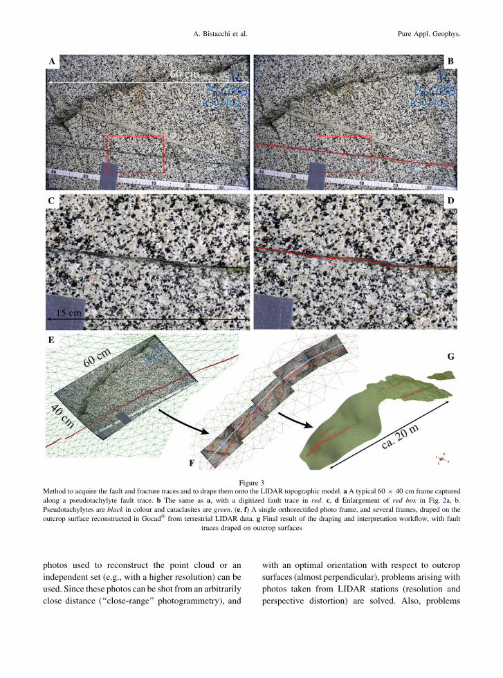
2.2. Orthorectified Photomosaics of Fault and Joints
Traces
We produced high resolution orthorectified pho-
tomosaics to obtain a detailed reconstruction of the
fault and joint traces. After a preliminary selection of
well exposed fault and joint traces that are oriented at
varying angles with respect to the net slip vector, 15
transects were collected along six pseudotachylyte-
lined slip surfaces of the GLFZ and four precursor
joints outside the fault zone. These transects comprise
a total of 154 photos, each covering an area of ca.
60 9 40 cm (Fig. 3a, b), collected with a calibrated
Nikon D700 camera with 28 mm lens, resulting in a
spatial resolution of ca. 0.15–0.2 mm/pixel (Fig. 3c,
d). Photos taken along each transect have been co-
registered by recognizing common tie points in
adjoining photos (precision estimated at a few pixels,
hence better than ca. 0.5–1 mm). Control points in
each photo were located with DGPS (accuracy ca.
2–3 cm) and the whole photo set (photomosaic)
constituting a transect was georeferenced by means of
rigid body translation and rotation using the DGPS
control points. Finally, the photomosaics were ortho-
rectified and draped on the LIDAR surface in Gocad�
(Fig. 3e, f). This procedure was followed to maintain
the best precision from each dataset. The location of
each photo with respect to the neighbouring one is
well defined at the scale of the spatial resolution of
the photos, and draping of photos on the LIDAR
surface is consistent with LIDAR and DGPS data
accuracy.
2.3. Close Range Photogrammetry
An alternative approach to high-resolution imag-
ing relies on a complete close-range photogrammetry
workflow. A detailed presentation of digital photo-
grammetry theory and techniques can be found in
KRAUS (2007). Of relevance to our study, this
technique allows one to derive a point cloud, similar
to those obtained with LIDAR, from pairs of photos
shot from different viewpoints (stereo couples).
These data, which were collected for selected
outcrops only, can be registered and merged with
the lower resolution LIDAR dataset, resulting in a
variable-resolution dataset that attains the higher
spatial resolution and accuracy only where this is
really needed (Fig. 4).
Once the point cloud is obtained, the same
workflow as above, including draping of orthorectified
high-resolution photos, can be completed. The same
Fault Roughness at Seismogenic Depths
photos used to reconstruct the point cloud or an
independent set (e.g., with a higher resolution) can be
used. Since these photos can be shot from an arbitrarily
close distance (‘‘close-range’’ photogrammetry), and
with an optimal orientation with respect to outcrop
surfaces (almost perpendicular), problems arising with
photos taken from LIDAR stations (resolution and
perspective distortion) are solved. Also, problems
Figure 3Method to acquire the fault and fracture traces and to drape them onto the LIDAR topographic model. a A typical 60 9 40 cm frame captured
along a pseudotachylyte fault trace. b The same as a, with a digitized fault trace in red. c, d Enlargement of red box in Fig. 2a, b.
Pseudotachylytes are black in colour and cataclasites are green. (e, f) A single orthorectified photo frame, and several frames, draped on the
outcrop surface reconstructed in Gocad� from terrestrial LIDAR data. g Final result of the draping and interpretation workflow, with fault
traces draped on outcrop surfaces
A. Bistacchi et al. Pure Appl. Geophys.

related to draping high-resolution photomosaics on
LIDAR surfaces that have lower spatial resolution and
accuracy may be solved using this methodology. The
main limitation with the photogrammetry approach is
that it results in huge datasets, which are cumbersome
to process and manage during subsequent interpreta-
tion, particularly if the very high resolution of the
photomosaics is to be maintained (0.2 mm/pixel), thus
it has been applied to limited areas only.
2.4. Accuracy, Precision and Spatial Resolution
Data sources and their typical spatial resolutions,
precisions and accuracies are shown in Table 1. It is
apparent that, although accuracy and precision are
separate parameters to spatial resolution, there is a
close correlation between them, at least with the
different data sources that we have used. The absolute
accuracy of topographic data with respect to a global
reference frame can be difficult to quantify. However,
the main scope of this work is the determination of
fault roughness at different length scales. Since
roughness is measured as the offset of the fault
surface with respect to a local reference line (1D
profiles) or plane (2D surfaces), it follows that in this
work we are mainly concerned with ‘‘internal’’
precision, since any systematic bias is cancelled by
the subtraction operation. Moreover, when assessing
the fractal behaviour of a rough surface, the required
precision scales with the length scale (or with the
inverse of the spatial frequency). Consequently, our
multiscale dataset is well suited for the analysis
performed here, because for the errors associated
with each type of data are much smaller than the
minimum scale of objects identified within that data.
In particular, the photomosaics provide very high
resolution and precision for the more detailed anal-
ysis (mm to m scale), whilst the lower resolution and
precision of the terrestrial and airborne LIDAR are
balanced by their larger area of coverage, which
allow high-quality analysis at the larger scales ([1 m
in wavelength).
3. Data Analysis and Modelling
In this section, we outline the workflow that leads
from 3D high-resolution outcrop imagery to the
definition of parameters that characterize fault sur-
face roughness. This workflow can be split into an
interpretation phase, carried out in Gocad�, and a
Fourier analysis phase, carried out with a custom-
made Matlab� toolbox.
3.1. 3D Imagery Interpretation
Digitizing fault traces directly in Gocad� or in
another 3D tool, either using point or line objects,
would result in an incredibly time-consuming proce-
dure if we want to pick points at the same 0.2 mm/
pixel resolution of photomosaics. For instance, a
typical 15 m long fault trace will result in ca. 75,000
hand-picked points. This problem was solved by
digitizing fault traces on photos prior to draping,
using a standard digitizing pen (of the kind used by
graphic designers) and general-purpose image pro-
cessing software. This results in a very accurate and
quick interpretation (Fig. 3a–d). The fault trace was
then imported into Gocad� using the same projection
parameters as for the underlying outcrop image
(Fig. 3e–g).
At this point in the workflow, we draped the high
resolution 3D fault traces on the outcrop surfaces
(Fig. 5a), and completed the geological interpreta-
tion. Small offsets (\2–3 cm) due to younger cross-
cutting fractures were removed and the overall
continuity of the pseudotachylyte-bearing fault traces
Figure 4Wavy fault trace 3D image draped on outcrop surface reconstructed
by photogrammetry and merged with lower-resolution LIDAR
point cloud in Gocad�
Fault Roughness at Seismogenic Depths

was restored. Using the resulting fault traces we
produced a best fit reference plane for each fault
surface in Gocad� (Fig. 5b), which is used in Fourier
analysis of the roughness (see Sect. 3.2). The
undulating topography of the outcrop surface allowed
different photomosaic transects to be produced for
each slip surface. The different photomosaics have a
variety of orientations with respect to the slip vector
of the selected fault surface (Fig. 5c). This will be
important when analyzing roughness anisotropy (see
Sect. 3.2).
Other structural data (e.g., fault separations) were
collected on 3D images and exported as ASCII XYZ
tables for the following steps of the analysis.
Additional fault traces were identified and picked
directly from the raw airborne and terrestrial laser-
scan data (Fig. 2). Due to the lower resolution of
these data, this was most effective for faults associ-
ated with some topography, such as a small gully or
break in slope. Picking of fault traces was carried out
manually using RiSCAN PRO� software, and points
along the fault traces were exported as ASCII XYZ
table for further analysis.
3.2. Fourier Analysis of Fault Traces
The Matlab� script (available upon request from
the author) used to analyze fault surface roughness is
composed of several data processing and analysis
functions, each one with different options: (1) pre-
process data (clean and choose monotonic dimen-
sion); (2) define best-fit interpolating plane; (3) select
‘‘almost straight’’ segments from a profile; (4)
resample data; (5) calculate orthogonal offset from
best-fit plane; (6) apply taper function; and (7)
conduct power spectrum analysis. In addition, func-
tions for loading and saving data (including ancillary
structural data such as slip vector, net slip) and
Figure 5Determination of fault surface roughness with respect to a reference average fault plane. a Fault traces draped on outcrops. b Interpolation of
best fit plane with Principal Component Analysis (PCA) for each fault strand. c Selection of ‘‘almost straight’’ fault traces, making different
angles with respect to slip vector, for Fourier analysis
A. Bistacchi et al. Pure Appl. Geophys.

plotting functions are provided, resulting in an
integrated analysis toolbox. Here we give details
about the most important and critical points in a
typical analysis.
In the pre-processing function, raw data imported
from Gocad� (or any other source of roughness data)
is cleaned to eliminate duplicate points and points
that do not follow a strict monotonic succession along
a chosen direction, either X, Y or Z. This is necessary
for Fourier analysis.
An interpolating best fit reference plane can be
defined in different ways. This step of the analysis is
non-trivial since roughness is defined as the deviation
of points on a non-planar surface measured normal to
the reference plane, and in Fourier analysis it is
required that the dataset has no trend or large-scale
slope discontinuities in general with respect to the
reference. Options provided in our Matlab� toolbox
include input of the reference plane defined in
Gocad� or interpolation of a best fit plane by means
of principal component analysis (PCA). PCA seems
better suited than traditional least squares to fitting a
mean plane to a point cloud, since uncertainty along
X, Y and Z is treated in the same way, whilst in least
squares the plane is seen as Z = a(X,Y), with
uncertainty in Z only, and the result may change if
functions X = b(Y,Z) or Y = c(X,Z) are considered.
Then an arbitrary segment or a complete fault
trace can be selected for the analysis. We chose
transects in the field based on our ability to gather
data on fault surface traces at pitches (i.e., rakes)
ranging from parallel to nearly perpendicular to slip
vectors deduced from fault surface striations. As
shown in Fig. 5, this ability was dictated by the
intersection of the fault surface with undulating rock
outcrop topography (i.e., the fault trace). If roughness
anisotropy (i.e., how the roughness in a fault surface
varies along profiles oriented at different angles with
respect to the slip vector) is to be investigated, it is
important that each fault segment selected for Fourier
analysis is almost straight so that the fault trace has a
constant angle with respect to the rake or pitch.
Data from each fault segment are used to calculate
the offset function h(x), defined as the distance
measured orthogonal from the reference plane
(Fig. 6a, b). This kind of profile can be immediately
interpreted in terms of root mean square roughness
rRMS ¼ffiffiffiffiffiffiffiffiffiffiffiffiffiffiffiffiffiffiffiffiffiffiffiffi
1
L
Z
L
h2ðxÞdx
v
u
u
t ð1Þ
where L is the profile length. This is the quadratic
mean of the offset with respect to the reference sur-
face, as shown in Fig. 6c.
Then the offset function h(x) is re-sampled to a
constant spacing (spatial frequency) by means of a
moving average filter (Fig. 6d). This, being a low-
pass filter, does not introduce biases in power spectra.
These data are then multiplied by a taper function
(Fig. 6e), to avoid edge effects due to abrupt
truncation of data at the extremities of the measured
trace, and are ready for Fourier analysis.
Power spectral density functions have been calcu-
lated with three different methods, yielding similar
results, but with a different noise level. The classical
periodogram method (SCHUSTER, 1898), which
involves taking the square of the modulus of the Fast
Fourier Transform (FFT), gives reliable results, but
with a higher noise level. The Thomson Multitaper
Method (MTM, THOMSON, 1982) and Welch method
(WELCH, 1967) are characterized by a lower noise level
(generally the Welch method is the preferred method),
but in general the overall shape of the power spectrum
is the same for all three methods. Results of this
analysis are shown in Fig. 7, in terms of power spectral
density profiles, where f is the spatial frequency in m-1
and P(f) is power spectral density in m3 (these units
represent a squared amplitude in m2 divided by a
spatial frequency in m-1). Note that spatial frequency
can be indicated also as the wavenumber (but some-
times a 2p factor is included in this quantity), and is the
reciprocal of the wavelength k.
Sensitivity of all methods to different resampling
frequencies and taper functions has been tested, and
the results are considered quite robust. We have also
tested the estimate of power spectral density based on
the Lomb-Scargle algorithm (PRESS et al., 2007),
which does not require resampling of the dataset to a
constant spacing, as it is not based on the FFT. The
Lomb–Scargle algorithm yielded results similar to
those of the other methods, but with a higher noise
level, particularly at high frequencies, and it is very
slow in terms of computation time, so we discarded
this method in our analysis.
Fault Roughness at Seismogenic Depths

To better understand the physical meaning of this
kind of analysis, we may recall that (Wiener–
Khinchin theorem, in JAMES, 2002) the power spectral
density P(f) corresponds to the Fourier transform of
the autocorrelation function C(Dx) of the offset
function h(x)
Pðf Þ� CðDxÞ ð2Þ
where the autocorrelation function, defined as the
cross-correlation of a signal with itself, measures the
correlation between a profile and itself, when it is
shifted by a certain distance Dx
CðDxÞ ¼Z þ1
�1hðxþ DxÞhðxÞdx ð3Þ
To clarify its meaning, we recall that the
autocorrelation of a periodic signal is periodic with
the same period as the signal. On the other hand, the
autocorrelation of white noise tends to zero, exclud-
ing a sharp maximum at Dx = 0. When applied to
spatial data, the meaning of the autocorrelation
function is very similar to that of the variogram as
defined in geostatistics, and in fact some authors have
used this kind of analysis for fault roughness data
(e.g., ECKER and GELFAND, 1999).
This being the integral of the power spectral
density over a certain interval (in the frequency
domain) equals the squared variance of the input
signal, hence the root mean square roughness can be
also defined as
rRMS ¼
ffiffiffiffiffiffiffiffiffiffiffiffiffiffiffiffiffiffiffiffiffiffiffiffiffiffi
Z fmax
fmin
P fð Þdf
s
ð4Þ
This highlights the relationship between the
power spectrum and the root mean square roughness,
which can be seen as a sort of ‘‘averaged’’ roughness,
but still is scale-dependent for a self-affine profile,
since it depends on the integration interval [fmin,
fmax], and hence on the length scales over which it is
measured.
Up to this point in the discussion, we have
assumed, without proving it, that fault or fracture
surfaces may show a ‘‘fractal’’, self-similar or self-
affine topography or roughness (MANDELBROT, 1982,
1985). When analyzed by means of power spectral
Figure 6A typical fault trace profile ready for Fourier analysis, with (b) or without (a) vertical scale exaggeration. Insets highlight the geometrical
meaning of h(x) and rRMS (c), and the moving average filter (d) and taper function (e) applied to profiles prior to Fourier analysis
A. Bistacchi et al. Pure Appl. Geophys.

density functions, surfaces are defined ‘‘fractal’’ if
they show a linear decay in power spectrum, when
represented in a Log–Log diagram, which implies
a power-law decay characterized by a certain
exponent
Pðf Þ ¼ P1f�ð1þ2HÞ ð5Þ
or
logðPÞ ¼ logðP1Þ � ð1þ 2HÞ logðf Þ ð6Þ
where H is the Hurst exponent and P1 is the prefactor
of the power spectral density. Both these parameters
can be obtained by linear regression in a Log–Log
plot. Results are shown in Figs. 7–10. The coefficient
of determination R2 for linear regression was always
between 0.92 on 0.96 in this study. Substituting (5) in
(4) we obtain
rRMS ¼
ffiffiffiffiffiffiffiffiffiffiffiffiffiffiffiffiffiffiffiffiffiffiffiffiffiffi
Z fmax
fmin
P fð Þdf
s
¼
ffiffiffiffiffiffiffiffiffiffiffiffiffiffiffiffiffiffiffiffiffiffiffiffiffiffiffiffiffiffiffiffiffiffiffiffiffi
Z fmax
fmin
P1f�ð1þ2HÞdf
s
¼
ffiffiffiffiffiffiffiffiffiffiffiffiffiffiffiffiffiffiffiffiffiffiffiffiffi
P1f�2H
�2H
� �fmax
fmin
s
ð7Þ
where we can easily see that rRMS scales with f –H,
hence with kH. This explains why a surface can be
defined as self-similar for H = 1 and self-affine for
H \ 1. In the first case, the geometric pattern of the
surface is replicated self-similarly at every length
scale, as the amplitude of the deviations from the
reference plane increases linearly with wavelength. In
the self-affine case, a scaling factor is applied to the
replicating pattern (SCHMITTBUHL et al., 1995a), which
introduces a decay of roughness at increasing
Figure 7Power spectral density analysis of faults and joints. a Power spectral density profiles for joint traces imaged with photomosaics. b Power-law
fit for joint profiles. c Power spectral density profiles for fault traces imaged with LIDAR (larger scale) and photos (smaller scale). All data,
independently of the orientation and length scale, are included in this plot. d Power-law fit for fault profiles
Fault Roughness at Seismogenic Depths

wavelengths. This implies that the fault trace tends to
a straight line (or the fault surface tends to a plane) at
large scale. Most natural fault and fracture surfaces,
and fracture surfaces produced in experiments, show
a self-affine behaviour with 0.8 C H C 0.5 (e.g.,
SCHMITTBUHL et al., 1993; AMITRANO and SCHMITTBUHL,
2002).
Roughness anisotropy can be recognized compar-
ing H, rRMS and P1 for profiles collected along a
single fault, but with different orientation with
respect to the slip vector (e.g., LEE and BRUHN,
1996). The same parameters also make it possible
to compare roughness of different fault surfaces (e.g.,
faults with different net slip, or faults developed in
different rocks). The root mean square roughness
rRMS seems to be a ‘‘natural’’ parameter to compare
the average roughness of different profiles, but it
should be used with some caution because it is a
function of the frequency interval. In this work we
have considered rRMS calculated over a standard
interval that covers our entire dataset, with
fmax = 102 and fmin = 10-2. All these results, regard-
ing P(f), H, P1 and rRMS for different faults and
joints, will be discussed in the following section.
3.3. Generation of Synthetic Self-Affine Fault
Surfaces
Synthetic self-affine fault surfaces can be gener-
ated using, for example, algorithms by BIERME et al.
(2007), and CLAUSEL and VEDEL (2009), which have
already been applied to natural faults by CANDEL-
A et al. (2009). Other algorithms are available and are
very common in materials science and tribology, as
shown for instance in WU (2002). These algorithms
accept as input parameters the Hurst exponent H and
the prefactor P1. The surfaces generated with this
method are different at each run (the algorithms
produce random surfaces), but they all share the input
statistical parameters H, P1, rRMS. On mathematical
grounds, using parameters determined from 1D
power spectrum analysis in 2D Fourier synthesis is
justified, since the 2D Fourier transform always has
separable variables in the frequency domain, even in
cases where variables are not separable in the spatial
domain (JAMES, 2002). In other words, the 2D Fourier
transform is by definition composed of two separable
1D transforms in the frequency space, hence it is
always possible to reconstruct it from its parts as we
do here.
In a first instance, we have used this kind of
synthetic surface to validate our analysis. After
having generated surfaces with given H and P1, we
were able to extract linear profiles oriented in
different directions (simulating the sampling operated
by outcrops), analyze them as specified in the
previous chapter, and obtain correct H and P1 values
(error \10%). This test supports the robustness of our
workflow.
Moreover, this kind of algorithm is particularly
useful because the output 2D synthetic surfaces can
be used in a wide spectrum of applications as a
realistic fault surface model.
4. Roughness of Faults at Seismogenic Depths
Traces of slip surfaces of the GLFZ and precursor
joints have been analyzed at length scales ranging
between ca. 500 m and 0.5 mm with a combination
of LIDAR and photomosaic data. In this section we
present results of roughness power spectral density
analysis for slip surfaces and precursor joints, the
latter outcropping a few hundred meters outside the
fault zone. We compare these results with the scale of
faults, present data on roughness anisotropy, and
finally show some modelling results from 2D Fourier
synthesis.
Precursor joints (12 m–0.5 mm scale) show a
very consistent self-affine roughness, with power
spectra that appear as straight lines in a Log–Log
diagram (Fig. 7a). Interpolating with a power-law of
the form of Eq. 6 (Fig. 7b) yields Hurst exponents
H = 0.82 ± 0.02, prefactors P1 = 3.6 9 10-5 ±
1.5 9 10-5 m2, and root mean square roughness
rRMS = 0.20 ± 0.05 m (integrated over the interval
10-2 B f B 102 m-1) (Fig. 8a). These results are not
influenced by the direction of the measured profile,
hence roughness of precursor joints is isotropic.
Considering faults, power spectral density func-
tions are quite consistent over the ca. 500 m to
0.5 mm range, and show a relatively constant slope in
a Log–Log diagram, which can be interpreted as
evidence for self-affine behaviour (Fig. 7c). Fault
A. Bistacchi et al. Pure Appl. Geophys.

traces interpreted directly on the LIDAR data at lar-
ger scale show more noise (Fig. 7c), but in any case
can be compared with data collected with high-res-
olution photos, and it must be noted that all profiles
lie approximately on the same trend, for frequencies
between 4 9 10-2 and 3 9 102 m-1, indicating a
general self-affine behaviour. Interpolating with
power-laws of the form of Eq. 6 (Fig. 7d) yields
Hurst exponents in the range 0.5 B H B 0.9, pre-
factors in the range 0.03 9 10-5 B P1 B 15 9
10-5 m2, and root mean square roughnesses in the
range 0.04 B rRMS B 0.55 m (integrated over the
interval 10-2 B f B 102 m-1) (Fig. 8b). The root
mean square roughness shows a positive relationship
with the Hurst exponent, hence smoother profiles are
particularly smooth at large wavelengths (small fre-
quencies). On the other hand, prefactors do not show
any relationship with H (Fig. 8b). Noteworthy, values
measured on precursor joints lie on the same trend,
but in a more limited field, as values measured on
faults (Fig. 8, compare a, b). Considering faults
measured at small scale, with spatial frequencies in
the 100 to 3 9 102 m-1 range, the Hurst exponents
show a marked variability, between ca. 0.55 and 0.85.
Considering larger profiles, picked directly on
LIDAR data, which yield power spectra in the
4 9 10-2 to 100 m-1 frequency range, the Hurst
exponents do not show this variability and show
values of ca. 0.70–0.80 (Fig. 8b).
We have investigated the anisotropy of slip sur-
faces using data collected along fault traces forming
an angle between 0� and 75� to the slip vector.
Plotting H and rRMS versus the angle between the
measured fault trace and the slip vector, a positive
Figure 8Parameters defined from power-law fit of joint and fault power spectral density profiles. a Hurst exponent versus rRMS and P1 for joints.
b Hurst exponent versus rRMS and P1 for faults. Fields with values of large scale faults and joints are highlighted
Fault Roughness at Seismogenic Depths

relationship can be detected for both parameters.
Considering (as above) the higher spatial frequencies
between 100 and 3 9 102 m-1, the Hurst exponent
varies between 0.55–0.6 along slip and 0.8–0.85 at a
high angle to the slip vector (Fig. 9), whilst the root
mean square roughness varies between 0.04 and
0.55 m. This means that faults are smoother along
slip, and that this departure from isotropy is more
marked at small frequencies (large wavelengths). On
the other hand, faults do not show any anisotropy at
larger wavelengths (4 9 10-2 to 100 m-1).
In Fig. 10 we present four examples of profiles
measured on the same fault, but at different angles to
the slip vector. In all four examples the slope of the
power spectrum is lower (hence H is lower) for
profiles collected parallel to the slip vector. This
confirms the different distribution of roughness with
wavelength depending on direction (faults are rela-
tively smoother at large wavelengths when measured
parallel to the slip vector). However, interpreting the
absolute elevation of these curves, collected along a
single fault trace segment, is more difficult. In fact,
the along-slip power spectrum can be locally higher
or more depressed than the one measured at high
angle to the slip vector. This is due to a fine scale
variability in the prefactor P1, already evidenced by
CANDELA et al. (2009), which, at small scales,
strongly depends on where on a single fault it is
measured, due to the variability of roughness at large
scale (this is another effect of the self-affine nature of
fault roughness). Hence, the absolute elevation of
roughness profiles is better defined by averaging a
large number of measurements carried out on dif-
ferent fault traces.
Finally, in Fig. 11 we show in map view a
40 9 40 m 2D fault surface generated using a 2D
synthesis algorithm modified after the one provided
by CANDELA et al. (2009), with mean Hurst exponent
and prefactor values of the GLFZ slip surfaces
(H = 0.75, P1 = 0.4 9 10-5). The maximum offset
of the synthetic surface with respect to the reference
average plane is of ca. 15 cm, and the distribution of
roughness at different wavelengths, controlled by the
Hurst exponent, is highly realistic. Anisotropy was
not considered here because we have seen that it is
relevant only at small wavelengths. These synthetic
surfaces will be used in next-generation, highly
realistic models of seismic rupture propagation which
will include constitutive friction equations obtained
in the laboratory (DI TORO et al., 2009).
5. Discussion
One of the main goals of this study is the devel-
opment of a methodology which exploits well-exposed
Figure 9Roughness anisotropy of faults. Hurst exponent and rRMS are plotted versus the angle between the measured fault trace and the slip vector.
Parent-values of cooling joints and inferred qualitative trends for small-scale faults (red) are evidenced
A. Bistacchi et al. Pure Appl. Geophys.

fault traces to define the roughness of fault surfaces
over several length scales (almost five orders of
magnitude in this work). According to the method
proposed here, this is possible by combining LIDAR
scans of large and polished outcrop surfaces with
high-resolution orthorectified photos of fault traces.
Compared to the direct measurement of fault sur-
faces, this methodology has several advantages. One
of the major advantages is that it allows reconstruc-
tion of fault surface geometry based on numerous
exposed fault traces which have variable orientations
with respect to the slip vector. This is a common
situation in many outcrops (in contrast to the very
rare occurrence of exposed fault surfaces), and hence
the methodology proposed here may be widely
applied. A second advantage is that, since surface
roughness is determined from fault traces and not
from surfaces exposed to the atmosphere, the
measurement of roughness is not influenced by
weathering processes. Finally, because both hanging
wall and foot wall, and the interposed fault rocks, are
preserved, fault displacements, fracture distributions,
and fault rock assemblages can be surveyed and
quantified, and precisely georeferenced samples can
be collected. Then these data can be related to fault
surface geometry in order to shed new light on fault
zone processes involving roughness development and
refinement.
Regarding the GLFZ case study, the analysis of
fault surface roughness (sect. 4) yield further insights
into the mechanical evolution of this fault zone
(DI TORO et al., 2009).
Precursor cooling joints are relatively smooth,
show a Hurst exponent of ca. 0.8, and no anisotropy.
This is common for joints in rocks, developed under
different conditions (SCHMITTBUHL et al., 1995a), and
Figure 10Roughness anisotropy of individual faults. Each plot represents a fault for which different traces have been measured, with different
orientations with respect to the slip vector
Fault Roughness at Seismogenic Depths

has been interpreted as consistent with ‘‘Brownian
motion’’ models of fracture growth in heterogeneous
materials (e.g., MANDELBROT, 1985). Of interest in
this study, these values (Fig. 8a) must be taken as a
‘‘starting point’’ in the evolution of roughness of the
GLFZ seismogenic slip surfaces, which exploit the
pre-existing joints (DI TORO et al., 2009).
Roughness of seismogenic slip surfaces can be
readily related to that of joints. In fact, the field
covered by fault values overlaps that of joints
(Fig. 8), but is much larger, extending particularly
towards lower H and rRMS values, with some
exceptions showing higher values (Fig. 8). If we
consider anisotropy, we see that H and rRMS values
lower than those of joints are represented by mea-
surements of fault traces lying almost parallel to the
slip vector, measured at wavelengths in the 1 m to
5 mm range (Fig. 9). On the other hand, the (few)
values higher than those of joints result from mea-
surements performed at a high angle to the slip
vector. When fault traces are characterized at larger
wavelengths, they do not show this evolution and are
quite similar to precursor joints (Fig. 8).
This can be interpreted in terms of roughness
evolution with slip accumulation, taking place par-
ticularly in the along-slip direction, as already
evidenced for other faults (e.g., SAGY and BRODSKY,
2009; CANDELA et al., 2009) and also in laboratory
experiments (AMITRANO and SCHMITTBUHL, 2002).
This evolution should be related to some sort of very
generalized ‘‘wear’’ mechanism (e.g., POWER et al.,
1987), including, for the pseudotachylyte-bearing
GLFZ slip surfaces, also frictional melting in ‘‘wear’’
processes. As in experiments (AMITRANO and
SCHMITTBUHL, 2002) and other natural faults (CAN-
DELA et al., 2009), this evolution is associated to a
reduction of the Hurst exponent, which means that
asperities are smoothed out preferentially at larger
wavelengths. However, for the GLFZ we observe this
kind of evolution only for the 1 m to 5 mm wave-
length range, and not at larger scales, as in previous
contributions on natural faults. This deserves a more
detailed discussion, but first we must recall that the
GLFZ slip surfaces show net slip values in the
1–10 m range, whilst faults considered, e.g., in CAN-
DELA et al. (2009) show larger displacements of some
hundreds of meters.
Importantly, the architecture of these larger-scale
fault zones is different from that of the GLFZ, as it
usually includes one, or just a few, well-developed,
metre-thick fault cores embedded in a well defined
damage zone tens to hundreds of metres thick (see
BEN-ZION and SAMMIS, 2003, for an extended discus-
sion). This architecture is consistent with the
occurrence of absolutely (in terms of friction coeffi-
cient) and relatively (with respect to the wall rocks)
weak fault rock assemblages (usually non-cohesive
fault gouges). In this case, fault zones show a pro-
gressive localization of strain within a few cataclastic
horizons (i.e., the fault core). Continued localization
of strain within the fault core leads to a significant
evolution of fault surface roughness for displace-
ments [ca. 100 m due to refinement (smoothing out)
of asperities along slip, resulting in a characteristic
large scale ‘‘striation’’ and marked roughness
anisotropy (POWER et al., 1988; SAGY and BRODSKY,
2009). This kind of localization also induced BEN-
ZION and SAMMIS (2003) to conclude that most large-
scale fault zones evolve towards a geometrically
simple structure, which is satisfactorily modelled as a
discrete Euclidean surface embedded in a continuum
(see BISTACCHI et al., 2010, for a 3D model based on
this geometrical framework).
Figure 11Map view of a synthetic 2D self-affine surface generated using
roughness parameters equivalent to those of the GLFZ. Colour
scale indicates deviation with respect to the reference average fault
plane
A. Bistacchi et al. Pure Appl. Geophys.

Instead in the GLFZ, exhumed from deeper
crustal levels (about 10 km), we witness the compe-
tition between a pre-existing weak and anisotropic
fabric, represented by the cooling joints, and a syn-
kinematic induration process. This (DI TORO et al.
2009) takes place due to cementation (precipitation of
epidote and K-feldspar from hydrothermal fluids
circulating in the cataclasites) and welding (solidifi-
cation of friction melts), and contrasts the weakening
and localization mechanisms described above. Hence
(seismic) slip is initially localized along a ‘‘weak
link’’ - a cooling joint, but then, because of the local
induration and hardening of fault rocks, it is pro-
gressively transferred away from the currently active
joint, towards another cooling joint that has not
already experienced slip and induration. It follows
that induration processes and exploitation and linkage
of pre-existing joints results in an array of individual
fault strands, which record small individual dis-
placements (\20 m). This de-localization process
also results in an unusual thickness of the fault zone
(about 550 m) with respect to total accommodated
slip (1,100–1,500 m).
The GLFZ-type structure (localized but limited
slip on individual fault strands distributed in a wide
fault zone) seems common at seismogenic nucle-
ation depths, and appears to be typical of other
indurated cataclasite- and pseudotachylyte-bearing
fault zones hosted in the crystalline basement (e.g.,
GROCOTT, 1981; SWANSON, 1988; ALLEN, 2005;
GRIFFITH et al., 2008). In terms of the geometrical
frameworks for fault zone characterization discussed
by BEN-ZION and SAMMIS (2003), this structure
should be described as a ‘‘fractal’’ fault zone, pos-
sibly posing some problems in terms of how to
introduce such a complex geometry in numerical
models of faults.
Coming back to the roughness evolution, we
may interpret our data saying that, on each slip
surface, we see an initial roughness evolution with
slip, evidenced by an anisotropic decrease in H with
respect to the joint’s parent value, but only at
wavelengths of the same order of magnitude as the
net slip accumulated on that particular slip surface.
Then slip migrates to another joint due to indura-
tion, and the slip and roughness evolution cycle is
repeated.
Concluding, we may say that the mechanical
evolution of fault rock assemblages is one of the main
factors controlling roughness evolution (including
anisotropy) and smoothing of fault surfaces with slip.
Particularly, at seismogenic depths, where fault rock
induration processes are active, roughness evolution
and refinement of the fault surface might be active
only at relatively small scales, in contrast to what
suggested by studies conducted on fault surfaces
exhumed from shallower crustal depths, where
localization processes are more effective.
6. Conclusions
We analyzed the surface roughness of faults and
joints using an innovative and efficient workflow that
can be applied to other well-exposed outcrops of fault
zones, potentially improving the database on fault
roughness that was previously limited to fault sur-
faces exposed in quarries or other particular
situations. From a methodological point of view,
compared to direct measurements of exposed fault
surfaces, the technique presented here has the
advantages that: (1) it can be applied to a wide range
of fault zones and outcrops; (2) hanging wall, foot
wall and fault rocks are well preserved and all their
structural features can be measured and related to
fault roughness; (3) the measured roughness is not
affected by weathering processes; (4) data collected
with LIDAR and high-resolution photos can be
merged to reconstruct power spectra spanning five
orders of magnitude.
Regarding the Gole Larghe Fault Zone, our con-
clusions are that (1) roughness of seismogenic fault
surfaces is inherited from precursor cooling joints,
and (2) roughness of seismogenic fault surfaces show
an evolution with slip only at the same length-scale as
the total accumulated slip, which for individual slip
surfaces of the GLFZ is in the 1–10 m range. In other
words, net slip on these faults was not sufficient to
produce significant fault surface refinement and
smoothing at large scale. This contrasts with obser-
vations from other larger-displacement faults,
exhumed from shallower depths, described in the
literature. The differences in roughness between
shallow (strong smoothing of roughness parallel to
Fault Roughness at Seismogenic Depths

slip at all scales) and deep seismogenic faults
(roughness evolution limited to the small wave-
lengths) might result from markedly different
mechanical properties of fault rock assemblages. The
previously studied shallow faults are weak in a rela-
tive and absolute sense; this results in localization
and accumulation of slip in a few cataclastic horizons
subject to intense surface refinement. The deeper-
seated GLFZ is strong both in a relative and absolute
sense due to syn-kinematic induration processes; this
results in de-localization and reduced fault surface
refinement.
Finally, data collected by this methodology are
significant for numerical modelling of earthquakes,
since they can be used to generate 3D synthetic fault
surfaces with a highly realistic geometry.
Acknowledgments
Fieldwork, meso-scale structural analysis and photo-
mosaic collection was carried out by AB and WAG.
Lidar data collection, processing and interpretation
was performed by SAS and RJ. Photogrammetry and
photomosaic processing, interpretation and 3D data
integration by AB. The Matlab� toolbox used for
the analysis was developed by AB (who also carried
out the analysis), with contributions by WAG and
SN. GDT developed and coordinated the project,
and introduced the team to the GLFZ. The paper
was written by AB with contributions from all
the co-authors. This study is funded by the Euro-
pean Research Council Starting Grant Project
205175 USEMS (http://www.roma1.ingv.it/laboratori/
laboratorio-hp-ht/usems-project). WAG was funded
by the National Science Foundation grant OISE-
0754258. The Gocad Research Group and Paradigm
Geophysical are acknowledged for welcoming Pado-
va University into the Gocad Consortium (http://
www.Gocad.org). The Provincia Autonoma di Trento
Geological Survey is acknowledged for providing
aerial LIDAR data. Elena Spagnuolo is warmly
acknowledged for useful suggestions on the Fourier
analysis section. Silvia Mittempergher and Andre
Niemeijer are thanked for sharing hard days working
with the DGPS on the Lobbia outcrops.
REFERENCES
ALLEN, J.L. (2005), A multi-kilometer pseudotachylyte system as an
exhumed record of earthquake rupture geometry at hypocentral
depths (Colorado, USA), Tectonophysics 402, 37-54.
AMITRANO, D., AND SCHMITTBUHL, J. (2002), Fracture roughness and
gouge distribution of a granite shear band, Journal of Geo-
physical Research, 107 (B12), 2375, doi:10.1029/2002JB001761.
BEN-ZION, Y., AND SAMMIS, C. (2003), Characterization of fault
zones, Pure and Applied Geophysics 160, 677-715.
BIERME, H., MEESCHAERT, M.M., AND SCHEFFLER, H.-P. (2007),
Operator scaling stable random fields, Stochastic Processes and
their Applications 117, 312-332.
BISTACCHI, A., MASSIRONI, M., AND MENEGON, L. (2010), Three-
dimensional characterization of a crustal-scale fault zone: the
Pusteria and Sprechenstein fault system (Eastern Alps), Journal
of Structural Geology, 32, 2022-2041.
BROWN, S.R., AND SCHOLZ, C.H. (1985), Broad bandwidth study of
the topography of natural rock surfaces, Journal of Geophysical
Research 90, 12575-12582.
CANDELA, T., RENARD, F., BOUCHON, M., BROUSTE, A., MARSAN, D.,
SCHMITTBUHL, J., AND VOISIN C. (2009), Characterization of fault
roughness at various scales: implications of three-dimensional high
resolution topography measurements, Pure and Applied Geophys-
ics 166 (10), 1817-1851, DOI:10.1007/s00024-009-0521-2.
CLAUSEL, M., AND VEDEL, B. (2009), Explicit constructions of
operator scaling stable random Gaussian fields, Submitted to
Advances in Applied Probability.
DI TORO, G., AND PENNACCHIONI G. (2005), Fault plane processes
and mesoscopic structure of a strong-type seismogenic fault in
tonalites (Adamello batholith, Southern Alps), Tectonophysics
402, 55-80.
DI TORO, G., PENNACCHIONI, G., AND NIELSEN, S., Pseudotachylytes
and Earthquake Source Mechanics, In Fault-zone Properties and
Earthquake Rupture Dynamics (ed. Eiichi Fukuyama) (Interna-
tional Geophysics Series, Elsevier, 2009) pp. 87-133.
DI TORO, G., NIEMEIJER, A.R., TRIPOLI A., NIELSEN S., DI FELICE F.,
SCARLATO P., SPADA G., ALESSANDRONI R., ROMEO G., DI STEFANO
G., SMITH S. AND MARIANO S. (2010), From field geology to
earthquake simulation: a new state-of-the-art tool to investigate
rockfriction during the seismic cycle (SHIVA). Rendiconti Lincei
21 (Suppl 1) 95-114.
ECKER, M.D., AND GELFAND, A.E. (1999), Bayesian modeling and
inference for geometrically anisotropic spatial data, Mathemat-
ical Geology 31 (1), 67-83.
GRIFFITH, W.A., DI TORO, G., PENNACCHIONI, G., AND POLLARD, D.D.
(2008), Thin pseudotachylytes in Faults of the Mt. Abbot
Quadrangle, Sierra Nevada : physical constraints for small
seismic slip events, Journal of Structural Geology, 30,
1086-1094.
GROCOTT, J. (1981), Fracture geometry of pseudotachylyte gener-
ation zones: a study of shear fractures formed during seismic
events, Journal of Structural Geology 3, 169-178.
JAMES, J.F., A Student’s Guide to Fourier Transforms, with
Applications in Physics and Engineering, 2nd Ed. (Cambridge
University Press, Cambridge 2002).
KRAUS, K., Photogrammetry, 2nd Ed. (De Gruyter, Berlin 2007).
LEE, J.-J., AND BRUHN, R.L. (1996), Structural anisotropy of normal
fault surfaces. Journal of Structural Geology 18 (8), 1043-1059.
A. Bistacchi et al. Pure Appl. Geophys.

MALLET, J.-L., Geomodeling (Oxford University Press, Oxford
2002).
MANDELBROT, B.B., The fractal geometry of nature (W. H. Freeman,
New York 1982).
MANDELBROT, B.B. (1985), Self-affine fractals and fractal dimen-
sion, Physics Scripta 32, 257-260.
PENNACCHIONI, G., DI TORO, G., BRACK, P., MENEGON, L., AND VILLA,
I. M. (2006), Brittle-ductile-brittle deformation during cooling of
tonalite (Adamello, Southern Italian Alps), Tectonophysics
427(1-4), 171-197.
POWER, W.L., TULLIS, T.E., BROWN, S.R., BOITNOTT, G.N., AND
SCHOLZ C.H. (1987), Roughness of natural fault surfaces, Geo-
physical Research Letters 14 (1), 29-32.
POWER, W.L., TULLIS, T.E., AND WEEKS, J.D. (1988), Roughness and
wear during brittle faulting, Journal of Geophysical Research 93
(B12), 15268-15278.
PRESS, W.H., TEUKOLSKY, S.A., VETTERLING, W.T., AND FLANNERY,
B.P., Numerical Recipes, 3rd Ed. (Cambridge University Press
2007).
RENARD, F., VOISIN, C., MARSAN, D., AND SCHMITTBUHL, J. (2006),
High resolution 3D laser scanner measurements of a strike-slip
fault quantify its morphological anisotropy at all scales, Geo-
physical Research Letters 33 (L04305), doi:
10.1029/2005GL025038.
SAGY, A., AND BRODSKY, E.E. (2009), Geometric and rheological
asperities in an exposed fault zone, Journal of Geophysical
Research 114, B02301.
SAGY, A., BRODSKY, E.E., AND AXEN, G.J. (2007), Evolution of fault-
surface roughness with slip, Geology 35 (3), 283-286.
SCHMITTBUHL, J., GENTIER, S., AND ROUX, S. (1993), Field mea-
surements of the roughness of fault surfaces, Geophysical
Research Letters 20 (8), 639-641.
SCHMITTBUHL, J., SCHMITT, F., AND SCHOLZ, C.H. (1995a), Scaling
invariance of crack surfaces, Journal of Geophysical Research
100 (B4), 5953-5973.
SCHMITTBUHL, J., VILOTTE, J.-P., AND ROUX, S. (1995b), Reliability of
self-affine measurements, Physical Review E 51 (1), 131-147.
SCHOLZ, C.H., The Mechanics of Earthquakes and Faulting 2nd Ed.
(Cambridge University Press, New York 2002).
SCHUSTER, A. (1898), On the investigation of hidden periodicities
with application to a supposed 26 day period of meteorological
phenomena, Terrestrial Magnetism and Atmospheric Electricity
3, 13-41.
SWANSON, M.T. (1988), Pseudotachylyte-bearing strike-slip duplex
structures in the Fort Foster Brittle Zone, S. Maine, Journal of
Structural Geology 10, 813-828.
THOMSON, D.J. (1982), Spectrum estimation and harmonic analysis,
Proceedings IEEE 70, 1055-1096.
WELCH, P.D. (1967), The use of fast Fourier transform for the
estimation of power spectra: a method based on time averaging
over short, modified periodograms, IEEE Transactions on Audio
Electroacoustics AU-15, 70-73.
WU, J.-J. (2002), Analyses and simulation of anisotropic fractal
surfaces, Chaos, Solitons and Fractals 13 (9), 1791-1806.
(Received September 16, 2010, revised February 1, 2011, accepted February 1, 2011)
Fault Roughness at Seismogenic Depths
Copyright © 2022 FDOKUMEN