Red Soils in Indonesia - WUR eDepot
152
P. Buurman (Editor) Red Soils in Indonesia qp Centre for Agricultural Publishing and Documentation Wageningen — 1980 ri-,--..,. ^ HUO^'OX/ ^ W "-
-
Upload
khangminh22 -
Category
Documents
-
view
2 -
download
0
Transcript of Red Soils in Indonesia - WUR eDepot
P. Buurman (Editor)
Red Soils in Indonesia
qp Centre for Agricultural Publishing and Documentation
Wageningen — 1980 r i - , - - . . , .
^ HUO^'OX/ ^ W " -
Abstract
Buurman, P. (Editor) (1980). Red Soils in Indonesia. Agric. Res. Rep. (Versl. landbouwk. Onderz.) 889, ISBN 90 220 0715 4, Bulletin No. 5, Soil Research Institute, Bogor (xii+169p., 29 figs, 31 tables, 124 refs, 11 app.).
Six case studies on soil formation in Indonesia are presented, preceded by a general paper commenting on suitability for cultivation and problems of classification, and by a paper on soil classification in Indonesia.
The case studies comprised soils on andesitic volcanic material between 100 and 1000 m altitude (West and East Java), on granodiorite (West Kalimantan), on acid volcanic tuffs (West Sumatra), on felsic sedimentary and metamorphic rocks (south-east Sulawesi) and on ultramafic rocks (South-East Sulawesi). Detailed analysis of soils, ranging from Oxic and Typic Dystropepts through Alfisols and Ultisols to Acrorthox and Eutrorthox, are included. Discussions are mainly on soil classification, the use of exchange characteristics and soil genesis.
One paper describes mathematical relations between various exchange properties.
Free descriptors: Red Yellow Podzolic Soils, Latosols, Mediterranean Soils, Toposequence.
Drawings: P. G. M. Versteeg Photographs: Z. van Druuten after slides by P. Buurman
ISBN 90 220 0715 4
© Centre for Agricultural Publishing and Documentation, Wageningen, 1980
No part of this book may be reproduced and/or published in any form, by print, photoprint, microfilm or any other means without written permission from the publishers.

Editor's preiace
This final document of the Indonesian-Dutch bilateral assistance project ATA 106 will appear more than a year after the official date of termination of the project, 30 April 1978.
Most of the time during the last half year of the project was dedicated to the study of classification of Red Soils in Indonesia. This work culminated in the presentation of six research papers (3 to 8 of the index) at the Workshop on Classification of Red Soils, organized by the Indonesian Society of Soil Science, 27 and 28 April, 1978. These papers, of which only No. 8 underwent major rewriting, are presented here, together with the discussions that ensued.
Mr Soepraptohardjo kindly allowed us to include his paper on Soil Classification in Indonesia, which was also presented at the workshop.
Papers 1 and 9 were written after my return to the Netherlands. I wish to thânk Dr D. Muljadi, director, for hospitality at the Soil Research
Institute, Bogor. Many thanks also to the staff of the soil fertility, mineralogy and soil mic-
romorphology divisions, who carried out many hundreds of analyses. May this book serve as a basis for further research.
Wageningen, April 1979.
The authors
M. Soepraptohardjo, J. Dai Ismangun Ir Sukardi, MSc Ir Subagjo, MSc Ir Subardja Lilis Rochimah1
Permadhy Sudewo Dr L. P. van Reeuwijk
Dr P. Buurman2
Head of Pedology Division, Soil Research Institute, Bogor Head of Subdivision Genesis and Classification Senior Staff Member Soil Mapping Head of Subdivision Soil/Land evaluation Senior Staff Member Genesis and Classification Junior Staff Member Genesis and Classification Staff Member, in charge of Mineralogy Division Staff Member, in charge of Micromorphology Section International Soil Museum, P. O. Box 353, 6700AJ Wageningen the Netherlands. Soil Scientist, Indonesian-Netherlands Technical Cooperation Programme ATA 106.
1. Present address: Kortehoven 15, 6721 SX Bennekom, the Netherlands. 2. Present address: Department of Soil Science and Geology, Agricultural University, Wageningen, the Netherlands.

Definitions of exchange properties of soil and clay, as used in this volume
Choice of units and entities
As a rule, the units in this book do not conform to the International System of Units (SI) (BIPM, 1977). The reason for this is that most of these units are still foreign to Indonesian soil science. In this list of definitions, both traditional and new units are compared.
Angstrom. 1 Â = 0.1nm (nanometre). The old unit is still used in this book because of its use in all handbooks of X-ray diffraction and in tables for the identification of minerals.
Substance concentration of solutions. In most cases the new unit, kmol/m3 is used. 1 kmol/m3 is equivalent to 1 N; 0.001 N equals 1 mol/m3
Volume and weight percentages. Instead of these terms, volume fraction and weight fractions have been used. The numerical value is the same.
Matric suction is expressed as the log of the suction in cm-water pressure (pF). The new unit for suction is the pascal (Pa). 1 bar corresponds to 0.1 MPa (megapascal). 1 cm-water corresponds to approximately 100 Pa. pF values should be increased by 2 to obtain the log of suction in Pa.
Exchangeable cations and exchange capacities. The old units of milliequivalents per 100 gram material are still used, because of their familiarity. lmeq/100g = 0.01 mol/kg, as long as the elementary entity is defined as that carrying unit charge.
Definitions
Al Substance content in dry soil of aluminium exchanged meq/100 g in KCl of substance concentration 1 kmol/m3
Al-sat Al at the adsorption complex at pH-KCl of the soil % divided by PC; also calculated as 100 minus BS-PC
Bases Exchangeable bases: substance content in dry soil of meq/100 g bases exchanged in NH4OAc of substance concentration 1 kmol/m3 and pH 7
BS7 Base saturation. Bases divided by CEC7. % BS8.2 Base saturation on CECS. Bases divided by CECS % BS-ECEC Base saturation on ECEC. Bases divided by ECEC % BS-PC Base saturation on PC. Bases divided by PC %

CEC7 Cation exchange capacity in dry soil at pH 7 with meq/100g NH4OAc of substance concentration 1 kmol/m3
CEC-clay Cation exchange capacity of the clay fraction. Two meq/100g expressions are used, the 'uncorrected' and the 'corrected' CEC-clay. The uncorrected CEC-clay (CEC-clay-unc.) was obtained by dividing the CEC7 by mass fraction of clay. The corrected CEC-clay (CECclay-corr.) was corrected for the exchange capacity of the organic matter fraction. CECclay-corr = (CEC7-n.C)/clay, in which n is the CEC of the organic matter fraction (meq/g C) and C is the mass fraction of organic meq/100 g C in the sample (in %) . For calculation see Paper 10. Cation exchange capacity by sum of cations. Sum of meq/100 g H-BaCl2 and bases Effective cation exchange capacity. Net negative charge meq/100 g at the pH of the soil; sum of PC and H Effective CEC of the clay fraction. ECEC divided by meq/100 g the mass fraction of clay. Exchangeable acidity. Substance content in dry soil of meq/100 g acidity exchanged in KCl of substance concentration 1 kmol/m3 minus Al. Extractable acidity. Substance content in dry soil of meq/100 g hydrogen extracted with BaCl2-triaethanolamine at pH 8.2 Permanent charge. Sum of Bases and Al meq/100 g Permanent charge of the clay fraction. PC divided by meq/100 g mass fraction of clay
PDC pH-dependent charge. Expresses the change in cation- meq/100 g exchange capacity with pH; difference between PC and CECS.
CECS
ECEC
ECEC-clay
H
H-BaCU
PC PC-clay

Contents
Editor's preface The authors Definitions of exchange properties of sou and day as used in this volume
Papers
1 Red SoDs in Indonesia, a state of knowledge (P. Buurman) 1 Introduction 1 Practical aspects of the cultivation of Red Soils in general 2 Sou classification and survey 8 Methods of research used at present 10 Acknowledgments 11 References 11
2 Classification of Red Sous in Indonesia by the Sou Research Institute (M. Soepraptohardjo and Ismangun) 15 Introduction 15 Soil classification system of 1957 15 Great Groups of Red Soils and their variants 16 Questions and comments 19 References 22
3 A toposequence of Latosols on volcanic rocks in the Bogor-Jakarta area (Subardja and P. Buurman) 25 Introduction 25 Climate 27 Landscape and geology 27 Materials and methods 30 Results 30 Clay minerals 30 Discussion 40 Soil genesis 41 Conclusions 41 Questions and comments 42 References 44 Appendix 1. Abbreviated descriptions of profiles P1-P10 45
4 Soil catenas on the west and north-east slopes of the Lawu Volcano in East Java (Subagjo and P. Buurman) 49 Introduction 49 Geology and climate 50 Materials 51
Results and discussion 53 Conclusions 62 Questions and comments 63 References 65 Appendix 2. General information of the profiles on the Lawu 66 Appendix 3. Brief morphological description of the Lawu profiles 67
5 Oxisols and associated soils on ultramafic and felsic volcanic rocks in Indonesia (P. Buurman and M. Soepraptohardjo) 71 Introduction 71 Materials 72 Results 72 Conclusions 83 Questions and comments 84 References 86 Appendix 4. General information on the soil profiles 86 Appendix 5. Generalized profile descriptions 88
6 Brown Soils, Latosols or Podzolics? (P. Buurman and Sukardi) 93 Introduction 93 Materials and methods 93 Discussion 99 Conclusions 103 Questions and comments 104
7 Sou formation Granodiorites near Pontianak (West Kalimantan) (P. Buurman and Subagjo) 107 Introduction 107 Parent material 107 Climate 107 Materials 109 Results and discussion 110 Conclusions 115 Questions and comments 116 References 117 Appendix 6. General information on the Kalimatan Barat profiles 117 Appendix 7. Generalized profile descriptions of the Kalimantan Barat profiles 118
8 Soils on acid metamorphic and sedimentary rocks in South East Sulawesi (J. Dai, Permadhy Soedewo and P. Buurman) 121 Introduction 121 Parent rocks 121 Climate 122 Vegetation and land-use 122 Materials 123 Results and discussion 127
Questions and comments 134 References 134 Appendix 8. General information on the soil profiles 134 Appendix 9. Abbreviated profile descriptions 135 Appendix 10. General data and abbreviated profile descriptions (Survey Team, 1976). 137 Appendix 11. Analytical data of survey profiles (Sukardi et al., 1976) 139
9 Mathematical correlations between exchange characteristics of soil and clay samples (P. Buurman and L. L. Rochimah) 141 Introduction 141 Materials and methods 142 Permanent Charge (PC) and CEC-NH4OAc (CEC7) 144 CEC by sum of cations and CEC7 147 pH.KCl and exchangeable aluminium 148 Exchangeable H+ and aluminium 149 Base saturation on permanent charge (BS-PC) and on cation exchange capacity (BS7) 149 Conclusions 152
Technical notes
Some Hewlett Packard-25 computer programs used in the processing of analytical data (L. Rochimah and P. Buurman) 155 X-ray diffraction 155 Exchange properties of soils and clays 156 Calculation of mole ratios: Si02/Al203, Si02/R203, Si02/Fe203, AlaOs/F^Oa 160 Splitting-up of populations for statistical analysis 161 Calculating map coordinates in degrees, minutes and seconds 162
A new suction device for mounting clay specimens on small porous plates for X-ray diffraction (L. P. van Reeuwijk) 164 Device and specimen preparation 164 Preparation of porous plates 165 References 167
List of analytical methods 168 Physico-chemical analyses 168 Mineralogical analyses 168 Micromorphological analyses 169 References 169
•f&piewlér-* . ^
y- efe' *££ . < i; . •3Üfcr .:,.ji
Ï * * * ^ * •*
£*•• \ * * •;' >?s * \ . ••:•*' . .^ •-*:-••
y$ _ $\].. '* .'•W*. "«<j$
£H C <1 .-. -
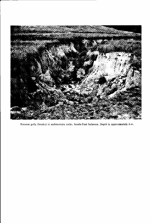
Erosion gully (lavaka) in sedimentary rocks, South-East Sulawesi. Depth is approximately 6 m.
1 Red Soils in Indonesia, a state oi knowledge
by P. Buurman
Abstract
A general outline of the research on Red Soils in Indonesia. Erosion and erosion control are briefly discussed with reference to cultivation, management, and in relation with soil fertility and availability of moisture.
Emphasis is laid on soil classification and survey. Possible improvements in the Indonesian classification system are indicated. Attention is paid to definitions and use of exchange characteristics.
Introduction
Since 1961, Red Soils in the Indonesian Soil Classification System have been divided into four major soil groups: Red Yellow Mediterranean Soils, Latosols, Red Yellow Podzolic Soils and Lateritic Soils (Soepraptohardjo, 1961). The definitions of these groups are discussed in Soepraptohardjo & Ismangun (Paper 2).
The units of the Red Yellow Mediterranean Soils, the Latosols and the Lateritic Soils were kept fairly pure, but the Red Yellow Podzolic Soils served to accommodate most of the soils that did not fit into the system or that were of no direct use.
The Red Yellow Podzolic Soils were officially introduced in Indonesian soil classification by Dudal & Soepraptohardjo (1957). The unit was based on the American concept of this great soil group, but because the Red Yellow Podzolic Soils in Indonesia occur in intricate association with all kinds of soils of low productivity, the unit was used to cover all the acid unproductive red or yellow soils. Because these soils had no direct use in food production, they were never extensively studied. The definition was purposely kept wide: 'Red Yellow Podzolic Soils are those red soils that are not Latosols and not Mediterranean Soils' (Rapat Kerja, 1969). Processes that led to the formation of Red Yellow Podzolic Soils were thought to be eluviation, homogenization, liberation of iron and, sometimes, ground water.
Red Yellow Podzolic Soils were found on all kinds of acidic parent materials such as volcanic tuffs, granites, shales, sandstones, and on some intermediary ones such as andesite or andesitic tuff. Accordingly, Red Yellow Podzolic Soils cover a large part of the Indonesian land surface: approximately 30%, or 0,51 million km2 (Driessen & Soepraptohardjo, 1974). Much of this area has been used for shifting cultivation or for semi-permanent subsistence agriculture, at a low level of management and is now covered by speargrass (alang-alang; Imperata cylindrica L.). Large areas have been used for rubber cultivation. The main food crop is
cassava, which is very acid-tolerant. The soils have a low capacity to support subsistence agriculture.
Interest in Red Yellow Podzolic Soils was renewed when large areas of land were opened up for transmigration. Much of the land in Kalimantan, Sulawesi or Sumatra that was still unoccupied consists of soils that were classified as Red Yellow Podzolic Soils. Soil studies for such transmigration projects made it clear that knowledge about the Red Yellow Podzolics was not sufficient for a proper classification. Detailed studies (locations indicated in Figure 1) showed that not only the subdivision of the Podzolic Soils was lacking, that the boundaries, for instance with Latosols and Lateritic Soils, had to be revised, and that new groups might have to be created.
To classify the Red Yellow Podzolic Soils, related soils had to be studied too and studies on other red soils have been included in this volume. Because of the overwhelming importance of upgrading the soil classification system in Indonesia, some other aspects such as fertility and management have not been properly researched by the ATA expert. Since, however, these aspects formed an integral part in the concept of the ATA 106 cooperation project, a discussion should not be omitted in its final document. General problems and solutions have been outlined in this introductory paper.
New proposals for the classification of Red Soils in Indonesia have been outlined by Soepraptohardjo & Ismangun (Paper 2), whose proposals do not take account of the other research in this volume, so that further revision will certainly be necessary. I will give a general outline of problems of cultivating and classifying Red Soils especially those on acid parent materials.
Practical aspects of the cultivation of Red Soils in general
Erosion
In the tropical primaeval forests on highly weathered soils, most of the nutrient supply is concentrated in a shallow surface layer, whose importance is illustrated by the shallow rooting systems of many trees. The surface layer is also crucial if the forest is cleared for agricultural crops. Especially for annual crops with shallow roots the nutrients in the topsoil will determine the yield. Clearing a forested area exposes the soil to erosion by water, so threatening the precious surface layer. Even without felling, primaeval forest is prone to erosion. French soil scientists and geomorphologists (Tricart, 1972) have long recognized long-term erosion by water dripping from high trees in concentrated streams (ruissellements) and the downslope transport of surface soil—especially the fine fraction— by streamlets that gradually dry up by infiltration (discontinuous overland flow). This combination of splash erosion and run-off can be important in primary forests that have no undergrowth, but becomes negligible in secondary forests that have developed a luxurious undergrowth of shrubs and grass.
However erosion after clearing of the land, or even under arable crops, is much more severe. Erodibility of bare soils of low aggregate stability is high, especially in those soils with sealing of the topsoil. Soils rich in exchangeable aluminium or
G a oo " d
§ g f-a ca *
1 f ,2.1
CS
3 1 g a
O «t l-H C a S
N >
•o S a. ~ " ss vu ra
o W < g h S < 3
B . 3 u->
S « 9 C ^ CO
I l S | £ H "55 eo 'S
IS» O « « •s i S o o « | m -a
• • * _
on 2 | m C/5
free iron have a somewhat higher stability because of the strong flocculaiion of clays by these compounds. Organic matter is a stabilizing factor. Nevertheless, tropical rainstorms have such an intensity (erosivity) that many bare soils are strongly eroded.
Simply keeping the soil covered is not always a solution. Prolonged cultivation with one kind of crop may seriously impare soil structure and increase erodibility. On a plot in Nigeria continuously cultivated with dry rice, run-off was ten times and soil loss eighty times that of the control plot. (Keilman, 1969, cit. in Lal, 1977). I observed similar deterioration of structure in a rice plot in South-East Sulawesi.
Loss of surface material is not the only hazard involved in clearing the forest. Often there is an increase in landslides especially in illitic and montmorillonitic soils. In landscapes with impervious subsoils, deep erosion gullies (lavakas) may form that cut down to the impervious layer. Erosion of surface soil causes loss of the nutrient reserve and decreases permeability and water intake. (Lai et al., 1975). These effects are even more pronounced with mechanized agriculture. Tropical red soils cannot be cultivated, and forests cannot be exploited without adequate measures against soil erosion and for fertility.
Clearing of land
There is a great difference between clearance of grasses from land for instance under speargrass, and of natural forest. Even in the clearing of forests there are different methods. In small areas of transmigration, forests are cleared by felling of trees and subsequent burning of branches and trunks. When clearance is by hand and by fire, trunks and logs remain in the field for several years, until consecutive burnings have removed even the largest ones. Although burning will certainly remove part of the organic matter of the soil by increased oxidation, the method is not destructive of soil fertility and structure, and erosion need not be severe. A serious disadvantage is that sowing and planting in the first 5 to 10 years is restricted to patches between fallen logs and that part of the area cannot be brought into production.
If an area is cleared mechanically, and logs and trunks are shoved away and dumped for instance in depressions, the land looks ready for planting after initial ploughing but most of the fertile topsoil has been carried away, or concentrated in ridges. Crops are then planted in the B horizon and yield poorly or fail. Heavy machinery strongly compacts topsoils by stress. Whenever mechanical clearing of land is deemed necessary, care should be taken always to replace topsoil, and to start erosion control immediately, because large areas of bare soil are particularly prone to erosion.
Enormous masses of timber are burnt after felling a forest: per square kilometer 50-100 thousand cubic metres. Such a large supply of firewood does not add significantly to soil fertility, but could perhaps be chain-sawn and stored as fuel for years to come (protection against pests would certainly be necessary). The whole area of land would then be available for planting, and the communities of transmigration farmers would not have to turn to the remaining patches of primaeval or regrown forest for firewood. In the long run areas of transmigration
should have patches planted with rapidly growing firewood. With speargrass (alang-alang), clearing land and preparing it for cultivation
raises different problems. Speargrass has most of its roots in the upper 15 cm of the soil. It is very difficult to suppress when the land is cleared by hand, and with burning, it is the first plant to reappear. With machines it is easily suppressed. The stress exerted by machines compacts the topsoil and inhibits growth of the thick soft speargrass roots. In grass-covered areas, too, protection against erosion is essential. Speargrass itself does little to protect the soil. Often, deep erosion gullies were observed in speargrass-covered areas.
Conservation measures
As mentioned before, soil structure has a strong effect on erodibility. Although erosion can be cut down by improving soil structure, the use of chemical sprays and conditioners is not feasible on a large scale. The only means within reach of smallholders in the tropics, is to keep organic matter content as high as possible. This has a beneficial effect for both soil conservation and nutrient adsorption. Tillage exposes the soil to erosion. Therefore, systems of zero tillage and minimum tillage have been tested in many tropical countries. Zero tillage systems appear to be ineffective. Kalms (1977) reported from Nigeria that erosion in ploughed fields was less than in zero-tilled fields. Minimum tillage and covering with mulch, however, has a strongly protective effect. Lai et al. (1975) reported that addition of mulch strongly decreased erosion in Nigeria and that the next crop emerged rapidly. Mulch was most effective when the soil was kept covered. Ahn (1977) used mulch of banana leaves and stems and found the same. Mulching with rice or maize stubble effectively maintained the content of organic matter. However, ploughing in of stubble requires an extra dressing of nitrogen for proper humification. Mulch gives a strong decrease in run-off and maintains infiltration rate. When mulch covers are used, weed control is essential. In most trials (e.g. Lai, 1977b) weeds are controlled with herbicides, which are probably not (yet) feasible on a large scale in Indonesia.
Conservation measures also include keeping the soil under a permanent vegetation. If this cannot be effected by the normal sequence of crops as, for instance with an unavoidable fallow period or at planting of estate crops, the soil can be kept covered by rapidly establishing weeds such as Stylosanthes guyanensis, Centrosema pubescens, Calopogonium mucunoides, Andropogon gayanus, Dolichos hosei, Indigofera endocephylla and Pueraria phaseoloides. These weeds are effective against erosion. They can be ploughed in or mulched to increase contents of organic matter and nitrogen. According to Lai (1977a) such ground cover does not dry out the soil
Mechanical means of soil conservation in the humid tropics include contour ploughing, tie-ridge ploughing and terracing. Contour ploughing alone is never sufficient to prevent erosion. Tie-ridging is more effective and has the additional benefit of increased infiltration of water into the soil, but some times increased infiltration may cause soil slip. Bench terraces are only effective against erosion if they are kept under vegetation (except in paddy cultivation). Some times, grass strips in cultivated plots or grassed channels have proved effective.
Fertilization and management
Most Red Yellow Podzolics and Latosols under tropical rainforest, speargrass or other vegetation are unfertile. In general, phosphorus and potassium are most limiting. As most nutrients are concentrated in the surface layers, care should be taken not to remove this precious layer. Unfortunately, when forests or other areas are mechanically cleared much of the topsoil is often lost or concentrated in low parts of the landscape. Subsurface material is then exposed.
Besides a very low nutrient status and lower permeability, such a horizon may have a high or even excessive aluminium saturation. Sometimes even cassava crops failed at the first planting.
Phosphorus is highly limiting, even to the extent that other fertilizers are useless unless phosphorus is applied as well. In many soils, especially Brown and Yellowish Brown Podzolics, phosphorus fixation is only slight and a beneficial effect of phosphate is encountered also in the second crop. Because of strong eluviation, slow-release fertilizers (like silicic phosphorus fertilizers) might be profitable (Martini & Macias, 1974). Calcium and phosphorus fertilizers should not be applied too shallow, because the resulting shallow rooting system would be prone to periodic drought.
Potassium is mainly necessary for starch crops such as cassava. Although cassava performs reasonably well without fertilization, even on the poorest soils, yields can be drastically increased by fertilization. The role of cassava—a protection against failure of the farmer's other crops—might well change with fertilizers. Highly soluble fertilizers should preferably be applied as small dressings several times in a growing season; first at sowing or planting, in the rows. Potassium fixation is hardly ever a problem in tropical soils, but leaching is rapid. Andriesse (1977) and Reynders (1960) pointed to rapid leaching of potassium, magnesium and calcium from topsoils. This was illustrated by Driessen et al. (1976) for nitrate and sulphate.
Liming is not generally advised in Indonesia. Although the pH of Latosols and especially Red Yellow Podzolics is generally low (pH of aqueous extract below 5.5), many crops that are grown in the tropics are adapted to such extreme. Occasionally, liming may be desirable to increase availability of phosphorus and to counter aluminium toxicity. Some crops, such as groundnuts, require a fair amount of calcium for proper growth.
Heavy dressings often result in shortages in trace elements, and liming may lower the availability of magnesium unless the lime contains this element. In general, liming is only feasible if large amounts of carbonate rocks are available nearby. Practical trials on the effects of liming should use local carbonate rocks, and not chemically pure calcium carbonate.
One key to crop production on tropical soils is sufficient organic matter. Organic matter stabilizes soil structures and increases the capacity to adsorb nutrients till they are taken up by the plant. Organic matter tends to disappear rapidly under cultivation. In order to maintain productive capacity content of organic matter should be kept as high as possible, for instance by, ploughing in stubble instead of burning it. In Nigeria (Lai et al., 1975), ploughing in of maize

stubble is just as effective as bush fallow for the maintenance of organic matter. Similar results were obtained at the maize estate Daya Itoh in Lampung (Sumatra). To exploit fertilizers optimally and to protect against erosion, intercropping may be adopted. In this system, plots are planted with alternating rows of two or more crops. In trials in Lampung (Sumatra) on Yellowish Brown Podzolic Soils (Dystropepts) on acid volcanic tuffs, intercropping was more profitable than mixed cropping or sequential cropping (planting of the second crop after the first has been harvested) (Syarifuddin & Mcintosh, 1975). With intercropping, the soil is never bare and there is always a crop to take advantage of available nutrients.
Soil suitability
There are many 'Podzolic' soils in Indonesia that have good prospects for rainfed agriculture. Many Latosols and Red Yellow Podzolics that have deep ground water and good soil structure, for instance in West Sumatra, can be transformed into productive areas. The key is proper management and control of erosion. Without these, any cultivation of newly opened lands is doomed to failure. The training of agricultural extension officers is—in the long run—as important as fertilization itself.
Fertilizer trials should be on representative soils, which must be intensively studied and characterized. Without this information, results of expensive trials cannot be interpreted for other areas. Trials on unrepresentative soils are only applicable locally. Fertilizer trials should often be laid out on several soils of soil catenas, to cover a whole landscape.
Available moisture
A major problem in cultivated Podzolic Soils and Latosols is availability of water. Moisture release curves indicate a volume fraction of available moisture (pF 2.5 to 4.2) of 0.10-0.15. For crops that root to a depth of about 30 cm, the reserve is thus less than 50 mm from the soil itself. So periodic drought may exhaust available water and retard crop growth, unless irrigation is practised.
In areas where irrigation is not feasible, water-conservation methods should optimize infiltration and storage of precipitation. Mulching and tied ridging may be useful. Most Podzolic Soils and Latosols have good drainage—except on large flat plateaux as in the Province of Lampung. (Buurman & Dai, 1976)—but in the rainy season, moisture is mostly near field capacity (Fridland, 1971). Available moisture and moisture retention are largely dependent on the pore system of the soil whose intricacy and stability are closely linked to content of organic matter, which is thus here too crucial.

Soil classification and survey
Soil classification
The classification of Soil Taxonomy (USDA, 1975) has been used as a basis for discussions. We preferred it to the FAO Legend (FAO, 1974) because the definitions of diagnostic horizons in Soil Taxonomy are more detailed and because Soil Taxonomy allows classification down to the Soil Family. Often, however, we have also mentioned tentative classifications according to the FAO Legend.
A major problem in classification of tropical soils by Soil Taxonomy is the concept of the argillic horizon. The Indonesian classification system of Dudal & Soepraptohardjo (1957) derives from the 1938 Great Soil Group System of the United States (Baldwin et al. 1938; Thorp & Smith, 1949) but its present interpretation tends to follow the concepts of Soil Taxonomy and the FAO Legend. The Podzolic Soils, as defined in 1938, have a subsurface horizon of a heavier texture than the A horizon. In Soil Taxonomy and in the FAO Legend such a difference in texture is still used to distinguish soils with an 'argillic' horizon, but the difference in texture must be attributable to accumulation of translocated clay in the B horizon. So differences in texture in stratified parent materials and differences due to removal of clay from the topsoil by erosion are now excluded. An advantage is that the unit that features an 'argillic' horizon is genetically purer, but a disadvantage is the difficulty of assessing the presence of an argillic horizon in stratified parent materials. Examples of such problems can be found in several papers in this volume.
The argillic horizon is also a problem in the Indonesian classification, not only of Indonesian Red Yellow Podzolic Soils, but also of some Latosols and most Mediterranean Soils. Its absence raises a problem of identifying, for instance, the newly proposed Brown Tropical Forest Soils and Brunizems (Paper 2). Many Indonesian upland soils have horizons that look argillic horizon, but we found few with undoubted clay skins or massive B horizons. The soils that did show these features were never widespread.
Podzolic Soils on acid volcanic tuffs in Lampung (Buurman & Dai, 1976) were classified as Oxic Dystropepts, Sombritropepts, Tropohumults and Paleudults. Podzolic soils on similar parent material in Banten were classified as Dystropepts, Tropudults, Tropohumults, Humitropepts and Paleudults, but with considerable uncertainty about the argillic horizon (Buurman et al., 1976). Soils on intermediary volcanic material, classified as Latosols, Podzolic Soils and Andosols in West Java did not show illuviation of clay and were classified as Inceptisols and Oxisols (Paper 3). Similar soils in East Java, ranging from Mediterranean to Podzolic Soils and Latosols are Inceptisols and Alfisols (Paper 4). Soils on acid volcanic tuffs in West Sumatra, classified as Latosols and Podzolic Soils, range from Dystropepts and Humitropepts through Tropudults and Paleudults to Haplorthox (Paper 6). Soils on schists and fluviatile sediments in South-East Sulawesi, (Paper 8) are Dystropepts and Tropudults with a single Paleudult identified on an old terrace.
Especially on volcanic rocks there is considerable doubt about classification, since textural differences can often be attributed to stratification in the parent
material. Soils on granodiorite in Kalimantan lost a lot of clay from the topsoil by erosion. The striking point, however, is that the definitions of the argillic horizon, both in the Soil Taxonomy and in the FAO legend emphasize the presence of clay skins even in insignificant amounts (1%) but do not mention the characteristic that is one of the reasons for the distinction of such a horizon: the unfavourable physical properties accompanying the illuviation of clay. The argillic horizon would impede root growth and drainage because of the sedimentation of clay in pores. Otherwise the presence of clay skins is irrelevant for crop growth.
In soils with a mass fraction of clay of 0.6 or more, differences in clay content seemed of no practical significance. High contents may stop movement of clay (Martini & Macias, 1974). In many soils, clay movement has stopped (Brook & van Schuylenborgh, 1971) and, even if continuing, biological activity in most forested tropical soils is so high that clay skins are only found in the deeper horizons. Clay skins were only found below the B horizon in well developed Podzolic Soils (Simonson, 1950) and ferrallitic soils (Sys, 1967). Especially in the humid tropics, where no dry period inhibits biological activity, the presence of an argillic horizon is doubtful (Allbrook, 1973). Such permanently humid circumstances prevail in Sumatra, Kalimantan, part of Sulawesi and Malaysia. Further north, for example in Thailand, where the climate is monsoonal, argillic horizons are more clearly defined (Moncharoen, 1975). Although interesting for soil genetics, any 'argillic' horizon that does not have a higher density and stronger structure than the overlying horizon is irrelevant for agricultural suitability. Neither is clay illuviation relevant if it is only detectable deeper than 1.5 m.
If the argillic horizon is defined on the basis of an increase in clay content and of the presence of clay skins in thin section, we will have to accept that by biological homogenization, old Ultisols may change into Inceptisols or into Oxisols. In that concept, Inceptisols will not only include immature soils, but also old and highly weathered ones. With the present definition of argillic horizon, it is often difficult or impossible to distinguish between an Oxic Dystropept, a Paleudult or a Haplorthox. For the Indonesian classification, it would be useful to change the definitions of the Major Groups to avoid similar problems. The Indonesian system could be improved by adopting the concept of a cambic horizon and changing the definition of soils with illuvial clay horizons in such a way that the unit only comprises those soils that have dense B horizons that hinder root growth and stagnate water flow. Criteria for the distinction between soils with and without a textural B horizon should be permeability, structure ahd drainage. Soils that are permeable and have weak structures and weak clay skins should not be grouped with Red Yellow Podzolic Soils unless the difference in texture between surface and subsurface horizon is so abrupt that it impedes root growth. Such a change appreciably reduces the area with the Podzolic Soils. The distinction of Mediterranean Soils—a different name might be adopted—is not tendentious. They have stronger developed textural B horizons and structure and mostly high saturation with bases. Furthermore, it will be necessary to separate the Red Soils that do not have an 'argillic' horizon into those that have oxic properties and those that do not. The Ferralsols and the Cambisols of the FAO Legend may well serve as concepts for these groups. These groups can be divided

further on the basis of concentration of organic matter (in whole soil to 1 m or B horizon), cation exchange capacity, base saturation, or other criteria used in Soil Taxonomy or in the FAO Legend. Adoption of FAO names has the advantage that no new names need to be invented. Names like Brunizems, Brown Tropical Forest Soils and Red Tropical Soils have already been used for other concepts and only add to confusion. Care should be taken that the FAO concepts are not given a different meaning.
Soil survey
In most forested areas, soils are mapped along linear traverses (rintisans in Indonesian), in the forest or bush. This is the only way of obtaining accurate results in inaccessible areas. A disadvantage is that one observation every few hundred metres does not show up catenary patterns, and obscures the picture of the total landscape. More information is obtained when, together with equally spaced observations, complete catenary patterns are studied once or twice within every soil landscape. Such an approach would add considerably to the value of a soil map. Also of soil associations, the pattern should be studied in detail over a few small areas. Catenary patterns and associations are essential for understanding soil maps, and the variation of soils within any landscape.
Use of a classification system as a basis for a mapping legend often leads to undesirable splitting up of fairly homogeneous units. Using associations of soil series in soil mapping solves such problems and has the advantage that mapping units correspond as closely as possible to the landscape. A correspondence between map legend and landscape makes interpretation easier and allows a more direct interpretation of the measures needed for cultivation and erosion control.
Methods of research used at present
Because the work reported in this volume was mostly complementary to soil survey or aimed at soil classification, extensive use was made of soil catenas, which indicate information of the variation within one map unit or the transition from one map unit to another. The landscape served as a basis, and the link with the landscape was considered essential. Emphasis was laid on exchange characteristics and mineralogical properties of the soils. The circulars of the Committee on Low-Activity Clay Soils of the International Society of Soil Science (1976-70) confirmed the emphasis on exchange properties, already present from the outset. It was concerned especially with soils like those in the Indonesian uplands. Internationally, some efforts have been made to correlate the various exchange properties. Definitions have therefore been given of the exchange properties used in this volume (prelims). We defined Permanent Charge as exchangeable Al + Bases per 100 g soil and not clay, because organic matter has a Permanent Charge as well, and because base saturation is calculated from Permanent Charge. For clarity, quantities that refer to the clay fraction are specified as such, for instance PCc,ay and CECclay. The contribution of organic matter to cation exchange capacity was subtracted before dividing by the clay content to arrive at CECclay.
10
The CECday pattern was then independent of organic matter distribution with depth. This CEC^y, if correctly calculated, is not influenced by changes in land use (forest-cultivation). If uncorrected CECclay were used, such changes in land use may influence soil classification at Great group level (Soil Taxonomy). In assessing the Soil Taxonomy classification, however, uncorrected CECclay was always used.
The method of calculation of the corrected value is discussed in Paper 10. It assumes constancy of the exchange capacity of organic matter with depth, and constancy of CECday in the two uppermost samples. These assumptions are not always realistic. Andriesse (1975) found that organic matter in topsoils of 'Pod-zolic Soils' from Sarawak was mainly humic acid, and in the subsoil fulvic acid. However the method used usually gave consistent results. Presumably, biological mixing of most forested soils is so intense that differentiation of organic matter is negligible. Where the method of calculation used was obviously wrong (negative values for CECclay or CEC of organic carbon, CEC of organic carbon less than 1 or higher than 6 meq/g) we have used a standard correction for carbon of 4 meq/g. These data can be recognized in the tables by the differing corrected CECclay of the upper two horizons. The adopted value of 4 meq/g is close to the mean CEC in organic C in those soils where the method worked consistently.
Acknowledgments
The author is indebted to Professor Dr J. Bennema and to Dr R. Brinkman for comments.
References
Ahn, P. M., 1977. Erosion hazard and farming systems in East Africa. In: Greenland & Lai (1977), p. 165-176.
Allbrook, R. F., 1973. The argillic horizon—does it exist in Malaysia? Proc. 2d ASEAN Soil Conf. Bogor. I: 51-55.
Andriesse, J. P., 1975. Characteristics and formation of so-called Red-Yellow Podzolic Soils in the humid tropics (Sarawak, Malaysia) Thesis. Amsterdam. 188 p.
Andriesse, J. P., 1977. Nutrient level changes during a 20 year shifting cultivation cycle in Sarawak (Malaysia). Proc. Conf. Class. Manag. Trop. Soils (Clamatrops). Kuala Lumpur. In press.
Baldwin, N., C. E. Kellogg & J. Thorp, 1938. Soil Classification. In: Soils and Men. USDA Yearbook of Agriculture. Washington.
Bennema, J., 1963. The red and yellow soils of the tropical and subtropical uplands. Soil Sei. 95: 250-257.
Bennema, J., A. Jongerius & R. C. Lemos, 1970. Micromorphology of some oxic and argillic horizons in South Brazil in relation to weathering sequence. Geoderma 4: 333-355.
Brook, R. H., & J. van Schuylenborgh, 1975. Weathering geochemistry of a paleudult in tropical Surinam. Geoderma 14: 3-13.
Buurman, P. & J. Dai, 1976. Research on Podzolic Soils in Central and North Lampung (Sumatra) and its bearing on agricultural development. In: Soil Research Institute (Bogor) Bulletin No. 3. p. 95-116.
Buurman, P., L. Rochimah & A. M. Sudihardjo, 1976. Soil genesis on acid tuffs in Banten (West Java). In: Soil Research Institute (Bogor) Bulletin No. 3, p. 151-172,
Driessen, P. M., P. Buurman & Permadhy S. 1976. The influence of shifting cultivation on a podzolic soil from Central Kalimantan. In: Soil Research Institute (Bogor) Bulletin No. 3, p. 95-116.
11
Driessen, P. M., & M. Soepraptohardjo, 1974. Soils for agricultural expansion in Indonesia. Soil Research Institute (Bogor) Bulletin No. 1, p. 1-63.
Dudal, R., & F. R. Moormann, 1964. Major soil groups of South-east Asia. J. Trop. Geogr. 18: 54-80.
Dudal, R., & M. Soepraptohardjo, 1957. Soil classification in Indonesia. Contr. Gen. Agric. Res. Sta. Bogor. 148: 3-16.
FAO-Unesco, 1974. Soil Map of the world 1:5 000 000. Vol. I. Legend. Fridland, V. M., 1971. The differences between crusts of weathering and soils developing on acid and
basic rocks in the humid tropics. In: Unesco Natural Resources Res. Vol. XI: 111-116. Greenland, D. J., & R. Lai (Eds.), 1977. Soil conservation and management in the humid tropics.
Wiley & Sons, New York. Ives, D. W., 1966. A weathering sequence on Malaysian soils derived from basic effusive rocks. Proc.
2d Malaysian Soil Conf: 114-117 (mimeogr.). Kalms, J. M., 1977. Studies of cultivation techniques at Bouake, Ivory Coast. In: Greenland & Lai
(1977) p. 195-200. Lal, R., 1977a. Soil conserving versus degrading crops and soil management for erosion control. In:
Greenland & Lai (1977). p. 93-98. Lal, R., 1977b. The soil and water conservation problem in Africa: Ecological differences and
management problems. In: Greenland & Lai (1977). p. 143-150. Lai, R. & B. T. Kang et al., 1975. Soil management problems and possible solutions in Western
Nigeria. In: E. Bornemisza & A. Alvarado (Eds.): Soil management in tropical America. North Carolina State Univ. Raleigh. USA. p. 372-408.
Martini, J. A., 1970. Allocation of cation exchange capacity to soil fractions in seven surface soils from Panama and the application of a cation exchange factor as a weathering index. Soil Sei. 109: 324-331.
Martini, J. A. & M. Macias, 1974. A study of six 'Latosols' from Costa Rica to elucidate the problem of classification, productivity and management of tropical soils. Soil Sei. Soc. Amer. Proc. 38: 644-652.
Moncharoen, L., 1975. The Red Yellow Podzolic Soils of Thailand: their distribution, characteristics, genesis and classification. Proc. 3d. ASEAN Soil Conf. Kuala Lumpur. In press.
Rapat Kerja Perluasan Areal Pertanian, 1969. Direktorat. Jend. Pertanian Jakarta (mimeogr.). Reinders, J. J., 1960. Some remarks about shifting cultivation in Netherlands' New Guinea. Neth. J.
Agric. Sei. 9: 36-40. Simonson, R. W., 1950. Genesis and classification of Red Yellow Podzolic Soils. Soil Sei. Soc. Amer.
Proc. 14: 316-319. Soepraptohardjo, M., 1961. Tanah Merah di Indonesia. Contr. Gen. Agric. Res. Sta. No. 161. Bogor. Syarifuddin, A. & J. L. Mcintosh, 1975. Cropping systems for transmigration areas in Lampung on
upland Red Yellow Podzolic Soils. Simp. Penc. Pemul. Tanah Kritis. Jakarta (mimeogr.). Sys, C , 1976. The concept of ferrallitic and fersiallitic soils in central Africa. Pédologie (Ghent) 17:
284-325. Thorp, J. & G. D. Smith, 1949. Higher categories of soil classification: Order, suborder and great soil
groups. Soil Sei. 67: 117-126. Tricart, J., 1972. Landforms of the humid tropics and savannas, Longman, London. USDA (United States Dept. of Agriculture) 1975. Soil Taxonomy. Agric. Handb. 436. Young, A., 1976. Tropical soils and soil survey. Cambridge Univ. Press. Cambridge UK.
12
.•'-•• . ' • - • • • •;;"*>:":f- vj"^*r"r ^» -^r i
. * • > • * »$^31*. ; * ' * . , • > • '
w * > ' .
; . • • « • . ? . • . ; ; \ ^ - . ^
itslJnTi
r< A' ft.-"«. (1-
- v ••/*(• •
t , i ft' -:" •*• - , - ^ i ; .<fc':^ *=**•
Farmer i„ p a d d y fieldS; W e g t ^ ^
>*&!
14
2 Classification of Red Soils in Indonesia by the Soil Research Institute
by M. Soepraptohardjo and Ismangun
Abstract
An outline is given of the developments in Indonesian Soil Classification since 1955. Criteria for the distinction of Great Soil Groups are mentioned, and a new proposal for the subdivision of Red Soils is explained.
Introduction
Red Soils occupy the greater part of Indonesia. They occur at low and high altitude in undulating to mountainous regions with perhumid to semiarid climates and are formed from all kinds of rocks, both felsic and mafic. Map 1 (p. 20 and 21) illustrates the distribution of Red Soils in Indonesia.
Soil surveys conducted in Indonesia have used several systems of soil classification and groups of soils within the red soils were renamed several times. Soepraptohardjo 1961 briefly reviewed this development. With increased knowledge on soil genesis the approach of the classification systems became more comprehensive. A first modern classification was introduced by Dudal in 1955, and his classification has developed into the system used by the Soil Research Institute. It is here designated as the Dudal-Soepraptohardjo system (D/S system) after the authors who published it in 1957.
With the experience of soil surveys during the last 20 years that covered extensive areas of Indonesia and with the more comprehensive United States soil classification (USDA Soil Survey Staff, 1960; 1967; 1975) it became clear that the present system was no longer satisfactory, and should be amended or a new approach should be initiated. The question arose whether the D/S system should be replaced by for instance the Soil Taxonomy (USDA, 1975) (Soepraptohardjo, 1977). As stated in Soil Taxonomy, 'Red Tropical Soils' are one of the least known groups of the whole system and therefore the Second National (Indonesian) Congress of Soil Science (1977) recommended that the D/S system should be maintained as a national system, but supplemented with views from Soil Taxonomy.
Soil classification system of 1957
When the Indonesian classification was introduced in 1957, its authors were well aware of its incompleteness and of the absence of well defined boundaries and criteria. The system is morphogenetically based. It has 6 categories. The higher categories are always genetically linked to the lower ones. It is an open system in the sense that new great groups can be introduced and it is applied for
15
mapping at exploratory to detailed level. Most of the definitions and criteria for field descriptions were adapted from the
Soil Survey Manual (Soil Survey Staff, 1951). The paper by Dudal & Soeprap-tohardjo (1957) not systematically describes the morphological and chemical characteristics of the respective Great Soil Groups nor elaborates on the genetical relationships between the higher and lower categories. For consistency of application for mapping purposes, a tentative guideline with definitions of the major Great Soil Groups and criteria for their classification was circulated (Soeprap-tohardjo 1961; Suhadi 1961). Here too, the authors were aware of inherent imperfections, but a general basis was established.
In short, the differentials used at higher levels were as follows: —distinction between Orders was based on mineral or non-mineral character; —suborders were based on profile development (none, AC, A(B)C, ABC); —great groups were based on diagnostic horizons: textural, colour/structural, latosolic, podzol, solonetzic B horizons; chernozemic, melanic and calcic horizons, and special features like clay coatings, plinthite and lime concretions.
Great Groups of Red Soils and their variants
Based on the differentials, the red soils were divided into the following great groups: Red Yellow Podzolics, Latosols, and Red Yellow Mediterranean Soils; a fourth great group, the Lateritic Soils was added in 1961. The definitions of the Great Groups are summarized in Table 1. They were based on knowledge at that time.
As experience was gained and as data was collected during surveys since 1955, the definitions proved inadequate for the many variants that were encountered. The genetical background was not sufficiently known and chemical methods in Indonesia were not yet sufficiently sophisticated to introduce well-founded changes in the existing Great Soil Groups or altogether new Great Groups.
On the basis of their suitability for agriculture, almost all of the variants that were not covered by the definitions, were lumped under Red Yellow Podzolic Soils, so this Great Group has a wide range of properties.
Some minor changes were made after the introduction of the '7th Approximation' (USDA Soil Survey Staff, 1960; 1967), mainly refinements of criteria for colour, horizons, clay coatings, base saturation and cation exchange capacity, all of which were adapted to the definitions given in the 7th Approximation. They were restricted to the subdivisions of the Great Soil Groups (Soepraptohardjo 1976).
A second modification was drafted in 1977 (Prae Workshop Soil Classification, June 1977) and circulated among survey staff. The modifications on Red Soils were based on a sharper differentiation of the diagnostic B horizons with criteria and definitions of Soil Taxonomy (USDA 1975) and took account of the FAO/Unesco Legend for the World Soil Map (1974) and the Dudal-Moormann (1964) classification of soils of south-east Asia, partly supplemented with mineralogical and micromorphological criteria. The main changes were: —Splitting of Latosols into 4 new Great Groups: Latosols (new strict sense).
16
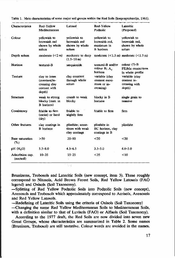
Table 1. Main characteristics of some major soil groups within the Red Soils (Soepraptohardjo, 1961).
Characteristics
Colour
Depth solum
Horizon
Texture
Structure
Consistency
Other features
Base saturation (%)
pH (H 20)
Adsorbtion cap. (me/soil)
Red-Yellow Mediterranean
yellowish to brownish red shown by whole solum
moderate (<2 m)
textural-B
clay to loam (constant/increasing clay content with depth)
weak to strong blocky (max. in B horizon)
friable to firm (moist) or hard (dry)
clay coatings in B horizon
>50
5.5-8.0
10-35
Latosol
yellowish to brownish red shown by whole solum
moderate to deep (1.5-10 m)
sesquioxide
clay constant through whole solum
crumb to weak blocky
friable to slightly firm
plinthite; sometimes with weak clay coatings
20-90
4.5-6.5
15-25
Red-Yellow Podzolic
yellowish to brownish red, maximum in B horizon
moderate (<1.5 m
textural-B and/or colour B; A2
horizon
variable (clay content maximum or increasing)
blocky in B horizon
friable to firm
plinthite in BC horizon, clay coatings in B
<20
3.5-5.0
<35
Lateritic (Proposed)
yellowish to brownish red, shown by whole solum
) moderate (<1.5m)
colour (?)-B FE/Mn concretions in whole profile variable (clay content increasing with depth)
single grain to massive
firm
plinthite
<20
4.0-5.0
<10
Brunizems, Trobosols and Lateritic Soils (new concept, item 3). These roughly correspond to Nitosols, Acid Brown Forest Soils, Red Yellow Latosols (FAO legend) and Oxisols (Soil Taxonomy). —Splitting of Red Yellow Podzolic Soils into Podzolic Soils (new concept), Arenosols and Trobosols which approximately correspond to Acrisols, Arenosols and Red Yellow Latosols. —Redefining of Lateritic Soils using the criteria of Oxisols (Soil Taxonomy) —Changing the name Red Yellow Mediterranean Soils to Mediterranean Soils, with a definition similar to that of Luvisols (FAO) or Alfisols (Soil Taxonomy).
According to the 1977 draft, the Red Soils are now divided into seven new Great Groups, whose characteristics are summarized in Table 2. Some names (Brunizem, Trobosol) are still tentative. Colour words are avoided in the names.
17
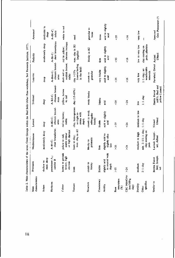
U o
a o <
2 £ S 3 3
co -ß •
3° A SS
I I o ca —
6 « * ö |
•o —
g o i T3 S
; « J
O 4>
< ^ " 7 3
E -1 5 z
' £• -S 8 _-•S s '5 a
4- T3
.5 | 2 B
O -O
e -LT
I O o
u <
<t! O ^t
Üi u w u
M 0 0
H -s
These concepts still have to be checked more for uniformity of genesis and of suitability for agricultural use. The classification system is still open to changes and additions. The future national soil classification system should be based on a sound integration of the already widespread D/S system with the comprehensive Soil Taxonomy. Much research is still needed on soil forming processes and soil-forming factors specific to Indonesian conditions.
Questions and comments
Z. Arifin Q. According to the soil map, soils in Java and in the outer islands are similar, but in fact there are many differences. Are there any physical and chemical differences? A. The similarity depends on map scale. On large-scale maps, much of the similarity disappears, and differences in chemical and physical properties can be inferred. For detailed information, you should never use small-scale maps.
S. Sivarajasingham Q. Should only Lateritic soils have a coarser feel, or may Latosols also exhibit this feature? Should Fe and Mn concretions occur throughout the profile in Lateritic soils? A. The coarser feel that is due to Fe and Mn concretions is specific to Lateritic soils. Such concretions should occur throughout the profile. Q. Is there any consistent difference in parent material or climate of Mediterranean soils from Latosols, Trobosols and Podzolic Soils? A. Mediterranean soils, as defined in 1957, result from a different climate (distinct dry period). Latosols and Mediterranean soils form from volcanic tuff; Podzolic Soils and Trobosols mainly from sedimentary rocks. Q. Is there any difference in the formation of Brunizems, from the other soils? A. Brunizems are supposed to be younger soils, formed in a less rainy climate on andesitic tuffs. Q. Is there any relation between the seven new great groups and their micro-morphological characteristics, particularly the distribution of sesquioxides and 1:1 clays? A. This matter is under study.
19
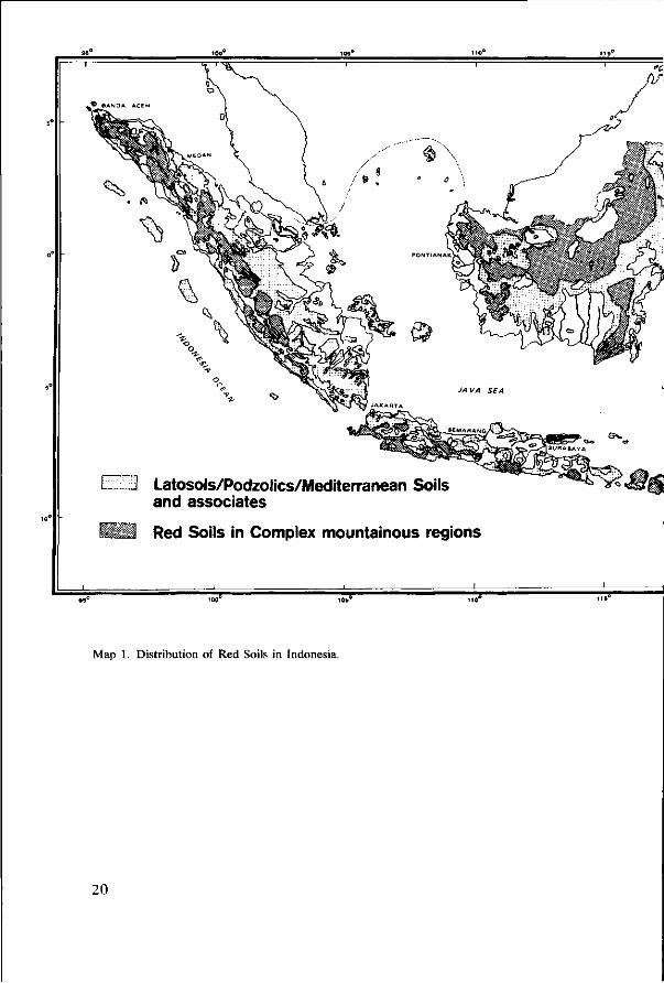
ZI Latosols/Podzolics/Mediterranean Soils and associates
Red Soils in Complex mountainous regions
Map 1. Distribution of Red Soils in Indonesia.
20

TT o
> •
pp
y" a "N
RED SOILS IN
INDONESIA
SULAWESI SEA
21

References
Dudal, R. & M. Soepraptohardjo, 1957. Soil Classification in Indonesia. Contr. Gen. Agric. Res. Sta. No. 148. Bogor.
Dudal, R. & F. R. Moormann, 1964. Major soils of South East Asia, their characteristics, use and agricultural potential. J. Trop. Geogr. 18: 54-80.
FAO/Unesco, 1974. Soil Map of the world. Volume 1. Legend. Paris. Soepraptohardjo, M., 1961. Tanah Merah di Indonesia. Contr. Gen. Agric. Res. Sta. No. 161. Bogor. Soepraptohardjo, M., 1961. Klasifikasi Tanah Kategori Tinggi. Kongr. Nas. Umu Tanah I. Bogor.
(mimeogr.). Soepraptohardjo, M., 1976. Jenis Tanah di Indonesia. Dok. Lemb. Penelit. Tanah. Bogor. Serie 3C. Soepraptohardjo, M., 1977. Menuju ke sistem klasifikasi tanah nasional. Kongr. Nas. Ilmu Tanah
(HITI) II, Yogyakarta (mimeogr.). Soil Survey Staff, 1951. Soil survey manual. USDA Handbook No. 18. Washington. Soil Survey Staff, 1960. Soil classification, a comprehensive system. 7th Approximation. USDA.
Washington. Soil Survey Staff, 1967. Supplement to Soil Classification system (7th Approximation) USDA.
Washington. Soil Survey Staff, 1975. Soil Taxonomy, a basic system of soil classification for making and interpreting
soil surveys. USDA Handbook 436. Washington. Soil Survey Staff, Bogor, 1977. Laporan Pra Workshop Klasifikasi Tanah. Dok. Lembaga Penelitian
Tanah, No. 2. Bogor. Soil Science Society of Indonesia, 1977. Warta Kongres. Newsletter No. 2, 3/6. Bogor. Suhadi, 1961. Klasifikasi Tanah Kategori Rendah. Kongr. Nas. Ilmu Tanah I. Bogor (mimeogr.).
22

The Salak Volcano seen from Bogor. Cassava crop in foreground, bananas and fruit trees in background.
24

3 A toposequence of Latosols on volcanic rocks in the Bogor-Jakarta area
by Subardja and P. Buurman
Abstract
Latosols in a toposequence between 40 and 1020 m altitude on andesitic rocks and derived sediments were classified according to Soil Taxonomy. The most weathered Latosols, in the plain, are classified as Eutrorthox. This great group includes both Red and Yellowish Red Latosols. Brown Latosols are classified as Dystropepts, Humitropepts and Eutropepts. They grade to Andosols at higher altitudes. The concepts for Yellowish Red and Red Latosols proved too narrow, while that of the Brown Latosols is too wide.
Although soils can be classified according to Soil Taxonomy, several of the boundaries in Soil Taxonomy units are inconvenient for practical use. It is proposed to define Red and Yellowish Red Latosols as having a cation exchange capacity of the clay lower than 24meq/100g, and to divide the Brown Latosols into Humic, and Non-humic Subgroups, and at lower level, into units with high and low base saturation.
Introduction
The soil map of the surroundings of Bogor (Hardjono & Soepraptohardjo, 1966), in which both the soils on the north slopes of the Gede-Pangrango and Salak Volcanoes, and the transition to the coastal plain of north Java are outlined, shows the following toposequence (Figure 2): —below 400 m: complexes of Latosols, dominated by Reddish Brown Latosols; —from 400-700 m: Brown Latosols; • —above 700 m: Yellowish Brown Andosols. In a later study, Hardjono (1969) mentioned the presence of Latosols at elevations up to 1000 m. These soil names are according to the Indonesian Classification System by Dudal & Soepraptohardjo (1957).
The slopes of the Salak and Gede Volcanoes consist of intermediary volcanic tuffs (andesite). Van Schuylenborgh & Rummelen (1955) and van Schuylenborgh (1957), had studied soil formation on such materials. Despite the detail of their study on soil profiles, their methods are now outdated and their findings cannot be interpreted for the new classification terms.
Until now, the distinction between the different Latosols in the Indonesian Classification System has mainly been based on the colour of the B horizon. In the legend of the soil map, we find for instance Red Latosols, Yellowish Red Latosols, Reddish Brown Latosols and Brown Latosols. Because data presently available do not sufficiently elucidate the properties of these soils to allow new proposals for classification, a number of new profiles have been described, sampled and analysed in detail. Special emphasis was laid on exchange properties, and correlation with Soil Taxonomy was attempted.
25

• ; - ' V - '~
fi 11^
w H
~^--:->:o -Z<rZ-Z-
0 5 10 km
I— < = H
G.PANGRANGO
Fig. 2. Soil Map of the Bogor-Jakarta area. 1. Association of Red and Reddish Brown Latosols; 2. Alluvial soils; 3. Regosols and Lithosols; 4. Andosols; 5. Brown Latosols; 6. Reddish Brown Latosols; 7. Association of Brown and Reddish Brown Latosols; 8. Other soils, mainly on non volcanic rocks ; + Weather station ; A Location of profile.
26

Climate
The climate in the area is classified as Koppen Afa type, with a rainfall type A (Schmidt & Ferguson, 1951). Rainfall varies with altitude from about 2000 to 7000 mm, and the dry season is less than 3 months throughout the area. Rainfall and temperature data are given in Table 3.
As the temperature gradient with altitude is about 6 °C per km, the mean temperature at Cikopo (800 m) is about 21.7 °C.
In Soil Taxonomy terms, the moisture regime is udic, and the temperature regimes are isohyperthermic up to about 800 m, and isothermic above that.
Mean monthly maximum and minimum temperatures range between 31.7-34.6 and 20.4-23.4 °C respectively for Jakarta, and between 31.3-33.0 and 19.1-21.8 °C for Bogor (Lembaga Meteorologi dan Geofisika, 1970). Temperature data for other stations in the area are not available.
Landscape and geology
The main landscape units in the Bogor-Jakarta area comprise the following: —The slopes of the Salak and Gede-Pangrango volcanoes rise up to 2500 and 3000 m respectively. The foot slopes extend north to Bogor, where there is a transition to the alluvial fan at an altitude of about 300 m. —In the east and west the alluvial fan of the combined volcanoes is bordered by Miocene non-volcanic deposits, and in the north near Parung, about 20 km away, it merges into coastal terraces. —River terraces, deposited by the Rivers Cisadane (from the Salak) and Ciliwung (from the Gede) extend north till Jakarta. Further north, most of the material brought by these rivers has been reworked and redeposited in coastal sediments.
Dai (1960) studied the mineral associations of the surface soils in the Bogor-Jakarta area. Most of the sediments in the area belong to the hypersthene association, except for an east-west zone about 10-15 km wide immediately south of Jakarta, where this association is mixed with the more strongly weathered pyroxene/zircon association. The less weathered association is limited to deposits of fresh volcanic material. Dai's investigation clearly shows, that the parent rocks in the area, from an altitude of 1500 m on the volcanoes down to 50 m on the terraces south of Jakarta, are uniform.
The rocks consist of pyroxene-andesites and tuffs of the same composition (Neumann van Padang, 1951). The recent geological map of the area (Effendi, 1974) mentions andesitic basalt with oligoclase-andesite, labradorite, olivine, pyroxene and hornblende, originating from the Gede area, and tuffaceous breccia, pumicious tuff and basalt, all of andesitic composition, from the Salak (Figure 3).
The mountainsides up to 1000 m have a mean slope of about 15% but are strongly dissected. The terrace area, south of Jakarta has a general slope of less than 3% ; it is also dissected and there are many scarps and excessively drained positions.
27

t~- NO (N O N
o\ r *
NO c-cn (NIN O rH (M
00 <Ti 00 f )
r~ <N
CN T H un CM rH tM t CJ • *
00 Tt 0 0 N£)
O N
•o (N
•>+ ^t m en
o CQ
O NO ON
O
.O
E
o oo o 03
o.
e
o OH Pa H
un
• *
ND
un NO
ON
O
ON
o
in (N
(M
NO
00 NO c<n
o
O
ON O N en
O
<N
ON rH
_; un
O 00 un
o NO un
N O
cn
• * •* m
in 00
<N
00
NO IN
in r--JM T H
cJ H m -H ra
-* O N
• *
NO 00 Wn <N T H (N • *
00 rH O0 (N 'T)
NO NO 00 H ON]
NO »O 0 0
in N O
•<t <N it NO rH
H rH 1^ e- H <s
^O ' t VD
T-f ^H O ^H
O W ) o o
NO IN
rH in o T H
ON N O
^ m Tt [ rH (N
O M "1 f- rH <N CO
r- t— • *
O Tt NO ^H
o un un O N H r)
NO ON in ^
<S (S NO rH
\n> r^
(N f-ro i — i
,-H
CM <N
r-H * — l
O l> 1-H N,—|
ro
n> r-fT)
r- in ^H <N
\0 ro O (N f-
\o i — i
(N
m l-H
m M 00 TH (N
Tt rH NO (N r*n
rH rH Un un CN cJ
•*
^ Tf <N ( r~
NO O •rf c-1
m
NO
o O
"
rNi t —
un
• *
co
o NO en
CO
O)
ON
00 ON co
00 O N
co CN
in
CN NO
CNl
NO
in ra
en CN
in
o
NO co
(N
o
00 NO O*
O H
(N
0 05
in 00
O H
NO
Q 05
co
co
O H
0 o;
ON
O H
(S
0 0- H
NO
O H
un
O H
IN
Q 05
E H
OH
Ä -a o < 3 £
Q
öß J2 S o. 2 E o
00 o
03
o a o
M
Ö
28
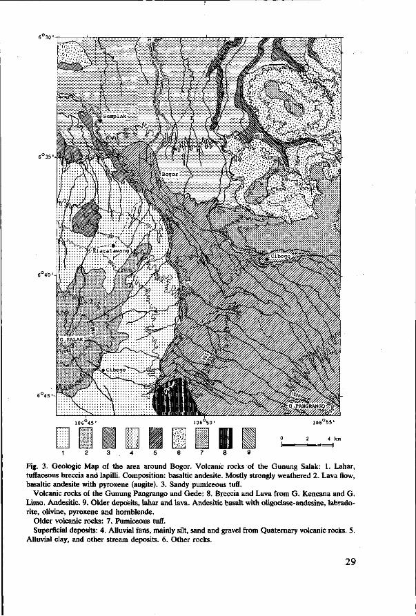
Fig. 3. Geologie Map of the area around Bogor. Volcanic rocks of the Gunung Salak: 1. Lahar, tuffaceous breccia and lapilli. Composition: basaltic andesite. Mostly strongly weathered 2. Lava flow, basaltic andesite with pyroxene (augite). 3. Sandy pumiceous tuff.
Volcanic rocks of the Gunung Pangrango and Gede: 8. Breccia and Lava from G. Kencana and G. Limo. Andesitic. 9. Older deposits, lahar and lava. Andesitic basalt with oligoclase-andesine, labrado-rite, olivine, pyroxene and hornblende.
Older volcanic rocks: 7. Pumiceous tuff. Superficial deposits: 4. Alluvial fans, mainly silt, sand and gravel from Quaternary volcanic rocks. 5.
Alluvial clay, and other stream deposits. 6. Other rocks.
29
Materials and methods
Ten profiles were sampled, covering a range in altitude of 40 to 1020 m. The profiles were meant to cover the full range of Latosols, and include soils classified as Red, Reddish Brown, Yellowish Red and Brown Latosols. The sequence stops at an altitude where Latosols grade into Andosols, and where the adsorption complex of the soils is dominated by amorphous material.
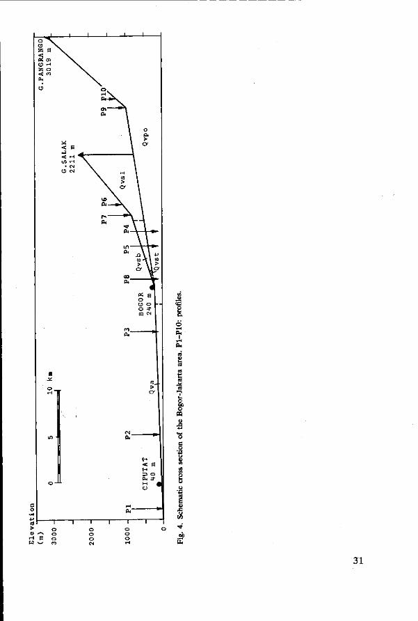
Methods of analysis are described in Paper 12. Profile descriptions are given in Appendix 1, and sites are indicated in Figure 2. A section through the area with the relative positions of the profiles is given in Figure 4.
Results
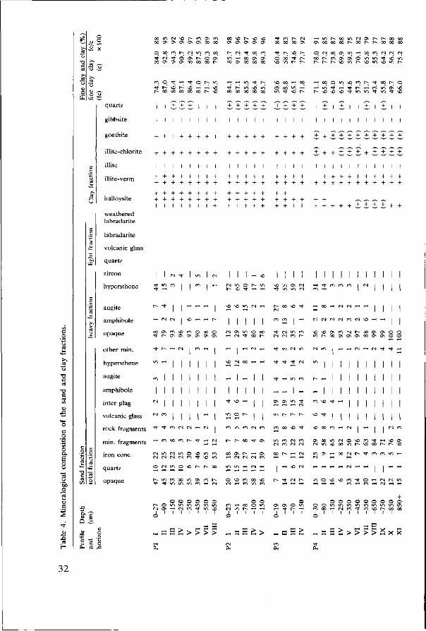
Mineralogical composition of the sand fractions
Sand fractions were analysed in order to establish both inhomogeneities in parent material, and mineral reserve (weatherable minerals). Total, heavy and light fractions were investigated. Results are given in Table 4.
All profiles show an addition of fresh material to the topsoils. In the analysis of the total sand fraction the general trends are somewhat obscured by large amounts of rock arid mineral fragments, but the total amount of weatherable minerals, (Table 5, last column) gives a clear picture. Only Profile P7 shows a regular increase in content of weatherable minerals with depth, indicating weathering in situ.
If we disregard the recent additions to the topsoils, we find that the amount of opaque and stable minerals (franklinite, ilmenite, hematite) decrease inversely with altitude. Likewise, rock fragments and hypersthene increase with altitude. These features are associated with the extent of weathering.
Light fractions are dominated by labradorite, that is most strongly weathered in the topsoils.
Clay minerals
On the river terraces, in profiles PI and P2, the clays are dominated by halloysite that shows already some characteristics of kaolinite (metahalloysite). This mineral is accompanied by fair amounts of interstratified illite-vermiculite, some illite-chlorite, goethite and quartz.
Uphill, the proportions of halloysite, goethite and quartz decrease gradually, while interstratified vermiculite-illite becomes dominant. In profiles P4, 5 and 6 halloysite appears to decrease with depth in the profile. Profiles P5, 6, 8 and 9 show a gradual transition from illite-vermiculite in the surface horizons to illites in the subsoils. The interstratified minerals, have only small amounts of vermiculitic layers, because the spacing (Mg2+ saturated samples) does not exceed 1.15 nm (11.5 Â). The minerals collapse to 1.0 nm (10 Â) with K+, saturation and upon heating.
At higher altitudes, the minerals become less crystalline. Crystallinity of the
30
o
°?
8. O 03
•3
en
E
31
^ £ X o o o c ^ r - ^ f N i n c o o o
oo NO r - NO NO ' t fD r - es r - u - i r - o o ^ t s o s r - r - o o o o a a a ^ ^ oo oo oo ON O N O o o c o o r - - c o r - r - - Q O o o Q O
r-; C J •<* oo m ' t h ^ t^. O f S o o ^ i n H c o m c J N M i n H c d a \ ! > o « i 1 - r * o d r ^ ^ o v O N Ö ^ w S ^ ^ i r i x o» co M x NO m r - r - r ^ r - r - N o m r - N D i n N O i n r -
quartz
gibbsite
goethite
illite-chlorite
illite
illite-verm
halloysite
weathered labradarite
n - ) O T t ^ - H T ] - O I > i O
l 1 3 3 3 1 1 l
1 1 1 l l 1
+ + l + + + + 1
+ + + + + + + + I ! I ! I I I I
+ + + + + + + + + + + + + + + + + + + + + + + + + + + + + + + + + + + + + + + +
*- i u-j T t r -
TT 00
_ +
1
r-00
+
1
»n QO
+
1
vn 00
+
1
r~ " r s v i o \ \6 »n i / i ' t m
+ + + + +
+ + + + +
I I I I 1
+ + + + + +
+ + + + + + + + + +
j , + + i 1 ± 1 i 1
1 1 1 1 1 1 1 1 1
++++ î + î î î
+ + +
1 1
! I
i + + ± . I I I I I I I I
+ + + + + + + + + + + + + + + + +
i ±
+ +
+ + + + + + + + + + Z.Z.Z-Z + +
labradarite
volcanic glass
quartz
zircon
hypersthene
I I fN ^ I m I (N
m i I m 1 1-1
I I I - * I I I I I I I I I M I I I I
cd H
augite
amphibole
opaque
other min.
hypersthene
augite
amphibole
inter plag
volcanic glass
rock fragments
min. fragments
iron cone,
quartz
opaque
1 r " 1
s? e Q 3
O T3 t-
k* c ° OH CO JZ
t r - -— f N
r o (N f N « CS
x n h ^ H
o t N m o N o r ^ r - o o
0 0 0 0 0 0
^ ^o 10 N
1 1 I 1 1
IT, O
fO IT)
h M \ 0 ^
<T) r n t — f N ) ( N ( N r - i m c N * — ( ^ H
f N
« *
^
' t
ON f N
1 rN
1
I NO
IT) ' t
-00
1 -
O X
f N
-
1
I
1
00
--
1
1
1
-t f N
-* t
' t
ON
f N f N
tr>
TT
^
ON
IT) m
f N
"*
un
I m
un
f N
fO
f N
»n r - i > t ^
r n 00 NO ' t
0
00
i n
O f N
m f N
t ^
ON f N
<n
NO
*n
00
rN
^
en
00
^ t
f N
f N
00 u->
O O
o\
ON
m
-NO
m
0 U"ï
f N
00
f 0
ON
m
r-
-' t
ON ' t
f N f N
£
* (N
O
f N
f N
f N
r-
0 »n
M i l
I I
1H M « N * T f
I I
I I
I I
I I
" I N
• ^ I I
« I I I m vo " * i-t
* " ' l 1 NO 00 r n I-H
m O N T - H o o r N r - T f r ^ f ^ u - i ^ f N <-H 1-H
— — — "-H <N ! I
H H > « a > « a > s a c > > > > „ H H £ > „ a a t „ a a : : > > > > a x x
0 0 0 0 0 0 0 0 0 o u - i i r j i r j i n i n i n i r i ^ u - i
I 1 I I 1 1 1 I I
32

1 c •e c
•o c
c o •a '55 o O.
• a
V I I-H CO M ' t C t 0 \ 0 \ 9 \ 0 \
r- o I-H
TJ- m v i
°9 ^ •"! *"! " *"ï "'t °°. od i-ï oó od ^ t ö © v i r*» oo r- t ^ r- co es cs
es oo m co ^ i f l oo r- x f » oo NO
^ O) N r^ o ; ^ t *û V I V I r H l > CS r H ^ ~ Tl" ' t ^ t CO r H CS
oo NO r- NO vo t - r- oo oo oo
H m h « N ^ r- o\ NO ^ ^ r-
^ H T - j t ^ ^ t f - j o i - | i n co co ^ -t ^ « v i 6 « i od es es es" es' v i v i v i i n * i n ^ • * \ o w N \ o
i-H m m co Oi o* o oo r-~ r- co oo r- oo
N vo N i - | H « rn «o v i oó t*^ \ ó w co M i n co m en m
N rn ^ t \ p o \ «s <•* cs « oo r j v i » q H NO t--- v i es i n ^ i <*! ^ f": " 1 *0. to N * o \ o i n i n ' t * m ^ v i ^ ' oî o - t d T t e > o d e s t ^ ' t ON i-ï ^- ON oó H Tt' r i 6 « « vó
m m m N H H y ^ t co ^ v i Tt co co ' t I-H ^ - - • - - — — - . - . v i t ' N N a ' t NO co r- r- r- r- »o ^H ^H •*t co co es es
£
"*
<U
Q
u te o £
fi o
TD
«
quartz
gibbsite
goethite
illite chlorite
illite
illite-verm
halloysite
weathered labradarite
labradarite
volcanic glass
quartz
zircon
hypersthene
augite
+
+ +
©
i n
1 i n
l v i CO
ON I-H
+
+ +
ON NO
es
i i n
l o
• *
M
+ + + +
+
00 i n
• *
o
1 CN
CS
00 rH
CO
CO
\o
1 CO
1
0 0
es 00
TT
\o
1 CO
~
+ +
+
1
r
+
+
+ + + +
i i
1 1 ON 00 ' t i n
co o (S CS
amphibole
opaque
i i
other min. I *+ „ IN I
hypersthene 2 * r i H |
amphibole I - I I I inter plag S g S S ft
volcanic glass m * N "" |
rock fragments "> * "> * °°
min. fragments ^ " ft 1$ ft
iron cone. N h » h »
quartz i t i~ m m
opaque ^ S ° S S
o o o Cl „ o • * t 'en t~ V-H ~H „
+ + + +
+ +
co <n • * co
T-H 00 m ' t
1 =0 NO ON
+ +
+
CS
vO
r -
N O
00
NO
r -
co
00
l i n
< t
00 00
1 00
V I
m 00
1 o
+ +
+ +
+ + +
+ +
+ + +
+ +
+ +
T o VC
I N '
1 -
+ +
J
r~
1 • *
+ + +
+"
vO
1 r^
+ +
+
v©
f O
m
<N
+ + + +
+ +
o »n
m o (M fM
m en
* <s
es es *-i es co ' t
M l l + l l l - l l
I M M I 2 S 2 | \ o NO 00 00 CS I I ~ I rt
in H N in oo o\ m H o n « N 00 ND C O C S i - r - t ^ - l ' ^ t ^ t C O 1-1
, O * - l l-H j 1-1
O
ON CO
l >
CO
CO m
CO
00
e s
CO
i n c s
es
1
es cs co T t NO
NO ON
CS m ON
" t t - t> o oo
I I C S I O N N o e s l r - ~ | i - H o o O N e s r H r H ' t T - H
co I-H es I-H
I I M M I-H r^ i n es
1 ON
~
CO
00 CO
00
1 CO
1 t
^ ON CO
m CO
i n
l cs
I 1-H
1 O ( S
o
i n CS
i co
* m CS
NO (O
1-H
NO CO
1 i n
r*
1-H CS
c s
o
t CO
NO
1 1-H
rH
NO c s
O0
es
CO CO
m
CS
r -
I co CS
CS ^H
* CS t
es
I 00
1 00 es
1-H
es
NO CO
1 CN
1 m
o 1-H
CS
i n
l l
fs l
v-H
5
rt
r -
1 ^
^ CO
<N
VO
0 0 CO
s CS
0 0
CO
t
CO
i n
t t NO
m
t
N O O N I C S l I t t l - H i - H C O i - H ^H | I | H N H
CO CO CO
I es • * i 1-1 ^ i c s i - H T f O N i - H | «-« ^H | | H H H VO
| H t O r t H | | | H t T t H
i 1-1 "O O N I CS
I es N O i-H t-H
• in o r* oo ON NO o ooNooot-*p*in
es rH co co ION i-H'-ti-HcoNcm oo »H o ^ M h ' I C O C S C O N O N O N O N O C S c O C S ' t
' N O M | | r H | l / 1 I ' H C S C O O N O
I I co NO i - i I es I-H
i n o o o o l-H ON e s m 00 NO I-H CO NO 1-H i-H 1-H CS CO
I I I I I 1 I
1-1 - H e s es
in o « I-H m ^ - N O rt vO O l H H j T i i i
i " i i i r r - o o p> m H ^ M i n
' t ON I-H o es m ^ - NO 00 i-H i H ^H
i
> > „ K B - a >
0 .
„ a > ^ e
I *" I I rt I I-H co ^- oo es o
C i 2 : NO ON m ' t r - oo r- o co ON
« a > C>> - H B S > > >
33
interstratified minerals is highest in Profile P4. Both halloysite and interstratified minerals apparently crystallize from amorph
ous material; upon weathering the latter gradually transform into halloysite, which again may change into kaolinite.
Chemical and physical characteristics
Data are given in Table 5. Many properties showed a clear relation to altitude, or, to extent of weathering and climate.
Organic carbon Organic carbon contents gradually increased with altitude. Their trends with depth indicate that most profiles were homogeneous in soil formation; only profiles P9 and P10 show an interaction between soil formation and addition of material to the surface.
Clay percentages Clay contents increased with extent of weathering and were therefore higher at lower altitudes. (Figure 5). The profiles on the alluvial fan and on terraces had a fairly uniform distribution of clay (Profiles P l - 5 , 8). Profile P3 had a loss of clay in the surface horizon, probably by seasonal puddling for paddy cultivation. Profiles on the volcanic slopes were rather uneven in clay distribution, reflecting stratification of the parent materials.
Caution exchange capacity of the clay fraction (Figure 6) Cation exchange capacity of clay was low and fairly constant for the lower profiles, higher and erratic for the profiles at higher altitudes. With the erratic behaviour of the clay distribution, this might suggest incomplete dispersion in soil samples from the volcanic slopes. Only profiles PI and P2 had exchange capacity low enough for an oxic horizon.
Permanent charge of the clay fraction PC-clays shows a similar behaviour. Here, however, profiles P4 and 5 merit attention because of their exchangeable aluminium and H+ . In both profiles there was many times more of these ions than in any of the other profiles; but we could not relate the feature to any other property.
pH-dependent charge PDC was highest in the profiles on the higher slopes, as expected, because the property was linked to the presence of amorphous material. In general, the profiles between 300 and 700 m were least saturated, but not most strongly weathered. This might well be linked to the exceptionally high rainfall in the zone (Table 3). Base saturations relative to CEC 7, PC and CECS and exchangeable aluminium and H+ (KCl) were low.
34

Xi
M 0\ H N NO oo r- M 1-1 en es ^H
m »ri I-H r-(J) (.fj ij- (V)
Ü D a-
" * O O ^H o oo es NO
o\ 6 a « m m N ^ rf en es
NO • * © - * -"t en ^- en
H H 00 t N
O PU
I
s - > S p
ce O
o o r * o v oo . O O 9 ft O t O TH T *
» e ,-*. ^ t oo i n r > r -
§ "3
af m H oo » 00
e n r - ; C S c n i n e n N q c s v J 6 ^ « i r ^ o ô o \ r H CSCS^-II-HI-HI-H^HCS
• * f n ( S ( S - * o - * o
oo co oo es tn *t* ON oó oó *t '
* 9* LU oo
q o
m \o in o m vi in r) N H T|- oo « « H d oó oó r oó a
00 00
m co
1—1
CS
"* 00
00 CS (S
^ H
00
en ON
(S CS 00
CS 00
ON
O
r
CS
t^
o o CS
v© »n i-H
00 oo
NO o r»
CS
ON ON
ON
00
1-H
r-
o © CS
o NO
en o
CS ri-No
ON CS
o> ON
"fr <n i-H
T *
C"-
00 o\
NO en 1-H
CS 00
o
NO
TJ-
ON ON
ON Tf
NO
Tf
00
o ON
O
i-H
O ON
ON O r-
00
© o *—1
o NO
00 en
ON CS
en CS
CS 00 CS
r» cs CS
T*
r-
•<t
en
NO
O
o
00 m
t'en
O en
i-H
CS
NO NO CS
ON 1-H CS
m ON 1-H
es
en
o NO
O
o
NO in
00 CS
en CS
NO
00 »n CS
CS
CS
^ H
NO
ON
S 1-H
00
o o
r-in
in CS
CS
1-H
Tf TICS
Tt ON i-H
r T *
1-H
O 1-H 1-i
O o
e n m o o N O a o c > t - * i - i © O N e n c s c s c s c s c s e n c s e n e n c s c s
r ^ r - o o o o N N O O N O N o o N O
t S N O o \ c s r - ; ö © a o o o N © i n m ' o N c s c s o N r t c s o ó c s c n N o C S i - l C S C S i - H C S C S i - H C S C S C S
© T t ^ r - ; N o c s c s e n » n Tt-«t r»" ON NO i>
« T-H r=4 T - * o t ^ r - r - - o o o \ i - H
O N « n e n i n c s e n » n - - H
^ H N O N m H M H ;
ffi ^ 0 © i - H © 0 0 © i H
M ^ H ( N l l f t H « 0 ^
< © © © ' © © " © ' © d ©
NO NO vO NO NO
o t n M m •* NO -FH 1-H CS i-î © © © ©
cn cs I-H I-H
m cS en *H I-H m ^H o o © o ©
i n c s t ^ c s r - © o o © i - H \ o o \
i - H i n r ^ c n c S i - H i - H o o O N i - - » n O N i n e n o q i n o N e n r ^ i H i n o N . r ^ r ^ © o ó o N O N N O O N O N O N o ó
r-H
c n T r o N O N e n T j - r - o r - c s ^ j -c n i > e n o q i - H © O N i - ; N O c s t ^ i n i n t ^ ^ o N d N o c n i n e n T f T t "
© o © © © © © o ©
S q q £ 2 2
; « H e s «n en ON
'i t> r * OÔ ON © © CS CS T* 00 NO NO NO NO NO
NO NO 00 © en' es I-H , - ï
00 1-H 00 T f
e n ^ t i n u - i ' s t e n c s c s e n c s c s
NO in ON ON ©
in I-H oo N O NO
oo ^ H es N O es T-Î es N O Tt es
^ H * H ^ H c s c s c s c s c s
NO in t- ^t r-
oo ON i-t en en
TJ- m NO r^ i>
ON en m
en © CS
1-» 00 en
't
cs
•sten CS
r»
1-H
00 NO "t
© ON CS
CS in en
ON T-H
ON CS m
cs cs cs
cs • *
© cs
00 en *t
o cs
CS
in
00
(S
es in • *
00 es CS
Tt oo r- <n in CS * H -* rf Tf
© O O O Q O T j - O O T l - l ^ tfj^NNHHHO rtO©©©©*©'©
, © o o c n r - - c s i n e n o o T f r i ' t d o N ^ o o i o o O N O N O N O O O o o o r -
^~, p - i n N O m N o i n i n N O gS ^ © © © ' © © o ©
NO r^ O N TJ- en in I-H Tt en m T-Î 1-H © ©' d r es rt oq en i n I-H 00 ON ON 00 O N 0 0 00 00 O M N H O
1-H i - l © ©
* t ^ «3 h © cd T t t-^ N O i n r ^ t ^
oo • * r - i n
es es ^ en
en •* i-H © © © © O © © © © ©
© c s o o o N i n i - H o o © c s e s c s o ó t ^ e n o N O N Ö i n i n ^ s d i n r - t - - r ^ N o i n r ^ N O i n N O i n r ^
* o © i n q © i - H r ^ r n e n N O N O T f ' T t i n e n e n m ' ^ e s e n T t c s
CS 1-H © © ©
» t ^ H H t OO* 1-H 00 00 ^ r - oo r - r - r-.
ON en es T t oo i > NO v i i n N O
a u
J3 u S
o o X
o &
NO © es i t T f i r i T t ^
es m m es T t - f r - fr TT
N O i - j ^ t c n T H c n i - H N O i n N O » n i n i n t n i n i n
© © © o © © f - © i n i n i n m i n » n c s o v i - ' c S e n r t - i n N O
^ i i i i T . i
© cs ^ Tt »n ^ ^t TT ^ ^
^ © en en Tt in in' in in in
en i-H oo © m N m h H IH
oo © es i-H rf in in in'
O N en rt Tt in' NO NO NO
© ON ON © m I-H •* r- I-H
l I I l
© i-( O i-t ON ON ri-' -^ rf Tt en' en
© r-; 00 t> 00 T^ en en en en
en T f en NO i n T t I-H ON I-H ON e s i n i n i n ' i n i n i n i n T ^ i n r j i n '
© © o © © © © © © o i n i n m i n i n m i n m c n o 0 i - H C S e n T f i n N O P - x 1 I l l l ï I l l l
00 00 t-^ 00 en en en en*
© © i-J © CNJ »n i n ' i n i n i n '
^g i i i i
35

> 3 ä? »> IA ^
o m & N J t co ^ ' t f l t ^ ^ h
ta
0 o u Cu c
_o
CO
ölt
(J de
o s o m s o T f s o > o i > » n i n T f O s i n ' e n s d i n c O T l ' s d e n
H Os m Os rj- cn sO SO ) t i ^ m h ov o \ a
T T TJ- r~- rH i n r - »o
T f CO CO —l
as CO Os Tf
o o o o o Os o o o o
00 T t SO Tf T |-' t i f l i n ï i i f l
- o »o r - TJ- so en t en en en
h T f ' t ' t T f >o r - o <N T t o r -
>û \ û h v i a i ^
CN o r - r - os o m m i n N H o \ —I CO 1-1 f H
00 00 TJ- vO O TJ-
o o
CQ
X
z ^ u S U o UJ O
< s
o o t ^ ^ c ^ r ^ f i t ^ c o r - I ^ o i j i c o ' d i n h ' t
oo os CN r - --< Tt- i > i - i as r - o
\ d vo oó r^ \ d T t en en co en en en
o o T t o o o c N t r - o o m c N oo H as x o TJ- i / i co - i as •>—«
O s O s T t C N O O e n O s > - i e n O
© T j - e N O t - - o c N s o t - - ^ H
m r - o i n T t - . - < > O T i - T } - e n i n r H c n o o c N i - ' i n ' — i c o c o i / i s d d f i f i c s o ^ d
i n r - c N i n e n a s s o c N c n o o ( S W w t s ^ r t N N N ' t ( N N r i r i o i i N H Ö ö d
o o o o
as i - i CN as o
o w i r - t CA Tt CS \Q t \D CN TJ- en ( s TH
O ^ ^ I s SO O
Os Ti- TJ- in H o ; H h i n H
6 d M ^ \o' M'
in so os SU ^ H GO
^ ^ i-I r-3 d ^ o
Os
^H
Os Tf-
O
^ O
00
en O
TI
CS
CN O
en o o
o
CN 00 (N
00 O
CN O O
00
en 00
£
sD O
o o
00
en en ,-i
so en o
o o
m
r-SO
Os
m
CO
^ Os
m en o
o
m
o
(N
so
^ (N »n o
o o
SO
»n m
m (N O
O o
m
so
CN CN O
CN O O
en
Tf r-
r-o
vn o o
-t
oo o T t f - r - »n CN
m m es en o - H
T t oo" en' i > en' ö en - H en T f TJ- m
CN T f U-J T f
CN I-H CN CN en TJ-
»n i-t 1-H H \ o en T-; o es en so oq (N i-H CN' CN' en' T t
CN O O O O O
O O O O O O
T t CN i-H 1-H o »-n m so r -
O O CN en so oq CNi r ï CN CN' cn ' t
_cd
"O ^
I S Ö ^ o DC
o 00 U-)
• ^
o en
t sO
en Tf
cn in
-
T)-
CN
Tl-O CN
in CN CN
cn Tt
00 <n
00 cn
c
~ 00
CN
SC so
CM t
in m
en »n
o T
r-
^ Tf Os
_ Tj-
CN in
cn
Tf O • ^
Os <n
Os CO
,-H
Tt
^H
in
Os sO
't SO O
CN
r
00 CN
w Tt
t in
in CN
CN sO O
t-
en
CN
CN
Tt Tt
• *
m
o in
en O
Ov CN
in SO
^ in
m m
o CO
in o
t
CN
t O
o in
sO m
o SO CN
l> O o
c-sO
CN O r-
r-l
in
oo m
o
en
SO o
*-< • ^
in
00 t
m t
o tn
00
o
o
^H
CN in Os m
m in
r-sO
so
sO m o
r» in >n
Tf-in
^ m
in s£>
m
m cn O
't o SO Tj-
in
o m
m sO
m Tt
00 CN O
^ in m
^o r-
o in
"» sO
O sO
as o en
o 00 •*t SO en en
^ ^t
CN m
t ^f
m •et
CN
•*-*
CN
00
CN
S0 Tj-
Os m
Os sO
<n SO o
in CN so cn co
f-t
^o in in
00
00
00 o
cn CN en sO
CN
O in
r-in
O
SO so o
00 CN CN
00 Tt CN
— m
r-in
SO CN
en Tf o
Tt in sO sO SO
r-Tf
Os in
o »n
en m CN w cn r - en co m r - oo i n oq cn so CN CNi r-ï T - Ï o o
CN I-H o r - so en cn
ini i - j oq T t i n ' m ' i n ' i n '
i - i oo ' t T-H oq i n oq i n ' i n i n so i n ' i n ' n
T f r - oo t-- o cn as i - t i - n c N c n s o o o i - t ' - i i - '
CU 0 Ä
36

C l a y % 80 100
Fig. 5. Clay-depth relations.
CEC-C l ay Cmeq /100 g c l a y ) 100 150
4
Fig. 6. Cation exchange capacity of the clay fraction (corrected) in relation to depth.
37
Discussion
From the data we can make the following correlations between the Indonesian Soil Classification System and the Soil Taxonomy and the FAO units:
Red Latosol j Eutrorthox [Rhodic Ferralsol Yellowish Red Latosol J [Orthic Ferralsol
(Reddish Brown Latosol) (Tropaquept)1
fDystropept (Dystric Cambisol Brown Latosol < Eutropept I Eutric Cambisol
l Humitropept (.Humic Cambisol intergrading to Andept
Red Latosol and Yellowish Red Latosol Although both profiles were classified as Eutrorthox, both are marginal cases. Soils with a slightly higher CEC-clay would be classified as Oxic Dystropept and when illuviation of clay is more pronounced, they should be called Paleudults. The distinction in Soil Taxonomy is not well suited for these soils, because similar soils would end up in different orders.
Although only few data are available, it might be appropriate for the Indonesian Soil Classification to define Red and Yellowish Red Latosols as having CEC-clay lower than 24 meq/100 g (and not 16) and a low content of weatherable minerals.
Reddish Brown Latosol Because this profile had strong hydromorphic properties it will not be considered in this discussion.
Brown Latosol The concept of Brown Latosols, as it stands now, is rather wide. It includes soils with a wide range of exchange properties and of carbon contents. Although content of organic carbon is sometimes strongly linked to land use, we think it useful to introduce this as a diagnostic criterion. The limiting concentration of 16kg/m3, as used in Soil Taxonomy for the Humox, seems appropriate. We prefer weight per volume (concentration) to weight percentage (mass fraction) of the surface horizon.
Whether the distinction between soils with high and low base saturation is of any use cannot be decided now. If soils with a low base saturation are systematically found in the zone with the highest rainfall, the distinction might be useful because it also predicts fertilizer wash-out.
Dystric/Eutric great groups In Soil Taxonomy different criteria are used for the distinction between Dystric and Eutric in, for instance, Tropepts and Orthox. Eutrorthox should have a base saturation (NH4OAc) of more than 35%, while
1. This is no general rule, but the result of paddy rice cultivation. Soils that are not flooded would probably be classified as Eutropepts.
40
Eutropepts should have a base saturation of over 50%. In Indonesian conditions this ambivalence is not desirable since it would lead to unrealistic distinctions.
For example: —Orthox with a CEC-clay of 15 meq/100 g and a base saturation of 40% would be classified as Eutrorthox, whereas; —Tropept with a CEC-clay of 17 meq/100 g and a base saturation of 45% would be classified as Dystropept. We would therefore suggest a single limiting value.
Soil genesis
Clay formation as a result of weathering is the main process of soil formation in most profiles. Weathering as measured by CEC-clay and clay content is strongest at lower altitudes, but desaturation and acidification are strongest in the zone with the highest rainfall (at moderate altitudes).
Weathering is strongly expressed in the clay fraction. At altitudes below about 1000 m, interstratified minerals such as vermiculite-illite and illite-chlorite gradually supersede amorphous components. Further down-slope, these minerals are gradually replaced by halloysite and, finally, kaolinite minerals. Apparently, however, this transformation is not yet complete in the profiles studied.
In the sand fraction, weathering is most clearly expressed in the disappearance of optically recognizable feldspars (labradorite) in the surface horizons. These minerals, however, can still be identified by X-ray diffraction. Augite and hyper-sthene disappear without a trace. Opaque minerals accumulate upon weathering.
Organic carbon is mainly correlated with rainfall and temperature. At higher altitudes, contents of organic carbon increase considerably.
Conclusions
The most weathered Latosols in the plain are classified as Eutrorthox (Soil Taxonomy). This Great Group includes both Red and Yellowish Red Latosols. Brown Latosols are classified as Dystropepts, Humitropepts and Eutropepts. They grade to Andosols at higher altitudes. The concepts of Yellowish Red and Red Latosols seems to be too narrow, whereas that of the Brown Latosols is too wide.
Red and Yellowish Red Latosols could usefully be redefined as having a CEC-clay lower than 24 meq/100 g, and Brown Latosols could be devided into Humic and non-Humic Subgroups, and into lower units with high and low base saturation.
Most profiles show evidence of surface addition of fresh material. The proportions of opaque and stable minerals decrease with increasing altitude; this is clearly related to the degree of weathering. Contents of rock fragments and hypersthene increase with altitude. Light fractions are dominated by labradorite, that is most strongly weathered in the surface horizon.
On the river terraces, the clays are dominated by Halloysite. Uphill, the proportion of halloysite, goethite and quartz decreases gradually, while interstratified vermiculite-illite becomes dominant. At higher altitudes, these minerals
41

become less crystalline. Both halloysite and interstratified minerals are apparently formed by crystallization from amorphous material. Upon weathering, the latter gradually transform into halloysite, which may further change into kaolinite.
In most profiles, weathering is the main process of soil formation. Weathering is strongest in the lower altitudes but the strongest desaturation and acidification occur in the zone with the highest rainfall.
Questions and comments
Rachmat H. Q. It might have been better to take Profiles PI and P2 near Pasar Minggu. At your sites the parent material is probably different from that of the mountain profiles. A. According to mineralogical analysis, the parent material of Profiles PI and P2 is comparable to that of the other soils in the sequence. Q. Illite-vermiculite stratifications are generally formed from mica minerals. How is it possible that you find such minerals in volcanic materials? A. We have to suppose that these interstratified minerals can also form by silication of halloysite or from allophane (Tokashiki & Wada, Geoderma 14(1975): 47-62). Q. Would it not be more appropriate to study weathering not only in the clay fraction, but also by comparing the shift in mass fractions in different particle size classes by the Doeglas graph? A. It would certainly be interesting to investigate all fractions, but the use of such research in soil classification is doubtful. The Doeglas graph cannot be used for monitoring the shifts in grain size because the graph is based on sorting. With weathering, fractions are transformed into finer ones, and changes are not due to sorting.
S. Sivarajasingham Q. What kind of CEC-clay did you use in your discussion? A. In discussing soil classification, uncorrected values were used. Q. Base saturation limits in Inceptisols were chosen at 50% and in Oxisols at 35% because in Oxisols even a slightly higher value was meaningful. A. This is true. However, the use of two limits is confusing when the soils are at the margin between Dystropept and Haplorthox. Q. Isn't it unusual that the pH-water in your Latosols is always higher than the pH-KCl? A. pH-KCl is only higher than pH-water when the exchange complex of the soil is dominated by iron and aluminium hydroxides. This is not so for the soils reported upon. Q. In Profile P10, the pH-water is much higher than the pH-KCl, although this profile is an Andosol. A. In Profile P10, the exchange capacity was mainly due to organic matter and not to allophane, and therefore pH-water is higher than pH-KCl.
42
F. J. Dent Q. The structure of Profile PI suggests an Ultisol rather than an Oxisol. A. The profile was taken from the wall of an old clay pit and therefore structures are too strong. Comment. Fresh profiles should be studied as much as possible, especially when Ultisols/Alfisols occur in association with Oxisols. Classification should be practical, not theoretical. Atmospheric moisture is not equivalent to soil moisture and extensive checking in the field is necessary.
T. Pandia Q. Can the profiles reported in this paper be classified according to the new proposal by Soepraptohardjo & Ismangun? A. Profiles P4, 5, 6, 7 and 9 cannot be classified according to this system because in the system profiles with a CEC-clay higher than 24 meq/100 g and a low base saturation are not included. Q. Are Profiles P9 and P10 not Andosols? A. In Profile P9, the CEC was too low for an Andosol. Profile P10 was transitional. Q. In your study, you find Latosols at an altitude of 1000 m. Is that normal? A. The Latosol at 1000 m is transitional to Andosol. At the Lawu volcano, we find similar transitions at about the same altitude.
Zoefri H. Q. You state that contents of organic matter increase with altitude. Is that not the effect of vegetation rather than altitude? A. We think it is an effect of the slow oxidation of organic matter at higher altitude. The highest profiles were taken in a tea plantation, where little organic matter was added to the soil, whereas lower profiles were under bush or grass. Q. In Profiles PI and 2 quartz contents are higher than in the other soils. Is that not a result of age rather than of position in the landscape? The higher profiles certainly received more young eruption products. A. We think that the position in the landscape is strongly related to age in this case. However Profiles PI and P2 have developed in a climate that was far different from that of the higher profiles.
Go Ban Hong Q. How did you sample your horizons? A. All samples contain material from the full depth of each horizon.
Suhardjo Q. In your paper you classify Reddish Brown Latosols as Aerie Tropaquents. I suggest that this is an exception. The profile you sampled should probably be classified as a paddy soil rather than a Red Brown Latosol. A. We are aware of this problem, and we did not state the classification in general terms, nor did we mention the profile in the discussion.
43

M. Weiss Q. From the taxonomie nomenclature and the underlying data, the reader can infer conclusions about the potential fertility. Would it not be more useful to give such conclusions in plain language. It might also be useful to include composition of soil water. A. As this paper mainly deals with soil classification, we have not discussed fertility aspects. Composition of soil water might be useful, but theories for the interpretation of such data in terms of soil classification have not yet been developed in Indonesia.
References
Boerema, J., 1937. Observations made at secondary stations in the Netherlands Indies. Roy. Magnetical and Meteorol. Obs. Batavia. Vol. XIX A.
Dai, J., 1960. Penyelidikan mineral berat daerah Bogor-Jakarta. Unpublished report with maps. Balai Penyelidikan Tanah, Bogor.
Dudal, R. & M. Soepraptohardjo, 1957. Soil classification in Indonesia. Contr. Gen. Agric. Res. Sta. Bogor 148: 3-16.
Effendi, A. C , 1974. Geologic map of the Bogor quadrangle. Geological Survey of Indonesia, Bandung.
Hardjono dan M. Soepraptohardjo, 1966. Peta Tanah tinjau sekitar Bogor. Lembaga Penelitian Tanah, Bogor.
Hardjono Atmosentono, 1968. Tanah sekitar Bogor. Lembaga Penelitian Tanah, Bogor. Lembaga Meteorologi dan Geoflsika, 1960. Curah hujan rata-rata di Jawa dan Madura. Meteorologi
cal Note. No. 8. Part I. Jakarta. Lembaga Meteorologi dan Geoflsika, 1970. Climatological data of Indonesia. Vol. XXVII (1949-
1953). Jakarta, Indonesia. Neumann van Padang, M., 1951. Catalogue of the active volcanoes of the world including solfatara
fields. Part I, Indonesia. Schmidt, F. H. & J. H. A. Ferguson, 1951. Rainfall types based on wet and dry period ratios for
Indonesia with western New Guinea. Verh. No. 42. Jawatan Meteorologi dan Geoflsika, Jakarta. Soil Survey Staff, 1975. Soil Taxonomy. US Dept. Agric. Handbook 436. Schuylenborgh, J. van, 1957. Investigations on the classification and genesis of soils, derived from acid
tuffs under humid tropical conditions. Neth. J. Agric. Sei. 5: 195-210. Schuylenborgh, J. van & F. F. F. E. van Rummelen, 1955. The genesis and classification of mountain
soils developed on tuffs in Indonesia. Neth. J. Agric. Sei. 3: 191-219.
44
l § öS
I fi *i •Si Eli *ltf- •g S E l
à ! HP., & o. a a i p&5 I J
e a P, S s I
S a. I I
I I1H s? i « S i l S
Öi I & -3 -3 - o l
6 •A E
1 1
•s e a
1
'S e' a
a 0.
•s a
i 1 1
M
I
'S + a
1
'S +
s«l ~ m oo a t^ ?r
'S 'S
a a
a l tti'
•s i 's a i ff a a
'S 'S
+ + 'S 'S
as a a
l l l l
I I
S i a? g a - s s-g s •s a a
1 « a a
Hb le, •e-e s
CC « •& <ti
, | | | | S E s . o u E B „
! a
i
oïl II
Ci S 8
la
so ?
S» o
cl ci
vi >n
© m o
TT 2
Dû M _ CS r t P. flflCÛ <
5 5,
<n v i
o o m vi Tf 00
©
i i
> 2
Ml
S S S * .a
II
g a l
f II s?
S ^ <w
"S
1
s
a a
! u
en
VI
U
k Ï?
11
S s •» te
PÏSS
nv.
..Vi 00
2 ^ in
ï r ï S w « êa w
i l P l l l l
45
a
a a. <
ft
.§
fi
3
3 C
c o o
o T ^
OH
"3 ° — j s S 0 « s
Q S
a.S > S
c E .2 E
s e
•|<a s E
.a !- & S
I I I
I § Ë
o 2
I.«
++ i i u Ë E E
I I
ui X) Xi X e s s s S S E n £
^ io 5_ vo ? <?r F Ù-Î p> oi a: tf a; >H > >• >- > « m m 1/1 1/1 r~' ^ r- r r-' K + - t
o + 1 1-1 •* o > t» ^ r-
< c
*
IN
m 0
r j CQ
<N
ffl
IIS « s « .
S3 E S
w
Jrsss
i- n •" il.
s.s I ls » ^ x E u x :
11 if y .3
l a - ë si 11
« S J3 -S X g X * X g X a . E 0. S
H i l l
S s 8 E
J: a . : 1
3 u «<Ê - S .
!f o
I I l l
'S'S
I M l
'S - ' s I
•8 .o-g
I i l , •S S S I
"S ° ° ^ « O -M -H P
5_ 5_
1-1 m <N (N CQ CQ 06
H (0 <
ËI b •a M u
I I
E E
"* 5. 3. m •* Tf Pi PÏ Pi
u-> O o> N in O i-i 1-1
£ I •o _ ' I
I S I
« a •
ni r- E + r- fi ï I
tfl vO « TH
u u u
3L 5. 5. ^F c*i en
tf tf tó m m m
o 00 1-1
CQ CQ CQ CQ P i
si CQ J
'Ë O
1 15 Ë
Si l« .S I S3
46
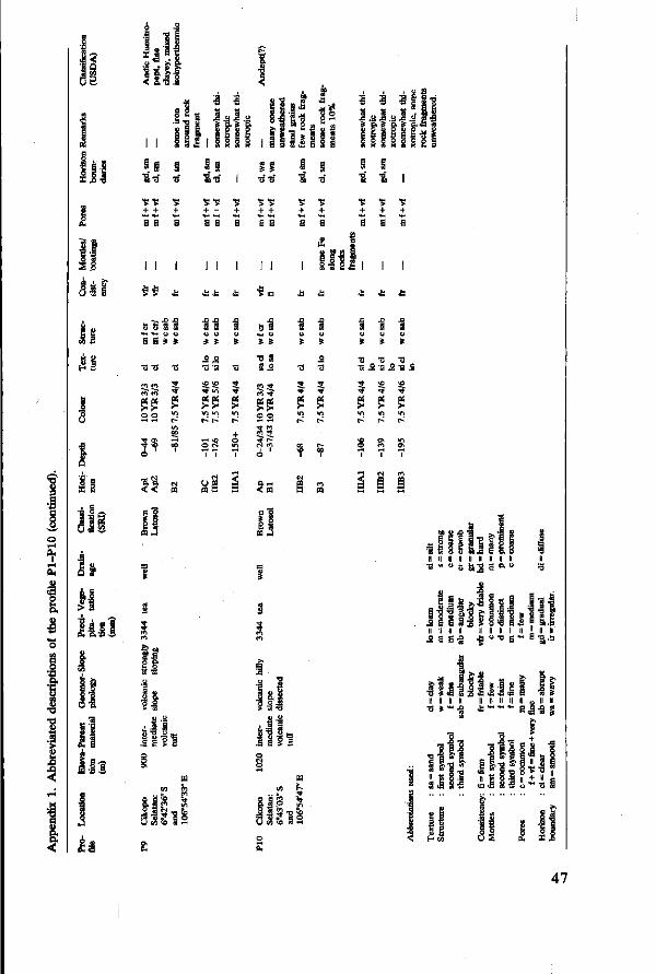
si il ut!
11
8 - ï 1 I §
3 3
I l I
* ' i ö g it.
SES S * g s S 6 5 S g g I 1 § 1 ! 1 g 1
! ! ! I .s 1 .a I S g. S a i
ifiii s s s s a
jtèi ft «G «a
111
•s ts + +
"S "S + + a H
"S "S + +
11 I I I
u. u en «
\£ I I I
* *
! oil
a s 9 *
Cl Cl C l C l
^ > o o
* *
es CQ J
•3-3
SE r-' r-
09 S
tj s <M U
» » 7! S S .S
Ci ^ Cl ^
« O o
• * Cl ci 5_ ^ r» CM c i
è '
Sr~ < QQ
c "§ S 1 0 s £ 3
S u s
•3
^ • *
$ i/i
(
oc f
g
S ti ÏS
o
•5 5_ TT
a ^ v i t-^
r-T
Cl
03
s u
» •o 'S
s • *
"î l >
I 1
1
S 3 u u s » •3 -0
o — o — A « I A I«
vß vo
^ ? S Ê m i n r^ r-'
Ol V I C l ON
1 1
CS Cl
I I
l i - . i i
«v •S
1
c i
I
II > s .8 8
* Q.-0 s
II
II
!
8-5
lin
u Ä!D a s
n i
s i
l « 3 .
Il II II II II II II II II
•s - u 8 &s e =•u
2 e 1 a - g h
l l l l f l l l l l l l Il II II II II II II II II l II II • 2 S Ë * ^ » » r B ï â
J i u i l - l i l s i 11 Il u II
s i * Il II II II
•B »-.g a - - - g j . g g
, i l ! i l i i&ll 1*1 ! S 8 5 <c fi S -
II L 1! u S
i g s S i I f S 1 r i j-s f
I si
47

-*.
„.<&£*-- •*• t f ./fifrr*• ~„-&£i, « ^ -> ,~J&
S-, *%# ' '"
* * , * * .
The bare south-west slopes of the Lawu Volcano, East Java, at an altitude of 900 m.
48
4 Sou catenas on the west and north-east slopes of the Lawu Volcano, East Java
by Subagjo and P. Buurman
Abstract
The physical chemistry and mineralogy were studied of two sequences of soils consisting of Andosols, Latosols, Mediterranean Soils and Grumusols on the west slope and of Mediterranean Soils on the north-east slope of the Lawu Volcano. Soils are developed from andesitic parent material on Upper Pleistocene and Holocene surfaces.
Weathering gradually increases downslope. Andosols are the least weathered soils, while Mediterranean Soils at the lowest altitude are most strongly weathered. Downslope, free iron in soils and particularly iron concretions in the sand fraction increase considerably, hence, perhaps the red colour of soils at lower altitudes. There is an anologous downwards increase in pH and exchangeable bases and hence base saturation which reach the highest values in the basin soil (Grumusol). Permanent charge is relatively low in Latosols, increases in Mediterranean Soils and is the highest in Grumusol. pH-dependent charge is linked to content of organic matter.
Weathering with the prevailing high rainfall and constantly high (isohyperthermic) temperature produces deep soils with predominantly halloysitic mineralogy. Gibbsite is formed in medium acid soils. Smectite appears in neutral to mildly alkaline soils with high supply of bases.
Soils on the north-east slope show higher pH, exchangeable bases, free iron and permanent charge of clay, but shallower profiles than soils of the same altitude on the west slope. These soils are probably younger than those of the west slope.
The properties of Andosol and Grumusol fitted the definition of Andepts and Uderts in the American Soil Taxonomy. The Latosols in this area were classified as Dystropepts and Humitropepts, Mediterranean soils as Eutropepts/Dystropepts and Tropudalfs.
Introduction
Pedogenetical studies by van Schuylenborgh (1957; 1961) and Tan & van Schuylenborgh (1959; 1961) emphasized the importance of parent material in tropical weathering in Indonesia. Studies of toposequences on volcanic slopes consisting of dacitic, andesitic and basaltic material, in Sumatra (Tan & van Schuylenborgh, 1961) and Java (Tan & van Schuylenborgh, 1959; Dudal & Soepraptohardjo, 1960) revealed distinct soil zones. Dudal & Soepraptohardjo found toposequences of Dark Red Latosols, Dark Reddish Brown Latosols, Brown Latosols and Andosols on various volcanoes in Java and Bali. In the Jakarta-Bogor area in West Java, they found Dark Red Latosols below an altitude of 200 m; Dark Brown Latosols between 200 and 350 m; Brown Latosols between 350 and 900 m and Andosols from 900 m upwards. Tan & van Schuylenborgh (1959) found a similar toposequence on the Lawu Volcano between 500 and 3300 m, although they used a different nomenclature.
The soils of the west slope of the Lawu Volcano were initially mapped by Dames (1951). Suhadi et al. (1964) and later Sukardi et al. (1973) mapped the volcano and its vicinities. Sukardi et al. found the following belts on the west
49
slope: 100-150 m Grumusols and Mediterranean soils; 150-250 m Reddish Brown Mediterranean soils; 250-650 m Reddish Brown Latosols; 650-1000 m Brown Latosols and over 1000 m Andosols.
Despite much research, lack of chemical and mineralogical data makes it impossible to translate the results of former investigations into modern concepts of soil classification.
The present study adds characteristics that have not been determined before and attempts classification of the soils, according to Soil Taxonomy (1975) and the FAO Map Legend (1974).
Geology and climate
Mount Lawu is a compound strato volcano that formed during the upper Pleistocene and Holocene (van Bemmelen, 1949). The southern half of the volcano was formed during Upper Middle Pleistocene and Lower Upper Pleistocene. The 'Old Lawu' slopes are rough and strongly dissected. The 'Young Lawu' that formed during a Holocene eruption period constitutes the northern half and partly covers the top areas of the volcanic complex.
The rocks of the Old Lawu consist of quartz-containing andesitic conglomerates, breccias and tuffs. Those of the Young Lawu are also andesitic but do not contain quartz (Dames, 1951). According to Neumann van Padang (1951) pyroxene andesite is the main rock of the volcanic complex. Tan & van Schuylenborgh (1959) classified the rocks of the Old Lawu as hypersthene-augite-andesite.
The climate of the west and north-east slope is Ama (Koppen World Climatic System), that is a tropical monsoon climate with a moderate dry season. According to Schmidt & Ferguson (1951) the rainfall type is C, which means rather wet with a short dry season of 2-3 months. Data on rainfall and rainy days of selected stations, means over the period 1930-1960 are presented in Table 6.
On the north-east and west slopes precipitation increases with altitude. In the west, rainfall is around 2000 mm at 100 m and increases to more than 3000 mm at 950 m. In the north-east rainfall at an altitude of 75 m is 2000 mm and it increases to over 2600 mm at 3000 m. The dry season is from June to October, August and September being the driest months. On the west slope the wettest months are February at low altitude or January above 600 m. On the wetter north-east slope, March is the wettest month.
The moisture regimes according to Soil Taxonomy (1975) are udic to ustic on the west slope up to about 400 m. Higher up, and on the north-east slope, the moisture regime is udic.
Monthly temperature data are not available, but mean annual temperatures can be calculated with the Braak conversion: T = a — bh, where T is temperature, a is 26.3 °C, b is 0.006 °C/m and h is altitude. According to Smith (1973), the calculation is fairly accurate up to about 2000 m and can be used to compute the mean annual air temperature. With the mean annual air temperature of Surakarta, which is 26 °C, the air temperature at 900 m on the west slope is about 20.9 °C. Since the mean annual soil temperature can be estimated by adding 1 °C to the mean air temperature (USDA, 1975), areas above 900 m have an isother-
50
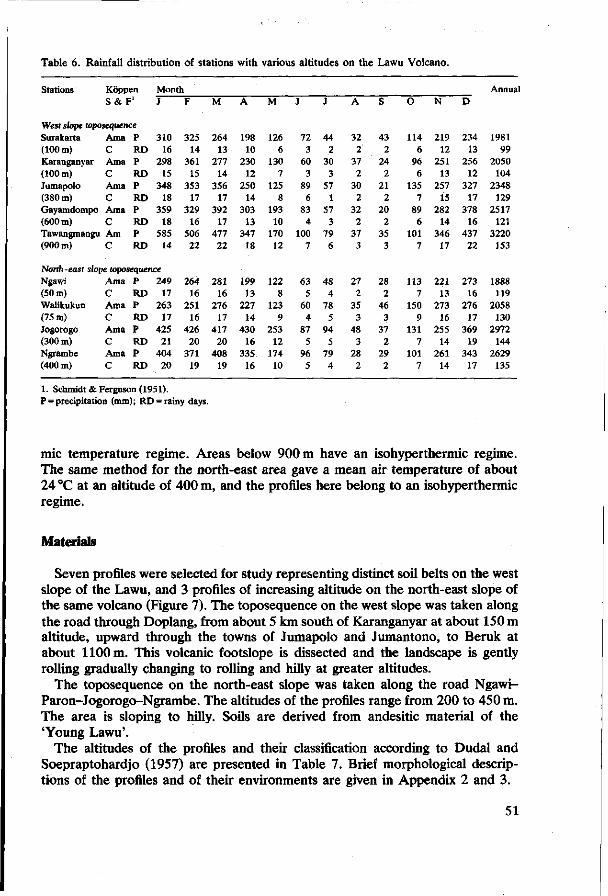
Table 6. Rainfall distribution of stations with various altitudes on the Lawu Volcano.
Stations Koppen S & F1
West slope toposequence Surakarta (100 m) Karanganyar (100 m) Jumapolo (380 m) Gayamdompo (600 m) Tawangmangu (900 m)
Ama C Ama C Ama C Ama C Am C
P RD P RD P RD P RD P RD
Month J
310 16
298 15
348 18
359 18
585 14
North-east slope toposequence Ngawi (50 m) Walikukun (75 m) Jogorogo (300 m) Ngrambe (400 m)
Ama C Ama C Ama C Ama C
P RD P RD P RD P RD
249 17
263 17
425 21
404 20
F
325 14
361 15
353 17
329 16
506 22
264 16
251 16
426 20
371 19
M
264 13
277 14
356 17
392 17
477 22
281 16
276 17
417 20
408 19
A
198 10
230 12
250 14
303 13
347 18
199 13
227 14
430 16
335 16
M
126 6
130 7
125 8
193 10
170 12
122 8
123 9
253 12
174 10
J
72 3
60 3
89 6
83 4
100 7
63 5
60 4
87 5
96 5
J
44 2
30 3
57 1
57 3
79 6
48 4
78 5
94 5
79 4
A
32 2
37 2
30 2
32 2
37 3
27 2
35 3
48 3
28 2
S
43 2
24 2
21 2
20 2
35 3
28 2
46 3
37 2
29 2
O
114 6
96 6
135 7
89 6
101 7
113 7
150 9
131 7
101 7
N
219 12
251 13
257 15
282 14
346 17
221 13
273 16
255 14
261 14
D
234 13
256 12
327 17
378 16
437 22
273 16
276 17
369 19
343 17
Annua
1981 99
2050 104
2348 129
2517 121
3220 153
1888 119
2058 130
2972 144
2629 135
1. Schmidt & Ferguson (1951). P = precipitation (mm); RD = rainy days.
mic temperature regime. Areas below 900 m have an isohyperthermic regime. The same method for the north-east area gave a mean air temperature of about 24 °C at an altitude of 400 m, and the profiles here belong to an isohyperthermic regime.
Materials
Seven profiles were selected for study representing distinct soil belts on the west slope of the Lawu, and 3 profiles of increasing altitude on the north-east slope of the same volcano (Figure 7). The toposequence on the west slope was taken along the road through Doplang, from about 5 km south of Karanganyar at about 150 m altitude, upward through the towns of Jumapolo and Jumantono, to Beruk at about 1100 m. This volcanic footslope is dissected and the landscape is gently rolling gradually changing to rolling and hilly at greater altitudes.
The toposequence on the north-east slope was taken along the road Ngawi-Paron-Jogorogo-Ngrambe. The altitudes of the profiles range from 200 to 450 m. The area is sloping to hilly. Soils are derived from andesitic material of the 'Young Lawu'.
The altitudes of the profiles and their classification according to Dudal and Soepraptohardjo (1957) are presented in Table 7. Brief morphological descriptions of the profiles and of their environments are given in Appendix 2 and 3.
51

Fig. 7. Location map of the Lawu area. LW: profile number + : weather station
Table 7. Classification and altitude of soils on the Lawu Volcano.
Profile Group or subgroup
West slope toposequence LW1
2 3 4 5 6 7
Andosol Brown Latosol Reddish Brown Latosol Reddish Brown Latosol Reddish Brown Mediterranean Soil Reddish Brown Mediterranean Soil Grumusol
Altitude (m)
1070 880 625 400 240 150 230
North-east slope toposequence LW8 Reddish Brown Mediterranean Soil 420
9 Reddish Brown Mediterranean Soil 330 10 Reddish Brown Mediterranean Soil 220
52
Results and discussion
Mineralogy
Mineralogical composition of the sand fractions The results of grain counts of total, heavy and light sand fractions and the results of X-ray diffraction analysis of clay fractions are presented in Table 8.
Opaque minerals, rock fragments, weathered mineral grains and iron concretions, predominate the composition of total sand fractions in most profiles so that interpretation of these data is highly unreliable. We therefore concentrate on the heavy and light sand fractions.
Analysis of the heavy fractions (Figure 8) shows that most profiles are not uniform in parent material. On the west slope, the assemblage was mostly dominated by green hornblende, which is characteristic of the Old Lawu products, but most surface layers show addition of Hypersthene and Augite, which belong to the Young Lawu deposits. Addition of younger material was pronounced in the Profiles LW1, 3, 5 and 6. Weathering of the sand fraction results in large amounts of residual opaque minerals, as illustrated by the compositions of Profiles LW3 and 4.
The three profiles on the north-east slope present a similar picture. LW8 was dominated by green hornblende but has an addition of younger material in the surface layers, while LW10 seemed more strongly weathered: its heavy fraction is dominated by opaque minerals, with amphibole in the second place, and fair amounts of augite and hypersthene. LW9 presents an ambiguous picture. Its subsoil seemed highly weathered (zircon) and its surface layers showed addition of Young Lawu material.
Opaque minerals were identified by X-ray diffraction. The majority belongs to the Franklinite group.
Light sand fractions offer a uniform picture. In all profiles intermediary plagioclases (labradorite) and weathering products of this mineral constituted up to 90% of the grains. The remainder were quartz, volcanic glass and rock fragments. The weathering of the feldspars showed no distinct trends with depth, which testifies of the addition of fresh material. Feldspars were most strongly weathered in LW4.
Mineralogy of the clay fraction Relative amounts of clay minerals were estimated from the intensities of the basal reflexions of oriented samples of the same thickness. Clay minerals throughout the profiles at greater altitude were poorly crystalline. Profile LW1, dominated by amorphous colloids, contained some badly crystalline metahalloysites and interstratified minerals, together with gibbsite and goethite. Downhill, the crystallinity of these minerals increased. Halloysite was the predominant mineral in most downhill soils, except LW4, where the clay fraction consisted mainly of irregularly interstratified minerals. Gibbsite was particularly abundant in that profile.
In the basin soil LW7, there were smectites, and traces of plagioclase in the clay fraction. In the soils on the north-east slope, halloysite was the predominant clay mineral.
53
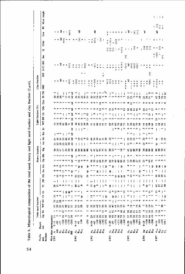
+ + + ~ + +
ü
o + + + + + +
e A
I I I ! I I I I m I I I I ^ I I I I I
« m /> H H t » ON h \o ^ m *D *D *t m r* cc oo <n m r j r— O N ^ O O N O ON ^ — oo
O a E o
xi es
H
O
5
• T m Tf w) -o c
'~ I I " ? I \D r- ^ t ^H T3
oo -o i CJ m
m NO x m m
M t m 3\ 0 \
I I I ~ I
t ^ CC VD T t - H
r r i " " " m ir, ci m i ci wi
« - i 3\ M (N m
" M i l l (N m m
© X ci NO >o t m m m ON r- t r-
m m i i m m cl o i M N i ^
-o •-* m r i x r- ci x *t
i i • 0 0 I (M NO ^ f -—i ON
o <n m m
co oo NO c i
l l - l
l l I I I " ! r- oo
ci m
m CJ
ci m
m i-f
00 ON
\0 00
't o
- i Cl •-<
,-,,-o 't
O i-<
CJ O
!-< r-
^
<3
1
ON
^ Cl
W1
O
X
NO
1 x
-m
X CJ
't
m
t
m
m
Cl
r-
in
X
in
£ Cl
1 X
1 1
\o
Cl
m
NO
O
\0 't
O
(*1
-ci
t
« -i
<N
a
1 -o X
en
NO
X
en
CJ
-«
m
m
m
! CJ
a
-• *
x>
-t
m
O
r-
CQ CQ CQ CQ
c •a c
•o c
C
C
cl
a
o>
i
i X
1 r-.
Cl
m
NO Cl
O o Cl
eo
't
1 NO
Os
1 ---ON m
1 O
C
^ m
CJ
Cl
X
o>
S
<
_
t m
1 1
X X
n c*i
O NO
a a
i i
i i
= " - i 1-1 a
ON m
«n ON
--H Ci
m n
C- ON
o
M ffl
00
1
X
(N
X
o
1 o o\
1 vO
a
a
ON
1 m
~ 1 *> (N 't
ci
NO
o
NO •'t
r-
V) 't
(N
-O
Tt
« n
(N
m
m
Cl
r-
cJ Cl
X
Ci
et
< m
§
** »n • *
• < *
l o m
*, -co
l a
xi
<N
-
n".
" 't
in
f
C
H
N©
Cl
NO
~ a
-
1 -
m
--ON -t
X
O
m
rî • *
r-
m
vO X
i
i « i
i in
" ">
m
\o Cl
Tt
7
Cl
^
m
• *
ON
1
1 -1
1
"> !
CJ
O
•<t
m
ON Cl
CQ CQ CQ CQ
X
Cl
VI
m
r-
a
i -i « " a
m
O
X
o
O
o
m
O Cl
-NO NO
*" g,
^
1 &
^
1 m
• *
Cl
^ X • *
o
<
- i
M
l
Ci
l
c-
p.
1 -1
1
^ p.
1 o
Si CJ
X f
CQ
o
1 m
-o o\
1
1 a
i
i o
&
i
^ X
X
C CM
7
CQ
^
1
-
-ON X
1 | a
i
i X
1 -c-
X
NO
c-
CQ
• *
cl
O
1
X
&
1 a
i
i
-i -(N
O
V>
O o (N
£
1
1 Cl
1 NO O«
! ! a
i
i m
l Cl
m
x>
CJ
O NO o
m Cl
-
•<t
x>
c-
•t
r<
SO
1 <n
m
CJ
r-
x
X CJ
X CJ
<
3
Oi
ON
Cl NO
• *
X CJ
~ 1
o
1
1 m
1
1 -X CJ
ON
NO
S
1 X X
1 ON
-
1 "
1
1
1 1 -
-
Wl
't
O O
CQ CQ
m
^r
X
r
CJ
i
i " i
i CJ
1 CJ
NO
• *
o
CQ
CJ
NO
O ON
CJ
»n CJ
1 a
«n
! 1
-1
X
ON
fO
CJ
+
o
in
O
f -
.m
Cl
-ON
1 ^
't
^ X
r-
X
X
2
^ NO
ON
T
O X
-sj
ot)
-
t " 1 g.
m
1 -ON
Cl
r-
• *
t
CJ
ON X
-t
1
1 Wl
1 ^
n w
-o\
NO
NO
o o Cl
m
^
ON X
-
a
i -i
! CJ
^ -
d
ON
ON
O X Cl
CQ CQ CQ
a
a
ON ON
-«
a
-\o
i CJ • *
m
^ m
fi
O
m
NO
S
1
1 o> 0^
-NO
a
1 o\
i
R NO
1
] -^0
ro
o
X r-> '- CJ
m cl
o m r- r-
NO Cl
>o m
i &
l l m in i-H C J
1 1 Cl o m NO
1 rt
1 & ON r-
O H CJ
r.--
cl m
«o + o m
< m ou
54

e
e
!
i
i 1
'S a
3 I
o
I 1 o •a
•S H
!
I
1
5 o
o
f
3 11.
1 1 1 +
! ! £ • § + 1 1 1 + l l l l l
+ + + ' ' ± + + I l l l l l
+ + S + + +
-•s + + + + + + + + + + • + + + + + + + + + +
+ + + + + + + + +
I I ^ t v> r t [ f t * n m r i «
< N t - T j - m m N m N r t «n — n c m n i-i CM
i o o » M i n N CM c \ oo r - i » t r t i (S r-l W TH ,H ^H CO I I
H « 3 H \ o n i - CM <N en N w r n * m — 1-H CO
m O N ^ * • *
i i " o o i m CM * a CM
N BH t WO B N
« <n »© t * * « i f l i j i f l * m co "O ^ i v> e *-< ' i « i e i -
sss
011 I - I " & I I " I I I I " & I I
" M M I M I S & I && 2 &rf<*
i i CM i & CM -<t tM i
M i l l I & I I ir> *4 i-i en en o< H I I
CO en I i -i
* - I I &
i - M i V ) > O H N f l
I ~ I
a N N O v i O
i H i f t h t - t » en r -. TH ,-< ,-H CM (JO _ ! ,-)
M m m ^
m m ffl 0
ÏS
i i i Nine» i m
I "SKS O O O N ' t ' t
m
* t CM O CM *C «n t r - r n
£ S § § § ^ T i i i
P. « S m -< O O B O
1
M
* ; a
si S-3. o a
_c3 ' p ,
a I
S '5 S c
P Q
H «
Saa i
°&
5 j a
"§ «'s» S -ga
es e-•o E.s
* Ö>.S Il H II
IP I-S e Mi ü s ? tl. ^ ü II II II « xi a fcK5
.111 E l l S * S
l ' ï l ? • ? 11
§ .1
•o -S e
ö » 2 M » -S
I
S 5
« j ; u a & B fi c
I S£ö 6 S*'
55
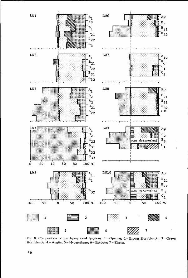
LW6
LW10
5
100 100 100 %
1
w Fig. 8. Composition of the heavy sand fractions. 1 = Opaque; 2 = Hornblende; 4 = Augite; 5 = Hypersthene; 6 = Epidote; 7 = Zircon.
Brown Hornblende; 3 = Green
56
Trends were the increase in crystallinity downhill. Halloysite predominated in the most strongly weathered soils and was accompanied by gibbsite, and by clay-size quartz.
Physico-chemical properties
The results of physico-chemical analysis and quantities derived from them are presented in Table 9.
All profiles except LW1 (Andosol), had rather high contents of clay that increase at lower altitudes. In most profiles from the west slope the distribution with depth was fairly homogeneous, while the profiles from the north-east slope had a distinct maximum of clay in the B horizon. In Profiles LW7 and 9 the lower clay content in the surface soil was mainly compensated by a higher silt content. As both profiles were under paddy rice, the differences in texture between surface soil and subsoil might be the result of periodic puddling: loss of clay with irrigation water, and an increase in residual coarser fractions.
With altitude pH varied somewhat. It was close to neutral in the Andosol, decreased in the Latosol profiles, and rose again in the Mediterranean and Grumusol profiles.
Base saturation gradually increased downhill, it was lowest in the Andosol and highest in Grumusol and Mediterranean soils. All soils, throughout the sequence, had very low contents of KCl-exchangeable aluminium and H+. Therefore, base saturations on Permanent Charge and Effective CEC were always close to 100%.
As a result of the higher base saturation, permanent charge (PC) and effective CEC increased downhill. In the highly saturated soils, PC and effective CEC approached CEC-7 (the pH approached neutral) and the pH-dependent charge decreased. In all profiles, except LW1, charge characteristics were f airly constant with depth. Exchange capacities increased downhill but were significantly influenced by content of organic matter (LW1.LW3). The CEC estimated by percolation with unbuffered NH4C1 of 1 kmol/m3 (IN) formed an exception. The CEC depends on the acidity of the saturating solution and strongly increases with pH (Chapman, 1961; Reeve & Sumner, 1971; Gallez et al., 1976). So, one would expect the CEC-pH7 to be higher than the unbuffered CEC, which was estimated at a pH close to the pH-KCl of the soil. Unbuffered CEC is generally close to effective CEC (soil). Unlike the other exchange characteristics, unbuffered CEC with NH4C1 tended to increase with depth and was often higher than CEC-pH7. This discrepancy was observed earlier in some 'Podzolic Soils' from west Sumatra and is as yet unexplained.
Charge dependent on pH (PDC) is generally correlated with one or both of organic matter and sesquioxides/amorphous substances. PDC was highest in the Andosol (LW1) and in the humose profile LW3. The presence of amorphous alumino-silicates such as allophane was demonstrated by equilibrating the soil sample with an NaF solution of 1 kmol/m3 (IN). Fluoride ions disrupt hydroxyl bonds and if considerable amounts of allophane are present, the pH of the solution rises strongly. For LW1, the pH of the equilibrium suspension was between 10.7 and 11.2, which, according to De Villiers (1971) indicates that
57

» s s S
ti _ 9
u ^
so o m oc o r - r - oo r - r - os o N ^ r^ ^ \ o ^ o o r - m o <n ^ ^ a r - o >n •-" r<} Os t - f ) f> CS rS rS Csl CI f") CS CS CS CS CS M N H p ) N OJ N N (S N T
CO "n m O so 00 u-| r>l ' t m CO Os r- rS U"> 00 U*1 rt M 0 \ >£ H a t O n x ^ o U l r t C O * W N W N N (N (N N •-< rS rS rS CS CS rt rt rt CS rt rS CS CS CS CS f
N r t N r t H
' (M O C O C O a M f •<t ro s o r~ r~
u a
u s-<
8g
8ë Ü M u w
•t « r i OV < ) os t-; es c*i m rs o ^ ^ N H m h- o ^ » m r-; <n es u-> m es ce • * t o r^ r i d oi ^ ö d t^ Os in' c*i ^ ci r- H d co' --i al H I-H rt rt' od >-H
t t *t m O Cl rs (N M (N rS rt M N l N N N N CS CS rt CS rt CS CS CS CS rt CS
(N i-i O CS O CI Os os ci d r- ^t I> od m Tf • * ci m (N I-H
i N rt rH » i- i (N rs n i-i H
r-; h; 't M » M ^ H e; n * H H Tf « o ; m >c vi (N a co e) q\cr^o ce sd c© ce' es' u-i •-< t-.' ooMr^r-'ö -<t ri c-i in - ' es' oi es od oi d sd sd os cc cc m'
.-. — .. -, „, «, . ,„ _ — , ^ ^ . f r j H M H m in m i-< -H es es m -i es m T m ^H es i
(- .-i .-H — cS ^" -H N >o 00 ' t \o © ^t es - , r-; Os in q SO sq q es • - ; TT fl l> O ^ I H C C
ci c i u-i sd i> os cooked
n H a co rt H n ui in oo M ._ i n ^ N 00 ^ CC O r O ^ f T C O
d od od ad od d cd sd so t- sd os I-H i-i d d es'
° S ï ^ ï ï » 5 o i-i i-i o r» r oe os so os so m o i t*) ° . ° . ° . ° . ° . M C O O f O . C S H N N f / i l » rt CS T ö o o o o o ö
V V V V V H O - H o o o o o o o o o o o o
o o o o o o o o o o o o
so so « Os r- m p o o o - * rs ö o o o ö ö
O CS f Os f- Os
q q q © -< q
ö ö ö ö o ö
m N *o co co H m -t rn - ^ e- so « fs) rn ,H \q ^ N .o; • * es I-; -H « r i r i r t o d d ö ó ö ö o
Os r- \D os x co I-; rS U-> CS O © es i-î d ó ó d
sO ' t CO © CS P- Os O M N ^ O O P- © so Os CS " o q s o w i q q * m vo « cc n q » ^ N »
ei r t «ri u-i u-i i I r - -ï / i TT m n m so i
r s o sw- i r -Ovcc n \ c \ o t cc ' t es es en q o r-; so es I-H © d d d d d d o d d d o
- o r- ui o> t so so rs o r-i in os I-H o I-H o r s o s r - m
1> w rs I-H
H co tf q co H t Os f CS in' d CS so v, t~- r- r- \o so m
r-; I-H co q co t^ co d i/i o »-< •-" rs M ci
\d u-i u-i sd oo od od
sOOsi-Hsocooo o\ n t-; in t -f es r- o cd o\ so es' cd rs TT' e- r- so r- so m so r- m m m
so q m_ o o *t o s o s r - q o q m t^ r i d o -H odrs ' sdrs iod
N es <n s o r - s O \ O T t
D ' + c s r ^ q s o r- H O I M Ü i - r- as' ci ci es ' t H ' co' w oi • - r - r - r - r - c o c o o o r - o o r - i
I-H I-H so so so
r- ci u-i rt sd r- co so so - *
CS 00 CS sO rt © CO ON 00 f- SO CO O s r t O O s t -
X> cd H
O s s o s o u ^ c s o r - ** ** f s"1"* ^ r^ io SD in m N vo \o co Tt n n © oo oo r- r-
' t ' •*' ' t "'t "'t "^ Tt t ^ " t * ' t i n T f f T f f f ' t * ' t ' ' t
E
O
§•
|
S
CO
i n
o
rs s o
m
a < < ^
o SO
u-i
SO
,_, c
T
SO
i n
so
PQ 0 3 CQ CD
CS
sO
O
<n >n
i
< I N
sO
u-i
Y
^
t>
u-i
o
'
CO
«n
ca cQ pa
r~~ m
n
t »
» n
rs
i
r-SO
SO
< a m
-
SO
m
_,
CO
u-i
i n
ro
r j 1
rs
• *
>n
n 1
rs CS
'-' ™
V,
m
i
m m
i
<
_1
o m
i
CQ
f
u-i
1
m «n
_ l
t
m
1
CO CQ CQ
m i n
rst l
rt sO
rs
i
< * U
^ sO
o SO
1
CQ CQ
Os
i n
i
r ,
CQ
co m
O
^
58

J S ' S -
S S « c Ï E . S S
4
S3 l'a?
CS CU
pa w
ei
II
'M
1 1 e ra
&
Cj
E
8 "o e
a
£
g
SI U .
y «
'S"
J ê h-t
s 0
S
1
o o
en
N N
o
(S
N ci
V>
ri N
m o!
r> ci
GO in d
m ©
o o o o o o
ït § §
N N «
N N N
H | « l ^
n q * n-' vi ~i
** oo ON
•* vi N
« N N
q M -H TH N' có
/ i M m d .-< r-
N N N
n ON m d o ^
H « n Ó O H
© © o o o o
ON o t-r- © ON
00 « <-< fl«CO0
co © cO Np co
O t O O co « r-
* N ' * ON ei ^
'NCJI*; oó r- t- M t n
00 ii o
ste.s oo t*- N
oó 3 oó
TH 00 00 \q co m
•oó vi có
TH •* N
**î *1 **î oó vi có
TH N
O
ON
ON o
o
o
N ei
r
q NO
r
N
t»; VÎ
t-; vi
o O
r-
ON
CO
CO fO
CM
NO i-i
O
O o O O o o o o
*£> vu « \0
00 t- O CO
N N w n
P* NO ON N N N es m
r- NO o N —1 1H TH <M
O ^ t H co <-ï ei i-J
H i r i N t * NO NO co NO vt n r J N N N
co 6 N
-* in'
*t
•* -* rf
•'t CO 00 00 ,-; d *-< «-<
N N N N
•* ON « 1- d d o! t- CO CO CO ^
N CO •<*
CÓ N CO '
- - 1 ; « * CO N CO ^
O O O O O O
r» o\ NC
00 1-1 ON
H O M t « N
N 00 ON
M H rH
v> ON N N N N
NO i-J o\ N o\' r-
W N N
N N 0 \ o r* có CO N N
O O
N N©
CO
m co
N N
VI N
Ov NU' N
CO CO N
•* N *û 0\ N CO Oi N N TH
- 3 N co n ON d « in N <-< i-i
H P j r ; d *o vi N i-i i-i
N N
00
•«f
^,
^
o o o o o o o o o o
« a r t t ^ NO VI N© NO NO
T- ON m N N CO N N CO ^
N N N CO f
o r- «o o r-N TH TH N N
N N i-i N tM vi -J CO i-ï N
•o i-j Tf in N
o vi \d * *fr
CO N N N N
wo O; co q q
N N N N i-
N q oq ON •* in o\ co i-ï N O
T H T H N CO CO
v> T T N m «n •* O CO co co vi t có CO N
CO ON CO CO i-< vj có có có N
-sa
fa c
s^
q q o q q o q q d o d o d o d o co i - iooco « i - t c o r -
o o o o o o o o
« O O N o d o o d
O O O O O O O O O o o o o o
•^•iHTtoOvO w N t ^ - * COO\COCOO
55?^i
„ ^ H H N .
O O O O O
N "* ^ N 5 •^ ON N in 4 NO v i NO vd v i
CO N N CO
H O O O O O O O O
h a » o o
1 ; r j O 1 ; <; ^ o o r ^ N ^ » h N O t O Â N O - ^ V O C O CSi ^ i-i 00 oÓi iNNONO coNONOviv) » n o o r - m NOOOOOVICO
r - N N O c o COOOVJNO
^ o; q i n n « so t^ O O N N P ^ N o r ^ d v i •r* ^ i -H N —I CO CO
* N ^ H « i-J o\ t-; N N N O W Ó N N O c ó r ^ T H v i • n r - h M O NO oo oo NO
C ^ ^ - O c O N corO.coi-
N NO 00 N ON
S iï
S
•s a
(S
•o c
Ü
0
£
1
^ g
ON N
^ H
vi
q NO
00
3
ON
'"' ON • *
ON V)
to
1
• *
N
00 • *
r vi
O o N
t
N
^ t* • *
NO vi
o 00 N
T T i-t ON r» TH Tf ON o\ T H TH fO 1*
co r-. NO q vi \ó vi *d
co r-- r-; co
N O N - O h
0-16
-1
03
-105
10
5 +
Q.N CO TH ^ f" (
< CÛ CQ U < CQ U E
N N o « n o c i T H i n r * r - p - c o r ^ \ O H Î - f-l TH N O O H r t T H - * !
I l l J i l l 1 1
N C O c o O S O - N C O T H Q < C 4 ( S ) C 0 > H
co CÛ co u < ta ta u <CQCQCQU
1! §
59
amorphous material predominated. In that profile, the proportion of amorphous material seemed to decrease with depth, as reflected also in the CEC7 pattern.
Because of decreasing amounts of amorphous material and organic carbon, PDC was much less downhill; it was almost negligible in the highly saturated Grumusol.
If we take charge properties of the clay fractions as a measure of weathering, Latosols were most strongly weathered, together with the Reddish Brown Mediterranean soil LW6. The soils of the north-east slope were considerably less weathered, testimony again for the development of these soils from Young Lawu eruptiva. The erratic behaviour of these properties in LW1 was probably due to incomplete dispersion and consequent error in estimation of clay content.
Soil classification
In the following, the profiles have been classified according to Soil Taxonomy (USDA, 1975) and to the FAO-UNESCO Mapping Legend (1974). Micromor-phological data are lacking and therefore, some ascriptions are tentative. Also data on bulk density and water content at tension 1.5 MPc (15 bar) were not available. Soil moisture conditions were assessed from meteorological observations.
Profile LW1: Andosol The profile has an umbric epipedon and a cambic horizon. The exchange complex is dominated by amorphous material. Base saturation is low. ST: 'Umbric' Dystrandept, medial, isothermic. FAO: Humic Andosol.
Profile LW2: Latosol The soil has an ochric epipedon. No clay coatings are visible and the increase of clay below the epipedon is not sufficient for an argillic horizon, so a cambic subsurface horizon is present. Base saturation is lower than 50%. The clay fraction is dominated by halloysite and mixed-layer minerals. ST: Typic Dystropept, very fine clayey, mixed, isohyperthermic. FAO: Dystric Cambisol.
Profile LW3: Latosol Again an ochric epipedon and a cambic horizon are present. The organic carbon content is higher than 12kg/m3. CEC-clay is higher than 24meq and base saturation is lower than 50%. The sand fraction has a low content of weatherable minerals. ST: Typic Humitropept, very fine clayey, mixed/halloysitic, isohyperthermic. FAO: Dystric Cambisol.
Profile LW4: Latosol This profile has an ochric epipedon. The subsoil does not show sufficient accumulation of clay for an argillic horizon and has a CEC-clay that is just too
60
high for an oxic horizon. It is therefore designated as cambic. Weatherable minerals are low. CEC-clay is lower than 24meq. Base saturation is less than' 50% in the B. Clay minerals are mixed. ST: Oxic Dystropept, clayey, mixed, isohyperthermic. FAO: Ferralic Dystric Cambisol.
Profile LW5: Mediterranean Soil The increase of clay in the B horizon is too small for an argillic horizon. The subsurface is therefore a cambic horizon. Epipedon is ochric, base saturation is more than 50%. ST: Typic Eutropept, very fine clayey, mixed, isohyperthermic. FAO: Chromic Cambisol.
Profile LW6: Mediterranean Soil No distinct illuviation of clay. Ochric epipedon and cambic horizon. Base saturation slightly lower than 50%. CEC-clay of B horizon is 24 meq. ST: Oxic Dystropept/Typic Eutropept, very fine clayey, halloysitic, isohyperthermic. FAO: Ferralic Cambisol.
Profile LW7: Grumusol Clayey soil with intersecting slickensides, calcic horizon and wide cracks. Moist colour value in upper 30 cm is higher than 3.5. ST: (Aqu)entic Chromudert, very fine clayey, mixed, isohyperthermic. FAO: Chromic Vertisol.
Profile LW8, 9, 10: Mediterranean Soils These profiles have very similar properties. Although they show a distinct increase in clay in the B horizon, this is probably due to a young cover of volcanic material and to washing out of clay. In the field, clay coatings were not obvious. All base saturations are higher than 50%. Two possible classifications are: ST: Ultic Tropudalf or Typic Eutropept, very fine clayey, halloysitic, isohyperthermic. FAO: Chromic Luvisol or Chromic Cambisol.
Weathering indices
Various authors have tried to express the weathering stage of soils with various parameters. Coleman et al. (1959) suggested the ratio PC/PDC as a weathering index. Van Wambeke (1962) used the fine silt/clay ratio to characterize the evolution of tropical soils. Jackson (1964, 1968) used the mineralogical composition of clay or silt fractions. De Leenheer et al. (1952) employed the ratio Fe203/silt and Tessens (1975) the ratio CEC-NH4Cl/clay. Tavernier & Eswaran (1975) used the mineralogical composition of the clay fraction, supplemented with physico-chemical properties.
61
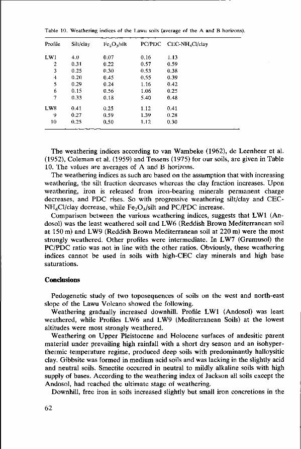
Table 10. Weathering indices of the Lawu soils (average of the A and B horizons).
Profile Silt/clay Fe203/silt PC/PDC CEC-NH4Cl/clay
LW1 2 3 4 5 6 7
LW8 9
10
4.0 0.31 0.25 0.20 0.29 0.15 0.33
0.41 0.27 0.25
0.07 0.22 0.30 0.45 0.24 0.56 0.18
0.25 0.59 0.50
0.16 0.57 0.53 0.55 1.16 1.06 5.40
1.12 1.39 1.12
1.13 0.59 0.38 0.39 0.42 0.25 0.48
0.41 0.28 0.30
The weathering indices according to van Wambeke (1962), de Leenheer et al. (1952), Coleman et al. (1959) and Tessens (1975) for our soils, are given in Table 10. The values are averages of A and B horizons.
The weathering indices as such are based on the assumption that with increasing weathering, the silt fraction decreases whereas the clay fraction increases. Upon weathering, iron is released from iron-bearing minerals permanent charge decreases, and PDC rises. So with progressive weathering silt/clay and CEC-NH4Cl/clay decrease, while Fe203/silt and PC/PDC increase.
Comparison between the various weathering indices, suggests that LW1 (An-dosol) was the least weathered soil and LW6 (Reddish Brown Mediterranean soil at 150 m) and LW9 (Reddish Brown Mediterranean soil at 220 m) were the most strongly weathered. Other profiles were intermediate. In LW7 (Grumusol) the PC/PDC ratio was not in line with the other ratios. Obviously, these weathering indices cannot be used in soils with high-CEC clay minerals and high base saturations.
Conclusions
Pedogenetic study of two toposequences of soils on the west and north-east slope of the Lawu Volcano showed the following.
Weathering gradually increased downhill. Profile LW1 (Andosol) was least weathered, while Profiles LW6 and LW9 (Mediterranean Soils) at the lowest altitudes were most strongly weathered.
Weathering on Upper Pleistocene and Holocene surfaces of andesitic parent material under prevailing high rainfall with a short dry season and an isohyper-thermic temperature regime, produced deep soils with predominantly halloysitic clay. Gibbsite was formed in medium acid soils and was lacking in the slightly acid and neutral soils. Smectite occurred in neutral to mildly alkaline soils with high supply of bases. According to the weathering index of Jackson all soils except the Andosol, had reached the ultimate stage of weathering.
Downhill, free iron in soils increased slightly but small iron concretions in the
62
sand fractions became abundant. This probably explains the red colour of the downhill soils.
Exchangeable bases, pH and base saturation also increased downhill, and reach their maximum in the basin soil LW7 (Grumusol). Permanent charge is relatively low in the Profiles LW2, 3 and 4 (Latosols), increased in the Profiles LW5 and 6 (Mediterranean Soils) and is highest in LW7 (Grumusol). PDC was closely related to content of organic carbon. It was relatively high in moderately acid soils and decreased in neutral soils. Exchangeable aluminium decreased with increasing pH of the soil
Soils on the north-east toposequence, generally had higher pH, exchangeable bases and base saturation, free iron content and permanent charge of clay. Charge dependent on pH was less and profiles were shallower than those at the same altitude on the west slope. These soils may be younger than soils of the west slope. The properties of Andosol (LW1) and Grumusol (LW7) fit to the definitions of Andepts and Vertisols (Uderts) respectively in the Soil Taxonomy. Latosols (LW2, 3 and 4) sometimes showed evidence of clay illuviation. Mediterranean Soils (LW5, 6, 8, 9 and 10) had all grades to strong clay illuviation. Latosols in this sequence were classified as Dystropepts and Humitropepts, Mediterranean Soils as Eutropepts/Dystropepts and Tropudalfs.
FAO Soil Taxonomy
Andosol
R. B. Latosol
R. B. Mediterranean Soil
Humic Andosol
Dystric Cambisol Dystric Cambisol Ferralic Dystric
Cambisol
Chromic Cambisol Ferralic Cambisol (Chromic Luvisol)
Umbric Dystrandept
Typic Dystropept Typic Humitropept Oxic Dystropept
Typic Eutropept Typic Eutropept/Oxic Dystropept (Ultic Tropudalf)
The table shows that Reddish Brown Latosols, as the definition now stands, have a rather wide range of properties, while the definition of Reddish Brown Mediterranean soils appears adequate.
Questions and comments
Isa Darmawidjaja Q. The profiles of the north-east Lawu do not present a real toposequence. The parent material of the three profiles is probably different, and the profiles are separated by deep river valleys. A. The profiles indeed form no real toposequence; not for the reasons you mention, but because they are from about the same altitude. Q. According to the mineralogical analysis, the profiles of the north-east Lawu
63

are also formed from Old Lawu eruptiva. A. For Profile 8, this may be true. Soil 10 does not have quartz anywhere in the profile and should therefore be grouped with the young Lawu products, and Profile 9 has a cover of young material. Q. Can the profiles be classified with the newly proposed system of Soeprap-tohardjo & Ismangun? A. The new system permits classification of these profiles. However we are not happy with the term 'Brunizems', which would apply to Profiles 2, 3, 5 and 6. Comment. There is a good correlation between the Coleman weathering indices and the classification in the D/S system.
T. Pandia Q. I suppose you could not determine goethite in oriented clay samples, because the goethite would be masked by the clay reflexions. A. That is not true. The main goethite reflexion does not coincide with the clay reflexions and, as iron minerals mostly occur as coatings on clay minerals, they are certainly not masked by clay.
S. Sivarajasingham Q. Why are Profiles LW5, 6, 8 and 10 not classified as Reddish Brown Latosols but as Reddish Brown Mediterranean Soils? Their CEC is lower than 24. A. Classification is based on CEC-clay and not on CEC-soil. The CEC-clay is higher than 24meq/100g.
I. P. Gedjer Q. According to your paper, the CEC-NH4C1 is unreliable, but you still use it in calculation of weathering indices. A. The absolute CEC-NH4C1 is certainly unreliable, but relative values are consistent with other measurements
Rachmat H. Q. You found smectite in one of your profiles, the Grumusol. Don't you think that this profile developed from a different parent material? A. Mineralogical analysis does not point to a different parent material. It is quite normal that profiles in basin positions in such landscapes develop a montmorillo-nite mineralogy.
Sukandar and Tejoyuwono N. Q. According to your weathering indices, the Grumusol is the most highly weathered soil. Do you consider that to be true? A. In fact, these weathering indices should not be used in soils with a high base saturation and mineralogy other than kaolinitic/sesquioxidic. I would not say that the Grumusol is the most highly weathered profile.
Tejoyuwono N. Q. Parent materials in your sequence are probably not uniform enough to allow
64
the term toposequence. Would not lithosequence be better? A. We think that differences in parent material have a smaller influence than those of slope and climate/altitude.
References
Bemmelen, R. W. van, 1949. The Geology of Indonesia. Vol. I. The Hague. Chapman, H. D., 1965. Cation Exchange Capacity In: C. A. Black, (Ed.), Methods of Soil Analysis.
Part 2. Amer. Soc. Agr. No. 9, Madison, Wisconsin. Coleman, N. T., S. B. Weed & R. J. McCracken, 1959. Cation Exchange Capacity and Exchangeable
cations in Piedmont Soils of North Carolina. Soil Sei. Soc. Amer. Proc. 23: 146-149. Dames, T. W. G., 1951. The Soils of East Central Java. Contrib. Gen Agric. Res. Sta. Bogor, No. 141. Dudal, R. & Soepraptohardjo, 1957. Soil Classification in Indonesia. Contr. Gen. Agric. Res. Sta.,
Bogor, No. 148. Dudal, R. & M. Soepraptohardjo, 1960. Some considerations on the genetic relationship between
Latosols and Andosols in Java (Indonesia). Trans. 7th Int. Congr. Soil Sei., Madison, USA Vol. IV. p. 229-237.
FAO-Unesco, 1974. Soil Map of the World. Volume I. Unesco-Paris: 59 p. Gallez, A., A. S. R. Juo & A. J. Herbillon, 1976. Surface and charge characteristics of selected soils in
the Tropics. Soil Sei. Soc. Amer. Proc. 40: 601-608. Jackson, M. L., 1964. Chemical composition of Soils. In: F. Bear, (Ed.), Chemistry of the Soils. 2nd
Ed. Reinhold Publ. Co., New York: 515 p. Jackson, M. L., 1968. Weathering of primary and secondary minerals in Soils. Trans. 9th Int. Congr.
Soil Sei. Vol. IV, Adelaide, Australia. Leenheer, L. de, J. D'Hoore & C. Sys, 1952. Cartographie et caractérisation pédologique de la catena
de Yangambi. Publ. INEAC Serie Scient, No. 52, 62 p. Mehra, O. P. & M. L. Jackson, 1960. Iron oxyde removal from soils and clays by a dithionite-citrate
system buffered with sodium carbonate. Clays and Clay Min. 7: 317-342. Neumann van Padang, M., 1951. Catalogue of the active volcanoes of the world, including solfatara
fields. Part I. Indonesia. Int. Vole. Ass., Napoli, Italia. Reeve, N. G. & M. E. Sumner, 1971. Cation Exchange Capacity and Exchangeable Aluminium in
Natal Oxisols. Soil Sei. Soc. Amer. Proc, 35: 38-42. Schmidt, F. H. & J. H. A. Ferguson, 1951. Rainfall types based on wet and dry period ratios for
Indonesia with Western Nieuw Guinea. Verhand. No. 42, Kern. Perhub., Jaw. Meteor, dan Geofisik. Schuylenborgh, J. van, 1957. Investigations into the classification and genesis of soils derived from
acid tuffs under humid tropical conditions. Neth. J. Agr. Sei. 5: 195-210. Schuylenborgh, J. van, 1958. On the genesis and classification of soils derived from andesitic tuffs
under humid tropical conditions. Neth. J. Agr. Sei. 6: 99-123. Smith, G. W., 1973. A Study of the agrometeorology of Indonesia. FAO Land Cap. App. Project,
Bogor, Working Paper No. 3. Sudjadi, M„ I. M. Widjik & M. Soleh, 1971. Penuntun Analisa Tanah. Publ. LPT No. 10. Suhadi, et al., 1964. Soil Mapping of East Central Java. Unpubl. report SRI. Sukardi et al., 1973. Soils and Land Evaluation of the Solo River Watershed (in Indonesian). SRI
publ. No. 4. Tan, K. H. & J. van Schuylenborgh, 1959. On the classification and genesis of soils, derived from
andesitic volcanic material under a monsoon climate. Neth. J. Agric. Sei. 7: 1-19. Tan, K. H. & J. van Schuylenborgh, 1961. On the classification and genesis of soils developed over
acid volcanic material under humid tropical conditions. Neth. J. Agric. Sei. 9: 41-57. Tavernier, R. & H. Eswaran, 1972. Basic concepts of weathering and soil genesis in the humid tropics.
2nd ASEAN Soil Conf. Proc. Vol I. p. 383-392. Tessens, E., 1975. Relation between charge properties and degree of chemical weathering on Late Tertiary and Pleistocene Deposits in the Zaire basin. State Univ. Ghent and IWONL 26 p. Villiers, J. M. de, 1971. The problem of quantitative determination of allophane in soils. Soil Sei. 112:
2-7.
65
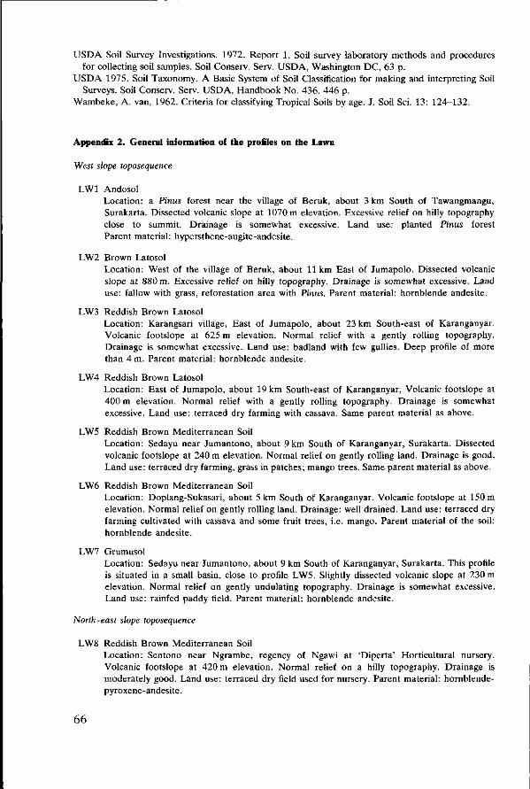
USDA Soil Survey Investigations. 1972. Report 1. Soil survey laboratory methods and procedures for collecting soil samples. Soil Conserv. Serv. USDA, Washington DC, 63 p.
USDA 1975. Soil Taxonomy. A Basic System of Soil Classification for making and interpreting Soil Surveys. Soil Conserv. Serv. USDA, Handbook No. 436. 446 p.
Wambeke, A. van, 1962. Criteria for classifying Tropical Soils by age. J. Soil Sei. 13: 124-132.
Appendix 2. General information of the profiles on the Lawu
West slope toposequence
LW1 Andosol Location: a Pinus forest near the village of Beruk, about 3 km South of Tawangmangu, Surakarta. Dissected volcanic slope at 1070 m elevation. Excessive relief on hilly topography close to summit. Drainage is somewhat excessive. Land use: planted Pinus forest Parent material: hypersthene-augite-andesite.
LW2 Brown Latosol Location: West of the village of Beruk, about 11 km East of Jumapolo. Dissected volcanic slope at 880 m. Excessive relief on hilly topography. Drainage is somewhat excessive. Land use: fallow with grass, reforestation area with Pinus. Parent material: hornblende andesite.
LW3 Reddish Brown Latosol Location: Karangsari village, East of Jumapolo, about 23 km South-east of Karanganyar. Volcanic footslope at 625 m elevation. Normal relief with a gently rolling topography. Drainage is somewhat excessive. Land use: badland with few gullies. Deep profile of more than 4 m. Parent material: hornblende andesite.
LW4 Reddish Brown Latosol Location: East of Jumapolo, about 19 km South-east of Karanganyar, Volcanic footslope at 400 m elevation. Normal relief with a gently rolling topography. Drainage is somewhat excessive. Land use: terraced dry farming with cassava. Same parent material as above.
LW5 Reddish Brown Mediterranean Soil Location: Sedayu near Jumantono, about 9 km South of Karanganyar, Surakarta. Dissected volcanic footslope at 240 m elevation. Normal relief on gently rolling land. Drainage is good. Land use: terraced dry farming, grass in patches; mango trees. Same parent material as above.
LW6 Reddish Brown Mediterranean Soil Location: Doplang-Sukasari, about 5 km South of Karanganyar. Volcanic footslope at 150 m elevation. Normal relief on gently rolling land. Drainage: well drained. Land use: terraced dry farming cultivated with cassava and some fruit trees, i.e. mango. Parent material of the soil: hornblende andesite.
LW7 Grumusol Location: Sedayu near Jumantono, about 9 km South of Karanganyar, Surakarta. This profile is situated in a small basin, close to profile LW5. Slightly dissected volcanic slope at 230 m elevation. Normal relief on gently undulating topography. Drainage is somewhat excessive. Land use: rainfed paddy field. Parent material: hornblende andesite.
North-east slope toposequence
LW8 Reddish Brown Mediterranean Soil Location: Sentono near Ngrambe, regency of Ngawi at 'Diperta' Horticultural nursery. Volcanic footslope at 420 m elevation. Normal relief on a hilly topography. Drainage is moderately good. Land use: terraced dry field used for nursery. Parent material: hornblende-pyroxene-andesite.
66
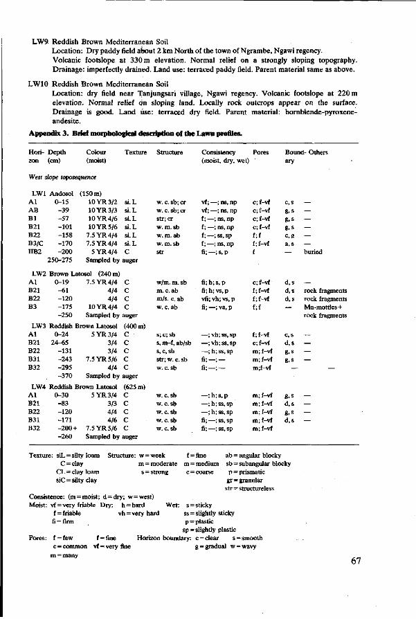
LW9 Reddish Brown Mediterranean Soil Location: Dry paddy field about 2 km North of the town of Ngrambe, Ngawi regency. Volcanic footslope at 330m elevation. Normal relief on a strongly sloping topography. Drainage: imperfectly drained. Land use: terraced paddy field. Parent material same as above.
LW10 Reddish Brown Mediterranean Soil Location: dry field near Tanjungsari village, Ngawi regency. Volcanic footslope at 220 m elevation. Normal relief on sloping land. Locally rock outcrops appear on the surface. Drainage is good. Land use: terraced dry field. Parent material: hornblende-pyroxene-andesite.
Appendix 3. Brief morphological description of the Lawn profiles.
Hori- Depth zon (cm)
Colour (moist)
Texture Structure Consistency Pores (moist, dry, wet)
Bound- Others ary
West slope toposequence
LW1 Andosol ( A l 0-15 AB -39 B l -57 B21 -101 B22 -158 B3/C -170 IIB2 -200
250-275
150 m) 10YR3/2 si.L 10YR3/3 si.L 10YR4/6 si.L 10YR5/6 si.L
7.5 YR 4/4 si.L 7.5 YR 4/4 si.L
5YR4 /4 C Sampled by auger
LW2 Brown Latosol (240 m) A l 0-19 B21 -61 B22 -120 B3 -175
-250
7.5 YR 4/4 C 4/4 C 4/4 C
10YR4/4 C Sampled by auger
LW3 Reddish Brown Latosol (400 m) A l 0-24 B21 24-65 B22 -131 B31 -243 B32 -295
-370
5YR3 /4 C 3/4 C 3/4 C
7.5 YR 5/6 C 4/4 C
Sampled by auger
LW4 Reddish Brown Latosol (625 m) A l 0-30 B21 -83 B22 -120 B31 -171 B32 -200 +
-260
5YR3 /4 C 3/3 C 4/4 C 4/6 C
7.5 YR 5/6 C Sampled by auger
Texture: siL = silty loam Structure: w = C = clay m =
CL = clay loam s = siC = silty clay
w. c. sb; cr w. c. sb; cr str;cr w. m. sb w. m. ab w. m. sb str
w/m. m. sb m. c. ab m/s. c. ab w. c. ab
s; c;sb s, m-f, ab/sb s, c, sb str; w. c. sb w. c. sb
w. c. sb w. c. sb w. c. sb w. c. sb w. c. sb
weak f = moderate m = strong c =
vf ; —; ns, np vf ; —; ns, np f;—;ns, np f;—;ns, np f ; —; ss, sp f; —; ns, np fi;—;s,p
fi;h;s,p fi; h; vs, p vfi; vh; vs, p fi; —; va, p
—; vh; ss, sp —; vh; ss, sp —; h; ss, sp fi;—; — fi;—; —
—;h;s ,p —; h; ss, sp —; h; ss, sp fi;—;ss, sp fi;—;ss, sp
fine ab = medium sb = coarse p =
gr = str =
c;f-vf c;f-vf c;f-vf c;f-vf f;f f;f-vf f
c;f-vf f;f-vf f;f-vf f;f
f;f-vf c;f-vf m;f-vf m;f-vf m;f-vf
m;f-vf m;f-vf m;f-vf m;f-vf m;f-vf
angular blocky
c, s g, s g. s g, s c,g a, s
—
d,s d,s d,s
—
c, s d.s g. s g, s
—
g. s d,s g, s d,s
subangular blocky prismatic granular structureless
— — — — — — buried
— rock fragments rock fragments Mn-mottles+ rock fragments
— — — —
—
— — — —
Consistence: (m = moist; d = dry; w = west) Moist: vf = very friable Dry: h = hard Wet:
f=friable vh = very hard fi = firm
Pores:
s = sticky ss = slightly sticky p = plastic
sp = slightly plastic f = few f = fine Horizon boundary: c = clear s = smooth c = common vf = very fine g = graduai w=wavy
m = many 67
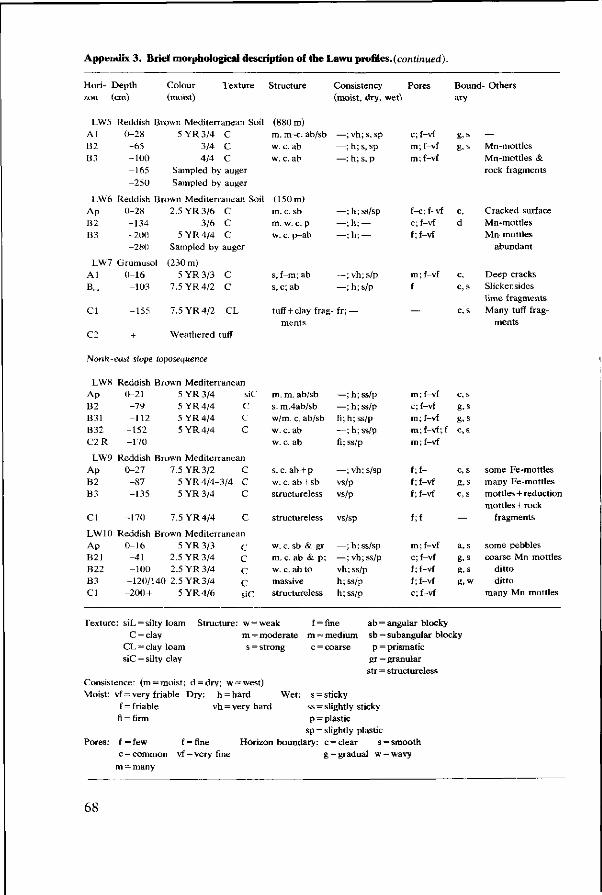
Appendix 3 . Brief morphological description of the Lawu profi les.(cm?mnW).
Hori- Depth zon
LW5 Al B2 B3
LW6 Ap B2 B3
LW7 Al B c .
C l
cm)
Reddish B 0-28 -65 -1(10 -165 -250
Reddish B 0-28 -134 -200 -280
Grumusol 0-16 -103
-155
Colour Texture (moist)
own Mediterranean Soil 5 YR 3/4 C
3/4 C 4/4 C
Sampled by auger Sampled by auger
own Mediterranean Soil 2.5 YR 3/6 C
3/6 C 5 YR 4/4 C
Sampled by auger
(230 m) 5 YR 3/3 C
7.5 YR 4/2 C
7.5 YR 4/2 CL
Structure
(880 m) m. m-c. ab/sb w. c. ab w. c. ab
(150 m) m. c. sb m. w. c. p w. c. p—ab
s, f-m; ab s, c; ab
tuff + clay trag ments
Consistency (moist, dry, wet)
—; vh; s, sp —; h;s , sp —; h; s, p
—;h;ss/sp ^ ; h ; — —;h; —
—; vh; s/p —;h;s/p
-fr; —
Pores
c;f-vf m; f-vf m ; f-vf
f-c; f-vf c;f-vf f ; f-vf
m; f-vf f
—
Bound- Others ary
g.s g, s
c, d
c, c, s
c, s
— Mn-mottles Mn-mottles & rock fragments
Cracked surface Mn-mottles Mn-mottles
abundant
Deep cracks Slickensidcs lime fragments Many tuff frag
ments
Nonh-east slope toposequence
LWS Reddish Brown Mediterranean Ap B2 B31 B32 C2R
LW9 Ap B2 B3
CI
LW10 Ap B21 B22 B3 CI
Texture
0-21 5YR3 /4 -79 5YR4 /4 -112 5YR4 /4
-152 5YR4 /4 -170
siC C C C
Reddish Brown Mediterranean 0-27 7.5 YR 3/2 -87 5 YR 4/4-3/4 -135 5YR3 /4
-170 7 .5YR4/4
Reddish Brown Mediterrane 0-16 5YR3 /3 -41 2.5 YR 3/4 -100 2.5 YR 3/4
-120/140 2.5 YR 3/4 -200+ 5YR4/6
: siL = silty loam Structure C = clay
CL = clay loam siC = silty clay
C C
c
c an
C C C C siC
w = m = s =
m. m. ab/sb s. m.4ab/sb w/m. c. ab/sb w. c. ab w. c. ab
s. c. ab + p w. c. ab + sb structureless
structureless
w. c. sb & gr m. c. ab & p; w. c. ab to massive structureless
—;h;ss/p —; h;ss/p fi;h; ss/p —; h; ss/p fi; ss/p
—; vh; s/sp vs/p vs/p
vs/sp
—;h;ss/sp —; vh; ss/p vh; ss/p h; ss/p h; ss/p
weak f = fine ab = moderate m ~ medium sb = strong c = coarse p =
gr =
m; f-vf c;f-vf m; f-vf m; f-vf; f m; f-vf
f;f-f;f-vf f ; f-vf
f;f
m; f-vf c; f-vf f ; f-vf f ; f-vf c; f-vf
angular blocky
c, s
g, s g, s c, s
c,s
g, s c, s
—
a, s g, s g. s g, w
subangular blocky prismatic granular
some Fe-mottles many Fe-mottles mottles + reduction mottles + rock
fragments
some pebbles coarse Mn mottles
ditto ditto
many Mn mottles
str = structureless Consistence: (m = moist; d = dry; w = west) Moist: vf = very friable Dry: h = hard Wet;
f = friable vh = very hard fi = firm
Pores: f = few f = fine c = common vf = very fine
m = many
s = sticky ss = slightly sticky p = plastic
sp = slightly plastic Horizon boundary: c = clear s = smooth
g = gradual w = wavy
68
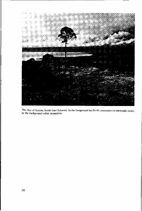
The Bay of Kolaka, South-East Sulawesi. In the foreground the Fe-Ni concession on ultramafic rocks; in the background schist mountains.
70
5 Oxisols and associated soils on ultramafic and felsic volcanic rocks in Indonesia
by P. Buurman and M. Soepraptohardjo
Abstract
The presence was demonstrated of Oxisols on felsic and ultramafic parent materials. On ultramafic rocks there was an association of Inceptisols, Alfisols, Ultisols and Oxisols that was governed by topography.
Acid volcanic rocks of a peneplain presented a more uniform picture but though soils were very similar, slight changes in properties had a strong influence on the classification. The soils were assigned to Inceptisols, Ultisols and Oxisols.
Although the ultimate weathering stage on both kinds of parent material is now classified as Acrorthox, it seems desirable to distinguish between the two at higher level than the soil family.
Complex toposequences like one on ultramafic rocks can not be tackled by routine mapping procedures. For a good legend, detailed studies of such associations should be undertaken. Oxisols have not yet obtained their proper place in Indonesia's soil classification.
Introduction
In recent years, considerable doubt has arisen about the presence of Oxisols in Indonesia. The main reason for this doubt is that throughout the Tertiary and Quaternary epochs volcanic activity has been almost continuous in Indonesia, and consequently there has been a constant supply of weatherable minerals to the surface. However Oxisols have been described from Malaysia (Yusoff & Eswaran, 1975; Sooryanarayana & Eswaran, 1975; Eswaran & Sys, 1976; Malaysian Society of Soil Science, 1977).
The present study demonstrates that Oxisols can also be found in Indonesia in similar positions and on similar rocks to those in Malaysia. This study ascertains the presence of 'typical' Oxisols on ultramafic materials, and secondly describes Oxisols that constitute a transitional group to 'Red-Yellow Podzolics'. It emphasizes the necessity of defining the limits between these groups. Although Oxisols were never properly classified in Indonesia they have been described before from various parts of that country. In their study on ore deposits, Dieckman & Julius (1924) analysed weathering residues that were apparently Oxisols. More recently a similar study was published by International Nickel Indonesia (1972). During exploratory soil surveys in Sumatra, Borneo and Celebes, between 1956 and 1959, soils formed on old mafic igneous rocks were recognized, but grouped with the Latosols that were already known from Java. Another group of highly weathered soils, formed on acid igneous rocks was grouped with the Red-Yellow Podzolics (Paper 7). These soils were described by Soepraptohardjo (1961) and Suwardjo & Soepraptohardjo (1961). Similar soils were again encountered during surveys in West Irian (Haantjes et al., 1967; Soepraptohardjo et al., 1971), but no new names were introduced.
71
Oxisols are invariably associated with certain landscapes or rocks. As Oxisols are generally considered to be very old soils, we expect to find them on old stable surfaces like peneplains.
Oxisols tend to form on a parent material with a relatively low silica content, such as mafic and ultramafic rocks or non-acid volcanic rocks. Such rocks are fairly common in Indonesia, but part of them is found in climates with a marked dry period, as in east Java, and soil formation does not then result in Oxisols but presumably in Alfisols and Inceptisols (Paper 4). Information about soils on ultramafic rocks in the perhumid parts of Indonesia is scarce.
Materials
The soils studied for the present paper were taken from the following: —an old dissected peneplain consisting of acid felsic to intermediary volcanic tuff deposits in West Sumatra (Province of Sumatra Barat); —a complex of ultramafic rocks in South-East Celebes (Province of Sulawesi Tenggara); —a locality of ultramafic rocks in South Borneo (Province of Kalimantan Selatan). These areas are indicated in Figure 1 (p. 3).
Results
Ultramafic rocks of south-east Sulawesi
Parent rock
The ultramafic rocks studied near Pomalaa, Ladongi, Lambuya, Unembute and Amusiu (Figure 9) are outliers of a large massif that covers most of the eastern part of Celebes, but they are separated from the main body by a fault zone with schists and phyllites. The outcrops of ultramafic rocks south of this fault zone are small and scattered. The rocks are mainly peridotites with a varying degree of serpentinization. It seems that the part north of the fault zone is less serpentinized (Dieckmann & Julius, 1924). Serpentinization is fairly marked in the Pomalaa area, but it is less distinct at the other sites.
Minerals identified in the parent rocks from Pomalaa include antigorite, chrysotile, clinochlore, tremolite, quartz and opal.
Tremolite (asbestos), quartz and opal-CT (with disordered cristobalite-tridymite stacking) occur in veins on pressure planes, and in diaclases respectively. Hyd-rated halloysite (endelilite), enriched with nickel ore, is frequently found as a secondary formation, associated with weathering.
The greater part of the rocks consists of either antigorite/chrysotile or of clinochlore.
72
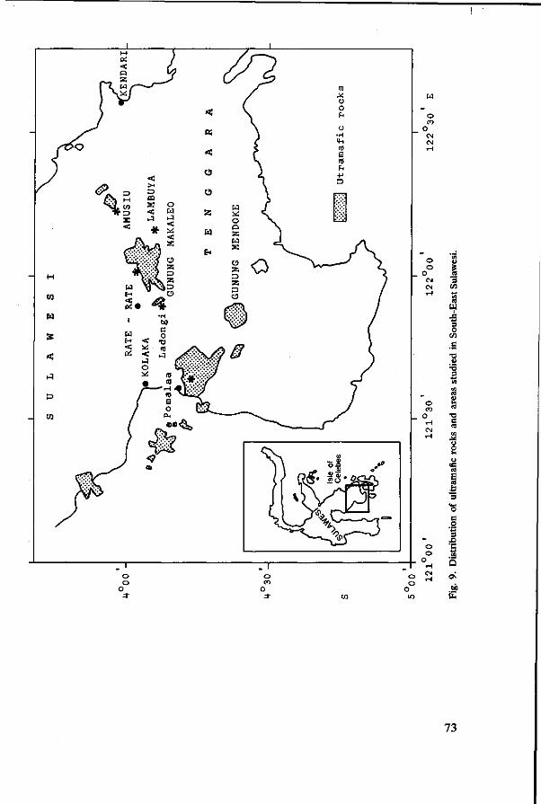
_ o
o o
1 CM CM
« * fl 3 C/5
_ o
o o
u 3 O
C/3
73 3
•o s
s X> 'G
°,-H Q
73

Climate
Climatic data are given in Table 21 at page 122. Rainfall ranges from more than 2000 mm in the west to about 1600 mm in the east. There is no distinct dry period. The mean annual temperature of Kendari is 25.7 °C and the annual fluctuation is about 2 °C.
Kendari has an Awa type of climate according to Koppen: the other stations have the Afa type. Rainfall types according to Schmidt & Ferguson (1961) are D for Kendari and B for the other stations.
Soils
All profile descriptions are given in the Appendix 4 and 5, and composition in Table 11. One sequence of profiles (ST21-25) was sampled in the FeNi concession area at Pomalaa. This sequence included height range of about 200 m, and wide differences in slope. The relative position of the profiles is indicated in Figure 10. As profiles were taken from different slopes, interpolations were used in this figure.
A single profile from Amusiu (ST 14) and one from Unembute (ST29) are also interpolated here.
A sequence of two profiles (ST1, 3) was sampled near Lambuya (Figure 10). From that sequence a single profile from Ladongi (ST26) has been projected.
Profiles on steep slopes were generally shallow and contained many rock fragments. B horizons were red or dark red. In some profiles the weathered parent rock showed honeycomb-like quartz structures that seemed to have enveloped fragments of parent rock. These structures are found in ST3 and 26.
Profiles on summits are slightly deeper but have less red B horizons than those on slopes. Rock fragments abound at shallow depths.
Downslope profiles, where erosion material had accumulated were dusky red and deep; they had granular structures and diffuse horizon boundaries.
The downslope profile in the Lambuya sequence was exceptional, with impeded drainage the profile had characteristics of Vertisols.
The sequences offer the following picture:
1. The Pomalaa sequence (ST21-25) and the profiles from Unembute (ST29) and Amusiu (ST14) Although analysis of these profiles is incomplete, the general trends are clear. The profiles were taken from a summit (ST23), steep slopes (ST22, 24), upper footslope (ST14, 29) and lower footslope (ST21, 25). As the relation between profile development and slope was stronger than that between profile development and altitude, profiles were grouped by slope.
Summit: ST23. The profile is rather shallow, rocks appearing at 50 cm. The B horizon is dusky red and has a crumb structure. Clay content increases from 29% in the A1 to 56% in the B2. CEC-clay is more than 16; base saturation is low but because the pH is fairly high there is no exchangeable Aluminium. Micro-morphological data are lacking, but we would expect an argillic horizon to be present. Clay minerals are dominated by interstratified illite-vermiculite with
74
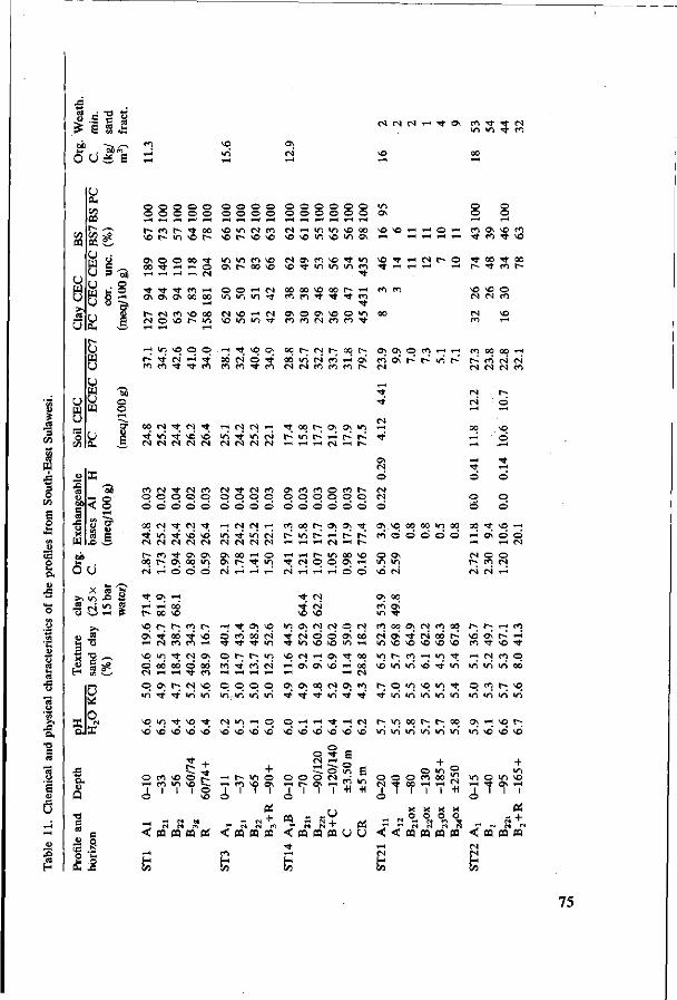
c S
OD
O u
(n CQ
u w
cd
0
n M
u 'S
O O. t / i CQ r 1/1 CO O
w u w
r-
8 ,w
u UJ
a
1 « TO J _
o f i ^
Ä 6
y — H
- s P
c
o fa ° 8S I
w> o o :~; IT U
e
(N CM CM H TT Os CO •* TT CM
in in •** eo so in'
o o o o o o o o o o
o o o o o o o o r~ ** oo so in CM eo in ^D h so r- so so
o\ o o oo vi in « « to t HH o os r- oo so rH rH rH rH CM
"* Tf t CO rH O O rH CM Os os os oo oo in in in ^
o o o o o o o o o o o o
CM rn in m so oo so so rn rn © rn O * fl VC i n O rH rH rH rH rH
t - <N CO O 00 CM VO rH (N ^ in in ^
CM os co so •* in so -st m in m co
oocoic i os r- H coco CO CO t Tf ' t co
• *
os o os so o in oo CO CO CM CO CO T t
rn in sq p p rn Tt sq os ^ * N' « * oó ri 6 ^ co eo rt T* eo eo eo •* eo
oo p (S p oo r-oo' in CM có rn os' CM CM co co co r»
so Tf rH CM t- O
o o CO
p~
SO CM
Os CO
00
SO CN
O
o rH SO
•st CO
o CO
os o\ 6 ( O n H m oo oo H (ö oi r- r in' c- c^cócMCM* CM CM CM CM CO
•* t'
CM 00 CM -t CM -st ^ ( N J C M ^ H 't 00 p Os Ol >n rH
**' in' -st só só in' Tf in' (si h i n V r i r- ts -rt C M C M C M C M C M C N C M C M C N H H H N H f
CM
CM
00 SO
ri o
m
an O
o
O O
CO CM ••* CM CO CM -st CM CO
p o © © © o o p o © d o d o © © © ©
OS CM
Ö Os CO CO O CO P-p p © o o o © d ö ö ö d
p &
o d
00 CM "st CM Tf H Csl N H CO 00 p ; Os Os <ïf Os s o 0 0 « i n 00 OO s t SO H • n ^ i n c M h in' f ^ H ts t^ c o d ö d d d r i o s o o CSI(S1CS![S1 r H r t r t C s l r t r - rH H N
•st m r f SO SO CM CM CM CM CM
r - c o ^ o s o s e> o o H o rn n oq r- Os oo in Os p st in " s t^ CM ri © © © f i r i r i H fi rt' r i r i 6 O >Ó CM
x I fc
>> o S 5 ü
x "g — p* « —
•a c u O
« .a
SCI P I-; COIt-; Os -st 00 t ' SO
H N en m H
i-H -_ o s s q
d co oô CM' st t * m
i n Os Cs) CM p CS) s t r i o o o i oô st in so so in H
sq in -xt CM os q p p in so es; H os t oo © oô oô d oô cÔTtcôcsi ri os oi ^ ri oô C M r ^ r H T f r e O r H r H r l r H r l rH (S]
P i n
SO só
O
©
T — 1
< i - H
H 00
Os •xf'
i n SO
CO CO
1
r-
ea
r^ • ' t
• *
só
SO m
1
«
CM in'
so SO
t t -
© so
1
at ci
CQ
SO i n
•* so'
+ r^
o SO
f *
p in'
CM SÔ
T—1
è
p in'
• n sd
r~ co
1
r>
O
«S
„ só
i n SO
1
M IM
< m « co H C/3
O •n'
o só
+ O OS
1
+ CQ
Os • * '
O só
O
1 o
« < • t r - l
H Vi
Os •st
r H
só
O r -
l
c CQ
00 ' t
r - l
só
O Csl r H
O Os
1
r e
CQ
CM i n
•st só
O
•* o CM r H
1
+
Os • ' t
r H
só
B o in có -H
co • *
CM só
g i n
-H
ai CQ U U
CO 0 0 Os CM CO 0 0 fs . f - H CO C M O S ' s t C N o Ó r ^ s ó Os | s ' r i
m s o s o s o s o s o c O t v o - * in c^rorHin - s t r n c s i c o p só in ' in ' só-r t in ' in in' in' oo'
p q in so in rj| p c o c - > s q •rj-in'in'in'inin i n i n i n ' i n
r-; in oo ts. r- oo os H sq r-_ i n i n ' i n i n i n i n ' ini só só só
o o CM • *
è ' r-i M
O 00
1
X o
o CO
1
X o
m 00 r H
1
X O
m CM
+1 X o
m
^ i o
-* 1
i n i n so OS rH
1 1
02 s + n CN N (N
< < C Q C Q C Q C Q < C Q C 0 0 Q
CM H C/5
75

5 S H S
O O c5 S
r t NO r^ O rt CO CO (T) CI ^ t OO CN
a
o
a
U
\ o r n \ o (N i r i o o NO rt ^o w N m o ] i n »o ON ^ ^o ^ H T - H T - H \ O ( ^ o NO r - ce (N H r - \ o ^ i \ o i n NO NO
o o
CN CN r^ ON CO N h M ^O [^ H a M \ Û TT 1 ^ r~ rt r ^ c o r t c N c N o c N r t ^ ^ , - ^ ~ . - ^ , ~ _..
" rt rt rt N
M
o o
O Ü
X >1 IA)
•n IN' J= s rtrt >
NO u~> ^ i n ^ r f
O r t rt rt
° CT U CN
e -
ON CO
• *
CN r o
o
• *
co
vo
co co
NO co
oc
h m o \ ^o ^ *"! "". co i n >n" ö \Ó N t ^ ^ i f i ^H
- r t - ^ i o n r - m - ^ t >o ^ ^o
o ö
^ ^ in o o
r^
VD O
NO
O
o o
NO i r i n
CO
o
0 0
o
o o
o
CN
O
<N
C c
NO <N
IT)
rt rt • *
' t
c
i n CN
00 NO
00 NO
o o
CN CN
NO
m
•* co
rt O
^ r -CN <N
00 CO
00 co
o o
o ö o o o o o
GO ^O O) ^C 00 h o Tf 00
*$ 'S co oo (N r i r n cc
q o i/i O l CN CN tO (N O CN i-i
n h - o^ r-< oo < N * o r ~ - ( N M > o r j o -3- >n vo m r--
CO ^ * - j CN "Ai
^ f -^t CO \ 0 00 q T o >n ON r--CN - ^ »n o od r^
\© H X ^ ^D 1 ^ Tf l / i
00 CO CN CN G\
co i n H H H T t «VI VD ^6 VD
q oo co i n i n -rt' i n <n
^q <-« Th <n Tf T t i n >n
rt T-H rt (N
O 00 O t - i
ON 00 CO « t
CO CN CO
i n Tf <n i n i n «n
• ^ t ^ r ^ o o r - ; CN CN ^q oo ^ o ^ q o c o o q x o co * * co i o o vu \ d \D ^ d ^ ^ ^ d i v i i n ' i n i n ^ d i n ^ > ^ ^ d ^ o
U
j a
U
TD C
2 O
—
C O
o J3
o o rt rt o
-pa < <: co <N H 00
o 2? o O i n i n rrt
s + CQ «
+ o r -
rt
CQ + oi
+ o o m o rt r-^ CO t ~ rt
o
OS
cK +
< 03 pq CQ
•* (N H «5
+ O O o i n NO o CN NO rt CN
o
x x T
< « Œ CQ
i n CN H C/3
O o
rt rt O
<Tco NO CN H C/3
+ O O
rt*
Pi + CQ
+ o i n i n o o ^ tf t - rt
i ' ' ' 0 !
< CQ CO CQ
ON CN H c/3
76
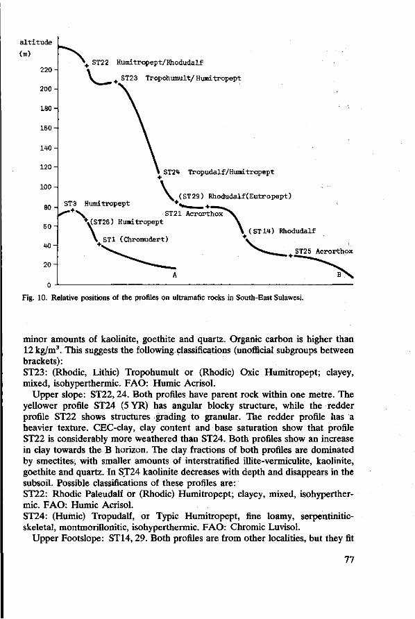
a l t i t u d e
(m)
220
200
1 80 -
160 -
140
120
100
80 H
60
W
20
>+ ST22 Humitropept /Fhodudalf
\ ^ J 4 I ST23 Tropohumult /Humitropept
ST3 Humitropept
'"""+>\ ST21 Acrorthox \(ST26) Humitropept
ST24 Tropudalf/Humitropept
(ST29) Rhodudalf(Eutropept)
yai
ST1 (Chromudert) (ST14) Rhodudalf
ST25 Acrorthox
Fig. 10. Relative positions of the profiles on ultramafic rocks in South-East Sulawesi.
minor amounts of kaolinite, goethite and quartz. Organic carbon is higher than 12 kg/m3. This suggests the following classifications (unofficial subgroups between brackets): ST23: (Rhodic, Lithic) Tropohumult or (Rhodic) Oxic Humitropept; clayey, mixed, isohyperthermic. FAO: Humic Acrisol.
Upper slope: ST22,24. Both profiles have parent rock within one metre. The yellower profile ST24 (5YR) has angular blocky structure, while the redder profile ST22 shows structures grading to granular. The redder profile has a heavier texture. CEC-clay, clay content and base saturation show that profile ST22 is considerably more weathered than ST24. Both profiles show an increase in clay towards the B horizon. The clay fractions of both profiles are dominated by smectites; with smaller amounts of interstratified illite-vermiculite, kaolinite, goethite and quartz. In ST24 kaolinite decreases with depth and disappears in the subsoil. Possible classifications of these profiles are: ST22: Rhodic Paleudalf or (Rhodic) Humitropept; clayey, mixed, isohyperthermic. FAO: Humic Acrisol. ST24: (Humic) Tropudalf, or Typic Humitropept, fine loamy, serpentinitic-skeletal, montmorillonitic, isohyperthermic. FAO: Chromic Luvisol.
Upper Footslope: ST14, 29. Both profiles are from other localities, but they fit
77
best in this sequence, as a transition to the next two profiles. The profiles show an appreciable accumulation of erosion material and are virtually free of coarse fragments down to 90 and 75 cm respectively. Profile ST14 was taken from the wall of a clay pit and its structure is therefore influenced by drying and irradiation. ST29 has a subangular blocky structure in the B horizon. ST14 is redder than ST29. Both profiles show a distinct increase in clay with depth, a CEC-clay of around 50meq/100gr and a base saturation (CEC7) of more than 50%. Thin sections of profile ST14 reveal the presence of illuviation cutans (ferri-argillans) in the B21 and B22 . The clay fraction of ST14 is dominated by montmorillonite. That of ST29 shows an increasing amount of montmorillonite with depth, and additional illite-vermiculite, margarite, kaolinite, goethite and quartz. Tentative classification for these soils:
ST14: Rhodic Paleudalf, clayey, montmorillonitic, isohyperthermic. FAO: Chromic Luvisol.
ST29: Typic Rhodudalf, or (Rhodic) Eutropept, clayey, montmorillonitic, isohyperthermic. FAO: Chromic Luvisol.
Lower Footslope: ST21,25. Both profiles are deep, dusky red, and have granular structures. Textures are clay. Both profiles consist of accumulated footslope material. Exchange properties of these soils are such that the B horizons classify as Oxic horizons. Weatherable minerals amount to 3% of the sand fraction (less than 0.3% of the whole soils). pH is above 5, and the difference between pH-H 2 0 and pH-KCl is only slight: 0.4 or less. There is, however, no horizon with a net positive charge. The PC-clay in the oxic horizon of ST25 is below 1.5. The clay fraction of both soils consists of kaolinite and goethite with smaller amounts of gibbsite and quartz. The non-clay fraction of ST25 consists of spinel and goethite. Both soils have high organic matter contents: more than 16 kg/m3, but they cannot be classified as Humox because the temperature regime is too high. We classify both soils as follows: ST21,25: Haplic (Humoxic) Acrorthox, clayey, kaolinitic-ferritic, isohyperthermic. FAO: Humic/Acric/Rhodic Ferralsol.
2. The Lambuya sequence (ST1, 3) and Ladongi (ST26) The main difference between the short Lambuya sequence and the Pomalaa sequence was the lack of free drainage in Lambuya of the footslope profiles and influence of groundwater. This resulted from the shape of the slope.
Profiles ST3 and 26 were comparable to ST 14 and 29 of the former sequence. Although these profiles did not show major additions of slope material, they were still only slightly weathered, had fairly low clay content, high CEC and high base saturation. They were reddish brown and not red; structures were subangular blocky.
Neither ST3 nor ST26 showed an appreciable increase in clay. Thin sections of ST3 showed that weathering was the main soil forming process. Although there was some orientation of clay, it was not enough to classify the B horizons as argillic.
78
The clay fractions of ST3 and ST26 were dominated by montmorillonite, with additional vermiculite-illite, margarite, illite and quartz. In ST26 some regular mixed layer minerals (chlorite-montmorillonite) were found. Both soils are classified as Inceptisols:
ST3: (Humic) Eutropept, clayey, montmorillonitic, isohyperthermic. FAO: Chromic Luvisol.
ST26: Lithic Humitropept, clayey skeletal, montmorillonitic, isohyperthermic. FAO: Chromic Cambisol.
Although Profile ST1 was sampled in the wet season, and cracks were not visible, consistence was like that of Vertisols. The grey colours reflected its impeded drainage. Its classification was tentative, and one may prefer to put the soil in a vertic subgroup rather than in the vertisols. ST1: Lithic Chromudert, montmorillonitic, isohyperthermic. FAO: (Chromic Vertisol).
Discussion
There is a strong relation between slope and soil development in this area. On the upper part of steep slopes, rejuvenation is dominant, and soils do not surpass the Inceptisol/Alfisol stage. Some translocation of clay occurs but it is of minor importance. Montmorillonite minerals predominate in the clay fractions in accordance with a high supply of bases—mainly magnesium—by weathering of peridotite.
In sites where erosion is active but supply of fresh material is less, soils develop towards Ultisols or Oxic subgroups of Inceptisols. The clay minerals suggest stronger weathering: mixed layers become dominant and kaolinite plays a greater role. Upper footslope profiles, where addition of material occurs, again have properties of Alfisols but are more strongly weathered than the upper slope profiles. These profiles are generally redder than the profiles upslope, and have lower CEC and higher clay contents.
On the lower footslopes, finally, Oxisols are found. Here, weathering and leaching of cations and silica are important. The parent material is presumably topsoil material from upslope and there is no supply of fresh material and bivalent cations either by surface addition or by groundwater. Soils are dusky red, and have granular structures. Mineralogically they consist of kaolinite, gibbsite and iron minerals, both in clay and in the coarser fractions.
The development of clay minerals in the course of weathering of peridotite is as follows: montmorillonites form in contact with the disintegrating rock or in places with magnesium-rich groundwater. As soon as Mg becomes depleted, inter-stratified minerals form that finally change to kaolinite.
Clay minerals suggest a change in parent rock from Pomalaa eastward. Margarite is found in the profiles from Amusiu, Lambuya and Ladongi, but not in Pomalaa. Also some trace minerals that have not yet been identified occur in the eastern part only. However, differences in parent rock are only slight and do not disturb the general trends of soil formation.
79
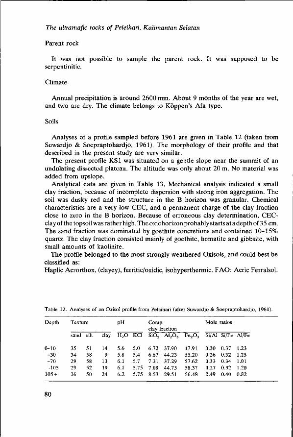
The ultramafic rocks of Peleihari, Kalimantan Selatan
Parent rock
It was not possible to sample the parent rock. It was supposed to be serpentinitic.
Climate
Annual precipitation is around 2600 mm. About 9 months of the year are wet, and two are dry. The climate belongs to Köppen's Afa type.
Soils
Analyses of a profile sampled before 1961 are given in Table 12 (taken from Suwardjo & Soepraptohardjo, 1961). The morphology of their profile and that described in the present study are very similar.
The present profile KS1 was situated on a gentle slope near the summit of an undulating dissected plateau. The altitude was only about 20 m. No material was added from upslope.
Analytical data are given in Table 13. Mechanical analysis indicated a small clay fraction, because of incomplete dispersion with strong iron aggregation. The soil was dusky red and the structure in the B horizon was granular. Chemical characteristics are a very low CEC, and a permanent charge of the clay fraction close to zero in the B horizon. Because of erroneous clay determination, CEC-clay of the topsoil was rather high. The oxic horizon probably starts at a depth of 35 cm. The sand fraction was dominated by goethite concretions and contained 10-15% quartz. The clay fraction consisted mainly of goethite, hematite and gibbsite, with small amounts of kaolinite.
The profile belonged to the most strongly weathered Oxisols, and could best be classified as: Haplic Acrorthox, (clayey), ferritic/oxidic, isohyperthermic. FAO: Acric Ferralsol.
Table 12. Analyses of an Oxisol profile from Pelaihari (after Suwardjo & Soepraptohardjo, 1961).
Depth
0-10 -30 -70 -105
105 +
Texture
sand
35 34 29 29 26
silt
51 58 58 52 50
clay
14 9
13 19 24
PH
H 2 0
5.6 5.8 6.1 6.1 6.2
KCl
5.0 5.4 5.7 5.75 5.75
Comp. clay fraction S i0 2 A1203
6.72 37.90 6.67 44.23 7.31 37.29 7.09 44.73 8.53 29.51
F e 2 0 3
47.91 55.20 57.62 58.37 56.48
Mole ratios
Si/Al Si/Fe
0.30 0.37 0.26 0.32 0.33 0.34 0.27 0.32 0.49 0.40
Al/Fe
1.23 1.25 1.01 1.20 0.82
80
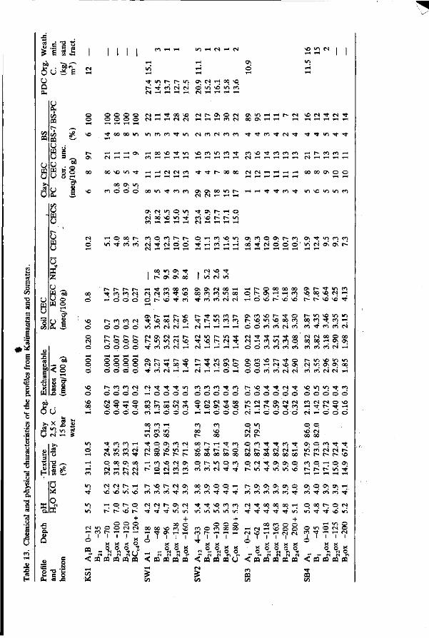
i-<
O «J o p
1 « 03 t i I M M i n H N H M
ON
ö O; O) •-; 00 NO 6 i n vd >n r o
^ i n h ; t ^ i n r~ -^- en es' es CS TH I-H TH TH CS TH i-H TH TH
(9
73
S
I
D. •o C « "8
. O Cd H
U
u c
ni * S
n o o
o o o o es TH ^- oo vo es c- ON o es a « i H H t ^ p i \ o M • * N T t O O O O M H H N N TH TH TH en CS 00 ON TH TH i-H ^4^-1^*^**
NO 't M oo in ^ n ei it tfi M n « c^ m ^ ^ m ^ N ^ ^ ^ vi t ^
r~ ^ H ^ H ^ H O \ H oo >c Tf in NO en m en ^- n » o ^ w n n n ^ n n n 0\ CS T H T H Cn T H T H T H ,-H T H T H I-H T H T H C S T H T H T H T H T H CS T H T H T H T H
00 O O l O m r f H H N N n ^- t C~ 00 00 CS CS TH TH TH TH 00 00 CN O O ^4 r* r4 r* TH T H T H T H T H T H T H T H T H
oo ON m NO en © d © oo m rj- tr, o\ a x in h- H H it ^ t in o "n m w
(S ra TH TH TH
o> N VI o in t o; r; H q es' od N© in' -rt ci\ó r^ in' C ^ T H T H T H T H CS TH TH TH TH
es T H o o q t - - n o m i - ; I - ; o H n « i n ON en © ON f ; en O; ^ ^ r i m ö in' TJ- en' cn es' - ^ es' © © ' t i-i en TH TH o o ' ^ ' r J ó ö ö ' i n r J o ^ O N r ^
sa o o rH CT1 U E
00 o
ND
ö
-5b < §
«.SI eb T -
O U
— "I >n Ü N H
NO
Ö NO
r - r - r~ i » i f m m N TH d ö ö
f ; cn en es
ö ö ö o r~ r-« r-> r* t"-; o o o
ö ö ö ö o o o o o © o o ö ö o ö
r- en cn es
ö o ö ö CS O TH O NO • * t t ö ö O O
oo i n o ; H; I r~ ON ON' o<j
H i t n oo n es es cn ^ NO ö t~ NO ' t m
es NO t_ in' N u i
ON ON CS 00 TH H oo m m i n oo q ^ en en es' es' TH Ö NO S NO NO
ON r - TH p- NO Tt; NO 00 CS ON in' m N N H es'
r - t m en r-t h i n n n
ON en NO r - Tt O r~ NO m NO oo en
ON P - i t »n en NO oo NO es TH
f^ r^ NO NO' ' t
r- »n NO i n m oo en ^ en TH
O e n e n c s e n en ' t en en es
N ON CN! H h es m r - m - * M Nt TJ- H • * oo h i n m « i c N t \ o i - . N T j N H W m n o ^ • e n e n c S i - H c i H H H ' H ' © © en' en en en en en en es TH
es es oo o oo 00 00 TH ON ON
ON r - H r - m M t n n r - ON m >o h <t o CS CS ^ 00 ' t TH ' t CS ON © © O TH CS NO ON T r ' e n e S T H T H C S ' T H T H Ö T H C i ö en en es' es' m m r i r i H '
t^ in NO VI m es in ON ON 00
es 't t. 't m TH' ö Ö Ö O en t- TH es Tt oo en oo in en en H ö o ö
eni en en •*; en ö ö ö o ' Ö o es es t oo •* q O N NO NO T H T H © © ©
i> NO •* •* es •* NÇ m in t en
d ö o ' ö ö o ' ö ö ö ó d •n es 't ON es es e n e s e s o N O f": »^ r-, in •* en "I *"": "* ^ es' TH ö ö © d es TH ö ö d o m o o
o.
a
o O
"S _ -S OM a JS
i n
o'
i - *
en
m ' t
vn in'
es
t ' t CS
o es en
es NO
T H
t~
i n o en r -
en en i n en en en
00 ON i-i r- en es
es f . NO' u-i
q r-; r~ NO
o o O CS
• i o
X X X PQ _ o om o
- (N M M M
< PQ 03 pa PQ
c/J
^ es' ' t 00 es' es
T H
NO
q t~
+ O CS
X o t u U pa
i n
' t es' t»
T H
r~
t-; en
es ' t
00
3 <
G/5
en >n ON 00 O ON
O NO 00 C-
en NO
d es' 1-4 w4
NO f-; en en'
es r~ • * ' • *
00 NO t ON
i 1 X O
(N CJ PQ CQ
en in'
es en
es • * '
ON
i n
00 en
1
g m
CS
r-ON
en'
ON
en
CS in'
+ o NO
1
X o
n pa
00
00 NO 00
q en
00 en
•* i n
en en
1— ' t 00
t~-en'
ON en
' t i n
o
NO 00
I - H
00
m es
o ' t
NO
u-i
O en
•* 00
o •<t
o • *
en •n
o 00
en
o 00 en t '
^ H
' t
en in'
+ o 00
• i i i * X X
O 0 X « M - N O O r" M w m H
< PQ oa PQ u CS
CS m o es' 00
q t ~
r-; en
es
•*
es l
o
< en PQ OD
ON r -
en
00
CS >n
ON
en
•* Tf
CS NO
1
X
o^
PQ*
• *
00
•* • *
ON
en
00 t '
00
1 X
q_ sa
• *
es' 00 ON
i n
ON
en'
00 t '
en NO r-4
1 X 0
CM
ca
en es 00
ON i n
ON en
00 t '
o o es
i X O
M PQ
•* 00
q NO'
o • *
^^ i n
+ O o CS
X o
o) ffl
NO 00 ON
i n
en r^
ON
en
q i n
o en
o
< ' t oa C/3
CS 00
q en
q
O • *
00 t '
m t
«
en es
T H
l >
ON
en
r -' t
o
X o__ pa
t ; t . es' r~ « - NO
O ON
in' ' t
ON TH
en' • *
q es NO i n
m o es o TH es
o g tN 0 D Cl
« PQ

West Sumatra volcanic tuffs
Parent rock
The soils studied in West Sumatra occur on Tertiary or Early Quaternary volcanic tuffs of dacitic and liparitic composition (compare Buurman & Sukardi, paper 6). The landscape is an undulating dissected peneplain and erosion is only slight.
Much of the area is still covered by primary forest. It was not possible to sample unweathered tuff, but X-ray diffraction studies of C material indicate that the main components are feldspar (albite), micas, quartz and some heavy minerals.
Climate
The climate of the area belongs to Köppen's Afa type. Rainfall ranges between 2000 and 3000 mm. The mean number of dry months (less than 100 mm) is less than 1 per year. The mean annual temperature is around 26 °C. Altitudes in the area studied ranged between 50 and 150 m.
Soils
Of the four profiles described here, two were studied in the Benchmark Soils Project (SW1, SW3) and these were fully analysed. All four profiles were very similar morphologically. Colours were mainly strong brown, except in SW3, which was redder, and structures were subangular blocky but rather weak. Porosity was high and hydromorphic features were negligible. All profiles were under either primary or secondary forest. Textures were very clayey; exchange capacities were low and the soils were strongly desaturated. All profiles had a fair amount of exchangeable aluminium. Clay fractions had CEC below 16 and Permanent Charge that ranged from 1.5 to 5 meqper 100 g in the B horizons.
Although some of the soils showed clay cutans on structure elements, these are not encountered in thin sections. Oriented clay was found only in the B3 horizon of SW3, below a horizon that was designated as oxic.
Clay fractions were invariably dominated by kaolinite. Profiles SW1, 3 and SB3 show minor amounts of gibbsite, chlorite, goethite and quartz in the clay fractions; in SB4 these additional minerals occurred in traces only.
Sand fractions were dominated by quartz. The contents of weatherable minerals were less than 3% of the sand fraction, and less than 0.2% of the whole soil. The composition of the surface soils suggests an addition of fresh material with more weatherable minerals.
Profile SB4 was sampled to a depth of 9 m. The mineralogy of the clay fraction hardly changed with depth, but the sand fractions of the lower horizons contain kaolinized micas, and, higher up, kaolinized feldspars. In the upper 3 m the only macroscopically visible sand minerals were idiomorphic quartz grains.
All profiles had Oxic horizons, and Ochric epipedons. The B horizon of SW3 was Acric. All profiles still had some structure and therefore could not be
82

classified as 'Typic' subgroups. Classifications are: SW1, SB3,4: Tropeptic Haplorthox, clayey, kaolinitic, isohyperthermic. SW3: Haplic Acrorthox, clayey, kaolinitic, isohyperthermic.
Discussion
From the foregoing it is clear that on old surfaces, even on felsic parent material, soils with Oxisol characteristics may develop. These soils should be considered as intergrades between Oxisols and Ultisols, which is indicated by stronger structures that should be expected in Oxisols, and by very slight illuviation of clay. In sites with strong internal drainage e.g. near escarpments, redder soils that are more strongly weathered and that have Acrorthox properties may develop.
Soils on the same parent material, that have not yet reached the weathering stage of the soils described here, fall under Inceptisols, while those with slightly stronger clay illuviation come under Ultisols. Hence, only slight differences in soil properties result in strong changes in soil classification up to order level. This seems undesirable, and it is an issue that has to be solved both in the Soil Taxonomy, and in the Indonesian classification.
Physical properties of Oxisols
A summary of physical properties of the Oxisols from the three areas is given in Table 14.
Striking was the low dry bulk density of most of the samples. The only exceptions were the samples from the Peleihari profile KS1. That profile was covered by a grass and shrubs vegetation and not by forest. The high porosity of all samples is clearly illustrated.
There was much available water in most samples, especially in the samples from Pomalaa, ST21 and 25 which also have the highest contents of organic carbon.
Conclusions
Oxisols are found on both ultramafic and on felsic volcanic rocks in Indonesia. These findings are similar to observations in nearby Malaysia, where such soils have been described. A slight addition of volcanic material to the surface soils does not influence soil formation sufficiently to prevent a severe weathering.
On ultramafic rocks, a sequence Inceptisol/Alnsol/Ultisol/Oxisol was obtained. We consider it very unlikely, however, that Oxisols develop from Alfisols and Ultisols on slopes, Profile development is inherent in topographic position. The main soil forming factor is the removal and addition of fresh material and the flow of magnesium-saturated groundwater.
Although soils that can be classified as Acrorthox are found on both parent materials, we feel that the term should be reserved to soils on ultramafic rocks. A method might be worked out to distinguish both kinds of Acrorthox on the basis of mineralogy, but at a higher level in the classification system. Some implications
83

Table 14. Physical properties of some Oxisols.
Profile
ST21
ST25
KS1
SW1
SW3
SB3
SB4
Depth (cm)
0-20 -80
0-20 -65 -100
0-12 -70
0-18 -48 -96
0-33 -118
0-21 -62
0-30 -45
B.D. (g/cc)
Pore space
(dry soil)
0.94 0.97
0.81 0.95 1.10
1.39 1.37
0.56 0.94 1.02
0.83 0.89
0.78 0.78
0.87 0.94
64.5 63.4
69.4 64.2 58.5
47.4 48.4
78.9 64.5 61.5
68.7 66.4
70.6 70.8
67.4 64.7
BD at pF2
1.41 1.49
1.24 1.40 1.61
1.80 1.76
0.92 1.39 1.60
1.31 1.42
1.34 1.22
1.40 1.43
Wate 1
51.8 57.3
49.2 51.8 57.9
45.6 45.9
41.7 58.1 60.7
53.8 59.8
61.9 51.6
62.5 56.8
r content at pF 2
46.8 52.2
43.4 45.2 51.3
40.7 39.5
35.7 45.1 58.1
47.9 53.4
56.5 44.3
54.0 49.9
2.5
40.5 45.6
38.3 39.3 44.9
33.3 31.4
31.8 50.4 54.7
42.5 48.5
50.5 40.4
50.1 45.8
4.2
21.6 19.9
19.3 19.8 22.9
26.0 23.0
20.7 34.0 37.3
31.3 34.5
20.8 31.8
34.4 32.8
Available water (vol %)
18.9 25.7
19.0 19.5 22.0
7.3 8.4
11.1 16.4 17.4
12.2 14.0
29.7 8.6
15.7 13.0
for Indonesian soil classification are as follows: —It seems useful to distinguish Oxisols on felsic materials from those on mafic materials at a high level in the classification. Distinction is useful for practical purposes as well as for soil genesis. —Normal mapping procedures are not sufficient for the development of legends in areas with local variations. Detailed studies of topological or other sequences of soils are essential in such areas. —The occurrence of Alfisols in a perhumid climate necessitates a review of the Indonesian concept that Alfisols should be restricted to ustic moisture regimes. —Agriculturally the Oxisols described have desirable water-holding properties. Because of their low CEC however, they require balanced fertilization. Best results should be obtained with deep rooting annual crops or with perennials. It seems that a long period of shallow-rooting vegetation (grass) results in deterioration of soil structure and water holding capacity.
Questions and comments
I. P. Gedjer Q. Profile ST25 has a clay bulge and is classified as an Oxisol. Is this possible? A. As long as the clay bulge does not have the properties of an argillic horizon, it is legal.
84
J. Dai. Q. In ST23, you find interlayered illite-vermiculite. How did they form? A. This case is probably similar to that of the occurrence of interstratifications in the Bogor-Jakarta profiles. We assume that these minerals formed from halloysite.
Subagjo Q. What are, according to the authors, the main shortcomings in classification of Oxisols in Soil Taxonomy, and what suggestions would you make to improve the classification? A. For brevity, let us refer you to the introductory paper by P. Buurman.
Zoef ri H. Q. According to your paper, grass caused deterioration of soil structure. I always thought that grass could improve structure. A. Deterioration is relative to soils under primaeval vegetation, not to bare soil or soil under cultivation.
F. J. Dent Q. Your profiles ST22 and ST14 might be classified as Rhodic Paleudalf instead of Rhodudalf. A. We are adopting this suggestion in the final text of the paper. Q. When we described profiles in the surroundings of Pomalaa, we classified them as Rhodic Paleudalf (we did not have analytical data). Do you think Rhodic Paleudalfs and Acrorthox can occur in association? A. We think so. The occurrence of Rhodic Paleudalfs is probably governed by the flow of magnesium-rich groundwater.
Tejoyuwono N. Q. You suggest that the name Acrorthox be reserved for soils developed from mafic rocks. I think parent material should not be included in the classification unless it is strongly reflected in profile properties. A. The parent material is certainly here reflected in profile properties. The Acrorthox from ultramafic rocks in Pomalaa have more than 50% Fe203 in their clay fraction, while those from West Sumatra are dominated by kaolinite clays. Q. Oxisols in general should be dominated by positively charged particles. Anion Adsorption Capacity and phosphorus fixation are important properties. A. As the definition of Oxisols now stands, only the Acrorthox may have a net positive charge. The definition of charge properties in Oxisols, less than 16 meq/100 g clay, indicates that the exchange complex of most Oxisols is dominated by sheet silicates and not by oxides. Q. I think there is a limit to sampling depth for use in soil classification. How deep should we sample for diagnostic properties? A. The conventional depth used in the Soil Taxonomy and several other systems is about 1.5 m.
85
References
Buurman, P. & Sukardi, 1979. Brown Soils, Latosols or Podzolics? A case study of soils on subrecent and quaternary volcanic and sedimentary rocks in the surroundings of Sungai Dareh, West Sumatra. This volume.
Dieckmann, W. & M. W. Julius, 1924. Algemene geologie en Ertsafzettingen van Zuidoost Celebes. Jaarb. Mijnw. Nederl. Indië. 53: 11-64.
Eswaran, H. & C. Sys, 1976. Physiographic and chemical characterization of the Quoin Hill Toposequence (Sabah, Malaysia) Pédologie (Ghent) 26: 152-167.
Gisolff, W. F., 1924. Microscopisch onderzoek van gesteenten uit Zuidoost Celebes. Jaarb. Mijnw. Nederl. Indië 53: 66-113.
Haantjes, H. A., J. J. Reynders, W. L. P. J. Mouthaan & F. A. van Baren, 1967. Major soil groups of New Guinea and their distribution. Comm. no. 55. Royal Trop. Inst. Amsterdam.
International Nickel Indonesia, 1972. Latérite deposits in the south-east arm Sulawesi. Bull. Nat. Inst. Geol. Mining Bandung 4: 37-57.
Malaysian Society of Soil Science, 1977. Characteristics of some soils in Peninsular Malaysia. Tour Guide PreConference Tour. Conf. Class. Managern. Trop. Soils. Kuala Lumpur.
Soepraptohardjo, M., 1961. Red Soils in Indonesia. Contr. Gen. Agric. Res. Sta. Bogor. No 161. Soepraptohardjo, M., 1975. Laporan Team Pra Survai daerah Kolaka-Kendari-Tinanggea (Prop.
Sulawesi Tenggara). Rept. Lemb. Pen. Tanah No 14/75. Soepraptohardjo, M., Sukardi & W. J. Surjanto, 1971. Tanah Irian Barat. Rept. Lemb. Pen. Tanah
Bogor. No 3. Sooryanarayana, V. & H. Eswaran, 1975. Pedological studies on Malaysian Soils—Bukit Lunchu,
Rengam and Kampung Kolam Series. II Mineralogy and Micromorphology. Proc. 3d ASEAN Soil Conf. Kuala Lumpur. In press.
Sukamto, R., 1975. Geologic Map of Indonesia. Sheet VIII, Ujung Pandang. Scale 1:1.000.000. Geological Survey of Indonesia, Bandung.
Suwardjo & M. Soepraptohardjo, 1961. Beberapa catatan tentang Latosol Merah-ungu di Pleihari, Kalimantan Selatan. Kongr. Nas. Ilmu Tanah I, Bogor, Mimeogr.
Yusoff, A., & H. Eswaran, 1975. Pedological studies on Malaysian Soils-Segamat and Jerangau Series. Proc. 3d ASEAN Soil Conf. Kuala Lumpur, In press.
Appendix. 4. General information on the soil profiles
Sulawesi Tenggara, ST
ST1: Location: S. of Lambuya, between Lamanggatu and Watundehui 122°07'13"E, 4°01'11"S. Elevation: 40 m. Relief: Hilly. Footslope. Impeded drainage. Parent material: ultramafic rock, peridotite. Undisturbed subsoil at 85 cm. Root development restricted to upper 10 cm. Vegetation: alang-alang.
ST3: Location: as ST1. Elevation: 70 m. Summit of small hill, Rolling landscape. Well drained. Undisturbed subsoil at 70 cm. Vegetation alang-alang. Roots confined to upper 10 cm.
ST14: Location: Amusiu, on the road from Wawotobi to Kendari. 122°14'54"E, 3°56'50"S. Elevation: 40 m. Wall of gravel pit in midslope of rounded hill consisting of ultramafic rock. Hilly. Somewhat excessively drained. Undisturbed subsoil at 130 cm. Common roots in upper 10 cm. Vegetation: alang-alang.
ST21: Location: Footslope Pomalaa mountains. Plot above grasses trial, bloc 12 L, FeNi concession. 4°12'10"S, 121°37'46"E. Elevation: 70 m. Parent material: footslope of serpentinized ul-trabasic rocks. Undulating relief. Somewhat excessively drained. Vegetation: alang-alang and ferns.
ST22: Location: as ST21. Summit of Bukit (Hill) 3. Elevation: 220 m. Hilly, strongly sloping; well drained. Ultramafic rocks. Secondary vegetation, dominated by bamboo.
86

ST23: Location: as ST21, summit of Bukit 4. Elevation: 200 m. Slightly sloping summit in hilly landscape. Well to somewhat excessively drained. Parent material: serpentinized peridotite with Ni enrichment. Vegetation: secondary forest, shrubs.
ST24: Location: as ST21, slope of Bukit 2. Elevation: 100 m. Steep slope. Parent material: serpentinized peridotite. Well drained: undisturbed subsoil at 80 cm. Common roots till 40 cm. Vegetation: shrubs.
ST25: Location: as ST21, just above housing bloc U. Elevation: 20 m. Gentle slope. Somewhat excessively drained. Footslope materials from serpentinized periodotite. Many roots in upper 50 cm, mainly alang-alang. Vegetation: alang-alang and ferns.
ST26: Location: Hillside opposite school in Ladongi II transmigration area. 12r54'19"E, 4°07'26"S. Elevation: 70 m. Moderately steep slope of single mountain bordering alluvial plain. Parent material: peridotite with Ni-enrichment. Well drained. Vegetation: secondary forest with remains of primary growth.
ST29: Location: Footslope of Gunung Makaleo, Unembute, E. of Rate-Rate. 122°00'16"E, 4°02'34" S. Elevation: 80 m. Very gently sloping footslope with many hummocks of unknown origin. Parent materials: peridotite. Surrounded by deeply weathered hillocks with strong silcrete-like concretions up to more than 1 m across. Vegetation: alang-alang. Well drained. Roots 0-25 cm.
South Borneo
KS1: Location: Peleihari, Kalimantan Selatan, behind kantor kabupaten Tanah Laut. Elevation: 30 m. Rolling upland. Parent material: serpentine or peridotite. Gently sloping position. Well drained. Vegetation: alang-alang and shrubs.
West Sumatra
SW1: Location: Abai Siat. Roadside south of Kotabaru, 7 km from Summatra Highway. Elevation 60 m. Undulating to rolling dissected peneplain. General slope 15%. Parent material; liparitic tuff. Well drained. Vegetation: shrubs. Recently cleared degenerated rubber forest.
SW3: Location: Rimbo Bujang, Muara Bungo, Jambi. About 500 metres from the entrance of transmigration area on first higher ridge north of Sumatra Highway. Elevation: 75 m. Undulating tuff landscape/Well drained. Vegetation: Secondary forest with rubber trees.
SB3: Location: Immediately south of Sumatra Highway, 39.5 km East of Sungai Dareh. Elevation: 150 m. Old dissected plain, covered by volcanic tuff. Gently sloping to rolling. Roots throughout the profile. Recently slashed primary forest.
SB4: Location: Roadside Sumatra Highway, 27.5 km E of Sungai Dareh. Elevation: 125 m. Gently sloping old dissected peneplain covered by volcanic tuff. Roots concentrated in upper 30 cm. Vegetation: Rubber with luxurious undergrowth.
87
•ê
f eu
s o
B ei
O j ^ CQ ta
o Cu
U u
o T3
e E s -_; 1-' X £ I u DO « cd |
cd M -
o
I I *
& O.
e e s s s ät s s I
o o o 5 o o
'Ti 'Ln 'cfl u
5f l
>
S -
O .
a o
J3
>! O 0Û i—' O
y- i3
—• _ : X) o u ni
i I s I
as
I I I I i i S i i
a <e <c a
e e S I
00 00 OD 00
V ) </i </> c /l
U V) «
a e o
s
e ou
c m
T3 C 3
X cd
s e 00 T3
C C cd cd
TJ T3 C c 3 3
X X I cd cd
E
._; •o
c cd
• o c 3
X Cd
«
C CO
T l C 3
X cd
e • CJ
c cd
T ) C 3
X cd
E t_
ou
c cd
T ) C 3
X> cd
S t/1
•
W
C cd
T ) C 3
X cd
£
C cd
T ) C 3
X I cd
I I I I I I I I
Ï / Î
a
«
t,, <Z>
p. 03
t-t
iX W3
a to
a W5
.* (_ M - l
a ^ j
~ G
a ;
"K c , _ •
y - i
O .
; *-' C
> > > >
,_ t _ J - I - 1 - Ö o " I »-<
(*J «•_; «
CA U3 CA CA CA (/} 'S) <Si rSï
O
"o "o 73 *u "o U Û U Ü ' t A CA CA ' c A
3 O O U
CN • * • * t c*"> m m C i
OS OS
o o
c-> «d- • * ^o ro ? ï f -ï" OS >-i n
O *f *t T t 00 c i m c«") m r--
as ai as as as r* y*4 r* r* r* "Tl O O O W-j (N ^ ^ ^ l >
Tf ^ f ^ ^ ^ cO (N (N (N <N
tf ^
3^ SL 51 3L (S OJ M en P4 a: a;
o in o
73
O i «
i <.
j e o. CU
a o N
X
ó t-i
ü -
u cc
o 1
o
'—1
<
H C/3
n 1
,_, ( N
m
VO "O
1
CN ( N
ca
S + o ?
1 O
r ca os
1
o
' — l
<
H C/3
r~ 1
^ ( N CQ
>n 1
( N ( N
ca
+ o
i
OS + rn m
o
1 o
ca i—f
<
c/3
O
1
^ I N
sa
0/12
0 40
+
350
T 7 -H
N V CN +
n n U K
o o CN t O
-H CN
< <
CN
H C/3
O 0 0
CN
ca
o
CN CN CQ
+ i / i 0 0
CN
CQ
u-j
o
< CN CN
H C/3
O ' t
m
i n
CN CQ
+ i r i
OS + CQ
88
M o O
T l U
tO
.g
00
VO
> *n <N
S 00
o. in
ui 05
> r-'
Sï-a * « o
g &ß g o o
.S • * 0\
O J *
TJ S
a +
y -a c
a s
•o e s o co
&
S S - 3 CA «5 - S —H
t î t ï *o bû
e s M
c e c e e 0j W M rt Bl
TJ TJ TJ TJ XJ . ^ e e c c c p 9 s s s s 5
x> X I X> JD X> 2 A A fl ti n C
<u tu
S S E CA Vi Vi
E & S
6 s C xi ou a
c c c a s sj s) A (9 M
B s e E E
E E t.
'S + MM
c o
>> » >> E g E E 8
E E E g S <« <» s
e + + + +
a E E E E
o I I 2
CA c O
U
H »5
Û .
Vi
Vi G
>
CJ
>
a CA
(A G
>
> «4-4
a CO
CA Ci
>
U
CL
CA
CA
>
t: t:
a M
Vi G
>
Vi
>
"a
CA
tC
"5 M-T
"a
CA
•S
ce M-J
a
CA
ce
•a «4-3
*a
CA
cc
B) <*-i
CA ( A CA CA CA CA CA CA CA
ci a a a CA CA CA CA
00 ÖD ob 00 I H <H > H <M > > > >
CA CA CA CA
+-Î
CA
T3
cä -G
•s r> « E CO
, 0. CA
<G
«*-î CA
a CA
G
CC
X )
ai y CA
o-
c CC
cd CA
• | '
E CA
E
D.
C
« Xi
c/1
~8 E
a
e IS
> > > > t/l t/l t/l t/l
•o U 3 C
o _o 3 5 T i T î "t3 *tj "3 ^ 7 Ï T i 5
tu 't/l 't/i 't/l
U O U CJ O CJ O <J t>
o
3 o "3
tN •* tN •* ff rt tN ff m n
PS os a os ><
O ir> o u i
ff • * ^ - ff
f n rt m ( ^
PS 06 OS >H >H >H
^i « i n ri
•n -* ff" 3 ff ?T tN ff OS PS
o >n
ff ff OS
-* ff ^ ff ff
PS
>-
ff ff ff 5 PS
S 5. SL 5. tN tN tN ?ï
Ü
CL
o.
<
a <u
Û e o
o X
S JB CU CC
° + 2° o o
o o o u-> f-H ' t V I H rt J I I l l
< ff tN
5 os m
m + + 00 03 PS
+ o
o i n o • * >-H ff r-~ rt J I l l
os +
tN ff ff 03 03 00
tN H co
o o O <n O O tN <> >-i tN J T I I
PS +
H (N (O 03 03 03
tN
o + o o o o ' '
OS "-! tN + < 03 ffl
VD r ) H c/5
i n
O
<C n\ tN H co
W)
T
*—« IN 03
o r-
1
IN IN 03
+ o o 1
OS + ff 03
i-H l O »•H ff
O '
03 - i - < N
< 03
C/3
+ O o
O tN tN r~ T-H i-H
l l l
tN ff , | tN tN U 03 03 03
89
o5
3 O
ca
CJ
«J
, > ï
o N
CA 3 CT
ca q>
o
s X
1 -CJJ
«J
>. o N
ca 3 t r
« q>
o
E « 1 -©D
ca
>, o
CO 3 CT
ca a> o
s ; O
> > > > „_ + + + +
co C "" co •O 2 3
&l ! c S c O u 0)
« >> .5 C J3 C ~ ~ o e s s co i/i c«
S **-i
B e e (/> t/3 «5
=3 I
co CD
O.
> l*H M-l t*H H-<
O O O CJ Q
2^ oo oo ""> in in £ « 0« ^ u i i n
c ü
cd SC
E S + + tt= t B
6 + « 3
E + as
c C0
fc c ca
e
c CO
b
c C0
c
W W VI (Ä 5) <L> CJ CJ | j N N Jj t-C l H l - t t - l ca ca ca ca 3 3 3 3 a" a" cy a"
F co
• o
> ï C ca
e
e „; o
> i c ca
e
H co 1-1
> CJ
m \o ^ >n
1 1
»
0 0
i n
05 C J
U -
O
M I M I I I S i
( V3
c
o
l-i
3 O 3
on
c d j
Ci
to C
u ,
- O ca co
F S
"5. r / l
C/1
CC
co
"e F
e
"5. C/l
C/l
CC
X co c/l
e
a, co
co
( C
ca co
e
"E. W5
t »
( C
- O ca co
O
e e
a i _
i -
e y _ ;
£
a k l
ca co
S
CL,
CC
ca co
e «« e
CU
CC
X) ca co
«4-1
•S
a t C
x* ca co
F
•ï
a cc
ca co
«*-3
£
O .
co
co
*H
CJ
xî ca
^ CO
a <ƒ)
t / 1
M
O
co
x» ca co
CJ
£
& to :•>
I- i
CJ
co
C/1 C/l C/1
X X 'S « M X « r/i </} ca >|_
Ë Ë E Ë
e e e e
co co co
O O O O O O O O CJ
o
o
co Tl-
tó
i n
"O
05 >, >-o i n
o i n
VO
i n \o i n
(N
t 05 >-i n
T t
i n
T t
LT)
05 >-i n
CN
VO
> • i n CN
+ VO
m
M-
r-> i n CN
+ i n
Tf
05 >» i n
+ VO
> i n
^- ^O ^ i ü
0! 05 > > o in
CO ^t o ^D Tt- in in in
05 05 05
o m o
J 3
O .
ü c o
o SB
ó O H
CL)
i n CN
F?
o
<
0 5
0 0
1
CN
m
c
CN CN
0 0 m H
( N CN
+ o
o
^ H CN
< <
O O CO
CN CN
pa oa
o 0 0
co oa
+ o o CN
ü
o ^ CN CN
O
< < co oa C/5
CN
«
0 0
CN
oa
CO
CN CN
oa
o CO
o
< T f
oa
i n
«
o
CN
oa
i n CN
co oa
90
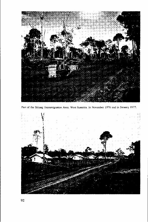
Part of the Sitiung Transmigration Area, West Sumatra. In November 1976 and in January 1977.
92
6 Brown Soils, Latosols or Podzolics?
by P. Buurman and Sukardi
Abstract
The two main landscape elements in the Mimpi Plain area of West Sumatra are the old volcanic peneplain, and the subrecent riverplain. The Old Volcanic Plain is strongly weathered and most of the soils are Haplorthox or strongly weathered Ultisols. The Subrecent Plain showed a range of Ultisols that were less strongly weathered, and Inceptisols. Correlation with map units showed that the landscape interpretation in the present paper is more suitable than the one used during survey and that several soils/areas should be reclassified. Possible criteria for the distinction between the three main soil groups are given and emphasis is laid on the problem of recognition of illuviated clay and the argillic horizon.
Introduction
During 1976 and 1977 the Mimpi Plain in West Sumatra was the scene of much activity by the Soil Research Institute. The purpose was twofold: mapping for large-scale transmigration projects, and selection of experimental sites for the Benchmark Soils Project of the University of Hawaii.
The Mimpi Plain raised several new and old problems for Indonesian Soil Classification. —the complex geomorphological and geological history of the plain and its immediate surroundings confuses soil mapping; —soils were common that because of their age should be neither Podzolic Soils nor Latosols, but that had properties reminiscent of one or both of these groups; —problems reoccurred of distinguishing between Podzolic Soils and Latosols.
In order to shed some light on these problems, P. B. made three field trips to the area to help the mapping project of Sukardi.
This paper combines field evidence with a thorough scrutiny of all available analytical data.
Materials and methods
The following data were available: —Incomplete descriptions and analysis of profiles taken during a preliminary survey in 1976, coded Sys (S)l-17 (LPT numbers 182366-182422); —descriptions and analysis of profiles investigated during two trips for the Benchmark Soils Project in 1976 and 1977, coded SW1-2 and S1/SW2 to S5/SW2 (LPT numbers: 183106-183121 and 187971-197997); —descriptions and analysis of profiles investigated in the context of soil genesis in 1977, coded SB1-8 (LPT184746-184790);
93
—descriptions and analysis of profiles adopted as standard profiles for mapping units, Coded SK, NS, DR, T, F (LPT184306-184462).
Positions of some of these profiles are indicated in Map 2. Samples were analysed for physico-chemical and mineralogical characteristics.
For methods of analysis see paper 12. Very few micromorphological data were available.
Special emphasis was laid on the exchange characteristics as differentials. Only the data on profiles SB1, 2, 5, 6, 7, 8 and SW2 are presented in full
(Table 15); those on SB3, 4 and SW1 can be found in Paper 5. Other data will be published in the survey report (Sukardi et al., in press).
Landscape and geology
The Mimpi Plain runs north-west to south-east about 200 km southeast of Padang in West Sumatra and extends into the Province of Jambi. In the north and north-east, it abuts on a fault zone marked by a mountain ridge of folded Palaeozoic Rocks. In the north-west, the boundary is formed by a complex of mixed Upper Triassic rocks, including granites, and in the west and south-west by a ridge of Tertiary volcanic tuffs that are partly covered by terrace deposits. The volcanic tuffs belong to the Upper Tertiary and Quaternary. Much of the sediment in the subrecent plain is derived from these tuffs and from the Upper Triassic rocks.
The ridge of tuff deposits has a fairly complicated geological history, and its interpretation strongly relates to that of the soil landscapes. The following reconstruction was derived from the study of roadcuts in the area (Figure 11).
The landscape south of the mountain ridge consists of horizontally stratified acid and intermediary volcanic tuffs. These tuffs, the Palembang Beds (1 in Figure 11) were partly eroded during Upper Tertiary times, and the old surface was partly covered by terrace deposits (Figure 11, item 2).
After this phase, deposition of tuff was resumed. Cover to a thickness of 10 m was laid down, but sedimentation was slow enough to allow the landscape to preserve its original form and the drainage system did not change much.
The next phase was strong abrasion of the landscape; most of the old undulating plain was eroded once more, and in some places younger river terraces were formed (A). In other places, the older terraces were exposed (B). This erosion phase was presumably contemporary with an early stage of formation of the subrecent Mimpi Plain, that is called the 'subrecent plain' in Figure 11 and that itself consists of several terraces. The soils in this plain, indicate that there are probably several islands or ridges of older deposits (C).
This build-up complicates soil mapping and classification in the following ways: —there are two or more exposed gravel terraces of different age and weathering; —an extensive abrasion terrace is recognizable in air photographs, however, it is not generally covered by gravels but consists of volcanic materials; —all parent materials are stratified; —much of the material in the subrecent plain is derived from already weathered volcanic tuffs and has characteristics similar to those of soils on the tuff plateau;
94
S
II o
11 > U * E
II (G U - J3
Ä c S 4)
•g £ 0--S s s Ê . u -a
• s v & • »
KE
«1 É> u
1 & Js E . y *0
.S u
&-S H Ë
o u
c £ e u , J =
3 S TD a
û . -S
e s H ' " Ü t J
' S V
ft-S f s
S" i?
P i
o « « o < o H rr) H o c i »o
M vq (S o ; r^ N
H « 6 N r i H
ftH N W M O 00 O «n r i » M m n 00 m N M C O * » t * H r - >g O H Cl t~ \ 0 O- Vï ' t C l H H r t o H H H H H H H o i r > < S H 0 0 H H t ^ ,_i co ON H H o i
ON r- oo ^ m © n v> «n • * n n ^ n o a ^ t n t w r r c i n c i r - o \ M r- oo M W M N N N o - "
• a
C
M
(U
o a.
O O 00 00
N T t ^ o M « r - m TJ- ^ r - r ^ r ^ o o T f t i A » o N i - co r- o H oo c i r ) * M • * N O M 3 \ N « 3
°°. * 1 ° ! *•"! ^ ! °°. c i i n v i ON Ó o
^ h ; w i N o ; N r ^ ^ û o q o q ON r i c i •>* r « o \ r-; ^ ; ON oo « n i n a •<t H H o ï v i v i \ o OÀ h >o v î ON >d cd ON c i d d »d NO cc NO * d •<ƒ O) H H ( S M — ' O J H H H H ( M N n H H H H H . H
a ^ i n n a i r - v i © (N œ * M O > *» NO r* H co O O M O O o « o q i c « h ; Tt oo H H N c o o j ' t q o i v» o \ co c i C I NO ON r ; o o f i ^ r v i r ^ v " ) cd v i v i v j i ^ t - ^ r ^ o \ t N ^ t NO r-' © ^ oó oo' d ©
^ « oo oo i n o ' t t oq oo t ^ —* oc irî i o vd cd OÀ r* N© oó vd
00 O V I O ON ^ Tf H H r i N C l
H •«* r - oo v i
W O; O » N oô ö H \d t^
O H O M N C I oo oo N© <n * * H H c i v i
Û- s 5 H - t- cd ci vî ci ci r> r i
Vt V I f * V» ON
\q © ^ m -tt *t
•n ON H r t r t H O i C l 00 t NÛ o c i o o m « M oo m vo a « v i o o ^ q o o o r - ; **} r i »n t n o o a N f * ; \ q o \ *q ^ f r - c i NO m • < t i - l c i c i r t d r- ^ ^ - v i d -<t d d c i c i r i 00° v î NO t ^ ON
r* v î \© [^ c*S ö
m ^ ' t M M O O f V i V )
O M ^ M « O i n * N «N ON' «d \d r* ci © ci r i r i r i
m H o oo oo n m i c o o ^ m o* ^ >-i « oo in oo ON r) ON ON © v; q m ' t t I- v i
H r i c i d vo - * •<* «n © r n d d f ô r i
n H O > Cl N r ) 00 ^ t • * ^ i > q w M m oq © • * ON ON
v i \ d v î v i v î
H oo O; ^f M Is; m in ^ ci •""; ** ^^ r i 6 o o o m' d o d o ' d ó ó ó ó r i o d d o
M
m m r- m o* ON V) CO O I*; -. ; ™ - ; - ; - ; r i c i c i i t O © r i c i © vd
r i oo »n r - oo
H O N c i oo ^ NO o n o o w c i N oo n « ON ao H » « a M H O i - n o r } " * ON ON m q m r i
o c i v i © " * d d c i c i t> vî \d t^ ON
r-. -* •* •* o d o o
c© oo r- ^ «n r; m Tf m m n d d d d d d d d d d d
oo m m r* r . ON o ^ O O H ^ N > O w C I NO >o r> o r i r - ON NO C I ON ^ r t O H H M C I ' m r i H O ONQ0NO'* t r j oo *o c i H H oo N H o i n oo q « O N H H H t ^ O ^ ' t I o d d © r i d © © ^ " r - i d d o ri ö ó ö ó r i © © d H H © © © • * H H d d i
«2 **"! m «
"3 ,-«
§3*
d d d d d d
*q • * © i - . c i H
O* »-< Cl O "-1 o* ^ m m i t M c i
r- m o o 0 0 ON
ON ON.
r- o r- oo >q v> ci r
r i r i \ d r i
P ^ V J - ^ J - O N T - I o \ " * r j o o o o » H O « « q r r n •<j ON •<* v î o* * ^ d r V * t ^ r ^ v i v ó i - i p i - * m v i v i v o m n vo r» r - TT c i m \ o v i • * n c i c i c i c i
r - © ON H v q r j o q c i f * » r ; * Tt O N W d o ! os d r » d h t ^ d c i
O N ^ ^ O ^
t-; oq ao oo oo q q O N » CN q ON oo ^ vu o ; q o N i - ; h ON ON oo ON O H O O O N vq «n « r^ r ; r ; c i c i ^ - ' c i c i T T T f c i c i c i ^ t ' c i c i c i c i c i - ^ c i c i c i c i c ï c ï c i ^ - • * ^ : ^ c i c i c i c i c i c i c i
fi 3
00 n o r- H
00 O o
^ * >û
1 1
< pa n co ça es
o S v j C ) o r t v i ' t o o
o T . i 0 i . . i
O Q <
o "o 5 J- c o
o m o x ci m ^ r- ^ r*
o o ON ^ NO v i co H * r - H H " <
i T ' ' ' è . _ - • r i r i H oi r . _ H r i _ , H N ^ N H N «
H + ^Hoi r ï ' - ' M r N i S ^ n c i o U ^ n n c i - - j n r i n c ) ** ** o i n n ci < m ca m < CÛ ea a t; < CÛ CÛ co m < co co co < m CÛ eo m < < CD CÛ ca CQ
95
RESISTANT ROCKS, FOLD
PERMI
Fig. 11. Schematic cross section through the Mimpi plain and its surroundings.
—because of the presence of faults, the subrecent terrace can be found at altitudes that do not seem related to each other.
Genetically the most logical way is to divide the landscape as follows (recent sediments and hydromorphic soils are omitted): 1. The old volcanic plain with its Tertiary terraces and Quaternary cover of volcanic tuff. The Tertiary terraces were grouped with this plain because they contained admixed volcanic tuff, and exchange properties were similar to those of the volcanic deposits. 2. The subrecent river terraces (gravelly) that overlie the old volcanic plain in places. 3. The subrecent river plain, with various younger terraces and outcrops of volcanic tuffs. 4. The Triassic rocks, that have a negligible cover of volcanic material.
This subdivision has been adopted below. Soils of the volcanic plain should be more strongly weathered than those of the river plain, where fresh sediment has admixed. The simplest way to check is a plot of the CEC-clay/depth profiles of all the soils analysed. (CEC-clay is corrected for organic matter, because the latter would obscure the picture (Figure 12).
All soils of the volcanic plain had CEC-clay that ranged between 4 and 12 meq/100 g, while values for the subrecent plain were considerably higher. Values that did not fall within these two groups belonged to: —Soils on outcrops of Triassic rocks, such as Gunung Medan: the values for these soils were intermediate between the two groups in the picture (Profile SB1). —Soils on steep ridges in the subrecent plain; these were more severely weath-
96

50
100
150 d e p t h (cm)
i
I i
IVOLCANIC t z P L A I N ~ 1 | 1 \ \ 1 1
1 1 1 I 1
V f I I
1 1
1 1 1 I 1 1 I 1 I
\ \ v \ _\ ^ ^ \. "N. \ » \ \ X "^—-«^^
\ ""* ~ « x "*-- __
1 •
~^-«^_ S I I R R r r E N T PI ,ATM - *«^ . ™ * " " i i ^ _
\ ~ * >
1 1 1 1 1
12 18 24 30 36 42 48
CEC-clay(corrected ) meq/100 g
Fig. 12. Relations between CEC-clay (corrected) and depth in soils of the volcanic plain and of the subrecent plain.
ered than the other plain soils. They also fell between the two main groups —Two soils from the extreme east of the mapping area. These soils had values considerably higher than the other profiles in the subrecent plain, but trends with depth were similar.
There were no exceptions for the soils of the volcanic plain. Only soils in transitional positions on escarpments in the subrecent plain had intermediate CEC-clay. This supports the validity of the subdivision used.
97
—The Brown Tropical Forest Soils in the present area should probably be divided into soils with and without Podzolic characteristics. They could be separated from the preceding groups by a CEC-clay of more than 24meq/100g (perhaps more than 16 meq/100 g). It might be useful to distinguish groups with high charge and with low charge or base saturation.
Crucial in survey is recognition of stratified sediments. Soils that have their highest clay contents at the surface did not always lose their A horizon.
Questions and comments
Sukandar Q. Is it possible to differentiate soils on more exchange characteristics than CEC alone, and is it possible to correlate exchange characteristics with visible properties? A. CEC-clay, PC-clay and base saturation are already extensively used and it seems impractical, at the moment, to include more exchange properties. As yet, correlation with visible properties has not succeeded.
F. J. Dent Comment: A basic difference between a soil mapping unit and a category of classification must be understood. Classification is largely theoretical, invented by man to organize soils as natural phenomena. A class, or category of a classification is a polypedon within the range of diagnostic criteria of each class or category. A series is the lowest category of classification recognized. In the taxonomie sense such a series is a polypedon. A series as a mapping unit, however, is a polypedon with holes in it.
The series is a link between the natural phenomenon and man's attempt at classification, as series are the basic individuals of the soil universe covered by the classification. Such a series cannot belong to more than one family, subgroup, great group, suborder and order. What we map are natural individuals; the series with their inherent characteristics are what form theories for classification. Consequently, we should build classification on natural occurrences and not try to impose a theoretical classification on nature.
104
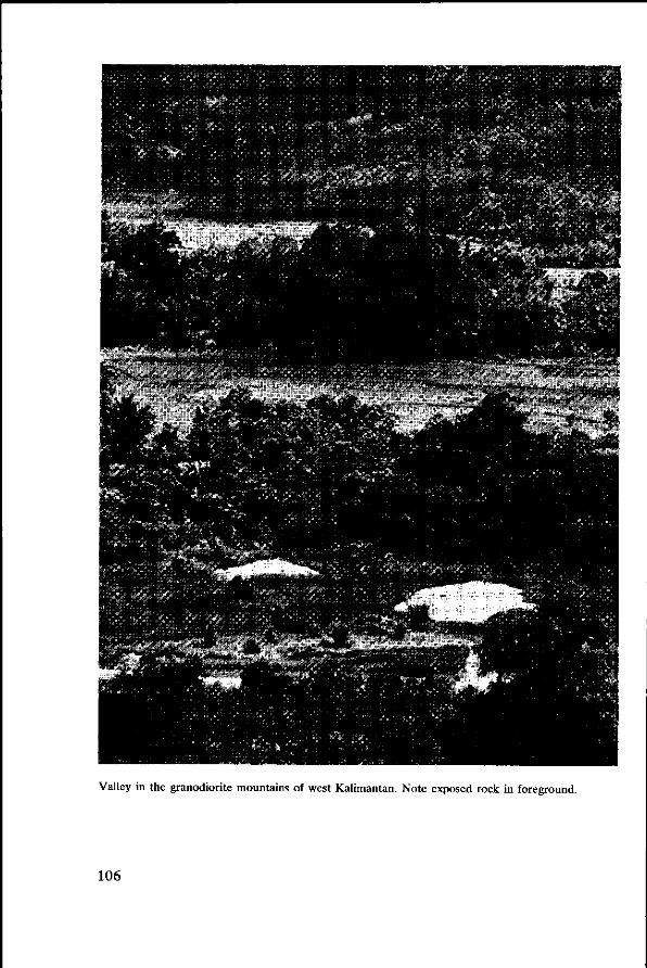
tw**
- • • > •
ins r * *t'
Valley in the granodiorite mountains of west Kalimantan. Note exposed rock in foreground.
106
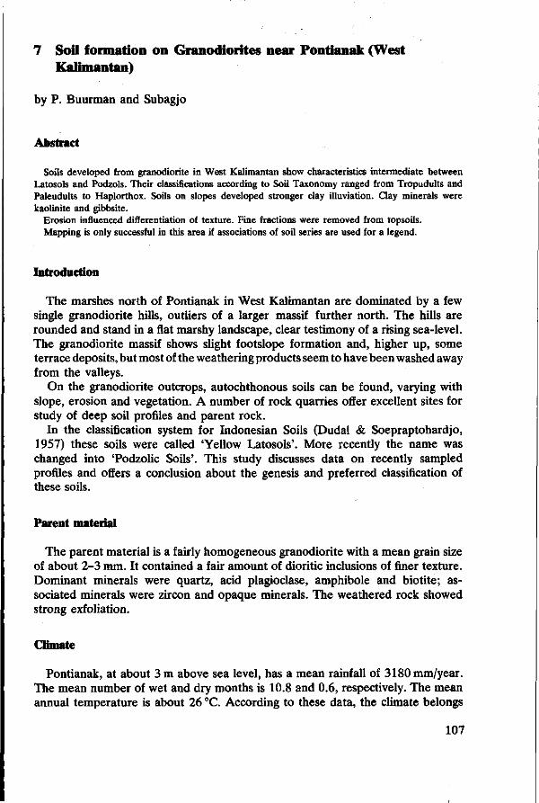
7 Soil formation on Granodiorites near Pontianak (West Kalimantan)
by P. Buurman and Subagjo
Abstract
Soils developed from granodiorite in West Kalimantan show characteristics intermediate between Latosols and Podzols. Their classifications according to Soil Taxonomy ranged from Tropudults and Paleudults to Haplorthox. Soils on slopes developed stronger clay illuviation. Clay minerals were kaolinite and gibbsite.
Erosion influenced differentiation of texture. Fine fractions were removed from topsoils. Mapping is only successful in this area if associations of soil series are used for a legend.
Introduction
The marshes north of Pontianak in West Kalimantan are dominated by a few single granodiorite hills, outliers of a larger massif further north. The hills are rounded and stand in a flat marshy landscape, clear testimony of a rising sea-level. The granodiorite massif shows slight footslope formation and, higher up, some terrace deposits, but most of the weathering products seem to have been washed away from the valleys.
On the granodiorite outcrops, autochthonous soils can be found, varying with slope, erosion and vegetation. A number of rock quarries offer excellent sites for study of deep soil profiles and parent rock.
In the classification system for Indonesian Soils (Dudal & Soepraptohardjo, 1957) these soils were called 'Yellow Latosols'. More recently the name was changed into 'Podzolic Soils'. This study discusses data on recently sampled profiles and offers a conclusion about the genesis and preferred classification of these soils.
Parent material
The parent material is a fairly homogeneous granodiorite with a mean grain size of about 2-3 mm. It contained a fair amount of dioritic inclusions of finer texture. Dominant minerals were quartz, acid plagioclase, amphibole and biotite; associated minerals were zircon and opaque minerals. The weathered rock showed strong exfoliation.
Climate
Pontianak, at about 3 m above sea level, has a mean rainfall of 3180 mm/year. The mean number of wet and dry months is 10.8 and 0.6, respectively. The mean annual temperature is about 26 °C. According to these data, the climate belongs
107

an
108
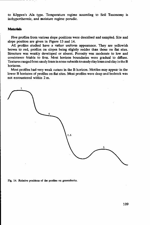
to Köppen's Afa type. Temperature regime according to Soil Taxonomy is isohyperthermic, and moisture regime perudic.
Materials
Five profiles from various slope positions were described and sampled. Site and slope position are given in Figure 13 and 14.
All profiles studied have a rather uniform appearance. They are yellowish brown to red, profiles on slopes being slightly redder than those on flat sites. Structure was weakly developed or absent. Porosity was moderate to low and consistence friable to firm. Most horizon boundaries were gradual to diffuse. Textures ranged from sandy loam in some subsoils to sandy clay loam and clay in the B horizons.
Most profiles had very weak cutans in the B horizon. Mottles may appear in the lower B horizons of profiles on flat sites. Most profiles were deep and bedrock was not encountered within 2 m.
, 2 . 5
Fig. 14. Relative positions of the profiles on granodiorite.
109
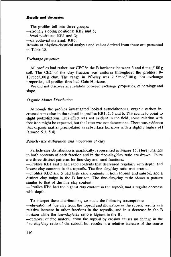
Results and discussion
The profiles fell into three groups: —strongly sloping positions: KB2 and 5; —level positions: KB1 and 3; —on colluvial material: KB6. Results of physico-chemical analysis and values derived from these are presented in Table 18.
Exchange properties
All profiles had rather low CEC in the B horizons: between 3 and 6 meq/100 g soil. The CEC of the clay fraction was uniform throughout the profiles: 8-10 meq/100 g clay. The range in PC-clay was 2-5 meq/100 g. For exchange properties, all profiles thus had Oxic Horizons.
We did not discover any relation between exchange properties, mineralogy and slope.
Organic Matter Distribution
Although the profiles investigated looked autochthonous, organic carbon increased somewhat in the subsoil in profiles KB1, 2, 5 and 6. This seems to point to slight podzolization. This effect was not evident in the field; some relation with free iron might be expected, but the latter was not determined. There was evidence that organic matter precipitated in subsurface horizons with a slightly higher pH (around 5.3, 5.4).
Particle-size distribution and movement of clay
Particle-size distribution is graphically represented in Figure 15. Here, changes in both contents of each fraction and in the fine-clay/clay ratio are drawn. There are three distinct patterns for fine-clay and sand fractions: —Profiles KB1 and 3 had sand contents that decreased regularly with depth, and lowest clay contents in the topsoils. The fine-clay/clay ratio was erratic. —Profiles KB2 and 5 had high sand contents in both topsoil and subsoil, and a distinct clay bulge in the B horizon. The fine-clay/clay ratio shows a pattern similar to that of the fine clay content. —Profiles KB6 had the highest clay content in the topsoil, and a regular decrease with depth.
To interpet these distributions, we made the following assumptions: —eluviation of fine clay from the topsoil and illuviation in the subsoil results in a relative increase in other fractions in the topsoils, and in a decrease in the B horizon while the fine-clay/clay ratio is highest in the B; —removal of fine material from the topsoil by erosion causes no change in the fine-clay/clay ratio of the subsoil but results in a relative increase of the coarse
110
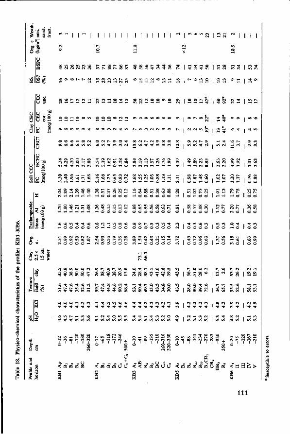
ï ' i i î i r i i i i i i i i M i i i i M i m >o I A n I M H M I 2 I I I I
CA DO « r e i n f i \ û r- I-H oo r-* so en ao oo vo t ^ ' t V© ^ f | ,-H ^ i-H © I r-H 00 i - H ^ -t CN CN CN CN en m r- oo r- oo oo ^ vi <o ^ m ^ m r- I ^ m ^ in | tn N en en I »n en
n e so o\ oo r-- r- CN en en en en t*» in so <n m CN oo m I-H *H rt H N N H N N i-H i-H ,-H ,-H i-H 2 I r- so en © i © en Os I-H S I 2
03
O 3
(J M
8 82
u 0. r~ U a u u w ^ U M W o
< 9
er
e
I © © t I*- [ I *H H -H •* I
o o H o u v i © © © oo (N en m i n O N V o o o o o o o o
c\ *o «n m m <* oo ^ n N Tf v i ^ v i m M M « m
00 « >û rt 0O N O C ^ r ^ O N O - ^ ;
m m
o en
ON CN • *
O
o
t
os
o o m
1-H
so
l'
en
rH
00
o en
so
m
so
os
CN
00 sO
(M SO w
(S
Os O
m so
1-H
1-H
en os
00 o
(S
<t O 0\ a | X ^o
[ f l N H H H H CN rH r-l © © ©
CO N f; tS O) 00 00 m" \6 rt ' t ' f i f i n
CN CN CN 1-H ,-H i-H i-H t t | 1-H i-H
00 IO V I \ 0 M f l H \ o m M o oo H H H I-H" H TH' © I-H I-H m
' t » ^ Ch vo o q oo H m ^ Tf f j r i N rt H H rH © © © © © r H © 0 © © © ©
© © © © © © o o © o © o
^O »O i n t Tf « 1-5 © © © © ©
oo N H i n oo © rH H © ©
00 & h Wl M V | ' t © © © © © © ©
o « N O O O O H CN © © O © © CO I-H © © © © © m
(S
o\ in*
Os 't 1-H
00 Os ©
in ©
00 in
ö
't
ö
en 't ©
CN
CN in'
00 i-H
00 ©
CS © rH
«n ©
en
d
CN
©
m
t^ Tt
en CN c4
00
^ m
©"
00 00 ©
so o'
as ©
©
Os CN'
in 00 ©
© sO ©
m CS ©*
© en ©
en ©*
en so ©
1 2
w 1 «
ea
-
-CN
*-l
"0 ©
-
-
't CN
© CN CN'
t-© r-H
m
vH
e-
©
co ©
SO
m o
so
so rH i-H
os Os 't
O CN
en
Os
rH
© CN CN
© T-H
oo
en'
t
r en
CN Os
^
1-H
r-4
in
©
©
t ©
sO ©
1 * o\
1 *
1-H
1 °. 1 -H"
SO
i ©
m
©
so en ©
t. ©
en
©
in
en m'
en sO -H
00 00 ©
m
©
00 in ©
en ©
Os Os ©
p
o
.§ CA
'G
^ "* «n s U fN rH S
"O O0 OS O O N O s P - O s
sO ^ sO ^ SO CM r ^ ^ - o o
© © © TH CN en ' t ^ Tt - ^ •*' - *
\ o i n r» *H en se ^•' t t ^-" i n "n i n
H ^ wi «
H «s ^ q v i i f l uS in' m' in" in" i n
r-00
m'
sO
5
in TJ-
Os © CN
CN ©
sO t
00 <n
t 00 SO
SO
-*
sO
CN
^ en \o
* •
t
i-H
en
t 00 (N
t © \o
t t
en so
w 00 en
f-Os
CN t
-H
en t
© >n
en t
©
5 m en
en "t
00
(N
00 t en
CN t
in Os en
© © m
T H
^
t t ' l t ^ ^ 9 in' in" in' i n i n i n in'
r-sO
m
© 00 CN
CN t
CN m
© 1 — «
m
© © en
CN • *
^ in
© 00 CN
^,
Os en
CN t
en <n
CN sO
sO CN t'
en
~
(N m
r-
2 r-
1 S
i o
1 « en m
vo <N
t^ in sO
CM t
• ^ •
m
r-* en m
m en en
Os en
00 • « •
CN sD CN
sO CN »n
CN t
CM m
CN
2 „
1 R
(S
1 ^
m
i-H
Os
«H
en m
o\
~
en m
&
© CN sO I-H CN i-i en oo I-H
o ' • '
© © 00 (N rH en
1 o s© CN
00 CN SO t- m I-H r* 't 1-H SC 1-4 l-H CN o 1 1 1 1 +
© © m
m © I-H o\ en i-H Tt 00 1-H
o ' ' '
© •-H (N
1
O © i-H en en en
o o SO CN CN en
F H O VI 00 ^ i-H T t 0 0 i-H
o ' ' '
•* © m en t oo CN CN CN
1 1 f
© m en
1 + © >n en
© t-© m CN so CN ( 1-H i-H
i ' ' '
© 1-H CN
1
< OQ OQ PQ PS
S
+ < n « cô U U Si
< < m <s n u s s H o? «
< B B ^ > a
111
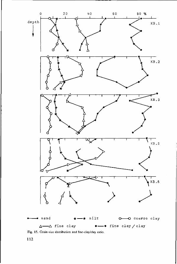
dep th
T ^ - n r
\ / \
K B . l
KB. 2
KB . 3
-RT—?»—i 1 1 1—t~r
KB .5
KB. 6
s a n d • • s i l t c o a r s e c l a y
A A f i n e c l a y • * f i n e c l a y / c l a y
Fig. 15. Grain-size distribution and fine-clay/clay ratio.
112

fractions in the topsoil; —weathering of minerals results in a decrease of the coarse fractions; and in an increase in fine-clay/clay ratio.
With these assumptions, we can draw the following conclusions: KB1. Both fine-clay and silt decreased towards the top, while coarse clay behaved erratically. As there was no distinct clay bulge, and an erratic behaviour of the fine-clay/clay ratio, we suppose that the texture differentiation in the topsoil resulted from removal of fine material by erosion. KB2. There was a distinct increase of clay and fine clay in the subsoil, at the expense of coarser fractions: a result of weathering. In the topsoil, the sand fraction increased and all finer fractions decreased. This indicates both eluviation and erosion. The clay bulge in the B horizon, coinciding with the highest fine-clay/clay ratios suggests the presence of illuviated clay. KB3. Similar to KB1. The decrease in silt-size minerals towards the top points to weathering of this component. The clay fractions were strongly removed from the topsoil by erosion. KB5. Similar to KB2. KB6. Fine fractions increased towards the top, at the expense of the coarser fractions. The increase in the fine-clay/clay ratio in the B horizon may point to some illuviation, but the distribution pattern suggests that weathering was the predominant process.
Mineralogy of the sand fractions
Results of mineral grain counts in the fraction 100-200 fim are presented in Table 19.
In the total sand fraction quartz was predominant. It represented up to 97% of the grains. Profile KB5 still had more than 3% weatherable minerals from a depth of 1.41 m down, but the other profiles had less than that amount. Secondary gibbsite and kaolinite (halloysite) were especially abundant in Profiles KB2,5 and 6. These minerals were partly idiomorphic substitutions of feldspar grains. In Profiles KB5 and 6 such fragments were identified by X-ray diffraction. In KB5 halloysite was found, together with minor amounts of mica and feldspar. In KB6, most of the fragments consisted of gibbsite.
The heavy fractions consisted of 50-90% of opaque minerals. The second major mineral was zircon. In none of the profiles was variation consistent with depth. Variations were due to changes in parent material with depth, and to differences in grain size. (Table 18).
The mineralogy of the clay fraction
In all samples, kaolinite and gibbsite were the only clay minerals encountered. Crystallinity of both minerals was very good. In some profiles distinct changes were observed in the Gibbsite/Kaolinite peak height ratio. These ratios are given in Table 20. Profiles KB1,3 had ratios that were very low and fairly constant with
113
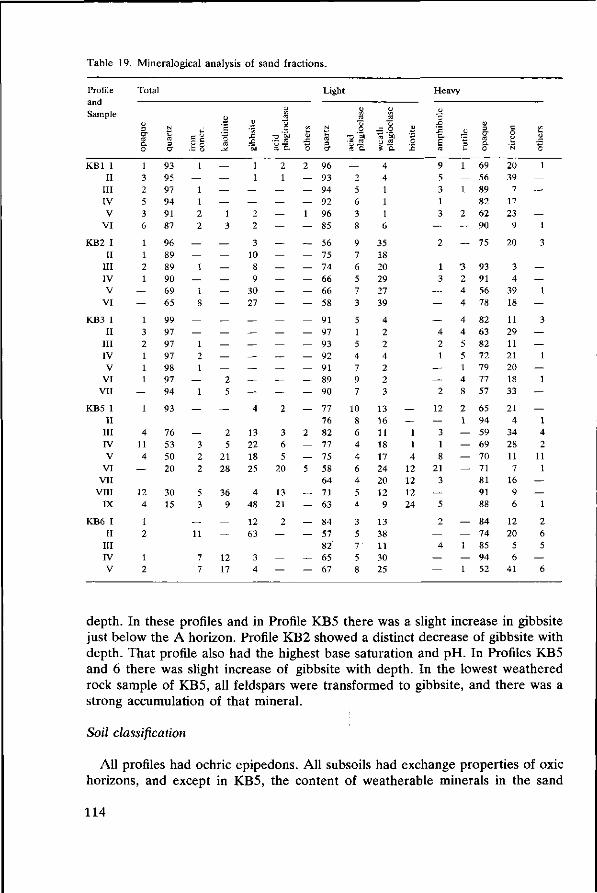
Table 19. Mineralogical analysis of sand fractions.
Profile and Sample
KB1 1 II
III IV V
VI
KB2 I II
III IV V
VI
KB3 I II
III IV V
VI VII
KB5 I II
III IV V
VI VII
VIII IX
KB6 I II
III IV V
Total
3 o-Co c. 0
1 3 2 5 3 6
1 1 2 1
— —
1 3 2 1 1 1
— 1
4 11 4
—
12 4
1 2
1 2
N
3
a-
93 95 97 94 91 87
96 89 89 90 69 65
99 97 97 97 98 97 94
93
76 53 50 20
30 15
1
— 1 1 2 2
— —
1
— 1 8
— 1 2 1
— 1
—
— 3 2 2
5 3
— 11
7 7
cd
— — — —
1 3
— — — — — —
— — — —
2 5
—
2 5
21 28
36 9
— —
12 17
'1 .c '3J
1 1
— —
2 2
3 10 8 9
30 27
— — — — — —
4
13 22 18 25
4 48
12 63
3 4
cj ca
TZ ' M • - CS
S ä 2 1
— — — — — — — — — —
— — — — — —
2
3 6 5
20
13 21
2
—
— —
J 3
2
— — — 1
— — — — — — —
— — — — — — —
2
— — 5
— — — —
— —
Light
cd 3 a"
96 93 94 92 96 85
56 75 74 66 66 58
91 97 93 92 91 89 90
77 76 82 77 75 58 64 71 63
84 57 82 65 67
O
•s ' i 1
'3-2
— 2 5 6 3 8
9 7 6 5 7 3
5 1 5 4 7 9 7
10 8 6 4 4 6 4 5 4
3 5 7 5 8
cj d
J5 0
4 4 1 1 1 6
35 18 20 29 27 39
4 2 2 4 2 2 3
13 16 11 18 17 24 20 12 9
13 38 11 30 25
3 o
— —
1 1 4
12 12 12 24
Heavy
.£ '.£ a E cd
9 5 3 1 3
— 2
1 3
— — —
4 2 1
— —
2
12
— 3 1 8
21 3
— 5
2
— 4
— —
3
1
— 1
— 2
— —
3 2 4 4
4 4 5 5 1 4 8
2 1
— — — —
— — 1
— 1
CO 3 •y cd a o
69 56 89 82 62 90
75
93 91 56 78
82 63 82 72 79 77 57
65 94 59 69 70 71 81 91 88
84 74 85 94 52
c 0 CJ
'N
20 39
7 17 23 9
20
3 4
39 18
11 29 11 21 20 18 33
21 4
34 28 11 7
16 9 6
12 20 5 6
41
0
1
— — — —
1
3
— —
1
— 3
— —
1
— 1
— —
1 4 2
11 1
— —
1
2 6 5
— 6
depth. In these profiles and in Profile KB5 there was a slight increase in gibbsite just below the A horizon. Profile KB2 showed a distinct decrease of gibbsite with depth. That profile also had the highest base saturation and pH. In Profiles KB5 and 6 there was slight increase of gibbsite with depth. In the lowest weathered rock sample of KB5, all feldspars were transformed to gibbsite, and there was a strong accumulation of that mineral.
Soil classification
All profiles had ochric epipedons. All subsoils had exchange properties of oxic horizons, and except in KB5, the content of weatherable minerals in the sand
114
Table 20. Relative peak heights of gibbsite with respect to kaolinite. Kaolinite 7.15 Â (0,715 nm), Gibbsite 4.84 Â (0,484 nm).
Profile Horizon G/K Profile Horizon G/K
KB1
KB2
KB3
Ap B l B2 B3 BC C
Al B l B2 B3 CI C1 + C2
A l AB B2 B3 BC Ccn C2
0.07 0.10 0.06 0.08 0.04 0.06
2.62 2.09 1.97 1.64 1.64 1.58
0.10 0.17 0.11 0.13 0.11 0.13 0.14
KB5
KB6
A l Bl B21 B22 B23 B + CR1 CR2 IIB2 CR3
A l II III IV V
0.19 0.27 0.23 0.23 0.33 0.46 0.32 0.26 4.50
0.18 0.18 0.25 0.30 0.34
fraction was also low enough for an oxic horizon. Profiles KB2 and 5 might have argillic horizons, but also the distributions in
KB1 and 3 suggest the same. Profile KB6 did not show clay illuviation. Suggested classifications are: KB1: Typic Haplorthox, clayey, kaolinitic, isohyperthermic. FAO: Xanthic Fer-ralsol. KB2: Typic Paleudult, clayey, gibbsitic, isohyperthermic. FAO: Dystric Nitosol. KB3: Typic Paleudult, clayey, kaolinitic, isohyperthermic. FAO: Dystric Nitosol. KB5: Orthoxic Tropudult, clayey, kaolinitic, isohyperthermic. FAO: Ferric Ac-risol. KB6: Typic Haplorthox, fine silty/loamy, kaolinitic, isohyperthermic. FAO: Or-thic Ferralsol.
Conclusions
The soils here classified as Tropudults, Paleudults, and Haplorthox, had very similar properties. It might be undesirable to adopt such differences in mapping legends.
The introduction of an association of soil series that covers the range of differences listed might offer a better solution. Profiles on slopes had stronger tendencies to develop towards Ultisols than profiles on flat sites.
Weathering of coarse-grained granodiorite obviously results in rather permeable residues that do not generally give rise to stagnation of water. The minerals
115
from the parent rocks tended to disappear rapidly, opaque minerals and quartz excepted. Hornblendes disappear without a trace, but feldspars and biotites show transitions to halloysite and gibbsite, and halloysite and kaolinite respectively. The profiles described, and their weathering processes are similar to the Malaysian Lanchang Series, on granodiorite, and the Rengam Series on Granite (Malaysian society of Soil Science, 1977). The latter shows a similar weathering sequence of feldspars: smectite at the bottom of the profile, kaolinite higher up, and gibbsite at the top.
Genetically, the profiles from Kalimantan are intermediate between Latosols and Podzolic Soils in the Indonesian Soil Classification System, and do also show some humus podzolization.
Questions and comments
Sukandar Q. In your data, there is no relation between biotite in the sand fraction and illite, vermiculite and smectite in the clay fraction. Was your identification of biotite right? A. The identification of biotite was confirmed by X-ray diffraction. We should not here expect equilibrium between the minerals in the sand and clay fractions.
T. Pandia Q. What is the classification of the profiles according to the new scheme of Soepraptohardjo & Ismangun? A. Profiles SB1 and 5 would be Lateritic soils; Profiles SB2, 3 and 6 Podzolic Soils.
Tejoyuwono N. Q. Although soil genesis is fundamental to the proper classification of soils, we should not go too deep into that matter. We have to establish which property we are going to use and where the limits of properties should be placed around the central concept. As soil classification should give the properties that people are interested in, the morphology of the soil in the field is more important than inferences from analytical data. A. We should not forget that until now all classifications that were based on morphology alone have failed. It is true however, that we should try to relate the properties we measure to properties that can be recognized in the field.
F. J. Dent. Comment. Soil associations and complexes may provide practical answers in an area with confused classification.
M. Weiss. Q. Could you give any data on weathering of primary minerals? A. We have not studied this in detail. In fact, this is only possible close to the unweathered rock because weatherable minerals were absent in the soil.
116
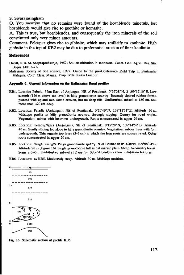
S. Sivarajasingham Q. You mention that no remains were found of the hornblende minerals, but hornblende would give rise to goethite or hematite. A. This is true, but hornblendes, and consequently the iron minerals of the soil constituted only very minor amounts. Comment. Feldspar gives rise to gibbsite, which may resilicify to kaolinite. High gibbsite in the top of KB2 may be due to preferential erosion of finer kaolinite.
References
Dudal, R & M. Soepraptohardjo, 1957; Soil classification in Indonesia. Contr. Gen. Agric. Res. Sta. Bogor 148: 3-46.
Malaysian Society of Soil science, 1977. Guide to the pre-Conference Field Trip in Peninsular Malaysia. Conf. Class. Manag. Trop. Soils, Kuala Lumpur.
Appendix 6. General information on the Kalimantan Barat profiles
KB1. Location Pabulu, 5 km East of Anjungan, NE of Pontianak. 0°20'38"N, 2 109°12'10"E. Low summit (120 m above sea level) in hilly granodiorite country. Recently cleared rubber forest, planted with upland rice. Some erosion, but no deep rills. Undisturbed subsoil at 180 cm. Soil more than 320 cm deep.
KB2. Location: Paladis (Anjungan), NE of Pontianak. 0°20'40"N, 109°11'11"E. Altitude 50 m. Midslope profile in hilly granodiorite country. Strongly sloping. Quarry for road works. Vegetation: rubber with luxurious undergrowth. Roots concentrated in upper 20 cm.
KB3. Location: Teradu/Ngara (Anjungan), NE of Pontianak. 0°19'20"N, 109°14'59"E. Altitude 40 m. Gently sloping footslope in hilly granodiorite country. Vegetation: rubber trees with fern undergrowth. Thin organic top layer (3-5 cm) in which the fern roots are concentrated. Other roots concentrated in upper 20 cm.
KB5. Location: Sungai Liung/S. Pinyu granodiorite quarry, N of Pontianak 0°16'40"N, 109°05'34"E, Altitude 20 m (Figure 16). Single granodiorite hill in flat marine plain. Steep. Secondary forest. Some erosion. Undisturbed subsoil at 2 metres. Subsoil boulders show exfoliation features.
KB6. Location: as KB5. Moderately steep. Altitude 30 m. Midslope position.
3 E Bl
B21
Fig. 16. Schematic section of profile KB5.
117
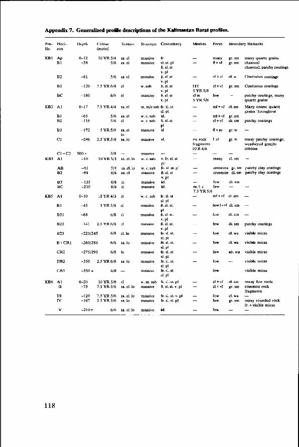
Appendix 7. Generalized profile descriptions of the Kalimantan Barat profiles.
Profile
KB1
KB2
KB3
KB5
KB6
Horizon
Ap B l
B2
B3
BC
A l
Bl B2
B3
CI
C1+C2 A l
AB B2
B3 BC
Al
B l
B21
B22
B23
B+CR1
CR2
IIB2
CR3
AI II
III IV
V
Depth
0-12 -38
-81
-120
-180
0-17
-65 -118
-172
-246
500 + -10
-41 -89
-135 -210
0-10
-45
-88
-141
Colour (moist)
10 YR 5/4 5/6
5/6
7.5 YR 6/8
6/8
7.5 YR 4/4
5/6 5/6
5YR5 /8
2.5 YR 5/8
5/8 10YR5/3
5/4 6/6
6/8 6/8
10YR4/3
5 YR 5/8
6/8
2.5 YR 6/8
-223/245 6/8
-260/280 6/8
-275/295 6/8
-350
-350 +
0-20 -75
-120 -167
-210 +
2.5 YR 6/8
6/8
10YR5/6 7.5 YR 5/6
7.5 YR 5/6 2.5 YR 5/6
6/6
Texture
sa. cl sa. cl
sa. cl
cl
cl
sa. cl
sa. cl cl
sa. cl lo sa. lo
— sa. cl.
sa. cl. sa. cl
cl cl
cl
cl
cl
cl
cl. lo
sa. lo
lo
sa. lo
cl sa. cl.
sa. cl. sa. lo
sa. cl.
lo
lo
lo
lo
lo
Structure
massive massive
massive
w. sab
massive
Consistency
fr si. st. pi fi. sl.st v. pi fi. si. st v. pi fi. si. st v. pi fi. si. St v. pi
m. m/c sab fr. si. st
w. c. sab w. c. sab
massive
massive
massive w.c.sab
w. c. sab massive
massive massive
w. c.sab
massive
massive
massive
massive
massive
massive
massive
massive
w. m.sab massive
massive massive
massive
sl.pl id. fi. si. st
Pi id
id.
— v. fr. si. st
Pi fr. si. st. pi fi. sl.st v. pi id. id.
fr. si. st. sl.pl fi. sl.st. Pi fi. si. st. v. pi fi. si. st. v. pi fr. si. st. sl.pl fr. si. st. sl.pl fr. si. st. sl.pl fr. si. st. sl.pl fr. si. st sl.pl
fr. si. st. pi fi. sl.st. v. pi
fr. sl.st. v. pi fr. si. st. pi
id.
Mottles
—
— fff 5 YR 5/8 cf m 5 YR 5/8
—
— — -on rock fragments 10 R 4/6
— — _ — — m.f. c
Pores
many ff + vf
cf + vf
cf + vf
few
mf + vf
mf + vf cf + vf
ff + m
f.cl
— many
Boundary Remarks
gr. sm gr. sm
cl. w
gr.sm
cl. sm
gr.sm di. sm
gr. w
gr.w
— cl. sm
common gr. sm common di. sm
few few
7.5 YR 5/6
— —
— — — — —
" _ — — — —
mf + vf
di.sm
— cl.sm
fewf+vf di. sm
few
few
few
few
few
few
few
cf + vf cf + vf
few few
few
di. sm
di. sm
cl. wa
cl. wa
ab. wa
—
~ cl.sm gr.sm
cl. wa gr.sm
—
many quartz grains charcoal charcoal, patchy coatings
Continous coatings
Continous coatings
patchy coatings, many quartz grains
Many coarse quartz grains throughout
patchy coatings
-many patchy coatings; weathered granite cobbles
— patchy clay coatings patchy clay coatings
— — —
patchy coatings
visible micas
visible micas
visible micas
visible micas
visible micas
many fine roots common rock fragments
— many rounded rock fr. +visible micas
—
118

The subrecent sedimentary plain lies slightly above the recent alluvial plain. Towards the mountains, the subrecent plain is bordered by terrace deposits that are sometimes strongly weathered. The subrecent plain itself is only slightly dissected and therefore has impeded drainage. The flatter parts have hydromor-phic soils, while in slightly better drained positions deeper soils with clay illuvia-tion may develop.
Climate
According to Schmidt & Ferguson (1951) the annual precipitation ranges from 1600 mm in the east (Kendari) to 1050 mm in the west (Kolaka). In Kendari, the mean number of wet and dry months (more than 100 and less than 60 mm) is 6.5 and 4, respectively, and the rainfall type is D. In Kolaka the mean number of wet months is 8.6 and that of dry months 2; the rainfall type is classified B.
Table 21 presents the monthly precipitation and the number of rainy days of four stations. The water balance for Kendari is plotted in Figure 17. Air temperatures in Kendari show a small monthly variation. The coolest month is August with a mean of 24.6 °C, the warmest is November with 26.7 °C. Mean annual temperature is 25.7 °C. This implies that according to Soil Taxonomy, the climate is isohyperthermic, and udic.
Vegetation and land-use
Most of the hilly to mountainous region in the Western part of the peninsula is still covered with rain forests. The areas of sedimentary rocks, however, have been stripped of their natural vegetation during many cycles of shifting cultivation. The landscape near Ameroro-Lambuya (Figure 18) is now largely occupied by speargrass or alang-alang (Imperata cylindrica L). Forest has not regenerated in the area. Among the few shrubs encountered were acid-tolerant (and speargrass-exudates tolerant) Schima and Melastoma species.
Table 21. Mean of monthly precipitation and rainy days for stations in South-East Sulawesi, (rd = rainy days. P = precipitation/mm).
Stations
Kendari
Wawotobi
M o w e w e
Kolaka
Eleva
tion (m)
10
35
224
0
P rd
P rd
P rd
P rd
Jan
182 14
148 13
165 14
204 14
Feb
170 12
138 12
174 13
199 12
Mar
198 13
169 14
193 15
235 14
Apr
181 12
151 12
237 17
231 14
May
207 13
261 17
281 18
263 15
J un
194 12
221 14
208 16
188 13
Jul
130 8
208 14
143 12
132 10
Aug
62 7
135 10
92 9
93 8
Sep
29 3
109 8
68 6
82 7
Oct
17 2
63 6
80 7
120 8
Nov
69 6
74 7
132 9
151 10
Dec
171 12
103 11
92 9
154 12
Annual
1600
125
1792
157
1865
146
2053
136
122

O 100-
temperature
precipitation
PE
U - u t i l i z a t i o n
D - d e f i c i t
R - recharge
S - s u rp lus
Fig. 17. Water balance, temperature and rainfall for Kendari.
Materials
Samples of Podzolic Soils were collected during two field trips, in April 1976 and in March 1977 (Profile descriptions in Appendices 8-11). According to parent material, the profiles can be grouped as follows: —on schists and on products exclusively derived from these: ST4 to 9 —on subrecent alluvia: ST10 to 13. Sites are indicated in the soil maps of Figures 18 and 19. In Figure 18, the profiles of the reconnaissance survey have been included. (Suhardjo et al., 1976).
The soils on schist were sampled at different sites. Of those on alluvia, Profiles ST10-12 formed a catena, and ST13 was an additional profile that can be projected in the same sequence (Figure 20).
In the mapping legend, the Podzolic Soils were split up into five units, the Yellow Podzolics (Pcy), Yellowish Brown Podzolics (Pcyb), Brown Podzolics (Pcb), Yellowish Red Podzolics (Pcyr) and Red Podzolics (Per).
Of the soils on schists, one is a Yellowish Brown Podzolic (ST5), one is a Brown Podzolic (ST8) and two are Yellowish Red Podzolics (ST4 and 7). All these soils are very porous and have gradual boundaries between horizons. The structure is mostly weak subangular blocky, except in ST8 which was very dry at the time of
123
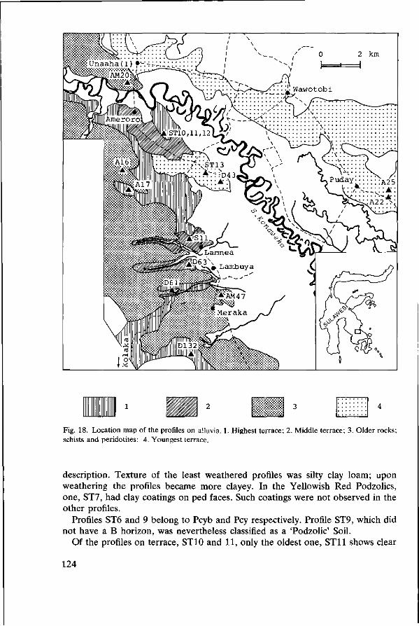
Fig. 18. Location map of the profiles on alluvia. 1. Highest terrace; 2. Middle terrace; 3. Older rocks; schists and peridotites; 4. Youngest terrace.
description. Texture of the least weathered profiles was silty clay loam; upon weathering the profiles became more clayey. In the Yellowish Red Podzolics, one, ST7, had clay coatings on ped faces. Such coatings were not observed in the other profiles.
Profiles ST6 and 9 belong to Pcyb and Pcy respectively. Profile ST9, which did not have a B horizon, was nevertheless classified as a 'Podzolic' Soil.
Of the profiles on terrace, ST10 and 11, only the oldest one, ST11 shows clear
124
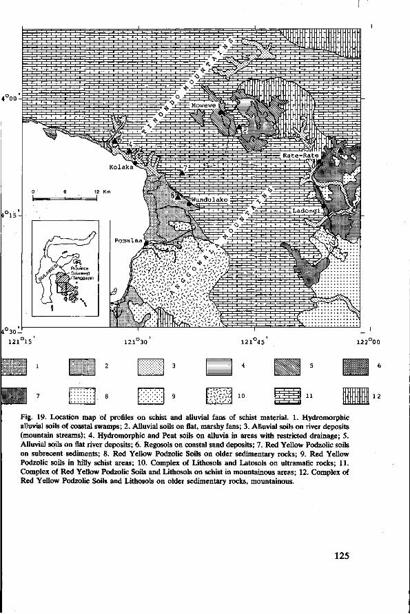
^
10 12
Fig. 19. Location map of profiles on schist and alluvial fans of schist material. 1. Hydromorphic alluvial soils of coastal swamps; 2. Alluvial soils on flat, marshy fans; 3. Alluvial soils on river deposits (mountain streams); 4. Hydromorphic and Peat soils on alluvia in areas with restricted drainage; 5. Alluvial soils on flat river deposits; 6. Regosols on coastal sand deposits; 7. Red Yellow Podzolic soils on subrecent sediments; 8. Red Yellow Podzolic Soils on older sedimentary rocks; 9. Red Yellow Podzolic soils in hilly schist areas; 10. Complex of Lithosols and Latosols on ultramafic rocks; 11. Complex of Red Yellow Podzolic Soils and Lithosols on schist in mountainous areas; 12. Complex of Red Yellow Podzolic Soils and Lithosols on older sedimentary rocks, mountainous.
125
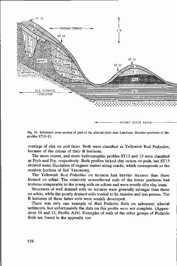
ST 11
> : * : * : * : * : * : - c+ V K + K ^ K ^ ^ ^
-RECENT RIVER PLAIN-
Fig. 20. Schematic cross section of part of the alluvial plain near Lambuya. Relative positions of the profiles ST10-13.
coatings of clay on ped faces. Both were classified as Yellowish Red Podzolics, because of the colour of their B horizons.
The more recent, and more hydromorphic profiles ST 12 and 13 were classified as Pcyb and Pcy, respectively. Both profiles lacked clay cutans on peds, but ST13 showed some illuviation of organic matter along cracks, which corresponds to the sombric horizon of Soil Taxonomy.
The Yellowish Red Podzolics on terraces had heavier textures than those formed on schist. The relatively unweathered soils of the lower positions had textures comparable to the young soils on schists and were mostly silty clay loam.
Structures of well drained soils on terraces were generally stronger than those on schist, while the poorly drained soils tended to be massive and less porous. The B horizons of these latter soils were weakly developed.
There was only one example of Red Podzolic Soils on subrecent alluvial sediments, but unfortunately the data on this profile were not complete. (Appendices 10 and 11, Profile A16). Examples of soils of the other groups of Podzolic Soils are found in the appendix too.
126
Results and discussion
Chemical characteristics
Analytical data of the profiles are presented in Table 22. Both the soils on schist and those on alluvia had low pH throughout. This pH sometimes rose slightly when weathered bedrock was reached. Lowest pH was observed in soils on schist from Kolaka (ST4 and 5), perhaps because of the higher rainfall in that region. In most soils, exchangeable bases were concentrated in the topsoil. Exceptions were the Profiles ST5 and 6, perhaps because of movements of slope material in the former and supply of groundwater rich in cations in the latter.
All soils had low contents of organic matter. The mass concentrations of organic C ranged from 4.4 till 7.9 kg/m3. (calculated on a dry bulk density of 1000 kg/m3) Cation exchange capacities tended to be higher in soils on schists. This was even more strongly expressed in the CEC of the clay fractions. The corrected CEC of soils on schist ranged between 30 and 45 meq/100 g, which values were also reached in the relatively unweathered alluvial Profile ST12. Footslope and young alluvial profiles had values between 25 and 30, while those of the B horizons of soils on terraces did not reach 20 meq/100 g. Most of the exchange complex was occupied by aluminium and H+. In some of the soils the aluminium saturation (100-BS-PC) is more than 90% in the B horizon. The low CEC7 in the Bl of ST4 was probably an error.
Fine clay (particle size less than 0.5 ftm) to clay ratio was more or less constant in most profiles. Profiles ST7 and ST11 show a distinct increase in the B horizon.
Mineralogical composition
Sand fractions of the profiles consist predominantly of turbid quartz (over 90%) and some mica, glaucophane, garnet and tourmaline. Soils on schist had larger amounts of micas than those on subrecent sediments. The result of X-ray diffraction analysis of some of the clay fractions is presented in Table 23. Most abundant clay minerals in all profiles were kaolinite and interstratified illite-vermiculite. Relatively unweathered soils still have some mica in the clay fraction. In highly weathered soils, like ST11 and 12 there was a smaller proportion of interstratified minerals. This was reflected in lower CEC-clay.
Micromorphology
In the following, the terminology of Brewer (1964) is used.
Profile ST7
Horizon B21. Depth 55 cm. Skeleton grains are mainly quartz and micas, partly as randomly arranged rock fragments. Plasma has a papulic fabric and consists of clay and iron. Voids are mainly vughs; planes and channels are scarce. Biological activity: some faint
127
X o
V •
r- *-i © -es in -i oo NO oo r-- t oo t m m H oo -t ) NO t-~ oo r*- m NO m in m NO NO in NO NO in Tf i^ ^
i—i o oo r » m CS NO o \ m o NO r j - co »o o
NO i n - ' t ON o* <—< oo t-- NO - f o - < t r - o es r o >/i n h NO ^ * i—i es o r ^ - O N O ^ O i — i ' — ( —i rH
i n © t-- i n i n o ' t ^ t ' t cs T t r - t ^ - t - ^ t i / i h - o ^ o en i- i ^ r - T t ^ o o c N ' - i ' - 1
• ÖD \ 0 \ 0 m (N ^ t ) O O f l t ' t ^ i ©
o\ oo oo m - t- TJ- m Ti-
O O O ' t "O en en ' t en en
' t H (S T f i n en en en en ^ t
T - H T f r t ^ o o r - - o \ © en " n ON oo en ON es NO oo t-^ © oo ' t en cs es ' t - t ' t - ' t -^- oo ' t en es en en es es m cs
es cs in P - NO en en oo CN en in in NO ON p- p- NO ON p -en en es es f en en en f P - es cs es es CS es CS CS CS
H m ^ i n > o ^ r © e n I -H N O i n O N o o ' t - f ^ o P-- © ^ o CS CS <-< ^ H CS CS CS CS CO © c n ^ ^ - H C M , - H ^ ^ H CS ^ H
w
O
o
i n o ; N c i q H o^ Tt* ' t n
(N un © r-; © cs © ' © '
q q N o \ h ; r o « i o \ o i h
N i n oo oo H
r t ö ö ^
cs oo oq © - t od T t T f i n en
ON oq en d H rs
»n en ' t en r-; ' t cs' es' i-î oó
H es »n e i CS ©' ©' ^
(N en oo ' t ' t 0 \ 0> 0 \ rH f f )
i n p p i n p en' i n ' NO' en ©
p-; en oo ON *t in ' ^f- en p- en'
CS © in ' od
ON ' t NO
in ' \ ó NO'
H oo q in ' i n ' \ d
' t ; CS en' i-ï
oo ^q \ o © ' © ' © '
H q h oo q r^ vd ^ r^ i n '
\ o i n es en oo i n <n' vu i ^ i -
in in in «n (N ^H Ö Ö © ©
ON F*: ^o i n i n in ' NO' oo
o i n < N f-H Ö i-ï o o
ON CS ' t ' t i n ' t ^5 »
t - ; CN| ' t es ON
P^ 00 00 OÓ ON
H h m h O; en' ' t i n in ' w-j
N H i n q o \ *-" - t -t- m' TT
ON NO 00 P*; © ^H © ' © ' © ' ^H
0 U < - < © © © © * - * © © © ©
CS rH 7-H i n i - " ©
i n - t ( ^ ' t ^o NO l > ' t es es 1-* © ' © * © ' ©
' t NO ^H © © © ©
oo - t en cs i n ' t - t en en en
h o H n o es en en en en
NO - f es es © es cs cs cs cs
r* CS NO t ^ t (S
CS es " t en
00 i n ON ON NO r-H ON 00 00 i n
O 1-
X
r-; i n ' t ' t en en en en en en
NO i n p - i n oo ' t ' t ' t ' ' t t '
' t ' t en ' t i n en en en' en ' t '
es es oq © p - t - t ' t in' NO'
P - P - NO
en en' en
t ^ I-H
i n ' i n en © cs »n i n ' in"
NO vo p-; ' t i n en' en en en en'
ON 00 ' t ON i n ' t ' t * i n ' ' t in '
oo © cs T t ' t ' t T t r r
o\ -Û r q in ' i n ' i n ' NO'
oq i n i n i n i n en en en' co en
es ^ H *-H © oo in" in ' in ' i n ' ' t
+ + © © ©
© - f r-- © en en NO en un H o i »o H H i n o ) i n w H
I l I I l I l l l I © ©
è •* o o t - o H ffl SD h O l
I I I I I O
O vo oo r - o H N K J r t
I I I I
o o m o in M rt ^ h Os
I I I I I o
O 3!
S <3 o
<-H CS ' - J H N M ft
< ra ra ra ra
H Vi
_ ^ < ^ , , >-] (S es co <J < ra ra ra ra
Vi
< ra
H Vi
N (S (^
rann
ai < m « m oi
C/3
^ n N C l
< ra ra ra
SO
H
" M M
< u u u u
ON
H
128

I JO
• f r« ^ ^ ^ ^ « Ä ^ti A^I *ni rti rtn n« n/"i 0 0 0 \ 0 0 O 0 \ 0 \ 0 0 0 0 > o ^ * » n ^ N o o *o n o oo u-i r- -<t o\ oo » o\ ON a o> Ov »o o i n ^ i n 10 in in vi vi
• *
• *
m
CE
M a5
H N O » TH r i N r i
» M n » ) M l l » r t
e
u ( S u c i o o o o o o v o o o - * n fi p i N N n r i r i o N ü 3
(Scsoor--oot~ONfn H 5 2 N ci r-1 »-1 ^ "-1
U o o
g ri ri ri ri
u -a H ° u o
en
< o •> s> xi 3
o u 1
3 O
M
I «M «5 V
o »s
a. 'S
u i x
3 2
es "o
•O ,_ §5É S« >L
^
se
U M
0
u « o
O l N 0 0 i n * ^ l f i N
n ^ i n H O j q o i * N c i c - i c i f f i c r i c i f i
*°. "} **? ^ "î ^ •*: °S Ö O O O O O O Ö
OJ © cri © o\ \o ri O t 00 0> ri f- vO t 0>
t M H H *-HV© i-i \C
o o o r ^ v o N O ^ t ^ m o t » vi oo t-- »n >o oo
ri ri O ri (S)
a vi Tt oi o\ H o> H f i h \o io vo o\ r- o ON «»» M M >H •-< <s i-i « n n n * * N N N N
< M < N t - ' < t t o o i — H r t i n * * m vi ^ r- h r i *-< r i r i r i r i r i Cl Cl Cl Cl ^- N N N N N
Cl Cl U"j f ; "O Tf © N ^ H * H ^ t"; «O 00 « l ^ v Ô t ^ O r î r i f r i r~ r i Cl CI Cl c i GO CO © ©
H O o i O i O j O i i o n i n r i o o ; c j c i o\ v i r-; c i c i c i v i r r~ oô oi © r i c i a i iô oó id o i oi
O O T f ^ m N - r J ; ! - ; f ; 00 « O O t I-; »1 00 O; H' ri ri wi f-' h t n o! d ri oó ei t-i vd oó oó
m \o in vq h; »ft O; sq c-; «n © o; 0 0 * 0 ^ ^ 0 0
r i Ö Ö O Ö Ö Ö Vi O O r i r i ei O Ö Ö ©
m H ^ H 00 n V) ^" © Cl Tt" ^" 00 ï^l (^ o ^ <jiiq * « I * M N P ^i ""! T"! ""! °? •*! *i ^i 1
d ó ó ö ö ó ó o ö ö ö ó ö o ö N ' Ó O O O n ' ö ö ö ö
N m r i t o n M O N N f r ) ^ ' < t T t ' - < t m
« n o o n i t N M n C l C l C I C A C I C l n c i
t - ; V O r - ; 0 0 ( " " ; 0 0 r - 0 0 C I C 1 C 1 C 1 C 1 C Ï C 1 C 1
O N O N r l C l C ï ' ^ r H ' * ^ • 3 - v i v i v i v i v i v i
00 vo o o © © © v l d T f v O C -r i c r ) | / - ) 0 \ r 1 r 1 r 1 r 1
I I I I I I I I
ON v i r i vo N e i r- o o t o m o o o o ON © N r- r-H N n m i o « * c4 o c i e i c4 ci o e i o e i
NO NO ON ON C4 ON Cl O M C * N (O m I<1 O O O C l N H r i H H r i r i r i r i r i r i r i
•"": ^ r-: f": •"": ^ '": ^ "} " i P. *": "Ç *~: ^ "1 ^ Cl Cl O Cl Cl Cl Cl Cl Cl Cl Cl Cl Cl Cl Cl Cl Cl
ON © © ON ci c) r i « N n > 0 ^ •* ci vi vi T* *t vi vi * * vi vi vi ^* vi vi vi vi vi vi vi in vi
•<t o
S " 7 o t- o , o v» i— <s x
P- r i r i (S) © r i i i g
«O O O ^t H io o» H m
<± ' ' ' * 2 ©
o o Tt VO o <s
M Î T 7
_^ - , n N Cl r \ ^ m n , 7 ^ 00 60 00 ^ 00 00 ' i H n N N c i c i y r i W n N ci U U *-J cl ci n n *-J n N ci so
b & ë is
129

Table 23. Clay minerals in selected samples.
Sample
ST4 B21 B22 B23
ST5 B22 ST7 A l
B21 ST9 C13g ST10 IIC ST11 IlCg ST12 Clg2
Kaolinite
+ + + + + + + + + + + + + + + + + + + + + + + + + +
Mica
+
+
Mite
(+) (+) (+) + + + + + + + + + + +
d-v)R
+ + + + + + + +
+
+ + +
(i-v)IRR
+ + + + + + + +
+
Vermiculitehc
+
aggrotubules, channels and striotubules. Some iron cutans on rock fragments. Some evidence of illuviated clay as papules and channel argillans.
Horizon B3. Depth 133 cm. Many lithorelicts, clustered or randomly arranged. Increased amount of skeleton grains. Plasma as in B21. Some faint diffuse iron mottles. More interconnected vughs, some craze planes and channels. More pronounced clay orientation than in B21, otherwise similar.
Remarks: The most pronounced feature in the thin section was the large amount of strongly oriented clay in the matrix. These are weathered mica grains. They gave rise to a papulic plasmic fabric that was not a result of clay migration. Some clear illuviation of clay and iron was encountered. Concentration of liberated iron around some lithorelicts was less pronounced. Hydromorphic features are negligible.
Profile ST8
Horizon B l . Skeleton grains are mainly quartz, lithorelicts and micas, partly with iron concentrations. Plasma consists mainly of silt-size micas. Clay and some iron occur in silasepic fabric. Voids are channels and mamillated vughs. Some organo-argillans and quasi-argillans.
Remarks: Weathering was less severe than in the foregoing profile. The plasmic fabric was silasepic rather than sepic or papulic. There was less liberation of iron. Illuviation was weak and argillans had a grainy appearance, probably as a result of admixture of organic material. Biological activity was low.
Profile ST10
Horizon B l Skeleton grains are mainly randomly arranged coarse and fine quartz. No lithorelicts. Some resistant organic bodies. Clay and iron are arranged in a skel-and masepic plasmic fabric. Voids are mainly channels, interconnected vughs
130

and some compound packing voids. Few lithorelicts are covered by iron. Some aggrotubules and matric fecal pellets.
Remarks: The combination of sand fraction and clayey plasma gave rise to some skelsepic and masepic plasmic fabric. Weathering phenomena were weakly expressed.
Profile ST11
Horizon B2 Skeleton grains range from 50-1000 microns and include quartz, some heavy minerals and mica. The distribution pattern is random to clustered. Clay and iron form an undulic plasma. Reorientations are abundant. Voids include channels, interconnected vughs and craze- and skew planes. The basic fabric is porphyroskelic. Plasma reorientations occur as skelsepic, omnisepic, masepic and vosepic, glaesepic and papulic fabric. Many void ferri-argillans with a strong continuous orientation. Some speckled ferri-argillans in the matrix. Few iron nodules with sharp boundaries in the lower part.
Remark: The most prominent feature in this profile is the illuviation of clay.
Physical data
Physical data of some of the samples are given in Table 24. All samples had fairly high dry and wet bulk densities, that increased with depth. Permeability was fairly low, and even extremely low in ST8, the soil with the strongest structure. In most soils volume fraction of available water was below 10%. No clear differences between soils on schist and on alluvia were detected.
Table 24. Soil physical data.
Profile
ST4
ST7
ST8
ST10
ST13
Horizon
B l B21
A l B21
B l B2
A l AB B l B21
A l B l B2g
Bulk density dry
1.10 1.16
1.27 1.45
1.32 1.48
1.26 1.51 1.57 1.50
1.12 1.39 1.48
Bulk density pF2
1.61 1.62
1.70 1.78
1.76 1.84
1.58 1.82 1.92 1.85
1.58 1.74 1.83
Total pore space
58.7 56.4
52.3 45.4
50.2 44.2
52.6 43.2 41.0 43.5
57.9 47.6 44.1
Water retention (vol %) pFl
57.1 53.8
50.6 42.8
48.2 43.5
47.1 42.2 39.8 41.2
51.9 40.4 42.3
pF2
51.6 46.3
43.4 33.7
43.8 36.2
32.9 31.9 35.3 35.4
46.9 34.9 34.8
pF2.5
47.3 38.8
37.8 27.2
34.1 29.1
26.8 26.9 29.6 29.9
39.3 32.0 30.8
pF4.2
36.8 27.2
28.9 21.8
25.7 21.6
18.1 19.6 22.3 24.3
31.0 26.6 23.5
Available water
10.5 11.6
8.9 5.4
8.4 7.5
8.7 7.3 7.3 5.6
8.3 5.4 7.3
Permeability (cm/hr)
0.56 0.93
4.58 0.91
0.04 0.01
6.05 1.73 4.75 0.92
2.59 0.16 1.06
131
Soil classification
The profiles were classified according to Soil Taxonomy (USDA, 1975) and to the FAO Legend (FAO-Unesco, 1974). Since the data on most profiles are incomplete on micromorphology, classifications are necessarily tentative.
Soils on schists
ST4. This profile has an ochric epipedon. Although there is a distinct increase in clay with depth, the fine-clay/clay ratio does not indicate any illuviation. The very high amounts of bases in the upper two layers may indicate colluvial material. The subsurface horizon is cambic. CEC-clay is higher than 24meq/100g, and base saturation is low. Soil Taxonomy: Typic Dystropept, fine loamy, mixed, isohyperthermic. FAO: Dystric Cambisol.
ST5. Except for a heavier texture this profile is similar to ST4. Soil Taxonomy: Typic Dystropept, fine loamy, mixed, isohyperthermic. FAO: Dystric Cambisol.
ST7. In this profile there is evidence of illuviated clay in thin sections as well as in total clay content and fine-clay/clay ratio. The surface horizon is ochric, the subsurface horizon argillic. CEC-clay is higher than 24meq/100 g and base saturation is low. Clay content does decrease more than 20% from its maximum within 150 cm. Soil Taxonomy: Typic Tropudult, fine clayey, mixed, isohyperthermic. FAO: Orthic Acrisol.
ST8. This profile has an ochric epipedon and a cambic horizon. The evidence of translocation of clay is not sufficient for an argillic horizon. CEC-clay is high and base saturation is low. Soil Taxonomy: Typic Dystropept, fine loamy, mixed, isohyperthermic. FAO: Dystric Cambisol.
Soils on alluvia
ST10. This profile has a gradual increase of clay content with depth. The fine-clay/clay ratio might point to some illuviation, but cutans were not observed in the field. CEC-clay is lower than 24meq/100g and base saturation is low. Clay content does not decrease within 150 cm. Soil Taxonomy: Oxic Dystropept or Typic Paleudult, fine clayey, mixed, isohyperthermic. FAO: Ferralic Cambisol or Dystric Nitosol.
ST11. There is ample evidence of illuviation of clay in this profile. The subsurface horizon is therefore argillic. The clay content does not decrease within 150 cm. CEC-clay and base saturation are low. The topsoil is ochric. Soil Taxonomy: Typic Paleudult, fine clayey, mixed isohyperthermic. FAO: Dystric Nitosol.
ST 12. Both profiles have an ochric surface horizon and a cambic subsurface and horizon. Both profiles have mottles with low chromas within 100 cm. Both ST13. profiles have a CEC-clay higher than 24meq/100g and a low base
saturation. Soil Taxonomy: Aquic Dystropept, fine silty, mixed, isohyperthermic. FAO: Gleyic Cambisol.
132
Soils on sediments associated with the schist mountains
ST6. This profile has an ochric epipedon and a cambic horizon. Hydromorphic properties are encountered within 100 cm. CEC-clay is higher than 24meq/100g and base saturation is over 50%. Soil Taxonomy: Aquic Eutropept, fine loamy/clayey, mixed, isohyperthermic. FAO: Gleyic Cam-bisol.
ST9. This soil has an ochric and a cambic horizon. Plinthite occurs in a 4 cm thick continuous layer within 50 cm. Colours do not meet the requirements of Aquepts. Soil Taxonomy: Plinthic Dystropept, fine loamy, mixed, isohyperthermic. FAO: Gleyic Cambisol.
Remarks: In most of these soils the amount of free iron than can be reduced upon submergence was very low. So those parts of the soil below a permanent groundwater level would not show colours with low chromas. Colours of the material itself would dominate. Soils like ST9 could not be classified as Aquepts, although they had very high groundwater tables during the rainy season.
Discussion and conclusions
Although the number of profiles is small, some distinct trends were observed in soil formation. On schist, most profiles were well drained because of the strong slopes, were strongly leached, and most had low base saturation. When slope played a dominant role, as in ST5, base status was somewhat better because of the continuous supply of relatively unweathered material from uphill.
Well developed profiles on relatively stable slopes developed an argillic horizon, which, however, did not inhibit root growth. Profiles ST4 and ST7 which were both classified as Yellowish Red Podzolics, fell into different orders of international classification systems, while differently classified soils ST4, 5 and 8 all belonged to the same subgroup of the international systems.
Profiles developed on alluvia showed a distinct trend in development with time. Soils of the subrecent plain (ST 12, 13) had reached about the same weathering stage as those on schists but they did not develop a textural B horizon, partly because of impeded drainage. Soils on terraces showed increasingly clear textural differentiation between topsoil and subsoil, and higher clay contents. The clay fraction was more strongly weathered. Also, structures were stronger and porosity was less than in soils on schist. In the subrecent plain, one of the dominant factors that governed soil development- and also its use- was periodic wetness. Although these soils, because of their low iron content, did not really develop grey colours that indicated periodic saturation, it would be better not to group them with the Podzolic Soils.
As was observed in Lampung (Buurman & Dai, 1976) Yellowish Brown and Brown Podzolic Soils did not generally feature argillic horizons. Such soils should be split off at a high level in the classification system, and introduced as an Order with the same definition as 'Cambisols' of the FAO legend or Tnceptisols' of Soil Taxonomy.
133
10YR8/3
135

Questions and comments
The text of this paper was completely rewritten after the workshop. Comments and questions by Rachmat H, S. Sivarajasingham, S. Sukmana, M. Weiss, F. J.
o o.
73
<a Ü
a, a <
.a s
o. E
•s A
e g E I I I
t Ü te c t3 "Ö Ë Ë
E E E ~ "U "O
Il i 0 ï i + +
00 00
> > KT\ ir,
I !
6 E
M M
E E E »i S c
£ J E + + + u t3 te
sO 00 \ 0 00 • ï -^o r " in OH OC g tó ^ >- >- > m o u-i m
F 1-
.n
ra £
J2 n)
F
X
f E
F <!, E
o
•a
x £
X) ra
E
F te
M
^' C3
1 S
e <B
X I
ra ra e
F c
X; ra
<D
ra £
ra S
ra i3
X
T E E
F t-H
IC
T E S
F 1-4
X>
E
F X
£
X rt
«3
X «5
E
F I-i
X
S
e
tC
X
kH
3
0
Xj o.
T3 ?
"o
(/!
>-"1
(N
G
"o (A
>-i n
"u (A
sO
' t
>-
CO
I
TD
sO
t n
o
7
0
1/ !
>-m
7 o
0
l/i
2Ü. so tf ^ G
G
O
CA
tó ^ o
i n
0
«5
>• G
+ IT)
"o 1/5
>-G
sC 1
G
U
U9
i n
Ä
> G
<J
<A
00
IT)
0,
> G
r-I
o
X
o;
>--
G
7
0
i/i
^t
> -
O
0
I/)
^o
ci
o
1
0
uî
^t r ^ X > -
m, IT)
1
0
VI
sO
SO-
>-G
+ IT) m,
U T3
<u E & 'S .I-ë
«S T3
& '3 . l - S
<n -a
mod
er
wel
l dr
aine
(U c
• 5 T3
0 a « T3
> o 3 &
=3 <D cd "O
x s •§ ä s vi n &
138
Appendix 11. Analytical data of survey profiles (Sukardi, et al., 1976).
Profiles Depth (cm)
PH H 2 0 KCl
Podzolic soils on hilly region A16 (Per) Uepai
D61 (Pcyr) Lambuya
0-17 -53
53 +
0-45 -75 -110
Podzolic soils on foo A17 (Pcyb) Uepai
D132 (Pcyb) Lambuya
0-15 -32 - 63 -100
0-12 -42 -88 -116
AM20(Pcyb)0-13 Unaaha -29
- 51
4.3 4.3 4.0
4.4 4.5 4.2
slopes 6.8 4.9 4.4 4.3
6.1 6.6 8.6 7.5
5.0 4.4 4.1
Podzolic soils on terraces D63 (Pcy) Lambuya
S i l (Pcy) Lambuya
0-27 - 53 -78 -110
0-11 -20 -54
54 +
5.3 5.3 5.4 5.4
5.8 5.3 4.8 5.3
3.0 3.2 3.0
3.1 3.2 3.0
4.9 3.3 3.0 3.0
4.6 4.5 4.4 6.0
3.5 3.1 3.0
3.5 3.5 3.6 3.6
4.0 3.8 3.8 3.8
Podzolic soils on river plains D43 (Pcyb) Uepai
S22 (Pcyb) Pondidalu
A25 (Pcyb) Pondidalu
S10(Pcyb) Ameroro
0-15 -32 -65 -100
0-16 -43 -72
72 +
0-6 -48 -73
0-16 -26 -55
55 +
4.2 5.1 5.0 5.3
5.6 5.2 5.2 5.3
5.5 4.9 5.4
5.0 4.2 5.6 5.5
3.0 3.2 3.1 3.5
4.1 3.8 3.7 3.8
4.1 3.5 3.7
3.5 2.8 3.7 3.5
Texture sand
(%)
22 18 15
46 42 41
57 47 22 24
6 4 3 2
15 14 9
6 7 5 4
20 20 19 21
8 7 5 5
6 5 6 4
4 4 3
19 14 17 15
clay
41 48 69
10 11 19
7 9
26 24
32 34 44 50
24 28 36
30 28 34 37
25 23 26 27
33 39 41 41
29 30 37 37
34 33 38
21 26 24 25
Org. C.
2.21 1.14 1.06
0.64 0.27 0.19
1.31 0.59 0.39
2.49 0.52 0.34 0.42
1.31 0.59 0.39
1.53 0.44 0.32 0.32
1.76 0.91 0.33 0.26
1.47 0.55 0.38 0.27
2.46 0.65 0.41 0.27
3.27 0.84 0.48
6.10 1.60 0.38 0.32
Exch bases
CEC soil
(meq/100 g)
1.0 0.6 0.7
0.4 0.5 0.5
1.7 1.0 0.6
9.8 5.7 8.5
14.4
2.7 1.0 0.6
1.5 0.6 0.5 0.7
3.3 0.5 0.5 0.5
3.6 1.0 0.7 1.7
6.7 1.7 1.3 0.8
13 4.1 1.5
5.8 5.7 1.3 1.3
20.2 17.3 18.9
5.7 4.1 5.7
7.8 7.2 7.9
17.6 11.8 11.8 14.6
7.8 7.2 7.9
11.4 7.2 7.5 8.5
11.2 9.0 7.3 7.5
15.6 13.0 14.8 17.3
17.8 11.8 13.8 14.5
23.7 17.7 18.6
28.0 12.6 9.5 8.9
clay cor. clay une. (meq/100 g)
26 26 21
25 25 25
21 21 20
30 30 24 26
21 21 20
20 20 19 20
32 32 26 26
27 27 32 39
32 32 33 37
48 48 46
51 51 56 54
49 36 27
57 37 29
33 26 22
55 35 27 30
33 26 22
38 26 22 23
45 39 28 28
33 31 37 46
61 39 37 39
70 54 62
256 95 66 63
BS7
(%)
5 4 4
7 12 9
35 14 8
56 48 72
100
35 14 6
13 8 7 8
29 6 7 7
23 8 5
10
18 14 9 6
55 23 9
46 20 14 15
Org.C. kg/m3
12.8
4.2
6.5
3.5
6.8
5.1
5.3
7.6
6.7
13.9
139
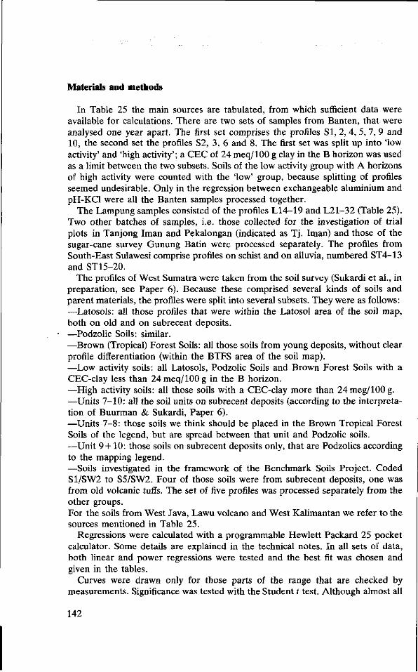
Materials and methods
In Table 25 the main sources are tabulated, from which sufficient data were available for calculations. There are two sets of samples from Banten, that were analysed one year apart. The first set comprises the profiles SI, 2, 4, 5, 7, 9 and 10, the second set the profiles S2, 3, 6 and 8. The first set was split up into 'low activity' and 'high activity'; a CEC of 24 meq/100 g clay in the B horizon was used as a limit between the two subsets. Soils of the low activity group with A horizons of high activity were counted with the 'low' group, because splitting of profiles seemed undesirable. Only in the regression between exchangeable aluminium and pH-KCl were all the Banten samples processed together.
The Lampung samples consisted of the profiles L14-19 and L21-32 (Table 25). Two other batches of samples, i.e. those collected for the investigation of trial plots in Tanjong Iman and Pekalongan (indicated as Tj. Iman) and those of the sugar-cane survey Gunung Batin were processed separately. The profiles from South-East Sulawesi comprise profiles on schist and on alluvia, numbered ST4-13 and ST15-20.
The profiles of West Sumatra were taken from the soil survey (Sukardi et al., in preparation, see Paper 6). Because these comprised several kinds of soils and parent materials, the profiles were split into several subsets. They were as follows: —-Latosols: all those profiles that were within the Latosol area of the soil map, both on old and on subrecent deposits. —Podzolic Soils: similar. —Brown (Tropical) Forest Soils: all those soils from young deposits, without clear profile differentiation (within the BTFS area of the soil map). —Low activity soils: all Latosols, Podzolic Soils and Brown Forest Soils with a CEC-clay less than 24 meq/100 g in the B horizon. —High activity soils: all those soils with a CEC-clay more than 24 meg/100 g. —Units 7-10: all the soil units on subrecent deposits (according to the interpretation of Buurman & Sukardi, Paper 6). —Units 7-8: those soils we think should be placed in the Brown Tropical Forest Soils of the legend, but are spread between that unit and Podzolic soils. —Unit 9 + 10: those soils on subrecent deposits only, that are Podzolics according to the mapping legend. —Soils investigated in the framework of the Benchmark Soils Project. Coded S1/SW2 to S5/SW2. Four of those soils were from subrecent deposits, one was from old volcanic tuffs. The set of five profiles was processed separately from the other groups. For the soils from West Java, Lawu volcano and West Kalimantan we refer to the sources mentioned in Table 25.
Regressions were calculated with a programmable Hewlett Packard 25 pocket calculator. Some details are explained in the technical notes. In all sets of data, both linear and power regressions were tested and the best fit was chosen and given in the tables.
Curves were drawn only for those parts of the range that are checked by measurements. Significance was tested with the Student t test. Although almost all
142

8 8 u w ü a m
u
t / j
U s (J 3
u
o.
X M O O
Ë -
x en r- o
g vo •* ts
X C\ O Tf « <S O (N
S *
.5 w m g ** Cl
8 " t » i o
g ci o ö
o.
S 00
- - c C C S ü <u o.
| | e Si m 2
• o f i C ^
•W ^H c
O ON -O ^ i—i
r- (S
o en o «-» T—1
O o
, - H
o X
c l
<N <N
l -H
r*-
m
00 00
ON
r-<N
13 c
c
o
m
•* 00 m
o O 1-H
<N o\
o r H
M ON
T H
ob o o 1—1
ty <u
c
«5
>
>-H *t m o*
( N O i n T-l 1-1 ( S
1-H
d
CO
^ H
m
( S m
vd
m i—1
V£> 00
co
o 1—1
CM 1-H
^ 00
( N
\o o
o vO
r- CN
1"H I—<
Tf O
«n ^t O CO
o **•
\ © ~4
o o <* ^H o q i-5 i-5 ö o o o
Ë CÓ CM CM i-i OÎ
« 9 i *-*
ed
U
fl fa
00
"t
m m
00
* t
m m
r-t
w-> m
00
^,
co co
CN
"t
• « •
en
00 O; in in N o
q q o o o ö
CN 00 O -tf »n vo
0\ C; (O
eï ei -^
s s s s 8 s . | 5 •§
£ S ? 2 ? ? J
«« va
E S ^ en
Ö 4
S «
<*! la >, 3 •° 2 S • g a g
S S >
* ft«
II rt* •—I
a S •fi 0 ä
a 4
•o
3 cd
S 00
o
s s
« n
Si i Pi Û< 00 EQ
••s-.2,
-H N rt ^ in o h
143
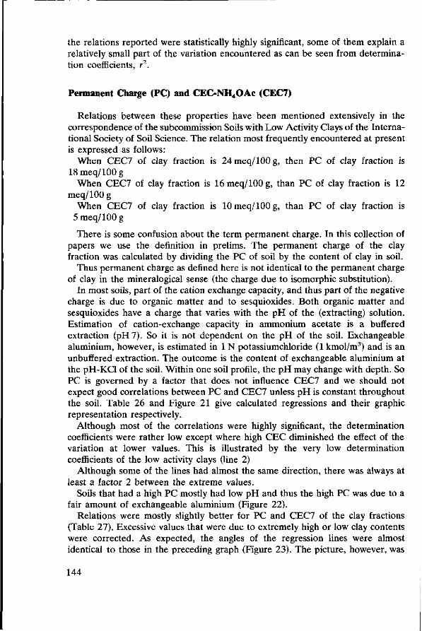
the relations reported were statistically highly significant, some of them explain a relatively small part of the variation encountered as can be seen from determination coefficients, r2.
Permanent Charge (PC) and CEC-NH4OAc (CEC7)
Relations between these properties have been mentioned extensively in the correspondence of the subcommission Soils with Low Activity Clays of the International Society of Soil Science. The relation most frequently encountered at present is expressed as follows:
When CEC7 of clay fraction is 24meq/100g, then PC of clay fraction is 18meq/100g
When CEC7 of clay fraction is 16 meq/100 g, than PC of clay fraction is 12 meq/100 g
When CEC7 of clay fraction is 10 meq/100 g, than PC of clay fraction is 5 meq/100 g
There is some confusion about the term permanent charge. In this collection of papers we use the definition in prelims. The permanent charge of the clay fraction was calculated by dividing the PC of soil by the content of clay in soil.
Thus permanent charge as defined here is not identical to the permanent charge of clay in the mineralogical sense (the charge due to isomorphic substitution).
In most soils, part of the cation exchange capacity, and thus part of the negative charge is due to organic matter and to sesquioxides. Both organic matter and sesquioxides have a charge that varies with the pH of the (extracting) solution. Estimation of cation-exchange capacity in ammonium acetate is a buffered extraction (pH 7). So it is not dependent on the pH of the soil. Exchangeable aluminium, however, is estimated in 1 N potassiumchloride (1 kmol/m3) and is an unbuffered extraction. The outcome is the content of exchangeable aluminium at the pH-KCl of the soil. Within one soil profile, the pH may change with depth. So PC is governed by a factor that does not influence CEC7 and we should not expect good correlations between PC and CEC7 unless pH is constant throughout the soil. Table 26 and Figure 21 give calculated regressions and their graphic representation respectively.
Although most of the correlations were highly significant, the determination coefficients were rather low except where high CEC diminished the effect of the variation at lower values. This is illustrated by the very low determination coefficients of the low activity clays (line 2)
Although some of the lines had almost the same direction, there was always at least a factor 2 between the extreme values.
Soils that had a high PC mostly had low pH and thus the high PC was due to a fair amount of exchangeable aluminium (Figure 22).
Relations were mostly slightly better for PC and CEC7 of the clay fractions (Table 27). Excessive values that were due to extremely high or low clay contents were corrected. As expected, the angles of the regression lines were almost identical to those in the preceding graph (Figure 23). The picture, however, was
144

Table 26. Relations between PC and CEC7 (on soil).
Origin
(1) Banten, all samples except those of (4)
(2) Banten, low activity clays (4) Banten, profiles 2, 3, 6, 8. (5) Lampung, except (6) (6) Lampung, Tj. Iman (8) South-East Sulawesi (9) West Sumatra, all samples,
except (18) (10) West Sumatra, Latosols (11) West Sumatra, Podzolic S. (12) West Sumatra, Brown F. S. (13) West Sumatra, Low activity S. (14) West Sumatra, High activity S. (15) West Sumatra, Units 7 + 8 (16) West Sumatra, Units 9+10 (17) West Sumatra, Units 7 - 1 0 (18) West Sumatra, Benchmark S. (20) West Java (21) Lawu Volcano (22) West Kalimantan
Equation2
PC = 0.88CEC7-9.70
PC = 0.21CEC7 + 1.97 PC = 0.37CEC7 + 0.31 PC = 0.31CEC7 + 0.19 PC = 0.23CEC7129
PC = 0.59CEC7102
PC = 0.41CEC7088
PC = 0 .33CEC7°" PC = 0.34CEC7093
PC = 0 . 20CEC7 l n
PC = 0.31CEC7098
PC = 3.51CEC7015
PC= 18.7CEC7-0-5
PC = 0.64CEC7O75
PC = 2.31CEC7028
PC = 0.09CEC7118
no significant relations PC = 0.41CEC7108
PC = 0.35CEC7084
r2
0.90
0.28 0.82 0.64 0.47 0.67 0.50
0.68 0.58 0.21 0.59 0.01 0.04 0.41 0.02 0.42
0.49 0.68
n
46
17 19 84 41 85
114
48 43 23 57 57 22 30 52 32
40 30
Signi
xxxx
xx xxxx xxxx xxxx xxxx xxxx
xxxx xxxx XX
XXXX
— — XXXX
— xxxx
xxxx xxxx
1. Significance: x: 5% level; xx: 2.5% level; xxx: 1% level; xxxx: 0.5% level; —: not significant. 2. PC(meq/100 g) = n x CEC7(meq/100 g)± m(meq/100 g).
PC and CEC S (meq/100 g soi l ) 24
22-
20-
18-
16
14
12
10
8
6-
4
2
21a
0 2 4 6 8 10 12 14 16 18 20 22 24 26 28 30 CEC 7(meq/100 g soil)
Fig. 21. Relations between permanent charge and CEC7 (on soil).
145
P C - c l a y
1 4 -
1 2 -
~i 1 1 1 r 1 1 1 1 1 1 r 2 4 6 8 10 12 14 16 18 20 22 24
CEC-clay (uncorrected)
Fig. 22. Relations between permanent charge and CEC7 (on clay).
Al-KCl
(meq/100 g soil) 10
— i 1 1 r^ 1
4 . 1 4 . 3 4 . 5 pH-KCl
3.3 3 .5
Fig. 23. Relations between pH-KCl and KCl-exchangeable aluminium.
146
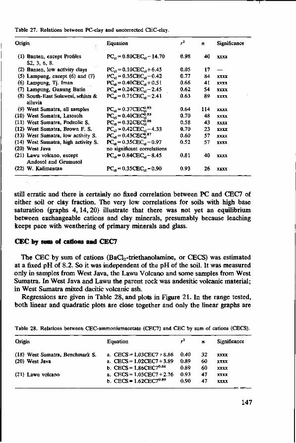
Table 27. Relations between PC-clay and uncorrected CEC-clay.
Origin
(1) Banten, except Profiles S2, 3, 6, 8.
(2) Banten, low activity clays (5) Lampung, except (6) and (7) (6) Lampung, Tj. Iman (7) Lampung, Gunung Batin (8) South-East Sulawesi, schists &
alluvia (9) West Sumatra, all samples
(10) West Sumatra, Latosols (11) West Sumatra, Podzolic S. (12) West Sumatra, Brown F. S. (13) West Sumatra, low activity S. (14) West Sumatra, high activity S. (20) West Java (21) Lawu volcano, except
Andosol and Grumusol (22) W. Kalimantan
Equation
PCcl = 0.80CECCI-14.70
PCcl = 0.10CECcl + 6.45 VCd = 0.35CECa-0A2 PCc, = 0.40CECcl + 0.51 PCcl = 0.24CECc l-2.45 PCcl = 0 .71CECc l-2.41
PC d = 0.37CEC°,93
PC d = 0.40CEC&-93
PCcl = 0.32CECd98
PCcl = 0.42CECc l-4.33 PCcl = 0.43CECd-87
PC d = 0 .35CEC d-0.97 no significant correlations PCcl = 0.84CECc l-8.45
PCCI = 0.35CECc l-0.90
r2
0.98
0.05 0.77 0.66 0.62 0.63
0.64 0.70 0.58 0.70 0.60 0.52
0.81
0.93
n
40
17 84 41 54 89
114 48 43 23 57 57
40
26
Significance
xxxx
— xxxx xxxx xxxx xxxx
xxxx xxxx xxxx xxxx xxxx xxxx
xxxx
xxxx
still erratic and there is certainly no fixed correlation between PC and CEC7 of either soil or clay fraction. The very low correlations for soils with high base saturation (graphs 4,14,20) illustrate that there was not yet an equilibrium between exchangeable cations and clay minerals, presumably because leaching keeps pace with weathering of primary minerals and glass.
CEC by sum of cations and CEC7
The CEC by sum of cations (BaCl2-triethanolamine, or CECS) was estimated at a fixed pH of 8.2. So it was independent of the pH of the soil. It was measured only in samples from West Java, the Lawu Volcano and some samples from West Sumatra. In West Java and Lawu the parent rock was andesitic volcanic material; in West Sumatra mixed dacitic volcanic ash.
Regressions are given in Table 28, and plots in Figure 21. In the range tested, both linear and quadratic plots are close together and only the linear graphs are
Table 28. Relations between CEC-ammoniumacetate (CEC7) and CEC by sum of cations (CECS).
Origin
(18) West Sumatra, Benchmark S. (20) West Java
(21) Lawu volcano
Equation
a. CECS =1.03CEC7 +8.86 a. CECS =1.02CEC7 +3.89 b. CECS=1.86CEC7086
a. CECS =1.03CEC7 +2.76 b. CECS=1.62CEC7089
r2
0.40 0.89 0.89 0.93 0.90
n
32 60 60 47 47
Significance
xxxx xxxx xxxx xxxx xxxx
147

drawn. Although the position of the lines differs the angle is obviously the same for different sources.
pH-KCl and exchangeable aluminium
The content of exchangeable aluminium is strongly dependent on pH: polymerization of Al(OH)3 increases with pH, and exchangeable amounts decrease as a result, although the total amount of aluminium in the soil does not necessarily change. Although the measurement of pH is in fact not accurate enough, regressions between exchangeable aluminium and pH-KCl were calculated for several groups of soils. Equations are given in Table 29, and graphs in Figure 23.
The samples from Banten (plots 1, 2, 3) have a very wide range in exchangeable aluminium. Soils with high CEC had higher exchangeable aluminium than those with low CEC at the same pH. Probably at a given pH the amount of exchangeable aluminium is proportional of the amount of exchange complex. The profiles from Lampung and Tj. Iman that were in general more strongly weathered, corroborate this assumption. The soils from Tj. Iman (6) were intermediate in weathering between the Ban ten (1) and the Lampung soils (5).
The soils from South-East Sulawesi (8) had about the same range of CEC7 as those from Tj. Iman, and followed the same trend as the latter.
The soils from West Sumatra presented a pattern similar to that of the B anten soils, although the slope of the curves was less steep. Again, at the same pH the low activity soils had less of exchangeable Al than high activity soils.
Exchangeable H+ and aluminium
The relation between exchangeable H+ and aluminium is an interesting point of discussion. Exchangeable H+ , or aciditiy originates partly from hydroxyl groups in
Table 29. Relations between pH-KCl and aluminium exchangeable in KCl (1 kmol/m3).
Origin
(1) Banten, all samples (2) Banten, low activity S. (3) Banten, high activity S. (5) Lampung, except (6) (6) Lampung, Tj. Iman (8) South-East Sulawesi,
schists & alluv. (9) West Sumatra, all samples
(10) West Sumatra, Latosols (11) West Sumatra, Podzolic S. (12) West Sumatra, Brown Forest S. (13) West Sumatra, Low activity S. (14) West Sumatra, High activity S. (20) West Java
Equation
Al = 9 . 6x l0 1 2 pIT 2 1 - 4 1
Al = 2 .3xl01 3pHT2 2-3 7
Al = 5 .0x l0 l üpHT 1 7 ' 0 7
Al = 5 .3xl0 8pH- 1 4" 9 7
Al = 8 . 0x l 0 1 2 p i r 2 1 - 9 5
Al = 2 . 2 x l 0 l o p F T 1 7 3 3
Al = 5 .4xl0 5pFT 8 - 9 8
Al = 5 . 7 x l 0 6 p i r 1 0 - 7 5
Al = 6 .7x l0 6pH- 1 0 - 9 6
A l = 1 . 8 x l 0 5 p H - 7 " Al = 4 . 2x l0 6 pH- 1 0 ' 6 9
A l = 8 . 1 x l 0 4 p H - 7 ' 3 7
Al = 9 . 2 x l 0 9 p H " 1 6 6 1
r2
0.63 0.60 0.57 0.67 0.94 0.71
0.53 0.55 0.50 0.79 0.64 0.61 0.75
n
58 27 31 84 41 85
114 48 43 23 57 57 60
Significance
xxxx xxxx xxxx xxxx xxxx xxxx
xxxx xxxx xxxx xxxx xxxx xxxx xxxx
148

organic matter and clay mineral surfaces, partly from aluminium polymers. If much aluminium be present most of the H+ will be derived from aluminium polymers, which will exchange more H when polymers are smaller, at low pH. At low pH too, the amount of exchangeable aluminium would be higher, and one would expect fair relations between KCl-exchangeable acidity and exchangeable aluminium. In fact, most of the acidity will be due to aluminium.
The relations are given in Table 30 and corresponding graphs in Figure 24. The high correlation coefficients in several of these relations are striking. Low correlations were found for Podzolic Soils and low activity soils from West Sumatra. The Podzolic Soils were a varied unit, that comprised both soils from old surface and from young ones.
The most reliable regressions had determination coefficients close to unity, throughout the range measured.
However, because of the relation between acidity and aluminium, this regression is probably not valuable.
saturation on permanent charge (BS-PC) and on cation exchange capacity (BS7)
Most correlations between BS-PC and BS7 were fairly good to very good (Table 31). Exceptions were the Lawu and West Java soils. They had a wide range in BS7, were only slightly acid and as a result had low contents of exchangeable aluminium and high BS-PC. Low determination coefficients for the Lawu soils were expected because the range in BS-PC was only 92-100%. Low correlations in West Java were probably due to strong desaturation in soils of a certain altitude, but a moderate CEC7 (Paper 3).
Soils with the highest BS7 had curves with the lowest slopes (Table 25; Figure 25). In the lowest curve (8), the highest BS7 was 100 %; in (1) and (4) it was 81 and 100 % respectively; in (5), (6), (22), (2) and (9), values were 50, 50, 27, 23 and 22%, respectively. So the relative amount of bases on the complex (with
Table 30. Relations between exchangeable H+ (acidity) and aluminium in KCl (1 kmol/m3).
Origin
(5) Lampung (8) South-East Sulawesi, schists & alluv. (9) West Sumatra, all samples
(10) West Sumatra, Latosols (11) West Sumatra, Podzolic S. (12) West Sumatra, Brown F. S. (13) West Sumatra, Low activity S. (13a) West Sumatra, CEC c l=sll (14) West Sumatra, High activity S. (18) West Sumatra, Benchmark S. (20) West Java (22) West Kalimantan
Equation
A1 = 0 .87H-0.15 A l=1 .05H-0 .32 A1=1.32H 0 6 4
Al = 0 .95H-0.43 Al = 0.59H + 0.84 A1 = 0.94H Al = 0.49H + 0.88 A l=1 .12H-0 .32 A1 = 0 .97H°9 6
A1 = 0.66H132
Al = 0 .52H-0.07 A1 = 0.86H096
r2
0.93 0.96 0.40 0.75 0.25 0.93 0.25 0.99 0.81 0.96 0.95 0.84
n
84 43
114 48 43 23 57 31 57 20 60 30
Significance
xxxx xxxx xxxx xxxx xxxx xxxx xxxx xxxx xxxx xxxx xxxx xxxx
149

Exch.Al (meq/lOOg soil)
10 Exch.H (meq/100 g soil)
Fig. 24. Relations between exchangeable acidity (H) and aluminium in KCl (1 kmol/m3).
Table 31. Relations between base saturation on CEC7 (BS7) and base saturation on permanent charge (BSPC).
Orig
(1) (2) (4) (5) (6) (8) (9)
(10) (11) (12) (13) (14) (15) (16) (17) (18) (20) (21) (22)
in
Banten, except (4) Banten, low activity S. Banten, prof. 2, 3, 6, 8. Lampung, except (6) Lampung, Tj. Iman South-East Sulawesi, schists & alluv. West Sumatra, all samples West Sumatra, Latosols West Sumatra, Podzolic S. West Sumatra, Brown F. S. West Sumatra, Low activity S. West Sumatra, High act. S. West Sumatra, Units 7 + 8 West Sumatra, Units 9+10 West Sumatra, Units 7-10 West Sumatra, Benchmark S West Java Lawu volcano West Kalimantan
Equation
BSPC = 4.63BS7074
BSPC = 4.46BS7092
BSPC = 2.08BS70'96
BSPC = 7.21BS7070
BSPC = 2.03BS7105
BSPC=1.93BS70 9 3
BSPC = 3.26BS7103
BSPC = 3.07BS71'00
BSPC = 2.60BS7121
BSPC = 4.59BS7091
BSPC = 3.13BS7104
BSPC = 3.32BS7103
BSPC = 6.48BS7075
BSPC=1.44BS71 5 2
BSPC = 3.57BS7101
BSPC=11.8BS70 5 7
no significant correlations no significant correlations BSPC = 6.87BS7075
r2
0.73 0.68 0.94 0.74 0.92 0.92 0.74 0.82 0.72 0.70 0.75 0.73 0.41 0.86 0.74 0.76
0.61
n
46 17 17 84 41 85
114 48 43 23 57 57 22 30 52 32
30
Significance
xxxx xxxx xxxx xxxx xxxx xxxx xxxx xxxx xxxx xxxx xxxx xxxx xxxx xxxx xxxx xxxx
xxxx

BS-PC % 100
80
60-
20-
1 1 1 1 1 1 1 r — | 1 1 1 1 1 1 1 1 1 1 1 1 ' 1 1 1
0 2 6 10 14 18 22 26 30 34 38 42 46 SO Base Saturat ion (BS7) %
Fig. 25. Relations between base saturation on CEC7 (BS7) and on permanent charge (BSPC).
BS-PC % 100
80
8 10 12 14 16 18 20 22
BS7 %
Fig. 26. Relations between BS7 and BSPC of West Sumatra samples.
151

respect to the PC) increases with decreasing saturation. The BS-PC is probably strongly influenced by pH (lower pH-higher Al-higher PC-lower BS-PC).
The plots for the West Sumatran soils (Figure 26) indicate the spread within one of the populations. Here the overall determination coefficient was not less than that of most subsets. The plots for the whole population (9), and those for low activity (13), high activity (14) and Brown Forest Soils (12) were almost identical. The other plots diverged somewhat, but their range was also smaller. Subset (16) contained two soils with extremely high BS-PC and therefore also had a better r2.
Conclusions
None of the six relationships mathematically tested is universally applicable. An exception was perhaps the relation between exchangeable H+ (acidity) and Al3+, but the usefulness of that relationship is doubtful, because both variables are strongly controlled by aluminium compounds. Generally the PC/CEC7 relationships had less slope than those suggested in the notes of the ISSM Committee on Low Activity Clays. However in our view a good correlation between PC and CEC7 that is universally acceptable cannot exist.
Soils developed from one kind of parent material show significant correlations between the properties tested. But on relatively fresh parent material with strong leaching and in relatively dry climates (soils with high base saturations), patterns were erratic and relationships that applied to more than two or three profiles were not found. Many of the relations tested could be governed by the behaviour of aluminium in a way that is still poorly understood. Further testing should be undertaken in which the pH-dependency of relationships is taken into account.
Estimates of properties like pH and aluminium are not always accurate enough for calculation of regressions. However, the significance of most correlations is high enough for us to take the relative positions of the lines as reliable.
152
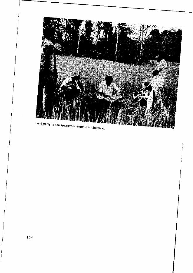
*" P d U y l n t h e speargrass, South-. East Sulaw
154

Some Hewlett Packard-25 computer programs used in the processing of analytical data
by L. Rochimah and P. Buurman
X-ray diffraction
Calculation of spacings (d) from given values of 20, and reverse.
A = 2 à sin 6
in which:
A = wavelength of X-rays d = spacing of mineral lattice 0 = angle with respect to sample of incident X-rays
For cobalt-K-alpha radiation, A = 1.7889 Â (0.17889 nm) Diffractometer readings are in 20, and therefore:
d = A/2 sin 0 and 20 = 2 arcsin (A/2d)
Program 1 Program 2 Step 01 02 03 04 05 06 07 08 09 10 11 12 13 14 15
Mode Enter 2
-=-f sin
2 X
gi/x l
7 8 8 9 X
GTO00
Code 31 02 71
14 04 02 61
15 22 01 73 07 08 08 09 6 i
13 00
Step 01 02 03 04 05 06 07 08 09 10 11 12 13 14 15
Mode Enter 2 X
g l / x 1
7 8 8 9 X
g sin"1
2 X
GTO00
Code 31 02 61
15 22 01 73 07 08 08 09 61
15 04 02 61
13 00
Step 16
30R/S 3 1 GTO16
Operation Mode: Programme Key in 1-15 Mode: Run Initiate: f PRGM
Key in 26 R /S-*d(Â)
Operation Mode: Programme Key in 1-15 Mode: Run Initiate: f PRGM
Key in d(A) R/S-»26
155
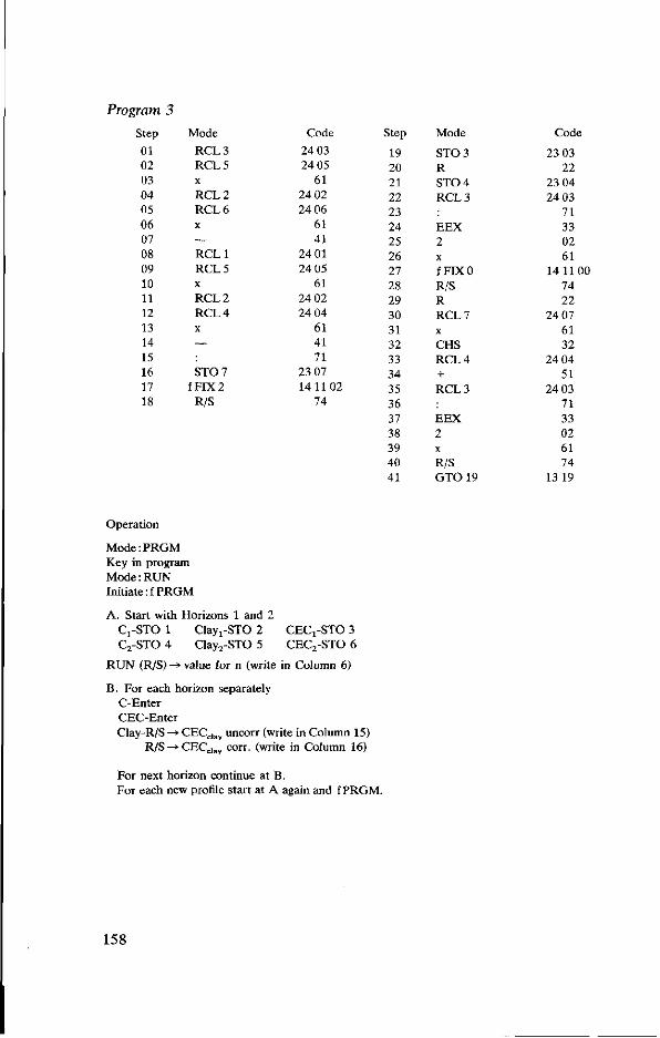
Program 3
Step
Ol 02 03 04 05 06 07 08 09 10 11 12 13 14 15 16 17 18
Mode
RCL3 RCL5 X
RCL2 RCL6 X
— RCL1 RCL5 X
RCL2 RCL4 X
—
ST0 7 f FIX 2
R/S
Code
24 03 24 05
61 24 02 24 06
61 41
24 01 24 05
61 24 02 24 04
61 41 71
23 07 14 1102
74
Step
19 20 21 22 23 24 25 26 27 28 29 30 31 32 33 34 35 36 37 38 39 40 41
Mode
ST0 3 R ST0 4 RCL3
EEX 2 X
fFIXO R/S R RCL7 X
CHS RCL4 + RCL3
EEX 2 X
R/S G T 0 1 9
Code
23 03 22
23 04 24 03
71 33 02 61
14 1100 74 22
24 07 61 32
24 04 51
24 03 71 33 02 61 74
13 19
Operation
Mode:PRGM Key in program Mode: RUN Initiate: f PRGM
A. Start with Horizons 1 and 2 Cj-STO 1 Clay i-STO 2 CECj-STO 3 C2-STO 4 Clay2-STO 5 CEC2-STO 6
RUN (R/S) -» value for n (write in Column 6)
B. For each horizon separately C-Enter CEC-Enter Clay-R/S —» CECclay uncorr (write in Column 15)
R/S -> CECd a y corr. (write in Column 16)
For next horizon continue at B. For each new profile start at A again and f PRGM.
158

Program 4: PC, ECEC, PC-clay, BS-PC, BS-ECEC (Columns 11, 12, 17, 20, 21; Equations given above).
4a. Exch. H+ available 4b. Exch. H+ not available
Step Mode Code Step Mode
01 02 03 04 05 06 07 08 09 10 11 12
(13)13 ( - ) 1 4 (14)15 (15)16 (16)17 (17) 18 (18) 19 (19) 20 (20) 21 ( - ) 2 2 (21) 23 (22) 24 (23) 25 (24)26 (25)27 (26)28 ( - ) 2 9 (27) 30 (28) 31
f FIX 2 STO0 + R/S STOl + R/S ST0 2 R •-RCL1 x-y
EEX 2 X
fFIXO R/S RCL0 RCL1
EEX 2 X
R/S RCL0 RCL2
EEX 2 X
GTO00
141102 23 00
51 74
23 01 51 74
23 02 22
24 01 21 71
£ } R C L 7
51 14 11 00
74 24 00 24 01
71 331 0 2 ) R C L 7
51 74
24 00 24 02
71
£ } H C L 7
51 13 00
(29) 01 (30) 02 (31) 03 (32) 04 (33) 05 (34) 06 (35) 07 (36) 08 ( - ) 0 9 (37) 10 (38) 11 (39) 12 (40) 13 (41) 14 (42) 15 (43) 16 ( - ) 1 7 (44) 18 (45) 19 (46) 20
fFTX2 STO0 + R/S STOl x-y
EEX 2 X
fFIXO R/S RCL0 RCL1
EEX 2 X
R/S GTO00
Code
141102 23 00
51 74
23 01 21 71 331 02JRCL7 51
14 11 00 74
24 00 24 01
71 33 02 . 51 74
13 00 GT029
RCL7
Operation Operation
Mode: Key in Mode: Initiate
PRGM program RUN : f PRGM
For each horizon: Clay H Al Bases
Enter Enter Enter R/S-»PC (Column 11) R/S-* ECEC R/S-»PC-clay R/S -» BS-PC R/S -* BS-ECEC
(12) (17) (20) (21)
Mode: Key in Mode: Initiate
PRGM program RUN : fPRGM
For each horizon: Clay Al Bases
Enter Enter
R/S-»PC R/S-»PC-clay R/S -> BS-PC
(11) (17) (20)
159

It is possible to combine Program 4a and 4b, if exchangeable H+ is available for part of the samples. If so, change as follows: —change all EEX 2 instructions into RCL 7 instructions (saves 1 step each time); —key Program 4b after 4a; —change last instruction of Program 4b into GTO 29; —store 100 in Register 7 before starting first calculation. Program 4a is now addressed by GTO 00 or f PRGM; Program 4b by GTO 29. Addressing is only necessary when switching from one program to the other.
At Step 31 in Program 4a, PC-clay and BS-PC are preserved in the stack, in the (Z, T) and Y positions, respectively. At Step 20 of Program 4b, PC-clay is preserved in the Y position.
Calculation of mole ratios: S i02 /Al203 , S i0 2 /R 20 3 , Si02 /Fe203 , A l 20 3 /Fe 20 3
The mole ratios listed above are calculated from total chemical analysis of soil or clay samples. Mass fractions are first converted to mole ratios. The ratios are used in soil genesis studies to determine the relative movement of the compounds Si02 , A1203 and Fe 20 3 . R 2 0 3 means the sum of A1203 and Fe 20 3 . In the following, the mole ratios are indicated as Si/Al, Si/Fe, Si/R and Al/Fe, respectively. Molecular weights: SiOz 60.08
A1203 101.96 Fe 2 0 3 159.7
Program 5 Step
01 02 03 04 05 06 07 08 09 10 11 12 13 14 15 16 17 18 19 20
Mode
Enter 6 0
0 6
STOl x-y 1 0 1
9 6
ST0 2
R/S R
Code
31 06 00 73 00 06 71
23 01 21 01 00 01 73 09 06 71
23 02 71 74 22
Step
21 22 23 24 25 26 27 28 29 30 31 32 33 34 35 36 37 38 39 40 41
Mode
1 5
.. 9
7
ST0 3 RCL 2 + RCL1 x-y
R/S RCL1 RCL 3
R/S RCL 2 RCL 3
GTO 00
Code
01 05 09 73 07 71
23 03 24 02
51 24 01
21 71 74
24 01 24 03
71 74
24 02 24 03
71 13 00
160

Operation:
Mode: Key in Mode: Initiate
Fe70, A1303
Si02
PRGM program RUN : fPRGM
Enter Enter R/S -> Si/ AI R/S-»Si/R R/S->Si/Fe R/S->A1/Fe
Splitting-up of populations for Statistical analysis
The HP-25 offers several programs for regression analysis. These programs have been frequently used in our studies of soil genesis.
Often one may be interested in both regression between two variables in a whole group and in several subgroups. It is possible to save the cumbersome procedure of entering all values two or three times.
For example, a mapping area comprises Brown Soils, Latosols and Podzolic Soils. All Brown Soils have CEC-clay higher than 16meq/100g, while both Podzolic Soils and Latosols comprise soils with higher or lower CEC-clay.
If we want to test a specific relation for: a. all soils b. all podzolic soils c. all latosols d. all brown soils e. all low activity soils (CEC-clay < 16 meq/100 g) f. all high activity soils, it would be particularly tiresome to enter all the pairs of values several times. This is not necessary if it be remembered that all values used in regression analysis are totals. For instance for linear regression we need:
£ y2 in HP Register 2
n in HP Register 3
£ y in HP Register 4
£ xy in HP Register 5
X x2 in HP Register 6
X x in HP Register 7
All totals can be obtained by simply adding subtotals, as follows. We designate the subtotals as below:
161
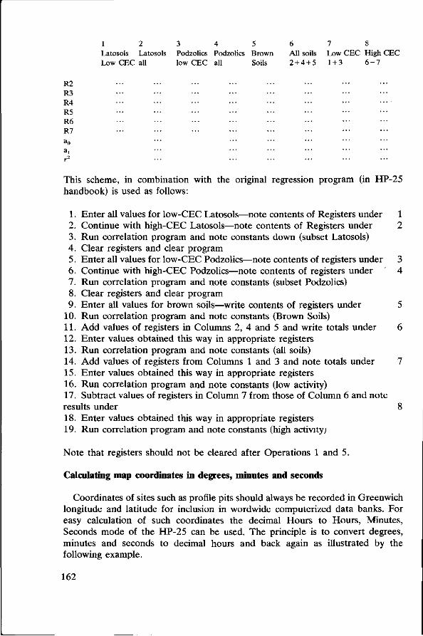
R2
R3 R4 R5 R6 R7 a0
ai r2
1 2 Latosols Lato Low CEC all
sols 3 4 Podzolics Podzolics low CEC all
5 Brown Soils
6 All soils 2 + 4 + 5
7 8 Low CEC High CEC 1+3 6 - 7
This scheme, in combination with the original regression program (in HP-25 handbook) is used as follows:
1. Enter all values for low-CEC Latosols—note contents of Registers under 2. Continue with high-CEC Latosols—note contents of Registers under 3. Run correlation program and note constants down (subset Latosols) 4. Clear registers and clear program 5. Enter all values for low-CEC Podzolics—note contents of registers under 6. Continue with high-CEC Podzolics—note contents of registers under 7. Run correlation program and note constants (subset Podzolics) 8. Clear registers and clear program 9. Enter all values for brown soils—write contents of registers under
10. Run correlation program and note constants (Brown Soils) 11. Add values of registers in Columns 2, 4 and 5 and write totals under 12. Enter values obtained this way in appropriate registers 13. Run correlation program and note constants (all soils) 14. Add values of registers from Columns 1 and 3 and note totals under 15. Enter values obtained this way in appropriate registers 16. Run correlation program and note constants (low activity) 17. Subtract values of registers in Column 7 from those of Column 6 and note results under 18. Enter values obtained this way in appropriate registers 19. Run correlation program and note constants (high activity;
Note that registers should not be cleared after Operations 1 and 5.
Calculating map coordinates in degrees, minutes and seconds
Coordinates of sites such as profile pits should always be recorded in Greenwich longitude and latitude for inclusion in wordwide computerized data banks. For easy calculation of such coordinates the decimal Hours to Hours, Minutes, Seconds mode of the HP-25 can be used. The principle is to convert degrees, minutes and seconds to decimal hours and back again as illustrated by the following example.
162
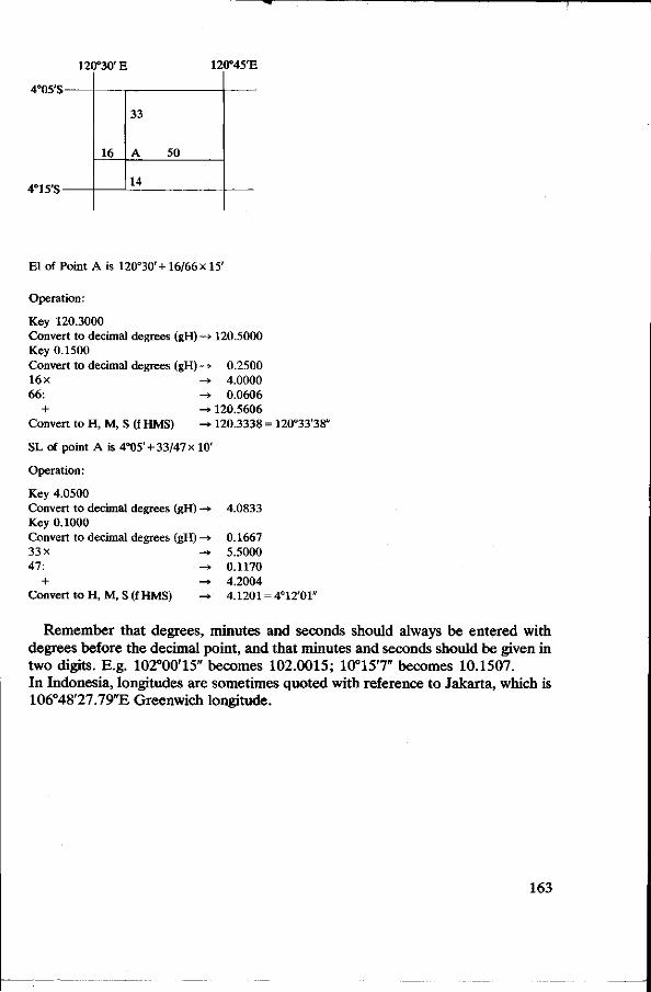
120°30' E
4°05'S-
4°15'S-
16
33
14
50
120°45'E
El of Point A is 120°30' +16/66 x 15'
Operation:
Key 120.3000 Convert to decimal degrees (gH) -» Key 0.1500 Convert to decimal degrees (gH) —* 16x -± 66: -*
+ -» Convert to H, M, S (f HMS) -»
SL of point A is 4°05' +33/47 x 10'
Operation:
Key 4.0500 Convert to decimal degrees (gH) —* Key 0.1000 Convert to decimal degrees (gH) —» 33x -* 47: -H>
+ -> Convert to H, M, S (f HMS) -*
120.5000
0.2500 4.0000 0.0606
120.5606 120.3338 =
4.0833
0.1667 5.5000 0.1170 4.2004 4.1201 =
120°33'38
4°12'01"
Remember that degrees, minutes and seconds should always be entered with degrees before the decimal point, and that minutes and seconds should be given in two digits. E.g. 102°00'15" becomes 102.0015; 10°15'7" becomes 10.1507. In Indonesia, longitudes are sometimes quoted with reference to Jakarta, which is 106°48'27.79"E Greenwich longitude.
163

•Kl* *_ -JS& •
Fig. 29. Different stages of assembly.
West Germany), available in plates of ca. 500 mm x 300 mm x 5 mm consisting mainly of mullite. These materials differ in some respects. Unglazed tile is much harder and, therefore, has a longer life in repeated use. It has a more pitted surface, however, and is somewhat less permeable than 'Diapor'. Both have excellent heating properties.
The small plates can be prepared like thin sections of rock specimens or impregnated soil samples. If prepared by hand, tiles must be cut to a small working size (e.g. sufficient for 6 small plates), they are then ground to the desired thickness, scored with a sharp object, and the small plates snapped apart.
With a flat-grinding machine, preparation is much quicker since larger units can be handled (e.g. sufficient for 40 small plates): one man can then prepare over 500 small plates in a day.
166
References
Dümmler, H. & D. Schroeder, 1965. Zur qualitativen und quantitativen röntgenographischen Bestimmung von Dreischicht-Tonmineralen in Böden. Zeitschr. Pflanz., Düng., Bodenk. 109: 35-47.
Gibbs, R. J., 1965. Error due to segregation in quantitative clay mineral X-ray diffraction mounting techniques. Amer. Miner. 50: 741-751.
Kinter, E. B. & S. Diamond, 1956. A new method for preparation and treatment of oriented-aggregate specimens of soil clays for X-ray diffraction analysis. Soil Sei. 81: 111-120.
Rich, C. I., 1969. Suction apparatus for mounting clay specimens on ceramic tile for X-ray diffraction. Soil Sei. Soc. Amer. Proc. 33: 815-816.
Shaw, H. F., 1972. The preparation of oriented clay mineral specimens for X-ray diffraction analysis by a suction-onto-ceramic tile method. Clay Min. 9: 349-350.
167

List of analytical methods
Analytical methods used in the laboratory of the Soil Fertility Division of the Soil Research Institute, Bogor, are laid down in Sudjadi et al. (1971). In the following, the codes refer to the description of methods given in USDA (1972).
Physico-chemical analyses
—Particle-size distribution of fraction smaller than 2 mm: Pipette method for fraction below 50 fim (3Ala). Sieving on 500, 420, 300, 210, 150, 105, 75 and 50 /u,m sieves for fraction 50-2000 fim (dry). —Dry bulk density: By weighing dry core samples of volume 200 cm3 in triplicate (4A3a). —Water retention: By pressure plate and pressure membrane (4Bla and 4B2). —Cation-exchange capacity in ammonium acetate at pH 7: By percolation method (5Alb). —Cation-exchange capacity in unbuffered ammonium chloride: By percolation, displacement and distillation of NH3. —Extractable acidity: By BaCl2-TEA at pH 8.2 (5A3a). —Exchangeable bases: In ammonium acetate percolate (5Bla). —Exchangeable acidity and aluminium: In unbuffered KCl (subst. concn 1 kmol/m3), fluoride titration (6Gld). —Organic carbon: By acid dichromate digestion (6Ala). —'Free' Iron: By dithionite-citrate extraction (6C2). —Amorphous material: NaF test. pH rise after 2 min when 1 g of soil is dispersed in 50 ml NaF (subst. concn 1 kmol/m3).
Mineralogical analyses
—Composition of the sand fraction: Fraction 100-200 jam, obtained by sieving. Counted with pétrographie microscope (line counting) after washing with HCl (subst. concn 6 kmol/m3). —Composition of heavy and light sand fractions: Fraction 100-200 /urn after removal of 'free' iron with sodium dithionite. Allow to separate in bromoform (density 2.89). Relative amounts obtained by counting with pétrographie microscope. Determinations of opaque and weathered minerals by X-ray diffraction (Guinier-de Wolff camera). Opaque minerals, where possible, expressed with respect to translucent fraction. —Composition of the clay fraction: The soil samples were treated with buffered H 2 0 2 (volume fraction in water 10%) in order to remove organic matter. Iron was
168

usually removed with sodium dithionite. After thorough washing, the clay fraction was obtained by sedimenting dispersed clay twice in an NaCl solution (subst. concn 5 mol/m~3). The clay was sedimented on porous ceramic plates (Paper 11). Clay sediments were saturated with Mg2+ and K+. Diffractometer traces were run of samples at 50% relative humidity, after glycerolation, and after heating at 550 °C. Most samples were checked with the Guinier-de Wolff camera (accessory minerals, and (060) reflexions of the clay minerals).
Micromorphological analysis
In the micromorphological description of thin sections, the terminology of Brewer (1964) was used.
References
Brewer, R., 1964. Fabric and Mineral analysis of soils. Wiley, New York. Sudjadi, M, I. M. Widjik & M. Soleh, 1971. Penuntun analisa Tanah. Bagian Kesuburan Tanah,
Lembaga Penelitian Tanah, Bogor. USDA, 1972. Soil Survey Laboratory methods and procedures for collecting soil samples. Soil Survey
Investigations Report No. 1. Washington DC.
169