project/programme proposal to the adaptation fund - part i
51
1 PART I: PROJECT/PROGRAMME INFORMATION Project/Programme Category: Regular Country: Viet Nam Title of Project/Programme: Building resilience and improving response to drought and flood in the North Central region of Viet Nam to reduce the impacts of climate change: Inclusive Integrated Management of Drought and Flood Type of Implementing Entity: Multilateral Implementing Entity Implementing Entity: Food and Agriculture Organization of United Executing Entity/ies: Ministry of Natural Resources and Environment Amount of Financing Requested: 3 580 000 (in U.S Dollars Equivalent) Project / Programme Background and Context: General context 1. Viet Nam is a low-lying and densely populated country in Southeast Asia, considered one of the most exposed to the impacts of climate change globally. The country has a land area of about 331 212 km 2 and a population of 96 462 106 in 2019. Despite the economic growth between 2002 and 2018 that lifted 45 million people out of poverty, poverty in rural areas is still roughly three times higher than in urban areas (IFAD, 2012; World Bank, 2020) 12 . The rate of household poverty according to the multi- dimensional poverty standards was estimated at 5.7% in 2019. This was 1.2 percent lower than in 2018. The poverty rate shows, however, regional disparity. Urban areas 1 IFAD. 2012. Country Programme Evaluation. 2 World Bank. 2020. Viet Nam Overview. PROJECT/PROGRAMME PROPOSAL TO THE ADAPTATION FUND
-
Upload
khangminh22 -
Category
Documents
-
view
2 -
download
0
Transcript of project/programme proposal to the adaptation fund - part i

1
PART I: PROJECT/PROGRAMME INFORMATION
Project/Programme Category: Regular
Country: Viet Nam
Title of Project/Programme: Building resilience and improving response to drought and flood in the North Central region of Viet Nam to reduce the impacts of climate change: Inclusive Integrated Management of Drought and Flood
Type of Implementing Entity: Multilateral Implementing Entity
Implementing Entity: Food and Agriculture Organization of United
Executing Entity/ies: Ministry of Natural Resources and Environment
Amount of Financing Requested: 3 580 000 (in U.S Dollars Equivalent)
Project / Programme Background and Context:
General context
1. Viet Nam is a low-lying and densely populated country in Southeast Asia, considered one of the most exposed to the impacts of climate change globally. The country has a land area of about 331 212 km2 and a population of 96 462 106 in 2019. Despite the economic growth between 2002 and 2018 that lifted 45 million people out of poverty, poverty in rural areas is still roughly three times higher than in urban areas (IFAD, 2012; World Bank, 2020)12. The rate of household poverty according to the multi-dimensional poverty standards was estimated at 5.7% in 2019. This was 1.2 percent lower than in 2018. The poverty rate shows, however, regional disparity. Urban areas
1 IFAD. 2012. Country Programme Evaluation. 2 World Bank. 2020. Viet Nam Overview.
PROJECT/PROGRAMME PROPOSAL TO THE ADAPTATION FUND

2
account for 1.2 percent, while rural areas for 8 percent in the same period. Amongst regions, the Northern midlands and mountain areas record the highest rate of household poverty at 16.4%3. The Southeast and the Red River Delta regions account for the lowest rates of poverty, at 3.5 and 8.1 percent respectively, while Northeast, Central Highlands and North Central Coast have multiple times higher poverty rates (IFAD, 2011)4. Amongst the factors hampering a balanced poverty reduction across the country, there are natural disasters, weather shocks, heavy dependency on subsistence agriculture and access to natural resources (World Bank, 2012)5.
Viet Nam’s agriculture and water resource sectors
2. Almost 40 percent of the total area of Vietnam is agricultural land (FAOSTAT). Production systems are distinguished by agro-ecological zones. Thanks to a steady increase of a 4 percent average annual growth (FAO, 2015)6, agriculture substantially contributes to the positive national trade balance, accounting for 16.6 percent of the annual export. Viet Nam is a major exporter of rice, coffee, rubber and cashew kernels. Further agriculture expansion is, however, severely limited by the availability of natural resources, and competing demands for water resources, in particular, are increasing. According to the current development pathways, water stress appears to be the major environmental, social and economic threat, eventually the obstacle to a sustainable development.
3. Agriculture is the largest employer in Viet Nam, providing direct employment for 47 percent of the population (FAO, 2014)7. The majority of smallholders, producing on less than average 0.4 hectare, sell their product in local market and through informal channels (FAO, 2018)8, while other than smallholders cultivate an average 2.5-hectare land. Smallholders, who generate 56 percent from on-farm activities and 38 percent of their income from crop production, represent the majority of households living under the poverty line. Poverty rate exceeds 59 percent in small farms and 58 percent in others. Although women take equal share in production (51 percent of the labour force), they are underrepresented in farm ownership, as control over production assets are dominated by men.
4. Agriculture shares the 95 percent of total water withdrawal, equivalent to 77 751 million m3 per year (FAO, 2011)9. Irrigated areas are highly concentrated, as two-thirds of the irrigation schemes operate in the two deltas and are originally designed for rice production (World Bank, 2016)10. The country has more than 6 000 irrigation reservoirs, 238 hydropower reservoirs, over 200 000 km irrigation canal and 5 500 large drains. Most of the water infrastructure were built between 1960 and 1980, and the initial design disregarded many sustainability-related aspects. The most negative
3 General Statistics Office of Vietnam. 2019. Statistical Year Book of Vietnam. 4 IFAD, 2011. Environmental and Climate Change Assessment. Prepared for IFAD’s Country Strategic Opportunities Programme 2012-2017 – Viet Nam. 5 World Bank, 2012. Well Begun, Not Yet Done: Vietnam’s Remarkable Progress on Poverty Reduction and the Emerging Challenges. 6 FAO. 2015. The economic lives of smallholder farmers. An analysis based on houseold data from nine countries 7 FAO. 2014. Evidence and Knowledge Gaps on Climate-Smart Agriculture in Vietnam. A review on the potential of agroforestry and sustainable land management in the Northern Mountainous Region. 8 FAO. 2018. Small family farming in Viet Nam – a country specific outlook 9 FAO, 2011. AQUASTAT Country Profile – Viet Nam 10 World Bank, 2016. Transforming Vietnamese Agriculture: Gaining More from Less

3
consequences are low climate change resilience, large investment costs, neglected operation and maintenance, fragmented management, and single-serving design for rice production. Water availability is an increasingly constraining factor, and as 60 percent of the water sources originate from transboundary countries, the country is dependent on neighboring countries.
5. Groundwater development has high potential in Viet Nam. Since drinking water is supplied by groundwater, monitoring resources to preserve their quantity and quality is of strategic importance, particularly in rural areas. Community-managed facilities however, are neither well-maintained nor sustainably financed and, although the access to improved water in rural areas has grown rapidly, around 33-48 percent of the piped water schemes currently are out of function or poorly operated (World Bank, 2017)11. Contamination and over-exploitation of groundwater is a double-edged sword that adversely affect both the environment and human health.
6. The necessary building block of water resource development is the regular and updated water monitoring, and a more rigorous and integrated monitoring is required to enable policymakers in planning and to improve communities’ preparedness. The assessment of services and hydrometeorological information identified those sectors related to user needs to support preparedness and the synthesis is compiled in the context of the current project (ISDR, World Bank, WMO, UNISDR, NHMS, GFDDR, 2013)12: a) Agriculture and food production: improved forecast and clear interpretation,
information on climate change scenarios, data sharing. b) Water management: risk assessment analysis, real-time hydrological data and
forecasts, rainfall estimates, flood forecasting, water quality monitoring. c) Disaster risk reduction: monitoring of water levels, site-specific forecasts, real time
weather and hydrology data, improved drought and flood forecast, vulnerability assessment, hazard mapping and public awareness.
d) Climate change: (1) structural measures; (2) non-structural solutions.
Climate change trends in Viet Nam
7. Viet Nam has both a tropical and a temperate climate zone. In northern regions,
temperature ranges between 22-27.5 C in summer and 15-20 C in winter, while in
southern areas between 28-29 C in summer and 26-27 C in winter (World Bank, 2020). Over the past 50 years (1958-2007), the annual average temperature
increased by about 0.5 C to 0.7 C. According to the climate projections applying multiple General Circulation Models (GCM), the projected anomaly shows significant increase of average daily maximum, daily and daily minimum temperature in worst
case scenario, predicting 1.8 C median increase in 2040-2059, and 3.7 C in 2080-2099 (World Bank, 2020)13. The largest increase is expected in Northern areas, Red River Delta and North Central Coast.
11 World Bank, 2017. Vietnam: toward a safe, clean, and resilient water system 12 ISDR, World Bank, WMO, UNISDR, NHMS, GFDDR, 2013. Country assessment report for Viet Nam. Strengthening of Hydrometeorological Services in Southeast Asia 13 World Bank. 2020. Viet Nam Overview

4
8. Average precipitation trends show opposite directions amongst the regions. Over the 50 years, both negative and positive trends are observed. In northern climate zones, a decrease in annual rainfall is recorded, unlike in southern zones, where an increase is registered. In the overall, rainfall is expected to decrease in dry season and increase in wet season.
Figure 1: Increase in rainfall amongst regions in 2020, 2050, 2100 (source: Climatic Research Unit of University of East Anglia)
9. According to the National Communication to the UNFCCC, climate change has an impact on multiple sectors: a) Water resources: under different IPCC RCP scenarios, annual flows of major river
basins are expected to increase. In different rivers basins, changes are predicted with both negative and positive signs in dry and wet seasons respectively. Decrease in average flows is projected in dry seasons. Groundwater is also expected to decrease due to the climate change impacts.
b) Agriculture: Rising temperatures are expected to cause yield losses and declines in livestock production. Based on IPCC scenarios, temperature increase can cause 1-3 percent yield loss and 1-4 percent livestock productivity loss in 2046-2065. Change in rainfall has an even more dramatic impact, as crop yield can decrease by 10 percent according to both RCP4.5 and RCP8.5 scenarios in 2046-2065.
c) Community health: different studies correlate the rise of average temperature to hospitalization rate. Sea level rise, high temperature, change in rainfall pattern increase the probability of epidemics outbreak and spread. Furthermore, the climate change indirect impact on food security puts an additional burden on public health in areas hit by poverty.
d) Gender equality: climate change impacts are even more devastating for women, particularly in rural areas, where most women are engaged in agriculture production and supply chain. The described negative impact on community health, coupled with lack of water for household use in drought periods spills over the women communities.
National climate change vulnerability and assessment
5
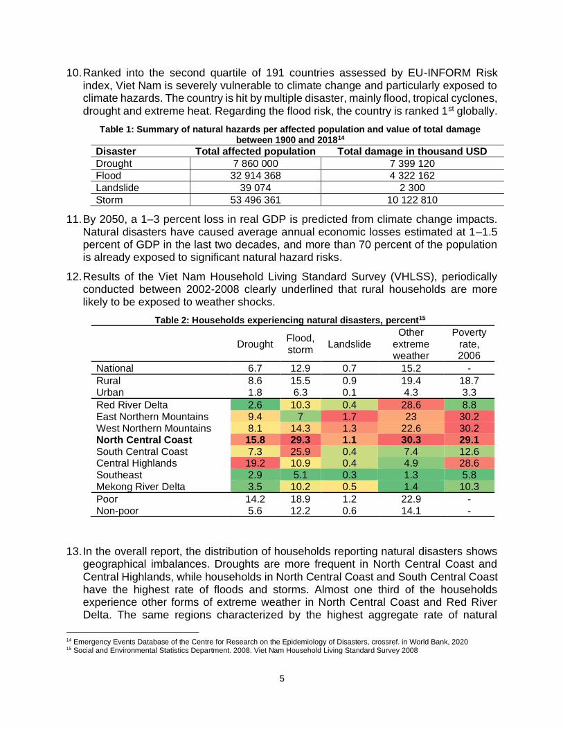
10. Ranked into the second quartile of 191 countries assessed by EU-INFORM Risk index, Viet Nam is severely vulnerable to climate change and particularly exposed to climate hazards. The country is hit by multiple disaster, mainly flood, tropical cyclones, drought and extreme heat. Regarding the flood risk, the country is ranked 1st globally.
Table 1: Summary of natural hazards per affected population and value of total damage between 1900 and 201814
Disaster Total affected population Total damage in thousand USD
Drought 7 860 000 7 399 120
Flood 32 914 368 4 322 162
Landslide 39 074 2 300
Storm 53 496 361 10 122 810
11. By 2050, a 1–3 percent loss in real GDP is predicted from climate change impacts. Natural disasters have caused average annual economic losses estimated at 1–1.5 percent of GDP in the last two decades, and more than 70 percent of the population is already exposed to significant natural hazard risks.
12. Results of the Viet Nam Household Living Standard Survey (VHLSS), periodically conducted between 2002-2008 clearly underlined that rural households are more likely to be exposed to weather shocks.
Table 2: Households experiencing natural disasters, percent15
Drought Flood, storm
Landslide
Other extreme weather
Poverty rate, 2006
National 6.7 12.9 0.7 15.2 -
Rural 8.6 15.5 0.9 19.4 18.7
Urban 1.8 6.3 0.1 4.3 3.3
Red River Delta 2.6 10.3 0.4 28.6 8.8
East Northern Mountains 9.4 7 1.7 23 30.2
West Northern Mountains 8.1 14.3 1.3 22.6 30.2
North Central Coast 15.8 29.3 1.1 30.3 29.1 South Central Coast 7.3 25.9 0.4 7.4 12.6
Central Highlands 19.2 10.9 0.4 4.9 28.6
Southeast 2.9 5.1 0.3 1.3 5.8
Mekong River Delta 3.5 10.2 0.5 1.4 10.3
Poor 14.2 18.9 1.2 22.9 - Non-poor 5.6 12.2 0.6 14.1 -
13. In the overall report, the distribution of households reporting natural disasters shows geographical imbalances. Droughts are more frequent in North Central Coast and Central Highlands, while households in North Central Coast and South Central Coast have the highest rate of floods and storms. Almost one third of the households experience other forms of extreme weather in North Central Coast and Red River Delta. The same regions characterized by the highest aggregate rate of natural
14 Emergency Events Database of the Centre for Research on the Epidemiology of Disasters, crossref. in World Bank, 2020 15 Social and Environmental Statistics Department. 2008. Viet Nam Household Living Standard Survey 2008

6
disasters experience also the highest poverty rate, in particular, the North Central Coast. Natural disasters, as primary risk factors of poverty, can result significant setback for the achieved progress in poverty reduction and inequality. Climate change further exacerbates the exposure to natural disaster, which in turn spurs spillover effects on livelihood.
14. According to MONRE analysis (2018), agriculture absorbs most of the losses caused by natural hazards. Poor farmers, mountainous communities, children and women are mostly affected. The vulnerability assessment indicates that the Central-North region is subject to all climate-induced disasters, namely temperature increase, sea level rise, flood, storm, tropical low pressure and droughts. Agriculture and food security, and water resources are indicated as the most vulnerable sectors.
General overview of target area
15. With a population of 3 337 207 in 2019 (Nghe An Statistics Office, 2019)16, the majority of the inhabitants (around 2 846 000) of Nghe An province live in rural areas. The exposure to climate change entails considerable social impacts due to the following main reasons: 1.) 29 percent of the population lives under the poverty line, 2.) highest national migration rate out of experienced labor, 3.) large share of population lives from rainfed agriculture.
Figure 2: Nghe An province and targeted districts
16. Nghe An province is located within the tropical monsoon belt. The province is divided into seven watersheds with a total length of 9 828 km. Ca watershed covers an area of 506 010 hectares, 405 642 of which are located in Nghe An province. The Ca River is the major source of water use and the basis of the economic development. The river basin reportedly suffers from multiple disasters including storms, flash floods, cyclones, drought, tropical low pressure, heat waves landslides, river bank erosion. The total monetary losses by natural disasters amounted over 3 300 billion VND17 from 1990 to 2010 (World Bank, 2019)18.
17. The region is topographically divided into four major zones: coastal plain areas, suburban areas, hilly areas and mountainous area, with extremely diverse cropping
16 Statistics Office of Nghe An. 2020. 17 Equivalent to 142 688 040 USD on the actual exchange rate – December 2020 18 World Bank. 2019. Climate Risk Country Profile. Vietnam.

7
patterns. In Nghe An, arable land occupies the 24 percent of the total area whereby rice, maize and vegetables are mainly produced. Both lowland and upland rice are cultivated in the province with larger density in the southern district. The main lowland rice producer areas are surrounded by maize producing districts, similarly to the southern lands of the province. The rest of the crops are concentrated in different districts. Amongst the current production constrains, land consolidation, lack of mechanization, high input prices and market disturbances are the most frequent.
18. The project target area covers Con Cuong and Thanh Chuong districts in Nghe An province in Central North region. The two districts share the same water source of Ca River. As hydrologically contiguous areas, they experience the same level of exposure to climate change impacts. Both districts are hit by flood, drought and temporal water scarcity. The detrimental landscape change in Con Cuong has now a devastating side effect both on the district and the downstream Thanh Chuong. Flood events have become more frequent on one side. On the other side, the water retention capacity of the areas has significantly decreased, thus leading to severe water scarcity and drought events in both areas. In order to adapt the climate change impacts, water resources must be managed in an integrated manner and also consider the upstream-downstream continuum.
19. The two districts account for high poverty rate and experience migration of labour force. COVID-19 further aggravated the situation, as many households relied on remittances. The drastic cut of remittance inflow plunges those families directly into poverty (detailed in the section H – consultation process). The population has extremely low resilience to absorb climate-change related damages. Thanh Chuong is typically a maize and tea producing area. While maize is presumably produced for fodder, tea production represents 6-8 million USD annual export value in Nghe An, out of which more than 50 percent is generated in Thanh Chuong. Con Cuong is a mountainous area with lower agricultural potential and covered by mainly forest. In the limited agricultural area, maize, tea and cassava are the most typical crops. Due to their reliance on agriculture, drought occurrence directly impacts the household food security and turns farming into loss.
Climate change impacts in the target area
20. The Nghe An province belongs to the Ca watershed, regularly prone to flood on the major river tributaries, thus, exacerbating the magnitude of flood impacts on livelihood, productive assets and natural resources. Flooding in the province can begin as early as August but occurs most frequently in September, October and November. Major drivers of flooding in the region are tropical cyclones, cold airmass incursions, and active inter-tropical convergence zone.
21. Compounded with changes in the frequency and intensity of flood events, heat waves are becoming more frequent in the province, lasting up to 14 days, concurrent with drought conditions. Together, extreme heat and hot winds accelerate the evaporation, eventually leading to hydrological and agricultural drought. Historical trends mean surface air temperature show a continuous increase over the historical 50-year period with significant interannual variability. Future productions from the Coordinated
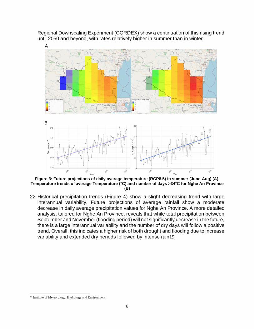
8
Regional Downscaling Experiment (CORDEX) show a continuation of this rising trend until 2050 and beyond, with rates relatively higher in summer than in winter.
Figure 3: Future projections of daily average temperature (RCP8.5) in summer (June-Aug) (A).
Temperature trends of average Temperature (°C) and number of days >34°C for Nghe An Province (B)
22. Historical precipitation trends (Figure 4) show a slight decreasing trend with large interannual variability. Future projections of average rainfall show a moderate decrease in daily average precipitation values for Nghe An Province. A more detailed analysis, tailored for Nghe An Province, reveals that while total precipitation between September and November (flooding period) will not significantly decrease in the future, there is a large interannual variability and the number of dry days will follow a positive trend. Overall, this indicates a higher risk of both drought and flooding due to increase variability and extended dry periods followed by intense rain19.
19 Institute of Meteorology, Hydrology and Environment

9
Figure 4: Future projections of average daily precipitation (mm) in the wet season (Sep-Nov) under
(A) RCP4.5 and (B) RCP8.5. Historical (red) and future RCP4.5 (green) and RCP8.5 (blue) projections of total precipitation (mm) in the wet season (Sep-Nov) (A) and
23. Temperature increase and consequential drought events are further exacerbated by hydrological droughts and the poor adaptive capacity of current infrastructure. The changing flow regime of Ca river is already evident. The lowest flow corresponds to the driest periods (February, March and April), supplying only 7 percent of the total
10
annual flow (Giang et al, 2014)20. The average annual flow variation is large, ranging from 2.67 m3/s to 9 140 m3/s in Upper Ca Watershed. This intra-annual variation poses great challenge to the provincial water network. Based on discharge records of Yen Thuong station, the discharge change is simulated by Giang et al. following the IPCC emission scenarios (B1, B2 and A1). Unsurprisingly, the simulated changes propose even higher seasonal discharge variation in the upper watershed (Yen Thuong hydrological station). The predicted discharge is expected to increase in wet season and decrease in dry season. According to the study, the expected increase in wet season is 6 percent (B1), 7.5 percent (B2) and 9.7 percent (A1) by 2090. The expected decrease in dry season is 5.1 percent (B1), 6.2 percent (B2) and 7.6 percent (A1) by 2090.
24. The water network supplies water for agriculture, forestry and domestic use. Only 122 415 hectares are equipped for irrigation, relying on surface water. However, the water regime has lately been affected by the impacts of climate change and weather anomalies, particularly in the dry season. Due to its high-water demand, rice is the most affected crop. Considering the national food security plans, rice production must be secured to the most extent to ensure both domestic and export market stability.
25. The current infrastructure, designed according to seasonal flows, is not prepared to accommodate the decreased level flow, thus disturbing the water diversion. The extended dry periods affect not only the water use relying on surface water, but indirectly the groundwater resources. Access to clean water is still poor and many of the poor households cannot afford the use of wells. Uneven distribution of water in dry seasons, coupled with the climate change induced deviation in flow level leads to conflict over water resources (Phuong, Skielboe and Huong, 2011)21, further aggravated by the low involvement of communities into water management-related issues.
Climate change induced hazards in the command area – droughts
26. The North Central region is severely exposed to climate change, and it experiences longer and more severe droughts and higher temperature, coupled with unpredictable events (off-season rain, sudden flash flood and cyclones). Amongst the impacts are the loss of arable land areas to drought, cropping calendar change, shrinking water resources, yield losses and aquaculture production decrease (IFAD, 2011)22. For water resources, the decrease in annual streamflow and decrease in dry season low flows are the most evident direct threats. Further entailed impacts are the slight increase in flood events, decrease in available surface water, increased drought frequency, increased irrigation demand and water allocation conflicts (ISPONRE).
27. Drought had not been considered a frequent natural disaster in Viet Nam previously, although occurring more frequently and with longer duration. North Central area is
20 Giang, Toshiki, Sakata, Kunikane and Vinh. 2014. Modelling climate change impacts on the seasonality of water resources in the
Upper Ca River Watershed in Southeast Asia. 21 Phuong et al., 2011. Understanding water conflict and cooperation in Con Cuong, Nghe An province, Vietnam. 22 IFAD, 2011. Environmental and Climate Change Assessment. Prepared for IFAD’s Country Strategic Opportunities Programme 2012-2017 – Viet Nam.

11
listed among the regions threatened by the largest yield decline because of drought and farmers in the region already reports loss of lands. FAO and Viet Nam National University conducted a series of drought mapping in the region that helped defining the Temperature Condition Index (TCI), a one-dimension drought indicator looking at the land surface temperature. According to the TCI, the province, as well as the entire North Central region, might be affected by the increased frequency and duration of drought during critical drought events.
28. The current design of the water network is not prepared to adapt to the impact of climate change on water resources, also given the topographical challenges of a territory that stretches along hilly and mountainous areas. Decreased flow levels hamper the water withdrawal by gravity-fed systems in critical dry periods. Detrimental long-term trends of shrinking surface water of small tributaries – as demonstrated in the Figure below – pose enormous pressure on farming communities, particularly on those living on mountainous areas and relying on natural springs.
Figure 5: Water occurrence change intensity between 1984-1999 and 2000-2019 in Con Cuong and Thanh Chuong districts23
29. These harmful conditions are already prompted, and further impacts of climate change are likely to increase the number of affected farmers, who are increasingly using pumps to lift water to the irrigation systems and extract groundwater to supplement their water demand.
30. Hydrological drought has cascading effect, as it indirectly puts severe pressure on groundwater resources. The adverse effect of supplementary water extraction results in conflict amongst water users, in particular between non-drinking domestic demand and agricultural use. Resolving balanced access to water amongst user is timelier than ever in the light of COVID-19. Based on WHO recommendation, frequent handwashing and cleaning are basic measures to control the spread of the virus. Poor communities having no facilities to extract groundwater are exposed to risk.
Climate change induced hazards in the command area – flood
23 Pekel, J-F.; Cottam, A.; Goerlick, N.; Belward, A.S. 2016. High-resolution mapping of global surface water and its
long-term changes. Natura 540. 418-422

12
31. Flood has been identified as a long-standing natural disaster in Viet Nam, a major natural hazard causing economic loss and putting population under threat. Poor communities are more vulnerable due to their income primary depending on agriculture, their housing facilities less protected, their low educational level and their poor access to health service (World Bank, 2016)24. Unlike the slow onset of drought hazard, flood events are unexpected, more localized and more rapid, making the preparedness even more difficult. According to emission pathways estimated by World Bank (2020)25, the occurrence and severity of flood is projected to increase by the mid-century.
32. The vulnerability and risk assessment of Nghe An province is based on the identified driving factors of vulnerability: ratio of poverty, agriculture as primary source of livelihood, access to clean water, education level and stunting. The provincial-level data is obtained from World Bank databases26. The composite analysis of these vulnerability indicators is matched to the risk of flood (coastal and riverine flood).
Figure 6: Composite analysis of flood vulnerability assessment
33. Results are in line with the latest researches related to flood disaster damage assessment in Viet Nam. The Central North region is highly exposed to flood, and capacities are not sufficient to cope with the devastating consequences of floods. Nghe An is ranked as one of the most vulnerable provinces. The immense load requires the development or complete replacement of dilapidated and outdated irrigation and flood protection infrastructures, which already have poor capacity (holding less than 10 percent of current annual flows).
34. Between 1989 and 2010, 14 flood events have been registered in the province with growing intensity and severity, as the number of fatalities shows (UNDDR, 2020)27. Based on general trends, major floods occur every 9-10 years and result in dike breaches.
24 World Bank, 2016. Transforming Vietnamese Agriculture: Gaining More from Less 25 World Bank. 2020. Viet Nam Overview 26 World Bank, Ministry of Labor – Invalids and Social Affairs of Viet Nam. 2020. mapVIETNAM 27 UNDRR. 2020. DesInventar Sendai. Viet Nam profile
Vulnerability Map
Most vulnerable
Least vulnerable

13
Rationale for integrated and inclusive approaches to adapt climate change
35. The multifaceted problem of meteorological and hydrological drought, compounded with flood as frequent natural disaster, make the province severely vulnerable. From one side, climate change induces the intensification of rain and increase of river discharge in wet season, while causing negative departure from average rainfall and decrease of river discharge in dry season. The adverse trends are exacerbated by further climate hazards, such as heat waves. Climate change has multiple impacts, including significant loss of agricultural assets, unsecured livelihoods, increasingly limited access to clean water, growing social tensions and conflicts. As defined in the National Communication of Viet Nam to the UNFCCC, the implementation of integrated water resource management is highly desirable to improve the response to climate change impacts. The province requires urgent measures for climate change adaptation in order to build resilience and improve response to drought and flood in integrated manner. Such development can be achieved only by improving the inclusiveness of disaster and risk management. National Strategy for Natural Disaster Prevention defines the integration of disaster risk management into Socio-Economic Development Plans as a main objective. In line with the national strategy, communities, often neglected from decision-making, must be involved into planning process as first crucial step of resilience building. Also, the NC-UNFCCC highlights the need of a more updated hydro-meteorological observatory and forecasting system and mainstreaming the climate scenarios into such Socio-Economic Development Plans. Preparedness of communities can only be prompted by integrated and multipurpose monitoring systems that provides timely and reliable information.
Project / Programme Objectives:
36. The overall objective of the project is to build communities’ resilience and improve response to climate change through inclusive integrated management of drought and flood. This will be achieved through three components in a four years project implementation period:
• Component 1: Building an institutional framework for inclusive integrated drought and flood management to strengthen adaptive capacities at province level. It foresees the establishment of a province-level integrated model for drought and flood management (in line with AF strategic results framework, notably Output 2.1., Output 7. Under Outcome 2. Strengthened institutional capacity to reduce risks associated with climate-induced socioeconomic and environmental losses and Outcome 7. Improved policies and regulations that promote and enforce resilience measures).
• Component 2: Strengthening climate resilience of the most vulnerable communities in the province to compound drought and flood threats through sustainable access to water resources. It foresees technical solutions for water multiple use and implementation of on-farm technologies for drought adaptation (in line with AF strategic results framework, notably Output 3.1., Output 3.2., Output 4. and Output 5. Under Outcome 3. Strengthened awareness and ownership of adaptation and climate risk reduction processes at local level,

14
Outcome 4. Increased adaptive capacity within relevant development sector services and infrastructure assets, Outcome 5. Increased ecosystem resilience in response to climate change and variability- induced stress)
• Component 3: Strengthening climate hazard monitoring capacity and knowledge sharing on inclusive integrated drought and flood management in the context of climate change. It foresees the improvement of traditional climate information system into context-tailored climate-hazard monitoring system that extends the delivery of timely information to communities (in line with AF strategic results framework, notably Output 1.2., Output 2.1., Output 2.2. and Output 3.2 under Outcome 1. Reduced exposure to climate-related hazards and threats, Outcome 2. Strengthened institutional capacity to reduce risks associated with climate-induced socioeconomic and environmental losses and Outcome 3: Strengthened awareness and ownership of adaptation and climate risk reduction processes at local level).
Project / Programme Components and Financing:
Project/Programme
Components Expected Concrete Outputs Expected
Outcomes
Amount (US$)
1. Building an institutional framework for inclusive integrated drought and flood management to strengthen adaptive capacities at province level
1.1.1. Current institutional setting and practices for drought and flood management in the region analyzed to enable inclusiveness and integration. 1.1.2. Coordination mechanism on flood and drought management amongst institutions at multiple levels (commune-level, district-level and province-level) strengthened. 1.1.3. Measures for adopting inclusive integrated drought and flood management identified 1.1.4. A process model for inclusive integrated drought and flood management in the region formulated.
1.1. The enabling environment is strengthened at province level through the establishment of an inclusive integrated drought and flood management model.
300 000
1.2.1. An operation plan for the process model developed. 1.2.2. Capacity-building programme for stakeholders on operation and upscale of process model provided.
1.2. Relevant stakeholders are empowered to operate the management model
2. Strengthening climate resilience of the most vulnerable communities in the provinces to compound drought and flood threats
2.1.1. A management tool to enhance decision-making on climate-related water interventions developed. 2.1.2. Water harvesting structures as an ecosystem-based adaptation measure in flood-prone areas created to increase
2.1. Water availability/access for multiple use of the communities most vulnerable to climate change better secured
2 186 500

15
through sustainable access to water resources
access to water for multiple use purposes and protect productive assets. 2.1.3. Aquifer recharge structures in high-density areas developed to reverse current groundwater exploitation trends. 2.1.4. Communities’ knowledge on sustainable water management increased and community-centered tool for groundwater monitoring provided in high-density areas.
through aquifer recharge, water harvesting and the application of efficient water techniques
2.2.1 In-situ rainwater harvesting techniques introduced to increase water accessibility at farm level. 2.2.2. Climate-resilient agricultural practices with special emphasis on water saving practices and technologies provided to communities. 2.2.3. Transition to crop diversification towards water-secure production supported to improve livelihood and reduce climate exposure. 2.2.4. Water pricing/sharing system within the communities developed and payment for water saving/water protection applied.
2.2. Vulnerable communities’ capacities strengthened to adapt to impacts of drought through adopting best on-farm technologies and practices
3. Strengthening
climate hazard monitoring capacity and knowledge sharing on inclusive integrated drought and flood management in the context of climate change
3.1.1. Scalable climate information system upgraded and integrated into a web-based information hub on inclusive integrated management of drought and flood. 3.1.2. Climate-hazard monitoring mechanism established based on upgraded and integrated climate information system. 3.1.3. Capacity-building programme on the use and operation of the monitoring system provided. 3.1.4. Web-based information hub on inclusive integrated management of drought and flood created.
3.1. Climate-hazard monitoring established and knowledge sharing platform on inclusive integrated drought and flood management established
500 000
4. Project/Programme Execution cost 313 500
5. Total Project/Programme Cost 3 300 000
6. Project/Programme Cycle Management Fee charged by the Implementing Entity (if applicable)
280 000
Amount of Financing Requested 3 580 000
Projected Calendar:
Milestones Expected Dates
Start of Project/Programme Implementation October 2021

16
PART II: PROJECT / PROGRAMME JUSTIFICATION
A. Project/programme components with their focus on concrete adaptation activities
37. The project design fully complies with the Adaptation Fund objectives, notably Objective 1 “Reduce vulnerability to the adverse impacts of climate change, including variability at local and national levels” and Objective 2 “Increase adaptive capacity to respond to the impacts of climate change, including variability at local and national levels”. The project provides both structural and non-structural measures to reduce climate vulnerability through three consecutive components. The project target area, Con Cuong and Thanh Chuong districts, are increasingly facing challenges of concurrent climate hazards, in particular drought and riverine flood. The two districts are hydrologically contiguous areas in the middle stretch of Ca River basin. As Nghe An is the main drain area of the catchment, the province is under constant threat of unpredictable large flows. While the river stream in Con Cuong has relatively well-defined course, it becomes meandering in Thanh Chuong. As districts are located along the main course of Ca river, they are exposed to high-frequency flood. Due to the underdevelopment of current infrastructure, the increasingly frequent droughts further aggravate the climate-induced problems. In order to reach integrated management of flood and drought, harmonized development of upstream and downstream areas is required. The cascading effects span over multiple sectors, including water resource management, agriculture, disaster risk management and livelihood. To respond to climate change impacts in an integrated manner and across these sectors, the project sets scope on adaptation measures that can be achieved in short-term but provide long-standing and sustainable solutions for resilience. After creating enabling environment for inclusive integrated drought and flood management through a reformed institutional framework, the project involves structural measures to improve access to multiple water use by flood water retention and harvesting. Inverting the perspective of flood risk into growth is envisaged through ecosystem-based adaptation measure, consistent with socio-economic, sustainability and financial objectives. Adding to the positive effects of improved access to surface water, the project addresses the current groundwater exploitation practices through aquifer recharge structures. At farm level, the positive effects are reinforced through non-structural measures. The project provides activities to directly involve farmers into water conservation through better on-farm practices and incentives to increase water use efficiency. To tackle the identified defects and/or incomplete coverage of monitoring systems currently in place, the project targets to turn the recent climate information systems into multifunctional climate-hazard monitoring system that provides readily available information directly for communities.
Mid-term Review (if planned) October 2023
Project/Programme Closing October 2025
Terminal Evaluation December 2025

17
38. Component 1. Building an institutional framework for inclusive integrated drought and flood management to strengthen adaptive capacities at province level. The component is phased into two consecutive and complementary outcomes:
• Outcome 1.1.: The enabling environment is strengthened at province level through the establishment of an inclusive integrated drought and flood management model.
• Outcome 1.2.: Relevant stakeholders are empowered to operate the management model
39. The component focuses on the current institutional framework to create an enabling environment at local level through the introduction of a process model for integrated drought and flood management. The component directly contributes to the targets of National Strategy on Climate Change, namely to the “enhance the participation of the entire political system in interdisciplinary organization and collaboration for coping with climate change; to improve efficiency and validity of central-to-local-level management of climate change issues”.
40. Vertical and horizontal coordination of relevant institutions is strengthened through successive analysis of current institutional setting and practices, review of coordination mechanism at multiple institutional level, measures for adoption, establishment of process model, provision of operation plan and capacity-building for stakeholders. The final product is a process model abstracting key institutional functions for inclusive integrated drought and flood management to strengthen the role of local level institutes through an integrated information flow amongst decision-making level. From bottom, acquisition and systematic compilation of sector-related information facilitates evidence-grounded policy making. From top, policy development better reflects on the need of communities through the access to systematic information base. The component is scaled at sub-national level to strengthen the contribution of local levels in national policymaking.
41. As concluded by the Nationally Determined Contribution of Viet Nam (NDC), the legal framework for integrating climate change into Socio-Economic Development Plans is still limited due to the lack of coordination between ministries, sectors and local stakeholders to address multisectoral issues. Further bottleneck defined by NDC is the institutional capacities, in particular at local level. From one hand, a great concern is that local level institutions are under-sourced to effectively manage adaptation processes. On the other, irrigation and drainage management companies as novel actors of national water management have not been integrated into institutional processes. Information-sharing to support their effective operation has not been established yet, thus making water-management spatially, temporally, institutionally scattered and unharmonized. In the last decades, much has been done at policy development and decision-making level, yet activities related to investment and capacity-building should be dispersed at district and commune level to activate local stakeholders. Equally important in climate adaptation, is the currently fragmented sectoral approaches. Droughts, floods and other climate-related disasters are managed by different authorities, often with overlapping mandates. Intersectoral coordination is increasingly needed to better respond to climate change not only because the impacts are cascading and interrelated in spatial, temporal and sector terms, but also because integrated management can neutralize and reverse each

18
other’s adverse impacts. The current component provides solid bases for participatory and inclusive approach of integrated management of drought and flood through an institutional process model that converge the different levels of stakeholders through better information sharing and its integration into decision-making.
42. The following activities per outputs are proposed accordingly: a) Current institutional setting and practices for drought and flood management in the
region analyzed to enable inclusiveness and integration: Cross-sectoral and cross-institutional analysis will be conducted to review the current institutional setting related to drought and flood management. The activity applies mapping exercise and gap analysis matrix (e.g. Action Matrix methodology by FAO). The mapping exercise includes the systematic review of institutions, regulations, policies for flood and drought management in the specific context of water resource management, agriculture and disaster risk management. The gap analysis matrix identifies the major bottlenecks of institutional, regulations and policy implementations – as it relates to the direct involvement of communities.
b) Coordination mechanism on flood and drought management amongst institutions at multiple levels (commune-level, district-level and province-level) strengthened: The activity concerns the improvement of institutional mechanism with emphasize on effective communication and administration among different institutions, as well as the definition of flow of information through the establishment of interinstitutional dialogue and mainstreaming into key management functions.
c) Measures for adopting inclusive integrated drought and flood management identified: Protocol for systematic data collection is to be crafted to determine the sectoral and cross-sectoral groups of measures to create comprehensive databases. From databases, enhanced management mechanisms of information sharing and administration are defined as the basis of bidimensional process model for enabling institutional framework.
d) A process model for inclusive integrated drought and flood management in the region formulated: Process model will be formulated to mainstream identified measures into institutional mechanisms, in particular in information-sharing and administration. The overall objective of the process model is to converge institutional actors and reinforce the role of communities in management decisions.
e) An operation plan for the process model developed: Completion of an operation plan will enable the use and regular update of the process model. The operation plan functions as the manual of the process model in the form of a learning module.
f) Capacity-building programme for stakeholders on operation and upscale of process model provided: Capacity-building programme will be conducted to increase their understanding on inclusive management in the context of climate-change. The capacity-building goes beyond the use of the process model and approaches the topic in more comprehensive manner with thematic sub-topics.
43. Component 2. Strengthening climate resilience of the most vulnerable communities in the provinces to compound drought and flood threats through sustainable access to water resources. The component is phased into two consecutive and complementary outcomes:

19
• Outcome 1.1.: Water availability/access for multiple use of the communities most vulnerable to climate change better secured through aquifer recharge, water harvesting and the application of efficient water techniques
• Outcome 1.2.: Vulnerable communities’ capacities strengthened to adapt to impacts of drought through adopting best on-farm technologies and practices
44. The component incorporates the recommendations on paradigm shift proposed by new national irrigation strategy. This component focuses on the development of water infrastructure targeting two major objectives: to improve water availability and access to water for multiple use at system level; and to increase communities’ capacities to adapt drought impacts at on-farm level.
45. At system level, the backbone of the component is an ecosystem-based adaptation technique, which turns excessive flood events to the advantage of the communities. The current spatial-temporal fluctuations of access to water results super-peak and off-peak periods in the form of alternating, successively changing flood and drought. Design of existing reservoirs often neglects the environmental and sustainability aspects, moreover, most of them are close to the end of their lifespan. The particularity of the reservoirs in mountainous areas is that outflows are below the level of fields. According to the consultation with communities (detailed in the section H – consultation process), the current decrease in water levels in dry season prevents the water offtake by the existing infrastructure. In order to address this complex issue, water harvesting structures in flood-prone areas will be created on existing facilities to reinforce water retaining capacities, and adjacent irrigation system will be rehabilitated to improve access to water. The water harvesting structures will be based on ecosystem-based adaptation techniques, which will store flood water for dry periods. On the other side, fluctuating groundwater tables are heavily exposed to human interference, as they are extracted not only for drinking purposes but for household use and supplemental irrigation. The mushrooming wells for supplemental irrigation are severe threats to both ecosystem and domestic water users. In particular, the groundwater use is concentrated to dry periods, when water tables shrink by natural processes anyway. The technology, therefore, is complemented with additional structure for aquifer recharge in high-density areas. The structure is to be constructed to reverse harmful exploitation trends and climate change impacts and preserve groundwater sources. Learning from past failure of rapidly deteriorating infrastructure, communities’ knowledge on sustainable water management and O&M of infrastructure will be strengthened through capacity-building programmes in most critical, high-density areas.
46. At farm level, advanced and climate-smart water management and agricultural practices will be introduced to increase farmers’ resilience to drought events. Farmers producing in small plots with traditional technologies have yields well-below of the national average. The consultation with farmers showed extremely low agricultural productivity (detailed in the section H – consultation process). Due to the capital-poor production, climate vulnerable and failure-prone irrigation infrastructure and lack of relevant experiences, farmers are not prepared to create adaptation strategies for drought. From these, climate-related events appear to be the major reason of uncertainty amongst farmers. Better on-farm water management is crucial to increase

20
farmers’ resilience to climate events and sustain the pathway towards crop diversification and water-secure production. Sets of combined in-situ water harvesting techniques (e.g. trash-lines, pitting, contour bunding, water retaining, etc.) and climate resilient agricultural practices (e.g. alternate wetting of rice, deficit irrigation, mulching, etc.) will be developed and disseminated to improve resilience. COVID-19 significantly impacted the livelihood of the communities, as most of the households make their living from remittances. The crisis resulted a dramatic drop of remittance flows according to the interviews with communities, so increasing the risk of poverty. More productive farming and diversification to cash-crop will be a viable strategy to improve livelihoods. Finally, the component will address the financial sustainability issue of water sector. Currently, public sources for water sector are reduced, and no mechanism is in place to reduce budget deficit. Water fees are well-established instrument to generate resources and promote efficient use of water. However, the past experience of over-pricing and charging poor farmers with over 20 types of different water fees were the syndrome of overall poor transposition and implementation of national strategies. Responding to the national strategy, water pricing mechanisms will be established and tested as scalable best practice on financial incentives for water conservation.
47. In order to strengthen climate resilience of the most vulnerable communities to compound drought and flood threats, the following activities per outputs are proposed:
a) A management tool to enhance decision-making on climate-related water interventions developed: investment tool will be developed to support decision-making on climate-related interventions, with an emphasis on ecosystem-based structural measures. Such tool incorporates multi-criteria assessment of investment in climate adaptation. The management tool will be designed for community-level application that can be further scaled-up to sub-national and national level.
b) Water harvesting structures as an ecosystem-based adaptation measure (EbA) in flood-prone areas created to increase access to water for multiple use purposes and protect productive assets: water harvesting facility is created in flood-prone areas by rehabilitation and stabilization of natural banks, re-naturalisation of dams and ponds in upstream (Con Cuong) and downstream (Thanh Chuong) command areas. The EbAs will be complemented with rehabilitation of outdated and non-functional irrigation systems to provide sufficient water for agricultural purposes. The EbA solutions are effective to control flow, store and slow runoff and river water, reduce ecosystem and land erosion, supply surface water in dry period, increase water level in critical points of gravity-fed irrigation systems and enable groundwater recharge. The EbAs will be equipped with multiple outlets to supply water for different water use (irrigation and livestock). The ultimate goal of EbA structures is to increase access to surface water for multiple purposes (irrigation and livestock) to reduce the impact of water scarcity, protect the productive assets and livelihoods from flood events and decrease the pressure on groundwater sources.
c) Aquifer recharge structures in high-density areas developed to reverse current groundwater exploitation trends: directly connected to the EbA structures, groundwater recharge structures are constructed to reverse groundwater exploitation in highly populated areas. Re-naturalization of dams and pond beds allow for more intensive infiltration into shallow groundwater tables. To increase the effectiveness,

21
injection wells will be constructed for managed aquifer recharge. The ultimate goal of the recharge structures is to preserve groundwater resources, improve resilience of groundwater sources to drought and heatwave, provide safe water for non-drinking household purposes with positive water balance.
d) Communities’ knowledge on sustainable water management increased and community-centered tool for groundwater monitoring provided in high-density areas: the current adverse trends of groundwater exploitation is partially coming from the insufficient information of communities about groundwater resources. In light of climate change impacts on groundwater sources, groundwater conservation is particularly important. The shift of water use towards surface water resources will be based on increased understanding of communities. While large water user sectors, including irrigation and livestock in the project context, are supported with improved access to surface water, groundwater use will be re-directed household purposes. In order to augment and revitalize groundwater resources, communities will be trained on groundwater monitoring (including the interpretation of updated groundwater maps) and community-centred tool, namely groundwater counter will be installed to create mass-information source.
e) In-situ rainwater harvesting techniques introduced to increase water accessibility at farm level: in-situ rainwater harvesting techniques (trash-lines, pitting, contour bunding, water retaining etc.) will be introduced in pilot farms and scaled at community level to improve on-farm water management and water use efficiency. Based on practical and scientific methods, sets of water harvesting techniques will be developed, piloted and demonstrated. Techniques increasing and prolonging soil moisture will substantially contribute to yield productivity and natural resource efficiency. Field guide for practitioners will be prepared and community-level information campaign will be conducted to disseminate results.
f) Climate-resilient agricultural practices with special emphasis on water saving practices and technologies provided to communities: climate-resilient on-farm practices (alternate wetting, deficit irrigation, mulching, etc.) will be introduced in pilot farms and scaled at community level to improve water use efficiency, on-farm natural resource management and agricultural productivity. Based on practical and scientific methods (e.g. AquaCrop), sets of agricultural practices will be developed, piloted and demonstrated. Methods improving water and soil conditions to build resilience to climate change will contribute to yield stabilization and productivity, natural resource conservation, and natural resource efficiency.
g) Transition to crop diversification towards water-secure production supported to improve livelihood and reduce climate exposure: cash-crop production model will be introduced in pilot gardens that is compatible with three objectives: climate scenarios, natural resource intensity and on-farm income. Technology transfer will be introduced to support farmers in transitioning to diversified production in favor for less water intense and higher value crops than rice production.
h) Water pricing/sharing system within the communities developed and payment for water saving/water protection applied: multilevel pricing model will be established that ensures the financial sustainability of irrigation network in the command area. The overall goal of the pricing model is to incentivize environment protection and water resource conservation to ensure equitable contribution to maintenance works. The

22
pricing model will be formulated on the basis of service provision to provide inclusiveness.
48. Component 3. Strengthening climate hazard monitoring capacity and knowledge sharing on inclusive integrated drought and flood management in the context of climate change. The component is based on one outcome:
• Outcome 3.1.: Climate-hazard monitoring established and knowledge sharing platform on inclusive integrated drought and flood management established.
49. This component focuses on strengthening and integrating climate-hazard monitoring system, while building on extensive experiences of FAO pilot monitoring initiative in Viet Nam. Access to climate predictions on drought and flood is a key constraint to agricultural production in the most vulnerable zones and it is continuously increasing together with climate change impacts. Through the timely management of drought and flood hazards the most viable and efficient adaptation strategies can be carried out to protect the livelihoods of people and improve food security. Therefore, the proposed project will implement activities that develop a monitoring system for the target area. This component will be implemented to take advantage of existing efforts on monitoring activities and integrate initiatives. Also, it will increase the positive impact of the project on the socio-economic side through direct access to information and predictions for all involved stakeholders. Furthermore, the system will support the decision-making processes to manage and disseminate easy-to-access information to direct beneficiaries and support the creation and implementation of adaptive measures.
50. Currently, national and sub-national monitoring systems for drought and flood management are still far to be implemented nationwide, due to an approach focused mainly on crisis management and emergency response. The existing information systems are spatially scattered and developed individually for different purposes. Still worse, many of them are no longer functional. There are four meteorological stations and six hydrology stations in Nghe An, of which three meteorological and four hydrology stations are located in along the main stream of Ca River. The stations are connected to the national level observatory. Beyond flood forecasting, there is an urgent need to create updated and integrated monitoring system that can be scaled at sub-national and community level.
51. In order to strenghten climate hazard monitoring capacity and knowledge sharing on inclusive integrated drought and flood management, the following activities are proposed:
a. Scalable climate information system upgraded and integrated into a web-based information hub on inclusive integrated management of drought and flood: scalable tool will be implemented as first step of integrated monitoring system. Based on in-situ devices (e.g. agro-meterological stations, discharge loggers, soil moisture sensors, groundwater level loggers) and involvement of communities, the command area is to be covered with real-time observation. Via remote communication and communities’ reporting, the devices will be connected to central information hub that integrates, processes, analyses and reports climate information, forecasting and risk assessment of flood and drought hazard. As robust information systems have been already

23
introduced and successfully piloted in Viet Nam (FAO ASIS), the project will integrate its results and scale-up its relevant parts.
b. Climate-hazard monitoring mechanism established based on upgraded and integrated climate information system: based on the achievement of the previous activity, the monitoring system will be integrated into sub-national information systems and complemented with remote-sensed information (including the most relevant agricultural and climate-hazard indicators). Information will be complementary with existing geo-referenced weather stations. On one hand, existing monitoring protocol will be updated with more robust methodologies that delivers information to decision-makers. On the other hand, the reporting function will be extended and scaled to communities.
c. Capacity-building programme on the use and operation of the monitoring system provided: extensive capacity-building programme will be organized with two main objectives. This activity will focus on building stakeholder capacity to use the implemented monitoring system. It aims at raising awareness and knowledge among decision-makers on an effective management of drought and flood, by creating a collaborative management strategy. The first module of capacity-building will be developed for sub-national and national professionals on the use of integrated information system. The second module of capacity-building will be organized to local professionals (local authority, extension service and community leaders) as training-of-trainers (ToT). ToT will be delivered to ensure the information distribution to farmers and communities.
d. Web-based information hub on inclusive integrated management of drought and flood created: Lessons-learnt will be included in web-based hub to support decision-makers in inclusive integrated management of drought and flood. The portal will be a central repository of quality-controlled data on droughts and floods, where users can browse real-time information on flood and drought management and project related results on adaptation measures at system and farm level. The ultimate goal of such information hub is to keep the relevant information up-to-date and accurate, scale-up the project results for potential replication.
B. Economic, social and environmental benefits
52. The focus of the project in subject is to build resilience and improve response to drought and flood in order to reduce the impact of climate change through inclusive integrated management of drought and flood in Viet Nam, and particularly in the indicated target areas. By implementing a combination of structural and non-structural measures, the project addresses the multiple and combined impacts of climate change and especially the adverse effects of concurrent climate hazards, in particular drought and riverine flood.
53. The beneficiaries have been determined through FAO targeting strategy and in direct consultation with national and regional stakeholders in the country. Through the three project components, beneficiaries are expected to receive significant economic and social benefits, in line with AF environmental and social policy objectives, while project activities have been formulated also with the scope to reduce the existing gender gap in water resources’ access and management. Project beneficiaries will strengthen their adaptive capacities through a capacity development
24
programme on tailored process model for inclusive integrated drought and flood management, the adoption of best on-farm technologies and practices, and the establishment of a climate-hazard monitoring and knowledge sharing platform.
54. Additional socio-economic and environmental benefits will come from improved access to surface water and the resulting improved water distribution, better reflecting the different demands of water users. Such an improvement is expected to increase farmers’ commitment for water conservation, also through the implementation of improved on-farm practices and incentives to increase water use efficiency. Furthermore, the improvement of existing groundwater monitoring systems into multifunctional climate-hazard monitoring systems will produce not only environmental benefits, by halting unsustainable practices for groundwater exploitation, but it will also have socio-economic advantages, by ensuring direct access to the users’ communities.
Type of benefit
Baseline conditions Target conditions
Economic/ Institu-tional
• Striking disparity, in terms of economic conditions, between rural and urban areas. Rural poverty rates three times higher in rural contexts as compared to urban ones.
• Significant percentage of population with incomes close to poverty line and particularly subject to the effects of climate change on rainfall and temperatures, as well as to human and animal pandemics.
• Natural disasters and weather shocks among the most impacting factors to hamper a balanced poverty reduction across the country, also given the heavy dependency on subsistence agriculture and access to natural resources.
• Significant amount of households relying on remittances, which have been sharply dropping since the outbreak of COVID-19
• Low education level and lack of modern, updated agricultural practices to improve productivity
• Reduced disparity between urban and rural areas thanks to improved agricultural production through the increased availability of water resources for key sectors (agriculture)
• Enhanced resilience to the effects of climate change through improved decision-making and coordination mechanisms for drought/flood integrated management to overcome sectoral approaches.
• Direct inclusion of final beneficiary communities promoted through enhanced participatory approaches and vertical institutional coordination
• Increased income by alternative cropping practices (gardening) and improved productivity
Social
• Smallholders consistently more affected by poor socio-economic conditions (59 percent in small farms).
• Lack of clean water for domestic purposes and increasing cost of
• Reduced exposure to natural disaster
• Improved socio-economic conditions of smallholders and vulnerable livelihoods through strengthened adaptive capacities at province level.
• Increased participation of women groups in resource

25
groundwater extraction due to shrinking groundwater resources
• Women underrepresented in farm ownership. Control over production assets dominated by men.
• Women take equal share in production, 51 percent of the labour force.
management through improved decision-making processes
• Enhanced availability of water resources, also for domestic use, and reduced burden on women through multiple-use approach
Environ-mental
• Severely vulnerable to climate change and particularly exposed to climate hazards. Hit by multiple disaster, mainly flood, tropical cyclones, drought and extreme heat. Ranked 1st at global scale for its exposure to flood.
• The already limited availability of natural resources hampers the expansion of key sectors (agriculture). Competing demands for water resources continuously increasing.
• Water availability an increasingly constraining factor, 60 percent of the water sources originate from transboundary countries.
• Ecosystem degradation (erosion) due to natural disasters
• Reduced vulnerability to climate hazards through the deployment of a web-based information hub on inclusive integrated management of drought and flood.
• Reduced soil and river bank erosion
• Increased sharing of information for proactive management of drought/flood
• Enhanced access to available water resources for vulnerable communities through aquifer recharge, water harvesting and application of efficient water-use techniques
• Reduced climate change impacts through the establishment of climate-hazard monitoring mechanisms based on integrated climate information systems
C. Cost-effectiveness of the proposed project
The cost-effectiveness of project approach and scope is assessed against two possible scenarios: without-the-project and alternative-adaptation-project.
26
Approach Rationale Without-project scenario Alternative adaptation scenario
Integrated approach
Climate change related hazards and disasters are alternating in time, which means that the command areas under the risk of flood damage are also exposed to severe shortage of water. Managing the risk separately would require individual adaptation measures designed for flood on one hand, and for drought on the other. Integrated management, however, is not only desirable from strategic point of view but from cost-effectiveness perspective.
• The area would be further imposed to flood and drought, thus keeping productive assets under threat.
• A drought event similar to the recent one in 2020 would continue to affect the communities, and they would be further forced to crop only in one season.
• Groundwater abstraction would increase in peak periods, thus depleting groundwater tables and put them to decreasing trends.
Separate management of flood and drought by reinforced embankment and dams:
• Flood management structures would be deployed in critical stretches to protect houses and lands. This would require the reinforcement of river banks
• At the same time, small-scale water dams would be constructed nearby agricultural lands to provide irrigation water in drought periods, from which groundwater would be augmented only through more intensive infiltration. By disconnecting the flood control structure from dams, canals should be constructed to connect the river with the dams.
Inclusive management
The management of natural resources is layered into different institutional levels now. Communities are not sufficiently involved into management that undermines the overall effectiveness. Even though larger water infrastructures are operated by companies now, the lower level and small-scale structures are the responsibility of the
• The management of irrigation infrastructure would remain shared amongst different institutional levels without effective harmonization.
• In lack of involvement, ownership of communities
Centralized management and zero management transfer:
• Top-down hierarchical management model would be created with higher expectations on farmers’ contributions.

27
communities. Empowering communities with more inclusive management model improves the management quality and reduces the need for outsourcing management activities. Evidence shows that participatory approaches improve the sense of ownership from farmers’ side and decrease the management budget.
and transfer of management responsibilities would not be established.
• The management and financing of current infrastructure would remain with public and private entities.
• The farmers would be service-receivers and management responsibility would be allocated to public or private entities.
Ecosystem-based solution
Ecosystem-based solution: Water resource development in the country had its “golden era” in the 1970s, when the sector underwent a rapid growth and structural change. The primary objective was to support the socio-economic development, both in terms of alleviating flood related disaster risk and making the best use of water resources (mainly for irrigation and hydropower). However, environmental and climate concerns were not sufficiently emphasized. Water infrastructure design followed the principles of grey investment. Its drawbacks have become apparent since then. Ecosystem-based investment, however, is in line not only with sustainability objectives, but with cost-effectiveness. Ecosystem-based approaches have significant advantages in both investment and O&M expenditures, compared to grey infrastructure.
• Ecosystem would further degrade, in particular soil and river stream erosion would occur more intensively.
• Outdated infrastructure would pose further risk on the ecosystem, in particular in flood-prone areas.
Grey infrastructure retrofitted to adaptation structures:
• Flood management structures and irrigation dams would be constructed from materials such as concrete, cement and metal. Due to the increased maintenance requirements, farmers would be requested to pay higher fees.
• Participatory approach would be limited, as only those farmers could contribute to the management, who have engineering experience.
Brownfield investment
The command area is suffering from rapid depreciation of current infrastructure due to the shortcomings of initial design, long-time neglected O&M, structures close to their end of lifespan, complete lack of repair works.
• The current water infrastructure would further entail depreciation cost, while cost of repair works
Green-field investment
• New infrastructures would be constructed in high-density areas, entailing potential re-settlement of
28
Re-engineering of existing infrastructure is of urgent need to avoid consequences of failure, restore and complement their functionalities, and re-construct them towards nature-based and climate-proof design. On the other hand, Viet Nam has developed large number monitoring systems that are currently working scattered without being harmonized or integrated. The project, therefore, builds on existing systems that can be integrated and scaled-up. Enhancing current infrastructure is highly cost-effective as it does not require potential costs, what green investment would entail (most importantly: land acquisition, baseline assessment and preparatory studies, landscape construction, etc.).
and re-investment would proportionally increase.
• Further critical costs such as cost of failure and condition-based maintenance costs would arise more frequently.
• Farmers should be higher irrigation fees for decreased performance and more limited water.
• Dams in critical conditions and not complying with dam safety regulations would be out of operation by of leaving farmers without irrigation water.
communities and land acquisition.
• If not investigated well, the project would require in-depth preparatory studies in the new area.
• The new structure would be harmonized with existing infrastructure to avoid negative effect on existing infrastructure. Therefore, preparatory studies on the impact of current infrastructure would be required.
Multilevel development with structural and non-structural measures
Nghe An province is characterized by severe labour outflux. According to International Organization of Migration, the number of people migrating abroad ranges between 11 and 16 thousand annually. In less than 5 years, over 50 thousand workers, mainly men moved abroad, thus leaving almost the same number of families to be dependent on remittances and the work of other family members. Nghe An has the highest rate of migration in the country due to multiple causes such as average salaries do not exceed the one-third of the salaries in the cities and the natural disasters pose continuous risk to productive assets. In order to address this issue, the project includes suites of structural (water harvesting structures etc.) and non-structural adaptation measures (capacity-
• The farmers would be further exposed to climate-change impact without technical support in adaptation and transition.
• Farmers would further exploit groundwater resources in drought periods to supplement irrigation water.
• In lack of successful transition, more farmers would abound the sector and leave lands behind.
• Rice would be produced predominantly, so farmers could not exploit the profitability potential of agriculture sector, namely
Climate-adaptive monoculture of paddy rice production:
• The farmers would be supported to improve paddy rice production, and rice farming would be put on the basis of economies of scale.
• Farmers would have access to stable market through wholesale companies.
• Despite the large-scale production, farmers’ income would not improve.
• Paddy rice would remain water-intensive compared to other crops. Production

29
building etc.) also at farm level that target the productivity and profitability of farmers. Farmers realizing higher profit are more likely able to ensure financial sustainability of structures.
gardening and cash-crop production.
would remain dependent on water availability.

30
D. Consistency with national or sub-national sustainable development strategies
55. Addressing climate change and natural disaster is a high priority under Viet Nam’s sustainable development strategies. The aims and objectives of the proposed Project are fully consistent with and built on the recommendations of Third National Communication to UNFCCC (2019), particularly two of the priority actions, regarding the proactive response to natural disasters and improvement of climate monitoring, and the assurance of social security. In addition, the AF project is consistent with the Updated National Determined Contribution (NDC, 2020) that underlines all the efforts conducted by the Country and identifies further strategic tasks for climate change adaptation, in particular to priority action of “respond pro-actively to disasters and improve climate monitoring”, and “ensure social security”.
56. In addition, AF proposed Project will contribute towards achieving the objectives of the following strategies and plans: a. National Adaptation Plan-NAP (2020) was approved on 20th July 202028 with the
general objective of reducing vulnerability and risk to the impacts of climate change through strengthening resilience, adaptive capacity of communities, economic and ecological sectors; promote the integration of climate change adaptation into strategic and planning systems. There are also three specific objectives of (i) Improving the effectiveness of climate change adaptation through strengthening state management on climate change, including climate change adaptation, and promoting adaptive integration into socio-economic development strategies and plans; (ii) Increasing resilience and enhancing adaptive capacity of communities, economic sectors and ecosystems through investments in adaptation actions, science and technology, and awareness raising for is willing to adapt to climate changes; and (iii) Disaster risk reduction and damage reduction, preparedness to respond to natural disasters and climate extremes increase due to climate change. Further alignment with the project can be found in the Annex I.
b. National Strategy for Natural Disaster Prevention, Response and Mitigation to 2020 (NSNDP, 2007). The strategy addresses disaster mitigation and management actions, especially floods and droughts. It integrates disaster risk reduction into national socio-economic development plans and harmonizes it with livelihood improvement.
c. National Target Programme to Respond to Climate Change (NTP-RCC, 2008), backed by the creation of the Support Program to Respond to Climate Change by JICA during the following year, in order to support the development and implementation of climate change policies and strategies based on the NTP-RCC. The overall objective of this strategy involves all the sectors and field, in terms of legal documents, mechanisms and policies, to be developed in three different periods. It sets out to elaborate feasible action plans to effectively respond to climate change for each period.
d. Action Plan on Climate Change Response of Agriculture and Rural Development Sector in the Period 2011-2015 (2011) which targets to strengthen
28 Decision No. 1055 / QD-TTg dated July 20, 2020 of the Prime Minister) in which water was among the
priority

31
the capacity for climate change response of agriculture and rural development sector in order to mitigate the climate change negative impacts. It is articulated in 7 actions, of which the second is closely related to the project objectives. It prompts the formulation of appropriate projects to respond (adapt and mitigate) to the climate change, in particular in water sector. Activities in this project respond to multiple priorities, including the development of irrigation measures to ensure water security, the implementation of irrigation measures with special attention to water saving techniques (surface irrigation, sprinkler irrigation, etc), the definition of procedures on management and the construction of hydraulic structures operation and regulation to avoid negative impacts and risks derived from climate change.
e. National Strategy on Climate Change (2011). It is a multi-phase strategy, through three periods. The proposed Project is well aligned with one of the specific targets, that aims at assuring food security, energy security, water security, poverty reduction, gender equality, social security, public health, and better livelihood as well as protect natural resources in the context of climate change. Particularly, the strategic mission regarding food security and water resource highlights specific actions as the improvement of water resource management, as well as the improvement as following: “upgrade, repair and build irrigation works, hydroelectric plants, and systems of river dike and breakwaters which can effectively cope with floods, droughts, seal level rising, and salt contamination in the context of climate change; and the set up and perfect standards and regulations for effective and multi-purposed exploitation and use of water resource in conformity with climate change and sea level rising”. At community level its purpose is “to strengthen communities’ capability and participation in activities of coping with climate change; to place importance on experience of on-site response and the role of local governments and grassroots-level mass organizations.”
f. National Strategy on Environment Protection to 2020 (2012). Its general objective targets the control and minimization of environment pollution, resource deterioration and biodiversity degradation; the improvement of habitat quality; the raise of the capability to respond to climate change, striving for sustainable national development. Out of the four directions and solutions for environment protection, the third one is fully aligned with the proposed Project since it aims at effectively and sustainably exploiting and using natural resources, while preserving nature and biodiversity. Particularly, it considers the solution of increasing water use efficiency and reducing the seasonal and regional water scarcity, through:
▪ Strictly management of the exploitation of surface and underground water, especially in dry season; application of quotas for underground water exploitation in specific regions;
▪ Review and readjustment of planning schemes for socio-economic development and industrial crop development in conformity with specific regions’ surface and underground water potential; and
▪ Renovation of the regime of water irrigation for agricultural activities in order to improve efficiency of water exploitation and use in these activities.
g. National Green Growth Strategy (2012): the overall objective of this strategy is to achieve a low carbon economy and to enrich natural capital; to reduce

32
GHG emissions and increase the capability to absorb them. The 9th solution of the strategy is strongly related to the proposed project, since it refers to the development of key sustainable infrastructure, including irrigation and water infrastructure. Specifically, it aims to:
▪ Enhance investment in irrigation systems with modern operation equipment to ensure efficient regulation and protection of water resources, adequate supply of water for agricultural production including the development of fruit plantation areas, aquaculture and salt making with better irrigation, drainage and flood control;
▪ Increase investment for adequate water supply for industrial and urban development with special focus on areas with water scarcity.
h. More recently, Viet Nam endorsed the National Action for the implementation of the 2030 Sustainable development agenda (2017). Among other activities, the National Action Plan addresses various development goals to the effective management and utilization of natural resources, as well as a proactive response to climate change. The proposed Project is closely aligned with this national action, since it will pursue the goals of “Ensure availability and sustainable management of water and sanitation for all” and “Develop eco-system services”
57. Finally, the project is in line with a number of additional legal, policy and institutional efforts, directly linked to climate change: i. The resolution of Active response to climate change, improvement of natural
resource management and environmental protection (2013) j. Law on Water Resources (2012) k. Law on Natural Disaster Prevention and Control (2013) l. Law on Environmental Protection – Law No. 55/2014/QH13. (2014) (replaced by
newly approved LEP on 17th November 2020 and come into force from 1st January 2022)
m. Law on Irrigation - Law No. 08/2017/QH14 (2017)
E. Relevant national technical standards and compliance with the Environmental and Social Policy of the Adaptation Fund.
58. The screening of relevant technical standards per sector, as well as the Environmental and Social Policy principles per concrete outputs are summarized in the Table.

33
Sector of
intervention Concrete output ESP principle Relevant Rules, Regulations, Standards and Procedures
Water
1.1.1. 1, 2, 3, 5 - Law No. 17/2012/QH13 on Water Resource - Law on Irrigation - Law No. 08/2017/QH14 (2017) - Decree No. 149/2004/ND-CP
- Ordinance on the exploitation and protection of irrigation works No. 32/2001/PL-UBTVQH10
- Decree No. 43/2015/ND-CP - Decree No. 54/2015/ND-CP
- Decision No. 1590/QD-TTg - Decree No. 120/2008/ND-CP - Decree No. 115/2008/ND-CP amending and supplementing a number of
articles of the Government’s Decree No. 143/2003/ND-CP - Decree No. 112/2008/ND-CP - Decision No. 197/2007/QD-TTg approving the master plan on socio-
economic development of Nghe An province till 2020 - Decision No. 05/2003/QD-BTNMT
- Circular No. 134/1999/TT-BNN-QLN - Directive No. 03/1999/CT-Ttg - Decree No. 143/2003/ND-CP
1.1.2 1, 2, 3, 5
1.1.3 1, 2, 3, 5
1.1.4. 1, 2, 3, 5
1.2.1. 1, 2, 3, 5
1.2.2. 1, 2, 3, 5
2.1.1. 1, 2, 3, 5
2.1.2. 1, 2, 3, 5, 9, 10, 11
2.1.3. 1, 2, 3, 5, 9, 10, 11
2.1.4. 1, 2, 3, 5, 9, 10, 11
2.2.4. 1, 2, 3, 5
3.1.1. 1, 2, 3, 5, 11
3.1.2. 1, 2, 3, 5, 11
3.1.3 1, 2, 3, 5, 11
3.1.4. 1, 2, 3, 5, 11
Environment and Climate
Change
1.1.1. 1, 2, 3, 5 - Law on Environmental Protection No. 55/2014/QH13 - Decree 40/2019/ND-CP - Circular 25/2019/TT-BTNMT
- Decision No. 19/2007/QD-BTNMT - Decision No 819/QD-BNN-KHCN Circular No. 04/2012/TT-BTNMT - Decree No. 102/2008/ND-CP - Decision No. 179/2004/QD-TTg - Circular No. 27/2015/TT-BTNMT - Law on Hydro-meteorology (No. 90/2015/QH13)
1.1.2. 1, 2, 3, 5
1.1.3. 1, 2, 3, 5
1.1.4. 1, 2, 3, 5
1.2.1. 1, 2, 3, 5
1.2.2. 1, 2, 3, 5
2.1.1. 1, 2, 3, 5
2.1.2. 1, 2, 3, 5, 9, 10, 11
2.1.3. 1, 2, 3, 5, 9, 10, 11
2.1.4. 1, 2, 3, 5, 9, 10, 11
2.2.1. 1, 2, 3, 5, 11, 15
2.2.2. 1, 2, 3, 5, 11, 15
2.2.3. 1, 2, 3, 5, 11, 15

34
3.1.1. 1, 2, 3, 5, 11
3.1.2. 1, 2, 3, 5, 11
3.1.3. 1, 2, 3, 5, 11
3.1.4. 1, 2, 3, 5, 11
Disaster Risk Management
1.1.1. 1, 2, 3, 5 - Law on Natural Disaster Prevention and Control
- Decree No. 66 /2014/ND-CP - Decision No. 172/2007/QD-TTg - Decision No. 1002/QD-TTg - Decision No. 1041/QD-TTg
1.1.2. 1, 2, 3, 5
1.1.3. 1, 2, 3, 5
1.1.4. 1, 2, 3, 5
1.2.1. 1, 2, 3, 5
1.2.2. 1, 2, 3, 5
2.1.1. 1, 2, 3, 5
2.1.2. 1, 2, 3, 5, 9, 10, 11
2.1.3. 1, 2, 3, 5, 9, 10, 11
2.1.4. 1, 2, 3, 5, 9, 10, 11
3.1.1. 1, 2, 3, 5, 11
3.1.2. 1, 2, 3, 5, 11
3.1.3. 1, 2, 3, 5, 11
3.1.4. 1, 2, 3, 5, 11
Agriculture
1.1.1. 1, 2, 3, 5 - Law on Crop Production - Decision No. 1895/QD-TTg - Circular No. 07/2015/TT-BNNPTNT - Decision No. 132/1999/QD-BNN-HTQT - Decree No. 56/2005/ND-CP repeals Decree No. 56/2005/ND-CP
1.1.2. 1, 2, 3, 5
1.1.3. 1, 2, 3, 5
1.1.4. 1, 2, 3, 5
1.2.1. 1, 2, 3, 5
1.2.2. 1, 2, 3, 5
2.2.1. 1, 2, 3, 5, 11, 15
2.2.2. 1, 2, 3, 5, 11, 15
2.2.3. 1, 2, 3, 5, 11, 15
2.2.4. 1, 2, 3, 5
3.1.1. 1, 2, 3, 5, 11
3.1.2. 1, 2, 3, 5, 11
3.1.3. 1, 2, 3, 5, 11
3.1.4. 1, 2, 3, 5, 11
35
59. The project will fully comply with the national technical standards and the 15 principles of the Environmental and Social policy of Adaptation Fund. Screening of national technical standards has been conducted (detailed in section K), and the relevant regulations per sectors are indicated in the Table. In course of the full proposal development, these regulations will be detailed and explained how they relate to the project. The concrete outputs are screened against the Adaptation Fund principles. The outputs are in line with the principles, and a narrative will be provided in the full proposal. FAO has established its Environmental and Social Safeguards that set out specific requirements to social and environmental issues. The nine safeguards are natural resource management; biodiversity, ecosystems and natural habitats, plant genetic resources for food and agriculture; animal – livestock and aquatic genetic resources for food and agriculture; pest and pesticide management; involuntary resettlement and displacement; decent work; gender equality; indigenous peoples and cultural heritage. The project will reflect on the defined Safeguards to ensure compliance with the organizational policy.
F. Duplication of project / programme with other funding sources
60. Viet Nam holds various climate change related projects and initiatives, although more focused on the southern part of the country. Initial screening for potential duplication has not highlighted any overlapping or duplication with other funding sources and the proposed project in technical, spatial, and / or temporal dimensions. The proposed project will take due account of them, and in some cases utilize the lessons learned of other projects to reinforce the objectivies. Moreover, the proposed project, due to its integrated and compatible design, will be able to maximize results through the integration and upgrading of the FAO pilot project in the region.

36
Relevant Projects/Programme Goals and Achievements Complementarity potential and
non-duplication Project timeline
World Bank “Viet Nam Dam Rehabilitation and Safety Improvement Project” Location: all country, focusing on prioritized dams and reservoirs Sectors: Irrigation and drainage; other water supply, sanitation and waste management; public administration
The subproject developed in Nghe An province aims to ensure the long-term viability of a selected dam and reservoir; to ensure the safety of downstream people and agricultural areas, as well as downstream infrastructures, and to ensure stable water source for irrigation of rice and animal production
The project, although related to water resources management, refers to a single dam, in Khe San reservoir which is located in Quynh Thang, a district of Nghe An province away from the current target area
It was approved in 2017 and it is expected to be concluded in 2022
ADB Water Sector Investment Program. Multi-tranche project -Vinh water supply subproject Location: Vinh city and surrounding region, Nghe An province
The project provides an improved water supply coverage in the system, as well as an old pipe replacement or improvement. The network is partitioned and master meter installed, as well as Supervisory Control And Data Acquisition (SCADA)
The ADB project is not overlapping with the proposed project, but lessons learned could be in-built to maximize the efficiency o project implementation
Duration: 2013-2018
World Bank / Viet Nam Government Viet Nam managing natural hazards project (vn-haz project) Location: Various provinces of Viet Nam, including Nghe An, which involved 9 subprojects (one in Thanh Chuong district regarding Repairing and Upgrading Dyke Luong Yen Khai)
The project involves 1.Strengthened Disaster, 2. Risk management, 3. Weather Forecasting and Early Warning Systems; 4. a community-Based Disaster Risk Management and 5. priority investments for Disaster Risk Mitigation Investments
AF project will take into account the produced material of World Bank project in terms of early warning and information systems in order to avoid duplication, although AF project will be more in-situ by developing a climate-hazard monitoring system targeting the command area
Duration: 2012 – 2019
FAO Pilot Study: Strengthening the agroclimatic information system to improve the agricultural drought monitoring and early warning system in Viet Nam Location: Ninh Thuan province
The main goal of FAO project is to provide a web platform in which includes a satellite-based monitoring system. The platform allows to map extreme events to improve drought management at decision-makers level.
AF project will create synergies with this pilot study, in order to convey an upgraded and integrated initiative within the selected area.
Duration 2017-2019

37
JICA Technical Cooperation Project on Development Planning of Agriculture Sector in Nghe An in the Socialist Republic of Vietnam Location: Nghe An province
The project aims to develop "The Agriculture Development Master Plan (M/P) for Nghe An Province" and "Action Plan (A/P)" to achieve the goals of the M/P, through introduction of "Contract Agriculture" which will enhance food value chain in Nghe An province.
The project will draw lesson on the development of pilot projects on sustainable agriculture. The project is complementary to the objectives of the current project.
Duration 2014-2019
Vietnam Forests and Delta Program Location: Thanh Hoa, Nghe An, Nam Dinh, Long An province
VFD has successfully developed policies and implemented actions to achieve green growth, sustainable forest management, and equitable payment for forest environmental services in Nghe An and Thanh Hoa provinces. As a result of project support, approximately 25 000 households are receiving PFES payments and are now more actively engaged in local forest protection
The projects have only minor cross-cutting objectives. However, achievements in the VFD programme will provide valuable basis for case studies on ecosystem-based adaptation. This can be part of the capacity-building programmes.
Duration 2012-2021

38
G. Learning and knowledge management component to capture and disseminate lessons learned
61. Component-specific capacity-building is essential part of the project to improve ownership of stakeholders, contribute to knowledge management, increase sustainability of project results and demonstrate good practices. The different components act at different level (decision-makers, community leaders, farmers), so the design of knowledge management is aligned differently. In particular, as current knowledge of communities on climate change and potential adaptation measures is limited, there is a strong need to scale knowledge products at their level.
62. Beyond specific capacity-building programmes, the project sets out to regularly document the practices, lessons-learnt and conclusions. All learning materials are to be disclosed and widely disseminated to transfer knowledge at wide scale both through national channels (local and sub-national media and FAO communication channels, including FAO publishing services and social media accounts).
Expected outcomes
Stakeholders and learning objectives
Knowledge product
1.1. The enabling environment is strengthened at province level through the establishment of an inclusive integrated drought and flood management model.
For decision-makers, management staff and community leaders:
• To obtain structured and systematic management analysis with institutional and policy dimension
• To develop management process model
• Structured dataset of management dimensions at different level
• Guide on institutional and policy analysis with FAO-developed Action Matrix for professionals
1.2. Relevant stakeholders are empowered to operate the management model
For decision-makers, management staff and community leaders:
• To operate, maintain and update the management process model
• To support inclusive and integrated policy decision
• Operation plan and tutorial modules for the process model
• Face-to-face training for decision-makers on the process plan
2.1. Water availability/access for multiple use of the communities most vulnerable to climate change better secured through aquifer recharge, water
For professional staff, engineers, community leaders and relevant stakeholders:
• To promote climate change adaptation in water sector development
• To support the design of green infrastructure, namely ecosystem-based
• Guide on multicriteria assessment in designing climate adaptive and ecosystem-based infrastructure in water sector
• Manual on O&M of ecosystem-based adaptation infrastructures
• Maps and data repository on groundwater management

39
harvesting and the application of efficient water techniques
structures in further development processes
• To facilitate efficient water allocation and distribution rules for multiple purposes
• To improve knowledge on groundwater management
• Face-to-face training on water allocation modelling for multiple purposes
• Training-of-trainers on groundwater management in participatory approaches
2.2. Vulnerable communities’ capacities strengthened to adapt to impacts of drought through adopting best on-farm technologies and practices
For extension service, community leaders and farmers:
• To enable climate-resilient and water efficient farming practices
• To improve farming outcomes (profitability, productivity, resource efficiency)
• To ensure cost recovery of irrigation sector at micro level
• Field guide for practitioners on in-situ water harvesting
• Field guide for practitioners on climate-resilient agricultural practices
• Community-level information campaign on in-situ water harvesting and climate-resilient agricultural practices
• Toolbox of good agricultural practices for diversification and dissemination campaign
• Manual on water pricing protocol
3.1. Climate-hazard monitoring established and knowledge sharing platform on inclusive integrated drought and flood management established
For professional staff, engineers, community leaders and relevant stakeholders:
• To strengthen climate-hazard monitoring and forecasting capacities
• To enable information-based decision-making in climate change adaptation
• To create effective mechanism for information sharing with communities
• Manual on O&M of monitoring system with tutorial modules
• Face-to-face training on monitoring and forecasting for professionals
• Training-of-trainers on reporting and information-sharing with communities
H. Consultative process
63. The consultative process involved stakeholders at different levels from decision-makers to community representatives. The consultation team involved national and international experts with decent gender balance. The consultation included representatives from relevant ministries to ensure the alignment with national priorities and strategies. MONRE was involved over the project development phase to exchange on progress and ensure that proposed activities are in conformity with national adaptation objectives. In order to anchor the project on communities’ actual need and reach their support in project development, several field consultations were arranged with the communities in the target area. As the process handled gender equity as high priority, representatives of Women Union were invited to participate in the consultation. Given the length limit, the proposal summarizes the main conclusions of the multiple steps of consultation.

40
Name Position, role Conclusions
Consultation team
Mr. Nguyen Song Ha (FAO VN, Assistant of FAO Representative, Viet Nam), Mr. Nguyen Thi (MONGRE, Officer, Viet Nam), Mr. Nguyen Sy Linh (National expert, Viet Nam), Mr. Maher Salman (FAO NSL, Senior Land and Water Officer, Rome), Ms. Margarita Diubanova (FAO OCB, Senior Climate Expert, Rome), Ms. Eva Pek (FAO NSL, Water Resource Specialist, Rome), Ms. Camilla Simongini (FAO NSL, Environmental engineer, Rome), Ms. Stefania Giusti (FAO NSL, Programme Officer, Rome)
Consultation meeting with Than Lam commune, Thanh Chuong district
Mr. Nguyen Xuan Ky (Vice chairman of the commune), Mr. Tran Hung Tien (Land and Environment Officer), Mrs., Nguyen Thi Thuy (Vice Chair of Woman Union), Mrs. Nguyen Thi Van Anh (Vice Chair of Farmer Union), Mr. Dinh Van Nam (Head of Village 1), Mrs Nguyen Thi Tho (Head of Village 2) Mr. Phan Van Hoang (Vice Head of Village 6)
Problem statement: The community is characterized by high poverty rate, with reliance on
income from remittances. Due to current pandemic crisis, however, the
families’ access to remittances has dramatically dropped. The community is severely exposed to high-frequency flooding, and recently observed severe flood damage, whereas 4 out of 6 villages were inundated for more than 8 days. The recent agricultural performance is low, as farmers can cultivate
only in one season due to drought and lack of access to water. The
traditional farming practices are not resilient; thus the actual rice yields do not reach the tenth of the national average (0.5 ton/ha). The community has been experiencing devastating droughts with cascading effects, including lack of water for irrigation and household purposes, shrinking groundwater tables and complete yield failure. Identified adaptation measures: The consultation together with accompanied field visit identified possible adaptation measures to address the abovementioned hardship. Communities requested the introduction of water harvesting techniques to increase access to water and recharge aquifers. Also, the participants highlighted the need of irrigation system rehabilitation to increase irrigation performance and allow for sufficient irrigation in two seasons. Furthermore, the update of current agricultural production with smart practices were reiterated by farmers. Given the high frequency of occurring floods, community leaders agreed on the need of information generation on flooding, in particular on accurate mapping to support livelihood protection and agricultural protection.

41
Consultation meeting with Binh Chuan commune, Con Cuong district
Mr.Vi Đinh Thanh (Chairman of Binh Chuan Commune), Mr. Khu Van Van (Head of Quan village), Mr. Nguyen Manh Ha (Vice Chairman of Binh Chuan Commune), Mr. Luong Van Ly (Head of Xiem village), Mr. Vi Van Kinh (Head of Toong village), Mrs. Khu Thi Hương (Farmer from Na Co village), Mr. Khu Van Vien (Head of Que village), Mr. Lay Van Vinh (Head of Quan village), Mr. Vi Van Luyen (Head of Dinh village), Mr. La Van Sao (Head of Na Co village), Mr. Vi Van Hoang (Head of Met village), Mr. Lo Van Hau (Head of Xieng village), Mrs. Khu Thị Du (Head of Dinh village), Mrs. Luong Thị May (Farmer from Na Co village), Mrs. Vay Thi Yen (Farmer from Dinh village), Mr. Lai Van Hung (Vice head of Agriculture and Rural Development Division of Con Cuong district), Mr. Vi Van Dung (Vice head of Natural Resources and Environment Division of Con Cuong district)
Problem statement: The agricultural production is limited in the area, to around 500 ha, which is prone to drought. The communities expressed their concern about growing food insecurity due to low agricultural productivity and as result of the previous landscape change (deforestation) in the area. Around 60 percent of the rice production area is affected by climate extreme, thus resulting extremely low yield. The communities reported a large number of deteriorated dams that are currently out of use. The frequent drought events and overall water scarcity pose enormous pressure on local communities and make them increasingly vulnerable. However, the rehabilitation of dams and water infrastructure would be desirable to tackle the multiple issues regarding water access. Another concern arose from the poor access to water for domestic water use. The current wells in use are dried up, as groundwater tables dropped. Drilling deeper wells would result in ecosystem degradation including soil erosion and groundwater exploitation, as well as it would entail significant cost to pump water from deep wells. Communities are extremely vulnerable to further decrease in water supply, as they already “have to ask for water to drink from each other”. Identified adaptation measures: As water scarcity and currently limited agricultural potential are the major pressing issues, the participants agreed that water harvesting structure for water retaining and storing, as well as the rehabilitation of dams and adjacent irrigation systems are inevitable to build resilience to further climate impacts. Communities articulated the need of groundwater mapping, as they have no information on the current trends.

42
Consultation meeting with DONRE office, Nghe An
Mr. Thai Van Nong (Vice Director of Nghe An DONRE), Mr. Dao Duy Tam (Head of Division- Hydrology and Metrology under DONRE) , Mr. Le Van Hoa (Vice Head of Division- Hydrology and Metrology under DONRE), Ms. Nguyen Thi Le (Official of Division- Hydrology and Meteorology under DONRE), Mr. Nguyen The Anh (Official of Sub-department of Water Resources under DARD of Nghe An province), Mr. Trang Van Binh (Vice head of Division of water work management and rural clean water under Sub-department of Water Resource), Mr. Nguyen Hoa Lam (Vice director of Sub-Department of Rural Development under DARD of Nghe An province), Mr. Nguyen Tien Duc (Director of Sub-department of Plant Protection and Crop production under DARD of Nghe An province)
The consultation introduced the project frames and the possible adaptation measures to respond to the current issues in the province. The participants agreed that Nghe An province is in utmost need to introduce adaptation measures to respond to climate change impacts, increase resilience and improve livelihoods through more productive agriculture. The meeting highlighted the socio-economic hardship of the communities and the threats of increasing poverty.
43
I. Justification for funding requested, focusing on the full cost of adaptation reasoning
64. The project is fully in line with national adaptation priorities as presented in the D section. The project is also in line with the requirement of communities and directly addresses the increasing vulnerability to climate change impacts. The project concrete outputs are complementary to provide a solid and comprehensive framework for adaptation from institutional, technical, socio-economic and climate point of view. Therefore, the project does not require additional fund to achieve full impact.
65. From institutional point of view, the project tackles the identified institutional gaps to enable integrated management of flood and drought. By strengthening institutional mechanism, the project will be embedded in efficient management environment, which is also in line with the relevant national institutions. This will pave the way to maintain the project results in long-term and contribute to enabling environment for climate change adaptation.
66. From technical point of view, the project provides integrated solutions for flood and drought. The deployed technologies themselves will reduce the risk of flood and drought damages. It will also address to environmental issues, such as shrinking groundwater resources, ecosystem degradation including soil erosion. No additional technology is required to have fully functional system and achieve the objectives of technology development. The information system is built on existing facilities, however, these are already in place.
67. From socio-economic point of view, the project delivers adequate farming practices that support farmers both in climate change adaptation and livelihood improvement. Farmers will take multiple advantages of proposed suite of best practices involving water-efficient and climate resilient farming, as they aim at reducing pressure on natural resources, while increasing farming outputs. In order to be inclusive for different cropping systems, farmers are supported in both updated rice production practices and crop diversification, as well as gardening. Communities’ livelihood is also supported through sustainable management of groundwater resources. As households water use rely exclusively on groundwater resources, augmentation of groundwater in shrinking aquifer will continue to supply water even for poorer households, who cannot afford deep well drilling, while protecting aquifers from depletion. Recharge capacity will be designed to counterbalance both climate change impacts and current rate of exploitation.
68. From climate-change point of view, each output of the project provides adaptation measures starting from planning and management capacities, technological solutions, farming practices to monitoring, information system including early-warning. While information system and updated management frameworks are non-structural measures to reduce the climate risks, the technologies and farming practices are combined non-structural and structural measures to adapt climate change and reduce the impact on vulnerable communities in long-term. Therefore, the project design itself is suitable to adapt climate change impacts even in worst scenario.
J. Project sustainability
44
69. The project design directly addresses the critical factors impacting on the post-project sustainability. The project is built on national experiences of water resource development, whereas imbalance between investment and operating expenses resulted fast deterioration of infrastructure. This was mainly due to the engineering design not complying with environmental requirements, high technological complexity, centralized management, poor O&M of infrastructure and increased load due to climate change impacts. In order to obtain long-lasting and scalable results, the project tackles both internal and external factors of sustainability. The assessment through different aspects provides a composite picture of the overall sustainability:
a. Technical sustainability: Unlike the current grey infrastructure in place, ecosystem-based design is rather built on traditional knowledge of natural process than on engineering capacities. Consequently, ecosystem-based adaptation solutions present reasonable technical complexity that can be integrated into participatory management. An infrastructure built on natural processes involve uncertainty, as its level of service evolves continuously. These processes can be observed and documented to establish high-performing management rules. In order to support the sustainability of the O&M of created infrastructure, performance monitoring (quantity, quality, impacting factors) is essential part of the project, as well as capacity-building on monitoring and O&M through Component 2. Component 3 directly contributes to the technical sustainability, as monitoring system is extended to observe natural processes (discharge, soil water content and groundwater tables). Based on the generated information, O&M guidelines and capacity-building will be developed to ensure the technology uptake and management transfer. In post-project phase, the deterioration of the structures is expected to remain low, thus enabling a long life-span.
b. Financial sustainability: The operating expenses of ecosystem-based structures are significantly lower than grey infrastructure, whereas maintenance works, in particular condition-based maintenance and repair works require reasonable budget. Therefore, it is expected that communities will be able to finance the O&M of the structures. In order to strengthen the financial sustainability, the project includes new pricing model for water services that ensures full cost recovery in Component 2. The pricing model increases the return of water infrastructure in decent manner. Adding to it, the selected infrastructures and technologies have low maintenance requirement and long lifespan. The longer lifespan allows for allocating sufficient budget for repair works and replacement, thus achieving the potential cost recovery. Participatory approach further reduces the budgetary burdens, as communities can directly contribute to O&M with in-kind services.
c. Community-related sustainability: The involvement of communities from the beginning of the project aims at creating strong ownership and commitment from direct end-users. Communities having reliable access to water are expected to remain engaged post-project. Also, communities channeled into information-sharing through Component 3 (climate information, early-warning reports, status of water resources) will be incentivized to maintain project results. In post-project phase, the communities will have sufficient capacities to operate the structures, practice climate-resilient agriculture, and eventually elevate farming outcomes.
d. Institutional sustainability: The revisited institutional arrangements that are more inclusive and information-based provide strong framework for the project sustainability

45
through Component 1. The process model complementing the project results from institutional point of view will create the most efficient setting of sustainable management. It will also form a basis for similar investments at larger scale. In post-project phase, the institutional actors will be empowered to become self-organized and more integrated.
e. Environmental sustainability: The core concept is built on ecosystem-based development, which is fully in line with environmental sustainability objectives. Building on natural process, such as re-naturalization and water resource augmentation helps restoring the ecosystem while providing substantial gains for stakeholders through Component 2. In post-project phase, the project adds to environmental benefits through groundwater conservation, prevention of soil erosion and support of natural embankments.
70. The project sustainability requires the cooperation of stakeholders at different level. MONRE is responsible for the overall coordination of the project results and mainstreaming its results to national policies. The implementation, management and maintenance of results of Component 1 related to institutional modelling is to be trusted on district-level authority (Sub-department of Water Resource in Nghe An province). The implementation, management and maintenance of results of Component 2 related to water infrastructure is to be shared between district-level authority and commune organization. Further related to Component 2, farm-level development is to be maintained directly by farmers and embedded into the programme of extension service. The implementation, management and maintenance of results of Component 3 related integrated information system is to be trusted on local meteorological and hydrology station as shared responsibility (Official of Division- Hydrology and Meteorology, DONRE).
71. The project provides scalable results that can be replicated at regional level. In order to ensure the scalability, capacity-building programmes and project results are disseminated through physical, online and offline knowledge products. At system level, the project provides good practice on turning degraded infrastructure into productive and environmental-friendly adaptation structures. By approaching their end of lifespan, large part of the countries’ outdated water infrastructure requires re-investment to restore their function. Therefore, the project aims at promoting sustainable re-engineering that supports the climate-change adaptation. Therefore, the interest of the project result replication at national level is expected to be high. At on-farm level, the introduced agricultural practices can be scaled at regional level, whereas climate similarity allows farmers to adopt them.
K. Environmental and social impacts and risks
72. According to Adaptation Fund’s regulations and following the initial screening, the concept proposal has been categorized as Category C, considering that no adverse environmental or social impacts have been identified.
73. A preliminary environmental and social risks assessment is shown in the table, which will be extended with more detailed narrative of the indicated principles in the full proposal, using specific, reliable and effective indicators. At this stage some potential

46
areas that require further assessment have already been identified and indicated in the below checklist.
Checklist of environmental and social principles
No further assessment required for compliance
Potential impacts and risks – further assessment and management required for compliance
Compliance with the Law
X Relevant laws, regulations and technical standards are identified and listed in Section E More detailed description will be provided in the full proposal
Access and Equity
X Communities’ leaders and representations are already consulted Field visit was conducted to map direct beneficiaries in both districts More rigorous and detailed analysis will be conducted in the full proposal stage
Marginalized and Vulnerable Groups
X Most vulnerable groups are mapped and visited during the field visit More rigorous and detailed analysis will be conducted in the full proposal stage
Human Rights X
Project risk related to human rights is not identified
.
Gender Equity and Women’s Empowerment
X Women representations are consulted and presented in Section H More detailed description will be provided in the full proposal
Core Labour Rights
X Project risk related to human rights is not identified
Indigenous Peoples
X No indigenous people live in the project area
Involuntary Resettlement
X Field visit was conducted to map the project area Component 2 is planned in equipped area, so neither land acquisition nor involuntary resettlement is required
Protection of Natural Habitats
X Con Cuong command area is bordered by natural park, but the project area does not include it

47
PART IV: ENDORSEMENT BY GOVERNMENT AND CERTIFICATION BY THE IMPLEMENTING ENTITY
The project sets out ecosystem- based infrastructure in the place of current grey infrastructure, so the project improves the natural habitats More detailed description will be provided in the full proposal
Conservation of Biological Diversity
X Project risk related to conservation of biological diversity is not identified
Climate Change X
Project risk related to climate change is not identified
Pollution Prevention and Resource Efficiency
X Component 2 targets to improve resource efficiency (land and water) Pollution related risk is not identified More detailed description will be provided in the full proposal
Public Health
X Groundwater recharge and system outlet for domestic purposes must comply with national regulations More detailed description will be provided in the full proposal
Physical and Cultural Heritage
X Project risk related to physical and cultural heritage is not identified
Lands and Soil Conservation
X Component 2 targets to reduce riverbank and soil erosion More detailed description will be provided in the full proposal

48
A. Record of endorsement on behalf of the government29 Dr. Tran Hong Ha, Minister of Natural Resources and Environment, Ministry of Natural Resources and Environment, Socialist Republic of Viet Nam
Date: Jan 14 2021
6. Each Party shall designate and communicate to the secretariat the authority that will endorse on behalf of the national government the projects and programmes proposed by the implementing entities.
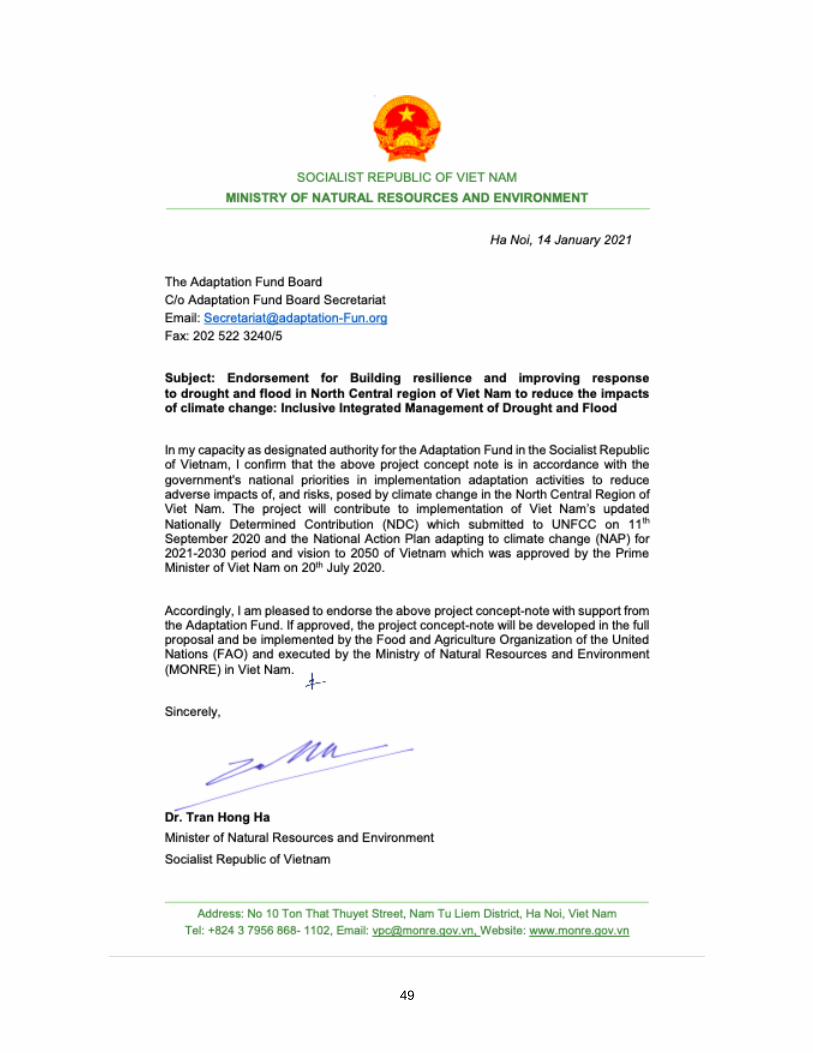
49

50
B. Implementing Entity certification
I certify that this proposal has been prepared in accordance with guidelines provided by the Adaptation Fund Board, and prevailing National Development and Adaptation Plans and subject to the approval by the Adaptation Fund Board, commit to implementing the project/programme in compliance with the Environmental and Social Policy of the Adaptation Fund and on the understanding that the Implementing Entity will be fully (legally and financially) responsible for the implementation of this project/programme.
Maher Salman
Implementing Entity Coordinator
Date: (January, 18, Year) Tel. and email:
0039 0657054718
Project Contact Person: [email protected]
Tel. And Email: 0039 0657054718, [email protected]

51
Annex I.
TASKS OF IMPLEMENTING THE NATIONAL CLIMATE ADAPTATION PLAN FOR THE PERIOD 2021 - 2030, WITH A VISION TO 2050 (Attached to the Decision No. 1055 / QD-TTg dated July 20, 2020 of the Prime Minister)
D. Water resources
No. Adaptation priorities/
needs
Targets/ specific
objectives Tasks Implementing agency/ies
1
Minimize the impact of climate change on water resources
Improve efficiency of water resource management in climate change conditions
Develop a National Strategy on Water Resources to 2030, with a vision to 2050 MONRE
Develop a master plan on water resources for the period 2021-2030, with a vision to 2050
MONRE
Building integrated planning of inter-provincial river basins and inter-provincial water sources
MONRE
Review and adjust inter-reservoir operation procedures in river basins MONRE, MARD, MoIT
Strengthen monitoring and protection of water resources
Complete the national water resources monitoring and monitoring system MONRE
Determining areas where underground water exploitation is restricted for areas, especially the Mekong River Delta
Provincial authorities/government
To restore and develop protection forests and mangrove forests in order to protect water sources, prevent riverbank and coastal erosion
MARD and provincial government
Increase water storage capacity and improve water efficiency
Investigate, evaluate and develop total solutions for water storage based on natural trends of each area
MONRE
Classification of water scarcity, proposing water storage measures, saving water, limiting water exploitation and use according to each level of water scarcity
MONRE, PPCs
Investigating, evaluating and identifying solutions to artificially supplement underground water for the Mekong River Delta, South Central Coast and Central Highlands to improve the efficiency of sustainable use of underground water resources in variable conditions. climate change
MONRE and MARD
Develop, deploy and multiply models of economical and efficient water use MARD, MoC, PPC
Construction of additional works to store water, exploit and use water resources in increasing drought conditions due to climate change
MARD, PPCs