PROPOSAL FOR CHILE AND ECUADOR - Adaptation Fund
723
AFB/PPRC.22/24 7 March 2018 Adaptation Fund Board Project and Programme Review Committee Twenty-Second Meeting Bonn, Germany, 20-21 March 2018 Agenda Item 9 g) PROPOSAL FOR CHILE AND ECUADOR
-
Upload
khangminh22 -
Category
Documents
-
view
1 -
download
0
Transcript of PROPOSAL FOR CHILE AND ECUADOR - Adaptation Fund
AFB/PPRC.22/24
7 March 2018 Adaptation Fund Board Project and Programme Review Committee Twenty-Second Meeting Bonn, Germany, 20-21 March 2018 Agenda Item 9 g)
PROPOSAL FOR CHILE AND ECUADOR

AFB/PPRC.22/24
Background
1. The strategic priorities, policies and guidelines of the Adaptation Fund (the Fund), as well as its operational policies and guidelines include provisions for funding projects and programmes at the regional, i.e. transnational level. However, the Fund has thus far not funded such projects and programmes. 2. The Adaptation Fund Board (the Board), as well as its Project and Programme Review Committee (PPRC) and Ethics and Finance Committee (EFC) considered issues related to regional projects and programmes on a number of occasions between the Board’s fourteenth and twenty-first meetings but the Board did not make decisions for the purpose of inviting proposals for such projects. Indeed, in its fourteenth meeting, the Board decided to:
(c) Request the secretariat to send a letter to any accredited regional implementing
entities informing them that they could present a country project/programme but not a regional project/programme until a decision had been taken by the Board, and that they would be provided with further information pursuant to that decision
(Decision B.14/25 (c))
3. In its eighth meeting in March 2012, the PPRC came up with recommendations on certain definitions related to regional projects and programmes. However, as the subsequent seventeenth Board meeting took a different strategic approach to the overall question of regional projects and programmes, these PPRC recommendations were not included in a Board decision. 4. In its twenty-fourth meeting, the Board heard a presentation from the coordinator of the working group set up by decision B.17/20 and tasked with following up on the issue of regional projects and programmes. She circulated a recommendation prepared by the working group, for the consideration by the Board, and the Board decided:
(a) To initiate steps to launch a pilot programme on regional projects and
programmes, not to exceed US$ 30 million;
(b) That the pilot programme on regional projects and programmes will be outside of the consideration of the 50 per cent cap on multilateral implementing entities (MIEs) and the country cap;
(c) That regional implementing entities (RIEs) and MIEs that partner with national
implementing entities (NIEs) or other national institutions would be eligible for this pilot programme, and
(d) To request the secretariat to prepare for the consideration of the Board, before
the twenty-fifth meeting of the Board or intersessionally, under the guidance of the working group set up under decision B.17/20, a proposal for such a pilot programme based on consultations with contributors, MIEs, RIEs, the Adaptation Committee, the Climate Technology Centre and Network (CTCN), the Least Developed Countries Expert Group (LEG), and other relevant bodies, as appropriate, and in that proposal make a recommendation on possible options
AFB/PPRC.22/24
on approaches, procedures and priority areas for the implementation of the pilot programme.
(Decision B.24/30)
5. The proposal requested under (d) of the decision above was prepared by the secretariat and submitted to the Board in its twenty-fifth meeting, and the Board decided to:
(a) Approve the pilot programme on regional projects and programmes, as contained in document AFB/B.25/6/Rev.2;
(b) Set a cap of US$ 30 million for the programme;
(c) Request the secretariat to issue a call for regional project and programme proposals for consideration by the Board in its twenty-sixth meeting; and
(d) Request the secretariat to continue discussions with the Climate Technology Center and Network (CTCN) towards operationalizing, during the implementation of the pilot programme on regional projects and programmes, the Synergy Option 2 on knowledge management proposed by CTCN and included in Annex III of the document AFB/B.25/6/Rev.2.
(Decision B.25/28)
6. Based on the Board Decision B.25/28, the first call for regional project and programme proposals was issued and an invitation letter to eligible Parties to submit project and programme proposals to the Fund was sent out on 5 May 2015. 7. In its twenty-sixth meeting the Board decided to request the secretariat to inform the Multilateral Implementing Entities and Regional Implementing Entities that the call for proposals under the Pilot Programme for Regional Projects and Programmes is still open and to encourage them to submit proposals to the Board at its 27th meeting, bearing in mind the cap established by Decision B.25/26.
(Decision B.26/3)
8. In its twenty-seventh meeting the Board decided to:
(e) Continue consideration of regional project and programme proposals under the pilot programme, while reminding the implementing entities that the amount set aside for the pilot programme is US$ 30 million;
(f) Request the secretariat to prepare for consideration by the Project and Programme Review Committee at its nineteenth meeting, a proposal for prioritization among regional project/programme proposals, including for awarding project formulation grants, and for establishment of a pipeline; and
(g) Consider the matter of the pilot programme for regional projects and programmes at its twenty-eighth meeting.
(Decision B.27/5)

AFB/PPRC.22/24
9. The proposal requested in (b) above was presented to the nineteenth meeting of the PPRC as document AFB/PPRC.19/5. The Board subsequently decided:
a) With regard to the pilot programme approved by decision B.25/28:
(i) To prioritize the four projects and 10 project formulation grants as follows:
1. If the proposals recommended to be funded in a given meeting of the PPRC do not exceed the available slots under the pilot programme, all those proposals would be submitted to the Board for funding; 2. If the proposals recommended to be funded in a given meeting of the PPRC do exceed the available slots under the pilot programme, the proposals to be funded under the pilot programme would be prioritized so that the total number of projects and project formulation grants (PFGs) under the programme maximizes the total diversity of projects/PFGs. This would be done using a three-tier prioritization system: so that the proposals in relatively less funded sectors would be prioritized as the first level of prioritization. If there are more than one proposal in the same sector: the proposals in relatively less funded regions are prioritized as the second level of prioritization. If there are more than one proposal in the same region, the proposals submitted by relatively less represented implementing entity would be prioritized as the third level of prioritization;
(ii) To request the secretariat to report on the progress and experiences of the pilot programme to the PPRC at its twenty-third meeting; and
b) With regard to financing regional proposals beyond the pilot programme referred to above:
(i) To continue considering regional proposals for funding, within the two categories originally described in document AFB/B.25/6/Rev.2: ones requesting up to US$ 14 million, and others requesting up to US$ 5 million, subject to review of the regional programme; (ii) To establish two pipelines for technically cleared regional proposals: one for proposals up to US$ 14 million and the other for proposals up to US$ 5 million, and place any technically cleared regional proposals, in those pipelines, in the order described in decision B.17/19 (their date of recommendation by the PPRC, their submission date, their lower “net” cost); and (iii) To fund projects from the two pipelines, using funds available for the respective types of implementing entities, so that the maximum number of or maximum total funding for projects and project formulation grants to be approved each fiscal year will be outlined at the time of approving the annual work plan of the Board.
(Decision B.28/1)

AFB/PPRC.22/24
10. According to the Board Decision B.12/10, a project or programme proposal needs to be received by the secretariat no less than nine weeks before a Board meeting, in order to be considered by the Board in that meeting. 11. The following project fully-developed project document titled “Reducing climate vulnerability in urban and semi urban areas in cities in Latin America” was submitted by the Banco de Desarrollo de America Latina (CAF; Development Bank of Latin America), which is a Regional Implementing Entity of the Adaptation Fund. 12. This is the sixth submission of the proposal. It was first submitted as a pre-concept for the twenty-sixth Board meeting and the Board decided not to endorse it. It was then submitted as a pre-concept for the twenty-seventh meeting, and the Board decided to endorse it. It was then submitted, as a fully-developed project document, bypassing the optional concept stage, to the twenty-eighth and twenty-ninth meetings and was not approved. It was submitted again as a fully-developed project document to the thirtieth meeting, and the Board decided:
(a) Not to approve the project document, as supplemented by the clarification response provided by the Banco de Desarrollo de America Latina (CAF; Development Bank of Latin America) to the request made by the technical review;
(b) To suggest that CAF reformulate the proposal taking into account the observations in the review sheet annexed to the notification of the Board’s decision, as well as the following issues:
(i) The proposal should identify the risks of unnecessary environmental and social harm in line with the Adaptation Fund’s environmental and social policy, present the evidence-based findings of impact assessments for those principles for which risks have been identified, and formulate management or mitigation measures accordingly, in a manner commensurate with the risks. The relevant information should be included in the main proposal document in a concise but adequate way. Any necessary additional documentation should be consistent with the information in the proposal document;
(ii) The proponent should consolidate the proposal and its components, following the application template, in a concise, coherent and clear manner, focusing on relevant information;
(iii) The proposal should include implementation arrangements for the environmental and social management measures needed to comply with the Adaptation Fund’s environmental and social policy, reflecting a consolidated and integrated environmental and social management plan; and
(c) To request CAF to transmit the observations under subparagraph (b) above to the Governments of Chile and Ecuador.
(Decision B.30/35)
AFB/PPRC.22/24
13. The present submission was received by the secretariat in time to be considered in the thirty-first Board meeting. The secretariat carried out a technical review of the project proposal, with the diary number LAC/RIE/DRR/2015/1, and completed a review sheet. 14. In accordance with a request to the secretariat made by the Board in its 10th meeting, the secretariat shared this review sheet with CAF, and offered it the opportunity of providing responses before the review sheet was sent to the PPRC.
15. The secretariat is submitting to the PPRC the summary and, pursuant to decision B.17/15, the final technical review of the project, both prepared by the secretariat, along with the final submission of the proposal in the following section. The proposal is submitted with changes between the initial submission and the revised version highlighted. The response sheet prepared by the proponent showing how the observations made by the Board when not approving the proposal at its thirtieth meeting were considered when developing the proposal for the current meeting, is also provided as an annex to this document.
AFB/PPRC.22/24
Project Summary
Chile and Ecuador – Reducing climate vulnerability in urban and semi urban areas in cities in Latin America
Implementing Entity: CAF
Project/Programme Execution Cost: US$ 965,074 Total Project/Programme Cost: US$ 12,880,000 Implementing Fee: US$ 1,030,400 Financing Requested: US$ 13,910,400
Project Background and Context: The objective of the proposed project would be to reduce vulnerability to climate-related floods, mudflows and landslides in three coastal cities by mainstreaming a risk-based approach to adaptation, building collaboration and networking, and developing a culture of adaptation. The project focus on the hydrometeorological hazards of mudflows in Antofagasta and Taltal, and flooding and landslides in Esmeraldas. The expected mid-term impacts are improved enabling conditions to sustain DRR adaptation in the three cities. In the long-term, it is expected that this will result in improved adaptive capacity. It is also envisioned that the lessons of the project are useful to other countries in Latin America and the Caribbean, and other regions of the world. Component 1: Priority actions to increase reslience (US$ 9,632,043) This component would focus on priority actions to increase resilience in the three cities. It would generate four outcomes dealing with building better to withstand climate-related hazards and enhancing disaster preparedness. It would be the largest component of the project, concentrating 74.8 per cent of the budget. The four outcomes would include enhanced plans and green infrastructure that would reduce vulnerability to floods, landslides and mudflows in three coastal cities; reduced vulnerability to floods, landslides and mudflows in two coastal cities; improved climate monitoring and means to alert the local population; and improved means to respond to floods, landslides and mudflows. Component 2: Strengthen capacities for adaptation (US$ 1,252,011) The component would focus on strengthen the capacities of local government officers and communities, as well as fortifying connections between communities and local and national government. Two outcomes would be generated by developing an online training course on risk-based adaptation for municipal and government officers, and implementing communication and education strategies to increase local awareness and contribute to build cultural memory. The online course would be open to professionals from other coastal cities of Latin America and the Caribbean. Component 3: ICTs and partnership between coastal cities in Latin America. (US$ 1,030,874) The component would focus on nurturing the project´s communities of practice and to document and disseminate the lessons. The backbone of the regional project would be the communities of practice that would allow the development of collective learning on specific topics. Five communities of practice would be developed. This component would include:
AFB/PPRC.22/24
i. An electronic platform to facilitate interaction and collaboration among project participants of both countries (e.g. teleconference, webinars), and the dissemination of lessons for the benefit of other coastal cities in the region and the world. According to the proposal, it is expected that this platform would serve to motivate further participation of other coastal cities in the region.
ii. Nurturing the communities of practice and facilitating networking among practitioners.
iii. The systematic documentation of lessons in different formats (e.g. YouTube
channel, formal documents) and their world-wide dissemination through various channels (e.g. mailing list server, Twitter, website).

AFB/PPRC.22/24
ADAPTATION FUND BOARD SECRETARIAT TECHNICAL REVIEW OF PROJECT/PROGRAMME PROPOSAL PROJECT/PROGRAMME CATEGORY: Regional Project
_________________________________________________________________________________________________________ Countries/Region: Chile, Ecuador Project Title: Reducing climate vulnerability in urban and semi urban areas in cities in Latin America Thematic Focal Area: Disaster risk reduction and early warning systems Implementing Entity: CAF Executing Entities: Ministry of the Environment, Chile and Ministry of the Environment, Ecuador AF Project ID: LAC/RIE/DRR/2015/1 IE Project ID: Requested Financing from Adaptation Fund (US Dollars): 13,910,400 Reviewer and contact person: Dirk Lamberts Co-reviewer(s): Daouda Ndiaye IE Contact Person: Carolina Cortés Cardona Review Criteria Questions Comments on 4 February 2018 Comments on 26 February 2018
Country Eligibility
Are all of the participating countries party to the Kyoto Protocol?
Yes.
Are all of the participating countries developing countries particularly vulnerable to the adverse effects of climate change?
Yes.
Project Eligibility
Has the designated government authority for the Adaptation Fund endorsed the project/programme?
Yes, by both countries.
Does the regional project / programme support concrete adaptation actions to assist the participating countries in addressing the adverse effects of climate change and build in
Yes, broadly.

AFB/PPRC.22/24
climate resilience, and do so providing added value through the regional approach, compared to implementing similar activities in each country individually? Does the project / programme provide economic, social and environmental benefits, particularly to vulnerable communities, including gender considerations, while avoiding or mitigating negative impacts, in compliance with the Environmental and Social Policy and Gender Policy of the Fund?
Yes.
Is the project / programme cost-effective and does the regional approach support cost-effectiveness?
Yes.
Is the project / programme consistent with national or sub-national sustainable development strategies, national or sub-national development plans, poverty reduction strategies, national communications and adaptation programs of action and other relevant instruments? If applicable, it is also possible to refer to regional plans and strategies where they exist.
Yes.
Does the project / programme meet the relevant national
Yes. However, Section F should describe the relevant technical standards and how
CAR: Sufficiently addressed, provided that the ESMP has clear

AFB/PPRC.22/24
technical standards, where applicable, in compliance with the Environmental and Social Policy of the Fund?
they are met, in compliance with the ESP. A 13-page table has been added to this section “briefly describing how the project mainstreams the Environmental and Social Policy of the Adaptation Fund”. This information is irrelevant here and has not been reviewed. CAR
provisions on complying with the national technical standards.
Is there duplication of project / programme with other funding sources?
No.
Does the project / programme have a learning and knowledge management component to capture and feedback lessons?
Yes.
Has a consultative process taken place, and has it involved all key stakeholders, and vulnerable groups, including gender considerations in compliance with the Environmental and Social Policy and Gender Policy of the Fund?
Yes.
Is the requested financing justified on the basis of full cost of adaptation reasoning?
Yes.
Is the project / program aligned with AF’s results framework?
Yes.
Has the sustainability of the project/programme outcomes been taken into account when designing the project?
Yes.
Does the project / programme provide an overview of environmental and social impacts / risks identified, in
The identification of environmental and social risks was not carried out in line with the ESP but was done using a UNDP methodology that is not equivalent to or
CR1: Not adequately addressed. The proposal now accurately states in several locations that the main
AFB/PPRC.22/24
compliance with the Environmental and Social Policy and Gender Policy of the Fund?
interchangeable with the ESP. Essential elements of the ESP principles have thus not been considered. No justification is provided on the choice of this methodology other than that it is that of the executing entity. The IE must demonstrate compliance with the ESP of the AF rather than with that of the EE. The process described is not in line with the ESP. The risks findings are not substantiated, while the ESP requires the process to be evidence-based. Based on the information provided, the risks identification remains deficient for a number of ESP principles. Information not directly relevant to the Environmental and Social Policy of the Adaptation Fund should not be included. CR1: Please identify environmental and social risks for the project in compliance with the ESP.
investments of the project have not yet been designed to the stage where effective environmental and social risks identification is possible in line with the ESP (unidentified sub-projects, paragraphs 90, 93, 102, 194, 262, 290, 291, 292). This being the case, the environmental and social risks findings presented in Table 11, Section II.L, are mostly premature and ineffective, at least as far as the USPs are concerned. ‘Table 1 Project Risk Identification’ in the new Annex 14 identifies risks for the whole project, including the USPs. The findings (e.g. identification of marginalized groups) are not substantiated other than by the yes/no answers to the questions in the table. The methodology used, while the IE is at liberty to demonstrate ESP compliance in a way of its choosing, is not aligned with the ESP. This seems partly explained by the use of an AF manual that is intended for capacity building at NIEs rather than for risks identification in projects. The latter is covered by the Guidance document for Implementing Entities on compliance with the Adaptation Fund Environmental and Social Policy https://www.adaptation-fund.org/wp-content/uploads/2016/07/ESP-Guidance_Revised-in-June-

AFB/PPRC.22/24
2016_Guidance-document-for-Implementing-Entities-on-compliance-with-the-Adaptation-Fund-Environmental-and-Social-Policy.pdf . The statement on p. 13 of Annex 14 that only the activities of component 1 are considered in the risks identification is not compliant with the ESP that requires a comprehensive risks identification. In a similar vein the statement on p. 16 ‘The ESMP was done only for Component 1, as Component 2 and Component 3 present a Categorization C’: categorisation should be the outcome of risk identification. The approach used in section 2.1 of Annex 14 leads to a conclusion on p. 15 that is not in line with the ESP. The ESP requires that for all risks identified an impact assessment is carried out, commensurate to the risks. The new ESMP still does not provide adequate environmental and social risks identification and management. Risks are said to have been identified without, however, the USPs having been identified to the point where this is adequately possible. Elements of the ESMP based on these inadequate risks findings are

AFB/PPRC.22/24
not commented on here in detail. The required mechanism to review USPs in line with the ESP as and when these are identified to the point where this is possible is included but it is incomplete and unlikely to lead to adequate risks identification. As there are no obstacles identified that pre-empt the full identification of the USPs, and considering the difficulty experienced by the IE to produce an adequate ESMP, all project activities should be identified in full prior to resubmission of the funding application, ESP risks identified accordingly and all subsequent elements for ESP compliance included in the proposal.
Does the project promote new and innovative solutions to climate change adaptation, such as new approaches, technologies and mechanisms?
Yes.
Resource Availability
Is the requested project / programme funding within the funding windows of the pilot programme for regional projects/programmes?
Yes.
Are the administrative costs (Implementing Entity Management Fee and Project/ Programme Execution Costs) at or below 20 per cent of the total project/programme budget?
Yes.
Eligibility of IE Is the project/programme submitted through an eligible
Yes.

AFB/PPRC.22/24
Multilateral or Regional Implementing Entity that has been accredited by the Board?
Implementation Arrangements
Is there adequate arrangement for project / programme management at the regional and national level, including coordination arrangements within countries and among them, and in compliance with the gender policy of the Fund? Has the potential to partner with national institutions, and when possible, national implementing entities (NIEs), been considered, and included in the management arrangements?
Are there measures for financial and project/programme risk management?
Yes.
Are there measures in place for the management of for environmental and social risks, in line with the Environmental and Social Policy and Gender Policy of the Fund?
As mentioned under 13, the risks identification is not done in line with the ESP. The measures summarised in section III.C for the management of environmental and social risks reflect the same deficiencies. The ESMP presented in Annex 15 has substantive shortcomings and does not comply with the ESP. CR2: Please complete section III.C in accordance with the findings related to environmental and social safeguarding identified elsewhere in the application, in an integrated, concise and coherent manner,
CR2: Not adequately addressed. The core of the measures for the management of environmental and social risks should be the ESMP. The issues with the ESMP presented are discussed under point 13. In addition, there are inconsistencies. E.g., risks are claimed to have been identified for all activities but the USPs. Outcome of that risks identification (which needs to be evidence-based) has been used to formulate mitigation measures, which are now included in III.C. One of these mitigation measures listed on

AFB/PPRC.22/24
and ensure that the project Environmental and Social Management Plan is based on the comprehensive, evidence-based environmental and social risks identification following the 15 ESP principles only. The grievances process would benefit from publicising the option to address grievances directly to the AFB Secretariat as well (details in para 34 of the ESP). CR3: Please update the grievances section of the funding proposal.
p. 97 is ‘b) Identification of vulnerable groups’. This, however, is a prerequisite for effective risks identification against the ESP principle on Marginalized and Vulnerable Groups. CR3: Addressed.
Is a budget on the Implementing Entity Management Fee use included?
Yes.
Is an explanation and a breakdown of the execution costs included?
Yes.
Is a detailed budget including budget notes included?
Yes.
Are arrangements for monitoring and evaluation clearly defined, including budgeted M&E plans and sex-disaggregated data, targets and indicators, in compliance with the Gender Policy of the Fund?
Yes.
Does the M&E Framework include a break-down of how implementing entity IE fees will be utilized in the supervision of the M&E function?
Yes.
Does the project/programme’s Yes.

AFB/PPRC.22/24
results framework align with the AF’s results framework? Does it include at least one core outcome indicator from the Fund’s results framework? Is a disbursement schedule with time-bound milestones included?
Yes.
Technical Summary
The project objective is to reduce vulnerability to climate-related floods, mudflows and landslides in three coastal cities by mainstreaming a risk-based approach to adaptation, building collaboration and networking, and developing a culture of adaptation. The project focus on the hydrometeorological hazards of mudflows in Antofagasta and Taltal, and flooding and landslides in Esmeraldas. The expected mid-term impacts are improved enabling conditions to sustain DRR adaptation in the three cities. In the long-term, it is expected that this will result in improved adaptive capacity. It is also envisioned that the lessons of the project are useful to other countries in Latin America and the Caribbean, and other regions of the world. The initial review finds that the issues raised in the last reviews of the [proposal have still not been addressed, mostly related to compliance with the Environmental and Social Policy of the Fund. The following corrective action request (CAR) and clarification requests (CR) are made: CAR: Section F should describe the relevant technical standards and how they are met, in compliance with the ESP. A 13-page table has been added to this section “briefly describing how the project mainstreams the Environmental and Social Policy of the Adaptation Fund”. CR1: Please identify environmental and social risks for the project in compliance with the ESP. CR2: Please complete section III.C in accordance with the findings related to environmental and social safeguarding identified elsewhere in the application, in an integrated, concise and coherent manner, and ensure that the project Environmental and Social Management Plan is based on the comprehensive, evidence-based environmental and social risks identification following the 15 ESP principles only. CR3: Please update the grievances section of the funding proposal. The final technical review finds that the revised proposal does not adequately address these areas. The following observations are made:
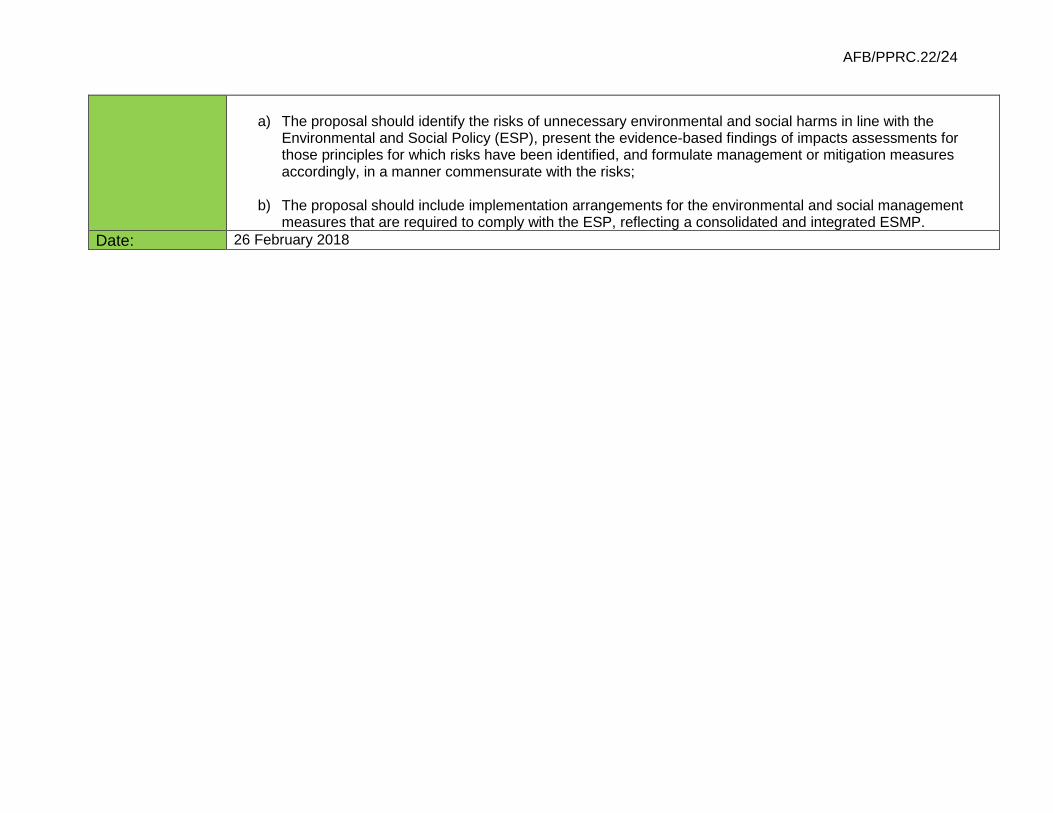
AFB/PPRC.22/24
a) The proposal should identify the risks of unnecessary environmental and social harms in line with the
Environmental and Social Policy (ESP), present the evidence-based findings of impacts assessments for those principles for which risks have been identified, and formulate management or mitigation measures accordingly, in a manner commensurate with the risks;
b) The proposal should include implementation arrangements for the environmental and social management
measures that are required to comply with the ESP, reflecting a consolidated and integrated ESMP. Date: 26 February 2018

1
ADAPTATION FUND BOARD SECRETARIAT TECHNICAL REVIEW OF PROJECT/PROGRAMME PROPOSAL
PROJECT/PROGRAMME CATEGORY: Regional Project
_________________________________________________________________________________________________________ Countries/Region: Chile, Ecuador Project Title: Reducing climate vulnerability in urban and semi urban areas in cities in Latin America Thematic Focal Area: Disaster risk reduction and early warning systems Implementing Entity: CAF Executing Entities: Ministry of the Environment, Chile and Ministry of the Environment, Ecuador AF Project ID: LAC/RIE/DRR/2015/1 IE Project ID: Requested Financing from Adaptation Fund (US Dollars): 13,910,400 Reviewer and contact person: Mikko Ollikainen Co-reviewer(s): Daouda Ndiaye IE Contact Person: Carolina Cortés Cardona
Review Criteria
Questions Comments 18 September 2017 Answers 15 January 2018
Country Eligibility
1. Are all of the participating countries party to the Kyoto Protocol?
2. Are all of the participating countries developing countries particularly vulnerable to the adverse effects of climate change?
Project Eligibility
1. Has the designated government authority for the Adaptation Fund endorsed the project/programme?
2. Does the regional project / programme support concrete adaptation actions to assist the participating countries in addressing the adverse effects of climate change and build in climate resilience, and do so providing added value through the regional approach, compared to implementing similar activities in each country individually?
3. Does the project / programme provide economic, social and environmental benefits, particularly to vulnerable communities, including gender considerations, while avoiding or mitigating negative impacts, in compliance with the Environmental and Social Policy and Gender Policy of the Fund?
4. Is the project / programme cost-effective and does the regional approach support cost-effectiveness?
5. Is the project / programme consistent with national or sub-national sustainable development strategies, national or sub-national development plans, poverty reduction strategies, national

2
communications and adaptation programs of action and other relevant instruments? If applicable, it is also possible to refer to regional plans and strategies where they exist.
6. Does the project / programme meet the relevant national technical standards, where applicable, in compliance with the Environmental and Social Policy of the Fund?
7. Is there duplication of project / programme with other funding sources?
8. Does the project / programme have a learning and knowledge management component to capture and feedback lessons?
9. Has a consultative process taken place, and has it involved all key stakeholders, and vulnerable groups, including gender considerations in compliance with the Environmental and Social Policy and Gender Policy of the Fund?
10. Is the requested financing justified on the basis of
full cost of adaptation reasoning?
11. Is the project / program aligned with AF’s results
framework?
12. Has the sustainability of the project/programme
outcomes been taken into account when designing the project?
13. Does the project / programme provide an overview of environmental and social impacts / risks identified, in compliance with the Environmental and Social Policy and Gender Policy of the Fund?
CR1: Partially addressed. An additional document “Environmental and Social Risk Analysis using the Adaptation Fund Principles. Ancillary document to CAF’s Environmental and Social Report (ESR)” has been provided and some of its information added to the application document. It is an addendum to one of the 20-odd annexes to the funding application. The justification of risks findings, now presented by ESP principles, remains inadequate, additional information is not provided and there are internal contradictions. (E.g., para 256, on Core labour rights, information is presented about (very) serious labour rights issues in both countries. Yet, the conclusion is ‘no risk’, without further substantiation. The same is stated on p. 8 of Annex 14, and repeated throughout. One other example: the risk of involuntary resettlement is at the time said to be
Modifications in the Full Proposal Document where made in sections: II. C. Describe how the project / programme would provide economic, social and environmental benefits, with particular reference to the most vulnerable communities, and vulnerable groups within communities, including gender considerations. Describe how the project / programme would avoid or mitigate negative impacts, in compliance with the Environmental and Social Policy of the Adaptation Fund. It was added the Measures to avoid / mitigate negative impacts page 50. II. F. Describe how the project / programme meets relevant national technical standards, where applicable, such as standards for

3
low (p. 72, Table 11, application document), medium (p. 26, Table 4, Annex 14, the ESMP) and high (p. 30, Annex 15.2).) The proposal should identify the risks of unnecessary environmental and social harms in line with the ESP, present the evidence-based findings of impacts assessments for those principles for which risks have been identified, and formulate management or mitigation measures accordingly, in a manner commensurate to the risks. The relevant information should be included in the main application document in a concise but adequate way. Any necessary additional documentation should be consistent with the information in the application document.
environmental assessment, building codes, etc., and complies with the Environmental and Social Policy of the Adaptation Fund. It was added the Complying with the Environmental and Social Policy of the Adaptation Fund. In page 61. Annex 14 and Annex 15 where modified completely using UNDP methodology as the executing entity but it was adjusted to comply with the AF Principles. Annex 14. Social and Environmental Risks Screening and Risk Identification ver. 2018 01 Annex 15. Environmental and Social Management Plan ver. 2018 01
CR2: Not addressed. The submission includes 21 annexes. E.g. p. 75, para 254 of the application document refers to: “The assessment is presented in Appendix 2 of Annex 15.” Three of the documents included in the submission are: (1) “Annex 15. CAF´s environmental and social impact assessment ver.4 English”; (2) “Annex 15. CAF´s SCREENING OF AF’S ENVIRONMENTAL AND SOCIAL PRINCIPLES ver.4”; and (3) “Annex 15.2. Environmental and Social Risk Assessment for Compliance with AF’s ESP-1” (sic). The proponent should consolidate the proposal and its components, following the application template, in a concise, coherent and clear manner, focusing on relevant information. There is e.g. no need for the proponent to provide extensive information and reports on its internal ESMS in relation to this project. The proponent is reminded that accreditation does not imply an acknowledgement of equivalence of its ESMS to the requirements of the ESP.
The document was adjusted taking into account the suggestion of “consolidate the proposal and its components, following the application template, in a concise, coherent and clear manner, focusing on relevant information”. Annex 14 and Annex 15 where modified completely using UNDP methodology as the executing entity but it was adjusted to comply with the AF Principles. The information of CAF’s Safeguards was erased.
14. Does the project promote new and innovative
solutions to climate change adaptation, such as new

4
approaches, technologies and mechanisms?
Resource Availability
1. Is the requested project / programme funding within the funding windows of the pilot programme for regional projects/programmes?
2. Are the administrative costs (Implementing Entity Management Fee and Project/ Programme Execution Costs) at or below 20 per cent of the total project/programme budget?
Eligibility of IE
3. Is the project/programme submitted through an eligible Multilateral or Regional Implementing Entity that has been accredited by the Board?
Implementation Arrangements
1. Is there adequate arrangement for project / programme management at the regional and national level, including coordination arrangements within countries and among them, and in compliance with the gender policy of the Fund? Has the potential to partner with national institutions, and when possible, national implementing entities (NIEs), been considered, and included in the management arrangements?
2. Are there measures for financial and project/programme risk management?
3. Are there measures in place for the management of for environmental and social risks, in line with the Environmental and Social Policy and Gender Policy of the Fund?
CR3: Partially addressed. Section III.C of the application form is limited to a number of mitigation and management actions the project intends to undertake in response to risks identified but does not provide information on implementation arrangements. The risk identification table along AF ESP principles has been added to Annex 14 and further elaborated for each activity. However, there remain issues with the risks identification as mentioned earlier, undermining the effectivity of the ESMP as described in Annex 14. The proposal should include implementation arrangements for the environmental and social management measures that are required to comply with the ESP, reflecting a consolidated and integrated ESMP.
Section III C. was modified based on the assessment of compliance with the environmental and social principles AF (Annex 14). For this 37 mitigation measures were defined and integrated into the project´s environmental and management plan (Annex 15).
4. Is a budget on the Implementing Entity Management Fee use included?
5. Is an explanation and a breakdown of the execution costs included?
6. Is a detailed budget including budget notes included?

5
7. Are arrangements for monitoring and evaluation clearly defined, including budgeted M&E plans and sex-disaggregated data, targets and indicators, in compliance with the Gender Policy of the Fund?
8. Does the M&E Framework include a break-down of how implementing entity IE fees will be utilized in the supervision of the M&E function?
9. Does the project/programme’s results framework align with the AF’s results framework? Does it include at least one core outcome indicator from the Fund’s results framework?
10. Is a disbursement schedule with time-bound milestones included?
Technical Summary The project objective is to reduce vulnerability to climate-related floods, mudflows and landslides in three coastal cities by
mainstreaming a risk-based approach to adaptation, building collaboration and networking, and developing a culture of adaptation. The project focus on the hydrometeorological hazards of mudflows in Antofagasta and Taltal, and flooding and landslides in Esmeraldas. The expected mid-term impacts are improved enabling conditions to sustain DRR adaptation in the three cities. In the long-term, it is expected that this will result in improved adaptive capacity. It is also envisioned that the lessons of the project are useful to other countries in Latin America and the Caribbean, and other regions of the world. The following clarification request are made: CR1: Please identify environmental and social risks for the project in compliance with the ESP. CR2: Please ensure consistency of information provided in various documents, and clarify which is the prevailing information regarding sections II.K and III.C of the application form. Please integrate the relevant information in the application form. CR3: Please complete section III.C in accordance with the findings related to environmental and social safeguarding identified elsewhere in the application, in an integrated, concise and coherent manner, and ensure that the project Environmental and Social Management Plan is based on the comprehensive, evidence-based environmental and social risks identification following the 15 ESP principles only.
Date: 17 Sept 2017


1
PART I: PROJECT/PROGRAMME INFORMATION
Title of Project/Programme: Reducing climate vulnerability and flood risk in
coastal urban and semi urban areas in cities in Latin America
Countries: Chile and Ecuador Thematic Focal Area1: Disaster risk reduction and early warning systems Type of Implementing Entity: Regional Implementing Entity (RIE) Implementing Entity: CAF, Development bank of Latin America Executing Entities: Ministry of the Environment (Chile)
Ministry of the Environment (Ecuador) Amount of Financing Requested: 13.910.400 (in U.S Dollars Equivalent)
1 Thematic areas are: Food security; Disaster risk reduction and early warning systems; Transboundary water management; Innovation in adaptation finance.
REGIONAL PROJECT/PROGRAMME PROPOSAL

2
Tabla de contenido PART I: PROJECT/PROGRAMME INFORMATION ............................................................ 1
Reducing climate vulnerability and flood risk in coastal urban and semi urban areas in cities in Latin America ...................................................................................................... 5
Chile and Ecuador ........................................................................................................... 5
Project Background and Context: .................................................................................... 5
National and local situation in Chile ................................................................................. 9
National and local situation in Ecuador .......................................................................... 17
Vulnerable groups and gender situation ........................................................................ 23
The adaptation challenge and barriers ........................................................................... 27
Project Objectives: ......................................................................................................... 30
Project Components and Financing: .............................................................................. 32
Projected Calendar ........................................................................................................ 33
PART II: PROJECT / PROGRAMME JUSTIFICATION .................................................... 34
A. Project Components Description ............................................................................... 34
Component 1. Priority actions to increase resilience .................................................. 34
Component 2. Strengthen capacities for adaptation ................................................... 44
Component 3. ICTs and partnership between coastal cities in Latin America ............ 46
Alternative approaches that were considered and not adopted .................................. 48
B. New and innovative solutions to climate change adaptation ...................................... 48
C. Economic, social and environmental benefits and mitigation of negative impacts, in compliance with the ESP of the Adaptation Fund. ......................................................... 49
Social benefits ............................................................................................................ 49
Economic benefits ...................................................................................................... 54
Environmental benefits ............................................................................................... 54
Gender considerations ............................................................................................... 54
Measures to avoid / mitigate negative impacts ........................................................... 55
D. Cost-effectiveness analysis with a regional approach ............................................... 56
E. Consistency with national or sub-national sustainable development strategies ......... 57
F. Meets relevant national technical standards (environmental, building others) complies with the ESP of the Adaptation Fund. ............................................................................ 63
Detailed description on expected outputs, relevant standards and procedures along with the measures to ensure compliance with ESP are elaborated below. ................. 63
Construction works..................................................................................................... 63
Environmental permits ............................................................................................... 64
Meteorological equipment and data ........................................................................... 65
Early warning systems ............................................................................................... 66
Complying with the Environmental and Social Policy of the Adaptation Fund. ............ 66

3
G. Describe if there is duplication of project with other funding sources ......................... 66
H. Learning and knowledge management component to capture and disseminate lessons learned. ......................................................................................................................... 67
I. Consultative process: List of stakeholders, with particular reference to vulnerable groups, including gender considerations, in compliance with the ESP of the Adaptation Fund. ............................................................................................................................. 68
Inception workshops .................................................................................................. 68
Stakeholder analyses ................................................................................................. 68
Validation workshops ................................................................................................. 70
Meetings of project partners ....................................................................................... 70
Additional consultation to local groups ....................................................................... 70
J. Provide justification for funding requested, focusing on the full cost of adaptation reasoning....................................................................................................................... 72
Component 1 ............................................................................................................. 72
Component 2 ............................................................................................................. 73
Component 3 ............................................................................................................. 74
K. Sustainability of the project outcomes ....................................................................... 74
Environmental sustainability ....................................................................................... 74
Social sustainability .................................................................................................... 74
Institutional sustainability ........................................................................................... 75
Financial sustainability ............................................................................................... 75
Replication ................................................................................................................. 75
L. Environmental and social impacts and risks identification in compliance with the ESP of the Adaptation Fund .................................................................................................. 76
PART III: IMPLEMENTATION ARRANGEMENTS ........................................................... 91
A. Arrangements for project management at the regional and national level .................. 91
Audit .......................................................................................................................... 92
Agreement on intellectual property rights and use of logo on the project’s deliverables .................................................................................................................................. 94
B. Describe the measures for financial and project risk management. ........................... 94
C. Describe the measures for environmental and social risk management, in line with the Environmental and Social Policy of the Adaptation Fund. .............................................. 96
D. Describe the monitoring and evaluation arrangements and provide a budgeted M&E plan. .............................................................................................................................. 97
Oversight and monitoring responsibilities ................................................................... 98
Monitoring and reporting requirements ....................................................................... 98
E. Include a results framework for the project proposal, including milestones, targets and indicators. .................................................................................................................... 101
F. Demonstrate how the project aligns with the Results Framework of the Adaptation Fund ............................................................................................................................ 107
G. Include a detailed budget with budget notes, broken down by country as applicable, a budget on the Implementing Entity management fee use, and an explanation and a breakdown of the execution costs. ............................................................................... 110

4
Budget ..................................................................................................................... 110
Budget notes ............................................................................................................ 117
Budget on the Implementing Entity management fee use ........................................ 128
H. Include a disbursement schedule with time-bound milestones. ............................... 128
List of annexes ................................................................................................................ 130
List of tables .................................................................................................................... 131
List of figures ................................................................................................................... 131
PART IV: ENDORSEMENT BY GOVERNMENTS AND CERTIFICATION BY THE IMPLEMENTING ENTITY ............................................................................................... 133
A. Record of endorsement on behalf of the government .............................................. 133

5
Reducing climate vulnerability and flood risk in coastal urban and semi urban areas in cities in Latin America
Chile and Ecuador
Project Background and Context: 1. Weather-related disasters have a major impact worldwide. Between 1995 and 2015, 90% of
disasters were weather-related and claimed 606,000 lives and affected about 4.1 billion people (UNISDR, 2015). Over the past 20-year period, floods and storms, respectively, accounted for 47% and 40% of all weather-related disasters (UNISDR, 2015).
2. In Latin America, the most obvious risk factor is El Niño Southern Oscillation (ENSO), a recurrent planetary climate phenomenon. El Niño (ENSO´s warm phase) produces an extreme increase in rain and floods in the Pacific coast and central part of South America (i.e., Argentina, Bolivia, south Brazil, Ecuador, Paraguay, Peru, and Uruguay), and a rain deficit and severe drought in Colombia, Venezuela, the Bolivian Andes, the Caribbean and northeast Brazil. The 1997 – 1998 El Niño, one of the strongest in record, produced USD7.5 billion in losses in five Andean countries2 (CAF, 2000a; CAF, 2000b; OPS, 2000). The most affected countries, at that time, were Ecuador (14.6 % of GDP), Bolivia (7% of GDP) and Peru (4.5% of GDP).
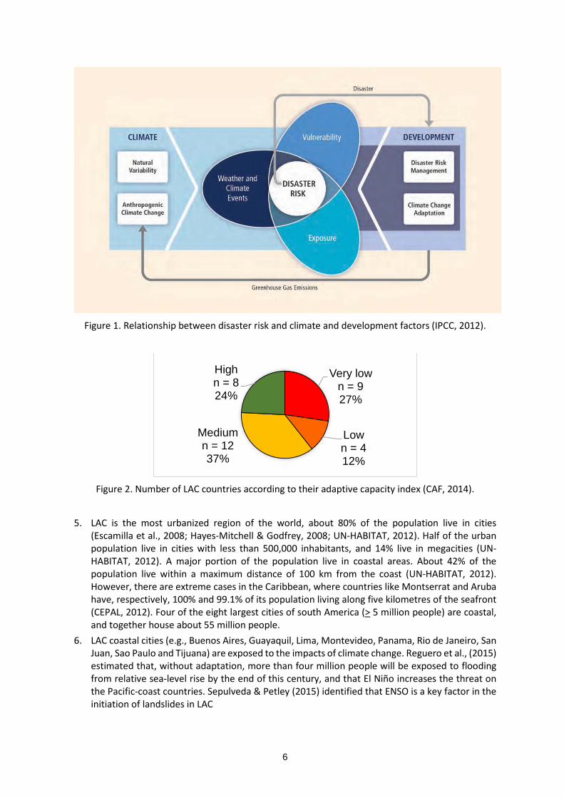
3. The projected climate change will be a major driver that will exacerbate hazards and disaster risk (Figure 1). Latin America and the Caribbean (LAC) is a very vulnerable area. Out of 33 countries, 10 are extremely vulnerable (30%) and eight are highly vulnerable (24%) to the impacts of climate change (CAF, 2014).
4. Coastal areas are more exposed and vulnerable to the negative effects of climate change and the impacts of weather-related disasters. Future sea level rise could severely impact coastal populations by inundation, flooding, coastal erosion and saltwater intrusion (Neumann et al., 2015). Hallegatte et al., (2013) estimated that flood-related loses in the world´s 136 largest coastal cities could increase from ca., USD 6 billion / year in 2005 to USD 52 billion / year by 2050 with projected socio-economic change alone. Climate change could further increase losses to about one trillion per year. In addition, it is anticipated that climate change will produce stronger and more frequent coastal storms and ENSO events (Cai et al., 2014; Cai et al., 2015).
2 i.e., Bolivia, Colombia, Ecuador, Peru, and Venezuela.
6
Figure 1. Relationship between disaster risk and climate and development factors (IPCC, 2012).
Figure 2. Number of LAC countries according to their adaptive capacity index (CAF, 2014).
5. LAC is the most urbanized region of the world, about 80% of the population live in cities
(Escamilla et al., 2008; Hayes-Mitchell & Godfrey, 2008; UN-HABITAT, 2012). Half of the urban population live in cities with less than 500,000 inhabitants, and 14% live in megacities (UN-HABITAT, 2012). A major portion of the population live in coastal areas. About 42% of the population live within a maximum distance of 100 km from the coast (UN-HABITAT, 2012). However, there are extreme cases in the Caribbean, where countries like Montserrat and Aruba have, respectively, 100% and 99.1% of its population living along five kilometres of the seafront (CEPAL, 2012). Four of the eight largest cities of south America (> 5 million people) are coastal, and together house about 55 million people.
6. LAC coastal cities (e.g., Buenos Aires, Guayaquil, Lima, Montevideo, Panama, Rio de Janeiro, San Juan, Sao Paulo and Tijuana) are exposed to the impacts of climate change. Reguero et al., (2015) estimated that, without adaptation, more than four million people will be exposed to flooding from relative sea-level rise by the end of this century, and that El Niño increases the threat on the Pacific-coast countries. Sepulveda & Petley (2015) identified that ENSO is a key factor in the initiation of landslides in LAC
Very lown = 927%
Lown = 412%
Mediumn = 1237%
Highn = 824%

7
7. Adaptation measures are crucial to reduce the risk of severe human and property losses in the coastal areas. However, in LAC the adaptation capacity is quite diverse (Figure 2). Thirteen out of 33 countries (39%) have very low and low adaptation capacity. Also, the population of coastal cities tend to be more vulnerable to climate change. Three of the four largest coastal cities of LAC have very high vulnerability index3, and the other has a high vulnerability index4 (CAF, 2014). But the same occurs in smaller cities like Cartagena (1.48 vulnerability index = very high), Panama (2.7 vulnerability index = high) and Montevideo (2.91 vulnerability index = high).
8. The present project focus on the impacts of climate-related risk in coastal cities of LAC. The projected climate change will increase the sea level, modify and intensify the seasonal periods of rain and drought, and result in stronger and more frequent weather events like coastal storms and ENSO. This will in turn, intensify hydro-meteorological hazards and disasters like floods, mudflows and landslides, and produce casualties and economic and infrastructure losses.
Figure 3. Location of Esmeraldas, Antofagasta and Taltal.
9. The purpose of this regional project is to generate lessons on increasing adaptive capacity to be
useful in coastal cities of Latin America and the Caribbean. The governments of Chile and Ecuador have agreed to collaborate and jointly implement an action learning approach to address the issues of climate change adaptation in coastal cities.
10. For this, the governments of Chile and Ecuador have decided to develop practical actions in three small coastal cities (less than 500,000 inhabitants): Antofagasta and Taltal in Chile, and Esmeraldas in Ecuador.
11. These cities were chosen because they:
3 This index takes into consideration human factors like poverty, education level, access to health services, enforcement of land-use regulations, and displacement. See CAF (2014). 4 Lima has a 1.65 vulnerability index (very high), Rio de Janeiro has 2.12, Sao Paulo has 2.3, and Buenos Aires has 2.55 (high).
8
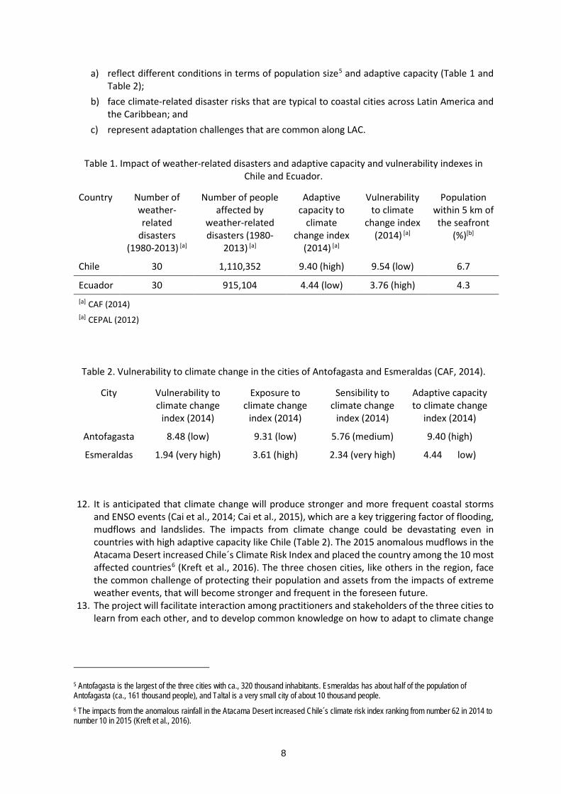
a) reflect different conditions in terms of population size5 and adaptive capacity (Table 1 and Table 2);
b) face climate-related disaster risks that are typical to coastal cities across Latin America and the Caribbean; and
c) represent adaptation challenges that are common along LAC.
Table 1. Impact of weather-related disasters and adaptive capacity and vulnerability indexes in Chile and Ecuador.
Country Number of weather-related
disasters (1980-2013) [a]
Number of people affected by
weather-related disasters (1980-
2013) [a]
Adaptive capacity to
climate change index
(2014) [a]
Vulnerability to climate
change index (2014) [a]
Population within 5 km of the seafront
(%)[b]
Chile 30 1,110,352 9.40 (high) 9.54 (low) 6.7
Ecuador 30 915,104 4.44 (low) 3.76 (high) 4.3 [a] CAF (2014) [a] CEPAL (2012)
Table 2. Vulnerability to climate change in the cities of Antofagasta and Esmeraldas (CAF, 2014).
City Vulnerability to climate change
index (2014)
Exposure to climate change
index (2014)
Sensibility to climate change
index (2014)
Adaptive capacity to climate change
index (2014)
Antofagasta 8.48 (low) 9.31 (low) 5.76 (medium) 9.40 (high)
Esmeraldas 1.94 (very high) 3.61 (high) 2.34 (very high) 4.44 low)
12. It is anticipated that climate change will produce stronger and more frequent coastal storms
and ENSO events (Cai et al., 2014; Cai et al., 2015), which are a key triggering factor of flooding, mudflows and landslides. The impacts from climate change could be devastating even in countries with high adaptive capacity like Chile (Table 2). The 2015 anomalous mudflows in the Atacama Desert increased Chile´s Climate Risk Index and placed the country among the 10 most affected countries6 (Kreft et al., 2016). The three chosen cities, like others in the region, face the common challenge of protecting their population and assets from the impacts of extreme weather events, that will become stronger and frequent in the foreseen future.
13. The project will facilitate interaction among practitioners and stakeholders of the three cities to learn from each other, and to develop common knowledge on how to adapt to climate change
5 Antofagasta is the largest of the three cities with ca., 320 thousand inhabitants. Esmeraldas has about half of the population of Antofagasta (ca., 161 thousand people), and Taltal is a very small city of about 10 thousand people. 6 The impacts from the anomalous rainfall in the Atacama Desert increased Chile´s climate risk index ranking from number 62 in 2014 to number 10 in 2015 (Kreft et al., 2016).

9
and to reduce the associated disaster risk. For this purpose, thematic communities of practice7 (Lave & Wenger, 1991; Wenger, 1998; Wenger et al., 2002) will be established to allow the development of collective learning on specific topics among the three cities. An electronic platform (Figure 21) will facilitate collaboration among project participants, and to share lessons in LAC. It is envisioned that the electronic platform will motivate interest and involvement on risk-based adaptation in coastal cities in the region.
Table 3. Exclusive and non-exclusive functions of Chilean municipalities (Letelier, 2006).
Exclusive functions Non-exclusive functions
(1) Preparation, approval, and modification of the municipal development plan according to the legal norms in force
(2) Local planning, regulation, and design of the building regulation according to the legal norms in force
(3) Promotion of community development (4) Enforcement of norms on
transportation and public transit on the basis of the general laws defined by the corresponding ministry
(5) Implementation of local arrangements for construction and urbanization on the basis of general laws defined by the corresponding ministry
(6) Community cleaning and adornment
(1) Education and culture (2) Public health and environmental
protection (3) Legal and social assistance (4) Job training, employment, and
productive promotion (5) Tourism, sport, and recreation (6) Urbanization and urban and rural roads (7) Construction of social housing and
sanitary infrastructure (8) Public transportation and transit (9) Risk prevention and assistance in
emergencies or catastrophic situations (10) Support, promotion, and
enforcement assistance for town security measurements
(11) Promotion of equity between men and women
(12) Development of common interest local activities
National and local situation in Chile 14. The Republic of Chile is located in the southern cone of South America. It has a continental land
surface of 756,096 km2 (i.e., the seventh largest nation in South America). In addition, Chile has a large extent of islands and islets (the most conspicuous are the Juan Fernandez archipelago and Pascua Island) and Antarctic territory. The country has a long coastline stretching for about 6,435 km (the world´s 20th largest coastline). The coastal plain extends from the seafront inland until the Chilean Coast Range.
15. The country has a wide range of climate conditions, ranging from warm and cold deserts in the far north, to tundra in the far south. The climate is mainly influenced by the Pacific Anticyclone,
7 Communities of practice are groups of people who share a concern, a set of problems, or a passion about a topic, and who deepen their knowledge and expertise in this area by interacting on an ongoing basis (Wenger et al., 2002).

10
the southern circumpolar low-pressure area, the cold Humboldt current, the Chilean Coast Range8 and the Andes Mountains.
16. In 2002, Chile had 15,116,435 people9. Women and ethnic groups constituted 50.7% and 4.6% of the population, respectively. Most people lived in cities; 86.6% was urban population. It is projected that Chile´s population in 2020 will be 18.896.684 people. The largest cities are Santiago (ca., 6.1 million people), Concepción and Valparaiso (ca., 1 million people each).
17. The country has a Global Gender Gap Index of 0.69810 (Annex 10), there is almost complete equality in educational attainment and health and survival, but major gaps in political empowerment and economic participation and opportunities (WEF, 2015).
18. The territory is organized into 15 regions, 54 provinces and 346 communes. They are administered in the following way: Regions are headed by an Intendent, who is appointed by the President of the Republic.
Ministries have regional secretaries (SEREMI) which together constitute a regional cabinet that advise the Intendent. The Regional Government prepare and implement the Regional Development Strategy.
The provinces are headed by a governor, also appointed by the President of the Republic. The provincial government coordinate the central government decentralized services.
The communes are administered by a municipality, headed by an alcalde (i.e., mayor) and a communal council who are elected by public vote. The Municipal government has a set of exclusive and non-exclusive functions (Table 3) and prepare and implement the Communal Development Plan (PLADECO).
At the local level neighbours can form "juntas de vecinos" (neighbourhood councils). These are not-for-profit community organizations (regulated by Law 19,418 of 1997), that promote community development, defend the interests and rights of the neighbours and collaborate with government authorities and municipalities.
8 This is a range which runs along the coast, parallel to the Andes for about 3,000 km. It extends from Morro de Arica in the north (Región de Arica y Parinacota or 15th Region) to Taitao Peninsula (Región de Aysén or 11th Region) in the south. The highest point is Cerro Armazones (ca., 3.064 m altitude) in the Antofagasta region. 9 Source: XVII National Population Census and VI Housing Census. The 2012 census was considered deficient and the information was not published by the Instituto Nacional de Estadísticas (INE). A new census was organised and executed on 19 April 2017. The results of the 2017 census have not been made public, it is anticipated that the information will be available on August 2017. 10 0.00 = inequality / 1.00 = equality.

11
Figure 4. Location of the city of Antofagasta and Taltal.
19. The city of Antofagasta is (a) the capital of the Antofagasta Region11 (Region II) and the
Antofagasta province, and (b) the seat of the Antofagasta commune12. The city has about 390 thousand people and is the country´s sixth largest city13. It is located in the coastal plain of the Atacama Desert, annual rainfall is about 1.7 mm / year. The economy is centred in copper mining. Antofagasta has the country’s highest per capita income, about USD 23,000 per year. The poverty level is low (ca., 5%) and houses have almost full access to potable water, sanitation and electricity14.
20. The Atacama Desert ecoregion occupies a continuous strip for nearly 1,600 km along the narrow coast of the northern third of Chile from near Arica (18°24' S) southward to near La Serena (29°55' S) (Dillon and A. E. Hoffmann-J 1997). This desert is a sparsely populated virtually rainless plateau, running east from the Pacific Ocean to the Andes Mountains. The average width is less than 100 km. The xeric conditions extend up to1,500 masl on the drier slopes (Börgel 1973). The faulted coastal mountains (mostly 500-1000 m high) are composed of Cretaceous sediments (limestone and sandstone) over more ancient masses of crystalline rocks (Lustig 1970).
21. The Atacama Desert is considered to be one of the driest coastal deserts in the world. Vegetation must contend with an annual rainfall of 0.6 mm in Arica and 2.1 mm in Iquique. The Atacama becomes slightly less arid as it moves southward. The average monthly temperatures
11 The Antofagasta Region contain three provinces (i.e., Antofagasta, El Loa and Tocopilla) and nine communes. 12 In the present document, the term “Antofagasta” will be used to refer to the city of Antofagasta, unless otherwise indicated. 13 Antofagasta is Chile´s most urbanized region. In 1960 the region had 94.8% of urban population, this figure increased to 97.7 in 2002 (INE, 2008). 14 In 2010, the urban population of Antofagasta region had 100% cover of potable water and 99.7% cover of sewage system. In 2013, 7.1% of houses of the Antofagasta commune had a deficit in sanitation (MDS, 2014a).

12
in Iquique range from 14.5 oC in September to 21 oC in March (Dillon and A. E. Hoffmann-J 1997).
22. Topography and substrate combine to influence the patterns of moisture availability and areas of suitable habitat. Where isolated mountains or steep coastal slopes intercept the clouds, a fog zone develops with a stratus layer concentrated against the hillsides. The moisture allows the development of fog-zone plant communities termed "lomas" (small hills) near the coast and in lower portions of numerous gorges ("Quebradas") between sea level and 1,100 m. These plant formations also have been called the fertile belt, fog oases or meadows on the desert. Plant communities of the lomas consist of mixtures of annual and short-lived perennial and woody scrub vegetation.
23. Antofagasta has developed bordering the seafront along a narrow strip (Figure 5). The inland limit is a set of coastal hills (part of the Chilean Coast range) that are cutted by 17 gorges (called “Quebradas”) which drain into the city.
Figure 5. Antofagasta’s Quebradas - Gorges.
Figure 6. Downhill view of Quebrada Bonilla Sur.

13
24. Despite the general high living conditions, Antofagasta has informal neighbourhoods (called campamentos15) mainly on the upper hillsides (Figure 9). These are unplanned illegal occupations of public land with deficient infrastructure and services, and roughly constructed houses. Access to affordable housing is a national issue. On this respect, the Ministry of Housing and Urban Development (MINVU) implements a national policy to provide housing solutions to campamento dwellers. Complementary, the Antofagasta Regional Government (ARG) implements a plan to confront the key factors that motivate the appearance and expansion of campamentos (GORE Antofagasta, 2015).
25. The number of people living in campamentos has increased in the recent years. Until May 2014, there were 17 campamentos (608 families) (TECHO, 2013; TECHO, 2014). The oldest was established in 1975 (campamento Juanita Cruchaga), and the most recent in 2012 (campamento Génesis) (TECHO, 2014). The latest figures, from the 2016 cadastre, indicate 44 campamentos16, where 4,593 families lived (TECHO, 2016) (Figure 9).
26. In the 2015 poll, it was found that women and persons with disabilities constituted, respectively 52.4% and 3.2% of the population of the campamentos (GORE Antofagasta, 2015a). Fifty-one percent were female-headed households. On average, settles had lived 1.5 years in the campamentos.
27. Most of the settlers were South American immigrants17 (GORE Antofagasta, 2015a; Santana, 2015; TECHO, 2015), and most had migrated to Chile seeking working opportunities (72.6%); 5.9% had migrated because of security reasons. About half of them did not know for how long they will stay in the country18 (51.3%) and send remittances to their countries of origin (48.7%). A small number of immigrants had an irregular condition (3.4%), and 0.1% were refugees (GORE Antofagasta, 2015a). Campamento dwellers have indicated that a key factor is the difficulty to access affordable housing.
28. In the Antofagasta region, people settle in campamentos mostly because of the high cost of house rental and limitations to access affordable housing (TECHO, 2015). Because of their irregular land-tenure, campamento dwellers cannot formally access public services. TECHO (2015) found that, in the campamentos of the Antofagasta region, 20.6% of the houses have individual water meters (i.e., formal access), 41.2% have informal connections to the public water network, and the others get water from different sources (e.g., tankers, wells). Similarly, only 1.5% of the houses have individual electricity meters, 7.3% of the houses have communal electricity meters, 89.8% have clandestine electricity connections, and 1.5% do not have electricity. Finally, only 6.3% of the houses are connected to the public sewage system, 51.7% use septic tanks, 39.5% use pit latrines, and 2.4% do not have toilets.
15 The illegal occupation of land is called toma, and the irregular settlement is called campamento. The official definition of campamento used by the Ministry of Housing and Urban Development (MINVU) is “‘settlements, usually found in urban areas, of more than eight families living on an irregular land tenure, lacking at least one of the three basic services (electricity, drinking water and sewage system) whose homes are closely grouped together’” (MINVU, 2012). The development of tomas and campamento is a common issue along Chile. It is common that the campamentos develop on unstable hillsides like in Valparaiso (Pino & Ojeda, 2013). The national cadastre of 2016 recorded 660 campamentos, where 38,770 families lived (ca., 116,310 persons) (TECHO, 2016). 16 This is 78.6% of the campamentos of the Antofagasta region. The campamentos of this region are found mostly in three communes (i.e., Antofagasta, Taltal and Calama) and are located mostly in urban areas (92.9%) (TECHO, 2016). 17 GORE Antofagasta (2015a) and Santana (2015) report: 40,2% Chileans, 18.8% Colombians, 14.7% Peruvians, 14.4% Bolivians, 2.6% Ecuadorians, and 8.8% other. 18 The other indicated time spans up to 10 years.

14
Figure 7. Types of houses in campamentos in Antofagasta (Visit July 2017).
Figure 8. Neighbourhood close to Quebrada Bonilla Sur
Figure 9. Campamentos in the city of Antofagasta. Source: 2016 national cadastre.

15
29. Taltal is a small city (ca., 10,400 people in 2013) located about 195 km south of Antofagasta. It
is also located in the coastal plain of the Atacama Desert, at the end-point of a large canyon (Figure 10). In 2011 the poverty level was very low (2.7%), well below the national average (INE, 2014b). About 25.1% of houses have sanitation deficit, which is well above the national and regional deficits (i.e., 17.0% and 13.7%) (INE, 2014b).
30. Taltal also has campamentos, though the information available is not as detailed as for Antofagasta. Until May 2014, there were two campamentos with 67 families, one established in 2004 (Tiro al Blanco, 55 families) and the other in 2005 (Eusebio Lillo, 12 families) (TECHO, 2013; TECHO, 2014). The most recent information, from the 2016 cadastre, indicate six campamentos with 400 families (TECHO, 2016) (Figure 11, Table 4).
Figure 10. Location of Taltal.
Table 4. Campamentos in Taltal. Source: TECHO (2016).
Campamento name Year established Number of families
Tiro al Blanco 2004 55
Eusebio Lillo 2005 15
22 de enero 2013 65

16
Luchando por nuestro hogar 2015 210
Vida nueva 2015 30
Salvador Allende 2015 25
Figure 11. Location of campamentos in Taltal.
31. Both cities are located in the Atacama Desert, and consequently have very dry conditions.
However, the entire region has been affected by intense mudflows caused by flash floods generated by unusual heavy rain. The area is extremely dry and devoid of vegetation; therefore, the hard ground cannot absorb unusual rain.
32. The strongest mudflow recorded was in 199119 and was caused by unexpected and sporadic heavy rain (recorded rainfall about 42 mm). The balance was 91 dead,16 missing persons, 8,000 refugees and about USD 71 million in losses (ONEMI, 1994; Melin, 2011). The most recent mudflows occurred in March 2015 in Taltal, and August 2015 in Tocopilla20. The March 2015 event affected southern Peru and northern Chile. Campamentos are more vulnerable to mudflows because they tend to locate on the hillsides.
33. Vargas & Ortlieb (1997) found records of seven events of heavy and intense rain between 1916 and 1991. In all cases Antofagasta was flooded, but five times mudflows developed21. Garreud & Rutllant (1996) and Vargas et al., (2000) found that the unusual rain episodes which produce
19 There were mudflows in three coastal cities of the Antofagasta region: Antofagasta, Taltal and Tocopilla. 20 A coastal city located about 200 km north of Antofagasta. The 2015 mudflow killed three people and 830 people had to be evacuated. 21 i.e., August 1930, June 1940, May 1982, July 1987 and June 1991.

17
mudflows are linked to ENSO conditions. Liberto (2015) explain the conditions that generated the 2015 event.
34. After the 1991 mudflow, protection works were built in priority gorges of Antofagasta22 and in Taltal. Taltal was supposed to be protected with the existing infrastructure. However, in March 2015 the structural measures were insufficient to withhold the strong alluvial flows. A key issue is that existing infrastructure do not incorporate the climate change factor.
35. The present project contributes to implement Chile´s national environmental policy expressed in the National Adaptation Plan (MMA, 2014) and the Climate Change National Action Plan 2017-202223 (PANCC-II). These national plans provide strategic guidance for the preparation of nine sectoral plans. Two sectoral plans are related to the present project: (i) the Climate Change Adaptation plan for Cities (to be ready during 2017), and (ii) the Climate Change Adaptation Plan for Infrastructure (under development). The present project will be the first initiative to contribute to implement the adaptation plan for cities.
Figure 12. Location of Mudflow Control Infrastructure in Antofagasta.
National and local situation in Ecuador 36. The Republic of Ecuador is located on the northwest of South America. It has a land surface of
257,217 km2, including the Galapagos archipelago (i.e., the ninth largest nation in South America). The country has 2,859 km of continental coastline. The most notable coastal
22 Infrastructure has been built in four gorges (Quebradas in Spanish): Salar del Carmen, La Cadena, El Ancla and Baquedano. Infrastructure for six additional Quebradas is included in the Antofagasta´s Regional Government – MOP project (i.e., Farellones, La Chimba, El Toro, Jardines del Sur, Riquelme, Uribe). The other five Quebradas do not have a source of funding: Club Hípico, Bonilla, Caliche, Universidad de Antofagasta, and El Huáscar. 23 The PANCC-II is currently under consultation. The process will finish on 4 August 2016. The consultation workshop in Antofagasta was held on 12 July 2016.
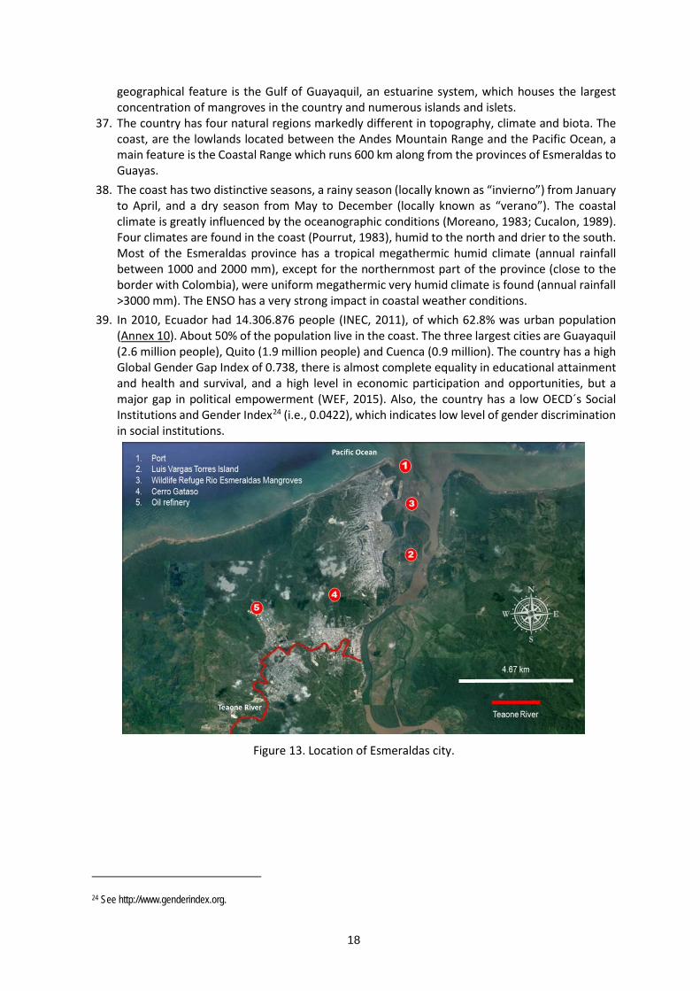
18
geographical feature is the Gulf of Guayaquil, an estuarine system, which houses the largest concentration of mangroves in the country and numerous islands and islets.
37. The country has four natural regions markedly different in topography, climate and biota. The coast, are the lowlands located between the Andes Mountain Range and the Pacific Ocean, a main feature is the Coastal Range which runs 600 km along from the provinces of Esmeraldas to Guayas.
38. The coast has two distinctive seasons, a rainy season (locally known as “invierno”) from January to April, and a dry season from May to December (locally known as “verano”). The coastal climate is greatly influenced by the oceanographic conditions (Moreano, 1983; Cucalon, 1989). Four climates are found in the coast (Pourrut, 1983), humid to the north and drier to the south. Most of the Esmeraldas province has a tropical megathermic humid climate (annual rainfall between 1000 and 2000 mm), except for the northernmost part of the province (close to the border with Colombia), were uniform megathermic very humid climate is found (annual rainfall >3000 mm). The ENSO has a very strong impact in coastal weather conditions.
39. In 2010, Ecuador had 14.306.876 people (INEC, 2011), of which 62.8% was urban population (Annex 10). About 50% of the population live in the coast. The three largest cities are Guayaquil (2.6 million people), Quito (1.9 million people) and Cuenca (0.9 million). The country has a high Global Gender Gap Index of 0.738, there is almost complete equality in educational attainment and health and survival, and a high level in economic participation and opportunities, but a major gap in political empowerment (WEF, 2015). Also, the country has a low OECD´s Social Institutions and Gender Index24 (i.e., 0.0422), which indicates low level of gender discrimination in social institutions.
Figure 13. Location of Esmeraldas city.
24 See http://www.genderindex.org.

19
Figure 14. Luis Vargas Torres Island.
Figure 15. Direction of Cerro Gatazo in Esmeraldas.

20
Figure 16. Exposure to sea level rise (SLR) in the City of Esmeraldas (Sierra et al., 2009).
Figure 17. Location of the largest landslide of January 2016 (Image google earth 2017).
21
40. The territory is organized into 24 provinces, 221 cantons, and 1,500 rural parishes. They are
administered in the following way: Provinces are headed by a prefecto and a provincial council, who are elected by public vote.
Provincial governments (also called Prefecturas) are responsible for constructing and maintaining the provincial road network, and for environmental management, and the administration of water basins and irrigation systems. They also promote farming production.
The cantons are administered by a municipality, headed by an alcalde and a municipal council, who are elected by public vote. The municipal government has a set of competences established by law, those relevant to the present project are (i) to prepare and implement the Development and Land Use Plan (PDOT), (ii) to manage and control land use, (iii) to provide public sanitation services (potable water, garbage collection, sewers and drainage), and (iv) to administer civil defence and fire brigades. The mayor heads and coordinates the canton´s Risk Management Committee (CGR) and the Emergency Operations Committee (COE)25.
The rural parish council (elected by public vote) plan the development and land-use planning of the parish in coordination with the municipal and provincial governments. They also encourage citizen organization and the development of community productive activities.
41. The city of Esmeraldas is the capital of the Esmeraldas province. In 2010, the city had 161,868 people (52.1% women). The majority were afro-ecuadorians (56.5%), the second ethnic group were mestizos (37%); indigenous groups constituted 0.7% of the population. The local economy is very diverse. In the 2010 census, the three main activities were commerce, teaching and agriculture26. The city has a major port with cargo, oil and fisheries terminals, and Ecuador´s main oil refinery. However, the poverty level is high. In 2010, 57% of the population had unsatisfied basic needs (NBI) (national 60.1%). The access to water, sewage system, electricity and waste disposal was, respectively, 75.3%, 56.6%, 79.5%, and 77.6%. Esmeraldas has a major issue of informal and un-planned expansion. In 2014, about 70% of the urban area was not in the cadastre.
42. Afro-ecuadorians are considered a vulnerable group. At the national level, this group has lower development indicators than other ethnic groups (with the exception of indigenous people). For example, in 2014 the living conditions survey (ECV) registered for afro-ecuadorians: (i) mean years of schooling 9 years (country level 9.8%), (ii) adult illiterate population >15years 7.5% (country level 7.2%), and (iii) functional illiteracy 13.4% (country level 12.7). In 2015, the urban survey of employment and unemployment, registered for afro-ecuadorians income poverty 31.6% (country level 23.3%) and NBI poverty 35.8% (country level 32.9%).
43. The city is located on the west bank of the Esmeraldas estuary (Figure 13). The seafront is a sandy beach, and along the riverside there are a series of sedimentary islands that have been heavily intervened. The most conspicuous is Luis Vargas Torres island which has been populated by informal un-planned neighbourhoods. The island is connected to the east bank of the river and the city by bridges and a main road (Figure 14).
44. In Esmeraldas it exists, the Wildlife Refuge Mangroves of Esmeraldas27 located at the mouth of the Esmeraldas River in the Pacific Ocean, between the city of Esmeraldas and the parish of
25 The CGE is a permanent committee focused on risk reduction. The COE functions to attend emergencies and disasters. The Ecuadorian risk management and emergency response system (including early warning) is managed by the Risk Management Secretariat (SGR). 26 Includes, agriculture, animal husbandry and fishing. 27 This national protected area, created in 2008, encompasses the remnant mangroves of the city; it has an area of 242 ha of which ca., 37% are mangroves and tropical dry scrubland.

22
Tachina, where the airport is located. The area includes the mangroves that exist at the mouth of the Esmeraldas River and a nearby area with patches of dry scrub. The mangroves found in this estuary are the last remnants of the extensive forests that existed in the area and that were transformed due to the advance of the city of Esmeraldas and the increase of agricultural areas and pools for shrimp farming. It is an area little known and visited due to the limitations of access and the lack of tourist infrastructure. The project area does not include Ramsar sites or Biosphere reserves. Mangroves in this estuary are the last remnants of the wide-reaching forests once stretching over the area and later transformed by the advance of the Esmeraldas city, and the increase of farming areas and pools for shrimp farming. This is a little-known and rarely-visited area because of access constraints and a lack of touristic infrastructure. Three types of mangrove are present in this protected area: Rhizophora mangle (red mangrove), Laguncularia racemosa (white mangrove) and Avicenia germinans (black mangrove). Some areas have even been invaded by the Acrostichum aureum (ranconcha fern).
45. In Island Luis Vargas Torres, seven types of herons thrive in this protected habitat: White, blue, snowy, striated, brunette, crab-fishing and coronine herons. Their habitat are the mangroves and they can be sighted when they are returning from their eating forages. The area is also the habitat for seagulls, frigates, pelicans, kingfisher, piures, beach shoe, ospreys, jacanas, cormorants, water birds, and swallows. This wildlife´s habitat is located along the Luis Vargas Torres Island mangrove strip; however, an estimation has been made that project´s intervention in this area will be minimal, since these interventions will be implementing disaster risk reduction, early warning systems, local capacity-building components among other activities. A Management Plan is in place at the reserve, as approved by the Ministry of the Environment in year 2015. Due to the presence of the Mangrove Wildlife Refuge, Esmeraldas River Estuary on the Luis Vargas Torres Island, it is important to be aware that the conservation of this may act as an adaptation measure. The project actions will concentrate at the north area of the Luis Vargas Torres Island.in urban areas and will not intervene areas with high value biodiversity.
46. Esmeraldas is divided by Cerro Gatazo (a 260 m height hill) which forms a natural barrier (Figure 13 and Figure 15). Further south the city has developed on the sides of the Teaone river. This river runs northward and makes an eastward turn to join the Esmeraldas river.
47. The area is very humid, annual rainfall in the city is about 800 mm28. The Esmeraldas river drains a 21,553 km2 watershed, it is the country´s fourth largest watershed. The main tributaries are the rivers Guayllabamba and Toachi (which originate in the Andes) and Quininde (which originates in the coastal ridge). It has a flow rate of ca., 300 m3/s and a sediment discharge of ca., 13,000 t/day. The inter-annual mean discharge is 8.5 billion m3. The Teaone river drains a 504,89 km2 watershed with an inter-annual mean discharge of 370 million m3.
48. The main weather-related risks are flooding by overflow of the Esmeraldas and Teaone rivers, and landslides on the unstable hillsides. Exposure is aggravated by informal and illegal occupation of land along the riverbanks, the sedimentary islands, and the hillsides (Perrin et al., 1998). By 2007, about 60% of the population lived in areas with medium to high risks of floods or landslides (Sierra et al., 2009).
49. The predicted climate change points to hotter and more humid conditions and stronger and more frequent ENSO. In the past, El Niño has aggravated floods and landslides. El Niño 1997 / 1998 destroyed public infrastructure like roads and the water system (CAF, 2000a), and the landslides destroyed about 300 houses (Perrin et al., 1998). The most recent impact was during El Niño 2015 / 2016, between January and April 2016 the city was flooded 20 times, about 16,000 people had to be evacuated (Bonilla, 2016a). Only in January 2016, about 2,600 people had to be evacuated when the Luis Vargas Torres island was flooded (Bonilla, 2016b). The heavy
28 The 1949 – 1984 annual average recorded in the local weather station (Esmeraldas – INOCAR) was 827.3 mm / year. The 1943-1991 annual average in the airport (Esmeraldas - Tachina) was 800.2 mm / year.
23
rain also produced landslides. The largest one was in January 2016, in Cerro Gatazo at the end of El Oro street (calle El Oro) (Figure 17), but the sustained rain produced that earth continued to move downhill until February.
50. Cerro Gatazo has been a main concern for years. The slopes are intervened, showing a mixture of eroded and barren areas and vegetated areas with grasses and trees. In Cerro Gatazo there are identified more than 15 species of flora such as: Panicum maximum, Cecropia sp., Cordia alliodora, Guadua angustifolia, Heliconia sp., Vernonia baccharoides, Ochroma paramidale, Sida acuta, Albisia guachapele, Inga eduli, Piper aduncum, Mangifera indica, which are not classified as highly valued. During the risk assessment visit and the recognition of the area for the development of the full proposal it was observed that Cerro Gatazo is already an intervened area which has a biodiversity based on pastures. At the beginning of the 2000s, the risk factors were studies and recommendations made (MAE, 2002), and a one-year vegetation trial using vetiver (Chrysopogon zizanioides) was executed in four sites of Cerro Gatazo (PNUD, 2005). It was found that vetiver was useful to stabilise the hillsides, but the local population showed low involvement in addressing the hazard. In 2010, the Risk Management Secretariat prepared the baseline studies and a project to build the infrastructure needed to stabilise the hillsides and channel rainwater. The project was presented to CAF as part of a loan to the Government of Ecuador, but was later withdrawn29.
51. In addition to flooding and landslides, sea level rise could produce that between three and six percent of the city would be temporarily or permanently under water (Sierra et al., 2009). The sedimentary islands and Tachina (where the airport is located) would be the most affected areas (Figure 16).
52. The present project contributes to implement Ecuador´s National Climate Change Strategy (MAE, 2012) and Esmeraldas´ Municipal Climate Change Adaptation and Mitigation Strategy (ONU-HABITAT, 2011).
Vulnerable groups and gender situation 53. According to the Adaptation Fund (AF, 2016), marginalized and vulnerable groups30 include
children, women and girls, the elderly, indigenous people, tribal groups, displaced people, refugees, people living with disabilities, and people living with HIV/AIDS, as well as any groups identified additionally such as seasonal migrants or illegal aliens. The population characteristics in the three cities is summarised in Table 5.
Table 5. Vulnerable groups in Antofagasta, Taltal and Esmeraldas.
Population group
Antofagasta commune
Taltal commune
Campamentos Esmeraldas (canton)
Total population
389,812a 13,296 a Antofagasta 4,593 families g (ca.,
13,779 persons) Taltal
400 families g (ca., 1,200 persons)
154,035 j
29 Ecuador´s Risk Management Secretariat contracted the baseline studies and design of the infrastructure to stabilize Cerro Gatazo hillsides and to channel rainwater to prevent landslides. The project was submitted to CAF as part of a large infrastructure loan request of the Ecuadorian government. But latter the Ministry of Finance modified the loan constituents and took out Cerro Gatazo and other elements, because CAF´s available line of credit was insufficient to cover all the investments that Ecuador required. 30 The definitions of marginalized and vulnerable groups can be found in Annex 2 of the present document.
24
Population group
Antofagasta commune
Taltal commune
Campamentos Esmeraldas (canton)
Children (<15 years)
22.6% a ♂45,065 ♀43,294
23.4%a ♂1,577 ♀1,536
32.9% Antofagasta (<18 years)
32.3% j (<14 years)
Women 47.8% a 44.6% a 52.4% h Antofagasta 52.1 j Older persons (>65)
8.6% a ♂14,959 ♀18,566
9.7% a ♂711 ♀581
1.2% h Antofagasta 5.5% j
Disabled (%)
7.9% b (>2 years)
9.3%c (>18 years)
NA 3.2% h Antofagasta 6.5% k
Indigenous people (%)
1.81% d 1.05% d NA 0.7% l
Poverty (%) 5.1% income poverty e
14.0% multidimensional
poverty
6.3% income poverty f
NA 57.0% l income poverty 28.4% l
unsatisfied basic needs
a. Projected population to 2017. Source: INE. Comunas: Población estimada al 30 de junio por sexo y edad simple 2002-2020. Base de datos. b. Population with disabilities (>2 years) in 2015 in the Antofagasta region (SENADIS, 2016). For reference, the total national population with disabilities (>2years) in 2015 was 16.7% c. Adult population with disabilities in 2015 in the Antofagasta region. Source: SENADIS (2016a). Adult female and male population with disabilities, respectively, 11.8% and 6.7%. d. 2002 Census (INE, 2005). e. Estimates for 2015 (MDS, 2016). f. Estimate for 2013 (MDS, 2015). g. 2016 cadastre (TECHO, 2016) h. 2015 (GORE Antofagasta, 2015a). j. Urban population. 2010 Census. k. Urban population. 2010 Census. There were, respectively, 10,036 and 529 persons with disabilities in the urban and rural areas of the Esmeraldas canton. Up to June 2017, in the Esmeraldas canton, there were 6,633 persons with disabilities registered in the National Council for Equality of Disabilities (CONADIS). Of this group, 43.8% were female. l. Esmeraldas canton. 2010 Census.
54. During project preparation stakeholder analyses were prepared for Antofagasta, Taltal and
Esmeraldas (Annexes 8 and 9). This allowed to identify that, for the purpose of the present project which is to reduce vulnerability to climate-related floods, mudflows and landslides, the more vulnerable groups are people living on risk areas in the three coastal cities: i. In Antofagasta, this is people living along the areas where the runoff flows from the
Quebradas through the city into the sea31 (hazard areas). ii. In Taltal, this is the entire city which is located on an alluvial fan (Figure 10, Figure 11). iii. In Esmeraldas, this is: the people living in flood-prone areas along the banks of Teaone and Esmeraldas rivers,
and the people living on unstable slopes and downhill of Cerro Gatazo.
31 The maps that show the mudflow risk areas for the Quebradas of the city of Antofagasta are found in the following link: http://www.onemi.cl/mapas/region/antofagasta/.
25
55. The most vulnerable groups are people living in (i) campamentos located in hazard areas in Antofagata and Taltal, and (ii) informal settlements in Esmeraldas. In various degrees, these people have poor-quality housing, limited access to basic services, and low-income.
56. From the latest available information, the most vulnerable groups have the following characteristics: In Antofagasta and Taltal, campamento dwellers are mostly South American immigrants (see
paragraph 27), about 51% are female-headed households, about a third are young people (<18 years), and persons with disabilities and older persons are about 3.2% and1.2%, respectively. Immigrants are not familiar with the territory and its associated risks (Annex 8).
Concerning the number of inhabitants deemed as Indigenous Populations, regional data collected by the 2006, 2009, 2011 and 2013 National Socioeconomic Characterization - CASEN Surveys have been taken into account. In this regard, Indigenous Populations as follows have been recognized: Atacameño, Aymara, Mapuche, Rapanui, Diaguita and others. On the other hand, and bearing in mind that more up-to-date data was not available, only the data collected in the 2011 Commune Statistical Reports have been taken into account for the commune-addressed review conducted32.
Between 2006 and 2009, the Indigenous People´s population recorded in the Antofagasta Region decreased from 38,485 to 30,609, respectively. By 2011, this population increased to 41,611 inhabitants, showing a further increase in 2013 to 50,623.33
Regarding the Taltal commune, Indigenous Population being recognized as born in Atacama were not accounted for in 2003. By 2006 their number had increased to 20 people, while by 2009, their population was 101 inhabitants. The Aymaras, on their part, were unaccounted for in 2003, but in 2006 their population was made up by 12 people, increasing to 162, in 2009. In 2003, the Mapuches were not recognized in the territory, but in 2006 its population was recorded as 41 People, showing a decrease in 2009 to 32 inhabitants. The Rapanuis, meanwhile, were 14 individuals in 2003, later on disappearing from all measurements therefrom. The point should be stressed that, in 2009, out of a total of 12,842 inhabitants, 295 of them are linked with some ethnic group, i.e., only 2.3% of the total population34.
In Esmeraldas, the population is mostly afro-ecuadorian. About 52% are women and a third are young people (<15 years). Persons with disabilities and older persons are, respectively, about 6.5% and 5.5% of the population. About 24% of the urban families are female-headed households (ODNA, 2009).
57. In Antofagasta and Taltal, campamento dwellers form de facto organizations with committees that represent their interests. Similarly, in Esmeraldas the “barrios” (neighbourhoods) form de facto organizations with elected committees. Women actively participate in these organizations. In Antofagasta and Taltal, the juntas de vecinos and campamento organizations are headed mostly by women (there is strong women leadership). Also, in Esmeraldas, women actively participate in neighbourhood and local organizations. The analyses did not find factors that will impede or limit women´s participation in project activities.
58. In Esmeraldas, two important elements that the project will have to take in consideration are: Afro-ecuadorian women have serious limitations to access the labour market and experience
domestic violence. Afro-ecuadorian women have better education indicators than afro-ecuadorian males (PNUD, 2008). However, they have serious limitations to access the labour market. The 2006 ECV recorded that afro-ecuadorian women had the highest unemployment rate (i.e., 16.75%, the national female unemployment rate was 9.91%). In
32 Results Synthesis - CASEN 2013 Survey, Indigenous Peoples´ Populations,Ministry of Social Development.
33 Results Synthesis - CASEN 2013 Survey, Indigenous Peoples´ Populations,Ministry of Social Development.
34 Statistical and Communal Reports 2015, Taltal, National Congress Library

26
2013, this situation improved, but still afro-ecuadorian women had poor employment conditions (Table 6). In addition, a 2011 survey35, found that in the Esmeraldas province 58.2% of women had experience violence (national average 60.6%); 78.3% of them experienced intimate partner violence (CNIG, 2014).
In flood-prone areas, families (in particular female-headed households) are reluctant to evacuate because they are afraid of (i) looting of houses, and (ii) unsafe conditions in shelters.
59. The project will intervene in the Luis Vargas Torres island to implement a pilot flood warning system with six informal afro-Ecuadorian neighbourhoods (about 700 families of the estimated 2500 families that live in the island).
60. In Ecuador, National institute of cultural heritage is the responsible to watch over the cultural reality of the country. The National legal and regulatory framework for recognition and protection of physical and cultural heritage in Ecuador is Cultural Heritage Law. This institution works in territory through Regional Technical Offices.
61. For Esmeraldas, in Luis Vargas Torres, according to the newspaper El Comercio some 60 Chachi families occupy an area of the island, where besides preserving the tradition of growing bananas, papaya, sugarcane and yucca, they enjoy the river and the benefits of the mangrove. According to the 2010 census, 600 families lived on the island, of which 100 were chachis. The population has increased in these four years. On the island, 60% of houses are made of cane and mixed construction. The chachis preserve their tradition of building houses with boards and roofs of cade (straw species). The streets have no asphalt and in summer they are filled with dust.
62. Chachis are an indigenous group that live in the tropical forests of the Esmeraldas province, where they reside in family-related communities (called centros Chachi). The national population is about 8000 people, located in 46 centros. Their territory is ca., 105 thousand hectares and is included into three national protected areas. The Chachi families in Luis Vargas Torres island are settlers that came to the city of Esmeraldas to study and work (Bonilla, 2014); they have been affected by former floods (Bonilla, 2016c).
Table 6. Unemployment and underemployment of afro-ecuadorian females. Source: Encuesta Urbana de Empleo y Desempleo - INEC 2013.
Type Afro-ecuadorian female
National females
Afro-ecuadorian males
National males
Unemployment 9.0% 5.4% 5.8% 3.4%
Underemployment 60.7% 59.0% 50.7% 49.0%
Historical, cultural, artistic, traditional or religious values
63. In both countries where the projects will be carried out, there are no sites, structures with historical, cultural, artistic, traditional or religious values that could be affected by the project. However, there is a small chance of finding archeological remains during construction works. Therefore, contractors will ensure having contingency measures to act in case archaeological remains are found during construction works. Related with intangible forms of culture, both project areas have several representations: artistic, religious, communitarian practices and
35 The 2011 National Survey on Family Relations and Gender Violence Against Women, prepared by the National Institute of Statistics and Censuses (INEC).
27
celebrations. The project need to understand these practices to mainstream the different activities of the project and to well communicate with the populations in the neighborhoods areas, also it is important not to disturb the cultural practices and maintain a high standard of respectful with different traditions and behaviours.
64. In Chile, the National legal and regulatory framework for recognition and protection of physical and cultural heritage in Chile is Cultural Heritage Law.
65. Antofagasta is a city of immigrants, which go to work on the mining during the week and leave town during the weekend. However, according to the study Regional Identity “Recognizing diversity for the development of territories”, the Antofagasta region is configured based on the "verification of an identity supra-regional, from the great north, which links the former provinces of Tarapacá and Antofagasta, today regions, at least in three common elements: (1) Popular religiosity, accent mariano expressive of the precordillerano religious syncretism; (2) The past nitrate and the construction of a proletarian epic discourse; and (3) A literature and northern history, where their older authors, such as Andrés Sabella Gálvez, gave name to this entity with his novel Norte Grande, constitutes one of the identity nexuses of the Region (SUBDERE, 2009, p.44).
The adaptation challenge and barriers 66. Adaptation to climate change in coastal cities is a main challenge for both countries. On the short
term, the three major risks are mudflows in Antofagasta and Taltal, and flooding and landslides in Esmeraldas. These risks are common to other coastal cities in the two countries and other countries of the region, therefore the lessons from the present project could be useful to all LAC. Sea level rise will not be addressed in this project, during project preparation it was obvious that local groups are concerned about the disaster risks that they already face and have produced severe damage.
67. The main barriers that limit adaptive capacity in the three cities are: 1. Protection works do not incorporate the climate change variable. Existing infrastructure to
manage stormwater and mudflows in Antofagasta and Taltal was designed and constructed without incorporating climate change considerations. Antofagasta´s storm water management plan (plan maestro de aguas lluvias36) was prepared in 2004 and focus on the 15 gorges that were identified as a priority after the 1991 mudflow. It is clear that the current scenario is different and that future conditions could be even harsher. The severe storms of March 2015 produced heavy rain and mudflows that overpassed the capacity of the existing infrastructure measures in Taltal. The predicted climate change indicates stronger and more frequent storms in the area. Antofagasta and Taltal are affected differently. Antofagasta is mostly affected by coastal storms that influence the coastal range on which the city has developed. In contrast, Taltal is mostly affected by precipitation from the Andes. In Esmeraldas, the designs to manage landslides in Cerro Gatazo were prepared in 2010 but did not considered the future scenario of increased rainfall and stronger and more frequent El Niño. There are no detailed plans to address flooding in Esmeraldas.
2. Early warning systems have limited information to alert people at risk with sufficient time to evacuate. Existing meteorological stations provide rainfall information with short time to act in case of emergency. The situation is critical in Antofagasta because coastal storms affect
36 Stormwater management plans are required by Law 19525 of 1997. This instrument defines the primary network and mechanisms to evacuate and drain rainwater to protect the local population. MOP is responsible for its preparation, and is compulsory for cities with population >50,000 people.

28
the gorges that cross the city. In addition, there is very little information about the coastal gorges, which limit the capacity to design effective structural and non-structural measures to protect the population. The same situation occurs in Esmeraldas, the existing meteorological stations37 do not permit to detect rain build-up in the watershed with sufficient time to alert the local residents of probable flooding and landslides. In addition, there are limited means to alert the population and to guide them to secure locations. The three cities have well developed means to alert people from tsunamis38, but there are no evacuation maps and signalled evacuation routes for mudflows and flooding.
3. Limited capacity to address informal occupation of land in high risk areas. About 24% of Latin America’s urban population live in informal settlements (UN-HABITAT, 2015). Informal occupation of land in urban areas is a complex issue with intricate social, cultural, political and economic root causes (Vargas Llosa, 2004; Fernandes, 2011). Dealing with illegal occupation of land is a complex and delicate issue in both countries. In Chile, the competence belongs to the Ministry of Housing and Urban Development, who has a long-term programme focused on improving living conditions of people inhabiting campamentos39. In 2011, 70% of people living in campamentos were in areas with risk of flooding and landslides. People in risk areas would have to be relocated, which has a high social and political cost (Anon, 2015; Muñoz, 2015). The ARG implements a plan to increase the number of affordable houses and build temporary neighbourhoods to relocate families situated in high risk areas (GORE Antofagasta, 2015; Muñoz, 2016). In Esmeraldas, the situation is more complex because of the high level of informality in land tenure. The municipality has applied administrative measures, like not allowing regularization of lots located in risk areas, but this does not address the root causes nor reduce hazard exposure. Over the years, there has been political resistance to enforce zoning regulations and deal with informal land tenure.
4. Local technical staff with limited capacities to mainstream climate change adaptation and disaster risk reduction (DRR). The municipal staff do not have sufficient skills to integrate DRR in the development planning process and their workplans and daily activities, nor to link actions of DRR and adaptation to climate change. Current development plans for Antofagasta and Taltal do not incorporate climate change adaptation, also weather-related risk is mentioned but not addressed. The municipality of Esmeraldas has incorporated climate change and risk management into the development plan (GAD Esmeraldas, 2012a) and has strategies for risk and disaster management40 (GAD Esmeraldas, 2012b) and adaptation to climate change41 (ONU-HABITAT, 2011). However, implementation of this plans has been very limited. Municipal officers have not been able to engage and motivate political decision-makers to advance on DRR.
5. Local population not fully aware of climate-related risks. The interviews with local stakeholders revealed that there is no clear understanding of the link between the weather-related disasters and climate change (Annexes 8 and 9). The future climate scenarios and the probable worsening of existing risks are not in the common dialogue. Sea level rise is
37 There are two coastal stations in the seafront of the city and the airport. Two additional stations are located on Sagüe (on the Esmeraldas river) and Teanone – Tabiazo (on the Teaone river). 38 Antofagasta and Taltal have sirens to alert of tsunamis. 39 MINVU (2012) recorded in 2011 a national total of 657 campamentos hosting 27,378 families (i.e., 83,862 people, 39% were under 18 years of age). e[ad] (2010) summarize the strategies to address campamentos. The most recent campamento cadastre was prepared in 2016 (TECHO, 2016). 40 This strategy was prepared with support from OXFAM and the European Commission. 41 This strategy was prepared with support from ONU-HABITAT within the framework of UN-HABITAT ’s Cities in Climate Change Initiative (ONU-HABITAT, 2010).

29
perceived as a very far risk factor and therefore is not seen as a short-term priority. This contributes to the fact that local population does not demand that elected authorities address adaptation as a priority matter. An additional factor is that the major events are not frequent. Therefore, the impetus of the response and interest after a disaster, decreases and gets diluted with time. Also, memory of past events faints with time, currently there are no mechanisms to encourage the transmission of knowledge to new generations. Major events are anecdotally remembered, like the 1991 mudflow in Antofagasta or El Niño 1982 / 1983 and 1997 / 1998 in Esmeraldas, but the lessons learned are not passed to younger groups.
68. The present regional project will contribute to address these barriers by developing practical adaptation actions under a learning approach. A key element will be to establish communities of practice (Lave & Wenger, 1991; Wenger, 1998; Wenger et al., 2002) among practitioners and key stakeholders of the three cities. Women will be motivated to form part of the communities of practice to ensure that their perspectives and experience are mainstreamed in the learning process. It is expected that these communities of practice will mature during project implementation and become a catalyst of change. Lessons will be disseminated within each country, between countries and in LAC, to motive action on climate change adaptation in coastal cities. Specific project actions to address the main barriers are listed in Table 7.
Table 7. Project actions to address the main barriers that limit adaptive capacity in Antofagasta, Taltal and Esmeraldas.
Barrier Project action
1. Protection works do not incorporate the climate change variable
Update Antofagasta´s stormwater management plan incorporating the climate change factor (output 1.1) to guide future investments to cope with foreseeable stronger and more frequent coastal storms. Prepare green infrastructure plan for Esmeraldas (output 1.2) to protect the city from flooding and landslides caused by the foreseeable increase in rainfall associated with stronger and more frequent El Niño. Update protection infrastructure designs and constructions incorporating the climate change factor for Quebrada Bonilla42 (output 2.1) and Cerro Gatazo (output 2.2) to reduce vulnerability of local population and develop methodology and experience for mainstreaming the climate factor in infrastructure works.
2. Early warning systems have limited information to alert people at risk with sufficient time to evacuate.
Increase capacity to forecast hydrometeorological hazards and strengthen early warning systems. Install meteorological radar in Esmeraldas, storm detection system in Antofagasta, and meteorological stations in both Antofagasta and Esmeraldas (outputs 3.1 and 3.2).
42 The experience on mainstreaming the climate factor into Quebrada Bonilla mudflow protection works and Antofagasta´s stormwater plan will be used by ARG to improve protection works in the region.

30
Barrier Project action Expand public warning systems in Antofagasta and Taltal to alert and evacuate the local population in case of mudflows (output 4.1). Prepare and implement a pilot community-based flood warning system in Luis Vargas Torres Island (Esmeraldas) (output 4.2), prepare climate-adjusted flood and landslide risk maps for the city and signal the evacuation routes and safe areas (output 4.3)
3. Limited capacity to address informal occupation of land in high risk areas.
Raise awareness of local population about the danger of setting on high-risk areas through the implementation of communication and education strategies (output 6.1) and an initiative to invigorate cultural memory (output 6.2).
4. Local technical staff with limited capacities to mainstream climate change adaptation and disaster risk reduction.
Develop and implement an online course on risk-based adaptation in coastal cities for local governments´ officers (output 5.1).
5. Local population not fully aware of climate-related risks.
Develop and implement communication and education strategies (output 6.1) and an initiative to invigorate cultural memory (output 6.2).
Project Objectives: 69. The project objective is to reduce vulnerability to climate-related floods, mudflows and
landslides in three coastal cities by mainstreaming a risk-based approach to adaptation, building collaboration and networking, and developing a culture of adaptation. The project focus on the hydrometeorological hazards of mudflows in Antofagasta and Taltal, and flooding and landslides in Esmeraldas. The expected mid-term impacts are improved enabling conditions to sustain DRR adaptation in the three cities. In the long-term, it is expected that this will result in improved adaptive capacity. It is also envisioned that the lessons of the project are useful to other countries in Latin America and the Caribbean, and other regions of the world.
70. The project is organised into three components: a. Component 1 will focus on priority actions to increase resilience in the three cities. Four
outcomes will be generated by mainstreaming DRR into local planning, building infrastructure which incorporate climate-related variables, improving climate monitoring, and strengthening the existing early warning and response systems.
b. Component 2 will focus on strengthen the capacities of local government officers and communities, as well as fortifying connections between communities and local and national government. Two outcomes will be generated by developing an online training course on risk-based adaptation for municipal and government officers, and implementing communication and education strategies to increase local awareness and contribute to build cultural memory. The online course will be open to professionals from other coastal cities of Latin America and the Caribbean.
c. Component 3 will focus on nurturing the project´s communities of practice and to document and disseminate the lessons. The backbone of the regional project are the communities of practice that allow the development of collective learning on specific topics. Five communities of practice will be developed. This component includes:

31
i. An electronic platform to facilitate interaction and collaboration among project participants of both countries (e.g., teleconference, webinars), and the dissemination of lessons for the benefit of other coastal cities in the region and the world. It is expected that this platform will serve to motivate further participation of other coastal cities in the region.
ii. Nurturing the communities of practice and facilitating networking among practitioners.
iii. The systematic documentation of lessons in different formats (e.g., YouTube channel, formal documents) and their world-wide dissemination through various channels (e.g., mailing list server, twitter, website).
71. The rationale of the regional project is to generate practical lessons on risk-based adaptation in coastal cities with different adaptive capacities and disseminate the lessons to Latin America and the Caribbean to motivate interest and involvement of other cities of the region.

32
Project Components and Financing:
Project Components Expected Outcomes Expected Outputs Countries
Amount (USD)
1. Priority Actions to increase resilience
Outcome 1. Enhanced plans and green infrastructure reduces vulnerability to floods, landslides and mudflows in two coastal cities
1.1. Stormwater management plan for Antofagasta [ USD 418,472 ]
Chile
9,632,043 (74.78% of A+B)
1.2. Green infrastructure plan for Esmeraldas [ USD 323,392 ]
Ecuador
Outcome 2. Reduced vulnerability to floods, landslides and mudflows in two coastal cities
2.1. Mudflow control infrastructure in Antofagasta [ USD 4,637,592 ]
Chile
2.2. Landslide mitigation works in Esmeraldas [ USD 2,440,392 ]
Ecuador
Outcome 3. Improved climate monitoring and means to alert the local population
.
3.1. Weather radar in Esmeraldas and a storm detection system in Antofagasta [ USD 1,136,937 ]
Chile and Ecuador
3.2. Increased number of meteorological stations in Antofagasta, Taltal and Esmeraldas [ USD 166,937 ]
Chile and Ecuador
Outcome 4. Improved means to respond to floods, landslides and mudflows
4.1. Enhanced public warning system in Antofagasta and Taltal [ USD 250,392 ]
Chile
4.2. Pilot flood warning system in Esmeraldas [ USD 120,992 ]
Ecuador
4.3. Evacuation route maps and signals in Antofagasta, Taltal and Esmeraldas [ USD 136,937 ]
Chile and Ecuador
2. Strengthen capacities for adaptation.
Outcome 5. Local governments with improved capacity to design and implement adaptation measures
5.1. Course on risk-based adaptation in coastal cities [ USD 229,937 ]
Chile and Ecuador
1,252,011 (9.72% of A+B)

33
Projected Calendar
Outcome 6. Local population and government personnel with increased awareness of climate-related risks (floods, landslides, mudflows)
6.1. Public communication and education strategies for Antofagasta, Taltal and Esmeraldas. [ USD 436,137 ]
Chile and Ecuador
6.2. Narrators´ initiative initiated [ USD 585,937 ]
Chile and Ecuador
3. ICTs and partnership between coastal cities in Latin America .
Outcome 7. Lessons and best practice on reducing vulnerability to climate related flooding, landslides and mudflows in coastal cities have been shared in the region.
7.1. Electronic platform to facilitate communication among stakeholders and dissemination of lessons and best practice [ USD 440,937 ]
Chile and Ecuador
1,030,874 (8.0% of A+B)
7.2. Lessons and best practice documented and disseminated [ USD 589,937 ]
Chile and Ecuador
Subtotal project activities cost [A] 11,914,926
6. Project Execution cost [B] [7.49% of A+B] 7. Total Project/Programme Cost [A+B] 8. Project/Programme Cycle Management Fee charged by the Implementing Entity [C] [8% of A+B]
965.074
12,880,000
1,030,400
Amount of Financing Requested [A+B+C] 13,910,400
Milestones Expected Dates
Start of Project/Programme Implementation July 2018
Mid-term Review (if planned) July 2021
Project/Programme Closing July 2023
Terminal Evaluation December 2023
34
PART II: PROJECT / PROGRAMME JUSTIFICATION
A. Project Components Description 72. The project strategy is based on active learning and sharing knowledge to empower local
authorities and communities, and contribute to build resilient cities. The project will cultivate communities of practice among practitioners and stakeholder of both countries to foster the development of collective learning. The main elements of the strategy are:
a. Develop experience on how to build better to withstand climate- related hazards. This includes (i) updating the designs of Antofagasta´s stormwater plan and protection works for Quebrada Bonilla, and Esmeraldas´ construction works to stabilize Cerro Gatazo, and (ii) building the public works in Quebrada Bonilla and Cerro Gatazo. These actions will facilitate learning on incorporating the climate variable into protection works. In addition, a green infrastructure plan will be prepared for Esmeraldas, and a first element will be implemented in Cerro Gatazo to complement grey infrastructure.
b. Enhance disaster preparedness by (i) using a weather radar in Esmeraldas, a storm detection system in Antofagasta, and an increased number of meteorological stations to anticipate risk situations and gain time to alert the local population, and (ii) strengthen involvement of local groups, including installing sirens to alert of danger, publicize evacuation maps, and establish public emergency drills to promote rapid and effective response to floods and mudflows.
c. Prepare an on-line regional training course on risk-based adaptation for municipal officers of coastal cities. This will contribute to strengthen local capabilities and empower municipal officers to mainstream DRR at the local level.
d. Increase awareness and empower local communities through public communication and education strategies and develop a narrators’ initiative to strengthen cultural memory for climate-related DRR.
e. Share lessons by systematically document, exchange and disseminate experience and learning within each country, between both countries and with other coastal cities of LAC.
73. The project is organized into three components and seven outcomes. Fourteen outputs will be produced. The results framework is on page 101, and the multiyear workplan is found in Annex 6.
Component 1. Priority actions to increase resilience
74. This component will generate four outcomes dealing with building better to withstand climate-related hazards and enhancing disaster preparedness. It is the largest component of the project, concentrating 74.78% of the total project cost.
Outcome 1. Enhanced plans and green infrastructure reduces vulnerability to floods, landslides and mudflows in three coastal cities
75. To generate this outcome, the stormwater management plan for Antofagasta43 will be updated,
and a green-infrastructure plan for Esmeraldas will be prepared.
43 Chile´s rainwater law (Law 19,525) establish that stormwater plans are prepared for cities with more than 50,000 inhabitants.

35
Antofagasta´s stormwater management plan
76. The stormwater management plan is the tool which identify priority alluvial control infrastructure, the primary and secondary routes to direct the flows, and the public works needed to conduit the runoff to the sea. Antofagasta´s current plan (i.e., Plan Maestro de Evacuación y Drenaje de Aguas Lluvias de Antofagasta) was prepared in 2004 and does not incorporate the climate-variable. Based on the experience of updating Antofagasta´s stormwater management plan, guidelines will be prepared on introducing the climate variable in these plans44. The guidelines will be published in digital format and disseminated. It is foreseen that the lessons from mainstreaming the climate variable into Antofagasta´s stormwater management plan will be useful to other cities in Chile, Ecuador and the region.
77. This plan is crucial for the design and implementation of future public works to protect the population from mudflows. It will be a pivotal element for the on-going public investments in alluvial control works. On this respect, it is important to highlight that: There is a regional infrastructure plan which includes targets for 18 alluvial control works
(11 in Antofagasta´s gorges and seven in the cities of Taltal and Tocopilla) (MOP, 2012). In response to the impacts of the March 2015 anomalous climate events, the Antofagasta
Regional Government and MOP signed an agreement (hereon the ARG – MOP agreement) to expand the infrastructure to protect from mudflows the cities of Antofagasta, Taltal and Tocopilla45 (DOH, 2015). The total investment will be about USD 84.2 million.
78. The ARG - MOP agreement46 “mudflow disaster mitigation and evacuation of rainwater, Antofagasta Region 2015-2020” was signed on 30 July 2015, as approved by Decree 232 of the Ministry of Finance of 27 July 2015 (Annex 15). It will be funded with resources from the National Fund for Regional Development (40%) and MOP (60%), and will be executed by the MOP´s Directorate of Hydraulic Works (DOH). The total investment between 2015 and 2020 will be CLP 56,152,340,000 (about USD 84.2 million). The agreement and Executive Decree 232 are included in Annex 15.
79. The purpose of the ARG – MOP agreement is to extend mudflow protection in the region, by building pending protection works and preparing pre-feasibility studies for stormwater management. The agreement explicitly states “the objective of the agreement is to expand the execution of the Plan for Alluvial control of Antofagasta, Taltal and Tocopilla, from a 40.4% expected net maximum flow coverage for 15 gorges with urban risk in 2014, to a 82% coverage in 2020; in Taltal coverage will expand from 79.6% in 2014 to 100% in 2020; in Tocopilla coverage will expand from 81.8% in 2014 to 100% in 2020. The plan also includes advancing the design of several works of the stormwater management plans of the cities of Antofagasta, Calama, San Pedro de Atacama, Sierra Gorda, among other works" (Annex 15).
80. In Antofagasta and Taltal, the ARG – MOP agreement will fund 10 projects (Table 9): I. Two designs:
Antofagasta - Design for stormwater primary evacuation ways. Taltal - Redesign of stormwater primary evacuation ways.
II. Eight Construction works:
44 i.e., guidelines to update stormwater management plans to cope with climate-related mudflows in coastal cities 45 The aim is to reach, by 2020, 100% cover in Taltal and Tocopilla (2014 cover was 79.6% in Taltal and 81.8% in Tocopilla) and 82% in Antofagasta (2014 cover was 40%) (DHO, 2015). 46 This is a second ARG – MOP agreement to cover mudflow protection. The first one was signed in 1999, it funded the construction of mudflow protection works in the four gorges that produced most of the damage during the 1991 mudflow (i.e., Quebradas Salar del Carmen, La Cadena, El Ancla y Baquedano). Construction works were executed between 1999 and 2008.

36
Antofagasta - Mudflow protection works in six gorges: (1) Farellones, (2) La Chimba, (3) El Toro, (4) Jardines del Sur, (5) Riquelme, and (6) Uribe.
Taltal - (1) mudflow protection works in via baja and Quebrada Cortaderas, and (2) construction of new decantation ponds to increase retention capacity.
81. The present project will be a catalyst in the implementation of the ARG-MOP agreement, by facilitating mainstreaming climate-change considerations into the process of updating Antofagasta´s stormwater management plan (output 1.1) and therefore influencing the design of alluvial control works in the region. The experience gained by DOH will be useful to other regions of Chile. The ARG has issued letter endorsing the present project proposal; in the last paragraph, it is indicated that “the results of this project will be inputs to internalize the climate variable in future designs of alluvial control works of projects in the region” (Annex 16).
Table 8. Projects to be implemented in Antofagasta and Taltal as part of the ARG-MOP agreement (2015-2020).
Project Phase Milestone for
completion
Total cost (thousand CLP of
2015)
1. Alluvial control works in Quebrada Farellones (Antofagasta)
Execution
2017 5,424,121
2. Alluvial control works in Quebrada La Chima (Antofagasta)
Execution
2019 11,176,830
3. Alluvial control works in Quebrada El Toro (Antofagasta)
Execution
2020 7,487,790
4. Alluvial control works in Quebrada Jardines del Sur (Antofagasta)
Execution
2020 8,174,807
5. Alluvial control works in Quebrada Riquelme (Antofagasta)
Execution
2020 3,035,639
6. Alluvial control works in Quebrada Uribe (Antofagasta)
Execution
2020 4,978,739
7. Alluvial control works in Taltal (via Baja and Quebrada Cortaderas)
Execution
2015 3,255,000
8. Construction of primary routes for the evacuation of rainwater in Antofagasta, Calama and Sierra Gorda
Design 2017 805,000
9. Redesign of alluvial way in Taltal Design 2016 150,000
10. Emergency works in Taltal and construction of new decantation ponds
Execution
2016 4,932,000
Total (CLP) 49,419,926,000
About USD 74.1 million
Esmeraldas green infrastructure plan
82. To prepare a green infrastructure plan for Esmeraldas (output 1.2), technical staff from the Municipality of Esmeraldas (GADE) and other local entities will be trained on the use of green
37
infrastructure for DRR, and a situation analysis will be prepared. The plan will focus mainly on protection from flooding and landslides and will operationalize the municipal strategies for risk and disaster management (GAD Esmeraldas, 2012b) and adaptation to climate change (ONU-HABITAT, 2011).
83. The green infrastructure plan will be socialized with local stakeholders and formally adopted. To facilitate implementation, municipal regulations will be updated to mainstream the use of green infrastructure in local land use planning. This will be pioneer work, since green infrastructure is still a relatively new area of work in Ecuador. In addition, it is foreseen that the lessons and experience acquired will be useful to other cities in Chile, Ecuador and the region.
84. Finally, a demonstration pilot will be designed and implemented to stabilize hillsides by revegetating Cerro Gatazo. This will complement the grey infrastructure intervention (see output 2.2), and will facilitate the comprehension of the practical application of green infrastructure in the city. It is estimated that ca., 100 ha will be revegetated, but the exact figure and location will be decided during project implementation in close coordination with the team that update the infrastructure designs to stabilise the slopes (output 2.2). Four plant species have been recommended for use on the hillsides: (i) guarango (Caesalpinia spinosa), (ii) algarrobo (Prosopis juliflora), (iii) huaje (Leucaena leucocephala), and (iv) vetiver (Chrysopogon zizanioides) (MAE, 2002). The species to be used in specific sites will be decided during project execution.
85. The project will motivate that the revegetated areas of the hillside in Cerro Gatazo (output 2.2) be declared as protected forests by the GADE in collaboration with MAE, with the intention of preventing them of being inhabited in the future.
Outcome 2. Reduced vulnerability to floods, landslides and mudflows in two coastal cities
86. To generate this outcome, infrastructure will be built in Quebrada Bonilla in Antofagasta (output 2.1) and Cerro Gatazo in Esmeraldas (output 2.2).
Mudflow control infrastructure in Quebrada Bonilla
87. The Quebrada Bonilla flows through Antofagasta. It has two branches (Bonilla norte and Bonilla sur) (Figure 18, Figure 19). In 1991, the mudflows from Bonilla sur caused severe damage in the city.
88. Protection works on this gorge are not included in the previously mentioned ARG – MOP project to build alluvial control infrastructure (Table 9). After Antofagasta´s 1991 mudflow, the gorges that cross the city were ranked according to the size of the watershed and the number of people located in the alluvial fan (hazard area). The Quebrada Bonilla is number 11 on this rank. The first ARG - MOP agreement of 1999, funded protection works on the four gorges with the highest priority. The second ARG - MOP agreement of 2015 (Annex 15; Table 9) will fund protection works in the following six gorges. Therefore, the works in Quebrada Bonilla could not be executed until financial resources are available, most probably after 2020.
89. The Quebrada Bonilla has a total drainage area of 6.7 km2 (3.4 km2 in Bonilla norte and 3.3 km2 in Bonilla sur). About 12,840 people live in the mudflow hazard area (Figure 16). There are three campamentos on the risk area, where 125 families live (TECHO, 2016) (Table 10, Figure 17).

38
Figure 18. Location of Quebrada Bonilla with no Mudflow Control Infrastructure in Antofagasta.
Table 9. Campamentos located in the mudflow risk area of Quebrada Bonilla.
Campamento Established Number of families
Víctor Jara 2001 25
Mujeres Unidas 2007 56
Nueva Esperanza – Villa Esperanza 2013 34
Source: TECHO (2016). Online: http://chile.techo.org/cis/monitor/
90. The required infrastructure for Quebrada Bonilla was designed ca., 14 years ago (Annex 11). It
comprises a series of 14 decantation ponds47 and 36 concrete retaining walls (31 in Bonilla North and five in Bonilla South). The infrastructure was designed with a 50-year return period horizon, but did not consider the influence of climate change. The redesigns of the infrastructure for Quebrada Bonilla with the climate change scenarios and the Environmental and Social Risk assessment per USP will help the final designs and sub-projects.
91. The present project will finance updating the designs, including climate change considerations,
and the construction of part of the infrastructure48. This experience will generate methods and tools that will be directly used in the other public works planned until 2020 within the ARG – MOP agreement (Annex 15) and protection infrastructure in other parts of Chile and LAC.
47 Seven decantation ponds in Bonilla norte, designed to retain 41,959 m3, and seven decantation ponds in Bonilla sur, designed to retain 82.300 m3. 48 The project budget includes USD 4.3 million for infrastructure in Quebrada Bonilla (budget note 16). This will not be sufficient to cover all the infrastructure required, which was estimated in about USD 18 million, without considering the climate change factor. MOP will prioritize the investment.

39
Figure 19. Area of mudflow risk in Quebrada Bonilla (Antofagasta). Source: ONEMI.
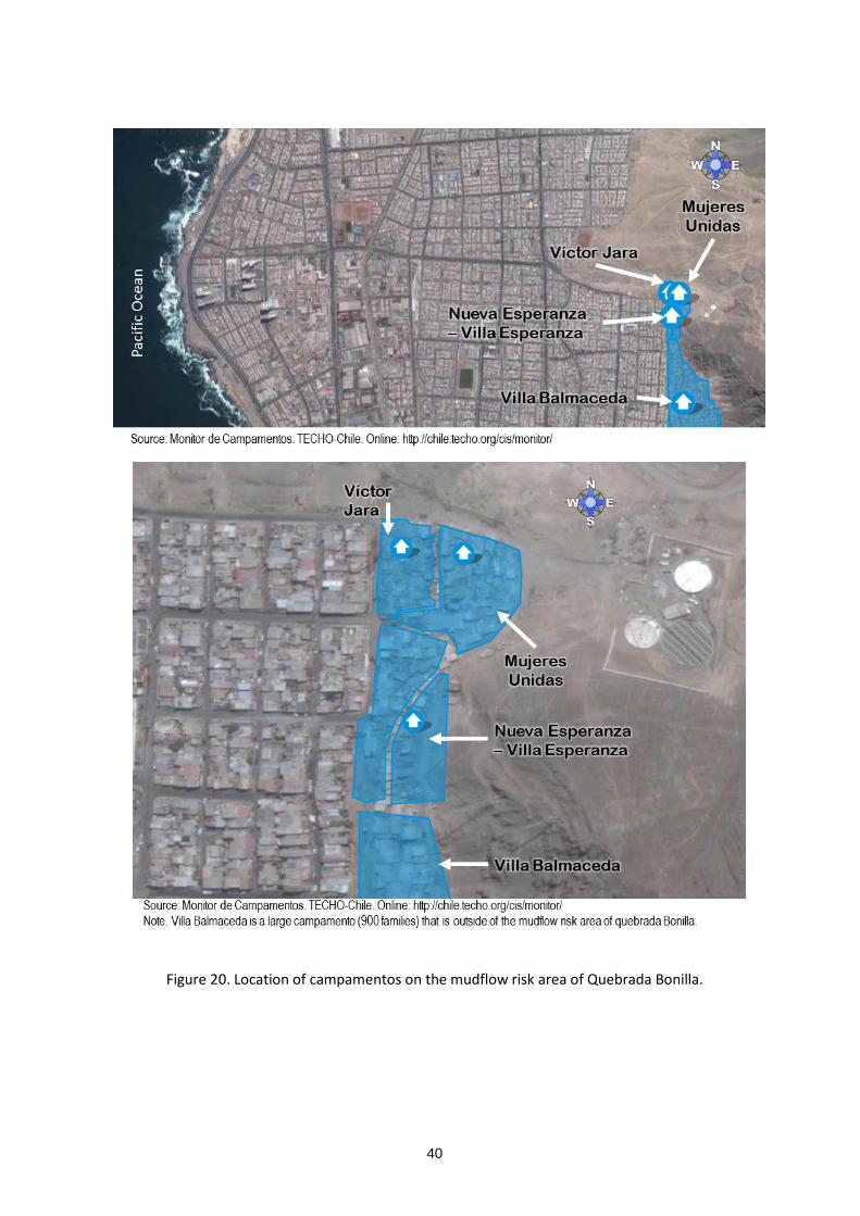
40
Figure 20. Location of campamentos on the mudflow risk area of Quebrada Bonilla.
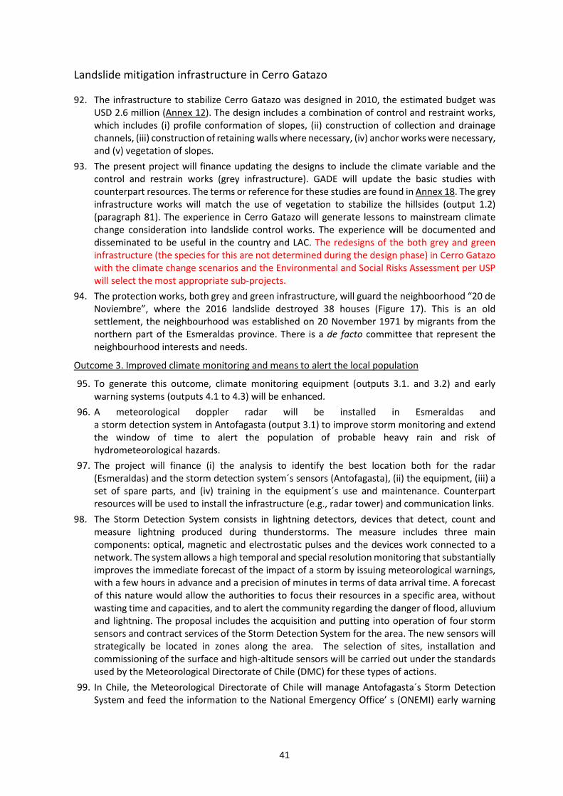
41
Landslide mitigation infrastructure in Cerro Gatazo
92. The infrastructure to stabilize Cerro Gatazo was designed in 2010, the estimated budget was USD 2.6 million (Annex 12). The design includes a combination of control and restraint works, which includes (i) profile conformation of slopes, (ii) construction of collection and drainage channels, (iii) construction of retaining walls where necessary, (iv) anchor works were necessary, and (v) vegetation of slopes.
93. The present project will finance updating the designs to include the climate variable and the control and restrain works (grey infrastructure). GADE will update the basic studies with counterpart resources. The terms or reference for these studies are found in Annex 18. The grey infrastructure works will match the use of vegetation to stabilize the hillsides (output 1.2) (paragraph 81). The experience in Cerro Gatazo will generate lessons to mainstream climate change consideration into landslide control works. The experience will be documented and disseminated to be useful in the country and LAC. The redesigns of the both grey and green infrastructure (the species for this are not determined during the design phase) in Cerro Gatazo with the climate change scenarios and the Environmental and Social Risks Assessment per USP will select the most appropriate sub-projects.
94. The protection works, both grey and green infrastructure, will guard the neighboorhood “20 de Noviembre”, where the 2016 landslide destroyed 38 houses (Figure 17). This is an old settlement, the neighbourhood was established on 20 November 1971 by migrants from the northern part of the Esmeraldas province. There is a de facto committee that represent the neighbourhood interests and needs.
Outcome 3. Improved climate monitoring and means to alert the local population
95. To generate this outcome, climate monitoring equipment (outputs 3.1. and 3.2) and early warning systems (outputs 4.1 to 4.3) will be enhanced.
96. A meteorological doppler radar will be installed in Esmeraldas and a storm detection system in Antofagasta (output 3.1) to improve storm monitoring and extend the window of time to alert the population of probable heavy rain and risk of hydrometeorological hazards.
97. The project will finance (i) the analysis to identify the best location both for the radar (Esmeraldas) and the storm detection system´s sensors (Antofagasta), (ii) the equipment, (iii) a set of spare parts, and (iv) training in the equipment´s use and maintenance. Counterpart resources will be used to install the infrastructure (e.g., radar tower) and communication links.
98. The Storm Detection System consists in lightning detectors, devices that detect, count and measure lightning produced during thunderstorms. The measure includes three main components: optical, magnetic and electrostatic pulses and the devices work connected to a network. The system allows a high temporal and special resolution monitoring that substantially improves the immediate forecast of the impact of a storm by issuing meteorological warnings, with a few hours in advance and a precision of minutes in terms of data arrival time. A forecast of this nature would allow the authorities to focus their resources in a specific area, without wasting time and capacities, and to alert the community regarding the danger of flood, alluvium and lightning. The proposal includes the acquisition and putting into operation of four storm sensors and contract services of the Storm Detection System for the area. The new sensors will strategically be located in zones along the area. The selection of sites, installation and commissioning of the surface and high-altitude sensors will be carried out under the standards used by the Meteorological Directorate of Chile (DMC) for these types of actions.
99. In Chile, the Meteorological Directorate of Chile will manage Antofagasta´s Storm Detection System and feed the information to the National Emergency Office’ s (ONEMI) early warning
42
system49. In Ecuador, the radar will be managed by the Provincial Government of Esmeraldas (GADPE) in collaboration with the National Meteorological and Hydrological Institute50 (INAMHI). The information will feed the Risk Management Secretariat´s (SGR) early warning system.
100. To complement and validate the radar and storm detection system information, additional automatic meteorological stations will be installed in the watersheds of Antofagasta, Taltal and Esmeraldas (i.e., Teaone and Esmeraldas rivers). MOP -- through its Directorate of Waters (DGA) -- and GADPE, respectively, will operate and maintain the meteorological stations in Chile and Ecuador.
101. Ecuador has interesting experience using meteorological radars that could be useful for DMC in future projects. INAMHI manage a set of three radars to monitor rainfall in Quito, and another set of three radars operate in the south of Ecuador, managed by local entities51. The project will foster collaboration and exchange of experiences among the organizations of both countries.
102. The localization of the radars meteorological stations and storm detection system are not precisely defined at this stage, there are consider USP. AF ESP will be screened for all USP during implementation phase to define the sub-projects in compliance with AF ESP.
Outcome 4. Improved means to respond to floods, landslides and mudflows
103. To generate this outcome, public warning systems will be expanded.
Enhanced public warning system in Antofagasta and Taltal
104. In Antofagasta and Taltal sirens will be installed to alert the local population of mudflow danger (output 4.1). This will be complemented with evacuation maps, on-site signals to mark the evacuation routes, and annual evacuation drills (output 4.3). Local inhabitants are familiar with the use of sirens and evacuation procedures for tsunamis52. However, people living on risk areas will have to be trained to recognise the mudflow alert and the corresponding evacuation procedures.
105. Local community leaders from juntas de vecinos and campamento committees will be identified on each gorge and trained to facilitate community action, to guide people to safe areas, and to contribute to guard the sirens and on-site signals. Evacuation plans and procedures will consider the special needs of women, children, older persons and people living with disabilities. Given the role of women in campamentos organizations and their leadership in their communities, it is expected that women can have an active role in this activity.
49 At project start, an agreement will be signed between MOP, DMC and ONEMI to establish operational procedures, information flow, and to guarantee that the information from the storm detection system and meteorological stations (paragraph 97) is expedited to the national weather forecast and early warning systems. 50 GADPE has no previous experience managing climate monitoring. However, GADPE is committed to develop a provincial weather monitoring system. The present project will be an opportunity to develop a decentralised monitoring system based on INAMHI´s former experience. INAMHI will oversee the installation and operation of the radar (paragraph 92) and the meteorological stations (paragraph 97) to ensure they comply with the required standards to guarantee data quality, adequate equipment performance and integration with the national meteorological network. An agreement will be signed between GADPE and INAMHI to establish operational procedures, information flow, and to guarantee that the information from the radar and meteorological stations is expedited to the national weather forecast and early warning systems. 51 This is part of the project "operational rainfall monitoring in southern Ecuador" (BE 1780/31-1 (short name RadarNet-Sur), sponsored by the German Research Foundation. One radar is managed by the Provincial Government of Loja, the other by Technical University of Loja (UTPL), and the last by Cuenca´s Empresa de Telecomunicaciones, Agua Potable y Alcantarillado (ETAPA). 52 ONEMI manage a nationwide tsunami evacuation alert siren system which includes Antofagasta and Taltal.

43
106. The drills will integrate early-warning, communication and evacuation to allow people and local authorities to practice their actions in case of mudflows. ONEMI will coordinate and implement all these actions in close collaboration with the two municipalities and relevant entities53 (e.g., Carabineros, fire brigades).
107. The present project will support ONEMI´s current efforts. On 16 July 2016, for the first time, there was a mudflow evacuation drill in Antofagasta (Quebradas Uribe and Baquedano, about 18,500 people live in the area) (Anon, 2016a; Anon, 2016b). Also, ONEMI is preparing and disseminating mudflow evacuation maps for each gorge that indicate the evacuation routes, and the location of meeting points and shelters54.
Pilot flood warning system in Esmeraldas
108. In Esmeraldas, a pilot flood warning system will be implemented in collaboration with six neighbourhoods of Luis Vargas Torres island55. The pilot will serve as a learning exercise and demonstration (output 4.2). It is anticipated that this experience will catalyse the development of a flood warning system for the entire city.
109. Luis Vargas Torres island is a high-risk area. In January 2016, 95% of the island was flooded and the population had to be evacuated. There are no precise figures, but it is estimated that about 6,000 families live in the island. The pilot will cover ca., 700 families from the six neighbourhoods previously mentioned. These neighbourhoods are located on the southwestern part of the island, and are integrated mostly by afro-Ecuadorians and some mestizos.
110. The pilot will include the use of sirens to alert the local community, and annual drills to test the plan and to prepare local groups. ONEMI´s experience using sirens and preparing evacuation procedures will serve to develop the pilot in Esmeraldas.
111. Like in Chile, local leaders will be trained to facilitate evacuation of vulnerable groups and take community action to guard the sirens and private property. Women will be encouraged to partake as evacuation guides.
112. The pilot will be implemented by GADE, in close coordination with SGR and relevant entities (e.g., police, fire brigades). There will be close coordination with the police to implement actions to prevent looting during emergencies, and to have secure shelters suitable to accommodate the needs of women, children, older persons and people living with disabilities.
113. In addition, the project will:
Assess the condition and provide maintenance to the existing footbridges that will be the main route to be used to evacuate the island during a flood.
Prepare a flooding evacuation map for the Luis Vargas Torres island, based on an updated climate-adjusted flood hazard map. The evacuation routes and procedures will take into account the needs of vulnerable groups like older persons, children, and the Chachi families that live in the island (see page 26).
53 To manage the alert system, ONEMI will require to have technical information from pertinent entities - e.g., DMC´s North Regional Meteorological Centre (CMR Norte), MOP - which have the means to generate and validate information about the condition of rainfall in the gorges and other contingencies. During project implementation, this operation will be aligned with ONEMI´s requirements with respect to alert operations. 54 The maps are found in the following link: http://www.onemi.cl/mapas/region/antofagasta/ 55 Six neighbourhood committees: 12 de mayo, Cordero Crespo, 20 de noviembre, Pianguapi, 29 de agosto, and Habana.

44
Evacuation route maps and signals in Antofagasta, Taltal and Esmeraldas
114. The project will contribute to update the mudflow evacuation maps for Antofagasta and Taltal (output 4.3). The maps, in large format (e.g., banners or large posters), will be placed in high-transit areas to sensitise and inform people living in risk areas. The maps will also be available in digital from through pertinent websites and social media. In addition, signals will be installed to guide local people through evacuation routes and into shelters.
115. In Esmeraldas, the project will contribute to prepare a flooding evacuation map and a landslide risk map. These maps will (1) be placed in high-transit areas to inform people living in risk areas (large format to be used), and (2) be available in digital form through pertinent websites (e.g., GADE, GADPE, SGR) and social media. In addition, signals will be installed to mark the flooding evacuation routes and landslide risk areas.
116. In all cases, the preparation of the evacuation maps will take into account the needs of vulnerable groups like children, older persons and people living with disabilities.
Component 2. Strengthen capacities for adaptation
Outcome 5. Local governments with improved capacity to design and implement adaptation measures
117. To generate this outcome, a regional online course will be developed (output 5.1). The Civil Protection Academy56 of Chile (APC) will lead this action, in coordination with Ecuadorian partners. The course will focus on mainstreaming risk-based adaptation in coastal cities, with a module dedicated to explain the linkages between gender, climate change and adaptation measures, and will be aimed at officers from local governments.
118. Former experience with similar online training will be analysed (e.g., NOAA´s digitalcoast) and partners (e.g., local universities, international cooperation) will be identified and invited to participate. The course will have a blended approach, combining self-paced activities with online group sessions to interact with trainers and other participants.
119. The project will finance (i) the development of the course, (ii) the training of trainers, and (iii) three courses to be open in years 3, 4 and 5. The courses will be open to personnel from the local governments of Antofagasta, Taltal and Esmeraldas, and other cities of the region. It is expected that after project end, the course will be maintained and updated by APC or another partner.
Outcome 6. Local population and government personnel with increased awareness of climate-related risks (floods, landslides, mudflows)
120. To generate this outcome, public communication and education strategies will be implemented in the three cities (output 6.1) and an initiative to strengthen cultural memory will be developed (output 6.2).
Public communication and education strategies
121. The communication and education strategies will be inclusive, gender-sensitive and aimed at (i) strengthen community awareness and ownership of climate-related risks, and (ii) engage local groups into risk-based adaptation. These strategies will be a network to articulate messages across project actions, and will motivate and encourage networking among stakeholders to
56 APC develop and offer in-person and online training courses (/www.onemi.cl/historia/).

45
cultivate social capital. The aim will be that key stakeholders get in contact and develop communication channels and constructive relationships.
122. Social inclusion will be at the core of the communication and education strategies. Therefore, actions will: i. consider the needs and concerns of the range of vulnerable groups, such as limited reading
capabilities or media literacy, and the need of large print or braille; and ii. foster ample participation (e.g., disadvantaged children, older people) and dialogue. These strategies will also be gender-sensitive, since it has been proven that the lack of a gender perspective in dissemination and communication exacerbates the negative impacts that a disaster can have (UNISDR 2009). This entails using appropriate communication channels, that reach both men and women (and may be different depending on who is targeted) and ensuring that messages are understandable and accessible for everybody.
123. In the Luis Vargas Torres island, the communication and education strategies will include actions to support the conservation of the Wildlife Refuge Mangroves of the Esmeraldas River (located in the northern tip of the island) and to inform and engage the Chachi families that live in the island.
124. Implementation of the strategies will be based in the municipalities, in close coordination with climate change officers of the ministries of environment. The local strategies will be articulated to larger scale initiatives on climate change adaptation communication and education.
125. The strategies will be jointly assessed and reviewed every year by project partners. This will allow for exchange of lessons among project partners of the three cities, and to adjust to incorporate views and interests from local communities and vulnerable groups. It is expected that after project end, this kind of work will be embedded into the actions of the municipalities and local interest groups.
Narrators´ initiative
126. The project will support adapting the concept of “narrators” used in Japan to local conditions in Chile and Ecuador. Narrators is a tool to maintain a living memory of past events and to transfer knowledge to new generations (i.e., build cultural memory). It was developed and applied in the city of Nishinomiya after the devastating 1995 Great Hanshin Earthquake. A pilot of the narrators’ methodology was tested in Valdivia (Chile) between 2012 and 2014 in cooperation with the Japan International Cooperation Agency (JICA) (Rosales, 2014).
127. To adapt the narrators’ concept, local and international experience will be compiled and analysed. There is interesting experience in strengthening cultural memory for climate-related DRR (EDUCEN, 2015). Also, key partners and communication channels will be identified, like storytelling, music or street theatre. Local partners (e.g., dance groups, actors, musicians) will be identified, and if needed will be assisted by more experienced external partners57 to initiate and catalyse local efforts of the narrators’ initiative.
128. The narrators´ initiative will be grounded on social inclusion. Therefore, women, children, older people and people living with disabilities will be encouraged to integrate this initiative. Also, their particular needs (e.g., wheelchair access, sign language) will be taken into consideration for the design of the various activities. The capabilities and experience of older persons will be crucial for the narrators´ initiative. They are a repository of knowledge and
57 For example, Latin Latas is a Colombian collective of musicians which works with local groups to promote environmental protection. Also, the International Storytelling Network has members in both countries. Finally, dance groups of the Luis Vargas Torres island had expressed their interest to participate.

46
preservers of cultural and social identity. The project will promote the preservation and use of oral history, and traditional tales and songs.
129. A learning by doing approach will be used, with continuous exchange of experience among the groups working in the three cities. A first two-year round will be implemented and evaluated. Afterwards, the strategy will be adjusted and tested in a final two-year round of actions. At project end, it is envisioned that the narrators´ initiative will be anchored in local groups and the municipalities.
130. The Ministry of Environment of Chile (MMA) will lead the narrators´ initiative in both countries, in close coordination with Ecuador´s Ministry of Environment (MAE). The initiative will be executed from within the three municipalities, and will be closely articulated with the communication strategies (output 6.1), and the other adaptation actions (e.g., mudflow control works, pilot flood warning system in Esmeraldas). Local partners, the municipalities and the ministries of environment will form a community of practice to strengthen cultural memory on disaster-risk adaptation.
Figure 21. Electronic platform of the project.
Component 3. ICTs and partnership between coastal cities in Latin America
Outcome 7. Lessons and best practice on reducing vulnerability to climate related flooding, landslides and mudflows in coastal cities have been shared in the region
131. This outcome is the backbone of the project´s learning process. To generate this outcome: a set of communities of practice will be established and nurtured, a regional electronic platform will be developed (output 7.1) (Figure 21), and the lessons and best practice will be documented and disseminated (output 7.2).
132. The project team will systematically work with the communities of practice, document experiences and lessons and disseminate them through the electronic platform and complementary media. It is envisioned to have five communities of practice:

47
a. Introducing the climate-variable in the design and construction of adaptation infrastructure (outcomes 1 and 2).
b. Climate monitoring to strengthen early warning systems (outcome 3). c. Early warning and response systems (outcome 4). d. Raising public awareness and engagement (outputs 5.1 and 6.1). e. Narrators as a tool to cultivate cultural memory (output 6.2).
Gender and social inclusion will be cross-cutting topics in all communities of practice. Women and other vulnerable groups (e.g., older people) will be encouraged to be part of the communities of practice.
133. Cultivating and supporting the communities of practice is a critical element of the project. On-line blogs will be maintained by project partners to serve as field journals and document advances and lessons. Learning experience documents58 (for a wide audience) will be prepared to systematize lessons and best practice, and propose recommendations for future action. Also, technical documents will be prepared for professional audiences. Along this process, female scientists will be invited to participate and analyse the experiences and lesssons.
134. The regional on-line platform has two elements: a. A web-based communication platform (e.g., SKYPE for business / WebEx) and other
electronic media (e.g., Twitter, WhatsApp, Facebook) to facilitate interaction and virtual meetings and webinars among project participants.
b. An array of media to document and disseminate information and lessons. This includes:
i. A mailing list server to distribute messages, news and information. ii. A YouTube channel to post a set of short videos (<5 minutes/video) to present
experience, lessons, best practice and anecdotes. This channel will be rooted in the concepts of participatory video (Lunch, 2004; Lunch & Lunch, 2006), whereby practitioners and community members use video to document their experiences and knowledge and to express their ideas and perspectives (i.e., tell their own story).
iii. A set of social network accounts (e.g., Twitter, Facebook, Instagram) to distribute messages and allow interaction among project participant and interested groups.
iv. A website dedicated to adaptation in coastal cities. The website will be linked the partners’ portals and relevant information sites, and will contain: News. Project information and documents. Blogs that document specific experience. It is foreseen to have one blog for
each output. Learning experience documents. Technical documents.
58 Nine learning experience documents are planned: 1. incorporating the climate change factor into stormwater management plans in Chile, 2. preparation of green infrastructure plan in Esmeraldas, 3. incorporating the climate change factor into mudflow control infrastructure in Antofagasta, 4. incorporating the climate change factor into landslide control in Cerro Gatazo (Esmeraldas), 5. Use of weather radar/ storm system to enhance early warning systems, 6. mudflows warning system in Antofagasta and Taltal, 7. pilot flood warning system in Esmeraldas, 8. communication and education strategies to increase public awareness of climate-related disaster risk, and 9. contribution of narrators to sustain cultural memory on climate-related risks and disasters.

48
135. To complement virtual communication, there will be in-person meetings between project partners of both countries. Women will be encouraged to participate in these meetings. It is planned to have four thematic exchange visits: pilot stabilization of Cerro Gatazo to control landslides (in Ecuador), early warning and response systems to climate-related events (in Chile), public awareness strategies (in Chile), and narrators’ initiative (in Ecuador). Exchange visits will be open to participants from other countries.
136. The mid-term Review (MTR) and Terminal Evaluation (TE) will contribute to the project´s learning process and will be inputs to the communities of learning.
137. To close the project there will be public events in Antofagasta, Taltal and Esmeraldas. These will include technical talks and informal activities to present results and learnings to stakeholders and general public. A final memoir will be prepared and disseminated with executive summaries in Spanish, English, French and Portuguese.
138. After project end, CAF will maintain the regional on-line platform. It is envisioned that it will develop into a working space to promote risk-based adaptation in coastal cities of Latin America and the Caribbean.
Alternative approaches that were considered and not adopted
139. Annex 13 summarise the alternative approaches that were analysed but not adopted.
B. New and innovative solutions to climate change adaptation 140. The project has three main elements of innovation:
a. First, the development of tools and methods to incorporate climate change into infrastructure design and construction. As mentioned before (paragraph 64), the existing protection infrastructure does not incorporate climate considerations and it is very likely that new infrastructure will be built without considering the foreseen conditions of stronger and more frequent rainfall to be caused by climate change. Therefore, it is necessary that new infrastructure is climate resilient to the potential increases in extreme weather events. However, there is limited experience on how to implement this adaptation measure. The project will support the development of three pieces of pioneer practical experience:
i. To update Antofagasta´s stormwater management plan to channel and evacuate the larger volumes of water generated by the expected increase in extreme weather events. It is very probable that the plan will require to upgrade the existing stormwater system and the construction of new stormwater facilities.
ii. To update the design of mudflow control infrastructure in Quebrada Bonilla (Antofagasta). With 2015´s Taltal mudflow it became evident that existing structural measures will be insufficient to cope with the projected impact of the climate change. Therefore, it is probable that the existing design and size of the decantation ponds and retaining walls (Annex 11) need to be changed.
iii. To update the design of landslide mitigation works in Cerro Gatazo (Esmeraldas) to cope with stronger and more frequent El Niño conditions. The design will combine grey and green infrastructure.
In all cases, the existing designs will be analysed and adjusted considering the foreseen conditions associated with future changes in climate. The experience and lessons of each

49
case will be documented and systematised in guidelines that will be published in electronic format. The guidelines will have a prompt direct application. In Chile, there are 33 cities with more than 50,000 people that already have stormwater management plans; none of them consider the future changes associated with climate change and will need to be upgraded to be climate resilient. Similarly, the guidelines will contribute to introduce climate change considerations into the new mudflow protection infrastructure that is planned to be built in the Antofagasta region.
b. Second, to develop hands-on practice on the preparation of the green infrastructure plan for Esmeraldas. As mentioned before, urban green infrastructure is a new field in both countries. The work in Esmeraldas will explore forms to use elements like vegetated slopes to control landslides and mangrove swamps, permeable pavers and rain gardens to manage urban flood risk.
c. Third, to adapt the narrators’ concept to local conditions and use it to fortify cultural memory. The existing experience in Chile indicate that the core concept is valid, but actions need to be inclusive and culturally appropriate. Therefore, the project will support: i. Documenting from different perspectives (e.g., older persons, women, children,
campamento dwellers, emergency services) the existing memory of climate-related disasters (e.g., Antofagasta´s 1991 mudflow, Taltal´s 2015 mudflow, El Niño associated floods in Esmeraldas).
ii. Supporting that local groups explore forms to transmit messages about climate-related hazards and disasters to the public and the new generations. It is anticipated that multiple channels will be explored, like street theatre, music and dance.
This will be a completely new approach to contribute to climate change adaptation by cultivating cultural memory. The lessons from this initiative have a high potential of application and replication in both countries and the entire region.
C. Economic, social and environmental benefits and mitigation of negative impacts, in compliance with the Adaptation Fund ESP.
Social benefits
141. The main benefits from the project will be (i) to protect the population of the three cities, and (ii) to reduce the risk of casualties.
Protected population in Chile
142. In Chile, the project will benefit the entire population of Antofagasta and Taltal, which is at risk of mudflows caused by extreme weather events (ca., 403 thousand people in 2017, Table 5). These people will benefit by having early warnings, information and knowledge to act in case of emergency and expedite evacuation, when necessary.
143. The direct beneficiaries are the people living in hazard areas. This is the population that will have to be evacuated in case of emergency: (i) about 116 thousand people from Antofagasta´s 17 gorges (Saavedra, 2016), and (ii) the entire population of Taltal (ca., 13,000 people). This includes people living in campamentos, which are the most vulnerable groups. The project intervention will contribute to protect the estimated 4,593 families that live in campamentos in Antofagasta (TECHO, 2016) (Figure 9), and the estimated 400 families living in campamentos in Taltal59 (Figure 11, Table 4).
59 The latest census of campamentos executed by TECHO in 2016 recorded 44 campamentos in Antofagasta (4,593 families) and 6 campamentos in Taltal (400 families) (TECHO, 2016).

50
144. The population of Antofagasta will also benefit from weather-proof protection infrastructure that will be built / strengthened in the near future based on the updated stormwater management plan.
145. The protection works in Quebrada Bonilla will directly benefit about 12,840 people that live in the mudflow hazard area, including the three campamentos60 (ca., 125 families) located there (Figure 20, Table 9). These people will benefit from weather-proof protection infrastructure that will mitigate the impact from mudflows.
146. The experience gained in Antofagasta and Taltal61 will indirectly benefit a much larger population, since it can be applied in other parts of Chile.
Protected population in Ecuador
147. In Ecuador, the entire population of Esmeraldas will benefit from the project; this is about 161 thousand people. These people will benefit by having early warnings, information and knowledge to act in case of emergency and expedite evacuation, when necessary.
148. Direct beneficiaries will be the people that live in flood and landslide hazard areas (ca., 60% of the city´s population). The works in Cerro Gatazo will directly benefit ca., 500 people that live in the hazard area (Barrio 20 de Noviembre). The direct beneficiaries of the pilot flood warning system will be ca., 700 families living in six neighbourhoods of Luis Vargas Torres island62 (about 28% of the families that live in the island).
149. Coverage of the weather radar comprise most of the Esmeraldas and Teaone river areas within the province. Therefore, radar information will provide valuable inputs to the province-level early warning system and benefit the population located in flood-prone areas.
150. The experience gained in Esmeraldas63 will indirectly benefit a much larger population, since it can be applied in other parts of the country.
Social inclusion
151. The project has mainstreamed social inclusion in key actions (e.g., outcomes 4, 6 and 7). This will provide additional social benefits in both countries and generate lessons that will be useful for the entire region.
152. The key stakeholders and vulnerable groups benefit - related to each outcome are summarised
in Table 10.
60 i.e., Víctor Jara (25 families), Mujeres Unidas (56 families) and Villa Esperanza (34 families). 61 For example, introducing the climate variable in Antofagasta´s stormwater management plan and Quebrada Bonilla´s protection infrastructure, use of a storm detection system to forecast rainfall and feed early warning systems, build cultural memory through the narrators´ initiative. 62 Six neighbourhood committees: 12 de mayo, Cordero Crespo, 20 de noviembre, Pianguapi, 29 de agosto, and Habana. 63 For example, use of a weather radar to forecast rainfall and feed early warning systems, introducing the climate variable Cerro Gastaso protection works, preparing a green-infrastructure plan for the city, implementing a community-based flood early warning system, build cultural memory through the narrators´ initiative.

51
Table 10. Key stakeholders and vulnerable groups.
Output Key public stakeholders
Key private stakeholders
Vulnerable groups Beneficiaries
1.1. Stormwater management plan for Antofagasta
MOP, Municipality of Antofagasta
Population of Antofagasta living on mudflow hazard areas (gorges) (ca., 116 thousand people)
One-parent homes, children, older persons and people living with disabilities who live in mudflow hazard areas
Population of Antofagasta (ca., 403 thousand people)
1.2. Green infrastructure plan for Esmeraldas
Municipality of Esmeraldas, Ministry of Environment
People living in flood-prone areas along the banks of Teaone and Esmeraldas rivers, and people living on unstable slopes and downhill of Cerro Gatazo (ca., 60% of the city´s population).
People living in informal settlements located on flood-prone and landslide-prone terrain. Mainly: one-parent homes, children, older persons and people living with disabilities.
Population of Esmeraldas (ca., 161 thousand people)
2.1. Mudflow control infrastructure in Antofagasta
MOP, Antofagasta Regional Government
People living on the mudflow hazard area of Quebrada Bonilla (12,840 persons).
One-parent homes, children, older persons and people living with disabilities who live on the mudflow hazard area of Quebrada Bonilla
People living on the mudflow hazard area of Quebrada Bonilla (12,840 persons).
2.2. Landslide mitigation works in Esmeraldas
Municipality of Esmeraldas
People living on barrio 20 de noviembre downhill of Cerro Gatazo (ca., 500 people)
One-parent homes, children, older persons and people living with disabilities who live on barrio 20 de noviembre
People living on barrio 20 de noviembre downhill of Cerro Gatazo (ca., 500 people)
3.1. Weather radar in Esmeraldas and a storm detection system in Antofagasta
Meteorological Directorate of Chile, ONEMHI, Municipality of Antofagasta, Municipality of Taltal
Population of Antofagasta living on mudflow hazard areas (gorges) (ca., 116 thousand people) Population of Taltal (ca., 13,000 people)
One-parent homes, children, older persons and people living with disabilities who live in mudflow hazard areas
Population of Antofagasta (ca., 403 thousand people) Population of Taltal (ca., 13,000 people)
Provincial Government of Esmeraldas, INAMHI, Risk Management Secretariat Municipality of Esmeraldas
People living in flood-prone areas of the city of Esmeraldas
People living in informal settlements located on flood-prone areas. Mainly: one-parent homes, children, older persons and people living with disabilities.
People living in flood prone areas along the Teaone and Esmeraldas rivers in the Esmeraldas province.

52
Output Key public stakeholders
Key private stakeholders
Vulnerable groups Beneficiaries
3.2. Increased number of meteorological stations in Antofagasta, Taltal and Esmeraldas
MOP, Meteorological Directorate of Chile, ONEMHI, Municipality of Antofagasta, Municipality of Taltal
Population of Antofagasta living on mudflow hazard areas (gorges) (ca., 116 thousand people) Population of Taltal (ca., 13,000 people)
One-parent homes, children, older persons and people living with disabilities who live in mudflow hazard areas
Population of Antofagasta (ca., 403 thousand people) Population of Taltal (ca., 13,000 people)
Provincial Government of Esmeraldas, INAMHI, Municipality of Esmeraldas,
People living in flood-prone areas of the city of Esmeraldas
People living in informal settlements located on flood-prone areas. Mainly: one-parent homes, children, older persons and people living with disabilities.
People living in flood prone areas along the Teaone and Esmeraldas rivers in the Esmeraldas province.
4.1. Enhanced public warning system in Antofagasta and Taltal
ONEMHI, Municipality of Antofagasta, Municipality of Taltal
Population of Antofagasta living on mudflow hazard areas (gorges) (ca., 116 thousand people) Population of Taltal (ca., 13,000 people)
One-parent homes, children, older persons and people living with disabilities who live in mudflow hazard areas
Population of Antofagasta (ca., 403 thousand people) Population of Taltal (ca., 13,000 people)
4.2. Pilot flood warning system in Esmeraldas
Municipality of Esmeraldas, Provincial Government of Esmeraldas, Risk Management Secretariat
About 700 families that live in six neighbourhoods64 in Luis Vargas Torres island (ca., 28% of the 2,500 families that live in the island).
One-parent homes, children, older persons and people living with disabilities in the target neighbourhoods. About 60 Chachi families that live in the island.
700 families that live in the six target neighbourhoods.
4.3. Evacuation route maps and signals in Antofagasta, Taltal and Esmeraldas
ONEMHI, Municipality of Antofagasta, Municipality of Taltal
Population of Antofagasta living on mudflow hazard areas (gorges) (ca., 116 thousand people) Population of Taltal (ca., 13,000 people)
One-parent homes, children, older persons and people living with disabilities who live in mudflow hazard areas
Population of Antofagasta (ca., 403 thousand people) Population of Taltal (ca., 13,000 people)
Municipality of Esmeraldas, Risk Management Secretariat
People living in flood-prone areas along the banks of Teaone and Esmeraldas rivers, and people living on unstable slopes and downhill of Cerro Gatazo (ca., 60% of
People living in informal settlements located on flood-prone and landslide-prone terrain. Mainly: one-parent homes, children, older persons and people living with disabilities.
Population of Esmeraldas (ca., 161 thousand people)
64 Six neighbourhood committees: 12 de mayo, Cordero Crespo, 20 de noviembre, Pianguapi, 29 de agosto, and Habana.
53
Output Key public stakeholders
Key private stakeholders
Vulnerable groups Beneficiaries
the city´s population).
5.1. Course on risk-based adaptation in coastal cities
Civil Protection Academy of Chile, Ministry of Environment of Chile, Ministry of Environment of Ecuador
None Local government officers that attend the course which are head of single-parent families, elder, women, or have disabilities
Local government officers of the Municipality of Antofagasta, Municipality of Taltal, Municipality of Esmeraldas, and other municipalities from Chile, Ecuador and the Latin America and Caribbean region.
6.1. Public communication and education strategies for Antofagasta, Taltal and Esmeraldas.
Municipality of Antofagasta, Muncipality of Taltal, Municipality of Esmeraldas, MOP, ONEMI, Ministry of Environment of Chile, Ministry of Environment of Ecuador
Population of Antofagasta living on mudflow hazard areas (gorges) (ca., 116 thousand people) Population of Taltal (ca., 13,000 people) People living in flood-prone areas along the banks of Teaone and Esmeraldas rivers, and people living on unstable slopes and downhill of Cerro Gatazo (ca., 60% of the city´s population).
One-parent homes, children, older persons and people living with disabilities who live in hazard areas
Population of Antofagasta (ca., 403 thousand people) Population of Esmeraldas (ca., 161 thousand people) Population of Taltal (ca., 13,000 people)
6.2. Narrators´ initiative initiated
Municipality of Antofagasta, Muncipality of Taltal, Municipality of Esmeraldas, Ministry of Environment of Chile, Ministry of Environment of Ecuador
Population of Antofagasta living on mudflow hazard areas (gorges) (ca., 116 thousand people) Population of Taltal (ca., 13,000 people) People living in flood-prone areas along the banks of Teaone and Esmeraldas rivers, and people living on unstable slopes and downhill of Cerro Gatazo (ca., 60% of the city´s population).
One-parent homes, children, older persons and people living with disabilities who live in hazard areas
Population of Antofagasta (ca., 403 thousand people) Population of Esmeraldas (ca., 161 thousand people) Population of Taltal (ca., 13,000 people)
7.1. Electronic platform to facilitate communication among stakeholders and dissemination of
Municipality of Antofagasta, Muncipality of Taltal, Municipality of Esmeraldas, Ministry
Population of Antofagasta living on mudflow hazard areas (gorges) (ca.,
One-parent homes, children, older persons and people living with
Population of Antofagasta (ca., 403 thousand people)

54
Output Key public stakeholders
Key private stakeholders
Vulnerable groups Beneficiaries
lessons and best practice 7.2. Lessons and best practice documented and disseminated
of Environment of Chile, Ministry of Environment of Ecuador
116 thousand people) Population of Taltal (ca., 13,000 people) People living in flood-prone areas along the banks of Teaone and Esmeraldas rivers, and people living on unstable slopes and downhill of Cerro Gatazo (ca., 60% of the city´s population).
disabilities who live in hazard areas
Population of Esmeraldas (ca., 161 thousand people) Population of Taltal (ca., 13,000 people) People and pubic officers from other municipalities from Chile, Ecuador and the Latin America and Caribbean region.
Economic benefits
153. The main economic benefits will be to safeguard public and private assets in the three cities. A proxy of the economic value is the losses recorded in previous events:
a. Antofagasta´s 1991 mudflow produced ca., USD71 million in losses, 493 houses were destroyed, and 2,464 houses had serious damages (ONEMI, 1994; Melin, 2011).
b. Taltal´s 2015 mudflow, which surpassed the existing protection infrastructure, damaged 27 houses. The municipality invested USD 1.3 million in rehabilitation works. In addition, MOP invested USD 4 million to rehabilitate and strengthen protection structures, and USD 4.5 million to build additional protection structures (Rojas, 2015; Santana, 2016).
c. In Esmeraldas, the landslides generated by El Niño 1997 / 1998 destroyed about 300 houses (ca., 2000 – 3000 people lost their properties) (Perrin et al., 1998). Also, the water system was damaged and did not operate for 45 days, the cost of this damage was ca., USD 1.3 million (CAF, 2000a). Also, a landslide broke a main oil pipeline close to the refinery, producing a spill of 8,700 barrels of crude oil and 3,500 barrels of diesel (CAF, 2000a).
Environmental benefits
154. The main environmental benefits are related to the impacts of flooding, mudflows and landslides in local biodiversity. But these impacts have not been assessed.
155. In Ecuador, an additional long-term benefit will be the implementation of a green infrastructure plan in Esmeraldas. In the short-term, an area will be revegetated on Cerro Gatazo to contribute to stabilize the hillsides (output 2.2). The exact area will be defined during project execution, but it is estimated that it will be about 100 ha. At the moment, the hillsides are highly intervened, therefore introducing new vegetation will have a positive impact.
Gender considerations
156. Men and women have different roles and responsibilities within their communities. Gender inequality is present in access and control over assets, natural resources, knowledge, capacities and opportunities, and can lead to different levels of vulnerability.
157. A study of 141 countries over 20 years on disasters impact over women’s and men’s life expectancy shows a gendered disparity in mortality rates from natural disasters and their

55
aftermaths (Neumayer & Plümper, 2007). Results presented include: (i) natural disasters lower women’s life expectancy more than men’s (either more women are killed or they are killed at a younger age than males); (ii) the greater natural disaster’s death toll, the greater gender gap in life expectancy; and (iii) the higher women’s socio-economic status, the weaker the effect on the gender gap in life expectancy.
158. In this view, the Hyogo Framework for Action (2005 – 2015) calls for an integration of a gender perspective “into all disaster risk management policies, plans and decision-making processes, including those related to risk assessment, early warning, information management, and education and training”. Sendai Framework for Disaster Risk Reduction (2015 – 2030) goes further, and calls upon relevant stakeholders, at the national and local level, to “invest in, develop, maintain and strengthen people-centred multi-hazard, multisectoral forecasting and early warning systems, disaster risk and emergency communications mechanisms, social technologies and hazard-monitoring telecommunications systems; develop such systems through a participatory process; tailor them to the needs of users, including social and cultural requirements, in particular gender; promote the application of simple and low-cost early warning equipment and facilities; and broaden release channels for natural disaster early warning information”.
159. Project design has taken into consideration gender differences and has identified outputs and activities where women can have more of a leading role. Also, gender perspective has been mainstreamed in a number of project actions like evacuation plans, education and communication strategies, and the narrators’ initiative, to ensure that both women and men’s needs are addressed. Paragraph list project action in support of gender equality and women´s empowerment.
160. A detailed Gender Analysis was dedicated to the project, which can be viewed in Annex 17.
Measures to avoid / mitigate negative impacts
Impacts from the construction of infrastructure in Quebrada Bonilla and Cerro Gatazo
161. Like any public works, the constructions in Quebrada Bonilla and Cerro Gatazo will produce temporary impacts like increased noise, and emission of dust and combustion gases. In addition, there will be risk of personnel accidents and contamination from waste and spills. Similarly, there will be temporary impacts during maintenance of the infrastructure. In Quebrada Bonilla, the decantation ponds and drainage ways will have to be cleaned annually (i.e., remove garbage). After a mudflow, the sediment and debris will be removed from the decantation ponds, the retaining walls and the drainage ways. The Cerro Gatazo’s infrastructure will require recurrent cleaning of debris and vegetation from the storm and surface water drains.
162. To prevent impacts and manage risks, MOP and GADE will obtain the corresponding environmental permits, and will prepare and implement an Environmental and Social Management Plan, which will be revised and actualized every year depending on the development of the project.
Potential impact from revegetation of Cerro Gatazo
163. The plant species to be planted in Cerro Gatazo will have to contribute to hold and consolidate the ground. Four species have been recommended for use on the hillsides, including vetiver and huaje (MAE, 2002), which are introduced species widely used in Ecuador.
164. Vetiver is a perennial grass native from India, but widely used worldwide for slope stabilization. It is a non-invasive species (Joy, 2009) that was used, with positive results, in trials to stabilize the hillsides of Cerro Gatazo in the early 2000s (PNUD, 2005).

56
165. Huaje is native from Mexico and central America, it is widely used in Ecuador´s mainland for various purposes (e.g., fodder, wood, revegetation) (Aguirre, 2012; Grijalva et al., 2012), but considered an invasive species in the Galapagos archipelago. It is listed as one of the ‘100 of the World’s Worst Invasive Alien Species’ for its spread in several countries (GSID, 2016).
166. The plant species to use will be decided during project implementation. However, to prevent impacts, the selection criteria will include: a. Preference to use native species. b. If a non-native species is a best choice, no species listed on IUCN´s Global Invasive Species
Database65 could be used. 167. Before execution, GADE will provide a written report indicating the list of plant species to be
used for slope stabilization and the criteria used for their selection according to the suggestions given by the MAE.
D. Cost-effectiveness analysis with a regional approach 168. The AF investment will benefit about 557 thousand people in the three cities which are highly
vulnerable to climate-related disasters. The project will contribute to strengthen the adaptive capacity in these cities, reducing the level of future impacts.
169. The project will also serve as a catalyst to the planned investment of ca., USD 84,5 million to build infrastructure to protect from mudflows the cities of Antofagasta, Taltal and Tocopilla (DOH, 2015; Saavedra, 2016) by providing practical guidelines to incorporate the climate variable in new construction works.
170. At the moment, the municipality of Esmeraldas has financial limitations. Therefore, this project will make possible to execute actions that could not be financed in the short-term. The public works in Cerro Gatazo is a long waited initiative that has not been possible to finance before.
171. The project will ensure the cost-effectiveness of resources by allocating AF funds to activities and products with high catalytic potential, such as:
a. Participatory learning process based in communities of practice to generate lessons and best practice on disaster-risk adaptation.
b. Systematic documentation and dissemination of lessons. c. Design and implement a communication strategy focused on specific interests and
channels of key stakeholders. d. Use of an electronic platform to: (i) disseminate lessons learned and outcomes of the
project, and (ii) facilitate communication and articulation among stakeholders and interest groups.
e. Support the development of lessons and best practice that are highly replicable worldwide.
172. The regional approach will facilitate south-south cooperation and the foreseeable future application of learnings in other coastal cities of the region. The backbone of the project is the exchange of know-how, experience and lessons among local and national authorities and stakeholders in both countries. The main tool will be communities of practice to facilitate horizontal collaboration.
173. Some examples of the benefits of a regional approach are: a. Exchange of experience and learnings on:
i. the use of meteorological radar and the storm detection system between INAMHI, GADPE, DMC, and MOP,
65 www.iucngisd.org

57
ii. early warning systems among ONEMI, DMC, INAMHI, SGR and the three municipalities, and
iii. mainstreaming risk-based adaptation in coastal cities between MMA and MAE. b. Expanding the narrators’ concept that was first applied in Chile to be useful in a new
cultural setting in Esmeraldas, and the possibility to applying it in other coastal cities of the region.
174. The regional approach also opens the opportunity to make available experience and lessons to a wider community of interested groups in Latin America and the Caribbean.
175. CAF will be a catalyst of this process by facilitating access to worldwide experiences and encouraging partnerships among the project participants.
E. Consistency with national or sub-national sustainable development strategies 176. At the international level, the project is in line with the Sendai Framework for Disaster Risk
Reduction 2015 – 2030. It also includes elements of the former Hyogo Framework for Action 2005-2015. The focal points for this matter are ONEMI in Chile and SGR in Ecuador. Also, the project will contribute to enhance knowledge and understanding, and to strengthen dialogue and coordination on line with the Warsaw International Mechanism for Loss and Damage associated with Climate Change Impacts and article 8 of the Paris Agreement under the United Nations Framework Convention on Climate Change (under ratification).
177. The project is in line with CAF´s climate change adaptation programme (CAF, 2013). This programme has five lines of action; the present project is in line with:
a. Line of action 2. To strengthen institutional capacity of public and private sectors of the region on climate change adaptation. The project will contribute to the following actions: i. Action 2. Implementation of training of public and private sector to promote the
importance of planned climate adaptation and the development of policies, plans and strategies to adapt to climate change. The present project will contribute to this action by implementing a regional online course on risk-based adaptation in coastal cities for local government officers.
ii. Action 3. To strengthen hydrometeorological data collection to feed climatic models. The project will contribute to this action by improving weather monitoring in the three selected cities.
b. Line of action 3. To promote on the ground concrete adaptation measures in response to pressing needs of Latin America and Caribbean countries. The project will contribute to action 7, which is to further the funding of infrastructure which is resilient to climate change. The present project will contribute to this action by mainstreaming the climate factor into Antofagasta´s stormwater management plan, and the designs and construction of protection infrastructure in Quebrada Bonilla (Antofagasta) and Cerro Gatazo (Ecuador).
c. Line of action 4. To support knowledge generation and management on adaptation to climate change. Component 3 of the present project is in line with this line. It will facilitate documenting and disseminating knowledge and best practice on risk-based adaptation in coastal cities.
178. At the national level, the project is in line and will contribute to the following Chilean instruments:
a. The National Adaptation Plan (MMA, 2014). The plan has eight strategic lines of action. The present project is in line with the following lines:
58
i. Line 7. Incorporate climate change in regional and local environmental management. This line focus on articulating sectoral and national adaption policies with local and regional development policies. The project contributes to the following activities:
1. A21. Incorporate climate change adaptation and mitigation actions into municipal and local environmental management through instruments such as municipal environment certification (SCAM) and national environmental certification of education establishments. This action seeks to incorporate the climate factor into municipal policy, planning and management. The project will contribute to this action by working directly with the municipalities of Antofagasta and Taltal. Project adaptation specialist will be based within the municipalities (Figure 23) and the public communication and education strategies will be executed by the municipalities (output 6.1).
2. A22. Incorporate climate change adaptation and mitigation actions into sustainable community or sustainable neighbourhood programmes. The project will contribute to this action by implementing public communication and education strategies and the narrators´s initiative (outputs 6.1 and 6.2).
ii. Line 8. Information for decision making on disaster risk management. The project contributes to the following activities:
1. A24. Incorporate information of extreme hydrometeorological events (present and foreseen) in the preparation and updating of risk maps, including climate change threat, vulnerability and exposure variables. The project will contribute to this action by preparing and disseminating evacuation route maps and installing evacuation signals (output 4.3).
2. A26. Develop a training programme for public entities and other stakeholders at national, regional and local levels, on disaster risk reduction adaptation to climate change, which includes, among other topics, climate change impacts, adaptation, risk perspective, and non-traditional adaptation alternatives such as green infrastructure and ecosystem-based adaptation. The project will contribute to this action by developing and executing a regional course on risk-based adaptation in coastal cities (output 5.1).
The project will also contribute to implement the Climate Change National Action Plan 2017-2022 (currently under public consultation), and the sectoral adaptation plans for cities and infrastructure that are under development.
b. National Plan for Civil Protection (Decree 156 of 12 March 2002). This plan set the foundations, organizational structure, responsibilities and procedures to address emergencies in Chile. The project is in line with this plan and will contribute by improving weather monitoring and strengthening the mudflows early warning system (outputs 3.1, 3.2, 4.1, and 4.3).
c. The National Policy for disaster risk management (ONEMI, 2014). This policy sets five strategic axes, the project is in line with the following elements: i. Strategic axis 2. Strengthen monitoring and early warning systems. This axis focusses
on providing to the civil protection national system adequate information to properly assess risks and take sound decision. The project will contribute to the following specific objectives: 1. Specific objective 1. Strengthen the monitoring systems to promptly detect
threats, within the competences of each actor, on a continuous 24/7 system. The project will contribute to this objective by upgrading weather monitoring with a meteorological radar in Esmeraldas, storm detection system in Antofagasta and meteorological stations in both sites (outputs 3.1 and 3.2).
59
2. Specific objective 4. Support the development of technical agencies that have human and technical resources to monitor diverse threats and fulfil their specific functions. The project will contribute to this objective by strengthening local functions. DMC will manage Antofagasta’s storm detection system and DGA will manage the meteorological stations (outputs 3.1 and 3.2). The data and information will feed the early warning systems.
ii. Strategic axis 3. Promote a prevention and self-protection culture. The project will contribute to the following specific objectives: 1. Specific objective 1. To include disaster risk reduction concepts and approach
into formal, non-formal and informal education. The project will contribute to this objective through the public communication and education strategies and the narrators´ initiative (outputs 6.1 and 6.2).
2. Specific objective 3. Contribute to train professionals on disaster risk reduction. The project will contribute to this objective through the regional online course on risk-based adaptation in coastal cities (output 5.1).
3. Specific objective 6. To promote the disaster risk reduction approach into public and private sectors. The project will contribute to this objective through the public communication and education strategies and the narrators´ initiative (outputs 6.1 and 6.2).
d. Antofagasta´s Regional Plan for Infrastructure and Water Resources Management to 2021 (MOP, 2012). This plan includes strategic action B2 which is to protect the population from mudflows or floods. The plan includes a set of targets for construction of mudflow protection works in Antofagasta and Taltal, and six projects to build new protection works (i.e., projects 31, 33, 34, 35, 62, and 63). The present project will complement the planned activities by updating Antofagasta´s stormwater management plan and building climate-proof mudflow protection infrastructure in Quebrada Bonilla (outputs 1.1 and 2.1). In addition, the lessons and experience from these two actions will serve to guide the incorporation of the climate factor into other protection works.
e. The project is consistent with Antofagasta´s Communal Development Plan 2013 – 2022 (MdA, 2012) and Taltal´s Communal Development Plan 2022 (MdT, 2015). In both cases, the project will contribute to mainstream risk-based adaptation concepts and approach into municipal work. A project´s adaptation specialist will be based within each municipality (Figure 23). This will allow for day-to-day interaction with municipal officers during the five years of project implementation. In addition, municipal execution of the public education and communication strategies will contribute to build interest and familiarity with risk-based adaptation. Finally, municipal officers will take course on risk-based adaptation in coastal cities, this will contribute to increase technical capacities and to interact with peers from other cities.
f. The project will contribute to Antofagasta´s and Taltal´s communal plans for civil protection (MdT, 2012) by advancing on practical actions to address mudflows (e.g., evacuation maps, evacuation drills, signal of evacuation routes, enhanced early warning and alert system and increased public awareness).
179. The project is in line and will contribute to the following Ecuadorian instruments: a. National Climate Change Strategy (MAE, 2012), in particular specific objectives 7 and 8.
The national strategy covers the period 2012 – 2025. It defines eight priority sectors for climate change adaptation, two of them are human settlements (number 7) and risk management (number 8) which is transversal to all the other sectors. The present project is in line with two specific objectives of the adaptation line of work:

60
i. Specific objective 7. To include integrated risk management to weather related extreme events in public and private sectors. Within this objective, the project will contribute to three key actions:
1. Action 2. Integrate risk management in present and future infrastructure plans and programmes, motivating innovation and continuous improvement of infrastructure quality and safety. The project will contribute to this action by developing experience on mainstreaming the climate change factor into the design and construction of protection infrastructure in Cerro Gatazo (output 2.2), complemented with green infrastructure (output 1.2). The development of a green infrastructure plan for Esmeraldas will allow to explore the use of natural elements to cope with climate change adaptation. In addition, the lessons and experience in Cerro Gatazo will be useful to other infrastructure projects.
2. Action 4. Encourage the generation and updating of early warning systems, which include the risks of extreme weather events from possible climate change scenarios, for the priority sectors. The project will contribute to this action by improving weather monitoring (outputs 3.1 and 3.2) and the existing Esmeraldas´ early warning system. In addition, the pilot flood warning system in Luis Vargas Torres island (output 4.2) will generate experience and lessons to be replicated in other areas.
3. Action 6. Promote public participation and social organization as mechanisms to support implementation of responses to climate change related extreme weather events as part of integrated risk management. The project will contribute to this action by preparing evacuation route maps (output 4.3) and implementing public education and communication strategies (outputs 6.1 and 6.2).
ii. Specific objective 8. To implement measure to increase the response capacity of human settlements to cope with the impacts of climate change. Within this objective the project will contribute to three key actions:
1. Action 2. Promote public participation and social organization to facilitate implementation of response measures to cope with extreme climate events linked to climate change. The project will contribute to this action by preparing evacuation route maps (output 4.3) and implementing public education and communication strategies (outputs 6.1 and 6.2).
2. Action 3. Promote the generation of specific information and its access to GADs about possible impacts from extreme climate events under possible climate change scenarios. The project will contribute to this action by improving weather monitoring (outputs 3.1 and 3.2) and the existing Esmeraldas´ early warning system
b. National Comprehensive Security Plan (MCS. 2014), in the policy framework assigned to SGR. This plan covers the period 2014 – 2017 and establishes the overall policies and assign responsibilities within the national security framework. The project contributes to implement the public policies related to risk management.
c. Sectoral Agenda for Risks Management (SGR, 2014), in particular policy 2 aimed at promoting a risk management culture, policy 3 aimed at coordinate and articulate the decentralised national system for risks management, and policy 4 aimed at strengthening international cooperation. The present project is in line with policy 3: to coordinate and articulate the national decentralized risk management system to protect people, communities and nature from natural and anthropic threats. Under this policy, the project will contribute to the following strategies:

61
i. Strategy 3.7. To promote programmes for risk-reduction and mitigation and adaptation to climate change, with emphasis on priority sectors, priority groups and fragile ecosystems. The entire project will contribute to this strategy. A key element will be to improve local capacity to design and implement adaptation measures in Esmeraldas (outcomes 5 and 6).
ii. Strategy 3.3. To improve and integrate the monitoring and early warning systems to identify and mitigate social and environmental threats and vulnerabilities from natural and anthropic risks. The project will contribute to this strategy by improving weather monitoring (outputs 3.1 and 3.2) and the existing Esmeraldas´ early warning system.
d. Esmeraldas´ Municipal Development and Land Use Plan (GAD Esmeraldas, 2012a), in particular environmental section, strategic line 10 to strengthen the municipal system for risk management. This plan covers the period 2012 – 2022. Strategic line 10 is to advance the operation of the municipal integrated risk management system. Within this strategic line, the present project contributes to the following actions: i. PYSA 49. Strengthen organisms for emergency coordination. The project contributes
to this action by strengthening weather monitoring and the early warning system (outputs 3.1, 3.2, 4.2 and 4.3).
ii. PYSA 50. Permanent education, communication and prevention campaigns. The project contributes to this action by implementing public communication and education strategies (output 6.1) and the narrators´ initiative (output 6.2).
iii. PYSA 52. Institutional strengthening, through COE´s technical working groups. The project contributes to this action by strengthening weather monitoring and the early warning system (outputs 3.1, 3.2, 4.2 and 4.3).
iv. PYSA 53. Strengthening of the early warning system. The project contributes to this action by strengthening weather monitoring and the early warning system (outputs 3.1, 3.2, 4.2 and 4.3).
v. PYSA 55. Execution of works to reduce and mitigate risks in vulnerable settlements. The project contributes to this action by designing a green infrastructure plan for Esmeraldas (output 1.2), constructing landslide mitigation works in Cerro Gatazo (output 2.2), executing a pilot flood warning system in Luis Vargas Torres island (output 4.2), and preparing and disseminating evacuation route maps and installing evacuation signals (output 4.3).
e. Esmeraldas´ Municipal Strategy for Risks and Disaster Management (GAD Esmeraldas, 2012b). in particular: i. Strategic objective 2. To reduce disaster risk in medium and high vulnerability human
settlements. The project will contribute to the following action lines: 1. Action line 3. To promote the design and construction of mitigation works on
hillsides with landslide risk. The project contributes to this action by revegetating Cerro Gatazo as part of the green infrastructure plan for Esmeraldas (output 1.2) and complementing the landslide mitigation works (output 2.2),
2. Action line 5. To identify, adequate and extend evacuation routes and safe areas, in accordance with existing threats. The project contributes to this action by preparing and disseminating evacuation route maps and installing evacuation signals (output 4.3).
3. Action line 6. To design, implement and strengthen early warning systems to allow a better reaction to the multiple threats that have been identified. The project contributes to this action by strengthening weather monitoring and the early warning system (outputs 3.1, 3.2, 4.2 and 4.3), including the pilot flood warning system in Luis Vargas Torres island.
62
4. Action line 7. To promote the execution of biannual evacuation drills in coordination with community, and public and private organizations. The project contributes to this action by implementing flood emergency drills as part of the pilot flood warning system in Luis Vargas Torres island (output 4.2).
ii. Strategic objective 3. To strengthen institutional capacities to implement a risk management approach in planning and land use processes (institutional strengthening). The project will contribute to action line 13 that is to train personnel from public and private institutions on risk management, including preparation of contingency plans, evacuation plans, interior signage, protection / safety elements, and evacuation routes (train personnel on risk management). The project will contribute to this action by hands-on training as part of the pilot flood warning system in Luis Vargas Torres island (output 4.2) and through the regional online course on risk-based adaptation in coastal cities (output 5.1).
iii. Strategic objective 4. To reduce economic, social and environmental vulnerability of the human and natural systems to mitigate and adapt to climate change. (reduce vulnerability). The project will contribute to action line 17, which is to develop hillside reforestation plans to prevent landslides. The project contributes to this action by revegetating Cerro Gatazo as part of the green infrastructure plan for Esmeraldas (output 1.2) and complementing the landslide mitigation works (output 2.2),
iv. Strategic objective 8. To implement non-structural works to reduce social vulnerability, through linking the Risk Management and Climate Change Unit and the Municipal Risk Management Committee with organized civil society. The project will contribute to the following action lines: 1. Action line 35. Form neighbourhood and parish emergency committees. The
project will contribute to this action with the pilot flood warning system in Luis Vargas Torres island (output 4.2)
2. Action line 36. Form and train a network of neighbourhood and parish community leaders for risk management and adaptation to climate change. The project will contribute to this action by hands-on training as part of the pilot flood warning system in Luis Vargas Torres island (output 4.2)
3. Action line 37. Establish recreational spaces for collective learning on disaster risk reduction. The project will contribute to this action with the narrators´ initiative (output 6.2) which will develop capacities of local groups to use recreational activities, like dance or story-telling, to cultivate collective memory on disaster risk reduction.
4. Action line 39. Communication campaigns on preventive measures to cope with adverse events, through public media (radio, press, television). The project contributes to this action by implementing public communication and education strategies (output 6.1) and the narrators´ initiative (output 6.2).
5. Action line 41. Establish spaces linking community - local government to reduce vulnerability of the organizational fabric. The project contributes to this action by implementing public communication and education strategies (output 6.1) and the narrators´ initiative (output 6.2).
v. Strategic objective 9. Consolidate the decentralized national risk management system in Esmeraldas canton with participation of authorities, institutions and community. The project will contribute to action line 42, which is to promote the permanent functioning of the canton´s integrated risk management system. The project will contribute to this line by strengthening weather monitoring and the early warning

63
system (outputs 3.1, 3.2, 4.2 and 4.3), including the pilot flood warning system in Luis Vargas Torres island.
f. Esmeraldas´ Municipal Climate Change Adaptation and Mitigation Strategy (ONU-HABITAT, 2011). The project is in line with strategic objective 2, which is to reduce social, economic and environmental vulnerability of the human and natural systems to cope with the climate change. In particular, with action line 1 on planning and land use. Within this action line, the project will contribute to:
i. Specific objective1.3. To reforest hillsides and form natural barriers to protect riversides. The project will contribute to this objective by revegetating Cerro Gatazo as part of the green infrastructure plan for Esmeraldas (output 1.2).
ii. Specific objective 1.4. To build green spaces within the urban area. The project will contribute to this objective by preparing Esmeraldas´ green infrastructure plan and revegetating Cerro Gatazo (output 1.2).
F. National technical standards (environmental, building codes and others) complies with the Adaptation Fund ESP. The proposed activities will adhere to all national regulations and technical standards, in both Chile and Ecuador, particularly those relating to concrete adaptation measures, including green infrastructure, civil works and reforestation developed under Component 1.
Detailed description on expected outputs, relevant standards and procedures along with the measures to ensure compliance with ESP are elaborated below (Section III.C).
Construction works technical standards
180. The update of Antofagasta’s stormwater plan will comply with Law 19525, published on 10 November 1997. It establishes that the primary network for rainwater evacuation and drainage will be under MOP´s responsibility and the secondary network will be under MINVU´s responsibility. MOP will prepare these plans, that are compulsory for cities with more than 50,000 inhabitants. Stormwater plans will be approved by Executive Decree signed by the ministries of public works and of housing and urban development. There are no specific guidelines or technical standards for the preparation of the stormwater plans.
181. The design and construction of infrastructure in Quebrada Bonilla will comply with pertinent Chile´s building standards. Mandatory and referential standards are available in MINVU´s website66. MOP will approve the designs and infrastructure for Quebrada Bonilla. This will ensure compliance with national technical standards and building codes.
182. The design and construction of infrastructure in Cerro Gatazo will comply with the Ecuadorian building code (NEC-15), adopted by Ministerial Agreement 0028 of 19 August 2014 and updated by Ministerial Agreement 0047 of 15 December 201467. The Directorate of Public Works of the Municipality of Esmeraldas will approve the designs and infrastructure to ensure compliance with all national technical standards and local regulations.
66 http://proveedorestecnicos.minvu.cl/normas-tecnicas-obligatorias/ 67 The elements of the norm of construction are found at http://www.habitatyvivienda.gob.ec/norma-ecuatoriana-de-la-construccion/

64
Environmental licences
183. In Chile, the construction works in Quebrada Bonilla will require an Environmental Qualification Resolution. In Ecuador, the works in Cerro Gatazo, and the installation and operation of the weather radar and the meteorological stations will require an Environmental Registry.
184. Chile´s environmental regulatory framework is based on the Environmental Law (Law 19,30068) amended by Law 20,417 of 201069, and Supreme Decree 40/2012 70of 2012 (regulation for the environmental impact assessment system). Article 10 of Law 19,300 list the types of activities that will be subject to the environmental impact evaluation system (SEIA). Two types of environmental permits exist: Environmental Impact Study (EIA) and Environmental Impact Declaration (DIA). An EIA applies to projects that may generate high-level impacts; article 11 of Law 19,300 establishes that a project with any of the following characteristics has to present an EIA: a. Risk to the health of the population, due to the quantity and quality of effluent, emissions
and waste. b. Significant adverse effects on the quantity and quality of renewable natural resources,
including soil, water and air. c. Resettlement of human communities, or significant alteration of the systems of life and
customs of human groups. d. Location at or near populations, resources and protected areas, priority conservation
sites, protected wetlands, glaciers, that may be affected, as well as the environmental value of the territory in which it is intended to deploy.
e. Significant change in terms of magnitude or duration, of the scenic or tourism value of an area.
f. Alteration of monuments, sites with anthropological, archaeological, historical value and, in general, belonging to the cultural heritage.
Projects included in the categories of article 10, but which do not have the characteristics listed in article 11, must present a DIA. Both EIA and DIA are subject to public consultation. The Environmental Evaluation Service (SEA) has established guidelines to conduct the public consultation process (SEA, 2013).
185. The existing designs for the protection works in Quebrada Bonilla already include the DIA that was approved in 2001. However, because the designs will be updated to incorporate the climate variable, the DIA will be updated. Therefore, MOP will prepare and submit the updated DIA to the SEA. SEA will conduct the review process, which is managed online, and issue an Environmental Qualification Resolution (RCA). For a DIA, the review process takes ca., 60 working days and has no cost. Existing mudflow protection works presented DIAs and obtained RCAs. The cost of preparing the DIA is included in the project budget (see budget note 14).
186. Ecuador´s environmental regulatory framework is based on the Environmental Management Law ((Ministerial Agreement 061 of 2015; Law 37 of 1999, coded in 2004), the environmental impact evaluation system (Ministerial Agreement 061 of 2015) and complementary regulations. Article 14 of Ministerial Agreement 061 established two types of environmental permits: (i) Environmental Registry, and (ii) Environmental Licence. There is an online
68 http://bcn.cl/1uywi 69 http://bcn.cl/1vze7 70 http://bcn.cl/1uvqa

65
catalogue71 which list the projects, works and activities that require an environmental permit and the corresponding permit type (article 22 of Ministerial Agreement 061). Article 24 indicates that the Environmental Registry is issued to projects, works and activities with low environmental impact and risk. Article 25 indicates that the Environmental Licence is issued to projects, works and activities with medium or high environmental impact and risk. To obtain an Environmental Licence, an Environmental Impact Assessment (EIA) must be submitted, and the review process is subject to public consultation.
187. The construction of Cerro Gatazo´s protection works (output 2.2) and the installation and operation of the weather radar and the meteorological stations (outputs 3.1 and 3.2) will require an Environmental Registry. The process to obtain the Environmental Registry is managed online (suia.ambiente.gob.ec), and consists on completing an online formulary and paying a fee of ca., USD180; the permit is issued automatically. For the construction works in Cerro Gatazo, GADE will obtain the corresponding environmental registry. For the weather radar and meteorological stations, GADPE will obtain the corresponding environmental registries. CAF has requested more stringent measures and will require the preparation of environmental impact assessments and the implementation of environmental management plans for these three project elements.
Meteorological equipment and data
188. The weather radar, the storm detection system and meteorological stations will comply with technical and operational specifications and requirements stipulated by the corresponding national authorities, DMC in Chile and INAMHI in Ecuador. This will ensure that the equipment comply with required specifications and is integrated into the national weather monitoring systems.
189. To ensure compliance, interinstitutional agreements will be signed. The signature of these agreements will be a pre-requisite before purchasing the radar, the storm detection system and the meteorological stations. a. In Chile, an agreement will be signed between MOP (who will operate and maintain the
meteorological stations), DMC (who will operate the storm detection system) and ONEMI to establish operational procedures, information flow, and to guarantee that the information is expedited to the national weather forecast and early warning systems.
b. In Ecuador, an agreement will be signed between GADPE (who will operate and maintain the radar and meteorological stations) and INAMHI to establish operational procedures, information flow, and to guarantee that the information from the radar and meteorological stations is expedited to the national weather forecast and early warning systems.
190. The information from meteorological monitoring will feed the early warning systems within the existing operational framework and institutional arrangements. a. In Chile, DMC and MOP will feed the data to ONEMI within the framework of the National
Plan for Civil Protection (Decree 156 of 2002) which includes the Communal Committees for Civil Protection and Emergency and the COEs of Antofagasta and Taltal.
b. In Ecuador, GADPE will feed the information to INAMHI and SGR within the framework of the national integrated system which includes the municipal and provincial Risk Management Committees and COEs.
71 The catalogue is found at http://suia.ambiente.gob.ec/catalogo_ambiental;jsessionid=TXc7k+eULLCzbtscHz6RsykX

66
Early warning systems
191. The actions to strengthen the early warning systems in Antofagasta and Taltal (e.g., mudflow evacuation maps, emergency sirens) will be administered by ONEMI to ensure compliance with existing specifications, integration with the national framework and articulation with the communal civil protection plans.
192. The actions to strengthen the early warning systems in Esmeraldas will be administered by GADE to ensure compliance with the municipal strategy for risks and disaster management (GAD Esmeraldas, 2012b) and the national framework.
Compliance with AF Environmental and Social Policy
193. All project interventions will comply with the AF Environmental and Social Policy. A screening of risks was completed under Section II.L and mitigation measures Section III.C (Annex 14) and controls will be put in place to ensure that the project will not exacerbate inequalities, harm the environment, causing negative impacts to marginalized or vulnerable groups.
194. Ongoing consultations with the environmental entities of both countries, as well as, local
governments took place during project design and will continue at all stages of the project to ensure that all unidentified sub-projects (USP) and activities comply with the relevant technical standards. Workshops were carried out in Chile and Ecuador to share the project concept and exchange experiences. These workshops were crucial for finalize the project design. (See more details on Section II.I)
G. Describe if there is duplication of project with other funding sources 195. No duplication with other funding sources was found. However, the project will have synergies
with the following projects: Third National communication (3NC) and First Biennial Update Report (BUR). This is a GEF
funded project (GEF ID 5478) under implementation in Ecuador. The executing agency is MAE, and the GEF implementing agency is UNDP. The project objective is to prepare the third national communication on climate change and the first biennial update report. The investment is USD 852,000. The present project will use the results of 3NC, in particular the outcomes of the climate change models and the guidelines for climate change adaptation.
ARG - MOP agreement “mudflow disaster mitigation and evacuation of rainwater, Antofagasta Region 2015-2020”. This is a government project under implementation (Annex 15). The executing agency is DOH. The project will build mudflow control works in Antofagasta and Taltal (DOH, 2015; Saavedra, 2016) (paragraph 77, Table 9 and Annex 15). The total investment is CLP 56,152,000,000 (about USD 84.5 million). The present project will provide practical guidelines to incorporate the climate variable in new construction works.
196. The project will seek collaboration with UNISDR´s Regional Platform for Disaster Risk Reduction of the Americas72 and the Resilient Cities Campaign73.
72 http://www.unisdr.org/we/coordinate/regional-platforms 73 http://www.unisdr.org/we/campaign/cities

67
H. Learning and knowledge management component . 197. Component 3 of the project focus on learning and knowledge management. It comprises one
outcome (i.e., outcome 7) and two outputs (i.e., outputs 7.1 and 7.2). 198. The backbone is the regional platform that will facilitate communication and collaboration
among project partners and dissemination of information and lessons (Figure 21). 199. The main tool will be communities of practice (Lave & Wenger, 1991; Wenger, 1998; Wenger
et al., 2002) among practitioners and key stakeholders. The communities of practice will facilitate common learning and the development of social capital. It is envisioned to have five communities of practice: a. Introducing the climate-variable in the design and construction of adaptation
infrastructure. b. Climate monitoring to strengthen early warning systems. c. Early warning and response systems. d. Raising public awareness and engagement. e. Narrators as a tool to cultivate cultural memory.
200. The main instruments will be: a. Project blogs. These will be on-line and will serve as field journals to document experience
and lessons. It is envisioned to have one blog per output. b. YouTube channel. It will contain short videos prepared mostly by project participants and
local stakeholders. However, it will also include videos prepared by the project team and partners.
c. Learning experience documents. These will be concise communication documents (i.e, accessible to a wide audience) that systematize lessons and best practice. Each document will include executive summaries in Portuguese, French and English to be useful to all countries in the region. It is anticipated to produce nine documents.
d. Technical documents. These will be documents aimed at practitioners and professionals to present, in a formal format, experience, results, guidelines and recommendations. Each document will include executive summaries in Portuguese, French and English to be useful to all countries in the region. The number and nature of these documents will be decided during project execution.
e. Memories of exchange visits. Four thematic exchange visits are planned. A memoir of each visit will be prepared to record discussions, joint analyses and recommendations. The memoirs will be communication documents to be accessible to a wide audience.
f. Mid-term review report. The project will use the independent mid-term evaluation as part of the learning process. The full document will be shared will all partners, and accessible through the regional on-line platform. A brief will be prepared for the use of the general public, decision makers and other stakeholders.
g. Terminal evaluation report. The independent final evaluation will also nurture the project´s learning process. The full document will be shared will all partners, and accessible through the regional on-line platform. Also, a brief will be prepared for the use of the general public, decision makers and other stakeholders.
h. Project memoirs. This will be a communication document that summarise the project´s achievements and lessons, as well as opinions and anecdotes from project partners and stakeholders. It will include executive summaries in Portuguese, French and English to be useful to all countries in the region

68
I. Consultative process: List of stakeholders, with particular reference to vulnerable groups, including gender considerations, in compliance with the AF ESP. 201. During project preparation, there were inception and validation workshops, and stakeholder
analysis in Antofagasta, Taltal and Esmeraldas. Following the request from the Adaptation Fund, there was additional consultation to local groups in the three cities.
Inception workshops
202. Before the inception workshops, MMA, MAE and the consultants in charge of the stakeholder analyses made a quick survey to identify local organizations and stakeholders to be invited. National and local entities and main stakeholders were invited by MMA in Chile and MAE in Ecuador.
203. The inception workshops were aimed to present the pre-concept, have feedback and initiate the project preparation process. In both workshops a roadmap was prepared, outlining the milestones to prepare the project proposal. The memoirs of the workshops (including list of participants) were distributed to all participants and are found in Annex 4.
204. The Antofagasta inception workshop was held on 4 May 2016. It included the stakeholders from Taltal; transportation was provided to bring the persons from Taltal to Antofagasta (a two-hour trip). Thirty-five people from Antofagasta and Taltal participated; 14 were females (40%). Participants included representatives of neighbourhood organizations, the two municipalities, and national entities (e.g., MOP, ONEMI, MINVU).
205. The Esmeraldas inception workshop was held on 16 May 2016. Twenty-eight people participated; three were females (10.7%). Participants included representatives of neighbourhood organizations, GADE, GADPE and national entities (e.g., INOCAR).
206. The inception workshops had the following elements: a. Presentation of the project concept (as approved by the Adaptation Fund). Participants
were introduced to the project concept and were able to provide comments and recommendations.
b. In group sessions, a participatory situation analysis was prepared. Participants identified key issues and suggested their root causes and constraints.
c. Using maps of the cities, participants located the most critical sites and analysed the situation on priority sites. The result was a preliminary list of intervention sites to be analysed afterwards.
d. Finally, participants analysed the proposed project elements (outcomes and outputs) and proposed adjustments and changes. For example, at this stage the idea of a weather radar for Esmeraldas was first discussed.
Stakeholder analyses
207. After the inception workshops, stakeholder analyses were prepared, covering each of the three cities (Annexes 8 and 9). In-depth interviews and focus groups were used to obtain perceptions, views and recommendations about the project proposal and its elements. These studies included a review of information on the social and economic situation of the cities and the identification of gender issues to be taken into account in the project.
208. The focus groups and in-depth interviews included (i) juntas de vecinos74 (neighbourhood councils) and campamentos in risk areas of Antofagasta and Taltal, (ii) residents of flood-prone
74 Juntas de Vecinos are community organizations that represent the people that reside in a neighbourhood. Their purpose is to defend the rights of the neighbours and collaborate with the State and the municipality. The neighbourhood councils are regulated by Law

69
areas (riversides along Teaone and Esmeraldas rivers and Luis Vargas Torres island) and landslide risk areas in Esmeraldas, and (iii) civil society organizations. In the focus groups and in-depth interviews local groups were presented the project concept and asked to comment the proposed actions, as well as to suggest modifications. This allowed to assess the options to work with specific groups. The campamentos and neighbourhood organizations of the main risk areas where the project will intervene75, where visited and consulted.
209. In the focus groups and interviews with juntas de vecinos and campamentos in Antofagasta and Taltal, participants ranked high the proposed actions and provided recommendations that were incorporated into the project: Ensure that the education strategies include children (9 – 12 years old) and people that
live in the risk areas. In alluvial risk areas, use means / media to facilitate that the local community identify and
remember the risks76. Campamentos are illegal settlements, therefore these groups have limited access and
influence in the decisions of the local authorities (e.g., municipalities, ARG). Unlike local residents, the immigrants in campamentos are not familiar with the natural
history of the area (e.g., former mudflows) nor are aware of the mudflow impacts. Also, they seem unwilling to move to safer areas.
The municipality is perceived as the key entity to address mudflow emergencies. 210. In Esmeraldas, the focus groups and interviews included a range of barrios located on landslide
and flood risk areas (Annex 9). There was support to the proposed actions and recommendations / comments that were incorporated into the project: The families that live in the risk areas have household and community vulnerability. They
consider that cannot access / afford living in safer areas. Therefore, relocation will be traumatic, unless appropriate support is provided.
There is limited comprehension of hydrometeorological hazards and the impacts from climate change.
There is dissatisfaction with the emergency response from the municipality and pertinent public entities.
Many households do not evacuate to guard their property. Pillage has been common in former emergencies. Measures need to be taken to safeguard the population and prevent looting of houses.
Women, mostly in female-headed households, are concerned about the safety and security of their families in strange environments or improvised shelters.
There are no maps that show the risk areas for floods and landslides, nor evacuation maps / procedures that indicate safe routes and shelters.
Sirens and other related equipment must operate under extreme situations. Power failures are common during floods. Also, this equipment has to be protected from stealing and vandalism.
19,418 of 1997 and its subsequent updates and modifications. The municipalities maintain lists of the Juntas de Vecinos of their territory. 75 In Quebrada Bonilla (Antofagasta): campamentos Víctor Jara, Mujeres Unidas and Villa Esperanza. In Cerro Gatazo (Esmeraldas): barrio 20 de noviembre. In Isla Luis Vargas Torres: neighbourhood committees 12 de mayo, Cordero Crespo, 20 de noviembre, Pianguapi, 29 de agosto, and Habana. 76 This recommendation motivated the action to install evacuation route maps in large format in high-transit areas (see page 36).
70
Validation workshops
211. The second round of consultation (validation workshops) focused on the analysis of the final project draft. These workshops served to confirm partner engagement and contributions. The Antofagasta workshop was held on 19 July 2016; like in the inception workshop, transportation was also arranged to bring the persons from Taltal to Antofagasta. The Esmeraldas workshop was held on 22 July 2016. The memoirs of the workshops (including list of participants) were distributed to all participants and are found inAnnex 04. Memoirs of inception and validation workshops ver. 2018 01.doc Annex 4.
212. Twenty-four people participated in the Antofagasta validation workshop; eleven people were females (45.8%). The key elements of the agenda were: (i) presentation of the draft PRODOC, (ii) presentation of the results of the stakeholder analysis, (iii) group work, and (iv) preparation of a roadmap to finalise the PRODOC. Two groups were formed, one analysed components 1 and 3, and the other components 2 and 3. The group work focused on reviewing the proposed outcomes, and present recommendations for adjustments and to solve pending issues.
213. Ten people participated in the Esmeraldas validation workshop. The only female present was CAF´ climate change officer. The key elements of the agenda were: (i) presentation of the draft PRODOC, (ii) group work, and (iii) preparation of a roadmap to finalise the PRODOC. Participants analysed the proposed outcomes and budget, and proposed recommendations for adjustments and to solve pending issues. Finally, contributions and participation of local organizations in the various project outcomes were confirmed. On this meeting, it was confirmed that six neighbourhoods of Luis Vargas Torres island and the barrio 20 de Noviembre will participate and contribute, respectively, to actions in the pilot flood warning system and the landslide mitigation in Cerro Gatazo.
Meetings of project partners
214. There were also in-person and virtual meetings with the project partners: a. In Chile, the project partners are MMA, MOP, DMC, ONEMI, the Municipality of
Antofagasta, and the Municipality of Taltal. A meeting was organised with the Chilean Agency for International Cooperation for Development (AGCID) to obtain their input to the project proposal. AGCID is the National Implementing Entity (NIE) of the Adaptation Fund in Chile.
b. In Ecuador, the project partners are MAE, the Municipality of Esmeraldas, GADPE and INAMHI.
Additional consultation to local groups
215. Five consultation meetings were organised with local groups during June and July of 2017. The purpose of the meetings was to have contributions and comments from local groups that might not have participated in the inception and validation workshops.
216. The meetings were organised in collaboration with MMA in Chile and MAE in Ecuador. The date, time and place were consulted with local groups to make sure that women and men could attend the meetings.
217. On each meeting, the project proposal was presented. Participants were provided with copies of the results framework (including budget allocations). Afterwards, there was a plenary to answers questions and have initial comments. Later, there was group work to analyse the elements of the project proposal. Finally, there was a plenary where groups presented their results and there was an open discussion. The meetings were managed to ensure that women could openly express their ideas.

71
Meeting with Barrio 20 de Noviembre
218. The meeting was held on the afternoon of 23 June 2017, in the barrio´s community house. Thirty-eight people participated, including women and older people.
219. There was support to the proposed actions and recommendations / comments that have been incorporated into the project: Promote that the municipality take immediate action to advance the works in Cerro
Gatazo (e.g., baseline studies). This will shorten the time for implementation of the protection works.
Ensure that communication actions and warning alerts use the radio stations with most local audience.
The evacuation plans must take into account the needs of people with disabilities. Make sure that there are secure meeting points and shelters to accommodate people
during emergencies. To motivate women participation on risk training, include complementary activities that
suit their interests. People live in risk areas because they have no means to move somewhere else.
Meeting in Luis Vargas Torres island
220. The meeting was held in the morning of 24 June 2017, in Leonidas Grueso George School. Forty-four people participated, including women, older persons and differently-abled people.
221. There was support to the proposed actions and recommendations / comments that have been incorporated into the project: Include mangrove forestation and reforestation within Esmeralda´s green infrastructure
plan. Ensure that the people is alerted with sufficient time to evacuate or take protective
measures. Establish local women´s groups to support emergency actions. Women can coordinate and support community activities. It is valuable to pass experience to the new generations. The sirens have to be guarded against vandalism and must operate under extreme
conditions like electricity failure. During past floods, there were power outages and communication failures. Cell phones and
text messages may not be available during emergency. The footbridges are in poor state. They are the main evacuation way to cross to the
mainland.
Meetings in Antofagasta
222. There were two meetings in Antofagasta in juntas de vecinos located in the mudflow risk area of Quebrada Bonilla.
223. The first meeting was held in the afternoon of 6 July 2017, in the community centre of the Junta de Vecinos Villa Irarrazabal. Twelve people participated, all neighbours were women.
224. There was support to the proposed actions and recommendations / comments that have been incorporated into the project: Ensure that the sound of mudflow sirens is different from the existing tsunami sirens. Evacuation protocols must consider the needs of children, older persons and people with
disabilities. People need to be trained how to correctly evacuate during mudflows.
72
225. The second meeting was held in the afternoon of 7 July 2017, in the community centre of the Junta de Vecinos Esperanza Nuestra. Twenty neighbours participated, 17 were women.
226. There was support to the proposed actions and recommendations / comments that have been incorporated into the project: People are not aware of climate change and its impacts. It is important to build the alluvial control infrastructure in Quebrada Bonilla. Campamento dwellers are more vulnerable to mudflows because of their low-quality
constructions. The narrators´ initiative is interesting. It will need to promote participation of children and
older people. It is necessary to ensure the grant from the Adaptation Fund, and start the project in 2018.
Meeting in Taltal
227. The meeting was held in the morning of 7 July 2017, in the cultural centre of Taltal. Sixteen neighbours participated, including Taltal city mayor77.
228. There was support to the proposed actions and recommendations / comments that have been incorporated into the project: It will be very valuable to have means to alert people with sufficient time to evacuate. The
last mudflow was devastating, it ran through the city and isolated the population. The cost and effort of recovery and reparations is very high. The removal of debris from the
retaining pools is still ongoing. Campamentos are vulnerable, but their informal condition limit public action. The evacuation procedures must consider the needs of children, older citizens and people
with disabilities. It is laudable to have included culture into the project. It is necessary to cultivate and
develop cultural manifestations and to strengthen collective memory. It is advisable that communication actions and the narrators´ initiative foster participation of diverse local groups and artists.
J. Funding requested justification
Component 1
Baseline
229. Antofagasta and Taltal have high risk of mudflows, the most recent were in 2015. Antofagasta’s stormwater management plan was prepared in 2004 and does not include the climate change variable. The existing infrastructure does not cover all the gorges that cross Antofagasta, and Taltal´s protection infrastructure was not able to contain the flows of the extreme weather event of 2015.
230. The ARG – MOP project will invest about USD 84.5 million to build additional infrastructure in the region, including Antofagasta and Taltal (see page 35 and Table 9). However, there is no guarantee that the climate change variable will be introduced in the designs and construction works. The ARG – MOP project does not include Quebrada Bonilla, which contains about 12,840 people along the hazard area.
77 It is important to highlight that Taltal city mayor has personally participated in all meetings during the preparation of the presente project.

73
231. Esmeraldas has high risk of flooding and landslides. Cerro Gatazo is an area of main concern, but the municipality has not been able to finance actions to stabilize the hillsides. The most recent landslide occurred in January 2016 after heavy rain associated with El Niño. Infrastructure designs were prepared in 2010 but funding could not be secured.
232. Esmeraldas´ Municipal Strategy for Risks and Disaster Management includes the use of vegetation to contribute to stabilize hillsides and to protect the riverbanks. However, the use of urban green infrastructure is a new matter, and there is no experience on the development of a comprehensive approach. Also, the municipality has financial limitations to advance on this front.
233. The areas of Antofagasta, Taltal and Esmeraldas have weather monitoring systems operated by DMC and MOP in Chile and INAMHI in Ecuador. This information is passed, respectively, to ONEMI and SGR to support decision making within the early warning systems. A main limitation is that rainfall information from weather stations gives short time to warn the population of events that might cause mudflows, floods or landslides. This in turn, affect the efficiency of the early warning systems. In addition, there are limited means to alert the population and guide them to secure areas. The cities do not have evacuation maps and marked routes for mudflows and floods.
Scenario with AF contribution
234. The AF investment will allow to update Antofagasta’s stormwater management plan introducing the climate change variable. This will be a major catalyst that will influence the ARG - MOP investment in protection works. Also, the project will finance updating the design for Quebrada Bonilla´s infrastructure, introducing the climate change variable, and construct part of the protection works. This exercise will provide hands-on experience that will be useful for the other infrastructure to be built in the cities.
235. The present project will enable the construction of grey and green infrastructure in Cerro Gatazo incorporating the climate change variable. This will greatly reduce the future risk of landslides in the city. In addition, the AF contribution will make possible to advance in the preparation of a green infrastructure plan to further advance Esmeraldas´ Strategy for Risks and Disaster Management.
236. With the AF investment weather radar and storm detection system will be installed in Esmeraldas and Antofagasta, respectively. This will expedite to have information about the location and velocity of precipitation that could affect the cities, and to anticipate anomalous situations. Having more time to decide the best course of action and to alert the population will greatly improve the adaptive capacity of Antofagasta, Taltal and Esmeraldas. This will be complemented with actions to enhance the public awareness systems. The project will allow to have sirens to alert the population, evacuation maps and marked evacuation routes. The investment in Esmeraldas will aid to implement a participatory pilot flood warning system with local residents. This experience will be valuable for future development in the city.
Component 2
Baseline
237. Current development plans for Antofagasta and Taltal do not incorporate adaptation, and in Esmeraldas, despite having specific strategies, implementation is very limited. A key barrier is that municipal officers have limited capacities to mainstream adaptation and DRR.
238. In addition, the local population of the three cities is not fully aware of the climate-related risks, nor engaged into advance adaptation to climate change. Lessons and experience from previous weather-related disasters faints with time and is not being passed to new generations.
74
Scenario with AF contribution
239. The AF investment will allow to develop an on-line regional course on risk-based adaptation in coastal cities. The course will contribute to enhance the skills of local officers and facilitate networking among practitioners that face similar challenges. Two additional benefit are that the course (i) will include a module to explain the linkages between gender, climate change and adaptation measures, and (ii) will be open to officers from other countries.
240. The project contribution will allow to engage local stakeholders into climate change adaptation action. This will be a valuable catalyst to reduce vulnerability and to build social capital.
241. Finally, the contribution of the AF will support ground-breaking work to develop forms to build cultural memory in support of DRR. The existing narrators experience will be expanded and adapted to local conditions. This has a high potential for replication in other parts of both countries and the entire region.
Component 3
Baseline
242. Despite the urgent need to advance climate change adaptation in coastal cities, there is no mechanism to promote networking and exchange of experience and tools. The existing platforms are general in the areas of climate change adaptation or coastal zone management. For example, the SPINCAN78 project in which Chile and Ecuador participate within the framework of the Permanent Commission for the Southeast Pacific (CPPS) does not include climate change adaptation.
Scenario with AF contribution
243. The AF investment will make possible to develop a regional platform specialized in adaptation and DRR in coastal cities. The platform will be initiated with the experience from Antofagasta, Taltal and Esmeraldas, but it is envisioned to be further expanded with facilitation from CAF.
K. Sustainability of the project outcomes
Environmental sustainability
244. In general, the project will have positive environmental impacts. However, to guarantee environmental sustainability, the public works will obtain the pertinent environmental permits to ensure compliance with corresponding regulations and requirements (see paragraphs 179 and 183).
Social sustainability
245. The project includes a participatory and inclusive approach, and emphasizes the involvement of key stakeholders.
246. Four key elements that have been incorporated in the project design to ensure social sustainability are: a. Establish and cultivate communities of practice to facilitate that practitioners collaborate
to address common problems and develop relationships based on trust. These communities of practice will include gender and social inclusion as cross-cutting issues.
78 Southeast Pacific data and information network in support to integrated coastal area management (SPINCAM) is a regional project funded by the Flemish Government of the Kingdom of Belgium. The second phase is under implementation.

75
b. Implement inclusive public communication strategies to empower and engage local communities.
c. Foster local initiatives to build cultural memory through various means. 247. The public communication strategies and narrators´ initiative will contribute to develop the
basis to sustain risk-based adaptation after project closure. It is intended that local groups and stakeholders internalise the importance and need to implement adaptation measures and introduce it into the social agenda of the three cities.
Institutional sustainability
248. The project is anchored in the pertinent national and local authorities responsible for climate change adaptation and DRR.
249. In Chile, the project is grounded in the Ministry of Environment. MMA has the mandate to promote climate change adaptation and has the capacity to work at the national and local levels. MMA will be able to sustain and capitalise project results.
250. MOP has the mandate to implement protection works, including the management of stormwater. Also, it has sufficient capacity to sustain and capitalise project results. MOP (through DGA) has agreed to operate and maintain the meteorological stations to be installed in the area.
251. DMC -- part of the General Directorate of Civil Aviation -- is the national meteorological authority and the meteorological service provider for civil aviation. DMC has agreed to operate and maintain the storm detection system to be installed in the area.
252. ONEMI has the mandate to coordinate the early warning and response systems. It has agreed to capitalise on the project to advance the work on DRR.
253. The municipalities of Antofagasta and Taltal head the COE in case of emergency. They have agreed to execute the public communication and education strategies and to mainstream climate change adaptation into their programmes.
254. In Ecuador, the project is grounded in the Ministry of Environment. MAE has the mandate to promote climate change adaptation and the capacity to work at national and local levels.
255. INAMHI is responsible for weather and climate monitoring and has long experience managing the national meteorological network and feeding information to the early warning systems. It will provide advice and technical support to GADPE to develop local capacities for weather monitoring. GADPE is willing to develop a provincial meteorological network that support early warning. During project implementation, GADPE will develop its capacities to operate and maintain the weather radar and meteorological stations on the long term.
256. The municipality of Esmeraldas has technical and operational capacities to contribute to execute project activities and to sustain them after project end.
Financial sustainability
257. Project partners have agreed to sustain the elements they will manage. For example, DMC and GADPE will, respectively operate and maintain the weather radar and the storm detection system as part of their routine operation. The post-project sustainability of actions is ensured by integration into institutional budgets of the project partners.
Replication
258. There is high probability of replicating the lessons and best practice from the project. AF resources have been strategically assigned to activities with high potential to catalyse
76
learnings. For this purpose, experience and lessons will be systematically documented and disseminated through an electronic platform accessible worldwide.
259. The narrators´ initiative, grounded on local culture, might be a useful tool for Latin America and the Caribbean.
L. Environmental and social impacts and risks identification in compliance with the AF ESP 260. All the components of this project are focused in generating positive environmental and social
positive impacts, using climate change planning for the decision making, green infrastructure, and knowledge exchange and through participation of stakeholders (communities, national, local and regional authorities). The adaptation measures proposed are medium and small-scale and are culturally-appropriate activities selected by the Chilean and Ecuadorian communities during project design. None of the Outputs, activities or unidentified sub-projects (USP) are expected to cause negative environmental nor social impacts, if they are designed and executed following the mechanisms and mitigation measures proposed in this project.
261. The Adaptation Fund’s Environmental and Social Policy requires that all projects be screened
against the 15 principles to identify respective environmental and social risks and impacts.
262. The results of the initial screening shows that Component 2 and 3 are categorized as low risk (Category C) because no adverse environmental or social impacts are caused by the sub-activities planned, related with: capacity building, education strategies (Risk-based adaptation courses), communication, narrators´ initiatives, lessons and best practices dissemination (Section II.A) .
Component 1 is categorized as medium risk (Category B), especially related with Outcome 2 and 3 (O2. Reduced vulnerability to floods, landslides and mudflows in two coastal cities and O3. improved climate monitoring and means to alert the local population). These outcomes involve certain risks and uncertainties that can be easily mitigated following ESMP and the USP mechanism throughout all the implementation phase. Therefore, the entire project is categorized as Category B.
263. A detailed screening process has been carried out for Component 1 (Annex 14) to identify
potential environmental and social risks and implement corrective measures that will avoid, minimize or mitigate these risks. The project will work to ensure that all measures are implemented with the highest standard following the ESMP to ensure compliance with 15 principles of AF ESP.
264. The potential risks identified and mitigation measures planned are presented in Table 11 below.
265. An Environmental and Social Management Plan including Grievance Mechanism and a monitoring, evaluation and oversight program are also included in Annex 14 including a specific description of the process for environmental and social safeguarding for unidentified sub-projects (i.e. activities that need technical specifications to be determined during implementation of the project such as outputs 1.1, 1.2.b, 1.3, and 1.4), clearly describing roles and responsibilities.

77
Table 11. Risks screening of the project at design stage using the 15 principles of the AF’s ESP.
Checklist of environmental
and social principles
No further assessment required for compliance
Potential impacts and risks - further assessment and management required for compliance
Principle 1: Compliance with the Law (Principle that always applies)
Potential risk identified: Insufficient alignment with laws and technical standards, especially related to implementation of concrete infrastructure works and climate monitoring under Component 1, Outcome 2 and Outcome 3. National and local authorities were consulted during the project design to ensure compliance with all relevant laws and technical standards, also for USP such as the pre-chosen grey and green interventions for Cerro Gatazo and Quebrada Bonilla. When the final infrastructure designs were ready and all sub-activities clearly planned, the project IE assume the compromised for screen the AF´s ESP, following the ESMP (Annex 14). All the staff associated with the project will be aware of national laws, technical standards and procedures of each country and comply with all the requirements, especially attention will be done during implementation of unidentified sub-projects under Component 1. A monitoring system will be put in place to systematically follow the project and the compliance with National laws and regulations. Specific procedures to comply with environmental regulations in both countries can be reviewed in Section II. F. of this proposal. As the final designs of Cerro Gatazo and Quebrada Bonilla need actualization with climate change scenarios, this Unidentified Sub Project will need to undergo detailed screening, a consultation process, the development of safeguard measures and a strict approval method developed. This is described in Section III.C and Annex 14.
Principle 2: Access and Equity
Potential risks identified: Possible interruption of water supply, energy services or roads / streets accessibility. The project will provide fair and equitable access to benefits in an inclusive manner. The project will not intentionally or deliberately impede access to basic health services, clean water and sanitation, energy, education, housing, safe and decent working conditions, and land rights.

78
Checklist of environmental
and social principles
No further assessment required for compliance
Potential impacts and risks - further assessment and management required for compliance
Temporary disruption of main road access in nearest neighbourhood in Cerro Gatazo (Esmeraldas), due to the mitigation work in place and the stone material’s mobilization may cause alterations in the lifestyle of the neighbourhood. See Annex 7 –Figure 17 for the Location of the largest landslide of January 2016 (Image google earth 2017). The consultative process Annex 4, during design phase conducted in Esmeraldas, Antofagasta and Taltal, were a key moment to define the priority interventions. Similar consultation process will continue to define precisely the direct and indirect beneficiaries specially related with USP interventions. To incorporate the needs of vulnerable groups and ensure an equitable access to project benefits and consultative process, a new stakeholder analysis will be carry out identifying the vulnerable groups living in target communities and hazard areas. During the design stage this process already started (Annex 8 and Annex 9). Ensure the assistances of all beneficiaries to workshops, consultancy process and socialization of the project or USPs will be done by an adequately informing and engaging key stakeholders and vulnerable groups in project actions with equal access. Public communication and education strategies as well as the narrators’ initiative will be adopted to address all the population (regardless of gender, age, race, ethnicity or nationality). Throughout the project implementation, the IE and EE will ensure that there will be neither discrimination nor favoritism in accessing project benefits, working with all the stakeholders and improving participatory methodologies and grievance mechanism following up the AF’s ESP. As the final designs of Cerro Gatazo for the grey and green infrastructure are not actualized including climate change scenarios, this Unidentified Sub Project will need to undergo detailed screening, a consultation process, the development of safeguard measures and a strict approval method developed. This is described in Section III.C and Annex 14.

79
Checklist of environmental
and social principles
No further assessment required for compliance
Potential impacts and risks - further assessment and management required for compliance
Principle 3: Marginalized and Vulnerable Groups.
There are no identified risks which can cause adverse impacts from the project that are disproportionate to those experienced by others. There are no findings that the Project could exacerbate existing inequities, particularly with respect to marginalized or vulnerable groups. The project implementation will avoid any adverse impacts on marginalized and vulnerable groups including children, women and girls, the elderly, indigenous people, tribal groups, displaced people, refugees, people living with disabilities, and people living with HIV/AIDS. The project has a highly participatory approach and incorporates specific actions to involve marginalized and vulnerable groups. In the project design phase, a beneficiary analysis was conducted to map their respective socioeconomic conditions in Antofagasta, Taltal and Esmeraldas (Annexes 8 and 9). The study allowed identification of the most vulnerable groups, living in (i) slums

80
Checklist of environmental
and social principles
No further assessment required for compliance
Potential impacts and risks - further assessment and management required for compliance
(campamentos) located in hazard areas in Antofagata and Taltal, and (ii) informal settlements in Esmeraldas. In various degrees, these people have poor-quality housing, limited access to basic services and low-income.
Principle 4: Human Rights (Principle that always applies).
The project will respect and promotes human rights at all the stages of the interventions. Even though, some structural conditions are beyond the scope of the project interventions. The project will strongly promote and advocate with the governments to improve the daily life of the beneficiaries. The mitigation works and all the capacity building activities will help the people make their life better and increase the realization of human rights. Both countries have ratified the core international human rights treaties. the principle of universalism of the human rights will be translation into practice in the specific subjects, such as: adaptation measures, reduce vulnerability, reduce the risks of future disasters and help the people of this neighbourhoods to have voice and autonomy and to be prepared for future disasters among others. The project will mainstream a human rights-based approach, by ensuring the compliance with the realization of human rights, as established in the Universal Declaration, as well as, the other international instruments related with. The project would contribute the development of the capacities of the “duty bearers” to fulfill his duties and with the “rights holders” to claim their rights. Human rights issues were addressed with recognition during the consultation meetings with local populations in the design process. Concerns on the marginalized and vulnerable groups were communicated and considerations on women, the elderly, children and people with disability were raised in the development of evacuation protocols. As the final designs of Cerro Gatazo and Quebrada Bonilla need actualization with climate change scenarios, this Unidentified Sub Project will need to undergo detailed screening, a consultation process, the development of safeguard measures and a strict approval method developed. This is described in Section III.C and Annex 14.

81
Checklist of environmental
and social principles
No further assessment required for compliance
Potential impacts and risks - further assessment and management required for compliance
Principle 5: Gender Equality and Women’s Empowerment
Equal opportunities will be promoted for both women and men. Socialization and consultation processes will consider both lifestyles. Women and men will receive comparable social and economic benefits. Both women and men will not have adverse effects during the development process. The project interventions in early warning and protection will defend all persons. Also, communication and public awareness activities will reach all the population. Work opportunities will be addressed in the implementation of Component 1 with gender focus taking into account capabilities. Consultation processes will take into account lifestyle schedules to guarantee participation of both women and men as it was done during the design process of the project.
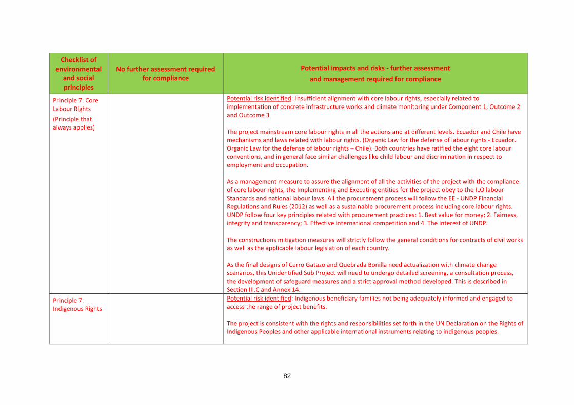
82
Checklist of environmental
and social principles
No further assessment required for compliance
Potential impacts and risks - further assessment and management required for compliance
Principle 7: Core Labour Rights (Principle that always applies)
Potential risk identified: Insufficient alignment with core labour rights, especially related to implementation of concrete infrastructure works and climate monitoring under Component 1, Outcome 2 and Outcome 3 The project mainstream core labour rights in all the actions and at different levels. Ecuador and Chile have mechanisms and laws related with labour rights. (Organic Law for the defense of labour rights - Ecuador. Organic Law for the defense of labour rights – Chile). Both countries have ratified the eight core labour conventions, and in general face similar challenges like child labour and discrimination in respect to employment and occupation. As a management measure to assure the alignment of all the activities of the project with the compliance of core labour rights, the Implementing and Executing entities for the project obey to the ILO labour Standards and national labour laws. All the procurement process will follow the EE - UNDP Financial Regulations and Rules (2012) as well as a sustainable procurement process including core labour rights. UNDP follow four key principles related with procurement practices: 1. Best value for money; 2. Fairness, integrity and transparency; 3. Effective international competition and 4. The interest of UNDP. The constructions mitigation measures will strictly follow the general conditions for contracts of civil works as well as the applicable labour legislation of each country. As the final designs of Cerro Gatazo and Quebrada Bonilla need actualization with climate change scenarios, this Unidentified Sub Project will need to undergo detailed screening, a consultation process, the development of safeguard measures and a strict approval method developed. This is described in Section III.C and Annex 14.
Principle 7: Indigenous Rights
Potential risk identified: Indigenous beneficiary families not being adequately informed and engaged to access the range of project benefits. The project is consistent with the rights and responsibilities set forth in the UN Declaration on the Rights of Indigenous Peoples and other applicable international instruments relating to indigenous peoples.

83
Checklist of environmental
and social principles
No further assessment required for compliance
Potential impacts and risks - further assessment and management required for compliance
In the Region of Antofagasta, there are a small indigenous, group the 2002 Census found that, in Antofagasta and Taltal the indigenous population was, respectively, 1.8% and 1%. 4.7% of Antofagasta region´s populations were indigenous groups (INE, 2005). In Esmeraldas, the 2010 census found that most of the population is afro-ecuadorian (52.1%) with only 0.7% of indigenous population in the Esmeraldas Region (Canton). In Esmeraldas City in the Luis Vargas Torres Island, it is known that about 60 Chachi families live in the island. Chachis are an indigenous group that live in the tropical forests of the Esmeraldas province, where they reside in family-related communities (called centros Chachi). The project intervention will not affect indigenous groups or territories since construction works will be executed outside indigenous territories. In Luis Vargas Torres the early warning system which will be implemented in the island will use megaphone with siren that will be installed in the light posts. Thereby, there is no risk of harming indigenous lifestyle, wealth being, etc. Therefore, it is of great importance for the project take into considerations of this indigenous group. The pilot flood early-warning system in Luis Vargas Torres island and the communication and education strategies must consider the needs of this Chachi group. To elaborate, at the beginning of the project initiation, the Chachi families will be located at the project site and be integrated into the various project activities. It will be dealt with a particular attention on the implementation of the Narrator’s Initiative and the use of their language in the communication strategies. Furthermore, the evacuation map and its procedures (outputs 4.2 and 4.3), and the communication and education strategies (output 6.1) will consider the needs of this indigenous group.
Principle 8: Involuntary Resettlement
Potential risk identified: Temporary physical relocation for the nearest families leaving informal settlements in the proximity of the intervention in Cerro El Gatazo – Esmeraldas, basically related with the removal of mud and soil to stabilize the hill. This risk may confirm when the USP interventions related with Component 1 Outcome 2 finalized the designs. The project will follow strictly participatory process with “do not harm” methodology approach to find a temporary agreed solution. If some families need to be reinstall temporary or permanent, this action cannot be considering as involuntary resettlement.

84
Checklist of environmental
and social principles
No further assessment required for compliance
Potential impacts and risks - further assessment and management required for compliance
In Chile, Campamentos in Antofagasta and Taltal would not be relocated because of the construction works executed by the project. The construction works developed in Antofagasta are unpopulated and far away from the campamentos communities and this works will help mitigate the dangers produced by the mudflow. Output 6.1 aims to raise awareness of local people about the danger of setting on high-risk areas in addressing informal occupation of land in slums (campamentos) or informal settlements in the slopes of the maountains. As the final designs of Cerro Gatazo for the grey and green infrastructure are not actualized including climate change scenarios, this Unidentified Sub Project will need to undergo detailed screening, a consultation process, the development of safeguard measures and a strict approval method developed. This is described in Section III.C and Annex 14.
Principle 9: Protection of Natural Habitats
Potential risk identified: The localization of the radars, meteorological stations and storm detection system are not precisely defined, there is a slightly risk being localized near protective natural habitats. (such risk will come when USP intervention are completely developed) The project will not intervene in protected areas or high value conservation areas. The Project does not involve unjustified conversion or degradation of critical natural habitats, including those that are legally protected; officially proposed for protection; recognized by authoritative sources for their high conservation value, including as critical habitat; or recognized as protected by traditional or indigenous local communities. In Ecuador, Output 2.2. Landslide mitigation works in Esmeraldas will be developed in the urban area of Esmeraldas and Cerro Gatazo is not considered as in protected areas or high value conservation areas. In both countries that Output 3.1. Weather radar in Esmeraldas and a storm detection system in Antofagasta will be developed the installation of them will not involve protected areas or high value conservation
85
Checklist of environmental
and social principles
No further assessment required for compliance
Potential impacts and risks - further assessment and management required for compliance
areas. Finally Output 3.2. Increased number of meteorological stations in Antofagasta, Taltal and Esmeraldas also will not take place in protected areas or high value conservation areas. However, as the localization of the radars, meteorological stations, storm detection system are not precisely defined now. This Unidentified Sub Project will need to undergo detailed screening, an a consultation process, the development of safeguard measures and a strict approval method developed. This is described in Section III.C and Annex 14.
Principle 10: Conservation of Biological Diversity
Potential risk identified: The introduction of non-endemic species for the stabilization of Cerro Gatazo in Esmeraldas may pose a risk for the project. (such decision will come when USP intervention are completely developed) The project avoids any significant or unjustified reduction or loss of biological diversity or the introduction of known invasive species. The project implementation in Chile does not represent any risk to reduction or loss of biological diversity or the introduction of known invasive species. Though, the project for slope stabilization in Cerro Gataso may have a risk of introduction of non-endemic species, as it can be the use of vetiver79 as an option of non-native grass widely used worldwide for slope stabilization in Ecuador. As the decision of which species will be used, this Unidentified Sub Project will need to undergo detailed screening, a consultation process, the development of safeguard measures and a strict approval method developed. This is described in Section III.C and Annex 14.
Principle 11: Climate Change
Risk Identified: As being a project which includes building materials, there is a risk of having unjustified increase in greenhouse gas emissions or other drivers of climate change.
79 One of the plants under consideration is vetiver (Chrysopogon zizanioides), a perennial grass from India. This plant is non-invasive (Joy, 2009), and has already been used in Esmeraldas (PNUD, 2005). Vetiver is extensively used for slope stabilizations (Truong et al., 2008).

86
Checklist of environmental
and social principles
No further assessment required for compliance
Potential impacts and risks - further assessment and management required for compliance
Even though there is still no defined design for the infrastructure to be developed in Cerro Gatazo, it is highly recommended for landslide protection works as an adaptation sustainable measure the use of gabion as “nature – engineer measure”, which uses rocks and wire (preferable recycled wire) for an effective minimal environmental impact. In addition, the costs of this type of infrastructure are economic. This type of infrastructure is sustainable, whereas concrete structures can have a high carbon footprint. They are typically used to form flexible, permeable and monolithic structures and are aesthetically pleasing therefore can be used where concrete is not mandatory. Carbon footprint analyses show that the use of a gabion solution can reduce CO2 emissions by up to 80% compared to a concrete retaining wall of the same height. If allowed to grow, vegetation can establish within a gabion wall, which can further contribute to carbon sequestration of the solution. The project will also be combining with green naturalistic engineering. However, for Antofagasta mudflow protection works the use of concrete is inevitable since it does not exist until know other different type of design for this type of infrastructure in the deserts. There is no possibility to use natural or ecosystem based system because of the characteristics of the desert of Antofagasta. Nonetheless, the project actions , considering all its components, do not involve a large emission of greenhouse gases. As the final designs of Cerro Gatazo and Quebrada Bonilla need actualization in their designs with climate change scenarios, this Unidentified Sub Project will need to undergo detailed screening, a consultation process, the development of safeguard measures and a strict approval method developed. This is described in Section III.C and Annex 14.
Principle 12 Pollution Prevention and Resource Efficiency
Potential risk identified: Project interventions, specially related with Component 1, Outcome 2, may cause pollution related with soil removal and dust. The project does not imply major use of energy or the production of wastes and pollutants.

87
Checklist of environmental
and social principles
No further assessment required for compliance
Potential impacts and risks - further assessment and management required for compliance
The project is designed and implemented in a way that does meets applicable international standards for maximizing energy efficiency and minimizing material resource use, the production of wastes, and the release of pollutants. The project will apply measures to reduce the generation of non-dangerous waste to a maximum. The waste that is generated will be recovered, reused, and recycled in a safe manner for human health and the environment, as far as possible. Final waste, which cannot be used in any way, will be treated, destroyed, or disposed in a manner that is safe and innocuous for the environment, including adequate control of emissions, effluents, and residues resulting from the manipulation and procession of waste material. The manipulation and final disposal of waste will comply with the regulatory dispositions of the country. In the absence of specific regulatory regulations, the manipulation and disposition of waste will be carried out applying international best practices. Waste that may negatively affect people and biodiversity cannot be disposed in the environment The project will generate mostly noise, particulate matter, and probably garbage. However, the project will not affect, to the extent of undermining well-being of the families in Antofagasta and in Esmeraldas as the impact of this type of operation is considered minor. The risk will be managed through the environmental management system complying with the requirements of ISO 14.001 and ISO 14064. However, as Output 2.1. Mudflow control infrastructure in Antofagasta and Output 2.2. Landslide mitigation works in Esmeralda’s activities are not fully developed because of the absence of designs actualized with climate change scenarios, this Unidentified Sub Project will need to undergo detailed screening, a consultation process, the development of safeguard measures and a strict approval method developed. This is described in Section III.C and Annex 14.
Principle 13: Public Health
Potential risk identified: Like any common infrastructure work, there is a low probability risk of collapse, especially during the period of construction and if a hazard materialized during this period, hazards such as: heavy rains, earthquake.
88
Checklist of environmental
and social principles
No further assessment required for compliance
Potential impacts and risks - further assessment and management required for compliance
As any project which includes infrastructure construction works, it must exist an Occupational Health and Safety Management Protocol, which will provide employers, workers, and worker representatives with a sound, flexible framework for addressing safety and health issues in diverse workplaces. They will be intended for medium-sized workplaces such as the project activities developing the construction works. The Protocol shall use a proactive approach to managing workplace safety and health. It shall recognize that finding and fixing hazards before they cause injury or illness is a far more effective approach. The protocol shall be articulated with the OSHA Safety and Health Program Management Guidelines recognized internationally. About the population at risk related with the possible collapse during the implementation, there shall be a Safety Management Protocol in accordance with the technical national and local requirements. However, as Output 2.1. Mudflow control infrastructure in Antofagasta and Output 2.2. Landslide mitigation works in Esmeralda’s activities are not fully developed because of the absence of designs actualized with climate change scenarios, this Unidentified Sub Project will need to undergo detailed screening, a consultation process, the development of safeguard measures and a strict approval method developed. This is described in Section III.C and Annex 14.
Principle 14: Physical and Cultural Heritage
There is no finding that the project could cause any alteration, damage, or removal of physical cultural resources, cultural sites, and sites with unique natural values recognized as such at the community, national or international level. Projects will not interfere with existing access and use of such physical and cultural resources.
89
Checklist of environmental
and social principles
No further assessment required for compliance
Potential impacts and risks - further assessment and management required for compliance
The Project will not be implemented in areas with unique natural values recognized at the community, national or international level, heritage recognized by 1972 UNESCO Convention Concerning the Protection of the World Cultural and Natural Heritage. Both countries have ratified and entered into force of the Convention Concerning the Protection of the World Cultural and Natural Heritage? The Project will not result in interventions that would potentially adversely affect sites, structures, or objects with historical, cultural, artistic, traditional or religious values or intangible forms of culture. On the contrary the narrators’ initiative will build on traditions (e.g., marimba, tales) to potentiate cultural memory of climate-related disasters
Principle 15: Lands and Soil Conservation
The project is designed and shall be implemented in a way that promotes soil conservation and avoids degradation or conversion of productive lands or land that provides valuable ecosystem services.

90
Checklist of environmental
and social principles
No further assessment required for compliance
Potential impacts and risks - further assessment and management required for compliance
The areas where the project will be implemented are no productive lands nor high value conservation sites. The objective of the project is to avoid the increment of land erosion causing landslides in Esmeraldas and mudflows in Antofagasta.

91
PART III: IMPLEMENTATION ARRANGEMENTS
A. Arrangements for project management at the regional and national level 266. CAF will be the implementing entity. The project will be implemented following CAF’s
administrative and financial regulations as agreed with the Adaptation Fund. CAF will designate an officer from the Environment and Climate Change Directorate to be the focal point for project coordination (i.e., CAF´s focal point).
267. The Republic of Chile and the Republic of Ecuador will be the beneficiaries of the project. The responsible entities in Chile an Ecuador will be, respectively, MMA and MAE. The responsible entities will be accountable for the implementation of agreed national activities. This includes the monitoring and evaluation of project interventions, achieving project outcomes, and for the effective use of AF resources.
268. The United Nations Development Programme (UNDP) will be the executing entity. UNDP will be responsible for project execution, while ensuring collaborative and coherent regional action. Project execution includes, among other tasks, financial management, personnel contract and management, and procurement of goods and services. UNDP will execute the project in accordance with the purpose and activities agreed with the implementing agency.
269. In Chile, the project partners are DMC, MOP, MMA, ONEMI, the Municipality of Antofagasta, and the Municipality of Taltal. In Ecuador, the project partners are INAMHI, MAE, the Municipality of Esmeraldas and the Provincial Government of Esmeraldas. The project partners will contribute to project execution and will ensure post-project sustainability (Figure 22).
270. The project organisation structure has a Project Board and a Project Unit (PU) (Figure 22). The Project Board is responsible for making by consensus, management decisions when guidance is required by the Project Manager, including recommendation for approval of project plans and revisions. In order to ensure CAF’s ultimate accountability, Project Board decisions should be made in accordance with standards that shall ensure management for development results, best value money, fairness, integrity, transparency and effective international competition. In case a consensus cannot be reached within the Board, final decision shall rest with CAF´s Climate Change Coordinator. The terms of reference for the Project Board are contained in Annex 5. The Project Board is comprised of the following individuals: Undersecretary of Environment (MMA, Chile), Undersecretary of Climate Change (MAE, Ecuador), CAF´s Climate Change Coordinator and UNDP Project Coordinator.
271. The project assurance role will be provided by CAF´s Principal Environment Executives in Chile and Ecuador. Project assurance will provide objective and independent oversight of the project and monitoring. The project assurance team will review and analyse project reports and the draft annual work plan and budget before they are submitted to the Project Board and will make recommendations to optimize project performance.
272. Strategic guidance will be provided by an Advisory Committee integrated by the Chilean Agency for International Cooperation for Development (AGCID) and the Technical Secretariat of International Cooperation of Ecuador (SETECI).
273. On each country, there will be a National Coordinator. These will be high ranking officers designated by MMA and MAE (the responsible entities). National coordinators will monitor the execution of national activities of the project and will sustain close coordination among the project partners, the Project Manager, UNDP and CAF. To ensure regional coordination,

92
National Coordinators will maintain permanent communication and will have quarterly virtual meetings. These meetings will include the Project Manager and CAF´s focal point.
274. The Project Unit is headed by a Project Manager and includes eight specialists (Figure 23). These personnel will be contracted by UNDP. The Project Manager will run the project on a day-to-day basis on behalf of the Project Board within the constraints laid down in the annual workplan. The Project Manager function will end when the terminal evaluation report, and other documentation required by the Adaptation Fund and CAF, has been completed and submitted to CAF (including operational closure of the project). The Project Manager will promote coordination among project partners.
275. There will be three thematic coordinators: a. An Electronic Media Specialist, who will be responsible to develop and maintain the
project´s electronic platform and the development of communication and education on project activities (Figure 21).
b. A Lead Engineer Specialist, who will be responsible for the implementation of the project´s adaptation measures.
c. A Monitoring and Evaluation Specialist, who will be responsible for monitoring the progress of the project and to document and systematize project experience and learning.
276. Local Specialists situated in Antofagasta and Esmeraldas: a. One Engineer Specialist responsible for the implementation of the adaptation measures in
Antofagasta and Esmeraldas. b. One Social Specialist responsible for implementation of the public communication and
education strategies and the narrators’ initiative in Antofagasta, Taltal, and Esmeraldas. 277. Finally, two Accounting and Administration Assistants will provide on-site administrative and
accounting support. 278. The Project Manager, Electronic Media Specialist, Lead Engineer Specialist, and Monitoring
and Evaluation Specialist will be based in office space arranged by UNDP. Their precise location will be decided at project start. The local engineer specialists will be based in the municipalities and will maintain close collaboration and coordination with the local offices of MMA and MAE (i.e., responsible entities) as well as with the corresponding project partners (Figure 22 and Figure 23). One Accounting and Administration Assistant will be based in the Municipality of Antofagasta and will provide support to the work in both Chilean cities. The other Accounting and Administration Assistant will be based in the Municipality of Esmeraldas.
Audit
279. The project will be audited according to CAF’s as implementing entity and UNDP as executing entity regulations and rules and applicable audit policies.
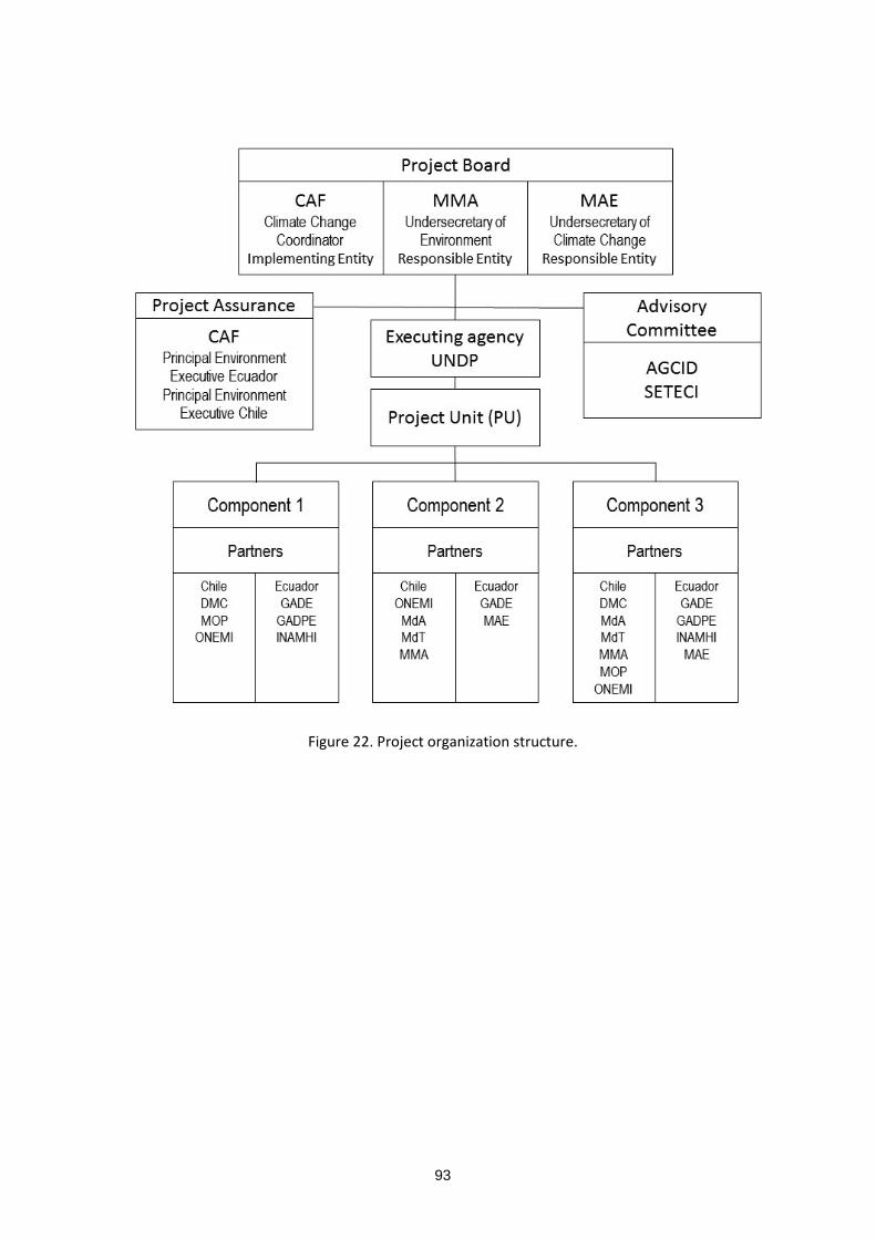
93
Figure 22. Project organization structure.

94
Figure 23. Project Unit.
Agreement on intellectual property rights and use of logo on the project’s deliverables
280. In order to accord proper acknowledgement to the Adaptation Fund for providing funding, the AF logo will appear together with the CAF logo on all promotional materials, other written materials like publications developed by the project, and project hardware. Any citation on publications regarding projects funded by the Adaptation Fund will also accord proper acknowledgement to the AF.
B. Describe the measures for financial and project risk management. 281. CAF’s risks management consists on two structures: internal (CAF) and external (clients). A
robust strategy for internal risks identification and mitigation is in place since 2015 and is executed by the Risks Management Direction. The external strategy is implemented in operations financed by CAF, both in the public and in the private sector. For this project, the structure that applies in terms of risks analysis is the external one. In this case, CAF studies projects from a holistic perspective: political, institutional, financial, operational, technological, social and environmental risks are assessed and addressed with mitigation measures. The status of these risks will be monitored quarterly by the Project Manager. The former will report on the status of the risks to CAF office in Quito, who will record progress in a risk log. Risks will be reported as critical when the impact and probability are high (i.e., 5). Management responses to critical risks will be reported to the Adaptation Fund in the annual project implementation report.
282. In terms of financial risks, CAF’s assessment methodology focuses on financial statements, shareholders’ information, bonds records, and currency performance, among others. In this project, CAF will regard as financial risks those related to the possibility of the grant not being delivered and/or not being delivered on time; to a possible increase in the budget due to inaccuracies in costs calculations, or due to overprices during project implementation.
283. CAF’s social and environmental policies require that every operation in which the organisation participates include an in-depth analysis of the social and environmental risks. The environmental and social risk classifies operations in terms of high, medium, low or no risk. During evaluation phase, the review process seeks to identify vulnerable areas, critic aspects, necessary measures for the prevention, control, mitigation and compensation of identified impacts, so they can be included in the cost structure in order to ensure their viability. The results of the evaluation and the definition of the environmental and social conditions and
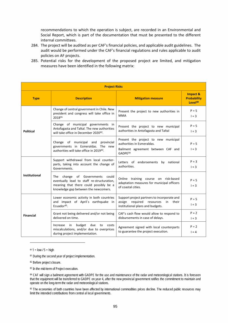
95
recommendations to which the operation is subject, are recorded in an Environmental and Social Report, which is part of the documentation that must be presented to the different internal committees.
284. The project will be audited as per CAF’s financial policies, and applicable audit guidelines. The audit would be performed under the CAF’s financial regulations and rules applicable to audit policies on AF projects.
285. Potential risks for the development of the proposed project are limited, and mitigation measures have been identified in the following matrix:
Project Risks
Type Description Mitigation measure Impact &
Probability Level80
Political
Change of central government in Chile. New president and congress will take office in 201881
Present the project to new authorities in MMA
P = 5 I = 3
Change of municipal governments in Antofagasta and Taltal. The new authorities will take office in December 202082.
Present the project to new municipal authorities in Antofagasta and Taltal
P = 5 I = 3
Change of municipal and provincial governments in Esmeraldas. The new authorities will take office in 201983.
Present the project to new municipal authorities in Esmeraldas. Bailment agreement between CAF and GADPE84
P = 5 I = 3
Institutional
Support withdrawal from local counter-parts, taking into account the change of Governments.
Letters of endorsements by national authorities.
P = 3 I = 3
The change of Governments could eventually lead to staff re-structuration, meaning that there could possibly be a knowledge gap between the newcomers.
Online training course on risk-based adaptation measures for municipal officers of coastal cities.
P = 5 I = 3
Financial
Lower economic activity in both countries and impact of April´s earthquake in Ecuador85.
Support project partners to incorporate and assign required resources in their institutional plans and budgets.
P = 5 I = 3
Grant not being delivered and/or not being delivered on time.
CAF’s cash flow would allow to respond to disbursements in case of delays.
P = 2 I = 3
Increase in budget due to costs miscalculations, and/or due to overprices during project implementation.
Agreement signed with local counterparts to guarantee the project execution.
P = 2 I = 4
80 1 = low / 5 = high 81 During the second year of project implementation. 82 Before project closure. 83 In the mid-term of Project execution. 84 CAF will sign a bailment agreement with GADPE for the use and maintenance of the radar and meteorological stations. It is foreseen that the equipment will be transferred to GADPE on year 4, after the new provincial government ratifies the commitment to maintain and operate on the long-term the radar and meteorological stations. 85 The economies of both countries have been affected by international commodities prices decline. The reduced public resources may limit the intended contributions from central al local governments.
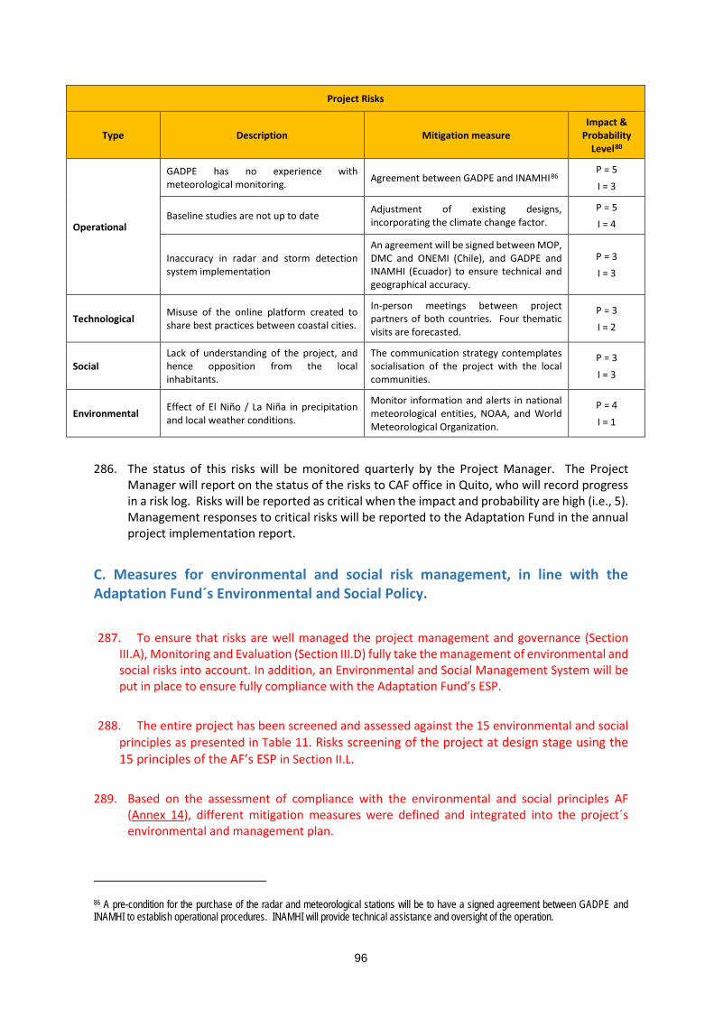
96
Project Risks
Type Description Mitigation measure Impact &
Probability Level80
Operational
GADPE has no experience with meteorological monitoring. Agreement between GADPE and INAMHI86
P = 5 I = 3
Baseline studies are not up to date Adjustment of existing designs, incorporating the climate change factor.
P = 5 I = 4
Inaccuracy in radar and storm detection system implementation
An agreement will be signed between MOP, DMC and ONEMI (Chile), and GADPE and INAMHI (Ecuador) to ensure technical and geographical accuracy.
P = 3 I = 3
Technological Misuse of the online platform created to share best practices between coastal cities.
In-person meetings between project partners of both countries. Four thematic visits are forecasted.
P = 3 I = 2
Social Lack of understanding of the project, and hence opposition from the local inhabitants.
The communication strategy contemplates socialisation of the project with the local communities.
P = 3 I = 3
Environmental Effect of El Niño / La Niña in precipitation and local weather conditions.
Monitor information and alerts in national meteorological entities, NOAA, and World Meteorological Organization.
P = 4 I = 1
286. The status of this risks will be monitored quarterly by the Project Manager. The Project
Manager will report on the status of the risks to CAF office in Quito, who will record progress in a risk log. Risks will be reported as critical when the impact and probability are high (i.e., 5). Management responses to critical risks will be reported to the Adaptation Fund in the annual project implementation report.
C. Measures for environmental and social risk management, in line with the Adaptation Fund´s Environmental and Social Policy.
287. To ensure that risks are well managed the project management and governance (Section
III.A), Monitoring and Evaluation (Section III.D) fully take the management of environmental and social risks into account. In addition, an Environmental and Social Management System will be put in place to ensure fully compliance with the Adaptation Fund’s ESP.
288. The entire project has been screened and assessed against the 15 environmental and social principles as presented in Table 11. Risks screening of the project at design stage using the 15 principles of the AF’s ESP in Section II.L.
289. Based on the assessment of compliance with the environmental and social principles AF
(Annex 14), different mitigation measures were defined and integrated into the project´s environmental and management plan.
86 A pre-condition for the purchase of the radar and meteorological stations will be to have a signed agreement between GADPE and INAMHI to establish operational procedures. INAMHI will provide technical assistance and oversight of the operation.
97
290. The project also defined Component 1, Outcome 2 and 3 as USP interventions, and add a mechanism to be follow during implementation phase to comply with AF´s ESP. This procedure can be consulted in Annex 14. Any action without ESP screening, mitigation measures and approval by the project board could not be implemented.
291. Before the implementation of any action or USP the IE and the EE will assess the compliance of the activity with the ESMP in line with the Adaptation Funds ESP.
292. The following is a summary of the measures identified during design phase. All of them would be implemented to prevent, correct and/or mitigate adverse environmental and social impacts and risks. More mitigation measures shall be implemented for USP intervention during full implementation phase of the project.
Verification of documentation which demonstrate compliance with the AF’s ESP
a) Activity / USPs with environmental permits, licence, registry and technical standards according to the national local legislation normativity.
b) Identification of vulnerable groups (named at the AF’s ESP Guidelines) c) Socialization, consultation documentation of the Activity / USPs with the direct beneficiaries
and possible affected by the works. d) Documentation of the possible different measures in case of water, energy, mobility
interruption caused by the Activity / USPs. e) Documentation regarding contracting works. f) Documentation of indigenous groups identified and invitation to participate. g) In case of recognition of possible resettlements caused by the implementation of an Activity
/ USPs management of the case with the GAD Esmeraldas. h) Possible species that will be used in Cerro Gatazo green infrastructure with the approval of
the MAE. i) Localization of the weather system (radars – meteorological stations) with the approval of
the MAE and the GADE Esmeraldas, Municipality of Antofagasta and MMA; if required other authorities.
j) Carbon footprint of the Activity / USPs for the Cerro Gatazo grey infrastructure and Quebrada Bonilla development.
D. Describe the monitoring and evaluation arrangements and provide a budgeted M&E plan. 293. The project results as outlined in the project results framework (Part III, section E) will be
monitored annually and evaluated periodically during project implementation to ensure the project effectively achieves these results. Supported by component three (i.e., includes knowledge Management and monitoring and evaluation), the project monitoring and evaluation plan (Table 13) will also facilitate learning and ensure knowledge is shared and widely disseminated to support the scaling up and replication of project results.
294. Project-level monitoring and evaluation will be undertaken in compliance with standard CAF requirements as agreed with the Adaptation Fund. Though these CAF requirements are not detailed in this section of the project document, CAF´ Ecuador country office will ensure that
98
the monitoring and evaluation (M&E) requirements are met in a timely fashion and to high quality standards. The additional and mandatory monitoring and evaluation requirements as outlined in this section will be undertaken in accordance with the agreement with the Adaptation Fund. In addition to these mandatory CAF and AF monitoring and evaluation requirements, other M&E activities deemed necessary to support project-level adaptive management, and the exact role of project target groups and other stakeholders in project M&E activities, will be finalized during the Inception Workshop and will be detailed in the Inception Report.
Oversight and monitoring responsibilities
295. The primary responsibility for day-to-day project implementation and regular monitoring rests with the Project Manager. The Project Manager will develop annual work plans based on the multi-year work plan included in the present project document, including annual targets at the output level to ensure the efficient implementation of the project. The Project Manager will ensure that the standard CAF and Adaptation Fund M&E requirements are fulfilled to the highest quality. This includes, but is not limited to, ensuring the results framework indicators are monitored annually in time for reporting, and reporting to the Project Board at least once a year on project progress. The Project Manager will inform the Project Board and CAF Country Office in Ecuador of any delays or difficulties as they arise during implementation, including the implementation of the M&E plan, so that the appropriate support and corrective measures can be adopted. The Project Manager will also ensure that all project staff maintain a high level of transparency, responsibility and accountability in monitoring and reporting project results.
296. CAF Country Office in Ecuador will support the Project Manager as needed, including through annual supervision missions. This Country Office is responsible for complying with all CAF project-level M&E requirements. This includes ensuring (i) that quality assurance assessment during implementation is undertaken annually, and (ii) that annual targets at the output level are developed, and monitored and reported using CAF corporate systems. Any quality concerns flagged by the process must be addressed by project management. Additional M&E and implementation quality assurance and troubleshooting support will be provided by the CAF Country Office in Ecuador. The project target groups and stakeholders will be involved as much as possible in project-level M&E.
Monitoring and reporting requirements
297. Inception Workshop and Report A project inception workshop will be held after the project document has been signed by all relevant parties to: a) re-orient project stakeholders to the project strategy and discuss any changes in the overall context that influence project implementation; b) discuss the roles and responsibilities of the project team, including reporting and communication lines and conflict resolution mechanisms; c) review the results framework and discuss reporting, monitoring and evaluation roles and responsibilities and finalize the M&E plan; d) review financial reporting procedures and mandatory requirements, and agree on the arrangements for the audit; e) plan and schedule Project Board meetings and finalize the first year annual work plan. The Project Manager will prepare the inception report no later than one month after the inception workshop. The final inception report will be cleared by CAF Country Office in Ecuador and will be approved by the Project Board.
298. Adaptation Fund Project Performance Report (PPR). The Project Manager and CAF Country Office in Ecuador will provide objective input to the annual PPR as outlined in Document AFB/EFC.9/.4/Rev.1 approved at the 18th meeting of the Adaptation Fund Board. The Project Manager will ensure that the indicators included in the project results framework are

99
monitored annually well in advance of the PPR submission deadline and are reported on accordingly in the PPR. The PPR that is submitted to the Adaptation Fund each year must also be submitted in English and shared with the Project Board. The CAF Country Office in Ecuador will coordinate the input of project partner and stakeholders to the PPR. The quality rating of the previous year’s PPR will be used to inform the preparation of the subsequent report. The first PPR should be submitted one year after the start of project implementation (date of inception workshop). The project’s terminal PPR along with the terminal evaluation report and corresponding management response will serve as the final project report package or project completion report. The final project report package shall be discussed with the Project Board during an end-of-project review meeting (i.e., Project Board closure meeting) to discuss lesson learned and opportunities for scaling up.
299. Adaptation Fund Results Tracker. This instrument is used by the Adaptation Fund to track specific indicator across its portfolio. The results tracker is an integral part of the PPR and will be completed based on the guidance and requirements of the Adaptation Fund.
300. Mid-term Review (MTR). An independent mid-term review process will begin after the second PPR has been submitted to the AF, and the final MTR report will be submitted to the Adaptation in the same year as the third PPR. The MTR findings and responses outlined in the management response will be incorporated as recommendations for enhanced implementation during the final half of the project’s duration. The terms of reference, the review process and the final MTR report will follow the standard templates and guidance established by the Adaptation Fund. The final MTR report will be available in English and will be cleared by the CAF Country Office in Ecuador, the Principal Environment Executives in Ecuador and Chile, and approved by the Project Board.
301. Terminal Evaluation (TE). An independent terminal evaluation (TE) will take place before operational closure of the project. The Project Manager will remain on contract until the TE report and management response have been finalized. The terms of reference, the evaluation process and the final TE report will follow the standard templates and guidance established by the Adaptation Fund. The final TE report will be cleared by the CAF Country Office in Ecuador, the Principal Environment Executives in Ecuador and Chile, and approved by the Project Board.
302. The CAF Country Office in Ecuador will retain all M&E records for this project for up to seven years after project financial closure in order to support ex-post evaluations that might be undertaken.
Table 12. Budgeted monitoring and evaluation plan.
Monitoring and Evaluation action
Primary responsibility
Indicative cost 87
(USD)
Time frame
1. Inception Workshop
CAF 20,000 Within two months of project document signature
2. Inception Report Project Manager None Within two weeks of inception workshop
87 Does not include personnel.
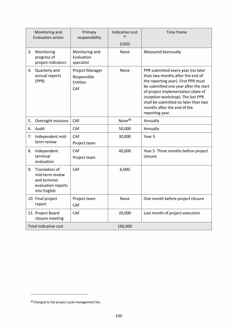
100
Monitoring and Evaluation action
Primary responsibility
Indicative cost 87
(USD)
Time frame
3. Monitoring progress of project indicators
Monitoring and Evaluation specialist
None Measured biannually
4. Quarterly and annual reports (PPR)
Project Manager Responsible Entities CAF
None PPR submitted every year (no later than two months after the end of the reporting year). First PPR must be submitted one year after the start of project implementation (date of inception workshop). The last PPR shall be submitted no later than two months after the end of the reporting year.
5. Oversight missions CAF None88 Annually
6. Audit CAF 50,000 Annually
7. Independent mid-term review
CAF Project team
30,000 Year 3
8. Independent terminal evaluation
CAF Project team
40,000 Year 5. Three months before project closure
9. Translation of mid-term review and terminal evaluation reports into English
CAF 6,000
10. Final project report
Project team CAF
None One month before project closure
11. Project Board closure meeting
CAF 20,000 Last month of project execution
Total indicative cost 166,000
88 Charged to the project cycle management fee.

101
E. Include a results framework for the project proposal, including milestones, targets and indicators.
Objective and Outcome Indicators Baseline
Mid-term and end of project targets
Means of verification Assumptions
Project Objective: To reduce vulnerability to climate-related floods, mudflows and landslides in three coastal cities by mainstreaming a risk-based approach to adaptation, building collaboration and networking, and developing a culture of adaptation
Number of men and women protected by improved risk-reduction measures in Antofagasta, Taltal and Esmeraldas.
Antofagasta = 0 Taltal = 0 Esmeraldas = 0
End of project Antofagasta = 380,000 (ca., 50% women) Taltal = 10,000 (ca., 50% women) Esmeraldas = 161,000 (ca., 50% women)
Project Performance Report
Political support from local and national authorities.
Entities responsible for building relevant infrastructure and early warning systems are willing to mainstream adaptation measures in their plans and actions.
Interest and collaboration from local population and stakeholders.
Component 1. Priority Actions to increase resilience.
Outcome 1. Enhanced plans and green infrastructure reduces vulnerability to floods, landslides and mudflows in two coastal cities
Number of plans that incorporate provisions for adaptation to climate change with gender perspective.
Stormwater management plan89 Antofagasta = 0 Green infrastructure plan90 Esmeraldas = 0
Mid-term: 1 End of project: 2
Antofagasta´s stormwater management plan Esmeraldas´ green
infrastructure plan Legal instruments
adopting the plans
Interest and support from local authorities.
Local and national authorities committed to fund and implement the plans.
89 Antofagasta has a stormwater management plan, prepared in 2004, which does not consider the climate change factor. In Chile, stormwater management plans are compulsory for cities >50,000 people. 90 The adaptation and mitigation strategy (ONU-HABITAT, 2011) and the risks and disasters management strategy (GAD Esmeraldas, 2012) include elements for mangrove enhancement and reforestation of hillsides. However, there is no comprehensive plan to operationalise a grid of green spaces that contribute to flood and landslide protection and generate additional benefits (i.e., a green infrastructure plan).

102
Objective and Outcome Indicators Baseline
Mid-term and end of project targets
Means of verification Assumptions
Outcome 2. Reduced vulnerability to floods, landslides and mudflows in two coastal cities.
Number of physical assets constructed to withstand conditions resulting from climate variability and change.
Antofagasta = 0 Esmeraldas = 0
Mid-term: 1 End of project: 2
Designs and construction report of mudflow control infrastructure for Bonilla gorge (Antofagasta) Designs and construction
report of landslide control infrastructure in Cerro Gatazo (Esmeraldas)
Local and national authorities warrant quality assurance of designs and construction works.
Pertinent local and national authorities incorporate in their financial plans the resources for future maintenance of the new infrastructure.
Number of men and women protected by improved infrastructure to withstand climate change and variability-induced stress.
Antofagasta = 0 Esmeraldas = 0
End of project: 12,840 Antofagasta = (ca., 50% women) Esmeraldas = 500 (ca., 50% women)
Survey report of people living in areas protected by improved infrastructure (Bonilla gorge and Cerro Gatazo) Percentage of women in
Antofagasta and Esmeraldas from national statistics.
Outcome 3. Improved climate monitoring and means to alert the local population
Number of weather radar in Esmeraldas and Storm detection system in Antofagasta to monitor precipitation, linked to gender-sensitive early warning systems.
Antofagasta = 0 Esmeraldas = 0
Mid-term Antofagasta = 1 Esmeraldas = 1
Radar/storm system siting analysis reports. Radar/storm system
installation reports. Quarterly radar/storm
system operation reports. Agreements to ensure
flow of radar/storm
Responsible Entities promptly execute complementary works to house and operate the equipment (e.g., radar tower, radio link).
Pertinent entities incorporate in their financial

103
Objective and Outcome Indicators Baseline
Mid-term and end of project targets
Means of verification Assumptions
system information to early warning systems91. Long-term agreements for
operation and maintenance92. Bailment agreements93
plans the resources for future operation and maintenance of the new meteorological equipment.
Risk management authorities incorporate the new information into their early warning systems to alert the local population.
Number of meteorological stations to monitor precipitation which affect the cities, linked to gender-sensitive early warning systems.
Antofagasta94 = 4 Taltal = 1 Esmeraldas95 = 5
Mid-term Antofagasta = 6 Taltal = 2 Esmeraldas = 796
Installation reports. Quarterly operation
reports. Agreements to ensure
flow of information to early warning systems. Long-term agreements for
operation and maintenance. Bailment agreements
Outcome 4. Improved means to respond to floods, landslides and mudflows
Number of men and women covered by alert and evacuation route signs to respond to floods
Number of people Antofagasta = 0
End of project: Reports on installation of sirens and evacuation route signs.
Risk management authorities integrate the new tools into their early
91 In Chile, agreement among MOP, DMC and ONEMI. In Ecuador, agreement between GADPE and INAMHI. These agreements will establish operational procedures, information flow, and guarantee that the information from the storm detection system and meteorological stations is expedited to the national weather forecast and early warning systems. 92 In Chile, DMC and MOP, and in Ecuador, GADPE will be responsible for installation, operation and maintenance of the radar/ storm detection system and meteorological stations. 93 CAF will sign bailment agreements with DMC, MOP and GADPE for the use and maintenance of the radar/ storm detection system and the meteorological stations. 94 MOP has three automatic stations in Antofagasta (Liceo Científico Humanista La Chimba, Escuela Fundación Minera Escondida, and Universidad de Antofagasta) and one in Taltal. 95 INAMHI has three meteorological stations that are relevant for the present project: La Concordia (M0025), Sague (San Mateo) (M0441), and Teaone - Tabiazo (M0444). Two additional stations are located in the city of Esmeraldas (operated by INOCAR) and at Tachina´s airport. 96 The project will provide two meteorological stations and one hydrological station. These stations will be managed by GADPE under the supervision of INAMHI.
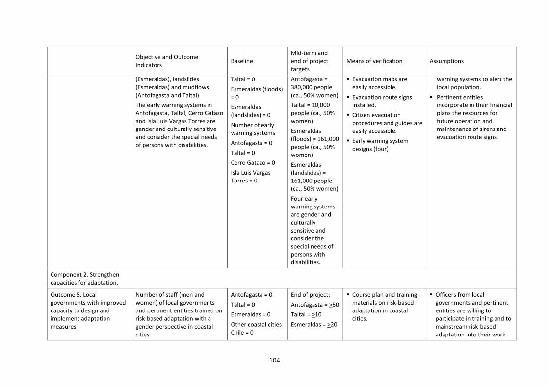
104
Objective and Outcome Indicators Baseline
Mid-term and end of project targets
Means of verification Assumptions
(Esmeraldas), landslides (Esmeraldas) and mudflows (Antofagasta and Taltal) The early warning systems in Antofagasta, Taltal, Cerro Gatazo and Isla Luis Vargas Torres are gender and culturally sensitive and consider the special needs of persons with disabilities.
Taltal = 0 Esmeraldas (floods) = 0 Esmeraldas (landslides) = 0 Number of early warning systems Antofagasta = 0 Taltal = 0 Cerro Gatazo = 0 Isla Luis Vargas Torres = 0
Antofagasta = 380,000 people (ca., 50% women) Taltal = 10,000 people (ca., 50% women) Esmeraldas (floods) = 161,000 people (ca., 50% women) Esmeraldas (landslides) = 161,000 people (ca., 50% women) Four early warning systems are gender and culturally sensitive and consider the special needs of persons with disabilities.
Evacuation maps are easily accessible. Evacuation route signs
installed. Citizen evacuation
procedures and guides are easily accessible.
Early warning system designs (four)
warning systems to alert the local population.
Pertinent entities incorporate in their financial plans the resources for future operation and maintenance of sirens and evacuation route signs.
Component 2. Strengthen capacities for adaptation.
Outcome 5. Local governments with improved capacity to design and implement adaptation measures
Number of staff (men and women) of local governments and pertinent entities trained on risk-based adaptation with a gender perspective in coastal cities.
Antofagasta = 0 Taltal = 0 Esmeraldas = 0 Other coastal cities Chile = 0
End of project: Antofagasta = >50 Taltal = >10 Esmeraldas = >20
Course plan and training materials on risk-based adaptation in coastal cities.
Officers from local governments and pertinent entities are willing to participate in training and to mainstream risk-based adaptation into their work.

105
Objective and Outcome Indicators Baseline
Mid-term and end of project targets
Means of verification Assumptions
Other coastal cities Ecuador = 0
Other coastal cities Chile = >10 Other coastal cities Ecuador = >10 About 40% will be women
Report of training of trainers. Report of each training
event (including list of participants).
Outcome 6. Local population and government personnel with increased awareness of climate-related risks (floods, landslides, mudflows)
Number of men and women who have participated in awareness activities and events.
Antofagasta = 0 Taltal = 0 Esmeraldas = 0
End of project: Antofagasta = >30,000 (ca., 50% women) Taltal = >1,000 (ca., 50% women) Esmeraldas = >16,000 (ca., 50% women)
Public communication and education strategies for Antofagasta, Taltal and Esmeraldas. Report of each awareness
activity and event (including list of participants). Quarterly progress
reports of implementation of each communication and education strategy.
Local population is sensible to messages about climate-related risks and adaptation to climate change.
Pertinent entities are willing to sustain long-term public awareness strategies and the narrators´ initiative.
Number of narrators (men and women) trained to maintain cultural memory of climate-related disaster and risks.
Antofagasta = 0 Taltal = 0 Esmeraldas = 0
End of project: Antofagasta = 10 (ca., 50% women) Taltal = 5 (ca., 50% women) Esmeraldas = 10 (ca., 50% women)
Training materials. Long-term signed
agreements to sustain narrators’ initiative in the three cities.
Quarterly progress reports of implementation of the narrators´ initiative
Component 3. ICTs and partnership between coastal cities in Latin America.

106
Objective and Outcome Indicators Baseline
Mid-term and end of project targets
Means of verification Assumptions
Outcome 7. Lessons and best practice on reducing vulnerability to climate related flooding, landslides and mudflows in coastal cities have been shared in the region.
Number of men and women (by nationality) who have participated in events for dissemination of lessons and best practice (e.g., workshops, exchange visits, seminars)
0 Mid-term >100 people > 50% women End of project: >200 people > 40% women
Memoirs / reports of virtual and in-person events (including list of participants)
The information is attractive, useful and accessible to key stakeholders and interest groups
Number of visitors per month (annual average) recorded in the network of electronic channels of the regional on-line platform used to disseminate project´ learnings and best practice
Visits 0 Unique visits 0
Mid-term Visits >2000 Unique visits >1600 End of project: Visits >4000 Unique visits >3200
Monthly reports from electronic platform administrator
Coastal communities have adequate internet access

107
F. Demonstrate how the project aligns with the Results Framework of the Adaptation Fund 303. The project is comprehensive and aligns with four of the seven outcomes of the Adaptation
Fund´s results framework.
Project Objective(s)97
Project Objective Indicator(s)
Fund Outcome Fund Outcome Indicator
Grant Amount98 (USD)
To reduce vulnerability to climate-related flooding in three coastal cities by mainstreaming a risk-based approach to adaptation, building collaboration and networking, and developing a culture of adaptation.
Number of people (men and women) protected by improved risk-reduction measures in Antofagasta, Taltal and Esmeraldas.
Outcome 1: Reduced exposure to climate-related hazards and threats
1. Relevant threat and hazard information generated and disseminated to stakeholders on a timely basis
1,812,19599
Outcome 2: Strengthened institutional capacity to reduce risks associated with climate-induced socioeconomic and environmental losses
2. Capacity of staff to respond to, and mitigate impacts of, climate-related events from targeted institutions increased
229,937100
Outcome 3: Strengthened awareness and ownership of adaptation and climate risk reduction processes at local level
3.1. Percentage of targeted population aware of predicted adverse impacts of climate change, and of appropriate responses
1,022,074101
Outcome 4: Increased adaptive capacity within relevant development sector services and infrastructure assets
4.2. Physical infrastructure improved to withstand climate change and variability-induced stress
7,819,848102
Project Outcome(s) Project Outcome Indicator(s)
Fund Output Fund Output Indicator
Grant Amount (USD)
97 The AF utilized OECD/DAC terminology for its results framework. Project proponents may use different terminology but the overall principle should still apply 98 The allocations listed below do not sum the total project Budget. Component 3 (i.e., outputs 7.1 and 7.2) deal with knowledge management and dissemination of lessons and best practice. The AF´s results framework does not have a specific outcome or output dealing with knowledge management. 99 Correspond to project outputs 3.1, 3.2, 4.1, 4.2 and 4.3. See project budget. 100 Correspond to project output 5.1. See project budget. 101 Correspond to project outputs 6.1 and 6.2. See project budget. 102 Correspond to project outputs 1.1, 1.2, 2.1, and 2.2. See project budget.

108
Outcome 1. Enhanced plans and green infrastructure reduces vulnerability to floods, landslides and mudflows in three coastal cities
Number of plans that incorporate provisions for adaptation to climate change.
Output 4: Vulnerable development sector services and infrastructure assets strengthened in response to climate change impacts, including variability
4.1.2. Number of physical assets strengthened or constructed to withstand conditions resulting from climate variability and change (by sector and scale)
7,819,848
Outcome 2. Reduced vulnerability to floods, landslides and mudflows in two coastal cities
Number of physical assets constructed to withstand conditions resulting from climate variability and change. Number of people (men and women) protected by improved infrastructure to withstand climate change and variability-induced stress.
Outcome 3. Improved climate monitoring and means to alert the local population
Number of weather radar/storm system to monitor precipitation, linked to early warning systems. Number of meteorological stations to monitor precipitation which affect the cities, linked to early warning systems.
Output 1.2: Targeted population groups covered by adequate risk reduction systems
1.2.1. Percentage of target population covered by adequate risk-reduction systems
1,812,195
Outcome 4. Improved means to respond to floods, landslides and mudflows
Number of people (men and women) covered by alert and evacuation route signs to respond to floods (Esmeraldas), landslides (Esmeraldas) and mudflows (Antofagasta and Taltal)
Outcome 5. Local governments with improved capacity to design and implement
Number of staff (men and women) of local governments and pertinent entities
Output 2: Strengthened capacity of national and subnational centres and networks to
2.1.1. Number of staff trained to respond to, and mitigate impacts of,
229,937

109
adaptation measures
trained on risk-based adaptation in coastal cities.
respond rapidly to extreme weather events
climate-related events (by gender)
Outcome 6. Local population and government personnel with increased awareness of climate-related risks (floods, landslides, mudflows)
Number of people (men and women) who have participated in awareness activities and events. Number of narrators (men and women) trained to maintain cultural memory of climate-related disaster and risks.
Output 3: Targeted population groups participating in adaptation and risk reduction awareness activities
3.1 Number of news outlets in the local press and media that have covered the topic
1,022,074
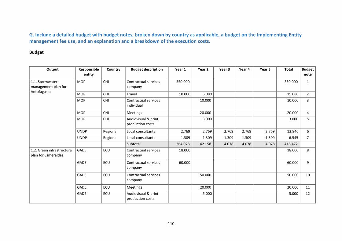
110
G. Include a detailed budget with budget notes, broken down by country as applicable, a budget on the Implementing Entity management fee use, and an explanation and a breakdown of the execution costs.
Budget
Output Responsible
entity Country Budget description Year 1 Year 2 Year 3 Year 4 Year 5 Total Budget
note
1.1. Stormwater management plan for Antofagasta
MOP CHI Contractual services company
350.000 350.000 1
MOP CHI Travel 10.000 5.080 15.080 2 MOP CHI Contractual services
individual 10.000 10.000 3
MOP CHI Meetings 20.000 20.000 4 MOP CHI Audiovisual & print
production costs 3.000 3.000 5
UNDP Regional Local consultants 2.769 2.769 2.769 2.769 2.769 13.846 6 UNDP Regional Local consultants 1.309 1.309 1.309 1.309 1.309 6.545 7 Subtotal 364.078 42.158 4.078 4.078 4.078 418.472
1.2. Green infrastructure plan for Esmeraldas
GADE ECU Contractual services company
18.000 18.000 8
GADE ECU Contractual services company
60.000 60.000 9
GADE ECU Contractual services company
50.000 50.000 10
GADE ECU Meetings 20.000 20.000 11 GADE ECU Audiovisual & print
production costs 5.000 5.000 12
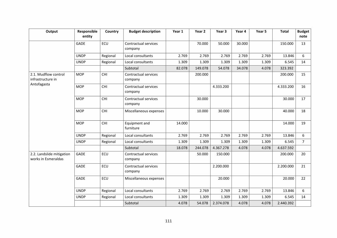
111
Output Responsible entity
Country Budget description Year 1 Year 2 Year 3 Year 4 Year 5 Total Budget note
GADE ECU Contractual services company
70.000 50.000 30.000 150.000 13
UNDP Regional Local consultants 2.769 2.769 2.769 2.769 2.769 13.846 6 UNDP Regional Local consultants 1.309 1.309 1.309 1.309 1.309 6.545 14 Subtotal 82.078 149.078 54.078 34.078 4.078 323.392
2.1. Mudflow control infrastructure in Antofagasta
MOP CHI Contractual services company
200.000 200.000 15
MOP CHI Contractual services company
4.333.200 4.333.200 16
MOP CHI Contractual services company
30.000 30.000 17
MOP CHI Miscellaneous expenses 10.000 30.000 40.000 18
MOP CHI Equipment and furniture
14.000 14.000 19
UNDP Regional Local consultants 2.769 2.769 2.769 2.769 2.769 13.846 6 UNDP Regional Local consultants 1.309 1.309 1.309 1.309 1.309 6.545 7 Subtotal 18.078 244.078 4.367.278 4.078 4.078 4.637.592
2.2. Landslide mitigation works in Esmeraldas
GADE ECU Contractual services company
50.000 150.000 200.000 20
GADE ECU Contractual services company
2.200.000 2.200.000 21
GADE ECU Miscellaneous expenses 20.000 20.000 22
UNDP Regional Local consultants 2.769 2.769 2.769 2.769 2.769 13.846 6 UNDP Regional Local consultants 1.309 1.309 1.309 1.309 1.309 6.545 14 Subtotal 4.078 54.078 2.374.078 4.078 4.078 2.440.392
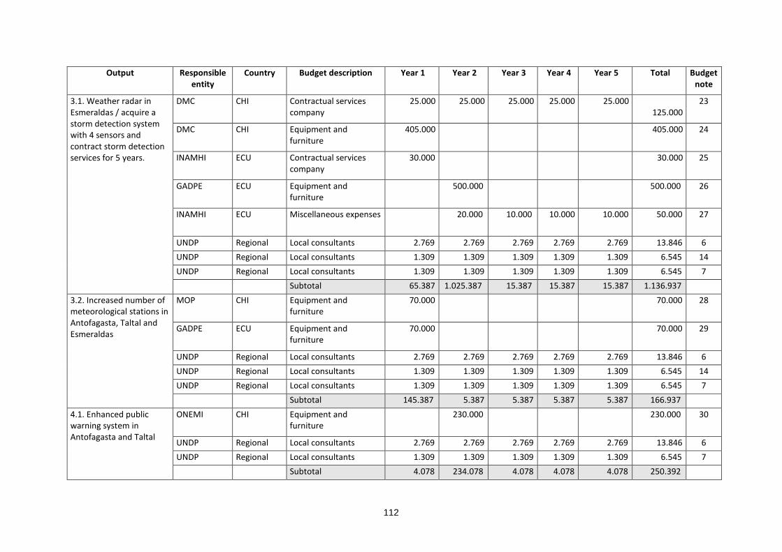
112
Output Responsible entity
Country Budget description Year 1 Year 2 Year 3 Year 4 Year 5 Total Budget note
3.1. Weather radar in Esmeraldas / acquire a storm detection system with 4 sensors and contract storm detection services for 5 years.
DMC CHI Contractual services company
25.000 25.000 25.000 25.000 25.000 125.000
23
DMC CHI Equipment and furniture
405.000 405.000 24
INAMHI ECU Contractual services company
30.000 30.000 25
GADPE ECU Equipment and furniture
500.000 500.000 26
INAMHI ECU Miscellaneous expenses 20.000 10.000 10.000 10.000 50.000 27
UNDP Regional Local consultants 2.769 2.769 2.769 2.769 2.769 13.846 6 UNDP Regional Local consultants 1.309 1.309 1.309 1.309 1.309 6.545 14 UNDP Regional Local consultants 1.309 1.309 1.309 1.309 1.309 6.545 7 Subtotal 65.387 1.025.387 15.387 15.387 15.387 1.136.937
3.2. Increased number of meteorological stations in Antofagasta, Taltal and Esmeraldas
MOP CHI Equipment and furniture
70.000 70.000 28
GADPE ECU Equipment and furniture
70.000 70.000 29
UNDP Regional Local consultants 2.769 2.769 2.769 2.769 2.769 13.846 6 UNDP Regional Local consultants 1.309 1.309 1.309 1.309 1.309 6.545 14 UNDP Regional Local consultants 1.309 1.309 1.309 1.309 1.309 6.545 7 Subtotal 145.387 5.387 5.387 5.387 5.387 166.937
4.1. Enhanced public warning system in Antofagasta and Taltal
ONEMI CHI Equipment and furniture
230.000 230.000 30
UNDP Regional Local consultants 2.769 2.769 2.769 2.769 2.769 13.846 6 UNDP Regional Local consultants 1.309 1.309 1.309 1.309 1.309 6.545 7 Subtotal 4.078 234.078 4.078 4.078 4.078 250.392

113
Output Responsible entity
Country Budget description Year 1 Year 2 Year 3 Year 4 Year 5 Total Budget note
4.2. Pilot flood warning system in Esmeraldas
GADE ECU Contractual services company
10.000 10.000 31
GADE ECU Equipment and furniture
10.000 50.000 60.000 32
GADE ECU Meetings 2.000 6.600 2.000 10.600 33 GADE ECU Miscellaneous expenses 5.000 5.000 5.000 5.000 20.000 34
UNDP Regional Local consultants 2.769 2.769 2.769 2.769 2.769 13.846 6 UNDP Regional Local consultants 1.309 1.309 1.309 1.309 1.309 6.545 14 Subtotal 26.078 65.678 11.078 9.078 9.078 120.992
4.3. Evacuation route maps and signals in Antofagasta, Taltal and Esmeraldas
ONEMI CHI Contractual services company
10.000 10.000 35
ONEMI CHI Audiovisual & print production costs
3.000 3.000 36
ONEMI CHI Audiovisual & print production costs
40.000 40.000 37
ONEMI CHI Miscellaneous expenses 6.000 6.000 6.000 6.000 24.000 38
GADE ECU Contractual services company
10.000 10.000 39
GADE ECU Audiovisual & print production costs
3.000 3.000 40
GADE ECU Audiovisual & print production costs
20.000 20.000 41
UNDP Regional Local consultants 2.769 2.769 2.769 2.769 2.769 13.846 6 UNDP Regional Local consultants 1.309 1.309 1.309 1.309 1.309 6.545 14 UNDP Regional Local consultants 1.309 1.309 1.309 1.309 1.309 6.545 7

114
Output Responsible entity
Country Budget description Year 1 Year 2 Year 3 Year 4 Year 5 Total Budget note
Subtotal 25.387 77.387 11.387 11.387 11.387 136.937 5.1. Course on risk-based adaptation in coastal cities
APC Regional Local consultants 25.000 50.000 25.000 100.000 42 APC Regional Meetings 8.000 8.000 43 APC Regional Grant 30.000 30.000 44 APC Regional Meetings 20.000 20.000 45 APC Regional Grant 15.000 15.000 15.000 45.000 46 UNDP Regional Local consultants 2.769 2.769 2.769 2.769 2.769 13.846 6 UNDP Regional Local consultants 1.309 1.309 1.309 1.309 1.309 6.545 14 UNDP Regional Local consultants 1.309 1.309 1.309 1.309 1.309 6.545 7 Subtotal 38.387 105.387 45.387 20.387 20.387 229.937
6.1. Public communication and education strategies for Antofagasta, Taltal and Esmeraldas.
MdA CHI Contractual services company
15.000 15.000 47
UNDP CHI Local consultants 12.000 12.000 12.000 12.000 12.000 60.000 48 MdA CHI Miscellaneous expenses 40.000 30.000 20.000 90.000 49
MdA CHI Equipment and furniture
3.400 3.400 50
MdT CHI Contractual services company
15.000 15.000 51
UNDP CHI Local consultants 10.800 10.800 10.800 10.800 10.800 54.000 52 MdT CHI Miscellaneous expenses 20.000 15.000 10.000 45.000 53
MdT CHI Equipment and furniture
3.400 3.400 54
GADE ECU Contractual services company
15.000 15.000 55
UNDP ECU Local consultants 12.000 12.000 12.000 12.000 12.000 60.000 56
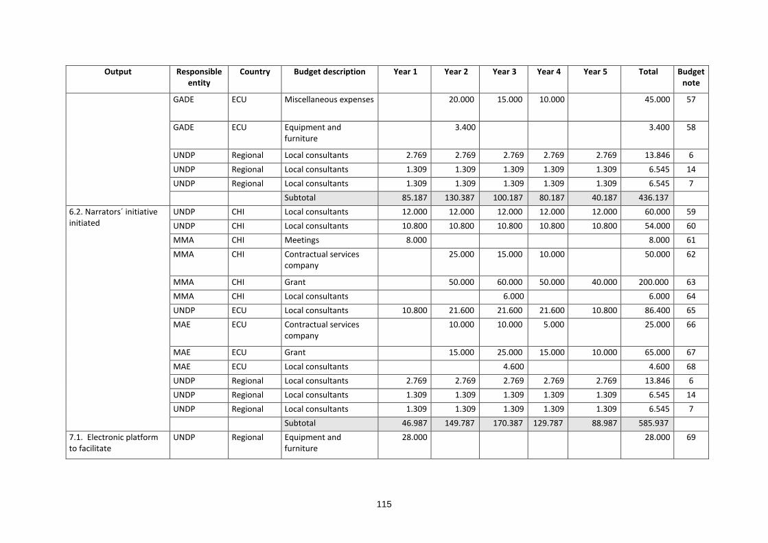
115
Output Responsible entity
Country Budget description Year 1 Year 2 Year 3 Year 4 Year 5 Total Budget note
GADE ECU Miscellaneous expenses 20.000 15.000 10.000 45.000 57
GADE ECU Equipment and furniture
3.400 3.400 58
UNDP Regional Local consultants 2.769 2.769 2.769 2.769 2.769 13.846 6 UNDP Regional Local consultants 1.309 1.309 1.309 1.309 1.309 6.545 14 UNDP Regional Local consultants 1.309 1.309 1.309 1.309 1.309 6.545 7 Subtotal 85.187 130.387 100.187 80.187 40.187 436.137
6.2. Narrators´ initiative initiated
UNDP CHI Local consultants 12.000 12.000 12.000 12.000 12.000 60.000 59 UNDP CHI Local consultants 10.800 10.800 10.800 10.800 10.800 54.000 60 MMA CHI Meetings 8.000 8.000 61 MMA CHI Contractual services
company 25.000 15.000 10.000 50.000 62
MMA CHI Grant 50.000 60.000 50.000 40.000 200.000 63 MMA CHI Local consultants 6.000 6.000 64 UNDP ECU Local consultants 10.800 21.600 21.600 21.600 10.800 86.400 65 MAE ECU Contractual services
company 10.000 10.000 5.000 25.000 66
MAE ECU Grant 15.000 25.000 15.000 10.000 65.000 67 MAE ECU Local consultants 4.600 4.600 68 UNDP Regional Local consultants 2.769 2.769 2.769 2.769 2.769 13.846 6 UNDP Regional Local consultants 1.309 1.309 1.309 1.309 1.309 6.545 14 UNDP Regional Local consultants 1.309 1.309 1.309 1.309 1.309 6.545 7 Subtotal 46.987 149.787 170.387 129.787 88.987 585.937
7.1. Electronic platform to facilitate
UNDP Regional Equipment and furniture
28.000 28.000 69

116
Output Responsible entity
Country Budget description Year 1 Year 2 Year 3 Year 4 Year 5 Total Budget note
communication among stakeholders and dissemination of lessons and best practice
UNDP Regional Contractual services company
8.600 8.600 8.600 8.600 8.600 43.000 70
UNDP Regional Local consultants 22.800 22.800 22.800 22.800 22.800 114.000 71 UNDP Regional Local consultants 24.000 24.000 24.000 24.000 24.000 120.000 72 UNDP Regional Supplies 1.800 1.800 1.800 1.800 1.800 9.000 73 UNDP Regional Audiovisual & print
production costs 10.000 10.000 10.000 10.000 10.000 50.000 74
UNDP Regional Travel 10.000 10.000 10.000 10.000 10.000 50.000 75 UNDP Regional Local consultants 2.769 2.769 2.769 2.769 2.769 13.846 6 UNDP Regional Local consultants 1.309 1.309 1.309 1.309 1.309 6.545 14 UNDP Regional Local consultants 1.309 1.309 1.309 1.309 1.309 6.545 7 Subtotal 110.587 82.587 82.587 82.587 82.587 440.937
7.2. Lessons and best practice documented and disseminated
UNDP Regional Local consultants 24.000 24.000 24.000 24.000 24.000 120.000 76 UNDP Regional Miscellaneous expenses 13.000 15.000 15.000 15.000 15.000 73.000 77
UNDP Regional Meetings 20.000 20.000 78 UNDP Regional Meetings 5.000 5.000 79 UNDP Regional Meetings 5.000 5.000 80 UNDP Regional Travel 20.000 20.000 20.000 20.000 80.000 81 UNDP Regional Travel 10.000 10.000 10.000 30.000 82 UNDP Regional International
consultants 30.000 40.000 70.000 83
UNDP Regional Audiovisual & print production costs
30.000 30.000 84
UNDP Regional Audiovisual & print production costs
50.000 50.000 85
UNDP Regional Meetings 20.000 20.000 86

117
Output Responsible entity
Country Budget description Year 1 Year 2 Year 3 Year 4 Year 5 Total Budget note
UNDP Regional Meetings 25.000 25.000 87 UNDP Regional Meetings 10.000 10.000 88 UNDP Regional Meetings 25.000 25.000 89 UNDP Regional Local consultants 2.769 2.769 2.769 2.769 2.769 13.846 6 UNDP Regional Local consultants 1.309 1.309 1.309 1.309 1.309 6.545 14 UNDP Regional Local consultants 1.309 1.309 1.309 1.309 1.309 6.545 7 Subtotal 72.387 64.387 104.387 74.387 274.387 589.937
Project execution cost UNDP Regional Equipment and furniture
4.500 4.500 90
UNDP Regional Miscellaneous expenses 1.300 1.300 1.300 1.300 1.300 6.500 91
UNDP Regional Administration fee 87.518 194.492 588.086 38.422 45.558 954.074 92 Subtotal 93.318 195.792 589.386 39.722 46.858 965.074
Total project cost 1.181.487 2.625.641 7.939.155 518.691 615.027 12.880.000
Budget notes
1 Engineer company contract to update stormwater management plan for Antofagasta.
2 Travel (including airplane tickets, board and lodging) of MOP personnel for contract supervision
3 Consultant to prepare guidelines to update stormwater management plans to cope with climate-related mudflows in coastal cities
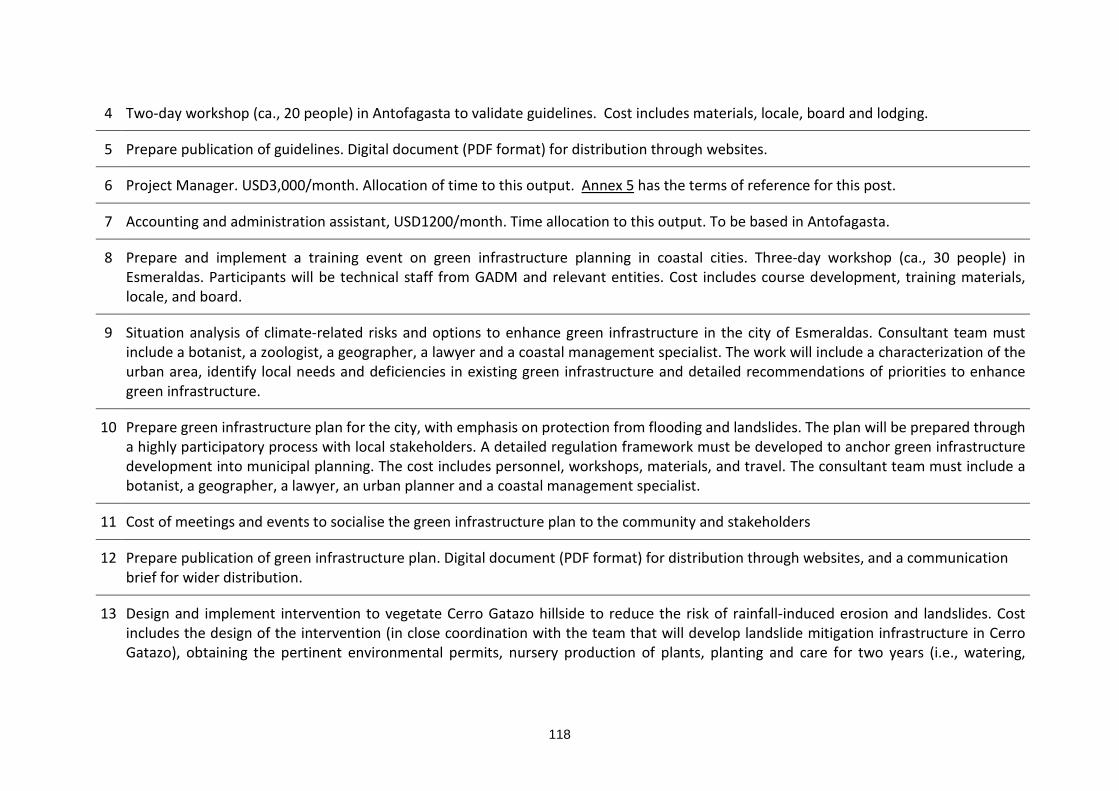
118
4 Two-day workshop (ca., 20 people) in Antofagasta to validate guidelines. Cost includes materials, locale, board and lodging.
5 Prepare publication of guidelines. Digital document (PDF format) for distribution through websites.
6 Project Manager. USD3,000/month. Allocation of time to this output. Annex 5 has the terms of reference for this post.
7 Accounting and administration assistant, USD1200/month. Time allocation to this output. To be based in Antofagasta.
8 Prepare and implement a training event on green infrastructure planning in coastal cities. Three-day workshop (ca., 30 people) in Esmeraldas. Participants will be technical staff from GADM and relevant entities. Cost includes course development, training materials, locale, and board.
9 Situation analysis of climate-related risks and options to enhance green infrastructure in the city of Esmeraldas. Consultant team must include a botanist, a zoologist, a geographer, a lawyer and a coastal management specialist. The work will include a characterization of the urban area, identify local needs and deficiencies in existing green infrastructure and detailed recommendations of priorities to enhance green infrastructure.
10 Prepare green infrastructure plan for the city, with emphasis on protection from flooding and landslides. The plan will be prepared through a highly participatory process with local stakeholders. A detailed regulation framework must be developed to anchor green infrastructure development into municipal planning. The cost includes personnel, workshops, materials, and travel. The consultant team must include a botanist, a geographer, a lawyer, an urban planner and a coastal management specialist.
11 Cost of meetings and events to socialise the green infrastructure plan to the community and stakeholders
12 Prepare publication of green infrastructure plan. Digital document (PDF format) for distribution through websites, and a communication brief for wider distribution.
13 Design and implement intervention to vegetate Cerro Gatazo hillside to reduce the risk of rainfall-induced erosion and landslides. Cost includes the design of the intervention (in close coordination with the team that will develop landslide mitigation infrastructure in Cerro Gatazo), obtaining the pertinent environmental permits, nursery production of plants, planting and care for two years (i.e., watering,

119
weeding, fertilization, pest and disease control). Reference cost USD1,200 ha-1 to establish the plantation, USD400 ha-1 year-1 for maintenance of the plantation.
14 Accounting and administration assistant, USD1200/month. Time allocation to this output. To be based in Esmeraldas.
15 Engineer company to update the designs of mudflow control infrastructure in Quebrada Bonilla (Antofagasta) incorporating future climate scenarios.
16 Construction company to build mudflow control infrastructure in Quebrada Bonilla (Antofagasta).
17 Prepare Environmental Impact Declaration and obtain pertinent environmental permits
18 Various expenses (e.g., airplane tickets, lodging, consumables) for MOP´s supervision of construction works.
19 Purchase of AQUAVEO WMS software and network server to model and analyse watersheds. About USD 7000 to purchase WMS premium edition for five network users. About USD 7000 to purchase a high capacity server to run the software and two computer terminals.
20 Engineer company to update the designs of landslide mitigation infrastructure in Cerro Gatazo incorporating future climate scenarios. This work will closely collaborate with the team which design the intervention to vegetate Cerro Gatazo hillside.
21 Construction company to build landslide mitigation infrastructure in Cerro Gatazo. The cost includes obtaining the pertinent environmental permits.
22 Various expenses for supervision of construction works.
23 Study to identify best location for storm sensors and design supporting infrastructure and facilities. DMC will prepare terms of reference and oversee the study. UNDP will contract the study.
24 Purchase of Storm Detection System of the DMC, including 4 sensors, installation and training of personnel in operation and maintenance. The equipment will be purchased by UNDP. DMC will be responsible for installation, operation and maintenance. For this purpose, a bailment agreement will be signed between DMC and CAF. The equipment will be transferred to DMC during year 4 of the project. A pre-condition for the purchase of the equipment will be to have a signed agreement between MOP, DMC and ONEMI to establish operational procedures,
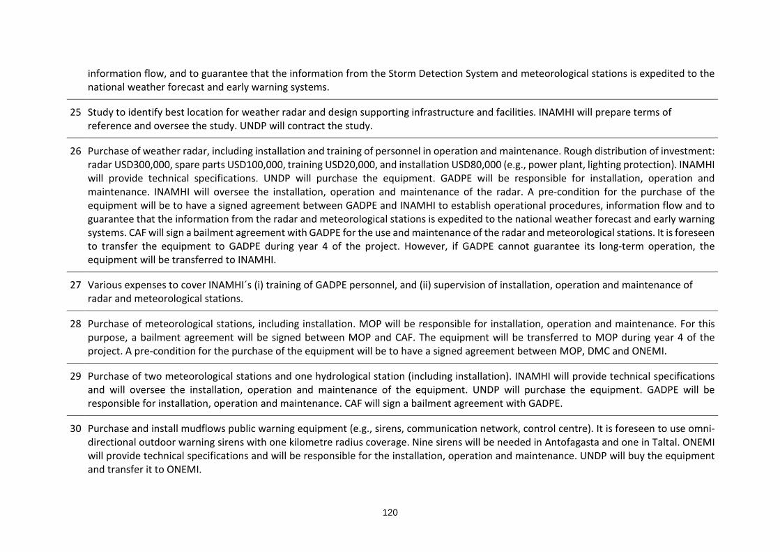
120
information flow, and to guarantee that the information from the Storm Detection System and meteorological stations is expedited to the national weather forecast and early warning systems.
25 Study to identify best location for weather radar and design supporting infrastructure and facilities. INAMHI will prepare terms of reference and oversee the study. UNDP will contract the study.
26 Purchase of weather radar, including installation and training of personnel in operation and maintenance. Rough distribution of investment: radar USD300,000, spare parts USD100,000, training USD20,000, and installation USD80,000 (e.g., power plant, lighting protection). INAMHI will provide technical specifications. UNDP will purchase the equipment. GADPE will be responsible for installation, operation and maintenance. INAMHI will oversee the installation, operation and maintenance of the radar. A pre-condition for the purchase of the equipment will be to have a signed agreement between GADPE and INAMHI to establish operational procedures, information flow and to guarantee that the information from the radar and meteorological stations is expedited to the national weather forecast and early warning systems. CAF will sign a bailment agreement with GADPE for the use and maintenance of the radar and meteorological stations. It is foreseen to transfer the equipment to GADPE during year 4 of the project. However, if GADPE cannot guarantee its long-term operation, the equipment will be transferred to INAMHI.
27 Various expenses to cover INAMHI´s (i) training of GADPE personnel, and (ii) supervision of installation, operation and maintenance of radar and meteorological stations.
28 Purchase of meteorological stations, including installation. MOP will be responsible for installation, operation and maintenance. For this purpose, a bailment agreement will be signed between MOP and CAF. The equipment will be transferred to MOP during year 4 of the project. A pre-condition for the purchase of the equipment will be to have a signed agreement between MOP, DMC and ONEMI.
29 Purchase of two meteorological stations and one hydrological station (including installation). INAMHI will provide technical specifications and will oversee the installation, operation and maintenance of the equipment. UNDP will purchase the equipment. GADPE will be responsible for installation, operation and maintenance. CAF will sign a bailment agreement with GADPE.
30 Purchase and install mudflows public warning equipment (e.g., sirens, communication network, control centre). It is foreseen to use omni-directional outdoor warning sirens with one kilometre radius coverage. Nine sirens will be needed in Antofagasta and one in Taltal. ONEMI will provide technical specifications and will be responsible for the installation, operation and maintenance. UNDP will buy the equipment and transfer it to ONEMI.

121
31 Design flooding early warning system for trial testing. Design will combine community-based actions coordinated with municipal and national authorities. The pilot will be implemented in Isla Luis Vargas Torres. The system will be designed with the participation of key organisations of island´s residents. The organizations that have agreed to contribute are 12 de mayo, Cordero Crespo, 20 de noviembre, Pianguapi, 29 de agosto, and Habana.
32 Purchase and installation of equipment for pilot flood early warning system. It is foreseen to use two omni-directional outdoor warning sirens with one kilometre radius coverage. GADE will be responsible for the installation, operation and maintenance. UNDP will buy the equipment and transfer it to GADE.
33 Meetings and workshops socialize and train local groups on flooding alert and emergency procedures. The cost includes production of handouts and communication material.
34 Flood emergency drills with local groups of the pilot area.
35 Update mudflows evacuation maps for Antofagasta and Taltal. Digital files (PDF format) will be posted in local websites and social media to facilitate public access.
36 Print evacuation maps in large format and locate in high-transit areas for public display in both cities.
37 Production and placing of mudflow evacuation route signs in Antofagasta and Taltal
38 Various expenses to hold annual mudflow evacuation drills in Antofagasta and Taltal
39 Prepare flooding evacuation map and landslide risk evacuation map for Esmeraldas. Digital files (PDF format) will be posted in local websites and social media to facilitate public access.
40 Print flooding evacuation map and landslide risk evacuation map in large format and locate in high-transit areas for public display.
41 Production and placing of signals for flooding evacuation routes and landslide risk areas
42 Two consultants to coordinate and prepare course on risk-based adaptation in coastal cities. Lead consultant will be based in Chile; the other consultant will be in Ecuador. They will prepare the analysis of existing experience, prepare the joint workshop to delineate the training

122
course, identify and take contact with key partners, contribute and oversee the preparation of the course, organize the training of trainers and oversee the delivery of the first training course. Lead consultant USD 60,000, local consultant USD 40,000.
43 Joint workshop to delineate training contents and structure, and agree working procedures. Three-day workshop. Travel cost for three persons USD6000 (airplane tickets, food and lodging, terminal expenses) and USD2000 for locale, materials and board. Travel cost includes one of the consultants.
44 Grant to partner organization (e.g., university with on-line training capabilities) to develop course and training materials, including training of trainers.
45 One-week workshop to train trainers. Cost includes travel.
46 Grant to partner organization to offer three training courses.
47 Prepare needs assessment and communication and public education strategy for Antofagasta
48 Local engineer specialist to coordinate and catalyse implementation of the project´s adaptation actions and the communication and public education strategy in Antofagasta. This person will also oversee the specialist responsible for activities in Taltal. Monthly salary USD2,000, 50% time dedicated to coordinate implementation of project´s adaptation actions and public education strategy. This person will be based within the Municipality of Antofagasta, under the supervision of the project´s Lead Engineer Specialist. With respect to the public education strategy, this person together with municipal staff will assess the progress in reaching the goals, adjust the strategy and prepare the workplan for the following year. Annex 5 has the terms of reference for this post.
49 Production of communication materials and events to implement the communication and public education strategy in Antofagasta. This also includes office materials and consumables for the work of the consultant.
50 Purchase of computer, printer, furniture and office supplies for the consultant to be based within the municipality
51 Prepare needs assessment and communication and public education strategy for Taltal
52 Local engineer specialist to coordinate and catalyse implementation of the project´s adaptation actions and the communication and public education strategy in Taltal. Monthly salary USD1,800, 50% time dedicated to coordinate implementation of project´s adaptation actions

123
and public education strategy. This person will be based within the Municipality of Taltal. With respect to the public education strategy, this person together with municipal staff will assess the progress in reaching the goals, adjust the strategy and prepare the workplan for the following year. Annex 5 has the terms of reference for this post.
53 Production of communication materials and events to implement the communication and public education strategy in Antofagasta. This also includes office materials and consumables for the work of the consultant.
54 Purchase of computer, printer, furniture and office supplies for the consultant to be based within the municipality
55 Prepare needs assessment and communication and public education strategy for Esmeraldas
56 Local engineer specialist to coordinate and catalyse implementation of the project´s adaptation actions and the communication and public education strategy in Esmeraldas. Monthly salary USD1,800, 50% time dedicated to coordinate implementation of project´s adaptation actions and public education strategy. This person will be based within the Municipality of Esmeraldas, under the supervision of the project´s Lead Engineer Specialist. With respect to the public education strategy, this person together with municipal staff will assess the progress in reaching the goals, adjust the strategy and prepare the workplan for the following year. Annex 5 has the terms of reference for this post.
57 Production of communication materials and events to implement the communication and public education strategy in Esmeraldas. This also includes office materials and consumables for the work of the consultant.
58 Purchase of computer, printer, furniture and office supplies for the consultant to be based within the municipality
59 Local engineer specialist based in Antofagasta, will lead the narrators´ initiative in the two countries, under the supervision of the project´s Lead Engineer Specialist. This person will coordinate and catalyse implementation of the initiative in Antofagasta and Taltal, and will supervise the adaptation specialist based in Esmeraldas. Monthly salary USD2,000, 50% of time dedicated to the narrators´ initiative. This person will be based within the Municipality of Antofagasta, but will have close coordination with MMA office in Antofagasta for the narrators´ initiative. Together with the Taltal´s adaptation specialist, this person will compile stories, anecdotes, and factual information to be used by narrators. This person will oversee the development of activities executed by local partners sponsored by the project. Jointly with project partners and the project´s Lead Engineer Specialist, every year, this person will assess the progress in reaching the goals, adjust the strategy and prepare the workplan for the following year. Annex 5 has the terms of reference for this post.

124
60 Local engineer specialist based in Taltal, under the supervision of Antofagasta´s adaptation specialist and the project´s Lead Engineer Specialist. This person will coordinate and catalyse implementation of the initiative in Taltal. Monthly salary USD1,800, 50% of time dedicated to the narrators´ initiative. This person will be based within the Municipality of Taltal, but will have close coordination with MMA office in Antofagasta for the narrators´ initiative. Together with the Antofagasta´s adaptation specialist, this person will compile stories, anecdotes, and factual information to be used by the narrators. This person will oversee the development of activities executed by local partners sponsored by the project. Jointly with project partners and the project´s Lead Engineer Specialist, every year this person will assess the progress in reaching the goals, adjust the strategy and prepare the workplan for the following year. Annex 5 has the terms of reference for this post.
61 Joint workshop to share national and international experience and convene work strategy. Three-day workshop. Travel cost for three persons USD6,000 (airplane tickets, food and lodging, terminal expenses) and USD2,000 for locale, materials and board. Travel cost includes one of the consultants. International experts and potential partners will be invited to present their experience (e.g., JICA, EDUCEN) through web-based link.
62 Technical assistance to local groups in Antofagasta and Taltal which are interested in developing narrators´ activities. In year 2 training to develop skills and messages. In years 3 and 4 mentoring.
63 Small grants to sponsor local groups in Antofagasta and Taltal. The allocations will sponsor local partners / groups to execute activities (e.g., children shows, street theatre, puppetry, music displays) to enhance / develop local collective memory about climate-related risks and adaptation to climate change.
64 Independent assessment of narrators´ initiative in Antofagasta and Taltal. The report will contribute to the mid-term review of the project.
65 Local engineer specialist based in Esmeraldas to implement the narrators´ initiative. This person will coordinate and catalyse implementation of the initiative in Esmeraldas, under the supervision of the adaptation specialist to be based in Antofagasta. Monthly salary USD1,800 for 48 months. This person will be based within the Municipality of Esmeraldas, but will have close coordination with MAE´s office in Esmeraldas for the narrators´ initiative. This person will compile stories, anecdotes, and factual information to be used by the narrators. Also, this person will oversee the actions executed by the local partner sponsored by the project. Jointly with project partners and the project´s Lead Engineer Specialist, every year this person will assess the progress in reaching the goals, adjust the strategy and prepare the workplan for the following year. Annex 5 has the terms of reference for this post.

125
66 Technical assistance to local groups interested in developing narrators´ activities. In year 2 training to develop skills and messages. In years 3 and 4 mentoring.
67 Small grant to sponsor local groups in Esmeraldas. The allocations will sponsor local partners / groups to execute activities (e.g., children shows, street theatre, puppetry, music displays) to enhance / develop local collective memory about climate-related risks and adaptation to climate change.
68 Independent assessment of narrators´ initiative in Esmeraldas. The report will contribute to the mid-term review of the project.
69 Equipment for web-based communication platform. One server + five teleconference sets (Antofagasta, Taltal, Esmeraldas, Santiago, Quito) + software. USD15,000. Equipment and software for project website and social media platforms. Three servers (USD6,000) + three multi-function printers (USD2,100) + three video cameras (USD1,500) + three audio recorders (USD300) + video, audio and image editing software (USD1,000) + website management software (USD1,000) + sundries 1,900. Total USD28,000.
70 Web-based communication service (e.g., WebEx, SKYPE for business) - USD200/month, plus high-speed internet access in three locations (Antofagasta, Taltal and Esmeraldas) - USD100/month per location, plus webhosting USD200/year.
71 Electronic media specialist, to administer and maintain the electronic platform for communication and hosting. USD1,900/month. This person will be based in CAF. Annex 5 has the terms of reference for this post.
72 Lead Engineer Specialist, USD2,000/month. Based in CAF. Supervises the adaptation specialists based in Antofagasta, Taltal and Esmeraldas. This person coordinate the implementation of the project´s adaptation actions. In collaboration with the Electronic Media Specialits, maintains the project website, the social networking platforms, and the mailing list server to disseminate information to stakeholders and interest groups. Annex 5 has the terms of reference for this post.
73 Office supplies for electronic platform (e.g., paper, toner, pens)
74 Production videos, images and other communication media for the project´s web platform and news.
75 National and international travel of Lead Engineer Specialist.
126
76 Monitoring and evaluation specialist, USD2,000/month. Responsible to document the project experience, including providing support to blogs. Annex 5 has the terms of reference for this post. This person will prepare learning experience documents. Nine learning experience documents are planned: 1. incorporating the climate change factor into stormwater management plans in Chile, 2. preparation of green infrastructure plan in Esmeraldas, 3. incorporating the climate change factor into mudflow control infrastructure in Antofagasta, 4. incorporating the climate change factor into landslide control in Cerro Gatazo (Esmeraldas), 5. Use of weather radar/ storm system to enhance early warning systems, 6. mudflows warning system in Antofagasta and Taltal, 7. pilot flood warning system in Esmeraldas, 8. communication and education strategies to increase public awareness of climate-related disaster risk, and 9. contribution of narrators to sustain cultural memory on climate-related risks and disasters.
77 Allocation for monitoring of project development. The value includes international and local travel of Monitoring and Evaluation specialist, consumables, meetings and other various expenses.
78 Project inception workshop. Participate members of the Project Board, responsible entities, and the project team. The allocation includes international travel, locale, board and materials. Two-day workshop to update project strategy, update first year workplan and budget, and fine-tune administration procedures and agreements.
79 National workshop to launch the project in Chile. Event to be held in Antofagasta. Cost includes locale, board and local travel costs.
80 National workshop to launch the project in Ecuador. Event to be held in Esmeraldas. Cost includes locale, board and local travel costs.
81 Travel cost for exchange visits. The allocation includes international and local travel, accommodation, materials and consumables. Four exchange visits are planned, one per year: 1. pilot stabilization of Cerro Gatazo to control landslides (in Ecuador), 2. early warning and response systems to climate-related events (in Chile), 3. public awareness strategies (in Chile), 4. narrators’ initiative (in Ecuador).
82 Travel cost to present project results in national or international events and fora. The use of these resources will be decided by the Project Board.
83 Mid-term review and terminal evaluation of the project. Lump sum to cover contract of international consultant and national consultants (one on each country), airplane tickets (international and national), accommodation, board and lodging.
127
84 Prepare and edit technical documents with results and lessons of the project. The documents will include executive summaries in Spanish, English, French and Portuguese. The documents will be in high-quality PDF format for download.
85 Prepare and disseminate project´s memoirs. Prepare and edit document in format for general public with executive summary in Spanish, English, French and Portuguese. 5,000 printed copies and high-quality PDF for download.
86 Project Board closure meeting. Participate members of the Project Board, responsible entities, and the project team. The allocation includes international travel, locale, board and materials. Two-day meeting to review project outcomes and analyse terminal evaluation and final project report.
87 Public event in Antofagasta to close the project. It will include technical talks and informal activities to present results and learnings to stakeholders and general public. It will be desirable to have video link with the other project sites or pre-recorded video to have summaries of their results and lessons. The cost includes locale, consumables, catering, travel, rental of equipment (e.g., sound amplification).
88 Public event in Taltal to close the project. It will include technical talks and informal activities to present results and learnings to stakeholders and general public. It will be desirable to have video link with the other project sites or pre-recorded video to have summaries of their results and lessons. The cost includes locale, consumables, catering, travel, rental of equipment (e.g., sound amplification).
89 Public event in Esmeraldas to close the project. It will include technical talks and informal activities to present results and learnings to stakeholders and general public. It will be desirable to have video link with the other project sites or pre-recorded video to have summaries of their results and lessons. The cost includes locale, consumables, catering, travel, rental of equipment (e.g., sound amplification).
90 Three computers and printers for project manager and accounting and administration assistants.
91 Office supplies and consumables (e.g., paper, toner, folders)
92 UNDP project administration and services

128
Budget on the Implementing Entity management fee use
304. The project cycle management fee will be used by CAF to cover the indirect costs of administering and supporting project implementation and to provide project assurance. This table contain indicative costs of the main categories of project services.
Category Indicative cost (USD)
Technical support and backstopping by personnel from headquarters and the offices in Quito and Montevideo103.
300,000
Financial administration of project funds and accounting services.
150,000
Procurement of goods, works and services and contract administration. Including management of project personnel and consultants.
230,400
Project oversight. Including visits to project sites to verify quality of deliverables, and overseeing independent evaluations.
150,000
Reporting. Including technical, administrative and financial reports to the Adaptation Fund. Preparation of annual Project Performance Report (PPR)
100,000
Provide office space and support services to the project´s management unit within CAF
100,000
Total 1,030,400
H. Include a disbursement schedule with time-bound milestones.
Description
First disbursment (at
signature of agreement)
Year 1 Year 2 Year 3 Year 4 Total
Project funds 1.181.487
2.625.641
7.939.155
518.691
615.027
12.880.00
0 Implementing Entity management fee
206.080
206.080
206.080
206.080
206.080
1.030.400
Total 1.387.567
2.831.721
8.145.235
724.771
821.107
13.910.40
0 Estimated date 15 June 2017 15 June } 15 June 15 June
103 There is no country office in Chile. The Montevideo office manage Chile´s projects and matters.

129

130
List of annexes
Annex 1. Abbreviations
Annex 2. Definitions
Annex 3. Bibliography
Annex 4. Memoirs of inception and validation workshops
Annex 5. Terms of reference
Annex 6. Multiyear workplan
Annex 7. Photographs
Annex 8. Stakeholder analysis in Antofagasta and Taltal (Chile)
Annex 9. Stakeholder analysis in Esmeraldas (Ecuador)
Annex 10. Comparison of selected indexes between Chile and Ecuador.
Annex 11. Existing designs for Quebrada Bonilla (Chile)
Annex 12. Existing designs for Cerro Gatazo (Ecuador)
Annex 13. Alternative approaches considered but not adopted in the project.
Annex 14. Compliance with the AF Environmental and Social Policy
Annex 15. ARG-MOP agreement “mudflow disaster mitigation and evacuation of rainwater, Antofagasta Region 2015-2020”.
Annex 16. Letter from Antogafasta´s Regional Government endorsing the present project proposal.
Annex 17. Gender analysis of the project.
Annex 18. Terms of Reference GADM Esmeraldas
131
List of tables
Table 1. Impact of weather-related disasters and adaptive capacity and vulnerability indexes in Chile and Ecuador. .................................................................................................................................... 8 Table 2. Vulnerability to climate change in the cities of Antofagasta and Esmeraldas (CAF, 2014). .. 8 Table 3. Exclusive and non-exclusive functions of Chilean municipalities (Letelier, 2006). ............... 9 Table 4. Campamentos in Taltal. Source: TECHO (2016). .............................................................. 15 Table 5. Vulnerable groups in Antofagasta, Taltal and Esmeraldas. ............................................... 23 Table 6. Unemployment and underemployment of afro-ecuadorian females. Source: Encuesta Urbana de Empleo y Desempleo - INEC 2013. ............................................................................... 26 Table 7. Project actions to address the main barriers that limit adaptive capacity in Antofagasta, Taltal and Esmeraldas. ................................................................................................................... 29 Table 8. Projects to be implemented in Antofagasta and Taltal as part of the ARG-MOP agreement (2015-2020). ................................................................................................................................... 36 Table 9. Campamentos located in the mudflow risk area of Quebrada Bonilla. ............................... 38 Table 10. Key stakeholders and vulnerable groups. ........................................................................ 51 Table 11. Risks screening of the project at design stage using the 15 principles of the AF’s ESP. . 77 Table 12. Budgeted monitoring and evaluation plan. ...................................................................... 99
List of figures
Figure 1. Relationship between disaster risk and climate and development factors (IPCC, 2012). .... 6 Figure 2. Number of LAC countries according to their adaptive capacity index (CAF, 2014). ............ 6 Figure 3. Location of Esmeraldas, Antofagasta and Taltal. ............................................................... 7 Figure 4. Location of the city of Antofagasta and Taltal. .................................................................. 11 Figure 5. Antofagasta’s Quebradas - Gorges. ................................................................................. 12 Figure 6. Downhill view of Quebrada Bonilla Sur. ........................................................................... 12 Figure 7. Types of houses in campamentos in Antofagasta (Visit July 2017). ................................. 14 Figure 8. Neighbourhood close to Quebrada Bonilla Sur ................................................................ 14 Figure 9. Campamentos in the city of Antofagasta. Source: 2016 national cadastre. ...................... 14 Figure 10. Location of Taltal. .......................................................................................................... 15 Figure 11. Location of campamentos in Taltal. ................................................................................ 16 Figure 12. Location of Mudflow Control Infrastructure in Antofagasta. ............................................ 17 Figure 13. Location of Esmeraldas city. .......................................................................................... 18 Figure 14. Luis Vargas Torres Island. ............................................................................................. 19 Figure 15. Direction of Cerro Gatazo in Esmeraldas. ...................................................................... 19 Figure 16. Exposure to sea level rise (SLR) in the City of Esmeraldas (Sierra et al., 2009). ........... 20 Figure 17. Location of the largest landslide of January 2016 (Image google earth 2017). ......... Error! Bookmark not defined. Figure 18. Location of Quebrada Bonilla with no Mudflow Control Infrastructure in Antofagasta. .... 38 Figure 19. Area of mudflow risk in Quebrada Bonilla (Antofagasta). Source: ONEMI. ..................... 39 Figure 20. Location of campamentos on the mudflow risk area of Quebrada Bonilla. ..................... 40

132
Figure 21. Electronic platform of the project. ................................................................................... 46 Figure 22. Project organization structure. ....................................................................................... 93 Figure 23. Project Unit. ................................................................................................................... 94

133
PART IV: ENDORSEMENT BY GOVERNMENTS AND CERTIFICATION BY THE IMPLEMENTING ENTITY
A. Record of endorsement on behalf of the government104 Provide the name and position of the government official and indicate date of endorsement for each country participating in the proposed project / programme. Add more lines as necessary. The endorsement letters should be attached as an annex to the project/programme proposal. Please attach the endorsement letters with this template; add as many participating governments if a regional project/programme:
6. Each Party shall designate and communicate to the secretariat the authority that will endorse on behalf of the national government the projects and programmes proposed by the implementing entities.

134

135

Annex 1. Abbreviations
AF Adaptation Fund
AFB Adaptation Fund Board
AGCID Chilean Agency for International Cooperation for Development
APC Civil Protection Academy of Chile
ARG Antofagasta Regional Government
CBD Convention on Biological Diversity
CLP Chilean Peso
COE Emergency Operations Committee
DGA Directorate of Waters of the Ministry of Public Works of Chile
DMC Meteorological Directorate of Chile
DOH Directorate of Hydraulic Works of the Ministry of Public Works of Chile
ESMP Environmental and Social Management Plan
ESP Adaptation Fund´s Environmental and Social Policy
GADE Municipality of Esmeraldas
GADPE Provincial Government of Esmeraldas
INAMHI National Meteorological and Hydrological Institute of Ecuador
INE National Institute of Statistics of Chile
INEC National Institute of Statistics and Censuses of Ecuador
LAC Latin America and the Caribbean
M&E Monitoring and Evaluation
MAE Ministry of Environment of Ecuador
MdA Municipality of Antofagasta
MdT Municipality of Taltal
MINVU Ministry of Housing and Urban Development of Chile
MMA Ministry of Environment of Chile
MOP Ministry of Public Works of Chile
NIE National Implementing Entity
ONEMI National Emergency Office of Chile
PAAS Environmental and Social Action Plan
PDOT Development and Land Use Plan
PLADECO Communal Development Plan

PPR Project Performance Report
PRODOC Fully Developed Project/Programme Document
PT Project team
RIE Regional Implementing Entity
SETECI Technical Secretariat of International Cooperation of Ecuador
SGR Risk Management Secretariat
UNDP United Nations Development Programme
USD United States Dollar
1 / 5
Annex 2. Definitions
Adaptation The process of adjustment to actual or expected climate and its effects. In human systems, adaptation seeks to moderate or avoid harm or exploit beneficial opportunities. In some natural systems, human intervention may facilitate adjustment to expected climate and its effects (IPCC, 2014).
Adaptive capacity The ability of systems, institutions, humans, and other organisms to adjust to potential damage, to take advantage of opportunities, or to respond to consequences (IPCC, 2014).
Alien species Refers to a species, subspecies or lower taxon, introduced outside its natural past or present distribution; includes any part, gametes, seeds, eggs, or propagules of such species that might survive and subsequently reproduce (Decision VI/23 of the Conference of the Parties to the CBD).
Campamento Settlements, usually found in urban areas, of more than eight families living on an irregular land tenure, lacking at least one of the three basic services (electricity, drinking water and sewage system) whose homes are closely grouped together (MINVU, 2012).
Cultural memory It refers to the recording and handing down meanings and interpretation from generation to generation. The consideration of cultural memory as an asset in disaster risk reduction (DRR) focus on how to recognize and use accumulated experience and knowledge from past crises and disasters to inform and enhance present and future DRR and disaster risk management (EDUCEN, 2015)
Disaster A serious disruption of the functioning of a community or a society involving widespread human, material, economic or environmental losses and impacts, which exceeds the ability of the affected community or society to cope using its own resources (UNISDR, 2009).
Disaster risk The likelihood within a specific time period of disaster (IPCC, 2014). The potential disaster losses, in lives, health status, livelihoods, assets and services, which could occur to a particular community or a society over some specified future time period (UNISDR, 2009).
2 / 5
Disaster risk reduction
The concept and practice of reducing disaster risks through systematic efforts to analyse and manage the causal factors of disasters, including through reduced exposure to hazards, lessened vulnerability of people and property, wise management of land and the environment, and improved preparedness for adverse events (UNISDR, 2009).
Early warning system
The set of capacities needed to generate and disseminate timely and meaningful warning information to enable individuals, communities and organizations threatened by a hazard to prepare and to act appropriately and in sufficient time to reduce the possibility of harm or loss (UNISDR, 2009).
El Niño-Southern Oscillation (ENSO)
A complex interaction of the tropical Pacific Ocean and the global atmosphere that results in irregularly occurring episodes of changed ocean and weather patterns in many parts of the world, often with significant impacts over many months, such as altered marine habitats, rainfall changes, floods, droughts, and changes in storm patterns (UNISDR, 2009).
Executing entity Executing Entities are organizations that execute adaptation projects and programmes supported by the Adaptation Fund under the oversight of the Implementing Entities (AF, 2012).
Exposure People, property, systems, or other elements present in hazard zones that are thereby subject to potential losses (UNISDR, 2009).
Female-headed households
A household in which an adult female is the sole or main income producer and decision-maker. In most countries, women are not usually considered as heads of households unless no adult male is living permanently in the household. The assumption that the head of a household is always an adult man, even if a woman’s economic contribution to the household’s maintenance is the same or greater than that of a man, is a form of gender bias. In developing countries, there is a general trend of more and more women being the primary source of economic support for their families (ILO, 2007).
Green infrastructure Refers to interventions to preserve the functionality of existing green landscapes (including parks, forests, wetlands, or green belts), and to transform the built environment through phytoremediation and water management techniques and by introducing productive

3 / 5
landscapes (Revi et al., 2014). Green infrastructure refers to an interconnected network of multifunctional green-spaces that are strategically planned and managed to provide a range of ecological, social, and economic benefits (Matthews et al., 2015).
Hazard A potentially damaging physical event, phenomenon or human activity that may cause the loss of life or injury, property damage, social and economic disruption or environmental degradation. Hazards can include latent conditions that may represent future threats and can have different origins: natural (geological, hydrometeorological and biological) or induced by human processes (environmental degradation and technological hazards). Hyogo Framework for Action.
Hydrometeorological hazard
Process or phenomenon of atmospheric, hydrological or oceanographic nature that may cause loss of life, injury or other health impacts, property damage, loss of livelihoods and services, social and economic disruption, or environmental damage (UNISDR, 2009).
Implementing Entity Implementing Entities are the national legal entities and multilateral organizations that have been identified ex ante by the Adaptation Fund Board (AFB) as meeting the criteria adopted by the Board, in accordance with decision 1/CMP.3, paragraph 5 (c), to access funding to implement concrete adaptation projects and programmes supported by the Fund (Rules of procedure of the Adaptation Fund Board)
Invasive alien species
It is an alien species whose introduction and/or spread threaten biological diversity (Decision VI/23 of the Conference of the Parties to the CBD).
Marginalized
groups
These are groups of people who are excluded from the normal economic and social fabric of societies, thus lacking access to basic essential services and facilities. Furthermore, they lack the means to improve themselves (motivation, social capital, skills and knowledge) and have low resilience (AF, 2016).
National Implementing Entity
National Implementing Entities (NIE) are those national legal entities nominated by Parties that are recognized by the Board of the Adaptation Fund as meeting the fiduciary standards approved by the Board. When implementing a project / programme, The NIEs will bear the full responsibility for the overall management of the projects and programmes financed by the
4 / 5
Adaptation Fund, and will bear all financial, monitoring, and reporting responsibilities (modified from AF, 2012).
Outcome The change in conditions, or intended effects of an intervention, usually brought about by the collective efforts of partners. Outcomes are achieved in the short to medium term (AF, 2012).
Output The product, capital goods and services which result from a development intervention relevant to the achievement of outcomes (AF, 2012).
Public awareness The extent of common knowledge about disaster risks, the factors that lead to disasters and the actions that can be taken individually and collectively to reduce exposure and vulnerability to hazards (UNISDR, 2009).
Regional Implementing Entity
Regional Implementing Entities (RIE) are those legal entities, recognized by the Board of the Adaptation Fund, that meet the fiduciary standards approved by the Adaptation Fund Board. When implementing a project / programme, The RIEs will bear the full responsibility for the overall management of the projects and programmes financed by the Adaptation Fund, and will bear all financial, monitoring and reporting responsibilities (modified from AF, 2012).
Resilience
The ability of a system, community or society exposed to hazards to resist, absorb, accommodate to and recover from the effects of a hazard in a timely and efficient manner, including through the preservation and restoration of its essential basic structures and functions (UNISDR, 2009).
Responsible Entity Responsible Entities are organizations that execute parts of the adaptation project under the supervision and oversight of the corresponding Executing Entity and Implementing Entity
Social inclusion The process of improving the terms for individuals and groups to take part in society. The process of improving the ability, opportunity, and dignity of people, disadvantaged on the basis of their identity, to take part in society (World Bank, 2013).
Vulnerability The conditions determined by physical, social, economic and environmental factors or processes, which increase the susceptibility of a community to the impact of hazards. Hyogo Framework for Action.
5 / 5
Vulnerable groups These are groups of people unable or with diminished capacity to anticipate, cope with, resist and recover from the impacts of (external) pressures, facing a higher risk of poverty and social exclusion than the general population. Vulnerability can stem from belonging or being perceived to belong to a certain group or institution, and is a relative and dynamic concept (AF, 2016).
1 / 11
Annex 3. Bibliography
AF. 2012. Accessing resources from the Adaptation Fund. The Handbook. Adaptation Fund (AF). Washington DC, USA: 64 pp.
AF. 2013. Environmental and Social Policy. Approved in November 2013. Adaptation Fund Board. Adaptation Fund (AF) Washington DC, USA: 10 pp. Online: http://www.adaptation-fund.org/wp-content/uploads/2015/09/Environmental-Social-Policy-approved-Nov2013.pdf
AF. 2016. Guidance document for implementing entities on compliance wih the Adaptation Fund Environmental and Social Policy. Revised in June 2016. Adaptation Fund (AF) Washington DC, USA: 21 pp. Online: https://www.adaptation-fund.org/wp-content/uploads/2016/07/ESP-Guidance_Revised-in-June-2016_Guidance-document-for-Implementing-Entities-on-compliance-with-the-Adaptation-Fund-Environmental-and-Social-Policy.pdf
AF. 2016a. Manual of basic Environmental and Social Management System procedures and functions at National Implementing Entities. April 2016. Adaptation Fund (AF) Washington DC, USA: 20 pp. Online: https://www.adaptation-fund.org/wp-content/uploads/2016/07/Manual-of-basic-ESMS-procedures-and-functions-at-NIE_April-2016.pdf
Aguirre. Z. 2012. Especies forestales de los bosques secos del Ecuador. Guía dendrológica para su identificación y caracterización. Proyecto Manejo Forestal Sostenible ante el Cambio Climático. MAE/FAO - Finlandia. Ministerio del Ambiente (MAE). Quito, Ecuador: 140 pp.
Anon. 2015. Restituyen terrenos ocupados ilegalmente en Antofagasta. Diario El Nortero. 29 de agosto de 2015. En línea: http://www.elnortero.cl/noticia/sociedad/restituyen-terrenos-ocupados-ilegalmente-en-antofagasta
Anon. 2016a. Gobierno realizará inédito simulacro de aluvión en Antofagasta. Intendencia Región Antofagasta. Ministerio del Interior y Seguridad Pública. 7 de julio de 2016. En línea: http://www.intendenciaantofagasta.gov.cl/noticias/gobierno-realizara-inedito-simulacro-de-aluvion-en-antofagasta/
Anon. 2016b. ONEMI confirmó fecha de simulacro en dos quebradas. Diario El Mercurio de Antofagasta. 7 de julio de 2016. En línea: http://www.mercurioantofagasta.cl/impresa/2016/07/07/full/cuerpo-principal/6/
Bonilla, M. 2014. Una pequeña población chachi se instaló en la isla Luis Vargas Torres. Diario El Comercio. 28 de agosto de 2014.
Bonilla, M. 2016a. 16 000 desplazados por las lluvias en Esmeraldas. Diario El Comercio. 12 de abril de 2016.

2 / 11
Bonilla, M. 2016b. Los albergados aumentaron a 2676 en la ciudad de Esmeraldas por las inundaciones. Diario El Comercio. 27 de enero de 2016.
Bonilla, M. 2016c. Drama de familias en dos islas por el desbordamiento del río Esmeraldas. Diario El Comercio. 25 de enero de 2016.
CAF. 2000a. Las lecciones de El Niño. Memorias del fenómeno El Niño 1997-1998. Retos y propuestas para la región andina. Ecuador. Volumen IV. Corporación Andina de Fomento (CAF): 304 pp.
CAF. 2000b. Las lecciones de El Niño. Memorias del fenómeno El Niño 1997-1998. Retos y propuestas para la región andina. Perú. Volumen V. Corporación Andina de Fomento (CAF): 293 pp.
CAF. 2013. Programa de Adaptación al Cambio Climático. CAF Banco de Desarrollo de América Latina. Caracas, Venezuela: 42 pp.
CAF. 2014. Índice de vulnerabilidad y adaptación al cambio climático en la región de América Latina y el Caribe. CAF Banco de Desarrollo de América Latina. Caracas, Venezuela: 211 pp.
CAF. 2015. Environmental and social safeguards for CAF/GEF projects manual. Vice-presidency of Development Strategies and Public Policies. Environmental Division. Version 1. May 2015. Caracas, Venezuela: 210 pp.
CAF. 2016. Salvaguardas ambientales y sociales. Septiembre 2016. CAF Banco de Desarrollo de América Latina: 108 pp. En línea: https://www.caf.com/media/5614351/salvaguardas%20ambientales%20y%20sociales%20caf.pdf
Cai, W., Borlace, S., Lengaigne, M., van Rensch, P., Collins, M., Vecchi, G., Timmermann, A., Santoso, A., McPhaden, M.J., Wu, L., England, M.H., Wang, G., Guilyardi, E. & F.F. Jin. 2014. Increasing frequency of extreme El Niño events due to greenhouse warming. Nature Climate Change 4: 111-116.
Cai, W., Wang, G., Santoso, A., McPaden, M.J., Wu, L., Jin, F.F., Timmermann, A., Collins, M., Vecchi, G., Lengaigne, M., England, M.H., Dommenget, D., Takahashi, K. & E. Guilyardi. 2015. Increased frequency of extreme La Niña events under greenhouse warming. Nature Climate Change 5: 132–137.
Cambridge, D., Kaplan, S. & V. Suter, V. 2005. Community of Practice Design Guide. A Step-by-Step Guide for designing & cultivating communities of practice in higher education. EDUCASE. Louisville, Colorado, USA: 8 pp. Online: http://net.educause.edu/ir/library/pdf/nli0531.pdf
CEPAL. 2012. Efectos del cambio climático en la costa de América Latina y el Caribe: vulnerabilidad y exposición. Documentos de Proyectos 460. Comisión Económica para América Latina y el Caribe (CEPAL) - Universidad de Cantabria. Santiago de Chile, Chile: 174 pp.

3 / 11
CIDA. 1995. Involving culture: a fieldworker’s guide to culturally sensitive development. Canadian International Development Agency (CIDA) - UNESCO. Report CLT/DEC/CD/96/01. Paris, France: 72 pp.
CNIG. 2014. La violencia de género contra las mujeres en el Ecuador: Análisis de los resultados de la Encuesta Nacional sobre Relaciones Familiares y Violencia de Género contra las Mujeres, Esmeraldas. Consejo Nacional para la Igualdad de Género (CNIG). Quito, Ecuador: 54 pp.
Cucalon, E. 1989. Oceanographic Characteristics off the Coast of Ecuador. In: Olsen, S. & L. Arriaga (eds.) A Sustainable Shrimp Mariculture Industry for Ecuador. Coastal Resources Center (CRC). Technical Report Series TR-E-6. University of Rhode Island. Narragansett, USA.
Danton, P. 2016. Antofagasta: la peligrosa expansión de los campamentos hacia los cerros. Diario La Tercera. 19 de marzo de 2016. En línea: http://www.latercera.com/noticia/nacional/2016/03/680-672951-9-antofagasta-la-peligrosa-expansion-de-los-campamentos-hacia-los-cerros.shtml
DOH. 2015. MOP obtiene histórica aprobación de $56.000 millones para mitigación de desastres aluvionales y evacuación de aguas lluvias. Dirección de Obras Hidráulicas (DOH). Ministerio de Obras Públicas (MOP). 18 de mayo de 2015. En línea: http://antofagasta.mop.cl/noticias/Paginas/DetalledeNoticias.aspx?item=149
e[ad]. 2010. Campamentos / Tomas. Casiopea. Escuela de Arquitectura y Diseño e[ad]. Pontificia Universidad Católica de Valparaíso. Consulta: 09 julio 2016.
EDUCEN. 2015. Report on review of state of the art: culture, DRR and cities. European Disasters in Urban Centres: a culture expert network (EDUCEN). Ref. Ares(2015)5892704 - 16/12/2015: 144 pp.
Escamilla, I., Scarpaci, J.L. & A.G. Aguilar 2008. Cities of Middle America and the Caribbean. Pages 102–141 in S.D. Brunn, Hays-Mitchell, M. & D.J. Zeigler (eds.) Cities of the World. Lanham, Maryland.
Fernandes, E. 2011. Regularization of Informal Settlements in Latin America. Policy Focus Report. Lincoln Institute of Land Policy. Cambridge, MA, USA: 48 pp.
Freedom House. 2017. Freedom in the World 2017. Populist and autocrats: the dual threat to global democracy. Freedom House. Washington D.C., USA: 24 pp.
GAD Esmeraldas. 2012a. Plan de Desarrollo y Ordenamiento Territorial de Esmeraldas, PDOT. Gobierno Autónomo Descentralizado Municipal del Cantón Esmeraldas (GAD Esmeraldas). Esmeraldas, Ecuador: 321 pp.
GAD Esmeraldas. 2012b. Estrategia de gestión de riesgos y desastres - Cantón Esmeraldas. Gobierno Autónomo Descentralizado Municipal del

4 / 11
Cantón Esmeraldas (GAD Esmeraldas) - OXFAM - Comisión Europea - Secretaría Nacional de Gestión de Riesgos (SNGR). Esmeraldas, Ecuador: 40 pp.
Garreud, R. & J. Rutllant. 1996. Análisis meteorológico de los aluviones de Antofagasta y Santiago de Chile en el periodo 1991-1993. Atmósfera 9: 251-271.
GORE Antofagasta. 2015. Plan Superación de Campamentos 2015-2018. Gobierno Regional. Región de Antofagasta. Antofagasta, Chile: 22 pp.
GORE Antofagasta. 2015a. Catastro y encuesta a familias de campamentos, ciudad de Antofagasta, año 2015. Plan Superación de Campamentos. Gobierno Regional de Antofagasta (GORE Antofagasta). Antofagasta, Chile: 34 pp. En línea: https://www.goreantofagasta.cl/goreantofagasta/site/artic/20170321/asocfile/20170321121616/presentaci__n_encuesta_familias_campamentos_antofagasta.pdf
Grijalva, J., Checa, X., Ramos, R., Barrera, P. & R. Limongi. 2012. Situación de los Recursos Genéticos Forestales – Informe País Ecuador. Preparado por el Programa Nacional de Forestería del INIAP con aval del INIAP/FAO/MAE/MAGAP/MMRREE. Documento sometido a la Comisión Forestal de la FAO-Roma, para preparación del Primer Informe sobre el Estado de los Recursos Genéticos Forestales en el Mundo. Instituto Nacional de Investigaciones Agropecuarias (INIAP). Quito, Ecuador: 95 pp.
GSID. 2016. Species profile: Leucaena leucocephala. Global Invasive Species Database (GSID) Downloaded from http://www.iucngisd.org/gisd/species.php?sc=23 on 27-08-2016.
Hallegatte, S., Green, C., Nicholls, R.J. & J. Corfee-Morlot. 2013. Future flood losses in major coastal cities. Nature Climate Change 3: 802–806.
Hays-Mitchell, M. & B.J. Godfrey. 2008. Cities of South America. Pages 142–199 in S.D. Brunn, Hays-Mitchell, M. & D.J. Zeigler (eds.) Cities of the World. Lanham, Maryland.
ILO. 2007. ABC of women workers’ rights and gender equality. Second edition. International Labour Organizatio (ILO). Geneva, Switzerland: 209 pp.
INE. 2005. Estadisticas sociales de los pueblos indigenas en Chile - Censo 2002. Instituto Nacional de Estadísticas (INE). Santiago, Chile: 200 pp.
INE. 2008. Población y sociedad, aspectos demográficos. Período de la Información 1950 - 2004. Instituto Nacional de Estadísticas (INE). Santiago, Chile: 49 pp.
INEC. 2010. El Censo informa: Educación. Instituto Ecuatoriano de Estadísticas y Censos. Quito, Ecuador: 19 pp.

5 / 11
INEC. 2011. Resultados del Censo 2010 de población y vivienda en el Ecuador. Resumen del Censo. Instituto Nacional de Estadísticas y Censos (INEC). Quito, Ecuador.
INEC. 2011a. Resultados del Censo 2010 de población y vivienda en el Ecuador. Fascículo nacional. Instituto Nacional de Estadísticas y Censos (INEC). Quito, Ecuador.
IPCC. 2012. Managing the Risks of Extreme Events and Disasters to Advance Climate Change Adaptation. A Special Report of Working Groups I and II of the Intergovernmental Panel on Climate Change (IPCC). Field, C.B., V. Barros, T.F. Stocker, D. Qin, D.J. Dokken, K.L. Ebi, M.D. Mastrandrea, K.J. Mach, G.-K. Plattner, S.K. Allen, M. Tignor & P.M. Midgley (eds.). Cambridge University Press, Cambridge, UK, and New York, NY, USA: 582 pp.
IPCC. 2014. Climate Change 2014: Impacts, Adaptation, and Vulnerability. Annex II. Glossary. Contribution of Working Group II to the Fifth Assessment Report of the Intergovernmental Panel on Climate Change. Field, C.B., V.R. Barros, D.J. Dokken, K.J. Mach, M.D. Mastrandrea, T.E. Bilir, M. Chatterjee, K.L. Ebi, Y.O. Estrada, R.C. Genova, B. Girma, E.S. Kissel, A.N. Levy, S. MacCracken, P.R. Mastrandrea & L.L. White (eds.) Cambridge University Press, Cambridge, United Kingdom and New York, NY, USA.
ITUC. 2017. The 2017 ITUC Global Rights Index. International Trade Union Confederation (ITUC). Brussels, Belgium: 97 pp.
Joy, R.J. 2009. ´Sunshine´ vetivergrass Chrysopogon zizanioides (L.) Roberty Plant Symbol = CHZI. Plant Guide. United States Department of Agriculture (USDA). Natural Resources Conservation Service (NRC). USDA NRCS Plant Materials Center, Hoolehua, Hawaii: 5 pp.
Konig, L.S. 2013. Opportunities and limitations of communities of practice in graduate education in Croatia. Economy of eastern Croatia – yesterday, today, tommorow. 2: 346-356.
Kreft, S., Eckstein, D. & I. Melchior. 2016. Global Climate Risk Index 2017. Who suffers most from extreme weather events? Weather-related Loss Events in 2015 and 1996 to 2015. GERMANWATCH e.V. Bonn, Germany: 31 pp.
Lave, J. & E. Wenger. 1991. Situated learning: legitimate peripheral participation. Cambridge University Press.
Letelier, L. Local government organization and finance: Chile. Pages 419 - 447 in Shaw, A. (ed.) Local governance in developing countries. Public Sector Governance and Accountability Series. The World Bank. Washington DC, USA.
Liberto, T.D. 2015. Flooding in the Atacama Desert: How did that happen? NOAA Event Tracker. Online: https://www.climate.gov/news-features/event-

6 / 11
tracker/flooding-chile%E2%80%99s-atacama-desert-after-years%E2%80%99-worth-rain-one-day
Lunch, C. 2004. Participatory Video: Rural People Document their Knowledge and Innovations. World Bank IK Notes 71. August 2004. The World Bank. Washington, DC, USA: 4 pp.
Lunch, N, & C. Lunch. 2006. Insights into Participatory Video. A Handbook for the Field. InsightShare. Oxford, UK: 125 pp.
MAE. 2002. Plan de control de riesgos en las laderas de la ciudad de Esmeraldas. Proyecto Piloto. Proyecto de asistencia técnica para la gestión ambiental municipio de Esmeraldas. Préstamo BIRF 3998 EC. Actividad 3.5.2. Ministerio del Ambiente (MAE). Quito, Ecuador: 44 pp.
MAE. 2012 Estrategia Nacional de Cambio Climático del Ecuador 2012-2025. Ministerio del Ambiente (MAE). Quito, Ecuador: 143 pp.
Matthews, T., Lo, A.Y. & J.A. Byrne. Reconceptualizing green infrastructure for climate change adaptation: Barriers to adoption and drivers for uptake by spatial planners. Landscape and Urban Planning 138: 155–163.
MCS. 2014. Plan Nacional de Seguridad Integral. Ministerio Coordinador de Seguridad (MCS). Quito, Ecuador: 264 pp.
MdA. 2012. Plan de desarrollo comunal de Antofagasta 2013 - 2022. Municipalidad de Antofagasta (MdA). Volumen I. Diagnóstico. Volumen II. Estrategia. Volumen III. Plan de acción. Antofagasta, Chile: 544 pp.
MDS. 2014a. Reporte Comunal: Antofagasta, Región de Antofagasta. Caracterización Social. Serie Informes Comunales 1. 7 de febrero de 2014. Ministerio de Desarrollo Social (MDS). Santiago, Chile: 6 pp.
MDS. 2014b. Reporte Comunal: Taltal, Región de Antofagasta. Caracterización Social. Serie Informes Comunales 1. 7 de febrero de 2014. Ministerio de Desarrollo Social (MDS). Santiago, Chile: 6 pp.
MDS. 2015. Resultados Encuesta Casen 2013. Estimaciones de Tasa de Pobreza por Ingresos por Comunas, según Nueva Metodología de Medición de Pobreza y Aplicación de Metodologías de Estimación para Áreas Pequeñas (SAE) e Imputación de Medias por Conglomerados (IMC), 2013. Ministerio de Desarrollo Social (MDS). Santiago, Chile. En línea: http://observatorio.ministeriodesarrollosocial.gob.cl/documentos/Estimacion_tasa_de_pobreza_comunal_2013_(nueva_metodologia)-1.xlsx.zip
MDS. 2016. Resultados Encuesta CASEN 2015. Estimaciones de la pobreza por ingresos y multidimensional en comunas con representatividad (Excel) 30 septiembre 2016. Ministerio de Desarrollo Social (MDS). Santiago, Chile. En línea: http://observatorio.ministeriodesarrollosocial.gob.cl/casen-multidimensional/casen/docs/estimacion_pobreza_ingreso_multidimensional_comunal_excel.zip
7 / 11
MdT. 2012. Plan comunal de protección civil y emergencia de la comuna de Taltal. Actualización. Ilustre Municipalidad de Taltal (MdT). Taltal, Chile: 42 pp.
MdT. 2015. PLADECO Taltal 2022. Hacia una mejor comuna para todos. Ilustre Municipalidad de Taltal (MdT). Noviembre 2015. Taltal, Chile: 163 pp.
Melin, J. 2011. Aluvión de 1991: 20 años de la catástrofe que aún no se olvida en Antofagasta. soyantofagasta. 19 de junio de 2011. En línea: http://www.soychile.cl/Antofagasta/Sociedad/2011/06/19/22134/Aluvion-de-1991-20-anos-de-la-catastrofe-que-aun-no-se-olvida-en-Antofagasta.aspx
MINVU. 2012.Catastro 2011: Mapa Social de Campamentos. Resultados Generales. Secretaría Ejecutiva de Campamentos. Ministerio de Vivienda y Urbanismo (MINVU). Santiago, Chile: 37 pp.
MMA. 2014. Plan nacional de adaptación al cambio climático. Oficina de Cambio Climático. Ministerio del Medio Ambiente (MMA). Santiago, Chile: 55 pp.
MOP. 2012. Plan Regional de Infraestructura y Gestión del Recurso Hídrico al 2021. Región de Antofagasta. Resumen Ejecutivo. Ministerio de Obras Públicas (MOP). Dirección Regional de Planeamiento MOP Región de Antofagasta. Diciembre de 2012. Antofagasta, Chile: 112 pp.
Moreano, H.R. 1983. Interacción océano - atmósfera sobre la zona costera del Ecuador. Acta Oceanográfica del Pacífico 2(1): 1-11.
Muñoz, G. 2016. Modelo de campamento liderado por cura Berríos en Antofagasta será replicado por Gobierno. Biobio Chile. 30 de marzo de 2016. En línea: http://rbb.cl/dwcw
Muñoz, R. 2015. Berríos por desalojo en campamentos: "¿Cómo sacas a esa gente y dónde los tiras? no son delincuentes". 30 de septiembre de 2015. soyantofagasta. En línea: http://www.soychile.cl/Antofagasta/Sociedad/2015/09/30/349233/Berrios-por-solicitud-de-desalojo-en-campamentos-Como-sacas-a-esa-gente-y-donde-los-tiras-No-son-delincuentes.aspx
Neumann, B., Vafeidis, A.T., Zimmermann, J. & R.J. Nicholls. 2015. Future Coastal Population Growth and Exposure to Sea-Level Rise and Coastal Flooding - A Global Assessment. PLoS ONE 10(3): e0118571. doi:10.1371/journal.pone.0118571
Neumayer, E. & T. Plümper. 2007. The gendered nature of natural disasters: the impact of catastrophic events on the gender gap in life expectancy, 1981–2002. Annals of the Association of American Geographers. 97(3): 551-566.
ODNA. 2009. Niñez esmeraldeña. Retrato de la diversidad. Observatorio de
los Derechos de la Niñez y Adolescencia (ODNA). Quito, Ecuador: 103 pp.
8 / 11
ONEMI. 1994. Estimación perdidas algunso eventos catastróficos 1990-1993. Oficina Nacional de Emergencia del Ministerio del Interior (ONEMI). Ministerio del Interior. Santiago, Chile: 11 pp. En línea: http://repositoriodigitalonemi.cl/web/handle/2012/196
ONEMI. 2014.Política Nacional para la Gestión de Riesgo de Desastres. Oficina Nacional de Emergencia del Ministerio del Interior (ONEMI). Ministerio del Interior y Seguridad Pública. Noviembre 2014. Santiago, Chile: 63 pp.
ONU-HABITAT. 2010. Climate Change Assessment for Esmeraldas, Ecuador: A Summary. Cities and Climate Change Initiative. United Nations Human Settlements Programme (UN-HABITAT). Nairobi, Kenya: 21 pp.
ONU-HABITAT. 2011. Estrategia de adaptación y mitigación al cambio climático para el cantón Esmeraldas. Ciudades en la Iniciativa para el Cambio Climático. Gobierno Autónomo Descentralizado Municipal del Cantón Esmeraldas - Programa de las Naciones Unidas para los Asentamientos Humanos (ONU-HABITAT). Quito, Ecuador: 49 pp.
OPS. 2000. Fenómeno El Niño, 1997-1998. Serie Crónicas de Desastres 8 Organización Panamericana de la Salud (OPS). Washington DC, USA: 294 pp.
Perrin, J.L., Janeau, J.L. & P. Podwojewski. 1998. Deslizamientos de tierra, inundaciones y flujos de lodo en Esmeraldas. Diagnóstico general de la situación actual de la ciudad. Misión de expertos. Instituto Francés de Investigación Científica para el Desarrollo en Cooperación (ORSTOM) - Embajada de Francia en Ecuador: 20 pp.
Pino, A. & L. Ojeda. 2013. City and informal habitat: illegal occupation of land and self-help construction in the ravines of Valparaíso. INVI 28(78): 109-142.
PNUD. 2005. Revegetación de Laderas en Esmeraldas. Experiencia 9. Gestión Local del Riesgo y Preparativos de Desastres en la Región Andina. Sistematización de buenas prácticas y lecciones aprendidas. Programa de las Naciones Unidas Para el Desarrollo (PNUD). Quito, Ecuador: 29 pp.
PNUD. 2008. Informe Objetivos de Desarrollo del Milenio - Estado de
Situación 2007. Pueblo Afroecuatoriano. Programa de las Naciones Unidas
para el Desarrollo (PNUD) - Corporación de Desarrollo Afroecuatoriano
(CODAE). Quito, Ecuador: 120 pp.
Pourrut, P. 1983. Los climas del Ecuador. Fundamentos explicativos. CEDIG Documentos de Investigación 4: 8-41.
Reguero, B.G., Losada, I.J., Díaz-Simal, P., Méndez, F.J. & M.W. Beck. 2015. Effects of Climate Change on Exposure to Coastal Flooding in Latin America and the Caribbean. PLoS ONE 10(7): e0133409. doi:10.1371/journal.pone.0133409

9 / 11
Revi, A., D.E. Satterthwaite, F. Aragón-Durand, J. Corfee-Morlot, R.B.R. Kiunsi, M. Pelling, D.C. Roberts, & W. Solecki. 2014. Urban areas. Pages 535-612 In: Climate Change 2014: Impacts, Adaptation, and Vulnerability. Part A: Global and Sectoral Aspects. Contribution of Working Group II to the Fifth Assessment Report of the Intergovernmental Panel on Climate Change [Field, C.B., V.R. Barros, D.J. Dokken, K.J. Mach, M.D. Mastrandrea, T.E. Bilir, M. Chatterjee, K.L. Ebi, Y.O. Estrada, R.C. Genova, B. Girma, E.S. Kissel, A.N. Levy, S. MacCracken, P.R. Mastrandrea, and L.L. White (eds.)]. Cambridge University Press, Cambridge, United Kingdom and New York, NY, USA.
Rivera, K. 2015. Antofagasta y sus nuevos campamentos. Diario La Tercera. 5 julio 2015. En línea: http://www.latercera.com/noticia/nacional/2015/07/680-637394-9-antofagasta-y-sus-nuevos-campamentos.shtml
Roberts, J. 2006. Limits to Communities of Practice. Journal of Management Studies 43(3): 623-639.
Rojas, J. 2015. Informe técnico. Recepción definitiva de obras en referencia a los proyectos de emergencia. Emergencia Marzo 2015. Secretaría Comunal de Planificación (SECPLAN). 8 de octubre de 2015. Taltal, CHile: 23 pp.
Rosales, X. 2014. Prestación de Servicios para la Coordinación Técnica del Programa Piloto de Narradores en la Comuna de Valdivia. Informe final. Enero de 2014. Valdivia, Chile: 47 pp.
Saavedra, B. 2016. A 25años de aluviones, definen zonas de amenaza. Diario El Mercurio de Antofagasta. 18 de junio de 2016. Antofagasta, Chile: 2-3.
Santana, C. 2015. El 59,8% de la población que vive en campamentos en Antofagasta es extranjera. Plataforma Urbana. 11 noviembre 2015. En línea: http://www.plataformaurbana.cl/archive/2015/11/11/el-598-de-la-poblacion-que-vive-en-campamentos-en-antofagasta-es-extranjera/
Santana, C. 2016. Capacidad de retención de lodo en Taltal aumentó en 24% a un año del aluvión. Plataforma Urbana. 27 de marzo de 2016. En línea: http://www.plataformaurbana.cl/archive/2016/03/27/capacidad-de-retencion-de-lodo-en-taltal-aumento-en-24-a-un-ano-del-aluvion/
SEA. 2013. Guía para la participación anticipada de la comunidad en proyectos que se presentan al SEIA. Servicio de Evaluación Ambiental (SEA). Santiago, Chile: 45 pp.
SENADIS. 2016. II estudio nacional de la discapacidad 2015. Servicio Nacional de la Discapacidad (SENADIS). Santiago, Chile: 267 pp.
SENADIS. 2016a. Resultados regionales para la población adulta. II estudio nacional de la discapacidad 2015. 04 febrero 2016. Servicio Nacional de la

10 / 11
Discapacidad (SENADIS). Santiago, Chile: 39 pp. En línea: http://www.senadis.gob.cl/descarga/i/3323
Sepulveda, S.A. & D.N. Petley. 2015. Regional trends and controlling factors of fatal landslides in Latin America and the Caribbean Nat. Hazards Earth Syst. Sci. 15: 1821–1833.
SGR. 2014. Agenda sectorial de gestión de Riesgos. Secretaria de Gestión de Riesgos (SGR). Quito, Ecuador: 60 pp.
Sierra, R., Flores, S. & G. Zamora. 2009. Adaptation to climate change in Ecuador and the city of Esmeraldas: an assessment of challenges and opportunities. Report Prepared for UN-Habitat: 41 pp. + 5 annexes.
TECHO. 2013. Actualización del catastro nacional de campamentos. Informe de cifras generales. Centro de Investigación Social TECHO Chile. Noviembre 2013. Santiago, Chile: 26 pp. + Anexo.
TECHO. 2014. Base Nacional de Campamentos (mayo de 2014). Centro de Investigación Social de Techo-Chile. Santiago de Chile, Chile. En línea: http://www.techo.org/paises/chile/cis/recursos/
TECHO. 2015. Informe Encuesta Nacional de Campamentos 2015. Datos duros de una realidad muchísimo más dura. CIS Centro de Investigación TECHO-Chile. Santiago, Chile: 152 pp.
TECHO. 2016. Catastro de campamentos 2016. El número de familias en campamentos no deja de aumentar. CIS Centro de Investigación TECHO-Chile. Santiago, Chile: 111 pp.
Truong, P., Tan Van, T. & E. Pinners. 2008. The vetiver system for slope stabilization. An engineer handbook. Vetiver Network International. Createspace Independent Publishing Platform, USA: 89 pp.
UNDP. 2015.Human Development Report 2015. Work for Human Development. United Nations Development Programme (UNDP). New York, USA: 273 pp.
UN-HABITAT. 2012. The State of Latin American and Caribbean Cities 2012. Towards a new urban transition. United Nations Human Settlements Programme (UN-HABITAT). Kenia, Nairobi: 194 pp.
UN-HABITAT. 2015. Informal Settlements. HABITAT III ISSUE PAPERS. Paper 22. 31 May 2015. United Nations Human Settlements Programme (UN-HABITAT). New York, USA: 8pp. Online: http://unhabitat.org/wp-content/uploads/2015/04/Habitat-III-Issue-Paper-22_Informal-Settlements-2.0.pdf
UNISDR, UNDP & IUCN. 2009. Making Disaster Risk Reduction Gender-Sensitive Policy and Practical Guidelines. United Nations. Geneva, Switzerland: 152 pp.

11 / 11
UNISDR. 2009. Terminology on disaster risk reduction. United Nations Office for Disaster Risk Reduction (UNISDR). Geneva, Switzerland: 30 pp.
UNISDR. 2015. The human cost of weather related disasters 1995-2015. United Nations Office for Disaster Risk Reduction (UNISDR) - Centre for Research on the Epidemiology of Disasters (CRED). Geneva, Switzerland: 27 pp.
Vargas Llosa, A. 2004. The Individualist Legacy in Latin America. The Independent Review 8(3): 427-438.
Vargas, G. & L Ortlieb. 1997. Registro de aluviones históricos en Antofagasta. VIII Congreso Geológico Chileno. Actas Volumen 1 Sesión Temática 2: 400-404.
Vargas, G., Ortlieb, L. & J. Rutllant. 2000. Aluviones históricos en Antofagasta y su relación con eventos El Niño/Oscilación del Sur. Revista geológica de Chile 27(2): 157-176.
Vasquez, I. & T. Porcnik. 2017. The human freedom index 2016. A global measurement of personal, civil and economic freedom. The Cato Institute, the Fraser Institute, and the Friedrich Naumann Foundation for Freedom. Washington D.C., USA: 301 pp.
WEF. 2015. The Global Gender Gap Report 2015. World Economic Forum (WEF). Cologny/Geneva, Switzerland: 377 pp.
Wenger, E. 1998. Communities of Practice: Learning, Meaning, and Identity. Cambridge: Cambridge University Press.
Wenger, E., McDermott, R. & W.M. Snyder. 2002. Cultivating communities of practice: a guide to managing knowledge. Harvard Business School Press. Boston, Massachusetts, USA: 283 pp.
World Bank. 2013. Inclusion Matters: The Foundation for Shared Prosperity. New Frontiers of Social Policy. Washington D.C., USA: 273 pp.

1
Regional Project: Reduction of Climate Vulnerability and
Flooding Risks in Urban and Semi-Urban Coastal Areas in
Cities in Latin America
Presentation of Report
Initial Formulation Workshop
Antofagasta
Republic of Chile
4 May 2016

2
Contents
Introduction ................................................................................... ¡Error! Marcador no definido.
Agenda ........................................................................................... ¡Error! Marcador no definido.
Welcome ........................................................................................ ¡Error! Marcador no definido.
Climate change and Adaptation ..................................................... ¡Error! Marcador no definido.
Adaptation Fund ............................................................................. ¡Error! Marcador no definido.
Main risks and adaptation measures set forth in the project concept¡Error! Marcador no definido.
ONEMI1 management in the sector ............................................... ¡Error! Marcador no definido.
Presentation of the project´s regional concept ............................. ¡Error! Marcador no definido.
Working tables. Situational analysis in Antofagasta and Taltal ..... ¡Error! Marcador no definido.
Working tables: Project-focused actions ....................................... ¡Error! Marcador no definido.
Next steps ....................................................................................... ¡Error! Marcador no definido.
Figures ............................................................................................ ¡Error! Marcador no definido.
Photographs ................................................................................... ¡Error! Marcador no definido.
Annexes
Annex 1. Registration of participants
Annex 2. Presentation: Climate change and adaptation in Chile
Annex 3. Presentation: The Adaptation Fund
Annex 4. Presentation: Main climate change impacts on the Antofagasta Region, and measures being envisioned in the project
Annex 5. Presentation: The Regional Project concept
Annex 6. “I love my Neighbourgood” Programme. Alluvial risk in Taltal
Annex 7. Outcomes framework
1 Oficina Nacional de Emergencia del Ministerio del Interior y Seguridad Pública (ONEMI)
National Emergency Office - Ministry of Internal Affairs and Public Security
3
Introduction
The Ministry of the Environment of Chile (MMA, for its acronym in Spanish) and the Ministry of
the Environment of Ecuador (MAE, for its acronym in Spanish), in a joint action with CAF -
Development Bank of Latin America – approached the Adaptation Fund with an initiative for a
Regional Project to be executed entailing the reduction of climate vulnerability and flooding risks
in urban and semi-urban coastal areas in cities in Latin America. This regional initiative was
intended to be implemented in three coastal cities: Antofagasta and Taltal in Chile, and
Esmeraldas in Ecuador.
The Adaptation Fund was set up in 2001 to funding specific climate change adaptation projects
and programmes in developing countries. The fund is a financial mechanism attached to the
United Nations Framework Convention on Climate Change and the Kyoto Protocol.
This Regional Project initiative was submitted as a preliminary concept for consideration by the
Adaptation Fund, and was therefore approved by the Fund in late March 2016. For the final Fund
approval to be granted to this project, the latter should be clearly articulated through a
collaborative endeavour with key local public and private stakeholders. Therefore, a workshop was
scheduled to be held in the city of Antofagasta in order to submit the preliminary concept to key
stakeholders, getting feedback and undertaking a process to expanding upon the final proposal to
be submitted to the Fund by August 1, 20162.
Agenda:
10:30 Welcome
10:45 Presentation of participants
11:00 Review of Agenda
11:45 Climate change and adaptation. Mr. Peter Muck (MMA)
12:15 The Adaptation Fund. Ms. Carolina Cortés (CAF)
12:35 Main risks and adaptation measures put forward in project concept. Ms. Gladys Santis (MMA)
13:00 Luncheon break
14:00 ONEMI management in the sector. Ms. María-José Mejías (ONEMI).
14:10 Presentation of the project´s regional concept
15:00 Working table: Situational analysis in Antofagasta and Taltal
16:00 Working tables: Project-focused actions
17:00 Next steps
2Deadline for submission of proposals to be considered at the 28th meeting of the Adaptation Fund´s Board
of Directors, scheduled to be held on 4 October 2016 in Bonn, Germany.

4
17:30 Closing of event
Welcome
Participants were welcome by Mr. Roberto Villablanca, Regional Ministerial Secretariat for the
Environment (MMA) and Mr. Marco Giussani, CAF officer (Photographs 1 and 2), who thanked
participants for their attendance and supplied information on the general meeting´s framework.
Thirty-five people were in attendance, as shown in Annex 1.
Climate change and adaptation
This presentation was made by Mr. Peter Muck, MMA Representative (Photo 3), who briefly
discussed the Chile situation vis-à-vis global climate change, and supplied insights on mitigation
and adaptation actions. Mr. Muck further explained that sector plans for climate change
adaptation are under way, such as the cities plan scheduled to be launched in 2017 and directly
linked to the regional project. This presentation is shown in Annex 2.
The Adaptation Fund
This presentation was made by Ms. Carolina Cortés, CAF officer (Photo 4), who explained the
scope and operation of the Adaptation Fund. Regarding CAF, in addition to its role as a
development bank, CAF is the Adaptation Fund´s Regional Implementing Agency and is articulating
the preparation of the proposal for this project. As explained, the project is a part to the
Adaptation Fund´s call made in 2015 for regional projects, to which the preliminary concept that
was approved by the Fund was submitted. Finally, as indicated, there is an option for a thorough
concept or a proposal to be submitted to the Fund in late July 2016. The final proposal is the
thoroughly developed project document addressing all Adaptation Fund´s own requirements. If
this proposal is submitted as a conceptual paper, this could be commented upon and, if necessary,
adjustments could be incorporated for the complete proposal to be submitted at year end.
However, if the proposal is submitted as a thorough proposal, it will only have an acceptance or
rejection option, thus constraining the likelihood for adjustments to be incorporated into it. This
presentation is shown in Annex 3.
Main risks and adaptation measures set forth in the project concept
This presentation was made by Ms. Gladys Santis, MMA officer (Photo 5), who explained the
climate change impacts likely to be expected in the Antofagasta region, stressing the point that
extreme weather events would likely be rather heavier and more frequent, as storm surges are
also expected to be. Likewise, a rather high sea level rise is to be recorded. The relevant
presentation is shown in Annex 4.
ONEMI Management in the sector
This presentation was made by Ms. María-José Mejías, officer, National Emergency Office attached
to the Ministry of the Interior and Public Security (ONEMI, for its acronym in Spanish) (Photo 6). A

5
summary was made of activities being implemented by ONEMI in Antofagasta and Taltal, including
evacuation plans in the event of landslides, were summarized.
Presentation of the regional project concept
This presentation was in charge of Mr. Segundo Coello, a CAF consultant responsible for the
preparation of the project document. Mr. Coello mentioned that the project is at its preliminary
conceptual level, and it should be expanded upon over the coming weeks to its definite proposal
level. A summary was made of similarities and differences between the three cities in which this
project is to be executed, highlighting that fact that this is a regional project, and that lessons and
instances for learning are expected to be applicable to some other coastal cities. The project´s
objective and expected results were reviewed, and the fact was highlighted that within the
project´s logic, the outcome should be situational changes, and the project products are concrete
matters making a contribution to achieving results (e.g., a meteorological radar, the number of
people trained). The project´s budget, its allocation, and expected results were reviewed in its
three components. The Adaptation Fund Secretariat´s comments vis-à-vis the project proposal
were also reviewed. An indication was made that only one AF comment is pending addressing the
involvement of the Adaptation Fund´s National Agency for Implementation (i.e., the Chilean
International Cooperation Agency). This presentation is shown in Annex 5.
Working tables. Situational analysis in Antofagasta and Taltal
Participants were split into two working groups (i.e., Antofagasta and Taltal) (Photos 7 and 8).
Work to be implemented is as follows:
1. Setting up two working groups (Antofagasta and Taltas).
2. First: Brainstorming over risks entailed in the likely climate scenario.
3. Second: Categorization of risks identified on the basis of a risk matrix.
4. Third: Identification of areas likely to be more susceptible to main impacts identified (Refer
to maps).
40 minutes
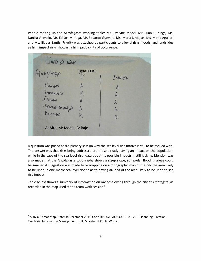
6
People making up the Antofagasta working table: Ms. Evelyne Medel, Mr. Juan C. Kings, Ms.
Daniza Vicencio, Mr. Edison Moraga, Mr. Eduardo Guevara, Ms. Maria J. Mejías, Ms. Mirna Aguilar,
and Ms. Gladys Santis. Priority was attached by participants to alluvial risks, floods, and landslides
as high impact risks showing a high probability of occurrence.
A question was posed at the plenary session why the sea level rise matter is still to be tackled with.
The answer was that risks being addressed are those already having an impact on the population,
while in the case of the sea level rise, data about its possible impacts is still lacking. Mention was
also made that the Antofagasta topography shows a steep slope, so regular flooding areas could
be smaller. A suggestion was made to overlapping on a topographic map of the city the area likely
to be under a one metre sea level rise so as to having an idea of the area likely to be under a sea
rise impact.
Table below shows a summary of information on ravines flowing through the city of Antofagsta, as
recorded in the map used at the team work session3:
3 Alluvial Threat Map. Date: 14 December 2015. Code DP-UGT-MOP-OCT-II-A1-2015. Planning Direction.
Territorial Information Management Unit. Ministry of Public Works.

7
Ravines having neither alluvial monitoring works nor projected works were highlighted on the city
map below:
The three ravines likely calling for particular attention are (in a Northern-Southern way): Club
Hípico, Bonilla and Caliche (Figure 1 and Figure 2). The Bonilla Ravine shows the highest impact in
terms of population size.
The Taltal working table was made up by: Mr. Emilio Rojas, Ms. Viviana Reyes, Ms. Hilda
Sepulveda, Mr. Antonio Barrera, Ms. Ruth Bravo, Ms. Ximena Estay, Ms. Marcela Olivos, Mr. Peter
Munck, Mr. Roberto Villablanca and Ms. Elsa Giovagnoli. Priority was attached by the group to
alluvial threats, and heat and cold waves as risks showing a high probability of occurrence and
having a high impact:

8
A: High M: Medium B: Low
Alluvial risks having an impact on the entire city of Taltal (Figure 3)4 can be generated by both,
mountains range´s and coastal precipitations. Alluvial monitoring works were conducted in Taltal,
and were expanded at the end of 20155 to a water retention capacity of 338 thousand M3.
The "Quiero Mi Barrio" (“I love my Neighbourhood”) programme, jointly implemented by the
Ministry of Housing and Urban Development (MINVU) and the Municipality of Taltal, made a
presentation showing the impacts of the March 2015 flooding event. This presentation is shown in
Annex 6.
Working tables: Project-focused actions
Two working groups were made up by participants to look into Component 1 in the preliminary
concept, and to review Component 2 in the outcomes framework (Annex 7) (Photographs 9 and
10). The task to be addressed was:
4 Proposal_ Evacuation Proposal Plan in case of alluvial danger. Locality of Taltal. Date: 17 December 2015.
Code: DP-UAT-MOP-DIC-II-A1-2015. Planning Direction. Territorial Information Management Unit. Ministry
of Public Works. 5 Mont, C. 2015. Taltal: Alluvial monitoring works were executed by the local government. El Nortero
Newspaper. 27 December, 2015. On line: http://www.elnortero.cl/noticia/sociedad/taltal-gobierno-finalizo-
obras-de-monitoring-aluvional. Anon. 2015. Alluvial monitoring works in Taltal are finished: The retention
rate has been increased to 338.000 M mil m33. Newspaper Soy Chile. 26 December 2015. On line:
http://www.soychile.cl/Antofagasta/Sociedad/2015/12/26/366246/Finalizaron-las-obras-de-monitoring-
aluvional-en-Taltal-aumentaron-a-338-mil-m3-la-cantidad-de-retencion.aspx

9
1. Setting up two working groups (per component). Appointing a rapporteur.
C1: Priority actions to increase resilience.
C2: Strengthening up adaptation capacity.
2. First: Reviewing actions (outputs) set forth in the component.
3. Second: Brainstorming over recommendations (changes, precisions, details). Recording
recommendations on flipchart (cards.
40 minutes
Results obtained by the group looking into Component 1 are shown in Figures 4 and 5. This group
did not manage to review subcomponents SC1.3 and SC1.4 (Annex 7). However, at the plenary
session the point was raised that the weather radar should be implemented bearing in mind that it
will allow for the collection of real-time data about precipitation rates to be collected. The
weather radar equipment, worth ca. €120,000 has already been identified. A recommendation has
been made for the radar to be installed at the Ministry of Public Works´ General Water Directorate
premises, in the city of Antofagasta.
Regarding subcomponent SC1.4, the ONEMI representative mentioned that evacuation maps and
evacuation route signs are already being prepared and that emergency operations committees are
already operational, so there is no need for these two components to be included in the project.
Consideration should be attached to how to reallocate the USD350,000 amount that was allocated
in Chile to these activities.
Component 2 was reviewed by Mr. Emilio Rojas, Ms. Viviana Reyes, Ms. Hilda Sepúlveda, Mr.
Antonio Barrera, Ms. Ximena Estay, Ms. Marcela Olivo, Mr. Roberto Villablanca, Ms. María José
Mejías and Ms. Elsa Giovagnoli. Group work results are shown in Figure 6. The point was stressed
for work to be coordinated with local stakeholders, and to strengthen up municipal teams. The
SC2.1 should include an emergency reaction survey. Finally, and regarding the storytellers'
experience, a suggestion was made for it to include a number of audio-visual materials.
Next steps
A roadmap as below was suggested to the participants:

10
Roadmap Proposal (Refer to dates shown in red above (NT)
Calendar- May – June – July 2016)
May 2016 Start-up Workshop in Esmeraldas
Key stakeholders mapping
Intervention clarifications and details (budgets)
June 2016 Preparation of PRODOC
July 2016 Revision of draft version of report
Validation workshop + endorsement letters
Final adjustments
The point was stressed that the focus for the remainder of May 2016 would be on:
(i) Mapping key stakeholders in each city, with a particular concern for areas being deemed
as priority areas; and
(ii) Defining details such as (a) ravines to be intervened by the project; (b) verifying that work
designs and cost updates are in place; (c) defining executors of project products; (d) cash
flow mechanism.
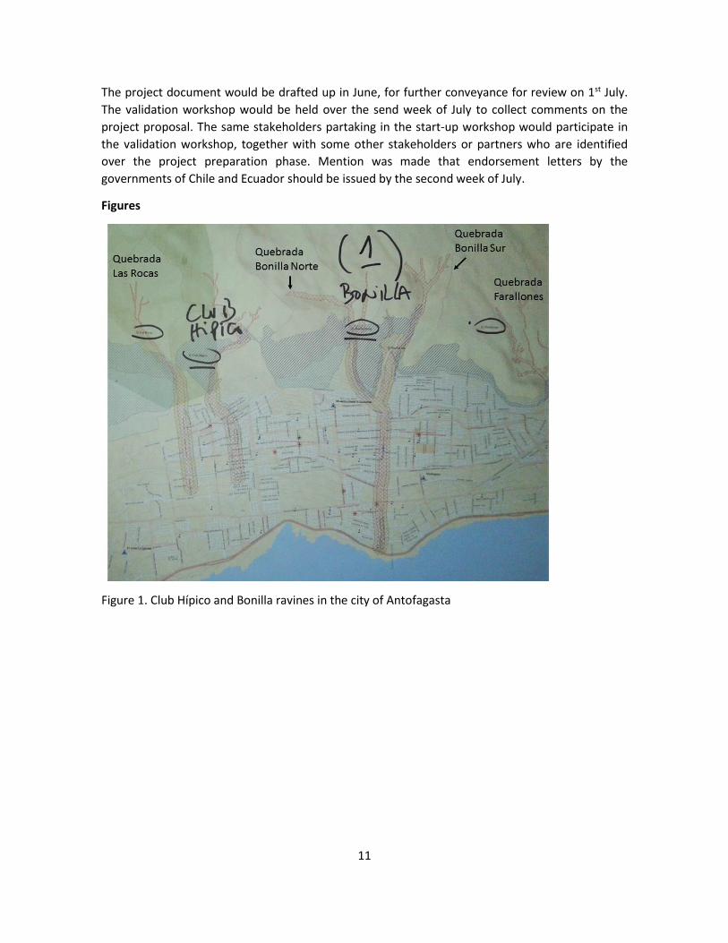
11
The project document would be drafted up in June, for further conveyance for review on 1st July.
The validation workshop would be held over the send week of July to collect comments on the
project proposal. The same stakeholders partaking in the start-up workshop would participate in
the validation workshop, together with some other stakeholders or partners who are identified
over the project preparation phase. Mention was made that endorsement letters by the
governments of Chile and Ecuador should be issued by the second week of July.
Figures
Figure 1. Club Hípico and Bonilla ravines in the city of Antofagasta
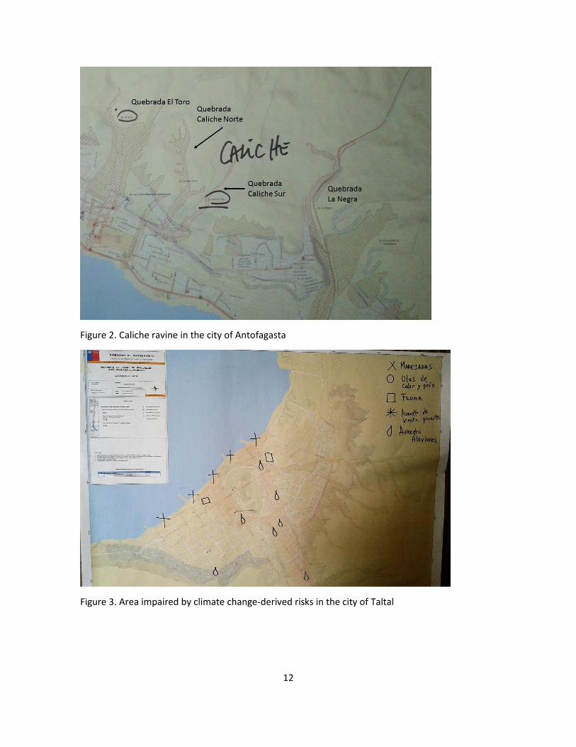
12
Figure 2. Caliche ravine in the city of Antofagasta
Figure 3. Area impaired by climate change-derived risks in the city of Taltal

13
Figure 4. Outputs of group members reviewing Component 1, vis-a-vis activities in Antofagasta and Taltal cities
Figure 5. Outputs of group members reviewing Component 1, vis-a-vis common Activities in Antofagasta and Taltal cities

14
Figure 6. Outputs of group members reviewing Component 2
Photographs:
Photograph 1. Welcome by Mr. Roberto Villablanca, MMA

15
Photograph 2. Welcome by Mr. Marco Giussani, CAF
Photograph 3. Presentation by Mr. Peter Muck, MMA

16
Photograph 4. Presentation by Ms. Carolina Cortés, CAF
Photograph 5. Presentation by Ms. Gladys Santis, MMA

17
Photograph 6. Presentation by Ms. María-José Mejías, ONEMI

18
Photograph 7. Working Session, Taltal group

19
Photograph 8. Working session, Antofagasta group

20
Photograph 9. Working session, group reviewing Component 1

21
Photograph 10. Working session, group reviewing Component 2.

22
Regional Project: Reduction of Climate Vulnerability and
Flooding Risks in Urban and Semi-Urban Coastal Areas in
Cities in Latin America
Presentation of Report
Initial Formulation Workshop
Esmeraldas City
Republic of Ecuador
16 May 2016
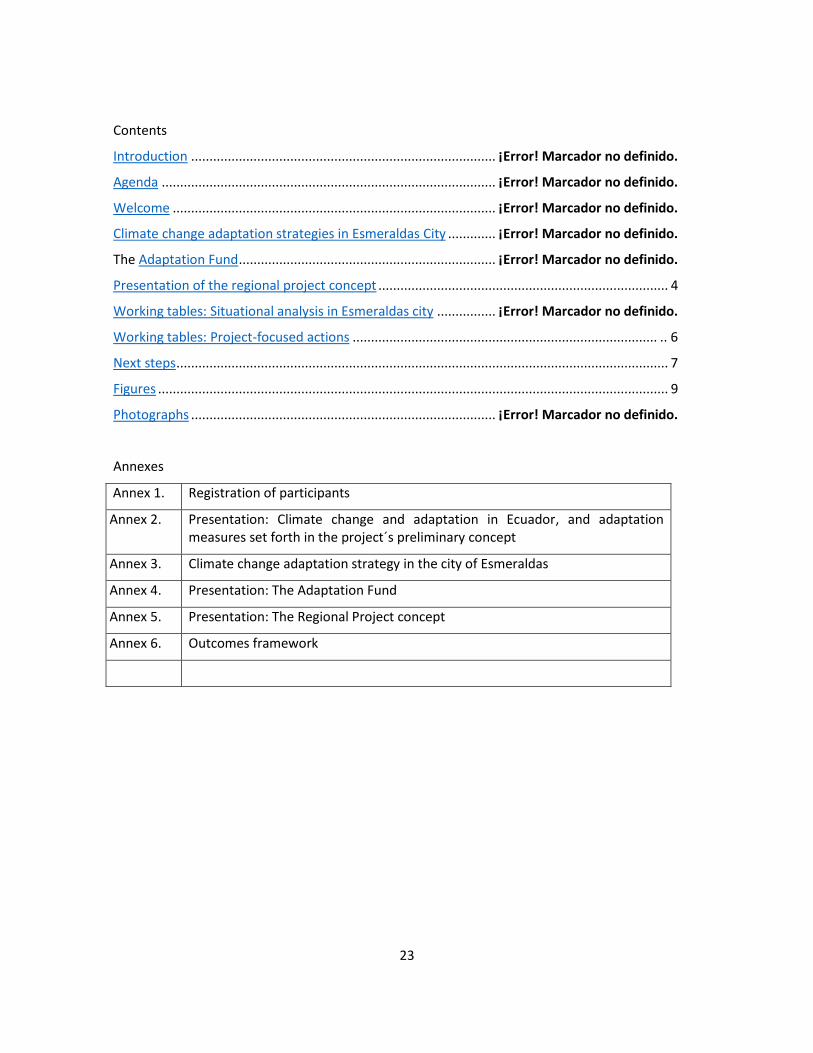
23
Contents
Introduction ................................................................................... ¡Error! Marcador no definido.
Agenda ........................................................................................... ¡Error! Marcador no definido.
Welcome ........................................................................................ ¡Error! Marcador no definido.
Climate change adaptation strategies in Esmeraldas City ............. ¡Error! Marcador no definido.
The Adaptation Fund ...................................................................... ¡Error! Marcador no definido.
Presentation of the regional project concept ............................................................................... 4
Working tables: Situational analysis in Esmeraldas city ................ ¡Error! Marcador no definido.
Working tables: Project-focused actions ................................................................................... .. 6
Next steps ...................................................................................................................................... 7
Figures ........................................................................................................................................... 9
Photographs ................................................................................... ¡Error! Marcador no definido.
Annexes
Annex 1. Registration of participants
Annex 2. Presentation: Climate change and adaptation in Ecuador, and adaptation measures set forth in the project´s preliminary concept
Annex 3. Climate change adaptation strategy in the city of Esmeraldas
Annex 4. Presentation: The Adaptation Fund
Annex 5. Presentation: The Regional Project concept
Annex 6. Outcomes framework

24
Introduction
The Ministry of the Environment of Chile (MMA, for its acronym in Spanish) and the Ministry of
the Environment of Ecuador (MAE, for its acronym in Spanish), in a joint action with CAF -
Development Bank of Latin America – approached the Adaptation Fund with an initiative for a
Regional Project to be executed entailing the reduction of climate vulnerability and flooding risks
in urban and semi-urban coastal areas in cities in Latin America. This regional initiative was
intended to be implemented in three coastal cities: Antofagasta and Taltal in Chile, and
Esmeraldas in Ecuador.
The Adaptation Fund was set up in 2001 to promote projects and specific climate change
adaptation programmes in implementing countries. The fund is a financial mechanism attached to
the United Nations Framework Convention on Climate Change and the Kyoto Protocol.
This Regional Project initiative was submitted as a preliminary concept for consideration by the
Adaptation Fund, and was Therefore approved by the Fund in late March 2016. For the Fund´s
final approval to be granted to this project, the latter should be clearly articulated through a
collaborative endeavour with key public and private stakeholders. Therefore, a workshop was
scheduled to be held in the city of Antofagasta in order to submit the preliminary concept to key
stakeholders, getting feedback and undertaking a process to expanding upon the final proposal to
be submitted to the Fund by August 1, 20166. This workshop was held at the capacity-building
centre attached to the Fire Brigade of Esmeraldas.
Agenda
08:30 Registration of participants
09:00 Welcome
09:15 Presentation of participants
09:30 Review of agenda
09:45 Climate change adaptation and measures suggested in the concept
10:30 Break
11:00 Climate change adaptation strategy in the city of Esmeraldas
11:30 The Adaptation Fund
12:00 Presentation: The regional project concept
12:40 Working tables. Situational analysis in Esmeraldas
14:00 Lunch break
6 Deadline for submission of proposals to be considered at the 28th meeting of the Adaptation Fund´s Board
of Directors, scheduled to be held on 4 October 2016 in Bonn, Germany

25
15:00 Working tables. Project-focused actions
16:30 Next steps
17:00 Closing of event
Welcome
Mr. Guillermo Oleas, a staff member of the Provincial Directorate of the Ministry of the
Environment, Mr. Renato Tambaco, Director, Environmental Management, Municipality of
Esmeraldas, and Ms. Carolina Cortés, CAF officer (Photographs 1, 2 and 3) welcome participants,
thanking them for their attendance, and supplying information on the general meeting
framework. The Esmeraldas Fire Department was warmly thanked for their kindness to facilitating
their Capacity-building Centre facilities for this event to be held. Thirty people attended the
meeting. The attendance record is shown Annex 1.
Climate change adaptation and measures set forth in the concept
The workshop presentation was made by Mr. Nicolás Zambrano, attached to the Ministry of the
Environment (MAE) (Photo 4), who briefly discussed the current status of coastal areas in Ecuador
vis-à-vis global climate change. An indication was made that higher temperatures and
precipitations are expected in the city of Esmeraldas, thus increasing the vulnerability in sectors
already showing a high risk of flooding and landslides. Preliminary adaptation measures identified
for the city of Esmeraldas were also summarized, some of which have been included in the
preliminary project concept. Mr. Diego Guzmán (Director, climate change adaptation) summarized
the political and institutional framework in which climate change mitigation and adaptation
actions are being undertaken. He further mentioned that action lines up to 2017 and to 2025 are
in place vis-à-vis climate change adaptation. The workshop presentation is shown in Annex 2.
Climate change adaptation strategy in the city of Esmeraldas
This presentation was made by Mr. Renato Tambaco (Photo 5), Director, Environmental
Management, Municipality of Esmeraldas. Mr. Tambaco mentioned that the main threats being
entailed by climate change are higher extreme precipitation and temperature, and the city´s
vulnerability situation, since it is being mainly affected by floods and landslides caused by heavy
rainfall. Finally, five climate change adaptation-focused projects were presented, one of them
being the regularization of settlements in high risk areas. This presentation is shown in Annex 3.
The Adaptation Fund
This presentation was in charge of Ms. Carolina Cortés, CAF Officer (Photo 6), who referred to the
scope and operation of the Adaptation Fund, further mentioning that in addition to its role as a
development bank, CAF is a Regional Implementing Agency (for the Adaptation Fund) and is
articulating the preparation of a proposal for this project. She explained that the project is a part
to the Adaptation Fund call made in 2015 for regional projects, to which the preliminary concept

26
which was accepted by the Fund was submitted. Finally, mention was made of an option to
submitting a concept or a final proposal in late July 2016. The final proposal is the fully developed
project document abiding by all the Adaptation Fund requirements. If the proposal is submitted at
conceptual level, comments could be made and, if necessary, there is an option to submit the
complete proposal by year end. However, if the proposal is submitted as a complete proposal,
there is only an acceptance or rejection option, thus constraining options for adjustments to be
added to it.
The point was stressed that this is a regional project involving the cities of Esmeraldas, in Ecuador,
and Antofagasta and Taltal, in Chile. Further, mention was made that the initial workshop in Chile
was held on May 4 in the city of Antofagasta. The related presentation is shown in Annex 4.
Presentation of the regional project concept
This presentation was made by Mr. Segundo Coello, a CAF consultant in charge of the preparation
of the project document. Mr. Coello mentioned that the project is at its preliminary concept level
and that a final proposal should be submitted over the next few weeks. Reference was also made
that scheduled time is quite short, since the project should be ready by July 15, to allow for time
for it to be reviewed both in Chile and Ecuador prior to submission to the Adaptation Fund by the
deadline date of 29 July.
The point was stressed by Mr. Coello that the project is just being envisioned as an idea and that
non-reimbursable resources available are limited, so strategic priority should be attached to the
intervention to be executed.
A summary was made of similarities and differences between the three cities in which work is to
be executed, highlighting that this is a regional project and that lessons and learnings are expected
to be useful to some other coastal cities. A review was made of the project objective and expected
results, highlighting that within the project logics, its outcomes are situational changes, and the
project outputs (e.g., number of people trained, infrastructure works) are concrete matters
making a contribution to achieving results. The budget and its allocation were reviewed in their
three components and expected outcomes. The comments made by the Adaptation Fund
Secretariat to the project proposal were also reviewed. As mentioned, only one comment is
pending that is related to the involvement of the National Implementation Agency attached to the
Adaptation Fund (i.e., the Chilean International Cooperation Agency), a matter that will be dealt
with in a timely manner. This presentation is shown in Annex 5.
Working tables. Situational analysis in the city of Esmeraldas
Participants were split into two working groups to look into intervention priorities in the city. The
work to be carried out was:
English version:
1. Setting up two working groups. Appointing a rapporteur.
2. First: Brainstorming over risks entailed in the likely climate scenario.
27
3. Second: Categorization of risks identified on the basis of a risk matrix.
4. Third: Identification of areas likely to be more susceptible to main impacts identified (Refer
to maps).
40 minutes
Group 1 members were Ms. Ericka Perdomo, Mr. Renato Tambaco, Mr. Byron Vargas, Mr.
Mauricio Perea, Mr. Alfredo Quiñonez, Mr. José Maffares, Mr. Jaime Arellano, Ms. Cheo Reyes,
Mr. Iván Sánches and Ms. Gissela Yunda (Photo 8).
Priority was attached by the group to floods and landslides on hillsides as risks showing a high
probability and a high impact (Figure 1). The sea level rise was not considered an issue to be dealt
with in this project.
The three most vulnerable sectors in case of flooding events, and the six sectors most vulnerable
to landslides (Figure 2, Figure 3) were also attached priority. Finally, the group deemed that the
intervention should focus on floodings in the island sector, and landslides in the Gatazo Hill
(November 20 neighbourhood).
Group 2 also attached priority to floods and landslides as being risks showing the highest
likelyhood of occurrence and impact, and identified the most vulnerable sectors in the city (Photo
9, Figure 4, Figure 5). The group also identified forest fires as risks, since they occur over the dry
season and could get worse in the presence of higher temperatures in the city hills, and a sea level
rise. However, not enough knowledge is available about the possible impact of a sea level rise. The
group attached priority to seven sectors that are frequently impaired by floods: three of them are
along the course of the Teaone River (Figure 6). As regards sector IV -where the city's water
treatment plant is located- mention was made that whenever the river level rises because of
flooding, water flows through sewers and houses drains (Figure 7).
Working tables: Project-focused actions
Three working groups were made up by participants to look into matters raised in the outcomes
framework (Annex 6). Group 1 focused on green infrastructure and gray infrastructure matters
(matters SC 1.1 and SC 1.2); the focus of group 2 was put on on climate monitoring and emergency
response (matters SC 1.3 and SC 1.4); and group 3 focused on the review of the whole
component. The task was:

28
1. Setting up three working groups (per component). Appointing a rapporteur.
First Group: To look into green and grey infrastructure matters included in the
preliminary concept (i.e., SC1.1 and SC1.2).
Second Group: To look into climate monitoring early warning matters included in the
preliminary concept (i.e., SC1.3 and SC1.4.)
Third Group: To look into component 2 (actions to strengthen up adaptive capacity).
2. First: Review of actions (outputs) as suggested in the component.
3. Second: Brainstorming over recommendations (changes, precisions, details). Recording
recommendations in a flipchart.
40 minutes
Group 1 was made up by Mr. Janino Carvache, Mr. Alfredo Quiñonez, Ms. Marianela Gamboa, Ms.
Gissella Yunda, Mr. Nicolás Zambrano, Mr. Jaime Arellano and Mr. Raúl Chiriboga (Photo 10). A
suggestion was made by the group that green infrastructure actions could be focused on coastal
reforestation in the islands sector, and revegetation of slopes in landslide areas (Figure 8).
Concerning grey infrastructure, a proposal was put forward for the focus to be put on stabilization
of landslides, and setting up of protection walls in flood areas in sector IV as shown in the map
(Figure 7). The group also suggested that the intervention on hillsides should be comprehensive,
combining grey infrastructure for soil stabilization; green infrastructure for soil protection from
rains; and strengthening up sector stakeholders´ capacity to react in case of emergency.
Group 2 was made up by Mr. Elvis Bastidas, Mr. Cheo Reyes, Mr. Patricio Caiza, Mr. José Morales,
Ms. Erika Perdomo and Mr. Iván Sánchez (Photo 11). The group suggested that two meteorological
stations should be installed at the source of the Teaone River and in the Mútile sector (on the
Esmeraldas River) (Figure 9). The convenience of installing conventional stations or automatic
stations was discussed, as was the option of installing a weather radar, and that the Provincial
Council of Esmeraldas could be in charge of the meteorological stations. The final place for
installation of the weather radar is still to be defined.
Group 2 also stated that a radio system is necessary to facilitating communication between
emergency groups; a recommendation was also made to strengthening up the fire brigade
reaction capacity, signalling evacuation routes, and installing shelter facilities.
Group 3 members were by Mr. Paul Mite, Mr. Exon Bone, Mr. Milton Meza, Mr. José Maffares, Mr.
Byron Vargas and Ms. Carolina Cortés, CAF Officer (Photo 12). The group stated that capacity-
building actions are based on the formal education system put in place by the Ministry of
Education (Figure 10). However, the need to get civil society cultural groups involved to host and

29
sustain initiatives, such as storytellers, and some other cultural manifestations, such as marimba
and lullabies was discussed. A proposal was also made that component 2 addresses strengthening
up the current political and regulatory framework to act vis-à-vis settlements in risk areas, and
prevent new settlements from being built up on them.
Next steps
A roadmap as below was suggested to the participants:
Roadmap Proposal (Refer to dates shown in red in
Calendar- May – June – July 2016)
May 2016 Start-up Workshop in Esmeraldas
Key stakeholders mapping
Intervention clarifications and details (budgets)
June 2016 Preparation of PRODOC
July 2016 Revision of draft version of report
Validation workshop + endorsement letters
Final adjustments
----
An explanation was made that over the focus over the remainder of May 2016 would be on:
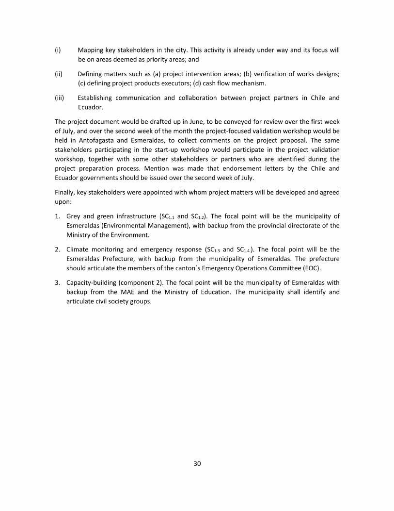
30
(i) Mapping key stakeholders in the city. This activity is already under way and its focus will
be on areas deemed as priority areas; and
(ii) Defining matters such as (a) project intervention areas; (b) verification of works designs;
(c) defining project products executors; (d) cash flow mechanism.
(iii) Establishing communication and collaboration between project partners in Chile and
Ecuador.
The project document would be drafted up in June, to be conveyed for review over the first week
of July, and over the second week of the month the project-focused validation workshop would be
held in Antofagasta and Esmeraldas, to collect comments on the project proposal. The same
stakeholders participating in the start-up workshop would participate in the project validation
workshop, together with some other stakeholders or partners who are identified during the
project preparation process. Mention was made that endorsement letters by the Chile and
Ecuador governments should be issued over the second week of July.
Finally, key stakeholders were appointed with whom project matters will be developed and agreed
upon:
1. Grey and green infrastructure (SC1.1 and SC1.2). The focal point will be the municipality of
Esmeraldas (Environmental Management), with backup from the provincial directorate of the
Ministry of the Environment.
2. Climate monitoring and emergency response (SC1.3 and SC1.4.). The focal point will be the
Esmeraldas Prefecture, with backup from the municipality of Esmeraldas. The prefecture
should articulate the members of the canton´s Emergency Operations Committee (EOC).
3. Capacity-building (component 2). The focal point will be the municipality of Esmeraldas with
backup from the MAE and the Ministry of Education. The municipality shall identify and
articulate civil society groups.

31
Figures
Figure 7. Outputs, working group 1 – First group work session
Figure 8. Areas highlighted in the city map by Group 1 at their first group work session
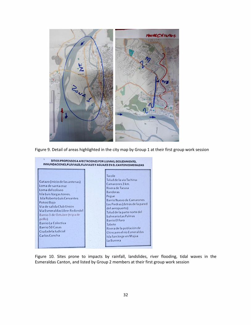
32
Figure 9. Detail of areas highlighted in the city map by Group 1 at their first group work session
Figure 10. Sites prone to impacts by rainfall, landslides, river flooding, tidal waves in the Esmeraldas Canton, and listed by Group 2 members at their first group work session

33
Figure 11. Outputs, Group 2 work over their first group session work

34
Figure 12. Areas highlighted in the city map by Group 2 over their first group work session

35
Figure 13. I. Luis Vargas Torres Island, flooding over heavy rainfall events. IV. Propicias I and II. Flooding over havy rainfall event. V. Propicias IV and V (Los Mangos) flooding over heavy rainfall events.
Flooding areas highlighted in the map by group 2 over their first group work session
Figure 14. Outputs group 1 (Green and grey infraetructure) at second group work session

36
Figure 15. Outputs, group 2 (climate monitoring and emergency response) at second group working session
Figure 16. Outputs, group 3 (Local stakeholder capacity-building) at the second group working session
Photographs

37
Photograph 11.Welcome by Mr. Guillermo Oleas, Ministry of the Environment, Provincial Direction in Esmeraldas
Photograph 12. Welcome by Mr. Renato Tambaco, Director, Environmental Management, Municipality of Esmeraldas

38
Photograph 13.Welcome by Ms. Carolina Cortés, CAF Officer
Photograph 14. Presentation by Mr. Nicolás Zambrano (above) and Mr. Diego Guzmán (below) attached to the Climate Change Adaptation Direction, MAE
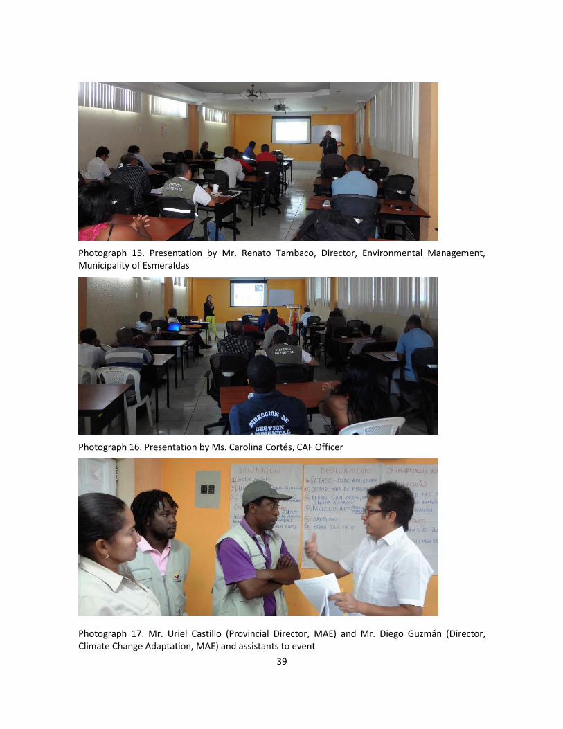
39
Photograph 15. Presentation by Mr. Renato Tambaco, Director, Environmental Management, Municipality of Esmeraldas
Photograph 16. Presentation by Ms. Carolina Cortés, CAF Officer
Photograph 17. Mr. Uriel Castillo (Provincial Director, MAE) and Mr. Diego Guzmán (Director, Climate Change Adaptation, MAE) and assistants to event
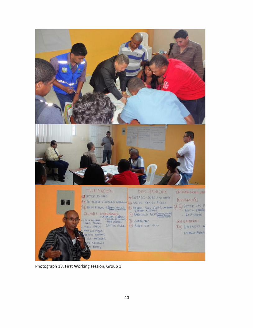
40
Photograph 18. First Working session, Group 1

41
Photograph 19. First Working Session, Group 2

42
Photograph 20. Second Working Session, Group 1. Focus on green and grey infrastructure (component 1 of project)

43
Photograph 21. Second Working session, Group 2. Focus on climate monitoring and emergency response (Component 1 of project)

44
Photograph 22. Second Working session, Group 3. Focus on component 2 of Project

45
Regional Project: Reduction of Climate Vulnerability and
Flooding Risks in Urban and Semi-Urban Coastal Areas in
Cities in Latin America
Presentation of Report
Validation Workshop
Antofagasta
Republic of Chile
19 July 2016
Contents

46
Introduction ................................................................................... ¡Error! Marcador no definido.
Agenda ........................................................................................... ¡Error! Marcador no definido.
Welcome ........................................................................................ ¡Error! Marcador no definido.
Presentation of regional project draft .......................................... ¡Error! Marcador no definido.
Presentation of stakeholders mapping outcomes ......................... ¡Error! Marcador no definido.
Working tables. Project-focused actions ....................................... ¡Error! Marcador no definido.
Group 1. Components 1 and 3. .................................................. ¡Error! Marcador no definido.
Group 2. Components 2 and 3. .................................................. ¡Error! Marcador no definido.
Matters still to be addressed vis-à-vis PRODOC closing................. ¡Error! Marcador no definido.
Closing of event .............................................................................. ¡Error! Marcador no definido.
Figures ............................................................................................ ¡Error! Marcador no definido.
Photographs ................................................................................... ¡Error! Marcador no definido.
Annexes
Annex 1. Registration of participants
Annex 2. Presentation: Draft report
Annex 3. Presentation: Stakeholders mapping results
Annex 4. Materials in use for team work

47
Introduction
The Ministry of the Environment of Chile (MMA, for its acronym in Spanish) and the Ministry of
the Environment of Ecuador (MAE, for its acronym in Spanish), in a joint action with CAF -
Development Bank of Latin America – approached the Adaptation Fund with an initiative for a
Regional Project to be executed entailing the reduction of climate vulnerability and flooding risks
in urban and semi-urban coastal areas in cities in Latin America. This regional initiative was
intended to be implemented in three coastal cities: Antofagasta and Taltal in Chile, and
Esmeraldas in Ecuador.
The Adaptation Fund was set up in 2001 to promote projects and specific climate change
adaptation programmes in implementing countries. The fund is a financial mechanism attached to
the United Nations Framework Convention on Climate Change and the Kyoto Protocol.
This Regional Project initiative was submitted as a preliminary concept for consideration by the
Adaptation Fund, and was Therefore approved by the Fund in late March 2016. For the Fund´s
final approval to be granted to this project, the latter should be clearly articulated through a
collaborative endeavour with key public and private stakeholders. Therefore, a workshop was held
on 4 May 2016 in the city of Antofagasta in order to submit the preliminary concept to key
stakeholders, getting feedback and undertaking a process to expanding upon the final proposal to
be submitted to the Fund by August 1, 20167. A similar start-up workshop was held in the City of
Esmeraldas on 16 May 2016. Memories of both, the Antofagasta, Chile, and the Esmeraldas,
Ecuador, start-up workshops were conveyed to participants in both countries.
Agenda
10:00 Registration of participants
10:30 Welcome
10:45 Presentation of participants
11:00 Review of schedule
11:15 Presentation: Draft version of project
12:30 Outcomes of Stakeholders mapping
13:00 Lunch
14:00 Working tables: Project-focused actions
16:00 Pending matters for PRODOC closing
7 Deadline for submission of proposals to be considered at the 28th meeting of the Adaptation Fund´s Board
of Directors, scheduled to be held on 4 October 2016 in Bonn, Germany.
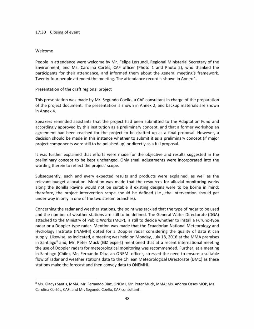
48
17:30 Closing of event
Welcome
People in attendance were welcome by Mr. Felipe Lerzundi, Regional Ministerial Secretary of the Environment, and Ms. Carolina Cortés, CAF officer (Photo 1 and Photo 2), who thanked the participants for their attendance, and informed them about the general meeting´s framework. Twenty-four people attended the meeting. The attendance record is shown in Annex 1.
Presentation of the draft regional project
This presentation was made by Mr. Segundo Coello, a CAF consultant in charge of the preparation of the project document. The presentation is shown in Annex 2, and backup materials are shown in Annex 4.
Speakers reminded assistants that the project had been submitted to the Adaptation Fund and accordingly approved by this institution as a preliminary concept, and that a former workshop an agreement had been reached for the project to be drafted up as a final proposal. However, a decision should be made in this instance whether to submit it as a preliminary concept (if major project components were still to be polished up) or directly as a full proposal.
It was further explained that efforts were made for the objective and results suggested in the preliminary concept to be kept unchanged. Only small adjustments were incorporated into the wording therein to reflect the project´ scope.
Subsequently, each and every expected results and products were explained, as well as the relevant budget allocation. Mention was made that the resources for alluvial monitoring works along the Bonilla Ravine would not be suitable if existing designs were to be borne in mind; therefore, the project intervention scope should be defined (i.e., the intervention should get under way in only in one of the two stream branches).
Concerning the radar and weather stations, the point was tackled that the type of radar to be used and the number of weather stations are still to be defined. The General Water Directorate (DGA) attached to the Ministry of Public Works (MOP), is still to decide whether to install a Furuno-type radar or a Doppler-type radar. Mention was made that the Ecuadorian National Meteorology and Hydrology Institute (INAMHI) opted for a Doppler radar considering the quality of data it can supply. Likewise, as indicated, a meeting was held on Monday, July 18, 2016 at the MMA premises in Santiago8 and, Mr. Peter Muck (GIZ expert) mentioned that at a recent international meeting the use of Doppler radars for meteorological monitoring was recommended. Further, at a meeting in Santiago (Chile), Mr. Fernando Díaz, an ONEMI officer, stressed the need to ensure a suitable flow of radar and weather stations data to the Chilean Meteorological Directorate (DMC) as these stations make the forecast and then convey data to ONEMHI.
8 Ms. Gladys Santis, MMA, Mr. Fernando Díaz, ONEMI, Mr. Peter Muck, MMA; Ms. Andrea Osses MOP, Ms.
Carolina Cortés, CAF, and Mr, Segundo Coello, CAF consultant.
49
Regarding the regional course for local government officials, mention was made that the Civil Protection Academy (APC) has been considered to lead the implementation of this initiative, bearing in mind their experience with on-site and online courses. However, the APC is still to advise whether they would like to participate in this project component.
Mention was made that some goals are still to be met within the outcomes framework that should be completed on the basis of local stakeholders´ experience.
The organisational structure of the project was set forth. An Advisory Committee made up by the Chilean Agency for International Cooperation for Development (AGCID) and the Technical Secretariat for International Cooperation (SETECI) of Ecuador has been included in this organisational structure. Also, as reported, a meeting was held with AGCID in Santiago on Monday, on 18 July, at which an agreement was reached to participate in the project's advisory committee.
Information on the entities executing the project's products was supplied, and the point was highlighted that a suggestion was made that the project team in Chile (three people) operate from the municipalities of Antofagasta (two people) and Taltal (one person). This requires the agreement of the municipalities involved.
Components still pending to be looked into by working groups were summarized:
1. Specifying what can be built along the Bonilla Ravine with resources available [one of the two ravines?]
2. Including existing designs that will be updated for Bonilla Ravine [including them as an annex to the project document]
3. Type and likely location of the [doppler?] weather radar.
4. Number and probable location of [automatic?] weather stations.
5. Mechanisms to ensure data flow from MOP to the Chilean Meteorological Directorate (DMC)
6. Ratifying that MOP will cover complementary infrastructure, operation and maintenance of equipment.
7. Number of sirens and location [validate with available budget]
8. Number of people who can be trained through a regional course.
9. Number of people that can be reached with communication and awareness strategies.
10. Validating location of MA and MT staff
Presentation of stakeholders mapping results
Ms. María José Godoy introduced the stakeholders mapping results for Antofagasta and Taltal. This presentation was the basis for the project design, and it is shown in Annex 3.

50
Working tables. Project-focused Actions
Participants made up two working groups (i.e., Component 1 and Component 2), to review Component 3. The task to be tackled with was:
1. Setting up two working groups (per component). Appointing a rapporteur.
C1 Priority actions to increasing resilience +C3.
C2). Enhancing adaptive capacity +C3.
Second Group: To look into climate monitoring early warning matters included in the
preliminary concept (i.e., SC1.3 and SC1.4.)
Third Group: To look into component 2 (actions to strengthen up adaptive capacity).
2. First: Review of actions (outputs) as suggested in the component. Checking on pending
matters. Jotting queries down.
3. Second: Brainstorming over recommendations. Recording recommendations in a Flipchart.
40 minutes
Group 1. Components 1 and 3
Group 1 members were: Ms. Hilda Sepulveda, Ms. Lorena Herrera, Ms. Daniza Vicencio, Ms. Carolina Ampuero, Ms. Nolvia Severino, Mr. Juan Carlos Reyes, Mr. Carlos Iriarte and Ms. Elsa Giovanoli (Photo 5). Group work outputs are shown in Figure 1.
Deadlines were set up for some project-related definitions. Mention was made that alluvial monitoring works will be carried out along both branches of the Bonilla Ravine. Infrastructural works will be executed from downstream the Ravine upwards insofar funding is available, expecting that additional funding may be forthcoming.
A recommendation was made for citizen communication strategies and the storytellers initiative to include work with schools and colleges (formal education) and groups having different capacities. The latter should also be considered in evacuation processes in case of emergency.
A recommendation was made that documents being generated (product 7.2) should ensure an inclusive and universal access. Therefore, a simple and inclusive language should be used.
It was considered necessary for the Municipality of Taltal to formally indicate its willingness to provide accommodation for a project team member over the five years the project is scheduled to last.
Group 2. Components 2 and 3

51
Group 2 members were: Ms. Aida Espejo, Ms. Jimena Estay, Mr. Sergio Albornoz, Ms. Diane Trigo, Ms. Carola Aparicio, Mr. Miguel Baroza, Ms. Rosemarie Rosas and Ms. María José Godoy (Photo 6). The group pointed out who are the local stakeholders attending the regional climate change adaptation course. An emphasis was made that the course should be evaluated and the capacity-building impact should be measured.
Pending matters for PRODOC closing
The pending matters listing was reviewed and an agreement was reached to have everything ready up to early next week taking into account that the related document should be delivered by Friday, 29 July, 2016. The need for municipalities to indicate their willingness to supply lodging facilities to the project team was highlighted.
Closing of event
Closing was in charge of Mr. Roberto Villablanca, MMA (Photo 7). Participation and contributions of people and institutions were warmly appreciated.
Figures
Figure 17. Group 1 Outputs

52
Figure 18. Group 2 Outputs
Photographs
Photograph 23. Welcome by Mr. Felipe Lerzundi, MMA

53
Photograph 24. Welcome by Ms. Carolina Cortés, CAF
Photograph 25. Presentation: Stakeholders mapping outputs. Ms. María José Godoy
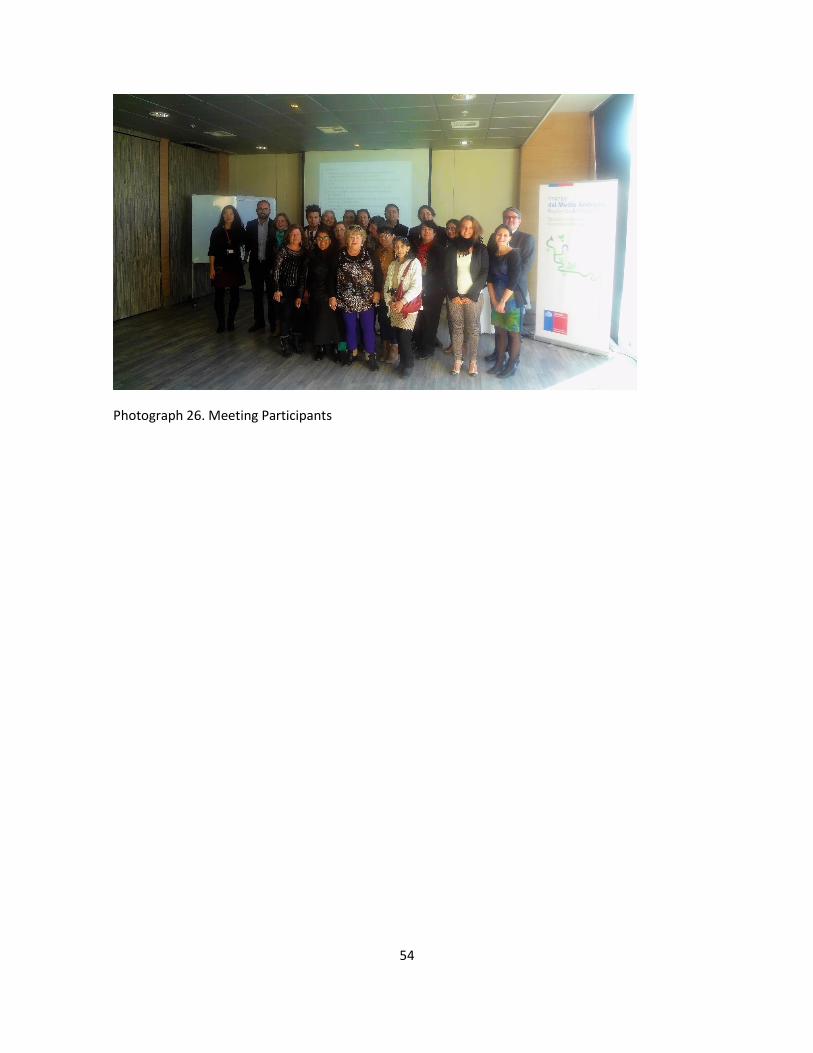
54
Photograph 26. Meeting Participants
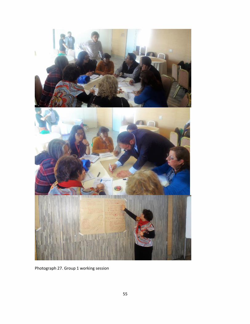
55
Photograph 27. Group 1 working session

56
Photograph 28. Group 2 working session
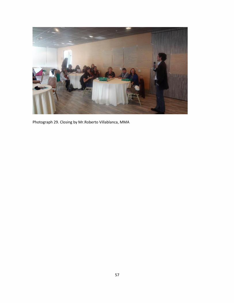
57
Photograph 29. Closing by Mr.Roberto Villablanca, MMA

58
Regional Project: Reduction of Climate Vulnerability and
Flooding Risks in Urban and Semi-Urban Coastal Areas in
Cities in Latin America
Presentation of Report
Validation Workshop
Esmeraldas City
Republic of Ecuador
22 July 2016
59
Contents
Introduction ................................................................................... ¡Error! Marcador no definido.
Agenda ........................................................................................... ¡Error! Marcador no definido.
Welcome ........................................................................................ ¡Error! Marcador no definido.
Presentation of regional project draft .......................................... ¡Error! Marcador no definido.
Working table. Project-focused actions ......................................... ¡Error! Marcador no definido.
Matters still to be solved vis-à-vis PRODOC closing ............................................................... …… 5
Closing of event ........................................................................................................................... 5
Figures ........................................................................................................................................... 6
Photographs ................................................................................... ¡Error! Marcador no definido.
Annexes
Annex 1. Registration of participants
Annex 2. Presentation: Draft version of project
Annex 3. Materials used for team work

60
Introduction
The Ministry of the Environment of Chile (MMA, for its acronym in Spanish) and the Ministry of
the Environment of Ecuador (MAE, for its acronym in Spanish), in a joint action with CAF -
Development Bank of Latin America – approached the Adaptation Fund with an initiative for a
Regional Project to be executed entailing the reduction of climate vulnerability and flooding risks
in urban and semi-urban coastal areas in cities in Latin America. This regional initiative was
intended to be implemented in three coastal cities: Antofagasta and Taltal in Chile, and
Esmeraldas in Ecuador.
The Adaptation Fund was set up in 2001 to promote projects and specific climate change
adaptation programmes in implementing countries. The fund is a financial mechanism attached to
the United Nations Framework Convention on Climate Change and the Kyoto Protocol.
This Regional Project initiative was submitted as a preliminary concept for consideration by the
Adaptation Fund, and was Therefore approved by the Fund in late March 2016. For the Fund´s
final approval to be granted to this project, the latter should be clearly articulated through a
collaborative endeavour with key public and private stakeholders. Therefore, a Start-up workshop
was held in the city of Antofagasta on 16 May 2016 in order to submit the preliminary concept to
key stakeholders, getting feedback and undertaking a process to expanding upon the final
proposal to be submitted to the Fund by August 1, 20169. A similar start-up workshop was held on
4 May 2016. The Antofagasta and Esmeraldas start-up workshops memories were conveyed to
participants in both countries.
The validation workshop was convened on June 23, 2016 and a number of email messages were sent as an event reminder. On Tuesday, July 19, an unexpected WhatsApp message was received from the Environmental Management Director, Municipality of Esmeraldas, advising that an evacuation drill was to be held in the city over the morning the workshop had been scheduled to take place. Accordingly, both, the meeting´s agenda and relevant logistics were modified and the document revision date was changed for Friday afternoon, 22 July 2016, and all attendants were notified accordingly.
Agenda
13:00 Registration of participants (lunch)
14:00 Welcome
14:10 Presentation of participants
14:30 Review of agenda
14:45 Presentation of Project draft
15:30 Working tables: Project-focused actions
17:00 Matters pending for PRODOC closure
17:30 Closing of event
9Deadline for submission of proposals to be considered at the 28th meeting of the Adaptation Fund´s Board
of Directors, scheduled to be held on 4 October 2016 in Bonn, Germany.

61
Welcome
Mr. Diego Guzmán, Director, Climate Change Adaptation, Ministry of the Environment (MAE) and Ms. Carolina Cortés, CAF Officer (Photo 1 and Photo 2) welcome participants and thanked them for their attendance, further informing them on the meeting´s general framework. Ten people attended the meeting. The attendance record is shown in Annex 1.
Presentation of the draft regional project
This presentation was made by Mr. Segundo Coello, a CAF consultant for the preparation of the project document. This presentation is attached in Annex 2, and backup materials are attached in Annex 3.
Mention was made that this project was submitted and approved by the Adaptation Fund as a preliminary concept, and that an agreement was reached at the previous workshop for this project to be executed as a final proposal. However, a decision should be made at this instance whether to submit this project as a concept (in case key project components should still be further developed) or directly as a final proposal.
The point was stressed that efforts were made to uphold both the project objective and results being suggested in the preliminary concept. Only small adjustments were incorporated into their wording to reflect the project scope.
Subsequently, an explanation was made of each of the expected results and products, as well as of the relevant budgetary allocation.
Mention was made regarding the need to validating the number and possible location of meteorological stations bearing in mind resources available in the project (product 3.2). Likewise, the point was stressed that the budget allocated to the radar should be increased to include additional equipment facilities (e.g., tower, enclosure).
As pointed out, INAMHI should be responsible for managing the radar and meteorological stations, and data collected therein shall flow to the early warning systems stationed in the canton and in the province.
As pointed out, it is necessary to identify the site where the community-based early warning system pilot exercise will be conducted in the city. Three likely sites have been identified: (i) Luis Vargas Torres Island, (ii) Teaone River banks, and (iii) the Teaone River - Esmeraldas River confluence point.
Regarding the regional course for local government officers, mention was made that the Chilean Civil Protection Academy (APC, for its acronym in Spanish) has been considered to lead this initiative taking into account their experience with on-site and online courses. However, the APC is still to advise whether they are interested in getting involved in this project component.
Mention was made that a number of goals´ values in the outcomes framework need to be completed based on the experience of local stakeholders.
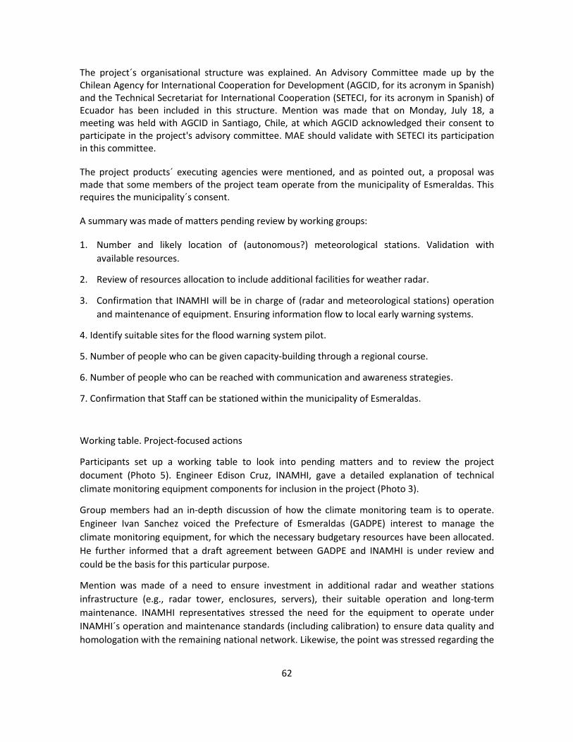
62
The project´s organisational structure was explained. An Advisory Committee made up by the Chilean Agency for International Cooperation for Development (AGCID, for its acronym in Spanish) and the Technical Secretariat for International Cooperation (SETECI, for its acronym in Spanish) of Ecuador has been included in this structure. Mention was made that on Monday, July 18, a meeting was held with AGCID in Santiago, Chile, at which AGCID acknowledged their consent to participate in the project's advisory committee. MAE should validate with SETECI its participation in this committee.
The project products´ executing agencies were mentioned, and as pointed out, a proposal was made that some members of the project team operate from the municipality of Esmeraldas. This requires the municipality´s consent.
A summary was made of matters pending review by working groups:
1. Number and likely location of (autonomous?) meteorological stations. Validation with
available resources.
2. Review of resources allocation to include additional facilities for weather radar.
3. Confirmation that INAMHI will be in charge of (radar and meteorological stations) operation
and maintenance of equipment. Ensuring information flow to local early warning systems.
4. Identify suitable sites for the flood warning system pilot.
5. Number of people who can be given capacity-building through a regional course.
6. Number of people who can be reached with communication and awareness strategies.
7. Confirmation that Staff can be stationed within the municipality of Esmeraldas.
Working table. Project-focused actions
Participants set up a working table to look into pending matters and to review the project
document (Photo 5). Engineer Edison Cruz, INAMHI, gave a detailed explanation of technical
climate monitoring equipment components for inclusion in the project (Photo 3).
Group members had an in-depth discussion of how the climate monitoring team is to operate.
Engineer Ivan Sanchez voiced the Prefecture of Esmeraldas (GADPE) interest to manage the
climate monitoring equipment, for which the necessary budgetary resources have been allocated.
He further informed that a draft agreement between GADPE and INAMHI is under review and
could be the basis for this particular purpose.
Mention was made of a need to ensure investment in additional radar and weather stations
infrastructure (e.g., radar tower, enclosures, servers), their suitable operation and long-term
maintenance. INAMHI representatives stressed the need for the equipment to operate under
INAMHI´s operation and maintenance standards (including calibration) to ensure data quality and
homologation with the remaining national network. Likewise, the point was stressed regarding the

63
need for skilled and qualified technical staff to operate and maintain the equipment, and efficient
redundant communication channels for data transmission even in emergency situations.
An agreement was reached that INAMHI: (i) will set forth the parameters required for the
operation of the equipment: (ii) will provide training and capacity-building; (iii) will supervise the
climate monitoring operation; and (iv) will collect data for further processing. Meanwhile, GADPE
will be responsible for the equipment´s long-term maintenance and effective operation. This
includes, among other things, technical staff, and logistical operation and maintenance. People in
attendance were reminded that the project´s fund allocation only covers the equipment costs,
installation, and a stock of spare parts. Any additional and / or complementary costs shall be
funded by the GADPE. An agreement was reached that all these matters should be clearly
specified through an agreement between both entities.
The complementary works for the radar (ca., USD 82,000) costs and the allocation for spare parts
of the equipment were detailed. A recommendation was made that the GADPE should appoint a
full-time electronic engineer who can ensure the proper operation of the equipment.
Finally, a decision was made that the flood early warning pilot will be held on Luis Vargas Torres
Island. Work shall be done with six neighbourhood committees that are legally constituted and
include about 10,000 people. These neighbourhood committees are:
1. 12 de Mayo
2. Cordero Crespo
3. 20 de Noviembre
4. Pianguapi
5. 29 de Agosto
6. Habana
Matters Pending vis-à-vis PRODOC closing
The pending matters listing was reviewed and an agreement was reached to have everything
ready by the beginning of the following week taking into account that the document should be
conveyed to the Fund by Friday, July 29. The need for the municipality to indicate its availability to
host the project team members was stressed, otherwise team members would be housed at the
MAE office premises in Esmeraldas.
Closing of Event
This was in charge of Mr. Diego Guzmán, MAE, who thanked all participants and institutions for
their attendance and contributions. (No listing is available for inclusion herein).

64
Figures

65

66

67
PHOTOGRAPHS
Photograph 30. Welcome by Mr. Diego Guzmán, MAE
Photograph 31. Welcome by Ms. Carolina Cortés, CAF Officer
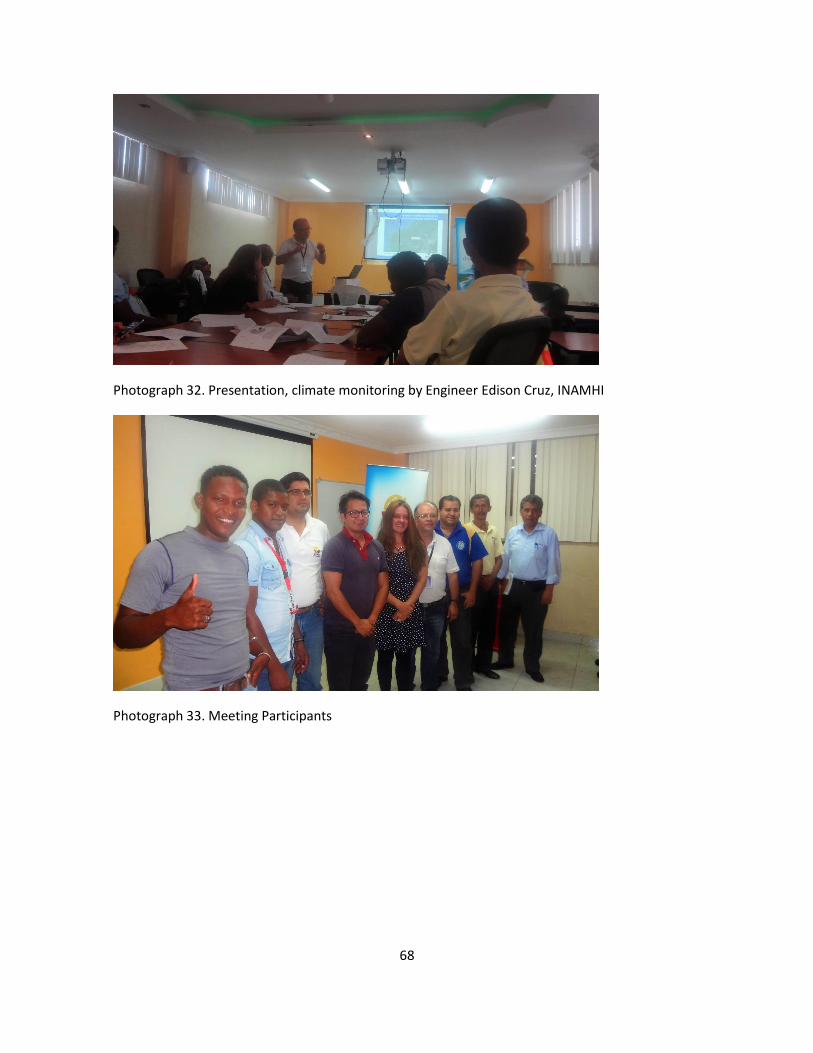
68
Photograph 32. Presentation, climate monitoring by Engineer Edison Cruz, INAMHI
Photograph 33. Meeting Participants

69
Photograph 34. Working group session

70
Regional Project: Reduction of Climate Vulnerability and
Flooding Risks in Urban and Semi-Urban Coastal Areas in
Cities in Latin America
Presentation of Report
Advisory Workshop at Cerro Gataso
Esmeraldas City
Republic of Ecuador
23 June 2017

71
Contents
Introduction ................................................................................... ¡Error! Marcador no definido.
Agenda ........................................................................................... ¡Error! Marcador no definido.
Welcome ........................................................................................ ¡Error! Marcador no definido.
Status of project preparation process ........................................... ¡Error! Marcador no definido.
Presentation: Regional project draft ............................................................................................. 4
Team work ..................................................................................................................................... 5
Plenay session ............................................................................................................................... 7
Closing of event…………………………………………………………..…………………………………………….11
Annexes
Annex 1. Registration of participants
Annex 2. Presentation: Draft version of project
Annex 3. Project outcomes framework
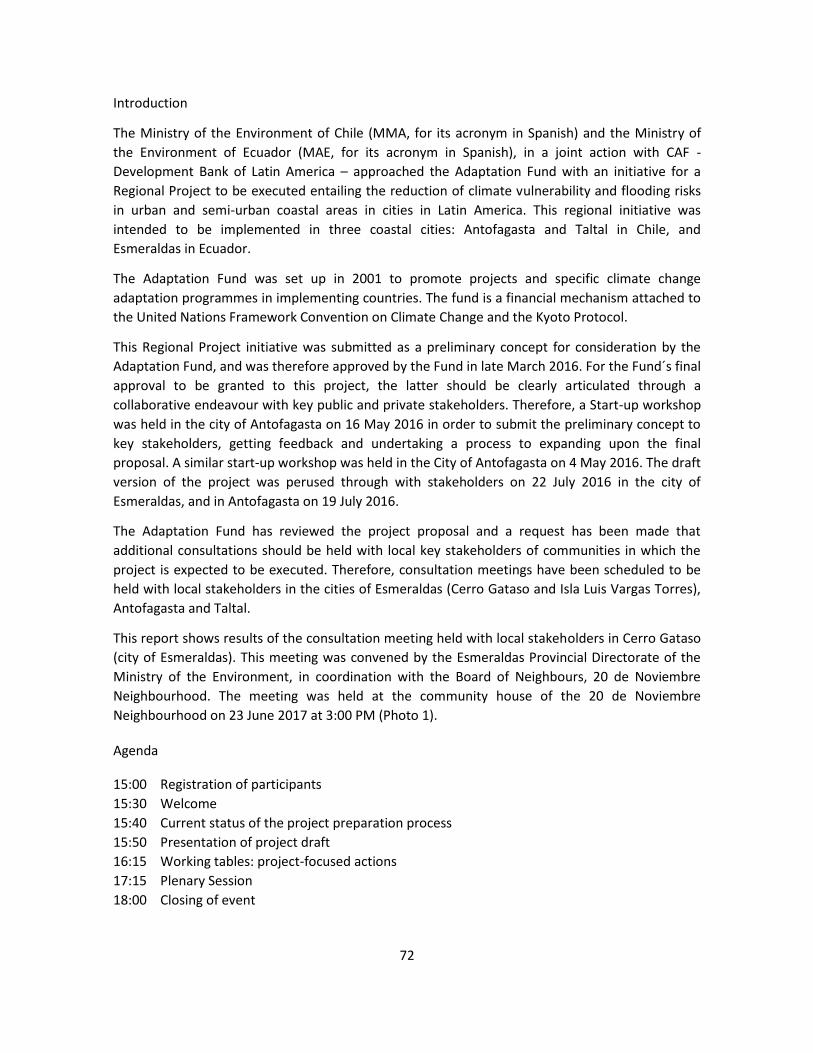
72
Introduction
The Ministry of the Environment of Chile (MMA, for its acronym in Spanish) and the Ministry of
the Environment of Ecuador (MAE, for its acronym in Spanish), in a joint action with CAF -
Development Bank of Latin America – approached the Adaptation Fund with an initiative for a
Regional Project to be executed entailing the reduction of climate vulnerability and flooding risks
in urban and semi-urban coastal areas in cities in Latin America. This regional initiative was
intended to be implemented in three coastal cities: Antofagasta and Taltal in Chile, and
Esmeraldas in Ecuador.
The Adaptation Fund was set up in 2001 to promote projects and specific climate change
adaptation programmes in implementing countries. The fund is a financial mechanism attached to
the United Nations Framework Convention on Climate Change and the Kyoto Protocol.
This Regional Project initiative was submitted as a preliminary concept for consideration by the
Adaptation Fund, and was therefore approved by the Fund in late March 2016. For the Fund´s final
approval to be granted to this project, the latter should be clearly articulated through a
collaborative endeavour with key public and private stakeholders. Therefore, a Start-up workshop
was held in the city of Antofagasta on 16 May 2016 in order to submit the preliminary concept to
key stakeholders, getting feedback and undertaking a process to expanding upon the final
proposal. A similar start-up workshop was held in the City of Antofagasta on 4 May 2016. The draft
version of the project was perused through with stakeholders on 22 July 2016 in the city of
Esmeraldas, and in Antofagasta on 19 July 2016.
The Adaptation Fund has reviewed the project proposal and a request has been made that
additional consultations should be held with local key stakeholders of communities in which the
project is expected to be executed. Therefore, consultation meetings have been scheduled to be
held with local stakeholders in the cities of Esmeraldas (Cerro Gataso and Isla Luis Vargas Torres),
Antofagasta and Taltal.
This report shows results of the consultation meeting held with local stakeholders in Cerro Gataso
(city of Esmeraldas). This meeting was convened by the Esmeraldas Provincial Directorate of the
Ministry of the Environment, in coordination with the Board of Neighbours, 20 de Noviembre
Neighbourhood. The meeting was held at the community house of the 20 de Noviembre
Neighbourhood on 23 June 2017 at 3:00 PM (Photo 1).
Agenda
15:00 Registration of participants
15:30 Welcome
15:40 Current status of the project preparation process
15:50 Presentation of project draft
16:15 Working tables: project-focused actions
17:15 Plenary Session
18:00 Closing of event

73
Photograph 35. Community house - 20 de Noviembre Neighbourhood, and public call to local
population
Welcome
Mr. Víctor Ayoví, President of the 20 de Noviembre Neighbourhood Board, Ms. Rosa Ana
González, officer at the Ministry of the Environment, and Ms. Dayana Vega, Officer, CAF welcome
people in attendance (Photo 2). They appreciated the attendance of participants and informed
about the general meeting´s framework. Thirty-seven neighbourhood residents were in
attendance (28 women and 9 men). The attendance record is attached in Annex 1.
Status of the project preparation process
Ms. Dayana Vega summarized the project proposal drafting up process. The project concept was
approved in March 2016, and a final proposal was submitted in October 2017. The Adaptation
Fund comments and remarks are being processed and a new project version should be submitted
in August 2017. If approved, the project execution should be getting under way in year 2018.

74
Photograph 36. Welcome by Mr. Victor Ayoví (above), Ms. Rosa Ana González (middle), y Ms. Dayana Vega (below).
Presentation of the draft regional project
This presentation was made by Mr. Segundo Coello, a CAF consultant for the preparation of the
project document. This presentation is shown in Annex 2. Participants received a copy of the
outcomes framework, which is attached in Annex 3.
As explained, this is a regional project which is being executed with non-reimbursable Adaptation
Fund funding, the goal of which is to support the implementation of global climate change
adaptation measures. The governments of Chile and Ecuador are involved in the project. CAF is its
implementing agency, and the executing agency in Ecuador is the Ministry of the Environment.
The project is seeking "to reduce vulnerability to climate-related floods in three coastal cities by
incorporating an adaptation approach which is based on risk management, building cooperation
and networks, and enforcing an adaptation culture”. This project is being envisaged to be
executed over five years, with a total USD12,880,000 funding. The project will implement actions
in three cities: Antofagasta and Taltal in Chile, and Esmeraldas in Ecuador.

75
Mention was made that the project was submitted to and approved by the Adaptation Fund as a
preliminary concept. Project intervention sites and main ideas for project-related activities were
set forth at the start-up workshop held in Esmeraldas on May 16, 2016. The proposal was
subsequently tuned up and submitted for validation and final adjustments at a workshop held on
July 22, 2016 in Esmeraldas. This meeting was also attended by some of the participants in this
presentation.
Each of the results and products included in the project proposal were explained at the meeting
and are summarized in Annex 3.
A series of questions were put forward by participants at the meeting who made several queries
to clarify doubts about the project proposal. A major element of concern was the urgency of
intervention that the site is requiring because of an impending landslides risk. Some 45 houses
were lost in last year´s landslides. Winter has not been too harsh in 2017, so no significant
landslides have been generated. Nevertheless, the intervention of the municipality is deemed as
an urgent matter.
An explanation was given concerning the intervention in landslides monitoring at Cerro Gataso
which is to be jointly executed with the municipality of Esmeraldas, which is the local development
authority. The Esmeraldas Prefecture offered to get in charge of monitoring the meteorological
radar and meteorological stations to identify rainfall and river flooding risks, so that an early
warning may be given to the population.
Group Work
Participants were split into three groups. Each group participants made a detailed review of the
project´s outcomes framework. One member of the work team accompanied each group to supply
information and clarify doubts. Each group appointed a rapporteur, who submitted project
outcomes at a plenary session.
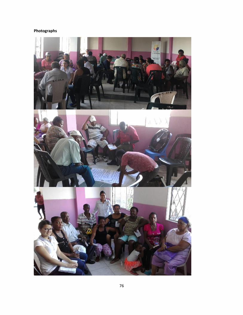
76
Photographs

77
Photography 37. Group work.
Plenary Session
The first group submitted their review and proposals. To start with, group member informed their
agreement with planting of trees at the top of the Gataso Hill and that measures should be taken
to prevent water from forming puddles. They also agreed to adopt measures to protect the hill
slopes, suggesting that concrete walls should be built up. The point was stressed that the poor
condition of streets in the sector should be borne in mind as well as the need to improve them.
Also a suggestion was made to consider the construction of a lookout in the upper part of the hill
to encourage visits to the sector.
Photograph 38. Presentation: Group 1 outcomes

78
Photograph 39. Group 1 Flipcharts
An agreement was also reached regarding installation of a weather radar to alert the population in case of poor weather conditions. A recommendation was made that local radio stations having a larger number of listeners, such as Candela Radio, or La Voz de su Amigo, are approached with a request to warn the population in case of need.
A suggestion was made that to encourage women to participate in risk capacity-building activities, matters of interest to them should be included, for example, entrepreneurship-driven activities. Mention was also made that the project is expected to encourage union and consensus within the community, as an example for others.
The second group´s outcomes were discussed (Photos 6 and 7). The groups´ rapporteur mentioned that the Municipality of Esmeraldas should be responsible for conducting surveys required for protection works needed in the neighbourhood, so as to allow that measures are quickly implemented once the project gets under way. An indication was also made that streets in the neighbourhood should be repaired. The neighbourhood leaders have approached the municipality with an urgent request for streets to be repaired to no avail, since as indicated by the municipality, this work cannot get under way until measures have been taken for landslides monitoring.
This group also submitted a proposal that the total cost involved in protecting this neighbourhood should be borne by the National Government.
Finally, a mention was made by Group 2 members that suitable places should be taken into account to provide shelter facilities to people in case of disasters. Shelters have been improvised

79
in previous disaster situations. The current situation of families affected by the last landslide has yet to be addressed.
Photographs
Photograph 40. Presentation by Group 2

80
Photograph 41. Group 2 Flipcharts
Photograph 42. Presentation by Group 3
Next, Group 3 submitted their outcomes (Photos 8 and 9). The group agreed that a green infrastructure plan for the city should be drafted up, further indicating their willingness to partake in tree planting activities. A suggestion was made for native tree species such as guayacán, laurel, balsa, and fruta de pan to be planted.

81
Regarding landslide monitoring measures, a recommendation was made to replicate the work done in Guacharaca, where terraces were dug up in the Hill slopes, and a mesh was laid along the surface for further protection of young trees. As indicated, the 20 de Noviembre neighbourhood has been badly affected by landslides, and the Municipality has shown little concern for the population as reflected in its lack of collaboration.
Concerning the early warning system, a clear indication was given about the need people have to know where they should evacuate to. People should get organized so they can react to a situation. Now the watchword is: Every man for himself. A further recommendation is for evacuation plans to bear in mind the needs of people with disabilities, and that safe shelters are in place.
Finally, mention was made that people are living in risk areas because they have nowhere else to live in.
Photograph 43. Group 3 Flipcharts
Closing of event
The closing of event was in charge of Mr. Víctor Ayoví, President, 20 de Noviembre Neighbourhood Board, Ms. Rosa A, González, officer, Ministry of the Environment, and Ms. Dayana Vega, CAF officer (Photo 2). They thanked people for their attendance and contributions.

82
Photographs
Photograph 44. Group at closing of event

83
Regional Project: Reduction of Climate Vulnerability and
Flooding Risks in Urban and Semi-Urban Coastal Areas in
Cities in Latin America
Presentation of Report
Advisory Workshop at Luis Vargas-Torres Island
Esmeraldas City
Republic of Ecuador
24 June 2017

84
Contents
Introduction ................................................................................... ¡Error! Marcador no definido.
Agenda .......................................................................................................................................... 3
Welcome ........................................................................................ ¡Error! Marcador no definido.
Status of project preparation process ........................................... ¡Error! Marcador no definido.
Presentation: Regional project draft ............................................................................................. 5
Team work ..................................................................................................................................... 6
Plenay session ............................................................................................................................... 6
Closing of event………………………………………………………………………………………………………….13
Annexes
Annex 1. Registration of participants
Annex 2. Presentation: Draft version of project
Annex 3. Project outcomes framework

85
Introduction
The Ministry of the Environment of Chile (MMA, for its acronym in Spanish) and the Ministry of
the Environment of Ecuador (MAE, for its acronym in Spanish), in a joint action with CAF -
Development Bank of Latin America – approached the Adaptation Fund with an initiative for a
Regional Project to be executed entailing the reduction of climate vulnerability and flooding risks
in urban and semi-urban coastal areas in cities in Latin America. This regional initiative was
intended to be implemented in three coastal cities: Antofagasta and Taltal in Chile, and
Esmeraldas in Ecuador.
The Adaptation Fund was set up in 2001 to promote projects and specific climate change
adaptation programmes in implementing countries. The fund is a financial mechanism attached to
the United Nations Framework Convention on Climate Change and the Kyoto Protocol.
This Regional Project initiative was submitted as a preliminary concept for consideration by the
Adaptation Fund, and was therefore approved by the Fund in late March 2016. For the Fund´s final
approval to be granted to this project, the latter should be clearly articulated through a
collaborative endeavour with key public and private stakeholders. Therefore, a Start-up workshop
was held in the city of Antofagasta on 16 May 2016 in order to submit the preliminary concept to
key stakeholders, getting feedback and undertaking a process to expanding upon the final
proposal. A similar start-up workshop was held in the City of Antofagasta on 4 May 2016. The draft
version of the project was perused through with key stakeholders on 22 July 2016 in the city of
Esmeraldas, and on 19 July 2016 in Antofagasta.
This project involves implementation of an early warning pilot system on the Luis Vargas Torres island. Thus, six neighbourhoods in the island committed their participation and contribution to the project: Mayo 12, Cordero Crespo, 20 de Noviembre, Pianguapi, 29 de Agosto, and Habana.
The project proposal has been reviewed by the Adaptation Fund, and a request has been made by this institution that additional consultations should be held with local key stakeholders in communities under the project´s direct influence. Therefore, consultation meetings have been held with local stakeholders in the cities of Esmeraldas (Cerro Gataso and Luis Vargas Torres Island), Antofagasta and Taltal.
This report shows the outcomes of the consultation meeting held with local stakeholders in neighbourhoods with which the project intends to work on the Luis Vargas Torres Island (city of Esmeraldas). This meeting was convened by the Ministry of the Environment Provincial Directorate of Esmeraldas, in coordination with the neighbourhood authorities. This meeting was held at the Leonidas Grueso-George School on June 24, 2017 at 10:00AM (Photo 1).
Agenda
09:30 Registration of participants
10:00 Welcome
10:15 Status of the project preparation process
10:30 Presentation of draft project

86
11:15 Working tables: Project-focused actions
12:15 Plenary session
13:00 Closing of the event
Photograph 45. Leonidas Grueso-George School i Luis Vargas Torres Island
Welcome
Attendants were welcome by Mr. Exon Bone Lasso, Principal of the Leonidas Grueso-George School, Mr. Rosa Ana González, Officer, Ministry of Environment, and Ms. Dayana Vega, Officer CAF Officer (Photo 2) who thanked participants for their attendance and supplied information about the meeting´s general framework. Forty-four settlers in the neighbourhood were in attendance at this meeting (37 women and 7 men) showing a wide age range between 21 and 91 years of age. The attendance record is shown in Annex 1.
Status of the project preparation process
Ms. Dayana Vega, CAF Officer, summarized the project proposal preparation process (Photo 3). The project concept was approved in March 2016, and the final proposal was submitted in October 2017. The Adaptation Fund comments and are being processed and a new version of the project document has been scheduled to be submitted to the Fund in August 2017. If approved, the project would begin execution in 2018.

87
Photograph 46. Welcome byMr. Exon Bone (above), Ms. Dayana Vega (middle), and Ms. Rosa Ana González (below)
Presentation of the draft regional project
Mr. Segundo Coello, a CAF consultant for the preparation of the project document was in charge of this presentation, which is shown in Annex 2. A copy of the outcomes framework, which is attached in Annex 3, was conveyed to participants.

88
Photograph 47. Ms. Dayana Vega, CAF, explains Project preparation advances
An indication was made that this is a regional project to which non-reimbursable funding has been allocated by the Adaptation Fund, and the purpose of which is to support the implementation of climate change adaptation measures. The governments of Chile and Ecuador are partaking in the project. Its implementing agency is CAF, and the Ministry of the Environment is acting as its executing agency in Ecuador.
This project seeks "to reduce vulnerability to climate-related floods in three coastal cities by incorporating a risk management-based adaptation approach, building collaboration and networks, and implementing an adaptation culture." This project is intended to be executed over a five-year term, and funding in the amount of USD12,880,000 has been allocated to it. The project will implement actions in three cities: Antofagasta and Taltal in Chile, and Esmeraldas in Ecuador.
The point was mentioned that the project was submitted and approved by the Adaptation Fund as a preliminary concept. Intervention sites and main action ideas were spelled out at the start-up workshop held in Esmeraldas on May 16, 2016. Thus, the proposal was tuned up and submitted for validation and final adjustments at the workshop held on October 22, 2016. July 2016 in Esmeraldas. Some of the people attending the workshop participated in these meetings.
Each one of the results and outcomes included in the project proposal were explained and are summarized in Annex 3.
Some questions were posed by ´participants to clarify doubts about the project proposal. The urgency for measures to be undertaken to protect people in case of floods was expressed.
Group Work
Four groups were made up by participants (Photo 4). Each group participants made a thorough review of the project outcomes framework. One member of the work team accompanied each group to supply information and clarify doubts. Each group appointed a rapporteur, who presented the results at the plenary session.

89
Plenary Session
The first group explained their own review and proposals (Photos 5 and 6). Group members agreed to drafting up a green infrastructure plan for the city. However, they were worried how to plant trees on the river banks if these are undergoing an erosion process. They suggested considering building a wall along the banks to hold the land in place, to then planting the trees.
Insofar the early warning system is concerned, a suggestion was made that the alert button be kept in a safe place, under someone´s responsibility, to avoid false alarms. A suggestion was also made that the evacuation notice is done by cellular message and that safe shelters are in place. However, mention was made that blackouts are expected the moment a flooding event takes place.
Mention was made that pedestrian bridges being currently used for evacuation purposes are in poor condition. A new pedestrian bridge should be built up by the municipality to be added to the four bridges currently in place.
The group agreed that a green infrastructure plan for the city should be drafted up. However, the group also suggested that walls or stone fillings be built to protect the island. Then tree species, such as chiparos, mambla and mangle should be planted.
They also were in agreement with the installation of the radar, suggesting that the accuracy and durability of the equipment is taken into account, notwithstanding.
Regarding the early warning pilot, they highlighted the lack of capacity-building of the population vis-a-vis evacuation routes. They also mentioned the need to bear in mind that access roads are in good condition and should be enlarged, if possible.
The third group submitted their outputs. They agreed to drafting up a green infrastructure plan for the city, and recommended planting trees along the riverbank and protecting existing mangrove areas.
Regarding the early warning system, they suggested that the radar be installed at the most appropriate site. In addition, the alarm must be given early enough to allow for time to people to react.

90
Photograph 48. Group Work

91
Photograph 49. Presentation of outcomes by Group 1
Concerning the island pilot project, a suggestion was made to setting up a group of women who are organized and trained to work with and supply capacity-building to community members.
The group was interested in the storytellers’ idea, mentioning how important it is to inform their children and grandchildren about their elders´ lives and experiences. The fourth group highlighted that over the 25 January 2016 flooding event the whole island was flooded and families lost all their belongings. They believe that a hydraulic filling is required for the island level to be raised.
Regarding the early warning system, a recommendation was made that the population should be notified at least one hour in advance. People mentioned that many residents are already aware of the evacuation route, but everyone should know where to evacuate. Finally, attendants considered it is important to continue the mangrove planting exercise along the riverbank to protect the island.

92
Photograph 50. Group 1 Flipcharts
Photograph 51. Group 2 Flipcharts
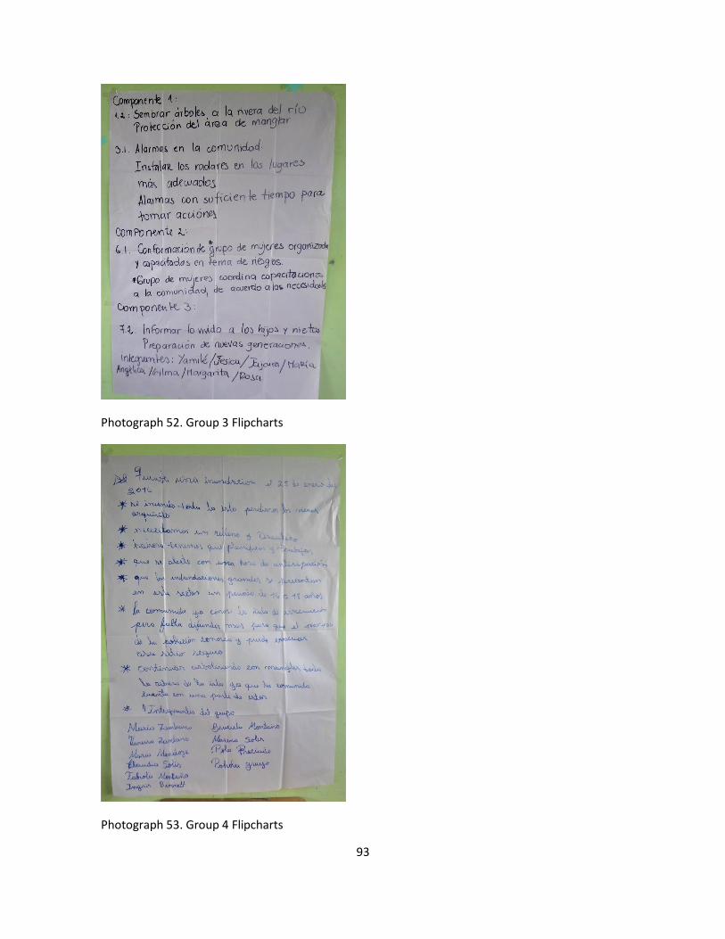
93
Photograph 52. Group 3 Flipcharts
Photograph 53. Group 4 Flipcharts

94
Photograph 54. Presentation by Group 2

95
Photograph 55. Presentation by Group 3
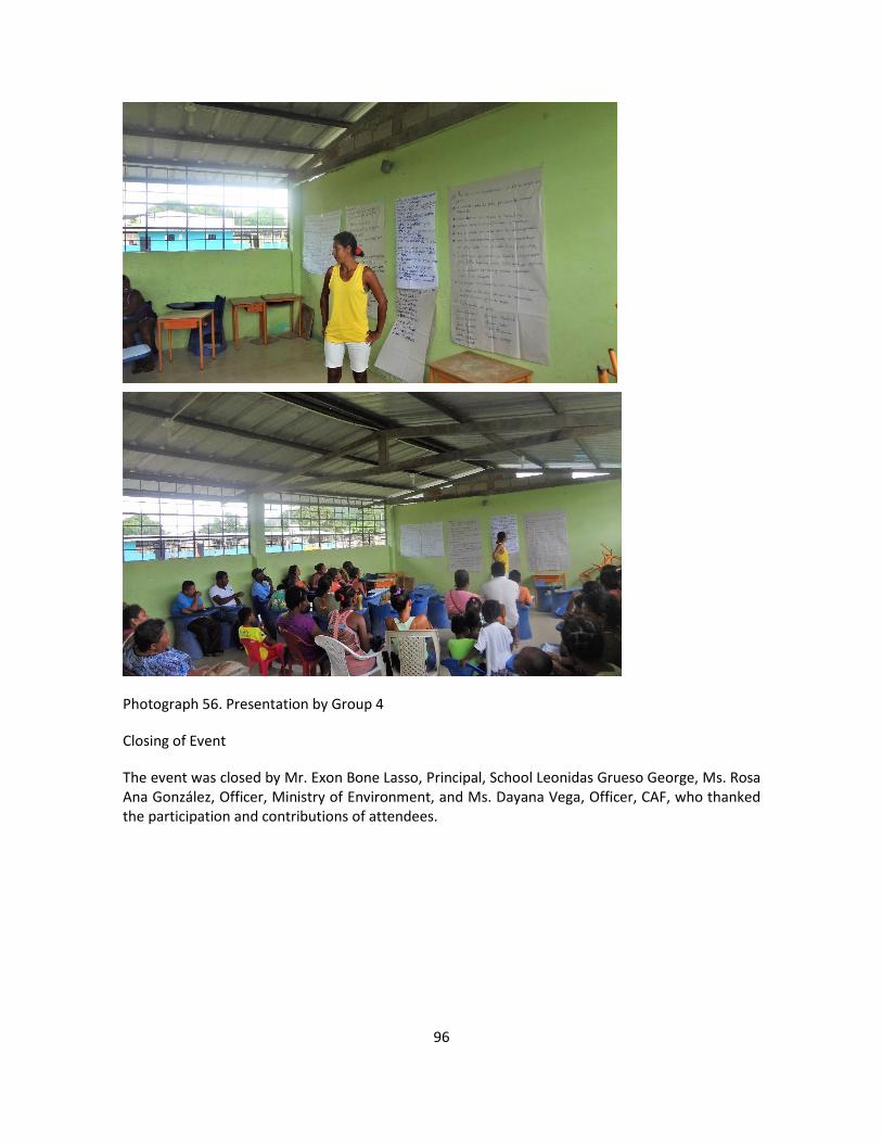
96
Photograph 56. Presentation by Group 4
Closing of Event
The event was closed by Mr. Exon Bone Lasso, Principal, School Leonidas Grueso George, Ms. Rosa Ana González, Officer, Ministry of Environment, and Ms. Dayana Vega, Officer, CAF, who thanked the participation and contributions of attendees.
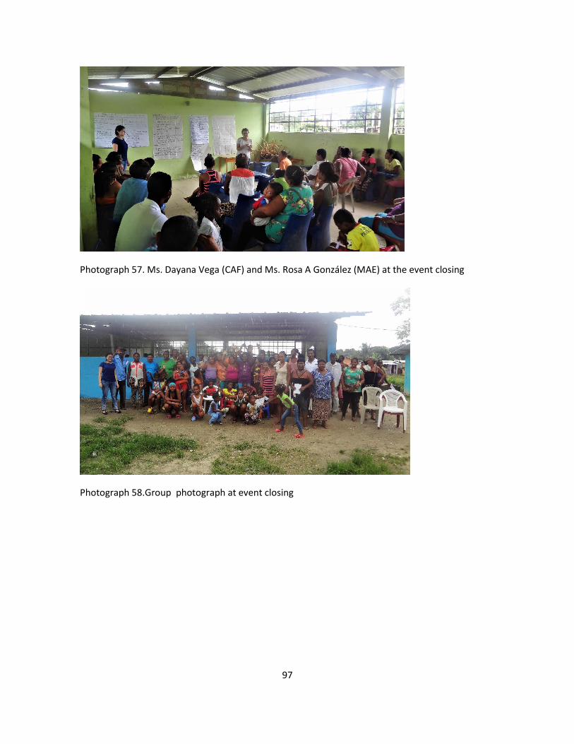
97
Photograph 57. Ms. Dayana Vega (CAF) and Ms. Rosa A González (MAE) at the event closing
Photograph 58.Group photograph at event closing

98
Regional Project: Reduction of Climate Vulnerability and
Flooding Risks in Urban and Semi-Urban Coastal Areas in
Cities in Latin America
Presentation of Report
Advisory Workshop in Antofagasta
Neighbours Board – Villa Irarrazabal
Antofagasta
Republic of Chile
6 July 2017

99
Contents
Introduction .................................................................................................................................. 3
Agenda .......................................................................................................................................... 4
Welcome ....................................................................................................................................... 4
Status of project preparation process .......................................................................................... 4
Presentation: Regional project draft ............................................................................................. 5
Plenay session ............................................................................................................................... 5
Closing of event………………………………………………………………………………………….………………..6
Annexes
Annex 1. Registration of participants
Annex 2. Presentation: Draft version of project
Annex 3. Project outcomes framework
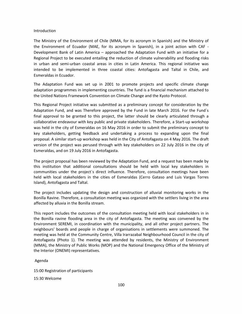
100
Introduction
The Ministry of the Environment of Chile (MMA, for its acronym in Spanish) and the Ministry of
the Environment of Ecuador (MAE, for its acronym in Spanish), in a joint action with CAF -
Development Bank of Latin America – approached the Adaptation Fund with an initiative for a
Regional Project to be executed entailing the reduction of climate vulnerability and flooding risks
in urban and semi-urban coastal areas in cities in Latin America. This regional initiative was
intended to be implemented in three coastal cities: Antofagasta and Taltal in Chile, and
Esmeraldas in Ecuador.
The Adaptation Fund was set up in 2001 to promote projects and specific climate change
adaptation programmes in implementing countries. The fund is a financial mechanism attached to
the United Nations Framework Convention on Climate Change and the Kyoto Protocol.
This Regional Project initiative was submitted as a preliminary concept for consideration by the
Adaptation Fund, and was Therefore approved by the Fund in late March 2016. For the Fund´s
final approval to be granted to this project, the latter should be clearly articulated through a
collaborative endeavour with key public and private stakeholders. Therefore, a Start-up workshop
was held in the city of Esmeraldas on 16 May 2016 in order to submit the preliminary concept to
key stakeholders, getting feedback and undertaking a process to expanding upon the final
proposal. A similar start-up workshop was held in the City of Antofagasta on 4 May 2016. The draft
version of the project was perused through with key stakeholders on 22 July 2016 in the city of
Esmeraldas, and on 19 July 2016 in Antofagasta.
The project proposal has been reviewed by the Adaptation Fund, and a request has been made by this institution that additional consultations should be held with local key stakeholders in communities under the project´s direct influence. Therefore, consultation meetings have been held with local stakeholders in the cities of Esmeraldas (Cerro Gataso and Luis Vargas Torres Island), Antofagasta and Taltal.
The project includes updating the design and construction of alluvial monitoring works in the Bonilla Ravine. Therefore, a consultation meeting was organized with the settlers living in the area affected by alluvia in the Bonilla stream.
This report includes the outcomes of the consultation meeting held with local stakeholders in in the Bonilla ravine flooding area in the city of Antofagasta. The meeting was convened by the Environment SEREMI, in coordination with the municipality, and all other project partners. The neighbours' boards and people in charge of organisations in settlements were summoned. The meeting was held at the Community Centre, Villa Irarrazabal Neighbourhood Council in the city of Antofagasta (Photo 1). The meeting was attended by residents, the Ministry of Environment (MMA), the Ministry of Public Works (MOP) and the National Emergency Office of the Ministry of the Interior (ONEMI) representatives.
Agenda
15:00 Registration of participants
15:30 Welcome

101
15:40 Status of the project preparation process
16:00 Presentation: Draft project
16:40 Plenary
17:00 Closing of event
Photograph 59. Community Centre, Neighbours Board, Villa Irarrazabal
Welcome
This was in charge of Ms. Mirna Aguilar, SEREMI Officer, The Environment, and Ms. Carolina Cortés, CAF Officer. They thanked participants for their attendance and supplied information about the meeting´s general framework. Twelve people attended the meeting, six of which were women neighbours living in the area. The latter represented the Bonilla Alto Neighbourhood Council, the Villa Irarrazabal Neighbourhood Council and the Balmaceda Neighbourhood Council. The attendance record is shown in Annex 1.
Status of the project preparation process
Ms. Carolina Cortés, CAF officer, made a summary of the project proposal preparation process. The project concept was approved in March 2016, and the final proposal was submitted in October 2017. The Adaptation Fund comments and remarks are being processed and a new version of the project document is expected to be submitted in August 2017. If approved, the project would begin execution in 2018.
Presentation of the draft regional project

102
This presentation was in charge of Mr. Segundo Coello, a CAF consultant for the preparation of the project document. The presentation is shown in Annex 2. Participants received a copy of the outcomes framework, which is attached in Annex 3.
An indication was made that this is a regional project to which non-reimbursable funding has been allocated by the Adaptation Fund, and the purpose of which is to support the implementation of global climate change adaptation measures. The governments of Chile and Ecuador are partaking in the project. Its implementing agency is CAF, and the Ministry of the Environment is acting as its executing agency in Ecuador.
This project seeks "to reduce vulnerability to climate-related floods in three coastal cities by incorporating a risk management-based adaptation approach, building collaboration and networks, and implementing an adaptation culture." This project is intended to be executed over a five-year term, and funding in the amount of USD12,880,000 has been allocated to it. The project will implement actions in three cities: Antofagasta and Taltal in Chile, and Esmeraldas in Ecuador.
The point was mentioned that the project was submitted and approved by the Adaptation Fund as a preliminary concept. Intervention sites and main action ideas were spelled out at the start-up workshop held in Esmeraldas on May 16, 2016. Thus, the proposal was later tuned up and submitted for validation and final adjustments at the workshop held on October 22, 2016. July 2016 in Esmeraldas. Some of the people attending the workshop participated in these meetings.
Each of the results and outcomes included in the project proposal were explained and are summarized in Annex 3.
Plenary Session
Participants asked several questions to clarify doubts about the project proposal. Mention was made the advisability of installing a radar to give early warnings to people living in the area. Likewise, there was consensus about the construction of alluvial monitoring works along the Bonilla Ravine. Further, villagers are familiar with the tsunami warning sirens, so a recommendation was made for sirens to have different tuning sounds.
Mention was made that ONEMI has previously carried out an alluvial simulation. However, people should be trained so they can act appropriately in case of emergency. Likewise, people were warned that evacuation plans should firstly be addressed to children, the elderly and people with disabilities.
Closing of Event
This was made by Ms. Mirna Aguilar, Environment SEREMI, and Ms. Carolina Cortés, CAF, who thanked people for their attendance and contributions to the meeting.

103
Photograph 60. Group Photograph closing of event

104
Regional Project: Reduction of Climate Vulnerability and
Flooding Risks in Urban and Semi-Urban Coastal Areas in
Cities in Latin America
Presentation of Report
Advisory Workshop in Antofagasta
Taltal Cultural Centre
Taltal
Republic of Chile
7 July 2017

105
Contents
Introduction .................................................................................................................................. 3
Agenda .......................................................................................................................................... 4
Welcome ....................................................................................................................................... 5
Status of project preparation process .......................................................................................... 5
Presentation: Regional project draft ............................................................................................. 5
Plenay session ............................................................................................................................... 6
Closing of event……………………………………………………………………………………………………….…..7
Annexes
Annex 1. Registration of participants
Annex 2. Presentation: Draft version of project
Annex 3. Project outcomes framework
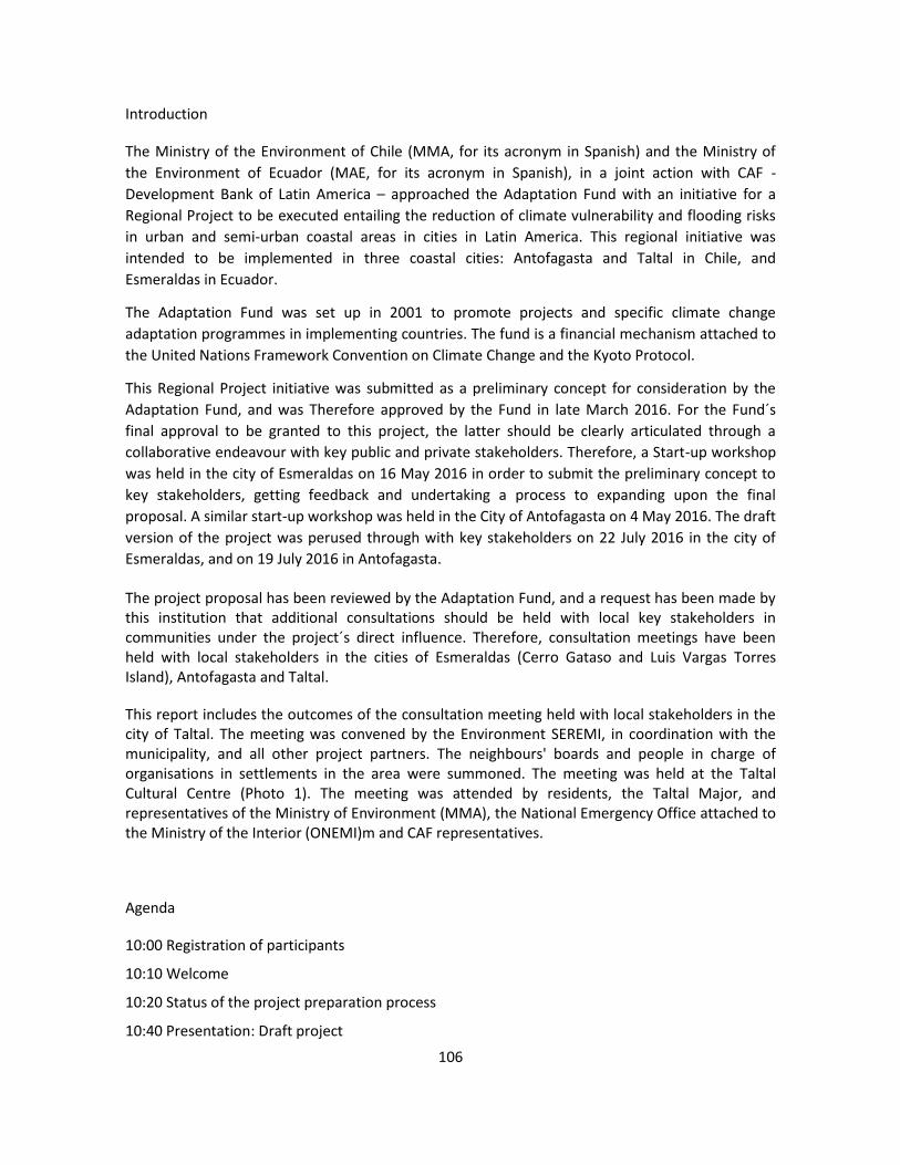
106
Introduction
The Ministry of the Environment of Chile (MMA, for its acronym in Spanish) and the Ministry of
the Environment of Ecuador (MAE, for its acronym in Spanish), in a joint action with CAF -
Development Bank of Latin America – approached the Adaptation Fund with an initiative for a
Regional Project to be executed entailing the reduction of climate vulnerability and flooding risks
in urban and semi-urban coastal areas in cities in Latin America. This regional initiative was
intended to be implemented in three coastal cities: Antofagasta and Taltal in Chile, and
Esmeraldas in Ecuador.
The Adaptation Fund was set up in 2001 to promote projects and specific climate change
adaptation programmes in implementing countries. The fund is a financial mechanism attached to
the United Nations Framework Convention on Climate Change and the Kyoto Protocol.
This Regional Project initiative was submitted as a preliminary concept for consideration by the
Adaptation Fund, and was Therefore approved by the Fund in late March 2016. For the Fund´s
final approval to be granted to this project, the latter should be clearly articulated through a
collaborative endeavour with key public and private stakeholders. Therefore, a Start-up workshop
was held in the city of Esmeraldas on 16 May 2016 in order to submit the preliminary concept to
key stakeholders, getting feedback and undertaking a process to expanding upon the final
proposal. A similar start-up workshop was held in the City of Antofagasta on 4 May 2016. The draft
version of the project was perused through with key stakeholders on 22 July 2016 in the city of
Esmeraldas, and on 19 July 2016 in Antofagasta.
The project proposal has been reviewed by the Adaptation Fund, and a request has been made by this institution that additional consultations should be held with local key stakeholders in communities under the project´s direct influence. Therefore, consultation meetings have been held with local stakeholders in the cities of Esmeraldas (Cerro Gataso and Luis Vargas Torres Island), Antofagasta and Taltal.
This report includes the outcomes of the consultation meeting held with local stakeholders in the city of Taltal. The meeting was convened by the Environment SEREMI, in coordination with the municipality, and all other project partners. The neighbours' boards and people in charge of organisations in settlements in the area were summoned. The meeting was held at the Taltal Cultural Centre (Photo 1). The meeting was attended by residents, the Taltal Major, and representatives of the Ministry of Environment (MMA), the National Emergency Office attached to the Ministry of the Interior (ONEMI)m and CAF representatives.
Agenda
10:00 Registration of participants
10:10 Welcome
10:20 Status of the project preparation process
10:40 Presentation: Draft project
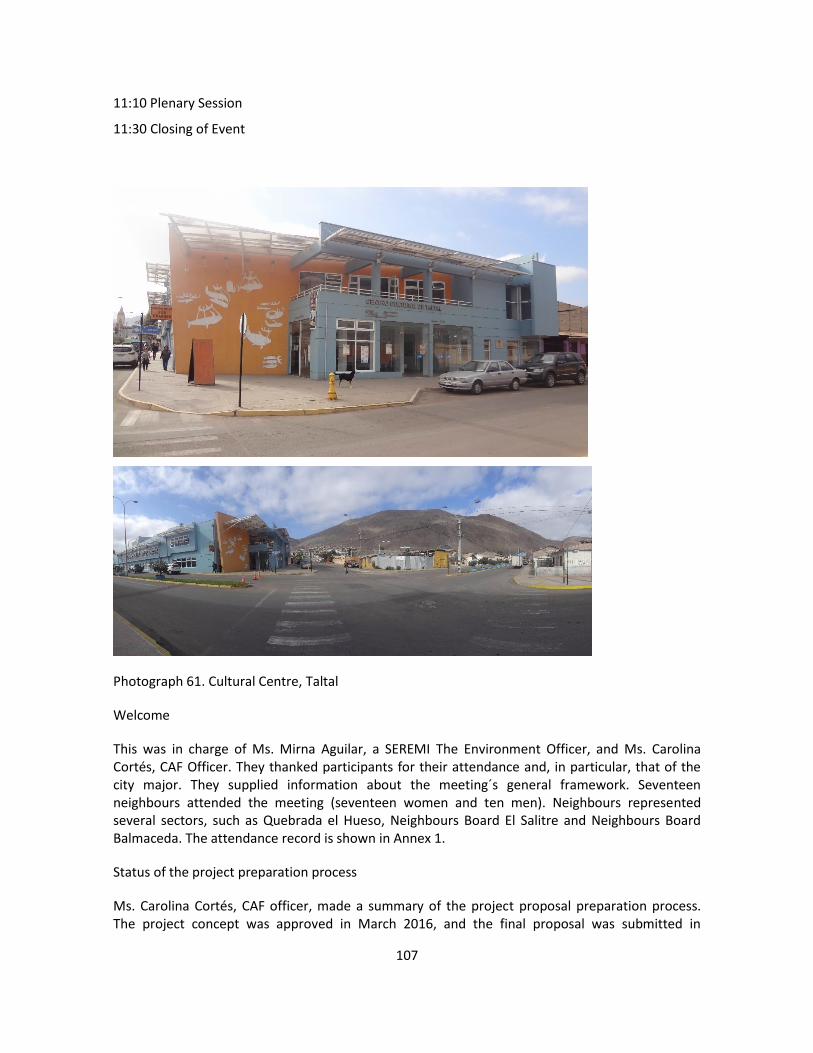
107
11:10 Plenary Session
11:30 Closing of Event
Photograph 61. Cultural Centre, Taltal
Welcome
This was in charge of Ms. Mirna Aguilar, a SEREMI The Environment Officer, and Ms. Carolina Cortés, CAF Officer. They thanked participants for their attendance and, in particular, that of the city major. They supplied information about the meeting´s general framework. Seventeen neighbours attended the meeting (seventeen women and ten men). Neighbours represented several sectors, such as Quebrada el Hueso, Neighbours Board El Salitre and Neighbours Board Balmaceda. The attendance record is shown in Annex 1.
Status of the project preparation process
Ms. Carolina Cortés, CAF officer, made a summary of the project proposal preparation process. The project concept was approved in March 2016, and the final proposal was submitted in

108
October 2017. The Adaptation Fund comments and remarks are being processed and a new version of the project document is expected to be submitted in August 2017. If approved, this project would begin execution in 2018.
Photo 2. Ms. Carolina Cortés, CAF, explains the project preparation process
Presentation of the draft regional project
This presentation was in charge of Mr. Segundo Coello, a CAF consultant for the preparation of the project document. The presentation is shown in Annex 2. Participants received a copy of the outcomes framework, which is attached in Annex 3.
An indication was made that this is a regional project to which non-reimbursable funding was allocated by the Adaptation Fund, and the purpose of which is to support the implementation of global climate change adaptation measures. The governments of Chile and Ecuador are partaking in the project. Its implementing agency is CAF, and the Ministry of the Environment is acting as its executing agency in Ecuador.
This project seeks "to reduce vulnerability to climate-related floods in three coastal cities by incorporating a risk management-based adaptation approach, building collaboration and networks, and implementing an adaptation culture." This project is intended to be executed over a five-year term, and funding in the amount of USD12,880,000 has been allocated to it. The project will implement actions in three cities: Antofagasta and Taltal in Chile, and Esmeraldas in Ecuador.
The point was mentioned that the project was submitted and approved by the Adaptation Fund as a preliminary concept. Intervention sites and main action ideas were spelled out at the start-up workshop held in Esmeraldas on May 16, 2016. Thus, the proposal was later tuned up and submitted for validation and final adjustments at the workshop held on October 22, 2016. July 2016 in Esmeraldas. Some of the people attending the workshop participated in these meetings.
Each of the results and outcomes included in the project proposal were explained and are summarized in Annex 3.

109
Plenary Session
Participants asked several questions to clarify doubts about the project proposal, and how the project´s work teams were to be made up. As explained, the various project partners will be takin over parts of the project: for example, ONEMI will be in charge of the early warning system; the Chilean Meteorological Directorate will manage the radar for identification of storm risks; and the Ministry of the Environment will take care of the storytellers´ initiative. An indication was made that both, the Antofagasta and Taltal municipalities have offered to provide room to house the project staff. One staff member will be stationed in Taltal.
The point was raised about the convenience of having an early warning system to alert the population well in advance of an event so that protective measures or evacuation may get under way in a timely manner. Mention was made that the 2015 alluvial event was devastating: the mud flow ran through the city, leaving it isolated from the outside world.
Mention was made that slum areas are vulnerable, and their condition of informality is a constraint to actions. A recommendation was made that evacuation routes and procedures should first address the needs of children, seniors, and people with disabilities.
A positive project activity deserving to be highlighted is the inclusion of cultural aspects in the storytellers' initiative. As indicated, this is a matter often left aside. It is a rather worthy action to cultivate and develop cultural manifestations that contribute to strengthen up the collective memory of the population, and several local groups can contribute to this purpose.
Event Closing
This was in charge of Mr. Sergio Orellana Montejo, Mayor of Taltal, Ms. Mirna Aguilar, SEREMI Environment, and Ms. Carolina Cortés, CAF (Photo 3). They appreciated the attendees participation and contributions.
Photograph 62. Taltal Major, Mr. Sergio Orellana, at the event closing
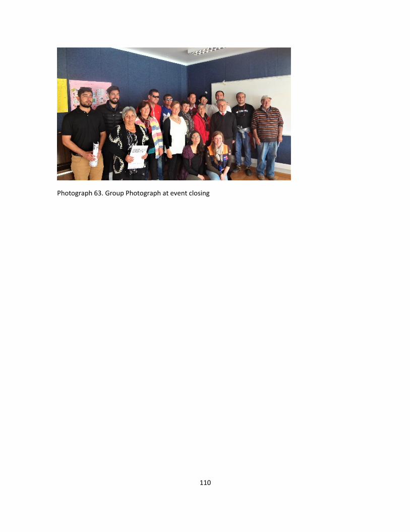
110
Photograph 63. Group Photograph at event closing

111
Regional Project: Reduction of Climate Vulnerability and
Flooding Risks in Urban and Semi-Urban Coastal Areas in
Cities in Latin America
Presentation of Report
Advisory Workshop in Antofagasta
Neighbourhood Board Esperanza Nuestra
Antofagasta
Republic of Chile
7 July 2017

112
Contents
Introduction .................................................................................................................................. 3
Agenda .......................................................................................................................................... 4
Welcome ....................................................................................................................................... 5
Status of project preparation process .......................................................................................... 5
Presentation: Regional project draft ............................................................................................. 5
Plenay session ............................................................................................................................... 6
Closing of event…………………………………………………………………………………….……………………..7
Annexes
Annex 1. Registration of participants
Annex 2. Presentation: Draft version of project
Annex 3. Project outcomes framework

113
Introduction
The Ministry of the Environment of Chile (MMA, for its acronym in Spanish) and the Ministry of
the Environment of Ecuador (MAE, for its acronym in Spanish), in a joint action with CAF -
Development Bank of Latin America – approached the Adaptation Fund with an initiative for a
Regional Project to be executed entailing the reduction of climate vulnerability and flooding risks
in urban and semi-urban coastal areas in cities in Latin America. This regional initiative was
intended to be implemented in three coastal cities: Antofagasta and Taltal in Chile, and
Esmeraldas in Ecuador.
The Adaptation Fund was set up in 2001 to promote projects and specific climate change
adaptation programmes in implementing countries. The fund is a financial mechanism attached to
the United Nations Framework Convention on Climate Change and the Kyoto Protocol.
This Regional Project initiative was submitted as a preliminary concept for consideration by the
Adaptation Fund, and was Therefore approved by the Fund in late March 2016. For the Fund´s
final approval to be granted to this project, the latter should be clearly articulated through a
collaborative endeavour with key public and private stakeholders. Therefore, a Start-up workshop
was held in the city of Esmeraldas on 16 May 2016 in order to submit the preliminary concept to
key stakeholders, getting feedback and undertaking a process to expanding upon the final
proposal. A similar start-up workshop was held in the City of Antofagasta on 4 May 2016. The draft
version of the project was perused through with key stakeholders on 22 July 2016 in the city of
Esmeraldas, and on 19 July 2016 in Antofagasta.
The project proposal has been reviewed by the Adaptation Fund, and a request has been made by this institution that additional consultations should be held with local key stakeholders in communities under the project´s direct influence. Therefore, consultation meetings have been held with local stakeholders in the cities of Esmeraldas (Cerro Gataso and Luis Vargas Torres Island), Antofagasta and Taltal.
This project includes the updated version of the design and construction of alluvial monitoring works at the Bonilla Ravine. Therefore, a consultation meeting was held with people living in the area under alluvial impact along the Bonilla Ravine.
This report includes the outcomes of the consultation meeting held with local stakeholders in the area under alluvial impact along the Bonilla Ravine in the city lf Antofagasta. This meeting was convened by the Environment SEREMI, in coordination with the municipality, and all other project partners. The neighbours' boards and people in charge of organisations in settlements in the area were summoned. The meeting was held at the social headquarters of the Neighbours Board Esperanza Nuestra, in the city of Antofagasta (Photo 1). The meeting was attended by neighbours and representatives of the Ministry of Environment (MMA), and CAF.
Agenda
18:00 Registration of participants

114
18:10 Welcome
18:20 Status of the project preparation process
18:40 Presentation of the draft project
19:10 Plenary Session
19:30 Closing of event
Photograph 64. Headquarter, Esperanza Nuestra Neighbours Board
Welcome
Ms. Mirna Aguilar, SEREMI of Environment, and Ms. Carolina Cortés, CAF welcome participants, and thanked them for their attendance. Information was supplied about the general meeting framework. Twenty sector neighbours attended the meeting (seventeen women and three men) in representation of the Balmaceda Neighbourhood Council. The attendance record is shown in Annex 1.

115
Photograph 65. Ms. Mirna Aguilar. SEREMI, the Environment, welcomes participants.
Status of the project preparation process
Carolina Cortés of CAF, made a brief explanation on the project proposal preparation process. The project concept was approved in March 2016, and the full proposal was submitted in October 2017. The Adaptation Fund comments and remarks are being processed and a new version of the project document should be submitted in August 2017. In If approved, the project would begin execution in 2018.
Presentation of the draft regional project
This presentation was in charge of Mr. Segundo Coello, a CAF consultant for the preparation of the project document. The presentation is shown in Annex 2. Participants received a copy of the outcomes framework, which is attached in Annex 3.
An indication was made that this is a regional project to which non-reimbursable funding was allocated by the Adaptation Fund, and the purpose of which is to support the implementation of global climate change adaptation measures. The governments of Chile and Ecuador are partaking in the project. Its implementing agency is CAF, and the Ministry of the Environment is acting as its executing agency in Ecuador.
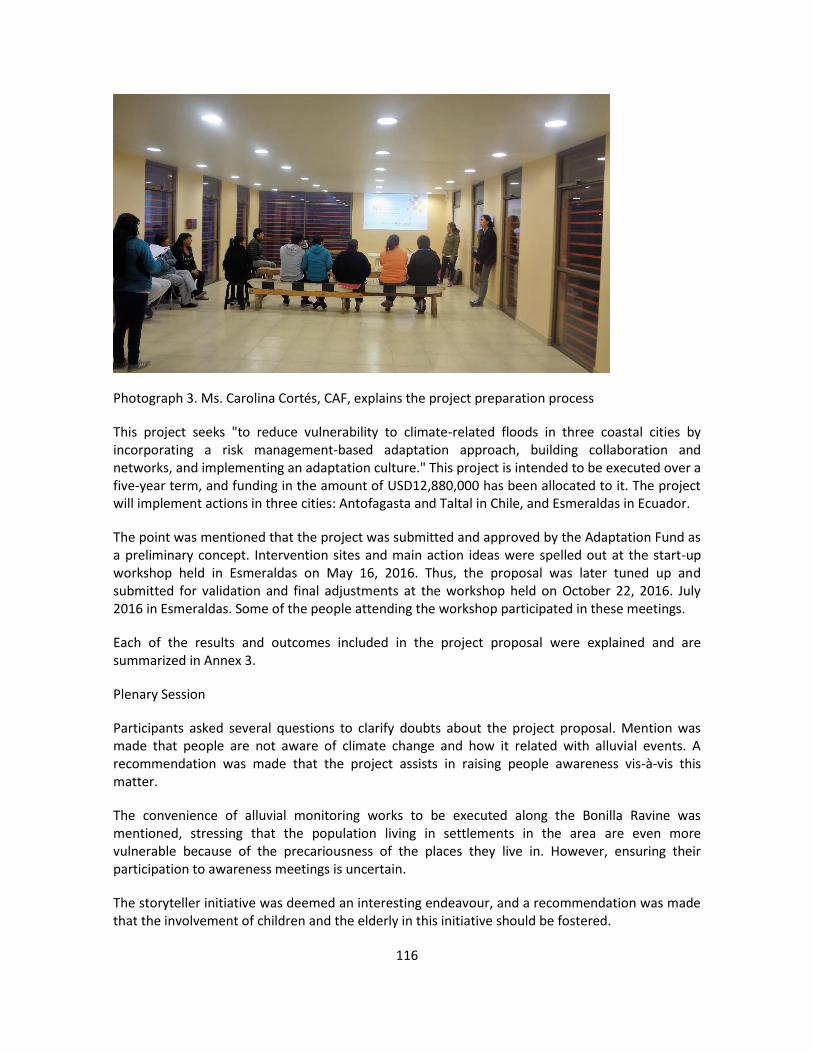
116
Photograph 3. Ms. Carolina Cortés, CAF, explains the project preparation process
This project seeks "to reduce vulnerability to climate-related floods in three coastal cities by incorporating a risk management-based adaptation approach, building collaboration and networks, and implementing an adaptation culture." This project is intended to be executed over a five-year term, and funding in the amount of USD12,880,000 has been allocated to it. The project will implement actions in three cities: Antofagasta and Taltal in Chile, and Esmeraldas in Ecuador.
The point was mentioned that the project was submitted and approved by the Adaptation Fund as a preliminary concept. Intervention sites and main action ideas were spelled out at the start-up workshop held in Esmeraldas on May 16, 2016. Thus, the proposal was later tuned up and submitted for validation and final adjustments at the workshop held on October 22, 2016. July 2016 in Esmeraldas. Some of the people attending the workshop participated in these meetings.
Each of the results and outcomes included in the project proposal were explained and are summarized in Annex 3.
Plenary Session
Participants asked several questions to clarify doubts about the project proposal. Mention was made that people are not aware of climate change and how it related with alluvial events. A recommendation was made that the project assists in raising people awareness vis-à-vis this matter.
The convenience of alluvial monitoring works to be executed along the Bonilla Ravine was mentioned, stressing that the population living in settlements in the area are even more vulnerable because of the precariousness of the places they live in. However, ensuring their participation to awareness meetings is uncertain.
The storyteller initiative was deemed an interesting endeavour, and a recommendation was made that the involvement of children and the elderly in this initiative should be fostered.

117
The meeting closed down with a request for steps as required to be taken to ascertaining the project funding so that it may get under way in 2018.
Closing of Event
This was in charge of Ms. Mirna Aguilar, SEREMI Environment, and Ms. Carolina Cortés, CAF (Photo 3). They appreciated the attendees´ participation and contributions.
Photograph 66. Groups at closing of event

1 / 9
Annex 5. Terms of reference
Project Board
The Project Board will oversee and provide strategic guidance to the project. The
Project Board will be formed by the Undersecretary of Environment (MMA, Chile),
the Undersecretary of Climate Change (MAE, Ecuador), and CAF´s Climate
Change Coordinator. The Project Manager will act as secretary and participate in
the meetings without voting.
The Project Board will make management decisions when guidance is required
by the Project Manager, including recommendation for CAF/Responsible Entities
approval of project plans and revisions. Project Board decisions should be made
in accordance with standards that shall ensure management for development
results, best value money, fairness, integrity, transparency and effective
international competition. Decision will be taken by consensus. In case a
consensus cannot be reached within the Board, final decision shall rest with
CAF´s Climate Change Coordinator.
The Project Board will be responsible for: (1) monitoring the implementation of
the project, (2) approving the annual budget and annual work plan prepared by
the Project Manager, (3) review the annual project report (PPR) and provide
comments and recommendations, (4) approve major changes to the plan or
project strategy, (5) evaluate the performance of the project, analyse the mid-
term review and terminal evaluation of the project, and provide comments and
recommendations, and (6) arbitrate conflicts that may arise.
The Project Board shall have in-person or virtual meetings at least twice a year.
The chair of the board will alternate annually between the Undersecretary of
Environment (MMA, Chile) and the Undersecretary of Climate Change (MAE,
Ecuador)). The Project Board may be extraordinarily convened by the
chairperson upon request by members.

2 / 9
Project Manager
The Project Manager (PM) leads the project unit and runs the project on behalf
of the Responsible Entities to ensure that the project produces the outputs and
outcomes specified in the project document to the required standard of quality
and within the specified constraints of time and cost. This person will work in
close cooperation and coordination with, and oversee, the Executing Entities in
Chile and Ecuador.
The PM will be contracted for 60 months with Adaptation Fund resources. This
will supervise the eight specialists that conform the project unit. The Project
Manager function will end when the final project terminal evaluation report, and
other documentation required by the Adaptation Fund and CAF, has been
completed and submitted to CAF (including operational closure of the project).
The PM will:
a. Be the signing authority of requests for disbursements of project funds.
b. Ensure the logistical, administrative and financial effectiveness of the
executing entities in fulfilling its roles set out above
c. To this end, provide monitoring, supervision and guidance to the country
teams.
d. Promote incidence in and coordination with the executing entities, the
responsible entities, the donor agencies that support them, and any other
relevant entity.
In addition, the PM -- with the assistance of the responsible entities -- will manage
the following:
a. Preparation of project reports, work plans, budgets and accounting
records.
b. Drafting of terms of reference, technical specifications and other
documents.
c. Identification of consultants and supervision of consultants and suppliers,
d. Overseeing the implementation of project activities in a timely and efficient
way.
e. Supervise and provide administrative support to the national platform
coordinators.
f. Maintain contacts with project partners at the national and international
level.
g. Organization of seminars, workshops and field trips, which are linked to
project activities.
The PM will provide leadership and guidance for the implementation of the
project´s adaptation measures. This person, in close coordination with the
responsible entities, will produce in a timely fashion annual work plans and

3 / 9
budgets to be approved by the Project Board, and quarterly operational and
annual progress reports (PPR) for submission to the Project Board. The reports
will provide details about the progress made, any shortcomings and the
necessary adjustments made to achieve project outcomes. The Project Manager
will also be responsible for any national or international service provider and the
recruitment of specialist services.
The Project Manager will have strong experience in (i) climate change adaptation
(preferably in coastal zones), and (ii) project administration. This person must
have deep understanding of development of communities of practice and disaster
risk reduction. This person must be fully bilingual (Spanish and English).
Electronic Media Specialist
The Electronic Media Specialist (EMS) will be responsible for and (i) guide the
development of communication and education on project activities and (ii) the
development and operation of the project´s electronic platform, which includes a
web-based communication platform to facilitate interaction and virtual meetings
among project participants and an array of media to document and disseminate
information and lessons. This person will ensure that the corresponding outputs
and outcomes specified in the project document are generated to the required
standard of quality and within the specified constraints of time and cost.
The EMS will be contracted for 60 months with AF resources. This person will be
supervised by the Project Manager. The EMS will ensure close collaboration and
team work with the Lead Engineer specialist, the three local engineer specialists
and the Monitoring and Evaluation Specialist.
The Electronic Media Specialist will be responsible to:
a. Provide strategic advice on electronic means for knowledge management,
communication among project participants and dissemination of
information of the project.
b. Provide strategic advice and guidance for the development and
implementation of strategies on public education, communication,
participation, and articulation among key stakeholders and project
participants.
c. Establish and operate the web-based communication platform (e.g.,
SKYPE for business / WebEx) to facilitate interaction and virtual meetings
among project participants.
Oversee the preparation and implementation of the communication
strategy for specific groups and sites.
d. Establish the methods and procedure to systematically document the
project experience and prepare learning experience documents.

4 / 9
e. Provide technical support and advice to project participants to facilitate the
development of the communities of practice and documenting their
experience and lessons.
f. Prepare materials for the press, write content and news for the project
website, and maintain the social media accounts of the project´s
electronica platform (e.g., YouTube channel, Facebook).
g. Ensure a continuous flow of information and news towards project web
portal and other media channels.
h. Organize in-person and virtual meetings and exchange visits to facilitate
networking and exchange among project´ participants.
i. Organize and communicate project events (e.g., meetings, workshops).
j. Closely collaborate with the Social Local Specialists to ensure that news
and information is posted and disseminated, in different formats, through
the project´s electronic platform.
k. Establish and operate the platforms of information and communication of
the project (e.g., website, YouTube channel, accounts in social networks,
email distribution list) and will ensure linkage with the websites of
participating entities.
l. Ensure that the information and the communication platform are secure.
m. Provide technical support and advice to project participants to better use
and have the maximum benefit from the project´s electronic platform.
n. Ensure prompt delivery of project outputs and the generation of project
outcomes.
o. Maintain proper communication and collaboration with key stakeholders,
responsible entities, and executing entities.
p. Maintain proper collaboration and coordination with the other members of
the project team.
q. Contribute to the preparation of the proposed annual work plan and budget
for component 3 of the project.
r. Provide information and support for the mid-term and final project
assessments.
The Electronic Media Specialist will have experience in the development and
operation of websites and electronic channels and media, preferably with prior
experience in climate change, disaster risk management and/or coastal
management and participation in international projects. Previous participation in
international projects will be a major asset. Previous experience and deep
knowledge of the development of communities of practice will be a major quality.
This person must be fully bilingual (Spanish and English).
Lead Engineer Specialist
The Lead Engineer Specialist (LES) will (i) provide support for the implementation
of the project´s adaptation measures, (ii) facilitate coordination and articulation

5 / 9
among project partners. This person will ensure that the corresponding outputs
and outcomes specified in the project document are generated to the required
standard of quality and within the specified constraints of time and cost.
The LES will be contracted for 60 months with AF resources. This person will be
supervised by the Project Manager. The LES will supervise the work of the three
engineer specialists based in Antofagasta, Taltal and Esmeraldas, and will
ensure close collaboration and team work with the Electronic Media Specialist
and the Monitoring and Evaluation Specialist.
The Lead Engineer Specialist will be responsible to:
a. Provide strategic guidance for the implementation of the project’s
infrastructure adaptation measures.
b. Provide strategic advice and guidance for the development and
implementation of project’s infrastructure adaptation measures
c. Oversee the preparation and implementation of documents needed for the
implementation of the project’s infrastructure adaptation measures.
d. Establish the methods and procedure to systematically document the
project experience and prepare documents.
e. Provide technical support and advice to project participants to facilitate the
development project’s infrastructure adaptation measures.
f. Organize in-person and virtual meetings and exchange visits to facilitate
networking and exchange among project´ participants about the project’s
infrastructure adaptation measures.
g. Closely collaborate with the Electronic Media Specialist to ensure that
news and information is posted and disseminated, in different formats,
through the project´s electronic platform.
h. Ensure prompt delivery of project outputs and the generation of project
outcomes.
i. Maintain proper communication and collaboration with key stakeholders,
responsible entities, and executing entities.
j. Maintain proper collaboration and coordination with the other members of
the project team.
k. Contribute to the preparation of the proposed annual work plan and budget
for the project.
l. Provide information and support for the mid-term and final project
assessments.
The Lead engineer specialist will have strong practical experience in climate
change adaptation, preferably in coastal zones of the pacific ocean.

6 / 9
Engineer Specialist
The Engineer Specialist will contribute to coordination of local activities and the
development of the adaptation construction measures and activities. This person
will ensure that the corresponding outputs and outcomes specified in the project
document are generated to the required standard of quality and within the
specified constraints of time and cost.
There will be two engineer specialists to be based in Antofagasta and
Esmeraldas. Each engineer specialist will be contracted for 60 months with AF
resources, and will be supervised by the Lead engineer specialist. The engineer
specialist will ensure close collaboration and team work with the Electronic Media
Specialist, the Local Social specialists and the Monitoring and Evaluation
Specialist.
The engineer specialist based in Antofagasta will oversee the work in Taltal,
ensuring coordinated team work.
The Engineer Specialist will be responsible to:
a. Coordinate local actions to ensure prompt implementation of the project’s
infrastructure adaptation measures.
b. Participate in the preparation and implementation of the project’s
infrastructure adaptation measures.
c. Apply the established methods and procedures to systematically
document the project experience and prepare the documents of the
implementation of the project’s infrastructure adaptation measures.
d. Give technical support to facilitate the development of the project’s
infrastructure adaptation measures.
e. Organize in-person and virtual meetings and exchange visits to facilitate
networking and exchange among project participants.
f. Closely collaborate with the Electronic Media Specialist to ensure that
news and information is posted and disseminated, in different formats,
through the project´s electronic platform.
g. Ensure prompt delivery of project outputs and the generation of project
outcomes.
h. Maintain proper communication and collaboration with key stakeholders,
responsible entities, and executing entities.
i. Maintain proper collaboration and coordination with the other members of
the project team.
j. Contribute to the preparation of the proposed annual work plan and budget
for the project.
k. Provide information and support for the mid-term and final project
assessments.

7 / 9
The engineer specialist will have practical experience in climate change
adaptation measures, preferably with prior experience in climate change, disaster
risk reduction, and / or coastal management.
Monitoring and Evaluation Specialist
The Monitoring and Evaluation Specialist (MES) will be contracted with AF
resources for 60 months, and will be responsible for monitoring the progress of
the project to ensure that the products and results are achieved within the
specified constraints of time and cost. This person will be supervised by the
Project Manager.
The Monitoring and Evaluation Specialist will be responsible to:
a. Compile and systematize information on the indicators of the project and the
Adaptation Fund Results Tracker.
b. Monitor and document the development to the site-specific actions.
c. Verify that the activities are implemented according to the annual work-plan
and budget.
d. Ensure the implementation of the project´s monitoring and evaluation plans.
e. Warrant that the Adaptation Fund Results Tracker is updated at mid-term and
at the end of the project.
f. Provide necessary information, input and support for the mid-term review and
terminal evaluation of the project.
g. Prepare quarterly reports with recommendations for the Project Manager.
This person will have experience in monitoring and evaluation of projects and
initiatives related to climate change, disaster risk management and / or coastal
management, preferably with prior experience in monitoring international
projects. This person must be fully bilingual (Spanish and English).
Social Specialist
The Social Specialist will contribute to coordination of local activities and the
development of communication and education on project activities. This person
will ensure that the corresponding outputs and outcomes specified in the project
document are generated to the required standard of quality and within the
specified constraints of time and cost.
There will be three engineer specialists to be based in Antofagasta, Taltal and
Esmeraldas. Each engineer specialist will be contracted for 60 months with AF
resources, and will be supervised by the Lead engineer specialist. The engineer
specialist will ensure close collaboration and team work with the Electronic Media
Specialist and the Monitoring and Evaluation Specialist.

8 / 9
The social specialist based in Antofagasta will oversee the work of the specialist
based in Taltal, ensuring coordinated team work. This person will also lead the
narrators´ initiative in the two countries, under the supervision of the Lead
engineer specialist. This person will coordinate and catalyse implementation of
the narrators´ initiative in Antofagasta and Taltal, and will supervise, on this
matter, the specialist based in Esmeraldas.
The Social Specialist will be responsible to:
l. Coordinate local actions to ensure prompt implementation of the project´s
adaptation measures.
m. Contribute to the development and implementation of strategies on public
education, communication, participation, and articulation among key
stakeholders and project participants.
n. Participate in the preparation and implementation of the communication
and public education strategy for specific groups and sites.
o. Apply the established methods and procedures to systematically
document the project experience and prepare learning experience
documents.
p. Give technical support and advice to project participants to facilitate the
development of the communities of practice and documenting their
experience and lessons.
q. Organize in-person and virtual meetings and exchange visits to facilitate
networking and exchange among project´ participants.
r. Closely collaborate with the Electronic Media Specialist to ensure that
news and information is posted and disseminated, in different formats,
through the project´s electronic platform.
s. Ensure prompt delivery of project outputs and the generation of project
outcomes.
t. Maintain proper communication and collaboration with key stakeholders,
responsible entities, and executing entities.
u. Maintain proper collaboration and coordination with the other members of
the project team.
v. Contribute to the preparation of the proposed annual work plan and budget
for the project.
w. Provide information and support for the mid-term and final project
assessments.
The social specialist will have practical experience in climate change adaptation
communication and/or disaster risk reduction communication. Prior experience in
educational communication is a key requirement. In addition, previous
experience and deep knowledge of the development of communities of practice
will be a major asset.

9 / 9
Accounting and administration assistant
There will be two Accounting and Administration Assistants to be based in
Antofagasta and Esmeraldas. This post will be hired with AF resources for 60
months, and will be supervised by the Project Manager. The Accounting and
Administration Assistant will keep the required records, prepare financial and
operational information, consolidate accounting information, and will provide
direct administration, logistics and finance support to the activities being
implemented in both countries. This person must have experience in
administration of international projects, and at least working knowledge of
English.

1 / 6
Annex 6. Multiyear workplan
Output Activities Project partner1
Year 1 Year 2 Year 3 Year 4 Year 5
1 2 3 4 1 2 3 4 1 2 3 4 1 2 3 4 1 2 3 4
1.1. Stormwater management plans for Antofagasta
Prepare terms of reference and contract specialised firm MOP x x
Update stormwater management plan for Antofagasta x x
Prepare guidelines to update stormwater management plans to cope with climate-related mudflows in coastal cities.
x x
Workshop to validate the guidelines x
Disseminate guidelines through MOP portal and project´s platform x x x x x x x x x x x x x x
1.2. Green infrastructure plan for Esmeraldas
Training on green infrastructure planning for climate-related risk reduction in coastal cities
GADE x
Situation analysis and recommendations for green infrastructure enhancement in Esmeraldas
x x
Design of green infrastructure plan with emphasis in protection from flooding and landslides.
x x x x
Socialise and adopt green infrastructure plan x x
Update municipal regulations to foster implementation of green infrastructure
x x
Demonstration pilot stabilization of cerro Gataso hillsides to control landslides.
x x x x x x x x
Declare protected forests the reforested hillsides x x x x
2.1. Mudflow control infrastructure in Antofagasta
Prepare terms of reference and contract specialised firm MOP x x
Updated the design for mudflow control infrastructure in quebrada Bonilla incorporating climate-related variables
x x
Prepare terms of reference and contract construction firm x x
Obtain environmental permit for construction works x
Construct mudlflow control infrastructure in quebrada Bonilla x x x x
Control and oversight of construction works x x x x
Prepare terms of reference and contract specialised firm GADE x x
1 The entity responsible for the delivery of the output. This entity leads actions and collaborate with the project team (PT) and other project partners.
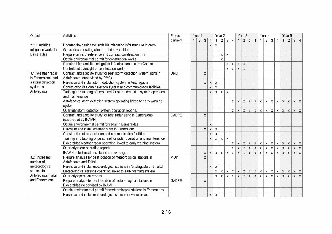
2 / 6
Output Activities Project partner1
Year 1 Year 2 Year 3 Year 4 Year 5
1 2 3 4 1 2 3 4 1 2 3 4 1 2 3 4 1 2 3 4
2.2. Landslide mitigation works in Esmeraldas
Updated the design for landslide mitigation infrastructure in cerro Gataso incorporating climate-related variables
x x
Prepare terms of reference and contract construction firm x x
Obtain environmental permit for construction works x
Construct for landslide mitigation infrastructure in cerro Gataso x x x x
Control and oversight of construction works x x x x
3.1. Weather radar in Esmeraldas and a storm detection system in Antofagasta
Contract and execute study for best storm detection system siting in Antofagasta (supervised by DMC)
DMC x
Purchase and install storm detection system in Antofagasta x x x
Construction of storm detection system and communication facilities x x
Training and tutoring of personnel for storm detection system operation and maintenance
x x x x
Antofagasta storm detection system operating linked to early warning system
x x x x x x x x x x x x x
Quarterly storm detection system operation reports. x x x x x x x x x x x x x
Contract and execute study for best radar siting in Esmeraldas (supervised by INAMHI)
GADPE x
Obtain environmental permit for radar in Esmeraldas x
Purchase and install weather radar in Esmeraldas x x x
Construction of radar station and communication facilities x x
Training and tutoring of personnel for radar operation and maintenance x x x x
Esmeraldas weather radar operating linked to early warning system x x x x x x x x x x x x x
Quarterly radar operation reports. x x x x x x x x x x x x x
INAMHI´s technical assistance and oversight x x x x x x x x x x x x x x x x x x
3.2. Increased number of meteorological stations in Antofagasta, Taltal and Esmeraldas
Prepare analysis for best location of meteorological stations in Antofagasta and Taltal
MOP x
Purchase and install meteorological stations in Antofagasta and Taltal x x
Meteorological stations operating linked to early warning system x x x x x x x x x x x x x x x x
Quarterly operation reports. x x x x x x x x x x x x x x x x
Prepare analysis for best location of meteorological stations in Esmeraldas (supervised by INAMHI)
GADPE x
Obtain environmental permit for meteorological stations in Esmeraldas
Purchase and install meteorological stations in Esmeraldas x x

3 / 6
Output Activities Project partner1
Year 1 Year 2 Year 3 Year 4 Year 5
1 2 3 4 1 2 3 4 1 2 3 4 1 2 3 4 1 2 3 4
Meteorological stations operating linked to early warning system x x x x x x x x x x x x x x x x
Quarterly operation reports.
INAMHI´s technical assistance and oversight x x x x x x x x x x x x x x x x x x
4.1. Enhanced public warning system in Antofagasta and Taltal
Identify best products and technology to complement existing warning systems in Antofagasta and Taltal (focused on mudflows alert) (i.e., sirens, communication network and control centre).
ONEMI x x
Purchase and install sirens and complementary equipment in Antofagasta and Taltal
x x
4.2. Pilot flood warning system in Esmeraldas
Select site for pilot trial GADE x
Design flooding early warning system and procedures within existing institutional framework
x x
Assess the condition of the three footbridges and provide basic maintenance
x
Identify best equipment for flood warning system (i.e., sirens, communication network and control centre) in collaboration with SGR
x x
Purchase and install sirens and complementary equipment in pilot site x x
Socialise flooding alert and emergency procedures with local community of the pilot site
x x x x x x
Flood emergency drills with local community x x x x
4.3. Evacuation route maps and signals in Antofagasta, Taltal and Esmeraldas
Update mudflows evacuation maps for Antofagasta and Taltal ONEMI x x
Publicise evacuation maps in high-transit locations in collaboration with municipal governments and local interest groups.
x x x x x x x x x x x x x x x x
Evacuation maps easily available in local websites and social media (i.e., Municipalidad de Antofagasta, Municipalidad de Taltal)
x x x x x x x x x x x x x x x x
Signal mudflow evacuation routes and safe areas in Antofagasta and Taltal, coordinated with municipal governments.
x x
Mudflow evacuation drills in Antofagasta and Taltal, coordinated with municipal governments.
x x x x
Prepare flooding evacuation map for Esmeraldas (evacuation zones, evacuation routes, and shelters).
GADE x x
Prepare landslide risk map for Esmeraldas x x
Signal flooding evacuation routes and safe areas in Esmeraldas x x
Signal landslide risk areas in Esmeraldas x x
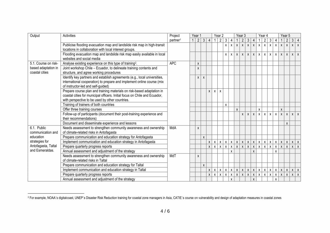
4 / 6
Output Activities Project partner1
Year 1 Year 2 Year 3 Year 4 Year 5
1 2 3 4 1 2 3 4 1 2 3 4 1 2 3 4 1 2 3 4
Publicise flooding evacuation map and landslide risk map in high-transit locations in collaboration with local interest groups.
x x x x x x x x x x x x x x
Flooding evacuation map and landslide risk map easily available in local websites and social media
x x x x x x x x x x x x x x
5.1. Course on risk-based adaptation in coastal cities
Analyse existing experience on this type of training2. APC x
Joint workshop Chile – Ecuador, to delineate training contents and structure, and agree working procedures
x
Identify key partners and establish agreements (e.g., local universities, international cooperation) to prepare and implement online course (mix of instructor-led and self-guided)
x x
Prepare course plan and training materials on risk-based adaptation in coastal cities for municipal officers. Initial focus on Chile and Ecuador, with perspective to be used by other countries.
x x x
Training of trainers of both countries x
Offer three training courses x x x
Follow-up of participants (document their post-training experience and their recommendations)
x x x x x x x x x x x
Document and disseminate experience and lessons x
6.1. Public communication and education strategies for Antofagasta, Taltal and Esmeraldas.
Needs assessment to strengthen community awareness and ownership of climate-related risks in Antofagasta
MdA x
Prepare communication and education strategy for Antofagasta x
Implement communication and education strategy in Antofagasta x x x x x x x x x x x x x x x x x
Prepare quarterly progress reports x x x x x x x x x x x x x x x x x
Annual assessment and adjustment of the strategy x x x
Needs assessment to strengthen community awareness and ownership of climate-related risks in Taltal
MdT x
Prepare communication and education strategy for Taltal x
Implement communication and education strategy in Taltal x x x x x x x x x x x x x x x x x
Prepare quarterly progress reports x x x x x x x x x x x x x x x x x
Annual assessment and adjustment of the strategy x x x
2 For example, NOAA´s digitalcoast, UNEP´s Disaster Risk Reduction training for coastal zone managers in Asia, CATIE´s course on vulnerability and design of adaptation measures in coastal zones
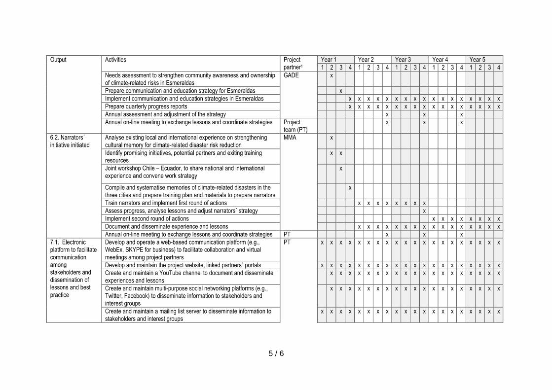
5 / 6
Output Activities Project partner1
Year 1 Year 2 Year 3 Year 4 Year 5
1 2 3 4 1 2 3 4 1 2 3 4 1 2 3 4 1 2 3 4
Needs assessment to strengthen community awareness and ownership of climate-related risks in Esmeraldas
GADE x
Prepare communication and education strategy for Esmeraldas x
Implement communication and education strategies in Esmeraldas x x x x x x x x x x x x x x x x x
Prepare quarterly progress reports x x x x x x x x x x x x x x x x x
Annual assessment and adjustment of the strategy x x x
Annual on-line meeting to exchange lessons and coordinate strategies Project team (PT)
x x x
6.2. Narrators´ initiative initiated
Analyse existing local and international experience on strengthening cultural memory for climate-related disaster risk reduction
MMA x
Identify promising initiatives, potential partners and exiting training resources
x x
Joint workshop Chile – Ecuador, to share national and international experience and convene work strategy
x
Compile and systematise memories of climate-related disasters in the three cities and prepare training plan and materials to prepare narrators
x
Train narrators and implement first round of actions x x x x x x x x
Assess progress, analyse lessons and adjust narrators´ strategy x
Implement second round of actions x x x x x x x x
Document and disseminate experience and lessons x x x x x x x x x x x x x x x x
Annual on-line meeting to exchange lessons and coordinate strategies PT x x x
7.1. Electronic platform to facilitate communication among stakeholders and dissemination of lessons and best practice
Develop and operate a web-based communication platform (e.g., WebEx, SKYPE for business) to facilitate collaboration and virtual meetings among project partners
PT x x x x x x x x x x x x x x x x x x x x
Develop and maintain the project website, linked partners´ portals x x x x x x x x x x x x x x x x x x x x
Create and maintain a YouTube channel to document and disseminate experiences and lessons
x x x x x x x x x x x x x x x x x x x
Create and maintain multi-purpose social networking platforms (e.g., Twitter, Facebook) to disseminate information to stakeholders and interest groups
x x x x x x x x x x x x x x x x x x x
Create and maintain a mailing list server to disseminate information to stakeholders and interest groups
x x x x x x x x x x x x x x x x x x x x

6 / 6
Output Activities Project partner1
Year 1 Year 2 Year 3 Year 4 Year 5
1 2 3 4 1 2 3 4 1 2 3 4 1 2 3 4 1 2 3 4
Create and support blogs to document the project´s experience3 x x x x x x x x x x x x x x x x x x x
7.2. Lessons and best practice documented and disseminated
Launch the project in both countries (binational inception workshop and national workshop with key stakeholders on each country)
PT x
Systematically document the project experience and prepare learning experience documents4
x x x x x x x x x x x x x x x x x x x x
Exchange visits between project partners5. Visits will be open to participants from other countries.
x x x x
Annual meeting of project board (webinar) x x x x
Presentation of project results in national or international events (to be defined)
x x x x x x x x x x
Implementation of monitoring and evaluation plan x x x x x x x x x x x x x x x x x x x x
Mid-term review and terminal evaluation of the project x x
Prepare and disseminate project´s memoirs x x x
Project board closure meeting and public event on each country x
3 Blogs will be accessible through the project´s website and will serve as field journals to document the experience and lessons of the main Project interventions. Responsible Entities will maintain a blog of each output under its responsibility. Additional blogs will be open if needed (e.g., individual blogs for narrators´ experience on each of the three city). 4 There will be nine learning experience documents: 1. incorporating the climate change factor into stormwater management plans in Chile, 2. preparation of green infrastructure plan in Esmeraldas, 3. incorporating
the climate change factor into mudflow control infrastructure in Antofagasta, 4. incorporating the climate change factor into landslide control in cerro Gataso (Esmeraldas), 5. Use of weather radar and storm detection system to enhance early warning systems, 6. mudflows warning system in Antofagasta and Taltal, 7. pilot flood warning system in Esmeraldas, 8. communication and education strategies to increase
public awareness of climate-related disaster risk, and 9. contribution of narrators to sustain cultural memory on climate-related risks and disasters. 5 At least following thematic exchange visits are planned: 1. pilot stabilization of cerro Gataso to control landslides (in Ecuador), 2. early warning and response systems to climate-related events (in Chile), 3. public awareness strategies (in Chile), 4. narrators’ initiative (in Ecuador).

1 / 6
Photographs of quebrada Bonilla sur (Antofagasta)
Taken from the site indicated in Figure 11.
Uphill view of quebrada Bonilla sur
Neighbourhood close to quebrada Bonilla Sur
Antofagasta

2 / 6
Photographs of Taltal´s mudflow of March 2015
Source: Diario El Mercurio de Antofagasta

3 / 6
Photographs of cerro Gataso´s landslide of 2016
Source: Diario El Comercio

4 / 6
Photographs of cerro Gataso´s landslide of 2010
Source: http://vdeesmeraldas.blogspot.com/2010_05_01_archive.html

5 / 6
Source: Diario El Universo
Photographs flooding of Isla Luis Vargas Torres in 2016

6 / 6
Source: Diario El Comercio
ANNEX 8.
STAKEHOLDER ANALYSIS IN ANTOFAGASTA AND TALTAL (CHILE)
STAKEHOLDERS ANALYSIS
REGIONAL PROJECT
Reducing climate vulnerability and flood risk in coastal urban and semi
urban areas in cities in Latin America
ANF Corporation
María-José Godoy, Sociologist
Fernando Zúñiga, Anthropologist
Talca, Chile

CONTENTS
I. Introduction
II. Methodology 2.1. Preliminary stakeholders´ classification proposal
2.2. Identification of roles and duties for each stakeholder
III. Characterisation of the socio-economic and demographic status of the Antofagasta and
Taltal communes
IV. Mapping of Antofagasta and Taltal communes´ stakeholders
4.1. Stakeholders mapping: The Antofagasta and Taltal cases
4.1.1. Card records – key stakeholders
4.1.2. Summary table
4.1.3. Break-up of stakeholders, community teams and service areas in the territory:
4.1.4. Concerning a review of prevailing power-based relationships
V. Identification of key stakeholders´ insight vis-à-vis adaptation measured being foreseen in
the preliminary concept
VI. Guidelines to involving and articulating key stakeholders to implementing adaptation
modelling
VII. Sources

I. Introduction
A project´s preliminary concept submitted to the Adaptation Fund by the Chile and
Ecuador governments was approved in March 2016. The aim of this preliminary concept is to
abating vulnerability to climate change-originating flooding in three coastal cities by
incorporating an adaptation approach which is based on risk management and co-operation, and
fosters enforcement of an adaptation-driven culture. This project is intended to be implemented
in the cities of Antofagasta and Taltal in Chile, and Esmeraldas in Ecuador, bearing in mind that
these cities are likely to be most impaired by sea level rise, and are highly vulnerable to floods
and flash floods caused by heavy rain resulting from El Niño event, as well as extreme weather
events. There is a likelihood for climate change impacts to becoming more frequent and harsher,
thus further exacerbating climate change-linked risks to local populations and public and private
infrastructure.
The process of expanding upon this project proposal entails singling out key stakeholders
having a particular concern for these areas, sectors and communities vulnerable to climate
change and, insofar the final approval is accorded to the project for it to get implemented, then
those areas, sectors and communities shall reckon with improvements in adaptation activities as
envisaged.
For this objective to be achieved, this Report intends to identifying and mapping key
stakeholders in Antofagasta and Taltal cities who are related both, with areas, sectors and
communities vulnerable to climate change, and with the implementation of adaptation measures
as being anticipated in the preliminary concept. Singling out the willingness of key stakeholders to
getting involved and implementing adaptation measures, besides identifying both, the role that
women, Indigenous Peoples and age groups play in the implementation of these measures, as
well as the cultural and social hurdles, and other barriers and problems constraining their
involvement and commitment, and suggesting actions to address those barriers and constraints.
Finally, and on the basis of secondary data (i.e., population and housing censuses) the
socio-economic status of the Antofagasta and Taltal population shall be characterised with a
particular focus on areas, sectors and communities most vulnerable to climate change impacts.
II. Methodology
A review of the stakeholders mapping as a methodological tool will allow for qualitative data
about the insights and concerns of key stakeholders to be collected, which should be borne in
mind at the time measures stipulated in the preliminary concept are to be carried through.

Stakeholders to be singled out are deemed to be individuals or institutions having some sway
vis-à-vis the scope and reach (preliminary concept measures) of the project to be implemented
and executed. Likewise, those persons or groups of people expected to be materially influenced
by these activities are also deemed to be stakeholders.
2.1. Preliminary Stakeholders breakdown proposal
To start with, a definition should be made of those institutions, civil society organisations, or
individuals to be involved in the implementation and / or promotion of measures being defined in
the project´s preliminary concept. A brainstorming meeting should be held to produce a listing of
all stakeholders having a direct or indirect bearing on the project, so that they may be classified
into groups, attaching to each group the bearing key stakeholders should have in the project´s
intervention. To this end, the following stakeholders´ breakdown is suggested:
The first breakdown of stakeholders is defined vis-à-vis the type of organisation or institution,
and should be based upon definitions as spelled out below:
• "Government Stakeholders". Attached to local, regional and / or central government entities.
• "Non-Government Stakeholders". Attached to grassroots organisations, private sector,
productive sector, foundations, corporations, universities, organisms, etc.
Both, government or non-government stakeholders shall be attached four action or incidence
levels: Territorial / Local; Communal; Regional; National.
Depending upon the review´s fine-tuning needs, a second category is set down in which
stakeholders could also be classified as follows:
• Primary stakeholders: Those groups directly involved in the problematics or project to be
looked into because of their specific interests (institutional, personal, community stakeholders).
• Secondary stakeholders: Representative groups of communities under the project´s direct
influence, political pressure organisations endeavouring to address socio-environmental
problems; or having some territorial competence in the area in which any of these problems may
become apparent.
• Backup stakeholders: Citizen or government organisations which, due to their grasp of some
technical know-how, or project and social activities management, have a particular knowledge
vis-à-vis some environmental or project-related issues.

2.2. Identification of Stakeholder´s Roles and Duties
The end-goal is to becoming aware of the main roles social and institutional stakeholders play in
the intervention proposal; also, to identifying actions that social and institutional stakeholders
could implement by outlining a network of inter-institutional alliances vis-à-vis the intervention
proposal.
Stakeholders review
To undertake the stakeholders review according to the following two categories: i) prevailing
relationships; and ii) authority levels. The aim is to conduct a qualitative review of the different
stakeholders vis-à-vis participatory processes.
i) Prevailing relationships: In the intervention proposal these are defined as affinity (trust)
relationships vis-à-vis the opposite (conflict). The following three aspects are borne in
mind:
• Pro: Trust and mutual collaboration relationships are prevalent
• Indecisive / Unconcerned: Affinity relationships prevail, but antagonistic relationships
show a higher incidence.
• Against: Conflict prevails in relationships.
- Ii) Power hierarchy ranking: The ability stakeholders have to constrain or facilitate the
actions being undertaken through the intervention. Power rankings are considered as
follows:
High: A high influence over other stakeholders is prevalent
Medium: Influence is moderately accepted
Low: No influence over other stakeholders
III: Characterisation of the socio-economic and demographic status of the
Antofagasta and Taltal communes. A description.
A description is made below of some social, economic and demographic indicators of the
Antofagasta and Taltal communes, located in the Antofagasta Province, in the Antofagasta
region.
Most data have been collected locally, the main source being the 2002 Census, bearing in mind
that this Census has been attached more legitimacy vis-à-vis the Census performed in in 2012, the

validity of which has been put into question. Furthermore, different CASEN survey measurements
outcomes have been perused through, as summarized in the Statistical and Communal Reports
published by the National Congress Library, which, together with some other public institutions
sources have been perused through.
1. Total population
According to 2002 Census data, the population of the Antofagasta region at the time was 493,984
people, while a total of 588,130 inhabitants was projected for year 20121. According to
projections of this same Census, the regional population would reach 594,555 inhabitants by
2013, and 613,093 inhabitants by year 20162.
Total Population (Antofagasta)
Figure 1. Source: Statistical and Communal Reports 2012, Antofagasta, National Congress Library. Authors´.
However, as shown in Figure 1, the Antofagasta Commune´s population increased from 296.905
people, in 2002, to a projected 378.923 inhabitants, for year 2012.
According to Figure 2 below, and in line with forecasts, the Taltal Commune population was
11.100 people in 2002, declining to 10.511 people by 2012.
Total Population (Taltal)
1 Data collected from Statistical and Communal Reports 2012, Antofagasta y Taltal, National Congress Library.
2 Chilean data collected from: Proyecciones y Estimaciones de Población, 1990-2020, National Statistics
Institute.

Figure 2. Source: Statistical and Commune Reports 2012, Taltal, National Congress Library. Authors´.
2. Age-based Population Distribution
Age-based Population Distribution (Antofagasta)
Figure 3. Source: Statistical and Commune Reports 2012, Antofagasta, National Congress Library. Authors´.
The population distribution by age ranges shows that the Antofagasta commune population has
increased in all age ranges over the corresponding period between 2002 and 2012. Figure 3
shows that the 0 – 14 years range has increased from 76,734 to 88,795 inhabitants; the 15 - 29
years range has increased from 18,608 to 97,848; the 30 – 44 years range has increased from
74,754 to 85,124; the 45 – 64 years range rose from 47,585 to 81,614 inhabitants; while the 65
years and over group shows an increase from 19,224 to 25,542 people.

Age-based Population distribution (Taltal)
Figure 4. Source: Statistical and Commune Reports 2012, Tantal, National Congress Library. Authors’.
As regards the Taltal, commune, Figure 4 shows that over the same period, the 0 - 14 years of
age range decreased from 2.997 to 2.490 inhabitants; the 14 - 29 years of age range decreased
from 2.491 to 2.401 people; the range for ages 30 – 44, has decreased from 2.935 to 2.135
people; that for ages 45 – 64, increased from 1.871 to 2.590 people; while the group of people
65 years old and over, has increased from 806 to 895 people.
3. Age-based Population Distribution
Figure 5. Source: Statistical and Commune Reports 2012 National Congress Library. Authors’.
0
50.000
100.000
150.000
200.000
250.000
Hombre Mujer Hombre Mujer
Year 2002 Year 2012
Population distribution by sex (Antofagasta)

Concerning distribution of the population by sex, Figure 5 shows that the number of men has
increased from 153,220 in 2002 to 196,952 in 2012 in the Commune of Antofagasta. On the
other hand, according to projections for 2012, the women population has grown from 143,685 in
2002 to 181,971 as stated in year 2012 forecasts.
Age-based Population distribution (Taltal)
Figure 6. Source: Statistical and Commune Reports 2012, Taltal, National Congress Library. Authors’
Regarding Taltal, Figure 6 shows that the number of men has decreased from 6.182 in 2002, to
5.807 in 2012; and women-reated figures show a decrease from 4.918 in 2002, to 4.704 in 2012.
4. Population according to Indigenous Populations
Concerning the number of inhabitants deemed as Indigenous Populations, regional data
collected by the 2006, 2009, 2011 and 2013 CASEN Surveys have been taken into account. In this
regard, Indigenous Populations as follows have been recognized: Atacameño, Aymara, Mapuche
, Rapanui, Diaguita and others. On the other hand, and bearing in mind that more up-to-date
data was not available, only the data collected in the 2011 Commune Statistical Reports have
been taken into account for the commune-addressed review conducted.
0
1.000
2.000
3.000
4.000
5.000
6.000
7.000
Hombre Mujer Hombre Mujer
Year 2002 Year 2012
Distribución de población por sexo (Taltal)

Number of Indigenous Peoples´ Population (Antofagasta Region)
Figure 7. Source: Results Synthesis - CASEN 2013 Survey, Indigenous Peoples´ Populations,
Ministry of Social Development. Author´s.
Results in Figure 7 show that between 2006 and 2009, the Indigenous People´s population
recorded in the Antofagasta Region decreased from 38,485 to 30,609, respectively. By 2011, this
population increased to 41,611 inhabitants, showing a further increase in 2013 to 50,623.
Indigenous Peoples Population in the Antofagasta Region
Figure 8. Source: Results Synthesis CASEN 2013, Indigenous Peoples, Ministry for Social Development.
Authors´.
39 %
,50% 17
16 ,40%
13 ,60%
11 ,80%
1 ,60%
Indigenous Peoples Population in the Antofagasta Region
Atacameño Mapuche Quechua Aimara Diaguita Otros
0
10000
20000
30000
40000
50000
60000
2006 2009 2011 2013
Number de población indígena (Región de Antofagasta)

The total indigenous population in the Region of Antofagasta for year 2013 was 50,623
inhabitants. Figure 8 shows that 39% of this population is made up by 39% Atacameñas; 18%
Mapuches; 16% Quechuas; 14% Aymara; and 12% Diaguita. Finally, those claiming to belong to
some other ethnic group account for 2% of the total indigenous population in the Region.
Population distribution by ethnic origin (Antofagasta)
Figure 9. Source: Statistical and Communal Reports 2011, Antofagasta, National Congress Library. Authors´.
As regards the Antofagasta commune and according to figure above, the people being deemed
as having been born in Atacama and recognised as Indigenous People to the region are not
included in the 2003 statistics; however, by 2006 they were 283 people; by 2009, this figure
showed an increase to 822. Regarding the Aymaras, between 2003 and 2006 the population
increased from 931 to 2,680, to then decrease to 2,296 in 2009. The Mapuche ethnic group was
recognized as having 2,589 inhabitants in the region in 2003, a figure increasing to 4,968 in 2006
and decreasing to 2,120 in 2009, while the Rapanuis are unaccounted for in all measurements.
Finally, the point should be stressed that according to 2009 data, the total population considered
as Indigenous Populations was made by 5,238 people, out of a total of 373,236 inhabitants, or
1.4% of the total population.
0
1000
2000
3000
4000
5000
6000
Atacameño Aymara Mapuche Rapanui
Distribución de la población por etnia ) Antofagasta (
Number of People 2003 Number of People 2006
Number of People 2009

Figure 10. Population distribution by ethnicity (Taltal)
Source: Statistical and Communal Reports 2011, Taltal, National Congress Library. Authors´.
According to Figure 10, and regarding the Taltal commune, Indigenous Population being
recognized as born in Atacama were not accounted for in 2003. By 2006 their number had
increased to 20 people, while by 2009, their population was 101 inhabitants. The Aymaras, on
their part, were unaccounted for in 2003, but in 2006 their population was made up by 12
people, a figure increasing to 162, in 2009. In 2003, the Mapuches were not recognized in the
territory, but in 2006 its population was recorded as 41 People, showing a decrease in 2009 to 32
inhabitants. The Rapanuis, meanwhile, were 14 individuals in 2003, later on disappearing from
all measurements therefrom. The point should be stressed that, in 2009, out of a total of 12,842
inhabitants, 295 of them are linked with some ethnic group, i.e., only 2.3% of the total
population.
0 20 40 60 80
100 120 140 160 180
Atacameño Aymara Mapuche Rapanui
Population distribution by ethnicity (Taltal)
Distribución de población por etnia (Taltal)
Number of individuals 2003 Númber of individuals 2006
Number of individuals 2009

Number of Immigrant Population
Figure 11. Source: results Synthesis CASEN 2013, Immigrants, Ministry of Social Development. Authors´.
5. Migration
Notwithstanding that the migratory phenomenon in the Antofagasta Region has been
deemed as a historical milestone, a particular weight has been attached to it in recent
years. Although communal level-disaggregated data is no available, the regional CASEN
2013 Survey figures have been considered. However, as shown in Figure 11, the number
of immigrant population in the Antofagasta region was recorded as 8,257 people in year
2009. This figure increased to 26,624 people in the 2013 survey.
6. Population according to poverty
The CASEN Survey up to 2011 measured poverty by income, taking into account the
traditional methodology applied by the Economic Commission for Latin America and the
Caribbean (CLAC, for its acronym in Spanish). From that 2013 survey onwards, poverty
has been measured through a new methodology. Regarding the latter, a definition will be
made in this paper of data collected on the Antofagasta Region. For communal area
details, the 2011 Communal Statistical Report data will be used.
According to the CASEN 2013 Survey, the total number of households (people living in
private homes) in the Region is 151,534, of which 1% are in extreme poverty by income;
2.2% are living in non-extreme poverty by income; 3.2% is in a situation of poverty by
5
0
5000
10000
15000
20000
25000
30000
2009 2013
Immigrant Population (Antofagasta Region)

income: while 14.8% is in a multidimensional poverty situation3. On the other hand, the
total population (in private homes) in the Region is 562,941 people, out of which 1.1% are
in extreme poverty, 2.8% are in non-extreme poverty, 4% are in poverty, and 20.7% are in
multidimensional poverty4.
Figure 12. Source: Statistical and Communal Reports 2011, Antofagasta National Congress Library.
Authors.
Poverty-based distribution of population
According to Figure 12, concerning the Antofagasta commune, in 2009 the destitute poor were
2,370 people, the non-destitute poor were 22,601 people, and the non-poor were 336,814
inhabitants, adding to a total population of 361,785. In other words, according to the 2009
Census, 7% of the total population of the Antofagasta commune is in a situation of poverty
(destitute poor people destitute plus not destitute poorer people).
3 CASEN 2013 Survey data, Profile of the Antofagasta Region. Ministry of Social Development. 4 CASEN 2013 Survey data, Profile of the Antofagasta Region. Ministry of Social Development.
0
50.000
100.000
150.000
200.000
250.000
300.000
350.000
400.000
Pobre Destitutee Pobre no Destitutee No Pobre Total
Population Distribution according to Poverty - ( Antofagasta )
2003 2006 2009

Figure 13. Source: Statistical and Communal Reports 2012, Taltal, National Congress Library.
Authors.
Concerning Taltal, Figure 13 shows that the destitute poor are 242 people; the non-destitute poor
are 898; and the non-poor make up a 9,564 inhabitants, within a total population of 10,704. In
percentage terms, for 2009, the population in poverty constitutes accounts for 11% of the total
figure.
7. Schooling
7 . Escolaridad
55 , 10
, 6 10
10 , 65
10 7 ,
, 75 10
10 8 ,
85 , 10
, 9 10
10 , 95
2003 2006 2009
Average Schooling Years (Antofagasta)
0
2000
4000
6000
8000
10000
12000
Destitute Poor not Destitute Poor Not Poor Total
Population Distribution according to Poverty (Taltal)
2003 2006 2009

Figure 14. Source: Statistical and Communal Reports 2011, Antofagasta, National Congress Library.
Authors.
According to Figure 14, the average schooling years of the Antofagasta population were 10.92
years, in 2003, while in 2006 and 2009 this figure decreased to 10.70 and 10.75 years,
respectively.
Figure 15. Source: Statistical and Communal Reports 2012, Taltal, National Congress Library.
Authors.
According to Figure 15, the Taltal numbers show 9.33 years of schooling in 2003; 9.89 years in
2006; while for 2009, this variable corresponds to 9.12 years.
8. Housing
8 , 6
8 , 8
9
2 , 9
4 , 9
6 9 ,
9 8 ,
10
2003 2006 2009
Average Schooling Years (Taltal)

Figure 16. Source: Statistical and Communal Reports 2011, Antofagasta, National Congress Library.
Authors.
In accordance with data supplied by the CASEN Survey, Figure 16 indicates that the number of
households in the Antofagasta commune increased from 73,171 in 2003 to 77,594 in 2006, and
then to 77.907 in 2009.
Figure 17. Source: Statistical and Communal Reports 2011, Taltal, National Congress Library.
Authors.
Meanwhile, the number of households in the Taltal commune, according to Figure 17, were 2,613
in 2003; this number decreased to 2,384 in 2006, to again increase to 2,414 in 2009.
9. Transportation
2.250
2.300
2.350
2.400
2.450
2.500
2.550
2.600
2.650
2003 2006 2009
Number of Households (Taltal)
70.000
71.000
72.000
73.000
74.000
75.000
76.000
77.000
78.000
79.000
2003 2006 2009
Total number of Households (Antofagasta)

With regard to transportation, two variables are described below based on the 2005 Vehicles in
Circulation Yearbook, supplied by the National Statistics Institute.
Figure 18. Source: Vehicles in Circulation Yearbook 2015, National Statistics Institute. Authors.
As regards the total number of both, motorized and non-motorized vehicles in the Antofagasta
Region, Figure 18 shows a total of 107,980 vehicles, of which 96,372 were circulating in the
Antofagasta commune and 3,394 in the Taltal commune.
Figure 19. Source: Vehicles in Circulation Yearbook 2015, National Statistics Institute. Authors.
As regards collective transport circulating in the Antofagasta commune, Figure 19 shows that 214
vehicles are basic taxis, 2,292 are collective taxis, 381 are tourist taxis, 844 are public transport
vans, 215 are minibuses used as school or workers transport vans; 1,087 are collective transport
0 500 1000 1500 2000 2500
Basic Taxi
Collective Taxi
Tourism taxi
Minibus, public transport
Minibus, School van, workers transport
Bus, public transport
Bus, school, and workers transport
transportbajadores
Public Transport
Taltal Antofagasta
0
20.000
40.000
60.000
80.000
100.000
120.000
Total Motor Vehicles Other vehicles
Total number of vehicles
Antofagasta Taltal

buses, and 135 buses are used for school or workers´ transportation. Regarding Taltal, some of
these types of transport were recorded, corresponding to 76 basic taxis, 1 collective taxi, and 60
public transport buses.
10. Basic Services Coverage
a) Drinking water
Figure 20. Source: Urban Indicators, Urban Observatory, Ministry of Housing and Urban Planning.
Authors.
Regarding domestic drinking water coverage, Figure 20 shows that Antofagasta commune indexes
have gradually increased: from 98.7% in 2003, to 99.7% in 2006, to then reach a 100% increase
during 2009.

Figure 21. Source: Urban Indicators, Urban Observatory, Ministry of Housing and Urban Planning.
Authors.
Figure 21 shows that during year 2003, the domestic drinking water coverage in the Tatal
commune reached a 94% figure. This level increased to 95.5% in 2006, to record a fall in the 2009
measurement, to a 86% coverage.
b) Electricity
Domestic Electricity Coverage (Antofagasta)
Figure 22. Source: Urban Indicators, Urban Observatory, Ministry of Housing and Urban Planning.
Authors.
80 %
82 %
84 %
86 %
% 88
% 90
% 92
% 94
% 96
98 %
2003 2006 2009
Domestic drinking water coverage (Taltal)

Domestic Electricity Coverage (Taltal)
Figure 23. Source: Urban Indicators, Urban Observatory, Ministry of Housing and Urban Planning.
Authors.
According to data in Figure 22, coverage of domestic electricity in the Antofagasta commune
reached 98.4%. Meanwhile, and as recorded in the CASEN Survey, in years 2006 and 2009
coverage was 99.7% and 100%, respectively. Figure 23 below, which also compiles data collected
by the Ministry of Housing and Urban Planning´s Urban Observatory, records the same data for
the case of Taltal.
11. Average household income
In this document, the household income is being referred to in accordance with the new CASEN
2013 Survey measurement in the case of the Antofagasta Region, as well as according to
parameters in older measurements (2003, 2006 and 2009), for the Antofagasta and Taltal
communes separately.
Concerning the monthly average household income, the CASEN 2013 survey set forth the amount
of 1,040,617 pesos for the Antofagasta Region. To measuring the CASEN 2009 Survey, this income
was 852,786 pesos5.
5 Data collected from the CASEN Survey. Profile, Antofagasta Region.

Figure 24. Source: Statistical and Communal Reports 2011, Antofagasta, National Congress
Library. Authors.
However, concerning the Antofagasta commune, the average autonomous income of households
was 557,858 pesos in 2003; 764,781 pesos in 2006; and 835,887 pesos in 2009.
Figure 25. Source: Statistical and Communal Reports 2011, Taltal, National Congress Library.
Authors.
As regards the Taltal commune, this variable corresponded to the following values: 483,618 pesos
in 2003; 734,526 pesos in 2006; and 828,873 pesos in the 2009 CASEN Survey measurement.
Concerning the migrant phenomenon
0 100.000 200.000 300.000 400.000 500.000 600.000 700.000 800.000 900.000
Autonomous Income
Monetary Benefit
Monetary income
Income (Taltal)
2009 2006 2003
0 100.000 200.000 300.000 400.000 500.000 600.000 700.000 800.000 900.000
Autonomous Income
Monetary benefit
Monetary Income
Income (Antofagasta)
2009 2006 2003

Notwithstanding the fact that official government research has been undertaken on the subject,
such as the National Statistical Yearbook; Migration in Chile 2005 – 2014, the migratory
phenomenon in the Antofagasta region has been scantily explored by the different fields of study
concerned with this subject. This is the reason why the phenomenon has been lacking
systematisation and research at both regional and communal level. While the Migration in Chile
1005 – 2014 paper incorporates the following (most recent) regional outlook of the migratory
phenomenon, the figures therein could add to an enhanced understanding of territorial migration
processes being undertaken in the Antofagasta and Taltal communes.
In the Antofagasta region, 4.6% of the population is made by people coming to the region who
are identified as migrants. When this figure is scaled up at the national level, it accounts for 6.9%
of the migrant population in the whole country. The Antofagasta region is, after Santiago, the city
recording the highest number of immigrants, and the point should be stressed that the migration
growth is a process inscribed at the northern macro zone level.
If a comparison is made between the percentage of migrants at regional level between years
2005 and 2014, an explosive growth is apparent of the migrant population in the region, reaching
a 327% figure, and entailing an increase from 6,612 to 28,236 inhabitants under a migration
status, corresponding to a growth of 21.624 new migrants into the region over a nine-year period.
Concerning the sex-based distribution of people in the region, the number of women is higher
than that for men, a situation which has been prevailing since 2005.
"Meaningful changes have become apparent within the age-related framework, mainly the
growth of migrants between 20 and 35 years of age, which, in this case, recorded an increase
from 36.1%, in 2005 to 50.1%, in 2014. For migrants over 51 years of age, an approximate 10
percentage points decrease was recorded, while the number of minors has decreased by 5.6
percentage points vis-à-vis year 2015. In both cases, the increase recorded stresses the economic
importance of the region, as well as its particular characteristic of being an important pole of
attraction for both, international and internal migration."
"Again. most important migratory flows in the region coincide with border countries: Bolivia: with
41.8%; Peru: 28.6%; and Argentina: 5.7%. The steady inflow of Colombian migrants is beginning to
become relevant from Antofagasta to the Southern region, accounting for a 11.0% share:
equivalent to a 9.4 percentage points increase over year 2005 (National Statistical Yearbook,
Migration in Chile 2005 - 2014)".
Concerning the legal status of immigrants in the region, from 2005 (to 2014 the region has
granted:
• 22.512 Residence Permits
• 27 Student visas
• 46.918 Visas subject to working contracts, in the region

• 52. 272 Temporary Visas


At the level of perception the phenomenon is perceived as a negative feature of globalization in
the region, putting in tension the social, economic and political dynamics. The community, by not
understanding the phenomenon and being bombarded by the media and speculative processes of
the media, as well as by contrasting with other cultures and phenotypic expressions, in space with
those coming from Colombia, has operated under the logic of discrimination And segregation, an
act that is reinforced by the labor field and housing sectors developed and occupied by the
migrant population (service area and camp).
Still some other relevant data in the processes are figures poblished in 2011, reporting that 10%
(283 children) of births in the regional hospital of the city of Antofagasta corresponded to
mothers of foreign nationality, or that over the same year, another reference to the presence of
foreigners in the commune of Antofagasta was that 12% of students enrolled at the Mario
Bahamonde men´s Lyceum, were foreigners.
This phenomenon has become so important that the National Government is working on a new
Migration Law for further approval by the Legislative Authority and enactment. This action was
reinforced in a headline in the newspaper Mercurio, on 4 March 2016, stating that:
"A National Defence Commission will arrive in Antofagasta to look into the migratory
phenomenon: On Monday 14th March, Parliament members Alejandro Guillier, Pedro Araya,
Carlos Bianchi, Víctor Pérez Varela and Baldo Prokurica will be meeting with local authorities to
discuss how the community is being affected by migration."
With regard to multidimensional poverty
Multidimensional poverty corresponds to and is understood to be the end product of the sum of
different aspects which, together, describe and account for poverty, as opposed to one-
dimensional instruments such as GDP.
For CASEN, as defined in its 2013 policy, "multidimensional poverty" is understood on the basis of
four dimensions, which in turn are composed of three indicators, the first dimension
corresponding to:
• Education
- Attendance
- Education underachievement
- Schooling
• Health
- Child Malnutrition
- Adscription to the Health System
- Health Care

• Work and social security
- Employment
- Social security
- Retirement pension
• Housing
- Overcrowding
- Housing conditions
- Basic services
For analytical and weighting purposes, these four dimensions have the same weight: 25%
.
In line with these criteria, table below shows the multidimensional poverty index in the
Antofagasta region for year 2013.
Region Multidimensional Poor
Persons Households
Number Percentage Number Percentage
II Antofagasta 112.187 20,7 21.579 14,8
Figure below shows the evolution and comparison between poverty and multidimensional
poverty from 2009 to 2013.
Source: Authors, from CASEN 2013 Survey data

"If we bear in mind how poverty calculations have evolved in the Antofagasta region, the
decrease in poverty would seem more relevant considering multidimensional poverty measuring:
showing a decrease from 30.5% in 2009 to 20.7% in 2013, with a decrease close to 5% for each
year. The size of this decrease according to the traditional approach is considerably lower, going
from 8.8% in 2009 to 4.0% in 2013, Antofagasta Region; Regional synthesis 2015".
Concerning the shantytown phenomenon
Over the last four years, the shantytown phenomenon (illegal occupations of land) has been
widely spread in the Antofagasta city. This is due to economic conditions prevailing in cities or
regions where mining activities are under way, and internal and external migration has become
into a particular feature attached to this activity.
According to Un Techo para Chile programme (A Roof for Chile), fifty-five shantytowns have
spread over the Antofagasta over some time in the region housing more than 4,100 families6.
While no official or updated data of this condition is available in the cities of Antofagasta and
Taltal, an estimation has been made that in the city of Antofagasta alone, there are more than 40
shantytowns housing more than 4000 people.
This phenomenon is linked to a huge immigration into the city, the largest wave being recorded in
recent years with the arrival of Colombian nationals. The main reasons for the huge proliferation
of shantytowns is the high rental costs of housing leases and expensive living conditions in the
city. This is the reason why, many families, mainly migrants, are forced to establish their homes in
illegal settlements, where utilities such as electricity, water or sewage are non-available.
Added to these conditions is a permanent risk linked to the fact that the shantytowns are settled
mainly on hill slopes, which have been flattened by backhoes, becoming into the place where
people build makeshift houses with light material. Along ravines and electricity antennas houses
are built providing a home to thousands of families in Antofagasta.
Jacqueline Fey, an Ecuadorian woman and leader of the "America Unida" (United America)
shantytown located along the Bonilla ravine, says in an interview for the newspaper La Tercera:
"It is very frightening to live here, knowing that at any moment our house can collapse downhill
because of an earthquake or a flooding. Even so, people make arrangements to build [a home],
because the need and the desire to get ahead are bigger”7.
6 http://chile.techo.org/cis/monitor/#
7 http://www.latercera.com/noticia/nacional/2016/03/680-672951-9-antofagasta-la-peligrosa-expansion-
de-los-campamentos-hacia-los-cerros.shtml

Most foreigners living in these places do not harbour a "memory" to making them ponder the risk
of setting up their homes in places devoid of the necessary safety conditions in case of floods.
IV. Stakeholders Maps - Antofagasta and Taltal Communes
A description is made in this section of key stakeholders involved in the development and
enhancement of the territory, who in turn represent the human capital required for viability,
reflection and submission of proposals being set forth in the preliminary concept. Processes
linked to setting up social networks made up by keystakeholders, predominant relations and
power relations, focus groups and, lastly, classification of keystakeholders in both Antofagasta
and Taltal are further described.
Thus, a table was drawn up listing the stakeholders identified and having a territorial relevance,
or according to the competencies and capacity for development and decision-making at the
communal and territorial level.
Seven variables are presented in table "Key Stakeholders Factsheet" as follows:
1. Name: The nominal classification with which the stakeholder is recognized.
2. Classification: The stakeholder´s organisational legal status, as well as its classification vis-à-
vis its link-up (see Annex N ° 1)
3. Role: The mission the organisation should accomplish
4. Function: The factual actions the key stakeholders should undertake
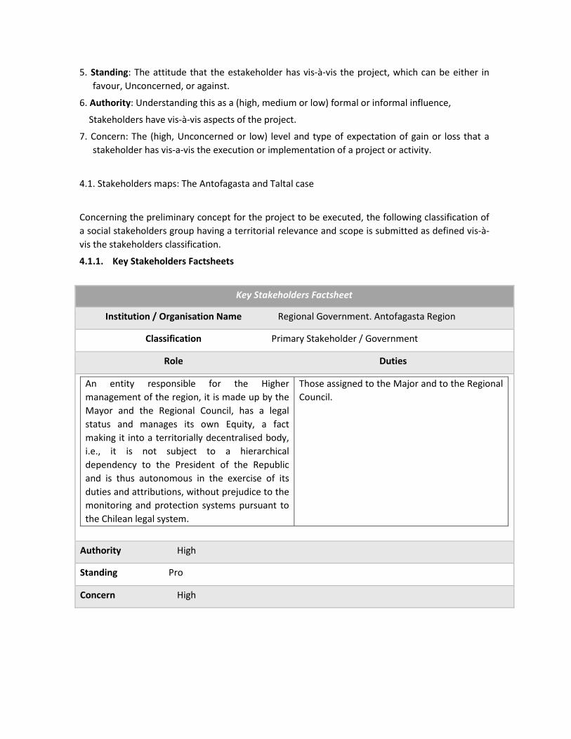
5. Standing: The attitude that the estakeholder has vis-à-vis the project, which can be either in
favour, Unconcerned, or against.
6. Authority: Understanding this as a (high, medium or low) formal or informal influence,
Stakeholders have vis-à-vis aspects of the project.
7. Concern: The (high, Unconcerned or low) level and type of expectation of gain or loss that a
stakeholder has vis-a-vis the execution or implementation of a project or activity.
4.1. Stakeholders maps: The Antofagasta and Taltal case
Concerning the preliminary concept for the project to be executed, the following classification of
a social stakeholders group having a territorial relevance and scope is submitted as defined vis-à-
vis the stakeholders classification.
4.1.1. Key Stakeholders Factsheets
Key Stakeholders Factsheet
Institution / Organisation Name Regional Government. Antofagasta Region
Classification Primary Stakeholder / Government
Role Duties
An entity responsible for the Higher
management of the region, it is made up by the
Mayor and the Regional Council, has a legal
status and manages its own Equity, a fact
making it into a territorially decentralised body,
i.e., it is not subject to a hierarchical
dependency to the President of the Republic
and is thus autonomous in the exercise of its
duties and attributions, without prejudice to the
monitoring and protection systems pursuant to
the Chilean legal system.
Those assigned to the Major and to the Regional
Council.
Authority High
Standing Pro
Concern High

Key Stakeholders Factsheet
Institution / Organisation Name Major. Antofagasta Region
Classification Principal Stakeholder / Government
Role Duties
The Major is accountable for leading the work attached to the Interior Government Position in the Region, according to the directions, orders and instructions being issued by the Head of State, either directly or through the Minister of the Interior. The Major position enjoys full confidence of the President of the Republic.
1. To issue and approve regional policies, plans and development programmes, as well as a draft budget, all of which should be in line with the national development policy and the National Budget. 2. To manage investment of resources corresponding to the region according to the National Fund for Regional Development allocation. 3. Making decisions vis-à-vis the allocation to specific projects of sector investment programmes resources for regional allocation pursuant to the annual Nation Budget Law. 4. Issuing general rules to regulate subjects under its competence. 5. Advising municipal authorities when they so require, and in particular concerning the design of development plans and programmes. 6. Adopting measures as required to deal with emergency and disaster emergencies, and implementing disaster prevention and protection programmes, without prejudice to the powers of the competent national authorities. 7. Participating in international cooperation activities in the region, within the framework set forth by treaties and agreements that the Government of Chile enters into for this purpose and in accordance with the procedures regulated in relevant legislation. 8. Exercising legal powers as may be transferred to it. 9. Maintaining a permanent relationship with the national government and its different agencies, in order for the implementation of their respective duties is duly complemented.
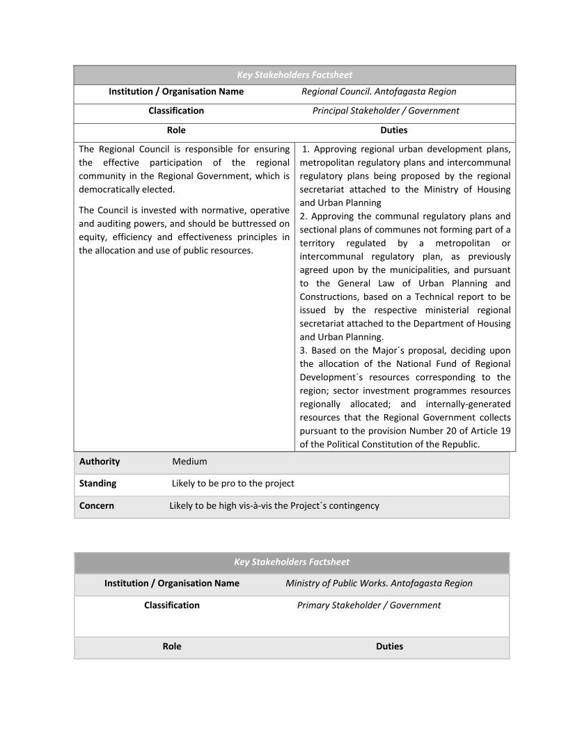
Key Stakeholders Factsheet
Institution / Organisation Name Regional Council. Antofagasta Region
Classification Principal Stakeholder / Government
Role Duties
The Regional Council is responsible for ensuring
the effective participation of the regional
community in the Regional Government, which is
democratically elected.
The Council is invested with normative, operative
and auditing powers, and should be buttressed on
equity, efficiency and effectiveness principles in
the allocation and use of public resources.
1. Approving regional urban development plans,
metropolitan regulatory plans and intercommunal
regulatory plans being proposed by the regional
secretariat attached to the Ministry of Housing
and Urban Planning
2. Approving the communal regulatory plans and
sectional plans of communes not forming part of a
territory regulated by a metropolitan or
intercommunal regulatory plan, as previously
agreed upon by the municipalities, and pursuant
to the General Law of Urban Planning and
Constructions, based on a Technical report to be
issued by the respective ministerial regional
secretariat attached to the Department of Housing
and Urban Planning.
3. Based on the Major´s proposal, deciding upon
the allocation of the National Fund of Regional
Development´s resources corresponding to the
region; sector investment programmes resources
regionally allocated; and internally-generated
resources that the Regional Government collects
pursuant to the provision Number 20 of Article 19
of the Political Constitution of the Republic.
Authority Medium
Standing Likely to be pro to the project
Concern Likely to be high vis-à-vis the Project´s contingency
Key Stakeholders Factsheet
Institution / Organisation Name Ministry of Public Works. Antofagasta Region
Classification Primary Stakeholder / Government
Role Duties
Recovering, strengthening up and moving along in the provision and management of infrastructure works and services for connectivity, protection of people and the territory, public building and the best use of water resources; ensuring the provision and care of water resources and the environment, to making a contribution to economic, social and cultural development, fostering equity, quality of life and equal opportunities for people.
The Ministry of Public Works is responsible for planning, design, construction, expansion, repair, preservation and operation of public works under its care, such as roads, highways, bridges, tunnels, airports, airfields, ramps, irrigation reservoirs, river defences, rainwater collectors, rural drinking water, new public building works, valuation of existing public patrimonial property, coastline, among others. Furthermore, it is responsible for the implementation of the Concessions Law and the Water Code. The Ministry also acts by mandate, since it is responsible for the survey, projection, construction, extension and repair of works commissioned by Ministries which, by Law, have been empowered to build works; the State institutions or companies; companies in which the State has an equity stake; the Regional Governments and the Municipalities; agreeing upon the works conditions, modalities and funding.
Authority High
Standing Likely to be pro to the project
Concern High
Key Stakeholders Factsheet
Institution / Organisation Name Ministry of the Environment
Classification Primary Stakeholder / Government
Role Duties
The Ministry of the Environment of Chile is the State body responsible for cooperating with the President of the Republic in drafting up and enforcing environmental policy, plans and programmes, as well as in the protection and conservation of biological diversity and Renewable natural resources and water, promoting sustainable development, the integrity of environmental policy and its normative regulation.
A particular duty concerning the Project is to
bringing forward Policy and formulating
climate change-addressed plans, programmes
and action plans. The Ministry´s competence
also entails co-operating with the different
State Administration organs at the national,
regional and local level, in order to determine
the bearing those entities have on the local
level, as well as to establishing adaptation and

mitigation measures as required.
Authority Medium/High
Standing Pro to the project
Concern High
Key Stakeholders Factsheet
Institution / Organisation Name ONEMI
Classification Primary Stakeholder / Government
Role Duties
The National Emergency Office of the
Ministry of Interior and Public Security is the
technical agency of the State of Chile
responsible for the coordination of the
National Civil Protection System. Its mission
is to plan, promote, articulate and
implement prevention, response and
rehabilitation actions in situations of
collective risk, emergencies, disasters and
catastrophes of natural origin or caused by
human action.
Its vision is to be the institution that leads at the national, regional and communal level the coordinated interaction of all members of the National Civil Protection System making Disaster Risk Reduction a national priority; Achieve sustainable development with resilient communities and be a benchmark in the management of the cycle of risks and emergencies.
Strategic pillars have been defined for ONEMI representing the strategic focus and the major issues of concern for the organisation. 1. Operational Excellence: High quality
management and productivity in the timely delivery of goods and services to the community.
2. Leadership in the National System for Civil
Protection: Articulating and coordinating stakeholders within the National System for Civil Protection.
3. Resilient Community: Encouraging the implementation of a preventive culture in the community.
Authority High
Standing Likely to be pro to the project
Concern Likely to be high

Key Stakeholders Factsheet
Institution / Organisation Name SHOA
Classification Primary Stakeholder / Government
Role Duties
The core mission of the Hydrographic and
Oceanographic Service attached to the Chilean
Navy is to supply technical elements,
information and technical assistance so as to
ensure safe navigation in waterways and lakes,
inland waters, territorial sea and in the high
seas adjacent to the Chilean seacoast.
Further, it is the official, technical and
permanent State service in all matters referring
to hydrography; maritime, river and lacustrine
hydrographic survey; nautical charting;
elaboration and publication of navigation
charts of national waters; oceanography,
planning and coordination of all oceanographic
activities related to physical-chemical research,
tides, currents and tsunamis; nautical
geography, navigation, astronomy, official time
signals, aerophotogrammetry applied to the
nautical chart.
SHOA is also responsible for advancing
research toward the implementation and
promotion of some other related national and
international activities, which are of particular
interest to the country.
Among Duties, the following are mentioned:
• Drafting up newsletters and publishing research
papers
• Teaching
• Publishing tides-related information
• Making Radio warnings
• Making Tsunami warnings
• El Niño Phenomenon
• Information on sea surface temperature
• Updating of navigation charts
Authority Medium
Standing Likely to be pro to, or Unconcerned to the project
Concern Likely to be High or Unconcerned

Key Stakeholders Factsheet
Institution / Organisation Name ASEMUCH Association of Municipalities in the
Antofagasta Region
Classification Backup Stakeholder / Non-Government
Role Duties
The Association´s general objectives are
based on helping facilitate the search for
solving common problems and making the
best use of resources available, ensuring the
promotion of municipal autonomy, local
interests, and a deepening of the democratic
process. The Board is made up of twelve (12)
members: nine mayors, and three councillors
representing member communes (each
councillor represents one of the three
provinces making up the Antofagasta
Region)
1. Making operational proposals vis-à-vis the Associations of municipalities contribution to decentralisation and sub-regional and local management. 2. Designing and implementing management tools suitable to the structure and duties of associations of municipalities. 3. Encouraging exchange of experiences and horizontal cooperation between municipal associations in the national and international setting. 4. Conducting capacity-building programmes on subjects related to associative management. 5. Management, monitoring and evaluation of the impact of the PFAM and the "Innovation and local entrepreneurship capital" finance funds. 6. Providing institutional support to the Associations of municipalities vis-à-vis their relationship with public institutions. 7. Technical assistance to Associations of municipalities so that they are granted legal status and management of the Private Law Corporation " instrument. 8. Managing the "Single Register of Municipal Associations with Legal Status".
Authority Medium
Standing Likely to be pro, or Unconcerned to the project, since management is
Focused on strengthening up the municipal administration
Concern Likely to be High or Unconcerned

Key Stakeholders Factsheet
Institution / Organisation Name Ministry of Housing and Urban Planning
Classification Primary Stakeholder / Government
Role Duties
Providing access to quality housing solutions and contributing to the establishment of equitable, integrated and sustainable neighbourhoods and cities, in line with decentralisation, participation and development criteria, so that people, families and communities may improve their quality of life and enhance their wellbeing
1. Reducing the housing deficit of most vulnerable
sectors.
2. Recovering neighbourhoods, with a focus on
vulnerable people living under dilapidating
housing and / or urban decay conditions;
generating investments that reduce common
spaces deficit, strengthening up social networks
and allowing for a balanced insertion of these
people in the cities.
3.- Ensuring the development of cities, fostering
the way they are planned, increasing investment
in infrastructure for connectivity, and public
spaces encouraging social integration.
4.- Providing citizens with quality products and
services in housing areas, neighbourhoods and
city, by means of the implementation of a quality
management system.
5.- Warranting proper and timely standardised
information to citizens. and strengthening up
instances for responsible participation in the
management and use of investments in housing,
neighbourhoods and city.
Authority Medium
Standing Likely be pro or Unconcerned to the project, since management is
Focused on strengthening up municipal management.
Concern Likely to be High or Unconcerned

Key Stakeholders Factsheet
Institution / Organisation Name Antofagasta Municipality
Classification Primary Stakeholder / Government
Role Duties
Las Municipalities are autonomous public-law corporations with a legal status and their own equity, the end goal of which is to addressing the needs of the local community and ensure its participation in the economic, social and cultural progress of the communes concerned
1. Drafting up, approving and revising the communal development plan the implementation of which should be in line with regional and national plans; 2. The commune´s planning and regulation and the drafting up of the communal regulatory plan, in accordance with legal regulations in force; 3. The promotion of community development; 4. To enforce provisions on public transport and transit within the commune, in line with the wording of the laws and general technical standards enacted by the ministry concerned; 5. To enforce provisions on construction and urban planning as stipulated by Law, and subject to the general technical standards being issued by the ministry concerned; and 6. Cleaning and Ornate of the commune.
Authority High (at communal level)
Standing Likely to be pro to the project, since its organisation chart includes an
Emergency and Operations Management.
Concern High
Key Stakeholders Factsheet
Institution / Organisation Name Emergency and Operations Management
Antofagasta Municipality
Classification Primary Stakeholder / Government
Role Duties
Having access to an administrative and
executive system which, in general, is
equipped with the human and material
resources required to addressing community
emergency situations and, in particular, to
undertaking preventive action tasks in the
1. Designing and putting forward an Emergency
Communal Plan and / or its subsequent changes.
2. Coordinating preventive communal emergency
action with the provincial and regional emergency
offices.
3. Undertaking at communal level all those

event of catastrophes and mass accidents.
Whenever the municipality operational
capacity is exceeded, undertaking
precautionary measures vis-à-vis the
maintenance of the municipal heritage
through a direct and subsidized action.
preventive actions allowing for the community to
be prepared in case of possible mass accidents or
catastrophes.
4. Operating an emergency items provisioning and
storage system, allowing to address those
shortages arising from mass accidents or
catastrophes.
5. Having a human team equipped with material
resources to efficiently and in a timely manner
react in emergency situations such as: storms,
earthquakes, tsunamis, etc.
6. Carrying out tasks addressing the availability and
use of the Municipality’s communication means.
7. Programming and controlling industrial safety
systems designed to prevent risks and
contingencies to which municipal officials,
infrastructure, and material resources could be
exposed.
8. Supplying materials and equipment required in
ceremonies and special events likely to be held at
the Municipality premises, or somewhere else
under the Municipality´ sponsorship.
9. Directing, coordinating and monitoring the
maintenance, security and cleanliness of municipal
premises.
10. Directing, coordinating and monitoring the
work of local agencies, butlers, and stewards at
municipal premises.
11. Providing ongoing attention on the proper
working and conditions of municipal offices,
through basic services carpentry, electricity,
plumbing, and others.
12. Managing workforce contractual arrangements
for minor works being overseen by the Municipal
Production Centre (CEPRO) unit, or any other
similar unit that is set up and arranged to
implementing light infrastructure plans, supplying
assistance, repair and maintenance of Real estate
owned by the Municipality.
13. Other duties as may be assigned by Law or by
the higher authority.
Authority Medium
Standing Likely to be pro to the project, since its organisation chart includes
An Emergency and Operations Management.
Concern High
Key Stakeholders Factsheet
Institution / Organisation Name The Environment, Cleaning and Ornate
Management, Municipality of Antofagasta
Classification Primary Stakeholder / Government
Role Duties
The purpose of the Environment, Cleaning and Ornate Department is to enforce environmental regulations to be implemented in the commune, and these are the responsibility of Municipal authorities; they involve, cleaning of public roads, parks, squares, gardens and, in general, all public use, and municipal administration goods existing in the commune; construction, preservation and management of green areas, and oversight of the final disposal site of solid wastes being produced in the commune.
1. Putting forward and applying measures intended to implement environment-related actions and programmes. 2. Enforcing environmental regulations in the commune. Applying environmental standards to be implemented in the commune that are within its competence. 3. Drafting up the preliminary environmental ordinance project. 4. With own resources or through third parties, taking care of the cleaning of public roads, parks, squares, gardens and, in general, of the national assets for public, and municipal administration use, existing in the commune. 5. Monitoring with own resources or through third parties, the collection service, transport and disposition of solid household waste. 6. Monitoring with own resources or through third parties, the administration of the final disposal site of solid household waste. 7. Ensuring the construction, preservation and management of green areas in the commune. 8. Drafting up the technical basis regarding cleaning, green areas and other services concessions for which Management is responsible. 9. Proposing to the Mayor's authority, for further enforcement, regulations conducive to
the maintenance of the cleanliness of the city. 10. Providing backup in all emergency situations, with all the human and material resources attached to the Mayor´s office, in order to provide aid to the affected community, according to the Mayor´s instructions or orders.
Authority Medium
Standing Likely to be pro to the project, since this Unit could be involved in
the construction of green areas, afforestation programmes, and cleaning
of streams, or areas to be intervened.
Concern Likely to be High
Key Stakeholders Factsheet
Institution / Organisation Name Green Antofagasta Programme, DIDECO.
Municipality of Antofagasta
Classification Backup Stakeholder / Government
Role Duties
Generating instances for dialogue,
consultation and neighbourhood
participation in environmental issues
through making proposals and community
projects that empower organisations in
solving their environmental problems,
incorporating the community´s own
capacities and tools for an autonomous
management of their own problems, needs
and initiatives.
1. Identifying and attaching priority to collective needs vis-à-vis the quality of life and the setting where the population live, bearing in mind both, the dispersion and segregation prevailing in the commune, and their differences and contrasts. 2. Advising social organisations and their leaders in the drafting up of participative proposals which are in line with the needs detected and prioritized. 3. Advising social organisations and their leaders in the drafting up of social projects for further submission to current Competitive Funds, incorporating the environmental dimension in their intervention lines. 4. Empowering civil society through awareness-raising and environmental education activities, as well as courses and workshops aimed at generating key knowledge for the sustainable development of their territory, as well as improving quality of life of people.

5. Fostering actions and habits addressed to generating more respectful behaviours to the environment, through educational actions, contests and projects aimed at achieving this purpose.
Authority Medium
Standing Likely to be pro to the project, since Duties are directly linked to awareness-
rising and education of the community vis-à-vis the environment.
Concern Se deduce que High
Key Stakeholders Factsheet
Institution / Organisation Name FIREFIGHTING BRIGADE
Municipality of Antofagasta
Classification Backup Stakeholder / Government
Role Duties
To bolster integration, involvement and development of neighbours in a locality. The neighbourhood council is constituted and made operational on the basis of By-laws, which have a legal basis, but may be subject to the particular forms of an organisation.
Acting on behalf of neighbours before the authorities to achieving development agreements. • Managing problem solving with the authorities. • Putting forward and implementing projects that benefit the neighbours. • Identifying infrastructure deficiencies (sewage, lighting, etc.), among others.
Authority Low
Standing Pro
Concern High / Unconcerned

Key Stakeholders Factsheet
Institution / Organisation Name Mounted Police of Chile
Classification Backup Stakeholder / Non-Government
Role Duties
The Chilean Mounted Policy is in place to attach effectiveness to Law; warrant public order, and internal public security throughout the Republic Territory.
Duties involve working lines as follows:
- Crime prevention
- Investigation
- National Integration
- Education
- Social solidarity
- Public security
- Control of public order
Authority Low
Standing Pro to the project
Concern High / Unconcerned
Key Stakeholders Factsheet
Institution / Organisation Name Armed Forces of Chile
Classification Backup Stakeholder / Non-Government
Role Duties
The Armed Forces of Chile are made up by
the Army (1810), the Navy (1817) and the
Air Force (1930), and are attached to the
National Defence Ministry. The
Constitution entrusts them with the
defence of the country, setting forth its
essential nature vis-à-vis national security.
Their Duties are mainly addressed to maintenance of the order. This is the reason why it is essential to understand the duty according to which the Armed Forces, subordinated to civil power, abide by the latter´s order to act in some extreme case, in which the validity of the Constitution and laws, or even the very existence of the State, may be at risk because of a threat from within the country. The Armed Forces must then fulfil the orders of the constituted powers and act in the internal setting, which apparently is foreign to them. It goes without saying that this extreme resource shall be resorted to by the legally constituted authority whenever all other dissuasive and repressive alternatives available to the State have been surpassed.
Authority Low

Standing Pro
Concern High / Unconcerned
Key Stakeholders Factsheet
Institution / Organisation Name Overcoming Poverty Foundation
Classification Backup Stakeholder / Non-Government
Role Duties
The Overcoming Poverty Foundation (FSP,
for its acronym in Spanish) is a private,
non-profit and public-interest institution,
established in 1994. The FSP contribution
to national development is buttressed on
action and knowledge generation, tools
and proposals addressed to policy and
social intervention with a view to
overcoming poverty and social exclusion.
Our mission is to fostering enhanced equity and social integration in the country so as to ensure a sustainable development of people living in poverty and social exclusion. A key factor in shaping up our strategic identity has been the option to calling upon young people who are undertaking their professional capacity-building to get involved in COUNTRY SERVICE as professionals, practitioners, or volunteers, contributing as direct intervention agents. To achieve this goal, we are being backed up by the State of Chile, through the inclusion of some in the Budget of the Nation Law of a pool of funds for the FSP.
1. Country Service
2. Country Proposals (Thesis): The Country
Thesis programme is set up within the
framework of these goals. Young pre- and post-
graduate students are invited to get involved
year after year; they are also encouraged to
writing their thesis work and papers with a
particular focus on poverty, social policy, equity
and social integration, with a more in-depth
approach into the theoretical, methodological
and practical knowledge about the poverty
phenomenon, its manifestations, constraints,
and coping strategies, within the framework of
FSP national and regional objectives and
priorities. At the same time, Country Thesis
seeks to having a bearing on student capacity-
building, contributing to the awareness and
motivation of new professionals vis-à-vis an
understanding and intervention of the poverty
phenomenon of poverty and its solution.
3. Communication and Poverty Alliance: To
provide communication-focused journalists and
students with tools allowing them to address
from a qualified perspective those issues related
to social exclusion, poverty, and how to
overcome them.
Authority Low
Posición Standing Likely to be pro or Unconcerned, depending upon whether the project is
executed in an area where the Foundation is undertaking community work.

Concern High or Unconcerned
Key Stakeholders Factsheet
Institution / Organisation Name Christ Home Foundation
Classification Backup Stakeholder / Non-Government
Role Duties
The Christ Home Foundation is a private, non-profit and public-interest institution, established in 1994. The Christ Home contribution to national development is buttressed on action and knowledge generation, tools and proposals addressed to policy and social intervention with a view to overcoming poverty and social exclusion. Our mission is to fostering equity and social integration in the country so as to ensure a sustainable development of people living in poverty and social exclusion. A key factor in shaping up our strategic identity has been the option to calling upon young people who are undertaking their professional capacity-building to get involved in COUNTRY SERVICE as professionals, practitioners, or volunteers, contributing as direct intervention agents. To achieve this goal, we are being backed up by the State of Chile, through the inclusion of some in the Budget of the Nation Law of a pool of funds for Christ Home.
1. Country Service
2. Country Proposals (Thesis): The Country
Thesis programme is set up within the
framework of these goals. Young pre- and post-
graduate students are invited to get involved
year after year, they are also encouraged to
writing their thesis work and papers with a
particular focus on poverty, social policy, equity
and social integration, with a more in-depth
approach into the theoretical, methodological
and practical knowledge about the poverty
phenomenon, its manifestations, constraints,
and coping strategies, within the framework of
FSP national and regional objectives and
priorities. At the same time, Country Thesis
seeks to having a bearing on student capacity-
building, contributing to the awareness and
motivation of new professionals vis-à-vis an
understanding and intervention of the poverty
phenomenon of poverty and its solution.
3. Communication and Poverty Alliance: To provide communication-focused journalists and students with tools allowing them to address from a qualified perspective those issues related to social exclusion, poverty, and how to overcome them.
Authority Low
Posición Standing Likely to be in favour or unconcerned, depending upon whether the Project is
executed in an area where the Foundation is operating.
Concern Likely to be Unconcerned or Low

Key Stakeholders Factsheet
Institution / Organisation Name A ROOF FOR CHILE Foundation
Classification Backup Stakeholder / Non-Government
Role Duties
The Roof for Chile Foundation (RFCh, for its acronym in Spanish) is a private, non-profit and public-interest institution, established in 1994. The RFCh contribution to national development is buttressed on action and knowledge generation, tools and proposals addressed to policy and social intervention with a view to overcoming poverty and social exclusion. Our mission is to fostering equity and social integration in the country so as to ensure a sustainable development of people living in poverty and social exclusion. A key factor in shaping up our strategic identity has been the option to calling upon young people who are undertaking their professional capacity-building to get involved in COUNTRY SERVICE as professionals, practitioners, or volunteers, contributing as direct intervention agents. To achieve this goal, we are being backed up by the State of Chile, through the inclusion of some in the Budget of the Nation Law of a pool of funds for RFCh.
1. Country Service
2. Country Proposals (Thesis): The Country
Thesis programme is set up within the
framework of these goals. Young pre- and post-
graduate students are invited to get involved
year after year, they are also encouraged to
writing their thesis work and papers with a
particular focus on poverty, social policy, equity
and social integration, with a more in-depth
approach into the theoretical, methodological
and practical knowledge about the poverty
phenomenon, its manifestations, constraints,
and coping strategies, within the framework of
FSP national and regional objectives and
priorities. At the same time, Country Thesis
seeks to having a bearing on student capacity-
building, contributing to the awareness and
motivation of new professionals vis-à-vis an
understanding and intervention of the poverty
phenomenon of poverty and its solution.
3. Communication and Poverty Alliance: To provide communication-focused journalists and students with tools allowing them to address from a qualified perspective those issues related to social exclusion, poverty, and how to overcome them.
Authority Low
Posición Standing Likely to be in favour or Unconcerned, depending upon whether the Project
is executed in an area where the organisation is operating.
Concern Likely to be Unconcerned or Low

Key Stakeholders Factsheet
Institution / Organisation Name FRACTAL Schools
Classification Backup Stakeholder / Non-Government
Role Duties
To be a group which, through a
critical praxis, makes a
contribution to implementing
processes for change in a search
for a society which is buttressed
on good living.
FRACTAL Action lines are: - Childhood: Schools buttress their work on a Children's and Youngers´ Rights outlook, and on the Non-formal and Intercultural Education Model. Current objectives are as follows: a) Making a contribution to creating a space for participation, expression and development, that is managed and organised by youngsters, girls and boys living in the Villa Esperanza Shantytown; b) Together with group members, generating significant instances for individual and collective development that is buttressed on respect, acceptance, aesthetic exploration, and strengthening up of the individual; c) Urging the implementation of spaces for active participation by Latin American migrant children. - Migration: The migration line was set up in late April 2013, originating on the concern of group members and independent individuals for the migration situation of South American men and women who have arrived in the country and in the region, and who are enduring social, labour and educational precariousness conditions. - Student education: The adult education area was set up in 2013, as a literacy instance based on the concern shown by people living in the Bonilla alto sector, who expressed their interest in solving the educational needs of many of them, who do not know how to read and write. - Extension: We understand it as a process and strategy allowing us to bringing to public debate those issues and problems concerning us and / or that are associated with our community praxis. In this sense, the extension activities seek to address the current work being undertaken by the social area, and helping make visible the group standing as a viable social work alternative. Critical and with an emancipatory perspective.
Authority Low
Posición Standing Likely to be pro or Unconcerned, depending upon whether the project is
executed in an area where FRACTAL is operating.
Concern Likely to be Unconcerned or Low

Key Stakeholders Factsheet
Institution / Organisation Name CULTAM
Classification Backup Stakeholder / Non-Government
Role Duties
CULTAM, is a private, autonomous, non-for profit entity, not related to any political and / or religious doctrine, the purpose of which is to promote and encourage within the community the appreciation, conservation and sustainable use of the cultural and natural heritage of the Great North of Chile, through the design, management and execution of projects, the implementation of surveys, consultancy, services, or strategies.
Production of educational material, talks, capacity-building, and holding of events. Its members are professionals working in fields such as culture, environment, and education, with a strong background in project formulation and execution.
Authority Low
Posición Standing Likely to be pro or Unconcerned, depending upon whether the project is
executed in an area where CULTAM is operating.
Concern Likely to be Unconcerned or Low
Key Stakeholders Factsheet
Institution / Organisation Name CREO Antofagasta
Classification Backup Stakeholder / Non-Government
Role Duties
CREO Antofagasta is a Project the end goal of which is to addressing the growth challenge the city is facing, with a strong sense of improvement in the community quality of life. The Creo Antofagasta´s aim is to envisioning a city in which we want to live, through a Master Plan setting forth a sustainable urban growth of Antofagasta up to year 2035.
To accomplishing the end goal to building up a city that becomes into a national and international model, the Project works on the basis of a public-private governance system incorporating Regional Government stakeholders, the Municipality of Antofagasta, and the community as a whole, so that through a participatory dialogue, the needs and expectations of all those people making up the city are fully met. The Project management entails the involvement of: - A public-private Committee

- An Executive Committee - A Working Team The Executive Committee is coordinated by the CREO Antofagasta Plan Chairman, the Mayor, and the Intendent.
Authority Medium / High
Standing Likely to be in favour
Concern Likely to be High
Key Stakeholders Factsheet
Institution / Organisation Name My Park Foundation
Classification Backup Stakeholder / Non-Government
Role Duties
This Foundation seeks to creating a community sense through the participatory recovery of Green areas in neglected neighbourhoods needing Green areas the most.
Drafting up a “Green Squares” project:
- Seeking funds.
- Involving municipalities in a search for land and maintenance of Green areas.
- Participatory design.
- Accompaniment, seeking to set up a neighbourhood committee to be in charge of the protection, care and implementation of the new Green Square.
Drafting up projects for “Educational Backyards”:
- Fund-rising
- Selection of communities: Gardens or schools interested in improving their backyards
Participatory design
Participatory construction
Accompaniment.
Authority Low
Posición Standing Likely to be pro or Unconcerned, depending upon whether the project is
executed in an area where My Park Foundation is operating.
Concern Likely to be Unconcerned or Low

Key Stakeholders Factsheet
Institution / Organisation Name Antofagasta Productive Development Corporation
Classification Backup Stakeholder / Non-Government
Role Duties
A private non-profit organisation working
on the Sustainable Development of the
Antofagasta Region, and cooperating with
socially responsible entities in the design,
execution and evaluation of surveys,
projects and shared-value programmes.
Thus, the organisation seeks to
contributing to policymaking and design of
strategic definitions for regional
development.
Making a contribution to the sustainable development of the Antofagasta Region, on the basis of projects and programmes, incorporating as strategic guidelines those being set forth in the Regional Development Strategy, as follows:
• - Education: Building up an innovative human capital. Comprehensive development of people.
• - A sustainable region: Ensuring the environmental sustainability of the territory.
• - Social cohesion and quality of life: Social cohesion to improving quality of life within the framework of a development-generating economic growth.
• - Territorial economic development: Cluster consolidation; productive diversification; entrepreneurship.
• - Economic integration: Consolidating and strengthening up the region´s internationalisation as a business platform.
• - Updating and participation: Integration of the different territorial stakeholders vis-à-vis regional development.
• - Regional Identity: Based on rescuing and appraisement of the natural, historical, and cultural heritage.
Authority Low
Standing Likely to be pro or Unconcerned, depending upon whether the Project
is executed in an area where the Corporation is operating.
Concern Likely to be Unconcerned or Low
Key Stakeholders Factsheet
Institution / Organisation Name CEITSAZA. Northern Catholic University

Classification Backup Stakeholder / Non-Government
Role Duties
The Desert Water Technology Research Centre, (CEITSAZA, for its acronym in Spanish) is working on research and technological development toward an environmentally-friendly sustainable and efficient management of water resources, mainly in arid areas. The CEITSAZA´s key objective is to be the leading institution working in research and technological development for a sustainable and efficient management of water resources, which is based on innovation, protection, and respect for both, people and the environment.
The Centre is meeting its objective to assessing and projecting the availability of water resources by generating management indicators buttressing decision-making; the Centre further develops technological solutions vis-à-vis the use of the resource, and makes a contribution to the strengthening up regional capacity. The Centre working areas are:
• Water treatment
• Mining
• Agriculture
Authority Low
Standing Likely to be pro or Unconcerned, depending upon whether the Project
is executed in an area where CEITSAZA is operating (green areas).
Concern Likely to be Unconcerned or Low
Key Stakeholders Factsheet
Institution / Organisation Name Shantytown Eradication Plan
Regional Government(REGO)
Classification Backup Stakeholder / Non-Government
Role Duties
The regional government office in charge of
the local shantytown area-related matters
was established some three years ago, as an
outcome of a demographic explosion the city
has sustained on account of the proliferation
of illegal settlements in the city.
This office is responsible for identifying and characterizing shantytowns in the city, the number of which has grown to more than 40 settlements, housing more than 4000 people living in below-normal conditions, without access to basic utilities.
- Getting in close contact with the population identified
- Making a diagnosis and a characterisation of their situation
- Addressing key demands of the population
- Giving an early warning in case of risks
Authority Medium
Standing Pro
Concern Likely to be High, since the Project would benefit people in shantytowns who could
be at risk
Key Stakeholders Factsheet
Institution / Organisation Name Women United Shantytown
Classification Backup Stakeholder / Non-Government
Role Duties
The aim of this institution is to regularise housing demands for a group of people. Established in 2006, this institution is currently housing about 40 people, more than half of whom are migrants from Colombia, Peru and Bolivia)
Unifying the housing demand for a group of people. Following the regular channels through the Ministry of Housing and Urban Planning MHUP to qualify for housing funding and benefits. Coordinating shantytown activities.
Authority Low
Standing Pro
Concern High
Key Stakeholders Factsheet
Institution / Organisation Name Officer in charge of shantytowns. Municipality of
Antofagasta (I.M.A.)
Classification Backup Stakeholder / Non-Government
Role Duties
Unit attached to DIDECO Community
Organisations, which is in charge of
coordinating and addressing demands,
consultations, etc. from these functional
organisations made up of people living in
shantytowns.
Guidance vis-a-vis the legal constitution of the organisation. Consultation guidance. Addressing needs in case of emergency. Keeping a cadastre record of shantytowns in the city, their location, organisational system, contact with leaders. Beneficiaries of municipal activities.

Authority Low
Posición Standing Likely to be pro or Unconcerned, depending upon whether the Project is
to be executed in an area being intervened by the DIDECO.
Concern Likely to be Unconcerned or Low
Key Stakeholders Factsheet
Institution / Organisation Name Board of Neighbours CaRol Urzúa
Classification Backup Stakeholder / Non-Government
Role Duties
To foster integration, participation and advance of neighbours in a community. Neighbours boards are made up and work on the basis of By-laws which, while having a legal basis, may be subject to particular organisational ways.
- Representing neighbours before the authorities to having access to development agreements.
- Managing the solution of problems before concerned authorities.
- Putting forth and implementing projects to the benefit of neighbours.
- Identifying infrastructure deficiencies (sewerage, lighting, etc.), among others.
Authority Low
Posición Standing Likely to be pro or Unconcerned, depending upon whether the Project is
to be executed in an area being intervened by the Board of Neighbours.
Concern Likely to be Unconcerned or Low
Key Stakeholders Factsheet
Institution / Organisation Name Board of Neighbours Esperanza Nuestra
Classification Backup Stakeholder / Non-Government
Role Duties
To foster integration, participation and advance of neighbours in a community. Neighbours boards are made up and work on the basis of By-laws which, while
• Representing neighbours before the authorities to having access to development agreements.
- Managing the solution of problems before
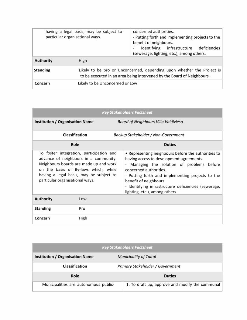
having a legal basis, may be subject to particular organisational ways.
concerned authorities.
- Putting forth and implementing projects to the benefit of neighbours. - Identifying infrastructure deficiencies (sewerage, lighting, etc.), among others.
Authority High
Posición Standing Likely to be pro or Unconcerned, depending upon whether the Project is
to be executed in an area being intervened by the Board of Neighbours.
Concern Likely to be Unconcerned or Low
Key Stakeholders Factsheet
Institution / Organisation Name Board of Neighbours Villa Valdivieso
Classification Backup Stakeholder / Non-Government
Role Duties
To foster integration, participation and advance of neighbours in a community. Neighbours boards are made up and work on the basis of By-laws which, while having a legal basis, may be subject to particular organisational ways.
• Representing neighbours before the authorities to having access to development agreements.
- Managing the solution of problems before concerned authorities.
- Putting forth and implementing projects to the benefit of neighbours. - Identifying infrastructure deficiencies (sewerage, lighting, etc.), among others.
Authority Low
Standing Pro
Concern High
Key Stakeholders Factsheet
Institution / Organisation Name Municipality of Taltal
Classification Primary Stakeholder / Government
Role Duties
Municipalities are autonomous public- 1. To draft up, approve and modify the communal

law corporations with legal personality and their own assets, whose purpose is to meeting the needs of the local community and ensuring their participation in the economic, social and cultural progress of the respective communes
development plan the implementation of which should be in agreement with regional and national plans; 2. The planning and regulation of the commune and the drafting up of the communal regulatory plan, in accordance with current legal norms; 3. The promotion of community development; 4. To enforce public transport and transit provisions within the commune, in a way pursuant to the laws and technical standards of a general nature as stipulated by the respective ministry; 5. To apply provisions ruling construction and urban planning, in the way determined by law, and subject to the general technical standards as stipulated by the respective ministry, and 6. Cleaning and decoration of the commune.
Authority High (at communal level)
Standing Pro
Concern High
Key Stakeholders Factsheet
Institution / Organisation Name Board of Neighbours Gabriela Mistral. Taltal
Classification Backup Stakeholder / Non-Government
Role Duties
To promoting the integration, participation and development of neighbours in a community. The Neighbourhood Board is constituted and operates on the basis of the Board´s own By-laws, which, while having a legal basis, may be subject to particular organisational standards.
• Representing neighbours before the authorities to entering into development agreements. • Managing problem solving before the authorities. • Proposing and executing projects beneficial to the community. • Identifying infrastructure deficiencies (sewage, lighting, etc.), among others.
Authority Low
Standing Pro
Concern High

Key Stakeholders Factsheet
Institution / Organisation Name Vista Hermosa Shantytowns (Taltal)
Classification Backup Stakeholder / Non-Government
Role Duties
To promoting the integration, participation and development of neighbours in a community. The Neighbourhood Board is constituted and operates on the basis of the Board´s own By-laws, which, while having a legal basis, may be subject to particular organisational standards.
• Representing neighbours before the authorities to entering into development agreements. • Managing problem solving with vis-a-vis authorities. • Proposing and executing projects beneficial to the community. • Identifying infrastructure deficiencies (sewage, lighting, etc.), among others.
Authority Low
Standing Pro
Concern High
Key Stakeholders Factsheet
Institution / Organisation Name Board of Neighbours Juan Cortés Shantytown (Taltal)
Classification Backup Stakeholder / Non-Government
Role Duties
To promoting the integration, participation and development of neighbours in a community. The Neighbourhood Board is constituted and operates on the basis of the Board´s own By-laws, which, while having a legal basis, may be subject to particular organisational standards.
• Representing neighbours before the authorities to entering into development agreements. • Managing problem solving with vis-a-vis authorities. • Proposing and executing projects beneficial to the community. • Identifying infrastructure deficiencies (sewage, lightening, etc.), among others.
Authority Low
Standing Pro
Concern High

4.1.2. Summary Table
Summary table below has been constructed on the basis of Key Stakeholders Datasheets as above,
showing itemised data, such as: Name, category, incidence level, authority, standing, and concern.
Antofagasta Case
Institution Name Category Incidence
Level
Authority Standing Concern
Regional Government Basic/Government Regional High Pro High
Major Basic/Government Regional High Pro High
Regional Council Basic/Government Regional Medium Pro High
Ministry of Public
Works
Basic/Government Regional/
National
High Pro High
Ministry of the
Environment
Basic/Government Regional/
National
Medium/
High
Pro High
ONEMI Basic/Government National/
Regional/
Communal
High Pro High
SHOA Basic/Government National Medium Pro High
ASEMUCH Backup/Non-
Government
Regional Medium/
low
Pro Unconcerned
Ministry of
Housing and
Urban Planning
Basic/Government Regional/
National
Medium/
High
Pro High
Municipality of
Antofagasta
Basic/Government
Communal
High (at communal
level)
Pro High
Emergencies and
Operations
Directorate
(I.M.A.)
d Basic/Government Communal Medium Pro High
Environment, Cleaning, and Ornate Directorate (I.M.A.)
Backup/Government Communal Medium Pro High/Unconcerned
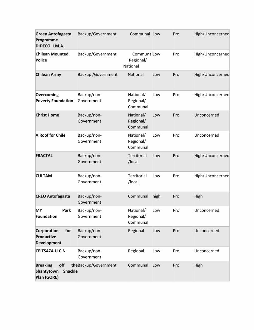
Green Antofagasta
Programme
DIDECO. I.M.A.
Backup/Government Communal Low Pro High/Unconcerned
Chilean Mounted
Police
Backup/Government Communal
Regional/
National
Low Pro High/Unconcerned
Chilean Army Backup /Government National Low Pro High/Unconcerned
Overcoming
Poverty Foundation
Backup/non-
Government
National/
Regional/
Communal
Low Pro High/Unconcerned
Christ Home Backup/non-
Government
National/
Regional/
Communal
Low Pro Unconcerned
A Roof for Chile Backup/non-
Government
National/
Regional/
Communal
Low Pro Unconcerned
FRACTAL Backup/non-
Government
Territorial
/local
Low Pro High/Unconcerned
CULTAM Backup/non-
Government
Territorial
/local
Low Pro High/Unconcerned
CREO Antofagasta Backup/non-
Government
Communal high Pro High
MY Park
Foundation
Backup/non-
Government
National/
Regional/
Communal
Low Pro Unconcerned
Corporation for
Productive
Development
Backup/non-
Government
Regional Low Pro Unconcerned
CEITSAZA U.C.N. Backup/non-
Government
Regional Low Pro Unconcerned
Breaking off the
Shantytown Shackle
Plan (GORE)
Backup/Government Communal Low Pro High

Officer in charge of
Shantytowns I.M.A.
Backup/Government Communal Low Pro High/Unconcerned
Shantytowns Women
United
Basic/Non-Government Territorial
/local
Low Pro High
JJ.VV. CaRoleUrzúa Basic/non-Government Territorial
/local
Low Pro High
JJ.VV. Esperanza
Nuestra
Basic/non-Government Territorial
/local
Low Pro High
JJ.VV. Villa
Valdivieso
basic/non-Government Territorial
/local
Low Pro High
Some other Stakeholders in the Territory:
• JJ.VV. Cardenal Zamoré
• JJ.VV. Villa México
• JJ.VV. Villa Alemania
• JJ.VV. Bonilla High
• JJ.VV. Bonilla Low
• JJ.VV. Jorge Alessandri
• JJ.VV. Rubén Infanta
• Seniors Home (municipality)
• Shantytown Víctor Jara
• Shantytown Villa Esperanza
Taltal Case
Institution Category Impact Authority Standing Concern
Firefighting
Brigade
Backup/Non-
Government
Communal/Regio
nal/National
Low Pro High/Unconcerned
Taltal
Municipality
Basic/Government Communal High (at
comunal
level)
Pro High
JJ.VV. Gabriela
Mistral
Basic/non-
Government
Territorial/local Low Pro High
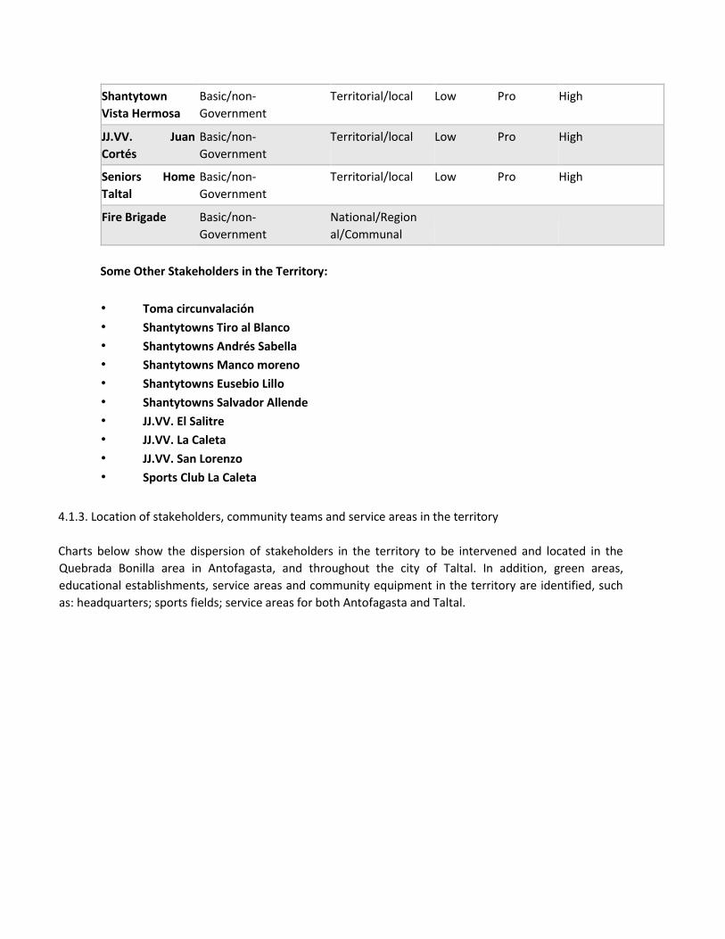
Shantytown
Vista Hermosa
Basic/non-
Government
Territorial/local Low Pro High
JJ.VV. Juan
Cortés
Basic/non-
Government
Territorial/local Low Pro High
Seniors Home
Taltal
Basic/non-
Government
Territorial/local Low Pro High
Fire Brigade
Basic/non-
Government
National/Region
al/Communal
Some Other Stakeholders in the Territory:
• Toma circunvalación
• Shantytowns Tiro al Blanco
• Shantytowns Andrés Sabella
• Shantytowns Manco moreno
• Shantytowns Eusebio Lillo
• Shantytowns Salvador Allende
• JJ.VV. El Salitre
• JJ.VV. La Caleta
• JJ.VV. San Lorenzo
• Sports Club La Caleta
4.1.3. Location of stakeholders, community teams and service areas in the territory
Charts below show the dispersion of stakeholders in the territory to be intervened and located in the
Quebrada Bonilla area in Antofagasta, and throughout the city of Taltal. In addition, green areas,
educational establishments, service areas and community equipment in the territory are identified, such
as: headquarters; sports fields; service areas for both Antofagasta and Taltal.

Antofagasta Map
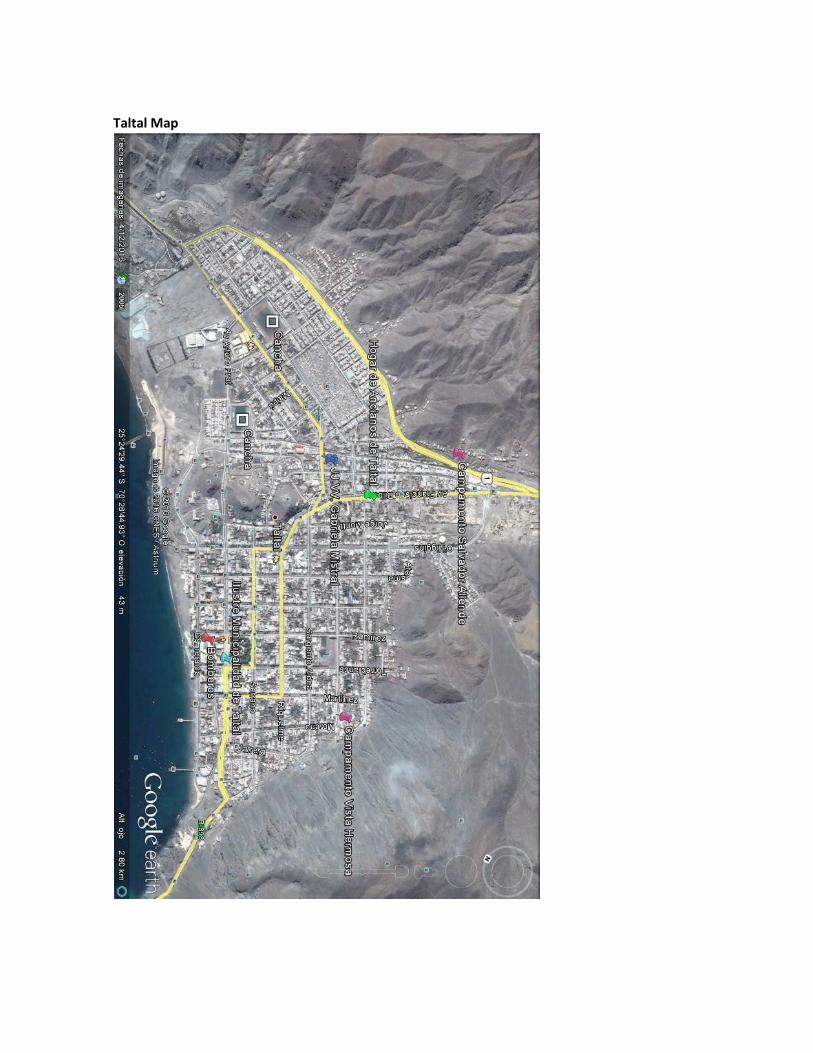
Taltal Map

Taltal Shantytowns

4.1.4. Review of Predominant and Power-based Relations
Some trend-focused relations of power dynamics, and predominant relations being held among
stakeholders, and consolidated in figures and a matrix recording stakeholders´ dispersion based
on predominant relations and stakeholders power ranking for Antofagasta and Taltal are shown
below.
Figure-based Consolidation; The Antofagasta Case
Figure below shows the relationship between primary, secondary and backup stakeholders linked
to the measurements. Results show a leadership of backup stakeholders with a 53% ranking.
The institutional level of stakeholders´ distribution was identified insofar primary stakeholders
show a distribution with a 21% differentiation in their concentration, ranking first position with
71% vis-à-vis Government-linked stakeholders.
47 %
0 %
53 %
Spatial Linkage Relationship
Basic Secundary Backup
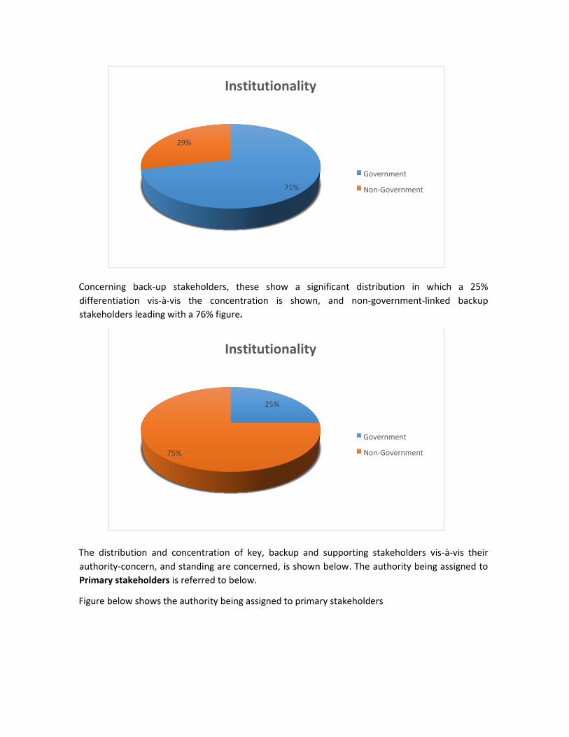
Concerning back-up stakeholders, these show a significant distribution in which a 25%
differentiation vis-à-vis the concentration is shown, and non-government-linked backup
stakeholders leading with a 76% figure.
The distribution and concentration of key, backup and supporting stakeholders vis-à-vis their
authority-concern, and standing are concerned, is shown below. The authority being assigned to
Primary stakeholders is referred to below.
Figure below shows the authority being assigned to primary stakeholders
25 %
75 %
Institutionality
Government
Non-Government
71 %
29 %
Institutionality
Government
Non-Government
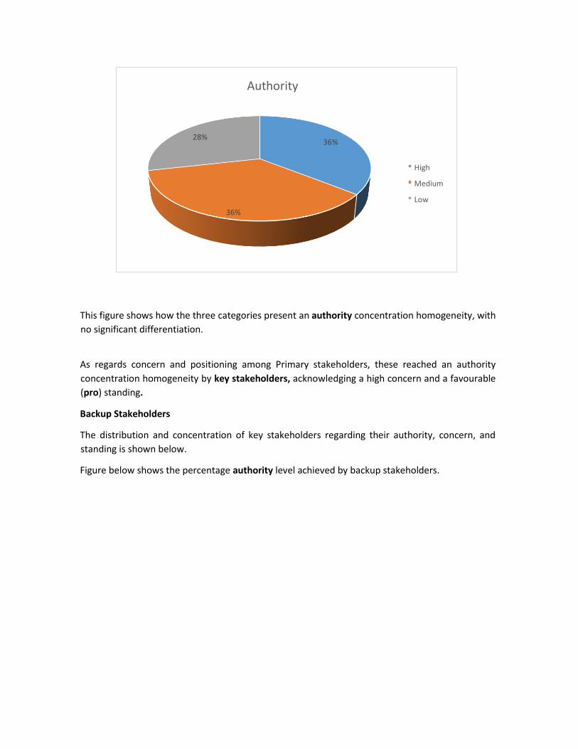
This figure shows how the three categories present an authority concentration homogeneity, with
no significant differentiation.
As regards concern and positioning among Primary stakeholders, these reached an authority
concentration homogeneity by key stakeholders, acknowledging a high concern and a favourable
(pro) standing.
Backup Stakeholders
The distribution and concentration of key stakeholders regarding their authority, concern, and
standing is shown below.
Figure below shows the percentage authority level achieved by backup stakeholders.
36 %
36 %
28 %
Authority
High
Medium
Low

This figure shows how backup stakeholders present a low authority level, leading with 88% and a
38 % differentiation
Figure below shows the percentage level of backup stakeholders´ concern
Backup stakeholders show a high concern, leading with a 62%
Concerning positioning level within backup stakeholders, the latter reached a unanimous
concentration, acknowledging a favourable (pro) standing
Figures-based Concentration; the Taltal case
62 %
38 %
0 %
Concern level
I. High
I. Unconcerned
I. Low
0 %
12 %
88 %
Authority Level
P. High
P.medium
P.Low

This figure shows the relationship between measure-linked primary, secondary and backup
stakeholders. Primary stakeholders are the leaders with an 83% ranking. Also, the absence of
secondary stakeholders can be noticed
The institutionality level of stakeholders can be seen in the way how they are distributed: Primary
stakeholders show a distribution with a 30% concentration differentiation, while Non-government
linked stakeholders are the leaders with an 80 % concentration
Concerning backup stakeholders, they show a unanimous non-governmental distribution.
The distribution and concentration of key, basic and backup stakeholders vis-à-vis their authority,
concern an standing level is show below. Now, we refer to Primary stakeholders.
83 %
0 % 17 %
Spatial link-up level
Primary
Secondary
Backup
20 %
80 %
Institutionality
Government
Non-Government

Figure below shows the authority assigned to Primary stakeholders
This figure shows how only two categories are highlighted in the three authority level categories:
High and low, the latter leading with 80%
Regarding the concern and standing levels within Primary Stakeholders these reached a
unanimous concentration by key stakeholders, acknowledging a high concern and a favourable
standing.
Backup Stakeholders
The distribution and concentration of key stakeholders is shown below vis-a-vis their authority,
concern and standing levels.
As regards concern and standing within Backup stakeholders, these reached a unanimous
concentration acknowledging a low authority level, a high concern, and a favourable standing
Stakeholders Breakup, predominant relations, and authority ranking Matrix
The Antofagasta Case
20 % 0 %
80 %
Authority level
P. High
P.Medium
P.Low
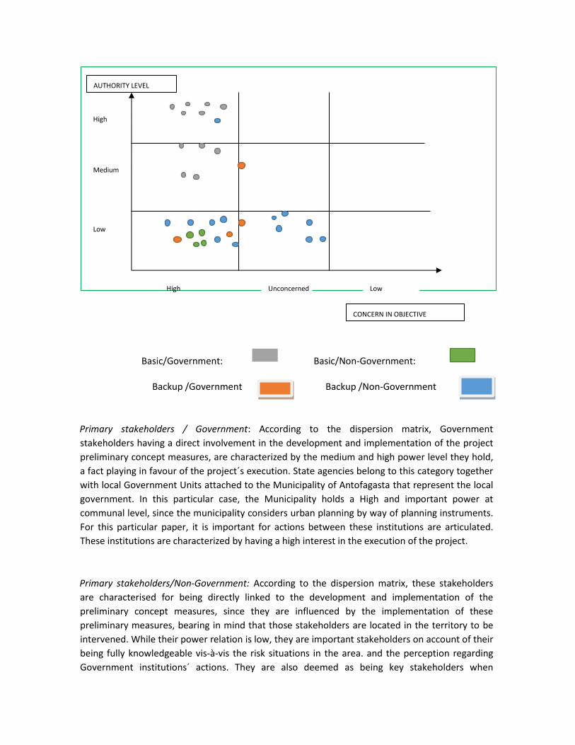
Backup /Government xxxxx Backup /Non-Government xxxxxx
Primary stakeholders / Government: According to the dispersion matrix, Government
stakeholders having a direct involvement in the development and implementation of the project
preliminary concept measures, are characterized by the medium and high power level they hold,
a fact playing in favour of the project´s execution. State agencies belong to this category together
with local Government Units attached to the Municipality of Antofagasta that represent the local
government. In this particular case, the Municipality holds a High and important power at
communal level, since the municipality considers urban planning by way of planning instruments.
For this particular paper, it is important for actions between these institutions are articulated.
These institutions are characterized by having a high interest in the execution of the project.
Primary stakeholders/Non-Government: According to the dispersion matrix, these stakeholders
are characterised for being directly linked to the development and implementation of the
preliminary concept measures, since they are influenced by the implementation of these
preliminary measures, bearing in mind that those stakeholders are located in the territory to be
intervened. While their power relation is low, they are important stakeholders on account of their
being fully knowledgeable vis-à-vis the risk situations in the area. and the perception regarding
Government institutions´ actions. They are also deemed as being key stakeholders when
Basic/Non-Government: Basic/Government:
High Unconcerned Low
Low
CONCERN IN OBJECTIVE
Medium
High
AUTHORITY LEVEL

implementing awareness and resilience processes in the community. These stakeholders are
characterized by their high concern in the execution of the project.
Backup Stakeholders/Government: These institutions are those entities having a technical
knowledge and / or binding backup that is linked to the development and implementation of
preliminary concept measures. Among these institutions are municipal units and state agencies.
Although their power and interest fluctuates between low and middle, their participation or
involvement will be dependent upon the demand for their know-how and / or powers regarding
the implementation of measures.
Backup Stakeholders/Non-Government: According to the matrix, these stakeholders have a low
authority, a medium concern, or are unconcerned, except for CREO Antofagasta, an institution
being considered as the only institution in this category showing a high-level authority vis-à-vis the
design of public works intended to improving quality of life of Antofagasta inhabitants. This
institution was set up as a private / public institution which, on the basis of a governance
executive committee chaired by the Major and the Intendent, intend to coordinating the
execution of urban projects in the city. Currently, CREO Antofagasta has undertaken a cadastre of
sectors at risk because of heavy rainfall in 2015. With the exception of CREO, these institutions,
while devoid of a strong power base, indeed have a relationship and a link with the territory or
with actions that can be linked to measures as spelled out in the preliminary concept. The interest
being shown by these organisations ranges between Unconcerned and High.
The Taltal Case
High Unconcerned Low
Low
CONCERN IN THE OBJECTIVE
Medium
High
AUTHORITY LEVELS
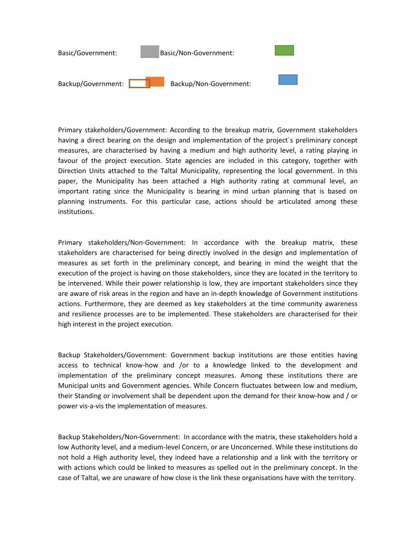
Basic/Government: Basic/Non-Government:
Backup/Government: Backup/Non-Government:
Primary stakeholders/Government: According to the breakup matrix, Government stakeholders
having a direct bearing on the design and implementation of the project´s preliminary concept
measures, are characterised by having a medium and high authority level, a rating playing in
favour of the project execution. State agencies are included in this category, together with
Direction Units attached to the Taltal Municipality, representing the local government. In this
paper, the Municipality has been attached a High authority rating at communal level, an
important rating since the Municipality is bearing in mind urban planning that is based on
planning instruments. For this particular case, actions should be articulated among these
institutions.
Primary stakeholders/Non-Government: In accordance with the breakup matrix, these
stakeholders are characterised for being directly involved in the design and implementation of
measures as set forth in the preliminary concept, and bearing in mind the weight that the
execution of the project is having on those stakeholders, since they are located in the territory to
be intervened. While their power relationship is low, they are important stakeholders since they
are aware of risk areas in the region and have an in-depth knowledge of Government institutions
actions. Furthermore, they are deemed as key stakeholders at the time community awareness
and resilience processes are to be implemented. These stakeholders are characterised for their
high interest in the project execution.
Backup Stakeholders/Government: Government backup institutions are those entities having
access to technical know-how and /or to a knowledge linked to the development and
implementation of the preliminary concept measures. Among these institutions there are
Municipal units and Government agencies. While Concern fluctuates between low and medium,
their Standing or involvement shall be dependent upon the demand for their know-how and / or
power vis-a-vis the implementation of measures.
Backup Stakeholders/Non-Government: In accordance with the matrix, these stakeholders hold a
low Authority level, and a medium-level Concern, or are Unconcerned. While these institutions do
not hold a High authority level, they indeed have a relationship and a link with the territory or
with actions which could be linked to measures as spelled out in the preliminary concept. In the
case of Taltal, we are unaware of how close is the link these organisations have with the territory.
Regarding Social Networks: The associativity dynamics, or linkages occurring by and among key
stakeholders are spelled out below. Furthermore, social relationships occurring in emergency
events have been identified.
Main social networks identified by the interviewees and concerning territorial stakeholders are:
Neighbours Boards, Elderly citizen groups, Mother centres, churches and places of worship,
schools, and mainly the Municipality officials, as the case was regarding Taltal, bearing in mind
that no government institutions are in place in the territory. The same situation applies as
regards the Mounted Police and the Firefight Brigade.
Organisations identified as being the first to react vis-à-vis safeguarding the most vulnerable
population
Main institutions identified as the first to react vis-à-vis safeguarding and protecting the most
vulnerable population are the Municipality and the Fire Brigade, followed by the Armed Forces,
the Mounted Police, ONEMI, the Regional Government, Neighbours Boards, and SERVIU, MOP,
and the Health Service.
While these reactions were common for Antofagasta and Taltal, for the latter the fact should be
stressed that the Municipality was singled out as the main stakeholder in the resolution of
problems in the community whenever an emergency arises. Further, the work of the Fire Brigade
in Taltal in addressing emergency situations in the city should be highlighted.
Organisations identified vis-à-vis the education process
Main organisations identified in terms of education, awareness-raising and resilience are the
Municipality, ONEMI, Regional Government, and MOP. The role that NGO´s are playing in
educational processes vis-a-vis their engagement with the territory and the community is also
taken into consideration.
Territorial organisations, both for Antofagasta and Taltal, acknowledge that the Municipality is the
organism in charge of this processes, because of its proximity to the community but, at the same
time, they mention that they lack the competence to do so, this being the reason why they attach
a great bearing to measures being implemented in terms of education and capacity-building
addressing the local government.
Organisations identified vis-à-vis backup relationships in an emergency situation
Primary Stakeholders/non-governmental mostly linked to the territory state that backup networks
in case of emergency mainly occur between the municipality, neighbours and family. In the case
of the woman leader of the shantytown, she also points to Regional Government, A Roof for
Chile, the Jesuit Migrant Organisation. The perception that people living in shantytowns has is
wider, since most assistance and / or shelter is provided to these more vulnerable populations.
In the case of Taltal, territory organisations, family, Armed Forces and the Municipality are the
main backup networks in case of emergency.

Regarding Focus Groups: the relationship is explained below as the presence of focus groups
within the territory, in which the establishment and involvement of groups as follows is
highlighted:
• Women in the territory
• Indigenous Peoples in the territory
• Groups characterized by age in the territory.
• Shantytowns: characterized by settlements of migrant groups
The Antofagasta Case
On the basis of the interviews with stakeholders in the territory located in the Bonilla creek, an
identification has been made that organisations, whether of neighbours, or shantytowns, are
mainly led by women, a fact showing that organisations and backup relationships in the territories
arise from the role that women play in management of those organisations.
Further, some organisations highlight the involvement on entities such as Mother Centres at the
social headquarters for which the Neighbours' Boards are responsible.
Seniors club are identified in age groups who use social venues to get together. These groups are
characterized by being legally constituted to generating backup and solidarity networks among
them. They identify themselves as participatory groups when it comes to promoting activities or
calls within the community.
No Indigenous Peoples have been identified in the territory.
A focal group in the territory should be added to this listing which, although not taken into
account in the Terms of Reference (TORs), is an important group contingent in the design and
implementation of measures to be taken into account in the preliminary concept. This group
belongs to the settlements in shantytowns being mainly characterized by the presence of
foreigners´ families and by the prevailing precariousness conditions and the vulnerability in the
places where are located. In the case of the La Chimba creek, three shantytowns are settled in the
area, and more than half of the inhabitants of which are foreigners, according to our interview
with Narlyn, a neighbour of the United Women Shantytown.
The Taltal Case
In the Taltal case, an interview was held with the lady in charge of the nursing home located in the
city´s outskirts (the sector most affected by a sudden and violent influx of water due to the
overflow of a river) and housing ten elderly people. This nursing home is equipped with all
implements required, and staff is attached to it to care for the elderly living there. The
interviewee reported that they are immediately assisted by the firefighter brigade and / or the
mounted police should an emergency arise, besides being provided with health care.

In the case of territorial organisations, a strong leadership is also perceived by women in
management positions and, to a lesser extent, groups of women are identified in particular.
No Indigenous Peoples communities are identified in the area.
As in the case of Antofagasta, there is a proliferation of shantytowns in non-suitable areas, which
are considered as focus groups vulnerable to climate change.
V. Identification of key stakeholders’ insight on adaptation measures foreseen in the
preliminary concept.
Two different points of view are discussed in this section, one of them regarding the appraisal
attached by the Antofagasta and Taltal communes to measures put forward in the preliminary
concept; likewise, (second approach) key stakeholders responsible for measures proposed are
considered.
Appraisal of the preliminary concept. Antofagasta Case
All those measures set forth in the preliminary concept were attached a high appraisal rating by
key stakeholders interviewed. The point should be stressed that their particularity and
differentiation are highlighted in the nature and rating attached to each interviewee, in the sense
that the territory- belongingness variable underscored the key difference.
Table below shows the appraisal scale and the rating on the basis of measures and outputs.
Scalable Appraisal Table - Antofagasta
14 15 16 17 18 19 20 21 22 23 24 25 26
2
7
2
8
2
9
3
0
3
1
3
2
3
3
3
4
3
5
3
6
3
7
3
8
3
9
4
0
4
1
4
2
Low approval M. Low Medium M. High High Approval
Non-structural Components
Non-structural components were attached a high appraisal by the interviewees, reaching an
average weighting of 39 points
Concerning the specificity of outputs, in relation to:
• Green infrastructure plans keeping in check or abating the impact of rainwater: This measure
was attached a high appraisal rate equivalent to 37 points, reaching a maximum weighting rating
by key territorial stakeholders
• Updating the Rainwater Master Plan including micro-basins and management of water flows
as a climate change impact: This measure was attached the highest weighting equivalent to 41
points by key regional stakeholders. This rating reached the highest unanimous approval within all
products and their components. The point should be stressed that this weighting was the closest
to reaching a unanimous high approval within all products and their components.

Table below shows weighting as the appreciation differentiation by each non-structural
components´ product
Structural Components
Structural components were attached a high appraisal by interviewees, reaching an
average weighting of 38 points
As regards specificity of products, in relation to:
• Works (works check-up, rainwater channels) in prioritised micro basins: This measure
was given a high appraisal, equivalent to 37 points, reaching the maximum weighting by
key territorial stakeholders
• Procurement of software for monitoring, design and prioritisation of higher risk
basins, and flood mapping (e.g., ArcGIS, Aquaveo WMS or Mike She, and / or flood):
This measure was attached a high appraisal equivalent to 39 points, reaching the
maximum weighting by key territorial stakeholders.
Table below shows weighting as the appraisal differentiation by each non-structural
components´ product
37
39
Measure 1 Measure 2
Point-based Weighting
Points

Early Warning System Component
Components in the early warning system were attached a high appraisal by interviewees,
reaching an average weighting of 38 points
Concerning product specificity vis-à-vis:
Installation of Climate Early Warning Systems (emergency room) and
communication devices to alert people during emergencies (eg, sirens, SMS, radio
broadcast): This measure was attached a high appraisal, equivalent to 40 points,
reaching the maximum weighting by key territorial stakeholders
Increasing the number of monitoring stations showing better parameters: This
measure was attached a high appraisal, equivalent to 38 points, reaching the
maximum weighting by key territorial stakeholders
Installation of a Meteorological Radar System: This measure was attached a high
appraisal, equivalent to 37 points, reaching the maximum weighting by key territorial
stakeholders
Implementation of an online platform for meteorological data: This measure was
attached a high appraisal, equivalent to 36 points, reaching the maximum weighting
by key territorial stakeholders. The fact that this weighting was close to a "medium
high" rating should be stressed.
37
39
Measure 1 Measure 2
Point-based Weighting
Points

This figure shows weighting as the appraisal differentiation for each one of the
components´ product linked to the “Early warning system”
Emergency Response Components
The "Emergency Response" components were attached a high appraisal by the
interviewees, reaching an average weighting of 39,6 points
Concerning products specificity, vis-à-vis:
• Strengthening up Emergency Committees (inter-agency coordination system, i.e.,
among government institutions): This measure was attached a high appraisal, equivalent
to 40 points, reaching the maximum weighting by key territorial stakeholders
• Evacuation Warning: This measure was attached a high appraisal, equivalent to 39
points, reaching the maximum weighting by key territorial stakeholders
• Flood evacuation maps: This measure was attached a high appraisal, equivalent to 40
points, reaching the maximum weighting by key territorial stakeholders
40
38
37
36
Measure 1 Measure 2 Measure 3 Measure 4
Point-based Weighting
Points

This figure shows weighting as the appraisal differentiation for each one of the
components´ product linked to the “Emergency Response” component
Local Governments Capacity-building Component (municipality and other authority)
The component linked to the "Local Governments Capacity-building", incorporating a
single product: "Climate Change Risk-based Adaptation-addressed Courses and
Materials", was attached a high appraisal by the interviewees, achieving a unique
weighting of 39 points, and showing its maximum rating by key territorial stakeholders
Local Population Capacity-building Component
Components involved in “Local Population Capacity-building”, were attached a high
appraisal by the interviewees, reaching a weighting average of 38 points
Concerning products specificity, as regards:
• Three education and communication strategies designed and implemented
(awareness-raising and capacity-building of the local population): This measure was
attached a high appraisal, equivalent to 40 points, reaching the maximum weighting by
key territorial stakeholders
• Experiences about “Storytelling" in three cities (the Japanese method). Storytellers
transmit tacit knowledge about environmental disasters recorded in the region,
acknowledging memory and history, the environment, culture, topography, etc. This
measure was attached a high appraisal, equivalent to 36 points, reaching the maximum
40
39
40
Measure 1 Measure 2 Measure 3
Point-based Weighting
Points

weighting by key territorial stakeholders. The point should be stressed that this score was
close to a "medium high" weighting.
Appraisal of Preliminary Concepts, the Taltal Case
All components, together with their outputs or measures, as set forth in the preliminary
concept were attached a high appraisal by stakeholders interviewed, reaching unanimous
maximum weighting and showing no changes in their appraisal, thus acknowledging the
bearing that the implementation and development of plans as set forth should have.
Regarding the Taltal case, no differences became apparent in appraisals among territorial
stakeholders (attached to areas where preliminary concepts were applied), and
communal or regional stakeholders.
A summary is shown below including the appraisal vis-à-vis the approval of components
and outputs in Taltal.
Project
Component
Outputs Approval Rating
Non-structural
Measures
Green infrastructure plans restraining/reducing water
impact.
High
Updating the Master Rainwater Plan including
microbasins, and incorporating management of
climate change-originating rainwater flows.
High
Structural
Measures
Works in priority micro-basins. High
Procurement of software for analysis, design, and
prioritisation of higher risk basins, and flood mapping
High
40
36
Measure 1 Measuremn
t 2
Point-based Weighting
Points

Early warning
Systems
Installation of Climate Early Warning Systems and
mechanisms as required to alert residents during
emergencies
High
Increasing the number of monitoring stations
equipped with technology-enhanced parametres
High
Installation of a Weather Radar System High
Implementation of an online meteorological data
platform
High
Emergency
Response
Strengthening up Emergency Committees High
Evacuation Signage High
Flood evacuation maps High
Local governments capacity-building
Risk-based adaptation courses and materials High
Local residents
capacity-building
Three education and communication strategies
designed and implemented
High
“Storytelling”. (The Japanese Method Experience). High
Key stakeholders involved in the feasibility and responsibility of measures as set forth in
the preliminary concept
This section refers to stakeholders that people interviewed have singled out, and who are
involved in the execution of the project and / or have a stake in the project. This
perception is related to the awareness that stakeholders have of the institutions, their
positions and duties, which are appraised by the interviewees and institutions they
belong to.
On the basis of this review, and in accordance with the competences of institutions
described in scorecards above, a listing has been made of institutions likely to be linked to
the execution of the different project outputs.
Antofagasta Case
Component Non-structural Measures
Outputs Key Stakeholders
Green infrastructure Plans incorporating or abating the
water impact.
Antofagasta Verde IMA. Dirección Aseo y Ornato IMA. Fundación mi Parque
CREO
CEITZASA UCN.
MOP
MMA
MINVU
STAKEHOLDERS IN THE
TERRITORY
Updating the Master Rainwater Plan including microbasins
and incorporating management of climate change-
originating rainwater flows.
MOP
Component Structural measures
Outputs Key Stakeholders
Works (monitoring works, rainwater channels) in priority
microbasins.
MOP
MINVU
ASEMUCH
CREO ANTOFAGASTA
MUNICIPALITY
Procurement of software for analysis, design and
prioritisation of higher risk basins, and flood mapping (e.g.,
ArcGIS, Aquaveo WMS or Mike She, and / or flood).
MOP
ONEMI
SHOA
Component Early Warning System
Outputs Key Stakeholders
Installation of Climate Early Warning Systems (emergency
room) and media devises to warn residents during
emergencies (e.g., sirens, SMS,, radio broadcasting).
MOP
SHOA
ONEMI
MUNICIPALITY
Increasing the number of monitoring stations equipped
with enhanced parametres.
MOP
ONEMI
SHOA
MUNICIPALITY
Component Emergency Response
Outputs Key Stakeholders
Strengthening up Emergency Committees (inter-agency
coordination system, i.e., among Government institutions)
MAJOR
MUNICIPALITY
ONEMI
Evacuation signage ONEMI
MUNICIPALITY
MOP
Evacuation Maps in case of flooding ONEMI
MUNICIPALITY
MOP
MINVU
Component Local governments capacity-building (municipalities and
other entities)
Outputs Key Stakeholders
Risk-based adaptation-addressed courses and materials. MUNICIPALITY
MMA
Component Strengthening up capacity-building of local residents
Outputs Key Stakeholders

Three education and communication strategies
designed and implemented (local population
awareness-raising and capacity-building)
IMA
ONEMI
MMA
TERRITORIAL OR
TECHNICAL
ORGANIZATIONS
(JJ.VV.;
FRACTAL; CULTAM)
“Storytellers” MMA
IMA
NGO´s
Key stakeholders linked to feasibility and accountability of measures spelled out in the
preliminary concept; the Taltal Case
Component Non-structural Measures
Outputs Key Stakeholders
Green infrastructure plans contemplating or reducing water
impact.
MUNICIPALITY
MMA
TERRITORIAL
ORGANIZATIONS
Updating the rainwater Master Plan to incorporate management
of climate change-originating flooding.
MOP
Component Structural measures
Outputs Key Stakeholders
Public Works (Monitoring works, rainwater channels) in
prioritised microbasins.
MOP
MINVU
ASEMUCH
MUNICIPALITY
Procurement of software for analysis, design and
prioritisation of higher risk basins, and flood mapping (e.g.,
ArcGIS, Aquaveo WMS or Mike She, and / or flood).
MOP
SHOA
ONEMI
Component Early warning system
Outputs Key Stakeholders
Installation of Early Warning Systems (emergency Room) and
media systems to warn residents during emergencies (e.g.,
sirens, SMS, radio broadcasting).
MUNICIPALITY
FIRE BRIGADE
MOUNTED POLICE
ONEMI
Increasing the number of monitoring stations equipped with
enhanced parametres
MOP
ONEMI
SHOA
Installation of the Metorological Radar System (Chile) MOP
ONEMI
SHOA
Implementation of a meteorological data online platform. MOP
ONEMI
SHOA
Component Emergency Response
Outputs Key Stakeholders
Strengthening up Emergency Committees (inter-agency
coordination system, i.e., among Government institutions
MUNICIPALITY
FIRE BRIGADE
MOUNTED POLICE
Evacuation signage MUNICIPALITY
ONEMI
Evacuation maps in case of flooding MUNICIPALITY
ONEMI
MOP
FIRE BRIGADE
Component Local governments capacity-building (municipalities and
other entities)
Outputs Key Stakeholders
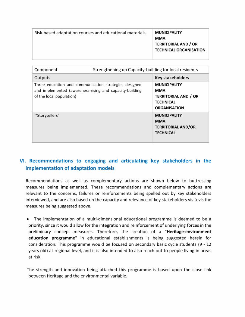
Risk-based adaptation courses and educational materials MUNICIPALITY
MMA
TERRITORIAL AND / OR
TECHNICAL ORGANISATION
Component Strengthening up Capacity-building for local residents
Outputs Key stakeholders
Three education and communication strategies designed
and implemented (awareness-rising and capacity-building
of the local population)
MUNICIPALITY
MMA
TERRITORIAL AND / OR
TECHNICAL
ORGANISATION
“Storytellers” MUNICIPALITY
MMA
TERRITORIAL AND/OR
TECHNICAL
VI. Recommendations to engaging and articulating key stakeholders in the
implementation of adaptation models
Recommendations as well as complementary actions are shown below to buttressing
measures being implemented. These recommendations and complementary actions are
relevant to the concerns, failures or reinforcements being spelled out by key stakeholders
interviewed, and are also based on the capacity and relevance of key stakeholders vis-à-vis the
measures being suggested above.
The implementation of a multi-dimensional educational programme is deemed to be a
priority, since it would allow for the integration and reinforcement of underlying forces in the
preliminary concept measures. Therefore, the creation of a "Heritage-environment
education programme" in educational establishments is being suggested herein for
consideration. This programme would be focused on secondary basic cycle students (9 - 12
years old) at regional level, and it is also intended to also reach out to people living in areas
at risk.
The strength and innovation being attached this programme is based upon the close link
between Heritage and the environmental variable.
Bearing in mind prevailing socioeconomic conditions and the link between the community
and the exo-environmental setting, this programme should have a substantial bearing and
significance for the community; therefore, a recommendation is made to becoming
acquainted with the experience, and the work done by the Ruinas de Huanchaca Foundation
in the field of educational strategies toward the appraising of the region.
• Stakeholders have pointed out to a lack of reinforcement incentives, and the fact is well-
known that any action should have a self-control and attachment component, thus allowing
for the sustainability of the rationale for intervention, therefore, the generation of playful and
significant reinforcement stimuli is recommended that correspond to "implementation of an
educational infographic signage" in areas under the impact of alluvial events, through which
the community will remember, become aware of, and face on a daily basis and in a different
way the information and value underlying the measures.
• An epistemological-nature strategy should be abode by, through which work is undertaken on
the basis of a deconstruction of the conceptual value of categories related to risk, fear, danger
and vulnerability toward the reconstruction of this strategy on the basis on highly legitimate,
affective and value-based binding actions. Based on the above, a proposal has been put
forward to "value risks, catastrophe and climate vulnerability as an evaluative element of
the cultural and territorial imaginary."
• The huge proliferation of shantytowns, which is linked to both the migratory process and to
multidimensional poverty, highlights a lack of a collective memory by the migrants, who do not
know the particularities of the territory they live in, bearing in mind both, the environmental
history and the environmental vulnerability. After the last heavy rainfall phenomenon, while
the migrant population stated in an interview that they were unaware of the risks and impacts
of these phenomena in the area, they have not considering moving out of the place, since they
are not only building their houses in the area, but are also creating community bonds based on
cooperation, solidarity and protection. This is why a multifactor programme should be
implemented particularly addressing the socialisation of climate change impacts and
perhaps, in some cases, the relocation of populations vulnerable to climate change.
• Closely associated to the above is the low frequency and regularity of climate-related
phenomena and, therefore, their impacts, exposing the sector´s vulnerability. This
infrequency, and the need for immigrants to occupy territories to settle in the city
(shantytowns in the ravines) have led to invisibility and to discard these climatic variables as a
decision-making-related factor at the time immigrants settle in the territory. We return here
to the proposal to again assert the vulnerability condition through educational processes
and meaningful stimulus, such as infographics.
• A key factor to be stressed and considered is that populations living in close proximity to ravine
areas in which the project is expected to be executed, are "shantytown" dwellers, a figure the
government has yet to attach legitimacy to, and still having an illegal status, thus these people
are lacking strong government-networks of an official nature to account for them and to assist
them in their territorial-nature processes.
The above notwithstanding, the government has implemented a shantytowns eradication
programme, which is currently working on an assessment of the shantytowns status. This is
the reason why we identify the population settled in shantytowns as a project-targeted
population, since it is being deemed to be highly vulnerable to climate change impacts.
• Territorial organisations identify the municipality as the relevant authority, as well as the key
stakeholder in the design and enforcement of safeguards and protection measures when
problems crop out or climatic disasters are involved; those organisations are also fully aware
of the low ability the municipality has to undertaking measures to address environmental
impacts and / or to tackle related problems.
This situation gets increasingly serious in Taltal, where the authority that the regional
government holds on the municipality does not extend over the whole territory, and Non-
Government institutions such as the fire brigade and the mounted police are the only two
organisations duly appointed and legitimized by the community. These two agencies supplied
substantial assistance after the latest catastrophic climate event. This the reason why the
municipality should be deemed as a key stakeholder in education and resilience processes
vis-à-vis natural events.
• According to stakeholders interviewed both, regional and communal governments´ relevant
bodies are not properly articulated, showing dissociation between them, generating an image
of disbelief and low efficiency in cases of environmental conflicts and catastrophes.
Notwithstanding, stakeholders believe that both, regional and communal governments are
responsible. In Taltalt, the fact that the regional government is lacking an institutional standing
in the territory should be added to the above.
• A lack of awareness by people in Taltal vis-à-vis the duties, rights and actual work being done
by formal government institutions, has generated a bottleneck at the time the community
makes a decision to exercise their right, since most people identify the municipality as the key
stakeholder, ignoring that the municipality has neither say not power in all government
instances, thus increasing both the negative perception of the communal government by
people, and the distance between the community and the institutional authority. Thus, a
recommendation is made for a communication linkage to be created with the community, so
that people are fully aware of the role and duties government officers should play in the
implementation of measures of all sorts.

• A lack of commitment and involvement of both, the communal and regional authorities vis-à-vis
community measures and projects was noticed. This is a process deeply rooted in supra
structural policy dynamics mostly working in favour of partisan trends and results, rather than
of a communion of wills and work for a region and a commune. Actions of this sort have a
bearing on regional projects execution, delay and rejection.
• The above results in threats and perceived risks vis-à-vis the low associativity, co-operative
endeavours, and networking between Government institutions (the State apparatus) and the
local government.
• Still, an additional risk is perceived insofar State policy being enforced through Government
programmes not always last over time, since State policy is dependent upon how those
programmes are implemented by government officers, who adjust public policy to the rhythm
of their partisan interests. Moreover, public policy has a centralist nature, which weakens the
outlook and particular characterisation of regions´ needs.
• The risk referred to above could be addressed by working in coordination with the Municipality,
which has access to urban planning and local development tools. Nowadays, the risks of
overflowing or flooding are not incorporated into planning guidelines; still, these guidelines, as
well as the duties of municipal entities can be amended to include duties and units in their
Organisation Chart, which are focused on the development of risk-addressed awareness-
raising, education, warning, and prevention.
• Municipalities have an internal organisational structure which can be modified by incorporating
backup units, or units directly linked to socialisation and education processes vis-à-vis climate
change impacts. Furthermore, municipalities have access to their own ordinances, which are
resolutions, within the regulatory framework being spelled out by the Mayor upon an
agreement by the Municipal Council. These ordinances are characterized by being general and
mandatory standards applicable to the community, within the commune territory. Pursuant to
this regulatory framework, some project-related measures can be endorsed, ensuring their
continuity over time.
• As far as the Women United Shantytown is concerned, their leader is deeply concerned about
the danger they are exposed to on account of landslides, antennas, electricity wiring, and a
water pond located right in front of their shantytown. The lady leader of the neighbouring
Town Councils states that the ravine is close to a wasteland which is used as a garbage and
debris disposal site, entailing a danger to the community.
• Streets and / areas being identified as risk areas on the basis of interviews with stakeholders
are: Manuel Silva; Antonio Martínez; Clodomiro Rosas; Novoa; Nicolás Tirado; Emilio Carrera;

Pablo Neruda and Capa Rosa (Antofagasta). Concerning Taltal, the area showing the highest
risk impact is the rea at the entrance of the city, splitting this into two sectors.
• For both, Antofagasta and Taltal, the Municipal institution is deemed as a close and highly
relevant stakeholder –in case of emergencies- to the protection of the most vulnerable
population. At the same time, the municipality is characterized as lacking the conditions and
professional standing to better back up its own management in case of emergencies. While
the perception of the municipality is more assistance- than prevention-focused, it is within its
competences to address this prevention and awareness-rising field. Thus, we deem education
and capacity-building of the communal government to be highly relevant.
• The role the municipality plays in situ is deemed to be important, and from a political
perspective, it is considered as the State policy decentralizing instance: in this case, the
characterisation of community needs, both concerning Antofagasta and Taltal, vis-à-vis climate
change-related risks.
• The Armed Forces, the Fire Brigade, and the Mounted Police are deemed to be relevant
stakeholders and are positively perceived by the interviewees in emergency situations. Given
the perception of distrust in and disarticulation of the Government institution, we believe it is
relevant to involve these stakeholders in processes linked to awareness-raising, education,
and prevention of climate change-related impacts.
VII. Sources consulted:
Anuario Parque de Vehículos en circulación 2015, National Statistics Institute. Available at:
http://www.ine.cl/canales/chile_estadistico/estadisticas_economicas/transporte_y_comunicacio
n es/parquevehiculos.php
Chile: Proyecciones y Estimaciones de Población, 1990-2020, National Statistics Institute.
Available at: http://palma.ine.cl/demografia/menu/EstadisticasDemograficas/DEMOGRAFIA.pdf
CASEN Survey 2013, Perfil Antofagasta Region, Ministry for Social Development. Available at:
http://observatorio.ministeriodesarrollosocial.gob.cl/casen/casen_perfil_2.php
Indicadores Urbanos, Observatorio Urbano, Ministry of Housing and Urban Planning. Available
at:
http://www.observatoriourbano.cl/indurb/indicadores.asp
Statistical and Communal Reports, National Congress Library:

Antofagasta
Year 2011. Available at: http://reportescommunales.bcn.cl/2011/index.php/Antofagasta Year
2012. Available at: http://reportescommunales.bcn.cl/2012/index.php/Antofagasta
Taltal
Year 2011. Available at: http://reportescommunales.bcn.cl/2011/index.php/Taltal
Year 2012. Available at: http://reportescommunales.bcn.cl/2012/index.php/Taltal
Síntesis de Resultados CASEN 2013, Inmigrantes. Available at:
http://observatorio.ministeriodesarrollosocial.gob.cl/documentos/CASEN_2013_Inmigrantes_rev
i sada.pdf
Síntesis de Resultados CASEN 2013, Pueblos Indígenas. Available at:
http://observatorio.ministeriodesarrollosocial.gob.cl/documentos/Casen2013_Pueblos_Indigenas
_13mar15_publicacion.pdf
http://observatorio.ministeriodesarrollosocial.gob.cl/documentos/CASEN_2013_Inmigrantes_revisada.pdf
http://observatorio.ministeriodesarrollosocial.gob.cl/documentos/CASEN_2013_Inmigrantes_revisada.pdf
http://observatorio.ministeriodesarrollosocial.gob.cl/documentos/CASEN_2013_Inmigrantes_revisada.pdf
Annex 9. Stakeholder analysis in Esmeraldas (Ecuador)
Reducing climate vulnerability and flood risk in coastal urban and semi urban areas in cities in Latin America
STAKEHOLDERS, CONCERNS, AND MANAGEMENT PROBLEMS
Authors: Byron Real1 Pedro Vidal Tello2 Esmeraldas, Ecuador May 2016
1 Lawyer and Anthropologist, postgraduate studies in social-environmental assessments, social and risk vulnerability
assessment. Contact address: [email protected]
2 Agricultural Engineer, working experience with organisations and communities in the Esmeraldas Province (Ecuador) with
a particular focus on agricultural and social-economic assessments. Contact address: [email protected]

CONTENTS
T Table of Contents…………….............................................................................................. 2
Tables and Map Index….................................................................................................... 3
Abbreviations.................................................................................................................... 4
EXECUTIVE SUMMARY ..................................................................................................... 5
INTRODUCTION ............................................................................................................... 6
Methodology Annotation................................................................................................ 7
Field Work ……….............................................................................................................. 8
I. SOCIAL VULNERABILITY, PUBLIC POLICY, AND RISK MANAGEMENT
INSTITUTIONALITY……………….. ..................................................................................... 9
Social-economic, and demographic conditions in Esmeraldas ...................................... 9
The City and its vulnerability to climate change.…….…….............................................. 15
Risk management policy and legislation in Ecuador.....................................................16
Vulnerability and risk reduction project……..................................................................18
II. STAKEHOLDERS AND THEIR CONCERNS................................................................ 20
Stakeholders insights and concerns............................................................................. 24
The standpoint of stakeholders in neighbourhoods ................................................... 25
The outlook of Public Entities ..................................................................................... 30
Characterisation of stakeholders identified …............................................................ 32
Identification of key stakeholders ………..................................................................... 35
Key stakeholders in Project (CVRRP) …………………………………………………………………....36
III. STRATEGIC DECISIONS, AND THE CVRRP MANAGEMENT…………........................ 39
A definition of Alliances............................................................................................., 39
Problems to be addressed.......................................................................................... 40
Buttressing the consolidation of a local risk management policy and administratio...40

Incorporating Gender Mainstreaming into risk management…………..........................42
Specific intervention in risk-prevalent areas.............................................................. 40
CONCLUSIONS.............................................................................................................44
REFERENCES….............................................................................................................45
ANNEXES.....................................................................................................................47
ANNEX 1.- Methodology …………….…...........................................................................47
ANNEX 2.- Key Guidelines to conducting Interviews…………………............................... 52
ANNEX 3.- Listing of people and public officers interviewed.....................................55
Tables and Map Index
Table 1.- Basic utilities provision in the Esmeraldas Province...….……………….……………15
Table 2.- Stakeholders aggregate vis-à-vis the CVRRP..………..………..............................22
Table 3.- Worrisome Issues for Vulnerable Communities...........................................31
Table 4.- Public Officers self-criticism…………….…………………...................................... 33
Table 5.- Analytical description of stakeholders .......................................................... 34
Table 6.- Identification of Key stakeholders ................................................................ 36
Table 7.- Key Stakeholders Authority, Concern and Standing ………………..................... 37
Table 8.- Stakeholders´ concern and standing…………..…….......................................... 39
Table 9.- Attitude of and Cooperation with stakeholders´ model ............................ ... 41
Map Index
Map 1.- Interviews and vulnerable areas´ locations visited ..........................................10
I. SOCIAL VULNERABILITY, PUBLIC POLICY, AND INSTITUTIONAL FRAMEWORK
VIS-À-VIS RISK MANAGEMENT .................................................................................... 9
Social-economic, and demographic conditions in Esmeraldas ..................................... 9
The City and its vulnerability to climate change.…….…….............................................. 13
Risk management policy and legislation in Ecuador.....................................................15
The vulnerability and risk reduction project.................................................................17

II. STAKEHOLDERS AND THEIR CONCERNS................................................................ 18
Stakeholders insights and concerns............................................................................. 21
The standpoint of stakeholders in neighbourhoods ................................................... 22
The outlook of Public Entities ..................................................................................... 27
Characterisation of stakeholders identified …............................................................. 30
Identification of key stakeholders ………....................................................................... 32
Key stakeholders in Project: “Climate Vulnerability and Flood Risk Reduction
Project (CVRRP) in coastal urban and semi urban areas in cities in Latin America”.... 33
III. STRATEGIC DECISIONS, AND THE CVRRP MANAGEMENT………….......................... 36
A definition of Alliances................................................................................................ 36
Problems to be addressed............................................................................................. 37
Buttressing the consolidation of risk management policy and administration at
local level………………………………….………..…………………………………………….……………………..38
Incorporating Gender Mainstreaming in risk management…………............................. 39
Particular intervention in risk areas............................................................................. 40
CONCLUSIONS.............................................................................................................. 42
BIBLIOGRAPHY ............................................................................................................ 43
ANNEXES...................................................................................................................... 45
ANNEX 1.- Methodology …………….…............................................................................ 46
ANNEX 2.- Basic Guidelines for Interviews…………………..……........................................ 51
ANNEX 3.- Listing of persons and public officers interviewed.................................... 54
Tables and Map Index
Table 1.- Basic utilities provision in the Esmeraldas Province...….……………..………………13
Table 2.- Stakeholders aggregate vis-à-vis the CVRRP ………..………..............................18
Table 3.- Issues of Concern for Vulnerable Communities ............................................27
Table 4.- Public Officers self-criticism…………….……………………...................................... 29

Table 5.- Analytical description of stakeholders .......................................................... 30
Table 6.- Identification of Key stakeholders ................................................................ 32
Table 7.- Authority, Concern and Standing Ratings of Key stakeholders .................... 33
Table 8.- Stakeholders´ concern and standing ratings …….......................................... 35
Table 9.- An stance and Cooperation with stakeholders´ model ............................ ... 37
Map Index
Map 1.- Interviews and vulnerable areas´ locations visited ..........................................8
Listing of Abbreviations and Acronyms
CVRRP Climate Vulnerability and Risk Reduction Project
RRA Risk Reduction Agenda
CAF Bank for Latin American Development
EFFB Esmeraldas Fire Fighting Brigade
RMC Risk Management Committee
EOC Emergency Operations Committee
OTAADC Organic Territorial Arrangement, Autonomies and Decentralisation CODE
OPPFC Organic Planning and Public Finance Code
CRE Constitution of the Republic of Ecuador
AAFF Armed Forces
DAG Decentralised Autonomous Government
NMHI National Meteorology and Hydrology Institute
NOCI Navy Oceanographic Institute
LVT Island Luis Vargas Torres Island
MEE Ministry of the Environment of Ecuador
MPW Ministry of Public Works
NGLP National Good Living Plan
CVRRP PCUEE Pontifical Catholic University of Ecuador, Esmeraldas Campus
NWS National Water Secretariat

RMS Risk Management Secretariat
Reducing climate vulnerability and flood risk in coastal urban and semi urban areas in cities in Latin America
STAKEHOLDERS, CONCERNS AND MANAGEMENT PROBLEMS
EXECUTIVE SUMMARY An identification is made in this paper of Stakeholders in the area where the Climate Vulnerability and Risk Reduction Project (CVRRP)3 4 is scheduled to be executed, and their perceptions and expectations are assessed as regards risk management, and prevention, mitigation and adaptation to the adverse climate change impacts, a subject falling within the overall scope of this project. A methodological mechanism known as "Stakeholder Review" was applied in drafting up this report. This review was performed through analytical stages, as set forth below:
Identification and classification of stakeholders,
Determination of stakeholders´ characteristics, concerns and circumstances,
Understanding how those concerns and circumstances could have an adverse or beneficial bearing on the Project,
Identification of points at issue, and suggestions of options to be tackled with and managed; and,
Suggesting a Project-addressed management strategy or model. This survey was undertaken in the urban area of the city of Esmeraldas, located in the Esmeraldas province, in Ecuador, and was based on interviews with some sixty people split up among fifty-two local, institutional, citizen and community stakeholders. This exercise allowed for an in-depth look into and mapping of stakeholders regarding the aforementioned initiative, and to linking them around both, their particular concerns, and their institutional, political and social standing as regards the execution of the CVRRP and, in general, the administrative exercise of risk management. While stakeholders voiced their particular concerns at the interviews, in no way any of them showed any rejection to the implementation of the CVRRP. This was due to the fact that this initiative seeks to making a contribution to addressing specific situations in the city, such as the occurrence of landslides and floods, and to backing up local entities in their endeavours to enhancing their
3 “Reducing Climate Vulnerability and Flood Risk in Coastal Urban and Semi-Urban Areas in Cities in Latin America”
(Reducción de vulnerabilidades y riesgo de inundaciones en zonas costeras urbanas y semiurbanas de ciudades en
Latinoamérica).
4 This Project was scheduled to be executed in the cities of Esmeraldas, Ecuador, and Antofagasta and Taltal, Chile. This
Stakeholders Review and Mapping applies to the city of Esmeraldas.

institutional risk management work. In order for these objectives to be achieved, this CVRRP will be implementing technical, regulatory and social techniques. Stakeholders identified are attached to national, provincial and cantonal public entities, civil society organisations, and urban neighbourhood groups organized around de facto (committees or associations) organisations. All institutional goals that public entities seek to achieve are issues such as: risk management, planning and public works, and water and meteorological management. A look into their objectives, competencies, duties and institutional attributions, as well as into the problems they should be facing up to, has allowed to finding out which stakeholders could have some type of direct involvement in the CVRRP, and which urban groups could directly be under the project´s impact. Likewise, organisations and urban groups have been identified with which the project could have some type of approach over its execution stage. This identification allowed to figure out four types of likely inter-relationships and priorities which could originate bearing in mind the nature and concerns of each stakeholder. They are: 1. Key stakeholders: Those having a high bearing and authority (own decision-making power). The
project should be entering into working relationships with these stakeholders, and a proper co-ordination with them should be secured;
2. Stakeholder with authority vis-à-vis the project´s concern issue, but with little bearing at the local level;
3. Stakeholders without authority, but with influence: These are the neighbourhood groups living in areas under the impact of floods and landslides. The problems and expectations of these groups should be monitored over the project execution stage in order to work with key stakeholders in the definition of strategies to address adverse impacts such as those mentioned above. A lack of monitoring of these groups could mean that a feeling of dissatisfaction may become apparent resulting in complaints, social conflicts, and the eventual politicisation of the problem.
4. Other stakeholders are those entities lacking bearing and importance regarding the project's issue. Their institutional objectives could nevertheless be useful to specific issues in the project, so that technical support links could be set up whenever specific needs so require.
Other than the identification and mapping of stakeholders, the work being addressed herein has allowed for cross-cutting issues to be identified vis-à-vis the whole institutional aggregate, and which should be applied in the exercise of their competencies, duties and attributions. These issues should be buttressing an enhanced institutional interrelationship in risk management, gender mainstreaming in risk management, and planning of risk management actions, as well as intervention in specific areas at risk, being considered as the most critical areas in Esmeraldas.
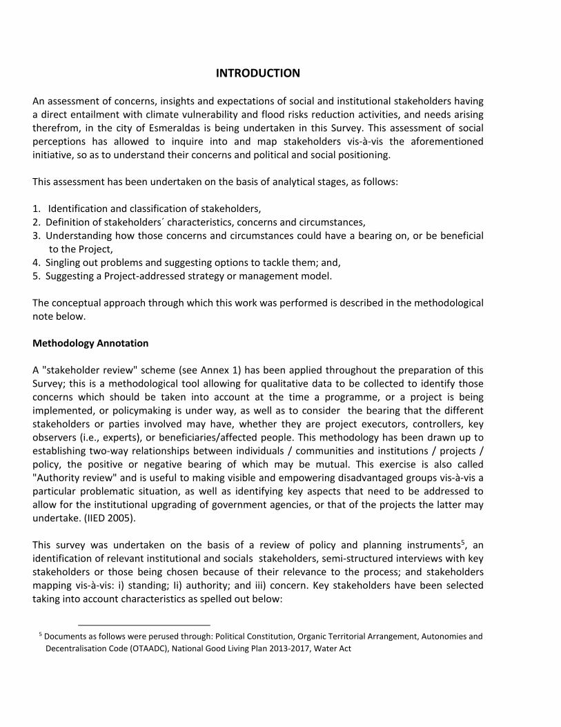
INTRODUCTION An assessment of concerns, insights and expectations of social and institutional stakeholders having a direct entailment with climate vulnerability and flood risks reduction activities, and needs arising therefrom, in the city of Esmeraldas is being undertaken in this Survey. This assessment of social perceptions has allowed to inquire into and map stakeholders vis-à-vis the aforementioned initiative, so as to understand their concerns and political and social positioning. This assessment has been undertaken on the basis of analytical stages, as follows: 1. Identification and classification of stakeholders, 2. Definition of stakeholders´ characteristics, concerns and circumstances, 3. Understanding how those concerns and circumstances could have a bearing on, or be beneficial
to the Project, 4. Singling out problems and suggesting options to tackle them; and, 5. Suggesting a Project-addressed strategy or management model. The conceptual approach through which this work was performed is described in the methodological note below. Methodology Annotation A "stakeholder review" scheme (see Annex 1) has been applied throughout the preparation of this Survey; this is a methodological tool allowing for qualitative data to be collected to identify those concerns which should be taken into account at the time a programme, or a project is being implemented, or policymaking is under way, as well as to consider the bearing that the different stakeholders or parties involved may have, whether they are project executors, controllers, key observers (i.e., experts), or beneficiaries/affected people. This methodology has been drawn up to establishing two-way relationships between individuals / communities and institutions / projects / policy, the positive or negative bearing of which may be mutual. This exercise is also called "Authority review" and is useful to making visible and empowering disadvantaged groups vis-à-vis a particular problematic situation, as well as identifying key aspects that need to be addressed to allow for the institutional upgrading of government agencies, or that of the projects the latter may undertake. (IIED 2005). This survey was undertaken on the basis of a review of policy and planning instruments5, an identification of relevant institutional and socials stakeholders, semi-structured interviews with key stakeholders or those being chosen because of their relevance to the process; and stakeholders mapping vis-à-vis: i) standing; Ii) authority; and iii) concern. Key stakeholders have been selected taking into account characteristics as spelled out below:
5 Documents as follows were perused through: Political Constitution, Organic Territorial Arrangement, Autonomies and
Decentralisation Code (OTAADC), National Good Living Plan 2013-2017, Water Act

a) Persons, communities and entities whose particular concerns are impaired by the project, or have a significant bearing on the project, or on the issue under consideration;
b) Experts having information, know-how and experience on the project´s key subject;
c) Individuals or institutions controlling or influencing the project implementation processes. In this case, the issue project, or subject under consideration regarding which this Stakeholder Review was carried out, was the "Reducing climate vulnerability and flood risk in coastal urban and semi urban areas in Latin American cities" project, which is being briefly referred to in this document as "Climate Vulnerability Reduction Project" or, simply, CVRRP. Field Work Fieldwork for drafting up this Survey was undertaken over the 2 – 14 May 2016 period. In the city of Esmeraldas, public entities empowered to addressing risk management-related matters in the local level were also contacted by experts in the subject, as well as residents living in areas vulnerable to hydro-meteorological phenomena arising from the climate change phenomenon, in the city of Esmeraldas. Public and civil society entities contacted for the preparation of this report were: Esmeraldas Municipality, Esmeraldas Provincial Council, Risk Management Secretariat, Navy-attached Oceanographic Institute (NOI, for its acronym in Spanish), Ministry of Public Works, National Water Secretariat, Fire Brigade, Red Cross, Pontifical Catholic University of Ecuador (Esmeraldas Campus). Visits were also made to neighbourhoods under the impact or likely to be under the impact of climate change, such as: Diógenes Mera (Cruzeiro), 20 de noviembre, Unión y Progreso (La Guacharaca), Cocoy, Abril 13, Chone Alto, El Arenal, Propicia 1 y 2, Las 50 Casas, Isla Pianguapi, Cordero Crespo (Isla Vargas Torres), 12 de mayo, Isla Vargas Torres), 20 de noviembre (Isla Vargas Torres), 29 de agosto (Isla Vargas Torres), and the Tachina sector. Interviews were held with local leaders and people facing up to specific emergency events or disasters is these neighbourhoods. Finally, and together with municipal officials and CAF representatives, a tour of critical vulnerability spots in the city was made to becoming aware of the sheer size of climate change impacts in the area, so as to ponder some other intervention lines through this project. (Map 1) A total of fifty-eight people were interviewed such as public officials, experts, neighbourhood leaders and residents.
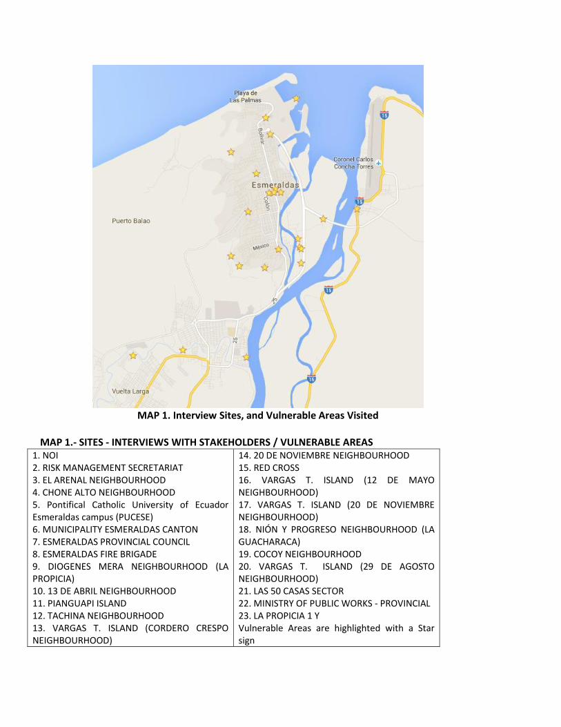
MAP 1. Interview Sites, and Vulnerable Areas Visited
MAP 1.- SITES - INTERVIEWS WITH STAKEHOLDERS / VULNERABLE AREAS 1. NOI 2. RISK MANAGEMENT SECRETARIAT 3. EL ARENAL NEIGHBOURHOOD 4. CHONE ALTO NEIGHBOURHOOD 5. Pontifical Catholic University of Ecuador Esmeraldas campus (PUCESE) 6. MUNICIPALITY ESMERALDAS CANTON 7. ESMERALDAS PROVINCIAL COUNCIL 8. ESMERALDAS FIRE BRIGADE 9. DIOGENES MERA NEIGHBOURHOOD (LA PROPICIA) 10. 13 DE ABRIL NEIGHBOURHOOD 11. PIANGUAPI ISLAND 12. TACHINA NEIGHBOURHOOD 13. VARGAS T. ISLAND (CORDERO CRESPO NEIGHBOURHOOD)
14. 20 DE NOVIEMBRE NEIGHBOURHOOD 15. RED CROSS 16. VARGAS T. ISLAND (12 DE MAYO NEIGHBOURHOOD) 17. VARGAS T. ISLAND (20 DE NOVIEMBRE NEIGHBOURHOOD) 18. NIÓN Y PROGRESO NEIGHBOURHOOD (LA GUACHARACA) 19. COCOY NEIGHBOURHOOD 20. VARGAS T. ISLAND (29 DE AGOSTO NEIGHBOURHOOD) 21. LAS 50 CASAS SECTOR 22. MINISTRY OF PUBLIC WORKS - PROVINCIAL 23. LA PROPICIA 1 Y Vulnerable Areas are highlighted with a Star sign

I. SOCIAL VULNERABILITY, PUBLIC POLICY AND RISK MANAGEMENT INSTITUTIONALITY As an essential conceptual background to the stakeholders´ review in this report, a brief description is made in this section of the social vulnerability and risks situation prevailing in the city, current policy and regulations in place vis-à-vis this phenomenon, and risk management-focused institutional arrangements. This introductory review allows to understand the threats being faced by community stakeholders interviewed for this report, as well as the determinants of government stakeholders being approached to carry out this work, who should abide by a specific legal and institutional framework. A summary of the "Reducing Vulnerability and Flood Risk in Urban and Semi-Urban Coastal Areas of Latin American Cities Project", is set forth in this report as an initiative to making a contribution to the solution of some of the most pressing vulnerability situations to which the population of the city of Esmeraldas is faced up with. This initiative, within the framework of which this work is being done, is part to an international initiative under way which is aligned with a political and legal framework on prevention and adaptation to climate change, as well as with international agreements and mechanisms addressing this area of work, to which Ecuador is a party. Socio-economic and demographic conditions in Esmeraldas The city of Esmeraldas, the capital of the province of the same name, is located on the Pacific Ocean coast, at the Esmeraldas River mouth. A seaport and the country's largest oil harbour and hydrocarbon refinery are located within the city´s territorial area: A natural setting with a wealth of natural resources, allowing for trade, tourism and fishing activities, which are the basis of the local economy. The Carlos Concha airport is rated as a first-class airport for national and international operation for passenger and cargo aircraft. In addition, in both the city and the province as a whole there is a highly important ethnic component since both of them are home to Ecuador's largest Afro-descendant population, as well as to three Indigenous Peoples´ nationalities. These cultural components make up an intangible Heritage on which the Emeralds identity is buttressed. Notwithstanding the natural and cultural wealth and the presence of a large public infrastructure, the Esmeraldas city and province have to cope with acute socioeconomic problems slowing down their developmental process. Some city-wise social indicators are shown below, indicating vulnerability traits in specific social sectors. 1. Current population
According to the latest census, (INEC 2010), the Esmeraldas canton population is made by 189,504 inhabitants, with a projected 208,615 inhabitants to 2015 (INEC 2015). Age Average is 27 years, with 403.9 children under five years old per 1,000 women of reproductive age (15-49 years). The Afro-Ecuadorian population accounts for %42.1%.
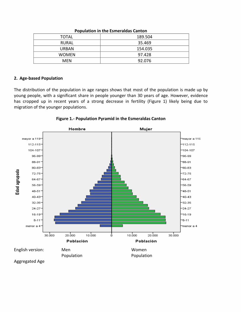
Population in the Esmeraldas Canton
TOTAL 189.504
RURAL 35.469
URBAN 154.035
WOMEN 97.428
MEN 92.076
2. Age-based Population The distribution of the population in age ranges shows that most of the population is made up by young people, with a significant share in people younger than 30 years of age. However, evidence has cropped up in recent years of a strong decrease in fertility (Figure 1) likely being due to migration of the younger populations.
Figure 1.- Population Pyramid in the Esmeraldas Canton
English version: Men Women Population Population Aggregated Age

3. Population by ethnic group
Ethnic groups present in the Esmeraldas canton are: mestizos, Afro-Ecuadorians, whites, Indigenous Populations, and Montubios (Figure 2). The largest communities are mestizos and Afro-Ecuadorian which, together, make up more than 87% of the local population.
Figure 2. – Ethnic Groups
English version: mestizos, Afro-Ecuadorians, whites, Indigenous Populations, Montubio, other 4. Migration
A large number of people have moved out of Esmeraldas over the last few years, recording 6,746 people migrating to other cities, both within the country and abroad (PDOT 2015-2020). However, there is also a large population influx, from Colombia in particular, as refugees fleeing from the internal war beleaguering their country for over half a Century. Only between years 2000 and 2005, some 36,665 Colombian nationals arrived in the Esmeraldas canton, and 1162 refuge applications were recorded, although the actual number of immigrants could be higher on account of the Colombian armed conflict could be higher. 5. Population vis-à-vis poverty
Thirty-four percent of the population in the Esmeraldas canton are recorded as living in poverty; extreme poverty figures account for 11% of the population. In urban areas, the incidence of poverty

is 27%, and that of extreme poverty accounts for 6%. In some other settings, poverty is recorded on the basis of the following indicators:
Average schooling years for most adults, father and mother, are 5.8 years;
Approximately 80% of men and women are not registered with social security;
There are three out-patient health facilities per each 10,000 inhabitants;
33.8% of inhabitants live in overcrowded conditions;
Around 60% of the population has access to health, road and basic utilities infrastructure (TAP 2015-2020)
6. Schooling The illiteracy rate in the Esmeraldas province is 8.3%. That for the Esmeraldas canton is 5.3%.
English version: Illiteracy Rate (%) Population aged 15 and over. 2001-2010-2013 Censuses.
National Provincial
Source: Territorial Arrangement Plan (TAP) 2015 – 2020
7. Housing
According to the 2010 Population and Housing Census data, collected in the 2015 – 2020 Esmeraldas
Development and Territorial Management Plan, 18% of households in this district live in homes
showing inadequate physical characteristics, a situation made even worse by a housing shortage. In
addition, homes in poor condition in the canton amounted to 4.5%. These data mean that one in
every five households is in a situation of vulnerability to natural events.

8. Transportation
The number of motor vehicles registered in the Esmeraldas canton shows a large increase since
2009, when only 9,604 units were registered. For 2010, this figure was 18,680; 31,029 units were
recorded in 2012; in 2012, the figure increased to 34,577 units (TAP 2015-2020).
This growth of the automotive park is explained by an expansion of tourism activities, in particular in
the southern areas of the canton. Also, mention should be made of the construction of a new airport
in Tachina, and the higher number of daily flight frequencies between Esmeraldas and Quito, which
has also given rise to a higher number of vehicles in the canton.
9. Public Utilities Coverage
Electrification is the most widespread public utility in the Esmeraldas province, with an 86.04%
coverage, which is lower than the national average of 93.19%. No disaggregated data are available
by cantons vis-à-vis electricity and all other public utilities as shown in Table 1, below.
Table 1.- Public Utilities Coverage in the Esmeraldas Province
Percentage of households supplied with
electricity
93.19 86.04
Percentage of households with sewage disposal
by public sewage system
53.6 30.72
Percentage of households with public water
supply in the premises
71.98 36.22
Percentage of homes disposing of garbage
through a garbage collection vehicle
76.97 69
Source: INEC. 2010 Census
Percentage of household with a computer available at home 14.11%
Percentage of households using gas for cooking 92.28
Percentage of households using electricity for cooking 0.22%
Percentage of households in overcrowded conditions 22.06%
Source: INEC. 2010 Census
According to estimations, the basic utilities deficit is 32.7%, showing low levels of access to
electricity, drinking water supply, and sanitation.
11. Average household income
Seventy per cent of the population is recorded in the informal and self-employment sector, while
between 68% and 73% of the economically active population has no access to permanent
employment. While the national per capita income in 2010 was US $ 1,759, the provincial average
only reached the US $ 670 figure.

The city and its vulnerability to climate change
Located right in front of the Pacific Ocean, in the Equatorial zone, the urban areas of the Esmeraldas
canton lie between the final stretch and the estuary of the Esmeraldas river in between the
Northern-Eastern area and a range of hills in the South and South-West. The geographical and
astronomical location of the canton (by the Ocean and in the Equatorial zone), defines the presence
of hydro-meteorological events having a heavy impact on the local and regional climate. This in turn,
when combined with geographical and topographical components existing in its setting (between
hills and a river-estuary) explains the risky situations the Esmeraldas city is exposed to, conditioning
its socio-economic life.
On account of its geographic and astronomical location, the city of Esmeraldas is subject
to meteorological events resulting from a combination of factors, such as: i) the confluence of the
cold Humboldt and the warm El Niño currents, flowing from the Southern and Northern zones of the
continent respectively, and the location of the city in the convection area where both currents mix.
The arrival of the warm El Niño currents is beneficial to the Northern coast of Ecuador because of
the rainfall those currents usually generate in the otherwise dry coastal area. This current, travelling
from the North, pushes the cold Humboldt current flowing from the South, drying up the coastal
areas; Ii) These cold and warm currents determine the occurrence of El Niño and La Niña
phenomena, the former generating humid and extremely humid climate conditions, and the latter
bringing dry and extremely dry climate conditions, both of them having significant global impacts;
and iii) As the last climate factor derived from the Esmeraldas astronomical location, the impact of
the intertropical convergence area determines the presence of accelerated evaporation processes,
and the occurrence of high-humidity loaded clouds, with resulting convective storms and torrential
rains.
Hydro-meteorological factors mentioned above have made the Esmeraldas canton and the province
into a meteorological extremes area, with torrential downpours (typically between January and
May), and drought (usually over August and September).
On the other hand, the geographic and topographic characteristics of the Esmeraldas city (right by
an ocean and having a river and estuary on one side and mountains on the other), define the
powerful bearing that these hydro-meteorological characteristics have on the city and the later
ensuing social vulnerability and risk situation. This could be briefly explained as follows:
I) The city´s most important location component is the presence of the final course and estuary of
the Esmeraldas River which, in turn, a few kilometres back, is fed by the River Teaone6 waters, a
fact signalling the presence of a wide riverbed, islands and adjacent lowlands. Due to specific
socioeconomic reasons, this natural setup is a feature becoming into a social vulnerability and
6 Fourteen local micro-basins make up the water system of the Esmeraldas and Teaone rivers recording a low and zero
water volumes over the dry season, and substantial rainfall volumes over the rainy season.
risk issue since poor families and immigrants have been living in these areas for several decades,
deeming them to be an affordable place to settle down. Being the end-result of land invasions
and because they are flood-prone areas, these lands are among the cheapest in the city.
Furthermore, in some cases luring people from most centrally located lands, attracting a large
population estimated to be 5,000 families at least, who have so far settled in these areas prone
to flood risks;
II) On the other hand, flanking the city on its South-West side, there is a chain of hills, the elevation
of which does not exceed 300 metres vis-à-vis the city´s altitude, showing high risk scenarios
notwithstanding. The geological composition of this topographic formation is made up of
disintegrating clays with small stone material segments, a fact determining the occurrence of
landslides of diverse sizes in some areas, putting at risk a large population settled on the hills´
slopes. Like the lowlands along the river, slope lands are also economically affordable because
they were originally obtained through invasion, a large number of them lacking property titles
and basic utilities. On account of the natural and socioeconomic conditions prevailing in the
area, landslides occurring in this mountain area of the city are of a geological origin (weathered,
cracked material), morphological origin (slope erosion), physical origin (long-lasting
precipitations) and anthropogenic origin (excavation, mining, deforestation) (Montaño 2011).
According to estimates, a population between 2000 and 5000 families has settled in this area.
These climate issues signalling the occurrence of heavy rainfalls, and the added city´s topographical
characteristics (lowlands along the river bed, and slopes flanking the city), and socioeconomic
conditions fostering settlement of a large population in these areas, have generated a widespread
social vulnerability, a worrisome problem not only for people living there, but also for the local
municipality, and government-attached risk planning and management entities. An estimation has
been made that 30% of the urban population of Esmeraldas is settled in areas showing high and very
high floods and landslides risks impacts (GAD-E 2012)7
Meteorological, geophysical and socio-economic considerations as above shall allow us to graphically appreciate that the city of Esmeraldas is an urban area particularly showing a high sensitiveness to climate change impacts. This natural and social framework is determinant vis-à-vis the prevailing situation and the attitude that both, city inhabitants and authorities have vis-à-vis climate change impacts. Most relevant stakeholders in the city have been interviewed for this Report (See Annex 3.- Listing of people and public officers interviewed), below.
Risk Management Policy and Legislation in Ecuador
Risk management policymaking and regulations are based upon a notion aimed at "improving the
quality of life of the population"8, which is one of the programmatic axes of both, the National Plan
7 DAG-E (Municipal Decentralized Autonomous Government, Esmeraldas Canton) Development and Territorial
Arrangement Plan 2012 - 2022
8 See: Objective No.3, in NGLP.

for Good Living (NPGL), and a comprehensive safety warranty9 for the country inhabitants: One of
the overriding duties of the Ecuadorian State. The Constitutional risk management10 and climate
change mitigation11 regulations respond to these two principles underpinning the public
administration around management of climate change-related natural and anthropogenic events.
Based on policy-making and legislation principles as stated above, a regulatory risk management
system has been constructed which is embodied in official documents as below:
• National Development Plan for "Good Living" - 2013-2017.
• The Political Constitution of the Republic of Ecuador.
• Public and State Security Act.
• Regulation to the Public Security and State Act.
• Organic Territorial Arrangement, Autonomies and Decentralization Code (OTAADC).
• Organic Planning and Public Finance Code (OPPFC).
• Organic National Public Procurement System Act.
This policy and legislation aggregate has been the origin of an institutional framework basically
consisting of a national entity (the Risk Management Secretariat), provincial and regional entities are
attached to throughout the country. Moreover, as an operational mechanism, plans are under way
to setting up specific operational instances for each territory, which are operational only in risk
situations. These are the Emergency Operations Committees (EOCs) which, bearing in mind the
geographical scope of the potential impact of the threat detected, or damages in the event of a
disaster, EOCs could have a national, provincial or cantonal coverage.
An EOC is an instance for inter-institutional coordination, the key duties of which are as follows:
a) Drafting up and approving the Risk Reduction Agenda (RRA) in the territory under its
responsibility, implementing the RRA, and being accountable for its achievements.
b) Coordinating public and private entities efforts within their territorial scope during emergencies
and disasters.
9 Seer: Article 3, Numeral 8, Political Constitution of the Republic of Ecuador (CRE)
10 See: Article 389, Numeral -CRE: “The State shall protect individuals, communities and nature from the adverse
impacts of natural or man-made disasters by means of risk prevention, disaster mitigation, recovery and improvement of
social, economic and environmental conditions, with an aim to minimising vulnerability conditions”.
11 See: Art. 414-CRE. “The State shall undertake appropriate and cross-cutting measures to mitigate climate change, by
curtailing Greenhouse Gas emissions, deforestation and air pollution, and taking measures addressing the conservation
of forests and vegetation, and the protection of populations at risk”.
c) Leading actions being implemented over the recovery phase.
d) Deciding upon matters that the EOC members submit to the Committee.
Members of the Cantonal Emergency Operations Committee
1. Mayor (Natural Chairman of the Cantonal EOC)
2. Cantonal Political Leader
3. Representatives of State secretariats present in the canton
4. Municipal Risk Management Unit, and Municipal Public Utility Companies Representative
5. Risk Management Secretariat and Heads of relief agencies (Fire BriADGe, Red Cross, Traffic
Commission) delegate
6. Disabled peoples´ organisations in the canton delegate
7. Armed Forces (present in the canton) delegate
8. National Police delegate
9. Neighbourhood Boards canton representative
10. Technical panels coordinators
11. Other members at the discretion of the cantonal EOC
Parallel to the EOC, which is the public operating instance, there is the Risk Management Committee
(RMC) which is made up by internal operational institutional (public and private) instances for
targeted emergencies.
Vulnerability and Risk Reduction Project (CVRRP)
The CVRRP project is a joint initiative of the Ministries of the Environment of Ecuador (EME) and
Chile (MMCh), and the Bank for Latin American Development (CAF). This project was originated on
the fact that the Latin American region is the most urbanized region in the world, with 80% of its
population living in cities, and 111 million people living in informal settlements and in poverty-in-
inequality conditions, a situation making a substantial number of these people highly vulnerable to
disasters. Most of this urban population is located in coastal areas, in places enduring the adverse
impacts of climate change.
Bearing in mind this situation, the CVRRP is making a proposal for work to get under way to abating
vulnerability to floods and landslides in three coastal cities in the region, one of which is
Esmeraldas12. As the cheer size of climate change impacts escalate, the city of Esmeraldas will be
12 Antofagasta and Taltal in Chile are the other two cities referred to.

becoming increasingly more sensitive to vulnerable situations such as those being highlighted in this
paper, and which will put at risk both, the city and department inhabitants, and private
infrastructure.
II. STAKEHOLDERS AND THEIR CONCERNS
The Stakeholder Review is a methodological tool allowing to single out the concerns that should be
borne in mind at the time a programme, project, or policy is designed, executed, or enforced. Each
stakeholder responds to a different two-basic type typology: public officers and citizens. The former
could be planning, regulatory, and control institutions, executing or promoting works. The second
type of stakeholder includes those being affected / benefited by the project, such as lobbyists,
observers, private entities, communities, Civil Society Organisations (CCOs), citizens, among others.
As described above, the CVRRP is addressed to the reduction of two of the vulnerabilities detected
in the city of Esmeraldas: landslides or mass earth movements, and flood risks. Two specific types of
stakeholders are involved: public officials and risk management experts, and people being impaired
by these two risks. Table 2 shows all stakeholders vis-à-vis the CVRRP, both at local, provincial and
national level. These stakeholders who are attached to the geographical and functional area13of
influence of the CVRRP, correspond to the following types:
1. Public entities:
a. National management and control bodies
b. Local Management Entities
2. Neighbourhood organisations
3. Civil society organisations
All entities and people having a particular interest in the CVRRP, as shown in Table 2 below, can be
attached to any of the two types above. Key stakeholders will then be identified, i.e., those who are
essential to the different project stages, with which the project executors should set up dialogue
mechanisms, enter into agreements, and coordinate activities.
13 “Functional Stakeholders”, are those that, because of their institutional investiture (legal competence or public
attribution), have a bearing on the project, even without being located in the project´s execution area, and even without
having a particular interest in the project.
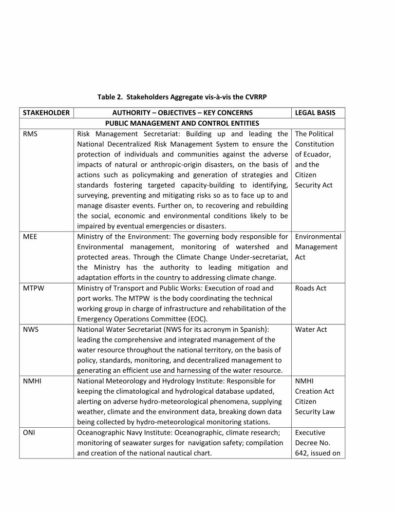
Table 2. Stakeholders Aggregate vis-à-vis the CVRRP
STAKEHOLDER AUTHORITY – OBJECTIVES – KEY CONCERNS LEGAL BASIS
PUBLIC MANAGEMENT AND CONTROL ENTITIES
RMS
Risk Management Secretariat: Building up and leading the
National Decentralized Risk Management System to ensure the
protection of individuals and communities against the adverse
impacts of natural or anthropic-origin disasters, on the basis of
actions such as policymaking and generation of strategies and
standards fostering targeted capacity-building to identifying,
surveying, preventing and mitigating risks so as to face up to and
manage disaster events. Further on, to recovering and rebuilding
the social, economic and environmental conditions likely to be
impaired by eventual emergencies or disasters.
The Political
Constitution
of Ecuador,
and the
Citizen
Security Act
MEE Ministry of the Environment: The governing body responsible for
Environmental management, monitoring of watershed and
protected areas. Through the Climate Change Under-secretariat,
the Ministry has the authority to leading mitigation and
adaptation efforts in the country to addressing climate change.
Environmental
Management
Act
MTPW Ministry of Transport and Public Works: Execution of road and
port works. The MTPW is the body coordinating the technical
working group in charge of infrastructure and rehabilitation of the
Emergency Operations Committee (EOC).
Roads Act
NWS National Water Secretariat (NWS for its acronym in Spanish):
leading the comprehensive and integrated management of the
water resource throughout the national territory, on the basis of
policy, standards, monitoring, and decentralized management to
generating an efficient use and harnessing of the water resource.
Water Act
NMHI National Meteorology and Hydrology Institute: Responsible for
keeping the climatological and hydrological database updated,
alerting on adverse hydro-meteorological phenomena, supplying
weather, climate and the environment data, breaking down data
being collected by hydro-meteorological monitoring stations.
NMHI
Creation Act
Citizen
Security Law
ONI Oceanographic Navy Institute: Oceanographic, climate research;
monitoring of seawater surges for navigation safety; compilation
and creation of the national nautical chart.
Executive
Decree No.
642, issued on

18 July 1972.
LOCAL AND PROVINCIAL GOVERNMENT ENTITIES
Provincial ADG cuting public Works in watersheds and micro-basins.
Article 47,
OTAADC14
Article 263,
Constitution
Municipal
ADG
Exercising control over land use and harnessing Provision of public utilities: drinking water, sewerage, sewage treatment. • Marking off, regulating, authorising and monitoring the use of seashores, riverbanks and riverbeds, lakes and lagoons • Safeguarding and ensuring an effective access of people to the use of sea beaches, river banks, lakes and lagoons. • Regulating, authorizing and controlling the exploitation of arid and stony materials present in riverbeds, lakes, sea beaches and quarries.
Article 264,
Constitution
Fire BriADGe
in Esmeraldas
Managing Urban emergencies, fires in particular. OTAADC
CIVIL SOCIETY ORGANISATIONS
Red Cross Health emergency care N / A
PCUE Pontifical Catholic University of Ecuador (Esmeraldas Campus)
Main concern: Higher education
N / A
STAKEHOLDER
AUTHORITY – OBJECTIVES – KEY CONCERNS LEGAL BASIS
CAF Bank for Latin American Development. Key concern: Funding of
Development Projects
N / A
NEIGHBOURHOOD ORGANISATIONS
NEIGHBOURHOOD LOCATION ORGANISATION
Diógenes Mera
(also known as
Cruzeiro)
Located in the low-lying areas in the city,
subject to flood impact. Recording sewage
reflux problems.
A factual neighbourhood Board
is in place.
A youth integration group is in
place carrying out social and
sports activities, and
cooperating in the cleaning and
recovery of community areas,
such as a sports fields. They
also seek to undertaking
14 OTAADC, Organic Territorial Arrangement, Autonomy and Decentralisation Code

activities to disrupt youth gangs
by engaging them in sports
activities.
20 de noviembre This neighbourhood was affected by a
landslide in January 2016, destroying 38
houses.
There is a de facto
neighbourhood Board the main
purpose of which is to up-
keeping community harmony.
The January 2016 landslide
made the Board to become
operational, thus holding talks
with Municipality authorities
and the Provincial Council for
support.
Unión y Progreso
(La Guacharaca)
A landslide was recorded in this
neighbourhood 20 years ago. Works to keep
it in check included a concrete and mesh
coating.
This is one of the oldest
population settlements in the
area, making it well-known for
its greater social cohesion. The
neighbourhood Board made a
decision to up-keeping the
natural vegetation on the hill
slopes in order for any future
landslides in the sector to be
prevented.
Cocoy The slope soils around this neighbourhood
are unstable and rocky. A stone and sand
mining operation is underway in the area.
The April 2016 earthquake originated a small
landslide, with no house damages recorded.
There is a de facto
neighbourhood Board, working
mainly for improvements in the
area. Further, there is an
informal women organisation
concerned with preventing
crime in their community. The
location of the neighbourhood
far away from the city centre,
makes its people vulnerable to
robberies and mugging.
13 de abril Located in the upper area of the city, soils
show characteristics similar to those of the
November 20 neighbourhood.
There is no neighbourhood
Board in operation
Chone Alto Located in the upper area of the city, on soils characterized by their instability. No large landslides have been recorded in the
There is no neighbourhood Board; instead, one man living there hold a de facto

area.
leadership which, when necessary, exerts it on behalf of people living in the sector.
El Arenal Located in the lower area of the city, showing flood-related problems only in extreme situations.
There is no neighbourhood Board in place. A folk group has been formed.
Sector La Propicia 1 and 2
Located by the river banks, experiencing flood problems in extreme situations.
Sewerage problems from occasional discharges originating in nearby PETROECUADOR facilities.
Sector las 50 Casas High city areas, close to an estuary flowing into the Esmeraldas river.
There is no neighbourhood Board in place
Pianguapi Island Inner area in the island, lowland and prone to flood.
There is no neighbourhood Board in place
1.Vargas Torres Island: 2.Cordero Crespo Neighbourhood 3.12 de mayo neighbourhood 4.20 de noviembre neighbourhood 5.29 de agosto neighbourhood
All of these neighbourhoods are flood-prone areas in heavy rainy seasons in the upper reaches of the basins and micro-basins of the Esmeraldas and Teaone rivers. Also, over the high tide and flood season, heavy floods are generated, reaching 2M high waves. Flood events of this size have been recorded every ten years or so.
There are no consolidated neighbourhood Boards in place, but groups assuming a de facto leadership as may be required to making complaints to public bodies, or interacting with authorities.
Source: Field Work Stakeholders' Insights and Concerns In overall, the three organisational types and two subordinate types being identified in the CVRRP geographical and operational area of implementation do not share a similar insight vis-à-vis a need to monitoring climate change impacts; however, this is not the case regarding specific administrative and technical measures for this goal to be achieved. The aggregate of stakeholders identified as regards the CVRRP, as already mentioned, is made up as follows: 1. Public entities:
a. National management and control entities b. Local Management Entities

2. Neighbourhood organisations 3. Civil society organisations Bearing in mind the nature of activities the CVRRP is intended to undertake, and funding sources, there is no objection to the Project´s execution. Taking into consideration that this is an initiative being funded by international cooperation with non-reimbursable funds, all stakeholders have expressly or tacitly stated their full agreement with this project since it addresses specific problems the Esmeraldas city is facing up to, such as climate change impacts and risks, as well as social vulnerability to those impacts, and pre-existing conditions having a bearing on several local neighbourhoods and communities. Furthermore, a city-specific public policy conceptual design is still lacking to address climate change impacts readiness and mitigation. The CVRRP would play a key role in this endeavour towards public policymaking on this subject around which all stakeholders involved are articulated. Beyond these understandable local concerns, no opposition likely to escalate to stressing or conflicting situations shall be generated by the CVRRP. Obviously, disagreements could arise over the project´s implementation phase, but they are unlikely to occur with respect to the reason behind the project implementation itself, but rather, regarding the way in which institutional interactions are established and prevention and mitigation actions and community participation are addressed. The Standpoint of Neighbourhood Stakeholders The local community likely to endure risks, emergencies and disasters as a result of hydro-meteorological events is made up by people enduring different poverty levels; a large number of people are migrants from rural areas in the same province, Manabí, and even from the Southern coastal areas of Colombia. That is to say, they are groups of individuals facing up to socio-economic vulnerability who have settled in low-priced, or freely-accessed places at risk, deemed as areas susceptible of invasion or irregular settlement. Their economic vulnerability prevents them from having access to any places other than those they are living in and, therefore, any attempt to displace or relocate them would become into a traumatic event if no proper assistant is provided to them beforehand. Visits were made to two different locations in the city: an area next to a row of hills stretching from a beach sector known as Las Palmas into the mainland parallel to the city; and to the flood area at the edge of the Esmeraldas river bed and estuary. In the first sector, occasional landslides have been recorded on the hill slopes, while the second sector is subject to flood events. Specific emergencies were sustained in both sectors in January 2016 resulting from heavy rain throughout the region, clogging the river bed and triggering instability in a place known as the Gatazo Hill (Neighbourhood 20 de noviembre, El Oro Street). No casualties were recorded because landslides were small-scal. As stated by the local community and, in particular, by people in the area enduring climate change impacts, they are unaware of the problematic they are living in. Sometimes, people only learn of climate-related risks the moment an emergency situation is triggered; some other times, people
naturally coexist with risk. This is the case of floods deemed as a normal natural event, since a sort of social resilience vis-à-vis floods has become ingrained in people making them to face up to these impacts with a sort of resignation to misfortune. A manifest disconnection exists between neighbourhood and community areas and public administration processes focused on risk management, which, in broad terms, are a relatively new and often underestimated institutional perspective country-wise15. Furthermore, the institutional framework has yet to construct a public image of the aggregate of political, administrative and operational measures making up risk management, a fact adding to the population assuming risk management more as assistance to the population in case of a climate impact rather than as a comprehensive set of both, State and citizen rights and obligations. In the absence of an integrative notion of what risk management entails, the social stance towards the State (in this case, the Municipality) is one of distrust, since the perception is that the risk management-focused discourse is only a justification for the public administration not meeting people needs, displacing them from the area, or not facing an already existing problem, such as the landslides in the 20 de Noviembre neighbourhood, which at the moment of its occurrence (year 2016) had already destroyed 38 houses16 and was still active at the time this paper was drafted up. As an outcome of the two factors mentioned signalling that the State is still to construct a comprehensive imaginary of risk management and that the public assumes it only from a welfare and philanthropic point of view, there are also expectations and even community demands that could not be met by public institutions, as shown in areas affected by floods. According to people living in these areas, smaller-size floods occur at least once a year, without causing permanent damages or impacts on the lower sectors of the Pianguapi and Vargas Torres islands and riverbanks close to the City (The Potosí sector). Heavy flood is recorded once over a five-year time range, reaching a 60cm rise, damaging a large number of houses. Every 20 years, heavy flood, reaching a 2M rise with a heavy impact on all houses in the islands and areas bordering the river is recorded. Notwithstanding the time estimate people make about the occurrence of these events, the most serious of them occur when high tide at sea and heavy precipitations in the upper and middle sectors of the Esmeraldas river mix basin together. Thus, floods generating emergencies and disasters could occur even within a shorter time lapse than that popular perception indicates. Beyond the direct impact on movable property and even the homes of people affected by climate change impacts, emergencies unleash a series of non-visible problems having a direct bearing on residents and generating friction with disaster relief agencies. For example, many people living in an area at risk do not evacuate their homes despite the imminence of an emergency because of the security problems their assets and property are exposed to if people are not present. Reports of robberies and looting of homes or, at least, fears that this may happen are common. This
15 Notwithstanding, the April 2016 earthquake shall greatly change citizen insight vis-a-vis risk management activities
and institutionality. 16 At the time the last visit was made over field work being done for this Report, three additional houses were being
destroyed by the advancing landslide recorded in the area.

perception, justified or not, could lead to fatalities in the event of a disaster and people do not comply with the authorities' request for evacuation. This means that the sociological perceptions or realities of vulnerable populations should also be integrated into emergency readiness measures, besides making arrangements to addressing the adverse event itself17. Likewise, these perceptions are linked to gender inequality situations, since single mothers find it more difficult to evacuate their homes because of the uncertainty they are left with of not being able to meeting the needs of their children in makeshift places. This will be further discussed below. Another subjective aspect likely triggering emergency situations that cannot be properly addressed is the perception about the occurrence of floods “demanding evacuation”. The rationale is that whenever heavy rains, high tide, and tidal waves occur, an evacuation process is mandatory. Notwithstanding, whenever heavy rainfall in the upper and middle parts of the Esmeraldas and Teaone river basins becomes apparent which may even go unnoticed in the lowlands where the city is located, could also cause sudden flood and even materials´ dragging. A firefighter was killed when he was trying to rescue someone in a flood event previous to that recorded in January 2016. Bearing in mind the perception people have of natural disasters, emergency entities should have a perspective that is based on remote warning systems allowing those entities to learning in advance about a threat of an adverse event, regardless of the subjective appreciations of people in the area. The perceptions people have likely distorting risk management measures are also present in a problem-solving situation. An example of this is how some people in the Vargas Torres Island found a way to tackle with flood events in the area: According to some people, a retaining wall should be built in a sector in the island marking the point where the Esmeraldas river is split into two branches, while for others it would be necessary to making a filling in the sector most impaired by flood events, so that whenever the river level should rise, this sector would not get flooded. Both works would require a large investment by the municipality, without a certainty whether the wall or the filling would really solve the problem. Another issue to be highlighted vis-à-vis local perception is the vulnerability people are faced with. Due to a lack of flood maps showing the areas likely to be prone to flood, the only way to find out whether or not a sector is flood-prone is through people´s own experience. This makes that vulnerability sectors likely to remain inactive for long periods of time to be invisible, thus becoming a source of risk under some circumstances. Versions have been collected about old dry riverbanks or river branches which have not been flooded since old times recollections in social memory. Since these areas are not considered as a potential hazard, people settle in them, building up their homes and other facilities without keeping risk situations in mind. Most people living in these areas argue that "no one has warned them" that the areas they have settled in are at risk. Further, this is intertwined with possible cases of speculation with lands resulting from invasions which are sold to
17 A similar situation was recorded in New Orleans, when thousands of people living in areas being affected by the
Katrina Hurricane did not evacuate the city despite the pressing call made by local authorities. In most of these
instances, the evacuation order was disregarded and people stayed home to collect the social security check that was
expected to arrive over the following days. An evacuation of the family without financial resources was not deemed
realistic by poor settlers of the city (see: Real 2007).

families who long for a place to build their homes, and who are unaware whether the place is safe to live in. Subjectivity as a factor of vulnerability to risk situations is also present in landslide areas, while people living in them take their own security measures on the basis of social memory, on the advisability of building their homes on cheap land, on a perception of security being generated by other houses already built on the site, on "without nothing happening," and, in general, on their own calculations about what can and cannot be done to face up to an ongoing socioeconomic risk, i.e., lacking a home of their own. These considerations inevitably turn against themselves and the authorities when an emergency situation occurs. Precisely in the area sustaining the latest landslide people living there argued that neither the Municipality nor any other authority informed them it was a risk area. Two of the residents who lost their homes due to the landslide stated that even their houses were granted building permits, and their property payments were up to date. Built in 2013, the two three-floor houses built in concrete were practically new (by 2016). The other 38 houses were destroyed and totally buried by the landslide because they were built right on the mountain slope where the landslide took place. This, as shown below, signals to an administrative fault by municipality authorities who, fourteen years ago had been given warning this place was prone to landslides, and specific preventive measures were suggested at the time, including a strict ban on the presence of settlements and construction of buildings. (EME 2002) Authorities addressed this situation by merely providing assistance, while an inter-institutional coordination and, above all, a solution strategy, were non-existent. People were well aware that between the Municipality and the Provincial Council "there was a two-way road", i.e., two different ways of weighing a solution, or how an emergency should be dealt with. The point of view of people living there was that the earth released by the landslide should have been removed, a work undertaken just to show off some response action rather than to actually solve the problem. Earth released would have required thousands of tow-lorry loads to evacuate, a nearly impossible task given the Municipality financial constraints. Further, removing the material would undermine the natural consolidation of the hill resulting from the detachment of material not having enough grip in the lower area. This would accelerate the occurrence of a new earth sliding front. However, despite the dangers the task involved, people feel optimistic whenever they watch a tractor and some of the municipality's dump trucks working in what seems to be a useless task. To further feeding people confusion, a few days later, according to residents interviewed, the Risk Management Secretariat arrived to take down the names of people who lost their homes. People thought of this as the start of some compensation or assistance process in the face of misfortune and, even more, as a chance to working with the rest of people living in the area who, although not yet impaired by the landslide, could also lose their homes. Notwithstanding the danger people continue to be exposed to, no procedure has been triggered to definitely address the situation. Here again, a lack of a specific public policy for these areas signals the attitude of the population to their vulnerability status and to local authorities. The soil instability in the hills adjacent to the city of Esmeraldas is a fact people have been aware of for at least two decades, when landslides were recorded in the Wínchele river watershed, (sector locally knows as St. George) in February 1998

(Montaño 2011), leading to the breakdown of the Trans-Ecuadorian Pipeline and starting a daunting fire18. In 2002, the EME recommended the Esmeraldas Municipality a series of technical, regulatory and social measures to avoid emergency situations in vulnerable areas in the hills and neighbourhoods in the city, including the 20 de noviembre and JR Coronel neighbourhoods, an area known as "the landfill." These measures include a protection screen on hills slopes to keep wind and water erosion in check; relocating houses built on slopes edges to a mid-slope area or at the foot of the hill, because they are exposed to serious damage; and prohibition of new housing development in the area. Nevertheless, new population settlements spread up over the next two decades, including the 20 of noviembre sector where, in January 2016, fourteen years after prevention measures were suggested to the Municipality, a new landslide was recorded, destroying at least 40 houses, most of them built after the time the Municipality was warned to stop house building projects in the area. The point should be highlighted that in some other inhabited areas in the hillsides (Cocoy, Union, Progreso, and Guacharaca Neighbourhoods, for example), people living there discern that landslides are linked to the loss of the slopes vegetation cover, so they have made a decision to keep the area in good condition. They are aware that some people, "to enlarging their backyards" have dig out the slope to have a flatter surface for family use and eventually build additional rooms. This, however, adds to hill slopes weakening. This community agency shows a clear concern to actively participate in monitoring the main threat these neighbourhoods are faced with. For obvious reasons, a mandatory question in this survey was how to assess the implementation of a specific project to reducing vulnerability to landslides and floods and to fostering an adaptation culture vis-à-vis adverse climate change impacts. In all cases, the answer to this question is affirmative; however, there is also a perception that people not only appreciate that a project of this type is executed, but the fact that international organisations are funding it generates expectation and high credibility vis-à-vis the outcomes the project is expected to achieve. In both, landslides and floods areas, the news about this project reaches the population only three months after the last most serious events in the city were recorded over the last decade. This series of events have given rise to a people´s perception of continuity vis-à-vis measures or help assurances they have been given by State agencies. As a complement to criteria drawn from interviews, Table 3 shows the specific points of concern that have been consistently stated by people living in the area being surveyed. These statements are incorporated verbatim so as to keep the significance they entail.
18 The landslide and subsequent fire caused 2 dead people, 30 people seriously injured, and 624 homeless people.
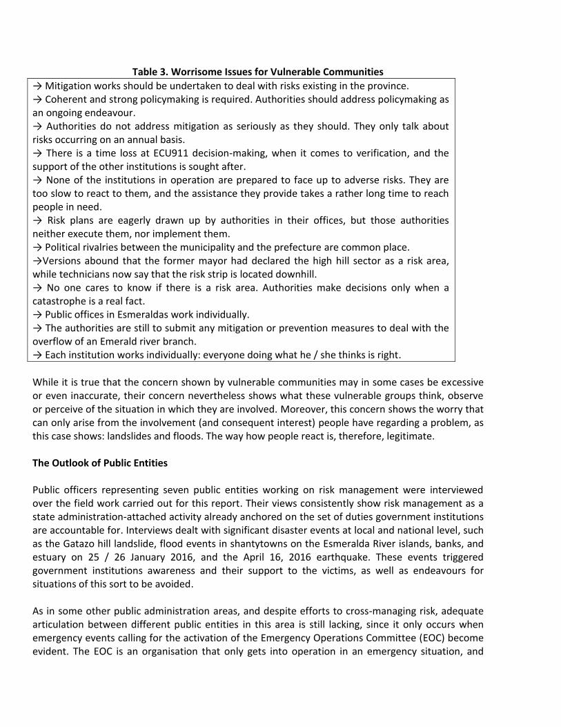
Table 3. Worrisome Issues for Vulnerable Communities
→ Mitigation works should be undertaken to deal with risks existing in the province. → Coherent and strong policymaking is required. Authorities should address policymaking as an ongoing endeavour. → Authorities do not address mitigation as seriously as they should. They only talk about risks occurring on an annual basis. → There is a time loss at ECU911 decision-making, when it comes to verification, and the support of the other institutions is sought after. → None of the institutions in operation are prepared to face up to adverse risks. They are too slow to react to them, and the assistance they provide takes a rather long time to reach people in need. → Risk plans are eagerly drawn up by authorities in their offices, but those authorities neither execute them, nor implement them. → Political rivalries between the municipality and the prefecture are common place. →Versions abound that the former mayor had declared the high hill sector as a risk area, while technicians now say that the risk strip is located downhill. → No one cares to know if there is a risk area. Authorities make decisions only when a catastrophe is a real fact. → Public offices in Esmeraldas work individually. → The authorities are still to submit any mitigation or prevention measures to deal with the overflow of an Emerald river branch. → Each institution works individually: everyone doing what he / she thinks is right.
While it is true that the concern shown by vulnerable communities may in some cases be excessive or even inaccurate, their concern nevertheless shows what these vulnerable groups think, observe or perceive of the situation in which they are involved. Moreover, this concern shows the worry that can only arise from the involvement (and consequent interest) people have regarding a problem, as this case shows: landslides and floods. The way how people react is, therefore, legitimate. The Outlook of Public Entities Public officers representing seven public entities working on risk management were interviewed over the field work carried out for this report. Their views consistently show risk management as a state administration-attached activity already anchored on the set of duties government institutions are accountable for. Interviews dealt with significant disaster events at local and national level, such as the Gatazo hill landslide, flood events in shantytowns on the Esmeralda River islands, banks, and estuary on 25 / 26 January 2016, and the April 16, 2016 earthquake. These events triggered government institutions awareness and their support to the victims, as well as endeavours for situations of this sort to be avoided. As in some other public administration areas, and despite efforts to cross-managing risk, adequate articulation between different public entities in this area is still lacking, since it only occurs when emergency events calling for the activation of the Emergency Operations Committee (EOC) become evident. The EOC is an organisation that only gets into operation in an emergency situation, and

over the time required to attend to the victims and undertake the initial recovery tasks. Here, public entities should get involved in the so-called "Technical Boards". Once the emergency is over, there is scant coordination between entities to address management of risk areas and support vulnerable communities. Likewise, there is also no interaction with communities either affected or impaired by emergencies; however, some meaningful efforts have been made for vulnerable and risky areas in the city to be identified. According to evidence arising from interviews, adverse impacts adaptation and mitigation-focused strategies, plans and conceptual documents have been drafted up since 2010, together with the installation of early warning equipment, for which cooperation has been forthcoming from international entities, mainly GIZ, UN-HABITAT, DIPECHO and UNDP. Notwithstanding these meaningful endeavours focused on risk management planning, a conceptual and administrative continuity with previous strategies and initiatives is still lacking: i.e., actions to diagnose, prevent and manage landslides-linked risks. Specific risk management approaches are present in the city (EME 2002, UNDP 2005) not showing any implementation or follow-up by government officials in charge. This could be explained by the paradigm shift generated with the approval in 2008 of a new conceptual and regulatory risk management framework19, which unwillingly moved officials to look only at the work they would do from that year on. Article 389 of the Constitution marked a landmark stage in public administration: risk management was for the first time understood as both, a crosscutting duty of the State and, implicitly, a citizen right. The second paragraph of this paper sets forth that risk management will be a regular activity, a part to all State levels and institutions, to be implemented through risk management units in all public and private institutions. This set of operational units constitutes the "decentralized national risk management system", under the aegis of the Risk Management Secretariat, which replaced the Civil Defence Office: a national entity attached to the Ministry of Defence that, having a less conceptual projection and devoid of an adequate Regulatory framework, was responsible for assistance work in disasters and emergencies up to year 2008 when the new conceptual framework came into being and, shortly after, the Risk Management Secretariat was set up. The paradigm shift recorded vis-à-vis this matter is basically a reflexion that disasters are not accidental events, but are due to natural, social and individual causal situations determining the vulnerability of a person or a community to a natural, or anthropogenic threat. Likewise, the temporality notion was replaced by a risk management on-going notion. The implementation of the new conceptual and institutional scenario for emergencies and risks management in both, Esmeraldas and the country as a whole, is attached to the Risk Management Secretariat and, when an emergency arises, to the EOC. This has meant that in this new risk management stage, plans disregard previous initiatives such as those in place to prevent landslides, which for over a decade predicted what would happen on Gatazo hill, and made specific action suggestions (EME 2002, UNDP 2005). This situation is an outcome of an unconscious consideration that whatever risk management measures had been designed previous to the current management paradigm, they were wrongly proposed.
19 This new conceptual framework was stipulated by the Republic Constitution, enacted in 2008.

To complement public officials´ perceptions, it is worth reviewing the statements made by some of the people interviewed for this report (Table 4). These admissions evidence the problems all paradigm transitions have, making it necessary that a new risk management outline currently operational in the country is consolidated in a harmonious inter-institutional exercise.
Table 4. Public Officers´ Self-criticism
→We are not prepared to face large-size adverse problems. → The EOC should be neutral vis-à-vis decision-making so as to be able to provide timely assistance to people affected. → Political rivalries are apparent within the EOC. → No in-depth analyses of environmental problems affecting the city have been conducted. → There is neither abidance nor a way to demand abidance by the prohibition for people to settle down in areas at risk;
Finally, a key issue arising out of interviews with public entities representatives working on, or linked to risk management -which goes beyond what is merely perceptual or subjective- is the scarce availability of resources allowing for plans and programmes drawn up to be implemented. Consistently, resources are needed to carry out and implement management plans and climate change prevention measures. The most important plan that has been implemented so far is the tsunami and flood risks-focused early warning system, equipped with two sirens strategically located in the city (one in the Provincial Council building and the other one in the Panecillo Hill), the activation of which can only be done by the city Mayor! Within this perception context, the implementation of a specific landslides and floods vulnerability reduction project -further intended to bolster an adaptation to adverse climate change impacts culture- generates an obvious appeal in all sectors. A project of this type allows risk management-linked entities to having a tangible possibility to carrying out actions for which a budget is non-existent. But more important is the fact that actions as planned shall be implemented having the risk management philosophy as the component underlying interventions likely to be performed, and not those attached to a conventional, dissociated from a social dynamic, public work. Characterization of Stakeholders Identified On the basis of the review above, considerations are spelled out below for each stakeholder identified (Table 5).
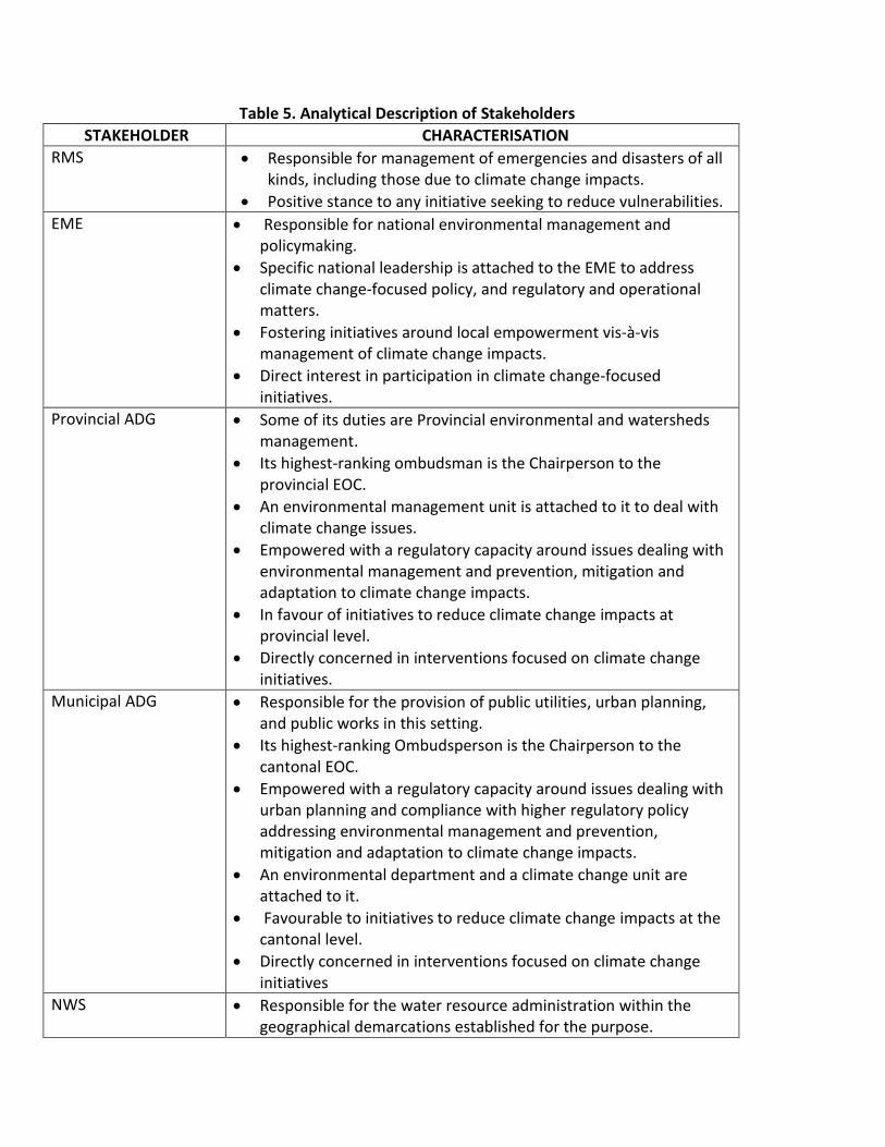
Table 5. Analytical Description of Stakeholders
STAKEHOLDER CHARACTERISATION
RMS Responsible for management of emergencies and disasters of all kinds, including those due to climate change impacts.
Positive stance to any initiative seeking to reduce vulnerabilities.
EME Responsible for national environmental management and policymaking.
Specific national leadership is attached to the EME to address climate change-focused policy, and regulatory and operational matters.
Fostering initiatives around local empowerment vis-à-vis management of climate change impacts.
Direct interest in participation in climate change-focused initiatives.
Provincial ADG Some of its duties are Provincial environmental and watersheds management.
Its highest-ranking ombudsman is the Chairperson to the provincial EOC.
An environmental management unit is attached to it to deal with climate change issues.
Empowered with a regulatory capacity around issues dealing with environmental management and prevention, mitigation and adaptation to climate change impacts.
In favour of initiatives to reduce climate change impacts at provincial level.
Directly concerned in interventions focused on climate change initiatives.
Municipal ADG Responsible for the provision of public utilities, urban planning, and public works in this setting.
Its highest-ranking Ombudsperson is the Chairperson to the cantonal EOC.
Empowered with a regulatory capacity around issues dealing with urban planning and compliance with higher regulatory policy addressing environmental management and prevention, mitigation and adaptation to climate change impacts.
An environmental department and a climate change unit are attached to it.
Favourable to initiatives to reduce climate change impacts at the cantonal level.
Directly concerned in interventions focused on climate change initiatives
NWS Responsible for the water resource administration within the geographical demarcations established for the purpose.
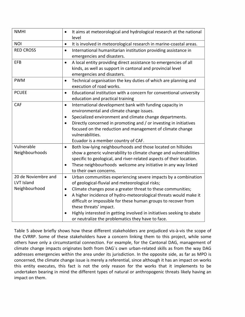
NMHI It aims at meteorological and hydrological research at the national level
NOI It is involved in meteorological research in marine-coastal areas.
RED CROSS International humanitarian institution providing assistance in emergencies and disasters.
EFB A local entity providing direct assistance to emergencies of all kinds, as well as support in cantonal and provincial level emergencies and disasters.
PWM Technical organisation the key duties of which are planning and execution of road works.
PCUEE Educational institution with a concern for conventional university education and practical training
CAF International development bank with funding capacity in environmental and climate change issues.
Specialized environment and climate change departments.
Directly concerned in promoting and / or investing in initiatives focused on the reduction and management of climate change vulnerabilities. Ecuador is a member country of CAF.
Vulnerable Neighbourhoods
Both low-lying neighbourhoods and those located on hillsides show a generic vulnerability to climate change and vulnerabilities specific to geological, and river-related aspects of their location.
These neighbourhoods welcome any initiative in any way linked to their own concerns.
20 de Noviembre and LVT Island Neighbourhood
Urban communities experiencing severe impacts by a combination of geological-fluvial and meteorological risks;
Climate changes pose a greater threat to these communities;
A higher incidence of hydro-meteorological threats would make it difficult or impossible for these human groups to recover from these threats’ impact.
Highly interested in getting involved in initiatives seeking to abate or neutralize the problematics they have to face.
Table 5 above briefly shows how these different stakeholders are prejudiced vis-à-vis the scope of the CVRRP. Some of these stakeholders have a concern linking them to this project, while some others have only a circumstantial connection. For example, for the Cantonal DAG, management of climate change impacts originates both from DAG´s own urban-related skills as from the way DAG addresses emergencies within the area under its jurisdiction. In the opposite side, as far as MPO is concerned, the climate change issue is merely a referential, since although it has an impact on works this entity executes, this fact is not the only reason for the works that it implements to be undertaken bearing in mind the different types of natural or anthropogenic threats likely having an impact on them.

Identification of Key Stakeholders As already mentioned, stakeholders are those people, social groups and institutions that are invested or legitimated to undertaking, formulating or executing a programme, policy or project, or having a positive or negative stance upon them. Depending upon the political, and socio-economic influence stakeholders have, this legitimation arises out of the impact it may have on his interests, or those of the competence the State has conferred upon those stakeholders to control, regulate or execute certain socioeconomic or technical activities. Table 2 below shows the aggregate of stakeholders in place vis-à-vis the CVRRP. Notwithstanding the concern or expectation that all these stakeholders could have regarding the project, not all of these stakeholders are to be counted on with at the different project stages: either to establishing coordination links, or to entering into agreements favourable to the project viability. This is why key CVRRP stakeholders should be identified. Notwithstanding the importance that many stakeholders may have to a particular project, only a few of them can be considered as key stakeholders: these being those the involvement of which is desirable, indispensable and / or compulsory to achieve the Project objectives. These stakeholders have the legitimacy, capacity or means to decide upon and bearing on all or some of the Project stages. Key stakeholders in this paper were identified on the basis of parameters detailed in Table 6 below.
TABLE 6. Identification of Key Stakeholders
Importance Rationale Key Stakeholders
Vulnerable groups or individuals bearing the impact of climate change impacts (or already affected by those impacts).
The State is accountable for the prevention and mitigation of disasters and emergencies, and should provide assistance to people enduring them.
Entities the duties of which revolve around risk and environmental management, and urban development.
Public entities with duties, attributions or powers vis-à-vis the CVRRP objective.
Attributions and powers in public law should be exercised, and are mandatory.
Entities the duties of which revolve around risk and environmental management, and urban development.
Entities with funding or technical advice capacity within the scope of the Project or programme.
The Law, or stakeholders´ own goals allows them access to technical and financial resources to executing works within the scope of the project´s management.
National or international entities having a concern or competences insofar climate change is concerned.

Stakeholders identified according to Table 6 are not homogenous insofar the CVRRP is concerned, since their motivation to intervene in the different project stages varies according to economic, political, or legal reasons, as explained below. The rationale for a group to be interested in a project is based on three factors: Authority, Concern and Standing, as defined as follows:
Authority: The formal (official) or informal (socio-economic) bearing that a stakeholder has regarding the project to be executed, or the geographical or operational functional settings linked to that project. This denomination refers to the ability stakeholders have to legitimately having a significant bearing on the project.
Concern: The degree and type of gain or loss expectations, or adjustment to regulatory protocols, that a stakeholder has regarding the execution or implementation of a project or activity.
Standing: The attitude stakeholders have toward the project, based on their own authority or concern, or on their own perceptions and expectations.
Table 7 below shows how the three factors behind each stakeholder motivation in a project are expressed in weighting levels. These levels are indicative for action over the project socialization stage, or of project-related agreements being entered into.
Table 7.- Key Stakeholders Authority, Concern, and Standing
VARIABLES LEVEL
Authority High Medium Low
Concern High Indifferent Low
Standing Favourable Indifferent Adverse
Once methodological classifications are undertaken, an identification is made in sections below to setting apart the concerns stakeholders have about the CVRRP. This identification has been made on the basis of insights of stakeholders as recorded in interviews, and on a review of institutional assignments and duties, signalling to a tacit concern by these stakeholders. Key Stakeholders in Project (CVRRP) Table 6 above shows how to determine the bearing a stakeholder can have for a project to be deemed as a key undertaking. Briefly, this bearing stems from the project´s impending importance, from the competences around the project objective or its impacts, and from an ability for the direct support that could be expected from them as regards the problematics the project may entail. In Table 5 above “Analytical Description of Stakeholders, a listing is made of the competences, duties, and institutional or community concerns making up key points of concern vis-à-vis the CVRRP. Taking the aggregate of stakeholders shown in Table 2 as a baseline, and bearing in mind the scope of the attributions or involvement each stakeholders has with regard to a need to abating and

managing vulnerabilities to climate change, a conclusion has been reached that the responsibility and concern each stakeholder has is different. While everyone has an implicit concern in being a part to a climate change initiative, not everyone can have the same commitment with the CVRRP warranting their involvement. This means that, in some cases, the stakeholders´ involvement with this initiative should be in line with the type of backup they can provide. Therefore, a conclusion can be reached that the CVRRP key stakeholders are entities and social groups as follows: the Barrio 20 de Noviembre, and Luis Vargas Torres Island neighbourhoods; EME; Provincial and Cantonal ADGs; and CAF. Concerning the two urban communities chosen as key stakeholders for project intervention, the severity of the impact of heavy rainfall as a sign of climate change impact is considered. In the first case, these communities are located in a sector sustaining serious damage by a landslide in January 2016 caused by heavy rainfall throughout the region, and triggering the instability of a particular sector of these hills, known as Gatazo Hill (November 20 neighbourhood, El Oro Street). The landslide in this sector has been slow-moving, thus causing no casualties. Troublesome conditions in this area call for a CVRRP intervention within a comprehensive outlook, that is, the inclusion of grey infrastructure that would be applied to stabilising the slopes, thus avoiding vulnerability to eventual heavier rainfall; establishment of green infrastructure to foster a vegetation cover on slopes; and undertaking social activities to strengthening up social resilience of the population settled in the lower sectors of the slopes. Likewise, backup should be provided to local authorities on regulatory matters and public policy, in order for settlements in risk areas to be kept in check. Another sector the CVRRP could be making a contribution to the canton is that located in the eastern section of the Simón Plata Torres road, an area recording heavy rainfall conditions leading to drainage waters not being adequately discharged in the estuary, reflowing back into houses drains and streets sewerage systems. The project intervention in this particular case would also be through the application of existing technological solutions for problems of this sort. The global characteristic of climate change, and the latter´s impact on populations all over the world, and the nature of objectives sought after through the CVRRP, which do not entail calling off public works or socio-economic activity, have not allowed for detractors of this initiative to be identified. There is a likelihood that detractors will emerge in the future to oppose any measures undertaken as a result of the project, such as the enactment of an ordinance forbidding settlements in certain areas in the city, or the relocation of residents already living in danger-prone areas. In this case, stakeholders who today support the project could be against it in the future; however, that will be the outcome of situations that are not part to the express or tacit CVRRP objective, but rather, secondary technical outputs or considerations already corresponding to some other initiatives (regulatory power attached to the municipal or provincial ADG, for example), which do not involve the project for which this stakeholders review is being performed.

Based on remarks above and taking into account the concern that stakeholders identified have regarding the main activity that the CVRRP is intent on carrying out, Table 8 below shows the stakeholders´ level of authority, concern, and standing. Insofar public entities are concerned, the willingness to decisively intervene in an activity becomes into a regulatory mandate institutions have vis-à-vis a particular issue and, in the case of private and community entities, the real or perceived urgency to solving an affectation, or an interest in securing a benefit. That is to say, in all cases, the point is to making a profit, a gain, that can legitimately be obtained from participating in a project or initiative in which one or more objectives (interests) that entities, civil society organisations or communities to which stakeholders identified are involved.
Table 8. Stakeholders Concerns and Standing
VARIABLES AUTHORITY CONCERN STANDING
STAKEHOLDERS High Medium Low
High Indifferent Low
Pro Indifferent Against
MEE X X X
Provincial DAG X X X
Municipal DAG X X X
Neighbourhoods X
X X
CAF X X X
FB Esmeraldas X
X X
MPW X
X X
Red Cross X
X X
NWS X
X X
PCUE X
X X

III. STRATEGIC DECISIONS AND THE CVRRP MANAGEMENT The review of the stakeholders' perceptions about how administration is performed for risk management, allows to understand the options for insertion of the CVRRP into the city´s institutional and social framework. This review shows that this project has a good institutional and social standing favourable to its implementation. However, some aspects cropped up through interviews made over fieldwork, showing a lack of understanding over the risk management administrative scope. These issues should be addressed so as to avoid that the project impact is reduced or distorted, and, besides, a direct intervention on these issues should be eventually made. A Definition of Alliances The review mentioned in previous sections shows that of the aggregate of stakeholders identified around the CVRRP objectives, only the EME, Provincial DAG, Municipal DAG, 20 de noviembre, and Isla Luis Vargas Torres neighbourhoods, and CAF should be deemed as strategic stakeholders, with whom this project should enter into a mandatory requirement to achieving its objectives. These stakeholders have a real capacity to significantly alter the project execution, its results, and / or its sustainability; therefore, direct interaction mechanisms should be incorporated to ensuring the proactive involvement of these stakeholders. The proper articulation of the latter will not only improve the project outcomes but, above all, buttress local risk management, which in itself should be deemed as a significant achievement of this initiative. All other institutional stakeholders identified have a minimal or no bearing at all on the CVRRP, so their importance to this initiative is latent. There could be a need for these stakeholders to get into action over the execution of the project so as to ensuring access to certain specific objectives sprouting out from the institutional roles these stakeholders play, such as: capacity-building (RMS, EFB, Red Cross, PCUEE) (PWM), climate, and water resources data requirements (NOI, NMHI and NWS). Although vulnerable neighbourhoods in the city in which no activity shall be carried out will not be directly involved in the project, they are nevertheless important to achieving the objectives the project seeks. The problems affecting them should be borne in mind, so as to prevent that an upsurge of those problems may give rise to negative or even critical perceptions about risk management in general. Although it is true that an initiative such as this CVRRP is not expected to performing a monitoring exercise of this type, and in keeping with its activities in others sectors of the city, it is desirable to do so. Therefore, together with the strategic value each stakeholder has for the project, Table 9 incorporates a matrix with suggestions of the type of approach to each stakeholder, according to their bearing and influence. This matrix allows for an understanding of the real worth that entities and communities making up the aggregate of stakeholders in their field of action have for the project.

Table 9. Attitude of and Cooperation with Stakeholders Model
Matrix in Table 9 shows a reference scheme suggesting the institutional performance that the CVRRP should have over its execution phase. This scheme shows possible interrelationships to be established which are based on each stakeholder´s nature and concerns, and according to priorities as follows: 1. EME.- Provincial ADG, 20 de noviembre and LVT Island, and CAF.- This box shows key
stakeholders, those having high bearing and influence. The project should enter into working relationships, and keep a good coordination with these stakeholders;
2. RMS.- The project should ensure that its activities shall not impair this stakeholder ´s concerns; 3. All other vulnerable neighbourhoods.- These stakeholders should be monitored on an ongoing
basis since they could be a source of risk on account of the volatility social groups are often affected with due to problems that may surpass their ability for endurance. Likewise, gender mainstreaming issues should also be monitored at all times both, in social communities to be intervened, and everywhere else.
4. EFB, Red Cross, PCUEE, NOI, INAMHY and NWS.- These are low priority stakeholders. Nevertheless, they could participate in the project when specific needs so require.
Problems to be addressed
Once the importance of stakeholders vis-à-vis the CVRRP has been established, some issues should be singled out and addressed within the project scope. Particular problems arising over the field work and which could be approached by the project on the basis of its components, results and products according to its schedule, shall be addressed in this section. The institutional framework or city-focused risk management rests upon a documentary base that in general terms signals the institutional perspective as regards this issue. Key documents are: Climate
Change Plan (ADG-E 2015), Risk and Disaster Management Strategy (ADG-E 2012), and Development and Territorial Arrangement Plans 2012-2022 (ADG-E s / f), all of them having a cantonal scope of action. Buttressing the the consolidation of a local risk management policy and administration While a comprehensive risk management plan for the canton urban area is non-existent, specific risk surveys have indeed been undertaken, such as those for the Gatazo Hill areas (EME 2002, UNDP 2005). This fact, however, has not been mentioned in interviews with public officials despite that one of those surveys predicted one decade earlier what was really going to happen ten years later, listing as well a series of specific prevention proposals to deal with the risks and the disaster that, in the end, became into a reality. This points to the sheer lack of coordination between different local administration tenures acting on a temporary basis, and confirms city dwellers´ perception about an institutional lack of coordination among management entities and, therefore, a lack of a unified strategy vis-à-vis public opinion. The WEM document (2002) suggested specific preventive technical, regulatory and social measures which, to this date, were never either taken into consideration, or implemented, and leading, fourteen years later, to the risk scenario that was foreseen in that survey:
"Landslides on the L1 profile slope will be rotational with faulty surfaces to a depth between 10m, and 12m and over 30m in length. Whereas for the opposite steep slopes, where the L2 and L3 profiles were evaluated, they show an immediate potential fault located at 4m or 6m depth. But with a long rainy season, and some triggering agent such as an earthquake, the fault surface could reach up to 20m deep."
On the other hand, UNDP (2005) did a great job in disaster preparedness and local risk management, as shown in the Revegetation of the Slopes of the City of Esmeraldas Project with the Esmeraldas Municipality involvement, and specifically addressed to: (i) stabilizing the city's urban slopes; (ii) reducing erosion and recovering soils in four urban micro-catchments; and (iii) Territorial enforcement of the Cantonal Development Plan; establishment of green areas to protect the city from oil refining and urban transport activities-generated pollution. However, an awareness (or knowledge) of these initiatives was not evident at any of the city entities accountable for risk management, the Municipality included. This institutional weakness points to a dispersion of initiatives, a lack of continuity in risk management undertakings, and an absence of an institutional memory allowing for experiences to be recorded, and for knowledge and lessons from previous risk situations to be learned. This undermines a proactive capacity to face up to adverse situations beforehand and to implementing comprehensive risk management plans, with a preventive, mitigation, training and social resilience approach. This situation point to the need for local risk management policymaking to be fostered by the Municipality, the Representative of which should chair the cantonal Emergency Operations Committee (EOC).

The EOC incorporates all public entities linked to risk management, health care, infrastructure development, as well as emergency relief bodies. This Committee get into operation only in disaster and emergency situations with a provincial or cantonal scope. In case of emergencies surpassing a canton jurisdiction, requiring the activation of the EOC, this Committee will be chaired by the local prefect or the Provincial Council representative and, in the event that the emergency is concentrated in a single canton, the Committee shall be chaired by the Mayor. Over the last few years, the EOC in particular, and the risk management system in general, have made significant inroads in adopting management notions and emergency prevention and attention mechanisms with a comprehensive focus. However, this concept is still to reaching out to the common citizen, and neither has it succeeded in constructing a comprehensive implementation of risk management-focused activities. A comprehensive imagery of risk management has not yet been constructed in which citizens do not only assume this from the point of view of care and philanthropy, but as an activity similar to any work or service addressing citizen needs. This situation could be tackled with on the basis of component SC 1.4 (Emergency response), as set forth in the CVRRP Results Framework, strengthening up mechanisms to deal with mudslides and floods; and SC 2.1, on strengthening local governments Capacity.
Incorporating Gender Mainstreaming into Risk Management Similar to some other situations arising out from social relations and prevailing socioeconomic patterns, gender inequality is one of the factors determining children and women vulnerability, and aggravating the impacts of disasters on these population groups. This particular issue is usually absent in risk management plans, and it is usual for these to provide "generic" operating mechanisms which are based on the existing situation, conditions and needs of men. This pattern for response actions to be formulated is not absent in the city's risk management plans. Surveys conducted in several countries show that women vulnerability is often more acute than that of men, not only because of economic, social and even psychological reasons, but also because they are more exposed to the impacts of emergencies and disasters because of pregnancy, child care, their responsibility to provide food to the family, among other factors. These situations making women even more vulnerable than other people living under the same socioeconomic conditions are present in the city of Esmeraldas, where women are mostly the only ones caring for their families, lacking an employment and living in places where social insecurity is prevalent, such as areas affected by floods, recording the presence of youth gangs and incidence of common delinquency. As highlighted in the community perceptions survey focused on risk management measures addressing flood emergencies requiring the evacuation from areas affected, many families, in particular single-parent families headed by a woman are afraid to evacuate due to two recurring fears: the loss of their belongings because of pillage likely to occur when homes are momentarily left alone over the evacuation process, and their fear to stay places not providing security for them and their children. These two factors were highlighted over the last large flood events recorded in January 2016.
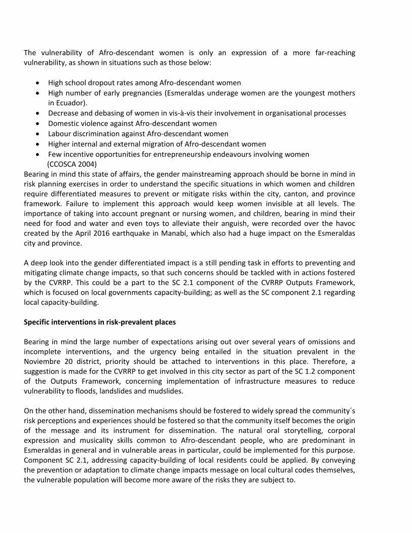
The vulnerability of Afro-descendant women is only an expression of a more far-reaching vulnerability, as shown in situations such as those below:
High school dropout rates among Afro-descendant women
High number of early pregnancies (Esmeraldas underage women are the youngest mothers in Ecuador).
Decrease and debasing of women in vis-à-vis their involvement in organisational processes
Domestic violence against Afro-descendant women
Labour discrimination against Afro-descendant women
Higher internal and external migration of Afro-descendant women
Few incentive opportunities for entrepreneurship endeavours involving women (CCOSCA 2004)
Bearing in mind this state of affairs, the gender mainstreaming approach should be borne in mind in risk planning exercises in order to understand the specific situations in which women and children require differentiated measures to prevent or mitigate risks within the city, canton, and province framework. Failure to implement this approach would keep women invisible at all levels. The importance of taking into account pregnant or nursing women, and children, bearing in mind their need for food and water and even toys to alleviate their anguish, were recorded over the havoc created by the April 2016 earthquake in Manabí, which also had a huge impact on the Esmeraldas city and province. A deep look into the gender differentiated impact is a still pending task in efforts to preventing and mitigating climate change impacts, so that such concerns should be tackled with in actions fostered by the CVRRP. This could be a part to the SC 2.1 component of the CVRRP Outputs Framework, which is focused on local governments capacity-building; as well as the SC component 2.1 regarding local capacity-building. Specific interventions in risk-prevalent places Bearing in mind the large number of expectations arising out over several years of omissions and incomplete interventions, and the urgency being entailed in the situation prevalent in the Noviembre 20 district, priority should be attached to interventions in this place. Therefore, a suggestion is made for the CVRRP to get involved in this city sector as part of the SC 1.2 component of the Outputs Framework, concerning implementation of infrastructure measures to reduce vulnerability to floods, landslides and mudslides. On the other hand, dissemination mechanisms should be fostered to widely spread the community´s risk perceptions and experiences should be fostered so that the community itself becomes the origin of the message and its instrument for dissemination. The natural oral storytelling, corporal expression and musicality skills common to Afro-descendant people, who are predominant in Esmeraldas in general and in vulnerable areas in particular, could be implemented for this purpose. Component SC 2.1, addressing capacity-building of local residents could be applied. By conveying the prevention or adaptation to climate change impacts message on local cultural codes themselves, the vulnerable population will become more aware of the risks they are subject to.
CONCLUSIONS The review and mapping of stakeholders in areas being impaired by adverse climate change impacts as described in this report, has identified an aggregate of 25 governmental, non-governmental, and community stakeholders, all of them having different risk management-focused concerns, several institutional objectives and perspectives, and a distinctive interest about the areas sustaining climate change impacts in the city of Esmeraldas. This report shows that prospects of success of the "Vulnerability Risk Reduction Project" (CVRRP), would be linked to the local planning entities and the national environmental authority. This review also suggests that communities that have already experienced emergencies would be the most interested in getting involved in relevant specific activities. Organisations identified as key stakeholders in this review are: CAF, EME, Provincial DAG, Municipal DAG, as well as the Noviembre 20, and Luis Vargas Torres Island neighbourhoods where emergencies have already occurred, such as landslides and floods, respectively. The importance and bearing these stakeholders have locally would greatly assist in carrying out the different technical, social and regulatory activities being foreseen in the CVRRP, thus the maximum efficiency could be achieved through compliance of all objectives, and use of available resources. While the RMS is a highly important entity in terms of risk management at national level, it shows a low bearing on the specific issue of vulnerability reduction and adaptation to the adverse impact of climate change. Likewise, due to its operational scope, this entity is less able to deal with specific risk areas, to which local entities are more closely related. Other entities and communities identified, such as EFB, PWM, Red Cross, NWS, NOI and PCUEE, are organisations having a low profile and a low bearing in the CVRRP operating areas, since their institutional objectives are too specific and little or Indirectly linked to management of climate change impacts. However, these entities could intervene in specific aspects in the project, whenever data are required concerning the activities making up their institutional objective. Finally, the neighbourhoods vulnerable to landslides and floods in the city, the impairment of which is impending or has already been dealt with, stand as a low importance social area, considered from an outlook to undertaking preventive actions; nevertheless, these areas are indeed highly influential. Bearing in mind the vulnerability they are subject to, these groups have a legal right to making complaints, voicing their opinions, and demanding actions to deal with the problems afflicting them. This could, at some point, be a source of problems or distortions vis-à-vis the activities being implemented by the CVRRP. Therefore, a suggestion is made herein to closely monitoring the problems these people are facing up to.

REFERENCES Bernard, Russel
2001 Research Methods in Anthropology. Altamira Press 2001.
CCOSCA (Consejo de Coordinación de las Organizaciones de la Sociedad Civil Afro-ecuatoriana) 2004 Diagnóstico de la problemática Afro-ecuatoriana y Propuesta de Acción Prioritaria Descripción de los desafíos del eje de género y generación. Consejo de Coordinación de las Organizaciones de la Sociedad Civil Afro-ecuatoriana.
ADG-E (Gobierno Autónomo Descentralizado Municipal de Esmeraldas) 2015 Plan de Cambio Climático. 2012 Estrategia de Gestión de Riesgos y Desastres. Cantón Esmeraldas. Gobierno Autónomo Descentralizado Municipal del Cantón Esmeraldas, Unidad Gestión de Riesgos y Cambio Climático Dirección de Gestión Ambiental. s/f Plan de Desarrollo y Ordenamiento Territorial 2012 – 2022.
IIED (International Institute for Environment and Development)
2005 Análisis de poder de las partes interesadas. Power Tools, IIED. INEC (Instituto Nacional de Estadísticas y Censos)
Resultados del Censo 2010 de Población y Vivienda. Equipo Técnico de Análisis del Censo de Población y Vivienda.
EME (Ministerio del Ambiente)
2002 Plan de control de riesgos en las laderas de la ciudad de Esmeraldas. Proyecto Piloto. Proyecto de asistencia técnica para la gestión ambiental al Municipio de Esmeraldas. Proyecto PATRA (Préstamo BIRF 3998 EC)
Montaño Escobar, Juan,
2011 Propuesta de manejo del suelo para la mitigación de deslizamientos en el sector de San Jorge. Instituto de Altos Estudios Nacionales, Universidad Técnica Luis Vargas Torres de Esmeraldas.
Ponce Mejía Marcelo Ernesto
s/f “Influencia de la pérdida de cobertura vegetal en la vulnerabilidad y riesgos en el cantón Esmeraldas, provincia de Esmeraldas”. Universidad Técnica del Norte, Facultad de Ingeniería en Ciencias Agropecuarias y Ambientales. Carrera de Ingeniería en Recursos Naturales Renovables
PNUD (Programa de las Naciones Unidas Para el Desarrollo) 2005 Gestión local del riesgo y preparativos de desastres en la región andina. Sistematización de buenas prácticas y lecciones aprendidas. Experiencia 9 Esmeraldas Revegetación de Laderas en Esmeraldas Ecuador. PNUD, 44

Buró de Prevención de Crisis y Recuperación. “Sistematización y Diseminación de Buenas Prácticas en Preparativos de Desastres y Gestión Local del Riesgo en la Región Andina” Real, Byron
2007 Hard Decisions in the Big Easy: Social Capital and Evacuation of the New Orleans Area Hispanic Community During Hurricane Katrina. En: Perspectives on Social Vulnerability. SOURCE Publication Series of UNU-EHS No. 6, 2007. Universidad de las Naciones Unidas, Bonn, Alemania.
SNGR/ECHO/UNISDR
2012 Ecuador: Referencias Básicas para la Gestión de Riesgos. Quito, Ecuador. SNGR.

ANNEXES
1.- Relevant Methodology 2.- Basic questionnaires used in interviews 3.- Listing of people and public officers interviewed
ANNEX 1. METHODOLOGY
REDUCTION OF CLIMATE VULNERABILITIES AND FLOOD RISKS IN
URBAN AND SEMI URBAN COASTAL AREAS IN ECUADOR AND CHILE
Esmeraldas Project – Ecuador
Methodology to Drafting up a Stakeholders Map
Contents
1. INTRODUCTION 2. DEFINITION, IMPORTANCE AND OBJECTIVES OF THE STAKEHOLDERS REVIEW 3. METHODOLOGY
Design of Data Review Tools
Identification of Stakeholders
Description and Mapping of Stakeholders
Meetings and Field Visits
4. REFERENCIAL TIMELINE

Methodology to Drafting up a Stakeholders Map INTRODUCTION DEFINITION, RELEVANCE, AND OBJECTIVES OF THE STAKEHOLDERS REVIEW
The stakeholder review is a methodological tool allowing for qualitative data to be collected to determine the concerns that should be taken into account for a programme, policy or project to be designed or implemented. Within this framework, a stakeholder is considered to be a person or institution having some relevance vis-à-vis the scope of a programme, policy or project intended to be developed, or implemented in a given community. Likewise, those people or social groups the lives of which will be significantly influenced by these activities are deemed to be stakeholders. While appertaining to different typologies, there are two key types of stakeholders: public and private. The former can belong to the regulatory type (public institutions setting forth regulations to be abode by to carry out an activity or project), or developers (executors of a project): those stakeholders under the impact, influence or an activity, pressure groups, observers, among others. Then, stakeholders are also those people, social groups and institutions empowered or legitimized to implementing, positively or negatively influencing a programme, policy or project, or to determine it as regards regulations in force. Such a legitimation originates in the socio-economic influence those stakeholders have, the way how their interests may be affected, or the authority the State has granted them to regulating or undertaking a project or activity. The significance of a stakeholders´ review lies in the data collected through that review to identify perceptions for or against a project, current or potential conflicts around them, and local needs to be addressed. Based on these data, strategic alliances can originate enabling for achievement of the different stakeholders´ goals, allowing for access to groups or individuals influenced or negatively affected by the project, with information and messages that are relevant to address a situation; and, if necessary, entering into dialogical processes in cases of conflicts, stressing situations, or confrontational dynamics likely to crop up as a direct or indirect effect of a policymaking or a project execution. In short, data collected from a stakeholder´ review is key to enable policy decision-makers to making adjustments to a programme or public policy vis-à-vis a better acceptance and social enforcement of that programme of public policy. On the other hand, this tool makes it possible for the social, economic and political setting in which the programme is inserted to be understood, thus allowing to setting forth priorities, and looking into trends. This understanding is achieved through the perception each stakeholder has of the subject. This perspective enhances the exercise since it allows to become aware of issues which otherwise could not be grasped, because of their subjectivity or informality. Decisions can be made that are based on this approach to a specific problem, or suitable tools could be created to address the situation.

Stakeholders mapping is included in this review, on the basis of which not only a listing of the different stakeholders involved in an initiative can be drafted down, but also information can be collected about their scope of action, the reason or objectives involved in stakeholder involvement in a process or socio-economic dynamics, their perceptions or expectations, among some other issues allowing to understand their positioning vis-à-vis a programme, policy or project. Generally speaking, a stakeholders mapping is a first step in ensuring a proper civil society involvement in participatory actions (workshops, meetings, seminars, etc.), not only ensuring the number but also the representativeness of individuals or groups (associations, foundations, grassroots organisations, government institutions, etc.) that are invited to participate. The use of a stakeholder mapping, also called sociogramme, helps represent the social reality to be intervened, understand it in its complexity, and design intervention strategies on the basis of elements other than common sense or the sole opinion of a qualified source. Using the social map is key to the design and execution of any project, as well as to the negotiation / joint construction of the activity schedule to be implemented. In short, the review and mapping of stakeholders should allow project developers to properly interact with the different stakeholders involved, establish relationships to be taken into account, and provide relevant stakeholders with a sound understanding of the importance the project to be executed has, and the role those stakeholders shall play, or their rights in force vis-à-vis that process.
METHODOLOGY The process to be implemented to conduct the stakeholders review suggested is shown below. While the process has a logical sequence, some of its stages could be replicated for additional relevant data to be recorded. Design of Data Review Tools Three variables are used in the stakeholders´ review: i) Standing; ii) Authority; and iii) Concern. The Standing, Authority and Concern recorded for each stakeholders is mainly based on the perceptions of the MPAs managers and some users. Definitions of these three variables are as follows:
Standing. The stakeholder´s attitude vis-à-vis the project: favourable (pro), against, or indifferent.
Authority. The formal (official) or informal (socio-economic) bearing that the stakeholder has vis-à-vis the project to be executed, or about the geographical or functional areas originating therefrom. That is, civil, private or community entities (CSOs, associations, communes, etc.) are identified here; Individuals (teachers, priests, leaders), who have a significant bearing on the project execution area; entities that, due to their geographical scope of action (decentralized autonomous governments

(DAGs) or functional entities (SENPLADES, Ministry of the Environment, etc.), who may have a bearing on the project.
The Authority rating can be high, medium or low.
Concern. The type of gain or loss expectation, or adjustment to regulatory protocols a stakeholder has regarding the execution or implementation of a project or activity.
The concern rating can be high, indifferent or low.
Stakeholders will be classified according to categories as follows:
Government Stakeholders. Attached to local, section and / or central government entities.
Non-Governmental Stakeholders. Attached to grassroots organisations, private sector, productive sector, foundations, universities, funding agencies, etc.
Local civil society stakeholders (CSSs). Stakeholders having a local influence.
Regional / Provincial Civilian Stakeholders. Stakeholders whose scope of action is regional or provincial.
National civilian stakeholders. Stakeholders having a national influence, although they may be international in origin, such as the case of Civil Society Organisations to which funding has been allocated, or international organisations or treaties the goals of which are common to the subject.
Depending upon the review fine-tuning needs, stakeholders could also be ranked into the following categories:
Primary stakeholders are those groups directly involved in the problem or project to be reviewed taking their specific problematics into account (institutional, personal, community).
Secondary stakeholders are representative groups of affected communities, political pressure organisations involved in the solution of socio-environmental problems; or people having some territorial competence in the subject matter area in which some of these problems crop up.
Backup stakeholders are civil or governmental organisations that, due to their grasp about some technical expertise or management of projects and social activities, have a specific knowledge as regards some environmental problems.

Identification of Stakeholders Identification of interested parties, and the different groups, organisations and individuals having some influence, interacting, or regulating activities in the project execution area, or regarding the subject the project is concerned with. This identification will be made on the basis of legal and bibliographic revisions and interviews with key local sources. Identification of stakeholders will be carried out through office work (regulatory and bibliographic revision) and field work (visits to vulnerable sectors in the city and interviews with their inhabitants). Insofar possible, focal meetings with local authorities and leaders will be scheduled, or independent interviews shall be held with public officials and local people. Interviews performed were semi-structured, and included a participatory observation exercise20. Stakeholders Description and Mapping The description of stakeholders is an evaluative explanation of the reason why an individual or a social, civil or public organisation has been included in the exercise. The institutional characteristics, purpose or objectives shall be spelled out here and, depending upon the case, so will be the competence attached to these stakeholders. Furthermore, the stakeholder mapping tool will allow for a graphical representation of individuals, organisations and institutions involved in the project execution process. Upon this stage, two graphics will be designed: A Authority and Concern matrix; and an Authority and Standing Matrix. These matrices will allow to learn the Authority and Bearing weight vis-à-vis decision-making regarding the project, concern and standing vis-à-vis the project.
20 Esta es una herramienta metodológica muy utilizada en la investigación social, que consiste en la apreciación de
primera mano de las condiciones, realidades y circunstancias locales y/o de los stakeholderes sociales. Ver: Bernard
2001.

ANNEX 2.- Key guidelines to conducting interviews Basic questionnaires applied to interviews conducted over fieldwork for the preparation of this report are shown below. They were addressed to people who have been impaired, and likely to be impaired by climate change impacts, as well as to public officials involved in hydro-meteorological management and risk management at the national, provincial and cantonal levels. Interviews lasted between 45 and 60 minutes each. People interviewed were chosen by the work team members who authored this report, and based on the identification of stakeholders sustaining the impact of climate change-related events, and their involvement with risk management and prevention, mitigation and adaptation to adverse climate change impacts.

A.- Interviews with people living in the area Respondent Name (optional) __________________________________ Role in the entity / community ______________________________________ Date ___________________ Place ___________________ 1. What are the main problems your community is facing up to, which are originated in natural
events? a. Are there any specific Community actions in place to solve them? b. What organisations or individuals are implementing these actions? 2. How do you think these problems could be addressed?
3. What do you know about both, climate change, and the impact it has on your community?
4. What public or non-governmental entities have you and your community been involved with
concerning the landslides or floods having an impact on your community?
5. Do you consider the information disseminated regarding environmental problems and risk management to be sufficient?
6. How do you think your worries about these problems could be solved?
7. What kind of actions would you expect the (national, provincial, local) State to carry out to ensure that you and your community have the right awareness about participation and prevention-mitigation of impacts resulting from climate change-linked natural events?

B.- Interviews with government officials Interviewed name ____________________________________ Duty/ Entity ______________________________________ Date ___________________ Place ___________________ 1. What are the most pressing climate change-related problems being recorded in the city of
Esmeraldas? a. Are there specific actions in place to addressing them? b. What organisations or individuals are implementing these actions?
2. What kind of actions could public entities undertake in the national, provincial and local settings
so that the community has the proper awareness, participation and prevention-mitigation knowledge about climate change-originating impacts?
3. How would you rate your entity´s coordination with other entities in the public sector regarding climate change-related issues?
4. How would you rate your interagency coordination within the framework of EOC's working groups?
5. How is your organisation's interaction with communities impaired by climate change-derived problems?

Annex 3.- Listing of people and public officers interviewed
INTERVIEWS WITH STAKEHOLDERS
NAME ENTITY/ SECTOR DATE REMARKS
1. Engineer ROBERTO GÁMEZ
2.
MINISTRY OF PUBLIC WORKS – PROVINCIAL
06/05/2016 Provincial Director
2. Engineer EDGARDO PRADO
PROVINCIAL DAG 06/05/2016 Director, Irrigation & Drainage Department
3. ENGINEER ÁLVARO RAMÍREZ
PROVINCIAL DAG 06/05/2016 Technician, Irrigation and Drainage Department
4. ENGINEER PEDRO VERA
PROVINCIAL DAG 06/05/2016 Technician, Irrigation and Drainage Department
5. ENGINEER JANINO CARBACHE LUCAS
PROVINCIAL DAG 06/05/2016 Director, Environmental Department, in charge of the Godzilla Plan
6. ENGINEER IVÁN SÁNCHEZ
PROVINCIAL DAG 06/05/2016 Technician, Environmental Department, in charge of the Climate Change Unit
7. ENGINEER RENATO TAMBACO
ESMERALDAS MUNICIPALITY
06/05/2016 Director, Environmental Management and Risk Directorate
8. ENGINEER LUIS MOREIRA CERVERA
ESMERALDAS MUNICIPALITY
06/05/2016 Director, Municipal Public Works Department
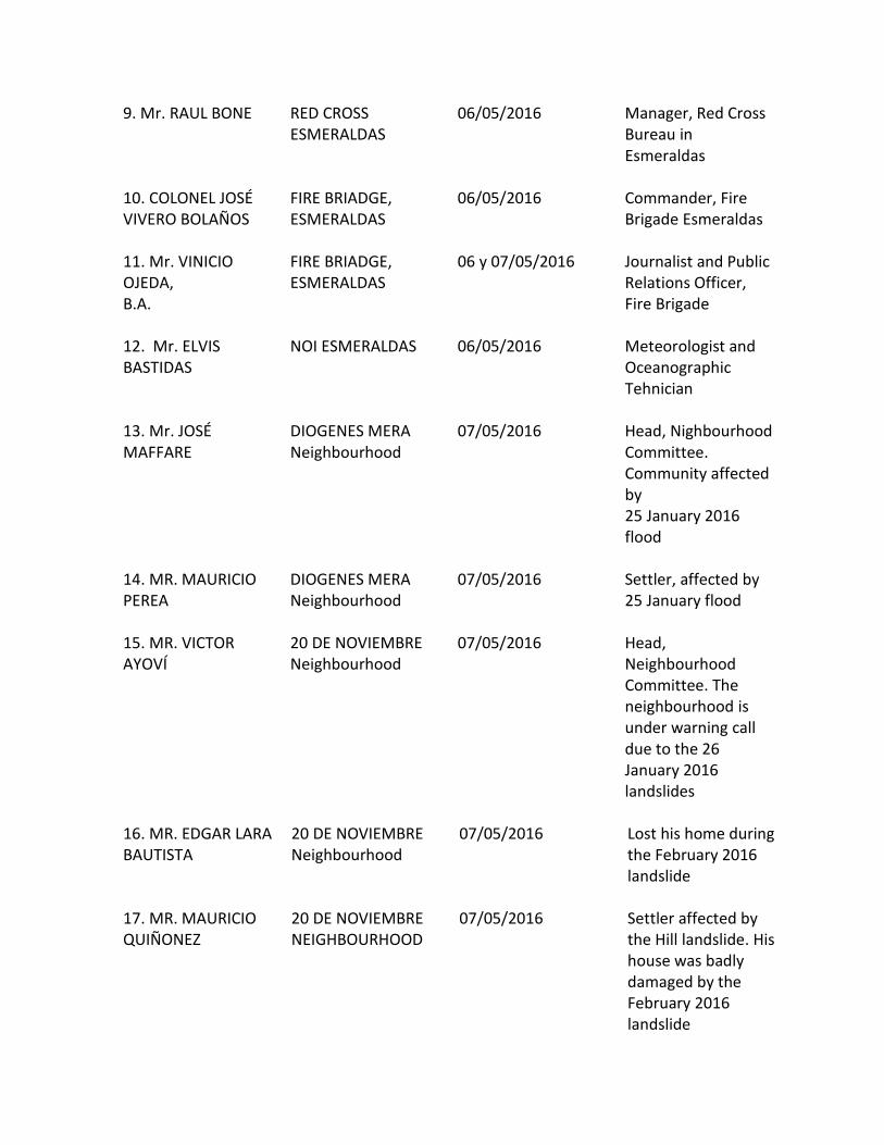
9. Mr. RAUL BONE
RED CROSS ESMERALDAS
06/05/2016 Manager, Red Cross Bureau in Esmeraldas
10. COLONEL JOSÉ VIVERO BOLAÑOS
FIRE BRIADGE, ESMERALDAS
06/05/2016 Commander, Fire Brigade Esmeraldas
11. Mr. VINICIO OJEDA, B.A.
FIRE BRIADGE, ESMERALDAS
06 y 07/05/2016 Journalist and Public Relations Officer, Fire Brigade
12. Mr. ELVIS BASTIDAS
NOI ESMERALDAS 06/05/2016 Meteorologist and Oceanographic Tehnician
13. Mr. JOSÉ MAFFARE
DIOGENES MERA Neighbourhood
07/05/2016 Head, Nighbourhood Committee. Community affected by 25 January 2016 flood
14. MR. MAURICIO PEREA
DIOGENES MERA Neighbourhood
07/05/2016 Settler, affected by 25 January flood
15. MR. VICTOR AYOVÍ
20 DE NOVIEMBRE Neighbourhood
07/05/2016 Head, Neighbourhood Committee. The neighbourhood is under warning call due to the 26 January 2016 landslides
16. MR. EDGAR LARA BAUTISTA
20 DE NOVIEMBRE Neighbourhood
07/05/2016 Lost his home during the February 2016 landslide
17. MR. MAURICIO QUIÑONEZ
20 DE NOVIEMBRE NEIGHBOURHOOD
07/05/2016 Settler affected by the Hill landslide. His house was badly damaged by the February 2016 landslide

18. MR. GARY CONZALES PALACIO
20 DE NOVIEMBRE Neighbourhood
07/05/2016 Settler living under warning call due to the hill landslide in February 2016
19. Mrs. HILDA PALACIO COROZO
20 DE NOVIEMBRE Neighbourhood
07/05/2016 A settler. She lives in constant fear because of the hill slide in February 2016
20. MR. JIMMY QUIÑONES
UNIÓN Y PROGRESO (LA GUACHARACA) Neighbourhood
07/05/2016 Neighbourhood Board Chairman. The community was affected by the Gatazo Hill landslide ten years ago (2006).
21. Mr. HARRY GOLLES KLINGER
UNIÓN Y PROGRESO (LA GUACHARACA) Neighbourhood
07/05/2016 Settler affected by the Gatazo Hill landslide ten years ago (2006).
22. MR. DAVID VALENCIA
UNIÓN Y PROGRESO (LA GUACHARACA) Neighbourhood
07/05/2016 Settler affected by the Gatazo Hill landslide ten years ago (2006).
23. MR. PATRICIO ORTÍZ CAICEDO
UNIÓN Y PROGRESO (LA GUACHARACA) Neighbourhood
07/05/2016 Settler affected by the Gatazo Hill landslide ten years ago (2006).
24. MR. ARSECIO PRECIADO CUERO
UNIÓN Y PROGRESO (LA GUACHARACA) Neighbourhood
07/05/2016 Settler affected by the Gatazo Hill landslide ten years ago (2006).
25. MR. CRISTIAN MOLIDA CERVANTE
COCOY Neighbourhood
07/05/2016 Neighbourhood Board Chairman. Settler frightened by the 25 January 2016

first landslide. His home is right at the foot of the hill
26. Mrs. DAISE CERVANTE
COCOY Neighbourhood
07/05/2016 Settler frightened by the 25 January 2016 first landslide. Her home is right at the foot of the hill
27. MR. MIGUEL MOLINA CERVANTE
COCOY Neighbourhood
07/05/2016 Settler frightened by the 25 January 2016 first landslide. His home is right at the foot of the hill
28. MRS. EMILY PEREA
COCOY Neighbourhood
07/05/2016 Settler frightened by the 25 January 2016 first landslide. Her home is right at the foot of the hill
29. ENGINEER MILTON MEZA
PONTIFICAL CATHOLIC UNIVERSITY OF ECUADOR. ESMERALDAS CAMPUS
09/05/2016 Teacher. Risks subject Area
30. ENGINEER BETO ESTUPIÑAN TORO
RISK MANAGEMENT SECRETARIAT
09/05/2016 In charge of the risk management office. Former head, environmental and risk management during former municipality administration
31. COMMANDER. JORGE BASANTE GARCÍA
RISK MANAGEMENT SECRETARIAT
09/05/2016 General Coordinator, Zone 1
32. MRS. KATERINE LEMOS
13 DE ABRIL NEIGHBOURHOOD
10/05/2016 Settler in area damaged by

landslide 15 years ago
33. MR. JEFFERSON CABEZ
13 DE ABRIL NEIGHBOURHOOD
10/05/2016 Settler in area impaired by landslide 15 years ago
34. MR. JULIO CABEZ
13 DE ABRIL NEIGHBOURHOOD
10/05/2016 Settler in area impaired by landslide 15 years ago
35. MRS. ANA TAFUR
CHONE ALTO NEIGHBOURHOOD
10/05/2016
settler in area impaired by erosion and flood in rainy seasons
36. MR. PUBLIO TAFUR
CHONE ALTO NEIGHBOURHOOD
10/05/2016 Settler in area impaired by erosion and flood in rainy seasons
37. MRS. SIRLEY ARAUJO
EL ARENAL NEIGHBOURHOOD
10/05/2016 settler in area impaired by flood due to recurrent rainfall
38. MRS. MARITZA GONGORA
EL ARENAL NEIGHBOURHOOD
10/05/2016 settler in area impaired by flood due to recurrent rainfall in the lower hillside area
39. MRS. MARLENE CUERO
LA PROPICIA 1 & 2 NEIGHBOURHOOD
10/05/2016 settler in area prone to flood due to overflow of the Esmeraldas and Teaone River caused by tidal waves
40. MRS. LUCIA CASTILLO
LA PROPICIA 1 & 2 NEIGHBOURHOOD
10/05/2016 settler in area prone to flood due to overflow of the Esmeraldas and Teaone River caused

by tidal waves
41. MR. DARIO ORTÍZ MANSABA
LAS 50 CASA NEIGHBOURHOOD
11/05/2016 Settler enduring flood every single year due to overflow of the Teaone River
42. MRS. INES BONE CHICHANDE
LAS 50 CASA NEIGHBOURHOOD
11/05/2016 Settler enduring flood every single year due to overflow of the Teaone River
43. MR. EDUARDO VALENCIA GUSTAVINO
LAS 50 CASA NEIGHBOURHOOD
11/05/2016 Settler enduring flood every single year due to overflow of the Teaone River
44. MR. LUIS ARROYO ABAD
LAS 50 CASA NEIGHBOURHOOD
11/05/2016 Settler enduring flood every single year caused by overflow of the Teaone River
45. MR. ANTONIO CHEME
PIANGUAPI ISLAND 11/05/2016 Chairman. Affected by recurring damages caused by flood due to heavy rainfall
46. MR. A MARÍA PRECIADO
PIANGUAPI ISLAND 11/05/2016 Settler affected by recurring damages caused by flood due to heavy rainfall, and tidal waves
47. MR. HENRRY CANCHINGRE
PIANGUAPI ISLAND 11/05/2016 Settler affected by recurring damages caused by flood due to heavy rainfall, and tidal waves
48. MR. JAIRON PROAÑO
ISLA PIANGUAPI 11/05/2016 Settler affected by recurring damages caused by flood due

to heavy rainfall, and tidal waves
49. MR. RICARDO CHEME
VARGAS TORRES ISLAND, CORDERO CRESPO NEIGHBOURHOOD
11/05/2016 Chairman. Neighbourhood Board. Affected by yearly flood caused by Esmeraldas River overflow
50. MRS. BEATRIZ PRECIADO BAZAN
VARGAS TORRES – ISLAND, CORDERO CRESPO NEIGHBOURHOOD
11/05/2016 Settler enduring yearly flood caused by Esmeraldas River overflow. On 25 January 2016, the highest ever overflow was recorded
51. MR. FRANCISCO SOLIS PRECIADO
VARGAS TORRES – ISLAND, CORDERO CRESPO NEIGHBOURHOOD
11/05/2016 Settler enduring yearly flood caused by Esmeraldas River overflow. On 25 January 2016, the highest ever overflow was recorded of a river branch
52. Mr. EDSON BONE LASSO
VARGAS TORRES – ISLAND, 12 DE MAYO NEIGHBOURHOOD
11/05/2016 Chairman. Neighbourhood Board. Enduring yearly flood caused by Esmeraldas River overflow
53. MRS. BRIGIDA VALENCIA CASTILLO
VARGAS TORRES – ISLAND, 12 DE MAYO NEIGHBOURHOOD
11/05/2016 Settler. Impaired by yearly flood caused by Esmeralda River overflow
54. MR. FRIXÓN ORDOÑEZ TENORIO
VARGAS TORRES ISLAND - 20 DE NOVIEMBRE
11/05/2016 Chairman. Neighbourhood Board. Impaired by

NEIGHBOURHOOD yearly flood caused by yearly river overflow
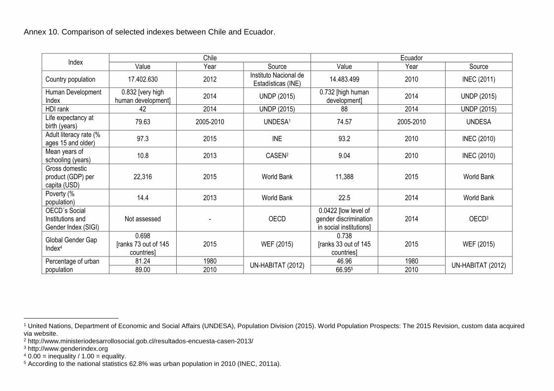
Annex 10. Comparison of selected indexes between Chile and Ecuador.
Index Chile Ecuador
Value Year Source Value Year Source
Country population 17.402.630 2012 Instituto Nacional de Estadísticas (INE)
14.483.499 2010 INEC (2011)
Human Development Index
0.832 [very high human development]
2014 UNDP (2015) 0.732 [high human
development] 2014 UNDP (2015)
HDI rank 42 2014 UNDP (2015) 88 2014 UNDP (2015)
Life expectancy at birth (years)
79.63 2005-2010 UNDESA1 74.57 2005-2010 UNDESA
Adult literacy rate (% ages 15 and older)
97.3 2015 INE 93.2 2010 INEC (2010)
Mean years of schooling (years)
10.8 2013 CASEN2 9.04 2010 INEC (2010)
Gross domestic product (GDP) per capita (USD)
22,316 2015 World Bank 11,388 2015 World Bank
Poverty (% population)
14.4 2013 World Bank 22.5 2014 World Bank
OECD´s Social Institutions and Gender Index (SIGI)
Not assessed - OECD 0.0422 [low level of
gender discrimination in social institutions]
2014 OECD3
Global Gender Gap Index4
0.698 [ranks 73 out of 145
countries] 2015 WEF (2015)
0.738 [ranks 33 out of 145
countries] 2015 WEF (2015)
Percentage of urban population
81.24 1980 UN-HABITAT (2012)
46.96 1980 UN-HABITAT (2012)
89.00 2010 66.955 2010
1 United Nations, Department of Economic and Social Affairs (UNDESA), Population Division (2015). World Population Prospects: The 2015 Revision, custom data acquired via website. 2 http://www.ministeriodesarrollosocial.gob.cl/resultados-encuesta-casen-2013/ 3 http://www.genderindex.org 4 0.00 = inequality / 1.00 = equality. 5 According to the national statistics 62.8% was urban population in 2010 (INEC, 2011a).

Annex 11. Existing designs quebrada Bonilla (Chile)
REPUBLIC OF CHILE
MINISTRY OF PUBLIC WORKS
HYDRAULIC WORKS MANAGEMENT
FINAL DESIGN OF ALLUVIAL POWER DISSIPATION SYSTEMS
AND ALLUVIAL PATHS IN THE CITY OF ANTOFAGASTA
EXECUTIVE SUMMARY
BONILLA RAVINE
2000
In collaboration with:
ELECTROWATT ENGINEERING (CHILE) S.A.
AC CONSULTANT ENGINEERS LTD
Contact: Mr. Rodrigo Jorquera-Chellew Mr. David González Electrowatt Engineering (Chile) S.A. Av. Holanda 1090, Providencia Santiago de Chile Telephone (56-2) 3353740 Telefax (56-2) 3353886
TABLE OF CONTENTS
1. Background ...................................................................................................3
2. Project Rationale and Objective ..................................................................3
3. Project Location .......................................................................................... 4
4. Economic Assessment of Project works and Size…….…………………………..….5
4.1. Valuation of Works…............... .................................................................5
4.2. Methodology........... .................................................. ..............................5
4.3. Alternatives Profitability and Selection of an Optimal Solution................6
5. Topographical Survey.................................................................................. 7
6. Soil Mechanics ................................... ........................................................ 7
7. Geological Report ........................................................................................8
8. Technical Project Characteristics………… ..................................................... 9
8.1. Design Criteria……….................................................................................. 9
8.2. Specific Design Features…….................................................................... 10
9. Description of the Alluvial Energy Dissipation Systems´ Works……………….10
9.1. Hydraulic Works Design……………........................... ..................................10
9.1.1. General Basin Characteristics………….....................................................10
9.1.2. Characteristics of Alluvial Control Works Designs………........................ 11
9.1.3. Flows and Volumetric Concentrations. ................................................ 12
9.2. Structural Design of Works.………............................................................ 12
9.3. Special Technical Specifications .............................................................. 13
10. Bonilla Ravine Budget ………………………………….......................................... 13
11. Execution Schedule……….......................................................................... 13
12. Legal Issues………...................................................................................... 14
13. Environmental Impact Assessment ..........................................................14
Scientific Terminology Source http://www.bioone.org/doi/abs/10.1659/mrd.0876

EXECUTIVE SUMMARY
BONILLA RAVINE
1. Background
The city of Antofagasta is located along a narrow coastal plain on the Western Coastal
mountain range, at about 1,800M above sea level, stretching over an approximate 40km -
80km width area.
The city´s Eastern sector is settled over material ejection cones resulting from rocks
weathering and wind-dragged materials. A fact that should also be borne in mind is the
discharge of urban and industrial waste materials into riverbeds, and the extraction of
materials in quarries, leading to a concomitant instability of mountain slopes.
The Antofagasta ravines have been commonly used as landfills, as are the Cármen and
Cadena Salt quarries showing the highest accumulation of waste. Nevertheless, the fact
should not be ruled out that all other ravines could also be used as landfills in the future,
while the quarries mentioned are gradually becoming into even larger landfills piling up
substantial volumes of debris of all sorts.
A series of meetings have been held over time with the Antofagasta Municipality
authorities to tackle this situation. Accordingly, a decision was made that the Municipality
authorities would see to it that all wastes should be removed from ravines, since local
authorities were exclusively competent and accountable for their proper disposal.
Bearing in mind these particular characteristic, whenever low-volume heavy rainfall is
present, several unusual events have been generated in the past, the main characteristics
of which being the conveyance downstream of large amounts of debris material in the
shape of alluvial flow. The loss of human life, and substantial material damages have been
the main outcomes of these alluvial events. The huge energy and destructive power of
highly concentrated solid-waste flows reaching urban areas have brought to light a need
for engineering-based solutions allowing to keeping these massive waste flows in check in
areas close to basins headwaters, or curtailing their impact by diverting them to more
open areas so they are spread out without causing victims or material damage.
2. Project Rationale and Objective
The city of Antofagasta is deemed as the fastest growing development hotspot located in
the Northern area of the country, and resulting from a progress boom the region has
witnessed as the outcome of the exploitation of large mining deposits in the territory. A
swift urban growth devoid of any proper urban planning, and leading to the exploitation
of large mining deposits has been recorded, resulting in a higher number of people being
exposed to alluvial risks.
Climate conditions prevailing in Region II and the steep relief of the Coastal Range are the
reason why ravines flowing into the Antofagasta sector are so sensitive to meteorological
events, such as heavy rainfall bringing about alluvial-type silting; thus, the Antofagasta
area is very prone to alluvial events being caused by heavy rainfall phenomena.
Large-scale alluvia have been generated after heavy rainfall, having a substantial impact
and bringing about huge disasters in the city, with serious human losses and material
damages. As a result of the last recent alluvium, dating back to 18 June 1991, a decision
was made by the government for the Antofagasta city to be declared a catastrophe area.
The sheer size and high speed an alluvial downpour reaches as its gets close to the
Antofagasta city makes it essential for surveys to be conducted and special prevention and
/ or protection structures to be built up to face up to any future events of this sort.
Bearing this in mind, the Hydraulic Works Directorate issued a Call for Proposals to
undertaking the "Alluvial Energy Dissipation Systems, and the Final Design of Alluvial
Tracks in the City of Antofagasta".
This project is born out of a need to both, solve risk situations Antofagasta is being faced
with, due to the city´s geomorphological condition, and decide upon the design of works
that should be undertaken to avoiding and / or dissipating heavy rainfall-caused flooding,
entrainment of solid material originating in an alluvial phenomenon, absorbing and
evacuating alluvial flows, so as to eliminating or reducing flooding risks that the
population and existing infrastructure in the city of Antofagasta are exposed to.
This project intends to putting forwards definitive and detailed engineering solutions to
avoid and / or dissipate alluvial downpours, to catch or decant solid wastes, and evacuate
flows, eliminating or reducing as much as possible the risks the population and existing
infrastructure in the city of Antofagasta are exposed to.
3. Project Location
Located in the II Antofagasta Region, right in front of the Antofagasta city, the project´s
subject matter are fifteen ravines (including the Bonilla ravine) flowing through the city up
to their discharge into the sea.

4. Economic Assessment of Project Works and Size
An Economic Assessment of the project involved a decision on the size of works to be
undertaken in each one of the ravines included in the Survey.
4.1. Valuation of Works
Private costs linked to execution of works for the economic rate of return of 50 and 100
years’ periods were established on the pricing base recorded in the EWI-DGA (1995)
Survey. For a definition of social costs, values stated therein were amended using the
methodology suggested by MIDEPLAN.
4.2. Methodology
The methodology used for the Economic Assessment was based on an idea to assimilating
the project-derived economic benefits to the avoided expected damage. This method
assumes that the execution of project-related works shall avoid damages due to floods
over the return period with which these works were designed. Therefore, the project
Expected Annual Benefit corresponds to the difference between damages generated in
situations with a project (future situation) and without a project (current situation).
Accordingly, benefits obtained through the project execution are directly dependent upon
alluvial flows occurring from year to year, and damages curves should be defined vis-à-vis
the period of return. The twenty-five year floods would not result in alluvial flows,
therefore, they correspond to events recording no alluvial damages. Data allowed to
obtain damage curves for the different floods likely to occurring in the Antofagasta ravines
as regards a situation with a project and without a project.
The problem how to estimate future benefits, when there is no data available about the
flows size or the sequence of flows likely to occur in the future, was solved by means of a
calculation of the mathematical expectation of damages with and without project. These
values are obtained on the basis of the damage-probability relations of exceedance,
multiplying each probability increase, associated with each flood level, by the amount of
related damages. The sum of these products corresponds to the amount of annual
damages expected with and without project. The difference between both is the Expected
Annual Benefit.
Disbursements or costs correspond to the investments necessary for project
materialization, as well as to those investments aimed at works maintenance throughout
the project lifetime being considered.

Investments for project materialization include costs involved in execution of works along
the ravines. As explained above, through the preliminary dimensioning done for 50 and
100 years return period, the amounts of initial investments required for the
materialization of works were determined. Access to this information allows for
information on the cost and benefits flows over different periods of time which, when
considered over an appropriate evaluation horizon, make up the basis to determining the
project's profitability. This profitability was obtained from economic indicators such as:
Net Present Value (NPV), Internal Rate of Return (IRR) and the NPV / INVESTMENT ratio.
This analysis was performed bearing in mind both, private and social prices.
For the latter case, market prices were converted to social prices in accordance with
MIDEPLAN recommendations. This transformation is based on conversion factors for
manpower price and currency, and the application of a social discount rate.
On the basis of economic indicators obtained for different periods of return, the optimal
solution in economic terms was defined, which corresponds to design conditions allowing
to maximize the project´s profitability.
4.3 Alternatives Profitability, and Selection of an Optimal Solution
As mentioned above, an evaluation was made of the profitability of solution alternatives
being suggested for alluvial control in the Antofagasta ravines. This evaluation was made
on the basis of Economic indicators such as the Net Present Value (NPV) and the Internal
Rate of Return (IRR). As a horizon of evaluation, a period of 30 years and a 12% discount
were adopted from 1997 onwards, as recommended by MIDEPLAN.
The annual cost for maintenance of works was calculated as the equivalent of a fraction of
the initial investment, considering a 0.5% value.
¨Profitability was evaluated taking into account 3, 5 and 10 years’ deadlines to complete
the investment or Total materialization of works, given the substantial amount of
investment involved. Likewise, considering the uncertainty of the assessment of intangible
type damages, a sensitivity analysis was performed with amounts equivalent to 6% and
12% of the total damage assessed.
Likewise, a sensitivity analysis was conducted considering ± 15% variations in Investment
costs.
Results obtained in the Economic Assessment allowed to appreciate that the economic
optimum ranges between a 50 to 100 years return period, and a verification was made
that the optimal NPV is close to 60 years for the Social assessment of the project, and
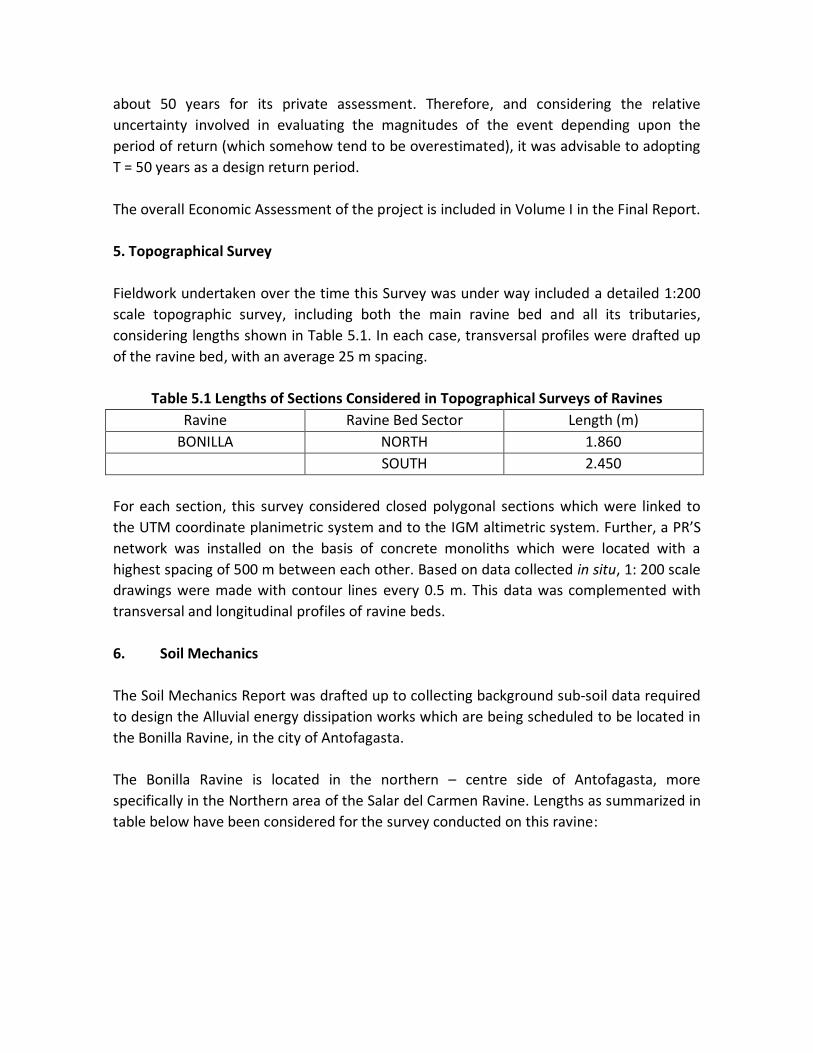
about 50 years for its private assessment. Therefore, and considering the relative
uncertainty involved in evaluating the magnitudes of the event depending upon the
period of return (which somehow tend to be overestimated), it was advisable to adopting
T = 50 years as a design return period.
The overall Economic Assessment of the project is included in Volume I in the Final Report.
5. Topographical Survey
Fieldwork undertaken over the time this Survey was under way included a detailed 1:200
scale topographic survey, including both the main ravine bed and all its tributaries,
considering lengths shown in Table 5.1. In each case, transversal profiles were drafted up
of the ravine bed, with an average 25 m spacing.
Table 5.1 Lengths of Sections Considered in Topographical Surveys of Ravines
Ravine Ravine Bed Sector Length (m)
BONILLA NORTH 1.860
SOUTH 2.450
For each section, this survey considered closed polygonal sections which were linked to
the UTM coordinate planimetric system and to the IGM altimetric system. Further, a PR’S
network was installed on the basis of concrete monoliths which were located with a
highest spacing of 500 m between each other. Based on data collected in situ, 1: 200 scale
drawings were made with contour lines every 0.5 m. This data was complemented with
transversal and longitudinal profiles of ravine beds.
6. Soil Mechanics
The Soil Mechanics Report was drafted up to collecting background sub-soil data required
to design the Alluvial energy dissipation works which are being scheduled to be located in
the Bonilla Ravine, in the city of Antofagasta.
The Bonilla Ravine is located in the northern – centre side of Antofagasta, more
specifically in the Northern area of the Salar del Carmen Ravine. Lengths as summarized in
table below have been considered for the survey conducted on this ravine:

Table 6.1 - Lengths and number of wells per channel sector
Ravine Channel Sector Length (m) Number of Wells
BONILLA Northern
South – Main Channel
South – Tributary 1
South – Tributary 2
1.860
2.050
200
200
19
23
3
2
Well 1 in Northern Bonilla is the same well 1 in Southern Bonilla, Main Channel, i.e., BON-
1 = BOS-1, therefore, in Northern Bonilla there are a total of 19 wells, while in Bonilla
South there are a total of 28 wells.
The subsoil was probed through drilling of 3 m depth wells, or drilling down to the rock in
the event that the latter could be detected before reaching the expected depth. Since
wells containing cemented material were also detected, showing substantial resistance to
both, manual excavation and backhoe excavators, these wells were deepened as far as
possible down to a 3 m depth or, failing that, intermediate wells which did not reach the
specified depth, were complemented with some other wells so that the presence of
cementing in the area could be established. Exploration wells were located every 100 m.
A detailed stratigraphy of all wells was performed and representative soil samples were
extracted which were subjected to classification tests (granulometry and Atterberg limits),
specific gravity, natural moisture, natural density, highest, minimum density, and soluble
salts.
7. Geological Report
Some general conclusions reached by the Geological Survey undertaken for this project
are spelled out below, pertaining both to the Bonilla ravine and to all other ravines
involved in the project. Also, some conclusions directly concerning the Bonilla Ravine are
included herein.
- The andesites1, Porphiritic andesites2 and sandstones present in La Negra Formation
show a NS to N10º E heading and 35ºW to 50ºW slopes. Hard and little weathered
1 Andesite is an extrusive rock intermediate in composition between rhyolite and basalt
https://flexiblelearning.auckland.ac.nz/rocks.../andesite.html
2 It is a volcanic rock, similar to diorite but fine-grained. www.ucl.ac.uk/museums-static/digitalegypt/stone/porphyry.html

rock, low to moderate fracturing degree. quartz – Feldspar dykes, syncline folds and
faults have an impact on Andesites.
- Sandstones and Tertiary age coquinas are distributed along different horizons inside
the terraces.
- Quaternary age alluvial sediments making up good to poor selection terraces are
distributed along different horizons.
- The sedimentary material is composed of silt, fine to coarse sand, gravel and angular
to rounded rock fragments (blocks and boulders), which are found along the ravines,
hills slopes, mudflows (Alluvia) and on terraces.
- Mining is undertaken of aggregates in ancient and current terraces sedimentary,
colluvial materials, and in the ravines. Unchecked mining has led to instability of
terraces and sedimentary levels located higher up the hills.
- Weathering of rocks in high hill sectors release colluvial material into ravines.
- Ravines have become into actual landfills accumulating large volumes of wastes of
different sorts whenever a large alluvium would occur. This waste could be easily
removed by increasing the mud stream volume.
8. Technical Project Characteristics
8.1. Design criteria
The design of alluvial Control works incorporated as a key goal to abating the destructive
impact debris flows have: i.e., keeping the highest possible flood volume in check, subject
to current space constraints in ravines beds. These works shall reach a goal to reducing
the volumetric concentration of solids from alluvial flows into the city, at the same time
weakening its peak flow, speed and drag capacity in ravine beds. A 15% highest solids
concentration at ravines exit was set up (access to the urban sector), so that the impact of
ravine flows through the city would be similar to that of rainwater, thus making its
evacuation easier.
The scope set by the MOP to this survey only considered a survey of tracks of ravines
located upstream of the urban boundary. Solutions were preliminarily formulated on a
cartographic scale base of 1: 5,000 obtained through an aerial photogrammetric survey of
the ravines in year 1992.
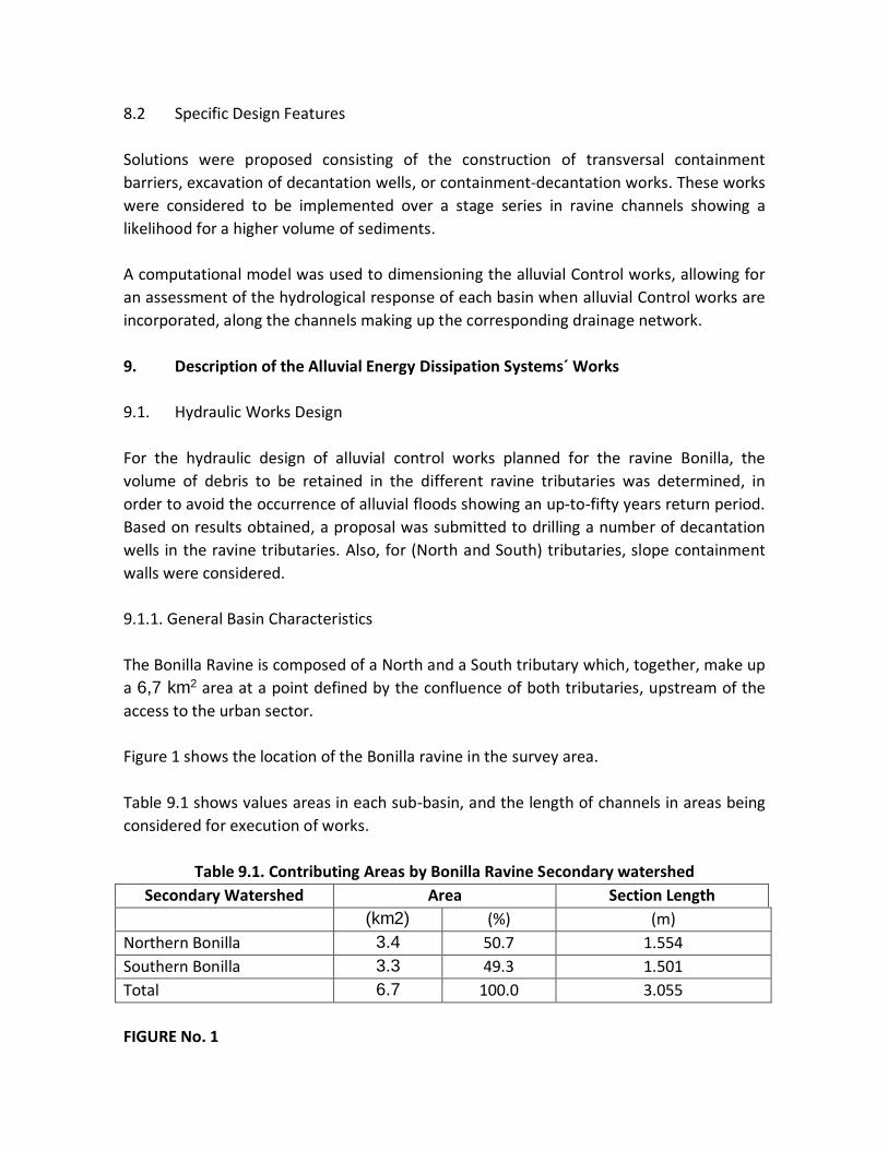
8.2 Specific Design Features
Solutions were proposed consisting of the construction of transversal containment
barriers, excavation of decantation wells, or containment-decantation works. These works
were considered to be implemented over a stage series in ravine channels showing a
likelihood for a higher volume of sediments.
A computational model was used to dimensioning the alluvial Control works, allowing for
an assessment of the hydrological response of each basin when alluvial Control works are
incorporated, along the channels making up the corresponding drainage network.
9. Description of the Alluvial Energy Dissipation Systems´ Works
9.1. Hydraulic Works Design
For the hydraulic design of alluvial control works planned for the ravine Bonilla, the
volume of debris to be retained in the different ravine tributaries was determined, in
order to avoid the occurrence of alluvial floods showing an up-to-fifty years return period.
Based on results obtained, a proposal was submitted to drilling a number of decantation
wells in the ravine tributaries. Also, for (North and South) tributaries, slope containment
walls were considered.
9.1.1. General Basin Characteristics
The Bonilla Ravine is composed of a North and a South tributary which, together, make up
a 6,7 km2 area at a point defined by the confluence of both tributaries, upstream of the
access to the urban sector.
Figure 1 shows the location of the Bonilla ravine in the survey area.
Table 9.1 shows values areas in each sub-basin, and the length of channels in areas being
considered for execution of works.
Table 9.1. Contributing Areas by Bonilla Ravine Secondary watershed
Secondary Watershed Area Section Length
(km2) (%) (m)
Northern Bonilla 3.4 50.7 1.554
Southern Bonilla 3.3 49.3 1.501
Total 6.7 100.0 3.055
FIGURE No. 1
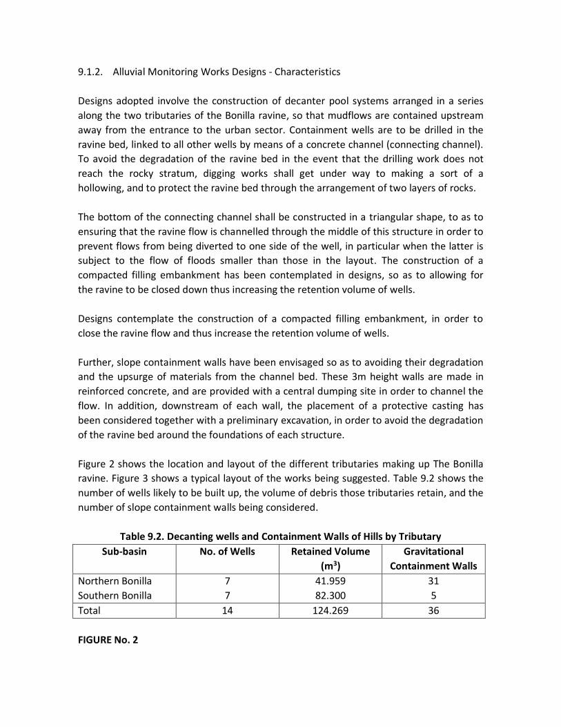
9.1.2. Alluvial Monitoring Works Designs - Characteristics
Designs adopted involve the construction of decanter pool systems arranged in a series
along the two tributaries of the Bonilla ravine, so that mudflows are contained upstream
away from the entrance to the urban sector. Containment wells are to be drilled in the
ravine bed, linked to all other wells by means of a concrete channel (connecting channel).
To avoid the degradation of the ravine bed in the event that the drilling work does not
reach the rocky stratum, digging works shall get under way to making a sort of a
hollowing, and to protect the ravine bed through the arrangement of two layers of rocks.
The bottom of the connecting channel shall be constructed in a triangular shape, to as to
ensuring that the ravine flow is channelled through the middle of this structure in order to
prevent flows from being diverted to one side of the well, in particular when the latter is
subject to the flow of floods smaller than those in the layout. The construction of a
compacted filling embankment has been contemplated in designs, so as to allowing for
the ravine to be closed down thus increasing the retention volume of wells.
Designs contemplate the construction of a compacted filling embankment, in order to
close the ravine flow and thus increase the retention volume of wells.
Further, slope containment walls have been envisaged so as to avoiding their degradation
and the upsurge of materials from the channel bed. These 3m height walls are made in
reinforced concrete, and are provided with a central dumping site in order to channel the
flow. In addition, downstream of each wall, the placement of a protective casting has
been considered together with a preliminary excavation, in order to avoid the degradation
of the ravine bed around the foundations of each structure.
Figure 2 shows the location and layout of the different tributaries making up The Bonilla
ravine. Figure 3 shows a typical layout of the works being suggested. Table 9.2 shows the
number of wells likely to be built up, the volume of debris those tributaries retain, and the
number of slope containment walls being considered.
Table 9.2. Decanting wells and Containment Walls of Hills by Tributary
Sub-basin No. of Wells Retained Volume
(m3)
Gravitational
Containment Walls
Northern Bonilla
Southern Bonilla
7
7
41.959
82.300
31
5
Total 14 124.269 36
FIGURE No. 2

FIGURE No. 3
9.1.3. Flows and Volumetric Concentrations
Table 9.3. shows highest flows and both, liquid and detritus flooding volumes for both, the
Northern and Southern tributaries respectively. Considering Northern and Southern
tributaries flows concentrations of 50% and 55% respectively, a highest detrital flow of
16.2m3 /sec is obtained.
Tabla 9.3. Flood and Volumes in a Swollen River
Sub-Basin Highest Flow (m3/s) Volume (m3/s
Liquid Detrital Liquid Detrital
Northern Bonilla 3.9 7.8 33.515 67.030
Southern Bonilla 3.9 8.4 32.411 72.024
Basin Total 7.7 16.2 65.928 139.054
Table 9.4 shows the concentration and design flows obtained for the various ravine
streams, and the total ravine tributary flow. The point should be stressed that values
shown for the ravine tributary were calculated after modelling the flood flow through
decanting wells.
Tabla 9.4. Design Flows
Sub-Basin Volume Concentration (%) Flow (m3/s)
Liquid Detrital
Northern Bonilla 50 3,9 7.8
Southern Bonilla 55 3.8 8.4
Ravine Tributary 15 3.9 4.6
Figure 4 shows the tributary, and tributary hydrographs of this ravine.
FIGURA No. 4 PÁGINA RE-13 en PDF NO EXISTE EN PDF
9.2 Structural Design of Works
The structural calculation of flow Control works and energy dissipation of events such as
Alluvial avalanche with solid entrainment was conducted in accordance with the
"Structural Design Records" of this project, the properties and Parameters related to the
geology of the Bonilla ravine soil, and its tributaries. These calculations are supported by
Soil Mechanics reports prepared for this particular purpose, and some other particular
considerations.

9.3. Particular Technical Specifications
In order for the execution of works to be carried out in accordance with the Project, a
document entitled Technical Specifications has been drawn up singling out the Standards,
Regulations, Materials, Construction Methods, and some other documents ruling the
construction of the works.
10. Bonilla Ravine Budget
Table 10.1 includes the official budget for Bonilla Ravine works.
Tabla 10.1. Official Works Budget (Price Baseline: March 1998)
Description Budget $ Budget $ (VAT included)
Northern Tributary 1.210.136.495 1.427.961.064
Southern Tributary 1.048.315.353 1.237.012.117
Partial Addition 2.258.451.848 2.664.973.181
Setting up of Works 29.991.184 35.389.597
Access Roads 20.000.000 23.600.000
Environmental Management Measures 22.584.518 26.649.732
Overhead Costs, Profits and Incidental expenses 932.411.020 1.100.245.004
Grand Total 3.263.438.571 3.850.857.513
11. EXECUTION SCHEDULE
Works to be executed at the Bonilla ravine shall be implemented on a stage-by-stage
basis, and are expected to be executed from the downstream to the upstream areas in
each tributary in which works have been scheduled. Activities as follows have been
considered for execution in the order they are stated:
-Hiring of Contractor
- Setting up of Works and Access Paths
- Works in Northern Tributary
- Works in Southern Tributary
A time estimate for execution of works has been fixed at 24 months. Sketches below show
a Gantt letter enclosing a schedule for the Bonilla Ravine works.

12. Legal Issues
Expropriations likely to be required insofar project-related works are concerned shall not
be enforceable insofar properties affected by the project are State-owned, no settlers are
located nearby the project site, and / or people requiring protection and / or resettlement
on account of the environmental impact of works as envisaged.
13. Environmental Impact Assessment
The environmental impact assessment of the execution and operation of works in the
Bonilla ravine, has shown that the project´s potential impact is low and is confined to each
project stage issues as follows:
Execution Stage:
Social Setting:
- Minor inconvenience to the local population due to an increase in particulate matter
in the atmosphere if prevailing winds change their course towards the city of
Antofagasta.
- Minor inconvenience to the local population due to an increase in noise pressure
levels being caused by moving machinery.
- higher local employment rates
Natural Setting: Landscape
- Changes in current landscape´s morphology in project and dumpsites areas.
Operation stage:
Social Setting:
- Safety in monitoring of alluvial floods.
- Higher local employment rates.
Natural environment: Landscape
- - Presence of alluvial dissipation works on the Bonilla Ravine tributaries bed.

Mitigation measures are referred to the use of good Construction practices vis-à-vis GHG
emissions, handling of waste materials, management of loans, and the protection of the
biotic and cultural environment.

Y MURO GRAVITACIONAL
ESQUEMA TIPOBARRERA TERMINAL
3
RE-11


RE-11


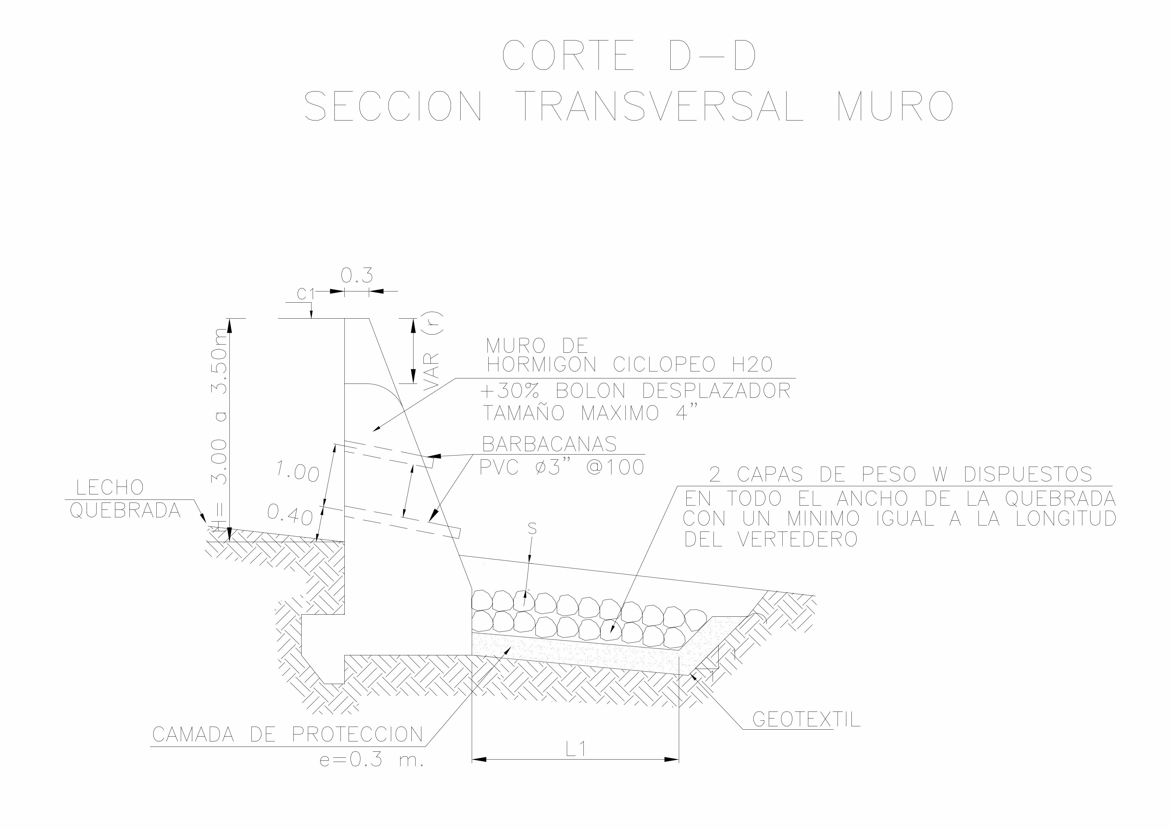

STABILITY OF GATAZO HILLS SLOPES
ESMERALDAS CITY
EXECUTIVE SUMMARY
TRICONSUL CIA. LTDA.
Esmeraldas, Ecuador, September 2008
AUTHOR
Forest Engineer Alfredo Arévalo Tello. M.Sc.©
Environmental Protection
Consultant N° 1 - 1461 - CIN
October 2008

1.- EXECUTIVE SUMMARY
1.1 A stability survey was conducted of four geological failures recently recorded in El Gatazo Hill
slopes, in Esmeraldas, Ecuador. A proposal for these slopes to be stabilized is shown below.
1.2.- A summary of the topography, hydraulic, geological and geotechnical works, surveys findings
and proposals for solution is shown below, together with a social assessment undertaken to
determine the impact these landslides had on people settled in the lower side of the Hill.
1.3.- Mechanical solutions to address this type of hill slope problems involve stabilizing them by
means of changes in their original geometry reducing the upper soil volume; solutions that in this
case avoid groundwater movement, and mechanical solutions preventing the movement of the soil
by using containment structures such as anchors.
2.- LOCATION AND CHARACTERISTICS OF LANDSLIDES
2.1.- The characteristics of landslides located within the topographic map of the city of Esmeraldas
are shown together with a reference to the universal geographical coordinates system. Table below
refers to this nomenclature.
a. Table below shows the geographic location coordinates of the survey area:
GEOGRAPHIC LOCATION
LATITUDE LENGTH
M M
104735 N 649658 E
Four landslides have been identified in the survey area, and table below shows geometric
characteristics:
GEOMETRIC CHARACTERISTICS
Landslide
m
Height
m
Length
m
Width
m
Hill descent
degrees
Loose Earth Mass
Before Current
M3
A
B
C
F
40
35
20
16
140
80
100
80
70
40
50
50
33p
24O
12p
12p
99.000 13.677
37.000 4.257
48.000 8.695
14.000 7.300
TOTAL 198.000 33.931
2.2.- Landslides area is located in the Gatazo Hill slopes, La Guacharaca neighbourhood, in
Esmeraldas, at an elevation of approximately 230M above sea level (masl) and the lower part of the
Hill is located at an average 130M above sea level.
3. WORK SCOPE
3.1.- Topography, geology, geophysics, hydraulics and geo-technics related field work was undertaken
at each site. Field and laboratory data results were processed to carry out the stability survey, to
establish safety factors, and to decide upon the most appropriate, economical and safe solutions.
3.2.- The topography survey involved drawing up a sketch of the area in question to identifying the
characteristics of landslides such as escarpments, borders, boundaries, geological failures, so as to
determining dimensions, area and volume of the soil mass detached by the landslide. The surveyed
topography was overlaid on the topographic map of the city of Esmeraldas, drawn up by
INGECONSULT company for the Municipality of Esmeraldas, and a definition was then made of the
slopes geometry before and after the landslides, thus allowing to learning how the hill slopes behave
vis-à-vis alterations in their water contents.
3.3.- Geology and geophysics techniques applied were intended to determine the characteristics of
the subsoil strata in the area, and to complement the geotechnical survey on the basis of field
observation and electrical resistivity probes, ten of which were undertaken: six in the upper part of
the affected area; 2 in the lower part of the same area; and 2 outside the area, in the Western sector
where the antennas were reinstalled.
3.4.- On the basis of topographic surveys, the hydraulics of the site surveyed the characteristics of the
basins, their flows and possible discharges, as well as the depth of the filtering strata.
3.5.- Geotechnical techniques were undertaken to schedule eight mechanical probes so as to
determine the physical and mechanical characteristics of the soils in the subsoil of the upper stratum,
and to induce the most probable parametre in the slopes behaviour. Six of these probes were located
at the top, and two at the bottom of the Hill.
3.6.- Field and laboratory results were used to estimate soil parametres under normal working
conditions and under critical conditions so that, using Bishop stability survey methods, in the
presence of circular failure surfaces, critical safety factors could be determined and, if required, the
containment force so as to achieving a higher than 1.5 safety factor.
3.7.- Hydraulic conditions were determined and a ditches and sub-drains system was designed to
superficially up-keeping the conditions of soils from sustaining water effects.

3.8.- On the basis of design data collected, work volume were calculated according to items and
specifications in Handbook MOP-001 - F – 2002.
3.9.- A social survey was conducted of all families settled in the lower part of the area impaired, and
based on interviews, income level data, and dwelling conditions, their level of affectation was
measured, and a recommendation was made for relocation of 106 households.
4.- SOILS STRATIGRAPHY
4.1.- In the upper part of the hill, an upper stratum is present in the surveyed depth which is a MH
type, light brown loose soil, with a number of strokes in the standard penetration test between N=3
and N=16; average liquid limit at 65%, and average plastic limit at 40%; average natural humidity 50%
close to the plastic limit; the percentage of fines passing the No. 200 sieve is 75%. This layer is made
up by the surface soil in which the failures and cracks are present.
4.2.- The lower stratum is a very hard soil, formed by two sub-strata, one formed by shales, siltstones,
or sandstones, of a light brown and greenish coffee colour, MH type, and another underlying soil
formed by a GW type conglomerate. The number of strokes in the standard penetration test
increased from N = 20 to 50; plasticity limits values are close to LL = 65% and LP = 40%; natural
moisture 55% and percentage through sieve No. 200 is similar to the material in the upper layer
because they have the same origin. This stratum shows a very homogeneous formation; the two
substrata share the same mineralogical characteristic, prone to oxidation and fragmentation, when
they are exposed and are in contact with natural environmental conditions for a long time. This
stratum, while also showing failures and cracks, is very stable.
4.3.-Surveys conducted in the lower part of the hill show a soil similar to the one defined for the
upper sector, and from a 7M deep, a conglomerate type underlying soil appears similar to the soil on
the Eastern hill front, in the quarries sector.
4.4.- On the basis of field and laboratory results of soil mechanics and geophysical surveys, an average
level has been determined of the interface between the non-compact upper soil and the lower hard
soil located under the two soil strata mentioned, which is made up by very hard tuffs of the shales,
siltstones types settled on a very hard sandstones and conglomerate stratum.
5. LANDSLIDES CONDITIONS
5.1.- Landslides are all located at the top of the ridge, and are generated in the upper soil having a
20m and 25m thickness, according to mechanical and geophysical surveys undertaken.
5.2.- Two types of defined strata are present in the Esmeraldas area soils: An upper stratum made up
of silty time schists resulting from the alteration of limolites and arcillolites and even sandstones; this
stratum is very heterogeneous, with very weak and low-resistant mantles, and rests on another

stratum made of unaltered and very resistant materials. Failure surfaces are generated in the first
stratum and on the upper part of the second stratum.
5.3.- General parametres recommended for stabilisation surveys are taken from retrospective surveys
conducted in slopes in the province of Esmeraldas area, and are based upon the methodology
brought forward by Engineer Francisco Abad and Engineer Francisco Ureña, from CEMOSA Co., at the
5th National Symposium on Unstable Slopes and Hills, held in Madrid, Spain, in 2001, a methodology
basically correlating cohesion values and an internal friction angle to obtaining safety factors equal to
1, and called "intrinsic line".
5.4.- Parametres as follows were taken from the retrospection survey vis-à-vis the weak upper
stratum on which the failures were caused. For the lower substrates values have been taken from the
soil characterisation table below:
SOIL PARAMETRES FOR STABILITY TEST
PARAMETRES STRATA VALUES
Higher Substratum 1 Substratum
2
COHESION C T/m2 5 40 40
FRICTION ANGLE Φ (o) 8 15 1.8
NO SAT. UNIT
WIEGHT
γ T/m3 1.6 1.8 1.8
SAT. UNIT WEIGHT Γsat T/m3 1.7 1.9 2.0
SUCS
CLASSIFICATION
MH MH GW
6.- STABILITY SURVEY
6.1.- On the basis of soil-related data, and the survey conducted on circular failure surfaces, the
typical conditions of mechanical behaviour were determined using the Bishop method with the
XSTABL V5 Programme.
6.2.- Once the soil parametres were defined, a survey was conducted in each landslide of its central
profile considered as the most critical, and defined in the topographic survey as such.
6.3.- Bearing in mind the knowledge available about the topography prior to the occurrence of
landslides, and the current topography resulting from the survey carried out in this assessment, we
proceeded to determine the soil parametres in place when the slope failed, that is, the parametres
making the safety factor equal to 1, using the Bishop method, with the XSTABL V5 Program: these
parametres were revised to find out whether they were within the intervals of the retrospective
survey of the Esmeraldas soils.
6.4- Six behavioural parametres were assessed in each of the four landslides with defined soil
parametres, to inquire into the geometry prior to the occurrence of landslides. In the first state, the

safety factor was determined in conditions critical to the entire slope The second stage was to
determine the failure conditions of the upper layer of the ridge generating the landslide.
6.5.- For the geometry after the landslides, the safety factor for the total height was determined in a
third state; in a fourth state the safety factor was determined for the failed stratum.
6.6- For the current conditions, two final states were analysed: a fifth state determined the safety
factor after correcting the slope geometries, for which slopes should be constructed with a maximum
1V:2H gradient, with a surface and underground drainage system.
6.7.- In a sixth state, a horizontal containment force was determined that should be provided by
means of anchors, in order to reach a 0.25 increase in the safety factor achieved with the geometries
change. Anchors should be installed with an inclination perpendicular to the slopes and should reach
a length until reaching the lower layer where it will be extended at least 8M.
6.8.- The safety factor chosen for the survey was 1.5 bearing in mind the mountain collapse
characteristics, the site location, social and economic impacts. However, in order to provide
additional safety taking into account the risk to life, an additional 0.25 increase was made by
providing an external force through anchorages.
6.9.- The water table was determined in surveys conducted below the sliding soils, i.e., the water
affecting the failed slopes is only the water infiltrating over rainy conditions.
7.- HYDRAULICS
7.1.- Hydraulic conditions in the survey area were determined. Topographic data allowed for charts
on which the altimetry survey of the site was drawn showing contour lines, the same ones that were
used for the implementation of the different channels dug up, and design structures recommended
for this purpose.
7.2.- Two areas have been hydraulically defined: an upper area measuring approximately 3.6Ha, and a
second one along the middle slopes of the Gatazo Hill. The lower part of the hill is made up by La
Guacharaca neighbourhood, and has two water channels flowing from above the Hill that will be used
as drainage from high areas. These channels flow into a sewage system starting in two catchment
areas, one of them, because of landslides, is affected both at the start and the first section of the
pipeline.
7.3.- Surface flow rates have been calculated by rational methods and are included in Annexes. Two
surveys have been conducted: one for the affected upper area, and the second one taking into
account the whole hillside.
7.4.- To determine underground flows, a calculation has been made on the basis of the method
proposed by Kevin Forrester document published by the ASCE Press, entitled: Subsurface Drainage for
Slope Stabilisation, and separation of trenches.
7.5.- Drainage and sub-drainage systems have been designed as a set of surface ditches and drainage
trenches formed by a drainage pipe within a filtering stone material core, covered with geotextiles
and geo-membranes.
7.6.- Dimensioning of structures and drainage and sub-drainage works is shown in annexes, and has
been made based on the needs to minimize the water impact on the slopes soils in situ.
8. OBSERVATIONAL RISK SURVEY
8.1.- The parametres of the retrospective survey show values similar to those bringing slopes to the
Hill failure: this means that the conditions to which soils in sites surveyed have been subjected are
critical, a fact which can be stressed by witnessing that in most slopes there are water flows showing
that the runoff has been deficient by natural ways, this meaning that soils conditions will greatly
improve if a sub-drains system is implemented.
8.2.- For the risk factor to be determined, the observation method described in Manual for
Zonification on Areas Susceptible to Rain-induced Slope Failure, published by the Asian Technical
Committee on Geo-technology for Natural Hazards has been used, that takes into account the slope
height, the mountain inclination, topography, surface soil thickness, depth of water table, and
geological failures levels, and attaches a 16 value to the highest risk and a 3 value to the minimum
risk, according to the basic table shown in the annexes as well as to each slide table.
8.3.- Observational survey findings rate the slope risk at 100%.
9. FAILURE MECHANICS AND SOLUTION
9.1.- The failure mechanism has been established bearing in mind the hydraulic conditions prevailing
in the area, and having a severe impact during the 1998 El Niño phenomenon, when a larger depth of
the soil upper stratum was affected by the weather and heavy rainfall, altering the mechanical
conditions by increasing the weight of the soil mass and decreasing the latter´s resistance, causing
failures in several places in the city and the province. Later on, more failures were generated over the
drought periods, because when the new strata in which the water contents increased under heavy
rainfall conditions reduced their size, they were cracked, also losing resistance. These new cracks
deeper than those in previous time became into a critical area since, as new rainy seasons arrived,
they became a greater depth of infiltration weakening down a larger soil mass, and causing new
landslides similar to those sustained in the Gatazo Hill.
9.2.- The survey area shows a very cracked failure area needing substantial work to close the cracks.
This shall be done by creating water collection areas and stable slopes. These have been defined with
a 1V: 2H slope, with 3M at least terraces or berms to allow for the displacement of work teams.
9.3.- Construction of a surface and underground drainage system has been arranged to ensure a fast
water evacuation by means of the construction of coronation and of foot of slope gutters, as well as a
drainage trenches system constructed down to a 4M depth connected to an external draining system

flowing into the city system for which a plan to rehabilitate the system has been jointly prepared with
the Municipality of Esmeraldas.
9.4.- In addition, an anchors system has been designed on the lower slopes to increasing the slopes
safety factor in some 0.25 additional points, considering risk sensitivity on account of a populated
area located at the foot of the Hill.
10. TECHNICAL SPECIFICATIONS
10.1.- Working conditions are rather particular bearing in mind that working sites are located on the
upper sector of a populated neighbourhood, so that thorough safety conditions should be in place to
avoid damages in the lower sector.
10.2.- Technical specifications in designs are those stipulated in the General Specifications Manual for
the Construction of Roads and Bridges MOP-001-F-2002.
10.3.- Two specifications have been defined in a special way for Stakeout and Anchors items.
10.4.- All materials should be disposed of at a place in the lower part of the city. Arrangements have
been made in coordination with Esmeraldas Municipality authorities for debris to be placed in the
Southern section of the road to the Montúfar military post, to be used as a landfill, allowing for a road
leading to the lower part of La Chamera neighbourhood, crossing nearby the Esmeraldas Tennis Club.
A 10Km travelling distance for evacuation of materials has been considered in the budget, together
with maintenance of a 2KM access road to Gatazo Hill.
10.5.- Several safety standards have been borne in mind, and a budget has been estimated to meet
environmental standards.
11.- METHODOLOGY, WORKLOAD, BUDGET AND TIMETABLE
11.1.- A methodology proposal was drafted up to setting forth activities’ characteristics and to
determine time and costs involved in unit prices and schedule.
11.2.- Based on MOP-001-F-2002 designs and specifications, the workload was split up into
construction stages and systems, as shown in Annexes.
11.3.- Two budgets have been prepared: one addressing official CORPOECUADOR unit prices, updated
as of July 2008, and including special unit prices, which are not included in the official list and are
necessary on account of the project typology; and a second budget incorporating special prices in
consideration of stringent working conditions vis-à-vis safety of workers and dwellings in the lower
area, as well as a difficult access, thus, having two budgets is acceptable to the project real
conditions; these unit prices have been updated as of September 2008. In both budgets, 22% indirect
costs have been considered.

11.4.- Works costs have been estimated at $2,358,749.91 (Ecuatorian Currency), considering
CORPOECUADOR official unit prices as of July 2008.
11.5.- The works costs considering actual working conditions have been calculated on the basis of
CORPOECUADOR unit prices, corrected by a difficulty factor considering the project location and
safety measures to be undertaken, with total costs of works amounting to $2,552,226.44, including
the budget of works to be contracted by CORPOECUADOR and the works recommended to be
executed on the basis of agreements to be entered into with the Municipality of Esmeraldas, such as
sewerage works, and EE-4 items. And works contracted with the Luis Vargas Torres Technical
University, such as revegetation of slopes, Item 206 (4), and reforestation, item EE-5, activities to be
removed from the budget and from the work schedule, as stipulated.
11.6.- The scheduled time for work execution is 12 months: ten months for specific stabilisation
works; and 2 additional months for works pursuant to agreement: sewage rehabilitation,
revegetation, and reforestation.
12.- CONCLUSIONS AND RECOMMENDATIONS
12.1.- A conclusion can be reached on the basis of results that the whole slopes body has been stable
before and after the landslides; and the lower stratum is not affected by changes in the water
contents.
12.2.- The upper layer failed under conditions typical of the Esmeraldas soils, which show a 6.5 Tn /
m2 cohesion, and φ = 8 ° internal friction angles; after the landslides, the slopes stabilized increasing
the safety factor to values between 1.5 and 2, which is understandable if the consideration is taken
into account that the occurrence of slides at the top caused the detachment of the slope from the top
of the hill.
12.3.- Changes in the slope geometry and the installation of anchors in the lower front side will
stabilize the slopes with a safety factor higher than 1.5, in all slopes.
12.4.- The resettlement of families as listed in the social survey is recommended in order to provide
them with the highest security in the future.
12.5.-Stabilisation works should be carried out together with the relocation of 106 dwellings to
minimize risks over execution of works.
12.6.- A recommendation is made that, for coordination of and responsibility for the works, two
stages involved therein: revegetation and reforestation, are undertaken through an agreement with a
specialized institution considering that the work is dependent upon several environmental conditions,
the responsibility of which could be taken over by a non-for-profit institution.
12.7.- The rehabilitation of sewerage systems in the lower part of the Hill, which were obstructed by
landslides, is an additional phase that should be carried out through a public institution. The point

should be borne in mind that procedures and implications with adjacent and complementary systems
attached to other Public Utilities could be executed by the Municipality of Esmeraldas, and under
their responsibility.
12.8.- The Environmental Impact Assessment contemplates that the intervened areas should be
revegetated by placing MONTHhes with local seeds and soils existing in the site. The site´s organic
vegetal soil collected at the time of clearing and the beginning of the soil cutting should be kept and
taken care of over the execution of works, to be reused at the time works are under way on
reconstructed slopes.
12.9.- The soil produced by the cutting should be placed along the new road sector on the way down
to La Chamera neighbourhood, as arranged for by the Municipality of Esmeraldas.
BIBLIOGRAPHY
1. This assessment was made on the basis of the Japan Landslide Society recommendations, Fig 2.1
Deslizamientosandestabilidad en taludes en zonas tropicales, Jaime Suarez Díaz.
2. The Recognition Methodology, Chapter 4 of Landslide Recognition, Richard Dikau, Denys Brunsden
was used.
3. The security factor was analysed on the basis on numeral 4.2 of Landslides and their stabilisation,
Christian Veder.
4. The assessment concepts were taken from Chapter 4 of Slope Stability and Stabilisation Methods,
Abramson, Lee, Sharma and Boyce.
5. The Assessment Method used was the Janub Method referring to XSTABL V5 non-circular surfaces
programme, Interactive Software Design Inc, Sunil Sharma.

6. Soil parametre values for assessments were taken from the Estudio de Parametrización de los
Suelos para Análisis de Estabilidad de Taludes de la Zona Central de la Provincia de Esmeraldas (Soil
Parametreisation Study for Stability Analysis of Slopes of the Central Area of the Province of
Esmeraldas) according to Abad and Ureña method, V Simposio Nacional sobre TaludesandLaderas
Inestables, Madrid, Spain, November 2001.
7. The Screen system design was taken from Chapter 12 in Foundation Engineering Handbook, Hsai-
Yang Fang, and Chapter 13 of Foundation Engineering Handbook, Winterkorn.
8. The moments and pressures calculation was taken from Chapter 10 Geotechnical Engineering,
Joseph Spilogon.
9. The thrust coefficients for cohesive soils were taken from page 453 in Foundation Engineering
Handbook, Hsai-Yang Fang.
10. The drainage trench system was taken from figure l 11.25 Chapter 11, Foundation Engineering
Handbook, Hsai-Yang Fang.
11. Drainage trench calculations were made using the method presented by Kevin Forrester in ASCE
Press publication, Subsurface Drainage for Slope Stabilisation, 2001.
12. The slope drainage graph un Figure 8, page 71-280 of DM 7.01, NAVFAC was used
13. The pile separation and anchoring calculations were performed in line with methods in Manual
Design for Permanent Ground AnchorageWalls, by the Federal Highway Administration, U.S.
Transportation Department, September 1998.
14. For anchoring estimates, concepts were applied as set forth in Manual de Estabilidad de Taludes,
Teotecnia Vial, National Road Institute, Transportation Ministry, 1998.
15. Risk level was measured in accordance with budget in Manual for zonification on areas susceptible
to rain-induced slope failure, Asian Technical Committee on Geotechnology for Natural Hazards, 1997.

CORPECUADOR
ESMERALDAS DELEGATION
SURVEY
STABILITY OF GATAZO HILLS SLOPES
ESMERALDAS CITY
ANNEX
CONSTRUCTION METHODOLOGY
SPECIFICATIONS, BUDGET, POLYNOMIC FORMULA
AND WORKING SCHEDULE
TRICONSUL CIA. LTDA.
Esmeraldas, September 2008
Distribuidor de SAP2000, ETABS, SAFE www.triconsul.com.ec
Libertad 303andPichincha Phone (593) 6 2724446 - 2724447 Fax (593) 6 2727097
Código Postal 08-01-285 E-mail: [email protected]
Esmeraldas – Ecuador
1.- CONSTRUCTION METHODOLOGY
1.1.- Calculating the budget and scheduling the work to be executed involve the design of a working
system so as to allowing for a definition of activities-related characteristic, and advancing a
construction methodology that can be subject to changes by the contracting party according to his /
her criterion, equipment, technology and working schedule.
1.2.- This proposal addresses in the first place the revegetation and levelling in the area, execution of
works in access roads and the removal of the vegetation layer in the work area, and the disposal of
waste material to a temporary storage place for further reuse in revegetation works.
1.3.- Soil cutting and dislodgement works should be started later on to reconstructing the slopes, a
work to be done in a top-to-bottom fashion, in order that the soil cutting and removal of the soil
reduces the weight on the slopes, and the bottom floor is later removed. Appropriate equipment
such as backhoes and dump trucks should be used.
1.4.- A drainage system should be subsequently built up, trying to ensure that excavation work does
not destabilise the slopes, and construction is done by stretches of no more than 6M in length. This
work should be done with specialized equipment, such as backhoes.
1.5.- The construction of the anchoring system should be scheduled to be done simultaneously with
the work above, once the slopes have been reconstructed and it is possible to do the drilling and
place the tensioners and the plates. This work should be carried out with specialized equipment such
as a pneumatic or mechanical drilling machine; a support crane should be available to support the
equipment and the transfer of materials and work elements. During the implementation of surveys, a
monitoring system should be in place to ensure that the hard lutitas (shale) soil is being penetrated to
at least a 8M depth.
1.6.- Subsequent to the placement of anchors and the construction of the drainage system, the
construction of ditches and the external drainage system works shall be undertaken.
1.7.- Revegetation works scheduled to be carried out over the rainy season to ensure their efficiency
should then be carried out and, to ensure their efficiency, a constant water system should be
available for maintenance.
1.8.- Reforestation works should be simultaneously planned to be undertaken in the upper or lower
slopes area. These works should be subject to a process and maintenance time to achieving the
outcoMONTH expected.
1.9.- Mitigation and environmental monitoring plans should be taken into account throughout the
construction works of stabilisation systems.

2.- SPECIFICATIONS
2.1.- Project specifications vis-à-vis the construction materials and modality of the project items will
be those as spelled out in the MOP 001 F 2002 Handbook, according to the denomination of items in
the quantities and budget listings.
2.2.- All matters related to legal and environmental provisions should be taken into account.
2.3.- Removal of excavation material wastes should be done in the south-west sector outside the
place adjacent to the affected area in order to avoid adverse impacts on the slopes.
EE-1 Revision of project projections and levelling
Description.- This work involves the revision of the preliminary project projections and keeping them
in place throughout the project, carrying out the revision of the entire project projections as the
different activities are being carried out. All plans containing the profiles prior to the execution of the
works should be prepared and submitted to the previous approval of the Inspection office, to carry
out the monitoring of the guidelines, dimensions and slopes for a sound execution of works.
Work Procedure.- Milestones and stakes will be placed in the worksite and maintained for the proper
verification, measurement and monitoring of the work at hand; and work measurements will be
made for payment purposes.
Equipment required.- Duly calibrated theodolites, levels or full stations shall be used to ensure
correct work results.
Measurement.- All works described in this section will be measured per M2 of the area, on a
horizontal plane, according to the total amounts included in the contract.
Payment.- Amounts as stated shall be paid according to constant unit prices set forth in the contract,
and including all personnel, materials and equipment necessary for the total execution of the item
concerned.
EE-2 SLOPES FORMATION
Description.- This work involves all cuts that should be made in the slopes as required to obtain the
geometry calculations as determined in drawings and according to the alignments and dimensions
defined therein.
Working Procedure.- These cuts should be made from top to bottom, i.e., the slopes being a floor
structure subject to failure, because the weight increases on the top or the weight is reduced on the
bottom, works should be executed completing each slope horizontally before continuing in the next
lower slope. The materials resulting from the cuts shall be immediately removed outside the work
area, towards the lower part of the city, through the access road to the place as provided by the
Inspector. The Municipality of Esmeraldas has authorized that these materials are placed in the
Chamera lagoon sector.

Equipment required.- Excavators and dump trucks should be used to make cuts and to proceed to
load and remove materials from the worksite.
Measurement.- The work described in this section will be measured by M3 of all global amounts
included in the contract; this measurement will be made of the difference of volume determined in
planimetry and altimetry calculations of drawings made before and after the cuts were made.
Payment.- The determined amounts will be paid according to the constant unit prices set forth in the
contract and include all personnel, materials, and equipment necessary for the total execution of the
item, and the removal of materials to the place approved by the Works Inspection.
EE-3 STABILISATION ANCHORAGE - LENGTH 30M
Description.- The construction of a cylindrical excavation filled in with concrete, and having a
tensioner guaranteeing at least 65Tn of external admissible tension, and 105Tn at the breakage point,
and externally supported on a concrete plate, as described in drawings: f ' c = 280 kg /cm2. The
contractor shall supply an anchorage system guaranteeing the required tension. The anchorage
should be arranged in the place shown in drawings, and in the inclination shown therein.
Working Procedure.- This procedure refers to executing a drilling of at least 15cm in diametre and
30M in length to guarantee to have drilled down to 8M in the hard, tobas type ground, described in
the surveys and approved by the Inspector. A tensor system with a length similar to that of the
sounding equipment will be inserted in the hole, and should guarantee the required tension, and the
hole shall be filled with grout-type concrete of high expansive resistance down to the a 10M depth,
and the filling shall be finished with f'c = 280 Kg /cm2 concrete.
Equipment required.- Drilling shall be carried out with specialized equipment, such as mechanically or
hydraulically driven drills with compressors; the holes will be filled by injection of mortars in lengths
as shown; concrete slab will be constructed with concrete prepared in plant or in situ. The anchorage
tension will be applied with a specialized mechanical or hydraulic equipment that measures the
tension applied.
Measurement.- Works described in this section will be measured by complete unit according to
global amounts as set forth in the contract.
Payment.- Amounts as set forth in the contract will be paid according to unit prices stipulated
therein, and shall include all personnel, materials, and equipment necessary for the total execution of
the item.
EE-4 REHABILITATION OF THE CITY SEWAGE SYSTEM
Description.- The rehabilitating of the City sewage system according to requirements and needs as set
forth in the requirements as proposed.

EE-5 REFORESTED AREA, 1 NIN-TYPE TREE NIN (NEEN) EACH 9 M²
Description.- Reforestation of 6Ha of land: 3Ha at the top in the landslides area, and 3Ha at the
bottom of this area. NIN-type trees will be planted, one per each 9M2, and one-year maintenance
work shall be enforced.
Work Procedure.- Works should guarantee the indefinite existence of trees by means of sowing and
maintenance techniques.
Equipment required.- The equipment needed to carry out soil preparation and planting of trees,
ensuring the efficiency of the works to be executed.
Measurement .- Measurement will be made by Ha or partial of the area planted on an horizontal
plane.
Payment.- Amounts as stipulated will be paid according to constant unit prices as stipulated in the
contract, and will include all the personnel, materials, and equipment necessary for the total
execution of the item.
EE-6 WASTE PIT
Description.- Construction of a waste disposal pit for construction materials and to be located outside
the work area.
Working Procedure.- An excavation of at least 3M3, and a 1.5M2 area. In a stabilized ground site, a
wooden light structure will be built on top of the waste disposal site, that can be removed when
works are finished. A drawing of the intended waste disposal pit should be submitted to the
Inspector's approval.
Measurement.- Measurement shall be fully completed, in accordance with the Inspector´s decision.
Payment.- Works described in this section will be measured by complete unit according to global
amounts as set forth in the contract.
EE-7 BIODEGRADABLES
Description.- Collection of all non-natural materials existing in the work site prior to the start of
construction work, and which should be evacuated outside the work area.
Measurement .- Measurement will be made in a completed overall fashion according to the
Inspector´s decision.

Payment.- Works described in this section will be measured by complete unit according to global
amounts as set forth in the contract.
EE-8 LATRINES
Description.- The construction of a pit for human organic materials to be located outside the work
area.
Working Procedure.- An excavation of at least 3M3, and a 1.5M2 area. In a stabilized ground site, a
wooden light structure will be built on top of the latrines, that can be removed when works are
finished. A drawing of the intended latrines should be submitted to the Inspector's approval.
Measurement.- Measurement shall be fully completed, in accordance with the Inspector´s decision.
Payment.- Works described in this section will be measured by complete unit according to global
amounts as set forth in the contract.
3.- BUDGETS
3.1.- CORPECUADOR UNIT PRICES - JULY 2008
CORPECUADOR - GATAZO HILL SLOPES STABILISATION WORKS
Updated to July 2008
Esmeraldas City
Item
Code Item Description
Unit Number
of units Unit Cost ITEM COST
1 INITIAL WORKS
201-(1) Camp & related works Glb 1.00 9,402.400 9,402.40
Access roads
EE-1 Stakeout & Levelling M2 12,000.00 0.217 2,600.52
308-2(1) Finishing of existing basic work M2 12,000.00 0.334 4,010.36
403-1 Sub-base Class 3 slope higher than
6% M3 2,400.00 6.105 14,650.83
309-6(5)
Base, sub-base transport, crushed
material, loan screening, & others D/L
– 0 Km
(D/L=O km) m3-
Km 24,000.00 0.208 4,992.00
307-3(1) Gutter excavation M3 3,200.00 1.520 4,864.00
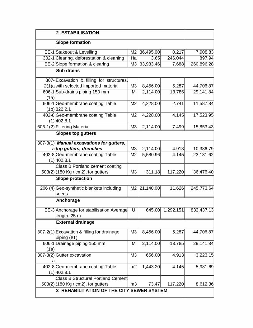
2 ESTABILISATION
Slope formation
EE-1 Stakeout & Levelling M2 36,495.00 0.217 7,908.83
302-1 Clearing, deforestation & cleaning Ha 3.65 246.044 897.94
EE-2 Slope formation & clearing M3 33,933.46 7.688 260,896.28
Sub drains
307-
2(1)a Excavation & filling for structures,
with selected imported material M3 8,456.00 5.287 44,706.87
606-1
(1a) Sub-drains piping 150 mm M 2,114.00 13.785 29,141.84
606-1
(1b) Geo-membrane coating Table
822.2.1 M2 4,228.00 2.741 11,587.84
402-8
(1) Geo-membrane coating Table
402.8.1 M2 4,228.00 4.145 17,523.95
606-1(2) Filtering Material M3 2,114.00 7.499 15,853.43
Slopes top gutters
307-3(1)
a Manual excavations for gutters,
top gutters, drenches M3 2,114.00 4.913 10,386.79
402-8
(1) Geo-membrane coating Table
402.8.1 M2 5,580.96 4.145 23,131.62
503(2) Class B Portland cement coating
(180 Kg / cm2), for gutters M3 311.18 117.220 36,476.40
Slope protection
206 (4) Geo-synthetic blankets including
seeds M2 21,140.00 11.626 245,773.64
Anchorage
EE-3 Anchorage for stabilisation Average
length. 25 m U 645.00 1,292.151 833,437.13
External drainage
307-2(1) Excavation & filling for drainage
piping (I/T) M3 8,456.00 5.287 44,706.87
606-1
(1a) Drainage piping 150 mm M 2,114.00 13.785 29,141.84
307-3(2)
a Gutter excavation M3 656.00 4.913 3,223.15
402-8
(1) Geo-membrane coating Table
402.8.1 m2 1,443.20 4.145 5,981.69
503(2) Class B Structural Portland Cement
(180 Kg / cm2), for gutters m3 73.47 117.220 8,612.36
3 REHABILITATION OF THE CITY SEWER SYSTEM

EE-4 Uptake No. 1 & Lenghtening of
Pipes Glb 1.00 57,000.000 57,000.00
EE-4 Uptake No. 2 Glb 1.00 23,500.000 23,500.00
EE-4 Uptake No. 3 & Lenghtening of
Pipes Glb 1.00 87,000.000 87,000.00
4 ENVIRONMENTAL MITIGATION
220-(1) Awareness-raising Talks U 10.00 315.00 3,150.00
708-
5(1)AEb Warning Signage Glb 25.00 109.80 2,745.00
708-
5(1)AEb Informational Signage Glb 10.00 109.80 1,098.00
EE-5 Reforested area 3Ha type NIN
trees (NEEN) Ha 3.00 25,000.00 75,000.00
EE-6 Waste pit Glb 1.00 2,500.00 2,500.00
EE-7 Biodegradables Glb 1.00 10,000.00 10,000.00
EE-8 Latrine Glb 1.00 1,500.00 1,500.00
TOTAL DIRECT COSTS 1,933,401.57
DIRECT INDIRECT COSTS 22% 425,348.35
TOTAL COST 2,358,749.91
3.2.- SPECIAL UNIT PRICES – SEPTEMBER 2008
CORPECUADOR.- GATAZO HILL SLOPES STABILISATION WORKS
Updated to September 2008
Esmeraldas City
Item
Code Item Description Unit Number of
ítems for
implementation
Unit Costs ITEM VALUE
1 INITIAL WORKS
201-(1) Camp & related works Glb 1.00 14,978.000 14,978.00
Access roads
EE-1 Stakeout & Levelling M2 12,000.00 0.217 2,600.52
308-2(1) Finishing of existing basic
work M2 12,000.00 0.952 11,429.52
403-1 Class 3 Sub-base slope
greater than 6% M3 2,400.00 14.148 33,954.96

309-6(5)
Transport of base, sub-base,
crushed material, loan
screening and otherss (D/L=O km)
m3-
Km 24,000.00 0.326 7,824.00
307-3(1) Gutter excavation M3 3,200.00 3.039 9,724.80
2 STABILISATION
Slope formation
EE-1 Stakeout & Levelling M2 36,495.00 0.217 7,908.83
302-1 Clearing, deforestation &
cleaning M2 36,495.00 0.559 20,400.71
EE-2 Slope formation & clearing M3 33,933.46 7.688 260,896.28
Sub drains
307-
2(1)a
Excavation & filling for
structures, with selected
imported material M3 8,456.00 8.343 70,548.41
606-1
(1a) Piping for subdrains 150 mm M 2,114.00 13.785 29,141.84
606-1
(1b) Geo-membrane coating
Table 822.2.1 M2 4,228.00 2.741 11,587.84
402-8
(1) Geo-membrane coating
Table 402.8.1 M2 4,228.00 4.145 17,523.95
606-1(2) Filtering Material M3 2,114.00 13.881 29,343.87
Slopes top gutters
307-3(1)
a
Gutter excavation, Manual
excavations for gutters, top
gutters, drenches M3 2,114.00 5.896 12,464.14
402-8
(1) Geo-membrane coating
Table 402.8.1 M2 5,580.96 4.145 23,131.62
503(2)
Class B Structural Portland
Cement (180 Kg / cm2), for
gutters M3 311.18 198.325 61,714.77
Slope protection
206 (4) Geo-synthetic blankets
including seeds M2 21,140.00 11.626 245,773.64
Anchorage
EE-3 Anchorage for stabilisation
Average length. 25 m U 645.00 1,292.151 833,437.13
External drainage
307-2(1) Excavation & filling Drainage
piping (I/T) M3 8,456.00 8.343 70,548.41
606-1 Drainage piping 150 mm M 2,114.00 13.785 29,141.84

(1a)
307-3(2)
a Gutter excavation M3 656.00 5.896 3,867.78
402-8
(1) Geo-membrane Coating
Table 402.8.1 m2 1,443.20 4.145 5,981.69
503(2)
TClass B Structural Portland
Cement (180 Kg / cm2), for
gutters m3 73.47 198.325 14,571.33
3 REHABILITATION OF THE CITY SEWER SYSTEM
EE-4 Uptake No. 1 & Lenghtening
of Pipes Glb 1.00 57,000.000 57,000.00
EE-4 Uptake No. 2 Glb 1.00 23,500.000 23,500.00
EE-4 Uptake No. 3 & Lenghtening
of Pipes Glb 1.00 87,000.000 87,000.00
4 ENVIRONMENTAL MITIGATION
220-(1) Awareness-raising Talks U 10.00 315.00 3,150.00
708-
5(1)AEb Warning Signage Glb 25.00 109.80 2,745.00
708-
5(1)AEb Informational Signage Glb 10.00 109.80 1,098.00
EE-5 Reforested area 3Ha type
NIN trees (NEEN) Ha 3.00 25,000.00 75,000.00
EE-6 Waste pit Glb 1.00 2,500.00 2,500.00
EE-7 Biodegradables Glb 1.00 10,000.00 10,000.00
EE-8 Latrine Glb 1.00 1,500.00 1,500.00
TOTAL DIRECT COSTS 2,091,988.88
DIRECT INDIRECT COSTS 22% 460,237.55
TOTAL COST 2,552,226.44

ENVIRONMENTAL IMPACT ASSESSMENT
STABILITY SURVEY OF THE GATAZO HILL SLOPES
GUACHARACA SECTOR - CITY OF ESMERALDAS
1. INTRODUCTION
The city of Esmeraldas sustains very strong anthropic activities in its surrounding hills, with
environmental degradation being an outcome of a swift growth rate, a high soil fragility, and a poor
or almost null capacity for self-recovery.
The current status of the Gatazo Hill, and the Guacharaca sector in particular is characterized by
strong degradation processes and landslides, among which are excavation for latrines and housing
construction, extraction of stone material, civil engineering works to open roads on the top of the
Hills, and infrastructure works for communication antennas, water reservoirs, farming activities,
cattle raising, grassland burning, drainage ditches, heavy machinery and vehicles vibrations, natural
causes, and others.
Today, environmental quality is understood not only as a development component, but as a forward-
looking economic activities factor, and a driver of an enhanced quality of life of citizens.
CORPECUADOR has brought forward environmental policy seeking the recovery, improvement and
capitalisation of the Guacharaca sector (Gatazo Hill) involving high-risk areas for people whose
hoMONTH are located at the foot and centre areas of the Hills, as well as in natural drainage areas
along these Slopes.
Within the environmental categorisation of projects, the project we are referring to in this paper is
considered to belong to the B category, likely having a moderate bearing on the environment with
substantial environmental impacts. Adverse environmental impacts have well-known solutions. This
project indeed requires an environmental impact assessment and audits to determine conformities
vis-à-vis environmental quality.
2. ASSESSMENT OBJECTIVES
2.1 OVERALL OBJECTIVES
• Determining current environmental conditions in the Guacharaca (Gatazo Hill) sector.

• Foreseeing possible environmental impacts resulting from activities the Engineering Project is
envisaging, activities seeking to environmentally revaluing the Gatazo Hill area to meeting
expectations of the population, and activities in their setting.
• Drafting up a Management Plan incorporating programme and sub-programme together with their
environmental mitigation measures.
2.2. PARTICULAR OBJECTIVES
• Project description
• Description of the setting where the project will be executed
• Identification of environmental impacts in the area where the project will be executed.
• Drafting up the Environmental Management Plan.
3. SCOPE
The Ex-Ante Environmental Impact Assessment will cover activities over the project execution, and
how those activities shall be having a direct and indirect impact on the environment at the physical,
biotic, socioeconomic and cultural levels.
A characterisation shall be made of the baseline of the area where the environmental remediation
and protection project is intended to be executed. Environmental impacts likely to be generated by
the project execution shall be identified and assessed vis-à-vis their environmental component or
variable.
Presentation of the Management Plan to ensure that all activities are incorporated by measures to
prevent, minimize, and mitigate the negative impacts likely to be generated by the project activities.
Those activities should be compatible with environmental management practices pursuant to
Ecuadorian regulations.
4.1 LEGAL FRAMEWORK
The Ex-Ante Environmental Impact Assessment was undertaken in abidance with Legal Regulations in
force, as follows:
4.1. NATIONAL REGULATIONS
Core aspects in environmental legislation in force in the Republic of Ecuador make up Constitutional
regulations assigning duties, rights and responsibilities to the Ecuadorian State and its inhabitants.

Thus, and in accordance with this Legal Framework, the defence of the country´s natural and cultural
heritage and the protection of the environment, are two of the overriding duties of the State.
Pursuant to the National Constitution, Article 14 (Right to a Healthy Environment) “The right of the
population to live in a healthy and ecologically balanced environment is acknowledged, warranting
sustainability and Good living, sumak kawsay.
Agreements: Ecuador Constitution (ECons): 66 Num. 27; 391 // General Environmental
Law (LGAmb): 1; 2; 7
The preservation of the environment, conservation of ecosystems, biodiversity and the integrity of
the country's genetic heritage, the prevention of environmental damage, and the recovery of
degraded natural areas is hereby declared to be of public interest.
Agreements: ConsE: 396; 397; 399 // - LGAmb: 5
The Constitution stipulates the State obligation to recognize this right. The practical outcome of
Constitutional principles quoted above is that the State shall protect the right of the people to live in a
healthy and ecologically balanced environment warranting sustainable development. The Constitution
shall ensure that this right is not impaired, and shall warrant the preservation of nature and good
living." This State obligation is abode by through the declaration of public interest of activities as
follows:
1. The preservation of the environment, the conservation of ecosystems, biodiversity and the
integrity of the country's genetic heritage.
2. The prevention of environmental pollution, the recovery of degraded natural areas, the
sustainable management of natural resources, and the requirements that public and private
activities shall abide by.
National Regulatory Framework in force:
• Political Constitution of Ecuador
• Environmental Management Law. Law No. RO 245, enacted on July 30, 1999
• Secondary Environmental Legislation Unified Wording (TULAS, for its acronym in Spanish), including
the Single Environmental Management System (SUMA, for its acronym in Spanish).
4.2. LOCAL REGULATIONS
• Municipal Ordinance
5. METHODOLOGY

Both, drafting up of environmental surveys, and their implementation, and the preparation of this EIA
were carried out in accordance with the Terms of Reference (TORs) put forward by CORPECUADOR in
their civil engineering surveys.
For the preparation of the Ex Ante EIA, primary and secondary sources data were used. Drafting up of
the baseline involved each one of the abiotic, biotic, socioeconomic and cultural components.
The ex-ante EIA is complemented with supporting photographic, cartographic, and other supporting
annexes.
GENERAL OUTLINE TO DRADFTING UP ENVIRONMENTAL SURVEYS
ENVIRONMENTAL SURVEYS
TRANSPORT, CONSTRUCCION OF CIVIL WORKS
BASELINE CHARACTERISATION
(Baseline)
IMPACTS ASSESSMENT
ENVIRONMENTLA MANAGEMENT PLAN
5.1. DELIMITING THE PROJECT´S AREA OF INFLUENCE
For access to a particular assessment framework and further data to be collected vis-à-vis
environmental impact assessments, two areas were identified likely to be impaired by project
activities: 1. The direct impacts scenario (local area); and 2. An area in which impacts could be
sustained in some other sectors (indirect impacts, micro regional area), and some other facilities in
the area.
The definition of the project´s area of influence also takes into account that this area is directly
related to that area being currently affected by landslides, as well as to some other sectors close to
the work site such as: facilities, road and urban infrastructure, the Esmeraldas river flowing through
the Eastern sector of the project's operations site, and some other sectors.
5.1.1. Direct Area of influence
When cutting operations are under way on the slope top, the area where soil is being removed, and
the houses located at the foot and near the slope, are prone to the direct impact of the project in the
Guacharaca sector (Gatazo Hill).
5.1.2. Indirect Area of influence
All those areas where materials are moved out to, possibly in the Chamera sector, hoMONTH close to
the Esmeraldas river in the Potosí sector, and the Esmeraldas river in the same sector. The impact will

be less strong than in the direct influencer area, and people settled farthest from the Guacharaca
working area (Gatazo Hill) will possibly be affected by dust, noise and vibrations.
5.2. BASELINE
A survey was conducted of the environmental components of the overall impact area, together with
particular features of the direct influence area. These features are detailed below:
5.2.1. Physical Component
Relevant components were characterized both concerning the general area of influence and the
direct area of influence. For the general area of influence (both direct and indirect) components as
follows are described: Geology, Geomorphology, Land Use, Climatology, General Hydrology, and
Landscape. Secondary information was used to describe these components.
5.2.1.1. Geology
Within the survey area, lithologies are sedimentary, deposited and consolidated in an underwater
environment, at the end of the Tertiary Period.
GATAZO HILL PROJECT AREA GEOLOGY ((Guacharaca)
MAPA PÁGINA 201 DOCUMENTO PDF
Gatazo Hill
(Sector Guacharaca)
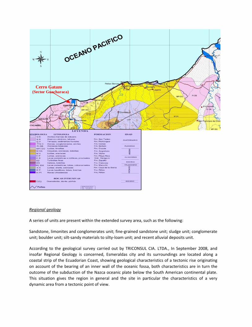
Regional geology
A series of units are present within the extended survey area, such as the following:
Sandstone, limonites and conglomerates unit; fine-grained sandstone unit; sludge unit; conglomerate
unit; boulder unit; silt-sandy materials to silty-loam unit; and recent alluvial deposits unit.
According to the geological survey carried out by TRICONSUL CIA. LTDA., In September 2008, and
insofar Regional Geology is concerned, Esmeraldas city and its surroundings are located along a
coastal strip of the Ecuadorian Coast, showing geological characteristics of a tectonic rise originating
on account of the bearing of an inner wall of the oceanic fossa, both characteristics are in turn the
outcome of the subduction of the Nazca oceanic plate below the South American continental plate.
This situation gives the region in general and the site in particular the characteristics of a very
dynamic area from a tectonic point of view.
Cerro Gatazo ( Sector Guacharaca)

Gatazo Hill and other high relief areas surrounding the city of Esmeraldas are formed by Pliocene-age
rocks known as a whole as the Onzole Formation, which were formed from sedimentary deposits in a
deep continental platform marine environment, and which soon were raised by the tectonic
movements of the lithospheric plates.
In particular, the Gatazo hill is a high relief area, more than 260M height, located to the North of the
Tiaone River confluence with the Esmeraldas River, and remains as the highest hill in the city, bearing
up against the river erosion, making access through the South and into the city difficult over many
years, until the access route through El Cabezón site was enlarged by means of large cuts into clay
rocks in the eastern slopes of the hill Gatazo, which at the time caused serious s instability conditions
along this route.
Local Geology
Stratigraphy
The entire Gatazo hill is formed by Pliocene Age´s Onzole formation rocks. The stratigraphic section of
concern to this survey begins at a topographic platform located at approximately 100masl in the
Northern part of the hill. At 120 masl at the NE end of the hill, an artificial widening of this platform is
apparent resulting from the exploitation of a large quarry known as Gatazo quarry.
At the base of the sedimentary sequence there are a number of clusters and subordinate sandstones,
the total thickness of which reaches 50M at their widest part. While compact, these rocks show a low
cementation degree, and a weathering degree allowing for their removal with a mechanical shovel,
except for some more consolidated sectors remaining in a "balls" shape after quarrying activities are
carried out.
In their lower third, conglomerates are "dense flows" type, showing a coarse sandy matrix and grain
heterogeneity with many angular rocks fragments; these conglomerates with grain-growing
granulometry are present in some places, a fact confirming their similar origin in dense flows, and
allows for them to be classified as "redeposited conglomerates" as defined by Walter; i.e., they are
formed by gravels modelled in a fluvial environment that were carried down to great sea depths by
means of high-density turbiditical flows. Towards the middle and upper part of these conglomerates
clusters are found well-rounded clasts of andesitic and rhyolitic volcanic rocks, of varying sizes: from a
few centimetres to 1dm. The occasional presence of marine fossils in these gravels (reported by a
quarry worker) confirms that they were deposited in a marine environment.
These conglomerates are also found in some other sites, such as quarries or mines located to the
South of the antennas in the Battalion Montúfar Mine, Southern side, and more towards the
Southeast in the Cabaret Mine.
Friable sands, or sands, that are intercalated in the conglomerates are thick-to-very thick
granulometry deposits, and they form lenticular channels of up to 1M thickness.
On top of the conglomerates, intercalations of tobaceas arcillolites and grey sands are found in
decimetrics thicknesses which have been detected in geo-electrical probes with the generic name of

tuffs due to their high competence and porosity. Their thickness is variable, reaching average values
between 40M and 50M.
Overlying the tuffs are well-rolled white creamy to white clayey arcillolites gradating towards clays in
the most superficial part by the weathering effect, as can be seen in geotechnical perforations
mentioned in subtitle below, and representing the rocks making up most of the Gatazo Hill top.
5.2.1.2. Geomorphology
Stretching along some other coastal foothills, the Esmeraldas and Muisne basins appear as isolated
depressions. They share many similarities:
• Altitudes are always low, generally less than 100masl and gradually decreasing towards the shores.
• Reliefs are smooth-patterned, with small and medium-sized homogeneous convex-concave hills
with moderate slopes.
• They are established on a substrate identical to that of above-mentioned reliefs: limonites and
sandy clays, with some locally sandy intercalations.
The landscapes characteristics are presented as low hills, showing the basic brown, clayey soils of the
Esmeraldas – AtacaMONTH basin.
GRÁFICA PÁGINA 205 DOCUMENTO ORIGINAL EN PDF
Muime & Esmeraldas Basin
Viche Mountain Range
Borbón – Valdez Basin
AtacaMONT
H

The Esmeraldas-AtacaMONTH basin has the shape of a 40Km almond from East to West, along a
15Km line from North to South, bounded on the West by the Atacama, and to the East by the
Esmeraldas River valley cliffs.
The basin modelling is made up of low and middle height hills, at 10-150M altitudes, reaching the
highest 200 masl along the sea edge to the West of Esmeraldas. The slopes, with a median close to
40% slope, are convex with a concave basal part.
Under climate conditions with a well-defined dry season, moderately deep clayey alterations are
developed, while soils, with a moisture regime, are clayey brown. The accumulation of calcium
carbonate, in the form of fine mycelia, is frequent in contact with the alteration horizon. This
landscape also includes quite extensive valleys, a complex of sandy to silty terraces at the mouth of
the Esmeraldas and the Teaone Rivers.
5.2.1.3. Soil Use
Soil in the Gatazo Hill, Guacharaca sector, is used in pastures crops, mining (rolling stone), native
forest remnants, several subsistence crops, housing building of all types. This area is considered a
marginal sector of Esmeraldas city.
5.2.1.4. Soils
Underdeveloped due to permanent washing and erosion, soils do not exceed 0.5m thick. Expansive
clays are the most common in these formations, their expansion reaching 30% or 40% with respect to
dry soil volume.
5.2.1.5. Climatology
The climate in the Esmeraldas Province is directly influenced by the Trade winds system, ocean
currents, and El Niño phenomenon. The region is located in the "Equatorial Low Pressure Belt"
between 30º N and 20º S latitudes, in the Intertropical Convergence Area(ITCZ), and is characterized
by the presence of air coming from the hemispheres, giving rise to atmospheric perturbations areas.
Climate can be considered as Tropical Monsoon and Tropical Humid Climate.
According to several climate-related surveys conclusions, the Ecuadorian coastal region is influenced
by the presence of large masses of air and water, the displacements of which determine the region´s
climate characteristics. When present in front of the Ecuadorian coast, the water and air masses
generate heavy rainfall over the January to March period. But, as these masses of water and air move
towards the North of the country, the dry season begins, running until November and December.
Also, the influence of the Humboldt Current is accentuated, so that this current is responsible for
relatively low temperatures prevailing in the region, low rainfall, and higher cloudiness from June to
November.

The well-known El Niño Phenomenon brings about wide climate fluctuations, which can be described
as an anomalous oceanographic condition in which the surface warms up, low salinity water moves
towards the Southern region displacing the cooler waters having a relatively high salinity. This climate
anomaly is sometime accompanied by similar sudden changes with the strength and direction of the
wind, and it is associated with heavier rainfall in the coastal area generating substantial material
losses having a severe impact on the region´s economy sectors and, in particular, on road
infrastructure and hills sustaining large landslides.
Wind
The local wind speed mean is 5.08m/ s, showing little variability, because the region is located in the
migration area of the Intertropical Convergence Area (ITCA) …..
5.2.1.10. Hydrology
The movements of air masses and marine currents of water in the Pacific Ocean determine the
climate characteristics of the area and, consequently, the rainfall regime in the project´s area of
influence.
Overall, during the December - June period, these masses move in a Southward fashion, showing
strong rainfall which is characteristic of the humid season and, as these masses return in a Northward
direction, the dry season begins, usually extending from July to November.
Mass movements are one of the most frequent phenomena linked with high-intensity precipitation
which, in a short time, saturate the residual soil and weathered rock layers and, consequently,
drastically modify the precarious stability conditions of many natural slopes and hillsides, so that the
next heavy rains can trigger a gravitational movement of the different unstable areas.
The well-known "El Niño" Phenomenon brings about wide climate fluctuations, which can be
described as an anomalous oceanographic condition in which the ocean surface warms, low salinity
water moves towards the southern region, displacing the Humboldt Stream cold waters towards the
Galapagos Province which shows a relatively high salinity. This climate anomaly is sometime
accompanied by similar changes having the wind strength and direction, and is associated with
heavier rainfall in the coastal area, generating substantial losses of materials having an adverse
impact on the various economy sectors in the Region and in particular on road infrastructure.
The calculation of flow rates for the survey area was done through the rational method, i.e., for a
total basin area of 3.65Ha: a flat area in the basin: 2Ha, and a sloping area in the basin: 1.65Ha. The
maximum rainfall volume are found in the Hydrology survey of the area of influence.
The cyclical phenomenon of El Niño is deemed as one of the natural events having the strongest
socio-economic and environmental impact in Ecuador. Areas at greatest risk are the low-lying area,
with a very low to flat relief; the low alluvial terraces, and areas where the water table levels are very
high, easily flooding even though having a permeable soil.
Mass Movements

Mass movements are one of the most frequent phenomena associated with high-intensity
precipitation which, in a short time, saturate the residual soil and weathered rock layers, thus
drastically changing the precarious stability conditions of many natural slopes, as well as the Gatazo
Hill slopes, so that further heavy rains can trigger a gravitational movement of the different unstable
areas in the Gatazo Hill, Gguacharaca neighbourhood, and several other sectors.
Source: Esmeraldas Civil Defence. Landslides, Las Palmas area, Gatazo Hill (1998).
Source: Civil Defence, Esmeraldas. Landslides, El Gatazo, Guacharaca Neighbourhood

5.2.1.11. Short air characterisation
While no work has been undertaken within the project area on particulate matter and atmospheric
pollution, we can consider that the air at 200masl, with winds coming in from the sea is undergoing a
permanent renovation, so we can consider it to be of good quality. There is a likelihood for some
pollution levels to be apparent because of traffic and ground movements in stone quarries, but these
pollution levels are swiftly diluted by the presence of winds.
5.2.2. Biotic Component
5.2.2.1. Life Area:
According to Leslie R: Holdridge and Cañadas, a survey area has been identified on the Ecological Map
of Ecuador as a very dry tropical forest (bmsT) life area.
The vegetative cover of this formation is as follows:
Source: IGM
FUENTE: IGM
= Pastures & corn = Pastures, some crops, relict forests

According to Sierra (1999) the vegetation consists in lowland dry thicket
VEGETATION TYPES IN CONTINENTAL ECUADOR
Source: CIFOP: Pichincha Forest Engineers School in Ecuador
---------------
5.2.2.2. Biodiversity
Forest Structure
a. Horizontal.- Highly intervened mixed and irregular secondary forest, no management of any kind
has been implemented; very thick coverage in gallery sectors and at the hill top, showing lower
density, a highly impacted area with pasture cover.
b. Vertical. - Three strata can be singled out in some areas with dense, lower, middle and higher
cover due to little intervention. The forest as a whole has high impact anthropic sectors (vis-à-vis the
primary forest).
Description of vegetative associations
The forest vegetation is characterized by the heterogeneity of the tree species, herbaceous epiphytes,
shrubs, etc. This species variability in this life area and different habitats is due to human intervention
with plants introduced to gather food. Notwithstanding the properties of the tropical forest, these
vegetative associations correspond to secondary forests´ remnant forests, which are located mainly in

gullies or drainages, while high-density forests grow in the Gatazo Hill, Guacharaca sector and the
stone mine.
TABLE. 10-YEAR METEOROLOGICAL OBSERVATIONS RECORD
Source: Esmeraldas Station (INOCAR)
Latitude: 0º 59 '45' 'N Height: 4 masl
Length: 0º 79º 07 '' W Period: 1995 – 2004
AÑOS
Environment
Temperature (ºC)
Maximum
Temperature (ºC)
Minimum
Temperature (ºC)
Relative
Humidity (%)
Heliophony
(horas)
Wind
Speed (m/s)
Precipitation
(mm)
2004 26.23 32.4 21.45 83.00 117.88 4.667 71.70
2003 26.00 31.4 21.88 83.00 115.92 4.750 77.96
2002 26.26 32.1 22.16 83.42 124.58 5.000 99.30
2001 25.61 31.5 21.93 82.58 131.30 5.417 27.417
2000 25,99 31.5 21.83 82.13 114.93 4.917 53.64
1999 25.54 31.6 21.70 83.46 123.51 5.667 101.82
1998 26.57 32.5 22.24 82.42 121.71 5.500 189.44
1997 26.56 32.5 22.03 81.67 144.-13 4.750 139.82
1996 20.40 31.3 22.00 82.33 127.23 5.000 40.41
1995 26.07 31.1 21.90 81.25 105.93 4.417 61.96
∑ 255.23 317.9 219.12 825.26 1227.12 50.085 863.47
Yearly
Media 25.523 31.79 21.912 82.53 122.712 5.009 86.35
Source: Esmeraldas Station (INOCAR) Layout: Eng. Alfredo Arévalo Tello
M.Sc
Average Wind Direction: S – SW –S
5.2.1.6. General Hydrography
The Esmeraldas River is the main water source, with a 21,166 km2 drainage area, main channel length
325Km, annual water deficit 100 mm, yield l / s 50.50, average flow generated m3 / s 1,069.5, average
flow available m3 / S 1,021.30. The Esmeraldas River carries large amounts of sediment, silt and sand,

solid waste (wood). pH is 7.5; raw water hardness is 26. 50 ppm according to laboratory tests. Water
is loaded with pathogens (coliforms, fungi, etc.).
The Teaone River flows reach 60M3, and its sub-basin is located in the region where the Slopes
Stabilisation project is scheduled to be executed. The river flows into the Esmeraldas River basin. The
Teaone River, with tributaries on the right bank, the Huele River, and drainage into the Teaone River,
the Tabiazo River on the left bank, and drainage into the Teaone River. Hydromorphy: None. Flooding
in the project area: None. Drainage: Moderately well drained.
5.2.1.7. Landscape (Characterisation)
The identification of landscape units is a very useful tool to achieving a sustainable management of
the territory. An in-depth knowledge of the area is secured, and a zoning according to its biophysical
characteristics is obtained, with the relevant benefit of focusing development on those
characteristics, besides the possibility of restoring the most significant visual impacts.
To begin with: human settlements have been and are being done in high-risk areas, have no
environmental management and are generally located in areas degraded by human activities.
Further, those settlements also contribute to the degradation of the environment.
HoMONTH built in areas corresponding to the Esmeraldas River channel

HoMONTH built along the hill slopes on unstable soils
Having a quality landscape is a goal ingrained in any treatment to recover a degraded space, without
forgetting the fact that most of the perception is made by sight.
Human activities throughout the Gatazo (La Guacharaca) area show general morphology alteration,
or significant relief forms, loss or change in native vegetation, incorporation of visual elements
(antennae), obliteration of harmony, accumulation of solid waste, significant changes in the
landscape singularity, changes in Nature, introduction of geometric forms as substitution of nature´s
own shapes for lines, production of punctual wounds (quarry), while human dwellings are set up on a
very fragile soil.
Landslides occur in many low and middle height hills with altitudes close to 100 -266.75masl near the
antennas location and the sea edge, in the western area of Esmeraldas. Areas close to the sea in
Balao show steep slopes, erosion due to runoff and landslides is one of the most dangerous event in
these soils. The spoilage of the landscape aesthetics is a most serious concern.
Exclusively, for the direct influence area:
5.2.1.8. Land topography
A terrain showing steep slopes and an irregular shape. The landslides area corresponds to a Gatazo
Hill sector in La Guacharaca neighbourhood, in the city of Esmeraldas, located at an approximately
230masl elevation, and the lower section is located at an average 130masl elevation. Its slopes are a
high-risk area due to its instability; the contour lines are at 20M, the highest altitude in the area is
266.75masl.
Slopes impaired by landslides have descents averaging 40º to 45º; the largest landslide located in the
West has left a batter with a slope higher than 65º.
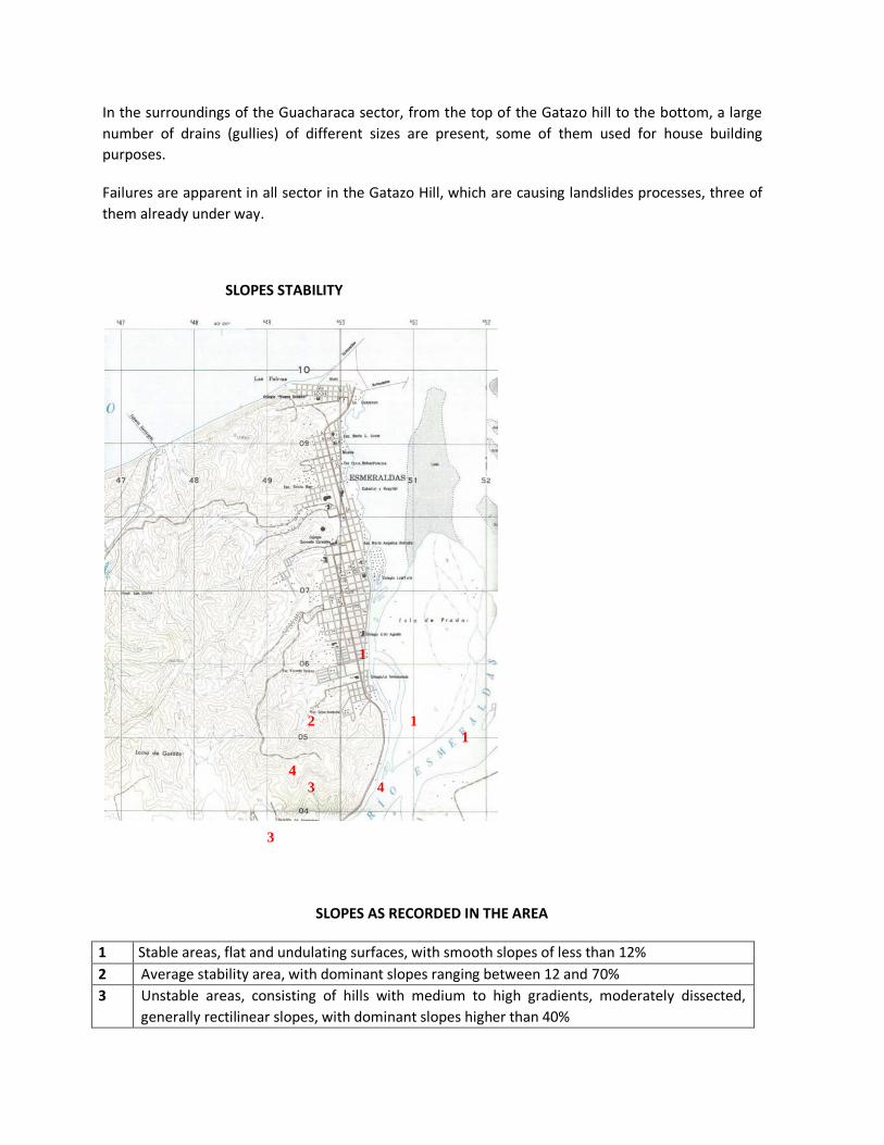
In the surroundings of the Guacharaca sector, from the top of the Gatazo hill to the bottom, a large
number of drains (gullies) of different sizes are present, some of them used for house building
purposes.
Failures are apparent in all sector in the Gatazo Hill, which are causing landslides processes, three of
them already under way.
SLOPES STABILITY
SLOPES AS RECORDED IN THE AREA
1 Stable areas, flat and undulating surfaces, with smooth slopes of less than 12%
2 Average stability area, with dominant slopes ranging between 12 and 70%
3 Unstable areas, consisting of hills with medium to high gradients, moderately dissected,
generally rectilinear slopes, with dominant slopes higher than 40%
1
2 1 1 4 3 4
3

4 Very unstable areas, where the high and very high heterogeneous hills and very dissected
slopes are rectilinear with slopes having a 100% likelihood for the occurrence of landslides.
5.2.1.9. Physical soil characteristics
Clayey, gravelly, dry, vertics and calcareous soil. Soils of this kind show a high degree of pedogenic
development, with an organic mineral horizon (A1) on the surface.
5.2.2.3. Floristic inventory:
FLORA
Table. Some flora species in Gatazo Hill La Guacharaca Neighbourhood
FAMILY SCIENTIFIC NAME COMMON NAME
ANACARDIACEAE Spondias mombin L. Obo de monte
Spondias purpurea L. Obo coMONTHtible
Magnifera muricata L. Mango
ANNONACEAE Annona muricata L. Guanábana
BOGNONTACEAE Tabebuia chrisantha (Jacq.) G,
Nicholson
Guayacán de costa
Crescentia cujete L. Mate
Tecoma castanifolia (D.Don
Melch.
Muyuyo de montaña
BOMBACACEAE Ochorma pyramidale (Cav. Ex
Lam) Urb.
Balsa
Pseudobombax millei (Standl.)
A. Robins
Beldaco
Momordica charantia L. Achochilla
Croton fraseri Müll. Arg Chala
GRAMINAE Panicum MAXIMUM Saboya
Paspolum fasciculatum Grama
Paspolum notatm Grama
BORAGINACEAE Corda alliodora (R.&P) Open
Laurel
Laurel
Cordia lutea, Lam. Moyuyo
Cordia hebeclada I.M. Johnst. Guacharaco
ASTERACEAE Vermonymthura patens
(Kunth) H. Rob.
Chilca
CONVOLVULACEAE Menimia qauinquefolia (L.)
Halier F.
Batatilla
FLACOURTIACEAE Muntingia calabura L. Nigüito
MALVACEAE Sida acuta Burm. Escobilla
Sida rombifolia L. Escobilla
MISOSACEAE Leucaena leucocephala (Lam) Leucaena
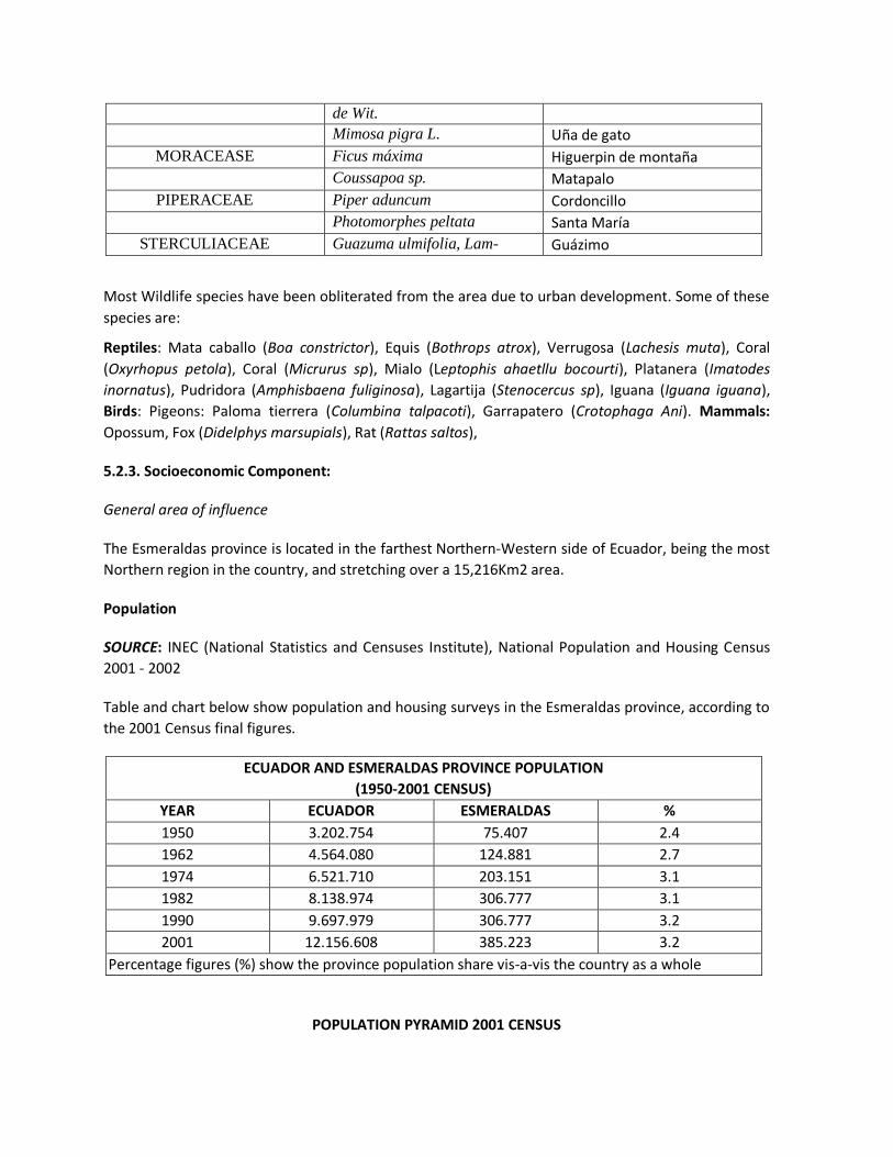
de Wit.
Mimosa pigra L. Uña de gato
MORACEASE Ficus máxima Higuerpin de montaña
Coussapoa sp. Matapalo
PIPERACEAE Piper aduncum Cordoncillo
Photomorphes peltata Santa María
STERCULIACEAE Guazuma ulmifolia, Lam- Guázimo
Most Wildlife species have been obliterated from the area due to urban development. Some of these
species are:
Reptiles: Mata caballo (Boa constrictor), Equis (Bothrops atrox), Verrugosa (Lachesis muta), Coral
(Oxyrhopus petola), Coral (Micrurus sp), Mialo (Leptophis ahaetllu bocourti), Platanera (Imatodes
inornatus), Pudridora (Amphisbaena fuliginosa), Lagartija (Stenocercus sp), Iguana (Iguana iguana),
Birds: Pigeons: Paloma tierrera (Columbina talpacoti), Garrapatero (Crotophaga Ani). Mammals:
Opossum, Fox (Didelphys marsupials), Rat (Rattas saltos),
5.2.3. Socioeconomic Component:
General area of influence
The Esmeraldas province is located in the farthest Northern-Western side of Ecuador, being the most
Northern region in the country, and stretching over a 15,216Km2 area.
Population
SOURCE: INEC (National Statistics and Censuses Institute), National Population and Housing Census
2001 - 2002
Table and chart below show population and housing surveys in the Esmeraldas province, according to
the 2001 Census final figures.
ECUADOR AND ESMERALDAS PROVINCE POPULATION
(1950-2001 CENSUS)
YEAR ECUADOR ESMERALDAS %
1950 3.202.754 75.407 2.4
1962 4.564.080 124.881 2.7
1974 6.521.710 203.151 3.1
1982 8.138.974 306.777 3.1
1990 9.697.979 306.777 3.2
2001 12.156.608 385.223 3.2
El Percentage figures (%) show the province population share vis-a-vis the country as a whole
POPULATION PYRAMID 2001 CENSUS

Men Ages Women
Percentages
ESMERALDAS: EVOLUTION OF THE URBAN AND RURAL POPULATION
1960 – 2001 Census
Population 1950 1962 1974 1982 1990 2001
Percentage (%)
Urban 20 32 36 48 44 41
Rural 80 68 64 52 26 59
The annual growth rate of the city of Esmeraldas is 7.78%. Population: 135,145 inhabitants.
Socioeconomic survey of population impaired by landslides in the Gatazo´s La Guacharaca sector
A survey of the social and economic level, and the bearing of impacts on families living in the Unión
and Progreso Alto Sectors (La Guacharaca), at the foot of the Gatazo Hill, can be found in Sociologist
José-Luis Yagual report.
Political-administrative division

Esmeraldas is the provincial capital, located at the mouth of the Esmeraldas River. The Esmeraldas
canton´s territory is made up of five urban parishes and eight rural parishes as shown in rural parishes
map below.
5.3. PROJECT DESCRIPTION
5.3.1. Project Location
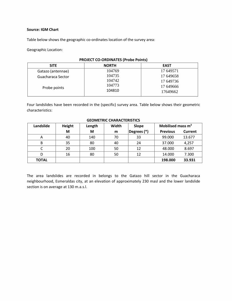
Source: IGM Chart
Table below shows the geographic co-ordinates location of the survey area:
Geographic Location:
PROJECT CO-ORDINATES (Probe Points)
SITE NORTH EAST
Gatazo (antennae)
Guacharaca Sector
Probe points
104769
104735
104742 104773
104810
17 649571
17 649658
17 649736
17 649666
17649662
Four landslides have been recorded in the (specific) survey area. Table below shows their geometric
characteristics:
GEOMETRIC CHARACTERISTICS
Landslide Height
M
Length
M
Width
m
Slope
Degrees (*)
Mobilised mass m3
Previous Current
A 40 140 70 33 99.000 13.677
B 35 80 40 24 37.000 4,257
C 20 100 50 12 48.000 8.697
D 16 80 50 12 14.000 7.300
TOTAL 198.000 33.931
The area landslides are recorded in belongs to the Gatazo hill sector in the Guacharaca
neighbourhood, Esmeraldas city, at an elevation of approximately 230 masl and the lower landslide
section is on average at 130 m.a.s.l.

5.3.2. Project Rationale
The substantial environmental degradation process of Gatazo Hill throughout the territory
surrounding the city of Esmeraldas is an aftermath of a swift-pace growth, a high environmental
fragility, and a low capacity for self-recovery.
The threat the Gatazo Hill is posing with its unstable slopes and permanent rotational type landslides
represents a serious risk to the life and health of the city inhabitants the hoMONTH of which are
located at the foot of the hill. The location of some 111 hoMONTH makes them prone to affectation,
and families should be urgently evacuated to a safe place.
The recovery of the Guacharaca sector in the Gatazo Hill, Esmeraldas city, intends the environmental
revaluation of the area to meet the expectations of the population and activities undertaken in the
surrounding area. An outdoor leisure area for the population is an idea that should be made into a
reality throughout the rehabilitated area and the area adjacent to the project.
This demand for service should be addressed by the City of Esmeraldas, taking advantage of
investments scheduled to be made, and projecting a basic design towards the ecological use of this
sector, together with a potential for self-financing for its sustainability, and the creation of work
sources.
5.3.3. Construction Methodology
This Environmental Impacts Assessment will be carried out in accordance with the construction
methodology put forward by TRICONSUL, which can be modified by the developer according to his /
her criteria, equipment, technology and working schedule.

Activities as below have been scheduled to be initially implemented:
Camp construction and operation, once stakeout and levelling have been implemented, and
execution of works in the access roads.
Removal of the vegetal layer in the work area, its disposal in a temporary storage place for
reuse in revegetation works.
Cutting and dislodgement work should be done for slope reconfiguration, and should follow a
top-to-bottom fashion, so that the soil cutting and removal will decrease the weight on the
slopes and, then, the slopes soil at the bottom is removed. This work should be done with
suitable equipment, such as backhoes and dump trucks.
The drainage system should then be constructed, trying to avoid the excavation work from
destabilizing the slopes. The system should be built up in stretches of no more than 6m length.
Specialized equipment such as backhoes should be used.
Construction of the anchoring system should be scheduled to be inserted into the previous
works, once the slopes have been reshaped and probes have been undertaken and tensioners
and plates have been set up. This work should be carried out with specialized equipment such
as a pneumatic or mechanical drilling machine, equipment support crane, and moving of
materials and work elements. A monitoring system should be in place at the time surveys are
being conducted to ensure that the hard shale soil is drilled down to a at least 8M depth.
Once anchors and the drainage system have been set up in place, the ditches and the external
drainage system construction work should be undertaken.
Revegetation works should be scheduled to be carried out in the rainy season to ensure their
efficiency, or a constant water system should be available for maintenance.
Reforestation works should be planned to be simultaneously implemented in the upper and
lower areas, and a maintenance process and timing schedule should be in place.
Mitigation and environmental monitoring plans should be taken into account during all
construction work on stabilisation systems.
5.3.3.1. Specifications
Project specifications regarding materials and project items´ construction modality will be those as
spelled out in the MOP 001 F 2002 Handbook, according to the denomination of items in the
quantities listing and the budget.
Each and every issue related to legal and environmental provisions should be taken into account.
The excavation material should be disposed of at the site designated by the Municipality.

INITIAL WORKS
Camp building and operation
201-01. Description.- These are provisional constructions and related works that the Contractor
should carry out to provide for accommodation and comfort for the implementation of work activities
by technical and administrative Staff (Contractor´s, Audit´s and workers´ in general).
201-02. Working Procedure.- In overall, camps should be provided with sanitary facilities as required,
according to Public Health regulations in force, and contractual requirements.
201-02.1. Location.- The design and location of camps and their facilities should be such as to not
polluting surface waters or underground drinking water sources and should in any case be previously
approved by the Inspector.
In no case should camp and facilities be located within ecologically sensitive areas, in protected or
endangered biotic species (flora and wildlife) habitats, in places with a high water table, or risks due
to instability of soils, and others.
201-02.2. Installation.- Land clearing, landfills, and vegetation removal in the area should be avoided
as much as possible. Camp buildings may be of the fixed, removable or mobile type at the
Contractor's option, unless a particular type is specified in environmental specifications.
201-02.3. Operation.- Camps should meet sanitary, hygienic, recreational and safety requirements;
thus, suitable systems for water supply, waste disposal, lighting, fire extinguishing equipment,
medical service and / or nursing (in line with their greater or lesser distance to populated centres),
library, entertainment sites and means, informational and precaution accidents and fire signalling.
201-02.4. Dismantling and environmental recovery.- When camps are erected, areas on which they
were settled down, as well as the natural drainage systems, should be restored according to
conditions in the place prior to their installation and occupation.
The Contractor shall be required to remove all signs of occupation of the place, such as scrap, debris,
fencing, electrical and sanitary installations, structures and their respective foundations, pedestrian
and vehicular roads, parking lots, etc. All wells should be filled up, and the soil should be decomposed
so as to restore the vegetation cover.
Access roads
202-01. Description.- These are temporary roads constructed to move personnel to workplaces, for
transit of vehicles and the Contractor´s and Inspector´s machinery to the work fronts, materials and
supplies sources, or to other sites within the worksite, endeavouring for these tasks to be
implemented with a limited budget and with restrictions in the clearing, earth movement, and
affectation to natural watercourses.
202-02. Working procedures.- Access roads will be built with suitable equipment and materials, and
the prior approval of the Inspector, who should approve overall construction details.

Slope, layout, drainage, and tread layer characteristics suitable for normal transit of equipment and
construction vehicles should be in place. Its layout should conform to the natural terrain contours so
as to minimize cuts and embankments. The width of access roads shall be the minimum required
(4.5M), as well as the curvature radii (15M), with a maximum 15% longitudinal gradient, in order to
provide safety conditions and the lesser possible impact on the environment. Drainage of these
accesses will be a key aspect to be taken into account in the layout and construction, as this depends
on road stability; sewers entrances and exits should be properly protected, as the Inspector may
request.
The Contractor shall be solely responsible for maintaining these accesses in a good transitability and
safety condition over the duration of the construction of road works. The relevant day and night
signalling shall be put in place in order to safeguard traffic safety, with a particular concern for
detours and maximum traffic speed (40km / h).
EE-1 Staking out and Levelling
Description.- This work involves the revision of the preliminary project stakeout references, and
keeping them in place throughout the project, to carry out the entire project stakeout as the different
activities are being carried out. All plans including the profiles should be drawn up prior to the
execution of the works, and should be previously approved by the Inspector. The alignments,
dimensions and slopes should be monitored for a sound execution of works.
Working Procedure.- The milestones and stakes shall be placed and kept on site for verification. All
works will be measured and monitored on the basis of these milestones and stakes, and the work
measurements for payments will be made.
Equipment required.- Totally calibrated theodolites, levels or stations will be used to ensure proper
work results.
Measurement.-All works described in this section will be measured per each area square metre, on a
horizontal plane, in accordance with global amounts included in the contract.
Payment.- Amounts as determined will be paid according to constant unit prices stipulated in the
contract and include all materials, equipment and personnel necessary for a comprehensive
execution of the item.
• STABILISATION
EE-2 SLOPES FORMATION
Description.- This work involves all cuts in slopes necessary to obtain the geometries as determined in
drawings in line with alignments and dimensions defined therein.
Working procedure.- Cuts should be made from top to bottom, i.e., being the slopes a floor structure
subject to failure, because the weight is increased at the top, or weight is lost at the bottom, works

should be executed by completing each slope in an horizontal way before continuing in the next
lower slope. The materials resulting from the cuts should be immediately disposed of outside the
work area, in the lower part of the city, by the access path to the place arranged by the Inspector. The
Municipality of Esmeraldas has authorized disposal of this material in the Chamera Lagoon sector.
Equipment required.- Excavators and dump trucks should be used for cuts to be made, and to load
waste materials in situ for further disposal.
Measurement.- Works described in this section will be measured by m3 of all global amounts as set
forth in the contract. Measurement will be made of volume difference as determined in planimetry
and altimetry parametres in drawings made before and after the cuts were made.
Payment.- Amounts as agreed upon will be paid according to unit prices as set forth in the contract,
and they include all materials, equipment and personnel necessary for the total execution of the
item, and the removal of the materials to the place approved by the Inspection.
EE-3. STABILISATION ANCHORAGE - LENGTH 30m
Description.- Construction of a concrete-filled cylindrical excavation with a tensioner warranting at
least 65Tn admissible external voltage and a 105Tn breakage, and externally supported on a concrete
plate, as described in drawings, f 'c = 280 kg /cm2. The contractor will provide an anchorage system
warranting the required tension. The anchorage should be arranged in the place shown in the
drawings and at the inclination shown therein.
Working procedure.- Performing a 15cm diametre and 30M length drilling at least that ensures that
8M has been drilled down the hard ground type tobas described in surveys and approved by the
Inspector. A tensor system with a length similar to that of the probe will be placed in the hole
warranting the required tension and the 10M metres deeper will be filled with grout-type concrete of
high expansive resistance and finished up with f' c = 280 Kg /cm2 concrete.
Equipment required.- Probes are performed with specialized equipment, mechanically or hydraulically
driven drills with compressors. Holes will be filled by mortars injection in lengths shown. The concrete
slab will be constructed with concrete prepared in plant or in situ. The anchorage tension will be
applied with a specialized mechanical or hydraulic equipment, measuring the tension applied.
Measurement.- Works described in this section will be measured by complete unit according to global
amounts included in the contract.
Payment.- Relevant amounts will be paid according to unit prices stipulated in the contract, and
include all materials, equipment and personnel necessary for the total execution of the item.
EE-4. REHABILITATION OF THE CITY SEWER SYSTEM

Description.- The rehabilitating of the City sewage system according to the requirements and needs as
set forth in requirements.
EE-5 REFORESTATION AREA, 1 NIN TYPE TREE (NEEN) EACH 9m²
Description.- Reforestation of 6Ha of land: 3Ha at the top of the landslides location, and 3Ha at the
bottom of this area. NIN-type trees will be planted, one per each 9 square metres, and one-year
maintenance should be ensured.
Working procedure.- The work should warrant the indefinite existence of the trees by means of shade
maintenance techniques.
Equipment required.- The equipment required should be that needed for soil preparation and
planting of trees, warranting the efficiency of works to be executed.
Measurement.- This shall be made by Hectare, or a partial measurement of the area sown on an
horizontal plane.
Payment.- Amounts determined will be paid according to unit prices stipulated in the contract and
include all materials, equipment and personnel necessary for the total execution of the item.
EE-6 WASTE DUMPING SITE
Description.- The construction of a waste dumping site for construction materials, and should be
located outside the work area.
Working procedure.- A 3M at least, and a 1.5M2 area will be dug out in a stabilized area in the ground,
and over the excavation a light wooden structure will be built up that can be removed at the end of
the works. The construction drawings should be submitted to the Inspector's approval.
Measurement.- Measurement shall be thoroughly completed, in accordance with the Inspection
decision.
Payment.- Works described in this section will be measured by complete unit according to the global
amounts included in the contract.
EE-7 BIODEGRADABLES
Description.- The collection of all natural materials present in the worksite prior to the beginning of
the construction, and that should be removed outside the work area.
Measurement.- Measurement shall be thoroughly completed, in accordance with the Inspection
decision.
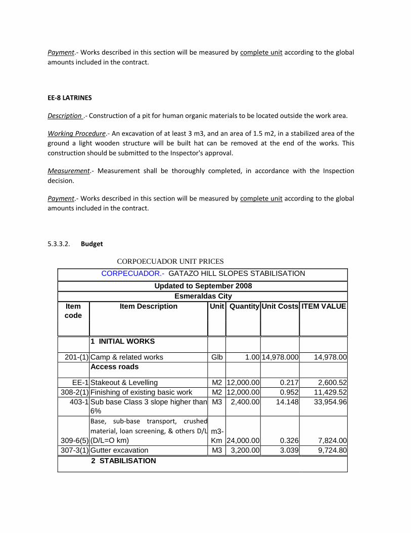
Payment.- Works described in this section will be measured by complete unit according to the global
amounts included in the contract.
EE-8 LATRINES
Description .- Construction of a pit for human organic materials to be located outside the work area.
Working Procedure.- An excavation of at least 3 m3, and an area of 1.5 m2, in a stabilized area of the
ground a light wooden structure will be built hat can be removed at the end of the works. This
construction should be submitted to the Inspector's approval.
Measurement.- Measurement shall be thoroughly completed, in accordance with the Inspection
decision.
Payment.- Works described in this section will be measured by complete unit according to the global
amounts included in the contract.
5.3.3.2. Budget
CORPOECUADOR UNIT PRICES
CORPECUADOR.- GATAZO HILL SLOPES STABILISATION
Updated to September 2008
Esmeraldas City
Item
code Item Description Unit Quantity Unit Costs ITEM VALUE
1 INITIAL WORKS
201-(1) Camp & related works Glb 1.00 14,978.000 14,978.00
Access roads
EE-1 Stakeout & Levelling M2 12,000.00 0.217 2,600.52
308-2(1) Finishing of existing basic work M2 12,000.00 0.952 11,429.52
403-1 Sub base Class 3 slope higher than
6% M3 2,400.00 14.148 33,954.96
309-6(5)
Base, sub-base transport, crushed
material, loan screening, & others D/L
(D/L=O km) m3-
Km 24,000.00 0.326 7,824.00
307-3(1) Gutter excavation M3 3,200.00 3.039 9,724.80
2 STABILISATION

Slope formation
EE-1 Stakeout & Levelling M2 36,495.00 0.217 7,908.83
302-1 Clearing, deforestation & cleaning M2 36,495.00 0.559 20,400.71
EE-2 Slope formation & clearing M3 33,933.46 7.688 260,896.28
Sub drains
307-
2(1)a Excavation & filling for structures,
with selected imported material M3 8,456.00 8.343 70,548.41
606-1
(1a) Piping for subdrains 150 mm M 2,114.00 13.785 29,141.84
606-1
(1b) Geo-membrane coating Table
822.2.1 M2 4,228.00 2.741 11,587.84
402-8
(1) Geo-membrane coating Table
402.8.1 M2 4,228.00 4.145 17,523.95
606-1(2) Filtering Material M3 2,114.00 13.881 29,343.87
Slopes top gutters
307-3(1)
a
Gutter excavation, manual
excavations for gutters, top gutters,
drenches M3 2,114.00 5.896 12,464.14
402-8
(1) Geo-membrane coating Table
402.8.1 M2 5,580.96 4.145 23,131.62
503(2) Class B Structural Portland Cement
(180 Kg / cm2), for gutters M3 311.18 198.325 61,714.77
Slope protection
206 (4) Geo-synthetic blankets including
seeds M2 21,140.00 11.626 245,773.64
Anchorage
EE-3 Anchorage for stabilisation Average
length. 25 m U 645.00 1,292.151 833,437.13
External drainage
307-2(1) Excavation & filling Drainage piping
(I/T) M3 8,456.00 8.343 70,548.41
606-1
(1a) Drainage piping 150 mm M 2,114.00 13.785 29,141.84
307-3(2)
a Gutter excavation M3 656.00 5.896 3,867.78
402-8
(1) Geo-membrane coating Table
402.8.1 m2 1,443.20 4.145 5,981.69
503(2) Class B Structural Portland Cement
(180 Kg / cm2), for gutters m3 73.47 198.325 14,571.33
3 REHABILITATION OF THE CITY SEWER SYSTEM

EE-4 Uptake No. 1 & Lenghtening of
Pipes Glb 1.00 57,000.000 57,000.00
EE-4 Uptake No. 2 Glb 1.00 23,500.000 23,500.00
EE-4 Uptake No. 3 & Lenghtening of
Pipes Glb 1.00 87,000.000 87,000.00
4 ENVIRONMENTAL MITIGATION
220-(1) Awareness-raising Talks U 10.00 315.00 3,150.00
708-
5(1)AEb Warning Signage Glb 25.00 109.80 2,745.00
708-
5(1)AEb Informational Signage Glb 10.00 109.80 1,098.00
EE-5 Reforested area 3Ha type NIN
trees (NEEN) Ha 3.00 25,000.00 75,000.00
EE-6 Waste pit Glb 1.00 2,500.00 2,500.00
EE-7 Biodegradables Glb 1.00 10,000.00 10,000.00
EE-8 Latrine Glb 1.00 1,500.00 1,500.00
TOTAL DIRECT COSTS 2,091,988.88
DIRECT INDIRECT COSTS 22% 460,237.55
TOTAL COST 2,552,226.44
5.3.3.3. Schedule with CORPECUADOR prices
The time for the execution of the work in the schedule is 12 months: Ten months for the specific
stabilisation works, and two additional months for works pursuant to contractual terms for sewerage
rehabilitation and revegetation and reforestation.

CORPOECUADOR – STABILISATION OF GATAZO HILL SLOPES
RATED TIMELINE
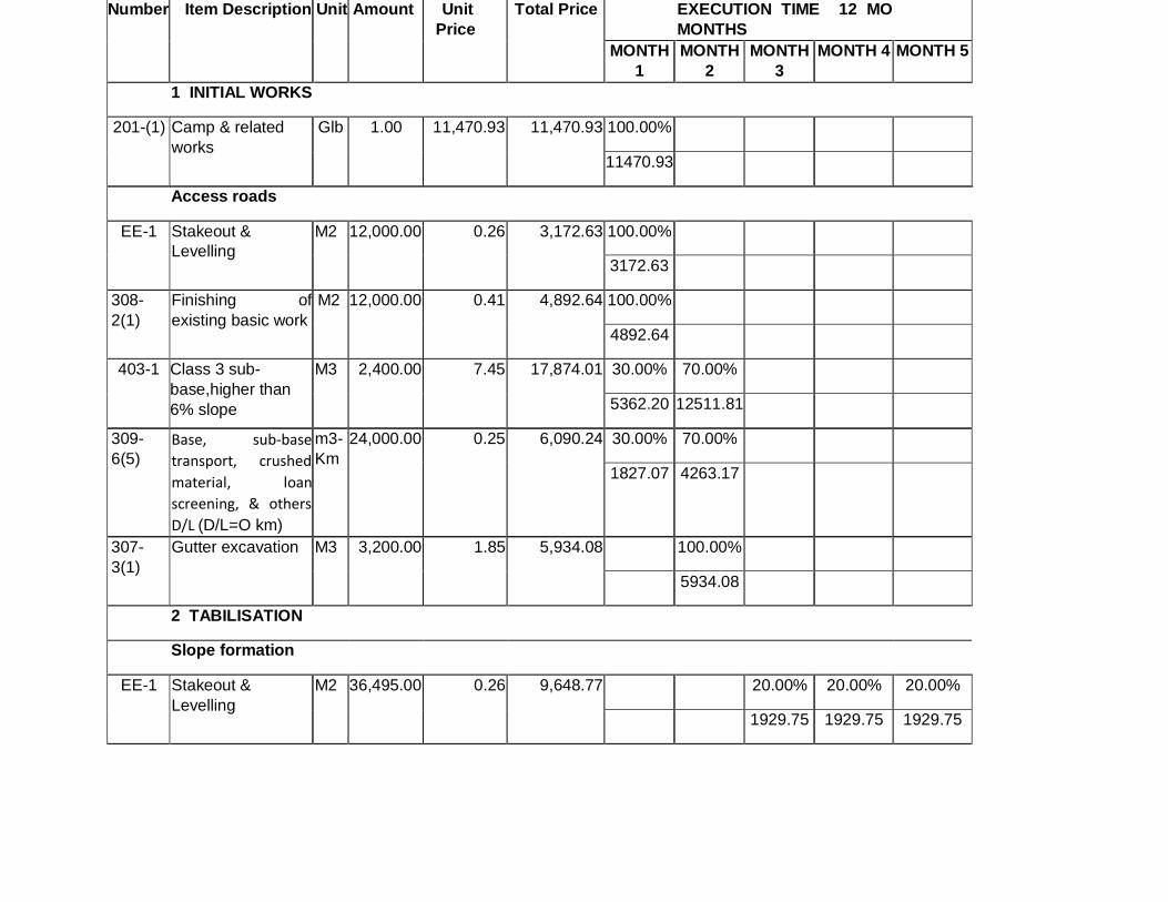
Number Item Description Unit Amount Unit
Price Total Price EXECUTION TIME 12 MO
MONTHS
MONTH
1 MONTH
2 MONTH
3 MONTH 4 MONTH 5
1 INITIAL WORKS
201-(1) Camp & related
works Glb 1.00 11,470.93 11,470.93 100.00%
11470.93
Access roads
EE-1 Stakeout &
Levelling M2 12,000.00 0.26 3,172.63 100.00%
3172.63
308-
2(1) Finishing of
existing basic work M2 12,000.00 0.41 4,892.64 100.00%
4892.64
403-1 Class 3 sub-
base,higher than
6% slope
M3 2,400.00 7.45 17,874.01 30.00% 70.00%
5362.20 12511.81
309-
6(5) Base, sub-base
transport, crushed
material, loan
screening, & others
D/L (D/L=O km)
m3-
Km 24,000.00 0.25 6,090.24 30.00% 70.00%
1827.07 4263.17
307-
3(1) Gutter excavation M3 3,200.00 1.85 5,934.08 100.00%
5934.08
2 TABILISATION
Slope formation
EE-1 Stakeout &
Levelling M2 36,495.00 0.26 9,648.77 20.00% 20.00% 20.00%
1929.75 1929.75 1929.75

302-1 Clearing,
deforestation &
cleaning
Ha 3.65 300.17 1,095.48 50.00% 50.00%
547.74 547.74
EE-2 Slope formation &
clearing M3 33,933.46 9.38 318,293.46 10.00% 15.00% 15.00%
31829.35 47744.02 47744.02
Sub drains
307-
2(1)a Excavation & filling
for structures; with
selected imported
material
M3 8,456.00 6.45 54,542.38
606-1
(1a) Piping for
subdrains 150 mm M 2,114.00 16.82 35,553.05
606-1
(1b) Geo-membrane
coating Table
822.2.1
M2 4,228.00 3.34 14,137.17
402-8
(1) Geo-membrane
coating Table
402.8.1
M2 4,228.00 5.06 21,379.22
606-
1(2) Filtering Material M3 2,114.00 9.15 19,341.19
Slopes top
gutters
307-
3(1) a Hand-made Gutter
excavation, top
gutters &
channelling
M3 2,114.00 5.99 12,671.88 10.00% 15.00%
1267.19 1900.78
402-8
(1) Geo-membrane
coating Table
402.8.1
M2 5,580.96 5.06 28,220.58 10.00%
0.00 2822.06

503(2) TClass B Structural
Portland Cement
(180 Kg / cm2), for
gutters
M3 311.18 143.01 44,501.20 10.00%
0.00 4450.12
Slope protection
206 (4) Geo-synthetic
blankets including
seeds
M2 21,140.00 14.18 299,843.84
0.00 0.00
Anchorage
EE-3 Anchorage for
stabilisation
Average length. 25
m
U 645.00 1,576.42 1,016,793.30 10.00% 15.00%
101679.33 152518.99
External drainage
307-
2(1) Excavation & filling
Drainage piping
(I/T)
M3 8,456.00 6.45 54,542.38 10.00% 15.00%
5454.24 8181.36
606-1
(1a) Drainage piping
150 mm M 2,114.00 16.82 35,553.05 10.00% 15.00%
3555.30 5332.96
307-
3(2) a Gutter excavation M3 656.00 5.99 3,932.24 15.00%
589.84
402-8
(1) Geo-membrane
coating Table
402.8.1
m2 1,443.20 5.06 7,297.66 15.00%
1094.65
503(2) TClass B Structural
Portland Cement
(180 Kg / cm2), for
gutters
m3 73.47 143.01 10,507.08 15.00%
1576.06
3

EE-5 Reforested Area 3 Ha tyoe NN trees
(NEEN) Ha 3.00 25,000.00 75,000.00
EE-6 Waste Pit Glb 1.00 2,500.00 2,500.00
EE-7 Biodegradables Glb 1.00 10,000.00 10,000.00
EE-8 Latrine Glb 1.00 1,500.00 1,500.00
TOTAL DIRECT COSTS 2,091,988.88
DIRECT INDIRECT COSTS 22% 460,237.55
TOTAL COST 2,552,226.44
REHABILITATION
OF THE CITY´
SEWER SYSTEM
EE-4 Uptake No. 1 &
Lenghtening of
Pipes
Glb 1.00 69,540.00 69,540.00
EE-4 Uptake No. 2 Glb 1.00 28,670.00 28,670.00
EE-4 Uptake No. 3 &
Lenghtening of
Pipes
Glb 1.00 106,140.00 106,140.00
4
ENVIRONMENTAL
MITIGATION
220-(1) Awareness-raising
Talks U 10.00 384.30 3,843.00 10.00% 10.00% 10.00% 10.00% 10.00%
384.30 384.30 384.30 384.30 384.30
08-
5(1)AE Informational
Signage Glb 25.00 133.96 3,348.90 100.00%
3348.90

EXECUTION SCHEDULE - 12 MONTHS
MONTH 6 MONTH 7 MONTH 8 MONTH 9 MONTH 10 MONTH 11 MONTH 12
20.00% 20.00%
1929.75 1929.75
15.00% 15.00% 15.00% 15.00%
47744.02 47744.02 47744.02 47744.02
20.00% 20.00% 20.00% 20.00% 20.00%
10908.48 10908.48 10908.48 10908.48 10908.48
20.00% 20.00% 20.00% 20.00% 20.00%
7110.61 7110.61 7110.61 7110.61 7110.61
20.00% 20.00% 20.00% 20.00% 20.00%
2827.43 2827.43 2827.43 2827.43 2827.43
20.00% 20.00% 20.00% 20.00% 20.00%

4275.84 4275.84 4275.84 4275.84 4275.84
20.00% 20.00% 20.00% 20.00% 20.00%
3868.24 3868.24 3868.24 3868.24 3868.24
25.00% 25.00% 25.00%
3167.97 3167.97 3167.97
15.00% 25.00% 25.00% 25.00%
4233.09 7055.14 7055.14 7055.14
15.00% 25.00% 25.00% 25.00%
6675.18 11125.30 11125.30 11125.30
10.00% 10.00% 10.00% 10.00% 20.00% 25.00% 15.00%
29984.38 29984.38 29984.38 29984.38 59968.77 74960.96 44976.58
15.00% 15.00% 15.00% 15.00% 15.00%
152518.99 152518.99 152518.99 152518.99 152518.99 0.00 0.00
15.00% 30.00% 30.00%
8181.36 16362.72 16362.72
15.00% 30.00% 30.00%
5332.96 10665.91 10665.91
25.00% 30.00% 30.00%
983.06 1179.67 1179.67
25.00% 30.00% 30.00%
1824.41 2189.30 2189.30
25.00% 30.00% 30.00%
2626.77 3152.12 3152.12
25.00% 25.00% 25.00% 25.00%
17385.00 17385.00 17385.00 17385.00
25.00% 25.00% 25.00% 25.00%
7167.50 7167.50 7167.50 7167.50
25.00% 25.00% 25.00% 25.00%
26535.00 26535.00 26535.00 26535.00
10.00% 10.00% 10.00% 10.00% 10.00%
384.30 384.30 384.30 384.30 384.30

FLOWCHART – PROJECT PROCESSES
INITIAL WORKS
INITIAL WORKS
Construction of camp site and related works Provisional constructions, provision of
accommodation and storage
Access roads Provisional roads, vehicle and machinery
transit
Mobilisation of personnel and machinery Public mobilisation
ESTABILISATION (slope formation)
Clearing, logging, and cleaning
Slope formation and dislodgement Cuts on slope, and soil removal
Drainage Inside and outside the Gatazo Hill (Guacharaca
sector)
Slopes protection Revegetation and reforestation
Anchorage A cylindrical construction filled in in concrete,
65Tn tensor
Rehabilitation of city sewer system Rehabilitation sewer system for drainage in the
area
Signalling Horizontal and vertical signalling. Signs are
being constructed
Implementation of Environmental Management
Plan (Mitigation)
Verification of compliance with mitigation
programme
5.3.3.4. Activities envisaged in project execution
With regard to changes to the physical, biological, landscape and socio-economic settings
likely to be generated as an aftermath of project activities, activities envisaged are related to
issues as follows:
A1.- Camp construction and related works
A2.- Access roads
A3.- Mobilisation of Personnel and machinery
A4.- Forest clearing and cleaning
A5.- Slope formation and removal

A6.- Drains
A7.- Protection of slopes
A8.- Anchors
A9.- Rehabilitation of sewerage in the city (Gatazo area)
A10.- Signage
6. ENVIRONMENTAL ASSESSMENT
6.1. Methodology for Identification and Assessment of Environmental Impacts (EIAs)
The methodological framework allowing for identification of interactions between
environmental components and activities being envisaged in this project sets forth a direct
"cause-effect" relationship, which is articulated in Leopold (1970)´s Double Entry Matrix, for
which steps as below will be spelled out:
1. Environmental factors related to the project will be identified on the basis of the following
table:
Environmental Factors
Environmental
Component
Environmental Sub-
component
Environmental
Factor
Definition
Physical Air
Soil
Water
Air quality
Sound level
Soil quality
Surface water
Underground water
Presence in air of substances
altering air quality
Impaired by noises
originating in project´s own
activities
Degradation of soil quality due
to project activities
Changes in surface water
quality
Changes in underground
water quality
Biotic Flora
Vegetative cover
Crops
Special ecosystems
Changes in vegetative cover
in the area
changes in crops due to
project execution
changes in special ecosystems
due to project execution
Wildlife Ictiowildlife
changes in ictiofauna in the
project execution area

Heterowildlife
Microwildlife
Macrowildlife
Bird Life
disappearance of heterofauna
in the project execution area
disappreance of microfauna
thriving in the area
disappearance of macrowfauna
thriving in the area
Disappearance of birds´ food
sources, refuge sites,
reproduction sites, and birds
life
Socio-economic Perceptual medium Sighsts and Landscape
Archaeology
Landscape alterations
Modifications in archaeological
remains in the area
Use of resources Water supply
Electricity
Water consumption over
Project execution Works
Demand for electrical power
Human Welfare
Health
Security
Employment
Changes in welfare conditions
of people living close to the
area
Changes in health of people
living in the area
Risks project workers are
exposed to
Generation of project-related
work sources
2.The impacts qualitative assessment rates the size and bearing of the impact identified, by means of
criteria as follows:
• Impact Type: Negative (-) Positive (+)
• Bearing: High (3), Medium (2), Low (1)
• Magnitude: High (3), Medium (2) and Low (1)
• Duration: Temporal (T) and Permanent (P)
• Geographic area: Local (L) and Regional (R)
• Reversibility: Reversible (R) and Irreversible (I)
7. IDENTIFICATION OF IMPACTS
Impacts likely to be generated in each environmental component on account of activities being
carried out over the remediation work are identified in this section.

The interaction matrix is a two-dimension checklist. Rows: environmental factors or components.
Columns: work tasks, intersection impact cause – effect relation.
MATRIX FOR IDENTIFICATION OF IMPACTS, CAUSE - EFFECT,
ACTIVITIES FOR STABILISATION OF THE GATAZO HILL SLOPES
LA GUACHARACA SECTOR
Identification of project impacts: 29 positive impacts and 43 negative impacts
A1.- Construction of camp and related works A6.- Drains
A2.- Access roads A7.- Slopes Protection

A3.- Personnel and machinery transportation A8.- Anchorage
A4.- Forest clearing and cleaning A9.- Sewer Rehabilitation
A5.- Slope formation and removal A10.- Signalling
7.1. Qualitative Appraisal of Environmental impacts
IMPACT ASSESSMENT MATRIX, CAUSE – EFFECT

MATRIX – POTENTIAL IMPACTS

8. ENVIRONMENTAL MANAGEMENT PLAN
The Environmental Management Plan (EMP) is the final stage of this survey and has been
drawn up on the basis of findings having a significant bearing: it is a set of standards and
measures intended to prevent, mitigate, foresee, monitor or minimize adverse
environmental and socio-cultural impacts, likely to be generated over Project execution.
The EMP is the final outcome of this assessment process, and addresses prevention,
mitigation, compensation, and other measures that should be undertaken by the Contractor,
so as to abide by the Ecuadorian Environmental Legal Framework, and in particular by the
General Specifications for Construction of Roads and Bridges, as set forth by the Ministry of
Public Works Resolution MOP - 001 - F Quito 2000.
MEASURE 1
Prevention
Surveillance of the mitigation process (Environmental education)
SECTION 105. PUBLIC AND COMMUNITY PARTICIPATION
General provisions for construction of roads and bridges MOP - 001 - F Quito 2000
105 - 01. Description.-
During construction, operation / maintenance, and concession processes, constrains may
arise between the Contractors and those involved in the project, such as landowners whose
properties are close to the road, the community, non-governmental organisations (NGOs),
local authorities, and others. It is advisable for the builder to enter into a friendly relationship
with social stakeholders as mentioned above, in order for socio-environmental conflicts to be
avoided that may jeopardise the works´ objective.
105 - 02. Community Involvement Actions.-
Actions should be undertaken by the Contractor so as to preventing any social disturbance at
work:
1) Keeping stakeholders, the community and local authorities in the area of influence of
works abreast of the characteristics involved therein (new constructions, rehabilitation,
maintenance, concession); the different activities to be implemented, and the negative
and positive impacts to be generated. This information should be disseminated in a clear,
precise and up-to-date fashion.

2) Informing the community and local authorities about hazardous situations likely to arise
over works execution. If sensible situations should crop up, relevant information will be
conveyed to the authorities by the Inspection Director.
3) Periodic communication mechanisms should be established with main stakeholders, in
order to up-keeping an ongoing coordination of social and community issues
encompassing road works.
4) Instructing Contractor´s representatives, technical personnel and workers on the
procedures and appropriate behavioural ways to deal with landowners, occupants of
lands close to the worksite and others, in order to reaching an acceptable demeanour of
communities toward the project and, above all, counting on their support and
collaboration.
5) Having respect for private property, for which the Contractor should request the proper
authorisation from owners or administrators in case of temporarily entering into those
properties, keeping them duly informed of the purpose of the work to be performed.
6) Strictly using the space and time as agreed upon with the Inspector, in order to avoid
discomfort to people living close to the worksite.
7) Delimiting by wire fences expropriated areas, and those areas for road works, trying to
cause the least possible damage to neighbours.
SECTION 220 ENVIRONMENTAL EDUCATION AND AWARENESS
220-01. Description.- This section entails the execution by the Contractor of a number of
activities the end goal of which is to strengthen up knowledge and respect for the natural
heritage, and the involvement of people living in the area and who will benefit from the
work.
These activities shall be directed towards two focal points of work under way: a) the
population directly involved with the work, and all other social stakeholders who are located
within the area of influence; and b) the technical staff and workers who are in permanent
contact with the work and the environmental setting in the area.
The project execution process should get under way fifteen (15) days before the start of
works and should be carried on an ongoing basis until the completion of the project
execution.

220-02. Working Procedure.- If in the particular environmental specifications no mention is
made of this item, the Inspector will require the Contractor to comply with this section, and
the latter will plan and submit to the Inspector for consideration the work contents, schedule
and execution methodologies for approval.
Minimum tasks the Contractor should perform should be as below:
220-02.1. Awareness-raising Talks.-
These will be focused on people living in neighbouring towns and along the road, who are
directly or indirectly related to the objective of the road work.
These talks will involve project-related subjects and the affectation they will be on the
environment, such as:
• The environmental setting surrounding the work and the latter´s close interrelation with
people living in the area;
• Main environmental impacts of the works and relevant mitigation measures;
• Social and environmental benefits that road construction / rehabilitation will be bringing
about;
How to keep the worksite in good condition upon the completion of activities. This issue shall
be dealt with by professionals having a strong background on management of natural
resources, community development, and social communication.
SECTION 711
MEASURE 2
ENVIRONMENTAL SIGNALLING
711-01. Description.- The installation of an adequate signage addressing subjects dealing
with prevention and monitoring of human activities in order to avoid environmental
impairment in work areas.
711-02. Working Procedure.- Before the preliminary work gets under way in situ, the
Contractor shall implement an appropriate environmental labelling addressing i)
informational, ii) preventive and iii) restrictions-related issues.

Informational signs should warn workers, visitors and the population close to the worksite on
the execution of road works.
Precautionary signs shall aim to warn road workers and users about potential hazards in
work areas, and indicate the restrictions or prohibitions that may arise, in particular those
regarding circulation speed limits.
These restriction signals will indicate actions forbidden so as to not to cause adverse
environmental impacts.
The particular subject for each label type, as well as the material and location, will be
included in specific environmental specifications or, according to the Inspector's criteria, if
applicable.
This type of labelling will include making and placing signs in accordance with the work
drawings, or Inspector provisions.
In case it is deemed advisable and subject to prior approval by the Inspection, signs with
artificial lighting will be placed in danger areas.
Except for cases in which the Inspection considers it inappropriate, these signs will be made
in treated wood, with a low relief wordings and drawings.
711-03. Measurement.- All signs should have the same measurement and paid per unit at
prices specified in the contract.
711-04. Payment.- These prices and payments will amount to the total compensation for the
construction and placement of signs; payments will include labour, materials, tools,
equipment and operations related to signs installation on site.
MEASURE 3
Dust Control (wetting)
SECTION 205
DUST CONTROL
205-01. Description.- In line with Inspector´s suggestions, this work will involve the
application of substances to keeping in check dust emissions originating in the work
construction, or road traffic going through the project site, detours and accesses.

Dust control will be done by using water or chemical stabilizers such as wetting agents,
hygroscopic salts, and surface crusting agents such as sodium chloride and calcium chloride.
The material used, the places treated, and the application frequency should be approved by
the Inspector.
-205-02. Work Procedures.- If water is used for dust removal it should be evenly distributed
by cisterns equipped with a pressure sprinkler system. The equipment used should be
approved by the Inspector. The spraying rate will be between 0.90 and 3.5 litres per square
metre, according to Inspector instructions also addressing the application frequency. When
dust control is done with vehicles, the maximum application speed will be 5 km / h.
205-03. Measurement.- The amount to be paid for this work are the thousands of litres of
water being used for application, and verified by the Inspector.
205-04. Payment.- Amounts payable according to guidelines in the previous item will be paid
for at prices as stated in the contract for items listed below.
No additional payment will be made to the Contractor for the hour-based dust control
application.
205- (1) Water for dust control .................................... Thousands of Litres
MEASURE 4
Monitoring of construction and clearing materials removal
CHAPTER 300
EARTH MOVEMENTS
SECTION 301. PRELIMINARY OPERATIONS
301.1. Overview
301-1.01. Description.- This work will involve the disposal and removal of obstacles, walls,
pavements, miscellaneous concrete constructions, bridges, and the clearing of vegetation. In
short, this Section refers to all preliminary work required to allow for movement of land and
the construction of road structures, pursuant to the Contract, according to these

Specifications, as set forth in additional contractual documents, and as indicated by the
Inspector.
This work will further include the cleaning and clearing of waste materials, except for those
the Contractor intends to harness at his / her convenience, instead of transporting road
excavation materials to be used on the road platform, and sites marked for the lower base
and tread layer materials.
301-2. Removal of sundry obstacles
301-2.01. Description.- The total or partial removal of obstacles such as buildings, houses
and other constructions, abandoned roads and detours, strips and devices for traffic
monitoring, fences and roadways, sewers and other drainage systems, except for those
obstacles that should be removed in accordance with contractual terms. Further, filling of
resulting trenches, pits and holes, as well as the proper disposal of materials removed as
described below, should also be included.
SECTION 302. SCRAPING, DEFORESTATION, AND CLEANING
302-1.01. Description.- Clearing the ground as required to carry out the work contracted in
accordance with these Specifications and other contractual documents. In areas shown in
drawings or as indicated by the Inspector, all trees, shrubs, logs, live fences, bushes and any
other vegetation will be removed together with stumps and leaf litter. Also included in this
heading is the removal of the soil layer down to a depth shown in drawings or as indicated by
the Inspector; as well as the disposal, to the Inspector´ satisfaction, of all materials resulting
from the clearing, deforestation and cleaning operation.
These works will include all places, quarries and mines within and adjacent to the road area
shown in drawings, or indicated by the Inspector, as designated or optional sources of
construction materials. They shall also include the removal of miscellaneous obstacles, as
stipulated in subsection 301-2, if the items annotated in that Section are not included in the
contract.
This work will also contemplate the preservation -avoiding any damage or spoilage- of the
vegetation, plantations, and objects that should be preserved.
302-1.02. Work Procedures.- Clearing, deforestation and cleaning shall be done through
efficient, manual and mechanical means, including soil cleaning, felling, pealing and any
other efficient procedures that the Inspector considers satisfactory. Usually, this work will be
done within the working site boundaries and up to a 10M distance outside the structures on
the outer slopes lines. In any case, the Contractor will be paid only for the works carried out
within the clearing, deforestation and cleaning boundaries as shown in drawings, or as
indicated by the Inspector.
When the contract provides for the conservation and disposal of the soil layer in planting
areas, this material will be stored in sites approved by the Inspector, until it is incorporated
into the new work, and all transport, storage and disposal of this material will be paid in
accordance with provisions in Sections 206 and 207 pursuant to these Specifications.
In excavation areas or embankments having a less than 2M height, all trunks, stumps, roots,
vegetation in general, and material deemed as inadequate by the Inspector, shall be
removed and disposed of, and if contractual documents so require, those materials should be
removed and stored for later use on the topsoil layer.
In areas to be covered by embankments higher than 2M, tree cutting can be done so that the
cut is made at a height of no more than 20cm. over the natural terrain surface; shrubs and
weeds will be thoroughly removed, and the grass should be at ground level. Trees should be
completely removed in places on which structures or sub-drains, piles, anchors, staggered
excavation for landfill, removal of soil layer, or removal of unsuitable material are to be set
up.
In areas to be covered by embankments and where vegetation, non-usable material, stumps
or roots have to be removed, the resulting surface will be levelled and compacted once those
materials have been removed. Filling and compaction shall be carried out in accordance with
subsection 305-1.
Tree cutting, or deforestation along areas for gutters, channel rectifications, or waterbeds,
will be carried out until the depth required has been reached for excavations in these
surfaces as envisaged in drawings.
In areas beyond the construction site boundaries and within the limits shown in drawings for
clearing, deforestation and cleaning, tree trunks will be cut at ground level, and in no case
shall they be left at a height of more than 30cm. Removal of shrubs or other vegetation other
than trees will not be required in these areas.
All these works should be done in such a way as to not impairing vegetation, constructions,
buildings, public services, etc., existing in adjoining areas. In this regard, provisions in
subsection 102-3 "Legal Relations and General Responsibilities" in these Specifications shall
be abode by.
No land removal may be undertaken in any part of the project site until the Clearing,
deforestation and cleaning works in areas in that sector have been thoroughly completed in a
manner satisfactory to the Inspector, and in accordance with the approved work schedule.

302-1.03. Disposal of materials removed.- All non-usable materials resulting from the
Clearing, deforestation and cleaning works, will be removed and discharged in places shown
in drawings, or on those places as the Contractor indicates, and subject to the Inspector´s
approval. No discharges of debris or rubble will be allowed in places within the right-of-way
area, where they would be visible from the finished road, unless they are buried or placed in
such a way that they do not spoil the landscape. Neither will the materials removed be
allowed to burn.
Any material the recovery of which is foreseen in contractual documents, or required by the
Inspector, will be stored for further use, pursuant to contractual stipulations and the
Inspector instructions.
Any wood harnessed within the boundaries stipulated for the Clearing, deforestation and
cleaning, will be property of the Work and for the latter use within the worksite, and any
surplus will be stored in the nearest Ministry of Public Works warehouses (MOP, for its
acronym in Spanish).
302-1.04. Measurement.- The amount to be paid for clearing, deforestation and cleaning
shall be the area in hectares, as measured at the worksite, in its horizontal projection of
orderly and acceptably executed works, including lending areas, quarries and mines within
the road area and the work sources harnessed outside that area, which are shown in
drawings as designated or optional sources to the Contractor.
302-1.05. Payment.- The amount set forth as shown in item above shall be paid at the
contractual unit price for the item shown below, and should be stated in the contract.
This price and payment shall constitute the total compensation for the elimination, removal,
disposal and transportation of all materials resulting from the Clearing, deforestation, and
cleaning, as well as all labour, equipment, tools, materials and related operations required to
executing the Works as set forth in this Section, including the removal and disposal of sundry
obstacles, whenever the contract does not stipulate payment for such work.
When the contract does not clearly stipulate these Clearing, deforestation, and cleaning
activities, this work shall be deemed as required and shall be paid for at the same contractual
prices as those for the excavation and filling works.
MEASURE 5
Transportation of materials and movement of machinery
SECTION 234
224-01. Description.- All precautions and measures are included that the Contractor should
undertake in order to avoid causing the minimum discomfort to human health and to the
environment surrounding the worksite.
224-02. Working Procedure.- During the construction, rehabilitation or concession of roads,
and particularly in connection with soil movements that have to be carried out to comply
with the work design conditions over the extraction, loading, transport or placement of
materials stages, these tasks should be prevented from producing air pollution by dust
particles, and the Contractor shall take all necessary precautions to avoid this occurrence, for
example, by watering the affected area.
The Contractor shall take all necessary precautions to prevent the discharge of material
during transportation, such as having access to covering tarpaulins, sealed containers or
others. The Inspector may order the removal of trucks not abiding by this provision.
Transportation of materials to the worksite, whether or not they are owned by the
Contractor, should be scheduled and adapted in such a way as to avoid any damage to public
and private roads, constructions, crops and any other public or private property. This work
schedule should be submitted to the Inspector for its knowledge and approval.
When public roads or paths should be used for transport purposes, the Contractor should
ensure that vehicles do not exceed the maximum authorized axle weights.
The Contractor shall avoid compaction of soils due to an unnecessary machinery traffic, in
particular in areas that are no part to the basic road works infrastructure. The Inspector may
order that those areas are recovered that have been unnecessarily used for traffic purposes,
at the Contractor's expense and cost.
Any material that is found out of place due to carelessness in transportation, such as
concrete, rocks, vegetation detritus, etc., will be disposed of by the Contractor and at his /
her own expense and cost. In case this is not done, the Inspection may order the removal of
the material to third parties, at the Cpntractor´s expense and cost.
224-03. Measurement and Payment.- The works that should be executed as set forth in this
section, and bearing in mind these works´ nature, will not be directly paid; rather, those
works will be included in contractual items.
MEASURE 6
Industrial safety and occupational health
SECTION 213
213-01. Description.- Industrial safety is the set of prevention and monitoring standards that
the Contractor should implement in each of the Contractor´s work fronts and facilities in
order to avoid the occurrence of work risks and accidents. This is known as Occupational
Health.
213-02. Work Procedure.- The Contractor shall be obliged to adopt industrial safety
measures as required in work fronts, and to issue and implement programme aiming to
achieving a sound physical and mental health of all its personnel, pursuant to regulations in
force as enacted by The Ecuadorian Institute for Social Security (IESS, for its acronym in
Spanish).
As minimum requirements for compliance with these requirements, due consideration
should be attached to wording below:
• The Contractor should implement the necessary facilities in worksites warranting a healthy
recreation of personnel at the worksite, and at the same time ensuring the minimum comfort
conditions.
• The first aid area should include at least one medical doctor and one medical assistant, in
addition to the basic equipment and implements to cover medical emergency care.
• For work hazards to be minimised, the Contractor shall provide his or her personnel with
basic clothing such as protective helmets, waterproof clothing, rubber-tipped steel boots,
dust masks, and other implements recommended by the country's industrial safety laws in
force.
Communities-addressed Procedure
In the case of accidents resulting in damage to infrastructure, or risks to the well-being or
health of the community, preliminary response guidelines should be established that are
aimed at ensuring that monitoring measures are implemented, as well as ensuring
community participation in the protection of their own safety and well-being. Some of these
measures are shown below.
Designating a community monitoring group for surveillance of environmental abidance, and
a community leader to contact the construction company management and Inspector.
Collaborating in the cleaning of contaminated soil and water, as well as in reforestation
activities.
MEASURE 7
Recovery and collection of the vegetation layer
SECTION 208
208-01. Description.- Recovery of the vegetation layer is understood as activities involving
the removal of surface layers of natural soil, material which is not suitable to the
construction site, of soils in places where some other works shall be carried out that are
connected to road works, such as camps, machinery yards, warehouses, etc., that, once
completed, road works should be restarted.
The collection refers to the accumulation and maintenance in good conditions of the
removed vegetal layer for later use on intervened areas.
208-02. Working Procedure.- The removal and collection of the vegetal layer will be carried
out in all areas to be excavated or refilled, mainly in work fronts, such as camps, road
platform, dumps, yards for operation and maintenance of machinery , slope cutting, etc.
In areas to be recovered, both the hauling and removal of organic soils, and the use of
fertilizers should be authorized by the Inspection.
The collection of these organic soils can be done with a dozer blade tractor, front loader
tractors, and dumpers, (soil thickness between 15 and 30cm). This mixed vegetation and soil
material will be collected in areas shown in particular environmental specifications, or
authorized by the Inspector, and single stows not higher than two metres should be made.
If possible, the time the organic material will be kept in storage areas should not exceed two
months, in order to avoid decomposition of the material itself. This time could be altered
subject to prior approval of the Inspection, for which the Contractor will request this
authorisation in writing, explaining the construction, environmental and technical reasons for
this change.
Once organic soils have been removed and reused, the site on which the reservoirs were
located should be recovered by ploughing or raking the soil, according to the Inspector
instructions in order to allow for soil oxygenation, and facilitating natural succession and
recovery.
The Contractor may request the Inspector not to comply with this provision when excavation
or canopy areas show original surfaces with less than 10cm organic soil layers in places such
as steep slopes hills, sites with rocky outcrops and, in general, in places where the site
characteristics prevent collection works, or where there is no material for removal.
208-03. Measurement.- Material excavated volume shall be measured to allow for removal
of the vegetal layer taking the cubic metre as a measuring unit.

208-04. Payment.- The vegetal layer recovery and collection works are not directly paid for
since they are included in contractual clearing, felling and cleaning items (Numeral 302-1.01
of Specifications MOP-001-F-2000).
SECTION 217
Prevention and monitoring of noise and vibrations
217-01. Description.- Noise is any undesirable sound and, just like vibrations, if proper
prevention and monitoring measures are not implemented, both, noise and vibrations
sources could have a substantial and adverse bearing on the health of workers and
operators.
217-02. Working Procedure.- The noise and vibration levels generated in work fronts should
be monitored to avoid disturbing human and wildlife populations in the worksite
surrounding area.
Machinery and equipment the operation of which generates high noise levels (above 75 dB)
should be moved from worksites to workshops to be repaired, and returned to work once
they meet noise permissible levels, and assurance is given that construction activities those
machinery and equipment are intended to perform are within noise ranges pursuant to the
Pollution and Prevention Monitoring Law – noise-related Regulation.
If the Inspector ascertains the generation of noise and / or vibrations in particular work
areas, the Contractor should be notified for the necessary corrective measures to be
undertaken, thus avoiding discomfort and conflicts.
Noise and / or vibrations monitoring may require the Contractor to perform any of the
following actions:
Reducing the cause by use of exhaust silencers for vehicles, machinery or heavy
equipment and shock absorbers to mitigate vibrations.
Isolating the noise transmission source by means of the installation of closed premises,
and of machinery maintenance workshops lined up with sound absorbing material.
Monitoring and elimination of unnecessary audible signals, such as sirens and whistles.
Absorption or attenuation of noise between the transmitting source and the receiver
through barriers or screens.

217-03. Measurement and Payment.- Works that should be performed under this Section
will not be measured or paid for, since it is the Contractor´s responsibility to keeping
equipment and machinery in good working condition.
MEASURE 8
Landscape integration
SECTION 223
223-01. Description.- The landscape conditioning plays a role as an integrating element
between the road work and the surrounding environment.
This environmental component includes a little-disturbed environment in the global vision
that road users have and their total integration to a little-disturbed environment.
223-02. Work Procedure.- It is in the construction phase itself where most appropriate
measures should be applied by the Contractor to perform tasks aimed at environmental
rehabilitation and their integration with the landscape.
Landscape works should be executed at the same time as road works, thus warranting a cost
reduction by hiring the same operators and the same machinery.
Except that no mention is made of this issue in particular environmental specifications, and in
order to address it, the Contractor shall submit to the Inspector for consideration a landscape
integration programme that shall at least incorporate the following tasks to be executed:
Undertaking land movement operations which are adapted to the natural terrain.
Formation and stabilisation of Hills with slopes suitable for their subsequent
revegetation treatment. Rounding of the edges of cut and filling slopes.
Formation of fillings and embankments with due concern for the natural terrain
shapes.
Concern for the natural drainage system, avoiding the disposal of materials in natural
water courses.
Monitoring the accumulation of waste materials in sites not intended for this purpose.
On-going maintenance and cleaning of areas producing large debris and construction
waste volume.

Sites to be considered and requiring enhanced landscape and visual attention will be those
materials´ exploitation areas, road slopes, areas occupied by temporary facilities, and areas
for deposit of surplus construction materials.
223-03. Measurement and Payment.- Works that should be performed for the purposes of
this section, and bearing in mind their nature, will not be paid for directly, but instead
considered in contract items.
MEASURE 9
Reforestation and enhancement of the road and slopes (Revegetation)
SECTION 207
207-1.01. Description.- This work will involve planting of trees, shrubs, vines and flowerbeds
within a lateral area of the road, islands, dividing girdle and any other area (Revegetation in
slopes) shown in drawings, in order to embellishing the roadway and integrating it into the
natural setting nearby.
207-1.02. Work procedures
207-1.02.1. Preparation of areas for planting.- Areas to be planted with trees and other
ornamental plants will be delimited in the drawings, as well as the spacing or location of
individual plants.
Before transplantation, holes should be excavated down to the specified depth; then, a 15cm
thick layer of vegetable soil will be placed at the bottom, unless the soil characteristics are
such that the Inspector considers that it will be enough to crumble the existing soil to form
the plant bed. The vegetable soil or other soil in the bed and the soil with which the hole is
filled shall be mixed with an organic or a chemical fertilizer of the type and in the quantity
specified in contractual documents. The holes´ dimensions will be appropriate for the plants
that will be sown in them, so that their roots are at a minimum 15cm distance from the two
sides and the bottom of the hole.
Plantation areas should be cleared of any weeds growing over the time between clearing and
cleaning, and the transportation of trees, shrubs or flowerbeds.
207-1.02.2. Trasplantation.- Trees and shrubs transplantation should be done once basic
work in a certain section has been finished, or as ordered by the Inspector. Planting work
should preferably be done in moist soil and over the rainy season. If this is not feasible, the
soil should be moistened before transplanting, as instructed by the Inspector.
At least two weeks before the transplant, the Contractor shall advise the Inspector to inspect
the nursery from which the plants will be extracted and approve plants species and quality.
According to plant varieties concerned, they shall be removed with a shovel, and wrapped in
cardboard, or transported with bare roots, and protected with moss or straw; In both cases
the roots should remain in good condition until the plant has been planted.
Before the plants are collected for transportation, they should be pruned and trimmed to
reduce damage due to spoilage, and the loss of water by evaporation. Precautions will be
taken to avoid any physical damage during transportation. No more plants will be brought to
the area than can be planted in one day. During transplantation or immediately afterwards,
the plants will be watered and adequate moisture will be maintained on successive days by
irrigation as necessary, according to the Inspector.
Plantation areas should be cleared of any weeds that have grown during the interval
between clearing and cleaning and transport of trees, shrubs or flower beds.
207-1.02.3.Irrigation.- Once the plants have taken root, only one weekly irrigation would be
required, even in temperate and arid areas; according to local climate, soil and rainfall
conditions, the Inspector will recommend the frequency and amount of water to be applied
in order to keep the soil moist in the root system area of the plants until they have settled in
the new place.
Irrigation will be done carefully to avoid soil erosion and not cause damage to the plants, but
at the same time allowing for full saturation of the soil next to the plants.
207-1.02.4.- Plant Care.- The Contractor is obliged to care for and maintain in a satisfactory
state of development the areas planted, including trees, shrubs and plants individually,
providing irrigation, pruning and everything thatis required.
All plants that, for any reason, are poorly developed or have not satisfactorily grown up, shall
be replaced at the Contractor's cost with live and healthy plants, sown in accordance with
original specifications, in the same class of plants, quantity and size.
207-1.03. Measurement.- Live plants and normal plants that have been planted in
accordance with contractual stipulations shall be measured for payment purposes.
MEASURE 10
SECTION 206 - ROAD AND SLOPES PROTECTION

206.1.01. Overview.- This section will include all works required to protect the newly
constructed road, as well as to preserve and improve the landscape within the roadside area.
206.1.02. Erosion Prevention
206.1.02.1 Description.- The preparation of slopes and other areas to be planted, the
incorporation of plant soil and the sowing or planting in areas shown in drawings, or
pinpointed by the Inspector, in order to prevent erosion in sections in the platform and in
slopes, further using Geo-synthetic Blankets for erosion control.
The coating material should be made of coconut fibre, straw fibre, sown with polyester yarn
in a black polypropylene interlacing, and stabilized against ultraviolet rays. Specifications and
characteristics that erosion monitoring blankets should comply with are shown in Table
206.1.1.
The seeds species (planted area) or seedlings (planted area) to be used will be stipulated in
particular environmental specifications and should be fast-growth and easy-regeneration
plants, to minimize erosion processes.
206.1.02.2. Work procedure
206.1.02.2.1. Preparation of areas for protection.- Erosion prevention works should be
undertaken once the basic work has been finished in the respective section.
206-01.1. Sown area.- This work consists in sowing plants in sites susceptible to erosion and
environmental recovery, such as lateral road slopes, dumps, areas previously used for camps,
workshops, warehouses, plants for materials production, and others in which the soil is bare
and it is necessary to protect it with a vegetal layer before installing the geo-synthetic
blankets.
206-01.1.1. Work procedure
206-01. 1. 1. 1. Analysis and preparation of areas to be treated.- Works to prevent erosion
and to recover cleared sites should be undertaken once the basic work in the respective road
section has been finished.
The Contractor should take into account the preliminary work as below, prior to planting: (i)
providing good drainage; (ii) decompressing the soil where the vegetation will be established
to allow for proper rooting development; (iii) removing toxic elements; Iv) increasing supply
of essential growth nutrients (fertilisation); and v) integrating terrain morphology into the
surrounding landscape.
The soil can be decomposed by means of scarification, subsoiling and ripening. If the
scarification method is used, the treatment depth will be between 10 and 35cm; the depth
for ripping and subsoiling is between 35 and 75essential cm.
All areas for sowing, after decompression, shall provide a reasonably firm but fragile bed with
a minimum 15cm depth of on flat ground, and 10cm on slope ground. Areas should also be
free of weeds, larger than 5cm diametre stones, debris and rubble.
206-01. 1. 1. 2. Fertilisation.- Fertilisation or edaphic improvements are essential to soil
preparation and can be done through inputs of organic matter, organic fertilisation (prepared
vegetable soil, humus, fungi residues, household wastes, and fertilizers) or by inorganic
fertilizers (mineral complexes such as ammonium nitrate, urea, ammonium sulphate and
phosphoric acid or ammonium phosphate).
In areas showing instability and erosion risk, organic products should be applied that are
evenly distributed, according to drawings requirements and Inspector instructions. Organic
and inorganic fertilizers should be evenly spread over the sowing area, with a between 6kg
and 8kg per hectare density, using suitable mechanical equipment or manual procedures, in
accordance with the Contractor's proposal, and the Inspector´s approval.
206-01. 1. 1. 3. Sowing. The Contractor shall proceed as stipulated in particular
environmental specifications or, depending on the land slope, will suggest to the Inspector
that the planting id done according to the following methods: a) in (<15 °) rows; B) releasing
seeds by throwing them by over the soil, and covering them with earth (<20 °); C) hydro-
sowing; D) aerial; other.
206-01.2. Planted area.- Providing, delivering and planting trees, shrubs, vines and ground
covering plants of the type and size shown on drawings or in particular environmental
specifications. Plantation sites will be those identified in drawings, particular environmental
specifications, or according to the Inspector provisions.
The location of trees and shrubs required will be shown in drawings or indicated by the
Inspector.
206-01.2.1. Work Procedure.- This work will be done by the Contractor over the time shown
in particular environmental specifications, or as the Inspector decides upon. In no way should
this work be carried out in icy terrains, or areas showing a high saturation degree.
The Contractor shall notify the Inspector in writing, and at least 15 days in advance, of the
delivery of nursery plants, or plants from the collection source. All plant materials should be
available for inspection at nurseries or supply sources before the plants are ready for
planting. Transportation, provisional storage and maintenance costs shall be borne by the
Contractor until final planting.

Prior to digging holes, the ground should be free of grass, weeds, roots and all materials
deemed as unsuitable for filling purposes. Plants should be sown in holes by thrusting them
heavily into the holes and to the same or lower level than that at which they were cultivated
in nurseries; hole filling with the plant inside will be done with a topsoil, black soil or peat
humus mixture.
Fertilisation will be done as shown in the particular environmental specifications or using
organic fertilizers as stipulated in the section dealing with the planted area in this document.
The use of compost (wood chips, sawdust or marsh moss) is recommended and the
application rate will be 5Kg / m3: this compost should be added within 24 hours after
planting.
Dead plants or plants in poor shape should be removed from the worksite and replaced by
some other good quality, sanitation and size plants, which should be delivered to the
Inspector's consideration and approval.
206-01.3. Turfing or ditching.- The preparation of the place for turfing, ditching, to carry and
to place the perennial grass in places shown in drawings or determined by the Inspector.
206-01.3.1. Working Procedure.- Turfing operations will be done at appropriate time,
pursuant to these particular environmental specifications, or when the Inspector so
authorizes in writing.
The Contractor shall notify the Inspector three days in advance, before beginning to cut the
30cm by 30cm squares grass sections, in order to avoid deterioration of the grass growing
base. The area from which grass sections will be extracted should be approved by the
Inspector, before starting the signalling and cutting of those grass sections.
Prior to delivery of grass sections, the lawn areas should be aligned and levelled; soil should
be removed by scarifying with discs or crawler, in such a way as to loosen the soil to the
depth shown in the particular environmental specifications or as indicated by the Inspector.
Once the soil has been scarified, the fertilizer, time or other material will be applied to
sustenance nutrients.
The grass sections should be placed on the prepared ground for 24 hours after cutting,
except when those grass sections need to be stored in (moistened) stacks or piles, with grass
surfaces against each other, and the root surfaces piled up in the same fashion, for a time not
to exceed 5 days.
Prior to manual placement of solid grass sections, bed areas should be clear of debris,
rubbish, etc. and fully moistened. Implantation in flat areas will be done by placing grass
sections in an edge to edge fashion; when the area to be covered with grass section shows a

2:1 or greater slope, grass section units should be staked after they have been manually
tamped and the stakes should remain at the same level as the lawn seating surface.
Areas covered with grass sections should be moistened while they are being put in place, and
the Contractor will have to keep them moist until they are revised, and the work is approved
by the Inspector. Pruning will be done by the Contractor at his / her own cost until the final
reception of the work.
206-02. Irrigation.- The Contractor shall protect and take care of grass areas sown and
planted at his / her own cost, keeping them wet, repairing or replenishing areas not showing
a satisfactory growth, until the final reception of the work.
Irrigation should be done by tanker trucks or other approved equipment allowing for
pressure irrigation with hoses or sprinklers. Water will be evenly distributed without causing
erosion; water will be frequently applied and in quantities approved by the Inspector.
206-03. Measurement.- Work carried out in accordance with requirements in this section
shall be measured as follows:
The areas effectively planted and covered with grass, according to contractual specification
in documents, will be measured in square metres of the surface area. For the planted area,
measurement and corresponding payment shall be made according to the number of trees,
shrubs and vines of specified sizes and varieties planted and delivered in accordance with the
particular environmental specifications or with the Inspector's report. Only planting, forage
and living and healthy plants will be acceptable at the time of the final inspection. Payment
made on the basis of this measurement will include hay or straw that is required as a
moisture retainer.
The soil and organic fertilizer required will be measured in cubic metres. Payment made on
the basis of this measurement for the plant land shall include any temporary storage and
other handling of the material as necessary.
Chemical fertilizers, time and seeds used according to contractual requirements, shall be
measured in kilogramme.
Water used to irrigate areas treated with vegetation cover, in addition to trees and shrubs,
will not be measured for payment. Costs involved in water supply will be covered by Item
204-A (1) and the water application cost will be offset by payments made by the various
erosion prevention items.
206-04. Payment.- Quantities and units defined in numeral above will be paid at contractual
prices for the designated items, as stated in the contract.

These prices and payment will constitute the total compensation for erosion prevention
work, including supply of materials, labour, tools, equipment and related operations required
for execution of works as described, as well as for maintenance of trees, shrubs, vines, areas
planted and turfed until the final reception of these works.
Payment Item and Designation Measurement Unit
206 (1) Area sown Square metre
206 (2) Planted area (Trees and shrubs) Unit
206 (3) Turfed area (grass) Square metre
206 (4) Geo-synthetic blankets Square metres
206 (5) Hydro Sowing Square Metres
206 (6) Vegetable Reinforcement Geo-grid Square Metres
9. BIBLIOGRAPHY
1) CFN, Manual de evaluación ambiental para proyectos de inversión. Quito, Ecuador. 1994,
460pp.
2) CAAM, Introducción a la evaluación del impacto ambiental. Quito, Ecuador.1996, 104 pp.
3) FUNDACION NATURA, Potencial Impacto de las Industrias en el Ecuador. Quito, Ecuador
1991. 641 pp.
4) BANCO MUNDIAL. Trabajo Técnico Número 140. Libro de Consulta para Evaluación
Ambiental. Vol. I, II, III. Washington, D.C.N. W.1994. 700 pp.
5) LARRY W. CANTER. Manual de Evaluación de Impacto Ambiental, McGraw - Hill, Inc. USA.
1997, 841 pp .
6) LAWS IN FORCE IN THE REPUBLIC OF ECUADOR
7) MOP. Especificaciones Generales Para la Construcción de Caminos y Puentes, Quito –
Ecuador 2000
8) ROBERT W. PEACH. Manual ISO 9000. McGraw Hill. Tercera edición. México DF. 1999
9) TEXTO UNIFICADO DE LEGISLACIÓN SECUNDARIA DEL MINISTERIO DEL AMBIENTE
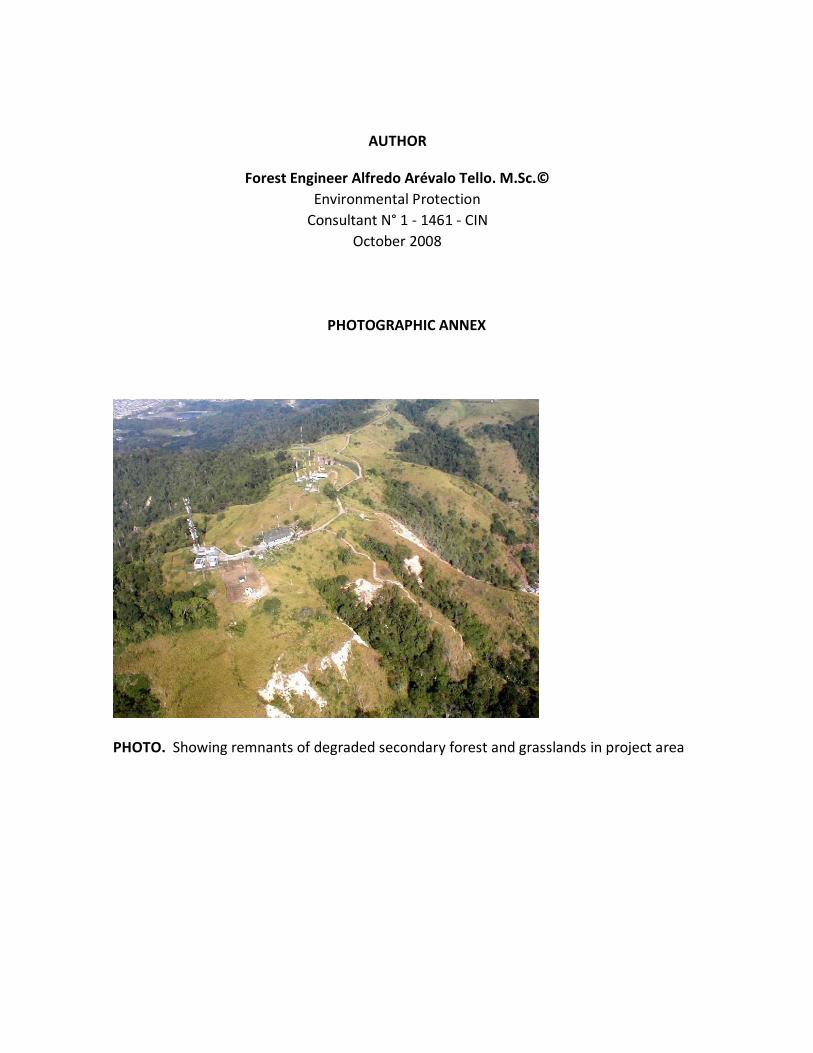
AUTHOR
Forest Engineer Alfredo Arévalo Tello. M.Sc.©
Environmental Protection
Consultant N° 1 - 1461 - CIN
October 2008
PHOTOGRAPHIC ANNEX
PHOTO. Showing remnants of degraded secondary forest and grasslands in project area

PHOTO. House destroyed by sliding impact near the antennas location

PHOTO 1. Crops in unsuitable places
PHOTO 2. High-risk area sustaining a huge rotational mass landslide
FOTO . Cultivo en lugar inapropiado

PHOTO. Abandoned house fearing dangerous ground fault condition
PHOTO. The project area can be used to set up a sighting place as a life quality
improvement factor.

SE
V 8
BA
RR
IO
GU
AC
HA
RA
CA
1 : 1500
050
100200m
etros
SENDERO
SENDERO
SENDERO
PI1
PI5
PI6
PI7
PI4
PI3
PI-1
3
PI-2
CAIDA DE AGUA
CAIDA DE AGUA
CE
RR
AM
IEN
TO B
LOQ
UE
CAS
A
Arbo
l
-150
-100
-50
0.00
50
100
150
200
250
300
350
400
450
CU
RV
A D
E N
IVE
L M
AY
OR
CU
RV
A D
E N
IVE
L M
EN
OR
SIM
BO
LOG
IA
CA
SA
S E
XIS
TE
NT
ES
PI L
EV
AN
TA
MIE
NT
O
CE
RC
A D
E A
LMA
BR
E
VIA
EX
IST
EN
TE
AN
TE
NA
TO
RR
E

B'
B
F'
F
SE
V 8
BA
RR
IO
GU
AC
HA
RA
CA
1 : 1500
050
100200m
etros
SENDERO
SENDERO
SENDERO
PI1
PI5
PI6
PI7
PI4
PI3
PI-1
3
PI-2
CAIDA DE AGUA
CAIDA DE AGUA
CE
RR
AM
IEN
TO B
LOQ
UE
CAS
A
Arbo
l90°
-150
-100
-50
0.00
50
100
150
200
250
300
350
400
450
CU
RV
A D
E N
IVE
L M
AY
OR
CU
RV
A D
E N
IVE
L M
EN
OR
SIM
BO
LOG
IA
CA
SA
S E
XIS
TE
NT
ES
PI L
EV
AN
TA
MIE
NT
O
CE
RC
A D
E A
LMA
BR
E
VIA
EX
IST
EN
TE
AN
TE
NA
TO
RR
E
98,83
A'
A" (G
eolo
gía)
65 ,1 2
125°
4,9
8
62°
45°
51,95
131°
2,4
A
LOC
AL
IZA
CIO
N
BA
RR
IO LA
GU
AC
HA
RA
CA
CE
RR
O E
L G
AT
AZ
OS
EC
TO
R D
E L
AS
AN
TE
NA
S
104
735
.04
37N
64
96
58.3
229
E
C'
62°
8,9
21
0 6, 0
9
SE
V 8
BA
RR
IO
GU
AC
HA
RA
CA
1 : 1500
050
100200m
etros
SENDERO
SENDERO
SENDERO
PI1
PI5
PI6
PI7
PI4
PI3
PI-1
3
PI-2
CAIDA DE AGUA
CE
RR
AM
IEN
TO B
LOQ
UE
CAS
A
Arbo
lCU
RV
A D
E N
IVE
L M
AY
OR
CU
RV
A D
E N
IVE
L M
EN
OR
SIM
BO
LOG
IA
CA
SA
S E
XIS
TE
NT
ES
PI L
EV
AN
TA
MIE
NT
O
CE
RC
A D
E A
LMA
BR
E
VIA
EX
IST
EN
TE
AN
TE
NA
TO
RR
ES
ON
DE
O_
1=
10
476
9.802
3 6
49
571
.896
9
SO
ND
EO
_2
= 1
04
735.0
437
64
96
58.3
229
S
ON
DE
O_
3=
10
474
2.919
0 6
49
736
.409
9
SO
ND
EO
_4
= 1
04
773.6
122
64
96
66.1
190
S
ON
DE
O_
5=
10
481
0.617
8 6
49
662
.684
8
A'
A" (G
eolo
gía)
1A'
1A
2A'
3A'
2A
3A
4A'
5A'
6A'
4A 5A
6A
A
3B'
2B'
1B'
1B'
3B'
5B'
F
F'
B
B'
2B'
4B'
0A'
C'
2C'3C
'4C'5C
'6C'
F1
F2
F3
F4F
5
deslizamiento F
Eje abscisa 0+000
deslizamientos B
y C
Eje abscisa 0+000
deslizamiento A
Eje abscisa 0+000
C
F
F'
F1
F2
F3
F4F
5
deslizamiento F
Eje abscisa 0+000
A'
A" (G
eo
logía
)
1A'
1A
2A'
3A'
2A
3A
4A'
5A'
6A'
4A
5A
6A
A
0A'
Eje abscisa 0+000
90°
18. 1
2
60.4
1°
90°
131
.50°
3B'
2B'
1B'
3B'
2B'
1B'
B
B'
4B'
5B'
3C'4C
'
C'
2C'
90°
62.0
5°
5C'6C
'
deslizamientos B
y C
Eje abscisa 0+000
C
20. 3
5
90°
46. 8
845
.46
°
90°

SE
V 8
BA
RR
IO
GU
AC
HA
RA
CA
TO
PE
CO
NG
LOM
ER
AD
O
DE
CA
NT
ER
A
FR
EN
TE
EX
PLO
TA
CIÓ
NC
AN
TE
RA
1 : 1500
050
100200m
etros
Fi
N3
0 / V
ER
TIC
AL
(FA
LL
A F
2)
50125
SENDERO
SENDERO
SENDERO
PI1
PI5
PI6
PI7
PI4
PI3
PI-1
3
PI-2
CAIDA DE AGUA
CAIDA DE AGUA
CE
RR
AM
IEN
TO B
LOQ
UE
CAS
A
Arbo
l
90°
-150
-100
-50
-0.00
50
100
150
200
250
300
350
400
450
CU
RV
A D
E N
IVE
L M
AY
OR
CU
RV
A D
E N
IVE
L M
EN
OR
SIM
BO
LOG
IA
CA
SA
S E
XIS
TE
NT
ES
PI L
EV
AN
TA
MIE
NT
O
CE
RC
A D
E A
LMA
BR
E
VIA
EX
IST
EN
TE
AN
TE
NA
TO
RR
ES
ON
DE
O_
1=
10
476
9.802
3 6
49
571
.896
9
SO
ND
EO
_2
= 1
04
735.0
437
64
96
58.3
229
S
ON
DE
O_
3=
10
474
2.919
0 6
49
736
.409
9
SO
ND
EO
_4
= 1
04
773.6
122
64
96
66.1
190
S
ON
DE
O_
5=
10
481
0.617
8 6
49
662
.684
8
B'
B
F'
F
A'
A" (G
eolo
gía)
A C'

SE
V 8
BA
RR
IO
GU
AC
HA
RA
CA
TO
PE
CO
NG
LOM
ER
AD
O
DE
CA
NT
ER
A
FR
EN
TE
EX
PLO
TA
CIÓ
NC
AN
TE
RA
1 : 1500
050
100200m
etros
Fi
N3
0 / V
ER
TIC
AL
(FA
LL
A F
2)
50125
SO
ND
EO
_1
SO
ND
EO
_2
SO
ND
EO
_4
SO
ND
EO
_3
SO
ND
EO
_5
SENDERO
SENDERO
SENDERO
CAIDA DE AGUA
CAIDA DE AGUA
CE
RR
AM
IEN
TO B
LOQ
UE
CAS
A
Arbo
l
-150
-100
-50
0.00
50
100
150
200
250
300
350
400
450
CU
RV
A D
E N
IVE
L M
AY
OR
CU
RV
A D
E N
IVE
L M
EN
OR
SIM
BO
LOG
IA
CA
SA
S E
XIS
TE
NT
ES
PI L
EV
AN
TA
MIE
NT
O
CE
RC
A D
E A
LMA
BR
E
VIA
EX
IST
EN
TE
AN
TE
NA
TO
RR
E
B'
B
F'
F
A'
A" (G
eolo
gía)
A C'
SO
ND
EO
_6
SO
ND
EO
_7
SO
ND
EO
_8
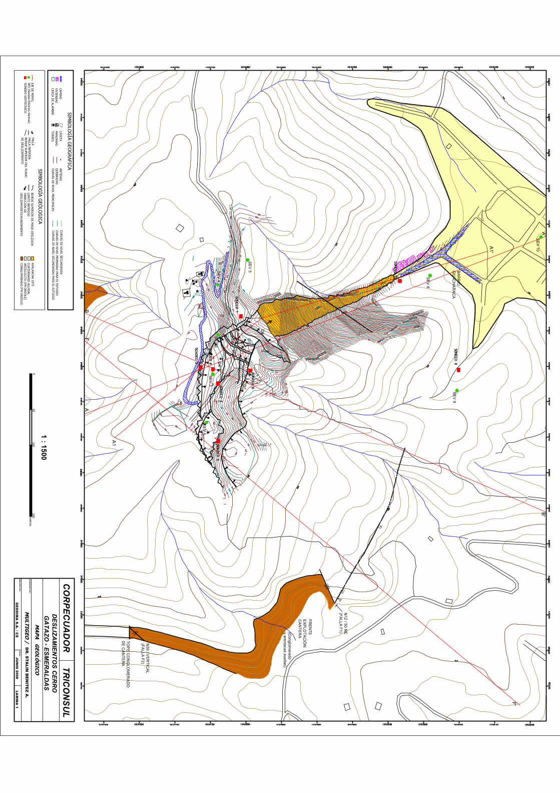
B'
AB
F'
F
A'
SE
V 1
SE
V 2
SE
V 3
SE
V 4
SE
V 5
SE
V 8
SE
V 9
SE
V 10
BA
RR
IO
GU
AC
HA
RA
CA
TO
PE
CO
NG
LOM
ER
AD
O
DE
CA
NT
ER
A
FR
EN
TE
EX
PLO
TA
CIÓ
NC
AN
TE
RA
(Co
nglom
erado
y are
nisca
s sue
ltas)
JUN
IO 2008
DIB
UJA
DO
PO
R :
FEC
HA
:
ELA
BO
RA
DO
PO
R :
DR
. ST
ALIN
BE
NIT
EZ
A.
GE
OS
IMA
S.A
. / CS
MA
PA
GEO
LÓG
ICO
LAM
INA
1
CO
RP
EC
UA
DO
RT
RIC
ON
SU
LD
ES
LIZ
AM
IEN
TO
S C
ER
RO
G
AT
AZ
O - E
SM
ER
AL
DA
S
MU
LTIGEO
/
SIMBO
LOG
ÍA GEO
GR
ÁFICA
SEV (Sondeo Eléctrico Vertical)SO
ND
EO G
EOTECN
ICO
CUATER
NA
RIO
ALUVIAL
BOR
DE SU
PERIO
R D
EL PLANO
D
E DESLIZAM
IENTO
BOR
DE SU
PERIO
R D
E MASA D
ESLIZADA
AVALAN
CH
A 1975
CON
GLO
MER
AD
O (FM
ON
ZOLE)
ARCILLO
LITA (FM O
NZO
LE)
CUR
VAS DE N
IVEL SECUN
DA
RIA
S
CUR
VAS DE N
IVEL PRIN
CIPALES
EJE DE PER
FIL
CAMIN
OVIV
IEND
ASTO
RR
ESQ
UEBR
ADAS
ANTEN
ASCU
RVAS D
E NIVEL PR
IMA
RIA
S PAR
A EL ESTUD
IOCER
CA DE ALAM
BRE
CASETAM
ANZAN
AS
1 : 1500
050
100200m
etros
SIMBO
LOG
ÍA GEÓ
LOG
ICAA
'A
LIMITE IN
FERID
O
CUR
VAS DE N
IVEL SECUN
DA
RIA
S PAR
A EL ESTUD
IO
D8
D7
D6
D5
D4
D1
D3
D2
Fi
N1
2 / 5
0 NE
(FA
LL
A F
1)
N3
0 / V
ER
TIC
AL
(FA
LL
A F
2)
50125
Fi
DIR
ECCIÓ
N D
E D
ESLIZAM
IENTO
/HU
ND
IMIEN
TO
FALLA INFER
IDA
Fi
FALLA
A1
A1
'
D9

50
100
150
200
250
300
SE
V-2
SA
LID
A L
AT
ER
AL
S-7
SE
V-8
SE
V-1
0
N.F
.
TO
BA
AR
CIL
LA
ES
CO
MB
RO
S D
E
AV
AL
AN
CH
A
0
50
100
150
200
250
300
0
DE
SL
IZA
MIE
NT
O
DE
SL
IZA
MIE
NT
O
AV
AL
AN
CH
A
AA
'A
NT
EN
AS
A
A'
JUN
IO 2008
DIB
UJA
DO
PO
R :
FEC
HA
:
ELA
BO
RA
DO
PO
R :
DR
. ST
ALIN
BE
NIT
EZ
A.
GE
OS
IMA
S.A
. / CS
CO
RTE G
EOLO
GIC
O A
- A'
LAM
INA
2
ES
C. H
OR
IZO
NT
AL 1:1000
ES
C. V
ER
TIC
AL 1:1000
CO
RP
EC
UA
DO
RT
RIC
ON
SU
LD
ES
LIZ
AM
IEN
TO
S C
ER
RO
G
AT
AZ
O - E
SM
ER
AL
DA
S
MU
LTIGEO
/
SIMBO
LOG
ÍA
SEV-5SO
ND
EO ELÉCTR
ICO VER
TICAL
S-7SO
ND
EO G
EOM
ECÁN
ICO
FALLA
UB
ICA
CIÓ
N D
EL
CO
RT
E
me
tros
050
100
10
TOPO
GR
AFÍA FOTO
GR
AM
ÉTRIC
ALEVAN
TAM
IENTO
TRIC
ON
SUL
DESLIZA
MIEN
TO
N.F.
NIVEL FR
EÁTICO
CO
NG
LO
ME
RA
DO
CO
NG
LO
ME
RA
DO
TO
BA
TO
BA
100
200
300
400
500
600
700
5015
025
050
450
550
650
750
metros
AR
CIL
LOL
ITA
S-2
D8
D6
D5
D4
D9

50
100
150
200
250
300
PR
OY
EC
CIÓ
NS
EV
-3S
EV
-2
CO
NG
LO
ME
RA
DO
S-2
AN
TIG
UO
D
ES
LIZ
AM
IEN
TO
CO
NG
LO
ME
RA
DO
JUN
IO 2008
DIB
UJA
DO
PO
R :
FEC
HA
:
ELA
BO
RA
DO
PO
R :
DR
. ST
ALIN
BE
NIT
EZ
A.
GE
OS
IMA
S.A
. / CS
CO
RTE G
EOLO
GIC
O B
- B'
LAM
INA
3
ES
C. H
OR
IZO
NT
AL 1:1000
ES
C. V
ER
TIC
AL 1:1000
CO
RP
EC
UA
DO
RT
RIC
ON
SU
LD
ES
LIZ
AM
IEN
TO
S C
ER
RO
G
AT
AZ
O - E
SM
ER
AL
DA
S
MU
LTIGEO
/
SIMBO
LOG
ÍA
SEV-5SO
ND
EO ELÉC
TRIC
O VER
TICA
LS-7
SON
DEO
GEO
MEC
ÁN
ICO
FALLA
50
100
150
200
250
300
00
B
B'
BB
'
TO
BA
FIN
A ?
UB
ICA
CIÓ
N D
EL
CO
RT
E
NU
EV
O
DE
SL
IZA
MIE
NT
O
TO
BA
ST
OB
AS
TO
BA
S
metros
050
100
10TO
POG
RAFÍA
FOTO
GR
AMÉTR
ICALEVA
NTA
MIEN
TO TR
ICO
NSU
LD
ESLIZAMIEN
TO
ES
CO
MB
RO
S D
E
AV
AL
AN
CH
A
AR
CIL
LO
LIT
AS
100
200
300
400
50060
070
050
150
250
350
450
550
650
750
metros
AN
TE
NA
S
AR
CIL
LO
LIT
AS
AR
CIL
LO
LIT
AS
S-4
S-5
D1
D9
D4

FF
'
TO
BA
AR
CIL
LO
LIT
A
TO
BA
AN
TIG
UO
D
ES
LIZ
AM
IEN
TO
TO
BA
S A
RE
NO
SA
S
SE
V-1
JUN
IO 2008
DIB
UJA
DO
PO
R :
FEC
HA
:
ELA
BO
RA
DO
PO
R :
DR
. ST
ALIN
BE
NIT
EZ
A.
GE
OS
IMA
S.A
. / CS
CO
RTE G
EOLÓ
GIC
O F - F'
LAM
INA
4
ES
C. H
OR
IZO
NT
AL 1:1000
ES
C. V
ER
TIC
AL 1:1000
CO
RP
EC
UA
DO
RT
RIC
ON
SU
LD
ES
LIZ
AM
IEN
TO
S C
ER
RO
G
AT
AZ
O - E
SM
ER
AL
DA
S
MU
LTIGEO
/
SIMBO
LOG
ÍA
SEV-5SO
ND
EO ELEC
TRIC
O V
ERTIC
AL
FALLA
F
UB
ICA
CIÓ
N D
EL
CO
RT
E
me
tros
05
01
00
10
TOPO
GR
AFÍA FO
TOG
RAM
ÉTRIC
ALEV
AN
TAM
IENTO
TRICO
NSU
LD
ESLIZAM
IENTO
F'
CA
MIN
O
AR
CIL
LO
LIT
AS
BR
EC
HA
CO
NG
LO
ME
RA
DO
50
100
150
200
250
300
50
100
150
200
250
300
00
100
200
300
400
500
600
700
5015
025
035
045
055
065
075
0
metros
AR
CIL
LO
LIT
A
AR
CIL
LA
Y T
OB
A
BR
EC
HA
?
AN
TIG
UO
D
ES
LIZ
AM
IEN
TO
NU
EV
O
DE
SL
IZA
MIE
NT
O
AN
TE
NA
S
AR
CIL
LO
LIT
A
S-3
D2
D3

50
100
150
200
250
300
SE
V-2
S-7
SE
V-8
SE
V-1
0
N.F
.
TO
BA
AR
CIL
LA
ES
CO
MB
RO
S D
E
AV
AL
AN
CH
A
0
50
100
150
200
250
300
0
DE
SL
IZA
MIE
NT
OD
ES
LIZ
AM
IEN
TO
S
AV
AL
AN
CH
A
AA
'A
NT
EN
AS
A1
A1'
JULIO
2008D
IBU
JAD
O P
OR
:FE
CH
A :
ELA
BO
RA
DO
PO
R :
DR
. ST
ALIN
BE
NIT
EZ
A.
GE
OS
IMA
S.A
. / CS
CO
RTE G
EOLO
GIC
O A
- A"
LAM
INA
2
ES
C. H
OR
IZO
NT
AL 1:1000
ES
C. V
ER
TIC
AL 1:1000
CO
RP
EC
UA
DO
RT
RIC
ON
SU
LD
ES
LIZ
AM
IEN
TO
S C
ER
RO
G
AT
AZ
O - E
SM
ER
AL
DA
S
MU
LTIGEO
/
SIMBO
LOG
ÍA
SEV-5SO
ND
EO ELÉCTR
ICO VER
TICAL
S-7SO
ND
EO G
EOM
ECÁN
ICO
FALLA
UB
ICA
CIÓ
N D
EL
CO
RT
E
me
tros
050
100
10
TOPO
GR
AFÍA FOTO
GR
AM
ÉTRIC
ALEVAN
TAM
IENTO
TRIC
ON
SUL
DESLIZA
MIEN
TO
N.F.
NIVEL FR
EÁTICO
CO
NG
LO
ME
RA
DO
CO
NG
LO
ME
RA
DO
TO
BA
TO
BA
100
200
300
400
500
600
700
5015
025
050
450
550
650
750
metros
AR
CIL
LOL
ITA
S-2
D9
D5
D6
D7
D8

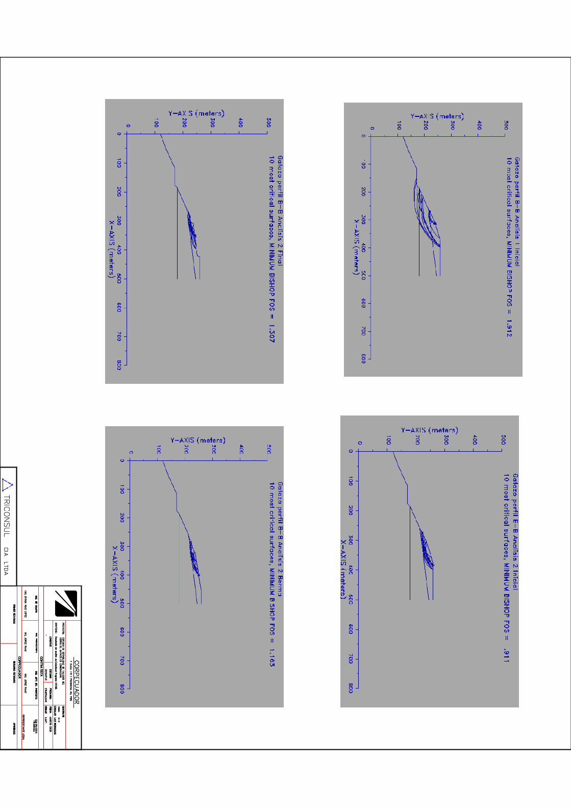
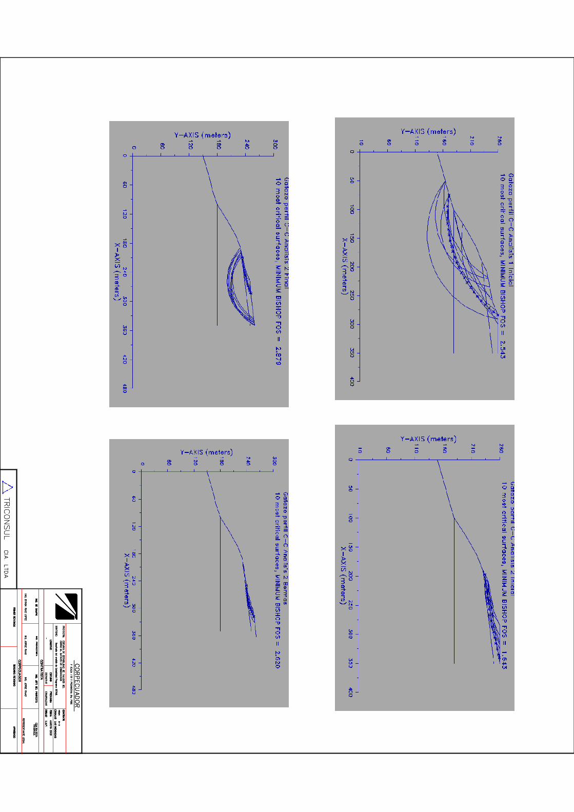


SE
V 8
BA
RR
IO
GU
AC
HA
RA
CA
Lín
ea gru
esa p
lanim
etria d
el eje d
e las
trinch
eras
050
100200m
etros
SENDERO
SENDERO
SENDERO
PI1
PI5
PI6
PI7
PI4
PI3
PI-1
3
PI-2
CAIDA DE AGUA
CAIDA DE AGUA
CAS
A
Arbo
l
-150
-100
-50
-0.00
50
100
150
200
250
300
350
400
450
CU
RV
A D
E N
IVE
L M
AY
OR
CU
RV
A D
E N
IVE
L M
EN
OR
SIM
BO
LOG
IA
CA
SA
S E
XIS
TE
NT
ES
PI L
EV
AN
TA
MIE
NT
O
CE
RC
A D
E A
LMA
BR
E
VIA
EX
IST
EN
TE
AN
TE
NA
TO
RR
ES
ON
DE
O_
1=
10
476
9.802
3 6
49
571
.896
9
SO
ND
EO
_2
= 1
04
735.0
437
64
96
58.3
229
S
ON
DE
O_
3=
10
474
2.919
0 6
49
736
.409
9
SO
ND
EO
_4
= 1
04
773.6
122
64
96
66.1
190
S
ON
DE
O_
5=
10
481
0.617
8 6
49
662
.684
8
CE
RR
AM
IEN
TO B
LOQ
UE
A'A
1'
A1
A1"
1A'
1A
2A' 3A
'
2A
3A
4A' 5A
'6A
'
4A 5A
6A
1A"
3B'
2B'
1B'
1B'
3B'
5B'
F
F'
B A
B'
2B'
4B'
C'2C
'3C'4C
'
0A'
5C'6C
'
TR
INC
HE
RA
S D
RE
NA
NT
ES
ES
CA
RP
A D
E F
AL
LA
Lín
ea delg
ad
a eje d
e b
ord
e extern
o d
e la b
erma
La lo
calizació
n se
hace
con
base
a la lo
calizació
n
de lo
s p
erfiles en
el la lam
ina c
orre
spo
nd
iente.
NO
TA
:
F'
F1
F2
F3
F4F
5
De
scarg
a al dren
aje n
atura
l d
e la ciu
da
d
De
scarg
a al dren
aje n
atura
l d
e la ciu
da
d

SE
CC
ION
5A
'-5A
20
0
25
0
30
0
SE
CC
ION
6A
'-6A
200
250
300
Linea de giro del Eje
deslizamiento AEje abscisa 0+000
Linea de giro del Eje
deslizamiento AEje abscisa 0+000
Pro
yecto
Pro
yecto
20
0
25
0
30
0
deslizamiento AEje abscisa 0+000
Linea de giro del Eje
Pro
yecto
20
0
25
0
30
0
SE
CC
ION
2A
'-2A
Linea de giro del Eje
deslizamiento AEje abscisa 0+000
Pro
yecto
SE
CC
ION
3A
'-3A
20
0
25
0
30
0
berm
as de
3m
.
Linea de giro del Eje
deslizamiento AEje abscisa 0+000
Pro
yecto
SE
CC
ION
4A
'-4A
20
0
25
0
30
0
Linea de giro del Eje
deslizamiento AEje abscisa 0+000
Pro
yecto
SE
CC
ION
A'-A

SE
CC
ION
B-B
'
20
0
25
0
30
0
deslizamientos B y CEje abscisa 0+000
Pro
yecto
SE
CC
ION
1B
'-1B
20
0
25
0
30
0
deslizamientos B y CEje abscisa 0+000
Pro
yecto
SE
CC
ION
2B
'-2B
20
0
25
0
30
0
deslizamientos B y CEje abscisa 0+000
Pro
yecto
SE
CC
ION
3B
'-3B
20
0
25
0
30
0
deslizamientos B y CEje abscisa 0+000
Pro
yecto
SE
CC
ION
4B
'-4B
20
0
25
0
30
0
deslizamientos B y CEje abscisa 0+000
Pro
yecto

SE
CC
ION
C'-C
20
0
25
0
30
0
deslizamientos B y CEje abscisa 0+000
Pro
yecto
SE
CC
ION
2C
'-2C
20
0
25
0
30
0
deslizamientos B y CEje abscisa 0+000
Pro
yecto
SE
CC
ION
3C
'-3C
200
250
300
deslizamientos B y CEje abscisa 0+000
Pro
yecto
SE
CC
ION
4C
'-4C
20
0
25
0
30
0
deslizamientos B y CEje abscisa 0+000
Pro
yecto

SE
CC
ION
F-F
'
20
0
25
0
30
0
deslizamiento FEje abscisa 0+000
Pro
yecto
SE
CC
ION
F1-F
1
50
10
0
15
0
20
0
25
0
30
0
SE
CC
ION
F2-F
2
50
10
0
15
0
20
0
25
0
30
0
deslizamiento FEje abscisa 0+000
deslizamiento FEje abscisa 0+000
SE
CC
ION
F3-F
3
50
10
0
15
0
20
0
25
0
30
0
SE
CC
ION
F4-F
4
50
100
150
200
250
300
SE
CC
ION
F5-F
5
50
10
0
15
0
20
0
25
0
30
0
deslizamiento FEje abscisa 0+000
deslizamiento FEje abscisa 0+000
deslizamiento FEje abscisa 0+000
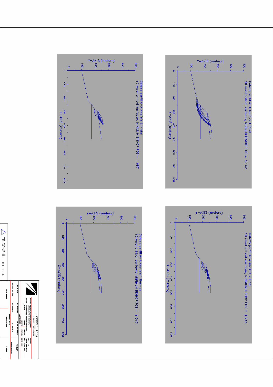


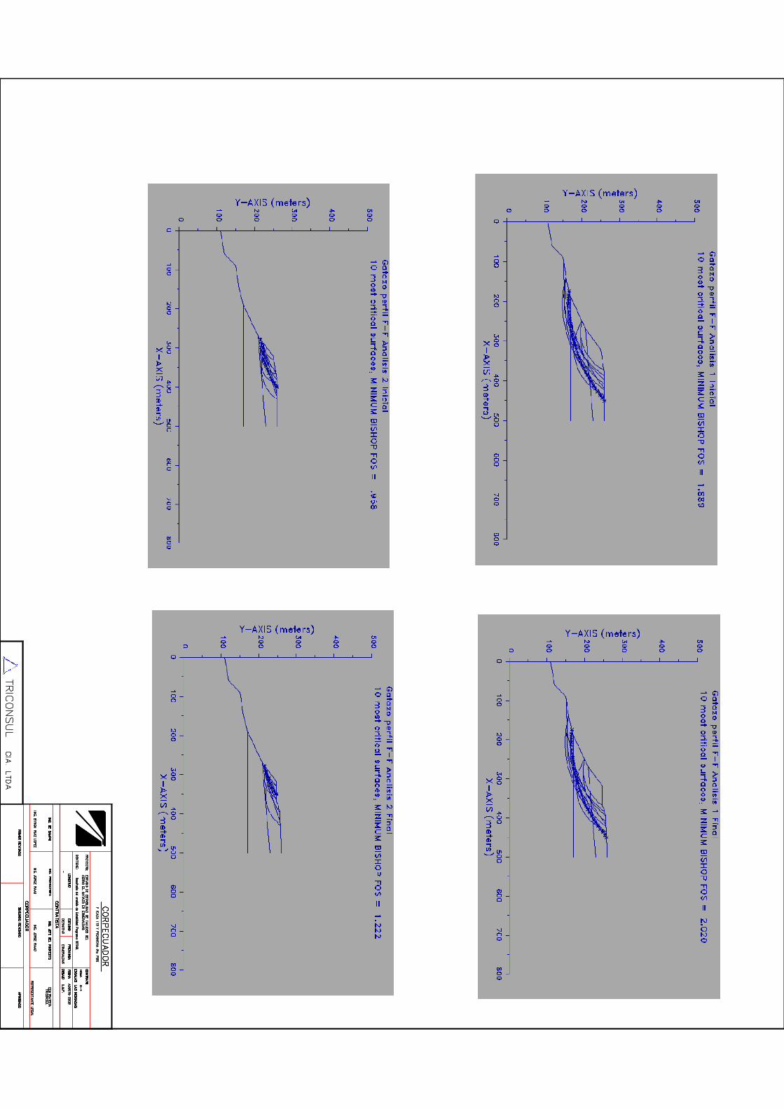


1 / 3
Annex 13. Alternative approaches considered but not adopted in the project.
Barrier Project action Alternative approaches considered but not adopted
1. Protection works do not incorporate the climate change variable
Update Antofagasta´s stormwater management plan incorporating the climate change factor (output 1.1) to guide future investments to cope with foreseeable stronger and more frequent coastal storms.
Prepare green infrastructure plan for Esmeraldas (output 1.2) to protect the city from flooding and landslides caused by the foreseeable increase in rainfall associated with stronger and more frequent El Niño.
Update protection infrastructure designs and constructions incorporating the climate change factor for quebrada Bonilla and cerro Gataso (output 2.1) and cerro Gataso (output 2.2) to reduce vulnerability of local population and develop methodology and experience for mainstreaming the climate factor in infrastructure works.
There is no alternative to the use of grey infrastructure to protect the cities from stronger and more frequent weather events. In Antofagasta and Taltal, the use of green infrastructure was considered and discarded because desert conditions make impractical the use of vegetation.
At first it was thought that mainstreaming the climate change factor into protection works could be done working directly with the municipalities. This was discarded for Chile, because infrastructure and water management is administered by MOP, who prepare and implement regional plans. The current Antofagasta´s plan cover the period 2012 – 2021 (MOP, 2012). Influencing the existing plan was not feasible, therefore it was decided to update Antofagasta´s stormwater management plan to incorporate the climate change factor. This is a compulsory instrument for cities with more than 50,000 inhabitants, which outlines the means and infrastructure required to channel stormwater and prevent damages to people and property.
In Esmeraldas, it was seen that a combination of grey and green infrastructure could be used to adapt to the impacts of a future scenario of stronger and more frequent rainfall. Actions to address flooding and landslides were analysed. However, addressing flooding was discarded because it would require a level of investment far beyond the scope of the present project. The city drainage system is obsolete and only cover about 50% of the urban area. In addition, people have settled in low flood-prone areas that easily inundate when the Esmeraldas and Teaone rivers overflow due to heavy rain. The required adaptation solution will be to upgrade the city´s drainage system considering the expected climate-related increase in rainfall.
In contrast, there were (i) previous experience on the use of vegetation to stabilise the slopes of cerro Gataso (MAE, 2002; PNUD, 2005), and (ii) fully developed engineering designs for infrastructure to stabilise hillsides and drain stormwater (Annex 12). The designs need to be updated and incorporate climate change considerations (e.g., stronger and more frequent El Niño), but this can be easily done.

2 / 3
Barrier Project action Alternative approaches considered but not adopted
The construction works in quebrada Bonilla (Antofagasta) and cerro Gataso (Esmeraldas) were chosen because (i) they were urgently needed, and (ii) there were engineering designs that could be updated to include the climate factor.
2. Early warning systems have limited information to alert people at risk with sufficient time to evacuate.
Increase capacity to forecast hydrometeorological hazards and strengthen early warning systems. Install meteorological radars and meteorological stations in Antofagasta and Esmeraldas (outputs 3.1 and 3.2).
Expand public warning systems in Antofagasta and Taltal to alert and evacuate the local population in case of mudflows (output 4.1).
Prepare and implement a pilot community-based flood warning system in Luis Vargas Torres Island (Esmeraldas) (output 4.2), prepare climate-adjusted flood and landslide risk maps for the city and signal the evacuation routes and safe areas (output 4.3)
At first it was considered that strengthening climate monitoring with automatic weather station could be sufficient to improve the forecasts. However, it was analysed that the weather stations this will not provide information with sufficient time to alert the local population in case of emergency. In Antofagasta and Taltal, coastal storms develop very fast and once rain falls, the window of opportunity to alert people is one hour or less. The same occurs in Esmeraldas, where flooding is mostly associated with heavy rainfall upriver.
Doppler weather radars were chosen because they provide information on precipitation movement and intensity. This will be the first weather radar in Chile. INAMHI´ experience with Quito´s weather radars was useful to assess the viability of this project element and will serve during project execution.
3. Limited capacity to address informal occupation of land in high risk areas.
Raise awareness of local population about the danger of setting on high-risk areas through the implementation of communication and education strategies (output 6.1) and an initiative to invigorate cultural memory (output 6.2).
At first, it was considered to directly address the issue of land tenure in informal settlements in risk areas. It was thought that the project could contribute to strengthen municipal regulations and assist to motivate that people relocate to safe areas. However, it was found that informal land use was a long-standing issue with very complex root causes. In Chile, despite sustained major work from public and private organizations, the problem still persists. Therefore, this approach was considered inviable because the present project would not be able to have a real impact. It was decided that the communication and education strategies include messages and actions to raise awareness about settling in hazard areas.
4. Local technical staff with limited capacities to mainstream climate change adaptation and disaster risk reduction.
Develop and implement an online course on risk-based adaptation in coastal cities for local governments´ officers (output 5.1).
At first, it was considered to use traditional in-person training. However, this was very costly and it seemed difficult to sustain it after project closure. The use of on-line training was chosen because (i) there is local experience and capacity to prepare and execute it, (ii) this kind of training is now widespread in LAC, (iii) it more cost-effective, (iv) it allows for diverse participation of professionals from the region, and (v) allows for self-paced learning. The limitations of self-paced only online training (e.g., inability to ask specific questions, no interaction with peers) were considered, and a blended approach was chosen. This is, a combination of
3 / 3
Barrier Project action Alternative approaches considered but not adopted
self-paced materials / activities with online sessions to interact with trainers and other course participants.
5. Local population not fully aware of climate-related risks.
Develop and implement communication and education strategies (output 6.1) and an initiative to invigorate cultural memory (output 6.2).
At first, only public communication and education strategies were considered to raise awareness and engage local groups into climate change adaptation. However, it was seen that there was a need of a social process to maintain a living memory of past events and to pass lessons to the new generations. Chile´s experience with the Japanese narrators´ methodology was analysed and found to be too formal and structured. Therefore, it was decided to use the basic concepts to build a culturally-appropriate initiative that gets rooted in local groups to be sustained on the long term.
Collective learning through communities of practice (transversal to all project outcomes).
At first, task-specific workgroups were considered to allow for team work. However, it was analysed that workgroups have a narrow scope and usually tend to focus on accomplishing a certain task. Workgroups do not necessarily contribute to a learning environment. Communities of practice (Lave & Wenger, 1991; Wenger, 1998; Wenger et al., 2002) were selected because they allow for collective knowledge creation and learning, collaborative processes and social networking. Communities of practice have limitations (Robert, 2006; Konig, 2013) and need to be cultivated and nurtured (Cambridge et al., 2005), but were considered a better choice.
Annex 14. Compliance with the Adaptation Fund’s Environmental and Social Policy and Gender Policy
Table of Contents
1. Compliance with the Environmental and Social Policy ................................................................... 2
1.1. Project Summary ..................................................................................................................... 2
2. Risk identification and categorization ............................................................................................. 3
1.1. ESP Risks Identification ........................................................................................................... 3
2.1. General Categorization ......................................................................................................... 13
2. Environmental and social management plan (ESMP) ................................................................... 16
2.1. Environmental and social mitigation program ..................................................................... 16
2.2. Environmental and Social Risk Identification Mechanism .................................................... 24
2.3. Grievance mechanism ........................................................................................................... 36
3. Monitoring, evaluation and oversight program............................................................................ 38
3.1. Unidentified Sub-Project (USP) intervention mechanism .................................................... 39
4. Annex ............................................................................................................................................ 40
4.1. Applicable domestic and international laws that apply........................................................ 40

2
1. Compliance with the Environmental and Social Policy
The Environmental and Social Policy of the Adaptation Fund requires that all projects be screened against the 15 principles. This policy ensures that projects supported by the Fund promote positive environmental and social benefits, and mitigate or avoid adverse environmental and social risks and impacts. This document, present a detailed risk identification, categorization and Environmental and Social Management Plan (ESMP) prepared for risks identified including a mechanism specifically designed for unidentified sub projects (USP). The ESMP developed in a collaborative manner by the implementing entity (IE) and the executing entity (EE), will go through a systematic monitoring and evaluation arrangement during implementation phase.
The document is composed of the following sections: 1. Summary description of the project, 2. risk identification and categorization, 3. Environmental and social management plan and 4. Monitoring and evaluation arrangements.
1.1. Project Summary
The main objective of the project is to reduce vulnerability to climate-related floods, mudflows and landslides in three coastal cities by mainstreaming a risk-based approach to adaptation, building collaboration and networking, and developing a culture of adaptation. The project focuses on the hydro-meteorological hazards of mudflows in Antofagasta and Taltal, and flooding and landslides in Esmeraldas. The expected mid-term impacts are improved enabling conditions to sustain DRR adaptation in the three cities. In the long-term, it is expected that this will result in improved adaptive capacity. It is also envisioned that the lessons of the project are useful to other countries in Latin America and the Caribbean, and other regions of the world.
The project has three components. Component 1 focuses on priority actions to increase resilience in the three cities. Four outcomes will be generated by mainstreaming DRR into local planning, building infrastructure which incorporate climate-related variables, improving climate monitoring, and strengthening the existing early warning and response systems. Component 2 is related with the enhanced capacities of local government officers and communities, as well as fortifying connections between communities and local and national government. Two outcomes will be generated by developing an online training course on risk-based adaptation for municipal and government officers, and implementing communication and education strategies to increase local awareness and contribute to building cultural memory. The online course will be open to professionals from other coastal cities of Latin America and the Caribbean. Component 3 focuses on nurturing the project´s communities of practice and documenting and disseminating the lessons. The backbone of the regional project is the communities of practice that allow the development of collective learning on specific topics between Ecuador and Chile. Five mechanisms for communities of practice will be developed. The rationale of the regional project is to generate practical lessons on risk-based adaptation in coastal cities with different adaptive capacities and disseminate the lessons to Latin America and the Caribbean to motivate interest and involvement of other cities of the region.

3
2. Risk identification and categorization
Using the Manual of Basic Environmental and Social Management System procedures and functions at National Implementing Entities (April, 2016), the Social and Environmental Risks Screening Checklist and the Identification and preliminary Management of Social and Environmental Risks were developed.
The process of risk screening for the current project activities developed followed the 15 principles of the ESP. Including Principles 1 (Compliance with the law), 4 (Human rights) and 6 (Core labour rights) which always apply, the other 12 principles were screened in relation to the project outcomes, outputs and activities were screened. Establishing relevance between these principles and project elements was one of the outcomes of the risk identification process.
1.1. ESP Risks Identification
Based on the checklist of the AF ESMS procedures, environmental and social risks were identified using the following checklist (Table 1).
The risk identification is developed taking into account the AF’s ESP and the steps presented in the Manual of Basic Environmental and Social Management System procedures and functions at National Implementing Entities for the compliance of each principle. The answers YES or NO mean if the action, activity, analysis, documentation, etc. was done for the identification of the risk.

Table 1. Project Risk identification
Component 1: Reducing climate vulnerability and flood risk in coastal urban and semi urban areas in cities in Latin America
Checklist of E&S Principles Questions Yes / No Risks Associated Yes / No
1.Compliance with the law
1.1. Does the Project demonstrate any incompliance with any applicable international law? Has the project identified all the specific, applicable domestic and international laws, regulations, standards, procedures and permits that apply to any of its activities?
Chi – NO
Ecu – NO
The project could not comply with applicable domestic and international law
Chi – YES
Ecu – YES
1.2. Has the project identified activities that may require prior permission (such as planning permission, environmental permits, construction permits, permits for water extraction, emissions, and use or production or storage of harmful substances)
Chi – YES
Ecu - YES
1.3. Has the project identified environmental and social safeguarding requirements, other than those of the AF (e.g. national or of co-financing entities). Use the appropriate screening tools, including any threshold lists and sectorial requirements?
Chi – NO
Ecu - NO
1.4. Has the project identified technical or industry standards that apply to any of its activities?
Chi – YES
Ecu - YES
2. Access and Equity 2.1. Has the project identified benefits and its geographical area of effect? Chi – YES
Ecu - YES
The beneficiary might have unfair and/or unequitable access to project benefits created.
Chi – YES
Ecu - YES
2.2. Has the project identified any marginalized or vulnerable groups among potential project beneficiaries? (stakeholder mapping in order to identify the potential beneficiaries, rivals, disputants, marginalized or vulnerable people)
Chi – NO
Ecu - NO
2.3. Has the project identified any existing inequities with respect to these marginalized or vulnerable groups? Chi – NO

5
Component 1: Reducing climate vulnerability and flood risk in coastal urban and semi urban areas in cities in Latin America
Checklist of E&S Principles Questions Yes / No Risks Associated Yes / No
Ecu - NO
2.4. Has the project identified the existing access to the essential services and rights indicated in the principle?
Chi – NO
Ecu - NO
The project might impede an access to basic health services, clean water and sanitation, energy, education, housing, safe and decent working conditions, and land rights.
Projects or programmes exacerbate existing inequities, particularly with respect to marginalized or vulnerable groups
2.5. Has the project described the mechanism of allocating and distributing project benefits, and how this process ensures fair and impartial access to benefits?
Chi – YES
Ecu - YES
2.6. Has the project developed stakeholder and local authorities’ consultations? Chi – YES
Ecu - YES
3. Marginalized and Vulnerable Groups
3.1. In the influence area of the project has there been identified the presence of marginalized or vulnerable groups, including but not limited to children, women and girls, the elderly, indigenous people, tribal groups, displaced people, refugees, people living with disabilities and people living with HIV/AIDS?
Chi – YES
Ecu - YES
The project may impose any disproportionate adverse impacts on marginalized and vulnerable groups (including children, women and girls, the elderly, indigenous people, tribal groups, displaced people, refugees, people living with disabilities, and people living with HIV/AIDS).
Chi – NO
Ecu - NO
3.2. Has the project quantified all the groups identified using accepted methods based, where possible, on disaggregated data?
Chi – YES
Ecu - YES
3.3. Has the project described the characteristics of any marginalized or vulnerable groups, identifying their particular vulnerabilities that would or could make them disproportionately vulnerable to negative environmental or social impacts caused by the implementation of the activities of the project?
Chi – NO
Ecu - NO
4. Human Rights 4.1. Has the project evidenced if the host country is cited in any Human Rights Council Special Procedures, be they thematic or country mandates?
Chi – YES
Ecu - YES
Chi – YES
Ecu - YES
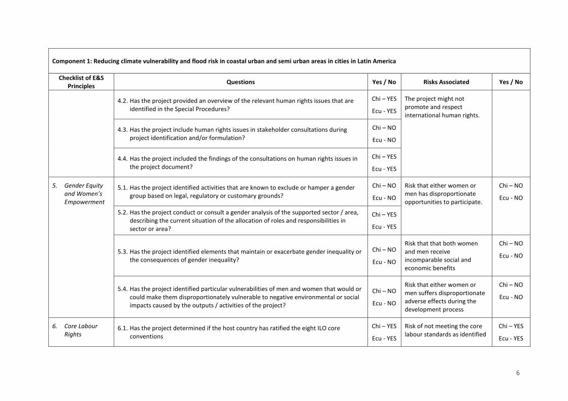
6
Component 1: Reducing climate vulnerability and flood risk in coastal urban and semi urban areas in cities in Latin America
Checklist of E&S Principles Questions Yes / No Risks Associated Yes / No
4.2. Has the project provided an overview of the relevant human rights issues that are identified in the Special Procedures?
Chi – YES
Ecu - YES
The project might not promote and respect international human rights.
4.3. Has the project include human rights issues in stakeholder consultations during project identification and/or formulation?
Chi – NO
Ecu - NO
4.4. Has the project included the findings of the consultations on human rights issues in the project document?
Chi – YES
Ecu - YES
5. Gender Equity and Women’s Empowerment
5.1. Has the project identified activities that are known to exclude or hamper a gender group based on legal, regulatory or customary grounds?
Chi – NO
Ecu - NO
Risk that either women or men has disproportionate opportunities to participate.
Chi – NO
Ecu - NO
5.2. Has the project conduct or consult a gender analysis of the supported sector / area, describing the current situation of the allocation of roles and responsibilities in sector or area?
Chi – YES
Ecu - YES
5.3. Has the project identified elements that maintain or exacerbate gender inequality or the consequences of gender inequality?
Chi – NO
Ecu - NO
Risk that that both women and men receive incomparable social and economic benefits
Chi – NO
Ecu - NO
5.4. Has the project identified particular vulnerabilities of men and women that would or could make them disproportionately vulnerable to negative environmental or social impacts caused by the outputs / activities of the project?
Chi – NO
Ecu - NO
Risk that either women or men suffers disproportionate adverse effects during the development process
Chi – NO
Ecu - NO
6. Core Labour Rights
6.1. Has the project determined if the host country has ratified the eight ILO core conventions
Chi – YES
Ecu - YES
Risk of not meeting the core labour standards as identified
Chi – YES
Ecu - YES

7
Component 1: Reducing climate vulnerability and flood risk in coastal urban and semi urban areas in cities in Latin America
Checklist of E&S Principles Questions Yes / No Risks Associated Yes / No
6.2. Has the project reviewed the latest ILO assessments of application of the standards in the country?
Chi – YES
Ecu - YES
by the International Labour Organization (ILO).
6.3. Has the project identified any past/present/planned ILO assistance to meet the standards through social dialogue and technical assistance?
Chi – YES
Ecu - YES
6.4. Has the project identified information on any ILO Special procedures relevant to the Member nation including details on the triggering representation or complaints
Chi – YES
Ecu - YES
6.5. Has the project identified how the ILO core labour standards are incorporated in the design and the implementation of the outputs / activities’ project?
Chi – YES
Ecu - YES
6.6. Has the project describe the common labour arrangements in the sector(s) in which the project will operate, with particular attention to all forms of child labour and forced labour.
Chi – NO
Ecu - NO
7. Indigenous Peoples 7.1. Has the project identified if indigenous peoples are present in the area of influence?
Chi – NO
Ecu - YES
Risk of inconsistency of the project with the rights and responsibilities set forth in the UN Declaration on the Rights of Indigenous Peoples and other applicable international instruments relating to indigenous peoples.
Chi – NO
Ecu - YES
7.2. Has the project quantify the groups identified of indigenous peoples? Chi – NO
Ecu - YES
7.3. Has the project determined if there are provisions for a realistic and effective Free, Prior, Informed Consent process, giving a community the right to give or withhold its consent to proposed projects that may affect the lands they customarily own, occupy or otherwise use?
Chi – NO
Ecu - YES
7.4. Has the project provided a summary of any reports, specific cases, or complaints that have been made with respect to the rights of indigenous peoples by the Special Rapporteur on the rights of indigenous peoples and that are relevant to the project?
Chi – NO

8
Component 1: Reducing climate vulnerability and flood risk in coastal urban and semi urban areas in cities in Latin America
Checklist of E&S Principles Questions Yes / No Risks Associated Yes / No
Ecu - NO
8. Involuntary Resettlement
8.1. Has the project identified if physical or economic displacement is required or will occur as a consequence of its implementation?
Chi – NO
Ecu - YES
Risk of not minimizing or avoiding the need for involuntary resettlement.
Chi – NO
Ecu - YES
8.2. Has the project determined if it is voluntary or involuntary resettlement? Chi – NO
Ecu - YES
8.3. Has the project identified stakeholders whose livelihoods may be affected, directly or indirectly, and if this may lead to resettlement?
Chi – NO
Ecu - YES
Risk of not producing well-informed rights, consultation, and offered technically, economically, and socially feasible temporary relocations alternatives or fair and adequate compensation.
Chi – NO
Ecu - YES
8.4. Has the project identified stakeholders whose assets or access to assets may be affected, directly or indirectly, and if this may lead to resettlement and its consequences including indemnification, compensation, etc.
Chi – NO
Ecu - YES
9. Protection of Natural Habitats
9.1. Has the project identified all the critical natural habitats in the region that may be affected? The area considered should be large enough to be credible and be chosen in function of the impact generating agent (e.g. noise) and an appreciation of its propagating ability. The habitats to be considered include all those recognized as critical in any way, be it legally (through protection), scientifically or socially.
Chi – YES
Ecu - YES
Risk of involving unjustified conversion or degradation of critical natural habitats, including those that are (a) legally protected; (b) officially proposed for protection; (c) recognized by authoritative sources for their high conservation value, including as critical habitat; or (d) recognized as protected by traditional or indigenous local communities.
Chi – NO
Ecu - YES
9.2. Has the project identified for each critical natural habitat, the mechanism by which it is particularly vulnerable?
Chi – YES
Ecu - YES
9.3. Has the project considered all the activities to identify actual risks for each of the natural habitats identified taking into account the specific characteristics of the activity (location, dimension, duration etc.) and the vulnerability mechanism(s) of each habitat identified.
Chi – NO
Ecu - YES

9
Component 1: Reducing climate vulnerability and flood risk in coastal urban and semi urban areas in cities in Latin America
Checklist of E&S Principles Questions Yes / No Risks Associated Yes / No
10. Conservation of Biological Diversity.
10.1. Has the project identified all the elements of biodiversity interest in the region that may be affected? The area considered should be large enough to be credible and be chosen in function of the impact generating agent and an appreciation of its propagating ability. It is important in the identification of the elements of biodiversity interests not to limit this to the species level but to include all elements of biodiversity interest, including landscapes, ecosystem processes, habitats, and hydrological cycles, processes of erosion and sedimentation and interactions between taxa. Include all elements enjoying local or international protection
Chi – YES
Ecu - YES
Risk of not avoiding any significant or unjustified reduction or loss of biological diversity or the introduction of unknown invasive species
Chi – NO
Ecu - YES
10.2. For each identified biodiversity element, has the project identified the mechanism by which it is particularly vulnerable? (Changes in flow regime or water quality for a seasonal wetland or disruption of migration routes).
Chi – NO
Ecu - YES
10.3. Has the project identified actual risks for each of the biodiversity elements identified taking into account the specific characteristics of the activity (location, dimension, duration etc.) and the vulnerability mechanism(s) of each biodiversity element identified?
Chi – NO
Ecu - YES
10.4. Has the project identified the potential of introducing – intentionally or accidentally – known invasive species?
Chi – NO
Ecu - YES
10.5. Has the project identified the use of living modified organisms resulting from modern biotechnology?
Chi – NO
Ecu - NO
11. Climate Change 11.1. Has the project determined if it belongs to a sector mentioned in the Guidance document for which a greenhouse gasses emission calculation is required?
• Energy, transport, heavy industry, building materials, large-scale agriculture, large-scale forest products, and waste management.
Chi – YES
Ecu - NO
The risk of resulting in significant or unjustified increase in greenhouse gas emissions or other drivers of climate change.
Chi – YES
Ecu - NO
11.2. Has the project carry out a qualitative risk identification for each of the following drivers of climate change: Chi – NO
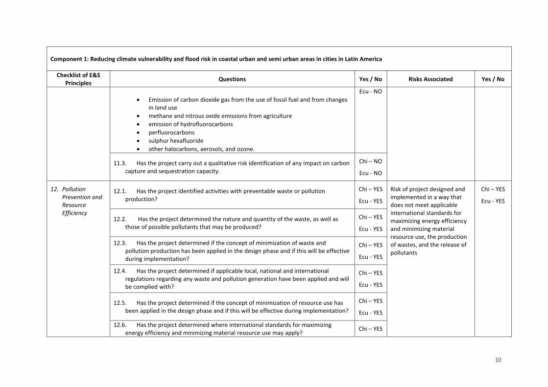
10
Component 1: Reducing climate vulnerability and flood risk in coastal urban and semi urban areas in cities in Latin America
Checklist of E&S Principles Questions Yes / No Risks Associated Yes / No
• Emission of carbon dioxide gas from the use of fossil fuel and from changes
in land use • methane and nitrous oxide emissions from agriculture • emission of hydrofluorocarbons • perfluorocarbons • sulphur hexafluoride • other halocarbons, aerosols, and ozone.
Ecu - NO
11.3. Has the project carry out a qualitative risk identification of any impact on carbon capture and sequestration capacity.
Chi – NO
Ecu - NO
12. Pollution Prevention and Resource Efficiency
12.1. Has the project identified activities with preventable waste or pollution production?
Chi – YES
Ecu - YES
Risk of project designed and implemented in a way that does not meet applicable international standards for maximizing energy efficiency and minimizing material resource use, the production of wastes, and the release of pollutants
Chi – YES
Ecu - YES
12.2. Has the project determined the nature and quantity of the waste, as well as those of possible pollutants that may be produced?
Chi – YES
Ecu - YES
12.3. Has the project determined if the concept of minimization of waste and pollution production has been applied in the design phase and if this will be effective during implementation?
Chi – YES
Ecu - YES
12.4. Has the project determined if applicable local, national and international regulations regarding any waste and pollution generation have been applied and will be complied with?
Chi – YES
Ecu - YES
12.5. Has the project determined if the concept of minimization of resource use has been applied in the design phase and if this will be effective during implementation?
Chi – YES
Ecu - YES
12.6. Has the project determined where international standards for maximizing energy efficiency and minimizing material resource use may apply? Chi – YES
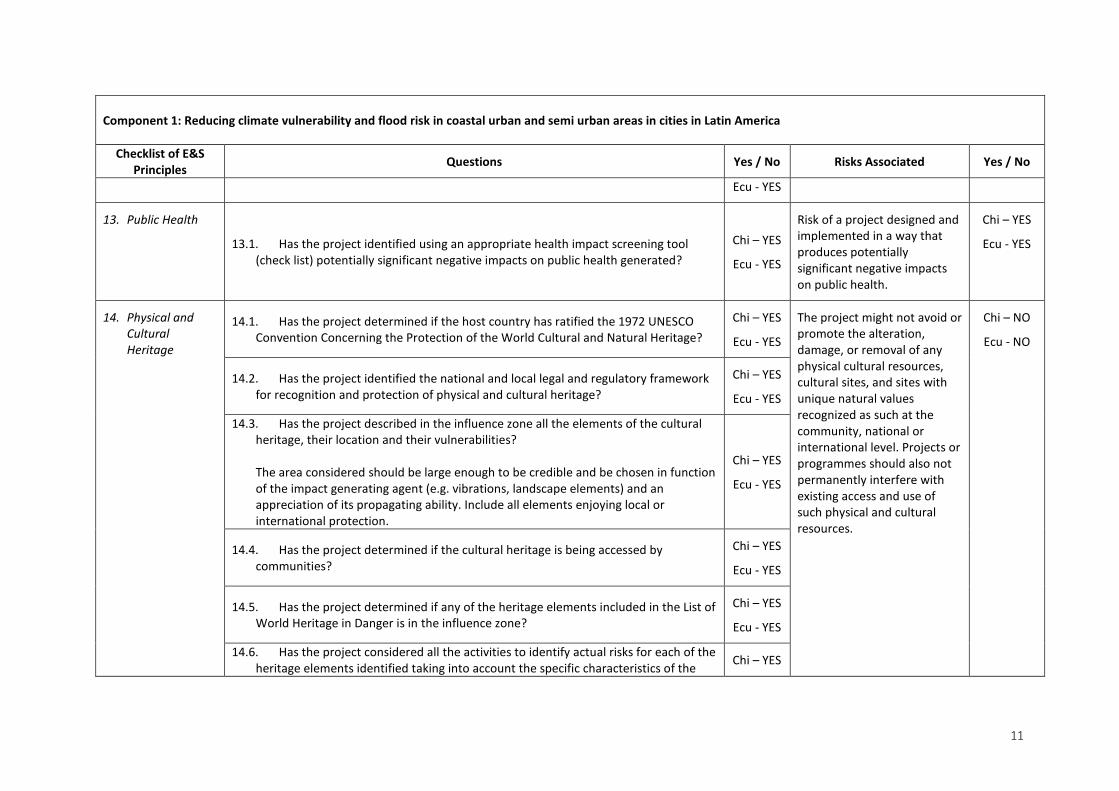
11
Component 1: Reducing climate vulnerability and flood risk in coastal urban and semi urban areas in cities in Latin America
Checklist of E&S Principles Questions Yes / No Risks Associated Yes / No
Ecu - YES
13. Public Health
13.1. Has the project identified using an appropriate health impact screening tool (check list) potentially significant negative impacts on public health generated?
Chi – YES
Ecu - YES
Risk of a project designed and implemented in a way that produces potentially significant negative impacts on public health.
Chi – YES
Ecu - YES
14. Physical and Cultural Heritage
14.1. Has the project determined if the host country has ratified the 1972 UNESCO Convention Concerning the Protection of the World Cultural and Natural Heritage?
Chi – YES
Ecu - YES
The project might not avoid or promote the alteration, damage, or removal of any physical cultural resources, cultural sites, and sites with unique natural values recognized as such at the community, national or international level. Projects or programmes should also not permanently interfere with existing access and use of such physical and cultural resources.
Chi – NO
Ecu - NO
14.2. Has the project identified the national and local legal and regulatory framework for recognition and protection of physical and cultural heritage?
Chi – YES
Ecu - YES
14.3. Has the project described in the influence zone all the elements of the cultural heritage, their location and their vulnerabilities? The area considered should be large enough to be credible and be chosen in function of the impact generating agent (e.g. vibrations, landscape elements) and an appreciation of its propagating ability. Include all elements enjoying local or international protection.
Chi – YES
Ecu - YES
14.4. Has the project determined if the cultural heritage is being accessed by communities?
Chi – YES
Ecu - YES
14.5. Has the project determined if any of the heritage elements included in the List of World Heritage in Danger is in the influence zone?
Chi – YES
Ecu - YES
14.6. Has the project considered all the activities to identify actual risks for each of the heritage elements identified taking into account the specific characteristics of the Chi – YES

12
Component 1: Reducing climate vulnerability and flood risk in coastal urban and semi urban areas in cities in Latin America
Checklist of E&S Principles Questions Yes / No Risks Associated Yes / No
activity (location, dimension, duration etc.) and the vulnerability mechanism(s) of each heritage element identified?
Ecu - YES
15. Lands and Soil Conservation 15.1. Has the project identified the presence of fragile soils within the influence area?
Chi – YES
Ecu - YES
The project might not promote soil conservation and avoid degradation or conversion of productive lands / land that provides valuable ecosystem services.
Chi – NO
Ecu - NO
15.2. Has the project identified activities that could result in the loss of otherwise non-fragile soil?
Chi – NO
Ecu - NO
15.3. Has the project identified productive lands and/or lands that provide valuable ecosystem services within the influence area?
Chi – NO
Ecu - NO
15.4. Has the project identified activities that may lead to land degradation? Chi – NO
Ecu - NO
The common elements of the unidentified sub-projects (USP) are screened using the risk identification matrix as part of the compliance with the AF´s USP. Also, a USP general mechanism to be follow by the EE during the execution phase and monitoring arrangements are part of this Annex, for a full compliance with the ESP for all the activities of the project.
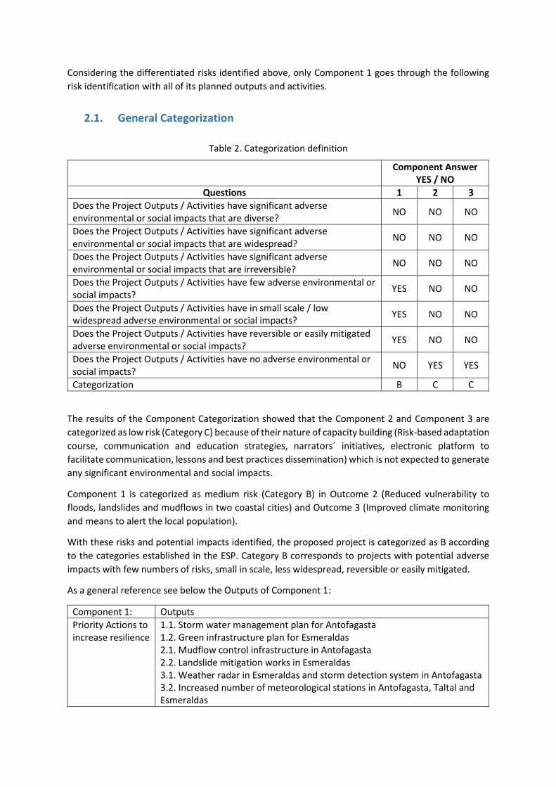
Considering the differentiated risks identified above, only Component 1 goes through the following risk identification with all of its planned outputs and activities.
2.1. General Categorization
Table 2. Categorization definition
Component Answer YES / NO
Questions 1 2 3 Does the Project Outputs / Activities have significant adverse environmental or social impacts that are diverse? NO NO NO
Does the Project Outputs / Activities have significant adverse environmental or social impacts that are widespread? NO NO NO
Does the Project Outputs / Activities have significant adverse environmental or social impacts that are irreversible? NO NO NO
Does the Project Outputs / Activities have few adverse environmental or social impacts? YES NO NO
Does the Project Outputs / Activities have in small scale / low widespread adverse environmental or social impacts? YES NO NO
Does the Project Outputs / Activities have reversible or easily mitigated adverse environmental or social impacts? YES NO NO
Does the Project Outputs / Activities have no adverse environmental or social impacts? NO YES YES
Categorization B C C
The results of the Component Categorization showed that the Component 2 and Component 3 are categorized as low risk (Category C) because of their nature of capacity building (Risk-based adaptation course, communication and education strategies, narrators´ initiatives, electronic platform to facilitate communication, lessons and best practices dissemination) which is not expected to generate any significant environmental and social impacts.
Component 1 is categorized as medium risk (Category B) in Outcome 2 (Reduced vulnerability to floods, landslides and mudflows in two coastal cities) and Outcome 3 (Improved climate monitoring and means to alert the local population).
With these risks and potential impacts identified, the proposed project is categorized as B according to the categories established in the ESP. Category B corresponds to projects with potential adverse impacts with few numbers of risks, small in scale, less widespread, reversible or easily mitigated.
As a general reference see below the Outputs of Component 1:
Component 1: Outputs Priority Actions to increase resilience
1.1. Storm water management plan for Antofagasta 1.2. Green infrastructure plan for Esmeraldas 2.1. Mudflow control infrastructure in Antofagasta 2.2. Landslide mitigation works in Esmeraldas 3.1. Weather radar in Esmeraldas and storm detection system in Antofagasta 3.2. Increased number of meteorological stations in Antofagasta, Taltal and Esmeraldas

14
4.1. Enhanced public warning system in Antofagasta and Taltal 4.2. Pilot flood warning system in Esmeraldas 4.3. Evacuation route maps and signals in Antofagasta, Taltal and Esmeraldas
After having the risk identification, it is important to assess the significance of the risk to valuate if it is necessary an ESIA or not. The combination of impact and probability is then used to determine the overall significance of the risk (Low, Moderate or High) Table 3 and Table 4.
Table 3. Significance of the risk A.
Table 4. Significance of the risk B.
Risk Description Impact and Probability (1-5)
Significance (Low, Moderate,
High) 1. The project could not comply with applicable domestic and
international law 1 4
2. The beneficiary might have unfair and/or unequitable access to project benefits created. 1 2
3. The project might impede an access to basic health services, clean water and sanitation, energy, education, housing, safe and decent working conditions, and land rights.
2 4
4. The project might not promote and respect international human rights. 1 1
5. Risk of not meeting the core labour standards as identified by the International Labour Organization (ILO). 1 1
6. Risk of inconsistency of the project with the rights and responsibilities set forth in the UN Declaration on the Rights of Indigenous Peoples and other applicable international instruments relating to indigenous peoples.
1 1
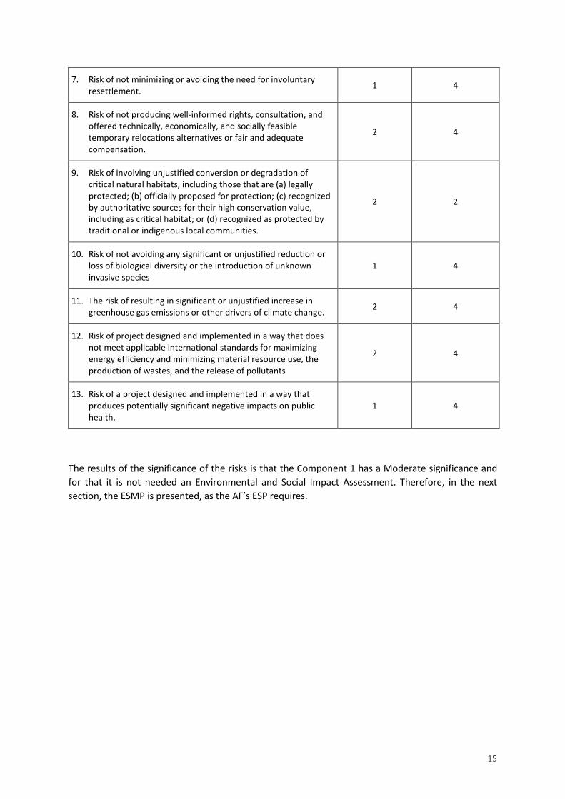
15
7. Risk of not minimizing or avoiding the need for involuntary resettlement. 1 4
8. Risk of not producing well-informed rights, consultation, and offered technically, economically, and socially feasible temporary relocations alternatives or fair and adequate compensation.
2 4
9. Risk of involving unjustified conversion or degradation of critical natural habitats, including those that are (a) legally protected; (b) officially proposed for protection; (c) recognized by authoritative sources for their high conservation value, including as critical habitat; or (d) recognized as protected by traditional or indigenous local communities.
2 2
10. Risk of not avoiding any significant or unjustified reduction or loss of biological diversity or the introduction of unknown invasive species
1 4
11. The risk of resulting in significant or unjustified increase in greenhouse gas emissions or other drivers of climate change. 2 4
12. Risk of project designed and implemented in a way that does not meet applicable international standards for maximizing energy efficiency and minimizing material resource use, the production of wastes, and the release of pollutants
2 4
13. Risk of a project designed and implemented in a way that produces potentially significant negative impacts on public health.
1 4
The results of the significance of the risks is that the Component 1 has a Moderate significance and for that it is not needed an Environmental and Social Impact Assessment. Therefore, in the next section, the ESMP is presented, as the AF’s ESP requires.
16
2. Environmental and social management plan (ESMP)
This plan consists of two stages that will be implemented during project execution:
1. Environmental and social mitigation program, in which specific measures are established to prevent and/or mitigate adverse environmental impacts and risks.
2. Monitoring, assessment and oversight program, which details the process of monitoring and evaluating implementation arrangements in compliance with ESP including grievance mechanism.
The development of these two programs is presented in the following sections.
2.1. Environmental and social mitigation program
Throughout the entire project, a comprehensive Environmental and Social Management Plan has been developed that includes specific measures to prevent and mitigate adverse environmental and social impacts and risks identified from the risk screening process. In the following section, Planned mitigation measures are presented according to respective risks identified above, with specified information on a body responsible for carrying out and verifying these mitigation measures. The ESMP was done only for Component 1, as Component 2 and Component 3 present a Categorization C.

17
Table 5. Mitigation measures for management of environmental and social impacts and risks.
Component 1.
Identified risks/impacts Environmental and Social principles Planned mitigation measure Responsible for Verification
Non-compliance with the laws and other administrative orders of national and state Government in Chile and Ecuador.
Principle 1: Compliance with the Law.
Interventions in both countries will comply with technical standards, environmental permits and construction code regulations. Related with the Ecuador output “Landslide mitigation infrastructure in Cerro Gatazo – Esmeraldas” the project will follow the rules to obtain the SUIA Environmental Registry in accordance with the Environmental Management Law (Law 37 of 1999, coded in 2004) and all the processwill be manage through an environmental impact evaluation system (Ministerial Agreement 061 of 2015) and complementary regulations.. Related with the Chile output “Mudflow control infrastructure in Quebrada Bonilla”, the project will follow the rules to obtain the Environmental Impact Declaration (DIA) in accordance with the Environmental Law (Law 19,3001) amended by Law 20,417 of 20102, and Supreme Decree 40/2012 3of 2012 (regulation for the environmental impact assessment system). Article 10 of Law 19,300.
GAD of Esmeraldas and MTOP The EE before the contracting process will assure with the Project Unit that all permits has been obtain. This risk shall be monitored before and during the implementation of the activities by the IE.
Interruption of the access to basic services due to the mobilization of materials using trucks for the
Principle 2: Access and Equity
Implementation of the activities related with the Landslide mitigation infrastructure in Cerro Gatazo - Ecuador, the Operational contractor shall:
The EE before the contracting process and during the implementation with the Project Unit of the Gatazo
1 http://bcn.cl/1uywi 2 http://bcn.cl/1vze7 3 http://bcn.cl/1uvqa
18
Component 1.
Identified risks/impacts Environmental and Social principles Planned mitigation measure Responsible for Verification
intervention in Cerro Gatazo - Ecuador.
Principle 3: Marginalized and Vulnerable Groups.
• Identify the vulnerable groups in the area of influence before the implementation of the project and organize a consultation meeting with the direct beneficiaries and affected groups.
• Receive complaints, inquires, suggestions from beneficiaries and communities involved during the consultancy process and if needed by the grievance mechanism.
• If there is any form of interruption of the basic services caused such as water shortage or energy disruptions, the operational contractor team shall make communication to the community affected.
• The operational contractor team shall be responsible for the coordination action related with traffic and temporary closure of traffic. In accordance with communities, routes and schedules of access to the Gatazo operational area can be planned.
• Fences or barriers and pedestrian pathways are required to be installed.
works will assure the achievement of all planned mitigation measures. This risk shall be monitored before the implementation of the activities concerning Component 1 essentially but also Component 2 and Component 3.
Violation of the international human rights in Ecuador or Chile
Principle 4: Human Rights
The IE and EE shall promote human rights in the project by: • Creating awareness among all involved stakeholders
and implementing entities in the project operations, including design, execution, monitoring, and evaluation, about the Universal Declaration of Human Rights as an overarching principle in the implementation of Component 2. Strengthen capacities for adaptation.
• Human rights issues shall be addressed with recognition during consultation meetings with local populations in the implementation process.
• During the implementation process, concerns on the marginalized and vulnerable groups have to be
The EE before the contracting process will assure with the Project Unit that all requirements in terms of human rights are fulfilled as a safeguard. This risk shall be monitored before and during the implementation of the activities that concern Component 1 essentially but also Component 2 and Component 3.

19
Component 1.
Identified risks/impacts Environmental and Social principles Planned mitigation measure Responsible for Verification
addressed in the USPs risk identification and impact assessment.
• All contractors in Chile and Ecuador must comply with human rights declaration.
Ignore or neglect the core labour standards as identified by the International Labour Organization (ILO) in Ecuador or Chile
Principle 6: Core Labour Rights Principle xx: Health
The operational contractor team in Chile and Ecuador shall be formed responsible for the control of all project related to core labour standards and will: TODO ESTO TIENE RELACIÓN CON HEALTH?? • Consider the identified hazards including those that
may originate from outside the workplace that are capable of adversely affecting the health and safety of persons under the control of the organization within the workplace.
• Applied control related to risk assessment • Follow an accident investigation form. • Recognize extra hours of work, in compliance with the
labour regulation of each country. • Be aware of the equipment that the workers use during
the infrastructure works. • Take into consideration the medical care emergency kit
at the infrastructure works. • Keep in mind the medical check provided at the
beginning of the works. • Construction workers must also be provided with
identification tags. • Comply with the national legislation – Labour Codes of
Ecuador and Chile • Ensure that employment procedures/ policy of the
operational contractor is communicated to local stakeholders.
• The intention of giving preferential employment to locals is clearly communicated, to discourage an influx of job-seekers from other areas.
The EE before the contracting process will assure with the Project Unit that all requirements in terms of human rights are satisfied as a safeguard. This risk shall be monitored before and during the implementation of the activities that concern Component 1 essentially but also Component 2 and Component 3.

20
Component 1.
Identified risks/impacts Environmental and Social principles Planned mitigation measure Responsible for Verification
The Project may have a risk of indigenous people being inadequately informed and engaged to access the range of project benefits in Ecuador.
Principle 7: Indigenous Rights Principle 2: Access and Equity
To ensure the participation and equitable access of indigenous communities to project benefits, the operational contractor has to: • Ensure that Outcome 4.2. Pilot flood warning system in
Esmeraldas and Outcome 4.3. Evacuation route maps and signals in Esmeraldas are adequately understood by the Chachi community.
• Guarantee local expertise is used for project implementation of Component 2 more specifically in Output 6.2 Narrators´ initiative initiated.
• Include culturally sensitive criteria in the screening process of Outcome 4.2 and 4.3.
The EE before the contracting process will assure with the Project Unit that all requirements in terms of indigenous groups are fulfilled as a safeguard. This risk shall be monitored before and during the implementation of the activities related to weather system devices / instruments localization and communication of Early Alert System (maps signs)
Potentially involves temporary physical displacement in Ecuador – Esmeraldas – 20 Noviembre Neighbors
Principle 8: Involuntary Resettlement Principle 4: Human Rights Principle 2: Access and Equity Principle 3: Marginalized and Vulnerable Groups.
To avoid or minimize the need for involuntary resettlement of community, the operational contractor has to: • Be aware that the project funded by the Fund shall be
designed and implemented in a way that avoids or minimizes the need for involuntary resettlement.
• Develop a Procedure plan for Possible Resettlements in agreement with the GAD of Esmeraldas.
• Design a technically, economically and socially feasible resettlement option.
• Provide fair and adequate compensation as an alternative for housing.
• Fully communicate and consult the Procedure Plan for Possible Resettlements with the beneficiaries and possible affected community for the implementation of the works developed in Cerro Gatazo.
The EE before the contracting process will assure with the Project Unit that all requirements in terms of displacement / resettlement are achieved. This risk shall be monitored before the implementation of the activities related Cerro Gatazo works.

21
Component 1.
Identified risks/impacts Environmental and Social principles Planned mitigation measure Responsible for Verification
Localization of the radars, meteorological stations, storm detection system are not precisely defined at the moment of the design of the project and there’s a risk of locating them in protected areas or high value conservation areas
Principle 9: Protection of Natural Habitats
To ensure that none of the weather system devices / instruments will not affect protected areas or high value conservation areas, the operational contractor for these activities shall: • Assure that relevant stakeholders in Ecuador (INMAHI,
MAE and GADE Esmeraldas) participate in the decision of the weather´s system devices localization in accordance with the national and regional legislation. Avoiding protected areas or high value conservation areas and its surrounding.
• Assure that relevant stakeholders in Chile (Chilean Meteorological Office, MMA and Antofagasta municipality) participate in the decision of the weather´s system devices placed in accordance with the national and regional legislation. Avoiding protected areas or high value conservation areas and its surrounding.
The EE before the contracting process will assure with the Project Unit that all requirements in terms of displacement / resettlement are achieved. This risk shall be monitored before the implementation of the activity related to weather system devices / instruments localization.
The project for slope stabilization in Cerro Gatazo may have a risk of introduction of non-endemic species.
Principle 10: Conservation of Biological Diversity
To ensure that the species that will be used during the stabilization process in Cerro Gatazo will not cause the reduction or loss of biological diversity or the introduction of known invasive species, the consultant for the implementation of Output 1.2. Green infrastructure plan for Esmeraldas will: • Promote the use of endemic species. • Conduct an environmental impact assessment If a non-
endemic species is promoted for the slope stabilization.
The MAE will accompany the process and endorse the Green infrastructure plan for Esmeraldas for implementation. The EE before the contracting process will assure with the Project Unit that all requirements in terms of displacement / resettlement are achieved. This risk shall be monitored before the implementation of the activity related to Landslide

22
Component 1.
Identified risks/impacts Environmental and Social principles Planned mitigation measure Responsible for Verification
mitigation works in Esmeraldas.
Antofagasta mudflow protection works it is inevitable to use concrete considering it does not exist until know other different type of design for this type of infrastructure in the deserts. There is a minimum risk of increment of emissions produced during implementation activities for this output.
Principle 11: Climate Change Principle 12: Pollution Prevention and Resource Efficiency
To ensure that there will not be an exacerbation of greenhouse gas emission during the implementation of the output 2.1. Mudflow control infrastructure in Antofagasta, the operational contractor shall monitor GHG produced by: • Transport of materials • Materials used The designs for the mudflow control infrastructure shall present a possible carbon footprint expected to be generated during its implementation. If there are alerts of exacerbation of GHG emissions, the operational contractor shall change a type of fuel used.
The EE before the contracting process will assure with the Project Unit that all requirements in terms of GHG emissions are mitigate in a complete manner. This risk shall be monitored before and during the implementation of the activity related to Mudflow control infrastructure in Antofagasta.
The Generation of wastes and pollutants during the implementation of Mudflow control infrastructure imply an environmental risk.
Principle 12: Pollution Prevention and Resource Efficiency Principle 11: Climate Change
To avoid an exacerbation pollution and over consumption of water and energy during the implementation of the output 2.1. Mudflow control infrastructure in Antofagasta, the operational contractor shall implement a monitoring plan to control: • Water consumption. • Fuel consumption. • Type of fuel consumption • Raw material consumption. • Energy consumption. • Solid waste generation. • Wastewater / generation (quality of wastewater). • Construction waste / debris generation.
The EE before the contracting process will assure from the Project Unit the achievement of all requirements to be met in terms of pollutants and consumptions. This risk shall be monitored before and during the implementation of the activity related to Mudflow control infrastructure in Antofagasta.
There is a constant risk of collapse, especially during the period of construction
Principle 13: Public Health
The operational contractor team in Chile and Ecuador shall be formed responsible for the control of all project related to Public Health and will:
23
Component 1.
Identified risks/impacts Environmental and Social principles Planned mitigation measure Responsible for Verification
and in case of disasters such as heavy rains and earthquake.
Principle 6: Core Labour Rights Principle 3: Marginalized and Vulnerable Groups.
• Develop an Occupational Health and Safety
Management Protocol. • Consider the routine and non-routine activities of the
organization to be sure all of them are coordinated. • Beware how all persons accessing the work place
including contractors and visitors (clothing, signals, helmets, etc.).
• Bear in mind the human behavior, capabilities and other human factors that could increment the potential failure of structural elements of the Project.
• Take into consideration how the operational contractor control threats created near the workplace during work -related activities.
• Keep in mind how the infrastructure, equipment and materials at the workplace affects construction works.
• Consider how the organization identifies changes or proposed changes to its activities or materials it uses.
• Consider how modifications to the OH&S protocol / system, whether they be temporary or not, impact on the operations, processes and activities of the organization.
• Consider how the project identified legal requirements for health and safety of persons beyond the immediate workplace, including those who are exposed to the workplace activities.
• Consider the effects of the design of work areas, processes, installations, machinery/equipment, operating procedures and work project, including their adaptation to human capabilities.

24
2.2. Environmental and Social Risk Identification Mechanism
As it was previously mentioned in the Proposal, during the formulation of the project, it was not possible to fully define the activities and their associated risks corresponding to the Component 1.
As part of the ESMP, it is required that all designed activities pass through the environmental and social risk screening process before implementation. Depending on the findings, a mitigation measure template should be presented and socialized.
The process for risk identification, mitigation measures and implementation is exactly as the one undertaken for the project during design phase. Activity and designs shall be screened in line with the Adaptation Fund’s ESP and Gender Policy. All risks identified will recognize different mitigation measures and responsible for compliance. Compliance Monitoring and Verification is required for all activities
The Process developed is presented in Figure 1. Risk identification – Mitigation Measures – Activity Implementation:

25
Figure 1. Risk identification – Mitigation Measures – Activity Implementation

26
Templates
The templates presented below are to be used for the risk identification of all adaptation unidentified sub-projects designed under the Component 1. Once the risk identification and mitigation measures templates are completed and verified by the Project Unit (Section II. A.), each operational contractor will communicate the results with beneficiary group and communities involved.
Executive Resume
NAME OF THE ACTIVITY:
Area on intervention:
Responsible of fulfilling the template - Local Technical Coordinator Check:
Management Coordinator Check:
Project Unit Check: Date:
Technical General Description of the Activity :
Fulfillment of the Risk Identification
Consultation with the community
Documentation – Evidence Base of Risk Identification
General / Relevant Mitigation Measures

27
Risk Identification template in Line with the AF’s ESP
Activity
Checklist of E&S Principles Questions YES / NO
1.Compliance with the law
1.1. Does the Project demonstrate any incompliance with any applicable international law? Has the project identified all the specific, applicable domestic and international laws, regulations, standards, procedures and permits that apply to any of its activities?
1.2. Has the project identified activities that may require prior permission (such as planning permission, environmental permits, construction permits, permits for water extraction, emissions, and use or production or storage of harmful substances)
1.3. Has the project identified environmental and social safeguarding requirements, other than those of the AF (e.g. national or of co-financing entities). Use the appropriate screening tools, including any threshold lists and sectorial requirements?
1.4. Has the project identified technical or industry standards that apply to any of its activities?
2. Access and Equity
2.1. Has the project identified benefits and its geographical area of effect?
2.2. Has the project identified any marginalized or vulnerable groups among potential project beneficiaries? (stakeholder mapping in order to identify the potential beneficiaries, rivals, disputants, marginalized or vulnerable people)
2.3. Has the project identified any existing inequities with respect to these marginalized or vulnerable groups?
2.4. Has the project identified the existing access to the essential services and rights indicated in the principle?
2.5. Has the project described the mechanism of allocating and distributing project benefits, and how this process ensures fair and impartial access to benefits?
2.6. Has the project developed stakeholder and local authorities’ consultations?
3. Marginalized and Vulnerable Groups
3.1. In the influence area of the project has there been identified the presence of marginalized or vulnerable groups, including but not limited to children, women and girls, the elderly, indigenous people, tribal groups, displaced people, refugees, people living with disabilities and people living with HIV/AIDS?
3.2. Has the project quantified all the groups identified using accepted methods based, where possible, on disaggregated data?
3.3. Has the project described the characteristics of any marginalized or vulnerable groups, identifying their particular vulnerabilities that would or could make them disproportionately vulnerable to negative environmental or social impacts caused by the implementation of the activities of the project?

28
Risk Identification template in Line with the AF’s ESP
Activity
Checklist of E&S Principles Questions YES / NO
4. Human Rights
4.1. Has the project evidenced if the host country is cited in any Human Rights Council Special Procedures, be they thematic or country mandates?
4.2. Has the project provided an overview of the relevant human rights issues that are identified in the Special Procedures?
4.3. Has the project include human rights issues in stakeholder consultations during project identification and/or formulation?
4.4. Has the project included the findings of the consultations on human rights issues in the project document?
5. Gender Equity and Women’s Empowerment
5.1. Has the project identified activities that are known to exclude or hamper a gender group based on legal, regulatory or customary grounds?
5.2. Has the project conduct or consult a gender analysis of the supported sector / area, describing the current situation of the allocation of roles and responsibilities in sector or area?
5.3. Has the project identified elements that maintain or exacerbate gender inequality or the consequences of gender inequality?
5.4. Has the project identified particular vulnerabilities of men and women that would or could make them disproportionately vulnerable to negative environmental or social impacts caused by the outputs / activities of the project?
6. Core Labour Rights
6.1. Has the project determined if the host country has ratified the eight ILO core conventions
6.2. Has the project reviewed the latest ILO assessments of application of the standards in the country?
6.3. Has the project identified any past/present/planned ILO assistance to meet the standards through social dialogue and technical assistance?
6.4. Has the project identified information on any ILO Special procedures relevant to the Member nation including details on the triggering representation or complaints
6.5. Has the project identified how the ILO core labour standards are incorporated in the design and the implementation of the outputs / activities’ project?
6.6. Has the project describe the common labour arrangements in the sector(s) in which the project will operate, with particular attention to all forms of child labour and forced labour.
7. Indigenous Peoples
7.1. Has the project identified if indigenous peoples are present in the area of influence?
7.2. Has the project quantify the groups identified of indigenous peoples?
29
Risk Identification template in Line with the AF’s ESP
Activity
Checklist of E&S Principles Questions YES / NO
7.3. Has the project determined if there are provisions for a realistic and effective Free, Prior, Informed Consent process, giving a community the right to give or withhold its consent to proposed projects that may affect the lands they customarily own, occupy or otherwise use?
7.4. Has the project provided a summary of any reports, specific cases, or complaints that have been made with respect to the rights of indigenous peoples by the Special Rapporteur on the rights of indigenous peoples and that are relevant to the project?
8. Involuntary Resettlement
8.1. Has the project identified if physical or economic displacement is required or will occur as a consequence of its implementation?
8.2. Has the project determined if it is voluntary or involuntary resettlement?
8.3. Has the project identified stakeholders whose livelihoods may be affected, directly or indirectly, and if this may lead to resettlement?
8.4. Has the project identified stakeholders whose assets or access to assets may be affected, directly or indirectly, and if this may lead to resettlement and its consequences including indemnification, compensation, etc.
9. Protection of Natural Habitats
9.1. Has the project identified all the critical natural habitats in the region that may be affected? The area considered should be large enough to be credible and be chosen in function of the impact generating agent (e.g. noise) and an appreciation of its propagating ability. The habitats to be considered include all those recognized as critical in any way, be it legally (through protection), scientifically or socially.
9.2. Has the project identified for each critical natural habitat, the mechanism by which it is particularly vulnerable?
9.3. Has the project considered all the activities to identify actual risks for each of the natural habitats identified taking into account the specific characteristics of the activity (location, dimension, duration etc.) and the vulnerability mechanism(s) of each habitat identified.
10. Conservation of Biological Diversity.
10.1. Has the project identified all the elements of biodiversity interest in the region that may be affected? The area considered should be large enough to be credible and be chosen in function of the impact generating agent and an appreciation of its propagating ability. It is important in the identification of the elements of biodiversity interests not to limit this to the species level but to include all elements of biodiversity interest, including landscapes, ecosystem processes, habitats, and hydrological cycles, processes of erosion and sedimentation and interactions between taxa. Include all elements enjoying local or international protection
10.2. For each identified biodiversity element, has the project identified the mechanism by which it is particularly vulnerable? (Changes in flow regime or water quality for a seasonal wetland or disruption of migration routes).

30
Risk Identification template in Line with the AF’s ESP
Activity
Checklist of E&S Principles Questions YES / NO
10.3. Has the project identified actual risks for each of the biodiversity elements identified taking into account the specific characteristics of the activity (location, dimension, duration etc.) and the vulnerability mechanism(s) of each biodiversity element identified?
10.4. Has the project identified the potential of introducing – intentionally or accidentally – known invasive species?
10.5. Has the project identified the use of living modified organisms resulting from modern biotechnology?
11. Climate Change
11.1. Has the project determined if it belongs to a sector mentioned in the Guidance document for which a greenhouse gasses emission calculation is required?
• Energy, transport, heavy industry, building materials, large-scale agriculture, large-scale forest products, and waste management.
11.2. Has the project carry out a qualitative risk identification for each of the following drivers of climate change:
• Emission of carbon dioxide gas from the use of fossil fuel and from changes in land use • methane and nitrous oxide emissions from agriculture • emission of hydrofluorocarbons • perfluorocarbons • sulphur hexafluoride • other halocarbons, aerosols, and ozone.
11.3. Has the project carry out a qualitative risk identification of any impact on carbon capture and sequestration capacity.
12. Pollution Prevention and Resource Efficiency
12.1. Has the project identified activities with preventable waste or pollution production?
12.2. Has the project determined the nature and quantity of the waste, as well as those of possible pollutants that may be produced?
12.3. Has the project determined if the concept of minimization of waste and pollution production has been applied in the design phase and if this will be effective during implementation?
12.4. Has the project determined if applicable local, national and international regulations regarding any waste and pollution generation have been applied and will be complied with?
12.5. Has the project determined if the concept of minimization of resource use has been applied in the design phase and if this will be effective during implementation?

31
Risk Identification template in Line with the AF’s ESP
Activity
Checklist of E&S Principles Questions YES / NO
12.6. Has the project determined where international standards for maximizing energy efficiency and minimizing material resource use may apply?
13. Public Health 13.1. Has the project identified using an appropriate health impact screening tool (check list) potentially significant negative impacts on public health generated?
14. Physical and Cultural Heritage
14.1. Has the project determined if the host country has ratified the 1972 UNESCO Convention Concerning the Protection of the World Cultural and Natural Heritage?
14.2. Has the project identified the national and local legal and regulatory framework for recognition and protection of physical and cultural heritage?
14.3. Has the project described in the influence zone all the elements of the cultural heritage, their location and their vulnerabilities? The area considered should be large enough to be credible and be chosen in function of the impact generating agent (e.g. vibrations, landscape elements) and an appreciation of its propagating ability. Include all elements enjoying local or international protection.
14.4. Has the project determined if the cultural heritage is being accessed by communities?
14.5. Has the project determined if any of the heritage elements included in the List of World Heritage in Danger is in the influence zone?
14.6. Has the project considered all the activities to identify actual risks for each of the heritage elements identified taking into account the specific characteristics of the activity (location, dimension, duration etc.) and the vulnerability mechanism(s) of each heritage element identified?
15. Lands and Soil Conservation
15.1. Has the project identified the presence of fragile soils within the influence area?
15.2. Has the project identified activities that could result in the loss of otherwise non-fragile soil?
15.3. Has the project identified productive lands and/or lands that provide valuable ecosystem services within the influence area?
15.4. Has the project identified activities that may lead to land degradation?
32
Categorization of the Activity
Activity
Questions YES / NO
Does the Project Outputs / Activities have significant adverse environmental or social impacts that are diverse? Does the Project Outputs / Activities have significant adverse environmental or social impacts that are widespread? Does the Project Outputs / Activities have significant adverse environmental or social impacts that are irreversible? Does the Project Outputs / Activities have few adverse environmental or social impacts? Does the Project Outputs / Activities have in small scale / low widespread adverse environmental or social impacts? Does the Project Outputs / Activities have reversible or easily mitigated adverse environmental or social impacts? Does the Project Outputs / Activities have no adverse environmental or social impacts? Categorization of the Activity
Mitigation Measures
Activity: Area on intervention:
Responsible of fulfilling the template - Local Technical Coordinator Check:
Management Coordinator Check:
Project Unit Check: Date:
Environmental or social Principle Environmental or social risk Mitigation measure Responsible Verification Principle 1. Compliance with the Law
Risk 1. Risk 2.
Mitigation measure 1. Mitigation measure 2. Mitigation measure 3. Mitigation measure 4.
Principle 2. Access and Equity Risk 1. Mitigation measure 1.

33
Mitigation Measures
Activity: Area on intervention:
Responsible of fulfilling the template - Local Technical Coordinator Check:
Management Coordinator Check:
Project Unit Check: Date:
Environmental or social Principle Environmental or social risk Mitigation measure Responsible Verification Risk 2. Mitigation measure 2.
Mitigation measure 3. Mitigation measure 4.
Principle 3. Marginalized and Vulnerable Groups
Risk 1. Risk 2.
Mitigation measure 1. Mitigation measure 2. Mitigation measure 3. Mitigation measure 4.
Principle 4. Human Rights Risk 1. Risk 2.
Mitigation measure 1. Mitigation measure 2. Mitigation measure 3. Mitigation measure 4.
Principle 5. Gender Equality and Women’s Empowerment
Risk 1. Risk 2.
Mitigation measure 1. Mitigation measure 2. Mitigation measure 3. Mitigation measure 4.
Principle 6. Gender Equality and Women’s Empowerment
Risk 1. Risk 2.
Mitigation measure 1. Mitigation measure 2. Mitigation measure 3. Mitigation measure 4.
Principle 7. Indigenous Peoples Risk 1. Risk 2.
Mitigation measure 1. Mitigation measure 2. Mitigation measure 3. Mitigation measure 4.
Principle 8. Involuntary Resettlement.
Risk 1. Risk 2.
Mitigation measure 1. Mitigation measure 2.
34
Mitigation Measures
Activity: Area on intervention:
Responsible of fulfilling the template - Local Technical Coordinator Check:
Management Coordinator Check:
Project Unit Check: Date:
Environmental or social Principle Environmental or social risk Mitigation measure Responsible Verification Mitigation measure 3. Mitigation measure 4.
Principle 9. Protection of Natural Habitats
Risk 1. Risk 2.
Mitigation measure 1. Mitigation measure 2. Mitigation measure 3. Mitigation measure 4.
Principle 10. Conservation of Biological Diversity
Risk 1. Risk 2.
Mitigation measure 1. Mitigation measure 2. Mitigation measure 3. Mitigation measure 4.
Principle 11. Climate Change Risk 1. Risk 2.
Mitigation measure 1. Mitigation measure 2. Mitigation measure 3. Mitigation measure 4.
Principle 12. Pollution Prevention and Resource Efficiency
Risk 1. Risk 2.
Mitigation measure 1. Mitigation measure 2. Mitigation measure 3. Mitigation measure 4.
Principle 13. Public Health Risk 1. Risk 2.
Mitigation measure 1. Mitigation measure 2. Mitigation measure 3. Mitigation measure 4.
Principle 14. Physical and Cultural Heritage
Risk 1. Risk 2.
Mitigation measure 1. Mitigation measure 2. Mitigation measure 3.

35
Mitigation Measures
Activity: Area on intervention:
Responsible of fulfilling the template - Local Technical Coordinator Check:
Management Coordinator Check:
Project Unit Check: Date:
Environmental or social Principle Environmental or social risk Mitigation measure Responsible Verification Mitigation measure 4.
Principle 15. Lands and Soil Conservation
Risk 1. Risk 2.
Mitigation measure 1. Mitigation measure 2. Mitigation measure 3. Mitigation measure 4.

36
2.3. Grievance mechanism
Response to petitions, complaints, and claims In order to respond adequately and effectively to petitions, complaints, or claims that may arise in any stage of the project cycle, a mechanism should be designed that allows effective and rapid response to the needs. All the population should be informed of this mechanism regarding how to present a petition, complaint, or claim, and on the time and manner in which they will receive a response. The planned mechanism should be presented and communicated among the local population with transparency and privacy if required.
Periodically, the results of the cases addressed should be disseminated, and this information will also be used as a feedback to improve the project's practice.
Principal agents of complaints
Beneficiaries, organizations affected by the project activities can complain. Complainants do not need to be directly affected by the project decision, action and are not required to identify the applicable rule, regulation or policy that may have been breached.
Subject of complaints
Complaints can be made regarding actions or decisions that stakeholders identify the project has carried out incorrectly, unfairly or unlawfully. These may concern:
• The social and environmental impacts of a project; • Arrangements for involvement of affected communities, minorities and vulnerable groups; • Project implementation; • Access to information; • Procurement procedures; • Human rights issues;
Complaints can be lodged, by letter or email addressing the Project Management Unit – Director (to be confirmed by the email). Complainants need to identify themselves, clearly state the subject of the complaint and what complainer expects to achieve. The complainant should provide as much detailed and relevant information as possible about the complaint. Complaints must be lodged within one year from the date on which the facts upon which the allegation is grounded could be reasonably known by the complainant. In the case of complaints concerning access to information, a complaint must be taken within 30 working days from the date of the reception which is the subject of the complaint. In order to ensure the protection of agents of complaints, all complaints should be treated confidentially.
The contact information of the Adaptation Fund will also be publicized (i.e. project website, facebook and mailbox) for the public to directly address concerns regarding the project:
37
Adaptation Fund Board secretariat Mail stop: MSN P-4-400 1818 H Street NW Washington DC 20433 USA Tel: 001-202-478-7347 [email protected]
Resolution of conflicts
It is necessary to define a mechanism for the resolution of conflicts that may emerge during any stage of the project. Mechanisms that exist in the area or country where the project is developed may be used, ensuring impartiality and efficiency in their resolution. Social actors must be informed about the existence of said mechanisms and the way to access them, if required. Using these mechanisms must not imply any cost for the person who decides to use it. To access these mechanisms, an individual must prove that a petition, complaint or claim was presented to the Proponent through a mechanism designed for that purpose, and the individual did not receive a response, or the response was not satisfactory according to the person's arguments.
The grievances and complaints mechanism is summarized in Figure 1. The process starts with the submission of a grievance/complaint) and continues with the consultation and verification of enforcement.
Before the implementation of the project, the grievances system document will be updated according to an actual contact point to address the needs (e.g., contact information in Chile and Ecuador) and translated into the local language, Spanish. Furthermore, the project website will be developed archiving the information on (i) a brief explanation of the grievances and complaints system, (ii) the contacts to file a grievance/complaint, and (iii) the grievances and complaints system document.
38
3. Monitoring, evaluation and oversight program
Before the implementation of the project, a “Manual of Social and Environmental Safeguards Implementation” will be developed to have protocols with specific indicators, means of verification and responsible for the implementation of the mitigation measures These protocols will be validated with the main partners involved in the project’s implementation. Additionally, a training workshop aimed at the members of the project unit and project partners will be carried out for the implementation of this manual. CAF will give technical support for the manual elaboration and the operation of training workshop.
Figure 2. Grievances and complaints reception mechanism. G/C = Grievance/Complaint - GMC = Grievances Management Committee - D-DMA = Environmental and Climate Change Division Director
39
3.1. Unidentified Sub-Project (USP) intervention mechanism
During the project´s design a special procedure, to manage impacts and risks for the unidentified sub-projects and activities, has been developed. There is a possibility that adverse environmental and social risks that were not foreseen during the project design are identified during the implementation. In order to anticipate future issues, during the preparation of the annual operation plans, the Project Unit will identify potential environmental and social risks associated to each of the activities planned for the year and will program mitigation measures accordingly, as well as the budget required for their implementation. This analysis will be made applying the same methodology used in this project to identify impacts and risks of other activities and considering the environmental and social principles applicable to the present project
The Project Manager (EE) will be responsible for reporting the IE every six months, the progress made on implementing these measures. Additionally, during quarterly meetings organized to monitor the progress on the implementation of annual operation plan, the Project Manager will report any possible environmental or social risk that has arisen and was not previously identified during the preparation of the annual operation plan. The Project Manager will be responsible for update of the ESMP every time unforeseen impacts and risks are identified. This will allow timely and appropriate actions taken to prevent any possible environmental or social impact.
The IE will designate an officer responsible for overviewing the compliance of the proposed provision in the annual operation plans. In the case of infrastructure works in Antofagasta and Esmeraldas, the IE and the EE through the Project Manager will closely coordinate to ensure the compliance of the outlined conditions.

40
4. Annex
4.1. Applicable domestic and international laws that apply
Ecuador Chile 2030 Agenda for Sustainable Development YES YES Article 2 of the UN Framework Convention on Climate Change (UNFCCC) YES YES Cartagena protocol on Biosafety YES YES Convention on Biological Diversity (CBD) YES YES Convention on the Elimination of All Forms of Discrimination against Women (CEDAW) YES YES Guidelines for National Greenhouse Gas Inventories (2006) YES YES Human Rights Council Special Procedures thematic mandates YES YES Human Rights Council Special Procedures country mandates YES YES ILO Declaration of Fundamental Principles and Rights at Work YES YES Intergovernmental Panel on Climate Change (IPCC) YES YES IUCN Red List of Threatened Species YES YES List of World Heritage in Danger YES YES Millennium Development Goals (MDGs) YES YES Ramsar sites inventory YES YES Report of the Special Rapporteur on the rights of indigenous peoples, James Anaya (The situation of indigenous peoples in Chile and Ecuador) YES YES
Special Rapporteur on the Rights of Indigenous Peoples (UN) YES YES Status of Ratification Interactive Dashboard (See Ecuador and Chile listing) YES YES Sustainable Development Goals (SDGs) YES YES UN Framework Convention on Climate Change (UNFCCC) (Article 2) YES YES
UNESCO Convention Concerning the Protection of the World Cultural and Natural Heritage, 1972 – article 1 and 2. See also: http://whc.unesco.org/en/statesparties/na - Namibia accepted the Convention in 2000. See also: List of World Heritage in Danger – article 11(4) of the Convention
YES YES
UNESCO Convention on Biological Diversity YES YES UNESCO Convention Concerning the Protection of the World Cultural and Natural Heritage – article 1 and 2 YES YES
UNESCO Man and the Biosphere Programme reserves list (Ecuador - Chile) YES YES Universal Declaration of Human Rights (UDHR) YES YES UN Declaration on the Rights of Indigenous Peoples (UNDRIP 2007) YES YES WHO Determinants of Health YES YES Sendai Framework for Disaster Risk Reduction 2015 – 2030. Hyogo Framework for Action 2005-2015 YES YES
Warsaw International Mechanism for Loss and Damage associated with Climate Change Impacts and article 8 of the Paris Agreement under the United Nations Framework Convention on Climate Change.
YES YES
National Laws and Regulations
41
National Constitutions Chile Political Constitution of the Republic of Chile; Constitution 1980.
Article 19.- The Constitution guarantees all persons: 8º.- The right to live in a pollution-free environment. It is the duty of the State to ensure that this right is not affected and to protect the preservation of nature. The law may establish specific restrictions on the exercise of certain rights or freedoms to protect the environment.
Ecuador Ecuadorian Constitution (2008): Article 414 mandates that the State shall take appropriate and transversal measures for climate change mitigation and protect populations at risk. Chapter Four establishes the rights of communities, peoples and nations. Specifically, in Article 57, the Constitution outlines the right of Afro and Indigenous populations to freely uphold, develop and strengthen their identity, ancestral traditions and forms of social organization Article 11 numeral 2, establishes: "The exercise of the rights will be governed by the following principles ... 2. All people are equal and enjoy the same rights, duties and opportunities. No one shall be discriminated against on grounds of [...] sex, gender identity ...; Nor by any other distinction, personal or collective, temporary or permanent, whose object or result is to impair or nullify the recognition, enjoyment or exercise of rights”.
National Development Plans Chile Chile of all (2014 – 2018)
Environmental management in a manner consistent with the importance of the challenge implied by the phenomenon of climate change. The Council of Ministers for Sustainability should be renamed "Council of Ministers for Sustainability and Climate Change". This body should develop, as quickly as possible, a new national climate change plan with a transversal and integrated vision, in adaptation, mitigation of impacts and capacity building, guiding the measures taken towards a low carbon economy that will benefit twice as much Chile: will contribute both to the reduction of greenhouse gas emissions and to the quality of the air we breathe in Chile and to the quality of life of Chileans.
Ecuador National Development Plan "A Lifetime" (2017 – 2020) establishes in Objective 3 - Guarantee the rights of nature for current and future generations that; It will encourage public investment to consolidate and expand the energy matrix based on renewable and non-conventional energies, with tariff schemes for incentives to the private and associative sectors. Promote good practices that contribute to the reduction of pollution, conservation, mitigation and adaptation to the effects of climate change, and promote them at the global level. Promote the urban and rural economy, based on the sustainable use and value aggregator of renewable resources, fostering social co-responsibility and the development of the bioeconomy.

42
Climate Change and Disaster Risk Management Policies Chile National Plan for Civil Protection (Decree 156 of 12 March 2002).
The National Policy for disaster risk management (ONEMI, 2014). National Adaptation Plan (MMA, 2014)
Ecuador The National Strategy for Climate Change (ENCC) (MAE, 2012) through Ministry Agreement 095. The GADs present their plans, programs and strategies for climate change to the national government for approval for incorporation into the national climate change plan
National Comprehensive Security Plan (MCS. 2014) Sectoral Agenda for Risks Management (SGR, 2014)
Gender Policies Chile Law Against Discrimination - Law Nº 20.609
The Ministry of Women and Gender Equity - Law Nº 20.820 Ecuador The National Policy Guidance on Protection and Guarantee of the Rights
of Women Victims of the Armed Conflict (CONPES 3784 of 2013) addresses the specific challenges that women victims of the armed conflict face. It is aimed to i) create or strengthen strategies of risk prevention and protection of women rights, guarantying no-repetition of rights violations, ii) promote the realization of women rights, and iii) strengthen institutional articulations and the number of social programmes benefiting women victims of the armed conflict.
Local and Territorial Chile Antofagasta´s Regional Plan for Infrastructure and Water Resources
Management to 2021 (MOP, 2012)
Antofagasta´s Communal Development Plan 2013 – 2022 (MdA, 2012) Taltal´s Communal Development Plan 2022 (MdT, 2015).
Ecuador Organic Code on Territorial Organization, Autonomy and Decentralization supports the strengthening of decentralized government organizations to promote equitable sustainable development with community participation and empowerment
Ministry Agreement 095: provides mechanisms for Decentralized Autonomous Governments to present to MAE their strategies, plans and projects Ministry Agreement 137: offers a guide to local institutions on how to incorporate climate change in local planning processes
Esmeraldas´ Municipal Development and Land Use Plan (GAD Esmeraldas, 2012a),
Esmeraldas´ Municipal Strategy for Risks and Disaster Management (GAD Esmeraldas, 2012b).
Esmeraldas´ Municipal Climate Change Adaptation and Mitigation Strategy (ONU-HABITAT, 2011).
Planning permission, environmental permits, construction permits, permits for water extraction, emissions, and use or production or storage of harmful substances Chile Environmental Law (Law 19,300 ) amended by Law 20,417 of 2010 , and Supreme
Decree 40/2012 of 2012 (regulation for the environmental impact assessment system).
Two types of environmental permits exist: Environmental Impact Study (EIA) and Environmental Impact Declaration (DIA)

43
An EIA applies to projects that may generate high-level impacts; article 11 of Law 19,300 establishes that a project with any of the following characteristics has to present an EIA: a) Risk to the health of the population, due to the quantity and quality of
effluent, emissions and waste. b) Significant adverse effects on the quantity and quality of renewable natural
resources, including soil, water and air. c) Resettlement of human communities, or significant alteration of the
systems of life and customs of human groups. d) Location at or near populations, resources and protected areas, priority
conservation sites, protected wetlands, glaciers, that may be affected, as well as the environmental value of the territory in which it is intended to deploy.
e) Significant change in terms of magnitude or duration, of the scenic or tourism value of an area.
f) Alteration of monuments, sites with anthropological, archaeological, historical value and, in general, belonging to the cultural heritage.
Projects included in the categories of article 10, but which do not have the characteristics listed in article 11, must present a DIA.
Ecuador Promulgation of Ecuadorian construction norm: Agreement Ministerial No. 0028 Environmental Management Law ((Ministerial Agreement 061 of 2015; Law 37 of 1999, coded in 2004),
Environmental impact evaluation system (Ministerial Agreement 061 of 2015) and complementary regulations. Article 14 of Ministerial Agreement 061 established two types of environmental permits: (i) Environmental Registry, and (ii) Environmental License.

232 I
APRUÉBASE el convenio deprogramación suscrito en la ciudadde Antofagasta, entre el GobiernoRegional de Antofagasta y elMinisterio de Obras Públicas (MOP),denominado "Mitigación deDesastres Aluvionales y Evacuaciónde Aguas Lluvias, Región deAntofagasta 2015 - 2020", por unmonto de $56.152 millones en unplazo de ejecución de seis años.
CRETO
TOS el inciso cuarto del articulo° de la Constitución Política de laública, en su texto refundido,rdinado y sistematizado, fijado por.S. N"100, de 2005, del Ministerioretaría General de la Presidencia,
articulo 81° de la Ley N"19.175,ánica Constitucional de Gobiernodministración Regional, cuyo textondido, coordinado, sistematizadoctualizado fue fijado mediante elL N"1-19.175, de 2005, delsterio del Interior,
ENTO N°
NTIAGO 27 JUL 2015
REF.: APRUEBA CONVENIO DEPROGRAMACiÓN ENTRE ELGOBIERNO REGIONAL DE
,TOFAGASTA y EL MINISTERIO DERAS PÚBLICAS.
06499/2015
MInisterio de Hacienda Al>''" ,;-, O 'O h'~ it 1 -' MINISTERIO DE HACIENl@E
MINISTERIO DE HACIEND~ 3OJUL 2015OFICINA DE PARTES
1 TALMENTE TRAMITADOHI::CI::PCIÓ" DOCUMENTO OFICIAL
SA
CONTRALORiA GENERALTOMA DE RAZON
RI::CEPC¡ÓN
D<P~ --JUR;QlCO EXCEP 1"
Y AEGl!omO -- --
D(P,UHC:ONTA!J14 -
-.... OCP
e UUl'1U.I.VI~
SU6 C<P 111.. CUENT-'S -
:>uo o¡,:p Ree.,
"'E~$UAC COI
OEPAi<r ell.:.uooeq,... -
OE:p·...'nSe
VOI'.U) T el
:;ve OLfOOr,
l.\lJt,;ICI¡> yl-- ref
- YiDF
REFRENDACION Mil
«[F POR s ... ".-_. ,.- ~__ •• N •
IMPOTAC - ..... -_._.ANal POR $ - - DEVdPl1TAC -. _ •• ' 'H
oc.ouc OTO,.. ,'-
-..' ,.-- I
- , _. J 1.
·'
SUBSECRETARIA OO. PP.OFICINA DE PARTES
FECHA 3 1 JUL 1015
PROCESO N' ~o¿o ~ q5
user
Typewritten Text
Annex 16.ARG-MOP agreement “mudflow disaster mitigation and evacuation of rainwater, Antofagasta Region 2015-2020”.
user
Typewritten Text
[a] Decree 232 of the Ministry of Finance of 27 July 2015
oMinisterio de Hacienda • 2
2. El total de las inversiones se financiarán en un 39,5% por el Gobierno Regional deAntofagasta y un 60,5% por el Ministerio de Obras Públicas, de acuerdo al siguientecalendario:
FINANCIAMIENTO DEL CONVENIO
Año GORE MOP Total2015 1.025.500 6.036.000 7.061.5002016 5.567.499 5.568.412 11.135.9112017 4.978.670 4.921.826 9.900.4962018 4.105.300 4.836.973 8.942.2732019 5.361.682 5.797.804 11.159.4862020 1.151.650 6.801.024 7.952.674Total 22.190.301 33.962.039 56.152.340
% 39,5 60,5 100,0
Miles de $
3. Estos montos están expresados en moneda de 2015 y son los máximos que secomprometen para cada año, sin perjuicio que se apliquen los procedimientos dereajustabilidad correspondientes. Asimismo, según las necesidades que sepresenten en la ejecución de los proyectos y las disponibilidades presupuestarias, laspartes podrán acordar la revisión de la programación y de los montos.
La ejecución de los proyectos de inversión, considerados en el convenio deprogramación que se aprueba, se efectuará con los recursos que cada año seconsidere, para las instituciones involucradas, en las respectivas leyes depresupuestos. Será responsabilidad de estas instituciones asignar prioritariamentesus recursos regulares para la ejecución del programa convenido.
4. La ejecución de los proyectos que forman parte de este convenio de programacióndeberá dar cumplimiento a lo dispuesto en los articulos 111 y 115 inciso cuarto de laConstitución Politica de la República de Chile, en los artículos 81, 24 letra e) y 36letra f) de la Ley N" 19.175 Orgánica Constitucional sobre Gobierno y AdministraciónRegional yen el arto 19 bis del D. L. N" 1.263, de 1975, que establece la Ley Orgánicade Administración Financiera del.Estado.,
5. El financiamiento consultado en el Convenio de Programación que se aprueba noimplica transferencia de fondos entre los suscriptores del mismo.
I

Ministerio de Hacienda • 3
ANÓTESE Y COMUNíQUESE
POR ORDEN DE LA PRESIDENTA DE LA REPÚBLICA
~¡>UBLlCA DE CHI{~<- ,
MINISTRO .'
~~RODRIGO VALD\ÉS PULIDO
Ministro de Hacienda
LO qUll~ a U¡;U)O para wco~·":::J~1'#&-a~
/j";,:.~~t,·:",,;.. . . yi,' :_.,.;-:;;¡,~;,'/I{L ¡;e,O .
" ·---·7I ~ .::.. ''';'':'':;' -·~lIl;¡r,(ld(O",~o""\1·Yo, ~..~
MAT: Convenio de Programación entre elMinisterio de Obras Públicas y elGobierno Regional de la Región deAntofagasta.
ORD: Nº 449 ! 161 !
INC: Original del Convenio deProgramación.
SANTIAGO, 24 JUN 2015
DE: DIRECTORA NACIONAL DE PlANEAMIENTO (S)
A: DIRECTOR DE PRESUPUESTOS - MINISTERIO DE HACIENDA
Adjunto un original del Convenio de Programación, "Mitigación de Desastres Aluvionales yEvacuación de Aguas lluvias, Región de Antofagasta 2015-2020", suscrito por el Sr. Ministrode Obras Públicas y el Sr. Intendente Regional de la Región de Antofagasta, para la confeccióndel Decreto aprobatorio correspondiente.
Además del texto del Convenio, se incluyen: Anexo 1 "Cuadro Detalle Proyectos de Inversióndel Convenio de Programación", y Anexo 2 "Acuerdo CORE Aprobación del Convenio deProgramación por parte del Consejo Regional de Antofagasta".
Saluda atentamente a usted,
6 ("7)1 /f i·1'1'1 ¡;lVU ti (r "O / t. .ARíA PíAROSS~t RDO
DIRECTORA NACIONAL DE PLANEAMIENTO (S)
t\~ frr'MPR!CBG/icvDISTRIBUCiÓN:- Sr. Director de Presupuestos - Ministerio de Hacienda- DIRPLAN 11 Región- Subdirección de Planificación Estratégica-DP.(2)- Oficina de Partes - DP.
W PfWGGJO •.lCJ..Lj.q0.:Q ....__._SUOOIHLCClon ["1 ... ;ti; Kft.IO¡¡ r::;íH,,"rr-:GICA
D f'IANr,'\M!CNTO._.....'"---'~~~_.~,-~~"-,~~-- .._,_......,~.--
user
Typewritten Text
user
Typewritten Text
[b] ARG - MOP agreement

, .
Ministerio de Obras Públicas
CONVENIO DE PROGRAMACION"MITIGACIÓN DE DESASTRES ALUVIONALES y EVACUACIÓN DE AGUAS
LLUVIAS, REGIÓN DE ANTOFAGASTA 2015 - 2020"
ENTRE
GOBIERNO REGIONAL DE ANTOFAGASTAy ,
MINISTERIO DE OBRAS PUBLICAS
En Antofagasta, a 22 de Mayo de 2015, el Gobierno Regional de la Región deAntofagasta, persona jurídica de derecho público, representado según se acreditarápor el Sr. Intendente de la Región de Antofagasta, don Valentín Volta Valencia,ambos domiciliados en la ciudad de Antofagasta, calle Arturo Prat N° 384, piso 2, enadelante "el Gobierno Regional", el Ministerio de Obras Públicas, representado por elSr. Ministro de Obras Públicas, don Alberto Undurraga Vicuña, ambos domiciliadosen la ciudad de Santiago, Calle Morandé NO 59, 6° piso, en adelante "el MOP",proceden a formalizar el siguiente Convenio de Programación.
PRIMERA.- De conformidad a lo dispuesto en el artículo 115 inciso 40 de laConstitución Política de la República, en su texto refundido, coordinado y sistematizadofijado por D.S. N°l00, de 2005, del Ministerio Secretaría General de la Presidencia y enel artículo 81 de la Ley NO 19.175 Orgánica Constitucional de Gobierno yAdministración Regional, en su texto refundido, coordinado y sistematizado fijado porD.f.L. N°20.035 de 2005, del Ministerio del Interior, los comparecientes vienen ensuscribir el Convenio de Programación "MITIGACIÓN DE DESASTRESALUVIONALES y EVACUACIÓN DE AGUAS LLUVIAS, REGIÓN DE ANTOFAGASTA2015 - 2020" con el objeto de unir esfuerzos, concretar acciones y coordinarinversiones relacionados con la mitigación de desastres, la seguridad, la integraciónsocial y la calidad de vida en las ciudades de la región.
El objetivo del Convenio es ampliar el porcentaje de avance de la ejecución del Plan deObras de Control Aluvional de Antofagasta, Taltal y Tocopilla, pasando de un 40,4% deCobertura del Caudal Máximo Líquido esperado para el conjunto de las 15 quebradascon riesgo urbano el año 2014, a un 82% de cobertura el año 2020; en el caso de laciudad de Taltal, se pasará de un 79,6% el año 2014, a un 100% el año 2020; yen laciudad de Tocopilla se pasará de un 81,8% de cobertura el año 2014, a un 100% decobertura el año 2020. El Plan igualmente incorpora el avance en la etapa de diseño dediversas obras de los Planes Maestros de Evacuación de Aguas Lluvias de las ciudadesde Antofagasta, Calama, San Pedro de Atacama, Sierra Gorda, entre otras obras.
Instructivo Ministerial de Convenios de programación Página 1

Ministerio de Obras Públicas
Se deja constancia que el Consejo Regional de la Región de Antofagasta aprobó lacelebración del presente Convenio, en ejercicio de ias facultades que le confiere elartículo 36, letra f) de la Ley NO 19.175, según consta en el compendio de Acuerdoscorrespondiente a la Sesión Ordinaria N°537 del Consejo, de fecha 15 de Mayo de2015, mediante Acuerdo N°12229-15, el que es parte integrante del presenteconvenio, junto con el listado de proyectos.
SEGUNDA.- De conformidad al artículo 16 de la Ley 19.175 antes citada, es funcióngeneral del Gobierno Regional entre otras, elaborar y aprobar las políticas, planes yprogramas de desarrollo de la Reglón, y en particular, definir y llevar a cabo lasmedidas para consolidar la infraestructura para la integración regional que establece laEstrategia de Desarrollo Regional de la Región de Antofagasta y el Plan Regional deInfraestructura y Gestión del Recurso Hídrico.
TERCERA.- El presente convenio tendrá una duración de 6 años. Su costo total seráde M$ 56.152.340 (Cincuenta y Seis mil ciento cincuenta y dos millonestrescientos cuarenta mil pesos), en moneda nacional del año 2015.
El financiamiento del convenio proviene en un 39,50/0, esto es M$ 22.190.301(Veinte y dos mil ciento noventa millones trecientos un mil pesos), de recursosdel Gobierno Regional de Antofagasta; en un 60,5%, esto es M$ 33.962.039(treinta y tres mil novecientos sesenta y dos millones treinta y nueve milpesos), de recursos del MOP.
CUARTA.- Para ejecutar el presente Convenio, cada una de las partes acepta concurrircon el financiamiento en la proporción y la calendarización que se detallan másadelante, siendo su fuente de financiamiento los recursos financieros de su asignaciónexclusiva, una vez dado cumplimiento al trámite de identificación previa a que hacenreferencia el Artículo 19 bis del Decreto Ley NO 1.263 de 1975 y a las leyes depresupuestos aprobadas para cada año de su vigencia.
En atención a lo dispuesto en la presente cláusula, los montos tanto regionales ysectoriales, señalados más adelante, se entienden como referenciales, preliminarese indicativos, incluyendo items de prefactibilidad, factibilidad, diseños de ingeniería,asesorías, expropiaciones y obras, y estarán sujetos a la identificación pormenorizadade los proyectos específicos de inversión a que se refiere este Convenio y que seincluyen en el Anexo 1 de este documento. Por esta razón las partes dejan constancia
\ \ ¡ue este convenio está referido a la coordinación en un tiempo y espacio determinadoJ re un conjunto de obras públicas.
Instructivo Ministerial de Convenios de Programación Página 2

Ministerio de Obras Públicos
El mayor o menor valor de las obras resultante de su comparación con los montos dereferencia, será asumido o rebajado por las partes a prorrata de su participación en elpresente convenio, por lo cual, para los efectos de mantener el debido equilibrio en losaportes de cada una de las partes, se estabiecerá un sistema de compensación paralos aumentos y disminución de aportes, que será objeto de una Modificación delConvenio la que deberá ser aprobada por las partes. Los débitos y créditos respectivosque se generen entre ellas deberán ser establecidos mediante un balance semestral.
QUINTA.- Con el objeto de materializar la ejecuClon del presente Convenio deProgramación, las partes se comprometen a concurrir con los montos (expresados enmiles de pesos del año 2015) y cumplir los plazos que siguen, teniendo presente loseñalado en el inciso segundo de la Cláusula Cuarta anterior:
CUADRO RES~~,~N
2015 2016 - 2011 20U 201'·: 2020._ ToTAL~$ .. TOTAL"
SECTORIAL MOP 6,036.000 5.558.412 4.921.826 4.836.973 5.797.804 6.801.024 33.962.039 60,5%
F.N.D.R. 1.025.500 5.567.499 4.978.670 4.105.300 5.361.682 1.151.650 22.190.301 39,5%
11.135.911, .9.9'00.,496, -~.904L2n '~ ·'i;i.:LS9..~B6.56~152340" ...... ioo.o" .roTAl 7.061.500 7~g52;614
.,-,---
Los montos señalados correspondientes al Gobierno Regional de Antofagasta seefectuarán con financiamiento del f.N.D.R. y los del MOP serán con cargo a surespectivo presupuesto sectorial. Para tal efecto, las partes se comprometen adisponer los mecanismos necesarios para considerar las reservas de fondos queaseguren el financiamiento contemplado en este.
SEXTA.- En caso que en algún año no se cumpla con la inversión señalada, la partecorrespondiente propondrá a la Comisión Evaluadora del Convenio, que seestablece en la Cláusula Décima del presente Convenio, la reasignación de los recursosen un nuevo programa financiero, el que deberá ser aprobado por las partes, previoacuerdo del COREo
SEPTIMA.- Los montos señalados son los comprometidos para cada período, enpesos, moneda nacional del año 2015, sin perjuicio de los procedimientos de
\
reajustabilidad que sean procedentes, las necesidades que presente la ejecución de los
\
proyectos y las posibles modificaciones de los montos que se han indicado en laCláusula precedente.
Instructivo Ministerial de Convenios de Programación Página 3

Ministerio de Obras Públicas
OCTAVA.- La ejecución del presente Convenio será de responsabilidad de cada una delas partes involucradas y su aplicación operará únicamente cuando se cumpla con losrequisitos reglamentarios correspondientes. La gestión financiera de los recursos delGobierno Regional de Antofagasta quedará radicada en este organismo, en tanto quela gestión financiera de los recursos provenientes del MOP será responsabilidad de él.No obstante, el seguimiento y control de la gestión de los proyectos involucrados eneste Convenio será realizada por la Comisión Evaluadora que se establece en laOáusula Décima del presente documento, en los casos en que lo amerite o requierapodrá ser invitado (a) el Secretario (a) Regional Ministerial del MDS u otra autoridad.
NOVENA.- Será requisito obligatorio para obtener el financiamiento de los proyectosque componen el presente Convenio, que tanto las etapas de pre inversión como dediseño y ejecución de obras, cumplan con los requisitos administrativos legalesvigentes establecidos en el Artículo 19 bis del Decreto Ley NO 1.263 de 1975 y a lasleyes de presupuestos aprobadas para cada año de su vigencia.
DECIMA.- La ejecución del presente Convenio será controlada regionalmente por una"Comisión Evaluadora del Convenio".
La Comisión estará integrada por el Sr. Intendente Regional o su representante, quela preside, por dos miembros del Consejo Regional designados para ese efecto, porel Seremi de Obras Públicas, el Director Regional de la Dirección de ObrasHidráulicas del MOP, por el Jefe de la División de Análisis y Control de Gestióndel Gobierno Regional y por el Director Regional de Planeamiento del MOP,quien actuará como Secretario Técnico de la Comisión.
Esta Comisión podrá ser convocada por cualquiera de sus partes y podrá sesionarsiempre que se encuentren presente la mayoría de los miembros de la Comisión,oportunamente citados por escrito para tal efecto. A su vez, los acuerdos seránaprobados sólo en sesiones que cuenten con al menos la presencia del representantede la Seremi MOP, además del Intendente o su representante. Esta Comisión deberáreunirse a lo menos una vez cada seis meses.
El objetivo de la Comisión será realizar el seguimiento y evaluación periódicamente dela ejecución del Convenio, así como resolver los problemas de coordinación que sepudiesen generar en su aplicación, tomando conocimiento y procediendo enconsecuencia para la generación del Informe de Seguimiento.
Luego de cada sesión, se levantará un acta, firmada por los asistentes, con losacuerdos de la reunión, copia de la cual deberá ser enviada a la Diiección Nacional dePlaneamiento del Ministerio de Obras Públicas; al Jefe de la División de Análisis yControl de Gestión del Gobierno Regional de Antofagasta y a la Comisión de Obras
~ ) Públicas, Vivienda y Transporte del CORE de Antofagasta.
Instructivo Ministerial de Convenios de Programación Página 4

Ministerio de Obras Públicas
La Comisión Evaluadora del Convenio deberá remitir el informe de seguimiento a laDirección Nacional de Planeamiento del Ministerio de Obras Públicas, a la División deAnálisis y Control de Gestión del Gobierno Regional de Antofagasta, y a la Comisión deObras Públicas, Vivienda y Transporte del CORE de Antofagasta; informe que deberáincluir el avance físico y financiero (en moneda del año) de cada una de los proyectosen ejecución, cualquiera sea su financiamiento y las alertas o dificultades en laejecución.
DECIMA PRIMERA.- El presente Convenio podrá ser revocado total o parcialmente,sólo por acuerdo unánime de las partes que lo suscriben, quienes, a través de susrepresentantes, se transforman en la máxima instancia de decisión de todas lasdiferencias que no puedan ser resueltas a nivel de la Comisión Evaluadora delConvenio y que incidan en la revocación o modificación del presente Convenio deProgramación. Igualmente las partes podrán incorporar en el Convenio, laprogramación de las etapas de ejecución de los proyectos de los Planes Maestros deEvacuación de Aguas Lluvias, que se incorporan al presente convenio en su etapa dediseño, u otras obras nuevas necesarias para conseguir sus objetivos.
DECIMA SEGUNDA.- Este documento se suscribe en seis (6) ejemplares originalesdel mismo tenor y fecha quedando tres (3) en poder del Ministerio de Obras Públicas,y tres (3) en poder del Gobierno Regional de Antofagasta.
DECIMA TERCERA.- El presente Convenio entrará en vigencia una vez tramitado eldecreto que lo autorice, dictado por el Ministerio de Hacienda, de acuerdo al artículo 70del Decreto Ley N° 1.263.
DECIMA CUARTA.- Forman parte integrante del presente Convenio los documentosque a continuación se señalan: (1) Anexo N°1 Cuadro de detalle Proyectos deInversión en Convenio de Programación, y (2) Acuerdo correspondiente a la SesiónOrdinaria N°537 del Consejo, de fecha 15 de Mayo de 2015, mediante AcuerdoN°12229-15; que se insertan como anexos.
DECIMA QUINTA.- La personería con que comparece en este acto Don ALBERTOUNDURRAGA VICUÑA para actuar en representación del Ministerio de ObrasPúblicas, consta en el Decreto Supremo N°669 de fecha 11 de marzo de 2014 y lapersonería con que comparece Don VALENTIN VOLTA VALENCIA, en representacióndel ,obiefo [fegional de .Antofagasta, consta en el Decreto Supremo N° 675 delMini lié!rio el I~terior, de fecha 11 de Marzo de
\ ,\ ~O\ \ \. ~\ , , : t.vA~BFRTp ~DURRAGA V¡C,v;" ii5MI~'iTR~ DTOBRAS PÚ~L1CAS g
, , ~~~;~~~::::::=t~-"'~ '9';;, Ministro d~ Obras Públic s ente Región
. (§ 0::-7 ~;;;';~;¡~tofagasta
',lRECT(•012'.1;;." --:1- .,-_
"-" Instructivo Ministerial de Convenios de prOgraraciÓn Página 5
r
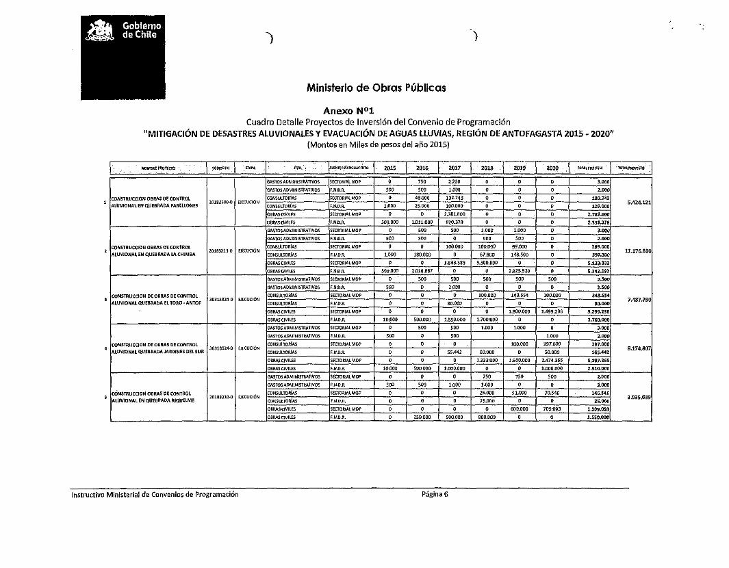
¡
Ministerio de Obras Públicas
)
Anexo N°1Cuadro Detalle Proyectos de Inversión del Convenio de Programación
"MITIGACiÓN DE DESASTRES ALUVIONALES y EVACUACiÓN DE AGUAS LLUVIAS, REGiÓN DE ANTOFAGASTA 2015 - 2020"(Montos en Miles de pesos dei año 2015)
\', , HOMUE tlOYlCTO ,\ WlmOID\ 1 EtAM .1" mM.' , rlJl!tttF~I/.o,IIC~óiro J 2015 2016 2017 2013 201' I 20211' I IOT~\~O¡UTU! . l' '1OT¡U,~(CJl)'
GASTOS AO~llNISTRAT1VOS SECTORIAL MOl' o 750 2.250 o o o 3.000
GhSTOS ADMI NISTMTIV05 F.N.O.rt. SOO 500 1.000 o o o "'00
CQNSTRUCC(ON OBRAS DE CONTROL CONSUlTOR!AS SECTORIA1MOP o 48.000 132.743 o o o 180.743
AtU'IIONAl EN QUEBRADA FARELtoNE52lJ183300-Q EJECl)CrÚN
CONSULTOO[f155.424.121
>.N.D.R. 1.00D 25.000 100.DOO o o o 126.000
DIlRASOV¡lES SECTORIAtMOP o o 2.781.000 o o o 2.781.000
OBMSClVILE5 F.N.O.R. 500.000 1.011.000 820.318 o o o 2.331.318
Go&.STOSAOMINISTRATiVOS SECTORJALMOI' o 500 500 1.000 1,000 o ',000
GASTOSAD~1JNISTRATlVOS F.N.O.1t 500 500 o 500 SO. o 2,000
CONSTl\UCClON OBRAS DE CONTROL CONSl.iLTOltrAS SOCTORIALMOP o o 100,000 100.000 99.000 o 299.000
AlUVIONAl EN Q.UEaRADA lA CHIMBA20183313,0 EJECUCiÓN
CON5ULTORf...s11.176.830
F.N.O.R. 1.000 180.000 o 61.800 148.500 o 391.300
OBAASCIVILES SECTORIAtMOP o , 1.833.333 3.300.000 o o 5.133.333
OBRASC!VtLES F.ND.R. 500.000 2D16.667 o o 2.825.530 o 5.342.197
GASTOS ADMINlSlRAi1VOS SEOORIAlMOP o 500 SOO 5DO SO. 500 2.5(10
GASTOS ADMINISTRATIVOS F."I.O.R. SO, o 2.000 o o o 2.5"00
CONSTRUCCION DE OBRAS DE CONTROl CONSUtTORfAS SEOORIAtMoP o o o 100.000 143.554 100.000 343.5"5'
I ALUVIONALQ.UEBRADA EL TORO, ANTOF30315824-0 EJECUCiÓN
CONSULTaRlAS o 7.487.790F.N.O.R. o 80.000 o o o B~OOO
OBRÁSCIVILES SECTORfAlMOP o , o o 1.800.000 1.499.236 3.299.236
OBRAS CIVILES F.N.O.R. 10.000 500.000 1.550.000 1.700.000 o o :3.760.000
GASTOS ADMINlSlRAl1VOS SECTORIAL MOP o 500 500 1.000 1.000 o 3.000
GAS10S AOM!NISTM1IVOS F."I.O.R. 500 o 500 1.000 2,000
CONs1l!.UCCION DE OBRAS DE CON1l!.Ol CONSiJlTORf4S SECTOIlIAI.MO? o o o 100.000 197.000 un.oooI AlUV!ONAL Q.UEaRADAJAROINES DEL SUR
30316124·0 lJECUClóNCONSULTORIAS
8.174.807F.N.O.R. o , 55.442 60.000 o 50.000 165".442
O!lMSCiV1LES SKTOIUA/.MOP o o o 1.223.000 1.500.000 2.4711.365 5.197.365
OIlRASClVILtS F.N.D.R. 10.000 500.000 1.000.000 o o 1.000.000 2.510.000
GASTOS ADMINISTRATIVOS SECTOR/AlMOP o o o 750 7SO 500 ,"00
GASTOS ADMINISTMTIVDS F.N.O.R. SOO 500 ,"00 1.000 o o 3.000
cONsTRUCCION ODRAS oe CONTROL(lfCUCIÓN
CONsLlLTORf.-.s SECTORIAL MO? o o o 25.000 51.000 70So16 146.546
AlUVroNAl EN QUEBRADA RIQ.UELME20183310.0
CONSULlORI.-.s o 3.035.639F.N.O.R. o o 2S.00tl o o 2S.OOO
OIlRASCIVJLES 5ECTORIAlMOP o o o o 600.000 709.093 1.309.093
OIlltASC!VtLts F.rW.R. o 250.000 500.000 SOO.OOO o o 1.550.000
Instructivo MinIsterial de Convenios de Programación Página 6

)
Ministerio de Obras Públicas
)
. 'o,' , '.: - /IIO-E-"~_~ CJ:lDUlOlQ< fl~PA .... InM ¡W¡u: f\N.'JIw..~.~1O 2015 2016 2017 2018 ·2019 20Z0 To1At90MEM "lOT..... PllOftcTO
GASTOS ADMINISTRATIVOS SECTORIALMOP o , o 750 1.000 1.000 2.150
GASTOS ADMINISTllATIV05 F.N.D.A. SOO 500 SOO o o 750 2.250
CONSTRlJCClON OaRI\S DE CONmOlEJECUrJÓN
CONSVLTORfAS SfCTaRlJl.lMOP , o o 84.973 100,000 100.000 284.973
ALUVlONAL EN QUEBRADA URIRE3039D924·(}
CONSULTORiAS4.978.739
F.N.D.R. o o o 50.000 40.082 99.900 189.9d
OBMS CIVilES SECTORIALMOP o o , o IADO,DCO 1.648.784 3.048.784
DB!b\SOVILES F.N.D.R. o 250.0llO 400.000 BOO.ODO o o 1.450.000
GASTOS AílMINISTRATIVOS SECTORlfltMOP o o , o o , oGASTOSADMINISTMTIVOS r.N.D.R. o , 850 1.000 1.000 , 2.850
CONSTRUCCION OBRAS OECONfflOL roNSUtTO!lfAS SECTORIAlMOP o o o , , o oALUVIONAL EN TOCOPllLA ¡Vi" AtuVIONAl 30315222.0 EJECUCIÓN 3.113.920BARRilES)
CONSULTORIo\!; F.Il.o.R. o , 15,000 100.000 146.070 o 261.070
OBRASClVlLES SECTORIAL MO? o o o o o o oOBRAS CIVILES r.N.O.JI. o o 150.000 SOO.OOO 2.200.000 o 2.850.000
GAST05 AOMINISTRATNos SECTOlIlAlMOP 500 1.000 , o o o 1.500
CONSTRUCCiÓN OBRAS DE CONTROL GA5TOS AOMINISTllATIVD5 fNOR o o o , o o ,l ALUVIONAL EN TOCOPllLA (VfA ALUVIONAL NA OISE~O 201.500
URBANA CAltE COL6N coNSU1TOllfAS srCT01I11ll MOP o 200.000 , , o o 200.000
CONSULTOR/AS FNOR o o , o o , ,GASTOSADMINISTMTlVCS SECTORIAL MOP '00 1.S00 , o , o ~oo,
GASTOS AOMI NJSTllATlV05 FNDR o o , o o o ,CONSTRUCCION oaRAS DE CONTROL
EJECUCIÓNCONSULTOR/M SECTORIAL MOP o 184.000 , , , o 184.000
g TOCOPJLLA(QDA. TRESAMIG05¡30073685-0
CONSULTORfAS2.446.000
r.N.D./\. o o o o , , oDSRASClVJLES SECTOR)ALMOP 10.000 2.250.000 , o o o 2.:250.000
OBRAS CIVILES r.N.O./\. o , , , o , ,GASTUS AOM¡NISTllATlVOS SECTCIIIALMOP 1.000 o , o o o 1.000
GASTOS ADMINISTRATIVOS foN.DA o , , o o , o
o ~~~~Ttl~~I~~:~~:A~~~~~~~~ASI EJECUCiÓNCONSULTORfAS SECTOIIIALMOP 196.000 , , , o , 196.000
30013685·0 3.255.000CONSU1TOllrAS F.N.D.FI. , o , , o o ,OBRAS CIVILES S!CTORJAtMOP 3.0sa.ODo , , o o o .11.058.000
OBMSl:IVllES r.N.O.JI. , , o , , , oCOH5T!1UCCIÓN VfAS PRIMARIAS DE GA.STCS AOMINISllIATIVOS ECfOIlIAI.MOP o o , o o o ,EVACOACtÓN DEAGUAS llUVJAS EN GASTOS ADMINISTRATIVOS F.N.O.JI. , 3.000 2.000 o , o 5.000
1 ANTOFAGASTA, CALAMA y51ERRA GORDA. 30396975-0 OlSEIlO CONSULTOR/AS SECTORIALMQP , o , o o o , 80S.000
CONSULTORrAS f.N.O.JI. o SOO.OOO 300.000 , o o 800.000
GASTOS ADMINISTRATIVOS 5EcroRIALMQP o 1.000 1.000 , o o 2.00[1
PlAN MAESTRO AGUAS llUVIAS SANOl5E/ro
GASTOSADMINI5TMTIVOS F.N.D.R. o o o , , o ,2 PEDRO DEATACAMA !PM5S SN PEORO¡
30371375·0CONSULTOR'AS
252.000SECTOIIJ"t MOP o 180.000 70.000 o o o 250.000
CONSULTORfAS r.N.O.JI. , o , , o o o
Instructivo Ministerial de Convenios de Programación Página 7

)
Ministerio de Obras Públicas
)
" CóblGOltlj ~...,.. ~ FUP<Il'.n"4Na>."tInO :ro" 2016 2017 .2018 2019' < 2020 lOTA~!'!I~fT'tM ror....l'IlQ>'iCltl.. _ ,.¡~~ '~,O'I[o.o
GASTOS ADMIHIS'TR>\TIV05 Stc.TORiAt MOP 1.000 3.000 o o o o 4,000
GASTOS ADMINISTRATIVOS F.N.DR. o o o o o o oI RW1SEliio Vl.a. AtUVIONAL TAlTAl N.A. OlSEÑO
OONSUlTORfAS o lS0.000SECTO¡¡IALMOP 66.DllO 80.0(10 o o o 146.000
CONSUlTORfl\S F.N.D.A. o o o o o o oGASTOSADMJNISTMnVQS SECTORIAL MOP 1.000 3.000 o o o o 11.000
CONSTRUCCrON OBRAS DE CONTROL DE GASTOS ADMINlSTMTIVOS F.N.n.R. o o o o o o o, CRECIDAS RIO SALADO
3003678&.0 DISEÑOCONSULm-mAS 50.000 o o o o 254.000
5ECTORJAtMOP 200.000 250.000
OON5ULTOruAS F.H.n.R. o o o o o o oGASTOSAOMINISTRATlVOS SECTORIAlMOP o o o o o o o
CONSERVI\OON y MANEJO DE CAUCE EN EL GASTOS 1l0M1NISTIlAnVOS F.N.O.R. soo uoo o o o o :1.700
,;. SECTOR TRANQ.UE DETOCONAO30377125-0 t1ECUCIÓN o o 464.994
OBRAS aVJLES SECTORIAL MOP 20.000 114.662 o o 134.662
OBAASOVllES F.N.D.R. o 326.632 o o o o 326.632
GASTOS AOMINISTRAnvos SECTOmALMOP o o o o o o oGASTOSADMIN1SlRATIVQS F.N.D.1t o o o o o o o
6 ~:;R~C~~::~N~:ST:~~ +CONSULTORfAS SECTORIALMQP o o o o o o
"' EJECUCIÓN 4.93Z.000OONSULTORfAS FNDR o o o o o oOBRAS oVllES SECTORIALMOP 2.632.000 2,300.000 o o o o 4.932.000
OBRAsaVILES F.N.D.R. o o o o o o o
¡r;,r~~ .,'" .......: :. .:' • ., '.',." "~,e " "·C,." ' 7'.06~,SDO luis.9il. 9.9~.0.496; 8.942.Z73 11.15~A86 'ÚSz:G74 ' . " -siu5z.340 56.152.340
CUADRO RESUMEN~ "--'-'---, ...." - .-- ... -.,.,,- 0"'- .. -- """--",,,,"",,
2015 2016 2017 2018 201~ 20Z~ , TQTALM$ TOTAl~
i::, SEqb~!~ü:1Qp<:'1 6.036.000 I 5.568.412 I 4.921.826 I 4.836.973 I 5.797.804 I 6.801.024 I 33.962.039 I 60,5%I -~. "'-r," ',' o,;
!:~'F:N;D:R:: ' ,1;, . 39,5%
;~ :~!~~,:,\ 100~O"
Instructivo Ministerial de Convenios de Programación Página 8

Ministerio de Obras Públicas
r
Anexo N°2
"Acuerdo CORE Aprobación del Convenio de Programación por parte del ConsejoRegional de Antofagasta"
Instructivo Ministerial de Convenios de Programación Página 9

CAPRIOGLIOMADRIGAL
COMPENDIO ACUERDOS 537a SESIÓN ORDINARIAAÑO 2015
CONSEJO REGIONAL, COREREGIÓN DE ANTOFAGASTA
En Antofagasta, a 15 de mayo de 2015, iniciándose a las 16:11 horas, yterminando a las 20:21 horas, en [a 537a Sesión Ordinaria del Consejo Regionalde Antofagasta, presidida por don Mario Acuña Villa lobos y con la asistencia de lasseñoras y señores Consejeros (as) Regiona[es:-Carlos Álvarez Chan.-Salvador Barrientos Muñoz.-Luis Capriog[io Rabello.-Gonzalo Dantagnan Vergara.-Luis Garrido Ampuero.-Pablo Iriarte Ramírez.-~1arcos Madriga[ Vide[a.-Mirta Moreno Moreno.-Alejandra Oliden Vega.-Guibaldo Ormazábal Arancibia.-Sandra Pastenes Muñoz.+1aría Eugenia Ramírez Díaz.-Silvia Soto Ovies.-Daniela Vecchiola Rlque[me.-Constantino Zafirópulos Bossy.Asimismo, estuvieron presentes:-Aicaldesa San Pedro de Atacama, doña Sandra Berna Martínez.-SEREMI de Obras Públicas, don César Benítez Espinoza.-Director Regional de Vialidad, don Félix Gallardo Seura.-Director Regional de Obras Hidráulicas, don Gabrie[ Valdivia González.-Director Regiona[ de Obras Portuarias, don Jorge Araya Caroca.-Director Regiona[ IND, don Hernán Muñoz Antiquera.-Jefa División de Análisis y Control de Gestión, doña Vicky Gutiérrez Cortés.-Jefe División de Pianificación y Desarrollo Regional, don Pedro Barrios Castillo.-Administradora Municipa[ SPA, doña Patricia Lanas Véliz.-Jefe SECOPLAC IMA, don Dante Novoa Arredondo.-Director Obras Municipales SPA, don Daniel Rodríguez M.-Jefe Planificación CMDS Antofagasta, don Julio Santander Fuentes-Jefe de Estudio y Diseño IMA, don C1audio Quiquincha Sakuda.-Arquitecta CMDS Antofagasta, doña Aída Ulloa Santelices.-Profesional Dirección de Arquitectura, doña Viviana Fuentes Orellana.-Profesional SECOPLAC SPA, doña Loreto Rivera C.-Profesional Servicio Salud de Antofagasta, don Percy Hernández Angulo.-Pdta. CGPA Escue[a N°10 de Tocopil[a, doña Emilia Alfara S.-Coordinadora Escuela N010 de Tocopilia, doña A[icia López Cliff.-Periodista MOP Antofagasta, doña Lorena Martínez Godoy.
SE ADOPTARON LOS SIGUIENTES ACUERDO (12224-15 A 12253-15):
ACUERDO 12224-15 (S.Ord.537.15.05): Se acuerda, por unanimidad,APROBAR el ACTA de la 5350 Sesión Ordinaria, la cual se aprueba sinobjeciones, ni observaciones.Concurren al acuerdo [os (las) Conseieros (as) Reaionales:r ACUNA ALVAREZ BARRIENTOSI DANTAGNAN GARRIDO IRIARTE
MORENO OUDEN ORMAZABAlRAMIREZ SOTO VECCHIOLA
PASTENESZAFlROPULOS

Lunes 25 de mayo de 2015:Actos conmemoración aniversario patrio Argentina.Lugar: Comuna de Antofagasta.Participan: Consejero Regional, señor Constantino Zafirópulos Bossy.
Martes 26 de mayo de 2015:Cuenta pública Servicio País.Lugar: Comuna de Antofagasta.Participan: Consejero Regional, señor Mario Acuña Villalobos.
Martes 26 Y miércoles 27 de mayo de 2015:Primera escuela de capacitación asuntos internacionales.Lugar: Comuna de ¡quique.Participan: Consejeros (as) Regionales Comisión de Sustentabilidad y RelacionesInternacionales.
Miércoles 27 de mayo de 2015:Capacitación proceso emprendedor.Lugar: Comuna de Antofagasta.Participan: Todos (as) Consejeros (as) Regionales.
Miércoles 27 de mayo de 2015:Presentación proyecto FIC-R ERNC Universidad de Antofagasta.Lugar: Comuna de Antofagasta.Participan: Todos (as) Consejeros (as) Regionales.
Miércoles 27 de mayo de 2015:Seminario diagnóstico y gestión ambiental humedales.Lugar: Comuna de Antofagasta.Participan: Todos (as) Consejeros (as) Regionales.
Miércoles 27 de mayo de 2015:Seminario finalización estudio F.N.D.R. humedales altoandinos.Lugar: Comuna de Antofagasta.Participan: Todos (as) Consejeros (as) Regionales.
Jueves 28 de mayo de 2015:Seminario desafíos nueva constitución política para Chile.Lugar: Comuna de Antofagasta.Participan: Todos (as) Consejeros (as) Regionales.
Viernes 29 de mavo de 2015:Estreno documental La Cruz de Hierro.Lugar: Comuna de Antofagasta.Participan: Consejeros (as) Regionales Comisión de Educación, Ciencia yTecnología.
Domingo 31 de mayo de 2015:Presentación obra "La Tierra está Viva".Lugar: Comuna de Antofagasta.Participan: Todos (as) Consejeros (as) Regionales.
Miércoles 03 de junio de 2015:Seminario cambio climático y efectos producción agropecuaria.Lugar: Comuna de Antofagasta.Participan: Todos (as) Consejeros (as) Regionales.
3

r
presentada por el señor Intendente Regional e informada por la Comisión deSociedad Civil y Participación Ciudadana, sancionando la siguiente priorización:- Proyecto C. SIP 30385728-0, "ADQUISICIÓN CAMIONES ALJIBES PARAEMERGENCIAS COMUNA S.P. DE ATAC", por un monto total F.N.D.R. 2015 Ymonto total del proyecto de M$165.000.- (Valores ficha IDI). Proyectofinanciado a través de la modalidad establecida en la Circular N°33 del Ministeriode Hacienda.Concurren al acuerdo los (las) Conseieros (as) Reaionales:
ACUNA ALVAREZ I BARRIENTOS CAPRIOGUODANTAGNAN GARRIDO ! IRIARTE MADRIGALMORENO OlIDEN i ORMAZABAL PASTENES
. RAMIREZ SOTO I VECCHIOLA ZAFIROPULOS
Ver Anexo 537.4.12228-15.002 "Ordinario 001000, Antofagasta 13 de mayo de2015".
ACUERDO 12229-15 (S.Ord.537.15.05): Se acuerda, por unanimidad,APROBAR el Convenio de Programación "MITIGACIÓN DE DESASTRESALUVIONALES y EVACUACIÓN DE AGUAS LLUVIAS, REGIÓN DEANTOFAGASTA 2015 - 2020", entre el Gobierno Regional de Antofagasta y elMinisterio de Obras Públicas, con una duración de 6 años a contar del año 2015hasta el 2020 y con un costo Total de M$56.152.340.El aporte F.N.D.R. para el presente Convenio será de M$22.190.301, lo quecorresponde a un 39,5 O/o y el aporte sectorial será de M$33.962.039, lo quecorresponde a un 60,5 O/o. La distribución anual será como se indica acontinuación en el cuadro de inversiones establecido en el Convenio'
i ! VALORES ANUALES EN M$ TOTAL TOTALFUENTE
2015 2017 2018 2019 M$ %2016 zazoF.N.D.R. 1.025.500 ¡ 5.567.499 4.978.670 4.105.300 5.361.682 I 1.151.650 22.190.301 39,5%
SECTORIAL6.036.000 ! 5.568.412 4.921.826 4.836.973 5.797.804 1 6.801.024 33.962.039 60,5%
MOPTOTAL 7.061.500 I 11.135.911 9.900.496 8.942.273 I 11.159.486 7.952.674 56.152.340 100,0%
El Convenio contempla 16 Iniciativas y se texto se adjunta como anexo delpresente acuerdo.Concurren al acuerdo los las
ACUNA 1 AlVAREZ ) CAPRIOGLIODANTAGNAN ) GARRIDO MADRIGALMORENO ! OlIDEN PASTENES
! RAMIREZ _ L..SOTO VECCHIOLA ._:U'ZA"'FI"'R"'O'-'P"'U"'LO""S'---__..J
Ver Anexo 537.5.12229-15.003 "Convenio de Programación..."
ACUERDO 12230-15 (S.Ord.537.15.05): Se acuerda, por unanimidad,APROBAR la Propuesta de PRIORIZACIÓN del proyecto del Fondo Nacionalde Desarrollo Regional, F.N.D.R., Proceso Presupuestario 2015,presentada por el señor Intendente Regional e informada por la Comisión deEducación, Ciencia y Tecnología, sancionando la siguiente priorización:- Proyecto C.BIP 30120017-0 "REPOSICIÓN ESCUELA LOCALIDAD DECAMAR, COMUNA SAN PEDRO DE ATACAMA", por un monto F.N.D.R. 2015de M$300.000.-, y un costo total F.N.D.R del proyecto de M$592.558.- (AmbosValores Ficha IDI).Concurren al acuerdo los (las) Conseieros (as) Reqionales:
ACUNA AlVAREZ i BARRIENTDS CAPRIOGlIODANTAGNAN GARRIDO IRIARTE MADRIGALMORENO I OLIDEN ORMAZABAl PASTENESRAMIREZ I SOTO VECCHIOLA ZAFIROPUlOS
Ver Anexo 537.6.12230-15.004 "Ficha CORE Código SIP 30120017-0".
ACUERDO 12231-15 (S.Ord.537.15.05): Se acuerda, por unanimidad,APROBAR la propuesta de PRIORIZACIÓN del proyecto del Fondo Nacionalde Desarrollo Regional, F.N.D.R., Proceso Presupuestario 2015,presentada por el señor Intendente Regional e informada por la Comisión deEducación, Ciencia y Tecnología, sancionando la siguiente priorización:
5

financiado a través de ia modalidad establecida en la Circular N°33 del Ministeriode Hacienda.
Concurren al acuerdo los lasACUNA I ALVAREZ CAPRIOGLIO
I DANTAGNAN GARRIDO MADRIGALMORENO .DUDEN PASTENESRAMIREZ . !)OTO VECCHIQLA ZAFIROPULOS
Ver Anexo 537.6.12234-15.008 "Ficha CORE Código BIP 303á9624-0".
CAPRIOGLIO
[MADRIGAL
I PASTENESZAFIROPULOS
MORENO DLIDEN ORMAZABAlRAMIREZ SOTO VECCHIOLA
Se inhabilitan los Conseieros Reaionales:ACUNA I
I
ACUERDO 12235-15 (S.Ord.537.15.05): Se acuerda, por unanimidad, saivolas inhabilidades indicadas ai final, APROBAR ia Propuesta de Priorización delProyecto del Fondo Nacional de Desarrollo Regional, F.N.D.R., PROCESOPRESUPUESTARIO 2015, presentada por ei señor Intendente Regional einformada por la Comisión de Salud y Medio Ambiente, sancionando la siguientepriorización:- Proyecto C. BIP 30370415-0, "REPOSICIÓN DE AUTOCLAVES Y PLANTASDE AGUA EN HOSPITAL ANTOFAGASTA", por un monto total F.N.D.R. 2015 ymonto total del proyecto de M$586.222.- (Valores ficha IDI). Proyectofinanciado a través de la modalidad establecida en la Circular N°33 del Ministeriode Hacienda.Concurren al acuerdo [os (las) Conseieros (as) Regionales:
AlVAREZ BARRIENTOSI OANTAGNAN 1 GARRIDO IRIARTE
r
Ver Anexo 537.6.12235-15.009 "Ficha CORE Código BIP 30370415-0".
ACUERDO 12236-15 (S.Ord.537.15.05): Se acuerda, por unanimidad,APROBAR la Propuesta de PRIORIZACIÓN del proyecto del Fondo Nacionalde Desarrollo Regional, F.N.D.R., Proceso Presupuestario 2015,presentada por el señor Intendente Regional e informada por la Comisión deEducación, Ciencia y Tecnología, sancionando la siguiente priorización:- Proyecto C.BIP 30137114-0 "ADQUISICIÓN EQUIPOS Y HERRAMIENTAESP. TP, LICEOS A-16, A-22 Y A-26", por un monto F.N.D.R. 2015 deM$661.361.-, y un monto total F.N.D.R. del proyecto de M$661.361.- (AmbosValores Ficha IDI). Proyecto financiado a través de la modalidad establecida en [aCircular N°33 del Ministerio de Hacienda.Concurren al acuerdo los las Conse'eros as Re ionales:
ACUNA AlVAREZ BARRIENTOS I CAPRIOGLIODANTAGNAN GARRIDO IRIARTE I MADRIGALMORENO eUDEN ORMAZABAL I PASTENESRAMIREZ SOTO VECCHIOLA ZAFIROPULOS
Ver Anexo 537.6.12236-15.010 "Ficha CORE Código BIP 30137114-0",
ACUERDO 12237-15 (S.Ord.537.15.05): Se acuerda, por unanimidad"APROBAR la propuesta de PRIORIZACIÓN del proyecto del Fondo Nacionalde Desarrollo Regional, F.N.D.R., Proceso Presupuestario 2015,presentada por el señor Intendente Regional e informado por la Comisión de ObrasPúblicas y Transportes, sancionando ia siguiente priqrización:- Proyecto C.BIP 20183313-0 "CONSTRUCCION OBRAS DE CONTROLALUVIONAL EN QUEBRADA LA CHIMBA ANTOFA", por un monto totaiF.N.D.R. 2015 de M$1.883.843.-, un monto sectorial 2015 de M$717.-, un costototai FNDR de M$5.489.002.-, un costo total sectorial de M$5.196.303.- y uncosto total del proyecto de M$10.685.305.- (Todos Valores Ficha IDI). Cc;bedestacar que este proyecto forma parte del CONVENIO DE PROGRAMACION
7
Ver Anexo 537.7.12240-15.014 Ordlnano DOP Ir N° 000180 .
Votan a favor los (las) Conseieros (as) Reqionales:I ACUÑA ALVAREZ I BARRIENT05 CAPRIOGLIQI DANTAGNAN GARRIDO IRIARTE MADRIGALI DLIDEN DRMAZABAL PASTENESI RAMIREZ VECCHIOLA ZAFIROPUlOS
Se abstienen las Conseieras Reqionales:
MORENOSOTO
" "
MADRIGALPASTENESZAFIROPULas
j CAPRIOGLIQDANTAGNAN GARRIDO I IRIARTEMORENO DUDEN I ORMAZABALRAMIREZ SOTO VECCHIOLA
ACUERDO 12241-15 (S.Ord.537.15.05): Se acuerda, por unanimidad,APROBAR la propuesta de INCREMENTO de RECURSOS por reevaluación,correspondientes al Fondo Nacional de Desarrollo Regional, F.N.D.R., ProcesoPresupuestario Año 2015, presentada por el señor Intendente Regional einformada por la Comisión de Obras Públicas y Transportes, para la iniciativa y enel monto que se indica:-Proyecto C.SIP 30277737-0 "CONSERVACIÓN RED VIAL REGIÓN DEANTOFAGASTA 2014 - 2015", por un monto total de incremento F.N.D.R. 2015de $432.109.292.- (Moneda Presupuestaria) quedando en consecuencia conun costo total F.N.D.R. del proyecto de M$6.475.047.- (Valor Ficha IDI).Concurren al acuerdo los (las) Consejeros (as) Reaionales:
ACUNA I ALVAREZ BARRIENTOS
Ver Anexo 537.7.12241-15.015 "Memorándum-Interno N°28".
ACUERDO 12242-15 (S.Ord.537.15.05): Se acuerda, por unanimidad,manifestar ei siguiente PRONUNCIAMIENTO, del Gobierno Regional en iostérminos que a continuación se detallan y que se encuentran dentro del proceso deevaluación ambiental'
Ver Anexo 537.8.12242-15.016 "Resumen de EvaluaCiones..."
PROYECTO I TITULAR COMUNA ESTRATEGIA TERRITORIALIDADFavorable:
Favorable: De acuerdo al análisis
Proyecto N°2: dei instrumento PRDU
Aumento Desarrollo y PRIBCA, se
Capacidad deMinera El Antofagasta Económico establece que existe
producción Way Territoriaicompatibilidad
Mina El Way
i
I N°6: territorial entre elI Identidad
Proyecto y la
I Regional planificación del áreade emolazamiento.
Concurren al acuerdo los (las) Consejeros (as) Regionales:ACUNA ALVAREZ BARRIENTOS CAPRIOGLIODANTAGNAN _..- GARRIDO IRIARTE MADRIGALMORENO DLIDEN ORMAZABAl I PASTENESRAMIREZ SOTO VECCHIOLA ZAFIROPULOS--,-"--
PASTENESZAFIROPULOS
CAPRIOGlIOI MADRIGAL
ORMAZABAL
Re ionales:BARRIENTOSIRIARTE
SOTOMORENORAMIREZ
ACUERDO 12243-15 (S.Ord.537.15.05): Se acuerda, por 14 votos a favor y02 abstenciones, DESIGNAR como integrantes de la COMISIÓN TÉCNICA DEEVALUACIÓN, del Fondo de Innovación para la Competitividad FIC-R, año 2015,en la categoría "Representantes del Sector Empresarial", a doña MaritzaIvanovic, Gerente de Hidrohuerto y don Roberto Cifuentes, Gerente General de GProcess.Votan a favor los
ACUNADANTAGNAN
9

Instituciones de IRudi Hermann Universidad de AntofagastaEducación Superior Seifert García Antofagastade la ReqiónInstituciones de ia Cristian Barría Fuerza Aérea (CODEFEN) AntofagastaDefensa Nacionai Lincoman
¡(DelegadoRegionai del CanalMilitar)Con grado Eduardo Verdejo Profesor de Educación Antofagastaacadémico en Green Física, con gradoEducación Física, Académicocon residencia en Alejandro González Profesor de Educación Taltalla respectiva Cuturrufo Física, con gradoregión. AcadémicoDesignado por la Carlos Riveras SERNAM AntofagastaDirección Regional Menadel ServicioNacional de laMuier
Concurren al acuerdo los (las) Consejeros as) Reqionales:ACUNA ALVAREZ BARRIENTOS CAPRIOGUODANTAGNAN GARRIDO IRIARTE MADRIGALMORENO OLIDEN ORMAZABAL PASTENESRAMIREZ SOTO VECCHIOLA ZAFIROPULoS
"
Ver Anexo 537.12.12247-15.021 Memorandum W15D".
siquiente etalle:PROYECTO I INSTITUCION SOLICITUD APROBADA
Solicita modificación deCampeonato Nacional Club Deportivo y fechas de ejecución delSiempre en Nuestra
Social CEBA proyecto para los díasMemoria CEBA 20,21,22 y 23 de Mayo
2015Concurren al acuerdo los (las) Consejeros (as) Reqionales:
ACUNA ALVAREZ BARRIENTOS ! CAPRIOGLIO IDANTAGNAN GARRIDO IRIARTE 1 MADRIGALMORENO OLIDEN ORMAZABAL ! PASTENESRAMIREZ SOTO
_""OVECCHIOLA I ZAFIROPULOS
".
Ver Anexo 537.11.12246-15.020 IND II REGID. RegIonal (O) N° 434".
ACUERDO 12247-15 (S.Ord.537.15.05): Se acuerda, por unanimidad,APROBAR la MODIFICACIÓN planteada por el formulador de proyecto ganadordel F.N.D.R. 2 % DEPORTES, Proceso Presupuestario 2014, según el
d
r
ACUERDO 12248-15 (S.Ord.537.15.05): Se acuerda, por 15 votos a favor y01 abstención, APROBAR la MODIFICACIÓN planteada por el formulador delproyecto del Fondo de Subvención de Actividades de Carácter Cultural,2% del Fondo Nacional de Desarrollo Regional, Proceso Presupuestario2014 y presentada por la Comisión de Educación Ciencia y Tecnología, según losiguiente:-Proyecto "MEMORIA MINERA: DOCUMENTAL PARA EL RESCATE DELPATRIMONIO INMATERIAL DE ANTOFAGASTA" de la AGRUPACIÓNCULTURAL CINE SOCIAL ANDINO DE ANTOFAGASTA. Se autoriza ampliar elplazo de ejecución del proyecto hasta Agosto de 2015.Votan a favor los las Canse'eros as Re ionales:
ACUNA AlVAREZ I BARRIENTOS 1 CAPRIOGUODANTAGNAN GARRIDO ! IRIARTE I MADRIGALMORENO DUDEN I ORMAZABALRAMIREZ SOTO VECCHIOLA ZAFIROPULOS
Se abstiene la Consejera Regional:I I
11

Participan: Todos (as) Consejeros (as) Regionales.
CAPRIOGUOMADRIGALPASTENESZAFIROPULOS
MORENO DUDEN ORMAZABALRAMIREZ SOTO ._ VECCHIOLA
Ver Anexo 537.14.12251-15.023 "Valentín Volta Valencia... "
Lunes 18 de mayo de 2015:Lanzamiento Plan Especial Inversiones para Calama. (*)Lugar: Comuna de Calama.Participan: Todos (as) Consejeros (as) Regionales.Concurren al acuerdo los (las) Consejeros (as) Reaionales:
ACUNA ALVAREZ BARRIENTDSDANTAGNAN GARRIDO IRIARTE
ACUERDO 12252-15 (S.Ord.537.15.05): Se acuerda, por unanimidad, aprobarla participación del Consejo Regional de Antofagasta y señores (as) consejeros (as)regionales, que en cada caso se indica, en la siguiente actividad:Viernes 19 al domingo 28 de junio de 2015:Pasantía para autoridades regionales y comunales. (**)Lugar: México y Cuba.Participan: Consejeros Regionales Salvador Barrientos Muñoz, Luis GarridoAmpuero y Guibaldo Ormazábal Arancibia.Concurren al acuerdo los (fas) Consejeros (as) Reoionales:
ACUNA ALVAREZ BARRIENTOS CAPRIOGUO¡ DANTAGNAN I GARRIDO IRIARTE MADRIGAL1 MORENO DLIDEN DRMAZABAL I PASTENESLRAM~R~ SOTO VECCHIOLA ZAFIROPULOS
Ver Anexo 537.14.12252-15.024 "Instituto Pedagógico Latinoamericano..."
CAPRIOGUOI MADRIGAL
ACUERDO 12253-15 (S.Ord.537.15.05): Se acuerda, por unanimidad, solicitara Jefa de División de Análisis y Control de Gestión del Gobierno Regional, entregueinforme que dé cuenta sobre la programación financiera del presupuesto F.N.D.R.,para el año 2015 y años posteriores, según el arrastre existente a la fecha..Concurren al acuerdo los las Canse 'eros as Re ionales:
ACUNA ALVAREZ ,BARRIEN OSDANTAGNAN I GARRIDO \:tRIARTEMORENO OLIO N_\- ORMAZABAl::,RAMIREZ SOTO ~, ...~":::, \ VECCHIOLA '\\.
PASTENESZAFIROPULOS
13

GOBIERNOREGIONAL¡Más región, mejor calidad de vida! '-'V/874
ORD.'Nl - .. /2016
MAT.: "Proyecto Regional Fondo deAdaptación"
ANTOFAGASTA, ~ 5 me. 2Illll
DE: FABIOLA RIVERO ROJASINTENDENTE REGIÓN DE ANTOFAGASTA (S)
A: PABLO BADENIER MARTINEZMINISTRO DEL MEDIO AMBIENTE
Junto con saludar, expreso a usted nuestro interés en respaldar al Ministerio del Medio Ambienteen la postulación del proyecto "Reducción de la Vulnerabilidad Climática y Riesgo de Inundaciónen Áreas Costeras Urbanas y Semi-Urbanas de las ciudades de América Latina" al Fondo deAdaptación de la Organización de las Naciones Unidas, iniciativa que incluye las comunas deAntofagasta y Taltal, de nuestra Región de Antofagasta, las cuales se han visto fuertementeafectadas por eventos meteorológicos extremos.
Los productos propuestos en el proyecto, tales como la renovación del Plan de manejo de aguaslluvias de Antofagasta, la construcción de infraestructura para el control de aluviones en laQuebrada Bonilla de la ciudad de Antofagasta, son medidas que apuntan directamente a laadaptación a los eventos climáticos y por otra parte la adquisición de instrumental y nuevatecnologia como lo son el radar meteorológico y las nuevas estaciones meteorológicas paraAntofagasta y Taltal, permitirán mejorar sustantivamente el pronóstico y el sistema de alertatemprana. Ello, sumado a las acciones de señaléticas, vias de evacuación y desarrollo decapacidades de la población, permitirán que las personas más vulnerables están mejorpreparadas para los eventos extremos y mejor adaptadas a los efectos del cambio climático.
El Gobierno Regional con el objeto de unir esfuerzos, concretar acciones y coordinar inversionesrelacionados con la mitigación de desastres, la seguridad, la integración social y calidad de vidaen las ciudades de Antofagasta, Taltal y Tocopilla en el mejoramiento de 15 quebradas con riesgourbano, para resolver el problema 15 quebradas Sin embargo se detalla Convenio deProgramación "Mitigación de Desastres Aluvionales y Evacuación de Aguas Lluvias, Región deAntofagasta 2015- 2020", Resolución Exenta W402 con fecha 13/05/2015.
En relación a iniciativas de inversión en Equipamiento se menciona "Proyecto Adquisición deRed Meteorológica" Código BIP N° 30296472, aprobada en Acuerdo 11801-2014, por un monto$467.736.-
Los resultados de este proyecto serán insumos para internalizar la variable Iimática en futuros
Le saluda atentamente,
user
Typewritten Text
Annex 17.Letter from Antogafasta´s Regional Government endorsing the present project proposal.

Versión 1 Unidad de Inclusión y Equidad de Género
Gender Analysis
Reducing climate vulnerability and flood risk in coastal urban and semi urban areas in cities in Latin America
Page 1 of 14
Title of Operation Reducing climate change vulnerability and flood risk in coastal urban and semi urban areas in cities Latin America
Country Chile, Ecuador
Date July 7th, 2017
Operation Manager Adriana Carolina Cortés
Fund Adaptation Fund
UIEG Officer Elena Cardona
UIEG Coordinator Violeta Domínguez
Firma
Executive Summary
The project strategy is based on active learning and sharing knowledge to empower local authorities and communities, and contribute to build resilient cities. The project will cultivate communities of practice among practitioners and stakeholder of both countries to foster the development of collective learning. Also new infrastructure will be built and plans for enhanced disaster preparedness developed, as well as expansion of early warning systems.
Both Chile and Ecuador present high Gender Index Gaps1, however, gender inequalities still persist, particularly in political participation and access to decision-making processes. While there is a higher presence of women´s grassroots organizations in Chile, that could be useful stakeholders for project implementation, women’s representation is specially low in public offices at the local level and in technological and scientific fields. Also, most of single-parent households are women-led and have dependents on their charge, which means that when facing a flood and proceeding with evacuation they may face particular difficulties. Given that illiteracy rates (functional and digital) in Ecuador are higher for women, communication strategies will need to gender-sensitive and convey appropriate and understandable messages for both sexes. Women are more vulnerable to climate change and disasters than men, because of gender roles and responsibilities, premise that underlines this Project: outputs 1.1, 4.1, 4.2, 4.3, 5.1, 6.1, 6.2, and 7.1 have been designed in such way to take into consideration gender differences and to promote women’s participation.
I. Description of the Operation
The purpose of this regional project, with a requested financing amount of US$ 13,9 MM, is to generate lessons on increasing adaptive capacity to be useful in Latin America and the Caribbean. The governments of Chile and Ecuador have agreed to collaborate and jointly implement an action learning approach to address the issues of climate change adaptation in coastal cities. Ministries of the Environment of Chile and Ecuador will be the responsible entities, accountable for the implementation of agreed national activities; while PNUD will be the Program Executing Entity, responsible for project execution and for ensuring collaborative and coherent regional action.
The project objective is to reduce vulnerability to climate-related floods, mudflows and landslides in three coastal cities by mainstreaming a risk-based approach to adaptation, building collaboration and
1 WEO, Global Gender Gap Index.
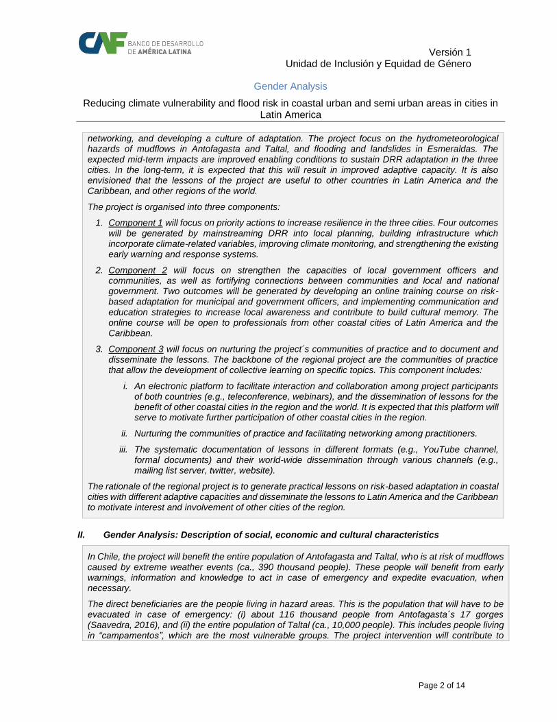
Versión 1 Unidad de Inclusión y Equidad de Género
Gender Analysis
Reducing climate vulnerability and flood risk in coastal urban and semi urban areas in cities in Latin America
Page 2 of 14
networking, and developing a culture of adaptation. The project focus on the hydrometeorological hazards of mudflows in Antofagasta and Taltal, and flooding and landslides in Esmeraldas. The expected mid-term impacts are improved enabling conditions to sustain DRR adaptation in the three cities. In the long-term, it is expected that this will result in improved adaptive capacity. It is also envisioned that the lessons of the project are useful to other countries in Latin America and the Caribbean, and other regions of the world.
The project is organised into three components:
1. Component 1 will focus on priority actions to increase resilience in the three cities. Four outcomes will be generated by mainstreaming DRR into local planning, building infrastructure which incorporate climate-related variables, improving climate monitoring, and strengthening the existing early warning and response systems.
2. Component 2 will focus on strengthen the capacities of local government officers and communities, as well as fortifying connections between communities and local and national government. Two outcomes will be generated by developing an online training course on risk-based adaptation for municipal and government officers, and implementing communication and education strategies to increase local awareness and contribute to build cultural memory. The online course will be open to professionals from other coastal cities of Latin America and the Caribbean.
3. Component 3 will focus on nurturing the project´s communities of practice and to document and disseminate the lessons. The backbone of the regional project are the communities of practice that allow the development of collective learning on specific topics. This component includes:
i. An electronic platform to facilitate interaction and collaboration among project participants of both countries (e.g., teleconference, webinars), and the dissemination of lessons for the benefit of other coastal cities in the region and the world. It is expected that this platform will serve to motivate further participation of other coastal cities in the region.
ii. Nurturing the communities of practice and facilitating networking among practitioners.
iii. The systematic documentation of lessons in different formats (e.g., YouTube channel, formal documents) and their world-wide dissemination through various channels (e.g., mailing list server, twitter, website).
The rationale of the regional project is to generate practical lessons on risk-based adaptation in coastal cities with different adaptive capacities and disseminate the lessons to Latin America and the Caribbean to motivate interest and involvement of other cities of the region.
II. Gender Analysis: Description of social, economic and cultural characteristics
In Chile, the project will benefit the entire population of Antofagasta and Taltal, who is at risk of mudflows caused by extreme weather events (ca., 390 thousand people). These people will benefit from early warnings, information and knowledge to act in case of emergency and expedite evacuation, when necessary.
The direct beneficiaries are the people living in hazard areas. This is the population that will have to be evacuated in case of emergency: (i) about 116 thousand people from Antofagasta´s 17 gorges (Saavedra, 2016), and (ii) the entire population of Taltal (ca., 10,000 people). This includes people living in “campamentos”, which are the most vulnerable groups. The project intervention will contribute to

Versión 1 Unidad de Inclusión y Equidad de Género
Gender Analysis
Reducing climate vulnerability and flood risk in coastal urban and semi urban areas in cities in Latin America
Page 3 of 14
protect the estimated 4.593 families that live in 44 campamentos in Antofagasta and the estimated 400 families living in 4 campamentos in Taltal2.
In Ecuador, the entire population of Esmeraldas will benefit from the project: about 161 thousand inhabitants. These people will benefit from early warnings, information and knowledge to act in case of emergency and expedite evacuation, when necessary.
Chile
In 2015, Chile3 had roughly over 18 million inhabitants, 87,4% of which lived in urban areas. The country has a Global Gender Gap Index of 0.69810, there is almost complete equality in educational attainment and health and survival, but major gaps remain in political empowerment and economic participation and opportunities (WEF, 2015).
The city of Antofagasta is the capital of the Antofagasta Region (2nd Region) and the Antofagasta province, and the seat of the Antofagasta commune. The city has about 380 thousand people and is the country´s sixth largest city. Antofagasta has the country highest per capita income, at about USD 23,000 per year. Despite general high living conditions, Antofagasta has informal neighbourhoods called “campamentos”, located mainly on the hillsides. These are unplanned illegal occupations of public land with deficient infrastructure and services, and roughly built houses. The poverty level is low (ca., 8%) and houses have almost full access to potable water, sanitation and electricity4.
TECHO5 reported 44 campamentos in 2016, housing 4.593 families (11,8% of total number of families living in campamentos at the national level) in Antofagasta commune, while in the whole region there are 56 campamentos, or 6.229 families. TECHO also reports that 71,4% of these campamentos are not registered by the Ministry of Housing and Urbanism (MINVU) census done in 2011 (back then, there were 28 campamentos and 1.061 families accounted in the region).
In Taltal, a small city (ca., 10,400 people in 2013) located about 195 km south of Antofagasta in the coastal plain of the Atacama Desert, TECHO (2016) also identified the presence of campamentos, with 400 families living in 4 of them. In 2011 the poverty level was 2,7%, well below the national average (INE, 2014b). About 25,1% of houses had sanitation deficit, higher than the national and regional deficits (i.e., 17.0% and 13.7%) (INE, 2014b).
Due to regional economic dynamism6 and mining employment opportunities, Antofagasta has attracted both Chilean and foreigner migrants, increasing the number of campamentos. A social study done by MINVU in 2013 exposed that 35% of population living in campamentos in Antofagasta region were aged 15 years old or younger, and people under 30 years accounted for 62% of them. Also, 75% of single parent families, which accounted for 24% of total families, were headed by a woman. Even though there was no sex-disaggregated data, it was revealed that 67% of household heads had basic education or less; 73% were working, either self-employed (59%) or as employees (41%), and 78% did not pay contributions to the public pensions system. Most of the employees were wage earners in a company (75%), 18% worked as a farmer and 8% in private homes.
a. Health
2 Catastro de campamentos 2016, TECHO. 3 Instituto Nacional de Estadísticas, projections based on 2002 census. 4 In 2010, the urban population of Antofagasta region had 100% cover of potable water and 99.7% cover of sewage system. In 2013, 7.1% of houses of the Antofagasta commune had a deficit in sanitation (MDS, 2014a). 5 Catastro de campamentos 2016, TECHO 6 Mapa social de campamentos 2013, Secretaría Ejecutiva de Campamentos, Ministerio de Vivienda y Urbanismo

Versión 1 Unidad de Inclusión y Equidad de Género
Gender Analysis
Reducing climate vulnerability and flood risk in coastal urban and semi urban areas in cities in Latin America
Page 4 of 14
In 20157, 25,1% of women had been or were mothers in their teens, proportion that has been rather constant both in 2013 and 2011. Prevalence of adolescent pregnancy (girls aged 12 to 19 years old) decreases when per capita household income levels increase: 9,2% in poorest quintile, while in the richest quintile this proportion is 1,1%; and decreases with level of education:
Education Level %women who have been
adolescent mothers
No formal education 39%
Primary education completed 36%
Secondary education completed 25%
Tertiary education completed 9%
In 2015, more women (396 thousand) than men (228 thousand) were functional dependents8. Among these, 69,5% of those who do not have a care-taker are women; while 68,2% of care-takers are women.
b. Education
There is gender parity in both basic (ages 6 to 13) and secondary (ages 14 to 18) school enrolment (97% and 93%, respectively and regardless of sex)9. However, there is horizontal segregation among students in secondary education: more boys (64%) choose Industries, Agriculture and Maritime, while more girls concentrate on Technical and Commercial. Regarding quality, girls outperform boys in all levels of basic and secondary education10. In tertiary education11, enrolment is higher for females, with a ratio of 1,14 in 2016, and there is also horizontal segregation12: male students concentrate in engineer and technology (79%); agronomy, forestry (70,6%); while there is female predominance in social work (84,1%), medical sciences (74,6%) and education (74,6%). Female proportion in all other branches of study ranges from 51% to 58%: economics; business administration; tourism; gastronomy; arts; journalism & communications; law; biology; maths; physics; chemistry.
Finally, there is a small gender gap in use and access to ICTs: 67,6% of male aged 5 years old or older use internet (or has access to) versus 65,4% of female.
c. Income
At the national level13, 23% of families were single-parent households, and 93% of those were headed by a female, in 2011. Both Antofagasta and Taltal communes show similar ratios for the same year: single-parent households account for 26% of the total, 95% of which are headed by females, in Antofagasta; while in Taltal those percentages are 19% and 93%, respectively. Female headed households have lower incomes: per capita average monthly earnings are 1,1 higher in male-led households at the national level, while this ratio increases up to 1,24 in Taltal and up to 1,28 in Antofagasta. This situation is even worse for female single-parent households, with the following male to female per capita monthly average earning ratios: 1,44 at the national level; 1,62 in Antofagasta commune and more than double (2,01) in the Taltal commune. This contrasts with the level of
7 CASEN 2015, Ministerio de Desarrollo Social. 8 Functional dependents (CASEN 2015): are those people older than 15 years old that: (i) state to have extreme difficulties or inability to perform basic activities (such as eat, bathe, move within the house; use WC; lay down and get up, dress) or instrumental to daily life (go out; do the shopping; go to the doctor; domestic chores; make or receive calls); or (ii) receive help frequently to perform an activity; or (iii) present moderate or severe difficultires in, at least, one basic activity or two instrumental activities of daily life. 9 Global Gender Gap Index, World Economic Forum. 10 Informe del Sistema Educacional con análisis de género, 2015, Ministerio de Educación. 11 Global Gender Gap Index, World Economic Forum. 12 CASEN 2015, Ministerio de Desarrollo Social. 13 Ministerio de Desarrollo Social, 2011.

Versión 1 Unidad de Inclusión y Equidad de Género
Gender Analysis
Reducing climate vulnerability and flood risk in coastal urban and semi urban areas in cities in Latin America
Page 5 of 14
education, since usually females have one or more years of education than males in monoparental households.
The proportion of female-headed households has been increasing in time since 199014, reaching 39,5% in 2015 from 20,2% in 1990. In urban areas this level reaches 41%, compared to 29% in rural areas. The poorest decile concentrates the higher proportion of female-headed households, with 52,8%, while the richest one has the lowest participation, with 30% of those households led by a woman.
A look into female-headed households shows15 that, in 2011, 50% were single-parent, 23% were one-person households, 17% included extended family and 12% were biparental. Furthermore, female-headed single-parent households were bigger in terms of size: they tended to have 2,7 people in them, in contrast to male-headed ones, where total family size is 1,9.
Even though female-headed households tend to be poorer than male-headed ones (12,9% vs 8,8%), more male-headed (16,9%) households suffer from multidimensional poverty (16,2% female-led households) in 201516. Similar gender gaps can be seen in terms of individuals, poverty and extreme poverty affected more females than males, but multidimensional poverty was worst among men:
People Poverty Extreme poverty
Multidimensional poverty
Women 8,4% 3,7% 20,4%
Men 7,8% 3,4% 21,4%
A reason behind prevalence of multidimensional poverty among male-headed households may be reduced access to support nets: 9,4% of these do not have any other person outside the household who can come for help in 8 different situations, while for female headed households this proportion is 8,7%. However, female-headed households tend to be more deprived of decent housing17 (20,5%) and environmental18 conditions (10,5%) than male-led homes (18,1% and 9,5%, respectively).
Intersection of ethnicity, rurality or migrant situation worsens indicators, for both genders:
Poverty Multidimensional poverty
Rural Indigenous Rural Indigenous
Women 23,1% 18,4% 34,8% 29,8%
Men 21,1% 18,1% 35,7% 31,9%
According to the last family survey19 (2015) held in campamentos located in the city of Antofagasta, the profile of head of household is: average age is 36 years old; 51% are females; 58% are foreigners (Colombian 22,1%, Peruvian 17,7%, Bolivian 15,0%); 74% are working (either as employee or self-employed); 40% are employed without a formal contract; 45% have access to social protection services; average family size is 3 people; only 3% have tertiary education (completed or incompleted), 35% have completed secondary education, and 14% have completed only primary education; 73% migrated searching for a work and 6% because of personal security reasons.
14 CASEN 2015, Ministerio de Desarrollo Social. 15 Ministerio de Desarrollo Social, 2011. 16 CASEN 2015, Ministerio de Desarrollo Social. 17 A home is considered deprived of decent housing conditions if it is overcrowded (numer of people per per bedroom is equal or greater than 2,5) or if walls, ceilings and floors are in bad state of preservation or even in a state of precariousness. 18 A home is considered deprived of decent environmental conditions if: (i) in the last 12 months has suffered always or frequently from air pollution, water pollution or urban waste; (ii) is lcoated far away from public transport, educational centres or health centres; or (iii) commuting for working household members takes more than an hour per journey). 19 Plan Superación de Campamentos, Catastro y encuesta a familias de campamentos, 2015, Gobierno Regional de Antofagasta. 2.657 families were surveyed, out of the estimated 3.043 families.

Versión 1 Unidad de Inclusión y Equidad de Género
Gender Analysis
Reducing climate vulnerability and flood risk in coastal urban and semi urban areas in cities in Latin America
Page 6 of 14
d. Labour markets
Even though female labor participation rate20 (47,4%) in 2015 was lower than male’s (71%), it has been increasing since 1990, when was set at 32,5% (men’s participation rate was then 73,6%), thus reducing gender gap over time. Also, gender gap in labor participation decreases with per capita earnings per household, except for the poorest decile, where gender gap is almost equal to that of the richest decile (16,7% and 16,5%, respectively).
Care-giving responsibilities may be one of the major reasons for women to stay out of the labor force: 20,9% of women stated so against 0,4% of men. When controlling for income levels, situation aggravates: 30,2% of women in the poorest quintile do not work because they are care-givers, while in the richest quintile only 10,9% stay at home. Men show similar behavior: proportion of male care-givers is higher in the poorest quintile (1,1%) and lowest in the richest quintile (0,1%).
Higher unemployment rates, both for men and women, are concentrated in the poorest deciles, but also show higher gender gaps, since women tend to have even higher unemployment rates. This is even worse for people aged 15 to 19 years old, who present highest rates for both sexes and the highest gender gap21: female unemployment rate is 39,4% and male is 28,9%. however, in Antofagasta region22, women face a lower unemployment rate (8,2%) than men (9,6%).
As in education, there is horizontal segregation in labour markets: Construction, Mining and Fishing concentrate highest proportion of male workers, with 94,3%, 90,6% and 82,8%, respectively; while Housekeeping services, Social and health services and Education seem to be more “feminine”, with 82,8%, 73,6% and 72% of workers being women. There is gender parity in the Sales workforce.
Regarding occupational category, women tend to prefer public-sector jobs more than men and constitute almost entirely housekeeping services workforce.
Employers Self- employed
Public-sector Employees
Private-sector Employees
Housekeepers
Men 3,3% 19,7% 7,4% 67,8% 0,1%
Women 1,9% 18,6% 14,7% 55,7% 8,4%
Earnings gender gap increases with the number of years of education: with 8 years of education, women earn 70% of what men do; while women with 18 years of education earn 65% of a man’s salary.
Finally, 76% of people, older than 15 years old, without independent personal income are women. This is consistent, altogether with lower female labour participation rate, with the amount of women who receive either a retirement or an old age pension, 30,3% women older than 59 years old against 63,5% of men older than 64 years old. Also, there are gender gaps among retributions: women earn, in average, 67,5% of what men do.
e. Political participation
There is a quota for women on candidate lists in national elections set at 40; however, political parties are not obliged to use quotas. Both legislative chambers in 201323 show low rates of women representation: women hold 16% of Congress seats, while female senators account for 20% of total seats. Executive power presents higher women participation rates: in 2006 gender parity in ministerial
20 CASEN 2015 21 CASEN 2015 22 Instituto Nacional de Estadísticas, 2017 February – April quarterly moving average 23 Gender statistics, Instituto nacional de estadísticas de Chile.

Versión 1 Unidad de Inclusión y Equidad de Género
Gender Analysis
Reducing climate vulnerability and flood risk in coastal urban and semi urban areas in cities in Latin America
Page 7 of 14
positions was achieved, in 2015 35% of ministers were females24. Until 2002 there were no female judges in the Supreme Court, in 2015, 26,3% of the justices were female25.
At the local level, 11,9% of city mayors were women in 201626, proportion that has been somewhat steady since 2000.
Finally, women represent 26,6% of trade union leaders, even though employee participation in trade unions is similar for both sexes: 13,3% men against 13,1% women.
f. Gender-based violence
There is no clear trend on the number of femicides27, however, Chile’s femicides rate in 2014 was lowest in the region28:
2010 2011 2012 2013 2014 2015
# Femicides 49 40 34 40 40 45
Rate (per 100.000 women) 0,57 0,46 0,39 0,45 0,44 0,49
In 2015, the number of femicide attempts was of 113 (1,23 attempts per 100.000 women).
In 2012, 35,1% of women stated to have experienced physical and/or sexual violence from an intimate partner at some time in their lives.
Ecuador
In 2010, Ecuador had 14.306.876 inhabitants (INEC, 2011), 62,8% of those lived in urban areas, while 50% lived in the coast. The country has a high Global Gender Gap Index29 (0.738), there is almost complete equality in educational attainment and health and survival, and a high level in economic participation and opportunities, but a major gap in political empowerment (WEF, 2015). Also, the country has a low OECD´s Social Institutions and Gender Index (i.e., 0.0422), which indicates low level of gender discrimination in social institutions.
a. Health
Prenatal control increased from 80% in 1999 to 96,1% in 201230, also 96,3% of births were attended by skilled health personnel in 201431. This has led to a reduction in neonatal mortality rates, from 16,1 deaths per 1.000 live births in 2002 to 10,8 deaths per 1.000 live births in 201532.
However, maternal mortality rate33 presents a diiferent trend: between 1990 and 2006 it decreased to its lowest level, with 48,46 deaths per 100.000 live births; from 2007 onwards this rate picked up and increased up until 2012, when registered 87,15 deaths per 100.000 live births. Public Health Ministry identified these factors among the reasons that could have led to this increase: medical centers
24 Global gender gap index, World Economic Forum. 25 Gender statistics, Instituto nacional de estadísticas de Chile. 26 Gender statistics, Instituto nacional de estadísticas de Chile. 27 Gender statistics, Instituto nacional de estadísticas de Chile. 28 CEPAL, 2014. Selected countries: Argentina, Barbados, Chile, Costa Rica, El Salvador, Guatemala, Honduras, Nicaragua, Panamá, Paraguay, Perú, Puerto Rico; Dominican Republic, Suriname, Uruguay and Venezuela. 29 World Economic Forum 30 Data from Public Health Ministry, found in Logros de la revolución ciudadana en clave de género, Consejo Nacional para la Igualdad de Género. 31 World Health Organization. 32 World Health Organization. 33 Public Health Ministry.

Versión 1 Unidad de Inclusión y Equidad de Género
Gender Analysis
Reducing climate vulnerability and flood risk in coastal urban and semi urban areas in cities in Latin America
Page 8 of 14
infrastructure; medical equipment; health care services model; poverty; gender violence; other. According to the World Health Organization, in 2015 this rate was 64 deahts per 100.000 live births.
Adolescent pregnancy rates34 descended in rural areas, between 2003 and 2013, however, they have increased slighty in urban :
Girls aged 12 to 19 Girls aged 15 to 19
2003 2013 2003 2013
Urban 4,9% 5,0% 8,7% 8,2%
Rural 6,5% 5,3% 11,2% 8,8%
b. Education
According to the Women and Gender Equality National Agenda 2014 – 2017 (WGENA), and based upon data from INEC (2013), women present higher illiteracy rates than men, specially in rural areas:
Illiteracy rates Funciontal illiteracy rates Digital illiteracy rates
Urban Rural Urban Rural Urban Rural
Men 3,2% 4,6% 7,0% 20,2% 18,6% 34,4%
Women 10,7% 15,2% 8,9% 25,6% 24,7% 43,2%
Digital illiteracy refers to access and use of information and telecommunication technologies, while functional illiterates refers to people with 3 years or less of education35.
In 2015, primary and secondary education enrolment rates and attainment rates36 were close to parity, however, women tend to outnumber men in tertiary studies:
Enrolment Attainment
Female Male F/M ratio Female Male F/M ratio
Primary 96% 94% 1,02 80% 82% 0,97
Secondary 84% 81% 1,04 38% 39% 0,96
Tertiary 45% 35% 1,31 11% 10% 1,06
Also, there is horizontal segregation in tertiary37 studies, with 7% of female graduates against 26% of male graduates in STEM38. Women have reduced access to credit and scholarships, receiving 28% of grants awarded by the Science, Technology and Innovation Superior Education National Secretary’s Office in 2011. According to WGENA, reasons behind this gap may refer to the lower participation of female students in STEM fields.
Finally, 73% of professors in tertiary education were male. This gap further increases in dean’s and rector’s offices39.
c. Income
34 Women and Gender Equality National Agenda 2014 – 2017. 35 Sistemas de indicadores sociales del Ecuador. 36 World Economic Forum, Gender Gap Index, Ecuador 2016. 37 Bachelor’s or equivalent level, Master’s or equivalent level, Doctoral or equivalent level, according to the International Standard Classification of Education (ISCED) by UNESCO 2011. 38 Science, Technology, Engineering and Mathematics. 39 WGENA
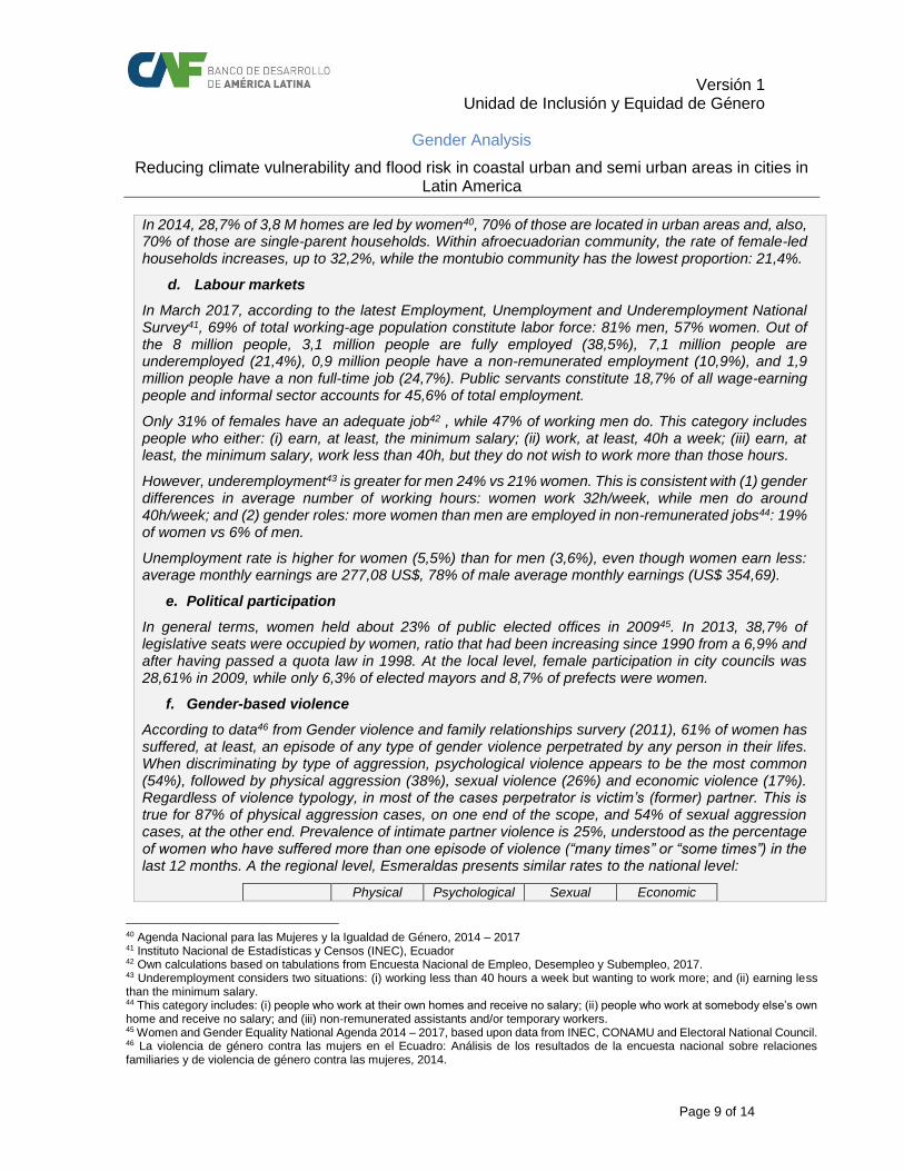
Versión 1 Unidad de Inclusión y Equidad de Género
Gender Analysis
Reducing climate vulnerability and flood risk in coastal urban and semi urban areas in cities in Latin America
Page 9 of 14
In 2014, 28,7% of 3,8 M homes are led by women40, 70% of those are located in urban areas and, also, 70% of those are single-parent households. Within afroecuadorian community, the rate of female-led households increases, up to 32,2%, while the montubio community has the lowest proportion: 21,4%.
d. Labour markets
In March 2017, according to the latest Employment, Unemployment and Underemployment National Survey41, 69% of total working-age population constitute labor force: 81% men, 57% women. Out of the 8 million people, 3,1 million people are fully employed (38,5%), 7,1 million people are underemployed (21,4%), 0,9 million people have a non-remunerated employment (10,9%), and 1,9 million people have a non full-time job (24,7%). Public servants constitute 18,7% of all wage-earning people and informal sector accounts for 45,6% of total employment.
Only 31% of females have an adequate job42 , while 47% of working men do. This category includes people who either: (i) earn, at least, the minimum salary; (ii) work, at least, 40h a week; (iii) earn, at least, the minimum salary, work less than 40h, but they do not wish to work more than those hours.
However, underemployment43 is greater for men 24% vs 21% women. This is consistent with (1) gender differences in average number of working hours: women work 32h/week, while men do around 40h/week; and (2) gender roles: more women than men are employed in non-remunerated jobs44: 19% of women vs 6% of men.
Unemployment rate is higher for women (5,5%) than for men (3,6%), even though women earn less: average monthly earnings are 277,08 US$, 78% of male average monthly earnings (US$ 354,69).
e. Political participation
In general terms, women held about 23% of public elected offices in 200945. In 2013, 38,7% of legislative seats were occupied by women, ratio that had been increasing since 1990 from a 6,9% and after having passed a quota law in 1998. At the local level, female participation in city councils was 28,61% in 2009, while only 6,3% of elected mayors and 8,7% of prefects were women.
f. Gender-based violence
According to data46 from Gender violence and family relationships survery (2011), 61% of women has suffered, at least, an episode of any type of gender violence perpetrated by any person in their lifes. When discriminating by type of aggression, psychological violence appears to be the most common (54%), followed by physical aggression (38%), sexual violence (26%) and economic violence (17%). Regardless of violence typology, in most of the cases perpetrator is victim’s (former) partner. This is true for 87% of physical aggression cases, on one end of the scope, and 54% of sexual aggression cases, at the other end. Prevalence of intimate partner violence is 25%, understood as the percentage of women who have suffered more than one episode of violence (“many times” or “some times”) in the last 12 months. A the regional level, Esmeraldas presents similar rates to the national level:
Physical Psychological Sexual Economic
40 Agenda Nacional para las Mujeres y la Igualdad de Género, 2014 – 2017 41 Instituto Nacional de Estadísticas y Censos (INEC), Ecuador 42 Own calculations based on tabulations from Encuesta Nacional de Empleo, Desempleo y Subempleo, 2017. 43 Underemployment considers two situations: (i) working less than 40 hours a week but wanting to work more; and (ii) earning less than the minimum salary. 44 This category includes: (i) people who work at their own homes and receive no salary; (ii) people who work at somebody else’s own home and receive no salary; and (iii) non-remunerated assistants and/or temporary workers. 45 Women and Gender Equality National Agenda 2014 – 2017, based upon data from INEC, CONAMU and Electoral National Council. 46 La violencia de género contra las mujers en el Ecuadro: Análisis de los resultados de la encuesta nacional sobre relaciones familiaries y de violencia de género contra las mujeres, 2014.

Versión 1 Unidad de Inclusión y Equidad de Género
Gender Analysis
Reducing climate vulnerability and flood risk in coastal urban and semi urban areas in cities in Latin America
Page 10 of 14
Esmeraldas 36% 42% 13% 7%
Total País 35% 43% 14% 11%
The study47 analyses some socio-economic factors that may be linked to gender violence, revealing:
(a) Income: gender violence levels are similar for the first four income quintiles, but descend on the fifth, specially psychological and physical agressions (differences between 1st and 5th quintile are 10 percentage points and 9 percentage points, respectively);
(b) Ehtnicity: prevalence of intimate-partner gender violence varies with ethnicity: indigenous women (59,3%), afroecuadorian women (55,3%), montubian women (48,0%), mestizo women (47,5%), and white women (43,2%);
(c) Education: women with no education (57,4%) or basic education (54,5%) suffer more from psychological and physical violence than women with tertiary studies (36,3%);
(d) Disabilities: women with some type of permanent48 disability49 suffer more gender violence than women without disabilities, specially sexual aggressions (more than 7 percentage points), followed by physical aggressions (with 6 percantages points of difference).
According to CEPAL, Ecuador’s femicides rate in 2014 was 1,2 deaths per 100.000 women.
III. Institutional framework
Chile
a. National regulation
Chile’s Constitution, under article 19.2 expresses “equality under the law. In Chile there is no person or group of people who are privileged. In Chile there are no slaves and if one steps into its territories becomes free. Men and women are equal under the law. No law nor authority will be able to establish arbitrary differences”. And article 19.3 declares “equal law protection in the exercise of their rights”.
Also, Chile has passed specific laws to promote gender equality and prevent gender violence, such as:
Law 20066 on Domestic violence was passed in October 2005, but it is not until December 2010 that Penal Code is modified by Law 20480, including the definition of “Femicide”, as the violent death of a woman by the current of former partner, and increasing sentences for this crime.
Law 20005 on sexual harassment, passed on March 2005, defines sexual harassment as inappropriate requests and behaviours of a sexual nature, without the consent of the other party, that impair his or her work situation and future professional opportunities50.
Gender equity is addressed in the Government Program51 of President Bachelet’s administration (2014 – 2018). It exposes the need for “a New Gender Agenda, based on women’s rights, equality and autonomy, fostered by a renovated and higher-ranked institution”. In this regard, the Ministry of Woman was created on March 2015 (see below). This agenda envisages “incorporating the gender perspective in the design of education reforms, electoral system, labor policies and the New Political Constitution”. Also, a “similar vision exist within the Investment National Services and in the design of a national care-services system”. Other legal measures are included, such as a new law on sexual and reproductive
47 La violencia de género contra las mujers en el Ecuadro: Análisis de los resultados de la encuesta nacional sobre relaciones familiaries y de violencia de género contra las mujeres, 2014. 48 Permanent disability referes to disabilities suffered for at least a year, or longer. 49 It includes the following types: cognitive, developmental, physical, mental, and deafness. 50 OECD, Social Institutions & Gender Index, Chile Profile 2016 51 Availablle at: http://www.minmujeryeg.gob.cl/agenda-de-genero/programa-de-gobierno/

Versión 1 Unidad de Inclusión y Equidad de Género
Gender Analysis
Reducing climate vulnerability and flood risk in coastal urban and semi urban areas in cities in Latin America
Page 11 of 14
rights, a law on abortion, reforming law on equal pay and modifying regulation that currently impedes equal access to property for married women.
Regarding the intersection with environmental regulation and gender, the National Climate Change Adaptation Plan (NCCAP) 2017 – 202252 sets out equity as one of its guiding principles, with “special consideration to gender equity, human rights and ethnicities”. NCAPP specific adaptation objectives are: (1) to determine country’s natural and human systems vulnerability, taking into consideration climate change possible and projected impacts; (2) to enhance disasters risk management in face of climate change impacts; and (3) to adapt to climate change, by means of national socio-ecological systems reduced vulnerability and increased adaptative capacity. Specific objective 1 gives special attention to recollecting vulnerability data disaggregated by sex, given the fact that women and men can be affected differently by climate change. Women suffer from increased vulnerability, since they are in charge of other vulnerable groups such as lactating infants, minors, elder people, disabled and sick. Under specific objective 3 there is an action line for the development of mechanisms to integrate adaptation and social aspects in climate change, more precisely, NCAPP sets out a measure to “mainstream gender and Chilean traditional knowledge into climate change adaptation tools”.
b. Institutions
Under law 20820 the Ministry of Woman and Gender equity was created, on March 2015. It took on responsibilities held before by the Woman National Service, established in 1991 with the purpose of promoting equal opportunities for men and women. Since 1994, WNS developed three Opportunities Equality Plans that ended with the constitution of the Ministries Committee for the Equality of Opportunities.
Ecuador
a. National regulation
Under National Constitution Art 3.1 it is guaranteed no discrimination to all people in full exercise of their rights. Art. 11.2 states that all people are equal and that “no one will be discriminated because of their ethnicity, place of birth, age, sex, gender identity, cultural identity, marital status, language, religion, ideology, political affiliation, judicial past, socioeconomic condition, migratory condition, sexual orientation, health status, VIH condition, discapacity, physical difference, or any other distinction, be it personal or collective, temporary or permanent […]”. Among priority attention groups identified in Art 35, “boys and girls, teenagers, pregnant women” are mentioned.
Under Art 70, “the State will formulate and carry out policies to reach equality among women and men, by means of a specialized mechanism according to the Law, and it will mainstream gender into plans and programas, providing technical assistance for its compulsory implementation in the public sector”.
Also, Constitution guarantees women’s right to live a life free of violence and Law 103 on Violence against women and family was passed in 1995. However, CEDAW53 (2007) declared that “some doubt remains with respect to the treatment of women under Ecuador’s criminal law; violence against women is still considered a 11isdemeanor rather than a crime”. In this sense, its Implementing Regulations, issued in 2004, were adopted as a strategy to proper implementation of Law 103. Also, in 2007 a National Plan to Erradicate Gender Violence against childhood, adolescence and women was approved
b. Institutions
52 It has not yet been approved. 53 Consideration of reports submitted by States parties under article 18 of the Convention on the Elimination of All Forms of Discrimination against Women, Combined sixth and seventh periodic reports of States parties, Ecuador, March 2007.

Versión 1 Unidad de Inclusión y Equidad de Género
Gender Analysis
Reducing climate vulnerability and flood risk in coastal urban and semi urban areas in cities in Latin America
Page 12 of 14
National Council on Gender Equality (NCGE) is the specialized mechanism responsible for ensuring full formal and de facto women and LGBTI rights, as established by the Constitution and other human rights international agreements. Its main objectives are to mainstream gender into the different functions of the state and public sector institutions; to develop public policies to reduce gender gaps that create inequailities and discrimination against women and LGBTI; and to monitor and evaluate compliance with women & LGBTI human rights.
Women and Gender Equality National Agenda (2014 – 2017) is the main tool for the NCGE to mainstream gender equality, including into the Plan Nacional del Buen Vivir. It has 9 core areas: reproduction and life sustainability; a life free of violencia; education and knowledge; health; sports and leisure; culture, communication and arts; production and employment; environment; power and decision-taking.
IV. Potential gendered impacts and risks assessment
Men and women have different roles and responsibilities within their communities. Gendered division of labour assigns different jobs to women and men, which implies different knowledge and sets of skills. Also, they have different access to assets and resources, including access to information as well as to decision-making processes. Thus, women and men are exposed differently to climate change vulnerability and have different tools and strategies to cope with it54. In this sense, project interventions should be gender-sensitive, age and culturally appropriate, as well as take into consideration persons with disabilities.
One out of every 4 homes is a single-parent family in Antofagasta, in Taltal is 1 out of every 5 homes. Given that most of single-parent households are led (95%) by a female in Chile, special considerations should be taken when designing evacuation plans (outcome 4), since these women are alone and in charge of children and/or other dependents (average family size for this group is 2.7).
Also, in order to increase awareness of local population (outcome 6), public communication and education strategies should contain and spread understandable warning messages both for women and for men. This is specially important in Ecuador, considering that women face higher illiteracy rates. It has been proven that the lack of a gender perspective in dissemination and communication exacerbates the negative impacts that a disaster can have (UNISDR 2009).
Horizontal segregation in tertiary education, both in Chile and Ecuador, with males outnumbering females in STEMs studies and careers, implies that less women are and will be represented in these fields. Mechanisms to ensure female presence in communities of practice established with this project (outcome 7) should be promoted. Usually women are included within vulnerable groups, however, “their role in fostering a culture of resilience and their active contribution to building disaster resilience has often been overlooked and has not been adequately recognized” (UNISDR 2009).
Along the same lines, it may be needed to ensure and foster women’s involvement in all public consultations generated by the project. Although stakeholders analyses (Annexes 8 and 9) did not find factors that could impede or limit women’s participation in project activities, women’s partaking in inception workshops in Antofagasta and Esmeraldas was 40% (14 out of 35) and 11% (3 out of 28), respectively; and in validation workshops it was 46% (11 out of 24) and only one woman was present in Esmeraldas (CAF climate change officer).
54 People-centred climate change adaptation: integrating gender issues, FAO 2007.
Versión 1 Unidad de Inclusión y Equidad de Género
Gender Analysis
Reducing climate vulnerability and flood risk in coastal urban and semi urban areas in cities in Latin America
Page 13 of 14
V. Gender Action Plan
As a result of this Gender Analysis, a gender perspective has been incorporated into some project components:
Component 1. Priority actions to increase resilience. In order to achieve Outcome 4. Improved means to respond to floods, landslides and mudflows, expansion of public early warning systems will be put in place, which entails: (i) installing new sirens in Antofagasta and Taltal (output 1); and (ii) developing evacuation maps, on-site signals and implementing annual evacuation drills (output 2). Evacuation maps and protocols should be designed with a gender perspective and it should be encouraged to identify women to be trained to facilitate community action and to guide people to safe areas. In Esmeraldas, the pilot community-based early warning system (output 4.2) will be implemented together with the informal settlers who live in Luis Vargas Torres island. By fostering women’s participation within the pilot, their needs should be more easily addressed within the system, they could transfer their knowledge and it could also help empower them in front of their community.
Component 2. Strengthen capacities for adaptation. Regional online course to be developed to reach Outcome 5. Local governments with improved capacity to design and implement adaptation measures should be gender-sensitive and include a module dedicated to explain linkages between gender, climate change and adaptation measures.
Outcome 6. Local governments with improved capacity to design and implement adaptation measures calls for designing both a public communication strategy and an education strategy for each city (output 6.1), to raise awareness among inhabitants and to engage them into risk-based adaptation. These strategies should be gender-sensitive, so they can effectively reach both men and women. Also, mechanisms to encourage women to participate in Narrators’ initiative (output 6.2) should be implemented.
Component 3. ICTs and partnership between coastal cities in Latin America. Communities of practice are to be set to accomplish Outcome 7. Lessons and best practices on reducing vulnerability to climate flooding, landslides and mudflows in coastal cities have been shared in the region. Gender should be a cross-cutting topic all along 5 communities and female scientists should be identified and encourage to participate.
All public consultations should
To monitor project implementation, some gender-sensitive indicators have been incorporated in the results matrix.
Finally, other means to foster women’s participation recommended to be considered are the following:
- It would be advisable to adjust existing vulnerability, risk and capacity assessments to be gender-sensitive. Also, if new assessments need to be made, it is recommended that they incorporate a gender perspective.
- It should be evaluated if the stormwater management plan for Antofagasta (output 1.1) could incorporate a gender perspective. Because of gender differences, analyzing roles and responsibilities in flood prone areas and identifiying any potential differential impact of floods on men and women are needed to develop mitigation, coping and recovery strategies that will be targeted based on gender perspectives55.
55 Urban stormwater management in developing countries, J. Parkinson, O. Mark,
Versión 1 Unidad de Inclusión y Equidad de Género
Gender Analysis
Reducing climate vulnerability and flood risk in coastal urban and semi urban areas in cities in Latin America
Page 14 of 14
- If Project is going to contemplate any measures or protocols for post-disaster relief coordination, these should be designed identifying women as relevant actors, and not only as vulnerable groups.
- When sourcing staff and consultants, gender equality wil be a guiding principle. Using gender-sensitive language in hiring procedures; determining a quota (i.e. 30%) or facilitating training for women so as they can access traditionally male-dominated positions, are some of the measures that could be implemented. Also, these procedures can be included as requirements for contractors to be hired to do the works.

“AUTONOMOUS DECENTRALIZED GOVERNMENT
OF THE ESMERALDAS CANTON”
Purpose
TERMS OF REFERENCE (ToRs) – HIRING OF SURVEYS INTENDED FOR FINAL STABILIZATION AND REINFORCEMET WORKS FOR THE GATAZO HILL SLOPES IN THE 20 DE NOVIEMBRE NEIGHBOURHOOD, ESMERALDAS CITY, ESMERALDAS CANTON, ECUADOR. HIRING TO BE DONE THROUGH THE SHORT-LIST CONSULTANCY PROCEDURE
Date 17 May 2017
Requiring Area PUBLIC WORKS OFFICE
Responsible for RequIrement
ENGINEER MIGUEL MOEIRA
Unit Director or Responsible Person
ENGINEER MIGUEL MOREIRA
1. BACKGROUND
The impact of never-ceasing landslides in the Gatazo foothills originating in heavy rainfall seasons has been the cause for erosion of slopes, a situation which in this case is not due to flooding but, rather, to the lack of storm water drainage to channel water away from households. Furthermore, heavy rains having a direct bearing on soil instability due to water-caused erosion, adding to the landslides particularly occurring in this area, are making the sector into an emergency hotspot, since it has been described as a high-risk area on account of the occurrence of mass movements. This situation is a cause for serious distress to families living in the 20 de noviembre neighbourhood, located at the access road end. The Municipality of Esmeraldas intervention through its different units has allowed for the immediate evacuation of more than twenty families whose homes have been settled in this sector for some time now: a place they should have never built their houses in. Specifically, toward the El Oro road end, in the neighbourhood known as 29 de Noviembre, the non-stop Gatazo Hill landslides have already accounted for the loss of several houses, and may also lead to the collapse of media antennas located near the Hill slopes failure. Second paragraph of Article 396, of the Political Constitution of the Republic of Ecuador sets forth: "the liability for environmental damage is objective. Any impairment to the environment, in addition to relevant sanctions, shall also imply the obligation to comprehensively restoring ecosystems in full, and compensating affected individuals and communities."

“AUTONOMOUS DECENTRALIZED GOVERNMENT
OF THE ESMERALDAS CANTON”
Article 20 of the Environmental Management Law, states: "For any activity entailing environmental risk to get under way, the relevant licence should have been already issued as granted by the Ministry of Industry." The Project: "SURVEYS INTENDED FOR FINAL STABILIZATION AND REINFORCEMET WORKS FOR THE GATAZO HILL SLOPES IN THE 20 DE NOVIEMBRE NEIGHBOURHOOD, ESMERALDAS CITY, ESMERALDAS CANTON, ECUADOR” AND BASED ON THE SHORT-LIST CONSULTANCY PROCEDURES" is intended to addressing one of the most pressing needs of the Esmeraldas City inhabitants settled in this area: i.e., safeguarding their lives and assets from the onslaught of nature, runoff, erosion, or landslides, to prevent the loss of soil necessary for future urban growth of this important district, the city and this canton, in particular as regards the city´s large population growth. The Autonomous Decentralized Municipal Government of the Esmeraldas Canton (GADMCE), is fully aware that, bearing in mind the erosion process the area has been sustaining over time, the ultimate purpose of this project is for a thorough protection to be added to the stability of the hillsides and slopes, since recurrent runoffs and landslides in the area are a source for great concern and worry to people settled therein, in particular over the rainy season, or over the occurrence of "El Niño" natural phenomenon. This project in intended to contributing to prevent and reduce environmental risk due to the loss of soil and vegetation stability, and to give some reassurance and security to people settled in this sector so that they can make gradual improvements to their homes, and the Municipality supplies basic public utilities such as (drinking water, sewage, and management of rainwater and domestic waste).
2. OBJECTIVES
2.1. Overall Objective The purpose of this consultancy is to conduct the: "SURVEYS INTENDED FOR FINAL STABILIZATION AND REINFORCEMET WORKS FOR THE WESTERN SLOPE OF THE GATAZO HILLSIDE, IN THE 20 DE NOVIEMBRE NEIGHBOURHOOD, ESMERALDAS CITY, ESMERALDAS CANTON, ECUADOR. The Consultant shall be responsible for all the work to be carried out and surveys to be conducted in compliance with these Terms of Reference (TofRs).

“AUTONOMOUS DECENTRALIZED GOVERNMENT
OF THE ESMERALDAS CANTON”
2.2. Specific objectives • Conducting feasibility surveys to carry out stabilization, drainage and slope reinforcement works, to protect infrastructure in case of disasters or unforeseen circumstances, and bearing in mind particular Ecuador's climate change scenarios. • Budgeting, definition of technical specifications, drafting up technical reports, drawings, and incorporating a unit price breakdown of all interventions that are scheduled to be carried out in existing buildings and external areas. • Making final designs for stabilization, drainage and reinforcement works intended for protection of infrastructure in the event of disasters, or unforeseen events, and bearing in mind climate change scenarios as depicted in the Ecuador´s Third National Climate Change Communication. • Drafting up designs that allow for the corrective process to be speeded up by using constructive technologies, thus optimizing construction time. • The structure itself should not sustain any damage whatsoever, rather, its operational condition should be warranted, as stated in Chapter addressing existing structures, as set forth in current Ecuadorian Construction Standards (ECS). • Providing advice over the time that the execution of the project so requires, up to the provisional and final reception of the project, if the institution so requests. Budgeting, drafting up of technical specifications and technical reports, drawings, preparing unit price breakdown of all interventions being scheduled to be carried out in existing buildings and outdoor areas. • Updating the Project´s Environmental Impact Survey, and the Environmental Management Plan.
3. SCOPE The scope and description of activities to be carried out by the Contractor to comply with the Object of the Contract is shown below:
“AUTONOMOUS DECENTRALIZED GOVERNMENT
OF THE ESMERALDAS CANTON”
• Conducting surveys to implementing stabilization and drainage works for infrastructure protection in the event of disasters or unforeseen events. • Identifying realistic and feasible costs, a schedule, or objectives bearing in mind project risks. • Drafting up designs allowing for corrective process to be speeded up through use of constructive technologies, thus optimizing construction time. • All activities as required to carry out specific objectives as set out above. 4. SPECIFICATION OF SURVEYS´ REQUIREMENTS SCOPE The Consultant shall clearly identify the purposes, objectives, expected results, activities and goals of the expected scope of Surveys as envisaged for each process in this contract, is as follows: • Feasibility Surveys • Final Survey and Environmental regularization. • Feasibility surveys of stabilization and reinforcement works in Gatazo slopes, in the 20 de Noviembre neighbourhood, Esmeraldas city, Esmeraldas Canton, Ecuador. • Final designs including Ecuador climate change scenarios in the Stabilization and Reinforcement Works in the Gatazo Hill, 20 de Noviembre neighbourhood, in the City of Esmeraldas. • Environmental and Social Impact Assessment and Environmental Management Plan of the infrastructure project. • Up-to-date documentation for management of the project´s environmental regularization. 5. SURVEYS´ IMPLEMENTATION SCHEDULE

“AUTONOMOUS DECENTRALIZED GOVERNMENT
OF THE ESMERALDAS CANTON”
1 2 3 4 5
Topografia
Sondeos geotécnicos
Geología y geofísica
Hidrología e hidráulica
Estabilidad de taludes
Diseño de anclajes
Informe de Ingeniería
ESTUDIO DE FACTIBILIDAD Y DISEÑO DEFINITIVO PARA LA ESTABILIZACION DE TALUDES DEL SECTOR 20 DE NOVIEMBRE DE LA
CIDAD DE ESMERALDAS, CANTÓN ESMERALDAS
ACTIVIDADMESES
TERCERA FASE
SEGUNDA FASE
PRIMERA FASE
FEASIBILITY SURVEY AND FINAL DESIGN FOR STABILISATION OF GATAZO
HILL SLOPES IN THE 20 DE NOVIEMBRE SECTOR IN THE CITY OF ESMERALDAS, ESMERALDAS CANTON, ECUADOR
ACTIVITY
MONTHS FIRST PHASE Topography Geotechnical probing Geology and geophysics SECOND PHASE Hydrology &Hydraulics Slope stability Anchorage design THIRD PHASE Engineering Report --------------------------------------------------
6. WORKING METHODOLOGY The Consultant shall prepare the Final Engineering Project. The survey and the scheduled work shall be fully coordinated and integrated with designs as dictated by the different engineering areas, namely: geological, geotechnical, hydraulic and
“AUTONOMOUS DECENTRALIZED GOVERNMENT
OF THE ESMERALDAS CANTON”
structural engineering branches, so as to obtaining a comprehensive product and in line with the importance of this project. The methodology as below is being suggested to fulfilling specific objectives:
Initially, the consulting team shall undertake a reconnaissance of the project site, collect information regarding basic infrastructure and all other information as deemed to be required to design reinforcement works for existing buildings.
Calculation reports should be drafted up for each design of the different engineering branches and relevant engineering drawings.
All information required for the overall objective of this survey to be achieved shall be collected by the consultant.
Budgeting of work volumes.
The consultant should include in the survey all design standards recommendations, as well as any subjects the consultant may deem as necessary and which are included within the requirements as called for.
The consultant shall deliver the information in digital files – allowing for changes, such as Word, Excel, Autocad, Shapefiles.
ENFORCEABLE REGULATIONS
NEC, Ecuadorian Construction Standard, NEC-SE-CG: Loads (Non-seismic);
NEC, Ecuadorian Construction Standard, NEC-SE-DS: Seismic Hazard and Earthquake Resistant Design;
NEC, Ecuadorian Construction Standard, NEC-SE-CM: Geotechnics and Foundations;
NEC, Ecuadorian Construction Standard, NEC-SE-RE: Seismic Risk, Appraisement, Rehabilitation of Structures;
ASTM, American Society Testing and Materials
AASHTO, American Association of State Highway and Transportation Officials. GENERAL SURVEYS METHODOLOGY TOPOGRAPHY A detailed survey will be conducted with soil georreferentiation equipment and drones, determining mass behaviour and movement. Movement, escarpments, cracks and channels details should be determined. GEOLOGICAL SURVEYS

“AUTONOMOUS DECENTRALIZED GOVERNMENT
OF THE ESMERALDAS CANTON”
Field and laboratory work will be undertaken under the supervision of a Geologist Engineer. Fieldworks Regional geological information will be collected on the basis of drones to assess stability conditions and endangered areas, and impairment of the regional geology in the project. Also, the geological characteristics, structural geology, lithology and geological risks (floods, mass movement, seismicity, volcanic risk, etc.) shall be ascertained. Surveys Report A physical and digital format report will be issued carrying the signatures of those responsible, and should include all field and gabinete geology surveys, regional geological maps, local geological map, geological sections, technical references, bibliographies, conclusions, recommendations, as well as all protection alternatives for stability of sites where structures are placed on. GEOTECHNICAL SURVEYS Field and laboratory work will be carried out under the supervision of a Geotechnical Engineer. Setting forth solution alternatives for stabilization of the area. Fieldworks In order to assess and validate the Risk Analysis Survey, data recorded in this survey will be verified through direct field inspections and geotechnical characterization of the subsoil. Field tests as required will be conducted by applying the most appropriate techniques, in order for geomechanical subsoil behaviour parametres to be recorded in the most direct way. Laboratory work All tests complementing and verifying parametres recorded in field tests will be done in order to obtain all those required for the survey objectives to be fulfilled. Gabinete work

“AUTONOMOUS DECENTRALIZED GOVERNMENT
OF THE ESMERALDAS CANTON”
A report in physical and digital format will be delivered signed by people responsible, and including all field geotechnical laboratory and gabinete surveys carried out with the corresponding geo-referencing, conclusions and recommendations. Furthermore, a report signed by the independent professional in charge of revisions shall be included certifying that all of these revisions have indeed been performed. Solution Proposals The consultant will issue solution alternatives for the stabilization of the affected area, solutions which should be both technically and economically viable. Proposals for solutions should include at least:
- A Technical report - A Constructive process report - Drawings - Quantities table - Technical specifications - Unit prices and referential budget review
STRUCTURAL ENGINEERING Structural evaluation work shall be performed under the supervision of a specialist civil engineer and shall consist of an analysis and design of the containment structures as required, and in accordance with the general stabilization and reinforcement solution. Gabinete work Woks as follows shall be included in a report:
- Structural analysis models according to seismic load and danger parametres as set forth in Ecuadorian Construction Standards
- Review of results obtained - Conclusions and recommendations.
HYDRAULICS ENGINEERING The Consultant shall have access to information as required to elaborate relevant drainage systems designs.

“AUTONOMOUS DECENTRALIZED GOVERNMENT
OF THE ESMERALDAS CANTON”
All technical surveys will be conducted to obtain a final design of all drainage works as required to ensure the optimal hydraulic operation so as to warrant the Gatazo Hill behaviour (Macizo (Massif), en el original en español NT).
The environmental impact assessment is a key tool for making decisions about projects, works or activities requiring an environmental licence, and this assessment should be submitted in all cases where an environmental licence is required, pursuant to the law and in accordance with this regulation. This assessment should correspond in its content and depth to the project´s own characteristics and setting. The Consultant should be in line with national requirements for surveys of this kind.
TECHNICAL STANDARDS
Technical Standards as below shall be considered design-wise:
• NEC-11 Ecuadorian Construction Standard
• INEN Ecuadorian Standardization Institute
• ANSI American National Standards Institute
• ASTM American Society for Testing Materials
• IEOS Ex Ecuadorian Works and Sanitation Institute
7. INFORMATION AVAILABLE TO THE ENTITY
Cadastral documents, drawings, previous surveys in the reference area. All documents, reports and outputs being drafted up as developed as a part of activities, are the property of the Autonomous Decentralized Government of the Municipality of Esmeraldas.
8. EXPECTED OUTPUTS OR SERVICES
EXPECTED OUTPUTS

“AUTONOMOUS DECENTRALIZED GOVERNMENT
OF THE ESMERALDAS CANTON”
The Consultant will submit the relevant Survey in phases, in two (2) copies each and in individual documents:
FIRST PHASE (within a sixty (60) days term): The deadline for delivery of the first phase outputs is sixty (60) days from the date the contract has been entered into. Upon delivery, the Contract Manager will have a further term period of up to fifteen (15) days to make relevant comments; likewise, the Consultant shall have up to fifteen (15) days to make corrections. These terms are not attributable to contractual term. As from the date of delivery of comments by the institution, the consultant should continue to carry out the second phase work. Upon submission of comments by the institution, the Consultant shall keep working on the second phase Works. TOPOGRAPHY Drawings and details of the impaired area surface GEOLOGY
Geological Report (Geology, Geomorphology Geological Risks).
Annexes: A report including a definite and accurate description of technical backup, and photographic annexes GEOTECHNICS
Probes, field and laboratory results, stratigraphy, characterization profiles. ENVIRONMENTAL IMPACT ASSESSMENT According to national legislation, this assessment should provide background for forecasting and identification of environmental impacts. Furthermore, the assessment should describe measures to preventing, keeping in check, mitigating and compensating for severe environmental disturbances. At least, information as below should be spelled out in this Assessment:
1. Delimitation of the area under the direct and indirect influence of the project, work or activity.

“AUTONOMOUS DECENTRALIZED GOVERNMENT
OF THE ESMERALDAS CANTON”
2. Description of the project, work or activity, including: location, stages, dimensions, estimated costs, execution schedule, processes, identification and basic estimation of inputs, outputs, waste, emissions, spills and risks inherent to the technology to be used, their sources and monitoring systems.
3. Information on the project compatibility with land uses as set forth in Territorial
Arrangement Plans.
4. Information on renewable natural resources that are intended for harnessing, use, or that shall be impaired by the execution of the project, work, or activity.
5. Identification of communities and mechanisms used to keep those
communities informed about the project, work, or activity.
6. A description, characterization and analysis of the biotic, abiotic, socio-economic setting in which the project, work or activity is intended to be developed.
The preparation of the Environmental Management Plan involves taking into account issues as follows:
Identification and appraisement of environmental impacts likely to be brought about by the project, work or activity, clearly stating which of these impacts could be prevented, mitigated, corrected or compensated for.
The Environmental Management Plan proposal for the project, the work, or the activity; proposal that should include the following:
Impact Prevention and Mitigation Plan. Measures to prevent, mitigate, correct and compensate for adverse environmental impacts that the project, work or activity could have on the environment and / or communities over the construction, operation, maintenance, dismantling, abandonment and / or termination phases of the project, work, or activity;
Monitoring and Follow-up Plan. The monitoring programme for the project, work or activity in order to verify abidance by environmental commitments and obligations over the implementation of the Environmental Management Plan, and verify compliance with environmental quality standards as set forth in regulations in force. Likewise, to assessing by means of indicators the expected environmental performance of the project, work or activity, the efficiency and effectiveness of environmental management measures adopted, and the relevance of corrective measures necessary and applicable

“AUTONOMOUS DECENTRALIZED GOVERNMENT
OF THE ESMERALDAS CANTON”
to each particular case;
Contingency Plan. The contingency plan which will contain prevention and response measures vis-à-vis emergencies likely to occur over the life of the project, work or activity;
Training Plan; Occupational Health and Safety Plan; Waste Management Plan; Community Relations Plan; Rehabilitation Plan for Impaired Areas; Area Abandonment and Handing over of the Area;
Management Plan projected costs vis-à-vis total costs of the project work or activity. and Management Plan execution schedule.
SECOND PHASE (within a 60-day term): The deadline for delivery of the second phase is sixty (60) days as from the date of submission of remarks on the first phase by the institution. Upon delivery of outputs, the Contract Manager will have a term period of up to fifteen (15) days to make relevant comments; and the Consultant will also have up to fifteen (15) days to incorporate corrections. This term is not attributable to contractual term. If any other comments to Phase 2 are made for a second time, the consultant will be granted a last and final fifteen (15) days for clarification and, if the inconvenience is not properly dealt with, relevant fines will be imposed for any additional days the Consultant takes to making corrections as from the date comments were issued by the institution and up to the time those comments have been addressed, and, so, the third phase´s term will have elapsed. GEOTECHNICS The most suitable solution alternative shall be submitted, together with the slopes calculation and survey report, a definition of the stabilization system, drawings and construction specifications. STRUCTURAL AREA • Structural report including detailed information on, at least: design parametres
adopted for structural assessment, mathematical models, results analysis, design of structural components and reinforcement proposal.
• A descriptive report of the work to be executed. • The consultant shall submit a listing of drawings with relevant respective names
and numbering. This listing should be attached to the descriptive technical report. Drawings should be submitted including the liability signature of the Engineer assigned to the project.

“AUTONOMOUS DECENTRALIZED GOVERNMENT
OF THE ESMERALDAS CANTON”
HYDRAULICS The most suitable drainage and sub-drainage solution alternatives will be submitted together with their calculation report and flow assessment, and the definition of the water evacuation and flow system, drawings and construction specifications. THIRD AND FINAL PHASE (30 DAYS): The deadline for submission of the third phase and the Final Report is thirty (30) days as from the acceptance of the final solution, completing one hundred and fifty (150) days counted as from the advance payment, without counting revision, correction and approval times. Budgets, specifications, unit price breakdown and timelines of the solution approved and accepted by the institution and the final report with all relevant documents and annexes will be delivered. Upon the final delivery of outputs, the institution will have up to fifteen (15) days to submit comments, and the Consultant will have up to fifteen (15) days to correct these comments if applicable, and to submit the Final and definite Report. These terms are not attributable to the contractual term. Within fifteen (15) days of delivery of all consultancy outputs, duly approved by the contract manager, the Unique Reception Delivery Minutes shall be signed pursuant to the terms as set forth in Article 123 of the General Regulation, of the National Public Procurement System Organic Law.
DOCUMENTS
TECHNICAL REPORT: The descriptive technical report shall include:
Cover: Including the name of the Expert in charge of the project, project name, project inception or updating date Introduction Background Description of the work executed Remarks Comments
Technical Specifications

“AUTONOMOUS DECENTRALIZED GOVERNMENT
OF THE ESMERALDAS CANTON”
The same code and order as per the consultant's reference budget should be submitted. Technical specifications are those documents in which the standards, requirements and procedures to be used and applied in all construction works are defined. Among technical specifications, information as below should be submitted: Description: A brief description of the works item concerned. Procedure: A description of requirements for items implementation or installation, including standards that equipment and / or materials to be used shall abide by. Minimum equipment: A detailed description of tools required for installation of equipment. Skilled labour: Workers having the occupational category granted by the Comptroller General of the State. (file updated) Tests: Refers to tests conducted of materials or equipment to be installed. Measurement Unit: A precise description of how each item shall be measured to go ahead with the relevant payment. Method of payment: Detailed information on how the item will be paid for. REFERENCE BUDGET: The reference budget according to the institution´s own format and the estimated work progress schedule. Unit prices analysis (with the same code and order of the consultant's reference budget), in which labour, materials, and equipment, making up each of the APUSs, should be broken down; There can be no global headings; performance should be adequate to execute the item on site. The technological disaggregation should be submitted. VALUED SCHEDULE: A document should be submitted in which each one of the project construction stages is mapped out. FORMAT AND DELIVERY DOCUMENTS: Project drawings in PDF and DWG 2013 or higher format and in INEN A1 format should be drawn up and include: Scale drawings of the current state,

“AUTONOMOUS DECENTRALIZED GOVERNMENT
OF THE ESMERALDAS CANTON”
and proposed, depending upon the project size, in addition to each drawing corresponding to structural engineering. Delivery of all information (documents and drawings) will be made in physical and digital formats: Physical format in original and two copies; and a Digital format (CD) of all the corresponding information and all documentation as required. All drawings scanned in PDF format with their respective structural engineering and architecture signatures will be delivered in a CD, with a good graphic quality for easy reproduction. 9. CONTRACTUAL PROCEDURE SUGGESTED (SUBSTANTIATED)
The reason why this hiring method was chosen is based on the provisions of Article 6 numeral 8, LOSNCP, "This Consultancy refers to the delivery of specialized non-standardized professional services, the purpose of which is to identify, audit, plan, undertake, or evaluate surveys and development projects, at their pre-feasibility, feasibility, design or operation stages. This Consultancy also includes oversight, audit, inspection, and appraisement of ex-ante and ex-post projects, the development of software or computer programmes, as well as consultancy and technical assistance services, and drafting up of Surveys." Furthermore, article 40, numeral 2 in LOSNCP, stipulates the following: "Short-list contracting: When the contract´s reference budget exceeds the budget as set forth in the previous number, and that budget is less than the amount resulting from multiplying the 0.000015 coefficient by the amount of the initial audited statement of accounts for the fiscal year concerned; and " 10. REFERENCE BUDGET The contractual reference amount is ONE HUNDRED AND SIXTY-SEVEN THOUSAND, EIGHT HUNDRED AND TWELVE US DOLLARS AND 00/50 DOLLAR CENTS (USD $ 167,812.50). 11. BUDGETARY AVAILABILITY (SPECIFY AND ATTACH) These contractual terms shall be applied to budget line No. 310.73.06.01, known as "CONSULTANCY, ADVISORY AND SPECIALIZED SURVEYS", a budget line already provided for in the year 2017 PAC, as set forth in Financial Management memorandum No. 3038-GADMCE-DF-2017 dated February 15, 2017.

“AUTONOMOUS DECENTRALIZED GOVERNMENT
OF THE ESMERALDAS CANTON”
12. CONTRACTUAL TERM The time for the provision of the service referred to above is one-hundred-and-fifty-days (150) days (5 months), counted from the day of notification to the Contractor that the advance payment is available. 13. TECHNICAL STAFF / WORK TEAM / RESOURCES KEY TECHNICAL STAFF In order to comply with the object of the contract, the Consultant will count on the involvement of key technical personnel as deemed to be required for Assessment purposes:
NUMBER PERSONNEL PARTICIPATION RATE
1 Project Director (Civil Engineer)
50,00%
1 Project Coordinator (Civil Engineer)
100,00%
1 Civil Engineer –Geotechnician 50,00%
1 Civil Engineer- Geologist 40,00%
1 Civil Engineer - Hydrologist 40,00%
1 Civil Engineer – Structural 40,00%
1 Architect 20,00%
1 Sociologist 80,00%
1 Planning Engineer 40,00%
1 Environmental Engineer, experienced in climate change
issues
70,00%
Additionally, personnel as below shall, shall be deemed as team members, and they shall not be evaluated:
NUMBER PERSONNEL PARTICIPATION RATE
2 Draughtsman/woman 80,00%
1 Secretary 40,00%
1 Chauffeur 80,00%
1 Laboratory Assistant 80,00%
1 Specialist in handling Drilling 40,00%

“AUTONOMOUS DECENTRALIZED GOVERNMENT
OF THE ESMERALDAS CANTON”
Machines
MINIMUM EQUIPMENT
• Topography equipment (1 full station)
• Soil drilling machine
• Soil laboratory equipment
• Data processing equipment (1 computer, 1 printer).
• Vehicle (1 vehicle suitable for the project).
For the provision of services related to drafting up of Survey, the Consultant will rely on qualified professional personnel as specified in the Consultant´s Technical Proposal. No changes shall be allowed except for duly substantiated force majeure. In these cases, the Consultant shall suggest this change of personnel to GADMCE, ten (10) business days in advance, in order to obtain approval for this change.
Failure by the Consultant to comply with requirements as set forth in these qualification parametres entails the application of fines as set forth in the Competition Bases and / or in the relevant contract.
14. PAYMENT METHOD Advance Payment: Fifty percent (50%) of the total agreed amount: that is, the amount of FIFTY THOUSAND, THREE HUNDRED AND FORTY-THREE, AND 75/100 CENTS DOLLARS OF THE UNITED STATES OF AMERICA (USD $ 50,343.75), VAT free, upon submission of the bank guarantee or insurance policy covering 100% of the Advance Payment amount. This amount will be paid at the signing of the contract.
The remaining fifty percent (50%), that is, the sum of ONE HUNDRED SIXTEEN THOUSAND, FOUR HUNDRED AND SIXTY-EIGHT, and 75/100; DOLLARS OF THE UNITED STATES OF AMERICA (USD $ 117,468.75) VAT free, will be paid against delivery of:

“AUTONOMOUS DECENTRALIZED GOVERNMENT
OF THE ESMERALDAS CANTON”
First Phase 50%
Second Phase 25%
Third Phase 25%
At delivery of each stage´s products, the Consultant will have five (5) days for review and remarks, and five (5) days for corrections (time not attributable to the Contractor). Guarantees: Those as LOSNCP may determine. 15. DELIVERY SYSTEM
Works in full 16. VALIDITY OF THE TENDER
The term for validity of the tender is thirty (30) days or until the contract is signed
17. AWARDING TYPE
Total 18. CONSULTANT TYPE
TYPE: CONSULTING FIRMS CONSULTANTS RECOMMENDED TO BE INVITED:
No. CORPORATE NAME RUC
1 CONGEOTEC SA 1391781288001
2 GEOSURVEYS SA 099233793101
3 TRICONSUL TRIÁNGULO ASOCIADOS CÍA. LTDA.
0891706723001
19. CONTRACTOR OBLIGATIONS The contractor undertakes to:

“AUTONOMOUS DECENTRALIZED GOVERNMENT
OF THE ESMERALDAS CANTON”
• Provide consulting services; and all that is necessary for the total execution of
the contract, in accordance with the tender negotiated tender, terms of reference, general and specific conditions, and all other contractual documents.
• For fulfilment of consulting services, and over the term of the contract, the Consultant shall hire the key technical personnel as indicated in its negotiated tender, and according to the approved schedule of activities.
• To replace key technical personnel assigned to the project, the Consultant will request the prior written authorization from the contract manager.
• Upon the request of the entity, based on the proven inefficiency of the personnel, and at the Consultant cost, the latter should replace one or more of the professionals, employees or workers assigned to the project.
• The Consultant will request the entity to approve it in case the Consultant requires personnel other than that as stipulated in the Consultant´s tender.
• The Consultant will take upon the full technical responsibility for the professional services rendered for preparation of the Final Survey in accordance with the ORGANIC LAW OF THE NATIONAL PUBLIC PROCUREMENT SYSTEM AND ITS GENERAL REGULATIONS (August 2008), Chapter XI, RESPONSIBILITIES: Article 100 (Responsibility of Consultants).
• The Consultant will be responsible for supplying accurate information on all geotechnical tests and their date of execution, their location (± 50 cm) at the time of design, in order to be able for tests results to be checked over the works execution stage, and file complaints.
• The review of documents and drawings by GADMCE over preparation of the Survey does not exempt the Consultant from final and total responsibility.
• The Consultant will also be responsible for the accuracy of the project work quantities which should be within a reasonable range, defined as ± 5% of such actual work quantities. As an outcome of the project's accuracy, the actual final cost of the work should be within ± 5% of the total initial cost of the work.
• In view of the fact that the Consultant is entirely responsible for the Survey undertaken, the Consultant should warrant its quality and vouch for the work done, in accordance with legal standards, over the next five (5) years from Date of approval of the Final Report by GADMCE. Therefore, in case of being required for any clarification or correction, the Consultant cannot refuse to attend the summons.
• In case of the Consultant´s refusal to attend the summons, that refusal will be notified to Ecuadorian State Comptroller General for the consequent legal effects, bearing in mind that the service provided is an administrative act, therefore, the Consultant is responsible to the State, in addition to responsibilities as set forth in Article 100 of the LOSNCP.

“AUTONOMOUS DECENTRALIZED GOVERNMENT
OF THE ESMERALDAS CANTON”
20. CONSULTANT NATURE Other than the responsibilities set forth in Article 100 of the LOSNCP 21. OBLIGATIONS OF THE CONTRACTING PARTY • Addressing requests and problems likely to arise over the execution of the
contract, within a period of days counted from the date of the written request made by the contractor.
• Supplying the contractor with the documents, access, and relevant information related to the Consultancy work, as the Contracting Party may have at his / her disposal, and making arrangements that the contractor should carry out vis-à-vis the various public entities, within a fifteen (15) days period counted as from the date of the written request made by the contractor.
• If necessary, and prior to the respective legal and administrative process,
entering into complementary contracts within a fifteen (15) days period counted as from the decision of the highest authority.
• To sign the delivery and reception of works Minutes, provided that, pursuant to
Law, the delivery and reception terms have been complied with; and, in general, to comply with obligations arising out of the contract.
22. MINIMUM REQUIREMENTS 1.- Minimum Equipment
No. Description Quantity Characteristics
1 Drilling machine 1
2 Soil Laboratory Equipment 1
3 Topography equipment (total electronic stations)
1 1 equipment, precision 5” (5 segundos)
4
Data processing equipment (computers i5)
2 Core i5
Data processing equipment – printer )
1 Color A4 a
5 Vehicle 1 4x4 type

“AUTONOMOUS DECENTRALIZED GOVERNMENT
OF THE ESMERALDAS CANTON”
7. Key Technical Staff
No. Duties Education Level Degree
Number
1 Project Manager Tertiary Civil Engineer 1
2 Project Coordinator Tertiary Civil Engineer 1
3 Geotechnician Tertiary Civil Engineer 1
4 Geologist Tertiary Geologist 1
5 Hydrologist Tertiary Civil Engineer 1
6 Structural Engineer Tertiary Civil Engineer 1
7 Architect Tertiary Architect 1
8 Sociologist Tertiary Sociologist 1
9 Planning engineer Tertiary
Civil Engineer, Business Administrator, or Economist
1
10
Mainstreaming the project´s environmental management and warranting inclusion of the climate variable into the Project (bearing in mind the outcomes of the Third Climate Change Statement) Tertiary
Environmental Engineer with experience in Climate Change
1
Backup Technical Staff as below shall be deemed to be team members:
No.
Duties Education level
Number
1 Draftsman / woman High School graduate
2
1 Secretary High school graduate
1
1 Chauffeur High school graduate
1
1 Laboratory Assisstant High School graduate
1
1 Specialist in handling drilling machines
High school graduate
1
3.- Minimum Technical Staff Experience

“AUTONOMOUS DECENTRALIZED GOVERNMENT
OF THE ESMERALDAS CANTON”
a. The area requiring to hire Staff shall define the experience that each Staff member should accredit as a minimum, either in terms of years, number, or monetary cost of projects in which they have participated.
b. Experience gained in a dependency working relationship will be recognized if the certificate issued by the contractor; or the legal representative of the Contracting Entity warrants the effective participation of the applicant as a private employee, or as a public official in the execution of a work, or works.
c. For each particular case, the instrument or means on the basis of which the experience acquired will be verified.
Technical staff hired should submit at least two (2) contracts or certificates attesting to their experience obtained for a minimum of three (3) months over the last five (5) years, with a minimum monetary cost of those works equal to ten percent (10) of the reference budget of the works contracted.
No.
Description Temporality
(años)
Minimum number of projects
Minimum Amount
Experience
1 Project Manager
5 2 16.781 Civil Engineering Projects
2 Project Coordinator
5 2 16.781 Slope stability Works and/or design
3 Geotechnician 5 2 16.781 Geotechnical Works and/or surveys
4 Geologist 5 2 16.781 Geology Works and/or surveys
5 Hydrologist 5 2 16.781 Geology Works and/or surveys
6 Structural Engineer
5 2 16.781 Structural Works, designs, and/or surveys
7 Architect 5 2 16.781 Architectonical Works, designs and/or surveys
8 Sociologist 5 2 16.781 Sociological Works and/or surveys
9 Planner 5 2 16.781 Planning Works and/or surveys
10 Environmental Engineer
5 2 16.781 Environmental Works and /or surveys dealing with environmental management

“AUTONOMOUS DECENTRALIZED GOVERNMENT
OF THE ESMERALDAS CANTON”
and climate change
As regards the minimum “Time” requirement, this will be considered from the date the required academic title was granted, with relevant supporting documentation. 4.- General and Specific Minimum Working Experience
No.
Description temporality
Number of Projects
Minimum amount
No. Of contracts allowed
Minimum contractual amount
1
General Experience.- Submit at least two (2) maximum five (5) provisional or definite contracts; receipt, and / or certificates issued by a competent authority attesting to the experience gained over the last five (5) years in: Audit, oversight, management and / or design of civil works, the minimum amount of which accounts for twenty percent (20%) of the project's reference budget.
5 2 33.562

“AUTONOMOUS DECENTRALIZED GOVERNMENT
OF THE ESMERALDAS CANTON”
Specific Experience Submit at least two (2) maximum five (5) provisional or definite contracts; receipt and / or certificates issued by a competent authority attesting to the experience obtained over the last five (5) years in Surveys and Designs of Solid waste works, the minimum amount of which accounts for ten percent (10%) of the project's reference budget.
5 2 16.781
Note: Certificates included in the minimum specific experience can also be listed in the minimum overall experience, provided that these certificates are within the framework of preparation of surveys, consultancy services and / or oversight of projects in general.
RATING PARAMETRES
PARAMETRE COMPLIES YES/NO
APPRAISEMENT (for Short List and Public Tender)
Tender integrity
Minimum Experience of Key Technical Personnel
Minimum overall experience
Minimum specific experience
Net worth (applicable to legal persons)*
Execution methodology and execution schedule

“AUTONOMOUS DECENTRALIZED GOVERNMENT
OF THE ESMERALDAS CANTON”
RATING PARAMETRES
Equipment and instruments available
Any other as the requesting area may consider (Experience, delivery term, quality, etc.)
23. APPRAISEMENT METHODOLOGY Parametres and their scores, as below have been borne in mind vis-à-vis the appraisement methodology:
PARAMETRES SCORE
a) Overall Experience 10
b) Specific Experience 30
c) Key technical Staff Experience 50
d) Instruments and Equipment available
5
g) Execution Methodology and Schedule
5
TOTAL 100
The total score for each Proposal will be obtained by adding the partial ratings described above. The proposal having the highest final rating will be the one chosen in the first place of preference for the negotiation of the Economic tender. To negotiate, at least seventy (70) points over one hundred (100) points are required to qualify. PARAMETRE 1 Tender Integrity APPRAISEMENT METHODOLOGY PARAMETRE 1 A revision will be made that the tender incorporates all forms as defined in these specifications, according to the following items:

“AUTONOMOUS DECENTRALIZED GOVERNMENT
OF THE ESMERALDAS CANTON”
A.) TENDER FORMAT B.) TECHNICAL STAFF PARTICIPATION COMMITMENT FORMATS, AND CURRICULUM VITAE OF STAFF MEMBERS C.) ASSOCIATION OR CONSORTIUM COMMITMENT FORMAT (if applicable) PARAMETRE 2 Key Technical Staff Experience Project Manager (Civil Engineer) A minimum of two (2) and a maximum of four (4) contracts, provisional or definitive reception minutes and / or certificates issued by a competent authority, and confirming position as Manager of civil engineering projects should be submitted; projects the minimum amount of which should be ten percent (10%) of the referential budget of this process these ToRs refer to ($ 16,781.00), which may be individually or cumulatively accredited between several projects. If values equal to or higher than the value above can be substantiated, ten (10) points will be assigned to the applicant to this position. Applicants substantiating values lower than those stipulated will be proportionally rated by applying a rule of three. Project Coordinator (Civil Engineer) A minimum of two (2) and a maximum of four (4) contracts, provisional or definitive reception minutes and / or certificates issued by a competent authority, and confirming position as a civil works engineer; projects the minimum amount of which should be ten percent (10%) of the referential budget of this process, i.e. ($ 16,781.00), which may be individually or cumulatively accredited between several projects. If values equal to or higher than the value above can be substantiated, ten (10) points will be assigned to the applicant to this position. Applicants substantiating values lower than those stipulated will be proportionally rated by applying a rule of three Geotechnical Civil Engineer A minimum of two (2) and a maximum of four (4) contracts, provisional or definitive reception minutes and / or certificates issued by a competent authority, and confirming position as a geotechnical civil engineer; projects the minimum amount of which should be ten percent (10%) of the referential budget of this process, i.e. ($ 16,781.00), which may be individually or cumulatively accredited

“AUTONOMOUS DECENTRALIZED GOVERNMENT
OF THE ESMERALDAS CANTON”
between several projects. If values equal to or higher than the value above can be substantiated, ten (10) points will be assigned to the applicant to this position. Applicants substantiating values lower than those stipulated will be proportionally rated by applying a rule of three. Geologist Engineer A minimum of two (2) and a maximum of four (4) contracts, provisional or definitive reception minutes and / or certificates issued by a competent authority, and confirming position as a geologist engineer; projects the minimum amount of which should be ten percent (10%) of the referential budget of this process, i.e. ($ 16,781.00), which may be individually or cumulatively accredited between several projects. If values equal to or higher than the value above can be substantiated, ten (10) points will be assigned to the applicant to this position. Applicants substantiating values lower than those stipulated will be proportionally rated by applying a rule of three.
Hydrologist Civil Engineer
A minimum of two (2) and a maximum of four (4) contracts, provisional or definitive reception minutes and / or certificates issued by a competent authority, and confirming experience in hydrological works; works the minimum amount of which should be ten percent (10%) of the referential budget of this process, i.e. ($ 16,781.00), which may be individually or cumulatively accredited between several projects. If values equal to or higher than the value above can be substantiated, ten (10) points will be assigned to the applicant to this position. Applicants substantiating values lower than those stipulated will be proportionally rated by applying a rule of three.
Civil Structural Engineer
A minimum of two (2) and a maximum of four (4) contracts, provisional or definitive reception minutes and / or certificates issued by a competent authority, and confirming experience in civil structures design works; works the minimum amount of which should be ten percent (10%) of the referential budget of this process, i.e. ($ 16,781.00), which may be individually or cumulatively accredited between several projects. If values equal to or higher than the value above can be substantiated, ten (10) points will be assigned to the applicant to this position. Applicants substantiating values lower than those stipulated will be proportionally rated by applying a rule of three.
“AUTONOMOUS DECENTRALIZED GOVERNMENT
OF THE ESMERALDAS CANTON”
Environmental Engineer
A minimum of two (2) and a maximum of four (4) contracts, provisional or definitive reception minutes and / or certificates issued by a competent authority, and confirming experience in environmental works and / or surveys; works or surveys the minimum amount of which should be ten percent (10%) of the referential budget of this process, i.e. ($ 16,781.00), which may be individually or cumulatively accredited between several projects. If values equal to or higher than the value above can be substantiated, ten (10) points will be assigned to the applicant to this position. Applicants substantiating values lower than those stipulated will be proportionally rated by applying a rule of three. Furthermore, evidence of work experience in climate change and knowledge about climate forecasting modelling should be submitted.
Architect
A minimum of two (2) and a maximum of four (4) contracts, provisional or definitive reception minutes and / or certificates issued by a competent authority, and confirming experience in architectural works and / or surveys; works and surveys the minimum amount of which should be ten percent (10%) of the referential budget of this process, i.e. ($ 16,781.00), which may be individually or cumulatively accredited between several projects. If values equal to or higher than the value above can be substantiated, ten (10) points will be assigned to the applicant to this position. Applicants substantiating values lower than those stipulated will be proportionally rated by applying a rule of three.
Sociologist
A minimum of two (2) and a maximum of four (4) contracts, provisional or definitive reception minutes and / or certificates issued by a competent authority, and confirming experience in social works and / or surveys; works and surveys the minimum amount of which should be ten percent (10%) of the referential budget of this process, i.e. ($ 16,781.00), which may be individually or cumulatively accredited between several projects. If values equal to or higher than the value above can be substantiated, ten (10) points will be assigned to the applicant to this position. Applicants substantiating values lower than those stipulated will be proportionally rated by applying a rule of three.
Planning Engineer

“AUTONOMOUS DECENTRALIZED GOVERNMENT
OF THE ESMERALDAS CANTON”
A minimum of two (2) and a maximum of four (4) contracts, provisional or definitive reception minutes and / or certificates issued by a competent authority, and confirming experience in project preparation and / or planning, the minimum amount of which should be ten percent (10%) of the referential budget of this process, i.e. ($ 16,781.00), which may be individually or cumulatively accredited between several projects. If values equal to or higher than the value above can be substantiated, ten (10) points will be assigned to the applicant to this position. Applicants substantiating values lower than those stipulated will be proportionally rated by applying a rule of three
Table.- Rating summary and participation rate – Key Technical Staff
Number.
STAFF PARTICIPATION SHARE
RATING
1 Project Director (Civil Engineer) 50,00% 5
1 Project Coordinator Civil Engineer)
100,00% 5
1 Geotechnician Civil Engineer 50,00% 5
1 Geology Engineer 40,00% 5
1 Civil Hydrologist Engineer 40,00% 5
1 Civil Structural Engineer 40,00% 5
1 Architect 20,00% 5
1 Sociologist 80,00% 5
1 Planning, Commercial Engineer, or Economist
40,00% 5
1 Environmental Engineer 70,00% 5
50
PARAMETRE 3 Minimum Overall Experience A minimum of two (2) and a maximum of five (5) contracts, minutes, and / or certificates accrediting experience accrued over the last five years in oversight, management an / or design of civil works, the minimum amount of which should be fifty percent (50%) of the referential budget of this project, i.e. ($ 100.050.00). Tenders equal to or higher than the value above shall be assigned the highest rating, ten (10) points. Tenders substantiating values lower than those stipulated will be proportionally rated by applying a rule of three

“AUTONOMOUS DECENTRALIZED GOVERNMENT
OF THE ESMERALDAS CANTON”
Furthermore, for working experience to be assessed, that gathered by the tender in a working dependence situation, both in the public and the private sector, shall be taken into account. For this experience to be demonstrated, certificates issued by the Public or private institution accrediting this experience should be submitted. PARAMETRE 4 Minimum Specific Experience A minimum of two (2) and a maximum of five (5) contracts, minutes, and / or certificates accrediting experience accrued over the last five years in Surveys and Designs of solid waste management projects, the minimum amount of which should be seventy percent (70%) of the referential budget of this project, i.e. ($ 140.070.00). Tenders equal to or higher than the value above shall be assigned the highest rating, ten (30) points. Tenders substantiating values lower than those stipulated will be proportionally rated by applying a rule of three
Furthermore, for working experience to be assessed, that gathered by the tender in a working dependence situation, both in the public and the private sector, shall be taken into account. For this experience to be demonstrated, certificates issued by the Public or private institution accrediting this experience should be submitted Note: Specific experience-related certificates can be used to substantiate overall experience, provided these certificates are framed within the context of surveys preparation and / or project auditing in general. PARAMETRE 5 Net worth (Applicable to legal entities) * Analysis of financial ratios: Financial ratios will be deemed as reference information vis-à-vis participants in the procedure and, to that extent, their analysis will be recorded as follows: Solvency ratio: 1.0 (higher than or equal to 1.0) Indebtedness index: 1.5 (less than 1.5) In addition, the income tax return for the last fiscal year filed with the Internal Revenue Service, and the last statement submitted to the Private Companies´ Super Intendency, should be attached.

“AUTONOMOUS DECENTRALIZED GOVERNMENT
OF THE ESMERALDAS CANTON”
PARAMETRE 6 Methodology and execution schedule The consulting firm shall comply with specifications as set forth in terms of reference (ToRs) and with the contents in formats spelling out the methodology and scope of work requires. Working criteria, working schedules / use of equipment / participation of key technical staff shall be clearly submitted to be rated with a maximum of five (5) points.
Ítem Valoración
Execution of Project activities, works, products 1
Description of the project work´s approach, scope and methodology
2
Functional organisation chart of the proposed service
1
Activity programme or programmes, assignment of professional Staff, and time allocation
1
Total 5
PARAMETRE 7 Equipment and instruments available GADME will rate the availability -not the ownership- of the minimum equipment required; therefore, instruments and equipment being submitted by tenders should be justified by way of invoices, purchase/sales contracts, or any legal document in the case of property of the tender, as well as sale or lease commitments in case these are not the property of the tender.
N° Equipment and/or instruments Quantity Rating
1 Drilling machine 1 1
1 Soil laboratory equipment 1 1
1 Total Station 1 1
2 Computers I5 1 0,5
3 Large format printer (Prints up to A1) 1 0,5
4 Double cabin 4x4 truck 1 1
TOTAL RATING 5

“AUTONOMOUS DECENTRALIZED GOVERNMENT
OF THE ESMERALDAS CANTON”
Nota: If the equipment is the property of the Project, invoices should be submitted; otherwise, the lease commitment letters should be submitted. 24. INFORMATION ABOUT THE SUPPLIER (IN CASE OF DIRECT CONTRACTS) Not applicable 25. ECONOMIC TENDER APPRAISEMENT METHODOLY Appraisement of the economic tender.- The contracting entity will not have access to economic tenders until the technical appraisement has been concluded, and access shall be restricted to tenders obtaining at least seventy (70) points in their technical assessment. The assignment of scores to economic tenders submitted by consultants reaching the minimum score in the technical tender rating, will be conducted by applying an inversely proportional relation as from the lowest economic tender, where the total score (100 points) will be awarded to the latter according to the following formula: Pei = (POEm x 100) / POEi Where: Pei = Score by Economic Appraisement of the tender i. POBm = Price of the lowest Economic tender. POEi = Price of the Tender's Economic tender i The total proposal´s score will be the weighted average of both appraisements, obtained from the application of the following formula: PTOi = (c1*Pti) + (c2*Pei) Where: PTOi = Total Tender Score i Pti = Technical Appraisement Score of Tender i Pei = Economic Appraisement Score of Tender i c1 = Weighting coefficient for the technical appraisement c2 = Weighting coefficient for the economic appraisement

“AUTONOMOUS DECENTRALIZED GOVERNMENT
OF THE ESMERALDAS CANTON”
The weighting coefficients shall meet conditions as below: - The sum of both coefficients should be equal to the unit (1.00). - Values to be applied in each case should be within the following ranges: - 0.80 <= c1 <= 0.90 - 0.10 <= c2 <= 0.20 In case of a tie in the final score, the rule as below should be applied so that the he priority order may be established: a) If the tie originates in different ratings in the technical and economic tender, the
winning tender will be the one having the highest score in the technical tender. b) If the tie originates in equal ratings in the technical and economic tender, the
winning tender will be the one determined according to criteria as follows: b.1) The tender having the highest score in the "Specific Experience" parametre; If the tie persists, the following criteria will be progressively applied in the following order: b.2) The tender having the highest score in parametre "Technical Staff Experience"; b.3) The tender having the highest score in parametre "General Experience"; b.4) The tender having the highest score in parametre "Work Plan"; b.5) The tender having the highest score in parametre "Available instruments and equipment". If, even after assessing criteria as above, a tie persists between bidders, the priority order will be established through a draw made by the electronic SERCOP portal tool. The tender shall be evaluated in accordance with compliance with parametres as set forth in Bidding Documents, as provided in numeral 19 of article 6 of the Organic Law of the National Public Procurement System. If tenders are given a less than seventy percent (70%) of the total score, those tenders will not qualify. 26. FINES For each day of delay in delivery of contracted products: A fine corresponding to 1 x 1000 of the contract value will be applied, and these values will be deducted from the final contract settlement.

“AUTONOMOUS DECENTRALIZED GOVERNMENT
OF THE ESMERALDAS CANTON”
For each day of delay in the delivery of monthly reports, a fine of 0.25 per 1,000 of the contract value will apply. For breach of the contract Manager provisions, a fine equivalent to 0.5 per 1000 of the contract value will apply. Notes: If the total addition of fines applied exceeds five (5%) of the total contractual value, the Autonomous Decentralized Municipal Government of the Esmeraldas Canton can and should unilaterally terminate the contract. No fines whatsoever could apply when any contractual breach is due to force majeure, fortuitous event, or a fact attributable to GADMCE. 27. CONTRACT MANAGER AND AUDITOR / WORKS SUPERINTENDENT (FOR SMALL AMOUNTS) The contracting entity shall expressly appoint the Contract Manager and Auditors, pursuant to the wording in Article 121 of LOSNCP General Regulations, which shall ensure the thorough and timely fulfilment of each and every one of the obligations derived from the contract. The Contract Manager and Auditors shall take such action as may be necessary to avoid unjustified delays and impose fines and sanctions. The Administration and Control of the Contract will be carried out by public employees being appointed by the highest authority or its delegate. The Contract Manager and the Auditor shall have the obligations and duties as set forth in article 80 of the LOSNCP and article 121 of its General Enforcement Regulations. Contract Manager The duly appointed Manager acts in the name and on behalf of the entity over the term of the contract, and duties as follows are assigned to this position: a) Ensuring the thorough and timely fulfilment of obligations arising from the contract. b) Undertaking actions as necessary to avoid unjustified delays in the contract c) Imposing the penalties and sanctions as they become necessary in this contract, and based on reports submitted to that effect by Auditors.

“AUTONOMOUS DECENTRALIZED GOVERNMENT
OF THE ESMERALDAS CANTON”
d) Approving auditing reports. e) Ensuring that Auditors in each headquarters comply with obligations as set set forth in specifications and in this contract. f) And any other obligations pursuant to the National Public Procurement Law and Regulations, in addition to those established in Internal Control Standards of the State General Comptroller's Office 408-29. g) Note: Documentation generated over the contract execution should be published by the Contract Manager in the web portal www.compraspublicas.gob.ec. Mandatory annexes NEED Report Budget Certification City Major Authorization Certificate or a document indicating that contracting is included in each area´s
POA for any works, goods, services or consultancies processes. 28. ENGINEER RESPONSIBILITY SIGNATURE Signature: _______________________________ ENGINEER ROBERTO SOLÓRZANO PLANNING TECHNICIAN 29. UNIT CHIEF AUTHORIZATION Signature: ________________________________________ ENGINEER MIGUEL MOREIRA DIRECTOR, MUNICIPAL PUBLIC WORKS