Object Detection in Optical Remote Sensing Images - arXiv
19
1 Object Detection in Optical Remote Sensing Images: A Survey and A New Benchmark Ke Li 1 , Gang Wan 1 , Gong Cheng 2 *, Liqiu Meng 3 , Junwei Han 2 * 1 Zhengzhou Institute of Surveying and Mapping, Zhengzhou 450052, China 2 School of Automation, Northwestern Polytechnical University, Xi’an 710072, China 3 Department of Cartography, Technical University of Munich, Arcisstr.21 80333 Munich, Germany Abstract: Substantial efforts have been devoted more recently to presenting various methods for object detection in optical remote sensing images. However, the current survey of datasets and deep learning based methods for object detection in optical remote sensing images is not adequate. Moreover, most of the existing datasets have some shortcomings, for example, the numbers of images and object categories are small scale, and the image diversity and variations are insufficient. These limitations greatly affect the development of deep learning based object detection methods. In the paper, we provide a comprehensive review of the recent deep learning based object detection progress in both the computer vision and earth observation communities. Then, we propose a large‐scale, publicly available benchmark for object DetectIon in Optical Remote sensing images, which we name as DIOR. The dataset contains 23463 images and 192472 instances, covering 20 object classes. The proposed DIOR dataset 1) is large‐scale on the object categories, on the object instance number, and on the total image number; 2) has a large range of object size variations, not only in terms of spatial resolutions, but also in the aspect of inter‐ and intra‐class size variability across objects; 3) holds big variations as the images are obtained with different imaging conditions, weathers, seasons, and image quality; and 4) has high inter‐class similarity and intra‐class diversity. The proposed benchmark can help the researchers to develop and validate their data‐driven methods. Finally, we evaluate several state‐of‐the‐ art approaches on our DIOR dataset to establish a baseline for future research. Keywords: Object detection, Deep learning, Convolutional Neural Network (CNN), Benchmark Dataset, Optical remote sensing images 1 1. Introduction The rapid development of remote sensing techniques has significantly increased the quantity and quality of remote sensing images available to characterize various objects on the earth surface, such as airports, airplanes, buildings, etc. This naturally brings a strong requirement for intelligent earth observation through automatic analysis and understanding of satellite or aerial images. Object detection plays a crucial role in image interpretation and also is very important for a wide scope of applications, such as intelligent monitoring, urban planning, precision agriculture, and geographic information system (GIS) updating. Driven by this requirement, significant efforts have been made in the past few years to develop a variety of methods for object detection in optical remote sensing images (Aksoy, 2014; Bai et al., 2014; Cheng et al., 2013a; Cheng and Han, 2016; Cheng et al., 2013b; Cheng et al., 2014; Cheng et al., 2019; Cheng et al., 2016a; Das et al., 2011; Han et al., 2015; Han et al., 2014; Li et al., 2018; Long et al., 2017; Tang et al., 2017b; Yang et al., 2017; Zhang et al., 2016; Zhang et al., 2017; Zhou et al., 2016). More recently, deep learning based algorithms have been dominating the top accuracy benchmarks for various visual recognition tasks (Chen et al., 2018; Cheng et al., 2018a; Clément et al., 2013; Ding et al., 2017; Hinton et al., 2012; Hou et al., 2017; Krizhevsky et al., 2012; Mikolov et al., 2012; Tian et al., 2017; Tompson et al., 2014; Wei et al., 2018) because of their powerful feature representation capabilities. Benefiting from this and some publicly available natural image datasets such as Microsoft Common Objects in Context (MSCOCO) (Lin et al., 2014) and PASCAL Visual Object Classes (VOC) (Everingham et al., 2010), a number of deep learning based object detection approaches * Corresponding authors. E‐mail address: [email protected] (G. Cheng), [email protected] (J. Han).
-
Upload
khangminh22 -
Category
Documents
-
view
0 -
download
0
Transcript of Object Detection in Optical Remote Sensing Images - arXiv
1
Object Detection in Optical Remote Sensing Images: A Survey
and A New Benchmark
Ke Li1, Gang Wan1, Gong Cheng2*, Liqiu Meng3, Junwei Han2*
1 Zhengzhou Institute of Surveying and Mapping, Zhengzhou 450052, China 2School of Automation, Northwestern Polytechnical University, Xi’an 710072, China
3Department of Cartography, Technical University of Munich, Arcisstr.21 80333 Munich, Germany
Abstract: Substantial efforts have been devoted more recently to presenting various methods for object detection in
optical remote sensing images. However, the current survey of datasets and deep learning based methods for object
detection in optical remote sensing images is not adequate. Moreover, most of the existing datasets have some
shortcomings, for example, the numbers of images and object categories are small scale, and the image diversity and
variations are insufficient. These limitations greatly affect the development of deep learning based object detection
methods. In the paper, we provide a comprehensive review of the recent deep learning based object detection
progress in both the computer vision and earth observation communities. Then, we propose a large‐scale, publicly
available benchmark for object DetectIon in Optical Remote sensing images, which we name as DIOR. The dataset
contains 23463 images and 192472 instances, covering 20 object classes. The proposed DIOR dataset 1) is large‐scale
on the object categories, on the object instance number, and on the total image number; 2) has a large range of object
size variations, not only in terms of spatial resolutions, but also in the aspect of inter‐ and intra‐class size variability
across objects; 3) holds big variations as the images are obtained with different imaging conditions, weathers,
seasons, and image quality; and 4) has high inter‐class similarity and intra‐class diversity. The proposed benchmark
can help the researchers to develop and validate their data‐driven methods. Finally, we evaluate several state‐of‐the‐
art approaches on our DIOR dataset to establish a baseline for future research.
Keywords: Object detection, Deep learning, Convolutional Neural Network (CNN), Benchmark Dataset, Optical
remote sensing images1
1. Introduction
The rapid development of remote sensing techniques has significantly increased the quantity and quality of
remote sensing images available to characterize various objects on the earth surface, such as airports, airplanes,
buildings, etc. This naturally brings a strong requirement for intelligent earth observation through automatic
analysis and understanding of satellite or aerial images. Object detection plays a crucial role in image interpretation
and also is very important for a wide scope of applications, such as intelligent monitoring, urban planning, precision
agriculture, and geographic information system (GIS) updating. Driven by this requirement, significant efforts have
been made in the past few years to develop a variety of methods for object detection in optical remote sensing
images (Aksoy, 2014; Bai et al., 2014; Cheng et al., 2013a; Cheng and Han, 2016; Cheng et al., 2013b; Cheng et al., 2014;
Cheng et al., 2019; Cheng et al., 2016a; Das et al., 2011; Han et al., 2015; Han et al., 2014; Li et al., 2018; Long et al.,
2017; Tang et al., 2017b; Yang et al., 2017; Zhang et al., 2016; Zhang et al., 2017; Zhou et al., 2016).
More recently, deep learning based algorithms have been dominating the top accuracy benchmarks for various
visual recognition tasks (Chen et al., 2018; Cheng et al., 2018a; Clément et al., 2013; Ding et al., 2017; Hinton et al.,
2012; Hou et al., 2017; Krizhevsky et al., 2012; Mikolov et al., 2012; Tian et al., 2017; Tompson et al., 2014; Wei et al.,
2018) because of their powerful feature representation capabilities. Benefiting from this and some publicly available
natural image datasets such as Microsoft Common Objects in Context (MSCOCO) (Lin et al., 2014) and PASCAL
Visual Object Classes (VOC) (Everingham et al., 2010), a number of deep learning based object detection approaches
*Corresponding authors. E‐mail address: [email protected] (G. Cheng), [email protected] (J. Han).
2
have achieved great success in natural scene images (Agarwal et al., 2018; Dai et al., 2016; Girshick, 2015; Girshick et al.,
2014; Han et al., 2018; Liu et al., 2018a; Liu et al., 2016a; Redmon et al., 2016; Redmon and Farhadi, 2017; Ren et al., 2017).
However, despite the significant success achieved in natural images, it is difficult to straight‐forward transfer deep
learning based object detection methods to optical remote sensing images. As we know, high‐quality and large‐scale
datasets are greatly important for training deep learning based object detection methods. However, the difference
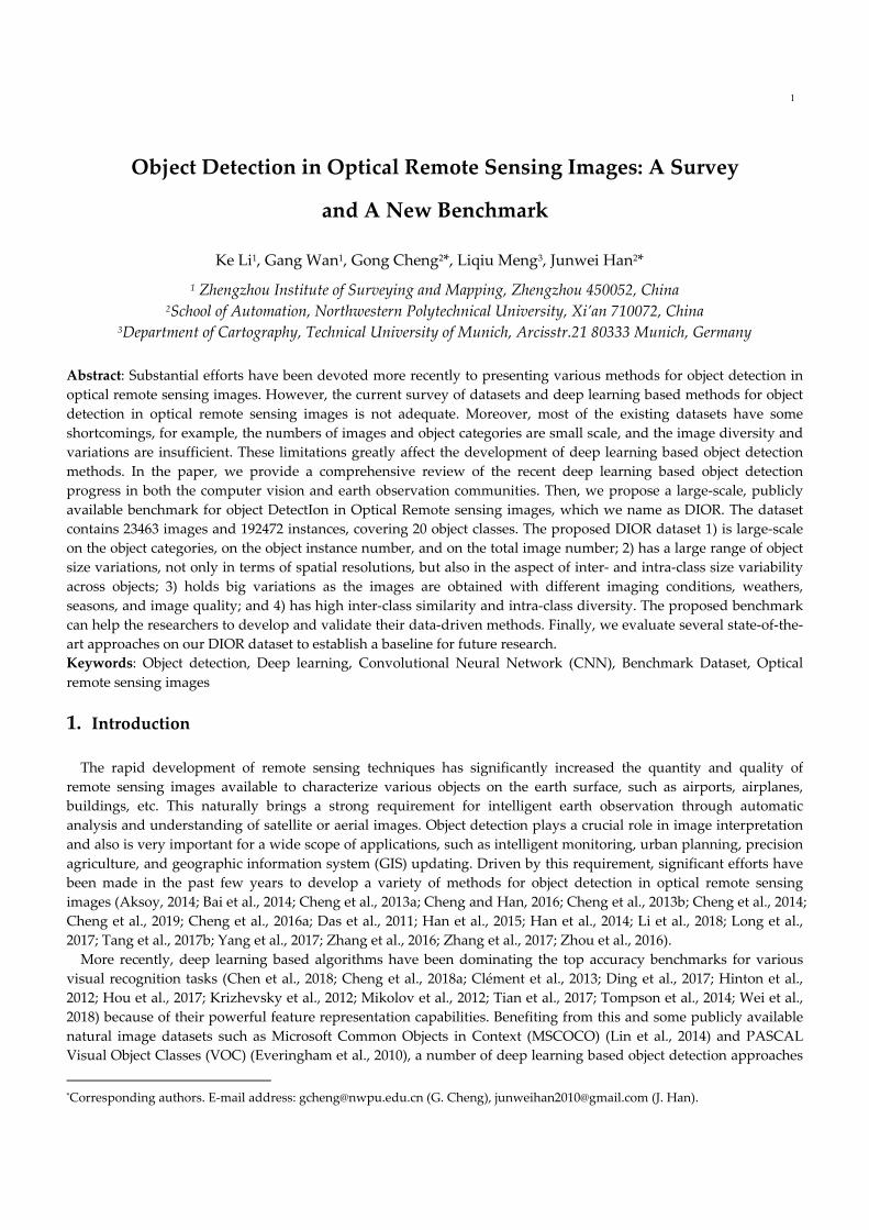
between remote sensing images and natural scene images is significant. As shown in Fig. 1, the remote sensing
images generally capture the roof information of the geospatial objects, whereas the natural scene images usually
capture the profile information of the objects. Therefore, it is not surprising that the object detectors learned from
natural scene images are not easily transferable to remote sensing images. Although several popular object detection
datasets, such as NWPU VHR‐10 (Cheng et al., 2016a), UCAS‐AOD (Zhu et al., 2015a), COWC (Mundhenk et al.,
2016), and DOTA (Xia et al., 2018), are proposed in the earth observation community, they are still far from satisfying
the requirements of deep learning algorithms.
Fig. 1. Some examples, taken from (a) the PASCAL VOC dataset and (b) the proposed DIOR dataset, demonstrate the difference
between natural scene images and remote sensing images.
To date, significant efforts (Cheng and Han, 2016; Cheng et al., 2016a; Das et al., 2011; Han et al., 2015; Li et al.,
2018; Razakarivony and Jurie, 2015; Tang et al., 2017b; Xia et al., 2018; Yokoya and Iwasaki, 2015; Zhang et al., 2016;
Zhu et al., 2017) have been made for object detection in remote sensing images. However, the current survey of the
literatures concerning the datasets and deep learning based object detection methods is still not adequate. Moreover,
most of the existing publicly available datasets have some shortcomings, for example, the numbers of images and
object categories are small scale, and the image diversity and variations are also insufficient. These limitations greatly
block the development of deep learning based object detection methods.
In order to address the aforementioned problems, we attempt to comprehensively review the recent progress of
deep learning based object detection methods. Then, we propose a large‐scale, publicly available benchmark for
object DetectIon in Optical Remote sensing images, which we name as DIOR. Our proposed dataset consists of 23463
images covered by 20 object categories and each category contains about 1200 images. We highlight four key

3
characteristics of the proposed DIOR dataset when comparing it with other existing object detection datasets. First,
the numbers of total images, object categories, and object instances are large‐scale. Second, the objects have a large
range of size variations, not only in terms of spatial resolutions, but also in the aspect of inter‐ and intra‐class size
variability across objects. Third, our dataset holds large variations because the images are obtained with different
imaging conditions, weathers, seasons, and image quality. Fourth, it possesses high inter‐class similarity and intra‐
class diversity. Fig. 2 shows some example images and their annotations from our proposed DIOR dataset.
Our main contributions are summarized as follows:
1) Comprehensive survey of deep learning based object detection progress. We review the recent progress of
existing datasets and representative deep learning based methods for object detection in both the computer vision
and earth observation communities, which covers more than 110 papers.
2) Creation of large‐scale benchmark dataset. This paper proposes a large‐scale, publicly available dataset for
object detection in optical remote sensing images. The proposed DIOR dataset, to our best knowledge, is the largest
scale on both the number of object categories and the total number of images. The dataset enables the community to
validate and develop data‐driven object detection methods.
3) Performance benchmarking on the proposed DIOR dataset. We benchmark several representative deep
learning based object detection methods on our DIOR dataset to provide an overview of the state‐of‐the‐art
performance for future research work.
Fig. 2. Example images taken from the proposed DIOR dataset, which were obtained with different imaging conditions, weathers,
seasons, and image quality.
The remainder of this paper is organized as follows. Sections 2‐3 review the recent object detection progresses of

4
benchmark datasets and deep learning methods in computer vision and earth observation community, respectively.
Section 4 describes the proposed DIOR dataset in detail. Section 5 benchmarks several representative deep learning
based object detection methods on the proposed dataset. Finally, Section 6 concludes this paper.
2. Review on Object Detection in Computer Vision Community
With the emergence of a variety of deep learning models, especially Convolutional Neural Networks (CNN), and
their great success on image classification (He et al., 2016; Krizhevsky et al., 2012; Luan et al., 2018; Simonyan and
Zisserman, 2015; Szegedy et al., 2015), numerous deep learning based object detection frameworks have been
proposed in the computer vision community. Therefore, we will first provide a systematic survey of the references
about the datasets as well as deep learning based methods for the task of object detection in natural scene images.
2.1 Object Detection Datasets of Natural Scene Images
Large‐scale and high‐quality datasets are very important for boosting object detection performance, especially for
deep learning based methods. The PASCAL VOC (Everingham et al., 2010), MSCOCO (Lin et al., 2014), and
ImageNet object detection dataset (Deng et al., 2009) are three widely used datasets for object detection in natural
scene images. These datasets are briefly reviewed as follows.
1) PASCAL VOC Dataset. The PASCAL VOC 2007 (Everingham et al., 2010) and VOC 2012 (Everingham et al., 2015)
are two most‐used datasets for natural scene image object detection. Both of them contain 20 object classes, but with
different image numbers. Specifically, the PASCAL VOC 2007 dataset contains a total of 9963 images with 5011
images for training and 4952 images for testing. The PASCAL VOC 2012 dataset extends the PASCAL VOC 2007
dataset, resulting in a larger scale dataset that consists of 11540 images for training and 10991 images for testing.
2) MSCOCO Dataset. The MSCOCO dataset was proposed by Microsoft in 2014 (Lin et al., 2014). The scale of
MSCOCO dataset is much larger than the PASCAL VOC dataset on both the number of object categories and object
instances. Specifically, the dataset consists of more than 200000 images covered by 80 object categories. The dataset is
further divided into three subsets: training set, validation set and testing set, which contain about 80k, 40k, and 80k
images, respectively.
3) ImageNet Object Detection Dataset. This dataset was released in 2013 (Deng et al., 2009), which has the most object
categories and the largest number of images among all object detection datasets. Specifically, this dataset includes
200 object classes and more than 500000 images, with 456567 images for training, 20121 images for validation, and
40152 images for testing, respectively.
2.2 Deep Learning Based Object Detection Methods in Computer Vision Community
Recently, a number of deep learning based object detection methods have been proposed, which significantly
improve the performance of object detection. Generally, the existing deep learning methods designed for object
detection can be divided into two streams on the basis of whether or not generating region proposals. They are
region proposal‐based methods and regression‐based methods.
2.2.1 Region Proposal‐based Methods In the past few years, region proposal‐based object detection methods have achieved great success in natural scene
images (Dai et al., 2016; Girshick, 2015; Girshick et al., 2014; He et al., 2017; He et al., 2014; Lin et al., 2017b; Ren et al.,
2017). This kind of approaches divides the framework of object detection into two stages. The first stage focuses on
generating a series of candidate region proposals that may contain objects. The second stage aims to classify the
candidate region proposals obtained from the first stage into object classes or background and further fine‐tune the
coordinates of the bounding boxes.
The Region‐based CNN (R‐CNN) proposed by Girshick et al. (Girshick et al., 2014) is one of the most famous
approaches in various region proposal‐based methods. It is the representative work to adopt the CNN models to
generate rich features for object detection, achieving breakthrough performance improvement in comparison with all
previously works, which are mainly based on deformable part model (DPM) (Felzenszwalb et al., 2010). Briefly, R‐

5
CNN consists of three simple steps. First, it scans the input image for possible objects by using selective search
method (Uijlings et al., 2013), generating about 2000 region proposals. Second, these region proposals are resized into
a fixed size (e.g., 224×224) and the deep features of each region proposal are extracted by using a CNN model fine‐
tuned on the PASCAL VOC dataset. Finally, the features of each region proposal are fed into a set of class‐specific
support vector machines (SVMs) to label each region proposal as object or background and a linear regressor is used
to refine the object localizations (if object exist).
While R‐CNN surpasses previous object detection methods, the low efficiency is its main shortcoming due to the
repeated computation of abundant region proposals. In order to obtain better detection efficiency and accuracy,
some recent works, such as SPPnet (He et al., 2014) and Fast R‐CNN (Girshick, 2015), were proposed for sharing the
computation load of CNN feature extraction of all region proposals. Compared with R‐CNN, Fast R‐CNN and
SPPnet perform feature extraction over the whole image with a region of interest (RoI) layer and a spatial pyramid
pooling (SPP) layer, respectively, in which the CNN model runs over the entire image only once rather than
thousands of times, thus they need less computation time than R‐CNN.
Although SPPnet and Fast R‐CNN work at faster speeds than R‐CNN, they need obtaining region proposals in
advance, which are usually generated with hand‐engineering proposal detectors such as EdgeBox (Zitnick and
Dollár, 2014) and selective search method (Uijlings et al., 2013). However, the handcrafted region proposal
mechanism is a severe bottleneck of the entire object detection process. Thus, Faster R‐CNN (Ren et al., 2017) was
proposed in order to fix this problem. The main insight of Faster R‐CNN is to adopt a fast module to generate region
proposals instead of the slow selective search algorithm. Specifically, the Faster R‐CNN framework consists of two
modules. The first model is the region proposal network (RPN), which is a fully convolutional network used to
generate region proposals. The second module is the Fast R‐CNN object detector used for classifying the proposals
which are generate with the first module. The core idea of the Faster R‐CNN is to share the same convolutional
layers for the RPN and Fast R‐CNN detector up to their own fully connected layers. In this way, the image only
needs to pass through the CNN once to generate region proposals and their corresponding features. More
importantly, thanks to the sharing of convolutional layers, it is possible to use a very deep CNN model to generate
higher‐quality region proposals than traditional region proposal generation methods.
In addition, some researchers further extend the work of Faster R‐CNN for better performance. For example,
Mask R‐CNN (He et al., 2017) builds on Faster R‐CNN and adds an additional branch to predict an object mask in
parallel with the existing branch for bounding box detection. Thus, Mask R‐CNN can accurately recognize objects
and simultaneously generate high‐quality segmentation masks for each object instance. In order to further speed up
object detection of Faster R‐CNN, region‐based fully convolutional network (R‐FCN) (Dai et al., 2016) was
proposed. It uses a position‐sensitive region of interest (RoI) pooling layer to aggregate the outputs of the last
convolutional layer and produce scores for each RoI. In contrast to Faster R‐CNN that applies a costly per‐region
sub‐network hundreds of times, R‐FCN shares almost all computation load on the entire image, resulting in 2.5‐20×
faster than Faster R‐CNN. Besides, Li et al. (Li et al., 2017) proposed a Light Head R‐CNN to further speed up the
detection speed of R‐FCN (Dai et al., 2016) by making the head of the detection network as light as possible. Also,
Singh et al. proposed a novel detector, called R‐FCN‐3000 (Singh et al., 2018a), towards large‐scale real‐time object
detection for 3000 object classes. This approach is a modification of R‐FCN (Dai et al., 2016) used to learn shared
filters to perform localization across different object classes.
In 2017, a feature pyramid network (FPN) (Lin et al., 2017b) was proposed by building feature pyramids inside
CNNs, which shows significant improvement as a generic feature extractor for object detection with the
frameworks of Faster R‐CNN (Ren et al., 2017) and Mask R‐CNN (He et al., 2017). Also, a path aggregation network
(PANet) (Liu et al., 2018b) was proposed to boost the entire feature hierarchy with accurate localization information
in lower layers by bottom‐up path augmentation, which can significantly shorten the information path between
lower layers and topmost feature.
More recently, Singh et al. proposed two advanced and effective data argumentation methods for object detection,
including Scale Normalization for Image Pyramids (SNIP) (Singh and Davis, 2018) and SNIP with Efficient
Resampling (SNIPER) (Singh et al., 2018b). These two methods present detailed analysis of different techniques for
detecting and recognizing objects under extreme scale variation. To be specific, SNIP (Singh and Davis, 2018) is a
novel training paradigm that builds image pyramids at both of training and detection stages and only selectively
back‐propagates the gradients of objects of different sizes as a function of the image scale. Thus, it significantly

6
benefits from reducing scale‐variation during training but without reducing training samples. SNIPER (Singh et al.,
2018b) is an efficient multi‐scale training approach proposed to adaptively generate training samples from multiple
scales of an image pyramid, conditioned on the image content. Under the same conditions, SNIPER performs as
well as SNIP while reducing the number of pixels processed by a factor of 3 during training. Here, it should be
pointed out that SNIP (Singh and Davis, 2018) and SNIPER (Singh et al., 2018b) are generic and thus can be broadly
applied to many detectors, such as Faster R‐CNN (Ren et al., 2017), Mask R‐CNN (He et al., 2017), R‐FCN (Dai et al.,
2016), deformable R‐FCN (Dai et al., 2017), and so on.
2.2.2 Regression‐based Methods This kind of methods uses one‐stage object detectors for object instance prediction, thus simplifying detection as a
regression problem. Compared with region proposal‐based methods, regression‐based methods are much simpler
and more efficient, because there is no need to produce candidate region proposals and the subsequent feature re‐
sampling stages. OverFeat (Sermanet et al., 2014) is the first regression‐based object detector based on deep networks
using sliding‐window paradigm. More recently, You Only Look Once (YOLO) (Redmon et al., 2016; Redmon and
Farhadi, 2017, 2018), Single Shot multibox Detector (SSD) (Fu et al., 2017; Liu et al., 2016a), and RetinaNet (Lin et al.,
2017c) have renewed the performance in regression‐based methods.
YOLO (Redmon et al., 2016) is a representative regression‐based object detection method. It adopts a single CNN
backbone to directly predict bounding boxes and class probabilities from the entire images in one evaluation. It
works as follows. Given an input image, it is firstly divided into S×S grids. If the center of an object falls into a grid
cell, that grid is responsible for the detection of that object. Then, each grid cell predicts B bounding boxes together
with their confidence scores and C class probabilities. YOLO achieves object detection in real‐time by reframing it as
a single regression problem. However, it still struggles to precisely localize some objects, especially small‐sized
objects.
In order to improve both the speed and accuracy, SSD (Liu et al., 2016a) was proposed. Specifically, the output
space of bounding boxes is discretized into a set of default boxes over different scales and aspect ratios per feature
map location. At prediction process, the confidence scores for the presence of each object class in each default box are
generated based on the SSD model and the adjustments to the box are also produced to better match the object shape.
Furthermore, in order to address the problem of object size variations, SSD combines the predictions obtained from
multiple feature maps with different resolutions. Compared with YOLO (Redmon et al., 2016), SSD achieved better
performance for detecting and locating small‐sized objects via introducing default boxes mechanism and multi‐scale
feature maps. Another interesting work is RetinaNet detector (Lin et al., 2017c), which is essentially a feature
pyramid network with the traditional cross‐entropy loss being replaced by a new Focal loss (Lin et al., 2017c), and
thereby increasing the accuracy significantly.
The insight of YOLOv2 model (Redmon and Farhadi, 2017) is to improve object detection accuracy while still
being an efficient object detector. To this end, it proposes various improvements to the original YOLO method. For
example, in order to prevent over‐fitting without using dropout, YOLOv2 adds the batch normalization on all of the
convolutional layers. It accepts higher‐resolution images as input by adjusting the input image size from 224×224
(YOLO) to 448×448 (YOLOv2), thus the objects with smaller sizes can be detected effectively. Additionally, YOLOv2
removes the fully‐connected layers from the original YOLO detector and predicts bounding boxes based on anchor
boxes, which shares the similar idea with SSD (Liu et al., 2016a).
More recently, YOLOv3 model (Redmon and Farhadi, 2018), which has similar performance but is faster than
YOLOv2, SSD, and RetinaNet, was proposed. YOLOv3 adheres to YOLOv2’s mechanism. To be specific, the
bounding boxes are predicted using dimension clusters as anchor boxes. Then, independent logistic classifiers
instead of softmax classifier are adopted to output an object score for each bounding box. Sharing a similar concept
with FPN (Lin et al., 2017b), the bounding boxes are predicted at three different scales through extracting features
from these scales. YOLOv3 uses a new backbone network, named Darketnet‐53, for performing feature extraction. It
has 53 convolutional layers, and is a newfangled residual network. Due to the introduction of Darketnet‐53 and
multi‐scale feature maps, YOLOv3 achieves great speed improvement and also improves detection accuracy of
small‐sized objects when compared with the original YOLO or YOLOv2.
In addition, Law and Deng proposed CornerNet (Law and Deng, 2018), a new and effective object detection
paradigm that detects object bounding boxes as pairs of corners (i.e., the top‐left corner and the bottom‐right corner)
7
by using a single CNN. By detecting objects as paired corners, CornerNet eliminates the need for designing a set of
anchor boxes widely used in regression‐based object detectors. This work also introduces corner pooling, a new
type of pooling layer that helps the network better localize corners.
In general, region proposal‐based object detection methods have better accuracies than regression‐based
algorithms, while regression‐based algorithms have advantages in speed (Lin et al., 2017c). It is generally accepted
that CNN framework plays a crucial role in object detection task. CNN architectures serve as network backbones
used in various object detection frameworks. Some representative CNN model architectures include AlexNet
(Krizhevsky et al., 2012), ZFNet (Zeiler and Fergus, 2014), VGGNet (Simonyan and Zisserman, 2015), GoogLeNet
(Szegedy et al., 2015), Inception series (Ioffe and Szegedy, 2015; Szegedy et al., 2017; Szegedy et al., 2016), ResNet (He
et al., 2016), DenseNet (Huang et al., 2017) and SENet (Hu et al., 2018). Also, some researches have been widely
explored to further improve the performance of deep learning based methods for object detection, such as feature
enhancement (Cai et al., 2016; Cheng et al., 2019; Cheng et al., 2016b; Kong et al., 2016; Liu et al., 2017b), hard
negative mining (Lin et al., 2017c; Shrivastava et al., 2016), contextual information fusion (Bell et al., 2016; Gidaris
and Komodakis, 2015; Shrivastava and Gupta, 2016; Zhu et al., 2015b), modeling object deformations (Mordan et al.,
2018; Ouyang et al., 2017; Xu et al., 2017), and so on.
3. Review on Object Detection in Earth Observation Community
In the past years, numerous object detection approaches have been explored to detect various geospatial objects in
the earth observation community. Cheng et al (Cheng and Han, 2016) provide a comprehensive review in 2016 on
object detection algorithms in optical remote sensing images. However, the work of (Cheng and Han, 2016) does not
review various deep learning based object detection methods. Different from several previously published surveys,
we focus on reviewing the literatures about datasets and deep learning based approaches for object detection in the
earth observation community.
3.1 Object Detection Datasets of Optical Remote Sensing Images
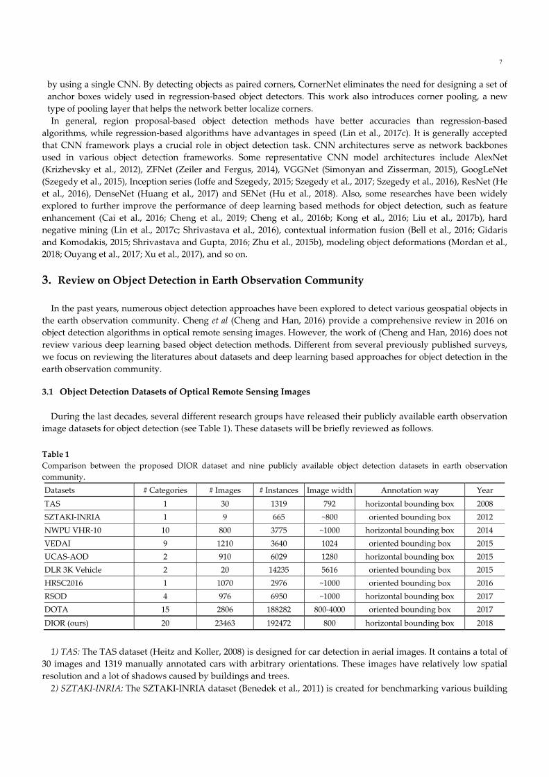
During the last decades, several different research groups have released their publicly available earth observation
image datasets for object detection (see Table 1). These datasets will be briefly reviewed as follows.
Table 1
Comparison between the proposed DIOR dataset and nine publicly available object detection datasets in earth observation
community.
Datasets # Categories # Images # Instances Image width Annotation way Year
TAS 1 30 1319 792 horizontal bounding box 2008
SZTAKI‐INRIA 1 9 665 ~800 oriented bounding box 2012
NWPU VHR‐10 10 800 3775 ~1000 horizontal bounding box 2014
VEDAI 9 1210 3640 1024 oriented bounding box 2015
UCAS‐AOD 2 910 6029 1280 horizontal bounding box 2015
DLR 3K Vehicle 2 20 14235 5616 oriented bounding box 2015
HRSC2016 1 1070 2976 ~1000 oriented bounding box 2016
RSOD 4 976 6950 ~1000 horizontal bounding box 2017
DOTA 15 2806 188282 800‐4000 oriented bounding box 2017
DIOR (ours) 20 23463 192472 800 horizontal bounding box 2018
1) TAS: The TAS dataset (Heitz and Koller, 2008) is designed for car detection in aerial images. It contains a total of
30 images and 1319 manually annotated cars with arbitrary orientations. These images have relatively low spatial
resolution and a lot of shadows caused by buildings and trees.
2) SZTAKI‐INRIA: The SZTAKI‐INRIA dataset (Benedek et al., 2011) is created for benchmarking various building
8
detection methods. It consists of 665 buildings, manually annotated with oriented bounding boxes, distributed
throughout nine remote sensing images derived from Manchester (U.K.), Szada and Budapest (Hungary), Cot
d′Azur and Normandy (France), and Bodensee (Germany). All of the images contain only red (R), green (G), and
blue (B) three channels. Among them, two images (Szada and Budapest) are aerial images and the rest seven images
are satellite images from QuickBird, IKONOS, and Google Earth.
3) NWPU VHR‐10: The NWPU VHR‐10 dataset (Cheng and Han, 2016; Cheng et al., 2016a) has 10 geospatial object
classes including airplane, baseball diamond, basketball court, bridge, harbor, ground track field, ship, storage tank,
tennis court, and vehicle. It consists of 715 RGB images and 85 pan‐sharpened color infrared images. To be specific,
the 715 RGB images are collected from Google Earth and their spatial resolutions vary from 0.5m to 2m. The 85 pan‐
sharpened infrared images, with a spatial resolution of 0.08m, are obtained from Vaihingen data (Cramer, 2010). This
dataset contains a total of 3775 object instances which are manually annotated with horizontal bounding boxes,
including 757 airplanes, 390 baseball diamonds, 159 basketball courts, 124 bridges, 224 harbors, 163 ground track
fields, 302 ships, 655 storage tanks, 524 tennis courts, and 477 vehicles. This dataset has been widely used in the earth
observation community (Cheng et al., 2014; Cheng et al., 2018b; Farooq et al., 2017; Guo et al., 2018; Han et al., 2017a;
Li et al., 2018; Yang et al., 2018b; Yang et al., 2017; Zhong et al., 2018).
4) VEDAI: The VEDAI (Razakarivony and Jurie, 2015) dataset is released for the task of multi‐class vehicle
detection in aerial images. It consists of 3640 vehicle instances covered by nine classes including boat, car, camping
car, plane, pick‐up, tractor, truck, van, and the other category. This dataset contains totally 1210 1024×1024 aerial
images acquired from Utah AGRC (http://gis.utah.gov/), with a spatial resolution of 12.5 cm. The images in the
dataset were captured during spring 2012 and each image has four uncompressed color channels including three
RGB color channels and one near infrared channel.
5) UCAS‐AOD: The UCAS‐AOD dataset (Zhu et al., 2015a) is designed for airplane and vehicle detection.
Specifically, the airplane dataset consists of 600 images with 3210 airplanes and the vehicle dataset consists of 310
images with 2819 vehicles. All the images are carefully selected so that the object orientations in the dataset distribute
evenly.
6) DLR 3K Vehicle: The DLR 3K Vehicle dataset (Liu and Mattyus, 2015) is another dataset designed for vehicle
detection. It contains 20 5616×3744 aerial images, with a spatial resolution of 13 cm. They are captured at a height of
1000 meters above the ground using the DLR 3K camera system (a near real time airborne digital monitoring system)
over the area of Munich, Germany. There are 14235 vehicles that are manually labeled by using oriented bounding
boxes in the images.
7) HRSC2016: The HRSC2016 dataset (Liu et al., 2016b) contains 1070 images and a total of 2976 ships collected
from Google Earth used for ship detection. The image sizes change from 300×300 to 1500×900, and most of them are
about 1000×600. These images are collected with large variations of rotation, scale, position, shape, and appearance.
8) RSOD: The RSOD dataset (Xiao et al., 2015) contains 976 images downloaded from Google Earth and Tianditu,
and the spatial resolutions of these images range from 0.3m to 3m. It consists of totally 6950 object instances, covered
by four object classes, including 1586 oil tanks, 4993 airplanes, 180 overpasses, and 191 playgrounds.
9) DOTA: The DOTA (Xia et al., 2018) is a new large‐scale geospatial object detection dataset, which consists of 15
different object categories: baseball diamond, basketball court, bridge, harbor, helicopter, ground track field, large
vehicle, plane, ship, small vehicle, soccer ball field, storage tank, swimming pool, tennis court, and roundabout. This
dataset contains a total of 2806 aerial images obtained from different sensors and platforms with multiple resolutions.
There are 188282 object instances labeled by an oriented bounding box. The sizes of images range from about
800×800 to 4000×4000 pixels. Each image contains multiple objects of different scales, orientations and shapes. To
date, this dataset is the most challenging.
3.2 Deep Learning Based Object Detection Methods in Earth Observation Community Inspired by the great success of deep learning‐based object detection methods in computer vision community,
extensive studies have been devoted recently to object detection in optical remote sensing images. Different from
object detection in natural scene mages, most of the studies use region proposal‐based methods to detect multi‐class
objects in the earth observation community. We therefore no longer distinguish them between region proposal‐based
methods or regression‐based methods in the earth observation community. Here, we mainly review some
representative methods.
9
Driven by the excellent performance of R‐CNN for natural scene image object detection, a number of earth
observation researchers adopt R‐CNN pipeline to detect various geospatial objects in remote sensing images (Cheng
et al., 2016a; Long et al., 2017; Salberg, 2015; Ševo and Avramović, 2017). For instance, Cheng et al. (Cheng et al.,
2016a) proposed to learn a rotation‐invariant CNN (RICNN) model in R‐CNN framework used for multi‐class
geospatial object detection. The RICNN is achieved by adding a new rotation‐invariant layer to the off‐the‐shelf
CNN model such as AlexNet (Krizhevsky et al., 2012). In order to further boost the state‐of‐the‐arts of object
detection, (Cheng et al., 2019) proposed a new method to train rotation‐invariant and Fisher discriminative CNN
(RIFD‐CNN) model by imposing a rotation‐invariant regularizer and a Fisher discrimination regularizer on the CNN
features. To achieve accurate localization of geospatial objects in high‐resolution earth observation images, Long et al.
(Long et al., 2017) presented an unsupervised score‐based bounding box regression (USB‐BBR) method based on R‐
CNN framework.
Although the aforementioned methods have achieved good performance in the earth observation community, they
are still time‐consuming because these approaches depend on human‐designed object proposal generation methods
which domain most of the running time of an object detection system. In addition, the quality of region proposals
generated based on hand‐engineered low‐level features is not good, thus thereby degenerating object detection
performance.
In order to further enhance the detection accuracy and speed, a few research works extend the framework of Faster
R‐ CNN to the earth observation community (Deng et al., 2017; Guo et al., 2018; Han et al., 2017b; Li et al., 2018; Tang
et al., 2017b; Xu et al., 2017; Yang et al., 2018a; Yang et al., 2017; Yao et al., 2017; Zhong et al., 2018). For instance, Li et
al. (Li et al., 2018) presented a rotation‐insensitive RPN by introducing multi‐angle anchors into the existing RPN
based on Faster R‐CNN pipeline, which can effectively handle the problem of geospatial object rotation variations.
Furthermore, in order to tackle the problem of appearance ambiguity, a double‐channel feature combination network
is designed to learn local and contextual properties. Zhong et al. (Zhong et al., 2018) utilized a position‐sensitive
balancing (PSB) method to enhance the quality of generated region proposal. In the proposed PSB framework, a fully
convolutional network (FCN) (Long et al., 2015) was introduced, based on the residual network (He et al., 2016), to
address the dilemma between translation‐variance in object detection and translation‐invariance in image
classification. Xu et al. (Xu et al., 2017) presented a deformable CNN to model the geometric variations of objects. In
(Xu et al., 2017), non‐maximum suppression constrained by aspect ratio was developed to reduce the increase of false
region proposals. Aiming at vehicle detection, Tang et al. (Tang et al., 2017b) proposed a hyper region proposal
network (HRPN) to find vehicle‐like regions and use hard negative mining to further improve the detection accuracy.
Although adapting region proposal‐based methods, such as R‐CNN, Faster R‐CNN, and their variants, to detect
geospatial objects in earth observation images shows greatly promising performance, remarkable efforts have been
made to explore different deep learning based methods (Lin et al., 2017a; Liu et al., 2017a; Liu et al., 2018c; Tang et al.,
2017a; Yu et al., 2015; Zou and Shi, 2016), which do not follow the pipeline of region proposal‐based approaches to
detect objects in remote sensing images. For example, Yu et al. (Yu et al., 2015) presented a rotation‐invariant method
to detect geospatial objects, in which super‐pixel segmentation strategy is firstly used to produce local patches, then,
deep Boltzmann machines are adopted to construct high‐level feature representations of local patches, and finally a
set of multi‐scale Hough forests is built to cast rotation‐invariant votes to locate object centroids. Zou et al. (Zou and
Shi, 2016) used a singular value decompensation network to obtain ship‐like regions and adopt feature pooling
operation and a linear SVM classifier to verify each ship candidate for the task of ship detection. Although this
detection framework is interesting, the training process is still clumsy and slow.
More recently, in order to achieve real‐time object detection, a few studies attempt to transfer regression‐based
detection methods developed for natural scene images to remote sensing images. For instance, sharing the similar
idea with SSD, Tang et al. (Tang et al., 2017a) used a regression‐based object detector to detect vehicle targets.
Specifically, the detection bounding boxes are generated by adopting a set of default boxes with different scales per
feature map location. Moreover, for each default box the offsets are predicted to better fit the object shape. Liu et al.
(Liu et al., 2017a) replaced the traditional bounding box with rotatable bounding box (RBox) embedded into SSD
framework (Liu et al., 2016a), thus being rotation invariant due to its ability of estimating the orientation angles of
objects. Liu et al. (Liu et al., 2018c) designed a framework for detecting arbitrary‐oriented ships. This model can
directly predict rotated/oriented bounding boxes by using YOLOv2 architecture as the fundamental network. In
addition, hard example mining (Tang et al., 2017a; Tang et al., 2017b), multi‐feature fusion (Zhong et al., 2017),
10
transfer learning (Han et al., 2017b), non‐maximum suppression (Xu et al., 2017), etc., are often used in geospatial
object detection to further boost the performance of deep learning based approaches.
Although most of the existing deep learning based methods have demonstrated significant achievement on the
task of object detection in the earth observation community, they are transferred from the methods (e.g., R‐CNN,
Faster R‐CNN, SSD, etc.) designed for natural scene images. In fact, as we have pointed out above, earth observation
images significantly differ from natural scene images is significant, especially in the aspects of rotation, scale
variation and the complex and cluttered background. Although the existing methods partially addressed these issues
through introducing prior knowledge or designing proprietary models, the task of object detection in earth
observation images is still an open problem deserved to further research.
4. Proposed DIOR Dataset
In the last few years, remarkable efforts have been made to release various object detection datasets (reviewed in
Section 3.2) in the earth observation community. However, most of existing object detection datasets in earth
observation domain shares some common shortcomings, for example, the number of images and the number of
object categories are small scale, and the image diversity and object variations are insufficient. These limitations
significantly affect the development of deep learning based object detection methods. In such a situation, creating a
large‐scale object detection dataset by using remote sensing images is highly desirable for the earth observation
community. This motivates us to create a large‐scale dataset named DIOR. It is publicly available2 and can be used
freely for object detection in optical remote sensing images.
4.1 Object Class Selection Selecting appropriate geospatial object classes is the first step of constructing the dataset and is crucial for the
dataset. In our work, we first investigated the object classes of all existing datasets (Benedek et al., 2011; Cheng and
Han, 2016; Cheng et al., 2016a; Heitz and Koller, 2008; Liu and Mattyus, 2015; Liu et al., 2016b; Razakarivony and
Jurie, 2015; Xia et al., 2018; Xiao et al., 2015; Zhu et al., 2015a) to obtain 10 object categories which are commonly used
in both NWPU VHR‐10 dataset and DOTA dataset. We then further extend the object categories of our dataset by
searching the keywords of “object detection”, “object recognition”, “earth observation images”, and “remote sensing
images” on Google Scholar and Web of Science to carefully select other 10 object classes, according to whether a kind
of objects is common or its value for real‐world applications. For example, some traffic infrastructures that are
common and play an important role in transportation analysis, such as train stations, expressway service areas, and
airports, are selected mainly because of their values in real applications. In addition, most of the object categories in
existing datasets are selected from the urban areas. Therefore, dam and wind mill, which are common in the suburb
as well as important infrastructures, are also chosen to improve the variations and diversity of geospatial objects. In
such a situation, a total of 20 object classes are selected to create the proposed DIOR dataset. These 20 object classes
are airplane, airport, baseball field, basketball court, bridge, chimney, dam, expressway service area, expressway toll
station, harbor, golf course, ground track field, overpass, ship, stadium, storage tank, tennis court, train station,
vehicle, and wind mill.
4.2 Characteristics of Our Proposed DIOR Dataset
The DIOR dataset is one of the largest, most diverse, and publicly available object detection dataset in earth
observation community. We use LabelMe (Russell et al., 2008), an open‐source image annotation tool, to annotate
object instances. Each object instance is manually labeled by a horizontal bounding box which is typically used for
object annotation in remote sensing images and natural scene images. Fig. 3 reports the number of object instances
per class. In the proposed DIOR dataset, the object classes of ship and vehicle have higher instance counts, while the
classes of train station, expressway toll station and expressway service area have lower instance counts. The diversity
of object size is more helpful for real‐world tasks. As shown in Fig. 4, we achieve a good balance between small‐sized
instances and big‐sized instances. In addition, the significant object size differences across different categories makes
2 http://www.escience.cn/people/gongcheng/DIOR.html

11
the detection task more challenging, because which requires that the detectors have to be flexible enough to
simultaneously handle small‐sized and large‐sized objects.
Fig. 3. Number of object instances per class.
Fig. 4. Object size distribution per class.
Compared with existing object detection datasets including (Benedek et al., 2011; Cheng and Han, 2016; Cheng et
al., 2016a; Heitz and Koller, 2008; Liu and Mattyus, 2015; Liu et al., 2016b; Razakarivony and Jurie, 2015; Tanner et al.,
2009; Xia et al., 2018; Xiao et al., 2015; Zhu et al., 2015a), the proposed DIOR dataset has the following four
remarkable characteristics.
1) Large scale. DIOR consists of 23463 optimal remote sensing images and 192472 object instances that are
manually labeled with axis‐aligned bounding boxes, covered by 20 common object categories. The size of images in
the dataset is 800×800 pixels and the spatial resolutions range from 0.5m to 30m. Similar with most of the existing
datasets, this dataset is also collected from Google Earth (Google Inc.), by the experts in the domain of earth
observation interpretation.
Compared with all existing remote sensing image datasets designed for object detection, the proposed DIOR
dataset, to our best knowledge, is the largest scale on both the number of images and the number of object categories.
The release of this dataset will help the earth observation community to explore and evaluate a variety of deep
learning based methods, thus thereby further improving the state of the arts.
2) A large range of object size variations. Spatial size variation is an important feature of geospatial objects. This is
not only because of the spatial resolutions of sensors, but also due to between‐class size variation (e.g., aircraft
carriers vs. cars) and within‐class size variation (e.g., aircraft carriers vs. hookers). There are a large range of size
variations of object instances in the proposed DIOR dataset. To increase the size variations of objects, images with
different spatial resolutions of objects are collected and the images which contain rich size variations coming from
12
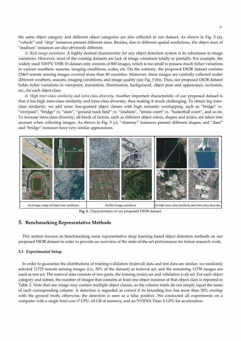
the same object category and different object categories are also collected in our dataset. As shown in Fig. 5 (a),
“vehicle” and “ship” instances present different sizes. Besides, due to different spatial resolutions, the object sizes of
“stadium” instances are also obviously different.
3) Rich image variations. A highly desired characteristic for any object detection system is its robustness to image
variations. However, most of the existing datasets are lack of image variations totally or partially. For example, the
widely used NWPU VHR‐10 dataset only consists of 800 images, which is too small to possess much richer variations
in various weathers, seasons, imaging conditions, scales, etc. On the contrary, the proposed DIOR dataset contains
23463 remote sensing images covered more than 80 countries. Moreover, these images are carefully collected under
different weathers, seasons, imaging conditions, and image quality (see Fig. 5 (b)). Thus, our proposed DIOR dataset
holds richer variations in viewpoint, translation, illumination, background, object pose and appearance, occlusion,
etc., for each object class.
4) High inter‐class similarity and intra‐class diversity. Another important characteristic of our proposed dataset is
that it has high inter‐class similarity and intra‐class diversity, thus making it much challenging. To obtain big inter‐
class similarity, we add some fine‐grained object classes with high semantic overlapping, such as “bridge” vs.
“overpass”, “bridge” vs. “dam”, “ground track field” vs. “stadium”, “tennis court” vs. “basketball court”, and so on.
To increase intra‐class diversity, all kinds of factors, such as different object colors, shapes and scales, are taken into
account when collecting images. As shown in Fig. 5 (c), “chimney” instances present different shapes, and “dam”
and “bridge” instances have very similar appearances.
Fig. 5. Characteristics of our proposed DIOR dataset.
5. Benchmarking Representative Methods
This section focuses on benchmarking some representative deep learning based object detection methods on our
proposed DIOR dataset in order to provide an overview of the state‐of‐the‐art performance for future research work.
5.1 Experimental Setup
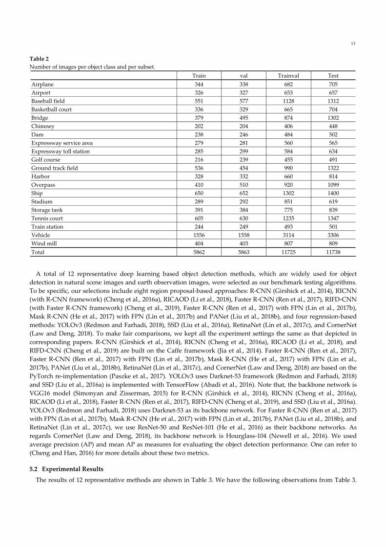
In order to guarantee the distributions of training‐validation (trainval) data and test data are similar, we randomly
selected 11725 remote sensing images (i.e., 50% of the dataset) as trainval set, and the remaining 11738 images are
used as test set. The trainval data consists of two parts, the training (train) set and validation (val) set. For each object
category and subset, the number of images that contains at least one object instance of that object class is reported in
Table 2. Note that one image may contain multiple object classes, so the column totals do not simply equal the sums
of each corresponding column. A detection is regarded as correct if its bounding box has more than 50% overlap
with the ground truth; otherwise, the detection is seen as a false positive. We conducted all experiments on a
computer with a single Intel core i7 CPU, 64 GB of memory, and an NVIDIA Titan X GPU for acceleration.
13
Table 2
Number of images per object class and per subset.
Train val Trainval Test
Airplane 344 338 682 705
Airport 326 327 653 657
Baseball field 551 577 1128 1312
Basketball court 336 329 665 704
Bridge 379 495 874 1302
Chimney 202 204 406 448
Dam 238 246 484 502
Expressway service area 279 281 560 565
Expressway toll station 285 299 584 634
Golf course 216 239 455 491
Ground track field 536 454 990 1322
Harbor 328 332 660 814
Overpass 410 510 920 1099
Ship 650 652 1302 1400
Stadium 289 292 851 619
Storage tank 391 384 775 839
Tennis court 605 630 1235 1347
Train station 244 249 493 501
Vehicle 1556 1558 3114 3306
Wind mill 404 403 807 809
Total 5862 5863 11725 11738
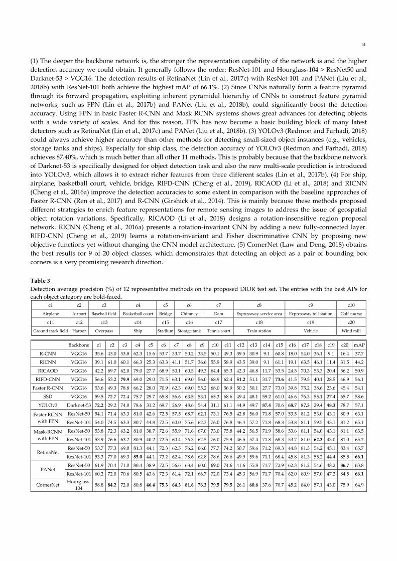
A total of 12 representative deep learning based object detection methods, which are widely used for object
detection in natural scene images and earth observation images, were selected as our benchmark testing algorithms.
To be specific, our selections include eight region proposal‐based approaches: R‐CNN (Girshick et al., 2014), RICNN
(with R‐CNN framework) (Cheng et al., 2016a), RICAOD (Li et al., 2018), Faster R‐CNN (Ren et al., 2017), RIFD‐CNN
(with Faster R‐CNN framework) (Cheng et al., 2019), Faster R‐CNN (Ren et al., 2017) with FPN (Lin et al., 2017b),
Mask R‐CNN (He et al., 2017) with FPN (Lin et al., 2017b) and PANet (Liu et al., 2018b), and four regression‐based
methods: YOLOv3 (Redmon and Farhadi, 2018), SSD (Liu et al., 2016a), RetinaNet (Lin et al., 2017c), and CornerNet
(Law and Deng, 2018). To make fair comparisons, we kept all the experiment settings the same as that depicted in
corresponding papers. R‐CNN (Girshick et al., 2014), RICNN (Cheng et al., 2016a), RICAOD (Li et al., 2018), and
RIFD‐CNN (Cheng et al., 2019) are built on the Caffe framework (Jia et al., 2014). Faster R‐CNN (Ren et al., 2017),
Faster R‐CNN (Ren et al., 2017) with FPN (Lin et al., 2017b), Mask R‐CNN (He et al., 2017) with FPN (Lin et al.,
2017b), PANet (Liu et al., 2018b), RetinaNet (Lin et al., 2017c), and CornerNet (Law and Deng, 2018) are based on the
PyTorch re‐implementation (Paszke et al., 2017). YOLOv3 uses Darknet‐53 framework (Redmon and Farhadi, 2018)
and SSD (Liu et al., 2016a) is implemented with TensorFlow (Abadi et al., 2016). Note that, the backbone network is
VGG16 model (Simonyan and Zisserman, 2015) for R‐CNN (Girshick et al., 2014), RICNN (Cheng et al., 2016a),
RICAOD (Li et al., 2018), Faster R‐CNN (Ren et al., 2017), RIFD‐CNN (Cheng et al., 2019), and SSD (Liu et al., 2016a).
YOLOv3 (Redmon and Farhadi, 2018) uses Darknet‐53 as its backbone network. For Faster R‐CNN (Ren et al., 2017)
with FPN (Lin et al., 2017b), Mask R‐CNN (He et al., 2017) with FPN (Lin et al., 2017b), PANet (Liu et al., 2018b), and
RetinaNet (Lin et al., 2017c), we use ResNet‐50 and ResNet‐101 (He et al., 2016) as their backbone networks. As
regards CornerNet (Law and Deng, 2018), its backbone network is Hourglass‐104 (Newell et al., 2016). We used
average precision (AP) and mean AP as measures for evaluating the object detection performance. One can refer to
(Cheng and Han, 2016) for more details about these two metrics.
5.2 Experimental Results
The results of 12 representative methods are shown in Table 3. We have the following observations from Table 3.
14
(1) The deeper the backbone network is, the stronger the representation capability of the network is and the higher
detection accuracy we could obtain. It generally follows the order: ResNet‐101 and Hourglass‐104 > ResNet50 and
Darknet‐53 > VGG16. The detection results of RetinaNet (Lin et al., 2017c) with ResNet‐101 and PANet (Liu et al.,
2018b) with ResNet‐101 both achieve the highest mAP of 66.1%. (2) Since CNNs naturally form a feature pyramid
through its forward propagation, exploiting inherent pyramidal hierarchy of CNNs to construct feature pyramid
networks, such as FPN (Lin et al., 2017b) and PANet (Liu et al., 2018b), could significantly boost the detection
accuracy. Using FPN in basic Faster R‐CNN and Mask RCNN systems shows great advances for detecting objects
with a wide variety of scales. And for this reason, FPN has now become a basic building block of many latest
detectors such as RetinaNet (Lin et al., 2017c) and PANet (Liu et al., 2018b). (3) YOLOv3 (Redmon and Farhadi, 2018)
could always achieve higher accuracy than other methods for detecting small‐sized object instances (e.g., vehicles,
storage tanks and ships). Especially for ship class, the detection accuracy of YOLOv3 (Redmon and Farhadi, 2018)
achieves 87.40%, which is much better than all other 11 methods. This is probably because that the backbone network
of Darknet‐53 is specifically designed for object detection task and also the new multi‐scale prediction is introduced
into YOLOv3, which allows it to extract richer features from three different scales (Lin et al., 2017b). (4) For ship,
airplane, basketball court, vehicle, bridge, RIFD‐CNN (Cheng et al., 2019), RICAOD (Li et al., 2018) and RICNN
(Cheng et al., 2016a) improve the detection accuracies to some extent in comparison with the baseline approaches of
Faster R‐CNN (Ren et al., 2017) and R‐CNN (Girshick et al., 2014). This is mainly because these methods proposed
different strategies to enrich feature representations for remote sensing images to address the issue of geospatial
object rotation variations. Specifically, RICAOD (Li et al., 2018) designs a rotation‐insensitive region proposal
network. RICNN (Cheng et al., 2016a) presents a rotation‐invariant CNN by adding a new fully‐connected layer.
RIFD‐CNN (Cheng et al., 2019) learns a rotation‐invariant and Fisher discriminative CNN by proposing new
objective functions yet without changing the CNN model architecture. (5) CornerNet (Law and Deng, 2018) obtains
the best results for 9 of 20 object classes, which demonstrates that detecting an object as a pair of bounding box
corners is a very promising research direction.
Table 3
Detection average precision (%) of 12 representative methods on the proposed DIOR test set. The entries with the best APs for
each object category are bold‐faced.
c1 c2 c3 c4 c5 c6 c7 c8 c9 c10
Airplane Airport Baseball field Basketball court Bridge Chimney Dam Expressway service area Expressway toll station Golf course
c11 c12 c13 c14 c15 c16 c17 c18 c19 c20
Ground track field Harbor Overpass Ship Stadium Storage tank Tennis court Train station Vehicle Wind mill
Backbone c1 c2 c3 c4 c5 c6 c7 c8 c9 c10 c11 c12 c13 c14 c15 c16 c17 c18 c19 c20 mAP
R‐CNN VGG16 35.6 43.0 53.8 62.3 15.6 53.7 33.7 50.2 33.5 50.1 49.3 39.5 30.9 9.1 60.8 18.0 54.0 36.1 9.1 16.4 37.7
RICNN VGG16 39.1 61.0 60.1 66.3 25.3 63.3 41.1 51.7 36.6 55.9 58.9 43.5 39.0 9.1 61.1 19.1 63.5 46.1 11.4 31.5 44.2
RICAOD VGG16 42.2 69.7 62.0 79.0 27.7 68.9 50.1 60.5 49.3 64.4 65.3 42.3 46.8 11.7 53.5 24.5 70.3 53.3 20.4 56.2 50.9
RIFD‐CNN VGG16 56.6 53.2 79.9 69.0 29.0 71.5 63.1 69.0 56.0 68.9 62.4 51.2 51.1 31.7 73.6 41.5 79.5 40.1 28.5 46.9 56.1
Faster R‐CNN VGG16 53.6 49.3 78.8 66.2 28.0 70.9 62.3 69.0 55.2 68.0 56.9 50.2 50.1 27.7 73.0 39.8 75.2 38.6 23.6 45.4 54.1
SSD VGG16 59.5 72.7 72.4 75.7 29.7 65.8 56.6 63.5 53.1 65.3 68.6 49.4 48.1 59.2 61.0 46.6 76.3 55.1 27.4 65.7 58.6
YOLOv3 Darknet‐53 72.2 29.2 74.0 78.6 31.2 69.7 26.9 48.6 54.4 31.1 61.1 44.9 49.7 87.4 70.6 68.7 87.3 29.4 48.3 78.7 57.1
ResNet‐50 54.1 71.4 63.3 81.0 42.6 72.5 57.5 68.7 62.1 73.1 76.5 42.8 56.0 71.8 57.0 53.5 81.2 53.0 43.1 80.9 63.1Faster RCNN
with FPN ResNet‐101 54.0 74.5 63.3 80.7 44.8 72.5 60.0 75.6 62.3 76.0 76.8 46.4 57.2 71.8 68.3 53.8 81.1 59.5 43.1 81.2 65.1
ResNet‐50 53.8 72.3 63.2 81.0 38.7 72.6 55.9 71.6 67.0 73.0 75.8 44.2 56.5 71.9 58.6 53.6 81.1 54.0 43.1 81.1 63.5Mask‐RCNN
with FPN ResNet‐101 53.9 76.6 63.2 80.9 40.2 72.5 60.4 76.3 62.5 76.0 75.9 46.5 57.4 71.8 68.3 53.7 81.0 62.3 43.0 81.0 65.2
ResNet‐50 53.7 77.3 69.0 81.3 44.1 72.3 62.5 76.2 66.0 77.7 74.2 50.7 59.6 71.2 69.3 44.8 81.3 54.2 45.1 83.4 65.7RetinaNet
ResNet‐101 53.3 77.0 69.3 85.0 44.1 73.2 62.4 78.6 62.8 78.6 76.6 49.9 59.6 71.1 68.4 45.8 81.3 55.2 44.4 85.5 66.1
ResNet‐50 61.9 70.4 71.0 80.4 38.9 72.5 56.6 68.4 60.0 69.0 74.6 41.6 55.8 71.7 72.9 62.3 81.2 54.6 48.2 86.7 63.8PANet
ResNet‐101 60.2 72.0 70.6 80.5 43.6 72.3 61.4 72.1 66.7 72.0 73.4 45.3 56.9 71.7 70.4 62.0 80.9 57.0 47.2 84.5 66.1
CornerNet Hourglass‐
104 58.8 84.2 72.0 80.8 46.4 75.3 64.3 81.6 76.3 79.5 79.5 26.1 60.6 37.6 70.7 45.2 84.0 57.1 43.0 75.9 64.9
15
While the results on some object categories are promising, there exists substantial improvement space for almost
all object categories. For some object classes, e.g., bridge, harbor, overpass, and vehicle, the detection accuracies are
still very low, and the currently existing methods are difficult to obtain satisfactory results. This probably attributes
to the relatively low image quality and the complex and cluttered background in aerial images, when compared with
natural scene images. This also indicates that the proposed DIOR dataset is a challenging benchmark for geospatial
object detection. In the future work, some novel training scheme including SNIP (Singh and Davis, 2018) and
SNIPER (Singh et al., 2018b) can be applied to many existing detectors, such as Faster R‐CNN (Ren et al., 2017), Mask
R‐CNN (He et al., 2017), R‐FCN (Dai et al., 2016), deformable R‐FCN (Dai et al., 2017), and so on, to obtain better
results.
6. Conclusions
This paper first highlighted the recent progress of object detection, including benchmark datasets and the state‐of‐
the‐art deep learning‐based approaches, in both the computer vision and earth observation communities. Then, a
large‐scale and publicly available object detection benchmark dataset is proposed. This new dataset can help the
earth observation community to further explore and validate deep learning based methods. Finally, the
performances of some representative object detection methods are evaluated by using the proposed dataset and the
experimental results can be regarded as a useful performance baseline for future research.
Acknowledgements
This work was supported in part by the National Natural Science Foundation of China under Grant 61573284,
Grant 61772425, and Grant 61790552, in part by the Project of Science and Technology Innovation of Henan Province
under Grant 142101510005, in part by the Young Star of Science and Technology in Shaanxi Province under grant
2018KJXX‐029, and in part by the Aerospace Science Foundation of China under Grant 2017ZC53032.
References
Abadi, M., Barham, P., Chen, J., Chen, Z., Davis, A., Dean, J., Devin, M., Ghemawat, S., Irving, G., Isard, M., 2016. TensorFlow: a
system for large‐scale machine learning. In: Proc. Conf. Oper. Syst. Des. Implement., pp. 265‐283.
Agarwal, S., Terrail, J.O.D., Jurie, F., 2018. Recent Advances in Object Detection in the Age of Deep Convolutional Neural
Networks. arXiv preprint arXiv:1809.03193.
Aksoy, S., 2014. Detection of compound structures using a Gaussian mixture model with spectral and spatial constraints. IEEE
Trans. Geosci. Remote Sens. 52, 6627‐6638.
Bai, X., Zhang, H., Zhou, J., 2014. VHR Object Detection Based on Structural Feature Extraction and Query Expansion. IEEE Trans.
Geosci. Remote Sens. 52, 6508‐6520.
Bell, S., Lawrence Zitnick, C., Bala, K., Girshick, R., 2016. Inside‐outside net: Detecting objects in context with skip pooling and
recurrent neural networks. In: Proc. IEEE Int. Conf. Comput. Vision Pattern Recognit., pp. 2874‐2883.
Benedek, C., ., Descombes, X., ., Zerubia, J., . 2011. Building Development Monitoring in Multitemporal Remotely Sensed Image
Pairs with Stochastic Birth‐Death Dynamics. IEEE Trans. Pattern Anal. Mach. Intell. 34, 33‐50.
Cai, Z., Fan, Q., Feris, R.S., Vasconcelos, N., 2016. A unified multi‐scale deep convolutional neural network for fast object
detection. In: Proc. Eur. Conf. Comput. Vis., pp. 354‐370.
Chen, L.C., Papandreou, G., Kokkinos, I., Murphy, K., Yuille, A.L., 2018. DeepLab: Semantic Image Segmentation with Deep
Convolutional Nets, Atrous Convolution, and Fully Connected CRFs. IEEE Trans. Pattern Anal. Mach. Intell. 40, 834‐848.
Cheng, G., Guo, L., Zhao, T., Han, J., Li, H., Fang, J., 2013a. Automatic landslide detection from remote‐sensing imagery using a
scene classification method based on BoVW and pLSA. Int. J. Remote Sens. 34, 45‐59.
Cheng, G., Han, J., 2016. A Survey on Object Detection in Optical Remote Sensing Images. ISPRS J. Photogramm. Remote Sens. 117,
11‐28.
Cheng, G., Han, J., Guo, L., Qian, X., Zhou, P., Yao, X., Hu, X., 2013b. Object detection in remote sensing imagery using a
discriminatively trained mixture model. ISPRS J. Photogramm. Remote Sens. 85, 32‐43.
Cheng, G., Han, J., Zhou, P., Guo, L., 2014. Multi‐class geospatial object detection and geographic image classification based on
collection of part detectors. ISPRS J. Photogramm. Remote Sens. 98, 119‐132.
16
Cheng, G., Han, J., Zhou, P., Xu, D., 2019. Learning Rotation‐Invariant and Fisher Discriminative Convolutional Neural Networks
for Object Detection. IEEE Trans. Image Process. 28, 265‐278.
Cheng, G., Yang, C., Yao, X., Guo, L., Han, J., 2018a. When deep learning meets metric learning: remote sensing image scene
classification via learning discriminative CNNs. IEEE Trans. Geosci. Remote Sens. 56, 2811‐2821.
Cheng, G., Zhou, P., Han, J., 2016a. Learning rotation‐invariant convolutional neural networks for object detection in VHR optical
remote sensing images. IEEE Trans. Geosci. Remote Sens. 54, 7405‐7415.
Cheng, G., Zhou, P., Han, J., 2016b. RIFD‐CNN: Rotation‐Invariant and Fisher Discriminative Convolutional Neural Networks for
Object Detection. In: Proc. IEEE Int. Conf. Comput. Vision Pattern Recognit., pp. 2884‐2893.
Cheng, L., Liu, X., Li, L., Jiao, L., Tang, X., 2018b. Deep Adaptive Proposal Network for Object Detection in Optical Remote
Sensing Images. arXiv preprint arXiv:1807.07327.
Clément, F., Camille, C., Laurent, N., Yann, L., 2013. Learning hierarchical features for scene labeling. IEEE Trans. Pattern Anal.
Mach. Intell. 35, 1915‐1929.
Cramer, M., 2010. The DGPF‐test on digital airborne camera evaluation‐overview and test design. Photogrammetrie ‐
Fernerkundung ‐ Geoinformation 2010, 73‐82.
Dai, J., Li, Y., He, K., Sun, J., 2016. R‐FCN: Object detection via region‐based fully convolutional networks. In: Proc. Conf. Adv.
Neural Inform. Process. Syst., pp. 379‐387.
Dai, J., Qi, H., Xiong, Y., Li, Y., Zhang, G., Hu, H., Wei, Y., 2017. Deformable convolutional networks. In: Proc. IEEE Int. Conf.
Comput. Vision, pp. 764‐773.
Das, S., Mirnalinee, T.T., Varghese, K., 2011. Use of Salient Features for the Design of a Multistage Framework to Extract Roads
From High‐Resolution Multispectral Satellite Images. IEEE Trans. Geosci. Remote Sens. 49, 3906‐3931.
Deng, J., Dong, W., Socher, R., Li, L.‐J., Li, K., Fei‐Fei, L., 2009. Imagenet: A large‐scale hierarchical image database. In: Proc. IEEE
Int. Conf. Comput. Vision Pattern Recognit., pp. 248‐255.
Deng, Z., Sun, H., Zhou, S., Zhao, J., Zou, H., 2017. Toward fast and accurate vehicle detection in aerial images using coupled
region‐based convolutional neural networks. IEEE J. Sel. Topics Appl. Earth Observ. Remote Sens. 10, 3652‐3664.
Ding, C., Li, Y., Xia, Y., Wei, W., Zhang, L., Zhang, Y., 2017. Convolutional Neural Networks Based Hyperspectral Image
Classification Method with Adaptive Kernels. Remote Sensing 9, 618.
Everingham, M., Eslami, S.A., Van Gool, L., Williams, C.K., Winn, J., Zisserman, A., 2015. The pascal visual object classes
challenge: A retrospective. Int. J. Comput. Vis. 111, 98‐136.
Everingham, M., Van Gool, L., Williams, C.K., Winn, J., Zisserman, A., 2010. The pascal visual object classes (voc) challenge. Int. J.
Comput. Vis. 88, 303‐338.
Farooq, A., Hu, J., Jia, X., 2017. Efficient object proposals extraction for target detection in VHR remote sensing images. In: Proc.
IEEE Int. Geosci. Remote Sens. Symposium, pp. 3337‐3340.
Felzenszwalb, P.F., Girshick, R.B., Mcallester, D., Ramanan, D., 2010. Object Detection with Discriminatively Trained Part‐Based
Models. IEEE Trans. Pattern Anal. Mach. Intell. 32, 1627‐1645.
Fu, C.‐Y., Liu, W., Ranga, A., Tyagi, A., Berg, A.C., 2017. DSSD: Deconvolutional single shot detector. arXiv preprint
arXiv:1701.06659.
Gidaris, S., Komodakis, N., 2015. Object Detection via a Multi‐region and Semantic Segmentation‐Aware CNN Model. In: Proc.
IEEE Int. Conf. Comput. Vision, pp. 1134‐1142.
Girshick, R., 2015. Fast r‐cnn. In: Proc. IEEE Int. Conf. Comput. Vision, pp. 1440‐1448.
Girshick, R., Donahue, J., Darrell, T., Malik, J., 2014. Rich feature hierarchies for accurate object detection and semantic
segmentation. In: Proc. IEEE Int. Conf. Comput. Vision Pattern Recognit., pp. 580‐587.
Guo, W., Yang, W., Zhang, H., Hua, G., 2018. Geospatial Object Detection in High Resolution Satellite Images Based on Multi‐
Scale Convolutional Neural Network. Remote Sensing 10, 131.
Han, J., Zhang, D., Cheng, G., Guo, L., Ren, J., 2015. Object Detection in Optical Remote Sensing Images Based on Weakly
Supervised Learning and High‐Level Feature Learning. IEEE Trans. Geosci. Remote Sens. 53, 3325‐3337.
Han, J., Zhang, D., Cheng, G., Liu, N., Xu, D., 2018. Advanced Deep‐Learning Techniques for Salient and Category‐Specific Object
Detection: A Survey. IEEE Signal Processing Magazine 35, 84‐100.
Han, J., Zhou, P., Zhang, D., Cheng, G., Guo, L., Liu, Z., Bu, S., Wu, J., 2014. Efficient, simultaneous detection of multi‐class
geospatial targets based on visual saliency modeling and discriminative learning of sparse coding. ISPRS J. Photogramm.
Remote Sens. 89, 37‐48.
Han, X., Zhong, Y., Feng, R., Zhang, L., 2017a. Robust geospatial object detection based on pre‐trained faster R‐CNN framework
for high spatial resolution imagery. In: Proc. IEEE Int. Geosci. Remote Sens. Symposium, pp. 3353‐3356.
Han, X., Zhong, Y., Zhang, L., 2017b. An Efficient and Robust Integrated Geospatial Object Detection Framework for High Spatial
Resolution Remote Sensing Imagery. Remote Sensing 9, 666.
He, K., Gkioxari, G., Dollar, P., Girshick, R., 2017. Mask R‐CNN. IEEE Trans. Pattern Anal. Mach. Intell. PP, 1‐1.
He, K., Zhang, X., Ren, S., Sun, J., 2014. Spatial Pyramid Pooling in Deep Convolutional Networks for Visual Recognition. IEEE
17
Trans. Pattern Anal. Mach. Intell. 37, 1904‐1916.
He, K., Zhang, X., Ren, S., Sun, J., 2016. Deep residual learning for image recognition. In: Proc. IEEE Int. Conf. Comput. Vision
Pattern Recognit., pp. 770‐778.
Heitz, G., Koller, D., 2008. Learning Spatial Context: Using Stuff to Find Things. In: Proc. Eur. Conf. Comput. Vis., pp. 30‐43.
Hinton, G., Deng, L., Yu, D., Dahl, G.E., Mohamed, A.‐r., Jaitly, N., Senior, A., Vanhoucke, V., Nguyen, P., Sainath, T.N., 2012.
Deep neural networks for acoustic modeling in speech recognition: The shared views of four research groups. IEEE Signal
Processing Magazine 29, 82‐97.
Hou, R., Chen, C., Shah, M., 2017. Tube convolutional neural network (T‐CNN) for action detection in videos. In: Proc. IEEE Int.
Conf. Comput. Vision, pp. 5822‐5831.
Hu, J., Shen, L., Sun, G., 2018. Squeeze‐and‐excitation networks. In: Proc. IEEE Int. Conf. Comput. Vision Pattern Recognit., pp.
7132‐7141.
Huang, G., Liu, Z., Laurens, V.D.M., Weinberger, K.Q., 2017. Densely Connected Convolutional Networks. In: Proc. IEEE Int.
Conf. Comput. Vision Pattern Recognit., pp. 4700‐4708.
Ioffe, S., Szegedy, C., 2015. Batch Normalization: Accelerating Deep Network Training by Reducing Internal Covariate Shift. In:
Proc. IEEE Int. Conf. Machine Learning, pp. 448‐456.
Jia, Y., Shelhamer, E., Donahue, J., Karayev, S., Long, J., Girshick, R., Guadarrama, S., Darrell, T., 2014. Caffe: Convolutional
architecture for fast feature embedding. In: Proc. ACM Int. Conf. Multimedia, pp. 675‐678.
Kong, T., Yao, A., Chen, Y., Sun, F., 2016. Hypernet: Towards accurate region proposal generation and joint object detection. In:
Proc. IEEE Int. Conf. Comput. Vision Pattern Recognit., pp. 845‐853.
Krizhevsky, A., Sutskever, I., Hinton, G.E., 2012. ImageNet Classification with Deep Convolutional Neural Networks. In: Proc.
Conf. Adv. Neural Inform. Process. Syst., pp. 1097‐1105.
Law, H., Deng, J., 2018. Cornernet: Detecting objects as paired keypoints. In: Proc. Eur. Conf. Comput. Vis., pp. 734‐750.
Li, K., Cheng, G., Bu, S., You, X., 2018. Rotation‐Insensitive and Context‐Augmented Object Detection in Remote Sensing Images.
IEEE Trans. Geosci. Remote Sens. 56, 2337‐2348.
Li, Z., Peng, C., Yu, G., Zhang, X., Deng, Y., Sun, J., 2017. Light‐head r‐cnn: In defense of two‐stage object detector. arXiv preprint
arXiv:1711.07264.
Lin, H., Shi, Z., Zou, Z., 2017a. Fully Convolutional Network With Task Partitioning for Inshore Ship Detection in Optical Remote
Sensing Images. IEEE Geosci. Remote Sens. Lett. 14, 1665‐1669.
Lin, T.‐Y., Dollár, P., Girshick, R.B., He, K., Hariharan, B., Belongie, S.J., 2017b. Feature Pyramid Networks for Object Detection. In:
Proc. IEEE Int. Conf. Comput. Vision Pattern Recognit., pp. 2117‐2125.
Lin, T.‐Y., Maire, M., Belongie, S., Hays, J., Perona, P., Ramanan, D., Dollár, P., Zitnick, C.L., 2014. Microsoft coco: Common
objects in context. In: Proc. Eur. Conf. Comput. Vis., pp. 740‐755.
Lin, T.Y., Goyal, P., Girshick, R., He, K., Dollar, P., 2017c. Focal loss for dense object detection. IEEE Trans. Pattern Anal. Mach.
Intell. PP, 2999‐3007.
Liu, K., Mattyus, G., 2015. Fast Multiclass Vehicle Detection on Aerial Images. IEEE Geosci. Remote Sens. Lett. 12, 1938‐1942.
Liu, L., Ouyang, W., Wang, X., Fieguth, P., Chen, J., Liu, X., Pietikäinen, M., 2018a. Deep learning for generic object detection: A
survey. arXiv preprint arXiv:1809.02165.
Liu, L., Pan, Z., Lei, B., 2017a. Learning a Rotation Invariant Detector with Rotatable Bounding Box. arXiv preprint
arXiv:1711.09405.
Liu, S., Huang, D., Wang, Y., 2017b. Receptive Field Block Net for Accurate and Fast Object Detection. arXiv preprint
arXiv:1711.07767.
Liu, S., Qi, L., Qin, H., Shi, J., Jia, J., 2018b. Path aggregation network for instance segmentation. In: Proc. IEEE Int. Conf. Comput.
Vision Pattern Recognit., pp. 8759‐8768.
Liu, W., Anguelov, D., Erhan, D., Szegedy, C., Reed, S., Fu, C.Y., Berg, A.C., 2016a. SSD: Single Shot MultiBox Detector. In: Proc.
Eur. Conf. Comput. Vis., pp. 21‐37.
Liu, W., Ma, L., Chen, H., 2018c. Arbitrary‐Oriented Ship Detection Framework in Optical Remote‐Sensing Images. IEEE Geosci.
Remote Sens. Lett. 15, 937‐941.
Liu, Z., Wang, H., Weng, L., Yang, Y., 2016b. Ship Rotated Bounding Box Space for Ship Extraction From High‐Resolution Optical
Satellite Images With Complex Backgrounds. IEEE Geosci. Remote Sens. Lett. 13, 1074‐1078.
Long, J., Shelhamer, E., Darrell, T., 2015. Fully convolutional networks for semantic segmentation. In: Proc. IEEE Int. Conf.
Comput. Vision Pattern Recognit., pp. 3431‐3440.
Long, Y., Gong, Y., Xiao, Z., Liu, Q., 2017. Accurate Object Localization in Remote Sensing Images Based on Convolutional Neural
Networks. IEEE Trans. Geosci. Remote Sens. 55, 2486‐2498.
Luan, S., Chen, C., Zhang, B., Han, J., Liu, J., 2018. Gabor Convolutional Networks. IEEE Trans. Image Process. 27, 4357‐4366.
Mikolov, T., Deoras, A., Povey, D., Burget, L., Cernocky, J., 2012. Strategies for training large scale neural network language
models. In: Proc. IEEE Workshop Autom. Speech Recognit. Underst., pp. 196‐201.

18
Mordan, T., Thome, N., Henaff, G., Cord, M., 2018. End‐to‐End Learning of Latent Deformable Part‐Based Representations for
Object Detection. Int. J. Comput. Vis., 1‐21.
Mundhenk, T.N., Konjevod, G., Sakla, W.A., Boakye, K., 2016. A large contextual dataset for classification, detection and counting
of cars with deep learning. In: Proc. Eur. Conf. Comput. Vis., pp. 785‐800.
Newell, A., Yang, K., Deng, J., 2016. Stacked hourglass networks for human pose estimation. In: Proc. Eur. Conf. Comput. Vis., pp.
483‐499.
Ouyang, W., Zeng, X., Wang, K., Yan, J., Loy, C.C., Tang, X., Wang, X., Qiu, S., Luo, P., Tian, Y., 2017. DeepID‐Net: Object
Detection with Deformable Part Based Convolutional Neural Networks. IEEE Trans. Pattern Anal. Mach. Intell. 39, 1320‐1334.
Paszke, A., Gross, S., Chintala, S., Chanan, G., Yang, E., DeVito, Z., Lin, Z., Desmaison, A., Antiga, L., Lerer, A., 2017. Automatic
differentiation in pytorch. In: Proc. Conf. Adv. Neural Inform. Process. Syst. Workshop, pp. 1‐4.
Razakarivony, S., Jurie, F., 2015. Vehicle detection in aerial imagery : A small target detection benchmark. J. Vis. Commun. Image
Represent. 34, 187‐203.
Redmon, J., Divvala, S., Girshick, R., Farhadi, A., 2016. You only look once: Unified, real‐time object detection. In: Proc. IEEE Int.
Conf. Comput. Vision Pattern Recognit., pp. 779‐788.
Redmon, J., Farhadi, A., 2017. YOLO9000: Better, Faster, Stronger. In: Proc. IEEE Int. Conf. Comput. Vision Pattern Recognit., pp.
6517‐6525.
Redmon, J., Farhadi, A., 2018. Yolov3: An incremental improvement. arXiv preprint arXiv:1804.02767.
Ren, S., He, K., Girshick, R., Sun, J., 2017. Faster R‐CNN: Towards Real‐Time Object Detection with Region Proposal Networks.
IEEE Trans. Pattern Anal. Mach. Intell. 39, 1137‐1149.
Russell, B.C., Torralba, A., Murphy, K.P., Freeman, W.T., 2008. LabelMe: A Database and Web‐Based Tool for Image Annotation.
Int. J. Comput. Vis. 77, 157‐173.
Salberg, A.B., 2015. Detection of seals in remote sensing images using features extracted from deep convolutional neural networks.
In: Proc. IEEE Int. Geosci. Remote Sens. Symposium, pp. 1893‐1896.
Sermanet, P., Eigen, D., Zhang, X., Mathieu, M., Fergus, R., Lecun, Y., 2014. OverFeat: Integrated Recognition, Localization and
Detection using Convolutional Networks. In: Proc. Int. Conf. Learn. Represent., pp. 1‐16.
Ševo, I., Avramović, A., 2017. Convolutional Neural Network Based Automatic Object Detection on Aerial Images. IEEE Geosci.
Remote Sens. Lett. 13, 740‐744.
Shrivastava, A., Gupta, A., 2016. Contextual priming and feedback for faster r‐cnn. In: Proc. Eur. Conf. Comput. Vis., pp. 330‐348.
Shrivastava, A., Gupta, A., Girshick, R., 2016. Training Region‐Based Object Detectors with Online Hard Example Mining. In: Proc.
IEEE Int. Conf. Comput. Vision Pattern Recognit., pp. 761‐769.
Simonyan, K., Zisserman, A., 2015. Very deep convolutional networks for large‐scale image recognition. In: Proc. Int. Conf. Learn.
Represent., pp. 1‐13.
Singh, B., Davis, L.S., 2018. An analysis of scale invariance in object detection ‐ SNIP. In: Proc. IEEE Int. Conf. Comput. Vision
Pattern Recognit., pp. 3578‐3587.
Singh, B., Li, H., Sharma, A., Davis, L.S., 2018a. R‐FCN‐3000 at 30fps: Decoupling Detection and Classification. In: Proc. IEEE Int.
Conf. Comput. Vision Pattern Recognit., pp. 1081‐1090.
Singh, B., Najibi, M., Davis, L.S., 2018b. SNIPER: Efficient multi‐scale training. In: Proc. Conf. Adv. Neural Inform. Process. Syst.,
pp. 9310‐9320.
Szegedy, C., Ioffe, S., Vanhoucke, V., Alemi, A.A., 2017. Inception‐v4, inception‐resnet and the impact of residual connections on
learning. In: AAAI, p. 12.
Szegedy, C., Liu, W., Jia, Y., Sermanet, P., Reed, S., Anguelov, D., Erhan, D., Vanhoucke, V., Rabinovich, A., 2015. Going deeper
with convolutions. In: Proc. IEEE Int. Conf. Comput. Vision Pattern Recognit., pp. 1‐9.
Szegedy, C., Vanhoucke, V., Ioffe, S., Shlens, J., Wojna, Z., 2016. Rethinking the Inception Architecture for Computer Vision. In:
Proc. IEEE Int. Conf. Comput. Vision Pattern Recognit., pp. 2818‐2826.
Tang, T., Zhou, S., Deng, Z., Lei, L., Zou, H., 2017a. Arbitrary‐Oriented Vehicle Detection in Aerial Imagery with Single
Convolutional Neural Networks. Remote Sensing 9, 1170.
Tang, T., Zhou, S., Deng, Z., Zou, H., Lei, L., 2017b. Vehicle Detection in Aerial Images Based on Region Convolutional Neural
Networks and Hard Negative Example Mining. Sensors 17, 336.
Tanner, F., Colder, B., Pullen, C., Heagy, D., Eppolito, M., Carlan, V., Oertel, C., Sallee, P., 2009. Overhead imagery research data
set — an annotated data library & tools to aid in the development of computer vision algorithms. In: Proc. IEEE Appl. Imag.
Pattern Recognit. Workshop, pp. 1‐8.
Tian, Y., Chen, C., Shah, M., 2017. Cross‐view image matching for geo‐localization in urban environments. In: Proc. IEEE Int. Conf.
Comput. Vision Pattern Recognit., pp. 1998‐2006.
Tompson, J.J., Jain, A., LeCun, Y., Bregler, C., 2014. Joint training of a convolutional network and a graphical model for human
pose estimation. In: Proc. Conf. Adv. Neural Inform. Process. Syst., pp. 1799‐1807.
Uijlings, J., R.R., Sande, V.D., K., E.A., Gevers, Smeulders, A., W.M., 2013. Selective Search for Object Recognition. Int. J. Comput.
19
Vis. 104, 154‐171.
Wei, W., Zhang, J., Zhang, L., Tian, C., Zhang, Y., 2018. Deep Cube‐Pair Network for Hyperspectral Imagery Classification.
Remote Sensing 10, 783.
Xia, G.‐S., Bai, X., Ding, J., Zhu, Z., Belongie, S., Luo, J., Datcu, M., Pelillo, M., Zhang, L., 2018. DOTA: A large‐scale dataset for
object detection in aerial images. In: Proc. IEEE Int. Conf. Comput. Vision Pattern Recognit., pp. 3974‐3983.
Xiao, Z., Liu, Q., Tang, G., Zhai, X., 2015. Elliptic Fourier transformation‐based histograms of oriented gradients for rotationally
invariant object detection in remote‐sensing images. Int. J. Remote Sens. 36, 618‐644.
Xu, Z., Xu, X., Wang, L., Yang, R., Pu, F., 2017. Deformable ConvNet with Aspect Ratio Constrained NMS for Object Detection in
Remote Sensing Imagery. Remote Sensing 9, 1312.
Yang, J., Zhu, Y., Jiang, B., Gao, L., Xiao, L., Zheng, Z., 2018a. Aircraft detection in remote sensing images based on a deep residual
network and Super‐Vector coding. Remote Sensing Letters 9, 229‐237.
Yang, X., Fu, K., Sun, H., Yang, J., Guo, Z., Yan, M., Zhan, T., Xian, S., 2018b. R2CNN++: Multi‐Dimensional Attention Based
Rotation Invariant Detector with Robust Anchor Strategy. arXiv preprint arXiv:1811.07126.
Yang, Y., Zhuang, Y., Bi, F., Shi, H., Xie, Y., 2017. M‐FCN: Effective Fully Convolutional Network‐Based Airplane Detection
Framework. IEEE Geosci. Remote Sens. Lett. 14, 1293‐1297.
Yao, Y., Jiang, Z., Zhang, H., Zhao, D., Cai, B., 2017. Ship detection in optical remote sensing images based on deep convolutional
neural networks. Journal of Applied Remote Sensing 11, 1.
Yokoya, N., Iwasaki, A., 2015. Object Detection Based on Sparse Representation and Hough Voting for Optical Remote Sensing
Imagery. IEEE J. Sel. Topics Appl. Earth Observ. Remote Sens. 8, 2053‐2062.
Yu, Y., Guan, H., Ji, Z., 2015. Rotation‐Invariant Object Detection in High‐Resolution Satellite Imagery Using Superpixel‐Based
Deep Hough Forests. IEEE Geosci. Remote Sens. Lett. 12, 2183‐2187.
Zeiler, M.D., Fergus, R., 2014. Visualizing and understanding convolutional networks. In: Proc. Eur. Conf. Comput. Vis., pp. 818‐
833.
Zhang, F., Du, B., Zhang, L., Xu, M., 2016. Weakly Supervised Learning Based on Coupled Convolutional Neural Networks for
Aircraft Detection. IEEE Trans. Geosci. Remote Sens. 54, 5553‐5563.
Zhang, L., Shi, Z., Wu, J., 2017. A Hierarchical Oil Tank Detector With Deep Surrounding Features for High‐Resolution Optical
Satellite Imagery. IEEE J. Sel. Topics Appl. Earth Observ. Remote Sens. 8, 4895‐4909.
Zhong, J., Lei, T., Yao, G., 2017. Robust vehicle detection in aerial images based on cascaded convolutional neural networks.
Sensors 17, 2720.
Zhong, Y., Han, X., Zhang, L., 2018. Multi‐class geospatial object detection based on a position‐sensitive balancing framework for
high spatial resolution remote sensing imagery. ISPRS J. Photogramm. Remote Sens. 138, 281‐294.
Zhou, P., Cheng, G., Liu, Z., Bu, S., Hu, X., 2016. Weakly supervised target detection in remote sensing images based on
transferred deep features and negative bootstrapping. Multidimensional Systems and Signal Processing 27, 925‐944.
Zhu, H., Chen, X., Dai, W., Fu, K., Ye, Q., Jiao, J., 2015a. Orientation robust object detection in aerial images using deep
convolutional neural network. In: Proc. IEEE Int. Conf. Image Processing, pp. 3735‐3739.
Zhu, X.X., Tuia, D., Mou, L., Xia, G.‐S., Zhang, L., Xu, F., Fraundorfer, F., 2017. Deep learning in remote sensing: a comprehensive
review and list of resources. IEEE Geosci. Remote Sens. Magazine 5, 8‐36.
Zhu, Y., Urtasun, R., Salakhutdinov, R., Fidler, S., 2015b. segdeepm: Exploiting segmentation and context in deep neural networks
for object detection. In: Proc. IEEE Int. Conf. Comput. Vision Pattern Recognit., pp. 4703‐4711.
Zitnick, C.L., Dollár, P., 2014. Edge Boxes: Locating Object Proposals from Edges. In: Proc. Eur. Conf. Comput. Vis., pp. 391‐405.
Zou, Z., Shi, Z., 2016. Ship Detection in Spaceborne Optical Image With SVD Networks. IEEE Trans. Geosci. Remote Sens. 54,
5832‐5845.